Assessment Report of - USDA Forest Service
268
United States Department of Agriculture Forest Service Southwestern Region May 21, 2014 Assessment Report of Ecological / Social / Economic Conditions, Trends, and Risks to Sustainability, Cibola National Forest Mountain Ranger Districts Volume II Socioeconomic Assessment
-
Upload
khangminh22 -
Category
Documents
-
view
1 -
download
0
Transcript of Assessment Report of - USDA Forest Service

United States Department of Agriculture Forest Service Southwestern Region May 21, 2014
Assessment Report of Ecological / Social / Economic Conditions, Trends, and Risks to Sustainability, Cibola National Forest Mountain Ranger Districts
Volume II
Socioeconomic Assessment

Cibola National Forest Mountain Ranger Districts Assessment Report – Volume II i
Cibola National Forest Mountain Ranger Districts Assessment
Volume II
Prepared by:
The Cibola National Forest and Grasslands 2113 Osuna Rd., NE
Albuquerque, NM 87113
For further information, contact: Elaine Kohrman
Forest Supervisor Cibola National Forest and Grasslands
505-346-3900
ABSTRACT: The Assessment presents and evaluates existing information about relevant ecological, economic, and social conditions, trends, and risks to sustainability and their relationship to the 1985 Cibola Forest Plan, within the context of the broader landscape. The U.S. Department of Agriculture (USDA) prohibits discrimination in all its programs and activities on the basis of race, color, national origin, sex, religion, age, disability, sexual orientation, marital status, family status, status as a parent (in education and training programs and activities), because all or part of an individual’s income is derived from any public assistance program, or retaliation. (Not all prohibited bases apply to all programs or activities.) If you require this information in alternative format (Braille, large print, audiotape, etc.), contact the USDA’s TARGET Center at (202) 720-2600 (Voice or TDD). If you require information about this program, activity, or facility in a language other than English, contact the agency office responsible for the program or activity, or any USDA office. To file a complaint alleging discrimination, write USDA, Director, Office of Civil Rights, 1400 Independence Avenue, S.W., Washington, D.C. 20250-9410, or call toll free, (866) 632-9992 (Voice). TDD users can contact USDA through local relay or the Federal relay at (800) 877-8339 (TDD) or (800) 845-6136 (in Spanish). USDA is an equal opportunity provider, employer, and lender. You may use USDA Program Discrimination Complaint Forms AD-3027 or AD-3027s (Spanish) which can be found at: http://www.ascr.usda.gov/complaint_filing_cust.html and http://www.ascr.usda.gov/es_us/sp_complaint_filing_cust.html or upon request from a local USDA office.

Cibola National Forest Mountain Ranger Districts Assessment Report – Volume II i
Table of Contents
Introduction ................................................................................................................................... 1
Chapter 1. Assessing Cultural and Historic Resources and Uses ............................................. 2
Chapter 2. Assessing Areas of Tribal Importance .................................................................... 41
Chapter 3, Assessing Social, Cultural, and Economic Sustainability ..................................... 54
Chapter 4. Multiple Uses and Their Contributions to Local, Regional, and National Economies ................................................................................................................................... 124
Chapter 5. Recreational Settings, Opportunities, Access, and Scenic Character ................ 150
Chapter 6. Assessing Designated Areas ................................................................................... 189
Chapter 7. Infrastructure ......................................................................................................... 207
Chapter 8: Assessing Land Status and Ownership, Use and Access ..................................... 219
Chapter 9. Renewable and Nonrenewable Energy and Mineral Resources ......................... 236
Glossary ...................................................................................................................................... 250

ii Cibola National Forest Mountain Ranger Districts Assessment Report – Volume II
List of Figures
Figure 1. Location of Inventories for Historic Properties within the Plan Area; Mount Taylor
Ranger District. ............................................................................................................... 18
Figure 2. Location of Inventories for Historic Properties within the Plan Area; Magdalena
Ranger District. ............................................................................................................... 19
Figure 3. Location of Inventories for Historic Properties within the Plan Area; Sandia and
Mountainair Ranger Districts. ......................................................................................... 20
Figure 4. Location of Historic Properties within the Plan Area; Mount Taylor RD. .............. 22
Figure 5. Location of Historic Properties within the Plan Area; Magdalena RD.................... 23
Figure 6. . Location of Historic Properties within the Plan Area; Sandia and Mountainair RDs.
........................................................................................................................................ 24
Figure 7. Location of Historic Properties Designated as National Historic Landmarks or
Listed on the National Register of Historic Places. ........................................................ 33
Figure 8. T’uf Shur Bien Preservation Trust Area. ................................................................. 53
Figure 9. Age Distribution in New Mexico. ............................................................................ 58
Figure 10: Change in NM employment, 2008-2009 and 2009-2010. ..................................... 59
Figure 11: Change in NM employment, 2010 to 2011. ........................................................... 60
Figure 12. New Mexico aggregate household income. Source U.S. Census Bureau, 1990 and
2000 censuses. ................................................................................................................ 61
Figure 13: New Mexico per Capita Income and Poverty Rate. .............................................. 62
Figure 14. Area of Influence for the Magdalena RD. ............................................................. 63
Figure 15: Historical and projected population of Magdalena RD counties. .......................... 64
Figure 16. Historical and projected age distribution in Magdalena RD counties. .................. 65
Figure 17: Educational Attainment in Magdalena RD Counties. ............................................ 66
Figure 18: Total Employment in Magdalena RD Counties. .................................................... 67
Figure 19: Livestock and livestock product cash receipts in Magdalena RD counties. .......... 68
Figure 20. 2011 employment levels by NAICS code for Magdalena RD counties. .............. 69
Figure 21. Household Income Distribution in Magdalena RD Counties. ............................... 70
Figure 22. Per capita income in Cibola NF RDs ..................................................................... 70
Figure 23: Poverty Rate and Race in Magdalena RD Counties .............................................. 71
Figure 24. Area of Influence (AoI) for the Mountainair RD. ................................................. 72

Cibola National Forest Mountain Ranger Districts Assessment Report – Volume II iii
Figure 25: Historical and Projected Population of Mountainair Ranger District Counties .... 74
Figure 26: Historical and Projected Age Distribution in Mountainair RD Counties .............. 76
Figure 27: Educational Attainment in Mountainair RD Counties ........................................... 77
Figure 28. Total employment in Mountainair RD counties .................................................... 78
Figure 29: Livestock and Livestock Product Cash Receipts in Mountainair RD Counties .... 79
Figure 30: 2011 employment levels by NAICS code for Mountainair RD counties .............. 80
Figure 31: Household Income Distribution in Mountainair RD Counties .............................. 81
Figure 32: Poverty Rate and Ethnicity in Mountainair RD Counties ..................................... 82
Figure 33: Poverty Rate and Race in Mountainair RD Counties ............................................ 82
Figure 34. Area of influence for the Mt. Taylor RD. .............................................................. 83
Figure 35. Historical and Projected Population of Mt. Taylor RD Counties .......................... 84
Figure 36: Historical and Projected Age Distribution in Mt. Taylor RD Counties ................. 86
Figure 37: Educational Attainment in Mt. Taylor RD Counties ............................................. 87
Figure 38: Total Employment in Mt. Taylor RD Counties ...................................................... 88
Figure 39: Livestock and livestock products cash receipts in Mt. Taylor RD counties .......... 89
Figure 40: 2011 Employment Levels by NAICS Code for Mt. Taylor RD Counties ............. 90
Figure 41: Household Income Distribution in Mt. Taylor RD Counties ................................. 92
Figure 42: Poverty Rate and Ethnicity in Mt. Taylor RD Counties ........................................ 92
Figure 43: Poverty Rate and Race in Mt. Taylor RD Counties ............................................... 93
Figure 44. Area of influence for the Sandia RD ..................................................................... 94
Figure 45: Historical and projected population of Sandia RD counties .................................. 95
Figure 46: Net migration to/from Cibola NF RD counties ..................................................... 96
Figure 47. Historical and Projected Age Distribution in Sandia RD Counties ....................... 98
Figure 48: Educational Attainment in Sandia RD Counties .................................................... 99
Figure 49: Total Employment in Sandia RD Counties .......................................................... 100
Figure 50: Livestock and Livestock Products Cash Receipts in Sandia RD AoI Counties .. 101
Figure 51: 2011 Employment Levels by NAICS Code for Sandia RD Counties ................. 102
Figure 52: Household Income Distribution in Sandia RD Counties ..................................... 103

iv Cibola National Forest Mountain Ranger Districts Assessment Report – Volume II
Figure 53. Poverty Rate and Ethnicity in Sandia RD Counties ............................................ 104
Figure 54: Poverty rate and race in Sandia RD Counties...................................................... 104
Figure 55. Management activity on the Cibola NF (mechanical treatments and planting 1997–
2012; fuel treatments 2003–2012). ............................................................................... 125
Figure 56. Wood volume (including vigas, latillas, firewood, posts, poles) sold on the Cibola
NF from 2003–2012. ..................................................................................................... 126
Figure 57. Collaborative restoration projects on the Mt. Taylor RD. ................................... 131
Figure 58. Collaborative restoration projects on the Magdalena RD. ................................... 132
Figure 59. Collaborative restoration projects on the Mountainair RD. ................................. 133
Figure 60. Collaborative restoration projects on the Sandia RD. ......................................... 134
Figure 61. Water quantity factor in watershed condition rating. ........................................... 137
Figure 62. Groundwater rights in the planning area and associated uses. ............................ 138
Figure 63. Surface water rights in the planning area. ........................................................... 139
Figure 64. Recreation Opportunity Spectrum, Mt. Taylor Ranger District. .......................... 152
Figure 65. Recreation Opportunity Spectrum, Magdalena Ranger District. ......................... 153
Figure 66. Recreation Opportunity Spectrum, Mountainair Ranger District. ....................... 154
Figure 67. Recreation Opportunity Spectrum, Sandia RD. ................................................... 155
Figure 68. Wilderness Opportunity Spectrum, Magdalena Ranger District. ........................ 157
Figure 69. Wilderness Opportunity Spectrum, Mountainair Ranger District. ...................... 158
Figure 70. Wilderness Opportunity Spectrum, Sandia Ranger District. ............................... 159
Figure 71. Unauthorized mountain bike route with erosion on the Sandia RD. Similar
impacts occur from unauthorized routes created by pack and saddle users and hikers. 161
Figure 72. Sandia Ranger District Day Use Area. ................................................................ 164
Figure 73. Manzano Mountain Wilderness Area. ................................................................. 166
Figure 74. Visual Quality Objectives, Mt. Taylor Ranger District. ....................................... 168
Figure 75. Visual Quality Objectives, Magdalena Ranger District. ...................................... 169
Figure 76. Visual Quality Objectives, Mountainair Ranger District. .................................... 170
Figure 77. Visual Quality Objectives, Sandia Ranger District. ............................................. 171
Figure 78. La Luz Trail, Sandia Ranger District. .................................................................. 175

Cibola National Forest Mountain Ranger Districts Assessment Report – Volume II v
Figure 79. Southwest Conservation Corps trail crew on the Magdalena Ranger District. ... 177
Figure 80. Sandia Ski Area annual snowfall and days of operation from 1984–2013 .......... 181
Figure 81. Designated Areas, Mt. Taylor Ranger District ..................................................... 190
Figure 82. Designated Areas, Magdalena Ranger District. ................................................... 190
Figure 83. Designated Areas, Mountainair Ranger District. ................................................. 191
Figure 84. Designated Areas, Sandia Ranger District. .......................................................... 191
Figure 85. Inventoried roadless areas of the Cibola. Source: USFS 2000 Roadless Area
Conservation FEIS. ....................................................................................................... 196
Figure 86. Management Areas of the Cibola NF. .................................................................. 220
Figure 87. Energy Transmission Corridors on the Cibola. .................................................... 240
Figure 88. San Mateo Mine Reclamation site, Mount Taylor District. ................................. 243
List of Tables
Table 1. Spanish and Mexican Land Grants Adjacent to the Plan Area .................................. 13
Table 2. Acres Inventoried for Historic Properties, by District. .............................................. 16
Table 3. Number and Density of Historic Properties, by District ........................................... 21
Table 4. Elevation of Historic Properties, by District ............................................................. 21
Table 5. Vegetation Association of Historic Properties, by District ........................................ 25
Table 6. Historic Property Occupation Types, by District ...................................................... 26
Table 7. Cultural Affiliations for Historic Property Components, by District ........................ 28
Table 8. National Register Eligibility of Historic Properties, by District ............................... 34
Table 9. Recorded Impacts to Historic Properties 1960 to Present, by Decade ...................... 36
Table 10. The Cibola's four mountain RDs and county-wide Areas of Influence ................... 55
Table 11. Race and Ethnicity within the Areas of Influence ................................................... 56
Table 12. Historical and Projected Population for the RDs and associated counties .............. 57
Table 13: Language Use in New Mexico 2006-2008. ........................................................... 105
Table 14. Current Contribution of the Cibola National Forest to the Regional Economy.
Includes Direct Contributions, and Indirect and Induced Impacts. ................................ 115
Table 15. Economic Contributions of the Cibola National Forest by Program Area ............. 116
Table 16. Secure Rural Schools and Payments in Lieu of Taxes 2010-2012 ......................... 118

vi Cibola National Forest Mountain Ranger Districts Assessment Report – Volume II
Table 17. Management Designations of Federal Lands (acres and percent of total areas). .. 121
Table 18. Collaborative restoration projects on the Cibola. .................................................. 129
Table 19. Mills within the plan area. ..................................................................................... 135
Table 20. Mills adjacent to the plan area. ............................................................................. 135
Table 21. Contribution of Water Use and Enjoyment of Water to Social and Economic
Sustainability. ................................................................................................................ 136
Table 22.Grazing allotment summary for the Cibola for fiscal year 2012 ............................ 140
Table 23. 2001 and 2011 Comparison of in-State Expenditures by US Sportsmen .............. 146
Table 24. Recreation Opportunity Spectrum for the Mountain Districts. ............................. 155
Table 25. Wilderness Opportunity Spectrum ........................................................................ 156
Table 26. Cibola’s Estimated Trail Costs by Trail Class. ...................................................... 185
Table 27. National Visitor Use Monitoring Survey .............................................................. 187
Table 28. IRAs on the Mt. Taylor Ranger District. ............................................................... 196
Table 29. IRAs on the Magdalena Ranger District. .............................................................. 197
Table 30. ERU representation in designated wilderness and RNA on the Cibola. ............... 198
Table 31. Location of Ranger District Offices ...................................................................... 207
Table 32. Road Miles by Maintenance Level ....................................................................... 210
Table 33. Road Miles by Maintenance Level with Estimated Costs ..................................... 210
Table 34. Bridges and Associated Attributes ........................................................................ 210
Table 35. Range Water Developments by Ranger District .................................................... 213
Table 36. Drinking Water System Classification and Condition Rating. .............................. 213
Table 37. Facility Condition Rating of Vault Toilets............................................................. 215
Table 38. Land ownership pattern of the 10-county area of influence of the Cibola ............ 221
Table 39. CWPPs and estimates of WUI area in the Cibola area of influence. .................... 227

Cibola National Forest Mountain Ranger Districts Assessment Report – Volume II 1
Volume II. Human Systems
Introduction to Human Systems
The preface of this draft assessment report (see Preface of Volume I) provides contextual information on
the Cibola National Forest and a discussion of first and second level ecosystem services provided to
society by the Cibola. The reader will recall from the Preface that first level ecosystem services, include
among other resources, clean air, water, or carbon cycling. These first level ecosystem services might be
described as the raw materials from which second level ecosystem services, such as grazing, wood fiber,
recreation, and spiritual and cultural values are derived. These second level ecosystem services are
characterized in each of the assessment topic areas addressed in this volume, Human Systems. Volume I
of this report, assesses the condition and trend, and risks to ecological integrity of the first level
ecosystem services, (i.e., vegetation, soils, water resources, air, species viability, and carbon storage),
under the Cibola’s current management direction. Volume II assesses the social and economic conditions,
trends, and risks to sustainability of second level ecosystems services provided by the Cibola. The second
level ecosystem services assessed in Volume II include: cultural, tribal, and historic resources; grazing;
wood fiber; fish and wildlife; watersheds; recreation and scenery; designated areas; infrastructure, land
status and ownership, use and access patterns; and energy and minerals.
Social sustainability refers to the capability of the Cibola National Forest to support the network of
relationships, traditions, culture, and activities that connect people to the land and to one another and
support vibrant communities.
Economic sustainability refers to the capability of the Cibola to produce goods and services, including
contributions to jobs and market and nonmarket benefits.
The demographic character of the Cibola’s area of influence and the contribution of the Cibola’s
infrastructure, lands, and designated areas to sustainability are also assessed in this volume. Integration
and cross references to ecological conditions and trends presented in Volume I are made where
appropriate. Integration among the second level ecosystem services is also made within Volume II.

2 Cibola National Forest Mountain Ranger Districts Assessment Report – Volume II
Chapter 1. Assessing Cultural and Historic Resources and Uses
This document is an assessment of the current known cultural and historic resources and uses on the
Cibola National Forest’s four mountainous ranger districts (“the plan area”).
The plan area contains historic properties that demonstrate human occupation and use for approximately
the past 12,000 years. The occupation and use of the plan area by Native Americans (American Indians)
with Pueblo and Athabaskan ethnic affiliation and groups ancestral to these ethnic affiliations has
occurred over this entire time span. Occupation and use of the plan area by Euro-Americans and other
peoples from the Old World has occurred over approximately the past 400 years.
The plan area has been under the management of the USDA Forest Service beginning in A.D. 1906, or for
a little more than 100 years. Native American, Hispanic, and Anglo-American traditional communities
continue to use the plan area for economic, social, and religious purposes.
Cultural and historic resources and uses in the plan area are critical to the social, economic, and
ecological sustainability of the plan area, the southwestern region, and the nation. Historic properties
within the plan area are a record of historic processes and events important in the identity of local
communities, the state of New Mexico, the region, and the nation. Contemporary uses of resources and
characteristics of the plan area by Native American, Hispanic, and Anglo-American traditional
communities are critical to maintaining the identity of these communities. Cultural tourism is a significant
component of the economy of the plan area. Tourists are attracted by the nature and significance of
historic properties, and by the character of traditional communities, a character maintained by the
resources and uses of the plan area. Historic properties contain a wealth of information for scientific
researchers regarding ecological conditions and changes over the past 12 millennia, and human successes
and failures in coping with these changes. This information is of value to managers making decisions
regarding the contemporary ecological management of the plan area and for educating the public about
ecological sustainability.
Information used to compile this assessment consisted of: published sources, site and report records for
the Cibola National Forest, corporate geographic information system (GIS) and INFRA databases for the
Cibola National Forest, State of New Mexico GIS and New Mexico Cultural Resources Information
System (NMCRIS) database information relevant to the plan area. As directed by 36 CFR 219.6(a)(2),
interested parties (including American Indian tribes, traditional communities, scientific researchers, and
professional and avocational organizations) who are knowledgeable about the cultural and historic
resources and uses of the plan area, were contacted to request information regarding the plan area. A letter
was sent to interested parties on October 24, 2012, and other activities were conducted to contact
interested parties. For a description of the activities used to contact American Indian tribes, please see the
assessment for Areas of Tribal Importance. For a description of activities used to contact traditional
communities, please see the assessment for Social, Cultural, and Economic Conditions.
Twenty-four scientific researchers, professional organizations, and avocational societies were specifically
identified as having information regarding the nature, condition, and significance of cultural and historic
resources and uses in the plan area. Follow-up calls soliciting information were made to the researchers
and organizations between December 1, 2012 and January 15, 2013. The responses received from this
solicitation have been incorporated into this assessment. A list of the individuals and organizations
contacted can be found in Planning Record.

Cibola National Forest Mountain Ranger Districts Assessment Report – Volume II 3
The Cultural, Historical Context of the Assessment Area
This section summarizes the history of the occupation and use of the plan area over the past
approximately 12,000 years. Contemporary uses of the plan area by traditional communities that are
considered important to the cultural identity of those communities, are discussed in the Description of
Cultural and Historic Resources section.
History of Occupation and Use
This sub-section is divided into three parts:
1. Native American views of their historic origins.
2. Native American history prior to A.D. 1600. This section addresses the span of time when Native
Americans were the only persons to occupy and use the plan area.
3. The span of time after A.D. 1600, when both Native Americans and Euro-Americans (and others
of Old World descent) used and occupied the plan area.
This history of occupation and use has been prepared from archeological studies, which employ historical
documents and records, and from studies that utilize the oral history and traditions from Native
Americans and others. While this history incorporates information from Native American oral history, it
is written from a Western archeological and historical perspective. Traditional Native American oral
history differs from Western history in its measurement of the passage of time and in the causality
identified for the course of human events and historic processes. Despite these distinctions, scholars have
found broad concordances in information regarding Native American history in the American Southwest
between archaeology, historic records and documents, and Native American oral history for at least the
past millennium.
However, Native American oral tradition and Western scholarship differ regarding the ultimate origins of
Native Americans in the region and in the Western Hemisphere. Western scholarship, using evidence
from archeology, genetics, and linguistics, places the ultimate origins of Native Americans in northeastern
Asia, with a migration to the Western Hemisphere sometime prior to 12,000 years ago and movement into
the American Southwest soon afterwards.
Archeological, genetic, and linguistic evidence indicates that Pueblo people are descendants of these
earliest migrants, while Athabaskan people are in part descendent from peoples that migrated from Asia
more recently, and entered the American Southwest as recently as 500 to 600 years ago. The oral
traditions of both Pueblos and Athabaskans, however, place their ultimate and organic origin within the
region itself. As such, Native Americans’ views of their own origins are considered in a separate section.
Native American Views of their Historic Origins
Native Americans, who have occupied and used the plan area both currently and historically, understand
their own history in ways that are distinct and sometimes differ from the version of history that is derived
from Western scholarly traditions. The historical traditions of Native Americans with ties to the plan area
are oral in nature. That is to say, that historical knowledge is maintained by passing it from one generation
to the next verbally, rather than having historical knowledge written down.
Until recently, Native American societies tied to the plan area did not have written languages. A few
groups, most notably the Navajo, have developed written forms of their language within the last 150
years. The majority of the Native American societies affiliated with the plan area, however, do not have a
written form of their language. In some cases, the lack of written language is an intentional act, reflecting
traditional beliefs that historical knowledge, along with other types of religious and sacred knowledge,

4 Cibola National Forest Mountain Ranger Districts Assessment Report – Volume II
should be restricted. The version of Native American history presented here reflects what has been written
in English by Native writers or told to non-Native researchers.
For Native American groups in the Southwest, geographical features on the landscape are integral to their
understanding of history and cultural identity. Vine Deloria Jr. (1994) describes the Native American
conception of history as being geographical rather than chronological, as spatial connections are more
important for understanding cultural identity than a chronological sequence of events. In this conception
of history, stories are linked with specific places in the landscape. Because of their permanence as
geological features, these places are used to remember historical narratives and traditions and thus
become a way of linking the present to the past (Ball 2000). For the Native American tribes that claim
affiliation with the Cibola National Forest, there are numerous places within the plan area that link Native
American oral histories to their traditional homeland in the Southwest. Although all Native American
groups affiliated with the plan area trace their historical roots to the American Southwest, origin histories
are diverse among the various groups.
Relative to the plan area, there are 17 federally recognized American Indian tribes with which the Cibola
National Forest routinely consults. Thirteen of the tribes are of Pueblo ethnic affiliation: Acoma Pueblo;
Cochiti Pueblo; Hopi Tribe; Isleta Pueblo; Jemez Pueblo; Kewa Pueblo; Laguna Pueblo; Sandia Pueblo;
San Ildefonso Pueblo; San Felipe Pueblo; Santa Ana Pueblo; Zia Pueblo, and Zuni Pueblo. Four of the
tribes are of Athabaskan ethnic affiliation: the Fort Sill (Chiricahua-Warm Springs) Apache Tribe, the
Jicarilla Apache Tribe, the Mescalero Apache Tribe, and the Navajo Nation.
While united by common origins, within each ethnic group, there is tremendous cultural diversity. Among
the 13 Pueblo tribes, 6 different languages are spoken, and there are significant differences in political
organization, the practice of traditional religion, and in social custom. Among the three Athabaskan tribes,
two languages (and numerous dialects) are spoken, and there is similar social diversity.
In discussing Native American origin stories in the plan area, it is important to note that even within a
particular tribe, there is no singular account of a group’s emergence and/or entrance into the Southwest.
Oral traditions tend to place more emphasis on understanding and internalizing the message of the story
rather than recounting an absolute truth. As a result, the details of any one story may vary from individual
to individual.
Three types of Native American origin stories are discussed in this section:
1. Pueblo origin stories (with emphasis on the Acoma, Hopi, and Zuni, which have had more
ethnographic documentation)
2. Apache stories from the Chiricahua and the Mescalero tribes, and
3. Navajo/Diné origin stories
Many of the Pueblo groups share a similar origin myth that involves a gradual assent through three
different worlds before emerging into the present (fourth) world. The details and characters involved in
the account vary from pueblo to pueblo. For instance, in the Hopi origin story, the people are led through
the worlds by a series of animals. In the Zuni accounts, it was the twin boys of Earth Mother and Sun
Father that led all beings into the final world (Griffin-Pierce 2000, Parezo 1996a, Sando 1994). The point
of emergence is usually described as being somewhere in the Southwest, but the exact location varies
from tribe to tribe. Once inside the fourth world, many of the pueblos describe a time of migration where
the group searched for the place that was granted to them as an ultimate homeland. This period of
migration is believed to have occurred over many years and across much of the Southwest (Anschuetz
2012; Colwell-Chanthaphonh and Ferguson 2012a, 2012b).

Cibola National Forest Mountain Ranger Districts Assessment Report – Volume II 5
Although stories that recount the creation of human beings and the world are common among other
Athabaskan groups (and even other Apache groups), neither the Chiricahua nor the Mescalero Apache
have a true creation story (Opler 1983, 1994). There are several stories, however, that discuss the early
history of the world and the Apache’s place within that history. According to contemporary Mescalero
Apache oral history, people were once ethnically and linguistically homogenous, with no cultural
differentiation. At some point, the first Big Tipi was created and as people stood around it, they were
given different beliefs and cultural practices. References indicate that the first ‘Big Tipi’ was revealed to
the Mescalero Apache ‘at the top of the world’ (presumably some place north of the Southwest) and the
group subsequently migrated to the Southwest (Ball 2000). Once settled in this new territory, the
landscape gradually became an embodiment of Apache identity and relationship to place.
This is particularly evident in the Apache’s adoption of the Mountain Spirit tradition. The Mountain Spirit
tradition has no definitive date of origin, but is seen by both the Apache people and anthropologists as
relatively recent; probably originating sometime in the past few hundred years. The mountain spirits are
healing spirits that help the Apache during times of need. They reside within the mountains of the
Southwest. Apache groups will most commonly cite four mountains as being sacred mountains that
represent the four directions. There are, however, many mountains that have been listed as being
important to the Apache tribes. Even within a single Apache tribe, there is often no consensus on which
mountains these are and which of the four directions they represent (Ball 2000).
The Navajo/Diné creation stories describe a journey through a series of worlds (3 or 4 depending on the
account) before arriving in the present world. The earlier worlds are chaotic, each a different color and
filled with its own primordial beings. As they traveled through the different worlds, the Diné were in
search of a place where there would be order and harmony. In the third (or fourth) world, a water monster
created a flood to take revenge on Coyote for kidnapping her baby. As the flood waters rose, the people
and animals gathered onto a hollow reed and climbed up towards the final world. Once in the present
world, the first man and the first woman formed the four sacred mountains: Blanca Peak in the east;
Mount Taylor in the south; the San Francisco Peaks in the west, and Hesperus Peak in the north. They
adorned the world with natural beauty and created the night and the day (Griffin-Pierce 2000, Parezo
1996b).
David Brugge (2005) contends that some Navajo oral tradition reflects a division between two types of
Navajo clans, each claiming a separate point of origin. According to Brugge, the first group of Navajo
clans claim a local place of origin in the Southwest. These clans claim to have either descended from
people who survived the age of the monsters or that a supernatural event resulted in their creation. The
second group of clans (the Western Water Clans) claim to have been created by the Navajo deity,
Changing Woman, at her home in the ocean. Some accounts indicate that the two groups merged some
place along the San Juan River.
Native American Occupation and Use to A.D. 1600
For virtually the entire span of human history in the plan area, Native Americans were the only people to
occupy and use the land. Their use of the plan area is concurrent with the earliest human occupation of the
Western Hemisphere, and persists to the present day. In the American Southwest, prior to A.D. 1600,
Native American history is divided into three broad eras:
1. The Paleoindian era is associated with the initial colonization of the region during the end of the
Pleistocene, when dramatic environmental changes took place within the region. The first
Paleoindian occupants were nomadic hunters and gatherers.
2. The subsequent Archaic era is a long span of time in the early and middle Holocene when
environmental conditions stabilized and became approximately the same as contemporary

6 Cibola National Forest Mountain Ranger Districts Assessment Report – Volume II
conditions. The Archaic era saw increases in population, social and technological changes, along
with the initial introduction of maize (corn) and other domesticated plants from Mesoamerica, but
with a continued focus on hunting and gathering.
3. The Pueblo era corresponds to the last millennium of Native American occupation prior to A.D.
1600. It is characterized by the advent of settled life and a shift to a reliance on farming for food,
and significant population growth in the region. The origins of the modern ethnic identities of
contemporary Pueblo peoples also lie within this era. Athabaskan peoples colonize portions of the
American Southwest during the end of the Pueblo era, although initially as small bands of hunters
and gatherers.
The human occupation of the Western Hemisphere, and the American Southwest, began around 12,000
years ago, as nomadic hunters and gatherers who entered the hemisphere from northern Asia via Alaska.
These earliest Native Americans are known as Paleoindians. Their arrival in the hemisphere coincided
with the end of the Pleistocene (last ice age), and rapidly changing climatic and ecological conditions.
In central New Mexico, Paleoindian occupation and use focused on grasslands and riparian areas
associated with closed basins and playas (Holliday and Mandel 2006). Areas that were a focus of use near
the plan area include the Estancia Basin east of the Mountainair District, the West Mesa west of the
Sandia District, and the San Augustin Basin to the south and west of the Magdalena District (Hill and
Holliday 2011).
Paleoindians undoubtedly used the plan area as a place to hunt and gather resources; and there is evidence
that tools were manufactured from stone gathered on the Sandia District and Manzano division of the
Mountainair District (Banks 1990; LeTourneau 2000). While there are some isolated artifacts, there are
few historic properties from the Paleoindian era known in the plan area. Only 17 historic properties in the
plan area have Paleoindian components, mainly in the Zuni division of the Mt. Taylor District, and in the
northern portion of Sandia District. Only one site, Sandia Cave, has received substantial investigation (see
below).
There is still dispute among scholars as to whether Native Americans colonized the Western Hemisphere
prior to the Paleoindian era. One site, Sandia Cave, has been involved in this scholarly dispute. Sandia
Cave is a long shaft cave located in the northern portion of the Sandia Ranger District. Excavations in the
cave in the 1930s revealed a variety of distinct Paleoindian artifacts and the remains of extinct animals
that lived in North American during the Pleistocene epoch. In the 1950s, it was surmised that the earliest
human remains dated to between 17,000 and 20,000 years ago, and predated the earliest Paleoindian sites
then known (Hibben 1955).
Later excavation and re-examination of the artifacts and animal remains from the cave have determined
that the earliest human occupation of the cave dates to the Folsom period in the early Paleoindian era
(11,500 to 10,000 years ago) (Thompson and Haynes 2012). In recognition of its role in the controversy
over the Native American colonization of the Americas, Sandia Cave has been designated a National
Historic landmark, and it is a rare potential example of religious and ceremonial activity during the
Paleoindian era in North America (Haynes and Agogino 1986).
The transition between the Paleoindian and Archaic eras took place around 8,500 to 8,000 years ago. The
era is marked by the onset of the Holocene epoch, and with it the arrival of climatic and ecological
conditions similar to the present day. It spans from about 8,500 to 8,000 years ago to about 2,000 to 1,400
years ago. During the Archaic era, Native Americans continued the hunting and gathering lifestyle seen
during the Paleoindian period. It is distinguished from the preceding Paleoindian era by the appearance of
part-time cultivation of domestic plants and associated plant processing tools. Many of the defining
characteristics of the following Pueblo era, such as the cultivation of domestic plants and the construction

Cibola National Forest Mountain Ranger Districts Assessment Report – Volume II 7
of permanent dwellings, make their first appearance in the later years of the Archaic era. The adoption of
pottery containers is often used as a marker for the end of the Archaic era (Huckell 1996).
The Archaic era is probably the least-studied era in the Native American history in the Southwest. This is
in part because it follows the impressive lithic technology of the Paleoindian era and the associated high-
profile discussions of the origins of humans in the Americas, and precedes the highly visible pottery and
architectural traditions that correspond with the following Pueblo era (Cordell 1984). In addition, it can be
difficult to differentiate properties associated with the Paleoindian from those associated with the Archaic
periods as properties from both periods are usually short-term habitation or hunting locations with few
diagnostic stone artifacts and almost no perishable archeological remains. In addition, with the limited
surface deposition in most of the arid Southwest, there are properties where thousands of years of
repeated occupation may be represented on the surface, or only shallowly buried. Without a stratified
sequence of archeological deposits it is difficult to derive a historical sequence from this type of property
(Huckell 1996).
Despite the difficulties in establishing culture-historical sequences from surface artifact scatters, there are
some contexts in which Archaic era occupations are well-defined and can be dated. There appears to be
an increased occupation of rock shelters and caves during the Archaic era, and the excellent preservation
in these places have safeguarded stratified deposits. Caves and rock shelters have yielded organic plant
and animal remains, as well as hunting tools made from perishable remains such nets, snares, spear
throwers, and hunting sticks.
On the Colorado Plateau and in Arizona, rock shelters from the Archaic era have yielded the remains of
sandals and other clothing dating to as early as 7,500 to 8,300 years ago (Geib 2000). Evidence of
Archaic occupations are also found in sand dunes and alluvial deposits (along rivers, streams, and
arroyos), and these sometimes have intact features such as hearths that can yield organic remains that can
be dated using the radiocarbon method This has allowed for the development of a chronology based on
different types of Archaic stone tools, particularly spear points.
The Archaic is divided into three periods based on this chronology: Early (8,000 to 5,500 years ago);
Middle (5,500 to 3,500 years ago) and Late (3,500 to 2,000 years ago)
The Early Archaic is marked by the appearance of seed-milling tools in the form of manos (handheld
grinding stones) and metates (grinding slabs). These items, along with the use of more locally available
lithic raw materials, suggest an overall trend toward decreased mobility and increased reliance on plant
processing and smaller game animals as food sources.
The Middle Archaic saw a continuation of these trends, along with sustained population growth and an
expansion in the areas inhabited and utilized by Archaic peoples. Rock art, such as pecked petroglyphs
and painted pictographs, appear during this period.
Late Archaic: The origins of domestic agriculture in the Southwestern region lie in the Late Archaic. The
wild progenitors of domestic crops, including maize (corn), beans, squash, gourds, chiles, and cotton, are
tropical plants. These crops were domesticated in central Mexico, and then brought to the Southwest
through trade. The first evidence that some of these crops– in particular maize– were cultivated in the
region comes from properties dating to the Late Archaic (Cordell and McBrinn 2012) There is some
evidence for the construction of houses and storage structures during the Late Archaic, but for the most
part, properties dating to this period show a continued reliance on a hunting and gathering way of life,
despite the addition of domestic plants as a supplement to the diet.
There are 316 properties with Archaic components in the plan area. The properties that have been
recorded indicate that all parts of the plan area were used during the Archaic era. Evidence for other

8 Cibola National Forest Mountain Ranger Districts Assessment Report – Volume II
activities is scarce. Rock art that possibly dates to the Middle Archaic is present on the Sandia District.
There are no known properties with remains of structures, or properties with known domesticate remains
in the plan area. However, there are several important properties where domesticates were found near the
Magdalena District.
Bat Cave and Tularosa Cave are two rockshelters with evidence of early maize that lie on the southern
margins of the Plains of Saint Augustin, to the west and south of the San Mateo and Datil divisions (Wills
1995). Maize remains found in both caves dates to around 4,000 years ago (Cordell and McBrinn 2012).
Maize remains dating to the same time period have also been found at the Montoya locality, located just
one mile south of the San Mateo division of the Magdalena District, along Alamosa Creek (Laumbach
2011).
The beginning of the Pueblo era within the northern American Southwest is marked by a shift from a
mobile lifestyle focused on hunting and gathering to more sedentary settlement and a primary reliance on
subsistence farming for food. In archeological assemblages, the adoption of pottery for containers is a
marker that distinguishes it from the preceding Archaic era. A host of other social, economic, and
religious changes appear to accompany this transformation in way of life. In particular, greater cultural
differentiation between groups is indicated by increasing differences in settlement types and patterns,
styles of artifacts (such as pottery), and land use practices. Broadly, this era can be divided into an
ancestral period, generally before A.D. 1300, where cultural divisions are identified on the basis of
material culture, and a modern period after A.D. 1300 when cultural divisions can be distinguished based
on Native American oral history and correlated by descent with contemporary Native American ethnic
divisions.
Within the plan area, cultural differentiation between Pueblo peoples prior to A.D. 1300 is reflected by
different traditions of material culture. Three major traditions are evident in the plan area: the Cibola-San
Juan tradition, Mimbres-Mogollon tradition, and the Rio Grande tradition.
The Cibola-San Juan tradition is defined by patterns of settlement and material remains associated with
the cultural phenomenon that rose and fell in Chaco Canyon to the north of the plan area. In the plan area,
it is characterized by the appearance of farmsteads and small settlements of semi-subterranean pithouses
after around A.D. 700, the appearance of small village sites around A.D. 900, and medium- to large-sized
villages between A.D. 1150 and 1300.
The ancestral Pueblo peoples who lived in these settlements farmed maize, beans, and other domestic
crops along arroyos and in alluvial fans in the foothills and at the base of the mountains on the Mt. Taylor
District and the northern portions of the Magdalena District. These farmers lacked domestic animals other
than dogs and turkeys, so the hunting of wild game and wild plant gathering remained important
components of the domestic economy.
Commonalities in settlement, decorated pottery, rock art, and other aspects of material culture indicate
widely shared cultural traditions, including affiliation with the traditions arising at Chaco Canyon to the
north of the plan area after A.D. 900. The extent of this shared cultural tradition is most commonly
defined by the extent of the production of a style of decorated pottery known as Cibola white ware.
Cibola white ware has a wide distribution, extending from the northern San Juan Basin in the north, the
upper Gila River drainage in the south, the White Mountains in the west and the Acoma-Laguna area in
the east (Goetze and Mills 1993).
Between A.D. 900 and 1150, there is a population expansion throughout the Cibola-San Juan region with
a large community centered in Chaco Canyon in the San Juan Basin. Beyond Chaco Canyon, the Chaco
cultural phenomenon was composed of a complex and regionally-integrated cluster of “great house”

Cibola National Forest Mountain Ranger Districts Assessment Report – Volume II 9
communities that were characterized by distinct architectural and pottery styles and the existence of a
road system that linked several of the outlying communities (Roney 1996).
Chaco great house communities are composed of a central large pueblo (the great house), assumed to be a
center of religious, ceremonial, and social activity, and other ritual or ceremonial structures, such as great
kivas and roads. The great houses are surrounded by smaller farming villages and farmsteads. The plan
area lies on the southern margin where Chaco great houses occur, but, no great houses are found within
the plan area. However, there are many great houses in the vicinity of the plan area on the Mt. Taylor
District, in the San Mateo Valley (the San Mateo, El Rito, and Kin Nihzoni great houses), the Red Mesa
Valley (including the fenced-up Horse Canyon, Coolidge, Andrews, and Casamero great houses), and the
El Morro Valley (the Village of the Great Kivas great house complex).
The small villages, farmsteads, and other ancestral Pueblo properties dating to this time period that are
found on the Mount Taylor District, were part of communities associated with the great houses located
just outside of the plan area. The northern portion of the Magdalena District lies beyond the southern
margin of the distribution of the Chaco great house communities, and here settlement distribution typical
of the larger Cibola-San Juan Tradition and is characterized by having an extensive distribution of smaller
settlements and a tendency to pioneer new areas.
Scholars disagree on whether the Chaco cultural phenomenon represented a political, economic, or
religious integrating force, or some mixture of various social forces. Regardless, the decline of Chaco
Canyon in the middle of the A.D. twelfth century coincided with major changes in distribution of
settlements and the organization of ancestral Pueblo society. The level of regional integration that was
visible in the material culture during the Chaco period did not exist after Chaco’s decline. Drought
conditions between 1130 and 1180, likely contributed to demographic shifts as populations during the
post-Chaco period concentrated in fewer, but larger properties, typically located in well-watered areas
(Kintigh 1996).
The San Juan Basin was depopulated by the late A.D. 1200s, and large portions of the Mount Taylor
District were no longer inhabited as ancestral Pueblo peoples moved to the Acoma-Laguna area to the
east, the Zuni area to the west, and to the south.
The Cibola-San Juan tradition, however, persisted in the northern portions of the Magdalena Ranger
District. On the Magdalena District, groups of small to medium-sized settlements are found in the
southern Bear division and the northern Datil division that date to after A.D. 1150, including a large
concentration of settlements around Lion Mountain. Based on the ceramics found and the increase in
settlement, many are assumed to migrants from the west and north, an idea that is supported in part by the
oral history of the Zuni tribe and others. By A.D. 1300, a large village complex is constructed in the
southern Bear division near Gallinas Springs. The layout of the community and the decorated pottery
found there suggest the migrants who built this village came from as far away as Mesa Verde in
southwestern Colorado (Lekson et al. 2002).
By the dawn of the early modern Pueblo era, however, the Cibola-San Juan tradition occupation in west-
central New Mexico on the northern Magdalena District appeared to have loosened its cultural ties with
the north and west and had increasing interaction with Pueblo people of the Rio Grande tradition (see
below). The trend towards habitation in a few large villages continued and the two large settlements
occupied during in the area after Gallinas Springs in the A.D. 1300s and 1400s are located just outside the
plan area in the Rio Salado drainage. Pueblo people undoubtedly used the plan area for farming, hunting
and gathering during this time.
In the later 1400s, a new village was founded in the plan area in the eastern Bear division near Goat
Spring, with a second village settled just outside the plan area near the present-day town of Magdalena.

10 Cibola National Forest Mountain Ranger Districts Assessment Report – Volume II
These two villages show strong ties to the Rio Grande tradition, and were occupied into the A.D. 1600s,
perhaps as late as the Pueblo Revolt (see below) (Marshall and Walt 1984).
The ancestral Pueblo Mimbres-Mogollon tradition encompasses much of the southwestern quadrant of
New Mexico and is found in the plan area exclusively in the San Mateo division of the Magdalena
District. The majority of the Magdalena District is situated in a cultural transition zone that contains the
material remains of both the Mimbres-Mogollon and Cibola-San Juan traditions. Properties with evidence
of Mogollon occupation (usually identified by the presence of Mogollon brown ware pottery) are located
in the Datil Mountains and the western and southern San Mateo Mountains.
The Mimbres are considered a distinct tradition within the larger Mogollon ancestral Pueblo culture, that
once stretched from south-central New Mexico to northern Chihuahua and west-central Arizona. The
Mimbres tradition has traditionally been defined by the appearance of distinct aggregated villages and
striking decorated black-on-white pottery that were produced within the Mimbres Valley and the eastern
slope of the Black Range to the south of the plan area between A.D. 900 and 1150 (Hegmon et al. 1999).
Ancestral Pueblo peoples of this tradition colonized the southern-most portion of the plan area, in the
drainages along Alamosa Creek on the western and southern portions of the San Mateo division; however
this occupation is poorly known and understood. In the plan area, the only known Mimbres-Mogollon
settlement is a village in the vicinity of West Red Canyon. This village dates between A.D. 1075 and
1130 contains over 50 rooms. It is the northern-most Classic Mimbres-Mogollon village that has so far
been identified by archeologists.
The Rio Grande tradition is defined by the material culture associated with the ancestral and early
modern Pueblo occupation of the northern and central Rio Grande Valley and its adjacent uplands. In the
plan area, it includes the Sandia and Mountainair Ranger Districts. The Rio Grande tradition has been
distinguished by scholars from the Cibola-San Juan and Mimbres-Mogollon traditions based on
differences in settlement, pottery styles, rock art, and other aspects of material culture. The greatest
difference between the traditions was the pace of cultural changes. The ancestral Pueblo farmers of the
Cibola-San Juan and Mimbres-Mogollon traditions moved from living in small and medium-sized
pithouse settlements to villages constructed of above-ground blocks of rooms beginning around A.D. 900,
while this transition appears not to have happened to a great extent until the mid-1100s or even later in the
Rio Grande tradition (Eckert and Cordell 2004). Overall, ancestral Pueblo populations in the northern and
central Rio Grande appeared to be significantly smaller than in other regions until this time, when
migrants from the south and west caused the region to grow.
The first manifestations of the Rio Grande tradition are marked by the appearance of ceramics in northern
New Mexico around A.D. 500. In the plan area, ancestral Pueblo settlement of the Rio Grande tradition is
relatively sparse prior to A.D. 900 and gradually increases during the A.D. 1100s and 1200s, indicated by
just a few pithouse settlements during this span of time. Between A.D. 1200 and 1325, population density
increases throughout the Region Grande region portion of plan area, with an almost continuous
distribution of small settlements extending from the eastern foothills of the Manzano Mountains into
Tijeras Canyon (Marshall and Marshall 1994; Larson et. al. 1998). Additional settlements from this
period are found along canyon drainages that extend off the western slopes of the Manzanita and Sandia
Mountains. Even with this scattered pattern of settlements, distinct clusters of small villages suggest that
the earliest development of aggregated communities, similar to those seen among peoples of the Cibola-
San Juan tradition during this same time, appears during this period (Eckert and Cordell 2004; Kintigh
1994).
The period between A.D. 1325 and 1600 is typically referred to as the ‘Classic Period’ and was a time of
cultural florescence in the Middle Rio Grande Valley and adjacent uplands (McEnany, Schutt and
Chapman 2001). This is the time period in which many contemporary Pueblo communities define their
modern origins. The migrations from the south and west had largely been completed, and the religious

Cibola National Forest Mountain Ranger Districts Assessment Report – Volume II 11
traditions practiced at the Pueblos today are first seen defined in rock art and the layout of Pueblo villages
(Bernardini 1998).
The movement of farmers from small settlements into large villages was almost complete by the
beginning of the Classic Period, and widespread trade and social interaction between villages across the
region is indicated by the manufacture and exchange of distinctive glaze-painted pottery. Villages,
farmsteads, rock art, and other types of properties from the Classic Period are common in the plan area on
the Mountainair and Sandia Districts.
Two large pueblo villages were founded in the plan area in the 1300s: in Tijeras Canyon on the Sandia
District and in the northern Gallinas division of the Mountainair District (Pueblo de la Mesa). Several
more are found in the vicinity of the plan area along the eastern foothills of the Sandia and Manzano
Mountains, and in the Rio Grande Valley below (Eckert and Cordell 2004). These villages were
depopulated in the 1400s, as Pueblo farmers moved to even larger towns, including two located in the
plan area on the northern Gallinas division (Pueblo Blanco/Tabira and Pueblo Colorado), and at least one
of these remained occupied into the A.D. 1600s.
Additional large villages dating to the late Classic Period are also found on in close proximity to the plan
area south and east of the Manzano division of the Mountainair District (including the villages of Chilili,
Tajique, Quarai, Abo, and Tenabo), along the northern and eastern margins of the Sandia District (the
villages of San Antonio and Pa’ako), and in the southwestern foothills of the Sandia Mountains, in the
Tijeras Canyon drainage.
Occupation and Use of the Plan Area after A.D. 1600
Spanish explorers, accompanied by other Old World peoples and Native Americans from Mesoamerica,
first entered the southwestern region in the A.D. 1530s. A variety of exploring parties passed in the
vicinity of the plan area in the middle and late sixteenth century, but use of the plan area by persons other
than previously resident Native Americans (Pueblos and Athabaskans) did not begin until after the
establishment of the Spanish colony of New Mexico in A.D. 1598.
Oñate’s expedition to colonize New Mexico began in Santa Barbara, Mexico traveled up the Rio Grande
drainage, and terminated in what is now Northern New Mexico. Between 1598 and 1607, Oñate and some
500 settlers imposed themselves upon the two northern Tewa Pueblos: the Ohke (San Juan) Pueblo and
the Yunge (San Gabriel) Pueblo. This expedition established a pattern in which the Spanish inserted
themselves into Pueblo villages and began to control labor and resources.
During his tenure as governor, Oñate contacted all of the major Pueblos, including the Salinas Pueblos on
the Mountainair Ranger District and the western Pueblos of Piro (on the Magdalena District), Zuni and
Acoma (Knaut 1995; Webber 1994). Oñate’s colonization efforts were shadowed by the arrival of
Franciscan missionaries. By 1629, 50 missions had been established in pueblo villages along the Rio
Grande Valley as well as villages within the western pueblos of Hopi, Zuni and Acoma (Hudson 2011;
Montgomery 2002; Schroeder 1979).
This period caused dramatic upheaval in the settlement, community structure and demographics of native
populations in the plan area. The Pueblo population was significantly reduced and several large pueblos
were abandoned. In August of 1680, the Rio Grande pueblos organized the first unified, large-scale
rebellion against Spanish governance and succeeded in removing the Spanish from New Mexico for 12
years (A.D. 1680-1692). As the success of the Pueblo Revolt reveals, the early Spanish occupation of
New Mexico was tenuous and vulnerable. Far from establishing a continuous and major Spanish
settlement, the occupation was disconnected from the larger Spanish empire and was largely confined to a
thin strip along the Rio Grande Valley.

12 Cibola National Forest Mountain Ranger Districts Assessment Report – Volume II
In the years following the Revolt of 1680, there was significant population movement across the plan
area. In the Gallinas division of the Mountainair District, the village of Pueblo Blanco/Tabira had been
occupied through the 1600s, but was depopulated along with the other communities in the Salinas area in
the 1670s. Goat Spring Pueblo, in the Bear division of the Magdalena District, was also apparently
occupied during the 1600, and was outside of Spanish control, but was found to be unoccupied when
visited by the Spanish in the 1690s (Marshall and Walt 1984). Indigenous settlement structure was
reorganized and at least 10 new pueblos were established during this era, generally in defensive locations
(Liebman et al. 2005).
In the aftermath of the Pueblo Revolts of 1680 and 1692, the Spanish authorities relaxed their controls
over Pueblo communities, and a period of peace and cooperation ensued between the Pueblos and the
Spanish, extending into the early nineteenth century. Episodes of conflict continued, however, between
the Spanish colony and Pueblos on one side, and Athabaskans on the other.
In addition, other Native American groups increasingly entered the American Southwest in the eighteenth
century. Geopolitical conflict between the Spanish Empire and other European nations resulted in the
militarization of western North America in the eighteenth century, as European powers armed Native
groups and encouraged them to make war on colonists from other European nations and their Native
American allies. The early eighteenth century saw protracted military conflicts between Apache groups
and Comanches on the high plains, and between Navajos and Utes in the San Juan basin. Spanish and
Pueblo communities were also attacked. This increased level of warfare limited both Spanish and Native
American use of the plan area in the A.D. 1700s, with only a handful of historic properties dating to this
time period.
Despite sporadic conflict with Navajos, Apaches, and other tribes, Spanish settlement expanded from the
northern and central Rio Grande Valley following the Pueblo Revolt. The Spanish crown (followed by the
Mexican government after 1821) issued grants of land to individuals and communities to settle and use
lands along the margins of the Spanish colony. Eighteen grants were issued within or adjacent to the plan
area between 1718 and 1844 (Table 1).
The first grants issued in the first half of the eighteenth century were issued in the Rio Grande valley,
along the northern and western sides of the Sandia District and the Manzano division of the Mountainair
District. These grants mainly provided grazing lands on the piedmont that lies between the Rio Grande
and the Sandia and Manzano Mountains for the Spanish communities located along the river. By the late
1700s, these grants and those elsewhere in the colony supported a substantial sheep industry (Denevan
1967). Grants for grazing were also issued in the mid-1700s within and adjacent to the Mount Taylor
division of the Mount Taylor District. These grants were issued during a period of relative peace between
the Spanish and the Navajo, but were largely abandoned in the 1770s when conflicts between the two
parties resumed (Reeve 1959).

Cibola National Forest Mountain Ranger Districts Assessment Report – Volume II 13
Table 1. Spanish and Mexican Land Grants Adjacent to the Plan Area
Grant Name Date Issued (Spain/Mex.) Type
Date Confirmed
(U.S.)
State Gov’t.
Subdiv.** Adjacent District
San Mateo Springs 1739 Private 1895 No Mt. Taylor
Nuestra Señora de la
Luz de las Lagunitas 1762 Community* 1895 No Mt. Taylor
Bartolome Fernandez 1767 Private 1894 No Mt. Taylor
Ignacio Chavez 1768 Community* 1895 No Mt. Taylor
Cebolleta 1800 Community 1869 Yes Mt. Taylor
Cubero 1833 Community 1892 Yes Mt. Taylor
Lo de Padilla 1718 Private 1896 No Mountainair
Tome 1739 Community 1858 Yes Mountainair
Belen 1740 Community 1858 No Mountainair
Casa Colorada 1823 Community 1858 No Mountainair
Manzano 1829 Community 1860 No† Mountainair
Tajique 1834 Community 1860 No† Mountainair
Chilili 1841 Community 1858 Yes Mountainair
Torreon 1841 Community 1860 Yes Mountainair
Elena Gallegos 1724 Community 1893 No Sandia
San Antonio de las
Huertas 1767 Community 1897 Yes Sandia
Cañon de Carnue 1819 Community 1894 Yes Sandia
Tejon 1840 Community 1860 No Sandia
San Pedro 1844 Community 1860 No Sandia
* awarded as private grants
** land grant is currently a subdivision of New Mexico State government
† grants participate with the New Mexico Land Grant Council, but are not subdivisions of State government
In 1821, Mexico won its independence from Spain and assumed control over the colony of New Mexico.
Located at the fringe of the newly-organized nation, New Mexico was relegated a minor role in national
politics. The change of government resulted in less official oversight of local politics and permitted a
greater degree of religious and secular autonomy for Native American groups in New Mexico. The lack
of oversight, however, also resulted in additional losses of Pueblo lands that were once protected by the
Spanish Crown (Hudson 2011; Weber 1982).
Throughout the early part of the nineteenth century, western expansion of the United States increased the
level of American influence over the Southwestern region. Following disputes over the Unites States’
annexation of Texas, the United States invaded Mexico in 1845, and seized New Mexico by military force
the next year. To resolve the conflict, the Treaty of Guadalupe-Hidalgo was signed in 1848, and
established New Mexico as part of the United States.
Unlike other portions of northern Mexico annexed by the United States (Texas, California, and Arizona),
New Mexico did not see a large influx of Anglo settlers into the territory, and the Hispanic population
remained a majority. However, the adjudication of land ownership claims from the time of Spanish and
Mexican rule were protracted and contentious, and many Hispanic communities and individuals lost lands
to legal maneuvering, fraud, and court decisions of questionable legal merit (deBuys 1985). Some of the

14 Cibola National Forest Mountain Ranger Districts Assessment Report – Volume II
areas in dispute included the grants that abut the plan area. The current boundaries of the grants are a
result of the land adjudication that took place after 1848, but for several grants, claims extended to
include parts of the plan area, particularly on the Sandia and Manzano Ranger Districts. New Mexico
applied for statehood soon after its annexation by the United States, in 1850, but was rebuffed, due to its
Hispanic majority. The territory formally attained statehood in 1912.
Most of the plan area came under the jurisdiction of the Forest Service with the establishment of seven
forest reserves and national forests between 1906 and 1909. Six of these units were combined into the
Cibola National Forest in 1931, with the remaining unit transferred from the Lincoln National Forest in
1958. (For the administrative history of the establishment of the Cibola National Forest, see the Land
Status assessment.) Some portions of the plan area – most notably in the Zuni division of the Mt. Taylor
District – were in private ownership through much of the early twentieth century, and were only later
acquired by the Forest Service. Significant portions of the Cibola National Forest on the Magdalena and
Mountainair Districts were transferred to the New Mexico State Land Office in the 1940s in
compensation for state lands taken by the Federal government for the White Sands Missile Range.
The initial establishment of Forest Service jurisdiction over the plan area likely had an impact on its use
by traditional Spanish and Native American communities, with the greatest effect being the regulation of
grazing. Many small operations were granted free use permits by the agency, but this practice was phased
out after World War II with a strong negative impact on small operators (deBuys 1985; Raish and
McSweeney 2008). The advent of industrial logging and mining in the plan area arguably had a greater
impact on the Native American, Hispanic, and Anglo peoples who lived in the vicinity of the plan area.
The development of the logging and mining industries in the plan area were driven by the development of
the transcontinental railroad system in the United States. The railroad reached Albuquerque in 1880, and
the Santa Fe Railroad connected with the Southern Pacific Railroad at Needles in 1883, cutting the travel
time to New Mexico from Chicago from three months to five days. Along the spine of this railroad
connection was built a network of railroad lines throughout Arizona and New Mexico, and the
commercial logging industry in New Mexico boomed (Baker et al. 1988).
In the Zuni division of the Mt. Taylor District, where much land remained in private hands at the
beginning of the twentieth century, between the 1890s and the 1930s railroad spurs were constructed and
logging towns established to exploit the timber of the Zuni Mountains (Glover and Hereford 1986).
Logging in the early twentieth century was also prevalent on the Mount Taylor division of the Mt. Taylor
District, and on the Manzano division of the Mountainair District. The remains of sawmills and other
indicators of logging are found throughout these portions of the plan area.
As with the logging industry, the railroad facilitated mining in the vicinity of the plan area. The early part
of the twentieth century saw lead and silver mines in the mountains on the Magdalena division of the
Magdalena District. Turquoise, gold and coal were mined on the Mt. Taylor District, and small deposits
of gold, silver and copper were being exploited in the Manzano division of the Mountainair District and in
Sandia Mountains on the Sandia District. The Sandia Mountains also contain deposits of zinc and lead.
Mining for gold and silver was the most predominant form of mineral extraction until 1940 in the Sandia
Mountains. After World War II, the focus shifted to extraction of sand and gravel, clay, pumice and
gypsum. In the 1930s, uranium was discovered on the Mount Taylor division of the Mt. Taylor District
and, as a result, the town of Grants boomed between the 1930s and the 1960s.
The Great Depression was the worst economic disaster the United States has ever experienced and
marked a turning point in American history. Young people entering the work force were most affected by
the economic crisis. Jobs were not available for unskilled laborers and there were limited opportunities for
people entering the job market to gain experience.

Cibola National Forest Mountain Ranger Districts Assessment Report – Volume II 15
In 1933, President Roosevelt introduced the New Deal program to the American people. The New Deal
was a combination of short-term strategies designed for immediate relief, and longer-term strategies
designed to promote the economic recovery. It included banking practice reforms like the Federal Deposit
Insurance Corporation (FDIC), the Farm Security Administration, and the Civilian Conservation Corps
(CCC). Men in the New Deal programs operated under several Federal agencies, including the Soil
Conservation Service and the National Park Service, but more than 50 percent of all the public works
projects administered by the New Deal were undertaken by the Forest Service (Otis et al. 1986).
In the plan area, two New Deal programs were at work: the CCC and later, the Works Progress
Administration (WPA). The Cibola National Forest was initially assigned three Civilian Conservation
Corps camps and several "fly" camps.
Camp F-8-N worked primarily in the Sandia Mountains on the Sandia District.
Camp F-9-N was stationed on the Magdalena District in 1933, but moved to Wyoming in May
1934.
Camp F-30-N continued work on the Magdalena District beginning in November 1933.
Camp F-7-N was located on the Mt. Taylor District.
Camp F-35-N worked primarily on the Mountainair District.
Camps moved often and were renamed often, depending on seasonal limitations, water supply, and the
kinds of work they were doing.
The CCC enrollees worked to save areas infested with pine bark beetle, built and maintained trails, roads
and picnic areas, fought wildfires and engaged in rescue efforts, planted trees, built fences and telephone
lines, and installed latrines, drinking fountains and signs (Melzer 2000). They built ranger stations at
Mountainair, recreation buildings such Kiwanis Cabin on the top of the Sandia Mountains, and culverts
like those in Las Huertas Canyon on the Sandia District and along the Burma Road on the Magdalena
District. Later in the life of the New Deal, the WPA also conducted projects in the plan area. The most
notable of the WPA projects were the Juan Tabo and La Cueva recreation areas on the Sandia District,
which were built mainly by laborers and craftsmen from the Albuquerque area.
Description of Cultural and Historic Resources including Heritage Assets Present in the Assessment Area
Cultural and historic resources can be divided into two, overlapping categories: historic properties; and
characteristics of historic and cultural importance to traditional communities.
Historic properties are defined under Section 101 of the National Historic Preservation Act (16 U.S.C.
470(a)(1)(A) and (B)) and NPS Bulletin 15 (National Register of Historic Places Staff 2002) as objects,
structures, buildings, and sites, and districts of the four aforementioned property types, that are National
Historic Landmarks, or are listed or eligible for listing to the National Register of Historic Places, based
on their importance to local, regional, or national history. In accordance with the Region 3 Programmatic
Agreement, properties for which eligibility cannot be established (“undetermined” properties) are treated
as if eligible to the NRHP, and are included as historic properties in this discussion.
Also included in this discussion are properties that have been evaluated and found to be not eligible to the
National Register of Historic Places (NRHP). Although not considered historic properties under U.S.C.
470(a)(1)(A) and NPS Bulletin 15, because the information gathered as part of their NRHP evaluation can
be valuable for the interpretation of historic occupation and use of the plan area, not eligible properties are
also considered here.

16 Cibola National Forest Mountain Ranger Districts Assessment Report – Volume II
Traditional cultural properties (TCPs) are a subset of historic properties. Traditional cultural properties
are historic properties that are in the main or in part eligible to the NRHP because of their “association
with cultural practices or beliefs of a living community that (a) are rooted in that community’s history,
and (b) are important in maintaining the continuing cultural identity of the community (Parker and King
1998).” The sources and descriptions of the data used to describe historic properties in this and the
remaining sections of this assessment are found in Planning Record.
The places and characteristics of the plan area that are of cultural and historic significance to the
traditional communities in the vicinity of the plan area can include TCPs and other historic properties, but
are not limited to them. More broadly, characteristics of cultural and historic importance are places within
or qualities of the plan area that are important to maintaining the cultural and historic identity of
traditional communities. These characteristics can be defined as historic properties, general areas
corresponding to the distribution of physicals attributes such as types of plants or geographic features, or
non-place based characteristics such as solitude.
Description of Historic Properties
On the Cibola National Forest, the parameters for the description of historic properties are set by extent of
inventories conducted for the identification of those properties, which are typically termed cultural
resources inventories or surveys. Such inventories have been conducted systematically since the early
1970s as part of the Section 106 (NHPA) process. Additional surveys have been conducted under Section
110 (NHPA), and by other entities for research purposes unrelated to forest management.
As of December 2012, approximately 261,400 acres within the plan area or approximately 16.2 percent of
its total area have been inventoried. Of this, approximately 210,400 acres or 13 percent of the total plan
area are considered to have been inventoried to current standards. Inventory has not been conducted
evenly across the four districts, or within each district. Acres inventoried by district are listed in Table 2.
Table 2. Acres Inventoried for Historic Properties, by District.
Acres Inventoried Mt. Taylor Magdalena Mountainair Sandia Total
Not to Standard 40,423 9,325 930 298 50,976
To Current Standard 100,063 42,220 42,022 26,119 210,424
Total 140,486 51,545 42,952 26,417 261,400
Total District Acres 517,342 791,684 205,958 100,446 1,615,430
Percent Total Inventoried 27.1 6.5 20.8 26.3 16.2
Because the vast majority of inventory conducted within the plan area has been conducted for Section 106
(NHPA) purposes, the amount of inventory reflected in Table 2 for each district is a consequence of the
extent of land management activities conducted on each over the past four decades. An emphasis on
timber harvesting and fire-adapted ecosystem restoration has meant that inventory has been concentrated
in the ponderosa pine and mixed conifer overstory types located on the Mount Taylor District and the
Manzano Mountains division of the Mountainair District. On the Sandia and Magdalena Districts, a major
portion of these forest types are in designated wilderness where timber harvesting and most ecosystem
restoration activities are prohibited. A significant amount of inventory has been conducted on Sandia
District, except in the Department of Defense and Department of Energy Withdrawal Areas, where those
two departments have conducted extensive Section 106 and Section 110-related inventories.
Likewise, the distribution of historic property inventories within each district has not been uniform. The
Mount Taylor District has seen the greatest amount of inventory both in acres surveyed and the
percentage of the district surveyed (Figure 1). Survey is concentrated in the mid-elevation areas (7,400 to

Cibola National Forest Mountain Ranger Districts Assessment Report – Volume II 17
8,600 feet) on both divisions of the district. Substantial survey has also been conducted at lower
elevations in the western and northwestern portions of the Mount Taylor division. Lower elevation areas,
particularly in the Zuni division adjacent to the Red Mesa Valley on the north, the El Morro Valley on the
southwest, and the San Jose Valley on the northeast, have received little survey. Higher elevation areas,
particularly in the northeastern portion of the Mt. Taylor division, have also received little survey.
The Magdalena District has the smallest percentage of area inventoried, but as the largest district, it has
the second-greatest amount of inventory (Figure 2). Inventory efforts, however, have been widely
distributed. Almost no statements can be made regarding the nature and distribution of historic properties,
with the exception of the southern and western portions of the Bear Division.
A few other inventories provide snapshots of property types and distributions in the northern Magdalena,
northern San Mateo, and southern Datil divisions. Most large block inventory areas have focused on areas
ranging from 7,500 to 8,000 feet in elevation, corresponding to the ponderosa pine forest type. Areas both
lower and higher in elevation have received little investigation. This is particularly true of higher
elevation settings (above 8,000 feet), which are primarily found in the San Mateo and Magdalena
divisions, and where higher country lies in Management Areas1 (designated wilderness and the Langmuir
research area) where few undertakings are conducted.
The Mountainair District is third both in the number of acres inventoried and the percentage of the district
inventories. The majority of the inventoried area is located in the northeastern and east-central portions of
the Manzano division, with additional inventories conducted in the northern portion of the Gallinas
division (Figure 3). The southern and eastern portions of the Manzano division and the southern portions
of the Gallinas division are mostly uninventoried. These areas consist mostly of steep, rugged country
across a range of elevations where few management undertakings are conducted. A significant portion of
the eastern Manzano division also falls within designated wilderness.
The Sandia District has seen the least amount of inventory of any of the districts, but owing to its small
size, it is second in the percentage of the district that has been inventoried. Almost all of the inventory has
been conducted in the southern half of the district in the Manzanita Mountains (Figure 3). Only scattered
inventories have been conducted on the northern half of the district, almost all adjacent to urbanized areas
along the forest boundary. About half of the northern portion of the district is within designated
wilderness, where few management undertakings are conducted.
1 A Management Area (MA) has common direction throughout. The entire Forest is divided into MAs, and each has
specific policies and prescriptions for use.

18 Cibola National Forest Mountain Ranger Districts Assessment Report – Volume II
Figure 1. Location of Inventories for Historic Properties within the Plan Area;
Mount Taylor Ranger District.

Cibola National Forest Mountain Ranger Districts Assessment Report – Volume II 19
Figure 2. Location of Inventories for Historic Properties within the Plan Area;
Magdalena Ranger District.

20 Cibola National Forest Mountain Ranger Districts Assessment Report – Volume II
Figure 3. Location of Inventories for Historic Properties within the Plan Area;
Sandia and Mountainair Ranger Districts.

Cibola National Forest Mountain Ranger Districts Assessment Report – Volume II 21
While the spatial distribution of inventories has biased our understanding of the location of historic
properties within the plan area, there is enough information to describe the nature, cultural affiliation, and
distribution of properties in the plan area. A total of 4,991 historic properties (including properties
determined not eligible to the NRHP) have been recorded in the plan area as of December 2012. As
virtually all of the inventories conducted for historic properties have been carried out for management
purposes, almost all of the properties recorded were located by these inventories. The distribution of
historic properties and their densities are listed in Table 3, and locations are displayed in Figures 4-6.
Table 3. Number and Density of Historic Properties, by District
Historic Properties Mt. Taylor Magdalena Mountainair Sandia Total
Number 2609 880 727 775 4991
Density/100 acres surveyed 1.85 1.71 1.69 2.93 1.91
Density/mile² surveyed 11.89 10.93 10.83 18.77 12.21
Over two-thirds of the historic properties in the plan area are found at elevations below 8,000 feet (see
Table 4). A portion of this pattern is explained by the fact that the majority of the terrain within the plan
area falls below 8,000 feet in elevation. This is particularly evident on the Magdalena, Mountainair, and
Sandia RDs, where site densities drop sharply in areas where inventory has been conducted at higher
elevations.
The Mount Taylor District is an exception to this pattern. Approximately 37 percent of sites on the district
are located above 8,000 feet. This is in part because the Mount Taylor District, unlike the others, has a
majority of its terrain above 8,000 feet. The higher percentage of high elevation properties is also a
reflection of past land use patterns. As the primary location for late nineteenth and early twentieth century
logging activities in the plan area (Glover and Hereford 1986), the Mount Taylor District features a large
number of historic properties associated with higher elevation forested areas. The extensive use of the
area during this period also explains Mount Taylor’s divergence from the rest of the districts in the
proportion of properties dating to after A.D. 1600.
Table 4. Elevation of Historic Properties, by District
Elevation (feet) Mt. Taylor Magdalena Mountainair Sandia Total
Less than 6,000 ft. 0 6 13 36 55
6,000-7,000 ft. 110 187 318 383 998
7,000-8,000 ft. 1,329 476 347 235 2,387
8,000-9,000 ft. 906 40 11 4 961
Greater than 9,000 ft. 79 15 1 3 98
No information 185 156 37 114 492
Total 2,609 880 727 775 4,991

22 Cibola National Forest Mountain Ranger Districts Assessment Report – Volume II
Figure 4. Location of Historic Properties within the Plan Area; Mount Taylor
RD.

Cibola National Forest Mountain Ranger Districts Assessment Report – Volume II 23
Figure 5. Location of Historic Properties within the Plan Area; Magdalena
RD.

24 Cibola National Forest Mountain Ranger Districts Assessment Report – Volume II
Figure 6. . Location of Historic Properties within the Plan Area; Sandia and
Mountainair RDs.

Cibola National Forest Mountain Ranger Districts Assessment Report – Volume II 25
The distribution of historic properties relative to the major vegetation and ecological communities aligns
closely with their distribution across the plan area (Table 5). The three most common vegetation
communities associated with historic properties are pinyon-juniper woodland, ponderosa pine forest, and
grassland, respectively. These vegetation communities (in that order) are also the most prevalent types of
vegetation in the plan area. Most of the properties in the plan area are found within pinyon-juniper
woodland community. The percentage of properties in this vegetation community, however, is probably
larger than what is reflected in the data. Past inventories across the plan area have disproportionately
focused on ponderosa pine forest areas, biasing the data to reflect a greater association between ponderosa
pine forests and historic properties. This bias is particularly evident on the Mount Taylor district, where
over half of all past inventories in the plan area have been conducted.
Historic properties in the plan area are divided equally between those with a Native American affiliation
that date to prior to A.D. 1600, and sites with all ethnic affiliations that date to after A.D. 1600 (see Table
6). Approximately one-third of recorded properties fit into each of these categories and an additional five
percent have components from both spans of time. The cultural affiliations of approximately one-quarter
of the properties are unknown. While this reflects the larger occupation trends of the plan area, this
pattern cannot be generalized across all of the districts. On Mount Taylor, there are almost twice as many
properties dating to after A.D. 1600 as there are that date to prior to A.D. 1600. On the other three
districts, this pattern is reversed, and properties dating to before A.D. 1600 outnumber those dating to
after A.D. 1600 by a ratios of one-and-a-half to two to one. Ratios of multi-component properties and
properties with an unknown affiliation on the districts are consistent with the plan-wide averages. One
exception is the number of properties with an unknown affiliation on the Mountainair District, which is
approximately one-third of all of the sites found on that district.
Table 5. Vegetation Association of Historic Properties, by District
Vegetation Class Mt. Taylor Magdalena Mountainair Sandia Total
Mixed conifer forest 172 46 31 17 266
Ponderosa pine forest 1,324 143 238 118 1,823
Montane scrubland 18 81 15 90 204
Pinyon-Juniper
woodland 970 582 462 469 2483
Scrubland 332 42 80 13 467
Grassland 733 229 136 167 1265
Sparsely Vegetated 71 0 16 163 250
Other 18 0 5 3 26
Total 3,638 1123 983 1040 6,784
Note: columns total to greater than the number of total properties on each district and on the forest,
because some properties lie in more than one vegetation association.

26 Cibola National Forest Mountain Ranger Districts Assessment Report – Volume II
Table 6. Historic Property Occupation Types, by District
Occupation Mt. Taylor Magdalena Mountainair Sandia Total
Pre-A.D. 1600 735 424 267 314 314
Features 334 252 41 134 134
No Features 401 172 226 180 180
Post-A.D 1600 1,223 225 167 172 172
Features 1,132 189 123 143 143
No Features 91 36 44 29 29
Multi-component 112 47 54 59 59
Features 94 31 30 45 45
No Features 18 16 24 14 14
Unknown 494 138 222 171 171
Features 200 49 31 49 49
No Features 294 89 191 122 122
No Information 45 46 17 59 59
Total 45 46 17 59 59
While there are historic properties in the plan area that date to all periods of human occupation, there are
portions of the plan area with clusters of properties that correspond to specific time periods and/or with
specific ethnic affiliations (Properties dating to the Pueblo era (A.D. 500 to 1600) constitute a little less
than 30 percent of the known properties in the plan area. They occur throughout the plan area, with well-
defined concentrations in a few localities. Properties from this period comprise between 24 percent and 34
percent of the total amount of known properties on each district. The Magdalena District is an exception
to this pattern, as Pueblo era properties account for 43 percent of the known properties.

Cibola National Forest Mountain Ranger Districts Assessment Report – Volume II 27
Table 7).
In some cases, these clusters of properties are distributed across the plan area, while others are
concentrated on specific districts. Approximately six percent of the properties in the plan area date to the
Archaic era (6500 B.C. to A.D. 500). They are distributed across the plan area, ranging from 6 percent
to11 percent of the known properties on each district. Known concentrations of Archaic properties occur
in the San Jose Valley in the Zuni division and Lobo Canyon in the Mount Taylor division of the Mount
Taylor District, in the northeastern portion of the Manzano division of the Mountainair District, and in the
Manzanita Mountains in the southern portion of the Sandia District.
Almost all Archaic sites are found below 8,000 feet in elevation. Of those where the property type is
known, the vast majority are chipped stone artifact scatters, the remains of temporary or seasonal
encampments. A few of the sites have associated simple features, such as hearths or other thermal features
(ash stains, etc.). Of properties where the period of occupation is known, those dating to the Middle and
Late Periods occur in equal proportion, while there are half again as many from the Early Archaic Period.
There is no spatial patterning to Archaic properties through time.
Properties dating to the Pueblo era (A.D. 500 to 1600) constitute a little less than 30 percent of the known
properties in the plan area. They occur throughout the plan area, with well-defined concentrations in a few
localities. Properties from this period comprise between 24 percent and 34 percent of the total amount of
known properties on each district. The Magdalena District is an exception to this pattern, as Pueblo era
properties account for 43 percent of the known properties.

28 Cibola National Forest Mountain Ranger Districts Assessment Report – Volume II
Table 7. Cultural Affiliations for Historic Property Components, by District
Component Culture Mt. Taylor Magdalena Mountainair Sandia Total
Pre-A.D. 1600 Components
Paleoindian 7 3 0 7 17
Archaic 144 43 46 83 316
Pueblo (Ancestral) 672 347 225 263 1507
Post-A.D. 1600 Components
Navajo 242 5 0 0 247
Apache 0 1 3 0 4
Pueblo 8 4 10 13 35
Hispanic 156 3 8 8 175
Hispanic/Anglo 1 1 1 7 10
Anglo 895 205 184 192 1476
Unknown Components
Unknown Native American 72 23 42 89 226
Unknown 595 164 247 112 1118
Total 667 187 289 201 1344
Note: columns total to greater than the number of total properties on each district and on the forest,
because some properties feature more than one cultural component.
On the Mount Taylor District, Pueblo properties are affiliated with the Cibola-San Juan tradition. They
are concentrated in the Red Mesa Valley in the northwestern portion of the Zuni division, the San Jose
Valley in the eastern portion of the Zuni division, and in the San Mateo Valley in the northwestern
portion of the Mount Taylor division. Where the time of occupation is known, most of the Pueblo period
properties date to the Pueblo II and Pueblo III periods (A.D. 900 to 1300). The majority of properties are
pottery and chipped stone scatters. Many residential properties dating to the Pueblo period are also found
on the Mount Taylor District. These typically consist of single residences (either pit houses or surface
structures) or small- and medium-sized pueblos. Almost all are found below 8,000 feet in elevation.
On the Magdalena District, there are Pueblo properties from the Mimbres-Mogollon tradition in eastern
portion of the San Mateo division. These are residential sites that date to the Mimbres Classic period
(A.D. 1000-1150). Concentrations of Pueblo sites from the Cibola-San Juan tradition are found in the
northern Datil division, and in the southeastern portion of the Bear division. Where property types are
known, the most common type is the small pueblo. There are also single residences, pottery and chipped
stone scatters, and a few medium- to large-sized pueblos. Occupation of the Magdalena District is evident
throughout the Pueblo era, but most properties date to the late Pueblo II, Pueblo III, and early Pueblo IV
periods (A.D. 1000 to 1400). Virtually all of these sites are found below 8000 feet in elevation.
On the Mountainair District, there are concentrations of Pueblo properties of the Rio Grande tradition in
the northwestern and western portions of the Gallinas division. There is occupation and use throughout
the Pueblo era, but occupation appears to be concentrated during the Coalition and Classic periods (A.D.
1200-1600). Three large pueblos are the most prominent properties in this concentration, but most
properties from this time period are artifact scatters, likely indicative of farming and gathering
encampments. Only one recorded property dating to this era lies above 8,000 feet in elevation.

Cibola National Forest Mountain Ranger Districts Assessment Report – Volume II 29
On the Sandia District, there are two concentrations of Pueblo properties. Both concentrations affiliated
with the Rio Grande tradition and are located in the Manzanita Mountains in the southern portion of the
district. One cluster of Pueblo era sites lies within the western Manzanita Mountains and contains a
medium-sized pueblo, smaller residential properties, artifact scatters, and other properties of the Rio
Grande tradition that date to the Developmental and Coalition periods (A.D. 600-1325). Another
concentration is found in the northeastern Manzanita Mountains. It contains a large pueblo, farmsteads,
artifact scatters, and other properties of the Rio Grande tradition, and dates to the Classic Period (A.D.
1325-1600). The district also has scattered Coalition and Classic period Rio Grande tradition properties,
including two medium-sized pueblos, along the western slope of the Sandia Mountains, but no
concentrations of properties.
There are few Native American properties in the plan area that date to after A.D. 1600. The one exception
is a cluster of Navajo affiliated properties located primarily on the Mount Taylor District. This cluster
accounts for almost five percent of the properties in the plan area. Properties are found across the district,
with concentrations in the northwestern, western, and eastern portions of the Mount Taylor division and
the northwestern portion of the Zuni division. There are almost no properties that definitively pre-date the
Pueblo Revolt of 1680, and about half of the properties are from the late nineteenth and early twentieth
centuries. Except for those associated with railroad logging activities in the Zuni division, most of the
Navajo affiliated historic properties lie below 8,000 feet in elevation.
Properties with a Euro-American affiliation account for the largest percentage of properties, comprising
approximately 32 percent of the total found in the plan area. Of these, a little over three percent of the
total number of properties has a Hispanic affiliation. The vast majority of properties with this affiliation
are found on the Mount Taylor District. There are two concentrations of properties: one in the central
portion of the Zuni division, and one in the east-central portion of the Mount Taylor division. Types of
properties include: residences and the remains of residences, ranching features, and aspen and rock art.
Almost all of the Hispanic properties date to the late nineteenth and early twentieth centuries. On the
Mount Taylor District, Hispanic properties are mainly associated with railroad logging, ranching, and
homesteading. In contrast to most properties affiliated with Native Americans, the majority of Hispanic
properties are found at elevations above 8000 feet, commensurate with the activities associated with these
properties.
The remaining Euro-American properties, a little less than 29 percent of the total known properties, have
an Anglo-American (non-Hispanic) affiliation. These properties make up about 32 percent of the total on
the Mount Taylor District, and 24 percent to 26 percent of the total on the remaining three districts.
Properties with this affiliation are found throughout the plan area, but there are a few distinct
concentrations. Over half of all Anglo-American properties are located on the Zuni division of the Mount
Taylor District. They are found throughout the division, but are usually located at elevations greater than
8,000 feet and associated with ponderosa pine and mixed conifer vegetation.
Most properties date between 1880 and 1930 and are associated with logging railroads in the Zuni
Mountains. This type of land use pattern is visible through the remains of several large town-sites and
logging camps, railroad grades and the remains of railroad trestles, and trash scatters and dumps. The
remaining properties affiliated with a Euro-American occupation on the Mount Taylor District are
associated with ranching, mining, and homesteading. Property types associated with these land use
patterns are dominated by homesteads, ranching features, mines, and aspen art.
Anglo-American properties are found throughout the Magdalena district. Properties are generally
associated with homesteading, ranching, and mining from 1860 onward. Because logging was not a
prominent activity on this district historically, most sites are located at elevations below 8,000 feet. There
are two distinct concentrations of Anglo-American properties: one in the southern portion of the Datil
division, and one in the northern Magdalena division. The concentration of properties in the northern

30 Cibola National Forest Mountain Ranger Districts Assessment Report – Volume II
Magdalena division is associated with mining activity between the 1860s and the 1930s. Property types
consist of the remains of mines and mining-related industrial structures and features. Elsewhere on the
district, property types include the remains of residences, ranching features, trash dumps and scatters, and
historic Forest Service infrastructure and administrative features.
Logging, homesteading, and mining are the main activities associated with Anglo-American properties on
the Mountainair district. Properties with this affiliation are found throughout the district, with
concentrations on the eastern side of the Manzano division and southern portion of the Gallinas division.
Logging and homesteading are the main activities associated with the properties in the concentration in
the Manzano division. Property types in this area include the remains of sawmills and residences,
irrigation ditches (acequias), ranching features, Forest Service infrastructure and facilities, and trash
dumps and scatters dating to between the 1860s and the 1940s. Properties are found at all elevations,
commensurate with the range of activities and uses during this time period. In the Gallinas division, the
concentration is associated with the use of the area during the American Civil War, and subsequent
ranching and mining activities. Properties consist of residential remains, ranching features, trash dumps
and scatters, and related types.
Anglo-American properties are found throughout the Sandia District, with a defined concentration within
the southeastern portion of the district in areas inventoried by the Department of Defense. Properties in
this area are mainly associated with mining, ranching, and historic military activities, with most dating to
after 1900. Mining related properties are most prevalent in this concentration, but there are also
residential remains, ranching features, trash dumps, and other property types here. Elsewhere on the
district, property types include Forest Service recreation and administrative facilities and infrastructure,
residential remains, and trash dumps. As with the Magdalena District, Sandia District saw little logging
activity historically, so most sites with an Anglo-American affiliation lie below 8,000 feet in elevation.
There remain significant data gaps regarding the nature and distribution of historic properties in the plan
area. Over a quarter of the recorded historic properties in the plan area have no known ethnic affiliation.
Of these, about two-thirds are artifact scatters, mostly scatters of chipped stone that contain no artifacts
that would indicate their period of use or affiliation. Additional research at these properties, including
archaeological excavations and radiometric dating of surface remains, could shed additional light on these
properties. The remaining one-third are likely isolated features such as wall alignments, erosion control
features, and hearths, that are general enough in nature that their ethnic affiliation and time of use cannot
be ascertained. The distribution of unaffiliated historic properties is fairly uniform across the plan area,
except on the Sandia District, where they consist of almost 38 percent of all recorded properties.
There are many portions of the plan area that have seen little inventory for historic properties, but where
the likelihood of there being numerous and important historic properties is high. On the Mount Taylor
District, there is a high probability for important ancestral Pueblo properties of the Cibola-San Juan
tradition in the Red Mesa and El Morro Valleys in the western portion Zuni division, and for important
Navajo properties in the Tapia Canyon area of the far eastern portion of the Mount Taylor division. On
the Magdalena District, there is a high likelihood for additional properties affiliated with both the Cibola-
San Juan tradition and the Mimbres-Mogollon tradition in the western, southern, and eastern portions San
Mateo division, and for ancestral Pueblo properties affiliated with the Cibola-San Juan tradition in the
northern portion of the Datil division. Avocational archaeologists have reported significant ancestral
Pueblo properties affiliated with the Rio Grande tradition in the southeastern portion of the Gallinas
division (Torrance County Archaeological Society 2013). Additional significant ancestral and early
modern Pueblo sites are also likely located along the western slope of the Sandia Mountains on the Sandia
District.
There are also several important types of properties that have been under-recorded in the plan area, either
due to a lack of inventory in the areas where they are likely to occur, or due to the past research biases of

Cibola National Forest Mountain Ranger Districts Assessment Report – Volume II 31
those conducting the inventory. Much of the plan area, including the Mount Taylor, Mountainair, and
Sandia Districts, are in proximity to significant twentieth century airfields, or are located on historic trans-
continental flight paths. Avocational historians have reported the presence of the remains of historic
aviation accidents on all three of these districts that are associated with the development of civilian and
military aviation in the United States. However, only one of these locations, on the Mount Taylor District,
has been recorded and the subject of an archaeological or historic study (Popelish and Brown 2009).
Another neglected set of property types are trails and travel routes. Portions of a major stock driveway
and its feeder routes dating to between 1885 and 1971 may lie on parts of the Magdalena District (Fugate
and Fugate 1989). Avocational archeologists also report the presence of a military road in the Gallinas
division of the Mountainair District (Torrance County Archaeological Society 2013).
Eleven of the historic properties recorded in the plan area have been defined based on their determinations
of eligibility to the National Register of Historic Places (NRHP) as traditional cultural properties (TCPs).
Five are located on the Mount Taylor Ranger District, while six are located on the Sandia Ranger District.
Eight of these properties derive their significance as TCPs from Native American ethnic affiliations.
These properties and their significance are described in the assessment for Areas of Tribal Importance.
Three properties derive their significance in part from their association with a traditional Hispanic land
grant community adjacent to the Sandia District. The properties consist of a historic district and two
properties that contribute to that district, and are significant to the economic well-being and cultural
identity of the Hispanic community (Benedict and Sinkovec 2011).
There has been no systematic attempt to inventory TCPs within the plan area. There are many previously
recorded and unrecorded historic properties within the plan area that may be eligible to the NRHP as
TCPs. Property types that are potential TCPs may include, but are not limited to: village sites, shrines,
rockshelters, caves, rock art sites, springs, mountains and mountain-top localities, geological formations,
quarries, plant collection areas, trails, and irrigation works (such as acequias).
Characteristics of Cultural and Historic Importance
The plan area contains characteristics that are of cultural and historic importance to both Native American
and Euro-American peoples. Those characteristics of the plan area that are of cultural and historic
importance to Native Americans are described in the assessment for Areas of Tribal Importance.
Inventory for characteristics of importance to non-Native traditional communities has been limited mainly
to the eastern portion of Manzano division of the Mountainair District and to the northern portion of the
Sandia District. These inventories have been associated with the traditional importance and uses of these
areas for adjacent Hispanic land grant communities. These inventories were conducted in the mid- to late-
1990s to assess the impacts of Forest Service management on characteristics important to land grant and
related traditional communities (Musello and Walt 1999; Romero 2000). The places, resources, and
characteristics important to traditional communities are similar in both areas. The most important resource
cited by community members is water for irrigation, followed by forage for cattle and other animals;
wood for fuel and construction; game for food, and wild plant products for food and for medicinal
purposes. Community members also cited solitude, wilderness values, and scenery as critical
characteristics, with both visual and physical access to the plan area as critical to community identity.
These resources and characteristics are distributed throughout the two portions of the plan area
inventoried, with specific resource locations dictated by elevation and setting. Three historic properties on
the Sandia District have been identified as TCPs.
There are significant gaps in information regarding characteristics of importance to non-Native American
traditional communities. The importance, if any, of the resources and characteristics of the Mount Taylor
District Zuni division to adjacent traditional Anglo-American communities is unknown. The district’s
Mount Taylor division is of known importance to adjacent traditional Hispanic land grant communities

32 Cibola National Forest Mountain Ranger Districts Assessment Report – Volume II
(Blake 1999), but the places, resources, and characteristics of the division of value to these communities
have not been inventoried. On the Magdalena District, district personnel have reported the importance of
the use of the plan area, particularly grazing, for the maintenance of the identity of the traditional mixed
Hispanic and Anglo-American community associated with the area. However, as with Mount Taylor,
these characteristics of importance have not been inventoried.
Current Condition of Known Cultural and Historic Resources, and Trends Affecting their Condition and Use
The current condition of cultural and historic resources can be characterized by examining the numbers of
historic properties that have been placed or have been determined eligible to the National Register of
Historic Properties (NRHP), and by examining data and other information on impacts to historic
properties and other resources. That a historic property is listed or is eligible to the NRHP, reflects that it
retains its integrity for the characteristics that make it significant to American history, and thus implies
that the property is not in poor condition. Other properties may be found not to be eligible to the NRHP
because they are in poor condition, but such a determination may also be made because the property has
no intrinsic significant historic value.
Eligibility of Properties to the National Register of Historic Places
There are five designated or listed historic properties in the plan area (Figure 7). There are two historic
properties that have been designated National Historic Landmarks for their significance in the history of
the United States. Big Bead Mesa, the remains of an eighteenth century Navajo settlement, is located on
the Mount Taylor division of the Mount Taylor Ranger District. Sandia Cave, a Paleoindian site of
ceremonial and religious significance, is located on the Sandia Ranger District.
There are three sites listed on the National Register of Historic Places. The Southwestern Sheep-Breeding
Laboratory Historic District is a twentieth century USDA experiment station located on the Zuni division
of the Mount Taylor District. Gallinas Springs, is the remains of a fourteenth century Pueblo village of the
Mesa Verde tradition located on the Bear division of the Magdalena District. Tijeras Pueblo is the
remains of a fourteenth and fifteenth century Pueblo village of the Rio Grande tradition located on the
Sandia District.

Cibola National Forest Mountain Ranger Districts Assessment Report – Volume II 33
Of the 4,991 historic properties recorded in the plan area, slightly less than half have had evaluations
made of their eligibility to the NRHP (Table 8). The high number of properties that have been recorded
Figure 7. Location of Historic Properties Designated as National Historic
Landmarks or Listed on the National Register of Historic Places.

34 Cibola National Forest Mountain Ranger Districts Assessment Report – Volume II
but never evaluated is because prior to 1995, the Forest Service in the Southwestern Region did not
consistently make evaluations of eligibility for historic properties. Of the properties that have been
evaluated, slightly less than one-third have been determined eligible to the NRHP (or are listed or
designated NHLs). Slightly more than a quarter of the properties have been determined not eligible to the
NRHP. The remaining evaluated properties did not receive determinations of eligibility, either because
the recorders of the property felt that more investigation of the property was needed for a determination of
eligibility to be made, or because the Forest Service and the New Mexico State Historic Preservation
Officer could not agree in consultation on the eligibility of the property. For management purposes, the
Forest Service treats undetermined and unevaluated properties as if they are eligible until a determination
of eligibility can be made for that property.
The proportions of properties evaluated as eligible, not eligible, or undetermined on each district is
roughly the same as those proportions forest-wide. A notable exception to this is the high proportion of
properties on the Sandia District where the eligibility of the property is undetermined. The ratio of
evaluated to unevaluated sites does not match the forest-wide pattern on any of the individual districts. On
the Mount Taylor and Magdalena Districts, unevaluated sites outnumber those that have been evaluated,
while this pattern is reversed for the Mountainair and Sandia Districts. This pattern is due to the nature
and timing of inventory work on each of the districts. On the former two districts, much of the inventory
work was conducted in the late 1970s, 1980s, and early 1990s for timber harvesting and stand
improvement projects. On the latter two districts, much of the inventory has been conducted in the last 20
years. On the Mountainair District, this work has been conducted for forest restoration and fuelwood
harvesting projects. On the Sandia District, most of the inventory has been conducted by the Departments
of Defense and Energy in compliance with Section 106 and 110 inventories. The remaining large
inventories on this this district have been conducted primarily for forest restoration projects.
Table 8. National Register Eligibility of Historic Properties, by District
National Register Eligibility Mt. Taylor Magdalena Mountainair Sandia Total
Designated/Listed 2 1 0 2 5
Eligible 300 127 159 146 732
Undetermined 375 176 192 230 973
Not Eligible 314 57 109 141 621
Total Evaluated 991 361 460 519 2331
Unevaluated 1,618 519 267 256 2,660
Total 3,600 1241 1187 1294 4.9917,3
22
Condition of Cultural and Historic Resources, including Historic Properties, and Trends Affecting their Condition and Use
The evaluation of the condition of cultural resources, including historic properties, is problematic. For
historic properties, objective criteria such as the evaluation of impacts from natural and human forces can
be used to generate statements regarding their condition. However, the nature, intensity, and quality of the
evaluation of impacts to properties have changed over the past half-century. Until 1977, plan area historic
properties were largely recorded on the state of New Mexico’s Laboratory of Anthropology (LA) forms.
From 1977 to 1990, the Forest’s Cultural Resources Automated Information System (CRAIS) forms were

Cibola National Forest Mountain Ranger Districts Assessment Report – Volume II 35
used, after which recording was accomplished using a newer version of the state of New Mexico’s LA
form.
All of these forms used different methodologies for assessing site condition. The data from three forms
has been normalized in state of New Mexico NMCRIS and Forest Service INFRA databases, despite
categorical equivalence, differences in the level of detail and quality of the data persist. As such, any
determination of the condition of historic properties will necessarily be qualitative and judgmental. For
properties and characteristics of importance to traditional communities, their condition is a reflection of
the perceptions of those traditional communities of that condition, regardless of the objective conditions
of those resources and characteristics, assuming such objective conditions can be measured (for example,
the availability of natural resources for collection, or the quality of noise- and viewsheds).
Data on current conditions and trends for historic properties can be examined from the recording and
monitoring of historic properties over the past 50 years (Table 9). Overall, water erosion (including
sheetwash erosion, drainage formation, and arroyo down-cutting) is the most prevalent impact observed at
historic properties. It has been noted at over one-third of all visits. Much of what has been recorded as
“unspecified erosion” (this category being a legacy of less precise observation categories on early
recording forms), is likely also water erosion. In most cases, water erosion at sites consists of sheetwash
erosion, and is usually not severe.
Construction, which also includes land development activities such as mining and logging in addition to
road construction and other activities, has been noted during slightly less than one-fifth of all visits. Land
development impacts can be slight, but construction activities involving heavy equipment often result in
severe impacts to properties. Bioturbation, which includes impacts from cattle grazing in addition to
damage from rodents, insects, and other wildlife, was noted during about one-eighth of all visits. This
seems to indicate that grazing, despite its prevalence on three of the four districts (grazing was ended on
the Sandia District in 1951) is not a major impact to historic properties.
Vandalism, a category that includes looting, the defacement of standing structures and other features
(such as rock art), arson, and the collection of surface remains such as pottery sherds, arrow and spear
points, and bottles, is the least prevalent disturbance category noted during visits, having been observed
during just less than five percent of the time during recording events. This is encouraging, given that
vandalism impacts can often be severe.
There is little significant variability between the ranger districts in the prevalence of different categories
of impacts to properties. Paradoxically, there has been a significantly greater incidence of bioturbation
reported on the Sandia District, despite this being the one district where the grazing of cattle is not
currently allowed.
Trends in impacts to historic properties over time, however, are less encouraging than the overall picture.
For all districts other than Sandia, the number of recorded property visits in the last 10 years is less than
the previous decade, but in most categories, the number of observed impacts has increased. Prior to 2000,
the increase in impacts over the past 40 years appears to largely be an increase in number of properties
being inventoried, and improvements in the quality of observations regarding the condition of these
properties. This pattern has changed over the last 10-12 years.
On the Mount Taylor District, bioturbation and construction impacts are up in absolute numbers, and
combined erosion and vandalism impacts are down only slightly despite the fact that there have been only
slightly more than half as many recorded visits in the last decade as in the decade preceding it. On the
Magdalena District, most impacts have declined commensurate with the number of visits recorded, but
the number of impacts from erosion has increased. On the Mountainair District, only vandalism has
declined commensurate with the number of visits; observed impacts from erosion, bioturbation, and
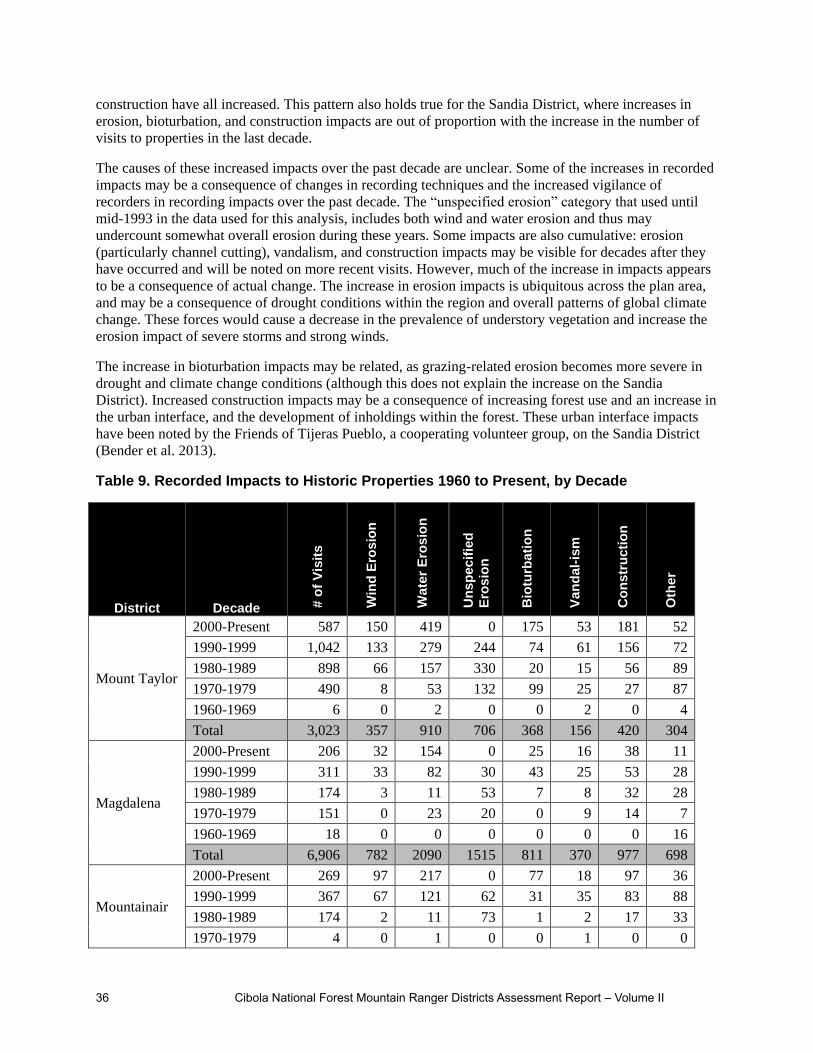
36 Cibola National Forest Mountain Ranger Districts Assessment Report – Volume II
construction have all increased. This pattern also holds true for the Sandia District, where increases in
erosion, bioturbation, and construction impacts are out of proportion with the increase in the number of
visits to properties in the last decade.
The causes of these increased impacts over the past decade are unclear. Some of the increases in recorded
impacts may be a consequence of changes in recording techniques and the increased vigilance of
recorders in recording impacts over the past decade. The “unspecified erosion” category that used until
mid-1993 in the data used for this analysis, includes both wind and water erosion and thus may
undercount somewhat overall erosion during these years. Some impacts are also cumulative: erosion
(particularly channel cutting), vandalism, and construction impacts may be visible for decades after they
have occurred and will be noted on more recent visits. However, much of the increase in impacts appears
to be a consequence of actual change. The increase in erosion impacts is ubiquitous across the plan area,
and may be a consequence of drought conditions within the region and overall patterns of global climate
change. These forces would cause a decrease in the prevalence of understory vegetation and increase the
erosion impact of severe storms and strong winds.
The increase in bioturbation impacts may be related, as grazing-related erosion becomes more severe in
drought and climate change conditions (although this does not explain the increase on the Sandia
District). Increased construction impacts may be a consequence of increasing forest use and an increase in
the urban interface, and the development of inholdings within the forest. These urban interface impacts
have been noted by the Friends of Tijeras Pueblo, a cooperating volunteer group, on the Sandia District
(Bender et al. 2013).
Table 9. Recorded Impacts to Historic Properties 1960 to Present, by Decade
District Decade # o
f V
isit
s
Win
d E
ros
ion
Wa
ter
Ero
sio
n
Un
sp
ec
ifie
d
Ero
sio
n
Bio
turb
ati
on
Va
nd
al-
ism
Co
ns
tru
cti
on
Oth
er
Mount Taylor
2000-Present 587 150 419 0 175 53 181 52
1990-1999 1,042 133 279 244 74 61 156 72
1980-1989 898 66 157 330 20 15 56 89
1970-1979 490 8 53 132 99 25 27 87
1960-1969 6 0 2 0 0 2 0 4
Total 3,023 357 910 706 368 156 420 304
Magdalena
2000-Present 206 32 154 0 25 16 38 11
1990-1999 311 33 82 30 43 25 53 28
1980-1989 174 3 11 53 7 8 32 28
1970-1979 151 0 23 20 0 9 14 7
1960-1969 18 0 0 0 0 0 0 16
Total 6,906 782 2090 1515 811 370 977 698
Mountainair
2000-Present 269 97 217 0 77 18 97 36
1990-1999 367 67 121 62 31 35 83 88
1980-1989 174 2 11 73 1 2 17 33
1970-1979 4 0 1 0 0 1 0 0

Cibola National Forest Mountain Ranger Districts Assessment Report – Volume II 37
District Decade # o
f V
isit
s
Win
d E
ros
ion
Wa
ter
Ero
sio
n
Un
sp
ec
ifie
d
Ero
sio
n
Bio
turb
ati
on
Va
nd
al-
ism
Co
ns
tru
cti
on
Oth
er
1960-1969 9 0 0 1 0 0 0 5
Total 14,635 1730 4530 3166 1731 796 2151 1558
Sandia
2000-Present 357 113 292 0 108 22 142 25
1990-1999 311 21 140 32 28 22 91 6
1980-1989 92 0 4 8 2 2 12 11
1970-1979 79 0 6 14 0 6 8 12
1960-1969 5 0 0 0 0 0 0 2
Total 30,114 3594 9502 6386 3600 1644 4555 3172
Forest Total 5,550 725 1,972 999 690 322 1,007 612
That vandalism has decreased or remained steady on three of the four districts is heartening, particularly
because the effect of cumulative recording can be strong on the observation of this impact (that is to say,
much of the damage from vandalism reported in the last decade may have occurred in prior decades). The
increase in vandalism on the Mount Taylor District is troubling, however. District personnel have
observed an increase in treasure and relic hunting by metal detector enthusiasts, the defacement of rock
art, looting at sites from the Pueblo era, and the intentional destruction of standing buildings from the
nineteenth and twentieth centuries.
There have been no consistent efforts to record impacts to resources and characteristics important to
traditional communities, other than those observed for those that are historic properties (traditional
cultural properties). For the general consideration of resources and characteristic important to Native
Americans, please see chapter 2 of this volume, Areas of Tribal Importance. There has been no
assessment of the condition of resources and characteristics important to traditional Hispanic and Anglo-
American communities, with the exception of traditional cultural properties. However, the information
collected by Raish and McSweeney (2008), has some bearing on current resource conditions and recent
trends for traditional Hispanic communities. In particular, there have been declines in the condition of
range land and fuelwood resources. The perception is that these resources are currently insufficient to
maintain community needs, and their availability has been declining over the past 50 years.
Contribution of Cultural and Historic Resources to Social, Economic, and Ecological Sustainability
Cultural and historic resources and uses in the plan area are critical to the social, economic, and
ecological sustainability of the immediate area, the southwestern region, and the nation. Historic
properties within the plan area are a record of historic processes and events important in the identity of
local communities, the state of New Mexico, the region, and the nation. Contemporary uses of resources
in the plan area by Native American, Hispanic, and Anglo-American traditional communities are critical
to maintaining the identity of these communities. Cultural tourism is a significant component of the
economy of the plan area. Tourists are attracted by the nature and significance of historic properties, and
by the character of traditional communities, a character maintained by resources and uses of the plan area.
Historic properties contain a wealth of information for scientific researchers regarding ecological
conditions and changes over the past twelve millennia, and human successes and failures in coping with

38 Cibola National Forest Mountain Ranger Districts Assessment Report – Volume II
these changes. This information is of value to managers making decisions regarding the contemporary
ecological management of the plan area. This information is also of value for educating the public about
ecological sustainability.
Historic properties are a major source of information regarding the history of the human occupation and
use of the plan area. For the first 11,000 years of human history in the area, the remains found at historic
properties are the only source of information, as this is a span of time for which there is little or no
information available from written records and from Native American oral history. Scientific researchers,
professional organizations, and cooperating groups that have provided input for this assessment have
emphasized the value of historic properties in the plan area for providing information about American
history (Bender et al. 2013; Hayden 2013; Huntley 2013; Laumbach 2013; Lekson 2013; McIntosh 2013).
There are several themes in American history for which historic properties can provide, or have provided,
important information:
Settlement and society during the Archaic era (6500 B.C.-A.D. 500), and the origins of farming in
North America (all districts).
Settlement and society among Pueblo peoples during the Chaco period (A.D. 900-1150), and in
particular life at “outlier” communities (Mount Taylor District).
Migration and cultural transformation among Pueblo peoples at the end of the ancestral Pueblo
era (A.D. 1100-1300) (all districts).
Pueblo society during the Classic Period (A.D. 1325-A.D. 1700), and the response by and effects
on Pueblo peoples from early Spanish exploration and colonization (Magdalena, Mountainair and
Sandia Districts).
Spanish settlement, land use, and society during the Land Grant period (A.D. 1692-1846) (Mount
Taylor, Mountainair, and Sandia Districts).
The economic and social impacts of commercial mining in the late nineteenth and early twentieth
centuries (Magdalena District).
The economic impacts and environmental consequences of commercial logging during the late
nineteenth and early twentieth centuries (Mt. Taylor and Mountainair Districts).
The forest also contains individual properties that are important to the traditional history of Native
Americans, to the history of the American Civil War in the Southwest, and to the history of early aviation
in the United States.
The use of historic properties to generate information about the history of the plan area, the region, and of
the nation is vital to maintaining cultural identity at each of these levels. The importance of history to
maintaining social sustainability has been cited by members of Hispanic traditional communities (Raish
and McSweeney 2008) and scientific researchers and professional organizations cite strong interest
among Native American communities in the historical information generated by researchers that study
historic properties (Huntley 2013; Lekson 2013; McIntosh 2013). Interpreted historic properties also
afford an opportunity to educate children and the public at large about the history of the plan area, the
region, and the nation (Bender et al. 2013; McIntosh 2013)
The importance of historic and cultural places and characteristics of the plan area for maintaining the
identity of traditional communities is well documented. For their importance to Native American
traditional communities, please see the assessment for Areas of Tribal Importance. Hispanic traditional
communities have identified the traditional use of the plan area for subsistence economic activities as
central to their cultural identity. This includes access to land for grazing, wood for fuel and construction,

Cibola National Forest Mountain Ranger Districts Assessment Report – Volume II 39
water for the irrigation of crops, plants used in folk medicine, and areas of traditional religious
significance (deBuys 1985; Gonzales 2003; Raish and McSweeney 2008). While there has been little
written research, district personnel report that access to resources and characteristics are also important to
the maintenance of traditional Anglo-American communities, in particular access to land for grazing,
hunting, and recreation.
Cultural and historic resources and uses serve as a driver of economic sustainability in the vicinity of the
plan area by fueling cultural tourism. Historic properties are a major attraction for cultural tourism
(Lekson 2013). In the plan area, there are few historic properties that are interpreted and readily available
for visitation by the public.
Properties associated with nineteenth and twentieth century logging in the Zuni division of the Mount
Taylor Ranger District are available for interpretation at the Hilso Trailhead and on the Zuni Mountains
Historic Auto Tour.
On the Sandia District:
The Tijeras Pueblo Archeological Site features a trail and interpretive placards at the remains of a
fourteenth and fifteenth century Pueblo village of the Rio Grande tradition.
The Friends of Tijeras Pueblo maintain an interpretive center adjacent to the property and conduct
tours and educational events for the public and for school groups.
The Kiwanis Cabin, a Depression-era twentieth century shelter constructed by the Civilian
Conservation Corps on the Sandia District, is also open for visitation and is interpreted.
A trail and trailhead is maintained to the Sandia Cave NHL, but there are currently no interpretive
materials installed for this property.
These sites, in particular the Tijeras Pueblo, are significant draws for cultural tourism within the plan
area. Although not offered for interpretation by the Forest Service, the thousands of historic properties in
the back country are also an attraction for visitors, as has been observed by district personnel and
cooperating volunteer groups (Bender et al. 2013; Hayden 2013).
Tourists are also attracted to the traditional communities that rely on the resources and uses of the plan
area to maintain their traditional identity. Fine art, handicrafts, foods, religious events, festivals and other
cultural events, and other products and activities that attract tourists to these communities all rely on
cultural resources and uses within the within the plan area. See the assessment for Social, Cultural, and
Economic Conditions for more information on cultural tourism.
Scientific information generated from the study of historic properties can generate, and has generated, a
wealth of information germane to the ecological sustainability of the plan area. Places of past human
settlement and use contain faunal remains, macrobotanical materials, soils, pollen, and other remains
relevant to the reconstruction of patterns of ecological and ecological change over the past 12,000 years,
and have been vital for reconstructing patterns of environmental change within the plan area and the
region. Scientific investigation of historic properties can also provide an understanding of how humans
have successfully adapted to a changing environment, or when they have failed to do so (Bender et al.
2013; Laumbach 2013).
Understanding past patterns of human land use also informs on the forces that have contributed to current
ecological conditions, as practices such as farming and logging can affect the subsequent health of
ecosystems for hundreds of years. As such, information about past environmental change and human land
use is critical for making decisions about maintaining ecological sustainability in future land
management. The interpretation of historic properties also creates opportunities to educate the public

40 Cibola National Forest Mountain Ranger Districts Assessment Report – Volume II
about environmental change and human adaptation in the past, and ecological sustainability in the future
(Bender et al. 2013).

Cibola National Forest Mountain Ranger Districts Assessment Report – Volume II 41
Chapter 2. Assessing Areas of Tribal Importance
This chapter identifies and evaluates available information on areas of tribal importance relevant to the
plan area, including tribal rights, areas of known tribal importance that are in the plan area and are
affected by management, and conditions and trends of resources that affect areas of tribal importance and
tribal rights
The Cibola provides many ecosystem services from its lands that are important to tribes. Among them are
cultural ecosystem services in the form of opportunities for religious pilgrimages to place offerings at
sacred sites and visits to shrines and springs. Provisioning services are also produced by Cibola lands to
tribes in the form of game and fish for sustenance, fresh water for drinking, and wood and fiber for
heating, cooking and construction. Supporting services provided to tribes from Cibola lands include
plants for gathering for food and medicine, plant pigments, and stone and minerals for tools and
agriculture. Tribes also benefit from regulating services produced by Cibola lands, including climate
regulation, water purification, and flood regulation.
Indian Tribes Associated with the Plan Area
The Cibola National Forest routinely consults with 17 federally recognized tribes that are based in New
Mexico, Arizona, and Oklahoma. These tribes include: the Pueblos of Acoma, Zuni, Laguna, Isleta,
Sandia, Santo Domingo, Santa Ana, San Felipe, San Ildefonso, Cochiti, Zia, and Jemez, the Navajo
Nation, the Hopi Tribe, the Jicarilla Apache Nation, the Mescalero Apache Tribe, and the Ft. Sill Apache
Tribe. These tribes have all expressed some level of interest in the resources and management of the
forest, and sometimes provide input to the forest pursuant to Section 106 of the National Historic
Preservation Act and the National Environmental Policy Act. These tribes recognize the lands managed
by the Cibola National Forest as part of their aboriginal or traditional use areas, and acknowledge
contemporary use of these lands for traditional cultural and religious activities.
The Cibola NF maintains a governmental relationship with 17 federally recognized tribes, and routinely
consults with these tribes on policy development, and proposed plans, projects, programs, and Forest
activities that have a potential to affect tribal interests or natural or cultural resources of importance to the
tribes. The forest developed a robust consultation program in the late 1990s and continues to build and
enhance its working relationship with these tribes.
Existing Tribal Rights
The federal government has certain trust responsibilities, and a unique legal relationship with federally
recognized Indian tribes, defined by history, treaties, statutes, and court decisions. The span of
responsibilities and nature of the relationships can vary between federal agencies.
The federal trust responsibility is summarized by Pevar (2004: 33) as “Broadly, the trust doctrine requires
the federal government to support and encourage tribal self-government and economic prosperity, duties
that stem from the government’s treaty guarantees to “protect” Indian tribes and respect their sovereignty.
In 1977, a Senate report expressed this obligation as follows:
The purpose behind the trust doctrine is and always has been to ensure the survival and welfare of Indian
tribes and people. This includes an obligation to provide those services required to protect and enhance
Indian lands, resources, and self-government, and also includes those economic and social programs which
are necessary to raise the standard of living and social well-being of the Indian people to a level
comparable to the non-Indian society.

42 Cibola National Forest Mountain Ranger Districts Assessment Report – Volume II
Under this broad approach, the federal government’s trust duty “is owed to all Indian tribes”, including
those that did not enter into treaties with the United States. The trust doctrine “transcends specific treaty
promises and embodies a clear duty to protect the native land base and the ability of tribes to continue
their ways of life.”
The Forest Service’s trust responsibilities are defined primarily by the authorities listed in Forest Service
Manual part 1563.03-Policy. At this time, the Forest Service Manual 1563 and Handbook 1509.03 are
under revision.
The agency’s current policy focuses on fourteen key points:
Maintain government-to-government relationship with federally recognized Tribes.
Ensure that Forest Service employees are familiar with the rights and interests of Tribes as
defined by the Constitution, treaties, statutes, Executive orders, and judicial rulings, though
training and other efforts.
Implement Forest Service programs and activities consistent with and respecting Indian treaty
rights, and fulfilling the Federal Government’s legally mandated trust responsibility with Tribes.
Manage Forest Service-administered lands and resources on which tribal treaty rights exist in
coordination with Tribes.
Coordinate Forest Service land and resource management plans and actions with tribal land and
resource management plans and actions to promote the health of ecosystems.
Administer programs and activities in a manner that is sensitive to traditional American Indian
and Alaska Native spiritual beliefs and practices and assist tribal members in securing ceremonial
and medicinal plants, animals, and the use of geographic places, consistent with Federal policy
under AIRFA and E.O. 13007 (FSM 1563.01e).
Protect the confidentiality of tribal information (including information regarding repatriation and
reburials) received by Tribes to the extent practicable under the law.
Assist American Indian and Alaska Native Tribal Governments by providing technical,
educational, financial, and other information, and establish information exchanges where
mutually agreed to and authorized by law.
Work to reduce or remove legal or administrative program impediments that inhibit the agency’s
and Tribe’s capacity to work directly and effectively with each other.
Consult with Tribes on matters that may affect tribal rights and interests, utilizing the principles
of compliance, collaboration, timely response, and coordination.
Ensure that the repatriation of Native American human remains and associated funerary objects,
unassociated funerary objects, sacred objects, and objects of cultural patrimony is consistent with
the requirements of the Native American Graves Protection and Repatriation Act (NAGPRA).
Support, where appropriate, request(s) for reburial of human remains and cultural items on Forest
Service-administered lands received from Indian tribes or lineal descendants. Document and
provide explanation to the affected Indian tribe or lineal descendent for any request(s) that are
denied.
Uphold confidentiality of reburial locations and associated documentation relating to human
remains or cultural items reburied on National Forest System land.
Support reburial of American Indian and Alaska Native human remains and funerary objects on
Forest Service administered lands. Consider burial requests for specific locations and provide
explanation for requests that are denied.
The forest carries out its trust responsibilities under a variety of authorities. Some of the laws that address
the agency’s requirement for government to government consultation include: the American Indian
Religious Freedom Act (AIRFA); the Archaeological Resources Protection Act (ARPA); the National
Forest Management Act (NFMA); the Native American Graves Protection and Repatriation Act

Cibola National Forest Mountain Ranger Districts Assessment Report – Volume II 43
(NAGPRA); the National Environmental Policy Act (NEPA); the National Historic Preservation Act
(NHPA) -Sections 106 and 110; 36 CFR Part 800 Protection of Historic Properties, and the Religious
Freedom Restoration Act (RFRA). Executive Orders, such as EO 13175 Consultation and Coordination
with Indian Tribal Governments and EO 13007 Indian Sacred Sites, also speak to the agency’s
responsibilities.
Other more recent authorities, directives and/or guidance relevant to forest management, collaboration,
and consultation include the Tribal Forest Protection Act (2004), the Food Conservation and Energy Act
of 2008 (The Farm Bill), Report to the Secretary of Agriculture-USDA Policy and Procedures Review
and Recommendations: Indian Sacred Sites (December 2012), Memorandum of Understanding Among
the Department of Defense (DOD); Department of Interior (DOI); U.S. Department of Agriculture
(USDA); Department of Energy (DOE), and ACHP Regarding Interagency Coordination and
Collaboration for the Protection of Indian Sacred Sites (December 2012), and FSH 2409.18-Trees,
Portions of Trees, or Forest Products Free of Charge for Indian Tribes for Non-Commercial Traditional
and Cultural Purposes.
The T’uf Shur Bien Preservation Trust Act (2003) is legislation that specifically addresses an area of
approximately 9,890 acres on the Cibola National Forest, partially within the Sandia Mountain
Wilderness. The legislation ratified a settlement agreement of a land claim by the Pueblo of Sandia. The
T’uf Shur Bien Preservation Trust Area is a special management area; the only one of its kind in the
Forest Service.
The U.S. Forest Service Tribal Relations Strategic Plan (2010) outlines three basic goals around Tribal
Rights, Partnerships and Program Development. The strategy targets specific outcomes, and delineates
the Tribal Relations Program, mission, goals and objectives. The Region’s First Amended Programmatic
Agreement Regarding Historic Property Protection and Responsibilities (December 2003) addresses
project-level consultation pursuant to the National Historic Preservation Act (as amended).
Under the current administration, there has been an increased emphasis on work with American Indian
tribes within USDA and the agency. On July 17, 2012 an Interim Directive was issued as an update to
FSH 1509.13, Chapter 10 Consultation with Tribes. It sets forth new direction to clarify who may conduct
government-to-government consultation with Tribes. The Interim Directive states “Government-to-
government consultation may only occur between Forest Service line officers and Tribal leaders who
have authority to consult on behalf of their Tribe…Tribal consultation may not be delegated from line to
staff in the field.” The Interim Directive also supports the development and use of memoranda of
understandings (MOUs) between Forests and Tribes.
Areas of Known Tribal Importance Affected by Management of the Plan Area
Lands managed by the Cibola National Forest have been used, and continue to be used by many tribes for
a variety of traditional cultural and religious activities. Over time, these activities have included, but are
not limited to: collection of plants, stone, minerals, pigments, feathers, soil, catching eagles, hunting
game, religious pilgrimages to place offerings, and to visit shrines and springs.
Places and properties valued and used by the tribes for a variety of purposes have been identified on every
unit of the Cibola National Forest. One example is a property of cultural and religious significance, which
can possess traditional cultural or religious significance for a number of reasons. Some of these include
locations with long-standing cultural use, locations of buried human remains repatriated under NAGPRA,
locations where ceremonial objects have been retired, locations of contemporary ceremonies, and
locations where specific forest products gathered for ceremonial use.

44 Cibola National Forest Mountain Ranger Districts Assessment Report – Volume II
The tribes consider all of these types of locations to be traditional cultural properties (TCPs). Some
locations such as shrines, springs, and resource collection areas have long-standing and ongoing
historical, cultural, and religious significance. The forest has documented nine of these locations as
traditional cultural properties, some of which have been determined eligible for the National Register.
These consist of site-specific locations, landscape-level properties, and historic districts containing a
number of historically or functionally related properties. Others known locations remain minimally
documented, but clearly meet the criteria of a TCP.
Existing information regarding these types of properties is based on published sources as well as the
results of project-level consultation conducted by the forest over the last 15 years. To date, approximately
40 locations of cultural and religious significance have been identified forest-wide.
In addition to specific noted locations, entire mountain ranges are commonly regarded as sacred, and
viewed as an integral part of a tribe’s cultural landscape. One example is Mt. Taylor, the highest peak in
the San Mateo Mountains, located on the Mt. Taylor Ranger District. Mt. Taylor is rooted in the history
and traditions of most of the tribes. It is central to their cultural practices as living communities and is
critical to the maintenance of their cultural identity. The mountain is important in ceremony. It is a place
that figures prominently in oral traditions regarding origin, place of emergence, and migration, and plays
a vital role in their cosmology and religion (Benedict and Hudson, 2008).
Other mountain ranges that make up the various divisions or units of the forest, such as the Datil
Mountains, the Magdalena Mountains, the San Mateo Mountains, the Sandia Mountains, the Manzano
Mountains, and the Gallinas Mountains also hold significance for the tribes. Most, if not all, have place
names tied to tribes’ oral traditions. The cultural and traditional use of locations within these mountain
ranges is sporadic but ongoing, and is dictated by the cycle of cultural activities.
For a more distant tribe, such as the Mescalero Apache, which is currently based in south-central New
Mexico, some of these mountain ranges served as a distinctive landmark or way point to aid in travel. The
Jicarilla Apache in northern New Mexico have indicated that they do not regularly rely on these areas on
the forest for resource collection, but acknowledge their reliance on tribes closer to the national forest
with whom they can trade to obtain plants needed for medicinal or ceremonial use (Benedict and Hudson,
2008:27). The Ft. Sill Apache who are currently based in Apache, Oklahoma, consider the San Mateo
Mountains on the Magdalena Ranger District as part of their traditional lands.
Many of the tribes also rely upon the national forest for forest products for personal, commercial, and
ceremonial use. Pinyon nuts are one example of a forest product commonly gathered for both personal
and commercial use. While gathered by many of the tribes, pinyon nuts are particularly important to the
Alamo Navajo Band whose lands border the Magdalena Ranger District, as well as tribal communities in
the vicinity of the Mt. Taylor Ranger District. The collection and sale of pinyon nuts is important because
tribal members in these communities rely heavily on the sale of pinyon nuts for income.
Fire wood is another forest product that is widely collected by tribal members, for personal and
ceremonial use. This includes juniper, pinyon, oak, and ponderosa pine. There is also a heavy reliance on
parts of the national forest for forest products for traditional and cultural purposes. Some examples
include yucca, willow, cactus, grasses, Osha root, Douglas fir, ponderosa pine, and Oneseed juniper.
Conditions and Trends of Resources that Affect Areas of Tribal Importance and Rights
Conditions and trends that are societal and/or economic based are influencing tribal use of the forest and
affecting areas of tribal importance. Some of these include: changes in land ownership, degradation of
forest health and watershed conditions, changing technologies and energy development, population
growth, urban pressures, and expanding recreation use, and the development of private lands.

Cibola National Forest Mountain Ranger Districts Assessment Report – Volume II 45
Change in Land Ownership and Access to Land and Resources
Tribal access and use of the lands and resources now managed by the Cibola National Forest, as well as
for the general landscape, has been altered over time due to a number of factors. The primary factor is the
change in land ownership and jurisdiction. Historically, resources on the land were more widely available
to tribes, and they had nearly unfettered access to these lands for grazing sheep, hunting, acquiring
construction material, gathering fire wood, and collecting resources for food, medicine, and ceremony.
There were often well-established travel routes between communities, and prescribed routes to specific
locations of tribal importance. As the Spanish, Mexicans, and later the Americans moved into the area,
recognition of land ownership became increasingly important. Access to and use of resources continued
to change with the establishment of the National Forest in the early 20th century, and the gradual
progression of environmental policy, resulting in the passage of federal laws and regulations, and greater
federal oversight.
In some cases, access to culturally significant locations has been severely restricted or eliminated
altogether in places where the land has gone into private ownership. While the Forest Service has the
ability under a variety of authorities to assure tribes access to sacred sites on National Forest land, and to
allow for tribes to conduct cultural activities in privacy, few tribes have exercised their rights on the
Cibola NF by utilizing provisions of authorities such as the 2008 Farm Bill to request a temporary closure
order to conduct traditional activities in privacy on the forest.
There seems to be a pervasive lack of awareness about the options and the process. There is also some
confusion about the process of obtaining free use permits for the collection of forest products, and under
what situations a permit is needed. Nevertheless, the forest is very responsive to tribal requests. The forest
has lacked a consistent policy for the collection of forest products for ceremonial use, however,
development of a policy that is consistent with the agency’s authorities is underway.
The process of preparing for and travelling to an area to conduct traditional and cultural activities is often
as significant as the activity itself. The construction of fences, installation of gates, and checkerboard land
ownership patterns, has all contributed to complicating the tribes’ ability to do resource collection and to
visit areas of traditional cultural and religious significance. Land ownership can affect how tribes
approach areas of tribal importance, and conflicts have been known to arise with land owners or with
Forest Service personnel who are unfamiliar with tribal rights on national forest land. Ownership and
development of private land has led to a greater reliance on national forests, however, tribes will
sometimes limit where and how they use the national forest for traditional, cultural and religious
activities. Instead, they will opt, where they can, to obtain these resources on their own lands, or will
travel to national forest lands that are closer to their reservations.
When tribes do go to important places on the national forest, their methods of travel and their activities
often have to be adjusted for factors such as road development, fences, gates, mixed land ownership, and
other permitted or recreational uses of the Forest.
Degradation of Forest Health and Watershed Conditions
Plant Collection
Tribes that rely on the forest for collecting plant resources for personal and/or ceremonial use have noted
that some plant species are more difficult to find than they were in the past. Some of this difficulty is due
to restricted access to areas that were used in the past, as is discussed above, and may also be due to the
general degradation of watershed conditions and forest health.
There are a number of factors that have led to compromised watersheds and forest ecosystems. Broadly
speaking, agency fire suppression policies, timber harvesting, logging practices, livestock grazing and
localized mining practices have all contributed to the compromised watersheds and forest ecosystems that

46 Cibola National Forest Mountain Ranger Districts Assessment Report – Volume II
the forest is managing today. Much of this occurred during a period in the agency’s history when output
was a top priority, in response to the social demands of the time. Ground-disturbing permitted activities
and dispersed recreation has also contributed to the disturbance and degradation of some plant
populations.
The Navajo believe that if plants are misused, they will move away. Drilling or digging into the earth is
an example that the Navajo use to describe misuse. The effect that drilling and digging have upon plants
is one reason these activities are viewed as negative. Digging into the earth is also believed to alter the
otherwise beneficial effect of activities such as prescribed burning. Burning is considered positive,
because it tends to bring about a re-growth of plants.
The Las Huertas watershed on the Sandia Ranger District is an example of where the watershed
degradation has affected tribal use of an area. Las Huertas creek, one of the few live watercourses on the
forest, is considered an impaired watershed. It is largely the presence of the road (NM165) and its
ongoing maintenance that has contributed to the impairment of the creek. The canyon is culturally
significant to many of the 19 New Mexico Pueblos; it is considered vital in their lives and the continuance
of their cultural practices and beliefs. Many of the Pueblos still use the canyon to gather resources for
food, medicine, and ceremonial use. As a resource harvesting area, Las Huertas canyon as a whole
contain plants, waters, and minerals that are not collected elsewhere, and are unique to the canyon for the
Pueblos of the middle Rio Grande. The canyon’s singular orientation, accessibility and diverse ecological
settings make it completely unique for those Pueblos dependent on its resources (Musello and Walt
1999:5.8). Sedimentation of the stream and impacts to the riparian area has impacted plant growth, and
has made it more difficult for tribal members to obtain the specific resources they need. Heavy
recreational use of this narrow canyon, made possible by the road and the development of a day-use
picnic area, has also affected tribal use of the area in that it often requires tribes to alter their methods and
timing of cultural activities in the canyon.
Restoration
Tribal Forest Protection Act of 2004 (Public Law 108-278) allows tribes to propose projects on
National Forest System lands to protect their own trust resources. The Tribal Forest Protection Act
(TFPA) basically authorizes the Secretaries of Agriculture and Interior to give special consideration to
tribally-proposed Stewardship Contracting or other projects on Forest Service or BLM land bordering or
adjacent to Indian trust land to protect the Indian trust resources from fire, disease, or other threat coming
off of that Forest Service or BLM land.
The Forest shares a common boundary with 6 tribes (the Pueblos of Acoma, Isleta, Laguna, Sandia, Zuni,
and the Navajo Nation). Currently the Forest has a TFPA project with the Pueblo of Isleta on the
Mountainair Ranger District, and other tribes have expressed interest in developing similar projects. It can
be reasonably expected that the Forest will enter into agreements or contracts with more tribes to develop
projects that are mutually beneficial and work across boundaries and enhance landscape-scale work.
Additional discussion on vegetation management can be found in Volume 1, Chapter 2. Vegetation-
related ecosystem characteristics are analyzed: vegetative structure, fire regime, patch size, invasive
species, coarse woody material, climate, snags, insects and disease.
Changing Technology and Energy Development
As a multiple use agency, the Forest Service permits a wide variety of activities on national forest system
lands. Activities such as the development of communication sites, mineral exploration and extraction, and

Cibola National Forest Mountain Ranger Districts Assessment Report – Volume II 47
construction of transmission or utility corridors have affected, and continue to affect areas of tribal
importance.
In recent years, there has been a greater emphasis on alternative forms of energy development such as
wind, solar, and nuclear power. While many tribes support the development and use of wind and solar
power, there is also recognition that these types of energy development result in a large footprint on the
landscape, and often impact the view shed. There has been some development of wind energy sites on
private lands immediately adjacent to national forest lands on both the Mountainair and Mt. Taylor
Ranger Districts. Evidence of past mineral exploration is still evident today on all of the units of the
forest, and the agency has only recently begun to address the remediation of older mines on the forest.
New uranium mines are planned on the Mt. Taylor Ranger District, partially within the boundaries of a
landscape-level traditional cultural property, Mt. Taylor. Mineral exploration and development can be
expected to continue as long as the price of the material is economically desirable.
Changes in telecommunication technology over the past century resulted in a proliferation of
communication sites developed on the forest, most located on high points such as mountain tops. These
constructed features are a mixed blessing for the tribal communities. While communication sites make
certain technologies readily available to all, they are perceived to cause impacts on the landscape, on
wildlife, and tribal traditional use of the land. For example, radio communication sites contain towers that
can be seen for great distances, and if greater than 200 feet in height, will be lit at night per FAA
requirements. Those tribes that have expressed their opposition to the development of new
communication sites have encouraged co-location of users to the maximum extent feasible.
Tribes have expressed concern that the installation and build-out of such sites will exacerbate the visual,
audible, and atmospheric interference, further disrupting and displacing prescribed traditional activities
that take place in that area. Mt. Taylor, for example, plays an integral role in a number of Navajo healing
ceremonies. The tribe’s concern is that visual and electromagnetic interference from the towers will
render the healing ceremonies ineffective because of the impact that the towers will have upon a
traditional practitioner’s ability to use a specific ceremony and accurately diagnose and treat patients. The
potential effect of electromagnetic radiation (EMR) emitted from the high power facilities upon humans
(and wildlife) is a concern, especially when traditional practitioners and contemporary users are within
the proximity of the towers.
Impacts created by the presence of towers or any other highly visible man-made objects, obstruct the “line
of sight” from the physical location of the ceremony to a given location (such as the peak of Mt. Taylor or
other prominent topographic feature). This can interfere with the practitioner’s accuracy of diagnosis and
proper treatment of patients. These visible impacts represent an intrusion to the traditional experience and
the ability to properly conduct prescribed cultural practices.
The continued permitting and development of electronic facilities and mines on the forest, particularly on
or near the higher mountains, disallows the meditative atmosphere, quietness, and privacy necessary for
traditional cultural activities. One Zuni tribal official cited the noise of the air conditioners that can be
heard from the Microwave Ridge low power communication site as an example of the permanent auditory
intrusion that interferes with traditional and cultural use of that area. The additional vehicular traffic
associated with the use and/or expansion of these types of facilities is also a concern from the standpoint
of intrusion and interference with traditional and religious practices.
Places of tribal importance have an integral relationship with a tribe’s beliefs and traditional cultural
practices, and are viewed as critical to the maintenance of a tribe’s cultural identity and transmittal of
their beliefs and practices. Practitioners sometimes engage in certain traditional activities that can only be
conducted in a specific place. Tribes have expressed concern that as development continues in areas of
tribal importance, it forces these individuals to alter their cultural activities, and in time, is seen as a

48 Cibola National Forest Mountain Ranger Districts Assessment Report – Volume II
cumulative impact to their cultural activities. Development does not always stop the cultural activities and
practices, but is perceived to downgrade the traditional practices and diminish their value.
Large and intrusive development has the potential to affect the integrity of a tribe’s relationship with an
area of traditional and cultural significance and risks the disruption and/or alteration of traditional cultural
activities that are critical to the continuity of cultural beliefs and practices of these tribes. In the view of
the tribes, impacts to a traditional practitioner’s ability to conduct traditional cultural activities in the area
will render the overall effectiveness of medicine and healing ceremonies less effective.
Some tribes are located in areas where there are significant renewable energy resources, including woody
biomass, biomass waste resources, solar, and wind. While geothermal and hydroelectric are also
considered renewable energy resources, there is no potential for these on the Forest. Renewable energy
can be developed to meet a tribe’s needs for sovereignty, energy independence and diversification,
environmental sustainability, and to strengthen the tribal economy.
Title V, Section 503 of the Energy Policy Act of 2005 (Public Law 109-58) and Indian Mineral
Development Act of 1982 (Public Law 97-382) provide increased flexibility for tribes to develop energy
resources. A number of tribes in the region are currently developing energy under the provisions of the
Energy Act of 2005. According to the Department of Energy, Tribal Energy Program website,
http://apps1.eere.energy.gov/tribalenergy/projects_state.cfm/state=NM there are 10 energy related
projects in New Mexico.
The Forest shares a common boundary with 6 tribes (the Pueblos of Acoma, Isleta, Laguna, Sandia, Zuni,
and the Navajo Nation). It can be reasonably expected that the Forest could receive additional requests for
special use permits to cross National Forest land. This would include requests to transmit electricity or
natural gas across National Forest land by the Department of Energy and the Department of Interior,
working on behalf of tribes to develop their resources. Additional discussion on energy and mineral
development can be found in Volume 2, Chapter 8.

Cibola National Forest Mountain Ranger Districts Assessment Report – Volume II 49
Population Growth, Urban Pressures, and Expanding Recreation Use
Recreational use of the forest is on the rise. The increase in certain types of activities is reflective of the
country’s aging population and greater urbanization of our society. Some of the most popular activities
involve day use (such as picnicking and hiking), driving for pleasure and scenic beauty, and wildlife
viewing. Urban populations seem more comfortable recreating in closer quarters, and this often results in
concentrated uses on some parts of the forest, particularly those that are within easy driving distance of
Albuquerque.
It should also be noted that the agency is proactive in its efforts to draw underserved populations to the
outdoors to foster an appreciation for the environment, and an understanding of the value of national
forests and the role it can play in people’s lives. The Sandia Mountain Wilderness, can be described as an
urban wilderness, as it is situated adjacent to Albuquerque, and in some places shares a common
boundary with residential neighborhoods.
The Pueblo of Sandia has expressed concern over the nature of the public’s use in the wilderness,
recognizing that the vast majority of people using the area are coming from Albuquerque and don’t have
an understanding of what wilderness is, and how the agency is mandated to manage it differently. This
sometimes results in inappropriate recreational use of the wilderness. Neighborhoods adjacent to this
wilderness view it as an extension of their backyards and engage in activities similar to what one would
expect when using a municipal park. As dispersed recreation increases on the forest, conflicts between
traditional practitioners and other forest visitors can be expected to increase.
Development of Private Land
There are inholdings of private land within every unit of the forest. In some cases, these properties
contain strategic and culturally significant features such as springs. Some of these lands were once used
for ranching, but are now being subdivided for sale and development. Development of subdivisions
within or adjacent to the forest creates concerns for neighboring tribal communities. In the case of a
proposed development in the Zuni Mountains upstream from the Zuni Reservation, the tribe expressed
concern about the effects that a subdivision would have on the quantity and quality of water in the upper
Rio Nutria watershed, and about potential impacts to the Zuni Bluehead Sucker, a federally proposed
endangered species. The Pueblo of Zuni also recognizes the increased risk of trespass onto tribal lands.
The risk of uncharacteristic human-caused wildfire is another concern expressed by tribes that share a
common boundary with the forest or are in close proximity to private inholdings within the forest. Lastly,
it is not uncommon for residents who live immediately adjacent to the national forest and/or wilderness
areas to establish informal trail systems for their personal use.
Overview of the T’uf Shur Bien Preservation Trust Area
Surrounded by the Sandia Mountain Wilderness is the 9,890-acre T’uf Shur Bien Preservation Trust Area.
T’uf Shur Bien means “green reed mountain” and is an area of great cultural importance to the Pueblo of
Sandia.
It is a special management area on the north end of Sandia Ranger District. It is the only one of its kind in
the Forest Service and was created out of an issue with title claim. The Pueblo of Sandia wanted fee
simple title claim with the Forest Service on lands on the western slope of the Sandia Mountains that the
Pueblo asserted was given to it by the King of Spain in 1748.
In 1983, the Pueblo of Sandia Tribal Council passed a resolution calling for a legislative effort to be
undertaking to recover approximately 10,000 acres of the Sandia Mountain which lies to the east of the
existing recognized reservation boundaries. Legislation was not proposed at that time.

50 Cibola National Forest Mountain Ranger Districts Assessment Report – Volume II
The Pueblo of Sandia then pursued legal avenues which resulted in the Office of the Solicitor issuing a
draft opinion in 1987 which stated that the Pueblo had presented a valid claim and that the Secretary of
the Interior had the authority to effect an administrative remedy; namely, to revise erroneous language of
the 1864 patent and to effect a new survey in accordance with the revised language.
The draft opinion was submitted to the Office of General Council (OGC) by the Solicitor. The OGC made
an independent review of applicable laws and facts and concluded that the 1864 patent correctly
delineated the boundary of the Sandia Pueblo. OGC provided their opinion to the Solicitor on June 4,
1987.
The outcome of the 1987 decision generated much interest by landowners and the news media and
resulted in concerns and issues between OGC, the Solicitors Office, and the Pueblo of Sandia. Extensive
research was done by the Pueblo of Sandia, landowners, interested parties, and the Forest Service.
Landowners and other interested parties became directly involved and met with the Secretary of the
Interior and other Interior officials, OGC, and congressional delegations.
On December 8, 1988, the Office of the Solicitor issued their final opinion and concluded that the
Pueblo’s claim was without merit and the Secretary of the Interior did not have the authority to take the
type of action requested by the Pueblo.
In December 1994, the Pueblo of Sandia filed a lawsuit against the Secretary of the Interior and the
Secretary of Agriculture in the U.S. District Court for the District of Columbia. The Pueblo asserted that
federal surveys of the Pueblo grant boundaries erroneously excluded approximately 9, 890 acres of land
from their Reservation that were part of the Cibola National Forest. This included a portion of the Sandia
Mountain Wilderness. The lawsuit requested that the Court order a corrected survey.
In July 1998, a District of Columbia federal judge issued an order favorable to the Pueblo requiring the
Department of the Interior to reconsider whether the eastern boundary of the Pueblo’s land grant extended
all the way to the crest of Sandia Peak. The Court found that the Department of the Interior had acted
arbitrarily when it denied the Pueblo’s request to remove lands from the national forest and include them
in the Pueblo, and that it had violated the Administrative Procedure Act by denying the Pueblo’s claim for
a corrected survey. The Court ordered the case remanded to the Department of the Interior to reconsider
its decision not to conduct a resurvey of the claim area.
The Judge’s decision was reviewed by the Departments of the Interior and Justice, and the Forest Service.
The Forest Service provided the Departments of Justice and Interior with a 1996 report on the “History of
the Boundaries of the Pueblo of Sandia, 1748-1860,” that contains additional information thought to be
helpful to clarify the boundary question. The report was not made part of the lawsuit record reviewed by
the judge since the Pueblo of Sandia filed their lawsuit in 1994, before the report was complete.
In December 1998, all parties involved in the litigation agreed to enter into a negotiated settlement
process. The parties included: the Departments of Justice, Interior, Agriculture, Bureau of Indian Affairs,
Forest Service, Pueblo of Sandia, Sandia Peak Tram Company, Sandia Mountain Coalition, Bernalillo
County and the city of Albuquerque. In August 1999, the Sandia Mountain Coalition, Bernalillo County,
and the city of Albuquerque withdrew from mediation.
In 1999, the Department of the Interior Solicitor overturned the previous 1988 Solicitor opinion because
the boundary issue was unclear. This set the stage for the government to settle the lawsuit.
In April 2000, the Forest Service, the Pueblo of Sandia, and the Sandia Peak Tram Company reached an
agreement, permanently resolving the Pueblo’s land claim to 9,890 acres on the western face of the
Sandia Mountain, on the Sandia Ranger District. Like most Indian land claim settlements, the agreement
had to be ratified by federal legislation.

Cibola National Forest Mountain Ranger Districts Assessment Report – Volume II 51
The settlement agreement lays out the details of what the parties agreed to. The Preservation Trust Area is
meant to emphasize the importance of preserving the natural condition of the land.
Key Points about Management of the Trust Preservation Area
The Trust Area is managed based upon the laws, regulations, policies, and manual directives that were in
place in January 2003 (the date of the Act). It should be noted that legislation passed after January 2003
does not apply to the Preservation Trust Area, unless it is explicitly mentioned in the new legislation. “To
the extent that any law enacted or amended after the date of enactment of this Act is inconsistent with this
title, the law shall not apply to the Area unless expressly made applicable by Congress” (Section 404 (3)-
Later Enactments). However, the Forest can discuss new legislation and its new directives with the
Pueblo and the Pueblo could decide whether or not it wants to adopt any or all of the new information.
Although the 1985 Forest Plan was in place at the date of the enactment of the Act, it does not apply to
the Trust Area, and is not the guiding document for the management of the Trust Area. The Act itself is
the “management plan” for the Area (refer to page 6 of the Settlement Agreement). The 2012 Planning
Rule does not apply to the Preservation Trust Area. When the Plan is revised, it will discuss the Trust
Area as a Special Management area, but will essentially just state points of fact consistent with the Act.
Highlights of the Agreement:
Pueblo Rights and Interests in the Area (Section 405 of the Act)
Free and unrestricted access to the area for traditional or cultural uses. Tribal members must still
adhere to the Wilderness Act and its regulations, as well as applicable federal wildlife protection
laws in place at the time of the Act.
Perpetual preservation of the national forest and wilderness character of the area.
Rights in the management of the area, including: the right to consent, or withhold consent to a
new use; the right to consultation regarding a modified use; the right to consultation regarding the
management and preservation of the area; the right to dispute resolution procedures.
Exclusive authority, in accordance with customs and laws of the Pueblo, to administer access to
the area for traditional and cultural uses by members of the Pueblo and of other federally
recognized Indian tribes.
Exclusive authority to regulate hunting and trapping in the area by members of the Pueblo, to the
extent that the hunting and trapping is related to traditional and cultural uses. This is confined to
sections 13, 14, 23, 24 and the NE ¼ of section 25 of T12N, R4E, and section 19 of T12N R5E.
This specifies certain areas that must be regulated in a manner consistent with the State of New
Mexico regarding types of weapons, and proximity of hunting and trapping to trails and
residences.
Limitation on Pueblo rights and interests in the area (Section 406 of the Act)
The Pueblo cannot sell, grant, lease, convey, encumber, or exchange land or any interest in land
within the area.
The Pueblo may not engage in prohibited uses (gambling or gambling of any kind, mineral
production, timber production and uses described in the Wilderness Act, such as the use of
motorized vehicles or equipment, and the installation of structures, and any new use to which the
Pueblo objects). The area is also closed to the location of mining claims under the Mining Law of
1872.
The Pueblo cannot exclude persons or governmental entities from the area.
The Pueblo is not exempt from applicable federal wildlife protection laws.
Private land owner interests

52 Cibola National Forest Mountain Ranger Districts Assessment Report – Volume II
The settlement removes the claim-related cloud from all land titles for private landowners.
Perpetual road access across Pueblo lands is provided for all subdivision landowners.
Perpetual utility easements are granted across Pueblo lands along all existing utility corridors.
Public rights
All existing recreational and other uses will continue.
Perpetual road access to national forest lands will be provided.
The 9,890 acres will remain national forest land and the Cibola National Forest would continue to
manage this area and provide public access to everyone.
The Sandia Mountain Wilderness designation will remain in effect. All lands within the
settlement area will be managed to keep their wildland character.
Resolution of Land Claims
The 9,890 acres is designated as the T’uf Shur Bien Preservation Trust Area of the Cibola
National Forest and Sandia Mountain Wilderness.
Confirms the United States’ title to the area.
The Sandia Peak Tram, High Finance Restaurant, Crest House, and the Crest Electronic Site will
continue operation under existing Forest Service special use permit authorization.
On January 1, 2003 federal legislation ratified the settlement agreement. The legislation is referred to as
the T’uf Shur Bien Preservation Trust Area Act (Public Law 108-07, the “Consolidated
Appropriations Resolution, 2003 Div. F, Title IV, Section 401-415). For more information regarding
jurisdiction, management and rights-of-way, please see the T’uf Shur Bien Preservation Trust Area Act of
2003 and the white paper titled Overview of the Pueblo of Sandia Land Claim, the Settlement Agreement,
and The Establishment of the T’uf Shur Bien Preservation Trust Area, dated 4/15/2013 by Cynthia
Benedict, Forest Tribal Liaison. It can be found in the project record. Also see Figure 8 below.
Ecosystem Services – Increasing, Stable, or Declining to Tribes?
Based on the above analyses, there are many examples of provisioning, regulating, cultural, and
supporting ecosystem services declining for tribes in the plan area : changes in adjacent land ownership
and development of private lands affecting access; degradation of forest health and watershed conditions
affecting plant collections; changing technologies and energy development interfering with traditional
ceremonies; and population growth, urban pressures, and expanding recreation use contributing to
conflicts with traditional practitioners.

Cibola National Forest Mountain Ranger Districts Assessment Report – Volume II 53
Figure 8. T’uf Shur Bien Preservation Trust Area. This map is directly from the white paper, Overview of the Pueblo of Sandia Land Claim,
the Settlement Agreement, and The Establishment of the T’uf Shur Bien Preservation Trust
Area, dated 4/15/2013 by Cynthia Benedict, Forest Tribal Liaison.

54 Cibola National Forest Mountain Ranger Districts Assessment Report – Volume II
Chapter 3, Assessing Social, Cultural, and Economic Sustainability
Introduction, Purpose, and Organization
This chapter presents socioeconomic and land use information for the Cibola National Forest and
extended “planning area of influence,” which includes the counties where each of the four mountain
ranger districts reside. This information provides context for understanding the setting of the Cibola, the
forest visitors and stakeholders, and for understanding social and economic demands that influence forest
management on the Cibola. Demographic and socioeconomic data reported by areas of influence are
consistent with the U.S. Census Bureau county-wide data.
The Mountain RDs, are sometimes are known as “sky islands,” because of their remote locations and high
elevation relative to the surrounding desert. Magdalena RD to the south and Mt. Taylor RD to the west
are 60 or more miles from the Cibola National Forest Supervisor’s Office in Albuquerque and even
farther away from any other Cibola NF ranger district office. Sandia and Mountainair RDs, while not
contiguous, are relatively close to each other along their north and south axis and to Albuquerque. The
2012 Forest Service planning rule and supporting proposed directives require that we address
socioeconomic content, culture, and related land uses from three distinct perspectives, which have been
grouped together in Chapter 3:
1. Social and economic sustainability
2. Social and economic influences on the plan area (Cibola NF) and
3. How the plan area influences social, cultural, and economic conditions outside of the plan area
The first section, titled Assessing Social, Cultural, and Economic Context presents demographic and
economic statistics within the context of their multi-county associations. Statistics for the State of New
Mexico are presented first as the reference area, for comparison with the ranger district’s statistical areas
which are the counties associated with each RD. Up to 12 standard demographic data sets for the State
and for each of the “areas of influence” are reported, depending on relevancy and availability of data for
an individual RD. There are some anomalies in the reporting as a result of data availability. A
standardized format is reported throughout, with some minor variations. Each data set is accompanied by
a short summary of the current condition, which includes: high, low or unexpected changes over time, and
projected trends where they could be identified. Following the State’s information, the same data sets are
reported, with summary information describing current conditions and trends for each of the four ranger
districts’ areas of influence. These can be compared with the state as a whole. The data for each multi-
county area has been aggregated, using a program economic tool kit from Headwaters Economics.
The second section of this chapter is titled Important Social, Cultural and Economic Influences on
the Plan Area. In this section, external social (demands, pressures) and cultural influences currently
affecting forest management, recreation opportunities, and other goods and services provided by the
Cibola are described.
The third section of this chapter is titled How the Plan Area influences Social, Cultural, and
Economic Conditions [outside the Forest boundaries]. This section provides information about the
forest’s economic contribution within the area of influence (AoI). Defining the areas of influence as

Cibola National Forest Mountain Ranger Districts Assessment Report – Volume II 55
county-wide, allows an evaluation of business areas such as recreation or cattle grazing. IMPLAN
software was used to assess the social, cultural, and economic effects on communities. Key social and
cultural conditions were identified separately from key economic conditions. Revenues paid through the
Secure Rural Schools and Payments in Lieu of Taxes programs are broken out and reported as the
Cibola’s contribution across a three-year range. Aesthetics of the plan area that may enhance the
attractiveness of the area for residents or businesses are also addressed.
Ecosystem Services
Ecosystem Services are the goods and products produced by forests that people use and benefit from. The
ecosystem services concept is discussed fully in the preface to this assessment report. There is increasing
competition for access to the ecosystem services produced by the Cibola; this competition between
stakeholders is often influenced by many of the demographic characteristics discussed in this chapter.
Many of the provisioning and cultural ecosystem services whose conditions, trends, and sustainability are
described in this volume can be better understood after consideration of the social, cultural, and economic
context and influences discussed in this chapter.
Assessing Social, Cultural, and Economic Context
Table 10 lists the four mountain ranger districts and the area of influence (AoI) counties associated with
each RD. Key demographic and economic statistics are then reported county-wide, or for aggregate areas
associated with each RD. The statistics are typically compared with state-wide averages over time to
illustrate conditions and trends. Many statistics were compiled by the University of New Mexico Bureau
of Business and Economic Research. Not all of that data are reported in this assessment. To read more,
please see the UNM-BBER Socioeconomic Assessment Supplement for the Cibola National Forest, 2013;
and the UNM-BBER Socioeconomic Evaluation for the Cibola National Forest, 2008 which are part of
the planning record and which can be found at
http://www.fs.usda.gov/Internet/FSE_DOCUMENTS/stelprdb5417645.pdf.
Sandoval and Bernalillo Counties are the most populous counties, and have the largest economies. Thus,
the data reported for Sandia, Mountainair, and Mt. Taylor RDs reflect the demographic and economic
trends in Sandoval and Bernalillo Counties. In some cases, on the Mt. Taylor RD for example, the
demographic and economic statistics reported for Sandoval County reflect conditions for large urban
areas geographically distant from the RD. This creates the appearance of a larger population than actually
exists near Mt. Taylor RD.
New Mexico
Magdalena RD Mountainair RD Mt. Taylor RD Sandia RD
Catron Bernalillo Cibola Bernalillo Sierra Lincoln McKinley Sandoval
Socorro Torrance Sandoval Valencia
Table 10. The Cibola's four mountain RDs and county-wide AoIs.

56 Cibola National Forest Mountain Ranger Districts Assessment Report – Volume II
Population, Population Density, Net Migration, Ethnic and Racial Composition
In 2010, New Mexico was home to more than 2 million people (less than 1 percent of the U.S.
population). The state’s population rate of increase has grown more rapidly than that of the U.S. since
1980. The New Mexico population grew by 16 percent between 1980-1990; 20 percent between 1990-
2000, and 13 percent between 2000- 2010. In comparison, the U.S. population grew at 10, 13, and 10
percent during these same periods. Migration played a relatively minor role in New Mexico’s population
growth. Net in-migration to New Mexico was approximately 150,000 people between 1990 and 2000, and
approximately 100,000 people between 2000 and 2010. UNM Geospatial and Population Studies has
projected state population growth rates for the next two decades of 14 and 11 percent, which will result in
a population of more than 2.6 million people by 2030 (UNM-BBER 2013).
Compared with other states, New Mexico has a relatively small population. In 2010, New Mexico’s
population rank was 36th in the nation, but we are the 5th largest state with a land area of 121,697 square
miles. As a result, it has a low average population density of 17 people per square mile in 2010 (UNM-
BBER 2013). According to the BBER, the portion of the New Mexico population that is of Hispanic
descent is increasing. In 1990, thirty-eight percent of the state’s population was Hispanic, and by 2010
forty-six percent was Hispanic. The racial composition of the state has also changed. The portion of the
population that self-identified as “White” fell from 76 to 68 percent between 1990 and 2010. This decline
has been offset by minimal increases among other racial groups, most notably by those who self-
identified as “Other” (UNM-BBER 2013). Table 11. Race and Ethnicity of Counties within the AoI of
each RD, 2010, illustrates the racial composition for each aggregate county area of influence for each of
the Ranger Districts, and the historical and projected populations for each area follows in Table 12.
Table 11. Race and Ethnicity of Counties within the AoI of each RD, 2010

Cibola National Forest Mountain Ranger Districts Assessment Report – Volume II 57
Age
The portion of the State’s population that is between the ages of 0 and 14 declined between 1990 and
2010 from 25 to 21 percent, while the portion that is age 65 or older increased from 11 to 13 percent.
These trends are expected to continue, as BBER projects that by 2030 those of ages 0 through 14 will
comprise 20 percent of the population, and individuals age 65 and older will comprise 21 percent of New
Mexico’s population (Figure 9). Between 1990 and 2010 the portion of New Mexico’s population that
was of working age, ages 15 through 64 grew from 64 to 66 percent of the population, but is expected to
decline to 60 percent of the population by 2030 (UNM-BBER 2013).
Table 12. Historical and Projected Population for the RDs and Associated
Areas of Influence. Source: U.S. Census Bureau, Decennial Census, 1980, 1990, 2000, and
2010; UNM BBER 2013.

58 Cibola National Forest Mountain Ranger Districts Assessment Report – Volume II
Levels of Education
New Mexico’s population has become more educated over the past two decades. The portion of
individuals age 25 or older with:
Less than a 9th grade education decreased from 11 to 8 percent;
Some high school education but no diploma or GED decreased from 14 to 10 percent,
An associates or other higher degree increased from 26 to 33 percent.2
The portions of those aged 25 or older with other education levels have remained relatively constant
during the last two decades (UNM-BBER 2013).
Employment, and Economic Sectors
During the 2001 recession, NM job growth remained strong, and did not experience a decline. Between
2000 and 2008 much of the growth in New Mexico nonfarm employment occurred in health & social
assistance, local government, professional and business services, and construction. In 2008/2009 the U.S.
economy crashed, resulting in what is now referred to as the Great Recession.
On a seasonally adjusted basis, New Mexico lost more than 57,000 jobs from the peak to the trough of the
Great Recession. Figure 10 depicts the sector-level changes in employment during this period. Between
2008 and 2009, New Mexico lost more 34,000 jobs with nearly 10,000 in the construction industry. Other
sectors that experienced significant job loss were: manufacturing; administrative and waste services; retail
trade; and mining. However, the health care and social assistance industry remained strong, as did federal
and local government employment sectors. These two sectors added nearly 5,500 jobs to the state
economy. Because of the overall declining economy, revenues began to decline at all levels of
government and the strength previously seen in local governments disappeared.
2 These values come from the U.S. Census Bureau, 1990 census, Summary File 3 and American Community Survey
(ACS), 2006-2010 5-Year Estimates.
Figure 9. Age
Distribution
in New
Mexico.
Source, UNM-
BBER
Population
Projections,
2013.

Cibola National Forest Mountain Ranger Districts Assessment Report – Volume II 59
Unemployment
Although New Mexico was slower to enter into the recession than the nation, it has also been slower to
recover. For example, whereas the U.S. employment level reached its trough in February 2010, New
Mexico reached its trough nearly a year later, in January 2011. Sectors in New Mexico that continue to
struggle to recover include: construction, manufacturing, professional and technical services, and
government. On the other hand, the mining industry has been growing, due in part to high oil and other
commodity prices, as have the health care and social assistance and accommodation & food industries
(Figure 10 and Figure 11).
Prior to this century, the unemployment rate in New Mexico typically exceeded that of the nation.
Between 2002 and 2006, New Mexico’s unemployment rate has been considerably below that of the
United States. The gap between the NM and US unemployment rates grew during the Great Recession, as
the US unemployment rate rose more than did the NM rate. The gap was greatest in 2009, when New
Mexico’s unemployment rate was 6.8 percent, while the US unemployment rate was 9.3 percent. In 2011,
the US had an unemployment rate of 8.9 percent while NM had a rate of 7.4 (UNM-BBER 2013).
Figure 10: Change in NM employment, 2008-2009 and 2009-2010.
Source UNM-BBER 2013
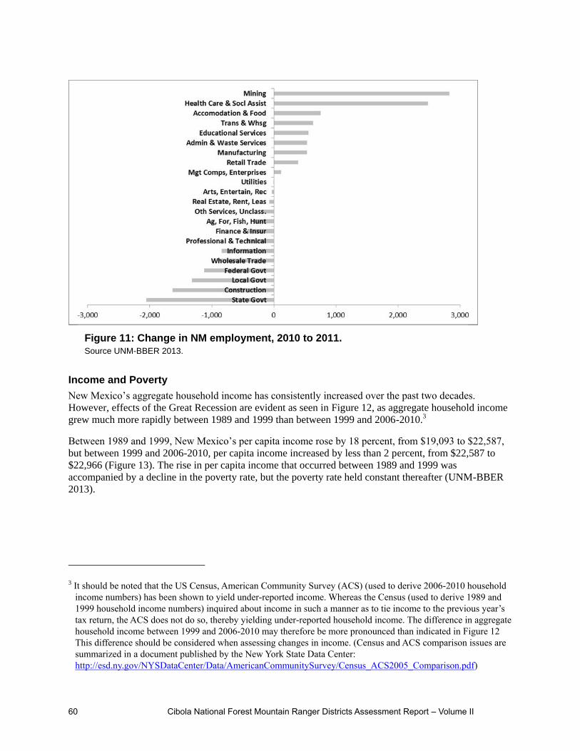
60 Cibola National Forest Mountain Ranger Districts Assessment Report – Volume II
Income and Poverty
New Mexico’s aggregate household income has consistently increased over the past two decades.
However, effects of the Great Recession are evident as seen in Figure 12, as aggregate household income
grew much more rapidly between 1989 and 1999 than between 1999 and 2006-2010.3
Between 1989 and 1999, New Mexico’s per capita income rose by 18 percent, from $19,093 to $22,587,
but between 1999 and 2006-2010, per capita income increased by less than 2 percent, from $22,587 to
$22,966 (Figure 13). The rise in per capita income that occurred between 1989 and 1999 was
accompanied by a decline in the poverty rate, but the poverty rate held constant thereafter (UNM-BBER
2013).
3 It should be noted that the US Census, American Community Survey (ACS) (used to derive 2006-2010 household
income numbers) has been shown to yield under-reported income. Whereas the Census (used to derive 1989 and
1999 household income numbers) inquired about income in such a manner as to tie income to the previous year’s
tax return, the ACS does not do so, thereby yielding under-reported household income. The difference in aggregate
household income between 1999 and 2006-2010 may therefore be more pronounced than indicated in Figure 12
This difference should be considered when assessing changes in income. (Census and ACS comparison issues are
summarized in a document published by the New York State Data Center:
http://esd.ny.gov/NYSDataCenter/Data/AmericanCommunitySurvey/Census_ACS2005_Comparison.pdf)
Figure 11: Change in NM employment, 2010 to 2011.
Source UNM-BBER 2013.

Cibola National Forest Mountain Ranger Districts Assessment Report – Volume II 61
0
5,000
10,000
15,000
20,000
25,000
30,000
35,000
40,000
45,000
50,000
1989 1999 2006-2010
20
10
mill
ion
do
llars
Household Income
Household Income
Figure 12. New Mexico aggregate household income.
Source U.S. Census Bureau, 1990 and 2000 censuses.

62 Cibola National Forest Mountain Ranger Districts Assessment Report – Volume II
Figure 13: New Mexico per Capita Income and Poverty
Rate.

Cibola National Forest Mountain Ranger Districts Assessment Report – Volume II 63
Figure 14. Area of Influence for the Magdalena RD.
Magdalena RD AoI
Magdalena Ranger District is the largest district on the Cibola NF, and covers approximately 792,148
(Cibola NF GIS 2013) acres in three New Mexico counties: Socorro, Catron, and Sierra. It is composed of
four separate mountain ranges: the Datil Mountains, Bear Mountains, San Mateo Mountains, and
Magdalena Mountains. The AoI map is presented in Figure 14.
Population, Population Density, Net Migration, Ethnic and Racial Composition
The counties associated with Magdalena RD are home to fewer than 35,000 people (Figure 15). With less
than 2 people per square mile, these counties are the least-densely populated within the plan area.
Between 1980 and 2000, the population increased on average 20 percent per decade, similar to that
experienced by the assessment area and the state. However, the assessment area and the state both
experienced population growth between 2000 and 2010 (17.6 and 13.2 percent growth, respectively), but
the Magdalena RD associated counties decreased by 4 percent about 1,106 persons.
Since 1990, the ethnic composition has consistently been approximately 40 percent Hispanic or Latino
and 60 percent non-Hispanic. However, significant differences exist across the three Magdalena RD
counties:
Catron County is predominantly non-Hispanic (81 percent in 2010),
Socorro County is almost evenly split between non-Hispanic and Hispanic or Latino, and Sierra County falls somewhere in between.

64 Cibola National Forest Mountain Ranger Districts Assessment Report – Volume II
The Magdalena area of influence is more predominantly white than other Cibola NF ranger districts.
See Table 11 above Figure 15) which depicts the 2010 racial composition of all counties within the
Cibola NF area of influence (UNM-BBER 2013).
Urban and Rural Communities, Characteristics and Values
The major towns in the Magdalena RD planning area include:
Socorro, with a population of 9,055 in 2011.Soccorro is home to New Mexico Institute of Mining
and Technology (New Mexico Tech), where academic programs focus primarily on science and
engineering.
Magdalena, with a population of 938 in 2010. Magdalena has a rich history of homesteading and
mining, and is known as the “Trails End” for the historic Magdalena Stock Driveway where
thousands of cattle and sheep were driven to stockyards awaiting transport east on the ATS
railroad spur. The last herd of cattle was reportedly brought into the stockyards as late as 1970.
The Magdalena District Ranger’s Office is located in the town of Magdalena.
Datil, with a population of 54 in 2010. Datil is located on the Plains of San Agustin west of
Magdalena on Highway 60. Between Datil and Magdalena is the Karl G. Jansky, Very Large
Array (VLA), a component of the National Radio Astronomy Observatory.
Truth or Consequences with a population of 6,451 in 2011 (US Census accessed 03 26 2013).
Truth or Consequences is located south of the Magdalena District in Sierra County on Elephant
Butte Reservoir, a popular State Park. Originally named Hot Springs, the city changed its name to
Truth or Consequences in 1950 after a contest held by the radio quiz program known by the same
name.
The Alamo Navajo Indian Reservation is a non-contiguous section of the Navajo Nation located
mostly within the Magdalena Ranger District proclamation boundary. The reservation has a land
area of about 100 square miles and an approximate population of 2,000 persons. Further
Figure 15: Historical and projected population of Magdalena RD counties.
Source UNM-BBER 2012.

Cibola National Forest Mountain Ranger Districts Assessment Report – Volume II 65
discussion of tribal reservations and culture in this RD can be found in chapter two of this
volume.
There are six Spanish or Mexican land grants in the vicinity of Magdalena Ranger District and include:
Belen, Sevilleta, Town of Socorro grant, Bosque del Apache, Pedro Armendariz No. 34 and Pedro
Armendariz No. 33 (UNM-BBER 2013). Additional discussion of the land grant communities occurring
in this RD can be found in chapter one of this volume.
Age
Since 1990, relatively minor changes have occurred in the population’s age structure. The population
between ages 0 and 14 has declined from 22 to 17 percent; working age adults between ages 15 and 64
has increased from 60 to 62 percent, and retirement age ─ ages 65 and over has increased from 19 to 22
percent.
Although the population living in counties associated with the Magdalena RD area is older than that of
New Mexico, recent changes to the age structure of the Magdalena area’s population are similar to
changes seen in both New Mexico and the US. For all areas, the trends result from declining fertility rates
and longer life expectancies. For the Magdalena RD area, and perhaps New Mexico as well, the trends
may result from young people leaving to seek greater economic opportunities. More dramatic age
structure changes are expected between 2010 and 2030, when the portion of the population that is of
retirement age is expected to increase from 22 percent to nearly one third, and the portion of the
population that is of working age is expected to decline from more than 60 percent to approximately 50
percent (UNM-BBER 2013). See Figure 16.
Levels of Education
Educational attainment levels have increased in all Cibola NF ranger district areas, including the counties
associated with Magdalena RD. This trend is consistent with the increase in educational attainment levels
that has occurred across the U.S. since at least 1940. Although Magdalena RD area of influence counties
have consistently had lower educational attainment levels than other Cibola NF ranger districts, the
Figure 16. Historical and projected age distribution in Magdalena RD AoI
counties. Source: New Mexico County Population Projections 2010-2040

66 Cibola National Forest Mountain Ranger Districts Assessment Report – Volume II
Magdalena RD area has also experienced some of the most dramatic improvements. Whereas in 1990,
thirty-four percent of individuals age 25 or older had at least some college education, this increased to 48
percent by 2006-2010. The lingering effects of the Great Recession will likely continue to create an
incentive for individuals to obtain higher education. Thus it is expected that educational improvements
will continue in counties associated with Magdalena RD and elsewhere. See Figure 17.
Employment and Important Economic Sectors
Similar to the population pattern in this RD area of influence (AoI), the majority of the area’s
employment, (53 percent in 2011), occurs within Socorro County. However, employment growth between
1990 and 2011 has been slower in Socorro than in other Magdalena RD counties.
Between 1990 and 2011 employment:
Socorro County grew by 1,729 jobs (26 percent)
Sierra County grew by 1,964 jobs (59 percent)
Catron County grew by 782 jobs (63 percent)
Both farm and non-farm proprietary employment4 play larger roles in the Magdalena RD area than in
other Cibola NF ranger districts. In 1990, 2000, and 2010 between 25 and 33 percent of employment in
the Magdalena RD area was proprietary (self-employed). In contrast, proprietary employment accounted
for about 18 percent of employment in counties associated with other Cibola NF ranger districts. The
relatively high level of proprietary employment in the Magdalena RD area makes sense for such a highly
rural area, where employment opportunities are limited. See Figure 18, below (UNM-BBER 2013).
4 Proprietary employment consists of sole proprietorships (unincorporated businesses required to file Schedule C of
IRS Form 1040 or Schedule F) and general partners. Proprietary employment is in contrast to wage and salary
employment, and captures those who are self-employed.
Figure 17: Educational Attainment in Magdalena RD Counties.
Source UNM-BBER 2013.

Cibola National Forest Mountain Ranger Districts Assessment Report – Volume II 67
Between 1990 and 2011, private nonfarm employment accounted for approximately 75 percent of New
Mexico’s total employment. For the same period, private nonfarm employment accounted for 56 percent
in Socorro County; 73 percent in Sierra County and 63 percent in Catron (63%) County. The importance
of private nonfarm employment is growing. Between 2001 through 2011, private nonfarm employment
grew from 54 to 56 percent in Socorro County, 70 to 75 percent in Sierra County, and 56 to 70 percent in
Catron County.
The farming sector – livestock production in particular – is larger in Magdalena ranger district associated
counties than the other individual RD AoIs. In 2010, farming accounted for 8 percent of all jobs in the
Magdalena RD area, but only 2 percent of jobs in other Cibola NF ranger district areas. Between 2001
and 2010, cash receipts from the sale of livestock and livestock products from the Magdalena RD area
averaged nearly $92,000 annually and represented approximately 40 percent of all such receipts in the
Cibola NF assessment area (Figure 19).5
Magdalena RD AoI contains approximately one-quarter of all irrigated acres in the Cibola NF assessment
area, and has a rich history of cattle ranching and stock drives along the historic Magdalena Stock
Driveway culminating in Magdalena at the “Trails End”. These two things may account for the relatively
high livestock receipts in the area.6 Although farming sector employment is growing in counties
associated with Magdalena RD, its importance relative to the rest of the area’s economy is diminishing7
(UNM-BBER 2013).
5 Note that the values presented in Figure 19 have not been adjusted for inflation. This is true for livestock and
livestock product cash receipts values throughout this report. 6 In 1999 the Magdalena RD associated counties contained 26 percent of the Cibola NF assessment area’s irrigated
acres (UNM-BBER 2013). 7 Difficulties that face Magdalena RD ranchers include (but certainly are not limited to) high feed costs, decreased
Figure 18: Total Employment in Magdalena RD Counties.
Source, UNM-BBER 2013.

68 Cibola National Forest Mountain Ranger Districts Assessment Report – Volume II
The government sector is the largest employer in counties associated with Magdalena RD, where local,
state, and federal governments accounted for nearly 30 percent of all employment in 2010. The
government sector is particularly important in Socorro County, where 36 percent of jobs are associated
with various government agencies (UNM-BBER 2013).
Composition of the private sector in Magdalena RD associated counties is difficult to ascertain due to the
small economic base. To maintain confidentiality, The U.S. Department of Commerce Bureau of
Economic Analysis does not disclose data that could result in identification of an individual employer.
Although data for numerous industries in unavailable for these counties, particularly Catron and Sierra
Counties, Figure 20, depicts 2011 employment levels by county and North American Industry
Classification System (NAICS) code8 (UNM-BBER 2013).
carrying capacities, and decreased seasons of use on federal lands grazing permits. 8 When assessing the relative importance of various industries within a given county, bear in mind that employment
data for an industry is only disclosed if at least three companies are associated with the industry in the county of
interest.
Figure 19: Livestock and livestock product cash receipts in
Magdalena RD counties. Source UNM-BBER 2013.

Cibola National Forest Mountain Ranger Districts Assessment Report – Volume II 69
Unemployment
Although the area’s unemployment rate has historically been higher than that of the state, the gap has
narrowed over time.9 The Great Recession caused unemployment rates to rise in both rural and urban
areas, but was greater in urban areas. As a result, beginning in 2008, the unemployment rate within
Magdalena RD area has been lower than the unemployment rates of both the Cibola NF assessment area
and the state (UNM-BBER 2013).
Income, Poverty, and Household Income
Between 1989 and 1999, aggregate household income grew in all Cibola NF RD area of influence (AoI)
counties. Income continued to grow from 1999 through 2006-2010 in Sandia, Mountainair and Mt. Taylor
AoIs, while RD aggregate household income fell by 14 percent. However, Magdalena RD AoI is the only
area where the working age population decreased between 2000 to 2010. If the population’s size holds
relatively constant and if the portion that is of working age continues to shrink (as forecast by BBER),
aggregate household income can be expected to continue to decline.
As depicted in Figure 21, the total area’s household income distribution has improved. In general, the
portion of households with incomes of $50,000 or more has increased while those with incomes of under
$50,000 have decreased. A comparison of per capita incomes across Cibola NF ranger districts provided
in Figure 22, shows that the more rural RDs (Magdalena and Mt. Taylor), have lower per capita income
than Mountainair and Sandia RDs. In the Magdalena area, per capita income grew by 17 percent between
1989 and 2006-2010 (from less than $16,000 to nearly $18,500).
9 Disparity in unemployment rates that existed across Magdalena RD counties in the early 1990s also narrowed
significantly by 2000.
Figure 20. 2011 employment levels by NAICS code for Magdalena RD
counties. Source UNM-BBER 2013.

70 Cibola National Forest Mountain Ranger Districts Assessment Report – Volume II
Figure 21. Household Income Distribution in Magdalena RD Counties. Source:
UNM-BBER 2013.
Figure 22. Per capita income in Cibola NF RDs. Source UNM-BBER 2013.

Cibola National Forest Mountain Ranger Districts Assessment Report – Volume II 71
The percent of residents living in poverty in the Magdalena area has remained fairly constant – an average
of 26 percent since 1989. However, there are significant differences in poverty rates between the counties
associated with Magdalena RD. Magdalena RD’s poverty rates are notably higher than the other counties
associated with the Cibola Mountain RDs and the state.
The ethnic and racial components of poverty have changed in recent years. While the portion of non-
Hispanics living in poverty was basically the same in 2006-2010 as in 1989 (between 21 and 22 percent),
the portion of Hispanics living in poverty has slowly declined from 33 percent in 1989 to 28 percent in
2006-2010.
Whites living in poverty has stayed relatively constant at approximately 22 percent, other races
have experienced substantial poverty rate changes in the last twenty years.
American Indians, African Americans, and “Others” living in poverty increased between 1989
and 1999, but decreased between 1999 and 2006-2010. The decrease was most dramatic among
African Americans, for whom the percent living in poverty decreased from over 50 percent (57
people) in 1999 to less than 10 percent (14 people) in 2006-2010.
Asians and Pacific Islanders have also experienced a dramatic decline in poverty rates since 1989
– from nearly 50 percent (95 people) to complete elimination by 2006-2010 (Figure 23).
The reductions in poverty rates that occurred between 1999 and 2006-2010 are somewhat surprising given
the Great Recession, but may in part be explained by people moving out of the area. With a poverty rate
still close to 50 percent, American Indians are now the only racial group for whom the poverty rate
exceeds 25 percent.10 As the recovery from the Great Recession continues, poverty rates are expected to
continue to decline. However, poverty appears to be pervasive among American Indian populations living
within Magdalena RD associated counties and will likely remain high for the foreseeable future (UNM-
BBER 2013).
10 For comparative purposes, American Indians in NM as a whole have a poverty rate of just over 30 percent.
Figure 23: Poverty Rate and Race in Magdalena RD counties. Source UNM-BBER
2013.

72 Cibola National Forest Mountain Ranger Districts Assessment Report – Volume II
Figure 24. Area of Influence (AoI) for the Mountainair RD.
Mountainair Ranger District Area of Influence
The Mountainair RD contains 205,903 acres (Cibola NF GIS 2013) of land located in Bernalillo,
Torrance, Lincoln and Valencia Counties. The district has two mountain ranges:
The Manzano Mountains, located primarily in Torrance County, with a small section on the west
side of the mountain located in Valencia County and a small area in southern Bernalillo Co.
The Gallinas Mountains, located in both Torrance and Lincoln Counties. The AoI of Mountainair
RD is presented in Figure 24.
Population, Population Density, Net Migration, Ethnic and Racial Composition
In 2010, the Mountainair RD AoI counties were home to 75 percent of New Mexico’s population (UNM-
BBER 2013). Bernalillo County is included in the Mountainair area of influence (AoI) and has a large
influence on the ranger district, particularly with regard to visitation to Fourth of July Campground and
influences of other urban recreational demands and activities. The population of these urban areas
contribute to the high population count in this otherwise rural area. It should also be noted that the
inclusion of Lincoln County’s demographics introduces populations of a number of small communities
geographically distant from the Mountainair RD such as Ruidoso, Capitan and Carrizozo, which are close
to, or within the Lincoln National Forest to the south. Residents of these communities tend to use the
Gallinas unit of the Cibola in traditional ways such as hunting and camping.
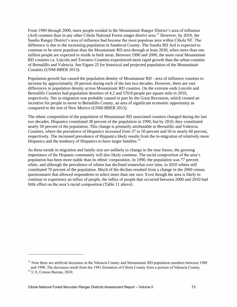
Cibola National Forest Mountain Ranger Districts Assessment Report – Volume II 73
From 1980 through 2000, more people resided in the Mountainair Ranger District’s area of influence
(AoI) counties than in any other Cibola National Forest ranger district area.11 However, by 2010, the
Sandia Ranger District’s area of influence had become the most populous area within Cibola NF. The
difference is due to the increasing population in Sandoval County. The Sandia RD AoI is expected to
continue to be more populous than the Mountainair RD area through at least 2030, when more than one
million people are expected to reside in both areas. Between 1990 and 2000, the more rural Mountainair
RD counties i.e. Lincoln and Torrance Counties experienced more rapid growth than the urban counties
of Bernalillo and Valencia. See Figure 25 for historical and projected population of the Mountainair
Counties (UNM-BBER 2013).
Population growth has caused the population density of Mountainair RD - area of influence counties to
increase by approximately 20 percent during each of the last two decades. However, there are vast
differences in population density across Mountainair RD counties. On the extreme ends Lincoln and
Bernalillo Counties had population densities of 4.2 and 570.8 people per square mile in 2010,
respectively. Net in-migration was probably caused in part by the Great Recession, which created an
incentive for people to move to Bernalillo County, an area of significant economic opportunity as
compared to the rest of New Mexico (UNM-BBER 2013).
The ethnic composition of the population of Mountainair RD associated counties changed during the last
two decades. Hispanics constituted 38 percent of the population in 1990, but by 2010, they constituted
nearly 50 percent of the population. This change is primarily attributable to Bernalillo and Valencia
Counties, where the prevalence of Hispanics increased from 37 to 50 percent and 50 to nearly 60 percent,
respectively. The increased prevalence of Hispanics likely results from the in-migration of relatively more
Hispanics and the tendency of Hispanics to have larger families.12
As these trends in migration and family size are unlikely to change in the near future, the growing
importance of the Hispanic community will also likely continue. The racial composition of the area’s
population has been more stable than its ethnic composition. In 1990, the population was 77 percent
white, and although the prevalence of whites has declined somewhat over time, in 2010 whites still
constituted 70 percent of the population. Much of the decline resulted from a change in the 2000 census
questionnaire that allowed respondents to select more than one race. Even though the area is likely to
continue to experience an influx of people, the influx of people that occurred between 2000 and 2010 had
little effect on the area’s racial composition (Table 11 above).
11 Note there are artificial decreases in the Valencia County and Mountainair RD population numbers between 1980
and 1990. The decreases result from the 1981 formation of Cibola County from a portion of Valencia County. 12 U.S. Census Bureau, 2010.

74 Cibola National Forest Mountain Ranger Districts Assessment Report – Volume II
Figure 25: Historical and Projected Population of Mountainair Ranger
District Counties. Source UNM-BBER 2013.

Cibola National Forest Mountain Ranger Districts Assessment Report – Volume II 75
Urban and Rural Communities, Characteristics and Values
Communities near the Mountainair Ranger District include five small land grant towns located on the east
side of the district, the Isleta Indian Reservation and the town of Mountainair.
The town of Manzano was confirmed to be in existence in 1846, and had a population of 29 in
2010.
Land for the town-site of Tajique was set-aside in 1834 (New Mexico Office of the State
Historian accessed July 2013) and had a population of 130 in 2010.
The town of Torreon was established in 1841 (New Mexico Office of the State Historian accessed
July 2013), and had a population of 237 in 2010.
The town of Chilili was registered in 1841, and had a population of 137 in 2010
Corona had a population of 172 (American Fact Finder 2010)
In contrast to the small land grant towns in the Mountainair RD AoI, also included in this AoI is the
County of Bernalillo, a highly urbanized and large metropolitan area with a population of over 673,000
people. The City of Albuquerque is the county seat. Over the years, Albuquerque has developed into the
cultural, political, and economic center of New Mexico (New Mexico Office of the State Historian,
accessed August 2013). There are a number of large federal employers in Albuquerque, a large state
university, and a large community college. Characteristics and values of Bernalillo County and the City of
Albuquerque are more fully described in this chapter in a later, similar subsection and which addresses
the Sandia RD AoI.
Also within this AoI is Los Lunas, a village in Valencia Co.. As of the 2012 census, the village
population is 14,835. It is the county seat of Valencia County but is only 22 miles from Albuquerque. It
is located adjacent to the Rio Grande and to I-25 and was originally part of the San Clemente Land Grant
(additional discussion of characteristics and values of this and other land grant communities located in
this RD AoI, including Tajique, Torreon, Manzano, and Chilili can be found in Chapter 1 of this volume).
Los Lunas has experienced rapid growth in the late 1990s and early 2000s, and many residents commute
to jobs in Bernalillo Co. and the City of Albuquerque Similarly, also within this AoI is Belen, the second
most populous city in Valencia Co. and located 10 miles south of Los Lunas on I-25. The population was
7,313 at the 2010 Census. Belen is Spanish for Bethlehem but gained the nickname "The Hub City"
because of a major rail junction on BNSF Railway's Southern Transcon rail line. The city is
geographically near the center of New Mexico and has been a significant transportation hub for central
New Mexico that includes access to rail, the interstate (I-25) and air at Valencia County's only public
airport.
The Isleta Indian Reservation boundary is coincident with the district boundary on the northwest, but the
Isleta Pueblo (town site) is located approximately 15 miles west toward the Rio Grande. U.S. Census Fact
Finder reports a population of 491 in the “Isleta Village Proper” for 2010. The pueblo is comprised of two
small villages: Oraibi and Chicale and the main village of Isleta. The language is generally Tiwa and most
people speak English as well. Isleta owns and operates a large casino and resort just south of the
Albuquerque city limits, and is also known for their exceptional style of traditional pottery (Indian Pueblo
Cultural Center, accessed July 2013). Further discussion of tribal reservations and culture can be found in
Chapter 2 of this volume.
The town of Mountainair was founded in 1903 (mountainairnm.gov/history, accessed July 2013) and is
located approximately five miles west of the district boundary. It had a population of 928 in 2010 (US
Census, American Fact Finder 2010). Until the mid-1950s, Mountainair was known as the “Pinto Bean
Capital of the World” (mountainairnm.gov/history, accessed July 2013).

76 Cibola National Forest Mountain Ranger Districts Assessment Report – Volume II
Age
Relatively minor changes have occurred in the age structure of this area’s population since 1990 (Figure
26). The population that is of working age (between 15 and 64), has remained nearly constant at
approximately 67 percent. The population between ages 0 and 14, has declined from 23 to 20 percent and
the portion of retirement age (65 and over), has increased slightly from 11 to 13 percent. By 2030, the
population that is of retirement age is expected to increase to 20 percent; the working age population is
expected to decline to 62 percent, and minimal change in ages 0 to 14 is expected to occur (UNM BBER
2013).
Levels of Education
Education levels have increased in the counties associated with Mountainair RD (Figure 27). This trend is
consistent with the increase in educational attainment levels that has occurred across the U.S. since at
least 1940 (UNM-BBER 2013). Counties associated with the Mountainair RD have had relatively high
education levels as compared to most other Cibola NF ranger districts and the state. Only the Sandia RD
area has been higher.
The portion of the Mountainair RD area’s population, i.e., those age 25 or older with at most a high
school degree is 40 percent and is lower than that of all other Cibola NF areas except the Sandia RD plan
area, where 38 percent of the relevant population have at most a high school degree. The portion with at
least some college or an advanced degree is correspondingly higher in the Mountainair and Sandia RD
areas, because the University of New Mexico, Central New Mexico Community College, and many
smaller private schools such as the University of Phoenix are located in Albuquerque and the commuting
area (UNM-BBER 2013).
Figure 26: Historical and Projected Age Distribution in Mountainair RD
Counties. Source UNM-BBER 2013.

Cibola National Forest Mountain Ranger Districts Assessment Report – Volume II 77
Employment and Important Economic Sectors
As depicted in Figure 28 the majority of the area’s employment occurs within Bernalillo County. Between
1990 and 2011, 92 percent of all Mountainair RD counties’ jobs have been located within Bernalillo
County. During 2011, more than 400,000 jobs (34 percent of all New Mexico jobs), were located in
Bernalillo County. However, employment growth between 1990 and 2011 has been slower in Bernalillo
County than in the other Mountainair RD counties. During this period, employment in Bernalillo County
grew by 33 percent, while those in Lincoln, Torrance, and Valencia Counties grew by 57, 63, and 77
percent, respectively.
Figure 27:
Educational
Attainment in
Mountainair RD
Counties.
Source UNM-BBER
2013.

78 Cibola National Forest Mountain Ranger Districts Assessment Report – Volume II
Not surprisingly, proprietary (self-employed or self-owned business) employment is of lesser importance
to the economies of Bernalillo and Valencia Counties, representing approximately 22 percent of total
employment since 1990. In the more rural economies of Lincoln and Torrance Counties, proprietary
employment has averaged 36 percent of total employment. Although the Mountainair RD area’s farming
sector employs few people and accounts for a smaller percentage of employment than the farming sectors
of most other Cibola NF areas and in New Mexico, the area accounts for nearly half of all Cibola NF
assessment area, and 5 percent of the state’s livestock and livestock products cash receipts (Figure 29)
This may in part result from the fact that the Mountainair RD associated counties contain more irrigated
acres than other RD areas within the Cibola NF assessment area13.
13 In 1999 the Mountainair RD associated counties contained 44 percent of the assessment area’s irrigated acres (UNM-BBER
2013). Some water is pumped from the Estancia Basin; however, many of the irrigated acres in these RD AoI counties are a
result of flood irrigation through acequias from the Rio Grande, which is geographically remote from Mountainair RD.
Figure 28. Total employment in Mountainair RD AoI counties.
Source UNM-BBER 2013.

Cibola National Forest Mountain Ranger Districts Assessment Report – Volume II 79
The government sector tends to be smaller (as a percent of all jobs) in the Mountainair and Sandia Ranger
Districts, where government provided 18 percent of all jobs in 2010 compared to the more rural
Magdalena and Mt. Taylor Ranger Districts, where government provided 28 and 24 percent of all jobs in
2010. The mix of government employment also differs, with state and local governments playing a larger
role in rural areas than in urban areas, and the military playing a larger role in the more urban RDs
because Kirtland Air Force Base is located in Albuquerque.
The private sector accounts for more than 80 percent of employment within Mountainair RD associated
counties. The percent distribution of employment across the private and public sectors has held fairly
constant since at least 1990 and will likely to continue to do so. The sectors that were primary employers
in Bernalillo County during 2011, were retail trade, health care and social assistance, and professional,
scientific, and technical services. These sectors accounted for nearly 40 percent of total Bernalillo County
employment (Figure 30). Those sectors for which 2011 employment data is disclosed, the health care and
social assistance sector was the largest employer in Valencia County, while retail trade was the largest
sector in both Lincoln and Torrance Counties.
Figure 29: Livestock and Livestock Product Cash Receipts in
Mountainair RD AoI Counties. Source UNM-BBER 2013.

80 Cibola National Forest Mountain Ranger Districts Assessment Report – Volume II
Unemployment
The area’s unemployment rate was equivalent to or lower than that of New Mexico from 1990 through
2007. However, during the Great Recession, unemployment rates rose more in urban than in rural areas,
and thus beginning in 2008, the Mountainair RD unemployment rate became higher than the state’s. Since
mid-2010, unemployment rates have fallen across New Mexico, although this has resulted more from a
decrease in the size of the labor force than from job creation (UNM-BBER 2013).
Income, Poverty, and Household Income
Between 1989 and 1999, aggregate household income grew in all Cibola NF ranger district areas. It
continued to grow between 1999 and 2006-2010 in all areas except the Magdalena RD area. Slower
aggregate household income growth in the Mountainair RD area between 1999 and 2006-2010 is
attributable to both slower population growth and to higher rates of unemployment. The area should
continue to experience a rise in aggregate household income as its population grows and the economic
recovery slowly continues (UNM-BBER 2013).
As depicted in Figure 31, household income in Mountainair RD area of influence has improved over time.
The percentage of households with incomes of less than $50,000 has decreased while the portion of
households with incomes of $50,000 or more has increased. This trend has been seen across the Cibola
NF assessment area and New Mexico, and is expected to continue.
Figure 30: 2011 employment levels by NAICS code for Mountainair RD AoI
counties. Source UNM-BBER 2013.

Cibola National Forest Mountain Ranger Districts Assessment Report – Volume II 81
Figure 31 also shows that in 2006-2010, the distribution of households across income ranges was fairly
consistent across Mountainair RD counties. However, Torrance County was a bit of an anomaly with a
greater portion of its population at the lower end of the income spectrum than other Mountainair RD
counties. Despite the fact that a greater portion of households had higher incomes in 2006-2010 than in
1989, the number and percent of people living in poverty in the Mountainair RD area have both increased.
In 1989, there were 81,670 people living in poverty (15% of the population) to 119,218 people (16% of
the population) in 2006-2010.
Poverty rates differ vastly for the Hispanic and non-Hispanic populations, although the gap between the
two has narrowed from 12.3 percent in 1989 to 9.5 percent in 2006-2010 (Figure 22). Hispanic and non-
Hispanic poverty rates decreased between 1989 and 1999, but subsequently increased between 1999 and
2006-2010. This same basic pattern also occurred across all racial groups except Asian and Pacific
Islanders, who experienced declines in poverty rates during both decades.
American Indians had the highest poverty rates in both 1989 and 1999 (29% and 25% respectively).
Between 1999 and 2006-2010 the rate of poverty increased more among African Americans than among
any other racial group. African Americans experienced an increase in poverty of more than 7 percent and
subsequently became the racial group with the highest poverty rate (almost 27%). This is a unique
circumstance – in all other years and areas (RDs, Cibola NF assessment area, NM), poverty rates were
consistently highest among American Indians, Figure 32 and Figure 33 (UNM-BBER 2013).
Figure 31: Household Income Distribution in Mountainair RD AoI
Counties. Source UNM-BBER 2013.

82 Cibola National Forest Mountain Ranger Districts Assessment Report – Volume II
Figure 32: Poverty Rate and Ethnicity in Mountainair RD AoI
Counties. Source UNM-BBER 2013.
Figure 33: Poverty Rate and Race in Mountainair RD AoI Counties.
Source UNM-BBER 2013.

Cibola National Forest Mountain Ranger Districts Assessment Report – Volume II 83
Mt. Taylor Ranger RD AoI
Mt. Taylor Ranger District is located in the northeastern part of the state contains nearly 517,432 acres
(Cibola NF, GIS 2013) of NF land located in McKinley, Sandoval, and Cibola Counties (Figure 34). It is
comprised of two mountain ranges: the San Mateo and Zuni Mountains.
Population, Population Density, Net Migration, Ethnic and Racial Composition
In 1980, fifteen percent of the Cibola NF assessment area population lived in counties associated with Mt.
Taylor RD. By 2010, largely as a result of population growth in geographically distant communities
within Sandoval County, this had increased to 22 percent. New Mexico’s population growth rates were
more moderate, as were those for Cibola and McKinley Counties. Between 2000 and 2010, Cibola
County’s population grew by only 6 percent, while McKinley County’s population decreased by
approximately 4 percent. These differences in population trends are consistent with those between other
urban and rural counties in the state, and are indicative of the general migration pattern resulting from the
Great Recession, i.e., movement from rural to urban areas. See Figure 35, below.
The area’s population density increased between 20 and 30 percent during each of the last two decades,
but at 17 people per square mile in 2010 was still relatively low. The RD area’s population density is
similar to that of New Mexico as a whole, but significantly lower than that of the Mountainair or Sandia
RD areas, but higher than that of the Magdalena RD area, which has a population density of 2 people per
square mile.
Figure 34. Area of influence for the Mt. Taylor RD.

84 Cibola National Forest Mountain Ranger Districts Assessment Report – Volume II
Mt. Taylor Ranger District area has consistently experienced net in-migration of approximately 20,000
persons over the past two decades. Net in-migration to Sandoval County was 84 percent higher between
2000 and 2010 (34,588 people) than between 1990 and 2000 (18,832 people). However, the increase was
largely offset by net out-migration of 12,214 people from McKinley County. Movement out of McKinley
and Cibola Counties was likely at least in part driven by the Great Recession – individuals likely moved
to seek greater economic opportunities in more urban areas (UNM-BBER 2013).
The ethnic makeup of the Mt. Taylor RD area differs from that of other Cibola NF ranger districts (Table
11). Between 1990 and 2000, the portion of the area’s population that was Hispanic held fairly constant,
but subsequently increased from 23 to 29 percent between 2000 and 2010. Much of the increase occurred
in Sandoval County, and results from the in-migration of relatively more Hispanics. Since 1990, the
portion of the area’s population that is American Indian has declined from 44 to 36 percent. Despite this
decrease, American Indians represent a greater portion of the area’s population than that of other Cibola
NF ranger district areas. The decrease has been driven by changes in the racial structure of Sandoval
County, where American Indians comprised 20 percent of the 1990 population, but by 2010 comprised
only 13 percent (UNM-BBER 2013). This is due to the influx of non-Native Americans into Sandoval
County, thereby changing the percentages.
Urban and Rural Communities, Characteristics and Values
The communities most closely (geographically) associated with Mt. Taylor Ranger District are:
Grants, with a population of 9,182 in 2010. It is famous for the Grants Mineral Belt, which is the
focus of uranium mining on the district.
Milan is located just north of Grants, and has a population of 3,245 in 2010.
Figure 35. Historical and Projected Population of Mt. Taylor RD AoI Counties.
Source UNM-BBER 2013.

Cibola National Forest Mountain Ranger Districts Assessment Report – Volume II 85
Gallup is surrounded by the Navajo Nation and had a population of 21,678 in 2010. The
American Indian and Alaska Native population in Gallup was 8,797 for the years 2007-2011─
about 40 percent of the population of Gallup (US Census American Community Survey accessed
March 27, 2013).
The Navajo Nation is the largest Indian reservation the United States, approximately 25,000
square miles. The Navajo engage in traditional enterprises such as low input agriculture, livestock
grazing, rodeos, timber production, but also have a casino and are known for weaving and
jewelry.
Acoma Pueblo is situated approximately 50 miles west of Albuquerque and has a population of
3,500 (Indian Health Service 2013). It is best known for the old village's (Sky City) dramatic
location atop a high mesa. Acoma is one of the oldest continuously inhabited communities in
North America. The local dialect is Keres and English. Acoma Pueblo owns and operates a large
casino located on US Interstate 40, which receives a lot of business from cross-country travelers.
Ramah is on the Ramah Indian Reservation on U.S. Interstate 40, south of the Zuni Mountains.
Ramah has a population of 370 in 2010, with 60 people (16 percent) reporting as American
Indian or Alaska Native (US Census American Fact Finder, accessed 03 27 2013).
Zuni Pueblo is situated west of the Zuni Mountains and shares a common boundary with the
Mt.Taylor RD. Mt. Taylor continues to serve as an important place for the Zunis. Farming and
grazing areas extend to its western base, and Zunis traverse the entire mountain and beyond for
hunting, plant, animal, and mineral collecting, and for religious observances (Colwell-
Chanthaphonh and Ferguson 2012).
The Pueblo of Laguna is located along the I-40 corridor and shares a common boundary along the
southeast portion of the Mt. Taylor division of the RD. The Pueblo operates two casinos along I-
40.
Further discussion of tribal reservations and cultures can be found in Chapter 2 of this volume.
There are nine Spanish or Mexican land grants near Mt. Taylor: Ignacio Chavez Grant; Nuestra Senora de
la Luz de Las Lagunitas; Cebolleta; Laguna Purchases Tract 1; Cubero Land Grant; Acoma Pueblo
Bartolome Fernandez; San Mateo Springs; Juan Tafoya Land Corporation, and Zuni Pueblo (UNM-
BBER 2013). Further discussion of land grants within the Cibola AoI can be found in Chapter 1 of this
volume.
Age
In 1990, there was a sizeable difference in the portion of the population that was between the ages of 0
and 14 (30%), and that which was age 65 or over (10%). The gap narrowed by 2010, when 23 percent
were between the ages of 0 and 14, and 11 percent were age 65 or over. This trend is expected to continue
so that by 2030, the two age cohorts will be approximately the same size, and each will represent roughly
20 percent of the population. The working age population ( ages 15 through 64), has slowly increased
from 62 percent in 1990 to 66 percent in 2010, but is expected to decline to 59 percent by 2030 (UNM-
BBER 2013). See Figure 36.

86 Cibola National Forest Mountain Ranger Districts Assessment Report – Volume II
Levels of Education
Individuals residing within counties associated with the Mt. Taylor Ranger District’s AoI generally have
less formal education than people in other ranger district’s AoI, and less than the average education level
of the people of the state. However, educational attainment has increased on all Cibola NF ranger
districts, including Mt. Taylor RD. This is consistent with the increase that has occurred across the United
States since 1940 (UNM-BBER 2013). In 2010, seventeen percent of the population had less than a high
school diploma, which is down from 31 percent in 1990 (Figure 37). Similarly, the population with an
advanced degree has increased during each of the last two decades. Now, 30 percent of the area’s
population has an advanced degree, compared to 20 percent in 1990. The lingering effects of the Great
Recession will likely continue to create an incentive for individuals to obtain additional education. It is
therefore expected that educational improvements will continue in the Mt. Taylor RD area and elsewhere
(UNM-BBER 2013).
Figure 36: Historical and Projected Age Distribution in Mt. Taylor RD
AoI Counties. Source UNM-BBER 2013

Cibola National Forest Mountain Ranger Districts Assessment Report – Volume II 87
Employment and Important Economic Sectors
In 1990, McKinley County had a larger share of the Mt. Taylor area’s jobs than either Cibola or Sandoval
Counties. By the mid-1990s, Sandoval County came to have more jobs than other Mt. Taylor counties.
Figure 38 illustrates the rapid growth in Sandoval County employment, which includes employment at
Intel Corporation and the recently built Rust Medical Center. Not surprisingly, employment levels grew
more between 1990 and 2000 than between 2000 and 2010. Growth during this period was slowest in
McKinley County, where employment grew by only 11 percent. In contrast, employment in Cibola and
Sandoval Counties grew by 18 and 28 percent, respectively during the same period. Historically the
Sandoval County population was relatively small and played a minor role in the area’s demographic and
economic profile, but as Intel Corporation has grown and the Rio Rancho and Sandoval County
populations have increased, Sandoval County has come to play a more prominent role in the state. There
are only 30 sections of Mt. Taylor Ranger District land in Sandoval County; however this growth is
reflected in the employment profile for the Mt. Taylor area of influence. Rio Rancho and its associated
economic opportunities are geographically distant from the Mt. Taylor planning area (UNM-BBER
2013).
Figure 37:
Educational
Attainment in
Mt. Taylor RD
AoI Counties.
Source UNM-
BBER 2013.

88 Cibola National Forest Mountain Ranger Districts Assessment Report – Volume II
A notable anomaly in the data pertaining to the Mt. Taylor Ranger District’s area of influence occurs in
the farm sector employment data. The farm sector in the Mt. Taylor RD area decreased by 8 percent ─ from 881 to 812 employees between 1990 and 2000. However, between 2000 and 2010, it expanded by
328 percent─ from 812 to 3,472 employees.14 The dramatic increase in the area’s farm sector employment
numbers stems from:
a) A change made in 2007 to the Census of Agriculture and
b) The Mt. Taylor RD associated counties contain large amounts of Native American lands.
Prior to the 2007 Census, Agriculture Native American farmers living on Native American land were
tallied as one large tribal farm. However, beginning with the 2007 Census of Agriculture, Native
American farmers living on Native American land were tallied as individual proprietors.15 Because the
Census of Agriculture is used as an input by the Bureau of Business and Economic Research, the
resulting increase in the number of farms carries forward into an increase in farm sector employment.
This pattern of growth occurred throughout the Mt. Taylor RD associated counties. Employment levels in
the farm sectors of Sandoval and Cibola Counties increased between 50 and 100 percent, while McKinley
County increased by a factor of ten.
14 Despite this significant growth, the farm sector still accounts for fewer than 4,000 jobs (less than 5 percent of the
area’s total employment). 15 According to the 2007 Census of Agriculture, the number of farms in Sandoval, Cibola, and McKinley Counties
increased by 162, 305, and 2,474 farms (105, 88, and 1,649 percent), respectively.
Figure 38: Total Employment in Mt. Taylor RD AoI Counties.
Source UNM-BBER 2013.

Cibola National Forest Mountain Ranger Districts Assessment Report – Volume II 89
Although the 2010 farm sector employment numbers indicate that Cibola, McKinley, and Sandoval
Counties have 14 percent of New Mexico’s farm sector employees, these counties account for only 2
percent of the state’s livestock and livestock products cash receipts. See Figure 39.
The presence of numerous small sectors for which data is unavailable, particularly in Cibola and
McKinley Counties, results in the presence of incomplete ranger district-level employment data and
presents difficulties for ascertaining the composition of the area’s private sector. We therefore focus our
assessment at the county level.
Sandoval County: The manufacturing, retail trade, and administrative and waste management
services sectors are the primary employers. See Figure 40. In 2011 these three sectors accounted
for nearly 40 percent of all Sandoval County employment.
McKinley County: The most important sectors are retail trade, health care and social assistance,
and accommodation and food services, which together provided 54 percent of the county’s
employment in 2011. Despite its importance, since at least 1990, the retail trade sector has
provided a smaller portion of the county’s employment with each passing decade, while the
health care and social assistance sector has employed a larger portion.
Figure 39: Livestock and livestock products cash receipts in Mt. Taylor
RD AoI Counties. Source UNM-BBER 2013.

90 Cibola National Forest Mountain Ranger Districts Assessment Report – Volume II
Cibola County: Disclosure issues exist for numerous sectors in Cibola County. Of those sectors
for which disclosure problems do not exist in 2011, retail trade is one of county’s most important
sectors and provided 11 percent of all Cibola County jobs in 2010. In the past, manufacturing was
a significant source of jobs in Cibola County, but contracted by 54 percent between 1990 and
2000 and by 82 percent between 2000 and 2010.
Unemployment
The Mt. Taylor Ranger District area’s unemployment rate has been higher than that of New Mexico since
at least 1990. The counties that comprise the Mt. Taylor RD area have vastly different unemployment
rates. For example, in 1990, the Cibola County unemployment rate was 13.4 percent, while Sandoval
County was 5.8 percent, and McKinley was about 6.3 percent. The disparity between the three counties
decreased between 1990 and 2002, and has been relatively small since 2002. Figure 10 above illustrated
the rapid rise in urban-area unemployment rates common during the Great Recession. The rise in Cibola
County’s unemployment rate was less than that of either McKinley or Sandoval Counties. The greater
increase in unemployment rates in McKinley and Sandoval Counties may in part result from the higher
levels of net migration to these counties, particularly if those migrating are unemployed and looking for
work. As the economy continues to recover from the Great Recession, unemployment rates should
gradually fall. However, much of the decrease in NM unemployment rates results from a decrease in the
size of the labor force rather than job creation (UNM-BBER 2013).
Figure 40: 2011 Employment Levels by NAICS Code for Mt. Taylor RD AoI
Counties. Source UNM-BBER 2013.

Cibola National Forest Mountain Ranger Districts Assessment Report – Volume II 91
Income, Poverty, and Household Income
Between 1989 and 1999, aggregate household income grew in all Cibola ranger districts and continued to
grow between 1999 and 2006-2010, including the Mt. Taylor RD. Slower growth between 1999 and
2006-2010 is not surprising, as the Great Recession resulted in high unemployment rates. The Mt. Taylor
Ranger District area had higher growth rates than any other Cibola National Forest RD. For example,
between 1989 and 1999, aggregate household income in the Mt. Taylor RD area grew by nearly 70
percent, while the average growth rate in other Cibola NF ranger districts was approximately 40 percent.
Although the difference was less pronounced between 1999 and 2006-2010, aggregate household income
of the Mt. Taylor RD area grew by 21 percent, while the average growth rate in other Cibola NF RDs was
only 4 percent.16 Aggregate household income should continue to rise, as the Mt. Taylor RD population is
projected to continue to grow by nearly 20 percent per decade. However, a shrinking working age
population and lingering effects of the Great Recession will likely keep growth dampened for the
foreseeable future (UNM-BBER 2013).
The Mt. Taylor RD area’s household income distribution has improved over time. The portion of
households with incomes of less than $50,000 has decreased, while the portion of households with
incomes of $50,000 or more has increased. Figure 41 illustrates the fact that in 2006-2010 Sandoval
County had a household income distribution that differed from that of McKinley and Cibola Counties. A
smaller portion of the Sandoval County population was at the lower end of the household income
distribution and a larger portion was at the upper end. In contrast to other ranger district AoIs within
Cibola NF, the Mt. Taylor RD area, and all of its AoI counties experienced a decrease in the portion of
the population living below poverty during each of the last two decades. The poverty rate of McKinley
County was 33 percent in 2006-2010 and has consistently been higher than that of the other Mt. Taylor
RD AoI counties, as well as higher than that of counties within other Cibola RD AoIs. In contrast,
Sandoval County has the lowest poverty rate, 11 percent, within the Mt. Taylor RD area and within New
Mexico.
In the Mt. Taylor Ranger District’s area of influence, poverty rates are higher among non-Hispanics than
among Hispanics (Figure 42). Over the last two decades, however, the proportion of non-Hispanics living
in poverty in McKinley County has decreased, while the proportion of Hispanics living in McKinley
County has increased. Poverty rates among Hispanics during 2006-2010 were lower in the Mt. Taylor RD
AoI than in any other Cibola ranger district AoI. The poverty rate (35%) for the American Indian
population within the Mt. Taylor RD AoI, however, was second only to that in the Magdalena RD AoI
(46%). Figure 43 below depicts the poverty rates for various racial groups over the last two decades.
16 Between 1990 and 2006-2010, growth in aggregate household income for the Mt. Taylor RD area was due solely
to Sandoval County and urban communities geographically removed from the District, as both Cibola and
McKinley Counties experienced a contraction in aggregate household income during this time. The decline within
McKinley County may in part be explained by the loss of population that occurred between 1990 and 2000.

92 Cibola National Forest Mountain Ranger Districts Assessment Report – Volume II
Figure 41:
Household
Income
Distribution in Mt.
Taylor RD AoI
Counties.
Source, UNM-BBER
2013.
Figure 42:
Poverty
Rate and
Ethnicity in
Mt. Taylor
RD AoI
Counties.
Source: UNM-
BBER 2013.

Cibola National Forest Mountain Ranger Districts Assessment Report – Volume II 93
Figure 43:
Poverty Rate
and Race in
Mt. Taylor
Ranger
District
Counties.
Source UNM-
BBER 2013.

94 Cibola National Forest Mountain Ranger Districts Assessment Report – Volume II
Sandia RD AoI
Sandia RD contains 100,299 (Cibola NF GIS 2013) acres in the north-central part of the state and is the
smallest of the Cibola ranger districts. The Sandia RD encompasses the Sandia and Manzanita Mountains,
and is associated with Bernalillo and Sandoval Counties (Figure 44).
Population, Population Density, Net Migration, Ethnic and Racial Composition
The Sandia Ranger District’s area of influence is more populous than any other in the assessment area
associated with Bernalillo and Sandoval Counties. Most of the area’s nearly 800,000 residents live in
Bernalillo County, although Sandoval County’s total share increased from 8 percent in 1980 to 17 percent
in 2010. Please see Figure 45. Communities in the Sandia Ranger District area include:
Albuquerque is the major metropolitan area associated with Sandia District, with a population of
545,852 in 2010
Rio Rancho, with a population of 87,521(American Fact Finder, accessed 03 27 2013).
Smaller communities include: Placitas on the north end of the district and Tijeras, located along US
Interstate 40 near the middle of Sandia District.
The population of the Sandia RD area grew more rapidly between 2000 and 2010 (23%) than in either of
the previous two decades. The more rapid growth was largely a result of net in-migration, which between
Figure 44. Area of influence for the Sandia RD.

Cibola National Forest Mountain Ranger Districts Assessment Report – Volume II 95
1990 and 2000 was 50,735 people. In-migration between 2000 and 2010 nearly doubled to 96,035 people
in Sandia RD associated counties
Figure 46 compares net migration into the Sandia RD AoI counties with that of other Cibola NF ranger
district AoIs and illustrates that the Mountainair and Sandia RD AoIs (both of which include Bernalillo
County) experienced the greatest net migration of any Cibola ranger district AoIs.
The majority of net in-migration to the Sandia RD area (approximately 65%) has been to Bernalillo
County rather than Sandoval County. Although it is difficult to ascertain causes of changes in net
migration, the marked difference in net migration patterns for the Mountainair and Sandia Ranger District
areas may reflect impacts of the Great Recession and the incentive to relocate from rural to urban areas
for employment opportunities, which may continue in the future.
Figure 45: Historical and projected population of Sandia RD AoI Counties.
Source UNM-BBER 2013.

96 Cibola National Forest Mountain Ranger Districts Assessment Report – Volume II
Population growth rates for Sandoval and Bernalillo Counties (and in particular Sandoval County) are
expected to slow through 2030. For example, Sandoval County’s population grew by 46 percent between
2000 and 2010, growth rates for the next two decades are projected to be 34 and 26 percent. The UNM
Bureau of Business and Economic Research (BBER), projects that by 2030, the combined populations of
Bernalillo and Sandoval Counties will surpass one million people.
Between 1990 and 2010, the portion of the area’s population that was Hispanic increased from 36 to 46
percent. Although changing slowly, whites (which includes white-identifying Hispanics) are still the
area’s dominant racial group at 69 percent. Much of the decrease in the prevalence of whites appears to
result from a change in the 2000 Census questionnaire that allowed respondents to select more than one
race. Other racial groups have maintained a relatively constant portion of the area’s population since at
least 1990. With no evidence to the contrary, we can expect the area’s racial and ethnic composition to
remain relatively constant.
Urban and Rural Communities, Characteristics and Values
Albuquerque was founded early in 1706, and is the largest city closely associated with Sandia Ranger
District with a population of 546,537 in 2010. At the time of its founding, Albuquerque was called many
names including: Bosque Grande de Doña Luisa, Estancia de Doña Luisa de Trujillo, San Francisco
Xavier del Bosque Grande, and, more commonly, simply Bosque Grande, “big forest, thicket.” By 1846
the Anglo-American presence in northern New Mexico had filtered down to Albuquerque as the town was
now called, and in 1852, Bernalillo County was formed with Albuquerque as the county seat. Over the
years, Albuquerque has developed into the cultural, political, and economic center of New Mexico (New
Mexico Office of the State Historian, accessed August 2013).
Department of Defense and Department of Energy: There are a number of important DoD and DoE
facilities within Albuquerque including Kirtland Air Force Base in southeast Albuquerque. They are
situated between the Sandia and Manzanita Mountains. Kirtland is home to:
Air Force Materiel Command's Nuclear Weapons Center
Figure 46: Net
migration to/from
Cibola NF RD Aoi
Counties. Source
UNM-BBER 2013.

Cibola National Forest Mountain Ranger Districts Assessment Report – Volume II 97
The New Mexico Air National Guard 150th Fighter Wing, and Sandia National Laboratories.
Sandia National lab’s primary mission is to ensure that the U.S. nuclear arsenal is safe, secure,
and reliable.
Sandia Lab is the engineering arm of the U.S. nuclear weapons enterprise (Sandia National
Laboratories, accessed August 2013).
The DoD and DoE also occupy a 30.9 square miles area (19,749 square acres) (Cibola NF GIS 2013) of
Sandia Ranger District, known as “the Military Withdrawal,” which is closed to public entry.
Higher Education: Albuquerque is home to the University of New Mexico, which has liberal arts
departments, law, and medical schools. The other major college in Albuquerque is Central New Mexico
Community College, which offers numerous certificate and associate degree granting programs.
Professional Sports: Albuquerque is also home to the Brooklyn/LA Dodgers Triple-A Farm Team,
known as the Albuquerque Isotopes.
Tribes/Pueblos:
Sandia Pueblo/Sandia Indian Reservation is located immediately north of Albuquerque and three
miles south of Bernalillo. Two of the tribe’s major business enterprises are sand and gravel
mining, and gaming enterprises, Sandia Resort and Casino (Indian pueblo Cultural Center,
accessed August 2, 2013).
The Isleta Pueblo/ Isleta Indian Reservation is located about 12 miles south of Albuquerque.
Isleta is known for their revival of their outstanding traditional pottery, and also has a large casino
enterprise. Further discussion of tribal reservations and culture can be found in Chapter 2 of this
volume.
Land Grants: There are seven Spanish or Mexican land grants near or touching Sandia Ranger District.
Further discussion of land grants within the Cibola AoI can be found in Chapter 1 of this volume (UNM-
BBER 2013):
Bernalillo or Felipe Gutierres
San Antonio de Las Huertas
Town of Tejon
San Pedro
Sandia Pueblo
Elena Gallegos
Isleta Pueblo
Canon de Carnue
Other towns in the immediate vicinity are:
Placitas, with a 2010 population of 4,977 adjacent to Sandia Ranger District, to the north.
Tijeras, with a 2010 population of 541 which is surrounded by mountainous Sandia District lands
near the I-40 corridor.
Other communities within the area of influence, but a little further removed geographically are:
Rio Rancho across the Rio Grande from Albuquerque, with a 2010 estimated population of
87,396. Rio Rancho is home to computer chip manufacturing giant, Intel.
Corrales with a 2010 population of 8,329.
Bernalillo an old Spanish village with a 2010 population of 8,320.

98 Cibola National Forest Mountain Ranger Districts Assessment Report – Volume II
Edgewood farther east on the Interstate 40 corridor, with a 2010 population of 3,735 (2006-2010
American Community Survey (ACS) 5 year estimates).
The rural ambiance in all of these towns and cities draw artists and collectors in from around the country
to express themselves artistically or to view beautiful the contemporary and traditional paintings,
sculpture, and jewelry made in New Mexico. Tribal and Spanish folk art are the traditional and expressive
arts passed down through word-of-mouth or taught within a specific cultural group such as family,
community, ethnic, or religious. Folk arts reflect the values and world-views of the groups that make
them and are a rich and valuable heritage for all New Mexicans.
Age
Small changes have occurred in the age structure of this ranger district’s AoI population during the last
two decades (Figure 47). There has been a small decrease in the portion of individuals between the ages
of 0-14 and small increases in the numbers of working age and elderly persons. More notable changes are
expected to occur by 2030, especially with respect to the working age and elderly cohorts. The working
age population is expected to decline from more than 67 percent to less than 62 percent, while the elder
portion is expected to increase from approximately 12 percent to nearly 20 percent (UNM-BBER 2013).
0
10
20
30
40
50
60
70
80
1990 2000 2010 2020 2030
% o
f P
op
ula
tio
n
Ages 0-14
Ages 15-64
Ages 65 & over
Figure 47. Historical and Projected Age Distribution in Sandia RD
Counties. Source UNM-BBER 2013.

Cibola National Forest Mountain Ranger Districts Assessment Report – Volume II 99
Levels of Education
Educational attainment levels are higher in the Sandia Ranger District AoI than those areas surrounding
other Cibola NF ranger districts, and the state. Sixty-two percent of the Sandia RD AoI population age 25
or older had at least some college education in 2006-2010. This was an increase from 54 percent in 1990
(Figure 48). The rise in education attainment seen in the counties associated with Sandia and other Cibola
NF ranger districts is consistent with that which has occurred across the United States since at least 1940
(UNM-BBER 2013).
The general trend toward a more educated population is likely driven by the proximity of the University
of New Mexico, Central New Mexico Community College, and many smaller private colleges and
universities such as the University of Phoenix which are located in Albuquerque and within the
commuting area. See Figure 48.
Employment and Important Economic Sectors
As depicted in Figure 49, Bernalillo County accounts for the vast majority of the area’s employment.
Despite Bernalillo County’s dominance, the importance of Sandoval County is growing. This is apparent
in the difference/change in total employment between the two counties between 1990 and 2010. Total
employment in Sandoval County grew by 120 percent between 1990 and 2000, whereas Bernalillo
County grew only 26 percent. Similarly, Sandoval County’s total employment grew by 28 percent
between 2000 and 2010, while Bernalillo County’s grew only 7 percent. See the Socioeconomic
Assessment Supplement for the Cibola National Forest, 2013 for more information and other detailed
graphs.
Given the occurrence of the Great Recession, it is not surprising that employment levels grew more
notably between 1990 and 2000 than between 2000 and 2010. Exceptions to this general pattern of
growth occurred in the agriculture, forestry, fishing and hunting sector, the mining sector, and
Figure 48:
Educational
Attainment in
Sandia RD AoI
Counties.
Source UNM-BBER
2013.

100 Cibola National Forest Mountain Ranger Districts Assessment Report – Volume II
government sector. Each of these sectors experienced more expansion (or less contraction) between 2000
and 2010 than between 1990 and 2000. Employment growth should continue into the future, although it
will be slower than growth between 1990 and 2000.
The importance of proprietorships grew in Bernalillo County between 1990 and 2010, increasing from 14
percent to 19 percent of all jobs. It declined in Sandoval County, falling from 31 to 24 percent of all jobs.
Government has consistently accounted for approximately 20 percent of all employment, while the
private sector accounted for approximately 80 percent.
The farming industry is a small player in both Bernalillo and Sandoval Counties, and accounts for less
than half of one percent of all employment. The cash receipts from livestock and livestock products has
fluctuated over the years, but decreased from 16 to 8 percent between 2001 and 2010 (Figure 50).
Figure 49: Total Employment in Sandia RD AoI Counties.
Source UNM-BBER 2013.

Cibola National Forest Mountain Ranger Districts Assessment Report – Volume II 101
Bernalillo and Sandoval Counties have sufficiently large economies that employment data for all NAICS
sectors is available (Figure 51). In 2011, Bernalillo County’s health care and social assistance sector
employed nearly 50,000 people, making it the county’s largest employment sector. Since at least 1990,
growth within this sector has been between 40 and 45 percent per decade. UNM Hospital is the region’s
only Level 1 Trauma Center, and employs a large part of the sector’s employees. Other noteworthy
sectors in Bernalillo County include: the retail trade and professional, scientific and technical services
sectors, which respectively employ approximately 43,000 and 40,000 people.
In Sandoval County, the manufacturing, retail trade, and administrative and waste management services
sectors are the primary employers. In 2011, these sectors accounted for nearly 40 percent of all Sandoval
County employment. Although the manufacturing sector continues to be an important source of
employment in Sandoval County, in 2010 it had 36 percent fewer employees than in 2000, a reduction
from 27 percent of the employed population to 14 percent.
Figure 50:
Livestock and
Livestock
Products Cash
Receipts in
Sandia RD AoI
Counties.
Source UNM-BBER
2013.

102 Cibola National Forest Mountain Ranger Districts Assessment Report – Volume II
Unemployment
The Sandia Ranger District unemployment rate has historically been lower than that of both the Cibola
NF assessment area and the state. However, the Great Recession caused unemployment rates to rise more
in urban areas than in rural areas, and as a consequence, the Sandia RD unemployment rate has actually
been higher than that of the state since 2007 and higher than the assessment area since 2008. In the
absence of further economic downturns, the unemployment rates should slowly fall from the high rates
experienced during the Great Recession. However, much of the recent decrease in unemployment rates
has resulted from a decrease in the size of the labor force rather than job creation (UNM-BBER 2013).
Income, Poverty, and Household Income
While aggregate household income grew by 41 percent between 1989 and 1999, the area’s population
grew by a smaller amount (19%), during the same period. These trends are consistent with rising per
capita income, which increased from $20,749 in 1989 to $26,147 in 1999. Despite the Great Recession,
aggregate household income continued to grow between 1999 and 2006-2010, albeit more slowly – by 15
percent. During the same period, the area’s population grew by 23 percent. Thus the trend was reversed,
resulting in a small decline in per capita income, from $26,147 to $26,061.
Figure 51: 2011 Employment Levels by NAICS Code for Sandia RD AoI Counties.
Source UNM-BBER 2013.

Cibola National Forest Mountain Ranger Districts Assessment Report – Volume II 103
As in other Cibola National Forest ranger district’s areas of influence, the Sandia RD AoI household
income distribution has improved over time. In general, the portion of households with incomes of less
than $50,000 has decreased, while the portion of households with incomes of $50,000 or more has
increased (Figure 52). The portion of the population living in poverty decreased from 14.7 to 13.5 percent
between 1989 and 1999. Subsequently, the population living in poverty increased to 14.9 percent between
1999 and 2006-2010 (UNM-BBER 2013).
The proportion of Hispanics living in poverty is nearly twice as large as that of non-Hispanics, although
the gap is narrowing (Figure 53). Between 2006-2010, nineteen percent of area Hispanics lived in poverty
while 11 percent of area non-Hispanics lived in poverty. American Indians have consistently been the
racial group with the highest poverty rate, although it has declined consistently since 1989 when more
than 35 percent of the area’s American Indians lived in poverty.
In 1999, less than 30 percent lived in poverty, and declined to 25 percent by 2006-2010 (Figure 54).
Asians have experienced consistent declines in poverty rates between 1989 and 2010. Other racial groups
including whites, blacks, and “other,” experienced lower poverty rates in 1999 than in 1989, but higher
again in the years 2006-2010.
Figure 52: Household Income Distribution in Sandia RD AoI Counties.
Source UNM-BBER 2013

104 Cibola National Forest Mountain Ranger Districts Assessment Report – Volume II
0
5
10
15
20
25
1989 1999 2010
% o
f P
op
ula
tio
n L
ivin
g B
elo
w P
ove
rty
Lin
e Non-Hispanic
Hispanic
Figure 54:
Poverty rate
and race in
Sandia RD AoI
Counties.
Source: UNM-BBER
2013
Figure 53. Poverty Rate and Ethnicity in Sandia RD AoI Counties.
Source UNM-BBER 2013.

Cibola National Forest Mountain Ranger Districts Assessment Report – Volume II 105
Safety Information and Risks to the Public
Within the Mt. Taylor Ranger District area of influence, the Grants Mineral Belt was the primary focus of
uranium extraction and production activities in New Mexico from the 1950s until the late 1990s. The belt
extends along the southern margin of the San Juan Basin in Cibola, McKinley, Sandoval, and Bernalillo
Counties as well as on Tribal lands (epa.gov/region 6 accessed April 1, 2013). The Cibola National Forest
currently has two proposed mining operations for the area: The La Jara Mesa Mine and Roca Honda
Mine.
The mill tailings pose a potential hazard to public health and safety. No information is available on the
acute (short‐term) non‐cancer effects of the radionuclides in humans. Animal studies have reported
inflammatory reactions in the nasal passages and kidney damage from acute inhalation exposure to
uranium. Chronic (long‐term) inhalation exposure to uranium and radon in humans may cause respiratory
effects, such as chronic lung disease, while radium exposure has resulted in acute leukopenia, anemia,
necrosis of the jaw, and other effects. Cancer is the major effect of concern from the radionuclides.
Radium, via oral exposure, may cause bone, head, and nasal passage tumors in humans, and radon, via
inhalation exposure, causes lung cancer in humans. Uranium may cause lung cancer and tumors of the
lymphatic and hematopoietic tissues (EPA, Region 6 2011).
Congress enacted the Uranium Mill Tailings Radiation Control Act of 1978 to provide for the safe and
environmentally sound disposal, long‐term stabilization, and control of uranium mill tailings and to
minimize or eliminate radiation health hazards to the public. Title I specifies the inactive mill sites for
remediation. Under Title I, EPA establishes standards for cleanup and disposal of contaminated material.
Under Title II, the EPA establishes standards for cleanup and disposal of byproduct material (EPA,
Region 6 2011).
There are historic mining-related features on all districts currently being mitigated according to their
prioritized hazard potential (Personal Communication, Diane Tafoya 8/2/2013).
Language Use
The U.S. Census Bureau’s American Community Survey provides data on language use and the ability to
speak English for the New Mexico population who are 5 years old and older for the years 2006-2008.
During that period, the state’s population for that age cohort was 1,818,055. From that group, 1,166,401
people reported speaking “only English at home,” and 651,654 people reported speaking “a language
other than English at home.” Of the population speaking other than English, 185,994 people self-reported
speaking English “less than very well” (US Census Bureau, 2010).
The data presented in Table 13 convey the primary linguistic groups distributed across New Mexico.
After English, Spanish is the most commonly spoken language. Spanish is spoken state-wide, but is
prevalent in northern New Mexico and the Spanish and Mexican land grant communities across the state.
The populations described in the table below do not represent all linguistic groups in New Mexico, thus
will not equal one hundred percent of the state’s population. Speakers of other Tribal, European or Asian
languages may live on Indian lands outside the assessment area, or dispersed across the state and
integrated with the general population.
Within the age cohort described above, Navajo is the most commonly spoken Native North American
language (U.S. Census, ACS 2010). The Navajo/Dine Indian Reservation is located primarily in
McKinley County, but there are detached groups such as the Alamo Band, Ramah and To’Hajiilee Navajo
located elsewhere within the Cibola AoI.
Table 13: Language Use in New Mexico 2006-2008.

106 Cibola National Forest Mountain Ranger Districts Assessment Report – Volume II
Source US Census Bureau, ACS, Data on Language Use 2010. An “X” entry in any column means that the question does not apply
Conclusions
The Cibola NF spans a large geographic area that is exceptionally diverse.
The assessment area contains both rural and urban areas (i.e., Magdalena RD AoI and Sandia RD
AoI), areas that are sparsely populated (e.g. Catron County, which has less than 1 person per
square mile), and areas that are densely populated (e.g. Bernalillo County, with 570 people per
square mile).
Migration patterns have differed as well, although in general the Great Recession has caused
people to leave more rural areas and move to urban areas that offer greater economic
opportunities.
Racial and ethnic composition varies across the Cibola, too. For example, American Indians
comprise 36 percent of the Mt. Taylor RD AoI population, but less than 5 percent of the
Mountainair RD AoI population.
Although age structures and education attainment differ across the assessment area, in general
average age and education levels are rising.
The economies of Cibola NF RDs also differ greatly.
Unemployment levels have increased in all areas in recent years, and household and per capita
incomes have stagnated (and in some cases declined).
The number of persons living in poverty decreased in most areas between 1990 and 2000, but
between 2000 and 2010 either decreased more slowly or in fact increased.
Poverty levels are generally highest among Hispanic and American Indian populations. Two of
the poorest counties in the state of New Mexico are within the Cibola’s AoI.
o During 2006-2010, poverty rates among Hispanics ranged from 17 percent in Mt. Taylor
RD to nearly 30 percent in Magdalena RD.
Language Tribes/Pueblos within
Assessment Area Primary
County(s) Number of Speakers
Spoke English less than “Very
Well”
English Only X X 1,166,401 X
Spanish X X 514,744 155,827
Navajo Navajo/Dine McKinley,
Socorro, Cibola
63,027 15,003
Keres Acoma, Santa Ana, Laguna,
Zia, Cochiti, Santa
Domingo, San Felipe
Cibola,
Sandoval
12,230 626
Tiwa Sandia, Isleta Bernalillo,
Valencia
2,121 73
Towa Jemez Sandoval 2,161 592
Zuni Zuni McKinley 8,923 1,314

Cibola National Forest Mountain Ranger Districts Assessment Report – Volume II 107
o During this same time period one out of every four American Indians lived in poverty in
Sandia RD, while almost one of every two American Indians lived in poverty in
Magdalena RD.
The demographic and economic characteristics discussed in this report have been shown to affect forest
use, volunteerism, and/or environmental attitudes. Some characteristics also affect preferences for site
development and opinions regarding forest management. Each Cibola National Forest ranger district not
only has a unique set of demographic and economic characteristics, but trends associated with the
demographic and economic characteristics also differ across ranger districts.
Important Social, Cultural, and Economic Influences on the Plan Area
In this section, several types of social, cultural, or economic influences that affect the Cibola are
discussed. All of these are all likely to be affected by demographics, education, age, values, income,
poverty, and unemployment (UNM-BBER 2012) as discussed in the first section of this chapter.
1. Demand from local, regional, state, minority and low-income groups, tribal and national interests
and the public for specific resources and ecosystem services;
2. Opportunities for young people and others who have not traditionally been engaged as
stakeholders in forest management;
3. Interests in specific uses, environments or management, and
4. Cultural influences related to traditional and historic uses of the Cibola by various communities
and Indian Tribes.
Demands for and Interests in Specific Uses, Resources, and Services
Many local, minority, low income and/or tribal stakeholders have traditionally used the Cibola National
Forest for firewood gathering, hunting, cattle grazing, and herb and pinyon nut gathering. Demand for
these uses is expected to continue, but they are constantly affected by changing demographics. For
example, subsistence activities such as firewood gathering and hunting, tend to decrease as income levels
rise or age and physical ability changes. Because newcomers to an area may not share those traditional
ties to the forest due to differing demographic characteristics as discussed earlier in this chapter, it can be
expected that other recreational use pressures will increase proportionately with the arrival and use of the
Cibola by individuals with differing demographics.
Traditional uses as a proportion of all activities on the forest may decrease over time. Currently, Hispanic
land grant communities adjacent to the Cibola and the Isleta Pueblo have traditional ties such as those
mentioned above to the Mountainair RD and the goods and services it provides. Similarly, Mt. Taylor and
Sandia Mountain are of particular importance to the Navajo, Sandia, Isleta, Laguna, and Acoma Tribes
for their traditional cultural and religious activities.
Relationships between demographic and economic characteristics and recreation demand are complex. At
the most basic level, as an area’s population increases, use of the forest intensifies. Use pressures are
greatest on the Sandia and Mountainair Ranger Districts, and will continue to rise as populations continue
rise. Education also tends to increase some recreation participation rates. Higher education levels are
associated with increased participation in birding, non-motorized winter activities, backcountry activities,
and wildlife viewing. However, participation in fishing, hunting, motorized off-road use, and motorized
winter activities decreases (UNM-BBER 2013).

108 Cibola National Forest Mountain Ranger Districts Assessment Report – Volume II
Various research efforts provide evidence that outdoor recreation participation rates are positively
correlated with income. According to research17, nearly 50 percent of the 2011 participants had incomes
of $75,000 or more. Improved economic conditions may cause communities to be less reliant on the forest
for subsistence activities (e.g., herb gathering and hunting) and household cash income (e.g., from the sale
of firewood, pinyon nuts, or Christmas trees). However, agriculture and natural resources may be an
important component of the way of life in rural areas. Therefore even as reliance on forest products
becomes less imperative, the forest may continue to be an important source of subsistence and cash
income for individuals and families. This may be especially true in the more rural Magdalena and Mt.
Taylor Ranger Districts (UNM-BBER 2013).
Ethnicity and race have also been found to affect participation rates. African Americans, Hispanics, and
Asians are far less likely than whites to participate in many forms of recreation, although exceptions do
exist. For example, when socioeconomic factors and availability of recreation options are controlled for,
Hispanics are more likely than whites to participate in hiking. In addition, non-Hispanic American Indians
are more likely than whites to participate in remote recreation activities such as hunting, fishing, wildlife
viewing, and equestrian activities. Increased minority populations have been found to diminish hunting
participation rates, as have increased population densities. Whether visits are multi-day or day-use only is
influenced in part by race and ethnicity. Latinos are more likely than others to primarily use sites for day-
use purposes. (UNM-BBER 2013).
An older population will place different recreational demands on the national forest. One study found that
although persons over the age of 55 tend to have much lower participation rates in almost all forms of
recreation than younger individuals, bird viewing and photography are exceptions (UNM-BBER 2013).
Another major influence on the Cibola plan area is the number of seasonal and recreational homes that
have increased in most areas in the Cibola AoI. This has become a complicating factor related to fire
management in the Cibola, as there has been an increased number of people living at the Cibola’s edges –
the wild land-urban interface (WUI). Many urban subdivisions are being situated close to forested areas
for their aesthetic and economic values (UNM-BBER 2007). This translates into demands by the public
for increased efforts by the Cibola that address fuels and fire management and wildfire suppression in
these interface areas.
Headwaters Economics estimated the total area of WUI18 for all of New Mexico to be 649 square miles
for 2010. (EPS-HDT, Profile of Development and the WUI, 2013)
Magdalena Ranger District aggregate county region has 78 square miles of land classified as
WUI, with 5 square miles developed for residential use.
Mt. Taylor Ranger District aggregate planning area has a total of 82 square miles of WUI, with
9 square miles developed for residential use.
Mountainair Ranger District has 62 square miles with 17 developed for residential use.
Sandia Ranger District has 49 square miles of WUI, with 12 square miles developed for
residential use.
17 Outdoor Foundation, Outdoor Recreation: Participation Report 2011. 18 As defined in the National Fire Plan, the WUI includes areas “where structures and other human development
meet or intermingle with undeveloped wild land.” Other federal documents define the WUI as areas “where
humans and their development meet or intermix with wild land fuel" or “the line, area, or zone where structures
and other human development meet or intermingle with undeveloped wild land or vegetative fuel." (EPS-HDT
2013).

Cibola National Forest Mountain Ranger Districts Assessment Report – Volume II 109
Further discussion of seasonal homes within WUI areas near the Cibola can be found in Chapter 8 of this
volume.
An evaluation of land use conversion from open space/agricultural uses to residential development near
the Cibola NF reveals that the aggregated Mt. Taylor AoI has experienced the highest land use change in
the assessment area between 2000 and 2010. The Mt. Taylor AoI reflects the growth in Sandoval County
and includes Rio Rancho and Placitas, which are geographically distant from Mt. Taylor District. But it
also reflects a significant increase in residential development in McKinley County, which is a primarily
tribal land. It includes the communities of Gallup, Crown Point, and Zuni Pueblo, but none of these are
immediately adjacent to the forest boundary.
Magdalena Ranger District’s aggregate counties AoI (Catron, Sierra, and Socorro Counties),
had a 32 percent increase (13,658 acres) in residential development between the years 2000 and
2010. This represents a conversion of open space/agricultural lands to residential uses. Within the
Magdalena RD AoI, Catron County had the highest rate of increase in land use conversion (107%
change), and Sierra County experienced the smallest rate of land conversion, (0% change).
Mountainair Ranger District’s aggregate counties AoI (Bernalillo, Lincoln, Torrance, and
Valencia Counties) experienced a 21 percent increase (55,646 acres) converted from open
space/agricultural lands to residential development between the years 2000 and 2010 (EPS-HDT,
A Profile of Land Use 2013).
Mt. Taylor Ranger District’s aggregate counties AoI (Sandoval, Cibola, and McKinley
Counties) experienced a 63 percent increase (58,803 acres) converted from open
space/agricultural lands to residential use during 2000-2010 (EPS-HDT, A Profile of Land Use
2013).
Sandia Ranger district’s aggregate Counties AoI (Bernalillo and Sandoval Counties)
experienced a 35 percent increase, (65,691 acres) in residential development over the same period
(EPS-HDT, A Profile of Land Use 2013).
During the same period, the state experienced a 23 percent change (326,469 acres) converted from open
space/agricultural lands to residential development (EPS-HDT, A Profile of Land Use 2013).
Thus, increasing conversion of private, open space to residential development on the Cibola’s boundary
and vicinity will translate to:
Additional fire hazards
Different fire management methods employed on the forest; additional costs, fire management
priorities, opposition to prescribed fire on the Cibola, and
Forest access issues either in the form of obstructing traditional access points, or facilitating
access to areas previously difficult to access, or setting the stage for increased number of
unauthorized and unmanaged trails and motorized routes emanating from residential
developments (UNM-BBER 2013).
There is currently much interest by some Cibola stakeholders in a number of Collaborative Forest
Restoration Program (CFRP) projects, and in landscape scale projects authorized by Congress under the
Collaborative Forest Landscape Restoration Program (CFLRP). These restoration projects are in
collaboration with diverse stakeholders to reduce fuel loads on the Cibola Mountain Districts and move
vegetation, watersheds, and other resources toward desired conditions. For example:

110 Cibola National Forest Mountain Ranger Districts Assessment Report – Volume II
Mt. Taylor Ranger District has the Zuni Mountain CFRP project. The district is collaborating
with a broad array of partners including: National Wild Turkey Federation, the Forest Guild, and
Wood Industries Network to reduce fuel loads on the Zuni Mountains.
Mountainair and Sandia Districts have the Isleta CFRP project, designed to reduce hazardous
fuels in collaboration with the Chilili Land Grant community, and Isleta Pueblo. Chapter 4,
Multiple Use-Timber and Special Forest Products has additional discussion of these collaborative
restoration efforts.
Two other large scale restoration projects, Cedro and La Madera forest restoration programs are
currently in the planning stages on the Sandia Ranger District.
Magdalena Ranger District currently has a participating agreement with the Alamo Navajo
School Board to train students to work in a number of forest related areas including thinning, bird
counts, timber marking, and development of small wood product industries.
Recreation Demands
Providing for the long-term sustainability of National Forest System (NFS) lands and resources is
essential to maintaining the quality of the recreation experience in the Cibola for all users. As discussed
above, there are increasing and varied demands on the Cibola for all recreational activities and settings.
National Visitor Use Monitoring (NVUM) data collected in 2006 and updated in 2009, estimated 1.13
million visits to the Cibola National Forest (NVUM 2009) for the purposes of increasingly diverse
recreation uses. Examples of notable demand include:
More designed trails for mountain biking and motorized OHV use on all districts
Seasonal use of snow play areas on the Sandia RD
Growth of the annual quadrathlon event at Mt. Taylor RD
Growth of visitation at the fall leaf change and colors at the 4th of July Campground on the
Mountainair RD
Increasing numbers of applications to the Magdalena RD for outfitter/guide special use permits,
More parking capacity at popular trailheads and vistas on the Sandia RD
Lower group sizes for those hiking in the Sandia Designated Wilderness Area
On Sandia Ranger District, user conflicts are increasing with increasing use. For example vandals are
“booby trapping” trails so that mountain bikers and motorized trail bikes will be hurt, or worse. This is
type vandalism is occurring with more frequency and it is becoming a trend across the country (Morgan
2013, personal conversation).

Cibola National Forest Mountain Ranger Districts Assessment Report – Volume II 111
Youth Opportunities to Influence the Cibola Plan Area Management
Talking Talons, a youth leadership organization located in Tijeras, N.M. and adjacent to the Sandia
Ranger District, offers opportunities for young people who have traditionally not been engaged as
stakeholders of the Cibola. They participate in outdoor classrooms, observe large bird enclosures, and
learn ways to protect the environment and inspire others to take environmental action and reach
community goals. Talking Talons is currently participating in a CFRP project on the Sandia RD that
involves youth in pre- and post-monitoring activities in areas where forest thinning projects are sponsored
by the Forest Service. This organization has increasing influence on youth in schools in the Albuquerque
metropolitan area. Emerging organizations and efforts such as Talking Talons will likely influence
recreational demands by youth and young adults upon the Cibola over the life of the revised plan, and
probably toward less traditional uses than historical ones discussed above.
Cultural Influences and Traditional Uses of the Plan Area
Chapters 1 and 2 of this volume address cultural influences related to traditional and historic uses of the
Cibola. Please visit those chapters for discussion on these topics.
How the Plan Area Influences Key Social, Cultural, and Economic Conditions
National Forest land provides society with numerous ecosystem services (discussed previously) at the
local, regional, and even national levels. Examples include providing regulating services such as filtration
of rainwater, and climate regulation, supporting services such as pollinating insects; and cultural services
─ aesthetic values ─ including scenic beauty, spiritual and religious values, and recreation. Society has
traditionally considered many ecosystem services as free benefits from NFS lands. The ecosystem
services provided by Cibola NF become even more important to all levels of society in the face of
urbanization, land use conversion, climate change occurring on lands outside of the Cibola’s boundaries.
(USDA FS 2011).
Key Social and Cultural Conditions Influenced by Plan Area Management
In recent years, the Forest Service and the public have placed a higher priority on making sure that NFS
land management takes into account the needs of nearby communities, regional residents, and national
residents. As awareness and commitment to this wide range of stakeholders grows, so does the need for
forest managers and planners to understand the dynamic linkages among the forest, surrounding
communities, and stakeholders including the national public (USDA FS 2009).
Values, beliefs, and attitudes are important components of what is known as human dimensions
information, which has assumed increased importance as the agency has adopted an ecosystem-based
approach to forest management. There is a growing emphasis on the science of human participation in
ecosystem processes. The agency is now attempting to integrate social science information into the
decision-making process and weighing it equally with information from the biological and physical
sciences to produce balanced solutions (USDA FS 2009).
Thus, in 2005, a survey designed to identify the public’s values, attitudes and beliefs toward the Cibola
National Forest was conducted by Adams-Russell Consulting. Data collection for the report Values,
Attitudes, and Beliefs toward National Forest System Lands: The Cibola National Forest was
accomplished through interviews with the public and agency personnel at each ranger district. The report
identified issues for forest plan revision from agency and public perspectives that were categorized into
three groups: agency presence and procedures, multiple-uses, and resource issues. Public priorities in the
multiple-use category included economic development, accommodation of traditional cultural services

112 Cibola National Forest Mountain Ranger Districts Assessment Report – Volume II
and spiritual activities, and the continued availability of provisioning services such as grazing (forage),
timber, and water quality-watersheds (Adams-Russell Consulting 2005).
Key social and cultural conditions experienced locally related to management of the Cibola’s resources,
goods, and services are the subject of stakeholder comments the Cibola sometimes receives related to
planning and project activity. Increasingly, stakeholders are concerned about impacts of climate change
and urbanization and what the Cibola can do to foster resiliency to these impacts upon the forest.
Stakeholders are also concerned about impacts of adaptive management on the Cibola upon local and
regional social and cultural conditions. Concerns are expressed about impacts of management upon
historical cultural uses of the forest, such as gathering nuts, berries, or firewood, or impacts to sacred or
cultural sites, or ways of life (e.g., ranching, hunting) or impacts to recreation opportunities or scenery.
Ultimately, Cibola forest management attempts to consider the impact of its management upon these
social and cultural values and outputs while striving for sustainable use of the Cibola’s resources, goods,
and services.
Climate change, increasing populations in the area of influence (AoI), increasing use of the forest, and a
myriad of competing stakeholder preferences and demands all interact and influence the way the Cibola is
managed. Forest Service management responses to these influences have long-term impacts on many of
the social and cultural services provided by the Cibola and received by the public.
The way the Cibola responds to these pressures in adaptive management (through law, regulation, policy,
and the forest plan), affects social and cultural conditions and quality of life in the Cibola AoI at varying
levels, such as:
The condition of wildlife habitats and forest and range conditions that affect aesthetics, hunting,
innate and spiritual values (forest-wide)
The viability of the ranching way of life (All ranger districts except Sandia)
The length of seasons for recreation activities by users (e.g., snow sports on the Sandia RD)
The quality of recreational experiences while accommodating larger numbers of users (Sandia
and Mountainair RDs)
Increased risks of uncharacteristic wildfire and threats to property and safety (forest-wide)
local and regional air quality and viewscapes (forest-wide)
Changes in sense-of-place felt by users within the plan area (forest-wide)
Changes in opportunities for pursuing traditional uses such as gathering fruits, nuts, firewood
(forest-wide)
Capacity of the Cibola to provide water for human use (forest-wide)
The social and/or cultural or spiritual enjoyment of the Forest in the face of increasing energy
development and corridor proposals to satisfy energy demand (forest-wide) (USDA FS
Southwestern Region 2010)
Below are further examples of how the management of the Cibola influences social and cultural
conditions in the AoI: land use conversion and demand for biomass energy.
Land Use Conversion
Agricultural, urban, and suburban areas are expanding into previously wild land. This expansion of
human use and influences on the rural landscape necessitates an altered response to disturbances such as
fire and flood. See the earlier section Important Social, Cultural, and Economic Influences on the Plan
Area in this chapter for a description of demands for specific uses on the forest. The combination of land

Cibola National Forest Mountain Ranger Districts Assessment Report – Volume II 113
use conversion, population growth, and climate change will create higher demand for water and
recreational opportunities. (USDA FS Southwestern Region 2010).
Over the past five decades, urbanization has continuously encroached on wild lands adjacent to developed
areas, such as in the Albuquerque area. Economic and social factors, such as discretionary income levels;
decisions about where to live and available transportation combine to deplete land covers and change land
uses. As land shifts from forest and agriculture to developed uses, the ecological benefits that nature
provides are diminished. The linkages between the forest and the well-being of people are as important as
they ever were, but they are less visible and less of a concern for most of us in our everyday lives. These
changes, in turn, influence the political debate surrounding forest management (National Report on
Sustainable Forests 2010).
The amenities of living next to a national forest have increased development of private in-holdings and
other lands surrounding the Cibola NF. This has decreased open defensible space from wild land fire.
Houses are being built closer to the base of the mountains, and public access to trails and forest lands may
be limited by private owners (UNM-BBER 2007). The increased population attracted by the aesthetics of
the Sandia Mountains has led to some land use conflicts for the Sandia RD, as some homeowners are
creating private trails to access the forest. These trails are not properly designed and create erosion. They
are not open to the public, but increase uncontrolled recreation access from adjacent properties
(backyards). These occurrences place new demands on forest management as development increasingly
pushes up against public land boundaries.
Similarly, over time, the Sandia RD has found it increasingly difficult to manage and protect the
Bernalillo Watershed RNA due to the location, i.e. the distance from the district office and the rapid
residential development in and around Placitas. User-defined trails multiplied in the Bernalillo Watershed
RNA and adjacent Sandia Mountain Wilderness. The Sandia RD has taken a proactive approach in
mapping and signing system trails to mitigate this evolving land use conflict between differing
recreational uses and research interests, while preserving the research value of the RNA.
Biomass Energy
Sustainable development requires sustainable energy supplies, particularly fuel for transportation and
electricity for commercial and residential uses. In the future, the prospects for increasing the nation’s
ability to use forest biomass to produce bioenergy and biofuels may result in increased demands and
opportunities on forested landscapes. The drive for energy independence and reductions in carbon
emissions from combustion of fossil fuels result in the emergence of new forest-based energy industries
and increased competition among traditional and new forest products industries.
An example of this development is a forest-based biomass industry developed near Mt. Taylor RD. This
local industry developed from a landscape scale restoration of ponderosa pine dominated forests in the
Zuni Mountains. The Zuni Mountain CFLRP is a landscape restoration priority for the Cibola NF located
within the wildland-urban-interface (WUI). It provides a long-term sustainable supply of wood products
to supply local wood utilization businesses and personal permit holders (USDA Cibola NF, 2013).
The Forest Guild, a non-governmental organization, is the point of contact for monitoring the Zuni
Mountain CFLRP. They identified two socioeconomic benefits associated with this project with growth
potential: wood utilization and recreation uses. Projects such as this provide the ability to preserve a
cherished way of life for local residents. The project’s intent is to practice and promote ecologically,
economically, and socially responsible forestry to sustain the integrity of forest ecosystems and the
human communities dependent upon them (http:www.forestguild.org) .
Key Economic Conditions

114 Cibola National Forest Mountain Ranger Districts Assessment Report – Volume II
Direct, Indirect, and Induced Economic Contribution to the Regional Economy
With regard to economic contributions from activity generated by stakeholders’ use of the Cibola’s
resources, goods, and service, the Cibola often receives public comments on the impacts of policy, plans,
or projects on local or regional economic activity. For example, in 2012, the Cibola received a comment
from a citizen and logger at a public meeting addressing the forest plan revision assessment. The
commenter expressed concern about current policy on fuel reduction and salvage logging on the forest.
The commenter advocated that Cibola policy should allow for fast-tracking the salvage/removal of large,
destroyed trees that usually went to waste. The commenter suggested salvaging fire-killed trees from a
large burned area on Mountainair RD would provide local economic contribution in the forms of
employment and raw materials for processing. Similar comments from stakeholders regarding economic
impacts of policy, plans, or projects are received by the Cibola in response to adaptive management of
grazing and range management, recreational use management, mining and special use permitting
proposals, for example.
The Cibola National Forest area of influence (AoI) counties form the regional economy for the economic
contribution analysis. There are approximately 547,424 jobs and $24.1 billion in labor income in the ten-
county region (Table 14). The five largest employment sectors in the regional economy are: (1)
government; (2) health care and social assistance; (3) retail trade; (4) professional, scientific, and
technical services, and (5) accommodation and food services. The extraction and consumption of forest
products (e.g., timber and forage), recreation visitors, and forest expenditures (e.g., equipment and
salaries), contribute to economic activity in the region (USDA Forest Service, TEAMS 2012).

Cibola National Forest Mountain Ranger Districts Assessment Report – Volume II 115
Table 14. Current Contribution of the Cibola National Forest to the Regional Economy.
Includes Direct Contributions, and Indirect and Induced Impacts.
Sector
Employment a
Labor Income b (Thousands of
2010 Dollars)
Area
Totals
FS-
Related Area Totals FS-Related
Agriculture 7,235 229 $ 125,249 $ 5,990
Mining 2,983 0 101,216 5
Utilities 1,396 3 124,521 564
Construction 32,877 12 1,410,932 814
Manufacturing 21,107 84 1,434,524 3,245
Wholesale Trade 16,687 33 902,058 3,073
Transportation and Warehousing 11,753 26 562,338 2,771
Retail Trade 56,922 112 1,606,532 3,501
Information 11,099 15 534,980 1,024
Finance and Insurance 25,582 39 1,039,397 2,378
Real Estate, Rental, and Leasing 23,515 45 354,544 957
Professional, Scientific, and Technical
Services 45,038 44 3,080,703 2,985
Management of Companies 3,611 5 274,629 796
Administrative, Waste Management,
and Remediation Services 32,923 41 1,016,760 1,762
Educational Services 9,686 9 276,563 354
Health Care and Social Assistance 61,313 58 2,792,750 3,685
Arts, Entertainment, and Recreation 11,893 76 127,566 1,199
Accommodation and Food Services 42,065 305 778,821 6,267
Other Services 24,453 32 886,828 1,857
Government 105,287 402 6,670,489 19,609
Total 547,424 1,571 24,101,399 62,835
FS as Percent of Total -- 0.29% -- 0.26% a Employment: jobs in IMPLAN are the annual averages of monthly jobs in each industry. Thus, one job lasting 12
months is equivalent to two jobs lasting six months each, or three jobs lasting four months each. A job can be either
full-time or part-time - the job estimates are not full-time equivalents (FTEs). b Labor income: includes employee compensation and proprietors’ income - the wages, salaries, and benefits paid to
employees and self-employed individuals.

116 Cibola National Forest Mountain Ranger Districts Assessment Report – Volume II
The role of the Cibola National Forest in the regional economy was modeled with IMPLAN19
Professional 3.0 software using 2010. IMPLAN is an input-output model, which estimates the economic
consequences of activities, projects, and policies on a region. Input-output analysis represents linkages
between sectors in an economy. For example, forest visitors spend money on accommodations and food.
Accommodation and food service businesses buy supplies from other businesses. The employees of these
firms spend their earnings on a variety of goods and services. These transactions result in direct, indirect,
and induced effects in the regional economy, respectively.
IMPLAN uses Forest Service data on expenditures and resource uses to estimate the economic
consequences of Cibola National Forest management. Quantitative inputs (e.g., animal unit months,
recreation visits, and FS payments to counties) were averaged for fiscal years 2010 to 2012 to lessen the
effect of annual fluctuations.
Market transactions attributable to activities on the Cibola NF support an estimated 1,571 jobs and $62.8
million in labor income in the regional economy. Forest Service activities on the Cibola NF are
responsible for approximately 0.29 percent of total employment and 0.26 percent of labor income in the
ten-county area. The Cibola NF contributes the most employment and labor income to the government,
accommodation and food services, and agriculture sectors. The agriculture sector is the most reliant on
Forest Service activities. Approximately three percent of employment and five percent of labor income in
the agriculture sector is attributable to activities on the Cibola NF. The agriculture sector includes both
grazing and forestry, so the relative importance of Forest Service activities in this sector is expected.
The discrepancy between the relative contribution of the forest to employment and labor income (0.29%
of regional employment versus 0.26% of regional labor income), indicates that jobs related to forest
activities pay less than jobs not related to forest activities. The high concentration of forest-related jobs in
the retail trade, accommodation and food services, and agriculture sectors, is consistent with the
discrepancy. Many jobs in these industries use low-skilled and/or part-time labor.
Table 15 displays the economic contribution of Cibola National Forest activities by program area.
Recreation and Forest Service expenditures contribute the most to employment in the regional economy,
each supporting more than 500 jobs on an average annual basis. However, timber provides approximately
$5 million more in labor income compared to recreation, despite providing less than half of the
employment. This indicates that jobs related to timber activities on the Cibola NF are more likely to be
full-time and provide higher wages than jobs related to recreation activities.
Table 15. Economic Contributions of the Cibola National Forest by Program Area
Program Area Employment
Labor Income
(Thousands of 2010 Dollars)
Recreation 547 $ 14,244
Grazing 166 1,794
Timber 209 19,660
Minerals 0 -0-
Payments to Counties 124 5,368
Forest Service Expenditures 524 21,769
19 IMPLAN stands for “Impact Analysis for Planning”.

Cibola National Forest Mountain Ranger Districts Assessment Report – Volume II 117
Program Area Employment
Labor Income
(Thousands of 2010 Dollars)
Total 1,571 62,835
Although mineral extraction occurs on the forest, the quantities of stone, sand and gravel removed are
insufficient to result in measureable economic impacts in the region. Furthermore, firms in these leasable
mining sectors purchase most of their equipment and supplies outside the region. Therefore, most of the
economic consequences related to leasable mining activities on the forest occur outside the region.
The above analysis considers only the market transactions that result from activities on the Cibola
National Forest. Numerous non-market social and economic values are associated with the forest. The
value of ecosystem services, such as, clean air and water, are not captured in the economic contribution
analysis. Therefore, this analysis should not be misinterpreted as a representation of the total economic
value of the forest. The valuation of ecosystem services is discussed at the top of each volume of the
assessment, and briefly again at the beginning of each resource area. Mining, is considered a cultural
service ─ land use ─ where we can evaluate the tangible contribution to local, regional and national
economies.
Currently, there are two proposed uranium mining projects for the Grants Mining Belt: the Roca Honda
Mine at more than 103 acres and the relatively small La Jara Mesa Mine at 18.3 acres.
The Roca Honda DEIS estimates that the project will contribute one billion dollars to the local economy
over the life of the project, from construction through reclamation. Project development would create an
estimated 100 to 150 part-time equivalent (PTE) jobs over a four-year period. Approximately 220 to 250
full-time (FTE) jobs (220 to 253 annual average full and part-time jobs) would be created during the
operation phase. Sixteen of these would be maintenance jobs; 25 would be general and administrative
(G&A), and the remaining jobs would be miners and other related labor support. Operation of the mine
would occur over an 11-year period. During the two-year reclamation phase, 30 PTE jobs would be
created (USDA FS 2012, 2013).
The life of the La Jara Mesa Mine is projected to be 30 years, with various mines intermittently in
production. The 2012 DEIS for this project cites the cumulative economic impacts to the state to include
millions of dollars in tax revenue and reduced unemployment. Under the proposed alternative, the
workforce requirements for the underground development activities at the project site could reach
approximately 60 employees during the start-up phase. At full mine production, workforce requirements
are projected increase to approximately 110 employees. Because there is a residual local work force
available with a knowledge of mining technology from past operations, no significant in-migration of
potential mining employees is likely to occur as a result of the project (USDA FS 2012).
Payments to Counties
Secure Rural Schools and Payments in Lieu of Taxes (PILT)
Counties containing federal lands have historically received a percentage of the revenues generated by the
sale or use of natural resources on these lands. A steep decline in federal timber sales on national forests
during the 1990s, however, significantly decreased revenues from the Department of Agriculture’s Forest
Service and from some public lands managed by the Department of the Interior’s Bureau of Land
Management (BLM). The Secure Rural Schools and Community Self-Determination Act of 2000,
reauthorized in 2008, was enacted in part to address this decline by stabilizing payments to counties
dependent on revenues from federal timber sales.

118 Cibola National Forest Mountain Ranger Districts Assessment Report – Volume II
The Secure Rural Schools Act, as reauthorized, comprises three principal titles:
1. Title I: Counties are to use the majority of payments they receive for the same purposes for
which they used federal receipts. In most cases, it would be for the benefit of roads and schools.
2. Title II: Counties may reserve a portion of the payments to fund certain land management
projects that benefit federal lands.
3. Title III: Authorizes the use of a portion of the payments for certain purposes related to wildland
fire and emergency services on federal lands. These authorized uses include carrying out certain
activities to increase the protection of people and property from wildland fires, reimbursing the
county for search and rescue and other emergency services performed on federal land, and
developing community wildfire protection plans to help protect homes and neighborhoods
(Government Accountability Office 2012).
Payments in Lieu of Taxes (PILT) are federal payments to local governments that help offset losses in
property taxes due to nontaxable federal lands within their boundaries. Payments in Lieu of Taxes
payments help local governments carry out vital services such as firefighting and police protection,
construction of public schools and roads, and search and rescue operations. The formula used to compute
the payments is based on population, receipt sharing payments, and the amount of federal land with the
county. Payments in Lieu of Taxes payments are in addition to other federal revenues such as oil and gas
leasing, livestock grazing and timber harvesting that the Federal Government transfers to the states.
Table 16 shows the PILT and SRS payments made in to each county for a three-year period (2010-2012).
These payments are made annually for tax-exempt lands administered by all agencies of the Interior
Department, the Forest Service, federal water projects, and some military installations (USDI 2010). The
SRS and PILT payments itemized below are factored into the economic contribution analysis, above.
The SRS data was taken from USFS SRS Payment and Receipts for the years 2010-2012. We used the
ASR 18-1, Secure Rural Schools Act Titles I, II and III Report. The report is ordered by state, county,
township and Proclaimed National Forest (PNF). Payments are shown apportioned among counties by
acres of PNF within the county.
Payments in Lieu of Taxes (PILT) payments to counties are reported by the U.S. Department of the
Interior. They report the annual payment to each county and the total number of federal acres within each
county. Using USFS Land Area Reports (LAR), we determined the percentage of acres managed by the
Cibola NF for each county, then reduced the total annual payment to each county to reflect the Cibola
NF/acres contribution. Data is reported for the years 2010-2012.
Table 16. Secure Rural Schools and Payments in Lieu of Taxes 2010-2012
County and Year
Secure Rural Schools
Payments in Lieu of Taxes
Bernalillo
2010 $64,474.00 $154,460.00
2011 $60,274.00 $157,467.00
2012 $63,674.00 $164,052.00
Catron
2010 $330,508.00 $432,970.00
2011 $267,435.00 $440,535.00
2012 $215,850.00 $483,479.00

Cibola National Forest Mountain Ranger Districts Assessment Report – Volume II 119
County and Year
Secure Rural Schools
Payments in Lieu of Taxes
Cibola
2010 $593,154.00 $515,464.00
2011 $552,871.00 $548,480.00
2012 $515,615.00 $598,839.00
Lincoln
2010 $48,886.00 $618,071.00
2011 $42,660.00 $634,587.00
2012 $36,193.00 $656,823.00
McKinley
2010 $464,315.00 $322,764.00
2011 $386,646.00 $335,648.00
2012 $380,570.00 $360,881.00
Sandoval
2010 $44,583.00 $983,984.00
2011 $39,034.00 $972,970.00
2012 $38,083.00 $1,021,518.00
Sierra
2010 $30,873.00 $268,853.00
2011 $26,619.00 $283,953.00
2012 $18,878.00 $311,180.00
Socorro
2010 $981,813.00 $400,030.00
2011 $864,885.00 $421,117.00
2012 $733,456.00 $482,147.00
Torrance
2010 $232,569.00 $194,375.00
2011 $197,335.00 $210,617.00
2012 $182,037.00 $235,568.00
Valencia
2010 $22,349.00 $30,653.00
2011 $20,155.00 $31,464.00
2012 $20,807.00 $32,971.00
Total $7,476,601.00 $12,305,920.00
3 Year Average $2,492,200.00 $4,019,973.00

120 Cibola National Forest Mountain Ranger Districts Assessment Report – Volume II
Aesthetics of the Plan Area
The Millennium Ecosystem Services Assessment categorized aesthetics as a cultural ecosystem service.
Cultural services are the nonmaterial benefits people obtain through spiritual enrichment, recreation, and
aesthetic experiences. Aesthetics are less tangible than ecological services, but they are nonetheless
highly valued by people in all societies. Due to this abstract nature, cultural services can be difficult to
value economically. Nonmaterial services are important in decision-making even when they are difficult
to quantify because planning decisions are underwritten by value judgments, and value systems have
evolved within the context of the appreciation of cultural services. These services are ultimately a large
part of the framework for decision-making that takes place in relation to forests.
Public land aesthetics20 are the scenic/visual qualities of public lands that make a region a desirable place
to live, recreate, and work. Aesthetics are the component of overall amenities21 that consist of scenic
vistas that promote residential development with associated small commercial developments.
One characteristic of growth associated with the presence of public lands is above-average growth in
services occupations and businesses. In the assessment area, many services-related jobs are associated
with growth in recreation and tourism. Other service occupations and businesses associated with
telecommunications technology and transportation networks, are able to move from urban locations to
take advantage of quality of life incentives, including the aesthetics and amenities provided by public
lands. Examples of these non-recreation service sector occupations and businesses include architects,
software developers, engineers, financial and management consultants, and researchers (EPS-HDT 2013).
If an area has a high proportion of public lands designated as wilderness, national park, or national
monument, it is likely that the environmental aesthetics (scenic characteristics) are high. If the area has
experienced a high rate of population growth from in-migration; that combined with a conversion of lands
for residential development and a high proportion of second homes, then it is likely that aesthetic driven
growth is taking place as in Catron County and in the WUI around Sandia District (EPS-HDT 2013).
Table 17 describes the size (in acres) and share of federal public lands managed for various purposes
broken out by county for each of the district planning areas. For purposes of this section, federal public
lands have been defined below as type A, B, or C to distinguish lands according to primary uses and/or
conservation functions, activities, permitted transportation uses, and whether they have a special area
designation (EPS-HDT 2013).
Type A lands tend to have more managerial and commercial use restrictions and represent
smaller proportions of total land management areas. Type A lands are specially designated areas
having uncommon bio-physical and/or cultural character worth preserving. This includes national
parks and preserves, wilderness, national conservation areas, national monuments, national
recreation areas, wild and scenic rivers, waterfowl production areas, wildlife management areas,
research natural areas, areas of critical environmental concern, and national wildlife refuges.
20 Merriam Webster defines aesthetics as having to do with human perception from all of the senses, including how
it “feels” to interact with something e.g., as a result of physically touching an artifact, or moving your body
through a space. 21 Amenities are the desirable or useful features of a building or place.

Cibola National Forest Mountain Ranger Districts Assessment Report – Volume II 121
Type B lands are similar to Type A lands in terms of activities allowed. Type B lands are areas
with limited development and motorized transportation worth preserving such as wilderness study
areas, inventoried roadless areas.
Type C lands generally have no special area designations, and represent the bulk of federally
managed lands. Type C lands may have altered landscapes within the objectives and guidelines of
multiple use. This typically includes BLM public domain lands, national forests and grasslands.
Table 17. Management Designations of Federal Lands (acres and percent of total areas).
Magdalena Ranger District Area of Influence (AoI)
Socorro Sierra Catron
Aggregate
County
Region
New
Mexico
Total Area
Type A, B & C 1,817,887 1,158,053 2,778,529 5,754,469 23,500,455
Type A 377,763
(21%)
134,802
(12%)
374,093
(14%)
886,658
(15%)
3,741,149
(16%)
Type B 321,345
(18%)
132,616
(12%)
550,669
(20%)
1,004,630
(18%)
2,253,996
(10%)
Type C 1,118,779
(74%)
890,635
(62%)
1,853,767
(67%)
3,863,181
(67%)
17,405,310
(74%)
Mountainair Ranger District Area of Influence (AoI)
Bernalillo Lincoln Torrance Valencia
Aggregate
County
Region
New
Mexico
Total Area
Type A, B & C 83,173 915,086 169,310 44,512 1,212,081 23,500,455
Type A
28,002
(34%)
110,560
(12%)
31,166
(18%)
6,488
(15%)
176,216
(15%)
3,741,149
(16%)
Type B N/A
73,539
(8%)
884
(.5%)
N/A
74,423
(6%)
2,353,996
(10%)
Type C
55,171
(66%)
730,987
(80%)
137,260
(81%)
38,024
(84%)
961,442
(79%)
17,405,310
(74%)

122 Cibola National Forest Mountain Ranger Districts Assessment Report – Volume II
Mt. Taylor Ranger District Area of Influence (AoI)
Cibola McKinley Sandoval
Aggregate
County
Region
New
Mexico
Total Area
Type A, B & C 842,101 440,958 1,002,055 2,285,114 23,500,455
Type A
317,085
(38%)
12,108
(3%)
224,545
(22%)
553,738
(24%)
3,741,149
(16%)
Type B
40,390
(5%)
36,023
(8%)
104,373
(10%)
180,786
(8%)
2,353,996
(10%)
Type C
484,626
(58%)
392,827
(89%)
673,137
(67%)
1,550,590
(68%)
17,405,310
(74%)
Sandia Ranger District Area of Influence (AoI)
Bernalillo Sandoval
Aggregate
County
Region
New
Mexico
Total Area
Type A, B & C 83,173 1,002,055 1,085,228 23,500,455
Type A
28,002
(34%)
224,545
(22%)
252,547
(23%)
3,741,149
(16%)
Type B N/A
104,373
(10%)
104,373
(10%)
2,353,996
(10%)
Type C
55,171
(66%)
673,137
(67%)
728,308
(67%)
17,405,310
(74%)
Source: EPS-HDT, A Profile of Public Land Amenities; Magdalena, Mountainair, Mt. Taylor, and Sandia County Regions, accessed 4/15/2013.
Note: year for data varies by geography and source. Land defined as either Type A, B, or C includes areas
managed by the National Park Service, the Forest Service, the Bureau of Land Management, or US Fish
and Wildlife Service. Lands administered by other federal agencies including the Army Corps of
Engineers, Bureau of Reclamation, Department of Agriculture, Department of Defense, Department of
Energy, and Department of Transportation were not classified into Type A, B, or C. Therefore, the total
acreage of Type A, B, and C lands may not add to the Total Federal Land Area reported for a given
county. Private lands and areas managed by state agencies and local government are not included in this
classification. These definitions (Type A, B, and C) of land classifications are not legal or agency-
approved, and are provided only for comparative purposes. A caveat: The amount of acreage in particular

Cibola National Forest Mountain Ranger Districts Assessment Report – Volume II 123
land types may not be the only indicator of quality. For example, Wild and Scenic Rivers may provide
amenity values far greater than their land acreage would indicate.
Table 17 shows that the counties associated with Magdalena RD AoI have the highest aggregate number
(>5,000,000 acres) of combined A, B and C type lands, and the highest number of type A lands in the
assessment area. This represents Withington and Apache Kid Wildernesses on the Cibola, and Sevilleta
and Bosque del Apache National Wildlife Refuges — all type A lands. In addition, there are numerous
inventoried roadless areas, type B lands; and other Cibola NF lands ─ type C. It is of interest to note from
previous sections, that Catron County has experienced a high rate of land conversion from open
space/agricultural lands to residential development and has the highest number of (summer) second
homes within the assessment area ─ all indicators of amenity growth associated with the aesthetics and
presence of public lands.
The second largest aggregate area (>2,000,000 acres) are the counties associated with Mt. Taylor RD AoI.
This AoI has the second highest number of type A lands in the assessment area, which represent El
Malpais National Monument and Conservation Areas, Bandelier National Monument, and the Valles
Caldera National Preserve. The area of influence also has some type B lands ─ inventoried roadless areas
on the Cibola; and the rest of the Mt. Taylor RD and part of the Santa Fe National Forests ─ both type C
lands. In this case, these aggregate counties had the overall highest conversion of land from open space to
residential in the assessment area, probably associated with development in Sandoval County
geographically distant from Mt. Taylor District.
The remaining two Cibola RD AoIs, have considerably less Type A lands. The Sandia RD administers the
Sandia Mountain Wilderness Area that spans both Sandoval and Bernalillo Counties, and the Bernalillo
Watershed RNA in Sandoval County. The Mountainair RD administers the Manzano Mountains
Wilderness Area that spans Torrance and Valencia Counties.

124 Cibola National Forest Mountain Ranger Districts Assessment Report – Volume II
Chapter 4. Multiple Uses and Their Contributions to Local, Regional, and National Economies
Multiple-use management contributes a range of benefits and services which can include both tangible
objectives and intangible benefits. The multiple-use mandate under the Multiple-use Sustained-Yield Act
of 1960 (16 U.S.C. 528-531) and the National Forest Management Act of 1976 (16 U.S.C. 1600 et seq.),
is not exclusive to a single resource or use, and the sustained-yield principle applies to all multiple-use
purposes for which the national forests are administered. Recreation, timber, range, and other resources
provide jobs and income to communities; help maintain social cultures; maintain long-standing traditions;
connect people to the land, and contribute to the quality of life for many Americans. The following
sections describe how each of these identified multiple uses are assessed on the Cibola.
Timber and Special Forest Products
Timber provides many ecosystem services on which other life forms (including humans) depend. At the
most basic level, timber provides supporting ecosystem services by converting sunlight and carbon
dioxide into oxygen and carbohydrates (primary production). Timber also provides regulating ecosystem
services, as it is key to soil formation and stability, thermoregulation (shading and evaporative cooling),
nutrient and hydrologic cycling, and energy flow. Timber contributes to provisioning ecosystem services
by providing wildlife habitat (cover, nest sites), food (pinyon nuts for humans and other animal species,
browse for wildlife), and fiber (lumber, paper, fuel). Especially important to humans are the cultural
ecosystem services that timber provides to society (Christmas trees, botanical remedies, aesthetics).
Background
From 1997–2012, over 70,000 acres of the Cibola National Forest (NF) have been treated (Figure 55).
Prior to that (1985–1996), the Cibola NF had an active timber-sale program with most activity occurring
on the Mt. Taylor Ranger District, while the other ranger districts had active fuelwood programs with
occasional small sales. The two main mills that utilized Cibola NF timber resources were Duke City
Lumber (Albuquerque, NM) and Blevins Sawmill (Milan, NM). Both of these mills went out of business
in the mid- to late-1990s due to a decade of wide-scale down-scaling of forest product industries across
the U.S. Forest Service Southwestern Region.
In September 1996, the Cibola Land and Resources Management Plan was amended to incorporate
Regional guidance for Northern Goshawk habitat and Mexican Spotted Owl recovery. As a result, the
Cibola NF shifted emphasis from producing and selling timber products to wildlife habitat management
and restoration. Consequently, the Cibola NF forestry program drastically declined in staffing, outputs,
and accomplishments. It was not until 2002, that the Cibola NF revamped and restaffed the forestry
program. The mandate of the new forestry program was to integrate with the wildlife, watershed, and
fuels management programs.

Cibola National Forest Mountain Ranger Districts Assessment Report – Volume II 125
Figure 55. Management activity on the Cibola NF (mechanical treatments and
planting 1997–2012; fuel treatments 2003–2012).
ERUPrescribed
Burn
Fuels
Removal
Fuels
Treatment
Commercial
Thin
Group
Harvest
Selection
Harvest
Thinning
Harvest
Revegetation Stand
Clearing
Total
Madrean Pine-Oak Woodland 0 0 0 0 0 0 0 0 0 0
Colorado Plateau/Great Basin Grassland 0 0 1 0 0 0 1 0 0 2
Juniper Grass 0 0 0 0 0 0 2 0 0 3
Spruce-Fir Forest 0 0 0 0 0 0 0 0 40 40
PJ Evergreen Shrub 91 0 1 0 0 0 3 0 0 94
Mixed Conifer w/ Aspen 211 0 25 0 0 0 9 0 272 517
Semi-Desert Grassland 394 0 47 0 0 0 105 0 0 546
Montane/Subalpine Grassland 138 5 108 6 0 7 383 59 0 707
PJ Woodland 1,164 0 586 102 0 0 434 2 33 2,322
PJ Grass 6,174 210 2,188 1 0 0 1,790 143 0 10,505
Mixed Conifer - Frequent Fire 10,478 39 499 17 47 854 1,059 54 0 13,046
Ponderosa Pine Forest 19,558 856 6,983 2,033 127 2,115 8,646 744 74 41,136
Total 38,208 1,111 10,437 2,160 174 2,976 12,432 1,002 418 68,917
From 2002–2008, timber management revolved around fuel reduction in both the wildland-urban
interface (WUI) and non-WUI. Since 2008, timber management has primarily revolved around forest
ecosystem restoration, which includes improving forest health, watershed condition, and wildlife habitat,
while reducing fuels and providing wood products to local communities. Cibola NF forestry projects
(timber sales, commercial and personal use fuelwood sales, stewardship contracts and agreements) sold
an annual average of 16,645 CCF (hundred cubic feet) between 2003 and 2012 (Figure 56). Pre-2003 data
are not available. Firewood sales (personal and commercial) accounted for about two-thirds of the volume
sold.

126 Cibola National Forest Mountain Ranger Districts Assessment Report – Volume II
Since its 2002 restructuring, the Cibola NF forestry program has become fully integrated with the other
vegetation management programs, such as planning, environmental compliance, and project
implementation. There has not been a project developed for the sole objective of conducting a timber sale
to provide material to a local mill. In fact, wood products have become collateral outputs of restoration
projects, and small wood-processing facilities have been established with the objective of taking
predominantly small-diameter woody material from the projects. These fledgling businesses are unable to
pay premium prices for the material due to the economic downturn of 2008 (and slow recovery) as well as
their need to make large capital investments in manufacturing equipment. This has required most of the
restoration projects to have some level of implementation subsidy to meet management objectives.
Currently the Cibola pays for on-the-ground treatment either through stewardship authorities or by using
service contracts. The wood from these projects is then sold at base rates as firewood or to the fledgling
businesses for manufacture into fuel pellets, rough-cut lumber, pallets, firewood, or chips for playgrounds
and landscaping material.
Goals
The removal of wood products is designed to meet desired conditions by achieving a distribution of tree
size-classes and openings that reduces the risk of catastrophic wildfire and improves wildlife habitat, and
provides resistance and resilience to the potentially negative effects of system drivers and stressors. For
example, by thinning overstocked stands to mimic historical distributions, more soil water is available to
the remaining trees, allowing them to better withstand drought and insect attack. The trees need water to
produce the resin exuded to “pitch out” bark-boring beetles. Furthermore, lower stand densities may also
retard the spread of dwarf mistletoe. (For more information, please see the Insects and Disease section in
Volume I of this assessment.)
While timber management has the potential to improve forest resistance and resilience to stressors, timber
management is a relatively slow process. It takes two to five years from the beginning of planning to
Figure 56. Wood volume (including vigas, latillas, firewood, posts, poles) sold on
the Cibola NF from 2003–2012.

Cibola National Forest Mountain Ranger Districts Assessment Report – Volume II 127
implementation, so it does not respond quickly to rising threats. This works better as a long-term
approach to achieving desired conditions.
Economic Contribution of Timber Management
The supply and demand for timber is driven by regional, national, or global issues. Local drivers are small
in scope and scale and generally have inconsequential effects on the overall market for timber and lumber
products. Larger issues, such as export demand, housing starts, and home improvement trends drive the
supply and demand for timber.
The larger issues described above have little impact on the economic contributions of woody material
harvested from the Cibola NF. Woody material is typically used for posts, poles, latillas, vigas, fuelwood,
pellets, and rough-cut dimensional lumber (typically used for pallet production). This material primarily
provides local subsistence and livelihood to rural communities, with small quantities sold across state
lines and a portion of the dimensional lumber sold to Mexico for pallet production. The Cibola NF
contributes $19,660,000 in labor income and provides 209 full-time timber harvest and production jobs
annually (2008–2010 annual average). Further discussion of the economic contribution of agriculture and
forestry on and around the Cibola National Forest mountain districts is found in chapter three of this
volume addressing plan area influences on key social, cultural and economic conditions.
Because the cost of project implementation varies due to terrain, soils, wildlife habitat requirements, and
roads, it is difficult to produce a forest-wide average cost per project, as the price for prescribed cutting
treatments can range from $200-$700 per acre. It is also difficult to estimate the total cost of these
projects when considering the environmental compliance and planning elements. Each project location
can vary in planning needs based on the forest type, heritage site density, transportation systems, and
objectives, causing overall cost to fluctuate greatly.
Cooperative Restoration
Congress established the Collaborative Forest Landscape Restoration Program (CFLRP) in 2009 to
encourage the collaborative, science-based ecosystem restoration of priority forest landscapes. The
CFLRP uses an “all-lands approach” to forest restoration using close coordination with other landowners
to encourage collaborative solutions through landscape-scale operations and to also:
Encourage ecological, economic, and social sustainability;
Leverage local resources with national and private resources;
Facilitate the reduction of wildfire management costs, including through re-establishing natural
fire regimes and reducing the risk of uncharacteristic wildfire;
Demonstrate the degree to which various ecological restoration techniques achieve ecological and
watershed health objectives; and,
Encourage utilization of forest restoration by-products to offset treatment costs, to benefit local
rural economies, to and improve forest health.
Since 2001, and with similar objectives as the CFLRP at the project scale, the Collaborative Forest
Restoration Program (CFRP) has funded 175 projects including close to 500 partners in planning and
implementing collaborative forest restoration and small-diameter utilization projects in 20 counties across
New Mexico. These projects have restored over 30,000 acres and created over 700 jobs. Thirteen CFRP
projects totaling 137,943 acres are currently occurring on the Cibola (

128 Cibola National Forest Mountain Ranger Districts Assessment Report – Volume II
Table 18, Figure 57–Figure 60), including three CFRP projects within in the 210,000-acre Zuni Mountain
CFLRP on the Mt. Taylor RD. These projects not only reduce a major threat to the national forests (see
“Fire and Fuels” under “Important Social, Cultural, and Economic Influences on the Plan Area” in this
volume), they also benefit recreation and improve scenery (see “Collaborative Forest Restoration
Projects” under “Conditions and Trends Affecting the Quality of Recreational Settings and Scenic
Character” in this volume).

Cibola National Forest Mountain Ranger Districts Assessment Report – Volume II 129
Table 18. Collaborative restoration projects on the Cibola.
Ranger District
Project name
Area (acres) Purpose Collaborator(s)
Mt. Taylor Bluewater 1,039 Pinyon-Juniper (PJ )
maintenance and
meadow restoration
Forest Guild
Mt. Taylor Bluewater 2 195 Mechanical treatment
in ponderosa pine and
material transported to
Mt. Taylor Machine
Forest Guild
Mt. Taylor Puerco
Planning 96,729 Stand exams and
heritage surveys as
baseline data for future
NEPA analysis
National Wild Turkey Federation
Magdalena Durfee
Bolander 18,045 Watershed restoration Alamo Navajo School Board
SWCA Environmental
Consultants
NM State Land Office
Bureau of Land Management
Natural Resource Conservation
Service (NRCS)
Magdalena Oak Springs 890 Alamo Navajo School Board
Mountainair Ojo Peak 390 Post-fire watershed
restoration NRCS
SWCA Environmental
Consultants
Mountainair Isleta 10,000 Conducting cross-
jurisdictional NEPA that
resulted in approved
fuels reduction and
restoration activities on
Pueblo of Isleta, Chilili
Land Grant Sandia RD
and Mountainair RD
Pueblo of Isleta,
Chilili Land Grant,
Estancia Basin Watershed
Monitoring Group,
Kirtland Air Force Base,
SWCA Environmental
Consultants
Mountainair Red Canyon 700 Train thinning crews
from Manzano Land
Grant
NRCS
Manzano Land Grant
Mountainair Chilili 225 Thinning using Chilili
Land Grant workers Chilili Land Grant
Sandia Talking Talons
Wildlife
Habitat
Improvement
Project
438 Restore PJ woodlands
and meadows to
improve wildlife habitat
and forest health
Talking Talons (grantee,
education and outreach)
Arid Land Innovations
(education and monitoring),
Forest Fitness LLC (contractor)
Friends of the Sandia Mountain
NM State Forestry (NMSF)
East Mountain Interagency Fire
Protection Association
(EMIFPA)
Boy Scouts
Ciudad Soil and Water

130 Cibola National Forest Mountain Ranger Districts Assessment Report – Volume II
Ranger District
Project name
Area (acres) Purpose Collaborator(s)
Conservation District (SWCD)
Bernalillo County Fire
Department
Sandia San Antonio
de las Huertas 180 Planning (vegetation
and archeological
surveys for
environmental analysis
document)
San Antonio de las Huertas Land
Grant (grantee)
Parametrix (contractor)
Las Placitas Association
NMSF
Bernalillo Public Schools
Las Acequias de Placitas
Las Huertas Ditch Association
Coronado SWCD
EMIFPA
Sandia La Madera 9,526 Planning (wildlife,
vegetation and
archeological surveys
for environmental
analysis document)
Forest Fitness LLC. (grantee)
Rocky Mountain Ecology
(contractor)
P3 Planning (contractor)
NM State Land Office
NMSF
Sandia Peak Ski Area
Talking Talons Youth
Leadership (education and
outreach)
Sandia David Canyon 625 Forest health restoration
and wildlife habitat
improvement
Arid Land Innovations (grantee
and monitoring)
Forest Fitness LLC (contractor)
814 Solutions (utilization)
Isleta Pueblo
Sandia Mountain Natural History
Center (education and outreach)
NM Museum of Natural History
EMIFPA
Backyard Tree Farm
Talking Talons Youth
Leadership
Central New Mexico College
Bats in Flight
Ellis Margolis (education)
The Nature Conservancy

Cibola National Forest Mountain Ranger Districts Assessment Report – Volume II 131
Figure 57. Collaborative restoration projects on the Mt. Taylor RD.

132 Cibola National Forest Mountain Ranger Districts Assessment Report – Volume II
Figure 58. Collaborative restoration projects on the Magdalena RD.

Cibola National Forest Mountain Ranger Districts Assessment Report – Volume II 133
Figure 59. Collaborative restoration projects on the Mountainair RD.

134 Cibola National Forest Mountain Ranger Districts Assessment Report – Volume II
Current Capacity and Trends
Milling and manufacturing within the plan area has been drastically reduced since the closing of local
mills in the 1990s. Very little bidding competition for timber, fuelwood sales, and stewardship contracts
has occurred. Similarly, the capacity for logging and restoration services has declined to levels
insufficient to accomplish Cibola NF objectives to reduce the potential of uncharacteristic wildfires,
insect and disease outbreaks and to improve wildlife habitat, watershed condition, and overall forest
health. However, through the assistance of the CFRP and the Forest Products Laboratory Woody Biomass
Utilization Grants and Stewardship authority, the Cibola is working with local communities and partners
to rebuild manufacturing and restoration businesses that are in the fledgling stages of operating.
As these businesses stabilize, there is an expectation that forest restoration would occur at a landscape
scale, which would create forest structure and dynamics more resilient to insect and disease outbreaks and
allow wildfire and prescribed fire effects to be within the natural range of variability. Capacity includes
mills from within (Table 19) and adjacent to (Table 20) the plan area. In addition to the mills, there are
numerous small retail firewood businesses that procure material from the Cibola NF.
Figure 60. Collaborative restoration projects on the Sandia RD.

Cibola National Forest Mountain Ranger Districts Assessment Report – Volume II 135
Table 19. Mills within the plan area.
Mill Location
Mt Taylor Manufacturing, Inc. Milan, NM
Pablo Romero Manzano, NM
Southwestern Forest Restoration Products Magdalena, NM
Alamo Navajo School Board, Inc. Alamo, NM
Table 20. Mills adjacent to the plan area.
Mill Location
Kellar Logging Ruidoso, NM
TC Connelly Jemez, NM
Roger Tucker, Inc. Jemez, NM
Watersheds
Watersheds on the Cibola provide many ecosystem services from which society derives enjoyment or
benefit. Watersheds and water provide:
Supporting ecosystem services to society in that they contribute to nutrient cycling and primary
production, and water is a catalyst in soil formation.
Regulating ecosystem services as they contribute to erosion control, flood regulation, and water
purification.
Provisioning ecosystem services by providing fresh water for people and all other life forms,
satisfying thirst for all. Water is critical in production of forage, livestock, fruits and nuts, and
game animals taken for meat and other animal products, and contribute to provisioning ecosystem
services. Mining and other industries related to fuel and energy also depend on water as a
provisioning service for their operations.
Cultural ecosystem services to society in a multitude of ways. For example, in providing
research opportunities and educational study areas; recreational (e.g., fishing, wildlife viewing,
boating, swimming) opportunities such as at McGaffey Lake on the Mt. Taylor RD, which
depends on stream flow, or in providing places of quiet solitude and personal enrichment next to
a stream or spring.
All of these ecosystem services related to watersheds and water are becoming more valuable in the
context of the larger landscape, where many watersheds off the planning area are facing increased
development pressure and degrading influences. However, the quantity of these same ecosystem services
may be declining in the face of drier and hotter climatic conditions and increased demand of water
resources.
Table 21 summarizes contributions of water use to social and economic sustainability in the Cibola area
of influence and references other sections of this document where watersheds are discussed. The Cibola
supports social and economic needs of the 10-county area by providing water to sustain surface flows and
recharge groundwater. The source of this water is precipitation. Precipitation falls on the land where it
flows into channels and infiltrates into the soil. How much of this water becomes surface water and
ground water depends on climate and watershed characteristics.
Climate is important because it is the determining factor in how much precipitation, (whether it’s in the
form of snow or rain), how much evaporates, and when it occurs. The watershed influences what happens

136 Cibola National Forest Mountain Ranger Districts Assessment Report – Volume II
to the precipitation after it falls. A properly functioning watershed dissipates flood flows, filters water,
and allows for infiltration of water which provides water to streams and recharge aquifers. The result is
clean water, less damaging floods, and replenished groundwater.
Table 21. Contribution of Water Use and Enjoyment of Water to Social and Economic Sustainability.
Water Resource Economic Social
Watersheds
For additional discussion,
please see Volume 1, Chapter
4 on Assessing Water
Resources
Provide water to aquifers.
Streams
Please see Volume 1, Chapter
4 on Assessing Water
Resources for additional
discussion
Provide water for
consumptive uses.
Provide water for aquatic
species. Please see
Volume 1, section on
Assessing At-Risk Species
and Volume 2, section on
Fish and Wildlife
Runoff fills reservoirs
Recreation. Please see
Volume 2, Chapters 1, 4 and 5
on, Cultural Resources, Fish
and Wildlife, and Recreation.
Springs
For additional discussion,
please see Volume 1 Chapter 4
on Assessing Water Resources.
Provide water for
consumptive uses. Recreation . Please see
Volume 2, Chapters 1, 4, and
5 on Cultural Resources, and
Fish and Wildlife and
Recreation.
Groundwater
For additional discussion,
please see Volume 1, Chapter
4 on Assessing Water
Resources.
Provides water for
consumptive uses
Watersheds in the Planning area were rated in 2012 to determine current condition using the Watershed
Condition Framework (WCF) (USDA 2011). Of the 208 sub-watersheds in the planning area:
57 percent rated as properly functioning
22 percent rated as functioning at risk
Less than 1 percent (one sub-watershed) rated as impaired
20 percent were not rated since these watersheds had less than 10 percent of their area on NFS
lands.
The factor of particular interest for water uses, is the water quantity component of the rating as shown in
Figure 61. This indicator is related to changes to the natural flow regimes in terms of magnitude (floods),
duration, and/or timing of natural streamflows.
Watersheds rated as good have no or minor alterations in their flows as affected by dams,
diversions, and groundwater withdrawals.
A fair rating means that stream have some departures from natural conditions but the overall
patterns are maintained.

Cibola National Forest Mountain Ranger Districts Assessment Report – Volume II 137
Impaired function refers to changes in flow those no longer mimic natural conditions in terms of
timing and magnitude due to diversions.
From this map, it can be seen that most watersheds are rated as good, with some areas rated as fair due to
diversions and small dams, and in the Sandia Mountains, one is rated as poor. Generally, these ratings are
related to diversions for drinking water, groundwater pumping, and small dams without flow controls.
While these uses provide water for multiple uses, when water is removed from watersheds, it can lead to a
loss of function for the watershed.
Because the mountains within the planning area supply much of the water found in the streams and
groundwater, water uses in the planning area are considered to be supplied by water which originates in
the planning area. Since water use in New Mexico is managed through water rights, the water rights
database available from the New Mexico Office of the State Engineer (OSE) was used to show the
contribution of water resources in the Planning area (Figure 62 and Figure 63) to consumptive use of
water by the public.
In the water rights database maintained by OSE, there are 566 groundwater rights within the boundaries
of the planning area. All of these are wells which withdraw water from the ground. The main categories of
use for this water is: drinking water, livestock watering, sanitary facilities, mining and industry,
commercial uses, irrigation, and construction. Figure 62 shows the main use categories for the
groundwater rights and breaks out those held by the USDA Forest Service. Of these, only 8 percent or 46
rights, are listed in the name of the USDA Forest Service. Most of these water rights claimed by the
USDA Forest Service are for livestock use (74%). The listed use for the remaining ground water rights are
Figure 61. Water quantity factor in watershed condition rating.

138 Cibola National Forest Mountain Ranger Districts Assessment Report – Volume II
for drinking water (14%) and sanitary uses (12%). It is likely these uses are for campgrounds and
administrative sites.
Of the water rights listed within the planning that are not held in the name of USDA, 57 percent are for
drinking water. These drinking water rights include private as well as public drinking water supplies.
25% of these uses are for livestock waters
12% are for mining and industrial purposes
3% of the groundwater rights support sanitary facilities.
1% each are for irrigation and construction
Most of the rights within the planning area that are not held in the USDA Forest Service name are held by
individual landowners. However, almost 13 percent of the groundwater rights are held by three companies
and not individuals. These are located in the Datil Mountains, the southern end of the San Mateo
Mountains, and on the south side of the Gallinas.
There are 49 surface water rights listed in the OSE database for the planning area. Springs and streams are
the main sources of water for these rights. This water is used for drinking water, irrigation, livestock
watering, fish and game, and industrial uses. Of these, 25 are held by the USDA Forest Service. All of
these are spring sources. The use category is listed as livestock for 48 percent of these, while the
remainder are listed as supporting fish and game species. Other surface water rights within the planning
area are largely for livestock watering, drinking water, wildlife (fish and game), and irrigation. Figure 63
shows these rights with associated uses.
Generally, water rights within the planning area should be held in the name of the USDA Forest Service
unless there is a pre-existing right. This type of reserved right is not common but does occur for some
acequias, such as in Placitas, springs supplying small towns, such as Sandia Park and Cañoncito, and in
land grant areas. It is unlikely there are as many privately owned rights, especially groundwater rights
within the planning area as indicated by the OSE data. It is possible these rights may not actually be
accurate in location or other attributes. Despite this, the large number of water rights found within the
planning area shows how important the planning area is for providing water to a large number of multiple
uses.
Figure 62. Groundwater rights in the planning area and associated uses.

Cibola National Forest Mountain Ranger Districts Assessment Report – Volume II 139
Given the information above, it can be seen that water in the planning area is largely used to support
livestock, drinking water, and wildlife. Non-Forest Service uses include mining and irrigation. Water use
in the planning area is stable since it is related to the number of cows and range allotments,
administrative, and recreation sites in the planning area. Non-Forest Service uses should also remain
stable since the number of reserved (pre-existing) rights is static. However, outside of the planning area,
within the sub-watersheds, water uses are likely to go up as population increases and demands on water
supplies also increase (NMOSE 2005). In addition to population increases, climate change factors are
likely to influence the water supply by changing the amount and timing of water, including the loss of
snow packs in mountains south of Santa Fe (NCEP and NMOSE 2007).
Range and Grazing
Cibola rangelands provide many ecosystem services from which society derives enjoyment or benefit.
Related to the concept of ecosystem services (discussed in the introduction of this report), rangelands and
managed grazing of domestic livestock provide:
Supporting ecosystem services to society in that they contribute to nutrient cycling, soil
development, and plant production.
Regulating ecosystem services as they contribute to carbon storage, air quality, erosion control,
and water purification.
Provisioning ecosystem services by managing domestic livestock and wildlife that consume
rangeland forage and browse produce food and personal items for people in the form of meat,
hides, and other animal products.
Figure 63. Surface water rights in the planning area.

140 Cibola National Forest Mountain Ranger Districts Assessment Report – Volume II
Cultural ecosystem services to society in a multitude of ways. For example, rangelands
contribute to a historically western, traditional way of life and have been and are essential for the
survival of many small ranching operations; rangelands provide an educational stage for
evaluating positive and negative impacts of differing grazing management approaches, and
rangelands provide aesthetics (scenery) and recreational (e.g., hunting, wildlife viewing)
opportunities to the public. Not to be overlooked, rangelands have an intrinsic value of their own
as a unique vegetation and animal community.
Multiple use management on the Cibola includes producing forage for ungulate and domestic livestock
grazing. The forest has been grazed since the Forest Service began administering the land in 1906. Range
was initially grazed by cattle, sheep, swine, and goats. Today, it is grazed by cows, calves, and yearlings,
with incidental use by permittees’ working horses.
Current Level of Grazing Activity
The number of grazing permits, grazing allotments, and maximum permitted forage consumption (animal
unit months [AUMs]) have remained relatively stable over time (Table 22). However, annual authorized
livestock numbers for grazing on the mountain district allotments can vary substantially due to
precipitation patterns and yearly forage production. Livestock management on national forest lands has
shifted to an adaptive management philosophy that allows timely changes to be quickly made in response
to changing conditions involving changes in forage production, utilization levels, precipitation patterns,
and water availability. Since 2006, the number of authorized livestock has averaged about 85 percent of
the number permitted due to drought-related issues such as reduced forage production or lack of livestock
water.
Table 22.Grazing allotment summary for the Cibola for fiscal year 2012. (The Sandia Ranger District has no grazing allotments.)
Mt. Taylor Magdalena Mountainair Total
Cibola Acres 464,854 786,858 205,139 1,456,851
Waived Acres† 15,420 0 4,072 19,492
Other Acres‡ 4,904 30,281 0 35,185
Total Acres 485,178 817,139 209,211 1,511,528
Allotments 28 39 17 84
Permittees 25 35 17 77
Permitted AUMs 25,880 87,135 23,953 136,968
Authorized AUMs 22,093 67,414 19,741 109,248 †Private land within an allotment. ‡Private land within Forest administrative boundary (not part of an allotment).
Grazing management for specific grazing allotments is determined by National Environmental Policy Act
(NEPA) analysis that is conducted for each allotment. During assessment scoping, the forest was asked
about the process of closing allotments. The responsible line officer can administratively close an
allotment if resource deterioration concerns arise or other priorities are determined. However that process
involves a NEPA environmental analysis and a decision document by the district ranger. Another
commenter offered that consideration should be given during plan revision to modify the AUM capacity
for the Mt. Taylor Ranger District’s Zuni Mountain grazing allotments.
Management on an allotment can and often is adjusted during the grazing season by Forest Service range
conservationists, based on local precipitation patterns and forage production. This authorized flexibility

Cibola National Forest Mountain Ranger Districts Assessment Report – Volume II 141
exists outside of strategic forest plan direction. There is evidence that livestock and increasing elk
populations on the Magdalena and Mt. Taylor Districts are competing for limited forage supplies.
Coordination with the New Mexico Game and Fish Department is key to managing the elk herds that
utilize the Cibola mountain districts’ forest and rangelands.
Current Range Condition
On a landscape scale, the current range conditions are considered to be satisfactory on the mountain
districts, based on data collected for annual inventory and monitoring to comply with the 1985 Cibola
Forest Plan monitoring requirements. A satisfactory rating is determined when the long-term trend in
vegetation and soil conditions is meeting or moving toward the desired ecological condition. This is based
on ecological similarity of vegetation and soil conditions to site potential.
The Cibola’s annual monitoring data and reports show that livestock grazing is ecologically sustainable at
current levels. (http://www.fs.usda.gov/main/cibola/landmanagement/planning) However, the forest is
continuing to identify and evaluate how evolving monitoring methods and using ecological, social, and
economic indicators such as those suggested by Straub and Belton (2012 ), Beschta et al. (2012), and
Belsky and Blumenthal (1997) might better inform the determination of whether ecological sustainability,
social acceptance, and economic viability of livestock grazing on rangelands, ponderosa pine and mixed
conifer forests of the Cibola is being met.
Further discussion of the condition and trends of ecological response units (ERUs) in which rangelands
occur on the Cibola can be found in Volume I, Chapter 2, Vegetation.
Additionally, the Cibola grazing program contributes to sustainability in the planning area through the
Integrated Resource Restoration (IRR) pilot program. The IRR funds vegetation monitoring to determine
the health of rangeland ecosystems and helps managers determine if management practices are achieving
the desired conditions. Integrated Resource Restoration also supports range inventory and NEPA
compliance (Fiscal Year 2013 President’s Budget Justification 2012, USDA FS restoration/IRR accessed
6/7/2013).
Domestic livestock grazing on the forest has not been found to be a major contributor to the spread of
invasive plants within affected range allotments (USDA Forest Service 2010). The overall trends indicate
that human activity along roads, trails, and recreation areas, along with disturbance at oil and gas well
pads and the movement of seed or other vegetative propagates by water along riparian corridors, are the
main transportation vectors at this time. However, this human activity can include the hauling of livestock
on trailers, which could contribute to the spread of invasives if the vehicle travels from an infested area or
drives through an infested area. Livestock permittees are not allowed to feed hay to their livestock on
National Forest System lands, which could be a potential source of new infestations if it was allowed.
State, County, and Tribal Plans Relevant to the Cibola NF Plan Area
State and county government and tribal plans are important to consider when assessing livestock grazing
on the Cibola, to be aware of potential conflicts among plans and opportunities to work toward common
objectives. Below are brief summaries of other plans addressing livestock grazing on federal rangeland in
the Cibola’s area of influence. It should be noted that some county position statements listed below and
found in their county comprehensive plans are in conflict with codes of federal regulation and thus are
illegal or inappropriate to implement on federal lands.
The New Mexico Statewide Natural Resources Assessment and Strategy and Response Plans (ENMRD
Forestry Division 2010) acknowledges a data gap for a statewide grazing layer, but also recognizes that
grazing in interaction with fire are important processes that maintain shortgrass prairie, which is present
on the Mountainair District and to a lesser extent on other districts. The assessment also acknowledges
that grazing provides important economic benefits for rural communities and that housing development

142 Cibola National Forest Mountain Ranger Districts Assessment Report – Volume II
impacts livestock grazing in Socorro and Bernalillo Counties, which are in the Magdalena and Sandia
Ranger Districts.
Magdalena Ranger District. The Socorro County Commissioners (Sites Southwest 2006) have
decreed that the Public Rangelands Improvement Act (PRIA), 43 U.S.C. Section 1901 et seq. be adopted
as a county ordinance and that the MOU between the Director of New Mexico Department of Agriculture
and the Regional Forester, USDA Forest Service, Southwestern Region, dated July 28, 1987, shall also be
incorporated into county ordinance. The ordinance decrees that the procedures set forth in the PRIA and
MOU govern all actions involving Forest Service and livestock grazing permittees with regard to
issuance, transfer or sale or lease, of a grazing permit or creation or revision of an allotment management
plan. It also requires that the Forest Service must initiate consultation procedures on said matters. Also
decreed, is that Socorro County is an open-range county, meaning that property owners who do not want
cattle grazing on their lands must fence them out.
The Datil mountain range within the Magdalena RD contains six allotments in Catron County. The
updated Catron County Comprehensive Plan (National Federal Lands Conference, 2009) acknowledges
several points relevant to livestock grazing. Livestock grazing is predominantly in the northwestern
portion of the county and is the second highest use of water following irrigated agriculture. It is the
county’s position that:
No roads, trails, right-of-way easements, or other traditional access for the transportation of people,
products, recreation, energy, or livestock may be closed, abandoned, withdrawn, or have a change of
use without full public disclosure and analysis.
Access to all livestock water and handling facilities must be maintained. Catron County supports
livestock grazing and other managed uses of watersheds and holds that, if properly managed, multiple
uses are compatible with watershed management.
Livestock grazing, the resulting lifestyles, and the resulting imprint on the landscapes of the west is
one of the oldest enduring and economically important cultural and heritage resources in the west and
must be preserved and perpetuated.
Predator and wildlife numbers must be controlled to a level that protects livestock and other private
property from loss or damage and to prevent decline in populations of other wildlife species.
The proper management and allocation of forage on public lands is critical to the viability of the
county’s agriculture, recreation, and tourism industry.
The viability of a large number of agriculture and livestock operations are dependent on access to
grazing on public lands.
Management of forage resources directly affects water quality and water supplies.
Forage allocated to livestock may not be reduced for allocation to other uses. Current stock allocation
will be maintained.
Increases in available forage resulting from practices or improvements implemented by a managing
agency will be allocated proportionately to all forage allocations, unless the funding source specifies
the benefactor.
Upon termination of a permit, a livestock permittee will be compensated for the remaining value of
improvements or be allowed to remove such improvements that permittee made on his/her allotment.
Forage reductions resulting from forage studies, fire, drought, or other natural disasters will be
implemented on an allotment basis and applied proportionately based on the respective allocations.
Permittees may sell or exchange permits. Such transaction shall be promptly processed.
Changes in season of use or forage allocation must not be made without full and meaningful
consultation with a permittee. The permittee must be the first point of contact.

Cibola National Forest Mountain Ranger Districts Assessment Report – Volume II 143
Livestock allocations must be protected from encroachment by wild horses and wildlife.
Permanent increases or decreases in grazing allocations reflecting changes in available forage will be
based on the vegetative type of the forage and applied proportionately to livestock or wildlife based
on their respective dietary needs.
The non-recreational use of OHVs, such as development and livestock operations, must be provided
for in all areas unless restricted by law.
The Memorandum of Understanding between the Director of the New Mexico Department of
Agriculture (NMDA) and the Regional Forester, U.S. Department of Agriculture, Forest Service
(USFS) Southwestern Region, dated July 28, 1987 shall be incorporated by reference into this county
ordinance, with the following provisions:
o That the procedures set forth in the Public Rangelands Improvement Act (1978) and
accompanying Memorandums of Understanding as modified by this Ordinance shall govern all
actions involving the federal agencies of the Bureau of Land Management and the U.S. Forest
Service and either an individual or group of livestock grazing permittee(s) or lessee(s), including
but not necessarily limited to the issuance of a grazing permit(s) or lease(s) by the federal
agencies, the transfer or sale of a gazing permit(s) or lease(s) from one party to another, the
creation or revision of an allotment management plan, and other like actions or as requested by
the permittee(s) or lessee(s).
o Wild and Scenic river designations, in-stream flow requirements, designations of critical habitat,
wilderness designations and riparian management plans shall not act to jeopardize customary and
cultural human, livestock, and wildlife access to water.
o The economic base and stability of Catron County is largely dependent upon commercial and
business activities operated on federally and state owned, managed, and/or regulated lands that
include, but are not limited to recreation, tourism, timber harvesting, mining, livestock grazing,
and other commercial pursuits.
Since the majority of the land in Catron County is federal land, and the county‘s major industries—
livestock, timber, and recreation—are tied to that land, then all ―economic or social and natural or
physical environmental effects are interrelated.
The livestock industry is vital to the Catron County economy
Portions of three allotments (18,963 acres) on the Magdalena RD are located in Sierra County, NM. The
Sierra County Comprehensive Plan (James Kent Associates, Rural Planning Institute, Inc. 2006) relates
the following as county policy, related to livestock grazing in Sierra County:
Opportunities for grazing livestock on federal and state lands should be continued at levels consistent
with custom and culture and the protection of equitable property rights.
Federal and state governments should not obstruct agricultural opportunities on their respective lands.
Sierra County shall establish a Grazing Advisory Board. Federal and state land management agencies
shall coordinate with the board on all matters affecting livestock grazing on public lands.
Sierra County shall develop, in coordination with federal and state governments, an effective process
pursuant to the Public Range and Improvement Act of 1978 and shall implement procedures and
guidelines to account for the allocation and expenditure of range improvement funds.
Incentives for improving grazing lands and promoting good land stewardship shall be developed
through:
o Encouraging permittee ownership of range improvements
o Appropriate fee schedules
o Allowing subleasing of equitable property rights
o Allotment management plan flexibility

144 Cibola National Forest Mountain Ranger Districts Assessment Report – Volume II
o Increasing grazing capacity or allowing other economic benefits to accrue to permits making
investments in range betterment
Sierra County shall explore market and incentive systems to reduce administrative and grazing costs
on federal and state lands.
Mountainair Ranger District. Torrance County’s Comprehensive Land Use Plan (MRCOG 2003),
states that a specific goal is to preserve and protect grazing and ranching lands from development that is
detrimental to existing land use.
The Gallinas unit of the Mountainair RD has allotments in Lincoln County. In the Lincoln County
Comprehensive Plan (Sites Southwest 2007), it is estimated by USDA ERS (2002) that Lincoln County
ranchers are between 10 and 30 percent dependent on federal land to provide forage for their livestock. In
their plan, Lincoln County states that it is important that federal agencies continue to provide access to
rangelands for grazing. The plan also has a goal to ensure the continued use of federal and state trust
rangelands for grazing, mining, recreation, and other public uses and activities by participating in USFS,
BLM and State Land Office planning efforts to maintain and/or expand said uses. Lincoln Co. has a
Public Land Use and Rural Affairs Advisory Committee Ordinance which monitors development and
monitoring of proposed uses of public lands and natural resources, including grazing, and works to
protect private property rights.
A small portion of three grazing allotments on the Mountainair RD are located within eastern Valencia
County. However, there are no goals, policy, or objectives addressing livestock grazing on federal lands
that are evident in the Valencia County Comprehensive Land Use Plan (2005).
Mt. Taylor Ranger District. Grazing allotments occur within McKinley County on both the district’s
Mt. Taylor and Zuni Mountain units. The McKinley County Comprehensive Plan Update (NWNMCOG
2012) promotes livestock ranching and grazing as a traditional economic activity in most areas of the
County, recognizing the modern need for supplemental economic activities for families engaged in
ranching. The plan also supports sustainable methods of grazing and prevention of grazing on
contaminated soils or exposure to contaminated water.
A few grazing allotments on the Mt. Taylor RD occur within the northwest corner of Sandoval County.
The Sandoval Co. Comprehensive Plan (Sandoval Co. Planning and Zoning Task Force 1987) calls for a
strategy for the county to seek more intensive agricultural activities such as livestock breeding operations
in appropriate locations within the county. The plan has no further direction applicable to livestock or
grazing.
Grazing allotments on the Mt. Taylor RD also occur within Cibola County, New Mexico, but no
comprehensive plan for Cibola County was available to assess at the time of this writing.
Sandia Ranger District. There are no grazing allotments on the Sandia RD in either Bernalillo or
Sandoval Counties.
Tribal Lands. Livestock grazing is equally important to tribes in the Cibola NF’s area of influence.
Laguna Pueblo’s Forest Management Plan, for example has a goal of improving forage to meet the needs
of the livestock growers and wildlife (Bureau of Indian Affairs-Laguna Agency 2012). The Cibola was
able to find or obtain only a few tribal management plans to review; however, no tribe currently has an
allotment on the Cibola NF.
Contribution of Plan Area Grazing to Social and Economic Sustainability
Many members of rural communities within the planning area have historical ties to ranching, and many
families continue to carry on this work. Ranching and livestock grazing are viewed as traditional cultural
values in the rural communities adjacent to the Cibola mountain districts. From the review of county

Cibola National Forest Mountain Ranger Districts Assessment Report – Volume II 145
plans, the inference can be made that livestock grazing occurring on the mountain districts makes
important contributions, both socially and culturally, in all but one of the counties within the Cibola area
of influence. It is so important, that most counties specifically address in their plan’s grazing policy and
the importance of these contributions from Forest Service lands to their respective cultures and
economies.
From economic analyses performed by the Forest Service, livestock grazing on the Cibola NF provides
166 full-time jobs, with employment income derived from these jobs at approximately $1,794,000,
annually (USDA Forest Service 2013). Further discussion of the economic contribution of agriculture and
livestock grazing on and around the Cibola National Forest mountain districts is found in chapter 3 of this
volume, addressing plan area influences on key social, cultural and economic conditions.
Based on the above discussion, the forest assesses the value of the ecosystem services produced for
society by rangeland as follows:
Supporting and regulating ecosystem services produced by rangelands would appear to be stable to
improving in value, as a consequence of adaptive management of livestock and restoration projects
being implemented.
Provisioning ecosystem services produced by rangelands would appear to be stable to declining, with
some years of adequate precipitation allowing for normal stocking rates and seasons of grazing, while
years when drought occurs results in decreased stocking rates and/or the length of the grazing season.
Cultural ecosystem services produced by rangelands would appear to be increasing, as grazing lands
available to support historical enterprises such as ranching are decreasing outside of the Forest,
making those services produced on the Forest more valuable. And, recreation, aesthetic values,
spiritual and intrinsic values appear to be increasing in value on rangelands as society discovers,
appreciates, and use the host of amenities that rangelands have to offer.
Fish and Wildlife
Wildlife resources have long been directly used by Americans, providing substantial economic and
nutritional benefits. Traditionally, views on wildlife resources were utilitarian and commodity-oriented,
but values about wildlife have diversified over the past several decades. Transitions away from utilitarian
views have been noted across the United States. Over the past several decades, there has been an
increasing recognition of the broader ecosystems services provided by wildlife, including supporting
services such as nutrient cycling and seed dispersal; provisioning services such as game, antler or bone;
regulating services such as herbivory and pollination; and cultural services including recreation, cultural,
or spiritual inspiration. For most of the species described in this section, these ecosystem services are
currently stable on the Cibola but as particular ERUs increase in departure from reference condition these
may decrease.
Understanding how wildlife-associated recreation is changing along with socio-demographic change and
how these shifts will affect management of resources and wildlife communities is essential to ensure
science-based policy and informed decision making. In addition to these ecosystem services, hunting and
wildlife watching make valuable contributions to local economies (USDA Forest Service 2010). Wildlife
RPA 2010).

146 Cibola National Forest Mountain Ranger Districts Assessment Report – Volume II
Contributions of Commonly Enjoyed Species to Social and Economic Sustainability
Wildlife and plants on the Cibola National Forest and Grasslands contribute to social sustainability by
promoting recreational and educational opportunities. They also provide for cultural aspects of social
sustainability such as preservation of traditions, history, art, and traditional uses in the plan area. Many
tribes rely on resources within the plan area for cultural and traditional uses. These all cultural ecosystem
services and contribute to social wellbeing and quality of life.
Wildlife and plants in the plan area contribute to economic sustainability as well by added employment
opportunities, support of small businesses, and federal receipts shared with local governments. The 2011
National Survey of Fishing, Hunting, and Wildlife –Associated Recreation found that 783,000 New
Mexico residents and nonresidents fished, hunted, or wildlife-watched in New Mexico that year.
Of the total number of participants, 278,000 fished and 69,000 hunted. Around 566,000 participated in
wildlife-watching activities, which includes observing, feeding, and photographing wildlife. The sum of
anglers, hunters, and wildlife-watchers exceeds the total number of participants in wildlife-related
recreation because many of the individuals engaged in more than one wildlife-related activity. Much of
the planning area is remote, requiring the use of horses and outfitting services (USDOI, USFWS 2011).
These participants contributed to economic sustainability in the plan area by spending approximately
$881 million in 2011 (Table 23).
Table 23. 2001 and 2011 Comparison of in-State Expenditures by US Sportsmen
Activity 2001 2011
Fishing $224,146,000 $418,249,000
Hunting $194,819,000 $136,264,000
Wildlife Watching $709,098,000 $327,117,000
Total $1,128,063,000 $881,630,000 Source: 2011 National Survey of Fishing, Hunting, and Wildlife –Associated Recreation, New Mexico. All pre-2011
expenditures were adjusted to 2011 dollars.
Trip expenditures varied by sport, but included food, lodging, transportation, equipment (guns),
equipment rental (boats), membership dues, licenses, permits and stamps. For purposes of this section, the
focus is on the contribution of wildlife and plants to social and economic sustainability in the Cibola’s
plan area. Because of the limited amount of perennial water in the plan area, fishing may be a popular
recreational activity but is limited in the plan area.
Fish, Wildlife, and Plant Species Enjoyed and Used by the Public
The Cibola’s mountain districts provide habitat for a wide variety of wildlife species and are popular
destinations for hunters, wildlife-watchers, and scientists. While there is no firearm hunting permitted on
the Sandia Ranger District, it is permitted in the other districts and hunting is common. The following
species are commonly hunted by the public: elk, mule deer, turkey, band-tailed pigeon, cougar, and black
bear. Other species, including bobcat and coyote, are trapped. In addition, areas of the Cibola’s mountain
districts, especially the Sandia Ranger District, are popular areas for non-consumptive wildlife users for
activities like bird watching.
Current Condition and Trends by Commonly-Hunted Species
Mountain Lions are found in each of the four mountain districts. Depending on annual restrictions
set by NMDGF, they may be hunted on the Cibola National Forest. Mountain lions are wide-ranging

Cibola National Forest Mountain Ranger Districts Assessment Report – Volume II 147
species and can be found in a variety of habitat types. However, they frequently use rough, rocky
terrain for denning sites (BISON-M 2013). Mule deer are reported as common prey for mountain
lions in New Mexico (BISON-M 2013) and therefore trends in those populations are likely to affect
mountain lions.
Elk are known to occur on each of the four mountain districts and use a variety of different habitat
types. During the summer, they are frequently encountered in higher elevation meadows and forests
with a grass understory. During winter, they typically move to lower elevation pinyon-juniper
woodlands, mixed conifer, grasslands, or desert scrub (BISON-M 2013). They eat predominately
grass but rely on denser areas of shrubs and trees for cover. Vegetation Dynamics Development Tool
(VDDT) modeling of grassland vegetation types conducted for this assessment, indicated that these
habitats are currently moderately or highly departed from reference and under current management
are predicted to become more highly departed over time.
Mule Deer are also known on each of the four mountain districts. They also use a variety of different
habitat types, although they tend to prefer open areas and patch edges with a higher preponderance of
shrubs and forbs (BISON-M 2013). This species has been identified by New Mexico Department of
Game and Fish (NMDGF) as a state species of greatest conservation need (NMDGF 2006). They are
predominately browsers and their diets consist of forbs (broad-leaf, non-woody plants) and browse
(leaves and twigs of shrubs and trees) (Watkins et al. 2007). VDDT modeling of pinyon-juniper
evergreen shrub conducted for this assessment indicated that this habitat type is highly departed from
reference and under current management is predicted to become even more so over time. The New
Mexico Comprehensive Wildlife Conservation Strategy (CWCS; NMDGF 2006) states that threats to
the species include habitat loss and fragmentation, ecological succession, and drought.
Band-tailed Pigeon is reported in each of the four mountain districts and has been identified by
NMDGF as a state species of greatest conservation need (NMDGF 2006). This bird is found at higher
elevation mixed conifer and spruce – fir forest types where it feeds on various berries, nuts, blossoms,
and buds (BISON-M 2013). VDDT modeling of these forest types indicated that they are currently
low to moderately departed from reference and are predicted to remain so over time. Threats to the
species include habitat alteration caused by drought, fire, and/or insect and disease (NMDGF 2006).
Wild Turkeys are found throughout the mountain districts and are associated with a variety of
different habitat types, including mixed conifer and spruce-fir forests as well as pinyon-juniper
woodlands and various grassland types (BISON-M 2013). Ponderosa pines are identified as an
important mast tree and favored roosting tree (BISON-M 2013). Habitats and populations are
relatively stable and are expected to remain stable over the next 20 years. Annual populations often
fluctuate, depending annual nesting success.
Black Bear are common in the Cibola mountain districts and are typically found in nearly all forested
habitat types including mixed conifer, ponderosa pine, pinyon-juniper, oak woodland, and spruce fire
(BISON-M 2013). They typically feed on mid-seral fruit-producing shrubs, grasses and forbs; these
food sources are enhanced by fire (BISON-M 2013). Black bears have been identified by NMDGF as
a species of greatest conservation need and threats to the species include upland habitat
conversion/loss, drought, and human conflicts (NMDGF 2006).
Habitat Stamp Program Wildlife Enhancement Projects
The Sikes Act is a federal law that permits state wildlife agencies to require hunters, anglers, and trappers
using Forest Service or Bureau of Land Management lands to purchase a “stamp” in addition to the
normal hunting/trapping/fishing license. Funds collected from these habitat stamps are then redirected to
the federal land management agencies and used to construct and maintain habitat improvement projects.

148 Cibola National Forest Mountain Ranger Districts Assessment Report – Volume II
Projects are reviewed and prioritized by a Citizen Advisory Committee and are often constructed by
volunteers. A number of such projects are located on the Cibola mountain districts and include: rainwater
catchment tanks and drinkers, habitat improvement such as manual thinning or prescribed burning, fence
installation to protect sensitive wildlife areas from livestock, and installation of informational signs. Since
1992, $1,762,267 has been spent on wildlife habitat improvement projects on the Cibola mountain
districts (personal communication, Dale Hall), (USDA Cibola NF 2013 Beck).
Current Conditions and Trends of Commonly-Viewed (Observed) Species
Rosy-Finches – The Sandia Ranger District’s Sandia Crest is one of the few places in the country where
birdwatchers can see all three species of rosy finch (Black, Gray-crowned, and Brown-capped Rosy-
Finches) and is a national destination. These species are found at the Sandia Crest during the winter where
they frequent bird feeders supplied by the Crest House concession. In addition to supplemental food, they
use ponderosa pine, mixed conifer, and spruce-fir habitat types where they feed almost exclusively on
seeds.
Important Bird Areas – The Audubon Society recognizes areas with unique habitat or importance as
Important Bird Areas or IBAs. These are sites that provide essential habitat for one or more species of
birds for breeding, wintering, or migrating. Important Bird Areas range from a few acres to thousands of
acres and may include public or private land or both.
Throughout New Mexico, 62 IBAs have been identified and they span four Bird Conservation Regions
(BCRs): Sierra Madre Occidental, Chihuahuan Desert, Southern Rocky Mountains, and Shortgrass
Prairie. These are used by 375 species on a regular basis (the state has recorded 516 species). Another 140
species are irregular in occurrence or vagrants. There are currently six IBAs on the Cibola National Forest
Mountain Districts:
Rinconada Basin on Mount Taylor features a “grand” canyon with a bosque of alder and oak,
which is home to the Hammond’s Flycatcher.
Tajique and Perra Canyons in the Manzano Mountains are two contrasting canyons: one dry,
the other wet, and both have Virginia’s Warblers.
Capilla Peak Hawk Watch Site in the Manzano Mountains is monitored each fall not only for
hawks, but Flammulated Owls as well.
Cedro and Otero Canyons in the Manzanitas both contain mature pinyon-juniper and large
populations of Gray Flycatchers and Black-throated Gray Warblers.
Kirtland Air Force Base & the Department of Defense Withdrawal areas in the Manzanitas
have Burrowing Owls (on Kirtland) and Gray Vireos (on the Withdrawal).
Sandia Hawkwatch Site in the Sandia Mountains boasts hawk monitoring in spring up high but
also such priority species as Black-chinned Sparrows and Crissal Thrashers in the canyon below.
Other Birding Opportunities – The Magdalena Ranger District has two areas are listed on NMDGF’s
Southwest New Mexico Birding Trail:
Springtime Campground: Summer birders visiting the Springtime Campground might see
Grace's and Red-faced Warblers and Hepatic Tanager. Acorn Woodpecker; Montezuma Quail;
and Bridled Titmouse are resident.
Water Canyon visitors might see Elf Owl, Hutton's Vireo, Bridled Titmouse, Olive Warbler,
Red-faced Warbler and the very distinctive Dark-eyed Junco. Some other 200 specialties found in
the area are the Blue Grouse, Brown-crested Flycatcher, and Painted Redstart.

Cibola National Forest Mountain Ranger Districts Assessment Report – Volume II 149
Current Condition and Trends by Commonly-Used Plant Species
Pinyon nuts or seeds have been a key dietary staple to people of the southwest and are still a popular
food item available both in grocery stores and at road-side stands. New Mexico pinyon are a source of
pride for many in the state and the New Mexico legislature passed the Pinyon Nut Act in 1978 requiring
labeling standards and instituting genetic research for pinyon in the state.
The collection and sale of pinyon nuts are particularly important to many tribes, especially the Alamo
Navajo Band whose lands border the Magdalena Ranger District. The public may gather pinyon for
personal use without a permit, which makes tracking consumption difficult. Those interested in harvesting
for commercial use (harvest more than 25 pounds of nuts) must get a permit from the Forest Service.
Harvests over the last few years have been low because pinyon nuts take approximately two years to
mature on the tree and are highly susceptible to drought. In addition, die-off of pinyon pines in New
Mexico forests has further decreased seed production.
Christmas Tree cutting in the plan area is a popular winter pastime for many. The following species are
commonly collected: pinyon pine, juniper, Douglas fir, ponderosa pine, blue spruce, Engelmann spruce,
sub-alpine fir, and southwestern white pine. Trees may only be cut from certain areas in the Mount Taylor
and Magdalena Ranger Districts. Permits are required and the public is asked to cut trees as close to the
ground as possible and to not take just the tops of trees.
Wildflowers and Other Botanical Sight-Seeing on The Sandia Mountains are a popular and convenient
destination for wildflower viewing. The Forest Service’s Celebrating Wildflowers website
(http://www.fs.fed.us/wildflowers/regions/southwestern/SandiaCrest/index.shtm) describes flowers that
can be seen here. Another popular botanical viewing area is the Fourth of July Canyon on Mountainair
Ranger District, which is known for spectacular fall color when bigtooth and Rocky Mountain maples
change. This is described in more detail in the Special Areas section.
Forest Products Gathered for Medicinal and Ceremonial Use. An internet search (i.e. “Sandia
Mountains medicinal plants”) indicated that in Albuquerque there is an active community of people who
routinely seek and collect plants from the plan area for medicinal use. The University of New Mexico
Medical School Section of Integrative Medicine has lead its residents on at least one “herb walk” in the
Sandia Mountains for the purpose of identifying medicinal plants. Tribal members also use the plan area
to gather a variety of plant materials for traditional and ceremonial uses including fuel wood, mushrooms,
and herbs.
Habitat for Rare, Endangered, Threatened, and Narrow Endemic Plant Species. The sky island
nature of the plan area means that many of the mountains in central New Mexico are under the
jurisdiction of the Cibola National Forest. These discrete mountain ranges provide the only suitable areas
in terms of altitude, aspect, slope, and soils for some narrow endemic or rare plant species. Development
and habitat conversion in private land both adjacent and within the plan area further emphasizes the
importance of the Cibola National Forest’s role in maintaining habitat for special plants species that may
not occur elsewhere.

150 Cibola National Forest Mountain Ranger Districts Assessment Report – Volume II
Chapter 5. Recreational Settings, Opportunities, Access, and Scenic Character
The national forests and grasslands provide a diversity of outdoor recreation opportunities, connecting
people with nature in an unmatched variety of settings and activities. Participation in recreational
activities is what draws most people to the national forests and grasslands, making it an important portal
for understanding the meaning, history, and relevance of public lands as a whole. Recreation contributes
greatly to the physical, mental, and spiritual health of individuals, bonds family and friends, instills pride
in heritage, and provides economic benefits to communities, regions, and the nation. All of these
contributions by recreation and scenery on the Cibola National Forest can be thought of as providing a
host of cultural ecosystem services to society. And because many of the cultural ecosystem services are
unique to the forest and limited off the forest, the value of these services is most certainly increasing.
The U.S. Forest Service utilizes the Recreation Opportunity Spectrum (ROS) to provide a spectrum of
recreation opportunities that can be enjoyed in diverse settings. A recreation opportunity is the
opportunity to participate in a specific recreation activity in a particular recreation setting to enjoy the
desired recreation experiences and other benefits that accrue. Recreation opportunities include non-
motorized, motorized, developed, and dispersed recreation on land, water and in the air. The social,
managerial, and physical attributes of a place, when combined, provide a distinct set of recreation
opportunities.
The ROS provides a framework for defining the types of outdoor recreation opportunities the public
might desire, and identifies that portion of the spectrum a given national forest might be able to provide
(ROS Users Guide, 1982). The ROS defines recreation settings based on social, managerial and physical
attributes and arranges them into a continuum of six distinct classes. The classes include:.
Primitive areas are characterized by essentially unmodified natural environment of fairly large size.
Interaction between users is very low and evidence of other users is minimal. The area is managed to be
essentially free from evidence of human-induced restrictions and controls. Motorized use and mechanized
equipment within the area is not permitted.
Semi-Primitive Non-Motorized areas are characterized by a predominantly natural or natural-appearing
environment of moderate-to-large size. Interaction between users is low, but there is often evidence of
other users. The area is managed in such a way that minimum on-site controls and restrictions may be
present but are subtle.
Semi-Primitive Motorized areas are characterized by a predominantly natural or natural-appearing
environment of moderate-to-large size. Concentration of users is low, but there is often evidence of other
users. The area is managed in such a way that minimum on-site controls and restrictions may be present
but are subtle. Motorized use is permitted.
Roaded Natural areas are characterized by predominantly natural-appearing environments with moderate
evidences of the sights and sounds of people. Such evidences usually harmonize with the natural
environment. Interaction between users may be low to moderate, but with evidence of other users
prevalent. Resource modification and utilization practices are evident, but harmonize with the natural
environment. Conventional motorized use is provided for in construction standards and design of
facilities.
Rural areas are characterized by substantially modified natural environment. Resource modification and
utilization practices are to enhance specific recreation activities and to maintain vegetative cover and soil.
Sights and sounds of people are readily evident, and the interaction between users is often moderate to
Cibola National Forest Mountain Ranger Districts Assessment Report – Volume II 151
high. A considerable number of facilities are designed for use by large numbers of people. Facilities are
often provided for special activities, such as amphitheaters, group pavilions, group fire rings and cooking
units, and so forth. Moderate densities are provided far away from developed sites. Facilities for
intensified motorized use and parking are available.
Urban areas are characterized by a substantially urbanized environment, although the background may
have natural-appearing elements. Renewable resource modification and utilization practices are to
enhance specific recreation activities. Vegetative cover is often exotic and manicured. Sights and sounds
of people on-site are predominant. Large numbers of users can be expected, both on-site and in nearby
areas. Facilities for highly intensified motor use and parking are available with forms of mass transit often
available to carry people throughout the site.
These settings represent a range from very high probability of solitude, self-reliance, challenge and risk to
very social experience where self-reliance, challenge, and risk are less important (USDA Forest
Service1982). The physical setting is defined by the absence or presence of human sights and sounds,
size, and the amount of environmental modification caused by human activity. The social setting reflects
the amount and type of contact between individuals or groups. The managerial setting reflects the amount
and kind of restrictions placed on people’s actions by the respective administering agency or private
landowner (ROS Book, 1986).
The ROS Users Guide was published in 1982 and expanded into the ROS Book in 1986. ROS classes
were delineated and incorporated into the Cibola Land and Resource Management Plan (LRMP), which
was published in 1985. Definition of the ROS classes was based on the criteria in the 1982 ROS Users
Guide during the forest planning process and with public involvement. The Forest adopted the ROS
activity, setting and experience characterizations as described in the 1982 ROS Users Guide. Table 24
displays the ROS classifications established under the 1985 LRMP for the mountain districts. About 52%
of forest lands offer recreation opportunities in the semi-primitive motorized setting, 27% in the semi-
primitive non-motorized setting, and about 20% in the roaded natural setting. About 1% of forest lands
are in the primitive and rural settings. The 1985 Cibola LRMP itself does not classify any forest land in
the Urban setting, but current information does show a small portion of forest land on the Sandia District
is in the Urban setting. Refer to Figure 64–Figure 67 for the graphic portrayal of ROS settings.

152 Cibola National Forest Mountain Ranger Districts Assessment Report – Volume II
Figure 64. Recreation Opportunity Spectrum, Mt. Taylor Ranger District.

Cibola National Forest Mountain Ranger Districts Assessment Report – Volume II 153
Figure 65. Recreation Opportunity Spectrum, Magdalena Ranger District.

154 Cibola National Forest Mountain Ranger Districts Assessment Report – Volume II
Figure 66. Recreation Opportunity Spectrum, Mountainair Ranger District.
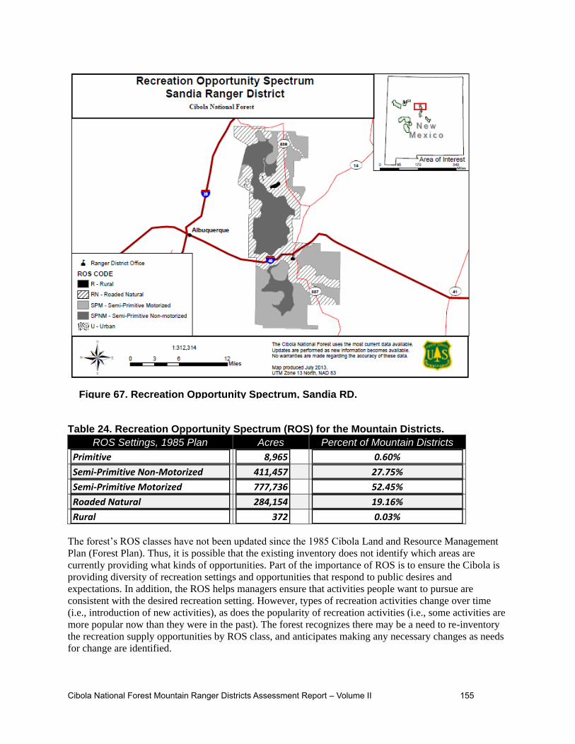
Cibola National Forest Mountain Ranger Districts Assessment Report – Volume II 155
Table 24. Recreation Opportunity Spectrum (ROS) for the Mountain Districts.
ROS Settings, 1985 Plan Acres Percent of Mountain Districts
Primitive 8,965 0.60%
Semi-Primitive Non-Motorized 411,457 27.75%
Semi-Primitive Motorized 777,736 52.45%
Roaded Natural 284,154 19.16%
Rural 372 0.03%
The forest’s ROS classes have not been updated since the 1985 Cibola Land and Resource Management
Plan (Forest Plan). Thus, it is possible that the existing inventory does not identify which areas are
currently providing what kinds of opportunities. Part of the importance of ROS is to ensure the Cibola is
providing diversity of recreation settings and opportunities that respond to public desires and
expectations. In addition, the ROS helps managers ensure that activities people want to pursue are
consistent with the desired recreation setting. However, types of recreation activities change over time
(i.e., introduction of new activities), as does the popularity of recreation activities (i.e., some activities are
more popular now than they were in the past). The forest recognizes there may be a need to re-inventory
the recreation supply opportunities by ROS class, and anticipates making any necessary changes as needs
for change are identified.
Figure 67. Recreation Opportunity Spectrum, Sandia RD.

156 Cibola National Forest Mountain Ranger Districts Assessment Report – Volume II
Congressionally-designated wilderness areas are often associated with a primitive type of recreation
opportunity, but the primitive ROS class is not synonymous with designated wilderness. On the Cibola
National Forest, the Sandia Mountain, Manzano Mountain, and Withington Wilderness Areas are
inventoried and mapped as the semi-primitive non-motorized ROS class. Part of the Apache Kid
Wilderness (8,965 acres) is classified as primitive, and the remainder is classified as semi-primitive non-
motorized.
Under the 1985 Cibola LRMP, the four designated wilderness areas were also inventoried and mapped
using the Wilderness Opportunity Spectrum (WOS). The WOS provides a way to describe the variations
in the degree of isolation from the sounds and influences of people, and the amount of recreation visitor
use in designated wilderness areas. There are four WOS classes:
Pristine – The area is characterized as an extensive, unmodified, natural environment. Natural processes
and conditions have not been measurably affected by the actions of users. The area will be managed as
free as possible from the influences of human activity. Terrain and vegetation allow extensive and
challenging cross-country travel.
Primitive – The area is characterized as an extensive, unmodified, natural environment. Natural processes
and condition have not been measurably affected by the actions of the users. The area is to be managed as
free as possible from the influences of human activity. Terrain and vegetation allow extensive and
challenging cross-country travel.
Semi-Primitive – The area is characterized by a predominantly unmodified environment of at least
moderate size. System trails and campsites are present and there is evidence of other uses. A minimum of
on-site controls and restriction are implemented to protect physical, biological, and social resources.
Some facilities may be present to reduce visitor impact and for resource protection.
Transition – The area is characterized by a predominantly unmodified environment. However, the
concentrations of visitors may be moderate to high at various times. The area likely receives a large
number of day users, along with overnight visitors and long-distance travelers on trails near trailheads and
wilderness boundaries.
Not much research has been done regarding WOS, and the WOS framework is not widely used. Portions
of the Cibola wildernesses have been mapped for more than one WOS settings. The management
direction varies depending on the WOS setting; however, because the WOS settings are not delineated on
the ground, it is not clear to the public what setting they are in. This leads to confusion regarding
management expectations (please see the discussion below under Designated Wilderness). As noted in the
previous paragraph, the wilderness areas have also been reviewed in terms of the ROS (2000-2002
Monitoring and Evaluation Report). Table 25 and Figure 68 - Figure 70 display the WOS classifications
established under the 1985 Cibola LRMP. Table 25. Wilderness Opportunity Spectrum
WOS Settings, 1985 Plan Acres
Pristine 10,013
Primitive 1,045
Semi-Primitive 110,933
Transition 15,248

Cibola National Forest Mountain Ranger Districts Assessment Report – Volume II 157
Figure 68. Wilderness Opportunity Spectrum, Magdalena Ranger District.

158 Cibola National Forest Mountain Ranger Districts Assessment Report – Volume II
Figure 69. Wilderness Opportunity Spectrum, Mountainair Ranger District.

Cibola National Forest Mountain Ranger Districts Assessment Report – Volume II 159
Figure 70. Wilderness Opportunity Spectrum, Sandia Ranger District.
Types of Recreational Opportunities Currently Available
Numerous studies show outdoor recreation is a major component of many Americans’ lifestyles (Roper
ASW 2004, Cordell 2008), and participation in outdoor recreation activities has been on the increase
since the Great Depression and World War II. However, studies differ on whether participation in outdoor
recreation activities has been increasing or decreasing since 2001. Some reports show a decline in
recreation participation nationally beginning in 2001. Suggested reasons for this trend include: the general
state of the economy, travel concerns following the September 11, 2001 attack on the World Trade Center
and the expansion of indoor recreation opportunities through the growth of computer games, the Internet,
and television (Roper ASW 2004). Alternatively, other studies show an overall increase in outdoor
recreation participation, but a change in the mix of outdoor activities and their relative popularity. For
instance, participation in some “traditional” outdoor activities (such a hunting and fishing) has been
declining, and is being replaced by other activities such as driving for pleasure, wildlife or bird watching
and photography (Cordell, 2008).
Based on results of the National Visitor Use Monitoring Survey (NVUM), recreation use on the Cibola
National Forest for calendar year 2006 was estimated at 1.3 million visits. Recreation use on the forest for
calendar year 2011 had increased to 1.6 million visits (USDA Forest Service 2006; 2011).22 It is possible
22 It was noted in the Cibola NF 2006 Monitoring and Evaluation report (USDA Forest Service 2007) that extreme
weather during the NVUM survey period (very dry through June, heavy rains in July and August) may have

160 Cibola National Forest Mountain Ranger Districts Assessment Report – Volume II
that this increase in recreation visits to the forest may have been a result of an increase in the population
of New Mexico (10% between 2000 and 2010) (BBER 2013). However, the NVUM report does not break
survey results down by district, so it is difficult to determine if increases in recreation visits are correlated
to changes in population.
The Cibola National Forest is unique in that the four mountain districts are not contiguous, and span 10
different counties. Magdalena, Mountainair and Mt. Taylor Ranger Districts are associated with the eight
counties that are more rural in nature. The Socioeconomic Assessment Supplement for the Cibola NF
(BBER 2013) shows that the population of these more rural counties decreased between 2000 and 2010,
likely due to the recession, which caused people living in rural areas to relocate to urban areas offering
more abundant economic opportunities. Only the population of Bernalillo and Sandoval Counties (the
most populous and the most densely populated counties associated with the Cibola NF) increased during
this period (BBER 2013). Sandia RD is associated with these two counties.
A comparison of NVUM data for 2006 and 2011 does show an increase in visitation from those who live
within 50 miles of the forest (about 50% in 2006 to about 70% in 2011), and a decrease in visitation from
those who live over 200 miles from the forest (about 41% in 2006 to about 30% in 2011). Similarly, the
2006 NVUM showed that 44 percent of visitors spent at least one night away from home on their visit,
while the 2011 NVUM showed that 26 percent of visitors spent at least one night away from home on
their visit. This could be a result of the recession (people are less likely to travel great distances for
recreation), and/or it could be a reflection of the increased population in the two counties (Bernalillo and
Sandoval) associated with the Sandia RD.
A variety of developed and dispersed recreational activities take place across the mountain districts. Some
of the more popular activities include: hiking/walking, viewing natural features, bicycling, driving for
pleasure, relaxing, viewing wildlife, picnicking, hunting, downhill skiing and nature center activities
(NVUM 2011). However, it is important to note people’s preferences for outdoor recreation activities
change over time. In other words, what people choose to do now for outdoor recreation is noticeably
different from choices made by and available to previous generations of Americans (Cordell 2008,
Cordell 2012). For instance, motorized vehicle use (e.g., 4-wheel drive, all-terrain vehicles, and motor
bikes) has increased across the forest. Participants in the Values, Attitudes and Beliefs discussion in 2005
repeatedly expressed concerns about the increase in popularity of motorized vehicle use, and the
importance of providing non-motorized opportunities both within wilderness areas and outside of
wilderness areas (USDA 2005). Additionally, the 2005 Cibola Monitoring and Evaluation Report noted
that motorized use commonly occurs in the Withington Wilderness on the Magdalena Ranger District
(USDA Forest Service 2006). This activity is in violation of the Wilderness Act and Forest Service
policy.
Off highway vehicle (OHV) use has increased in popularity on public lands throughout the country,
including the Cibola National Forest. In 2005, the Chief of the Forest Service declared unmanaged
recreation (and specifically unmanaged motor vehicle use) one of the four threats to the National Forest
System. The 2005 Travel Management Rule (TMR) provides regulations to help manage motor vehicle
use on National Forest System lands. Implementation of the rule provides for a system of National Forest
System (NFS) roads, NFS trails, and areas on NFS lands designated for motor vehicle use and prohibits
motor vehicle use not in accordance with the designations.
The 2005 TMR effectively prohibited cross-country travel by motor vehicles once a Forest Service unit
designated a system of roads, trails and areas for motor vehicle use. At this time, the Mountainair, Mt.
Taylor, and Sandia Ranger Districts have designated roads, trails and areas for motor vehicle use, and are
in various stages of implementation. The Magdalena Ranger District is currently in the process of travel
resulted in in use figures that were likely lower than expected.

Cibola National Forest Mountain Ranger Districts Assessment Report – Volume II 161
management planning, and will likely have a designated system of roads, trails and areas for motor
vehicle use in by the end of 2014.
Mountain biking is another recreation use that has increased in popularity since the 1985 Cibola LRMP,
notably on the Mt. Taylor and Sandia RDs, and will likely increase on all RDs within the next few years.
In some cases, mountain bikers are traveling cross-country and creating unauthorized routes. These
routes, when located perpendicular to the slope of the natural terrain, known as fall-line alignments,
trigger substantial rill and gully erosion (Figure 71) because they essentially act as a drainage channel.
This is a concern given the substantial occurrence of impaired soils and soils with moderate to severe
erosion hazard on the Cibola (see chapter 3 of volume 1, Soils). Some pack and saddle users, as well as
hikers and rock climbers are also traveling cross-county and creating unauthorized routes with fall-line
alignments, and this too is a concern with regard to soil erosion. Rock climbing is a recreational activity
that has grown in popularity, especially on the Sandia RD.
Figure 71. Unauthorized mountain bike route with erosion on the Sandia RD. Similar
impacts occur from unauthorized routes created by pack and saddle users and hikers.
Not only do certain recreational activities grow in popularity over time, but new and unique activities can
also emerge that may raise new managerial concerns. For instance, geo-caching is an activity that has
emerged in the past decade. Management direction for these kinds of growing and new recreational uses
is needed to ensure that the activities are sustainable and appropriate for the recreation setting where they
are occurring, opportunities are available into the future and forest resources are protected from damage.
Developed and Dispersed Recreation
The Cibola’s four mountain districts have approximately 137 developed sites, which encompass picnic
areas and campgrounds, trailheads, winter sports areas. Motorized dispersed camping is allowed in
accordance with travel management decisions. In addition, there are a variety of dispersed recreational
activities on each RD.
Mt Taylor Ranger District has 5 campgrounds with a total of 84 campsites, 2 picnic areas and
approximately 196 miles of recreational trails.
The district offers recreational opportunities year-round, with the highest visitation occurring during
the summer and fall. Mountain biking has become increasingly popular, with designated mountain
bike trails in the Zuni Mountains area as well as multi-use trails in the Mt. Taylor area.
Developed campgrounds, dispersed camp sites and trails receive relatively heavy use in the summer.
A highly popular event held in late summer is the Mt. Taylor 50K Trail Run. This 31-mile race uses
NFS roads and trails that circumnavigate Mt. Taylor and is designed to highlight the views afforded
by Mt. Taylor, as well as the variety of forest and terrain types through which the course passes.

162 Cibola National Forest Mountain Ranger Districts Assessment Report – Volume II
Big game hunting and viewing “fall colors” are popular activities in the fall, while spring attracts
turkey hunters.
Winter activities include cross-country skiing, snow-shoeing, snowmobiling, and general snow play.
The Winter Quadrathlon is a very popular one-day event in February which is an endurance event
involving biking, running, Nordic skiing and snow-shoeing.
Magdalena Ranger District has 5 campgrounds with a total of 28 campsites, 1 picnic area with 4
sites and approximately 194 miles of recreational trails.
Recreational opportunities vary seasonally. Snow/rain can affect access to higher elevations and/or
areas throughout the year. Luna Park Campground offers a fairly secluded experience and rock
climbers utilize the area. This campground has odd volcanic rock formations, “moonscape,” and
offers picnicking and camping.
Springtime Campground located off the interstate between Socorro and Truth or Consequences is in a
somewhat secluded location. The Apache Kid Wilderness and San Mateo Peak Lookout can be
reached from Springtime CG by hiking or by horseback on the Apache Kid Trail. There are 6
campsites with Adirondack shelters built by the Civilian Conservation Corps at this campground. In
addition, a new corral has been constructed 300 yards east of Springtime Campground as a safe place
for the horses of permitted hunting guides and horseback riders entering the Apache Kid Wilderness.
Dispersed camping occurs throughout the Magdalena Ranger District. Additional dispersed recreation
activities include driving for pleasure and sight-seeing, hiking, backpacking, mountain biking,
hunting, fishing, trapping, bird watching, site seeing, pleasure driving, 4-wheeling, horseback riding,
rock crawling, geocaching, boating, snowshoeing, cross country skiing, snowmobiling, sledding and
target shooting. Other activities requiring a permit include wood cutting and gathering, Christmas tree
cutting and wildings (transplanting a tree from the forest).
Mountainair Ranger District has 6 campgrounds with a total of 82 sites, 4 picnic areas with 17 sites
and approximately 85 miles of recreational trails.
The district receives low to moderate visitation during most of the year. Red Canyon Campground
receives the highest use throughout the summer. The Trigo Fire in 2008 damaged the Capilla Peak
Campground and forced its closure due to public safety risks. This campground was reconstructed
and reopened in the spring of 2013, and visitation is expected to be moderate to high, especially once
it becomes more widely known that the campground is available.
The Fourth of July Canyon Campground receives heavy use during the fall color season as users flock
to view the vibrant colors of the Bigtooth maple trees. Three trails are situated in this area and tie into
the Manzano Crest Trail: Albuquerque Trail, 4th of July Trail and the Cerro Blanco Trail.
Winter hiking opportunities are now available on the Comanche and Salas Trails on the west side of
the Manzano Mountains, when they reopened in June 2013. Manzano Crest Trail offers 20 miles of
hiking opportunities; most trails tie into this trail. The Gallinas Unit offers the Gallinas group site
which is utilized primarily for hunting groups and the Red Cloud Campground is located in this unit
as well.
Dispersed camping occurs along the two major forest roads (FR55 and FR253/422) on the Manzano
Unit. Some dispersed camping occurs in the Manzano Mountain Wilderness. The Gallinas Unit
experiences a high volume of dispersed camping during hunting seasons. Trash left by visitors during
high use is a management challenge. Red Cloud Campground receives moderate use, while the
Gallinas Group sites get moderate to heavy use during these times. Many visitors are hunting on State
and BLM lands in the immediate area.

Cibola National Forest Mountain Ranger Districts Assessment Report – Volume II 163
Sandia Ranger District has 3 group campgrounds with a total of 4 sites, 12 picnic areas with 304
sites and approximately 300 miles of recreational trails. The Sandia RD is strongly identified as an
“urban interface” forest, adjacent to the Albuquerque metropolitan area with a population of
approximately 775,000.
The proximity of forest resources to nearby residences is a valued characteristic that offers a range of
opportunities that have become part of the lifestyle of Albuquerque residents (VAB 2005). Recreation
use remains high year-round on the Sandia Ranger District, but noticeably significant visitation spikes
occur over the summer holiday weekends (Memorial Day, Independence Day, and Labor Day), and
during the Albuquerque International Balloon Fiesta in October. The district also experiences a
smaller but still significant spike in use on Easter Sunday and on Mother’s Day. Participants in the
Values, Attitudes and Beliefs discussions in 2005 expressed the importance of providing winter
recreation activities and opportunities to add to the mix of year-round recreation on the Forest (VAB
2005).
Developed winter recreation facilities on the Sandia RD include the Sandia Ski Area and the Capulin
Snow Play Area (Figure 72) (sledding). Insufficient snow over the last several years has affected the
season of use and operation of these facilities. Capulin Snow Play Area requires grooming of the
snow and supervision of users to ensure safe operation. These requirements, in conjunction with
unpredictable snowfall, present management challenges. Cross-country skiing and snow-shoeing also
occur on the district during the winter.
Dispersed recreation on the Sandia RD includes: mountain biking in the foothills and Manzanitas,
rock climbing, especially in T’uf Shur Bien Preservation Trust Area, backpacking and day hiking in
Sandia Mountain Wilderness and along La Luz, Pino, Embudo, Embudito Trails, horseback riding,
bow hunting, nature viewing, OHV riding, picnicking, and pleasure driving. Cross-country skiing
occurs on 10K, Ellis and Crest Trails. Snowshoeing occurs on these trails as well as on Challenge,
Gravel Pit, Rocky Point, Switchback, Buried Cable and Kiwanis Meadow trails. Hang gliding,
requiring a special use permit and limited to club members, starts from the Tram and the top of
Sandia Crest.
Observations by Sandia RD staff indicate that dispersed use of the Sandia RD is on the rise. The
increased use of Forest Service trails and an expanding network of unauthorized trails have led the
district to analyze the sustainability of its trail system. Actions that may be considered include: adding
unauthorized routes to the system, decommissioning underutilized and unneeded trails, and restricting
cross-country travel by horse and bikes across the landscape.
Many users access the forest by unauthorized routes originating from private property or other public
land. An extensive network of unauthorized routes on the forest has developed over time in Placitas
and the foothills, raising concerns about damage to natural and cultural resources, conflicts between
recreationists who do not want to share the trails with other users, as well as public/private conflicts.

164 Cibola National Forest Mountain Ranger Districts Assessment Report – Volume II
Designated Wilderness Areas
The Cibola NF has 137,239 acres of designated wilderness areas on three districts:
Sandia Ranger District: Sandia Mountain Wilderness
Mountainair Ranger District: Manzano Mountain Wilderness
Magdalena Ranger District: Apache Kid and Withington Wilderness
Activities within the designated wilderness areas include: hiking, horseback riding, camping, hunting,
cross-country skiing, snowshoeing, technical rock climbing and wildlife viewing. Many of these activities
are opportunities to seek solitude. Motorized and mechanized uses are not permitted in designated
wilderness areas. Participants in the 2005 Values, Attitudes and Beliefs discussion expressed the
importance of areas that do not permit motorized uses, especially in light of the increased popularity of
motorized uses.
The management emphasis from the 1985 Cibola Land and Resource Management Plan (Forest Plan) for
the wildernesses encourages “no-trace” visiting and providing wilderness information to visitors. The
plan also acknowledges that portions of the Sandia Mountain Wilderness were over-utilized. Observations
by Sandia RD staff and comments from the public indicate that recreation use in the wilderness is
reaching capacity. Contributing factors include: proximity to urban areas, limited access and an
insufficient number of system trails and trailhead facilities to meet visitor demand. The plan cautions that
similar congestion problems in heavily used areas can be expected in the three remaining wildernesses if
corrective measures are not taken (Cibola LRMP, 1985).
The Sandia Mountain Wilderness receives the highest amount of use, mostly due to its proximity to the
Albuquerque metropolitan area. Management direction needs to continue taking this into consideration.
Figure 72. Sandia Ranger District Day Use Area.

Cibola National Forest Mountain Ranger Districts Assessment Report – Volume II 165
The La Luz Trail Run is a popular annual recreation event with a limit of 400 participants. Although a
portion of the run occurs within the designated Sandia Mountain Wilderness, the greatest impact to
resources occurs outside of the wilderness boundary at the race starting point within the Juan Tabo
Recreation Area. Vehicles park along roadways within the recreation area as well as along Tramway
Road immediately adjacent to the recreation area impacting resources and safety of the visiting public.
The event was established prior to the wilderness area designation in 1968 and was “grandfathered in” as
a permitted activity. Organizers of the event are required to obtain a Special Use Permit for this annual
event.
There is evidence that mountain bikers are encroaching on designated wilderness, specifically in the
Sandia Mountain Wilderness Area. Mountain biking is permitted on city of Albuquerque land and much
of this activity occurs in the foothills that buffers the western slope of the Sandia Mountain Wilderness
Area.
The 1985 Cibola LRMP identified relatively light use for Apache Kid Wilderness (10% of user capacity),
Manzano Mountain Wilderness (39% of capacity) and Withington Wilderness (2% of capacity). While
the percentages of user capacity may have changed slightly, the relative levels accurately reflect current
use. The primary management emphasis for these three areas is to provide dispersed recreation
opportunities compatible with maintaining wilderness values and protecting resources (Cibola LRMP,
1985). A portion of the Apache Kid Wilderness is in the Primitive ROS (and WOS) class. There is
evidence of motorized use where there is inadequate signage and boundary marking of the Withington
Wilderness Area.
The 1985 Cibola LRMP identifies group size limits for the Sandia Mountain Wilderness by WOS class:
25 in the Transition Zone and 10 in the Semi-Primitive zone. The 1985 Cibola LRMP also sets group size
limits for Manzano Mountain (Figure 73), Apache Kid and Withington Wilderness by WOS class: 25 in
the Transition Zone, 10 in the Semi-Primitive Zone and 5 in the Primitive Zone. Group size limits are
difficult to enforce because the different WOS zones are not marked. Recreation users may be unaware
when they move from one zone to another and violate group size restrictions. To benefit both
management and users and improve customer service, establishing one group size for all zones within
wilderness should be considered.
Past monitoring and evaluation reports show that motorized use is occurring in some wilderness areas
(i.e., Withington Wilderness), and that mitigation measures (such as signs and physical barriers) are
limited. Participants in the 2005 VAB also expressed that wilderness is a valued resource, but did not see
a need to expand existing wilderness areas.

166 Cibola National Forest Mountain Ranger Districts Assessment Report – Volume II
Caves
The Federal Caves Resources Protection Act of 1988, directs the Secretary of Agriculture to prepare and
maintain a list of significant caves. The criteria for listing are in 36 CFR part 290.3(c). The Forest Service
policy is to identify and manage significant caves. These caves will be managed to protect and maintain
the caves and cave resources. The type and degree of protection will be determined through the agency
resource and management planning process with full public participation process. Under certain
circumstances, the location of significant caves can be withheld.
Twenty significant caves have been listed for the plan area. Caves must meet at least one of a number of
criteria of significance. All of the plan area caves have the met the criterion of cultural significance. The
listing is omitted here, as information associated with caves, including common names and locations, is
sensitive with regard to cultural and heritage resources, sensitive bat hibernacula (habitat), fragility of the
sites, and safety concerns.
Existing and Potential Scenic Character
People are concerned about the quality of their environment, including aesthetic values of landscape,
particularly scenery and spiritual values (USDA FS, 1995). When the Cibola National Forest Plan was
adopted in 1985, scenic resources were inventoried and analyzed using the visual management system
(VMS). The VMS, presented in Forest Service Handbook 462 (USFS 1974), National Forest Landscape
Management Volumes 1 and 2 (including 7 chapters), provided the framework inventorying the visual
resource and providing measurable standards for managing it.
The Forest Service replaced the VMS in 1995 with the Scenery Management System (SMS) for the
inventory and analysis of the aesthetic values of National Forest System lands. The SMS is described in
Figure 73. Manzano Mountain Wilderness Area.

Cibola National Forest Mountain Ranger Districts Assessment Report – Volume II 167
Agricultural Handbook 701, Landscape Aesthetics: A Handbook for Scenery Management (USDA Forest
Service 1995). Agency policy at FSM 2382.3 directs national forests to update scenery inventory using
the SMS prior to or at the initiation of forest land and resource management plan revisions. This update
will occur during the plan revision with the input of Cibola stakeholders and the public.
While the essence of the system remains essentially intact, still supported by current research,
terminology has changed and the system has been expanded to incorporate updated research findings.
Conceptually the SMS differs from the VMS in that it increases the role of the public, or constituents,
throughout the inventory and planning process. It takes into account, more so than the VMS, that human
influences such as rustic cabins, wooden fences, and so forth, can have positive cultural connotations and
should be recognized as scenic attributes. Further, it borrows from and is integrated with the basic
concepts and terminology of Ecosystem Management. The SMS provides for improved integration of
aesthetics with other biological, physical, and social/cultural resources in the planning process.
SMS is a tool for integrating the benefits, values, desires, and preferences regarding aesthetics and
scenery for all levels of land management planning. The process involves identifying scenery
components as they relate to people, mapping these components, and developing a value unit for
aesthetics from the data gathered.
SMS is today’s best science to achieve high-quality scenery through ecosystem management practices.
Through the SMS process scenic character goals are developed in concert with other resource and social
demands or expectations, and scenic integrity objectives are established.
In conjunction with earlier forest planning efforts, the Cibola NF began the Scenery Management System
analysis in 1999, but the analysis was not completed. These efforts are being restarted now as part of the
Cibola’s forest plan revision efforts. Working with TEAMS, a Forest Service enterprise group, the
Cibola is using the 1979-1980 VMS data along with updated inventory of s the existing condition of the
scenic resources on a district-by-district basis. The team has identified areas within the mountain districts
where the inventoried visual quality objectives (VQO) is much lower than it would be using the SMS and
does not accurately reflect the scenic integrity. For example, the Magdalena Ranger District’s Sawtooth
Mountains are identified as maximum modification, which provides limited protection to the scenic
resources. Through the SMS process, the Sawtooth Mountains have been identified as a Concern Level 1
(assigned to areas where visitors have a high level of interest in scenery) with a high existing scenic
integrity due to the majesty of these unique sandstone escarpments and cliffs. The Cibola NF intends for
the new SMS analysis to be a valuable resource for the public in considering a need for change to the
1985 Plan relative to scenery resources and their integration into all future project level decisions.
To understand the following maps (Figure 74 - Figure 77) that depict current visual quality objectives
identified on the Cibola NF mountain districts, the following definitions of visual quality objectives are
provided.
Preservation: This visual quality objective allows ecological change only. Management
activities, except for very low visual-impact recreation facilities, are prohibited.
Retention: This visual quality objective provides for management activities which are not
visually evident. Under the retention objective, activities may only repeat form, line, color, and
texture which are frequently found in the characteristic landscape. Changes in their qualities of
size, amount, intensity, direction, pattern, etc., should not be evident.
Partial Retention: Management activities must remain visually subordinate to the characteristic
landscape. Associated visual impacts in form, line, color, and texture must be reduced as soon
after project completion as possible but within the first year.

168 Cibola National Forest Mountain Ranger Districts Assessment Report – Volume II
Figure 74. Visual Quality Objectives, Mt. Taylor Ranger District.
Note: “None” refers to non-NFS land on this and the following maps.
Modification: Management activities may visually dominate the characteristic landscape.
However, landform and vegetative alterations must borrow from naturally established form, line,
color or texture so as to blend in with the surrounding landscape character. The objective should
be met within one year of project completion.
Maximum Modification: Management activities of vegetative and landform alterations may
dominate the characteristic landscape. However, when viewed as background, the visual
characteristics must be those of natural occurrences within the surrounding area or character type.
Alterations may be out of scale or contain detail which is incongruent with natural occurrences as
seen in the foreground or middle ground.

Cibola National Forest Mountain Ranger Districts Assessment Report – Volume II 169
Figure 75. Visual Quality Objectives, Magdalena Ranger District.

170 Cibola National Forest Mountain Ranger Districts Assessment Report – Volume II
Figure 76. Visual Quality Objectives, Mountainair Ranger District.

Cibola National Forest Mountain Ranger Districts Assessment Report – Volume II 171
Important Recreational Sites or Areas
There are a number of recreation sites or areas on the mountain districts that are considered important
because of levels of use, their local, regional, national or historic significance, , the number of public
served, and so forth. Some of these sites and areas include:
Mt. Taylor Ranger District
Continental Divide National Scenic Trail (CDNST) spans 3,100 miles across 5 states between
Mexico and Canada. The Mt. Taylor RD has a 45 mile section of the CDNST which is one of 11
National Scenic Trails in the Unites States. Approximately 15 miles of this section of the CDNST is
on designated open system road for motorized vehicles.
As defined in its Comprehensive Plan, the nature and purposes of the CDNST are to provide for high-
quality scenic, primitive hiking and horseback riding opportunities and to conserve natural, historic,
and cultural resources along the CDNST corridor. Between Pie Town, NM and the BLM’s El Malpais
National Conservation Area, the trail is temporarily located along state and county highways over a
52 mile section of trail. This alignment is not consistent with a primitive hiking and horseback riding
experience and presents a safety issue for those hiking on the road.
The BLM and Forest Service have been working cooperatively to identify a permanent, high-quality
route for the trail off of roads. As there is no continuous corridor of federal lands in this area, the
Figure 77. Visual Quality Objectives, Sandia Ranger District.

172 Cibola National Forest Mountain Ranger Districts Assessment Report – Volume II
BLM has been evaluating opportunities for easements or land acquisitions outside the National Forest
boundary to create connections between BLM and National Forest lands. Consistent with the
Comprehensive Plan, the trail routing focus is to utilize public lands to the greatest extent possible,
minimizing the need to cross non-federal lands. The shortest crossing of private lands is sought in all
cases. This emphasis has led the BLM to work in the area between Pie Town and the Sawtooth
Mountains, and an area on Alamocita Creek immediately north of the Magdalena Ranger District.
The BLM’s Socorro Field Office Resource Management Plan (September 2010) identifies a Special
Management Recreation Area on these lands for the potential routing of the trail and to protect the
quality of the resources associated with a trail corridor. The BLM is currently working with
landowners willing to provide the lands needed for the CDNST. The Zuni Mountains remain a viable
option for extension of the CDNST.
Northwest NM Multi-agency Visitor Center is located at exit 85 just southeast of I-40 in Grants,
NM. This visitor center is jointly operated by the Forest Service, Bureau of Land Management, and
the National Park Service. The Center has a bookstore managed through the Western National Parks
Association (WNPA), and sells a variety of books related to the area as well as topographic maps.
Firewood and Christmas tree permits are sold at the Center as well. Group educational programs can
be scheduled at the Center or off-site. Average annual visitation from 2008-2012 was 21,350. The
Cibola provides one-third of annual operating costs for the Visitor Center as well as one full-time
Forest Service employee.
Magdalena RD
Apache Kid Trail has historic significance associated with a tree and cross that may have been the
Apache Kid’s lynching tree.
Notable scenic views/drives are located on Road 225 from Springtime to Luna Park, as well as from
Luna Park to Monticello.
Mountainair RD
Fourth of July Canyon in the Manzano Mountains has Bigtooth and Rocky Mountain maples that
change colors from mid-September through mid-October. This canyon is a very popular destination
for picnicking, hiking and photography, especially during the fall season. Aspens and oaks offer vivid
colors of yellow, orange and red, making a beautiful sight intermixed with the maples.
Capilla Peak summit offers spectacular scenery in all directions.
Sandia RD
Capulin Snow Play Area is located adjacent to the Capulin Springs Picnic Grounds, off of the
Sandia Crest Highway (SR 536), is a designated area for snow sledding and tubing December through
March, as conditions allow. Days/hours of operation are generally weekends and during the holiday
break over Christmas/New Year, depending on snow levels. This is a recreation fee area with parking,
vault toilets and a warming hut with a fire pit. For the safety of users, a 12” base of snow is required
to open the site for public use.
Management of this site is very labor-intensive and requires FS employees to plow/shovel the access
road and parking lot, walkways and warming hut. Forest Service employees monitor sledding and
tubing activities to minimize mishaps on the slopes. Because the Sandia RD has no grooming
equipment, the sledding area can easily become iced over and create a safety hazard. The public
becomes frustrated when the area is closed due to lack of adequate snow or icy conditions. The
Capulin Snow Play Area was developed to provide a designated sledding/tubing area as unsafe
sledding/tubing was occurring immediately off of the Crest Highway (SR 536).

Cibola National Forest Mountain Ranger Districts Assessment Report – Volume II 173
Sandia Man Cave was discovered in 1936 by a University of New Mexico anthropology student. It
is located on the north end of the Sandia Mountains high up on the steep cliff walls of Las Huertas
Canyon. It is a National Historic Landmark. The trail head is off of SR 165 and is marked with a sign.
It is a 0.47 mile hike from the parking lot to the cave. The trail leads to a concrete staircase, then to a
limestone ledge in the cliff, and finally to a metal staircase that spirals up to the mouth of the cave.
From 1937-1941, UNM conducted excavations within the cave and found stone arrow and lance
points, basket scraps, bits of woven yucca moccasins, and skeletal remains of Ice Age animals such as
the mastodon.
The cave attracts illicit activity such as graffiti and fires built inside the cave. The District
archaeologist is working with a local cave group, the Forest Service Regional Cave Specialist, local
tribes and New Mexico State Historic Preservation Office to develop a plan for graffiti removal and
long-term site protection.
Kiwanis Cabin Interpretive Site is constructed of local limestone and was built by the Civilian
Conservation Corps (CCC) around 1930. It is eligible to the National Register of Historic Places.
Parking is available at Sandia Crest, and there is an improved path to the site. The site is in good
condition, but vandalism does occur with graffiti and unauthorized fires inside the cabin. A closure
order was posted in 2012 to discourage visitors from climbing on top of the cabin. Two sides of the
cabin are very close to the cliff’s edge with nothing to break a fall should someone fall off of the top
of the Cabin.
Juan Tabo and La Cueva Recreation Areas were built in the early 1930s by the CCC and have
been determined to be eligible to the National Register of Historic Places. This area contains
examples of some of the CCC’s finest rock and concrete work and showcases a unique and appealing
design approach that tucked the facilities into the landscape and built picnic tables around trees and
suspended from rock outcrops. This area is also part of the T’uf Shur Bien Preservation Trust. When
the area was constructed, Albuquerque was a small town located several miles away. Over the years
the city has grown in size and population and now has reaches the edge of the recreation areas. Easy
access to the recreation areas has made it possible for many people to enjoy the facilities; however, it
also subjects it to heavy vandalism, gang and other undesirable activity. The Cibola is exploring
partnership opportunities that would help address the maintenance and managerial challenges at this
area.
Tijeras Pueblo Archaeological Site houses the remains of a 200-room dwelling, that was home to an
ancient Pueblo people living in the area from approximately 1300 – 1425 AD. The site is on the
National Register of Historic Places and managed by The Friends of Tijeras Pueblo, a non-profit
organization. The friends group sponsors guided tours, lectures, workshops and presentations.
Sandia Peak Tramway and Ski Area is known for the world’s longest tramway. The lift travels 2.7
miles from the base to the top of the mountain. The Sandia Peak Ski Area can be accessed from the
top of the Sandia Peak Tramway as well as from the Sandia Crest Highway (NM 536).
Sandia Crest Recreation Area accommodates day use activities such as hiking, picnicking and site-
seeing. The Crest House concession houses a souvenir shop as well as a restaurant. The Forest
Service manages a small information/interpretive area inside the Crest House.
Sandia Crest Byway (NM 536)—National Forest Scenic Byway is an all-weather, paved highway
that is the highest scenic drive in the southwest. The Sandia Mountains were created by an uplift,
leaving the forested eastern slope and a craggy, cliff-like western face. Part of the Sandia Mountains
are home to Rocky Mountain bighorn sheep, mule deer, black bear and many other mammals and
birds -- including the golden eagles that may be seen soaring at the Crest.

174 Cibola National Forest Mountain Ranger Districts Assessment Report – Volume II
Turquoise Trail (NM 14)—America’s Byway is a Scenic and Historic Area that encompasses
15,000 square miles in the heart of central New Mexico. The byway links Albuquerque and Santa Fe.
The 50-mile drive is along Highway 14. It offers a breathtaking view from atop Sandia Crest, then
winds through the historic mining towns of Golden, Madrid, and Cerrillos, which is known for arts,
crafts, theater, music, museums and restaurants.
Nature, Extent, and Condition of Trails, Roads and Other Transportation and Other Infrastructure to Provide Recreational Access
The condition of recreation facilities and associated infrastructure on all districts is monitored through
a deferred maintenance program in which facilities are routinely inspected and evaluated. Facility
conditions range from excellent to poor. Annual and deferred maintenance needs and cost are
identified and tracked in INFRA, a national database where information on many Forest Service
programs is housed. Routine maintenance on facilities is planned and prioritized; however, the
growing backlog of deferred maintenance needs and vandalism (e.g., graffiti, litter, deliberate
destruction of facilities, etc.) present a growing and constant challenge at some recreation areas and
often force visitors to seek alternate sites.
Prolonged drought conditions and rising levels of insect and disease infestations are taking a toll on
the condition of trees in recreation areas. Patches of dead and dying trees are visible and expanding
across some districts, particular along Sandia Ranger District’s Sandia Crest Highway. This situation
impacts recreationists because of the loss of highly valued trees and shade and increased risks to
public safety. To mitigate the safety concerns, danger tree are removed in developed recreation areas
and along heavily used NFS trails and NFS roads where feasible. Developed recreation areas or trails
are closed temporarily to remove danger trees. The volume of diseased and dead trees within
recreation areas and along trails and the limited number of qualified “fellers” makes the job of
removing danger trees an ongoing challenge.
The forest participates in the Recreation Enhancement Act and charges use fees at some of the
developed recreation areas. The revenue generated helps supplement appropriated dollars and is used
to enhance the recreation opportunities and amenities provided at the areas. While many forest
visitors understand and support charging recreation fees on national forests, not all do. Compliance
with the recreation fee program is much higher where recreation areas are routinely patrolled. Routine
patrolling also provides the opportunity for employees to talk with visitors, explain the fee program,
answer questions, and engage in public education/information. Fee tubes are vulnerable to vandalism
and theft, which has been an issue on both the Mt. Taylor and Sandia Ranger Districts.
Approximately 274 miles of trail are in wilderness areas (Figure 78), and about 582 miles of trail are
non-motorized. Trail use continues to increase, resulting in ongoing challenges in the maintenance,
construction and reconstruction of trails. (see below for fiscal analysis of trail system). Additionally,
unauthorized routes (created both by motorized and non-motorized users) are on the rise. Over time,
implementation of travel management decisions should reduce the amount of motorized travel off the
designated system, but travel management only addresses motorized uses. It does not address non-
motorized uses (such as mountain bikes and horses) that may travel off the designated system and
create unauthorized routes.
Some trails on the forest were not properly designed, and this has continued to create issues with
erosion, and other environmental impacts. In many cases, the forest has opted to relocate major
sections of a trail to build in proper sustainable design features. Some trails were severely impacted
by recent large fire events, and there are on-going issues with trees falling across these trails. Some
trails have erosion problems from hikers and/or bikers straying off-trail and cutting switchbacks.
Lack of adequate trail maintenance is also a concern. In some cases, trails are becoming re-vegetated
and disappearing on the ground, or overgrown with vegetation. In other cases, trails are becoming

Cibola National Forest Mountain Ranger Districts Assessment Report – Volume II 175
trench-like, or incised, resulting in channelization of water and sedimentation into nearby intermittent
streams. In addition, single track trails are widening to become double-track trails. The latter tends to
occur with repeated all-terrain vehicle use. All-terrain vehicles are using snowmobile trails (when
there is no snow on them), which is causing resource damage. Hazard trees along trails are also of
concern, and will likely be an on-going issue. Trails have to be reconstructed after large fires, and in
2008-2009, the forest made much progress in reconstructing and maintaining trails (2009 Cibola
LRMP Monitoring and Evaluation Report).
Lack of rights-of-way across private land hinders access to portions of the mountain districts. For
instance, on the Mountainair Ranger District, the Bosque and Crest trails have been re-routed because
of unsuccessful attempts to acquire rights-of-way. On the Magdalena Ranger District, Trail 25 was
closed due to the lack of a right-of-way across private land. An alternate route has been established
and constructed. Other similar situations exist on the forest, and if the Cibola continues to be
unsuccessful in obtaining easements to cross private property, other solutions should be investigated.
Figure 78. La Luz Trail, Sandia Ranger District.

176 Cibola National Forest Mountain Ranger Districts Assessment Report – Volume II
Compatibility of Different Recreation Activities
As established in the socioeconomic assessment report (BBER 2013) and in other sections, population is
increasing in New Mexico, and the Albuquerque metropolitan area is the fastest growing area in the state.
Results of past Cibola NF Monitoring and Evaluation Reports show that the Cibola NF is experiencing
record numbers of visitors, especially on the Sandia RD.
Participants in the Values, Attitudes and Beliefs (VAB) Survey (USFS 2005) discussed multiple uses, and
the combination of increasing usage resulting from population growth, and increased demand for limited
recreational resources, which result in the increased potential for one type of use to conflict with another
(USFS 2005). Participants in the VAB were more concerned about conflicts between motorized and non-
motorized uses. Participants also believed that many of the “problem users” simply lacked information
about appropriate forest rules and regulations. Unauthorized routes continue to appear and are created by
both motorized and non-motorized activities, such as OHVs, horses, and hikers. Mountain biking is
becoming an increasingly popular activity. There is a variety of opportunities for bikers on the Cibola NF,
but there is potential for conflict with other trail users, in addition to impacts to the resource if bikers
travel off designated routes.
On the Cibola, user conflicts can occur between motorbikes, equestrians, mountain bikers and hikers,
especially on the Manzanita Mountain/Cedro Trail System. User conflicts also occur between mountain
bikers and hikers/walkers in the foothills of the Sandia Mountains and in the Bernalillo Watershed
Research Natural Area. Another common conflict on the Sandia RD is between the wilderness visitor
(who may be seeking solitude and quiet) and those who drive for pleasure on Highway 536 (specifically
motorcyclists).
User conflicts may occur among winter sports activities such snowshoeing, cross-country skiing and
snowmobiling. Cross-country skiers may use snowmobile tracks as groomed trails. Future management
direction may need to take these differing needs into account.
Ecological-related conflicts can also occur, such as between rock climbers and peregrine falcons during
nesting season. This conflict occurs more on the Sandia and Magdalena RDs but both districts have
implemented seasonal closures to mitigate this concern.
Opportunities to Foster Greater Connection between People and Nature
Participation in outdoor recreation is the way that most Americans come to know their National Forests
and Grasslands, making it an important portal for understanding their meaning, history, and relevance,
and that of public lands as a whole. Connecting with nature reminds people of the resources that sustain
life and helps them understand and care about those resources.
The mountain districts’ trails, picnic grounds, campgrounds, downhill ski area, established snow play
area, group use areas, and interpretive displays present countless opportunities for visitors to connect with
nature. Other opportunities for visitors to get connected with the Cibola NF include:
Volunteering can provide a meaningful connection with nature and benefit the Cibola. Volunteers
are engaged in a variety of activities, including maintaining and constructing trails, staffing
interpretive facilities, serving as a campground hosts and presenting interpretive/conservation
education programs. The Cibola continues to explore opportunities to expand the volunteer base.
Fee Waiver Days waive recreation day use fees at most federal recreation areas to promote public
use of public recreation. The Forest Service participates in five fee waiver days: Martin Luther King,
Jr. Day; President’s Day weekend; National Get Outdoors Day; National Public Lands Day and
Veterans Day Weekend.

Cibola National Forest Mountain Ranger Districts Assessment Report – Volume II 177
Conservation Education/Interpretation offers a variety of conservation education and interpretive
programs including Smokey Bear Fire Prevention, Junior Rangers, career fairs, nature hikes and
programs for schools on and off site. Several youth groups and summer camp programs utilize the
Sandia Ranger District for their programming. The Friends of Tijeras Pueblo Interpretive Site, located
on the Sandia Ranger District, offers a variety of programs and special events throughout the year.
Agreements with youth development programs such as the Southwest Conservation Corps (Figure
82), Youth Conservation Corps, and the Alamo Navajo School District provide meaningful outdoor
work opportunities for young people between the ages of 14–25. The forest met objectives of the Ten
Year Wilderness Challenge by hosting Southwest Conservation Corps Youth on the Magdalena and
Sandia Ranger Districts. Youth Conservation Corps trail crews have completed trail rehabilitation
projects on the Mountainair Ranger District as well as recreation facilities maintenance, trail
rehabilitation and timber marking on the Mt. Taylor Ranger District. Through an agreement with the
Alamo Navajo School Board, the Magdalena Ranger District provides an outdoor work setting for the
school’s youth who have accomplished trail rehabilitation projects (t).
Special Use Permits such as the Sandia Peak Ski Area on the Sandia Ranger District offer
opportunities to connect with nature through downhill skiing, snowboarding and mountain biking
(summer months). The Sandia Peak Tramway provides easy access to the Sandia Mountains for the
Albuquerque Metro Area. Additionally, several public events such as a Quadrathlon, sanctioned
walks, runs and bike rides on the Sandia and Mt Taylor Ranger Districts offer opportunities to enjoy
the great outdoors.
Figure 79. Southwest Conservation Corps trail crew on the Magdalena Ranger
District.

178 Cibola National Forest Mountain Ranger Districts Assessment Report – Volume II
Outfitters/Guides can provide a valuable service for hunters and hikers on the forest. Outfitter/Guide
permits range from hunting on the Mt. Taylor and Magdalena Ranger Districts to rock climbing on
Sandia. The Cottonwood Gulch Foundation uses Cibola lands on Mt. Taylor and Magdalena Districts for
expeditions for environmental, historic and cultural education.
Partners with various organizations support the mission of connecting people with nature through a
variety of recreational and educational opportunities. The Sandia Ranger District partners with the
Albuquerque Astronomical Society, REI retail store, Talking Talons, Turquoise Trail Association,
Salt Missions Trail and Hawk Watch in providing unique educational and interpretive programming.
In 2012, the Mt. Taylor Ranger District and several partners including Cibola and McKinley Counties
established the Zuni Mountain Trail Partnership to enhance non-motorized recreation opportunities on
the District, specifically mountain bike trails. The New Mexico Cross Country Ski Club and the
Friends of the Sandias regularly assist in keeping trails open for cross country skiing and hiking on
the Sandia Ranger District.
Timber Product Permits allow the public to gather firewood on all mountain districts. Christmas
tree cutting permits are available on Mt. Taylor and Magdalena Ranger Districts. Mt Taylor also
offers permits for transplanting trees (wilding) from the forest.
Mineral Permits can be obtained to collect minerals/rocks from Mt. Taylor and Magdalena Ranger
Districts.
Scenic Byways/Scenic Highways such as the Turquoise Trail and the Crest Highway on the Sandia
Ranger District offer opportunities to drive for pleasure and view natural features and wildlife.
Recreation Residences are privately owned, limited-use cabins in national forests that are under 20-
year special use permits. These tracts were first authorized in 1915 to encourage recreation within
national forests (16 U.S.C. 497d). The forest has 17 recreation residences: 12 on Mt Taylor Ranger
District and 5 on Sandia Ranger District.
Conditions and Trends Affecting the Quality of Recreational Settings and Scenic Character
Several recent uncharacteristic, stand-replacing wildfires and insects and disease outbreaks on the forest
have affected the quality of recreational settings and scenic character.
The Trigo Fire of 2008, burned through Capilla Peak Campground on Mountainair Ranger District.
This campground was closed for five years due to the high severity, uncharacteristic wildfire that
burned through it, causing facility damage, vegetation loss and danger trees. It also caused
widespread mortality along the Capilla Peak Road that reduced scenic quality and prevented public
access for five years due to danger trees and erosion damage to the roadbed.
The Big Springs Fire of 2009 in the northern part of the Manzano Mountains on Mountainair RD
caused widespread tree and vegetation mortality. This wildfire closed the Tajique day use area due to
hazards. It also created danger trees along the 55 road, which was known as a scenic drive especially
in the fall when the Rocky Mountain maple and oak leaves change. The high severity burn has
decreased scenic quality to this area.
Sandia Ranger District widespread insect and disease tree mortality has caused an increase in
danger trees along scenic road corridors, developed recreation areas, and designated trails and has
reduced scenic quality. Mitigation of the danger trees is ongoing. In developed recreation sites, the
felled trees are made available to the public via firewood permits; however, many stumps remain

Cibola National Forest Mountain Ranger Districts Assessment Report – Volume II 179
within the area, shade has been reduced and the overall scenic value and recreational integrity has
been reduced. Along trails that are inaccessible for removal of firewood, the felled danger trees are
left on site adjacent to the trail. This has created a level of material that is unsightly especially along
the trails at the crest where visitor is extremely high.
Mt. Taylor Ranger District widespread insect and disease tree mortality has drastically altered
the scenic quality of the area due to several hundred acres of continuous area being killed all at once.
This areas are within the view shed of the primary hiking trails in the area.
These events are becoming the norm in the Southwest and result in a marked contrast to the naturally-
appearing landscape. After this type of event, the scenic quality can be dramatically altered for many
years due to the time needed for the landscape to recover.
Wind Energy
There are two wind farms just outside of the forest boundary:
1. On the Mountainair Ranger District adjacent to the Gallinas Unit
2. On Mt. Taylor Ranger District adjacent to the Mt. Taylor Unit
These wind turbine farms, while visible from the Forest, do not directly impact scenic integrity or
recreation opportunity settings on the Forest.
According to the National Renewable Energy Laboratory, areas within and surrounding the four mountain
districts are economically suitable for wind energy farm development. (NREL 2010).
Uranium Mining
The Cibola NF is currently processing two uranium mining proposals on the Mt. Taylor Ranger District.
There are also reclamation processes occurring at abandoned and closed mines, including the San Mateo
mine and other small mines on the Mt Taylor and Sandia RDs.
The current trend is the continuation of exploration on the Mt. Taylor, Magdalena, and Mountainair
Ranger Districts. This exploration may lead to more mines on the Cibola NF. These mining activities can
have a lasting impact on scenic quality and may affect recreation opportunities. The SMS and ROS
analyses currently in process will address these mining activities.
Collaborative Forest Restoration Projects
Collaborative Forest Restoration projects (CFRPs) implement treatments to improve wildlife habitat,
forest health, improve overall watershed condition and reduce hazardous fuels. By accomplishing those
objectives, these projects enhance scenic quality by:
Reducing tree densities to a historic range of variability to improve overall forest health and
allowing the residual trees to thrive and defend themselves from insect and disease outbreaks
Reducing hazardous fuels to reduce the potential of uncharacteristic wildfire that would lead to
widespread tree mortality and loss of vegetation diversity that would require decades to reverse.
Thinning overgrown stands of trees to a more sustainable level would increase visual diversity
and provide opportunities to open up views of rock formations and other unique landscape
characteristics.
Increasing the mix of vegetation species and spatial distribution, thus increasing visual diversity.
Collaborative Forest Restoration projects improve recreation opportunities by:
Including trail and road maintenance as part of these projects. This will allow for improved
vehicle and foot travel within the forest

180 Cibola National Forest Mountain Ranger Districts Assessment Report – Volume II
Conducting treatments to improve wildlife habitat which should increase hunting opportunities
and wildlife viewing.
Promoting forest health and reducing hazardous fuels, which will increase the likelihood of
continued available recreation opportunities.
The Cibola is conducting 11 CFRPs totaling 136,418 acres (

Cibola National Forest Mountain Ranger Districts Assessment Report – Volume II 181
Table 18, Figure 57–Figure 60).
Climate Conditions
The Southwestern Region is in the midst of an extended drought and forecasts indicate it is likely to
continue. Drought conditions are impacting the Cibola’s recreation program in a number of ways. As
fire danger increases, restrictions may be put in place to reduce the risk of human-caused fires.
Depending on the severity, restrictions typically range from a ban on open campfires to outright closure
of the forest to public access. These restrictions limit access to recreational settings and opportunities.
The forest experienced extensive fire closures in 2006, 2011, and during the summer of 2013. Fire
damage to trails and recreation facilities limit recreational opportunities until rehabilitation and/or
restoration can be completed. Rehabilitation and restoration projects can take several years to fund and
complete.
Inadequate snowfall affects winter recreational settings and opportunities such as the Sandia Peak Ski
Area and the Capulin Snow Play Area on the Sandia Ranger District. Since 1985, days of operation at the
Sandia Peak Ski Area have ranged from 49 days during the 2012-2013 seasons to 131 days during the
1984-1985 season (Figure 80). The Capulin Snow Play Area did not open during the 2000-2001, 2005-
2006 and 2012-2013 seasons due to inadequate snow (Heiar, February 2013).
Drought conditions caused dry or low water levels, that impacted recreational settings and recreational
opportunities at McGaffey Lake on the Mt. Taylor Ranger District. Within the last decade, three years
have had very low water levels, and the lake has been dry for the past two years (Arnold Wilson, pers.
comm., February 2013).
Figure 80. Sandia Ski Area annual snowfall and days of operation from 1984–2013

182 Cibola National Forest Mountain Ranger Districts Assessment Report – Volume II
Extended warm weather lends to a longer “summer” recreation season; starting earlier in the spring and
extending later into the fall. A longer “summer” recreation season warrants extending seasonal staff and
additional operations and maintenance costs.
Sustainability of the Set of Recreation Opportunities and Scenic Character
The goal of sustainable recreation is to:
Provide a diverse range of quality natural and cultural resource based recreation opportunities,
and protect the natural, cultural, and scenic environment for present and future generations to
enjoy
Partner with public and private recreation benefit providers to meet public needs and
expectations, and
Perform and plan by implementing systems and processes to ensure effective decisions and sound
investments.
National forests and grasslands cannot depend solely on appropriated funding to meet constituents’ needs,
and must unite diverse interests and focus scarce resources to sustain and expand the benefits of outdoor
recreation. To sustain these benefits, the recreation program must achieve a sustainable balance among
the three spheres of environmental, social, and economic conditions (USDA, Forest Service, 2010).
Appropriated funds vary somewhat from year to year, so it is difficult to predict what the allocated dollars
will be in the future (economic conditions). Increased demand for services and levels of recreation use in
conjunction with flat or declining budgets and loss of key Forest Service personnel present challenges to
operating and maintaining infrastructure (such as developed recreation sites and trails) to standard. In
addition, recreation facilities (social conditions), particularly older sites, may no longer align with the
capacity or use for which they were designed. For example, use data for McGaffey Lake Campground on
Mt. Taylor RD and some of the facilities along Sandia Crest Highway on Sandia RD indicate that these
areas may be underutilized. Vandalism and gang activity are also changing how some recreation areas are
used and displacing recreationists. The increasing backlog of deferred maintenance needs and impacts to
the resources by unmanaged uses (environmental conditions) also affect the sustainability of the
recreation program.
Any analysis the forest does regarding the sustainability of its recreation facilities will most likely find
that the forest cannot maintain the current infrastructure without some adjustments in management. In
response to this, the Cibola may need to consider changing the mix of infrastructure, adjusting the season
of use, or reducing the amount or capacity of infrastructure. However, reducing or changing infrastructure
does not mean the forest is reducing recreation opportunities.
The Forest Service recognized the need to create a sustainable program that aligns recreation sites with
visitors’ desires and expectations. The national forests and grasslands conducted the Recreation Facility
Analysis (RFA) process. Through this process, recreation staff analyzed their recreation facilities and
evaluated how they might operate and maintain these sites and facilities more efficiently—both as prudent
financial managers and in terms of meeting the changing preferences and patterns of our public. It is
important to note that the RFA generates information that is essential for managing recreation facilities
regardless of budget. The process also helps establish priorities for operations, maintenance, and
investment in recreation facilities, helping sustain existing recreation facilities and plan for future ones.
The result of the RFA was a five-year program of work, or the tasks needed to bring the forest’s
recreation infrastructure into alignment with the resources available to operate and maintain it to standard.
Four categories of proposed management are used:
1. Category A sites that are under some type of operational or contractual agreement whose terms
are longer than the 5-year period of the RFA.

Cibola National Forest Mountain Ranger Districts Assessment Report – Volume II 183
2. Category B sites that meet the unit niche, are: environmentally sustainable within the capability
and capacity of the natural resources; are supported by and provide support to local communities;
and have a sustainable management cost-benefit ratio.
3. Category C sites that do not meet all of the above criteria, but with a combination of mitigation,
additional resources, or other type of action could be made to qualify for Category B status.
4. Category D sites that do not meet all of the Category B criteria, or fall sufficiently short in one or
more of the criterion so as to render the capability of meeting it unsustainable. These sites may be
managed for dispersed recreation opportunities.
The Cibola National Forest completed its RFA 5-Year Program of Work in October 2008. The RFA
focused only on developed recreation and how to bring those facilities in line with condition, user
demand, and funding. However, because dispersed recreation demand is also expanding, the Cibola has
recognized the need to take a hard look at the entire recreation program. To address this, the Forest is
embarking on a sustainable recreation strategy concurrent with forest plan revision. This is consistent
with national emphasis on sustainable recreation.
In a 2010 document titled, A Framework for Sustainable Recreation, the Forest Service noted the
importance of analyzing recreation program needs and available resources and assessing potential ways to
narrow the gap between them. Building on this, the Southwestern Region developed a Sustainable
Recreation Strategy (Strategy) to guide the region toward a recreation program that is vital to the well-
being of visitors and communities and is essential to the future of the agency. The Strategy sustains
America’s great outdoors and builds greater capacity to serve the citizens of the southwest by focusing the
recreation program on building strong relationships with diverse publics while improving management
effectiveness and program resiliency.
The Strategy identifies goals and objectives for the recreation program, one of which is to develop and
implement a forest-specific action plan for sustainable recreation. Cibola staff will begin this effort in
2014 in collaboration with its diverse communities and partners. The intent of the action plan will be to
pick up where the RFA stopped and establish priorities for a 5-year period.
Recreation Fees
The Federal Lands Recreation Enhancement Act (FLREA) was signed into law by President Bush in
2004. It is a 10-year act that permits federal land management agencies to establish, modify, charge and
collect modest recreation fees at campgrounds, rental cabins, and at day use sites that have certain
facilities. Recreation fees provide crucial resources that allow the federal agencies to respond to increased
demand on federal lands. The goal is to provide visitors with a quality recreation experience through
enhanced facilities and services.
The Cibola does participate in the recreation fee program, which contributes to sustaining and enhancing
its facilities and services. For example, revenue from this program has enabled the Forest to replace toilet
buildings, increase visitor contact, and disperse information.
Trails
The US Forest Services manages more than 158,000 miles of recreation trails. To remain safe and usable,
these trails need regular maintenance. The US Government of Accountability Office (GAO)23 was asked
23 The GAO is a federal agency housed within the legislative that works for Congress and audits federal agencies
and programs that receive federal funding.

184 Cibola National Forest Mountain Ranger Districts Assessment Report – Volume II
to review the agency’s trails program and examine funding and staffing resources, the extent to which the
FS is meeting trail maintenance needs, and factors that might complicate agency trail maintenance efforts.
The Southwest Region (Arizona and New Mexico) was included in that review.
The general, the GAO recommended that the FS analyze trails program needs and available resources and
develop options for narrowing the gap between them. The results of the review accurate capture the
condition of the Cibola’s trails program. Among the findings are:
The Forest Service has more miles of trail than it has been able to maintain, resulting in a persistent
maintenance backlog with a range of negative effects. In fiscal year 2012, the agency reported that it
accomplished at least some maintenance on about 37 percent of its 158,000 trail miles and that about
one-quarter of its trail miles met the agency's standards. The Forest Service estimated the value of its
trail maintenance backlog to be $314 million in fiscal year 2012, with an additional $210 million for
annual maintenance, capital improvement, and operations. Trails not maintained to quality standards
have a range of negative effects, such as inhibiting trail use and harming natural resources, and
deferring maintenance can add to maintenance costs.
The Forest Service relies on a combination of internal and external resources to help maintain its trail
system. Internal resources include about $80 million allocated annually for trail maintenance
activities plus funding for other agency programs that involve trails. External resources include
volunteer labor, which the Forest Service valued at $26 million in FY 2012, and funding from federal
programs, states, and other sources.
Collectively, the agency officials and stakeholders who GAO spoke with, identified a number of
factors complicating the Forest Service's trail maintenance efforts, including:
o Factors associated with the origin and location of trails
o Some agency policies and procedures, and
o Factors associated with the management of volunteers and other external resources.
For example, many trails were created for purposes other than recreation, such as access for timber
harvesting or firefighting, and some were built on steep slopes, leaving unsustainable, erosion-prone
trails that require continual maintenance. In addition, certain agency policies and procedures
complicate trail maintenance efforts, such as the agency's lack of standardized training in trails field
skills, which limits agency expertise. Further, while volunteers are important to the agency's trail
maintenance efforts, managing volunteers can decrease the time officials can spend performing on-
the-ground maintenance.
Agency officials and stakeholders GAO interviewed collectively identified numerous options to
improve Forest Service trail maintenance, including:
o Assessing the sustainability of the trail system
o Improving agency policies and procedures, and
o Improving management of volunteers and other external resources
Many officials and stakeholders suggested that the agency systematically assess its trail system to
identify ways to reduce the gap and improve trail system sustainability. They also identified other
options for improving management of volunteers. For example, while the agency's goal in the Forest
Service Manual is to use volunteers, the agency has not established collaboration with and
management of volunteers who help maintain trails as clear expectations for trails staff responsible
for working with volunteers, and training in this area is limited. Some agency officials and
stakeholders stated that training on how to collaborate with and manage volunteers would enhance the
agency's ability to capitalize on this resource.

Cibola National Forest Mountain Ranger Districts Assessment Report – Volume II 185
In preparation for the GAO visit, Regional Office (RO) staff analyzed the trail system across New Mexico
and Arizona national forests, and determined the cost/mile by trail class for operations, annual
maintenance, deferred maintenance, and capital improvements. Trails are categorized into five classes
based on their level of development, thus have different costs for maintenance and construction. The
estimated costs for all the trails on the Cibola National Forest by Trail Class (TC) are displayed in Table
26.
Table 26. Cibola’s Estimated Trail Costs by Trail Class.
Trail Class (TC)
# of Miles
Operations (OPS)
Annual Maintenance
(AM)
Deferred Maintenance
(DM)
Capital Improvements
(CI)
TC 1 Minimally
Developed 47.62 $6,595.37 $18,091.31 $88,557.49 $53,675.36
TC 2
Moderately
Developed
743.15 $107,831.07 $325,165.28 $1,677,237.53 $1,192,027.46
TC 3 Developed 174.9 $35,028.97 $120,994.07 $444,700.74 $354,566.03
TC 4 Highly
Developed 8.1 $1,365.74 $4,050.81 $22,361.59 $6,563.51
TC 5 Fully
Developed 2.28 $667.08 $9,638.75 $23,978.80 $15,950.15
Cibola NF
(estimated cost
for entire trail
system,
approximately
976 miles)
976.05 $151,488.23 $477,940.22 $2,256,836.15 $1,622,782.51
Based on Table 26, the total estimated cost for operations, annual and deferred maintenance and capital
investment of the Cibola’s trail system is approximately $4.5 million. Allocated dollars for operations
and maintenance of the Cibola trails system over the last five years are:
2009 .......... $426,800
2010 .......... $367,016
2011 .......... $218,351
2012 .......... $187,300
2013 .......... $160,905
As noted earlier, appropriated funds vary, so it is difficult to predict what the amount of allocated dollars
will be in the future. The needs for trail maintenance and operations is increasing while available
resources are remaining flat or declining. In anticipation of this trend continuing, the Cibola will continue
to look to other sources, such as grants, partnerships, and volunteer assistance to accomplish trail
maintenance and operations.
Currently, all four mountain districts utilize sources other than appropriated funds to support trail
maintenance: Examples of this are:

186 Cibola National Forest Mountain Ranger Districts Assessment Report – Volume II
Mt. Taylor RD – Youth Conservation Corps (YCC) Trail Crews
Magdalena RD – Alamo Navajo Schools Youth Trail Crews
Mountainair RD – Forest Guild Youth Conservation Corps (YCC) Trail Crews and Southwest
Youth Conservation Corps (SCC) Trail Crews
Sandia RD– Friends of Sandia Mountain Volunteers, Southwest Conservation Corps (SCC) Trail
Crews, Sandia RD Volunteer Trails Crews
Recreation Special Use Permits (SUP)
The Forest Service Special Uses Permit program authorizes uses on National Forest System land that
provide a benefit to the general public and protect public and natural resources values. The Forest Service
typically charges a fee for issuing a special use authorization, since use and/or occupancy of National
Forest System lands is being authorized for a specific activity, purpose or specific period of time.
Recreation special use authorizations can generate a significant amount of revenue for the forest. The
average annual collections on the Cibola in the past three years include $17,000 in Recreation Special Use
Permits and $28,000 in Interagency Passes.
The demand for recreation special use permits, as well as type and complexity varies across the mountain
districts. For example, the majority of the permits issued on Magdalena and Mountainair Ranger Districts
are to big game outfitter and guides (O&Gs). Demand for permits for recreation events such as search and
rescue training, organized trail and bike races, hang gliding, and rock climbing is high on Sandia and Mt.
Taylor RDs. In addition, the Sandia RD administers a permit for the Sandia Ski Area and Tramway.
According to the Magdalena district ranger, the demand by O&Gs to operate big game hunts on the
district is currently being met, although this situation may change over the next few years as competition
for trophy big game animals increases. Approximately 700,000 acres of the Magdalena RD are available
and suitable for hunting. However, the O&Gs do not operate in the Withington and Apache Kid
Wildernesses. There is little evidence of conflict among O&Gs or environmental impact from this
activity. The relatively large land base allows hunters to spread out and not congregate in certain areas,
and most guided hunters stay in hotels or on private ranches. However, it is a challenge to monitor and
inspect O&G operations because the hunters do not stay in hunting camps on the district.
In contrast, the demand for recreation special use authorizations and special events is very high on
Sandia RD due in part to the district’s proximity to Albuquerque, the variety of opportunities for outdoor
recreation. In addition, the district’s land base, approximately 100,000 acres, has a limited capacity to
accommodate the growing demand. Compounding this issue is the high number of people who are
operating bus and jeep tours, horseback rides, and guided hikes without permit. These issues will be
addressed as part of the sustainable recreation strategy discussed earlier.
The high demand for recreation special uses and number of recreation special events impacts the general
recreating public. The number of participants and support personnel for special events exceeds the
capacity of recreation areas, particularly for parking. This often results in individual recreationists being
displaced, especially when events take place on holiday weekends.

Cibola National Forest Mountain Ranger Districts Assessment Report – Volume II 187
Social, Cultural, or Economic Conditions Impacting Recreational Participation by Minorities and other Historically Disadvantaged Groups
From 2000-2011, the Hispanic population in New Mexico increased by 28 percent, according to the Pew
Hispanic Center (2013). According to the 2006 and 2011 NVUMs, the percentage of Hispanic
recreationists on the forest increased by only 2 percent (Table 27).
Table 27. National Visitor Use Monitoring Survey (NVUM)
Race * 2006 Forest Visits (%) 2011 Forest Visits (%)
American Indian/Alaska Native 3.9 6.5
Asian 1.3 0.6
Black/African American 2.2 0.8
Hawaiian/Pacific Islander 0.6 1.2
White 93.5 91.6
Total 101.5+ 100.7
+
Ethnicity * 2006 Forest Visits (%) 2011 Forest Visits (%)
Hispanic/Latino 11.6 13.6
* Race and Ethnicity were asked as two separate questions + Individuals could respond to more than one race hence over 100%
The following barriers or impediments may explain the disproportionate increase in recreational activity
of some minority groups on the Cibola as compared to that group’s increase in the overall state
population.
Language. For many under-represented groups, English is not their first language. Some under-
represented groups may not be aware of recreational settings and recreational opportunities as the
majority of signage, literature and website texts are written in English. To address this gap, the Cibola is
starting to provide bilingual information.
Socioeconomics. Some under-represented groups, both rural and urban, may not have transportation or
the financial means to access forest recreational settings and recreational opportunities. The west slope of
the Sandia Ranger District is the most readily accessible area of the forest for all residents of the
Albuquerque metro area. The foothills of the west slope are immediately adjacent to the city proper and
can be accessed by public transportation, walking or biking. However, the expense of recreational
equipment may prevent some under-represented groups from participating in some recreational
opportunities such as camping, backpacking and snow-based activities (NM SCORP 2010-2014).
A number of factors, such as fees, inadequate transportation, and unfamiliarity with being outdoors, may
deter some people from recreating on the Forest. The Forest Service participates in free fee days
including National Get Outdoors Day and National Trails Day in June, National Public Lands Day in
September and Veterans Day in November. On these days recreation day use fees are waived at most
federal recreation areas to encourage public use.

188 Cibola National Forest Mountain Ranger Districts Assessment Report – Volume II
Influences Outside the Plan Area Affecting Demand for Recreation or Ability of the Forest to Meet Those Demands
According to the New Mexico Statewide Comprehensive Outdoor Recreation Plan (SCORP), the
preferences and demands of the New Mexican public for specific recreation opportunities or
settings are as follows:
Bicycling ................................. 23%
Camping .................................. 31%
Fishing..................................... 13%
Hunting .................................... 7%
Paddling .................................... 5%
Snow Sports .............................. 7%
Trail ......................................... 41%
Wildlife Viewing ..................... 31%
While the Cibola many different forms of recreation, it lacks the water resources to support water based
activities such as fishing and paddling. The Cibola NF recognizes the stated goals in approved plans or
other published reports of tribes, states, or local governments, for recreation opportunities in the plan area.
For example, the New Mexico Statewide Comprehensive Recreation Plan (SCORP) 2010-2014
recognizes the following priorities:
Priority 1 – Promote the Livability of All Communities Through Health and Fitness
Priority 2 – Enhance Economic Vitality
Priority 3 – Properly Use and Conserve Natural Resources
Priority 4 – Develop a Statewide Trail Network That Facilitates Recreation, Transportation and Healthy
Lifestyles
The forest supports the Priorities 1-3 and can partner with the state of New Mexico and other government
agencies to develop a statewide trail system where the forest boundary is adjacent to other public lands.
Emerging new or unique recreational trends or interests that may affect future demand for recreation on the plan area
There is a growing interest in adventure races and similar events such as boot camps, mud events and
endurance races. These events are usually held by “for profit” organizations but some are conducted as
fundraisers. The types of activities associated with these events may include: running, bicycling,
paddling, climbing, orienteering and other activities that require endurance, strength and agility.
Other factors that may affect the demand for recreation in the plan area includes the growing interest in
zip lines, geo- or eco-tourism, expanding use at ski areas beyond the traditional winter season, and so
forth. Depending on where these activities may surface and if not managed, they could exacerbate the
environmental and social stressors addressed throughout this chapter, resulting in increased degradation
of the natural resources and in current recreationists being crowded out or displaced entirely to other
areas.

Cibola National Forest Mountain Ranger Districts Assessment Report – Volume II 189
Chapter 6. Assessing Designated Areas
Designated special areas contribute to social sustainability by connecting people to their natural and
cultural heritage, and providing economic benefits to surrounding communities. They promote the
preservation of cultural traditions including historical features that contribute to social wellbeing through
education, and provide recreational opportunities. Economic sustainability is supported by increased
employment opportunities, supporting small businesses, and sharing federal receipts with county and state
governments. Designated areas contribute to ecological sustainability as well, by preserving intact natural
systems and their individual components.
Designated areas within the Cibola National Forest or immediate area of influence include:
Four wilderness areas
One research natural area
One designated critical habitat for federally threatened and endangered species
Thirteen inventoried roadless areas (IRAs)
Seven nationally or state designated scenic byways
One national scenic trail
The Langmuir Site for Atmospheric Research and Magdalena Ridge Observatory
T’uf Shur Bien Preservation Trust Area
Three national monuments24
One national conservation area
Two national historic landmarks
The locations of these areas, with the exception of IRAs which are shown on their own map later in this
chapter, are identified on the “Designated Areas” map for each Ranger District (Figure 81–Figure 84).
24 The Antiquities Act of 1906 authorized the President to declare by public proclamation landmarks, structures, and
other objects of historic or scientific interest situated on lands owned of controlled by the government to be
national monuments. Thus, the Abo, Quari, and Gran Quivera units of the Salinas Pueblo Missions National
Monument are listed individually as National Historic Landmarks. These landmarks, and the Salinas Pueblo
Missions National Monument and El Morro National Monument are also listed on the National Register of
Historic Places (USDOI, National Park Service 2013).

190 Cibola National Forest Mountain Ranger Districts Assessment Report – Volume II
Figure 81. Designated Areas, Mt. Taylor Ranger District
Figure 82. Designated Areas, Magdalena Ranger District.

Cibola National Forest Mountain Ranger Districts Assessment Report – Volume II 191
Figure 83. Designated Areas, Mountainair Ranger District.
Figure 84. Designated Areas, Sandia Ranger District.
192 Cibola National Forest Mountain Ranger Districts Assessment Report – Volume II
The Cibola is not aware of any published documents or county, state, city, or tribal plans that identify the
need or potential need for additional designated areas specifically on the plan area. The forest has
received detailed correspondence from two non-government organizations (NGOs), The Wilderness
Society and The Sierra Club, describing the potential need and opportunities to recommend additional
designated areas, particularly wilderness designation. From an ecological perspective, the authors make
the case that the Cibola’s undeveloped areas are important for conservation of habitats and connectivity,
biodiversity, and for climate change adaptation. The authors of the correspondence argue that there exists
a potential need and opportunity to designate additional areas to sustain biodiversity on the Cibola. In
terms of socio-economics, the NGOs cite several papers that address national, regional, and state public
preferences for additional wilderness designation, claim a neutral to positive relationship between the
presence and extent of wilderness and performance of local economies, and predict that outdoor nature-
based recreation will continue to grow in the future in New Mexico and the Region. The correspondence
from these NGOs can be viewed at
http://www.fs.usda.gov/Internet/FSE_DOCUMENTS/stelprdb5426468.pdf.
Internally, three areas on the forest have been identified as having potential for special area designation:
1. The area called “Fourth of July” on Mountainair Ranger District. There is a unique stand of Big
Tooth and Rocky Mountain maple along Tajique Creek that that has potential for designation as a
special botanical area.
2. Little Water Canyon on Mt. Taylor RD. This area has unique botanical diversity. Little Water Canyon
was identified as a RNA to be designated in the 1985 Cibola Forest Plan but was never designated
due to surveying issues. It will be re-evaluated, along with other areas, for RNA recommendation.
3. The Sawtooth Mountains area on the Datil side of Magdalena District. This area is of geologic and
scenic interest and may be evaluated for special area designation.
The following is an inventory of designated areas within the plan area of influence and the plan area.
While some general information regarding the economic impacts of the designation of national
monuments outside of the plan area has been developed, it is not available for each monument named in
the national monument section. No specific data projecting visitor use or direct and indirect economic
impacts associated with features within the plan area is currently available.
Wilderness
The Wilderness Act of 1964 (Act; 16 USC §§ 1131-1136) authorized the withdrawal of federal lands
from standard multiple use management and established a process for adding new lands to the National
Wilderness Preservation System. Lands classified as wilderness through the Wilderness Act could be
under jurisdiction of the Forest Service, National Park Service, or U.S. Fish and Wildlife Service. With
some exceptions, prohibitions include: closure to motorized and mechanized vehicles, timber harvest,
new grazing and mining activity, or any development.
The four wildernesses on the Cibola National Forest were established under either the Endangered
American Wilderness Act of 1978 (Act; 16 USC § 1132), or the New Mexico Wilderness Act of 1980
(Act, 16 USC §1132 et seq.). Lands designated under the Endangered American Wilderness Act of 1978
were found to possess outstanding natural characteristics and met the statutory criteria as established in
the Wilderness Act of 1964. Because these lands were subjected to pressures of population growth and
development, Congress found it in the national interest to designate these areas to promote and perpetuate
the wilderness character for future generations. The New Mexico Wilderness Act was enacted to promote
and preserve the wilderness characteristics of the land, protect watersheds and wildlife habitat, and
promote scientific research and primitive recreation. This Act established or approved additions for 12
wilderness areas in New Mexico.

Cibola National Forest Mountain Ranger Districts Assessment Report – Volume II 193
Responsibility for reporting wilderness acreage resides in the Lands or Realty division of the Forest
Service. This is recorded in the annual lands report found at
http://www.fs.fed.us/land/staff/lar/LAR2012/lar2012index.html. The Forest Service determines acreage
by verifying changes that result from realignment of boundaries or acquisition of private inholdings.
Forest Service acreage figures do not include inholdings unless explicitly stated. In 2012, the Forest
Service managed 1,387,498 acres of wilderness in New Mexico (USDA Forest Service 2012).
Sandia Mountain Wilderness, Sandia Ranger District- Congress designated Sandia Mountain
Wilderness under the Endangered American Wilderness Act of 1978 (Act, 16 USC §1132). The
wilderness is located in Bernalillo and Sandoval Counties and has 37,877 NFS acres and 480 acres of
private lands (USDA, Forest Service 2012). The area lies primarily on the western slope of the Sandia
Mountains, but it crosses over the crest to the eastern side of the mountain at the north and south ends.
Spruce and fir dominate the high country, with stands of mixed conifers just below. Many raptors
migrate through these mountains in spring and fall, sharing their territory with mule deer and black
bears. There is also an area of Mexican Spotted Owl critical habitat on the district in the area of La
Luz Trail on the west and extends east over the crest toward SR 536, the Sandia Crest Scenic and
Historic Byway Figure 84). There are also Northern Goshawk post fledgling family areas (PFAs) on
the district.
A major recreation feature, the Crest Trail, runs along the main ridge of the Sandia Mountains for
26.54 miles, at an elevation averaging 10,000 feet. There are 117 miles of trails in varied condition.
The wilderness can be accessed from a number of trailheads on the west side from Cibola National
Forest lands and City of Albuquerque Open Space land, as well as the crest near the tram, or the
Sandia Crest Scenic and Historic Byway on the east side.
Management emphasis is to provide quality wilderness experience opportunities, including heavy day
use, through maintenance of wilderness character and values. Dispersed recreation managed within
established capacities and compatible with the needs of important wildlife species is the key
objective. Livestock grazing is not permitted.
Sandia Mountain Wilderness is currently managed for maximum group size and Wilderness
Opportunity Spectrum (WOS) classification acres as follows: 10 Persons at one time (PAOT)25 in
28,650 semi-primitive acres, and 25 PAOT in 8,582 transition acres. Group size restrictions as written
in the 1985 Cibola National Forest Land and Resource Management Plan (USDA Forest Service
1985) limit the visitor use permits for groups larger than 10 that can be issued by forest personnel. In
addition, the Wilderness Occupancy Regulations, Closure Order 03-0422 2011, prohibits forest users
from exceeding the established use limits and is legally enforceable. The order was issued in 2011,
and is necessary to protect and maintain the wilderness character. The “La Luz Trail Run” is the only
recreation use exempted from this Order.26
Under the 1985 Plan, the Sandia Mountain Wilderness is managed for a Visual Quality Objective
(VQO) of “preservation” (USDA Forest Service 1985). When the conversion to the Scenery
Management System (SMS) is made during the plan revision, this characterization will change to
conform to the USDA FS Landscape Aesthetics Handbook (USDA Forest Service 1996).
25 Persons at One Time (PAOT) is defined as an “organized or loosely formed group of individuals taking a
wilderness trip whereby the group usually, but not always, begins and ends the trip as one collected party.” 26 Cibola NF, Sandia Ranger District, Closure Order 03-0422, 2011.

194 Cibola National Forest Mountain Ranger Districts Assessment Report – Volume II
Apache Kid Wilderness, Magdalena Ranger District- Congress designated the Apache Kid
Wilderness in 1980, under the New Mexico Wilderness Act. It is located in Socorro County and has
44,626 NFS acres (USDA Forest Service 2012). The wilderness is named for the Apache Kid, an
Apache Indian scout employed by the U.S. Army who was a legendary outlaw of the late 19th century
(American National Biography Online 2013). Apache Kid was killed and buried in this area. His
gravesite is located and marked in San Mateo Canyon.
This is a remote wilderness where visitors can experience a high degree of solitude. However there
are number of trailheads that provide access to the wilderness from all sides. The trailheads are
accessible by forest roads outside the wilderness boundary, and to the south in Nogal Canyon, there is
Springtime, a developed campground.
Narrow, steep canyons bisect the peaks of the southern San Mateo Mountains, where elevations
exceed 10,000 feet. The vegetation is typical of the region, with pinyon-juniper woodland at lower
elevations, spruce, fir and aspen at higher elevations, and ponderosa pine in between. Human visitors
are few, but wildlife can be seen making their way across this rugged terrain range from Coue's
white-tailed deer and mule deer to elk, black bears, bobcats, cougars, antelope, javelina, coyotes,
rabbits, squirrels, and quail (Wilderness.net 2013). There is a large area of Mexican Spotted Owl
designated critical habitat on the south side of Magdalena Ranger District, which includes both
Withington and Apache kid Wildernesses (Figure 82). There are Northern Goshawk post fledgling
family areas (PFAs) on the Magdalena District, but the locations are not made public.
There are 68 miles of maintained and unmaintained trails. The Crest Trail, which leads to the Apache
Kid's gravesite, follows about 13 miles of mountain crest. Water is limited to less than a dozen semi-
dependable springs, most of which dry up in summer.
The 1985 Plan grouped the Manzano Mountain Wilderness, Apache Kid, and Withington Wilderness
areas together in one management area. About 92 percent of the area is over 40 percent slope, and the
primary management emphasis is to provide dispersed recreation opportunities. Livestock grazing is
permitted on full and potential capacity range. Oil and gas leasing are prohibited.
The area is managed for a VQO of Preservation (USDA, Forest Service 1985).
The management area, which includes the Manzano, Withington, and Apache Kid wilderness areas
are managed for maximum group size and Wilderness Opportunity Spectrum (WOS) classification
acres. Group size requirements were established in the 1985 forest plan and limit the visitor use
permits issued by forest personnel as follows:
o 5 Persons at one time (PAOT) in 10,013 pristine acres
o 5 PAOT in 1,045 Primitive acres
o 10 PAOT in 82,283 Semi-primitive acres
o 25 PAOT in 6,666 Transition acres.
Withington Wilderness, Magdalena Ranger District- Congress designated Withington Wilderness
under the New Mexico Wilderness Act in 1980. It is located in Socorro County and has 19,000 NFS
acres (USDA Forest Service 2012).
This wilderness is located in the northern extreme of the San Mateo Mountains and almost entirely on
the eastern slopes. Elevations range from 6,800 feet to 10,100 feet atop Mount Withington, which
marks the center of the western boundary. Mixed conifers grow in the shady bottoms of the area's
steep-walled canyons, giving way to a woodland of pinyon and juniper as the ground becomes more
open and drier and the vistas stretch eastward toward the Rio Grande. In the lowest land near the
eastern boundary, there are small stands of ocotillo (Wilderness.net 2013).

Cibola National Forest Mountain Ranger Districts Assessment Report – Volume II 195
Many of the Withington trails are seldom used, and promise solitude for the adventurous. Winters
bring snow, and summers are often hot and dry. During the desert “monsoon” season (July and
August), rainwater may flood the narrow canyons, but most of the year offers little or no water
sources (Wilderness.net 2013). The wilderness is accessible from trailheads located along the west,
south, and east sides. Beartrap and Hughes Mill Campgrounds provide developed camping facilities
on the west side in Bear Trap Canyon.
The area is currently managed for a VQO of Preservation (USDA, Forest Service 1985).
Manzano Mountain Wilderness, Mountainair Ranger District- Congress designated the Manzano
Mountain Wilderness under the Endangered American Wilderness Act of 1978 (Act; 16 USC §
1132). It has 36,875 NFS acres and 320 acres of private lands (USDA Forest Service 2012). In the
early 1700s, explorers visiting a small village on the eastern edge of these mountains discovered very
old manzanos (apple trees), and area was named “Manzano.”
Spread out across the western slope of the Manzano Mountain range, this wilderness varies in
elevation from about 6,000 feet to 10,098 feet atop Manzano Peak. Pinyon and juniper grow at lower
elevations, gradually submitting to ponderosa pine and then spruce, fir, and aspen higher up. This is
mostly steep and rugged terrain, cut with canyons and marked with outcroppings of rock. Thousands
of raptors migrate along the Manzano Mountains in spring and fall as they work their way between
Canada and Mexico. More than 64 miles of a well-developed trail system provide access to the
wilderness (Wilderness.net 2013). There is a large area of Mexican Spotted Owl designated critical
habitat on Manzano Mountain Wilderness (Figure 83). There are Northern Goshawk post fledgling
family areas (PFAs) on the Mountainair District, but the locations are not made public.
The wilderness can be accessed from numerous trailheads along the wilderness boundary, and there
are six developed campgrounds on Mountainair District near the east side of the wilderness.
The area is managed for a VQO of Preservation (USDA Forest Service 1985).
Inventoried Roadless Areas
In 1970, the Forest Service studied all administratively designated primitive areas and inventoried all
essentially roadless areas greater than 5,000 acres in the National Forest System. This national study was
known as Roadless Area Review and Evaluation (RARE). Due to a legal challenge, RARE was halted in
1972. In 1977, the Forest Service began another Roadless Area Review, RARE II. In 1978, the Cibola
National Forest completed their RARE II inventory of unroaded areas and identified 17 areas that met the
criteria for further consideration as wilderness. Four of those areas are now designated: Sandia Mountain
(including Sandia Contiguous), Manzano Mountain, Apache Kid, and Withington. The remaining areas
were found to have characteristics benefited by multiple use management (USDA, Forest Service 1997).
In 2000, the Forest Service completed an inventory of NFS lands for each forest and grassland that had
been inventoried for planning purposes as roadless. This inventory was based on existing forest plans,
plan revisions in progress where the agency has established a roadless inventory, or other assessments
completed and adopted by the agency (USDA, Forest Service 2000). The resulting polygons of roadless
areas became identified as Inventoried Roadless Areas in the 2001 Roadless Area Conservation Rule.
Road construction, reconstruction and timber harvest activities in these polygons were hereafter limited in
order to sustain the social and ecological roadless characteristics of each area. These activities were
selected because they occur on forests and grasslands throughout the nation, have the greatest likelihood
of altering landscapes, cause significant landscape fragmentation, and result in immediate, long-term loss
of roadless characteristics (USDA, Forest Service 2000). Additional information on the Roadless Area
Conservation Rule can be found in Volume 1 of the Roadless Area Conservation Rule Environmental
Impact Statement : http://www.fs.usda.gov/Internet/FSE_DOCUMENTS/stelprdb5057895.pdf

196 Cibola National Forest Mountain Ranger Districts Assessment Report – Volume II
Official roadless area boundaries were established in the 2000 Forest Service Roadless Area Conservation
FEIS and these boundaries will not be reconsidered during plan revision. Figure 85 depicts the 13 Cibola
IRAs and Table 28 and Table 29 present location and size information. No IRAs occur on the Sandia and
Mountainair RDs. With regard to public lands management, all of these IRAs have restrictions
prohibiting future road construction or reconstruction. However, motorized trails are not prohibited, but
are constrained by the motor vehicle use map for the RD. During the plan revision phase, potentially
suitable wilderness areas will be inventoried and evaluated using criteria consistent with the 2012
Planning Rule; IRAs will be considered in that inventory and evaluation.
Table 28. IRAs on the Mt. Taylor Ranger District.
IRA Name
Map Key # Acreage Location
Mt. Taylor 1 6,355 San Mateo Mountains, Mt. Taylor RD, 16 mi. e-ne of Grants
Ranger Cabin 2 6,124 San Mateo Mountains, Mt. Taylor RD, 25 mi. ne of Grants
Cerro Alesna 3 6,184 San Mateo Mountains, Mt. Taylor RD, 28 mi. ne of Grants
Guadalupe 4 13,619 San Mateo Mountains, Mt. Taylor RD, 41 mi. ne of Grants
Figure 85. Inventoried roadless areas of the Cibola. Source: USFS 2000 Roadless Area
Conservation FEIS.

Cibola National Forest Mountain Ranger Districts Assessment Report – Volume II 197
Ignacio Chavez
Contiguous
5 993 San Mateo Mountains, Mt. Taylor RD, adjacent to BLM Wilderness
Study Areas, 25 mi. w. of San Ysidro
Table 29. IRAs on the Magdalena Ranger District.
IRA Name
Map Key
# Acreage Location
Madre
Mountain
6 19,839 Datil Mountains, Magdalena RD, 14 mi. north of Datil
Datil 7 13,957 Datil Mountains, Magdalena RD, 2 mi. north of Datil
Scott Mesa 8 39,515 Bear Mountains, Magdalena RD, 12 mi. north of
Magdalena
Goat Spring 9 5,755 Bear Mountains, Magdalena RD, 5 mi. north of
Magdalena
Ryan Hill 10 34,200 Magdalena Mountains, Magdalena RD, 12 mi. southeast
of Magdalena
White Cap 11 8,036 Adjacent to Withington Wilderness, San Mateo
Mountains, Magdalena RD
Apache Kid
Contiguous
12 67,542 Adjacent to Apache Kid Wilderness, San Mateo
Mountains, 30 mi south of Magdalena, Magdalena RD
San Jose 13 16,950 Adjacent to Apache Kid Wilderness in San Mateo
Mountains, 43 mi. south of Magdalena, Magdalena RD
Research Natural Areas
Research natural areas (RNAs) are administratively designated by the Regional Forester, and managed to
maintain the natural features for which they were established. Because of the emphasis on natural
conditions, they are excellent areas for studying ecosystems or their component parts and for monitoring
succession and other long-term ecological change. Non-manipulative research and monitoring activities
are encouraged in natural areas and can be compared with manipulative studies conducted in other similar
areas. They help protect biological diversity at genetic, species, and ecosystem scales. As ecosystems in
relatively pristine condition, they are managed primarily for their natural ecological processes, and in
some cases, to help protect rare or threatened species (Pacific Northwest Interagency Natural Areas
Network 2013).
When the 1985 forest plan was written, there were no designated research natural areas on the forest. At
the time, it was considered that options for designating RNAs would diminish as the population increased,
and demands for recreation, timber and fuelwood would increase accordingly.
To preserve specific vegetation types for future study, the 1985 plan identified suitable candidate areas to
study for possible RNA inclusion on two mountain districts. The proposed areas are:
Mt. Taylor Ranger District: 910 acres in Little Water Canyon. The Little Water Canyon survey and
documentation was incomplete and was not officially designated. It will be reevaluated along with
other sites during the plan revision process.

198 Cibola National Forest Mountain Ranger Districts Assessment Report – Volume II
Sandia Ranger District: 990 acres in the Bernalillo Watershed. The Bernalillo RNA was ultimately
designated, and is comprised of 299 acres of juniper grassland and 731 acres of semi-desert grassland.
The Cibola received correspondence from residents of the Placitas community regarding the maintenance
and enforcement of the Bernalillo Watershed RNA management requirements. They cite the steadily
increasing recreational use occurring in the Loop Road area and a rise in all forms of recreation use,
including mountain biking, hiking, dog walking, etc. In response, the Sandia District staff mapped and
cataloged all of the unauthorized trails a first step in a proposed Placitas Area Trails Project27. The
project’s intent is to devise a management plan for a Placitas area trail system that successfully balances a
diversity of recreational uses with resource protection.
Distribution of Vegetation types in the Four Wildernesses and Bernalillo Watershed RNA
About 9% of the Cibola is designated as a wilderness or a research natural area. Vegetation type,
condition and distribution are primary considerations when evaluating areas for potential wilderness or
RNA recommendation. Of the 31 Ecological Response Units (ERUs) occurring on the Cibola, 19 are
represented in these designated areas, including all ERUs that occupy at least 1.5 % of the Cibola (Table
30). Each of the 12 ERUs not represented in designated areas occupies less than 1.5% of the Cibola and is
well-represented off-Cibola—the average acreage for these ERUs across New Mexico and Arizona is 438
times higher than their respective on-Cibola acreage (Montane Conifer/Willow is the lowest at 22 times
higher).
Table 30. ERU representation in designated wilderness and RNA on the Cibola.
ERU Cibola Acres % of Cibola % of Cibola ERU Area Designated
Ponderosa Pine Forest 454,780 28.21 1.86
Pinyon-Juniper Grass 291,607 18.09 1.32
Pinyon-Juniper Woodland 266,031 16.50 6.60
Dry Mixed Conifer 157,000 9.74 24.84
Semi-Desert Grassland 113,936 7.07 2.73
Juniper Grass 92,482 5.74 2.26
Montane / Subalpine Grassland 41,446 2.57 1.30
Gambel Oak Shrubland 37,150 2.30 45.81
Mixed Conifer with Aspen 32,904 2.04 73.31
Madrean Pinyon-Oak Woodland 29,364 1.82 31.49
Colorado Plateau / Great Basin
Grassland 24,062 1.49 0.00
Pinyon-Juniper Evergreen Shrub 22,628 1.40 15.78
Mountain Mahogany Mixed Shrubland 17,984 1.12 47.17
Spruce-Fir Forest 7,766 0.48 3.91
Sand Sagebrush 5,089 0.32 0.00
Intermountain Salt Scrub 3,298 0.20 0.00
27 This project is independent of Forest Plan Revision.

Cibola National Forest Mountain Ranger Districts Assessment Report – Volume II 199
ERU Cibola Acres % of Cibola % of Cibola ERU Area Designated
Chihuahuan Salt Desert Scrub 2,968 0.18 0.00
Sagebrush Shrubland 2,653 0.16 0.00
Herbaceous 2,563 0.16 0.00
Rio Grande Cottonwood / Shrub 2,020 0.13 5.53
Narrowleaf Cottonwood / Shrub 1,297 0.08 18.40
Willow - Thinleaf Alder 724 0.04 32.94
Chihuahuan Desert Scrub 589 0.04 0.00
Ponderosa Pine / Willow 457 0.03 28.55
Upper Montane Conifer / Willow 213 0.01 46.53
Fremont Cottonwood - Conifer 123 0.01 0.00
Fremont Cottonwood / Shrub 54 0.003 0.00
Fremont Cottonwood - Oak 48 0.003 0.00
Desert Willow 35 0.002 0.00
Arizona Alder - Willow 22 0.001 0.00
Arizona Walnut 9 0.001 83.99
Total 1,612,315 100 8.57*
*Total designated acres as percentage of total Cibola acres.
Designated Critical Habitat for Federally Threatened and Endangered Species
Section 4 of the Endangered Species Act (Act; 16 U.S.C. Sec. 1531 et seq.) requires the U.S. Fish and
Wildlife Service (Service) to identify and protect all lands, water, and air necessary to recover an
endangered species. This is known as critical habitat. Critical habitat includes areas that have been
determined to be needed for life processes for a species. It includes: space for individual and population
growth and for normal behavior; cover or shelter; food, water, air, light, minerals, or other nutritional or
physiological requirements; sites for breeding and rearing offspring; and habitats that are protected from
disturbances or are representative of the historical geographical and ecological distributions of a species.
Section 7 of the Endangered Species Act requires federal agencies to ensure that actions they authorize,
fund, or carry out are not likely to destroy or adversely modify designated critical habitat. The following
species have designated or proposed critical habitat either on or within close proximity to the Cibola
National Forest and Grasslands’ four mountain districts.
Mexican Spotted Owl- In 2004, the Service designated 3.5 million hectares (8.6 million acres) of
federal lands as critical habitat for the federally threatened Mexican Spotted Owl (Strix occidentalis
lucida) in Arizona, Colorado, New Mexico, and Utah (69 FR 53182)28. A total of 176,073 hectares
28 The Endangered Species Act (the Act) is designed to protect critically imperiled species from extinction as a consequence of
economic growth and development. The US Fish and Wildlife Service and the National Oceanographic and Atmospheric
Administration (NOAA) have primary responsibility to regulate endangered and threatened wildlife and plants in the United
States. The document citation (69 FR 53182) refers to publication of the final rule designating critical habitat for the Mexican
Spotted Owl, by volume (69) and page number (53182) in the Federal Register. For information about listing threatened or
endangered species, and/or the designation of critical habitat for the Chirichaua leopard frog and Zuni Bluehead Sucker, visit:

200 Cibola National Forest Mountain Ranger Districts Assessment Report – Volume II
(435,100 acres) of designated critical habitat exists within the four mountain units on the Cibola
National Forest, see Figure 82 - Figure 84 for maps of designated critical habitat for the Mexican
Spotted owl. This encompasses habitat that has been determined to contain primary constituent
elements including mixed conifer and pine-oak forest types, canyons and cliffs, and riparian areas that
are required for survival by the Mexican Spotted Owl.
Chiricahua Leopard Frog- In 2012, the Service designated 4,187 hectares (10,346 acres) of critical
habitat for the federally threatened Chiricahua leopard frog (Lithobates chiricahuensis) across 39
separate units grouped into 8 recovery units in Arizona and New Mexico (77 FR 16324). Recovery
Unit 8 includes a small part of the San Mateo Mountains in Magdalena Ranger District and one
critical habitat unit is located on private land just off the forest boundary. This unit was designated as
critical habitat because it contains primary constituent elements including aquatic breeding habitat
and immediately adjacent uplands for foraging and basking that are required for survival by the
Chiricahua leopard frog.
Zuni Bluehead Sucker- In 2013, the Service proposed listing the Zuni bluehead sucker (Catostomus
discobolus yarrowi) as endangered under the Act (78 FR 5369) and proposed designated critical
habitat for the species (78 FR 5351). Parts of proposed subunits 1a and 1b occur within the Zuni
Mountains on the Mt. Taylor Ranger District. The Service anticipates that final listing and critical
habitat determinations will be made during calendar year 2014. Please refer to the Federal Register
(78 FR 5351) for more information regarding the location of proposed critical habitat on the Cibola
National Forest and Grasslands.
Other Designated Areas
T’uf Shur Bien Preservation Trust Area- The T’uf Shur Bien Preservation Trust Area is a
congressionally designated area of approximately 9,890 acres (discussed in chapter 2 of this volume).
It is adjacent to and overlaps the northwestern section of Sandia Mountain Wilderness. It is depicted
on the map titled “T’uf Shur Bien Preservation Trust Area, April 2000, revised August 2013” (Figure
8 located in chapter 2 of this volume), and the Sandia District map for designated areas.
In 1748, the Pueblo of Sandia received a grant from the King of Spain which was recognized and
confirmed by Congress in 1858. In 1994, the Pueblo filed a civil action asserting that federal surveys
of the grant boundaries had erroneously excluded certain lands, including a portion of the Sandia
Mountain Wilderness. While the case was pending, a settlement agreement (Agreement of
Compromise and Settlement) was negotiated and signed in April 2000 by the Pueblo, the Forest
Service, and certain private entities. Subsequently, the T’uf Shur Bien Preservation Trust Area Act
(Act; 16 USC § 539m-2) established the Trust Area within the Cibola National Forest and confirmed
the status of national forest land and wilderness in the Area while resolving issues associated with the
civil action. The Area was congressionally established to recognize and protect in perpetuity the
Sandia Pueblo’s rights and interests in and to the Area, preserve in perpetuity the wilderness and
national forest character of the Area, and to respect and assure in perpetuity the public’s longstanding
use and enjoyment of the Area.
https://www.federalregister.gov/articles/. Enter the federal register document citations in the “Search Articles” field near the top,
right.

Cibola National Forest Mountain Ranger Districts Assessment Report – Volume II 201
The Area continues to be administered as part of the National Forest System consistent with the
provisions of the Act affecting management of the Area. Traditional or cultural uses by Pueblo
members and members of other federally recognized tribes are authorized to use the Area except for
activities prohibited by the Wilderness Act, and applicable wildlife protection laws. Prohibited uses
include: gaming or gambling, mineral production, timber production or any new use to which the
Pueblo objects (T’uf Shur Bien Preservation Trust Area Act (Act; 16 USC § 539m-2).
Although the 1985 forest plan was in place at the date of the enactment of the Act, it does not apply to
the Trust Area, and is not the guiding document for management of the Trust Area. The 2003 Act
itself is the plan for the area. The revised forest plan will contain management direction for the Area
only as specified in the Act. The Trust Area is included here as a Special Management Area, which is
just a point of fact (Benedict 2013).
Langmuir Laboratory for Atmospheric Research (Langmuir Research Site)- Title II of the New
Mexico Wilderness Act established the Langmuir Research Site on Magdalena Ranger District in
1980, to encourage scientific research into atmospheric processes and astronomical phenomena, and
to preserve conditions necessary for that research. Congress found that the high altitude, freedom
from air pollution and night luminosity caused by human activity, make the research site uniquely
suited to conduct research probes into thunder clouds and for other atmospheric and astronomical
research purposes.
This designation authorized the Secretary of Agriculture to enter into an appropriate land use
agreement with New Mexico Institute of Mining and Technology for the Langmuir Research Site to
establish conditions for use of the national forest land.
The research site consists of approximately 31,000 acres, and includes a principle research facility of
approximately 1,000 acres which operates under a special use permit that authorizes the following:
use of rockets, weather balloons, buried monitoring stations, overhead wires, buried utilities,
waterlines, improvements, roads, towers, and storage area, and other uses (Langmuir Laboratory for
Atmospheric Research 2013). In April and May of 2012, a new special use permit was signed to
continue scientific operations at the Lab and associated Magdalena Ridge Observatory, and is valid
until December 31, 2031 (USDA Forest Service 2012).
About 72 percent of the Langmuir Site has slopes in excess of 40 percent and vegetation ranges from
grassland to spruce-fir. Recreation use is light and there are no developed sites. Hiking is the primary
recreation activity. Regulated even-age timber management is planned, but activities will be managed
to minimize disturbance to Langmuir Lab. Livestock grazing is permitted and wildlife habitat and
species diversity are maintained. There is Mexican Spotted Owl designated critical habitat coincident
with the Langmuir site. There are Northern Goshawk post fledgling family areas (PFAs) on the
Magdalena District, but the locations are not made public.
Scenic Byways
Eight national scenic byways are within the Cibola National Forest area of influence. The National Scenic
Byways Program is administered by the U.S. Department of Transportation, Federal Highway
Administration. It was established to help recognize, preserve and enhance selected roads throughout the
nation. The U.S. Secretary of Transportation recognizes these designated roads based on one or more
intrinsic qualities — archaeological, cultural, historic, natural, recreational, or scenic. There are also three
scenic byways with New Mexico State designation within the planning area, as documented by the New
Mexico Department of Tourism.

202 Cibola National Forest Mountain Ranger Districts Assessment Report – Volume II
Route 66 National Scenic Byway is sometimes called “The Mother Road.” It was designated as a
national scenic byway by the Secretary of Transportation in October 2009. Only Arizona, Illinois,
New Mexico, and Oklahoma have designated Route 66 as a national scenic byway. The entire Route
is 2,448 miles long, and runs from Chicago to Los Angeles. However the length of the designated
national scenic byway is 1,409 miles, with a 604 mile-long segment crossing New Mexico.
Approximately 15 miles of the historic route passes through Tijeras Canyon on the Sandia Ranger
District and into the City of Albuquerque (Bernalillo County). It is approximately coincident with US
Interstate 40 (America’s Byways, National Scenic Byways Online 2013). This byway also carries a
historic state designation.
El Camino Real National Scenic Byway was designated in September 2005. It is 299 miles long and
runs from El Paso, Texas through New Mexico, nearly to the Colorado border. It follows the Rio
Grande and the I-25 corridor. El Camino Real passes within a mile of the south end of the Magdalena
Ranger District and the city of Socorro on State Highway 1. Within that area, the route provides
access to the Bosque del Apache National Wildlife Refuge and Sevilleta National Wildlife Refuge on
the Rio Grande. El Camino Real also carries a NM State designation, and is also designated El
Camino Real de Tierra Adentro National Historic Trail (El Camino Real de Tierra Adentro National
Historic Trail Act (16 USC §1241).
Sandia Crest Scenic and Historic Byway is a mile above the surrounding countryside and two miles
above sea level. The byway is nearly 14 miles in length from the junction at North 14 to the top of
Sandia Crest. The all-weather, paved Sandia Crest Scenic Byway (NM 536) is the highest scenic
drive in the southwest. Sandia Crest was originally designated as a national forest scenic byway in
1988, and was designated a New Mexico scenic & historic byway in 1994. There is conflicting
information regarding the correct name and designation of this route. America’s Byways.org,
(Americas Byways, National Scenic Byways Online 2013) provides a comprehensive inventory of the
national byways designated by the U.S. Department of Transportation, but Sandia Crest is not among
them. However, they provide a listing for other New Mexico byways and Sandia is named there as
Sandia Crest Byway, with documentation for the 1988 National Forest designation, and the 1994 state
designation of scenic and historic, which is the most recent entry.
The New Mexico Department of Tourism, Parks and Byways (New Mexico Department of Tourism
2013) does not acknowledge Sandia Crest Scenic and Historic Byway as part of the state system
under any name. And, until recently, the America’s Byways site described and mapped Sandia Crest
Byway as part of the Turquoise Trail National Scenic Byway. However, that information is no longer
posted on their site. The entry for the Turquoise Trail National Scenic Byway provides other evidence
contributing to the confusion regarding the Sandia Crest Byway’s name and status..
Turquoise Trail National Scenic Byway is named for the rich turquoise deposits found throughout
the area. The 54-mileTurquoise Trail is coincident with NM Route 14, and runs north from Tijeras to
Santa Fe. It is possible that the first mile, or so out of Tijeras is on national forest land. However, the
remaining miles pass very close to the west edge of Sandia District, north through Bernalillo and
Santa Fe Counties into Santa Fe. The Turquoise Trail was designated as a national scenic byway in
June 2000, but was originally designated a national forest scenic byway in 1988 and was named
Sandia Crest Scenic Byway. (Americas Byways, National Scenic Byways Online 2013).
Salt Missions Trail Scenic Byway (NM state designation) is a loop that starts at the junction of NM
333 in Tijeras Canyon on Sandia District with NM 337 (14 South) in the town of Tijeras, which links
the Sandia and Manzano Mountains. Tijeras Canyon has long been an important travel corridor. It
provides an east-west passage between the Sandia and Manzano mountains. Apache Indians traveled

Cibola National Forest Mountain Ranger Districts Assessment Report – Volume II 203
through the canyon to access the Rio Grande, and later, Hispanic settlers used the canyon for timber
and game, and as a trading route. Between Tijeras and Moriarty, the byway shares the road with
Route 66 National Scenic Byway, now known as NM 333.
The byway follows NM 41 south out of Moriarty. It runs through McIntosh and Estancia, before
turning west on US 60 to Mountainair. Mountainair is the starting point for the historic features that
gave this byway its name - the ruins of the Salinas Pueblo Missions. This byway passes just south of
Mountainair District, and provides direct access to Mountainair District Ranger’s office and into the
forest from the south, up FR 422 to major trailheads and developed camp grounds (New Mexico
Department of Tourism 2013).
Abo Pass Trail Scenic Byway (NM State designation) links El Camino Real National Scenic
Byway with the Salt Missions Trail Scenic Byway. It starts on the east side of Belen on NM 47,
where it angles off to the southeast towards the junction with US Highway 60. Between Belen and
Highway 60, it crosses the Tome, Casa Colorada, and Belen Land Grants. The byway follows US 60
east for 12 miles, to Abo Pueblo. Driving up the hill towards Abo, the jagged, red stone walls of San
Gregorio de Abo Mission loom up through the trees. In contrast, only unexcavated mounds of melted
adobe mark the extensive pueblo room-blocks. With Gran Quivira and Quarai, Abo is now part of
Salinas Pueblo Missions National Monument and is located approximately a half-mile south of the
Mountainair Ranger District boundary. Total length is about 31 miles in Valencia County and
provides access to Mountainair District from the west at the intersection with US Route 60 described
above (New Mexico Department of Tourism 2013).
Trail of the Ancients Scenic Byway (NM state designation) is within the plan area and area of
influence. This byway is coincident with NM Route 53, which trends south from Grants, then east to
west, south of the Zuni Mountains side of Mt. Taylor Ranger District. In that area, the byway
traverses the western boundary of El Malpais National Conservation Area, El Malpais National
Monument, coincident with the district boundary and El Morro National Monument. A few miles
farther west, the byway enters NFS lands just below Oso Ridge, and provides access to that part of
the district from the south. Eventually NM 53 winds through Zuni Pueblo toward the Arizona border.
The length of the New Mexico segment is 662 miles. The byway was designated in October 2002.
Chaco Culture National Historic Park, a UNESCO world heritage site, is the centerpiece of the New
Mexico segment of Trail of the Ancients Scenic Byway. Occupied from around AD 850 to 1250 it
served as a major center of the ancestral Puebloan civilization. Remarkable for its monumental public
and ceremonial buildings, engineering projects, astronomy, artistic achievements, and distinctive
architecture, it was a hub of ceremony/trade in the prehistoric Four Corners area for 400 years (New
Mexico Department of Tourism 2013).
Continental Divide National Scenic Trail is a designated hiking trail running 3,100 miles between
Mexico and Canada. A 45-mile segment was constructed on the Mt. Taylor Ranger District between
2007 and 2010. It runs from the Continental Divide Trailhead near Grants in an irregular, but
generally northeasterly direction from the trailhead onto BLM land north of El Dado Mesa. It
provides high quality, scenic, primitive hiking and horseback-riding recreational experiences, while
conserving natural, historic, and cultural resources along the Continental Divide. No facilities have
been generated for the Trail. Trail users are responsible to bring their own water as there is no potable
water along the trail. Camping on state land is allowed only with a permit and is prohibited on private
lands (USDOI, Bureau of Land Management 2013).
Sandia Cave, National Historic Landmark was designated as a National Historic Landmark in
1961. National historic landmarks are nationally significant historic places designated by the
Secretary of the Interior because they possess exceptional value or quality in illustrating or

204 Cibola National Forest Mountain Ranger Districts Assessment Report – Volume II
interpreting the heritage of the United States (USDOI, National Park Service 2013). The cave was
discovered in 1936 by a University of New Mexico (UNM) anthropology student. From 1937-1941,
UNM excavated the cave and found stone arrow and lance points, basket scraps, bits of woven yucca
moccasins, and skeletal remains of Ice Age animals such as the mastodon. No human remains were
discovered (USDA Forest Service 2013).
It is located in Sandoval County on the steep cliff walls of the Sandia Mountains’ Las Huertas
Canyon on the Sandia Ranger District. The trailhead is off of SR 165. It is less than a half-mile hike
from the parking lot to the cave. The trail leads to a concrete staircase, then to a limestone ledge in the
cliff, and finally to a metal staircase that spirals up to the mouth of the cave.
Big Bead Mesa, National Historic Landmark is a planned and fortified Navajo refuge site complex
near the Rio Puerco in Sandoval County. The boundaries include two fortified or defensive mesas
separated by rugged dissected arroyos. Studies (excavations) at Big Bead Mesa found 90 hogans that
had fireplaces, water cisterns, and stone artifacts. The site is about 134 acres, located partially on
Forest Service (Mt. Taylor District), and partially on BLM land. Original studies in the area were on
the nature of Navajo acculturation to the pueblo cultural pattern of the Southwest. Vegetation is
typical of the dry, high plateau of New Mexico. Pinyon-juniper provide the canopy along with scrub
oak, cholla, yucca and sage. The site was designated a National Historic Landmark in1964, and
entered on the Register of Historic Places in November 1986 (USDOI National Park Service
2013).Records on file at the Cibola National Forest Supervisor’s Office.
National Monuments
There are three National Monuments located on lands immediately adjacent to the Cibola National Forest.
Salinas Pueblo Missions National Monument are important cultural resources. Ruins of
seventeenth-century Spanish Colonial Missions in three separate units: Abo, Quari, and Gran Quivera
located near Mountainair Ranger District. Elevations range from 6,100 to 6,600 feet above sea level.
Vegetation is predominantly pinyon-juniper woodlands with associated shrub and cacti (USDOI
National Park Service 2013). Salinas Pueblo Missions National Monument is listed on the National
Park Service’s National Historic Landmarks Survey and National Register. The New Mexico Historic
Preservation Division lists the individual structures on the National Register of Historic Places, but
not the monument itself (New Mexico Historic Preservation Division 2012).
The Salinas missions and pueblos possess many significant attributes. These are divided into four
general categories:
1. The Salinas villages were the sites of significant historic events
2. They possess structural remains that preserve a significant record of seventeenth century
architecture and workmanship, in settings virtually unchanged since their construction
3. The sites and their structural remains record significant archeological and anthropological
information about their occupants
4. The structural remains have integrity.
Because of these qualities of significance, Congress accepted the proposal to designate the national
monument incorporating the three publicly owned Salinas pueblos. The park started on November 1,
1909 with the preservation of the Gran Quivira unit. Gran Quivira National Monument was joined in
1980 by the Abo and Quarai Units which were transferred to the National Park Service from New
Mexico State Monuments. The two new units were combined with Gran Quivira to create Salinas
National Monument, joining three of the five principal pueblos that had once formed the Jurisdiction

Cibola National Forest Mountain Ranger Districts Assessment Report – Volume II 205
of Salinas in seventeenth-century New Mexico. The monument was renamed Salinas Pueblo Missions
National Monument in 1988 (USDOI, National Park Service 2013). Congress established Salinas
National Monument to set apart and preserve for the benefit and enjoyment of the American people
the ruins of prehistoric Indian pueblos and associated seventeenth century Franciscan Spanish mission
ruins. (Ivey, James E. 1988).
El Malpais National Monument and Conservation Area is part of the Zuni-Bandera volcanic field
in west-central New Mexico. It is managed by the National Park Service. Located south of the Zuni
Mountains, the primeval black basalt terrain of El Malpais was created by volcanic forces over the
past million years. The youngest eruption occurred just 3,000-4,000 years ago. In this dry climate, the
rocks and volcanic features are well-preserved. The youngest lava flow in the field is the McCartys
flow, which is 3,000 years old. Two distinct kinds of lava can be found in the varied flows of El
Malpais: Aa lava is clumpy and forms numerous irregular chunks, while pahoehoe lava cools to form
smooth surfaces often covered with ropy textures (New Mexico Institute of Mining and Technology
2010).
The Zuni-Bandera volcanic field was recognized as an important geological feature as early as the
1930s, when the area was first proposed as a national monument. However, they weren’t formally
designated until 1987 when an act (16 U.S.C. § 460uu et seq.) established El Malpais National
Monument and El Malpais National Conservation Area (NCA) in the State of New Mexico. The bill
provided for 376,000 acres, with 262,000 acres as a national conservation area managed by the
Bureau of Land Management and 114,000 acres as a national monument administered by the National
Park Service.
The 231,230 acre National Conservation Area (NCA) includes two wildernesses: West Malpais and
Cebolla and cover almost 100,000 acres. The NCA includes dramatic sandstone cliffs, canyons, La
Ventana Natural Arch, the Chain of Craters Back Country Byway and the Narrows Picnic Area.
El Morro National Monument is located on an ancient east-west trail south of the Zuni Mountains.
The monument’s main feature is a great sandstone promontory with a pool of water at its base and the
remains of a pueblo atop the promontory. Between the years 1275 and 1350 AD, up to 1,500 people
lived in this 875-room pueblo. Many centuries of travelers have left signatures, names, dates, and
stories carved in the rock. The earliest petroglyphs and carvings were made by the Anasazi centuries
before Europeans began leaving their marks. The first Spanish inscription carved at El Morro was that
of Governor Don Juan de Onate in 1605 (USDOI, National Park Service 2013).
Basalt flows from the Zuni-Bandera volcanic field to the east underlie the sandstone and grey mud-
stone and shale in this area. The pueblo ruins are built upon the grey mudstone to shale unit, which
represents streams flowing across the coastal plain in Late Cretaceous time (New Mexico Institute of
Mining and Technology 2010).
Existing Inventories for Designated Areas
Wild, Scenic, and Recreation Rivers- During the fall of 2001 the Cibola National Forest completed
an assessment for eligibility and classification of rivers within its jurisdiction pursuant with the Wild
and Scenic Rivers Act (USDA, Cibola National Forest 2002). The assessment resulted in Amendment
10 to the 1985 forest plan that defined agency policy to protect eligible rivers and preserve their
classification pending determination of suitability. Eligibility of a river for the national system is
determined by applying the criteria of the Wild and Scenic Rivers Act, and USDA and USDI
Guidelines for Eligibility, Classification, and Management of River Areas. The environmental
assessment for Amendment 10 and associated documentation of evaluation can be seen in the project
record. These river segments may have changed since the original eligibility determinations were

206 Cibola National Forest Mountain Ranger Districts Assessment Report – Volume II
done, although we currently carry them in the inventory as eligible. They will be reevaluated for
eligibility during the plan revision process.
The interim management in Amendment 10 (USDA, Forest Service 1985) applies to the following
rivers which meet eligibility criteria for further study:
Mt Taylor Ranger District
o Agua Remora – eligible wild river
o Little Water Canyon (Zuni side) – eligible wild river
o Lobo Creek – eligible recreation river
Magdalena District
o West Red Canyon (headwaters) – eligible recreation river
o West Red Canyon (below Red John Box) – eligible recreation river
Mountainair District
o Tajique Creek – eligible recreation river
Sandia District
o Lower Las Huertas Creek – eligible recreation river

Cibola National Forest Mountain Ranger Districts Assessment Report – Volume II 207
Chapter 7. Infrastructure
Transportation Infrastructure
This section addresses the assessment of the current condition of the road system on the Cibola National
Forest mountain districts, comprised of the Sandia, Mountainair, Magdalena and Mt Taylor Ranger
Districts. None of the districts are contiguous with another district, and are spread over an area that
extends approximately 60 miles to the east of Albuquerque, 125 miles to the south, 30 miles to the north,
and 115 miles to the west. Table 31 displays the locations of the Ranger District offices and the distances
from the Forest Supervisor’s Office in Albuquerque.
Table 31. Location of Ranger District Offices
Ranger District Location Distance and Direction from
Albuquerque, NM
Sandia Tijeras, NM 21 miles east
Mountainair Mountainair, NM 71 miles southeast
Magdalena Magdalena, NM 109 southwest
Mt Taylor Grants, NM 83 miles
Primary Access Routes Serving Ranger Districts
Sandia Ranger District is comprised of two separate mountain ranges, located just east of
Albuquerque and separated by Interstate 40 (I-40). The Sandia Mountains and Manzanita Mountains
are located north and south of I-40, respectively. The portion of the district north of I-40 is dominated
by the Sandia Mountains, and much of it is consumed by the Sandia Mountain Wilderness area.
Primary access to this part of the district is provided by Interstate 25 (I-25) from the west and State
Highways 14 and 165 from the east and north, respectively. The only access from the south is to the
trailheads for two non-motorized trails, which extend into the wilderness area.
Much of the portion of the district south of I-40, is consumed by the Department of Defense and
Department of Energy withdrawal areas, which are closed to public entry. Primary access to the
southern part of the district is provided by State Highway 337, which extends north and south through
the central portion, and State Highway 217 from the east.
Mountainair Ranger District is comprised of two mountain ranges: the Manzano Mountains to the
west and north of the district office in Mountainair, NM, and the Gallinas Mountains to the east and
south. These two areas are referred to as the Mountainair Ranger District’s Manzano and Gallinas
Divisions. The Manzano Mountain Wilderness comprises much of the west side of the Manzano
Division, so the majority of the forest road system is on the east and south sides.
Primary access to the Manzano Division is provided by State Highways 337 and 55 from the north
and east, respectively, and US Highway 60 from the south. Access to the Gallinas Division is
provided by State Highways 42 and 55 from the east and west, respectively, and US Highway 54
from the south.
Magdalena Ranger District is comprised of four mountain ranges:

208 Cibola National Forest Mountain Ranger Districts Assessment Report – Volume II
o The Bear/Gallinas Mountains are a north/south trending range northwest of the Village of
Magdalena. Primary access to this mountain range is by State Highway 169. Goat Spring and
Scott Mesa inventoried roadless areas (IRAs), are located within the Bear Mountains.
o The Datil Mountains lie to the west of the District Office, approximately 40 miles along US
Highway 60. The range consists of two sub-ranges: the Crosby Mountains and the Sawtooth
Mountains. These ranges are accessed via US Highway 60. The Datil and Madre Mountain IRAs
are located within the Datil Mountains.
o The Magdalena Mountain range is a north/south trending range and is immediately south of the
Village of Magdalena. State Highway 107 provides access to the west side of the mountain range,
while the east side of the range is accessed from US Highway 60. The Langmuir Research Site
and Ryan Hill IRA are located in this mountain range.
o The San Mateo Mountains are the largest of the four mountain ranges and have a north/south
trend. The Apache Kid and the Withington Wilderness Aras are located in this mountain range, as
are the Apache Kid Contiguous, San Jose, and White Cap IRAs. Access to this mountain range is
provided by State Highways 52, 107, and 1 to the west, east, and south, respectively.
Mt Taylor Ranger District is comprised of two mountain ranges: the San Mateo Mountains to the
east of the district office in Grants, NM, and the Zuni Mountains to the west. The portion of the
district in and adjacent to the San Mateo Mountains is generally referred to as the Mt Taylor area,
while the portion in and adjacent to the Zuni Mountains is referred to as the Zuni area. US Interstate
40 (I-40) bisects these two areas, with the Mt Taylor area to the north and Zuni area to the south.
Primary access to the Mt Taylor area is provided by State Highways 547 and 605 from the Grants
area. State Highway 53 provides access to the Zuni area from the south and east, while State Highway
400 provides access from the north. Five IRAs are located in the Mt Taylor area: Mt Taylor, Ranger
Cabin, Cerro Alesna, Ignacio Chavez Contiguous, and Guadalupe.
Travel Management
In response to an increase in environmental impacts as a result of unrestricted motorized travel on
National Forest System lands, the Forest Service revised its travel management regulations. These
regulations were published in November, 2005 in the Federal Register under the heading, “Travel
Management; Designated Routes and Areas for Motor Vehicle Use; Final Rule” and are found at 36 CFR
Parts 212 (Travel Management), 251(Land Uses) Subpart B (Special Uses), and 261 (Prohibitions)
Subpart A (General Prohibitions). The regulations at 36 CFR 212 require all Forest Service units to
designate a system of National Forest System (NFS) roads (system roads), National Forest System trails
and areas on National Forest System lands for motor vehicle use and to publish this designated system of
roads, trails and areas on a motor vehicle use map (MVUM).
Fundamental to travel management of NFS roads is the travel analysis process, which is used, in part, to
inform decisions related to the designation of roads, trails and areas for motor vehicle use (FSM 7712 and
FSH 7709.55 Chapter 20). It is also used to inform decisions related to the identification of the “minimum
road system [36 CFR 212(b) (1)] needed for safe and efficient travel and for administration, utilization,
and protection of National Forest System lands.” The minimum road system is the road system that:
Meets resource and other management objectives adopted in the Cibola National Forest Land and
Resource Management Plan (Cibola Forest Plan),
Meets applicable statutory and regulatory requirements,
Reflects long-term funding expectations, and

Cibola National Forest Mountain Ranger Districts Assessment Report – Volume II 209
Minimizes adverse environmental impacts associated with road construction, reconstruction,
decommissioning, and maintenance.
Travel analysis uses a science-based approach to assess the current transportation system and identify
issues and assess benefits, problems, and risks associated with each NFS road. This process has been
completed for the mountain districts, with the exception that the minimum road system was not identified
for the Sandia Ranger District. Forest Service direction requires that this travel analysis portion be
completed by the end of fiscal year 2015 (FY 2015). The key findings of the travel analysis process
relevant to this assessment of the Cibola’s infrastructure were:
Funding is inadequate for maintaining the current transportation system to standard.
Some system roads are causing adverse impacts to soil productivity, water quality, wildlife
habitat, or cultural resources.
Resources are being damaged as a result of motor vehicle travel off system roads.
Unrestricted motor vehicle use has resulted in private property trespass issues.
Unrestricted motor vehicle use has increased the risk for human-caused wildfire.
Rights-of-way across, or reroutes around, private property are needed to access Cibola National
Forest System lands presently not legally accessible.
There are many roads that are not needed or that present a greater risk of causing adverse impacts
to the surrounding environment than they are a benefit in providing access opportunities.
Designation of NFS roads and trails and areas on NFS lands has been completed on the Sandia, Mt
Taylor, and Mountainair Ranger Districts in accordance of 36 CFR 212.51 Subpart B. The motor vehicle
use maps for these districts were first published in 2009, 2012, and 2013, respectively. The environmental
assessment decision document for the Magdalena Ranger Districts is expected to be later in 2014, with
the MVUM to be published subsequent to the decision. The designated system will be monitored, and the
designations will be revised as warranted. Motor vehicle use maps will be republished each year.
Forest Transportation System
Road System Condition
There are 3,129 miles of NFS roads serving the Cibola’s four mountain districts. The forest road system
does not include private roads or roads that are under the jurisdiction of a state, county or other local
public road authority.
The Forest Service uses the term maintenance level (ML) to describe the service provided by, and
maintenance required for, a specific road. A road is assigned a maintenance level on the basis of the
design vehicle and intended use of the road. The maintenance level also provides an indication of the
level of comfort the user would expect to experience while operating a vehicle on the road.
There are five maintenance levels: ML 1 to ML 5. An ML 1 road requires the least amount of
maintenance effort while an ML 5, the greatest. Refer to the Glossary for a description of the maintenance
levels. Table 32 displays the number of road miles by maintenance level for each mountain district. ML 1
roads are closed to all motorized traffic. ML 2, 3 and 4 roads are open to motorized vehicular traffic.
There are no ML 5 roads serving the mountain districts.

210 Cibola National Forest Mountain Ranger Districts Assessment Report – Volume II
Table 32. Road Miles by Maintenance Level.*
Ranger District ML 1 ML 2 ML 3 ML 4 Total Miles
Mt Taylor 219.2 891.6 97.1 0.6 1208.5
Magdalena 48.4 1204.5 103.5 0.2 1356.6
Mountainair 5.2 421.1 58.4 0 484.7
Sandia 16.3 46.8 6.0 10.0 79.1
* There are no ML 5 roads serving the mountain districts. All mileage above reflects recent travel management
decisions except for the Magdalena RD, where the decision has not been finalized.
Table 33 provides a summary of the road miles serving the mountain districts by maintenance level, with
estimated maintenance costs.
Table 33. Road Miles by Maintenance Level with Estimated Costs.
Maintenance Level* Miles Maintenance
Cost/Mile Total Annual
Maintenance Cost
1 289.1 $100 $28,910
2 2,564.1 $600 $1,538,460
3 265.0 $8,500 $2,252,500
4 10.8 $11,500 $124,200
Total 3129.0 $3,944,070
* There are no ML 5 roads serving the mountain districts.
There are 3,129 miles of NFS roads serving the mountain districts. Road maintenance budgets have
declined significantly over the last several years. The average road maintenance budget for fiscal years
2012 and 2013 to maintain Cibola mountain district roads is about 19 percent of the funding necessary to
maintain these NFS roads. This reduced fiscal capacity for maintenance may have consequences to the
future sustainability of the current NFS transportation system on the Cibola.
The declining road maintenance budgets have resulted in a large backlog of deferred maintenance needs.
Deferred maintenance can be generally defined as routine maintenance that was not completed when
scheduled.
Table 34 lists the road bridges that are located on NFS roads serving the mountain districts, along with
pertinent information associated with each. Although all of the bridges are presently in good or fair
condition, most were constructed in the 1950s or 60s and will likely begin to deteriorate more quickly in
the relatively near future. The aging of these structures are a future threat to the sustainability of the
Cibola NFS road system.
Table 34. Bridges and Associated Attributes.
Ranger District Bridge Name Route ID Milepost Condition
Year Constructed

Cibola National Forest Mountain Ranger Districts Assessment Report – Volume II 211
Mt Taylor Bluewater 178 2.1 Good 1966
Mt Taylor Ojo Redondo 480 1.6 Fair 1954
Magdalena Corn Canyon 225 13.6 Good 1952
Magdalena Rock Springs 225 17.4 Good 1950
Mountainair Canyon Nuevo 245 4.7 Fair 1953
Mountainair Canyon del Tajique 55 3.0 Good 2011
Mountainair Canyon del Apache 55 3.5 Good 2011
Sandia Las Huertas #1 16C 0.0 Good 1951
Sandia Las Huertas #2 16C 0.1 Good 1951
Trends Affecting Transportation System Condition and Development
The trend most affecting the condition of the transportation system is the progressive decline in
appropriated funding for road maintenance. This trend is not expected to change significantly for the
better in the foreseeable future. As a result, difficult decisions will have to eventually be made to bring the
maintenance needs of the transportation system in line with available funding and to ensure this balance is
maintained.
Another notable trend is the loss of access as a result of the unwillingness of many private land owners to
allow public access across their property to NFS lands beyond. In the past, it was common practice for
land owners to allow access across their land with or without formal easements having been granted to the
Forest Service. As these lands are sold or passed on to new generations, many new owners are reluctant to
allow public access across their property. The only other option to gain legal access is to reroute the road
around the private property. However, reroute construction can be very costly and may not be feasible,
given the limited funding available for road maintenance and construction.
Sustainability of the Transportation System
The transportation system as it currently exists in not sustainable, given the continual decline in
appropriated road maintenance funding. Travel analysis will help to reduce the size of the transportation
system by identifying roads that are not needed and are therefore candidates for closure or
decommissioning. If there is a long-term need for a road –but no immediate need– the road would likely
be closed but kept on the transportation system; otherwise, it would be a candidate for decommissioning.
Restricting motor vehicle use to a designated system of roads in accordance with 36 CFR Parts 212
(Travel Management) and 261 (Prohibitions), should help to limit both the creation of new unauthorized
roads and continued use of existing unauthorized roads and decommissioned roads. This should ease the
strain on future road maintenance budgets somewhat.
Another strategy that would help ease the strain on road maintenance budgets is road disinvestment.
Disinvestment means that a road is allowed to deteriorate to a condition consistent with a lower
maintenance level. For example, if an ML 3 road were allowed to deteriorate to the condition of a typical
ML 2 road, the maintenance cost savings would be $7,900 per mile (Table 33). No road disinvestment is
planned presently, but it may have to be considered in the current trend in road maintenance funding
continues.
Information Gaps

212 Cibola National Forest Mountain Ranger Districts Assessment Report – Volume II
The forest’s tabular data relating to the design, construction and management of constructed features,
such as NFS roads, bridges, and associated appurtenances, are stored in Infra. The corresponding spatial
data are stored in a database associated with the geographic information system (GIS) application
ArcGIS. There are 120 miles of roads identified in Infra as NFS roads with no graphical representation in
GIS, which is a concern the forest is addressing.
Facilities
Developed Recreation
Please chapter 5 of this volume for a full discussion of developed recreation facilities on the Forest.
Communication Sites
All four mountain districts have communication sites. This use is authorized under the
Telecommunications Act of 1996 to promote competition and reduce regulation to secure lower prices
and higher quality services for American telecommunications consumers and to encourage the rapid
deployment of new telecommunications technologies. Specifications for site designation, management
plans, uses, and administration can be found in Forest Service Handbook 2709.11-Special Uses
Handbook, Chapter 90, Communication Site Management.
In addition, Migratory Bird Guidelines, 2000 from the U.S. Fish and Wildlife Service (USFWS) are in
place to evaluate tower siting and construction to prevent bird strikes and negative impacts on migratory
birds.
Mt. Taylor Ranger District has four communication sites: La Mosca, East La Mosca,
Microwave Ridge, and Oso Ridge
Magdalena Ranger District has three communication sites: Datil, Davenport, and West Knoll
Mountainair Ranger District has two communication sites: Capilla Peak-Saddle and Gallinas
Peak
Sandia Ranger District has three communication sites: Arroyo del Coyote, Cedro Peak, and
Sandia Crest
Dams
Specification for site designation, management, design standards, and administration can be found in
Forest Service Manual 7520 – Dam Planning, Investigation and Design and in Forest Service Handbook
7509.11 – Dams Management Handbook.
Mt Taylor Ranger District has three dams:
1. Slit Tank is federally owned and active
2. Rice Park is privately owned and active
3. McGaffey Dam is owned by the State of New Mexico and active
Range Structural Improvements
A structural range improvement is defined as an improvement requiring construction or installation to
improve the range or facilitate livestock management (Forest Service Manual 2240 – Range
Improvements). These structures are further designated as either permanent or temporary improvements,
based on the length of usage.

Cibola National Forest Mountain Ranger Districts Assessment Report – Volume II 213
Categories of range/grazing infrastructure on the Cibola include: control fencing, livestock working pens
(corals), and water improvements.
Water development on range allotments does not have to meet the same requirements as drinking water.
Water development structural improvements on the RDs (Table 35) include distribution pipeline,
dugout/pit tanks, guzzlers/trick tanks, pumps, storage tanks, troughs, or wells.
Table 35. Range Water Developments by Ranger District.
Ranger District Pipeline
Dugout/ Pit
Tank
Guzzler/ Trick Tank Pumps
Storage Tanks Troughs Wells
Mt. Taylor 38 25 4 3 23 11 32
Magdalena 150 171 23 1 122 258 121
Mountainair 35 27 5 1 46 49 27
Drinking Water Systems
Current Condition
The Cibola has 14 drinking water systems, with 10 serving recreational facilities and the remainder
serving administrative sites. Recreational drinking water systems were developed or improved during the
1990s when an emphasis on providing drinking water was part of the forest’s mission. Administrative
sites generally have a drinking water system when connecting to a municipal system is not nearby or the
cost to connect is prohibitive. The Cibola is currently preparing a plan to address recreational drinking
water systems that have not been utilized in 3 or more years and do not have an immediate need for
retention and cannot be maintained to standard for drinking water.
The Forest Service utilizes the Facility Condition Index (FCI), which compares the required deferred
maintenance a facility needs to the replacement value of the asset. The FCI then correlates to a rating
(facility condition rating, FCR) of good, fair, or poor. Table 36 shows the condition rating along with the
classification of the system. Each drinking water system must meet water quality and system operation
standards according to its classification.
Table 36. Drinking Water System Classification and Condition Rating.
System Class Administrative Recreation FCR
Non-public Non-transient 2 Good
Non-public transient 1 Good
4 Poor
Non-transient non-community 1 Poor
Transient non-community 1 Fair
5 Poor

214 Cibola National Forest Mountain Ranger Districts Assessment Report – Volume II
Trends and Drivers
Declining budgets, reduction in work force, lack of money to maintain water systems ultimately will
lead to decommissioning of the drinking water infrastructure.
The cost required to operate a system to standard is becoming increasingly high.
Drinking water regulations are very complex and are becoming more restrictive.
Environmental change has caused several water systems to go dry and to be non-productive.
Drinking water systems may not be open if not maintained to standard due to the health risks
associated with this resource.
Resource Specific Information
Forest service water systems must be operated in compliance with the following regulatory agency
policies. Where there is a conflict between policies, the most stringent requirements are applicable.
1) Safe Drinking Water Act as amended
2) Primacy Agency – New Mexico Drinking Water Bureau
3) Forest Service Manual 7400
Forest Service owned non-public water systems (non-public non-transient and non-public transient) must
comply with the current maximum contaminant levels applicable to a similar public system.
Qualified personnel shall conduct sanitary and condition surveys for maintenance of Forest Service-
owned drinking water systems on an interval not to exceed 5 years, in accordance with Forest Service
Handbook 7409.11. A corrective action plan to correct deficiencies is developed from the findings
identified in a sanitary survey and is signed by the line officer (FSM 7421.13-14).
Sustainability of Infrastructure
The deferred maintenance of drinking water systems on the Cibola is valued at nearly $440,000. With a
limited budget to address all facility needs of the forest, drinking water systems that serve administrative
sites will receive priority funding. All other drinking water systems will increasingly have high deferred
maintenance costs due to deterioration until they will have to be completely reconstructed or properly
decommissioned.
The Cibola is preparing a plan to address the recreational drinking water systems that have not been
utilized in three or more years and do not have an immediate need for retaining. A water system will be
considered properly decommissioned when all above-ground appurtenances have been removed and the
source has been reclaimed as close to preconstruction as possible (i.e., a well source will be plugged per
regulatory standards, preventing a contamination pathway to the groundwater).
Wastewater Systems
Current Condition
The forest manages 9 wastewater systems and 117 vault toilets serving both administrative and recreation
facilities. This type of infrastructure is necessary in the remote areas where it is not feasible to connect to
a municipal sewer system. The systems at administrative sites are either the traditional septic tank and
leach field design or vault toilets. At recreation sites, wastewater is handled via vault toilets, holding tanks
or the septic and leach field design. These systems are necessary for managing the health hazards
associated with inhabiting areas of the forest in a sanitary and safe manner.

Cibola National Forest Mountain Ranger Districts Assessment Report – Volume II 215
The majority of the traditional wastewater infrastructure (septic and holding tanks) was constructed in the
early 1990s. However, there are two systems that date back to 1960 when the administrative site they
serve were first developed. All but one of the wastewater systems is actively being utilized. The one
system that is inactive is at a recreation site where an analysis is being conducted on what amenities will
be provided (water, holding tank, electricity, etc.). The oldest vault toilet on the forest dates back to 1927,
with the majority (104), of vaults located at recreation sites. The Cibola has been replacing old restroom
buildings and wastewater systems with vault restrooms since the 1990s.
The wastewater systems also utilize the Facility Condition Index and Rating system. The systems are
evenly split among the condition ratings of good, fair and poor at three apiece. The vault toilets range
from poor to good condition (Table 37).
Table 37. Facility Condition Rating of Vault Toilets
Site served
Condition Administrative Recreation
Poor 8 17
Fair 1 13
Good 4 74
Trends and Drivers
Because of the subsurface nature of these systems, the required maintenance often gets ignored.
The systems installed prior to 1980 are nearing the end of their design life and will need to be
replaced or will require a major overhaul.
The amenities offered at recreational facilities are continually being evaluated against the cost for
operation and maintenance and the added benefit they add to the site (i.e., the ability to attract a
campground host, which in turn increases the collection of fees).
Vault toilets are an all-inclusive system which contains both the building and the below-ground vault
for wastewater.
Resource Specific Information
Forest Service wastewater systems shall be constructed and operated in accordance with the following:
Forest Service Manual Chapter 7430 – Wastewater
Complying with applicable Clean water Act regulations
Seeking to comply with the state regulations and guidelines
The objective is to develop and manage wastewater collection and treatment systems to:
1. Avoid creating health hazards or nuisance conditions
2. Restore and maintain the chemical, physical, and biological quality of water resources
3. Prevent future pollution or degradation of surface or ground waters
Where these objectives cannot be met in the manner described in FSM 7430, the forest shall apply
management actions that provide for restricted use, temporary closure or permanent closure.

216 Cibola National Forest Mountain Ranger Districts Assessment Report – Volume II
Sustainability of Infrastructure
The deferred maintenance of wastewater and vault toilet systems on the Cibola currently is valued at more
than $602,000. With the limited budget to address all facility (buildings, water systems and wastewater
systems) needs, prioritization of the facilities that are critical is required to meet the forest’s mission. The
deferred maintenance costs on all the systems will continue to increase because of the continued
deterioration of the systems and their tendency to be overlooked for maintenance. When a system reaches
the point that it no longer functions or meets applicable standards the Cibola will have to completely
reconstruct or find another means of handling the health hazards associated with these systems.
The forest is currently updating operation and maintenance plans and will continue to perform sanitary
and condition surveys to preserve these investments. As the infrastructure ages and nears the end of its
design life, the Cibola will evaluate the need for the system (wastewater handling) and implement low
operation and maintenance technologies as appropriate for the population and location served.
Administrative Facilities
Current Condition
Structures have been constructed over the years to facilitate management and administration of the Forest.
These structures are located on administrative sites where the majority of planning and storage of
materials occurs, however there are facilities within the general forest area that were developed as range
cabins or on mountain peaks that serve as fire lookouts.
Below are the types of structures owned by the Forest for management on the mountain districts.
Structure Category Quantity
Crew Quarters 7
Family Dwellings 16
Offices/visitor center 7
Storage or warehouse 54
Utility building (i.e., pump house) 7
Fire Lookouts 10
Communication buildings 3
Service (toilet, bath house) 14

Cibola National Forest Mountain Ranger Districts Assessment Report – Volume II 217
Rappelling Tower 1
Cabins 16
Total 135
Each structure within the forest’s portfolio receives a Facility Condition Assessment by qualified
personnel every five years. During these inspections all maintenance needs are documented and entered
into the corporate database. The Facility Condition Index (FCI) is then computed, comparing the required
maintenance to the generated replacement value for said asset. The FCI then correlates to a rating
(facility condition rating, FCR) of good, fair, or poor. Condition rating by mountain district office or
supervisor’s office are shown below.
Mountain District Number of
Structures
Facility Condition Rating
Good Fair Poor
Supervisor’s Office 2 1 1
Mt. Taylor 51 20 7 24
Magdalena 42 17 4 21
Mountainair 22 15 2 5
Sandia 18 12 6
Trends and Drivers
Declining budgets and reduction in work force trends, will continue to lead to the prioritization of
the limited funds and workforce to maintain facilities that are high use or mission critical.
The surge from legislation and agency direction to create a Sustainable Infrastructure will lead to
structures being updated and/or the forest’s portfolio right-sized to meet mission needs.
Buildings identified as no longer needed or do not meet sustainability measures will
systematically be demolished as identified in the Facilities Master Plan;

218 Cibola National Forest Mountain Ranger Districts Assessment Report – Volume II
Resource Specific Information
The Facilities Master Plan (a living document, currently being revised) guides acquisition, maintenance
and disposal of facilities. It identifies facility needs and guides decisions regarding proposed and existing
facilities per FSH 7309.11-22
Sustainability of Infrastructure
The deferred maintenance of Administrative Facilities on the Cibola mountain districts is valued at over
$4 million dollars. With a limited budget to address all facility needs of the Cibola, investment in
maintenance according to the following prioritization occurs with the goal of sustainability foremost in
mind: (1) address existing or potential health and safety hazards; (2) emergency repairs to restore
serviceability of building; (3) repair to existing building and utility system to prevent further damage and
deterioration; (4) maintenance of facilities to the objective service level; (5) improvements to reduce
maintenance and operation costs.

Cibola National Forest Mountain Ranger Districts Assessment Report – Volume II 219
Chapter 8: Assessing Land Status and Ownership, Use and Access
Patterns
This chapter describes how land status, ownership, use and access patterns influence the Cibola National
Forest and how the Cibola’s management may influence land use and access. Land ownership is the basic
pattern of private and private ownership of both surface and subsurface estates. Land status is the zoning
for private lands and formal management status of public lands (such as wilderness).
Land use is the current use of land, such as residential, commercial, industrial, or agricultural use.
Access is transportation access to or through the Cibola, including pedestrian access from properties
adjacent to the Cibola.
Additional assessment information on land status, ownership, use, and access can be found in Chapters 1,
2, 4. 6 and 7 of this volume.
The Forest Service Land Area Report (2012) reports the total forest acreage of the Cibola’s mountain
ranger districts as 1,633,744 NFS acres with 469,784 acres in other ownership within the boundaries.
These four ranger districts are further divided in 15 management areas (Figure 86)29 for purposes of
identifying unique management direction for each area in the 1985 Cibola Forest Plan.
29 Management Area 4 (Black Kettle and McClellan Creek National Grasslands) and Management Area 5 (Kiowa
and Rita Blanca National Grasslands) are not shown in Figure 86. Management Area 6 is undefined.

220 Cibola National Forest Mountain Ranger Districts Assessment Report – Volume II
The Cibola National Forest uses the most current data available. Updates are performed as new information becomes available. No warranties are made regarding the accuracy of these data. Prepared by the Cibola National Forest May14, 2014 UTM, NAD83, Zone 13
Ranger District (RD) boundary Nonfederal land within Ranger District boundary Interstate highway County boundary City
Management Area (MA)
MA number MA acres MA name
1 38,297 Sandia Mountain Wilderness
2 42,226 Sandia Ranger District- Nonwilderness
3 98,979 Manzano, Apache Kid & Withington Mountain Wilderness Areas
7 29,693 Langmuir Research Site
8 192,481 Mt Taylor Ranger District- Ponderosa Pine Suitable Timberlands
9 4,307 Mt Taylor Ranger District- Spruce-fir Suitable Timberlands
10 5,822 Mt Taylor Ranger District- Mixed Conifer Suitable Timberlands
11 99,573 Magdelena and Mountainair Ranger Districts- Ponderosa Pine Suitable Timberland
12 44,048 Magdelena and Mountainair Ranger Districts- Mixed Conifer-Aspen Suitable Timberland
13 216,991 Mt Taylor, Magdelena and Mountainair Ranger Districts- No Capacity Rangelands
14 230,370 Mt Taylor Ranger District- Full-Capacity Rangelands
15 118,932 Mountainair Ranger District- Full-Capacity Rangelands
16 451,464 Magdelena Ranger District- Full-Capacity Rangelands
17 19,606 Sandia District Military & DOE Withdrawn Lands
18 17,596 Mt Taylor Ranger District- Ponderosa Pine Suitable Timberlands (Non-stocked)
9
10
11
12
14
8
16
3
13
3
17
1
2
15
7
18
Socorro
Mountainair
Albuquerque Grants
15
12
11
13
New Mexico
Lincoln Sierra
Catron
Socorro
Valencia Cibola Torrance
Bernalillo
Sandoval
Santa Fe
McKinley
Mt. Taylor RD
Sandia RD
Mountainair RD
Magdalena RD
Figure 86. Management Areas of the Cibola NF.

Cibola National Forest Mountain Ranger Districts Assessment Report – Volume II 221
Existing Patterns of Land Ownership, Status, and Use Within and Near the Plan Boundary
All Ranger Districts
Table 38 shows the mix of land ownership in the 10 county area of
influence (see Chapter 3 of this volume) in which the Cibola
mountain ranger districts reside. Federal ownership is substantial in
all counties and actually exceeds the area of private lands in four
counties. However, not all federal ownership in these counties is
attributable to the Cibola.
Several other federal agencies have significant holdings as well.
Additionally, in counties such as Catron, Lincoln, Sandoval, and
Sierra, other national forests have holdings. Nevertheless, in counties
such as Bernalillo, Cibola, McKinley, Socorro, and Torrance, the
Cibola has considerable holdings, which has implications for the
types and amounts of resource management and access that may be
desired by local communities.
Table 38. Land ownership pattern of the 10-county area of influence of the Cibola mountain ranger districts.
Bernalillo County,
NM
Catron County,
NM
Cibola County,
NM
Lincoln County,
NM
McKinley County,
NM
Sandoval County,
NM
Sierra County,
NM
Socorro County,
NM
Torrance County,
NM
Valencia County,
NM
10 County Region
Total Area 747,000 4,429,721 2,906,572 3,092,044 3,488,060 2,377,832 2,711,010 4,255,180 2,141,293 683,598 26,832,310
Private Lands 336,203 1,130,068 1,015,005 1,697,407 687,810 490,583 687,144 1,340,425 1,644,023 485,931 9,514,599
Conservation Easement N/A 4,944 112 N/A 3,320 327 177 N/A N/A 111 8,991
Federal Lands 113,072 2,776,384 842,004 1,095,917 461,873 1,003,512 1,713,610 2,274,877 169,125 44,433 10,494,807
Forest Service 73,329 2,191,586 304,576 396,199 190,911 471,439 377,686 612,500 154,528 15,803 4,788,557
BLM 6,756 584,272 426,301 518,665 246,916 503,455 779,908 920,228 13,905 28,630 4,029,036
National Park Service 2,971 526 111,127 N/A 3,080 26,391 N/A 382 692 N/A 145,169
Military 30,016 N/A N/A 181,053 20,966 2,190 521,913 442,046 N/A N/A 1,198,184
Other Federal N/A N/A N/A N/A N/A 37 34,103 299,721 N/A N/A 333,861
State Lands 22,027 510,445 187,096 297,882 187,477 71,962 310,256 533,059 311,666 29,451 2,461,321
State Trust Lands* 21,264 509,743 183,582 297,882 174,964 68,933 284,778 527,572 309,965 28,763 2,407,446
Other State 763 702 3,514 N/A 12,513 3,029 25,478 5,487 1,701 688 53,875
Tribal Lands 226,727 12,822 862,467 672 2,150,900 809,747 N/A 106,818 16,479 123,782 4,310,414
City, County, Other 48,972 N/A N/A 167 N/A 2,029 N/A N/A N/A N/A 51,168
Percent of Total
Private Lands 45.0% 25.5% 34.9% 54.9% 19.7% 20.6% 25.3% 31.5% 76.8% 71.1% 35.5%
Conservation Easement N/A 0.1% 0.0% N/A 0.1% 0.0% 0.0% N/A N/A 0.0% 0.0%
Federal Lands 15.1% 62.7% 29.0% 35.4% 13.2% 42.2% 63.2% 53.5% 7.9% 6.5% 39.1%

222 Cibola National Forest Mountain Ranger Districts Assessment Report – Volume II
Bernalillo County,
NM
Catron County,
NM
Cibola County,
NM
Lincoln County,
NM
McKinley County,
NM
Sandoval County,
NM
Sierra County,
NM
Socorro County,
NM
Torrance County,
NM
Valencia County,
NM
10 County Region
Forest Service 9.8% 49.5% 10.5% 12.8% 5.5% 19.8% 13.9% 14.4% 7.2% 2.3% 17.8%
BLM 0.9% 13.2% 14.7% 16.8% 7.1% 21.2% 28.8% 21.6% 0.6% 4.2% 15.0%
National Park Service 0.4% 0.0% 3.8% N/A 0.1% 1.1% N/A 0.0% 0.0% N/A 0.5%
Military 4.0% N/A N/A 5.9% 0.6% 0.1% 19.3% 10.4% N/A N/A 4.5%
Other Federal N/A N/A N/A N/A N/A 0.0% 1.3% 7.0% N/A N/A 1.2%
State Lands 2.9% 11.5% 6.4% 9.6% 5.4% 3.0% 11.4% 12.5% 14.6% 4.3% 9.2%
State Trust Lands* 2.8% 11.5% 6.3% 9.6% 5.0% 2.9% 10.5% 12.4% 14.5% 4.2% 9.0%
Other State 0.1% 0.0% 0.1% N/A 0.4% 0.1% 0.9% 0.1% 0.1% 0.1% 0.2%
Tribal Lands 30.4% 0.3% 29.7% 0.0% 61.7% 34.1% N/A 2.5% 0.8% 18.1% 16.1%
City, County, Other 6.6% N/A N/A 0.0% N/A 0.1% N/A N/A N/A N/A 0.2%
*Most state trust lands are held in trust for designated beneficiaries, principally public schools. Managers typically lease and sell those lands for a
diverse range of uses to generate revenues for the beneficiaries.
Source: Headwaters Economics 2013. Economic Profile System-Human Dimension Toolkit (EPS-HDT). www.headwaterseconomics.org

Cibola National Forest Mountain Ranger Districts Assessment Report – Volume II 223
Land ownership patterns are important because decisions made by public land managers may
influence the local economy, particularly if public lands represent a large portion of the land base.
Agency management actions that affect water quality, access to recreation, scenery (as well as
other quality of life amenities), and the extent and type of resource extraction are particularly
important in areas where much of the land is managed by public agencies.
With a mix of land ownership, often across landscapes that share basic similarities, there is the
potential for a mix of management priorities and actions. Federal and state land managers, private
land owners, and others are constrained in different ways by laws and regulations that dictate how
different lands can be managed. This can lead to adjacency challenges and opportunities.
In addition, where a large portion of land is owned and managed by federal agencies, local
governments may rely heavily on PILT (Payments in Lieu of Taxes) and revenue sharing
payments e.g., Forest Service Secure Rural Schools and Community Self-Determination Act or
BLM Taylor Grazing Act payments (Headwaters Economics 2013). Only Bernalillo and Valencia
Counties in the 10-county area of influence of the Cibola contain USFS lands totaling less than
100,000 acres.
Nine of the 10-counties in the Cibola area of influence have comprehensive land use plans. These
plans are discussed in some detail in Chapter 4 of this volume (Multiple Uses). These county land
use plans generally identify areas as to their suitable status for future residential, commercial,
industrial and agricultural development or activities, and in some cases, county expectations for
coordination of uses between private landowners and federal agencies administering land in the
respective counties .
Mt. Taylor Ranger District is comprised of two separate mountain ranges: the Mt.
Taylor/San Mateo Mountains and the Zuni Mountains, totaling nearly 517,432 acres of
National Forest land within the proclamation boundary (USDA, Cibola NF 2013). Elevations
range from 6,500 to 11,301 feet; the highest point is Mt. Taylor. The district office is located
in Grants, New Mexico.
o Zuni Mountains: Ownership outside the proclamation boundary is diverse. The Zuni
Indian Reservation and Fort Wingate Army Depot are located west and north of the Zuni
Mountains, and the Ramah Navajo Reservation is to the south. The Navajo (Dine) Indian
Reservation is to the north, and to the south are three National Park Service lands: El
Malpais National Monument, El Malpais National Conservation Area, and El Morro
National Monument. The northeast side of the unit is primarily checkerboard ownership
comprised of state, BLM, tribal, and lands in private ownership.
o Mt. Taylor: The Cebolleta Land Grant and Marquez Wildlife Area are east of the Mt.
Taylor unit, and the Bartolome Fernandez Land Grant is on the north. Laguna and Acoma
Indian Pueblos are south of the district, although Acoma owns five sections inside the
proclamation boundary. Northwest of the district boundary is checkerboard ownership
comprised of state lands, tribal lands, BLM lands, and private lands. The state manages
the Water Canyon Wildlife Management Area, which is toward the south in the vicinity
of Laguna tribal lands.
o Special Areas: Other than the Continental Divide National Scenic Trail, the Mt. Taylor
Ranger District has no designated areas such as wilderness, RNAs or other special areas.
However there are two national monuments and one national conservation area managed
by the National Park Service adjacent to the district boundary on the south. These
monuments attract visitors and increase tourism to view the outstanding historic and

224 Cibola National Forest Mountain Ranger Districts Assessment Report – Volume II
geologic characteristics of the monuments. For more information on these sites, see
Chapter 6 of this volume, “Assessing Designated Areas.”
o Inventoried Roadless Areas (IRAs): There are also five administratively designated
inventoried roadless areas (IRAs) on the Mt. Taylor Ranger District (Table 28 above).
With regard to public lands management, all of these IRAs have restrictions prohibiting
future road construction or reconstruction. However, motorized trails are not prohibited,
but are constrained by the motor vehicle use map for the RD. Please see Chapter 6
Designated Areas of this volume for maps and further discussion of IRAs.
Sandia Ranger District is comprised of two contiguous mountain ranges: the Sandia
Mountains and the Manzanita Mountains. There is approximately 100,299 acres of National
Forest land within the proclamation boundary (USDA, Cibola NF 2013). Elevations range
from 6,000 to 10,678 feet on the west side, which faces the city of Albuquerque. Small
intermittent areas along the front, are designated city of Albuquerque Open Space. City open
space provides an interface between developed/residential city property and the national
forest. These open space lands and developed urban area are known as the wild land – urban
interface (WUI). The district office is located in Tijeras, New Mexico.
o The Manzanita Mountains are south of Interstate 40, and include the town of Tijeras,
and a Department of Defense and Department of Energy (Military) withdrawal parcel of
NFS lands. The withdrawal land is closed to public entry, and is used by Kirtland Air
Force Base and the Sandia National Labs. The withdrawal area is approximately 19,749
acres (USDA Cibola NF 2013). The withdrawal area is administered by the Forest
Service, but is withdrawn from typical Forest Service multiple uses such as mineral entry,
cattle grazing, and recreation uses. See Chapter 9 of this volume (Assessing Renewable
and Nonrenewable Energy and Mineral Resources) for more information on mineral
withdrawals and mineral rights.
Ownership outside the proclamation boundary on the west side is primarily urban, and a
large portion of developed land is known as the Elena Gallegos Land Grant. The Sandia
Indian Reservation (Pueblo of Sandia Grant) is located northwest of the district, and
Isleta Pueblo Indian reservation is on the south. Kirtland Air Force base is west of the
district boundary in the developed area of Albuquerque, but is immediately adjacent to
the Military Withdrawal area. Ownership on the east side of the district is primarily in
private ownership with small areas of City Open Space and some sections of state land.
o Wilderness Areas: The majority of the Sandia Ranger District north of Interstate 40 is
designated wilderness ─ Sandia Mountain Wilderness. It was designated as wilderness in
1978 and encompasses 37,232 acres. Management of this area is governed by Forest
Service Manual 2300, Chapter 2320.
o Special Areas: The T’uf Shur Bien Preservation Trust Area, a congressionally designated
area of approximately 9,890 acres is adjacent to and overlaps the northwestern section of
the Sandia Mountain Wilderness. It is depicted on the map titled, “T’uf Shur Bien
Preservation Trust Area, April 2000, revised August 2013.” (Please see Figure 8 in
Chapter 2 of this volume). It is also depicted on the Sandia Ranger District map for
designated areas. This area continues to be administered as part of the National Forest
System consistent with the provisions of the Act affecting management of the area. A
revised plan will continue with the provisions of the Act for this area. Traditional or
cultural uses by Pueblo members and members of other federally recognized tribes are
authorized to use the area except activities prohibited by the Wilderness Act, and

Cibola National Forest Mountain Ranger Districts Assessment Report – Volume II 225
applicable wildlife protection laws. Prohibited uses are: gaming or gambling, mineral
production, timber production or any new use to which the Pueblo objects (T’uf Shur
Bien Preservation Trust Area Act (Act; 16 USC § 539m-2). See Chapter 6 of this volume
for further discussion on T’uf Shur Bien.
o Inventoried Roadless Areas (IRAs): There are no IRAs on the Sandia Ranger District.
Magdalena Ranger District is comprised of four separate and distinct mountain ranges in
southwest New Mexico: the Datil and Bear Mountains to the north, and the Magdalena
Mountains in the middle, and the San Mateo on the south, totaling nearly 792,148 acres of
NFS land (USDA, Cibola NF 2013). Magdalena is the largest of the Cibola NF Districts;
elevations range from less than 6,000 feet to 10,700 feet. The District Ranger’s Office is
located in the Town of Magdalena, New Mexico.
o The Datil and the Bear Mountains ownership between the is unusual because there are
1,077,274 acres of land inside the proclamation boundary, but only 792,148 acres are
administered by the agency (USDA Cibola NF 2013). The Gallinas Mountains are
located between the Datil and the Bear Mountains. Most of the land is in private
ownership and about 53sections are part of the Alamo Band of the Navajo Indian
Reservation. In this area, outside of the forest proclamation boundary are large
contiguous areas of state land, smaller areas of Indian-owned lands, and sections of
privately owned lands. To the south of the forest boundary, near the Catron and Socorro
County boundaries is an area known as the Plains of San Augustin, which is home to the
National Radio Astronomy Observatory, Very Large Array.
o The Magdalena Mountains are in the middle part of the district, and is located south of
the town of Magdalena off State Route 60. Most of the land within the proclamation
boundary is NFS lands, but there are a number of small private parcels, homestead entry
surveys or mineral patents. There are a few developed trailheads in this portion of the
district, and Water Canyon, a developed campground. Outside the boundary is a
checkerboard pattern of sections comprised of state, BLM and private ownership. The
Pedro Armendaris Number 34 Grant is two or three miles southeast of the district
boundary.
o The San Mateo Mountains are in the southern part of the district. Ownership inside the
proclamation boundary is primarily NFS, but there are a few sections of private
inholdings. The Withington Wilderness (19,000 acres) and Apache Kid Wilderness
(44,626 acres) are both within this unit and are discussed more fully in Chapter 6 of this
volume. There are about 15 trailheads providing access to the wilderness and 3 developed
campgrounds outside the wilderness areas. Ownership outside the proclamation boundary
is primarily checkerboard comprised of state, BLM, and private ownership. Elephant
Butte Reservoir State Park is about six miles southeast of the district boundary.
o Inventoried Roadless Areas (IRAs): There are eight IRAs on the Magdalena RD (Table
29 above). With regard to public lands management, all of these IRAs have restrictions
prohibiting future road construction or reconstruction. However, motorized trails are not
prohibited, but are constrained by the motor vehicle use map for the District. Please see
Chapter 6 Designated Areas of this volume for maps and further discussion of IRAs.
Mountainair Ranger District is made up of the Gallinas and Manzano Mountains. Together,
there are 255,369 acres within the proclamation boundary, with 205,909 acres of NFS lands
and 322 acres in other ownership (USDA Cibola NF 2013). The District Ranger’s office is in
the town of Mountainair, New Mexico.

226 Cibola National Forest Mountain Ranger Districts Assessment Report – Volume II
o The Manzano Division shares a border on the north with Isleta Indian Reservation and
land grants on the east and west. The land grant communities of Chilili, Tajique, Torreon,
and Manzano are small predominantly Hispanic and agriculturally based with close ties
to the land. Quarai and Abo, two units of the Salinas Pueblo Missions National
Monument, are near the district on the east side, as is Manzano State Park.
The west side is adjacent to the Tome, Casa Colorada, and Belen Land Grants. These
land grants are vast tracts, and lightly populated. There is checkerboard ownership to the
northwest comprised of BLM, state, and private lands. Manzano Mountain Wilderness
(36,875) is on the west slope of this unit and is discussed more fully in Chapter 6 of this
volume. Elevations on this district vary from 6,000 to 10,098 feet at Manzano Peak. This
district has approximately 11 developed trailheads accessing the wilderness and 6
developed campgrounds just outside the wilderness boundary on the east side.
o The Gallinas Division is south of Manzano. Ownership within the proclamation
boundary is primarily NFS lands, but also contains a substantial amount of land in private
ownership. There is one developed campground accessible from the south, up Red Cloud
Canyon. Land outside the proclamation boundary is primarily in private ownership with
some sections of State land. Corona is the closest town, at the intersection of State
Highway 42 and US Highway 54, about one mile east of the District boundary.
o Inventoried Roadless Areas (IRAs): There are no IRAs on this district.
Trends Affecting Status, Ownership and Use Within and Near the Plan Area Boundary
All Ranger Districts- Since 2001, at risk communities in the Cibola area of influence have
responded to an increasing trend of threats of uncharacteristic wildlife by developing
Community Wildfire Protection Plans (CWPPs) in partnership with the Cibola and New
Mexico State Forestry. These partnerships have resulted in the delineation of wildland urban
interface (WUI) areas. Community Wildfire Protection Plans are authorized by Title I of the
Healthy Forests Restoration Act (HFRA) of 2003. Federal and state funding for hazardous
fuel reduction projects is dependent on whether a county or community has a signed and
approved CWPP.
Community Wildfire Protection Plans have three main components:
1. Collaboration with all stakeholders throughout the CWPP process
2. Identification and prioritization of hazardous fuel reduction areas and
3. Addressing the treatment of structural ignitability within the CWPP area.
Wildland urban interface areas are defined as a line, area, or zone where structures and other
human development meet or intermingle with undeveloped wildland or vegetative fuels.
Wildland urban interface areas are within or adjacent to an at-risk community identified in
recommendations to the Secretary of Agriculture in a CWPP, or in the case of any area which
a CWPP is not in effect, an area extending ½ miles from the boundary of an at-risk
community, or 1 ½ miles from a community at-risk that has sustained steep slopes, is in
condition class 3 as documented by the Secretary, or is adjacent to an evacuation route
(HFRA 2003).
Table 39 illustrates an approximation of the number of square miles of WUI areas currently
in the Cibola’s area of influence and corresponding CWPPs that have been approved and are
recognized. Within these WUI areas, Bernalillo County has the highest percent of WUI area

Cibola National Forest Mountain Ranger Districts Assessment Report – Volume II 227
with homes (42%), while Socorro County has the lowest (0.5%). In 2010, Lincoln County,
NM had the largest percent of total homes (36.1%) built inside the WUI, and McKinley
County, NM had the smallest (0.3%).
Table 39. CWPPs and estimates of WUI area in the Cibola area of influence.
Ranger District (RD)
Counties in Area of
Influence
Square Miles of Wildland Urban Interface within
County*
Community Wildfire Protection plans in place
that include the Cibola NF
Mt. Taylor
Cibola 31 Candy Kitchen
McKinley 11 Candy Kitchen
Sandoval 40 Middle Rio Grande
Magdalena
Catron 31 Datil
Socorro 19 Middle Rio Grande
Claunch-Pinto
Sierra 28 None
Mountainair
Lincoln 40 Claunch-Pinto
Torrance 11 Claunch-Pinto
Valencia 3 Middle Rio Grande
Bernalillo 9 Not applicable
Sandia
Bernalillo 9 East Mountain
Middle Rio Grande
Sandoval 40 Middle Rio Grande
*May include WUI areas not adjacent to the Cibola NF but to other federal ownerships.
Sources: Headwaters Economics Economic Profile System-Human Dimensions Toolkit
http://headwaterseconomics.org/tools/eps-hdt and NM Energy, Minerals, and Natural Resources
Department http://www.emnrd.state.nm.us/SFD/FireMgt/cwpps.html

228 Cibola National Forest Mountain Ranger Districts Assessment Report – Volume II
Mt. Taylor Ranger District Trends – Mining, Recreation, Military Use
There is increasing interest in mining exploration and extraction in this district. The Grants
Mineral Belt in New Mexico extends along the southern margin of the San Juan Basin within
Cibola, McKinley, Sandoval, and Bernalillo Counties as well as on tribal lands. The Grants
Mineral Belt was the primary area for uranium extraction and production activities in New
Mexico from the 1950s until late in the 20th century. The Grants Mineral belt includes Mt.
Taylor and surrounding Forest Service lands and suffers from a legacy of past uranium
mining that resulted in detrimental health effects and polluted environments. Many residents
oppose any mining, fearing similar effects. However, the project is supported by two County
Commissions and the city of Grants because of the jobs it would bring (USDA Cibola NF
2012)
Currently there are two uranium mining projects proposed for Mt. Taylor District.
o The Roca Honda Mine is proposed to develop underground uranium mining and surface
support facilities. The draft environmental impact statement (DEIS) assesses the potential
impacts of implementing the proposed plan. See the DEIS for Roca Honda Mine, 2013
for more information on this project.
o The La Jara Mesa Mine. For detailed information regarding La Jara Mesa see the DEIS
for the La Jara Mesa Mine, 2012.
The Mt. Taylor Ranger District has also experienced an increasing trend in non-motorized
mountain biking recreational demand and use, as well as an increase in requests for special
use permits for endurance sports use (Mt. Taylor Quadrathlon) and for military training
exercises.
Sandia Ranger District Trends – Increased Off-Forest Development, Increased
Recreation Uses, Fire, Military Training
The Sandia District faces tremendous customer service and urban sprawl challenges in
managing the Sandia and Manzanita Mountains. As part of the effort to respond to issues
which arise because of urban sprawl, the district has increased its collaboration with
surrounding communities in county planning, regional transportation planning, open space
designation, and rural economic and tourism development.
Traditional community values are being heavily impacted by urban sprawl, producing many
challenges to the Forest Service in its efforts to manage for a full range of user groups.
The Sandia Mountains are the most visited mountains in New Mexico. Millions of people
journey into the mountains each year to ride the Sandia Peak Tram or to drive the Sandia
Crest Scenic Byway to take in spectacular city views, particularly at night. Many visitors
come to hike the numerous trails including the Crest Trail and La Luz Trail, or use the many
developed picnic areas, or winter snow play area. Non-motorized mountain bike usage has
dramatically increased in recent years, particularly on the Bernalillo Watershed RNA.
Requests for large group special use permits for various functions on and around the Sandia
Crest have also dramatically increased, as has the number of special use permit requests for
filming and military training.
Because of dry conditions, local residents have become more open to prescribed burning
activities to improve forest health and other restoration initiatives. In the past several years,
the forest has started an aggressive forest health program in the wildland-urban interface
(WUI). Headwaters Economics defines WUI as private forestlands that are within 500 meters
of public forestlands. Within the 10 county area of influence, Bernalillo County has the
largest percentage of WUI lands occupied with homes (Headwaters Economics 2013).

Cibola National Forest Mountain Ranger Districts Assessment Report – Volume II 229
Magdalena Ranger District Trends – Research Special Use Permits, Recreation,
Grazing, Military Training
The Magdalena assessment area is home to a rich scientific community including a technical
university, a research laboratory for lightning and other weather-related events, and two
astronomical observatories.
Langmuir Laboratory for Atmospheric Research is located on the RD in the Magdalena
Mountains near the summit of South Baldy Peak to study cloud process that produce
lightning, hail, and rain. The Lab is operated under a Special Use permit with the Cibola
National Forest. The lab is affiliated with New Mexico Tech in Socorro. Co-located at the
Langmuir site is the Magdalena Ridge Observatory for astronomical research.
A significant increase in interest in archaeological research on this district has recently been
observed and is expected to continue, as it has the lowest percentage of areas surveyed for
historic properties but the second most inventoried properties and is largest area of all ranger
districts.
It is expected that a continued and perhaps expanding interest in scientific research will occur
on this ranger district.
Because of this district’s remoteness and size, there has also been a recent trend of increasing
applications for outfitter guide special use permits for leading hunting expeditions. Similarly,
there has been a recent increase in interest in motorized OHV and non-motorized mountain
bike use of this district, as well as increases in special permit requests from the Department of
Defense to conduct military training exercises.
Finally, the district has experienced an increase in applications for digging more water wells
on livestock grazing allotments to keep livestock grazing permits active and viable. This
trend is expected to continue if climate change effects result in hotter and drier conditions.
Mountainair Ranger District Trends – Land Grants and CRFP Projects, Recreation,
Well-drilling
Mountainair Ranger District is surrounded by Spanish and Mexican land grants. In
recent years, there has been increased interest and activity among land grant
communities in being active partners with the Cibola NF on Collaborative Forest
Restoration Program Projects. There has also been increased seasonal use by the
public of the Fourth of July Canyon area to observe the brilliant colors of the fall leaf
change of the Rocky Mountain and big tooth maples that occur in that area.
Similar to Magdalena Ranger District, grazing on the Mountainair Ranger District is highly
dependent on availability of livestock water. Increases in applications for drilling additional
wells for livestock water to keep the grazing allotment viable is a trend on the Mountainair
RD.
Influence of the plan area on land ownership, status, and use within the broader landscape
The Cibola has several major influences upon ownership, status, and use within the broader
landscape. The real estate industry and home buyers have long recognized the desirability of
building a primary or second home residence next to the Cibola National Forest boundaries. This
has had the domino effect of fragmenting previously large tracts of land into smaller, residential
lots. Land that had been utilized as rangeland or forestland supplying opportunities for livestock
grazing or forest products harvesting and forest management treatments or unfragmented wildlife

230 Cibola National Forest Mountain Ranger Districts Assessment Report – Volume II
habitat, is now used for residential purposes. This phenomenon has had the added impact of
increased road density, disturbed soil and habitat, and fewer opportunities for reducing stand
densities, fuels management and prescribed burning to reduce the chance of uncharacteristic
wildfire.
As of 2010, approximately 31 sq. miles of residential properties resided in the collective WUIs of
the 10-county areas of influence of the Cibola (Headwater Economics 2013). This is
approximately 14% of all WUI area in the 10-county areas of influence. Lincoln, Catron, and
Sierra Counties have the greatest number of homes in the 10-county WUI.
Utility and communication facilities, recreation residences, concessions, and rights-of-way can be
authorized on the forest by special use permits. Issuance of these permits can have direct and
indirect effects on the landownership patterns, status, and use of lands outside of the Cibola
boundaries. The 1985 Cibola Forest Plan established corridors or windows for major utility
facilities such as natural gas pipelines, electric transmission lines, or major transportation routes.
The corridors or windows have been established to provide routes through the forest and
minimize development impacts on the surface resources and are discussed in Chapter 9. A list of
current electronic sites on each district is presented in Chapter 7 of this report.
Included within and adjacent to the Cibola boundaries are private lands, mineral patents, and
lands administered by other agencies. The Cibola can acquire land through exchanges, purchases,
donations, and service easements. Disposal of land is generally accomplished by exchange,
although sales are permitted under certain circumstances. To make desirable adjustments to the
Cibola’s internal landownership pattern and use, certain acreages administered by the Cibola are
identified for exchange. Criteria for selection of these lands for exchange includes:
1. Isolated tracts
2. Ability to manage
3. Need by a local community
4. Lands are not suitable for Forest purposes
5. An exchange would improve consolidation of public lands; and
6. An exchange would meet overriding public needs
Lands desirable for acquisition by the Cibola should meet one or more of the following criteria:
1. Inholding tracts residing within a wilderness
2. The land is desirable for reasons water related
3. The land has high recreation potential
4. The land contain unique natural or cultural values
5. There is a need to stabilize or protect threatened or endangered species
6. There is a need to improve ownership and management pattern or meet research needs;
7. There is a need to provide access or protect public land from fire or trespass or prevent
damage to public land resources
8. There is a need to rehabilitate or stabilize non-federal land in order to restore productivity
of lands administered by the Cibola
9. There is a need to implement direction prescribed by Congress or U.S. Department of
Agriculture
10. There is a need to improve management or meet specific administrative needs or to
benefit other Cibola programs or priorities
Examples of desirable lands for acquisition are:

Cibola National Forest Mountain Ranger Districts Assessment Report – Volume II 231
Tampico Springs Ranch property on the western side of the Zuni Mountains unit of the
Mt. Taylor Ranger District
Land exchange with the City of Albuquerque Open Space Division on the western edge
of the Sandia Ranger District
Coyote Springs development on the western edge of the Sandia Ranger District and south
of Interstate 40
Crest of Montezuma on the north end of the Sandia Ranger District
The Loma Ponderosa/Sedillo Ridge Open Space owned by the City of Albuquerque Open
Space Division and adjacent to the Sandia Ranger District
Property owned by the New Mexico State Land Office at Tecolate Canyon on the east
side of the Sandia Ranger District
Access to the Plan Area and Trends of Status and Ownership Affecting Access to the Plan Area
Current analyses indicate that the Cibola needs to acquire road rights-of-way (ROW) to provide
adequate access for public and administrative use. Local counties also need to acquire rights-of-
way within the forest for the same reasons. The transportation analysis process for Travel
Management decisions on each ranger district include spreadsheets with detailed ROW needs for
the forest and a spreadsheet defining roads to transfer jurisdiction. These spreadsheets can be
accessed at
http://www.fs.usda.gov/detail/cibola/landmanagement/projects/?cid=stelprdb5262323.
Mt. Taylor Ranger District’s primary access from Albuquerque or Gallup is via Interstate
40. State Route 53 provides access to the Zuni side of the district from I-40 intersecting at
Grants, and provides access to the Ramah and Zuni Reservations and national monuments to
the west. The Mt. Taylor side is accessible from State Route 547, via I-40 near Grants. SR
547 provides access to the Continental Divide National Scenic Trail and a number of
developed recreation sites and trailheads within the forest.
Trends in Access. Over the past few decades, the popularity, availability and capability of
OHVs has increased tremendously. However, the increase in OHV use also affects soil,
water, wildlife habitat, and other recreational visitors. To mitigate the damage to all forest
resources, Forest Supervisor Nancy Rose, signed a Decision Notice on April 14, 2011to
identify changes to the designations of roads, trails, and areas for public motorized travel on
the Mt. Taylor Ranger District. This decision prohibits cross-country motorized travel off Mt.
Taylor’s designated system, and 312 miles of open system roads were restricted to
administrative use only. A Motor Vehicle Use Map (MVUM) that shows roads and trails
open to motorized use has been published. The travel analysis process documents and
environmental assessment can be viewed on the Cibola’s website.
Sandia Ranger District is accessed on the east via State Road 556 (Tramway Boulevard)
from Interstate 40 or Interstate 25. There are other routes available throughout the city,
however they all cross Tramway to access the developed Forest Service or Open Space
trailheads. The district is also accessible from Historic Route 66 or I-40 north from State
Route North 14, Turquoise Trail National Scenic Byway then east on State Route 536, Sandia
Crest Scenic Byway to the Crest near the communication site. The southern part of the
district is accessible from I-40 at the town of Tijeras via State Route 337, which is locally
known and intermittently signed as 14 South.

232 Cibola National Forest Mountain Ranger Districts Assessment Report – Volume II
Trends in Access. The Sandia Ranger District is an extremely popular tourist and
recreational attraction to visitors to and residents of Albuquerque and surrounding areas.
Often, the Sandia Crest Byway is lined with parked cars on the shoulders of the road,
particularly at the Crest, but also at several overflow locations along the highway. This
presents a safety issue for all. Applications for special use permits for large groups visiting
the Sandia Crest and Wilderness are increasing. The popularity of this attraction is quickly
surpassing the ability of the Cibola and other administrative agencies to manage the number
of people desiring to visit the more accessible features of the mountain. Of additional concern
is the greatly increased occurrence of unauthorized mountain biking on the Bernalillo
Watershed Research Natural Area, resulting in soil and vegetation disturbances to this RNA,
as well as user conflicts.
To mitigate the damage to all forest resources, Forest Supervisor Nancy Rose, signed a
Decision Notice on July 14, 2008. The selected alternative designated a system of roads and
trails for public access and motorized recreation travel. This decision includes:
o Prohibiting cross-county motorized travel off of the designated system
o Designating 42.66 miles for motorcycle use
o Designating 1.76 miles for vehicles under 50 (ATVs and motorcycles)
o Designating 10.12 miles open to all vehicles (including OHVs)
o Designating 7.02 miles for legal highway vehicles only
A Motor Vehicle Use Map (MVUM) that shows roads and trails open to motorized use has
been published. The travel analysis process documents and environmental assessment can be
viewed on the Cibola’s website.
Magdalena Ranger District’s primary access to the town of Magdalena is via US Route 60
from Interstate 25. Route 60 continues west through the Datil Mountains and into Arizona.
From Magdalena, State Route 169 provides access north, through the Bear Mountains to the
Alamo Navajo Reservation. The San Mateo unit is accessible from State Route 107 from US
Route 60 at Magdalena, or State Route 107 north from Interstate 25. The Magdalena
Mountains are accessible on FR 235 from US 60, down Water Canyon to South Baldy Peak.
Trends in Access. The Continental Divide National Scenic Trail is being studied by USFS
and BLM for possible realignment near the scenic Sawtooth Mountains on lands administered
by the Cibola. However, such a realignment is contingent upon acquisition of easements or
land from private property owners who control the lands necessary to make a realignment
feasible. The CDNST is expected to grow in popularity and use in the coming decades.
Similar to the other ranger districts, the Magdalena Travel Analysis Process (TAP) assessed
current transportation conditions and identified issues, needs, and opportunities for travel
management. Based on this information, the Magdalena Ranger District recently published
the Environmental Assessment, but the Decision Notice has not been signed as of January
2014, and the MVUM has not been published. The travel analysis process documents and
environmental assessment can be viewed on the Cibola’s website.
Mountainair Ranger District primary access to the Manzano division can be accessed from
the north, from the town of Tijeras, south on State Highway 337, to the intersection of State
Route 55. The district can be accessed from the town of Tajique on FR 55, or one can
continue south on SR 55 and gain forest access at a number of points near the town of
Manzano using FR 253 to Red Canyon.. From the west, along the southern boundary, access

Cibola National Forest Mountain Ranger Districts Assessment Report – Volume II 233
is from US Route 60, then north bound into the Forest on FR422. These three points provide
direct access to many developed trailheads and campgrounds just outside the wilderness
boundary.
The Gallinas unit can be accessed from SR 42 in Torrance County, and from SR 54 in
Lincoln County. County roads B086, C003 and B079 provide access to lands or system roads
within the Gallinas unit from SR 42, which itself intersect the forest boundary. County Roads
D039, D040, and D026 provide access to Forest Service System Roads from SR 54.
Trends in Access. The Fourth of July Canyon Campground area has been receiving
increasingly heavy use during the fall leaf change of Rocky Mountain and big tooth maple
trees. Both are uncommon species on the Cibola and have brilliant foliage colors in the fall.
Additionally, due to hazard trees associated with the Dripping Springs and Trigo fires, some
popular roads such as Forest Road 245 leading to Capilla Peak have been temporarily closed
for safety reasons.
To mitigate the damage to all forest resources, Acting Forest Supervisor Susan Millsap
signed a Decision Notice on May 7, 2012. This decision includes:
o Adding 4.8 miles of decommissioned and unauthorized roads to the system for use by
all vehicles
o Changing the status of 1.1 miles of closed roads to open for use by all vehicles
o Constructing approximately 2.2 miles of road reroutes around private land to
maintain continued motorized access to National Forest lands
o Restricting 272.2 miles of NFS roads currently open to the public to restricted for
administrative use only
A Motor Vehicle Use Map (MVUM) that shows roads and trails open to motorized use has
been published. The travel analysis process documents and environmental assessment can be
viewed on the Cibola’s website.
Opportunities to Provide Open Space Connections with lands in Other Ownerships
Each of the districts works with other land ownerships to provide open space connection
opportunities. Examples that are ongoing or are being studied are identified below.
Mt. Taylor- The Cibola partners in aligning the CDNST through lands administered by the
Cibola and others. These partners include: New Mexico State Parks, New Mexico State Land
Office, Bureau of Land Management, National Park Service, Pueblo of Acoma, and the
Continental Divide Trail Alliance (USDOI BLM 2013).
Working with these partners, an option that is being studied includes extension of the
Continental Divide National Scenic Trail (CDNST) into the Zuni Mountains west of El
Malpais National Conservation Area. This option would effectively connect the trail with
those lands administered by the National Park Service. The CDNST is also discussed in
Chapters 5 and 6 of this volume. Additional information is available online at:
http://www.blm.gov/nm/st/en/prog/recreation/continental_divide_nst.html.
Sandia Ranger District- Several areas of city of Albuquerque and Bernalillo County Open
Space lands are located adjacent to lands of the Sandia RD. These public areas provide refuge
from urban pressures and ensure habitat for vegetation and wildlife. They also serve as areas

234 Cibola National Forest Mountain Ranger Districts Assessment Report – Volume II
for low-impact public use. Some have developed recreation facilities that include: picnic
grounds, interpretive trails and sites, and networks for hiking, biking and horseback riding.
Magdalena Ranger District- The Bureau of Land Management and the Forest Service have
been working cooperatively to identify a permanent, high quality route for the Continental
Divide National Scenic Trail (CDNST) off of roads. As there is no continuous corridor of
federal lands in this area, the BLM has been evaluating opportunities for easements or land
acquisitions outside the National Forest boundary to create connections between BLM and
National Forest lands. Consistent with the Comprehensive Plan, the trail routing focus is to
utilize public lands to the greatest extent possible, minimizing the need to cross non-federal
lands. The shortest crossing of private lands is sought in all cases. This emphasis has led the
BLM to work in the area between Pie Town and the Sawtooth Mountains, and an area on
Alamocita Creek immediately north of the Magdalena Ranger District. The BLM’s Socorro
Field Office Resource Management Plan (September 2010) identifies a Special Management
Recreation Area on these lands for the potential routing of the trail and to protect the quality
of the resources associated with a trail corridor. The BLM is currently working with
landowners willing to provide the lands needed for the CDNST.
The Sevilleta National Wildlife Refuge (NWR), managed by the U.S. Fish and Wildlife
Service is located east of the Bear Mountains near Socorro. The NWR is managed primarily
as a research area because four different kinds of biomes intersect on the refuge. The
dominant theme of their research examines long-term changes in ecosystem attributes. The
refuge is closed to most recreational activities but does allow hiking, hunting, and wildlife
viewing. The NWR hosts two popular events annually: National Public lands Day, when the
public is invited to participate in a habitat restoration project, and Refuge Day to view
interpretive presentations and live animal viewing (USFWS 2013).
http://www.fws.gov/refuge/Sevilleta/ Sevilleta National Wildlife Refuge\ New Mexico.
Mountainair Ranger District- There may be open space connection opportunities between
the ranger district and National Park Service lands. The Quarai and Abo ruins of the Salinas
Pueblo Missions National Monument are close to the district boundary on the south and east.
The Gran Quivera is approximately 35 miles south of Mountainair. Manzano State Park is
very close to the district boundary near the land grant community of Manzano. Partnering
with NPS and state and local agencies, land grant communities, NGOs, and private
landowners may foster a way to connect the district to these sites.
Influence of conditions and trends of Ownership, Status, Use and Access on Social, Cultural, Economic and Ecological Conditions
The juxtaposition of lands administered by the Cibola with those under private ownership, land
grants, tribal lands, and other federal and state agencies, creates a myriad of influences on social,
cultural, economic and ecological conditions within the Cibola’s 10-county area of influence.
Many have already been discussed in this chapter and in Chapter 3 of this volume. Others that
have not been discussed earlier that apply to all Cibola ranger districts are as follows:
Development of residential areas near the Cibola boundaries frequently influences fire
suppression strategies within the Cibola boundary, in order to protect property and lives
should a wildland fire move off of the Cibola. Additionally, the construction and inhabitance
of residential areas near the Cibola puts a strain on county budgets which must then fund road
construction and maintenance, additional fire protection and law enforcement, building code
inspections, water quality and sewer monitoring, and trash collection, among other

Cibola National Forest Mountain Ranger Districts Assessment Report – Volume II 235
government services. However, with increased development within WUI areas comes an
increased property tax base for local governments.
Wildfire directly impacts safety, private and public costs, and landscape health. The rising
expense of wildland firefighting that takes place both on public and private lands costs the
federal government more than $3 billion per year. A principal reason for the escalating cost
of wildland firefighting is the growing number of homes built in the wildland urban interface
(WUI). Many studies point to the expanding pattern of residential development adjacent to
public lands as a significant contributing factor to the costs of defending private property
from uncharacteristic wildfire. The trend of increased residential development within and
increased treatment of WUI areas on both federal and private and other non-federal lands is
expected to continue.
Filming/Photography. The Cibola is also a popular location for the commercial filming, and
still photography industries. Commercial filming includes locations used by the motion
picture and television media involving large crews and sets. Still photography includes
commercial activities for capturing still images for commercial use. Filming and photography
on the Cibola bring a significant pulse of economic activity into the local communities for the
duration of the filming, including temporary job creation.
Changes in status on Cibola lands often results in changes in use allowed on those lands
under Forest Service Manual direction. For example, designation of wilderness, research
natural areas, and some special management areas are changes in land status and as such
restrict certain activities from occurring, such as forest product harvesting or firewood
cutting, road building, certain fire suppression or fuel management activities, or energy
development. These same changes in status, though, often create opportunities for other types
of recreational activities and/or ecological benefits.
Spread of invasive species. Changes in ownership patterns, status, use and access can have
a significant influence on the spread of invasive species, both plant and animal, onto the
Cibola. More recreational activities and use by the public, along with soil disturbances such
as road maintenance, trail construction, logging, mining, and livestock trucks, motorized and
mechanized off-highway vehicle activity, equestrian activity, and the flow of water within
riparian corridors, are the main vectors of invasive species at this time. This effect will
continue to be a challenge for the Cibola to manage.

236 Cibola National Forest Mountain Ranger Districts Assessment Report – Volume II
Chapter 9. Renewable and Nonrenewable Energy and Mineral Resources
Geology
This assessment identifies and evaluates available information relevant to the plan area for
renewable and non-renewable energy and mineral resources. The assessment addresses:
Whether the plan area has potential for energy sources such as: wind, solar, coal, oil or
natural gas
Summary information on existing energy transmission corridors and potential need for new
corridors
The presence of nonrenewable mineral resources which include locatable mineral deposits,
leasable minerals, and mineral materials
Energy and mineral resources provide ecosystem services which are important to people in both a
local and in some cases regional or even global scale. They are important provisioning and
cultural ecosystem services provided by the Cibola National Forest lands.
The Cibola’s mountain districts have the potential to provide a large source of fuel and energy
from the mining of uranium on Mt. Taylor District in the Grants Mineral Belt. Although
controversial, uranium is considered an important source of fuel and potential (alternative)
energy. Other sources of mineral exploration in the planning area for locatable, leasable and
common saleable variety minerals are available as a forest commodity. These mineral types are
described and defined under, “Three Classifications.”
Forest Service Manual 2700, Special Uses Management, establishes the authority for industry
including mineral exploration, development and sale as well as energy generation and
transmission, all of which are considered provisioning services. The condition and trends of
mineral and energy/fuels and their contribution to the plan area and beyond are addressed below.
The Forest Service maintains a national memorandum of understanding (MOU) with the Bureau
of Land Management (BLM), In addition, the Southwest Region is part of a state-wide MOU
with BLM regarding the coordination of mineral resource administration in concert with the State
Mining and Minerals Division. The Cibola also coordinates with the New Mexico Energy,
Minerals and Natural resources Department, Mining and Minerals Division30.
The Forest Service Handbook identifies six types of relevant information which is included in the
evaluation for this assessment:
1. Current type and extent, and general location of energy and mineral activity and energy
facilities in the plan area
2. Potential of the plan area for energy and mineral activity
3. Trends that affect energy and mineral activity
4. Known abandoned mines or mining-related hazards in need of reclamation
30 See the Memorandum of Understanding Between the US Bureau of Land Management, New Mexico
State Office and US Forest Service, Southwestern Region and the Energy, Minerals and Natural
Resources Department, July 2010.

Cibola National Forest Mountain Ranger Districts Assessment Report – Volume II 237
5. Existing energy transportation corridors and the potential need for new transmission corridors
6. The contributions of energy and mineral activity in the plan area to social, economic and
ecological sustainability
Further, this assessment will include the following relevant information:
1. How energy and minerals resources provide Ecosystem Services
2. Cave resources
For the plan area, energy and minerals are very different resources and will be addressed
separately.
Energy resource information will be addressed for the plan area as a whole, and will be
organized by the relevant topics of information listed above.
Minerals information can best be addressed specific to each commodity and geographic
areas where key minerals occur. This is because for each mineral occurrence, the relevant
information consists of an integrated mix of information about mineral type, extent, current
activity, potential activity, trends and social, economic and ecological sustainability-
information that is specific to that mineral resource occurrence and geographic area.
Accordingly, this assessment will organize the minerals section differently and address the
relevant information by Ranger District. Energy, Transmission Corridors and Caves will be
addressed for the plan area as a whole.
The likelihood for energy and minerals activities within the plan area is based not only on the
geologic presence of a mineral, but the type of mineral and the specific laws regulating legal
access to the mineral. Chapter eight of this volume, discusses land status classifications and how
they affect mining and mineral administration activity.
For locatable minerals, access is already legally determined, or, for leasables, may only be fully
determined through an area-specific NEPA process. The interplay of several factors determines
whether the minerals activity is discretionary or non-discretionary on the part of the Forest
Service. It is essential to know the class of mineral resource and the land status of the area in
order to identify whether a legal right to the mineral resource may already exist.
Before beginning the assessment, it is important to detail how all federal minerals (which include
energy resources) are administered as falling into one of three categories: locatable minerals,
leasable minerals or mineral materials. Each of these categories of minerals is administered under
separate laws and regulations, and each requires a different means for the public to obtain these
resources.
Three Classifications of Minerals
Locatable minerals are, in general, the hardrock minerals mined and processed for metals
(for example: gold, silver, copper, uranium and some types of non-metallic minerals). Rare
Earth Elements (REE), are also locatable minerals, as is uranium. They are called ‘locatable’
because they are subject to mining claim location under the United States mining laws. All
public domain lands are available for locatable mineral entry under the 1872 Mining Law (as
amended), unless the lands are withdrawn from mineral entry (and in such case they are not
available for mineral activities). Withdrawn lands include: congressionally withdrawn areas,
such as a wilderness, and administrative withdrawals, such as a campground area or
administrative sites.

238 Cibola National Forest Mountain Ranger Districts Assessment Report – Volume II
All of the mountain districts have locatable minerals resources. Other than withdrawn areas,
all of the lands on the districts are open to mining claims for locatable minerals. The public
can obtain locatable minerals on a mining claim through the BLM by staking a mining claim
according to federal rules and regulations.
Leasable minerals are, in general, nonrenewable energy resources relevant to this
assessment. Leasable minerals are defined by the Minerals Leasing Act of 1920, and include:
coal, oil, gas, oil shale, sodium, phosphate, potassium, geothermal and, in New Mexico,
sulfur. Leasable minerals can include what would usually be considered hardrock (locatable)
minerals, if found on lands that have “acquired” status. Leases to obtain leasable minerals are
obtained through the Bureau of Land Management, with the assent of the forest to offer these
mineral resources. Once a lease is issued, the Forest Service must allow resource extraction
(subject to the stipulations in the lease).
Mineral Materials/Salable/Common Variety Minerals. Mineral materials are also known
as salable or common variety minerals. These are synonymous terms for the class of minerals
that can be sold under a mineral material contract, and are common. These minerals are
relatively low value per volume, for example: sand, gravel, cinders, common building stone,
and flagstone. Many of the materials are used for road surfacing, boulders, and engineering
construction or may be specialty resources such as soil amendments or decorative stone,
including flagstone.
These minerals are typically sold unless used internally, by another government agency, or
for ceremonial uses. In these cases, they may be provided free of charge. Issuing a permit for
salable types of minerals is discretionary. The plan area contains salable/mineral materials/
common variety minerals. The demand for the materials, the relative remoteness of the area,
and the local economy dictate whether there may be value as a mineral material.
The discretion of the Forest Service to allow mining operations is governed by the United
States Mining Laws, including the 1872 Mining Law. The Forest Service has limited
discretion regarding the development of locatable minerals on National Forest System (NFS)
lands. Specifically, the Forest Service cannot categorically deny an otherwise reasonable plan
of operation for locatable minerals. United States v. Weiss, 642 F.2d 296 (9th Cir. 1981). The
Forest Service does have the authority to deny an unreasonable plan of operations or a plan
otherwise prohibited by law. The Forest Service would return an illegal or unreasonable plan
to the claimant with the reasons for disapproval and request submission of a new plan that
addresses the issue(s) of concern.
Discretion to allow use is more complex for national resources such as energy leasable
minerals. For oil, gas and geothermal leasing, the regulations require that decisions regarding
the availability (and therefore suitability) of lands for leasing require a leasing analysis as set
forth in 36 CFR 228.102. Court decisions have affirmed that leasing availability decisions
must be made with full NEPA disclosure. The geologic conditions on the mountain districts
are such that there are no oil and gas resources, or other commonly leasable minerals.
However, locatable minerals, if found on acquired lands, may be subject to leasing, rather
than location on a mining claim.
Current Type, Extent, and General Location of Energy and Energy Facilities
Renewable Resources
Renewable resources are non-carbon based resources which could be developed into energy
sources within the plan area, although some are not amenable due to geographic location.

Cibola National Forest Mountain Ranger Districts Assessment Report – Volume II 239
Geothermal resources are not known to occur in the plan area, and there is no potential for
hydropower.
Solar/Wind Energy. The plan area has the potential for solar and wind energy production.
No facilities or utility corridors presently exist to convert these resources to power sources.
There is also a public utility solar generation facility north of the Gallinas unit in the Estancia
Valley. The forest has been approached with applications for wind farms, but the facilities
have eventually been located off of the forest. There is a wind farm located off of the forest
near the north Gallinas unit boundary on Jumanos Mesa, northwest of the Gallinas unit of the
Mountainair Ranger District.
While there are many locations which would seem potentially amenable for wind or solar, the
determining factor for development is the location of the utility corridor which would have to
be developed to market the energy produced. The greater the distance to market, the larger
the commitment of resources may be, depending on location. Developing renewable
resources can involve a major commitment of forest resources for both the facility placement
and the power corridor needed to access an energy grid. Trends continue to point to
renewable energy as desirable. Ecosystems Services are provided by renewable energy
sources because they do not deplete fossil fuels. Further solar and wind energy are clean fuel
sources for electrical generation because they do not involve the burning of fossil fuels which
contribute to greenhouse gasses.
Existing Energy Transmission Corridors
The Cibola’s mountain ranger districts have established corridors for major utility facilities such
as natural gas pipelines and electric transmission lines. Corridors are shown on the utility
corridors map (see Figure 87. Note – there are no corridors on the San Mateo Mountains unit of
the Magdalena RD, which is truncated at the south end of the map).
To date, there is one natural gas pipeline easement traversing 1.25 acres of the Cibola and 18
powerline easements totaling 843 acres. These corridors were established under special use
authorization easements and facilitate long-term uses. Energy corridors are restricted from
research natural areas, wild and scenic river corridors, and wilderness.
Potential Transmission Corridors Reflecting Growing Demand
The SunZia Southwest Transmission Project is proposed to transport electricity generated
by power generation resources –including renewable resources– to western power markets
and load centers. The proposing company plans to construct and operate two 500 kilovolt
(kV) transmission lines originating at a new substation in Lincoln County in the vicinity of
Corona, New Mexico, and terminating at the Pinal Central Substation in Pinal County near
Coolidge, Arizona.
The project would enable the development of renewable energy resources including: wind,
solar, and geothermal generation by creating access to the interstate power grid in the
Southwest. A notice of availability of the final environmental impact statement was published
in the Federal Register by the Environmental Protection Agency on June 14, 2013. The White
Sands Missile Range Route 1 alternative and an un-named alternative considered but
eliminated from further study in the final EIS published by the Bureau of Land Management
would appear to traverse the southern area of the Gallinas unit of the Mountainair RD and the
southern end of the San Mateo unit of the Magdalena RD, respectively. However, as of the
date of this report, there is no proposal to route this project over lands of the Cibola.

240 Cibola National Forest Mountain Ranger Districts Assessment Report – Volume II
The Centennial West Clean Line Project is a +/- 600 kV high voltage (HV) direct current
(DC) transmission line that would gather energy from renewable energy generation projects
in eastern New Mexico and surrounding areas and transmit it to load centers in southern
California.
The project would be developed to accommodate delivery of approximately 3,500 megawatts
of wind generation. Proposed Route A would possibly traverse the Cibola on the Magdalena
and possibly the Mountainair Ranger Districts. However, the project has been put on hold and
the National Environmental Policy Act analyses and documents have not been initiated. But,
this project and the SunZia project do reflect a potential need for new transmission corridors
in the vicinity of the Cibola.
Nonrenewable Leasable Energy Resources
Fossil fuels, which are carbon-based, are nonrenewable energy resources, as they consume
geologic resources that cannot be replaced. The lands in the Cibola mountain districts do not have
a potential for oil and gas resources, which are the most commonly leased minerals. The geologic
environment and the geologic processes evident in the plan area are such that there are no
deposits of these nonrenewable resources.
Coal is a non-renewable energy resource, and is present in limited amounts on the flank of Mount
Taylor, on the Mount Taylor District. It was mined at one time near Coal Mine Campground.
Although coal may occur in trace amounts elsewhere in the plan area, it is only known to have
been mined in one location. There would be no potential for developing this resource further, as it
Figure 87. Energy Transmission Corridors on the Cibola.

Cibola National Forest Mountain Ranger Districts Assessment Report – Volume II 241
is a small deposit even if further coal resources remained. There is no economic trend to develop
small coal deposits. No other fossil fuels such as oil shale or oil sands are present in the plan area.
Nonrenewable, Locatable Mineral Resources by District
This section describes minerals information for the Cibola National Forest’s mountain districts. It
serves to identify broad areas of relatively higher or lower potential for the presence of mineral
resources or the likelihood of mineral resource development. The description of existing
conditions either in this assessment or in the revised land and resource management plan (Forest
Plan) is not a formal determination of mineral potential under Forest Service Manual (FSM) part
2806, Minerals Resource Survey. The assessment in this document complements direction found
in Forest Service Handbook (FSH) 1909.12 - Land Management Planning Handbook, Chapter 10,
the assessment.
Mount Taylor Ranger District — Mount Taylor Mountain Range
Current Type, Extent, and General Location of Mineral Activity. Uranium resources
occur on the Mt. Taylor side of the Mount Taylor Ranger District, southwest of the central
caldera of the volcanic Mount Taylor. The Mount Taylor area is located in the SE edge of the
San Juan Basin, an elongated geomorphic basin-feature containing thousands of feet of
sedimentary rocks. The southern edge of the San Juan basin hosts the Grants Uranium Belt,
which contains world-class uranium deposits in these rocks. Portions of the ranger district are
within the Ambrosia Lake mineral district with known high-grade uranium content. The
uranium mineralization occurs within the sedimentary basin rocks of the Westwater Canyon
Member, Jurassic Morrison Formation. The Grants Uranium Belt as a whole has been home
to hundreds of uranium mines and a score of mills.
Potential for Mineral Activity, Trends. Past mining locations are excellent predictors of
future potential for continued mineral activity. Potential is high for the Mt. Taylor Ranger
District, northern (Mount Taylor) side. The Mt. Taylor Ranger District can expect to continue
to receive uranium mineral activity proposals for mining and exploration. Historically,
uranium mines – but no uranium mills – were located on the forest. Uranium mining occurred
in the area from the 1950s through approximately 1980, when the price of uranium dropped
below the economic level to mine. The price of uranium began to rise again in the late 2000s,
which began a new cycle of uranium resource development.
Many uranium deposits are known to exist which were never mined or if mined were not
depleted of uranium in the approximately 30-year period of previous mining. Between 2008
and 2012, the Forest Service received two uranium mine proposals and a handful of
exploration proposals within the Mt. Taylor side of the district, (within the Grants Uranium
Belt, Ambrosia Lake Uranium District). The mines include: La Jara Mesa Mine and the Roca
Honda Mine. Uranium exploration is proposed on the forest and environmental analysis (EIS)
is underway for this and the two proposed uranium mines.
The trend is for uranium prices to remain stable or to rise worldwide due to an anticipated
uranium shortage in the United States. The rise in price would be related to depletion of
uranium stockpiles. Potential for continued mineral activity is high. The Mt. Taylor Ranger
District can expect to continue to receive uranium mineral activity proposals for mining and
exploration. The present period of mineral activity began as the price of uranium rose through
the 2000s and 2010s. After nearing $90/pound, prices have settled around $40/pound as of
June, 2013. Prices are not expected to fall much below $40/pound, and is expected to rise
significantly due to global forces as world-wide stockpiles of available uranium are depleted.

242 Cibola National Forest Mountain Ranger Districts Assessment Report – Volume II
Known Abandoned Mines or Mining-related Hazards in Need of Reclamation; Social
Effects. Socioeconomic and human health and safety effects remain from past uranium
operations. Health problems resulted from working in uranium industry occupations or from
releases of contaminates into the environment. These are known as legacy issues. Legacy
refers to contamination remaining in the Grants Uranium Belt as a whole from previous
mining and milling of uranium. Most mines were left with little or no environmental cleanup
or reclamation. Mills concentrate uranium as well as other toxic mineral elements and pose a
greater environmental risk of contamination than do mines, as many concentrated elements
remain on mill sites. Mills were often abandoned when mining largely ceased in the 1980s,
leaving contaminants to seep into the soil and groundwater. Although there were no mills on
the forest, some previously operated mills off the forest are now designated superfund sites or
are now permanent radioactive waste repositories. Releases of uranium or radon gas from
remaining contamination also have had serious health effects on the human environment.
The uranium industry is addressing the occupational health issues by requiring strict
monitoring of air quality in mining (for radon levels) and procedures to properly contain all
mined materials on site. This includes: removing dust on miners’ clothes to washing trucks in
order to maintain dust on-site. Water treatment is required for produced water leaving the
site. It is believed that state-of-the-art practices will prevent the deleterious effects caused by
the past industry practices.
Six past mines are located on the Mt. Taylor District. Mining removes ore, which is rock
containing the uranium minerals, but uranium is disseminated through the rock with other non-
mineralized rock in a natural (un-concentrated) state, and thus created less contamination than
mill sites might have. The largest of the six mines was the San Mateo Uranium Mine (Figure 88).
The mine was fully remediated by the Forest Service with cleanup completed in March 2013. As
restored, this contributes to ecosystem services. The five remaining uranium mine are extremely
small and are being ranked for remediation with the Forest Service Regional On-scene
Coordinator.

Cibola National Forest Mountain Ranger Districts Assessment Report – Volume II 243
Figure 88. San Mateo Mine Reclamation site, Mount Taylor District.
The Contribution of Mineral Activity in the District Area to Social, Economic and
Ecological Sustainability. Ecosystem services which would be provided by the development
of uranium include the expected use of uranium as fuel for nuclear reactors. Uranium-fueled
power plants are considered by some to be a clean energy option because nuclear power does
not contribute to greenhouse gasses associated with global warming. Nuclear uses also
include medical applications.
Grants, New Mexico and local communities, including the Acoma and Laguna Pueblos, are
economically depressed. The proposed La Jara Mesa Mine is expected to bring in one million
dollars in taxes and revenue; the Proposed Roca Honda Mine is expected to generate over a
billion dollars to the local economy due to jobs, goods and services. Economically, uranium
mining on the forest would create jobs and have economic ripple effects in the nearby
communities by associated taxes, housing, food service industries, etc. Some fear that the
new interest in mining might provide an infusion of economic benefits, but would perpetuate
a ‘boom-and-bust’ cycle suffered by the local economy after the past period of mining ended.
Mount Taylor Ranger District — Zuni Mountains
Current type and Extent, and General Location of Mineral Activity in the Zuni
Mountains. The Zuni Mountains are a dome of Precambrian Granite flanked by later

244 Cibola National Forest Mountain Ranger Districts Assessment Report – Volume II
sedimentary deposits and penetrated by Tertiary and Pleistocene volcanos (Chronic, 1987).
The Precambrian granite contains copper and fluorspar minerals in amounts that have
supported small mining operations for these commodities. Copper has also been mined in the
sedimentary red beds of Permian age. Mineralization occurs along the eastern flank of the
Zuni Mountains. There are currently no mining activities in the Zuni Mountains.
Potential of the Zuni Mountains Area for Mineral Activity; Trends that affect Mineral
Activity. There is currently no expectation of receiving proposals to mine fluorite in these
small mineral locations, as most fluorite is produced in large mines outside of the United
States. However, worldwide demand for fluorite continues to rise (Globe Metals and Mining,
2013), and New Mexico, USA, is still listed as a source area for the mineral (Mineral Zone,
2013).
Known Zuni Mountains Abandoned Mines or Mining-related Hazards in need of
Reclamation. Due to historic abandoned copper and fluorite (fluorspar) mines and related
mineral activity, more than 49 abandoned mine lands (AML) features have been identified in
the Zuni Mountains. Physical hazards of abandoned mining features include: adits (shaft
entrances), shafts, cuts and open pits. Remediation of these features is undertaken on a
priority ranked basis by the Regional AML program. There are plans to remediate 43 of these
AML features, which began in 2012 and will continue into 2013. It is expected that other
features remain, although they have not been brought to the forest’s attention as hazards.
The Contributions of Mineral Activity in the Zuni Mountains area to Social, Economic
and Ecological Sustainability. Development of fluorite could provide provisioning
ecosystem services as a source of a raw mineral. Fluorspar is an important industrial mineral
used in manufacturing high-quality lenses, teflon, fire-retardant clothing, hydrofluoric acid,
and flux for aluminum and steelmaking, as a few examples (Gobi Tushleg Minerals, 2010).
There is no expectation that the production of mineral resources will provide local social or
economic impacts at this time. However, the remediation of abandoned mine features will
add to the ecological sustainability of the plan area.
Sandia Ranger District
Current Type and Extent, and General Location of Mineral Activity and Facilities in
the Sandia Mountains. The Sandia Mountains are an east-tilted, fault-block mountain range
that makes up the eastern margin of the Rio Grande Rift as it passes through Albuquerque.
The rock exposed along the east side of Albuquerque is Precambrian granite, with a thin
upper rim of Pennsylvanian Madera Limestone strata along the crest of the mountains. The
eastern slope of the Sandia Mountains is composed of Permian-age sandstone and shale
overlying the Pennsylvanian limestone. South of Tijeras Canyon, limestone persists but some
underlying units are Precambrian metamorphic rocks.
The Tijeras Canyon area is home to an actively producing cement plant which utilizes the
Pennsylvanian-age Madera Limestone formation. While most of the plant is operating on
patented (private) land, there are two mining claims on the Cibola National Forest where
limestone for the cement plant is produced. There are historic prospects for fluorspar
(fluorite) in Precambrian Granite on the eastern slope of the Sandia Mountains (Fluorspar in
New Mexico, 1978). There are also historic prospects and mines which produced small
amounts of gold, lead and silver in the southern Sandia Mountains near Tijeras Canyon.
Potential of the Plan area for Mineral Activity; Trends that Affect Mineral Activity.
There is currently no indication of receiving proposals to mine or explore minerals on a large
scale. Other than the Tijeras limestone mine/plant, there is no expectation of the production

Cibola National Forest Mountain Ranger Districts Assessment Report – Volume II 245
of mineral resources that will provide any economic impacts at this time. The high price of
gold would not rule out increasing interest in small-scale prospecting for gold.
Known Abandoned Mines or Mining-related Hazards in need of Reclamation. Several
abandoned mine features were reclaimed in 2012. Abandoned mine lands (AML) remediation
projects occur on a hazard-priority basis. It is expected that other features remain, although
they have not been brought to the forefront as hazards.
The Contributions of Mineral Activity in the Sandia Mountains area to Social,
Economic and Ecological Sustainability; how Mineral Resources provide Ecosystem
Services. The limestone mined for cement on the Sandia Ranger District is a constituent in
valuable building materials produced by the plant. For additional ecosystem services, there is
scientific value in some rock formations accessible in the Sandia Mountains, specifically for
paleontological and geological features. The Madera Limestone, especially where exposed on
the crest of the Sandia Mountains, contains fossil assemblages which are readily observable
by forest visitors and scientists alike. Rare aspects of the Madera Limestone and portions of
the Sandia Granite formation provide interest and opportunity to the amateur geologist and to
geology students, due to the accessibility of the features near Albuquerque.
Occasional requests are received to excavate fossils or remove other rock for scientific
reasons. Permits can be issued to accredited institutions with curated collections. The Sandia
Mountains exhibit a locally famous rock strata contact between Precambrian age Sandia
Granite, and Pennsylvanian-age limestone known as “The Great Unconformity,” as it exhibits
missing rock strata which is a missing ‘chapter’ in the New Mexico geological history
‘record.’
Due to high volumes of visitors, limited cleared areas and opportunity for enforcement, rock
permits for personal landscape use or commercial landscape rocks are not sold on the Sandia
Ranger District, unlike the other RDs.
Special Areas. The Sandia Ranger District contains the Sandia Wilderness, which generally
takes in the west face of the mountain range. The wilderness is closed to new mining claims.
Locatable mineral mining is subject to valid existing rights. There are no known proposals for
minerals operations within the wilderness. The Sandia Ranger District also contains the T’uf
Sur Bien Preservation trust area, which is also withdrawn from the location of new mining
claims, under the U.S. Mining Laws.
Mountainair Ranger District — Manzano Mountains
Current Type and Extent, and General Location of Mineral Activity in the Manzano
Mountains. The Manzano Mountains are a west-tilted, fault-block mountain range, with a
similar limestone ridgeline to the Sandia Mountains, although much of the Manzano
Mountains’ underlying Precambrian rock is metamorphic. Along the southern end of the
range, Precambrian metamorphic rocks, including gneiss, schist and quartzite dominate, and
are overlain by Pennsylvanian and Permian rocks on the southern edge. Copper and uranium
were mined in the Permian red-beds of the Abo formation.
A small uranium mine was located off of the south end of the forest during the previous
uranium ‘boom’ related to the cold war, 1950s to 1980s. These mines are located on the far
south end of the Manzano Mountains in Permian-age red sandstone and mudstone. While no
uranium was mined on the forest, some uranium prospect pits exist.
For saleable minerals, there is an inactive quartzite gravel quarry located on the extreme
southwest end of the Manzano Mountains. The district has abundant resources of red

246 Cibola National Forest Mountain Ranger Districts Assessment Report – Volume II
sandstone “moss rock,” which is prized for landscape rock. This is Permian age ‘red-bed’
sandstone occurring at the surface that has some amount of lichen growing on it. It is blocky,
but can be removed relatively easily from the surface along natural bedding planes. These
rocks occur generally along the lower south and east-facing slopes of the southern Manzano
Mountains.
Potential of the Area for Mineral Activity; Trends that affect Mineral Activity; Known
Abandoned Mines or Mining-Related Hazards in need of Reclamation. No proposed
locatable mineral activity is expected on the Manzano unit, despite the current rise in uranium
prices. Unlike the Mt. Taylor area, no large uranium deposits have been identified. A small
prospect pile of uranium waste rock was identified on the district in the Abo area, with
radiological readings above background levels. The Forest Service has scheduled it for
remediation in 2015. The district may expect requests for landscape rock, especially if they
were proactive in clearing areas for rock permit sales.
The Contributions of Mineral Activity in the Manzano Mountains to Social, Economic
and Ecological Sustainability; Ecosystem Services. No locatable minerals activities are
expected to contribute to social, economic and ecological sustainability in the Manzano
Mountains. Commercial salable rock sales can contribute to local community income. There
is concern that much landscape rock is illegally removed from the forest and sold in the
Albuquerque area. The removal of rock by rock permit from areas cleared by archeological
and biological survey is a sustainable mineral use and provides income in economically
depressed areas. The challenge is to manage this use legally under permit: either by
commercial mineral material sales or by personal-use-only permits. It is difficult to enforce
this multiple-use, as the rock resource is wide-spread.
Special Areas. The Mountainair Ranger District contains the Manzano Wilderness, which
takes in most of the west side of the mountain range, as well as the higher peaks in the
southern end of the mountain range. The wilderness is closed to the location of new mining
claims. Locatable minerals mining in the wilderness would be subject to valid existing rights.
Mountainair Ranger District — Gallinas Mountains
Current Type and Extent, and General Location of Mineral Activity in the Gallinas
Mountains. The Gallinas Mountains are an exhumed laccolith, a mushroom-shaped pool of
magma which solidified below the surface, and was later exposed by erosion. There are
historic rare earth element (REE) mines, and modern exploration for REE related to
hydrothermal activity around the edges of the laccolith. Mineralized areas are generally along
Red Cloud Canyon. Modern exploration drilling for REE is near these historic areas and also
east of Forest Road 161 on the south end of the district.
Potential of the Area for Mineral Activity. It is unknown whether any REE deposits exist
that would support a mine in the Gallinas Mountains. There is a reasonable expectation that
there would continue to be proposals to explore (by drilling) for REE minerals, due to a
shortage of the minerals and the continuing applications for REEs. It is not presently foreseen
that that proposals to mine would be received, but that is dependent on results of further
exploration.
Trends that affect Mineral Activity. A good indicator that the rare earth elements (REEs)
are in high demand is the current exploration for these minerals. REE include: yttrium,
scandium, lanthanum, and neodymium among others. These elements are in demand for high-
tech applications and also because most of the REE used in the U.S. is imported.

Cibola National Forest Mountain Ranger Districts Assessment Report – Volume II 247
Known Abandoned Mines or Mining-Related Hazards in need of Reclamation There are
historic mine-related features in this area. These features include adits (shaft entrances), cuts
and prospect pits in need of reclamation. There are no scheduled AML projects addressing
features in the Gallinas Mountains.
The Contributions of Mineral Activity in the Gallinas Mountains to Social, Economic
and Ecological Sustainability; Ecosystem Services. There are no socioeconomic impacts
from exploration alone. Labor for these jobs is brought in by the exploration companies, and
any locally hired labor (such as for reclamation), would be for temporary jobs. However,
supporting exploration in the national forests is important because it could potentially
contribute to significant national resources if an economically viable mineral deposit were
found. Some uses for rare earth elements (REE) include: cell phones, televisions, weapon
systems, wind turbines, MRI machines and the regenerative brakes used in hybrid cars. It
would be speculative at this time to make any projections about mining REE minerals or the
potential for future economic impacts in the Gallinas Mountains.
Magdalena Ranger District — Magdalena, San Mateo, Datil and Bear Mountain Ranges
Current Type and Extent, and General Location of Mineral Activity in the Magdalena,
San Mateo, Datil and Bear Mountain Ranges ; Potential of the Area for Mineral
Activity. The mountains in the Magdalena Ranger District are remnants of several huge
Tertiary-age volcanic calderas of the Datil-Mogollon Volcanic field, which stretches
southwest toward Silver City. The mountains are rich with mineral resources, particularly
where the volcanic magmas intruded pre-existing sedimentary limestones, creating the
chemical conditions needed to concentrate valuable elements from hydrothermal (hot) fluids
accompanying the volcanics. The Magdalena and the San Mateo Mountains are also tilted
fault-block mountain ranges faulted parallel to the Rio Grande Rift. The Bear Mountains are
tilted westward and exhibit a sequence of latite, rhyolite and basaltic andesite, which are
silica-rich igneous rocks.
The Magdalena Mountains near Magdalena, the south end of the San Mateo Mountains, and
the Datil Mountains have seen historic mining activity. Previous mining is one of the best
indications of where future mineral activities may be proposed.
From the late 1880s to as late as the 1950s, the Magdalena Mountains were the site of
significant mining interest, producing gold, silver, copper, lead and zinc. The mining district
was also prospected for uranium in the 1950s. Historic features include: numerous mines,
adits (mine entrances), shafts, cuts and prospect pits. The Magdalena Mountains contain five
important mining districts:
o The Water Canyon Mining District, which resulted in a number of producing mines,
stretches along the entire north-south length of the mountain range.
o The Hop and Mill Canyon Mining Districts along the west side of the Magdalena
Mountains produced copper, lead and silver.
o The Magdalena Mining District, at the north end of the Magdalena Mountains and nearest
to the town of Magdalena, produced the largest amount of silver in the ranger district, and
was also a large producer of zinc.
o The North Magdalena Mountain, produced the copper, silver, lead, vanadium and barite.
San Mateo Mountains Historic mining districts included the Rosedale Mining District, on the
north end of the San Mateo Mountains, located on the east flank of the mountain range. This

248 Cibola National Forest Mountain Ranger Districts Assessment Report – Volume II
area was one of the most important gold-producing locations in the San Mateo Mountains.
Gold was discovered in 1882, causing a rush to the area. Prospects and mines were also
located south of Vicks Peak.
There are historic mines and prospects for vanadium and uranium in the Datil Mountains near
the McKnight Ranch area. The uranium deposits are associated with the Baca mineral
formation, exposed approximately 16 miles north of Datil, in the north end of the mountain
range. Mining occurred where the Baca Formation is exposed at the surface. During the
1970s, there was extensive exploration for uranium while the price for uranium supported the
mining development of such deposits. No uranium mining resulted from that 1970s
exploration work. There have been at least six recent exploration proposals for the area south
of the old Riley and McKnight mining areas in the Datil Mountains. As the deposit is
somewhat lower grade than the deposits in the Grants Mineral Belt, exploration efforts have
been focused on shallow deposits.
The Bear Mountains’ Baca (mineral) Formation is a sedimentary conglomerate formation at
the eastern foot of the range. Uranium is known to occur in the Baca Formation and soils
derived of the Baca Formation can be indicative of uranium resources. There are no reports of
mining occurring in the Bear Mountains.
Trends that affect Mineral Activity. There is currently no production (mining) of any of the
mineral resources in the Magdalena Ranger District. Exploration and prospecting can be
expected in areas of previous mining activities.
Due to the high price of gold, there is active gold prospecting occurring within the Magdalena
and San Mateo Mountains. Gold prospecting is an individual miner-by-miner basis. Because
of the small-scale, one- or two-person operations, it is likely that much of the prospecting
activity is occurring without contacting the district with a Notice of Intent (NOI) or proposed
plan of operation. This is especially true due to the remote locations of many of the old
mining features. The district will continue to receive requests to pan for gold near the Water
Canyon area in the Magdalena Mountains, and prospect for gold in the Vick’s Peak mining
area of the San Mateo Mountains.
The high prices of uranium has resulted in uranium exploration drilling taking place in the
Datil Mountains. Exploration for uranium is expected to continue, as the price of uranium is
expected to rise due to a projected future shortage in the United States.
Known Abandoned Mines or Mining-Related Hazards in need of Reclamation. Due to
an intense mining history, there are numerous historic features including: small mines, adits
(shaft entrances), shafts, cuts and prospect pits. The Magdalena and San Mateo Mountains
have the most AML features followed by the Datil Mountains. Many of these sites pose
physical hazards and remediation of these features is undertaken on a priority-ranked basis by
the Regional AML program. The remediation of abandoned mine features add to the
ecological sustainability of the plan area as a whole. One of the largest mine features, the
Rosedale Mine on the north end, east flank of the San Mateo Mountains, has been completely
reclaimed.
The Contributions of Mineral Activity in the Magdalena Ranger District to Social,
Economic and Ecological Sustainability; Ecosystem Services. There are no socioeconomic
impacts from the present prospecting or exploration on the Magdalena Ranger District.
Prospecting is small scale and does not contribute to the local economy. Labor for exploration
drilling operations is brought in by the exploration companies, and any locally hired labor
(such as for reclamation), would be very short-term. It would be speculative at this time to

Cibola National Forest Mountain Ranger Districts Assessment Report – Volume II 249
make any projections about future economic impacts tied to minerals in the Magdalena
Ranger District. Should there be further mineral development (mining), the most likely
commodity to be developed would be uranium in the Datil Mountains.
Special Areas. The San Mateo Mountains contain the Withington Wilderness on the north
end of the mountains and the Apache Kid Wilderness on the south end. Both wilderness areas
are closed to the location of new mining claims. Locatable mineral mining in these areas
would be subject to valid existing rights. There are no proposals for mineral activity in these
wildernesses. However, there are historic mine features southeast of Vicks Peak at the
southern end of the Apache Kid Wilderness. Prospectors often investigate many of the old
mining properties in the area.
Some old prospects are located close (within a quarter-mile) of the wilderness boundary,
making it difficult to ensure new operations do not occur in the wilderness. This old mining
location is one of the areas receiving renewed minerals interest from small-scale gold
prospectors. The area is remote, compounding difficulties in minerals administration.

250 Cibola National Forest Mountain Ranger Districts Assessment Report – Volume II
Glossary
Administrative unit. A National Forest, a National Grassland, a purchase unit, a land utilization
project, Columbia River Gorge National Scenic Area, Land between the Lakes, Lake Tahoe Basin
Management Unit, Midewin National Tallgrass Prairie, or other comparable unit of the National
Forest System. (36 CFR 212.1, 36 CFR 261.2)
All-Terrain Vehicle (ATV). A type of off-highway vehicle that travels on three or more low-
pressure tires; has handle-bar steering; is less than or equal to 50 inches in width; and has a seat
designed to be straddled by the operator. (FSH 2309.18.05)
Annual Maintenance. Work performed to maintain serviceability, or repair failures during the
year in which they occur. Includes preventive and/or cyclic maintenance performed in the year in
which it is scheduled to occur. Unscheduled or catastrophic failures of components or assets may
need to be repaired as a part of annual maintenance. (Financial Health - Common Definitions for
Maintenance and Construction Terms, July 22, 1998)
Assessment. For the purposes of forest plan revision, an assessment is the identification and
evaluation of existing information to support land management planning. Assessments are not
decision-making documents, but provide current information on select topics relevant to the plan
area, in the context of the broader landscape.
Best management practices for water quality (BMPs). Methods, measures, or practices selected
by an agency to meet its nonpoint source control needs. BMPs include but are not limited to
structural and nonstructural controls and operation and maintenance procedures. MPs can be
applied before, during, and after pollution-producing activities to reduce or eliminate the
introduction of pollutants into receiving waters.
Candidate species. (1) For U.S. Fish and Wildlife Service candidate species, a species for which
the U.S. Fish and Wildlife Service possesses sufficient information on vulnerability and threats to
support a proposal to list as endangered or threatened, but for which no proposed rule has yet
been published by the U.S. Fish and Wildlife Service.(2) For National Marine Fisheries Service
candidate species, a species that is:(i) The subject of a petition to list and for which the National
Marine Fisheries Service has determined that listing maybe warranted, pursuant to
section4(b)(3)(A) of the Endangered Species Act (16 U.S.C. 1533(b)(3)(A)), or(ii) Not the
subject of a petition but for which the National Marine Fisheries Service has announced in the
Federal Register the initiation of a status review.
Carbon Sequestration refers to the ability of plants to remove carbon dioxide from the
atmosphere and sequester or store it as carbon in the plant. Forests are by far the best land cover
for storing carbon since a high percentage of wood fiber is made up of carbon.
Carbon stocks. Carbon stocks are the amount of carbon stored in the ecosystem, in living
biomass, soil, dead wood, and litter. For purposes of carbon assessment for National Forest
System (NFS) land management planning, carbon in fossil fuel resources, lakes or rivers,
emissions from agency operations, or public use of NFS lands (such as emissions from vehicles
and facilities) is not included.
Collaboration or collaborative process. A structured manner in which a collection of people with
diverse interests share knowledge, ideas, and resources while working together in an inclusive
and cooperative manner toward a common purpose. Collaboration, in the context of this part, falls
within the full spectrum of public engagement described in the Council on Environmental

Cibola National Forest Mountain Ranger Districts Assessment Report – Volume II 251
Quality’s publication of October, 2007: Collaboration in NEPA—A Handbook for NEPA
Practitioners.
Connectivity. Ecological conditions that exist at several spatial and temporal scales that provide
landscape linkages that permit the exchange of flow, sediments, and nutrients; the daily and
seasonal movements of animals within home ranges; the dispersal and genetic interchange
between populations; and the long distance range shifts of species, such as in response to climate
change.
Conservation. The protection, preservation, management, or restoration of natural environments,
ecological communities, and species.
Conserve. For purposes of Planning Rule § 219.9, to protect, preserve, manage, or restore natural
environments and ecological communities to potentially avoid federally listing of proposed and
candidate species.
Culmination of mean annual increment of growth. See mean annual increment of growth.
Cyclic Maintenance. Preventive maintenance activities that recur on a periodic and scheduled
cycle. (Financial Health - Common Definitions for Maintenance and Construction Terms, July
22, 1998)
Decommission. Demolition, dismantling, removal, obliteration and/or disposal of a deteriorated or
otherwise unneeded asset or component, including necessary cleanup work. This action
eliminates the deferred maintenance needs for the fixed asset. Portions of an asset or component
may remain if they do not cause problems nor require maintenance. (Financial Health - Common
Definitions for Maintenance and Construction Terms, July 22, 1998)
Designated area. An area or feature identified and managed to maintain its unique special
character or purpose. Some categories of designated areas may be designated only by statute and
some categories may be established administratively in the land management planning process or
by other administrative processes of the Federal executive branch. Examples of statutorily
designated areas are national heritage areas, national recreational areas, national scenic trails,
wild and scenic rivers, wilderness areas, and wilderness study areas. Examples of
administratively designated areas are experimental forests, research natural areas, scenic byways,
botanical areas, and significant caves.
Decision memo. A concise written record of the responsible official’s decision to implement an
action that is categorically excluded from further analysis and documentation in an environmental
impact statement (EIS) or environmental assessment (EA), where the action is one of a category
of actions which do not individually or cumulatively have a significant effect on the human
environment, and does not give rise to extraordinary circumstances in which a normally excluded
action may have a significant environmental effect.
Deferred Maintenance. Maintenance that was not performed when it should have been or when it
was scheduled and which, therefore, was put off or delayed for a future period. When allowed to
accumulate without limits or consideration of useful life, deferred maintenance leads to
deterioration of performance, increased costs to repair, and decrease in asset value. Deferred
maintenance needs may be categorized as critical or non-critical at any point in time. Continued
deferral of non-critical maintenance will normally result in an increase in critical deferred
maintenance. Code compliance (e.g. life safety, ADA, OSHA, environmental, etc.), Forest Plan
Direction, Best Management Practices, Biological Evaluations other regulatory or Executive
Order compliance requirements, or applicable standards not met on schedule are considered
deferred maintenance. (Financial Health - Common Definitions for Maintenance and
Construction Terms, July 22, 1998)

252 Cibola National Forest Mountain Ranger Districts Assessment Report – Volume II
Designated road, trail, or area. A National Forest System road, a National Forest System trail, or
an area on National Forest System lands that is designated for motor vehicle use pursuant to 36
CFR 212.51 on a motor vehicle use map (MVUM). (36 CFR 212.1)
Disturbance. Any relatively discrete event in time that disrupts ecosystem, watershed,
community, or species population structure and/or function and changes resources, substrate
availability, or the physical environment.
Disturbance regime. A description of the characteristic types of disturbance on a given landscape;
the frequency, severity, and size distribution of these characteristic disturbance types; and their
interactions.
Easement. A type of special use authorization (usually granted for linear rights-of-way) that is
utilized in those situations where a conveyance of a limited and transferable interest in National
Forest System land is necessary or desirable to serve or facilitate authorized long-term uses, and
that may be compensable according to its terms. (36 CFR 251.51)
Ecological conditions. The biological and physical environment that can affect the diversity of
plant and animal communities, the persistence of native species, and the productive capacity of
ecological systems. Ecological conditions include habitat and other influences on species and the
environment. Examples of ecological conditions include the abundance and distribution of
aquatic and terrestrial habitats, connectivity, roads and other structural developments, human
uses, and invasive species.
Ecological integrity. The quality or condition of an ecosystem when its dominant ecological
characteristics (for example, composition, structure, function, connectivity, and species
composition and diversity) occur within the natural range of variation and can withstand and
recover from most perturbations imposed by natural environmental dynamics or human influence.
Ecological Response Unit (ERU). A unit of land that is homogenous in character such that similar
units will respond in the same way to disturbance or manipulation (SRM 1998).
Ecological sustainability. See sustainability.
Ecological system. See ecosystem.
Economic sustainability. See sustainability.
Ecosystem. A spatially explicit, relatively homogeneous unit of the Earth that includes all
interacting organisms and elements of the abiotic environment within its boundaries. An
ecosystem is commonly described in terms of its :(1) Composition. The biological elements
within the different levels of biological organization, from genes and species to communities and
ecosystems. (2) Structure. The organization and physical arrangement of biological elements such
as, snags and down woody material, vertical and horizontal distribution of vegetation, stream
habitat complexity, landscape pattern, and connectivity. (3) Function. Ecological processes that
sustain composition and structure, such as energy flow, nutrient cycling and retention, soil
development and retention, predation and herbivory, and natural disturbances such as wind, fire,
and floods.(4) Connectivity. (see connectivity above).
Ecosystem diversity. The variety and relative extent of ecosystems.
Ecosystem services. Benefits people obtain from ecosystems, including:(1) Provisioning services,
such as clean air and fresh water, energy, fuel, forage, fiber, and minerals;(2) Regulating services,
such as long-term storage of carbon; climate regulation; water filtration, purification, and storage;
soil stabilization; flood control; and disease regulation;(3) Supporting services, such as
pollination, seed dispersal, soil formation, and nutrient cycling; and(4) Cultural services, such as

Cibola National Forest Mountain Ranger Districts Assessment Report – Volume II 253
educational, aesthetic, spiritual and cultural heritage values, recreational experiences and tourism
opportunities.
Environmental assessment (EA). A public document that provides sufficient evidence and
analysis for determining whether to prepare an EIS or a finding of no significant impact, aids an
agency’s compliance with the National Environmental Policy Act (NEPA) when no EIS is
necessary, and facilitates preparation of a statement when one is necessary (40 CFR 1508.9; FSH
1909.15, Chapter 40).
Environmental document. For the purposes of this part: an environmental assessment,
environmental impact statement, finding of no significant impact, categorical exclusion, and
notice of intent to prepare an environmental impact statement.
Environmental impact statement (EIS). A detailed written statement as required by section
102(2)(C) of the National Environmental Policy Act (NEPA) of 1969 (40 CFR 1508.11; 36 CFR
220)..
Even-aged stand. A stand of trees composed of a single age class.
Federally recognized Indian Tribe. An Indian or Alaska Native Tribe, band, nation, pueblo,
village, or community that the Secretary of the Interior acknowledges to exist as an Indian Tribe
under the Federally Recognized Indian Tribe List Act of 1994, 25 U.S.C. 479a.
Focal species. A small subset of species whose status permits inference to the integrity of the
larger ecological system to which it belongs and provides meaningful information regarding the
effectiveness of the plan in maintaining or restoring the ecological conditions to maintain the
diversity of plant and animal communities in the plan area. Focal species would be commonly
selected on the basis of their functional role in ecosystems.
Forest land. Land at least 10% occupied by forest trees of any size or formerly having had such
tree cover and not currently developed for non-forest uses. Lands developed for non-forest use
include areas for crops, improved pasture, residential or administrative areas, improved roads of
any width and adjoining road clearing, and power line clearings of any width.
Forest Road or Trail. A road or trail wholly or partly within or adjacent to and serving the
National Forest System that the Forest Service determines is necessary for the protection,
administration and utilization or the National Forest System and the use and development of its
resources. (36CFR 212.1, 36 CFR 251.5, 36 CFR 261.2)
Forest Transportation System. The system of National Forest System roads, National Forest
System Trails, and airfields on National Forest System lands. (36 CFR 212.1)
Formal comments. See substantive formal comments.
Geographic area. A spatially contiguous land area identified within the planning area. A
geographic area may overlap with a management area.
INFRA. The Agency’s infrastructure database used to store and manage information related to
constructed features, such as buildings, dams, bridges, water systems, roads, trails, developed
recreation sites, range improvements, administrative sites, heritage sites, as well as general forest
areas and wilderness areas.
Inherent capability of the plan area. The ecological capacity or ecological potential of an area
characterized by the interrelationship of its physical elements, its climatic regime, and natural
disturbances.

254 Cibola National Forest Mountain Ranger Districts Assessment Report – Volume II
Integrated resource management. Multiple use management that recognizes the interdependence
of ecological resources and is based on the need for integrated consideration of ecological, social,
and economic factors.
Landscape. A defined area irrespective of ownership or other artificial boundaries, such as a
spatial mosaic of terrestrial and aquatic ecosystems, landforms, and plant communities, repeated
in similar form throughout such a defined area.
Lead objector. For an objection submitted with multiple individuals, multiple entities, or
combination of individuals and entities listed, the individual or entity identified to represent all
other objectors for the purposes of communication, written or otherwise, regarding the objection.
Line officer. A Forest Service official who serves in a direct line of command from the Chief.
Maintain. In reference to an ecological condition: To keep in existence or continuance of the
desired ecological condition in terms of its desired composition, structure, and processes.
Depending upon the circumstance, ecological conditions may be maintained by active or passive
management or both.
Maintenance. The upkeep of the entire forest transportation facility including surface and
shoulders, parking and side areas, structures, and such traffic-control devices as are necessary for
its safe and efficient utilization. (36 CFR 212.1)
Management area. A land area identified within the planning area that has the same set of
applicable plan components. A management area does not have to be spatially contiguous.
Management system. For purposes of the 2012 Planning Rule, a timber management system
including even-aged management and uneven-aged management.
Mean annual increment of growth and culmination of mean annual increment of growth. Mean
annual increment of growth is the total increment of increase of volume of a stand (standing crop
plus thinnings) up to a given age divided by that age. Culmination of mean annual increment of
growth is the age in the growth cycle of an even-aged stand at which the average annual rate of
increase of volume is at a maximum. Inland management plans, mean annual increment is
expressed in cubic measure and is based on the expected growth of stands, according to
intensities and utilization guidelines in the plan.
Monitoring. A systematic process of collecting information to evaluate effects of actions or
changes in conditions or relationships.
Motor Vehicle. Any vehicle which is self-propelled, other than:
A vehicle operated on rails; and
Any wheelchair or mobility device, including one that is battery-powered, that is designed
solely for use by a mobility-impaired person for locomotion, and that is suitable for use in an
indoor pedestrian area. (36 CFR 212.1, 36 CFR 261.2)
Motor Vehicle Use Map (MVUM). A map reflecting designated roads, trails, and areas on an
administrative unit or a Ranger District of the National Forest System. (36 CFR 212.1)
Multiple uses. The management of all the various renewable surface resources of the NFS so that
they are utilized in the combination that will best meet the needs of the American people; making
the most judicious use of the land for some or all of these resources or related services over areas
large enough to provide sufficient latitude for periodic adjustments in use to conform to changing
needs and conditions; that some land will be used for less than all of the resources; and
harmonious and coordinated management of the various resources, each with the other, without
impairment of the productivity of the land, with consideration being given to the relative values
of the various resources, and not necessarily the combination of uses that will give the greatest

Cibola National Forest Mountain Ranger Districts Assessment Report – Volume II 255
dollar return or the greatest unit output, consistent with the Multiple-Use Sustained-Yield Act of
1960 (16U.S.C. 528–531).
Name. The first and last name of an individual or the name of an entity. An electronic username is
insufficient for identification of an individual or entity.
National Forest System. The National Forest System includes national forests, national
grasslands, and the National Tallgrass Prairie.
National Forest System Land. All lands, waters, or interests therein administered by the Forest
Service. (36 CFR 251.51)
National Forest System Road. A forest road other than a road which has been authorized by a
legally documented right-of-way held by a State, county or other local public road authority. (36
CFR 212.1, 36 CFR 251.51, 36 CFR 261.2)
National Forest System Trail. A forest trail other than a trail which has been authorized by a
legally documented right-of-way held by a State, county or other local public road authority. (36
CFR 212.1)
Native knowledge. A way of knowing or understanding the world, including traditional ecological
and social knowledge of the environment derived from multiple generations of indigenous
peoples’ interactions, observations, and experiences with their ecological systems. Native
knowledge is place based and culture-based knowledge in which people learn to live in and adapt
to their own environment through interactions, observations, and experiences with their
ecological system. This knowledge is generally not solely gained, developed by, or retained by
individuals, but is rather accumulated over successive generations and is expressed through oral
traditions, ceremonies, stories, dances, songs, art, and other means within a cultural context.
Native species. An organism that was historically or is present in a particular ecosystem as a
result of natural migratory or evolutionary processes; and not as a result of an accidental or
deliberate introduction into that ecosystem. An organism’s presence and evolution (adaptation) in
an area are determined by climate, soil, and other biotic and abiotic factors.
Natural Range of Variability- Natural Range of Variation. Spatial and temporal variation in
ecosystem characteristics under historic disturbance regimes during a reference period. The
reference period considered should be sufficiently long to include the full range of variation
produced by dominant natural disturbance regimes, often several centuries, for such disturbances
as fire and flooding and should also include short-term variation and cycles in climate. “Natural
range of variation” (NRV) is a term used synonymously with historic range of variation or range
of natural variation. The NRV is a tool for assessing ecological integrity, and does not necessarily
constitute a management target or desired condition. The NRV can help identify key structural,
functional, compositional, and connectivity characteristics, for which plan components may be
important for either maintenance or restoration of such ecological conditions.
NEPA. The National Environmental Policy Act (NEPA) requires federal agencies to integrate
environmental values into their decision making processes by considering the environmental
impacts of their proposed actions and reasonable alternatives to those actions.
Newspaper(s) of record. The newspaper(s) of record is (are) the principal newspaper(s) of general
circulation annually identified and published in the Federal Register by each regional forester to
be used for publishing notices as required by 36 CFR 215.5. The newspaper(s) of record for
projects in a plan area is (are) the newspaper(s) of record for notices related to planning.
Objection. The written document filed with a reviewing officer by an individual or entity seeking
pre-decisional administrative review of a plan, plan amendment, or plan revision.

256 Cibola National Forest Mountain Ranger Districts Assessment Report – Volume II
Objection period. The allotted filing period following publication of a public notice in the
applicable newspaper of record (or the Federal Register, if the responsible official is the Chief)
of the availability of the appropriate environmental documents and draft decision document,
including a plan, plan amendment, or plan revision during which an objection may be filed with
the reviewing officer.
Objection process. Those procedures established for pre-decisional administrative review of a
plan, plan amendment, or plan revision.
Objector. An individual or entity who meets the requirements of § 219.53, and files an objection
that meets the requirements of §§ 219.54 and 219.56.
Off-Highway Vehicle (OHV). Any motorized vehicle designed for or capable of cross county
travel on or immediately over land, water, sand, snow, ice, marsh, swampland, or other natural
terrain; except that term excludes (A) any registered motorboat, (B) any fire, military, emergency
or law enforcement vehicle when used for emergency purposes, and any combat or combat
support vehicle when used for national defense purposes, and (C) any vehicle whose use is
expressly authorized by the respective agency head under a permit, lease, license, or contract.
(EO 116-44 as amended by EO 11989). See also FSM 2355. 01 - Exhibit 01.
Online. Refers to the appropriate Forest Service Web site or future electronic equivalent.
Open to Public Travel. The road section is available, except during scheduled periods, extreme
weather or emergency conditions, passable by four-wheel standard passenger cars, and open to
the general public for use without restrictive gates, prohibitive signs, or regulation other than
restrictions based on size, weight, or class of registration. Toll plazas of public toll roads are not
considered restrictive gates. (23 CFR 460.2)
Participation. Activities that include a wide range of public involvement tools and processes,
such as collaboration, public meetings, open houses, workshops, and comment periods.
Passenger Cars. These include passenger cars of all sizes, sport/utility vehicles, minivans, vans
and pickup trucks. (AASHTO, 2001, A Policy on Geometric Design of Highways and Streets)
Persistence. Continued existence. Plan area. The NFS lands covered by a plan.
Plan or land management plan. A document or set of documents that provide management
direction for an administrative unit of the NFS developed under the requirements of this part or a
prior planning rule.
Plant and animal community. A naturally occurring assemblage of plant and animal species living
within a defined area or habitat.
Private Road. A road under private ownership authorized by easement to a private party, or a
road which provides access pursuant to a reserved or private right. (FS-643, Roads Analysis;
Informing Decisions About Managing the National Forest Transportation System, August 1999.)
Productivity. The capacity of NFS lands and their ecological systems to provide the various
renewable resources in certain amounts in perpetuity. For the purposes of this subpart,
productivity is an ecological term, not an economic term.
Project. An organized effort to achieve an outcome on NFS lands identified by location, tasks,
outputs, effects, times, and responsibilities for execution.
Proposed Species. Any species of fish, wildlife, or plant that is proposed by the U.S. Fish and
Wildlife Service or the National Marine Fisheries Service in the Federal Register to be listed
under Section 4 of the Endangered Species Act.
Cibola National Forest Mountain Ranger Districts Assessment Report – Volume II 257
Public Agency. Any organization with administrative or functional responsibilities which are
directly or indirectly affiliated with a governmental body of any nation, State, or local
jurisdiction. (23 CFR 635.102)
Public Authority. A Federal, State, county, town or township, Indian tribe, municipal or other
local government or instrumentality thereof, with authority to finance, build, operate or maintain
toll or toll-free highway facilities. (23 CFR 460.2)
Public Road. Any road or street under the jurisdiction of and maintained by a public authority and
open to public travel. (23 USC 101)
Recovery. For the purposes of the 2012 Planning Rule, and with respect to threatened or
endangered species: The improvement in the status of a listed species to the point at which listing
as federally endangered or threatened is no longer appropriate.
Recreation. See Sustainable recreation.
Recreational Vehicle. These include motor homes, cars with camper trailers, cars with boat
trailers, motor homes with boat trailers and motor homes pulling cars. (AASHTO, 2001, A Policy
on Geometric Design of Highways and Streets)
Recreation opportunity. An opportunity to participate in a specific recreation activity in a
particular recreation setting to enjoy desired recreation experiences and other benefits that accrue.
Recreation opportunities include non-motorized, motorized, developed, and dispersed recreation
on land, water, and in the air.
Recreation setting. The social, managerial, and physical attributes of a place that, when
combined, provide a distinct set of recreation opportunities. The Forest Service uses the
recreation opportunity spectrum to define recreation settings and categorize them into six distinct
classes: primitive, semi primitive non-motorized, semi-primitive motorized, roaded natural, rural,
and urban.
Responsible official. The official with the authority and responsibility to oversee the planning
process and to approve a plan, plan amendment, and plan revision.
Restoration. The process of assisting the recovery of an ecosystem that has been degraded,
damaged, or destroyed. Ecological restoration focuses on reestablishing the composition,
structure, pattern, and ecological processes necessary to facilitate terrestrial and aquatic
ecosystems sustainability, resilience, and health under current and future conditions.
Restore. To renew by the process of restoration (see restoration).
Reviewing officer. The USDA or Forest Service official having the delegated authority and
responsibility to review an objection filed on a plan or amendment.
Right-of-Way. A privilege or right to cross over or use the land of another party for egress and
ingress such as roads, pipelines, irrigation canals, or ditches. The right-of-way may be conveyed
by an easement, permit, license, or other instrument. (FSM 5460.5)
Riparian Areas. Three-dimensional ecotones of interaction that include terrestrial and aquatic
ecosystems that extend down into the groundwater, up above the canopy, outward across the
floodplain, up the near-slopes that drain to the water, laterally into the terrestrial ecosystem, and
along the water course at variable widths.
Riparian management zone. Portions of a watershed where riparian dependent resources receive
primary emphasis, and for which plans include plan components to maintain or restore riparian
functions and ecological functions.

258 Cibola National Forest Mountain Ranger Districts Assessment Report – Volume II
Risk. A combination of the likelihood that a negative outcome will occur and the severity of the
subsequent negative consequences.
Road (1). A motor vehicle route over 50 inches wide, unless identified and managed as a trail. (36
CFR 212.1)
Road Maintenance Levels (ML):
ML1. Roads that are closed to vehicular traffic intermittently for periods that exceed 1 year.
Can be operated at any other maintenance level during periods of use.
ML2. Roads that are open and maintained for use by high-clearance vehicles; surface
smoothness is not a consideration. Most have native material surface (not paved and no
aggregate surface).
ML3. Roads that are open and maintained for use by standard passenger cars. Most have
gravel surface.
ML4. Roads that are open and maintained for use by standard passenger cars and to provide a
moderate degree of user comfort and convenience at moderate travel speeds. Most are paved
or have an aggregate surface.
ML5. Roads that are open and maintained for use by standard passenger cars and to provide a
high degree of user comfort and convenience. Most are paved.
Routine Maintenance. Work that is planned to be accomplished on a continuing basis, generally
annually or more frequently. (FSH 7709.58, 13.41)
Scenic character. A combination of the physical, biological, and cultural images that gives an
area its scenic identity and contributes to its sense of place. Scenic character provides a frame of
reference from which to determine scenic attractiveness and to measure scenic integrity.
Social sustainability. See sustainability.
Sole source aquifer. Underground water supply designated by the Environmental Protection
Agency (EPA)as the ‘‘sole or principle’’ source of drinking water for an area as established under
section 1424(e) of the Safe Drinking Water Act (42 U.S.C. 300h–3(e)).
Source water protection areas. The area delineated by a State or Tribe for a public water system
(PWS) or including numerous PWSs, whether the source is ground water or surface water or
both, as part of a State or tribal source water assessment and protection program (SWAP)
approved by Environmental Protection Agency under section 1453 of the Safe Drinking Water
Act (42 U.S.C. 300h–3(e)).
Special Use Authorization. A permit, term permit, lease, or easement which allows occupancy,
use, rights, or privileges of National Forest System land. (36 CFR 251.51)
Stressors. For the purposes of the 2012 Planning Rule: Factors that may directly or indirectly
degrade or impair ecosystem composition, structure or ecological process in a manner that may
impair its ecological integrity, such as an invasive species, loss of connectivity, or the disruption
of a natural disturbance regime.
Substantive formal comments. Written comments submitted to, or oral comments recorded by, the
responsible official or his designee during an opportunity for public participation provided during
the planning process (§§ 219.4 and 219.16), and attributed to the individual or entity providing
them. Comments are considered substantive when they are within the scope of the proposal, are
specific to the proposal, have a direct relationship to the proposal, and include supporting reasons
for the responsible official to consider.
Sustainability. The capability to meet the needs of the present generation without compromising
the ability of future generations to meet their needs. For purposes of this part, ‘‘ecological

Cibola National Forest Mountain Ranger Districts Assessment Report – Volume II 259
sustainability’’ refers to the capability of ecosystems to maintain ecological integrity; ‘‘economic
sustainability’ ’refers to the capability of society to produce and consume or otherwise benefit
from goods and services including contributions to jobs and market and nonmarket benefits; and
‘‘social sustainability’’ refers to the capability of society to support the network of relationships,
traditions, culture, and activities that connect people to the land and to one another, and support
vibrant communities.
Sustainable recreation. The set of recreation settings and opportunities on the National Forest
System that is ecologically, economically, and socially sustainable for present and future
generations.
System drivers. Generally refers to a set dominant ecological processes, disturbance regimes, and
stressors, such as natural succession, wildland fire, invasive species, and climate change; and the
ability of terrestrial and aquatic ecosystems on the plan area to adapt to change.
Temporary road or trail. A road or trail necessary for emergency operations or authorized by
contract, permit, lease, or other written authorization that is not a forest road or trail and that is
not included in a forest transportation atlas. (36 CFR 212.1)
Timber harvest. The removal of trees for wood fiber use and other multiple use purposes.
Timber production. The purposeful growing, tending, harvesting, and regeneration of regulated
crops of trees to be cut into logs, bolts, or other round sections for industrial or consumer use.
Trail. A route 50 inches or less in width or a route over 50 inches wide that is identified and
managed as a trail. (36 CFR 212.1)
Trailhead. The transfer point between a trail and a road, lake, or airfield. The area may have
developments that facilitate the transfer from one transportation mode to another. (FSM 2353.05)
Transportation Facility Jurisdiction. The legal right or authority to control, operate, regulate use
of, maintain, or cause to be maintained, a transportation facility, through ownership or delegated
authority. The authority to construct or maintain such a facility may be derived from fee title,
easement, written authorization, or permit from a Federal agency, or some similar method. (23
CFR 660.103)
Travel Route. A road, river or trail, that is open for use by members of the general public. (36
CFR 292.21)
Unauthorized Road or Trail. A road or trail that is not a forest road or trail or a temporary road or
trail and that is not included in a forest transportation atlas. (36 CFR 212.1)
Vehicle. Any device in, upon, or by which any person or property is or may be transported,
including any frame, chassis, or body of any motor vehicle, except devices used exclusively upon
stationary rails or tracks. (36 CFR 261.2)
Viable population. A population of a species that continues to persist over the long term with
sufficient distribution to be resilient and adaptable to stressors and likely future environments.
Watershed. A region or land area drained by a single stream, river, or drainage network; a
drainage basin.
Watershed condition. The state of a watershed based on physical and biogeochemical
characteristics and processes.
Wild and scenic river. A river designated by Congress as part of the National Wild and Scenic
Rivers System that was established in the Wild and Scenic Rivers Act of 1968 (16 U.S.C.1271
(note), 1271–1287).

260 Cibola National Forest Mountain Ranger Districts Assessment Report – Volume II
Wilderness. Any area of land designated by Congress as part of the National Wilderness
Preservation System that was established in the Wilderness Act of 1964 (16 U.S.C. 1131–1136).
Woodland. A plant community in which the dominant trees are typically small and short-boled,
usually with little crown overlap.