Mountaineers - USDA Forest Service
223
-
Upload
khangminh22 -
Category
Documents
-
view
4 -
download
0
Transcript of Mountaineers - USDA Forest Service


United StatesDepartment of
Agriculture
Forest
Service
Washington, D.C.
FS-380
MountaineersandRangers
A History of Federal ForestManagement in theSouthern Appalachians1900-81
Shelley Smith Mastran and Nan LowerreManager and Researcher, and ResearcherMaximus, Inc., McLean, Va.
April 1983

Foreword
In 1978 the former Head of the Forest Service's History
Section, David A. Clary, conceived the idea of doing a history
of the impact of Federal natural resource management on the
peoples of the Southern Appalachians. The contract was
awarded July 25 that year under competitive bidding to
Maximus, Inc., in McLean, Va.
We believe this study to be an important addition to the
literature on the Forest Service and the Southern
Appalachians. It is only the second scholarly publication to
take a regional approach to Forest Service history, and it is the
first to explicitly examine how Forest Service programs have
affected local populations. We hope that it will stimulate other
individuals, both in and outside the Forest Service, to write
similarly significant histories.
Photographs and maps, mostly from official Forest Service
sources, have been included to illustrate points covered in the
text. Readers may order those from the National Archives
collection by number from the Still Pictures Branch,
Audiovisual Archives Division, National Archives, General
Services Administration (GSA), Washington, DC 20408. Ask
for GSA From 6797 with the latest valid price list; prices
change each year on October 1. An advance payment made
out to the Cashier, National Archives, GSA, must accompany
each order. Requests for prints of photographs still held by the
Forest Service, other photos, and for map photos should be
sent to the History Section, Forest Service, U.S. Department of
Agriculture, P.O. Box 2417, Washington, DC 20013;
notification of the appropriate charge will be made, and the
advance payment made out to Forest Service, USDA, must
then be sent to us.
The source of each print is given in the description beneath
each photograph, where it appears in the text. The designation
"NA:95G" means it is an official Forest Service photograph,
and the negative is held in the National Archives collection;
the number following is the number of that photo. Thedesignation "Forest Service photo" means the negative with
the number following is still retained by the Forest Service in
Washington, DC.
Sources of data for this study, including tables, are fully
provided in the reference notes following each chapter and in
the 11 lists in the Bibliography. The authors wish to thank
personnel of the National Archives, Washington, DC;' the
Washington National Records Center, Suitland, Md.; the
Lands and the Recreation Staffs of the Forest Service in
Washington, DC, and Atlanta, Ga.; the various National
Forests in the Appalachians; the Southeast Regional Office
and the Supervisor of Great Smoky Mountains National Park,
National Park Service; and the Appalachian Regional
Commission, as well as the many other persons interviewed
personally and by telephone, for their cooperation and special
assistance which added greatly to the completeness of this
report.
Dennis M. Roth, Head
History Section
Forest Service
ii

Contents
Page
A Summary v
Introduction xi
Chapter I. Conservation Movement Comes to the Southern Mountains .1
Chapter II. National Forests Organized in Southern Appalachians 23
Chapter III. The Depression and the New Deal 43
Chapter IV. The Civilian Conservation Corps 71
Chapter V. Great Smoky Mountains National Park and the Blue Ridge Parkway 83
Chapter VI. World War II Through the Fifties: From FDR to JFK 95
Chapter VII. Federal Development of the Southern Appalachians, 1960-81 123
Chapter VIII. Recreational Development of the Southern Appalachians, 1960-81 150
Bibliography 180

List of Tables
Page
Table 1.—Number and Percentage of Farms by Size in Four Typical Southern Appalachian Counties,
1900 xiii
Table 2.—The 11 Original National Forest Purchase Units in the Southern Appalachians 23
Table 3.— Civilian Conservation Corps: Numbers of Residents and Nonresidents Enrolled in Camps in
Each of Five Southern Appalachian States; Residents of These States Enrolled in Other
Regions, 1934, 1937, 1941 74
Table 4.—Twelve Southern Appalachian Counties Selected for Comparison and Detailed
Analysis: Percentage of Land in National Forests 102
Table 5.— Population Changes in 12 Selected Southern Appalachian Counties. 1940-60 102
Table 6.—Number of Farms and Total Farm Acreage in 12 Selected Southern Appalachian
Counties, 1940-59 103
Table 7.—Changes in Number of Manufacturing Establishments and Employees in 12 Selected
Southern Appalachian Counties. 1939-58 104
Table 8.—Number of Retail Establishments in 12 Selected Southern Appalachian Counties,
1939-58 104
Table 9.—Four Poverty Indicators in the Appalachian Mountain Sections of Five Southern States,
circa 1960 124
Table 10.—Five Poverty Indicators in 12 Selected Southern Appalachian Counties, circa 1960 125
Table 11.—Allocations of Funds to National Forests in the Southern Appalachians under the
Accelerated Public Works Program, 1962-64 126
Table 12.— Civilian Conservation Centers in National Forests of the Southern Appalachians,
1980 and 1982 127
Table 13.— Southern Appalachian Counties Receiving Most Appalachian Regional Commission
Funds, 1966-80 133
Table 14.—Total and Per Capita Funds Allotted by Appalachian Regional Commission to 12
Selected Southern Appalachian Counties. 1980 133
Table 15.—Changes in Four Poverty Indicators for Appalachian Mountain Sections of Five Southern
States, 1960-76 134
Table 16.—Changes in Four Poverty Indicators for 12 Selected Southern Appalachian Counties.
1960-74 135
Table 17.—Changes in Net Migration for 12 Selected Southern Appalachian Counties, 1960-70
and 1970-75 135
Table 18.—Total Lands Acquired With Land and Water Conservation Act Funds in National Forests
of the Southern Appalachians, 1966-80 140
Table 19.—Payments Made From the 25 Percent and In-Lieu Funds of Five of the 12 Selected
Southern Appalachian Counties, 1975-80 146
Table 20.—Protection Status of the Appalachian National Scenic Trail in the Southern
Appalachians, October 1981 158
Table 21.— Eating and Drinking Places in 12 Selected Southern Appalachian Counties: Number
and Percentage of Total Retail Sales, 1972 Data Compared to Data for 1954 and 1967 .... 162
Table 22.—New Areas Designated in Southern Appalachians by the Eastern Wilderness Act of 1975 . 167

A Summary
Tracing the history of the impact of Federal land acquisition
and land management on the peoples of the Southern
Appalachians has not been a simple or direct exercise. The
task was difficult, largely because the people most affected
have been almost silent. Reflecting the inexpressiveness of their
culture, they have rarely written their reactions. 1 Indeed, as
Ronald Eller affirms, "no satisfactory history of the [Southern
Appalachian] region has ever been written." 2 Perhaps the best
work on the Southern mountaineer, John C. Campbell's 1921
classic The Southern Highlander and His Homeland is not by
a native; he was educated in the Northeast and came from
Indiana to observe and educate the mountaineer. In spite of its
thoroughness and sensitivity, the book conveys an outsider's
perspective. Similarly, the foregoing narrative of Federal land
activity is told mainly through the remarks and writings of the
Federal agents who came to the Southern Appalachians to
purchase and manage the land, or by other outside analysts
and observers, plus supporting data. The reactions of the
mountaineer to massive Federal landowership and changing
land uses have necessarily been largely inferred.
Federal land acquisition in the Southern Appalachians
began shortly after the Weeks Act, authorizing the purchase of
forest land by the Federal Government from other owners for
the establishment of National Forests, was passed by Congress
in March 1911. The Weeks Act represented an extension of
Federal land management policies. In the western United
States, nearly all National Forests had been reserved from the
public domain, the lands held by the Federal Government for
disposal under the land laws. In the East, however, there was
little remaining public domain by the time of the 1891 act. All
but a few have been created by Federal purchase of lands that
had been held for generations in private ownership. Between
1911 and 1982, over 23 million acres were so acquired for
National Forests east of the 100th meridian. Almost 4 million
of these acres were in the Southern Appalachian mountains. 3
First Reserves in the East
In response to appeals by leading local conservationists, the
Southern Appalachians, stretching from southwestern Virginia
to northern Georgia, and the White Mountains of NewHampshire were the first areas in the East to be identified by
the Federal Government, and the affected State governments,
as needing protection from destructive lumbering. Thus the
two areas became the first to have large tracts converted to
National Forests. Federal land agents—geologists, foresters,
surveyors, and appraisers—were sent to the Southern
Appalachians to carry out this mandate. They were impressed
by the physical beauty and abundant resources of the region. 4
Under the authority of Congress to regulate interstate
commerce, the Weeks Act justified Federal purchase of forest
lands for one stated objective: to protect lands on the
headwaters of navigable streams from deforestation, fire, and
erosion, so that streamflow could be protected. Behind this
legislative rationale, however, was a complex history of land
management controversies that accompanied the birth of
forestry in America. Gifford Pinchot, who, before he became
Chief of the Forest Service, had fathered America's first
experiment in practical, conservative forestry at Biltmore, near
Asheville, N.C., was an instrumental advocate of Federal land
acquisition in the Southern mountains. The movement for a
National Park in the Southern Appalachian Great SmokyMountains, which had developed during the 1890's and grew
into a broad movement for forest reserves in the East, provided
further momentum for the establishment of National Forests in
the region. The Weeks Act implied that Federal ownership was
the best—perhaps the only—way to restore the cutover and
burned Southern Appalachian slopes and to preserve the
mountain region for future generations to enjoy and use.
By the time Federal land agents arrived in the Southern
Appalachians, the region had already been discovered by
outside investors, timber and coal barons, missionaries, local-
color writers, and scientists, and had been defined as being
unique and distinct from the rest of the United States.
Exploitation of its natural resources, especially coal and
timber, was well along. In 1900, the area was characterized by
an economy of self-sufficient small farms settled in the
mountain river bottoms and hollows, isolated from each other
by steep, parallel ridges. The culture of the region appeared
strange to outsiders: sometimes quaint, sometimes frightening.
It was strongly Scotch-Irish in ethnic background, and
reminiscent of pioneer America. The absence of large towns,
the lack of formal schooling, the homogeneous population, the
widespread distillation of corn liquor, the fierce independence,
and the apparent lawlessness that prevailed were a few
indicators of the region's "otherness." 5 Furthermore, the
mountaineer seemed oblivious to the riches amidst which he
had settled: coal and timber, both in high demand by the
industrializing cities of the North.
Rail Opens Area to Industry
After 1880, with extensive railroad construction, the
Southern Appalachian region began to change in fundamental
and enduring ways, as absentee landownership became the
single most important facet of the region's political economy.
Investors from Europe and the Northeast purchased vast tracts
of Southern Appalachian land, for its coal, its timber, or
simply for the increasing value of the land itself. Often when
they could not buy the land, they bought rights to the
resources beneath or upon it. In certain portions of the
Southern mountains—for example, the hardwood-rich Great
Smokies and coal-rich slopes of eastern Kentucky—absentee
landowners came to control the vast majority of the exploitable
resources. Many mountaineers were displaced, moving into
small towns within and adjacent to the region; some remained
on the land as tenants or squatters. The self-sufficient farming
economy and mountain culture were altered, as
industrialization and small-scale urbanization became
increasing features of the landscape. 6 Furthermore, once the
land was acquired by outsiders, the mountaineer essentially
lost it for good. Much of the land was eventually transferred to
the Federal Government, and the Southern Appalachian
farmer did not— indeed, could not—buy it back.
v

National Forests Are Assembled
As Shands and Healy have written, "the national forests of
the East, in the main, were assembled from land that nobody
wanted."" From the beginning, the Government purchased
only from willing sellers, who either volunteered their land for
sale or, approached by Government agents, were able to reach
agreeable settlements with the Forest Service. In the early
years, most of the acreage acquired in the Southern
Appalachians was from large timber and landholding
companies, such as Gennett, Ritter, Little River, and
Champion, which found a ready market for their culled,
cutover, or inaccessible tracts, and transferred their absentee
ownership to the Federal Government. Some of the largest and
most finely timbered acreage was acquired first; for example,
in Tennessee, North Carolina, and Georgia, nearly 30 percent
of the acreage so obtained was virgin timber. 8 Hundreds of
small landholders of the region sold willingly as well, in plots
of from 5 acres to nearly 1,000 acres, and a patchwork pattern
of Federal and private landownership began to emerge within
the gross National Forest boundaries. The first eastern
National Forest, the Pisgah, was established in 1916 in North
Carolina. By 1920, five more Southern Appalachian forests had
been proclaimed.
The impact of these federally managed units was negligible
at first; land owned mostly by absentee corporations had
simply been transferred to another absentee owner, and little
changed. Gradually, however, the process of Federal land
acquisition accelerated the decline of the farming economy that
had begun in the late 19th century. As more and more family
farms were abandoned to National Forests status, the acreage
that could potentially be settled or developed by private
interests dwindled. The population growth of the mountain
counties slowed. The irreversible interruption of previous
settlement patterns had begun, and in Henry Shapiro's words,
the notion of the southern mountains as "essentially
uninhabitable" was "institutionalized." 9
Fight Against Burning Is Slow
The arrival of Forest Service land managers was
accompanied by the agency's campaign against burning the
woods. The traditional folk practice of using fire—to clear
brush, vines, and weeds, and to destroy insects, vermin, and
snakes before spring planting and after harvest—was in clear
conflict with this policy. Rangers assigned to the mountains in
the early years considered their most difficult management
task to be changing this native habit. The acculturation
process was slow, never entirely successful. Although seasonal
burning declined considerably, deliberate fires became a
recurring symbol of resentment and protest. In the fall of
1980, nearly 50 years after the National Forest was established,
fires spreading over 100,000 acres of the Daniel Boone were
attributed to arsonists "seeking revenge on the government." 10
Although large-scale Federal land acquisition helped to
accelerate outmigration from the mountain recesses to nearby
towns and cities, National Forests provided some employmentfor those who remained. Timber sales favored small lumber
mill operators, who were sustained, although marginally, on
National Forest timber. The Forest Sen-ice fire warden system
relied on a team of local men who reported, and helped
combat, forest fires in each ranger district. Ranger assistants,
lookouts, and work crews were also recruited locally.
The number of local men so employed was not large at first,
but increased significantly during the Depression years through
the Civilian Conservation Corps. (In 1937, the peak year of the
CCC, almost 9,000 young men were enrolled in Southern
Appalachian National Forest CCC camps, the majority of themfrom the region.) 11 Many local experienced men were hired to
help train them. Thus, the CCC helped to integrate the people
of the small mountain towns with the goals and value system
of Forest Service personnel. In addition, it accomplished muchfor the forests, in the way of reforestation, erosion control, and
the construction of trails, campgrounds, fire roads, and fire
towers.
The active participation of the Federal Government in the
lives of the southern mountaineers came on a scale muchlarger than ever before with the New Deal of the 1930's.
During Franklin D. Roosevelt's first administration, Federal
funds were provided to relocate families on submarginal farms,
and appropriations were enormously expanded for Federal land
acquisition. The National Forests of the region were enlarged
and consolidated through the addition of hundreds of small
tracts. Impoverished family farms were purchased, often for as
little as $3 per acre. During the Depression, such prices were
standard, and acceptance of a Federal bailout, commonplace.
However, 30 and 40 years later, when land prices had
increased tenfold, even a hundredfold, the second-generation
mountaineer expressed bitterness at the pittance paid. 12
Two Parks Require Condemnation
During the Depression, two major Federal parks were
established in the region: the Great Smoky Mountains
National Park and the Blue Ridge Parkway. Each, promised
by promoters as a sure tourist attraction, was generally locally
supported and well received. However, because the acquisition
of all land within certain prescribed park boundaries was
required, the power of condemnation to obtain needed parcels
from those unwilling to sell was exercised for the first time in
the southern mountains. Although some timber companies and
many small landholders were willing to sell, many were not.
Litigation over land values, such as that over the nearly
93,000-acre Champion Fibre Co. tract, was time-consuming
and costly.13 Although land prices paid for the Appalachian
vi

National Parks were often higher than comparable land in the
National Forests, the use of the power of eminent domain to
create the parks resulted in great misunderstanding and
bitterness, which continued for generations. The same can be
said of the land acquisition by the Tennessee Valley Authority
to construct dams and reservoirs on the mountain tributaries of
the Tennessee River.
World War II brought a temporary economic boom to the
Southern Appalachians, as had World War I. The coal and
timber reserves were again in demand; however, the slump
that followed the war accelerated regional outmigration and
increased the region's dependency. The Southern Appalachians
lost population to urban areas of the Piedmont and North, and
experienced a marked drop both in the number of farms and
farm acreage. Most land in the region's core remained under
Federal or absentee corporate control; farms were generally
poor, and employment opportunities were few and unvaried.
Low income, poor health, and inadequate schooling and
housing were typical, and were particularly acute in the coal
counties of eastern Kentucky, eastern Tennessee, and far
southwestern Virginia.
Three Periods of Federal Activity
Federal involvement in the financial welfare of the Southern
Appalachian region has come in three distinct phases: the
earliest, between 1911 and 1920, when the first National
Forests were established; the second, during the New Deal of
the 1930's, and most recently, during the 1960's, when
Appalachia was again rediscovered and millions of Federal
dollars spent for development. With the presidency of Lyndon
B. Johnson, programs such as Job Corps, Volunteers in Service
To America (VISTA), and the Work Experiences and Training
Program—flourished briefly, bringing temporary employment,
training, and education to the region. Some Job Corps camps
are still there. The Appalachian Regional Commission, created
in 1965, was responsible for distributing billions of Federal
dollars for regional development. Later came the Youth
Conservation Corps and the Young Adult Conservation Corps.
In 1980, after the expenditure of nearly $50 million in the core
counties of the Southern Appalachians—for highway
construction, vocational education, and health facilities—the
lasting effect on the region's economy was still unclear.
Although outmigration from the area had clearly slowed
between 1965 and 1980, the standard indicators of income,
education, and health showed little, if any, improvement
relative to those for the Nation as a whole. 14
Also related to Federal efforts to revitalize the region was the
establishment of the Redbird Purchase Unit, an extension of
the Daniel Boone National Forest, in eastern Kentucky. Like
much of the acreage acquired for the first Southern
Appalachian forests, the land in the Redbird was depleted,
and its forests heavily culled. Its inhabitants were amongAppalachia's most destitute. However, most of the Redbird
tracts were acquired from the coal and timber companies that
had held the bulk of the land. Thus, as a local relief measure,
the purchase unit was of dubious immediate benefit.
Recreation Becomes Major Force
During the 1960's, the Southern Appalachians became a
major focus for the recreational development legislation of the
decade. A national sense of urgency about preserving open
space was expressed through several Congressional actions that
directly affected the region. The Land and Water Conservation
Fund, administered by the Bureau of Outdoor Recreation, was
established for purchasing Federal recreational lands and
providing grants to the States for recreational development.
Through the Fund, nearly $45 million were appropriated
between 1965 and 1980 for National Forest land acquisition. 15
The Fund was the chief source of land purchase money for the
Appalachian Trail, Wild and Scenic Rivers, National
Recreational Areas, and forest wilderness areas. The urgency
of the perceived need for these special recreational reserves
forced a change in policy. For the first time, condemnation
was used to acquire desired land that owners refused to sell.
After 1965, single-purpose (recreational) needs were
increasingly cited to justify condemnation, which the Forest
Service had previously felt was not necessary to accomplish
multiple-use objectives.
The new emphasis on recreation in the southern mountains
helped to foster another Appalachian land investment boom.
Vacationers, retirees, developers, and speculators began to buy
many of the mountain acres still in local hands. With greater
absentee landownership came an inflation of land values, and
many mountaineers were no longer able to afford the family
farm, or to consider buying a new one. Increasing numbers of
tourists were drawn to the region, but the spurt of growth in
the regional recreation industry was temporary, and the
economic benefits of tourism that were often promised by
developers and politicians were not widely realized.
Nevertheless, the recreation attractions helped to slow, and
often reverse, the trend of outmigration that had characterized
the region for decades.
For the Southern Appalachian mountaineer, the 1970's were
a time of uneasy adjustment to further change. People from
outside the region were arriving in greater numbers, bringing a
value system and attitude toward the land that were often alien
to those of the mountaineers. The Forest Service was insistent
as never before on acquiring selected lands. As property values
soared, the amount of money returned to the counties from
National Forest proceeds seemed paltry, considering the often
large percentage of Federal acreage involved. The more
development that occurred, the more its potential seemed
restricted by Government landownership. L.E. Perry, of
McCreary County, expressed a bitter attitude more extreme
than most: "there is little room for expansion . . . [The Forest
Service], by its very nature . . . [is] a bureaucracy with a
miserly grip on a large part of the land area." 16
vii

Natives Resist More Wilderness
Wilderness areas were added to the National Forests of the
East in 1975. In 1977, when the Forest Service asked the
public's reaction to established new wilderness areas in the
Southern Appalachian forests, the response was often
vehemently negative. Many oldtime mountaineers felt betrayed.
The relationship they had maintained with the Forest Service
for decades had been based on their trust of individual
rangers, gained through experience, and the sense that the
Forest Service was sympathetic to their economic and social
needs. 1 " But for an often patronizing attitude and an
unrelenting prohibition of fire, Federal foresters had allowed
the mountaineer to use the woods essentially as he always had
—to hunt, fish, and gather forest products—and had provided
him employment if it was feasible. Wilderness designation,
however, precluded lumbering and roads, and thus restricted
most traditional forest uses. The mountaineer reacted strongly
against it. As had happened only a few years before when
condemnation was used to acquire recreational lands, the
Southern Appalachian people organized to express themselves:
specifically, to protest formally the designation of certain
remote forest lands to be roadless areas.
They were not alone in registering protest to Federal land
acquisition and management policies. The Carter
Administration's large additions to roadless areas for
wilderness consideration (RARE II) inspired widespread
national reaction. Then, by 1980, continued Government
acquisition of private land was being strongly challenged by
citizens groups and legislators. A December 1979 report by
Congress' General Accounting Office, investigating Federal
land acquisition policies, contended that the Government had
often acquired lands that were not really needed, but had been
obtained simply because funds had been available. 18 Need, of
course, is a relative and subjective term. From the Forest
Service perspective, nearly all lands within the boundaries of a
National Forest could be considered suitable or desirable; and
if funds were available and sellers willing, lands had been
acquired. The GAO report recommended that alternatives to
acquisition be explored, and that potential land purchases be
more carefully evaluated in terms of demonstrable Federal
need. Actually, the Forest Service had been acquiring
considerable land by exchange for more than 55 years.
Between 1900 and 1975, the Southern Appalachian people
lost control of much of their land to "those who . . . were
more powerful or more shrewd or more wealthy." 19 The
steepest, most remote, and heavily forested mountain slopes
were early acquired by timber and coal companies;
subsequently much of this land—and thousands of acres
more—were sold to the Federal Government for restoration
and preservation. From the end of the 19th century until 1980,
the region has effectively been a colony within the American
economic system. 20 As land acquisition proceeded, the
mountain people moved from the innermost parts of the region
to urban areas on the fringe. Farming virtually died out as a
viable means of gainful employment, but the manufacturing
that moved into the area was itself often marginal, most of it
controlled by large, nonlocal corporations. Although, over the
decades, with the spread of television and the construction of
the interstate highway system, the Southern Appalachian
mountaineer gradually has been drawn into the social and
cultural framework of 20th century urban-industrial America,
in certain fundamental ways the Southern Appalachian region
has remained the same. 21 The population of the region's core
doubled from about 1.1 million in 1900 to nearly 2.2 million in
1975, but the population of the Nation as a whole tripled over
the same period. 22 In spite of recent trends in inmigration, the
region has remained sparsely populated and nonmetropolitan.
It has also remained poor.
Federal Impacts Hard to Assess
Because the southern mountain region changed in various
ways from many causes during the 20th century, it has often
been difficult to isolate impacts specifically attributable to
Federal landownership. The GAO report just cited identified
several results of Federal land purchases, notably the
escalation of prices of adjacent land, the erosion of local tax
bases, the stifling of economic activity, and the preclusion of
farming. 23All of these have been identified and discussed as
they pertain to Southern Appalachian history. Yet an
assessment of the Federal impact on the region is more
complex—because there have been beneficial effects as well,
and because the Federal Government is by no means the only
absentee landholder. Indeed, the impacts of Federal land
acquisition and management must fairly be related to those of
other types of absentee ownership. As this report has shown,
many of the negative effects of absentee land control—such as
outmigration, low income, and restricted employment—have
been considerably more pronounced in the coal counties of the
Southern Appalachians than in the mountain counties that are
largely National Forest.
With a perspective on national forestry goals and priorities,
the Forest Service has sometimes placed local needs and
concerns second. Often what was perceived to be best for the
Nation has been harmful to local needs, goals, and values. As
the 1979 GAO report stated:
Conflicts between Federal land managers and local
landowners are probably unavoidable. The Federal
land manager is directed to manage lands in the
national interest for specified purposes. Local interests,
on the other hand, want to use the land in ways that
maximize local benefits. The extent of the conflict
depends on local perceptions and expectations of
economic gain or loss from the presence of a national
area.24
viii

Reference Notes
Often, as illustrated by the case of Mount Rogers and the
RARE II phenomenon, it has been a matter of mis- or non-
communication that has fired the conflict. Only since the
mid-1960's through its Inform and Involve Program, have the
Forest Service and the local people formally exchanged
perspectives on policies of land management in advance of
actions.
Finally, one has to speculate what would have happened to
the region had the Federal Government not created Natonal
Forests there. Relative to the coal companies, land companies,
and other self-interested developers, who still control large
tracts of the region's land, the Federal Government has
generally been less damaging both to the people and the
environment. Even a group which often felt adversely affected
by the decisions of Federal land managers has given them a a
large meausre of praise. The Citizens for Southwest Virginia,
one of the most outspoken citizens groups in the region, has
placed the contribution of Federal land acquisition and
management in perspective, as follows:
There was a time when it appeared that Mt. Rogers
would suffer the fate experienced by much of the rest
of the land in the southern mountains. In the early
part of this century, timbering operations devastated
the region's forests and left the land in a state which,
according to one local resident, "looked like the
surface of the moon." The Forest Service was
instrumental in reviving the land and bringing it back,
if not to its original state, at least to a state where it
was once again a valuable and productive resource.
The early work of the Forest Service in the Mt. Rogers
area (and in the eastern forests generally) is an
example of one of the few government programs that
has been an almost unqualified success. More than any
other institution, perhaps, the Forest Service deserves
credit for the survival of the region as an area of
recreational and conservation potential. 25
1. See, for example, Norman A. Polansky, Robert D. Borgman, and
Christine DeSaix, Roots of Futility (San Francisco: Jossey Bass, Inc.,
1972), pp. 76-80. "Verbal inaccessibility" and inexpressiveness are
identified as distinctive elements of the Appalachian subculture.
2. Ronald D. Eller, "Toward A New History of The Appalachian
South," Appalachian Journal 5 (Autumn 1977): 75.ft
3. William E. Shands and Robert G. Healy, The Lands Nobody
Wanted (Washington: The Conservation Foundation, 1977) p. 3.
4. See especially Message From the President of the United States,
Transmitting a Report of the Secretary of Agriculture in Relation to
the Forests, Rivers, and Mountains of the Southern Appalachian
Region (Washington: Government Printing Office, 1902).
5. Shapiro, Appalachia On Our Mind, is the classic work on the
history of outsiders' perceptions of Appalachia and the development of
the mountaineer stereotype.
6. Ronald D. Eller, "Miners, Millhands, and Mountaineers: The
Modernization of the Appalachian South, 1880-1930," Ph.D.
dissertation, University of North Carolina, 1979.
7. Shands and Healy, The Lands Nobody Wanted, p. 1.
8. The National Forests and Purchase Units of Region Eight, USDA,Forest Service, Region 8, manuscript, Atlanta, Ga., January 1, 1955,
p. 3.
9. Shapiro, Appalachia On Our Mind. p. 187.
10. "Arsonists Blamed for Fires In Appalachian Parklands,"
Washington Post, November 16, 1980.
11. National Archives, Record Group 35, CCC Station and Strength
Reports, 1933-42.
12. See, for example, Eliot Wigginton, "Introduction," Foxfire 5
(Garden City, N.Y.: Anchor Press, 1979), p. 12.
13. Carlos C. Campbell, Birth of a National Park in the Great SmokyMountains (Knoxville: University of Tennessee Press, 1969), pp.
80-95.
14. Appalachia—A Reference Book; See also. Comptroller General,
Report to the Congress, Should the Appalachian Regional Commission
Be Used as a Model For the Nation?
15. Data from Heritage, Conservation, and Recreation Service, USDI.
16. Perry, McCreary Conquest, p. 224.
17. Jack E. Weller, in Yesterday 's People, Life in Contemporary
Appalachia (Lexington: University of Kentucky Press, 1965), wrote of
the mountaineer, "He conceives of government processes in terms of
personal relationships, much like those in his reference group. He sees
the actions of government not in terms of general order or of law but
in terms of the personal whims of each official. Thus, government
agencies are closely identified with the persons who run them."
a

18. Comptroller General of the United States, Report to the Congress:
The Federal Drive to Acquire Private Lands Should Be Reassessed
(U.S. Government General Accounting Office, Washington, D.C.,
December 14, 1979), p. 9.
19. Wigginton, Foxfire 5, p. 12.
20. See Helen Matthews Lewis, Linda Johnson, and Donald Askins,
eds., Colonialism in Modern America: The Appalachian Case (Boone,
N.C.: The Appalachian Consortium Press, 1978; and Edgar Bingham,
"Appalachia: Underdeveloped, Overdeveloped, or Wrongly
Developed?", The Virginia Geographer VII (Winter 1972): 9-12.
22. Population changes from 1900-1975 computed for 80 core counties
of the region. U.S. Bureau of the Census, Twelfth Census of the
United States (Washington, D.C.: Government Printing Office, 1902);
Bureau of the Census, County and City Data Book 1977 (Washington,
D.C.: Government Printing Office, 1978).
23. Comptroller General, The Federal Drive To Acquire Private
Lands Should Be Reassessed, p. 9.
24. The Federal Drive, p. 11.
25. Citizens for Southwest Virginia, Troutdale, Response, 1978, p. 22.
21. See "The Passing of Provincialism," in Thomas R. Ford, ed., The GPO Jacket 388-176, P.O. 123
Southern Appalachian Region: A Survey (Lexington: University of
Kentucky Press, 1962); John B. Stephenson, Shiloh: A Mountain
Community (Lexington: University of Kentucky Press, 1968); and
Harry K. Schwartzweller, James S. Brown, and J. J. Mangalam,
Mountain Families in Transition (University Park, Pa.: Pennsylvania
State University Press, 1978), Chapter 11.
x

Introduction
At the end of the 19th century, when much of America was
experiencing strong urban-industrial growth, the Southern
Appalachian region of eastern Kentucky, eastern Tennessee,
southwestern Virginia, western North Carolina, and northern
Georgia was sparsely populated, nonindustrial, and very largely
rural. After the mid-18th century the mountains had been
settled by westward-moving pioneers in a pattern of widely
scattered clusters of small farmsteads — first along the wider
river bottoms, and later into the coves and up the ridges.
Towns were few, small, widely separated, and connected only
by narrow, rutted dirt roads. Most mountaineers lived self-
sufficiently, growing corn and raising hogs, isolated from each
other and the outside world by the region's many parallel
ridges.
Until 1880 the rich resources had been barely touched. Steep
mountainsides were covered with unusually heavy and varied
hardwood forests and underlain with thick seams of coal and
other minerals. Water rushed abundantly down and through
the mountains on its way west to the Tennessee and Ohio
Rivers, east to the Atlantic Ocean, and south to the Gulf of
Mexico. Then, however, railroads penetrated the mountains,
and with them came tourists, journalists, missionaries,
scientists, investors, businessmen, and industrialists who found
a society and economy at once pristine and primitive. By 1900
these outsiders had described and publicized the region,
purchased much of the land, and were beginning to extract its
resources; they had also tried to educate, reform and
transform the southern mountaineers.
In 1911 the Federal Government came to the Southern
Appalachians to purchase and manage vast tracts of mountain
land as National Forests. The Weeks Act, passed in March of
that year, authorized the Federal purchase of "forested, cut-
over or denuded" lands on the headwaters of and vital to the
flow of navigable streams. Land acquisition under the WeeksAct focused at first principally on forests of the southern
mountains. Several thousand acres were acquired within a few
years. In June 1924 this Act was amended and broadened by
the Clarke-McNary Act to allow purchase of timber lands
unrelated to navigable streams. 1 The creation of these National
Forests helped to define Appalachia as a discrete region.
In the 70 years since 1911, the Federal Government has
acquired over 4 million acres of land in the Southern
Appalachians, principally for National Forests supervised by
the Forest Service of the U.S. Department of Agriculture, by
far the largest single land manager in the region. Federal lands
are managed for a variety of public purposes that often differ
from profit-oriented private land management practices.
Therefore, the effects of this massive series of purchases on the
people of the region have been considerable, though subtle and
gradual for the most part during the first 50 years.
Since 1960, changes in the region have accelerated, and
although mountain residents are still largely wary spectators
and often victims of events, they are no longer silent; their
response has quickened and sharpened. They have learned to
join together to at least modify some of the changes being
imposed by modern society.
Boundaries of the Region
As it is for any cultural region, defining the boundaries
precisely is arbitrary and subjective. The region encompasses
the southern half of the great multiple Appalachian Mountain
chain that runs from Alabama to Maine, but its exact
boundaries have varied according to the differing purposes of
various studies. Often considered besides terrain are political
boundaries and socioeconomic and cultural factors.
Three definitions have gained prominence. 2 John Campbell,
in his 1921 classic, The Southern Highlander and His
Homeland, included all of West Virginia, the western
highlands of Maryland, Virginia, North Carolina, and South
Carolina, easternmost Kentucky and Tennessee, northernmost
Georgia, and northeastern Alabama: 256 counties in 9 States.
His principal criterion was physiography. 3
In 1960 Thomas R. Ford, in The Southern Appalachian
Region, outlined an area of 189 counties, 25 percent smaller
area than Campbell's. Ford excluded westernmost Maryland,
South Carolina, and West Virginia, and included less of
Virginia, Alabama, and Tennessee. He based his region on
"State Economic Areas", a concept developed in 1950 by the
U.S. Bureau of the Census and the U.S. Department of
Agriculture in order to group counties with similiar economic
bases. 4
The Appalachian Regional Commission has provided a more
recent definition. This 169-county "Southern Appalachia"
stretched down to include a corner of Mississippi and almost
half of Alabama, but excluded West Virginia and eastern
Kentucky, putting both in a new category, "Central
Appalachia". The principal criterion is weak or lagging
economic development. 5
All three definitions include a mountainous "core": far
southwestern Virginia, far western North Carolina, easternmost
Tennessee, and northernmost Georgia. These sections,
although the most rugged and least accessible, are not all the
weakest economically.
There is some doubt whether any of the above three broad
regions, or even the "core", constitute a true cultural region.
Geographer Wilbur Zelinsky says two features identify a
cultural region: (1) how its distinctiveness is manifested
(physically and behaviorally), and (2) how its people
consciously behave. 6 Scholars generally have treated the
Southern Appalachians as a cohesive cultural entity. Although
Campbell and Ford acknowledged that the region was not
culturally homogeneous, both emphasized its distinctiveness.
However, others have insisted that the region is too culturally
diverse to be regarded as a unit and that it is not a functional
social and economic area.7 Indeed, some have questioned
whether its people show a genuine regional selfconsciousness or
whether the region's cultural distinctiveness is not simply a
reaction to outside forces. 8
xi

This study covers counties with large Federal land
purchases, including the crest of the Blue Ridge Mountains
where the Blue Ridge Parkway was built, as well as the Great
Smoky Mountains of Tennessee and North Carolina that are
now largely enclosed in the National Park of that name, and
part of the Cumberland Plateau in Kentucky. The major focus
is on the counties of Kentucky, Tennessee, North Carolina,
South Carolina, and Georgia that respectively contain the
Daniel Boone. Cherokee, Pisgah. Nantahala, Chattahoochee
and part of the Sumter National Forests, as well as the
southwesternmost counties of Virginia below the New River
divide that contain part of the Jefferson National Forest. Thus,
this study area encompasses the core of the Southern
Appalachians that all previous definitions of the region share.9
Nearly all of the National Forests in the eastern half of the
United States stem from the 1911 Weeks Act, as amended by
the 1924 Clarke-McNary Act. The justification for such
purchases was at first to control erosion and streamflow
through the rehabilitation, maintenance and improvement of
forests.10 In the Southern Appalachians, lands at stream
headwaters were naturally the steepest, most remote, and least
inhabited. In 70 years, the Federal Government has purchased
over 4 million acres of land there, most of it for National
Forests. 11 These purchases have been largely concentrated in
the region's core and in the separate Cumberland Highlands
belt of Kentucky. Today several "core" counties are more than
50 percent federally owned. 12
Purpose of This Study
Assessing the impact of Federal land acquisition and land
management on the peoples and cultures of the Southern
Appalachian region is the purpose of this study. Even before
the lands in question were purchased, they were special in
several ways. Besides being generally the most mountainous
and least accessible, they were often the least populous and
most scenic in the region. Thus, even without purchase and
management by the Federal Government, they might have
developed differently from adjacent lands that were not
purchased. It is unlikely, for example, that they would ever
have supported a large population. Nevertheless, the very act
of Federal purchase and the introduction of new land
management techniques to the region changed its
demographic, economic, and social structure. Indeed, the large
Federal presence has certainly helped to shape the region's
distinctive culture.
Physical Geography of the Region
The Southern Appalachian mountains, a broad band of
worn-down parallel ridges of sedimentary rocks, are among the
oldest in the world. They were formed several hundred million
years ago in an "accordion" effect of the movement of very-
deep continental plates and accompanying upheavals of the
earth's surface. 13 They comprise three geologic subregions: the
Blue Ridge Mountains, the Valley and Ridge section, and the
Appalachian Plateau. 1 '
The Blue Ridge Mountains, rising sharply from the
Piedmont to form the eastern subregion, are the oldest and
were the deepest layers of rocks, and so were greatly changed
by heat and pressure (metamorphosed). From 5 to almost 75
miles wide, the Blue Ridge area is in some places a single ridge
of mountains and in others a complex of ridges. It includes the
Blue Ridge Mountains of Virginia and North Carolina; the
Iron, Black, Unaka, Nantahala, and Great Smoky Mountains
of North Carolina; and the Cohutta Mountains of northern
Georgia. The highest peak in the eastern United States, MountMitchell, 6.684 feet (2,037.3 meters) in elevation, lies within
the Black Mountains and is a State Park. 15
The Valley and Ridge subregion is a band of nearly parallel,
"remarkably even-crested" ridges and river valleys; from the
air it looks almost like corrugated cardboard. 16 This subregion
stretches from northern Georgia northeastward slightly west of
the North Carolina-Tennessee border, into southwestern
Virginia and eastern Kentucky. It includes the Greater
Appalachian Valley, actually a series of broad river valleys that
run in broken stretches from the Shenandoah Valley of
Virginia south to the valley of the Tennessee River and its
tributaries. These valleys were the major avenues of immigrant
travel diagonally through the mountains into the region from
the mid-Atlantic States and Carolina Piedmont.
The Appalachian Plateau, a broad, uplifted area in eastern
Kentucky and Tennessee, forms the westernmost subregion of
the Southern Appalachians. The plateau has been so severely
dissected over millenia by running streams that it appears
almost mountainous, although its elevations are not nearly as
high nor its slopes as steep as those of the Blue Ridge to the
east. Known as the Cumberland Plateau in Tennessee and
Kentucky (and as the Allegheny Plateau in West Virginia) the
subregion is marked on the west by an escarpment which
drops down to a gently rolling piedmont. 17
The long-stretching parallel ranges and ridges of the
Southern Appalachians formed a strong barrier to westward
pioneer travel. There are only a few passes: water gaps where
rivers now cut across the ridges, such as the New River gap; or
wind gaps, such as Cumberland Gap, where ancient, now
diverted streams once cut. No river flows directly or all the way
through the region covered by this study. However, the very
old New River, together with the Kanawha, does flow clear
across almost the entire width of the Southern Appalachians,
and is the only river system to do so, just north of the study
area.
Geographers have noted the "odd behavior" of rivers in the
Southern Appalachians. The main rivers begin as many
mountain streams that drain, first in trellis patterns and then
at right angles, across the ridges to the west. In contrast, the
rivers north of Roanoke, Va., drain to the east.18 Only the
Chattooga and Tallulah Rivers of northern Georgia, and the
Yadkin, Pee Dee. and Catawba Rivers of North Carolina,
originate in the mountains and drain to the Atlantic; the
remainder flow west or southwest. The Clinch, Powell.
Holston. Watauga, Nolichucky. Tellico, Little Tennessee,
Pigeon, Nantahala, French Broad, Hiwassee and Toccoa-Ocoee
xii

Figure 1.—Forested ridges and slopes of Black Mountains, a section of the Blue
Ridge near Mt. Mitchell, N.C., highest point in the East, on Pisgah National
Forest. When photo was taken in March 1930 a new summer home had just
been built under special use permit, in foregound. (Forest Service photo in
National Archives, Record Group 95G-238076)
Figure 2.—Sparse spruce-fir growth on 5,700-foot ridge of Black Mountains,
Pisgah National Forest, N.C., looking toward Pinnacle Peak, with SwannonaGap in foreground and Asheville reservoir watershed at right. (NA:95G-254616)
xiii

Figure 3.—Cascades near headwaters of Catawba River between Old Fort, N.C.,
and Black Mountain, east of Asheville, Pisgah National Forest; photo taken in
June 1923. (NA:95G-1 76371)
Rivers all flow into the Tennessee River, which passes by
Chattanooga and the northwestern corner of Georgia into
Alabama before turning northward to join the Ohio River in
Kentucky. The New River, actually the oldest in the region,
joins the Kanawha, which also drains into the Ohio. The
streams of eastern Kentucky drain into the Licking, Kentucky,
and Cumberland Rivers which all join the Ohio, too.
The climate of the region is mild, and rainfall is plentiful.
Average annual temperature is about 65 °F. (18.3°C); growing
season is about 220 days. Rainfall is fairly uniform throughout
the year, usually accumulating between 30 and 50 inches (76.2
and 127.0 cm.); in the Nantahala and Great Smoky Mountains
up to 80 inches (203.2 cm.). In general, slopes facing south
and southeast are warmer and drier than those facing north
and northwest. 19
Flora, Fauna, Coal, Minerals AbundantBecause of its geological history and climate, the Southern
Appalachian region possesses an abundance and great variety
of trees, at least 130 species, perhaps the greatest variety of
any temperate region in the world. Species distribution varies
with location and altitude. Up to 2,500 feet (762 meters) above
sea level, oak forests predominate; principally red, chestnut,
scarlet, white, and black oaks, as well as shortleaf pine,
various species of hickory, black gum, sourwood, dogwood,
and red maple. Before the disastrous blight early in this
century, American chestnut was a major and exceedingly
valuable species. Between 2,500 and 3,500 feet (1,067 meters)
in elevation, yellow (tulip) poplar, white pine, hemlock, birch,
beech, walnut, and cheery are abundant. Above 3,500 feet,
black spruce and balsam fir forests cover the mountain slopes.
Dense undergrowths of rhododendron and mountain laurel are
common in much of the region. In general, the heaviest
rainfall and most luxuriant forest are on the protected
northwestern-facing Blue Ridge slopes. 20
The region's forest is home for an unusual variety of fauna.
Although most of the species are rodents and other small
mammals, many have provided a rich quarry for hunters.
Deer, squirrels, black bears, raccoons, opossums, grouse, and
wild turkeys abound. Until they were eliminated or driven
from the region early in this century, elk and wolves were
present in the Southern Appalachians; foxes and bobcats
remain. Wild boars, which were imported from Europe in 1912
and introduced near the Tennessee-North Carolina border
south of the Great Smokies, persist on remote slopes. 21
Soils are of disintegrated and decomposed sedimentary rock.
Each subregion has its own typical soils; those of the Blue
Ridge are most subject to erosion and those of the greater
Appalachian Valley most conducive to productive cultivation.
The alluvium in the broader river valleys is fertile and
productive if not overworked, and the region's bottomland soil
is excellent for growing corn, beans, and other garden
vegetables. However, some mountain soils are thin, rocky, and
infertile; when exposed on steep slopes, they can become
severely eroded. 22
The Southern Appalachians are rich in coal deposits, both
bituminous (soft) and anthracite (hard), as well as true
minerals. Most of the coal is high-grade bituminous,
concentrated in eastern Kentucky, where it lies close to the
surface of the folds and ridges of the earth in horizontal beds
from 8 to 10 feet thick. Kentucky coal thus can be easily
stripped or mined by boring horizontally into a mountainside.
The Valley and Ridge subregion of Virginia and Tennessee
also contain high-quality coal, much of it anthracite, that is
usually mined in deep shafts. The Southern Appalachians
contain reserves of limestone, copper, manganese, and sulfur,
all of which have been mined with varying degrees of financial
success over the last century. 23 They are also presumed to
contain sizeable deposits of oil and natural gas. Recent
xiv

Figure 4.—A group of huge old "virgin" American chestnut trees up to 13 feet in
diameter deep in the Great Smoky Mountains of western North Carolina; photo
taken about 1890. Note the men at left and center. A foreign blight wiped out
this extremely valuable species between 1900 and 1930. (Photo courtesy of Shelley
Mastran Smith)
XV

geological research has shown the mountains to be underlain to
a depth of 12 miles with layers of sedimentary rock, the kind
least likely to have dispelled hydrocarbons and therefore most
likely to contain natural gas and oil.24
Thus, the region is unique in its geology and physiography,
and has natural assets which contribute to its distinctiveness.
The physical geography of the Southern Appalachians greatly
influenced its settlement and early development, as well as the
way the region was perceived and used throughout the 19th
and 20th centuries.
Settlement of the Southern Appalachians
Thousands of years before white men settled the Southern
Appalachians, aboriginal Indians inhabited the area.
Archeological evidence suggests human activity over most of
western North Carolina, eastern Tennessee, southwestern
Virginia, northeastern Georgia, and northwestern South
Carolina as early as 10,000 to 8,000 B.C. Throughout the Blue
Ridge and the Valley and Ridge subregions, weaponry and
domestic tools have been discovered that suggest a mobile
hunting civilization evolving slowly over the millennia. By 1000
to 1650 A.D. the Cherokees, as the largest group of Indians
came to be known, were cultivating corn, beans, squash, sweet
potatoes, and fruits in scattered, nucleated villages, where
Europeans encountered them. 25
Figure 5.—A 70-year-old stand of white pine with understory of sugar maple and
birch high up in the Bald Mountains near Hurricane Gap and the Tennessee-
North Carolina State line. Nolichucky Ranger District, Cherokee National Forest,
near Rich Mountain Lookout and the Appalachian Trail, just up the ridge from
Hot Springs, N.C., and the French Broad River. When photo was taken in May1962, Ranger Jerry Nickell was marking trees for a partial cut. These northern
species do well at this 3,200-foot elevation. This site along Courtland Branch is
used as a dispersed camping site by visitors. (NA:95G-502184)
The first European to see the mountains may have been
Hernando DeSoto who, on an expedition from Florida in 1540,
named them after the Appalache Indians. Next were John
Lederer and his party, sent in 1669 by Virginia's Governor,
William Berkeley, to discover a route to the western Indians.
Over the next 50 years, several more expeditions explored the
Blue Ridge area, primarily for Indian trade, but none resulted
in permanent settlement. 26
The Southern Appalachians were settled after 1730 by
pioneers of western European stock searching for more
freedom and abundant land. For 100 years considerable
pioneer traffic to the west moved through the gaps of these
mountains. 27
xvi

The early settlers were primarily Scotch-Irish Presbyterians
from northern Ireland and Palatinate (west Rhine) Germans.
The latter immigrated in large numbers between 1720 and
1760, fleeing religious persecution and economic hardship.
They settled first in Pennsylvania, gradually moved westward,
then, along with others, ventured down the Greater
Appalachian Valley of Virginia and North Carolina. Other
early settlers moved inland from the Carolina Piedmont, over
the ridges into Kentucky and Tennessee, which became States
in 1790 and 1796, respectively. They traveled by wagon and
horseback, following river valleys and Indian game trails,
crossing the parallel ridges where streams had cut through the
mountain chains at places like Saluda Gap just south of
present-day Asheville, on the North Carolina South Carolina
line, and Cumberland Gap, the furthest west point of Virginia,
on the Kentucky-Tennessee border.
Most pioneers moved through the Southern Appalachians to
the Ohio River valley, on to Missouri, Arkansas, and further
westward. But a permanent population, attracted by the
mountains, remained in the valleys and coves to live by
hunting, stock raising, and simple farming. By 1755 the
Cumberland Gap area had several permanent clusters of
dwellings; Watauga became the first settlement in Tennessee
in 1768. 28
After 1810, the stream of pioneer settlers began to slow, and
by the 1830's it had all but stopped. The last major influx of
pioneer migration to the Southern Appalachians occured after
gold was discovered near Dahlonega, Ga., in 1828. By 1830
between 6,000 and 10,000 persons lived in northern Georgia,
but many left when the gold rush ended. 29
After the major settlement phase, people and goods between
East and West still passed through the Highlands.
Merchandise from eastern ports was transported on primitive
roads. Large livestock herds were driven from the interior
across the ridges to Baltimore, Philadelphia, and to the cotton
plantations. Travelers heading west might meet droves of as
many as 4,000 or 5,000 hogs heading to market. In 1824 it was
estimated that a million dollars' worth of horses, cattle, and
hogs came through Saluda Gap to supply South Carolina
plantations. 30 Whiskey was also frequently shipped through the
mountains; it was less bulky, higher in value, and less
perishable than the corn that produced it. By midcentury,
however, Middle West farm products were more often shipped
down the Mississippi to the East. Traffic on the mountain gap
routes gradually declined.
Natives Were Cherokee Indians
When the pioneers first entered the Southern Appalachians,
they encountered the Cherokee culture. Trade between the
white settlers and the Indians developed early, and was the
means of mutual influence. Pioneers learned from the
Cherokees what crops to cultivate, how to farm, where and
how to hunt. The Indians received material goods from white
settlers, and soon abandoned their thatched huts for cabins
with log and rail siding. 31
The two cultures, however, did not remain compatible. Over
the course of the 18th century, as settlers moved into the
mountains the Indians' territory was circumscribed. Between
1767 and 1836, through a series of controversial treaties
between the Cherokees and the State of North Carolina, the
Indians, under severe pressure, gradually relinquished all tribal
lands east of the Mississippi River. Although about 2,000
Cherokees voluntarily emigrated to the West, many were
hunted down, forcibly removed and marched to Oklahoma by
Federal troops after 1838. Many died on this "trail of tears."
A band of about 1,000 Cherokees refused to leave and instead
hid in the Great Smoky Mountains. In 1878, with the aid of
an attorney, William H. Thomas, these fugitive Cherokees
obtained title to over 60,000 acres of land in Swain and
Jackson counties, N.C., site of the present Qualla
Reservation. 32
By the middle of the 19th century, the Southern
Appalachians were fairly widely settled and the important
towns established. Just as topography influenced pioneer routes
of travel, so did it structure the region's settlement pattern.
Settlement occurred first in the broader, flatter, more
accessible river valleys, such as the Watauga, Nolichucky,
Clinch, Holston, Powell, New, and French Broad, where the
soil was relatively rich and productive. Asheville, N.C., on the
French Broad River, started as a trading post in 1793 and was
incorporated in 1797. By 1880 it had over 2,600 inhabitants.
Knoxville, located at the confluence of the French Broad and
Holston rivers, was founded in 1791, although a fort had been
there as early as 1786. 33 Smaller river and stream valleys which
cut west through the ridges were also settled early. Protected
coves and hollows with arable land, good water, and abundant
timber were sought as homesites. Only gradually did people
occupy the steeper ridges where the terrain and rocky soils
often made farming difficult. In general, ridge settlements
were more characteristic of the Cumberland Plateau area than
of the Blue Ridge region, where, as Ronald Eller has written,
"the predominance of larger coves permitted oval patterns of
settlement around the foot of the slopes, leaving the interior
basin open for cultivation and expansion."
Many Small Family Clusters
The mountains became a land of scattered, self-sufficient
"island communities" divided by ridges and hills.34 These
communities generally consisted of small clusters of two or
three homes within easy walking distance of each other.
Groups of neighbors were often kinfolk as well. Later
generations added to these clusters, but there were rarely more
than a dozen households together. Commercial settlements
often developed at a gap, at a crossroads, or at the mouth of a
large hollow, but they were small, usually containing one or
two stores, a mill, a church, and a school. 35 Larger towns were
widely scattered and slow to grow.
xv ii

From early in the 18th century, the land was divided into
units later called counties, subdivided as population increased.
In western North Carolina this process took 150 years. Rowan,
the first, was formed in 1753; Avery, the last, in 1911. County
seats were smaller and less important than elsewhere in the
South. 36
Until about 1900, mountain communities were connected to
each other and outside points only by narrow rutted, muddy or
dusty roads that inhibited frequent or long-distance travel.
Nevertheless, the isolation was much like that of most
communities in early 19th-century rural America.
Mountaineers traded with nearby communities, worked
seasonally outside the mountains, received letters and
periodicals through the mail, and were visited by occasional
peddlers and local politicians.37 Mountain people had some
access to new goods and ideas.
The relative isolation of the region become more pronounced
after the Civil War. Although the war engaged the sentiments
of many, it did little to alter the economy and settlement of the
region. The rise of industrialization and urbanization was slow
Figure 6.—The "Pink Beds-Cradle of Forestry" area of the old Biltmore Forest
of William Vanderbilt, nucleus of the Pisgah National Forest just south of
Asheville, N.C. Panoramic view was taken from Pounding Mill Overlook on U.S.
highway 276 about 1950. (Photo from National Forests in North Carolina)
to reach it. Not until more than a decade after the first
transcontinental railroad was completed in 1869 did a rail line
cross the region. The mountains were then gradually opened to
tourists, travelers, and investors. In the 1880's timber and
mining interests began to acquire mountain land, and the
region's population started to swell.
By 1900 industrialization had finally arrived. However,
impacts for long were only scattered and fragmentary. The
settlement pattern survived, and the self-sufficient family farm
remained dominant. In 1900 only 4 percent of the region's
population could be classified as urban (living in places of
2,500 people or more). Asheville, the largest city, had a
population of 14,694, while the neighboring centers of
Knoxville and Chattanooga, across the mountains on the
Tennessee River, each boasted counts of over 30,000. Other
large mountain towns were Bristol and Johnson City, Tenn.;
xviii

Middlesboro, Ky. and Dalton, Ga., each with over 4,000
people. Several mountain counties had one town of at least
1,000, but many counties had no village with more than 500
people. 38 Larger towns were usually county seats, but there
were notable exceptions, such as Middlesboro, near
Cumberland Gap. 39 The most populous areas were the
Asheville vicinity, northeastern Tennessee, and southwestern
Virginia. These Tennessee and Virginia areas each had four
counties with over 20,000 inhabitants. Least populated were
the highlands of extreme southwestern North Carolina and
northern Georgia. Both Clay and Graham Counties, N.C., for
example, had fewer than 5,000 people.
Population density over the region was about 35 per square
mile in 1900, and some counties had less than 20, like Rabun,
Ga.; Leslie, Ky.; Bland, Va.; and Graham, Swain, and
Transylvania, N.C.
Fast Population Growth
In the last decades of the 19th century, the rate of
population growth in the Southern Appalachians was greater
than for the Nation as a whole. For the 79 counties in the
region's core, the rate from 1890 to 1900 was about 23 percent.
For the United States it was 20.7 percent. The growth varied
considerably from State to State, however. Kentucky led the
mountain counties with 34 percent during the 1890's; northern
Georgia had only 14 percent. Certain counties grew by more
than 50 percent over the decade, primarily coal counties, such
as Wise (100 percent) and Dickerson in Virginia, and Leslie
(70 percent), Bell, Harlan, and Knott, in Kentucky. Somenoncoal counties also spurted.
Although only 4 percent of the region's population was
urban in 1900, about one person in four lived in nonfarm
homes (33 percent in eastern Tennessee and 40 percent in
southwestern Virginia, both of which had more small towns;
Virginia also had larger farms). Most farms in the region in
1900 were between 50 and 175 acres, averaging about the same
as that for the States involved and for the South Atlantic
region, but smaller than the 147-acre average for the Nation as
a whole. 40 Typical ranges of farms by size are in table 1.
The independence and self-sufficiency of the Southern
Appalachian farmer is generally confirmed by farm tenure
statistics for 1900. Most farms in the region (about two-thirds)
were owner-operated; however, the second highest category of
tenure, "share tenants," indicates an increasing tendency
toward absentee landlordism and tenancy in general. In some
counties, as many as 30 percent of all farms had share
tenancy. This situation was one reflection of the outsider
investment and changes in landownership that began toward
the end of the 19th century. 41
Although modern enterprise was beginning to bring
significant changes, there was in 1900 only small-scale and
scattered industry. Most counties of Appalachian North
Carolina, Tennessee, and Virginia had from 50 to 100
factories; those in Georgia and Kentucky usually had less than
50. These firms did not employ many people. Less than 1
percent of the region's population earned wages in
manufacturing. Even in Asheville's Buncombe County, the 208
factories employed only 3 percent of the people.
Thus, industrial development was nascent and the small,
100-acre, owner-occupied farm prevailed in the core of the
region, which would within two decades experience major
Federal land acquisition. The mountains were only partially
populated and cleared, towns were small and few, and
settlements were scattered.
Marginal, Self-Sufficient Farms
In 1900 the marginally self-sufficient family farm — in
Rupert Vance's words, "the modus vivendi of isolation" — was
still the most significant element in the economy of the
Southern Appalachians. Unlike other rural areas of the
Table 1. — Number and percentage of farms by size in four typical Southern Appalachian
Counties, 1900
Size of farm
in acres
Union, Georgia Graham, North Carolina Unicoi, Tennessee Bland, Virginia
Number Percent Number Percent Number Percent Number Percent
Under 3 None 0 2 1 7 1 3 Under 1
3-9 36 2 22 3 64 9 25 4
10-19 91 6 45 6 98 15 37 6
20-49 245 17 137 19 189 28 104 16
50-99 395 27 212 29 149 22 118 18
100-174 419 29 185 25 104 15 149 23
175-259 140 10 64 9 32 5 89 13
260-499 93 6 40 5 16 2 82 12
500-999 22 2 18 2 11 2 32 5
Over 1000 3 1 7 1 8 1 21 3
Totals 1444 100 732 100 678 100 660 100
Source: Bureau of the Census, Twelfth Census of the U.S. (Washington: Government Printing Office, 1902).
xix

country, especially the nonmountain South where the raising of
a single cash crop prevailed, the mountain farm remained
diversified. Before the Civil War at least, the mountain farmer
produced up to 90 percent of the products he needed. " By
1880 the region had a greater concentration of noncommercial
farms than any other part of the United States.
In the late 18O0*s the typical mountain farm contained both
bottomland and steep hillsides. About a quarter was in crops,
a fifth in cleared pasture, and the remainder, over half, was in
forest. Springs and a nearby creek provided plentiful water.
About half the land under cultivation was devoted to corn,
which provided a household staple and the basis for whiskey,
as well as grain for horses and hogs. Secondary crops were
oats, wheat, hay. sorghum, rye. potatoes, and buckwheat. Anorchard of apple and other fruit trees was planted. Manyfarmers had their own bee hives, and even- farm had a large
vegetable garden where green beans, pumpkins, melons, and
squash were commonly grown. Contour farming was still
unknown there. Crops and gardens often stretched vertically
up the side of a hill, hastening erosion, runoff, and siltation of
mountain streams.41'
Mountain farmers cleared land for cultivation by felling the
largest trees and burning the remaining vegetation. Indeed,
burning was the accepted practice of "greening" the land,
including woods for browsing, in the spring and "settling" it in
the fall. The fires were set to destroy rodents, snakes, and
insects, and to clear underbrush, The thin layer of ash left
added a small nutrient to frequently depleted soil, the only
inorganic fertilizer then known to mountain farmers. Once
lands became unproductive through overcultivation or erosion,
they simply cleared more adjacent forest and abandoned
garden plots to scrub.
A variety of livestock helped make the mountain family self-
sufficient. A few milk cows, a flock of chickens, a horse or
mule, or a yoke of work oxen, and a dozen or more shoats
(pigs) were found on nearly even farm. Sheep were often
raised for their wool, which the women weaved into clothing,
blankets, or rugs. Geese were useful for insect and weed
control and for their down which was plucked for bed quilts
and pillows. A good hunting dog or two were necessary to keep
rabbits and groundhogs out of the garden and for the year-
round hunting of rabbits, squirrels, quail, and other wild game
to supplement the farm's meat supply.44
Usually 8 to 12 people — parents, children, and occasionally
grandparents or other relatives — lived on the farm. Aided by
a horse or mule, the family performed all the work necessary
to provide its own food and shelter. The center and symbol of
mountain life was the farm home itself. Homes were usually
built in sheltered spots with good water readily accessible and
within easy walking distance — but not sight — of neighbors.
The traditional mountain homested was a handhewn log cabin,
usually one room with a loft, front porch, and possibly a lean-
to at the back. When sawmills became more prevalent
throughout the region in the late 1800's. small frame houses
were built. Eventually two- to four-room box houses and larger
frame houses became more common. However, log cabins
continued to be built in more isolated areas well into the 20th
century. 4S
A limited exchange occurred between farms, between farms
and towns, and between farms and distant markets. From the
earliest settlement until the 1880's, the principal commercial
activity was the raising of livestock. Cattle, hogs, and other
animals were allowed to roam the forest freely or were driven
to pasture on the ridges or high grassy mountain "balds,"
which resulted from forest fires. The most important animal
for sale was the hog. Fattened on the abundant chestnuts,
acorns, walnuts, and hickory nuts, and "finished off" before
sale or slaughter on several weeks' diet of corn, mountain hogs
provided considerable ham and bacon for the South.
Throughout the 19th century cattle and hogs were driven at
least semiannually from the mountains to markets in North
Carolina, South Carolina, and Virginia, and even to Baltimore
and Philadelphia. The practice continued even after the
coming of the railroads, although crops and bacon were also
shipped by rail to such markets as Chattanooga and
Augusta. 46
Timber, Herbs, Honey, 'Moonshine' Add to Income
Mountaineers also supplemented their incomes with
occasional timber cutting. Small-scale logging provided work
during the winter and an opportunity for trade. Some families
operated small, local steam-engine sawmills. Some produced
wood products such as chairs, shingles, and fenceposts for
exchange with their neighbors or local merchants. Until the
early 20th century when it was wiped out by a foreign blight,
chestnut was the favored Southern Appalachian wood, readily
marketable as timber or finished product, and its nuts (mast)
were an important food for hogs and wildlife.
The forests provided the mountaineer with other abundant
marketable produce. For many families, the gathering of
medicinal herbs and roots was an important commercial
activity. In late summer the family would collect yellow-root,
witch hazel, raspberry leaves, spearmint, sassafras, golden-
seal, and bloodroot (used for dyes). Ginseng and galax were
especially important forest plants. Ginseng is a perennial herb
with a long aromatic root, long favored by the Chinese for its
supposed stimulant properties. It was heavily gathered from
1850 to 1900 until its supply was severely depleted. Galax, an
evergreen ground cover used especially in floral arrangements,
became an important collectible toward the end of the century.
A town in Grayson County, Va., is named after galax. Such
plants were often used as exchange for household items at
local stores. Merchants receiving the plants dried and
packaged them for shipment by wagon and later railroad to
distribution centers in the Northeast. Between 1880 and 1900,
merchants paid S2.00 to S5.00 for a pound of ginseng root
collected in the forests.47

9L 4 >'
Families also supplemented their incomes by trading
products of their fields, kitchens, and parlors, such as jams,
honey, apple butter, woven and knitted goods, and illegally
distilled liquor. Indeed whiskey ("moonshine") became the
fundamental, unique, virtually universal domestic industry of
the Southern Appalachian region after the Civil War when the
tax on it skyrocketed. As Rupert Vance has written, distilling
was a natural outgrowth of the combined circumstances of
corn production and relative isolation. Corn was the chief cash
crop cultivated, but its transportation was "a baffling
problem." Therefore, instead of being carried to market as
grain, it was transmuted to a more valuable condensed
product: its essence was conveyed by jug.''8 In some hollows
particularly northwestern North Carolina, tobacco became an
important cash crop. Surrey, Madison, Burke, Catawba, and
Buncombe counties had sizeable acreage in tobacco from 1880
to 1900, but this crop faded there as piedmont and coastal
tobacco became more popular. 49It is still grown in some
mountain sections near Winston-Salem, however.
Only rarely would a mountaineer actually receive cash for
the livestock, timber, whiskey, roots, sweets, or herbs he might
trade. Barter was universal. There were few banks in the
mountains until after 1900. Before railroads and
industrialization, local merchants extended credit and
exchanged their wares for the produce of the mountaineers. Agood source of cash was seasonal fruit picking. Thousands of
mountain men traveled to lowland orchards at harvest time,
and took most of their wages back to their families.50 On the
whole, however, mountaineers seldom saw cash.
Figure 7.— Illustrative of the rich home crafts tradition of the Southern
Appalachians was Mrs. Lutitia Hayes, seated with many of the blankets and
quilts she had made, in front of her home in Clear Creek, Knott County. Ky., in
September 1930. (NA:95G-249152)
Isolation Fosters Independence, Equality
The relative isolation and self-sufficiency of the 19th-century
Southern Appalachians fostered a loose social and political
structure that emphasized independence and equality. Since
mountain settlements were clusters of extended families,
religious, social, and political activities were organized along
kinship lines.
The concept of equality — that any man was as good as
another — flourished in a setting where most people owned
their own land and made their living from it with family labor.
Slavery existed in mountain counties before the Civil War, but
it never had a significant impact. In traditional mountain
society, social divisions were not based on wealth but rather on
status derived from the value system of the community. In
mountain neighborhoods where economic differences were
minimal, personality or character traits, sex, age, and family
group were the bases for social distinction. Thus, the rural
social order was simply divided into respectable and
nonrespectable groups, with varying degrees in each. 51
xxi

Figure 8.—Jim Perkins, who then was county attorney in the tiny Knott County
seat of Hindman, in the bitumimous coal belt of eastern Kentucky, August 1930,
then a severely depressed area. (NA:95G-247046)
In larger towns, however, a class consciousness based on
wealth was more evident. Wealthier, landed families whocontrolled local businesses and provided political leadership
formed a local elite, as elsewhere in the South. They sent their
sons outside the mountains to be educated, to become
teachers, lawyers, doctors, and businessmen. 52 Using their
political influence, education, outside contacts, and
comparative wealth, members of these families played an
important role in the region's industrialization. They
purchased land and mineral rights from their neighbors for
sale to outsiders, and they publicized and promoted the
development of transportation improvements, especially the
railroads, often acquiring large fortunes as a result."
Political activity in the Southern Appalachians was informal,
personal, and largely based upon ties of kinship. Respected
patriarchs and commercial leaders often obtained political
power. They relied on family ties to get elected and, having
won elected office, were expected to look out for their kinfolk.
National or State politics were of little concern to the
mountaineer. Political interest was largely in local matters and
the election of county officials: the county attorney,
superintendent of schools, circuit court judge, and the
sheriff.54
Political activity centered on the county courthouse. Whatthe VanNoppens have written of western North Carolina can
be said of the region as a whole:
The courthouse was to the county seat what the
cathedral was to a medieval city: it expressed the hopes
and aspirations of the people. It was . . . the shaper of
human lives and destinies. It was the center of
government and authority. It brought order and system
to the wilderness ... It was the focal point of the
social life, the occasion when those from one cove
could meet and gossip with their neighbors from other
coves and ridges, whom they had not seen for
months. 55
Thus, when circuit court met in the county seat several times
a year, many families attended the sessions to shop and meet
with friends and relatives. On election days large crowds
gathered to be entertained by campaigning politicians. Until
the turn of the century voting was by voice rather than secret
ballot and voters would often stay all day, waiting to see howthe election came out. 56
Churches, Schools Are Simple
The strong egalitarianism and independence of the
mountaineer were reflected in the prevailing forms of religious
belief and practice. Presbyterians, Baptists, Methodists, and
Lutherans were the chief denominations of the Southern
Appalachians, although the area fostered hundreds of smaller
sects as well. In the 18th century, Presbyterian' were dominant
among the pioneers. This denomination, however, is highly
organized and rigidly structured, emphasizing formal ritual,
and with a firm requirement for a well-educated ministry.
Thus, it was not readily adaptable to life in the small, isolated,
unlettered neighborhoods of the mountains. Baptists became
by far the most successful of the Protestant denominations,
here as elsewhere, founding thousands of churches which
grouped under the Southern Baptist Convention. 57It was less
structured, more democratic, and appealed strongly to the
emotions. When members were too far from an established
church to attend services regularly, they formed their own
congregation. By 1900 Baptists accounted for well over a third
of the total membership in religious groups of the region. 58 For
100 years, Baptist splinter groups and other small sects had
developed, each expressing its variety of a down-to-earth,
simple, emotional Christianity of sin and personal salvation.
Although the Bible was the supreme religious authority, each
person was free to interpret it.59
xxii
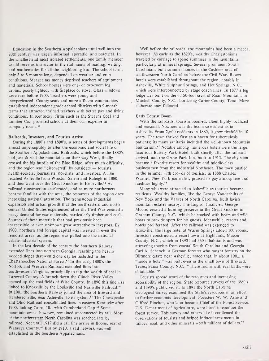
Education in the Southern Appalachians until well into the
20th century was largely informal, sporadic, and practical. In
the smallest and most isolated settlements, one family member
would serve as instructor in the rudiments of reading, writing,
and mathematics for all the neighboring kin. The school term,
only 3 to 5 months long, depended on weather and crop
conditions. Meager tax money deprived teachers of equipment
and materials. School houses were one- or two-room log
cabins, poorly lighted, with fireplace or stove. Glass windows
were rare before 1900. Teachers were young and
inexperienced. County seats and more affluent communities
established independent grade-school districts with 9-month
terms that attracted trained teachers with better pay and living
conditions. In Kentucky, firms such as the Stearns Coal and
Lumber Co., provided schools at their own expense in
company towns. 60
Railroads, Investors, and Tourists Arrive
During the 1880's and 1890's, a series of developments began
almost imperceptibly to alter the economic and social life of
the Southern Appalachians. Railroads, which before the 1880's
had just skirted the mountains on their way West, finally
crossed the big hurdle of the Blue Ridge, after much difficulty,
and the region was "discovered" by outsiders — tourists,
health-seekers, journalists, novelists, and investors. A line
reached Asheville from Winston-Salem and Raleigh in 1880.
and then went over the Great Smokies to Knoxville. 61 As
railroad construction accelerated, and as more northerners
became familiar with the area, the resources of the region drew
increasing national attention. The tremendous industrial
expansion and urban growth that the northeastern and north
central United States experienced after the Civil War created a
heavy demand for raw materials, particularly timber and coal.
Sources of these materials that had previously been
inaccessible or even unknown grew attractive to investors. By
1900. northern and foreign capital was invested in even the
remotest areas, as the region was pulled into the national
urban-industrial system.
In the last decade of the century the Southern Railway
extended lines into northern Georgia, reaching the heavily
wooded slopes that would one day be included in the
Chattahoochee National Forest. 62 In the early 1880's the
Norfolk and Western Railroad extended lines into
southwestern Virginia, principally to tap the wealth of coal in
Tazewell County. A branch down the Clinch River Valley
opened up the coal fields of Wise County. In 1890 this line was
linked to Knoxville by the Louisville and Nashville Railroad. 63
In 1901 the Southern Railway joined the area of Brevard and
Hendersonville, near Asheville, to its system. 64 The Chesapeake
and Ohio Railroad consolidated lines in eastern Kentucky after
1900, linking Cairo, 111., with Cumberland Gap. 65 Somemountain areas, however, remained unconnected by rail. Mostof the northwestern North Carolina was reached late by
railroad. Not until 1917 did a rail line arrive in Boone, seat of
Watauga County. 66 But by 1910, a rail network was well
established in the Southern Appalachians.
Well before the railroads, the mountains had been a mecca,
however. As early as the 1820's, wealthy Charlestonians
traveled by carriage to spend summers in the mountains,
particularly at mineral springs. Several prominent South
Carolinians built summer homes in the Cashiers area of
southwestern North Carolina before the Civil War. Resort
hotels were established throughout the region, notably in
Asheville, White Sulphur Springs, and Hot Springs, N.C.,
which were interconnected by stage coach lines. In 1877 a log
lodge was built on the 6,150-foot crest of Roan Mountain, in
Mitchell County, N.C., bordering Carter County, Tenn. Moreelaborate ones followed.
Early Tourist BoomWith the railroads, tourism boomed, albeit highly localized
and seasonal. Nowhere was the boom so evident as in
Asheville. From 2,600 residents in 1880, it grew fivefold in 10
years. The town thrived first as a haven for tuberculosis
patients; its many sanitaria included the well-known Mountain
Sanitarium. 67 Notable among numerous hotels were the large,
luxurious Battery Park Hotel, built shortly after the railroad
arrived, and the Grove Park Inn, built in 1913. The city soon
became a favorite resort for wealthy and middle-class
businessmen from the industrial Northeast. The town bustled
in the summer with crowds of tourists; in 1888 Charles
Warner, New York journalist, praised its gay atmosphere and
facilities highly. 68
Many who were attracted to Asheville as tourists became
residents. Wealthy families, like the George Vanderbilts of
New York and the Vances of North Carolina, built lavish
mountain estates nearby. The English financier, George
Moore, created a hunting preserve in the Great Smokies in
Graham County, N.C., which he stocked with bears and wild
boars to provide sport for his guests. Meanwhile, resorts and
hotels proliferated. After the railroad was extended to
Knoxville, the large hotel at Warm Springs added 100 rooms.
Investors constructed a resort town at Highlands, MaconCounty, N.C., which in 1890 had 350 inhabitants and was
attracting tourists from coastal South Carolina and Georgia.
Carl A. Schenck, a German forester who taught forestry on the
Biltmore estate near Asheville, noted that, in about 1901, a
"modern hotel" was built even in the small town of Brevard,
Transylvania County, N.C., "where rooms with real baths were
obtainable." 69
Tourists spread word of the resources and increasing
accessibility of the region. State resource surveys of the 1880's
and 1890's publicized it. In 1891 the North Carolina
Geological Survey examined the State's resources in an effort
to further economic development. Foresters W. W. Ashe and
Gifford Pinchot, who later became Chief of the Forest Service,
U.S. Department of Agriculture, were hired to conduct the
forest survey. This survey and others like it confirmed the
observations of tourists and helped induce investments in
timber, coal, and other minerals worth millions of dollars.70

Mountaineer Stereotype Develops
As the railroads opened up portions of the mountains and
resort areas sprang up, the region attracted novelists and
journalists in search of local color. During the last 30 years of
the 19th century, travelogues and short stories set in little-
known locales were extremely popular with the national
reading public. Major magazines of the period — Lippencott's,
Harper's, Scribner's, and Appleton 's — provided a ready
market for such writing. Professional authors looking for a
romantic setting and for dramatic, novel materials found both
in the Southern Appalachians.
Writers who popularized the region generally focused on the
mountains of one State. For example, Mary N. Murfree, under
the pseudonym Charles E. Craddock, wrote numerous stories
such as "The Romance of Sunrise Rock" and "The Despot of
Broomsedge Cove," most set in the Great Smoky Mountains of
eastern Tennessee. The background of Frances H. Burnett's
stories was North Carolina. James L. Allen wrote extensively of
travels through the Cumberland area of Kentucky. Such
writings found a wide audience; the most popular stories and
articles were printed both in magazine and book form, and
books often went through several editions. 71
These authors pictured a culture different from the rest of
America, especially the urban middle-class reader. The
mountain environment was described as mysterious and
awesome, and the mountaineer as peculiar and antiquated,
with customs and a language of his own.
Along with northern journalists came the northern
Protestant home mission movement. Protestant missionary
work in the mountains grew out of a general effort to
transform the South along northern lines and to eliminate
racial discrimination through education and religious
influence. At a time when the major older Protestant
denominations were competing for new mission fields to
develop, the Southern mountains were seen by many as an
"unchurched" land, despite the numerous small Baptist
congregations, because these northern Protestant
denominations were weakly represented there. To overcome
this situation, several hundred church schools were established
throughout the region, supported by the American Missionary
Association. One of the best known private Christian schools
in Appalachia is Berea College in Berea, Ky., founded in 1855
by John S. Fee, a Presbyterian (later a Baptist) minister, as an
integrated, coeducational, but nondenominational institution.
These schools emphasized what they saw to be Christian and
American values, modern ways, and provided practical training
for the "exceptional population" of the region to participate
fully in national life. Henry Shapiro claims that mission
schools institutionalized Appalachian "otherness," through the
implicit insistence that the mountaineers did in fact compose a
distinct element in the American population." 72
By the end of the 19th century, the southern mountaineer
had been identified by others as not only different from most
Americans but also in need of their help. Two aspects of
mountain behavior in particular captured the interest of
outsiders. These were the sometimes-linked practices of
moonshining and feuding. Mountaineers came to be perceived
and characterized as illegal distillers of corn whiskey and as
gun slingers who fiercely protected their stills, their
homesteads, and their family honor with little regard for the
law. 73
Estimating the actual prevalence of moonshining and
feuding in 19th century Southern Appalachia is difficult at
best, for from the beginning the documentation of these
practices was unscientific. Certainly, moonshining was a
common household industry. During the Civil War, distilleries
were required to be licensed, and liquor was taxed at
increasingly higher rates (from 20 cents per gallon in 1862 to
$2.00 per gallon in 1864). Although a certain degree of
compliance with these regulations occurred, manymountaineers resented the Government's authority to take a
large cut of one of the few profits they could realize from their
labors. They simply defied the system by hiding their stills in
the woods, literally making whiskey by moonshine, and selling
the liquor on the sly.74
After the Civil War, as the liquor tax increased but the
revenues from it decreased, the U.S. Internal Revenue Service
established new penalties for tax violations and instituted an
era of raids on illegal mountain stills. Although moonshiners
often established secret cooperative relationships with Federal
revenuers (perhaps preferring their wares in exchange for
Government oversight of their stills), they generally evaded the
Federal agents or challenged them. As Carl Schenck, the
German forester, wrote of the late 19th-century moonshiners in
western North Carolina, liquor distilleries were hidden in the
mountain coves and were "shifted . . . from site to site to
avoid discovery." Moonshiners "went about armed, keeping
the others in awe and threatening death to any betrayer of
their secrets." Federal raids sometimes resulted in bloodshed.
Violence was often the penalty for informers and the outcome
of discovery of an illegal still.75
Family Feuds
The common denominator of bloodshed linked moonshining
and feuding in the minds of Appalachian observers. Although
in fact the two were sometimes related, feuding stemmed from
broader and more basic causes. Feuding has been interpreted
by some to have developed from the interfamilial disputes of
the Civil War that occurred in and around the Southern
Appalachians. Major campaigns and battles took place at
Knoxville and Chattanooga, and numerous mountain gaps
provided significant passage for both Union and Confederate
troops. In John Campbell's words, "the roughness of the
country led to a sort of border guerrilla warfare." Throughout
the region, mountaineers joined both the Union and
Confederate armies, with family members often on opposite
sides. Such divisions provoked bitter local hostilities and
xxiv

provided the seeds for lasting feuds. In Madison County, N.C.,
Union sympathizers "seized the town of Marshall, plundered
the stores and committed many acts of violence." In
retaliation, a thousand Confederate sympathizers from nearby
Buncombe County engaged them in a punishing skirmish.
After the war, as political parties developed along lines of
Union-Confederate sympathies, such acrimony continued not
only as interfamilial feuds, but as partisan rivalry as well.76
The most notorious of feuds was that between the Hatfield
family of Tug Valley, W.Va., and the McCoys of Pike County,
Ky. Beginning in the early 1880's with a series of minor
misunderstandings, the feud quickly escalated into violence.
Members of each family kidnapped, ambushed, and killed
members of the other family with avenging spirit throughout
the decade. Both Governor MacCorkle of West Virginia and
Governor Bucknew of Kentucky tried to intervene by
strengthening law enforcement in the area. The feud continued
sporadically until about 1920 when Anderson "Devil Anse"
Hatfield, the family patriarch, died of pneumonia. 77
By the end of the 19th century, outsiders were seeking not
only to describe and to change the mountaineer, but also to
explain his quaint, peculiar, and sometimes disturbing
behavior. Such explanations perpetuated and even enhanced
the mountaineer stereotype. Geographical determinism and
ethnic origin were most generally accepted as explanations. In
1901, a geographer, Ellen Churchill Semple, in a study of the
mountain people of Kentucky, emphasized the Scotch-Irish
heritage of the mountaineer and described his behavior as a
pattern of adjustments required by the rugged and isolated
mountain environment. He was soon widely perceived to be a
remnant of pioneer days, a man of pure Anglo-Saxon stock
whose culture had been isolated and been preserved by the
rugged terrain and inaccessibility of the mountains. 78
Moonshining and feuding, as examples of mountaineer
behavior left over from frontier days, symbolized the
independence and lawlessness of the pioneer. Mountain
feuding was explained by identifying the mountaineers as
Highlanders and relating the feuds to Scottish clan warfare, an
idea deriving from James Craighead's Scotch and Irish Seeds
in American Soil, an 1878 publication popularized by the
American Missionary Association. Later, John Campbell
attributed both moonshining and feuding to the mountaineer's
high degree of individualism: "His dominant trait is
independence raised to the fourth power." Geographer Rupert
Vance emphasized environmental adaptation as an explanation
of moonshining and feuds: "Stimuli to homicide were manywhere lands were settled by the squatter process and titles were
so obscure. . . .
" 79
An alternative view of the mountaineer that developed early
was also based on ethnicity. John Fiske, a popular historian of
the late 19th century, gave currency to the false idea that
virtually all Southern mountaineers were descendants of whites
transported to America as servants or criminals in early
colonial times. 80 Such a distorted, ignorant view of the
mountaineer as Anglo-Saxon criminal made it easier for some
to see why feuding and illegal distilling persisted in spite of
Christian education and increased law enforcement. This naive
view, which was repeated and reinforced in the 20th century by
the writing of John Gunther and Arthur Toynbee, achieved a
modern stridency in the words of Kentuckian Harry Caudill.
Caudill claimed the mountaineer was "the illiterate son of
illiterate ancestors," and of debtors, thieves, and orphans who
fled the cities of England:
... cast loose in an immense wilderness without basic
mechanical or agricultural skills, without the refining,
comforting, and disciplining influence of an organized
religious order, in a vast land wholly unrestrained by
social organization or effective laws, compelled to
acquire skills quickly in order to survive, and with a
Stone Age savage as his principal teacher. 81
Investors Transform the Region
The railroads opened the area to investors as well. Some of
the investors were northern financiers; some were British
investment capitalists whose interest in the region was but a
small part of their overseas investments. A few of the
capitalists came to the region to stay as did Joseph Silverstein
of New York who formed the Gloucester Lumber Co.
southwest of Asheville, and Reuben B. Robertson of Canton,
Ohio, who managed the Champion Fibre Co. of North
Carolina. Most, however, invested in the region only to extract
the desired riches, and then withdrew.
The foreign investment and industrial development which
followed was frequently hailed as a natural solution to "a
whole range of problems . . . resulting from the isolation of
Appalachia and the poverty of the mountaineers." 82 Much of
the capital investment in the Southern mountains between
1880 and 1900 was justified by a belief that economic
development and industrialization were best for the region
itself.
The impact this industrial investment was to have on the
people of the Southern Appalachians was profound. By 1900
the isolated, self-contained farming existence that had
characterized the region was quickly changing and, by 1920,
was seriously disrupted. Before 1880, the southern
mountaineer made his living directly from the land, and
needed only modest amounts of cash, which he could raise
from the sale of livestock, trees, or other products from his
land. From 1890 on, the timber and coal companies purchased
much of the mountaineer's land, gave him a job in a mill,
mine, or factory, paid him in cash, brought in canned food
and consumer goods for him to buy, and educated him in the
ways of the modern world. Industrialization, urbanization,
large-scale changes in landownership and land use, as well as
deliberate attempts to change the society and culture of the
mountaineer, had come to the Southern Appalachians to stay.
Two world wars, the Great Depression, the New Deal social
programs, TVA, and the introduction of the Federal forest
and parks also had major lasting impacts on the area and its
people.
xxv

Reference Notes
1. 36 Stat. 962 (16 U S C 515, 521); 43 Stat. 653 (16 U.S.C. 471,
505, 515, 564-70).
2. For general discussions of the alternative definitions of the
Southern Appalachian region, see Bruce Ergood, "Toward ADefinition of Appalachia" in Bruce Ergood and Bruce Kuhre
(eds.), Appalachia: Social Context Past and Present (Athens,
Ohio: Ohio University, 1976), pp. 31-41 and Allen Batteau,
"Appalachia and the Concept of Culture: A Theory of Shared
Misunderstandings," Appalachian Journal 7 (Autumn/Winter,
1979-80): 21, 22.
3. John Campbell, The Southern Highlander and His Homeland
(Lexington: The University of Kentucky Press, 1969), pp. 10-13.
Campbell distinguishes a Southern Appalachian region as that
part of the Southern Highlands which is south of the New River
divide, p. 12.
4. Thomas R. Ford (ed.), The Southern Appalachian Region: ASurvey (Lexington: University of Kentucky Press, 1962).
5. Map published by the Appalachian Regional Commission,
January, 1974. The Commission has divided "Appalachia" into
Northern, Central, and Southern subregions. Within each of
these, there is a "Highlands Area," representing the most
mountainous counties of the region.
6. Wilbur Zelinsky, The Cultural Geography of the United States
(Englewood Cliffs, N.J.: Prentice-Hall, Inc., 1973), p. 112.
7. Helen M. Lewis, "Subcultures of the Southern Appalachians,"
The Virginia Geographer (Spring 1968):2.
8. Batteau, "Appalachia and the Concept of Culture: A Theory of
Shared Misunderstandings":29.
9. This geographic focus includes all the Appalachian National
Forests within the Forest Service's Southern Region (R-8), with
the exception of the George Washington National Forest.
Because it is located north of the New River divide and within a
90-minute drive of Washington, D.C., the George Washington
National Forest was felt to belong more properly with a
consideration of the Monongahela National Forest in West
Virginia, the Allegheny in Pennsylvania and Wayne National
Forest in Ohio.
10. 36 Stat. 962; 43 Stat. 653.
11. Some 61,500 acres were purchased for the Blue Ridge Parkway
and over 507,000 for the Great Smoky Mountains National Park.
Almost 3.5 million acres have been acquired for the Nantahala,
Pisgah, Cherokee, Chattahoochee, Daniel Boone, and Jefferson
National Forests.
12. Si Kahn, "The National Forests and Appalachia," Cut Cane
Associates, 1973, p. 1.
13. Charlton Ogburn, The Southern Appalachians: A Wilderness
Quest (New York: William Morrow and Co., 1975), pp. 67-72;
and Frederick A. Cook, Larry D. Brown, and Jack E. Oliver,
"The Southern Appalachians and the Growth of Continents,"
Scientific American 243 (October 1980): 156-169.
14. The three subregions have also been labeled "belts" or
"provinces" and have received varying names. The Valley and
Ridge subregion for example, has been called The Greater
Appalachian Valley, The Newer Appalachians, and The Folded
Appalachians. For physiographic descriptions of the three
subregions, see John C. Campbell, The Southern Highlander and
His Homeland, pp. 10-18; Edgar Bingham, "Appalachia:
Underdeveloped, Overdeveloped, or Wrongly Developed?" The
Virginia Geographer VII (Winter 1972): 9; Wallace W. Atwood,
The Physiographic Provinces of North America (Boston: Ginn
and Company, 1940), pp. 109-122; Charles B. Hunt, National
Regions of the United States and Canada (San Francisco: W.H.Freeman and Co., 1974), pp. 282-299; Thomas R. Ford (ed.),
The Southern Appalachian Region: A Survey, pp. Ir3; and
Rupert B. Vance, Human Geography of the South (Chapel Hill:
University of North Carolina Press, 1932), pp. 27, 28.
15. Atwood, The Physiographic Provinces, p. 14.
16. The subregion has also been likened to "a wrinkled rug." Cook,
et. ah, "The Southern Appalachians," p. 160.
17. Ogburn, The Southern Appalachians, p. 103.
18. One explanation for the reversal is that, north of Roanoke, the
sea advanced and retreated several times over millions of years
and, in so doing, created a new drainage pattern. See Atwood,
The Physiographic Provinces, p. 120.
19. Hunt, Natural Regions, pp. 287, 288.
20. Ogburn, The Southern Appalachians, 151-171; Ina W.VanNoppen and John J. VanNoppen, Western North Carolina
Since the Civil War (Boone: Appalachian Consortium Press,
1973), p. 291.
21. Ogburn, The Southern Appalachians, pp. 139-150.
22. Campbell, The Southern Highlander and His Homeland, pp.
246, 247.
23. Hunt, Natural Regions, pp. 297-299.
24. Cook, et. ah, "The Southern Appalachians."
25. Roy S. Dickens, Jr., Cherokee Prehistory: The Pisgah Phase in
the Appalachian Summit Region (Knoxville: University of
Tennessee Press, 1976), pp. 9-15; and Ogburn, The Southern
Appalachians, p. 55.
26. Ogburn, The Southern Appalachians, pp. 10, 11. David S.
Walls, in "On the Naming of Appalachia," maintains that
DeSoto's discovery of the Appalachians is merely "legend" and
that the first European to designate the mountains by their
names was Jacques le Moyne de Morgues, a Frenchman, in 1564.
J.W. Williamson (ed.), An Appalachian Symposium (Boone:
Appalachian State University Press, 1977), pp. 56-76.
27. Frederick Jackson Turner, Rise of the New West, 1819-1829
(New York: Collier Books, 1962), pp. 56-58.
28. Descriptions of the pioneer settlement of the Southern
Appalachians are found in Campbell, The Southern Highlander,
pp. 23-42; John Caruso, The Appalachian Frontier: America's
First Surge Westward (Indianapolis: The Bobbs-Merrill Co.,
Inc., 1959); Vance, Human Geography of the South; and Harry
Caudill, Night Comes to the Cumberlands (Boston: Little, Brown
and Co., 1962).
29. Campbell, The Southern Highlander, p. 42.
30. Turner, Rise of the New West, pp. 84-86.
31. Dickens, Cherokee Prehistory, pp. 14, 15.
xxvi

32. Ogburn, The Southern Appalachians, pp. 55-58. See also
Kenneth B. Pomeroy and James G. Yoho, North Carolina Lands:
Ownership, Use, and Management of Forest and Related Lands
(Washington: The American Forestry Association, 1964), pp.
92-120; and Duane H. King (ed.), The Cherokee Indian Nation
(Knoxville: The University of Tennessee Press, 1979).
33. VanNoppen and VanNoppen, Western North Carolina, p. 379.
Campbell, The Southern Highlander and His Homeland, p. 33.
34. Ronald D. Eller, "Land and Family: An Historical View of
Preindustrial Appalachia," Appalachian Journal 6 (Winter 1979):
84, 86.
35. Ronald D. Eller, "Miners, Millhands, and Mountaineers: The
Modernization of the Appalachian South, 1880-1930" (Ph.D.
dissertation, University of North Carolina, 1979), p. 23.
36. VanNoppen and VanNoppen, Western North Carolina, pp. 2, 3.
Gene Wilhelm, "Folk Geography of the Blue Ridge Mountains,"
Pioneer America (1970): 1, 2.
37. Eller, "Land and Family," p. 85. Eller, "Mountaineers, Miners,
and Millhands," p. 20.
38. This and the following demographic description of the Southern
Appalachians is based on Bureau of the Census data for 79
mountain counties which represent the core of the region. These
counties include:
Georgia: Banks, Catoosa, Chattooga, Fannin,
Gilmer, Gordon, Habersham, Lumpkin,
Murray, Rabun, Stephens, Towns, Union,
Walker, White, Whitfield;
Kentucky: Bath, Bell, Clay, Estill, Harlan, Jackson,
Knott, Knox, Laurel, Lee, Leslie, Letcher,
Menifee, Morgan, Perry, Powell, Pulaski,
Rockcastle, Rowan, Whitley, Wolfe;
North Carolina: Avery, Buncombe, Burke, Caldwell,
Cherokee, Clay, Graham, Haywood,
Jackson, Macon, McDowell, Madison,
Mitchell, Swain, Transylvania, Watauga,
Yancey;
Tennessee: Blount, Carter, Cocke, Greene, Johnson,
McMinn, Monroe, Polk, Sevier, Sullivan,
Unicoi, Washington;
Virginia: Bland, Dickenson, Giles, Grayson, Lee,
Pulaski, Russell, Scott, Smythe, Tazewell,
Washington, Wise, Wythe.
Data comes from Bureau of the Census, Twelfth Census of U.S.
(Washington: Government Printing Office, 1902).
39. For a full discussion of Middlesboro's founding, see Eller,
"Miners, Millhands, and Mountaineers," pp. 130-137.
40. See Note 38.
41. See Note 38.
42. Vance, Human Geography of the South, p. 247. Gene Wilhelm,
Jr., "Appalachian Isolation: Fact or Fiction?" in J. W.Williamson (ed.), An Appalachian Symposium (Boone:
Appalachian State University Press, 1977), p. 88.
43. Eller, "Miners, Millhands, and Mountaineers, p. 36, 37; and
Jack E. Weller, Yesterday's People (Lexington: University of
Kentucky Press, 1966), pp. 12, 13.
44. Weller, Yesterday 's People, 38-40.
45. Frank L. Owsley, Plain Folk of the Old South (Chicago:
Quadrangle Books, 1965), p. 45.
46. Eller, "Miners, Millhands, and Mountaineers," pp. 40-42; Susie
Blaylock McDaniel, Official History of Catoosa County, Georgia
1853-1953 (Dalton, Georgia: Gregory Printing and Office Supply,
1953), p. 195; Goodridge Wilson, Smythe County History and
Traditions (Kingsport, Tennessee: Kingsport Press, 1932), p. 171;
and Wilhelm, "Appalachian Isolation," p. 83.
47. Eller, "Miners, Millhands, and Mountaineers," p. 43; and
George L. Hicks, Appalachian Valley (New York: Holt, Rinehart
and Winson, 1976), pp. 20, 21.
48. Wilhelm, "Appalachian Isolation," p. 88; and Vance, HumanGeography of the South, p. 249.
49. VanNoppen and VanNoppen, Western North Carolina, pp. 276,
277.
50. Wilhelm, "Appalachian Isolation," p. 83.
51. Eller, "Miners, Millhands, and Mountaineers," p. 26.
52. VanNoppen and VanNoppen, Western North Carolina, p. 18.
53. Eller, "Miners, Millhands, and Mountaineers," p. 29.
54. Campbell, The Southern Highlander, p. 102.
55. VanNoppen and VanNoppen, Western North Carolina, p. 27.
56. Eller, "Miners, Millhands, and Mountaineers," p. 65, and
Laurel Shackelford and Bill Weinberg, eds.. Our Appalachia
(New York: Hill and Wang, 1977), pp. 23-25.
57. Willis D. Weatherford, ed., Religion in the Appalachian
Mountains: A Symposium (Berea, Ky.: Berea College, 1955), pp.
35-50.
58. Campbell, The Southern Highlander, pp. 170, 171; and
VanNoppen and VanNoppen Western North Carolina, p. 72.
59. Weatherford, Religion in the Appalachian Mountains, pp. 96-98,
and Shackelford and Weinberg, Our Appalachia. pp. 44-50.
60. Campbell, The Southern Highlander, p. 264; L. E. Perry,
McCreary Conquest, A Narrative History (Whitley City, Ky.: L.
E. Perry, 1979), pp. 63-72.
61. Wilma Dykeman, The French Broad (New York: Rinehart and
Company, 1955), p. 164. See pp. 159-165 for colorful description
of Western North Carolina Railroad construction. See also
VanNoppen and VanNoppen, Western North Carolina, pp.
253-259.
62. Ignatz Pikl, A History of Georgia Forestry (Athens: University of
Georgia, Bureau of Business and Economic Research, 1966), p.
9.
63. Eller, "Miners, Millhands, and Mountaineers," pp. 114-129.
64. Carl Alwin Schenck, The Birth of Forestry in America (Santa
Cruz, Calif.: Forest History Society and the Appalachian
Consortium, 1974), p. 103.
65. William Haney, The Mountain People of Kentucky (Cincinnati:
The Robert Clarke Company, 1906), p. 94.
66. VanNoppen and VanNoppen, Western North Carolina, p. 265.
67. Ogburn, The Southern Appalachians, pp. 18, 19; VanNoppen
and VanNoppen, Western North Carolina, pp. 40, 378, 379.
68. Charles Dudley Warner, On Horseback: A Tour in Virginia,
North Carolina and Tennessee (Boston: Houghton, Mifflin and
Company, 1888), p. Ill, 112.
xxvii

69. Alberta Brewer and Carson Brewer, Valley So Wild: A Folk
History (Knoxville: East Tennessee Historical Society, 1975), pp.
131-133. VanNoppen and VanNoppen, Western North Carolina,
p. 260, p. 378; Schenck, Birth of Forestry in America, p. 103.
70. John R. Ross, "Conservation and Economy: The North Carolina
Geological Survey, 1891-1920," Forest History 16 (January 1973):
21; and Judge Watson, "The Economic and Cultural
Development of Eastern Kentucky from 1900 to the Present"
(Ph.D. dissertation, Indiana University, 1963), p. 42.
71. The major source for material on the discovery of the Southern
Appalachians and the development of the mountaineer stereotype
is Shapiro, Appalachia On Our Mind. For mention of writers,
see pp. 310-339.
72. Henry D. Shapiro, Appalachia On Our Mind, 32, 42.
73. Henry D. Shapiro, "Appalachia and the Idea of America: The
Problem of the Persisting Frontier," in Williamson, AnAppalachian Symposium, pp. 43-55.
74. Esther Kellner, Moonshine: Its History and Folklore (New York:
The Bobbs-Merrill Co., 1971), p. 78; VanNoppen and
VanNoppen, Western North Carolina, pp. 273, 274. Adescription of legal distilling in Kentucky occurs in Shackelford
and Weinberg, eds., Our Appalachia, pp. 102-108.
xxviii
75. Schenck, Birth of Forestry in America, p. 64; George W.Atkinson, After The Moonshiners (Wheeling, W. Va.: Frew,
Campbell, Stearn Book and Job Printers, 1881).
76. Campbell, The Southern Highlanders and Their Homeland, p.
97; VanNoppen and VanNoppen, Western North Carolina, pp.
15-17.
77. Otis K. Rice, The Hatfields and the McCoys (Lexington:
University of Kentucky Press, 1978); and Lawrence D. Hatfield,
The True Story of the Hatfield and McCoy Feud (Charleston:
Jarrett Printing Company, 1944). Shackelford and Weinberg,
eds., Our Appalachia, p. 60.
78. Ellen Churchill Semple, "The Anglo-Saxons of the Kentucky
Mountains: A Study in Anthropogeography," Geographical
Journal 17 (June 1901): 588-623. Shapiro, Appalachia On Our
Mind, Chapter 3.
79. James G. Craighead, Scotch and Irish Seeds in American Soil
(Philadelphia: Presbyterian Board of Publication, 1878).
Campbell, The Southern Highlander and His Homeland, p. 91.
Vance, Human Geography of the South, p. 250.
80. John Fiske, Old Virginia and Her Neighbors, II (Boston:
Houghton Mifflin and Co., 1897), pp. 311-321.
81. Caudill, Night Comes to the Cumberlands, p. 17; W. K. McNeil,
"The Eastern Kentucky Mountaineer: An External and Internal
View of History," Mid-South Folklore (Summer, 1973): 36.
82. Shapiro, Appalachia On Our Mind, p. 158.

MountaineersandRangers
A History of Federal ForestManagement in theSouthern Appalachians1900-81


Though this first major venture failed, others were not
deterred. H.N. Saxton, an Englishman, organized the
Sevierville Lumber Co. in the late 1880's, and later started
Saxton and Co., a firm exporting hardwoods to Europe. 2 As
the forests of the Northeast and the Great Lakes region were
depleted, more and more northern lumber companies came to
the Southern Appalachians. Speculators came too, to take
advantage of the rich resources and low land costs. Businesses
were organized for the explicit purpose of buying land and
timber.
In the 1890's the timber speculators began in earnest, and
an astonishing number of timber companies moved into the
southern mountains. In North Carolina, the Unaka Timber
Co. of Knoxville, Tenn., was active in Buncombe, Mitchell,
Madison and Yancey Counties, while the Crosby Lumber Co.
from Michigan operated in Graham County. In 1894 the
Foreign Hardwood Log Co. of New York and the Dickson-
Mason Lumber Co. of Illinois made extensive purchases in
Swain County. The Tuckaseigie Lumber Co. purchased 75,000
acres of land in Macon, Jackson, and Swain Counties. Other
firms included the Toxaway Tanning Co., the Gloucester
Lumber Co., the Brevard Tanning Co., the Asheville Lumberand Manufacturing Co., and the Asheville French Broad
Lumber Co. After 1900 the Montvale Lumber Co., the Bemis
Lumber Co., and the Kitchen Lumber Co. bought large tracts
Figure 10.—Steam engine loading railroad flatcars at log boom on Big Lost
Creek, Polk County, southeastern Tennessee, just above Hiwassee River and line
of Louisville & Nashville Railroad, near old mill town of Probst, not far from
present town of Reliance, in Unicoi Mountains. This area was part of the newCherokee National Forest Purchase Unit when photo was taken in February
1912. Logs are largely yellow-poplar, which shows good reproduction in this
highland region of heavy annual rainfall. Timberlands of the Prendergast
Company, which also owned the flatcars and the logging railroad. (National
Archives: Record Group 95G-10832A)
in the North Carolina Great Smokies. The largest North
Carolina firms were Champion Fibre Co. which came from
Ohio to Canton, N.C., in 1905, and the William Ritter
Lumber Co. from West Virginia. The Ritter firm, the largest
lumber company in the Southern Appalachians, owned almost
200,000 acres of land in North Carolina alone. 3
New timber companies also acquired land and timber rights
in eastern Kentucky, eastern Tennessee, and northern Georgia.
The Burt-Brabb and Swann-Day lumber companies, early
developers in eastern Kentucky, were followed by the Kentucky
River Hardwood Lumber Co., which at one point owned over
30,000 acres of forest land. Watson G. Caudill operated a
lumber company that was active in several counties. However,
it was not until the William Ritter Co. moved in that truly
extensive and long-term operations began in the eastern
counties of the State. The Ritter companies were so large and
enterprising that they built their own railroads after the
Norfolk and Western Railroad refused to construct lines
needed for their business. 4 The Ritter Co. also purchased
acreage in the mountains of eastern Tennessee.
2

The Little River Lumber Co. became a major landowner in
the Great Smoky Mountains, with over 86,000 acres near
Clingman's Dome. The Norwood Lumber Co., the Vestal
Lumber and Manufacturing Co., and the Pennsylvania-based
Babcock Lumber Co. also bought land in eastern Tennessee.
The Gennett Lumber Co., organized in Nashville in 1901,
speculated in land and timber in Tennessee, South Carolina,
Georgia, and North Carolina for most of the 20th century. The
Gennett Lumber Co. was one of the most prominent in
northern Georgia, along with the Pfister-Vogel Land and
Leather Co. of Milwaukee, which actively purchased land there
after 1903, for about $2.00 an acre. 5
Timberlands Sell Cheaply
Prices paid by the timber companies for land in the southern
mountains were astonishingly low. The agents of northern and
foreign firms found a people unaccustomed to dealing in cash
and unfamiliar with timber and mineral rights and deeds. The
companies bought up huge tracts of land for small sums.
When local opposition to such purchases began to develop,
they switched to buying only timber or coal rights. Some
lumber companies even purchased selected trees. The
mountaineer, offered more cash than he had seen before in
one transaction, found it difficult to refuse an offer, especially
since he usually had no idea of the fair value of the land or
timber. Enormous yellow- (tulip) poplars and stands of white
and red oak and black cherry were sold for 40 to 75 cents a
tree.6
Ronald D. Eller tells how much Appalachian mountain land
was acquired:
The first timber and mineral buyers who rode into the
mountains were commonly greeted with hospitality by
local residents. Strangers were few in the remote
hollows, and a traveler offered the opportunity for
conversation and a change from the rhythms of daily
life. The land agent's routine was simple. Riding
horseback into the countryside he would search the
coves and creek banks for valuable timber stands or
coal outcroppings, and having found his objective, he
would approach the cabin of the unsuspecting farmer.
[The farmer's cordial] greeting was usually followed by
an invitation to share the family's meal and rude
accommodations for the night. After dinner, while
entertaining the family with news of the outside world,
the traveler would casually produce a bag of coins andoffer to purchase a tract of 'unused ridgeland' which
he had noticed while journeying through the area.
Such an offer was hard to refuse in most rural areas,
where hard money was scarce, life was difficult, and
opportunities few.7
Thus the money often provided a welcome opportunity for a
family to leave a farm that had been worn out for years. In
northern Georgia especially, the farm population was greater
than the land could reasonably support, and people sold
willingly.8 In other areas, people were more reluctant to sell to
outsiders. Some unscrupulous firms enlisted the aid of local
Figure 11.—A team of four horses and mules pulling a flatbed wagon carrying a
large white oak log to the sawmill along a dirt road near Jonesboro, WashingtonCounty, Tenn., in July 1915. Log probably came from Locust Mountain area
west of Johnson City, not far from the Unaka National Forest, now a part of the
Cherokee. (NA:95G-23262A)

merchants, who would make purchases for "dummy"corporations.
Sometimes land with inexact or missing titles was simply
taken from the mountaineers, who often had failed to obtain
formal title to their land. This "unclaimed" land could be
taken by anyone willing to stake a claim, survey the land, and
pay a fee to the State. Other claims were clouded, or not
properly surveyed. 9 In some counties, courthouse records had
been destroyed by fire, creating uncertainty about ownership.
Thus, a timber company could move into an area, conduct its
own surveys, and file claim for lands that the mountaineer had
long used and thought were his. Litigation was expensive and
time-consuming; most residents had neither the sophistication
nor the resources to carry a case through court proceedings. In
Kentucky, the State legislature passed an act in 1906 that
permitted speculators who had held claims and had paid
property taxes for 5 years to take such property from previous
claimants who had not paid taxes. 10 Thus, rising property
taxes created by speculation worked to the advantage of the
corporation and against the original claimant, who probably
paid low taxes to start with and could not afford an increase.
These processes were gradual, but they marked the beginning
of the disestablishment of the mountaineer, and further
alteration of the mountain economy.
Timber Cutting Often Delayed
Once the land was acquired, timber companies often did not
cut the timber immediately. Most of the Pfister-Vogel lands of
northern Georgia were never cut by the firm. The Gennett
brothers bought and sold land for decades, cutting over parts,
and waiting for good or better lumber prices on others. The
Cataloochia Lumber Co. lands in Tennessee were sold to the
Pigeon River Lumber Co., and in turn were bought by
Champion Lumber Co. The firm of William Whitmer and
Sons purchased tracts in North Carolina which it deeded to the
Whitmer-Parsons Pulp and Lumber Co., which later sold the
lands to the Suncrest Lumber Co., a Whitmer-backed
operation
.
1
1
Other outside firms bought land, timber, or mineral rights
for speculation, or for possible use. For example, the Gennetts
bought an 11,000-acre tract from the Tennessee Iron and Coal
Co.; the Consolidation Coal Co. owned vast tracts in
Kentucky, and employed a forester to manage those lands.
At one point, Fordson Coal Co., a subsidiary of the Ford
Motor Co. owned about half of Leslie County, Ky., and several
land development companies purchased extensively in the
mountains of northern Georgia. 12 Such speculation was to
inflate the value of all land in the region, as illustrated in the
following comments by a Forest Service purchasing agent whocame to the Southern Appalachians in 1912:
This is a virgin timber county [the Nantahala purchase
area] and about three years ago the big lumber
companies, seeing their present supplies in other
regions running low, came in here and quietly bought
up large "key" areas of timberland. They are now
holding these at prices which are more nearly
compared with lands in regions where railroad
developement [sic] is more favorable . . . Thewithdrawal of these large bodies has enhanced the
value of the smaller tracts . ..' 3
Between 1890 and the First World War, a great deal of
timber was cut on purchased lands, and the economic impact
was felt throughout the southern mountains. The years 1907 to
1910 were the years of peak activity. Throughout the region,
lumber production rose from 800 million board feet in 1899 to
over 900 million board feet in 1907. 14 In 1910, the number of
lumber mills in Georgia reached almost 2,000; a decade later it
had fallen to under 700. Individual tracts yielded vast
quantities of lumber: in 1909, one 20,000-acre tract in the Big
Sandy Basin produced 40 million board feet of tulip (yellow-)
poplar, while in 1912, the mountains around Looking Glass
Rock in North Carolina yielded 40,000 board feet of tulip
(yellow-) poplar per acre. 15.
Logging Boom Displaces Farmers
The social and economic impact of the logging boom on the
peoples of the Southern Appalachians was lasting. For decades
small firms and individuals had engaged in selective cutting
throughout the region without appreciably changing the
economy, the structure of the labor force, or the size of the
forests. Now, within a decade or two, the landownership
pattern of the southern mountains changed drastically. As
mountain lands were sold to the timber interests, farms and
settlements were abandoned. As Ron Eller has written:
Whereas mountain society in the 1880's had been
characterized by a diffuse pattern of open-country
agricultural settlements located primarily in the fertile
valleys and plateaus, by the turn of the century the
population had begun to shift into non-agricultural
areas and to concentrate around centers of industrial
growth. 16
By 1910, vast tracts of mountain land, which had previously
been held by privately scattered mountain farmers, had fallen
into the hands of absentee landowners, and towns were
becoming important centers of population. Although some
mountaineers remained on the land as tenants, sharecroppers,
caretakers, or squatters, many were displaced.
The changing pattern of landownership was reflected in
changes in population and acreage devoted to farming. The
population growth of some mountain counties slowed
considerably by 1910, and a few actually lost population. For
example, Macon and Graham Counties, N.C., which had
grown at a rate faster than the State between 1880 and 1900,
experienced almost no growth between 1900 and 1910. Over
the same decade, Rabun and Union Counties, Ga., lost 11.5
4
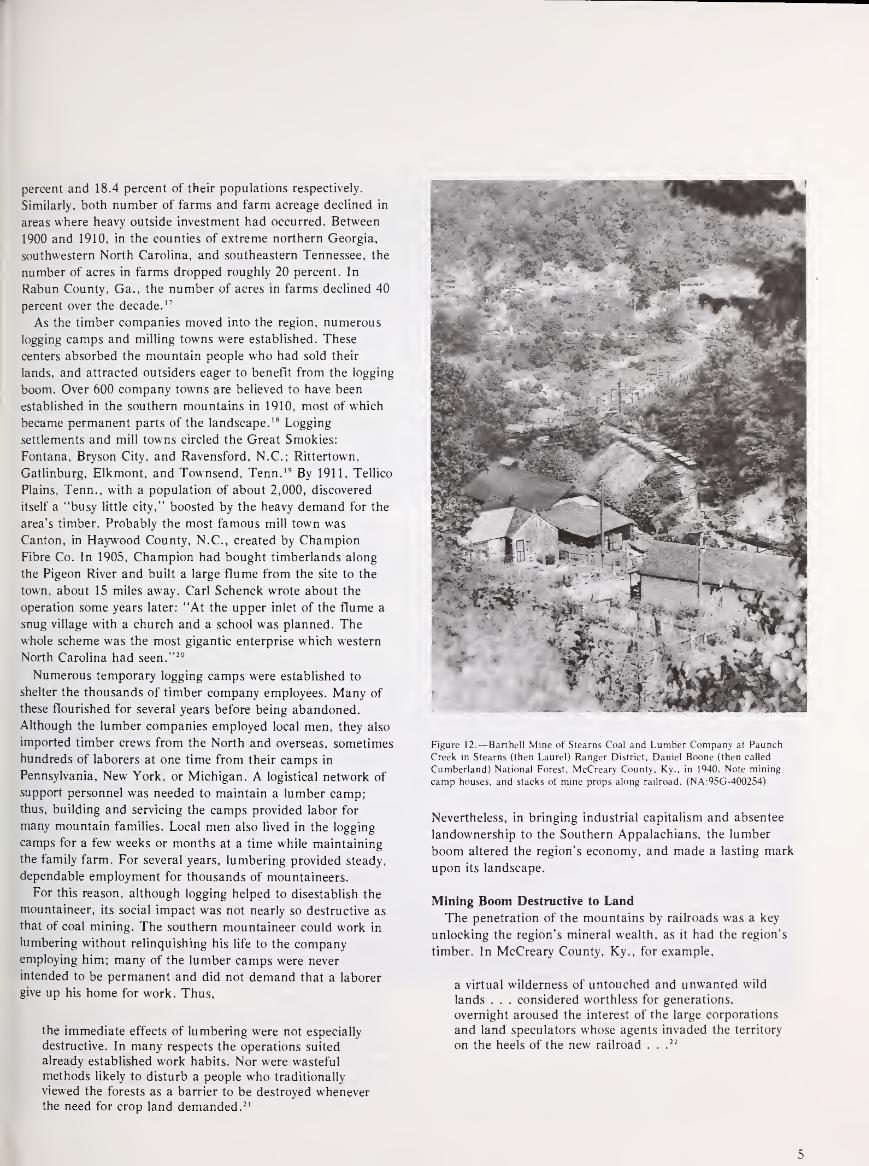
percent and 18.4 percent of their populations respectively.
Similarly, both number of farms and farm acreage declined in
areas where heavy outside investment had occurred. Between
1900 and 1910, in the counties of extreme northern Georgia,
southwestern North Carolina, and southeastern Tennessee, the
number of acres in farms dropped roughly 20 percent. In
Rabun County, Ga., the number of acres in farms declined 40
percent over the decade. 17
As the timber companies moved into the region, numerous
logging camps and milling towns were established. These
centers absorbed the mountain people who had sold their
lands, and attracted outsiders eager to benefit from the logging
boom. Over 600 company towns are believed to have been
established in the southern mountains in 1910, most of which
became permanent parts of the landscape. 18 Logging
settlements and mill towns circled the Great Smokies:
Fontana, Bryson City, and Ravensford, N.C.; Rittertown,
Gatlinburg, Elkmont, and Townsend, Tenn. 19 By 1911, Tellico
Plains, Tenn., with a population of about 2,000, discovered
itself a "busy little city," boosted by the heavy demand for the
area's timber. Probably the most famous mill town was
Canton, in Haywood County, N.C., created by Champion
Fibre Co. In 1905, Champion had bought timberlands along
the Pigeon River and built a large flume from the site to the
town, about 15 miles away. Carl Schenck wrote about the
operation some years later: "At the upper inlet of the flume a
snug village with a church and a school was planned. The
whole scheme was the most gigantic enterprise which western
North Carolina had seen." 20
Numerous temporary logging camps were established to
shelter the thousands of timber company employees. Many of
these flourished for several years before being abandoned.
Although the lumber companies employed local men, they also
imported timber crews from the North and overseas, sometimes
hundreds of laborers at one time from their camps in
Pennsylvania, New York, or Michigan. A logistical network of
support personnel was needed to maintain a lumber camp;thus, building and servicing the camps provided labor for
many mountain families. Local men also lived in the logging
camps for a few weeks or months at a time while maintaining
the family farm. For several years, lumbering provided steady,
dependable employment for thousands of mountaineers.
For this reason, although logging helped to disestablish the
mountaineer, its social impact was not nearly so destructive as
that of coal mining. The southern mountaineer could work in
lumbering without relinquishing his life to the companyemploying him; many of the lumber camps were never
intended to be permanent and did not demand that a laborer
give up his home for work. Thus,
the immediate effects of lumbering were not especially
destructive. In many respects the operations suited
already established work habits. Nor were wasteful
methods likely to disturb a people who traditionally
viewed the forests as a barrier to be destroyed wheneverthe need for crop land demanded. 21
Figure 12.— Barthell Mine of Stearns Coal and Lumber Company at Paunch
Creek in Stearns (then Laurel) Ranger District, Daniel Boone (then called
Cumberland) National Forest, McCreary County. Ky., in 1940. Note mining
camp houses, and stacks of mine props along railroad. (NA:95G-400254)
Nevertheless, in bringing industrial capitalism and absentee
landownership to the Southern Appalachians, the lumber
boom altered the region's economy, and made a lasting mark
upon its landscape.
Mining Boom Destructive to Land
The penetration of the mountains by railroads was a key
unlocking the region's mineral wealth, as it had the region's
timber. In McCreary County, Ky., for example,
a virtual wilderness of untouched and unwanted wild
lands . . . considered worthless for generations,
overnight aroused the interest of the large corporations
and land speculators whose agents invaded the territory
on the heels of the new railroad . . .
22
5

As with timber lands, the sale of mountain lands to coal
company agents was usually done willingly, even if
unscrupulous methods sometimes were used. In Kentucky,
where the Stearns Coal and Lumber Co. bought thousands of
homesteads beginning in the late 1890's, William Kinne, the
Stearns land agent, was received warmly and came to be
regarded with respect and even endearment. 23 Nevertheless,
the transfer of landownership to land and development
companies in the 1880's and 1890's insured that the control of
the mining industry, and much of the profit from it, would
flow outside the region.
Mineral developments in the Southern Appalachians
included mica, iron, copper, manganese, and coal mining.
Mica mining flourished for a time around the turn of the
century in North Carolina, and then declined as mica was
replaced by other substances. Some mica mining continues,
but it is a comparatively small business.
Between the end of the Civil War and about 1910, an iron
and copper industry based on locally produced coal, iron ore,
copper ore, sulfur, and limestone grew up in eastern
Tennessee. Although railroad construction at first improved
the market for iron, the expansion of the national
transportation network eventually drove the regional producers
out of business. Limitations in the quality and quantity of iron
ore also were a factor. By World War I, little remained of the
iron industry that had flourished earlier in Chattanooga,
Ducktown, Rockwood, and Dayton. 24
In spite of these mineral developments, it is coal mining that
most significantly altered the economy and society of the
mountains. From 1900 to 1920 the increasing national demandfor coal led to the penetration of the Great Lakes market by
Southern Appalachian coal producers and to the rapid
development and, ultimately, overdevelopment of the mountain
coal fields. It was comparatively cheap and easy to extract coal
by strip-mining from seams in the mountainsides. The most
important requirement was a large supply of cheap labor. 25
Although large areas of accessible mountain land were
affected by the timber boom, coal and other forms of mining
at first affected only individual isolated valleys, chiefly in
Kentucky and Tennessee. However, the impact of mining was
more permanent. Timber companies would "cut and get out,"
but mining companies, working rich and extensive seams of
coal, would remain for years. Unlike the logging camps, the
mining towns became of necessity the permanent homes of
those who came to work the mines. Mine operators developed
company towns partly to provide housing in isolated areas, and
partly to gain control of the labor force. Workers often had no
alternative to the company town because the coal company
owned all the land for miles around.
To the coal entrepreneur, a local mountaineer who remained
on his own "home place" was an unreliable worker. He would
take time off for spring planting, and several times a year he
would go hunting. He might also take off from work for a
funeral or a family reunion. Once a worker was housed in the
company town, however, he could be disciplined more
effectively because, if he lost his job in the mine, he would be
evicted from his house at the same time. Also, most companytowns did not permit independent stores to operate. Workers
were generally in debt for purchases made at the company-
owned store. In many towns even a garden patch to
supplement the store-bought food was, for lack of space,
impossible.
When the timber boom began to slacken just after World
War I, mountaineers who had been dependent on work in the
logging camps and sawmills moved into the coal mining areas
of the mountains to find work. Many went across the crest of
the Appalachians from North Carolina and Virginia into
Kentucky to the coalfields of the Cumberlands. Mountaineers
were also faced with competition for jobs, when outsiders,
including blacks from the Deep South, as well as European
immigrants, were imported to enlarge the labor force.
Squalid Company Towns
The coal industry in the Southern Appalachians continued
to grow until 1923. However, throughout the 1920's the coal
producers maintained their competitive advantage by wage
reductions. The cut-throat competition in the coal industry
discouraged investment in improvements for the company
towns. Many of these hastily constructed communities grew
increasingly squalid. Miners moved frequently, hoping for
better housing and working conditions at another mine.
Mining was destructive to the environment, even in the early
days. The demand for pit props, poles, and railroad ties
contributed to the exploitation of the surrounding forests. The
mines produced slag heaps and acid mine runoff which
severely damaged streams and wildlife. The company towns
had no facilities for sewage and refuse disposal, so human
waste and trash heaps polluted the creeks, causing serious
health hazards. One particularly blighted area, perhaps the
largest and most notorious in the United States, was near
Ducktown, Polk County, Tenn., and McCaysville, Fannin
County, Ga. There, the acid fumes from the smelting and
refining of copper and iron had destroyed thousands of acres
of the mountains' entire vegetative cover. Erosion was severe
from the bare slopes, and heavy silting occurred in the main
channel of the Tennessee River, 45 miles to the west.26 Yet
decades went by before such devastating impacts of mining
attracted wide attention.
The impact of largescale logging on the Southern
Appalachians in the years after 1890 was not only economic
and social. It encouraged fires, erosion, and floods that drew
national attention to the region and sparked legislation
authorizing most of the eastern National Forests.
6
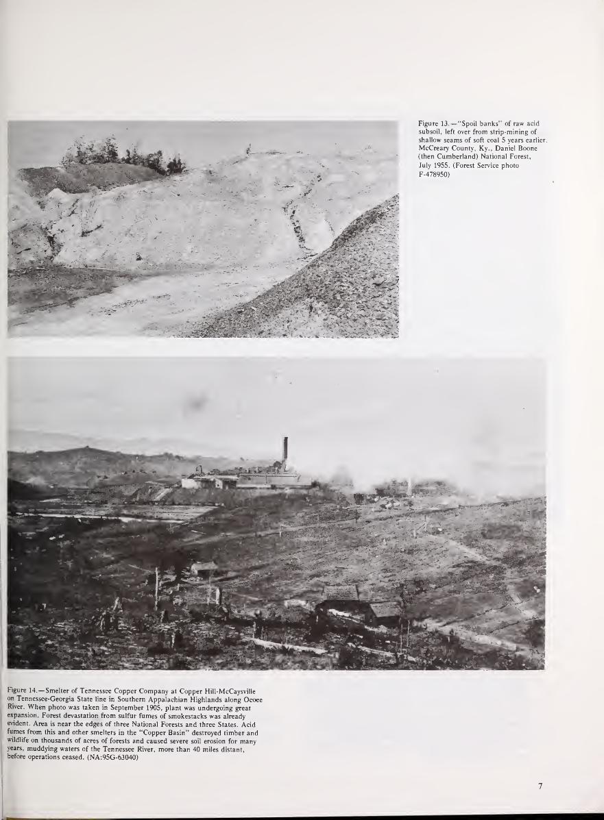
Figure 14.—Smelter of Tennessee Copper Company at Copper Hill-McCaysvilleon Tennessee-Georgia State line in Southern Appalachian Highlands along OcoeeRiver. When photo was taken in September 1905, plant was undergoing great
expansion. Forest devastation from sulfur fumes of smokestacks was alreadyevident. Area is near the edges of three National Forests and three States. Acidfumes from this and other smelters in the "Copper Basin" destroyed timber andwildlife on thousands of acres of forests and caused severe soil erosion for manyyears, muddying waters of the Tennessee River, more than 40 miles distant,
before operations ceased. (NA:95G-63040)
7

In terms of both investment and impact, logging operations
in the mountains actually occurred in two phases. The first,
roughly from 1880 to 1900, was characterized by low
investment, "selective" cutting (usually "high-grading"), and a
spatial separation between timbering operations and milling.
The second phase, beginning around 1900, peaking in 1909,
and lasting into the 1920's, involved a higher level of
investment, heavy cutting, and the construction of rail lines
and mills thoughout the mountain forests. It was with the
latter stage that environmental damage became acute.
In the early days, only the largest and highest quality trees
were cut: cherry, ash, walnut, oak, and yellow- (tulip) poplar,
often as large as 25 feet in circumference. Although it is
difficult to imagine today, trees were felled that were larger in
diameter than an average man stands. Some portable sawmills
were brought into the mountains in the earlier years, but logs
from these enormous trees were usually transported to a mill,
some miles distant, by horse, oxen, or water. Typically, log
splash dams were built on the shallow mountain streams so
that many logs could be moved at one time. Logs were rolled
into the lakes formed behind the dams, and with a buildup
from rain or melting snow, the dams were opened to let the
logs cascade down the mountains. From wider places on the
river, trees— as many as 40 to 120 at a time—were lashed
together to form rafts, which were piloted downriver to the
mills.27
Elbert Herald reminisced about this kind of logging for the
compilers of Our Appalachia. As a boy, Herald logged with his
father in Leslie County, Ky., between 1922 and 1930. His
experiences are typical of the small local lumbering operations
that went on before, during, and after the big timber boom.
I was eleven years old when I moved to Leslie County.
It was a very isolated country7 up there, mind you, I
said this was in 1922: there was not one foot of
highway, there was not one foot of railroad. My father,
he looked around and there was plenty of hard work to
get done, and we went to work cutting logs.
There wasn't any saw mill around to sell them at closer
than Beattyville, a right smart piece away. There was a
number of companies we would contact [to] get a
contract for so many logs . . .
Walnut and white oak at that time was best. We would
get $35 a thousand [board feet] for that, but when it
come down to beech and smaller grades we done well
to get $25 a thousand.
[We] cut roads through the hills and hauled our logs
down to the riverbanks with work oxens and horses.
When we got [the logs] to the river we would raft themtogether and buyers would come along buying. If it was
real big logs—anywhere from 24 to 28 inches [in
diameter]—we would take about 65 logs. If they were
smaller logs—anywhere from 18 to 22 inches—we'd
take 75 or 80 on a raft, which would amount to
anywhere from 8 to 10 thousand board feet, depending
on the length of the logs.28
Although logging was hard work and timber prices were not
high, Herald explained that it was the only way to makemoney at that time. The market for farm crops was dismal.
Although this kind of logging was careless and destructive,
its environmental impact was minor compared to the intense
logging of the boom period. Small local lumber operations cut
trees very selectively, according to size, quality, and proximity
to a stream. Relatively few men were engaged in lumbering at
first, and the visible effects of milling were scattered and
removed from the source of supply. It had been estimated that
even in 1900 most of the area was wooded and at least 10
percent of the Southern Appalachian region remained in virgin
timber. 29
Before that year, however, distinct changes began. Out-of-
state and foreign investors began purchasing large tracts of
mountain land, and rail lines were built into previously
inaccessible valleys. With railroads, mills could be located
close to the source of supply; trees had to be transported only
short distances, and finished lumber could be carried to the
market.
One of the most impressive railroad projects in the
mountains was that of the Little River Lumber Co. Chartered
in 1901, the Little River Railroad was a standard-gauge line
from Maryville, Tenn., at the southwestern corner of the Great
Smokies, to the mill at Townsend, then running 18 miles up
the gorge of the Little River to the base of the timber
operations. The rail construction greatly increased the ease and
scale of operations. By 1905, the mill was cutting about 60,000
board feet of wood per day. This area is now well inside the
Park, not far from the cross-Park highway, U.S. Route 441.
Other methods, too, were devised to further largescale tree
removal; among them were inclined railways controlled by
yarding machines, and overhead cable systems, both used with
considerable success in the Smokies. 30 To facilitate log
transportation, larger flumes and splash dams were built. Aconcrete splash dam built across the Big Sandy River in
Dickenson County, Va., was probably the largest. Completed
in 1909, it was about 360 feet high and 240 feet across, with
five flumes, each 40 feet wide, through which the pent-up logs
tumbled. 31 The dam enabled the Yellow Poplar Lumber Co. to
run logs to Cattletsburg, Ky., in record time; within 10 years,
the merchantable hardwood timber supply of the Big Sandy
Basin had been virtually exhausted.
Wasteful Cutting Damages Forests
Throughout the region, as the scale of logging increased,
size selectivity in cutting declined:
The depletion of the forests is revealed by the rapidly
changing cutting standards as culling became the rule
rather than the exception. In 1885 few logs under 30
inches in diameter were cut. Ten years later the usual
cutting was 24 inches. By 1900 the average limit had
dropped to 21 inches. By 1905 lumberman were taking
chestnut and oak only 15 inches on the stump. 32
8

Figure 15.—Steam overhead cable skidder on rails bringing in logs from two
facing slopes on tract of Little River Lumber Company in Great SmokyMountains. Sevier Countv. Tenn., in 1913. (NA:95G-15507A)
Not only was there a decline in the average size cut, there
was a shift as well in the species of trees harvested. As the best
cherry, ash, and oak were depleted, the demand for hemlock
and spruce grew. Both were used for pulpwood in the
manufacture of paper products, and during World War I
spruce was used to build the first fighter airplanes. Chestnut,
which the leather goods industry had used profitably for its
byproduct, tannin, came into increasing demand when a
process was developed by Omega Carr to manufacture pulp
from chestnut chips, once the tannin was removed. TheChampion Paper and Fibre Co., mill in Canton, N.C., became
a major producer of pulp from chestnut wood— until this
source disappeared after the chestnut blight reached the area
in 1920.
Throughout the logging boom, trees were harvested with
little regard for other resources or future timber supplies.
Young growth was damaged and smaller limbs and brush were
left to ignite untended in dry spells, destroying the humus and
remaining ground cover, preventing absorption of rain and
snow. In areas of heavy logging, particularly on steep slopes,
the soil became leached and erosion was often severe.
It is difficult, if not impossible, to assess the amount or
lasting effects of this damage. Even at its peak, the timber
industry left large sections of remote mountain forests little
touched. 33 Parts of the Great Smokies, and much of far
southwestern North Carolina (later the Nantahala National
Forest) remained in "virgin" timber. However, in more
accessible mountain regions—southern Union, Fannin, and
Rabun counties, Ga.; northeastern Tennessee; near Mt.
Mitchell and Asheville, N.C.,—whole mountainsides were cut
over and burned, hillsides were eroded, and dried-up autumn
streams became raging rivers in the spring.
9

Figure 16.— Railroad bridge washed out over the Nolichucky River at UnakaSprings, Tenn., after flood of May 21, 1901. Such floods stimulated strong
public demands early in this century for national parks and forests in the
Southern Appalachians. Forests in this area became part of Unaka National
Forest in 1921, later the Unaka District of Cherokee National Forest.
(NA:95G-11062)
Such conditions came to national attention shortly after the
turn of the century. In 1900, the Division of Forestry, U.S.
Department of Agriculture, in cooperation with the Geological
Survey, U.S. Department of the Interior, conducted a field
investigation of the Southern Appalachian region. The survey
results, sent to Congress by President Theodore Roosevelt 2
years later, decried the widespread damage, and attributed the
land conditions to poor farming practices, repeated fires, and
destructive lumbering:
In these operations there has naturally been no thought
for the future. Trees have been cut so as to fall along
the line of least resistance regardless of what they
crush. Their tops and branches, instead of being piled
in such way and burned at such time as would do the
least harm, are left scattered among the adjacent
growth to burn when driest, and thus destroy or injure
everything within reach. The home and permanentinterests of the lumberman are generally in another
state or region, and his interests in these mountains
begins and ends with the hope of profit.34
Such conditions supported the survey report's conclusion that a
Federal forest reserve in the Southern Appalachians was the
only way to stop the continuing losses.
10

Figure 17.— Severely eroded steep rocky slope, the result of bad crop farming,
along Scotts Creek, Jackson County, west of Asheville, N.C., after heavy rains of
May 21, 1901. Scattered hardwoods and pitch pine are visible on hillside.
(NA:95G-25315)
Figure 18.—Enormous load of gravel and silt deposited on 20-acre field on farmof William Brown along Catawba River, McDowell County, above Marion, N.C.,
by floods of May 21 and August 6, 1901. This area borders the present PisgahNational Forest. (NA:95G-25325)
11

American Forestry Begins in Appalachia
This indiscriminate but profitable logging exploitation of the
mountain forests was soon challenged by a conservative
approach. In 1892, amidst the timber boom, America's first
experiment in practical forestry began in the Blue Ridge
Mountains of western North Carolina.
Practical forestry was a vital part of the general conservation
movement that arose in the United States in the last quarter of
the 19th century and reached its peak during the presidency of
the Progressive, Theodore Roosevelt. An intellectual and
political phenomenon, the conservation movement was largely
a response to the rapid industrialization and urbanization after
the Civil War. Settlements had extended across the continent,
the landscape had been altered, and American culture
appeared increasingly materialistic. A countermovement
developed to preserve pristine areas and to try to conserve the
Nation's natural resources for present and future generations.
As with the Progressive movement in general, conservation
concerns were expressed essentially by urban dwellers and
Easterners. The focus of conservation attention, however, was
primarily in the West, where vast extents of land remained in
Figure 19.—Cane creek at Bakersville, Mitchell County. N.C., showing broad
heavy deposit of silt from flood of May 21. 1901. Seven of the houses at right
were washed away or badly damaged. The flood aroused wide interest in a
Federal Forest Reserve. This area borders the present Pisgah National Forest.
(NA:95G-25369)
the public domain and where large tracts of forest remained in
"virgin" timber. 35
The conservation movement embodied two distinct groups:
preservationist and utilitarian. The preservationists, inspired by
Henry Thoreau and exemplified by the influential founder of
the Sierra Club, John Muir, believed in saving as much as
possible of the Nation's scenic wilderness and forest expanses
just as they were—never to be exploited by humans. They
believed the beauty of the natural landscape should be valued
in and of itself. The creation of Yellowstone, the first National
Park, in 1872, was one of the earliest outgrowths of such
concerns. 36
In the last four decades of the 19th century a second
conservationist faction developed: those who believed that
renewable resources should be protected and managed through
wise and economical use. The principal focus of this
philosophy was the Nation's forests where the mechanics of
economical conservation were to be demonstrated. A leading
spokesman for this philosophy was Gifford Pinchot, early
forester, who became Chief of the USDA Division of Forestry
in 1898 and of its successor, the Forest Service, in 1905.
12

Forest Reserves Authorized in 1891
Between 1890 and 1910, practical-conservationist concerns
were translated into political action. In 1891 by an amendmentto the General Land Law Revision Act, often called the
Creative Act, Congress gave the President almost unlimited
power to withdraw huge expanses of forested lands from the
public domain. In 1897 an amendment to the Civil
Appropriations Act, often called the Organic Administration
Act, established the management objectives of these reserves:
".. . securing favorable conditions of water flow and to
furnish a continuous supply of timber for the use and
necessities of citizens of the United States." 37 Timber in forest
reserves was to be harvested and sold; waters could be used for
mining, milling, or irrigation.
Before the passage of the Weeks Act in 1911, numerous
large forest reserves were set aside in the West from lands in
the public domain. It was in the East, however, where
practical forestry was inaugurated. At Biltmore, between 1890
and 1910, the foundations were laid for scientific forestry as
the Nation was later to practice it; here too some experiences
and problems with the local population and commercial
interests foreshadowed those of the first Federal foresters.
In 1889, the wealthy George W. Vanderbilt of New York,
who had previously visited the area as a tourist, purchased
about 300 acres of small farms and cutover woodlands near the
French Broad River southwest of Asheville. The tract was
composed of "some fifty decrepit farms and some ten country
places heretofore owned by impoverished southern landed
aristocracy." 38 The lands were in poor condition, having been
abused by cutting, fires, erosion, and neglect. There
Vanderbilt began construction of the palatial Biltmore House,
and acquisition of what was to become a 100,000-acre estate.
Over the next two decades Vanderbilt established an English-
style village, an arboretum, parks, a wildlife preserve stocked
with deer and pheasant, ponds and lagoons, a dairy farm, and
miles of roads and trails as part of a vast experiment in
landscape alteration. 39
Vanderbilt's land-management philosophy was ahead of its
time. His goal was to recultivate the fields and rebuild the
forests with the most scientifically advanced methods of the
day; Biltmore was to be a model of dairying, horticulture,
landscaping esthetics, wildlife management, and productive
forestry. In 1892, upon the recommendation of the famous
landscape architect, Frederick Law Olmstead, creator of
Central Park, New York City, who was in charge of
landscaping the Biltmore grounds, Vanderbilt hired Gifford
Pinchot, the future Chief of the Forest Service, to supervise
Biltmore's forest lands.
Pinchot was at Biltmore for 3 years. During that time he
conducted a survey and inventory of the more than 7,000 acres
that had been acquired; continued management of the
Biltmore Arboretum (an experimental garden with over 100
species of trees); continued the reforestation of badly cutover
and eroded areas on the estate; and supervised the purchase of
mountain lands to the west which came to be known as Pisgah
Forest. There, in the fall of 1895, Pinchot directed the first
logging of yellow- (tulip) poplar. To disprove the local notion
that once such a forest was felled, it would never grow back,
Pinchot cut selectively in the Big Creek valley below Mt.
Pisgah only those large trees he had chosen and
marked—felling, bucking, and hauling the logs out carefully
so as to avoid damaging young trees. Although he claimed to
know "little more about the conditions necessary for
reproducing Yellow poplar than a frog knows about football,"
he understood that it needs strong light to grow well and that
creating openings in the forest by felling mature trees would
encourage a new crop. 40 Although the immediate goal was
profit, the long-range objective was to preserve the remaining
stand and insure a steady annual yield. Pinchot claimed his
lumbering to be profitable, rather unconvincingly, since
Vanderbilt himself consumed most of the timber. 41
Pinchot left Biltmore in 1895; he had gradually become
disappointed and disillusioned with Vanderbilt's motivations,
and was ambitious for new experiences. Replacing Pinchot was
Carl Alwin Schenck, a young highly recommended Germanforester, who for 14 years carried on and intensified Pinchot's
efforts. He continued the practice of selective lumbering, and
intensified reforestation efforts throughout the Vanderbilt
estate. Schenck initially experimented with hardwood
plantings, but eventually concentrated on reforestation of
culled and eroded areas with eastern white, pitch, and
shortleaf pines.42
Early Forestry School at Biltmore
Schenck carried out one of Pinchot's recommendations by
establishing in 1898 the Biltmore School of Forestry in Pisgah
Forest, now the site of the Forest Service's Cradle of Forestry
historical exhibit. There, Schenck personally trained young
men in all aspects of practical and textbook forestry, from
seedlings to sawmilling. Although most went into industrial
forestry, many became State and Federal foresters. Among his
graduates were several leaders of the early Forest Service,
including Overton W. Price, Associate Forester under Pinchot,
Inman F. Eldredge, who supervised the first Forest Survey of
the South, and Verne Rhoades, first supervisor of Pisgah
National Forest.43
Although both Schenck and Pinchot believed in the wise
utilization of resources as opposed to strict preservation,
Schenck ran his school under a philosophy slightly different
from Pinchot's. Schenck alternated book learning with
practical experience in the woods, and was more interested
than Pinchot in the hard economics of forestry. Over the years,
the two men, both with very strong viewpoints and
personalities, bickered continuously, sometimes bitterly. In
essence, Pinchot separated forestry from sawmilling; Schenck
did not. His frequently quoted dictum, "That forestry is best
which pays best" indicates Schenck's orientation to industry.44
13

Figure 20.—Schenck Lodge, built in Black-Forest-of-Germany style on site of old
Biltmore Forest School, now the Cradle of Forestry Visitors Center, Pisgah
National Forest, Brevard, N.C., as it appeared in August 1949. Lodge had just
been restored with new roof and foundation. It was originally built to house
forest workers on the old Biltmore Forest, and then to house students in Dr. Carl
A. Schenck's school. It is now used for administration and public recreation.
(Forest Service photo F-458641)
He felt Pinchot's silvicultural practice of selective cutting to be
a luxury that market prices or financial pressures often did not
allow. This remains a debated issue today. Schenck wrote that
Pinchot was furious "When he learned that in the school
examinations at Biltmore a knowledge of logging and
lumbering was weighed higher than that of silviculture or of
any other branch of 'scientific' forestry . . .." 4S
Although Schenck was more commercially oriented than
Pinchot, he too was frequently frustrated with the local
inhabitants of the French Broad area. The Vanderbilt estate,
including Pisgah Forest, was dotted with many small
inholdings, as it still was when the Federal Government
purchased it in 1914. In spite of Vanderbilt ownership, the
indwellers continued to use the land as if it were theirs; they
cut wood, farmed, grazed cattle, and hunted freely on
Vanderbilt land. Schenck considered this trespassing a serious
block to his forestry efforts:
14

Figure 21.—Replica of original Biltmore Forest School building on Pisgah
National Forest, Brevard, N.C., south of Asheville, now part of the Forest
Service's Cradle of Forestry Visitor Center. Photo was taken in August 1967, a
year after reconstruction. (Forest Service photo F-516882)
In the Southernmost part of Pisgah Forest the size and
the number of the interior holdings were so great that
Vanderbilt's property in the aggregate was smaller than
that of the holders. The woods in my charge were on
the ridges and on the slopes above the farms where
there was no yellow poplar. Mine seemed a hopeless
task. For years to come, I could not think of
conservative forestry.46
Throughout his service with Vanderbilt, Schenck continued to
urge acquisition and consolidation of the inholdings, with some
success.
In addition to trespassing, Schenck was frustrated with the
mountaineers' penchant for burning to "green up" the
pastures and clear the brush, and remained incredulous that
no local regulations existed to prevent or control fire:
The citizens of the county do not realize—do not want
to realize—that my work is for their benefit as well as
for that of my employer. We have never found any
encouragement whatsoever in our work on the side of
the state, the county, or the town. We are aliens; wedo things out of the ordinary; that is cause enough for
suspicion—for antagonism and enmity. 47
These sentiments were echoed a decade later by some of the
first Federal foresters in the region. And the two major
concerns of Schenck—trespass and fire—continue to occupy
the foresters in the Southern Appalachians today.
Although the local population remained a problem for
Schenck, he was to have a positive and notable impact on
industrial forestry throughout the region. Schenck was well
known and respected by several local industrialists, who sought
his advice on reforestation and marketing. The St. Bernard
Mining Co. of Earlington, Ky., for example, experimented
extensively before 1909 with hardwood plantings on lands no
longer valuable for farming, and communicated with Schenck
for guidance and expertise. 48
Schenck's influence on industrial forestry was most
noteworthy, however, in his association with the Champion
Fibre Co. In 1906 Champion's president, Peter G. Thompson,
came to North Carolina from Hamilton, Ohio, to buy spruce
acreage in the Great Smoky and Balsam Mountains for
making pulp. In 1907, Reuben B. Robertson, Thompson's son-
in-law, opened the Champion Paper and Fibre Co. at Canton,
N.C. Both men became well acquainted with Schenck.
Although Schenck was never able to convince Thompson of the
value of second-growth planting, he had more success with
Robertson. Through Schenck, Robertson became convinced of
the advantages of sustained-yield forestry, and earned
Champion a reputation for intelligent, conservative lumbering.
In 1920, Champion employed Walter Darntoft as corporate
forester—the first such industrial forester in the South. 49
i 5

Figure 22.—New Visitor Information Center at "Cradle of Forestry," Pisgah
National Forest, Brevard, N.C., August 1967. (Forest Service photo F-516886)
The Move For Eastern Reserves
The Southern Appalachians gradually became a focus for
the conservation movement. In addition to the forestry
experiment at Biltmore, efforts began in western North
Carolina to create an Appalachian National Park, largely
through the Appalachian National Park Association, led by
Dr. Chase P. Ambler of Asheville. Ambler, who had come
from Ohio as a specialist in treating tuberculosis, valued the
area's scenery and climate for what he considered its
restorative characteristics. 50 The original sentiment behind the
Association was preservationist: that the beauty and
healthfulness of the Southern mountains should be preserved
from destructive logging for the pleasure of future generations;
the idea was to create an eastern equivalent of Yellowstone. 51
Within 2 years, however, the concern for scenic preservation
was supplanted by the drive to create a forest reserve, and the
interests of the park enthusiasts and foresters became
temporarily commingled.
Through the lobbying effort of Dr. Ambler's group and the
sponsorship of North Carolina Senator Jeter C. Pritchard, in
1900 Congress appropriated $5,000 for a preliminary
investigation of forest conditions in the Southern
Appalachians. The investigation, conducted by the U.S.
Department of Agriculture with the help of the U.S.
Geological Survey, also considered farmlands and the flow of
streams throughout the region. Secretary of Agriculture James
Wilson and Gifford Pinchot, at that time Chief of the USDADivision of Forestry, spent about ten days looking over the
region themselves.
The report of the survey, published in 1902, details the land
abuses of the Southern Appalachian region. Its tone is
reminiscent of George Perkins Marsh's Man and Nature, the
classic conservationist volume first published in 1864, with
which Pinchot was very familiar. 52 Marsh's repeatedly stated
theme was that man's influence on the land—particularly in
clearing and burning forests and overgrazing pastures—had
been detrimental and destructive. The message of the Southern
Appalachian survey report, with pictures to support each
point, was essentially the same: the special hardwood forests of
the beautiful Appalachians were being destroyed by lumbering,
fires, and—perhaps worst—by mountainside farming. These
agents of destruction were causing the soil to leach, slopes to
erode, and streams to flood their banks with rain and melting
snow. The only clear solution: "for the Federal Government to
purchase these forest-covered mountain slopes and make them
into a national forest reserve." 53
Throughout the decade of 1900 to 1910, the movement to
create an Appalachian Forest Reserve grew in the size and
diversity of its support to become a powerful and effective
lobby group. In 1902 the National Hardwood Lumber
Association and the National Lumber Manufacturers'
Association passed resolutions favoring a Southern
Appalachian Forest Reserve. Although many small mill
operators and independent lumbermen continued to oppose the
reserve movement, some of the largest firms, once assured that
logging would continue, welcomed Federal land purchase as a
relief from taxes on cutover useless land and an assurance of
support for sound forestry.5 '' In 1905, the movement gained the
strong and broad-based support of the American Forestry
Association, calling for Forest Reserves in both the Southern
Appalachians and White Mountains. Indeed, when the AFAendorsed the Appalachian reserves, Ambler and his group
disbanded and turned their efforts over to the more vigorous,
nationally based association.
Throughout the decade nearly 50 bills to authorize an
Appalachian Forest Reserve—or eastern reserves—were
introduced in Congress. At first, Congressional opposition to
the idea was strong, based on the issue of States' rights. This
opposition was overcome in 1901 when the legislatures of North
Carolina, South Carolina, Alabama, Georgia, Tennessee, and
Virginia approved the Federal Government's right to acquire
title to land in their States, and relinquished the right to tax
that land. The Federal Government's constitutional authority
to acquire land for reserves continued to be questioned,
however, until the linkage was made between such acquisition
and the power of Congress to regulate interstate commerce.
The theory ran as follows: Removal of the forest cover affects
streams flooding to such an extent that navigation is
threatened; restoration of the forest will assure stream control,
and hence navigation.
16

This linkage, however, was difficult to establish: in 1900
there was considerable doubt as to whether forests really did
help control stream flow. The U.S. Army Corps of Engineers
denied it. Indeed, there was disagreement within the Forest
Service itself over the issue. Both Bernhard E. Fernow,
Pinchot's predecessor as Chief of the Division of Forestry, and
William B. Greeley, then Forest Assistant and later Forest
Service Chief, believed that the effects of a forest cover on
waterflow were often exaggerated, and questioned the extent to
which forests could actually prevent floods. Even Pinchot
acknowledged that the role of ground cover could be
overestimated. Nevertheless, these internal doubts were
suppressed, and the Forest Service adopted a position of
aloofness in the ensuing public debate. 55
Meanwhile, reserve proponents went to considerable pains to
convince skeptical Congressmen that a cause and effect
relationship existed between forests and floods. In May 1902,
for example, representatives of Ambler's Appalachian National
Park Association (soon renamed Appalachian Forest Reserve
Association) took two miniature mountains which they had
built to a Washington meeting with the House Agriculture
Committee.
These model mountains were about six feet high andwere built on a slope of thirty degrees, being
constructed on frames. The one miniature mountain
was left bare, the gulleys and depressions in the sides
of the mountain being faithfully reproduced. The other
mountain was covered with a layer of sponge about
four inches thick and over this was spread moss; in this
moss were put small twigs of evergreens. TheCommittee on Agriculture admitted that we had two
very good illustrations of mountains.
Rain was caused to fall on these mountains by a
member of the association climbing a step ladder with
a sprinkling can, endeavoring to demonstrate whatoccurred when it rained on the forest covered mountainand bare mountains. The results were that the
demonstration showed conclusively that the water
which fell on the bare mountain ran off with a gush,
forcing rivers in the lowlands out of their banks andcausing devastating floods; while the rain which fell onthe forest covered mountains was held in the humusand given up slowly in the form of springs, thus
regulating the water supply in the lowlands. 56
Most Congressmen remained unconvinced. In addition,
legislators from the West and Midwest, particularly Speaker of
the House Joseph G. ("Uncle Joe") Cannon of Illinois, were
antagonistic toward the idea of eastern reserves, and some
were resentful of the Pinchot-engineered transfer of the Forest
Reserves from the Department of Interior to the Department
of Agriculture early in 1905.
Severe Floods Trigger Weeks Act
The eventual success of the legislation for eastern Forest
Reserves with the passage of the Weeks Act in 1911 can be
attributed to two factors. First, the Weeks Act was the result
of persistent, insistent lobbying. Absolutely convinced of the
tightness of their cause, the Forest Reserve proponents
gradually won broader and broader support, and outlasted the
opposition. Second, physical events reinforced their arguments.
In 1907 disastrous and costly flooding which occurred along
the Monongahela and Ohio Rivers was traced directly to the
cutover conditions of the upper watershed. In 1910 a series of
mammoth, disastrous fires swept the Northwest, particularly
Montana and Idaho. These environmental cataclysms helped
persuade legislators that the destructive logging of the past two
decades was taking its toll, and that forests had to be better
managed for fire control.57 The combining of these two
interests helped to ease passage of the Act, eventually resulting
in establishment of National Forests in Pennsylvania and West
Virginia at the headwaters of the rivers flooded in 1907. 58
After a final 2 years of intense debate but waning opposition
the Senate passed a bill on February 5, 1911, that the House
had approved in June 1910, to allow creation of Forest
Reserves in the East, by purchase. The bill was known as the
Weeks Act after John Weeks, Congressman from
Massachusetts and member of the House Committee on
Agriculture, who had been the bill's sponsor for several years. 59
Based on the authority of Congress to regulate interstate
commerce, the bill authorized the Secretary of Agriculture to
examine and recommend for purchase "such forested, cut-
over, or denuded lands within the watersheds of navigable
streams as in his judgment may be necessary to the regulation
of the flow of navigable streams . .." An initial $11 million
was appropriated to cover the first several years of purchase.
The bill created the National Forest Reservation Commission
to consider, approve, and determine the price of such lands.
The Commission, which was to report annually to Congress,
was composed of the Secretary of the Army, Secretary of the
Interior, Secretary of Agriculture, two members of the Senate
selected by the President of the Senate, and two members of
the House appointed by the Speaker. In addition, the bill
authorized the Secretary of Agriculture to cooperate with
States situated on watersheds of navigable rivers in the
"organization and maintenance of a system of fire protection"
on private or State forest land, provided the State had a fire-
protection law.
Although the Weeks Act did not specify the Southern
Appalachians or the White Mountains as areas of purchase, it
was implicitly directed at those watersheds. Lands whose
purchase was necessary for stream regulation were in rugged
mountainous areas of heavy rainfall where the absence of a
forest cover would threaten stream regularity and, hence,
navigability. Having studied these lands for the last decade,
the Forest Service knew in 1911 the general acreage it wanted
to acquire. As soon as the Weeks Act passed, Forest Service
Chief Henry Graves, Pinchot's successor, assigned 35 men to
the task of examining the designated areas.
17

It is difficult to gauge precisely the involvement of the
people of the Southern Appalachians in the Forest Reserve
movement or to assess the impact on them of the growing
national interest in their area. Certainly, the organized
movement for an Appalachian National Park, and
subsequently a forest reserve, was never very large. Theoriginal size of the Appalachian National Park Association
membership was 42, composed principally of professionals:
doctors, attorneys, editors, geologists among them. 60 The total
membership in 1905 was 307, with more members living
outside North Carolina than within the State.61 Although the
geographical base of the group's membership had broadened,
it is unlikely that the occupational base had. Thus, the group
of local, active supporters for a park or Forest Reserve
remained small, essentially urban, and—in a sense— elitist.
The degree of local general awareness of the Forest Reserve
movement is difficult to assess. Certainly, the publicity
campaign of Appalachian National Park-Forest Reserve
Association was earnest: Dr. Ambler and others, such as
Joseph Holmes and Joseph Pratt of the North Carolina
Geological Survey, spoke throughout the State and before
Congress in support of the proposed reserve. Local and
national newspapers favorably addressed the issue. However,
the extent to which this publicity reached the mountain
populace is uncertain. There were signs of local opposition to
the forest movement, primarily from the smaller, independent
lumbermen, some of whom were undoubtedly misinformed or
confused about the purpose of such reserves, some of whomsimply resented a Federal intrusion. For example, some lumber
interests circulated erroneous information about the reserves,
which was countered by editorials in the Asheville Citizen. 62
Inman Eldredge, a graduate of Biltmore Forest School whowas with the Forest Service in the South from the earliest days,
has spoken of the "murky atmosphere of animosity" between
lumbermen and Pinchot's foresters in the years before the
Weeks Act.
It is probably safe to say that the majority of the local
population was oblivious or indifferent both to the Forest
Reserve movement and the opposition to it. As Forester
Eldredge expressed it:
... All the rest of the people didn't know and didn't
give a damn. Forestry was as odd and strange to themas chiropody or ceramics. The people right down on
the ground, the settlers, the people who lived in the
woods . . . were completely uninformed and were the
greatest, ablest, and most energetic set of wood-
burners that any foresters have had to contend with. 63
The Early Forest Service
The Forest Service in 1911 was a very young and, at that
time, threatened organization. Gifford Pinchot, who had been
Chief Forester with the Department of Agriculture since 1898,
had been fired by President Taft in January 1910 for his
insubordination and highhandedness in challenging the policies
of the recently appointed Interior Secretary, Richard A.
Ballinger. Early in 1905, Pinchot had engineered the transfer
of the Forest Reserves from the General Land Office of the
Department of Interior to the Bureau of Forestry in the
Department of Agriculture. He had virtually created the Forest
Service. Having united in one office the functions of overseeing
forest reserves and advising the Nation on forestry, Pinchot was
beginning to achieve his goals:
... to practice Forestry instead of merely preaching it.
We wanted to prove that Forestry was something morethan a subject of conversation. We wanted to
demonstrate that Forestry could be taken out of the
office into the woods, and made to yield satisfactory
returns on the timberland investment—that Forestry
was good business and could actually be made to pay. 64
Unfortunately, although he had had strong support from
President Roosevelt, Pinchot created enemies in his intense
conservation campaigns. When Taft succeeded Roosevelt early
in 1909, he allowed Pinchot to remain Forest Service Chief,
but Taft's appointments and policies were soon intolerable to
Pinchot. Less than a year later, as a result of Pinchot's public
attacks on Ballinger, Taft was forced to remove Pinchot.
Henry Graves, Dean of the Yale School of Forestry, was
named to replace Pinchot in January 1910, probably through
Pinchot's maneuvering. 65 A serious, studious, no-nonsense
administrator, Graves presented to many a needed contrast to
the flamboyant, aggressive, self-righteous Pinchot. In 1910 the
Forest Service was not in Congressional favor, and thus needed
an economy-minded, moderate, apolitical leader.
The frugality imposed on the Forest Service during Graves'
administration compounded the already demanding, self-
sacrificing existence that Forest Service employees were
expected to assume in those early years. Pinchot's original
"Use Book," The Use of the National Forest Reserves,
published in 1905, leaves little doubt as to the rigorous
eligibility requirements of a ranger:
To be eligible as ranger of any grade the applicant
must be, first of all, thoroughly sound and able-
bodied, capable of enduring hardships and of
performing severe labor under trying conditions.
Invalids seeking light out-of-door employment need not
apply. No one may expect to pass the examination whois not already able to take care of himself and his
horses in regions remote from settlement and supplies.
He must be able to build trails and cabins and to packin provisions without assistance. He must knowsomething of surveying, estimating, and scaling timber,
lumbering, and the livestock business . . . Thoroughfamiliarity with the region in which he seeks
employment, including its geography and its forest andindustrial conditions, is usually demanded . . .
66

Figure 23.—Forest Service ranger making camp at day's end. Pisgah National
Forest, N.C., June 1923. (NA:95G-176512)
Although these words were softened slightly during Graves'
administration, their tone continued to stress that Forest
Service employment was only for those with special
qualifications.
By 1915 the basic areas of Forest Service activities had
evolved as three distinct organizational units: the National
Forests, cooperation with States and private owners, and
forestry research. 67 Forest administration was decentralized,
with forests grouped into major Districts under largely
independent District Foresters. (Districts became Regions in
1930.) A supervisor was responsible for each forest, and
rangers were in charge of the administrative districts within the
forests. Other Forest Service officers included deputy
supervisors, forest examiners, forest assistants, lumbermen,
and scalers. All were appointed after a Civil Service
examination.
The district ranger, then as now a crucial position in the
Forest Service field organization, was charged with the
management of timber sales, grazing, fire protection, and
special uses for about 60,000 acres, on the average, at that
time. In 1915 he was paid an annual salary of between $900 to
$1,200. By 1920 that salary had barely increased; forest
supervisors were paid only twice that. Indeed, the continuing
low salary caused a sizeable defection in the Forest Service
technical staff between 1918 and 1920. 68
Rangers were required to pass both a written and a field
examination, the latter a test of various practical skills
including lumbering, horsemanship, and surveying. Clyne and
Walter Woody of Suches, Ga., whose father, W. Arthur
Woody, became a U.S. forest ranger in northern Georgia in
1918, remember that the examination lasted for several days
and was extremely demanding in the endurance and range of
skills required. 69 W. Arthur Woody, who later became one of
the most well-known rangers, was a native of the mountains
who proved invaluable because of his devotion to conservation
and the respect he had among the mountain people.
Even in the earliest days, the relationshp between Forest
Service officers and the general public was regarded as
important. According to the 1915 Use Book, Forest Service
personnel were not just officers of the Government, but "also
agents of the people, with whom they come into close relations,
both officially and as neighbors and fellow citizens." Thus,
they were encouraged to be "prompt, active, and courteous in
the conduct of Forest business" and " to prevent
misunderstanding and violation of Forest regulations by timely
and tactful advice rather than to follow up violations by the
exercise of their authority." 70 To help win popular respect, the
Forest Service generally placed officers in districts close to their
homes. This practice, followed even in recent years when
possible, became especially important in eastern forests where
the intermingling of Federal and private lands brought the
Forest Service and the local population into greater contact
than generally occurred in the West.

Reference Notes
1. Wilma Dykeman, The French Broad (New York: Rinehart and
Company, 1955), pp. 166-177. See also F. D. Eubank, "Early
Lumbering in East Tennessee," Southern Lumberman (December 15,
1935): 100. A good general source on the logging boom in the
Southern Appalachians is Ronald D. Eller, Chapter III, "Miners,
Millhands, and Mountaineers: The Modernization of the Appalachian
South, 1880-1930," Ph.D. dissertation, University of North Carolina,
1979.
2. Eubank, "Early Lumbering."
3. Ronald D. Eller, "Western North Carolina, 1880-1940: The Early
Industrial Period," Chapter II of Draft Version, Socio-Economic
Overview in Relation to Pisgah-Nantahala National Forest. (Prepared
for National Forests of North Carolina by the Appalachian Center at
Mars Hill College, N.C., 1979), p. 14. See also Elier's "Miners,
Millhands, and Mountaineers," Chapters II and III.
4. W. B. Webb, "Retrospect of the Lumber Industry in Eastern
Kentucky: Story of Fifty Years of Progress," Southern Lumberman
113 (December 22, 1923): pp. 175, 176; Burdine Webb, "Old Times
in Eastern Kentucky," Southern Lumberman 193 (December 15,
1956): 178G-178I; and the W. M. Ritter Lumber Co., The Romance
of Appalachian Hardwood Lumber; Golden Anniversary, 1890-1940
(Richmond, Va.: Garrett and Massie, 1940), pp. 13, 14.
5. Michael Frome, Strangers in High Places: The Story of the Great
Smoky Mountains (Garden City, N.Y.: Doubleday and Co., 1966), pp.
157, 166; Douglas Brookshire, "Carolina's Lumber Industry,"
Southern Lumberman 193 (December 15, 1956): 162; Robert S.
Lambert, "Logging the Great Smokies, 1880-1930," Tennessee
Historical Quarterly 20 (December 1961): 350-363; Robert S.
Lambert, "Logging on Little River, 1890-1940," The East Tennessee
Historical Society, Publications Number 33 (1961): 32-43;
"Knoxville," Hardwood Record (November 10, 1911): 293; Alberta
Brewer and Carson Brewer, Valley So Wild: A Folk History
(Knoxville: East Tennessee Historical Society, 1975), p. 310; Ernest V.
Brender and Elliott Merrick, "Early Settlement and Land Use in the
Present Toccoa Experimental Forest," Scientific Monthly 71 (1950):
323.
6. Harry Caudill, Night Comes to the Cumberlands , (Boston, Little,
Brown and Company, 1976), p. 64.
7. Eller, "Miners, Millhands, and Mountaineers," pp. 94, 95.
8. Marion Pearsall, Little Smoky Ridge, The Natural History of a
Southern Appalachian Neighborhood (University, Ala.: University of
Alabama Press, 1959), p. 70.
9. Eller, "Miners, Millhands, and Mountaineers," p. 96. Similarly,
Forest Service surveyors and purchasing agents often found titles,
claims, and surveys to be haphazard when they entered the mountains
in 1911 and 1912.
10. Judge Watson, "The Economic and Cultural Development of
Eastern Kentucky from 1900 to the Present," Ph.D. dissertation,
Indiana University, 1963, p. 45; Caudill, Night Comes to the
Cumberlands, pp. 62-71
.
11. Lambert, "Logging the Great Smokies," 361; Brookshire,
"Carolina's Lumber Industry," 162; Ruth Webb O'Dell, Over the
Misty Blue Hills: The Story of Cocke County, Tennessee (n.p., 1950),
p. 195.
12. Brookshire, "Carolina's Lumber Industry," 162; Webb,
"Retrospect of the Lumber Industry": 175.
13. O. D. Ingall to The Forester, May 10, 1912. National Archives,
Record Group 95, Records of the Forest Service, Region,8, Nantahala,
Examinations.
14. Watson,"The Economic and Cultural Development of Eastern
Kentucky," p. 131.
15. Ignatz James Pikl, Jr., A History of Georgia Forestry, (Athens:
University of Georgia, Bureau of Business and Economic Research,
Monograph #2, 1966), p. 17; Roderick Peattie, ed., The Great
Smokies and the Blue Ridge: The Story of the Southern Appalachians
(New York: The Vanguard Press, 1943), p. 155; Shackelford and
Weinberg, Our Appalachia (New York: Hell and Wang, 1977), p.
113.
16. Ronald Eller, "Industrialization and Social Change in
Appalachia, 1880-1930," in Helen Mathews Lewis, Linda Johnson and
Don Askins, eds., Colonialism in Modern America: The Appalachian
Case, (Boone, N.C.: The Appalachian Consortium Press, 1978), p. 39.
17. Bureau of the Census, Thirteenth Census of the U.S. Taken in the
Year 1910, Volume I, Population (Washington: Government Printing
Office, 1913). Bureau of the Census, Fourteenth Census of the U.S.
Taken in the Year 1920, Volume VI, Agriculture (Washington:
Government Printing Office, 1922).
18. Eller, "Industrialization and Social Change," p. 39.
19. Lambert, "Logging the Great Smokies," p. 168. Brewer and
Brewer, Valley So Wild, p. 311.
20. Carl Alwin Schenck, Birth of Forestry in America, Biltmore
Forest School. 1898-1913 (Santa Cruz, Calif.: Forest History Society
and the Appalachian Consortium, 1974), p. 148.
21. Marion Pearsall, Little Smoky Ridge, The Natural History of a
Southern Appalachian Neighborhood (University, Ala.: University of
Alabama Press, 1959), p. 67.
22. Horton Cooper, History of Avery County, North Carolina
(Asheville: Biltmore Press, 1964).
23. Alan Hersh, "The Development of the Iron Industry in East
Tennessee," Master's thesis. University of Tennessee, 1958.
24. Perry, McCreary Conquest, pp. 7, 13.

4 * * * <
25. There are no comprehensive histories of the coal industry or
mining in general in the Southern Appalachians. Caudill's Night
Comes to the Cumberlands presents an undocumented analysis of the
impact of coal on eastern Kentucky. Another coal classic is Theodore
Dreiser, Harlan Miners Speak (New York: Da Copo Press, 1970).
Other selected works on the development of the coal industry in the
region include Charles E. Beachley, The History of the Consolidation
Coal Company 1864-1934 (New York: Consolidation Coal Company,
1934); Edward Eyre Hunt, Frederick G. Tryon, and Joseph H.
Willitts, What the Coal Commission Found (Baltimore: Williams and
Wilkens, 1925); Winthrop D. Land, Civil War in West Virginia: AStory of the Industrial Conflict In The Coal Mines (New York: B. W.Huebsch, Inc., 1921); Howard B. Lee, Bloodletting in Appalachia
(Morgantown: West Virginia University Press, 1969); Malcolm Ross,
Machine Age in the Hills (New York: The McMillan Company, 1933);
and William Purviance Tarns, Jr., The Smokeless Coal Fields of West
Virginia: A Brief History (Morgantown: West Virginia University
Press, 1963). Eller, "Miners, Millhands and Mountaineers," Chapters
IV and V, is the source of this account of the coal regions of the
Southern Appalachians.
26. W. W. Ashe, "The Place of the Eastern National Forests in the
National Economy," Geographical Review 13 (October, 1923), p. 535.
27. John F. Day, Bloody Ground (Garden City, N.Y.: Doubleday,
Doran & Co., Inc., 1941), p. 190.
28. Shackelford and Weinberg, Our Appalachia, pp. 116-118, 121,
122.
29. Eller, "Western North Carolina, 1880-1940," p. 8.
30. Lambert, "Logging the Great Smokies," pp. 39, 359.
31. Henry P. Scalf, Kentucky's Last Frontier (Prestonburg, Ky.:
Henry P. Scalf, 1966), p. 217.
32. Pearsall, Little Smoky Ridge, p. 69.
33. Eller, "Miners, Millhands, and Mountaineers," p. 163.
34. Message From the President of the United States Transmitting a
Report of the Secretary of Agriculture in Relation to the Forests,
Rivers, and Mountains of the Southern Appalachian Region
(Washington: Government Printing Office, 1902), p. 24.
35. General sources for the conservationist movement in the United
States include Samuel P. Hays, Conservation and the Gospel of
Efficiency: The Progressive Conservation Movement, 1880-1920
(Cambridge: Harvard University Press, 1959); Roderick Nash, ed..
The American Environment: Readings in the History of Conservation
(Reading. Mass.: Addison Wesley Publishing Company, 1968); ElmoR. Richardson, The Politics of Conservation; Crusades andControversies, 1897-1913 (Berkeley: University of California Press,
1962); and Grant McConnell, "The Conservation Movement—Past
and Present," Western Political Quarterly VII (1954): 463-478.
36. Nash. The American Environment, p. 89.
37. 26 Stat. 1103, 16 U.S.C. 471. 30 Stat. 34, 16 U.S.C. 473-482,
551.
38. Earl H. Frothingham, "Biltmore—Fountainhead of Forestry in
America," American Forests 47 (May, 1941): 215. See also John Ross,
'"Pork Barrels' and the General Welfare: Problems in Conservation,
1900-1920" Ph.D. dissertation, Duke University, 1969, pp. 2-10.
39. Schenck, Birth of Forestry, p. 25. Other references to the
conditions of the Biltmore lands before and after the Vanderbilt
purchase are found in Dykeman, The French Broad; Josephine
Laxton, "Pioneers in Forestry at Biltmore," American Forests 37
(May, 1931); and Overton W. Price, "George W. Vanderbilt, Pioneer
in Forestry," American Forestry 20 (June, 1914).
40. Gifford Pinchot, Breaking New Ground (New York: Harcourt,
Brace & Co., 1947), p. 66, 68. (Reprinted by University of
Washington Press, Seattle, 1972.)
41. Harold T. Pinkett, "Gifford Pinchot at Biltmore," The North
Carolina Historical Review 34 (July, 1957): 351.
42. Frothingham, p. 216.
43. Harley E. Jolley, "The Cradle of Forestry in America," American
Forests 76 (December, 1970).
44. John B. Woods, "Biltmore Days," American Forests 54 (October,
1948): 452.
45. Schenck, Birth of Forestry, p. 52.
46. Schenck, Birth of Forestry, p. 118.
47. Harley E. Jolley, "Biltmore Forest Fair, 1908," Forest History 14
(April, 1970): 10. 11.
48. J. B. Atkinson, "Planting Forests in Kentucky," American
Forestry 16 (August, 1910): 449-453.
49. Elwood R. Maunder and Elwood L. Demmon, "Trailblazing in
the Southern Paper Industry," Forest History 5 (Spring, 1961): 7.
50. Josephine Laxton, "Pisgah—A Forest Treasure Land," American
Forests 37 (June, 1931): 340.
51. C. P. Ambler, The Activities of the Appalachian National Park
Association and the Appalachian National Forest Reserve Association
(Asheville, N.C., August, 1929), p. 6.
52. George Perkins Marsh, Man and Nature (Cambridge: Harvard
University Press, reprinted 1967).
53. Message From the President of the United States, p. 34.
54. Eller, "Western North Carolina, 1880-1940," p. 26.
55. Ashley L. Schiff, Fire and Water, Scientific Heresy in the Forest
Service (Cambridge: Harvard University Press, 1962), pp. 116-122.
Harold K. Steen, The U.S. Forest Service, A History (Seattle:
University of Washington Press, 1976), p. 126.
56. Ambler, Activities of the Appalachian National Park Association,
pp. 28, 29. This group changed its name to the Appalachian National
Forest Reserve Association in 1903.

57. Bernard Frank, Our National Forests (Norman, Okla.: University
of Oklahoma Press, 1955), p. 12. See also Michael Frome, The Forest
Service (New York: Praeger Publishers. 1971). p. 17.
58. For more detailed information on the background to passage of
the Weeks Act. see Ross, '"Pork Barrels' and the General Welfare:
Problems in Conservation. 1900-1920"; for a briefer account, John Ise,
The United States Forest Policy (New Haven: Yale University Press,
1920), pp. 212-223.
59. 36 Stat. 962; 16 U.S.C. 515, 521.
60. Charles Smith, "The Appalachian National Park Movement,
1885-1901," North Carolina Historical Review 37 (January. 1960):
44-47.
61. Ambler. Activities of the Appalachian National Park Association.
p. 36.
62. Jesse R. Lankford, Jr., "The Campaign For A National Park in
Western North Carolina, 1885-1940" (Master of Arts Thesis. Western
Carolina University. 1973), p. 36.
63. Elwood R. Maunder. "Ride the White Horse—Memories of a
Southern Forester," Forest History 3 (Winter. 1960).
64. Pinchot, Breaking New Ground, p. 293.
65. Harold K. Steen, The U.S. Forest Service. A History (Seattle:
University of Washington Press, 1976), pp. 104, 105.
66. U.S. Department of Agriculture, Forest Sen-ice, The Use of the
National Forest Reserves—Regulations and Instructions (Washington:
Government Printing Office. 1905), p. 88.
67. Steen, The U.S. Forest Service, A History, p. 131. See also
Herbert Kaufman, The Forest Ranger: A Study in Administrative
Behavior (Baltimore: The Johns Hopkins University Press, 1967), pp.
29. 30.
68. Harold K. Steen. The U.S. Forest Service, p. 142.
69. Interview with Clyne and Walter Woody, Suches, Ga., July 12,
1979.
70. U.S. Department of Agriculture, Forest Service. The Use
Book—A Manual for Users of the National Forests, 1915
(Washington: Government Printing Office. 1915), p. 17.
22

Chapter II
National Forests Organized in Southern Appalachians
The Weeks Act, establishing Federal authority to purchase
lands for National Forests, was signed by President William
Howard Taft on March 1, 1911. Almost immediately, the
Forest Service examined, and optioned for purchase, lands in
the Southern Appalachian Mountains. The first National
Forest there was proclaimed by President Woodrow Wilson on
October 17, 1916; more followed in 1920. By 1930 thousands
of acres of culled or cutover mountain lands had been acquired
and the Forest Service had begun its ambitious, long-term
effort for environmental and economic stabilization of the
region.
Within a week, the Act became law and the National Forest
Reservation Commission had been appointed and had met for
the first time. 1 In anticipation of the new law, the Forest
Service had been working for many months to select a large
number of precisely defined, very large tracts suitable for
purchase, in the most promising areas, for Commission
approval. These tracts, designated "purchase units," roughly
bounded the mountain headwaters of navigable streams. Each
unit was at least 100,000 acres (156.25 square miles, or 40,469
hectares) in size, and most were much larger. Final surveying
and mapping was done early in March, and on March 27 the
Commission announced the establishment of 13 purchase
units, 7 of which were in the Southern Appalachians. By the
end of fiscal year 1912, four more units in the region were
announced. All 11 are listed in table 2.
The boundaries of these units were altered several times in
later years, as lands were reevaluated and new lands became
available for purchase. When the units were incorporated into
National Forests, after sufficient lands had been acquired,
some of the names were retained as the names of the new
forests. Four Southern Appalachian purchase units were added
considerably later: the French Broad in North Carolina and
Tennessee (1927), the Cumberland in Kentucky (1930), the
Chattahoochee in Georgia (1936), and the Redbird in
Kentucky (1965). Of the original purchase units, no land was
ever purchased in the Great Smoky Mountains area, and the
Yadkin Unit was still inactive in 1982 and likely to remain so.
With the establishment of official purchase units, the actual
acquisition process began, on something of an ad hoc basis.
Although modified over the years, the procedure remained
essentially the same in 1982. First, advertisements requesting
offers to sell land within the purchase unit boundaries were
published in newspapers throughout the area. Upon reasonable
offers of sale, the lands in question were examined and
surveyed and, if deemed suitable, were recommended for
purchase to the National Forest Reservation Commission. TheCommission, usually meeting twice each year, considered each
tract separately. Depending upon the availability of funds,
purchases were consummated within several months to a year
of approval.
By June 30, 1911, 1,264,022 acres of land had already been
offered for sale by owners; of those, about 150,000 had been
examined.
Reputedly, the first land to receive preliminary Commission
approval was a tract of over 31,000 acres offered on April 14,
1911, by Andrew and N.W. Gennett of the Gennett Land and
Lumber Co. of Atlanta. 2 The tract, located in Fannin, Union,
Lumpkin, and Gilmer Counties, Ga., was in an area which
had formerly been "rather thickly settled" with small farms
but was now almost abandoned. Although some of the tract
had deteriorated with misuse, enough marketable timber
remained to command a price of $7.00 per acre.
The Gennetts were probably eager to sell the tract because it
was not immediately accessible. The nearest rail point was
located from 16 to 25 miles away. 3 Indeed, after Commission
approval of their first tract, the Gennetts offered 13,000 acres
of land belonging to the Oaky Mountain Lumber Co., of which
Andrew Gennett was President, in Rabun County, Ga.
Gennett proclaimed his Oaky Mountain lands to be "solid and
compact ... as well timbered as any portion of that
section . . . [and] not over 300 or 400 acres has ever been
cleared.4 In January 1913, the National Forest Reservation
Commission approved the purchase of 7,335 Oaky Mountain
acres at $8.00 per acre; additional Gennett tracts of 10,170
and 2,200 acres were approved in 1917 and 1919. 5
The first tract actually purchased was an 8,100-acre tract of
the Burke McDowell Lumber Co. in McDowell County, near
Marion, N.C. This tract was officially approved at the same
meeting the first Gennett tract was—on December 9, 1911;
however, payment for it was made on August 29, 1912, almost
4 months before the Gennett tract was paid for. The Burke
McDowell tract sold for just over $7.00 per acre. 6
Table 2.—The 11 Original National Forest Purchase Units in
the Southern Appalachians
Name Location
Initial
Gross
Acreage
1911
Mt. Mitchell
Nantahala
Pisgah
SavannahSmoky Mountains
White TopYadkin
7972
BooneCherokee
Georgia
Unaka
Total
North Carolina
North Carolina and TennesseeNorth Carolina
Georgia and South Carolina
North Carolina and TennesseeTennessee and Virginia
North Carolina
North Carolina
TennesseeGeorgia and North Carolina
North Carolina and Tennessee
214,992
595,419
358,577
367,760
604,934
255,027
194,496
241,462
222,058
475,899
473,533
1,412,952
Source: The National Forests and Purchase Units of Region Eight, Forest Service
unpublished report, Region 8 (Atlanta, Ga., January 1, 1955), p. 5.
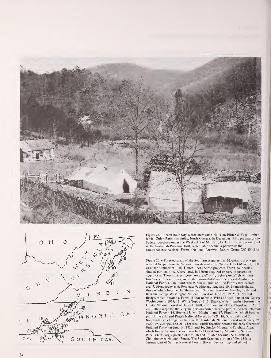
Figure 24.—Forest boundary survey crew camp No. 1 on Pfister & Vogel timber
lands, Union-Fannin counties, North Georgia, in December 1911, preparatory to
Federal purchase under the Weeks Act of March 1, 1911. This area became part
of the Savannah Purchase Unit, which later became a portion of the
Chattahoochee National Forest. (National Archives: Record Group 95G-10411A)
Figure 25.—Forested areas of the Southern Appalachian Mountains that were
selected for purchase as National Forests under the Weeks Act of March 1, 1911,
as of the summer of 1915. Dotted lines enclose proposed Forest boundaries;
shaded portions show where lands had been acquired or were in process of
acquisition. These various "purchase areas" or "purchase units" shown here,
together with newer ones, were later consolidated and incorporated into nine
National Forests. The numbered Purchase Units and the Forests that evolved
are: 7, Monongahela; 8, Potomac; 9, Massanutten, and 10, Shenandoah, all
three of which became the Shenandoah National Forest on May 16, 1918, and
then the George Washington National Forest on June 28, 1932; 11, Natural
Bridge, which became a Forest of that name in 1918 and then part of the George
Washington in 1933; 12, White Top, and 13, Unaka, which together became the
Unaka National Forest on July 24, 1920, and then part of the Cherokee on April
21, 1936 (except for the Virginia portions which became part of the new Jefferson
National Forest); 14, Boone, 15, Mt. Mitchell, and 17, Pisgah, which all became
part of the enlarged Pisgah National Forest by 1921; 18, Savannah, and 20,
Nantahala, which together became the Nantahala National Forest on January 29,
1920; 19, Georgia, and 21, Cherokee, which together became the early Cherokee
National Forest on June 14, 1920; and 16, Smoky Mountains Purchase Area,
which finally became the southern half of Great Smoky Mountains National
Park. The Georgia portion of Nos. 18 and 19 later became the nucleus of
Chattahoochee National Forest. The South Carolina portion of No. 18 later
became part of Sumter National Forest. (Forest Service map and photo)
24

Best, Largest Tracts Acquired First
The size and quality of the Gennett and McDowell tracts are
representative of many of the earliest lands purchased in the
Southern Appalachians. Generally, although many small
owners sold tracts in the 100- to 300-acre category, some of the
best and largest tracts were acquired first. Purchasing a few
large tracts was an easier way to establish national forest
acreage than purchasing many smaller tracts, and lumber
companies were often willing to sell large tracts. The Forest
Service maintained, however, that the boundaries of the
purchase units were not necessarily drawn to include large
tracts. In 1912, William Hall, Assistant Forester in charge of
acquisition, advised his forest examiners near Brevard, N.C.,
"the question of whether a locality is to be put in a purchase
area should be determined entirely irrespective of whether the
lands are held in small or large holdings." 7
Nearly 30 percent of the lands bought in the first 5 years in
North Carolina, Tennessee, and Georgia were virgin timber. 8
Most of the remaining land had been partially cleared or
culled for specific types of timber, especially yellow- (tulip)
poplar and chestnut. Few of the first tracts purchased were
totally cutover, although the proportion of cutover lands
acquired increased over the years. The largest tracts were
purchased almost without exception from lumber companies or
land investment concerns. Most such land was either sparsely
populated or uninhabited, the residents having left as the land
was depleted and acquired by investors for its remaining
timber. In the case of the Gennett tract:
the emigration tendency in the vicinity of this tract wasso strong that the remaining settlers have been unable
to maintain schools and churches or keep roads in
good condition. This situation has made it easy for a
body of land of the size of this tract to be
assembled ... 9
The quality of lands purchased varied considerably over the
Southern Appalachian region. The best lands were those where
topography and remoteness had delayed road and rail access.
For example, the Nantahala Purchase Unit of far southwestern
North Carolina was thought to contain "some of the best and
most extensive virgin forests of the hardwood belt." 10 Amongthe first lands purchased there were about 21,000 acres of the
Macon Lumber Co., high in the mountains. Only 102 acres of
the tract had been cleared, "and the only settler [in 1912] is
the keeper employed by the Company." 11 The lands sold for
$11 per acre. Another early Nantahala purchase was over
16,000 "well-timbered" acres of the Macon County Land Co.,
sold between 1914 and 1919 for between $8 and $9 per acre. 12
On the other hand, lands offered in the Cherokee and
Unaka purchase units appear to have been lower and less
uniform in quality. Of over 275,000 acres not in farms in the
Unaka area in 1912, 40 percent of the land was estimated to
have been cutover or culled, and on another 40 percent of the
land, timber operations were ongoing, with at least 15 large
sawmills and more than 50 smaller ones. Moreover, of 24,050
acres of "virgin" timber being offered for sale in the Unaka
area as of March 1912, 22,000 were subject to timber
reservations on all trees above 10 inches in diameter. 13
Similarly, in the Cherokee Purchase Unit, much of the
timber on the offered lands was either cutover, being cut, or
reserved. In 1913 the Alaculsy Lumber Co. of Conasauga,
Tenn., offered 32,000 acres, all of which were cutover or
subject to a timber reservation.14 Of the over 53,000 acres of
the Tennessee Timber Co. surveyed between 1913 and 1915,
sections had been extensively damaged by smoke and sulfur
fumes from the smelting operations of the Tennessee Copper
Co. and the Ducktown Sulfur, Copper, and Iron Co. near
Ducktown, Tenn. 15 In certain areas, particularly northern
Georgia and southwestern North Carolina, the Forest Service
gained possession of finely timbered "virgin" forests. However,
more often than not, the lands acquired, especially in later
years, had been cleared, misused, or at least selectively culled.
Formal Field Surveys Required
Because all lands obtained under Weeks Act authority had
to be acquired and paid for on a per-acre basis, a formal
survey of each tract was necessary before it could be
recommended for purchase. Survey work on the tracts offered
during the early years was difficult, time-consuming, and
costly. Many were remote and inaccessible, steep, and covered
with dense undergrowth. Before the land examiners came to
cruise the Gennett tract in northern Georgia, for example,
Gennett warned them that it would take at least 10 days to go
over the tract and that it would be very difficult to get
accommodations, "and in some portions of the tract, it will be
absolutely impossible." 16
Most of the offered tracts had never been surveyed before,
and often the owners had only a general awareness of their
boundaries, as the letters and reports of the first survey teams
recurringly attest. Thomas Cox, Survey Examiner in Georgia,
wrote in his January 1914 report, "Tracts difficult to locate as
owners do not know anything definate [sic] of corners." In
surveying the Vanderbilt lands of the Pisgah Unit in 1914,
James Denman wrote, "no one either in Vanderbilt employ or
otherwise seems to know much about the location of their
lands on the ground." 17 Indeed, sometimes lot descriptions
were based on tree lines that no longer existed; in these cases,
surveyors persuaded adjacent landowners to establish ad hoc
corners and sign an agreement accordingly. 18
Surveying for early Forest Service acquisitions in the
Southern Appalachians even required surveying a county line
for the first time. The boundary between Swain and Macon
Counties, N.C., established in 1871, had never actually been
surveyed; essentially it followed clear natural or man-made
boundaries, except for an arbitrary line between the Nantahala
and Little Tennessee Rivers. In June 1914 the Forest Service
surveying party established the boundary on the ground. 19

Much of the surveyor's work involved resolving tract
overlappings where lands were claimed by more than one
owner. In parts of the southern mountains, early grants had
been made and titles transferred—to the apparent ignorance or
indifference of the current occupant. Many of the old grants in
the Mt. Mitchell area were found so vague in description that
they were almost impossible to locate.20 Throughout the area
lands had been claimed and counterclaimed with both parties
often sharing the property in ambiguous peace until the Forest
Service surveyors arrived. Upon initial survey of the Vanderbilt
tract, at least seven claimants refused to acknowledge
Vanderbilt title. An extreme example of the earnestness of
such claimants is the Dillingham family, who claimed several
sections of the Big Ivy Timber Co. lands near Mt. Mitchell.
According to a 1914 leter from Thomas Cox, examiner of
surveys, Ed Dillingham went so far as to build a fence around
one of his Big Ivy claims, and "has gone to every length to
forceably stop the survey and have me arrested." 21
Figure 26.—Camp of forest boundary survey crew on lands of Little River
Lumber Company, Great Smoky Mountains, Blount County, Tenn., in
December 1911, just 9 months after passage of the Weeks Act. This area is nowin the National Park, but then was scheduled to be in a new National Forest.
(NA:95G-10071A)
An unusual example of overlapping claims to ownership
involved the Olmstead lands in the Nantahala Purchase Unit.
In 1868, the Treasury Department had taken possession of the
lands of E.B. Olmstead (not to be confused with Frederick
Law Olmstead) who was convicted of embezzling funds from
the U.S. Post Office Department. In 1912 these lands were
transferred from Treasury to the Secretary of Agriculture. NoFederal survey of the lands had occurred until the Forest
Service came in 1913; before then, the "local populace were
not generally aware of the Government's claim to
ownership." 22 Consequently, there were scores of claims
against portions of the land, 22 of which were not resolved
until passage of the Weaver Act in 1934 which granted
possession to all claimants and thus assured them of payment,
and the U.S. Government of bona fide deeds. 23
Perhaps the most serious example of overlapping claims
involved the Little River Lumber Co. lands in Tennessee.
Failure to established clear title eventually led to the
26

abolishment of the Smoky Mountains Purchase Unit, and thus
influenced dramatically the course of history in the area.
As early as 1912, surveyors and examiners were cruising the
large acreage of the Little River Lumber Co. and nearby
smaller tracts of the Smoky Mountains unit. Several small
landowners offered to sell right away, and by 1913 their
proposals had been accepted by the National Forest
Reservation Commission. By 1915 at least 8,050 acres in five
separate units of the Little River Lumber Co. had also been
approved for purchase. 24 However, no land in the Smokies was
ever actually purchased. Titles predating occupancy by the
Little River Lumber Co. were simply difficult, if not
impossible, to clear to the Government's satisfaction. With the
onset of World War I, the company, unable to wait for
Federal title searches any longer, cancelled its offers of sale,
and the purchase unit was subsequently rescinded. 25 With
Forest Service interest in the area abandoned, in 1923 a
movement began to promote the idea of a National Park in the
Great Smoky Mountains.
Reactions to Federal Purchase
From the evidence available, it appears that the initial
reaction of the people in the Southern Appalachians to the
coming of the Forest Service was generally favorable in spite of
some skepticism and distrust. Two written comments on early
popular reaction to Weeks Act purchases came from Forest
Service personnel. D.W. Adams, timber cruiser, wrote to
Forester William Hall in September 1911, from Aquone, N.C.,
"The people generally, particularly on the Mt. Mitchell Unit,
have been decidedly skeptical as to the purchase of lands by
the government ..." Verne Rhoades, forest examiner, a
graduate of the Biltmore School of Forestry, and later the first
supervisor of the Pisgah National Forest, writing of the Unakaarea in February 1912, reported that "The people in general
regard most favorably the movement on the part of the
government to purchase these mountain lands." 26
The large number of tracts quickly offered for sale testifies
to a generally favorable reaction. For timber companies, sale to
the Government offered an opportunity to rid themselves of
cutover, useless land, or lands which, even though finely
timbered, were inaccessible or steep. Sale to the Government
thus offered payoffs for their speculation and risk and a
lightening of their tax burdens. For small landholders, Forest
Service acquisitions offered an undreamed-of profit on lands
that no one else would pay for. The "lands nobody
wanted"— if they were in the right place—were wanted by the
Forest Service.27
The prices paid by the Forest Service were respectably high,
especially in the early years. The Federal purchase process
itself contributed to high land values. As O.D. Ingall, Forest
Service agent, wrote from Andrews, N.C., in May 1912, "the
government ties up the land for months and puts the owner to
a great deal of trouble and expense." Besides delay, the owner
might lose acreage through the careful surveys required and be
put to considerable expense to prove title to the government's
satisfaction. 28
In addition, in the early years of acquisition, Forest Service
survey teams and timber cruisers sometimes assessed tracts
which had not yet been formally offered for sale. In such a
case, a wily owner, whose corners had been set and boundaries
located at no personal expense, would hold out for a higher
price—figuring that the Government would not want to lose
the cost of survey. 29Initially, too, a number of land agents
operated throughout the area to obtain a fee for boosting a
seller's price. William Hall, Assistant Forester, wrote in
September 1911:
The effect of the work of agents in offering lands
under the Weeks Act is in most cases bad. They tend
to increase the price of land above what it ought to be
and will make it difficult for the government to buy at
a reasonable price.30
As early as April 1911, the National Forest Reservation
Commission discussed the role of agents and determined to
deal only with owners themselves. Hall warned his land
acquisition teams to "be on . . . guard at all times" against
such unscrupulous agents. 31
Although there were some landowners who, in ignorance,
asked too low a price and others who sacrificed land for sure
money, on the whole, the southern mountaineers had become
sophisticated negotiators and traders. The willingness of small
landowners to sell their land depended in part on whether
other owners in the area had already sold. R. Clifford Hall,
forest assistant, noted in 1913 that it required "much time and
patience" to deal with the "wavering" small landowners of the
Hiwassee area of extreme northern Georgia. 32 A year later he
found negotiation even more difficult:
The small owners of this section are very hard to deal
with, as all the 'traders' have sold out to the various
buyers that have scoured the country. Where the land
is so located adjacent to what we are getting as to be
especially desirable, and the owner talks as if he might
sell but will not sign a proposal, we should make the
valuation now in order to be able to name a price and
get a legal option without delay when he happens to be
in a 'trading humour'. 33
It was in considering such problems of price negotiation that
the National Forest Reservation Commission discussed the use
of condemnation. Although the Weeks Act did not make a
specific provision for condemnation, the Commission assumed
it had such authority.34 William Hall, for one, felt that if the
people know condemnation was a possibility, they would be
more willing to sell at reasonable prices.35 Nevertheless, the
Commission determined it was "inexpedient" to
condemn—except to clear title—and best to proceed with
purchase as far as possible. This early decision by the
Commission is a policy still followed by the Forest Service.

In spite of the generally high prices offered for the earliest
purchases, as time went on and the delays between offer and
survey, or between recommendations for purchase and
payment, lengthened, the acquisition process could bring
frustration, disillusionment, and anger. In the SmokyMountains Unit, for example, Forest Examiner Rhoades noted
in 1913 that several small landowners, who had been asked to
discontinue milling operations while their tracts were being
considered by the Commission, were becoming "restless and
dissatisfied." 36 Similarly, a mill operator on the Burke
McDowell tract near Mt. Mitchell, who had suspended
operations during examination and survey, was reported to be
"exceedingly reluctant to quit manufacturing timber
and . . . very impatient with McDowell . .
." 3? In 1915, in the
Mt. Mitchell area, the elderly J.M. Bradley had been waiting
for his money for so long that his relatives "were afraid that he
would lose his mind over it."38
J.W. Hendrix of Pilot, Ga..
threatened in 1914 to stop the sale of his over-350 acres if the
Forest Service did not proceed more rapidly:
I am in neede of money and I am ready to close the
deal. I am going to give you a little time to cary out
this contract, and if you do not take the matter up in a
reasonable length of time. I will cansel the sale of this
property, [sic.]29
And Miss Lennie Greenlee of Old Fort, N.C., wrote to Ashe
that:
the time-killing propensities of this band of surveyors is
notorious, although were the saying reported to themthey would revenge themselves by doubling the gap of
time between them and my survey. 40
The First National Forests
As stated in the Secretary of Agriculture's Report to
Congress in December 1907, the original thought behind the
establishment of the eastern National Forests was that 5
million acres in the Southern Appalachians and 600,000 acres
in the White Mountains should be acquired. By 1912, these
numbers still appeared appropriate, but it was determined
unnecessary to purchase all the land within any given purchase
unit; between 50 and 75 percent was considered enough. 41
According to Henry Graves' Report of the Forester for 1912:
There is every reason to believe that the purpose of the
government may be fully subserved by the acquisition
of compact bodies each containing from 25,000 to
100,000 acres well suited for protection, administration
and use.42
Four Million Acres Acquired by 1930
Purchase of land for National Forests in the East continued
fairly steadily throughout the two decades of 1911-31. By the
end of fiscal year 1930, 4,133,483 acres had been acquired
under the Weeks Act. The first Weeks Act appropriation of
$11 million lasted for 8 years, through fiscal year 1919; only
rjLNJSTESSEE
CHEROKEE £j=!
S-J ALABAMA
\
Figure 21.—The National Forests of the Southern Appalachians in 1921. ThePisgah was established in 1916, the Shenandoah. Natural Bridge, and Alabamain 1918, and the Nantahala. Monongahela, Cherokee, and Unaka all in 1920.
(Forest Service map and photo)
S600.000 was appropriated in 1920. and SI million in 1921.
Throughout the 1920's, typically about one-half of what the
Forest Service requested was appropriated. 43 The number of
acres purchased in any given year was primarily dependent
upon funds available; there always were, and still are (1982),
more tracts offered for sale than appropriated money could
purchase.
In the Southern Appalachians, Weeks Act acquisitions were
heaviest between 1911 and 1916, when some of the largest
tracts of today's Pisgah, Nantahala, Chattahoochee, Cherokee,
and Jefferson Forests were purchased. Most land was
purchased in large tracts of more than 2,000 acres. Indeed,
some 60 percent of the Nantahala National Forest was
acquired from only 22 sellers, mostly lumber companies or
land investment concerns. About 80 percent of the Pisgah
National Forest was purchased from 29 sellers. The largest
tract from a single owner was its nucleus of 86,700 acres from
the Biltmore Estate.
Vanderbilt had had his lands preliminarily surveyed shortly
after the Weeks Act passed. Purchase negotiations began in
1913, when members of the National Forest Reservation
Commission, Chief Forester Graves, and other Forest Service
personnel visited the Biltmore estate and Vanderbilt's hunting
lodge on Mt. Pisgah. Vanderbilt died before a purchase
agreement was reached, but after his death, his widow, Edith
Vanderbilt, consummated the sale on May 21, 1914, for
$433,500. This vast, cohesive tract became the core of the first
National Forest in the Appalachians, the Pisgah, on October
17, 1916. With a gross acreage of over 355,000, only 53.810
acres had actually been purchased in 1916, but an additional
34,384 acres had been approved. On November 7, 1916,
President Wilson proclaimed Pisgah a National Game Preserve
as well.
28
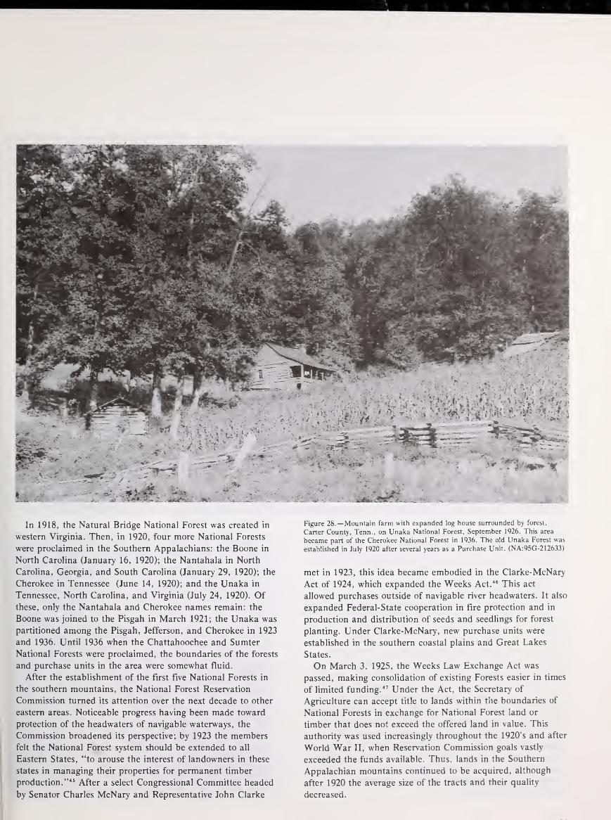
In 1918, the Natural Bridge National Forest was created in
western Virginia. Then, in 1920, four more National Forests
were proclaimed in the Southern Appalachians: the Boone in
North Carolina (January 16, 1920); the Nantahala in North
Carolina, Georgia, and South Carolina (January 29, 1920); the
Cherokee in Tennessee (June 14, 1920); and the Unaka in
Tennessee, North Carolina, and Virginia (July 24, 1920). Ofthese, only the Nantahala and Cherokee names remain: the
Boone was joined to the Pisgah in March 1921; the Unaka was
partitioned among the Pisgah, Jefferson, and Cherokee in 1923
and 1936. Until 1936 when the Chattahoochee and Sumter
National Forests were proclaimed, the boundaries of the forests
and purchase units in the area were somewhat fluid.
After the establishment of the first five National Forests in
the southern mountains, the National Forest Reservation
Commission turned its attention over the next decade to other
eastern areas. Noticeable progress having been made toward
protection of the headwaters of navigable waterways, the
Commission broadened its perspective; by 1923 the members
felt the National Forest system should be extended to all
Eastern States, "to arouse the interest of landowners in these
states in managing their properties for permanent timber
production." 45 After a select Congressional Committee headed
by Senator Charles McNary and Representative John Clarke
Figure 28.—Mountain farm with expanded log house surrounded by forest,
Carter County, Tenn., on Unaka National Forest, September 1926. This area
became part of the Cherokee National Forest in 1936. The old Unaka Forest was
established in July 1920 after several years as a Purchase Unit. (NA:95G-212633)
met in 1923, this idea became embodied in the Clarke-McNary
Act of 1924, which expanded the Weeks Act. 46 This act
allowed purchases outside of navigable river headwaters. It also
expanded Federal-State cooperation in fire protection and in
production and distribution of seeds and seedlings for forest
planting. Under Clarke-McNary, new purchase units were
established in the southern coastal plains and Great Lakes
States.
On March 3, 1925, the Weeks Law Exchange Act was
passed, making consolidation of existing Forests easier in times
of limited funding. 47 Under the Act, the Secretary of
Agriculture can accept title to lands within the boundaries of
National Forests in exchange for National Forest land or
timber that does not exceed the offered land in value. This
authority was used increasingly throughout the 1920's and after
World War II, when Reservation Commission goals vastly
exceeded the funds available. Thus, lands in the Southern
Appalachian mountains continued to be acquired, although
after 1920 the average size of the tracts and their quality
decreased.

Forest Purchases Reduce Population, Farms
By 1930 the Forest Service had been a presence in the
southern mountains for almost two decades. Within the
purchase units and National Forests themselves, Federal lands
were interspersed with those still held in private hands in an
almost patchwork pattern of landownership. Inhabitants within
and adjacent to National Forest boundaries were affected not
only by the land acquisition program but by the ways in which
the Forest Service managed its lands.
One of the most obvious effects of the first National Forest
purchases in the Southern Appalachians was a decline in
population growth and a decline in both farm acreage and
number of farms. Although most of the first acreage
purchased was timber company-owned, hundreds of small
farms were acquired as well. In areas where many small
landowners sold, the decline in population growth and in
number of farms was marked.
This trend was especially evident in selected counties of
northern Georgia where outmigration had been occurring
before 1912. Union County, for example, whose population
had declined by over 18 percent between 1900 and 1910,
experienced another 7 percent decline between 1910 and 1920.
Rabun County, where population had declined over 11 percent
in the previous decade, experienced a population growth well
below the State average between 1910 and 1920. Fannin and
Towns Counties likewise experienced either no growth or an
absolute population loss. This trend of population decline or
slowing of growth, however, was not nearly so pronounced
between 1920 and 1930.
A similar slowing of population growth took place in
counties of North Carolina and Tennessee where large numbers
of tracts were purchased early. For example, in Polk County,
Tenn., population grew by only 0.9 percent between 1910 and
1920 (the State as a whole grew by 14 percent). In Macon and
Graham Counties, North Carolina, population growth was only
6 and 3 percent respectively over the same decade. Yet, in
adjacent Swain County—part of the Smoky Mountains
Purchase Unit where no Forest Service acquisition
occurred—population grew by 27 percent. 48
Early acquisitions for National Forests are also reflected in
agricultural statistics. In Georgia, North Carolina, and
Tennessee, the number of farms increased between 1910 and
1920, but, in counties experiencing heavy National Forest
purchases, the number of farms declined. In Fannin and
Rabun Counties, Ga., and in Buncombe and McDowell
Counties, N.C., this decline was between 11 and 13 percent.
The decline in farm acreage was more dramatic. The numberof acres in farms dropped 39 percent in Rabun County, Ga.,
37 percent in Buncombe County, N.C., 22 percent in Fannin
County, Ga., and 21 percent in North Carolina's MaconCounty.'" (This trend continued between 1920 and 1930,
although the percentage decline in acreage was slightly less.)
Thus, at least for selected counties, in areas where Federal
land acquisition was initially extensive, there was a decided
change both in demographics and in the pattern of
landownership and land use.
Evidence of the mountaineers' first reaction to the coming of
the Forest Service, beyond the letters already cited, is almost
nonexistent. For example, a search through the Asheville
Citizen from 1910 to 1920, reveals "little local reaction to the
creation of the National Forest Reserves." Indeed, Eller has
concluded that "most local residents reacted indifferently to
the legislation." 50It was not until Forest Service personnel
arrived in the mountains that the consequences of the WeeksAct could be understood, and even then it does not appear
that the people's reactions were reflected in the local
newspapers.
When Forest Service staff first appeared in the purchase
units and early ranger districts, they were the object of some
suspicion and distrust. Ranger Roscoe C. Nicholson, the first,
and for many years, district ranger in Clayton, Rabun County,
Ga., wrote about this early reaction:
For several years the people . . . did not seem to knowwhat to think of the government owning this land.
Some of them did not like the idea of taking the land
out from under taxation. Some thought they would be
forced to sell their land and have to move out. Perhaps
most of them thought at first that if they were stopped
from burning out the woods they would never have any
more free range and that the insects and other pests
would destroy their crops. S1
Figure 29.—The National Forests and proposed National Parks of the Southern
Appalachian Mountains in 1930. Areas shaded with diagonal lines are the future
Shenandoah National Park in Virginia. Great Smoky Mountains National Park
in North Carolina and Tennessee, and Mammoth Cave National Park in
Kentucky. The small black dots and squares are State forests. The Qualla Indian
Reservation in the Great Smokies was later renamed the Cherokee Indian
Reservation. The National Forests are little changed from a decade earlier.
(Forest Service map and photo)
_ _ _• t^r— —
('Karfr.ttf
.ti ALA 't>pcar*arx*"fit i s
Gr+efwUt« "Chirkst»r b \
30

Figure 30.—Subsistence mountain farm homes on wagon track, surrounded by
forest, in Lee County, Ky., near Kentucky River about 45 miles southeast of
Winchester, in summer 1926. Lee County, like adjacent Estill County, today has
little National Forest land, although much is hilly and forested. (NA:95G-214116)
Figure 31.—Tiny crude inhabited log cabin with a small window and tarpaper
roof in Lee County, Ky., summer 1926. Note stoneboat and sunflower stalk in
front; also water pump and privy both very close to cabin and each other. Daniel
Boone (then Cumberland) National Forest. (NA:95G-214118)
31

ESI
Figure 32.—Log shack used as a temporary camp for Forest Service rangers and
fire guards, near Silers Bald, Wayah Ranger District, Nantahala National Forest,
west of Franklin, N.C., near present Nantahala Lake, in March 1916. Site was
then a Purchase Unit. (NA:95G-27295A)
Many of the early rangers considered themselves highly
dedicated considering the animosity they encountered. Former
Forest Service supervisor Inman F. Eldredge, a graduate of the
Biltmore School of Forestry, remembers that early foresters
worked
... in a hostile atmosphere where the settlers in the
national forests . . . were against you because the
Forest Service hemmed them in. The stock men were
against you because you were going to regulate themand make them pay for grazing, count their cattle andlimit where they could go . . .The lumbermen were
against you from the lumberjack up. They thought you
were a silly ass . . . because you limited their action
with the axe, and the people at the top thought you
were a misguided zealot with crazy notions. People whowork in that atmosphere have to have tough
hides—dedication. 52
Forest Fire Control Stressed
Such dedication, and a strong sense of mission, soon
produced results. One of the earlier influences of the Forest
Service in the Southern Appalachians was the control of fire.
Deliberate burning was a traditional method of land
management in the region. Such burning usually occurred in
the late fall and early spring to clear the woods of snakes and
insects, to increase pasturage, and to enrich the soil.
Uncontrolled fires had been noted by the first survey and
examination parties in 1911, since they delayed surveys and
altered land valuations. For example, E.V. Clark, an examiner
in Georgia, noted a fire set on private holdings in LumpkinCounty which, before being checked burned almost 100 acres
of the Gennett tract. Henry Johnson, examiner in the
Cherokee area, noted in March 1914 that a week had been
spent in firefighting and would continue for a month, "cattle-
owners and others being determined to burn the range." 53
In general, burning was practiced by various segments of the
population—the lumbermen, farmers, hunters, railroad men,
and mischief makers; violators were seldom convicted, and
people seemed generally indifferent to stopping the practice.
Yet, as more and more Federal land was acquired, deliberate
burning on adjacent or proximate lands was a matter of
increasing concern to the Forest Service. One of its early goals
was to practice fire control and teach its neighbors to do
likewise.
32

Indeed the Forest Service was extremely concerned about the
evils of fire. Within the Forest Service, some dissension
developed during the 1930's over the use of fire as a tool of
forest management. It had been demonstrated that in the
southern coastal pine forests, annual burning, by removing the
thick ground cover of pine needles, grass and other vegetation,
and disease spores, helped the forests to regenerate and
flourish. This discovery, however, was suppressed as harmful
to the overall fire control effort, and the dominant official view
of fire as a universal enemy to the forest prevailed.54 There is
certainly no evidence that anyone in the Forest Service
suggested that annual burning of the Southern Appalachian
hardwood forests was a useful management technique. The
Forest Service was completely unsympathetic with the local
custom of burning the mountain woods.
Fire control on National Forest lands in the Southern
Appalachians began almost immediately with their
establishment. Ranger Nicholson described the early fire
prevention work in Rabun County, Ga.:
Forest guards were appointed at a salary of $50 a
month and went out on their tasks on horseback.
There were then no towers or telephone lines. It was
not until 1915 that the first telephone line was built
from Clayton to Pine Mountain. 55
Figure 33.—Forest Service ranger on top of Satulah Mountain near Highlands,
N.C., using an alidade to locate on his map a forest fire to the northeast in the
direction of Chimney Top Mountain on the old Savannah Purchase Unit in April
1916. Note binoculars. This area near South Carolina and Georgia became part
of the Nantahala National Forest in January 1920. (NA:95G-27296A)

Figure 34.—Pisgah National Forest officer using a portable telephone hooked up
to a newly installed Forest Service field line. Note wire hanging down from the
overhead wire strung through the woods. The Pisgah was still a Purchase Unit
when photo was taken in April 1916; it was officially established as the first
purchased National Forest in the United States in October 1916.
(NA:95G-27361A)
Figure 35.—A mounted Forest Service firefighter carrying hay rakes and a
brushhook on his way to a forest fire on the Pisgah National Forest in 1923.
(NA:95G-1 76511)
The rangers generally enrolled several local men to serve as
forest guards and firefighters. These men helped to spread the
new idea of fire control throughout the community. The Forest
Service spent nearly $100,000 for fire control in the SmokyMountains Purchase Unit before it was rescinded. Local
firefighters, construction crews, and trail builders were hired.
A fire tower was built at Rich Mountain, near Hot Springs,
now in the Pisgah National Forest, and a preliminary network
of trails constructed."
One of the main provisions of the Weeks Act was to
establish a system of Federal-State cooperation to prevent and
control forest fires. The South was the most deficient area of
the United States in organized fire protection. When the
Weeks Act was passed, no Southern Appalachian State had
passed a fire protection law. The Weeks Act, by providing
Federal funds (about $2,000 in the early years) to match State
funds to support qualifying fire protection programs, thus
encouraged legislatures to meet Federal standards.
34

Figure 36.—Four-man crew on way to forest fire on railroad handcar, with
various hand tools including pulaski, axes, pitchforks, canvas bucket, and
lantern. Pisgah National Forest, N.C., 1923. (NA:95G-176444)
Figure 37.—Mounted Forest Service ranger, Lorenzo Jared. on Green Ridge,
Bald Mountains, in French Broad District, Pisgah National Forest, using field
glasses to look for signs of smoke of forest fires. Spot is near Hot Springs, N.C.
and Tennessee State line, in spring 1930. (NA:95G-238056)
Kentucky revamped its forest fire laws in 1912, appointed a
State Forester, and began receiving Weeks Act fire protection
funds; its first forest fire protection association was organized
in Harlan County in 1914. Virginia appointed a State Forester
in 1914; in 1915 fire patrols were started in several far western
counties (on lands all of which later became part of the
Jefferson National Forest), and the State began receiving
Weeks Act fire funds. In 1915 North Carolina passed a new
fire law, appointed a State Forester, formed its first fire
protection association, and began receiving Weeks Act fire
funds. Tennessee hired a forester in 1914, but did not begin
receiving Weeks Act fire funds until after it organized a
Bureau of Forestry in 1921. S7 After the Clarke-McNary Act
provided expanded grants-in-aid for fire protection programs,
Georgia in 1925 and South Carolina in 1928 developed State
fire control systems. 58

From available accounts of the period. Forest Service efforts
to control and prevent fires in the southern mountains began
to show results quite early. In 1920, the National Forest
Reservation Commission minutes claimed a "tremendous
improvement" in forest cover and regularity of stream flow.
"After seven years the effects of the stoppage of fires were
beginning to show on several Forests." 59 Nevertheless,
throughout the next decade, firefighting continued to engage
the activities and funds of most Southern Appalachian forest
supervisors.
'Home-Grown' Rangers Do Best
How were the mountaineers persuaded not to burn?
According to an early ranger, "it took a great deal of
educational work with lectures at schools, moving pictures,
and literature to overcome this practice." 60 The effort was a
gradual one which evolved as a system of trust developed
between the Forest Service and the mountain people. This
Figure 38.—Lorenzo Jared, French Broad District Ranger. Pisgah National
Forest. N.C.. talking over field telephone at Butt Mountain Lookout near
Tennessee State line, spring 1930. (NA:95G-238057)
system was often founded upon the selection and placement of
rangers and forest technicians who had grown up in the
mountains and knew them well. As the Forest Service Use
Book of 1915 states, "The most successful rangers are usually
those who have been brought up in timber work or on ranches
or farms, and who are thoroughly familiar through long
residence, with the region in which they are employed." 61
A classic example of a local resident who became an
outstanding ranger was W. Arthur Woody, native of northern
Georgia, who started as a laborer in 1912 and became a
district ranger there July 1. 1918. He retired in 1945. Knownfor his accomplishment of restocking the forest with deer and
protecting wildlife, Woody was also renowned for his ability to
get along with the mountaineers of his home. Woody enlisted
local boys to help watch for and fight fires and resorted to his
own methods of punishing incendiarists. His sons, Clyne and
Walter, who also became foresters, as did a nephew and
grandson, tell the tale of Woody tracking a fire-setting turkey
hunter with a bloodhound, jailing him, and then returning him
to the scene of the fire, whereupon the hunter finally
confessed. 62
3 b

Ranger Nicholson, of Rabun County, Ga., also employed a
bloodhound. Former Regional Forester J. Herbert Stone
remembers "Ranger Nick's" special fire prevention program:
One of the firebugs whom Nick had had his eye on upin that area, Rabun County, had been setting fires
each year in the spring to get the country in shape for
his stock. The year after the bloodhound's reputation
had gotten around, a friend of his asked if he's going
to burn the woods that year and he says, "No sir, not
me," he says, "I don't want any bloodhound tearing
the seat out of my britches." The result was that the
fire record for that particular drainage improved
tremendously. 63
Early rangers and foresters hoped, by example, not only to
stop the deliberate burning but to encourage the local
inhabitants and timber concerns to practice enlightened
silviculture and forest conservation as well. As W.W. Ashe has
written, "stimulating private owners ... in developing and
applying methods of management" to cutover lands was one of
the main purposes of acquiring eastern forests.64 Evidence
suggests that this campaign may not have been so successful as
the one against fire.
Figure 39.—William Arthur Woody, a real-life legendary Forest Service figure in
North Georgia all his adult life. Native to the mountains, he was the senior
ranger on the Toccoa and Blue Ridge Districts, Cherokee and Chattahoochee
National Forests, from 1918 to 1945. This is an April 1937 photo.
(NA:95G-344061)
Throughout the South, the lumber industry as a whole
declined after 1909, as small, portable sawmills replaced the
large, stationary mills. Many once thriving mill towns had been
abandoned as the forests nearby were cut over. In Georgia, for
example, the number of lumber mills declined by two-thirds
between 1909 and 1919. 65 In North Carolina, over the same
decade, the number of lumbering establishments did not
decline, but the number of wage earners employed in
lumbering and the timber products industry declined by nearly
25 percent. 66
Logging, of course, continued on National Forest land,
managed with an eye toward preservation and profit,
sometimes on a large scale. The Carr Lumber Co., for
example, extensively logged the Pisgah Forest under a 20-year
contract which had been signed by Louis Carr and the
Vanderbilts in October 1912. However, National Forest timber
sales generally favored small concerns and individual
operators. Many such sales were for fence posts, crossties, and
tanbark, and in the early years were often made for under
$100. 67
37

Heavy Timber Cutting Continues
The influence of the Forest Service in controlling timber
cutting on private land was less decisive. Certainly, in
Kentucky, where no Federal purchases were made until 1933,
heavy timber cutting continued throughout the 1920's, partly
because many stands in eastern Kentucky did not become
really accessible, or economically feasible to log, until that
period. In areas where the National Forests had been
established, in Tennessee, Georgia, and North Carolina, large-
scale destructive lumbering continued. Forester William Hall
noted in 1919:
In most of the larger timber operations in the Southern
Appalachians, there has been no change in former
methods of cutting except to make the cutting heavier
as a result of higher lumber prices.68
When the Weeks Act was passed, considerable animosity
existed between many local lumbermen and Government
foresters. To some extent this animosity can be attributed to
Figure 40.—A dramatic scene of devastation on the slopes of Mt. Mitchell, N.C.
after destructive logging and numerous resulting fires, in June 1923. This was
typical of the Southern Appalachians then. (NA:95G-176379)
the ideological and practical differences between lumbering
and forestry which persisted, despite the teachings of Carl
Schenck and Austin Cary. As Forester Inman Eldredge stated
in his reminiscences of early Forest Service days, manyforesters had little experience in using the woods and
disparaged those who did:
You produced the timber and cared for it, and then
you turned it over to the roughnecks to cut it up and
ship it around. There wasn't any science or art to
it . . ,
69
Reciprocally, lumbermen regarded early forestry as frivolous
and foolish, in Inman's words, "a parlor game." Inman felt
that bad feelings between lumbermen and Pinchot's foresters
had been created by the foresters' intense, but sincerely
expressed, propaganda against the "timber barons." 70
Certainly, Andrew Gennett resented the picture he felt was
painted of lumbermen as "crooks and rascals," who had
38

"wasted and devastated the vast areas of the forests in the
United States."71 In 1926, Gennett, in cooperation with
Champion and Bemis Lumber, bought up a vast acreage in
western Graham County, N.C., from an English syndicate, and
continued lumbering in his new operations in Clay County,
N.C.; Beattysville, Ky., and Ellijay, Ga. 72 Throughout the
1920's, lumbering companies, such as Champion, Sunburst,
Andrews, and Hutton and Bourbonnais, continued to clearcut
and "high-grade" (cull) huge tracts, many of which, once
depleted, were sold to the Forest Service in the mid-1930's.
Knowledge that the Forest Service would eventually buy
their lands may have dissuaded some companies from
practicing sound silviculture. Nevertheless, by the end of the
1920's, the relationship between the Forest Service and the
lumber companies was improving. The lumbermen were
beginning to trust the motives of the Federal foresters and
were learning to turn Federal purchasing to their advantage.
Gennett never cut his large tract in western Graham County,
N.C., but sold it to the Forest Service in 1936 and 1937 for the
unusually high price of $28.00 per acre. The 19,225-acre tract,
containing some of the largest and most varied "virgin" timber
in the Southern Appalachians, was steep and inaccessible,
and, thus, too costly for Gennett to log. In 1936, 3,800 acres
of the tract was set aside as the Joyce Kilmer Memorial Forest
(since enlarged and now called Joyce Kilmer-Slickrock
Wilderness), which the Forest Service pledged to protect as a
place of inspiration and beauty. 73
Federal land acquisition in the southern mountains had an
initial, and continuing, effect on the tax base of all counties in
which lands were purchased. Since all lands passing into
Federal ownership were no longer taxable, a given county's
property tax income was reduced by varying percentages.
However, the Weeks Act provided that 5 percent of the
receipts from all timber sales on National Forest land within a
county went to its treasury for schools and roads. Verne
Rhoades, forest examiner, noted in his February 1912 report
on the Unaka Purchase Unit that:
The question of taxation bothers many of . . . the
people, especially the smaller owners, who think they
will have to meet higher taxes when the land purchased
by the government is removed from the total acreage of
assessable property. 7 ''
County Rebate Raised to 25 Percent
The National Forest Reservation Commission considered the
issue in 1911, and decided to study the extent to which local
communities might be affected. In 1913 the group
recommended that 5 percent be changed to 25 percent to
provide greater compensation for the tax loss. Whether there
was widespread local awareness of the possible loss of tax
revenue from Federal acquisition in the early years is not
apparent. Some counties undoubtedly suffered a loss by the
change, although of those that did, the increase in small
timber sales and Federal employment may well have balanced
such loss.
Figure 41.—This huge burned-out yellow-poplar tree, a casualty of repeated
forest fires, was long found useful by campers for shelter. Its size is indicated by
man on horseback. Photo was taken on Little Santeetlah Creek in Unicoi
Mountains, N.C., near Tennessee State line, in March 1916. This area is now
part of the Joyce Kilmer-Slickrock Wilderness (formerly Joyce Kilmer Memorial
Forest) in the Nantahala National Forest. (NA:95G-27294A)

Reference Notes
The Forest Service, even in the earliest years, was a
relatively generous employer. When the first survey teams
arrived in 1911 and 1912, local men were hired as assistants.
When district rangers arrived, men were recruited for fire
watching, firefighting, trail building, and the like. Thus,
although land sales to the Government often hastened
outmigration as former landowners moved to towns for
industrial employment, enough new jobs were also created in
the forests to occupy both those who remained as tenants on
Federal lands and those who lived on adjacent farms. 75
Many rangers believed they had good relationships with the
mountain people. Rangers and forest technicians often became
community leaders and friends whom the local people learned
to trust. J. Herbert Stone, who came to the Nantahala in 1930
as a technical assistant to the Forest Supervisor, testifies to the
goodwill that the Forest Service felt had been built:
... so the relationships and the cooperation received
from the people throughout the mountains was very
fine. There were of course a few that would want to set
fires and who would become provoked when they
didn't get just what they wanted, but in the main the
relationships between the people and the leaders of the
communities was all that could be expected by the time
I got there. 76
In other ways, early Federal land acquisition and land
management practices had a more subtle effect. The Forest
Service introduced to the Southern Appalachians an element of
culture and education which was basically northeastern and
urban. In 1919 William Hall went so far as to claim:
. . . improved standards of living are coming in.
Homes are kept in better repair. Painted houses and
touches of home adornment are to be observed. Moneyis available for better food and clothing. The life is
different. The people are different. Yet it must be
remembered that these are the genuine Appalachian
mountaineers who, until a few years ago, had no outlet
for their products and none for their energies except
the manufacture of moonshine liquor and the
maintenance of community feuds.77
In spite of Hall's patronizing tone and reliance on the
mountaineer stereotype to make his point, the Forest Service
was providing leaders who began to earn the respect and
loyalty of many local inhabitants and to effect lasting changes
in the social and economic structure of mountain life.
(In the following notes, the expressions "NA, RG 95, FS, OC, NFRCmeans National Archives, Record Group 95, Records of the Forest
Service, Office of the Chief and Other General Records, Records of
the National Forest Reservation Commission, 1911-1976, Series 27.
"LA" means Division of Land Acquisition, General Correspondence,
Exchange, Purchase, Donation, or Condemnations, Region 8. See
Bibliography, IX.)
1. The National Forest Reservation Commission was composed of
three Cabinet members, two Senators appointed by the President of
the Senate, and two Congressmen appointed by the Speaker of the
House. The first such Commission members were Henry L. Stimson,
Secretary of War; Walter Fisher, Secretary of Interior;' James Wilson,
Secretary of Agriculture; John Walter Smith, Senator from Maryland;
Jacob H. Gallinger, Senator from New Hampshire; William Hawley,
Congressman from Oregon; and Gordon Lee, Congressman from
Georgia.
2. NA, RG 95, Office of the Chief, Records of the National Forest
Reservation Commission, Work of the National Forest Reservation
Commission, 1911-1933, p. 2.
3. NA, RG 95, OC, NFRC, "Lands of Andrew and N.W. Gennett,"
June 19, 1911.
4. NA, RG 95, LA, Correspondence, Surveys, Georgia. Andrew
Gennett to W. L. Hall, May 28, 1912.
5. "The National Forests and Purchase Units of Region Eight,"
Forest Service unpublished report (Region 8, Atlanta, Ga., January 1,
1955), p. 30, copy in Regional Office.
6. Telephone interview with Walter Rule, Public Information Officer,
National Forests of North Carolina, Asheville, N.C., September 19,
1979.
7. NA. RG 95, LA, Correspondence, Examination, North Carolina,
William Hall to R. W. Shields, January 19, 1912, Correspondence,
Examination, North Carolina.
8. "The National Forests and Purchase Units of Region Eight," p. 3,
Region 8 report, January 1, 1955, copy in Regional Office, Atlanta,
Ga.
9. NA, RG 95, OC, NFRC, "Lands of Andrew and N. W. Gennett."
10. "Lands of Andrew and N. W. Gennett," p. 41.
11. NA, RG 95, OC, NFRC, Minutes of the National Forest
Reservation Commission, February 14, 1912.
12. "The National Forests and Purchase Units of Region Eight," p.
41, Region 8 report, January 1, 1955, copy in Regional Office.
13. NA, RG 95, LA, Correspondence, Examinations, Verne Rhoades,
"Report on the Unaka Area in Tennessee and North Carolina,"
February, 1912, pp. 2-4, 10.
14. NA, RG 95, LA. Correspondence, Examinations, Tennessee.
1913, W. W. Ashe to H. L. Johnson, August 14, 1913.
40
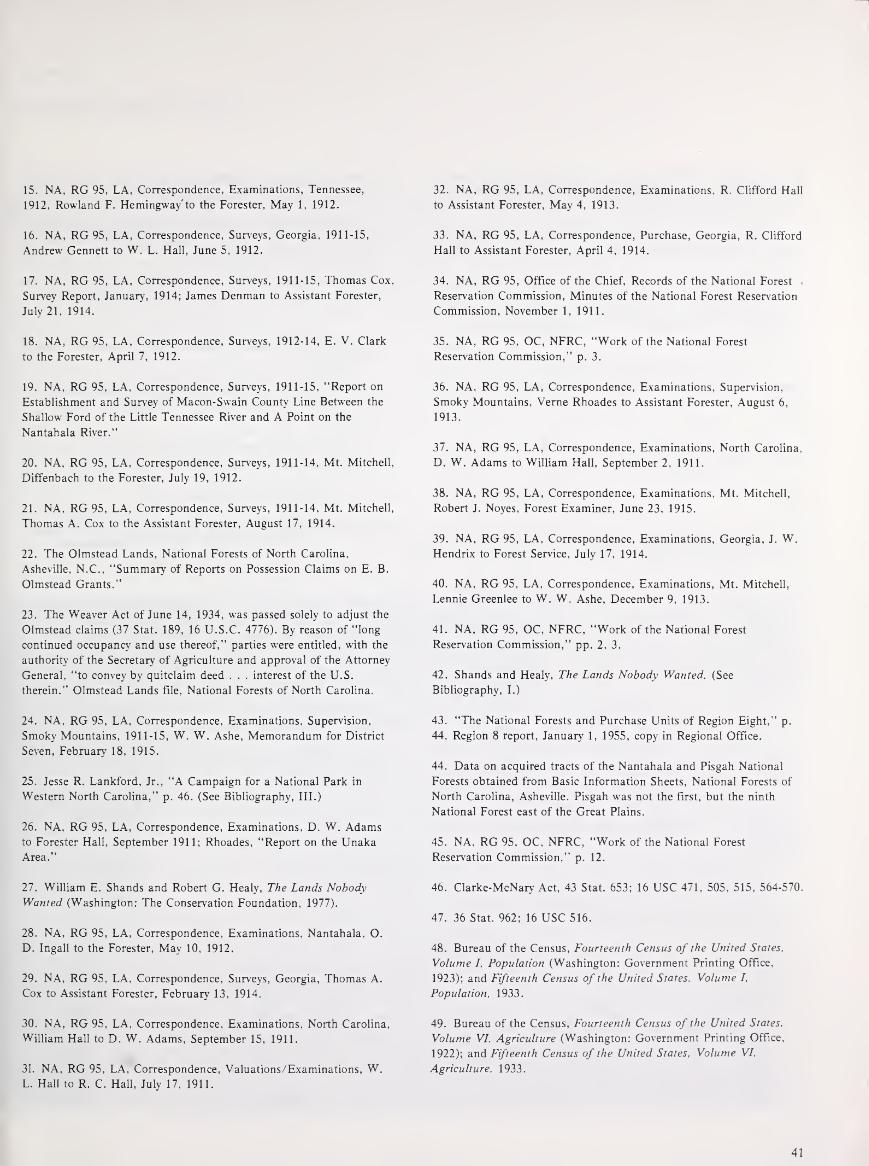
15. NA, RG 95, LA, Correspondence, Examinations, Tennessee,
1912, Rowland F. Hemingway to the Forester, May 1, 1912.
16. NA, RG 95, LA, Correspondence, Surveys, Georgia, 1911-15,
Andrew Gennett to W. L. Hall, June 5, 1912.
17. NA, RG 95, LA, Correspondence, Surveys, 1911-15, Thomas Cox,
Survey Report, January, 1914; James Denman to Assistant Forester,
July 21, 1914.
18. NA, RG 95, LA, Correspondence, Surveys, 1912-14, E. V. Clark
to the Forester. April 7, 1912.
19. NA, RG 95. LA. Correspondence. Surveys, 1911-15, "Report on
Establishment and Survey of Macon-Swain County Line Between the
Shallow Ford of the Little Tennessee River and A Point on the
Nantahala River."
20. NA, RG 95, LA. Correspondence, Surveys, 1911-14, Mt. Mitchell,
Diffenbach to the Forester, July 19, 1912.
21. NA. RG 95. LA, Correspondence. Surveys, 1911-14, Mt. Mitchell,
Thomas A. Cox to the Assistant Forester, August 17, 1914.
22. The Olmstead Lands, National Forests of North Carolina,
Asheville, N.C., "Summary of Reports on Possession Claims on E. B.
Olmstead Grants."
23. The Weaver Act of June 14, 1934, was passed solely to adjust the
Olmstead claims (37 Stat. 189, 16 U.S.C. 4776). By reason of "long
continued occupancy and use thereof," parties were entitled, with the
authority of the Secretary of Agriculture and approval of the Attorney
General, "to convey by quitclaim deed . . . interest of the U.S.
therein." Olmstead Lands file, National Forests of North Carolina.
24. NA, RG 95, LA, Correspondence, Examinations. Supervision.
Smoky Mountains, 1911-15, W. W. Ashe. Memorandum for District
Seven. February 18, 1915.
25. Jesse R. Lankford, Jr., "A Campaign for a National Park in
Western North Carolina," p. 46. (See Bibliography. III.)
26. NA, RG 95, LA, Correspondence. Examinations, D. W. Adamsto Forester Hall, September 1911; Rhoades. "Report on the UnakaArea."
27. William E. Shands and Robert G. Healy, The Lands Nobody
Wanted (Washington: The Conservation Foundation, 1977).
28. NA, RG 95, LA, Correspondence, Examinations. Nantahala. O.
D. Ingall to the Forester, May 10, 1912.
29. NA, RG 95, LA, Correspondence, Surveys. Georgia, Thomas A.
Cox to Assistant Forester. February 13, 1914.
30. NA, RG 95, LA, Correspondence. Examinations. North Carolina,
William Hall to D. W. Adams, September 15. 1911.
31. NA. RG 95, LA, Correspondence, Valuations/Examinations, W.L. Hall to R. C. Hall, July 17, 1911.
32. NA, RG 95, LA, Correspondence, Examinations, R. Clifford Hall
to Assistant Forester, May 4, 1913.
33. NA, RG 95, LA, Correspondence, Purchase, Georgia, R. Clifford
Hall to Assistant Forester, April 4, 1914.
34. NA, RG 95, Office of the Chief. Records of the National Forest
Reservation Commission. Minutes of the National Forest Reservation
Commission, November 1, 1911.
35. NA. RG 95, OC, NFRC, "Work of the National Forest
Reservation Commission," p. 3.
36. NA. RG 95. LA, Correspondence. Examinations, Supervision,
Smoky Mountains, Verne Rhoades to Assistant Forester, August 6,
1913."
37. NA. RG 95, LA, Correspondence, Examinations, North Carolina,
D. W. Adams to William Hall, September 2. 1911.
38. NA, RG 95, LA, Correspondence. Examinations, Mt. Mitchell,
Robert J. Noyes, Forest Examiner. June 23, 1915.
39. NA, RG 95, LA, Correspondence. Examinations, Georgia. J. W.Hendrix to Forest Service, July 17, 1914.
40. NA, RG 95, LA, Correspondence. Examinations, Mt. Mitchell,
Lennie Greenlee to W. W. Ashe, December 9, 1913.
41. NA, RG 95, OC, NFRC, "Work of the National Forest
Reservation Commission." pp. 2, 3.
42. Shands and Healy, The Lands Nobody Wanted. (See
Bibliography. I.)
43. "The National Forests and Purchase Units of Region Eight," p.
44. Region 8 report, January 1, 1955, copy in Regional Office.
44. Data on acquired tracts of the Nantahala and Pisgah National
Forests obtained from Basic Information Sheets, National Forests of
North Carolina. Asheville. Pisgah was not the first, but the ninth
National Forest east of the Great Plains.
45. NA. RG 95. OC. NFRC. "Work of the National Forest
Reservation Commission," p. 12.
46. Clarke-McNary Act. 43 Stat. 653; 16 USC 471. 505. 515. 564-570.
47. 36 Stat. 962; 16 USC 516.
48. Bureau of the Census, Fourteenth Census of the United States,
Volume I. Population (Washington: Government Printing Office,
1923); and Fifteenth Census of the United States. Volume I,
Population. 1933.
49. Bureau of the Census, Fourteenth Census of the United States.
Volume VI. Agriculture (Washington: Government Printing Office.
1922); and Fifteenth Census of the United States. Volume VI.
Agriculture. 1933.
41

50. Eller, "Miners, Millhands, and Mountaineers," p. 185. A search
through selected county newspapers of the region confirms this
finding.
51. R. C. Nicholson, "The Federal Forestry Service," in Sketches of
Rabun County History, Andrew J. Ritchie, ed., (n.p., n.d., c. 1948),
p. 359.
52. Elwood R. Maunder, "Ride the White Horse." (See Bibliography
II.) Although Eldredge was a supervisor on the National Forests of
Florida, his remarks are applicable to the Southern Appalachian
forests as well.
53. NA, RG 95, LA, Correspondence, Surveys/Examinations,
Supervision, (Georgia), E. V. Clark to Forester, December 4, 1912;
Supervision, (Cherokee), Henry Johnson to Assistant Forester, March
30, 1914.
54. Ashley L. Schiff, Fire and Water: Scientific Heresy in the Forest
Service. (See Bibliography, I.)
55. R. C. Nicholson, "The Federal Forestry Service," p. 360. (See
note 51.)
56. Elizabeth S. Bowman, Land of High Horizon (Kingsport, Tenn.:
Southern Publishers, Inc., 1938), p. 178.
57. "Cooperative Forest Fire Control, A History of Its Origins and
Development Under the Weeks and Clarke-McNary Acts," USDA,Forest Service, M-1462, Rev. 1966, p. 26. Ralph R. Widner, ed.,
Forests and Forestry in the American States, A Reference Anthology,
(Washington: National Association of State Foresters, 1968), pp. 203,
298, 309, 326-28. John R. Ross, '"Pork Barrels* and the General
Welfare: Problems in Conservation, 1900-1920," p. 240. (See
Bibliography, III.)
58. Schiff, Fire and Water, p. 17. (See note 54.)
59. NA, RG 95, OC, NFRC, Minutes of the National Forest
Reservation Commission, April 8, 1920.
60. Nicholson, "The Federal Forestry Service," p. 360. (See note 55.)
61. USDA, Forest Service, The Use Book, 1915 (Washington:
Government Printing Office, 1915).
62. Interview with Clyne and Walter Woody, Suches, Ga., July 12,
1979.
63. Taped interiew with J. Herbert Stone for Southern Region History
Program, November 22, 1978. Made available by Sharon Young,
Regional Historian, Region 8, Atlanta, Ga.
64. William W. Ashe, "The Place of the Eastern National Forests in
the National Economy," Geographical Review 13 (October, 1912):
539.
65. Ignatz James Pikl, Jr., A History of Georgia Forestry, p. 17. (See
Bibliography, I.)
66. U.S. Bureau of the Census, Fourteenth Census of the United
States, Volume IX, Manufactures, 1919 (Washington: Government
Printing Office, 1923).
67. William L. Hall, "Influences of the National Forests in the
Southern Appalachians," Journal of Forestry 17 (1919): 404.
68. W. L. Hall, "Influences," p. 407.
69. Elwood R. Maunder, "Ride the White Horse." (See Bibliography,
II.) Cary was a Forest Service timber expert of the Schenck type.
70. Maunder, "Ride the White Horse."
71. Andrew Gennett, Autobiography, p. 164. Papers of the Gennett
Lumber Company, Manuscript Division, Perkins Library, DukeUniversity, Durham, N.C.
72. Douglas C. Brookshire, "Carolina's Lumber Industry," 162. (See
Bibliography, II.)
73. Michael Frome, Battle for the Wilderness (New York: Praeger
Publishers, 1974), pp. 174, 175.
74. NA, RG 95, LA, Correspondence, Examinations, Verne Rhoades,
"Report on The Unaka Area," p. 9.
75. William L. Hall, "Influences of the National Forests in the
Southern Appalachians, " Journal of Forestry 17 (1919): 404.
76. Sharon Young, Interview with J. Herbert Stone.
77. Hall, "Influences of the National Forests," 404.
42

Chapter ill
The Depression and the New D.eal
During the years of the Great Depressidn , there was a greatly increased involvement of Federal agencies in the Southern Appalachian highlands. Before the administration of Franklin D. Roosevelt, virtually the only Federal activities there were a forest resource survey, the purchase and management of lands for National Forests , and the searches by "revenuers" for illegal whiskey stills. The New Deal created the Tennessee Valley Authority, a program for purchase of submarginal farmlands and relocation of the farm operators, and greatly expanded public welfare and employment programs . At the same time, National Forests were enlarged and consolidated, and new National Parks developed. More people than ever before were directly affected by programs and policies of the Federal Government. The extensive social reform plans of the early New Deal years made dramatic changes in the mountains, but curtailment of these programs in 1935 and 1937 left the people of the mountains to slower and less orderly patterns of change . Some farm reforestation aid was offered by the Norris-Doxey Cooperative Farm Forestry Act of May 18, 1937 (which was superseded by the more comprehensive Cooperative Forestry Management Act of August 25, 1950) , and by the Bankhead-Jones Farm Tenant Act of July 22, 1937.1
Agriculture, textiles, and coal are all basic to the prosperity
of the mountain people . These industries were in a period of decline and stagnation all during the 1920's . Long before the rest of the Nation experienced the shock of the New York stock market crash in the fall of 1929, many mountain areas, especially the coal fields, like the Nation's farmlands, had already entered the Great Depression. With the crash came further price declines and loss of markets for the products of the southern mountains. Coal production dropped drastically and in 1933 the number of miners employed dropped to its lowest point in 25 years. 2
The peak of timber production had passed, and large-scale logging had begun to decline even before World War I. However, with the Depression, this decline was accelerated by a rapid drop in prices for lumber and related forest products. 3
The major operator, Andrew Gennett, wrote in 1934:
At the present time the lumber business is so disrupted that none of us know where we stand, and we are making no engagements of any kind until we find out what is going to happen .•
Figure 42.-Loading logs onto a truck from a roadside skidway with a steampowered rig on rails. Spot was along the Upper Tellico River, Monroe County, Tenn., south of Great Smoky Mountains National Park, on the Cherokee National Forest, in 1937. (National Archives: Record Group 9SG·354360)
43

43
The market for what lumber remained in the mountains almost disappeared. In Georgia, lumber production reached its
lowest point in the 20th century in 1932. Over 1,000 sawmills, most of them small, disappeared between 1929 and 1932. 5 The picture was about the same in other southern States. Production of other forest products, acidwood, pulpwood, railroad ties, fenceposts, mine props, also dropped drama tic ally.
The value of the land itself declined rapidly as well. Some of
this decline was due to the condition of the land. Cutover and
not reforested, farmed to exhaustion, flooded by silted-up creeks and rivers, the land in many parts of the mountains was actually deteriorating. But most of the price decline was a result of the deflationary impact of the Depression. Land
valued for tax purposes at $5 per acre in 1925-26 was worth $3 per acre or even less by 1934, and the possibility of finding a
buyer was not likely even at the lower prices. 6
44
Figure 43.-Portable sawmill with circular saw powered by oil distillate, cutting white oak log. Laurel Lumber & Stave Company, Daniel Boone (then Cumberland) National Forest, Ky., August 1937. Smoke came from a burning pile of slabs. (NA:9SG-365412)
Figure 44. -Erosion-causing cornfields planted unwisely on very steep slopes in Knott Cou nty, Ky., August 1930. Neeley's Fork near Bailey Fork, at head of Troublesome Creek, between Redbird Purchase Unit and Kentucky portion of Jefferson National Forest. Note log cabin and zigzag rail fence. (NA:95G-247048)
While large timber interests complained loudest about their losses in land value, the small landowner was also hard hit. In
the mountains where the Pee Dee River rises west of WinstonSalem, N.C., over half of the farm property and a third of the forest land was tax delinquent at the height of the Depression.
In some counties tax delinquency rose to 90 percent. 7 The slack in coal mining had put another burden on the
already hard-pressed agricultural lands of the Appalachian highlands. In eastern Kentucky and adjacent Virginia and
Tennessee, many mountain people had left the farms to go
into the mines. As the coal slump deepened, some returned to worn-out farms and steep, cutover slopes and tried to get a living once again from the soil. 8

44

Later, when the Depression began to affect all parts of the Nation, more people joined the return to the land. For years
the Southern Appalachian mountains had exported people as well as timber and minerals. Thousands of southern highlanders had found new homes in mill towns and industrial
cities and were scattered over much of the east-central United States. Many of these people, finding themselves unemployed and destitute, returned to old family farms, abandoned or
perhaps still inhabited by elderly cousins, and sought to resume the life of their forefathers. They rechinked the old log
cabin, repaired the roof a bit, planted a cornfield and garden
patch, and hoped for the best. Those less fortunate "squatted" in abandoned shacks, old chicken houses and
smokehouses-anything with a roof and walls. They had
neither seed nor tools and little knowledge of farming or
gardening. They survived on relief or they starved. In the counties where the Daniel Boone (originally
Cumberland) National Forest is now located, the situation was
especially acute. Assistant Regional Forester John H. Hatton,
compiling a report on the "Social Aspects of National Forest
Management" in 1934, described the area:
At the same time the population has increased in the last four or five years very rapidly, which increase depends entirely on local mountain farming . . . The conditions of the valley would not be noticed from the train but one has only to leave the highway and strike up one of the very small creeks and he finds whole sections and districts wherein not a person has sufficient supplies to support themselves above want and many are actually suffering from the need of food, clothing and medical attention. There was a time when the extremely poor had neighbors who could help them, but the neighbors' condition has become such that they can no longer render aid . . . The people are of good character, and have a certain amount of dignity and pride in the midst of direst poverty, unwilling to accept direct relief until they reach the point of actual suffering. They all prefer work rather than charity and especially the form of charity which is humiliating to them. For a good many years numbers of the small land owners and tenants after putting by their crops have sought work in factories of other States and some among settlements to work tobacco crops. They had to have this money to pay taxes and to buy articles for the winter, but the factories have been closed and other employment has practically ceased. On top of all this there has been a gradual influx from the cities and manufacturing centers of about 25% of the people who were unable to get employment and have returned to their relatives and friends in the country. 9
Evidence that mountaineers who had earlier migrated to
industrial areas returned to their former farm homes during the 1930's is abundant, though exact figures depend on the
definition of Southern Appalachia used. In most of the
46
mountain counties farm acreage remained quite stable from 1930 to 1940, but the number of farms rose significantly. 10
This fact explains why mountain people were often reluctant to sell even very poor farms during the Depression years.
Because poverty, unemployment, and economic decline existed in the Southern Appalachian highlands to a degree
unsurpassed in other regions of the Naton, the election of
Franklin D. Roosevelt and the rapid development of "New Deal" programs designed to alleviate the symptoms of the Depression inevitably had a marked impact on the region. Even before FDR's inauguration the leadership of the Forest
Service saw that National Forests would be called upon to play
an important role in Federal plans for relief and recovery. Forest supervisors were willing and able to put large. numbers
of men to work. They began to plan as soon as Roosevelt was
elected how they wanted to use additional manpower to carry out longrange plans for forest imorovement. 11

Figure 45.-Ramshackle barn used as dwelling
in Estill County. Ky .. under special·use permit from Daniel Boone (then Cumberland) National
Forest, in late summer 1939. Upper Kentucky
River watershed. This county. though forested. has very little National Forest land. (NA:9SG-381247)
Figure 46.-A mountain family in front of their
new log cabin on Balls Fork of Troublesome
Creek, Knott County, Ky .. in November 1930.
(NA:9SG-250896)
47

The role of the Forest Service as a forest resources manager was greatly enlarged by the New Deal. Roosevelt gave it large
sums for land purchases, which aided economic recovery in several ways. The Government was virtually the only buyer of lands; its purchases often helped the selling individuals and companies out of financial difficulties. The new National Forest land also provided thousands of jobs, mainly through the Civilian Conservation Corps, in areas that were hard hit by
the Depression. It was an ideal time to expand the forests, since land prices
were low, and opposition to Federal intervention had virtually disappeared. Many who might in other times have opposed the
expansion of the National Forests were happy to unload their land onto the Federal Government and salvage what they could from the economic catastrophe.
The largest single beneficiary of the expanded purchases for
Natonal Forests in this period was the Stearns Coal and Lumber Co. of Stearns, Ky. After it cut and removed all
merchantable timber from its large holding in the vicinity,
mostly for its own mine props, and drift-mining most of the
coal, its president, Robert L. Stearns, Jr., appeared before the National Forest Reservation Commission in Washington in
1937 to strongly urge expansion of the new Cumberland
National Forest Purchase Unit beyond the Cumberland River to the Tennessee State line. Thus the unit would encompass
the extensive Stearns coal lands in McCreary County. Stearns offered a 47,000-acre piece just logged, for an attractive price;
however he reserved mineral (coal) rights. The Commission endorsed the expansion of the Purchase Unit and accepted his offer of the lands. The deed was dated December 18, 1937. (The Cumberland unit had been established by the Forest
Service in 1930, and the first land purchases had begun in
1933.) It seemed a good deal to both parties. The Forest
Service secured a large addition at a good price-the country
was still in a Depression, and the company had removed all resources that it profitably could yet still held the rights for the
residual coal, subject to Forest Service regulations on land
reclamation for surface disturbances. 12
The Forest Service, because of its already established role in
the Highlands, was to play a very important part in the New Deal, but other New Deal agencies and programs came into the area and left their mark on the land and people as well.
The Agricultural Adjustment Administration (AAA) arrived
in force in some mountain districts in 1934. The mountain people were most affected by the Land Policy Section, which
sought to acquire "submarginal" farm lands and resettle the former owners or tenants on more productive farms. Much of the land being farmed in the mountains was clearly unable to produce an adequate living for its users, and thus could be labeled "submarginal." The Land Program was shifted to the Resettlement Administration, then the Farm Security
Administration and later the Bureau of Agricultural Economics, where limited funding reduced it to minor importance.
48
The Tennessee Valley Authority (TVA) with its sweeping
powers to reconstruct the watershed of the Tennessee River
also had considerable impact on its area. The mountains at the
river's source shared to some extent in TVA programs. Land was purchased, creeks dammed, lakes formed, and power
plants built. Mountain communities were disrupted and
rebuilt.
Two other New Deal programs-the Civilian Conservation Corps, and the concurrent development of Great Smoky
Mountains National Park and the Blue Ridge Parkway-were
so important that they are covered in separate chapters.
Submarginal Farm Relocation Projects: Stinking Creek
The early New Deal programs for economic recovery in
agriculture were contained in the Agricultural Adjustment Act
of 1933. The act created the Agricultural Adjustment Administration (AAA), charged with finding ways to raise the prices of staple agricultural commodities.
One method of raising prices was to curtail production by
removing land from agricultural use. While some of this would
be only temporary, the AAA provided an opportunity to
remove poorer land permanently from agricultural use by
purchasing it for other uses, such as park lands, forests, or
wildlife preserves. Land deemed unsuitable for productive farming was
classified "submarginal." This classification was based on (1) an estimate of the yield per acre that could be obtained from
the most appropriate crop, and (2) whether capable farmers
could expect to make an adequate living from the land. Since
neither of these criteria was clearly defined, and both were subject to change, the definition was flexible. 13
With the energy characteristic of the early days of the New
Deal, the AAA's Land Policy Division quickly began efforts to move people off eroded and unproductive mountain lands. The
mountains, with their serious social and economic problems, seemed an ideal place to start purchasing land so that it would
be removed permanently from agricultural use.
Because submarginal land purchase was shifted to various
agencies during its life span, records are less complete than those of more permanent Federal activities. Efforts to trace the
development of specific submarginal land purchase programs in the mountains are often unrewarding. However, in one
location selected, the development of the program can be traced. In the spring of 1934 a University of Kentucky
agriculture professor recommended four counties where most land being farmed was submarginal and where 80 to 90
percent of the families were on relief. He pointed out that the people of Knox, Clay, Leslie and Bell Counties were accustomed to cash income from employment off the farm
which was no longer available. 14 There was no way that they
could make a decent living from their lands alone, even in more prosperous times.
Since local leaders in Knox County gave evidence of some
support for Federal purchase of submarginal land in their county, plans for land acquisition in the county began in the spring of 1934. The Stinking Creek watershed in Knox County

was designated as part of a proposed Kentucky Ridge Forest Project which included purchase areas in Bell and Harlan Counties as well. Since there were no plans to establish State forests in Kentucky at that tirp.e , it was hoped that the land could be turned over to the Forest Service as part of the proposed Cumberland National Forest . 15 The only drawback to this plan , from the viewpoint of local political leaders, was the fear of loss of county tax revenue if the land remained in Federal ownership.
The people of Stinking Creek accordingly began to receive visits from land acquisition agents in August 1934. Some of these agents had become familiar with the mountain country and its people while engaged in their previous jobs-locating and destroying moonshine whiskey stills during Prohibition . The identification of Federal agents as destroyers of one of the most profitable businesses in the mountains may have helped to intensify the suspicion with which the land purchase program was greeted. Some land purchase agents had to spend much time explaining the purpose of their new jobs.
The people were understandably cautious about the new program, wondering whether they would get a fair price for their land, and if they would be able to get a new farm near those of their friends and neighbors . The mountain man would agree that things were pretty bad where he was, but often concluded , "I am afeard I would not be satisfied to make a change. " 1 6
This caution , as one field supervisor pointed out, was not based on ignorance . They read their newspapers carefully and the men discussed Federal programs with considerable awareness. They knew that New Deal agencies had a lot of money to spend. As with most of the Southern Appalachian mountaineers, the Stinking Creek people were generally shrewd and careful traders, used to driving a hard bargain to get the most for what little they had to sell. In most cases their land was their most valuable possession . In the past it had been the basis of their economic security. They were in no hurry to sell; each waited to see what his neighbors would do . 1 7•
The people were emotionally attached to their homes and anxious to remain close to their relatives and neighbors, but emotional attachment does not seem to have been the most important factor in their reluctance to sign options to purchase agreements. A 1934 survey of the 63 1 families in Knox County whose lands were included in the Kentucky Ridge Forest Project found that 157 families were unwilling to resettle, 93 were willing to move within the county and 381 were willing to move anywhere . 1 8
However, they realized that resettlement plans were vague and that the money they would get for a poor mountain farm would not b uy a better farm unless they were to receive Government help in obtaining the new land. Also, those who held the best land along the creek , and whose actions were most closely watched by their neighb ors, soon realized that if the Government were to purchase most of the land, then the tracts remaining in private ownership would increase in value. No one wanted to sell first and see h is neighbors get better prices for their land later.
The situation was further complicated by the Kentu cky custom of separating ownership of the surface of the land from ownership of the mineral� beneath the soil . Land acquisition agents were not sure whether they could buy land without acquiring the mineral rights, usually to coal , and the additional right to use a portion of the land and the timber on it for mining. Many mountain people had sold the mineral rights to their land years before and retained only rights to the surface . Usually even the surface rights were limited by the right of the subsurface owner to extract the minerals by any n ecessary means. In February 1935 it was finally decided that the Federal Government could take options for surface rights while allowing others to own the coal and timber needed to remove the coal . 1 9
The people of Knox County, moving with caution , missed their chance to sell their land to the Federal Government. Other mountain landowners in neighboring Bell County had been quicker to sign options to purchase agreements, and when funds for submarginal land purchase were cut, the available money went to those who had previously agreed to sell .
The land actually acquired was not contiguous to the Cumberland National Forest, as it was finally established , but the Federal Government retained the 14,000 acres of Bell County land as a demonstration area or "Land Utilization Project." The new Resettlement Administration , which acquired management of the AAA submarginal land program early in 1935 , determined that the land could best be used for growing timber. The Forest Service was responsible for managing the land as a demonstration of good timber land man agement for the area. This Bell County forest land was later transferred to the State of Kentucky. It is now known as Kentucky Ridge State Forest. The Forest Service chose to concentrate its purchase efforts farther west in the Cumberland region .
Most of the originally proposed Kentucky Ridge forest area was never purchased. 20 So little land had actually been optioned that the purchase of it was given a very low priority when land acquisition funds were reduced . It was considered more important to complete projects where larger consolidated areas could be acquired .
Several other land utilization projects involving watershed improvement and retirement of submarginal land were proposed but never undertaken in eastern Kentucky. 21 The evidence is incomplete, but it is possible that political pressures resulted in the spending of limited funds in other areas of the State, where a few of the proposed projects were completed.
One long-term result of these abandoned land purchase plans, combined with the actual land purchases for the Cumberland National Forest, has been the persistent folk belief that during the New Deal the Federal Government had a secret plan to buy all the mountain land in eastern Kentucky.
49

The story surfaced in the summer of 1979 during a study of a proposed wilderness area in the Daniel Boone National Forest (now the name of the Cumberland). Oldtimers in the area still fear that the Forest Service is ·a partner in a "creeping federal land grab . "22
The fate of the families who lived in the Bell County area actually purchased for the Kentucky Ridge Forest indicates that the mountain people on Stinking Creek may have been wise when they decided to hold onto their land. In September 1936 , a resettlement report showed 1 15 families on the land purchased by the Federal Government. All but one of the families were tenants. Only 30 families qualified for rural resettlement. The report noted that the project area contained no farm land and that it was difficult to find good farm land in t?e area at a price the Government would pay. The people were right when they wondered where they would be able to find farms to replace those they were asked to sell .
Of the remaining families at Kentucky Ridge, 5 were judged mentally deficient, 15 physically unable to farm, and 25 were held to be "morally unfit" to receive help from the rural rehabilitation staff. The report concluded that:
the remaining heads of families ( 40) competent to assume obligations, are a stranded industrial people, with no experience in the management of agricultural units . . . to be rehabilitated in industrial locations. 23
The classification of mountain families as "stranded industrial people" illustrates the problem the Resettlement Administration had in dealing with them . Agriculture specialists did not see the mountain people as farmers . A corn patch and a garden scratched out of a mountain slope were not, in their eyes, a "real farm. " Therefore , as rural rehabilitation , resettlement , and sub sistence homestead schemes were shuffled from one agency to another during the middle period of the New Deal , it was easy to forget about the mountain people . By the end of 1936 , agricultural resettlement projects in the Southern Appalachians were in limbo. Formal plans were largely abandoned . The Park Service and the Forest Service were left with the responsibility for the people who had been living on the lands they now owned . 24 The Park Service moved everyone off its lands. The Forest Service allowed people to remain as tenants.
In the Kentucky Ridge purchase area, in 1938 the local project manager was required to move the remaining people off the Land Utilization Project lands. Finally, in April 1939, he was able to report that 1 1 6 families had moved themselves without any Government aid. One family had been moved "through the efforts and personal expense of the project manager. " He considered all these families to be "in the direst need of assistance , " but saw little hope of any Government help for them. 25 Two additional families had moved onto the Government-owned land between 1936 and 1939.
The final result of sub marginal land purchase and relocation programs in eastern Kentucky was the purchase of a few mountain farms and the eviction of the former owners and tenants . There was only one resettlement project in the area, called Sublimity, covered later in this section, and few of those whose lands were purchased by the Federal Government actually moved there .
In North Carolina the story was different because of the long established Pisgah and Nantahala Forests in that State's mountains. Both forests were expanded and consolidated during the 1930's . One important justification of these forest developments was the contribution made by the -National Forests toward stabilizing the local economy. The Forest Service would provide part-time work for local farm and small community dwellers and would also make possible the continuation of employment in wood-using industries by regrowing forest on the cutover land. 26
The AAA Land Policy Section in North Carolina tried to work closely with the Regional Forester to plan its land purchase programs. In 1934 , under pressure to move quickly in the purchase of submarginal farm lands, land policy agents obtained information on the number of farms and acres of farm land within the forests and related purchase units . The Regional Forester stated that:
Under the Forest Service purchase policy no valuation is placed upon improvements such as houses, barns , and fences , since they are of no value in the future management of the National Forests. For this reason , ordinarily small tracts which contained cultivated lands and improvements could not be purchased even though the cultivated lands were sub marginal because the Forest Service could not offer a high enough price. Furthermore, under the policy which has been in effect, it would probably have been unwise to purchase a large part of the farms listed because there were no provisions made to take care of the people living upon them and in many cases these men would not secure enough for their lands to allow them to purchase good farms elsewhere . 27
He included a table showing 3, 774 farms which could be added to the Pisgah and Nantahala National Forests and 2,255
which could be made part of the Cherokee National Forest in Tennessee. The Regional Forester offered the assistance of the Forest Service in locating farms and negotiating for their purchase , since the Forest Service was eager to acquire small farms within existing forests and purchase units .
S ince the AAA Land Policy Division was not to keep the land it purchased, but had to find a State or Federal agency to administer and develop it, buying land for the National Forests simplified the j ob , both in locating land to be purchased and in disposing of the land after acquisition.
In spite of the obvious dovetailing of interests between the Forest Service and AAA Land Policy, negotiation of a working agreement between them took over a year. Decisions had to be reached about who would survey and value the farms and how

to determine which portions }VOuld be paid for by the Forest Service and which by the AAA. The development of the Blue Ridge Parkway also affected the land situation in the North Carolina mountains. An additional complication was provided by the desire of the Cherokee Indians to benefit from the Parkway and Great Smoky Mountains National Park . Since the Cherokee Indian Reservation is located between the Nantahala forest and Great Smoky Mountains National Park , the land interests of the Indians were affected by Federal purchases .
Not until May 1935 was a Memorandum of Understanding signed between the Forest Service and the AAA Land Policy Section , by then under the new Resettlement Administration . The memorandum was too late to produce any results . In July 1935, the Land Policy Section Director for the region informed the Regional Forester that funds for land purchase had been greatly curtailed and the priorities of his organization had been changed. The Land Policy Section would therefore have to drop out of the land purchase plan just agreed upon . "We are reluctant, " he wrote, "to break faith with the people who have optioned their land, but there appears to be little we can do about it . "28 Many of the farms were later acquired by the Forest Service through its regular land acquisition program.
In April 1935 the Resettlement Administration headed by "braintruster" Rexford Tugwell had been given control of the rural rehabilitation and land programs. Funding remained low. In all , only 4,441 families, nationwide , were actually resettled . Early in 1937 its successor with much of the same staff, the Farm Security Administration , took over. Again funding for the agency was low. The only project related to the Southern Appalachians was Sublimity, in Kentucky, discussed later . 29
Later in 1 937 the work was transferred to the Land Utilization Division , Bureau of Agricultural Economics. It developed several land plans for the North Carolina mountain areas during the period 1 937 to 1939. Since relocation programs were not being funded adequately by the Federal Government, the plans were developed on a different premise than the submarginal land program first set up by the AAA. After 1935 it was assumed that little or no money would be available for resettlement.
An important element of the plans was the part-time employment provided by the National Forests . A great effort was made to work out plans which would make it possible for the greatest number of mountain people to remain on their lands . This desire conflicted with sound economics and good farm management practices , but the land-use planners justified their approach by concluding that the people were there, most of them wanted to stay, and there was a real need to improve their economic lot where they were. Studies showed that in North Carolina, as in Kentucky, mountain people enjoyed a comfortable standard of living when they were able to combine subsistence farming with part-time employment off the farm . 30
Most of the studies remained in administrative file drawers. Funds were not available to carry out Federal development plans . The financial, political , and social problems they addressed were too complex for quick solution. The submarginal land and the relocation programs were curtailed before they were able to have much positive impact , but a few •
of their goals were achieved by the Forest Service as a byproduct of expanding the Southern Appalachian National Forests.
The Tennessee Valley Authority
The most famous and in many ways the most important of the New Deal development programs was the Tennessee Valley Authority. While the impact of TVA on eastern Tennessee as a whole was very great , most mountain people were on the fringes of the development during the 1930's. TV A made its presence felt most strongly in the mountain valleys that were flooded by its darns, including many small farms. The Tennessee River and its tributaries rise in the Appalachian Highlands , so mountain people in Tennessee, Kentucky, North Carolina, Georgia, and Alabama encountered TV A as a land acquisition agency.
Unlike the Forest Service, TVA could not wait until people were ready to sell , since darns could not be completed until all of the land they would flood was acquired. To speed up the process of land acquisition, TVA developed its own procedure . As soon as the engineering staff had determined what land would be needed, the Land Acquisition Division sent out field appraisers to inspect the property. The recommendations of the field appraiser were reviewed by a committee of three, who decided upon a fair price. A TVA employee then submitted the price to the landowner. If the proposal was not acceptable to the landowner, condemnation procedures would be started immediately. This was called the "no-trading policy," since TVA would not negotiate over price with the landowner. 31 The method was efficient, and in most cases fair, but it gave the mountain people an impression of arbitrariness . They were allowed no scope for their customary bargaining.
More problems arose when the farmer attempted to find a new farm home. The owner of a small farm with a cabin and a few rough outbuildings would get little for it. If he wished to remain nearby, he would be competing with others who had also lost their homes the same way. For example, about 3 , 000 families were moved out of the Norris Reservoir area. Vacant farms were often almost nonexistent even before the TV A purchases. In many cases the displaced mountaineer soon used up the money he had received for his land in higher daily living expenses , and his family was without both land and money. 3 2
TV A land acquisitions also markedly decreased the limited amount of good farm land available in the mountains. As one wife put it, "Now the darn water will cover all the bottoms and leave just the hog ridges for farming. That darn will just about ruin this here country. "33

One major objective of TV A land acquisition was "to leave the people ... at least as well off as they were before TV A entered the picture. "34 This modest objective was met in some cases, but efforts to assist in the relocation of individuals and communities displaced by TV A activities were not always successful . Pressure to get the dams built limited the amount of time that could be spent in planning relocation projects, and funds for relocation assistance were limited .
Some TV A programs had positive effects on mountain people. TVA demonstration farms and reforestation projects helped to improve the use of the remaining land . Electricity generated at TV A power plants reached into some of the mountain communities, making possible a more modern way of life , including labor-saving equipment for both housewife and farmer. 35 TVA encouraged and promoted many programs for the economic improvement of all parts of the Tennessee River watershed . However, the affected communities identified TV A most clearly with dam construction and the trauma of land acquisition .
In the long run many mountain people have reaped their share of the economic development brought about by TV A. Economic developments during the war years and continuing
52
Figure 47.-Nantahala River Gorge above junction with Little Tennessee River and Fontana Lake, the Tennessee River Authority power and flood control reservoir built during World War II which borders Great Smoky Mountains National Park. Note Winding Stair Road at right, and road, railroad, and town in valley. Nantahala National Forest, Swain County, N.C., 1935. (NA:95G-310077)
expansion of the potential of the Valley area first recognized by TV A have contributed further economic benefits to the region . However, these benefits have rarely affected mountain communities directly, since people had to move to urban industrial centers to participate in most economic opportunities . The social and political changes that New Deal planners hoped TV A would bring failed to happen on a significant scale. TV A remained chiefly a producer of cheap fertilizer and electric power.
The TVA lakes also contributed to the slow conversion of the mountains from a place to live to a vacation or recreation area. Today children and grandchildren of mountain people who live and work in Chattanooga or Knoxville are affluent enough to own a piece of land for a second home. They spend their weekends and vacations in the mountain area where their families may once have lived . 36

Figure 48.-Swimming and boating at Lake Winfield Scott, Tennessee Valley Authority power and flood control reservoir in the Blue Ridge Mountains of North Georgia between Dahlonega and Blairsville. Located on the Chattahoochee National Forest, it has tent and trailer camping and picnicking facilities, and private summer cottages under special-use permit leases. (Forest Service photo F-458534)
New Deal Expands National Forests
In June 1933 President Roosevelt signed an Executive Order providing $20 million to purchase more land for National Forests in the East. This was the beginning of extensive forest expansion during the New Deal. While much of this money was used to develop new National Forests in regions that had , at that time , few significant publicly owned forest areas, the older National Forests of the Appalachian region were consolidated and enlarged as well. 37 Expansion of these forests provided employment for a small army of surveyors , timber experts, land purchase agents , and their attendant assistants, clerks, and secretaries. They rented or purchased locally everything from office space to mules, and were therefore welcome in the small towns where they made their headquarters .
Although the purchase process was time-consuming, the Federal Government paid for the land it optioned. Since the National Forest Reservation Commission (NFRC) had to approve land purchases for National Forests , there was an unavoidable delay of 6 to 8 months, and sometimes it was a year or more , before legal issues related to a land purchase could be settled and payment actually made . These problems remained as serious as they had been when the initial purchases were made 20 years earlier. For this reason , it was until 1935 and 1936 that the economic impact of payments for forest purchases was actually felt. Hundreds of small landowners received their payments, thus bringing some cash into the local economies. Timber, pulpwood , mining, and land investment companies also benefited from Federal purchase of lands for which there was otherwise no market.
New National Forest land meant increased employment for local mountain people, chiefly through the Civilian Conservation Corps. Emergency Conservation Work, the parent agency of the CCC, provided $10 million from its funds for forest purchases in the East in 1934. Robert Fechner, director of the program, had concluded that money spent for increased eastern forest purchases would spare CCC the
53

·y;...� ··· ... , : -
Figure 49. -The National Forests, and Purchase Units (diagonally shaded areas), of the Southern Appalach ian Mountains in 1934. Large areas are shown contemplated for addition to the National Forests, which would more than double their acreage. There is a new Purchase Unit in Kentucky, the Cumberland, which became the National Forest of that name in February 1937, and a new one in southwestern Virginia, the Clinch, which later became a Ranger District on the Jefferson National Forest. The new Sauratown Purchase Unit in North Carolina was cancelled within a year. The Shenandoah National Forest was renamed George Washington in 1932 when the National Park was formed in the same vicinity. The Natural Bridge National Forest was transferred to the George Washington in 1933. The Enoree Purchase Unit in South Carolina, plus the Long Cane (not shown) later became the Sumter National Forest. ( Forest Service map and photo)
Figure 50. -The National Forests and Purchase Units of the Southern Appalachians in 1935, showing the new Purchase Units in Ohio and Indiana for the first time. (U.S . Geological Survey map; Forest Service photo)
54
problems and costs of transporting men from the East to the sparsely populated Western States where most National Forest land was located . One major purpose of this purchase fund, then, was to create employment . 38
The total allotment for land purchase in 1935 was $ 1 5 million, but available funds dropped sharply i n 1936. An average of $3 million per year was available nationwide from 1936 to 1941 . The demands of wartime then brought about another drastic drop in forest purchase funds.
S ince CCC labor was available to develop picnic areas and camp grounds , the Forest Service gave increased cpnsideration to the acquisition of lands which would expand the recreation potential of the eastern forests . Harold Ickes, Secretary of the Interior and a member of the NFRC, believed, like other Interior officials before him, that all Federal recreation areas should be managed and controlled by the National Park Service. The role of the Forest Service, he said, should be confined to growing trees. In spite of his determined opposition, many land purchases were made which added to the scenic beauty of the National Forests and improved their facilities for hiking, camping, hunting and fishing.
In most cases the recreation benefits were played down and timber and watershed management functions of the land to be purchased were emphasized, largely to avoid Ickes' opposition . For example, the highest-priced piece of land in the Nantahala was purchased from the Gennett Lumber Co. in 1936 and 1937. This tract, which became the Joyce Kilmer Memorial Forest, contained a magnificent stand of virgin timber. In justifying the high purchase price, the Forest Service carefully calculated the value of the timber, though there was no intention ever to cut this unique stand. 39 The value of the tract for scientific study was also pointed out.
Most of the lands acquired were cutover or heavily culled , and purchase prices of badly damaged land were sometimes less than $2 per acre . These purchases fit more closely with the older Forest Service practices of gett'ing the most land for the money and of restoring land best suited to timber production to its natural use. The purchase of damaged lands also provided work for the CCC and would contribute in the long run to watershed management, another original National Fore st purpose.
Benefits to Counties Vary Greatly
While owners of land were often glad to see the Forest Service in the market for major purchases , two issues were raised which led some to view major expansion of the National Forests with alarm. One group was led by Austin Cary, a pioneer in the development of sound forestry practices for southern forests , especially the coastal pinelands used for turpentine production. Cary had been employed by the Forest Service for many years, but had never accepted the idea of large-scale Federal ownership of land . He wanted only small experimental tracts in Government ownership and believed, like Carl Schenck before him, that private forest owners could be convinced to manage their lands responsibly. 40

'I". '!''
,:., ,... ..., . ..
i ,!
I, '
·-......... "-
Figure SL-Construction work on State Route 106 on Scaly Mountain between Highlands, N.C., and Dillard, Ga., in summer 1937. Job was done under the Federal Emergency Relief Administration (ERA), which became the Works Progress Administration (WPA) in 1938. (NA:95G-352573)
Cary served as a focal point for those who feared a Government takeover of the forests . A delegation from the Society of American Foresters, which addressed NFRC at its Janu ary 22, 1936, meeting, recommended that the Forest Service be permitted to purchase lands only if they were not likely to be properly developed by private owners. The key to much of their argument was a desire for special credits to permit forest owners to survive their present economic problems without having to sell their land. A Forest Service representative pointed out in response that the purchase program planned by the Forest Service would leave 90 percent of the forest lands in the Eastern United States in private ownership. Federal domination of timber growing did not appear to be a serious threat. 4 1
Another issue raised at this meeting was far more important in its implication for the people of the Southern Appalachians. This was the problem of removal of land from the tax base of
already hard-pressed counties . The Forest Service was well aware of the problem , especially in the areas of the mountains where it was acquiring new land. Forest Service payments to local governments in the past had been a percentage of revenue from the sale of timber. Much of the land now being acquired would take several generations to regrow , so the counties could expect no funds in the immediate future .
In response to the criticism that it was bankrupting the southern mountain counties, the Forest Service prepared a group of careful studies of the finances of representative counties. One of the counties studied was Macon County, N . C . , a rural, mountainous area included in the Nantahala National Forest . In 1936, when the study was made , 43 percent of the area of the county was in Federal ownership and the rest , except an area of about 1 , 000 acres in the towns of Franklin and Highlands, was included in the area of proposed additions to that forest. It would require many years to restock the forest in Macon County, since its American chestnuts had suffered fatal damage from the Chinese blight and other species would have to be developed to replace them . The principal forest-related occupation in the county in 1936 was the salvage of dead chestnut stumpage .
SS

Although the State of North Carolina had taken over the
major portion of school and highway costs, the county was, in
effect, virtually without funds. Services were minimal, and the
rates of tax delinquency very high. The condition of county
records was so poor that an exact picture of its financial
situation was impossible. but the report concluded that the
county had probably gained more than it had lost through the
presence of the National Forest. Benefits included road
construction and maintenance, development of recreation
areas, free-use permits granted to county residents, use of
Forest Service telephone lines, and employment on the forest.
The report estimated that the county had received directly
$12 ,500, chiefly in money spent for roads, and that it could
have collected, at most, $8 ,000 in taxes from the Nantahala
National Forest lands if they had remained in private
ownership. 42 Another representative mountain county was Johnson
County, Tenn. It was also completely rural, but its farms were
somewhat better than those of Macon County. However, tax
defaults were common, and the county was also in debt. About
21 percent of the county had been purchased for the Unaka National Forest (now the northern Cherokee). Almost all of the
rest was included within the planned future Forest boundaries,
but in 1936 it did not seem likely that more land would be
purchased soon. The report, which was less thorough than the
study of Macon County, concluded that the county had lost
about $3,300 in taxes and gained roads worth $8 , 250 per year
in the years immediately preceding 1936. Other benefits such as recreation areas and employment of local residents were not
estimated in this report. 43
56
Figure 52.-A natural area seen from Rattlesnake Rock, Cherokee National Forest, Tenn., in 1937. White pine and other conifers are mixed with northern hardwoods. (NA:9SG-352605)
While Johnson County would undoubtedly have liked more
tax money for operating expenses. the presence of the forest did tend to reduce many county expenses. The principal
county expenditures were for law enforcement, roads, and schools. For the 21 percent of the county land already in the
National Forest, no county funds were spent on roads, and the
need for both schools and law enforcement was low because few people lived there.
In spite of the conclusion that local government had
generally not lost much or even had gained by the presence of National Forests, the Forest Service and other Federal land
agencies continued to work on a plan for reform of the method
of payment to local government. The problem was that income from the 25 percent payment plan fluctuated too greatly for
counties to use the money in their financial planning, and that
some counties got no money because National Forest land was
not yet productive. 44 It proved impossible to come up with a
new plan satisfactory to all concerned and it was to be many years before a basic change was made in the payment method.
While large tracts were purchased in the Southern Appalachians during the Depression, it was the purchase of smaller tracts to consolidate the Forests which had the most visible impact on the mountain people. The files of the NFRC

for 1935 and 1936 bulge with the records of hundreds of individual land purchases , some as small as 8 acres, many less than 200 acres. These acquisitions benefited the forests by improving fire control, game management, prevention of pollution and trash problems and in many other ways. Local governments benefited since they no longer had to worry about providing schools and roads in the areas. (They generally had made no provision for sanitation .) The more affluent small landowners benefited by acquiring cash to start over elsewhere on better farm land . Tenants and the poorer landowners were a serious problem. Many of them remained and became tenants on the forest .
Figure 53.-Rocky Face Mountain, overlooking forested Mill Creek valley, near Dug Gap in Armuchee Ranger District , Chattahoochee National Forest , near Dalton, Ga., in 1 941. (Forest Service photo F-4 1 1 6 1 7)
Figure 54.-New Wild Acres Hotel near Mt. Mitchell, N.C., on Pisgah National Forest , operating under a special-use permit in March 1 930. (NA :95G-238080)
Many Small Landholders Pose a Problem
The acquisition of these small parcels of land was often a complex process. First, as two decades before, few of the landowners had a clear idea of the location of the boundaries of their land. Even where boundaries were indicated by a creek or a road , the owner often had no idea of the exact nu mber of acres he held . The Forest Service could not tell a mountain man how much money he would receive for his farm until it had been surveyed , since the purchase price would be determined by establishing the value per acre and multiplying by the number of acres. Many people felt cheated when the su rvey showed that they held fewer acres than they thought, and the payment for their property was therefore smaller than they had expected . On the other hand, nearly as many small landowners were pleasantly surprised to discover that they held title to more land than they realized. For example, an elderly farmer in Madison County, N .C . , claimed 40 acres when he agreed to sell . Survey showed that he actually possessed 106 acres. 45
57
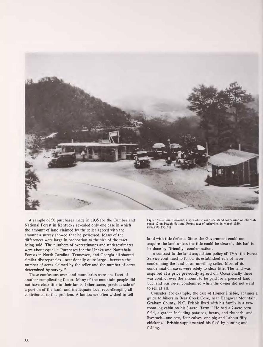
A sample of 50 purchases made in 1935 for the Cumberland National Forest in Kentucky revealed only one case in which the amount of land claimed by the seller agreed with the amount a survey showed that he possessed. Many of the differences were large in proportion to the size of the tract being sold. The numbers of overestimates and underestimates were about equal . 46 Purchases for the Unaka and Nantahala Forests in North Carolina, Tennessee , and Georgia all showed similar discrepancies-occasionally quite large-between the number of acres claimed by the seller and the number of acres determined by survey. 47
These confusions over land boundaries were one facet of another complicating factor. Many of the mountain people did not have clear title to their lands. Inheritance, previous sale of a portion of the land, and inadequate local recordkeeping all contributed to this problem. A landowner often wished to sell
58
Figure 55.-Point Lookout, a special-use roadside stand concession on old State route 10 on Pisgah National Forest east of Asheville, in March 1930. (NA:95G-238161)
land with title defects. Since the Government could not acquire the land unless the title could be cleared , this had to be done by "friendly" condemnation .
In contrast to the land acquisition policy of TVA , the Forest Service continued to follow its established rule of never condemning the land of an unwilling seller. Most of its condemnation cases were solely to clear title. The land was acquired at a price previously agreed on. Occasionally there was conflict over the amount to be paid for a piece of land , but land was never condemned when the owner did not want to sell at all.
Consider, for example , the case of Homer Frisbie, at times a guide to hikers in Bear Creek Cove, near Hangover Mountain, Graham County, N . C . Frisbie lived with his family in a tworoom log cabin on his 3-acre "farm. " He had a 2-acre corn field, a garden including potatoes, beans, and rhubarb , and livestock-one cow, four calves, one pig and "about fifty chickens. " Frisbie supplemented his food by hunting and fishing.

Frisbie , however, did not exactly "own" his land. County records revealed that Frisbie and his wife held a 1 /30 undivided interest in a 98-acre tract optioned by Sam Sparks and others. Since the owners of the other 29/30 interests ·wanted to sell , a "friendly" condemnation suit had been filed. Frisbie became alarmed and obtained the help of visitors who wrote letters on his behalf, including a Chicago attorney.
One solution was for Frisbie to remain on his 3 acres and farm it with a special-use permit, but losing title to the land. Frisbie refused, wanting either to retain ownership or to obtain title to some other suitable land. North Carolina law stated that a condemnation without Frisbie's consent would be void, since he was using the tract as a home . The Forest Service might have agreed to allow Frisbie to retain title , but h is plot was the last piece of a tract of nearly 30 square miles that the Forest Service had put together to establish a wildlife management area and to preserve its wildness. The tract contained the largest stand of virgin timber in the Nantahala forest. The Forest Supervisor was, naturally, eager to move Frisbie out.
Frisbie finally agreed to accept a 9 . 7-acre tract of Federal land in exchange . Settlement of the case took about 9 months, extensive legal correspondence , and the consideration of diverse interests. The value of the Frisbie land so acquired was only $35.0048
One wonders what would have happened if Homer Frisbie had not received legal help . But in another case, stubbornness won out without legal help .
In 1934 Mrs. Hester Jane Truitt, a widow, signed an option to sell her land and cabin , in Swain and Macon counties, N .C . , for $ 1 . 75 per acre . She was assured of help in finding a new home to buy when she received payment. Title to the
99.4-acre farm was clouded, requiring condemnation . There were delays, and payment was not ready until March 1937. By then Mrs. Truitt realized that she would not get relocation assistance , and she could not find a new farm to purchase with the money she was entitled to . So she simply refused to accept •
payment and remained where she was. In November 1940, 44 months later, an attorney for the
Justice Department Lands Division visited Mrs. Truitt to see why she had not accepted payment. A portion of his account of the visit follows.
Mrs. Truitt, whom I judge to be about 65 years of age , lives on the condemned property with her daughter, whom I judge to about 35 years of age . Leaving my car at the nearest road approach to the premises, I climbed a rugged mountain trail about three-fourths of a mile up to Mrs. Truitt's cabin . The cabin is located in a small field, possibly three and one-half acres in total area, in which were a few scragly fruit trees, a pig pen , and a crude cow-shelter, and apparently two acres of corn stubble . The ground indications were that the corn had been cultivated largely by use of the hoe . I saw three head of cattle and several chickens about the place . Every pound of supplies used in the house or on the land that comes from the outside has to be carried up the path by which I climbed . . . The whole appearance from a physical appraisement looked about as hopeless to sustain human occupants as any I ever came in contact with ; and my own origin was in the rugged Blue Ridge Mountains.
Figure 56 .-Bent Creek Forest Camp, overnight public recreation site on Pisgah National Forest near Asheville, N.C., in March 1930. (NA:95G-2381 68)
59

Mrs. Truitt said she had been waiting a long time for my visit and she wondered what kind of man would come there to tell her that she must leave her home that she had helped to clear out of the woods with her own hands and where she had reared a large family of children . She just wanted me to tell her what kind of government I was working for, which through its (forestry) representatives promised her and her neighb ors if they would petition for the establishment of the Government Forest they would be paid enough for their lands to enable them to get better placed in the valleys ; and that after she so petitioned, would send me around to offer her less than one hundred dollars after taxes for the home she had occupied for forty years . What kind of home would that amount buy for her and her daughter, who had many years to live after she, Mrs . Truitt , would be gone, she asked?
The conclusion of the matter was that she flatly declined to touch a cent of the award ; and said that when she moved from those premises she would be carried feet-foremost . 4 9
It was finally decided to remove her tract from the condemnation and return the $1 73. 95 to the U . S . Treasury. so
Lacking both an influential advocate and a legal leg to stand on, Mrs. Truitt nevertheless retained her land through sheer stubbornness .
While Mrs. Truitt actually retained title to her mountain farm , so that her daughter could also continue to live there after her death, some elderly residents sold the land to the Forest Service but reserved lifetime rights .
They continued to occupy their homes until they died , although the Government immediately acquired title to the land . The price paid for the land was reduced in such cases , and the occupants became subject to forest regulations on burning and trash disposal . Since the Government held title to the land, no State or local taxes would have to be paid. In some cases the Forest Service required that no change be made in the use of the land without the district ranger's permission. A cash payment plus the right to remain in their homes gave some financial security for such older residents in their last years . Life interests were granted only to those over 65 , thus ensuring that complete control of the land would pass to the Forest Service before long . Examples occurred in all of the Southern Appalachian forests, but the number was small. s i
Forest Service as Landlord; Sublimity Project
As early as 1934 , Forest Service administrators realized that their extensive program of forest land purchase would create problems for people , especially tenants and squatters , occupying the land. Many of these people were trying to make a living from unsuitable land only because they h ad no place else to go.
60
A policy established in September 1934 stated that all persons occupying land acquired for the National Forests could continue to live there by paying a "special -use fee . " This fee generally would be slightly less than the taxes payable on the land if it were in private ownership . Holders of special-use permits for residence and cultivation would be subject to land use requirements intended to minimize damage to the land, including restrictions on fires, trash disposal , timber cutting, and whatever else the district ranger thought necessary or enforceable. si
�
At that time it was hoped that rural resettlement programs might find new and better homes for many of these people . With the end of that hope, the Forest Service became a more permanent landlord. Even in 1934 provision was made for isolated pockets of good farm land within National Forests. Permanent authorization of special u se for such areas was permitted, as long as this did not interfere with forest management. s 3
The mountain forest that h ad the greatest number of tenants was the newly created Cumberland National Forest in Kentucky, where purchases began in 1933. The one resettlement project, Sublimity, intended to provide better homes for those who had been displaced by the establishment of the forest, was a very limited success. s 4 The Sublimity Forest community was planned, constructed, and managed by the Forest Service with funds provided by the Resettlement Administration and later the Farm Security Administration.
Forest work needed by S ublimity residents to supplement their farm and garden income was never adequate. The high standards set for housing and social services made the cost per family prohibitive . Families carefully selected from a number of applications became disillusioned with the project and left. Between 1937 and 1 945 , 103 families lived in the project. The average period of occupancy was 18.8 months, and the average rate was 73 percent or 48 of the 66 homes in the community.
A 1947 Forest Service report on the proj ect , written after it had been terminated , recommended that the "establishment of rehab ilitation communities on or in connection with national forests be discouraged. " The author of the study concluded that Sublimity had been useful as an experiment, but that organized , managed communities were not workable either socially or economically. Socially, "improvements" in the peoples' lives and attitudes were difficult to make and required constant supervision to maintain . Economically, the project closed with a net loss of $73, 870, an unacceptable cost for a small project. s s
One forest officer commented , "S ublimity to me was a nightmare , much more depressing from a psychological point of view than World War 11 . " ss No one wished to repeat the Sublimity experiment, including the local people who refused to apply for homes there or voted against it by simply moving out .
Lumber and shingles from dismantled CCC camps were used to improve some of the Sublimity homes. Longrange plans were made to improve homes, outbuildings , and the farmland itself, but funds for this work were always very limited. Forest

Service personnel felt a responsibility to the people, but they were uncomfortable in a "social work" role .
What type of structures should the Forest Service provide its tenants? What should our standards be? The TV A, so Richards told us, has spent from $400 to $1500 for each set of improvements owned and rented by the Government under similar conditions under the TVA. Forest Service expenditures on cases sampled during our trip were from $35 to $122 per case. These expenditures resulted in placing the properties in as habitable a condition as the general run of improvements occupied by the better tenants and the smaller owners in the same neighborhood. Should we attempt to raise these standards? Should we provide something besides bare board walls inside the house and floors as well as ceilings that the housewife will be especially proud of? Should we be so "extravagant" as to provide bright colored paints for the exterior of the dwellings? In addition , what kind and what use of incentives should be used to encourage these people to raise their standards? Such problems are over the head of the average forester but are quite probably everyday matters to the trained social worker. For this reason , we would join the Region in suggesting the assignment of a sufficient number of trained social workers to this field until a satisfactory plan and procedure for handling these cases has been developed. 57
Forest officers understandably wanted to turn the problems over to someone else .
Figure 57.-Mountain farm family at their cottage in Currens Valley, Smyth County, Va., Jefferson National Forest, in November 1939. (NA:95G-390771)
Dealing With Forest Residents
While Forest Service officers may have been uncomfortable in their roles as "landlord , " they were more at home in dealing with local people in other ways. Technical personnel , clerical workers, and unskilled labor were usually local residents. The district ranger (or his staff, if any) was the "boss" for these workers, a role in which the forest officers were generally comfortable and quite successful . 58
Forest Service officers also dealt with people who requested special-use permits. The poor squatters and tenants mentioned earlier occupied their homes and land under special permits, sometimes free, sometimes paying a small fee. Similar permits were issued for a multitude of uses from resort hotels and industrial developments to cutting firewood or fenceposts. A Forest Service report in 1940 concluded that:
It is probable that all of this special use business is so much taken for granted that it has little influence on the attitudes of people except when they are refused some desired privilege . Such disapprovals result in more or less hostility and resentment. 59
61

58
59
Figure 58. -Successful hunters with their buck deer after a special Forest Service-regulated hunt on Pisgah National Forest, N.C. , in fall 1 939. (NA:95G-397105)
Figure 59.-Guide Bud Graves of Tellico Plains, Tenn., holding his dogs as he waited to be checked into hunting area for Forest Service-regulated wild boar hunt on Cherokee National Forest in fall 1941. (Forest Service photo F-414169)
Figure 60.-This 300-pound Prussian wild boar was the largest taken in the fall 1 944 hunt regulated by the Forest Service in Tellico Wildlife Management Area, Cherokee National Forest , Tenn. Hunter was L. W. Galloway of Kingsport, Tenn. (Forest Service photo F-433225)
62
60

' Some hostility and resentment also stemmed from the
establishment of wildlife management areas where hunting was restricted , since local residents often were accustomed to hunting as a supplement to their food supply. Hunting has never been prohibited on National Forests, but the forest lands are subject to State laws regulating hunting and fishing. Limits on the hunting season and on the hunters' bag are often resented, as are hunting license requirements.
Active game management in the Appalachian highlands generally dates from the 1930's, so this was a new source of problems at the time. The purpose of the controls was to improve hunting and fishing in the forests and preserve the possibility of such sports for the future. Game animals had been shot out or starved out of much of the newly acquired land and restocking had to take place. However, there was good hunting in the better forested older areas. No Federal fee was charged for hunting and fishing in the National Forests, but about this time residents were required to obtain a State hunting or fishing license for the first time, which was an annoyance to many.
Fire control and land acquisition remained the two principal areas of activity where forest officers came in contact with local people. Fire prevention publicity, organization of fire crews, investigation of man-caused fires for prosecution-these tasks occupied much of the time of many forest officers.
Figure 61 .-Blackened spots where boy is standing show how a farmer's landclearing brush fire got away in a high wind in 1942 to burn 2,000 acres of the adj oining Cherokee National Forest, the margin of which is visible in foreground. (Forest Service photo F-419862)
Figure 62.-A local farmer serving as a fire warden for the USDA Forest Service on the Daniel Boone (then Cumberland) National Forest, Ky., in August 1940. The Forest Service furnished such wardens with a telephone in their homes, to report forest fires. (Forest Service photo F-400243)
6 1
62
63

...-�"'""be.a-. / " ul- ,,. � --. .,..-;'&�"'t4�"'� 0• 1 " � •v•�L"' .... So� ... • • C flll �p·&�r(} �·�� ' .. ,...., · �- ...
- J-- . ·� .. ''" 1'1 "'2"�· �:�pkof\Svo���H·���� * A Y flll C
.- o .. r o c · ��".1
64
r .. _ I ""
·- · -1·.._ J .� • .. 53 L. t • '- ... - ..._ r eJ'":T"'"' :l•9 ,,.,,• 5 A t.1 P �O "t , u lit I 0 N �.,..����·: .. wo•D .. :;.���( � :· ! . ' t!-r>tor t
J,,.....,. • " .. ; 0 .. \ "' °""':!'t··� , . � -___ .._ __ .'�·'"'!�t-:� · ..
Figu re 63.-The National Forests , and Purchase Units (lighter blocks), of the Southern Appalachian Mountains in 1938 show only a few changes from 1935. The major additions were taking place in the Gulf States. (U.S. Geological Survey map; Forest Service photo)
Figure 64.-The National Forests and Purchase Units of the Southern Appalachians in 1940, showing the consolidations of 1936. The forests and units in North Georgia had been combined to form the Chattahoochee, those in Tennessee to form the new enlarged Cherokee, and those in South Carolina to form the Sumter. The Unaka was divided along State lines among the Cherokee, Pisgah, and Jefferson National Forests in 1 936. The units north of the Ohio River are Purchase Units, except the Shawnee, which had just been established. National Parks are also shown. (Forest Service map and photo)
Because of the extensive land acquisitions in the 1930's, related activities occupied relatively more time and led to more individual contacts with people than in recent years . It was a long, drawn-out process. As in the early years, after a purchase area was established , forest officers would interview landowners in the area regarding their interest in selling their land. Since prices offered were generally not high , much discussion would result. The forest officer would also have to

explain the Forest Service p�ocess of land acquisition and forewarn the seller of the possibility of delay in consummating the purchase . Once an option was obtained from a willing seller, a survey crew would retrace old survey lines , conferring with all adjacent landowners to help locate the corners and check the accuracy of the survey. A crew would then come in to inventory the timber and classify the soil to determine the value of the land for forest purposes. The relations of these crews with local people could be touchy.
In the early states of such work , forest officers are in danger of being mistaken for 'revenuers' and most take some pains to make their identity known to residents. 60
Further negotiations often would result, sometimes over a considerable period of time . If the landowner decided to accept the final offer made to him , a final survey would be made to establish permanent corners and mark lines. The results of this final survey could lead to trouble if the lines were not where the owner thought they should be. As we have already seen , this was often the case. Still another source of trouble remained.
Final payment is made to a man for the land he has sold. Much ill will results from preposterous delays in making final payment because of highly technical legal demands from legal authorities regarding title, squatters on land, etc. Although Forest Service has fought for years for a more rational handling of title work , little real progress has been made until just recently. 6 1
Figure 65. -Tallulah (until 1931 called Clayton) Ranger Station, Clayton, Ga. , in 1935. The District was then part of Nantahala National Forest. The Georgia portion of the old Nantahala was transferred to the new Chattahoochee National Forest on July 9, 1936. (NA:95G-310056)
On large tracts of land purchased from absentee owners there were often squatters who had been there for years and had, or thought they had, some flaim to the land . Numerous grievances arose out of all the:;e situations.
One Week on the Job With a Ranger
A Memorandum of Inspection from the Cherokee National Forest shows how some of these interactions with people fit into the weekly routine of a district ranger. 6 1 Hiwassee District Ranger J. W. Cooper, accompanied by the Assistant Forest Supervisor, E.W. Renshaw, toured his district in mid-April 1 938, handling a variety of problems. The first stop on their tour was Hiwassee Beach , where the operator of the beach (a special-use permit holder) had requested that the Forest Service install a telephone. The ranger pointed out that the Forest Service could only install telephones needed for fire control purposes, but he suggested that the local residents might want to build their own telephone line. They could use the existing Forest Service telephone poles if they wished.
The two officers then checked the complaint of the man who had protested that Forest Service telephone line maintenance had destroyed trees and shrubs close to his summer cabin. Cooper concluded that the CCC had probably done a little more clearing than was necessary when they built the line in 1 935, but nothing could be done about it.
The next day Cooper spent several hours with a junior forester who was conducting a "visible area study, " to help plan lookout tower locations. Cooper and Renshaw then proceeded to the Tumbling Creek area to investigate a boundary dispute with a landowner who claimed that an Experimental Project crew had placed a weather observatory and a weir (for stream observation) on her property. Relations with this woman had become "rather strained . " There was much difficulty in checking the boundary, as the line had never been painted and the corner marker had been destroyed.
65

67
66
� ..,. -:- � ---- ..... --:---......... �---. ..
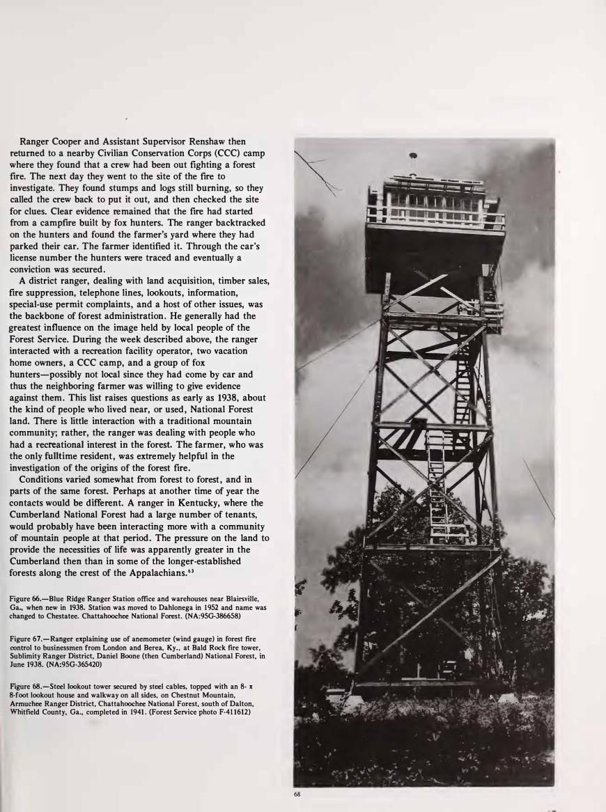
Ranger Cooper and Assistant Supervisor Renshaw then returned to a nearby Civilian Conservation Corps (CCC) camp where they found that a crew had been out fighting a forest fire. The next day they went to the site of the fire to investigate. They found stumps and logs still burning, so they called the crew back to put it out, and then checked the site for clues. Clear evidence remained that the fire had started from a campfire built by fox hunters. The ranger backtracked on the hunters and found the farmer's yard where they had parked their car. The farmer identified it. Through the car's license number the hunters were traced and eventually a conviction was secured .
A district ranger, dealing with land acquisition, timber sales, fire suppression, telephone lines, lookouts , information, special-use permit complaints, and a host of other issues, was the backbone of forest administration . He generally had the greatest influence on the image held by local people of the Forest Service. During the week described above, the ranger interacted with a recreation facility operator, two vacation home owners , a CCC camp, and a group of fox hunters-possibly not local since they had come by car and thus the neighboring farmer was willing to give evidence against them . This list raises questions as early as 1938, about the kind of people who lived near, or used , National Forest land. There is little interaction with a traditional mountain community; rather, the ranger was dealing with people who
had a recreational interest in the forest. The farmer, who was the only fulltime resident , was extremely helpful in the investigation of the origins of the forest fire.
Conditions varied somewhat from forest to forest , and in parts of the same forest. Perhaps at another time of year the contacts would be different. A ranger in Kentucky, where the Cumberland National Forest had a large number of tenants, would probably have been interacting more with a community of mountain people at that period. The pressure on the land to provide the necessities of life was apparently greater in the Cumberland then than in some of the longer-established forests along the crest of the Appalachians. 63
Figure 66.-Blue Ridge Ranger Station office and warehouses near Blairsville, Ga., when new in 1938. Station was moved to Dahlonega in 1952 and name was changed to Chestatee. Chattahoochee National Forest. (NA:9SG-386658)
Figure 67.-Ranger explaining use of anemometer (wind gauge) in forest fire control to businessmen from London and Berea, Ky. , at Bald Rock fire tower, Sublimity Ranger District, Daniel Boone (then Cumberland) National Forest, in June 1938. (NA:9SG-365420)
Figure 68.-Steel lookout tower secured by steel cables, topped with an 8- x 8-foot lookout house and walkway on all sides, on Chestnut Mountain, Armuchee Ranger District, Chattahoochee National Forest, south of Dalton, Whitfield County, Ga., completed in 1941 . (Forest Service photo F-41 1612)
68

Reference Notes
(In the following notes, the expression "NA, RG 83 " means National
Archives , Record Group 83 , Records of the Bureau of Agricultural Economics (USDA); "NA, RG 95 , OC, NFRC" means National
Archives , Record Group 95 , Records of the Forest Service (USDA), Office of the Chief, National Forest Reservation Commission; and
"NA, RG 96" means National Archives , Record Group 96, Records of the Farm Security Administration (USDA). "WNRC, FSR" means
Washington National Records Center, Forest Service records. See
Bibliography, IX.)
1 . 50 Stat. 1 88; 64 Stat. 473 ; 50 Stat 525. Harold K . Steen , The U. S.
Forest Service: A History (Seattle: University of Washington Press ,
1 975), pp. 327, 328.
2 . Glen Lawhorn Parker, The Coal Industry: A Study in Social
Control (Washington , D . C . : American Council on Public Affairs ,
1 940) , p. 67.
3 . National Archives, Record Group 83 , Records of the Bureau of
Agricultural Economics (BAE), USDA , Forest Service, Soil
Conservation Service, and Bureau of Agricultural Economics:
"Preliminary Examination Reports , " Yellow Creek Watershed, 1939;
Pee Dee River Watershed, 1 938; New River Watershed, 1 940;
Roanoke River Watershed, 1 941 ; B ig Sandy River Watershed, 1940.
These reports contain much useful economic information on the
mountain areas where these rivers and their tributaries rise.
4 . Duke University, Perkins Library, Gennett Lumber Company,
Papers, Box 24, Andrew Gennett to C. W. Savage, Murphy, N . C . ,
October 1 5 , 1 934.
5 . Ignatz Pikl , Jr. , A History of Georgia Forestry, p . 25 . See also note
3 , "Preliminary Examination Reports . "
6 . National Archives , Record Group 95, Records of the Forest
Service, Office of the Chief, National Forest Reservation Com mission, Minutes , January 1 1 , 1 934.
7. NA, RG 83 (BAE), "Preliminary Examination Reports , " Pee Dee
River Watershed 1 938. Although counties did not make adjustments
readily to the lower land values of the Depression , in most cases land was taxed at a fairly low rate.
8 . Harry Caudil l , Night Comes to the Cumber/ands, Chapter 1 3 .
9. Cratis D . Williams, "The Southern Mountaineer i n Fact and
Fiction" (Ph . D . dissertation , New York University, 1 96 1 ) , p. 101 .
10. Washington National Records Center, Forest Service Records, Accession No. 59A 1532, Forest Service Memo: "Social Aspects of
National Forest Management" by John H. Hatton , Assistant Regional Forester ( Region 2), June, 1934.
1 1 . NA, RG 95 , Office of the Chief, Supervision, 1 929-35 , General,
Memo, E. A. Sherman, Associate Forester, to Regional Foresters, December 9, 1932.
68
1 2 . Elwood R. Maunder, Dr. Richard E. McArdle: An Interview
With the Former Chief. U.S. Forest Service. 1 952-1 962 (Santa Cruz,
Calif. : Forest History Society, 1 975), p. 84 ; and Robert F. Collins, A
History of the Daniel Boone National Forest (Lexington, Ky. : University of Kentucky Press, 1 975) , pp. 262-263 .
13 . Edwin Nourse, Joseph Davis, and John Black, Three Years of the
Agricultural A djustment Administration (Washington , D . C. , 1937).
14. National Archives , Record Group 96 , Records of the Farm
Security Administration , Correspondence, Records of Regional Director, Region 4, 1 935-40, AAA Land Policy Section , Division of
Program Planning, W . D . Nichol ls, University of Kentucky College of Agriculture, to L. C. Gray, Division of Land Economics , Land Policy,
Agricultural Adjustment Administration, April 14, 1 934.
15. NA, RG 96 , Farm Security Administration (FSA), W . D . Nicholls
to L. C. Gray April 6 , 1 934; L. C. Gray to W. D. Nicholls April 1 2 ,
1 934. See note 1 4 .
1 6 . N A , RG 9 6 , Farm Security Administration (FSA), Records of the
Regional Director, Region 4, Land Policy Section, Division of
Program Planning, AAA, 1 934-35 , "My Experiences While Working
on the Submarginal Land Program in Knox County, Kentucky" by W. P. Mayhew, Field Supervisor, November 10, 1934. Also similar reports
prepared by Elmer Pritchard, Edward S . Amis and Dr. Wayne T. Gray, field clerks, in November, 1934.
17. NA, RG 96, FSA , Mayhew, "My Experiences in Knox County, "
Region 4, Land Policy, AAA, 1 934-35.
18. NA, RG 96, FSA , Records of Region 4 Land Policy Section,
Division of Program Planning, AAA, Report- 1 934, Kentucky Ridge
Area.
19. NA, RG 96, FSA, Correspondence of the Regional Director, Region 4, 1935-40. Tilford E. Dudley, Chief, Legal Division , The
Land Program , F. E. R.A. , to Carl C. Taylor, Regional Director, Land
Policy Section , AAA, February 7, 1935.
20. NA , RG 83 , Bureau of Agricultural Economics (BAE),
Appalachian Regional Office Records, 1935, Kentucky 184 .
2 1 . N A , RG 83 , BAE, Appalachian Records, 1 935, Kentucky 184.
22. I nterview with Dr. Billie DeWalt, Winchester, Ky. , July 27, 1979.
Dr. DeWalt was employed by the Forest Service to do a community
study in the Red River Gorge area.
23. NA, RG 96 , FS A, Correspondence of the Regional Director, Region 4, AAA , 1935-40, Resettlement of Land Utilization Clients,
Report, September 29, 1 936, Kentucky Ridge Forest Project, L .U. -Ky
1 .
24 . NA, RG 96, FSA, Region 4 , Resettlement Division, AAA,
1935-40, List of Projects , 1936, and C. B . Faris, Assistant Regional
Director, to Mack J. Morgan, Resettlement Representative, Lexington,
Ky. , April 7, 1 936.

25 . NA, RG 96, FSA , Correspondence 1 935-40 , Land Utilization Projects, Region 4 , File of letters dealing with the need to move people off all Land Utilization Project lands by May 3 1 , 1938. W. P. Mayhew, Project Manager, Pineville, Ky. , to Howard H. Gordon, Regional Director, FS A , Kentucky Ridge Forest Project.
26. WN RC, Forest Service Records, Accession No. 95780002, Report on Proposed Extension of the Pisgah National Forest, May 9, 1 934.
27. NA, RG 96, FSA , Correspondence of the Regional Director, Region 4, AAA, Joseph C. Kircher, Regional Forester, to Dr. Carl C. Taylor, Regional Director, Division of Program Planning, AAA Lands, October 27, 1934.
28. NA , RG 96, FSA , Correspondence of the Regional Director, Land Policy Section , D ivision of Program Plann ing, A A A , Region 4, Paul W. Wager, Regional A ssistant, Land Policy Section , AAA , to J . C. Kircher, U.S . Forest Service, May 1 4 , 1 935. Paul W. Wager, Acting Regional Director, Resettlement Administration , to J. C. Kircher, July 1 1 , 1935. The Cherokees worked out a separate agreement with the Park Service. Conflicts over the need to help tenants and sharecroppers as well as farm landowners led to the resignation of a number of "social reformers" from the AAA in the Spring of 1935; W. E. Leuchtenberg, Franklin D. Roosevelt and the New Deal, (New York : Harper and Row, 1 963) , pp. 1 39- 142.
29. Rexford Tugwel l , "The Resettlement Idea , " Agricultural History 33 ( 1 959): 159- 1 64 .
30. N A , R G 83 B , Bureau o f Agricultural Economics (BAE), Land Utilization Projects, Regional Files, 1 934-45, Appalachian Region. See especially Nantahala-Cherokee Project and Prel iminary Report of Land Use Conditions in Cherokee County, North Carolina, January, 1939.
31 . Marguerite Owen, The Tennessee Valley A uthority (New York : Praeger Publishers , 1 973) , pp. 67-68.
32. Arthur E. Morgan , The Making of the TVA . (Buffalo, N .Y. , 1974), pp. 75-79 . Morgan and others had many ideas about social and political develop ment of the region through TV A. Most of their ideas were never carried out. See also Clarence L. Hodge, The Tennessee
Valley A uthority: A National Experiment in Regionalism
(Washington : American Un iversity Press, 1938), for efforts made to cooperate with and assist local commun ities and interest groups.
33. Brewer and Brewer, Valley So Wild. p . 259. The dam she referred to was the Fontana. See also Alfred J. Gray "Land Use Aspects of Reservoir Problems , " in G. Donald Hudson, et al: "Studies of River Development in the Knoxville-Chattanooga Area, Economic Geography 15 (July, 1939).
34 . Charles J . McCarthy, "Land Acquisition Pol icies and Procedures in TV A , " Ohio State Law Journal (Winter, 1949).
35 . Vladimir Eugene Hartman , "A Cultural Study of a Mountain Community in Western North Carol ina" ( Ph . D . dissertation , University of North Carolina at Chapel Hil l , 1 957) p . 109. See also Owen , The TVA , p. 27.
36. Interview with Russell Griffith and Bruce Jewell, headquarters, Cherokee National Forest, Clevel and, Tenn . , July 1 7, 1 979 .
37. N A , RG 95, Records of the Forest Service, Office of the Chief, National Forest Reservation Commission (N FRC), Minutes, June 9 , 1 933. The information i n the following section i s chiefly derived from NFRC minutes. Specific citations will be provided where appropriate.
38. NA, RG 95, Office of the Chief, NFRC, Minutes, November 21 , 1934 .
39. Land Acqu isition Records, National Forests of North Carol ina, Asheville, N . C .
4 0 . Roy Ring White , "Austin Cary a n d Forestry i n the South" (Ph. D . dissertation, Un iversity of Florida, 1 960) , pp. 23 1 -239.
41 . NA, RG 95 , Office of the Chief, NFRC, Minutes, January 22, 1936.
42. WN RC, Forest Service Records, Accession No. 60A85 1 , Report on Macon County, North Carolina, 1 936.
43 . WNRC, FS R, Acc. No. 60A85 1 , Report on Johnson County, Ten n . , 1 936.
44. WNRC, FS R, A cc. No. 58-A64, Memo from R. C. Hall , Director, Forest Taxation Inquiry, to R. E. Marsh , Assistant Chief, "Department Contributions Policy" June 1 8 , 1 943.
45 . NA , RG 95 , Office of the Chief, NFRC, M inutes, July 30, 1 935, Onaka Forest Purchase Records .
46. NA , RG 95, Office of the Chief, NFRC, Minutes, July 30, 1935, Cu mberland Forest Purchase Records .
47. NA, RG 95 , OC, NFRC, M inutes, July 30, 1 935, Unaka and Nantahala Forests Purchase Records.
48. NA, RG 95 , Land Acquisition (LA), Condemnation Cases , 1939-46, Region 8, John A . Massen to Hon . Mastin G. White , Office of the Solicitor, USDA , May 3 1 , 1 940; L. L. Bishop, Assistant Forester to John A. Massen , June 1 , 1940; L. F. Kneipp, Assistant Chief, F . S . to J. Kircher, Regional Forester, August 7, 1940; J . Kircher, Regional Forester, t o Chief, September 1 0 , 1 940; John E. Burch, Acting Chief, Land Acquisition, to Regional Forester, September 30, 1940; Memorandum for Mr. Kneipp, A cquisition , Nantahala, September 27, 1 940; Memorandu m for Supervisor, Nantahala, August 1 3 , 1940.
49. NA , RG 95, Land Acquisition (LA), Condemnation Cases , 1939-46, Region 8, Nere A. Day, Special Attorney, Department of Justice , to Attorney General , Lands Division, Condemnation Section , Department of Justice, December 13, 1 940.
69

SO. NA, RG 9S, Land Acquisition. (LA), Condemnation Cases,
1 939-46, Region 8, John E. Burch , Acting Chief, Forest Service , to
Solicitor, Department of Agriculture, Acquisition, Nantahala, May 26,
194 1 .
S L NA , RG 9S, Office of the Chief, National Forest Reservation
Commission, Minutes, Cherokee Forest Purchase Records, July 30,
1 93S; Pisgah Forest Purchase Records, April 2, 1936; Nantahala
Forest Purchase Records, June 30, 1 94 1 ; Chattahoochee Forest
Purchase Records, June 4, 1940.
S2. Washington National Records Center, Accession No. 72A3386,
Forest Service Records, L. F. Kneipp, Assistant Forester, to John E.
Burch, Secretary, NFRC, October 17, 1934.
S3. WNRC, Forest Service Records, Acc. No. 72A3386, F. A. Silcox,
Forester, to Regional Foresters, September 27, 1934. See also, Collins,
A History of the Daniel Boone National Forest, Chapter 30, pp.
2 19-224.
54. Forest Service Regional Office Records , Atlanta, Ga. , Lands
Division, "Notes of Observations During a Trip Through Eastern
Kentucky, " May 22, 1940, Supervision-Cumberland National Forest.
"History of the Sublimity Forest Community Situated in Laurel
County, Kentucky, " prepared by W. E. Hedges, 1947, pp. S-8, 34,
80, 8 1 .
70
SS. Forest Service Regional Office Records, Atlanta, Ga. , Lands
Division, Hedges, "History of Sublimity," 1 947.
S6. Edward Ritter to W. E. Hedges, Jan . 1 7, 1947, filed with
"History of Sublimity."
S7. NA, RG 9S, Office of the Chief, General Integrating Inspection
Reports , Region 8, 1937, by E. W. Loveridge and J. A. Fitzwater. The
southern lowland forests such as the Talledega and Kisatchie had
more serious tenant problems than the mountain forests .
S8 . Washington National Records Center, Accession No. 60A93 1 , "A List of Different Kinds of Things the Forest Service and Forest
Officers Do Which Influence Residents , " August 12, 1 940.
S9 . WNRC, Acc. No. 60A93 1 , "A List of Different Things"
60. WNRC, "A List of Different Things"
6 1 . WNRC, "A List of Different Things"
62. NA , RG 9S, CCC Camp Records, Memorandum of Inspection,
Hiwassee District, Cherokee National Forest, April 18, 1938, E. W.
Renshaw, Assistant Forest Supervisor, Camp Old Hickory, Tenn.
63. Forest Service Regional Office Records , Atlanta, Ga. , Lands
Division, "History of the Sublimity Forest Community," p. 73 . In
1938, 80 free permits were issued to destitute families living in the
Cumberland Forest. Several hundred additional holders of residence
permits paid a small fee.

Chapter IV
The Civillan Conservation Corps
In 1933, shortly after his i?auguration as President, Franklin D. Roosevelt sent to Congress an urgent request for legislation to put unemployed young men to work in conservation jobs. FDR and others had been considering such a program for several months and when Congress passed the Emergency Conservation Work Act on March 31 , 1933, they moved swiftly to get the program started. Just 5 days later Robert Fechner was appointed Director of Emergency Conservation Work to head the program. The first Civilian Conservation Corps camp was occupied in less than 2 weeks. By July, 300,000 men were in CCC camps all over the United States. 1
At first , the Forest Service was the sole CCC employer; later it employed at least half of the men . Its camps were the first established and often the last closed down , some of them existing from 1933 to the end of the CCC in 1942. In contrast, other camps were usually dismantled and moved when they completed a project, often in less than a year. The Forest Service, which for years had been short of funds and manpower for tree planting, timber stand improvement, recreation development, building telephone lines, firefighting, road and trail building, and scores of related jobs on the Forests, had responded eagerly to the opportunity. Forest supervisors promised to put young men to work as soon as they could be recruited and brought to the forests.
Other agencies supervised significant numbers of CCC camps in the Southern Appalachian Highlands. One was the new Soil Erosion Service of the Department of the Interior, headed by Hugh H. Bennett, also created in 1933 . Enrollees planted trees and shrubs to help hold the soil in place and built small dams to help lessen floods, mostly on private lands. These camps are difficult to trace, as they were often temporary, and moved to a new location when their work was completed. At the strong urging of a coalition of agricultural and forestry groups, Roosevelt transferred SES to the Department of Agriculture in March 1935 and had it renamed Soil Conservation Service. 2 The National Park Service had many CCC camps in the Great Smoky Mountains National Park ( 1 6 in 1934 and 1935) and along the Blue Ridge Parkway. Other CCC camps worked on new State parks. The tasks performed by these camps were similar to those of the National Forest camps with the exception of timber stand improvement. The Tennessee Valley Authority provided work for men in about 20 camps in Tennessee and Kentucky building check dams and planting trees. TV A camps did their work both on TVA-owned lands and adjacent private land.
The Army, experienced in handling recruits , was given the job of processing the young men and operating and maintaining the camps. There was no drill or military training, but Army Reserve officers at first had to maintain discipline,
' arrange leisure-time activities, and provide suitable food, clothing, and shelter.
The CCC had an especially strong impact on the southern mountains and their people , so it is appropriate that the first CCC camp was located in an Appalachian National Forest. 3 As we have already seen , the CCC was indirectly responsible for the enlargement of the Southern Appalachian National
Forests. The desire to find more places for the CCC to work in the East accelerated the process of acquiring more land for the forests, and $10 million in additional forest purchase funds came directly from the budget for CCC, Emergency Conservation Work. The CCC program was so successful and met so much approval nationwide that when emergency authorization for the program expired in March 1937, Congress passed new legislation continuing the program and giving it a more permanent status. Many hoped that CCC would continue after the Depression was over. As it turned out, CCC lasted only for a little over 9 years. Enlistment declined in 1941 as war industries attracted young workers. The CCC was disbanded starting in 1942, soon after the United States went to war.
Many Camps in Appalachia
CCC camps, usually with 150 to 220 enrollees each, were clustered thickly in the National Forests of Southern Appalachia . 4 The arrival of so many young men in the rural mou ntain counties created tensions, especially since the first CCC recruits were chiefly unemployed youth from the larger towns and cities of the States in which the camps were located. Accustomed to different standards of behavior and a different way of life, they were considered "foreigners" in the mountains, though many of them were still in their native State. Later this picture changed as the CCC recruited more young men from the neighboring farms and small towns. However, in lightly populated counties with lots of forest, local boys were often outnumbered in the camps. In the middle and late 1930's many boys came from heavily populated and urbanized New Jersey and New York , States with more unemployed youth than their forests could keep busy. These boys, many from tough big-city neighborhoods, found the southern mountains and people as strange as the natives found them .
Initially, CCC enrollees were unmarried, 1 7 to 2 1 , unemployed members of families o n relief o r eligible for public assistance, not enrolled in school (the CCC was not a "summer job"), in good physical condition and of good character. The few World War I veterans accepted later usually had separate task-oriented camps. Both blacks and whites were enrolled, but were rarely in the same camp. The mountains had no black camps, because CCC administrators concluded large groups of young black males, would not be welcome. It was also more convenient to locate black CCC camps where there were lots of prospective enrollees.
Each camp had one to three reserve Army officers and technical personnel responsible for work supervision, including foresters, engineers, and experienced foremen. There were also a few local experienced men (L. E. M . ) , usually men who previously had worked for the Forest Service.
71

Hiring of technical personnel was at first under political control . The Project Supervisor for each camp was selected from a list of men approved by the local congressman . These jobs were much sought after since they paid quite well for the time, $1 ,200 to $1 , 800 per year. At first some project supervisors made more money than the local district ranger to whom they reported, but salaries were evened out later on . Eventually many supervisory personnel became Forest Service employees subject to Civil Service regu lations. Even in 1933 and 1934 political approval for project superintendents did not cause seriou s difficulties. A former Forest Supervisor on the Nantahala recalled that because so many well-qu alified men were unemployed, it was not d ifficult to select them from the congressmen's lists. This particular Forest Su pervisor also remembers little difficu lty in getting political approval for his own candidates for CCC jobs if there was no one suitable on the approved list . 5
Many of the early enrollees did not work out because of the nature of most CCC work. An early inspection report from a camp on the Pisgah National Forest reported 41 "elopements" (unauthorized departures) from the camp during the late summer and early fall of 1933 . The reasons given were the isolation of the camp and the hard outdoor work, unfamiliar to the former cotton mill hands sent in the camp 's first allotment of young men. 6
By 1936 there had been a shift to enrollees more familiar with outdoor labor. A su rvey made in Janu ary 1937 showed about one-fifth from farms and a third from small towns (less than 2,500 popu lation). The shift seems to have been a natural and sensible one, and in part reflects the extension of relief and other welfare programs to some rural and semi-rural areas during the New Deal. There were no relief programs in most rural counties before 1933 . 1
One Project Su pervisor at a National Forest camp observed another very definite change in the enrollees during the years 1933 to 1938. He wrote that during the first 2 years of the CCC most of the enrollees he worked with were young men in their early 20's who at one time had been employed. Some of them had useful skills, such as carpentry or truck driving. He thought that these early en rollees were willing workers who had been demoralized by unemployment, but could be organized to work well without extensive training.
By 1939 the CCC camp was receiving a different type of young man.
72
The majority of present day " Rookies" might be called products of the depression . From 16 to 22 years old, most of them quit school before completing the grammar grades, except for a few who attended vocational school from 1 to 3 years. Many admit they have loafed from 1 to 7 years and don't really know how to do anything. 8
The effects of the Depression on school budgets and on the morale of young people had been devastating. For many enrollees, developing the physical strength and mental concentration necessary to do a full day's work was the most important part of their training in the CCC.
Many Enrollees Were Illiterate
For other enrollees the CCC provided an opportunity to acquire education. CCC education reports reflect serious efforts, usually successful, to teach illiterates the fundamentals of reading and arithmetic. For mountain boys especially, basic education filled a real need. One camp in Kentucky reported in 1940:
Due to the fact that practically all men enrolled in the company from seven local surrounding counties where educational facilities are limited, a major emphasis must be placed on Literacy Education . Twenty-five men enrolled in the company during the past year had never previously attended school . Sixty others were illiterate . 9
Teachers for those in need of basic edu cation were sometimes provided by Works Progress Administration (WPA) funds; sometimes other enrollees served as instructors. The use of enrollees as teachers was possible because there was a wide variation in educational background among the young men. In 1939 a camp near Morehead, Ky. , reported sending eight young men to Morehead State College. Four enrollees were attending the local high school. 1 0
The education the boys needed was not always available. The educational advisor from another camp in Kentucky reported that 76 men in his company had completed the 8th grade but no high school instruction was available. He was tutoring 11 men whom he classed as "semi-literate . " 1 1
Academic classes were not the most important part of the CCC educational effort. A nationwide education report for 1937 stated that about 60 percent of the classes in CCC camps were vocational because " . . . job training and vocational courses were the most popular in the camps . . . and had the strongest holding power. " 1 2 Only 33 percent of enrollees nationwide attended academic classes.
Work Projects Under Forest Service
The Forest Service was responsible for job training related to the work projects . The camp Project Superintendent was responsible for training in each camp. Forest Service staff, especially district rangers , were instructed to help camp supervisory personnel learn to use the education method recommended by the Forest Service . This method , generally, was to break each job into a number of simple steps and then coach the enrollees through the task step by step until they understood how to do it. 1 3
A carefully prepared little pamphlet, "Woodmanship for the CCC , " was printed by the Forest Service and usually issued to each enrollee. 1 4 It went through a number of printings and was always in demand. "Woodsmanship" explained clearly, with
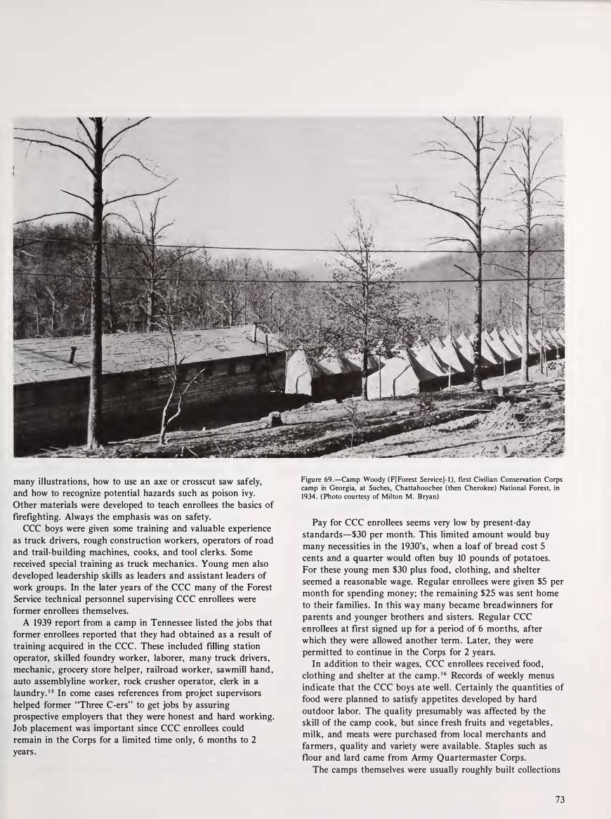
many illustrations, how to use an axe or crosscut saw safely, and how to recognize potential hazards such as poison ivy. Other materials were developed to teach enrollees the basics of firefighting. Always the emphasis was on safety.
. CCC boys were given some training and valuable experience
as truck drivers, rough construction workers, operators of road and trail-building machines, cooks, and tool clerks. Some received special training as truck mechanics . Young men also developed leadership skills as leaders and assistant leaders of work groups. In the later years of the CCC many of the Forest Service technical personnel supervising CCC enrollees were former enrollees themselves.
A 1939 report from a camp in Tennessee listed the jobs that former enrollees reported that they had obtained as a result of training acquired in the CCC . These included filling station operator, skilled foundry worker, laborer, many truck drivers, mechanic , grocery store helper, railroad worker, sawmill hand , auto assemblyline worker, rock crusher operator, clerk in a laundry. 1 5 In come cases references from project supervisors helped former "Three C-ers" to get jobs by assuring
. prospective employers that they were honest and hard working. Job placement was important since CCC enrollees could remain in the Corps for a limited time only, 6 months to 2 years .
Figure 69.-Camp Woody (F[Forest Service]- 1 ), first Civilian Conservation Co1:Ps camp in Georgia, at Suches, Chattahoochee (then Cherokee) National Forest, m 1934. (Photo courtesy of Milton M. Bryan)
Pay for CCC enrollees seems very low by present-day standards-$30 per month. This limited amount would buy many necessities in the 1930's , when a loaf of bread cost 5 cents and a quarter would often buy 10 pounds of potatoes. For these young men $30 plus food, clothing, and shelter seemed a reasonable wage. Regular enrollees were given $5 per month for spending money; the remaining $25 was sent home to their families. In this way many became breadwinners for parents and younger brothers and sisters. Regular CCC enrollees at first signed up for a period of 6 mor.ths, after which they were allowed another term . Later, they were permitted to continue in the Corps for 2 years.
In addition to their wages, CCC enrollees received food, clothing and shelter at the camp. 1 6 Records of weekly menus indicate that the CCC boys ate well . Certainly the quantities of food were planned to satisfy appetites developed by hard outdoor labor. The quality presumably was affected by the skill of the camp cook, but since fresh fruits and vegetables , milk, and meats were purchased from local merchants and farmers , quality and variety were available. Staples such as flour and lard came from Army Quartermaster Corps.
The camps themselves were usually roughly built collections
73

of wooden buildings, often unpainted . One building, or sometimes a series of small cab�s, provided quarters for the officers in charge of the camp, for the project supervisors in charge of work, and the camp educational advisor. The largest building in a camp would be the kitchen and dining hall, with a recreation room either in the same building or nearby. The
boys were housed at first in tents, then in rough wooden barracks, sometimes with bathroom facilities attached. Some camps had separate bath houses. There would usually be
several sheds for trucks, road machinery, and storage . The buildings were heated in winter by wood- or coal-burning
stoves . Buildings at these camps hastily constructed of green lumber in 1933 were in bad repair by 1940, but other camps were more solidly constructed , especially later buildings built by the CCC boys for their own use. Some of the more
permanent camps had classroom buildings and athletic fields for leisure time activities.
Weekly Recreation VI.sits to Town Most of the camps were close enough to towns to permit
weekly recreation visits. Such visits were welcomed by the boys and by local merchants as well. Theater owners could count on
a good audience for the motion picture when the CCC came to town. Some camps were actually located on the outskirts of small towns like Hot Springs, N.C. Other camps in the most rugged mountain districts were almost inaccessible. In 1939 an inspector noted that one camp near Laurel Springs, N. C. , was 1 8 miles from the nearest telephone. The camp was also without telegraph or radio communication. Consequently, he recommended the construction of a telephone line to be used for fire control and to obtain assistance in emergencies. 1 7
A rough idea of how many boys were affected by� the CCC
can be obtained from table 3 , which gives some enrollment
figures for 3 years and indicates as well the size of the CCC at its beginning (1934), peak enrollments at the height of the program (1937), and declining enrollments (1941). Declines were not so great for the Southern Appalachian States ,
especially Georgia and Kentucky, as they were in some areas of the country, but by the end of 1940 there were fewer camps and the remaining ones were below strength. 1 8
Table 3 . -Civilian Conservation Corps: Numbers of Residents and Nonresidents Enrolled in Camps in Each of Five Southern Appalachian States; Residents of These States Enrolled in Other Regions , 1934, 1937, 1941
State
Kentucky
Total residents e n ro l l ed in CCC camps (nat ionwide) I n Far West (beyond G reat P l ai n s)
I n Appalac h i ans
I n other reg i ons Out-of-State res i d e n ts i n Kentucky Appalachian camps
Te n n essee
Total residents e n ro l l ed i n CCC camps (nat ionwide) In Far West (beyond G reat Plains)
I n Appalachians
I n other reg i o n s
Out-of-State res ide nts i n Ten nessee Appalachian camps
N o rth Caro l i n a
Total residents e n rol led in C C C camps (nat ionwide) In Far West (beyong G reat Plains)
I n Appalach ians I n other reg i o n s
Out-of-State res ide nts i n N o rt h Caro l i na Appalachian camps
South Carol in a Total residents e n ro l l ed in CCC camps (nat ionwide)
In Far West (beyo nd G reat Plai n s)
I n Appalachians
I n other reg i o n s Out-of-State res idents i n S o u t h Caro l i na Appalachian camps
Georgia Total res idents e n rol led i n CCC camps (nat ionwide)
I n Far West (beyond G reat Plai ns) I n Appalachians
In other reg i ons
Out-of-State res idents in Georgia Appalachian camps
1934
4,495 1 ,068
820 2,607
0
5,779 0
1 ,086 4 ,691 3,248
6,820 0
3,839 2,981
448
3,802 0
588 3,214
0
6,899 0
2,359 4,540
1 84 Source: Nat ional Archives, Was hing ton, D.C., Record Group 35, Records of the Civ i l ian Conservation Corps, Station and Strength Reports.
74
1 937 1 941
5,571 5,41 4 669 587
1 ,224 660 3,698 4,167
725 740
7,649 6,831 43 827
2 ,282 1 ,994 5,324 4,01 0
1 26 1 43
8,542 6,21 9 1 1 6 1 18
1 ,355 684 7,071 5,4 1 7 1 ,306 561
6,258 4,466 192 1 85 603 452
5,463 3,829 241 158
6,654 6,556 381 1 , 143 776 565
5,742 4,848 96 124

Two examples serve to illustrate further the impact of the CCC on the young enrollees. In 1934 a young Tennesseean, B. W. Chumney, enrolled. He intended to go to college later, but needed a job to earn expenses. However, his temporary job became a career. He remained on the Cherokee National Forest until his retirement in 1977. For the first 7 years he was employed by the CCC, though his duties in timber management and fire control remained similar when he was shifted to regular Forest Service employment in 1 94 1 .
Chumney participated a s a fire dispatcher i n the application of many new firefighting techniques, from the use of radio dispatching in the 1930's to helicopters and flying water tankers in the late 1960's and early 1970's . During his career he saw the Cherokee National Forest grow from a patchwork of eroded , cutover slopes to the magnificent and valuable stands of timber that comprise much of the forest today.
The Cherokee became Chumney's hobby as well as his job . He is a recognized expert on the history of the forest and has devoted much effort to collecting information about it . A staunch believer in Forest Service management practices, Chumney has preached fire control, timber stand improvement , and careful timber cutting to his neighbors and acquaintances for more than 40 years. Practicing what he preached, he used his savings to buy timber land which he managed carefully according to the practices he learned in the Forest Service. 1 9
For other young men, the CCC provided only a few months' employment in the outdoors, but often with much benefit . One case history from the "Summary of Social Values 1933- 1934" tells the story of Johnny S . , a North Carolina tenant farmer's son who spent 6 months in the CCC. Johnny's family lived in an isolated area. The children (Johnny was the oldest of 10) had little schooling and almost no contact with the world outside their family. Johnny learned to read and write a little at the CCC camp and developed enough skill in the woods to get a job near home when he returned.
The county welfare director concluded his report:
Johnny has been home for some time now and all reports from him are that he "is holding his head high . " He helped his father make a crop this year and received a share of it for his own . He made a great deal of money and bought a secondhand car. The neighbors say that he takes the family to church every Sunday and is now helping them to see beyond the little road that stretches in the front of their door. 20
Johnny returned to his native area and even to his father's occupation , tenant farming, but for him, as well as for those who found new careers through the CCC, the experience provided a widening of outlook and opportunity for new skills. Johnny's brief experience away from home, according to the County Welfare director, marked the change from boy to man .
These two examples illustrate the wide variety of young men who found employment in the CCC. Anyone, from a semiliterate squatter to the Forest Supervisor himself, may have been a "Three C-er. " And, most important, this shared
experience helped the Forest Service for many years to build trust and friendships in the mountains. As the generation that served in the CCC retires and dies, this nostalgic common bond is being lost.
Large Camps Close to Towns Cause Some Friction Most CCC camps sent truckloads of young men into the
nearest town once or twice a week for recreation , often a visit to the local movie theatre. The boys were usually free to wander about town and spend their limited pocket money in the stores. Sometimes they attended servkes at local churches, though often neighboring clergymen were invited to conduct services at the camps and there were official chaplains assigned to groups of camps. After 1937, when the CCC became a more permanent organization and increased its emphasis on education , some boys attended local high schools and, in a few cases, colleges. CCC boys were also taken on recreation trips to see local landmarks, and to other camps or nearby towns to play baseball games .
The degree of social impact a camp had varied greatly from place to place. Smaller, more isolated camps might go almost unnoticed except by those who were employed there or who did business with the camp. Larger camps, and those very close to towns, made their presence felt continually, sometimes with unfavorable results for all concerned.
The most notorious case was Camp Cordell Hull, Tennessee F-5, Unicoi County. 2 This camp illustrates most of what could go wrong. In spite of the many problems, however, the camp remained in use throughout the life of the CCC, since there was much work to be done in the area. The camp also had an unlimited supply of pure drinking water (often a problem at other camps) since it was located on the site of the Johnson City waterworks. Because of its convenient location, much of the time the camp housed two companies of CCC-about 400 young men.
During the period of most serious trouble, 30 to 100 of the regularly enrolled young men were local, from Unicoi or neighboring counties. Thirteen local skilled men were employed by the Forest Service as supervisors for various projects.
A routine inspection of the camp in January 1934 reported all was well and that relations with the surrounding community were "very favorable , " but as the weather improved in the spring, conditions deteriorated rapidly.
According to the military men assigned to run the camp, the locals used it as a ready-made lucrative market for prostitutes and moonshiners. The camp commander blamed lax local law enforcement for the situation and refused to cooperate with the local sheriff when he came to arrest CCC enrollees at the camp.
75

Local people did not want drunkenness in the camp, but at the same time turning in moonshiners was against their custom. As a former county sheriff put it:
There is some in the [CCC] camp that sells liquor. I can throw a rock from my barn and hit one of them . . . I am personally acquainted with him, and it would hurt his feelings if I said anything about it. 2 2
I t would appear that the situation was also exacerbated by factionalism within the camp , for when a formal complaint was filed against the Army officers in charge , one of the complainants was the educational advisor. The complaint alleged misbehavior of the enrollees and failure of the officers to cooperate with local law enforcement officials. Other complainants were four neighboring residents and the county sheriff.
When the Army investigator from Ft . Oglethorpe, Ga . , came to sort out the situation in July 1934, evidence indicated that the Army officers and the sheriff were all to blame . Testimony he collected showed that the four local residents had been enraged by the remarks yelled at local women an d girls by CCC boys driving past in trucks. They also complained that CCC boys had disrupted two church services.
The county sheriff reported two serious incidents. The first resulted from a fist fight at a "wiener roast" in Unicoi. A CCC boy pulled a knife , seriously wounding a local boy. The knifewielder was arrested, but escaped from jail and was hidden by his friends at the camp for several nights until he could arrange to get away. The local boy was believed to have started the fight.
The other was a "highway robbery" incident. A Johnson City man had picked up three CCC boys who were hitchhiking. He had a jug of whiskey which he offered to share and apparently all four had quite a bit to drink . The complaint contended that the boys then knocked him out (they said the whiskey did it) and took his car, which was hidden near the CCC camp. The CCC boys claimed that the incident, while regrettable, was really far less serious. Feeling against the sheriff was running high in the camp at that time and the camp commander refused to let him search the camp for suspects .
The CCC enrollees and their commander were angered by what they perceived as the sheriffs "double standard"arresting them for drunkenness, but ignoring the illegal whiskey sales which caused it. The sheriff blamed moonshining on "bad times" and said wherever men congregate they will man age to get liquor; to him it was a normal occurrence . 2 2 The citizens also testified that there had been some troubles with local girls who hung around the camp . As one neighboring resident put it:
76
It seems that all hours of the night they are out, and if I understand it right there has been quite a few girls that has happened with bad luck . That is a misfortune to our community. 2 4
The people of Unicoi County seem to have been reluctant to assume responsibility for the behavior of their own citizens toward the CCC camp, expecting the Army to prevent serious trouble by disciplining the enrollees. The Army officers , on the other hand, had to try to control about 400 vigorous young men without using military discipline. It was a difficult task , certainly not made easier by the ready availability of moonshine whiskey and other distractions. It is not clear how the camp commander was to control their behavior when on leave .
Perhaps the most remarkable aspect of the whole acrimonious affair was that no one wanted the camp removed . All the complainants agreed that i t was " a good thing for the county . " The sheriff even protested that the camp commander had tried to get him in trouble with the local merchants by refusing to let the boys go into Erwin, the county seat. (The commander did later let local enrollees take a truck to Erwin to vote against the sheriff. ) The camp was considered beneficial because of its contribution to the local economy.
Testimony also was unanimous that the Forest Service had nothing to do with the enrollees' misbehavior and was not responsible for the trouble . The complaint was entirely against the Army. The Army investigator concluded that nothing further needed to be done, since the camp commander had already been replaced, and he hoped for better relations with local citizens. No further serious disturbances were reported from Camp Cordell Hull . The personnel changes an d increased efforts to keep the boys busy after working hours helped to improve community relations.
Although the Forest Service was not held responsible for the CCC's drin king problem in this case , it appears certain that a few temporary local employees who could not resist the chance for easy money in the bad times were often directly involved in moonshine distribution . In many camps the whiskey was covertly brought in by local experienced men (L. E . M . ) or technicians. District rangers tried to eliminate men who were habitually drunk or who sold liquor to the enrollees. As the Supervisor of the Cherokee pointed out to a trail building foreman he had been forced to fire :
Regardless of the excellent caliber of an empl�ye�'s services , the Forest Service cannot condone drmkmg by its employees on the job and at CCC camps. Instructions have been repeatedly issued to all employees cautioning him in this respect. 2 5
Even firing a local foreman who peddled moonshine on the
side was not as simple an issue as it might seem. The Forest Service was com mitted to doing its best to relieve unemployment in the mountain counties. Forest supervisors and district rangers were very anxious not to have "outside" CCC enrollees push local men and boys out of the available jobs on the forests . If a man was fired, often he could not find
a job . Many local men h ad been employed by the Forest Service before CCC was established and firing them gave the
impression that they were being pushed out of work by the
ccc. 26
Though for obvious reaspns documentation of the practice does not exist , conversations with former district rangers and indirect evidence suggest that illegal still s were frequently overlooked as long as they did not cause fires and the owner did not harvest timber illegally to fuel his still . Such tolerance would maintain local goodwill and prevent trouble. Moonshiners may have been surprised by the ban on sales to CCC men.
Enrolling and employing local men contributed directly to the drinking problem. The more local men there were in a CCC company, the more connections they had to obtain moonshine . One company commander in Kentucky noted in 1935 that some men had to be discharged and others disciplined for over-indulgence . 2 7
Both drinkers and sellers became angry about efforts to control the use of liquor. Moonshiners saw the CCC camps as one of the best places to get hard cash for their product, though both the Army and the Forest Service tried to discourage them. According to one report, when a camp first opened at Pine Ridge, Ky. :
. . . the Moonshiners used to come on pay day and ask the camp commander to collect their booze bills for them. When they were ordered off the grounds they got sore on everybody. 2 8
While the liquor problem never disappeared entirely, it did become less serious in the later years of the CCC.
In the early years of the CCC , the Forest Service was troubled by the requirement that they release even the most satisfactory of the local experienced men after only 6 to 12 months of employment. Supervisory personnel were not subject to these time limitations , and this caused resentment. In 1935 the Forest Service secured the approval of the Director of Emergency Conservation Work to keep the L.E.M. ' s employed indefinitely where they were needed . It had been pointed out that many of the L.E. M. ' s were former part-time Forest Service employees who had depended for work on the forest for years. 29
Best Enrollees Get Forest Service Jobs
The Forest Service was able to arrange regular jobs for outstanding enrollees as well . A 1937 report on jobs for former CCC enrollees stated that the largest number had found jobs as machine operators or truck drivers ; the second largest category of regular employment was with the Forest Service. In January 1 937 the Forest Service reported that a Civil Service position, that of junior assistant to technician , had been created just for the CCC boys . Those who placed highest in the exam filled the available positions. 30 The agency was able to reward the most competent and interested CCC boys with permanent good jobs. The promise of more permanent jobs for their young men greatly helped to build local support as well as high morale in the camps.
Another way in which the CCC sought to create good feelings among its neighbors was by various kinds of festivities held to celebrate the "birthday" of the CCC in April of each year. There was even competition to see which camp could hold the most original party. They often included a picnic , open house , tours of work projects, and entertainment by enrollees . Some camps used these parties to preach the message of fire control , since the CCC camps were heavily involved in firefighting. Other camps used the parties as recruiting devices , seeking to convince young men visiting the camp to join the CCC. The parties were well publicized locally.
At one such party, the "CCC Fox Chase and Barbecue" at the 200- man Camp Old Hickory, near Benton, Tenn. , on April 5, 1938, 1 ,500 people from Reliance , Archville, Greasy Creek Caney Creek, Etowah , and Cleveland joined the families of Cherokee National Forest personnel to feast on barbecued beef and pork , with trimmings. A foxhound show judged by a prominent citizen drew 68 mixed entrants, but a planned fox chase was cancelled for lack of a fox. 3 1
In 1938 Camp Old Hickory had been in existence for 5 years and local residents were thinking of it as a permanent fixture . They were certainly familiar with the work it had done. If a family from a neighboring town decided to picnic in the Forest , they would drive on a stretch of road built by the CCC, and use the rest rooms and picnic tables built by the CCC as well . The caretaker at the picnic ground would be a trained CCC enrollee . If a farmer adjacent to the Forest started a fire to burn brush , it would be reported by a CCC youth manning a fire tower. If the fire threatened to spread into the Forest , it would be extinguished by a CCC crew trained in fighting forest fires. And if the farmer had misjudged the wind, and the fire began moving toward his house or barn , he could call for help from the CCC fire crew. 3 2
Major Work Is in Fire Control, Road, Trails, Campgrounds
Much of the work of the Civilian Conservation Corps was related, directly or indirectly, to the control of forest fires in the mountains. 33 Ever since the first land acquisition in 1912, the Forest Service had been convinced that control of fires was essential to the improvement of the forests. This was contrary to local practices of burning to remove debris , encourage forage growth or kill insects and snakes . Though much of this deliberate burning had been stopped as a result of Forest Service educational efforts, mountain people were often careless with fire when they burned brush on their own land. Hunters , fishermen , and campers sometimes failed to put out their fires. Finally, arson as a form of malicious mischief or to get work was popular in some mountain areas. 34
The existence of the CCC gave the Forest Service a pool of manpower that could be trained to fight fires and was quickly available when fire broke out. The final report prepared when the CCC was disbanded concluded that "During the nine and one quarter years of the Corps , CCC enrollees became the first line of fire defense. " 35 All were given basic firefighting instructions and indoctrinated in the Forest Service dictum that fires should be prevented.
77
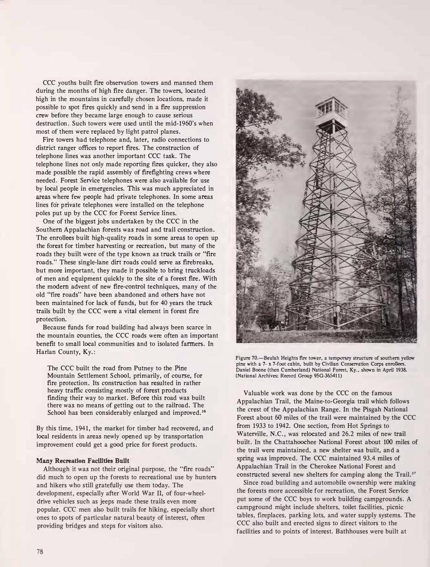
CCC youths built fire observation towers and manned them during the months of high fire danger. The towers, located high in the mountains in carefully chosen locations, made it possible to spot fires quickly and -send in a fire suppression crew before they became large enough to cause serious destruction . Such towers were used until the mid- 196-0's when most of them were replaced by light p atrol planes .
Fire towers had telephone and, later, radio connections to district ranger offices to report fires. The construction of telephone lines was another important CCC task. The telephone lines not only made reporting fires quicker, they also made possible the rapid assembly of firefighting crews where needed . Forest Service telephones were also available for use by local people in emergencies. This was much appreciated in areas where few people had private telephones. In some areas lines for private telephones were installed on the telephone poles put up by the CCC for Forest Service lines.
One of the biggest jobs undertaken by the CCC in the Southern Appalachian forests was road and trail construction . The enrollees built high-quality roads in some areas to open up the forest for timber harvesting or recreation , but many of the roads they built were of the type known as truck trails or "fire roads." These single-lane dirt roads could serve as firebreaks, but more important, they made it possible to bring truckloads of men and equipment quickly to the site of a forest fire . With the modern advent of new fire-control techniques, many of the old "fire roads" have been abandoned and others have not been maintained for lack of funds, but for 40 years the truck trails built by the CCC were a vital element in forest fire protection.
Because funds for road building had always been scarce in the mountain counties, the CCC roads were often an important benefit to small local communities and to isolated farmers. In Harlan County, Ky. :
The CCC built the road from Putney to the Pine Mountain Settlement S chool, primarily, of course, for fire protection . Its construction has resulted in rather heavy traffic consisting mostly of forest products finding their way to market . Before this road was built there was no means of getting out to the railroad. The School has been considerably enlarged and improved. 3 6
By this time, 194 1 , the market for timber had recovered, an d local residents in areas newly open ed up by transportation improvement could get a good price for forest products .
Many Recreation Faclllties Built
Although it was not their original purpose, the "fire roads" did much to open up the forests to recreational use by hunters and hikers who still gratefully use them today. The development , especially after World War II, of four-wheeldrive vehicles such as jeeps made these trails even more popular. CCC men also built trails for hiking, especially short ones to spots of particular natural beauty of interest, often providing bridges and steps for visitors also.
78
Figure 70.-Beulah Heights fire tower, a temporary structure of southern yellow pine with a 7- x 7-foot cabin, built by Civilian Conservation Corps enrollees. Daniel Boone (then Cumberland) National Forest, Ky. , shown in April 1938. (National Archives: Record Group 95G-36541 1)
Valuable work was done by the CCC on the famous Appalachian Trail , the Maine-to-Georgia trail which follows the crest of the Appalachian Range . In the Pisgah National Forest about 60 miles of the trail were maintained by the CCC from 1933 to 1942. One section, from Hot Springs to Waterville, N.C. , was relocated and 26.2 miles of new trail built . In the Ch attahoochee National Forest about 100 miles of the trail were maintained, a new shelter was built, an d a spring was imprm·ed. The CCC maintained 93.4 miles of Appalachian Trail in the Cherokee National Forest and constructed several new shelters for camping along the Trail . 3 7
Since road building and automobile ownership were making the forests more accessible for recreation, the Forest Service put some of the CCC boys to work building campgrounds. A campground might include shelters, toilet facilities , picnic tables, fireplaces, parking lots, and water supply systems. The CCC also built and erected signs to direct visitors to the facilities and to points of interest. B athhouses were built at
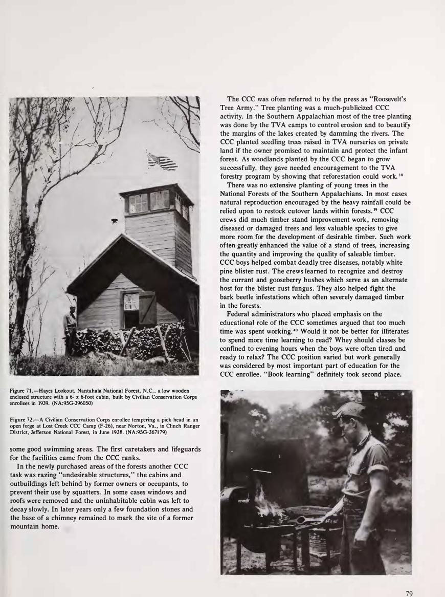
-:.. I .. . / � .. . ·' ,�{:: 1 .
,,,,..- ,- 1 \ \.._ , ,
'" · . - '. ;' - .
: � \� � � -
Figure 7 1 . -Hayes Lookout, Nantahala National Forest, N.C. , a low wooden enclosed structure with a 6- x 6-foot cabin, built by Civilian Conservation Corps enrollees in 1939. (NA:9SG-396050)
Figure 72.-A Civilian Conservation Corps enrollee tempering a pick head in an open forge at Lost Creek CCC Camp (F-26), near Norton, Va. , in Clinch Ranger District, Jefferson National Forest, in June 1938. (NA:9SG-3671 79)
some good swimming areas. The first caretakers and lifeguards for the facilities came from the CCC ranks.
In the newly purchased areas of the forests another CCC task was razing "undesirable structures, " the cabins and outbuildings left behind by former owners or occupants,. to prevent their use by squatters. In some cases windows and roofs were removed and the uninhabitable cabin was left to decay slowly. In later years only a few foundation stones and the base of a chimney remained to mark the site of a former mountain home.
The CCC was often referred to by the press as "Roosevelt's Tree Army." Tree planting was a much-publicized CCC activity. In the Southern Appalachian most of the tree planting was done by the TV A camps to control erosion and to beautify the margins of the lakes created by damming the rivers. The CCC planted seedling trees raised in TVA nurseries on private land if the owner promised to maintain and protect the infant forest. As woodlands planted by the CCC began to grow successfully, they gave needed encouragement to the TVA forestry program by showing that reforestation could work. 3 8
There was no extensive planting of young trees in the National Forests of the Southern Appalachians. In most cases natural reproduction encouraged by the heavy rainfall could be relied upon to restock cutover lands within forests. 39 CCC crews did much timber stand improvement work , removing diseased or damaged trees and less valuable species to give more room for the development of desirable timber. Such work often greatly enhanced the value of a stand of trees, increasing the quantity and improving the quality of saleable timber. CCC boys helped combat deadly tree diseases, notably white pine blister rust . The crews learned to recognize and destroy the currant and gooseberry bushes which serve as an alternate host for the blister rust fungus. They also helped fight the bark beetle infestations which often severely damaged timber in the forests.
Federal administrators who placed emphasis on the educational role of the CCC sometimes argued that too much time was spent working. 40 Would it not be better for illiterates to spend more time learning to read? Whey should classes be confined to evening hours when the boys were often tired and ready to relax? The CCC position varied but work generally was considered by most important part of education for the CCC enrollee. "Book learning" definitely took second place.
79

Benefits to Local Areas
Throughout the life of the CCC , there was continual debate about the quantity and quality of work accomplished. H Since CCC enrollees had to be trained for the work they performed, they naturally accomplished less than would a crew of already skilled laborers. Some Forest Service employees, especially project superintendents, argued that it would have been better to use the money spent on the CCC to employ local skilled workers to do the jobs performed by the CCC on the forests . In spite of efforts to employ as many local people as possible through the CCC, there was always some feeling that the CCC
Figure 73-A 26-year-old white pine plantation thinned and pruned the previous summer by Civilian Conservation Corps enrollees to encourage fast quality timber growth. Nantahala National Forest, N. C., in 1940. (NA:9SG-396044)
80
took jobs away from them. In truth , there is some doubt whether the Forest Service , Park Service , TVA, SCS, or State agencies that employed the CCC would have been able to get funds to have the same work performed by ordinary wage labor. CCC labor was cheap , even though the boys might not accomplish as much as skilled workmen.
The quality of work done by the CCC naturally varied from site to site; much depended on the vigilance and skill of the project superintendent. There were cases of loafing and of slovenly work performance , but these were balanced by examples of hard work resulting in well-built trails and buildings. The Forest Service and other "employing agencies" tried to encourage the enrollment of young men who would make good workers . They sometimes accused the local welfare and employment offices of enrolling the "worst first, " because these young men appeared to be more in need of help . Many young men who enrolled in the CCC required job training and had little or no work experience . However, most of them learned the skills they needed and became good workers. Others left. Efforts were made to reward those who worked well with promotion to crew leader or to skilled jobs. Where there were large numbers of repeat enrollments , work output tended to improve because less training was required.
One advantage that the CCC had over many New Deal "make-work" projects was the the work was "real . " Good project superintendents and district rangers made sure that the enrollees were told why the project they were working on was necessary. For example, they were shown how their particular truck trail or telephone line fitted into the plan for fire control in the district .
Although the CCC presence in the Southern Appalachians was sometimes disruptive, on the whole the program brought the mountains multiple benefits. The CCC employed thousands of local men, providing wages, education, and a sense of accomplishment . Thus, perhaps more than any other New Deal program , the CCC contrib uted much to human dignity in a time of dire economic need.
In addition, the CCC altered the landscape of the Southern Appalachian forests and parks. The fire towers, trails, roads, and campgrounds it built and the trees it planted, thinned, and protected were improvements that controlled fire , enhanced the forests' beauty, and made the mountains more accessible.
The overall impact of CCC camps on local communities, society, and culture can best be evaluated by a comparison. Even before the turn of the century mountain communities had been influenced by the temporary presence of logging or construction camps. Thus, adaptation to the presence of camps similar to those established by the CCC was not new. Railroad building, logging, and mining all brought large groups of "foreigners , " chiefly young males, into the mountains . The impact of these groups on mountain culture and society was chiefly economic and often temporary. These is no evidence that the impact of CCC camps was any greater, or more lasting, but the program did ease conditions at a very critical time .

Reference Notes
(In the following notes, the expression "NA, RG 35" means National
Archives, Record Group 35, Records of the Civilian Conservation Corps; "NA, RG 95, CCC" means National Archives, Record Group
95, Records of the Forest Service (USDA) Records Relating to Civilian Conservation Corps Work, 1 933-42. See Bibliography, IX.)
1. Wayne D. Rasmussen and Gladys L. Baker, The Department of
Agriculture (New York and Washington: Praeger Publishers, 1 972),
34, 35; 89-91 .
2. NA, RG 95, CCC , General Correspondence, Information, Emergency Conservation Work, What ABout the C. C. C. ?, 1937,
1933-42, Information, Records of CCC Work. The CCC newspaper Happy Days is another source of stories about CCC, though few of
these pertain to the region under discussion here.
3. Camp Roosevelt, near Luray, Va. , in the George Washington National Forest , 1 20 miles from Washington, D.C.
4. The following account of the CCC is based on information in
Record Group 35, National Archives. Investigation Reports and Education Reports for camps in the National Forests were used, and
specific citations are given where necessary. John Salmond, The
Civilian Conservation Corps, 1 933-42: A New Deal Case Study
(Durham : Duke University Press, 1967), Chapter 5, "The Selection of Negroes." Black camps were not welcome in most areas of the country
and were limited in number, mostly in the Deep South .
5. Interview with B . W . Chumney, July 1 8 , 1979, Cleveland , Tenn. ;
Interview with J. Herbert Stone.
. 6. NA, RG 35, Investigation Reports , Neill McL. Coney, Jr . , special
investigator, Report on [CCC camp] N.C.F-5, Mortimer, N.C. , Nov.
12, 1933.
7. NA, RG 35, Investigation Reports, Education, June 30, 1937 .
"Federal Aid for Unemployment Relief, " Hearings Before a
Subcommittee of the Committee on Manufactures, U . S . Senate, 72nd
Congress, 1st Session, on S 1 74 and S 262 (Washington : Government
Printing Oftke, 1 932).
8. James R. Wilkins, "The Charges We Watch, " Service Bulletin 23 : 7 (April 3 , 1 939). (USDA, Forest Service , Washington , D.C.)
9. NA, RG 35, Investigation Reports , Education, Elbert Johns, Camp
Kentucky F-13 , McKee [Jackson County] , Ky. , Jan. 30, 1 941 .
10. NA , RG 35, Investigation Reports , Education, Earl C. May,
Camp Kentucky F-4 , Clearfield, Ky. March 1 1 , 1 939.
1 1 . NA, RG 35, Investigation Reports , Education, Carl G. Campbell, Camp Kentucky F-9, Stanton, Ky. Oct . 21 , 1 94 1 .
12. NA, RG 35, Report of Director of CCC Camp Education for year ending June 30, 1 937.
13. NA, RG 95, CCC, CCC Personnel (Training).
14. NA, RG 35, CCC, USDA, Forest Service, "Woodmanship for the CCC, " Washington , 1 934, subsequent editions to 1 940.
15. NA, RG 95, CCC, CCC Personnel (Training), Monthly Education Reports 1939, Camp Old Hickory, Tenn.
16 . Menu and building descriptions are taken from Inspection Reports cited earlier.
1 7 . NA, RG 35, Inspection Reports, Neill McL. Coney, Jr. to
Assistant Director, CCC, Oct. 2, 1937, North Carolina F-7; Neill
McL. Coney Jr. to Assistant Director, CCC, April 7, 1939 , North
Carolina NP-2 1 .
1 8 . NA , R G 3 5 , CCC Station and Strength Reports 1933-42. The records of the following CCC camps were examined for this study:
Kentucky: Camp Lochege , F-4 , Morehead, Rowan County; Camp
Woodpecker, F-9, Stanton, Powell County; (No name), F-13, McKee,
Jackson County; Camp Bell Farm , F-14, Bell Farm, McCreary
County; and Camp Bald Rock, F-15, London, Laurel County, all in
Cumberland (now called Daniel Boone) National Forest: Camp
Elkhorn, S-82 , Hellier, Letcher County (Flat Woods area), and (No
name), S-84, Crummies (Harlan County Game Refuge), both State camps; also several Tennessee Valley Authority camps.
Tennessee: Camp Old Hickory, F-3 , Archville (Benton), Polk
County; Camp Cordell Hull , F-5, Unicoi, Unicoi County; Camp Evan
Shelby, F-1 1 , Bristol , Sullivan County; and Camp Turkey Creek,
F-17, Tellico Plains, Monroe County, all in Cherokee National Forest; also several TV A camps.
North Carolina: Camp Grandfather Mountain, F-5, Mortimer
( Edgemont), Avery-Caldwell County; Camp Alex Jones, F-7 , Hot
Springs, Madison County; and Camp John Rock, F-28 , Brevard,
Transylvania County, all in Pisgah National Forest; Camp Coweeta ,
F-23 , Otto, Macon County; and Camp Santeetlah , F-24, Robbinsville,
Graham County, both in Nantahala National Forest; and Camp Meadow Fork, NP-2 1 , Laurel Springs, Alleghany-Ashe County, Blue Ridge Parkway.
Georgia: Camp Woody, F- 1 , Suches, Union County; Camp
Crawford W. Long, F-7, Chatsworth, Murray County; Camp Lake Rabun, F-9 , Lakemont, Rabun County; and Camp Pocket Bowl, F-16,
La Fayette , Walker County, all now in Chattahoochee National Forest .
(At the time, F-9 was in Nantahala , and F-1 and F-7 were in Cherokee National Forest . )
South Carolina: Camp Ellison D. Smith, F- 1 , Mounain Rest,
Oconee County, then in Nantahala National Forest, now in Sumter
National Forest. (In this list , F stands for National Forest, NP stands for National
Park, and S for State-operated camps.)
1 9 . Interview with B . W. Chumney, July 1 9 , 1 979, Cleveland, Tenn. "Forest Fire Fighter" Cleveland Banner. Cleveland, Tenn. , March 30,
1 978.
20 . NA, RG 35, 1 933- 1 934 , Appendix D-Case Histories, North Carolina, "Summary of Social Values . "
2 1 . NA, RG 35, Investigation Reports, Tennessee F-5, Unicoi, Tenn.
22. NA, RG 35, Investigation Reports, Tennessee F-5, Testimony of George W. Buckner, July 29, 1 934.
81

23 . NA, RG 35 , Investigation Reports, Tennessee F-5, Testimony of
Sheriff M . F. Parsley, Erwin, Tenn. July 29, 1 934.
24. NA, RG 35, Investigation Reports, Tennessee F-5, Testimony of
Alf T. Snead, Limestone Cove, Tenn. July 29, 1 934.
25. NA, RG 95, CCC, Donald E. Clark, Forest Supervisor, to W.M.
Felker, November 24, 1934, Camp Old Hickory, Tenn .
2 6 . NA, RG 95, CCC, General Integrating Inspection Report, Region
8, 1 937.
27. NA, RG 35, Investigation Reports, Kentucky, F-9, Stanton, Ky. ,
C . H. Mackelfresh to T.J. McVey, Sept. 17, 1 935.
28. NA, RG 35, Investigation Reports, Kentucky. T.J. McVey to J.J.
McEntee, Sept. 17 , 1 935.
29. NA, RG 95, CCC, Memorandum for Hiwasee Project
Superintendents from J.W. Cooper, Sept. 1 4 , 1935, Camp Old
Hickory, Tenn.
30. NA, RG 95, CCC, News Release, March 6, 1937, Information,
General 1 933-42; Circular letter from A. W. Hartman, CCC Regional
Office, Dec. 2, 1937, CCC Personnel (Training), Camp Old Hickory,
Tenn.
3 1 . NA, RG 95, CCC. This account of the "Fox Chase and
Barbecue, " April 5, 1938, is taken from local newspaper accounts
found in the CCC Personnel Training file, Camp Old Hickory, Tenn.
82
32. NA, RG 95, CCC, Memo to District Rangers from Forest Supervisor, Cherokee National Forest, June 9, 1 938, National Forest
Development and Protection; Fire Reports to Forest Supervisor,
Cherokee N.F. , 1 935; CCC Inspection Reports , 1933-42, Camp Old
Hickory, Tenn.
33. The following acount of work performed by the CCC is derived
from records cited in notes 4 and 32.
34. John Salmond, The Civilian Conservation Corps 1933-1942, pp.
1 2 1 -1 25; Michael Frome, The Forest Service, p. 20; Ignatz Pikl, Jr. ,
History of Georgia Forestry, pp. 19 , 28, 33. Summaries of work
performed in the individual camps are found in the Inspection Reports
cited earlier.
35. NA, RG 35, "CCC in Emergencies . "
3 6 . NA, R G 95, CCC, Information, General, K . G . McConnell to
G.T. Backus, In Charge, State CCC, May 23, 1941 .
37. NA, RG 95, CCC, Information, Special, H.E. Ochsner, Forest
Supervisor, Pisgah, Memo for Regional Forester, May 24, 1 938. W . H .
Fischer, Forest Supervisor, Chattahoochee, Memo fo r Regional
Forester, March 1 6 , 1 938; P. F.W. Prater, Forest Supervisor,
Cherokee, Memo for Regional Forester, May 1 3 , 1938.
38. Marguerite Owen, The Tennessee Valley Authority (New York:
Praeger Publishers, 1 973) , pp. 30-33 .
39. NA , RG 95, CCC, Personnel (Training), P.F.W. Prater-Forest
Supervisor, Cherokee National Forest, Memo on ECW Education
(Conseration), April 27, 1937, CCC Camp Old Hickory, Tenn.
40. John Salmond, The Civilian Conservation Corps, pp. 47-54 and
1 62-168 .
4 1 . The following discussion of the CCC's accomplishments i s based
on the surviving records of the camps listed in table 3 .

Chapter V
Great Smoky Mountains National Park andthe Blue Ridge Parkway
The New Deal decade of the 1930's introduced the Southern
Appalachians to yet another Federal agency interested in land
acquisition: the National Park Service. Compared to the Forest
Service, the Park Service presence in the region is minor; yet it
has engendered considerable public awareness and controversy.
Although the Park Service operates several small parks,
monuments, and historic sites in the Southern Appalachians,
its presence is most visible in the Great Smoky Mountains
National Park and the Blue Ridge Parkway. 1 The creation of
both parks, which occurred between 1928 and 1940, differed
considerably from the creation of the area's National Forests.
The National Park Service was established in August 1916,
as a result of a conservation campaign similar to the one
leading to the Weeks Act several years earlier. Since the
creation of Yellowstone Park in 1872, 13 National Parks had
been created from the lands of the public domain. These had
been under the jurisdiction of the General Land Office of the
Department of the Interior, but some, like Yellowstone, had
been supervised by the Army and others scarcely managed at
all. Under the chief sponsorship of the American Civic
Association, conservationists, civic groups, and legislators
nationwide rallied behind the idea of scenic preservation, and
promoted a separate agency to manage the parks on an active
basis.2
The purposes of National Parks differ from those of National
Forests (originally called forest reserves). The principal
difference is that the parks stress preservation and the forests
stress "wise use" of their natural resources. National Parks are
areas of special national significance; many exhibit unusual
natural scenic grandeur. The Act of 1916 which organized
them under a National Park Service states that they were
created "to conserve the scenery and the natural and historic
objects and the wild life therein and to provide for the
enjoyment of the same in such manner and by such means as
will leave them unimpaired for the enjoyment of future
generations." 3 In a National Park the forest is left essentially
as it is; if trees mature, they are not harvested; if they fall,
they are left to rot.4 No timber harvesting, grazing by domestic
livestock, mining, or hunting is allowed in National Parks, but
fishing may be permitted, and individual dead trees that pose
a hazard may be removed.
The National Forests, as is explained in Chapter VIII, are
and have long been managed for a variety of public uses and
needs. The so-called Organic Administration Act of 1897
provided for protection and management of the forests to
insure favorable water flow and a continuous supply of timber
for the needs of the Nation. In 1905 Secretary of Agriculture
James Wilson emphasized that "all the resources . . . are for
use" and directed the Forest Service to manage the forests so
"that the water, wood, and forage . . . are conserved and
wisely used . . . [for] the greatest good to the greatest numberin the long run." 5 The first major uses of the forests were
providing wood for local settlers and industries, and forage for
grazing of local domestic livestock. Before long it was
recognized that the forests were also important for public
recreation activities and as habitat for diverse forms of
desirable wildlife. Later on the Forest Service pioneered in
setting aside special areas as wilderness. The principle of
multiple uses, begun under Gifford Pinchot, first Chief of the
Forest Service, thus developed. It is explained in detail in
Chapter VIII.
Although certain land-management goals of National Parks
and National Forests are somewhat similar—such as
encouraging visitors and providing some facilities for them,
encouraging and protecting wildlife, controlling dangerous
fires, and preserving wilderness—the two agencies do have
basic differences that can result in conflict at times.
The Forest Service and National Park Service have often
been competitive. Their rivalry dates from Pinchot's successful
negotiations for transfer of the forest reserves from Interior to
Agriculture in 1905. The Forest Service opposed the creation
of the National Park Service in 1916, believing that a separate
agency was not needed to manage the country's most
outstanding scenic areas, that the Forest Service could do the
job just as well. Many such areas have been transferred from
the Forest Service to the Park Service. A few National
Monuments are still supervised by the Forest Service. Rivalry
between the two services has continued to the present, rising in
intensity during years when a merger of the two services or a
large land transfer is proposed. 6
The land acquisition policies of the two agencies differ as
well. Units of the National Park System are created by
individual acts of Congress; there is no legislation comparable
to the Weeks Act authorizing general, ongoing land acquisition
for the National Park System. In addition, until the 1960's,
National Parks that had not been set aside from the public
domain were acquired by State, local, or private agencies, and
title was subsequently transferred to the United States. Thus,
the lands for the Great Smoky Mountains National Park were
purchased by specially formed park commissions in Tennessee
and North Carolina; lands for the Blue Ridge Parkway were
purchased by the States of North Carolina and Virginia. Some
lands for the Parkway were transferred from the Forest
Service.
Most important, eastern National Parks have been created
through the power of eminent domain; unwilling sellers have
had their lands condemned. In contrast, eastern National
Forests have been created only with "willing buyer-willing
seller" acquisitions. Since a National Forest is a multipurpose
area to be used by man, taking all the land within a given
forest boundary has not been considered necessary. A National
Park, as an area of scenic preservation, usually must be wholly
controlled to be preserved. Thus, acquisition of land for a park
usually erases human enterprise and culture from the
landscape.
83

Origins of Great Smoky Mountains National Park
After lying dormant for almost 20 years, the movement for a
National Park in the Southern Appalachians came to life again
during the winter of 1923-24. Since becoming first director of
the National Park Service, Stephen T. Mather had favored an
eastern park; for several years the Service had been
considering possible sites. At a dinner at the prestigious
Cosmos Club in Washington in December 1923, Mather,
Congressman Zebulon Weaver of Asheville, and others resolved
to press for a park in the Southern Appalachian region. In
1924, the Secretary of the Interior appointed a special
Southern Appalachian National Park Committee to study
potential sites.7
At the same time, pro-park groups were coalescing in the
region itself. In Knoxville, Tenn., Willis Davis, manager of the
Knoxville Iron Co., along with a small group of businessmen
and attorneys, formed the Great Smoky Mountains
Conservation Association for the purpose of raising interest in,
and money for, a National Park and a road through the
Smokies. Meanwhile, a group of North Carolina citizens
reactivated interest in a Southern Appalachian park. In 1924,
the State legislature created the North Carolina Park
Commission for the purpose of securing a National Park in
North Carolina. At first the North Carolina group preferred
Figure 74.—Great Smoky Mountains National Park, view from State Line Trail
looking down Forney Creek watershed southeastward toward Little Tennessee
River, in 1931. (National Archives: Record Group 95G-259049)
the site of Grandfather Mountain and Linville Gorge; however,
after the national committee recommended the Blue Ridge
Mountains of Virginia and the Great Smokies as the best sites
for Appalachian parks, the North Carolina Park Commission
shifted its focus to the Smokies.
The national committee was convinced of the suitability of
the Smokies as a location for a National Park not only on
account of its scenery but also its forests: "The Great Smokies
easily stand first [in park sites] because of the height of
mountains, depth of valleys, ruggedness of the area, and the
unexampled variety of trees, shrubs, and plants." 8It was the
largest area of original forest remaining in the eastern United
States.9 Indeed, the "unexampled" tree cover had made the
Smokies a loggers' paradise. Timber companies had been
operating in the mountains for 30 years; in 1925, fully 85
84
percent of the area was timber company-owned. Although
much of the land had been clearcut or culled, the steepness
and remoteness of the area had delayed extensive logging in
places; at mid-decade about one-third of the Smokies was
judged to be still primeval forest.
Preservation of this unique forest was the goal around which
an intense campaign began in 1925 in both Tennessee and
North Carolina. In 1925 there was no Federal authority to
purchase land for a National Park, as there was for a National
Forest. Thus, wrote Mather, "the only practicable way
National Park areas can be acquired would be donations of
land from funds privately donated. 10 Each State set out to
raise at least $500,000 toward initial land acquisition.
Donations were sought from all levels of society, across both
States. An earnest newspaper campaign began urging the
importance of the Great Smoky Park. The appeals were to
both esthetics and economics: preservation of the forest from
inevitable destruction by the timber companies was urged; at
the same time, the economic rewards of tourism to the area
were assured. The park promised to be a tremendous boon to
the mountain region, in the cash it would bring to businesses,
in the employment it would offer, in the population increase
the area would experience. 11
Opposition to the creation of a National Park in the Great
Smoky Mountains was vehemently expressed by a majority of
the area's lumber companies. Indeed, the idea was anathema
to them. They proposed instead the creation of another
Appalachian National Forest: a compromise that would
provide a scenic recreation site while allowing lumbering to
continue.
Chief among the opposition spokesmen was Reuben B.
Robertson, president of Champion Fibre Co. of Canton, N.C.
Champion owned nearly 100,000 acres of spruce and mixed
hardwoods in the very center of the Smokies which the
company had bought from smaller companies about 10 years
before. About 9,000 acres of the tract had been logged, but
most was virgin timber. 12 Robertson began a publicity
campaign via newspapers and pamphlets to counter the park
enthusiasts. Although his primary motivation was to protect
the economic interests of Champion, his arguments were also
based on the value of scientific forestry. Since most of the
Smokies were cutover or culled, he reasoned, they should not
be left to the course of nature but managed under sound
principles of silviculture. The Forest Service was, to Robertson,
clearly the preferable land management agency. 13
Support for Robertson's position was, if not widespread, at
least strong. North Carolina lumber companies almost
universally sided with Champion. Andrew Gennett, of the
Gennett Lumber Co. of Asheville, agreed too, but proposed a
compromise 100,000-acre park along the crest of the Smokies
within the boundaries of a National Forest. 14 In Tennessee, the
movement for a National Forest as an alternative to a park was
led by James Wright, a landowner in Elkmont and attorney for
the Louisville-Nashville Railroad. The movement was initially
strong enough to defeat the first bill in the Tennessee
legislature to buy a tract from the Little River Lumber Co.
Sentiment for a National Park, however, was ultimately
stronger, although it is difficult to gauge the degree of public
awareness of the park-vs. -forest issue. The newspapers, at
least, carried the debate. Horace Kephart, of Bryson City,
N.C, author of Our Southern Highlanders, argued against
Robertson in an article in the Asheville Times of July 19, 1925:
... if the Smoky Mountain region were turned into a
national forest, the 50,000 to 60,000 acres of original
forests that are all we have left would be robbed of
their big trees. They would be the first to go.
Why should this last stand of splendid, irreplaceable
trees be sacrificed to the greedy maw of the sawmill?
Why should future generations be robbed of all chance
to see with their own eyes what a real forest, a real
wildwood, a real unimproved work of God, is like?
It is all nonsense to say that the country needs that
timber. If every stick of it were cut, the output would
be a mere drop in the bucket compared with the
annual production of lumber in America. Let these few
old trees stand! Let the nation save them inviolate by
treating them as national monuments in a national
park. 15
Indeed, Kephart reminded his readers, the Forest Service
did not want a National Forest in the Great Smokies; the
earlier purchase unit there had been dissolved and options to
purchase relinquished. Others argued that a National Forest
could not compare to a park in the tourist trade it would
bring. As Dan Tompkins, editor of the Jackson County
Journal, expressed the sentiment, "We have examples of
national forests in Jackson and most of the other mountain
counties, and if a single tourist has ever come here to see
them, we've missed him." 16
In the end, the arguments against lumbering, and for
scenery, recreation, and tourism, were stronger. Local response
to the fund-raising campaign was seemingly enthusiastic; by
the end of 1925, several hundred thousand dollars had been
pledged. Although a considerable amount of money was
raised, the base of support for the movement is difficult to
ascertain. As with the first Appalachian park movement, the
second one was principally an urban, professional coalition, led
by the business leaders of Asheville and Knoxville. The roles of
publishers Charles A. Webb of the Asheville Citizen and Times
and Edward Meeman of the Knoxville News-Sentinel were
certainly key to the campaign's success. The movement was
well organized, and its appeal was broader than that of the
earlier park movement. Although there were undoubtedly
small landholders and people employed in lumbering who
opposed the coming of the park, their spokesmen were few;
their opposition was overwhelmed by the momentum of the
park idea.
85

First Tract Purchased in 1925
In 1925 the first tract of land for the Great Smokies park
was purchased: 76,507 acres from the Little River Lumber Co.
for $3.57 per acre. One-third'of the $273,557 purchase price
was paid by the City of Knoxville, two-thirds by the State of
Tennessee. The tract was essentially the lands that had been
optioned for purchase as a National Forest 10 years earlier.
Most had been heavily cut, and lumbering was underway on
the remaining acres. In fact, Col. W. B. Townsend, owner of
the lumber company, sold the tract with timber rights for 15
years to all trees over 10 inches in diameter. 17
On May 22, 1926, President Calvin Coolidge signed a bill
passed by the 69th Congress authorizing Federal parks in the
Blue Ridge and Great Smoky Mountains, all land for which
was to be purchased with State and private funds. 18 The Great
Smoky Mountains National Park was originally to be 704,000
acres. Once 150,000 acres were purchased, administration by
the National Park Service would begin; once a minimum of
300,000 acres was purchased, the park could actually be
developed.
The next 2 years involved a search for purchasing funds.
Early in 1927, North Carolina appropriated $2 million for park
land acquisition; Tennessee followed with an appropriation of
$1.5 million. In 1928, John D. Rockefeller, Jr., offered $5
million from the Laura Spelman Rockefeller Memorial
Foundation on a dollar-for-dollar matching basis. Although
finances remained tight, the Rockefeller grant assured that
acquisition could begin on a large scale.19
Land acquisition for the Great Smoky Mountains Park took
approximately 10 years, although certain condemnation suits
were not resolved until the 1940's. The total area of the park
contained more than 6,600 separate tracts. Over 5,000 were
small lots that had been auctioned or sold for summer homes;
almost all were in Tennessee. About 1,200 tracts were small
mountain farms from 40 to several hundred acres in size; most
were in Tennessee as well. The majority of the land was in a
few large tracts held by timber companies, primarily in North
Carolina. Among them were the Champion Fibre, and the
Suncrest, Norwood, William Ritter, Montvale, and Kitchen
lumber companies. Because most of the smaller tracts were in
Tennessee, land acquisition there was more difficult and time-
consuming. North Carolina park acquisition was almost
complete by 1931 ; by 1934 only a 60-acre tract remained to be
purchased. Tennessee on the other hand, was actively
acquiring tracts as late as 1938. 20
The authority for land acquisition was in the hands of the
North Carolina and Tennessee park commissions. Verne
Rhoades, former Forest Service officer, was executive secretary
of the North Carolina Commission. At first the commissions
were reluctant to take land by condemnation, but gradually
they realized that it was necessary in some cases. The timber
firms often asked prices the commission could not pay, and
some of the smaller farmers were as resistant to selling as the
timber firms. If an owner were particularly stubborn, he was
permitted to sell his property at a lower price and become a
lifetime tenant. The tactic was often used to determine which
owners were clinging to their land out of genuine love and
which were trying to drive hard bargains. 21
Lumber Companies Violently Oppose Selling Lands
Some lumber companies expressed determined opposition to
the purchase of their lands. In 1928 the Suncrest Lumber Co.,
having been asked to halt logging operations, and anticipating
condemnation, challenged the constitutionality of the North
Carolina Park Commission and its right to condemn. In a
series of court battles the Commission won not only its right to
force timber operations to halt, but also its right to condemn
in State courts. In 1929, Suncrest closed its logging operations
completely, but the tract was not purchased until 1932, when
litigation over the price of the tract was resolved. The North
Carolina Park Commission paid $600,000 for the almost
33,000-acre tract.22
The opposition of Champion Fibre Co. to the Great SmokyMountains National Park at first had been fierce; however,
after the North Carolina park appropriation of $2 million was
passed, Robertson relented, and Champion subsequently
suspended logging operations on its tract. Preliminary
negotiations to purchase the property were begun in late 1929,
but it soon became apparent that the park commissions and
Champion placed vastly different values on the land. In
January 1930 the Tennessee Park Commission began
condemnation proceedings to acquire its share of the tract.
Tennessee valued the 39,549 acres on its side at from $300,000
to $800,000; Champion claimed the acreage was worth between
$4 million and $7 million. Champion based the figures on the
incomparable quality of the area's spruce timber and the
almost total dependence of the Canton mill on this spruce.
Indeed, the Canton mill -and rail lines had been built
specifically to handle the spruce. Robertson's perspective in
1929 was that the loss of the spruce supply would mean an end
to the sulphite mill. As he recalled later, in spite of the
desirability of the park for the State and community, "we had
a duty to our stockholders to protect their investment." 23
In November 1930, a Sevierville jury awarded Champion
$2,325,000 for the tract as well as $225,000 in damages to the
Canton mill. Tennessee, outraged, threatened to appeal the
case. Champion was not satisfied either; Robertson wanted $4
million for the tract.24 Two months later he announced that
Champion would resume logging on the Tennessee property;
with that, the Tennessee Park Commission appealed the jury's
decision.
The problem was finally resolved when National Park
Service director Horace Albright called Champion and park
commission officials to Washington. There, in spite of bitter
personal disagreement between Robertson and Col. David
Chapman of the park commission, a settlement was reached.
Champion was paid $3 million for its 92,814.5-acre tract: over
$32 per acre. In spite of Robertson's predictions, Champion's
mill at Canton did not close. Over the course of the next
decade the company perfected a process of making high-
quality paper from pine fiber as a substitute for spruce. In
86

i
fact, pine, available from the Piedmont, proved to be a
cheaper resource than the Smoky Mountains spruce, and
assured a much more profitable operation.
On the whole, the small farmers and lot holders, if not
eager, were often willing to sell their land for the park. There
were, of course, exceptions, some of whom were as resistant to
the park as Champion and Suncrest. The lines of battle were
drawn over prices: the disparities between values placed on
land by the park commissions and those by the landowners
were often wide.
The Cades Cove Settlement
Probably the most famous condemnation cases involved
selected tracts in the Cades Cove area of Tennessee. Cades
Cove, a wide valley surrounded by some of the Smokies'
highest peaks, was a settlement of farms that had been passed
down through families for several generations. John Oliver,
who owned 375 acres in Cades Cove, absolutely refused to sell;
condemnation proceedings began in 1929 but the case was not
settled until 1935. The apparent source of Mr. Oliver's hostility
to the park was a particular person on the acquisition team,
who was subsequently replaced. Mr. Oliver was paid $17,000
for his farm, over $45 per acre."
The Tennessee commission tried a series of tactics to
persuade the Cades Cove opponents to sell. Ben Morton of
Knoxville, whose father had been a respected physician in the
area, was sent to Cades Cove as ambassador of goodwill. It
was in response to Cades Cove opposition that the commission
began allowing especially resistant oldtimers to remain lifetime
tenants on their land if they sold at a lower price.
Other pockets of recalcitrant owners were the Elkmont and
Cherokee Orchards areas of Tennessee, where some cases were
not settled until the late 1930's. One especially well-known
condemnation case concerned the 660-acre property of W. O.
Whittle, not far from Gatlinburg. Whittle valued his land at
$200,000; park estimators offered no more than $40,000. Thecase was in litigation until 1942, when a federal jury awarded
Whittle $36,700, over $55 per acre. 26
Other opposition to the park took the form of general
disgruntlement with the Tennessee and North Carolina park
commissions. In North Carolina, $51,000 in park funds hadbeen lost in the 1931 failure of an Asheville bank. Over the
next few years of the Depression, the expenditures of the
commission often seemed extravagant. Protest was strong
enough to effect change. In 1933, North Carolina reduced the
size of the commission and appointed a new set of
commissioners; in Tennessee, the commission was abolished
and its duties transferred to the Tennessee Park and Forestry
Commission.
Roosevelt Gets CCC Money For Park
In spite of these changes, the prices paid for land were often
higher than anticipated and, even with the Rockefeller grants,
the commissions ran out of funds twice. In December 1933,
President Roosevelt secured $1,550,000 in CCC funds for the
park, most of which went to pay for North Carolina lands.
Several years later more funds were required. In 1937
Tennessee Senator Thomas McKellar attached to a bill
appropriating money for lands in the Tahoe National Forest in
Nevada, an amendment providing almost $750,000 to complete
purchases in the Smokies. The bill passed in 1938. 27
In general, the prices paid for park land were high,
especially compared to prices paid for National Forest lands
during the same years. Prices for large tracts in the Pisgah,
Cherokee, and Nantahala National Forests during the 1930's
averaged between $3 and $10 an acre. Even the incomparable
"virgin" timber of the Nantahala forest's Gennett tract
brought only $28 per acre. In the Smokies, Champion's land
sold for $32 an acre. Companies other than Champion were
paid well for their land. Suncrest's tract was settled in 1932 for
over $18 per acre. In 1933, the Ravensford Lumber Co. tract,
over half of which had been cutover, sold for over $33 per
acre. In 1935 the large Tennessee tract belonging to the
Morton Butler heirs was settled for over $15 per acre; the
owners were outraged at the low price.28
To some degree, land values for the park were inflated by
demand. The stated goal of buying all the land within the park
boundaries undoubtedly encouraged some landowners,
confident that the government would eventually buy, to hold
out for higher prices. Built into some of the prices, of course,
were the costs of litigation, damages, and delay. For example,
when the Sevierville jury awarded a settlement to Champion
Fibre, they included $225,000 for damages for the company's
railroad and mill.29 Nevertheless, considering that most of the
Smokies' timberland had been cut and that Depression prices
prevailed over the region, the discrepancies were large.
Land acquisition agencies were aware of the high prices
being paid. In 1935 the Agricultural Adjustment
Administration discussed cooperating with the Park Service in
acquiring submarginal land in Haywood County, N.C., which
could then be added to the park. The Forest Service also was
enlisted to help. Samuel Broadbent, Supervisor of the Pisgah
National Forest, felt the Forest Service could acquire a half
dozen tracts along the Pigeon River at more moderate prices
than the park commission, and pledged cooperation with the
Park Service and AAA. 30 However, according to Roger Miller
of the Great Smoky Mountains National Park headquarters,
the Forest Service never acquired any land for the park. 31
The Park's Effects on the Mountain People
In 1931, the headquarters of the Great Smoky Mountains
National Park was established at Gatlinburg, Tenn., and the
park was developed slowly. In 1936, after more than 400,000
acres had been acquired and turned over to the Federal
Government, the Park Service assumed responsibility for land
acquisition. In 1940 the park was dedicated by President
Roosevelt.
S7

Until most of the area within the park boundaries was
consolidated, land management was fragmentary and difficult.
Protecting the area from fires, vandalism, and hunting was the
major management activity. It was particularly difficult to stop
mountaineers from hunting on grounds they had used for that
purpose for generations. Incendiary fires also plagued the first
park rangers. Fire control improved over the decade with
construction of fire towers and fire control roads by the CCC.
During 1934 and 1935 there were 16 CCC camps active within
the park, with over 4,000 men employed. 32
In slightly more than a decade, there was an almost
complete change in landownership within the park area. The
timber companies either closed down, as Suncrest did. or
resumed operations elsewhere. (The vast majority—85
percent—of the land was held by 18 lumber companies.) 3 '
Altogether, about 4.250 people, or "00 families, were affected
by the creation of the park. 34 Most small farmers and their
families in the Smokies settled on farms in adjacent pans of
Swain, Sevier, and Graham counties, or in nearby villages.
Gatlinburg. for example, which was a hamlet of only "5 people
in 1930. grew to 1.300 residents by 1940. almost entirely as a
result of park outmigration. 35
In 1934 a survey of Tennessee families whose lands had been
acquired for the park was undertaken by W. O. Whittle for
the University of Tennessee Agricultural Experiment Station,
to ascertain the impact of relocation on the lives of the people
involved. Information was obtained on 528 families, and 331
were personally interviewed. The survey revealed that most
families had relocated on adjacent land. Only 2.6 percent of
the families moved to other States, and 22 percent to other
counties. Fifteen percent retained temporary or life occupancy
within the park boundaries. 36
In general, the survey found that for the 331 families
interviewed, movement from the area of the Great SmokyMountains National Park increased tenancy, decreased the
average acreage held, and increased unemployment. Yet most
relocated families also were closer to church, schools, and
stores in their new locations, and found agricultural conditions
more favorable. Overall. 54 percent of the families interviewed
regarded the conditions of their former and new locations to be
equal.
Land acquisition and outmigration continued at a trickle
over the decades of the 1940's and 1950's. as boundaries were
adjusted and most difficult cases settled. The pattern of
outmigration was similar to that of the 1930's. In 1982 the
park contained 515.000 acres or 208.600 hectares, about 805
square miles, with about 2.600 acres of inholdings yet to be
acquired. 3"
Economic Boom Benefits Only a Few
The economic boom that park enthusiasts had promised was
slow to arrive, and some would question whether it ever came
at all. Although the annual number of visitors to the Great
Smoky Mountains National Park increased over the years to
over 3 million, the money left by them went only to a small
portion of the local population. The Gatlinburg area, for
example, virtually exploded in commercial acreage, number of
businesses, gross business receipts, and residential subdivision,
but the beneficiaries of this growth were few. Most of
Gatlinburg's business district was owned for many decades bv
a few prominent families: the Ogles. Whaleys, Huffs, and
Reagans. Thus, "the benefits of commercial land ownership,
primarily in the form of contract rents, are flowing largely to a
small group of local residents.'" 3
!
Others who invested in
Gatlinburg were outsiders: either large, nationally based
chains, in the case of businesses, or vacationers and
subdivision developers, in the case of residential land.
Meanwhile, for those who were dislocated by the park, the
benefits of tourism were meager, if not nonexistent. 39
The grievances against the park were sometimes specific, as
in the case of many Swain County residents over the non-
completion of a highway which the Federal Government
promised to rebuild. Swain County is almost 82 percent
federally owned: one half of the county is within the park, and
half the Cherokee Reservation is in the county; much of the
remaining land is part of the Nantahala National Forest.
TVA's Fontana Dam. built in 1943. backed Fontana Lake
halfway across the county. Several people who lived on park or
TVA land relocated in the interstices of the National Forest. 40
In 1940. even after the park was dedicated, park officials
and park enthusiasts wanted to include one more major tract
within park boundaries: almost 45.920 acres north of the Little
Tennessee River in the area of Fontana. N.C. 4: The tract
belonged to the North Carolina Exploration Co., a subsidiary
of the Tennessee Copper Co. It was traversed by North
Carolina Highway 288. from Bryson City to Deal's Gap.
Acquisition of the land would ease the administration of park
regulations against hunters and poachers, and would help fire
control. The value of the land, however, was exorbitantly high
for the Park Service.
TVA Acquires Fontana Dam Site
During World War II. TVA acquired 44.000 acres of the
tract for Fontana Dam. The lake created by the dam cut off
Highway 288. TVA agreed to rebuild the road, but had
insufficient funds to do so. Thus, a convenient exchange
between Federal agencies occurred. TVA gave the remaining
land to the Great Smoky Mountains National Park. (At the
same time. TVA transferred acreage south of the lake to the
Forest Service.) The Park Service now had the regular
boundary it desired, down to the shores of Lake Fontana. and
in return agreed to rebuild Highway 288. Thus. TVArelinquished its responsibility for building a road, the Park got
its desired land, and the people of the area were given a
promise. 42
In 1982 the promise was still unfulfilled. Only 6 miles of the
road was built from Bryson City into the park. At one point
construction was halted because of the legal question of the
right of the National Park Service to build a nonaccess road
through the lands of the North Carolina Exploration Co. In
1979 the road was not being built because of the
environmental hazards it might bring. Excessive cutting and
B8

filling would be required on steep slopes; the mineral content
of the soil would cause a dangerous runoff. Anakeesta, the
predominant mineral, has been known to cause deadly
pollution in mountain streams. 43
The people of Swain County are not receptive to this reason
for the Park Service's failure to rebuild its highway. They
believe that their county has inadequate access from outside
and, therefore, cannot participate in whatever benefits accrue
from park tourism. In addition to access from without,
residents have lost access to areas within the park that were
homesites and farm sites. About 26 family cemeteries have
been cut off from access by road; they can be reached only by
boat across Fontana Lake, and then by foot or horseback up
the mountains. Off-road vehicles are prohibited in the park. 44
It was not the intent of the Park Service to eliminate the
former culture of the Smoky Mountains region. In fact, the
settlement of Cades Cove has been preserved as a historical
area, with an operating grist mill and country store.
Nevertheless, because the park has no permanent inhabitants
and because the field and forests cannot be used as they
formerly .were, the park bears no sign of an active culture. The
same can be said of the Blue Ridge Parkway, to be considered
next.
Blue Ridge Parkway, a New Deal Project
It was not long after the establishment of National Parks in
the Blue Ridge and Great Smoky Mountains that the idea
developed to connect the Shenandoah National Park to the
Great Smoky Park by a scenic mountain highway.
Congressman Maurice Thatcher of Kentucky had promoted
the idea as early as 1930. Since 1931 the Skyline Drive had
been under construction in the Shenandoah National Park.
The road had proved a welcome source of employment for the
mountain regions particularly hard hit by the Depression; the
idea of extending this roadway from the Shenandoah Park to
the Smokies seemed logical, even inevitable.
The Blue Ridge Parkway was actually conceived during a
meeting at the Virignia Governor's mansion in Richmond in
September 1933. Although no single person can be credited as
Parkway originator, Virginia's Senator Harry F. Byrd was
instrumental in the inaugural phase of the project, convincing
Interior Secretary Harold Ickes, and therefore President
Franklin Roosevelt, of the Parkway's value. Official reaction to
the proposed highway was immediate and almost universally
enthusiastic. Within 2 months S4 million had been allotted for
the Blue Ridge Parkway, and plans for its construction
begun. 45
The beginnings of the Parkway present a contrast to those of
the Great Smoky Mountains National Park. Coming in 1933 at
the Depression's depth and with the New Deal's optimistic
launching, the Parkway passed immediately into the Federal
domain. It was, from the beginning, not just a National Park
but a relief project, and was supported and orchestrated from
Washington.
With FDR's blessing, money for Parkway construction was
allotted in December 1933 by the Special Board for Public
Works under the National Industrial Recovery Act. This
Federal funding was assured after the States had agreed to
purchase the necessary right-of-way of 200 feet and deed it to
the Federal Government. Secretary Ickes assigned the Parkway
to the jurisdiction of the National Park Service, which was to
cooperate with the Bureau of Public Roads in its construction.
Initial local reaction to the proposed highway was almost
unanimously favorable. Hundreds of letters were received by
Federal and State officials from mountain residents offering
their land for rights-of-way, requesting that the Parkway be
routed through a particular town or piece of property, or
asking for employment in highway construction. One such
letter received by North Carolina Congressman Doughton from
a resident of Sparta pleaded for "us people that lives along the
crest of the Blue Ridge . . . cut off from the outside world . . .
We would be glad to give you the Right a way to get the
Road." 46
The Parkway was welcomed especially as a source of
economic relief. Part of its appeal was undoubtedly its relative
immediacy, but the boost anticipated was short-term, in
contrast to the economic boom anticipated from tourism to the
Great Smoky Park not a decade previously. The tourism the
Parkway would bring in the future was secondary to the
employment the Parkway would offer right away to absorb the
labor surplus of the mountains. According to the Asheville
Citizen, other Federal agencies and relief programs could not
equal the Parkway in the quantity and type of economic
assistance offered:
The National Industrial Recovery Act would do little
for them [the mountain residents] because they hadrelatively few industries; the Agricultural Adjustment
Act could not offer much aid because their small farms
had no important staple crop; the Tennessee Valley
Authority could offer little immediate help, if ever; the
creation of Shenandoah and the Great SmokyMountains National parks and a series of national
forests had removed much property from the tax books
and had halted the timber work which had employed
thousands. Thus, a great local construction project,
such as road building, appeared to be their only
salvation.47
Opposition expressed toward the construction of the
Parkway was scattered and feeble. Certain conservation groups
registered concern about the highway. Nature Magazine in a
1935 editorial protested that the Parkway would ruin the
landscape and allow careless dispersal of trash; Robert
Marshall, who a few years later became Recreation Director of
the Forest Service, expressed worries at a 1934 meeting of the
American Forestry Association that the Parkway would destroy
wilderness areas.48 Certain owners of summer mountain cabins,
threatened with the loss of their private retreats, protested the
road. On the whole, however, in the middle of the 1930s the
Blue Ridge Parkway was a much-applauded, happily
anticipated regional gain.49
89

The selection of the route of the Blue Ridge Parkway
absorbed nearly a year of bitter wrangling between North
Carolina and Tennessee for Federal favor. The final choice of
a route along the higher mountain ridge in North Carolina, by
Grandfather Mountain, and by Asheville, to enter the Great
Smoky Park at Cherokee, was made by Secretary Ickes in late
1934. Actual acquisition for the Parkway began shortly after
the final route selection was announced. 50
The National Park Service required that for every mile of
parkway, 100 acres be acquired in fee simple, and 50 acres of
scenic easement be controlled. The average width of the right-
of-way strip was to be 1,000 feet, and no less than 200 feet.
Although Virginia never accepted these requirements, for the
most part North Carolina did. Both States had the power to
condemn by eminent domain; in North Carolina, simply
posting the Parkway's route through a given county at the
county courthouse established the right to title. In Virginia,
the acquisition procedure was the same as for other State
roads. 51
Altogether 38,000 acres in North Carolina and 23,500 acres
in Virginia were acquired for the Blue Ridge Parkway. The
Parkway deliberately bypassed existing communities; thus, for
the most part, the land acquired was in the most remote and
sparsely populated areas of the mountain counties. Many of
the people whose land was affected lived in small isolated
cabins or on meager subsistence farms. In some cases, area
residents had never heard a radio. 52 The surveyors for the path
of the Parkway often found the land as remote and
inaccessible as had the early Forest Service surveyors 20 years
before.
Parkway Land Acquisition Proves Difficult
In both States, in spite of the eagerness that initially greeted
announcement of the Parkway, acquisition of both rights-of-
way and scenic easements proved much more difficult than
anticipated. This difficulty was due partly to popular confusion
and misunderstandings about what the scenic easement and
right-of-way for a National Parkway imply. In the case of a
right-of-way, title is held by the Park Service; in the case of an
easement, the landower continues to hold title but relinquishes
to the Federal Government certain controls over the use or
appearance of the land. In both cases, roadside development,
commercial frontage, and access are strictly prohibited. Thus,
a landowner selling a right-of-way or easement received no
direct benefit from the Parkway, save the one-time payment
for the land. Furthermore, there may have been a discrepancy
between those who wrote the editorials proclaiming a county's
eagerness for the roadway and those whose land actually lay in
the Parkway's path. It was probably easy for a mountain
county in 1934 to applaud the coming of the Parkway in
general, but not so easy for individual mountaineers 2 years
later to accept that their particular tract would be taken.
Although many residents were pleased to sell their mountain
land at a time of economic deprivation, some counties had
scores of condemnation cases during the acquisition process.
Figure 75.—Tiny dilapidated log cabin, similar to many encountered on the
right-of-way of the Blue Ridge Parkway and in Great Smoky Mountains National
Park. This one was on lower slopes of Flat Top Mountain, between Troutdale
and Konnarock, Va., in July 1958, near the present Mt. Rogers National
Recreation Area, east of Damascus, near the Tennessee and North Carolina State
lines. (Forest Service photo F-487199)

f ';
Figure 76.—View from Blue Ridge Parkway showing mountain farm home, andfields and forest lands encountered along the route. Forests were heavily culled,
and many farm fields were worn out and returning to brush. This scene, taken in
1948, is on lower slopes of Sharp Top in the Peaks of Otter region of the
Jefferson National Forest near Roanoke, Va. (Forest Sen-ice photo F-452145)
Tales of mountaineers' fierce resistance to land sales echo
those of Cades Cove in the Great Smokies. One owner, for
example, challenged the constitutionality of the North Carolina
law appropriating the purchasing funds; one refused to move a
barn from the acquired right-of-way and had it sliced down the
middle instead; one threatened a bulldozer with a double-
barrel shotgun. Some landowners were ultimately able to avoid
losing their land. As in the Great Smoky Park, several grants
of lifetime tenure were given as exceptions to elderly people
whose families had held the land for generations and who were
especially resistant to moving. In addition, some summerhomeowners were persuasive enough to have the Parkway re-
routed around their tracts."
It must be remembered that most landowners sold only a
strip or corner of their land; except where the original acreage
was small, losing a strip did not necessarily infringe on the
privacy or coherence of a tract. Poor mountaineers obviously
suffered more than large landholders. In some areas more than
a strip of land was involved where special developments were
planned along the 477-mile Parkway route: recreation sites for
camping and picnicking; service areas for lodging, eating, and
automobile service. For them, at least several hundred acres
had to be acquired.
The effect of acquiring special development park areas on
the lives of the people who had resided there suggests what
some other mountaineers along the Parkway route experienced.
Families forced to give up their farms were suddenly
confronted with the necessity of finding new homes and, in
some cases, new employment. For some, the process of
relocation was relatively easy; for others, relinquishing their
land brought confusion and helplessness. Five of the special
service areas became part of a Land Use Project funded by the
Resettlement Administration in May and June 1936. The five
areas totaled 5,300 acres, most of which was optioned for
purchase by the summer of 1937. A total of 39 families had
lived on the acreage and, with option for purchase, had moved
on their own or were helped to relocate. 54
91
The North Carolina special service areas were in Alleghany,
Wilkes, and Surrey counties, none of which had had any
National Forests or other Federal land project. Of the 13 North
Carolina families who were affected, 10 moved on their own.
Most of them did not move far. Several owned other tracts
nearby on which they settled; 3 became tenants on neighboring
farms. In May 1937, 3 of the families still remained on the
park land, but none was to be allowed to stay longer and all
needed Resettlement aid to relocate. These 3 families had been
farming plots of less than 20 mountainous acres; their cash
incomes averaged less than $100 per year. The families
averaged 6 members; their housing was sub-standard at best.
Although all were poorly educated and untrained, they were
regarded by welfare workers as having "a tenacious and
fighting spirit." None had ever been on relief before. 55 The 3
families wished to resettle on farms close to their current
homes. They were expected to be paid between $4 and $10 per
acre for their lands; all were expected to need help in finding
land and employment.
The summary of proposals and recommendations regarding
the people displaced by the park areas may speak for other
mountaineers all down the Parkway route:
The majority of families living within the park areas
were living on submarginal land, and most of the
persons living there were the owners of the tract on
which they lived. The families themselves felt that in
selling their land they had done a service for the
government. They are worried and at a loss to knowthe reason for the great delay in being paid, and the
necessity for a relief status before they can get work in
the park. In the majority of cases the only asset the
family had was the farm on which they lived. They will
receive so small a sum for their land that it will be
impossible for them to continue as self-supporting
citizens unless some aid is given. In many cases advice
in buying new land is necessary in order that the family
will not be influenced to buy land that will not meet
their needs and on which they cannot improve their
condition. 56
In general, it appears that for the poor mountaineers whose
lands were taken for the Parkway, compensation was meager
and slow to arrive. Some may have felt they helped their
Government, but they were confused and upset about the
delay in payment for their land. For the poorest, dislocation
seems to have necessitated relief payments and a welfare
status. Even for those who profited nicely by their land sales,
the long-term benefits may have been limited. Profits from sale
of land with inflated values are often illusory when the seller
tries to reinvest in comparable land. 57
The Blue Ridge Parkway did, however, bring employment to
the region, supplying numerous jobs from 1935 until World
War II. Four CCC camps employing about 150 boys each were
established along the route of the Parkway; the Emergency
Relief Administration sponsored several building projects as
well. Private contractors on the Parkway were required to use
as much local labor as possible; laborers had to be recruited
from the relief and unemployment rolls of the counties through
which the road was built. It has been estimated that of all the
hard labor the Parkway involved, only 10 percent was imported
from outside the immediate region. 58
Actual Parkway construction began in September 1935,
almost 2 years after authorization, on a portion of the Parkway
near the North Carolina-Virginia line. More than 100 menfrom the relief rolls of Alleghany County, N.C., were recruited.
Eventually, local men were hired to help in surveying, land
clearing, fence building, planting, erosion control, truck
driving, and construction of recreation and service facilities.
Wages were the minimum 30 cents per hour, which was
generally far more than was obtainable elsewhere in the area.
As a long-term employer, however, the Blue Ridge Parkway
served a limited role. After construction was completed, the
Parkway continued to employ, and still does, local residents in
the service areas, for maintenance, repairs, and grounds
keeping, but the staff is not large.
Parkway Bypasses Mountain People
Aside from the initial money received for the sale of land
and scenic easements, and the Depression employment it
supplied, the Blue Ridge Parkway bypassed the people of the
Southern Appalachians. The Parkway forbids roadside
development and commercial establishments, minimizes access,
avoids existing communities and arterials, and prevents new
ones from encroaching. A visitor can travel the entire Parkway
and, except for exhibit areas preserved by the Park Service,
scarcely see a sign of the mountain culture the road has
displaced. Like the Great Smoky Mountains National Park,
the land acquisition for, and the management of, the Blue
Ridge Parkway have done little to preserve or enrich the
culture of the Southern Appalachians.
Forty years later it is still important to recall the impact of
the New Deal on the Southern Appalachian highlands. The
coming of largescale lumbering had altered the economy and
the landscape of the region in the years following the turn of
the century. The alterations made by the New Deal were just
as profound, but very different. Earlier change came from
increasing exploitation of resources and people. The New Deal
marked the first real attempt to protect them. However, NewDeal programs were ultimately unable to change entirely the
pattern of thoughtless exploitation of resources such as timber
and coal. The people and the land benefited from the New
Deal, but it was not enough.
In the mountains as everywhere in the United States, the
New Deal brought agencies of the Federal Government directly
into the lives of ordinary people for the first time. For the first
time people were encouraged to think that Federal programs
might solve their local problems.
92

Reference Notes
The National Forests had been in the mountains for 20
years, but they had had limited visibility and impact. Much of
the land purchased earlier was cutover timber land with few
inhabitants. As the forests were expanded during the NewDeal, they became more important to the economies of the
neighboring counties and began to push aside some local
residents. Forest expansion was only part of the large Federal
land acquisition carried out by various agencies. The Park
Service and the Tennessee Valley Authority in particular
bought numerous small tracts of land from mountain people.
The number and complexity of these land purchases
guaranteed that many sellers would be left with a grievance
against "the government."
The benefits of the land purchases are often more readily
visible to those removed from the scene by time or distance.
Today the economic development programs, electric power,
erosion and flood control brought about by TVA have made an
obvious contribution to life in the Southern Appalachian
region. The Great Smoky Mountains Park and the Blue Ridge
Parkway are national treasures enjoyed by millions of visitors
every year. The National Forests have become increasingly
important for outdoor recreation and as places where
Appalachian hardwoods can grow for future generations. In
the 1930's in mountain neighborhoods it was often easier to
think of families displaced and rural villages gone than of the
future benefits available to those who remained.
Although there were some problems and conflicts, the CCCgenerated more good will than any other Federal program of
the '30s. Employment provided by the CCC was invaluable to
many mountain families. Welfare programs could have a
demoralizing effect on the mountain people, as Caudill points
out in Night Comes to the Cumberlands. 59 But the CCC was
not a "something for nothing" program. By encouraging work
and learning, it provided a valuable antidote to the
hopelessness the Depression had added to an area already
beset with economic problems.
It is difficult to evaluate the impact of the growing
recreation use of the mountains. The potential for enjoyment
of the mountains was preserved and greatly increased by NewDeal developments. Long frequented by the wealthy, mountain
resorts became more accessible to the automobile-owning
middle class. The park, parkway, and forest recreation
provided are a blessing to those, often from urban areas, whouse them; but they are a mixed blessing to mountain people.
Tourist business can contribute to a local economy, but the
contribution is rarely a large one, as many people of the region
were to realize in the 1960's and 1970's. 60
It was the Forest Service, with its emphasis on long-range
production of a renewable resource, that contributed the most
to the preservation of possibilities for the old mountain way of
life. The lands it took over generally remained open for
traditional uses such as wood gathering, hunting, fishing, and
berrying. The Forest Service and the CCC together provided
the best job opportunities for mountain men during the
Depression years. The growing timber promised employment
for the future as well.
(In the following notes, the expression "NA, RG 83, FHA" means
National Archives, Record Group 83, Farmers Home Administration
(USDA). See Bibliography, IX.)
1. Other national parks in the Southern Appalachian region include
the Chickamauga-Chattanooga National Military Park, the
Cumberland Gap National Historical Park, and the Andrew Johnson
National Historic Site in Greenville, Tenn.
2. Jenks Cameron, The National Park Service (New York: D.
Appleton and Company, 1922). William C. Everhart, The National
Park Service (New York: Praeger Publishers, 1972).
3. National Park Service Act, 39 Stat., 535.
4. Everhart, The National Park Service, pp. 184, 185.
5. James Wilson, Secretary, to the Forester, Forest Service, 1
February 1905. History Section files, Forest Service.
6. A detailed treatment of the rivalry between The National Park
Service and the Forest Service is found in Allan Jarrell Soffar,
"Differing Views on the Gospel of Efficiency; Conservation
Controversies Between Agriculture and Interior, 1898-1938" (Ph.D.
dissertation, Texas Tech University, 1974).
7. Jesse R. Lankford, Jr., "A Campaign for a National Park in
Western North Carolin, 1885-1940," p. 48. Master's thesis, Western
Carolina University, 1973.
8. Carlos C. Campbell, Birth of a National Park in the Great Smoky
Mountains (Knoxville: University of Tennessee Press, 1960), p. 29.
9. Alberta Brewer and Carson Brewer, Valley So Wild: A Folk
History. Knoxville: East Tennessee Historical Society, 1975, p. 349.
10. Elizabeth S. Bowman, Land of High Horizon. Kingsport, Tenn.:
Southern Publishers, Inc., 1938, p. 180.
11. Lankford, "A Campaign for a National Park in Western North
Carolina," pp. 61, 62.
12. Carlos C. Campbell, Birth of a National Park in the Great Smoky
Mountains. Knoxville: University of Tennessee Press, 1969, p. 92.
13. Lankford, "A Campaign for a National Park," p. 53, 55.
14. Lankford, "A Campaign," 53, 55.
15. Horace Kephart, The Asheville Times, July 19, 1925, cited in
Bowman, Land of High Horizon, p. 188.
16. Jackson County (North Carolina) Journal, November 25, 1915, p.
2.
17. Campbell, Birth of a National Park, Chapter 4.
18. 44 Stat. 616; 16 USC 403.
19. Campbell, Birth of a National Park, Chapters 5-9. See also
Lankford, "A Campaign for a National Park."
93

20. Campbell, Birth of a National Park. p. 70.
21. Campbell, Birth of a National Park, p. 70.
22. Lankford, "A Campaign for a National Park," p. 82.
23. Elwood R. Maunder and Elwood L. Demmon, "Trailblazing in
the Southern Paper Industry," p. 9. Forest History 3 (Winter 1960),
Forest History Supplement No. 2.
24. Campbell, Birth of a National Park, pp. 84, 85.
25. Campbell, Birth of a National Park, p. 98.
26. Campbell, Birth of a National Park. p. 128.
27: Campbell, Birth of a National Park, Chapters 16, 17.
28. Campbell, Birth of a National Park, pp. 116-118.
29. Campbell, Birth of a National Park, p. 84.
30. NA, RG 96, Records of the Farm Security Administration
(USDA), Region 4, Correspondence of Director, Land Policy Section,
Division of Program Planning, AAA, Letter from Paul Wager,
Resettlement Administration, to Sam Broadbent, Supervisor, Pisgah
National Forest, August 6, 1935.
31. Telephone interview with Roger Miller, Great Smoky Mountains
National Park, Gatlinburg, Tenn., November 15, 1979.
32. Campbell, Birth of a National Park, p. 125.
33. Campbell, Birth of a National Park, p. 12.
34. W.O. Whittle, "Movement of Population From the SmokyMountains Area," University of Tennessee Agricultural Experiment
Station, 1934, p. 2.
35. Jerome Eric Dobson, "The Changing Control of Economic
Activity in the Gatlinburg, Tennessee Area, 1930-1973" (Ph.D.
dissertation, The University of Tennessee, 1975), p. 13.
36. W.O. Whittle, "Movement of Population From the SmokyMountains Area."
37. Telephone interviews with Roger Miller, Gatlinburg, Tenn.,
November 15, 1979, and February 18, 1982. The principal inholding is
a 2,300-acre tract owned by Cities Service Corp., just north of
Fontana Lake. The other very small scattered tracts are the park
borders and may be deleted.
38. Jerome E. Dobson, "The Changing Control of Economic
Activity," Ph.D. dissertation, p. 91.
39. Dobson, "The Changing Control," p. 91.
40. Interview with Frank Sharp, Forester, National Forests in North
Carolina, Asheville, May 11, 1979.
41. Campbell, Birth of a National Park, p. 131.
42. Campbell, Birth of a National Park, p. 130-132.
43. Rick Gray, "Swain County Gets Political Ear," Greensboro Daily
News, August 20, 1978.
44. Rick Gray, "Swain County."
45. Harley E. Jolley, "The Blue Ridge Parkway: Origins and Early
Development" (Ph.D. dissertation, Florida State University, 1974), p.
71.
46. Harley E. Jolley, "The Blue Ridge Parkway," p. 76.
47. The Asheville Citizen, June 28, 1934, in Jolley, "The Blue Ridge
Parkway," p. 89.
48. Jolley, "The Blue Ridge Parkway,' P- 78.
49. Jolley, "The Blue Ridge Parkway,' P- 80.
50. Jolley, "The Blue Ridge Parkway,' Chapter 8.
51. Jolley, "The Blue Ridge Parkway,' P- 174.
52. Jolley, "The Blue Ridge Parkway,' P- 180.
53. Jolley, "The Blue Ridge Parkway,' P- 191-194.
54. NA, RG 83, FHA (USDA), Land Use Summary Reports for
Project LP-VA-8, and LP-NC-11, Blue Ridge Parkway Project, Land
Utilization Reports, Relocation of Families.
55. NA, RG 83, FHA, Land Use Summary Reports, Blue Ridge
Parkway Project, FHA, p. 1-1.
56. NA, RG 83, FHA, Land Use Summary Reports, Blue Ridge
Parkway, FHA, p. 14.
57. Jerome E. Dobson, "The Changing Control of Economic
Activity," Ph.D. dissertation, p. 137.
58. Harley E. Jolley, "The Blue Ridge Parkway," p. 189.
59. Harry Caudill, Night Comes To The Cumberlands. Boston: Little,
Brown and Company, 1962, pp. 184-186.
60. See, for example, Jeffrey Wayne Neff, "A Geographic Analysis of
the Characteristics and Development Trends of the Non-Metropolitan
Tourist — Recreation Industry of Southern Appalachia" (Ph.D.
dissertation, University of Tennessee, 1975); Dobson, "The Changing
Control of Economic Activity;" and Anita Parlow, "The Land
Development Rag," in Colonialism in Modern America: The
Appalachian Case, pp. 177-198.
94

Chapter VI
World War II Through the Fifties: From FDR to JFK
World War II marked the beginning of major economic and
demographic changes in the Southern Appalachians. The
wartime boom was temporary, and afterward the Depression
returned. Many people left to find work elsewhere; rural farm
population declined dramatically between 1940 and 1960.
Meanwhile, Federal land acquisition nearly stopped as national
priorities shifted. The Forest Service had to cope with a major
increase in demand for outdoor recreation and balance that
demand with other forest uses and needs. Although problems
of National Forest management in the Southern Appalachians
during the 1950's occurred in apparent calm, the region's
poverty remained, and the potential conflicts among forest uses
which were to receive national attention in the 1960's had
already appeared.
With the outbreak of war in Europe in September 1939, new
and increasing demands were placed on the Nation's
manpower and natural resources, demands that accelerated
when this country entered the war in December 1941. Wartime
production and mobilization revitalized the Depression-worn
national economy. By 1944 half the country was engaged in
war-related production, and full employment had returned. 1
The Southern Appalachians experienced a good share of
wartime changes as coal and timber prices began to rise. Old
Figure 77.—Crew with crosscut saw and double-bit axe checking large mature
white pine marked for harvest for the Appalachian Forest Products mill near
Clayton, Rabun County, Ga., on Chattahoochee National Forest, July 1941. Themill was the first to be operated on a sustained-yield basis in North Georgia anddepended on the Forest for most of its timber. (Forest Service photo F-414090)
jobs in mining and lumbering reopened and new industries
were established close to the mountains. Although emergency
New Deal programs were gradually phased out, the popular
and effective CCC lasted until war came to America, and the
Tennessee Valley Authority continued to provide construction
and related employment through the war years.
Heavy Demand for Timber
Demands on the Nation's timber resource were heavy. Woodwas needed to build bridges, barracks, ships, aircraft, and
above all packing crates for shipping supplies overseas. Vital
wood products were cellulose for explosives, wood plastic,
rosin, and glycerol. Wood was classified as a critical material
by the War Production Board. Although the heaviest demandfor wood fell on the Douglas-fir forests of the West and the
coastal southern yellow pines, the hardwoods and conifers of
the southern mountains were also needed. 2
The wartime demand for timber increased sales from
National Forests throughout the South — from 94.2 billion
board feet in 1939 to 245.3 billion in 1943. 3 High war demandsled to heavy cutting, especially of such desirable hardwoods as
redgum and yellow- (tulip) poplar. There was a strong market
even for previously unwanted "limby old field pines and
inferior hardwoods." The total cut was still less than half of
the estimated overall timber growth there, however. This was
true because the forests all contained considerable second-
growth timber which, although growing rapidly, was still not
mature enough for harvesting. 4

Figure 78.—Crew using peavies to roll a huge yellow-poplar log down to loading
platform on Chattahoochee National Forest, July 1941. (Forest Service photo
F-414105)
Figure 79.—Lumber crew rolling yellow-poplar logs from skidway platform to
truck on Chattahoochee National Forest, July 1941. (Forest Service photo
F-414107)
Reflecting Forest Service policy, and the generally scattered
and small volume available, about 90 percent of the timber
was disposed of in sales of less than $500 each. The supervisor
of the Cumberland (since renamed Daniel Boone) National
Forest related in 1941:
. . . one mountain inhabitant purchased sufficient
timber in small lots to make 1,200 railroad ties. Hehired help to cut the timber; hewed the ties himself;
skidded them to the roadside with his own mule; hired
trucking of his product to the point of acceptance. Hecleared about $600 on his operations. He has 14
children. This $600 was probably more money than the
family had seen in the last eight years. 5
Such sales were intended to take care of the little man, but
they also made timber sale supervision and coordination
harder. As the war went on, forest administration became
more difficult. Many men had been drafted or had enlisted.
Thus, timber stand improvement work, as well as cleanup and
road repair work after timber sales, were not being done. 6 Anassessment of the situation in Region 8 in 1943 stated that "in
general, standards of performance are poorer," largely because
"many of our best men are in the armed forces and have had
to be replaced with poorer ones." 7
,-ffli
—— <
96

Even a large outfit that had been logging in the region since
1900 felt the pinch. When the supervisor of the Chattahoochee
National Forest asked the Gennett Lumber Co. in September
1944 why it had left logs in an area, an agent responded:
... we had not intended to abandon any scaled logs
that are on Cynth Creek ... we were forced to moveover to Owl Creek so we could get men to operate. Thelabor situation got so critical on Cynth Creek that wecould not keep things going. . .
8
Since this forced the Forest Service to scale the area twice, a
penalty was considered. The supervisor explained, "At a time
when we are short of men and pushed to get the job done, the
leaving of incompleted areas is costly to both you and us." 9
As discussed earlier, land acquisition had been a major
activity before the war. As late as 1937, it was felt that "the
extension of government ownership in areas of low production
and high watershed values as in the mountainous . . sections
[of Region 8] is unquestionably desirable." 10 However, Weeks
Act funds dropped dramatically, from $3 million or more per
year to $354,210 in 1943, $100,000 in 1944, $75,000 in 1945,
and nothing at all in fiscal year 1946. 11
However, land exchanges continued briskly through the war
period. Desirable inholdings and adjacent lands were acquired
in exchange for timber from Forest Service lands, with
emphasis on facilitating sustained-yield management,
experimental forests, and administrative economy. 12
One problem, which was to become of increasing
significance later, first appears in reports from war years. This
was the decline in personal contact between National Forest
officers, especially district rangers, and the people living on or
near the forests. A 1943 forest inspection report observed that,
because of the volume work, "they (the rangers) know the
bankers, members of service clubs, etc., but the lesser lights
living on the forest are neglected." 13 Rangers already had less
of what oldtimers on the Cherokee refer to as "spit-and-whittle
time." Mountain people prefer those who are not in a hurry to
do business, but will "set a spell," and visit.14 Fortunately, a
reservoir of goodwill between the Forest Service and
mountaineers had been build up during the Depression, chiefly
through the CCC. Only after the war would a lessening of such
personal contacts lead to friction.
Coal Mining Revived
In addition to demands for timber, the war brought huge
orders for coal, giving the few mining companies that had
survived the Depression a new lease on life. As demand grew,
new companies were formed, and by 1942 it was boom time
again in Southern Appalachian coal country. Miners returned
to the delapidated company towns, and new housing was
hastily constructed. Old men, youngsters below draft age, and
those with serious health problems were accepted for mine
work. The military had swept up the cream of mountain
youth, fortunately for many of them. However, the
development of heavy-duty trucks and the "duckbill" coal
loader helped reduce the need for manpower, a trend that
accelerated. 15
Depression-born attempts to diversify the economy of the
coal-producing regions were wiped out by the demand of the
wartime boom. As Caudill describes it:
The whole attention of the area's population fastened
again on coal. The blossoming farmers among whomCounty Agricultural Agents had worked so hard
discarded seed sowers and lime spreaders for picks and
shovels. The small but growing herds of pure-bred
livestock were turned into pork and beef.16
The same could be said for efforts to develop the timber
resources of the coal counties. Early in the war the last stands
of "virgin" hardwood forest in Kentucky were cut. Only in the
cutover lands purchased for the new Cumberland National
Forest was any thought given to creating a sustained-yield
forest that could provide a continued wood-using industry in
the area.
Figure 80.— Ranger Edgar F. Wolcott, Wythe District, Jefferson National Forest,
Va., talking with a local farmer in July 1958. (Forest Service photo F-487235)
97

The benefits of the wartime boom, however, should not be
exaggerated. As L. E. Perry, a former general ranger district
assistant and fire control officer for the Forest Service on the
forest, has written of the impact,of the wartime economy on
McCreary County, Ky.:
The coal and lumber industry was vigorous in
McCreary County but there was an exodus of the
working people, even teachers, to northern plants and
to the armed services. Consequently, there were
shortages—of materials; manpower; money. Food andfuel were rationed. There was not enough of anything
to go around. Hoarding and the blackmarket
flourished . . . When at last the war was over, recovery
was slow.17
In some areas of the Southern Appalachians, stepped-up
coal and timber production continued for several years after
the war. For example, in Clear Fork Valley of Claiborne
County, Tenn., between the Cumberland and the Cherokee
National Forests, 10 underground mines producing 750,000
tons of coal a year and employing nearly 1,400 men were still
actively operating in 1950—a holdover from war production
years. However, like other Southern Appalachian counties
almost entirely dependent on one or two extractive industries,
Claiborne succumbed to a serious postwar depression, keenly
felt by the mid-1950's. 18
Helping to hold up the postwar demand for soft coal in the
eastern Kentucky and Tennessee area was a new steam power
plant constructed there by the Tennessee Valley Authority.
The Stearns Coal and Lumber Co. of Stearns, Ky., was alert
to this new major consumer of its main product. Early in 1953
the company contacted the District Ranger at Stearns and the
Supervisor of the Cumberland National Forest at Winchester.
It was anxious to rework the coal seams in the 47,000 acres it
had sold the Government more than 15 years earlier. Many of
the old seams still contained blocks of coal close to the surface
of hillsides. This coal had not been removed during earlier
deep mining because of the danger of collapse of the mine
tunnels. Now, with higher prices and recently developed earth-
moving equipment, this coal could be recovered by strip-
mining. The soil and rock cover could be dug away with power
shovels and bulldozers to expose the coal for loading directly
into huge trucks. The debris would be mostly dumped down
the hillsides, thus clogging streams.
The Forest Supervisor, H.L. Borden, told Stearns that he
was opposed to permitting strip-mining on the tract. A clause
in the 1937 deed of sale for the Stearns tract reserved authority
for the Forest Service to require adequate reclamation of
ground surfaces disturbed by mining. Borden retired in May.
He was succeeded by Robert F. Collins, who met with
company officials in August and received a formal request a
week later. Collins sent a copy of the request to the Eastern
Regional Forester, Charles L. Tebbe, with a memo of his own
urging that the request be denied. Collins pointed out that
serious erosion and stream pollution would result, if approval
were granted, and the action would thus be in direct violation
of the stated purposes of the Weeks Act, which authorized the
National Forest land purchases. In addition, he noted that a
dangerous precedent would be set for National Forests
throughout the East where mineral rights had been reserved. It
was estimated by the Forest Service that 2,000 linear miles of
strip-mining in the old Stearns tract could result from approval
of the request.
The Stearns request was reviewed by the Regional Office in
Philadelphia and by the Washington Office and lawyers of the
Department of Agriculture. A consensus was reached, and on
January 29, 1954, Tebbe officially denied the request.
On July 1, 1954, the company renewed its request, pointing
out that a new Kentucky strip mine law requiring surface
reclamation had just become effective, and contending that
this law should provide adequate protection to the affected
areas. (See Chapters VII and VIII). On July 30, Tebbe again
denied the application. On August 29, Robert L. Stearns, Jr.,
president, appealed in person to the Secretary of Agriculture,
Ezra Taft Benson, in Washington. Benson referred the request
to Richard E. McArdle, Chief of the Forest Service, who again
conferred with his staff and with Department lawyers.
Convinced that such mining would irreparably damage the
land, streams, and wildlife of the Forest, McArdle denied the
appeal, which was then taken to the Secretary for a final
decision.
McArdle suggested that a special board be appointed by
Benson to study the situation and give an advisory, but not
binding, opinion. The board would be composed of a noted
leader in the national resource field, a professional mining
engineer, and a public member to be chosen by the other two.
Benson and Stearns agreed. The men appointed were Samuel
T. Dana, who had just retired as chairman of the Department
of Natural Resources at the University of Michigan; Robert L.
Wilhelm, a coal operator of St. Clairsville, Ohio; and Charles
P. Taft, a prominent Cincinnati attorney who was son of
former President William H. Taft and brother of the
Republican Senator, Robert A. Taft. The board visited the
area in January 1955 and examined the sites that would be
strip-mined as well as other sites being strip-mined. The board
also conducted a public hearing near Stearns, which attracted
wide publicity. During the entire period of this controversy the
Forest Service had received many letters from the public,
mostly opposing the mining project.
On May 12, 1955, the board reported to Benson that a
majority recommended denial of the Stearns request. On July
22, 1955, Assistant Secretary of Agriculture Ervin L. Peterson
publicly affirmed the Forest Service denial. The company
decided not to appeal the decision in the courts."
During the war the labor-short lumber and mining
industries had tried hard, with varying success, to gain draft
deferments for their skilled employees. The Gennett Oak
Flooring Co. of North Carolina pleaded with the Asheville
draft board to let it retain experienced workers to meet
demands of the War Production Board for lumber and avert a
shutdown. 20
98

Wartime military service changed the outlook and lives of
many. Young men often did not return permanently to the
mountains. The "G.I. Bill of Rights" offered college education
to those who might never have considered it. With new skills
and confidence gained during military service, they worked to
become teachers, engineers, pharmacists, doctors, lawyers, and
football and basketball coaches. A few even studied forestry, a
subject they had first come to know as teenagers in the CCC. 21
The Tennessee Valley Authority
One New Deal program which continued to flourish during
the war was the Tennessee Valley Authority (TVA). Increasing
needs for electric power, especially for aluminum production,
quieted the opposition of industry to increased TVA power-
generating capacity. In 1942 and 1943, TVA had 42,000
employees working on 12 projects throughout the Southern
Appalachian region, the highest employment figure ever
recorded by the agency. 22
Most impressive of all was Fontana Dam on the Little
Tennessee River high in the mountains of Swain and GrahamCounties, N.C., just south of Great Smoky Mountains National
Park. Fontana, the highest dam east of the Rockies, built to
generate electric power for industry, was claimed to be justified
by the war effort; it was rushed with a sense of urgency and
high purpose. Before work could begin a road had to be built
to carry in heavy construction equipment. Fontana Village,
with peak population of 6,000, was built nearby for workers
and their families. Work on the dam began shortly after Pearl
Harbor, and for nearly 3 years men worked in round-the-clock
shifts, under floodlights at night. In November 1944 the damwas finally closed and Fontana Lake began to fill, only a few
months before the end of the war. 23
Jobs were plentiful everywhere during those years; therefore
to keep workers at Fontana, a model community was
developed, with library, schools, a small hospital, and
recreational facilities. The project manager encouraged
planting of gardens and flowers as an excellent way to reduce
turnover in the work force. Those who planted gardens would
want to stay and see them grow. 24
Besides hydroelectric power, TVA plants produced
fertilizers, chemicals for munitions, and synthetic rubber. Thecartographic section of TVA, established to design maps of the
region as an aid in planning and land purchases, was used by
the Army to make maps for military planning. Supplying
wartime needs helped TVA maintain political independence
and continue many of its long-range social goals.
The uranium processing facilities for the atomic bomb, at
Oak Ridge, Tenn., just west of Knoxville in Anderson County,
require brief mention. The most notable aspect of the project
that mattered to the local population was that they were forced
permanently out of their ancestral homes and their communitywas destroyed. Today many East Tennesseeans take pride in
the scientific accomplishments of Oak Ridge; however, in
1941, their parents' and grandparents' prime concern was that
the Army Corps of Engineers suddenly swooped in to condemn
59,000 acres of land, and abruptly evicted nearly 1,000
bewildered and resentful rural families from their homes and
farms. No argument or protest was permitted; the need was
considered too urgent.
Operating under the cover name of ManhattanEngineering District, Marshall (chief of the district)
and his colleagues moved quickly — too quickly for
many of the people in this affected area of Tennessee.
After a September site inspection by Brig. Gen. Leslie
R. Groves, named in this month to head the entire
Manhattan Project, a battery of Corps attorneys and
surveyors entered the area and began mapping. In
early October, condemnation proceedings got under
way and a declaration of taking was filed in federal
court at Knoxville. It called for immediate possession
of the land, even though appraisals and transactions
with individual owners had not yet begun.
By November, residents leaving the area were passing
an incoming flood of construction workers. 25
Partially because of the population dislocation and partially
because of the influx of atomic energy employees from other
regions, the Knoxville area swelled in population during the
1940's. When the Oak Ridge plants were phased down during
the 1950's, Knoxville experienced a net migration loss.26
In sum, the wartime emergency brought a temporarily
booming economy to the Southern Appalachians. The natural
resources of the region—timber, coal, and water power in
particular—were in high demand; the labor supply to marshall
the resources was short. Prices and wages were high, as the
area responded to wartime needs. With an emphasis on
military materiel production, certain aspects of prewar forest
management, such as land acquisition (except for Oak Ridge),
recreation, and conservation, were momentarily de-
emphasized. These concerns, however, returned to importance
when the war mobilization wound down.
Heavy Migration to Cities
The Second World War not only affected national
production and employment levels, it also brought large-scale
shifts in population distribution. Between 1940 and 1950 about
1 million people migrated from farms to cities, and stayed
there. The national rural-to-urban migration accelerated
during the 1950's, as more than 5 million persons from
nonmetropolitan areas moved to Standard Metropolitan
Statistical Areas (SMSA's). The Southern Appalachian region
contributed many migrants to other regions during and after
the war, as its farm population declined sharply, and
manufacturing became increasingly important.
99

Figure 81.— Nantahala River in the Gorge above junction with Little Tennessee
River and Fontana Lake, a Tennessee Valley Authority power and flood control
reservoir on the border of Great Smoky Mountains National Park, Swain County
N.C., in July 1960. Nantahala National Forest. (Forest Service photo F-494664)
100

Population changes in the Southern Appalachians between
1940 and 1960 were particularly dramatic. Between 1940 and
1950, its rate of growth fell below 10 percent for the first time
since the first census of 1790. Between 1950 and 1960, its
population declined. 27 Over the 189-country area defined by
the 1960 Thomas Ford study, this loss was 2.8 percent, or
about 160,000 persons. Net migration loss alone (in vs. out)
was 19 percent. 28 However, the change and the rate of change
in population growth varied considerably. The Valley and
Ridge subregion on the east side gained population, through
urban-industrial growth in the broad river valleys. But the
Appalachian Plateau subregion, particularly eastern Kentucky,
had heavy losses, due primarily to the sharp postwar drop in
coal industry employment as new technologies, and greater use
of alternative fuels such as oil and gas, forced economies in the
coal market. The population of the Blue Ridge subregion did
not change markedly over the same period. Here, "the
development of industry and tourism undoubtedly served to
retard out-migration." 29
As with the Nation as a whole, metropolitan areas of the
Southern Appalachians grew more or lost population less
between 1940 and 1960 than did the nonmetropolitan areas.
Between 1940 and 1950, the nonmetropolitan counties gained
by less than 15 percent, compared to 20 percent for the others.
Between 1950 and 1960, nonmetropolitan population declined
6 percent; metropolitan population increased 7 percent. 30 Theregion's metropolitan gains over the two decades were minor
compared to those in most such areas of the United States. In
fact, between 1950 and 1960, all SMSA's of the region defined
by Ford except Roanoke, although gaining population overall,
experienced a net migration loss. Asheville and Knoxville lost
migrants at relatively high rates. 31
Most of the region's migration during the postwar years was
between adjacent counties or within the same State. Available
data on destinations of migrants into and out of the region
during 1940-50 show most movement was short, intracounty or
to a contiguous county. In more than 80 percent of the region,
less than 20 percent of the migrants went to another State. Ofthose who did, the patterns were fairly regular over the two
decades. Most interstate migrants from the Appalachian
Plateau subregion moved to Ohio, Michigan, and Illinois.
Most migrants from southwestern Virginia, if they left the
state, traveled to the District of Columbia and Maryland, 32
where Federal employment offered opportunities.
In general, as with most migrations, the majority were
young—between 18 and 34. Most were white, male, and above
average in education. Outmigrants, especially those moving
longer distances, tended to be younger than inmigrants. Thus,
in the postwar period, the population of the Southern
Appalachian region defined by Ford became relatively older,
with more persons 65 or over. Also, because women of child-
bearing age were leaving in increasing numbers, a slowing
down of the region's rate of natural increase for the following
decades was assured. 33
The demographic shifts that occurred in the region during
and after the war are reflected in farm statistics. Between 1940
and 1950, its rural farm population declined sharply, so that in
1950, for the first time, the rural farm population was smaller
than either the rural nonfarm or urban populations. 34 During
the 1940's, as many who had held onto their farms during the
1930's found employment elsewhere, the rural farm population
experienced a net loss due to migration of 595,000 persons, a
rate of over 28 percent. This loss was greatest in the Kentucky
counties, followed by those of Tennessee. 3S
Demographic Changes Are Confirmed
For the smaller area of the Southern Appalachians on which
this study focuses, the demographic changes between 1940 and
1960 were very nearly as dramatic as for the larger region
defined in Ford's study. In both decades the coal counties of
eastern Kentucky had the greatest outmigration losses and the
greatest population shifts. Within the area with a high
concentration of land in National Forests, most counties
experienced a net migration loss. The greatest migration losses
(40 percent or more) from 1940 to 1950 were in Kentucky: the
Cumberland National Forest counties of Jackson and Wolfe; as
well as in Hancock County, Tenn., a coal county, and Swain
County, N.C., most of which is within the Great SmokyMountains National Park. Other counties suffering heavy net
outmigration were Polk County, Tenn., and Rabun County,
Ga., both of which had a large proportion of land in National
Forest; and the Kentucky counties of Estill, Lee, Morgan,
Menifee, Harlan, Letcher, Perry, and Clay. 36 Between 1950
and 1960, the greatest losses from net out-migration were
experienced in Lee County, Va.; Swain County, N.C.; and the
eastern Kentucky counties of McCreary, Bell, Harlan, Letcher,
Perry, and Leslie.37
In general, then, the heaviest net outmigration from the
Southern Appalachians during the period from 1940 to 1960
was from coal-producing counties. That is, population loss
appears chiefly correlated with changes in the mining industry,
not with changes in Federal land acquisition or land policy.
One exception stands out: Swain County, N.C. The heavy
move from Swain County was forced by the closing of Great
Smoky Mountains National Park to residents. Between 1940
and 1950, over 40 percent of them left, many to adjacent
Sevier County, Tenn., where Gatlinburg is located. Sevier was
one of the few counties to show a net migration gain. 38
12 Counties Are Selected For Full Analysis
For a narrower focus on the demographic and economic
changes that have occurred in the Southern Appalachians since
World War II, we have selected a group of 12 mountain
counties for further detailed analysis. This group consists of six
counties with a high proportion of land in National Forests and
six counties with little or no National Forest land. The former
counties are considered representative of the core counties of
the region. Each has a long (at least 40-year) history of Federal
land acquisition and land management.
101

The latter group was selected as approximating many of the
physical traits of the former group except for high Federal
landownership. Each is mountainous (although not so much as
the counties of the former group) and nonmetropolitan. Each
is adjacent to or near the counties with a high proportion of
National Forest. At least one county of each type was selected
from all the five States of the study area. However, two of each
type were selected from North Carolina, because of the
presence of two National Forests there. The 12 counties are
listed in table 4.
The population changes that occurred in the 12 study
counties from the period 1940 to 1960 are representative of
those that occurred across the greater Southern Appalachian
region. These changes are shown in table 5. All 12 counties
experienced net migration losses for both decades; however,
from 1950 to 1960 the rate of natural increase was generally
not great enough to offset the migration loss, and most
counties experienced an absolute loss of population. 39 All six
counties with a high proportion of National Forest land
suffered population losses during the decade 1950-60; whereas,
only three of the counties with little or no National Forest did.
And, in the latter counties that did experience population
declines—Knox, Ashe, and Hancock—the losses were generally
more severe than those experienced by the counties with a high
percentage of National Forest land.
The population losses in the study counties between 1950
and 1960 can only marginally be attributed to an increase in
National Forest acreage. Most of the counties in question
gained no more than 4 percent in National Forest land
ownership over the decade, but experienced more than a
20-percent net migration loss. As with the Southern
Appalachian region as a whole, the counties of eastern
Kentucky—McCreary and Knox—suffered the most severe
population declines.
The population changes experienced by the 12 study
counties between 1940 and 1960 are reflected strikingly in farm
statistics for those years, as shown in table 6. For the six
counties with a high percentage of National Forest land, the
number of farms declined over the two decades by a weighted
average of 45 percent. For the six non-National Forest
counties, the average decline was 43 percent. That is, the
decline in the number of farms does not appear to be related
to Federal land-ownership. The counties that experienced the
greatest decrease in number of farms over the period 1940 to
1960 were McCreary, (68 percent decline), Knox (63 percent),
and Buchanan (57 percent), all predominantly coal counties in
the Appalachian Plateau. This pattern confirms the finding of
the Ford study over the whole Southern Appalachian region
that from 1940 to 1960 the Cumberland coal counties lost the
greatest farm population through migration.
Table 4.—Twelve Southern Appalachian counties selected for
comparison and detailed analysis: percentage
of land in National Forests
County and State National Forest
Percentage
of land in
National Forest
1980-1981
High proportion of
National Forest
Union County, Ga.
Graham County, N.C.
Macon County, N.C.
Unicoi County, Tenn.
McCreary County, Ky.
Bland County, Va.
Chattahoochee
Nantahala
Nantahala
Cherokee
Daniel Boone(Cumberland)
Jefferson
Little or no
National Forest
Habersham County, Ga.
Ashe County, N.C.
Henderson County, N.C.
Hancock County, Tenn.
Knox County, Ky.
Buchanan County, Va.
48
58
60
46
45
30
Chattachoochee 22
Pisgah under 1
Pisgah 7
None NoneDaniel Boone(Cumberland) under 1
None None
Table 5. — Population changes in 12 selected
Southern Appalachian counties, 1940-60
County and State
Percentage
change in total
population
1940-50 1950-60
Percentage
change in net
migration
1940-50 1950-60
High proportion of
National Forest
Union County, Ga. - 5.0 - 11.0 -23.5 -25.0Graham County, N.C. + 7.0 - 6.6 - 13.4 -25.0
Macon County, N.C. + 2.0 - 7.7 -14.0 -22.0
Unicoi County, Tenn. + 12.0 - 5.0 - 2.5 -22.0
McCreary County, Ky. + 1.0 -25.0 - 15.0 -43.0Bland County, Va. - 4.4 - 7.0 - 15.6 - 19.0
Little or no
National Forest
Habersham County, Ga. + 12.0 + 9.0 - 3.9 - 8.0
Ashe County, N.C. - 3.5 - 10.0 -18.2 -25.0
Henderson County, N.C. + 19.0 + 17.0 -14.1 + 2.8
Hancock County, Tenn. - 19.0 -15.0 -30.7 -30.0
Knox County, Ky. - 2.0 -17.0 -18.6 -32.0
Buchanan County, Va. + 13.6 + 2.7 - 10.3 -24.0
Source: U.S. Bureau of the Census, County and City Data Book (Washington:
Government Printing Office, 1947, 1952, 1962).
Source: Lands Staff, Southern Region, Forest Service, USDA, Atlanta, Ga.
102

Table 6.—Number of farms and total farm acreage in 12 selected Southern Appalachian counties, 1940-59
High proportion of Little or no
National Forest National Forest
Year Number of farms
1940 1325 818 2243 1100 1675 918 1386 4153 2323 1768 3432 2420
1950 1303 759 2276 926 1162 787 1413 3886 2394 1820 2763 2341
1959 661 587 1203 741 540 552 728 3040 1368 1466 1274 1029
Pet.
change1940-59
-36 -28 -46 -33 -68 -40 -47 -27 -40 - 17 -63 -57
Farm Acreage (thousand acres)
1945 87 40 136 41 50 126 101 247 135 120 159 163
1959 74 30 87 35 57 111 65 220 97 114 80 71
Pet.
change1945-59
- 15 -25 -36 - 15 + 14 -52 -36 - 11 -28 -5 -50 -56
Bureau of the Census, County and City Data Book (Washington: Government Printing Office, 1947, 1949, 1952, 1962).
Throughout the southeastern mountains, farm acreage also
declined markedly during and after the war. Again, no clear
differences were evident between the counties with a high
proportion of National Forest land and those with little or
none. In fact, of the study group of 12, the two counties that
experienced the heaviest declines in farm acreage from 1945 to
1959 were Knox (50 percent) and Buchanan (56 percent),
neither of which contained any National Forest acreage.
Because migration destination questions were not asked on
the 1940, 1950, or 1960 Censuses, it is not possible to know
where the lost farm population of the 12 southeastern
mountain counties relocated. It is likely, however, that the
farm migrants followed the pattern exhibited throughout the
region: most settled in urbanizing areas close by—in either the
same or an adjacent county—and if not, probably within the
same State.
The shift in farm acreage and farm employment is also
reflected in statistics on the growth of the number of
manufacturing establishments and of manufacturing
employment in the study counties, as shown in the table in
table 7. Between 1939 and 1947/1948, the number of
manufacturing establishments in the heavily national forested
counties swelled. This growth, which ranged from 55 percent
in Unicoi County to 1300 percent in Union County, was
probably a response to wartime demands on their timber
resources. Growth in the number of manufacturing
establishments in the non-National-Forest counties for the
same time period was not quite so pronounced. However, this
latter group had more manufacturing establishments to begin
with.
In general, for both sets of counties, manufacturing
continued to expand throughout the 1950's, although in some
counties growth slowed after the wartime spurt. For most
counties, the majority of the manufacturing units were small,
employing fewer than 20 persons. Henderson County had the
highest percentage of large establishments (in 1954, 43 percent
had 20 or more employees and 10 percent had 100 or more).
On the other hand, several counties in both groups — Union,
McCreary, Hancock, and Buchanan — had only small
manufacturers in 1958, with fewer than 20 employees.
In terms of total number of employees, the war brought a
substantial marshalling of labor into industry. In both sets of
counties the number of manufacturing employees
approximately doubled between 1939 and 1947. As with the
number of plants, this growth was not always sustained
through the 1950's. By 1958, Union, McCreary, and Unicoi
Counties had fewer employees in manufacturing than they had
had during wartime. The pattern of sustained growth was
more clearly evident in the counties with little or no National
Forests; all but Hancock and Buchanan Counties continued to
grow in manufacturing employment throughout the postwar
decade.
103

Table 7.—Changes in number of manufacturing establishments and employees in 12 selected Southern Appalachian counties,
1939-58
High proportion of National Forest Little or no National Forest
Number of manufacturing establishments
1939 1 1 8 9 4 3 12 9 14 0 7 5
1947 13 2 18 14 18 12 41 26 37 2 12 13
1954 17 9 26 17 13 12 57 34 49 7 12 26
1958 10 7 33 16 14 25 51 46 58 4 21 31
Number of employees in manufacturing
1939 D 1 D 77 537 249 273 551 737 1380 0 154 53
1947 44 D 351 1378 375 206 1749 173 1739 D 357 299
1954 76 237 369 1000 159 235 2087 540 2348 27 176 199
1958 42 270 762 482 59 328 2288 1028 3322 18 320 192
'D = Disclosure laws prohibit publication for one or two firms only.
Source: U.S. Bureau of the Census, County and City Data Book (Washington: Government Printing Office, 1947, 1949, 1952, 1956, 1962).
Table 8.—Number of retail establishments in 12 selected
Southern Appalachian counties, 1939-58
Number of units
1939 68 46 149 153 168 58 171 229 266 87 266 364
1948 88 54 149 163 160 60 221 237 348 83 259 305
1954 48 38 154 126 104 40 164 130 356 41 194 284
1958 44 36 167 143 103 42 194 174 345 42 227 293
Source: U.S. Bureau of the Census, County and City Data Book (Washington: Governmen: Printing Office. 1947. 1949, 1952,
1956, 1962).

During the 1940's and 1950's, retail establishments did not
contribute to the economic well-being of the Southern
Appalachians as clearly as manufacturing did. In all 12 study
counties except 3, the number of retail units actually declined
between 1939 and 1958, as table 8 reveals. The decline appears
to have been most severe between 1948 and 1954. These years
probably represent the peak period of postwar economic
stagnation in the Southern Appalachians, when the war's end
most severely affected the region's agricultural and industrial
base, and outmigration swelled. Two decades of public relief
measures, private development, and local initiative were
needed to reverse the depression conditions and slow
evacuation of the Southern Highlands.
Land Exchanges Replace Purchases
Land acquisition for the National Forests virtually ceased
during the war. There were no regular meetings of the
National Forest Reservation Commission, although "recess
approval" was given for several purchases on which work had
begun before the war.
On .February 7, 1947, the NFRC held its first postwar
meeting. Congress appropriated $3,000,000 for forest
purchases in 1947, and the prewar program of acquisition in
existing purchase units was renewed. However, appropriations
for land purchase steadily declined during the remaining years
of the Truman administration. In 1948, appropriations were
only $750,000; by 1951, they dropped to $300, 000. 40 The
Commission did not resume the close supervision of land
acquisition and the policymaking functions it had often
assumed before the Second World War. Purchases were
routinely approved by recess action and, when actual meetings
were held, Cabinet members and other important figures were
represented by deputies rather than attending in person, as
had been customary before the war. The most important land
purchase program was in the Superior National Forest of
Minnesota for the Boundary Waters Canoe Area. 41
Because funds were so limited and other regions had priority
on forest purchases, land and timber exchanges played an
increasingly important role in the consolidation of the Southern
Appalachian National Forests and in efforts to add to the
existing purchase units in the region.
Just after World War II many exchanges involved surplus
military land. In 1949 the Forest Service gave 278 acres in the
Chattahoochee National Forest, on which Camp Toccoa had
been constructed during the war, to the War Assets
Administration in exchange for 654 acres of surplus military
land under its jurisdiction. The War Assets Administration
later sold Camp Toccoa to the State of Georgia for conversion
to a mental hospital. 42
The Forest Service also obtained some postwar National
Forest acreage through the Surplus Property Act of 1944. 43
Lands that had been acquired through bankruptcy or
condemnation proceedings by the Federal Farm Mortgage
Corp. could be purchased by the Forest Service. These lands
were often bankrupt farms, abandoned and unproductive, or
acreage owned by a bankrupt corporation. For example, in
1947 the Forest Service acquired 1,830.62 acres in the Jefferson
National Forest that had been acquired by the Federal Farm
Mortgage Corp. in condemnation proceedings against the
bankrupt Triton Chemical Co. of Botetourt County, Va. The
Forest Service paid $8,200.37, or about $4.50 per acre, for the
tract.44
In efforts to substitute exchanges for the almost nonexistant
land purchase funds, the Forest Service worked out some
complicated tripartite exchanges involving land and timber.
One such deal involved 7,603.7 acres of land belonging to the
Vestal Lumber and Manufacturing Co. in Greene,
Washington, and Unicoi Counties, Tenn., within the Cherokee
National Forest. The land, which was cutover and contained
only some poor, second-growth timber, was exchanged for an
equal value of National Forest timber. However, the Vestal Co.
itself was not going to cut the timber; it would simply receive
payment from third parties who contracted for the timber. The
exchange was delayed and threatened because Vestal wanted
funds from the timber sales by a specified date. This the
Forest Service could not promise, but the exchange was finally
consummated in September 1956. 45
In some cases, lands were purchased for the purpose of
exchanging them for desired Forest Service acreage. For
example, in 1953 the State of Georgia bought 239.15 acres of
land in Union and Towns Counties. The land was described as
"isolated, inaccessible, and of no known value to the state,"
but the State knew that it lay within the boundaries of the
Chattahoochee National Forest and that the Forest Service
wanted to acquire it. In 1956 Georgia exchanged this land for
105.10 acres in White County, which made possible the
expansion of the White County Area State Park. 46
Figure 82.—The National Forests and Purchase Units, and the National Parks of
the Southern Appalachian Mountains in 1948. Only changes from 1940 are the
name of the Black Warrior National Forest in Alabama (not in the mountains) to
William B. Bankhead, the spelling of Uharie to Uwharrie in North Carolina, and
a new unit added to the Chattahoochee National Forest in Georgia. (Forest
Service map and photo)
105

On rare occasions during this time, the Forest Service
received land donations, generally small, of 50 or fewer acres.
In 1948, Mrs. Cornelia Vanderbilt Cecil, daughter of George
Vanderbilt, who lived in London, England, donated 2.6 acres
within the Pisgah National Forest to the Forest Service. The
Lincoln Investment Corp. donated two tracts totaling 47.2
acres in Smythe County, Va., valued at $127. 45.47 One
donation in the Jefferson National Forest reflected strong
concern of local residents for conservation and ecology. The
Virginia Commission of Game and Inland Fisheries planned to
build a 65-acre lake in the Corder Bottom Area of the Clinch
Ranger District. Only 50 acres of the lake were within the
National Forest; 15 were in private ownership. The local Izaak
Walton League chapter and the Norton Chamber of Commerce
purchased the 15 acres, as well as a protective strip and
mineral rights. These they donated to the Forest Service in
September 1956, and thus assured that access to the lake
would be entirely within the National Forest boundaries. 48
Whether lands were purchased, exchanged, or even donated,
the problem of extensive delays in the acquisition process
continued. One striking example was in the Cumberland
National Forest around 1950. After some negotiation, a widow,
Mrs. Eva Kidd, agreed to sell 226.7 acres in McCreary
County, Ky. She did not have clear title, so the land was
acquired through condemnation proceedings. The Forest
Service deposited payment, $680.70, with the court for
disbursement, but for some reason Mrs. Kidd was not paid.
Three years later, frustrated and annoyed, she visited the
district ranger "once and sometimes twice a week insisting on
settlement." The Forest Supervisor wrote to ask the U.S.
Attorney in Lexington to make sure Mrs. Kidd got her money.
Finally, in September 1953, a check was mailed to her, but
sadly, she had died on September 7 so the check was
returned. 49
Another example of the frustrations involved in the land
acquisition and exchange process is the case of Dr. Bernhard
Edward Fernow, one of four sons of Bernhard Eduard Fernow,
Chief of the Division of Forestry in the U.S. Department of
Agriculture before Gifford Pinchot. Dr. Fernow, a mechanical
engineer, purchased a summer cabin near Highlands, Macon
County, N.C., in 1948. Slightly under an acre of the tract on
which the cabin was situated encroached on Nantahala
National Forest land; Fernow was asked to continue payment
of $25 per year for a special-use permit to occupy the land.
A year later Fernow wished to purchase the acre. His
request was denied by the Regional Forester, because Federal
law forbade it. However exchange of land of equal value was
permitted. So, Fernow then initiated requests to exchange
other acreage for the desired 1 acre at his cabin site, but had
considerable difficulty locating suitable land to exchange. The
Forest Service valued the acre in question at $1,500 (the cost
of a typical vacation site in the Highlands area in the early
1950's). Fernow, on the other hand, referred to the tract as no
more than an "acre of rock."
After years of correspondence, negotiation, and finally the
intercession of a South Carolina congressman and the Chief of
the Forest Service, the matter was settled in 1957, 8 years after
Fernow's original request for exchange. Dr. Fernow exchanged
several tracts he had purchased in neighboring Jackson
County, N.C., totaling 112.8 acres, for the 0.9 acre he desired
for his summer cabin. 50
After the election of Dwight D. Eisenhower as President in
1952, the Forest Service was uncertain what changes would
accompany the end of 20 years of Democratic administration.
The new (Republican) National Forest Reservation Commission
met for the first time on June 17, 1954. Assistant Secretary of
Agriculture J. Earl Coke explained that, "the department
recommended to Congress that additional money for purchases
under the Weeks Law not be provided, but Congress included
some funds for this purpose so that the program will
continue." 51 Some land funds were available through other
programs, but Weeks Act purchases were limited to $75,000
for fiscal year 1954, the lowest since 1945. The major emphasis
was on acquisition of Indian lands for the Chippewa National
Forest in Minnesota.
The NFRC did not meet again until April 1956, though
some purchases were approved by recess action in the
interim. 52 Major actions were taken at the 1956 meeting. Eight
purchase units were abolished and the boundaries of a number
of others were changed. In general, the changes made the
units smaller, though there were some exceptions. Land in
Madison and Haywood counties, N.C., was eliminated from
the Pisgah National Forest Purchase Unit. The Chattahoochee
Figure 83.—The National Forests and Purchase Units of the Southern
Appalachian Mountains in 1958-59. The Purchase Units in Ohio and Indiana
had become the Wayne and Hoosier National Forests, respectively. The areas of
the Chattahoochee and Pisgah forests were reduced. Yadkin and Uwharrie in
North Carolina were still Purchase Units. Black triangles are Forest Experiment
Station headquarters of the Forest Service. Black dots are National Forest
headquarters. Atlanta is regional headquarters. (Forest Service map and photo)
106

National Forest lost prospective additions to territory in Dade,
Walker, Catoosa, Fannin, White, Banks, and Stephens
Counties. A small addition was made in Habersham County to
provide for better road access. Although tracts of land might
still be acquired for consolidation, no real expansion of the
units in the mountain forests was anticipated. Ironically, the
recreation value of lands within or adjacent to the National
Forests was now so high that the Forest Service could rarely
afford to purchase such tracts. By improving its own lands, the
Forest Service had enhanced the value of its neighbors' lands
as well.
Thus, in the 15-year period that followed World War II, the
impact of Federal land acquisition on the people of the
Southern Appalachians was considerably less than it had been
before the war. However adjacent landowners benefited from
rapidly rising land values.
The number of Federal land purchases was far smaller than
it had been during the New Deal, and exchanges were more
likely to involve a land or lumber company, or a State or local
government, than an individual. Further, the exchange
program was slow and cumbersome. Nevertheless, the 1959
regional report recommended more use of "land for timber
and tripartite procedures for acquisition of key holdings." 53
These exchanges could be maddeningly difficult to set up, but
they became the best way of adding land to improve forest
administration.
Local attention to Federal land agencies during the postwar
decades more often focused on the Tennessee Valley Authority,
which became increasingly visible and controversial during the
Figure 84.—Number of Recreational Visits to All
National Forests, 1945-60
Visitor-days—millions
I I I I I I I
1945 1950 1952 1954 1956 1958 1960
Source: Federal Agencies and Outdoor Recreation, ORRRC Study Report 13. A Report to
the Outdoor Recreation Resources Review Commission by the Frederic Burk Foundation for
Education, Washington, D.C., 1962, pp. 21, 22. A visitor-day= one person for 12 hours, 12
persons for 1 hour, or any equivalent combination.
Eisenhower presidency than it previously had been.
Republicans generally did not favor public electric power
development, and charges were made that industries had been
"lured" to the Tennessee Valley by cheap subsidized power.
Such charges were never substantiated, but TVA remained on
the defensive. 54
In addition, TVA's practice of transferring its lands to other
governmental agencies drew attention to the condemnations of
the 1930's and early 1940's. The Supreme Court had decided
in 1946 that such transfer did not mean that TVA had illegally
condemned unnecessary land. But large land transfers or sales
still raised questions in local people's minds about the necessity
for some of the earlier condemnations. 55 Most of the TVAtransfers involved land originally acquired for TVA forests or
for recreational development. However, because there had been
some success in encouraging private landowners to carry out
reforestation, original plans for TVA forests had been
abandoned, except for one experimental tract. TVA policy
favored leaving recreation development to other agencies or to
local or private enterprise. Several large reservoir lakeside
areas were sold or turned over to other governmental agencies
for recreation use. For example, between 1947 and 1951, TVArelinquished nearly 11,000 acres of land south of Fontana Damto the Nantahala National Forest. 56
Outdoor Recreation Use Skyrockets
Shortly after Pearl Harbor, many Federal agencies had
begun comprehensive studies to plan projects to provide work
that would ease the expected strains on labor and the economy
in the shift from military to civilian production. Great effort
and time were expended in making detailed long-range plans.
The Forest Service was much involved in this work. It was
recognized that a tremendous backlog of maintenance and
improvement had built up during the war, particularly for
recreation. It was considered urgent to reverse destructive
logging which the war had encouraged. 57Little came of these
plans as the economy took care of itself, and the Forest Service
gave up trying to regulate logging on non-Federal lands. It was
also a decade before funds were again available to deal
adequately with public recreation demands. In the Southern
Appalachian forests, campgrounds and picnic areas built by
the CCC, some of them already 10 or more years old, received
increasingly heavy use after the end of the war. Families used
accumulated savings to buy cars as soon as they became
available. Gasoline was no longer rationed. More and more
people took vacation trips into the mountains. Forest Service
recreation development plans, shelved in 1941, were brought
out again.
Even before World War II, recreational use of the National
Forests had increased steadily. Between 1925 and 1940, visists
to National Forests for recreational purposes rose from 5.6
million to 16 million. 58
After World War II, recreational visits increased far more
dramatically, as the graph in figure 84 reveals.
107

Thus, for National Forests as a whole, recreational visits
increased by 400 percent (five times) between 1945 and 1956,
and by over 900 percent (10 times) between 1945 and 1960.
Much of this increase was in National Forests of the West.
Region 8 had only a 188-percent increase in recreational use
between 1945 and 1956 (less than threefold). However, within
the Southern Appalachians such use increased much faster; in
North Carolina it rose 333 percent (more than four times). S9
With the end of the World War II, the recreational potential
of National Forest lands was recognized by resort developers
and promoters as well as those within the Forest Service. The
issues involved in resort development in or near the National
Forests can be seen in connection with one proposed
development on a peninsula in Lake Santeetlah in Graham
County, N.C., in the Nantahala National Forest. The
developer, a Miami realtor, wished to exchange over 2,000
acres of forest land in the county adjacent to the National
Forest for this 136-acre tract. He intended to build a 25-room
resort hotel. Because the case was potentially precedent-
setting, it drew the attention of the Acting Chief of the Forest
Service, who discussed some of the problems in a memo to the
Regional Forester.
First, he explained that the Forest Service "has gone to
considerable effort and expense to acquire control of shore
lines on lakes having substantial recreational values," to insure
that development was "appropriate."
Another consideration is that this apparently
contemplates the installation of a high-priced and
rather exclusive resort. By reference to the policy
statement under the heading of Purpose on page NF-
G-3(6) of the recreation section of the National Forest
Manual, you will note that such installations require
special justification. Our general policy is to favor more
modest types, catering to persons of moderate means. 60
On the other hand, the memo pointed out, "the opportunity to
acquire a substantial area of forest land in the trade is not
lightly to be dismissed." 61
The decision was left to the Regional Forester. In order to
gauge the value of the peninsula, he considered opening the
land to vacation cottages. The Forest Service had been leasing
sites for vacation homes since the 1920's. At first, demand was
small; few families could afford second homes, and
transportation was difficult. Although vacation home sites
would appear to serve the needs of "persons of modest means"
even less than would a resort hotel, they were a familiar form
of recreation use in the forests. Study showed, however, that
the Santeetlah peninsula was unsuitable for vacation homes.
Furthermore, the hotel development had "the strong support
of the leading citizens of Robbinsville who believe it will make
a material contribution to the welfare of their community." 62
The Regional Forester supported the resort development, and
by 1947 the land exchange was consummated.
Local political leaders, such as Governor Cherry of North
Carolina, also recognized the potential of the National Forests
for tourism and recreation. In an October 1947 speech before
the Asheville Board of Conservation and Development, the
Governor noted that the Forest Service had cooperated with
the State in the development of roads to scenic areas in the
mountains. Such roads, he believed, would contribute to the
growth of tourism and bring money to the State's mountain
people. Such cities as Asheville had long profited from
tourism, and hoped to profit still more in the postwar years. 63
How Much Recreational Development?
One of the principal issues relating to postwar recreation was
the degree to which the Forest Service should develop
recreational facilities. A major advantage of development was
that visitors could well become supporters of the National
Forests and of conservation. Tourists and picnickers could
learn the beauties of these forests, formerly reserved for
hunters, fishermen, and a few hikers. A major disadvantage
was cost. Even picnic areas and camping grounds required
appropriations; elaborate facilities and paved roads were big
investments. Should National Forests develop recreation areas
or lease concessions for facilities? And, however financed, what
types of recreational developments were most appropriate?
In 1947, 168 recreational developed areas had been built in
the National Forests of the Southern Region. About half the
developments were small — picnic areas and campgrounds.
Forty-five of the areas were quite elaborate, some even
including swimming pools. Selected recreational areas were
considered of outstanding beauty, especially Cliffside on the
Nantahala National Forest and North Mills Creek on the
Pisgah. Equally well-planned areas in the southern-pine forests
of the Piedmont and Coastal Plain were not so attractive or so
heavily used. The natural scenic setting of the Southern
Appalachian region contributed as much as the planned
development to its attractiveness for recreation seekers, and
the mountain forests thus had a distinct recreational
advantage. 64
The attractiveness of the Southern Appalachians was
demonstrated by recreation cost and use figures for the region.
In 1947, less than a third of Region 8's investment in
recreation development was devoted to the Appalachian
forests, but they had two-thirds of the recreation use in the
Region. Many of the recreation areas had been refurbished in
1946 with rehabilitation funds made available in that year to
repair the consequences of wartime neglect. 65
Although the Forest Service developed numerous
recreational facilities in the South, and although manyquestions were arising concerning basic policies, including the
types and scale of new recreational development to be pursued,
recreation as a form of land use was then not integrated with
the resource management plans for either the individual forests
or the Southern Region itself. The authors of the Region 8
General Integrating Inspection Reports (men from the
Washington headquarters) commented on the development
within the Region of master land-use priority plans organized
108

Figure 85.—Foot trail beside North Fork of
Mills River, a recreation area on Pisgah
National Forest between Hendersonville and
Asheville, N.C., a short distance from the
"Pink Beds," "Cradle of Forestry," and Blue
Ridge Parkway, in August 1949. (Forest Service
photo F-458635)
Figure 86.—Boy Scout camp site leased under
Forest Service special-use permit at Lake
Winfield Scott, a Tennessee Valley Authority
power and flood control reservoir on
Chattahoochee National Forest, North Georgia,
in May 1949. (Forest Service photo F-458505)
109

Figure 87.— House trailer camping area in the "Pink Beds," Pisgah National
Forest, N.C., in August 1949. (Forest Service photo F-458631)
Figure 88.—Cherokee National Forest sign on Tellico River Road, Tellico Ranger
District, Tenn., May 1957. (Forest Service photo F-486254)
110

by watersheds. These plan's were intended to serve as
benchmarks for the formation of resource management plans
for the individual ranger districts within each forest. It was
considered noteworthy that:
On some areas of the Pisgah District water and gamewere given priority over timber; in other words,
customary cutting practices for the type were to be
modified to favor the higher priority uses. We think
this is a constructive approach, worthy of active
expansion. 66
Even putting water and game ahead of growing timber was a
novel practice at the time, for heavily timbered forests.
Policymakers in 1948 were preparing to plan for intensive
recreational use in a large number of locations. Comprehensive
recreation plans, however, were still in the future.
Thus, to a certain degree, as the Outdoor Recreation
Resources Review Commission noted in 1962:
It seems likely that the Forest Service was . . . pushed
into recreational activities in self-defense. People
discovered the recreational values of the forests and
used them with the result that the Forest Service found
itself attempting to "manage" recreation to minimize
fire hazards, stream pollution, and hazards to the
recreationists themselves. Once having becomeinvolved, Forest Service personnel apparently adapted
themselves to the situation and tried to make the most
of it.67
Figure 89.—Stand of mature white pine and hemlock trees in Laurels Recreation
Area, Cherokee National Forest, on Stone Mountain, Unicoi-Carter County line,
Unaka Ranger District, near Johnson City, Tenn., in June 1951. Dense tree
canopy has provided a park-like atmosphere. Overnight shelters, picnic tables,
and toilets are provided here. (Forest Service photo F-469300)
Figure 90.— Picnicking family at recreation area on Tellico River, Cherokee
National Forest, Monroe County, Tenn., in May 1957. Cement tables and
benches reduced maintenance and vandalism. (Forest Service photo F-486263)
111

In the late 1940's and during the 1950's, facility overuse
became critical. As recreational visits to National Forests
soared, more funds were provided but not enough for the
policing and maintenance necessary. (In 1950, only $2 million
were appropriated for all Forest Service recreation —maintenance, construction, and development.)
Thus, the problems of roads and parking, litter and refuse,
impure drinking water, and fires often became acute. 68
In the Southern Appalachians, the recreation areas of Bent
Creek, near Asheville, and Arrow Wood, outside Franklin,
N.C., suffered particularly heavy use and required extra
maintenance and patrolling. Throughout the Southern Region,
vandalism was "widespread," in some locations "serious." The
Forest Service considered night guards or appealing to "decent
people in the neighborhood to handle the situation." 69
Closely related to recreational overuse was the problem of
defining who the forests should serve. As early as 1940, the
demands of two different publics were noted in a Forest
Service document:
Under some circumstances, as in the Talledega country
in [northern] Alabama, [near Birmingham] costly
recreational developments are primarily designed to
serve residents of nearby cities and agricultural valleys,
but are very poorly adapted to actual residents living in
the "hollows" within the National Forest boundary.
But in other instances, the development of simple
Figure 91.— Hikers camping overnight at one of 12 shelters on Appalachian
Trail, Nantahala National Forest, N.C., between the Chattahoochee National
Forest (Ga.) and Great Smoky Mountains National Park, in July 1960. (Forest
Service photo F-494685)
picnic grounds is greatly appreciated by local residents
who are high enough in the economic scale to ownvehicles for transportation to such recreational
grounds. 70
These observations could well have been written about the
forests of the Southern Appalachians.
In the 1950's, forest officers often accepted unquestioningly
the idea that the National Forests were a national possession
and belonged to "the people." However, increasingly there
were two distinct groups, often with conflicting interests, whocould claim to be "the people" to whom the forests belonged.
When the needs and interests of recreation users from outside
areas came into conflict with those of the local mountain
residents, whose interests should come first? Recreation users
from urban areas could point out that the National Forests
belonged to all the people. Local citizens could argue that the
needs of those who resided permanently in the area and madetheir living in or near the forests should have priority over
occasional visitors whose only purpose was pleasure. Most
forest officers hoped that the needs of both groups could
continue to be met and that they would not have to face the
unpopular task of assigning priorities.
112
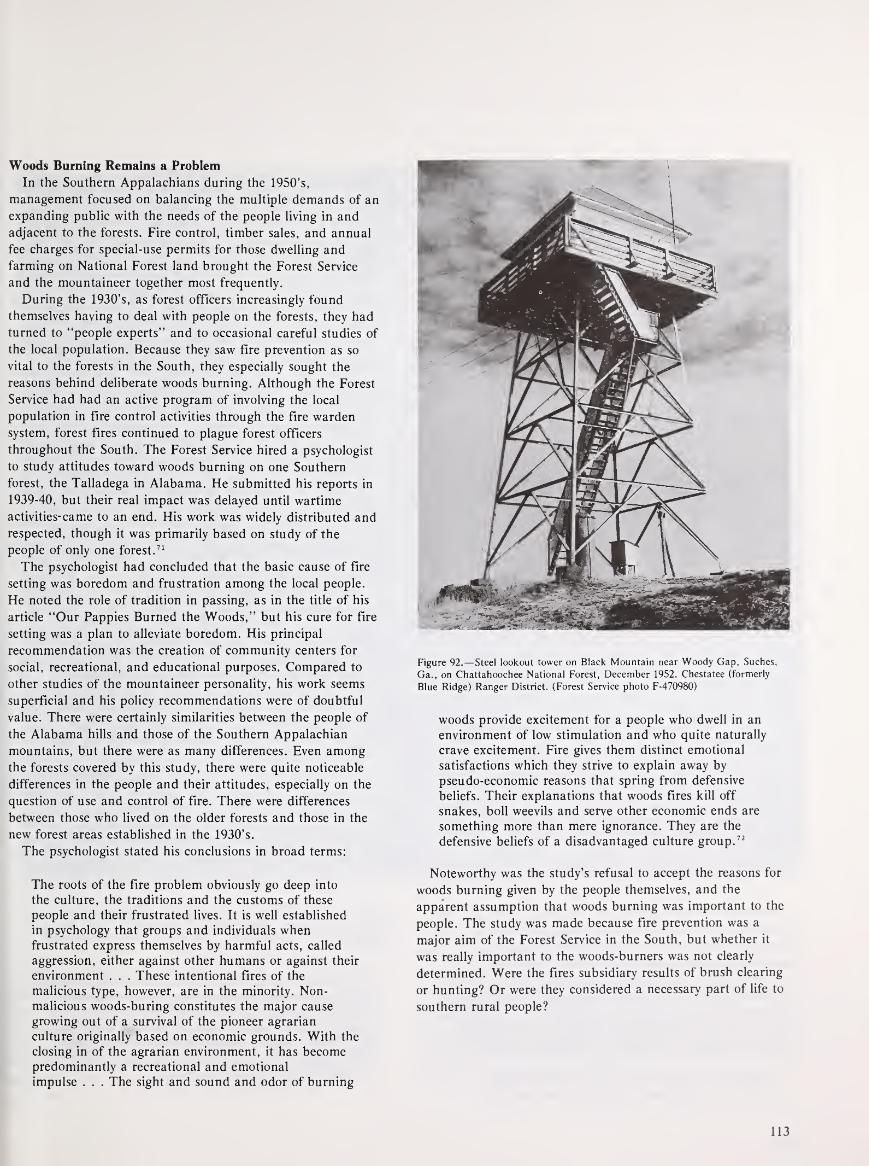
Woods Burning Remains a Problem
In the Southern Appalachians during the 1950's,
management focused on balancing the multiple demands of an
expanding public with the needs of the people living in and
adjacent to the forests. Fire control, timber sales, and annual
fee charges for special-use permits for those dwelling and
farming on National Forest land brought the Forest Service
and the mountaineer together most frequently.
During the 1930's, as forest officers increasingly found
themselves having to deal with people on the forests, they had
turned to "people experts" and to occasional careful studies of
the local population. Because they saw fire prevention as so
vital to the forests in the South, they especially sought the
reasons behind deliberate woods burning. Although the Forest
Service had had an active program of involving the local
population in fire control activities through the fire warden
system, forest fires continued to plague forest officers
throughout the South. The Forest Service hired a psychologist
to study attitudes toward woods burning on one Southern
forest, the Talladega in Alabama. He submitted his reports in
1939-40, but their real impact was delayed until wartime
activities-came to an end. His work was widely distributed and
respected, though it was primarily based on study of the
people of only one forest.71
The psychologist had concluded that the basic cause of fire
setting was boredom and frustration among the local people.
He noted the role of tradition in passing, as in the title of his
article "Our Pappies Burned the Woods," but his cure for fire
setting was a plan to alleviate boredom. His principal
recommendation was the creation of community centers for
social, recreational, and educational purposes. Compared to
other studies of the mountaineer personality, his work seems
superficial and his policy recommendations were of doubtful
value. There were certainly similarities between the people of
the Alabama hills and those of the Southern Appalachian
mountains, but there were as many differences. Even amongthe forests covered by this study, there were quite noticeable
differences in the people and their attitudes, especially on the
question of use and control of fire. There were differences
between those who lived on the older forests and those in the
new forest areas established in the 1930's.
The psychologist stated his conclusions in broad terms:
The roots of the fire problem obviously go deep into
the culture, the traditions and the customs of these
people and their frustrated lives. It is well established
in psychology that groups and individuals whenfrustrated express themselves by harmful acts, called
aggression, either against other humans or against their
environment . . . These intentional fires of the
malicious type, however, are in the minority. Non-
malicious woods-buring constitutes the major cause
growing out of a survival of the pioneer agrarian
culture originally based on economic grounds. With the
closing in of the agrarian environment, it has becomepredominantly a recreational and emotional
impulse . . . The sight and sound and odor of burning
Figure 92.— Steel lookout tower on Black Mountain near Woody Gap, Suches,
Ga., on Chattahoochee National Forest, December 1952. Chestatee (formerly
Blue Ridge) Ranger District. (Forest Service photo F-470980)
woods provide excitement for a people who dwell in an
environment of low stimulation and who quite naturally
crave excitement. Fire gives them distinct emotional
satisfactions which they strive to explain away by
pseudo-economic reasons that spring from defensive
beliefs. Their explanations that woods fires kill off
snakes, boll weevils and serve other economic ends are
something more than mere ignorance. They are the
defensive beliefs of a disadvantaged culture group. 72
Noteworthy was the study's refusal to accept the reasons for
woods burning given by the people themselves, and the
apparent assumption that woods burning was important to the
people. The study was made because fire prevention was a
major aim of the Forest Service in the South, but whether it
was really important to the woods-burners was not clearly
determined. Were the fires subsidiary results of brush clearing
or hunting? Or were they considered a necessary part of life to
southern rural people?
113

A more modest study carried out by a forest officer at about
the same time covered three of the mountain forests,
Cherokee, Chattahoochee, and Nantahala. Interviewing 39
heads of households whose lands were contiguous to, or
surrounded by, Government-owned land, he asked a number
of questions related to policies and management of the forests.
Fire prevention was an important aspect, but he was concerned
with more than woods burning. Trying to determine which
Forest Service goals meant most to the people, he found:
Maintenance of timber resources and employmentmeant most to eighteen, or slightly more than half.
Figure 93.—A Forest Service crew clearing a fireline before setting light to a
backfire to stop the Laurel Branch wildfire which was racing toward them.
Campbell Creek. Watauga Ranger District, Cherokee National Forest. Tenn..
November 1952. (Forest Service photo F-471193)
The wildlife . . . appealed most to eight, saving of land
to six, and forest attractiveness to three. Many persons
well acquainted with these people affirm that their
interest in wildlife and hunting transcends everything
else. The expressions here show, however, that aspects
of the forest program promising more opportunities for
employment have the stronger appeal. 73
114

The investigation also showed the tire causes most familiar
to them: farmers' burning brush or fields, campfires, smoking
of "bee trees," and other "accidents." The purpose of starting
a fire was not to burn the forest, but little was often done to
keep the fire from spreading. They did not think people should
be prosecuted for such accidents, but most of them agreed that
intentional fire setters should be penalized.
One significant but not surprising finding was that each
person tended to evaluate the National Forest and its programs
by how he or she personally was affected. For the most part,
respondents were satisfied with the forests in their localities,
but:
The specific comments they made showed their
appraisal to be in terms of grazing, prices paid for
land, timber sales, and other matters in which they see
themselves affected economically at present, and to nosmall extent, the likableness of forest officers they
happen to know. The broader purposes of national
forest management appeared to be unfamiliar lines of
thought to most of these backhills people. 74
A majority favored enlarging the National Forests in the
mountains. Those who disagreed feared that families would be
forced to leave and would have no way of getting along in newhomes. The diversity of responses found in these interviews
and the tendency of the mountain people to make judgments
on a very personal basis seem most striking. The study made a
number of recommendations for improving public relations,
but proposed no overall plan or cure for problems with forest
neighbors.
Figure 94.—Crewmen on the fireline using specially made triangular-toothed
rakes to prevent their newly lit backfire from spreading across the line to
unburned timber. Laurel Branch Fire, Watauga Ranger District, Cherokee
National Forest, Tenn., November 1952. (Forest Service photo F-471196)
Figure 95.—A fire crewman keeps a close watch on a burning snag (dead tree),
to prevent embers from spreading across fireline to untouched timber. Laurel
Branch Fire, Watauga Ranger District, Cherokee National Forest, Tenn.,
November 1952. (Forest Service photo F-471197)
How widely these and other studies of the local people were
read and believed by the forest officers is a question that
cannot be answered, but the existence of these studies reflects
official concern, beginning in the late 1930's, for developing
insights into the behavior of rural Southerners. Although this
concern persisted, it generally focused on the pine forests of
the deep South, where burning could be beneficial if properly
done. Man-caused fires were certainly not gone from the
mountains, but the more severe problems often came from
other areas.75
Timber Sales Favor Small Logger
Throughout the National Forests, but in the Southern
Appalachians in particular, timber sale policy continued to
favor the small logger. The Forest Service regarded such sales
as a direct means of benefiting and influencing the local
public. According to an internal document dated August 1940,
"much emphasis is put on making sales to the little fellow who
has only the most meager equipment and can only raise a few
dollars for advance payment." 76
115
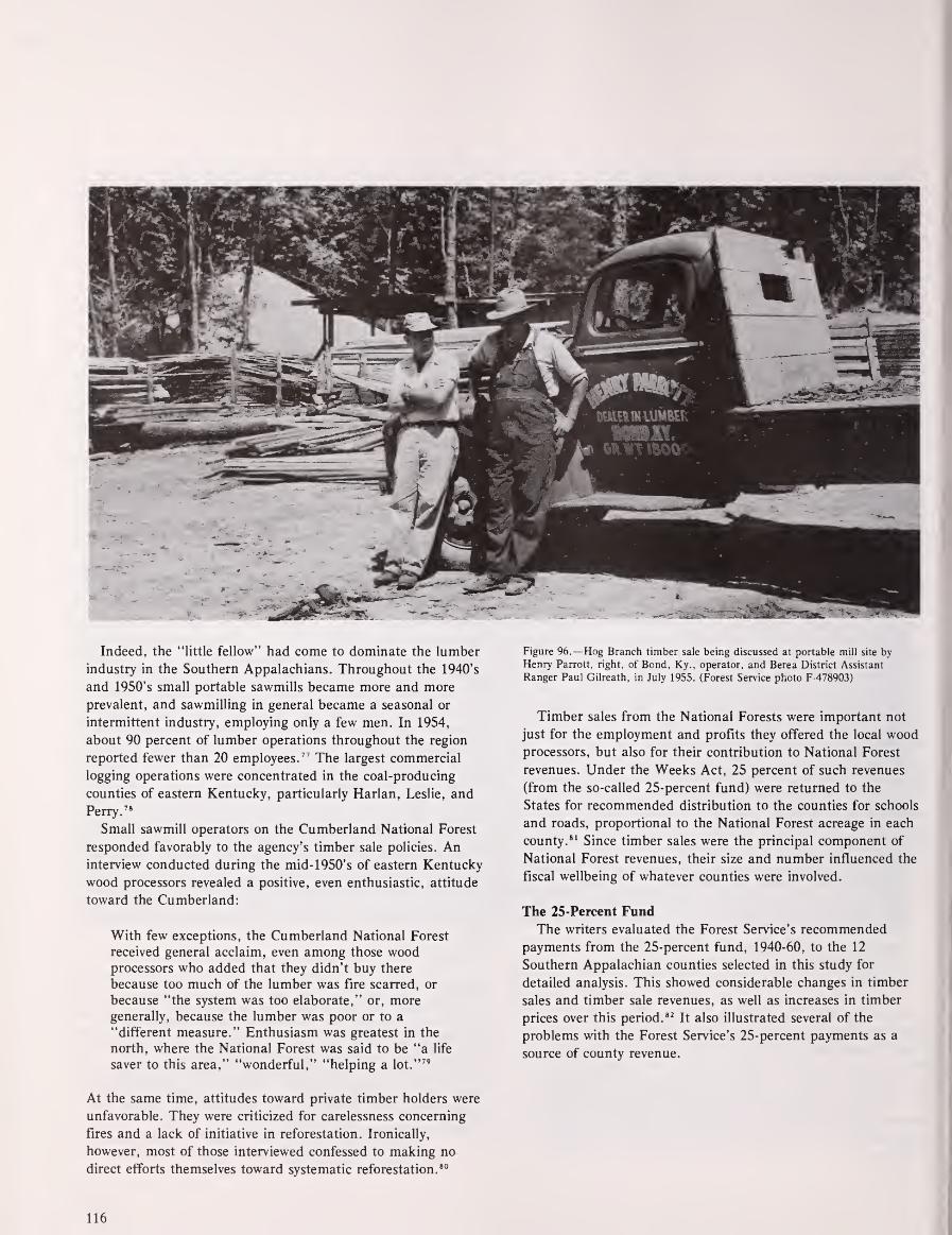
Indeed, the "little fellow" had come to dominate the lumber
industry in the Southern Appalachians. Throughout the 1940's
and 1950's small portable sawmills became more and more
prevalent, and sawmilling in general became a seasonal or
intermittent industry, employing only a few men. In 1954,
about 90 percent of lumber operations throughout the region
reported fewer than 20 employees. 77 The largest commercial
logging operations were concentrated in the coal-producing
counties of eastern Kentucky, particularly Harlan, Leslie, and
Perry. 78
Small sawmill operators on the Cumberland National Forest
responded favorably to the agency's timber sale policies. Aninterview conducted during the mid-1950's of eastern Kentucky
wood processors revealed a positive, even enthusiastic, attitude
toward the Cumberland:
With few exceptions, the Cumberland National Forest
received general acclaim, even among those woodprocessors who added that they didn't buy there
because too much of the lumber was fire scarred, or
because "the system was too elaborate," or, moregenerally, because the lumber was poor or to a
"different measure." Enthusiasm was greatest in the
north, where the National Forest was said to be "a life
saver to this area," "wonderful," "helping a lot."79
At the same time, attitudes toward private timber holders were
unfavorable. They were criticized for carelessness concerning
fires and a lack of initiative in reforestation. Ironically,
however, most of those interviewed confessed to making no
direct efforts themselves toward systematic reforestation. 80
Figure 96.—Hog Branch timber sale being discussed at portable mill site by
Henry Parrott, right, of Bond, Ky., operator, and Berea District Assistant
Ranger Paul Gilreath, in July 1955. (Forest Service photo F-478903)
Timber sales from the National Forests were important not
just for the employment and profits they offered the local woodprocessors, but also for their contribution to National Forest
revenues. Under the Weeks Act, 25 percent of such revenues
(from the so-called 25-percent fund) were returned to the
States for recommended distribution to the counties for schools
and roads, proportional to the National Forest acreage in each
county. 81 Since timber sales were the principal component of
National Forest revenues, their size and number influenced the
fiscal wellbeing of whatever counties were involved.
The 25-Percent Fund
The writers evaluated the Forest Service's recommended
payments from the 25-percent fund, 1940-60, to the 12
Southern Appalachian counties selected in this study for
detailed analysis. This showed considerable changes in timber
sales and timber sale revenues, as well as increases in timber
prices over this period. 82It also illustrated several of the
problems with the Forest Service's 25-percent payments as a
source of county revenue.
116

Our analysis considered 25-percent payments and National
Forest acreage per county for the nine counties of the group
having such acreage. (Hancock and Buchanan Counties have
no National Forest acreage; before 1972, Knox County had
none.) For all nine counties, 25-percent payments and
payments per acre increased from 1940 to 1960. Gross
payments increased many times over—for example, from
$1,658 in 1940 to $22,302 in 1960 for Union County. However,
in 1960 even the highest paid county, Macon, received only
$34,679 from the fund. As a supplemental payment for roads
and schools, the 25-percent fund was still certainly not large.
Figure 97.—Skidding hemlock logs to landing by tractor and winch on Reed
Creek timber sale in Bear Hollow, Wythe Ranger District, Jefferson National
Forest, southwestern Virginia, in July 1955. (Forest Service photo F-479067)
On a per-acre basis, payments also increased over time. In
1940 all counties in the sample were paid only between $0.01
and $0.03 per National Forest acre; by 1960, this amount had
increased to between $0.05 and $0.24 per acre. The most
dramatic increases in payments per acre were for Union,
Graham, Macon, and Habersham Counties, all but the last in
the heart of the Chattahoochee and Nantahala forests. Muchof the National Forest land in these forests had been
purchased in earlier years; consequently, by the 1950's each
had merchantable second-growth timber stands.
117

For all nine counties studied, World War II brought an
increase in 25-percent-fund payments per acre, reflecting the
wartime boom. Payments peaked during 1944. Graham and
Macon counties experienced the greatest wartime increase in
per acre payments—from $0.07 in 1943 to $0.16 in 1944
—suggesting that timber cutting in these counties mayhave doubled.
In spite of the general increase in payments over the two
decades, however, for any given county the amounts varied
from year to year, giving support to Si Kahn's criticism that
National Forest counties could not predict the amounts they
would receive. 83 As a case in point, Macon County per-acre
payments from 1951 to 1956 varied as follows:
1951-$0.06 1954-$0.16
1952-$0.09 1955-$0.13
1953-S0.10 1956-$0.08
Although not all counties exhibited the same degree of
variation, no pattern was steady.
Figure 98.—Cutting a big notch in base of 38-inch mature yellow-poplar tree to
fix direction of fall before felling, using one-man power chainsaw, on a timber
sale in Chattahoochee National Forest, North Georgia, in October 1956. (Forest
Service photo F-481523)
Cross-county payment inequities were even more extreme
and became increasingly so over the two decades. In 1940, all
nine counties received between $0.01 and $0.03 per National
Forest acre. By 1950, the payments ranged between $0.03 and
$0.14. By 1960, the range was $0.05 to $0.24, primarily
reflecting differences in timber sales from county to county. In
general, these variations in per-acre payments had no relation
to the proportion of National Forest land in a county.
Thus, not all mountaineers reacted so favorably to National
Forest management as did the local wood processors. Onegroup in particular, the tenants and squatters, proved a
frequently difficult management problem. During the 1950's,
when land acquisition faded, the chief friction with local
residents was over special-use permits.
118

Tenants and squatters had often been permitted to remain
on land sold to the Government during the 1930's. The Forest
Service usually required them, however, to obtain special-use
permits covering their cabins and fields. Although generally a
small fee was charged, the principal purpose was to confirm
Federal authority to regulate any activity carried out on the
land.
One example shows what can happen in a classic case of
mountain stubbornness. Cecil Cable, his wife, and seven
children lived in a two-room cabin with lean-to on Nantahala
National Forest land. Cable had repeatedly refused to obtain a
permit for his home from the district ranger or to pay the user
fee of $13.00 per year. The forest supervisor investigated,
concluding that Cable, though poor, was well able to pay the
fee, but "that he has simply made up his mind that he will not
do so." 84 Finally he recommended that Cable be evicted, but
the Justice Department was reluctant to take such action.
The case eventually went to the office of the Chief, where a
memorandum was prepared explaining that:
We have asked the Regional Forester to reconsider this
case very carefully and to exhaust every possibility of
solving the problem without resorting to eviction. Werecognize that it is undesirable for the United States to
be put into the role of "evicting landlord," especially
when a family and small children are involved;
however, in this case it seems inescapable . . .
It would be most difficult for us to administer the
national forests if one person were allowed to defy the
authority of the United States by refusing to pay a just
and reasonable fee for the use of national forest land. 85
Eviction, recommended in October 1951, was carried out in
early September 1953. Efforts were made to help Cable and his
family find another home and move their household goods, but
Cable refused all offers. Finally, the U.S. marshall physically
evicted the man and his family from the cabin and piled all
their possessions, including about 400 jars of home-canned
fruit and vegetables, at the side of the road. A Forest Service
crew immediately tore down the cabin and removed it.
In a similar situation on the same Forest, however, the
Forest Service was lenient. A Mr. Posey was allowed to squat on
Nantahala National Forest land for over 30 years without a
permit. 85 He had lived in poverty and obscurity along the Little
Tennessee River on lands that were flood by TVA whenFontana Dam was built in 1944. That year Mr. Posey, as well
as the local Baptist Church, had been given deeds to small
tracts on the lands of the Whiting Manufacturing Co., just
south of the flooded area, in the Nantahala National Forest.
Mr. Posey, seizing a rare chance for profit, soon sold his
deed and moved, as a squatter, deep into the Nantahala onto
lands that TVA transferred in 1947 to the Forest Service. This
squatting was "overlooked" by the Forest Service for over 30
years. However, in the late 1970's, when his son moved a
trailer onto the site, the two were finally evicted.
Another permit problem on the Nantahala National Forest
involved a mica mine on Government land. In 1952 the
Supervisor informed the mine operator, S. W. Reid, of
Franklin, N.C., that he was to stop mining until he had
obtained the necessary permit from the Bureau of Land
Management, the Government agency that regulates all mining
and issues all mining permits and leases on Federal land. The
Forest Service had no objection to Reid's operation, as long as
he complied with regulations. 87 Considering the large number
of special-use permits issued on all of the region's forests, and
the joint role of multiple Federal agencies managing the land,
it is remarkable that there were not more conflicts.
A 1959 report defined the increasing pressures felt by forest
officers in the mountains, as well as throughout the South, and
foreshadowed the difficult management problems of the 1960's
and 1970's.88 The Forest Service had been confronted with
proposals to transfer National Forest lands to other
jurisdictions for single-use for military use, for alienations for
privately owned organization camps ..." The report
concluded that, "although some such transfers may be
justified, they indicated that the Forest Service had done an
inadequate job of selling the principles of multiple-use
management." The implication was that the National Forests,
if properly managed, can be used for many things by many
people:
Timber management should ... be emphasized, but it
must be fully coordinated with other uses. Allowable
cut figures should make full allowance for scenic areas,
soil stabilization, present and future recreation areas,
roadside strips, etc. Ways and means must be
developed to intensify programs in watershed
management, public recreation, wildlife habitat
management and grazing. 89
The difficulties of juggling the multiple purposes of the
forests were to become increasingly apparent in the decades
ahead. The Southern Appalachian forests had to continue to
provide a steady supply of timber for small sawmill operators,
local industries, and the population at large. Logging roads
had to be maintained, opportunities for timber harvest
continued, and timber sale profits assured. At the same time,
wildlife and scenic areas had to be protected and recreational
opportunities developed. In the eastern forests, scattered
ownership patterns made administration for all purposes
increasingly difficult. Poor marking of forest boundaries
invited trespass and encroachment. Private land uses were
increasingly incompatible with those of the Forest. There was
still some hope for a future purchase program in the Southern
Appalachians, but most of the consolidation of the Forests
would have to be done by exchange. A longtime Forest Service
employee summed up the problems tersely:
"People are so selfish. "They all want whatever they use the
forest for to come first."90
119

Reference Notes
(In the following notes, the expression "NA, RG 95, FS" means
National Archives, Record Group 95, Records of the Forest Service
(USDA). Under this file designation, "OC" means Office of the Chief,
"NFRC" means National Forest Reservation Commission, and "LA"means Land Acquisition, Region 8. "WNRC, FS" means Washington
National Records Center. Records of the Forest Service. See
Bibliography, IX.)
1. Joseph M. Petulla, American Environmental History: The
Exploitation and Conservation of Natural Resources (San Francisco:
Boyd and Fraser Publishing Company, 1977), p. 329.
2. Harold K. Steen, The U.S. Forest Service: A History (Seattle:
University of Washington Press, 1976), pp. 246, 247.
3. NA, RG 95, FS, OC, General Integrating Inspection Reports (Gil),
1943, Loveridge-Fitzwater, Region 8, pp. 26-28.
4. NA, RG 95, FS, OC, Gil, 1943, Loveridge-Fitzwater, Region 8,
pp. 26-28. Steen, U.S. Forest Service, p. 254.
5. John F. Day, Bloody Ground (Garden City, N.Y.: Doubleday,
Doran and Company, Inc., 1941), p. 201.
6. NA, RG 95, FS, OC, Gil Report, 1943, Loveridge-Fitzwater,
Region 8, p. 26.
7. Loveridge-Fitzwater, p. 26.
8. Gennett Lumber Company, Papers, Perkins Library, Duke
University, Box 21. Letter from Forest Supervisor, Chattahoochee
National Forest, to N.W. Gennett, September 29, 1944; letter from N.
W. Gennett to Forest Supervisor, Chattahoochee National Forest,
October 12, 1944.
9. Gennett Papers, Box 21, Letter from Forest Supervisor,
Chattahoochee National Forest, to N. W. Gennett, September 29,
1944.
10. NA, RG 95, FS, OC, General Integrating Inspection Reports, R.
E. Marsh and W. P. Kramer, 1948-49, Region 8, p. 23.
11. NA, RG 95, FS, OC, NFRC, Final Report for the fiscal year
ending September 30, 1976, p. 4.
12. NA, RG 95, FS, OC, General Integrating Inspection Reports,
(Gil), Marsh and Kramer, 1948-49, Region 8, p. 24.
13. NA, RG 95, FS, OC, Gil Reports, Loveridge-Fitzwater, 1943,
Region 8, p. 54.
14. Interview with Bruce Jewell and Russell Griffith, July 17, 1979,
Cherokee National Forest, Cleveland, Tenn. Jack E. Waller,
Yesterday's People, Life in Contemporary Appalachia (Lexington:
University of Kentucky Press, 1965), pp. 54, 55.
15. Harry Caudill, Night Comes to the Cumberlands. Boston: Little,
Brown and Company, 1962, Chapter 16.
16. Caudill, Night Comes to the Cumberlands, pp. 221, 222.
17. L. E. Perry, McCreary Conquest, A Narrative History. Whitley
City, Ky.: L. E. Perry, 1979, p. 81.
18. John Gaventa, Power and Powerlessness: Quiescence and
Rebellion in an Appalachian Valley (Urbana, 111.: University of Illinois
Press, 1980), pp. 125, 126.
19. The foregoing account is summarized from Elwood R. Maunder,
Dr. Richard E. McArdle: An Interview With the Former Chief, U.S.
Forest Service, 1952-1962 (Santa Cruz, Calif.: Forest History Society,
1975), pp. 84-87, and Robert F. Collins, A History of the Daniel
Boone National Forest (Lexington, Ky.: University of Kentucky Press,
1975), pp. 262-268. See also: Samuel T. Dana, "The Stearns Case: AnAnalysis," American Forests 61, 9 (September 1955): 18, 44; and TomWallace, "The Stearns Case," American Forests 61, 4 (April 1955):
24, 56.
20. Gennett Papers, Perkins Library, Duke University, Box 23, Letter
from Gennett Oak Flooring Company to Local Draft Board #4,
Asheville, N.C., n.d.
21. Caudill, Night Comes to the Cumberlands, pp. 244-246.
22. Marguerite Owen, The Tennessee Valley Authority, (New York:
Praeger Publishers, 1973), p. 84.
23. Marguerite Owen, The Tennessee Valley Authority, pp. 84, 85.
24. Marguerite Owen, The Tennessee Valley Authority, pp. 84, 85.
25. Charles O. Jackson and Charles W. Johnson, "The Urbane
Frontier: The Army and the Community of Oak Ridge, Tennessee
1942-1947," Military Affairs XLI (February 1977): 9.
26. James S. Brown and George A. Hillery, Jr., "The Great
Migration, 1940-1960," in Thomas R. Ford, ed., The Southern
Appalachian Region, p. 61.
27. John C. Belcher, "Population Growth and Charactistics," and
Brown and Hillery, "The Great Migration, 1940-1960," in Ford, The
Southern Appalachian Region, p. 39, 54.
28. Brown and Hillery, "The Great Migration, 1940-1960," p. 58, 59,
63-67.
29. Brown and Hillery, "The Great Migration," 58.
30. Brown and Hillery, "The Great Migration," 59.
31. Brown and Hillery, "The Great Migration," 59.
32. Brown and Hillery, "The Great Migration," 63-67.
33. Brown and Hillery, "The Great Migration," 67.
34. James S. Brown, "The Changing Highland Population,"
Mountain Life and Work 29 (1953): 42.
35. Brown and Hillery, "The Great Migration, 1940-1960," p. 72.
36. Brown and Hillery, "The Great Migration," p. 56.
120

37. Brown and Hillery, "The Great Migration," p. 57.
38. Brown and Hillery, "The Great Migration," p. 56.
39. Data for the 12-county migration analysis and others that follow
are based on U.S. Bureau of the Census, County and City Data Book
for 1947, 1949, 1952, 1956, and 1962 (Washington: Government
Printing Office).
40. NA, RG 95, FS, Office of the Chief (OC), National Forest
Reservation Commission (NFRC), Final Report for the Fiscal Year
ending September 30, 1976, p. 4.
41. NA, RG 95, FS, OC, NFRC, Minutes, 1945-1953, "Recess
approval" of a purchase required that proposals be mailed to each
member of the NFRC. There was a specified time to reply yes or no.
Recess approval had to be unanimous, but no response was assumed
to be a yes vote.
42. NA, RG 95, FS, Land Acquisition (LA), Exchange, Purchase and
Donation Cases, 1946-51, Chattahoochee Exchange, Camp Toccoa.
43. Surplus Property Act, 58 Stat. 765.
44. NA, RG 95, FS, Land Acquisition (LA), Exchange, Purchase, and
Donation, Cases, 1946-1951, Jefferson Purchase.
45. WNRC, FS Accession No. 61A1087, Land Exchange; Purchase,
Donation. (U-Recreation, Region 8.)
46. WNRC, FS, Acc. No. 61A1087, Land Exchange, Purchase,
Donation.
47. NA, RG 95, Land Acquisition (LA), Exchange, Purchase and
Donation Cases, 1946-51, Pisgah Donation; Jefferson Donation.
48. WNRC, FS, Acc. No. 61A1087, Land Exchange, Purchase,
Donation.
49. WNRC, FS, Acc. No. 61A1087, Land Exchange.
50. NA, RG 95, FS, (LA), Exchange, Purchase, and Donation, Cases,
1946-1951, Nantahala Exchange.
51. NA, RG 95, FS, NFRC, Minutes, June 17. 1954.
52. NA, RG 95, FS, NFRC, Minutes, April 17. 1956.
53. WNRC, FS, Acc. No. 79001, General Integrating Inspection
Reports, 1959, Comments.
54. Marguerite Owen, The Tennessee Valley Authority, pp. 98, 99.
55. Owen, TVA, p. 154, 155.
56. Lands Records, National Forest of North Carolina, Asheville,
N.C. In addition to lands around Fontana Dam, TVA transferred
58. Federal Agencies and Outdoor Recreation, ORRRC Study Report
13. A Report to the ORRRC by the Frederic Burk Foundation for
Education, Washington, D.C. 1962, p. 21.
59. WNRC, FS, Accession No. 61A1087, U-Recreation, Region 8,
Letter from H.R. Raum, September 17, 1957.
60. NA, RG 95, FS, Region 8, Nantahala Exchange. Memorandumfrom L. F. Kneipp to Regional Forester, Atlanta, Ga., August 9,
1945.
61. NA, RG 95, FS, LA, Region 8, Nantahala, Exchange. L. F.
Kneipp to Regional Forester, Atlanta, Ga., August 9, 1945.
62. NA, RG 95, FS, LA, Region 8, Nantahala, Exchange,
Memorandum for Regional Forester to Chief, Forest Service, August
4, 1945.
63. Southern Historical Collection, Ramsey Papers, Folder 44, Speech
of Governor Cherry, October 13, 1947, before Board of Conservation
and Development, Asheville, N.C.
64. NA, RG 95, FS, OC, General Integrating Inspection Reports
(Gil), Marsh and Kramer, Region 8, 1948-49, pp. 38, 45.
65. NA, RG 95, OC, FS, Gil, Marsh and Kramer, Inspection
Reports, Region 8, 1948-49, p. 38.
66. NA, RG 95, FS, OC, Gil, Marsh and Kramer Inspection
Reports, Region 8, 1948-49, p. 45.
67. Federal Agencies and Outdoor Recreation, ORRRC Study Report
13, 1962, p. 20, 22.
68. Federal Agencies and Outdoor Recreation, p. 22.
69. NA, RG 95, FS, OC, Gil, Marsh and Kramer, Region 8.
1948-49, p. 38.
70. WNRC, FS, Acc. No. 60A931, "A List of Different Kinds of
Things the Forest Service and Forest Officers Do Which Influence
Residents," August 12, 1940, p. 7.
71. John P. Shea, "Our Pappies Burned the Woods," American
Forests 46, (April 1940): 159-174. See also correspondence relating to
Shea's studies in Forest Service Records, WNRC, Acc. No. 63A809.
72. Shea, p. 162.
73. Charles R. Ross, "Some Aspects of Forestry Public Relations in
the Southern Appalachian Backhills, " Journal of Forestry 38 (1940):
920. Another example of a study produced within the Forest Service
for its own use is "A List of Different Kinds of Things the Forest
Service and Forest Officers Do Which Influence Residents."
74. Charles R. Ross, "Some Aspects of Forestry," p. 923.
another 21,640 acres around other area reservoirs to the Nantahala 75. WNRC, FS, Acc. No. 79001, General Integrating Inspection
National Forest between 1940 and 1976. Reports, Region 8, 1959, Comments.
57. Steen, The U.S. Forest Service, p. 254.
121
76. WNRC, FS, Acc. No. 60A931, "A List of Different Kinds of
Things the Forest Service and Forest Officers Do Which Influence
Residents," p. 4.
77. Thomas R. Ford, ed., The Southern Appalachian Region: ASurvey (Lexington: University of Kentucky Press, 1962), p. 118.
78. Man' Jean Bowman and W. Warren Hayes, Resources and People
in Eastern Kentucky (Baltimore: The Johns Hopkins University Press,
1963), p. 129.
79. Bowman and Hayes, Resources and People, p. 125.
80. Bowman and Hayes, Resources and People, p. 126.
81. 36 Stat. 963.
82. Data on recommended county payments made to States were
obtained from Fiscal and Accounting Management, Washington
Office, Forest Service. It is important to note that county payments
are only recommendations made to the States for roads and schools;
the Forest Service has no jurisdiction over the actual payments a State
chooses to make.
83. Si Kahn, The Forest Service and Appalachia (New York: The
John Hay Whitney Foundation, 1974), p. 9; pp. 13, 14.
84. WNRC, FS, Acc. No. 59A1753, Trespass files. Region 8, 1941-54.
85. WNRC, FS, Trespass files, Region 8. 1941-54.
86. The Mr. Posey anecdote was related in an interview with Frank
Sharp, forester. National Forests of North Carolina, Asheville, May11, 1979.
87. WNRC, FS, Acc. No. 59A1753, Trespass, Region 8. 1951-54,
Letter from E. W. Renshaw, Forest Supervisor, to S. W. Reid,
Franklin, N.C., June 23, 1952, Trespass, Region 8, 1941-54.
88. WNRC, FS, Acc. No. 790001, General Integrating Inspection
Reports, Region 8, 1959.
89. WNRC, FS, Acc. No. 790001, General Integrating Inspection
Reports, Region 8, 1959, p. 25.
90. Interview with B. W. Chumney, July 18, 1979.
122

Chapter VII
Federal Development of the Southern Appalachians,1960-81
Under the presidencies of John F. Kennedy and Lyndon B.
Johnson, the Appalachian region was recognized as seriously
lagging behind the rest of the Nation, and concerted efforts
were directed at revitalizing the area's economy. A myriad of
Federal programs were developed to combat poverty and
unemployment, some aimed specifically at Appalachia. The
Appalachian Regional Commission, created by Kennedy in
1963, and given expanded powers by Congress in 1965,
funneled millions of dollars into the Southern Appalachians. In
addition, Federal land acquisition in the area was given new
impetus, and a new National Forest purchase unit was created
in eastern Kentucky. The National Forests of the region were
pressured to market their resources to help meet accelerating
demands for timber nationwide. Although the region made
gains in employment, health, and education, the Southern
Appalachian mountaineer, in the early 1970's, remained
considerably poorer and less advantaged than the average
American in spite of multiple Federal development efforts.
When John F. Kennedy campaigned in the West Virginia
Democratic primary for the presidency in April and May 1960.
the poverty and squalor he witnessed made a strong impression
on him. 1 One of his earliest concerns as President was to ease
the depressed conditions he had seen and to restore the
Appalachian region to economic health. Shortly after taking
office, Kennedy appointed a Task Force on Area
Redevelopment to deal with the problems of chronic
unemployment, unused labor, and low income. The
recommendations of the Task Force, published in early
January 1961, echoed New Deal proposals of 30 years before:
emergency public works programs in depressed areas of the
Nation and development of these areas' natural resources.
Appalachia Is Rediscovered
The year 1960 thus marked the beginning of a national
rediscover,' of Appalachia that directed billions of Federal
dollars to improving the area. Specifically, the Kennedy Task
Force identified nearly 100 Appalachian "depressed areas,"
classified by the Department of Labor as having a "labor
surplus, substantial and persistent," and between 300 and 400
rural, low-income areas where Federal funds might be
concentrated. The Task Force report recommended that a
commission be established for the 11— State Appalachian
region to tackle special area development problems. Although
Figure 99.—Local unemployed workers applying for forestry jobs under the
Federal Accelerated Public Works (APW) Program in the Tusquitee RangerDistrict office. Nantahala National Forest, in Murphy. Cherokee County, N.C.,
in January 1963. APW ran for 2 years and led to the myriad programs of the
Economic Opportunity Act. (Forest Service photo F-503999)

most of these recommendations were not translated into
Federal action until the presidency of Lyndon B. Johnson,
John F. Kennedy redirected national attention and concern to
the region. 2 He appointed an advisory commission in 1963.
In 1960 the Appalachian region certainly deserved national
attention. Since World War II, as its agriculture and coal
industry failed to keep pace with national trends, its
population was increasingly unemployed and poor. By 1960,
the region's employment, income, and educational levels were
well below the national averages. Although the State of West
Virginia represented one of the worst concentrations of
regional poverty, Appalachian Kentucky, Virginia, Tennessee,
North Carolina, and Georgia also suffered severe
underemployment and income inequities.
As discussed in some detail in chapter VI, the Southern
Appalachian region had been experiencing heavy outmigration
for two decades. At the same time, human fertility rates were
declining, so that by 1960 the natural rate of increase (births
minus deaths per 1,000 population) was not enough to offset
the population losses from net outmigration. Not only was
population declining, but relatively more was age 65 or older.
Throughout the southern mountains, more and more people
were leaving their farms for urban and suburban areas.
However, retailing and manufacturing firms could not absorb
the extra labor, and unemployment rose, In 1960, the
unemployment rate of Appalachia was nearly twice the
national average. 3
By whatever statistic it was measured, the poverty of the
region was glaring. In the counties of Kentucky, Virginia,
North Carolina, Tennessee, and Georgia defined by the
Appalachian Regional Commission to be part of
"Appalachia," poverty was reflected in per capita income
figures, poverty level statistics, infant mortality rates, and
school enrollments. Four such measures are presented in
table 9.
The table shows that, by all four measures, the people of the
Southern Appalachians in 1960 were poorer, less healthy, and
less well educated than the national average. This was
especially true in Appalachian Kentucky where per capita
income was only half the U.S. average, and nearly three times
the national percentage of families were below poverty level.
The infant mortality rate, as an indicator of general health
conditions, was highest in Appalachian Virginia and
Kentucky, which also had the most 16- and 17-year-olds not
enrolled in school. Thus, the statistics confirm that, in general,
conditions in the coal counties were the most severe, although
throughout the region poverty was markedly worse than the
national average.
These conditions were examined more closely for the 12
study counties selected for detailed analysis and introduced in
chapter VI. Five poverty indicators available from 1960 Census
data are presented for the 12 counties in table 10. On a
county-by-county basis, the greatest discrepancies in the data
appear between the Cumberland Plateau coal counties of
Table 9.—Four poverty indicators in the Appalachian Mountain sections of five Southern
States, circa 1960
Per capita
income as
percentage of U.S.
average— 1965
Percentage of
households
below poverty
level— 1960
Infant
mortality
rate
per 1,000—1960
Percentage of
persons 16-17
not enrolled in
school— 1960
United States 100 22.1 26.0 19.1
Appalachian
Kentucky
49 58.4 30.9 33.0
Appalachian
Virginia
55 24.4 31.0 33.1
Appalachian
Tennessee70 39.9 27.7 27.9
Appalachian
North Carolina
75 37.2 26.8 25.6
Appalachian 70 38.5 29.1 28.0
Georgia
Source: Compiled from Appalachia—A Reference Book (Appalachian Regional Commission, February 1979).
124

Table 10.— Five poverty indicators in 12 selected Southern Appalachian counties, circa 1960
High proportion of National Forest Little or no National Forest
Poverty Indicator8
^ o° S>
3> *o
tr
/ /£> £ V
Per capita income—
$
768 770 870 1,127 481 836 809 1,104 759 1355 516 594 844 862
Percentage of families below
poverty level 67.1 58.0 56.2 39.6 71.5 56.2 58.1 35.5 60.9 35.5 78.0 70.5 50.2 55.1
Percentage of population
receiving public assistance**
Under
8.8 5.9 3.0 5.1 13.3 1.0 6.3 5.3 7.7 2.3 8.7 11.7 2.3 5.4
Percentage of families with
incomes of $10,000 or more 3.1 1.9 3.8 3.7 0.9 1.7 2.7 3.5 2.1 6.4 1.2 1.7 3.8 3.7
Percentage of population
65 years or older 10.2 7.6 10.7 9.1 9.0 8.8 9.4 8.3 10.2 11.8 8.7 9.7 4.0 8.6
"For percent of families below poverty level, averages are unweighted.
"1964 recipients as a percent of 1960 population.
Source: U.S. Bureau of the Census. City and County Data Book (Washington: Government Printing Office. 1962. 1967).
McCreary and Knox in Kentucky, and Hancock, in Tennessee,
as a group, and the remaining mountain counties. In 1960.
these three had by far the lowest income of the 12 and the
most families below poverty level. Also, along with Union
County, Ga., they had the most on public assistance and,
along with Graham County, N.C., the fewest earning 510.000
a year or more.
L. E. Perry has painted a more explicit picture of conditions
in 1960 in McCreary County, representative of the Cumberland
Plateau in Kentucky, which has a high percentage of National
Forest land:
The county7 was not the best in economic stability (it
never seems to be) nor was it the worst. But the
general welfare of the people was
disturbing. . . . There were the same crucial and
urgent problems. 49% of all homes had no running
water; 65% of the homes had no bathrooms; 75% had
no central heat; 33% of the homes were on dirt roads.
Hundreds of unsightly, unsanitary and uncomfortable
houses dotted the landscape. The problems of housing
and what to do about it was one to stagger the
imagination. . . .[sic. ]
Surplus food distribution was not only a way of life it
was life for much of the population, not unlike the
never-to-be-forgotten days of the great depression.
The slump in coal production in the 1950s persisted;
the war-time factories no longer beckoned.
Unemployment was at a high rate. Would poverty
never perish in McCreary County? 4
A comparison of the six study counties with a high
proportion of National Forest land and those with little or no
National Forest suggests that the former group fared worse in
1960—but only slightly so. The averages computed for each set
of counties are generally close, with only several percentage
points between them, except for a larger difference in the
percent of population earning S10.000 or more. It is
noteworthy that within each group of counties—and excluding
the Cumberland coal counties—the differences are
considerable. For example, Unicoi and Union Counties, with
43 and 47 percent, respectively, of their land in National
Forests in 1960, showed a difference of 32 percent in per
capita income. Similarly, Henderson and Ashe Counties, with
only an 8 percent difference in National Forest land ownership
in 1960, had a 44 percent difference in per capita income.
Thus, it appears that in 1960, although the six counties with
a higher proportion of land in National Forests were generally
poorer, had a higher percentage of people dependent on public
assistance, and a higher percentage of people 65 or older than
the six counties with a low percentage of National Forest
ownership, these differences were relatively small. These
differences were not so great as those within the two sets of
counties studied and across the subregions of the Southern
Appalachians. Thus, it cannot fairly be determined from this
sample whether a high proportion of National Forest land
depressed local social and economic conditions. Certainly,
poverty conditions cannot be attributed to Federal
landownership alone, if, indeed, to any degree at all.
125

The first emergency employment project for distressed areas
to be implemented under President Kennedy was the
Accelerated Public Works Program (APW) which operated
nationwide during the 1962 and 1963 fiscal years under a
$900-million authorization of the Clark-Blatnik Emergency
Public Works Acceleration Act enacted September 14, 1962.
Funds were allocated by the Area Redevelopment
Administration in the Department of Commerce. During the 2
years, a peak force of 9,000 men worked on a multitude of
projects on 100 National Forests, advanced with $60,800,000 of
allotted funds, many in the Southern Appalachians. (See table
11.) Work included picnic and camp recreation and sanitary
facilities, timber stand improvement, wildlife and fish habitat
improvement, roads and trails, erosion control, and fire
towers, ranger offices, warehouses, and other structures.
Among the latter were a new office for the Morehead Ranger
District, Daniel Boone National Forest, Ky., and construction
of research facilities for water runoff measurement at the
Coweeta Hydrologic Laboratory near Franklin, N.C., in the
Nantahala National Forest. 5 The APW Program led to the
numerous special work programs of the Johnson
Administration which developed out of the Economic
Opportunity Act of 1964.
The Federal War on Appalachian Poverty
When Lyndon B. Johnson became President in 1963, he
turned Kennedy's concern with poverty and unemployment
into a crusade: a "War on Poverty." Over the next 5 years, a
proliferation of governmental agencies and programs was
created to combat the nation's economic ills. The Southern
Appalachians were "rediscovered," and a substantial share of
Federal program money was provided for the region's
development. 6 As L. E. Perry put it:
Every big gun was pointed toward Appalachia andthere were dozens of them in the armies of agencies
recruited to fight poverty. There was an Accelerated
Public Works Program and the Area RedevelopmentAdministration with numerous projects to disperse the
federal benefits. Another division was called ManpowerDevelopment and Training Act. Only the bureaucrats
knew the meaning of that. There was action in the
Department of Health, Education and Welfare, andthe mighty Agriculture Department. The Appalachian
Road Program was pushed forward and the Forest
Service revived a nearly dead land acquisition program.
Even the Kentucky Department of Economic Security
was in the midst of this war. Every conceivable
maneuver, it seemed, was anticipated, and covered by
some sort of program or plan at the local, State or
federal level.
But the top brass was that of the Office of EconomicOpportunity. Here was the command post of such
powerful agencies as Head Start, Neighborhood YouthCorps, Job Corps, Vista, Unemployed Fathers (HappyPappy) and others. If poverty could not be eliminated,
this war would make it more enjoyable. 7
The Economic Opportunity Act of 1964 created many of the
most visible programs throughout Appalachia, 8 incorporating
several antipoverty approaches. The Act established a series of
unconnected programs under the Office of Economic
Opportunity (OEO). These included: Community Action
Programs, Job Corps, Neighborhood Youth Corps, VISTA(Volunteers In Service To America), Summer Head Start, and
the Work Experience and Training Program. In fiscal years
1967 and 1968 alone, OEO spent nearly $225 million in
Virginia, Kentucky, Tennessee, North Carolina, and Georgia,
Table 11.—Allocations of funds to National Forests in the Southern Appalachians under the Accelerated Public Works Program,
1962-64
1962-63 allocations 1963-64 allocations
(dollars)
total: 32,500,000
(dollars)
total: 28,300,000
Area First Second Third First Second
All National Forests 15,000,000 10,000,000 7,500,000 20,255,000 8,045,000
Southern Appalachian Forests 980,000 1,700,000 NA 2,435,000 NAChattahoochee and Oconee(Georgia) 200,000 410,000 NA 600,000 NACherokee (Tennessee) 180,000 300,000 NA 285,000 NADaniel Boone (Kentucky) 350,000 145,000 NA 545,000 NAJefferson (Virginia) 50,000 260,000 NA 485,000 NAPisgah, Nantahala, Uwharrie,
and Croatan (North Carolina) 200,000 485,000 NA 520,000 NA
Note: NA = Not available
Total Funds, 1962-64, all National Forests: $60,800,000
Funds listed include amounts for States for tree planting
Source: Accelerated Public Works file, History Section, Forest Service
126

mostly on Community Action Programs, but much on Head
Start and Job Corps also. VISTA, although more publicized,
received only 2 percent of OEO funds for 1967 and 1968 in the
five States.'
Another visible OEO program in Appalachia was President
Johnson's Work Experience and Training Program, operated
by the Department of Labor. It provided on-the-job training
for unemployed fathers of dependent children who would
otherwise receive AFDC (Aid to Families with Dependent
Children) payments. Popularly known as the "Happy Pappy"
program, it was very active in eastern Kentucky, where it at
first inspired enthusiasm. In 1965 William McKinley Sizemore,
mountain resident of Knox County, Ky., volunteered the
following folk song about the Happy Pappy program:
Mr. Johnson put me to working
When he signed that little bill
Since I've become important
It gives me a thrill
The neighbors hushed their talking
That I was no good
Since I'm a happy pappyThey treat me like they should. 10
However, although for some mountaineers this program mayhave made Lyndon Johnson the favorite President since
Roosevelt, it soon brought on widespread cynicism and
disillusionment. By 1967, even before the Nixon
administration, funds for the program were severely cut
back. 11
VISTA and most other OEO programs suffered similar
fates. Basically, they were criticized for being naively and
expensively staffed by people with grand ideas but little
practical experience. OEO was repeatedly charged with
spending dollars to "fatten middle-class staffs as assistant
directors and executive secretaries proliferate." 12 Part of the
failure of VISTA, it was claimed, rested with Appalachian
Volunteers, Inc., (AV) an organization of about 30 persons
supported almost entirely by OEO grants, which managedVISTA initiatives. AV, it was charged, lacked managementskill and was generally not cost-effective.
13 (Of the 12 study
counties, only Knox, McCreary, Hancock, and Macon received
any VISTA funds.) 14
Job Corps Proves Itself
One of the few OEO programs that survived the 1960's
relatively uncriticized was Job Corps, which grew out of a
recommendation of the 1961 Kennedy Task Force and was still
going strong 20 years later. A supplemental appropriation to
the Forest Service was recommended for timber stand
improvement, control of erosion, and development of
recreation facilities on National Forests in distressed areas,
many of which were in the Southern Appalachians. 15 One of
the main aims, as with the CCC, was to create jobs to absorb
the unused young labor of such areas.
This recommendation was translated into Job Corps during
Lyndon Johnson's presidency by the Economic Opportunity
Act of 1964, funded in the Department of Labor. Job Corps
was intended to provide intensive educational and vocational
training in group settings for disadvantaged youth so that they
might become responsible and productive, and to do so in a
way that contributed to national resource development. 16
Certain Job Corps camps were to be operated by the Forest
Service as Civilian Conservation Centers under an inter-agency
agreement with the Department of Labor. As L. E. Perry said,
".. . Job Corps was the new baby the Forest Service had long
wanted but could not afford until the OEO stork arrived." 17
The first Job Corps center to be activated in the United
States, Camp Arrow Wood, opened in the Nantahala National
Forest near the town of Franklin, Macon County, N.C., early
in 1965. (It was renamed Lyndon B. Johnson after his death.)
Five other camps opened later that year throughout the
Southern Appalachians. Most were old CCC camps, remodeled
and made habitable by the Corpsmen themselves. The six
Southern Appalachian Job Corps (Civilian Conservation)
centers still active in 1982 are listed below.
The purpose of Job Corps was to transfer disadvantaged,
primarily urban, youths to new environments where they would
receive vocational training, education, and counseling. The
Corpsmen who were sent to the Southern Appalachian centers
were predominantly urban and black. When Job Corps began,
the introduction of several hundred black youths into a
previously all-white mountain community caused some
problems. In some locations, it was difficult to integrate the
Corpsmen into the surrounding communities as easily as had
been hoped.
Table 12.—Civilian Conservation Centers* in National Forests of the Southern Appalachians, 1980 and 1982
National Forest Camp Trainee Capacity
Fiscal year 1980 Fiscal year 1982
Nantahala, N. C. Lyndon B. Johnson (formerly Arrow Wood) 205 205
Pisgah, N. C. Schenck 224 224
Cherokee, Tenn. Jacobs Creek 200 224
Jefferson, Va. Flatwoods 224 224
Daniel Boone, Ky. Pine Knot 224 224
Frenchburg 224 168
'Originally called Job Corps Centers
Source: Harold Debord, Human Resource Programs, Southern Regional Office, Forest Service, Atlanta, Ga.
127

For example, a 1966 review of community attitudes toward
the Schenck Job Corps Conservation Center located in the
Pisgah National Forest showed some local reluctance to
welcome the men. Although nearby Hendersonville had invited
them to visit certain prearranged, select sites, the town would
not send its representatives to the camp, "not wishing to have
their presence [in general] or deal with their problems. This
has been made formally clear." 18 The small town of Brevard,
only a few miles from the camp, was felt to offer little for the
urban youth. Asheville, where they were bussed regularly,
seemed to know little about the camp. The Asheville police
were said to "regard the influx [of Corpsmen] in a most
informal manner, looking the other way when small
disturbances occur." 19
The worst Job Corps problems in the Southern Appalachians
were at Arrow Wood. In 1965, after a busload of Corpsmen
arrived in Franklin, N. C, for a summer evening, violence
erupted between them and some local ruffians. According to
the Camp's first director, although local youths had caused
disturbances with outsiders before, this evening's melee was
unprecedented. Police stopped the violence, and many local
boys spent the night in jail. After that evening, policies
changed; the number of Corpsmen bussed into Franklin was
kept to a minimum. 20
Fortunately, such racial disturbances were not widespread.
Camps near towns larger than Franklin had less difficulty. For
example, Jacobs Creek Center near Bristol, on the Tennessee-
Virginia line, experienced no such problems. It seems that
Bristol, a bi-State city of 55,000, with a black population of its
own, was better able to absorb the Corpsmen. 21
The Pine Knot Job Corps Center, which opened in
McCreary County in 1965, likewise experienced no racial
difficultures. L. E. Perry wrote of its establishment:
At first the government officials were apprehensive
about the possible racial consequences of establishing
the training center in the area of McCreary County
since it would recruit a majority of young blacks. After
several local civic group meetings in the county, and
with considerable preconditioning statements, it was
generally implied that no more than 50% of the
trainees would be of the minority class.
The local people for the most part have nopreconceived ideas about racial discrimination and they
refused to act violently. Within a few years the Center
was almost 100% made up of black youths in training
with a staff that was 100% white. The Forest Service
hierarchy was pleased at the non-violent acceptance of
the blacks by the citizens and privately and gleefully
congratulated one another for integrating McCreary
County without conflict.22
Over the years, Job Corps has improved the National Forests
of the Southern Appalachians in much the way the Civilian
Conservation Corps did 30 years before—with road
construction, construction of recreational facilities, soil erosion
Figure 100—New Stearns Ranger District office and modern sign, with Rangers
Andrew Griffith and Herbert Staidle by official car in front, on State route 27,
Daniel Boone National Forest, Ky., in July 1966. Name of Forest had just been
changed from Cumberland in April. (Forest Service photo F-515412)
btt4">5
RANGER S TATION
h.':Vil3 i:"iy
l' - *
128

Figure 101.—Classroom instruction in basics for Job Corpsmen at SchenckConservation Center near "Cradle of Forestry" on Pisgah National Forest near
Brevard, N.C., in August 1966. (Forest Service photo F-516105)
control, reforestation, and timber stand improvement. For
example, the ranger station and the visitor center of the Cradle
of Forestry in Pisgah National Forest were built by the
Schenck Job Corpsmen. 23
Some of the Corps work has benefited local communities as
well as the forests. In 1979, for example, the Pine Knot Job
Corps unit rebuilt the McCreary County Little League baseball
field, constructed a backstop and chain-link fence for the
McCreary County Park, and supplied umpires for local Little
League games. 24 Job Corps centers have also provided
employment for local residents, either through the construction
of facilities for the centers or through staff positions. For
example, in 1979 the Frenchburg Job Corps center in the
Daniel Boone Forest employed between 30 and 40 persons
from Powell, Montgomery, Menifee, and Bath counties on
construction contracts, and employed 22 persons full time and
8 persons part time as center staff members, also from
adjacent counties. The Center director estimated that 70
percent of Frenchburg's nearly $1 million operating budget was
spent in the five-county area surrounding the center."
Other Programs Benefit Local Labor
The other Human Resource Programs administered by the
Forest Service have had a more direct impact on the local
labor market in the Southern Appalachians. The Youth
Conservation Corps (YCC) and Senior Conservation
Employment Program, both initiated in 1971, have provided
employment in the National Forests for local youths and
elders. YCC has operated summer camps for male and female
youths 15 to 18, enrolling as many as 1,200 persons per year in
the Southern Appalachians. Although YCC youths are not
necessarily local, the locals who do enroll often are children of
business and professional leaders in the community. 26 YCCcampers have built trails, planted trees, developed
campgrounds, and surveyed land throughout the Appalachian
forests. In 1981 YCC was reduced but continued on a revised
basis.
The Senior Conservation (older American) Employment
Program has provided work at minimum wage for over 500
elderly folk in the National Forests of the southern mountains.
They have been local men and women 55 or older, with no
income except Social Security or small pensions, performing
odd construction and repair jobs. The program has been
considered highly successful in involving the local population in
Forest Service activities, and in furthering rapport with the
local community. 27
129

Figure 102.—Job Corps trainees on way to morning classroom and field workassignments at Schenck Conservation Center, Pisgah National Forest near
Brevard, N.C., August 1966. (Forest Service photo F-516130)
The Young Adult Conservation Corps (YACC), begun in
1977, is the most recent Human Resource Program. It has
provided employment at minimum wage for a 1-year maximumto local men and women between 16 and 23 years old. Unlike
Job Corps and YCC, persons in YACC lived at home; mostly
on the fringes of the National Forests. In 1979, nearly 500
persons were employed in YACC in the Southern Appalachian
National Forests—including 112 in the Daniel Boone alone. 28
In 1981 this program was terminated by the new
administration in Washington in an economy move.
The Appalachian Regional Commission
In 1965 President Lyndon Johnson secured passage of the
Appalachian Regional Development Act, which created the
Appalachian Regional Commission (ARC). 29 A study
commission, originally recommended by the Kennedy Task
Force, had already been in operation for 2 years under
presidential appointment. Under the leadership of Franklin D.
Roosevelt, Jr., the President's Appalachian Regional
Commission (PARC) had conducted several analyses of the
region, and had formulated the commission's essential
approach to regional development. 30
The main problems of Appalachia were defined by PARC as
a lack of access both to and within the region, a technological
inability to use its natural resources fully, a lack of facilities to
control and exploit its rainfall, and inadequate resources to
train its youth. 31 Thus, regional development was to focus on a
new and improved highway network; public facilities; resource
development programs for water, timber, and coal; and on
human resource programs. Specifically in regard to the
Appalachian timber resource, PARC viewed the region's
timber as underutilized and undermarketed, and
recommended that increased timber harvesting would not only
provide local jobs, but would also improve conditions for
recreation, wildlife, and water production.
The Appalachian Regional Commission, created in March
1965, consisted of the governors of 12 Southeastern and
Northeastern States (the 13th State, non-Appalachian
Mississippi, was added in 1967) and one presidential
appointee. The Commission was to coordinate the
administration of a great new Federal-State funding effort for
Appalachian development. Although most supporting funds
would be Federal, the burden of the responsibility for project
initiation, decisionmaking, and program administration was
delegated to the States. In this delegation, ARC represented a
new approach to regional rehabilitation efforts.
The Commission defined "Appalachia" as a vast
195,000-square mile region of 397 counties, including all of
130

West Virginia and parts of 12 other States from New York to
Mississippi. On the assumption that Appalachia, as "a region
apart," lacked access to the Nation's economic system, and
that correcting this defect was basic to the entire program, the
main initial thrust of the commission's development effort was
to improve the region's system of highways. In fact, more than
80 percent of the first ARC billion-dollar appropriation was for
a Development Highway System, the money to be spent over 6
years." Among the improvements resulting were the Foothills
Parkway along the Tennessee side of the Great Smoky
Mountains National Park, the Tennessee portion of the Tellico
Plains— Robbinsville Highway across the Smokies south of the
Park, and the Bert T. Combs Mountain Parkway from
Winchester to Salyersville, Ky., through the Red River Gorge.
Other public works investments were planned, but humanresource development was left to the poverty programs
administered under OEO, and even natural resource
development was regulated to low priority, as Robb Burlage
described it:
The Act [Appalachian Regional Development Act]
explicitly forbade use of public funds to purchase or
support public power and ignored most direct agency
resource development and administrative powers.
Water resources were given to the Congressional (and
private power company) favorite, the Army Corps of
Engineers, to study and plan with the states for five
years. Timber, livestock, and mineral development
programs were whittled away. Environmental control
over coal was narrowed to a few restoration and study
efforts.33
ARC funds were to be concentrated in those areas of the
region that had fared relatively well during times of economic
distress and thus showed a potential for self-sustaining growth.
The highway network would connect all such growth areas,
and provide access to them from the surrounding labor fields.
Jerald Ter Horst said there was "a hint of economic
predestination" in ARC's development premise: "the belief
that many economically weak towns and counties do not have
the potential to become thriving, prosperous centers of
population." 34 When eastern Kentucky newspaper editor TomGish saw an ARC development map in December 1964,
showing only white space for his area, he labeled it "Eastern
Kentucky's White Christmas." 35
Local Development Districts
For administrative purposes, the States divided their
Appalachian regions into local development districts (LDD's),
of which there were 69 in 1980. LDD's are multicounty
planning and development agencies organized around urban
growth centers. For example, the Southwest North Carolina
LDD encompasses Cherokee, Clay, Macon, Graham, Swain,
Jackson, and Haywood Counties. LDD's receive administrative
support funding from ARC but operate differently from State
to State. Projects are often initiated and administered LDD-wide, although others are restricted to one county or
encompass several LDD's.
Figure 103.—Job Corpsman receiving instruction in operating heavy road-
building equipment from officer of Pisgah National Froest, N.C., in August
1966. (Forest Service photo F-516209)
131

The programs funded through the Appalachian Regional
Commission have been administered through a series of
existing governmental agencies, often co-sponsored by them.
ARC developed working relationships with a number of
Federal agencies active in the region; for example, the
Environmental Protection Agency and the Rural Development
and Soil Conservation Services of the Department of
Agriculture. Although ARC's relationship with the Forest
Service has been less formalized than those with other Federal
agencies, there has been communication between the two on
certain initiatives and policy issues. The commission has
funded a series of resource and environmental programs,
primarily in mine subsidence, land stabilization, and mine
reclamation. There have been timber development programs as
well, although very localized and small in scale; this is
discussed further on. ARC has funded, through the Forest
Service Regional Office in Atlanta, several associations of
landowners for the purpose of private timber development. In
1980 one was operative in a five-county area around
Catlettsburg, Ky. 36
Figure 104.—Cinder blocks for new office building of Stanton (formerly Red
River) Ranger District being laid by Job Corps trainee in June 1967. The men on
this project were from the Frenchburg Civilian Conservation Center, near the
Red River Gorge and the confluence of Menifee, Powell, and Wolfe counties, on
the Daniel Boone National Forest, Ky. (Forest Service photo F-519122)
ARC Is Criticized For Failing the Poor
Between 1966 and 1978, the Appalachian Regional
Commission spent more than $3.5 billion for the region's
economic development. 37 Although the Commission has cited
numerous successful projects, critics—from the U.S. General
Accounting Office (GAO) to local spokesmen, such as Robb
Burlage and John Gaventa—have been vocal. In essence, they
charged that ARC has failed to reach the region's critically
poor, and that "improvement" has benefited only the local
elites or the already urbanized areas of Appalachia. Over 60
percent of ARC's funds have gone into highway building or
improvement. 38 Of the remaining funds that have been
dispensed, most have bypassed the hard-core, neediest
Appalachian communities. Several have suggested that to be
truly responsive, ARC should have recognized Appalachia's
status as an internal colony by taxing the coal and resource
extraction industries, fostering the development of public
power, and encouraging greater local citizen participation in
the Commission's expenditure decisions. 39
132

The General Accounting Office, in an April 1979 report to
Congress, was more specific in its criticisms. In essence, the
GAO found that, (1) the fundamental goals of ARC were not
completely clear; (2) ARC State-planning efforts were
politically oriented, fragmentary, and inadequate; (3) specific
time frames for the accomplishment of the Commission's long-
term goals had not been established; (4) often areas with the
least severe poverty and employment problems had received the
highest average ARC funds per capita; and (5) that funding
and program status had frequently not been adequately
monitored. 40
The report specifically focused on the Kentucky River Area
Development District of central eastern Kentucky, which
includes Leslie, Perry, Knott, Owsley, Breathitt, Wolfe, and
Lee counties—most of which are in the area of this study. The
GAO concluded that, in spite of concentrated investments of
nearly $23 million in the district, and in spite of the district's
percentage increase in per-capita income greater than the
national average, the incidence of poverty worsened for the
district between 1960 and 1970. Thus, the GAO questioned
"whether the goal of economic self-sufficiency is feasible or
realistic in this and perhaps other parts of Central
Appalachia." 41
Out of the more than $3.5 billion in ARC funds expended
between 1966 and 1980, slightly more than $230 million were
spent for single counties over the 84-county area considered in
this study. 42 For four of the five States involved—Kentucky,
Tennessee, North Carolina, and Georgia—ARC funds were
spent fairly evenly on a per-county basis. The Virginia
counties, however, received about twice the per-county ARCfunds (over $4.6 million) as did the others.
Counties that received the most ARC funds individually
(more than $6 million) over the 84-county area are listed
below.
With the exception of Buncombe and Whitfield Counties,
the above list is composed of coal counties, none of which has
a high proportion of National Forest land. It is noteworthy that
Buncombe County, where Asheville is located, received a
relatively large share of ARC funds, an indication that
development efforts were often concentrated in areas with an
exhibited potential for growth.
For the 12 Southern Appalachian counties selected for
detailed analysis in this report, a total of $23,438,631 in ARCfunds were spent from the Commission's beginning through
March 25, 1980. The breakdown of these expenditures and the
expenditures per capita are shown in table 14. The difference
in expenditures on county projects between the selected group
Table 13—Southern Appalachian counties receiving most ARCfunds, 1966-80
Wise County, Va. $13,029,646
Whitfield County, Ga. 10,530,783
Buncombe County, N.C. 7,362,167
Scott County, Va. 6,859,172
Tazewell County, Va. 6,816,041
Bell County, Ky. 6,766,902
Harlan County, Ky. 6,722,624
Dickenson County, Va. 6,420,717
Source: ARC Funds by County, Joe Cerniglia, Appalachian Regional Commission,
Washington, D.C.
Table 14.—Total and per capita funds allotted by Appalachian Regional Commission to 12 selected Southern Appalachian
counties, 1980
County and
State
Total ARC funds
as of March 25, 1980
Population
as of July 1, 1975ARC funds
per capita
High proportion of National Forest
Union, Ga.
Graham, N.C.
Macon, N.C.
Unicoi, Tenn.
McCreary, Ky.
Bland, Va.
$ 633,163
481,700'
1,389,079
725,756
820,570
none
8,110
6,641
18,163
15,702
14,342
5,596
$ 78.07
72.53
76.49
46.22
57.21
none
Total $ 4,050,268 68,554 $ 59.08
Little or no National Forest
Habersham, Ga.
Ashe, N.C.
Henderson, N.C.
Hancock, Tenn.
Knox, Ky.
Buchanan, Va.
1,458,124
1,853,312
4,684,722
1,353,806
4,795,525
5,242,874
23,128
20,211
48,647
6,486
26,713
34,582
$ 63.05
91.70
96.30
208.73
179.52
151.61
Total $19,388,363 159,767 $121.35
*No funds allotted, 1973-80
Source: Appalachian Regional Commission data sheets, "Financial Information for all Projects by County." Courtesy of Joe Cerniglia, ARC, Washington, D C.
133
of counties with large areas of National Forests and the
selected group with no National Forests is clear. The latter
received more than four times as much ARC funds as the
National-Forest counties, although the group had only about
twice the population. For example, Bland County got no funds
at all, and Graham got less than $500,000, while Hancock
County, with about the same small population, got $1.3
million. Thus, in terms of ARC funds per capita provided at
the county level, the counties without National Forests fared
about twice as well.
Of the 12 study counties, those that have received the most
funds per capita are the predominantly coal
counties—Hancock, Knox, and Buchanan. Here the funds
have been spent diversely. The most costly ARC project in
Hancock County was an access road between Morristown and
Rogersville; Buchanan County received $2 million for
construction of the Buchanan General Hospital; in Knox
County, ARC funds were spent for an industrial park access
road, the Union College Science Center building, and
numerous smaller projects, ranging from an industrial park
rail siding to an emergency radio communications network.
Although such expenditures have probably contributed to the
counties' wellbeing, they do not appear to have been aimed at
the hard-cord victims of coal mining. (For all 12 study-area
counties, about one-fifth of the total ARC funds were spent on
roads and over one-quarter on vocational education.)
For the six counties with a high proportion of land in
National Forests, McCreary and Graham are typical. Most of
McCreary's $820,570 ARC funds went to the McCreary County
High School vocational education department in 1974. In 1976,
over $250,000 were spent on the McCreary County Park.
Graham County's ARC funds also went largely for a vocational
education facility, although a sewage treatment facility and
solid waste disposal program were also funded. GrahamCounty received no direct ARC funds between 1973 and 1980.
This assessment of the impact of both the ARC programs
and the various anti-poverty programs initiated under OEO on
the Southern Appalachians is neither clearcut nor exhaustive.
However, an examination of changes in certain poverty
indicators over time suggests that noticeable improvement has
occurred. Table 15 presents changes from 1960 to 1970, 1975
or 1976 for the four poverty indicators shown earlier over the
five Southern Appalachian States.
For all States, all indicators show an improvement over time,
although in the 1970's the region still lagged behind much of
the Nation. The most dramatic improvements in per capita
income were for Appalachian Kentucky and Virginia—the
poorest areas in 1960. Although they were still the poorest in
1976, per-capita income in those States was much closer to the
regional average. Other noteworthy changes include an overall
drop in the infant mortality rate closer to the national average
(the Appalachian Tennessee rate was actually below national
average), and a considerable decrease in the percent of families
below poverty level. Although the number of persons 16-17 not
enrolled in school decreased between 1960 and 1970, the
percentage change was not as large as that for the Nation as a
whole.
For the 12 study counties, changes in poverty indicators over
the decade of the 1960's were typical of those across the
Southern Appalachians, but appear greater for the counties
with much area in National Forest than for those with little or
no national forest land, as shown in table 16. In 1960, the six
counties with a high proportion of national-forest land
appeared to be poorer than their counterparts with little or no
national-forest land; by 1970, there is a suggestion that the
reverse was true.
Table 15.—Changes in four poverty indicators for the Appalachian Mountain sections of five southern states, 1960-76
Area
Per capita
income
as percentage
of U.S. average
Percentage
of households
below
poverty level
Infant
mortality rate:
deaths per
thousand
Percentage of
persons aged 16-17
not enrolled
in school
1965 1976 1960 1970 1960 1975 1960 1970
United States 100 100 22.1 13.7 26.0 16.1 19.1 10.7
Appalachian
Kentucky 49 68 58.4 38.8 30.9 17.1 33.0 25.3
Appalachian
Virginia 55 75 24.4 0.4 31.0 21.6 33.1 17.5
Appalachian
Tennessee 70 79 39.9 22.4 27.7 15.8 27.9 19.0
Appalachian
North
Carolina 75 84 37.2 18.8 26.8 19.1 25.6 17.1
Appalachian
Georgia 70 77 38.5 16.9 29.1 16.4 28.0 25.3
Source: Compiled from Appalachia—A Reference Book, Appalachian Regional Commission, February 1979, pp. 56, 66. 74, and 77.
134

Although the six counties without National Forests had a
higher average per capita income in 1974, the difference
between the two groups of counties analyzed had closed from 6
percent to 4 percent since 1960. Furthermore, by the end of
the 1960's, the counties with little or no National Forest had a
greater percentage of families below poverty level (a reverse of
the situation in 1960) and a higher percentage of people
receiving public assistance. Indeed, in Buchanan County, with
no National Forest, although the population dropped from
36,724 to 32,071 between 1960 and 1970, the number of
people receiving AFDC payments increased between 1964 and
1972 from 837 to 2,009. Again, the predominantly coal
counties appeared the poorest counties in both groups, in spite
of signs of relative improvement. McCreary, Knox, and
Hancock Counties, in particular—one of which has over half
its land in National Forest, the other two having little or
none—ranked low according to all the poverty indices. All 12
study counties experienced a uniform increase in the
proportion aged 65 or older. Such a change suggests a
continued trend in the outmigration of the younger population
and, for some counties, an inmigration of persons of
retirement age.
Table 17 summarizes changes in net migration rates from
the 12 study counties from 1960 to 1975. The data indicate
that between 1960 and 1970, although the rate had slowed
from the previous decade, net outmigration from most of the
Table 16—Changes in four poverty indicators for 12 selected Southern Appalachian counties, 1960-74
High proportion of National Forest Little or no National Forest
768 770 870 1,127 481 836 809 1,104 759 1,355 516 594 844 862 1960 Per capita
2,853 2,880 2,922 3,165 1,915 2,977 2,785 3,256 2,816 3,814 1,827 2,278 3,496 2,915 1974 income—
$
Percentage
67.1 58.0 56.2 39.6 71.5 56.2 58.1 35.5 60.9 35.5 78.0 70.5 50.2 55.1 1960 of families
35.4 24.8 24.9 19.8 53.7 20.0 29.8 16.5 28.0 19.9 55.5 48.4 27.2 32.6 1969 below
poverty level
Percentage
of population
8.8 5.9 3.0 5.1 13.3 <1.0 6.2 5.3 7.7 2.3 8.7 11.7 2.3 6.3 1960 receiving
public
4.8 1.0 <1.0 4.1 8.4 1.0 3.2 1.6 3.1 0.9 8.5 9.9 6.3 5.1 1972 assistance
Percentage
10.2 7.6 10.7 9.1 9.0 8.8 9.2 8.3 10.2 11.8 8.7 9.7 4.0 8.8 1960 of population
13.7 12.4 17.0 12.5 10.3 11.2 12.9 10.2 13.5 16.1 12.8 11.7 6.4 11.8 1970 65 years or
older
'For percentage of families below poverty level, averages are unweighted.
Source: U.S. Bureau of the Census, County and City Data Book, (Washington: Government Printing Office, 1967, 1972, and 1977).
Table 17.—Changes in net migration for 12 selected Southern Appalachian counties, 1960-70 and 1970-75
High proportion of National Forest Little or no National Forest
Percentage
change
1960-70 -4.2 - 11.8 -0.3 -7.9 -13.3 13.2 2.2 -9.9 9.4 -21.4 - 16.7 -30.2
1970-75 13.9 -4.4 14.0 -0.4 9.7 0.1 7.5 0.5 12.5 -5.4 6.6 - 1.6
Source: U.S. Bureau of the Census, County and City Data Book (Washington: Government Printing Office, 1967, 1972, and 1977)
135

counties was still considerable. The coal counties of Buchanan,
Hancock, Knox, and McCreary continued to experience the
greatest outmigration losses, with Bland and Graham Counties
close behind.
Between 1970 and 1975, however, all 12 experienced a
marked change. In several, net losses changed to net gains; at
the very least, the rate of net outmigration dropped. Changes
were most dramatic for the coal counties of Buchanan (29
points), Knox (22 points), and McCreary (23 points), although
Union, Hancock, and Macon Counties improved by from 14 to
18 percentage points. The magnitude of the migration changes
was apparently not related to the proportion of National Forest
land. These population shifts will be discussed further in
chapter VIII.
New Forest Is Created in Kentucky
One of the major concerns of the President's Appalachian
Regional Commission (PARC), created by President Kennedy
in 1963, was the development of the timber resource of the
Appalachian region. "The timber resource," PARC reviewers
felt, "should provide much of the foundation for the renewed
economic vigor of the region." 43 However, fragmented
ownership proved to be one of the region's most serious timber
problems, and "substantial acreages of forest land" in
Appalachia were found so depleted as "not likely to be
rehabilitated and adequately protected under private
ownership." 44 Thus, public ownership of such lands was
recommended so that they could be returned to full
productivity.
Following the recommendations of Senator Robert C. Byrd
of West Virginia and Governor Bert T. Combs of Kentucky,
two mountain areas—one bordering the Monongahela National
Forest, the other in eastern Kentucky—were studied for
National Forest expansion in Appalachia. The area of eastern
Kentucky was of about 4 million acres encompassing
headwaters of the Cumberland, Kentucky, Licking, and Big
Sandy Rivers. PARC recommended acquiring about 1.3 million
acres over a 10-year period—not only to meet timber
development recommendations but also to further general goals
of the President's Commission. 45
Two years later, PARC's recommendations were realized. In
February 1965, Congress created the Redbird Purchase Unit
encompassing acreage in Leslie, Clay, Bell, Harlan, Owsley,
Perry, and Knox Counties. Land acquisition began almost
immediately. In April 1966, Congress renamed the
Cumberland National Forest the Daniel Boone National Forest.
As in other parts of the Southern Appalachians before
Forest Service acquisition, lands of the Redbird Purchase Unit
had been held largely by absentee timber corporations,
landholding companies, and mining interests since 1900 or
earlier. As such, they had been extensively cut over and
mined. 46 Indeed, the Redbird contained some of the most
abused land of the whole region. For the most part it was
abandoned, and the few residents remaining, either small
landholders or tenants, lived in the worst conditions of
Appalachian poverty.
The Forest Service had considered this area several times as
potential National Forest. Forest examiners had gone to
eastern Kentucky in the first years after the passage of the
Weeks Act. The area was reexamined during the 1920's, and
again in the 1930's. By then, most of the lands had been
heavily cut over, and could provide only the most meager
existence for the inhabitants. In 1933 Mary Breckenridge,
founder of the Frontier Nursing Service in eastern Kentucky,
went before the National Forest Reservation Commission to
plead for a National Forest in the area. A National Forest, she
felt, was the logical land-management choice for the region,
not only to preserve and develop the timber resource and
provide local employment, but also to prevent disastrous
downstream flooding. 47
Although Mary Breckenridge was well received, and
although Forest Service examiners visited the area and
expressed strong interest in acquisition, no purchase unit was
established. The major reason then, as it was in 1914, was that
most of the land was held by timber coal companies whose
owners either were unwilling to sell at all or refused to
relinquish mining rights to the land until the coal was
depleted. 48
In the 1960's, since much of the land had not only been
logged but also mined, the Forest Service was more successful
with acquisition. The first tract purchased in the Redbird Unit
was of about 60,000 acres from the Red Bird Timber Co. The
land, located in Clay, Leslie, Harlan, and Bell Counties,
formed the nucleus of the almost 300,000-acre unit. Red Bird
Timber had bought the tract from Fordson Coal Co., a Ford
Motor Co. subsidiary, in the early 1960's; Fordson had held
the land for almost 40 years after buying it from Peabody Coal
in 1923. 49
Although some coal and timber companies were willing to
sell to the Forest Service, the unit was not hailed
enthusiastically by all of the local population. Indeed, for
several weeks running, the Leslie County News lamented the
Federal takeover and scorned the benefits that were assured
the area. Although acknowledging that Government ownership
could improve the land measurably, the paper said that
Federal ownership is bad because it irrevocably takes the land
away from private ownership. "It is a fact," stated The
Politician of the paper, "that once the government does
purchase property, it rarely sells it back."
A democracy does have many problems, but
government ownership is not a cure all. Nor can it
automatically make profitable a venture which has
failed, in hands of individuals. The only real difference
is that the government can afford to operate anything,
anywhere, anytime, because it doesn't have to make a
profit. It doesn't have anything invested, except the
taxpayers' money. 50
136
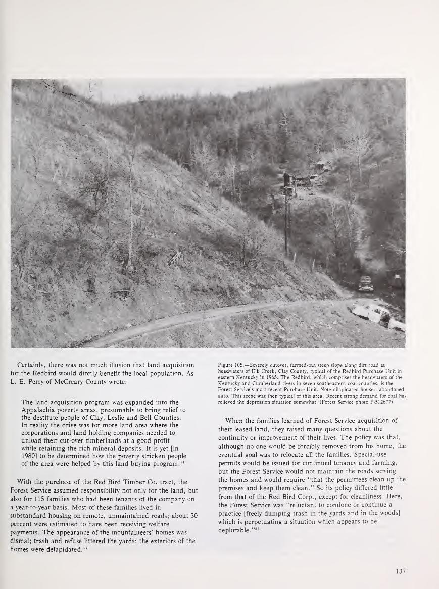
Certainly, there was not much illusion that land acquisition
for the Redbird would dirctly benefit the local population. As
L. E. Perry of McCreary County wrote:
The land acquisition program was expanded into the
Appalachia poverty areas, presumably to bring relief to
the destitute people of Clay, Leslie and Bell Counties.
In reality the drive was for more land area where the
corporations and land holding companies needed to
unload their cut-over timberlands at a good profit
while retaining the rich mineral deposits. It is yet [in
1980] to be determined how the poverty stricken people
of the area were helped by this land buying program. 51
With the purchase of the Red Bird Timber Co. tract, the
Forest Service assumed responsibility not only for the land, but
also for 115 families who had been tenants of the company on
a year-to-year basis. Most of these families lived in
substandard housing on remote, unmaintained roads; about 30
percent were estimated to have been receiving welfare
payments. The appearance of the mountaineers' homes was
dismal; trash and refuse littered the yards; the exteriors of the
homes were delapidated."
Figure 105.— Severely cutover, farmed-out steep slope along dirt road at
headwaters of Elk Creek. Clay County, typical of the Redbird Purchase Unit in
eastern Kentucky in 1965. The Redbird. which comprises the headwaters of the
Kentucky and Cumberland rivers in seven southeastern coal counties, is the
Forest Service's most recent Purchase Unit. Note dilapidated houses, abandoned
auto. This scene was then typical of this area. Recent strong demand for coal has
relieved the depression situation somewhat. (Forest Service photo F-512677)
When the families learned of Forest Service acquisition of
their leased land, they raised many questions about the
continuity or improvement of their lives. The policy was that,
although no one would be forcibly removed from his home, the
eventual goal was to relocate all the families. Special-use
permits would be issued for continued tenancy and farming,
but the Forest Service would not maintain the roads serving
the homes and would require "that the permittees clean up the
premises and keep them clean." So its policy differed little
from that of the Red Bird Corp., except for cleanliness. Here,
the Forest Service was "reluctant to condone or continue a
practice [freely dumping trash in the yards and in the woods]
which is perpetuating a situation which appears to be
deplorable." 53
137

Throughout the next decade, rangers on the Redbird Unit
had continuous problems with some of the inhabitants, such as
special-use permits, trash disposal, and incendiary fires.
Maintaining a firm but friendly attitude was difficult, even for
the most resourceful ranger.
For example, the first ranger on the Redbird Unit tells of
his experiences with one particularly stubborn tenant family
which had occupied several acres in the Redbird since the days
of Fordson Coal Co. Although a tenant of Fordson, the family
had persistently filed claims for- the property they were
occupying, but could never prove their case to obtain a bona
fide deed.
When the Government acquired the lands the family was
occupying, the second generation of tenants was not content
with a special-use permit and continued the fight to own their
small tract. They threatened the district ranger with bodily
harm, and went so far as to begin construction of building
foundations on the tract they occupied. In short, they
"interfered with national forest management." Ultimately, the
case was settled in Federal court and the family was required
to leave the National Forest. Several family members, however,
continued for at least 10 years to assert their claim to the
land. 54
Weeks Act Purchases Rise Steadily
After the lean years of the Eisenhower Administration,
appropriations for Weeks Act purchases increased almost
steadily from 1961 until 1967, from $100,000 to $2,480,000.
In 1966, more acres were approved for Weeks Act acquisition
than had been approved for all the previous 11 years
together." Throughout the late 1960's and early 1970's,
acquisition in the Redbird Purchase Unit dominated the
business of the National Forest Reservation Commission.
According to NFRC minutes in 1972, "during the past six
years, over one-half of the Weeks Law funds have been
concentrated in the Redbird Purchase Unit." 56
In 1972, the National Forest Reservation Commission
approved a 96,061 -acre extension to the Redbird Purchase
Unit. The extension included land in Owsley and Perry
Counties that was "forested although heavily cutover." The
Commission felt that Federal acquisition would help protect
the area's watersheds and improve the water quality of an
existing reservoir in the region. It was projected that
acquisition costs would range between $25 and $80 per acre,
and that the purchase program would run for about 20 years. 57
In 1975, the Redbird was still identified as the "major thrust
area" for NFRC land purchase. 58
Most of the tracts purchased in the Redbird were small,
ranging between 10 and 300 acres. Larger tracts were the
exception, although in 1973 over 9,000 acres were acquired
from the Mayne Land and Development Co. 59 From its
creation in 1965 until 1978, an average of about 7,500 acres
was acquired in the Redbird each year. In 1977 the net
acreage of the purchase unit was almost 135,000 acres. In 1981
it was just over 140,000. Prices for land in the Redbird have
been far below those in the other Southern Appalachian
National Forests. In fiscal year 1977, for example, tracts
acquired in the Redbird averaged $85.97 per acre; those in the
Nantahala and Pisgah National Forests averaged $441.27 per
acre, and those in the Cherokee, $635.22 per acre. 60
Serious Problem With Mineral Rights
The problem of mineral rights on the lands of eastern
Kentucky, which halted efforts to establish a National Forest
there 60 years ago, has plagued the Forest Service since the
Redbird was established in 1966. Much of the land in the
Redbird is covered by the Kentucky broad form deed, which
allows strip-mining and gives the deed holder wide freedom
with the land. At first the National Forest Reservation
Commission was reluctant to purchase lands that had mineral
rights outstanding in a third party with a Broad Form Deed.
Gradually, however, it was recognized that so much Redbird
land was of this type, some would have to be acquired to
create a manageable National Forest district.
Thus, many tracts in eastern Kentucky have been purchased
with mineral rights held by third parties. The Commission
consoled itself with the expectation that, because Kentucky
had strengthened its 1954 strip-mining law, the mining would
be acceptable. 61 Mineral rights have been separately
purchased, where possible, however, to facilitate Forest Service
control. For example, in 1971 the National Forest Reservation
Commission authorized $10 per acre to purchase the mineral
rights to the Fordson Coal Co. lands. 62 Ultimately, of course,
the Commission could obtain the mineral rights with the
Secretary's condemnation, an option that was entertained more
frequently in the 1970's as recreation and wilderness forces
collided with mining interests on the Daniel Boone.
New Law Boosts Recreational Land Purchases
Although land acquisition in the Southern Appalachians
during the 1960's and 1970's was concentrated in the Redbird
Unit, the other National Forests in the region also expanded
because of a boost in acquisition monies provided by the Land
and Water Conservation Fund (LWCF). The Fund, established
by the Land and Water Conservation Fund Act of September
1964, was a direct outgrowth of the Outdoor Recreation
Resources Review Commission (ORRRC) study. 63 The main
purpose of the Act was to enhance the recreational resources of
America through planning, acquisition of lands, and
recreational development. A separate fund was established to
provide money to individual State and local governments on a
matching basis and to Federal agencies to carry out the
purposes of the Act. Monies were available, through the
Bureau of Outdoor Recreation (later to become the Heritage,
Conservation, and Recreation Service), for the Forest Service
to acquire private inholdings in wilderness areas, lands for
outdoor recreation purposes, or areas where any fish or wildlife
species was threatened. The Act stipulated that no more than
15 percent of the acreage so acquired could be west of the
100th meridian.
138

Figure 106.— Hillsides scarred by strip and
auger coal mining along Beech Fork, Leslie
County, Ky., in 1965. A common sight then in
Redbird Purchase Unit. Acid soil debris leached
down to pollute streams and kill fish for manyyears. New highway and old road cut slope at
lower levels. (Forest Service photo F-512684)
Figure 107.— Strip coal mine spoil banks,
partly reforested by planting, along Little Goose
Creek in Leslie County, Ky., in 1965. At that
time, more than 1.500 acres of strip mine
tailings in the area were still in need of
rehabilitation and revegetation. (Forest Service
photo F-512685)
139
After 1965, LWCF appropriations became by far the chief
source of money for National Forest land acquisitions. Between
1965 and 1977 an average of over $25 million per year was
provided for National Forest acquisition from the fund. 64 Bythe end of 1973, 35 percent of the National Forest acres
acquired through the LWCF were in Georgia, Kentucky, North
Carolina, Virginia, and Tennessee." In fiscal year 1976
conservation fund monies exceeded Weeks Act monies by a
ratio of more than 25 to l.66 Increasingly, the Fund was used
to purchase lands on the older Southern Appalachian National
Forests with high recreational value, while Weeks Act
appropriations were devoted to the Redbird Unit. 67 Table 18
summarizes the LWCF funds spent for land acquisitions in the
Southern Appalachian National Forests during the first 14
years of the Fund, ending June 30, 1980.
Although land acquisition for National Forests in the
Southern Appalachians continued throughout the 1960's and
1970's, large purchases were generally not made without a
clear indication that they were approved by the local public. Acase in point is a 46,000-acre tract largely in Bland County,
Va., owned by Consolidation Coal Co., a subsidiary of
Continental Oil Co. It was considered by the Commission in
January 1972. Because the tract amounted to about one-fifth
the land area of Bland County, the NFRC felt that evidence of
public support for the purchase was necessary. 68
The tract in question had been logged about 40 years before
and contained only "a residual stand of poor quality timber."
Manganese strip-mining had also occurred on the land, leaving
behind a few small lakes. The tract was not being used for
farming or grazing; it was mountain land with no ongoing
commercial utility except some small-scale lumbering.
However, its recreational potential was considered "great." 69
Although the Virginia Commission for Outdoor Recreation
favored Forest Service purchase, Bland County was divided on
the issue. One-half of the letters to the Forest Service from
local groups and individuals approved of the purchase, and the
Bland County Board of Supervisors was split, two to two, on
Table 18.—Total lands acquired with Land and Water
Conservation Act funds in National Forests of the
Southern Appalachians, 1966-80
Forest State LWCF acquisition funds*
Chattahoochee Georgia $ 7,898,000
Daniel Boone Kentucky 1,622,000
Nantahala North Carolina 10,139,000
Pisgah North Carolina 4,923,000
Cherokee Tennessee 4,046,000
Jefferson Virginia 16,106,000
Total $44,734,000
•Rounded to nearest thousand. Fiscal year data.
Source: Data on National Forest lands acquired through LWCF monies: Heritage,
Conservation, and Recreation Service, Department of the Interior, Washington, D.C.
the acquisition. The opponents did not want to see the land
removed from the tax rolls. The estimated loss of revenue from
such removal was an annual $3,000, without considering
timber harvesting. Although the tract contained poor second-
growth timber, the Forest Service claimed it was suitable for
immediate pulpwood harvesting, which would bring additional
revenues. The NFRC recommended that the Bland County
purchase be approved. 70 The area actually so acquired was
about 40,000 acres.
Forest Commission Dissolved
Throughout the 1960's and early 1970's, the National Forest
Reservation Commission was finding it nearly impossible to
assemble the various cabinet members, senators, and
congressmen, or even a quorum of their deputies, at the same
time to consider National Forest land acquisitions. Approval
was usually granted in "unassembled" meetings. Finally, in
October 1976, the NFRC was dissolved. The National Forest
Management Act of 1976 transferred its functions to the
Secretary of Agriculture, 71 granting him authority to approve
small, routine acquisitions, but requiring those of $25,000 or
more to be submitted to the House Agriculture Committee and
the Senate Committee on Agriculture and Forestry for a 30-day
review.
The demise of NFRC marked a symbolic end of National
Forest creation under the Weeks Act. After the Redbird
Purchase Unit was added to Daniel Boone National Forest,
acquisition of large cutover tracts at major stream headwaters
virtually stopped. By 1975 most such lands in eastern
watersheds not in Federal ownership were too expensive to buy
or not for sale. Additions to eastern National Forests were thus
increasingly based on other legal authority, and primarily for
recreation—as will be discussed in chapter VIII.
Recent National Forest Timber ManagementAlthough the demand for timber slackened in the immediate
postwar years, the 1950's saw a steady rise in timber harvesting
across the Nation as housing construction and timber exports
increased. In 1952 the Forest Service, in cooperation with
other Federal, State, and private agencies, began a newinventory and assessment of the country's timber resource
known as the Timber Resource Review (TRR). The TRRreport, published in final revised form in 1958, found that in
1952 growth of sawtimber was almost equal to the cut, and in
the South and East, exceeded the cut. However, the report
expressed serious concern over the ability of the nation's forests
to meet future timber demands, which were projected to rise
rapidly. Although the TRR report fell short of recommending
regulation of harvesting procedures on private timberlands, it
emphasized the need for increased National Forest production
and more intensive timber management on lands of all
ownerships. 72
140

Figure 108.—Open mine of Manganese Mining & Contracting Company on
Glade Mountain near Marion, Smyth County, Va., in Holston Ranger District of
Jefferson National Forest, in July 1955. The firm operated under a Forest Service
special-use permit, and maintained a settling pond to collect mine waste to avoid
polluting streams. Mineral rights had been reserved on these lands when the land
was sold to the Federal Government. (Forest Service photo F-479124)
At the same time, as discussed in chapter VI, pressures on
the National Forests had been building for expanded outdoor
recreational opportunities. In June 1958, shortly after the
publication of the TRR report, President Eisenhower
established the Outdoor Recreation Resources Review
Commission (ORRRC) to inventory the nation's recreational
resources. (ORRRC is discussed further in chapter VIII.)
Meanwhile, the Forest Service was handling a multitude of
problems connected with livestock grazing in the Western
National Forests and was receiving increasing numbers of
requests for special uses of Federal land, including the
reservation of more wilderness. The combined pressures on the
National Forests throughout the 1950's led to the drafting and
eventual passage of the Multiple Use-Sustained Yield Act,
which defined the purposes for which National Forests were
established and administered, 73 mostly reaffirming long-
standing Forest Service policies and practices. It was the
organization's feeling that the Forest Service "had better get its
national forest house in order" that prompted the legislation.74
The Multiple Use Act of 1960
The Multiple Use-Sustained Yield Act, enacted on June 12,
1960, stated five renewable resources or uses of the National
Forests in alphabetical order: outdoor recreation, range
(grazing of domestic livestock), timber, watershed, and wildlife
and fish. (Mining was not mentioned; it is not a renewable
use, and was not at the time felt to be in need of express
encouragement.) In essence, the Act declared that National
Forests do not exist for any single purpose and implied that no
one resource should be overemphasized at the expense of
others. The Multiple-Use Sustained Yield Act articulated the
management ideals that the Forest Service had espoused for
years: the National Forests are to be managed for a variety of
purposes, with an effort to sustain the benefits of each purpose
for the longest possible period of time. Although conflicts
between purpoes (uses) are possible, they are to be resolved in
favor of the long-term public interest—in Pinchot's
paraphrase, "The greatest good of the greatest number in the
long run."
141

Much has been written about the ambiguities inherent in the
Multiple Use-Sustained Yield Act. 75First, the Act states that
the five purposes are "supplemental to but not in derogation
of the purposes stated in the so-called Organic
Administration Act of 1897 that provided for management of
the forest reserves. Those purposes were forest improvement
and protection, securing favorable water flows, and a
continuous timber supply. The Act also specifically protected
prospecting and mining rights. There is some overlap between
the two acts, and whether the more limited purposes stated in
the 1897 Act should take precedence over those of the 1960
Act was publicly discussed after the latter's enactment. 76
Resolution of competing claims remained difficult. The more
recent laws of the 1970's have clarified the situation
substantially.
In addition, the 1960 Act's definition of multiple use was
vague and simplistic. The criteria of flexibility in uses over
time and continuous resource productivity can give "the
unwary or ill-informed . . . the comforting illusion that if the
uses are multiple enough there will be sufficient for
everyone." 77 Moreover, the Act gives little specific direction as
to how National Forests are actually to be managed, much less
just how conflicts among purposes are to be resolved. Thus,
some critics have charged that the multiple-use concept is a
"facade behind which the Forest Service can operate to makedecisions according to the relative strengths of clientele groups
in a given area at a given time," or that it is a "blank check"
to manage the National Forests as it sees fit.78
Certainly, the legislation was not so much a management
tool as it was a statement allowing the Forest Service
management flexibility while placating the multiple forest
users. As Edward C. Crafts, Assistant Chief of the Forest
Service during the 1950's, wrote:
. . . there was a chance the various pressure groups
might tend to offset each other to some degree. For
example, the grazing people might like the bill because
their interests would be equated with timber andrecreation. Recreation and wilderness users should like
it because it would raise them to a status equal to
commercial users. The timber industry which had
enjoyed preferential treatment would not like losing
this preference, but on the other hand would be
protected against being overridden roughshod by the
recreation and wilderness enthusiasts. The bill
contained a little something for everyone. 79
Nevertheless, in spite of its ambiguity and openness to
conflicting interpretation, the Act did express the fundamental
approach of Congress and the Forest Service to managing
lands under pressure from multiple interest groups and fast-
growing U.S. population: a recognition of all the uses to which
forests can be put (except mining), and an attempt to diversify
land use—or prevent single use—wherever possible. As
Richard E. McArdle, then Forest Service Chief, stated at the
Fifth World Forestry Congress in August 1960, "in most
instances forest land is not fully serving the people if used
exclusively for a purpose which could also be achieved in
combination with several other uses." 80 McArdle conceded that
multiple use is not "a panacea," but he pointed out that
because it helps considerably to overcome problems of scarcity
and resolve conflicts of interest, it is the "best management for
most of the publicly owned forest lands of the United
States." 81
Difficult to Promote Private Forestry
Against the background of potentially conflicting
management directives inherent in the Multiple Use-Sustained
Yield Act, Forest Service management of the Southen
Appalachian forests became increasingly complex through the
1960's. The complexity was compounded by the development
initiatives encouraged by the President's Appalachian Regional
Commission. In 1963 PARC recommended that a timber
resource development program for the whole Appalachian
region be launched "on a scale far greater than ever before." 82
This program would involve an accelerated effort on both
National Forests and on State and private lands. Specifically
recommended initiatives were reforestation, timber stand
improvement, construction of access roads, and the location
and marking of property boundaries, as well as firebreak
construction and erosion control. PARC estimated that more
than 37,000 man-years of employment would be involved in the
initial 5 year effort, and that more than $240 million should be
spent. 83
The Appalachian Regional Development Act of 1965
creating the new Commission with expanded powers made a
specific provision for technical assistance to be given for the
organization and operation of private "timber development
organizations." Timber development organizations were
conceived as nonprofit corporations that would manage the
timber resources of participating private landowners. One of
the first research reports prepared for ARC was an evaluation
of such organizations as a source of regional economic
benefits.
The report concluded that, because sawmilling dominated
the timbering industry of Appalachia—not pulpwood, plywood,
or the like—and because of "restrictions imposed by timber
availability, timber procurement economics, and requirements
for timber quality," the industry was not expected to grow. 84
Furthermore, private forest lands were found to be in
"multiple thousands of small size holdings," and many of the
region's timber owners unmotivated to improve their long-term
productivity. "Feelings of disinterest and mistrust" often
characterized sales transactions, as well as "a propensity
toward overengagement in dickering and negotiation." For
these reasons, consolidating private timber holdings and
turning their management over to second parties did not seem
feasible, and timber development organizations were
proclaimed "not . . . viable in sufficient numbers to yield
substantial economic benefits to Appalachia." 85
142

This finding serves to emphasize the stabilizing role of
Federal land managed for a variety of uses in the development
of the Appalachian timber resource. Clearly, the National
Forests did not exhibit the fragmented ownership, lack of
owner motivation, and poor resource quality that characterized
the private timber industry. Nevertheless, because of their
timber composition, Southern Appalachian forests could not
then be managed in the same way that Pacific forests and
Southern coastal forests were. Appalachian forests did not at
that time contain nearly the proportion of commercial timber
acreage that the Western and the Southern piedmont and
coastal forests did. Much was low-quality, second-growth
hardwood, the product of a history of repeated "selective"
cuttings, actually destructive "high-grading" in most cases,
that left behind the undesirable and damaged individuals and
species. Further, the quality hardwood that was present had a
fairly long rotation cycle: between 40 and 80 years for
sawtimber-sized trees.86
Figure 109.—Tractor-mounted power loader dropping a big white pine sawlog
onto a truck at a Forest Service timber sale in Hurricane Gap section of
Nolichucky Ranger District, Cherokee National Forest on the Tennessee-North
Carolina State line adjoining Hot Springs Ranger District of Pisgah National
Forest, in May 1962. (Forest Service photo F-502185)
Nevertheless, the Appalachian National Forests continued to
provide resources for the small local wood processors. Small
sales, of less than $2,000 in value, generally exceeded the
larger sales in value by a factor of four to one, although there
was considerable variation from forest to forest. For example,
in fiscal year 1960, the only year for which comparable data
were readily available, there were no sales of greater than
$2,000 in value on the Daniel Boone or Cherokee National
Forests, and on the Chattahoochee, only a handful; whereas,
on the Nantahala and Pisgah, the value of "large" sales was
nearly equal to that of small ones. 87It is interesting to note
that large timber sales in the western North Carolina and
northern Georgia forests were dominated by one company, the
Ritter Lumber Co., which had been operating in the area since
1900.
143

For both small and large lumber firms, logging in the
National Forests could not be described as a lucrative business,
in part because the process of sealed bidding often elevated
timber prices; in part because of the restrictions placed on the
logger. As George Hicks wrote in Appalachian Valley about
logging in North Carolina:
Work in timber continues to provide a living for somelocal men, but it is seasonal and sporadic
employment . . . When a local man, for example, wontimber rights to a large tract of national forest land in
1965 by submitting a bid far above all others, it wasgenerally agreed by those who make their living in
cutting timber that he "might just come out even" andperhaps make a slim profit only because he and his
five adult sons would work together. If he were to hire
labor, he would surely lose money. 88
Moreover, as it did nationwide, the Forest Service placed
restrictions on the size and type of logging roads, requiring
piling and burning of slash, and specified the methods of
timber extraction—to protect the environment, reduce danger
of fire, and assure reproduction—all of which increased the
cost of logging. This is even more true today.
Even-Aged Management Becomes Standard
In the early 1960's—under policy directives to increase
National Forest timber production, with the support of long-
awaited new silvicultural research findings, a more stringent
need for economy and efficiency in harvesting, and with
demand increasing from the region's pulpwood
industry—clearcutting in patches (called even-aged
management by foresters) became a more prominent practice
of timber management in the Southern Appalachian forests,
where mild climate, heavy rainfall, and generally good soils
help insure rapid regrowth. Indeed, by the middle of the
decade, it was the chief method of timber harvesting
nationwide on National Forests, as it had nearly always been
on private forests, and by 1969 accounted for about 50 percent
of the harvested timber volume on eastern National Forests. 89
However, it was over such cutting in an Appalachian
forest—the Monongahela National Forest in West Virginia,
along with others in Montana and Wyoming—that the practice
actually became a national controversy. The debate over
clearcutting or patch cutting, which persisted through the
1960's and into the 1970's, illustrates the kind of difficulty that
multiple-use management could bring, and points to the
special qualities of Southern Appalachian forests that help
explain why they would increasingly become the focus of
management controversy.
Scientific clearcutting in patches, or even-age management,
is a silvicultural technique that has been in practice for
centuries. All the trees within a given area of limited extent are
cut, regardless of age, species, or size, so that the stand that
replaces them will be even-aged and will mature at the sametime. Forest regrowth is assured by natural or artificial
seeding, or by planting. The advantages of the technique over
Figure 110.—Forest Service specialists mapping soil types on aerial photos during
a field survey in Pisgah National Forest, N.C., in February 1965. Uniformshoulder patch was new at the time. (Forest Service photo F-513936)
true selective cutting, shelterwood, or seed-tree methods are:
improved regulation of stands, encouragement of growth for
valuable sun-loving shade-intolerant timber species—such as
yellow-poplar in the East and Douglas-fir in the West, control
of disease, and economy of cutting. 90
With this cutting system accounting for about half the
harvest, timber sales increased markedly in the Southern
Appalachians during the 1960's. Data on the volume and value
of timber sold from fiscal years 1960 to 1969 in the Jefferson
and Daniel Boone National Forests, for example, show a
steady increase over the decade. 91 The volume of timber sold in
the Jefferson nearly tripled from 13,070 million board feet in
1960 to 38,752 million board feet in 1969. On the Daniel
Boone the increase in volume was from 18,726 million board
feet to 41,384. (The value of the timber sold similarly tripled
and doubled respectively.) Thus, although the total acres cut
in the Southern Appalachian National Forests were but a small
percent of the region's total forest, the increase in timber
harvesting made this system more visible.92
Public reaction to patch clearcutting in the Monongahela
National Forest began with the objections of squirrel and
turkey hunters to losing some of their favorite densely forested
habitats, which years of Forest Service protection had
fostered. 93 The objections reached the West Virginia
legislature, which passed a resolution in 1964 calling for a
study of timber management practices on the Monongahela.
Over the next 7 years, despite several such resolutions and
studies, and numerous requests to change the system, the
Forest Service continued to practice even-aged management
there, with some modifications. The issue broadened its scope
and base, as national interest groups became involved there
and in the West. The press and other media provided extensive
and usually highly critical coverage. Eventually the clearcutting
controversy resulted in heated and extensive Congressional
hearings and litigation.
144

Lawsuit Forces New Forestry Act
In 1974 a Federal District Court judge in West Virginia
ruled the Forest Service in violation of the Organic Act of 1897
(which permitted the harvesting of dead, mature, or large
trees); its ruling was upheld by the Fourth Circuit Court of
Appeals in 1975, which noted that if changes in the law were
needed it was up to Congress to make them. The appeal ruling
forced Congress to act, prompting passage of the National
Forest Management Act of 1976. The Act repealed the
restrictions on timber harvesting declared in the 79-year-old
Organic Administration Act, set more specific requirements for
management planning, thereby amending the 1974 Resources
Planning Act, and established guidelines for timber harvesting.
Patch clearcutting on National Forests was not forbidden, but
was permitted only when determined optimal and under
environmental constraints.
By the last half of the 1970's, because of harvesting delays
caused by litigation and new rules, timber harvesting in the
Southern Appalachian National Forests was reduced below the
annual levels of the previous 10 years. On the Daniel Boone
and Jefferson National Forests, for example, the volume of
timber sold dropped to pre-1964 levels in fiscal years 1977,
1978, and 1979. (On the Jefferson, less timber was sold in 1979
than had been sold in 1960.) Integrated planning on an
increased scale to give more concern to wildlife, esthetics, and
watershed protection, and changes in road design and
harvesting practices to assure minimum environmental impact,
plus many studies for new wilderness proposals and increased
public participation in decision-making all slowed down timber
sales.
Throughout the 1960's and until the mid-1970's, the Forest
Service's required 25-percent payments to counties continued
to reflect timber sales and, as such, fluctuated with the rise
and subsequent fall in timbercutting. 94 In only two of the six
study counties with a high percentage of National Forests
(Graham and Macon) did 25-percent payments per-acre
increase overall from 1961 and 1975. In the other four, per-
acre payments rose to a peak in the years between 1965 and
1970, and then fell close to their 1961 level. In Union County,
for example, per-acre payments rose from $0.26 in 1961 to a
peak of $0.38 in 1967; in 1975 the payment was $0.18 per
acre. Similar fluctuations applied to counties with little or no
National Forest acreage. In 1975 none of the study counties
received more than $0.29 per acre in 25-percent payments.' 5
The Appalachian counties' dissatisfaction with the
fluctuating and often paltry compensation for Federal
landownership drew national attention in the 1970's. ThePublic Land Law Review Commission report, One Third of the
Nation's Land, issued in 1970, summarized the inequity of the
reimbursement system:
The study made for this commission confirms the
contention of state and county government officials
that shared revenues amount to less than the revenues
they would collect if the lands were in private
ownership and subject to taxation. 96
Nevertheless, the PLLRC report concluded, it does not follow
that these payments should be equal to full tax equivalency.
Although they are difficult to calculate, direct and indirect
benefits go to counties with Federal land—such as special land
use permits, fire protection, and road construction and
maintenance. The Commission considered that fair payment
for Federal land in lieu of taxes should equal 60 to 90 percent
of the amount necessary to provide full tax equivalency. 97
In 1974, Si Kahn, who learned of the 25-percent payment
through VISTA volunteers in northern Georgia, published The
Forest Service and Appalachia , a tract railing against the
unfairness of the Federal payment to National Forest
counties. 98 Although Kahn challenged several Forest Service
acquisition and management policies, his basic charge was that
the tax-exempt status of vast National Forest lands had
weakened the counties' tax bases, increased the burden on
local landowners, and threatened the ability of the counties to
govern themselves. 99
Congress Raises Payments to Counties
Two years after Kahn's publication was released, Congress
passed the Payments In Lieu of Taxes Act. 100 Under this Act,
counties would receive the higher of $0.75 per acre of entitled
Federal land minus certain payments received under 10
specified laws, or $0.10 per acre without those deductions,
both subject to a ceiling based on county population. One of
the specified laws was the original Act of 1908 first authorizing
Forest Service payments to States from receipts of National
Forest land, as amended.
Thus, for Southern Appalachian timber-harvest-poor
counties that had been receiving less than $0.30 per acre from
Forest Service payments prior to 1976, the In-Lieu Act
qualified them for the difference between that previous
allotment and $0.75 per National Forest acre. The Bureau of
Land Management would be the actual disbursing agent of In-
Lieu funds; the States would continue to provide to the
counties the recommended Forest Service 25 percent-of-receipts
payments, which would literally be subtracted from the
$0.75-per-acre amount due.
Table 19 illustrates the difference in such revenues between
1975 and post-In-Lieu years for five of the 12 selected study
counties. For most, the new total payments represent a 400- or
500-percent increase from pre-1976 revenues. The importance
of the In-Lieu additional payment can be seen in the example
of Graham County, where 25-percent payments ranged
between $4,885 and $36,296 over only 4 years. The In-Lieu
payment gave Graham County an assured, steady revenue.
However, whether an assured, steady revenue of $0.75 per
acre from Federal lands is necessarily fair is open to question.
One problem is that, in spite of the increased revenue, timber-
poor counties are still penalized. That is, counties with vast
timber sales (for example, in the Pacific Northwest) can elect
145

to receive $0.10 from the Bureau of Land Management and
still receive the 25-percent Forest Service payment, yielding
well above $0.75 per acre. In addition, the issue of whether
even the $0.75 per acre adequately compensates a county for
lost property taxes remains unclear. 101
A recent study sponsored by the Appalachian Regional
Commission, which includes several county case studies, states
that Swain and Clay Counties, N.C., which are 80 percent and
nearly 50 percent Federally owned, respectively, would receive
an average of $1.22 per acre from out-of-State private owners
if Federal lands were in their hands. However, the counties
receive only $0.75 for their National Forest land. The study
claims that $98,182 per year is being denied the two counties
even if the Federal Government would pay the low out-of-state
corporate tax rate instead of the $0.75 per acre. 102
Similarly, the report states that, "if the 70,000 acres owned
by the Forest Service in Bland County were taxed at the same
rate as land owned by county residents, the county would
realize an additional $16,000, a substantial increase for a
county of 6,000." 103 In 1980, Bland County, which is 30
percent federally owned, received $451,487 revenue from
property taxes versus $47,122 from the In-Lieu and 25-percent
payments combined. 104 In Union County, Ga., the tax assessor
asserted that property taxes yield about $800,000 in annual
revenues; whereas, In-Lieu payments for National Forest
land—which account for nearly half the total county
acreage—yield only about $55,000 105 (He failed to mention the
25-percent payment to Union County, although for the last few
years it has been small.)
While In-Lieu payments in the Southern Appalachian
National Forest counties generally have not equaled property
tax revenues for private lands, less tangible benefits must also
be considered. These include increased revenues from tourism
(which will be addressed in the next chapter), the value of
wildlife and hunting, the value of forest products, and
watershed control. 106 Furthermore, such adverse effects as maybe traced to Federal landownership must be compared with the
effects of any absentee ownership, whether corporate or
individual. As this chapter has suggested, and chapter VIII
will further consider, the economic and social problems that
many Southern Appalachian counties have faced may be more,
or as, attributable to private absentee landownership, and the
resource exploitation that accompanies it, than they are to
Federal ownership of land.
Table 19.—Payments made from the 25 percent and in-lieu funds to 5 of the 12 selected Southern Appalachian
counties, 1975-80
1980 National
Forest acreage 95,604 112,479 154,563 40,009 17,296
Payments in 1976:
25% fund from 1975 receipts 17,374 32,774
D o I I a r
24,554
s
7,194 2,756
Payments in 1977:
25% fund from 1976 receipts
In-Lieu fund
Total
11,760
59,959
18,755
64,975
25,995
103,425
4,867
24,817
3,205
9,952
71,719 83,730 129,420 29,684 13,157
Payments in 1978:
25% fund from 1977 receipts
In-lieu fund
Total
5,158
66,549
4,885
78,922
9,545
107,133
2,135
27,549
403
12,754
71,707 83,807 116,678 29,684 13,157
Payments in 1979:
25% fund from 1978 receipts
In-lieu fund
Total
17,731
53,956
36,296
47,598
26,088
90,590
7,340
22,656
1,472
11,685
71,687 83,894 116,678 29,996 13,157
Payments in 1980:
25% fund from 1979 receipts
In-lieu fund
Total
17,038
54,664
30,577
53,696
13,569
110,330
7,114
22,893
1,853
11,304
71,702 84,273 123,899 30,007 13,157
Source: Fiscal and Accounting Management Staff. Forest Service. USDA. Washington, D C. Fiscal year data.
146
Reference Notes
(In the following notes, the expression "NA, RG 95, FS, OC, NFRC"means National Archives, Record Group 95, Forest Service, Office of
the Chief, National Forest Reservation Commission. "WNRC, FS"
means Washington National Records Center, Records of the Forest
Service. See Bibliography, IX.)
1. Theodore H. White, The Making of the President 1960 (New York:
Atheneum Publishers, 1961), Chapter 4.
2. Washington National Records Center, Forest Service Records,
Accession No. 65A2473. National Forest Program—Depressed Areas,
General Correspondence, to 2/10/61, Planning.
3. A Report to Congress on the Continuation of the Appalachian
Regional Commission (Washington, D.C.: Appalachian Regional
Commission, March 1979), p. 1; and Belcher, "Population Growth
and Characteristics," in Thomas R. Ford, ed., The Southern
Appalachian Region: A Survey (Lexington: University of Kentucky
Press, 1962), Chapter 3.
4. L. E. Perry, McCreary Conquest, A Narrative History (Whitley
City, Ky.: L. E. Perry, 1979), p. 86.
5. Accelerated Public Works Program File, History Section, Forest
Service.
6. Robert F. Munn, "The Latest Rediscover)' of Appalachia" and
Don West, "Romantic Appalachia," in David S. Walls and John B.
Stephenson, eds., Appalachia in the Sixties. (Lexington: University of
Kentucky Press, 1972.)
7. Perry, McCreary Conquest, pp. 87, 88.
8. Economic Opportunity Act, 78 Stat. 508.
9. "Summary of Federal Programs," A Report of Federal Program
Impact on the Local Community. Information Center, Office of
Economic Opportunity.
10. W. K. McNeil, "The Eastern Kentucky Mountaineer: AnExternal and Internal View of History," Mid-South Folklore (Summer
1973): 45.
11. McNeil, "The Eastern Kentucky Mountaineer," and Paul Good,
"Kentucky's Coal Beds of Sedition," in Walls & Stephenson, eds.,
Appalachia in the Sixties, pp. 184-193.
12. Good, "Kentucky Coal Beds," p. 190; See also. West, "Romantic
Appalachia," p. 214.
13. ATAC Evaluation Group, An Analysis of the VISTA Program and
Appalachian Volunteers, Inc., Prepared under OEO Contract,
September 30, 1967.
14. "Summary of Federal Programs," OEO (See note 9).
15. WNRC, FS. Acc. No. 65A2473, National Forest
Program—Depressed Area, General Correspondence, Paper on
"Kennedy Task Force on Area Redevelopment," December 27. 1960.
16. Economic Opportunity Act. 78 Stat. 508.
17. Perry, McCreary Conquest, p. 227.
18. John M. Cooney and Fred Whitener, "Report on Visit—March23-25, 1966," in Survey ofJob Corps Camp Conservation Centers.
Prepared by the National Conference of Christians and Jews under
OEO Contract, p. 1.
19. Cooney and Whitener, "Report," 2.
20. Interview with Jack S. Kelley, Legislative Affairs, Regional Office,
Atlanta, Ga., July 9, 1979. Confirmed by interview with John W.Moser, Cherokee National Forest, July 18, 1979.
21. Interviews with Jack Kelley and John Moser, July 1979.
22. Perry, McCreary Conquest, p. 227.
23. Interview with Harold Debord, Director, Human Resource
Programs, Regional Office, Atlanta, Ga., July 10, 1979.
24. Pine Knot Civilian Conservation Center, "Report to Reply due
July 27, 1979," information supplied by Danny W. Hill, Center
Director, to Forest Supervisor, July 23, 1979.
25. Letter to Forest Supervisor from James E. Morphew, July 25,
1979, Frenchburg Civilian Conservation Center, Mariba, Ky.
26. Interview with Charles Crail and Clarence Moore, Cherokee
National Forest, Cleveland, Tenn., July 26-27, 1979. See David E.
Nye, The History of the Youth Conservation Corps (Washington:
Government Printing Office, 1981).
27. Interview with Harold Debord, Human Resource Programs,
USDA Forest Service, Regional Office, Atlanta, Ga., July 10, 1979.
The success of the SCEP program was confirmed by staff officers on
the Chattahoochee. Cherokee, and Daniel Boone forests.
28. Interview with Harold Debord, July 10, 1979. See Jack W.McElroy, History of Young Adult Conservation Corps: Bringing
Human and Natural Resources Together (Washington: Government
Printing Office, 1979).
29. Appalachian Regional Development Act, 40 App. USC 1-405.
30. Robb Burlage, "Toward A People's ARC," in Walls and
Stephenson, eds., Appalachia in the Sixties, p. 248.
31. Washington National Records Center, Forest Service Records,
Acc. No. 67A4805, Appalachia, Regional Study, Memo by John L.
Sweeney, Executive Director of PARC, October 30, 1963.
32. Burlage, "Toward A People's ARC," pp. 249, 250.
33. Burlage, "Toward A People's ARC," 249.
34. Jerald Ter Horst, "No More Pork Barrel: The Appalachia
Approach," in Walls and Stephenson, eds., Appalachia in the Sixties.
p. 35.
35. Burlage, "Toward A People's ARC," p. 250.
147

36. Telephone interview with Neil Walp, Appalachian Regional
Commission, Washington, D.C., December 11, 1979.
37. "Fact Sheet on ARC," June 1979. Appalachian Regional
Commission.
38. "Fact Sheet on ARC."
39. Burlage, "Toward A People's ARC." John Gaventa, Power and
Powerlessness: Quiescence and Rebellion in an Appalachian Valley
(Urbana: University of Illinois Press, 1980), pp. 163, 164.
40. Comptroller General of the United States, Report to the Congress,
Should the Appalachian Regional Commission Be Used as a Model
For the Nation? U.S. General Accounting Office, April 27, 1979.
41. Comptroller General Report on ARC, April 27, 1979, 107.
42. Data for the analysis of ARC funds that follows were obtained
from computer printouts on total ARC funds spent by county and
state, and for selected counties, by project. Provided by Joe Cerniglia,
Appalachian Regional Commission, Washington, D.C.
42. WNRC, FS, Acc. No. 67A4805, Planning—President's
Appalachian Regional Commission, "Program Highlights—The
Timber Situation in Brief," p. v, November 27, 1963.
44. "Program Highlights," PARC, xiii, November 27, 1963.
45. "Program Highlights," PARC, xiv, November 27, 1963.
46. Mary Breckenridge, Wide Neighborhoods: A Study of the Frontier
Nursing Service (New York: Harper & Row, 1952), Chapter 35.
47. Breckenridge, Wide Neighborhoods, Chapter 35. Also quoted in
Thomas R. Frazier, Project Leader, Redbird Purchase Unit,
"Redbird Roundups," Forest Service public relations publication,
1966. See also, Robert F. Collins, A History of the Daniel Boone
National Forest (Lexington, Ky. : University of Kentucky Press, 1975),
pp. 259-262. Collins notes that Ms. Breckenridge tried unsuccessfully
in 1936 to help the Kentucky State Garden Club save a tract of
"virgin" timber then being logged on Lynn Fork of Leatherwood
Creek in southern Perry County by having it included in the new
Cumberland National Forest Purchase Unit.
48. Frazier, "Redbird Roundups," 1966, and John F. Day, Bloody
Ground, (Garden City, N.Y.: Doubleday, Doran and Company, Inc.,
1941), p. 200.
49. "Fordson Coal Company, Peabody— Kentucky," miscellaneous
paper in possession of Thomas E. Frazier, former Redbird ranger,
USDA, Forest Service, Regional Office, Atlanta, Ga.
50. "Profiles of Politics," The Leslie-County News, Hyden, Ky., July
21, 1966.
51. Perry, McCreary Conquest, p. 227.
52. Thomas R. Frazier, "A Proposal for Housing, Relocation and
Employment in Eastern Kentucky," 1966. Unpublished document
provided by the author in a personal interview, USDA Forest Service
Regional Office. Atlanta, Ga., July 10, 1979.
53. Frazier, "A Proposal for Housing," 1966.
54. Interviews with Thomas E. Frazier, Lands, Regional Office,
Atlanta, Ga., July 10, 1979; March 27, 1980; January 27, 1981.
55. NA, RG 95, FS, OC, NFRC, Final Report for the fiscal year
ending September 30, 1976, pp. 4, 5.
56. NA, RG 95, FS, OC, NFRC, Minutes, March 15, 1972.
57. NA, RG 95, FS, OC, NFRC, Minutes, January 26, 1972, p. 7.
58. NA, RG 95, FS, OC, NFRC, Minutes, January 17, 1975.
59. NA, RG 95, FS, OC, NFRC, Minutes, February 23, 1973.
60. NA, RG 95, FS, OC, NFRC, Final Report, pp. 6, 7.
61. NA, RG 95, FS, OC, NFRC, Minutes, January 15, 1969.
62. NA, RG 95, FS, OC, NFRC, Minutes, July 8, 1971.
63. Land and Water Conservation Fund Act, 78 Stat. 897.
64. NA, RG 95, FS, OC, NFRC, Final Report, p. 4.
65. Records on Land and Water Conservation Fund purchases,
Headquarters, Chattahoochee National Forest, Gainesville, Ga.
66. NA, RG 95, FS, OC, NFRC, Final Report of the National Forest
Reservation Commission, p. 4.
67. NA, RG 95, FS, OC, NFRC, Minutes, March 15, 1972.
68. NA, RG 95, FS, OC, NFRC, Minutes, January 26, 1972.
69. NA, RG 95, FS, OC, NFRC, Minutes, January 26, 1972, 3, 4.
70. Si Kahn wrote about this tract in The Forest Service and
Appalachia, pp. 60-65. Kahn quotes several residents who were
opposed to the federal purchase, which, Kahn says, the Forest Service
"pushed through" in spite of the opposition.
71. National Forest Management Act of 1976, 90 Stat. 2949.
72. Edward C. Crafts, "Saga of a Law," American Forests 76 (June
1970); and Steen, The U.S. Forest Service, pp. 285-289.
73. The Multiple Use-Sustained Yield Act, 74 Stat. 215.
74. Crafts, "Saga of a Law," p. 15; for additional background to the
legislation, see Steen, The U.S. Forest Service. Chapter XI.
148

75. See, for example, Marion Clawson, Forests For Whom and For
What? (Baltimore: The Johns Hopkins University Press, 1975);
Shands and Healy, The Lands Nobody Wanted, pp. 121-124; Glen O.
Robinson, The Forest Service (Baltimore: The Johns Hopkins
University Press, 1975) pp. 56-58; Crafts, "Saga of a Law;" and
Federal Agencies and Outdoor Recreation, pp. 27-29.
76. Michael McCloskey, "Note and Comment: National
Resources—National Forests—The Multiple Use-Sustained Yield Act
of 1960," Oregon Law Review 41 (December 1961): 71-73.
77. Federal Agencies and Outdoor Recreation, p. 28.
78. Federal Agencies and Outdoor Recreation, p. 28.
79. Crafts, "Saga of a Law," p. 17.
80. Richard E. McArdle, "The Concept of Multiple Use of Forest and
Associated Lands— Its Value and Limitations," Fifth World Forestry
Congress, Seattle, Wash., August 29, 1960, p. 4.
81. R. E. McArdle, "The Concept of Multiple Use," p. 7.
82. Washington National Records Center, Forest Service Records,
Acc. No. 67A4805, Planning—President's Appalachian Regional
Commission, "Program Highlights—The Timber Situation in Brief,"
November 27, 1963, p. vii.
83. Program Highlights, viii-xi.
84. Appalachian Regional Commission, Evaluation of Timber
Development Organizations, Research Report No. 1 . Prepared for the
Appalachian Regional Commission by McDonald Associates, Inc.,
November 1, 1966, p. iv.
85. Evaluation of Timber, vi-vii.
92. Between 1968 and 1973, about 13 percent of National Forest land
in Region 8 were cut. Shands and Healy, The Lands Nobody Wanted,
p. 30. Postwar public reaction to lumbering is summarized in Steen,
The U.S. Forest Service, p. 302.
93. Sidney Weitzman, Lessons From the Monongahela Experience,
An In-Service Analysis Based on Interviews with Forest Service
Personnel, December 1977; Robinson, The Forest Service, pp. 78-80.
94. "Volume Timber Cut and Sold—MFB," F.Y. 1977, F.Y. 1978,
F.Y. 1979. Timber Management Staff, USDA Forest Service,
Washington, D.C.
95. Data on 25-percent payments: Fiscal and Accounting
Management Staff, USDA Forest Service, Washington, D.C.
96. Public Land Law Review Commission, One Third of the Nation's
Land (Washington: Government Printing Office, 1970), pp. 236, 237.
97. PLLRC, One Third of the Nation's Land, p. 238.
98. Si Kahn, The Forest Service and Appalachia. (See note 70.)
99. Kahn, The Forest Service and Appalachia, 1-6.
100. 90 Stat. 2662. The 1908 Act was 35 Stat. 260; it was modified by
the Weeks Act (36 Stat. 963).
101. Shands and Healy, The Lands Nobody Wanted, pp. 230, 231.
102. Appalachian Regional Commission, North Carolina State Report,
Preliminary Draft For the Land Ownership Task Force of the
Appalachian Alliance, 1980, p. 28.
103. Appalachian Regional Commission, Land Ownership and
Property Taxation in Virginia. Prepared by Tracey Weis for the
Appalachian Land Ownership Task Force, November 1980, p. 62.
86. Shands and Healy, The Lands Nobody Wanted, pp. 27-31;
Clawson, Forests For Whom and For What?, p. 49. It was not 104. Letter to authors from Dorothy M. Wright, Treasurer, Bland
selective cutting in the proper, professional, silvicultural sense. County, Va., January 27, 1981.
87. "F.Y. 1960 Sales—Classified by Small and Large Business." 105. Telephone interview with Office of Tax Commissioner, Union
Timber Management Staff, USDA, Forest Service, Washington, D.C. County, Blairsville, Ga., January, 1981.
88. George L. Hicks, Appalachian Valley, (New York: Holt, Rinehart 106. See, for example, Land Ownership and Property Taxation in
and Winston, 1976), p. 27. Virginia, p. 62. Appalachian Regional Commission.
89. Glen O. Robinson, The Forest Service, p. 76.
90. Robinson, The Forest Service, 76-85.
91. "Volume and Value Timber Sold and Cut by Regions, Forests,
States," for FY 1960-FY 1969. Timber Management Staff, USDAForest Service. Data on the Daniel Boone and Jefferson are not
available in the same form for the other Southern Appalachian forests.
149

Chapter VmRecreational Development of the SouthernAppalachians: 1960-81
The recreational development of the Southern Appalachian
Mountains during the 1960's and 1970's was extensive. It
brought widespread changes in landownership patterns, greater
visitation and use of the region's forests, and a vocal,
organized, and critical response from the Southern
Appalachian mountaineer. After 1965 the Federal Government
provided millions of dollars from the Land and Water
Conservation Fund to acquire private lands. Then a series of
Federal laws established National Recreation Areas, Wild and
Scenic Rivers, a National Trail, and finally confirmed and
extended wilderness areas in the region's National Forests. At
the same time, second-home builders and resort developers
helped increase the pattern of absentee landownership already
typical of the region. In response to the accelerating loss of
private and locally held land and local land-use control,
residents throughout the mountains organized to protest. The
people of the Southern Appalachians now seemed much more
determined to resist giving up ownership of land than they had
been in the past.
As discussed in chapter VI, outdoor recreation became more
and more a national pursuit and a national concern after
World War II, as the spendable income, leisure time, and
mobility of Americans increased rapidly. Concern with the
Nation's ability to satisfy recreational demands was expressed
in Federal legislation in June 1958, when President Eisenhower
created the Outdoor Recreation Resources Review Commission
(ORRRC). 1 The Commission's task was to inventory and
evaluate America's outdoor recreational resources, both current
and future, and to provide comprehensive information and
recommendations so that the necessary quality and quantity of
resources could be assured to all. It was composed of four
senators, four congressmen, and seven private citizens.
The Commission's immense report was issued in 1961, in 27
volumes. In essence, it found that America's recreational needs
were not being effectively met, and that since future demands
would accelerate, money and further study were needed at the
Federal, State, and local levels. The Commission provided
more than 50 specific recommendations, which can be grouped
into five general categories. These were: (1) the establishment
of a national outdoor recreation policy, (2) guidelines for the
management of outdoor recreation, (3) increased acquisition of
recreational lands and development of recreational facilities,
(4) a grants-in-aid program to the States for recreational
development, and (5) the establishment of a (Federal) Bureau
of Outdoor Recreation. 2
Bureau of Outdoor Recreation Is Created
During the next 10 years, virtually all the ORRRCrecommendations were enacted. In April 1962 the Bureau of
Outdoor Recreation (BOR) was established in the Department
of the Interior. 3 Edward C. Crafts, former Assistant Chief of
the Forest Service, became its first Director. The Bureau's
purpose was to coordinate the recreational activities of the
Federal Government under a multitude of agencies and to
provide guidance to the States in planning and funding
recreational development. At the same time a policymaking
Recreation Advisory Council was established by executive
order. It was composed of the Secretaries of the Interior,
Agriculture, Defense, and Health, Education and Welfare, and
the Administrator of the Housing and Home Finance Agency."
The Outdoor Recreation Act of 1963 was passed to expedite
coordination of recreational planning by Federal agencies and
initiate a comprehensive national recreation plan. 5 A year
later, the Land and Water Conservation Fund Act was passed
to provide funds for Federal and State recreational
development.
This heavy Federal legislative and administrative emphasis
on outdoor recreation was to have a decided impact on the
Southern Appalachians during the 1960's and 1970's. Many of
the Federal recreation programs and dollars spent on
recreation were channeled into the region. The number of
annual visitors to the southern mountain forests rose
substantially, as increased recreational development—both
public and private—increased tourist attractions and
investment possibilities. In addition, the renewal of Federal
funding for recreation made land acquisition appear muchmore urgent than it had previously been for general National
Forest purposes. Consequently, the Forest Service decided to
exercise its condemnation power as a final option, if needed, to
acquire especially worthy sites from owners unwilling to sell.
Such condemnation aroused residents in several areas, many of
whom organized for the first time in often bitter protest of
Federal land acquisition policies.
Since the early 1900's, with the genesis of the movements for
National Parks in the Great Smoky and Blue Ridge Mountains
and for the Blue Ridge Parkway, the recreational potential of
the region's natural resources had been well recognized. By
1960, decades of Federal land acquisition throughout the
region had put together very large tracts close to the Eastern
Seaboard that appeared ripe for recreational development.
Studies conducted for the Appalachian Regional
Commission were somewhat contradictory. One made for ARCby the Bureau of Outdoor Recreation in 1966-67 declared the
Southern Appalachian region had great potential to provide for
rapidly rising demands for public recreation. The study, in
estimating demand for outdoor recreation from 373 counties
and parts of 53 Standard Metropolitan Statistical Areas within
125 miles of Appalachia, calculated that to meet 1967 needs,
at least 600,000 more acres were required for boating, 20,000
acres for camping, and 30,000 for picknicking. By the year
2000, it predicted, the recreational demands placed on the
region would be "staggering"; thus, an intensive effort was
believed necessary to provide recreational supplies to meet the
demands. However, another study, made jointly by two private
firms less than a year earlier for ARC, had warned against
major public investment. 6
150

The Land and Water Conservation Fund (LWCF),
established in September 1964, was the principal Federal step
taken to meet these perceived recreational demands. 7 The
Fund, administered by the Bureau of Outdoor Recreation,
could be used for Federal acquisition of lands and waters—or
interests in lands and waters such as scenic easements. The
properties would be used to create National Recreation Areas
in the National Parks and in the National Forests and to
purchase private inholdings in the National Forests "primarily
of value for outdoor recreation purposes" including
wilderness. 8 The ORRRC report had stressed the need to
rectify the imbalance between the abundance of Federal
recreation lands in the West and their scarcity in the East. The
Land and Water Conservation Fund was to address the need. 9
Within the Southern Appalachian forests, LWCF monies were
used in the Mount Rogers National Recreation Area in
southwestern Virginia, the Wild and Scenic Rivers System, and
the Appalachian Trail. The Mount Rogers NRA was perhaps
the most visible and most controversial use of LWCF funds in
the region.
National Recreation Areas (NRA's) were first conceived and
established by the President's Recreation Advisory Council.
The first NRA's created in 1963, were administered by the
National Park Service, and were principally based on a large
reservoir, such as Lake Mead above Hoover (Boulder) Dam on
the lower Colorado River. NAR's were defined to be spacious
areas of not less than 20,000 acres, designed to achieve a high
recreational carrying capacity, located within 250 miles of
urban population centers. Each was to be established by an
individual act of Congress. 10 The first National Recreation
Area in the Appalachians was the Spruce Knob-Seneca Rocks
NRA, established in September 1965 in the Monongahela
National Forest in West Virginia. The Mount Rogers NRA,centered on Whitetop Mountain and Mount Rogers—the
highest point in Virginia—was established in the Jefferson
National Forest on May 31, 1966."
Mount Rogers National Recreation Area
The Mount Rogers NRA was originally conceived as an
intensely developed recreational complex of 150,000 acres with
a 63-mile scenic highway, campgrounds, and nearby reservoirs.
(Two of these reservoirs were part of the proposed Blue Ridge
Project on the New River, to be discussed later.) Mount Rogers
was expected not only to help satisfy future regional demands
for outdoor recreation, but also to provide an economic boost
to the economy of southwestern Virginia. As the Secretary of
Agriculture stated in congressional testimony on the NRA:
The counties involved [in the NRA] are in areas of
continued and substantial unemployment and a
relatively low rate of economic activity. A national
recreation area will benefit this situation both
immediately and in the long run through the inflow of
funds and accelerated development and intensified
administration and the upbuilding of a permanenteconomic base oriented to full utilization of all the
national forest resources. 12
However, the scope and intensity of development originally
planned for Mount Rogers were not realized. The Forest
Service finally shifted its priorities away from encouraging
more motorized recreation such as those activities enabled by
reservoirs and scenic highways, to more active, "dispersed"
recreation, such as canoeing and backpacking 13 This shift is
reflected in recreational use data by type of activity for two
representative Southern Appalachian forests, the Cherokee in
eastern Tennessee and the Chattahoochee in northern Georgia.
For both forests between 1968 and 1980, automobile traveling
declined somewhat, not in volume but as a percentage of all
recreational activities. In the Cherokee, the decline was from
18 percent to 15 percent; in the Chattahoochee, it was from 22
to 19 percent. On the other hand, hiking more than doubled
as a percentage of all recreational activities: in the Cherokee
from 2.4 to 8 percent, in the Chattahoochee, from 4 to 8.9
percent. 14
The legislation establishing the Mount Rogers NRA provided
for acquisition of such lands, waters, or interests in them, by
purchase, donation, exchange, transfer, or condemnation, as
the Secretary of Agriculture deemed "needed or desirable." 15
The Land and Water Conservation Fund was to be used as the
source of acquisition monies. The final Forest Service-
developed plan for the NRA called for Federal ownership of
123,500 acres within the approximately 154,000-acre NRAboundary. By 1966 much of the desired acreage had already
been acquired; some 58,000 acres were deemed "needed or
desirable" to complete the future NRA. 16
The defined "need" was based on the premise of protection,
as the Secretary of Agriculture explained to Congress:
To fully develop and assure maximum public use and
enjoyment of all the resources of this area, there will
need to be come consolidation of landownership. Thepresent ownership pattern, particularly in the
immediate vicinity of Mount Rogers, precludes effective
development for public use. Acquisition of
intermingled private forest and meadowlands and of
needed access and rights-of-way is essential to fully
develop the outdoor recreation potential by protecting
the outstanding scenic, botanical, and recreational
qualities of the area . . ,
17
Of the approximately 58,000 desired acres remaining in private
lands, the Forest Service estimated acquiring about 32,000
"during the next several years." Of the other 26,000, it was
hoped that scenic easements could be used for a good portion,
although the exact amount of land to be acquired or easements
obtained could not be estimated. However, no scenic
easements were obtained during the next 15 years. At the end
of 1981 the first easement was acquired, 20 acres along a road
in the Brushy Creek area, and another easement on a similar
small tract was in the process of being acquired. The new plan
for the NRA places strong emphasis upon scenic easements. 18
151

Between 1967 and early 1981, approximately 25,000 more
acres in 312 separate transactions were acquired for the MountRogers NRA. The lands selected for acquisition were generally
in stream and river valleys where developed recreation facilities
(campgrounds, roads, trails, parking, and picnic areas) could
be located, and where the Forest Service generally had not
previously acquired land. The acquisition process proceeded
gradually over a 15-year period, dependent upon the funds
available for purchase (mostly from the Land and Water
Conservation Fund) and the operational plans of the Forest
Service staff, and influenced by the local peoples' reactions to
such acquisition. 19
Figure 111.—Hereford cattle grazing in mountain pasture adjoining Jefferson
National Forest near Taylors Valley. Washington County, Va.. between
Damascus and Konnarock, close to the Tennessee State line and the present Mt.
Rogers National Recreation Area administered by the Forest Sen-ice. in
November 1966. White pine and northern hardwoods are visible on nearby slopes
and ridges. (Forest Service photo F-515652)
Of the 312 tracts, 51, totaling about 7,100 acres, were taken
for the NRA through condemnation. Of these 51 tracts, 20 had
full-time residents, 15 of whom did not want to sell at all.
(Five agreed to sell, but wanted more money than the Forest
Service offered.) The majority of the condemnation cases were
filed between 1972 and 1975, in preparation for specific
development projects. Most tracts were in western Grayson
County, in the area of Pine Mountain, where a ski resort was
planned under special use permit, and Fairwood Valley, where
resort accommodations and camping facilities were planned.
152
The Forest Service acquired the Pine Mountain lands to keep
the area free from extraneous commercial development and
thus maintain a natural camp setting. Resort to condemnation
was minimized by Public Law 91-646 (1970) which liberalized
relocation assistance benefits to displaced landowners who were
living on their properties. However, some still resisted.20 Many
residents of the Mount Rogers area were angry and puzzled by
the rationale for the taking of land. A newsletter of a local
protest group declared:
Nowhere has the Forest Service lost more credibility
and generated more ill will than in its land
condemnation and acquisition practices. Everyone in
the affected area has either lost land or had friends or
relatives who did. These are people who ancestral
homes are here, whose parents, grandparents, great-
and great-great-grandparents have lived here, and until
recently were coerced into selling their land at a
fraction of its worth.
The Forest Service has been condeming land for years,
making sweeps through the area taking thousands of
acres at a time while assuring residents "that's all the
land we're going to buy." A few months later they
sweep through again enlarging their borders. 21
As a result of their disgruntlement, local citizens organized
to combat the tentative Forest Service development plans. The
Citizens for Southwest Virginia, which formed shortly after the
Forest Service issued the Draft Environmental Impact
Statement for the NRA in spring 1978, was composed of
citizens from the five-county area affected. They formed a
Board of Directors of prominent citizens whose families had
been in the area for generations. The organization claimed in
1978 that almost 10 percent of the five-county population had
signed their petition of protest against further NRAdevelopment. 22
Largely as a result of local citizen protest, supplemented by
that of environmental groups nationwide, the Forest Service
modified some of its initial development plans for MountRogers. The proposals for a scenic highway and for a ski resort
were dropped completely. Projections that reservoirs would be
constructed, that an excursion rail line would be built, that
local investment capital would supplement Federal
development proved too optimistic. The regional reservoirs and
rail line were never built; the Mount Rogers Citizens
Development Corporation, created to raise capital for local
development use, failed to achieve its funding-raising goals.
Regional economic conditions, however, began to improve
without such massive development efforts.
The popular mandate, the Forest Service concluded, was
clearly for dispersed recreation at Mount Rogers, with
emphasis on hiking, camping, canoeing, and the like.23
In 1981 some members of the Citizens for Southwest
Virginia were still active. Although in general they were
satisfied with the modified development plans for the NRA,they were skeptical about a Forest Service "access road" being
built between Troutdale and Damascus on the path of the
supposedly defunct Scenic Highway. Citizens were still uneasy
about Forest Service acquisition techniques, convinced that
local landholders were sometimes intimidated through
harassment and a lack of knowledge of their rights. 24 By 1981,
the Citizens for Southwest Virginia had joined the National
Inholders Association, a California-based organization created
in early 1979 to change Federal land acquisition policies
nationwide. 25
The Big South Fork NRAAnother National Recreation Area in the Southern
Appalachians that was still in the preliminary development
stage in early 1981 was the Big South Fork National River and
Recreation Area in McCreary County, Ky., and Scott County,
Tenn. The Big South Fork basin of the Cumberland River,
although rich in coal deposits, had not been extensively mined
or developed, because of the high sulfur content of the coal as
well as the physical limitations imposed by the narrow
shoreline, high cliffs, and generally rugged terrain of the river
basin. The area was largely uninhabited, most of its acreage
owned by the big Stearns Coal and Lumber Co., which had
bought the land around 1900. 26
Since the end of World War II, the Corps of Engineers had
tried unsuccessfully to win Congressional approval of an almost
500-foot dam on the Big South Fork near Devil's Jump for
hydroelectric power and flood control. The dam was generally
supported by local legislators and was strongly sponsored by
the Kentucky Senator, John Sherman Cooper; it was opposed
by private power companies: the Kentucky Utilities Co., the
Cincinnati Gas and Electric Co., as well as the Associated
Industries of Kentucky.
In 1967 Howard Baker was elected Senator from Tennessee.
During the 1950's and early 1960's, Baker had represented the
Stearns Coal and Lumber Co. in litigation and in efforts to
persuade the Forest Service to allow strip mining under
Stearns' reserved mineral rights. Between 1962 and 1966, he
served on Stearns' Board of Directors. 27 Shortly after his
election to the Senate in 1967, the fate of the Big South Fork
was decided. Baker called various government officials together
to determine the best development strategy for the area; the
plan to develop an NRA was an administrative and legislative
compromise. 28
Authorized under the Water Resources Act of March 7,
1974, the NRA was to encompass approximately 123,000 acres.
Of these, 3,000 belonged to the State of Tennessee, 1,000 to
the Corps of Engineers, and about 16,000 lay in the Daniel
Boone National Forest. All public lands were to be transferred
to the National Park Service—the designated managing
Federal agency—when sufficient private land had been
acquired. 29 The Federal land acquisition agency, as well as
planner, designer, and construction agent of the NRA, was the
U.S. Army Corps of Engineers.
153

Figure 112.— Visitors listening to forest interpreter on a guided trail walk in
Daniel Boone National Forest. Ky., in July 1966. (Forest Service photo F-514898)
The Corps' land acquisition program began in August 1979,
when Stearns Coal and Lumber Co. sold 43,000 acres of
surface rights, and 53.000 acres of mineral rights, in the Big
South Fork area, for S16.5 million. (Although the authorizing
legislation did not require that subsurface rights be acquired
for the NRA, it did prohibit prospecting and mining. Thus,
the Corps of Engineers felt obligated to acquire mineral rights
as well as land.) During 1980 several smaller tracts were
acquired, including those of over half the 38 families living in
the area. By March 1981 about half the privately owned land
remained to be acquired, but the timetable for that acquisition
was uncertain, depending as it did upon congressional
appropriation. 30
Local reaction to the development of the National Recreation
Area was mixed. Although at first McCreary County citizens,
having long supported the Corps dam, were generally opposed
to the NRA, by 1978 many were beginning to regard the
development favorably. There was some feeling that the area
might prove a major tourist attraction, even to the point of
tacky overdevelopment, characteristic of Gatlinburg. 31
However, in spite of the promises of local economic boom
assured by NRA promoters, the former Forest Service
employee of McCreary Count}*. L. E. Perry, was scornful:
Some local leaders have been brainwashed to the point
they believe the National Recreation Area ... is holy
salvation, placidly accepting the fact that not one
major highway leading from Interstate 75 to anywhere
near the Big South Fork is in the foreseeable future,
which is further proof that the people of the region
have been had. 32
The Wild and Scenic Rivers Act and the National Trails
Systems Act. which also guided recreational development in
the Southern Appalachians, were passed in 1968. The former
established a system of rivers judged to possess "outstandingly
remarkable scenic, recreation, geologic, fish and wildlife,
historic, cultural, or other similar values" to be preserved in a
free-flowing state.33 Rivers of the system were classified as
"wild," "scenic," or "recreational." depending on the degree
of access, development, or impoundment they possessed; each
class was to be managed according to a different set of
guidelines. The Act designated 8 rivers, all west of the
Mississippi, as the first components of the system, and named
27 others to be considered for wild and scenic designation. By
1980. only two Southern Appalachian rivers had been
designated part of the Wild and Scenic Rivers System— the
Chattooga River, forming the border between northeastern
Georgia and northwestern South Carolna. and a portion of the
New River near the western North Carolina-Virginia border. 34
154

The Scenic New River Controversy
A 26.5-mile segment of the New River in Ashe and
Alleghany Counties, N.C., was designated a "scenic river" in
March 1976 by the Secretary of the Interior. 35 This designation
was a deliberate obstruction to a development proposed in
1965 by the Appalachian Power Co. called the Blue Ridge
Project, designed to provide peak-demand power to seven
States in the Ohio River Valley. The project would have
created two reservoirs—one in Grayson County, Va., the other
in Ashe and Alleghany Counties, N.C.— totalling over 37,000
surface acres. The reservoirs would have dislocated nearly
1,200 people and over 400 buildings. Nevertheless, the project
promoters promised the local population construction jobs and
revenues from reservoir recreational visitation.36
Citizens of the North Carolina counties affected by the Blue
Ridge Project organized a protest against it. A National
Committee for the New River, based in Winston-Salem, N.C,
mounted a well-financed publicity campaign with letters,
brochures, and reports.37 By 1973, the commissioners of Ashe
and Alleghany Counties, and the two candidates for governor
of North Carolina, denounced the Blue Ridge Project and
endorsed the preservation of the river.38 In 1974, the North
Carolina legislature designated 4.5 miles of the New River a
State Scenic River. Public pressure was applied at the Federal
level through the Federal Court of the District of Columbia,
which was responsible for the Federal Power Commission
license, through the Congress, and through the Department of
Interior. Although the FPC license was upheld in March 1976,
the Secretary of the Interior designated the 26.5-mile portionn
of the New River as part of the national Wild and Scenic River
System 3 weeks later, in effect revoking the FPC license. 39
The Final Environmental Statement prepared by the Bureau
of Outdoor Recreation, although conceding that the scenic
river designation resulted in the projected loss of some 1,500
temporary construction jobs, and a certain loss in projected
increased land values adjacent to the reservoirs, emphasized
the benefits of the scenic designation. These were principally
intangible—the preservation of a unique, free-flowing river, the
preservation of wildlife and of archeological and geological
assets, and the preservation of a way of life in an Appalachian
river valley. The direct recreational benefits from the scenic
designation to the local communities were estimated to be low.
The activity areas to be established along the river were
expected to accommodate annually 50,000 canoeists, hikers,
and picnickers. Private entrepreneurs were anticipated to have
little opportunity for riverside development, due to the
existence of easements and floodway zoning. 40
Incorporation of the New River segment into the Wild and
Scenic River System provoked little local protest. In general,
the scenic designation brought only minor changes to life along
the river. Nearly 5 years after the designation of the New River
segment, the County Manager of Ashe County summed up its
impact as "very little."41 The State of North Carolina, which
has managed the 26.5-mile, 1,900 acre river segment,
established a State park along a portion of its banks; a few
canoe rental firms and river outfitters receive seasonal revenues
from recreationists. Overall, however, inclusion of the NewRiver in the Wild and Scenic Rivers System has had only a
small local impact.
The Wild Chattooga River
The designation of the Chattooga River had larger
repercussions. Public reaction was more outspoken, largely
because most of the nearly 57-mile segment of the river, which
included over 16,400 acres of adjacent land, was designated
"wild" and was therefore slated for more restrictive
management, and because the Forest Service sought to acquire
lands along the river to establish a protected corridor.
The Chattooga River portion of the Wild and Scenic Rivers
System was so designated by legislation of May 10, 1974. 42 The
designated river segment lay within the Nantahala National
Forest and on the border between the Chattahoochee and
Sumter National Forests. A corridor up to 1 mile wide was
outlined for acquisition along the designated river. In 1974, 47
tracts consisting of nearly 6,200 acres had to be acquired for
the river corridor. 43 By early 1981, 85 percent of the desired
corridor acreage had been acquired, mostly through exchange,
and all from willing sellers.
In general, acquisition along the Chattooga River proceeded
smoothly; land management of the area, however, met with
considerable local protest. Because some 40 miles of the
57-mile corridor were designated "wild," river access was
deliberately restricted in keeping with the guidelines
established by BOR. These guidelines stipulated that
administration of a wild river required restricted motorized
travel, removal of homes, relocation of campgrounds, and the
prohibition of structural improvements. 44 Consequently, upon
land acquisition, the Forest Service closed several of the jeep
trails that had provided river access. Not all the river jeep
trails were closed, just those the Forest Service judged were
allowing excessive and inappropriate use of the Chattooga that
was not in keeping with its wild and scenic designation. 45
The rationale for restricting access, however, was not
strongly supported or well understcjd by the local population.
As an Atlanta newspaper reported:
When the Forest Service attempted to keep the jeeps
away from the protected Chattooga River, the
mountain dwellers torched vast tracts of National
Forest land; if they couldn't use the land as they
wished, they wanted no one else to use it at all.46
155

Over the years, as the Chattooga River became increasingly
popular with urban recreationists for white-water canoeing,
rafting, and camping, local resentment mounted. In 1980,
nearly 130,000 visitor-days were spent in watercraft recreation
along the 57-mile river segment; 70,000 were spent in
swimming, and 60,000 in hiking. Altogether, the Chattooga
Wild and Scenic River received nearly a half-million visitor-
days of use in 1980.47 With a high frequency of visitors, it
appeared to some local people that the Forest Service was
catering to outsiders who came to the Chattooga to canoe, raft,
and camp. Those who lived in the area often resented the
restriction on using four-wheel drive vehicles. As one Clayton,
Ga., resident wrote to the Forest Service in 1978:
Figure 113.—Family hiking party at spectacular falls over a bald on upper
Toxaway River near Toxaway Lake, Transylvania County, N.C.. Nantahala-
Pisgah National Forests. Spot is southwest of "Cradle of Forestry" and Brevard,
N.C., near the South Carolina State line, about 15 miles from the upper
Chattooga River; July 1964. (Forest Service photo F-511344)
Special interest & minority groups, plus
environmentalists got the Government to close off the
Chattooga River, in Rabun County. Look at the river
now & it is more filthy and more trashy, from no one
but people who ride the river, & if any, very few local
people ride the river. Local people of Rabun County
don't destroy beauty, it's our home, [sic]4 *
156

The Appalachian Trail '
Another piece of post-ORRRC recreational legislation was
for the full development and protection of the Appalachian
Trail. The Trail, running for over 2,000 miles from Georgia to
Maine, mostly along the high ridges of the Appalachians, was
actually originally cleared and built between 1925 and 1937 by
the Appalachian Trail Conference, a group of Trail enthusiasts
composed of outdoorsmen, parks and planning staff, foresters,
and governmental officials, in cooperation with State and
Federal agencies. Most of the Trail was constructed by
volunteers, on private lands, whose owners gave permission.
Nearly a third of the Trail was built by the Forest Service and
National Park Service on their lands. Both agencies have
helped promote and maintain the Trail.49 In the Southern
Appalachian forests, 441.4 miles out of a total 592, or 75
percent, were "protected" before 1969 with an acquired right-
of-way or scenic easement. 50
The same was not true, however, of those portions of the
Trail not under Forest Service or Park Service jurisdiction.
Over the years, as the Appalachian Trail received increasing
public use, concern for the Trail's protection and uniform
management mounted, resulting in the National Trails System
Act of October 2, 1968. 51 The Act established a national
system of recreation and scenic trails, with the Pacific Coast
Trail and Appalachian Trail as the major components of the
system. The former was to be administered by the Secretary of
Agriculture, the latter by the Secretary of the Interior,
although specific stretches of either trail were to be managed
directly by the agency whose land the trail traversed.
Specifically, the National Trails System Act charged the
Secretary of the Interior with establishing the right-of-way for
the Appalachian Trail, provided that, "insofar as practicable,"
it coincided with the right-of-way already established. 52 Therequired dimensions of the right-of-way were not specified in
the 1968 Act; thus, the adequacy of Trail protection at a given
location was open to interpretation. Right-of-way purchases
could include entire tracts, strips of tracts, or even easements,
so long as the adjacent land uses were compatible with the
Trail's scenic qualities.
The authority to condemn lands of an unwilling seller for
the Trail right-of-way was clearly provided in Section 7(g) of
the Act but was to be utilized "only in cases where ... all
reasonable efforts to acquire such lands or interests therein by
negotiation have failed." 53 Further, a limitation was placed on
the amount of land that could be taken—no more than 25
acres per mile of Trail. Most condemnation cases simply
involved clearing title to the land. An example of a tract that
in 1980 appeared likely for such condemnation was the
Blankenship tract along the Tennessee-North Carolina border,
owned by more than 50 heirs. Condemnation would clear title,
but all 50 owners had to be contacted before the suit could
begin, and the proceedings were obviously complicated. 54
Until 1978, unprotected stretches of the Appalachian Trail
were acquired by the various jurisdictions with acquisition
authority, but generally—except for the Forest Service—at a
desultory pace. The slowness was due largely to the multiplicity
Figure 114.— Hiker passing new Forest Service sign on Appalachian Trail at
Rock Gap, Nantahala Mountains, in Standing Indian Wildlife Management Area
of Nantahala National Forest southwest of Franklin, N.C., near Georgia State
line, which is much closer as the crow flies than sign indicates. Photo was taken
in July 1960. (Forest Service photo F-494684)
of agencies and States responsible for right-of-way acquisition
and management. This was compounded by the fact that the
two principal Federal agencies—the Park Service and Forest
Service—were unable to develop a uniform approach to Trail
policy, which, in part, was due to differing interpretations of
the 1968 Act. 55 The Park Service maintained that a mile-wide
strip on either side of the Trail, that was free of parallel roads,
which had been established in a 1938 Forest Service-Park
Service agreement, was the appropriate right-of-way. The
Forest Service stressed that the Trail right-of-way could not
exceed 25 acres per mile. 56
In addition, the two agencies disagreed over the funding and
timing of Trail purchases. The National Trails System Act
established a $5-million fund for Trail purchases that the
Forest Service felt it could draw upon. The Park Service
considered this fund to be for State purchases only. Further,
the Park Service imposed acquisition deadlines on the Forest
Service that were impossible to meet, given the time-consuming
nature of surveys, title searches, and buyer-seller negotiations.
Several deadlines were established and subsequently
extended. 57 Nevertheless, between 1969 and mid-1977, 110
157

miles of the Appalachian Trail in the National Forests of the
Southern Appalachians were acquired. Of the 61 tracts
involved in this acquisition, 4 were obtained through
condemnation: one in the Nantahala, 2 in the Pisgah, and one
in the Cherokee. 58 By mid-1981, only 14.3 miles (2.1 percent)
of the 677.0 miles for which the Forest Service has
responsibility in the mountains of four States were
unprotected. Of the 263.5 miles delegated to the National Park
Service, 42.8 miles (16.2 percent) were still unprotected. 59 Asummary of the status of Appalachian Trail protection in the
Southern Appalachians in October 1981 is shown in table 20.
Amendments to the National Trails System Act passed in
1978 substantially improved the administration of the Trail
acquisition process and clarified most of the management
problems. 60 Substantial additional funds were provided for
acquisition, and condemnation authority was extended to allow
acquisition from unwilling sellers of up to 125 acres per mile of
Trail. In addition, the amendments stipulated that the
acquisition program was to be "substantially complete" by the
end of fiscal year 1981 (September 30).61
Under the 1978 amendments, the acquisition process
proceeded with available funding. 62 By January 1981, all but
14 miles of Trail strips in the Southern Appalachian National
Forests had either been acquired or were in the final stages of
acquisition. Most of the remaining private tracts involved
appeared to be obtainable only through condemnation. Somewere held by implacable owners who simply refused to sell.
John Lukacs, as resident of Florida, was one. Lukacs owned
about 1,500 acres in the Cherokee National Forest, near
Johnson City, Tenn., which he planned to develop someday.
The Appalachian Trail cut diagonally across one small corner
of his property. The Forest Service wanted to purchase a strip
of land along the Trail as well as the 11.6-acre "uneconomic
remnant"—the corner cut off by the Trail. Lukacs refused to
sell, citing as his reason a spring in the corner remnant. In
1978 the Forest Service referred the case to the Department of
Justice for prosecution. 63 Late in 1981 Justice agreed to press
ahead with the suit.
Another long-resistant owner was the Duke Power Co.,
which had several large tracts along both sides of the Trail on
the Tennessee-North Carolina State line in the Cherokee and
Nantahala National Forests. Duke Power finally exchanged its
Nantahala tract for equivalently valued National Forest
acreage. Although the Forest Service needed only a narrow
strip nearly 5 miles long, Duke insisted on selling the whole
Cherokee tract intact, about 1,705 acres. The Forest Service
made an offer which was refused by Duke, but after another
potential buyer dropped out, further negotiations produced
agreement on the sale price for the whole tract and the Forest
Service set aside funds for it. Completion of the purchase was
expected by early 1982. This would reduce the agency's
remaining Trail strip to be acquired to less than 10 miles out
of its total Trail responsibility of 677 miles in the four affected
States, less than 1.5 percent. 64
Kentucky Red River Gorge
Aside from Mount Rogers and the Appalachian Trail, the
only other location in the Southern Appalachians where the
Forest Service has taken lands from unwilling owners by
condemnation for recreational purposes was the Red River
Gorge of the Daniel Boone National Forest. Named a
geological area in 1974, the Gorge covers 25,663 acres along
the north and middle forks of the Red River, in Powell,
Menifee, and Wolfe counties, Ky. Once part of an ancient sea
and the product of centuries of weathering and erosion, the
area is unusually scenic, with natural arches, caves, bridges,
and rocky outcrops along the cliffs of the gorge. It has been
managed as a special forest unit, both for recreation and to
protect and preserve a unique environment. Lumbering is
prohibited in the Gorge. 65
Condemnation in the Red River Gorge has been used to
acquire summer-house lots held by absentee owners along
Tunnel Ridge Road, a high-use portion of the area. Altogether
five tracts involving 45 acres have been condemned, although
several owners have sold under threat of condemnation. 66 In
1973, when the Forest Service's draft plan for the Red River
Table 20.— Protection status of the Appalachian National Scenic Trail in the Southern
Appalachians, October 1981
USDA Forest Service National Park Service, USDI State-owned land
Still Still Still
Location to be to be to be
of trail Protected protected Protected protected Protected protected
miles miles miles
Virginia 303.7 4.4 152.0 42.8 18.6 6.0
Tennessee-
North Carolina 208.9 9.9 68.7 none none none
Georgia 78.1 none none none none none
Total 662.7 14.3 220.7 42.8 18.6 6.0
Source Land Acquisition Field Office. Appalachian National Scenic Trail. U.S. Department of the Interior, Martinsburg, W. Va.
Tennessee and North Carolina mileage is combined because much of the trail follows the State line. Virginia data includes stretches
not included in the study area of this publication.
158

Figure 115.—The static mountain community of Nada, Powell County, Ky., on
old State route 77 which tunnels through the mountain close by and forms part
of the Red River Gorge Loop Drive on the Daniel Boone National Forest. Themodern Mountain Parkway also now passes near the town, and the Frenchburg
Civilian Conservation Center, established 3 years before the photo was taken in
September 1968, is just a short distance away. A scene still common today
throughout the Southern Appalachians. (Forest Service photo F-519027)
Gorge was developed, the Red River Area Citizens Committee
protested the use of condemnation. Since 1973, some Red
River inholders, having observed its use in spite of their
opposition, began to protest any additional Federal land
acquisition. The Gateway Area Development District, for
example, passed a resolution in April 1979 opposing "further
acquisition of land within the . . . area." 67
The opposition appears to have been inflamed by the RAREII proposals to designate nearly one-half of the Red River
Gorge (Clifty area) as wilderness (to be discussed later);
however, the concern developed out of general experience with
Forest Service acquisition policies and procedures. As in the
cases of Mount Rogers, Chattooga River, and the Appalachian
Trail, legislative development and Forest Service management
plans appeared to threaten, with little warning, the pattern of
local landownership. In the Red River Gorge area many people
believed that, although the Forest Service usually aired its
land-management alternatives in public, it often did not
adequately inform them of final land-use decisions. Because
people sometimes felt uncertain of their options, the threat of
Federal acquisition was not entirely removed. 6e As long as the
Federal Government was a neighbor, the mountaineer felt he
could never be certain that his land would remain his own.
159

Private Recreation Business Is a Major Force
One conclusion of the ORRRC report was that the "most
important single force in outdoor recreation is private
endeavor—individual initiative, voluntary groups . . . , and
commercial enterprises." 69 Indeed, the heightened Federal
attention to outdoor recreational resources and and Federal
legislation passed following the report apparently triggered a
substantial private recreational development, particularly in the
Southern Apalachians. The natural beauty of the region and
its proximity to the population centers of the East were
recognized as assets that had not been fully exploited. National
corporations opened new resorts in the mountains; vacation
home communities spread in clusters outside the National
Forests; the number of retail establishments catering to tourists
increased, and speculators bought numerous tracts of
mountain land, throughout the region, hoping to turn a profit
by subdividing. The impact of these actions was considerable,
not only on the local population but also on the managers of
Federal land.
In its first years, the Appalachian Regional Commission
funded a series of studies to ascertain the potential role of the
recreation industry in the region's economic development. Thebenefits of tourism to the local population had long been
acclaimed by recreational developers seeking to gain support
for their programs. Promoters of the Blue Ridge Parkway and
the Great Smoky Mountains National Park had both predicted
a regional tourist boom. 70Nevertheless, although recreational
visitation and tourism in the Southern Appalachians increased
dramatically over the years, by 1960 no such boom had
developed. •
The first ARC study in 1966 concluded that the economic
impact of recreational development on local areas is
"marginal" and should be justified principally because it gives
open-space recreation to people living in metropolitan areas. It
cautioned that recreational employment is seasonal, low-
paying, and undemanding, and that the indirect benefits of
tourism are small. Thus, the 1966 ARC report pointedly
advised, "major public investment in non-metropolitan
recreation resources would rarely be justified solely or even
primarily, for the sake of the economic impact on the local
area." 71 So the recreation industry, like the timber industry,
was not the solution to Appalachia's economic ills.
Nevertheless, seemingly ignoring the prudent findings of its
first study, and favoring the rosy BOR report of 1967, ARCcontinued to encourage heavy recreational development. 72 In
1967 the Commission began an inventory and analysis of
selected multicounty sites, 23 of which were labeled of greatest
potential. Twelve such sites were in the Southern
Appalachians, and seven of these, all relatively undeveloped,
were selected for further analysis.73
All seven were near, or
enclosed, National Forests, National Parks, or TVA reservoirs.
Thus, the large Federal landownership in the region was
recognized as a major recreational asset. Private investment, it
was felt, could "piggy-back" on the existing recreational
attraction of public sites.
For example, the Upper Hiwassee River Interstate complex,
a seven-county highland area of northern Georgia,
southeastern Tennessee, and southwestern North Carolina, just
south of Great Smoky Mountains National Park, was credited
with enormous potential because of the Chattahoochee,
Cherokee, and Nantahala National Forests and four TVAreservoir lakes. However, the area lacked road access,
accommodations, and camping spaces. Although it was
implied that Federal or State funds would be required for
roads and other public services, ARC said private developers
could profitably build hotels, motels, and second homes. 74
Similarly, the Boone-Linville-Roan Mountain complex in the
Pisgah National Forest section of North Carolina, just east of
the park, was seen to exhibit "great potential" for attracting
vacationers, especially skiers.75
Overall, the ARC study
concluded, if the 14 recreation sites were fully developed, by
1985 there would be a $1.7-billion "total economic impact."
Even in the smallest counties where a lower level of
expenditure could be assumed, "a sizable amount of private
business development and/or expansion could be expected,
and services would probably be considerably expanded." 76
In 1960, private recreational development was not spread
evenly over the Southern Appalachians; rather, it was
concentrated in distinct county clusters. The principal clusters
were near Great Smoky Mountains National Park—Sevier and
Swain; in the Nantahala National Forest—Graham, Jackson,
and Macon; the northern Georgia counties in the
Chattahoochee National Forest—Towns, Union, Fannin, and
principally, Rabun; and Watauga and Avery counties, in the
upper Pisgah National Forest, near Boone, N.C., and the Blue
Ridge Parkway. Clearly, the National Forests, parkway, and
National Park of the region were integral to the development
of the private tourist-recreation industry.77
Nevertheless, physical recreational resources alone do not
explain the locational pattern of the recreation industry.
Hancock County, Tenn., for example, one of the 12 study
counties we chose for more detailed analysis, located north of
Knoxville near Cumberland Gap, had "a mountain
environment, clean air and streams, an uncommercialized and
unspoiled countryside, and a unique county culture
group .... Tourists, however, have not visited the county in
large numbers." 78 Major factors in recreational development
were relative ease of access and a resort history. That is, the
counties with the greatest recreational growth in this period
were those that had a history of tourism and that seemed
unable to attract other economic activities, because of their
remoteness. 79 Southern Appalachian counties with the most
lodgings and tourist-related jobs were relatively inaccessible,
lacked a diverse economic base, but had been frequented for
many years by vacationers.
160

The Federal lands that provided the regional recreation base
attracted vacationers throughout the 1960's and 1970's, most
of them at an increasing rate. Statistics for the fiscal years
1972-80 reveal the general trend, as shown in figure 116. 80 The
Chattahoochee and Jefferson National Forests did not show
substantial visitor growth over the 8-year period, and the
Cherokee did so only in 1980, when visitation increased 150
percent over 1979. In the four North Carolina forests, it
increased steadily by 240 percent over the period. In the
Daniel Boone, including the Redbird unit, the peak was
reached in 1976. Notably, compared to all National Forests in
the United States, the Daniel Boone and North Carolina
forests rose dramatically as ranked by number of recreation
"visitor-days" reported. By 1980, the Daniel Boone ranked
26th out of 122 National Forest units; the North Carolina
forests jointly ranked eighth. 81
Private Development Varies Greatly
The extent of private recreational development that occurred
during the 1960's and 1970's varied considerably from county
to county across the Southern Appalachian region. Some
Figure 116.—Volume of Recreational Visitation in
Southern Appalachian National Forests, 1972-80.
Visitor-days—millions
6
I i i1 1 1 1 1
1
1972 73 74 75 76 77 78 79 80
Fiscal Year
1
1ncludes the small Croatan and Uwharrie National Forests of the Piedmont and coast,
includes the small Oconee National Forest of the Piedmont.
Source: "Relative Standings of the National Forests According to Amount of Visitor-days of
Use." Recreation Management Staff. Forest Service, Washington. D.C. A visitor-day is any
aggregate of 12 person-hours, ranging from one person for 12 hours to 12 persons for one
hour each.
became the focus for heavy second-home development; others
grew in commercial facilities; others, although remaining
relatively important as recreational concentrations, developed
very little. One area that achieved wide publicity for its heavy,
uncontrolled commercial development is Gatlinburg, Sevier
County, Tenn.—western entrance to Great Smoky Mountains
National Park. 82
During the 1980's changes in landownership began to occur
suddenly in the Gatlinburg area where for years land had been
closely held by a few families. After 1960 "outsiders with no
apparent intention of establishing residency . . . increased
their holdings." 83 Most of these "outsiders" were northern
corporations, such as Rapoca Resources Coal Co. of
Cincinnati, or national chains, such as Holiday Inn. A very
high number of franchise or chain ownerships located there.84
Investments were made not only in resort attractions (resort
hotels, restaurants, and shops), but in residential land as well.
Individuals and corporations bought acreage all around
Gatlinburg, so that by 1972 almost half the landowners were
outsiders. Many of them bought land for summer or
retirement homes but some, with no intention of settling,
bought for pure speculation. Although in the mid-1970's
sizable tracts outside Gatlinburg were still in the hands of local
inhabitants, the slightly more distant tracts, upon which higher
capital gains could be realized, were largely in the hands of
outsiders. 85
Although the town was unusual in the Southern
Appalachians in that it had been an established resort area for
several decades, its pattern of land development by outside
investors was repeated throughout the region. Watauga and
Avery Counties, N.C., were heavily developed in the 1960's,
first by local entrepreneurs. For example, Hugh Morton
transformed Grandfather Mountain into a recreational
complex that included condominiums, a subdivision of Scottish
manor houses called Invershiel, a lake, and the Grandfather
Mountain Golf and Country Club, with a professional golf
course. 86 His family had owned some 16.000 acres of mountain
land since the end of the 19th century; when his father died,
Morton inherited the mountain as a parcel of land no one else
in the family wanted. Although a movement was started to
purchase Grandfather Mountain for the National Park Service,
Morton finally decided to develop the land. With the aid of
professionals, he built one feature after another. By 1978,
Grandfather Mountain boasted, in addition to traditional
resort facilities, a bear habitat, a nature museum, and a mile-
high swinging bridge.
Later, corporate developments, such as Sugar Mountain and
Beech Mountain, owned by Carolina-Caribbean Corp. of
Miami, followed. Some Winston-Salem businessmen and the
L.A. Reynolds Construction Co. built Seven Devils nearby. All
included golf courses, lakes, tennis courts, and ski slopes, as
well as second homes spread in subdivision fashion across the
hills.87
Northern Georgia has also attracted heavy recreational
investment, particularly in vacation-home communities. As of
1974, approximately 210 second-home subdivisions were being
161

"actively developed" in 12 counties, some as large as 5.000 to
9,000 acres.88 On a smaller scale, the Highlands area of Macon
County, N.C. became the site of many second homes whose
owners had permanent residences m Atlanta, Savannah.
Jacksonville, and other southern urban areas. 89 However,
recreational subdivisions per se did not become a commonfeature of the southwestern North Carolina landscape. In the
11-county "Southern Highlands" region of North Carolina,
including Buncombe. Henderson, Graham, Macon, and Swain
Counties, there were only 12 second-home development firms
that controlled 30 or more homes or sites each in 1973. Macon
County, had the most, with four. 90
The increase in second-home development throughout the
Southern Appalachians was part of the general reversal of the
heavy outmigration the region experienced in the two decades
after World War II. As discussed in chapter VII, between
1970 and 1975 a distinct change in migration patterns occurred
in all study counties; either net outmigration slowed
dramatically or net inmigration took place. This shift appears
to have applied across the whole region, and must be seen as
part of a national change. In general, over the United States
as a whole, after 1970, nonmetropolitan areas attracted
increasing numbers of people while Standard Metropolitan
Statistical Areas lost population. In particular,
nonmetropolitan places of a recreation or retirement character
attracted heavy numbers of inmigrants. Although the Sunbelt
States were the chief recipients of inmigrants, parts of the
Southern Appalachians previously identified as areas of
recreational development were also among the migration-
destination targets.91
No Economic Boom Results
However, in spite of the isolated clusters of resorts, the
localized proliferation of second homes, and the reversal in
migration trends, recreational development in the Southern
Appalachians in the 1960's and 1970's did not create an
economic boom. Development was initiated largely by
individual or corporate outside investors, and secondary growth
was often limited. Ten years after the initial ARC recreational
study of 1966, reports and statistics of actual results generally
confirmed this study's conclusion that the net economic impact
of recreational development on the Southern Appalachian
region would be "marginal."
For example, over the 11-county area of southwestern North
Carolina, almost no growth occurred in the local recreation
industry between 1966 and 1972. Specifically, the North
Carolina Outdoor Recreation Areas Inventory discovered an
actual decline in the number of resorts offering camping and
recreation/amusement facilities between 1966 and 1972. This
decline was most extreme for commercial resorts, which
dropped in number by 25 percent; whereas resorts on
government land actually increased by 60 percent. 92
Employment in recreation-related businesses over the
11-county area generally increased between 1960 and 1970;
however, as a percentage of total employment, recreation
business employment showed little gain. Only employment in
construction and in hotels, lodging places, and amusement
services increased, both absolutely and relatively. Employment
in eating and drinking places, gas stations, and real estate
experienced relative declines. 93 The only real recreation-related
growth shown was in the actual number of firms servicing the
recreation, tourist, and second-home market. 94 This growth,
however, may more accurately reflect exogenous investment
than it does local capital development.
Over the Southern Appalachian region as a whole, as
represented by the 12 study counties, growth from recreational
development can be partially gauged from the increase in the
number of, and sales from, eating and drinking places. Table
21 shows these increases over the years for which data are
available:
Table 21.— Eating and drinking places in 12 selected Southern Appalachian counties: number
and percentage of total retail sales, 1972 data compared to 1954 and 1967
High proportion of National Forest Little or no National Forest
Year N umber of eating and drinking places
1954 6 4 11 14 5 2 16 5 44 NA 16 20
1972 12 8 27 19 8 5 23 14 49 2 27 28
Percentage of total retail sales from eating and drinking places
1967 2.0 10.0 3.4 4.0 1.3 2.4 3.8 2.2 4.4 D' 4.7 3.4
1972 3.7 11.3 5.4 5.4 2.6 4.5 2.3 2.4 4.1 D 4.6 4.7
'D = Disclosure laws prohibit publication for only one or two firms.
Source U.S. Bureau of the Census, County and City Data Book. (Washington: Government Printing Office. 1957. 1967. 1972).
162

Although the number of eating and drinking places
increased in both the counties with a high proportion of
National Forest land and those with little or none, the
percentage increase was greater for the former group. For two-
thirds of the former, the number of eating and drinking places
at least doubled, an increase that suggests the rise in tourism
those areas experienced. Similarly, that group of counties
showed a gain in the relative importance of sales from eating
and drinking places between 1967 and 1972; whereas, over the
same period, the relative importance of such sales generally
decreased in the latter group. This differential probably
reflects the failure of the heavily national-forested counties to
build as broad an economic base as those counties without
much such land, as well as their increase in recreational
development. 95
Pace of Recreational Development Slows
Although the recreation industry of the heavily national-
forested counties experienced a period of relative growth in the
1960's and 1970's, the extent of neighboring Federal
landownership was no assurance of a successful recreation
investment. The pace of development has slowed. For example,
the privately owned Bear Paw Resort on Lake Hiwassee in the
extreme southwestern corner of the Nantahala National
Forest—one of the areas identified by ARC as showing
substantial recreation development potential—suffered major
financial losses during most of the 1970's.96 The resort, a
99-acre complex with 40 rental cottages, built by TVA whenthe Hiwassee Dam was constructed, included tennis courts, a
swimming pool, an ice-skating rink, marina, stables, and
restaurants. In 1979 the North Carolina Department of Natural
Resources and Community Development negotiated to buy the
property for a State park. But, as one of the owners lamented,
"the thing is a loser. There's no way for us to make money or
even for the state to . . . The property isn't worth $200,000,
so far as a going concern ..." The purchase did not take
place.97
Furthermore, whatever growth may have occurred in the
recreation industry in selected counties during the 1960's and
1970's, the employment in the industry was repeatedly
acknowledged to be small, sporadic and low-paying. 98 In 1975,
in 12 mountain counties of North Carolina, where recreational
development was a feature of the landscape, only 6.6 percent
of the labor force worked in the recreation industry, and then
only seasonally, for low wages. 99 As Lewis Green of Asheville
has written, in spite of the promises developers make for the
local economy:
... all that one can see for the little man is
maintenance and custodial jobs. Maids and waitresses.
At the end of the season, the big money goes to
Florida— to return here again to buy up some more old
homeplaces. 100
Even more significant, some feel, is the fact that such
employment introduces "a job orientation no longer directly
associated with the land." Although in itself such orientation
may not be bad, it "serves to undermine the spirit of
independence so long characteristic of the mountain people,
and places them in a position of almost perpetual
subordination to the outside-dominated financial
manipulators." 101
During the 1960's, commercial and individual private land
acquisition began to alter the mountaineer's perception of his
land. Land became "significant as property," and valued for
financial investment. 102 On the whole, private investment in
the Southern Appalachians during the 1960's and 1970's
substantially inflated the price of land. In southwestern North
Carolina, "hilly woodland that sold for $50 to $100 [per acre]
in 1955 could have easily been sold ten years later for $450 and
more." 103 Such inflation consequently raised property
valuations, causing increased property taxes, and thus a higher
property tax base. Whether such changes were ultimately
beneficial or detrimental is open to some controversy. Edgar
Bingham has described the circumstances that have led to the
inflation of land values:
Buyers from . . . large corporations . . . offer prices for
land which unsuspecting natives find difficult to refuse.
The prices offered are in truth inflated relative to the
value of the land in its traditional subsistence or semi-
subsistence farm use .... Many sell, assuming that
they will buy other property within the general area,
but they find that land values overall have gone upradically, so they either must give up their former wayof life and become menials for the developer, or, as is
often the case, they leave the community altogether.
Even those who are determined to retain their land
find that its value has become so inflated that it is no
longer practical to use it for farming, so either they
become developers themselves or they sell to the
developer. 104
This process has been clearly documented in Ashe, Avery,
and Watauga Counties, N.C., where the number of out-of-
State landowners and the amount of land they owned increased
dramatically between 1960 and 1980. 105 A study by the North
Carolina Public Interest Research Group found that outside
speculators increased their landownership by 164 percent in
Watauga County and 47 percent in Avery County between
1970 and 1975. 106 One result of such increase is that, as land
values inflated, farmers found it more and more difficult to
pay taxes. By the mid-1970's, approximately half the farmers
in Watauga and Avery Counties worked at least 100 days per
year off their farms to supplement their incomes. The long-
range predicament is that, as farmland prices escalate, a
farming career ceases to be viable.107
163

Net Benefits Are Questionable
Although second-home developments and investments in
mountain land increased the property tax base of manySouthern Appalachian counties, the cost of services also
increased considerably. Due to a lack of substantive
documentation, it is not certain whether revenues kept up with
costs. The 1966 ARC study found that resorts and vacation
homes generally strengthen the property tax base. Also,
because the highest single item of public
expenditure—education—is usually not increased as a result of
recreational development, the study claimed that vacation
homes and establishments do "yield a profit on the municipal
balance sheet." 108
However, a mid-1970's study of the Georgia, North Carolina,
and South Carolina State agencies responsible for recreation
suggested that the cost of providing services to second-home
developments can be more than the increased taxes they
generate, particularly if the developments are not adjacent to
existing population concentrations. 109Specifically, Avery and
Watauga Counties, with very limited road-maintenance
budgets, allowed ski roads in demand for tourist developments
to be maintained, while farm roads suffered. Hospitals, fire
departments, and police all were found understaffed and
underfinanced to handle the temporary vacationing
population. 110 Similarly, in Sevier County, Tenn., three resort
developments studied by the State Planning Office in 1977
were found to have cost the county at least $23,000 more in
services than they generated in tax revenues. 111
In addition, many have claimed that resort and recreational
home development in the Southern Appalachians has brought
environmental degradation similar to that resulting from the
exploitation of timber and coal resources decades earlier.112
Problems of erosion, inadequate water supplies, and sewage
treatment facilities have been cited.113 Some of the degradation
has been clearly visible, as the description of a Rabun County,
Ga., development, named Screamer Mountain, testifies:
Seen from a helicopter, it is as though an entire
mountain had been assaulted by a road-building spider
and left entangled and throttled in a network of gouges
and tracks. Since this development is dense and the
gradients are steep, much of the vegetation is gone;
mud turning to liquid mud in the rain, is left behind.
Since this development constitutes a mountain, it is
visible from all sides. It is particularly worthwhile to
imagine several such developments on the tops of
approximately contiguous hills. These fortresses of
deforestation, frowning upon each other across their
several valleys, would then constitute their inhabitants'
only views .... It is hard to see what amenity would
remain. 114
Such visual blight has occurred largely because most
counties in the region have not had appropriate zoning or land
use controls. In North Carolina, although most county
governments have zoning ordinances, they are generally of
poor quality, and are often set aside or lightly administered
under economic pressures. In addition, development has often
taken place in the unincorporated areas of a county, where
land-use controls have been even more lax.115
Big Influx of Temporary Residents
Finally, recreational development has brought to the
mountains a new group of temporary residents, most of whomhave a value systaem and attitude toward the land that are
alien to the mountaineer. Writing of the suburban newcomers,
Bingham has explained:
The effect on the human population [of recreational
development] over recent years has been to replace the
natives with "new" mountaineers. Mountaineers
without a real attachment to the land and whose
demands or expectations have tended to be in conflict
with rather than in harmony with the mountain
habitat. His automobiles, motorcycles, and the service
vehicles meeting his more elaborate demands clog the
mountain roads and disturb the rural quiet with the
roar of their engines. His ski slopes have cut huge
slashes in the natural cover of the most attractive
mountains, and the most appealing trails and
associated vistas suddenly become off-limits to the
people who have always lived here.116
Perhaps the greatest misunderstanding between the old and
new mountaineer is in the matter of trespass. The southern
mountaineer has his own sense of landownership rights.
Holding title to the land is but one type of possession; long
residence in an area entitles one to certain rights as well—for
example, free access for hunting, wood gathering, and berry
picking. This attitude toward the land is based on historical
precedent; in the past, each farmer had his own bottomland
acreage but regarded the forested ridges as common ground. 117
Thus, although over 4 million acres in the region were in
Federal ownership, local residents still felt free to use much of
that land in the traditional way. As George Hicks has written:
Timber is recognized as private property and one must
buy trees before cutting them. Scavenging for fallen
tree limbs to use as firewood, however, falls into the
same category as galax: it belongs to the gatherer. Thesame is true for wild fruits—huckleberries, blueberries,
blackberries, and so on. 118
Although permits were required for some activities—tree
cutting, gathering evergreens, or hunting—the Forest Service
at times overlooked violations. As Hicks wrote of local use of
the North Carolina National Forests, "evergreen collectors take
it as a game to evade the forest rangers and Federal officers,
and they declare that the officials have a similar playful
attitude."119 A similar "game" has been observed between
164

local hunters and Forest Service personnel along the
Appalachian Trail:
"Foot Travel Only" trails . . . [are] being (hopefully, at
least) protected by Forest Service signs designed to
exclude two-wheeled and four-wheeled vehicles. Duringhunting season, it seems that the signs are taken downand hidden; and vehicles enter. Violators profess
innocence . . . claiming they saw no signs excludingvehicles. To combat this, the Forest Service erects
heavy wooden posts. The posts are cut down with chainsaws, and vehicles obtain entrance. The Forest Service
retaliates with more wooden posts, and this time drives
one-inch thick steel rods diagonally through the postsand into the ground. And so the battle goeson . . . each side thinking of new ways to outwit theother. 120
Figure 117.—Prominent wilderness leaders who accompanied Forest Service
officials on a 4-day "show-me" trip through National Forests in the Southern
Appalachian Mountains, were here looking over the new Shining Rock Wild
Area, later called Wilderness, from the crest of Shining Rock on the Pisgah
National Forest, N.C., in September 1962, 2 years before passage of the
Wilderness Act. The spot is near the "Pink Beds." "Cradle of Forestry," and
Blue Ridge Parkway, southwest of Asheville and not far from Great SmokyMountains National Park. Standing, left to right, were: North Carolina National
Forests Supervisor Peter J. Hanlon; Southern Regional Forester James K. Vessey;
Harvey Broome, a lawyer and co-founder in 1934 of the Wilderness Society, a
leader in the Great Smoky Mountains Hiking Club; William W. Huber,
Southern Regional information chief; Pisgah District Ranger Ted S. Seeley; and
Supreme Court Justice William O. Douglas, a hiking and wilderness enthusiast.
Seated: Ernest M. Dickerman, then director of field services, eastern region,
Wilderness Society, later also Washington representative of Tennessee Citizens
for Wilderness Planning, and (1982) vice-president of Conservation Council of
Virginia; and Charles Rickerhauser. (Forest Service photo F-504012)
165

When the new group of vacation homeowners and resort
developers came, they established the boundaries of their newly
acquired property with fences and often "No Trespassing" or
"No Hunting" signs.121 This exclusion became a source of
misunderstanding and antagonism. Why, the mountaineer
reasoned, was he prohibited from woodgathering or hunting on
lands his family had used for years? Incidences of arson were
traced to such resentment. In Macon County in 1976, an
outbreak of fires struck a sawmill, several patches of woods,
and a tourist attraction called Gold Mountain. A man was
later quoted as saying, "The posted signs burned right off
early. They didn't last no time." 122
Because the mountaineers, the newcomers, and the Forest
Service staff live in close proximity throughout the mountains,
a triangular relationship developed in which the Forest Service
was often perceived by the mountaineers to be catering to the
ways of the newcomers. There was a "conflict—real or
perceived—between the expectations and desires of forest users
distant from the forest scene and local economic
aspirations." 123 The forest officers, following administrative
directives from Washington, felt caught in the middle. In no
case was this situation more dramatic than in the battles that
were staged during the late 1970's over wilderness.
Wilderness Act Sparks Much Conflict
The Wilderness Act of September 3, 1964 gave Federal
statutory recognition to wilderness designation through the
establishment of a national system of wilderness areas.124 The
Act was the culmination of 8 or 9 years of intensive legislative
debate and lengthy testimony. The first wilderness bill had
been introduced by Senator Hubert Humphrey in 1956
following the opposition to and defeat of the proposed Echo
Park Dam on the Green River in Dinosaur National
Monument, northern Utah and Colorado. That preservation-
versus-development controversy illustrated both the political
power of militant conservationist groups and the substantial
base of their popular support. 125
Debate over the Wilderness Act focused on three issues: the
amount of land to be included in the wilderness system; the
addition of lands to the system; and the status of logging and
mining in wilderness areas. 126 Most timber, mining, petroleum,
agriculture, and grazing interests opposed the legislation; the
Forest Service, although a pioneer in establishing wilderness
areas, also was strongly against the bill at first, largely because
its administrative and land-management prerogatives would be
restricted. The statement in the Multiple Use-Sustained Yield
Act of 1960 that "the establishment and maintenance of areas
of wilderness are consistent with the purposes and provisions
of . . . multiple use," anticipated to some extent the wilderness
legislation to come. 127 Support for a separate wilderness act
was strong, however, and the Forest Service ultimately acceded
to the popular movement, lending its expertise to the long bill-
drafting and modification process.
The Wilderness Act defined wilderness areas as places
"where the earth and its community of life are untrammeled
by man, where man himself is a visitor who does not remain."
Wilderness areas were to be preserved in a roadless, forested,
undeveloped condition. Specifically prohibited in the
wilderness system were motor vehicles (land or water),
motorized equipment, and the landing of aircraft, except
where already established, as well as permanent buildings and
lumbering. In general, hunting, fishing, and grazing (but not
crop farming) were allowed. Where rights had been previously
established, mining and prospecting could continue until
January 1, 1984.
The wilderness system defined by the Act incorporated over
14 million acres of areas that were already being administered
by the Forest Service as wilderness. In 1924 its Southwestern
Region had established the Gila Wilderness Area in NewMexico. In 1929 the Forest Service had set aside large
primitive areas in the West and upper Great Lakes region for
protection under Regulation "L-20." In 1939 the "U"Regulations formally established a system of wilderness, wild,
and primitive areas. (Later the Boundary Waters Canoe Area
in Minnesota, much of which had been pledged by the
Secretary of Agriculture in 1926 to remain roadless, was added
as a distinct administrative entity.) Lumbering, roads,
commercial establishments, motor boats, and resorts were all
prohibited in the system. Except for size, Forest Service
wilderness and wild areas were the same; wilderness areas were
larger than 100,000 acres, wild areas were between 5,000 and
100,000 acres. Primitive areas were tracts set aside for further
study, although they were administered as wilderness.
Altogether, in 1964, the system encompassed over 14,600,000
acres.128
The Wilderness Act included the Forest Service's 54
previously designated wilderness and wild areas as the sole
initial components of the national wilderness system. Its 34
primitive areas, which accounted for over a third of the
14,600,000-acre system, were to be reviewed over a 10-year
period for possible inclusion. Each area could be added to the
system only by an act of Congress; prior to congressional
action, each area had to be the subject of a public hearing
where testimony from Governmental officials and private
citizens would be taken.
By 1973, only three areas in the East, formerly designated
wild areas, had been included in the wilderness system: Great
Gulf, in the White Mountain National Forest in NewHampshire, and Linville Gorge and Shining Rock, both in the
Pisgah National Forest. In designating wilderness, the Forest
Service had maintained a strict interpretation of its own
guidelines. 129 In the East, where most lands had been
occupied, logged, or burned, only a few select areas of more
than 5,000 acres qualified for wilderness consideration.
However, the 7,655-acre Linville Gorge and 13,400-acre
Shining Rock tracts were not altogether free from the imprint
of man; parts of both areas had been logged and burned about
1900. 130
166

However, the national movement for wilderness was strong.
Local conservationists expressed dissatisfaction with the
exclusion by definition of all but a few eastern lands from the
wilderness system. 131 Furthermore, the eastern areas that had
been designated wilderness were experiencing a phenomenal
increase in public visitation. Linville Gorge and Shining Rock
had a recreational use of 5,300 and 5,200 visitor-days
respectively in 1968; by 1974, the figures were 21,800 and
12,400 visitor-days.132 Recognizing the pressure for designating
more areas as eastern wilderness, the Forest Service in 1972
asked conservation organizations and natural resource
associations for recommendations on ways to classify and
preserve wilderness in the East, taking into consideration the
special problems posed by the fragmented landownership
pattern, the fact that most mineral rights were privately held,
and the fact that most rivers and bodies of water within
National Forests were not federally owned. 133
Beginning in 1972, bills were introduced in Congress to
establish a special wilderness system; the Eastern Wilderness
Act of 1975 resulted.134 The bill did not attempt to define
wilderness as such, but catalogued the value of wilderness as,
"solitude, physical and mental challenge, scientific study,
inspiration and primitive recreation." Altogether, the Act
designated 16 eastern National Forest areas totaling over
207,000 acres as the initial components of the system. Five of
the areas were in the Southern Appalachians, as listed in table
22.
In addition, the Act named 17 study areas for consideration
for inclusion in the wilderness system. They were to be
administered as wilderness until a final determination on their
status was made, which was to be no later than 1980. Three
were in the Southern Appalachian forests: the 1,100-acre
Craggy Mountain area in Pisgah National Forest, and Big Frog
and Citico Creek in the Cherokee, totaling 18,500 acres.
Table 22.—New areas designated in Southern Appalachia by
the Eastern Wilderness Act of 1975.
Wilderness National Forest
Beaver Creek Daniel Boone (Ky.)
Joyce Kilmer-Slickrock Nantahala, Cherokee(N.C.-Tenn.)
Ellicott Rock Nantahala, Sumter,
Chattahoochee
(N.C., S.C., Ga.)
Gee Creek Cherokee (Tenn.)
Cohutta Chattahoochee, Cherokee
(Ga., Tenn.)
Total
Acreage
5,500
15,000
3,600
2,570
34,500
61,170
Source: The Eastern Wilderness Act. See also Hendee, Stankey, and Lucas,
Forest Service, USDA, Wilderness Management, (Washington: Government Printing
Office, October 1978), pp. 116, 117, 121.
The Roadless Areas Reviews (RARE)Before the Eastern Wilderness Act was passed, efforts had
been underway to expand the national wilderness system. In
1971, the Forest Service initiated a review process called RARE(Roadless Area Review and Evaluation) in which National
Forest roadless areas not included in the previously namedPrimitive Areas were identified and rated for possible
wilderness designation. 135 The result of the RARE process was
a list of 274 study areas, published in late 1973. Very few,
however, lay east of the 100th meridian.
Although the Eastern Wilderness Act of 1975 established an
eastern wilderness system, public pressure for more wilderness,
and Federal dissatisfaction with the slow process of study and
evaluation before public land use could be allocated,
precipitated another review of potential wilderness sites.136
Another Roadless Area Review and Evaluation was begun in
1977, which immediately came to be known as RARE II.
RARE II was proposed as a national town meeting wherein
the public would help select potential wilderness sites and then
evaluate them. The RARE II process thus built upon and
extended the requisite for public involvement in Forest Service
planning that had been expressed in legislation since 1964. 137
The evaluation demanded a quick decision: within a year and
a half, each site was to be designated either "wilderness,"
"nonwilderness," or "needing further planning"—subject to
congressional approval or modification. During the summer of
1977, workshops were held throughout the country to review a
preliminary list of Forest Service-proposed wilderness sites and
to suggest designation of others. On August 6, 1977, a public
workshop was held in Dahlonega, Ga., to comment on
wildernesses proposed in the Chattahoochee National Forest.
At this meeting, the public literally drew boundaries on maps
around areas they favored for wilderness.
After considering the public comments, the Forest Service
selected 2,688 areas nationwide for possible wildernesses. The
criteria for eastern wildernesses were different from those of
western areas; for example, they could contain one-half mile of
improved road for every 1,000 acres. Nevertheless, relatively
few areas were named in the eastern forests, and not even 3
percent were in the forests of the Southern Appalachians. 138
In June 1978 the Forest Service published its Draft
Environmental Statement announcing the potential
wildernesses, and during the summer and early fall, solicited
public response. Town meetings were held to explain the
RARE II process, to outline the possible wilderness areas, to
clarify wilderness management, and to receive public questions
and comments. Largely through announcements in local
newspapers and other media, the agency openly sought letters,
written comments on pre-printed forms, and visits from the
public. 139
The size and intensity of the public reaction surprised some
in the Forest Service. Altogether, 264,093 separate responses
(with 359,414 signatures) were received nationwide, "the
largest number of comments the agency had ever received on a
Draft Environmental Statement—or on anything else for that
matter." 140
167
Mountaineers Protest Strongly
The response of southern mountaineers, although part of the
national reaction, was particularly strong, one-sided, and
widespread. In one sense, the emotions expressed went beyond
their typical and long-standing mistrust of government,
frequently noted by Appalachian scholars; in another, they
were no more than a release of pent-up frustrations and
dissatisfactions with the Federal Government. 141
From the beginning of the land acquisition program the
Forest Service had filled many roles in relation to the local
population: Buyer, patron, employer, persuader, educator,
disciplinarian, friend. In most of these roles the agency
activated some respect of the relationship and guided it toward
a predefined goal. For example, from earliest days it chose to
crusade against man-caused forest fires. This effort led to
interactions with the local population that varied according to
the personalities of the ranger and careless burner or
incendiarist involved. 142 The mountaineer's resistance,
although not always passive, had been generally silent. His
frustrations became increasingly pronounced during the 1960's,
however. The relationship between Forest Service managers
and both the recently arrived and long-settled local populations
became more and more strained by complexity and distance.
One factor that contributed to the strain was the change in
the defined role of the district ranger. Because of the growing
public demands on the National Forests and the increased
complexity of land management, the ranger was drawn more
and more into an administrative role. He was expected to be
the "whole man," handling all aspects of land management
and public relations.143 To ensure that the ranger performed
his job well, much of the time he had formerly spent training
forest technicians and work crews was transferred to his
district staff. As paperwork multiplied, he had to spend more
time in his office and less in the forest.144
During the 1960's, throughout the region, the ranger's office
was moved from the forest into nearby towns. Such relocation
was done primarily to give the towns an economic boost and to
enhance public access to the ranger, but it proved generally
detrimental to his relationships with the people in his district.
As a Chattahoochee forester explained the problem, rural folk
traditionally came to town only once a week — Saturday.
Thus, if the ranger was based in town and tied to his desk,
people would see him at most only one day out of seven. 145
This distance between the ranger and the rural residents was
even more pronounced in the case of the forest supervisor. The
former ranger assistant, L. E. Perry of McCreary County,
writes with some acidity and apparent disgruntlement on the
remoteness he perceived in the Daniel Boone forest managers:
The office of the forest supervisor of the Daniel Boone
forest was located as far from the national forest as
politely possible, at Winchester, Kentucky, in the heart
of Bluegrass country, amidst horse farms, stately
homes and country clubs. From this comfortable
position the supervisor with a large staff of subalterns
has directed the activities of his district rangers. As the
forest supervisor he belongs to an elite group of
minibureaucrats because he holds one of about 150
such positions in the United States. On rare occasions
a forest supervisor makes a brief tour of the ranger
stations on the forest but keeps a discreet distance
from the general public, taking great pains to shun all
politicians below the office of Governor or a U.S.
Congressman, and aloof from most corporation
executives or professional people unless circumstances
dictate otherwise. 146
Perry's description of the role and attitude of the forest
supervisor, if strongly biased and inaccurate, nonetheless
reflects the estrangement the mountaineer sometimes felt
between himself and the Forest Service.
Another factor that contributed to this estrangement was the
replacement in the mid-1960's of the fire warden system.
Under this system, which had been in existence for decades in
the eastern forests, a fire warden — a local man selected by
the ranger for his leadership and reliability — headed a team
of about 10 citizens who could be summoned immediately on
notice of a fire. Fires were reported to the warden, who is turn
reported to the district ranger. 147 Over the years, however, the
type of person suitable to serve as warden had become harder
to find. Increasingly, such citizens commuted to work in
nearby towns or cities; they were not at home to respond to
fire emergencies or to activate a fire crew. 148
In the 1960's, aerial detection and special fire crews became
the chief means of fire control, and the need for fire towers,
crews to man them, and local labor declined. Although the
new fire protection system was more efficient and helped
substantially to reduce the size and number of fires, a chain of
communication between the ranger and local community was
broken. "Gone was much of the direct contact with the local
folks and their appreciation of the Forest Service attitudes,
interests and personnel." 145 The same was true of local
involvement with timber stand improvement and tree planting,
as during the 1960's much of this work was contracted out to
professionals. 150
Thus, it is apparent that during the 1960's and 1970's, as
the size of the Forest Service administrative staff increased,
and as mountaineers were contacted less often about its
activities, local resentments towards Federal land managers in
the Southern Appalachians increased. At the same time,
throughout the region, public land acquisition intensified: the
Federal Government had pressed for recreational land even to
the point of taking it by condemnation, and more and more
outsiders had arrived to buy whatever was left. In the eyes of
many mountaineers, its proposal to designate local land as
wilderness was an intolerable last straw.
168
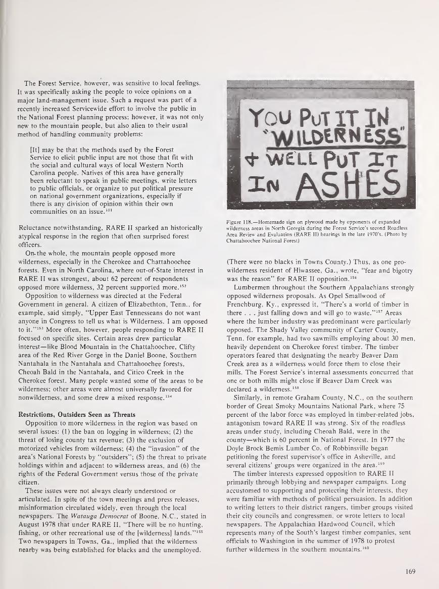
The Forest Service, however, was sensitive to local feelings.
It was specifically asking the people to voice opinions on a
major land-management issue. Such a request was part of a
recently increased Servicewide effort to involve the public in
the National Forest planning process; however, it was not only
new to the mountain people, but also alien to their usual
method of handling community problems:
[It] may be that the methods used by the Forest
Service to elicit public input are not those that fit with
the social and cultural ways of local Western North
Carolina people. Natives of this area have generally
been reluctant to speak in public meetings, write letters
to public officials, or organize to put political pressure
on national government organizations, especially if
there is any division of opinion within their owncommunities on an issue.
151
Reluctance notwithstanding, RARE II sparked an historically
atypical response in the region that often surprised forest
officers.
On- the whole, the mountain people opposed more
wilderness, especially in the Cherokee and Chattahoochee
forests. Even in North Carolina, where out-of-State interest in
RARE II was strongest, about 62 percent of respondents
opposed more wilderness, 32 percent supported more. 152
Opposition to wilderness was directed at the Federal
Government in general. A citizen of Elizabethton, Tenn., for
example, said simply, "Upper East Tennesseans do not want
anyone in Congress to tell us what is Wilderness. I am opposed
to it."153 More often, however, people responding to RARE II
focused on specific sites. Certain areas drew particular
interest—like Blood Mountain in the Chattahoochee, Cliffy
area of the Red River Gorge in the Daniel Boone, Southern
Nantahala in the Nantahala and Chattahoochee forests,
Cheoah Bald in the Nantahala, and Citico Creek in the
Cherokee forest. Many people wanted some of the areas to be
wilderness; other areas were almost universally favored for
nonwilderness, and some drew a mixed response. 154
Restrictions, Outsiders Seen as Threats
Opposition to more wilderness in the region was based on
several issues: (1) the ban on logging in wilderness; (2) the
threat of losing county tax revenue; (3) the exclusion of
motorized vehicles from wilderness; (4) the "invasion" of the
area's National Forests by "outsiders"; (5) the threat to private
holdings within and adjacent to wilderness areas, and (6) the
rights of the Federal Government versus those of the private
citizen.
These issues were not always clearly understood or
articulated. In spite of the town meetings and press releases,
misinformation circulated widely, even through the local
newspapers. The Watauga Democrat of Boone, N.C., stated in
August 1978 that under RARE II, "There will be no hunting,
fishing, or other recreational use of the [wilderness] lands." 155
Two newspapers in Towns, Ga., implied that the wilderness
nearby was being established for blacks and the unemployed.
1
You Put itW,
«• vw£ll put zt
#»
Figure 118.—Homemade sign on plywood made by opponents of expanded
wilderness areas in North Georgia during the Forest Service's second Roadless
Area Review and Evaluation (RARE II) hearings in the late 1970's. (Photo by
Chattahoochee National Forest)
(There were no blacks in Towns County.) Thus, as one pro-
wilderness resident of Hiwassee, Ga., wrote, "fear and bigotry
was the reason" for RARE II opposition. 156
Lumbermen throughout the Southern Appalachians strongly
opposed wilderness proposals. As Opel Smallwood of
Frenchburg, Ky., expressed it, "There's a world of timber in
there . . . just falling down and will go to waste." 157 Areas
where the lumber industry was predominant were particularly
opposed. The Shady Valley community of Carter County,
Tenn. for example, had two sawmills employing about 30 men,
heavily dependent on Cherokee forest timber. The timber
operators feared that designating the nearby Beaver DamCreek area as a wilderness would force them to close their
mills. The Forest Service's internal assessments concurred that
one or both mills might close if Beaver Dam Creek was
declared a wilderness. 158
Similarly, in remote Graham County, N.C., on the southern
border of Great Smoky Mountains National Park, where 75
percent of the labor force was employed in timber-related jobs,
antagonism toward RARE II was strong. Six of the roadless
areas under study, including Cheoah Bald, were in the
county—which is 60 percent in National Forest. In 1977 the
Doyle Brock Bemis Lumber Co. of Robbinsville began
petitioning the forest supervisor's office in Asheville, and
several citizens' groups were organized in the area. 159
The timber interests expressed opposition to RARE II
primarily through lobbying and newspaper campaigns. Long
accustomed to supporting and protecting their interests, they
were familiar with methods of political persuasion. In addition
to writing letters to their district rangers, timber groups visited
their city councils and congressmen, or wrote letters to local
newspapers. The Appalachian Hardwood Council, which
represents many of the South's largest timber companies, sent
officials to Washington in the summer of 1978 to protest
further wilderness in the southern mountains. 160
169

Numerous letters to district rangers expressed fear of
counties losing incoming because of wilderness. RARE II gave
many people the chance to express their belief that the Federal
Government had been shortchanging their local governments
for years. Although the Payment-In Lieu-of-Taxes Act had
substantially increased payments to Southern Appalachian
counties with National Forests, some either were unaware of
the increase, or considered 75 cents per acre still inadequate
compensation. 161
Probably the most widely expressed opposition to the
proposed wilderness in the Southern Appalachians was based
on the exclusion of roads and motorized vehicles. Although
hunting and fishing were to be permitted in wildernesses,
access was limited to horseback or foot travel. Hunters and
fishermen, accustomed to entering the woods in a pickup or
4-wheel drive vehicle, loudly attacked the restriction. Protests
came from sportsmen's clubs, such as the Carter County
Hunting and Fishing Club in Tennessee, as well as from
individual sportsmen. As a resident of Lakemont, Ga., wrote,
"I like to hunt and fish, but would like to drive within easy
walking distance." 162 The letters of protest also came from
mountaineers who use the woods for berrying and gathering
firewood. Quite a few complained that the roadless designation
was discriminatory. A Rabun County citizen wrote:
If roads are closed, only the young, hale and hearty
will be able to use the inner-regions of the wilderness
while the elderly, handicapped and those who are not
well-in-body will have to nibble around the edges. It's
not right . . . it's not American. 163
Figure 119.—Shady Valley, Term., in December 1928, then a cluster of farms
surrounded by forested hills with some fields returning to forest, adjoining the
Unaka (now Cherokee) National Forest. (NA:95G-230401)
Some of the protest against wilderness designation focused
on the outsiders who visit the National Forests. A Marble,
N.C., man, interviewed by CBS News, wondered, "People in
Raleigh and Washington, D.C., they don't have to make their
living here. They don't have to heat with wood. Where we
gonna' get heater wood? Where's these men gonna' work over
here?" 164 Although many expressed concern about the general
overuse of wildernesses, some spoke disparagingly of the type
of people attracted to them. Throughout the region, the
mountaineers made a clear distiction between themselves and
the weekenders who hiked the Appalachian Trail, rode the
Chattooga River, or backpacked near the Red River Gorge of
the Daniel Boone. A Georgia resident wrote, "I used to be
able to drive with my family down on the Chattooga and camp
out. Now it is only open to river riding hippies." 165 Another
Georgia resident wrote, "I like to be able to get out and ride
Dune Buggies and 4 Wheel. I don't like these city slickers and
Hippies taking over." 166
170

Private Inholdings Are Protected
Emotions sparked by RARE II also ran high over the
question of private inholdings within designated wildernesses.
The Eastern Wilderness Act provided for acquisition of
inholdings, but put no specific restrictions on the use of
private land within or adjacent to wilderness. The Act
authorized condemnation or exchange when the use of an
inholding was incompatible with wilderness, but it did not
define incompatibility. Since some of the proposed wildernesses
contained several inholdings, the ambiguity created some
alarm. For example, the 11,115-acre Clifty area in the Red
River Gorge contained 2,145 acres in private ownership. Most
was in summer-home lots and vacation cabins, but there was
one permanent resident, the elderly Mrs. Ernie Tyra. Mrs.
Tyra, who had optioned 115 of her 250 acres for sale to the
Government, seemed less concerned about the wilderness
designation than the second-home owners in the area, many of
whom sent written comments to the forest supervisor. 167
Although the Clifty area was finally selected for wilderness, it
was determined that the inholdings, if their present use
continued, were not incompatible with wilderness, and that
nothing in the area would change, "except that it [the
designation] will never be changed." 168
In the Chattahoochee National Forest, the proposed Blood
Mountain and Broad Camp roadless areas stirred inholders'
reactions. When their perimeters were originally drawn, several
summer homes in the vicinity of Lake Winfield Scott, and
private lands with farms, chicken houses, and commercial
enterprises were included. Clearly, some of these would be
incompatible with wilderness. People asked what would
become of these settlements—would their land-use options be
restricted? Would the Forest Service take their land? The
Forest Service, however, was unable to give a precise, definitive
answer.
A public meeting was called in April 1978, in Suches, Union
County, Ga., to which the Chattahoochee supervisor was called
to explain the agency's intentions. Suches is a hamlet of only a
few families cradled in the hills, but over 200 people were
gathered in the local Woody Gap School. The crowd was
visibly hostile; the supervisor was grateful to have had an
assistant and two local ministers, Baptist and Methodist,
acting as moderators and protectors. 169
The meeting passed without violence. Primarily as a result of
the meeting, the supervisor acted to insure that the boundaries
of the areas recommended for wilderness were redrawn to
eliminate all private lands. He published a letter to the citizens
of northern Georgia acknowledging a Forest Service error, and
the validity of local concern. 170
How Much Wilderness?
Finally, some of the opposition to RARE II was based on
the general issue of Federal rights and the particular issue of
how much land and land-use control the Federal Government
should have. "Must the Forest Service be so greedy?" a YoungHarris, Ga., woman asked. 171 A Blairsville, Ga., dentist wrote,
"Although I'm an avid environmentalist, I feel that the current
proposed legislation imposes too much upon the citizens' rights
under our Constitution." 172
Throughout the Southern Appalachians, citizens were not
content simply to write protest letters to their district rangers.
Many of them organized protest groups. Jack Brettler, of
Franklin, N.C., started the Save America Club; Jimmy Rogers,
a Baptist minister with interests in timber, organized the Stop
RARE II Coalition in western North Carolina and northern
Georgia. The Coalition issued "Stop RARE II" bumper
stickers, which were popular on the mountain roads.173 By far
the largest and most effective local organization was
SORE— Save Our Recreational Environment. SORE was
formed in September 1977, in Tellico Plains, Monroe County,
Tenn., and was led by the mayor, Charles Hall. SORE boasted
about 2,500 members, but it sponsored many times that
number of protest letters. SORE inundated the Cherokee
forest office with written comments on RARE II. Indeed,
Tennessee ranked fifth nationally in the number of responses
received, more than half of them sponsored by SORE. 174
The intense, instant opposition to RARE II in the Tellico
Plains area can be explained largely by the concern already
present over the halting of the Tellico Dam and Tellico-
Robbinsville Scenic Highway. Both of these projects had been
stopped by environmentalist protest but were favored by the
local population because they would boost the area's marginal
economy. 175 The Tellico Dam, a proposed TVA project on the
Little Tennessee River, was halted by a court ruling based on
the threat to the snail darter, an endangered fish species.176
The Scenic Highway, which had been approved in 1964, was
opposed from the beginning by environmentalists because its
path traversed a portion of the Joyce Kilmer Memorial Forest,
a remote and pristine area of the Nantahala National Forest.177
The original route was shifted, and one-third of the highway
had been completed through the Cherokee National Forest on
the Tennessee side when it was halted by environmental
opposition.
SORE thus represented a convergence of issues. Moreover,
the success of SORE was partly attributable to the ease with
which local residents and vacation homeowners could work
together. In contrast to the situation in northern Georgia and
southwestern North Carolina, many second-home owners in the
East Tennessee mountains had roots there. Although they lived
in Chattanooga or Knoxville, their families had come from the
mountains, and they felt at home there. They drove the same
cars, and looked and talked the same, as the full-time local
residents. Thus, the two groups worked easily together for a
common goal: no more mountain wilderness. 178
Considering the high level of emotion, concern, and
involvement generated by RARE II, it is not surprising that
antiwilderness protest threatened at times to become violent.
The level of hostility at RARE II meetings was often high. In
Franklin, N.C., in early August 1978, the Forest Service
presented an "information meeting," which brought "a
171

caravan of cars and pickups, heavy log-loaders and tractor-
trailer rigs" to town. 1"9 Citizens had previously agreed to
refrain from verbal comment at the meeting. However, when
one unidentified man yelled. "We don't want no more damned
wilderness." the mayor of Franklin, claiming to be a protestor
himself, led a walkout. 180
The most widespread threat expressed was burning the
forests, should they be designated wilderness. For example, in
the Chattahoochee National Forest in the summer of 19"8. a
plywood roadside sign was posted that read, "You put it in
'wilderness' and we'll put it in ashes.
"
:5: Such threats were
verbal as well as written, and became a popular subject of
local newspaper editorials and analyses. April 19 78 was a
month of unusually numerous fires across the Southeast,
attributable in part to unseasonably dry weather. Some of the
fires, however, were called deliberate. 152 That month, the
Asheville Citizen-Times in an editorial discussed reasons for
deliberate forest burning. Acknowledging the Southern
tradition of burning the woods for the purpose of clearing land
and eliminating rodents, snakes, and insects, the article also
cited revenge and 'misguidance' as motivations. " 'Big
government,' ... an unresponsive society . . . foresters." all
were cited as targets of vengeful burning. 155 (Ironically, that
very month, in McCreary County. Ky.. the Forest Service was
embarrassed when a debris-burning fire it had set to clear a
100-acre plot flattened by a tornado spread out of control,
aided by very dry brush and gusting winds, until it had
covered 1.400 acres in the Daniel Boone National Forest.184
However, although there were threats and hints of violence,
there were almost no violent acts documented. Rangers on the
Cherokee observed that, even at the height of the RARE II
conflict, the number of incendiary fires remained about the
same as for the previous 10 years. 155 In both the Pisgah and
Nantahala forests, although the total number of man-caused
fires (accidental or deliberate) in 19~8 was greater than in
1977. it differed little from that of 1976. 186 In general,
mountain people were striving to control the forests for the
uses most important to them—hunting, fishing, gathering,
fuel, and timber. In spite of the threats, there was no hostile
intent toward the forests themselves. 187
By the end of 1978, the wilderness recommendations were
announced— only 89.000 acres in the Southern Appalachians,
a large portion of which was the Southern Nantahala area of
the Nantahala and the Chattahoochee National Forests. Other
sizeable designations were the Brasstown Bald area of northern
Georgia and the Clifty area of Kentucky. In Tennessee, only
one roadless area, the Bald River Gorge east of Knoxville. was
recommended for wilderness—less than 4,000 acres.
Considerably more land was slated for nonwilderness status
than was put into the further planning category. In the
Cherokee forest, only 38.100 acres were assigned to further
planning; in the Chattahoochee, more than 93.000. Further
planning areas are to be managed as wilderness until their
status is finally decided. 188
With the announcement in early January 19"9 of the
outcome of the RARE II process, the public furor subsided.
However, the issues raised during RARE II remained alive,
and only partially resolved. The RARE II outcome obviously
could not please everyone, and. as expected, some of the
groups that contributed heavily to the public response were not
pleased with the results. In Tennessee, where only Bald River
Gorge was committed to wilderness, environmentalists were
outspoken in their disappointment. In Tennessee and North
Carolina, the Wilderness Coalition, the Sierra Club, and other
prowilderness groups vowed to exert strong pressure for the
areas under "further planning" to be designated wilderness. 189
In some mountain areas, people continued to protest any
land being designated wilderness: and some felt that too few
areas were designated nonwilderness. Jack Brettler. of the Save
America Club in North Carolina, expressed disappointment
that the Harper Creek tract, which contains uranium deposits,
was recommended for further study. 194 Antiwilderness forces of
RobbinsviTle. N.C. were upset that three out of the six sites in
Graham County were designated wilderness, and vowed to get
the other three assigned to multiple use. "We're going to fight
just as hard for those areas as if there were six. We're going to
fight full steam." 10'- In northern Georgia, many mountain
communities expressed concern about the acres set aside for
further planning. As the Towns Count}- school superintendent
said, "People are afraid that the federal bureaucracy will take
a little more each year, and you lose more and more." 192
Mining Issue Is Unresolved
A potentially more explosive issue was not addressed by the
RARE II process and remained unresolved: mining in National
Forest wilderness areas. Shortly after the Wilderness Act was
passed, the Chief of the Forest Sendee expressed concern that
this issue could cause "some of our most difficult
administrative problems." 195 Under the Wilderness Act and
Eastern Wilderness Act, mining was permitted in designated
wilderness areas, according to terms of preexisting leases and
permits, until December 31. 1983. 194(In the eastern National
Forests, mineral rights under one-third of the land are not
owned by the Government: either they were reserved by the
seller when Federal acquisition occurred or they were already
outstanding in third parties. In the Daniel Boone and Jefferson
forests, where coal deposits are known to exist, even more of
the subsurface mineral rights are held by private interests. For
example, of 85.000 acres on the Clinch Ranger District of the
Jefferson. 55.000— or 65 percent—have privately held mineral
rights.)
Although the Forest Service has been unable to dictate the
extent of mining in parts of the Southern Appalachian forests,
mineral extraction prior to 1975 was limited, and most was
through deep mining, which generally did not jeopardize other
forest uses.195 However, as strip-mining of marginal lands
became more economically feasible, the threat of major land-
use controversies grew. In the late 1970's. such a controversy
erupted over strip-mining in the Beaver Creek wilderness of the
Daniel Boone National Forest.
172

Reference Notes
In 1975, the Greenwood Land and Mining Co., which
operated four deep mines in the Daniel Boone forest,
purchased rights to 5,000 acres of coal under the Beaver Creek
wilderness in McCreary County—rights that had been reserved
when the land was sold to the Government in 1937.
Greenwood applied for a permit to prospect for coal at 27
sites, 22 of which were in the wilderness. The prospecting
would have involved th euse of motorized equipment and
excavation. Ultimate recovery of the coal would require some
contour stripping. 196
The Forest Service denied the permit, on the basis that the
prospecting was not compatible with wilderness management.
Greenwood filed suit in U.S. District Court in November 1976;
the court ruled in favor of Greenwood, but, commenting on an
issue beyond the immediate suit, added that strip-mining could
not occur on public property. 197 Meanwhile, the Forest Service
began planning to acquire Greenwood's interests in the Beaver
Creek area, as the mining company appealed its case. Neither
initiative had been settled by early 1982. 198
A similar case in the same county had a different outcome.
In 1976 the Stearns Coal and Lumber Co. applied for a permit
to strip-mine 15 acres of National Forest land on White OakCreek. The Forest Service denied the application, citing the
Secretary of Agriculture's Rules and Regulations of 1911 with
which Stearns' reserved rights had to comply. 199 Stearns
"wholly rejected" the premises of the Forest Service denial,
and took the case to court for resolution. 200 In 1978, the
Kentucky State Supreme Court upheld the Kentucky tradition
that, in the case of a broad form deed, mining rights take
precedence over surface rights, even if the surface owner is the
United States Government and the surface is "public
property."
The case went to Federal court, and in early 1982 was still
unsettled. The outcome of the case will have repercussions not
only in McCreary County, where Greenwood Land and Mining
Co. is seeking to traverse and possibly strip within the Beaver
Creek wilderness, but throughout the Daniel Boone and other
eastern National Forests. The most decisive recourse for the
Forest Service would be acquisition of or exchanging other
land for the mining rights to such land—either a very
expensive solution.
By early 1982, Congress had not yet acted to establish the
recommended new wilderness areas in the Southern
Appalachians. In the meantime, public use of most of the
areas that had been previously designated wilderness was
increasing substantially. In only 3 years, between 1977 and
1980, the estimated recreational use of the eight wildernesses
of the Southern Appalachians increased by over 13 percent. 201
The pressures on the forests of the region, from backpackers,
Federal recreation developers, and the mountaineers, seemed
focused on wilderness areas. Yet the issues surrounding
wilderness—particularly strip mining and the acquisition of
inholdings—remained unresolved.
1. 72 Stat. 238.
2. "The ORRRC Recommendations— 1962," in Phillip O. Foss,
Conservation in the United States: A Documentary History (New
York: Chelsea Publishers, 1971), pp. 581-587. See also Edwin M.
Fitch and John F. Shanklin, The Bureau of Outdoor Recreation (New
York: Praeger Publishers, 1970), pp. 60-78.
3. The Bureau of Outdoor Recreation (BOR) was created April 2,
1962, by Interior Secretary Stewart L. Udall under the authority of
Reorganization Plan No. 3 of 1950. Foss, Conservation in the United
States, p. 595. See also Fitch and Shanklin, The Bureau of Outdoor
Recreation. BOR was deactivated January 25, 1978 by Secretary Cecil
D. Andrus, and its functions shifted to the new Heritage Recreation
and Conservation Service, which was abolished February 19, 1981 by
Secretary James Watt and most functions shifted to the Park Service.
4. "Executive Order Establishing the Recreation Advisory Council,
April 27, 1962," in Foss, Conservation in the United States, pp. 601,
602.
5. 77 Stat. 49., Foss, Conservation in the United States, pp. 601-623.
6. U.S. Department of the Interior, Bureau of Outdoor Recreation, AReport on Outdoor Recreation Demand, Supply, and Needs in
Appalachia. Prepared for the Appalachian Regional Commission,
September 1967, pp. 20-27. Recreation As An Industry, Appalachian
Research Report No. 2. Prepared for the Appalachian Regional
Commission by Robert R. Nathan Associates, Inc. and Resources
Planning Associates, Washington, D.C., December 1966, p. v.
7. 78 Stat. 897. See Chapter VII for discussion of LWCF acquisition
in the Southern Appalachian forests.
8. LWCF Act, Section 6 (a) (1).
9. Fitch and Shanklin, The Bureau of Outdoor Recreation, p. 74.
10. "The Recreation Advisory Council Policy on National Recreation
Areas, March 26, 1963," in Foss, Conservation in the United States,
pp. 444-448.
11. 80 Stat. 190.
12. Letter from the Secretary of Agriculture in Establishment of the
Mount Rogers National Recreation Area in Virginia, Report to
Accompany H.R. 10366, 89th Congress, 1st Session, p. 5.
13. Letter from the Secretary in Mt. Rogers Report, pp. 5-7. See also
William E. Shands and Robert G. Healy, The Lands Nobody Wanted,
p. 44. (Washington: The Conservation Foundation, 1977).
14. Recreation-Use Information, computerized data on microfiche,
Recreation Management Staff, USDA, Forest Service, Washington,
D.C.
173

15. Act to Establish Mount Rogers, Section 3 (a).
16. Establishment of the Mount Rogers National Recreation Area in
Virginia, pp. 4, 5. (See note 12).
17. Letter from the Secretary of Agriculture in Establishment of the
Mount Rogers National Recreation Area in Virginia, 5.
18. Letter from the Secretary of Agriculture, 5. Update on easements
obtained by Frank J. Harmon, History Section, Washington Office, in
telephone conversation with Philip B. Etchison and William E. Clark,
Lands Staff, Southern Region, Forest Service, Atlanta, Ga., January
28, 1982.
19. Information on general acquisition perspectives on Mount Rogers
NRA provided by Charles A. Blankenship, Recreation Staff, Jefferson
National Forest, Roanoke, Va., February 19, 1981.
20. Information provided by William E. Clark, Lands Staff, Forest
Service, Regional Office, Atlanta, Ga., February 20, 1981, and
January 29, 1982. Additional data provided by Philip B. Etchison,
Group Leader, Landownership, Lands Staff, Southern Regional
Office, USDA Forest Service, Atlanta, Ga., September 15, 1981. PL91-646, known as the Uniform Relocation Assistance and Real
Property Acquisition Act of 1970 (84 Stat. 1894), became law on
January 2, 1971. See Title I, paragraph 101.
An example of a Mount Rogers condemnation case based on a
dispute over the price of land is that of John Kabler. Kabler, a bankr
from Delray Beach, Fla., purchased a 106-acre tract in the Fairwood
Valley area of Smythe County in June 1972 for $22,000. According to
the Forest Service correspondence file on the Kabler case, Kabler had
been informed bfore purchasing the property that the Forest Service
needed it for the NRA. Almost immediately after acquisition, he
began improvements to the property, including a vacation cabin,
septic field, roads, and clearing. The Forest Service began efforts to
acquire the tract but Kabler, although continually informing the
Forest Service of his improvements, professed a complete
unwillingness to sell. He wrote letters and visited politicians to protest
both the acquisition itself and the approximately $40,000 appraised
value the Forest Service offered. The case was finally settled in court
in June 1974 when Mr. Kabler was awarded $75,000, nearly three and
a half times the value of the tract two years before.
21. Newsletter of the Citizens for Southwest Virginia, Troutdale, May1978, p. 7.
22. Newsletter of the Citizens for Southwest Virginia, August 1978, p.
3.
23. Interview with Charles Blankenship, Jefferson National Forest,
Roanoke, Va., February 1981.
24. Telephone interview with Lawrence Pierce, Citizens for Southwest
Virginia, Troutdale, Va., February 25, 1981.
25. Interview with Charles Cushman, President, National Inholders
Association, Sonoma, Calif., March 6, 1981.
26. A detailed account of the Big South Fork project is in Perry,
McCreary Conquest, pp. 151-164; updated by author's interview with
Robert Strosnider, Lands, Daniel Boone National Forest, Winchester,
Ky., March 10, 1981. See also, Patrick E. Tyler, "Why It Helps to
Know Sen. Howard Baker," The Washington Post, March 15, 1981.
27. Tyler, "Why It Helps to Know Sen. Howard Baker."
28. L.E. Perry, McCreary Conquest, A Narrative History (Whitley
City, Ky.: L. E. Perry, 1979), p. 164; Tyler, "Why It Helps to KnowSen. Howard Baker."
29. 88 Stat. 12, 43; PL 93-251, Section 108. Telephone interview with
Charles Hooper, Chief, Real Estate Division, Nashville Office of the
U.S. Army Corps of Engineers, March 13, 1981.
30. Interview with Charles Hooper, U.S. Army Corps of Engineers.
Tyler, "Why It Helps to Know Sen. Howard Baker."
31. "The Lesson of Gatlinburg," Courier Journal, Louisville, Ky.,
September 12, 1978.
32. Perry, McCreary Conquest, p. 164.
33. 82 Stat. 906.
34. Some confusion over the Federal designation of a Wild River
versus a State designation is apparent in the case of the Big South
Fork of the Cumberland River in the Daniel Boone National Forest.
L. E. Perry, in his book McCreary Conquest, stated that the Big
South Fork had been designated under the Wild and Scenic Rivers
Act of 1968; in fact, the river became a Kentucky Wild River under
the Wild Rivers Act of 1972, and is administered by the Kentucky
Department for Natural Resources and Environmental Protection.
"Wild Rivers of Kentucky," publication of Department of Natural
Resources and Environmental Protection, Frankfort, Ky., n.d.
35. This designation was legislatively confirmed by PL 94-407,
September 11, 1976.
36. Environmentall Impact Statement—Modified Blue Ridge Project
No. 2317, Federal Power Commission, June 1973, pp. 37, 38.
37. A glossy folded brochure entitled, "The New River, A Heritage
Endangered," with colored photographs, was distributed by the
National Committee for the New River. Reports were regularly printed
in Committee letterhead.
38. National Committee for the New River, "Up-Dated Report,
People Versus Power," Winston Salem, N.C., n.d., p. 7.
39. "New River—Chronology of Events," Bureau of Outdoor
Recreation internal document, April 16, 1976.
40. Final Environmental Statement—Proposed Scenic Designation of
South Fork New River, U.S. Department of Interior, Bureau of
Outdoor Recreation, March 1976, pp. 199, 200; Revised Management
Plan—South Fork New River and Main Stem New River, North
Carolina, North Carolina Department of Natural and Economic
Resources, June 1975.
174

41. Interview with County Manager, Ashe County, N.C., February 19,
1981.
42. P.L. 93-279.
43. Information provided by Charles D. Huppuch, Lands Staff,
USDA Forest Service Regional Office, Atlanta, Ga., February 1981.
44. "Guidelines For Evaluating Wild, Scenic and Recreational River
Areas Proposed for Inclusion in the National Wild and Scenic Rivers
System Under Section 2. Public Law 90-542." Department of the
Interior, February 1970, pp. 7, 8.
45. Interview with Pat Thomas, Supervisor, Chattahoochee National
Forest. Gainesville, Ga., July 11, 1979; supplemented with interview
with Charles Huppuch, Lands Staff, USDA Forest Sen-ice Regional
Office. Atlanta, Ga.
46. Steve Oney, "The Wilderness Campaign," The Atlanta Journal
and Constitution Magazine, Atlanta, Ga., September 24, 1978, p. 18.
47. Recreation-Use Information, Recreation Management Staff,
USDA-Forest Sen-ice, Washington, D.C.
48. Comments provided by P. Ledford, Clayton, Ga., to
Chattahoochee National Forest Headquarters, Gainesville. Ga.,. June
30, 1978.
49. Sally Kirk Fairfax, "Federal-State Cooperation in Outdoor
Recreation Policy Formation: The Case of the Appalachian Trail,"
(Ph.D. dissertation, Duke University, 1974), pp. 12-33. See also
Edward B. Ganey, Appalachian Hiker II (Oakton, Va.: Appalachian
Books, 1978), pp. 6-20.
50. "Appalachian Trail Protection Progress Report." Status as of
August 1981. Provided by Land Acquisition Field Office, National
Park Sen-ice, Martinsburg. W.Va.
51. 82 Stat. 919.
52. 82 Stat. 919; Section 5 (a).
53. 82 Stat. 919; Section 7 (g).
54. Inten-iew with Vince McCormack, Lands Staff, USDA Forest
Sen-ice, Regional Office, Atlanta, Ga., July 10, 1979. Confirmed in
telephone inten-iew with Charles D. Huppuch, Lands Staff, February
17, 1981.
55. Sally Kirk Fairfax, "Federal-State Cooperation in Outdoor
Recreation Policy Formation: The Case of the Appalachian Trail," pp.
132-143. The Forest Sen-ice and Appalachian Trail Club also differed
over interpreting the 1968 Act.
56. Fairfax, p. 137.
57. Fairfax, pp. 138, 139.
58. Information provided by Charles D. Huppuch, Lands Staff,
USDA Forest Service Regional Office. Atlanta, Ga., February 17,
1981.
59. Land Acquisition Field Office. Appalachian National Scenic Trail.
U.S. Department of the Interior, Martinsburg, W.Va., October 30,
1981.
60. 92 Stat. 159.
61. 92 Stat. 159; Section 5 (a) (1).
62. In fiscal year 1980. no funds were appropriated from the Land
and Water Conservation Fund for Appalachian Trail right-of-way
acquisition. However, other LWCF funds from the West were utilized
for Trail purposes. Acquisition was slowed, but did not stop. Somefunds also became available late in FY 1981. Information provided by
Lands, Staff, USDA Forest Sen-ice, Regional Office, Atlanta, Ga..
February and October. 1981.
63. Forest Sen-ice Lands Staff, Atlanta, Ga., February, 1981.
64. Information provided by Charles D. Huppuch. Lands Staff.
USDA Forest Sen-ice Regional Office. Atlanta, Ga., February and
October, 1981.
65. U.S. Department of Agriculture, Forest Sen-ice, Southern Region,
"Red River Gorge—Land of Arches." See also Robert F. Collins, AHistory of the Daniel Boone National Forest (Lexington, Ky.:
University of Kentucky Press, 1975), pp. 270-279.
66. Inten-iew with Robert Reynolds, Lands, Daniel Boone National
Forest, Winchester, Ky., March 13. 1981.
67. Joe Lamb, "Forest Sen-ice Criticizes Gateway Opposition to
Wilderness Areas," Morehead News, Morehead, Ky.. May 25, 1979.
68. Inten-iew with Dr. Billie DeWalt. University of Kentucky
anthropologist employed by the Forest Sen-ice to study Red River
Gorge community, Winchester, Ky., July 27, 1979.
69. Fitch and Shanklin, The Bureau of Outdoor Recreation, p. 73.
(See notes 2, 3. and 9.)
70. See Jesse R. Lankford, Jr., "The Campaign For a National Park
in Western North Carolina, 1885-1940." Master's thesis, Western
Carolina University, 1973, and Harley E. Jolley, "The Blue Ridge
Parkway: Origins and Early Development," Ph.D. dissertation,
Florida State University, 1973, as cited in Chapter V.
71. Recreation As An Industry, Appalachian Research Report No. 2.
Prepared for the Appalachian Regional Commission by Robert R.
Nathan Associates, Inc. and Resources Planning Associates,
Washington, D.C December 1966, p. v.
72. ARC's turnabout is cynically described by Anita Parlow. "The
Land Development Rag." in Helen Matthews Lewis, Linda Johnson,
and Donald Askins, Colonialism in Modern America: The
Appalachian Case (Boone, N.C.: The Appalachian Consortium Press,
1978). pp. 190, 191.
175

73. Neil Walp, "The Market for Recreation in the Appalachian
Highlands," Appalachia 4 (November-December 1970).
74. Walp, "The Market for Recreation in the Appalachian
Highlands," p. 30.
75. Walp, p. 31.
76. Walp, p. 30.
77. A recent disseration identified six counties with high
concentrations of tourism in the Souther Appalachians, based on the
relative importance of lodging facilities and the percent of labor force
employed in hotels and campgrounds. The six are Rabun County,
Ga., Graham, Jackson, Swain, and Watauga Counties, N.C.; and
Sevier County, Tenn. Jeffrey Wayne Neff, "A Geographic Analysis of
the Characteristics and Development Trends of the Non-Metropolitan
Tourist-Recreation Industry of Southern Appalachia," Ph.D.
Dissertation, University of Tennessee, 1975.
78. Neff, 30.
79. Neff, Chapter II.
80. Recreational use statistics are not comparable for the years before
and after 1965; in that year the Forest Service shifted from reporting
"visits" to "visitor-days." One visitor-day is equal to recreational use
of national forest land or water that aggregates 12 visitor-hours. This
may entail one person for 12 hours, 12 persons for one hour or any
equivalent combination of use, continuous or intermittent. Recreation
Management Staff, USDA Forest Service, Washington, D.C.
81. Recreation-Use data on the North Carolina forests include the
Pisgah, Nantahala, Uwharrie, and Croatan National Forests; the data
on the Chattahoochee include the Oconee.
82. Gatlinburg was cited in the Response of Citizens for Southwest
Virginia as an example of what they hoped Mount Rogers would never
become, pp. 40-42.
83. Jerome E. Dobson, "The Changing Control of Economic Activity
in the Gatlinburg, Tennessee Area, 1930-1973," (Ph.D. dissertation,
University of Tennessee, 1975), p. 83.
84. Jeffrey Wayne Neff, "A Geographic Analysis of the Characteristics
and Development Trends of the Non-Metropolitan Tourist-Recreation
Industry," p. 53.
85. Dobson, "The Changing Control of Economic Activity in the
Gatlinburg, Tennessee, Area," pp. 83-91.
86. Background on Hugh Morton is from "Morton and Mountain-
Lifetime Dream," Greensboro Daily News, Sunday, October 1, 1978.
Descriptions of Morton's development can be found in Parlow, "The
Land Development Rag," p. 178, and John Van Noppen and Ina VanNoppen, Western North Carolina Since the Civil War, (Boone, N.C.:
Appalachian Consortium Press, 1975), p. 412.
87. Anita Parlow, "The Land Development Rag," and Edgar
Bingham, "The Impact of Recreational Development on Pioneer Life
Styles in Southern Appalachia," in Lewis, Johnson, and Askins,
Colonialism in Modern America, pp. 177-198, and 57-69; Van Noppenand Van Noppen, Western North Carolina Since the Civil War, p.
412.
88. Frank O'Neill, "Greatest Menace Yet to Southern Mountains,"
Southern Voices, May-June, 1974, p. 73.
89. Shands and Healy, in The Lands Nobody Wanted, cited
Highlands, along with Massanutten Mountain in the George
Washington National Forest, as an example of the "blighting
developments" that exist "in almost every eastern national forest," p.
157 (See note 13.)
90. Data on Recreation-Tourism-Second Home Development Firms,
Table 1, in Southern Highlands Mountain Resources ManagementPlan, Georgia Department of Natural Resources, North Carolina
Department of Administration, South Carolina Department of Parks,
Recreation, and Tourism, June 1974.
91. Curtis C. Roseman, Changing Migration Patterns Within the
United States, Association of American Geographers Resource Paper
No. 77-2, pp. 18-21.
92. Roseman, Table 2.
93. Roseman, Table 5.
94. Roseman, Table 3.
95. These data support for findings of Neff, "A Geographic Analysis
of the Characteristics and Development Trends of the Non-
Metropolitan Tourist-Recreation Industry."
96. "State Might Buy Troubled Resort For State Park," Greensboro
Daily News. August 10, 1979.
97. Greensboro Daily News, August 10, 1979. Telephone query to
Supervisor, National Forests in North Carolina, February 23, 1982.
98. Marion Clawson and Jack Knetsch, in Economics of Outdoor
Recreation (Baltimore: The Johns Hopkins University Press, 1966),
have found that, in general, only a small percent of recreationists'
total expenditures stay in the local area. The Neff dissertation, "AGeographic Analysis of the Characteristics and Development Trends of
the Non-Metropolitan Tourist— Recreation Industry of Southern
Appalachia," confirms this, as does Charles Garrison's study of TVA's
Norris Lake, "A Case Study of the Local Economic Impact of
Reservoir Recreation," Journal of Leisure Research, 1974.
99. North Carolina State Report, "Preliminary Draft," Prepared for
the Land Task Force of the Appalachian Alliance, 1980, p. 36. See
Edgar Bingham, "The Impact of Recreational Development of Pioneer
Life-Styles in Southern Appalachia," Proceedings of the Pioneer
America Society, 1973, p. 60; Jeffrey Wayne Neff, "A Geographic
Analysis of the Characteristics and Development Trends of the Non-
Metropolitan Tourist-Recreation Industry of Southern Appalachia;"
and ARC's Recreation As An Industry.
176

100. Lewis W. Green, "Strangers on the Land," Appalachian Journal,
Fall 1976, p. 14.
101. Edgar Bingham, "The Impact of Recreational Development on
Pioneer Life-Styles in Southern Appalachia," Proceedings of the
Pioneer America Society (1973): p. 60.
102. George L. Hicks, Appalachian Valley. (New York: Holt,
Rinehard and Winston, 1976), p. 50.
103. Hicks, pp. 51, 52.
104. Hicks, p. 62.
105. Draft North Carolina State Report.
106. Parlow, "The Land Development Rag," p. 180. (See note 87.)
107. Draft North Carolina State Report, p. 26.
108. Recreation As An Industry, pp. 51, 52.
109. Southern Highlands Mountain Resources Management Plan, p.
33.
110. Parlow, "The Land Development Rag," p. 184-186.
111. Response of Citizens for Southwest Virginia, Troutdale, 1978, p.
40.
112. The analogy between recreational development and coal and
timber exploitation appears, for example, in Bingham, "The Impact
of Recreational Development on Pioneer Life-Styles in Southern
Appalachia;" O'Neill, "Greatest Menace Yet to the Southern
Mountains;" and Parlow, "The Land Development Rag."
113. Parlow, "The Land Development Rag," pp. 186-188.
114. O'Neill, "Greatest Menace Yet to the Southern Mountains," p.
78.
115. Southern Highlands Mountain Resources Management Plan, pp.
36, 37. Similar lack of appropriate zoning in Virginia and West
Virginia is noted in Shands and Healy, The Lands Nobody Wanted, p.
162.
116. Bingham, "The Impact of Recreational Development on Pioneer
Life-Styles in Southern Appalachia," p. 62.
117. Margaret J. Boland, Public Involvement in Forest Planning,
Community Research Center, Mars Hill College, January 15, 1979, p.
14.
118. Hicks, Appalachian Valley, p. 52.
119. Hicks, p. 53.
120. Garvey, Appalachian Hiker II, p. 167. (See note 49.)
121. Garvey, also Green, "Strangers on the Land," p. 13.
122. Green, "Strangers on the Land," p. 15.
123. Shands and Healy, The Lands Nobody Wanted, p. 159.
124. 78 Stat. 890.
125. Richard A. Cooley and Geoffrey Wandesforde-Smith, eds.,
Congress and the Environment (Seattle: University of Washington
Press, 1970), p. 53; Frome, Battle for the Wilderness, pp. 130, 131.
126. Cooley and Wandesforde-Smith, Congress and the Environment.
pp. 55-58.
127. 74 Stat. 215, 16 U.S.C. 529; (Section 2); Cooley and
Wandesforde-Smith, Congress and the Environment, p. 54; Federal
Agencies and Outdoor Recreation, ORRRC Report 13, p. 27.
128. Frome, Battle For the Wilderness, p. 121, 125, 145; Federal
Agencies and Outdoor Recreation, p. 26. John C. Hendee, George H.
Stankey, and Robert C. Lucas, Wilderness Management (Forest
Service, U.S. Department of Agriculture, October 1978), pp. 61-64.
Michael McCloskey, "The Wilderness Act: its background and
meaning," Oregon Law Review 45(4):288-321 . Memorandum, Office
of the Secretary, Department of Agriculture, September 17, 1926,
"The Policy of the Department of Agriculture in Relation to Road
Building and Recreational Use of the Superior National Forest,
Minnesota, Forest Service, History Section files.
129. Hendee, Stankey, and Lucas, Wilderness Management, p. 75.
130. Shands and Healy, The Lands Nobody Wanted, pp. 45, 46;
Frome, Battle For the Wilderness, pp. 170, 171.
131. Frome, Battle For the Wilderness, pp. 170-175.
132. Recreation-Use Information, on microfiche. Recreation
Management Staff, USDA Forest Service, Washington, D.C.
133. Washington National Records Center, Forest Service Records,
Acc. No. 95-78-0002, "Alternatives for Preserving and Managing
National Forest Wild Land Values in the East."
134. 88 Stat. 2096.
135. Hendee, Stankey, and Lucas, Wilderness Management, pp.
103-105.
136. Hendee, Stankey, and Lucas, Wilderness Management, 103-105.
See also, "RARE II Questions and Answers," Forest Service
document obtained from USDA Forest Service Regional Office,
Atlanta, Ga., n.d., pp. 1, 2.
137. The National Environmental Policy Act of 1969 (83 Stat. 852).
the Forest and Rangeland Renewable Resources and Planning Act of
1974 (88 Stat. 476), and the National Forest Management Act of 1976
(90 Stat. 2901) all call for impact analyses and public involvement in
forest planning.
138. "RARE II Questions and Answers," p. 5.
177

139. For example, the Greenville, Term., Sun. on August 16, 1978,
published a Forest Service invitation for groups interested in a
program on RARE II proposals to contact their local ranger station
for scheduling. The July 2, 1978 Lexington, Ky., Herald Leader
presented the RARE II proposals for the Daniel Boone and explained
where copies of the Draft Environmental Impact Statement could be
obtained.
140. "Fact Sheet," Computer printing of Questions and Answers,
Summary of Public Comment Analysis, and Comments by the
Secretary, Cutler, and Chief, U.S. Forest Service, January 3, 1979,
pp. 11. 577-580.
141. See, for example, John D. Photiadis, "The Economy and
Attitudes toward Government in Appalachia" in John D. Photiadis
and Harry K. Schawrzweller, eds., Changes in Rural Appalachia:
Implications for Action Programs (Philadelphia: University of
Pennsylvania Press, 1970), pp. 122-126.
142. Kaufman, The Forest Ranger: A Study in Administrative
Behavior, pp. 48-56. See also, "A List of Different Kinds of Things
the Forest Service and Forest Officers Do Which Influence
Residents."
143. National Archives, RG 95, Records of the Forest Service,
Division of Operation, Organization, Servicewide Organization Study,
Implementing the P.M. Aspects of the Organization Study
Recommendations, 1961, Booklet of lesson plans, p. I-IV.
144. Implementing the Organization Study, p. I-IV.
145. Interview with Forest Supervisor Pat Thomas, and Foresters
Howard Orr and Steve Briggs, Chattahoochee National Forest,
Gainesville, Ga., July 11, 1979.
146. Perry, McCreary Conquest, p. 223.
147. Kaufman, The Forest Ranger, p. 52.
148. Interview with Pat Thomas and Howard Orr, Chattahoochee
National Forest. Also, interview with Jack S. Kelley, Legislation,
Regional Office, U.S. Forest Service, Atlanta, Ga., July 10, 1979.
149. Sidney Weitzman, Lessons From the Monongahela Experience,
An In-Service Analysis Based on Interviews with Forest Service
Personnel, December 1977, p. 8.
150. Weitzman, Lessons From Monongahela, 8.
151. Margaret J. Boland, Public Involvement in Forest Planning,
Community Research Center, Mars Hill College (N.C.), January 15,
1979, pp. 12, 13.
154. "Narrative, RARE II Public Input Analysis, Southern Region,"
tabulation of RARE II responses, USDA Forest Service, Regional
Office, Atlanta, Ga.
155. "Ah, Wilderness . . . When is Enough Enough?" Watauga
Democrat. Boone, N.C., August 14, 1978.
156. Letter No. 08-00-002746-30546-1-1 to USDA Forest Service
Regional Office, Atlanta, Ga., from resident of Hiwassee, Ga. See
also Steve Oney, "The Wilderness Campaign," p. 27 (note 46).
157. Ed Ryan, "U.S. Urges Protection of Red River Gorge," Courier
Journal. Louisville, Ky., January 5, 1979.
158. Based on analysis of questionnaires sent to district rangers as
part of RARE II Individual Area Social Analysis, USDA Forest
Service Regional Office, Atlanta, Ga.
159. Analysis of RARE II questionnaires, Atlanta, Ga.
160. Oney, "The Wilderness Campaign," p. 17.
161. See, for example, Lee Vance, "For the Record," Erwin Record.
Erwin, Tenn., September 6, 1978.
162. RARE II Oral Comment dated June 24, 1978, received by
Chattahoochee National Forest Headquarters, Gainesville, Ga.
163. Letter No. 08-03-01137-30525-1-1 to Forest Service, Tallulah
Ranger District, Clayton, Ga., from resident of Clayton, Ga.
164. "Department of Agriculture Announces RARE II Proposals,"
CBS Evening News, Thursday, January 4, 1979, Radio-TV Monitoring
Service, Inc.
165. RARE II Oral Comment dated June 24, 1978. See also Boland,
Public Involvement in Forest Planning p. 15.
166. RARE II Oral Comment dated June 30, 1978, received by
Chattahoochee National Forest headquarters, Gainesville, Georgia.
The aspersions cast by some mountaineers on the urban recreationists
were sometimes matched and exceeded by outsiders' comments on the
protestors. A man from Pocatello, Idaho, enraged by a national news
story citing Georgia residents threatening to burn the wilderness,
wrote to the regional forester in Atlanta, "I'd like to see those stupid
mountain YA HOOS try to burn them down. The national forests
belong to everyone, not just some fat-bellied and round-assed Georgia
locals." Letter 08-00-002377-83201-1-1.
167. "Bergland Proposes State Forest Be Included in Wilderness
Area," Lexington Herald. Lexington, Ky., January 5, 1979.
168. "Want Forest To Be in 'Wilderness', Menifee County News,
152. Margaret J. Boland and Larry N. Stern, "Public Impact and January 1979.
Decision-Making in the U.S. Forest Service" Community Research
Center, Mars Hill College, p. 6.
153. RARE II Oral Comment dated September 13, 1978, Cherokee
National Forest Headquarters, Cleveland, Tenn.
178

169. The information on the Suches meeting is based on an interview
with Pat Thomas, Supervisor of the Chattahoochee National Forest,
Roger Frantz, and Steve Briggs, Gainesville, Ga., July 11, 1979. The
incident described is very similar to the experience of citizens of
Bristol, Vermont over the designation in 1975 of the Bristol Cliffs
wilderness area in the Green Mountain National Forest. Inholders
learned of the wilderness only after it had already been created; they
formed the Bristol Cliffs Wilderness Area Landowners Association and
eventually succeeded in having all private inholdings removed from the
wilderness area. Shands and Healy, The Land Nobody Wanted, pp.
166, 167.
170. "Open Letter to the Citizens of North Georgia," from W. Pat
Thomas, Forest Supervisor, Chattahoochee National Forest, May 1,
1978.
171. Letter to Supervisor, Chattahoochee National Forest from
resident of Young Harris, Ga., August 19, 1978.
172. letter No. 08-03-00489-30512-1-1 to Forest Service, Brasstown
District, Blairsville, Ga., from resident of Blairsville, July 31, 1978.
173. "U.S. Forest Service Caught Between Interests in N.C.," The
Times. Gainesville, Ga., January 7, 1979.
174. "SORE's Charles Hall Asks Wilderness Area Help," Cleveland
DaUy Banner. April 18, 1978; Randall Higgins, "Wilderness Mail
Swamps Office Before Deadline," The Tri-County Observer. October
4, 1978; "Questions and Answers, Summary of Public CommentAnalysis, Comments by the Secretary, Cutler, and Chief, U.S. Forest
Service," 1, 25.
175. Dan Hicks, Jr., "Wildlife Resources Commission Opposes Our
Dam, Scenic Highway," Madisonville Observer, January 17, 1979.
176. Hicks, "Wildlife Resources." The Endangered Species Act of
1973 (87 Stat. 884) provides for the protection of threatened and
endangered species. Work on the dam has since resumed.
177. Frome, Battle For the Wilderness, p. 175. It is now a wilderness.
178. Discussion of SORE based on interviews with Russell Griffith,
Bruce Jewell, and John Moser, Cherokee National Forest, Cleveland,
Tenn., July 17, 18, 1979.
179. 180. "Ah, Wilderness . . . When is Enough Enough?"
181. From a photograph in the possession of Pat Thomas, Forest
Supervisor, Chattahoochee National Forest, Gainesville, Ga.
182. "Clip Sheet, Southern Region, Southeastern Area," Collection of
newspaper articles pertaining to fires in Region 8 national forests,
April 1978, from USDA Forest Service Regional Office, Atlanta, Ga.
183. "Why Do Citizens Burn Precious Dixie Forests?" Asheville
Citizen-Times, Asheville, N.C., April 16, 1978.
184. Ken Hoskins, "McCreary Fire Deliberately Set—by Forest
Service," Courier Journal, Louisville, Ky., April 12, 1978.
185. Interview with Russell Griffith, Bruce Jewell, and John Moser,
Cherokee National Forest, Cleveland, Tenn.
186. "Summary— Statistical Data, Forest-District-By Years,"
computer printout, National Forests of North Carolina, Asheville,
N.C.
187. Barry King, "Wilderness Plan Facing Roadblock," The Atlanta
Journal and Constitution, January 6, 1979.
188. U.S. Department of Agriculture, Forest Service,
Summary—Final Environmental Statement, Roadless Area Review
and Evaluation, Jnuary 1979.
189. "Group Disappointed in Recommendation," Bristol Vir.-Tenn.,
Bristol, Tenn., January 5, 1979; "In Cherokee Forest-Wilderness Area
Reaction is Mixed Locally," Maryville Times. Maryville, Tenn.,
January 5, 1979.
190. "U.S. Forest Service Caught Between Interviews in N.C," The
Times. Gainesville, Ga., January 7, 1979.
191. "U.S. Forest Service Caught," January 7, 1979.
192. King, "Wilderness Plan Forcing Roadblock."
193. Bruce M. Kilgore, ed., Wilderness in a Changing World,
Proceedings of the 9th Wilderness Conference. San Francisco: Sierra
Club, 1966, p. 165.
194. The Wilderness Act, Section 4(d)(3); The Eastern Wilderness
Act, Section 6(a).
195. Shands and Healy, The Lands Nobody Wanted, p. 58-62.
196. Mineral Prospecting in the Beaver Creek Wilderness. Final
Environmental Statement. Daniel Boone National Forest, Winchester,
Ky., January 1978.
197. Livingston Taylor, "A Tale of Two Lawsuits or How U.S. Forest
Can Be Strip-Mined," Courier Journal, Louisville, Ky., September 30,
1977.
198. Taylor, "A Tale of Two Lawsuits." See also, "Opinion— Forest
Strip-mine Decision Compounds an Old Injustice," Courier Journal.
Louisville, Ky., March 19, 1978.
199. Letter to Mr. Robert Gable, President, Stearns Coal and Lumber
Company, from Forest Supervisor, Daniel Boone National Forest,
January 31, 1978.
200. Letter to Forest Supervisor, Daniel Boone National Forest from
Robert E. Gable, Stearns Coal and Lumber Co., February 21, 1978.
201. Recreation-Use, Wilderness Use data, on microfiche, Recreation
Management Staff, USDA Forest Service, Washington, D.C.
179

Bibliography
I. Books and Manuscripts
Ambler, C. P. The Activities of the Appalachian National Park
Association and the Appalachian National Forest Reserve
Association. Asheville, N.C., 1929
American Forest Products Industries. Government Land Acquisition:
A Summary of Land Acquisition by Federal. State and
Local Governments up to 1964. Washington: American
Forest Institute, 1965.
Anderson. Kent. A Socio-Cultural Assessment of Inholders In the
Mount Rogers National Recreation Area. San Antonio:
Institute for Human Rights Research, n.d.
* Appalachian Center, Mars Hill College. Socio-Economic Overview in
Relation to Pisgah-Nantahala National Forest. Prepared
for National Forests of North Carolina. Mars Hill, N.C., 1979.
Appalachian Regional Commission, Appalachia—A Reference Book.
Second Edition, Washington, D.C., February, 1979.
Appalachian Regional Commission, A Report to Congress on the
Continuation of the Appalachian Regional Commission.
Washington, D.C., 1979.
Arnow, Harriette. Flowering of the Cumberland. New York: The
Macmillan Co., 1963.
ATAC Evaluation Group. An Evaluation of the VISTA Program and
Appalachian Volunteers, Inc. OEO Contract Report,
September 30. 1967.
Atkinson, George W. After the Moonshiners. Wheeling. W. Va.:
Frew, Campbell, Steam. Book and Job Printers, 1881.
Atwood, Wallace W. The Physiographic Provinces of North
America. Boston: Ginn and Company. 1940.
Blackmun, Ora. Western North Carolina to 1880. Boone:
Appalachian Consortium Press, 1977.
Boland, Margaret J. Public Involvement in Forest Planning.
Community Research Center, Mars Hill College [N.C.],
January 15, 1979.
Bowman, Elizabeth Skaggs. Land of High Horizon. Kingsport,
Tenn.: Southern Publishers, Inc., 1938.
Bowman, Mary Jean and Hayes, Warren W. Resources and People
in Eastern Kentucky. Baltimore: The Johns Hopkins
University Press, 1963.
Breckenridge, Mary. Wide Neighborhoods: A Study of the Frontier
Nursing Service. New York: Harper and Row, 1952.
Brewer. Alberta and Brewer, Carson. Valley So Wild: A Folk
History. Knoxville: East Tennessee Historical Society, 1975.
Burns, Iney E. History of Blount County, Tennessee. Nashville:
Benson Printing Co., 1957.
Cameron, Jenks. The National Park Service. New York: D.
Appleton and Company, 1922.
* Campbell, Carlos C. Birth of a National Park in the Great SmokyMountains. Knoxville: University of Tennessee Press,
1969.
* Campbell, John C. The Southern Highlander and His Homeland.
New York: The Russell Sage Foundation, 1921.
Caruso, John. The Appalachian Frontier: America 's First Surge
Westward. Indianapolis: The Bobbs-Merrill Company,
Inc., 1959.
* Caudill. Harry. Night Comes to the Cumberlands. Boston: Little,
Brown and Company, 1962.
Caudill, Harry. The Watches of the Night. Boston: Little, Brown
and Company, 1976.
* Citizens for Southwest Virginia, Response of Citizens for Southwest
Virginia to the Draft Environmental Impact Statement for
*Major sources used in this study.
the Mt. Rogers Recreation Area and Mt. Rogers Scenic
Highway. Troutdale, Va.. August 1, 1978.
Clawson, Marion. Forests For Whom and For What? Baltimore:
The Johns Hopkins University Press, 1975.
Clawson. Marion. Man. Land, and the Forest Environment.
Seattle: University of Washington Press, 1977.
Clawson. Marion and Knetsch. Jack. Economics of Outdoor
Recreation. Baltimore: The Johns Hopkins University
Press, 1966.
Coles, Robert. Migrants. Sharecroppers, Mountaineers. Boston:
Little. Brown and Company, 1971.
Collins. Robert F. A History of the Daniel Boone National Forest.
Lexington: University of Kentucky Press, 1975.
Comptroller General of the United States. Report to the Congress:
Federal Land Acquisitions By Condemnation—Opportunities to Reduce Delays and Costs. U.S. General
Accounting Office. May 14, 1980.
Comptroller General of the United States. Report to the Congress:
Federal Protection and Preservation of Wild and Scenic
Rivers Is Slow and Costly. U.S. General Accounting
Office, May 22, 1978.
Comptroller General of the United States. Report to the Congress:
Should the Appalachian Regional Commission Be Used As
a Model For the Nation? U.S. General Accounting Office.
April 27. 1979.
* Comptroller General of the United States. Report to the Congress:
The Federal Drive to Acquire Private Lands Should Be
Reassesssed. U.S. General Accounting Office. December
14. 1979.
Connelly. Thomas L. Discovering the Appalachians. Harrisburg,
Pa.: The Stockpole Company, 1968.
Cooley. Richard A. and Wandesforde-Smith. Geoffrey., eds.
Congress and the Environment. Seattle: University of
Washington Press. 1970.
Cooney, John M. and Whitener, Fred. "Report on Visit—March
23-25, 1966," Survey ofJob Corps Camp Consen-ation
Centers. Prepared under OEO contract by the National
Conference of Christians and Jews, n.d.
Cooper, Horton. History of Avery County, North Carolina.
Asheville: Biltmore Press, 1964.
Costner, Ella V. Song of Life in the Smokies. Maryville, Tenn.:
Brazos Press, 1971.
Couch, W. T. Culture in the South. Chapel Hill: University of North
Carolina Press. 1935.
Craighead, James G. Scotch and Irish Seeds in American Soil.
Philadelphia: Presbyterian Board of Publication, 1878.
Crawford. Charles. Stanley F. Horn: Editor and Publisher.
Interview. Santa Cruz, Calif: Forest History Society,
1978.
Dabney, Joseph Earl. Mountain Spirits: A Chronicle of Corn
Whiskey From King James Ulster Plantation to America 's
Appalachians and the Moonshine Life. New York: Charles
Scribner's Sons, 1974.
Day, John F. Bloody Ground. Garden City, N.Y.: Doubleday. Doran
and Company, Inc., 1941.
Deaderick, Lucile., ed. Heart of the Valley: A History of
Knoxville Tennessee. Knoxville: East Tennessee Historical
Society. 1976.
Dickens, Roy S.. Jr. Cherokee Prehistory: The Pisgah Phase in the
Appalachian Summit Region. Knoxville: The University of
Tennessee Press, 1976.
180

Dreiser. Theodore. Harlan Miners Speak. New York: Da Capo
Press, 1970.
Duerr, William A. The Economic Problems of Forestry in the
Appalachian Region. Cambridge: Harvard University
Press, 1949.
* Dykeman, Wilma. The French Broad. New York: Rinehart and
Company, 1955.
Ecusta Paper Corporation. The Fifth Anniversary Record of a NewAmerican Industry. Pisgah Forest, N.C.: Ecusta Paper
Corporation, 1944.
Eilert. John W. A Profile and Economic Impact Analysis of Four
Cumberland Gap Counties. National Park Service.
Memphis: Tennessee State University. 1968.
* Ergood. Bruce and Kuhre. Bruce E., eds. Appalachia: Social
Context Past and Present. Dubuque. Iowa: Kendall Hunt
Publishing Company, 1976.
Evaluation of Timber Development Organizations. Appalachian
Research Report No. 1. Prepared for the Appalachian
Regional Commission by MacDonald Associates, Inc.,
Washington, D.C., 1966.
Everhart, William C. The National Park Service. New York: Praeger
Publishers, 1972.
Filler, Louis and Allen Guttman, eds. The Removal of the Cherokee
Nation: Manifest Destiny or National Dishonor? Boston:
D.C. Heath and Company, 1962.
Fiske, John. Old Virginia and Her Neighbors. II. Boston:
Houghton, Mifflin and Company, 1897.
Fitch, Edwin M. and Shanklin, John F. The Bureau of Outdoor
Recreation. New York: Praeger Publishers, 1970.
Fleer, Jack. North Carolina Politics: An Introduction. Chapel Hill:
University of North Carolina Press, 1968.
* Ford, Thomas R., ed. The Southern Appalachian Region: A Survey.
Lexington: University of Kentucky Press, 1962.
Foss, Phillip O. Conservation in the United States. A Documentary
History. New York: Chelsea House Publishers, 1971.
Frank. Bernard. Our National Forests. Norman: University of
Oklahoma Press, 1955.
* Frome, Michael. Battle for the Wilderness. New York: Praeger
Publishers. 1974.
Frome. Michael. The Forest Service. New York: Praeger
Publishers, 1971.
Frome, Michael. Strangers in High Places: The Story of the Great
Smoky Mountains. Garden City, N.Y.: Doubleday and
Company, 1966.
Frome, Michael. Whose Woods These Are: The Story of the
National Forests. Garden City, New York: Doubleday and
Company, 1962.
Fuson, Henry Harvey. History of Bell County, Kentucky. Vol. 2.
New York: The Hobson Book Press, 1947.
Garvey, Edward B. Appalachian Hiker II. Oakton, Va.:
Appalachian Books, 1978.
Gates, Paul W. and Swenson, Robert W. History of Public LandLaw Development. Washington: Government Printing
Office. 1968.
Gaventa, John. Power and Powerlessness: Quiescence and Rebellion
in an Appalachian Valley. Urbana: University of Illinois
Press, 1980.
Goodwin, O.C. Eight Decades of Forestry Firsts: A History of
Forestry in North Carolina. 1889-1969. Raleigh: School of
Forest Resources, N. C. State University, 1969.
*Major sources used in this study.
Haney, William H. The Mountain People of Kentucky. Cincinnati:
The Robert Clarke Co.. 1906.
Hatfield. Lawrence D. The True Story of the Hatfield and McCoyFeud. Charleston: Jarrett Printing Company, 1944.
Hays. Samuel P. Conservation and the Gospel of Efficiency: The
Progressive Conservation Movement. 1880-1920.
Cambridge: Harvard University Press, 1959.
Hendee, John C; Stankey. George H.; and Lucas, Robert C.
Wilderness Management. U.S. Department of
Agriculture. Forest Service. (Washington: Government
Printing Office. October 1978.)
* Hicks. George L. Appalachian Valley. New York: Holt, Rinehart
and Winston, 1976.
Hodge. Clarence. The Tennessee Valley Authority: A National
Experiment in Regionalism. Washington: American
University Press, 1938.
Hooker, Elizabeth. Religion in the Highlands. New York: The HomeMission Council. 1933.
Hunt. Charles B. Natural Regions of the United States and
Canada. San Francisco: W. H. Freeman and Co., 1974.
Huth, Hans. Nature and the American: Three Centuries of Changing
Attitudes. Berkeley: University of California Press, 1957.
Ise, John. The United States Forest Policy. New Haven: Yale
University Press. 1920.
Jensen. Clayne R. Outdoor Recreation in America: Trends,
Problems, and Opportunities. Minneapolis: Burgess
Publishing Co., 1973.
Jewell, Malcolm E. and Cunningham. Everett W. Kentucky
Politics. Lexington: University of Kentucky Press, 1968.
* Jolley, Harley E. The Blue Ridge Parkway. Knoxville: University of
Tennessee Press. 1969.
* Kahn, Si. The Forest Service and Appalachia. New York: The John
Hay Whitney Foundation, 1974.
Kahn, Si. "The National Forests and Appalachia." Cut Cane
Associates, 1973.
Kaplan, Berton. Blue Ridge. Morgantown, W.Va.: West Virginia
University Press, 1971.
* Kaufman, Herbert. The Forest Ranger: A Study in Administrative
Behavior. Baltimore: The Johns Hopkins University Press,
1960.
Kearins, Jack J. Yankee Revenooer. Durham. N.C.: Moore
Publishing Company, 1969.
Kellner, Esther. Moonshine: Its History and Folklore. New York:
The Bobbs-Merrill Co.. 1971.
* Kephart. Horace. Our Southern Highlanders. New York: Outing
Publishing Co., 1913. Reprint ed. Knoxville: University of
Tennessee Press, 1976.
Kilgore. Bruce M.. ed., Wilderness in a Changing World,
Proceedings of the 9th Wilderness Conference. San
Francisco: Sierra Club, 1966.
King. Duane H., ed. The Cherokee Indian Nation. Knoxville: The
University of Tennessee Press, 1979.
Lee, Howard B. Bloodletting in Appalachia. Morgantown: West
Virginia University Press, 1969.
* Lewis, Helen Matthews; Johnson, Linda; and Askins. Donald, eds.
Colonialism in Modern America: The Appalachian Case.
Boone, N.C.: The Appalachian Consortium Press, 1978.
Lilienthal, David E. TVA: Democracy on the March. New York:
Harper and Brothers, 1944.
Loomis, Charles P. and Dodson, L. S. Standards of Living in Four
Southern Appalachian Mountain Counties. Washington:
Farm Security Administration, 1938.
181

Maunder, Elwood R. Dr. Richard E. McArdle: An Interview with
the Former Chief, U.S. Forest Service. 1952-1962. Santa
Cruz, Calif.: Forest History Society, 1975.
McDaniel, Susie Blaylook. Official History of Catoosa County,
Georgia, 1853-1953. Dalton, Ga.: Gregory Printing and
Office Supply, 1953.
McGeary, Martin Nelson. Gifford Pinchot. Forester-Politician.
Princeton: Princeton University Press, 1960.
McKinney, John C. and Thompson, Edgar, eds. The South in
Continuity and Change. Durham: Duke University Press,
1962.
Marsh, George Perkins. Man and Nature. Cambridge: Harvard
University Press, 1967.
Maughan, William, ed. Guide to Forestry Activities in N.C., S.C.,
and Tennessee. Asheville: Appalachian Section, Society of
American Foresters, 1939.
McElroy, Jack W. History of Young Adult Conservation Corps:
Bringing Human and Natural Resources Together.
Washington: Government Printing Office, 1979.
Mobley, M. D. and Hoskins, Robert N. Forestry in the South.
Atlanta: Turner E. Smith and Co., 1956.
Montell, William Lynwood. The Saga of Coe Ridge: A Study in
Oral History. Knoxville: University of Tennessee Press,
1970.
Moore, Arthur. The Frontier Mind: A Cultural Analysis of the
Kentucky Frontiersman. Lexington, Ky.: University of
Kentucky Press, 1957.
Moore, John, ed. The Economic Impact ofT.V.A. Knoxville:
University of Tennessee Press, 1967.
Morgan, Arthur E. The Making of the TVA. Buffalo, N.Y.:
Prometheus Books, 1974.
Murfree, Mary N. (pseud. Charles Craddock). The Bushwackers and
Other Stories. Freeport, N.Y.: Books for Libraries Press,
1899, 1967.
Nash, Roderick, ed. The American Environment: Readings in the
History of Conservation. Reading, Mass.: Addison-Wesley
Publishing Company, 1968.
Nash, Roderick, ed. The Call of the Wild. New York: George
Brogiller, 1970.
National Forest Reservation Commission. Final Report for the
Fiscal Year Ending September 30, 1976. U.S. Department
of Agriculture, Forest Service, Washington, D.C., 1976.
Newman, Monroe. The Political Economy of Appalachia. Lexington,
Mass.: D.C. Heath & Co., 1972.
Nourse, Edwin; Davis, Joseph; and Black, John. Three Years of
the Agricultural Adjustment Administration. Washington:
Brookings Institution, 1937.
Nye, David E. The History of the Youth Conservation Corps.
Washington: Government Printing Office, 1981.
O'Dell, Ruth Webb. Over the Misty Blue Hills: The Story of Cocke
County, Tennessee, n.p., 1950.
Ogburn, Charlton. The Southern Appalachians: A Wilderness
Quest. New York: William Morrow and Co., Inc., 1975.
ORRRC Study Report 13. Federal Agencies and Outdoor
Recreation. A Report to the Outdoor Recreational
Resource Review Commission by the Frederic Burk
Foundation for Education. Washington, D.C, 1962.
Owen, Marguerite. The Tennessee Valley Authority. New York:
Praeger Publishers, 1973.
*Major sources used in this study.
Owsley, Frank L. Plain Folk of the Old South. Chicago:
Quadrangle Books, 1965.
Parker, Glen Lawhorn. The Coal Industry: A Study in Social
Control. Washington: American Council on Public
Affairs, 1940.
* Pearsall, Marion. Little Smoky Ridge: The Natural History of a
Southern Appalachian Neighborhood. University, Ala.:
University of Alabama Press, 1959.
Peattie, Roderick, ed. The Great Smokies and the Blue Ridge: TheStory of the Southern Appalachians. New York: TheVanguard Press, 1943.
Peffer, E. Louise. The Closing of the Public Domain: Disposal
and Reservation Policies 1900-1950. Palo Alto: Stanford
University Press, 1951.
* Perry, L. E. McCreary Conquest, A Narrative History. Whitley
City, Ky.: L. E. Perry, 1979.
Petulla, Joseph M. American Environmental History: The
Exploitation and Conservation of Natural Resources. San
Francisco: Boyd and Fraser Publishing Co., 1977.
Photiadis, John D. and Schwarzweller, Harry K., eds. Changes in
Rural Appalachia: Implications for Action Programs.
Philadelphia: University of Pennsylvania Press, 1970.
Pikl, Ignatz James, Jr. A History of Georgia Forestry. Athens:
University of Georgia, Bureau of Business and Economic
Research, Monograph #2, 1966.
Pinchot, Gifford. Breaking New Ground. New York: Harcourt,
Brace & Company, 1947; reprinted by University of
Washington Press, Seattle, 1972.
Plunkett, H. Dudley and Bowman, Mary Jean. Elites and Change
in the Kentucky Mountains. Lexington: The University
Press of Kentucky, 1973.
Polansky, Norman A.; Borgman, Robert D.; and DeSaix, Christine.
Roots of Futility. San Francisco: Jossey-Bass, Inc., 1972.
Porter, Eliot. Appalachian Wilderness: The Great SmokyMountains: Natural and Human History by EdwardAbbey. New York: E. P. Dutton & Co., 1970.
Pomeroy, Kenneth B. and Yoho, James G. North Carolina Lands:
Ownership, Use, and Management of Forest and Related
Lands. Washington: The American Forestry Association,
1964.
Raine, James Watt. Saddlebag Folk: The Way of Life in the
Kentucky Mountains. Evanston, 111.: Row, Peterson and
Co., 1942.
Raulston, Leonard J. and Livingood, James W. Sequatchie: AStory of the Southern Cumberlands. Knoxville: The
University of Tennessee Press, 1974.
Recreation as an Industry. Appalachian Research Report No. 2.
Prepared for the Appalachian Regional Commission by
Robert R. Nathan Associates, Inc. and Research Planning
Associates. Washington, D.C, 1966.
Rice, Otis K. The Hatfields and the McCoys. Lexington:
University Press of Kentucky, 1978.
Richardson, Elmo R. The Politics of Conservation: Crusades andControversies, 1897-1913. Berkeley: University of
California Press, 1962.
Ritchie, Andrew Jackson. Sketches of Rabun County [Ga.] History.
n.p., n.d., c. 1948.
Robbins, Roy M. Our Landed Heritage: The Public Domain.
1776-1970. Lincoln: University of Nebraska Press, 1976.
Roberts, Bruce and Roberts, Nancy. Where Time Stood Still: APortrait of Appalachia. New York: The Macmillan Co.,
1970.
182

Robinson, Glen O. The Forest Service: A Study in Public Land
Management. Baltimore: The Johns Hopkins University
Press, 1975.
Roseman, Curtis C. Changing Migration Patterns Within the United
States. Washington: Association of American
Geographers, Resource Paper No. 77-2, 1977.
Ryan, William. Blaming the Victim. New York: Pantheon Books,
1971.
* Salmond, John A. The Civilian Conservation Corps, 1933-1942:
A New Deal Case Study. Durham, N.C.: Duke University
Press, 1967.
Scalf, Henry P. Kentucky's Last Frontier. Prestonburg, Ky.:
Henry P. Scalf, 1966.
* Schenck, Carl Alwin. Birth of Forestry in America: Biltmore
Forest School, 1898-1913. Santa Cruz, Calif.: Forest
History Society and the Appalachian Consortium, 1974.
Schiff, Ashley L. Fire and Water: Scientific Heresy in the Forest
Service. Cambridge: Harvard University Press. 1962.
Schwartzweller, Harry K., Brown, James A., and Mongalam, J. J.
Mountain Families in Transition, A Case Study of
Appalachian Migration. University Park, Pa.:
Pennsylvania State University Press, 1971.
Selznick. Philip. TVA and the Grassroots. New York: Harper and
Row, 1966.
* Shackelford. Laura and Weinberg, Bill, eds. Our Appalachia. NewYork: Hell and Wang, 1977.
* Shands, William E. and Healy. Robert G. The Lands Nobody
Wanted. Washington: The Conservation Foundation,
1977.
* Shapiro, Henry D. Appalachia On Our Mind: The Southern
Mountains and Mountaineers in the American
Consciousness, 1870-1920. Chapel Hill: University of
North Carolina Press. 1978.
Sheppard, Muriel. Cabins in the Laurel. Chapel Hill: University of
North Carolina Press, 1935.
Southern Highlands Council. Southern Highlands Mountain
Resources Management Plan. Georgia Department of
Natural Resources, North Carolina Department of Natural
Resources and Community Development, South Carolina
Department of Parks, Recreation, and Tourism, June
1974.
Steen, Harold K. The U.S. Forest Service: A History. Seattle:
University of Washington Press. 1976.
Stephenson, John B. Shiloh: A Mountain Community. Lexington:
University of Kentucky Press. 1968.
Surface, William. The Hollow: New York: Coward-McCann, Inc.,
1971.
Swain, Donald C. Wilderness Defender: Horace M. Albright and
Conservation. Chicago: University of Chicago Press, 1970.
Thornborough, Laura. The Great Smoky Mountains. New York:
Thomas Y. Crowell Co., 1937.
Turner, Frederick Jackson. Rise of the New West, 1819-1829.
New York: Collier Books, 1962.
U.S. Department of Agriculture, Economic Research Service.
Exurban Development in Selected Areas of the
Appalachian Mountains. April 1963.
U.S. Department of Agriculture, Forest Service. National
Forests in the Southern Appalachians. Washington:
Government Printing Office, 1940.
*Major sources used in this study.
U.S. Department of Agriculture, Forest Service. The Use Book. AManual for Users of the National Forests, 1915.
Washington: Government Printing Office, 1915.
U.S. Department of Agriculture, Forest Service. The Use of the
National Forest Reserves, Regulations and Instructions.
Washington: Government Printing Office, 1905.
* U.S. Department of Agriculture. Message from the President of the
United States Transmitting a Report of the Secretary of
Agriculture in Relation to the Forests, Rivers, and
Mountains of the Southern Appalachian Region.
Washington: Government Printing Office, 1902.
U.S. Department of the Interior, Bureau of Outdoor Recreation.
A Report on Outdoor Recreation Demand, Supply, and
Needs in Appalachia. Prepared for the Appalachian
Regional Commission, September 1967.
Vance, Rupert B. Human Geography of the South. Chapel Hill:
University of North Carolina Press, 1932.
* Van Noppen, John and Van Noppen, Ina. Western North Carolina
Since the Civil War. Boone, N.C.: Appalachian
Consortium Press, 1975.
Verhoeff, Mary. The Kentucky Mountains: Transportation and
Commerce, 1750 to 191 1. Louisville: Filson Club
Publication, No. 26, 1911.
Walls, David S. and Stephenson, John B. eds. Appalachia in the
Sixties. Lexington: University of Kentucky Press, 1972.
Wager, Paul W. and Hayman, Donald B. Resource Management in
North Carolina: A Study in Public Administration. Chapel
Hill: University of North Carolina, Institute for Research
in Social Sciences, 1947.
Warner, Charles Dudley. On Horseback. A Tour in Virginia. North
Carolina and Tennessee. Boston: Houghton, Mifflin and
Co., 1888.
Watkins, Floyd and Watkins. Charles. Yesterday in the Hills.
Chicago: Quadrangle Books, 1963.
Weatherford. Willis D. and Brewer, Earl. Life and Religion in
Southern Appalachia. New York: Friendship Press, 1962.
Weatherford. Willis D., ed. Religion in the Appalachian
Mountains: A Symposium. Berea, Ky.: Berea College,
1955.
Weitzman, Sidney. Lessons From the Monongahela Experience. An
In-Service Analysis Based on Interviews with Forest
Service Personnel, December 1977.
Weller. Jack E. Yesterday's People: Life in Contemporary
Appalachia. Lexington: University of Kentucky Press,
1965.
White, Edwin E. Highland Heritage: The Southern Mountains and
the Nation. New York: Friendship Press, 1935.
Wigginton, Eliot. Foxfire 5. Garden City, N.Y.: Anchor Press,
1979.
William M. Ritter Lumber Co. The Romance of Appalachian
Hardwood Lumber: Golden Anniversary. 1890-1940.
Richmond: Garrett & Massie, 1940.
* Williamson, J. W., ed. An Appalachian Symposium: Essays Written
in Honor of Cratis D. Williams. Boone, N.C.:
Appalachian State University Press, 1977.
Wilson, Goodridge. Smythe County History and Traditions.
Kingsport, Tenn.: Kingsport Press. 1932.
Wiltse, Henry M. The Moonshiners. Chattanooga, Tenn.: Times
Printing Company, 1895.
Zelinsky, Wilbur. The Cultural Geography of the United States.
Englewood Cliffs, N.J.: Prentice-Hall, Inc., 1973.
183

II. Periodicals
Allen, John C. "A Half Century of Reforestation in the Tennessee
Valley." Journal of Forestry 51 (February 1953): 106.
Anon. "Broad and Comprehensive Forestry Policy Outlined in
McNary Bill." Southern Lumberman 113 (December
1923): 115, 116.
Anon. "Filming 'Burnin' Bell'." American Forests 37 (1931): 330,
331.
Anon. "Knoxville." Hardwood Record, November 10, 1911, pp.
27-32.
Anon. "Pisgah Forest Purchased." American Forestry 20 (1914):
425-429.
Anon. "Splash Damming on the Big Sandy." Hardwood Record,
July 10, 1912, pp. 34a-36.
Arnow, Harriette. "Progress Reached Our Valley." Nation (August
1970), pp. 71-77.
Artman, James O. "Reforesting the Tennessee Valley." Garden
Journal 10 (1960): 182-185.
Artman, James O. "Trees for Tennessee." American Forests 61
(April 1955): 8-12.
Ashe, William W. "The Creation of the Eastern National Forests."
American Forestry 28 (September 1922): 521-525.
Ashe, William W. "The Place of the Eastern National Forests in
the National Economy." Geographical Review 13 (October
1923): 532-539.
Atkinson, J. B. "Planting Forests in Kentucky. 'American Forestry
16 (August 1910): 449-456.
Baker, Willis. "Reminiscing about the TVA." American Forests 75
(1969): 31, 56-60.
Barkan, Barry and Lloyd, Baldwin R. "Picking Poverty's Pocket."
Mountain Life and Work (September 1970): 4-9, 19-21.
Batteau, Allen. "Appalachia and the Concept of Culture: A Theory
of Shared Misunderstandings." Appalachian Journal 7
(Autumn-Winter 1979-80): 9-31.
Beaver, Patricia D. "Independence, Egalitarianism and the
Historical Myth." Appalachian Journal 5 (Summer 1968):
400-411.
Billings, Dwight. "Culture and Poverty in Appalachia." Social
Forces 53 (December 1974): 315-323.
Bingham, Edgar. "Appalachia: Underdeveloped, Overdeveloped, or
Wrongly Developed?" The Virginia Geographer VII
(Winter 1972): 9-12.
Bingham, Edgar. "The Impact of Recreational Development
on Pioneer Life-Styles in Southern Appalachia."
Proceedings of the Pioneer America Society (1973): 59-69.
Borah, Leo Arthur. "Home Folk around Historic Cumberland Gap."
National Geographic 84 (1943): 741-768.
Boskoff, A. "Structure, Function, and Folk Society." America
Sociological Review 14 (December 1949): 749-758.
Branscome, James. "Annihilating the Hillbilly: The Appalachians'
Struggle with America's Institutions." Katallagete 3
(Winter 1971): 25-32.
Brender, Ernest V. and Merrick, Elliott. "Early Settlement and
Land Use in the Present Toccoa Experimental Forest."
Scientific Monthly 71 (1950): 318-325.
"Broad and Comprehensive Forestry Policy Outlined in McNaryBill." Southern Lumberman 113 (December 1923): 115,
116.
*Major sources used in this study.
Brookshire, Douglas C. "Carolina's Lumber Industry." Southern
Lumberman 193 (December 15, 1956): 161, 162.
Brown, James S. "The Changing Highland Population." Mountain
Life and Work 29 (September 1953): 42, 43.
Buchanan, Millard. "Logging." Foxfire 9 (Summer-Fall 1975):
177-208.
Butler, Ovid M. "What Forestry Means to Southern Commerce."American Forestry 28 (1922): 433-435.
Caldwell, Mary F. "Change Comes to the Appalachian
Mountaineer." Current History 31 (1930): 961-967.
Carlson, Elmer J. "The Cherokee Indian Forest of the Appalachian
Region." Journal of Forestry 51 (September 1953):
628-631.
Carothers, J. Edwin. "Poverty Stalks the Small Farmer."
Mountain Life and Work 31 (Winter 1955): 17-19.
Cary, Austin. "An Appreciation of Dr. Schenck." Forestry
Quarterly 12 (December 1914): 562-566.
Clawson, Marion. "Resettlement Experience on Nine Resettlement
Projects." Agricultural History 52 (January 1978): 1-92.
Clendening, Carl H. "Early Days in the Southern Appalachians."
Southern Lumberman (December 15, 1931): 101-105.
Collins, Robert F. "Daniel Boone National Forest: Historic Sites."
Filson Club History Quarterly 42 (January 1968): 21-25.
Conti, Eugene A. Jr. "The Cultural Role of Local Elites in the
Kentucky Mountains: A Retrospective Analysis."
Appalachian Journal 7 (Autumn-Winter 1979-80): 51-68.
Cook, Frederick A.; Brown, Larry D.; and Oliver, Jack E. "The
Southern Appalachians and the Growth of Continents."
Scientific American 243 (October 1980): 156-169.
Crafts, Edward C. "Saga of a Law." American Forests 76 (June
1970): 13-19, 52-54.
Craig, James B. "Blueprint for Public Service — The Story of
Grandfather Mountain." American Forests 54 (May
1948): 200-204, 236.
Crawford, Charles W. "Perspectives on Southern Forestry: The
Southern Lumberman, Industrial Forestry, and Trade
Associations." Journal of Forest History 21 (January
1977): 18-31.
Durand, Loyal. "Mountain Moonshining in East Tennessee."
Geographic Review 46 (1956): 168-181.
* Eller, Ronald D. "Land and Family: A Historical View of
Preindustrial Appalachia." Appalachian Journal 6 (Winter
1979): 83-111.
Eller, Ronald D. "Toward a New History of the Appalachian
South." Appalachian Journal 5 (Autumn 1977): 74-81.
Ernest, Harry W. and Drake, Charles H. "Lost Appalachians:
'Poor and Proud and Primitive'." Nation 188 (May 30,
1959): 490-493.
Eubank, F. D. "Early Lumbering in East Tennessee." Southern
Lumberman (December 15, 1935): 100.
Foscue, E. J. "Gatlinburg: A Mountain Community." Economic
Geography 21 (1945): 192-205.
Fox, John Jr. "The Southern Mountaineer." Scribner's 29
(1901): 387-392, 557-570.
Friedman, John. "Poor Regions and Poor Nations: Perspectives on
the Problem of Appalachia." Southern Economic Journal
32 (April 1966): 465-473.
Frothingham, Earl H. "Biltmore—Fountainhead of Forestry in
America." American Forests 47 (May 1941): 214-217.
Garrett, Ray. "In Less Than A Life Span." American Forests 58
(October 1952).
184

Garrison, Charles B. "A Case Study of the Local Economic
Impact on Reservoir Recreation." Journal of Leisure
Research (Winter 1974): 7-19.
Gatewood, Willard B.. Jr. "North Carolina's Role in the
Establishment of the Great Smoky Mountains National
Park." North Carolina Historical Review 37 (April 1960):
165-184.
Granger. C. M. "The National Forests A re in the Black. American
Forests 58 (July 1952): 7-9.
Grattan. C. Hartley. "Trouble in the Hills." Scribner's
Magazine 98 (November 1935): 290-294.
Graybeal. David M. "Cultural Changes in the Appalachian South."
Mountain Life and Work 35 (1959): 6-10.
Green. Lewis W. "Strangers on the Land." Appalachian Journal
4 (Fall 1976): 12-15.
Hall, R. Clifford. "The Pisgah Forest in 1912." American
Forests 70 (September 1964): 34-37. 48-51.
* Hall. William L. "Influences of the National Forests on the
South Appalachians." Journal of Forestry 17 (1919):
402-407.
Hawley. Willis C. "Buying National Forests: A Personal Account
of the Work of the National Forest Reservation
Commission." American Forests 31 (May 1925): 293-296.
Hillery. George A.; Brown, James S.; and DeJong, Gordon F.
"Migration Systems of the Southern Appalachians: SomeDemographic Observations." Rural Sociology 30 (March
1965): 33-48.
Hines. James. "Portrait of a Hill-Billy." American Mercury
(April 1952): 49-57.
Hudson. G. Donald, et. al. "Studies of River Development in the
Knoxville-Chattanooga Area." Economic Geography 15
(July 1939): 235-270.
Israel, Albert R. " 'Getting Somehwere' in Utilizing Cut-Over
Lands." Southern Lumberman 133 (December 22, 1923):
163-165.
Jackson, Charles O. and Johnson. Charles W. "The Urbane
Frontier: The Army and the Community of Oak Ridge.
Tennessee 1942-1947." Military Affairs XLI (February
1977).
Jolley, Harley E. "Biltmore Forest Fair, 1908." Forest History 14
(April 1970): 6-17.
* Jolley. Harley E. "The Cradle of Forestry: Where Tree Power
Started." American Forests 76 (October. November,
December 1970).
Kahn, Si. "The Government's Private Forests." Southern
Exposure 2: 132-144.
Kaufman, Paul. "Public Benefit or Private Gain? The Blue
Ridge Project." Mountain Life and Work (November
1970): 12-16.
Kernolde, Wayne. "Last of the Rugged Industrialists." Harpers
220 (January 1960): 46-51.
Kincaid, Robert Lee. "Cumberland Gap National Park."
Commonwealth: the Magazine of Virginia 26 (June 1959):
17-19, 72.
Kneipp, Leon F. "Uncle Sam Buys Some Forests: How the WeeksLaw of Twenty-Five Years Ago is Building Up a Great
System of National Forests in the East." American Forests
42 (October 1936): 443-446, 483.
*Major sources used in this study.
Lambert. Robert S. "Logging in Little River. 1890-1940." East
Tennessee Historical Society's Publications 33 (1961):
32-43.
* Lambert, Robert S. "Logging the Great Smokies. 1880-1930."
Tennessee Historical Quarterly 20 (December 1961):
350-363.
Laxton, Josephine. "Pioneers in Forestry at Biltmore."
American Forests 37 (May 1931): 269-272, 319.
Laxton. Josephine. "Pisgah—A Forest Treasureland." American
Forests 37 (June 1931): 339-342.
Lewis, Charles D. "Government Forests and the Mountain
Problem." Mountain Life and Work VI (January 1931):
2-9.
Lewis, Helen M. "Subcultures of the Southern Appalachians."
The Virginia Geographer (Spring 1968): 2-8.
McCarthy. CHarles J. "Land Acquisition Policies and Procedures in
TVA." Ohio State Law Journal, Winter, 1949.
McCloskey, Michael. "Note and Comment: National Resources
—
National Forests—The Multiple Use-Sustained Yield Act
of 1960." Oregon Law Review 41 (December 1961): 49-68.
McConnell, Grant. "The Conservation Movement— Past and
Present." Western Political Quarterly VII (1954): 463-478.
McConnell, John P. "The Retardation of the Appalachian Region."
Mountain Life and Work V (April 1929): 21, 22.
* McNeil, W. K. "The Eastern Kentucky Mountaineer: AnExternal and Internal View of History." Mid-South
Folklore (Summer 1973): 35-53.
Marsh, Alton. "Last Stand at Red River Gorge." National
Parks and Conservation Magazine 48 (August 1974):
18-22.
* Maunder, Elwood R. "Ride the White Horse—Memories of a
Southern Forester." An Interview with Inman F.
Eldredge, Forest History 3 (Winter 1960), Forest History
Supplement No. 2.
Maunder. Elwood R. and Demmon, Elwood L. "Trailblazing in the
Southern Paper Industry." Forest History 5 (Spring 1961):
6-12.
Mayhew. Earl. "A Mountain Boy Speaks Up." Mountain Life and
Work 39 (Fall and Winter 1963): 36-41, 26-30.
* Meyer. Peter. "Land Rush." Harper's 258 (January 1979): 45-60.
Montgomery, James E. "Three Southern Appalachian Communities:
An Analysis of Cultural Variables." Rural Sociology 14
(June 1949): 138-148.
Nesbitt, William A. and Netboy. Anthony. "The History of
Settlement and Land Use in the Bent Creek Forest."
Agricultural History 20 (April 1946): 121-127.
Netboy. Anthony. "Wilderness and the American." American
Forests 75 (April 1969): 12-15, 48, 50-51.
Nicholls, Wiliam H. "Human Resources and Industrial
Development in the Upper East Tennessee Valley,
1900-1950." The Quarterly Journal of Economics 71 (May
1957): 289-316.
Nicholls, William H. "Some Foundations of Economic Development
in the Upper East Tennessee Valley, 1850-1900." Journal
of Political Economy 64 (1956): 277-302, 400-415.
Oden. Jack P. "Charles Homes Hertz and the Birth of the
Southern Newsprint Paper Industry, 1927-1940." Journal
of Forest History 21 (April 1977): 76-90.
* O'Neill. Frank. "Greatest Menance Yet to the Southern
Mountains." Southern Voices (May-June 1974): 73-78.
185

Oney, Steve. "The Wilderness Campaign." The Atlanta Journal
and Constitution Magazine, September 24, 1978.
Perdue, Charles L. Jr., and Martin-Perdue, Nancy J. "Appalachian
Fables and Facts: A Case Study of the Shenandoah
National Park Removals." Appalachian Journal 7
(Autumn-Winter 1979-80): 84-104.
Peterson, Bill. "Southern Appalachia: 'We Call Ourselves
Hillbillies'." American Mountain People. Washington;
National Geographic Society, 1973.
Pinkett, Harold T. "Gifford Pinchot at Baltimore." The North
Carolina Historical Review 34 (July 1957): 346-357.
Price, Overton W. "George W. Vanderbilt, Pioneer in Forestry."
American Forestry 20 (June 1914): 420-425.
Pullman, Raymond. "Destroying Mt. Mitchell." American
Forestry 21 (February 1915): 83-93.
Quarles, Mary A. "When Roads Come." Mountain Life and WorkXL (Winter 1964): 43-46.
Ray, Joseph M. "The Influence of the Tennessee Valley
Authority on Government in the South." American
Political Science Review 43 (October 1949): 922-932.
Reich, Charles A. "The Public and the Nation's Forests."
California Law Review 50 (August 1962): 381-407.
Richards, Edward C. M. "Forestry and Floods in the Tennessee
Valley." American Forestry 42 (1936): 500-504; 530.
Ross, Charles R. "Some Aspects of Forestry Public Relations in
the Southern Appalachian Backhills." Journal of Forestry
38 (1940): 916-924.
Ross, John R. "Conservation and Economy: The North Carolina
Geological Survey, 1891-1920." Forest History 16 (January
1973): 21-27.
Russell, Paul H. "We Still Have Chestnut." Southern Lumberman179 (December 15, 1949): 236-238.
Sayers, William B. "The Changing Land Ownership Patterns in
the U.S." Forest History 9 (July 1965): 2-9.
Schrag, Peter. "Appalachia: Again the Forgotten Land." Saturday
Review, January 27, 1968, pp. 14-18.
Semple, Ellen, "The Anglo-Saxons of the Kentucky Mountains: AStudy in Anthropogeography." The Geographical Journal
17 (1901): 588-623.
Shea, John P. "Our Pappies Burned the Woods." American
Forests 46 (1940): 159-162.
Silver, J. W. "Hardwood Producers Come of Age." Journal of
Southern History XXIII (1957): 427-453.
Sipe, Henry. "To Prosecute or Not to Prosecute." Journal of
Forestry 47 (October 1949): 796-801.
Smith, Charles. "The Appalachian National Park Movement,
1885-1901." North Carolina Historical Review 37 (January
1960): 38-65.
"Splash Damming on the Big Sandy." Hardwood Record, July 10,
1912, pp. 34a-36.
* Major sources used in this study.
Swain, Donald C. "The Passage of the National Park Service Act
of 1916." Wisconsin Magazine of History 50 (Autumn
1966): 4-17.
Tallmadge, William H., Caudill, Harry; Drake, Richard B.; and
Siler, James. "Anglo-Saxon vs. Scotch-Irish." Mountain
Life and Work 10-19 (February-June 1969).
Tugwell, Rexford. "The Resettlement Idea." Agricultural
History XXXIII (1959): 159-164.
VanNoppen, John and VanNoppen, Ina W. "The Genesis of
Forestry in the Southern Appalachians: A Brief History,"
Appalachian Journal 1 (Autumn 1972): 63-71.
Wallace, Tom. "A State That Abandoned Its Forests." American
Forestry 29 (May 1923), 277.
Walp, Neil. "The Market for Recreation in the Appalachian
Highlands." Appalachia (November-December 1970).
Webb, Burdine. "Old Times in Eastern Kentucky." Southern
Lumberman 193 (December 15, 1956): 178G-178I.
Webb, George W. "The Hardwood Lumber Industry of the Eastern
Highland Rim." Journal of the Tennessee Academy of
Sciences 32 (1957): 216-227.
Webb, W. B. "Retrospect of the Lumber Industry in Eastern
Kentucky: Story of Fifty Years of Progress." Southern
Lumberman 113 (December 22, 1923): 175, 176.
Weller, Jack. "Is There a Future for Yesterday's People?"
Saturday Review, October 16, 1965, pp. 33-36.
West, Don, "The Heritage of Appalachian People." Mountain
Life and Work (May-June 1971): 3-7.
Wheeler, Lester R. "A Study of the Remote Mountain People of
the Tennessee Valley." Journal of the Tennessee Academy
of Science 10 (1935): 33-36.
Whisnant, David E. "Ethnicity and the Recovery of Regional
Identity in Appalachia: Thoughts Upon Enterining the
Zone of Occult Instability." Soundings 56 (Spring 1973):
124-138.
Whisnant, David E. "The Folk Hero in Appalachian Struggle
History." New South 28 (Fall 1973): 30-47.
Wilhelm, Eugene J. Jr. "The Cultural Heritage of the Blue
Ridge." Mountain Life and Work XLI (Summer 1965):
10-20.
* Wilhelm, Eugene J. Jr. "Folk Culture History of the Blue Ridge
Mountains." Appalachian Journal 2, (Spring, 1975):
192-222.
Wilkins, James R. "The Charges We Watch." [Forest Service]
Service Bulletin XXIII (April 1939).
Withington, Alfreda. "The Mountain Doctor." Atlantic
Monthly 150 (October-December 1932): 257-267, 469-477,
768-774.
Woods, John B. "Biltmore Days." American Forests 54 (October
1948): 452, 453, 469, 470.
186

HI. Dissertations and Theses IV. Census Publications
Dobson. Jerome E. "The Changing Control of Economic Activity
in the Gatlinburg. Tennessee Area. 1930-1973." Ph.D.
dissertation. University of Tennessee, 1975.
*Eller, Ronald D. "Miners. Millhands. and Mountaineers: The
Modernization of the Appalachian South. 1880-1930." Ph.D.
dissertation. University of North Carolina, 1979.
Fairfax, Sally Kirk. "Federal-State Cooperation in Outdoor Recreation
Policy Formation: The Case of the Appalachian Trail." Ph.D.
dissertation. Duke University. 1973.
Hartman. Vladimir Eugene. "A Cultural Study of a Mountain
Community in Western North Carolina." Ph.D. dissertation.
University- of North Carolina, 1957.
Hersh. Alan. "The Development of the Iron Industry in East
Tennessee." Master's thesis. University of Tennessee, 1958.
Jolley. Harley E. "The Blue Ridge Parkway: Origins and Early
Development." Ph.D. dissertation, Florida State University, 1964.
Lankford. Jesse R.. Jr. "The Campaign for a National Park in
Western North Carolina. 1885-1940." Master's thesis. Western
Carolina University. 1973.
Miller. Joseph A. "Congress and the Origins of a Conservation:
National Resource Policies. 1865-1900." Ph.D. dissertation.
University of Minnesota, 1973.
Neff. Jeffrey Wayne. "A Geographic Analysis of the Characteristics
and Development Trends of the Non-Metropolian Tourist-
Recreation Industry- of Southern Appalachia." Ph.D. dissertation.
University- of Tennessee, 1975."
Ross. John R. " 'Pork Barrels' and the General Welfare: Problems
in Conservation. 1900-1920." Ph.D. dissertation. Duke University,
1969.
Schulman. Steven A. "Logging in the Upper Cumberland River
Valley: A Folk Industry." Master's thesis. Western Kentucky
University. 1973.
Shapiro. Henry D. "A Strange Land and Peculiar People: The
Discovery of Appalachia. lS^O-^O." Ph.D. dissertation. Rutgers
University-. 1966.
Soffar. Allan J. "Differing Views on the Gospel of Efficiency:
Conservation Controversies between Agriculture and Interior.
1898-1938." Ph.D. dissertation. Texas Technological University,
1974.
Tudiver. Neil. "Why Aid Doesn't Help: Organizing for
Community Economic Development in Central Appalachia." Ph.D.
dissertation. University of Michigan, 1973.
Watson, Judge. "The Economic and Cultural Development of
Eastern Kentucky from 1900 to the Present." Ph.D. dissertation.
Indiana University. 1963.
White, Roy Ring. "Austin Cary and Forestry in the South."
Ph.D. dissertation, University of Florida, 1960.
Williams, Cratis D. "The Southern Mountaineer in Fact and
Fiction." Ph.D. dissertation. New York University, 1961.
Major sources used in this study.
Bureau of the Census. Tw elfth Census of the U.S. Washington:
Government Printing Office. 1902.
Bureau of the Census. Thirteenth Census of the U.S.. Volume I.
Population. Washington: Government Printing Office. 1913.
Bureau of the Census. Fourteenth Census of the U.S.. Volume I.
Population: Volume VI. Agriculture: Volume IX. Manufactures
1919. Washington: Government Printing Office. 1922. 1923.
Bureau of the Census. Fifteenth Census of the U.S.. Volume I.
Population. Volume VI. Agriculture. Washington: Government
Printing Office. 1933.
Bureau of the Census. County and City- Data Book. Washington:
Government Printing Office. 1947. 1949. 1952, 1956, 1962. 1967,
1972, 1977.
187

V. Miscellaneous Documents
Boland. Margaret J. and Stern, Larry N. "Public Impact and
Decision-Making in the U.S. Forest Service." Community
Research Center, Mars Hill [N.C.] College, n.d.
Draft Reports. Prepared by the Land Ownership Task Force of the
Appalachian Alliance for the Appalachian Regional Commission,
1980.
Environmental Impact Statement—Modified Blue Ridge Project No.
2317. Federal Power Commission, June 1973.
"Fact Sheet on ARC." Appalachian Regional Commission, June
1979.
"Federal Aid for Unemployment Relief." Hearings Before a
Subcommittee of the Committee on Manufactures, U.S. Senate.
Washington: Government Printing Office, 1932.
Final Environmental Statement—Proposed Scenic Designation of
South Fork New River. U.S. Department of the Interior, Bureau of
Outdoor Recreation, March 1976.
Final Report on the National Forest Reservation Commission for the
Fiscal Year Ending September 30, 1976. U.S. Department of
Agriculture, Forest Service, 1976.
"History of the Sublimity Forest Community Situated in Laurel
County, Kentucky." Prepared by W. E. Hedges, 1947. Records of
T.R. Frazier, USDA Forest Service, Regional Office, Atlanta, Ga.
McArdle, Richard E. "The Concept of Multiple Use of Forest and
Associated Lands— Its Values and Limitations." Fifth World
Forestry Congress, Seattle, Wash., August 29-September 10, 1960.
Merritt, Frank. "Selected Aspects of Carter County (Tennessee)
History During 1900-1920 Period." University of Tennessee, 1965.
Unpublished Manuscript, Tennessee State Archives and Library.
Mineral Prospecting in the Beaver Creek Wilderness. Final
Environmental Statement. USDA Forest Service, Region 8. Daniel
Boone National Forest, Winchester, Ky., January 1978.
"Notes of Observations During a Trip Through Eastern Kentucky."
May 22, 1940. Supervision—Cumberland National Forest. Lands.
USDA Forest Service, Regional Office, Atlanta, Ga.
Revised Management Plan—South Fork New River and Main Stem
New River, North Carolina. North Carolina Department of Natural
and Economic Resources, June 1975.
Summary—Final Environmental Statement. Roadless Area Review
and Evaluation. USDA, Forest Service. January 1979.
"Summary of Federal Programs." A Report of Federal Program
Impact on the Local Community, Office of Economic Opportunity,
n.d.
"Summary of Reports on Possession Claims on E. B. Olmstead
Grants." Olmstead Lands file, National Forests of North Carolina,
Asheville, N.C.
"Survey of Job Corps Camp Conservation Centers." Prepared by the
National Conference of Christians and Jews for Office of Economic
Opportunity.
"The National Forests and Purchase Units of Region Eight." USDA,Forest Service manuscript. Atlanta, Ga., January 1, 1955.
Whittle, W. O. "Movement of Population From the Smoky Mountains
Area." Knoxville: University of Tennessee Agricultural Experiment
Station, 1934.
188

VI. Newspapers and Newsletters
Asheville Citizen and Citizen-Times. Asheville. N.C.
Atlanta Journal and Constitution, Atlanta, Ga.
Bristol Vir.— Term., Bristol, Tenn.
Cleveland Daily Banner, Cleveland, Tenn.
Courier Journal, Louisville, Ky.
Erwin Record, Erwin, N.C.
Greensboro Daily News, Greensboro, N.C.
Greenville Sun, Greenville, Tenn.
Herald Leader, Lexington, Ky.
Jackson County Journal. Bryson City. N.C.
Leslie County News. Hyden, Ky.
Madisonville Observer. Madisonville. Tenn.
Maryville Times, Maryville, Tenn.
Menifee County News. Frenchburg, Ky.
Morehead News, Morehead, Ky.
Newsletter, National Committee for the New River, Winston-Salem,
N.C.
Newsletter of the Citizens for Southwest Virginia. Troutdale, Va.
Polk County News. Benton, Tenn.
Times. Gainesville, Ga.
Washington Post. Washington, D.C.
Watauga Democrat. Boone, N.C.
VII. Personal Interviews
Regional Office, Forest Service, USDA, Atlanta, Ga. 30309
July 9. 10. 1979
Russell M. Daley, Jr.
George H. (Pat) Cook
Harold E. DeBord
Thomas R. Frazier
Jack S. Kelley
Vincent H. McCormackElwyn F. Peffer
James A. Rothschild
National Forests of North Carolina. Asheville, N.C. 28802
May 10, 11, 1979
Richard C. Moore
Walter W. Rule
Frank Sharp
Headquarters. Cherokee National Forest, Cleveland, Tenn. 37311
July 17. 18, 1979
B. W. Chumney
Russell F. Griffith
Bruce Jewell
John W. Moser
Headquarters, Daniel Boone National Forest, Winchester, Ky. 40391
July 27, 1979
Charles Crail
Billie De Walt, anthropologist
Clarence Moore
Headquarters, Chattahoochee National Forest, Gainesville, Ga. 30501
July 11, 12, 1979
Charles (Steve) Briggs
Roger Frantz
Howard R. Orr
W. Pat Thomas
Clyne and Walter Woody. Suches. Ga.. July 12. 1979
Taped Interview with J. Herbert Stone, Forest Service, Southern
Region, History Program. November 22, 1978
189

VIII. Telephone Interviews IX. Records of the National Archives
Charles Blankenship. Jefferson National Forest. Roanoke, Va. 24001.
February 19. 1981.
William Clark. Southern Regional Office. Forest Service, Atlanta. Ga.
30309. February 20, 1982, and January 28. 1982.
Charles Cushman, National Inholders Association, Sonoma, Calif..
March 6. 1981.
Philip Etchison, Southern Regional Office, Forest Service. Atlanta.
Ga. 30309. September 15. 1981.
Charles Hooper. Army Corps of Engineers. March 13. 1981.
Charles Huppuch. Southern Regional Office. Forest Service. Atlanta.
Ga. 30309. February 17, 1981.
Roger Miller. Supervisor's Staff, Great Smoky Mountains National
Park. Gatlinburg, Tenn., November 11, 1979, and February 18. 1982.
Office of County Manager. Ashe County. Jefferson, N.C.. February
19. 1981.
Office of Tax Commissioner. Union County, Blairsville. Ga., January,
1981.
Lawrence Pierce, Citizens for Southwest Virginia, Troutdale. Ya..
February 25. 1981.
Robert Reynolds. Daniel Boone National Forest, Winchester, Ky.
40391, March 13. 1981.
Walter Rule. National Forests of North Carolina. Asheville. N.C.
28002, September 19. 1979.
Robert Strosnider. Daniel Boone National Forest. Winchester. Ky.
40391, March 10. 1981.
Neil Walp. Appalachian Regional Commission, Washington, D.C..
December 11, 1979.
National Archives Building, Washington. D.C. 20408
Record Group 35 — Records of the Civilian Conservation Corps
Record Group 64 — Records of the Regional Offices of the National
Resources Planning Board
Record Group 83 — Records of the Bureau of Agricultural Economics
Record Group 95 — Records of the Forest Sen-ice
Record Group 96 — Records of the Farm Security Administration
Record Group 409 — Records of the Public Land Law Review
Commission
Washington National Records Center. Suitland. Mary land 20409
Forest Sen-ice Records. Accession Numbers:
58 A 64
59 A 1532
59 A 1753
60 A 851
60 A 931
61 A 1087
63 A 809
65 A 2473
67 A 4805
72 A 3386
79 - 0001
95~80002
190

X. Special Collections XI. Files, Tables and Computerized Data
Gennett Lumber Company, Papers. Manuscript Division, Perkins
Library, Duke University, Durham, N.C. 27706.
Ramsey, Darley Hiden, Papers, 1877-1966. Southern Historical
Collection. Library, University of North Carolina, Chapel Hill, N.C.
27514.
ARC Funds by County. Provided by Joe Cerniglia, Appalachian
Regional Commission, Washington, D.C.
Basic Information Sheets. 5400-21. Lands. National Forests of
North Carolina, Asheville, N.C.
In-Lieu of Taxes Data and Twenty-five Percent Payments. Fiscal
and Accounting Management Office, USDA, Forest Service,
Washington, D.C.
Land and Water Conservation Fund appropriations by National
Forests. Virginia E. Berryman. Lands Staff, USDA, Forest
Service, Washington, D.C.
RARE II Oral and Written Comments. Headquarters, Chattahoochee
National Forest, Gainesville, Ga.; Cherokee National Forest,
Cleveland, Tenn.
Recreation-Use Data. Recreation Management Staff, Forest
Service, Washington, D.C.
Summary Data on Fires, Forest-District, By Years. National Forests of
North Carolina, Asheville, N.C.
Timber Sale Data by Forest by Year. Timber Management Staff,
USDA Forest Service, Washington, D.C.
* U.S. GOVERNMENT PRINTING OFFICE : 1983 0 - 388-176 : QL 3
191

I