APPENDD( F - USDA Forest Service
94
APPENDD( F
-
Upload
khangminh22 -
Category
Documents
-
view
1 -
download
0
Transcript of APPENDD( F - USDA Forest Service

APPENDD( F


Appendix FFish Habitat
Table of Contents:
Introduct ion. . . . . . . . . . . . . . . . . . . . . . . . . . . .F-2
Lower Litt le River Vicinity..... ..................F-5
Cavitt Creek Vicinity..... ..........F-l l
Middle Litt le River Vicinity..... ................F-Zz
WolfPlateau Vicinity ..............F-25
Emile Creek Vicinity .... . ........F-32
Black/Clover Vicinity. .............F-35
Upper Litt le River Vicinity..... ..................F-44
Appendix F - I

LEVEL tr STREAM SURVEY NARRATIYES
Introduction:
The following stream survey narratives are intended to provide additional information specific tofisheries resources within the Little River basin that was too detailed to report in the main body ofthe watershed analysis document. It is hoped that this more detailed and site specific informationwill be of use to individual project planners, state agencies, and private citizens when planningtimber sales, restoration projects, and other activities that may potentially affect the watershed.
These narratives will vary widely in content (especially on private land or lands managed by theBl-tuf) due to the authors lack of the site specific knowledge of certain streams. In these areas,aerial photographs, ODFW stream surveys, and professional judgements are the primaryinformation sources used to describe habitat conditions.
The survey information is described by each of the 7 vicinity areas (see map Fl) and then furtherbroken down and described by individual subbasin areas within these vicinities, otherwise knownas fish watershed analysis areas, or fish WAA's (see map F2). The fish WAA stratification wasdeveloped in order to provide specific information about resources on a fairly small scale thatwould be useful for project level planning activities. The Little River basin was broken down into36 separate fish WAA's, most of which correspond to drainage boundaries of small fish-bearingtributaries within the basin. The majority of these fish WAA's will be discussed in this appendix.
Vicinities within Little River
Map Fl: Seven Vicinity Areas of the Little River Watershed
I
Appendix F - 2

|-b{CD
-
E.CDr . . l
, , )FJ
d(-.FFI(\1F-tf - .
CD(t)
H)
-
ef(+
CD
)-rl
(Dt-
-7
aF-
U6f-
=E
|;J .
a\z lCD 'N
a)6T
J=c-€
.Dc.a0----?^-_
Appendix F - 3
Map F-2: Little River Fish WAA's.

Data Collection:
Initial Level II stream surveys began in Little River in 1990, but the majority of the surveys wereconducted in 1994, partially as a result of the basin's designation as an Adaptive ManagementArea. The stream survey data contained within these reports comes from two different sources,the ODFW and the USFS. These two agencies utilizs difFerent survey methodologies, makinginterpretation and comparisons of this information diffcult. Some of the codes used, as well asthe important differences between data tables for each respective survey method, are listed below
Fish Species:
Co: Coho SalmonCh: Spring Chinook SalmonSt: Steelhead TroutmCt: lvfigratory Cutthroat Trout
Substrate tJrpes:
SI: Silts and fine organic materialsSA: SandGR: Gravel (pea to hardball size)CO : Cobble (hardball to basketball size)
Large Wood:
rCt : Resident Cutthroat TroutRb : Resident Rainbow TroutBk: Brook Trout? : Fish presence or absence not determined
(either fluvial or sea-run)
SB : Small boulders (basketball to 0.5 yd3)LB : Large bouldersBR: Bedrock
In ODFW surveys, the metric volume of in-channel wood is recorded, rather than the number of"large" pieces (see Forest Service definition of "large wood" below). Therefore, when reportingthis information in this document, these values have been converted to English units for ease ofcomparison befween survey types, and are reported as the number of cubic feet per 100 ya, ds ofstream, on average. In Forest Service stream surveys, only "large" pieces of wood that are i0feet in lengtlL and have diameters of 24 inches or larger at the small end, are counted. T1r,irer.)re.when reporting this information in table format, only the number of pieces per mile meetrng thp5scriteria will be reported.
Appendix F - 4

Table 1. Landslide frequency by cause by vicinity. Frequency is reported in occurrencesper square mile. See Appendix A for more information on the landslide analvsis.
tr.qnity "Nshrral"L dslids'Frequenry
lVfansCencr{,',",'R€lat l ::Ldsliie,,,Frequ€ncy''
,Cpmbqpd,:ifindstidei,FrequFapy
Lower Littlefuver
0.6 4 .5 5 .2
Cavrtt Creek l . o 3 . 8 5.4
Emile Creek 1 . 0 3 .4 4.3
Middle Littlefuver
l . J J . J 4.6
Wolf Plateau t . l q t 6.2
Black/Clover 3.6 + . L 7.8
Upper LittleRiver
l . o 3 . 5 5 . 1
From the above table it is evident that the Black/Clover vicinity had the highest "natural" landslidefrequency of all vicinities within the basin. This vicinity also has the highest combined(management and natural) frequency of 7.8 slides per square mile. The Wolf Plateau vicinity hada relatively low incidence of natural landslides, but has the highest frequency of managementrelated landslides and the 2nd highest frequency of combined landslides. Landslide frequencies ofall of the vicinities have increased substantially over what they were naturally as a result ofmanagement activities. This fact has undoubtedly resulted in a negative contribution to thecondition of aquatic habitat within the watershed.
Table 2. Percent of fish bearing miles by vicinity.
Viainitr4 ' o/a,of,;
Total.Beainfuea
,t';",:.','.,.,1,'.,,,,9/o,af, ,Total..:.:...'.',iii:
i:i,ftrdioftus Fiih..::. B g.,[vfil€S.:.,...,....'
,, 7o,bf.Total,,,:,r,R*ident,'fi .B g,1tflsg
r:rr7r:, uf, :Tolal F,iah
Lower Little River t 6 2 l 1 6 l 8
Cavitt Creek 29 29 28 28
Emile Creek 7 ,) t 4 9
Appendix F - 5

Vicinity ,o/a,bf,TotatBasinArea
.......'.Z;.dfTo .......'..
.......ResidCnt, H sh ....',....B .l,titCS'..'.
% ofTbial Fishnearilg nnt*': :::::|::::::: : ::::::. :
Nfiddle Little River 1 6 3 9 4 1 8
Wolf Plateau l l 6 J 4
BlacldClover 13 J 1 7 1 l
Upper Little River 8 0 1 8 1 1
From a fisheries standpoint, the Little River basin provides roughly 48 miles of anadromous fishhabitat, and an additional 70 miles of resident salmonid habitat. In looking at the above table, andthe stream survey narratives contained within this appendb<, it becomes apparent that the bulk ofanadromous fish habitat is provided by the larger, mainstem areas of the Lower Little River,Middle Little River, and Cavitt Creek vicinities. In contrast, the majority of the resident salmonidhabitat is found within the smaller tributaries of the Upper Little River, Black/Clover, CavittCreelg Emile Creek, and Lower Little River vicinities.
LOWER LITTLE RTVER VICINTIY
The lower Little River vicinity is comprised of 4 separate fish WAA'S for a combined acreage of2I,834 acres (see map F-3). Wthin these 4 fish WAA's, there is very little land managed by theFederal government. It should be noted that Engles Cree( a small tributary to mainstem LittleRiver in this vicinity, did not receive a separate fish WAA designation due to the faa that fishwere not thought to have used this small system. However, recent surveys conducted in 1994 dididenti$ fish here. While no drainage specific land management information is available for thissubbasin, its habitat attributes (as obtained in the survey) are reported below.
In general, stream gradients in the fish bearing portions of streams in this vicinity are relativelylow. This is a result of their location in the Coastal and Klamath geologic provinces, which havebeen exposed to erosional forces for a much longer period of time than the western cascadesprovince. Streams in these reas have had more time to "worlC' on the landscape, resulting inchannels with a more mature profile (ie. wider valley bottoms, lower gradients, and meander backand forth across their floodplains).
Appendix F - 6

Map F-3: Lower Little River Fish WAA's end Survey Reaches.
Table 3: Land Management fnformation for the Lower Little River Vicinity.
NOTE: * denotes an incomplete or suspect data set. It is likely that harvest levels aresubstantially higher in these iueas.
Prior to 1946 (and significant upslope management activities) the overall landslide density for thisvicinity was 0.6 slides per square mile. However, management activities have resulted in this area
F-shV/AA Dr"inageAcres
Road,pensity(r4i 4i2)
,Y;ofFish:.,,.'l.. WAA,.:........l;,;.,.rugq{;.,..l:.,I{ar,v ..:,',,,, ::,,',,.,,,, ,,,. ,,,
,,'%,od',liPtt : . ! . ' ... a
i,i:'Natitrtrl'!l", l , . ' . .,.:
....,..1'1$!i.$ 1 ....,{sng ?J,.
I -Mgpnt.
. , , , ,Ral , . ,,, !qg4{i49,,.,.,.,.il D S.i.,.,.,'.,l(SlitteM2,,
Buckhorn Creek@IGD
4,334 3.6 5 5 + 99 0.4 2.4 2.8
Fall Creek @AL) 5.544 4.6 8 l 93 0.8 9.9 10.7
Jim Creek (JIlf) 2,756 5.7 84 87 0.7 3.5 4.2
l,ower LittleRiver (IR)
9,200 4.4 5 3 r 93 0.5 2.5 3.0
Appendix F - 7

having the second highest management-related landslide frequency in the entire Little River basirqat 4.5 slides per square mile. The total landslide frequency (naturd and management related) forthis vicinity is 5.2 slides per square mile, the 4th highest frequenry of the 7 vicinity areas.
The survey information for each of the fish bearing tributaries found within this vicinity is listedbelow. No fish habitat surveys have been conducted on the mainstem of Little River in this area,but anecdotal information and professional judgement will be used to describe the quality of thishabitat.
Buckhorn Creek
Buckhorn Creek (BKI! is a 4,334 acre tributary to lower Little River, and contains populationsof resident cutthroat trout. There is reportedly a small falls near the mouth of this stream thatprevents anadromous fish passage. The fish bearing portions of this stream pass through largeblocks of flat valley-bottom land that is primarily used for agricultural purposes with some ruralresidential use as well. The upper slopes are steeper, with slope gradients averaging around 30 to60 percent. These lands are predominantly commercial timber lands in their second or thirdharvest rotation.
Stream ardReaCh t€ngth SpeciesPresent
P:R:G,ratio,,
Wmd,,,, Volume:1,ft3/100 yds.
Dotr/sub, ,,'do*n'.,,,Subst-ate
Crradi€nt,,,,o/o,t..:,,,,
Buckhom Creek I t . t rCt 34:34:30 26 GR:SA I
2 1 . 0 rCt 2l:55:24 tt7 BR;GR
J 2 . 1 rct 17:54:29 36 SA:GR )
The stream itself is similar to many other larger (3rd order and above) streams within DouglasCounty that are located on the flat valley bottom lands of the Klamath and Coastal geologicprovinces. In general, these streams are highly incised into the flat valley bottom lands, which arecomprised primarily of loose alluvial materials that were deposited there thousands of years agoduring a wetter climatic period. Within Buckhorn Creek (as well as other similar channels), largeamounts of stream bank erosion is occurring, and surveys indicate that there are high levels ofsands and silts in the streambed substrate. In additioq anecdotal reports from residents of thearea indicate that this stream is extremely turbid during the winter and spring months. Thisconditiorg along with the fact that this stream had one of the lowest volumes of in-channel largewood of any ODFW surveyed stream in the Little River basrq indicate that habitat is simple,degraded, and not conducive to producing or maintaining healthy fish populations.
An analysis of landslides indicated that there is a low density of mass wasting failures whencompared to other, steeper terrain found in the western cascades and Klamath geologic provinces.
Appendix F - 8

Fall Creek
Fall Creek (FAL), at 5,544 acres, is also a resident cutthroat trout stream. There is a largewaterfall at its mouth that is a complete barrier to anadromous fish. The headwaters of thisstream are located within granitic rock types that are highly susc€ptible to both surface erosionand mass wasting. These headwater areas experienced a large fire in 1987, that resulted in largeamounts of salvage timber harvest. In totd, the basin has been 810% clearcut harvested. As aresult of the erosive ground, the large amount of management activities, and the recent fires, themajority of this channel is in a highly degraded condition.
Stream and Resch t ngth sPrssent
P:R:G, rstio,:
' Wood '
,,Yolume "ff/100)ds
Dom/sub, ,d66a,,,
Substrate
C'radi€oto/s,:.ai ,;,
Fall Creek I 1 . 4 rCt l6:78:6 75 SA:GR z
2 1 . 9 rCt l 2 :83 :5 396 SA:GR 4
J 1 . 9 rCt l 5 : 8 1 : 4 1280 BRSA 4
Survey data shows that the stream is dominated by rifle habitat, with an abundance of sand in thestreambed substrates. As with Buckhorn Creek and many of the other tributaries of thewatershed, this may be an indication that the stream channel is receiving more fine sediment thanit is capable of transporting. Many of the pools that are present within this stream are beingformed as a result of beaver dams, especially in reach 3. This fact, combined with the recent fireocculrence in this are4 may explain the larger volumes of wood recorded in reach 3. Reaches Iand 2 have relatively low volumes of in-channel wood, likely a result of riparian timber harvestand stream cleanout activities. As with Buckhorn Creelg the presence of large amounts of finesediment, relatively low volumes of wood, and a lack of pool habitat is an indication that thisstream is in a degraded condition.
Jim Creek
Jim Creek (Jn/! has a drainage area of 2,756 acres, and supports populations of steelhead trout,coho salmorL and resident cutthroat trout. The majority of Jim Creek is privately owned, but asubstantial portion of the subbasin is managed by the Roseburg Distria BLM as well. Most of itsdrainage area(8aYo) has been clearcut harvested, and numerous portions of the mainstem channelhave had their wood removed, as indicated by the relatively low wood volumes found in reaches1,2, and3.
Appendix F - 9

Steamand ReaCh. : : ] : : : ' : : ] ' : : : : : ] ' : ' : :
hgth SpeciesPreseiit P;R;G
,,I,sl9,.' r,rlwqo :,' ,,,,,:,,,Volumc 'ft3/l00yds.
Dom/sub,r,, dom, ,:Substate
qq4ieq!;:,,: :,:,:: :: !fO; ;, :.:.
Jim Creek I 0.2 St" Co, mCt rCt 2l:70:9 260 BR:SA 6,) 0.3 St, Co, mCt, rCt 33:63:4 803 SA:CO I
J 0.5 rCt 37:51:12 767 SA:BR )
4 1 . 5 rct 38:59:3 2242 SA:GR J
5 0.5 rCt 47:50:3 3240 SA:GR J
6 1.4 rCt 49:49:2 t27 | SA:GR 4
The faa that sand makes up a large portion of the streambed substrate in all reaches is anindication that this system contains more fine sediment than it is capable of transporting todownstream areas. While this may be expected in lower gradient streams with naturally highsediment loads, in Jim Creelg this situation is likely a cumulative effect of the intensive landmanagement and recent (1987) fires that have occurred within its drainage area. Based on theseconditions, much of the habitat in Jim Creek is considered to be degraded.
Engles Creek
Engles Creek is a small, roughly 1,060 acre drainage similar to Greenman and Bond Creeks of theMiddle Little River vicinity. The habitat is dominated by high gradient rifle habitat types.According to the survey information, there is no barrier that would prevent anadromous fish fromusing the lower portions of this system. To date, no fish species determinations have beenattempted in this streanL but it is likely that the headwaters are dominated by resident cutthroattrout, with the lower areas being inhabited by a mix of steelhead and resident cutthroat.
Although no drainage specific harvest information is available on this small systerq interpretationof recent aerial photographs indicates that roughly 80 to 90% of the drainage area within thisbasin has been clearcut harvested. The overall drainage area currently appears stable, with arelatively contiguous stand of second growth conifers. However, the graveVsand nature of thestreambed substrates is an indication that the system may have excessive amounts of finesediment, and is recovering from the past harvest and road related impacts.
L"ogth spe.,oPrcs€qt
,P1R.G': istib i.,, ,.W,Ooe ..,.,.,.,,,,,Volttncg,.:.:.:n:lrmt*;
Da!d$u!,,,,,,.. .,'..subfilt
Engles Creek I 1 1 rCt 6:88:6 1868 GR:SA t3
The channel itself is steep, with very little pool habitat, and is not likely to be a large producer ofresident or anadromous salmonids.
Appendix F - l0

Lower Little River (Mainstem)
There have been no habitat surveys conducted in the lower mainstem portions of Little River.However, professional judgement can be used to describe the conditions in these areas. In this 7mile stretch of the lower mainstenr, physical habitat conditions, for the most part, are highlydegraded. There is very little large wood, most substrates are highly embedded by fine sediment,water temperatures exceeding 83 degrees F were measured in 1994, high pH values were alsorecorded during this period, and extremely low flows persist throughout much of the summer.
There are several areas of complex habitat that are found in short stretches of narrow canyorLwhere large boulders and bedrock outcroppings are resulting in the formation of diverse habitat.These areas :re primarily located from the mouth of Cavitt Creek downstream approximately 3miles. The remaining habitat downstream from these areas is dominated by shallow, wide,oversimplified glide or slow moving ri.fle areas, with virnrally no diversity.
This lower stretch of mainstem Little River is used by spring chinoolg coho salmorL and steelheadtrout for spawning and rearing pulposes. It is likely that the abundance of fine sediments, and thepoor water quality conditions in these areas is having a negative affect on egg to fry, as well as firy
to smolt survival.
CAvTfT CREEK VICINTTY
At 37 ,689 acres, Cavitt Creek is the largest tributary to Little River, representing roughly 29Yo of
the land area found within the entire Linle River drainage. Within the watershed boundaries of
Cavitt Creelg there are 11 distinct fish bearing tributaries other than the mainstem of Cavitt Creekitself. In total, this subbasin contains approximately 14 miles of anadromous salmonid habitat, and
an additional20 miles of resident salmonid bearing habitat. These figures represent 29Yo of the
total anadromous fish bearing miles, and 28o/o of the total resident fish bearing miles, respectively,
within the Little River basin.
From a fisheries standpoint, Cavitt Creek contains a relatively diverse assemblage of salmonid
species including coho salmoq steelhead, resident, fluvial, and sea-run cutthroat trout, andpossibly spring chinook salmon. In particular, Cavitt Creek is considered to be the majorproducer of coho salmon and cutthroat trout within the basin. It is also likely that a large portion
bf tn" basins Pacific lamprey population is found here due to the abundance of fine sand and silt
substrates, but additional information is necessary to support this hypothesis. Based on limited
information and preliminary field investigations, it appears as though the salmon species only
utilize the lower 3 or 4 miles of the mainsten\ as well as the mouths of a few small tributaries.
Steelhead, however, are the most ubiquitous of the anadromous species found in the basirq and
have been observed using habitat as far upstream as Cultus Creek (see map F-4).
Appendix F - 11

@ @g E6 4m mto x5 ox
oo-o-mImo
,tIImf-{U)ox
$.
\ cr
m
Map F-4: Cavitt Creek fish WAA's and Survey Reaches.
Appendix F - 12

Cavitt Creek has a wide variety of management and land use boundaries, rangrng from residentialand agricultural near the mouttg to conunercial timber lands near it midsections, to public lands inits headwater reaches. It was one of the fust tributary streams to receive intensive Euro-American settlement in the early 1900's, resulting in a current residential population of severalhundred people. Since settlement began in the zubbasiq roughly 22,700 acres, or 60 percent ofits drainage are4 has been clearcut harvested using a variety of methods including tractor harves!skyline yarding, etc. Approximately 300 miles of road have been constructed in the drainage aswell.
In its natural conditioq it is likely that Cavitt Creek had a relatively high sediment load due to thepresence of a large earthflow located near its upper reaches. This earthflow, also known as IdiotSlide, is a natural phenomenon that delivers large amounts of sediment on a yearly basis. Inadditioq erosive "granitic" rock types are found along a portion of the western boundary ofCavitt Creelg in the vicinity of the headwaters of Boulder, White Roclg and Copperhead Creeks.This erosive ground is also likely to have contributed to the naturally high sediment load.
Currently, it is believed that the sediment load found within the basin is much higher than thatobserved naturally. Timber harvest and road construction greatly increased the number oflandslides and debris flows occurring in this drainage. As shown in table;rq landslide rates haveincreased dramatically over those seen prior to significant land management began in the basin. Infact, prior to 1946, the "natural" landslide frequenry of the area was roughly 1.6 slides per squaremile. With the onset of substantial management activities, this density jumped up to its currentfigure of 5.4 slides per squ:ue mile of ground...a significant increase.
Table 4: Land Management Information for the Cavitt Creek Vicinity.
Fish WAA DrainageAcres
Road,,,,,Density
(Mi /fiD
%,cfIi$,:,:,.: rW.44,r,',:,,,,,,,,.,Reeen,,.,.,.,:,l : ,:: :::::::l:::l :: : : |
: : : ::at:;: :: :::a:: :, :: ::
7r,oi,,Rip,
,:R991try,:
trffi]::]::::::::::::::::::::::::::]:,
,, Mglqt..,:.:.:,:,:.:P"1dsd :i, i
Lmdslide,:.....,D it;:.. ' .....(Slid /,.i'.'.'
.i,.....Mi2).iii1iri:.i.:.tii
McKay Creek(MCK)
I,435 4.7 75 7 l 1 .3 8.9 10.3
Evarts Creek(Ew)
2,262 5.3 79 86 1.4 l . l 2.5
Cavitt Creek(CA9
r0,672 4.9 6 75 0.8 4.7 5 . 5
Buckpeak Creek(Br(P)
1,559 6.2 99 100 t .2 t7 .7 18.9
Appendix F - 13

risn..w44: : ] : : : : : : : : : : : : : : : : : : ] : ] :. : : : : : j : : : : : : : . l : : i l
'Vc;ofFl$:::,:,l.l....WAAl.,..... 'l
Regen:..,. .,llflvesEd''.
7e 0f:Rip;RestrvesHrrvested
*Natoralo
tandslida,,:Density,,,.
,,(Sri{e{,,, M 2 ) ,
:: Mgmt'.:,: ,,' Relafad','.' ' 'Landslide'::D*"tty(snqe{,@)-'
. Cortrbi .'',i,,,,t lidc-,, ,
, , , . , , . : ' 1 , , : , i , . :(sti{qp.tizl,
Buckshot Creek(BKS)
840 4.0 90 88 0.0 2.3 2.3
Copperhead Creek(coP)
2,2t5 4 .8 82 85 0.0 4.0 4.0
White Rock Creek(wRK)
2,007 5.4 96 98 0.3 6.7 7.0
Springer Creek(sPR)
t,220 6.3 7 L 8 l 0.5 4.2 A 1
Mill Creek (MIL) t,205 6.6 9 l 94 A a, . L 7.4
Tuttle Creek CnfD t.329 5.0 u 45 3.4 0 .5 3 .8
Plusfour Creek(PLF)
2,126 5.7 3 8 a / 3.6 6.0
Culhs Creek(cuL)
5,622 4.4 28 2 l 3 . 1 0 . 1 J . J
Upper Cavitt Creek(ucA)
5,1 99 5.4 5 t 36 ) ) 1 . 2 3 .4
Mainstem Cavitt Creek (CAV and UCA fish WAA's):
Cavitt Creek is an important drainage because of its size, and because it is distinctly different thanmost of the other tributaries within the basin. It is characterized by an abundance of gravel, arelatively low gradient, and by the presence of large amounts of fine sediment, compared to themainstem of Little River. The Cavitt Creek subbasin has extensive areas of dormant, large-scalelandslide complexes and massive earthflow deposits, both active (idiot slide) and inactive. Theancient, deep-seated landslide complexes have historically interacted with the stream channelchanging the profile of the drainage. Landslide obstructions have caused the formation of wide,alluvial valley bottoms, with slnuous stream channels that meander back and forth across theselow gradient reaches. The majority of these localized flat valley areas are small, averaging about0.25 to 0.5 mile in length. However, a significant landslide deposit at the mouth of BuckshotCreek restricted flow in Cavitt Creek which resulted in a large sediment accumulation. This 2mile long segment of flat valley bottom represents the largest such section along Cavitt Creek(reaches 6 and 7).
Appendix F - 14

In their natural conditiorq these low gradient, meandering channels in the mainstem of CavittCreelg tend to be some of the most productive in terms of aquatic insects and fish populations.This is because water velocities are slower, habitat complexity (ie. large wood, pools, undercutbanks, etc.) is usually higher, and more of the nutrients that enter the aquatic system are retainedon-site as a result (ie. leaves collect on woody debris, high water velocities don't wash everythingdownstrearq etc.).
Much of this potentially productive habitat, however, is in a degraded state because the channelhas lost one of the key components of its former productivity - large wood. Large wood wasremoved from the stream channel and the future source of large wood (as well as stream shade)was removed from riparian :ueas as a result of intensive timber harvest. As a result, the stream iscontinuing to meander back and forth across its valley, but the large wood component thatformerly added stream bank stability and in-channel habitat diversity, is no longer there to fall in.Consequently, banks continue to erode as the stream channel moves laterally with no resistance(ie. no trees holding the banla together). This results in a widened stream channel that containsmore sediment, is exposed to more sunlight, and has no large structural elements to aid in theformation of complex habitat.
The table below summarizes some of the key habitat elements for the mainstem of Cavitt Creek.The upper most reaches in Cavitt Creek generally have more large wood. These are areas wherethe source of large wood has not been removed. This stream was surveyed in 1993 using ODFWmethods.
Several large sources of fine sediment are present today in the upper Cavitt Creek drainage. Oneof these sources, a large active earthflow known as Idiot Slide, continues to contribute sedimenton an annual basis. This earthflow was not caused by management activities, however activitiesthat increase pealdows may lead to an increase in the stream's ability to erode the toe of theearthflow resulting in an increased yield of sediment from this naturally occurring feature. Theother major source of sediment is located along the western edge of Cavitt Creelg where highlyerosive granitic bedrock is present. Granitics are well known for their highly erosive nature. Soilsderived from granitic parent material are highly susceptible to weathering because of the granulartexture and widespread fracturing and jointing of this terrain. This terrain is subject to both largeamounts of surface erosiorq as well as debris avalanches and debris flows on steep slopes. Muchof this granitic terrain has been intensively managed for timber with high road densities. Theseland management actMties have greatly accelerated natural erosion process in these areas,scoured streams on steep slopes and deposited the sediment in low gradient channel segments.
The presence of large sediment sources, combined with physical habitat that has been simplified,results in stream channels that contain extremely large amounts of fine sediment. These"embedded" streambeds do not promote diverse or abundant aquatic insect communities.Numerous studies have shown that high levels of fine sediment can have serious detrimentaleffects on aquatic communities (various authors in Meehaq 1991).
Appendix F - 15

In the lower to middle mainstem of Cavitt Creelg there are short segments of relatively diversehabitat found within the incised stream channel. Although the large wood has been removed fromvirtually the entire strean\ these areas still possess moderate diversity as a result of large bouldersof bedrock outcroppings. These complex areas are not present to the extent seen in the mainstemoflittle River (in the MLR and LRC fish WAA's), but they still provide locali'ed patches ofdiverse rearing habitat. They are primarily found in reaches 2,4 and 5 of mainstem Cavitt Creek.As with the lower mainstem of Little River, howeveq water temperatures and pH values in 1994sometimes exceeded 80 degrees F and 8.7 respectively.
Based on the habitat and water quality conditions described above, the lower to middle mainstemreaches of Cavitt Creek are not believed to support large populations ofjuvenile salmonids duringthe summer months. Within the basin overall, it is likely that the majority of the summer rearingtakes place in the upper watershed areas, upstream of lethal water temperatures.
SkesmandReach {nrg{b' : : . ] . . . - : ' ' ' ' : ' ' : ' ' ' j : : ' . ' : , : i ] : : ' : , : , :
ics,yi t P;R:G,::..,,., lali0-,,,.',,,,.,:::.::::::::. ::. ::::
W- Vo1 :,, ft3110O,y{s.,'.,'.;
Dd"u6,,,,, drm,,,',,,,Sub$rate
Ctr l
:.,: , ' :o/i |::::::::
Meinstern Cavitt I 0.6 Co, St mCt 68:27:5 4 BR:CO
2 t . 0 Co, St, mCt 48:33 : l9 7 CO:BR I
J 1 . 3 Co, St mCt ,16:35:19 7 CO:BR
4 0.9 Co, St mCt 57:36:7 106 CO:BR 2
5 1 . 5 Co, St, mCt 53:37 : l0 1 5 9 CO:GR )
6 0.8 Co, St mCt, rCt 75:19:6 187 GR:CO I
1 3.7 Co, St, mCL rCt 36:52:12 42 CO:GR 2
8 I . J St mCt, rCt 39:57:4 484 CO:SB 9
9 2 . 1 rct 27:71.,2 1378 CO:GR 5
t 0 0 .1 rCt 50:50:0 l 3 l CO:GR aJ
n 1 . 5 rct 24:75:l 745 CO:GR l 0
McKay Creek:
McKay Creek is a small tributary that is relatively steep in nature. There is a high gradientcascade over a bedrock ledge at the mouth of this stream which is believed to be a barrier toanadromous fish. Resident trout, believed to be cutthroat, are found within the lower >o< mile ofhabitat however. 100% of this drainage is privately owned, with the primary uses beingcommercial timber land, and rural residential. The volume of in-channel wood appears to be lowto moderate relative to other streams of a similar size that have not been completely harvested (ie
Appendix F - 16

Tuttle Creelg Upper Cavitt Creek). In additioq the faa that sand is the dominant substrate inboth reaches of this steep stream is likely an indication of an impacted system. The presence ofthese fine sediments in a stream that has low to moderate levels of complexity (wood) indicatesthat more sediment is entering the channel than the stream is capable of transporting downstream.
Sream andResch L€qge DQg/grh,rr:,,,, ,(l!0tr1: i l i i , t . : . . . . . . . r : : l.b- ' te.: , i
9 i :::::t.,.tltt':.:ta :t,....,.t'....
McKay Creek I t . 2 rCt 38:62:0 2f36 SA:CO ,I
) 0 .3 rCt + 559 SA:BR 9
McKay Creek has a relatively high density of management related landslides. This fact is likely aresult of the moderate to high levels of land management that have occurred, as well as thepresence of highly erosive "granitic" rock types found in the headwaters of this system.
Evarts Creek:
Evarts Creek is a steep, rugged channel that has a drainage area that is relatively resistant toerosion overall. Even though this system has had roughly 79%o of its drainage area harvested, ithas one of the lowest overall landslide densities within the entire Cavitt Creek vicinity. Itsheadwaters flow offof the same resistant rock feature that resulted in the formation of the WolfPlateau vicinity area (see discussion)
StreamandRcach I-ength ,!pa|'Cs
ItflP;R:Greti.o,,,
,Wood,,,Voftryq,,,,.run00yds
Don/sub,'... @rq.$lffiate
Crrsdient:,.,; . ,o/o',,,,..,,
Evarts Creek I 0.2 Co, rCt,St
32:68:0'i
7 l BR:GR I
2 0.5 rCt 50:50:0 &1 LB:CO l 3
J 0.5 n 33:66: I 647 GR:CO 8
* = Much of this reach was dry channel.
Anadromous fislq primarily coho and steelhead, are known to utilize the lower 0.2 mile of thisstreanr, but a small waterfall supposedly prevents them from using habitat further upstream. Ingeneral, the habitat appears to be in fair shape, with a moderate amount of wood in the upperreaches, and a moderate amount of pool habitat throughout the system as well.
Boulder Creek:
fupendix F - 17

Boulder Creek is somewhat similar to McKay Creek in that its headwater areas are located withinthe highly erosive granitic rock types. There is also a large tributary fork known as BuckpeakCreek that joins this system approximately 0.5 mile upstream from its confluence with CavittCreek. This stream likely contains fistr, but has not been surveyed to date.
Sheam andRear:rr* l gth Spec-ies,hesent,:,
P:R.:G,r.f'6,,
WoodVoftmCft3/100 ids,.,,
Donc/sub,..'.,.. q9q.:...Substoate
Gradient,;, ,:,oio.,:
Boulder Creek I 0.2 St, rct 32:68:0 335 SA:CO 2
) 0.3 St, rct 3 l : 6 4 : 5 I 196 SA;SI 5
J 1 . 5 rct 47:53:O 8 1 2 GR:CO 9
A 0.3 I 2:98:0 673 GR:SA 8
5 0.3 ( 0:100:0 929 BR:SA 25
The Boulder CreelclBuckpeak Creek subbasin (otherwise known as the Buckpeak fish WAA) hasbeen 100% harvested. This fact, combined with the erosive areas of granitics, has resulted in theBoulder ClclBuckpeak Ck. subbasin having the highest frequency of management relatedlandslides of any fish WAA within the entire Little River basin. As shown in the table above, thisstrqrm has large quantities of sands and silts in the streambed substrates, which are likely having anegative impact on fish populations.
Buckshot Creek:
At 840 acres, Buckshot Creek is one of the smallest fish bearing tributary streams found withinthe entire Little River basin. It is characterud as an extremely steep and rugged channel that isdominated by riffle and cascade habitat t)?es. While the percentage of pools recorded during thesurvey is relatively low, it is likely that the steep cascade and riffle habitat units contain numeroussmaller "pocket pools" that were not large enough to call separate pool units. Regardless of this,the habitat found in this system is extremely rugged, and not conducive to producing largenumbers of fish. This subbasin had the lowest landslide density of all tributaries within CavittCreek despite the fact that90%o of its drainage iuea has been clearcut harvested.
SteamandReach, l"€ogh rSp99i$ncsent
P:R:G,.' iE6o,,W.@,tfol1ryp::, :..,,tsit oo ras, , ,
Dom/suh,, O*, .Sr$s*rate
Cradi€ot': o7l' ' "
Buckshot Creek I 0.7 rCt 8:92:0 471 CO:BR l 4
Appendix F - 18

Copperhead Creek:
This stream has had roughly 82oh of its drainage area hawested. As with Boulder Creek andMcKay Creelg the headwaters of this stream are located within the erosive granitic rock types.The overall landslide density is lower when compared to Boulder and McKay Creeks, but thehabitat in this stream is in a similar, degraded condition. The majority of the reaches in this streamare highly embedded with silts and sands. Large wood is present in the channel in moderateamounts, but the majority of it appears to be remnant pieces left over from previous loggingactivities within the subbasin. It will take decades before the second growth conifers cunentlygrowing on the site will reach a large size and start to enter the channel naturally. Current habitatconditions within this system are not conducive to healthy populations of aquatic insects of fish.
Skeam andReach t-ength SpegiesPresent
P:R:G;ai$,,
Wood Vol.'me:,ft3/l00tds-:,
Domrhrb.,.,,.aom ..,Substatq
cradiAtt,,,t.',.ltttttt;^,,;tt,,:'',;
Copperhead Ck I 1 . 6 St, rCt 66:33: l 530 SI:SA 2
2 1 . 0 rCt 20:79:l 972 SA:GR J
J 0.7 rct 6:94:0 l 3 l 0 SA:GR il
4 0.4 ? a 2349 SA:SI t 7
* : This stream was too small in these areas to efuively separate into different habitat types.
White Rock Creek:
White Rock Creek appears to be very similar to its neighboring subbasrn, Mill Creelg which isdiscussed below. It is dominated by riffe habitat, especially in reaches 2 and 3, where gradientsare higher. It contains an unusual combination of sand and bedrock in the streambed substrates ofits upper reaches. The presence of large amounts of sand in a steep, bedrock channel, is highlyindicative of a stream that is receiving more sediment than it is capable of transporting. There isa small portion of granitic ground in the upper portions of this subbasirq potentially explaining thelarge amount of fines seen in the channel. In additioq this subbasin also has a relatively highfrequenry of management related landslides.
Appendix F - 19

hs:..'..,: : : : : . : . : : : . . : t i : r ;
W ,llolutrre
,.,4:ll0Oyas,,,..'UenVru!" "alolrir i"
,Subffidte
Grudient:','
, t7;,,,:,,',:,:,,
White Rock Ck I 0.9 St, rCt 27:68:5 t75 GR:CO J
., t .2 St, rct l0:89: l t72l BR:SA t 0
3 0.4 ? ti 737 SA:BR T7
r : Stream was a small, steep cascade that was too small to effectively separate habitat units.
Mill Creek:
Mill Creek has a long, nilrow watershed area and a relatively steep channel gradient overall.Very few pools were present in the lower reacb and the stream is extremely small upstreanL inreach 2. This channel is of limited use to fish due to a waterfall barrier found a short distanceupstream from the mouth. Wood volumes are moderate to higlq but are likely to be smallerremnant pieces that were left over from the previous loggng activities that have occurred withinthe drainage. As with many other streams that have had the majority of their drainage areasharvested within the last 40 years, it will be several decades before the second growth trees attaina larger size and begn to fall into the stream channel naturally.
SteamandReach I-eogth SpeciesPresent
P&Ciatio
L{$,V0hmeft3/ 00 ds.,
Do@/sub, gom-,, ,Sutr*rate
Cradient' ,,,9/e ,,;..,;,.,
Mill Creek I 1 . 3 St, rct ' l0:90:0 932 CO:GR l 0
2 0.9 T a i 2897 GR:CO n
* : There is a falls approximately 0.1 mile upstream from the mouth that appears to be a barrierto all fish. No fish were seen upstream of this point.** : The stream w:rs too small to effectively distinguish separate habitat types in this reach.
Tuttle Creek:
Tuttle Creek is a small stream with limited habitat available to fish use. It has a steep gradient andis dominated by rifle and cascade habitat units. It has experienced some significant timberharvest in the lower reacheq of the strean\ but there is a relatively contiguous block of matureforest upstream of this poht. Harvest has occurred in the upper reaches as well, but it was mainlydone along the upper third of the slopes within the drainage area of the basin. As a result, theriparian and channel functions within the mature block of forested area appear to be relativelyhealthv and intact.
Appendix F - 20

Stream,andRed L€sge Spggjes:.,,,I t c t i
,,..,P',RlGltr,.:iStiO.:.!
D $rUl.....'''@.........S e
C'r-adigot' : ' : ' : t ; ' : ' , lO/Q":, , ' , " '
Tuttle Creek I t .9 st, ct 4:96:0 l 7 l 5 GR:CO l 3
Plusfour Creek:
Plusfour Creek is another relatively steep stream that only provides a small amount of habitat forfish use. Resident cutttroat trout utilize the lower 0.4 mile of this strearq with their upperdistribution being blocked by a series of large waterfalls. Upstream of this point there isevidence that the stream has experienced a large debris flow in the past. The majority of thechannel has been scoured down to bedroclg and most of the riparian vegetation locatedimmediately adjacent to the stream channel is very young. There are also debris flow scarspresent on many of the larger conifers that were able to withstand the mass of water and debristhat had moved down this channel. Below the torrent track (and falls) the channel takes on amuch more diverse nature, with an extremely high level of large wood (96 pieces per mile)resulting in numerous small debris jams, and the formation of abundant, high quality pool habitat.
StreamaodReach",,,'.,,,,,,,,,,,,,,; ,,,,, ' ,, ,,,,,,,,,, ,
Lengh Sp"9i"sheser*
PR.'G,,,,r*io,,,,.,.
I{gg w.eod.,.,.,., Pq.qriS.- ,.,...,
Dom/sub' , : , ' . , ' ,S ate
C'radient,:;..:.:.:::i7o,;.,,,.,:
Plusfour Ck I 0.4 rCt 46:47:7 96 CO:GR 9
Cultus Creek:
At 5,622 acres, Cultus Creek is the largest tributary stream to the Cavitt Creek system. As wasseen in Tuttle Creek, there is also a relatively contiguous block of mature forest found in the mid"core" reaches of its drainage area. Within these areas, it appears that the riparian and streamchannel functions are relatively healthy and functioning well. In its lower reaches, the streamprovides a small amount of habitat for steelhead, with the remainder of the stream beingdominated by resident cutthroat trout.
Near the headwaters of this subbasirU there is a small artificial impoundment known as CultusLake. This lake has been stocked with rainbow trout for several decades, but apparently containsa mix of rainbow and cutthroat trout.
StrearnandRetch Irlrge Spg9jes,:,..,
S+ ..,.lP.R,A.r8titt,
;,;{ffi;{{ad1,,.,.1.1pf{: :.i, ,
,W's!,l , 1 . , , ' , . , . . ' . ',Subsrte
9+ftP1,,,';',',"'::,'.'c7i::,1:l',t;,t;,:,:,,1
Culhs Creek I t . 7 st, rcr 43:56:0 28 CO:GR 5
7 0.4 rCt 24:76:0 27 SB:CO l 0
Appendix F - 21

BOND CK.
\ ,
Streaa andReach .!eF$ S*xp,.,.,Pregqlt',
P1RiG,.i::.:1g6o....,.
Ldge,:wq i,;':, per qit$,.,.,.,..'...
W E.,',i,,...,.,.,9gg,.,.,,,, .:.Si aler,,:
J 0.8 rct 100:0:0 J SI:SA 3
MIDDLE LITTLE RTVER VICINTTY
The Middle Little River vicinity is approximately 2L,633 acres in size, and encompasses the longinner gorge areas of the middle mainstem of Little River. This is an unusual vicinity area in that itis predominantly made up of small, face draining tributaries to the mainsterq most of which arenot fish bearing. There are two exceptions to this (discovered so far); Bond Creek and GreenmanCreek. Both of these streams are small, and only contain short segments of fish bearing water.The vicinity was broken up into 4 fish WAA's for analysis purposes; 2 of which are segments ofthe mainstenL and the other 2 being the small tribs mentioned above (see map F-5).
GREENMAN CK.II
v
Map F-5: Middle Little River Fish WAA's end Survey Reaches.
Due to the mainstem nature of the habitat found here, this vicinity (by default) supports a largepercentage of the basins anadromous fish populations. It represents 160A of the basin area, butcontains 39Yo of the anadromous fish bearing miles of streanr, and orly 4Yo of the resident fishbearine miles of stream.
Appendix F - 22

FrshW'AA DrCinage,': l4g1p3,,::,,
. . l i . ,R . . l . . . l
iE':
YT'%:offi
:,:,t,,,Wfid,',,,',,,,,..tl:;r.t,RE8€6:j:l:. :,
,l*uoS{,,
,,,%,of,Ri.p.,,,,,,.,'..R.,!Iry..i.
Bond Creek (BOI'D 887 4.6 8'l 92 0.0 1.4 1.4
Greenman Creek(GRN[)
t .77 5 5.0 82 85 1.4 6.5 7 .9
Middle Little River(MLR)
l l , 3 l 2 4.7 59 60 1 . 0 2.4 3.4
Little fuver Canyon(r-RC)
7,659 4.4 47 40 1 . 9 4.0 5 .9
Table 5: Land Management fnformation for the Middle Little River vicinity.
Bond Creek
With a drainage area of 887 acres, Bond Creek is one of the smaller fish bearing tributaries foundwithin the entire Little River basin. While the mouth is accessible to anadromous fistr, onlyresident cutthroat trout have been found in this system to date. These fish were found for adistance of approximately 1.5 miles upstream from the mouth. Bond Creek has had 87Yo of itsdrainage area harvested, but also has one of the lowest landslide densities found within the LittleRiver watershed. This may be an indication that the majority of the drainage area of Bond Creekis relatively stable, and not prone to large amounts of mass wasting. Contrary to this findinghowever, is the fact that substrates in this steep stream are dominated by sand and gravel. This isan indication that the stream may be receiving more fine sediment inputs than it is capable oftransporting to downstream areas. Recent aerial photos show that the landslides that haveoccurred have been located in the upper headwater reaches of this systerq possibly explaining thepresence of the sand substrate throughout both reaches. Wood volumes are relatively low inreach l, but increase in reach 2, where there is also a slight increase in the amount of pool habitat.
SbeammdRe6cb L4ngth Spggie$i'.
i:iii,iiPfi.1C.:.:.:l
:::: .'tltO:::::::::
r,:, wood,:,,,:.Vojrrmc ,
ft3ll00y
Dodsubl,, doqq,,,,,
stib$rdrt
@ient....i,i...., ..
?t ''lll.....,lli.:l
Bond Creek I 0.8 rct I l : 8 1 : 2 270 SA:GR 7
2 1 .3 rCt l4:72:3 l 0 l 4 SA:GR l 0
Greenman Creek
Appendix F - 23

As with Bond Creelg Greenman Creek has experienced high levels of timber harvest, withapproximately 82Yo of its drainage area having been clearcut harvested. It has the highestlandslide density within the lvfiddle Little River vicinity. Although this subdrainage also has thehighest road density within the vicinity, the majority of the landslides were related to harvest units,and occurred within the same time frame as the large flood events of 1953, 1956, and 1964 (allaround 25-yeu recurence interval flood events).
,:Sucqn*' Reaeh
: : : : : : : : , : : : : : : : : : , : , : t r : : : : : : I : : : : : : : : l : : t : : : : r
t . . : : : : : .1
Iinslt Speciirs,,Preseot.
ffi.:Gr.mtiO:.
,,,,,,,w ,,,,,.i:i:;Vol}$1q...ri,ft3llO0yds
Dom/sub: : ] , , : , , : :Sub
Gradient, : o / o . : ,
Greeoman Creek I o.7 rCt I 97 SA:GR A
) 1 .6 rCt I 504 SA:BR l l
J 0.4 ? a 2 1 8 SA:CO 8
* - All reaches had large quantities of dry channel, where habitat units were not delineated.
Sands were found to be the dominant material in the substrates. In conjunction with the presenceof large amounts of sand, relatively low volumes of large wood and large amounts of dry channelin the summer, lead to overall poor habitat conditions. In fact, it is possible that the highfrequency of landslides in this system has caused widespread accumulation of poorly sortedsediments in the channel bottom. This condition may be causing much of the flow to go"subgravel", resulting in large stretches of dry channel.
Mainstem Little River
The survey reaches below represent mainstem habitat from Wolf Creek upstream to the pointwhere FS road 27 crosses Little Riveq a distance of approximately 14 miles. This survey passesthrough both the Middle Little River (tflR) and Little River Canyon (LRC) fish WAA's. Thesefish WAA's are somewhat similar in nature and will be discussed together.
The relatively narrow face draining strips of land that make up MLR and LRC have been 59Yo and47Yo clearcut harvested, respectively. The lower land areas found in the MLR fish WAA aremore gentle in nature and contain a large mix of ownership and management patterns. As aresult, more harvest and road construction has occurred in this area. The opposite is true of theLRC canyon are4 which is slightly steeper, is predominantly public land, and hasn't experiencedquite as much harvest and road construction.
ShesmtrrdRe-ech Isgtb i fi+:. . ::r:rr: :r:::::::::::::::::t:. :::r:::r:::::::::::r
' rj::
PJI:G ratio. ] ] : ] : : . ' . . . . . , ' ' . , , . . . ., r t rg9IHPq,,: :l\lrlc:,:".
Dorn/sub.:.;.:,,dOm.:,:,..Substoate
Gradient, ,,,o7o;,:'."'
MainstemlittleRiv. I 3.2 Co, Ch, St mCt 58:37:5 0 CO:GR I
Appendix F - 24

SEedm atrdResc& Imgth speqi*kf?{ ' largC:,,W, ps1-, ,Ivlile.,.,,,,',
Dorr/sub'.,.,&rn-,,,,i,Siibstrs[e
Gradient, o 1 o ' , ' ,
2 1 . 8 Co, C[ St, mct 53:40:6 J CO:GR 2
J 1 . 0 Co, Ch, S! mCt 48:44:6 6 CO:GR )
A 2.4 St, RU 67:29:3 l 9 CO:GR )
5 0.9 St. Rb 65:30:3 2 l CO:GR J
6 0.9 St. Rb 35:59 :3 t / CO:GR J
1 2.4 St, Rb 49.49:2 1 lL ' CO:GR J
8 t . 4 Rb 36:59: I l 7 CO:GR 3
While the dominant and subdominant substrates are listed and cobble and gravel, there is also alarge amount of bedrock found in these stream segments. The majority of these areas have hadthe large woody material removed at one time, and are just now starting to regain woodcomplexity as new pieces fall into the channel (and are left there). This is particularly true inreach 6, where a large fire in 1987 killed many riparian trees that are now starting to fall into thechannel.
Overall, habitat in these reaches has been simplified somewhat due to the removal of large wood,but it remains relatively stable due to the bedrock controlled nature of the channel. There areareas of diverse habitat in the more confined "gorge-like" areas, represented by reaches 3, 4, and5. It is likely that fish densities would be higher in these areas due to the more complex habitatfound there, but this has not been verified.
As with much of the Little River basu\ the effects of cumulative sediment impacts are visible inthis stretch of the mainstem as well. Virtually all areas of gravel and cobble deposition alsocontain large amounts of fine sediments. This fine sediment is also seen in the steeper gorgeareuls, where the high water velocities would be expected to transport it to downstream areas.This is likely an indication of a large scale sediment problem within the Little River basin.
WOLF PLATEAU VICINTIY
The Wolf Plateau Vicinity is located near the center of the Little River watershed. This vicinityrepresents llyo (14,514 acres) of the Little River basin and ranges in elevation fromapproximately 1,000' to 5,275'at Red Butte Mountain. This vicinity is made up of three fishWAA's; Wolf Creelg Negro Creelg and White Creek (see map F-6)
Appendix F - 25

Map F-6: Wolf Pleteau Fish WAA's tnd Survey Reaches.
The Wolf Plateau Vicinity contains 6% (2.8 miles) of the anadromous fish habitat within the LittleRiver basin. Steelhead are the primary anadromous species which use this vicinity, although cohoand spring chinook salmon have access to the lower portions of all three streams. It is likely thatmigratory cutthroat trout (either sea-run or fluvial) also use the anadromous fish bearing portionsof these basins due to the fact that a 9 inch cutthroat "smolt" was captured in Wolf Creek duringan electroshocking survey. Rainbow trout, cutthroat trout, and at least one species of sculpin canbe found in the resident fish bearing water within this vicinity. Lamprey may also be presentwithin these basins. There are a total of 1.9 miles of resident fish habitat within the vicinity. Thisrepresents 3Yo of the resident fish habitat within the Little River basin. Overall, the WolfPlateauVicinity contains 4o/o of the total fish habitat within the Little River watershed.
The Wolf Plateau Vicinity can be divided into three primary land ownerships. These are privatelyowned lands, public lands managed by the Forest Service, and public lands managed by theBureau of Land Management. The majority of the basin (50% or 7,011 acres) is privately owned.These lands are primarily owned by industrial timber companies. The Forest Service manages3,233 acres or 23Yo of the WolfPlateau Vicinity. Twenty-seven percent or 3,861 acres within thevicinity are public lands managed by the Bureau of Land Management.
Management practices within the Wolf Plateau Vicinity include timber harvest, road building, anddeveloped recreation. Approximately 78% (11,377 acres) of the land area with the Wolf PlateauVicinity has been harvested to date. Initid entry into the basin occurred in the 1950's, with the
Appendix F - 26

peak of activity occurring in the 1960's. All of the timber harvest which occurred within the basinwas done under clearcut silvicultural prescriptions. The primary logging system used within thevicinity was tractor skidding. Riparian harvest and stream cleanout also occuned within someClass I - fV streams within the vicinity. There are a total L09.7 miles of road within this vicinity,for an overall road density of 4.8 miles of road per square mile of ground. The majority of theseroads are aggregate surface roads.
The Wolf Plateau Vicinity had the second highest vicinity landslide density (6.2 landslides persquare mile of ground) within the Little River basin. This was due in parf to the fact that thisvicinity had the highest management related landslide density within the watershed. Themanagement related landslide density within the WolfPlateau Vicinity was 5.2 landslides persquare mile. In contrast the natural landslide density within the vicinity was only 1.1 landslidesper square mile.
Appendix F - 27

Table 6: Land Management Informetion for the Wolf Plateau Vicinity.
White Creek
White Creek is a Class I stream which drains approximately 2,558 acres (4.0 sq. miles) and rangesin elevation from 1,440' to 5,275'at Red Butte. Fish known to use White Creek includesteelhead trout, cutthroat trout, and at least one species of sculpin. The lower 0.2 miles of WhiteCreek is known to support steelhead and may provide habitat from coho salmon, chinook salmorqand possibly migratory cutthroat trout (sea-run or fluvial). At approximately river mile 0.2 withinthe basin there is a fall which prevents the passage of migratory fish further into the basin. Thereis only 0.4 miles of resident fish habitat in the basin and it is occupied primarily by cutthroat trout.
Steam and Reach I^ength(It,files)
Sp€ciesPres€ill
P:R:Grstio,
fargB Wmdpermile
Dcrrrlzubdom
Substrate
Gradi€flt,,, o/o '
White Creek I 0.7 St, mCt, rCt 25:73:l 57 CO:GR 9
2 0.5 no fish 3 l :69 :0 0 CO:GR 8
White Creek runs through a moderately steep "V"-shaped valley with side slopes ranglng 30Yo to600/o, and a valley floor which is less than 100'wide. Stream surveys conducted during 1994showed that the lower 1.2 miles of White Creek are moderately entrenched with an averagechannel gradient of 9Yo. An extreme increase in gradient was observed at the end of reach Iwhere six falls rangng height from 6' to 25'were encountered. The in-stream habitat the lower1.2 miles of stream was domlnated (72%) by cobble and gravel riffles. Pools comprised 260/o ofthe available habitat in the surveyed reaches of stream. Stream bed substrate embeddedness wasobserved throughout the surveyed reaches. The amount of large wood within the stream channelvaried geatly between survey reaches. In reach I there were 57 pieces of large wood per mile.Survey notes suggest that there were also many pieces of wood which did not meet the largewood criteria but were contributing to stream habitat diversity. There were log/debris jams
FishWAA DrainageI Acres,
Road,,
Pedry(Mi/M2)
%.ofFishi,,....ftft ....,.ll., f t 6g6 , ; ,
I{iri'ested
,,,%of Rip,: , ] ] , ,I-hrtrested
*Natural"
I$dstidC"Oensity(SIide{Mi2)
, Jvlggl',,,,l,,RelatdJ,,,,:Lmdslide.DensltJt,,,,(Slide$.,Mi2)'
,Combined
::::: ::,,1::,hg!11,,''..,,,,.,,($[&V,.'.l:': , : :.:,lvn2),:t:i:,
White Creek [I/Hf) 2,558 4.8 70% 7 t % 0.0 9.3 9.3
Negro Creek (NEG) 4,420 5.3 90% 86% 0.4 3.0 3 .5
Wolf Creek OVLF) 7,531 4.6 75% 73% I . 8 5.0 6.8
Appendix F - 28

located throughout the reach associated with channel nick points. In reach 2 there were zerolarge pieces of wood within the bankftll width of the strearn. Review of the 1966 aerialphotographs showed that this reach of stream had been cleaned out, and all of the riparian (andupslope) trees had been harvested prior to 1966. Stream cleanout appeared to have beenfacilitated by tractor skidding in portions of the channel itself The.ip.ri* canopy within thesurveyed reaches of stream ranged from 0% to 30Yo, with the r-opy closure being the lowest inreach 2. Douglas-fir and willow in the sapling/pole seral stage are the dominant splcies within theriparian areas in both reaches.
Land ownership within White Creek was divided between lands managed by the Forest Serviceand private land. The public land representsTTYo of the basin or 1,963 acres. The remaining 595acres or 23Yo of the basin is private land.
Road building and timber harvest are the two primary management practices that have occurredwithin the White Creek basin. There are currently I9.4 miles of road located within thewatershed, for a road density of 4.8 miles of road per square mile of ground. The majority ofthese roads are aggregate surface roads. This does not include an undocumented amount oftractor roads and compacted skid trails within the basin. A total of 1,786 acres or 70yo of thebasin has been harvested to date, primarily under clearcut silvicultural prescriptions. Review ofthe 1966 aerial photographs show that many of units harvested within the basin were harvestedusing tractor logging systems. Therefore, there may be some soil compaction associated withthese harvest units. These tractor harvest methods were also used for conducting riparian loggttgand stream cleanout activities. These activities occurred along Class II - fV streams within thebasin.
White Creek had the highest landslide density of all of the streams within the Wolf plateauVicinity, with 9.3 landslides per square mile. All of these landslides were management related (ie.either associated with road building or timber harvest activities). There *erc no detectablenatural landslides present on the historic aerial photographs of the White Creek watershed. Thisis a likely explanation for the large amounts of fine sediments seen embedding gravels throughoutthe surveyed reaches.
Negro Creek
Negro Creek is a Class I stream which drain approximately 4,420 acres (6.9 sq. miles) and rangesin elevation from 1,280' to 5275'at Red Butte. lvfigratory fish known to use Negro Creek includesteelhead, chhook salmon, coho salmorL and possibly migratory cutthroat trout. Chinook andcoho salmon are limited to the lower 100 yards ofNegro Creek by a nine foot falls that blockstheir passage. I\figratory cutthroat (sea-run or fluvial) also have access to this portion of theNegro Creek basin. This falls may also be a partial barrier to steelhead, depending upon flows.When steelhead are able to get above these falls they have access to the lower 1.3 miles ofNegroCreek before their passage is blocked by another falls. Cutthroat trout are the most abundantresident fish within the basirq although there are some resident rainbow trout found within the
Appendix F - 29

basin. There are a total of 1.2 miles of resident fish habitat within the watershed.
Surveys conducted during the summer of 1994 showed that the lower 1.9 miles ofNegro Creekruns through a moderate to steep *V'-shaped valley and is considered to be constrained by itsvalley walls. Stream gradients within the suneyed reaches ranged from7Yo to 20Yo. Theinstream habitat in basin was dominated (89,o/o) by high gradient cobble and boulder rifiles. Theserifles were classified as cascades which would suggest that they would contain some significantpocket pool habitat. Only 8% of the habitat surveyed in the lower 1.9 miles ofNegro Creek waspool habitat. This may have an influence on the basin's ability to support fish populations, sincemost resident and anadromous salmonids prefer pool habitat during some portion of theirfreshwaterresidence.Ripariancanopyclosurewithinthesurveyedreachesofstreamwas>60%. Riparian tree species were not documented, but hardwoods in the sapling/pole seral stagewere considered be the most abundant riparian tree component.
Steqm'mdReaCh I"€ngq-(miles)
Spg"iaaPryt
Pf,.:G.rEtio,.
, , , W o o d.,,.,VohmC1'ft3/100 yds,
Dom/sub' . , . . . .Subsbfit€
Grsdient:: ',,,ofo ,,,,,.,
Negro Creek I 1 .3 St, rct l 0 :89 : l l l l 0 CO:SB 6
2 0.7 St, rct 5:94: I 20t7 CO:SB t 5
3 t . 2 rCt 4:96:0 1075 CO:SB 8
A 0.9 No fish l 3 :84 :3 2063 CO:GR 9
Land ownership in Negro Creek is dominated by private land. A total of 3,541 acres or 80% ofthe basin is considered to be private ground. The remaining 879 acres or 20Yo is public landmanaged by the Forest Service.
Road building and timber harvest are the two primary management practices that have occurredwithin the Negro Creek drainage. There are currently 36.4 miles of road located within thewatershed for a road density of 5.3 miles of road per square mile of ground. Seventeen miles ofthis are Forest Service system road, the majority of which (14.7 miles) is aggregate surface road.The remaining 19 miles of road are located on private land and their composition is unknown. Atotal of 3,978 acres or 90Yo of the basin has been harvested within the basin. All harvest has beenconducted under clearcut silvicultural prescriptions. Logging systems within the basin haveincluded skyline yarding and tractor skidding. Therefore, it is likely that there is some soilcompaction associated with units that were tractor harvested. Riparian harvest and some streamcleanout also occurred within and along Class tr - fV streams within the basin. Even with somestream cleanout activities, this stream had moderate volumes of in-channel large wood. Furtherinvestigation of these wood volumes indicates that some large or "key'' pieces are present, but themajority of the pieces are small and contained in small debris jams.
Appendix F - 30

Negro Creek had the lowest overall landslide density within the Wolf Plateau Vicinity at 3.5landslides per square mile. There have been few natural landslide occurrences within the basin.The natural landslide density was only 0.4 landslides per square mile of ground. Managementactivities have greatly increased the rate of landslides withh the basin. ihe density of
-
management related landslides is 3.0landslides per square mile of ground.
Wolf Creek
Wolf Creek is a moderate sized Class I stream which drains approximately 7,531 acres (11.8 sq.miles) and ranges in elevation from 1,100" to 4,350u. The headwaters of Wolf Creek are locatedwithin an ancient eartMow complex. Wolf Creek has two major tributaries, an unn,uned westfork and Egglestron Creek.
Steelhead are the primary anadromous fish known to use the Wolf Creek basiq although cohohave been documented spawning in the streanL and spring chinook salmon have access to thebasin as well (but haven't be documented). lvfigratory cutthroat (sea-run or fluvial) likely use thebasin as well. There are a total of 1.3 miles of stream within the basin which can be accessed bymigratory fish. The upper most distribution of steelhead within the basin is limited by thepresence of a 90'falls on the main stem of Wolf Creek. Cutthroat trout are the primary residentfish present within the basirl although resident rainbow trout and sculpins are likely prlsent aswell. There is a total of 0.3 mile of resident fish bearing water within the basirq most of which iscontained within Egglestron Creek.
Surveys conducted during the summer of 1994 showed that the lower 4.2 miles of Wolf Creekflows through a moderate "V"-shaped valley and was constrained by its valley walls. The streamchannel ranged in gradient from 4Yo to l3oh and in-stream habitat was dominated (71%) by rifles.The dominant streambed substrates within the basin ranged from sand to bedroclg but themajority of the channel appears to have scoured down to its bedrock underlayment. This mayhave been caused by a debris torren! increased peak flows, stream cleanout, or a combinationthereof. Pools constituted only ZlYo of the in-stream habitat. Riparian canopy cover was > 600lothroughout all reaches. Conifers in the sapling/pole and small tree seral stages were the mostabundant trees in the adjacent riparian areas.
Public lands managed by the Bureau of Land Management occupy the majority (54%) of the WolfCreek basin. A total of 3,861 acres of the basin are managed by the BLM. Privately owned landwithin the Wolf Creek basin totals 2,875 acres. The Forest Service only manages 391 acres ofpublic land within the basin.
Road building and timber harvest are the trvo primary management practices that have occurredwithin the Wolf Creek basin. There are currently 53.9 miles of road within the Wolf Creek basin,for an overall road density of 5.3 miles of road per square mile of ground. The majority of thisroad is aggregate surface road. A total of 5,612 acres or 75Yo of the basin of the Wolf Creek
Appendix F - 3l

basin has been harvested to date. All of this harvest has occurred as clearcut harvest. Streamcleanout and riparian harvest have also occurred along Class I-IV streams within the basin. Thereis also a developed recreational trail along the lower main stem of Wolf Creek.
Stearn and Resch L€n$h(nile$) .-sf"ci"s,*.T ,i .,
'P:f,t:G,...'.ffO!..l
,,,,,,,,,w .',,,:.:VOl ,''
ft3/t00y&r
Dodq$,.,':'.i&fi:i...:i.t:i::
Sub {e,
Wolf Creek I 0.9 Co, St mCt, rCt 28:57:15 507 SI:GR 8
,) 0.4 No fish 2l:79:0 l 6 1 l BR:SI 1
J t . 2 No fish l7 :82 : l 1630 CO:SB nA 0.4 No fish 3:97:0 637 BR:SA l 5
The overall landslide density within Wolf Creek was 6.8 landslides per squiue mile of ground.This can be further broken down into 1.8 natural landslides per square mile of ground and 5.0management related landslides per square mile. This indicates that Wolf Creek had the highestnatural landslide density of any fish WAA within the vicinity, and that management appears tohave accelerated the landslide rate within the basin.
A maximum water temperature of 69.91F was documented at the mouth of Wolf Creek in July of1994 (a low water year with higher than average water temperatures).
EMILE CREEK VICINTIY
With a drainage area of 8,716 acres, Emile Creek is one of the larger tributary streams to theLittle River basin. This vicinity represents 7 percent of the basin area, and provides2Yo of theanadromous fish bearing miles and L4o/o of the resident fish bearing miles. Anadromous fish useof the system is limited to the lower 1.5 miles of stream due to the presence of an impassable fallsbarrier at that point. Currently, only steelhead trout have been documented using this lowerstretch of Emile, but there is nothing that would prevent migratory cutthroat, coho or springchinook salmon from utilizing this area as well. Above this falls barrier the stream is dominatedby rainbow trout with an occasional brook trout being found as well. These brook trout arecoming from upstream ponds and water holes that have been stocked in the past, and now havenaturally reproducing populations of this exotic salmonid. This basin was broken down into turoseparate "fish watershed analysis areas" (fish WAA's) based on distinct differences in topography,climate, and rezulting channel types (see map F-7).
Appendix F - 32

Map F-7: Emile Creek fish WAA's end Survey Reeches.
The upper Emile fish WAA (UEM) is somewhat similar to the Wolf Plateau vicinity in that it hasgentle terrain that is being "held togethe/' by a rock band that is resistant to erosion. Due to itshigher elevation however, it has a climate that is moister and cooler than that of the Wolf Plateau.Due to the gentle nature of the tenairq combined with a relatively infrequent fire disturbanceregime that resulted in stands with very large trees, this upper Emile area received a slightly higheramount of timber harvest and road construction when compared to the lower reaches of the '
subbasin. Currently, 52% of this area has been harvested with a corresponding road density of 5miles per square mile. This upland plateau area is characterized by stream channels that are lowin gradient and tend to meander back and forth through wet meadows with dense willow patches.Oftentimes, a defined stream channel with active scour is difficult to find in these areas.
The lower Emile fish WAA (Eltf) is characterized by the steep, rugged nature of the terrairl anda mainstem stream channel that is also steep, highly incised into its canyorL and extremely diverse.The one exception to this is the lower 2 mile segment of the mainsterq where the gradient flattensout somewhat, and intensive upslope and riparian timber harvest and stream cleanout haveresulted in habitat that is much more simplified than that found upstrearq where riparian areas areintact.
Appendix F - 33

Table 7: Land Management Information for the Emile Creek Vicinity.
Emile Creek:
As expected, the steep canyon areas of lower Emile have experienced more landslide activity thanthe flatter, upper plateau areas of the subbasin. As with all of the other vicinities containingsteeper ground, the number of landslides and debris flows significantly increased following timberharvest and road construction activities in the basin. In most cases, the bulk of these largeerosional events occurred in conjunction with the largest storm events that have been recordedsince flow measurements began in the basttt ie. the floods of 1953, 1956, and 1964. These storrnevents were of the magnitude of 25-year recurrence interval storm events.
Within the channel itsel{, there are numerous debris jams and individual pieces of wood,particularly in reaches 2 through 6, above the areas of intensive riparian management. In additiorqthese reaches also have an abundance of large and small boulders, further adding to the complexnature of the habitat. This habitat is some of the healthiest found within the Little River basin andis extremely resistant and resilient to change.
Sbcam'nd ! ,;,,;;,PR;G',, ,iiatio
,, ,,,,Irrgs,.,,,,
,,,w.99dPpr':.,, ,,:,,r fllile ,,
Donl$&
:,,;,;dom'.,,,,.Sub-state
,,:,.av*:t:.t,...Grrsdi€ar,
MainstemEmilc I t .2 St 54:M:2 9 CO:GR 3
2 1 . 6 Rb 3 l : 6 7 : l 5 t CO:GR 5
J 1 . 6 Rb 44:53:0 59 CO:GR 9
4 0.7 Rb 32:67:0 29 CO:GR
5 l . t Rb, BK 35:63:0 OJ BR:CO I 8
FishWAA Drainagq,',,,4 , .
,',Road,,,b t v, (lvfi/,',
.'.M?)'..,,
Ye ofFishi, \}/Ar.,t '"
, RegarHsrvestd
'/o of Rip.ReservesIlrvested
"Na&ral:rLsndslideDensity(s1i+{MD}
,,,M9!!,. , , , ,,Related,l,,Lsrdslide:,Density,:,(slid ,,tu[i2],,,,,,
Combinedud;:
,Density.(SlideV,:,,, M2) ,
Lower Emile Creek(E},tr)
4,836 3.6 46 49 1 . 5 5 .7 7 . 1
Upper Emile Creek(uEl'f)
3,880 5.0 52 43 0.3 0 .5 0.8
Appendix F - 34

BI.ACK/CLO VE R VICINTIY
The Black/Clover Vicinity is located near the headwaters of the Little River watershed on thesouth side of the basin. This vicinity represents 12.9% (17,056 acres) of the Little River basin andranges in elevation from approximately 1,680' to 5,310' at Flat Rock Mountain. The vicinity ismade up six fish WAA's, namely Black Creelg Dutch Creelg Clover Creelg Clover Creek tributaryd Clover Creek tributary B, and the Flat Rock Branch of Clover Creelg all of which support fishpopulations (see map F-8).
Map F-E: Black/Clover fish WAA's end Survey Reaches.
The Black/Clover Vicinity contains 1.5 miles of anadromous fish habitat and I1.7 miles of
resident fish habitat. This represents 3% of the anadromous fish bearing miles and lTYo of the
resident fish bearing miles within the Little River basrq respectively. Overall, the fish bearing
Appendix F - 35

miles found in the Blaclc/Clover Vicinity represent llYo of the total fish bearing miles within thewatershed. Steelhead are the only anadromous salmonid known to use Black Creek or Clover
Creek. This is due to the presence of a falls on the main stem oflittle River near Poore Creek,that historically prevented the passage of chinook and coho salmon. The upstream distributions
of steelhead within both Black Creek and Clover Creek are limited by impassable falls. Abovethese falls, resident rainbow trout and sculpins are the primary fish species present within thisportion of the basrU although it is possible that brook lamprey may also be present.
Management practices within the Black/Clover Vicinity include timber harvest, road building, androck extraction (quarry). Approximately 36Yo (6,176 acres) of the land area within theBlack/Clover Vicinity has been harvested to date. Initial entry into the basin occurred in the late
1950's, with peaks of aaivity occurring in the 1960's and 1980's. The majority of the timberharvesting which took place in this vicinity occurred under clearcut and shelterwood harvestprescriptions. Harvest practices prior to the late 1980's included riparian timber harvest andstream cleanout. There are a total of 113.8 miles of road within the this vicinity, for an overallroad density of 4.3 miles of road per square mile of ground. The majority of these roads (75%)are aggreg te surface roads.
The Black/Clover Vicinity has the highest natural and combined (natural & management related)landslide densities of any of the other vicinities within the Little River watershed. This suggeststhat the steep, highly dissected nature of the ground within this vicinity is prone to mass slopefailure, and that landslides and debris flows have a large influence of stream channel conditions.
Table t. Land Management Information for the Blacli/Clover Vicinity.
FishWAA' efiage",{6ss,,,,,,
.lloadrti.:
Deqsity,....'l{lyfil...,..
'w ' ) l
....yaofFisa'W{{, .
.,.,.,.,', Re geo,,.,...;.;.,,'llawestd],:'
7cd,gfp,R9qt9s
cst€d
rr:ilNa9r4rl,:tandslide.i..li.b i'ri: :(slid ,... , i .1 MDJ. . . .
,,,,,,,,..'Ys!,,,.,,.,,,',RClat ,'.,.
.',,'lsli4i..,....'.,.,1,1'':. F!t!]{.,li'.;:ii,,,', (slidev.'......,,,,,,,,'i:,,1./fi2) i:,:.:.:.t tl :
:,:Combihed,:Landslider:
.'',.:....sity.,'l,.,,, ,:,(stidev::, ,,,,!@),,,,',,,,,
Black Creek (BIX) 7,M2 4.4 45% l9/o 3.9 5.9 . 9 . 8
Dutch Creek @UT) 2,6t9 5.8 4U/o 40% 0.7 2.0 2.7
Clover Creek (CLV) 2,510 4.0 3U/o 20% 5 . 1 5 . 1 t0.2
Flat Rock Branch(FRB)
2,871 2.8 22% tt% 3 . 8 1 . 8 5 .6
Clover Trib. A (CLA) 973 4.4 3 t % t9% 2.6 5.3 7.9
Clover Trib. B (CLB) 1042 4.2 28% t7% 4.9 1 . 8 6.7
Appendix F - 36

Black Creek
Black Creek is a Class I stream with a drainage area of approximately 7,040 acres (l1.0 sq.miles) within the headwaters of Little River. This does not include Black Creeks largest tributaryDutch Creelg which is discussed separately below. The watershed ranges in elevation from 1,680'to 5,050' at Black Butte.
Fish known to use the Black Creek basin include Steelhead trou! rainbow trou! and at least onespecies of sculpin. Steelhead use the lower mile of Black Creek for spawning and rearing. Theirdistribution within the basin is limited by the pres€nce of a falls which blocks their access to theremainder of the watershed, including Dutch Creek. Rainbow trout and sculpin distributionsextend another 1.4 rniles above the falls to where their distribution ends at a high gradientcascade-dominated reach of stream. Currently, only l8% of the perennial streams within theentire Black Creek watershed support fish populations. It is believed that the upper portion of theBlack Creek basin was cut offby a "geologically recent" lava flow that dammed Black Creelgupstream of Dutch Creelg before it was colonized by fish. It is speculated that this "dam" of lavacreated numerous waterfalls and a high gradient reach of stream that fish could not travel through.Above this high gradient reach of streanr, channels are lower gradient and depositional in nature,tending to meander back and forth across the widened valley bottom.
Surveys conducted during 1994 showed that the lower 2.0 miles of Black Creek flowed through amoderate "V"-shaped valley with side slopes ranging from3}Yo to 60Yo, and had a valley floorwidth of < 100'wide. The channel itself is moderately entrenched, with an average gradient of4Yo. The majority (58%) of the in-stream habitat in Black Creek is composed of bedrockdominated rifiles. Thirty-six percent of the habitat in this lower mile is composed of bedrock andgravel dominated pools. Pool habitat in these portions of the stream is large and often associatedwith bedrock plunge features. Stream bed substrates within the lower 2 miles of stream areconsidered to be embedded with fine sediment, and numerous pools that were partially filled withfine sediment were also observed.
Even though the majority of the riparian areas adjacent to this section of stream are in excellentconditiorg with large stands of mature forest, stream cleanout has occurred within this lowerportion of the basin. Aside from the low large wood densities recorded during the 1994 surveys,cut log ends can be seen within the stream channel, where single logs were bucked to length. It isunclear whether the logs were removed as part of timber salvage operations of simply cut and leftto wash downstream as part of stream cleanout activities. Riparian canopy cover within thesurveyed reaches of stream is considered to be > 600A throughout both surveyed reaches. Theriparian tree species are dominated by hemlock and red alder in the sapling/pole seral stage.
Strcarn and Resch I,,,gpgth Spggi.sP,tfri
P$cratio:
lergc,,W,egg.,.,.,ne{f.....'..
[email protected];,,,,t:.:::{9S.:.:ri:r::Sirbstrde ,,,,
Black Creek I 0.9 St. Rb 27:61: l l l 0 BR:GR 4
Appendix F - 37

Stresm andReac,lr.. . . .
: l r t : t : : : : t : : . : r . . .
I-engtb SpeciesPresflt
P:R:Gratio
Large:Wmd
...*.W..l.l'..
,,D subi.,,:,..:...iaour i,:,,,:SubSrate'
Gfsdient, ' % ,
. . t r : . . . . . : . : . . . : . : .
1 l . l Rb 43:54:3 l 8 BR:GR 4
Road building and timber harvest are the two primary management practices which have occurredwithin the Black Creek basin. There are currently 48 miles of Forest Service system road withinthe basfuL for a road density of 4.4 miles of road per square mile of ground. The majority (73%)of these roads were aggregate surface roads. A total of 3,162 acres (45Yo) have been harvestedwithin the Black Creek watershed. Most of this harvest has been in the form of clearcutsilvicultural prescriptions.
Black Creek had the highest management related landslide density of all the subbasins within theBlaclc/Clover Vicinity, at 5.9 landslides per square mile of ground. The natural landslide densitywas 3.9 landslides per square mile of ground. The combined landslide rate for the basin is 9.8landslides per square mile. This is the second highest combined landslide rate within the vicinity.
Summer stream temperatures monitored during the summer of 1994 recorded a maximum watertemperature of 67.9T at the mouth of Black Creek in July.
Dutch Creek
Dutch Creek is a small (2,619 acre), steep Class tr tributary of Black Creek which drains east.The watershed ranges in elevation from 2,400' to 5,275'at Red Butte. Rainbow trout are theonly fish known to inhabit Dutch Creek and they are located in the lower 2.7 miles of streambelow Eureka Pond. Dutch Creek likely did not support fish populations naturally, due to its highgradient and numerous impassable waterfalls. It is believed that the few fish found in DutchCreek came from historic stocking eflorts in this pond.
SteamedReach L€trgth sFcgie$Pr t,
Pfi.'G,.,,,,,ntio.li, ,,
:,:|:]: .,W,9q4 ii,:i.:.::il:,
,,,. IloF+g'...,.,.,.,.,m/lmltb,,,,
D9g/,,a$llll:l:,:,C94l:::,,:,.Substrgte
Dutch Creek I 1.0 Rb 37:59: I 54 CO:SA l l
2 2 . 1 Rb 27:72: l 3 l CO:GR 8
Dutch Creek runs through a moderate to steep "V"-shape valley with side slopes from 30% to >60Yo, and a valley floor which is less than 100'feet in width. The valley itself lies within a largeearthflow geologic complex. Surveys conducted during the summer of 1994 showed that thelower 3.1 miles of Dutch Creek are moderately entrenched with average channel gradients ranglngfrom 8% - Il%. The in-stream habitat in this portion of the basin was dominated by cobble and
Appendix F - 38

gravel riffles. Many of the habitat units within the surveyed reaches of stream were embeddedwith sands and other fine sediments. The subdominant Stream bed substrate in reach I was sand.This may indicate that there is a high delivery of sand sized sediment, as the average reachgradient was I lo/o and material this size would be expected to be easily transported. Reach I ofDutch Creek has a relatively high large wood density (54 pieces per mile). This would suggestthat little to no stream cleanout or riparian harvest has occurred along this section of stream. Inreach 2 the stream niurows and the channelbecomes "brushed-in". The last 350'of the streamchannel surveyed during 1994 was very shallow and "swamp-like", and ended at Eureka Pond.The riparian canopy within the zurveyed reaches of stream ranged from 3 lYo to > 60%o. T"heriparian tree species were dominated by western hemlock and western red cedar in the saplingpole seral stage.
Road building and timber harvest are the two primary management practices that have occurred inthe Dutch Creek basin. There are currently 23.7 miles of Forest Service system road locatedwithin the watershed for a road density of 5.8 miles of road per square mile of ground. Themajority of these roads (76%) are aggregate surface roads. A total of 1,052 acres (40olo) havebeen harvested within the basiq primarily under clearcut harvest silviculturd prescriptions.Review of the 1991 aerial photos shows that some of the units were harvested using tractorskidding methods. Therefore, there may be some compaction associated with these harvest units.Unlike many other streams within the Little River drainage it appears that there was little ripariansalvage or stream cleanout along the main stem ofDutch Creek. However, riparian harvest, andmost likely stream cleanout, has occurred along Class Itr and IV streams associated with harvestunits in other portions of the basin.
Dutch Creek had the lowest natural landslide density of any of the subbasins within theBlack/Clover Vicinity at0.T landslides per mile of ground. It also had the lowest overall landslidedensity with 2.6 landslides per square mile. It should be noted however, that there are manysmall slides and localized bank failures within the canyon of this highly incised stream system.The combination of a steep, highly incised and well shaded channel made detection of these smallfailures virtually impossible using aerial photographs. As a result, they were not factored in tolandslide density determinations.
Clover Creek
Clover Creek is a Class I stream which drains approximately 2,510 acres (3.9 square miles). Thisdoes not include tributary "A', tributary nB', or the Flat Rock Branclq which are discussedseparately in this document. With these tributaries included the total watershed area of the CloverCreek basin is 7,396 acres (11.5 square miles) The watershed ranges in elevation from 1,750'to5,050' at Black Butte.
Fish known to use Clover Creek include steelhead trout and resident rainbow trout. Steelheaduse the lower Vz ntie of stream for spawning and rearing. Their distribution within the basin islimited by the presence of a falls which blocks their access to the remainder of the basin. The
Appendix F - 39

rainbow trout distribution within the main stem extends another 4.2 miles above the falls.
Stream habitat surveys conducted in 1994 showed that the lower 4.5 miles of Clover Creekflowed through a low to moderate nVn-shaped valley with slide slopes rangng from}}Yo to 6QYo,
and had a valley floor width of <100'wide. The channel itself was moderately entrenched and had
channel gradients rangng from4Yo - 8yo. Instream habitat in Clover Creek was dominated (67%)
by cobble and gravel rifles. Stream bed substrate throughout all surveyed reaches was
considered to be embedded. Pool habitats in surveyed reaches I and 3 were documented as being
large, as compared to pools in other surveyed reaches. Reaches 2 and 3 contained 2o/o and 4Yo
side channel habitat respectively. Bank erosion was reported as moderate to high in surveyed
reaches 3 and 4. Bank erosion in the lower reaches was noticeably less, primarily a result of the
bedrock nature of the stream banks here. The riparian canopy cover within the surveyed reaches
of stream was considered 3 lo/o to 60Yo. The majority of the riparian trees were Douglas-fir and
red alder in the small tree seral stage.
Ste mdReadh ffl SpSiesPrcsent
P:R,Go ,
rv', '.'Pq,Vile.
Don/sub,, d ,,,,,,,Sub
Crsdient:, ,;,, ,
o/o :,,,.
Clover Creek I 0 .5 St. Rb 45:52:3 32 CO:GR i
2 1 . 2 Rb 43:54:1 t 7 CO:GR 4
J t . 2 Rb 26:70:O l l CO:GR 4
4 1 . 0 Rb 22:76: l 24 CO:GR 8
5 .5 Rb l2:87:0 35 CO:GR l 5
Road building and timber harvest are the two primary management practices that have occurredwithin the Clover Creek basin. There are currently 15.7 miles of Forest Service system road inthe Clover Creek watershed. The majority of this road (72Yo) is aggregate surface road, while theremaining road is native surface. The road density within the basin is 4.0 miles of road per squaremile of ground. A total of 745 acres (30%) of the Clover Creek basin (excluding theaforementioned tributaries) have been harvested to date. Most of this harvest has occurred underclearcut harvest silvicultural prescriptions. Stream cleanout and riparian salvage has also occurredwithin the basin. This is reflected in the low large woody material densities and in the fact thatsurveyors commented on the lack of mature sized trees in the riparian along the lower tworeaches of stream.
There have been recent inc.Les in the large wood densities in the lower reach of Clover Creekdue to a fire which occurred in 1987. This fue, which occurred near the mouth of Clover Creelgresulted in direct tree mortality and an increase in the occunenc€ of debris flows, both of whichincreased the delivery of large wood (and sediment) to the stream channel.
While Clover Creek had the hiehest overall landslide rate of all the streams within the
Appendix F - 40

Blaclc/Clover Vicinity, this basin also had the highest natural landslide density of any fish WAA inthe entire Little River basin, at 5.1 landslides per square mile.
Summer water temperatures at the mouth of Clover Creek during July, 1994 reached a maximumof 69.9T.
Tributary A
Tributary "A" is a small class II stream which drains 973 acres (1.5 square miles) and ranges inelevation from 2,100'and 5,050'. The lower 0.7 mile of this tributary is known to supportresident rainbow trout.
Stream surveys conducted on the lower mile of Tributary "A" showed that it flowed through amoderate "V"-shaped valley, with side slopes rangng from 30% to 60Yo, and had a valley floorwidth of <100'wide. The channel itself was moderately entrenched and had an average gradientof 6Yo. The majority of the instream habitat was domhated by cobble and gravel rifles. Whenthis tributary was surveyed in September of 1994, there was a considerable amount of drychannel. Pools located between sections of dry channel were seen to hold resident rainbow trout.Bank erosion was considered to be low to moderate in the surveyed reach of streanr, butembeddedness was high. In-stream wood densities were low suggesting that some form of streamcleanout may have taken place. There is a valley bottom road along the surveyed portion ofstream which would have facilitated such activities. The riparian canopy cover within thesurveyed reaches of stream was considered to be> 60Yo. The riparian tree community alongthese reaches were dominated by Douglas-fir and vine maple in the sapling/pole seral stage.
Strean and Reach I"€{rgth PR:Gii:.lrad;'i.,
. ] : ] ' j : : : ' : ' : : : : ] : ] ] ] : : : : : :
Don/$b. l ' l l :Sub
@i.rlt, ' , ' , ' ;Y; " '
Clover Trib A 0.9 Rb 34:66: l l l CO:GR 6
Road building and timber harvest are the primary land management activities that have taken placein the basin. There are currently 6.7 miles of Forest Service system road within Tributary "A", foran overall road density of 4.4 miles of road per square mile of ground. A totd, of 297 acres (30%)has been harvested within the watershed.
Tributary "A" had the second lowest natural landslide density (2.7 landslide per square mile) ofthe watersheds within the Black/Clover Vicinity. It also had the second highest managementrelated landslide density (5.3 landslides per square mile) within the vicinity. The combinedlandslide density within the basin was 7.9 landslides per square mile of ground.
Tributary B
Tributary "B" is a small Class tr stream which drains l,M2 acres (1.6 square miles) and ranges in
Appendix F - 4l

elevation from 2,450'to 4,900'. The lower 0.8 mile of Tributary "B" provides habitat for residentrainbow trout.
Stream surveys conducted on the lower mile of Tributary "B" showed that it flowed through amoderate "V"-shaped with side slopes rangng from30Yoto 60Yo, and had a valley floor width of<100'wide. The channel was moderately entrenched with and average gradient of 8Yu Instreamhabitat was dominated by cobble and gravel rifles. Stream bed substrate within this reach wasconsidered to be embedded. Similar to Tributary "A" there was a considerable amount of drychannel present during the 1994 surveys. Wood densities in this strearn were low (17 pieces oflarge wood per mile) but there was a large wood jam near the end of the reach. In general thestream was small in size and the shrub component of the riparian vegetation was higlq makingsurveying this stretch of stream difficult. The riparian canopy cover within the surveyed reachesof stream was considered to be 3IYo - 60yo. Trees species within the riparian areas weredominated by Douglas-fir and western hemlock in the mature tree seral stage.
SFedfi rdReach kngh Spqcie*Prcs€d
P:RrG,,i*ic,,
W-oad,' ' 'P9{16c,
Dom/$rt:'..':..,.@:.:'' ''SubstrCte
Gradiefit,,,,.,,,,,', :,tryo,;,,:,,,.::,:
Clover Trib. B 1 .0 Rb 37:61:2 1 7 CO:GR 8
Road building and timber harvest are the two primary management activities that have occurredwithin the basin. There are currently 6.9 miles ofForest Service system road in the watershed fora road density of 4 .2 miles of road per square mile of ground. A total of 28Yo (290 acres) of thebasin has been harvested to date.
Tributary "B" had an overall landslide density of 6.7 landslides per square mile. This tributary hadthe second highest density of natural landslides within the Little River basin, at 5.0 landslides persquare mile. Of interest is that this same tributary had a relatively low density of managementrelated landslides, with a density of 1.9 landslides per square mile.
Flat Rock Branch
The Flat Rock Branch of Clover Creek is a 2,510 acre watershed which drains west, and ranges inelevation from 2,150' to 5,310' at Flat Rock Mountain. Rainbow trout are the only species of fishknown to inhabit the Flat Ropk Branch and they are only found in the lower 1.8 miles of stream.
Surveys conducted during the summer of 1994 showed two very different channel types beingpresent within the main stem of the Flat Rock Branch. The lower 1.2 miles of the Flat RockBranch of Clover Creek runs through a moderate to steep *U"-shaped valley with side slopesbeing greater than 30% and a valley floor greater than 100'- 150'wide. This channel ismoderately entrenched and had an average gradient of 4Yo. The lower 2/3 of this reach had many
Appendix F - 42

complex side channels, almost to the point of being considered braided. "Swampy" areas werealso common along this stream channel. The in-stream habitat in this reach was dominated bycobble rifles, although pools that were present were large and of high quality. Bank erosion waslow to moderate in this reaclq and the Stream bed substrate within the reach was considered to beembedded. The amount of large wood increased in the upper portion of the reach. The upperportion of the valley (from river mile 1.2 to river mile 2) was a moderate "Vn-shape with sideslope ranging from 30o/o to 60Yo, and a valley floor width of <100'. This portion of the channelwas deeply entrenched and had an average gradient of l2o/o. The in-stream habitat in this reachwas dominated by cobble riffes. Survey notes said that there were also large stretches of bedrockand small boulder cascades. Falls occupied one perc€nt of the instream habitat in this reach.Stream bed substrate in this reach was considered to be embedded. Large wood densitiesincreased greatly within this reach. The riparian canopy cover in the surveyed reaches of streamwas considered to range from 3 lYo to > 600A. Douglas-fir and western red cedar in the maturetree seral stage dominated the riparian tree community.
Sbeam and Resch Lfagth sPrcsmt
P:R;G:ratic I.tg€,Wd
,,,'.,Pgf lvfile .Do SqQ,,, : , , ,d@,,,SubstrCie
Gradiegt, . . , , : Yo, ' .
Flat Rock Branch I t . 2 Rb 26:72:l 27 CO:CO 4
2 0.7 Rb l6:82:0 49 CO:CO T2
Road building and timber harvest are the two primary management practices that have occurredwithin the Flat Rock Branch. There are currently 12.6 miles ofForest Service system road withinthe basin for road density of 2.8 miles of road per squiue mile of ground. This is the lowest roaddensity of all the subbasins withh the Little River watershed. A total of 631 acres (22Yo) havebeen harvested within the Flat Rock Branch watershed.
The Flat Rock Branch has a landslide density of 5.6 landslides per squzre mile of ground. Thiscan be further broken down into natural and management related landslides. The natural landslidedensity within the basin was 3.8 landslides per square mile. The Flat Rock Branch had the lo*estdensity of management related landslides within the vicinity with a density of only 1.8 landslidesper square mile of ground. This is likely directly related to the fact that relatively little landmanagement has occurred within the basin.
Considering the fact that the Flat Rock Branch has experienced the least amount of harvest androad construction activities within the Little River basrr, this stream is one of the few that can beconsidered to be near its "natural" or reference condition. As such a rare resource within thebasin, an emphasis should be placed on the maintenance of this condition.
Appendix F - 43

UPPER LITTLE RTVER VICINTTY
The Upper Little River vicinity is located in the upper headwaters of the Little River watershed.This vicinity represents 7.9yo (10,406 acres) of the Little River basu\ and ranges in elevation from2,400'to approximately 5,300'. The vicinity is made up of four Fish WAA"s, namely HemlockCreelg function Creelg Pinnacle Creelg and Upper Little River (see map F-9).
Mep F-9: Upper Little RivcrFish WAA's and Survey Reaches.
The Upper Little River Vicinity plays an important role in the maintenance of summer flowswithin the Little River watershed. The high elevation snowpaclg deep soils and highly fracturedgeologic rock types within this vicinity allow for the retention and gradual release of stored waterover time. During the summer months the water released from the Upper Little River Vicinity is
Appendix F - 44

roughly five times the flow per square mile of land, than is observed in most portions of the LittleRiver basin. The Hemlock Creek and Upper Little River Fish WAA's contribute the majority ofthis flow.
Table 9. Land Management Information for the Upper Little River vicinity.
The Upper Little River Vicinity contains no anadromous fish habitat. Resident rainbow trout andat least one species of sculpin are the primary fish species present within this portion of the basin,although brook lamprey may also be present. There are a total of 13.0 miles of fish bearing waterin this vicinity. This represents 18olo of the resident fish habitat in the basirq and llYo of the totalfish habitat within the Little River watershed.
Management practices within the Upper Little River Vicinity include timber harvest, roadbuilding, rock extraction (quarry), water impoundment (Hemlock Lake and Lake-in-the-woods),
and developed recreation. Approximately 35% (3,660 acres) of the land area within the Upper
Little River Vicinity has been harvested to date. Initial entry into the basin began in the late
1950's, with peaks of aaivity in the 1950's, 70's, and 1980's. Clearcutting was the primarysilvicultural prescription used, although some shelterwood harvest prescriptions were used in the1980's. Review of the 1966 and 1991 aerial photos showed that riparian harvest and streamcleanout associated with timber harvest were also among the timber harvest practices whichoccurred within the basin. Roads within the Upper Little River Vicinity include both aggregate
surface and native surface roads. There are a total of 71.3 miles of road within this vicinity for an
overall road density of 4.4 miles of road per square mile of ground. Developed recreation in the
vicinity centers primarily around the two human made lakes which provide recreational fishing
opportunities. Hemlock Lake is the largest of the two impoundments with a surface area of 28
acres and a total volume of 440 acre feet (540,000 m3;. Lake-in-the-woods is a much smaller
impoundment occupying a surface area of only 4 acres and having a total volume of only 20 acre
feet (25,000 tn) Both lakes are stocked annually with non-native rainbow fingerlings, and
Fish WAA DrainagcAcrEs
Road ,flensity,,s{if , ,M2)
TeofFish.\[/,i1r\*,
. , ' ,Rog€n.Harvest€d
% of Rip.ResernesIkvested
'iNatrral"
rao&rdeDensity(Slides/|vlil)
',' MFt,,:,,,,,.,*"146'1,.,,,,,
If4il&,,:,',',p€qfify i(sri&J
:',.:Mi2) . .,,
:,::,Comt@,'..'I lidc
',,,,,,,,,P1SitY',,:,:,(SIideV,:: ld2)"':
Junction Creek (JNC) t , 3 3 1 4 .2 34 1 . 4 2.4 3 . 8
Pirnacle Creek @IN) I,540 J J 29 2 . 1 5 .0 7 . 1
Upper Little River(rJLR)
3.984 5.0 38 3 l 1 . 3 2.9 4.2
Hernlock Creek(FDt'0
3,551 4.0 34 32 1 . 8 4.0 5 .8
Appendix F - 45

Hemlock lake has been stocked with kokanee salmon in the past. Both species are seen inrecreational angler bag limits. Dead Cow I-ake is also present in this vicinity. This lake is a small,shallow, natural lake located in the head waters of Hemlock Creek. It is unknown wether thislake supports any sPecies of fish.
Junction Creek
Junction Creek is a small Class II stream which drain approximately 1,330 acres (2.1 sq. miles)within the headwaters of the Little River basin. The watershed ranges in elevation from 2,440' toit highest point of approximately 5,150' at Lookout Mountain. Rainbow trout occupy only thelower 0.5 mile of Junction Creelg due to the presence of a barrier which appears to have inhibitedtheir progress into the basin.
The mainstem of Junction Creek is located within a moderate "V"-shaped valley with side slopesranging from 30% to 6Tyo. The valley floor is less than 100'wide. Surveys conducted during1994 showed that the channel was moderately entrenched, and has an average gradient of 6Yo.The majority (66%) of in-stream habitat in Junction Creek is composed of cobble and gravel
dominated riffles. The riparian canopy within the surveyed reaches of stream was considered tobe> 60Yo. The riparian trees species in this reach were dominated by Douglas-fir and red alder inthe small tree seral stage.
Stream urd Reach gth s i...:t.,.,.,
:..iLrge Wood.;l;:'..;.l'PPd Mle,.' i,.
'Dom/subl
,,,.,,dor[,,Sub$rate
Crtdient,, ,,1,,,,,,1.1.',9/.9:,;,,;l;;':,;;,;;,;,,,
Junction Creek I 0.6 Rb 3l:66:2 27 CO:GR 6%
A stream channel condition and stability survey conducted n 1992 showed that in-stream habitatin Junction Creek is currently in a degraded condition. This survey documented that portions ofthe Junction Creek mainstem are highly simplified as a result of riparian timber harvest and streamcleanout. The removal of channel stabilizing features (large woody material) has allowed theupper portions of the main stem channel to degrade. This has resulted in severe bank cutting andmass wasting within the upper 0.7 mile of the main stem channel. The effects of this can be seendownstream where the cobble and gravel substrate is embedded and pools are being filled withfine sediment. The lower portions of the channel, while still having been simplified by the removalof large wood, are more stable than the upper portions of the main stem. The streambanks in thisportion of the basin have a tfgher rock content, causing them to be more stable. Substrateembeddedness and pool filling remain a problem in this lower portion of the basin. The fishhabitat that is available within the basin is in "poorn to "fair" condition.
Road building and timber harvest are the fwo primary management practices that have occurredwithin the Junction Creek basin. There are currently 8.8 miles ofForest Service system roadlocated within the basiq for a road density of 4.2 miles of road per square mile of ground. The
Appendix F - 46

majority of this road (6.6 miles) is aggregate surface road. Approximately 0.75 miles of the roadin the basin can be considered valley bottom road. A total of 426 acres have been harvestedwithin the Junction Creek watershed under clearcut silvicultural prescriptions. This representsapproximately 32o/o of the basin. Riparian salvage and stream cleanout also occurred along Class[, il, and tV streafiis in the past.
The Junction Creek basin had the lowest landslide density of all of the Fish WAA's with in theUpper Little River Vicinity. Its overall landslide density (natural and management related) was3.8 landslides per square mile.
Unlike Upper Little River and Hemlock Creelg Junction Creek does not contribute significantly tosummer base flows within the Little River basin. During September of 1994 Junction Creek wasshown to only contribute 0.05 CFS per squiue mile of ground to the flow of Little River, where asUpper Little River and Hemlock Creek contributed 0.24 CFS/mD and 0.25 CFS/mi2 respectively.This would suggest that Junction Creek does not play as much of a role in contributing to summerflows within the main stem of Little River as compared to other parts of the Upper Little RiverVicinity.
Pinnacle Creek
Pinnacle Creek is a small, steep Class II stream which drains approximately 1,540 acres (2.4 sq.miles) in the upper portion of the Little River basin. The watershed ranges in elevation from2,400'to about 4,800' at its highest point. Rainbow trout and at least one species of sculpin arepresent within the lower mile of Pinnacle Creek. Fish distribution within the basin ends at rivermile 1.0 at the base of a l0 foot falls.
Pinnacle Creek flows tkough a moderate "V"-shaped valley, which has a less than 100'widevalley floor. The main stem channel is moderately entrenched and the channel has an averagegradient of 7Yo. The majority (69%) of the in-stream habitat in Pinnacle Creek is composed ofcobble and gravel dominated rifles. Pinnacle Creelg like Junction Creelg has also experiencedstream cleanout associated with road building and timber harvest. Review of the 1966 aerialphotos show that stream cleanout occurred within approximately 0.75 miles of the lower 1.5 milesof Junction Creek. Stream surveys conducted in 1994 showed that the lower 1.3 miles ofPinnacle Creek only contained 15 pieces of large woody material per mile. This is well belowwood densities seen in other stream channels within the Upper Little River Vicinity. The lack oflarge structural elements within the stream has lead to an overall simplification of stream habitatconditions and a loss of fish habitat. The riparian canopy cover within the zuweyed reaches ofstream was considered to be> 60Yo. Douglas-fir and vine maple in the small tree seral stagedominated the riparian tree canopy.
Appendix F - 47

SEeam add Re€ch SppiesP
P:RiGratio,
l&eev/'...,,,.ner,li99:
D sut'l....,d ..'..,.,'':
Snb$ratCi.:.
@$at..,.......'.'.'%..,''"..,...
Pinnacle Creek I 1 . 3 Rb 26:69:4 l 5 CO:GR 7
Road building and timber harvest are the two primary management practices which have occurredwithin the Pinnacle Creek basin. There are currently 8.9 miles of Forest Service system roadlocated within the basin for a road density of 3.7 miles of road per square mile of ground. Themajority of this road (5.9 miles) is aggregate surface road. A total of 505 acres (32%) have beenharvested within the Pinnacle Creek watershed under clearcut silviculturd prescriptions. Themajority of the recent harv'est within the basin has occurred within the steep headwater portions ofthe basin. This has resulted in the occurrence of landslides and subsequent debris flows associatedwith road building and timber harvest within the upper portion of the watershed. Pinnacle Creekhad a landslide density of 7.1 landslides per square mile of ground. This was the highest landslidedensity documented within the Upper Little River Vicinity.
Pinnacle Creek was also similar to Junction Creek in that it did not play a major role incontributing to summer base flows within the mainstem of Little River. Stream flowmeasurements taken in September 1994 showed that flows at the mouth of Pinnacle Creek were (0.1 CFS, or roughly 0.02 CFS/m2. This would suggest that Pinnacle Creek does not significantlycontribute to the maintenance of summer flows as do Hemlock Creek and Upper Little River.
Hemlock Creek
Hemlock Creek is a relatively small Class tr stream located in the upper headwater areas of themain stem Little River drainage (see map x). It has a drainage area of approximately 3,551 acres,and ranges in elevation from 2,400 feet at its confluence with upper Little River, to 5,310 feetnear its headwaters. The streams origins lie in the general vicinity ofDead Cow Lake, a small wetmeadow/pond area approximately one mile upstream ofHemlock Lake. Hemlock Lake wasconstructed primarily for recreational purposes, and receives moderate use in the spring, summer,and fall months. Fish stocks present in the lake include resident rainbow trout and kokaneesalmon. Both of these stocks were artificially introduced into the lake in order to enhance therecreational uses of the site. I{ainbow trout continue to be planted on a yearly basis and appear tosurvive and grow with vigor, with some of the larger fish attaining sizes of around 20 inches. Thestocking of kokanee salmon has been discontinued for a number of years due to the fact that thesefish never attained a large enough size to be a valuable contributor to the recreational fishery inthe lake. Anecdotal reports of occasional catches of kokanee salmon in the lake, however,indicate that some successful spawning is taking place.
Within Hemlock Creek itse[ only resident rainbow trout have been documented. Based upon therugged nature of the habitat downstrean\ which consists of numerous waterfalls in excess of 75feet, as well as a dominance of high gradient cascade habitats, it is likely that these fish originated
Appendix F - 48
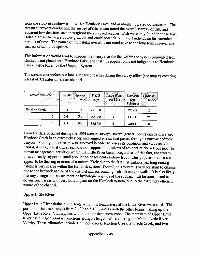
from the stocked rainbow trout within Hemlock Lake, and gradually migrated downstream. Thestream surveyors conducting the survey of this stream noted the overall scarcity of fislr, andapparent low densities seen throughout the surveyed reaches. Fish were only found in ihose few,isolated areas that were of low gradient and could potentially support indiviiuals for extendedperiods of time. The nature of the habitat overall is not conducive to the long term suwival andsuccess of salmonid species.
This information would tend to support the theory that the fish within the system originated fromstocked trout placed into Hemlock Lake, and that this population is not indigenous to HemlockCreelg Little River, or the Umpqua System.
The stream was broken out into 3 separate reaches during the survey effort (see map x) coveringa total of 3.2 miles of stream channel.
SteamandReach X€ngth Sp€iesP r t
Pfl.:Grstio,
I;req Wbd'pd' 'MilC
"'Dodsub: , . 'Substrst€
Hemlock Creek I 1 . 3 Rb 2 l :78 :0 5 l CO:GR l 5
2 0.6 Rb 2O:79:O 4 l CO:SB 25
J 1 . 3 Rb l3 :87 :0 3 l GR:CO 8
From the data obtained during the 1994 stream surveys, several general points can be discerned.Hemlock Creek is an extremely steep and rugged stream that passes through a niurow bedrockcanyon. Although this stream wzrs surveyed in order to assess its condition and value as fishhabitat, it is likely that this stream did not support populations of resident rainbow trout prior tohuman management activities within the Linle River basin. Regardless of this fact, the streamdoes currently support a small population of resident rainbow trout. This population does notappear to be thriving in terms of numbers, likely due to the fact that suitable yearlong rearinghabitat is very scarce within the Hemlock system. Overall, this system is very resistant to changedue to the bedrock nature of the channel and surrounding bedrock canyon walls. It is also likelythat any changes to the sediment or hydrologic regimes of the subbasin will be transported todownstream areas with very little impaa on the Hemlock systerq due to the extremely efficientnature ofthe channel.
Upper Little River
Upper Little River drains 3,983 acres within the headwaters of the Little River watershed. Thisportion of the basin ranges from 2,400'to 5,100', and as with the other basins making up theUpper Little River Vicinity, lies within the transient snow zone. The mainstem of Upper LittleRiver has 5 major tributary junctions along its length before entering the lvfiddle Little RiverVicinity. These tributaries include Hemlock Creelg Junction Creelg Pinnacle Creelg and two
Appendix F - 49

unnamed tributaries. Resident rainbow trout and at least one species of sculpin are present withinthe fish bearing portion of Upper Little River.
Upper Little River flows through a low to moderate "Vn-shaped channel with a valley floor whichis less than 100' in width. Surveys conducted during the summer of 1994 displayed that themajority of the stream channel in this portion of the basin is moderately entrenched and has streamgradients rangrng from 5% to l2Yo. The streambed throughout the surveyed reaches is dominatedby cobble and gravel substrate, although reach I does have a significant bedrock c,omponent. Thecanopy cover within the surveyed reaches of stream was considered to range from2}Yo to 60Yo.Douglas-fir, western red cedar and vine maple in the small and large tree seral stages were amongthe most common species observed within the riparian areas along Upper Little River.
Stream channel conditions within Upper Little River change drastically with increases in elevationand changes in the amount of stream side management practices. In the lower portion of the basinwhere there is little stream side management, pools and large wood a,re more abundant. Insurveyed reaches I and2, pool habitat makes up 30Yo to almost 50% of the in-stream habitat inthe basin. Large wood plays a large role in creating these habitats. In the heavily managed areashigher in the basirq pool habitat is not its common. In reach 4 where stream side management isthe most intense pool habitat drops to less that20Yo. This is expected to be the result of theremoval of large wood from the stream channel. Once the structural control was removed fromthe channel it was able to degrade and become simplified.
Stream,mdReach 3fl Spgr"gPresent
P:R:Graio
Lsrgq Wood
.,...',...091$19,.....:Dom/sub
.,,,:.. do6rrj'i.:r,
SUb$ratd
Crradient
;.... t...l.. ', Yn:..'.t. ...
Upper Little River I 1 .0 Rb 42:57:O 67 CO:GR t2
) 1 .3 Rb 30:66: l 45 CO:GR 8
J t . 0 Rb 29:71:0 38 CO:GR 4
4 0.8 Rb l8 :81 :0 l 0 CO:GR 5
Road building and timber harvest are the rwo primary management practices that have occurredwithin the Upper Little River basin. There are currently 3l miles of Forest Service system roadwithin the basi4 for a road density of 5.0 miles of road per sq.mile of ground. Twenty-three milesof this road was aggregate surface road, while the remaining 8 miles were native surface. Timberharvest in Upper Little River began in the 1950's and to date 1,516 acres (38%) of the basin havebeen harvested. Clearcutting was the most conunon silvicultural prescription used although a fewshelterwood harvest units are present in the basin as well. As with the other streams in the basi4riparian harvest and steam cleanout occurred along and within many Class f[, TTT, and fV streamchannels.
Appendix F - 50

APPEI\DD( G


APPENDIX G
RARE PLANTS, NON.I\ATIVE PLANTS, AND NATIVE REVEGETATION
Table of Contents
TES Plant Species, Preferred Habitats... . . . . . . . . . . . . . . .G-2
TES Plant Species Occurrence in the Little River watershed.. .....G-8
ROD Speices Occurrence in the Little River watershed.. ............G-13
Non-native plant species, noxious weed regulations.... . . . . . . . . . . . . . . .G-21
Oregon State noxious weed l ist, Lit t le River occurrences.... . . . . . . . . . . . . . . . . . . . . . . . .G-23
Native grass seed availability ...G-27
Native species lists, including nitrogen fixers...... .......G-28
Revegetation/Stabilization areas ..G-37
Data summar ies. . . . . . . . . . . .G-38
Integrated Weed Management Guidelines.... . . . . . . . . . . . . .G-40
Appendix G - I

LITTLE RTVER WATERSHT' DTES PI,A}IT SPECMS
PREF"ERRED HABITAT
Descriptions are compiled from numerous sources, including Oregon Natural Heritage Programrecords, Forest Service and BLM working documents as well as pertinent Floras.
Allium bolanderi Bolander's OnionThis plant prefers clay soils in brush and mixed woods below 3000 feet. It often occurs onserpentine soils gravelly flats and stony slopes.
Allium campanulatum Sierra OnionThis species is known from a variety of habitats. On the east side of the Cascades it commonlygrows in the litter at the base of ponderosa pine trees. On the Barlow Ranger District of theMount Hood National Forest it is found growing in shallow clay soil on ridge top openings inconiferous forest at 3400 to 5000 feet elevation. On the Tiller Ranger District it occurs in opentimber/meadow mosaic at elevations of 5500 to 5700 feet where it has been found on east to east-northeast facing ridge tops and slopes up to 30%. On the North Umpqua ranger District it ismost likely to occur on high elevation ridge lines.
Asarum wagneri Green-flowered Wild GngerKnown locations for this species occur from 3000 to 8400 feet in moist loamy to rocky soil onslopes of 0 to 45oh at any aspect. Frequently sites occur in closed-canopy mixed conifer standsdominated by Shasta red fir (Abies magnifica). Plants are also occasionally found in open areas.The most cofiImon combination of site characters is. true fir conifer forest, open to filtered light,moist loamy soil, slope of L5o/o or less, north to east aspect, at over 5000 feet elevation. Associatespecies often include gooseberries (Ribgs spp.),chinkapin (Castenopsis chrysophylla), pipsissiwa(Chimophylla umbellata), It occasionally shows up above timberline and in rocky situations suchas talus slopes.
Asplenium septentrionale Grass-fernAsplenium septentrionale sites are concentrated in a narrow band extending from lower CopelandCreek over Limpy Rock to Singe Creek. It occurs on rock outcrops of pyroclastic origin where itgrows in cracks along with moss and ferns. Aspect ranges from east to south-southwest. Slopesrange from 10% to vertical. Moisture varies from moist to xeric and canopy can be open orclosed. The elevation of the sites lies between 2400 and 5200 feet. Umpqua Kalmiopsis
@fuopsu "fragrans") is often present.
Astragualus umbraticus Woodland milkvetchThis species occurs in the West Side Cascades and Klamath Mountain physiographic provinces.Populations in Douglas and Lane Counties have been found from 1640 to 3600 feet on east, southand west aspects on slopes ranging from 0 to 9OYo. Nearly all sites have experienced some kind
Appendix G - 2

of disturbance. Typical habitat is a midslope site at 2500 feet in open woods or forest on asoutheast aspect with a pitch of less than 25yo that has been disturbed by logging or fire. Old skidroads are often favored. Cutbanks, shoulders and even rocked surfaces ofroads have beenoccupied by this plant.
Calamagrostis brewer Brewer's reedgrassThis is a moist site species found growing in open:ueas on stream banl6, lake margins, moistsubalpine to alpine meadows. Sites can be expected in an elevation range from 5000 to 1Z,2OOfeet.
Calochortus umpquaensis Umpqua mariposa lilyThis species is restricted to open grassland and forests on serpentine soils in SouthwesternOregon ranging from the Little River drainage in southern Douglas County to northern Jacksonand Josephine Counties. Habitat varies from forest to open grasslands, though it appears topreler open grasslands dominated by native bunchgrasses and the ecotone between grassland andforest. Elevation ranges befween 800 and 2900 feet. Populations have been found on all aspects,but favor north and east facing slopes in the southern portion of its range. Slopes range from 0%to 65Yo. The forest communities in which C. Umpquaensis is found are dominated by Pinusjeffrqd, Pseudotsuga menziesii, and Calocedrus decurrens. Meadow habitat is characterized bybunchgrasses such as Festuca idahoensis, Danthonia californica" and Stipa lemmonii, andintroduced annuals such as Brome mollis, Cynosurus echinatus, and Aira caryophyllea.
Cimicifuga elata Tall bugbaneCimicifuga elata prefers north aspects in shady, moist, low elevation forests, woods and thickets.An exception to this occurs on the Tiller Ranger District where the plants are also found intimber/meadow mosaic habitats above 4000 feet elevation. Known sites occur habitat from 200to 5000 feet in elevation with most occurring at less than 1000 feet. Slopes range from 0 to 9O%o.Sites include old growth conifer forests, deciduous woods, clearcuts, ecotones between timberand clearcuts as well as thickets and road margins. This demonstrates a wide tolerance of covervariation from none to dense, however the most common situation is one of shade or deep shade.Dominant canopy species include Douglas-fir (Psegdosnga menziesii), bigleaf maple (Acermacrophyllum) and red alder (Alngr rubra) and, on the Tiller R.D., Shasta red fir (Abies magnificavar. shastensis). Associate species generally include trillium (Trillium ovatum), fairy bells(Bispssle hookerii and D. smithii), and thimbleberry (Rqhus parvifloris).
Collomia malzama MazamacollomiaThis is a high elevation species with sites concentrated along the Cascade crest. Known sitesoccur from 4900 to 6200 feet elevation. Most are mid to upper slope moist meadows, meadowmargins or open canopy timber such as that found in timber/meadow mosaic situations, however,sites are occasionally found in riparian situations.. Aspect generally ranges from south throughwest to north although many sites are flat and consequently occupy no aspect. Slopes aregenerally less than 2}%o.Plants are located in areas that receive light shade or filtered sun .Canopy cover seldom exceeds 30Yo.Plants are not found in dry openings or under dense canopy.
Appendix G - 3

Soils are generally composed of loam or sandy loam. Associated species frequently include red fir(Abies magnifica) and mountain hemlock (Tsuga mertensiana).
Cypripedium fasciculatum Clustered Lady's slipperHabitat for this species is variable. Elevation of known sites in southwest Oregon ranges from150 to 6000 feet with the majority occurring between 1500 and 3000 feet. Aspect at the site isusually somewhere from west to north. Slopes are generally moderate with some at the flat andsome at the very steep end of the scale. Midslope and riparian bench sites are corrunon with themidslope sites being of a moderate to dry moisture regime and the riparian sites generally beingmoist. Most sites are either moist riparian locations dominated by Douglas-fu (Pseudostugamenziesii) with Pacific dogwood (Cornus nuttallii present OR they are moderately dry midslopemixed woods or conifer forest locations with madrone (Arbutus menziesii) or tanoak Githoca$usdensiflorus) or canyon live-oak (Quercus chrysophylla) present.
Frasera umpquaensis Umpqua swertiaFrasera umgquaensis is found primarily at elevations of 4000 to 6000 feet in open fir (Abies ppp.)forests and meadows on the west side of the Cascades and in open mixed conifer forests in theKlamath Mountains. In all known sites the plants are located in areas that are relatively protectedfrom environmental extremes, especially high temperatures dry soils. The Cascade populationsare in relatively cool, moist sites that experience significant winter snow accumulations. Plantsmay be found growing as understory herbs in open forest stands or as a principal component onherb dominated meadows. They are rarely found in closed canopy situations.
Frittillarie glauca Siskiyou frittillariaThis plant inhabits gravelly, shallow soil on rocky and craggy sites at moderate or high elevations.Slopes range from 20 to 70Yo. Vegetative cover is sparse or nearly absent. Serpentine is afrequent parent material. On the Umpqua National Forest it known from the Rogue UmpquaDivide.
Hazardia (Ilaplopappus) whitneyi var. discoidea Whitney's hazardiaThis plant is a high elevation lover of rocky open places. In the Cascades it occurs at elevationsfrom 4500 to 7000 feet in gravelly soil on craggy sites on ridges, saddles and upper slopes wherethe vegetative layer is sparse. Occasionally it will occur with Siskiyou fritillary (trtillarn glauga).Commonly associated species include sulfur flower (Egagauutg umbellatum), sedums (Sedumspp.), and pinemat manzanita (Artcostaphyllos nevadensis). Nearby tree cover usually consists ofShasta red fue (Abies magnifica var. shastensis) and mountain hemlock (Tsuga mertensiana).
Horkelia congesta var. congesta dwarf-flowered horkeliaKnown only from the Willamette and Umpqua valleys, this plant inhabits interior valley prairie andoak savannah habitat in western Oregon below 2000 feet. Historically the species ranged fromWashington to Douglas County. Extant populations no longer occur in Washingtoq Marion andPolk Counties in the northern portion of its range. One population is known in the Little River
Appendix G - 4

watershed. Aspect is typically southerly with slopes rangng between 0%o and 600A. It is knownto have survived periodic mowing on several sites. Associated species include red fescue (Eesfucarubra), Calilornia oatgrass (Danthonia californica), yarrow (Adillga millefolium), Oregon iris (Listenax), Leichtlin's camas (C.amasria leichtlinii), barestem buckwheat (Eriogonuno nudum), and'spring phacelia (Piacalta verna). Associated with Little River are Calochortus tolmiei,Calochortus umpquaensis, Viola hallii, Keoleria cristat4 and Festuca idahoensis.
Illiamna latibracteata California globe-mallowCalifornia globe-mallow prefers open sites in forested iueas. Often it is found where timber hasbeen clearcut and the unit prepared for reproduction by burning. Known sites range in elevationfrom 2500 to 5200 feet and in variously described habitats including clearcuts, moist meadows,and dry, rocky cut-banks. Aspect is usually southerly or westerly. Soil is generally sandy andwell drained. Overstory tree canopy is absent.
Isoprum stipitatum Dwarf isopynrmIn the Willamette and Umpqua Valleys dwarf isopynrm is found in moist open grassy habitatsincluding mowed fields and oak woodland in a riparian setting where brush has timited cover. Onthe south slopes of the Klamath/Rogue divide near Hilt it occurs in association with buckbrush(Ceanothus cuneatus) where it has been found only on south and north aspects. While the sites areoften sunny, plants tend to be under the canopy of brush or trees. Buckbrush is always present,however, plants are not found in young or medium age buckbruslq only old decadent stands.Plants are also found in stands ofjuniper, oalg or pine in their early seral stages when the'skeletons' of dead buckbrush plants are still present. Near Hilt dwarf isopyrum may be found atelevations from 2000 to 4000 feet. In the Willamette and Umpqua valleys elevations of knownsites lie between 300 and 1500 feet.
Kalmiopsis "fragrans" Umpqua KalmiopsisThis plant is found in all aspects on rock outcrops composed of pyroclastic parent material. Itgrows in cracks in rocks and shallow soil overlying rock substrate. It will tolerate shade fromoverstory tree canopy but most often will be found h open areas growing on its own withoccasional scattered shrubs and moss and lichen species. It generally is not found growing on soilwhere the shrub layer is dense. Slope varies from flat to vertical. Pinemat manzanita(Arctostaphylos nevadensis) is a common associate. Known sites occur from 1600 to 4500 feet.
Lewisia columbiena var. columbiana Columbia lewisiaColumbia lewisia favors exposed rocky sites where it grows rooted in moss mats in cracks and
depressions in bedrock rock. Summertime conditions can become xeric. Elevations of knownsites range from 100 feet above sea level in the Columbia Gorge to 6000 feet elevation in theCascades of southern Oregon. Aspects of sites tend to be toward the north and/or east. Slopevaries from flat to vertical. Associated species include typical 'rock garden' plants such assedums (Scdun spp.) saxifrages (Sariftaga spp. and rock cresses (Arabh sp!.). Tree and shrubcanopy is absent.
Appendix G - 5

Mimulus douglasii Douglas' monkey-flowerDouglas' monkey-flower is an ephemeral annual whiclU depending on weather conditions, may ormay not appear each year. It inhabits gravelly soils in rocky open slopes that are moist in thespring. Known sites are generally located at 4000 feet elevation or lower. Habitats are variouslydescribed as chaparral, foothill woodland, and rock meadows. Serpentine is a common substrate.
Minuarta cismontana sandwortRange of this species includes Douglas and Lane Counties. It is expected to be found on the westslope of the Cascade Range as well as in the Klamath Mountains and in California. Habitatinformation was unavailable when this document went to press.
Ophioglossum pusilum (wlgafulq) Adder's tongue, Grass-fernGrass-fern grows in shady moist or boggy meadows and margins of ponds. where it can be foundamong sedges, in the open or near low shrubs. Known sites occur from 1500 to 5000 feetelevation. Sites are generally flat having little or no slope or aspect. Soil is constantly wet andhigh in organic material. Associated species include baldhip rose (R!sa gymnocarpa), bracken fern
Gtsridum apuilinum), sedges (Carex $p.), horsetail (Eqlise[rm hymenale), rush (Juncus effi.rsus),Douglas spirea(Spirea douglasii), and Oregon ash (Fraxizus latifolia).
Pellaea andromedaefolia Coffee fernKnown sites occur from 600 feet to 1800 feet on dry, open rock outcrops composed of basalt,siltstone, sandstone, conglomerate or metavolcanic rock. Plants generally root in crevices in therock or in shallow loamy soil over the surface. Slope position varies from lower slope to crestwith most sites being on the upper slope or crest. Aspect varies from southeast to southwest.Slope ranges from20Yo to verticle with most being around 60 to 70o/o. Habitats are generallydescribed as rock outcrops or rock balds. Associated species include hedgehog doEail grass(Cyncurus echinatus), silverleaf phacelia (Phacela hastata), Hall's desert parsley (Lonatrujnnhallii), poison oak (Rhus diversiloba), and madrone (Arbutus menziesii).
Perideridia erythrorhJza Red-root yampaThis species can be found in moist prairies, valleys, and pasture land. It often occurs in heavy.poorly drained soils. Sites are known mostly from elevations under 1600 feet on the west side ofthe Cascades but occur as high as 5000 feet on the east side in the Klamath area. Sites are operLflat or west facing with slopes from 0 to l5o/o. Trees and shrubs are usually absent. Those mostcommonly occurring are Oregon white oak (Ouercus garryana) and Oregon ash (Fraxinuslatifolia). Red-root yampa is usually found growing in meadows dominated by grasses with rushes(Jnff&s sp.)and mints (Menlha gp.) present. Herbaceous vegetation is often composed of as muchas 50o/o non-native species.
Polystichum californicum California sword fernCalifornia sword fern grows on rock cliffs where it most often occurs either in moist proximity offalling water or in grottos or deep overhangs recessed in the cliff. The plants require deep shadeand a moist environment. Plants root in crevices in the rock or in shallow gravelly loam deposited
Appendix G - 6

in concavities. Known sites occur at all aspects at elevations ranging from 100 to 4000 feet withthe mean elevation being at about i7O0 feet. Moss and lichen cover at the sites is generallymoderate, herb layer light and shrub layer limited or absent. Tree canopy may or may not shadethe site. Shade is required for survival, however, and where it is not provided by recesses in theclifftree canopy is generally closed or dense. Associated vascular plant species are generally "rockgarden" types . They usually include spatula-leaf stonecrop (Sedum spathulifolium), smallflowerallumroot (Heuchera micrantha), saxifrages (Saxifraga sp.) and various rock- loving ferns.
Romanzoffia "thompsonii" Thompson's mistmaidenThompson's mistmaiden requires shallow soil on well drained sites that are moist or wet in thewinter and spring. Sites have been variously described as rock balds, rocky seeps , vernally wetgravel slopes, and dripping wet moss-mats on cliffs.. Shrubs and large herbaceous plants aregenerally absent. Tree cover may be absent or limited and supplied by trees adjacent to ratherthan on the site. The plants are rooted in shallow gravelly loam. They are usually found growingin mats of red b.yu- moss (Bryum miniatum) which clings to cracks and irregularities in thesurface of solid rock. The slope of known sites varies from 10% to 100% with 60% being aboutthe mean. Sites are located on all aspects but most commonly occur in the range from southeastto southwest. Elevations range from 1200 to 6000 feet. Associated species include selaginella(Selaginella sp.), rosy plectritis (PleArtis congesta),seep spring monkeyflower Mmulus€grfiafus), chickweed monkeyflower (Mmulus alsinoides),California mistmaiden G.omanzoffiacalifornica), and Nuttall' s saxifrage ( S axifraga nuttallii).
Utricularia minor LesserbladderwortLesser bladderwort is restricted to standing or slow moving water where it floats just under thesurface. Known habitats have been described as wet hollows, ponds, fens, marshes, wet meadowhollows, peatland, and organic muck. Slope ranges from 0 to 20 degrees with nearly all sitesbeing reported as flat. Elevations range from 20 to 4900 feet with most known sites lying above3200 feet. Reported water depths are generally less than six feet. Associated species includesphagnum moss (Sphagnum spp.), moss (Drepanaaladut sp.), pondweed Gonamggflar spp.),slender cottongrass Gnophonm gracile), threeleaf bogbean Garuyathel trifoliata), and sedges(Carex spp.).
Wolflia columbiana Columbia water-meal
Wolffia borealis punctate water-mealColumbia water-meal occurs in lakes, ponds, and pools of standing water. Plants float just belowthe water surface with the upper thallus just touching the surlace film. Elevations of known sitesrange from 20 to 2000 feet. Slope is generally flat but can be as much as 20 degrees. Associatedspecies include mosquito fern (&olla sp.), Brazilian water-meal 0Volffia braziliensis), waterlentil (Leana minor), and great duckweed (Spirodela polyrhiza).
Appendix G - 7

THREATENED, ENDANGERED AND SENSITIVE SPECIES OCCURRENCE
IN THE
LITTLE RIVER WATERSHED
Status codes:
1). United States Fish and Wildlife Service (USFWS [Represented in table as FWS]), Oregon Department of Agriculture(oDA)
LE= Listed Endangered by ODA or USFWS.LT= Listed Threatened by ODA or USFWS.PE= Proposed Endangered by ODA or USFWS.PT= Proposed Threatened by ODA or USFWS.C1= Taxa for which USFWS has sufficient information to support a proposal to list as threatened or endangered.
(Category 1 candidate).C2= USFWS candidates for which addrtional information is needdd to support listing as threatened or
endangered.C2.= USFWS candidates which may be extrnct.3A= Extinct taxa.38= Taxonomic problems which cause the taxa not to meet the USFWS definition of a "species".3C= Taxa which have proven to be more abundant or widespread than previously believed and/or which have no
identifiable threats.
2 ) . ONHP1= Threatened, endangered or presumed extnct throughout range.2= Threatened, endangered or possibly extirpated from Oregon but more common elsewhere.3= May be threatened or endangered in Oregon or throughout range. More information is needed.4= Very rare but currently secure or declining but too common to be listed as threatened or endangered.
3). Forest Service Region 6 (R6)OR= Sensitive in OregonOR\WA= Sensitive in Oregon and WashingtonSensitive species require project clearance, NEPA documentation, and may require USFS consultation.
4). Bureau of Land Management (BLM)Candidate= Federal Candidate Species. Requires project clearance, NEPA documentation, and
coordination with USFWSSensitive= Bureau Sensitive. Requires project clearance, and NEPA documentationAssessment= Assessment Species. Requires project clearance and NEPA documentation. Protection and
mitigation to be balanced with other resources. Tracking= 1r""Ong species. Consideration of species is optional
5). Record of Decison (ROD): species closely associated with late successional and old groMh forests1= Strategy 1: manage known sites2= Strategy 2: survey prior to activities and manage known sites3= Strategy 3: conduct extensive surveys and manage sites4= Strategy 4: conduct general regional surveys
Appendix G - 8

L ike l ihood o f Occur rance : pg6gmented
vascu la r
SCIENTIFIC NAME FWS ODA ONHP R6 BLM RODAster Mal isCalochortus umpquaensisHorkelia congesta ssp congestaRomazoffia thompsonii
c2C IC2
cLE
1111
OR
OR
CandidateCandidateSensitiveSensitive
1 2
SCIENTIFIC NAME FWS ODA ONHP R6 BLM RODAstragulus umbraticuslliamna latbracteataLewisia columbiana var columbianaPolys0chum californicumWolffia borealis
22222
OROROR
oRn /AOR
A,ssessmentAssessment
AssessmentAssegsment
SCIENTIFIC NAME FWS ODA ONHP R6 BLM RODMinuarta cismontana J Assessment
SCIENTIFIC NAME FWS ODA ONHP R6 BLM RODPhacel ia verna ") f- 4 Tracking
Likel ihood of Occurrance : gugpe6ted
f ung i
SCIENTIFIC NAIVE FWS ODA ONHP R6 BLM ROD
Oryporus nobrlissimus 1 123
l i c h e n
SCIENTIFIC NAME FWS ODA ONHP R6 BLM ROD
Neohroma occultum 4I t 5
SCIENTIFIC NAME FWS ODA ONHP R6 BLM ROD
Sulcana badia z
Appendix G - 9

Likel ihood of Occurrance : gugpected
l i chen
SCIENTIFIC NAME FWS ODA ONHP R6 BLM RODLecidea dolodesPilophorus nigricaulisPseudocyphellaria aurata
J
3 1 3
livenrvort
moss
SCIENTIFIC NAME FWS ODA ONHP R6 BLM RODChiloscyphus gemmiparusSphaerocarpos hians
II
aI
SCIENTIFIC NAME FWS ODA ONHP R6 BLM RODHerbertus sakuraiiPorella vernicosa var fauriei
2?
1 3
SCIENTIFIC NAME FWS ODA ONHP R6 BLM RODGym nomitrion concinnatumHaplomrtrium hookeriHerburtus aduncusJamesoniel la autumnal is var heterosporaLophozia laxaMarsupel la condensataMarsupel la emarginata var aquat icaMetsgena temperataPlagiochi la semidecurrens var alaskanaScapania gymnostomophi laScapania obscuraSchof ieldia moticola
a
J
J
SCIENTIFIC NAME FWS ODA ONHP R6 BLM ROD
Encalypta brevrcolla var crumianaTripterocladium leucocladulum
11
OR 1 3
SCIENTIFIC NAME FWS ODA ONHP R6 BLM ROD
Andreaea schofieldianaFrunaria muhlenbergi iHelodium blandowiiRacomitrium pacificumTaylona serrata
22z2z
Appendix G - t0

Likel ihood of Occurrance : $ugpegted
moss
SCIENTIFIC NAME FWS ODA ONHP R6 BLM RODBruchia bolanderiEncalypta brevipesTrematodon boasii
?
J
J
vascular
SCIENTIFIC NAME FWS ODA ONHP R6 BLM RODArabis koehleri var koehlenCimcifuga elataCypripedium fasciculatu mFrasera umpquaensisKalmiopsis fragransLimnanthes gracilis var gracilisLupinus sulphureus ssp kincaidi iPerideridia erythrorhizaPlagiobothyrus hirtus
c2
c2
3Cc2c2
cccc
cccLE
1
1II
1111
4I
1
0R A/AoR A/A
OROROR
SensitiveCandidateCandidateTrackingSensitive
CandidateCandidateCandidate
1 2
SCIENTIFIC NAME FWS ODA CNHP R6 BLM RODAgoseris elataArctostaphylos hispidaAsplenium septentrionaleBotrychium minganenseCalamagrostrs breweriiCarex hystricinaCarex lividaCheilanthes intertextaFrltil laria glaucaHaplopappus whrtney ssp discoideusHuperzia occidntalisHydrocotyle verticillataLewisia leanaLyco@iella inundataMimulus kel loggi iOphioglossum pusi l lumPellaea andromedaefoliaPerideridia howelliiScribneria bolanderiUtricularia minorWolffia columbiana
2222z222222222z222222
oR/\ /A
OROROR
oR A/AOROROROR
OROR
ORoR A/A
OR
OROROR
Assessment
Assessment
AssessmentAssessment
AssessmentAssessment
12
SCIENTIFIC NAME FWS ODA ONHP R6 BLM ROD
Allium bolanderi var bolanderiAl l ium bolanderi var mirabi leCarex comosaCarex retrorsaEpi lobium luteumlsopyrum stiprtatum
33J
J
J
J
AssessmentAssessment
AppendixG- l l

Likel ihood of Occurrance : $U5pegted
vascular
SCIENTIFIC NAME FWS ODA ONHP R6 BLM RODNavarretia tagettnaRosa spithamea var spithameaScirpus pendulusScirpus subterminalisSysrinchium hitchcockii
?
2
?
33 Tracking
SCIENTIFIC NAME FWS ODA ONHP R6 BLM ROD
Erigeron cascadensisMimulus douglasi iMontia diffusaPoa laxifloraPolystichum lemmoniiSidalcea cusickii
444444
Assessment
Tracking
Appendix G - 12

ROD SURVEY AND MANAGE SPECIES OCCURRENCE
IN THE
LITTLE RIVER WATERSHED
Status codes:
1)' United States Fish and Wildlife Service (USFWS [Represented in table as FWS]), Oregon Department of Agriculture(oDA).
LE= Listed Endangered by ODA or USFWS.LT= Listed Threatened by ODA or USFWS.PE= Proposed Endangered by ODA or USFWS.PT= Proposed Threatened by ODA or USFWS.C1= Taxa for which USFWS has sufficient information to support a proposal to list as threatened or endangered.
(Category 1 candidate).C2= USFWS candidates for which additional information is needed to support listing as threatened or
endangered.C2"= USFWS candidates which may be extinct.34= Extrnct taxa.38= Taxonomic problems which cause the taxa not to meet the USFWS definitlon of a "species".3C= Taxa which have proven to be more abundant or widespread than previously believed and/or which have no
identrfiable threats.
2). ONHP1 = Threatened, endangered or presumed extinct throughout range.2= Threatened, endangered or possibly extirpated from Oregon but more common elsewhere.3= May be threatened or endangered in Oregon or throughout range. More information is needed.4= Very rare but currently secure or declining but too common to be listed as threatened or endangered.
3). Forest Service Region 6 (R6)OR= Sensitive in OregonOR\WA= Sensitive in Oregon and WashingtonSensitive species require project clearance, NEPA documentation, and may require USFS consultation.
4). Bureau of Land Management (BLM)Candidate= Federal Candidate Species. Requires project clearance, NEPA documentation, and
coordination with USFWSSensitive= Bureau Sensitive. Requires project clearance, and NEPA documentationAssessment= Assessment Species. Requires project clearance and NEPA documentation. Protection and
mitigaton to be balanced wilh other resourcesTracking= Tracking species. Consideration of species is optional
5). Record of Decison (ROD): species closely associated with late successional and old growth forests1= Strategy 1 : manage known sites2= Strategy 2: survey prior to activities and manage known sites3= Strategy 3: conduct extensive survels and manage sites4= Strategy 4: conduct general regional surveys
Appendix G - 13

Likelihood of Occurrance : Documentedl ichen
SCIENTIFIC NAME FWS ODA ONHP R6 BLM RODLobaria hal l i i 1 3
SCIENTIFIC NAME FWS ODA ONHP R6 BLM RODLeptogium saturninumLobaria oreganaLobana pulmonariaNephroma bel lumNephroma helvetrcumNephroma laevigatumNephroma resupinatumPannaria saubinetiiPeltigera collinaPeltigera neckeriPseudocyphel lar ia anomalaPseudocyphellaria anthraspisPseudocyphellana crocataSticta fuliginosaSticta limbata
444444444444444
vascular
SCIENTIFIC NAME FWS ODA ONHP R6 BLM ROD
Allotropa virgataAster vialis c2 c 1
I Candidate1212
Likelihood of Occurrance : gqgpegted
fungi
SCIENTIFIC NAME FWS ODA ONHP R6 BLM ROD
Bondarzewia montanaOryporus nobilissimus 1
123123
SCIENTIFIC NAME FWS ODA ONHP R6 BLM ROD
Albatrellus avellaneusAlbatrellus caeruleoporusAleurodiscus farlowiiAlpova alexsmithiiAlpova olivaceotinctusAlpova sp. nov. # Trappe 1966Alpova sp. nov. # Trappe 9730Arcangeliella crassaArcangeliella lactarioidesBalsamia nigraBoletus haematinusBoletus pulcherrimus
1 31 31 31 31 31 31 31 31 31 31 31 3
Appendix G - 14

Likel ihood of Occurrance : gqgpegted
fung i
SCIENTIFIC NAME FWS ODA ONHP R6 BLM ROD
I Cantharellus formosusI Choiromyces alveolatuslchoiromyces venosusI Chroogomphus loculatusClitocybe senilisClitocybe suMitopodaCollybia bakerensisCortinarius boulderensisCortinarius canabarbaCortinarius magnivelatusCortinarius olympianusCortinarius rainierensisCortinarius vanipesCortinarius verrucisporusDestuntzia fuscaDestunEia rubraDichostereum granulosumElaphomyces su bviscid usEndogone acrogenaGastroboletus imbelellusGastroboletus ruberGastroboletus sp. nov. # Trappe 7515Gastroboletus subalpinusGastrosuillus sp. nov. # Trappe 75'16Gastrosuillus sp. nov. # Trappe 9608Gautieria magnicellarisGautieria otthiiGelatindoiscus fl avid usGymnomyces sp. nov. # Trappe 1690, 1706,1710Gymnomyces sp. nov. # Trappe 5052Gymnomyces sp. nov. # Trappe 7545Gymnopilus puntifoliusHebeloma olympianaHelvella compressaHelvella crassitunicataHelvella elasticaHelvella maculataHydnotrya sp. nov. # Trappe 787,792Hydnotrya subnix sp. nov. # Trappe 1861Hygrophorus caeruleusHygrophorus vernalisLeucogaster citrinusLeucogaster microsporusMacowanites mollisMarasmius applanatipesMartellia fragransMartellia idahoensisMartellia monticolaMartel l ia sp. nov. # Trappe 1700Martellia sp. nov. # Trappe 31 1Martellia sp. nov. # Trappe 5903Martellia sp. nov. # Trappe 649Mycena hudsonianaMycena monticolaMycena overholtsiiMycena quinaultensisNeolentinus adherensNeournula pouchet i
1 31 31 31 31 31 31 31 31 31 31 31 31 31 31 31 31 31 31 31 31 31 31 31 31 31 31 31 31 31 31 31 31 31 31 31 31 31 31 31 31 31 31 31 31 31 31 31 31 31 31 31 31 31 31 31 31 31 3
Appendix G - 15

Likel ihood of Occurrance : Suspegtedfung i
SCIENTIFIC NAME FWS ODA ONHP R6 BLM RODNivatogastrium nubigenumOctavia nina macrosporaOctavianina sp. nov. #Trappe7502Otidea smithiiPhaeocollybia californicaPhaeocol lybia carmanahensisPhaeocollybia dissiliensPhaeocol lybia gregariaPhaeocol lybia kauffmani iPhaeocol lybia oregonenisPhaeocol lybia piceaePhaeocollybia scatesiaePhaeocollybia sipeiPholiota albivelataPithya vulgarisPlectania latahensisPlectania milleriPolyozel lus mult iplexRamaria abiebnaRamaria amyloideaRamaria araiosporaRamaria a u rantiisiccescensRamaria botryis var. aurantiiramosaRamaria celerMrescensRamaria claviramulataRamaria concolor f . marnRamaria concolor f . tsuginaRamaria coulteraeRamaria cyaneigranosaRamaria fasciculata var. sparsiramosaRamaria gelatiniaurantiaRamaria gracilisRamana hi lar is var. olympianaRamaria largentiiRamaria lorithamnusRamaria maculatrpesRamaria rainierensisRamana rubel la var. blandaRamana rubribrunnescensRamaria ru brievanescensRamaria rubripermanensRamaria spinulosaRamaria stunEiiRamaria suecicaRamaria thiersiiRamaria verlotensisRhizopogon brunneinigerRhizopogon evadens var. subalpinusRhizopogon exiguusRhizopogon fl avofi brillosusRhizopogon inquinatusRhizopogon sp. nov. # Trappe 1692Rhizopogon sp. nov. # Trappe 1698Rhizopogon sp. nov. # Trappe 9432Rhodocybe nitdaRhodocybe speciosaSedecula pulvinataTricholoma venenatum
1 31 31 31 31 31 31 31 31 31 31 31 31 31 31 31 31 31 31 31 31 31 31 31 31 31 31 31 31 31 31 31 31 31 31 31 31 31 31 31 31 31 31 31 31 31 31 31 31 31 31 31 31 31 31 31 31 31 3
Appendix G - 16

Likel ihood of Occurrance : gu5pe6ted
fung i
SCIENTIFIC NAME FWS ODA ONHP R6 BLM RODTricholomopsis fulvescensTylopilus pseudoscaber 1 3
1 3
SCIENTIFIC NAME FWS ODA ONHP R6 BLM RODCantharellus cibariusCantharel lus subalbidusCantharel lus tubaeformisClavariadelphus borealisClavariadelphus l igulaClavariadelphus lovejoyaeClavanadelph us pistilansClavariadelphus sachalinensisClavariadel ph us subfastrgiatusClavariadelphus truncatusClavulina cinereaClavulina cristataClavulina ornatipesGyromitra californicaGyromitra esculentaGyromitra infulaGyromitra melaleucoidesPhlogoitis helevlloidesPhytoconis ericetorum
34343434343434343434343434343434343434
SCIENTIFIC NAME FWS ODA ONHP R6 BLM RODAlbatrellus ellisiiAlbatrellus flettiiAsterophora lycoperdoidesAsterophora pa rasiticaBaeospora myriadophyl laBoletus piperatusCatathelasma ventricosaChrysomphalina grossulaClavicorona avellaneaCollybia racemosaCordycepys capitataCordycepys ophioglossoidesCortinarius azureusCortinarius cyanitesCortinarius spilomiusCortinarius tabularisCortinarius valgusCudonia monticolaCyphellostereum laeveDermocybe humboldtensisFayodia gracilipes (rainierensis)Gallerina atkinsonianaGallerina cerinaGallerina heterocystsGallerina sphagnicolaGallerina vaittaeformisGastroboletus turbinatusGomphus bonariiGomphus clavatus
333J
33333
J
J
33J
33333333333333
Appendix G - 17
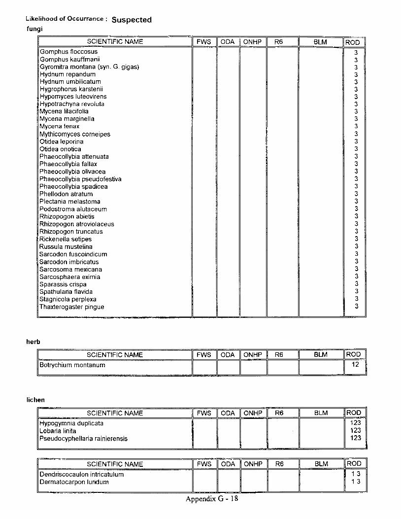
Likel ihood of Occurrance : gu5pegted
fung i
SCIENTIFIC NAME FWS ODA ONHP R6 BLM RODGomphus floccosusGomphus kauffmaniiGyromitra montana (syn. G. gigas)Hydnum repandumHydnum umbilicatumHygrophorus karsteni.Hypomyces luteovirensHypotrachyna revolutaMycena lilacifoliaMycena marginel laMycena tenaxMythicomyces corneipesOtidea leporinaOtidea onoticaPhaeocol lybia atten uataPhaeocollybia fallaxPhaeocol lybia olivaceaPhaeocol lybia pseudofestivaPhaeocollybia spadiceaPhel lodon atratumPlectania melastomaPodostroma alutaceumRhizopogon abietisRhizopogon atroviolaceusRhizopogon truncatusRickenella setipesRussula mustelinaSarcodon fuscoindicumSarcodon imbricatusSarcosoma mexicanaSarcosphaera eximiaSparassis crispaSpathularia flavidaStagnicola perplexaThaxterogaster pingue
3J
3?
3333J
3?
3332
333333
33
?
33333J
3J
3
herb
l ichen
SCIENTIFIC NAME FWS ODA ONHP R6 BLM ROD
Botrychium montanum 1 2
SCIENTIFIC NAME FWS ODA ONHP R6 BLM ROD
Hypogymnia duplicataLobaria linitaPseudocyphellaria rainierensis
123123123
SCIENTIFIC NAME FWS ODA ONHP R6 BLM ROD
Dendriscocaulon intricatulumDermatocarpon luridum
1 31 3
Appendix G - 18

Likel ihood of Occurrance : gq5pegted
l ichen
SCIENTIFIC NAME FWS ODA ONHP R6 BLM RODHydrothyria venosaLeptogium rivalePannaria rubiginosaPlagiochila satoiPlagiochila semidecurrensSticta arcticaTholurna dissimilisNephroma occultumPilophorus nigricaulis
1
1 31 31 31 31 31 31 31 31 3
SCIENTIFIC NAME FWS ODA ONHP R6 BLM RODCladonia norvegicaHeterodermia sitchensisHypogymnia vittataNephroma isidiosum
333J
SCIENTIFIC NAME FWS ODA ONHP R6 BLM RODCalicium abietinumCalic ium adaequatumCalicium adspersumCalic ium glaucel lumCalicium vrrideCetrelia cetrarioidesChaenotheca brunneolaChaenotheca chrysocephalaChaenotheca ferrugineaChaenotheca furfuraceaChaenotheca subroscidaChaenothecopis pusillaCollema nigrescensCyphel ium inquinansLeptogium burnetae var. hirsutumLeptogium cyanescensLeptogium teretiusculumLobaria scrobiculataMicrocalicium arenariumMycocalicium subtileNephroma parilePannaria leucostictoidesPannana mediterraneaPeltigera pacificaPlatismatia lacunosaRamalina thraustaStenocybe clavataStenocybe majorSticta beauvoisiiUsnea longissima
444444444444444444444444444444
livenrvort
SCIENTIFIC NAME
Kurzia makinoana
Appendix G - 19

Likel ihood of Occurrance : gugpegted
liverwort
SCIENTIFIC NAME FWS ODA ONHP R6 BLM RODMarsupella emarginata var. aquaticaTritomaria exsectiformis
121 2
SCIENTIFIC NAIVE FWS ODA ONHP R6 BLM ROD
Diplophyl lum albicansHerbertus aduncusTritomaria quinquedentataHerbertus sakuraii 2
1 31 31 31 3
SCIENTIFIC NAME FWS ODA ONHP R6 BLM ROD
Douinia ovata 4
SCIENTIFIC NAME FWS ODA ONHP R6 BLM RODUlota megalospora 1 2
SCIENTIFIC NAME FWS ODA ONHP R6 BLM ROD
Bartramiopsis lescuriiBrotherel la roel l iBryoria tortuosalwatsuklella leucotrichaOrthodontium gracilePleuroziopsis ruthenicaRacomrtrium aquaticumTetraphis geniculataEncalypta brevicol la var crumiana 4
I OR
1 31 31 31 31 31 31 31 31 3
SCIENTIFIC NAME FWS ODA ONHP R6 BLM ROD
Antitrichia curtipendulaScouleria marginata
44
vascular
SCIENTIFIC NAME FWS ODA ONHP R6 BLM ROD
Cypripedium montanum (west Cascades)Botrychium minganenseCypripediu m fasciculatum c
21
ORoR A/A
Tracking
Candidate
121212
Appendix G - 20

NON.NATIVE PLANT SPECMSNOXIOUS WEED I,AWS, REGT]LATIONS AND POLICY
The following laws, regulations, and policies provide the foundation for management of noxiousweeds on public lands.
reoeral Lano rollcy ano Management Act of 1976 FLPMA). Directs the BLM to "take anyaction necessary to prevent unnecessary and or undue degradation of the public lands.,,
Public Rangelands Improvement Act of 1978 (PRIA). Requires that BLM will manage, maintain,and improve the condition of the public rangelands so that they become as productive as feasible.
Carlson-Foley Act of 1968. Directs agency heads to enter upon lands under their jurisdiction withnoxious plants and destroy noxious plants growing there.
Undesirable Plantson Federal Lands. 1990. Authorizes the Secretary "to cooperate with other federal and stateagencies, and others in carrying out operations or measures to eradicate, suppress, control orprevent or retard the spread of any noious weed. Each Federal agency shall l) designate anoffice or person adequately trained to develop and coordinate an undesirable plants managementprogram for control of undesirable plants on federal lands under the agency's jurisdictiorL 2)establish and adequately fund an undesirable plants management program through the agency'sbudgetary process, 3) complete and implement cooperative agreements with State agenciesregarding the management of undesirable plant species on federal lands, and 4) establishintegrated management systems to control or contain undesirable plant species targeted undercooperative agreements. "
Final Fnvironmental Impact Statement for Noxious Weeds (1985) and Final SupplementalEnvironmental Impact Statement for Noxious Weeds (1987). Declares that the BLM has thestatutory duty to control and eradicate noxious weeds on public lands and identifies theenvironmental impacts of such a program.
Department Manual 5 17. Prescribes policy for the use of pesticides on the lands and waters underits jurisdiction and for compliance with the Federal Insecticide, Fungicide, and Rodenticide Act,as amended.
Department Manual 609. Prescribes policy to control undesirable or noxious weeds on the lands,water, or facilities under its jurisdiction, to the extent economically practicable and as needed forresource protection and accomplishment of resource management objectives.
BLM Manual 901 l. Provides policy for conducting chemical pest control programs under anintegrated pest management approach.
Appendix G - 2l

BLM Manual 9014. Provides guidance and procedures for planning and implementing biologicalcontrol in integrated pest management programs.
BLM Manual 9015. Provides policy relating to the management and coordination of noxiousweed activities among BLln[ organizations and individuals.
BLM Manual 9220. Provides guidance for implementing integrated pest management on landsadministered by the Bureau. The objective is to ensure optimal pest management with respect toenvironmental concerns, biological effectiveness, and efficienry while achieving resourcemanagement obj ectives.
Forest Service Land and Resource Management Plan for Umpqua N.F. States that noxious weedcontrol should be accomplished in cooperation with other agencies and organizations. Notes thatpreventative management is critical to effective control.
Forest Service Manual 2080. Establishes Direction. Clarifies responsibilities and authorities formanagement of noxious weeds on Forest Service lands. Objectives are to l) use integrated weedmanagement to meet vegetation management goals, 2) prevent introduction and establishment ofnew infestations, 3) contain and suppress existing infestations, 4) cooperate with other agencies,organizations and land owners, 5) increase general knowledge of employees, other agencies,organizations, users and adjacent owners. Delineates project level responsibilities, preventiorqand control measures.
RLM Roseburg District Draft Integrated Weed Control Plan and Environmental Assessment.Analyzes the current situation on lands administered by the Roseburg District. Identifies targetspecies. Proposes management activities for target infestations. Explains environmentalconsequences.
Appendix G - 22

c.lcil
I
XE
q)
tt
-N6I
o
Gc
ct).c
3
o
oEcooQ)oc
9 o
b dL o !
6
l
oE!o
oo
;ooo
ot
o'6G
LrJ
Frn J 8c :o . :
Eael u -y - c -
v , o . =
r
oo'o
oo
U;f,
o
oo)o 6
- 6| , o )I Fi i oo - a
s g
EcGc):fo(U
U;o)'o
R oE 6
_ o )E o
. = 6d . '
.t
(\'a
F. co dl
c,
(!-oo
ooo,
oo
oc)
(l)
E(Ezo'-c.ooo
go
tr(u
Ecoo)c)
-gJo(uoooE
oc,oEoa
.u,(Uot
'o-
?
E(uooEcC'oU)
o(o-9
El' o.=
o)G
GErtoo-6)oE
oocoa(UE
:c()
.ooo>o(l
.go
oElUzcoEEo
o
E.
(o.9
o3o(u
(g. E
o
(l,
oooEo
oo,
Eaoo
n
o
.o
-=
(D
co=oEoo
o
_o
F6
!t(6c(!
(J
ooc)()3o
c
(l)o()
^ - . . c o )
. E { s E : oE E 8 = . 8 'E : F ; : : =E E = E E iH € g i u s2 " U g E E 6( E c E = ' F ] oa : e g ! ' 8 _o o ) o o . e o5 : c - c - o !F E E : . O : ie j s E f ;i E g E g s2 Z z E ; :f * E : F I5 ; e : - o ;g e F ' € E so = = E - o
! g
= - o o Ev l r o ( I ] o ) o.,lJ = =
E g F E E ie : a 5 e s; E! :,8 ?': s: : f i ' -g E s € : € =
! o 5 ( D o i
{ F q E - g E = o[ . ! : Eg f lP9 E = 3 i . € q= E E F = ' q 6 '
e H : e E g E: = ; E ; 3 s -E 5 P _ 8 € E En : # : E ; g- E R " , i P " : 6 t u
{ i=&= :E'€ *E: + P s + E E J *E , $ E E E 5 : " g g; q E F F E E E E E=F gEH gE : gEE i E E A ! ; E T E; 3 : E E P F : A i if E $ H 5 F A E t _ E
f i f ,= 2o u If t ro t rx 3i r o
H 3 Pf l Eo E
6 5O Fu J =E , Jo

vc.l
I
XE
q)
o
HI
oqJ
co
ioI
oc
o
=lo=
a
&o
o
o=oEq)=
E
;oo
ooo
o
.c
o)o
Eo
o
oI
!
oN6-o
i=6
o(u
o
o >b €9 a. : ! !. o
- 6o o )> x
= 6
eG
oE
. - 6
O F
= ^
o - i6 O
i i o
o Y
J 6
J
8oo. -
c
oq)q):
q)
BoL O
3 d0 a E
o6
EGo.zoc
o. co
ooc)o)o)
qJ
G
B_-!
8oc,.zoo-o6
o(!O- 0,
z >
ol
od).5
x-8oo
o-oC'66 c |C L E: €o >z . c
EoEo
E(!
Ec6o
? ( uo !x | Ul t , >o . E9 o
: E( ) 0- . oo >F u
U G
. 9'c
o)oltUco6
o
:J
o)
o-o
U
o
=ul
o,o=
ul
c.9o
C64)
oq)
o
. E
- No ( 7 )
= v ,
u J :t r Ep 3 s
= s o
3 E E
- rX E5 -E Eo c
c o
(!' 6 A
= J
,.ii o
q)
o)
I,IJ
q)
o
ul
c.ooo
oo
E B .( l ) Y
E U J> b
o=I
oopooo
cooc(!
c)(')c(q
E
oo
!o
6
o(L
;oo.c-o-3o o9 F( l , -- 0 ,H }E }o - oO Fq r ;
E :
> o
o6c)(uGo6
o
U)
oo;6o'o
(Uo
Ec6
o)=oo
> o
r G
@
(u(!,
U'o
c6
o
tr
o6'
oo
3uiopq,
Eoo
E
oolooo-
Ecgo)o)c6
oo(t,ooooB6o'6
oo
U;Ecoc,=oo(L
o3G
a(D cn F
(D
q)
o oo
oq) oood)
cq,ooo-
o oo
o(l,
oo
oq)
q)
Eozo
.F
.0,oa
a'-o-Eo
oo
=
6
;oq)
f6
q)
O
6
ooC
.ooo
E=(!
.oo-o
E
=o-o
.oo(l,
e(Uof,
fzo
oo
o
tV
oo8_ooEol
.os(-)
.oooE(l,
Eq,.9.26
UJ
ooo.coo(lt6
El
(',6
o(!oCLo
6)x0,l
o=(!
c,Eoo)
o
o)o6I
(!
g.9Ec,
(l'
I
Go
-6;o
c(l,
o6Eo-q,oo
oooff
IEo
E(u'o-
o
Ef
(uU'
8.-e|!-E
-=o)
a
oo'-E
=ooo_s9'o)
.(Ucto-oao
. 6
tY
(!
oo.g
oCLa
UJ
t!
q
o
z
o'o
o|\'oo=oc|Do
.g
oo,ooo".9E.(D
q)(Eo
(D
E=o(uo
Eaq)
.g(l,(!
F
Ea
|g
(!
EE:=a
q,
EozoEE
6
u6oFc'-oE6o
](u)<q)
=o
T'oo3otl,
o
'^=Ell,6
c. oo(g
ful
Eo(|,]
E
co
El,!
Ioo
c
IL
' o
ooo-
.(Uo
Eo,oEo)<
ooo
o
c
6IoI
_o
I
o
.og
6
o)cftt
o,
I.o
Fc.o(o
q)oEY
6
-
oot!
o
Eo
l
oooo)
ooo,'^- Y
oo)lo-
U)
IEo
J
oo
6
Eo(l,
3o-Gq)<]o(l,
oot(ua
oc6
0)=o
(t,
E
(!q,
E66J
c)
o
.oEr
=

ta)C-l
I
X.o
4)
q
€No
I
o
o
oq,
o
co
I
E-oo
o
c6
o=|!
oEooio
o :> xc &
ol
' 5
. ooq,
o,
qJ
ooc)q,
F .;i q,r l E: o
oo
o
coo
G
oC'
. c
o
o
Ytioo
oO E
6 E
c L 6
J G
--'-o
oo
ouid).:t!c
o
;()
oo
3o
.Yo
oq,.zoo
6
6(Eo - o
z 5
E(uc
=(oE
!
- Y ( l ,g =. > a- co o. o 95 €
F O -
o
oo
I
oI()ooo
o
.o
F
oo6
.trr8oo
o o- EO CJ O
3 Eo f6 -
E E
o)n
o6
LrJ
8.olul
lo _:, = J
o . E.Z r'-; ( 9E C O
E ;8 P; 3
|E(to
uJ
'6G
=uJ
q,
ol
t l J
o
JuJ
t_olul
. c
e=
E9 oE Bo >: Ei o
U O
Ecozcoo,O - 6o oJ , =u J <
t!
(oI
oECoo=o
U;
o=o)
=- o
c c )o P
a p
ocoo0po€Iocooo(!o . ^( ! o )
c ) ( )> E
cG'-o
U;o
(l,
i(tq,
oo
8o
;6o)oo6(Ei
9o t hp o
3 EE rn ; 6k o> ^
J E
6|Eo(uG3
oq)
c,oo3U;OJo=uiooo(!
:==t r q
' - 6
o p< F
oq)'o!o-.oBo
Et!oEo r !o c ,E r !P E= ao c ,
{ !
ooo(l'
oo;utq)
6E(Uo
oEc(Eoo)
E
oECod,c')co
c6olo
CL
oo=G
CD' o
cgop
c6
oc)tlt
ao
Et!o
o
= a).'( Yg cg-8O E' 6 9> E
o)aa
co (D (It CD (D F.
dt d)-
d)
oou
q)oo
oc)
oo tt
o aoo
oo)
oq,
q,
E6zo
't
OoU)
oc(E
lcoff
Go
E:'o=6
El
Ed,
J
Ef
6
lo6
EE' .oo
o
rn(l,
trc,o
=o' EF
6
oe(!oE
gJ
o.eoo
(Eol6
cq,()
o
o
o-oCD
:o:=
.oE(DEo
.6oo
E
o(|,(Jc=(v
.E
o
c)
t!
lo
c,()
of'=
oool
.osO
E=o=o)o6Ef
(!
oU)
o='-
o=f
(!(J
(g
'-c)=(uo
Fo
a
oloo)o
o
E
Eoo
oo
o)
(u(l,
ELrl
ocoa
o..(!co.NEoI
EJoo'aoE
. l
ox
(uano=ooE(!0,
G
oo
(!
6et)
6o
o
0)
Ef(Uotoo-E='-8-I
(E
Ioo.g.ooocc)
a
'-o(6
Eo-oo
c::
A
q,ocoa6
E
Eg
r.u
dJ
Eozc
EEo
d,
o
FIof
o0,Eoo-q,
Eccoo
x
-EEI
o
o-
o)c'5(,)oc3
c)
oooo
o
f
ooEE(ooq,
f
oqlG
Tooa
c,q,3oE.
E(l)
Bco
EI
U)
oJE.
c,iG
\l
6o)
E.
c
8d]
oooU)
oo
oc
zq,
:
o)
.o
F
o)aB
oco
oo(U
!
(J
c
E
CJ
.o
.o
ooE
ooEoo
3coooE
f
U)
oo3o,x'^
l
o!
o
.;a
ooa(U)<
oodU)
Eoc)io_(g
\zoooE6l6
EoBoco-a
Eo3CD(E
E.
oc6
L
r!tl,
(1)
(!,
ctl,oo=cc,oq,

\oc.l
I
X
()
o
oNG
T
6c)o
E,C
orc
.9v 6 '6 0] Go o> oO ' Ec o )O Cq E( o t
oo)
o
q,
;oo
=
=o
. C
.91
co
o
;6o
E g .= a
E u r> E
.go6
JUJ
o=oI
ttc)'o
o6o,6
ooo.U;Ec(tq,otc
E
o
cGo)oo
o
oo
E
o=(!
a
(D F (D FCD
o
ooo_
oO
oo
C
oo
4
'l,
E6zo'-C
'6o
o
=o8oq)
oEo
t6o
E
l1ro.g
trEl
.Eoo-
o
(Uc6
oJ
E6
?o
6lc6)
otoo6
q
()
ao
?_
ooo(oq,
(E
oo
tt
o-9l
'tro'=
oEGzoEE
o
.o
F
6
.ooEq)
oo-_
:
oo
=
oo
F
o. 6o
o)
q)o
zi
o
11,
.o
Eoa3oo,
xo
ooF
'q)

NATTVE GRASS SEEDAVAILABLE FROM J.H. STONE NURSERY
SEPTEMBER 1994
COMMONNAME
Bluebunch WheatgrassLeaty BentgrassCalifornia BromeNarrow-flowered BromeTufted HairgrassSlender HairgrassBlue Wild-RyeCalifornia FescueIdaho FescueWestern FescueMeadow BarleyJunegrassPine BluegrassSquineltailC alifornia Need legrassTall Trisetum
SCIENTIFIC NAME PROWNCE
Agropyron spicatum S,CAgrostis pallens S,CBromus cmirwtus S.CBromus wlgaris S,CDeschampsia caespitosa S,CDeschampsia elongata S,CElynus glaucas S,CFestuca californica S,CFestuca idahoensis S,CFestuca occidentalis S,CHorefuum brachyantherum S,CKoelaria cristata S,CPu scabrella S,CSitanion hystrix S,CStipa californica S,CTrisetum canescens S.C
S : Siskiyou Mountains on Rouge River National Forest and adjacent BLM land.C : Cascade Mountains on Rouge River National Forest and adjacent BLM land.
Appendix G - 27

NITROGEN FIXING SPECIESON THE
UMPQUA NATIONAL FOREST
Species List with Recommendattons
compiled by Lisa WolfNorth Umpqua R.D.
Fa l l 1993
:iiiiil:l:::;iii::::::::::*:i:':is t$fffilii:j-,iij:i.r.::,::..::.::..:.i:::iiltt\i$? F.ffiAlnus rubra red alder Yes Yes commonAlnus viridis s sinuata (sinuata) sitka alder Yes Yes occasionalAstraoalus umbraticus svlvan milkvetch Yes No rafeCeanothus cuneatus Buckbrush Yes Yes commonCeanothus inteoerrimus Deerbrush Yes Yes commonCeanothus Drostratus squaw carDet Yes Yes occasionalCeanothus sanouineus redstem ceanothus Yes Yes crceesiona I
Ceanothus velut inus v velut inus snowbrush Yes No commonCytisus scoparius Scotchbroom NO No occasionalLathvrus latifolius sweet oea NO No commonLathvrus nevadensis s nevadensis Sierran oea Yes occasionalLathvrus oolvohvllus leafu oea Yes Yes commonLotus corniculatus birdsfoot-trefoil NO No abundantLotus crassifol ius v subolaber buckvetch Yes Yes occasionalLotus formosissimus seaside btus Yes Yes commonLotus micranthus small flowered deervetch Yes commonLotus nevadensis Nevada deervetch Yes common?Lotus oblonqifolius v nevadensis oblono leaved lotus Yes commonLotus purshianus SDanish clover Yes commonLupinus a lb icaul is sickle-keeled luoine Yes occasionalLuoinus albifrons white-leaved luoine Yes Yes occasionalLuoinus bicolor two4olor luoine Yes Yes commonLuoinus latifolius v latifolius broadJeafed luoine Yes YesLuoinus leoidus v lobbi i dwarf lupine Yes Yes commonLuoinus oolvohvl lus v oolvohvl lus bio- leaf hroina Yes Yes commonI r r n i n r r q r i v u l a r i q r iverh:nk hrnine Yes Yes common?Medicaqo polvmorpha (h ispida) bur clover NO No common?Medicaoo sativa atfalfa NO No uncertainMetilotus alba white sweetclover NO No commonMeti lotus off icinal is vellow sweetclover NO No occasionalPsoralea phvsodes California tea Yes Yes commonThermoosis montana v venosa oolden banner Yes Yes commonTrifolium cvathiferum cuo clover Yes Yes uncommonTr i fo l ium dubium little hoo clover NO No commonTrifolium howelli i Howell's clover Yes Yes commonTrifolium hvbridum Alsike clover NO No uncommonTrifolium lonoioes v hansenii lono-stalked clover Yes Yes occasionalTrifolium microceohalum small-headed clover Yes occasionalTrifolium olioanthum few-flowered clover Yes uncommonTrifolium oratense red clover NO No occasionalTrifolium reoens White clover NO No commonTrifolium subterraneum subterranean clover NO No commonTrifolium tridentatum tomcat ckcver Yes rare?Trifolium varieqatum white-tio clover Yes occasionalTrifolium wormskioldii sorinobank clover Yes Yes uncommonVicia americanc v truncata American vetch Yes Yes commonVicia cracca tineqrass NO No uncommonVicia sativa common vetch NO No commonVicia tetraspelma slender vetch NO No uncommon
Appendix G - 28

tul
o
l - t - Z z F Zc r E u J * = = Z z z e z L l r z z
s " { b b c ' t E F F 3 F g F F= = = = B B B H 3 S = 3 = = S S = B S E * * = 3 z z z z * z = 3 =t E t H f f f f E * H E H f * o ' - u r < e < t E s E+r s r r r r . r E F F E F6 6 6 * o 6 6 6 - n o - o o - o o s " * b a f a f f b s 3 3 3 3 F 3 b F 3
uJta
i ' * E & ; H a H H H H E E B 8 Hq g r r q h 6 * E r f r f i f f * * i i = #g E E g c s A E g E c t g g g g E g g g g H E g g i E E H * * * g
=
I
- G = B . r 3 ( D ^ ^ c l c l? 6 o =
- o r - o Q 9 q o o c : lv ) ) J ( J T ( J 0 O O O O O O O O @ a
c o c D o l e o c r i c o = = = = = = Z 4 a c o d )c n ( D I c D I . . f = f r I c o d ) ( D d ) f . . . c n c ot E g e E 9 9 E A t E t t r t r E t t r q t t <ul Lrj I u I = = - rE = I I ul [! uJ Vt i 4 trl uJ q E E E E E E (r - u.r I ru IT. = a r (/) > > a (, u, u, q r r r T o > r r O O O O O O O O a T a - a
()zullo[!EL
d i i . ' : z i = d d
6 6 6 6 6 6 5 A 6 =e =e A 6E afrfr e tfi e 3 a3 aa.3 aEi a a= = = = = = = = > = = = = ? = 2 2 = = 3 == = = = = = 5 = >o o o o o o o o o o o o o c l o a a O O o o Z a o > o - > O o o O Oo o o o o o < . l o o o o o o o o o o o o o O = o . O = O o = o O O < : < ' l
uJ
zz
()
< U '- < F
H ; H f u r e , o g t r kg s g ; f r f q = e i - g e - u l ' H u 5 - u
, = 5 * e s ' , i # E i F s ! r i ; ? l ; t * ; , . 5 Z ; * ; c n6 : 6 i e i i f i f ; ; ; s c r E s d s f i E g f t = ; = E E ; E 5 i ;r g 5 = = F $ B s F H * g H = d = i f r H 3 s H : p i H E g 9 ; 3 ;
uJ
zoI
Fzr,.lJ()U)
l u r o
* o ? f i= = f r = 1 E s Q . ^ si - e E * , * ; I i F i s i n i z t , A f i p 5 [ , g , Z s p i ; E
;===EHigE**fi frIEEiE;EfrE;i*I5EE::;I4 + s = o r s r
$H=f H=;*HEEEESFEsIEgE===E5tI3HH;fiJ
=I
e = = = o t 2 z z 6' E E o . f r E E E * i q 9 8 8 9 =H H H H p r r 'r H o e e o ." ." ." a 5 _ ff i ! ! ! ia a u r r r u J < <
' 9 . o,Y CD} o t r
gl i E' ,o u - o -u-
o . ;. r =
1 5 . O
'- q)
o ( ,
o\c.l
I
.xo)
o-lov.oU)FzJ
4
TU
F
zo Q(n lJ-)
> Eco luo 5
" t HZ Zg u t> r u> ( DO FO Ow zt aa <q rO Fr u ao - =o

cnI
X
0)
z zLrl uJ( L O _
z t r t r z z t - z z| l J E t t u t l J C L r l l r Jo - < < o - ( L < o - o .o o - o - O O o - O O
> - u l o oi Y F : o o >o . < ' t > > Q. , E ^ , ' , t
, 4 3 ; a a ; ,i r o o O O O O o <o > > > > > > o
3 l l o o o BU T J J J V
J = o o o -C O C D ( D C N C O ( l ) C Df l l l f l l( Y r Y ( f f v f t u ) t r 8
I I - I I = I Ia o a a o > a a
ozuJfat lJ
t!
iz
z z z z z z z oo o o o o o o ;
N A / \
o o o o o ( ) o o
LIJ
zzo
()
zr 9 zA - * oE - E E >! q E a n )
t - t - ^ = - .r ! a . o > V ; zo _ - E < o a i ' i u . rt E t t E 2 9 o -< f g n u l f - - l : <c i H I t f l o d < _ :
B ; 8 9 : 9 E 9< ? L u ^ = t L O *r G ! - - Z = / o t Fo F = - f r < < O( / ) / . / ' ) r o t I ) F O - O I
t !
z9u-trzUJoa
a
e 9J t -F : , . -a
s Y < q . ^ i i ar s ! # H = ;P 5 o 3 9 e E io - 9 . q o g j o o
3 : s 3 4 6 5 6= # a g s 5 = =6 f r 5 . o . o . o P Yz o z ) ) ) @ a< < f @ @ @ z zu J 0 Z 0 r l f l u J [ ! l( ) l r - O - E C E O - O -
E E
5 5: ) lI I
z o _ o -
< a o o o u r E tT O O O O O ( ) ( . )E E E G . E E . A A

( , F
Z Y], L,lu.J
F O r Lf - 6lo u r o ' 3 , , , Y F io 4 2 o I 2 3 : i 9r a i 9 E n S = E 4 e I; 2 6 * 2 " E : u i 2 S 5 3 : H f lP E E i = E ' , , i ' ? ; - r F 2 P ; e5 3 5 ; 2 s z 2 \ z . E a. q i ; ; q E s d a E n o i u a 4 * 3 u H I_ s d s x = E E l s = 4 2 s q E p p p r : e E i
F f ; 9 = l = ; - = 4 ? , r i i , F F F g ? i F S a
$ 5 : * d ; r t n ? d q E t t f i f i u + . ; .a = < y d = 6 ; = i 6 A p : 5 3 3 = g $ E q
(t
G'
O ii:i,i;':'::.i.O:i : . ' i l : , :Z i'id.r.i .i6,,,: a o<= . r6 l t u u:5 :l&::: O- (L! ! , : : : . . : : : : : ) - > - O O O O O O O O O O O O O O O O O O O O O O O9::::::.r:::r:C) O L O- O- O- o- (L (L (L O- (L (L (L O- O- O- O- O- CL (L (L O- (L O-
. i : t i l i i
=! 0 )o . =
! ! oc | , , | c )
! r !
. E g ; ,o l : 9
; .9 i lP c E
. ' 3 g6 3 cg r i :o H . 6o o o3 ) 5S F eo E Po o E; E O. 9 G cu ) G ' E
t r ; g- ; 9 o. 9 0 i ;: - o
x t tI o D
i ,P ;; ; o > .* g i
A ', iJ:x . : < ( !
E O C '- ! o
€ 3 Eo c r oz p r6 ! g , ( !a € ac 9 q to : os 6 e3 € 39 - ' ; ;o o i i: r [ o; * o: 5 o o -
! f > Ov t , f l
. s ; d3 5 =: O is f #o o o- o v l
E E Oo o o -
^ - = oE ; *E f i 5o 6 69 O c
o - O. q E co q r og _ 3 to P Eb i E! = -
. o o o
' Y o F. g oo o 0 ). s g E3 o - o r: oO r ! c t
o - a o ,- c o c ,
=O c o> C ' )> o )o f
. a -J ( !>\ tL
ro
:
F F F F F FE t t . E t v .
Z z t - z z z z t - z z z z z zuJ uJ 0< r,! uJ [! Lu c uJ r.rJ LtJ uJ riJ trt(L tL <' L (L L O- d O- O- O- O- O- O-O O o - O O O O d O O O O O O
. ' . . . .trr'.:. >- Et.:: c o o o o o o o oS , Q F F + i F F F F F F i i F F F F,,i,i,,..:O >_ 9 A > y- 1- Q O (2 F A O U, (D r - A @ - A A A A,;,,;;1'6 G. a a A P g o o o ! o o o o -., i o o ; o o o o. ' . : . : . : :E o = = O 5 5 > > > t
z z z z z z z z z z zo o o o o o o o o o o
6 6 = = = 6 = = 6 = = = = 6 = = 6 =3 = 3 H 3 3 = 3 p 3 = 3 u 3 3 3 = p 3 3 =
" 'o o z < z z o z < z o z < z z z o < z z o r F lo ( _ ) I 0 a f t o f 0 a t o ) E f t l Q 0 a l l ( _ ) v
''n1',, l-- Fliii c G,5,, s st}:,: t *'l}'::': i'' fi fr i' fr':: .]:]: ̂
:::::l::lr:;::ao O O O O
l l l : , l i i : , l i =L
,ll,::::,i,1'l R,,i,,,.,,j,:t' uj - E
H , , , , 3 * e , Q 3 * = 2 . U = gs , . , r H 3 , ? 3 q 2 e A * 9 7 * x e r q 6 * B
,::,,:,:,,,F g i v e ? fi g = E ? i -H I H = i e F fr il i F E =: : : : : : : : g Z = < : ! = q y i : I c o = 9 9 I = q ; g s _ ' : i - 5 =
t,,ttttttt:tt> Y i a i i I : I = 3 6 3 X E g ; ; 5 = 6 I : ; f,i,il:,i;::::i:
" 2 f ;
2 3 5 *e < e e . i . ^ = ! 5 9 5 f $ F8 9 9 * , * - i = = e , 2 , i t * 9 5 3 bZ i s * = I g r : H * E i - C q t ? i \ E ? i q 3 f li 4 Es f r l ? ? p r r r ? ? 5 i a a a V ? = = = t * s =b i l 3 3 3 3 3 3 3 3 3 F 3 3 3 3 ; = r F r r i 5 5t d . E t E E E E d . t E ( \ O O O O - ] a z z z 3 3 = =< < o o o ( , ( , ( 9 ( , ( 9 ( 9 : f E E E G < JO O <
zo olll ;-(Ju J d
c a I4 F O< z t r Jr < t9 ! ^ n oq * = z> - u r x <' = zI A e8 = 3z = i !
! + ou , gIUE

il::::::::::i:;i:,:,:::ij::i:i J 9)l : : l : l : l l : l 4 l -:t::::::: j :::: l = :
J:::::::::::::: z Y:.'l.,':':.t:i: uJ t 2,,t:lti cD "l z.::g:::i J uJ
lU:'i u7 o t:.tl!:::: < O E,,8..i g l,i .',,,fi..:. d <* k
. , - r . r ; i = HF i: : : r : : : : : j r * ( r u J O: : : : ' : : i ' : ' i : i l f g O:::::::1,,:::::< r E 6 t- lli':.:i.i.t:i.::.2 uJ ^ Z i:' . .:..: ' .:,:o 6 fi o Y.:.:.j:::::::: O Oa tu !4 e O:...:.:.::::: ttl < (r :< I E::::::::::::::> - o f F L
z 2 z u r 9; H I s g z u J z4 = 3 = 2 " E = 62 f ; ; ? " = g E 3O c u r u l p g d ? .E = 2 Z t F = ( / 2 F
; ; = g F 6 P '; g a zz a a . ^ a a 9 . g : . , H [ 3l i u s ? d : = 3 ; E s g q If f i i e ! f r k - N k : = E I Er : * E x B - # 3 F 6 6 = s f ; F f ;A Z ? ! > N * = ! U d N 9 d [ [ [s
FE.
UJz . z z z z a z[! LtJ UJ Ul UJ < UJo - o - t u r L L I LO O O O O ( / ) O
U
il a t
o > - > - o > o oO ; I c z o i r O O> o o > o > >
€F
. q o { ; "= r u . o -; o 9 ;2 E E i -J > e H 9 9u r 9 ; h r y i !i E 3 ; q ad A - * 5 H 3< X = Z i ' "H ; ; = ; ;
3E.E.
n E t , ? ^
;*u=r;f;g=s'Ffidq gurt3us i * f r n E e = H I E = e l u ; e q E E5 a P ; ; p H F ; 9 s : 9 3 s g 5 E E 9
f i f ;> 9 > > 1= = P ? * 2r o ? t r 9 { o
i 5 ; ? r r h=n21= u E g_ j r E 5 f i d 3O Z E = t l l > O< < u t - . ! / ) o - r
a , ^ = 1 = != o # t . s H . E = f r = >n ^ i ' = f i - tE ? E s : s ; i g B A = ; - * E i - = =i i : : i * R i H H = r g * H 3 i = = H gfififififififig888*frH3F;;HHe
au J >a oo w< r.u
5 3u aO U Jz t -< a
6 HU e
= =L -
o ou) <t)Z U Jo Y
z zL! ul
o o
N
oo
LIJtrJL
I=oJuJd)
zUJ(Lo
U)
UJE
G.
F F F F FE , E . T . E E
z z z z z o z z z z z z z z[! u,J uJ [! ul < r! rtJ uJ uJ ttt uJ t"lJ t!
O O O o O ( r ) O O O O O O O O
F
> > > > 9t 0 / 0 / E l )o o o o >
z z oo o >o o >o o ( ) Eo o z <n ^ - v
t \ J toF F F F F F9 a + a g a Q r - ro o P o o o o t t J ' M L u= = B = = = = t 6 B
F F
> _ 9 2i l < O O i r( ) > = o
z z zo o o
O O ( )z z zl l l
z z . z z z z zo o o o o o o
O O O O O O O c - lo o o o o o o
|'rl uJg . E
t E
)zo z
O u..r 2O d > Oz < o ol d o o
E . E . E . E E .tll tlj [! l,.lJ Lll z rF F F F F Y c oo a o @ < n E <
dlg.lur
O :::i::::::::i6'',.5,:iiz. ' :u i t l li :,E.,.i= i4til:) .:.lri:j:!t r : : : : : : : : : : :o o o o o o o o o o o o o o o o o o o o oL, ..::.::::: o. o- o- (L o- o- o- o- o- o- o- o- (L o- (L o- (L o- o- o- o-
'.'15,,,'h..:.
.:nF:l::,,:ii,::::::i
:i:iiiiiiiii:i|::*,.:l':u::'::iu::::',lll:iii
:(t:,,,: | t : , : :rj:s::r:
..*,...::::::::::::i,
: : j : : : : ] : : : : : :
:]::::::::::::

caca
I
.xq)
;:::::::i:ij':,::::::::::::::. i l i i i i i
'::lr!::i:::tid,:::
:iE::i:::g'::::,,,Si:i::::C!l
,:'frii
i:i;i:i:i::i
iiiiiiiiiiiiil*iil::ij:li:i::l:;,U:::::::gti::::::*:::li i-. l t -
.::::::::::: Q
::::::::i::::: O.i::::i::ii:i O::::::!i;iij
iiiiiiiiilr::Sf:j:i:::E::::tt.*.iiil,i'j,i:iiii:, >:::::l::::::::: f
i i : i t i i : A::::r:r::::::: u:::::':ii:'
:::?t::: q
:':G:::: ::::Ef:::: (t)
:,.tt,::i <:::ll::i: O:::gi:l C)i:i$ii o
iiiiiin
J J J ) ) J
z z z z z zo z o z z o o z z z z o o z z z z z z z z z zc , O 6 O O A d O O O O ; 6 O O O O O O O O O O
o > o > > o o9 O 9 O O 9 9 O O O O O O O O O O O O O O O Oo o o o o o o o o o o o o o O O O O O O 6 o O
= aS o ( / )F z 4 =F - S V! + i - F ^ =_ Jf'L ;'.J v X i t of i < ^ = u ,& . = f r ' .I Z s l O O a a OF t ! ) a . - - t r . z yP t r r P . . \ . . 9 , , : , i P e 6o a r u s r r 9 = ) q i : = = H ; i kg * e E g P P i P g S P e s , s r ; 1 q tf i ; E Q S < < a < < t < E i Z Z t ' i 3r = r 9 ! 4 o r = = t F F - = > E 5 < 0 . u , u r; P t b P q e H E s ! 8 s 8 8 8 8 ! * - d f ;u : r : : r r . r o r i : 5 i - i = = o = = = i < 9 c =< o- < cl- F [D cO E 0a a t u t- E t t E >, T
(t
ooa
(L
F F t { F F i !t c / c r F q ! - c r o a o t Ft f s E f 5 f f f t " .g D D u Q Q Q D D Q D Az z a Q o z z z z o z o z z o z z z'! qJ < < < gJ qi gJ'rJ < L! < uJ u.l < uJ r.rJ lrJ
b 3 ; # # 3 3 3 3 ; 3 ; 3 b ; 3 3 3
H d P H } H b E 3# 4 f # q # Q f r +
* 3 4 6 6 3 3 , - 6 6 - ^ i - 3 6 * 6g g e s s g g E E e C g g E g e i e
F F FE E E
z z z z zuJ [! [! [! ulo - o _ ( L o _ ( Lo o o o o
tIJ L!F : F< . * <E X ETIJ Y UJo o o > - FO o O o . g= > > o E
.lll:i::. :Iia::::':{tr:i
fi6 * t z
? , 4 2 $ 6 3= : g g * i & i d " H
? - n - H = e : f r : E - & n u E i r3 s f i P P = ; n : - = *r E ; i i - . ? i f r = I : E ; H ; = ; E t t ; Hg ; g = B E s*si fi H s 5 3 E 3 d 3 g fi s P
i rr i q I :
= s ; " Z t r , * a g * = = E E i E = E*?2i s " ? i B = : E E = = -: E E = = i E3 i q ?A#t5 = ; = E ; = H fi i g g q E4 r F i|Z= ; ; = e g g ; ; r * ; e = s = a
(LU)@l()EUJlo
(,l!
!il*rUl :::::ii::::::uJ :iti:i:i:i:1,E i,.,.ry]i.ii.ll- l::atl::::>:::iEi,l= t:lllEiiit.= i:f&iii:4:: : : : : : : : : : : : i(f) :i::::::i::::
J ) J ) )
n z 6 - - l l l l l
E 9 9 P P 9 9 T " = T[ J J ! ) Z Z a 6 E E t< O o o o < < o r o o oo - L o - ( L ( L G t r , E E O U > v )
t a < = = = = = = = =l L l ! l l - = J J ) ) J ) - J
...f;i::i,:.8,,:.rial:::i,;it*;.il.1:ti. i i i
oElrJ
t:::::::::::::ilj::l::::::::::
.:::::::l:::i:il;i::,,:ii::::,{di'::,*!ai::lt::i::,ft\\;

J
z
ouJ=
af
F
IJI
F
UJoIo
E.oFoo=
$zo l
= vO Xo €
(')
lll
ozo(,1!t
ILE.
o
aotLrJzotllJ
l!(D
oE.ul(DE.u.l
a
=uio
L
U;uJEELUCDaulo
E
IF3
=[!zU;
ulo
zsE
tr
.ti:11!l
aYz
FfOF
oo_
O[!--4 o
Z Fo
5 No II E
o u )z l :-i _ )) L( ) Z
, A r 5 >t o= r ! Y ov L
F
S P e d ol r y o < o Od 6 e , * 3 H It f a < o ;u i z - ET
f i t u ) > ( r ^YI U J c / ) > 6 L
tfr:|,,2, l E ; o
,ttrltlt: Elti:l::l:iil E;:::liii:lii >::::: i :::.:: ^:j:::.: ' :.:::. :/: . : j : : : : t : : F
::::iliii B'ii11:i: n
:::::::::::il
$
oo.!o.
F Ft l - t t -< ( r < ( r( L < ( L <
a z o z< u J < u ra O a O
F F q q l F Z F F FE E I o o O ( [ r r F F t t - t t< < ( r( L ( L < r I o - o < < o _ < o - o _D D + A A D D + Q D - L D Da o z z z z o z z o z z o z o o< < t l J L r J [ ! [ ! < , t r J uJ < uJ uJ < tU < <! ! E I J 4 g T B E I 4 ! I
| , ( / ) O O O O ( , < O O o O O o O e o
utFe
a - a HO i E O O= o > >
z z z zv v v v
o o o oo o o o
u r u J [ ! > > > u tF l F t f t t t -
P e - - - e
A 3 - 6 4 6 - e 3 H 6 6 Z 6 6 A EO O r O o o O - O o O O O O O O O> > o > = >
z zz . z . z . z z z z z z = = 9 = = = 9 =o o o o o o o o o o o = o o o = o
o o o o o o o o o o o z o o o z oo o o o o o o o o o o f o ( ) ( ) r o
E.J 1^ ( f =
5 l . n A Z Z
t r 3 e o 9 o 9 3 ? ? t r o o u r u > o< u r o a c r r r t E o a r - O O O O O O Oo o u uJ ur [! r.u o G t t E tr t G. G. t
Jt E
; ' 1 = * b6 ' b = c n= l = u: 9 d >? d u t r> o r ( / )
t= ^ < z; r X F <H X z ! z * &e i $ = E H = _ E , > > i2 ? i E r u s E t H = n = F : p= 3 3 i , : 8 = E q e ; I f ; f i X a
3a =a
g i ' - { q . A
? 2 4 * - i g f i : i H B FEs4Ui^62 =i*HrHfr=gf i = d - " 3 8 t q q s e s u > G zs ; b 6 E a ? r * E * H e * * a ;i { P P i e g u f ; 3 g F 3 # 3 = g( / ) L < < ( , ( r > ( r O O < ( ) I o o . o _ E
3oJ
dt=ct-U'
i:i'::iii:::;it;iiii:i:i,jlE::,:::|fr,:: S:i:iA:::: i:::iiij::j (Ji:r:|{:::: z lL
::rl!t:::: < ,- 7: : € : : < I -i i s i : - J -i : : :# : t : := = z <,ilHt,;i k 5 a t:::iti:: z c o uJ:,:tr9:1::fi @ O F:r:illirlli; q ca 6,,,,,11,i;ii'<J (9 j f:::::::::::::::r d )i
-.|
::t,:i::i:i'i:iil fi ir frl:l:::l:::i::::O c) O >lr:::::i:::::i:< < O <' : :: i1:i
l:iiiii:it.:.i:iIii:::::i..H.lj.
' :4ri e d ^
i.i$r,r, il fi i o: i : i l i : : l : i i j t lO c) i.u O
il:iiii:ii:;:< < ,o or
I
dg.
U'
dt
t!
U'

tfl
cnI
X
c)
ozr-lo
L
Boo
LU U>
4 L
o i _T J- ooozc oL U t! n
O Q Y
3 = ;I - Y E{ ii- rr
o ] ; :N o oI G Ot o E
aul
oIJI
a , ^ a
o k o ot r > . t r 2J : S Fu J < u J XJ S J VU J ; | . l J ( L* - . * ,? . A Y . i r rU < U =T < T L^ t ^ Ev n v ,
I t L : E ( )
J
szz[!tt.U >O - J
n 7; \ J
\ Y Ox 6 ^ z; E V
E s iF | J J a ,
J -
t e -
ur + r.uo Y oo . * i
F FE E
z zt! Lr.J( L ( Lo o
ulF
EuJO F1 1 l != 3
e 3E - 1u l =T }E y )uJ (rF U IF ( Lco o-
n 9 H = E g
5;fr;i;l=* =-uz#?^#s itreEigg==c
F
z(,E
> xur :!. h =
5 o -z x( E <L q
=
H = f f r ( , q . " s i6 H A j Z i z ; H ; ; g E= 3 u g E a H ; 3 ! H ; = 3= $ g i = ; n s = 7 , 1 : - g st 9 Z 3 ? ? x x H s s s i i ,5 * 5 = q q ; ; H = e = i i( ' I O O = = ( L ( L u J < ( r ( r ( L ( L
zo
o
t(!
z z o o z z t - z z z z z z zqJ uJ < < uJ uJ (r ul ul t! uJ t.lJ [! ul
3 3 ; ; E 3 t r E 3 3 E b 3 3u J o ot o ; > 9S 1 t o . > t r
| . n
r 6 9 ( ' ) - ) - e o > - i ' D o Q - o
5 9 9 9 5 5 9 9 x 9 9 9 9 9J ) J J J J J J
z z z z z z z zl O O Z O O z O O O z z o zY O U T Y O O Y ( ^ . ^ t A v v t A v
= 5 5 = 5 5 = 5 5 5 = = 5 =o ( J o o o o o ( ) o ( ) o o o oo o o o o o o o o o o o o o
2 7 2 j jT t
E E - > > o * *t u - t w = , \ _ _ t ! 9 - . . . y VF F : t = ( D C D i{ , ' ( , o 0 r e e O O o o o o o o< < o l,,r.J u- r.L (L o- ()- E E E @ .t'
xa - ,o ZE A
ut|rlg.
tdt=t-a
al,lJ +
8 , fz j 4> ^9 ; 9= 2 =
a a i 6 3 ,z J r s z l L !
i e s ; ; ;- w ^
^ U , i u - Ux - y t r ! :9 - , . t = i , t ox 0 a < ( 9 = fo < c = r oF > F i . F
ra)
oooo.
LrJ zo F r !< ( r T Lr < o
z z z Q z zru IJJ [! < t! uJ
o o o 6 o o
z i iO z z .
= = = e = e= = 9 3 = 3o o z o o ( )o o f o o o
;I t G- * 9 J =
v - 4 u
f i u { o < o -
= 4 6 x; F 3 9= 6 g tz T : ^ : . : 'Y S O T
: : : : : : . : :i:il,::r: >\= ) i e
,,*,.,, li {:.&:::: H F
.,fi,.i X i8,,,: Y )$, : A a:;tl:1:i ,q !,,{l,l:: ; *: : : : i : : : : : l ; - <:::::::::::::: ii: >: : : : : : : i : : : : : ; UJ
::.::iji.liii o L
: j : . t : : : : . :
dtfotrtftIo
9.
o u - ;V J
J !J -
g A i 3 3 qa - ' t t - t -9 2 2 * 2 e4 V V 4 V J
o a J . J O o a u J< + + o o - oC o - i o a z! 2 < < > l oE F F - I . S
9 3 3 = 5 Fo - F F O Z o> o o ( ) < Z> E t < t r J u JQ < < > O &
Id ?U Z O _
0 . , . , . , . = oO . Y Y Y < ( r< E t o a r oo t u u l U J 0 r ( ,
> ::::::::::::::O i:::i::::::!J :::f11:.::; ,Eil,j, '- :g : : : :
= : 4 : t l l
=: r l l i : : : :! ::ri:::::::-:

O oz u )< tE oo qt l xF XLtl v
t< Q U )
o o( , J - ?u J < <= > >o o oN N N
E t t
uJ:ozttl
XuJ
uJt.LlU)
FE
Fa
roE
-
r::::::iii::i
i l i i i i i :
zv;trul
l
e
t x* =t F
:E
E% av uj
= tI,,IJ GZ U J
u ; , , ,
:i': < ulw ?- , i @ f
u r O( r a t< o ( DE u J YO U J )I L ( , U J
fJ)I
oo
E,ulo
' r i i i i i l
lrill:::::::t#:i::l:,iAl::::Ill::::,lH:,,,:iE':,,.roiil,::ttii,:
' i : i i : ir
' i i i : i i :
::,8::l:..il|:::::t:lr: :.ET::,:,,$::::
(oooto
t - t - z t -E . 0 z t J J E .< < q <( L ( L O O .
D D D D u To o o o o FI I I I I <u r a a a u r o -
Z F FF F r . t l E F F o ac c o . < G . E << < O ( L < < Lq a D D u r Q * D ' rz z o z z o z o z z z o or,r,l Lrl < t! tlJ < ul < tlJ tll tlJ < <
3 3 ; 3 b ; 3 f i E 3 3 ; ;
caI
.xE
q)
a
u l oF Ot ?
F F ; F F6 0 - = a o
e e E g 9 cJ
zz z z z o zO O O O d O
o o o o o oo o ( ) o o ( )
IY u'tO J E] Y Ea < ) u l> f u J @
x 2 9 , d 5; e 9 = * t9 1 , * ? E 5 3? i a + a 5E 5 S ; A *
u i " u , ' r l * Zd H H e f i X r; g r q E R ; x = =3 *d,q i i t i d i z B E g S S E9 E E = E ? g E 3 5 E 3 F( n E 0 r . d ) ( r ( L =
g:fiHzZd r < < < = E< r J : l r U J , z =
|zlt e e
o =Z l C
* P H4 q = 5 a e " = ? "i = = o? 3 = E - H 5 9 6 3
# # 3 f E s i 6 3 i F =d r c o ( ' ( n = f t t ; A ; A - d -
? P 3 3 A F i = z 2 r r D
2 2 * E E : i F ? * = = ?< < o o o o F < o l ! E F
F U J [ !ao
r 5 r - - * * f f p9 * + g 9 g _ 9 6 y - r 6 9
9 5 9 9 9 9 5 9 9 5 9 9 9az
z z z z z z z z z z o z zO o o O O o o O o o a O o
o o o o o o o o o o 9 0 0o o o o o ( ) o o o o o o ( )
d d 3 3r 3 i f t F = H 8 , , =u F 8 3 3 5 3 3 8 3 3 $ 3
z
=oo
l l f f r . ro o o >L L L <
E I E F s s0 ( ) 0 ( ) o ] r t 0 /
UJz5
i..llli.::'t:f8;iii,:!*:t:i::a'::'::(f:::::::ttr:j:j,riFr,rt::i&:::i::lll::i:
i:'lliiii..fi..:.E:.::::fi::::
:::Li:l:j:,tiii:l:,ili i : i i i :
ttJTUtF
ut[Jtr.Fdl=trT
0
(Lo5J
U>
X
U)

AREAS NEEDING STABILIZATION AND REVEGETATION
Four areas on Forest Service administered land have been identified as needing stabilization andrevegetation:
l. The bend in Little River Road, T27S RlE, Sec 17 in the NW l/4.2. NongtheZTll Road, TzlS,RlE, Sec 15 inthe SW l/4.3. Above the east boat ramp at Hemlock Lake.4. Above the Hemlock Lake dam.
Exploratory botanical work has already been completed for these projects. Experimental effortsto produce appropriate stocking materials were successfully undertaken at J.H. Stone Nursery. Itis recommended that planting be undertaken, monitored, and used to create a template for workat similar sites.
The Roseburg Bureau of Land Management has recommended that an area along Ace WilliamsMountairg T265, R3W, Sec27, (approximately 15 acres), and along Jim Creelg T275, R3W, Sec3 (approximately 10 acres) be revegetated with native bunch grasses. This open meadow habitatis currently dominated by exotic grasses. This revegetation action would be consistent with thedraft conservation strategy recommended for Calochortus umpquaensis.
Appendix G - 37

able 1. Sites requiring special mana
T.ESC.ifar\-Ii;inifai
Lower Little 6 I
Mid Little aJ
.,
Uoper Little J
Emile 4
Wolf Plateau J
Cavitt Creek 2 I
Rlack Clover l 0
Watershed 3l 4 1+ROD "Strategy 1" species
T
LMTLE RTVER WATERSHT'D ANALYSNDATA SUMMARMS -VICINTTY COMPARISONS
able2. Acres of watershed su
fli.ini#rr tls irms 111.,'14',.f|:l*S Ilf.alTli,
Lower Little 0 ,l
Mid Little River 148 ,l 2
Upper Little 324
Emile I
Wolf Plateau 3 0 ,l
Cavitt Creek 0 ,l I
Rlnck Clover r 5 R
Watershed. 618 4139 4
Table 3. Percent of Forest Service Lands adequately surveyed for current listed TESs
Vinirrifri,,, I ; ;ia,,,(rir.rravorl', Prrrf i nn .,Srr r"rrpvcd f a/6)
Lower LittleMid Little River 54 0.6
Upper Little 143 1 . 4
Emile 0 0
Wolf Plateau I 0
Cavitt Creek aJ 0
Rlack Clover t 6 9
Watershed 370 0.6
T
Appendix G - 38

PIORTION OF AREA DISTTJRBED8070
60
50tdo
A
3020l 0
0
DISTURBAI{CEVrcnny
= M L R %t r w P mffi wAA
Figure l. Portion of vicinity disturbed and subject to possible encroachment by non-nativespecies.
Table 4. Portion of vicinitv disturbedortron ol vtctnttv dlstuViainif.t Porfinn nf A'rpa (o/^l
Lower Little 65
Mid Little 59Upper Little J b
Emile 54Wolf Plateau 80Cavitt Creek 63Black Clover 7 7
Wsterched 6r
Iffit : : ; : : r
ULRCAV
LLR
EMI
BC
Appendix G - 39

TATIEG RATED WEED MAI{ AGEMEMT [WM) GUIDELTATESUse the following guidelines to implement and determine the best method(s) for an integratedapproach to weed management.
CulturalPrevention
1. Develop available preventive measures, such as quarantine and closure, to reducethe spread of the infestation.
2. Determine whether policy and laws allow for the use of all preventive measures,in'cluding local quarantine and closure.
3. If past management activities have allowed the introduction and spread of noxiousweeds, determine how to change management after selecting a treatment method.
Livestock Manipulation1. Determine whether changes in livestock grazing will affect the target weeds.
a. Reduced grazing may allow for increased competition from beneficial vegetationor just allow for more seeds to be disseminated.b. Increased grazing may reduce beneficial vegetation or may be used to reduceseed source.
2. Determine whether changes in movement or type of livestock is neccessary to re-duce or contain the infestation due to movement of seeds on or in the animals.
3. Determine whether containing livestock in a weedfree area prior to introduction to
the area would Drevent new infestations.
Wildlife Manipulation1. Determine whether wildlife or wildlife feeding programs can be managed to reduce
weed infestations.2. Determine feasibility of changes in wildlife movement that would reduce or contain
the infestation due to movement of seeds on or in the animals.
Soil Disturbance Activi ties1. Revegetate all bare soii following disturbance.2. Select plants species that will reduce the spread of noxious weeds.3. Defer soil disfurbance if possible until weeds are conlrolled or under management.
Rock Sources1. Develop rock source management plans2. Keep utilization of rock source confined to existing contaminated roads.
3. Keep new or "clean" rock stockpiles separate from contaminated stockpiles.4. Obtain rock from uncontaminated sources.
Appendix G - 40