stelprdb5269445.pdf - USDA Forest Service
392
Appendixes Final Environmental Impact Statement for the Revised Land and Resource Management Plan United States Department of Agriculture Forest Service Southern Region Management Bulletin R8-MB 114F January 2004 Cherokee National Forest
-
Upload
khangminh22 -
Category
Documents
-
view
0 -
download
0
Transcript of stelprdb5269445.pdf - USDA Forest Service
AppendixesFinal Environmental Impact
Statement for the Revised Land and Resource Management Plan
United StatesDepartment ofAgriculture
Forest ServiceSouthern Region
Management Bulletin R8-MB 114F January 2004
Cherokee National Forest

The U.S. Department of Agriculture (USDA) prohibits discrimination in all its programs and activities on the basis of race, color, national origin, sex, religion, age, disability, political beliefs, sexual orientation, or marital or family status. (Not all prohibited bases apply to all programs.) Persons with disabilities who require alternative means for communication of program information (Braille, large print, audiotape, etc.) should contact USDA's TARGET Center at (202) 720-2600 (voice and TDD).
To file a complaint of discrimination, write USDA, Director, Office of Civil Rights, Room 326-W, Whitten Building, 1400 Independence Avenue, SW, Washington, D.C. 20250-9410 or call (202) 720-5964 (voice and TDD). USDA is an equal opportunity provider and employer.
Supervisor’s OfficeP.O. Box 2010
Cleveland, TN 37320
2800 N. Ocoee Street.Cleveland, TN 37312
Office: (423) 476-9700Fax: (423) 339-8650
Ocoee/Hiwassee Ranger District Nolichucky/UnakaRanger DistrictRt. 1, Box 348-D 4900 Asheville Highway, SR70Benton, TN 37307 Greeneville, TN 37743Office: (423) 338-5201 Office: (423) 638-4109Fax: (423) 338-6577 Fax: (423) 638-6599
Tellico Ranger District Watauga Ranger District250 Ranger Station Road P.O. Box 400 (4400 Unicoi Drive)Tellico Plains, TN 37385 Unicoi, TN 37692Office: (423) 253-2520 Office: (423) 735-1500Fax: (423) 253-2804 Fax: (423) 735-7306

CHEROKEE NATIONAL FOREST
ENVIRONMENTAL IMPACT STATEMENT i TABLE OF CONTENTS
TABLE OF CONTENTS
Table of Contents ............................................................................................................................................i List of Tables..................................................................................................................................................iii List of Figures .............................................................................................................................................. viii Appendix A: Summary of Public Involvement.............................................................................................. 1
Introduction................................................................................................................................................ 1 Notice of Intent: ......................................................................................................................................... 1 Initial Scoping Efforts: ............................................................................................................................... 1 Issue Development:................................................................................................................................... 2 Alternative Development:.......................................................................................................................... 2 Rolling Alternative:..................................................................................................................................... 2 Release of the Draft Revised Plan & EIS:................................................................................................. 3 Content Analysis: ....................................................................................................................................... 3
Appendix B: Description of the Analysis Process........................................................................................ 5 Introduction – The Analysis Process and Goals....................................................................................... 5 Framework of the Planning Process......................................................................................................... 5 The 10-Step Planning Process.................................................................................................................. 5 Inventory Data and Information Collection (Step 3) ................................................................................ 8 Analysis of the Management Situation (Step 4) ....................................................................................11 Analysis of Resource Demand Determination .......................................................................................13 Fire Regime..............................................................................................................................................19 Fire Frequency .........................................................................................................................................19 Fire Effect to Dominant Vegetation ........................................................................................................19 Benchmark Analysis ................................................................................................................................22 Formulation of the Alternatives ..............................................................................................................25 Analytical Tools Used...............................................................................................................................26 Development of Land Allocation Model (SPECTRUM) ...........................................................................27 SPECTRUM Model Design .......................................................................................................................28 Land Stratification ...................................................................................................................................31 Analysis Areas..........................................................................................................................................36 Analysis Area Development – All Alternatives .......................................................................................36 Management Actions ..............................................................................................................................41

CHEROKEE NATIONAL FOREST
ii ENVIRONMENTAL IMPACT STATEMENT TABLE OF CONTENTS
Timber Suitability Analysis ......................................................................................................................45 Objective Functions .................................................................................................................................50 SPECTRUM Constraints...........................................................................................................................50 Constraints and The Riparian Adjustment .............................................................................................52 Constraints Used in SPECTRUM for All Alternatives ..............................................................................53 Constraints Common To All Alternatives ................................................................................................54 DEVELOPMENT OF ALTERNATIVES.........................................................................................................54 Alternative A.............................................................................................................................................55 Alternative B.............................................................................................................................................58 Alternative D ............................................................................................................................................61 Alternative E.............................................................................................................................................64 Alternative F .............................................................................................................................................67 Alternative G ............................................................................................................................................69 Alternative I ..............................................................................................................................................72 ESTIMATED EFFECTS OF ALTERNATIVES (STEP 6) ................................................................................75 Analysis Results.......................................................................................................................................75 ECONOMIC, AND LOCAL GOVERNMENT IMPACT ANALYSES.................................................................75 Sediment Yield and Cumulative Effects for Water Quality and Associated Beneficial Uses...............82 Roads Analysis.........................................................................................................................................83 Inventorying and Monitoring Institute (IMI) Effects Analysis Process...................................................84
Appendix C: Roadless Area Evaluations................................................................................................. 105 Appendix D: Wild and Scenic Rivers ....................................................................................................... 241
INTRODUCTION ..................................................................................................................................... 241 THE PROCESS: How Rivers are Evaluated .......................................................................................... 241 ELIGIBILITY CRITERIA BY RESOURCE .................................................................................................. 243 THE EVALUATIONS: Individual River Evaluations and Classifications ............................................... 249 Rivers for which Eligibility was determined in 1991 .......................................................................... 256
Appendix E: Terrestrial Species Viability ................................................................................................ 267 Appendix F: Aquatic Species Viability ..................................................................................................... 305 Appendix G: Air Quality and Air Quality Related Values......................................................................... 341
References............................................................................................................................................ 378

CHEROKEE NATIONAL FOREST
ENVIRONMENTAL IMPACT STATEMENT iii LIST OF TABLES
LIST OF TABLES
Table B-1. DATA REQUIREMENTS AND MEASURES.................................................................................... 9 Table B-2. DATABASES USED.....................................................................................................................10 Table B-3. Other Data Sources ..................................................................................................................10 Table B-4. GIS DATA USED .........................................................................................................................10 TABLE B-5 USE ESTIMATES BY NVUM CATEGORY BY ALTERNATIVE........................................................15 TABLE B-6 CONVERSION OF NVUM CATEGORIES TO RPA ACTIVITY GROUPS.........................................16 Table B-7. Fire Adapted Communities with Fire Regime Designation .....................................................20 Table B-8. OBJECTIVE FUNCTIONS ............................................................................................................23 TABLE B-9. SOME HABITAT ELEMENTS ON THE CHEROKEE NATIONAL FOREST THAT MAY REQUIRE
ACTIVE MANAGEMENT TO RESTORE AND MAINTAIN DESIRED CONDITIONS, AND THE PRIMARY MANAGEMENT ACTIVITIES LIKELY TO BE NEEDED............................................................................24
Table B-10. Distinctive Outputs and Effects For Each BenchMark .........................................................24 Table B-11. PLANNING HORIZON ..............................................................................................................29 Table B-12. YEARS PER PERIOD................................................................................................................29 TABLE B-13. SPECTRUM LAND STRATIFICATION......................................................................................31 Table B-14. LAYER 1 ANALYSIS AREA IDENTIFIER, MANAGEMENT PRESCRIPTIONS (MgRx) ................32 Table B-15. MANAGEMENT PRESCRIPTION GROUPS ..............................................................................32 Table B-16. MANAGEMENT PRESECRIPTIONS BY ALTERNATIVE ............................................................33 Table B-17. LAYER 2 ANALYSIS AREA IDENTIFIER, COMMUNITY TYPE (CommTy) .................................34 Table B-18. LAYER 3 ANALYSIS AREA IDENTIFIER, Scenic Class (ScCls) ................................................34 Table B-19. SITE INDEX..............................................................................................................................35 Table B-20. Age Class.................................................................................................................................35 Table B-21. LAYER 4 ANALYSIS AREA IDENTIFIER, COMPOSITE OF SITE INDEX AND AGE CLASS
(SI_Age) ................................................................................................................................................35 Table B-22. LAYER 5 ANALYSIS AREA IDENTIFIER, SLOPE (Slope)..........................................................35 Table B-23. LAYER 6 ANALYSIS AREA IDENTIFIER, ACCESS (Access) .....................................................35 Table B-24. Analysis Areas Before Reduction...........................................................................................37 TABLE B-25. ANALYSIS AREAS AFTER REDUCTION ..................................................................................37 TABLE B-26. INVENTORIED FORESTED ACRES ON CHEROKEE NF (All Mgt Rx)......................................38 TABLE B-27. TIMBER MANAGEMENT SUITABILITY BASED ON MANAGEMENT PRESCRIPTIONS BEFORE
RIPARIAN ADJUSTMENT FOR INVENTORIED FORESTED ACRES.......................................................38 TABLE B-28. RIPARIAN ACRES IN SUITABLE MANAGEMENT PRESCRIPTIONS BY ALTERNATIVE (Acres)
..............................................................................................................................................................38

CHEROKEE NATIONAL FOREST
iv ENVIRONMENTAL IMPACT STATEMENT LIST OF TABLES
TABLE B-29. TIMBER MANAGEMENT SUITABILITY BASED ON MANAGEMENT PRESCRIPTIONS AFTER RIPARIAN ADJUSTMENT ......................................................................................................................39
TABLE B-30. FINAL ADJUSTMENTS TO TOTAL ACRES FOR SPECTRUM...................................................39 Table B-31 REVENUES FROM TIMBER SALES FOR THE FIRST DECADE BY ALTERNATIVE EXPRESSED
IN M$’S ................................................................................................................................................39 Table B-32 ACTIVITY COSTS PER MILE......................................................................................................40 Table B-33 ACTIVITY COSTS PER MCF.......................................................................................................40 Table B-34 Treatment Types......................................................................................................................42 Table B-35 MANAGEMENT ACTION EMPHASIS.........................................................................................42 Table B-36 MANAGEMENT ACTION INTENSITY.........................................................................................43 Table B-37 MANAGEMENT ACTIONS .........................................................................................................43 Table B-38 MANAGEMENT ACTIONS AND LAND THEMES .......................................................................43 Table B-39. Timber Lands Suitability Classification .................................................................................46 Table B-40 Timber Lands Suitability Classification for all Atlternaives ...................................................50 TABLE B-41. ROTATION AGES ....................................................................................................................52 Table B-42. RIPARIAN ADJUSTMENT CALCULATIONS...............................................................................53 Table B-43. RIPARIAN ADJUSTMENTS FOR ALL ALTS EXCEPT ALTERNATIVE F ......................................53 Table B-44. CONSTRAINTS BY ALTERNATIVE............................................................................................53 Table B-45. CONSTRAINTS COMMON TO ALL ALTERNATIVES .................................................................54 Table B-46 SUITABILITY BY MANAGEMENT PRESCRIPTIONS; ALTERNATIVE A.......................................56 TABLE B-47. MGRX IN OTHUNS; ALTERNATIVE A .....................................................................................56 TABLE B-48. SUITABILITY BY COMMUNITY TYPES; ALTERNATIVE A ........................................................56 TABLE B-49. SUITABILITY BY SCENIC CLASS; ALTERNATIVE A.................................................................56 TABLE B-50. SUITABILITY BY SITE INDEX AND AGE; ALTERNATIVE A ......................................................57 TABLE B-51. SUITABILITY BY SLOPE; ALTERNATIVE A ..............................................................................57 TABLE B-52. SUITABILITY BY ACCESSIBILITY; ALTERNATIVE A ................................................................57 TABLE B-53. MGRX WITH EARLY SUCCESSIONAL OBJECTIVES; ALTERNATIVE A ...................................57 TABLE B-54. COMMUNITY TYPES WITH EARLY SUCCESSIONAL OBJECTIVES; ALTERNATIVE A.............57 Table B-55. ALTERNATIVE A UNIQUE CONSTRAINTS................................................................................57 TABLE B-56. SUITABILITY BY MANAGEMENT PRESCRIPTIONS; ALTERNATIVE B....................................59 TABLE B-57. MGRX IN OTHUNS; ALTERNATIVE B .....................................................................................59 TABLE B-58. SUITABILITY BY COMMUNITY TYPE; ALTERNATIVE B ..........................................................59 TABLE B-59. SUITABILITY BY SCENIC CLASS; ALTERNATIVE B ................................................................59 TABLE B-60. SUITABILITY BY SITE INDEX AND AGE; ALTERNATIVE B ......................................................60 TABLE B-61. SUITABILITY BY SLOPE; ALTERNATIVE B..............................................................................60 TABLE B-62. SUITABILITY BY ACCESSIBILITY; ALTERNATIVE B ................................................................60 TABLE B-63. MGRX WITH EARLY SUCCESSIONAL OBJECTIVES; ALTERNATIVE B ...................................60 TABLE B-64. COMMUNITY TYPES WITH EARLY SUCCESSIONAL OBJECTIVES; ALTERNATIVE B.............60

CHEROKEE NATIONAL FOREST
ENVIRONMENTAL IMPACT STATEMENT v LIST OF TABLES
TABLE B-65. ALTERNATIVE B UNIQUE CONSTRAINTS ..............................................................................61 TABLE B-66. SUITABILITY BY MANAGEMENT PRESCRIPTION; ALTERNATIVE D......................................62 TABLE B-67. MGRX IN OTHUNS; ALTERNATIVE D .....................................................................................62 TABLE B-68. SUITABILITY BY COMMUNITY TYPES; ALTERNATIVE D........................................................62 TABLE B-69. SUITABILITY BY SCENIC CLASS; ALTERNATIVE D ...............................................................62 TABLE B-70. SUITABILITY BY SITE INDEX AND AGE; ALTERNATIVE D......................................................63 TABLE B-71. SUITABILITY BY SLOPE; ALTERNATIVE D..............................................................................63 TABLE B-72. SUITABILITY BY ACCESSIBILITY; ALTERNATIVE D ................................................................63 TABLE B-73. MGRX WITH EARLY SUCCESSIONAL OBJECTIVES; ALTERNATIVE D. ..................................63 TABLE B-74. COMMUNITY TYPES WITH EARLY SUCCESSIONAL OBJECTIVES; ALTERNATIVE D.............63 TABLE B-75. ALTERNATIVE D UNIQUE CONSTRAINTS ..............................................................................64 TABLE B-76. SUITABILITY BY MANAGEMENT PRESCRIPTIONS; ALTERNATIVE E ....................................65 TABLE B-77. MGRX IN OTHUNS; ALTERNATIVE E .....................................................................................65 TABLE B-78. SUITABILITY BY COMMUNITY TYPE; ALTERNATIVE E...........................................................65 TABLE B-79. SUITABILITY BY SCENIC CLASS; ALTERNATIVE E.................................................................65 TABLE B-80. SUITABILITY BY SITE INDEX AND AGE; ALTERNATIVE E ......................................................66 TABLE B-81. SUITABILITY BY SLOPE; ALTERNATIVE E ..............................................................................66 TABLE B-82. SUITABILITY BY ACCESSIBILITY; ALTERNATIVE E ................................................................66 TABLE B-83. MGRX WITH EARLY SUCCESSIONAL OBJECTIVES; ALTERNATIVE E ...................................66 TABLE B-84. COMMUNITY TYPES WITH EARLY SUCCESSIONAL OBJECTIVES; ALTERNATIVE E.............66 TABLE B-85. ALTERNATIVE E UNIQUE CONSTRAINTS ..............................................................................66 TABLE B-86. SUITABILITY BY MANAGEMENT PRESCRIPTION; ALTERNATIVE F.......................................67 TABLE B-87. MGRX IN OTHUNS; ALTERNATIVE F......................................................................................67 TABLE B-88. SUITABILITY BY COMMUNITY TYPE; ALTERNATIVE F...........................................................68 TABLE B-89. SUITABILITY BY SCENIC CLASS; ALTERNATIVE F.................................................................68 TABLE B-90. SUITABILITY BY SITE INDEX AND AGE; ALTERNATIVE F ......................................................68 TABLE B-91. SUITABILITY BY SLOPE; ALTERNATIVE F ..............................................................................68 TABLE B-92. SUITABILITY BY ACCESSIBILITY; ALTERNATIVE F.................................................................68 TABLE B-93. MGRX WITH EARLY SUCCESSIONAL OBJECTIVES; ALTERNATIVE F....................................69 TABLE B-94. COMMUNITY TYPES WITH EARLY SUCCESSIONAL OBJECTIVES; ALTERNATIVE F .............69 TABLE B-95. ALTERNATIVE F UNIQUE CONSTRAINTS...............................................................................69 TABLE B-96. SUITABILITY BY MANAGEMENT PRESCRIPTION; ALTERNATIVE G......................................70 TABLE B-97. MGRX IN OTHUNS; ALTERNATIVE G .....................................................................................70 TABLE B-98. SUITABILITY BY COMMUNITY TYPE; ALTERNATIVE G ..........................................................71 TABLE B-99. SUITABILITY BY SCENIC CLASS; ALTERNATIVE G ................................................................71 TABLE B-100. SUITABILITY BY SITE INDEX AND AGE; ALTERNATIVE G....................................................71 TABLE B-101. SUITABILITY BY SLOPE; ALTERNATIVE G ...........................................................................71

CHEROKEE NATIONAL FOREST
vi ENVIRONMENTAL IMPACT STATEMENT LIST OF TABLES
TABLE B-102. SUITABILITY BY ACCESSIBILITY; ALTERNATIVE G..............................................................71 TABLE B-103. MGRX WITH EARLY SUCCESSIONAL OBJECTIVES; ALTERNATIVE G.................................72 TABLE B-104. COMMUNITY TYPES WITH EARLY SUCCESSIONAL OBJECTIVES; ALTERNATIVE G ..........72 TABLE B-105. ALTERNATIVE G UNIQUE CONSTRAINTS............................................................................72 TABLE B-106. SUITABILITY BY MANAGEMENT PRESCRIPTION; ALTERNATIVE I .....................................73 TABLE B-107. MGRX IN OTHUNS; ALTERNATIVE I ....................................................................................73 TABLE B-108. SUITABILITY BY COMMUNITY TYPE; ALTERNATIVE I .........................................................73 TABLE B-109. SUITABILITY BY SCENIC CLASS; ALTERNATIVE I ...............................................................73 TABLE B-110. SUITABILITY BY SITE INDEX AND AGE; ALTERNATIVE I .....................................................74 TABLE B-111. SUITABILITY BY SLOPE; ALTERNATIVE I .............................................................................74 TABLE B-112. SUITABILITY BY ACCESSIBILITY; ALTERNATIVE I ...............................................................74 TABLE B-113. MGRX WITH EARLY SUCCESSIONAL OBJECTIVES; ALTERNATIVE I ..................................74 TABLE B-114. COMMUNITY TYPES WITH EARLY SUCCESSIONAL OBJECTIVES; ALTERNATIVE I............74 TABLE B-115. ALTERNATIVE I UNIQUE CONSTRAINTS .............................................................................75 Table B-116. ANALYSIS RESULTS..............................................................................................................75 TABLE B-117. ECONOMIC BENEFITS AND FINANCIAL REVENUE VALUES –CHEROKEE NF...................81 Table B-118. FWRBE PRESCRIPTION ATTRIBUTES ..................................................................................84 Table B-119 Vegetation Management Ratings..........................................................................................86 Table B-120 Prescribed Fire Ratings..........................................................................................................86 Table B- 121 Early Successional Habitat Ratings .....................................................................................86 Table B- 122 Permanent Openings Ratings...............................................................................................87 Table B-123 Open Roads Ratings ..............................................................................................................87 Table 124 Budget and Employment Data.................................................................................................88 TABLE B-125. COUNTY AND STATE POPULATION CHARACTERISTICS OF COUNTIES WITH NATIONAL
FOREST LAND, 1980 ...........................................................................................................................89 TABLE B-126. COUNTY AND STATE POPULATION CHARACTERISTICS OF COUNTIES WITH NATIONAL
FOREST LAND, 1990 ...........................................................................................................................89 TABLE B-127. COUNTY AND STATE POPULATION CHARACTERISTICS OF COUNTIES WITH NATIONAL
FOREST LAND, 2000 ...........................................................................................................................90 TABLE B-128. PERCENT CHANGE 1980–2000........................................................................................90 TABLE B-129. COUNTY AND STATE POPULATION CHARACTERISTICS OF COUNTIES WITH NATIONAL
FOREST LAND, 1980, 1990, AND 2000 ............................................................................................91 TABLE B-130. COUNTY AND STATE POPULATION CHARACTERISTICS OF COUNTIES WITH NATIONAL
FOREST LAND, 1980 AND 1990 (URBAN/RURAL) ............................................................................92 TABLE B-131. COUNTY AND STATE UNEMPLOYMENT/INCOME IN COUNTIES WITH NATIONAL FOREST
LANDS, 1980 AND 1990 ....................................................................................................................93 TABLE B-132. PEOPLE OF ALL AGES IN POVERTY, 1989 AND 1995 ......................................................94 TABLE B-133. HOUSEHOLD DATA, 1980 AND 1990................................................................................95 TABLE B-134. HOUSING DATA, 1980, 1990, AND 2000 .........................................................................96

CHEROKEE NATIONAL FOREST
ENVIRONMENTAL IMPACT STATEMENT vii LIST OF TABLES
TABLE B-135. PERSONAL INCOME AND TRANSFER PAYMENTS, 1990 AND 1997 ...............................97 TABLE B-136. COUNTY EMPLOYMENT AND UNEMPLOYMENT RATES, 1997.........................................97 TABLE B-137. DIVERSITY OF THE CHEROKEE NF ANALYSIS AREA’S ECONOMY BY MAJOR INDUSTRY
SECTOR, 1985 AND 1996 ..................................................................................................................98 TABLE B-138. NET EXPORTS, 1985 AND 1996..................................................................................... 101 TABLE B-139. PAYMENT IN LIEU OF TAXES PAYMENTS TO COUNTIES, 1990 AND 1999 .................. 101 TABLE B-140. 25 PERCENT PAYMENTS BY COUNTY WITH NATIONAL FOREST LANDS, 1986, 1989,
1992, 1995, 1997........................................................................................................................... 102 TABLE B-141. LAND-USE PERCENT, 1982 AND 1992 .......................................................................... 103 TABLE B-142. SHANNON-WEAVER ENTROPHY INDICIES ...................................................................... 103 TABLE B-143. PERCENTAGE OF LOCAL RESIDENTS 16 OR OLDER INDICATING THE STATED
MANAGEMENT OBJECTIVE IS IMPORTANT AND PERCENTAGE INDICATING EXTREMELY IMPORTANT BY FOREST, SUBREGION, AND REGIONWIDE IN THE SOUTHERN APPALACHIANS.. 104
Table C-144 Rivers studied for National Wild and Scenic Rivers System eligibility (in miles) ............. 249 Table C-145 Rivers on the Cherokee National Forest with potentially "outstandingly remarkable
values" (ORV) .................................................................................................................................... 249 Table D-146 Geographic Charteristics of Hiwassee and Tellico Segments ......................................... 259 Table F-147. Watershed Condition Scores ............................................................................................ 305 Table F-148. Watershed Condition Ranks ............................................................................................. 313 Table F-149. Watershed Condition Ranks ............................................................................................. 323 Table F-150. Species sensitivities and the number of watersheds they occur in for all forest in plan
revision: Chatthoochee-Oconee (CONF), National Forests in Alabama (NFA), Cherokee (CNF), Francis-Marion (FMNF), Jefferson (JNF), and Daniel Boone (DBNF). ............................................ 332
Table G-151. Monitoring results for particulate matter 2.5 microns (PM2.5) and smaller in size for the year 1999 through 2001*............................................................................................................... 355
Table G-152. Percentage of streams in each stream acid neutralizing capacity (ANC) class for the 1999-2000 (n = 30) samping period, and 2002 (n = 29) sampling periods, and the results reported by Southern Appalachian Mountains Initiative (SAMI, 2002)......................................... 363

CHEROKEE NATIONAL FOREST
ENVIRONMENTAL IMPACT STATEMENT viii LIST OF FIGURES
LIST OF FIGURES
Figure B-1. Spectrum Model Data Components.......................................................................................28 Figure C-1. Bald River Gorge Addition Roadless Area ........................................................................... 223 Figure C-2. Bald Mountain Roadless Area ............................................................................................. 224 Figure C-3. Beaver Dam Creek Roadless Area....................................................................................... 225 Figure C-4. Big Frog Addition Roadless Area.......................................................................................... 226 Figure C-5. Big Laurel Branch Roadless Area ........................................................................................ 227 Figure C-6. Brushy Ridge Roadless Area................................................................................................ 228 Figure C-7. Devil’s Backbone Roadless Area ......................................................................................... 229 Figure C-8. Flint Mill Gap Roadless Area................................................................................................ 230 Figure C-9. Little Frog Addition NE Roadless Area................................................................................. 231 Figure C-10. Little Frog Addition NW Roadless Area ............................................................................. 232 Figure C-11. Joyce Kilmer Slickrock Addition Roadless Area................................................................ 233 Figure C-12. London Bridge Branch Roadless Area .............................................................................. 234 Figure C-13. Rogers Ridge Roadless Area ............................................................................................. 235 Figure C-14. Sampson Mountain Addition Roadless Area .................................................................... 236 Figure C-15. Slide Hollow Roadless Area ............................................................................................... 237 Figure C-16. Stone Mountain Roadless Area......................................................................................... 238 Figure C-17. Sycamore Creek Roadless Area ........................................................................................ 239 Figure C-18. Upper Bald River Roadless Area ....................................................................................... 240 Figure G-1: Analysis Areas 30 and 120 miles from CNF boundary ....................................................... 343 Figure G-2. Location of monitoring sites available to use in the analysis. ........................................... 344 Figure G-3. The 20 Metropolitan Statistical Areas within 120 miles of the CNF. ................................ 345 Figure G-4. Nonattainment Areas within 120 miles of the CNF. .......................................................... 346 Figure G-5. Location of urban areas near the CNF................................................................................ 347 Figure G-6. Counties with the greatest emissions of nitrogen oxides (tons) from highway vehicles using
a 1990 emissions inventory (SAMI, 2002) ..................................................................................... 349 Figure G-7. Total nitrogen oxide emission (tons) in 1990 and location of point sources of nitrogen
oxides greater than or equal to 10,000 tons per year (SAMI, 2002)............................................ 350 Figure G-8. Changes in total nitrogen oxide emission (tons) in 2040 and location of point sources of
nitrogen oxides greater than or equal to 10,000 tons in 1990 (SAMI, 2002). ............................ 351 Figure G-9. Location sulfur dioxide sources emitting greater than or equal to 10,000 tons in 1990
(SAMI, 2002)..................................................................................................................................... 352

CHEROKEE NATIONAL FOREST
ENVIRONMENTAL IMPACT STATEMENT ix LIST OF FIGURES
Figure G-10. Sulfur dioxide emission estimates (tons) for the year 2040 (SAMI, 2002).................... 352 Figure G-11. Total fine particulate (PM2.5) emissions (tons) in 1990 (SAMI, 2002). .......................... 354 Figure G-12. Estimated annual average fine particle mass (micrograms per cubic meter) based upon
1990 emissions using at atmospheric model (SAMI, 2002) ......................................................... 356 Figure G-13. Estimated annual average fine particle mass (micrograms per cubic meter) based upon
2040 emissions using at atmospheric model (SAMI, 2002) ......................................................... 356 Figure G-14. Picture of the Copper Hill basin taken prior to 1955 shows the environmental damage
caused by sulfur compounds, and deforestation (used by permission from the Copper Hill Museum, Ducktown, Tennessee). ................................................................................................... 358
Figure G-15. Location of documented effects from copper smeltering and deforestation (after Maher, 1964). ............................................................................................................................................... 359

CHEROKEE NATIONAL FOREST
ENVIRONMENTAL IMPACT STATEMENT 1 SUMMARY OF PUBLIC INVOLVEMENT
APPENDIX A: SUMMARY OF PUBLIC INVOLVEMENT
INTRODUCTION Five National Forests in the Southern Appalachians, including the Cherokee, worked concurrently to revise their current Forest Land & Resource Management Plans (LMP). The five national forests took a consistent approach to revising their plans. The overall process was the same for each national forest and public participation activities were conducted in close coordination and similar approach. The public was included throughout the process. The national forests developed Alternative I, often referred to as a "rolling alternative." Alternative I continued to incorporate public comments throughout the process. Regularly scheduled planning team meetings were open to the public throughout the process until the release of the Draft Revised Pan & EIS.
In October 1995 the Cherokee National Forest began notifying the public through a LMP newsletter that it would begin revising its LMP in early 1996. This newsletter was sent to the Forest mailing list consisting of approximately 4,200 individuals, groups, agencies and organizations.
The newsletter, correspondence, news releases, meetings, and personal contacts have been utilized to keep the public informed and to provide them with a variety of opportunities to be involved with the revision process. All of the CNF planning team meetings were open to the public. The public had the opportunity to interact with the team on a regular basis.
One of the first steps in the revision process was to analyze the current management situation to determine the need for change in forest management. On February 22, 1996 a public meeting was conducted in Alcoa to provide the public the opportunity to discuss the AMS and the need for change. A total of 45 people attended this meeting. Written comments were solicited and accepted.
NOTICE OF INTENT: The Notice of Intent (NOI) to begin the revision process and formal public comment period (scoping) was published in the Federal Register on August 2, 1996. Through the Federal Register, the Forest mailing list and widespread media coverage a series of public meetings was announced. These meetings were conducted in October 1996 to provide information about the revision process and to solicit public comment.
INITIAL SCOPING EFFORTS: In order to provide the public with information about the scooping process and how to provide comment two meetings were conducted in each of the following cities:
APPENDIX A CHEROKEE NATIONAL FOREST
2 ENVIRONMENTAL IMPCT STATEMENT SUMMARY OF PUBLIC INVOLVEMENT
Elizabethton, Greeneville, Alcoa, Tellico Plains, Ducktown Cleveland, and Nashville. A total of 130 people attended these sessions.
The formal public comment period was August 2 – December 2, 1996. Written public comments were received and logged in at the Forest Supervisor’s Office in Cleveland during this period. A total of 1,224 cards and letters of input were received.
It was extremely important that all public comments received during the NOI scoping be carefully reviewed and analyzed. The public response analysis is defined in the FSM1626.05 as “the objective and systematic description of the content, nature, and extent of public comments transformed into data that can be summarized and compared.”
ISSUE DEVELOPMENT: A public content analysis team consisting of Forest specialists and technicians from various resource disciplines was assembled to read every comment and identity issues and concerns submitted during the initial scooping public comment period. The primary issues identified were used to help develop and address various management alternatives. The Southern Region Office worked with the five southern Appalachian national forests to develop a standard set of 12 common issues.
ALTERNATIVE DEVELOPMENT:
Initially the five southern Appalachian national forests developed four themes for resource management and direction. Along with the description of the current management situation these themes became the focal point for alternatives to be analyzed. In October and November 1999 three series of meetings were conducted in Etowah, Unicoi, Greeneville, Tellico Plains and Benton. The first series of meetings informed the public of the status of the LMP revision process and presented Altenative I. The second series of meetings consisted of facilitated group sessions. Each group identified items of concern and presented possible improvements to Alternative I. The final series of meetings was held to “fine-tune” the management alternative. A total of approximately 1,000 people attended these meetings.
ROLLING ALTERNATIVE:
In concert with the Regional Office and the other Appalachian national forests involved with revising their LMP’s two workshops were conducted in Knoxville on August 22, 2002. The intent was to provide the public with an update of the status of the revision process, provide an update of Alternative I, provide an opportunity for the public to meet with the planning team, and to document “red flag” issues in the process. A total of 81 people attended the workshops. The planning team reviewed the comments documented at the meetings and presented them to the Forest Leadership Team for consideration. It was determined that no issues or red flag issues were identified that had not already been addressed.

CHEROKEE NATIONAL FOREST APPENDIX A
ENVIRONMENTAL IMPACT STATEMENT 3 SUMMARY OF PUBLIC INVOLVEMENT
RELEASE OF THE DRAFT REVISED PLAN & EIS: The formal public comment period for the Draft Revised Plan & EIS began on March 22, 2003 after The Notice of Availability was published in the Federal Register on March 21. The public comment period was March 22 – July 3, 2003.
Copies of the Draft Revised Plan & EIS or the summary documents were mailed to approximately 3,500 people on the CNF mailing list. In addition, the documents were posted to a web site, placed in numerous public libraries, and were available upon request at all CNF offices.
Public meetings (two at each location) were conducted on April 14, 2003 in Cleveland, TN and on April 15, 2003 in Gray, TN (Johnson City area) to provide general information and to explain information in the draft EIS and draft Revised LMP. The intent was to help reviewers understand how to use and understand the contents of the documents. More than 100 people attended these meetings.
Approximately one month prior to the end of the public comment period a news release was issued as a reminder with information re: the comment period ending date, and information re: how to provide comment. In addition, a notice with similar information was mailed to the CNF mailing list.
CONTENT ANALYSIS: An agency public content analysis enterprise team (CAET) based in Salt Lake City, Utah was used to receive and identify issues and concerns for the five southern Appalachian national forests involved with revising their draft LMPs & EIS’s. Approximately 12,000 written comments were received for the five national forests.
Summary reports of comments received were provided to each national during the public comment period. At the end of the comment period a final report of all comments received was provided to each national forest. The Southern Region Office and the five southern Appalachian national forests worked together to determine which issues were national forest specific and which ones were multi-forest in nature. The need to be consistent in responding to issues was a high priority. Each comment was grouped with similar comments/issues and addressed in the Final Environmental Impact Statement.


CHEROKEE NATIONAL FOREST APPENDIX B
ENVIRONMENTAL IMPACT STATEMENT 5 DESCRIPTION OF THE ANALYSIS PROCESS
APPENDIX B: DESCRIPTION OF THE ANALYSIS PROCESS
INTRODUCTION – THE ANALYSIS PROCESS AND GOALS Appendix B presents a technical discussion of the analysis process and computer models used in the revision planning effort.
The appendix focuses on the quantitative methods used to perform the analysis and documents how the analysis was done.
The Forest’s major planning goal is to provide enough information to help decision makers and the publics determine which combinations of goods, services, and land allocations will maximize net public benefits (NPB). The regulations (36 CFR 219) developed under the National Forest Management Act (NFMA) provide the analytical framework within which these decisions are made.
The NFMA and its regulations also state that the requirements of the National Environmental Policy Act (NEPA) and its regulations (40 CFR 1500–1508) must be applied in the analytical process. The NEPA regulations require that the environmental effects of a proposed action, and alternatives to that proposed action, must be disclosed in an environmental impact statement (EIS).
Information presented in this chapter supplements the broader and less technical descriptions included in the body of the EIS. This discussion includes basic assumptions, modeling components and inputs, rules, methods, and constraints. Additional information and documents used in the analysis process are contained in the planning records. The planning record in its entirety is incorporated here by reference.
The results from the modeling process are estimates of what can be expected if alternatives are implemented and facilitate the comparison of alternatives. Land and resource management planning requires that processes formally used to make individual resource decisions be combined into integrated management decisions. It also requires that mathematical modeling techniques be used to identify the most economically efficient solution to meet the goals and objectives of any alternative.
FRAMEWORK OF THE PLANNING PROCESS The general planning process described in 36 CFR 219.12 guides the revision of a Forest Plan. This section describes ten steps that lead from the completion of a Forest Plan to the completion of a revised Forest Plan.
THE 10-STEP PLANNING PROCESS Land and resource management planning requires that processes formally used to make individual resource decisions be combined into integrated management
APPENDIX B CHEROKEE NATIONAL FOREST
6 ENVIRONMENTAL IMPACT STATEMENT DESCRIPTION OF THE ANALYSIS PROCESS
decisions. It also requires that mathematical modeling techniques be used to identify the most economically efficient solution to meet the goals and objectives of any alternative.
The 10–step process defined in the NFMA regulations was followed. This appendix describes the analysis phase of this process that includes steps 3 and 6. Steps 1, 2, 4, 5, 7, and 8 are described in Chapters 1 and 2 and Appendix A of this EIS. Plan implementation and monitoring, steps 9 and 10, are discussed in the revised Forest Plan. A brief discussion of the 10-step process follows.
STEP 1, Identification of purpose and need: issues, concerns, and opportunities (ICOS)
The Forest interdisciplinary team assessed changes in public issues, management concerns and resource use and developmental opportunities (ICOS) since the Forest Plan was initially developed and subsequently amended. Appendix A of this EIS documents this step.
STEP 2, Planning criteria
Criteria are designed to guide the collection and use of inventory data and information; the AMS; and the design, formulation, and evaluation of alternatives.
The NFMA regulations require planning criteria be developed to guide each step in the planning process. Process criteria are standard rules and tests to guide and measure the effectiveness of the planning process. They apply to collection and use of inventory data and information; AMS; and the design, formulation, and evaluation of alternatives.
Planning criteria are based on:
Laws, executive orders, regulations and agency policy as set forth in the Forest Service Manual
Goals and objectives in the USDA Forest Service Strategic Plan
Recommendations and assumptions developed from public issues, management concerns, and resource use and development opportunities
The plans and programs of other federal agencies, state and local governments, and Indian tribes
Ecological, technical, and economic factors
The resource integration and management requirements in 36 CFR 219.13 through 219.27
Alternatives that are technically possible to implement
Alternatives that meet management requirements or standards
Various levels of multiple–use objectives and outputs achieved
This step establishes guidelines for accomplishing the next five steps. The work plan and other process records document this step.

CHEROKEE NATIONAL FOREST APPENDIX B
ENVIRONMENTAL IMPACT STATEMENT 7 DESCRIPTION OF THE ANALYSIS PROCESS
STEP 3, Inventory data and information collection
The kind of data and information needed is determined in Step 2 based on the issues, concerns, and opportunities identified and the resulting assessment of the management situation and determination of what needs to change. Data collection is part of normal forest operations. Existing data is used whenever possible and supplemented with new data, when practicable, if new data will contribute to more responsive analysis. Data accuracy is continually evaluated. Much of this data and background documentation is part of the planning process records on file in the Supervisor’s Office.
STEP 4, Analysis of the management situation
This step consists of assessing the existing situation on the forest and determining opportunities for resolving issues and concerns. This information provides the basis for formulating an appropriate range of reasonable alternatives.
This analysis brings existing information together, puts it into a total forest perspective, and examines the range of possible situations to resolve issues. It examines supply potentials and market assessments for goods and services, and determines suitability and feasibility for meeting needs. Other objectives of the AMS are:
Assessing current direction, including a schedule of the goods and services that are most likely to be provided if current direction is continued.
Assessing the demand for goods and services from national forest lands.
Determining if there is a need to change current management direction.
STEP 5, Formulation of alternatives
A reasonable range of alternatives is formulated according to NEPA procedures. Alternatives are formulated to assist in identifying one that comes nearest to maximizing NPB. They provide for the resolution of significant issues and concerns identified in Step 1. The alternatives reflect a range of resource management programs. Each identified significant issue and management concern is addressed in different ways in the alternatives. The programs and land allocations in each alternative represent the most cost–efficient way of attaining the goals and objectives for that alternative. Both priced and non–priced goods and services (outputs) are considered in formulating each alternative.
STEP 6, Estimated effects of alternatives
The physical, biological, economical, and social effects of implementing each alternative are considered in detail, responding to the issues and need for change.
The SPECTRUM model estimates some, but not all, of the economic and physical effects. Other effects examined outside the model include ecological and social considerations. The effects of the alternatives are displayed in Chapter 2 and 3 of this EIS.

APPENDIX B CHEROKEE NATIONAL FOREST
8 ENVIRONMENTAL IMPACT STATEMENT DESCRIPTION OF THE ANALYSIS PROCESS
STEP 7, Evaluation of alternatives
Significant physical, biological, economical, and social effects of implementing alternatives are used to evaluate each alternative and compare them with each other. Typically, each alternative can be judged on how it addresses the significant issues identified in Chapter 1 of the EIS. Chapter 2 of the EIS summarizes the comparisons of the alternatives with regard to the issues.
STEP 8, Preferred alternative
The Forest Supervisor reviews the interdisciplinary team’s evaluation of each alternative and the public issues and concerns. The Forest Supervisor then recommends a preferred alternative to the Regional Forester, who in turn either selects the recommendation, another alternative, or modifies the recommended alternative. That alternative is described as the preferred alternative in the EIS and is displayed as the revised LMP.
STEP 9, Plan approval and implementation
After the interdisciplinary team has reviewed public comments and incorporated any necessary changes into the Draft EIS or proposed Forest Plan, the Regional Forester reviews and approves the revised Forest Plan and final environmental impact statement. A record of decision (ROD) documents this step.
STEP 10, Monitoring and evaluation
The revised LMP establishes a system of measuring, on a sample basis, actual activities and their effects, and compares these results with projections contained in the revised LMP. Monitoring and evaluation comprise an essential feedback mechanism to ensure the revised LMP is dynamic and responsive to change. Chapter 5 of the revised LMP displays the monitoring and evaluation program.
INVENTORY DATA AND INFORMATION COLLECTION (STEP 3) Database Development
The Issues in EIS Chapter 2 were an important basis for determining what data needed to be updated or collected and which effects would be evaluated. Existing data and new information were used in revising the LMP. Much data were entered into the Southern Region CISC database or into GIS.
Table B-1. DATA REQUIREMENTS AND MEASURES was developed by the interdisciplinary team to identify and inventory the data needs for the CNF revision process. The table is organized so that the data requirement responds to an issue or concern, or to a FSM, NFMA, or executive order requirement.

CHEROKEE NATIONAL FOREST APPENDIX B
ENVIRONMENTAL IMPACT STATEMENT 9 DESCRIPTION OF THE ANALYSIS PROCESS
Table B-1. DATA REQUIREMENTS AND MEASURES Data Need Responds To
Data Requirement Issue(s) CFR Reg(s) Covered In
All volume, suitable and unsuitable Timber supply SPECTRUM A/O
Timber program costs 219.14b SPECTRUM A/O (Table B-xx)
Timber program revenues 219.14b SPECTRUM A/O (Table B-xx)
Acres not cost-efficient (Min Level Mgmt) 219.14c SPECTRUM A/O (Table B-xx)
Old Growth Old Growth Test/Tables in Chapter 3 of FEIS
Wildlife/fish user days 219.21 Text/table in Chapter 3 of EIS
Recreation visitor days 219.21 Text/table in Chapter 3 of EIS
Riparian area protection zone acres Riparian 219.23 Prescription Area 11 Streamside habitat protection zone acres Riparian 219.19 Prescription 11
All streamside management acres Riparian Prescription 11 and Appendix C
Riparian habitat, small streams Riparian 219.19a EIS, Chapter 3 Riparian habitat, large streams Riparian 219.19a EIS, Chapter 3 Water areas Riparian 219.23 EIS, Chapter 3 Water yield/Extreme Events Riparian 219.23 EIS, Chapter 3 Wetland Areas Riparian 219.23 EIS, Chapter 3 Water Use Riparian 219.23 EIS, Chapter 3 Land acquisition priority level areas Land use Forest Plan, Chapter 2 Mineral exploration and development area within management areas
Minerals development Forest Plan, Chapters
2 & 3 Outstanding minerals areas 219.22 EIS, Chapter 3 Reserved minerals areas 219.22 EIS, Chapter 3 Locatable minerals occurrence areas 219.24 EIS, Chapter 3 Leaseable minerals occurrence areas 219.24 EIS, Chapter 3 Common variety minerals occurrence areas 219.24 EIS, Chapter 3
Minerals future development areas 219.24 EIS, Chapter 3
Two key types of information were needed to facilitate the analysis and development of alternatives. The first consisted of information related to the classification of land into categories with unique properties. This classification was based on attributes significant to the planning issues. This type of information was tied directly to the map base (current alternative, Alt-F, excepted). In the case of the CNF, this map base was its GIS and CISC databases.
The second type of information is not directly tied to a map base but has more to do with the estimation of how land will respond to certain management activities within a given alternative. This can be viewed as the goods and services discussed in the EIS, Chapters 2 and 4. In linear programming, these are called production coefficients. This type of information came from many sources: regional procedural handbooks, professional research studies, master’s theses, etc. The most up-to-date and verifiable information was utilized.

APPENDIX B CHEROKEE NATIONAL FOREST
10 ENVIRONMENTAL IMPACT STATEMENT DESCRIPTION OF THE ANALYSIS PROCESS
Table B-2 and Table B-3 summarize resource data sources utilized:
Table B-2. DATABASES USED Database Name Common Name or Description
CISC Continious Inventory of Stand Conditions TIS Transportation Information Systems
INFRA INFRA Database RIM Recreation Inventory Management System FIA FIA Survey Data
Table B-3. Other Data Sources Sample of miles from stands to nearest system road Rainfall data Program budget data Census data Timber sales data Stand Maps US Topographic Maps (71/2’ quads) Initial Old Growth Inventory 12/10/97
GIS DATA LAYERS
In 1995 a computerized geographic information system (GIS) was initiated forestwide. GIS links natural resource data with spatial (map) information. This linkage enabled valuable spatial analysis and rapid display of resource information for Forest planning. The Southern Region’s Continuous Inventory of Stand Conditions (CISC) database was also used. Inventories were continually updated to reflect current conditions and verification of existing information was an ongoing effort. Many different physical, biological, or administrative layers or resource–related information are contained in the CNF GIS mapping system. The compilation of the various inventories into GIS resulted in more than ten layers of land attribute and management opportunity delineations. These layers formed the basis for the resource data used for programmatic analysis. Table B-4 shows the data, stored in GIS that were used in the formulation and the effects analysis of the alternatives.
Table B-4. GIS DATA USED GIS LAYER NAME Common Name or Description
alt(x)_dis alternative layers stands forest stands layer roads roads plan_9f rare communities forsms2 scenery management system selatsp nelatsp elevation grids
bearreser bear reserves rless roadless wild wilderness trails trails water rivers wsd5th_alanc watersheds proc_strgulf Ownership Old Growth Possible and Future Old Growth Areas

CHEROKEE NATIONAL FOREST APPENDIX B
ENVIRONMENTAL IMPACT STATEMENT 11 DESCRIPTION OF THE ANALYSIS PROCESS
Table B-4. GIS DATA USED GIS LAYER NAME Common Name or Description
Soil type map Riparian areas ROS Recreation Opportunity SPECTRUM
ANALYSIS OF THE MANAGEMENT SITUATION (STEP 4) An initial step in the plan revision process was to analyze the current condition of CNF environment. The following is a brief summary of the AMS (AMS), an unpublished collection of technical reports describing the existing condition, existing management direction, existing management plans, summary of current outputs and activities, projected outputs and activities, expected future condition based on continuation of the current management, and known problems.
The technical reports are available on the CNF web site (http://www.southern region.fs.fed.us/cherokee/planning/index.htm).
Summary of Issues
Public involvement is a key part of the planning process. Our goals for public involvement associated with this planning process were to
Ensure that all individuals and groups interested in or affected by the management of the CNF have the opportunity to be informed and participate in the revision process;
Reach an informed understanding with the public of the varying interest and to consider these interests in developing this revised plan.
Public comments were used to identify what direction management of CNF should take in the future, including what goods and services would be provided, and what the environmental conditions should be. Many opportunities are provided for people to get involved in the planning process and to provide comments. Issues submitted by the public, as well as from within the Forest Service, guided the need to change current management strategies.
Public involvement began with the publication of the notice of intent to prepare an environmental impact statement on August 1, 1996, and subsequent public meetings held in east Tennessee.
The issues developed for the CNF are:
1. Terrestrial Plants and Animals and Their Associated Habitats: How should the national forest retain restore a diverse mix of terrestrial plant and animal habitat conditions while meeting public demands for a variety of wildlife values and uses?
2. Threatened, Endangered, and Sensitive/Locally Rare Species: What levels of management are needed to protect and recover the populations of federally listed threatened, endangered, and proposed species? What level of management is needed for Forest Service sensitive and locally rare species?

APPENDIX B CHEROKEE NATIONAL FOREST
12 ENVIRONMENTAL IMPACT STATEMENT DESCRIPTION OF THE ANALYSIS PROCESS
3. Old Growth: The issue surrounding old growth has several facets, including: (1) how much old growth is desired, (2) where should old growth occur, and (3) how should old growth be managed?
4. Riparian Area Management, Water Quality, and Aquatic Habitats: What are the desired riparian ecosystem conditions within national forests, and how will they be identified, maintained, and/or restored? What management direction is needed to help ensure that the hydrologic conditions needed for the beneficial uses of water yielded by and flowing through NFS lands are attained? What management is needed for the maintenance, enhancement, or restoration of aquatic habitats?
5. Wood Products: The issue surrounding the sustained yield production of wood products from national forest has several facets, including: what are the appropriate objectives for wood product management? Where should removal of products occur, given that this production is part of a set of multiple-use objectives and considering cost effectiveness? What should be the level of outputs of wood products? What management activities associated with the production of wood products are appropriate?
6. Aesthetic/Scenery Management: The issue surrounding the management of visual quality has two facets. One is, what are the appropriate landscape character goals for the national forests? The other is, what should be the scenic integrity objectives (SIOs) for the national forests?
7. Recreation Opportunities/Experiences: How should the increasing demand for recreational opportunities and experiences be addressed on the national forests while protecting forest resources? This includes considering a full range of opportunities for developed and dispersed recreation activities (including such things as nature study, hunting and fishing activities, and trail uses).
8. Roadless Areas/Wilderness Management: Should any of the roadless areas on NFS lands be recommended for wilderness designation? For any roadless areas not recommended for wilderness, how should they be managed? How should areas recommended for wilderness designation be managed? How should the patterns and intensity of use, fire, and insects and diseases be managed in the existing wilderness areas?
9. Forest Health: What conditions are needed to maintain the ability of CNF to function in a sustainable manner as expected or desired? Of particular concern are the impacts of exotic or non-native species and the presence of ecological conditions with a higher level of insect and disease susceptibility.
10. Special Areas and Rare Communities: What special area should be designated, and how should they be managed? How should rare communities, such as those identified in the Southern Appalachian Assessment (SAA), be managed?
11. Wild and Scenic Rivers: Which rivers are suitable for designation into the National Wild and Scenic River System, and how should rivers that are eligible, but not suitable, be managed?

CHEROKEE NATIONAL FOREST APPENDIX B
ENVIRONMENTAL IMPACT STATEMENT 13 DESCRIPTION OF THE ANALYSIS PROCESS
12. Access/Road Management: How do we balance the rights of citizens to access their national forests with our responsibilities to protect and manage the soil and water resources, wildlife populations and habitat, aesthetics, forest health, and desired vegetative conditions?
ANALYSIS OF RESOURCE DEMAND DETERMINATION Resource demand determination abstracts for resource areas are presented in this section. Further detail about the AMS is available in either Chapter 3 of the EIS or on the CNF website at (http://www.southernregion.fs.fed.us/cherokee /planning /index. htm) .
Wildlife And Wildlife-Related Recreation Supply And Demand
The following estimations were made with best available information, using the Regional Forester's 2630 memo of 6/27/96 as a general guide.
The CNF provides a total of 439,604 wildlife-related recreation WFUDs at a total estimated value of $20,565,164. The CNF, a state-designated wildlife management area, provides 96,726 big game hunting WFUDs valued at $3,965,766, and 13,758 small game hunting WFUDs valued at $577,836, for a total of 110,484 hunting WFUDs valued at $4,543,602.
The CNF also provides 329,120 nonconsumptive wildlife WFUDs (primary nonresidential activities, including wildlife, fish and wildflower viewing) valued at $16,021,562.
Conservative projections for the year 2040 (1996 dollars) are 108,222 big game WFUDs valued at $4,437,102; 16,180 small game WFUDs valued at $679,560; and 415,871 wildlife viewing WFUDs valued at $20,244,600, for a total of 540,273 wildlife-related recreation WFUDs valued at $25,361,262.
Popular wildlife-related recreation opportunities on the CNF include hunting wild turkey, white-tailed deer, ruffed grouse, black bear, wild boar, gray squirrel, raccoon, bobwhite quail, cottontail rabbit and other small game species. A survey of a small sample of successful deer hunters revealed that about 80 percent considered the CNF to be moderately to not at all crowded, indicating that hunter dispersal is probably adequate at this time (Fly and Jakus, 1996). However, a number of locations have been identified as areas of concentrated hunting activity. These are generally dispersed along road corridors, typically state or forest roads that allow quickest access to the interior of the forest.
No precise, localized data are available on nonconsumptive wildlife uses on the forest. Wildlife, fish and wildflower viewing and photography may be primary reasons for visiting the Forest, and these activities also occur along with another activity, such as hiking, pleasure driving, picnicking, biking, or rafting. Some areas offer specialized birding opportunities, such as Roan Mountain, Unaka Mountain, Backbone Rock, Rock Creek Campground, South Holston Lake and the Haw Knob/Stratton Gap area, and attract users specifically for viewing birds including the northern saw-whet owl, alder flycatcher, bald eagle, and Swainson's, Blackburnian, magnolia and golden-winged warblers. Black bear, red squirrel, barred owl, ruffed grouse, wild turkey, trout and spring ephemeral wildflowers are also commonly

APPENDIX B CHEROKEE NATIONAL FOREST
14 ENVIRONMENTAL IMPACT STATEMENT DESCRIPTION OF THE ANALYSIS PROCESS
viewed. Butterfly watching activity is increasing locally and is focused in areas where vegetation has recently been disturbed. For a complete discussion of the factors used to derive these numbers, see the AMS located on the web at http://www.r8web.com/cherokee/AMS/wildlife.htm .
Fish
The CNF provides a total of 747,500 recreational fisheries days at a total estimated value of $52,312,900. The 396,400 coldwater fisherman user days are valued at $19,661,300 and 351,100 warmwater fisherman user days are valued at $32,651,600. Estimated fisherman user days for the year 2040 (1997 dollar values) are 1,036,400 valued at $64,867,900. These estimations are based on resident anglers. Information for non-resident anglers is minimal and did not allow for complete calculations. The numbers used are from a USDI-FWS (1993) telephone survey and the Tennessee Wildlife Resource Agency strategic management plan (TWRA 1994). For a complete discussion of the factors used to derive these numbers, see the AMS located on the web at http://www.r8web.com/cherokee/AMS / fisheries_sup_dem.htm .
Demand for Soil improvement and Soil Survey
The forest maintains an annual list of project acres in need of soil restoration or improvement on the WIN (Watershed Inventory of Needs) to cover the inventory of restoration projects that will provide the basis for assigning priority and allocating funds for watershed improvement projects.
Soil productivity will be maintained on approximately 624,000 acres. The backlog of acres in a declining watershed condition should decrease, but, as long as there is illegal use, dispersed sites, trail and road relocations, the CNF will continue to have an inventory of acres in a declining watershed condition.
We conduct soil and water resource projects to improve the watershed condition of the CNF. In the beginning of the planning period, we had approximately 340 acres in a declining watershed condition and during the period we completed a total of 416 acres. We currently have approximately 70 acres remaining to complete. The CNF averages about 40 acres/yr. of soil resource improvement. But, as long as there is illegal use, dispersed sites, trail and road relocations, the CNF will continue to have an inventory of acres in a declining watershed condition.
The Natural Resource Conservation Service (NRCS) completed soil inventories of the forest by FY2000.
Recreation
The evaluation of current and future demand for recreation on the CNF was based on recent surveys that identified and/or quantified: the estimated number of current recreation visits to the CNF; participation rates for recreation activities within the forest market area and future activity demand base on projected population growth and demographic strata.
National Forest Visitor Use Monitoring (NVUM) was developed to provide statistically reliable estimates of visitor use to assist with federal land management planning decisions. NVUM reports visitation estimates using standard definitions of national

CHEROKEE NATIONAL FOREST APPENDIX B
ENVIRONMENTAL IMPACT STATEMENT 15 DESCRIPTION OF THE ANALYSIS PROCESS
forest visits and national forest site visits that provide comparable estimates of visitor use. NVUM data has been collected on the CNF, but reports have not been completed.
A protocol was established to generate recreation visitation estimates for forests not yet completed with the NVUM process. Values for forest level variables were determined for the different site types and use stratums. Results for the CNF included an estimated 1,747,874 national forest site visits and 1,365,527 national forest visits (1.28 site visits per national forest visit). The following table illustrates the results by use categories.
TABLE B-5 USE ESTIMATES BY NVUM CATEGORY BY ALTERNATIVE Use
Category Alt. A Alt. B Alt. D Alt. E Alt. F (Current) Alt. G Alt. I
Day Use Developed Sites
High (+21%) 554,165
No Increase 457,988
No Increase 457,988
Mod (+12%) 512,947
457,988
No Increase 457,988
Low (+5%) 480,887
Overnight Use Developed Sites
Mod (+15%) 214,125
No Increase 186,196
No Increase 186,196
Mod (+12%) 208,539
186,196
No Increase 186,196
Low (+5%) 195,506
Wilderness Mod (+12%) 78,831
Low (+5%) 73,904
Low (+6%) 74,608
Mod (+10%) 77,424
70,385
High (+21%) 85,166
Low (+4%) 73,200
General Forest Area
Mod (+10%) 1,136,636
No Increase 1,033,305
Low (+2%) 1,053,971
Mod (+15%) 1,188,301
1,033,305
Low (+3%) 1,064,304
Mod (12%) 1,157,302
Total Site Visits
Mod (13%) 1,983,757
Low (<1%) 1,751,393
Low (1%) 1,772,763
Mod (14%) 1,987,211
1,747,874
Low (3%) 1,793,654
Mod (9%) 1,906,895
No Increase = Current use* Slight increase = 1-5% of total use
Moderate increase = 6-20% of total use High increase = 21% or higher of total use
Assumptions: Changes in forest visitation were estimated for each alternative based on the emphasis placed on developed and dispersed recreation.
Day-Use Developed Sites (DUDs) – Alternative A would maximize day-use development to intentionally increase recreational use and boost local economies. Alternatives E and I would accommodate existing recreation demand by updating and constructing facilities such as trailheads, river access points and interpretive sites. The overall recreation theme for Alternative E would support the development of more recreation day-use opportunities than Alternative I. Therefore, Alternative E would generate a moderate increase in day-use visitation versus a low increase for Alternative I. Alternatives B, D and G would not propose additional day-use development unless necessary for site protection or public health and safety. No change in day-use visitation would be anticipated.
Overnight-Use Developed Sites (OUDs) – Rationale for estimating day-use site visits can also be applied to overnight-use. Alternative A would provide the highest level of developed overnight accommodations to attract more use and promote longer stays. Alternative E would also increase overnight-use opportunities to support the recreation-oriented theme. A moderate increase in overnight-use visitation would be anticipated for both Alternatives A and E. Alternative I would update and maintain

APPENDIX B CHEROKEE NATIONAL FOREST
16 ENVIRONMENTAL IMPACT STATEMENT DESCRIPTION OF THE ANALYSIS PROCESS
existing facilities with less emphasis on creating new campgrounds. A low increase would be anticipated. Alternatives B, D and G would not propose additional overnight-use development unless necessary for site protection or public health and safety. No change in overnight-use visitation would be anticipated.
Wilderness Sites (WILD) – Increases in wilderness visitation would be influenced by the amount of prescription 1.B allocated in each alternative as well as the availability of other quality dispersed recreation areas. Alternative G proposes the greatest expansion of wilderness areas, so the highest increase in wilderness visitation would be expected. Alternatives E and A also expand the wilderness land base, but to a lesser extent. A moderate increase in visitation would be anticipated with a greater increase for Alternative A due to additional outfitter guides. Alternatives B and D would provide less acreage of wilderness study areas as well as quality dispersed recreation settings. Therefore, visitors expecting natural appearing, remote settings may be displaced or attracted to wildernesses. Alternatives D, B and I would all have low increases in wilderness visitation.
General Forest Areas (GFAs) – The highest increase in visitation to general forest areas would occur under Alternative E due to the emphasis on quality dispersed and developed recreation settings and opportunities. Alternative I would generate the second highest increase for the same reasons. Alternative A would maximize developed recreation opportunities and emphasize other resources in the general forest areas, so use would not increase to same extent as for Alternatives E and I. Alternative G would convert GFA visitation to wilderness visits. Alternative B would not increase GFA visitation. Alternative D would create a slight increase due to more opportunities for access and hunting.
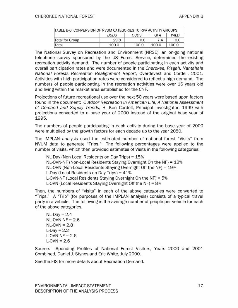
Based on the NVUM Survey Results from nearby Forests and local experience, the following percentages were used to estimate the number of visitors in the different RPA Activity Groups. These numbers were used in the PNV and Jobs/income calculations.
TABLE B-6 CONVERSION OF NVUM CATEGORIES TO RPA ACTIVITY GROUPS DUDS OUDS GFA WILD
Total on Forest 150.91 51.50 655.16 11.59 RPA Camping, Picnicking,Swimming Percent Percent Percent Percent Total for Group 22.2 100.0 5.9 0.0 RPA Mechnical Travel& Viewing Scenery Total for Group 0.0 0.0 39.0 0.0 RPA Hiking, Horseback Riding, Water Travel Total for Group 0.0 0.0 23.8 0.0 RPA Winter Sports Total for Group 2.3 0.0 0.0 0.0 RPA Resorts Total for Group 0.0 0.0 0.0 0.0 RPA Fish & Wildlife Total for Group 45.7 0.0 23.9 0.0 Wilderness Total for Group 0.0 0.0 0.0 100.0 Other
CHEROKEE NATIONAL FOREST APPENDIX B
ENVIRONMENTAL IMPACT STATEMENT 17 DESCRIPTION OF THE ANALYSIS PROCESS
TABLE B-6 CONVERSION OF NVUM CATEGORIES TO RPA ACTIVITY GROUPS DUDS OUDS GFA WILD
Total for Group 29.8 0.0 7.4 0.0 Total 100.0 100.0 100.0 100.0
The National Survey on Recreation and Environment (NRSE), an on-going national telephone survey sponsored by the US Forest Service, determined the existing recreation activity demand. The number of people participating in each activity and overall participation rates and were documented in the Cherokee, Pisgah, Nantahala National Forests Recreation Realignment Report, Overdevest and Cordell, 2001. Activities with high participation rates were considered to reflect a high demand. The numbers of people participating in the recreation activities were over 16 years old and living within the market area established for the CNF.
Projections of future recreational use over the next 50 years were based upon factors found in the document: Outdoor Recreation in American Life, A National Assessment of Demand and Supply Trends, H. Ken Cordell, Principal Investigator, 1999 with projections converted to a base year of 2000 instead of the original base year of 1995.
The numbers of people participating in each activity during the base year of 2000 were multiplied by the growth factors for each decade up to the year 2050.
The IMPLAN analysis used the estimated number of national forest “Visits” from NVUM data to generate “Trips.” The following percentages were applied to the number of visits, which then provided estimates of Visits in the following categories:
NL-Day (Non-Local Residents on Day Trips) = 15% NL-OVN-NF (Non-Local Residents Staying Overnight On the NF) = 12% NL-OVN (Non-Local Residents Staying Overnight Off the NF) = 19% L-Day (Local Residents on Day Trips) = 41% L-OVN-NF (Local Residents Staying Overnight On the NF) = 5% L-OVN (Local Residents Staying Overnight Off the NF) = 8%
Then, the numbers of “visits” in each of the above categories were converted to “Trips.” A “Trip” (for purposes of the IMPLAN analysis) consists of a typical travel party in a vehicle. The following is the average number of people per vehicle for each of the above categories.
NL-Day = 2.4 NL-OVN-NF = 2.6 NL-OVN = 2.8 L-Day = 2.2 L-OVN-NF = 2.6 L-OVN = 2.6
Source: Spending Profiles of National Forest Visitors, Years 2000 and 2001 Combined, Daniel J. Stynes and Eric White, July 2000.
See the EIS for more details about Recreation Demand.

APPENDIX B CHEROKEE NATIONAL FOREST
18 ENVIRONMENTAL IMPACT STATEMENT DESCRIPTION OF THE ANALYSIS PROCESS
Wild and Scenic Rivers
Information about Wild and Scenic Rivers Demand determination and evaluation can be found in Appendix D of the EIS.
Wilderness Management
Information about wilderness resource demand determination and evaluation can be found in Appendix C of the EIS.
Facilities Management
In the Analysis of the Management Situation (AMS), reference was made to the Facilities Master Plan originally completed in FY92 for FA&O facilities.
The following describes the situation at that time:
Work center locations were central to most district activities. Some upgrading and continued full maintenance should provide adequate facilities for many years.
The Tellico office was too small.
The Ocoee office was relatively new and in a good location.
District rental offices needed PPAs for construction of FS owned offices.
The Forest Supervisor stated that each ranger district would have its own office and that consolidation and co-location were not viable options.
The trends were:
Recreation use and requests for special uses would increase.
Boundary line disputes, claims and trespasses would increase.
Need for specially trained persons would increase.
Timber sale activity would be static or slightly decrease.
Recommendations and other actions that occurred include:
Rehab and expansion were done at the Tellico office.
The old Hiwassee office was leased to Etowah Utilities.
Co-location was studied for Unaka and Watauga Districts but consolidation actually occurred between Unaka and Nolichucky Districts. Also, part of the new district was co-located with the Watauga in a new rental building in Unicoi with the remainder of the Nolichucky/Unaka employees located in a new rental building in Greeneville.
Hiwassee was split and a part combined with each of the Ocoee and Tellico.
Plans are underway to expand the Ocoee/Hiwassee office to accommodate the additional employees from this consolidation.

CHEROKEE NATIONAL FOREST APPENDIX B
ENVIRONMENTAL IMPACT STATEMENT 19 DESCRIPTION OF THE ANALYSIS PROCESS
The Ocoee Whitewater Center was completed for the 1996 Olympics.
Buyouts reduced the number of employees on the CNF, but the downward trend reversed with an increase in fire related hires.
A new facility for the hotshot crew was built at the Unicoi Work Center.
In summary, the basis for demand for facilities was the Facilities Master Plan with updated information in the AMS. Sometimes political decisions overrode the recommendations based on that plan. There are no other immediate major changes planned, but the Facilities Master Plan is scheduled for update.
Fire Management
The following is a discussion of an analysis to provide a guide of the estimated acreage that would need burning to achieve ecosystem-based management goals for ecological communities where fire has played a major role in natural stand replacement or maintenance.
This analysis is based solely on ecological criteria and does not take into account the average number of burning days per year, the existing work force, and budget constraints. The following is a short discussion of the analysis process. Refer to Table B-7 for actual acreage and fire return intervals by forest cover type.
A run was conducted on the Continuous Inventory of Stand Conditions (CISC) program to provide the number of acres by forest cover type and age class for the CNF. The fire regime classification system is used to characterize the personality of a fire in a given vegetation type, including the frequency that the fire visits the landscape, the type of pattern created, and the ecological effects. The following natural fire regimes are arranged along a temporal gradient, from the most frequent to the least frequent fire return interval (Fryar, 2003 Draft).
The definitions below are from the GTR- RMRS-87.
FIRE REGIME FIRE FREQUENCY FIRE EFFECT TO DOMINANT VEGETATION
Fire Regime I 0-35 Years Low severity Fire Regime II 0-35 Years Stand replacement Fire Regime III 35-100+Years Mixed severity Fire Regime IV 35-100+Years Stand replacement Fire Regime V 200+Years Stand replacement
Fire Regime I
Fires in the understory fire regime generally do not kill the dominant vegetation or substantially change its structure. Approximately 80 percent or more of the aboveground dominant vegetation survives fire (Brown 2000). The understory fire regime occurs primarily in southern pine and oak-hickory forests, which support pine and pine-oak associations such as Kuchler’s southern mixed forest, oak-hickory-pine, and oak-hickory associations.

APPENDIX B CHEROKEE NATIONAL FOREST
20 ENVIRONMENTAL IMPACT STATEMENT DESCRIPTION OF THE ANALYSIS PROCESS
Fire Regime II
The severity of fire in the mixed fire regime either causes selective mortality in dominant vegetation, depending on tree species’ susceptibility to fire, or varies between understory and stand replacement (Brown 2000).
Fire intensities are generally greater than in the understory fire regime and cause mortality ranging from 20 to 80 percent of the overstory.
The low-intensity pre-settlement fires that wounded or killed many trees did not cause enough mortality (greater than 80 percent) to be considered stand replacement regimes (Wade and others 2000)
Stand-Replacement
Stand-replacement fires consume or kill more than 80 percent of the basal area or more than 90 per-cent of the overstory canopy cover (Morgan and others 1996).
Table B-7. Fire Adapted Communities with Fire Regime Designation Community
Type Forest Type(s) & CISC Codes Acres Fire Regime
Dry to Mesic Oak Forest
Post Oak-Black Oak (51), White Oak-Red Oak-Hickory (53), White Oak (54), Northern Red Oak-Hickory (55)
125,189 I
Dry and Dry to Mesic Oak-Pine Forest
Upland Hardwoods-White Pine (42), Southern Red Oak-Yellow Pine (44), Chestnut Oak-Scarlet Oak-Yellow Pine (45), Bottomlands Hardwood-Yellow Pine (46), White Oak-Black Oak-Yellow Pine (47), Northern Red Oak-Hickory-Yellow Pine (48)
56,465 I
Dry and Xeric Oak Forest
Chestnut Oak (52), Scarlet Oak (59), Chestnut Oak-Scarlet Oak (60) 69,984 I
Xeric Pine and Pine-Oak Forest
Shortleaf Pine-Oaks (12), Loblolly Pine-Hardwood (13), Pitch Pine-Oak (15), Virginia Pine-Oak (16), Shortleaf Pine(32), Loblolly Pine (31), Virginia Pine (33), Pitch Pine (38) Table Mountain Pine (39), Table Mountain Pine-Hardwood (20)
130,981
9,891
I II
Timber Management
A supply and demand analysis for forest products was completed for the CNF as part of the AMS in 1997. The analysis was based on sub regions two and three of the Southern Appalachian Assessement (SAA). This report estimated that from four to five per cent of timberlands, growing stock inventory, and sawtimber inventory is on CNF lands for the two sub regions. For national forest lands in the sub region, the CNF makes up approximately 25 per cent of timberlands, growing stock inventory, and sawtimber inventory. The CNF has a higher sawtimber inventory to area ratio than private ownership for the two sub regions but the ratio for sawtimber removals is the same for both ownerships. Sawtimber growth is higher than sawtimber removals for the CNF. For example, southern yellow pine, yellow poplar, white oak,

CHEROKEE NATIONAL FOREST APPENDIX B
ENVIRONMENTAL IMPACT STATEMENT 21 DESCRIPTION OF THE ANALYSIS PROCESS
and red oak growth is twice that of removals; other oaks are growing four times the rate of removals; and eastern white pine is growing at 23 times the rate of removals.
The local market share of forest products for the CNF is from 23 to 34 per cent and demand is expected to increase over time (Draft AMS 1997).
The US Forest Service Southern Research Station, Forest Inventory and Analysis (FIA) reports that for the period 1989 to 1999 for the 27 county area of east Tennessee, about 16 per cent of the area classified as timberlands is located on CNF lands (Schweitzer 2000). Volume harvested on National Forest lands for the 10-year period represented about 14 per cent of the total volume (hardwood and pine) harvested for the 27 county area.
For the 10-year period an average of about 33 per cent of growth on areas classified as timberlands was harvested and an average of 65 per cent of the mortality was harvested. On average for the ten year period about 22 per cent of growth and mortality combined was harvested.
Water Resources
Demand for water can be viewed from the perspectives of consumptive and non-consumptive use (demand). Consumptive demand for water on the CNF was determined by evaluating records of water use in the CNF WURR database. This database describes water needed for administrative use and by special use permittees. A more general assessment of consumptive water demand for the Forest planning area was provided by the “Southern Appalachian Assessment, Aquatic Technical Report”. This report detailed water use for counties in or adjacent to the CNF and other southern Appalachian national forests.
The vast majority of water use on the CNF is instream, non-consumptive use related to recreational activities such as fishing, paddling sports and scenic viewing. The water also provides habitat for a wide variety of aquatic dependant species. Instream flow need to support these uses and habitats was not quantified since water supply vastly exceeds consumptive water use.
Air Quality
Good air quality is essential for people to have a good quality of life and to have a healthy forest and aquatic ecosystem. Both high ozone and fine particle concentrations can cause adverse impacts to the people and the environment. During periods of poor air quality, some people (especially the elderly and children) can have an increase in the frequency or severity of respiratory illnesses, and sometimes premature death. Poor air quality leads to increased hospital visitations, increased absentee from work and school, and increases the amount of money spent on medications. People involved in vigorous outdoor activities can also be at risk to damage to their lungs from unhealthy levels of ozone or fine particles. This could include CNF staff working in the field, as well as some people visiting the CNF who are involved in rigorous activities such as hiking, or mountain biking. Portions of the CNF are expected to be classified as unhealthy for ozone and/or fine particles in the future (see Appendix G).

APPENDIX B CHEROKEE NATIONAL FOREST
22 ENVIRONMENTAL IMPACT STATEMENT DESCRIPTION OF THE ANALYSIS PROCESS
Clearly seeing the color and texture of distant mountain peaks is one of the main reasons people visit the southern Appalachians, and the CNF (Appalachian Regional Commission, 1970). However, during the summer months the air pollution, especially sulfates from coal-fired power plants (see Appendix G), can significantly reduce the visibility to a point that has a negative impact on a person’s enjoyment of the mountains. Furthermore, long term deposition of acid compounds has had an adverse impact to some high elevation cold water fisheries, and will continue to have adverse impacts in the future. Therefore, the number of streams supporting a diverse biological population, and brook trout population will continue to decrease in the distant future. Reducing the amount of air pollution can have a positive benefit for the environment and the local economy. Improvement in visibility over the levels anticipated with current rules, laws and regulations have been estimated to benefit the local economy near the Great Smoky Mountains National Park by 952 million dollars by the year 2040 (SAMI, 2002). It is likely that people visiting the CNF could also contribute similar amounts to the local economy as the Great Smoky Mountains National Park.
See end of the Appendix G, Air Quality for a list of literature citations.
BENCHMARK ANALYSIS Benchmark analysis is specified in the NFMA regulations in 36 CFR 219.12(e) as part of the AMS. Selection of those benchmarks to develop is dependent upon the revision topics. Benchmarks assist in defining the range within which alternatives can be constructed. Three benchmarks are relevant to the timber revision topic. They are:
Maximizing the present net value of the timber program.
Maximizing timber production in the first decade.
Minimizing costs of the timber program.
The NFMA regulations in 36 CFR 217.27 list management requirements that must be considered in benchmarks. The following basic management requirements were included in the benchmark SPECTRUM models:
Timber harvest regulations.
Nondeclining flow and long-term sustained yield.
The ASQ only generated from tentatively suitable timber lands.
Water quality and watershed protection.
Riparian protection.
Base level of visual resource protection.
Each SPECTRUM benchmark consists of one or more objective functions and a set of constraints. Prior to describing the benchmarks in detail, the objective functions and constraints used in this analysis are clearly defined. The objective functions are defined in Table B-8 that follows.

CHEROKEE NATIONAL FOREST APPENDIX B
ENVIRONMENTAL IMPACT STATEMENT 23 DESCRIPTION OF THE ANALYSIS PROCESS
Table B-8. OBJECTIVE FUNCTIONS
Name Type Activities/Outputs Units $ Discount Rate
First Period
Last Period
PNV MAX ALL ACTIVITIES AND OUTPUTS THOUS $ 0.04 1 5 VOL MAX VOL MCF 1 5 MINC MIN AllCosts THOUS $ 0.04 1 5 MINR MIN AllRevs THOUS $ 0.04 1 5
Benchmarks were considered in the analysis to set “sideboards” on the range of outputs and activities. These are as follows:
Maximum Timber Benchmark
This benchmark determined the maximum amount of timber that can be produced given market conditions. Only timber-related values and costs were used in the calculation of PNV. All the constraints were removed, except for the “Harvest Policy Constraints.” Perpetual Harvest and the “nondeclining” ASQ Constraint Type were included. The Maximize Volume objective was run for five decades then a Max PNV (for 15 periods) “rollover” was done.
Maximum PNV Benchmark
This benchmark represents the highest PNV that can be achieved through management of the CNF. The Max PNV benchmark uses the same model formulation as the preceding “Max Timber” benchmark with no constraints except for the “harvest policy constraints”). The benchmark was run with a Max PNV Objective Function for 15 periods.
Minimum Level Benchmark
The Minimum Level Benchmark is “the minimum level of management which would be needed to maintain and protect the unit as part of the National Forest System together with associated costs and benefits” (36 CFR 219.12(e)(1)(i)).
This would be an alternative where management of the CNF would be minimal. In Chapter 2 of the EIS, it is compared to the management emphasis of Alternative C, which was originally considered but was eventually eliminated from detailed study. Alternative C essentially embodied all of the elements of a minimum level of management benchmark by only providing for the protection of resources and meeting legal requirements. This benchmark shows no commercial timber production or harvest; therefore the ASQ is zero. In this benchmark, no early successional habitat conditions are created.
One of the effects of minimum level management is that we would not be able to meet the habitat needs of those species associated with these habitat elements. Active management will be necessary to restore and maintain desired conditions relative to a number of habitat elements (TABLE B-9). These habitat elements are important to maintaining viability of associated species.

APPENDIX B CHEROKEE NATIONAL FOREST
24 ENVIRONMENTAL IMPACT STATEMENT DESCRIPTION OF THE ANALYSIS PROCESS
TABLE B-9. SOME HABITAT ELEMENTS ON THE CHEROKEE NATIONAL FOREST THAT MAY REQUIRE ACTIVE MANAGEMENT TO RESTORE AND MAINTAIN DESIRED CONDITIONS, AND THE PRIMARY MANAGEMENT ACTIVITIES LIKELY TO BE NEEDED.
Habitat Element Primary Management Activities
Bogs, Fens, Seeps, Seasonal Ponds Tree cutting, prescribed burning
Glades and Barrens Tree cutting, prescribed burning
Table Mountain Pine Forests Tree cutting, prescribed burning
Grassy Balds Herbicide application, prescribed burning
Shrub Balds Prescribed burning
CANEBRAKES Tree cutting, prescribed burning, herbicide application
Sandhills Tree cutting, prescribed burning
Wet Savannas and Flatwoods Tree cutting, prescribed burning
Mature Oak Forests Tree cutting, prescribed burning
Mature Yellow Pine Forests Tree cutting, prescribed burning, tree planting
Longleaf Pine Forests Tree cutting, prescribed burning, tree planting
Mountain Longleaf Pine Forests Tree cutting, prescribed burning, tree planting
Early-Successional Forests Tree cutting
High Elevation Early Succession Tree cutting, prescribed burning
Canopy Gaps Tree cutting
Woodlands, Savannas, and Grasslands Tree cutting, prescribed burning
Mixed Landscapes Tree cutting, prescribed burning
Early-Successional Riparian Tree cutting
Current Level Benchmark
This is Alternative F (No-Action) in the LMP. Under this benchmark, activities and outputs are what they have been since the original plan was implemented in 1986. This benchmark assumes that no changes will be made in the outputs or activities The Current Level Benchmark provides for management using the current plan, adjusted to incorporate changes necessary to meet current management direction. The benchmark estimates the capability of the planning areas to provide for a wide range of goods, services, and other uses from the present land allocation. This benchmark meets all requirements specified in the regulations (36 CFR, Part 219).
Benchmark Evaluation
Table B-10 displays some of the distinctive outputs and effects for each benchmark.
Table B-10. Distinctive Outputs and Effects For Each BenchMark MAX PNV Max Timber Min Level Current (Alt F) Allowable Sale Quanity (ASQ) for 1st Period 84,383 MCF 145,122 MCF -0- 71,096 MCF
Allowable Sale Quanity (ASQ) for 5th Period 97,516 MCF 145,122 MCF -0- 127,028 MCF
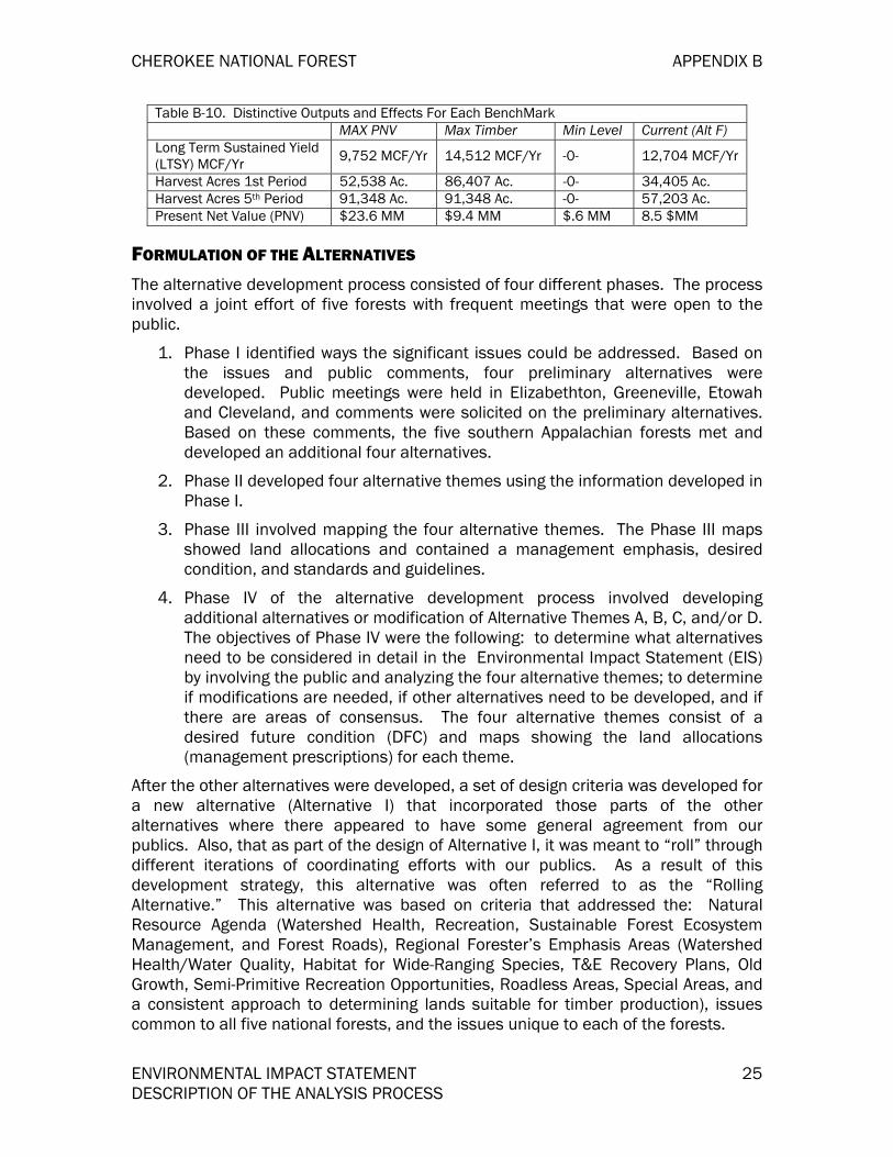
CHEROKEE NATIONAL FOREST APPENDIX B
ENVIRONMENTAL IMPACT STATEMENT 25 DESCRIPTION OF THE ANALYSIS PROCESS
Table B-10. Distinctive Outputs and Effects For Each BenchMark MAX PNV Max Timber Min Level Current (Alt F) Long Term Sustained Yield (LTSY) MCF/Yr 9,752 MCF/Yr 14,512 MCF/Yr -0- 12,704 MCF/Yr
Harvest Acres 1st Period 52,538 Ac. 86,407 Ac. -0- 34,405 Ac. Harvest Acres 5th Period 91,348 Ac. 91,348 Ac. -0- 57,203 Ac. Present Net Value (PNV) $23.6 MM $9.4 MM $.6 MM 8.5 $MM
FORMULATION OF THE ALTERNATIVES The alternative development process consisted of four different phases. The process involved a joint effort of five forests with frequent meetings that were open to the public.
1. Phase I identified ways the significant issues could be addressed. Based on the issues and public comments, four preliminary alternatives were developed. Public meetings were held in Elizabethton, Greeneville, Etowah and Cleveland, and comments were solicited on the preliminary alternatives. Based on these comments, the five southern Appalachian forests met and developed an additional four alternatives.
2. Phase II developed four alternative themes using the information developed in Phase I.
3. Phase III involved mapping the four alternative themes. The Phase III maps showed land allocations and contained a management emphasis, desired condition, and standards and guidelines.
4. Phase IV of the alternative development process involved developing additional alternatives or modification of Alternative Themes A, B, C, and/or D. The objectives of Phase IV were the following: to determine what alternatives need to be considered in detail in the Environmental Impact Statement (EIS) by involving the public and analyzing the four alternative themes; to determine if modifications are needed, if other alternatives need to be developed, and if there are areas of consensus. The four alternative themes consist of a desired future condition (DFC) and maps showing the land allocations (management prescriptions) for each theme.
After the other alternatives were developed, a set of design criteria was developed for a new alternative (Alternative I) that incorporated those parts of the other alternatives where there appeared to have some general agreement from our publics. Also, that as part of the design of Alternative I, it was meant to “roll” through different iterations of coordinating efforts with our publics. As a result of this development strategy, this alternative was often referred to as the “Rolling Alternative.” This alternative was based on criteria that addressed the: Natural Resource Agenda (Watershed Health, Recreation, Sustainable Forest Ecosystem Management, and Forest Roads), Regional Forester’s Emphasis Areas (Watershed Health/Water Quality, Habitat for Wide-Ranging Species, T&E Recovery Plans, Old Growth, Semi-Primitive Recreation Opportunities, Roadless Areas, Special Areas, and a consistent approach to determining lands suitable for timber production), issues common to all five national forests, and the issues unique to each of the forests.

APPENDIX B CHEROKEE NATIONAL FOREST
26 ENVIRONMENTAL IMPACT STATEMENT DESCRIPTION OF THE ANALYSIS PROCESS
ANALYTICAL TOOLS USED PreSuppose
Pre-Suppose was used to query and sort Forest Inventory and Analysis (FIA) data for use in Suppose. The program will prepare the locations and stand list file needed by Suppose to use the pre-sorted data.
Suppose
Suppose is a computer program that was used to simulate the changes in forest vegetation over a long time span (100-400 years) and over a “landscape” spatial scope. A landscape is defined to be one to about 1,000 forest stands.
Suppose accomplishes the simulation by creating an input file used by the Forest Vegetation Simulator (FVS) and by then starting the appropriate FVS program that reads and processes the input file. The program contains the desired geographic variant and extensions to the base FVS system. FVS, and not Suppose, actually accomplishes the desired simulation.
Suppose has these missions:
To provide a working tool for standard FVS runs and some post-processors.
To provide an evaluation platform that can be used to gather user feedback. The feedback will be used for redesigning Suppose, as necessary, so that it meets its mission.
Forest Vegetation Simulation (FVS) Model
The primary tool used for estimating growth and yield used in the SPECTRUM model is the Forest Vegetation Simulation Model (FVS), formerly called Prognosis. FVS is an individual-tree, distance-independent, growth and yield model. It has its structural roots in the Stand Prognosis Model developed by Albert Stage from the Intermountain Research Station. Staff at the USFS Forest Management Service Center in Fort Collins have now calibrated sixteen additional variants of the model to specific geographic areas throughout the west, midwest, and northeastern United States.
FVS allows the user to calculate estimates of forest stand structure and species composition over time and quantify this information to (1) describe current and future forest stand conditions, (2) simplify complex concepts of forest vegetation into user-defined indices, attributes, etc., and (3) allow the manager to ask better questions about growth and yield of forested stands and complete analyses to answer those questions. FVS uses actual forest stand data selected from the Forest's CISC data base to project growth and yields for future outputs.
The FVS model structure contains modules for growing trees; predicting mortality; establishing regeneration; simulating growth reductions, damage, and mortality due to insects and disease; performing management activities; calculating tree volumes; and producing reports. One of the strengths of the FVS system is its ability to incorporate local growth rate data directly into the simulation results.

CHEROKEE NATIONAL FOREST APPENDIX B
ENVIRONMENTAL IMPACT STATEMENT 27 DESCRIPTION OF THE ANALYSIS PROCESS
There are several steps in building the growth and yield tables. The first step was to stratify the CNF. Based on the issues and the availability of data, forested areas were stratified by major R-8 oldgrowth community types and productivity class. Old growth community types used were mixed mesophytic hardwood, conifer-hardwood, dry to mesic oak, dry and dry to mesic pine-oak, dry and xeric oak, and xeric pine. The crosswalk from CISC forest types to Oldgrowth community types was based on the Report of the Region 8 Old-Growth team from 1997. Further stratification was based on productivity class. Data was divided into two classes: greater than or equal to site index 70 and below site index 70.
The next step was to generate a sample of forest stand data. Forest Inventory and Analysis (FIA) data was used to obtain adequate stand level information for development of growth and yield tables. FIA data was used from blue ridge provinces for the Jefferson National Forest in Virginia, Natahala and Pisgah National Forests in North Carolina, Chattahoochie National Forest in Georgia, and the CNF in Tennessee.
Verifications for growth and yield data generated from FVS was made by comparing existing standing volumes to outputs from recent timber sales.
Standard reports such as summary tables of trees per acre, basal area, cubic foot volume, etc., as well as stand structure and species composition tables, were developed for all stands used in the predictions. Values from these tables were then used to build the yield tables used in the SPECTRUM model.
Forest Planning Model (SPECTRUM)
A computerized model called SPECTRUM has been developed by the Forest Service to help each national forest analyze the management situation, formulate management alternatives, and estimate effects of management alternatives. The computer programs that comprise SPECTRUM are the same for all forests; however, each Forest is responsible for defining the way SPECTRUM features will be used (i.e. the structure of the model) and for estimating the outputs per acre that are stored in yield tables. These outputs per acre are commonly referred to as Output Coefficients and have been developed and verified by the ID Team. The basic elements of the SPECTRUM structure are: Outputs and Costs, Analysis Areas, Management Prescriptions, Time Periods, Objective Functions, and Constraints.
Outputs are those goods and services that are produced whether purposely or incidentally as a result of management of the CNF. Selection of outputs to be used in SPECTRUM has major bearing on the structure of the model and on the results of the analysis. The primary reason SPECTRUM was selected for use in the planning process was the ability of the model to allocate scarce resources to competing demands on the basis of selected criteria. Outputs to be entered in the model are important factors in decisions regarding management of the Forest. Outputs represent those goods and services that are delivered to various users of the CNF who derive value from that use.
DEVELOPMENT OF LAND ALLOCATION MODEL (SPECTRUM) Land management planning is the major mechanism for making large-scale and longterm forest land allocations and resource management decisions. Planning

APPENDIX B CHEROKEE NATIONAL FOREST
28 ENVIRONMENTAL IMPACT STATEMENT DESCRIPTION OF THE ANALYSIS PROCESS
consists largely of exploring a national forest’s productive potential and experimenting with various allocation choices. A forest model is the primary planning tool because it permits studying the consequences of choices without actually committing valuable resources to experimentation or having to wait many years to observe an outcome.
People, not the model, make decisions about structuring land allocations, choosing and pursuing trade-offs, and accepting one result instead of another. The model is a device for organizing elements of the decision problem and discovering possible choices. Making decisions is a human act.
The model is used in the analysis to simulate different management actions on forest resources and environmental conditions. This model is also designed to find the optimum solution to a problem posed by the potentials and limitations of land and resources, the effect of costs, budgets, and resource prices, and the desired objectives of resource yields and environmental conditions.
SPECTRUM MODEL DESIGN The model is designed and solved in four steps:
1. Creating the Model. Designing a SPECTRUM model is the most intensive of the four steps. In this step the modeler inputs resource data, specifies resource interactions, sets goals and objectives, outlines management actions, defines activities and outputs, sets the planning horizon, delineates the landscape into management areas, and inputs economic data. The basic model building components are diagrammed in Figure B-1 below.
Figure B-1. Spectrum Model Data Components
SPECTRUM Model Data
Goals and Objectives
Land Stratification
Natural Processes
Management Actions
Planning Horizon
Cost and Returns
Activities and Outputs

CHEROKEE NATIONAL FOREST APPENDIX B
ENVIRONMENTAL IMPACT STATEMENT 29 DESCRIPTION OF THE ANALYSIS PROCESS
2. Generating a Matrix. Generating the matrix is the process of converting the input from step one to a matrix of rows and columns that the optimizations software can solve.
3. Finding a Solution. Commercial software is used to solve the matrix. The LP solver finds the best mix of management actions to meet the management objectives.
4. Interpreting the Solution. The final step in the modeling process is to use the reports created in SPECTRUM to interpret the results of the optimization and sensitivity analysis.
Creating the Model
A standard SPECTRUM model shell was developed to ease the task of developing the individual models used to analyze alternatives. The shell model has a standard set of identifier, qualifiers, treatment types, activities, outputs, cost data, objective function, and yield data. In order to customize the shell model into an alternative model, the analysis areas and constraints unique to the alternatives were added.
Planning Horizon
Each model has a specified time frame called a “planning horizon” that may be as short or long as desired. The planning horizon is broken down into time “periods,” each containing an equal number of years. A maximum of 90 periods may be specified.
The SPECTRUM shell was designed with the following planning horizon:
Table B-11. PLANNING HORIZON Beginning Year Planning Horizon 2000 150 Years
Table B-12. YEARS PER PERIOD
Period Number 1 2 3 4 5 6 7 8 9 10 11 12 13 14 15
Number of Years 10 10 10 10 10 10 10 10 10 10 10 10 10 10 10
Year Groups Are 10 Years Long For Yield Estimation. Timber outputs have been modeled for 150 years to assure non-declining timber yields
Forest Planning Model (SPECTRUM)
The different types and localities of land that are modeled in SPECTRUM are called Analysis Areas (AA). Six hierarchical categories referred to as layer identifiers were used by the CNF to describe the Analysis Areas:
Layer 1 – Management Prescriptions Layer 2 – Community Types Layer 3 – Scenic Classes Layer 4 – Site Index & Age Layer 5 – Slope Layer 6 – Access

APPENDIX B CHEROKEE NATIONAL FOREST
30 ENVIRONMENTAL IMPACT STATEMENT DESCRIPTION OF THE ANALYSIS PROCESS
A narrative list of management prescriptions is contained in the LMP. A summary of the prescriptions is shown in Table B-14. Each prescription is a mix of integrated management activities that are intended to accomplish specific objectives. These prescriptions were developed through the coordinated efforts of a Regional team addressing public issues and management concerns and will be a major element of the LMP when it is published. For more details about the coordinated development of management prescriptions see Chapter 2 of the EIS.
Constraints
There are two major classes of constraints in SPECTRUM:
Implicit Constraints – Each SPECTRUM model contains “land accounting” constraints to ensure that every acre of the model is allocated to a management emphasis, even if the emphasis is a no-action alternative.
Explicit Constraints – These constraints are built by the user to model resource thresholds, relations between and among activities and outputs, policy requirements, or monetary limitations.
A mandatory type of constraint is the maximum acres in each Analysis Area. It is through the use of constraints that legal and policy requirements as well as management objectives are represented in the model.
Objective Function
The objective function feature allows specifications of an overall objective to be met in a given run of the model while all constraints otherwise specified are also met. For example, one run of SPECTRUM might be set up to obtain X number of board feet of timber per year and Y number of RVDs of recreation per year and at the same time minimize government costs. The objective function in this case would be minimized government costs.
The Conceptual Model
The model is based on the premise that any given piece of land (Analysis Area) will respond (cost and outputs) to management (prescriptions) in a predictable way (yield coefficients). Once resource outputs to be monitored are identified, areas of land (Analysis areas) that respond similarly to management prescriptions in terms of those outputs can be identified.
Through the hypothetical application of prescriptions to analysis areas, per-acre output/cost coefficients can be developed for possible prescription/Analysis area combinations. Once these data are loaded into SPECTRUM, the total forest wide results (outputs and costs) of the application of various prescriptions on various land areas can be calculated. Because the cause-effect relationship between prescriptions applied to analysis areas and outputs/costs is symmetrical, the model can also calculate which prescriptions would need to go on which analysis areas to produce desired levels (constraints) of outputs.
Once all assumptions and yield coefficients are built into the SPECTRUM model and verified, a “what if” game can be played specifying different levels of outputs to be attained under different management objectives. By this means, different strategies

CHEROKEE NATIONAL FOREST APPENDIX B
ENVIRONMENTAL IMPACT STATEMENT 31 DESCRIPTION OF THE ANALYSIS PROCESS
for managing the Forest (alternatives) can be portrayed and analyzed. Model results consist of predictions of levels of outputs and costs of various alternatives as well as specific allocations of analysis areas to prescriptions. Once mapped these allocations combine with direction contained in written management prescriptions to become the primary basis of management alternatives. In turn, one of these management alternatives will be selected to become the LMP.
LAND STRATIFICATION Land stratification is the process of identifying a set of attributes, or strata, to use in defining the land base. This is done to organize the forest land base into logical subunits that respond similarly to management actions. In SPECTRUM, each strata is called a "level" and combining these levels results in an "analysis area." SPECTRUM level identifiers 1 through 6 are used to describe analysis areas. Analysis areas are usually homogenous, but not contiguous. The attributes used in developing analysis areas are based on the issues to be addressed by the model, differences in resource response, and the reliability of the data.
Analysis areas are developed by combining the six level identifiers shown in TABLE B-13 and calculating the amount of acreage for each combination that is present. Activities and outputs that are associated with analysis areas are on a per acre basis.
The first step in land stratification is to identify a set of “LAYERS” used to describe the planning area. The CNF was stratified by the following six layers:
TABLE B-13. SPECTRUM LAND STRATIFICATION
Layer SPECTRUM Name Name
1 MgRx Management Prescription See Table B-14 2 CommTy Community Type See Table B-17 3 ScCls Scenic Class See Table B-18 4 SI-Age Site Index-Age See Table B-21 5 Slope Slope See Table B-22 6 Access Accessibility See Table B-23
The planning area is subdivided into areas that facilitate analyzing land allocation and management scheduling options. The subdivision is largely a function of two determinants:
(1) How managers want the forest subdivided to answer planning questions, and
(2) How specialists need the forest subdivided to estimate resource response to management scenarios.
These factors were identified that the decision maker would need to consider evaluating those potential resolutions. The aggregate set of these factors for all the issues determined the potential set of AA identifiers. The layers assist in the analysis of important strategic planning issues.
Each layer contains one or more “ATTRIBUTES”. Attributes break each layer down into meaningful components.

APPENDIX B CHEROKEE NATIONAL FOREST
32 ENVIRONMENTAL IMPACT STATEMENT DESCRIPTION OF THE ANALYSIS PROCESS
LAYER 1: MgRx
Layer 1 identifies the management prescriptions utilized on the CNF. The array of potential land treatments applied to a forest area is represented in the model by sets of actions known as management prescriptions. Generally, a management prescription refers to a set of treatments or practices designed to develop or protect some combination of resources on a particular land type. Table B-14 shows the management prescriptions used in the CNF SPECTRUM model.
Table B-14. LAYER 1 ANALYSIS AREA IDENTIFIER, MANAGEMENT PRESCRIPTIONS (MgRx)
SPECTRUM Code Description Mgmt Rx Suitability
6.B Areas managed to restore/maintain Old Growth characteristics Y
6.C Old Growth areas managed with a mix of natural and restoration activities Y
6.E Old Growth core with surrounding area of UEA mgmt Y 7.A Scenic byway corridor N 7.B Scenic corridors and sensitive areas with veg mgmt Y 7.C OHV use areas Y 7.E.2 Dispersed recreation areas with veg mgmt Y 8.A.1 Mid to late successional forest habitats Y 8.A.2 Area sensitive mid to late successional forest habitats Y 8.B Mix of successional habitats; early successional hab. Emph Y 8.C Black bear habitat management Y 8.E.1 Ruffed Grouse Mgmt Y 9.A.1 Source water protection watersheds Y 9.A.2 Reference watersheds N 9.A.3 Watershed restoration areas Y 9.C.1 Dry and Xeric Oak and Oak-Pine Forests Y 9.C.2 Dry-Mesic Oak Forests Y 9.E Mtce and restoration of pine and pine-oak forests Y 9.G Mtce and restore of up/bottomland hwoods and mixed pine Y 9.H Mgt,mtce & rest. Of plans assoc. to their ecolog potential Y 10.A Sustained Timber Yield Mgmt Y 10.B High quality forest products Y 11 Unsuitable Riparian N OTHUNS All other unsuitable areas N
Table B-15 describes the various groupings of management prescriptions used in SPECTRUM:
Table B-15. MANAGEMENT PRESCRIPTION GROUPS SPECTRUM
Name Description Management Prescriptions
7AE9A1 MgRx’s with early successional objectives, no clearcutting, thinning on slopes < 40% for all community types, except Virginia Pine (VAPN).
7.B, 7.E.2, 9.A.1, 7.A
8AC9AB MgRx’s with early successional objectives, clearcutting allowed for Virginia Pine (VAPN) community type only.
8.A.1, 8.A.2, 8.C, 9.A.3, 9.B.1
9C8910 MgRx’s with early successional objectives, clearcutting allowed for DXO, DMOP, XPPO on
7.C, 8.B, 9.H, 10.A, 10.B, 8.E.1, 9.C.1, 9.C.2, 9.E

CHEROKEE NATIONAL FOREST APPENDIX B
ENVIRONMENTAL IMPACT STATEMENT 33 DESCRIPTION OF THE ANALYSIS PROCESS
Table B-15. MANAGEMENT PRESCRIPTION GROUPS SPECTRUM
Name Description Management Prescriptions
Scenic Class (ScCls) 3, 4, & 5 and clearcutting allowed for VAPN on all sites.
ALB6E All MgRx’s with early successional objectives except 6.E.
7.C, 7.E.2, 8.A.1, 8.A.2, 8.B, 8.C, 9.A.1, 9.A.3, 9.H, 10.A, 10.B, 8.E.1, 9.C.1, 9.C.2, 9.E, 8.A, 9.C, 8.E
alluns All unsuitables Othuns, 9.A.2, 11
Esgrp Only Rx’s that have Early Successional objectives
7.C, 7.E.2, 8.B, 9.H, 10.A, 10.B, 8.E.1, 9.E, 8.E
LSgrp Only Rx’s with Early Successional objectives 6.E, 7.B, 8.A.1, 8.A.2, 8.C, 9.A.1, 9.A.3, 9.C.1, 9.C.2, 8.A, 9.C, 7.A, 6.B, 6.C
ResSYP Restoration of shortleaf, pitch, and table mtn pine Obj 19.04 8.B, 9.H
suit All suitable mgmt prescriptions
6.E, 7.B, 7.C, 7.E.2, 8.A.1, 8.A.2, 8.B, 8.C, 9.A.1, 9.A.3, 9.H, 10.A, 10.B, 8.E.1, 9.C.1, 9.C.2, 9.E, 8.A, 9.C, 7.A, 8.E, 6.B, 6.C
Table B-16 lists the management prescriptions and the alternatives they were used in:
Table B-16. MANAGEMENT PRESECRIPTIONS BY ALTERNATIVE Alternative MgRx
A B C D E F G I 6.B X X 6.C X 6.E X X X 7.A X X X X X X 7.B X X X X X 7.C X X X X 7.E.2 X X X X X 8.A.1 X X X 8.A.2 X X 8.B X X 8.C X X X X X X 8.E.1 X X X X 9.A.1 X X 9.A.2 X X 9.A.3 X X X 9.C.1 X 9.C.2 X 9.E X 9.H X X X 10.A X X X 10.B X 11 X X X X X X X X othuns X X X X X X X X

APPENDIX B CHEROKEE NATIONAL FOREST
34 ENVIRONMENTAL IMPACT STATEMENT DESCRIPTION OF THE ANALYSIS PROCESS
LAYER 2: CommTy
Layer 2 identifier keyed on Community Type (forest type). Community type is composed of various CISC values as shown in Table B-17 . Basis for this is Forestry Report R8-FR 62 Guidance for Conserving and Restoring Old-Growth Forest Communities on National Forests in the Southern Region.
Table B-17. LAYER 2 ANALYSIS AREA IDENTIFIER, COMMUNITY TYPE (CommTy) SPECTRUM
Code Description CISC No(s).
DXO Dry and Xeric Oak 52, 59, 60 MM Mixed Mesophytic 41, 50, 56 DMOP Dry and Dry-Mesic Oak-Pine 42,44,45,46,47,48 XPPO Xeric Pine and Pine-Oak 12, 15, 16, 20, 31, 32, 38 ,39 NH Northern Hardwoods 81, 83 DMO Dry-Mesic Oak 51, 53, 54, 55 CH Connifer-Northern Hardwood 3, 4, 5, 6, 7, 8, 9, 17
BH Eastern Riverfront and River Floodplain Hardwood 58,71,72,73,76,46,62,98
VAPN Virginia Pine 33
LAYER 3: ScCls
Layer 3 identifier keyed on Scenic Class. All national forest landscapes have value as scenery—some more than others. Scenic classes are used as a measure of the value of scenery in a national forest. These classes, expressed numerically as one through 7, are a product of the CNF scenery inventory that combines viewing distance zones, concern levels and scenic attractiveness. Generally, Scenic Classes 1-2 express a high public value, classes 3-5 have moderate value and classes 6 and 7 have low value. At this time, CNF has no inventoried Class 6 or 7.
For more information, see Landscape Aesthetics, A Handbook for Scenery Management, USDA Forest Service Agriculture Handbook No. 701, December 1995.
Table B-18 lists the scenic classes used in SPECTRUM.
Table B-18. LAYER 3 ANALYSIS AREA IDENTIFIER, Scenic Class (ScCls) SPECTRUM Code Description
1 Scenic Class 1– High public value 2 Scenic Class 2– High public value 3 Scenic Class 3– Moderate public value 4 Scenic Class 4– Moderate public value 5 Scenic Class 5– Moderate public value
LAYER 4: SI-Age
Layer 4 identifier keyed on site index and the ages of existing stands. Table B-19 through Table B-21 demonstrate how the Site Index and Age Class were combined to form the SPECTRUM Code.

CHEROKEE NATIONAL FOREST APPENDIX B
ENVIRONMENTAL IMPACT STATEMENT 35 DESCRIPTION OF THE ANALYSIS PROCESS
Table B-19. SITE INDEX Site Index
Code Productivity
1 Low – SI < 70 2 High – SI >= 70
Table B-20. Age Class
Age Class (Years)
SPECTRUM Name
0 – 10 00_1 11 – 40 11_4 41 – 80 41_8
80 – 100 8110 100 + 100+
Table B-21 shows how the site index and age class are combined to form the SPECTRUM code. The following example shows the combination.
Site Index Code Age Class Code
1_00_1
Table B-21. LAYER 4 ANALYSIS AREA IDENTIFIER, COMPOSITE OF SITE INDEX AND AGE CLASS (SI_Age) SPECTRUM Code Description
1_00_1 SI <= 60; age 0 – 10 1_11_4 SI <= 60; age 11 – 40 1_41_8 SI <= 60; age 41 – 80 1_8110 SI <= 60; age 81 – 100 1_100+ SI <= 60; age > 100 2_00_1 SI > 60; age 0 – 10 2_11_4 SI > 60; age 11 – 40 2_41_8 SI > 60; age 41 – 80 2_8110 SI > 60; age 81 – 100 2_100+ SI > 60; age > 100
LAYER 5: Slope
Layer 5 idenfitier keyed on the slope. Table B-22 displays the SPECTRUM code and the description of the slope.
Table B-22. LAYER 5 ANALYSIS AREA IDENTIFIER, SLOPE (Slope) SPECTRUM Code Description
1 0 – 40% slope 2 41 – 70% slope 3 Greater than 70% slope
LAYER 6: Access
Layer 6 identifier keyed on stand accessibility. Because a significant portion of the cost of harvesting timber is in the construction or re-construction of access roads, the distance of stands to existing roads was used as an analysis area identifier. Table B-23 shows four classes of distance zones that were used ranging from the most accessible (.25 mile) to the least accessible (> 1 Mile).
Table B-23. LAYER 6 ANALYSIS AREA IDENTIFIER, ACCESS (Access) SPECTRUM Code Description
.25 Less than .25 miles from an existing road
.50 .25 - .5 miles from an existing road
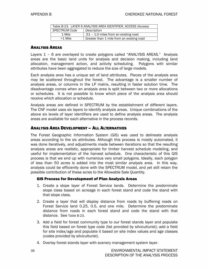
APPENDIX B CHEROKEE NATIONAL FOREST
36 ENVIRONMENTAL IMPACT STATEMENT DESCRIPTION OF THE ANALYSIS PROCESS
Table B-23. LAYER 6 ANALYSIS AREA IDENTIFIER, ACCESS (Access) SPECTRUM Code Description
1 Mile .51 – 1.0 miles from an existing road >1 Mile Greater than 1 mile from an existing road
ANALYSIS AREAS Layers 1 – 6 are overlayed to create polygons called “ANALYSIS AREAS.” Analysis areas are the basic land units for analysis and decision making, including land allocation, management action, and activity scheduling. Polygons with similar attributes have been aggregated to reduce the size of large models.
Each analysis area has a unique set of land attributes. Pieces of the analysis area may be scattered throughout the forest. The advantage is a smaller number of analysis areas, or columns in the LP matrix, resulting in faster solution time. The disadvantage comes when an analysis area is split between two or more allocations or schedules. It is not possible to know which piece of the analysis area should receive which allocation or schedule.
Analysis areas are defined in SPECTRUM by the establishment of different layers. The CNF model uses six layers to identify analysis areas. Unique combinations of the above six levels of layer identifiers are used to define analysis areas. The analysis areas are available for each alternative in the process records.
ANALYSIS AREA DEVELOPMENT – ALL ALTERNATIVES The Forest Geographic Information System (GIS) was used to delineate analysis areas according to the six attributes. Although this process is mostly automated, it was done iteratively, and adjustments made between iterations so that the resulting analysis areas are realistic, appropriate for timber harvest schedule modeling, and useful for implementation of the harvest schedule. One characteristic of this GIS process is that we end up with numerous very small polygons. Ideally, each polygon of less than 50 acres is added into the most similar analysis area. In this way, analysis could be efficiently done with the SPECTRUM model, and yet still retain the possible contribution of these acres to the Allowable Sale Quantity.
GIS Process for Development of Plan Analysis Areas
1. Create a slope layer of Forest Service lands. Determine the predominate slope class based on acreage in each forest stand and code the stand with that slope class.
2. Create a layer that will display distance from roads by buffering roads on Forest Service land 0.25, 0.5, and one mile. Determine the predominate distance from roads in each forest stand and code the stand with that distance. See Table B-23.
3. Add a field for forest community type to our forest stands layer and populate this field based on forest type code (list provided by silviculturist); add a field for site index/age and populate it based on site index values and age classes (codes provided by silviculturist).
4. Overlay forest stands layer with scenery management system layer.

CHEROKEE NATIONAL FOREST APPENDIX B
ENVIRONMENTAL IMPACT STATEMENT 37 DESCRIPTION OF THE ANALYSIS PROCESS
5. Overlay alternative layer with results of overlay from step 4. Do this for each of the alternatives.
6. Fill in some of the blanks for records with missing data: for areas that were not new acquisitions but had a zero for forest type, code the forest community type DMOP (silviculturist instructions), for areas that were not new acquisitions but had a zero for scenic class, code the scenic class 2 (landscape architect instructions), for areas that were not new acquisitions, not non-forested, and that did not have a zero land class but had no value for site index/age, code site index/age 1_8110 (silviculturist instructions).
7. Obtain a summary file of: prescription code, forest community type, site index/age, scenic class, slope, distance from roads, and acres. This provides a listing of analysis areas. Table B-24 illustrates the number of Analysis Areas for each Alternative before AA’s less than 50 acres were combined with the most similar analysis area.
Table B-24. Analysis Areas Before Reduction Alternative No. of Aas
A 52169 B 52220 D 52400 E 52744 F 55516 G 52923 I 62505
8. The summary file obtained in step 7 contained thousands of analysis areas. To reduce this number, the planning team leader and silviculturist decided we could combine analysis areas less than 50 acres with similar areas. We did this by breaking the summary file into two files, one containing areas less than 50 acres and another containing areas greater than 50 acres. Using cursor processing we compared the two files and combined each smaller analysis area with the larger area that matched the greatest number of the fields listed in step 7 resulting in fewer AA’s for each Alternative as shown in TABLE B-25 column “No. of AA’s.” TABLE B-25 further shows the tentatively suitable AA’s that would have an approximate 20 percent riparian reduction. The “No. of AA’s” and “Riparian AA’s” then yielded the total AA’s considered in each Alternative.
TABLE B-25. ANALYSIS AREAS AFTER REDUCTION Alternative No. of Aas Riparian Aas Total Aas
A 2315 1274 3589 B 2071 1092 3163 D 1683 1141 2824 E 2156 585 2741 F 2503 1843 4346 G 2094 704 2798 I 2064 1161 3225

APPENDIX B CHEROKEE NATIONAL FOREST
38 ENVIRONMENTAL IMPACT STATEMENT DESCRIPTION OF THE ANALYSIS PROCESS
TABLE B-26 shows forested acres that have been inventoried.
TABLE B-26. INVENTORIED FORESTEDACRES ON CHEROKEE NF (All Mgt Rx)
IAll Aternativesl 1. Total Cherokee NF Acres 639,958 acres
2a. Non-Forest 3,617 acres2b. Uninventoried 15,230 acres2c. Zero Land Class 10,728 acresTotal 2a+2b+2c 29,575 acresInventoried Forested Acres 1 – (2a+2b+2c)
610,383 acres
TABLE B-27 displays suitability for timber management based on management prescription allocations before riparian area adjustments.
TABLE B-27. TIMBER MANAGEMENT SUITABILITY BASED ON MANAGEMENT PRESCRIPTIONSBEFORE RIPARIAN ADJUSTMENT FOR INVENTORIED FORESTED ACRES Alt-A Alt-B Alt-D Alt-E Alt-F Alt-G Alt-I Suitable Acres (BeforeRiparian Adj) 358447 393473 461159 116630 464722 191094 402486
Unsuitable Acres 251936 216910 149224 493753 145661 418289 207897
Total 610383 610383 610383 610383 610383 610383 610383
Each suitable analysis area was decreased by a riparian percentage to allow for buffering of unsuitable acres.
Percentage: Total riparian corridor acreage 126030
--------------------------------------------------- = ------------ = 19.696%
Total Forest Acres 639862
TABLE B-28 displays estimated riparian area acres found in suitable management prescriptions, by alternative.
TABLE B-28. RIPARIAN ACRES IN SUITABLE MANAGEMENT PRESCRIPTIONS BY ALTERNATIVE (Acres) Alternative
MgRx Alt-A Alt-B Alt-D Alt-E Alt-F Alt-G Alt-I Riparian Acres 70,600 77,498 90,830 22,971 16,063 37,639 79,274
TABLE B-29 displays suitable acres with adjustments made for riparian areas. The riparian acres were adjusted from the suitable category to the unsuitable category and assigned to Management Prescription 11.

CHEROKEE NATIONAL FOREST APPENDIX B
ENVIRONMENTAL IMPACT STATEMENT 39 DESCRIPTION OF THE ANALYSIS PROCESS
TABLE B-29. TIMBER MANAGEMENT SUITABILITY BASED ON MANAGEMENT PRESCRIPTIONS AFTER RIPARIAN ADJUSTMENT Alt-A Alt-B Alt-D Alt-E Alt-F Alt-G Alt-I Suitable Acres 287847 315975 370329 93659 448659 153455 323212 Unsuitable Acres 322536 294408 240054 516,724 161724 456928 287171
Total Acres 610383 610383 610383 610383 610383 610383 610383
TABLE B-30 shows further adjustments to the total acres as a result of rounding errors by the spreadsheet and/or the SPECTRUM import routine.
TABLE B-30. FINAL ADJUSTMENTS TO TOTAL ACRES FOR SPECTRUM Alt-A Alt-B Alt-D Alt-E Alt-F Alt-G Alt-I Inventoried Forested Acres 610,375 610,014 609,758 609,946 610,198 609,915 610,383
Acres read into SPECTRUM 610,301 609,948 609,703 609,992 610,098 609,877 610,305
Acres lost due to rounding, slivers, etc.
74 66 55 -46 100 38 78
Percentage lost to rounding, slivers, etc.
0.01% 0.01% 0.01% -0.01% 0.02% 0.01% 0.01%
Costs, Returns, Production Functions, and Yields
Costs, revenues, and production functions for timber-related activities and outputs over the last decade were analyzed to determine the coefficients that should be entered in the timber harvest schedule model. Costs and revenues were inflated to a common base year of 1996. In some cases, data from adjacent National Forests and the Region were included in the evaluation. A summary of the revenues and costs included in the model are shown in Table B-31 and Table B-32.
Timber Revenues
SPECTRUM was constructed as a timber harvest allocation model. Only revenues and costs pertaining to the timber program were included in the model. Thus, Present Net Value (PNV) calculations pertain only to timber.
Sawtimber revenue figures reflect a ten year period (1990-2000) of harvest values (revenues actually paid) for sawtimber on the CNF inflated to a common base year of 1996. Most harvest on the CNF has been tractor logged. The additional cost of yarding, felling and bucking, and overhead in cable logging was determined to be about 30 per cent higher than ground skidding operations. The additional cost was included in SPECTRUM as an activity found only on steep slopes above 40 per cent. Helicopter yarding was not considered.
Table B-31 REVENUES FROM TIMBER SALES FOR THE FIRST DECADE BY ALTERNATIVE EXPRESSED IN M$’S Alt A Alt B Alt D Alt E Alt F Alt G Alt I Revenues 20,414 21,980 38,144 5,175 39,375 11,424 22,692

APPENDIX B CHEROKEE NATIONAL FOREST
40 ENVIRONMENTAL IMPACT STATEMENT DESCRIPTION OF THE ANALYSIS PROCESS
Timber Costs
A summary of activity costs in the SPECTRUM model is shown in Table B-32 and Table B-33.
Construction and reconstruction costs for Traffic Service Level (TSL) D roads used in Spectrum were the same as those determined for the response to a Regional Office 1920/2410 memo dated March 6, 2000 requesting road costs for the Southern Appalachian Forest Revision process.
Timber sale road costs were examined for the five preceding years (FY95 through FY99) and separated into four categories as requested by the memo and separated into North End and South End.
For Spectrum, a CNF cost for construction and reconstruction was calculated by computing the average for the North End and South End. The result was $27,750 per mile for construction and $20,250 per mile for reconstruction.
Table B-32 ACTIVITY COSTS PER MILE
TSL D North End
Contract
South End
Contract
Average NE/SE FS Labor FS
SuppliesFS
Equipment
Est Road Construction Costs (Average +
Labor+Supplies+Equipment)
Construction $18,000 $15,000 $16,500 $10,000 $250 $1,000 $27,750
Reconstruction $11,000 $7,000 $9,000 $10,000 $250 $1,000 $20,250
Coefficients for road costs were determined by summarizing volume, road construction miles, and re-constructions miles for 20 randomly selected timber sales conducted on the CNF. The total volume associated with these sales then divided the miles of construction and re-construction. This yielded a series of coefficients for construction and re-construction that would be applied to each MCF harvested to determine total miles that was then applied to a cost per mile to arrive at total road costs.
Table B-33 ACTIVITY COSTS PER MCF
Activity Slope Emphasis Intensity Treatment Cost Per MCF
Harv Admin EAM 0T/1T 66 Harv Admin CC 60 Harv Admin SW 60 Harv Admin UEAM 66 Harv Admin 2A 60 Harv Admin EAM 1T/1T 66 Harv Admin C2CDcv 0T/1T 60 Inv NEPA 70 Oak SW SW 69.6 Oak SW 2A 69.6 Oak SW UEAM 83.8 Oak SW . CC 69.6 PCT 2A 78 PCT CC 78 PCT UEAM 93 PCT . . SW 78

CHEROKEE NATIONAL FOREST APPENDIX B
ENVIRONMENTAL IMPACT STATEMENT 41 DESCRIPTION OF THE ANALYSIS PROCESS
Table B-33 ACTIVITY COSTS PER MCF
Activity Slope Emphasis Intensity Treatment Cost Per MCF
RegenArt CC 74 RegenArt SW 74 RegenArt 2A 81 RegenArt UEAM 89 RegenArt C2conv 0T/1T 74 RegenNat CC 59 RegenNat SW 59 RegenNat 2A 64 RegenNat UEAM 70 RegenNat C2conv 0T/1T 59 Sale Prep UEAM 179 Sale Prep Thin 179 Sale Prep 1 EAM 160 Sale Prep 2 EAM 179 Sale Prep 1 C2CDcv 0T/1T 160 Sale Prep Thin 179 Sale Prep 2 C2CDcv 0T/1T 179 Sale Prep Thin 179 TSI-Herbicid SW 103 TSI-Herbicid CC 181 TSI-Herbicid 2A 181 TSI-Herbicid UEAM 217 TSI-Manual SW 67 TSI-Manual CC 113 TSI-Manual 2A 113 TSI-Manual UEAM 136 TSI-RxFire SW 45 TSI-RxFire CC 45 TSI-RxFire 2A 45
TSI-RxFire UEAM 53
Timber Yield Summary
Using stand exam data and FIA survey data as input, the FVS was used to generate numerous timber yield streams. Yields were generated for different species, age classes, and treatment types. Based on review of these predictions of timber yield for variability, consistency, and anomalies, yield streams were selected for inclusion in the timber harvest schedule model. The model explicitly includes yield tables for grow-only, thins, and uneven-aged.
MANAGEMENT ACTIONS Overview
The types of management actions for timber harvest, regeneration, and stand improvement follow.
A management action consists of a set of activities, applied to a particular piece of ground that results in outputs and/or conditions. The management action has an
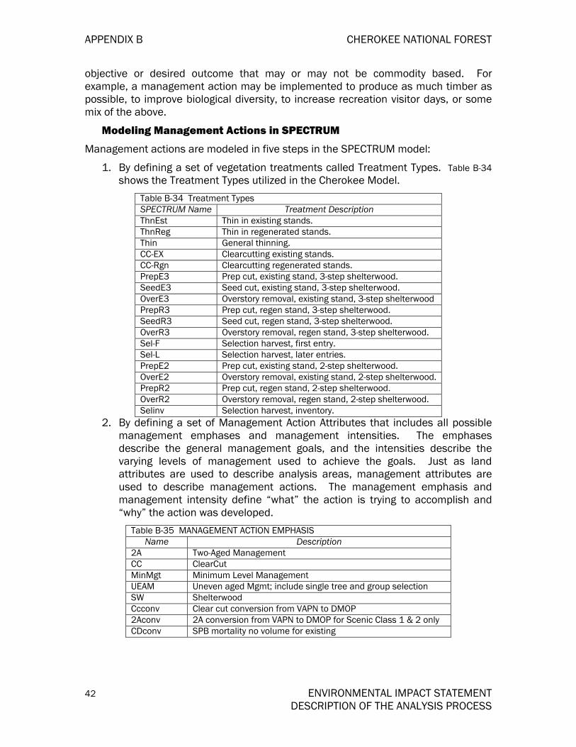
APPENDIX B CHEROKEE NATIONAL FOREST
42 ENVIRONMENTAL IMPACT STATEMENT DESCRIPTION OF THE ANALYSIS PROCESS
objective or desired outcome that may or may not be commodity based. For example, a management action may be implemented to produce as much timber as possible, to improve biological diversity, to increase recreation visitor days, or some mix of the above.
Modeling Management Actions in SPECTRUM
Management actions are modeled in five steps in the SPECTRUM model:
1. By defining a set of vegetation treatments called Treatment Types. Table B-34 shows the Treatment Types utilized in the Cherokee Model.
Table B-34 Treatment Types SPECTRUM Name Treatment Description ThnEst Thin in existing stands. ThnReg Thin in regenerated stands. Thin General thinning. CC-EX Clearcutting existing stands. CC-Rgn Clearcutting regenerated stands. PrepE3 Prep cut, existing stand, 3-step shelterwood. SeedE3 Seed cut, existing stand, 3-step shelterwood. OverE3 Overstory removal, existing stand, 3-step shelterwood PrepR3 Prep cut, regen stand, 3-step shelterwood. SeedR3 Seed cut, regen stand, 3-step shelterwood. OverR3 Overstory removal, regen stand, 3-step shelterwood. Sel-F Selection harvest, first entry. Sel-L Selection harvest, later entries. PrepE2 Prep cut, existing stand, 2-step shelterwood. OverE2 Overstory removal, existing stand, 2-step shelterwood. PrepR2 Prep cut, regen stand, 2-step shelterwood. OverR2 Overstory removal, regen stand, 2-step shelterwood. Selinv Selection harvest, inventory.
2. By defining a set of Management Action Attributes that includes all possible management emphases and management intensities. The emphases describe the general management goals, and the intensities describe the varying levels of management used to achieve the goals. Just as land attributes are used to describe analysis areas, management attributes are used to describe management actions. The management emphasis and management intensity define “what” the action is trying to accomplish and “why” the action was developed.
Table B-35 MANAGEMENT ACTION EMPHASIS Name Description
2A Two-Aged Management CC ClearCut MinMgt Minimum Level Management UEAM Uneven aged Mgmt; include single tree and group selection SW Shelterwood Ccconv Clear cut conversion from VAPN to DMOP 2Aconv 2A conversion from VAPN to DMOP for Scenic Class 1 & 2 only CDconv SPB mortality no volume for existing

CHEROKEE NATIONAL FOREST APPENDIX B
ENVIRONMENTAL IMPACT STATEMENT 43 DESCRIPTION OF THE ANALYSIS PROCESS
Table B-36 MANAGEMENT ACTION INTENSITY Name Description 0T/0T No thin in existing stand; No thin in regenerated stand 1T/1T 1 Thin in existing stand; 1 Thin in regenerated stand 0T/1T No thin in existing stand; 1 Thin in regenerated stand
MinMgt Minimum Level Management UE-E Unevenaged Management Even Decades UE-O Unevenaged Management Odd Decades
3. By defining a set of Management Actions. These consist of a set of activities applied to an area of land to produce a desired set of outcomes.
Table B-37 MANAGEMENT ACTIONS Emphasis Intensity Management Action Name
0T/0T 2A & 0T/0T 0T/1T 2A & 0T/1T 2A 1T/1T 2A & 1T/1T
2Aconv 0T/1T 2Aconv & 0T/1T 0T/0T CC & 0T/0T 0T/1 CC & 0T/1T CC 1T/1T CC & 1T/1T
CCconv 0T/1T CCconv & 0T/1T CDconv 0T/1T CC Dead & 0T/1T MinMgt MinMgt Custodial - Unsuitable
0T/0T SW & 0T/0T 0T/1T SW & 0T/1T SW 1T/1T SW & 1T/1T UE-E UEAM Even UEAM UE-O UEAM Odd
4. Specify the land themes (groups of analysis areas by attributes) to which the management actions may be applied. Once a management action is defined, the portion of the forest where it may be applied is specified. This is done via theming with land attributes or by specifying specific analysis areas by name. A list of themes, or land attributes, defines where the management action might be applied.
Table B-38 MANAGEMENT ACTIONS AND LAND THEMES Mgmt Action Name AU MgRx CommTy ScCls SI_Age Slope Access Emphasis Intensity 2A & 0T/0T --- ALB6E DXO --- --- 1 & 2 --- 2A 0T/0T 2A & 0T/0T --- ALB6E MM --- --- 1 & 2 --- 2A 0T/0T 2A & 0T/0T --- ALB6E DMOP --- --- 1 & 2 --- 2A 0T/0T 2A & 0T/0T --- ALB6E XPPO --- --- 1 & 2 --- 2A 0T/0T 2A & 0T/0T --- ALB6E NH --- --- 1 & 2 --- 2A 0T/0T 2A & 0T/0T --- ALB6E DMO --- --- 1 & 2 --- 2A 0T/0T 2A & 0T/0T --- ALB6E BH --- --- 1 & 2 --- 2A 0T/0T 2A & 0T/0T --- ALB6E CH --- --- 1 & 2 --- 2A 0T/0T 2A & 0T/1T --- ALB6E BH --- 2_8110 1 --- 2A 0T/1T 2A & 0T/1T --- ALB6E DXO --- 4110+ 1 --- 2A 0T/1T

APPENDIX B CHEROKEE NATIONAL FOREST
44 ENVIRONMENTAL IMPACT STATEMENT DESCRIPTION OF THE ANALYSIS PROCESS
Table B-38 MANAGEMENT ACTIONS AND LAND THEMES Mgmt Action Name AU MgRx CommTy ScCls SI_Age Slope Access Emphasis Intensity 2A & 0T/1T --- ALB6E MM --- 4110+ 1 --- 2A 0T/1T 2A & 0T/1T --- ALB6E DMOP --- 4110+ 1 --- 2A 0T/1T 2A & 0T/1T --- ALB6E CH --- 4110+ 1 --- 2A 0T/1T 2A & 0T/1T --- ALB6E XPPO --- S2A41+ 1 --- 2A 0T/1T 2A & 0T/1T --- ALB6E NH --- S2A41+ 1 --- 2A 0T/1T 2A & 0T/1T --- ALB6E DMO --- S2A41+ 1 --- 2A 0T/1T 2A & 1T/1T --- ALB6E DMOP --- 0-40 1 --- 2A 1T/1T 2A & 1T/1T --- ALB6E CH --- 0-40 1 --- 2A 1T/1T 2A & 1T/1T --- ALB6E MM --- 11_40 1 --- 2A 1T/1T 2A & 1T/1T --- ALB6E MM --- 2_00_1 1 --- 2A 1T/1T 2A & 1T/1T --- ALB6E DXO --- 2_41_8 1 --- 2A 1T/1T 2A & 1T/1T --- ALB6E NH --- S2A04 1 --- 2A 1T/1T 2A & 1T/1T --- ALB6E DMO --- S2A04 1 --- 2A 1T/1T 2A & 1T/1T --- ALB6E XPPO --- S2A08 1 --- 2A 1T/1T 2Aconv & 0T/1T --- ESgrp VAPN 12 1 1 --- 2Aconv 0T/1T 2Aconv & 0T/1T --- LSgrp VAPN 12 1 1 --- 2Aconv 0T/1T CC & 0T/0T --- 9C8910 DXO 345 --- 1 & 2 --- CC 0T/0T CC & 0T/0T --- 9C8910 DMOP 345 --- 1 & 2 --- CC 0T/0T CC & 0T/0T --- 9C8910 XPPO 345 --- 1 & 2 --- CC 0T/0T CC & 0T/1T --- 9C8910 XPPO 345 SI2 --- CC 0T/1T CC & 0T/1T --- 9C8910 DXO 345 --- 1 --- CC 0T/1T CC & 0T/1T --- 9C8910 DMOP 345 --- 1 --- CC 0T/1T CC & 1T/1T --- 9C8910 DXO 345 0-40 1 --- CC 1T/1T CC & 1T/1T --- 9C8910 DMOP 345 0-40 1 --- CC 1T/1T CC & 1T/1T --- 9C8910 DXO 345 2_41_8 1 --- CC 1T/1T CC & 1T/1T --- 9C8910 DMO 345 S2A04 1 --- CC 1T/1T CC & 1T/1T --- 9C8910 XPPO 345 S2A08 --- --- CC 1T/1T Ccconv & 0T/1T --- ESgrp VAPN 345 1 1 --- CCconv 0T/1T Ccconv & 0T/1T --- LSgrp VAPN 345 1 1 --- CCconv 0T/1T Custodial -Unsuitable --- --- --- --- --- --- --- MinMgt MinMgt
SW & 0T/0T --- 9C8910 XPPO --- 0-99 1 & 2 --- SW 0T/0T SW & 0T/0T --- 9C8910 XPPO --- 100+ 1 & 2 --- SW 0T/0T SW & 0T/0T --- 9C8910 DXO --- --- 1 & 2 --- SW 0T/0T SW & 0T/0T --- 9C8910 MM --- --- 1 & 2 --- SW 0T/0T SW & 0T/0T --- 9C8910 NH --- --- 1 & 2 --- SW 0T/0T SW & 0T/0T --- 9C8910 DMO --- --- 1 & 2 --- SW 0T/0T SW & 0T/0T --- 9C8910 CH --- --- 1 & 2 --- SW 0T/0T SW & 0T/0T --- 9C8910 DMOP --- --- 1 & 2 --- SW 0T/0T SW & 0T/0T --- 9C8910 BH --- --- 1 & 2 --- SW 0T/0T SW & 0T/1T --- 9C8910 DXO --- --- 1 --- SW 0T/1T SW & 0T/1T --- 9C8910 MM --- --- 1 --- SW 0T/1T SW & 0T/1T --- 9C8910 CH --- --- 1 --- SW 0T/1T SW & 0T/1T --- 9C8910 DMOP --- --- 1 --- SW 0T/1T

CHEROKEE NATIONAL FOREST APPENDIX B
ENVIRONMENTAL IMPACT STATEMENT 45 DESCRIPTION OF THE ANALYSIS PROCESS
Table B-38 MANAGEMENT ACTIONS AND LAND THEMES Mgmt Action Name AU MgRx CommTy ScCls SI_Age Slope Access Emphasis Intensity SW & 0T/1T --- 9C8910 XPPO --- SI2 1 --- SW 0T/1T SW & 0T/1T --- 9C8910 NH --- SI2 1 1 --- SW 0T/1T SW & 0T/1T --- 9C8910 DMO --- SI2 1 1 --- SW 0T/1T SW & 0T/1T --- 9C8910 BH --- SI2 1 --- SW 0T/1T SW & 1T/1T --- 9C8910 DXO --- 0-40 1 --- SW 1T/1T SW & 1T/1T --- 9C8910 MM --- 0-40 1 --- SW 1T/1T SW & 1T/1T --- 9C8910 DMOP --- 0-40 1 --- SW 1T/1T SW & 1T/1T --- 9C8910 CH --- 0-40 1 1 --- SW 1T/1T SW & 1T/1T --- 9C8910 DXO --- 2_41_8 1 --- SW 1T/1T SW & 1T/1T --- 9C8910 NH --- S2A04 1 1 --- SW 1T/1T SW & 1T/1T --- 9C8910 DMO --- S2A04 1 1 --- SW 1T/1T SW & 1T/1T --- 9C8910 XPPO --- S2A08 1 --- SW 1T/1T UEAM Even --- suit NoVAPN --- --- 1 leq.5 UEAM UE-E UEAM Odd --- suit NoVAPN --- --- 1 leq.5 UEAM UE-O
5. Define Schedule options for each management action. The schedule type defines “how” and “when” the action will be implemented, and the yield composite contains the set of activities, outputs and conditions that occur as a result of the action being implemented.
TIMBER SUITABILITY ANALYSIS During forest planning, the Forest Service is required to identify lands unsuited for timber production (16 USC 1604(k); 36 CFR 219.14). This identification process involves three stages of analysis.
Stage 1 Analysis
Stage 1 analysis identifies lands tentatively suitable for timber production.
Those lands that do not meet the definition of forest land.
Those lands that have been withdrawn from timber production by an act of Congress, the Secretary of Agriculture, or the Chief of the Forest Service.
Those forest lands incapable of producing industrial wood.
Those lands where technology is not available to ensure timber production from the land without irreversible soil and water resource damage.
Those lands where there is no reasonable assurance of adequate restocking.
Those lands where there is inadequate response information.
Timber Suitability Stage 1 Evaluation
Results of Stage 1 analysis are documented in the CNF Plan, Appendix F. Of the 639,509 acres of land evaluated, 8948 acres are not physically suited for timber production.
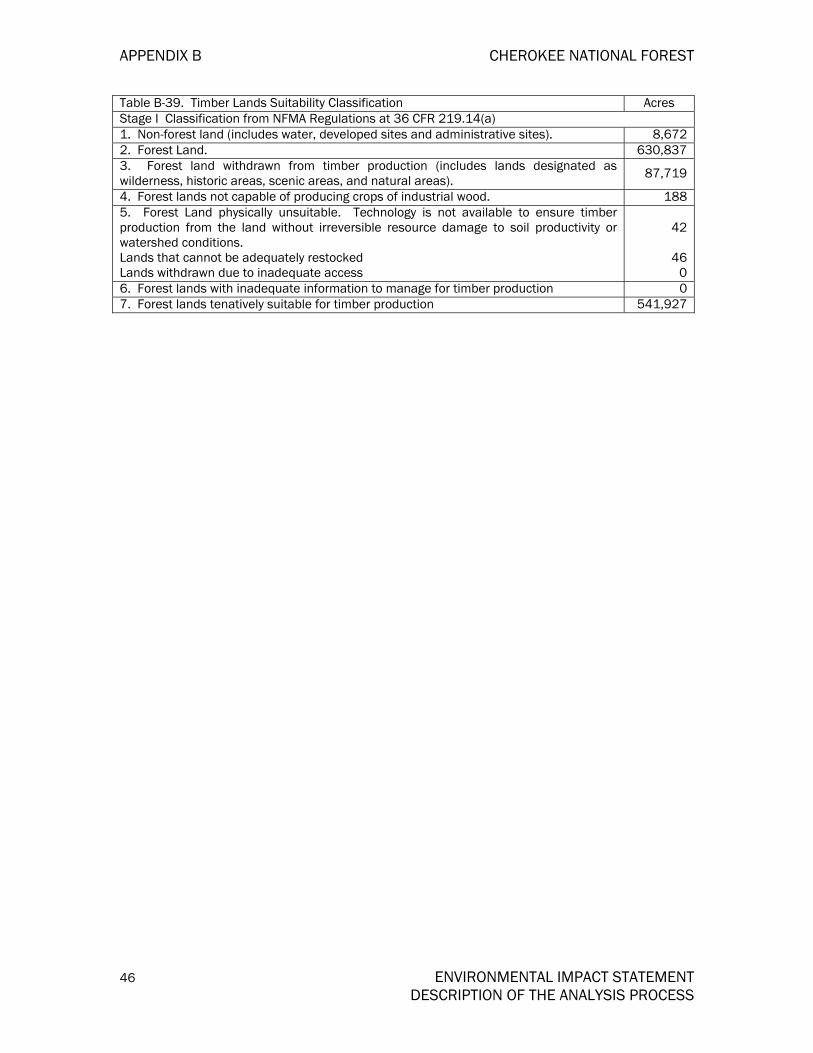
APPENDIX B CHEROKEE NATIONAL FOREST
46 ENVIRONMENTAL IMPACT STATEMENT DESCRIPTION OF THE ANALYSIS PROCESS
Table B-39. Timber Lands Suitability Classification Acres Stage I Classification from NFMA Regulations at 36 CFR 219.14(a) 1. Non-forest land (includes water, developed sites and administrative sites). 8,672 2. Forest Land. 630,837 3. Forest land withdrawn from timber production (includes lands designated as wilderness, historic areas, scenic areas, and natural areas). 87,719
4. Forest lands not capable of producing crops of industrial wood. 188 5. Forest Land physically unsuitable. Technology is not available to ensure timber production from the land without irreversible resource damage to soil productivity or watershed conditions. Lands that cannot be adequately restocked Lands withdrawn due to inadequate access
42
46
0 6. Forest lands with inadequate information to manage for timber production 0 7. Forest lands tenatively suitable for timber production 541,927

CHEROKEE NATIONAL FOREST APPENDIX B
ENVIRONMENTAL IMPACT STATEMENT 47 DESCRIPTION OF THE ANALYSIS PROCESS
N
Tentatively Suitable TimberlandsSouth End - Cherokee NF
10/11/2002
900 UnproductiveTentatively Suitable800 Not Appropriate700 Lack of TechnologyTentatively Suitable600 SpecialTentatively Suitable500 StandardTentatively Suitable400 Deferred300 Reserved200 Non-Forest100 Water AreaDistrict Boundary
Figure B- 1. Stage 1 Tentatively Suitable Timberland - South End Cherokee NF

APPENDIX B CHEROKEE NATIONAL FOREST
48 ENVIRONMENTAL IMPACT STATEMENT DESCRIPTION OF THE ANALYSIS PROCESS
N
Tentatively Suitable TimberlandsNorth End - Cherokee NF
10/11/2002
900 UnproductiveTentatively Suitable800 Not Appropriate700 Lack of TechnologyTentatively Suitable600 SpecialTentatively Suitable500 StandardTentatively Suitable400 Deferred300 Reserved200 Non-Forest100 Water AreaDistrict Boundary
Figure B- 2. Stage 1 Tentatively Suitable Timberland - North End Cherokee NF

CHEROKEE NATIONAL FOREST APPENDIX B
ENVIRONMENTAL IMPACT STATEMENT 49 DESCRIPTION OF THE ANALYSIS PROCESS
STAGE 2 ANALYSIS Stage 2 analyzess varying intensities of timber management on lands designated as tentatively suitable to determine which ones have a positive present net value (PNV), for all alternatives.
Timber Suitability Stage 2 Evaluation
There were 144,482 combinations of timber activities and timing choices evaluated with 65,106 or 45 percent resulting in a positive Present Net Value. The Timber Suitability Analysis is an economic analysis of each Analysis Area (AA) in SPECTRUM. It is defined in 36 CFR 219.14(b). Two questions are answered:
1. Which lands are “above cost”?
2. Which management intensity is the most economical for each Analysis Area?
Stage II analysis was run to estimate the most profitable timber prescription for each analysis area and to determine which analysis areas had the highest returns for timber. The analysis consists of sorting through economic information that is generated for use in SPECTRUM and finding the highest present net value for each part of the Forest. The analysis was done by taking data from the SPECTRUM matrix and placing it in a Microsoft Access database.
The results of this analysis found that 365,635 acres, or about 57 percent of the total forest acres, would have a positive present net value with timber activities and timing choices available in SPECTRUM.
Stage 3: Identification Of Suitable Acres
Stage 3 analysis was accomplished during the formulation of alternatives. Three criteria were used during this stage to identify lands as not suited for timber production:
1. Based upon a consideration of multiple use objectives for the alternative, the land is proposed for resource uses that preclude timber production, such as Appalachian Trail Corridor and scenic areas.
2. Other management objectives for the alternative limit timber production activities to the point where management requirements set forth in 36 CFR 219.27 cannot be met.
3. The lands are not cost efficient, over the planning horizon, in meeting Forest objectives, which include timber production.
Stage 3 analysis identifies lands as unsuited for timber production under the alternative selected as the revised Forest Plan.
Riparian areas also provide unique habitat for wildlife. In the draft EIS, only riparian polygons (areas large enough to be delineated as a polygon for GIS) were included in the suitability analysis. For the final EIS, riparian areas that were delineated as a line were buffered by 100 feet to account for the management and protection of these areas. This buffered area was added to the riparian polygons for inclusion in the suitability analysis.

APPENDIX B CHEROKEE NATIONAL FOREST
50 ENVIRONMENTAL IMPACT STATEMENT DESCRIPTION OF THE ANALYSIS PROCESS
Table B-40displays acres for Stage I, Stage II, and Stage III analysis for all alternatives.
Table B-40 Timber Lands Suitability Classification for all Atlternaives STAGE I CLASSIFICATION FROM NFMA REGULATIONS AT 36 CFR 219.14(a) Alt-A Alt-B Alt-D Alt-E Alt-F Alt-G Alt-I 1. Non-forest land 3617 3617 3617 3617 3617 3617 36172. Forest land 636341 636341 636341 636341 636341 636341 6363413. Forest land Withdrawn from Timber production
87719 87719 87719 87719 87719 87719 87719
4. Forest lands not capable of producing industrial wood
188 188 188 188 188 188 188
5. Forest land physically unsuitable.
42 42 42 42 42 42 42
6. Forest land with inadequate information 29958 29958 29958 29958 29958 29958 29958
7. Forest land tentatively suitable for timber production
522391 522391 522391 522391 522391 522391 522391
STAGE II CLASSIFICATION FROM NFMA REGULATIONS AT 36 CFR 219.14(b) Lands With positive present net value
365635 365635 365635 365635 365635 365635 365635
STAGE III CLASSIFICATION FROM NFMA REGULATIONS AT 36 CFR 219.14(C) 8.Forest Land not approprite for timber production
245140 221067 167191 427384 94750 373705 214904
9. Unsuitable forest land (lands 3,4,5,6, and 8)
363047 338974 285098 545291 212657 491612 328811
10. Total suitable forest land (item 2 minus item 9)
273294 297367 351243 91050 423684 144729 307530
11. Total national forest land (items 1 and 2).
639958 639958 639958 639958 639958 639958 639958
OBJECTIVE FUNCTIONS All Alternatives used a MAX objective function named MAX PNV. This objective function attempted to maximize the PNV of all activities and outputs. SPECTRUM optimized this objective function subject to a set of constraints described in the next section.
SPECTRUM CONSTRAINTS Several constraints were developed for the SPECTRUM model in response to standards and guidelines and the management requirements in the NFMA regulations (36 CFR 219.27). Constraints were also developed in response to management goals and to improve the model's simulation of actual management of the Forest.
Constraints identified as “management requirements” (36 CFR 219.27) were applied to all alternatives. Additional constraints common to all alternatives were applied to

CHEROKEE NATIONAL FOREST APPENDIX B
ENVIRONMENTAL IMPACT STATEMENT 51 DESCRIPTION OF THE ANALYSIS PROCESS
insure an implementable solution. These common constraints fall into four categories:
1. Constraints assigning congressionally and administratively designated areas to specific prescriptions,
2. Constraints ensuring that the management requirements are met in each alternative,
3. Timber scheduling constraints, and
4. Operational constraints that constrain timber harvest to a realistic solution.
The affect of each constraint on the model is discussed in the following section on "Sensitivity Analysis."
Implicit Constraints
The following SPECTRUM constraints were applied to all alternatives:
1. Long Term Sustained Yield (LTSY) and Nondeclining Yields
The LTSY constraint is used to ensure that the harvest of timber in the last decade is not greater that the long-term timber production capacity of the CNF. Long-term sustained yield capacity is computed using the acreage scheduled to each regeneration prescription applied in the model.
2. Perpetual Timber Harvest Constraint
This constraint is used to ensure that the remaining timber inventory will allow achievement of nondeclining harvest levels beyond the modeling horizon. To achieve this condition the constraint requires that the CNF contain as much timber inventory volume at the end of the last period as the CNF would have, on the average, under the management intensities selected in the analysis. Without this constraint the SPECTRUM model would have no reason to leave enough inventory at the end of 150 years to sustain timber harvest levels into perpetuity.
3. Nondeclining Yield
This constraint is used to ensure that the harvest of timber in a decade is greater than or equal to the harvest of timber in the previous period. This constraint indirectly limits the model to a lower present net value and reduced flow of timber in the early decades but also provides community economic and social stability through the controlled flow of timber.
Explicit Constraints
4. Visuals - Constrained clear cutting to scenic classes 3, 4, and 5. Shelterwood and uneven-aged allowed for all classes.
5. Cable Logging – Required on slopes greater than 40 per cent.
6. Financial Efficiency – Max PNV used as objective function
7. Mix of Regeneration Methods
a. Shelterwood b. Shelterwood with reserve

APPENDIX B CHEROKEE NATIONAL FOREST
52 ENVIRONMENTAL IMPACT STATEMENT DESCRIPTION OF THE ANALYSIS PROCESS
c. Clear cutting d. Thin
Rotation Ages
TABLE B-41. ROTATION AGES Community Type Rotation Age
Dry Xeric Oak (DXO) 80 - 100 yrs Mixed Mesophitic (MM) 100 - 120 yrs Dry Mesic Oak Pine (DMOP)
80 – 100 yrs
Xeric Pine and Pine Oak (XPPO)
80 – 100 yrs
Northern Hardwood (NH) 100 – 120 yrs Dry Mesic Oak (DMO) 100 – 120 yrs Conifer-Hardwood (CH) 100 – 120 yrs Bottomland Hardwood (BH)
100 – 120 yrs
Virginia Pine (VaPn) 60 – 80 yrs
CONSTRAINTS AND THE RIPARIAN ADJUSTMENT Some of the constraints used in the SPECTRUM model include the percent early successional objectives for the different management prescriptions that are suitable. These percentages need to be applied to all the acres within the Management Prescription allocation. So, if you have 10,000 acres in 8.A.1 with an objective of 4-10 percent in early successional habitats, then between 400 and 1,000 acres should be in early-succession within the 8.A.1 management prescription allocation. However, the acres that are in the riparian corridor have been deducted and assigned to Management Prescription 11. While overall there are 10,000 acres in the geographic allocation of 8.A.1, the SPECTRUM model only sees 8,000 acres being available for 8.A.1 (assuming 20 percent) is in riparian). But the desired condition is till to have 400 to 1,000 acres of the “landscape” in the 8.A.1 allocation in early-successional. Using 4-10 percent, SPECTRUM would take 320 to 800 acres (when 400 to 1,000 acres is the desired result). The following formula was used generate a factor use to make the adjustments in the constraints to account for the riparian acreage deductions:
1/1 – (% Riparian)
This gives a new factor to multiply by the original percentage targets. So, given 20 percent is in riparian, the correction factor becomes
1/1 – (0.2) = 1/0.8 = 1.25
1.25 times 4% and 10% equals 5% and 12.5%, and the constraints entered into SPECTRUM for acres in 8.A.1 would be 5% and 12.5% instead of 4% and 10%.
The riparian percentages for all alternative considered are:
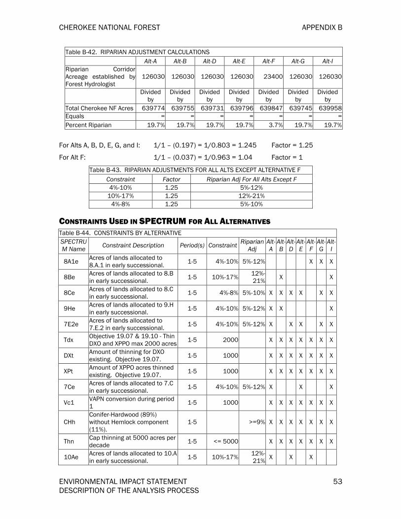
CHEROKEE NATIONAL FOREST APPENDIX B
ENVIRONMENTAL IMPACT STATEMENT 53 DESCRIPTION OF THE ANALYSIS PROCESS
Table B-42. RIPARIAN ADJUSTMENT CALCULATIONS Alt-A Alt-B Alt-D Alt-E Alt-F Alt-G Alt-I
Riparian CorridorAcreage established byForest Hydrologist
126030 126030 126030 126030 23400 126030 126030
Divided
by Divided
by Divided
by Divided
by Divided
by Divided
by Divided
by Total Cherokee NF Acres 639774 639755 639731 639796 639847 639745 639958Equals = = = = = = =Percent Riparian 19.7% 19.7% 19.7% 19.7% 3.7% 19.7% 19.7%
For Alts A, B, D, E, G, and I: 1/1 – (0.197) = 1/0.803 = 1.245 Factor = 1.25
For Alt F: 1/1 – (0.037) = 1/0.963 = 1.04 Factor = 1
Table B-43. RIPARIAN ADJUSTMENTS FOR ALL ALTS EXCEPT ALTERNATIVE F Constraint Factor Riparian Adj For All Alts Except F 4%-10% 1.25 5%-12%
10%-17% 1.25 12%-21% 4%-8% 1.25 5%-10%
CONSTRAINTS USED IN SPECTRUM FOR ALL ALTERNATIVES Table B-44. CONSTRAINTS BY ALTERNATIVE SPECTRUM Name Constraint Description Period(s) Constraint Riparian
Adj Alt-A
Alt-B
Alt-D
Alt-E
Alt-F
Alt-G
Alt-I
8A1e Acres of lands allocated to 8.A.1 in early successional. 1-5 4%-10% 5%-12% X X X
8Be Acres of lands allocated to 8.B in early successional. 1-5 10%-17% 12%-
21% X X
8Ce Acres of lands allocated to 8.C in early successional. 1-5 4%-8% 5%-10% X X X X X X
9He Acres of lands allocated to 9.H in early successional. 1-5 4%-10% 5%-12% X X X
7E2e Acres of lands allocated to 7.E.2 in early successional. 1-5 4%-10% 5%-12% X X X X X
Tdx Objective 19.07 & 19.10 - Thin DXO and XPPO max 2000 acres 1-5 2000 X X X X X X X
DXt Amount of thinning for DXO existing. Objective 19.07. 1-5 1000 X X X X X X X
XPt Amount of XPPO acres thinned existing. Objective 19.07. 1-5 1000 X X X X X X X
7Ce Acres of lands allocated to 7.C in early successional. 1-5 4%-10% 5%-12% X X X
Vc1 VAPN conversion during period 1 1-5 1000 X X X X X X X
CHh Conifer-Hardwood (89%) without Hemlock component (11%).
1-5 >=9% X X X X X X X
Thn Cap thinning at 5000 acres per decade 1-5 <= 5000 X X X X X X X
10Ae Acres of lands allocated to 10.A in early successional. 1-5 10%-17% 12%-
21% X X X

APPENDIX B CHEROKEE NATIONAL FOREST
54 ENVIRONMENTAL IMPACT STATEMENT DESCRIPTION OF THE ANALYSIS PROCESS
Table B-44. CONSTRAINTS BY ALTERNATIVE SPECTRUM Name Constraint Description Period(s) Constraint Riparian
Adj Alt-A
Alt-B
Alt-D
Alt-E
Alt-F
Alt-G
Alt-I
10Be Acres of lands allocated to 10.Bin early successional. 1-5 10%-17% 12%-
21% X
8A2e Acres of lands allocated to 8.A.2 in early successional. 1-5 <= 4% <= 5% X X
8E1e Acres of lands allocated to 8.E.1 in early successional. 1-5 10%-17% 12%-
21% X X X X
9A1e Acres of lands allocated to 9.A.1 in early successional. 1-5 <= 4% <= 5% X X
9A3e Acres of lands allocated to 9.A.3 in early successional. 1-5 <= 4% <= 5% X X X
9C1e Acres of lands allocated to 9.C.1 in early successional. 1-5 4%-10% 5%-12% X
9C2e Acres of lands allocated to 9.C.1 in early successional. 1-5 4%-10% 5%-12% X
9Ee Acres of lands allocated to 9.E in early successional. 1-5 4%-10% 5%-12% X
Budg Budget Constraint For BudgetCosts Activity Group 1-5 8,870,000 X
CONSTRAINTS COMMON TO ALL ALTERNATIVES Table B-45. CONSTRAINTS COMMON TO ALL ALTERNATIVES SPECTRUM
Name Constraint Description Period(s) Constraint Riparian Adj
Tdx Objective 19.07 & 19.10 - Thin DXO andXPPO max 2000 acres 1-5 2000
DXt Amount of thinning for DXO existing.Objective 19.07. 1-5 1000
XPt Amount of XPPO acres thinned existing.Objective 19.07. 1-5 1000
Vc1 VAPN conversion during period 1 1-5 1000
CHh Conifer-Hardwood (89%) without Hemlockcomponent (11%). 1-5 >=9%
Thn Cap thinning at 5000 acres per decade 1-5 <= 5000
DEVELOPMENT OF ALTERNATIVES Seven alternatives are considered in detail, including no action, which would continue management under the 1986 LMP as amended. Six action alternatives were developed in response to issues and concerns identified during the planning process. The process used to create the alternative themes and assign landscape allocations is described earlier in this appendix under the heading formulation of the alternatives. Each alternative combines land allocations, management practices, and activity schedules which, when implemented, would result in a unique set of resource outputs and environmental consequences. Each alternative was designed to be fully implementable and achievable.
Suitable acres in the the following tables indicate total acres in Management Prescriptions that are suitable for timber production. This does not mean that all

CHEROKEE NATIONAL FOREST APPENDIX B
ENVIRONMENTAL IMPACT STATEMENT 55 DESCRIPTION OF THE ANALYSIS PROCESS
acres in a suitable Management Prescription will be scheduled for timber management treatments. Because of economic or scheduling conflicts, some acres within the suitable prescriptions may not end up being scheduled and would therefore eventually become classified as snsuitable able for timber production.
ALTERNATIVE A This alternative emphasizes timber management for the sustained yield of wood products and an increase in commercial recreation and increased public access to forest, including off-highway vehicle trails, to provide more recreation opportunities to the public. Watersheds, water quality, and aquatic habitats would be restored or improved. A “natural” looking forest landscape would be provided for the public. Areas adjacent to existing wilderness would be recommended for wilderness designation.
A detailed description of this alternative’s distinguishing features and land allocation can be found in Chapter 2 of this document.
AA Stratification
Table B-46 through TABLE B-54 shows how the AAs were stratified for the SPECTRUM model of Alternative A by six layer identifiers. Total acres shown are based on GIS computed analysis area acres. This number varies slightly between alternatives because each alternative GIS layer consisted of a different arrangement of thousands of polygons ranging in size from several hundred acres to less than 0.01 acre. Small “sliver” analysis areas totaling less than one acre were not included in the SPECTRUM analysis.
Table B-46 displays acres by management prescription. The category “othuns” includes management prescriptions that are designated as not suitable for timber management and are listed in detail in TABLE B-47.

APPENDIX B CHEROKEE NATIONAL FOREST
56 ENVIRONMENTAL IMPACT STATEMENT DESCRIPTION OF THE ANALYSIS PROCESS
Table B-46 SUITABILITY BY MANAGEMENTPRESCRIPTIONS; ALTERNATIVE A
MgRx Suitable Unsuit Grand Total 10.A 36345 3634511 73885 738856.C 1682 16826.E 6337 63377.A 27860 278607.C 2785 2785
7.E.2 62683 626838.A.2 15501 155018.C 44663 44663
8.E.1 2099 20999.A.1 17941 17941
9.A.3 65879 65879
9.H 17379 17379
othuns 235262 235262
Grand Total 273294 337007 610301
TABLE B-47. MGRX INOTHUNS; ALTERNATIVE A
MgRx Total 1.A 675821.B 27873
12.A 776712.B 135002.B.2 12534.A 31698
4.B.2 6084.F 111274.I 42354.K 39315.A 11705.B 3776.A 109917.D 2019
9.A.2 179949.A.4 235179.F 9620
Grand Total 235262
TABLE B-48 displays acres by Community Type (CommTy) and suitability for timber management. TABLE B-49 displays acres by Scenic Class (ScCls) and suitability for timber management.
TABLE B-48. SUITABILITY BY COMMUNITYTYPES; ALTERNATIVE A CommTy Suitable Unsuitable Grand Total BH 939 751 1690CH 20665 14189 34854DMO 58275 66590 124865DMOP 60423 44091 104514DXO 28573 38054 66627MM 72462 75297 147759NH 1981 16291 18272VAPN 30000 23140 53140XPPO 27836 30744 58580Grand Total 301154 309147 610301
TABLE B-49. SUITABILITY BY SCENIC CLASS;ALTERNATIVE A
ScCls Suitable Unsuitable Grand Total 1 50433 149709 2001422 79263 51660 1309233 31783 20858 526414 838 205 10435 138837 86715 225552
Grand Total 301154 309147 610301
TABLE B-50 displays acres by Site Index and Age Class (SI_Age) by suitability for timber management. TABLE B-51 displays oacres by slope class (Slope) and suitability for timber production. TABLE B-52 shows acres by access classification by suitability for timber production.

CHEROKEE NATIONAL FOREST APPENDIX B
ENVIRONMENTAL IMPACT STATEMENT 57 DESCRIPTION OF THE ANALYSIS PROCESS
TABLE B-51. SUITABILITY BY SLOPE;ALTERNATIVE A
Slope Suitable Unsuitable Grand Total 1 252816 217797 4706132 48194 89137 1373313 144 2213 2357
Grand Total 301154 309147 610301
TABLE B-50. SUITABILITY BY SITE INDEXAND AGE; ALTERNATIVE A SI_Age Suitable Unsuitable Grand Total 1_00_1 1809 1897 37061_100+ 316 3161_11_4 5670 4317 99871_41_8 9537 16942 264791_8110 5514 16226 217402_00_1 10163 10424 205872_100+ 23820 25083 489032_11_4 41893 22360 642532_41_8 101230 102837 2040672_8110 101518 108745 210263Grand Total 301154 309147 610301
TABLE B-52. SUITABILITY BY ACCESSIBILITY;ALTERNATIVE A Access Suitable Unsuitable Grand Total 0.25 283489 233881 5173700.5 14382 38474 52856
>1Mile 13849 138491Mile 3283 22943 26226Grand Total 301154 309147 610301
TABLE B-53 displays acres by management prescriptions that have early successional habitat objectives. TABLE B-54 shows acres by Community Type and early successional habitat objectives.
TABLE B-53. MGRX WITH EARLY SUCCESSIONAL OBJECTIVES; ALTERNATIVE A
MgRx Not ES ES Grand Total 6.C 1682 16826.E 6337 63377.C 2785 27857.E.2 62683 626838.A.2 15501 155018.C 44663 446638.E.1 2099 20999.A.1 17941 179419.A.3 65879 658799.H 17379 1737910.A 36345 3634511 73885 73885othuns 263122 263122Grand Total 345026 265275 610301
TABLE B-54. COMMUNITY TYPES WITH EARLY SUCCESSIONAL OBJECTIVES; ALTERNATIVE A CommTy Not ES ES Grand Total
BH 751 939 1690CH 16488 18366 34854
DMO 74325 50540 124865DMOP 50065 54449 104514DXO 40404 26223 66627MM 82331 65428 147759NH 16420 1852 18272
VAPN 27900 25240 53140XPPO 36342 22238 58580Grand Total 345026 265275 610301
Table B-55 displays the unique set of constraints applied to Alternative A for Spectrum.
Table B-55. ALTERNATIVE A UNIQUE CONSTRAINTS NAME CONSTRAINT DESCRIPTION Period(s) Constraint Riparian Adj
8Ce Acres of lands allocated to 8.C in early successional. 1-5 4%-8% 5%-10%

APPENDIX B CHEROKEE NATIONAL FOREST
58 ENVIRONMENTAL IMPACT STATEMENT DESCRIPTION OF THE ANALYSIS PROCESS
Table B-55. ALTERNATIVE A UNIQUE CONSTRAINTS NAME CONSTRAINT DESCRIPTION Period(s) Constraint Riparian Adj
9He Acres of lands allocated to 9.H in early successional. 1-5 4%-8% 5%-10%
7E2e Acres of lands allocated to 7.E.2 in early successional. 1-5 4%-8% 5%-10%
7Ce Acres of lands allocated to 7.C in early successional. 1-5 4%-8% 5%-10%
10Ae Acres of lands allocated to 10.A in early successional. 1-5 10%-17% 12%-21%
8A2e Acres of lands allocated to 8.A.2 in early successional. 1-5 <= 4% <= 5%
8E1e Acres of lands allocated to 8.E.1 in early successional. 1-5 10%-17% 12%-21%
9A1e Acres of lands allocated to 9.A.1 in early successional. 1-5 <= 4% <= 5%
9A3e Acres of lands allocated to 9.A.3 in early successional. 1-5 <= 4% <= 5%
ALTERNATIVE B This alternative emphasizes restoring the natural resources of the forest and maintaining a mixture of wildlife habitats through active management, for which timber production would be a tool. Recreation settings would occur in areas in which they would be compatible with forest restoration activities. Riparian areas would be managed to maintain water quality and restore watersheds. Scenic integrity in this alternative would be low to moderate with the implementation of this program. Roadless areas would not be recommended for wilderness. Invasive species and diseases would be actively managed under this alternative.
A detailed description of this alternative’s distinguishing features and land allocation can be found in Chapter 2 of this document.
AA Stratification
TABLE B-56 through TABLE B-64 shows how the AAs were stratified for the SPECTRUM model of Alternative B by six layer identifiers. Total acres shown are based on GIS computed analysis area acres. This number varies slightly between alternatives because each alternative GIS layer consisted of a different arrangement of thousands of polygons ranging in size from several hundred acres to less than 0.01 acre. Small “sliver” analysis areas totaling less than one acre were not included in the SPECTRUM analysis.
TABLE B-56 displays acres by management prescription. The category “othuns” includes management prescriptions that are designated as not suitable for timber management and are listed in detail in TABLE B-57.

CHEROKEE NATIONAL FOREST APPENDIX B
ENVIRONMENTAL IMPACT STATEMENT 59 DESCRIPTION OF THE ANALYSIS PROCESS
TABLE B-56. SUITABILITY BY MANAGEMENTPRESCRIPTIONS; ALTERNATIVE B
MgRx Suitable Unsuitable Grand Total 7.A 4740 47407.B 1521 15218.B 10838 108388.C 32358 32358
8.E.1 2093 20939.A.1 17941 179419.A.3 117676 1176769.C.2 5354 53549.E 11989 119899.H 97597 9759711 74115 74115
othuns 233726 233726Grand Total 297367 312581 609948
TABLE B-57. MGRX INOTHUNS; ALTERNATIVE B
MgRx Total 1.A 676691.B 1290
2.B.1 12534.A 34393
4.B.2 5664.F 172574.K 39315.A 11705.B 3776.A 495057.D 2652
9.A.2 179689.A.4 235459.B.1 11149.B.2 14039.F 9633
Grand Total 233726
TABLE B-58 displays acres by Community Type (CommTy) and suitability for timber management. TABLE B-59 displays acres by Scenic Class (ScCls) and suitability for timber management.
TABLE B-58. SUITABILITY BY COMMUNITYTYPE; ALTERNATIVE B CommTy Suitable Unsuitable Grand Total
BH 1056 930 1986CH 20348 14333 34681
DMO 59086 66197 125283DMOP 59128 45361 104489DXO 29628 36812 66440MM 72994 74746 147740NH 2128 15982 18110
VAPN 30441 22277 52718XPPO 27298 31203 58501Grand Total 302107 307841 609948
TABLE B-59. SUITABILITY BY SCENIC CLASS;ALTERNATIVE B
ScCls Suitable Unsuitable Grand Total 1 50969 149637 2006062 77176 51995 1291713 34209 19740 539494 859 211 10705 138894 86258 225152
Grand Total 302107 307841 609948
TABLE B-60 displays acres by Site Index and Age Class (SI_Age) by suitability for timber management. TABLE B-61 displays oacres by slope class (Slope) and suitability for timber production. TABLE B-62 shows acres by access classification by suitability for timber production.

APPENDIX B CHEROKEE NATIONAL FOREST
60 ENVIRONMENTAL IMPACT STATEMENT DESCRIPTION OF THE ANALYSIS PROCESS
TABLE B-61. SUITABILITY BY SLOPE;ALTERNATIVE B
Slope Suitable Unsuitable Grand Total 1 252740 215629 4683692 49269 89991 1392603 98 2221 2319
Grand Total 302107 307841 609948
TABLE B-60. SUITABILITY BY SITE INDEX ANDAGE; ALTERNATIVE B
SI_Age Suitable UnsuitableGrand Total1_00_1 1899 1919 38181_100+ 316 3161_11_4 5952 4392 103441_41_8 10015 16059 260741_8110 5578 16597 221752_00_1 9879 10468 203472_100+ 24305 24908 492132_11_4 41991 21855 638462_41_8 99508 103188 2026962_8110 102980 108139 211119
Grand Total 302107 307841 609948
TABLE B-62. SUITABILITY BY ACCESSIBILITY;ALTERNATIVE B
Access Suitable Unsuitable Grand Total 0.25 283512 233068 5165800.5 15299 38163 53462
>1Mile 13828 138281Mile 3296 22782 26078
Grand Total 302107 307841 609948
TABLE B-63 displays acres by management prescriptions that have early successional habitat objectives. TABLE B-64 shows acres by Community Type and early successional habitat objectives.
TABLE B-63. MGRX WITH EARLYSUCCESSIONAL OBJECTIVES; ALTERNATIVE B
MgRx Not ES ES Grand Total 7.B 1521 15218.B 10838 108388.C 32358 32358
8.E.1 2093 20939.A.1 17941 179419.A.3 117676 1176769.C.2 5354 53549.E 11989 119899.H 97597 9759711 74115 74115
othuns 238466 238466Grand Total 319456 290492 609948
TABLE B-64. COMMUNITY TYPES WITH EARLY SUCCESSIONAL OBJECTIVES; ALTERNATIVE B
CommTy Not ES ES Grand Total BH 930 1056 1986CH 15243 19438 34681
DMO 68323 56960 125283DMOP 47878 56611 104489DXO 38543 27897 66440MM 76899 70841 147740NH 15982 2128 18110
VAPN 22562 30156 52718XPPO 33096 25405 58501
Grand Total 319456 290492 609948

CHEROKEE NATIONAL FOREST APPENDIX B
ENVIRONMENTAL IMPACT STATEMENT 61 DESCRIPTION OF THE ANALYSIS PROCESS
TABLE B-65 displays the unique set of constraints applied to Alternative B for Spectrum.
TABLE B-65. ALTERNATIVE B UNIQUE CONSTRAINTS NAME CONSTRAINT DESCRIPTION Period(s) Constraint Riparian Adj
8Be Acres of lands allocated to 8.B in early successional. 1-5 10%-17% 12%-21%
8Ce Acres of lands allocated to 8.C in early successional. 1-5 4%-8% 5%-10%
9He Acres of lands allocated to 9.H in early successional. 1-5 4%-10% 5%-12%
8E1e Acres of lands allocated to 8.E.1 in early successional. 1-5 10%-17% 12%-21%
9A1e Acres of lands allocated to 9.A.1 in early successional. 1-5 <= 4% <= 5%
9A3e Acres of lands allocated to 9.A.3 in early successional. 1-5 <= 4% <= 5%
9C2e Acres of lands allocated to 9.C.1 in early successional. 1-5 4%-10% 5%-12%
9Ee Acres of lands allocated to 9.E in early successional. 1-5 4%-10% 5%-12%
ALTERNATIVE D This alternative emphasizes timber management of the forest on a rotation basis. Of all the alternatives, this alternative proposes the least “naturalness” of the forest. Recreation, stream restoration, water quality, threatened and endangered species are not emphasized. “Old growth,” semi-primitive areas, and roadless areas would be only those areas determined unsuitable for timber production. Insects, diseases and exotic plants and animals would be actively managed.
A detailed description of this alternative’s distinguishing features and land allocation can be found in Chapter 2 of this document.
AA Stratification
TABLE B-66 through TABLE B-74 shows how the AAs were stratified for the SPECTRUM model of Alternative D by six layer identifiers. Total acres shown are based on GIS computed analysis area acres. This number varies slightly between alternatives because each alternative GIS layer consisted of a different arrangement of thousands of polygons ranging in size from several hundred acres to less than 0.01 acre. Small “sliver” analysis areas totaling less than one acre were not included in the SPECTRUM analysis.
TABLE B-66 displays acres by management prescription. The category “othuns” includes management prescriptions that are designated as not suitable for timber management and are listed in detail in TABLE B-67.

APPENDIX B CHEROKEE NATIONAL FOREST
62 ENVIRONMENTAL IMPACT STATEMENT DESCRIPTION OF THE ANALYSIS PROCESS
TABLE B-66. SUITABILITY BY MANAGEMENTPRESCRIPTION; ALTERNATIVE D
MgRx Suitable Unsuitable Grand Total 7.A 26612 266127.B 8789 8789
7.E.2 15272 152728.A.2 7330 73308.C 89920 89920
10.A 206095 20609510.B 23837 2383711 92695 92695
othuns 139153 139153Grand Total 351243 258460 609703
TABLE B-67. MGRX INOTHUNS; ALTERNATIVE D
MgRx Total 1.A 67755
2.B.1 12532.B.2 514.A 36458
4.B.2 5754.F 93414.K 44685.A 14275.B 3777.D 2019
9.A.4 79679.B.1 2869.B.2 13239.F 9848
Grand Total 143148
TABLE B-68 displays acres by Community Type (CommTy) and suitability for timber management. TABLE B-69 displays acres by Scenic Class (ScCls) and suitability for timber management.
TABLE B-68. SUITABILITY BY COMMUNITYTYPES; ALTERNATIVE D
CommTy Suitable Unsuitable Grand Total BH 1176 505 1681CH 22912 11290 34202
DMO 73858 51326 125184DMOP 70374 34112 104486DXO 40622 25779 66401MM 93533 54145 147678NH 3039 15440 18479
VAPN 34260 18714 52974XPPO 38081 20537 58618
Grand Total 377855 231848 609703
TABLE B-69. SUITABILITY BY SCENIC CLASS; ALTERNATIVE D
ScCls Suitable Unsuitable Grand Total 1 74784 125954 2007382 95571 33611 1291823 41725 12039 537644 896 220 11165 164879 60024 224903
Grand Total 377855 231848 609703
TABLE B-70 displays acres by Site Index and Age Class (SI_Age) by suitability for timber management. TABLE B-71 displays oacres by slope class (Slope) and suitability for timber production. TABLE B-72 shows acres by access classification by suitability for timber production.

CHEROKEE NATIONAL FOREST APPENDIX B
ENVIRONMENTAL IMPACT STATEMENT 63 DESCRIPTION OF THE ANALYSIS PROCESS
TABLE B-71. SUITABILITY BY SLOPE; ALTERNATIVE D
Slope Suitable Unsuitable Grand Total 1 302939 163568 4665072 74678 66122 1408003 238 2158 2396
Grand Total 377855 231848 609703
TABLE B-70. SUITABILITY BY SITE INDEX ANDAGE; ALTERNATIVE D
SI_Age Suitable Unsuitable Grand Total 1_00_1 2577 1543 41201_100+ 67 163 2301_11_4 7252 2787 100391_41_8 14416 12095 265111_8110 7756 14483 222392_00_1 11667 8427 200942_100+ 29956 18780 487362_11_4 46611 17212 638232_41_8 125370 77720 2030902_8110 132183 78638 210821
Grand Total 377855 231848 609703
TABLE B-72. SUITABILITY BY ACCESSIBILITY;ALTERNATIVE D
Access Suitable Unsuitable Grand Total 0.25 335847 174900 5107470.5 29563 28054 57617
>1Mile 2129 11602 137311Mile 10316 17292 27608
Grand Total 377855 231848 609703
TABLE B-73 displays acres by management prescriptions that have early successional habitat objectives. TABLE B-74 shows acres by Community Type and early successional habitat objectives.
TABLE B-73. MGRX WITH EARLYSUCCESSIONAL OBJECTIVES; ALTERNATIVE D.
MgRx Not ES ES Grand Total 7.B 8789 8789
7.E.2 15272 152728.A.2 7330 73308.C 89920 89920
10.A 206095 20609510.B 23837 2383711 92695 92695
othuns 165765 165765Grand Total 267249 342454 609703
TABLE B-74. COMMUNITY TYPES WITH EARLYSUCCESSIONAL OBJECTIVES; ALTERNATIVE D CommTy Not ES ES Grand Total BH 700 981 1681 CH 12795 21407 34202 DMO 58562 66622 125184 DMOP 39269 65217 104486 DXO 27769 38632 66401 MM 62733 84945 147678 NH 15751 2728 18479 VAPN 23550 29424 52974 XPPO 26120 32498 58618 Grand Total 267249 342454 609703

APPENDIX B CHEROKEE NATIONAL FOREST
64 ENVIRONMENTAL IMPACT STATEMENT DESCRIPTION OF THE ANALYSIS PROCESS
TABLE B-75 displays the unique set of constraints applied to Alternative D for Spectrum.
TABLE B-75. ALTERNATIVE D UNIQUE CONSTRAINTS NAME CONSTRAINT DESCRIPTION Period(s) Constraint Riparian Adj
8Ce Acres of lands allocated to 8.C in early successional. 1-5 4%-8% 5%-10%
7E2e Acres of lands allocated to 7.E.2 in early successional. 1-5 4%-10% 5%-12%
10Ae Acres of lands allocated to 10.A in early successional. 1-5 10%-17% 12%-21%
10Be Acres of lands allocated to 10.B in early successional. 1-5 10%-17% 12%-21%
8A2e Acres of lands allocated to 8.A.2 in early successional. 1-5 <= 4% <= 5%
ALTERNATIVE E This alternative emphasizes a combination of hunting, wildlife, and timber management. A natural setting and an increase in concentrated and dispersed recreation facilities and off-highway vehicle trails would be provided that could attract a variety of recreation users. The forest would be managed for a variety of wildlife habitats, including ruffled grouse. Riparian areas would be designated and protected. A “natural” forest viewshed would be maintained for the public.
A detailed description of this alternative’s distinguishing features and land allocation can be found in Chapter 2 of this document.
AA Stratification
TABLE B-76 through TABLE B-84 shows how the AAs were stratified for the SPECTRUM model of Alternative E by six layer identifiers. Total acres shown are based on GIS computed analysis area acres. This number varies slightly between alternatives because each alternative GIS layer consisted of a different arrangement of thousands of polygons ranging in size from several hundred acres to less than 0.01 acre. Small “sliver” analysis areas totaling less than one acre were not included in the SPECTRUM analysis.
TABLE B-76 displays acres by management prescription. The category “othuns” includes management prescriptions that are designated as not suitable for timber management and are listed in detail in TABLE B-77.

CHEROKEE NATIONAL FOREST APPENDIX B
ENVIRONMENTAL IMPACT STATEMENT 65 DESCRIPTION OF THE ANALYSIS PROCESS
TABLE B-76. SUITABILITY BY MANAGEMENTPRESCRIPTIONS; ALTERNATIVE E
MgRx Suitable Unsuitable Grand Total 6.B 5234 52346.E 4896 48967.B 10025 100257.C 2785 2785
7.E.2 389 3898.C 37810 37810
8.E.1 2433 24339.A.3 27478 27478
11 29906 29906othuns 488966 488966
Grand Total 91050 518872 609922
TABLE B-77. MGRX INOTHUNS; ALTERNATIVE E
MgRx Total 1.A 681091.B 49881
2.B.1 12534.A 33425
4.B.2 3974.E.1 2904.F 176624.I 47994.K 44685.A 14275.B 3776.A 157987.D 5515
7.E.1 1842999.F 9840
12.A 4552512.B 39166
Grand Total 482231
TABLE B-78 displays acres by Community Type (CommTy) and suitability for timber management. TABLE B-79 displays acres by Scenic Class (ScCls) and suitability for timber management.
TABLE B-78. SUITABILITY BY COMMUNITY TYPE;ALTERNATIVE E
CommTy Suitable Unsuitable Grand Total BH 524 1123 1647 CH 7075 27378 34453
DMO 24704 100362 125066 DMOP 25399 79095 104494 DXO 6429 59940 66369 MM 27413 120347 147760 NH 922 17432 18354
VAPN 16002 37199 53201 XPPO 13460 45118 58578
Grand Total 121928 487994 609922
TABLE B-79. SUITABILITY BY SCENIC CLASS; ALTERNATIVE E
ScCls Suitable Unsuitable Grand Total 1 26359 173822 2001812 34780 95835 1306153 8055 45862 539174 1071 10715 52734 171404 224138
Grand Total 121928 487994 609922
TABLE B-80 displays acres by Site Index and Age Class (SI_Age) by suitability for timber management. TABLE B-81 displays oacres by slope class (Slope) and suitability for timber production. TABLE B-82 shows acres by access classification by suitability for timber production.

APPENDIX B CHEROKEE NATIONAL FOREST
66 ENVIRONMENTAL IMPACT STATEMENT DESCRIPTION OF THE ANALYSIS PROCESS
TABLE B-81. SUITABILITY BY SLOPE;ALTERNATIVE E
Slope Suitable Unsuitable Grand Total 1 106309 361912 4682212 15568 123911 1394793 51 2171 2222
Grand Total 121928 487994 609922
TABLE B-80. SUITABILITY BY SITE INDEX ANDAGE; ALTERNATIVE E
SI_Age Suitable Unsuitable Grand Total 1_00_1 1242 2739 39811_100+ 136 179 3151_11_4 4547 5670 102171_41_8 8911 17618 265291_8110 2748 19359 221072_00_1 4542 15454 199962_100+ 8167 40683 488502_11_4 14707 49301 640082_41_8 43998 159732 2037302_8110 32930 177259 210189Grand Total 121928 487994 609922
TABLE B-82. SUITABILITY BY ACCESSIBILITY;ALTERNATIVE E
Access Suitable Unsuitable Grand Total 0.25 117877 396614 5144910.5 3791 51003 54794
>1Mile 13836 138361Mile 260 26541 26801
Grand Total 121928 487994 609922
TABLE B-83 displays acres by management prescriptions that have early successional habitat objectives. TABLE B-84 shows acres by Community Type and early successional habitat objectives. TABLE B-83. MGRX WITH EARLY SUCCESSIONALOBJECTIVES; ALTERNATIVE E
MgRx Not ES ES Grand Total6.B 5234 52346.E 4896 48967.B 10025 100257.C 2785 2785
7.E.2 389 3898.C 37810 37810
8.E.1 2433 24339.A.3 27478 27478
11 29906 29906othuns 488966 488966
Grand Total 53902770895 609922
TABLE B-84. COMMUNITY TYPES WITHEARLY SUCCESSIONAL OBJECTIVES;ALTERNATIVE E
CommTy Not ES ES Grand Total BH 1306 341 1647CH 30447 4006 34453
DMO 111184 13882 125066DMOP 90655 13839 104494DXO 61734 4635 66369MM 131073 16687 147760NH 17651 703 18354
VAPN 43795 9406 53201XPPO 51182 7396 58578
Grand Total 539027 70895 609922
TABLE B-85 displays the unique set of constraints applied to Alternative E for Spectrum.
TABLE B-85. ALTERNATIVE E UNIQUE CONSTRAINTS NAME CONSTRAINT DESCRIPTION Period(s) Constraint Riparian Adj
8Ce Acres of lands allocated to 8.C in early successional. 1-5 4%-8% 5%-10%7E2e Acres of lands allocated to 7.E.2 in early successional. 1-5 4%-10% 5%-12%7Ce Acres of lands allocated to 7.C in early successional. 1-5 4%-10% 5%-12%8E1e Acres of lands allocated to 8.E.1 in early successional. 1-5 10%-17% 12%-21%
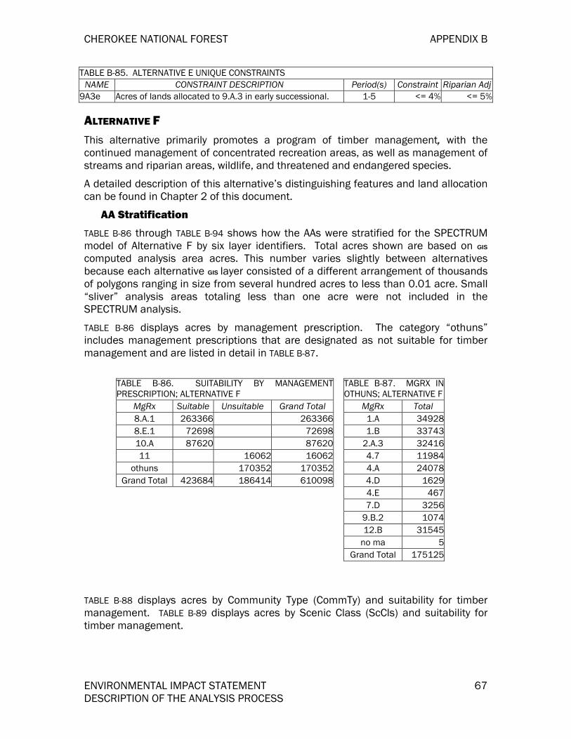
CHEROKEE NATIONAL FOREST APPENDIX B
ENVIRONMENTAL IMPACT STATEMENT 67 DESCRIPTION OF THE ANALYSIS PROCESS
TABLE B-85. ALTERNATIVE E UNIQUE CONSTRAINTS NAME CONSTRAINT DESCRIPTION Period(s) Constraint Riparian Adj
9A3e Acres of lands allocated to 9.A.3 in early successional. 1-5 <= 4% <= 5%
ALTERNATIVE F This alternative primarily promotes a program of timber management, with the continued management of concentrated recreation areas, as well as management of streams and riparian areas, wildlife, and threatened and endangered species.
A detailed description of this alternative’s distinguishing features and land allocation can be found in Chapter 2 of this document.
AA Stratification
TABLE B-86 through TABLE B-94 shows how the AAs were stratified for the SPECTRUM model of Alternative F by six layer identifiers. Total acres shown are based on GIS
computed analysis area acres. This number varies slightly between alternatives because each alternative GIS layer consisted of a different arrangement of thousands of polygons ranging in size from several hundred acres to less than 0.01 acre. Small “sliver” analysis areas totaling less than one acre were not included in the SPECTRUM analysis.
TABLE B-86 displays acres by management prescription. The category “othuns” includes management prescriptions that are designated as not suitable for timber management and are listed in detail in TABLE B-87.
TABLE B-86. SUITABILITY BY MANAGEMENTPRESCRIPTION; ALTERNATIVE F
MgRx Suitable Unsuitable Grand Total 8.A.1 263366 2633668.E.1 72698 7269810.A 87620 8762011 16062 16062
othuns 170352 170352Grand Total 423684 186414 610098
TABLE B-87. MGRX INOTHUNS; ALTERNATIVE F
MgRx Total 1.A 349281.B 33743
2.A.3 324164.7 119844.A 240784.D 16294.E 4677.D 3256
9.B.2 107412.B 31545
no ma 5Grand Total 175125
TABLE B-88 displays acres by Community Type (CommTy) and suitability for timber management. TABLE B-89 displays acres by Scenic Class (ScCls) and suitability for timber management.

APPENDIX B CHEROKEE NATIONAL FOREST
68 ENVIRONMENTAL IMPACT STATEMENT DESCRIPTION OF THE ANALYSIS PROCESS
TABLE B-88. SUITABILITY BY COMMUNITY TYPE;ALTERNATIVE F
CommTy Suitable Unsuitable Grand Total BH 875 1332 2207CH 26870 6012 32882
DMO 84694 40513 125207DMOP 79832 25245 105077DXO 44451 21957 66408MM 107069 40547 147616NH 6451 12062 18513
VAPN 39546 13965 53511XPPO 33896 24781 58677
Grand Total 423684 186414 610098
TABLE B-89. SUITABILITY BY SCENIC CLASS;ALTERNATIVE F
ScCls Suitable Unsuitable Grand Total 1 50941 151111 2020522 113763 17238 1310013 50342 2697 530394 831 30 8615 207807 15338 223145
Grand Total 423684 186414 610098
TABLE B-90 displays acres by Site Index and Age Class (SI_Age) by suitability for timber management. TABLE B-91 displays acres by slope class (Slope) and suitability for timber production. TABLE B-92 shows acres by access classification by suitability for timber production.
TABLE B-91. SUITABILITY BY SLOPE;ALTERNATIVE F
Slope Suitable Unsuitable Grand Total 1 352068 118988 4710562 71364 65353 1367173 252 2073 2325
Grand Total 423684 186414 610098
TABLE B-90. SUITABILITY BY SITE INDEX ANDAGE; ALTERNATIVE F
SI_Age Suitable UnsuitableGrand Total1_00_1 3025 787 38121_100+ 74 741_11_4 8425 1111 95361_41_8 14306 12150 264561_8110 7107 14677 217842_00_1 14716 5051 197672_100+ 34734 13566 483002_11_4 55650 8525 641752_41_8 137173 67844 2050172_8110 148548 62629 211177
Grand Total 423684 186414 610098
TABLE B-92. SUITABILITY BY ACCESSIBILITY;ALTERNATIVE F
Access Suitable Unsuitable Grand Total .25 398548 129696 528244.5 20210 24355 44565
>1Mile 319 13486 138051Mile 4607 18877 23484
Grand Total 423684 186414 610098
TABLE B-93 displays acres by management prescriptions that have early successional habitat objectives. TABLE B-94 shows acres by Community Type and early successional habitat objectives.

CHEROKEE NATIONAL FOREST APPENDIX B
ENVIRONMENTAL IMPACT STATEMENT 69 DESCRIPTION OF THE ANALYSIS PROCESS
TABLE B-93. MGRX WITH EARLYSUCCESSIONAL OBJECTIVES; ALTERNATIVE F
MgRx Not ES ES Grand Total 10.A 87620 8762011 16062 16062
8.A.1 263366 2633668.E.1 72698 72698
othuns 170352 170352Grand Total 449780 160318 610098
TABLE B-94. COMMUNITY TYPES WITHEARLY SUCCESSIONAL OBJECTIVES;ALTERNATIVE F
CommTy Not ES ES Grand Total BH 1896 311 2207CH 22896 9986 32882
DMO 93522 31685 125207DMOP 73306 31771 105077DXO 49249 17159 66408MM 108213 39403 147616NH 15306 3207 18513
VAPN 39838 13673 53511XPPO 45554 13123 58677
Grand Total 449780 160318 610098
TABLE B-95 displays the unique set of constraints applied to Alternative F for Spectrum.
TABLE B-95. ALTERNATIVE F UNIQUE CONSTRAINTS NAME CONSTRAINT DESCRIPTION Period(s) Constraint Riparian Adj
8A1e Acres of lands allocated to 8.A.1 in early successional. 1-5 4%-10% 5%-12%
10Ae Acres of lands allocated to 10.A in early successional. 1-5 10%-17% 12%-21%
8E1e Acres of lands allocated to 8.E.1 in early successional. 1-5 10%-17% 12%-21%
Budg Budget Constraint For BudgetCosts Activity Group 1-5 8,870,000
ALTERNATIVE G Of all the alternatives, this alternative proposes the least overall active management of the forest. Large contiguous areas of the forest would be maintained for movement corridors, threatened and endangered species and watershed restoration. Most roadless areas would be recommended for wilderness. Emphasis would be on the recovery of proposed, threatened, endangered, sensitive, and rare species. Recreation activities would occur within the context of ecosystem needs and function. Semi-primitive, wildlife and nature-oriented recreation activities would be emphasized. Developed recreation facilities would occur only where they did not conflict with ecosystem function. Exotic pests and diseases would be controlled. A “natural” appearing forest landscape would be maintained. Watersheds would be managed for water quality.
A detailed description of this alternative’s distinguishing features and land allocation can be found in Chapter 2 of this document.
AA Stratification
TABLE B-96 through TABLE B-104 shows how the AAs were stratified for the SPECTRUM model of Alternative G by six layer identifiers. Total acres shown are based on GIS

APPENDIX B CHEROKEE NATIONAL FOREST
70 ENVIRONMENTAL IMPACT STATEMENT DESCRIPTION OF THE ANALYSIS PROCESS
computed analysis area acres. This number varies slightly between alternatives because each alternative GIS layer consisted of a different arrangement of thousands of polygons ranging in size from several hundred acres to less than 0.01 acre. Small “sliver” analysis areas totaling less than one acre were not included in the SPECTRUM analysis.
TABLE B-96 displays acres by management prescription. The category “othuns” includes management prescriptions that are designated as not suitable for timber management and are listed in detail in TABLE B-97.
TABLE B-96. SUITABILITY BY MANAGEMENTPRESCRIPTION; ALTERNATIVE G
MgRx Suitable Unsuitable Grand Total 6.B 5233 5233 6.E 4895 4895 7.B 179 179
7.E.2 389 389 8.A.1 47922 47922 8.C 40075 40075
9.C.1 46036 46036 11 46196 46196
othuns 418952 418952 Grand Total 188267 421610 609877
TABLE B-97. MGRX IN OTHUNS; ALTERNATIVE G
MgRx Total 1.A 68094 1.B 70059
2.B.1 1253 4.A 27459
4.B.2 397 4.F 17579 4.I 4284 4.K 3931 5.A 1170 5.B 377 6.A 18892 7.D 1845
7.E.1 11692 9.A.4 8184 9.B.2 48 9.F 6900
12.A 110762 12.B 22486
Grand Total 375412
TABLE B-98 displays acres by Community Type (CommTy) and suitability for timber management. TABLE B-99 displays acres by Scenic Class (ScCls) and suitability for timber management.

CHEROKEE NATIONAL FOREST APPENDIX B
ENVIRONMENTAL IMPACT STATEMENT 71 DESCRIPTION OF THE ANALYSIS PROCESS
TABLE B-98. SUITABILITY BY COMMUNITY TYPE;ALTERNATIVE G
CommTy Suitable Unsuitable Grand Total BH 689 843 1532 CH 12524 22271 34795
DMO 37166 87755 124921 DMOP 39906 64554 104460 DXO 12897 53637 66534 MM 41422 106328 147750 NH 1296 17035 18331
VAPN 23069 29879 52948 XPPO 19298 39308 58606
Grand Total 188267 421610 609877
TABLE B-99. SUITABILITY BY SCENICCLASS; ALTERNATIVE G
ScCls Suitable Unsuitable Grand Total 1 30320 170338 200658 2 52403 77880 130283 3 14101 39648 53749 4 350 701 1051 5 91093 133043 224136
Grand Total 188267 421610 609877
TABLE B-100 displays acres by Site Index and Age Class (SI_Age) by suitability for timber management. TABLE B-101 displays oacres by slope class (Slope) and suitability for timber production. TABLE B-102 shows acres by access classification by suitability for timber production.
TABLE B-101. SUITABILITY BY SLOPE;ALTERNATIVE G
Slope Suitable Unsuitable Grand Total 1 161371 305681 4670522 26798 113708 1405063 98 2221 2319
Grand Total 188267 421610 609877
TABLE B-100. SUITABILITY BY SITE INDEX ANDAGE; ALTERNATIVE G
SI_Age Suitable Unsuitable Grand Total 1_00_1 2069 2097 41661_100+ 438 4381_11_4 4899 5518 104171_41_8 7498 18098 255961_8110 3263 19164 224272_00_1 7353 12635 199882_100+ 14383 34836 492192_11_4 27750 36454 642042_41_8 62976 139970 2029462_8110 58076 152400 210476
Grand Total188267 421610 609877
TABLE B-102. SUITABILITY BY ACCESSIBILITY;ALTERNATIVE G
Access Suitable Unsuitable Grand Total 0.25 181494 332887 5143810.5 6178 48709 54887
>1Mile 13796 137961Mile 595 26218 26813
Grand Total 188267 421610 609877
TABLE B-103 displays acres by management prescriptions that have early successional habitat objectives. TABLE B-104 shows acres by Community Type and early successional habitat objectives.

APPENDIX B CHEROKEE NATIONAL FOREST
72 ENVIRONMENTAL IMPACT STATEMENT DESCRIPTION OF THE ANALYSIS PROCESS
TABLE B-103. MGRX WITH EARLYSUCCESSIONAL OBJECTIVES; ALTERNATIVEG
MgRx Not ES ES Grand Total6.B 5233 52336.E 4895 48957.B 179 1797.E.2 389 3898.A.1 47922 479228.C 40075 400759.C.1 46036 4603611 46196 46196othuns 418952 418952Grand Total 569413 40464 609877
TABLE B-104. COMMUNITY TYPES WITH EARLYSUCCESSIONAL OBJECTIVES; ALTERNATIVE G
CommTy Not ES ES Grand Total BH 1286 246 1532CH 32299 2496 34795DMO 116868 8053 124921DMOP 95781 8679 104460DXO 64321 2213 66534MM 136984 10766 147750NH 17441 890 18331VAPN 47944 5004 52948XPPO 56489 2117 58606Grand Total 569413 40464 609877
TABLE B-105 displays the unique set of constraints applied to Alternative G for Spectrum.
TABLE B-105. ALTERNATIVE G UNIQUE CONSTRAINTS
Name Constraint Description Period(S) Constraint Riparian Adj
8A1e Acres of lands allocated to 8.A.1 in early successional. 1-5 4%-10% 5%-12%
8Ce Acres of lands allocated to 8.C in early successional. 1-5 4%-8% 5%-10%
7E2e Acres of lands allocated to 7.E.2 in early successional. 1-5 4%-10% 5%-12%
9C1e Acres of lands allocated to 9.C.1 in early successional. 1-5 4%-10% 5%-12%
ALTERNATIVE I This alternative proposes the most active management of the forest for all resources of all the alternatives. This includes a program of active timber production over large areas of the forest, the most off-highway vehicle trails, and the largest amount of dispersed recreation areas. Under this program of timber/wildlife/vegetation management the forest would include a variety of “early, middle, and late succession” forest habitats, as well as large areas in which restoration of plant associations would occur. Areas of the forest would be managed for sensitive, threatened, and endangered species. There would be a decrease in concentrated recreation areas, but a marked increase in scenic byways and scenic corridors, the view sheds of which would provide a general “natural” appearing forest landscape.
A detailed description of this alternative’s distinguishing features and land allocation can be found in Chapter 2 of this document.
AA Stratification
TABLE B-106 through TABLE B-114 shows how the AAs were stratified for the SPECTRUM model of Alternative I by six layer identifiers. Total acres shown are based on GIS computed analysis area acres. This number varies slightly between

CHEROKEE NATIONAL FOREST APPENDIX B
ENVIRONMENTAL IMPACT STATEMENT 73 DESCRIPTION OF THE ANALYSIS PROCESS
alternatives because each alternative GIS layer consisted of a different arrangement of thousands of polygons ranging in size from several hundred acres to less than 0.01 acre. Small “sliver” analysis areas totaling less than one acre were not included in the SPECTRUM analysis.
TABLE B-106 displays acres by management prescription. The category “othuns” includes management prescriptions that are designated as not suitable for timber management and are listed in detail in TABLE B-107.
TABLE B-106. SUITABILITY BY MANAGEMENTPRESCRIPTION; ALTERNATIVE I
MgRx Suitable Unsuitable Grand Total 7.B 28681 286817.C 8949 89497.E.2 71105 711058.A.1 22559 225598.B 44825 448258.C 74674 746749.H 56737 5673711 78562 78562othuns 224213 224213Grand Total 307530 302775 610305
TABLE B-107. MGRX INOTHUNS; ALTERNATIVE I
MgRx Total 1.A 686611.B 1966412.A 1386912.B 395842.B.2 15232.B.3 16604.A 309434.E.1 8284.F 207164.K 39395.A 11705.B 3777.D 19729.F 6512Grand Total 211418
TABLE B-108 displays acres by Community Type (CommTy) and suitability for timber management. TABLE B-109 displays acres by Scenic Class (ScCls) and suitability for timber management.
TABLE B-108. SUITABILITY BY COMMUNITY TYPE;ALTERNATIVE I
CommTy Suitable Unsuitable Grand Total BH 1008 693 1701CH 21989 13846 35835DMO 61186 63530 124716DMOP 63518 41129 104647DXO 29892 36579 66471MM 75074 72185 147259NH 2091 15817 17908VAPN 34750 18365 53115XPPO 30817 27836 58653Grand Total 320325 289980 610305
TABLE B-109. SUITABILITY BY SCENIC CLASS;ALTERNATIVE I
ScCls Suitable Unsuitable Grand Total 1 48614 153044 2016582 82826 47781 1306073 33022 20597 536194 350 696 10465 155513 67862 223375
Grand Total 320325 289980 610305

APPENDIX B CHEROKEE NATIONAL FOREST
74 ENVIRONMENTAL IMPACT STATEMENT DESCRIPTION OF THE ANALYSIS PROCESS
TABLE B-110 displays acres by Site Index and Age Class (SI_Age) by suitability for timber management. TABLE B-111 displays oacres by slope class (Slope) and suitability for timber production. TABLE B-112 shows acres by access classification by suitability for timber production.
TABLE B-111. SUITABILITY BY SLOPE;ALTERNATIVE I
Slope Suitable Unsuitable Grand Total 1 271405 194937 4663422 48822 92822 1416443 98 2221 2319
Grand Total 320325 289980 610305
TABLE B-110. SUITABILITY BY SITE INDEX ANDAGE; ALTERNATIVE I
SI_Age Suitable Unsuitable Grand Total 1_00_1 2602 1326 39281_100+ 115 174 2891_11_4 7461 2822 102831_41_8 12706 13192 258981_8110 5209 17728 229372_00_1 10781 9408 201892_100+ 24904 23905 488092_11_4 44559 19508 640672_41_8 106130 97270 2034002_8110 105858 104647 210505
Grand Total 320325 289980 610305
TABLE B-112. SUITABILITY BY ACCESSIBILITY;ALTERNATIVE I
Access Suitable Unsuitable Grand Total 0.25 301094 213171 5142650.5 16686 38569 55255
>1Mile 14183 141831Mile 2545 24057 26602
Grand Total 320325 289980 610305
TABLE B-113 displays acres by management prescriptions that have early successional habitat objectives. TABLE B-114 shows acres by Community Type and early successional habitat objectives.
TABLE B-113. MGRX WITH EARLYSUCCESSIONAL OBJECTIVES; ALTERNATIVE I
MgRx Not ES ES Grand Total 7.B 28681 286817.C 8949 8949
7.E.2 71105 711058.A.1 22559 225598.B 44825 448258.C 74674 746749.H 56737 5673711 78562 78562
othuns 224213 224213Grand Total 354015 256290 610305
TABLE B-114. COMMUNITY TYPES WITH EARLYSUCCESSIONAL OBJECTIVES; ALTERNATIVE I
CommTy Not ES ES Grand Total BH 1064 637 1701CH 16811 19024 35835
DMO 75659 49057 124716DMOP 53595 51052 104647DXO 40690 25781 66471MM 87685 59574 147259NH 16720 1188 17908
VAPN 25733 27382 53115XPPO 36058 22595 58653
Grand Total 354015 256290 610305
TABLE B-115 displays the unique set of constraints applied to Alternative I for Spectrum.

CHEROKEE NATIONAL FOREST APPENDIX B
ENVIRONMENTAL IMPACT STATEMENT 75 DESCRIPTION OF THE ANALYSIS PROCESS
TABLE B-115. ALTERNATIVE I UNIQUE CONSTRAINTS Name Constraint Description Period(S) Constraint Riparian Adj
8A1e Acres of lands allocated to 8.A.1 in early successional. 1-5 4%-10% 5%-12%
8Be Acres of lands allocated to 8.B in early successional. 1-5 10%-17% 12%-21%
8Ce Acres of lands allocated to 8.C in early successional. 1-5 4%-8% 5%-10%
9He Acres of lands allocated to 9.H in early successional. 1-5 4%-10% 5%-12%
7E2e Acres of lands allocated to 7.E.2 in early successional. 1-5 4%-10% 5%-12%
7Ce Acres of lands allocated to 7.C in early successional. 1-5 4%-10% 5%-12%
ESTIMATED EFFECTS OF ALTERNATIVES (STEP 6) RESOURCE OUTPUT LEVELS
ANALYSIS RESULTS The following table displays some of the important results from the analysis.
Table B-116. ANALYSIS RESULTS Alternative A B D E F G I ASQ (MCF) / Period 36113 38969 69767 8143 71096 19500 39968 LTSY (MCF/yr) 6438 6678 11734 1541 12704 3776 8149 PNV (MM$) 6.4 6.6 7.5 1.7 8.5 3.9 7.6 Regen (acres 1st Period) 16016 17213 33334 3863 32405 8775 17901 CC (acres 1st Period) 3378 3339 3359 831 3872 2098 3227 Shelterwood (ac. 1st Period)
12336 13874 29673 2507 28533 6180 14028
Thin (acres 1st Period) 2000 2000 2000 2000 2000 2000 2000 Uneven Age (ac. 1st Period)
302 0 302 525 0 497 146
ECONOMIC, AND LOCAL GOVERNMENT IMPACT ANALYSES The purpose of this portion of Appendix B is to provide interested readers with additional details regarding the social and economic analyses. This section does not provide sufficient information to replicate the analysis. For that level of detail, the companion specialist reports contained in the administrative record should be consulted.
The Models
Economic effects to local counties were estimated using an economic input-output model developed with IMPLAN Professional 2.0 (IMPLAN). IMPLAN (Impact Analysis for Planning) is a software package for personal computers that uses the latest national input-output tables from the Bureau of Economic Analysis. The software was originally developed by the Forest Service and is now maintained by the Minnesota
APPENDIX B CHEROKEE NATIONAL FOREST
76 ENVIRONMENTAL IMPACT STATEMENT DESCRIPTION OF THE ANALYSIS PROCESS
IMPLAN Group, Inc (MIG). Data used for the impact analysis was from secondary data for those counties considered to be in the forests impact areas. The assumption used in this modeling process was that the impact area comprised the counties within the forests’ designated county boundaries. The data source used in developing the southern Appalachian forest models for impact purposes was the most recent county data available from MIG (1998). County data is used in the model to develop one impact response coefficient for each resource or activity in the analysis area.
Input-output analysis gives estimates of employment and income for an increase in final demand on certain sectors of the economy. For Forest Service timber, for example, we have looked at the saw mill and pulpwood industries where our timber goes as the first processing step in manufacturing. Impacts include all those industries initially impacted as well as those industries linked with supplying inputs to production, as well as workers in those industries who spend wages in their households (known as direct, indirect and induced effects, respectivly). Thus, the impact assumes a new demand is made on the economy and estimates what this new increase in final demand will mean in employment and income to that economy. Input-out put modeling (an efficiency analysis which tells how income and jobs are distributed throughout and economy for a given economic impact) has nothing to do with benefit-cost (an efficiency analysis which estimates how efficient monies are spent on investment activities.
DEPENDENCY ANALYSIS
The IMPLAN model was used to assess the economic dependencies of the Southern Appalachian national forests’ planning area. Economic dependency is a way of assessing the strength of regional or local economies. Regional economies generally depend on their exports to sustain most local income and employment. Based on this data, it is reasonable to estimate economic dependency by examining an area’s export base. The export base analysis done for this EIS measured the total contribution of one sector, or industry to the economy. Industries can import and export similar commodities. Those industries having more exports than imports are considered “basic”, and thereby allow “new” money to enter the economy. Basic industries allow an economy to grow.
DIVERSTIY ANALYSIS
Using IMPLAN employment and income reports, forest planners illustrated the relative importance of major sectors and industries, such as wood products, and tourism. Employment, industrial output, and total income to workers and proprietors were contrasted to the total for the entire forest economy to gauge the percentage relationship between the two. Using IMPLAN models from two years (1985 and 1996) a change in economic characteristics in illustrated. The Shannon-Weaver Entrophy Indexes were also used to show relative diversity of counties, states.
FOREST CONTRIBUTION AND ECONOMIC IMPACT ANALYSES
An impact analysis describes what happens when a change in final sales (e.g. exports and residents) occurs for goods and services in the model region. Changes in final sales are the result of multiplying production data (e.g., head months of grazing or
CHEROKEE NATIONAL FOREST APPENDIX B
ENVIRONMENTAL IMPACT STATEMENT 77 DESCRIPTION OF THE ANALYSIS PROCESS
recreation visitor trips) times sales. Economic impacts were estimated for 2000, using the expenditure data for recreation, wildlife and hunting (U.S. Forest Service’s National Visitor Use and Monitoring data,(NVUM), and the Fish & Wildlife Service’s wildife use data, respectively); stumpage estimates for timber, market prices for minerals, and estimated animal allotment prices for Range. NVUM data were used by Daniel J. Stynes and EricWhite, Michigan State University, July 2002 to estimate spending profiles of recreation users. The USDA Forest Service Inventory and Monitoring Institute, Ft. Collins, CO estimated spending profiles from the 1996 U.S. Fish & Wildlife Services wildlife data.
Impacts to local economies are measured in two ways: employment and total income.
Employment is expressed in jobs. A job can be seasonal or year-round, full-time or part-time.
The income measure used was total income expressed in 2000 dollars. Total income includes both employee compensation (pay plus benefits) and proprietors income (e.g. self-employed).
DATA SOURCES
The planning area IMPLAN models were used to determine total consequences of dollar, employment, and income changes in selected sectors. Because input-output models are linear, multipliers or response coefficients need only be calculated once per model and then applied to the direct change in final demand. A Forest Service-developed spreadsheet known as “FEAST” (Forest Economic Analysis Spreadsheet Tool) was used to apply the IMPLAN impact results (response coefficients) to each alternative, expressed in units of output. FEAST transforms the dollar impact for a given industry from IMPLAN to the resource output units, obtained from SPECTRUM (e.g. ccf for timber or visits for recreations) by alternative. The multiplication of resource outputs and the IMPLAN response coefficieints within FEAST yields a specific employment and dollar output for each resource or activity. Specifications for developing IMPLAN response coefficients and levels of dollar activity are stated below.
TIMBER
Sales Data – Sales data was determined by using timber values multiplied by estimated production levels for each alternative.
Use of the Model – Hardwood and softwood saw timber are processed through the sawmill industry. Hardwood and softwood roundwood are assumed to be processed at the pulp mill. In the absence of a pulp mill in the local economy, roundwood is assumed to be exported out of the analysis area. Impacts represent the economic activity occurring in all backward linking sectors associated with the final demand output of the timber industries described above. For the CNF, pulp mills are not existant in the analysis area. Therefore it was assumed roundwood was exported out of the impact area.
IMPLAN showed, that for every $1 million of total timber production in the forest impact area, a given level of dollar value of logs going into the mill result in this

APPENDIX B CHEROKEE NATIONAL FOREST
78 ENVIRONMENTAL IMPACT STATEMENT DESCRIPTION OF THE ANALYSIS PROCESS
impact. Some of this output may be exported and generate new money for the local economy.
Range
Sales Data—The best available data for agriculture is found in the 1997 Census of Agriculture. From this census, data for farm livestock inventory, tables 14, was used.. Animal months of grazing on forest land were provided from the USDA Forest Service “Annual Grazing Report”. This unit of use information was placed in FEAST to link with IMPLAN impact data in dollars to yield an impact for the range resource per unit of grazing (AUM).
OTHER RECREATION & WILDLIFE/FISH
Expenditure Data—Recreation and Wildlife and Hunting trips were derived from the National Visitor Use and Monitoring survey, 2001 (NVUM) that is done for one-quarter of national forests each year. For those forests that have not been surveyed, data from a surveyed Appalachian forest served as proxy data, and adjustments were made by forest personnel based on pre-NVUM work for that forest. The resulting calculations yielded trips for resident and non-resident Day, On National Forest Overnight use, and Off National Forest Overnight Use. These use metrics were entered into FEAST to link with IMPLAN impact response coefficients to yield an impact for recreation and wildlife resources.
While some analysts may not include resident participation in local economy impacts because there may be substitution opportunities for local residents to spend their discretionary dollar, we decided to include resident expenditures in the local economy with the caveat that these expenditures were “associated” with the impacts not “responsible” for causing the impacts. The statement -is made that impacts are “associated” with recreation and wildlife resource impacts rather than “caused” by these impacts because local recreation users have many choices in an impact area for recreation. If some people choose not to recreate on national forest level land, they may recreate in another manner such as go to sporting events or a movie. The dollars would still be spent in the local economy causing a similar impact, but the provider of recreation would be a different party. Local residents are defined as recreation users within 50 miles of the forest boundary.
FEDERAL EXPENDITURES & EMPLOYMENT
Expenditure Data –A Forest budget was estimated for each alternative, and these estimates were used for forest expenditures, some of which had local economic effects. Total forest obligations by BOC for FY 2000 were obtained from the National Finance Center and used to identify total forest expenditures. The proportion of funds spent by program varied by alternative according to the theme for that alternative. Forest Service employment was estimated by the forest staff based on examination of historical Forest Service obligations.
Use of the Model – To obtain an estimate of total impacts from Forest Service spending, salary and non-salary portions of the impact were handled separately. Non-salary expenditures were determined by using the BOC information noted above.
CHEROKEE NATIONAL FOREST APPENDIX B
ENVIRONMENTAL IMPACT STATEMENT 79 DESCRIPTION OF THE ANALYSIS PROCESS
This profile was run through the model for non-salary expenditures per one million dollars, and the results multiplied by total forest non-salary expenditures. FEAST was again used to make the calculations. Local sales to the federal government are treated in the same manner as exports.
Salary impacts result from forest employees spending a portion of their salaries locally.
IMPLAN includes a profile of personal consumption expenditures for several income
categories; the average compensation for an employee on the Southern Appalachian National Forests fell in the category of $30,000-$39,999.
REVENUE SHARING – 25% FUND PAYMENTS
Expenditure Data – Until September 30, 2001, Federal law required that 25 percent Fund Payments be used for only schools or roads or both. A split of 50 percent for schools and 50 percent for roads was used. One profile of expenditures was developed from within the county forest boundary model for 1) the highway construction sector and 2) local educational institutions. Because counties can choose to continue payments under this formula, traditional payments were analyzed (we assumed 50 percent of payments went to roads and 50 percent to education). Should counties choose fixed payments under the new law, the impacts would not vary by alternative. The impact of the fixed payment was not calculated.
Use of the Model – The national expenditure profile for state/local government education (schools) and local model estimates for road construction (roads) are provided within IMPLAN. One million dollars of each profile was used to obtain a response coefficient for these Forest Service payments to impact area counties. Sales to local government are treated in the same manner as exports.
OUTPUT LEVELS
Output levels for each item listed above can be viewed in various Forest FEAST spreadsheets files contained in the process records. These amounts are also located in the corresponding resource sections of the FEIS.
PRESENT NET VALUE
The 1982 National Forest Management Act (NFMA) implementing regulations (36 CFR 219.1) state that forest plans must “…provide for multiple-use and sustained yield of goods and services from the NFS in a way that maximizes longterm net public benefits in an environmentally sound manner.” Net public benefits is defined as the overall value to the Nation of all outputs and positive effects (benefits) less all associated inputs and negative effects (costs) whether they can be quantitatively valued or not.
Present net value (PNV) is one of the criteria used to determine net public benefits (NPB) in benchmarks and alternatives. It is the difference between the discounted value of all outputs which were assigned a price in the revision and all Forest Service management and investment costs over the analysis period. The PNV converts all costs and benefits over the 150-year planning period to a common point in time.

APPENDIX B CHEROKEE NATIONAL FOREST
80 ENVIRONMENTAL IMPACT STATEMENT DESCRIPTION OF THE ANALYSIS PROCESS
Other benefits of public land management cannot be measured using dollar values. These non-priced benefits are another criteria used to determine NPB.
Each alternative was determined and analyzed to achieve its goals and objectives in a manner that produced the greatest PNV while meeting all specified costs and objectives for non-priced benefits. Thus, the PNV of each alternative estimated the highest value of priced benefits while accounting for the costs of producing priced benefits, nonpriced benefits, and meeting management requirements. The PNV of each alternative can then be compared directly.
Financial and Economic Efficiency Analysis
Financial efficiency is defined as how well the dollars invested in each alternative produce revenues to the agency. Economic efficiency is defined as how well the dollars invested in each alternative produce benefits to society. Present Net Value (PNV) is used as an indicator of financial and economic efficiency.
The southern Appalachian forests used a Microsoft Office Excel electronic spreadsheet to calculate PNV for each alternative over a 50-year period. A four percent real discount rate, prescribed by Forest Service Handbook (FSH) 1909.17, was used. Decadal and 50 year cumulative present values for program benefits and costs as well as present net values are the product of this spreadsheet. For each decade, an average annual resource value was estimated, multiplied by ten years, and discounted from the mid-point of each decade.
The financial values for range came from RPA estimates and updated to 2000 dollars; for timber from average 2000 stumpage prices provided by the Forest; for minerals from market prices for minerals from the Minerals Management Agency; and prices for recreation and wildlife from RPA updated to 2000 dollars and transformed to NVUM unit measurements. All values are in 2000 constant dollars.
For the recreation and wildlife values, a conversion factor of 1.629 was used to convert from RVDs to “Visits”. This factor was determined by taking the weighted average of hours for a site visit on the Jefferson and NF in NC (from which we had specific NVUM data). The weighted average turned out to be 19.5 hours per site visit. 19.5 was divided by 12 (number of hours in an RVD) to get the value of 1.629 RVDs=1 visit. This factor was multiplied by the 1989 price of an RVD.
TABLE B-117 displays the economic values that were used for each resource.

CHEROKEE NATIONAL FOREST APPENDIX B
ENVIRONMENTAL IMPACT STATEMENT 81 DESCRIPTION OF THE ANALYSIS PROCESS
TABLE B-117. ECONOMIC BENEFITS AND FINANCIAL REVENUE VALUES –CHEROKEE NF Range ($/AUM) Cattle/Horses NA Timber *($/MCF): Saw-Soft $110 Saw-Hard $250 Roundwood- Softwood $10 Roundwood- Hardwood $10 Minerals: Dimension Stone ($/Metric Ton) $4.65 Crushed Stone ($/Metric Ton) NA Limestone ($/Metric Ton) NA Clay ($/Ton) NA Petroleum ($/Barrel) NA Natural Gas ($/cubic meter) NA Recreation ($/Visit): Camping, Picnicking, Swim. $6.17 Mech. Travel, Viewing Scenery $2.17 Winter Sports $1.51 Resorts $24.09 Wilderness (backpacking) $23.64 Other Recreation $16.97 Wildlife ($/Visit): Hunting $71.22 Fishing $141.43 Wildlife Watching $84.88 * - Values for projected volumes from unsuited lands. Values for projected volumes from suited lands came from the SPECTRUM model.
NA: Not Applicable
Timber values based on Forest harvest values; Recreation and Wildlife values based on non-market values in the USDA Forest Service “Resource Pricing and Valuation Procedures for the Recommended 1990 RPA Program”; Mineral value taken from historical prices from the U.S. Minerals Management Service
STAKEHOLDER AND DEMOGRAPHICS ANALYSES
In recent years, the amount and level of conflict over natural resource issues has increased substantially. As a result, much attention has been devoted to increasing our understanding of the dynamics of these conflicts, what they mean for stakeholders and natural resource managers, and what can be done to help managers and stakeholders better understand each other and work together to find ways to resolve conflicts before they occur.
We attempted to learn of the values, attitudes and beliefs of the neighbors to the Southern Appalachian forests through a random telephone survey. This survey was published under the title “Public Survey Report, Public Use and Preferred Objectives for Southern Appalachian National Forests”, Cordell, K, et. al., June 2002. Copies are located at http://www.srs.fs.fed.us/trends .

APPENDIX B CHEROKEE NATIONAL FOREST
82 ENVIRONMENTAL IMPACT STATEMENT DESCRIPTION OF THE ANALYSIS PROCESS
SEDIMENT YIELD AND CUMULATIVE EFFECTS FOR WATER QUALITY AND ASSOCIATED BENEFICIAL USES A sediment yield/cumulative effects model was developed (Clingenpeel, 2002) to estimate sediment yields and analyze the cumulative effects of proposed management actions on water quality. The process provided a means to systematically evaluate water quality conditions for 5th level watersheds covered in whole or in part by the LMP. The process also provided results that aided in aquatic viability analysis at the community scale.
The model first determined the current condition of each 5th level watershed (all lands). This was accomplished by ranking on a relative scale (1 –5) the condition of each watershed in terms of sediment, point source pollution, stream temperature and altered stream flow. Sedimentation was assessed based on current land uses represented in each watershed. Estimates of current sediment were expressed as a percent increase above a baseline condition (forested with no roads). Point source pollutants were expressed as a density (points per square mile). Temperature was assessed based on the road density in the riparian area and the percent of the riparian area forested in the 1970’s and 1990’s. Altered stream flow was evaluated based on the number of dams, road density in the riparian area and average density of strip mines (1970’s and 1990’s) within each 5th level watershed.
The results of this determination and ranking of current condition was used in the aquatic viability assessment. Sediment was additionally used to determine the effects of Forest Service management, by alternative, on water quality and to determine estimated cumulative effects on water quality within each 5th level watershed.
An index of watershed condition for 5th level watersheds was developed based on the percent increase in sediment yield above a baseline condition. The watershed condition is determined by using the relative abundance of locally adapted species with respect to sediment increases.
Assumptions - Major assumptions associated with the model include:
Sediment yield is an appropriate surrogate for determining cumulative impacts to water quality.
Fifth level watersheds are the appropriate scale of analysis for cumulative effects to water resource.
Appropriate erosion coefficients from Dissmeyer and Stump (1978) approximate erosion rates from land use activities on CNF lands.
More technical assumptions associated with the model can be found in the Process Paper (Clingenpeel, 2002) with a citation found in the list of references.
The model will provide the following information:
Estimate of the current sediment yield within 5th level watersheds covered in total or partially by the Forest Plan.
Estimate of sediment yield attributable to Forest Service activities by alternative and planning period.

CHEROKEE NATIONAL FOREST APPENDIX B
ENVIRONMENTAL IMPACT STATEMENT 83 DESCRIPTION OF THE ANALYSIS PROCESS
Estimate of cumulative sediment yields for entire 5th level watersheds (all ownerships) by alternative and planning period.
ROADS ANALYSIS Roads analysis comprises six steps aimed at producing needed information and maps. Line-officer participation is essential to the process. Although the analysis consists of six sequential steps, the process may require feedback and iteration among steps over time as the analysis matures. The amount of time and effort spent on each step will differ, based on specific situations and available information. The process provides a set of possible road-related issues and analysis questions, the answers to which can inform the choices made about future road systems. Line officers and interdisciplinary teams can determine the relevance of each question, incorporating public participation as deemed necessary by line officers.
Step 1 — Setting up the analysis. The analysis must be designed to produce an overview of the road system. Line officers will establish appropriate interdisciplinary teams and identify the proper analytic scales. The interdisciplinary team will develop a process plan for conducting the analysis. The output from this step will include assignment of interdisciplinary team members, a list of information needs, and a plan for the analysis.
Step 2 — Describing the situation. The team will describe the existing road system in relation to current forest plan direction. Products from this step include a map of the existing road system, descriptions of access needs, and information about physical, biological, social, cultural, economic, and political conditions associated with the road system.
Step 3 — Identifying issues. The interdisciplinary team, in conjunction with line officers and the public, will identify important road-related issues and the information needed to address these concerns. The interdisciplinary team will also determine data needs associated with analyzing the road system in the context of the important issues, for both existing and future roads. The output from this step includes a summary of key road-related issues, a list of screening questions to evaluate them, a description of status of relevant available data, and what additional data will be needed to conduct the analysis.
Step 4 — Assessing benefits, problems, and risks. After identifying the important issues and associated analytical questions, the interdisciplinary team will systematically examine the major uses and effects of the road system including the environmental, social, and economic effects of the existing road system, and the values and sensitivities associated with unroaded areas. The output from this step is a synthesis of the benefits, problems, and risks of the current road system and the risks and benefits of building roads into unroaded areas.
Step 5 — Describing opportunities and setting priorities. The interdisciplinary team and line officers will identify management opportunities, establish priorities, and formulate technical recommendations that respond to the issues and effects. The output from this step includes a map and descriptive ranking of management options and technical recommendations.

APPENDIX B CHEROKEE NATIONAL FOREST
84 ENVIRONMENTAL IMPACT STATEMENT DESCRIPTION OF THE ANALYSIS PROCESS
Step 6 — Reporting. The interdisciplinary team will produce a report and maps that portray management opportunities and supporting information important for making decisions about the future characteristics of the road system. This information sets the context for developing proposed actions to improve the road system and for future amendments and revisions of forest plans.
INVENTORYING AND MONITORING INSTITUTE (IMI) EFFECTS ANALYSIS PROCESS The IMI process used a combination of Arc/Info and Oracle macros to generate an effects analysis report for the CNF. Using the field “forest type”, the forest stand layer was first categorized into the following community types: mesic hardwood, oak forest, white pine, yellow pine, and xeric (oak, mixed and pine). Stand age was used to further classify these communities and create layers of successional stages for each. A high elevation layer (3000 feet or greater) was developed from forest elevation data (digital elevation model).
Each alternative considered in this EIS varies by the prescripition allocation. Each prescription is assigned codes for vegetation management level, prescribed fire level, forest succession option, permanent opening option, and roads option (see Table B-118). These attribute codes are assigned to prescriptions by the CNF plan revision team, and approved by the administrative leaders. Using these alternative layers and those mentioned in the previous paragraph, a series of spatial intersects was performed to create additional layers for each alternative: a succession layer based on the forest succession option, a high elevation layer, and different community layers (mesic hardwood, oak, white pine, yellow pine, and xeric). Total acres were calculated for each layer and, using predefined percentages, acres were also calculated for low, medium and high succession stage options in the succession layers. Oracle was then used to generate a comprehensive effects analysis report. A separate analysis was developed to assess effects on forest interior habitat (see EIS, Chapter 3, “Forest Interior Birds” section).
Table B-118. FWRBE PRESCRIPTION ATTRIBUTES
Prescrip-tion Code
Vegetation Management
Level 1
Prescribed Fire Level 2
Forest Succession
Option 3
Permanent Openings Options 4
Roads Options
5 0.A Custodial Management 1 (none) 1 (none) 1 1 2
1.A Designated Wilderness/Wilderness Study Areas 2 (low) 2 (low) 1 1 1
1.B Recommended Wilderness Study Areas 2 (low) 2 (low) 1 1 1
2.B.1 Wild River 1 (none) 2 (low) 1 2 1
2.B.2 Recommended Scenic Rivers 2 (low) 3 (mod) 1 2 3
2.B.3 Recommended Recreational Rivers 2 (low) 3 (mod) 1 1 3
4.A Appalachian Trail Corridor 2 (low) 2 (low) 1 2 3
4.B.2 Proposed Research Natural Areas 1 (none) 1 (none) 1 1 1 4.E.1 Cultural and Heritage Areas 2 (low) 3 (mod) 1 2 3 4.F Scenic Areas 2 (low) 3 (mod) 1 N/A (or 1) 3 4.I Natural Areas - Few Open Roads 1 (none) 2 (low) 1 1 2 4.K Other Unique Areas 2 (low) 2 (low) 1 2 2 5.A Administrative Sites 1 (none) 1 (none) N/A (or 1) N/A (or 1) 3
5.B Designated Communication and Electronic Sites 1 (none) 1 (none) 1 N/A (or 1) 3

CHEROKEE NATIONAL FOREST APPENDIX B
ENVIRONMENTAL IMPACT STATEMENT 85 DESCRIPTION OF THE ANALYSIS PROCESS
Table B-118. FWRBE PRESCRIPTION ATTRIBUTES
Prescrip-tion Code
Vegetation Management
Level 1
Prescribed Fire Level 2
Forest Succession
Option 3
Permanent Openings Options 4
Roads Options
5
6.A Old Growth - Emphasize Natural Processes 1 (none) 1 (none) 1 1 2
6.B Areas Managed to Restore Maintain Old Growth Characteristics 3 (mod) 3 (mod) 1 1 2
6.C Old Growth Areas Managed With a Mix of Natural Processes and Restorartion Activities
2 (low) 2 (low) 1 1 2
6.E Old Growth Core Areas Surrounded by Uneven-aged Management (NOTE: inside core area all values are 1)
2 (low) 3 (mod) 1 1 3
7.A Scenic Byway Corridors 2 (low) 4 (high) 1 3 3
7.B Scenic Corridors and Sensitive Viewsheds 3 (mod) 3 (mod) 1 3 3
7.C OHV Use Areas 4 (high) 4 (high) 3 3 4 7.D Concentrated Recreation Zones 3 (mod) 4 (high) 1 3 4 7.E.1 Dispersed Recreation Areas 2 (low) 3 (mod) 1 2 3
7.E.2 Dispersed Recreation Areas with Vegetation Management 3 (mod) 4 (high) 3 3 3
8.A.1 Mid- to Late-Successional Forest Emphasis 3 (mod) 4 (high) 3 3 3
8.A.2 Area-Sensitive Mid to Late Successional Forest Forest Habitats 2 (low) 2 (low) 2 2 2
8.B Early-Successional Habitat Emphasis 4 (high) 4 (high) 4 3 3
8.C Black Bear Habitat Management Areas 3 (mod) 4 (high) 3 3 2
8.E.1 Ruffed Grouse Management 4 (high) 4 (high) 4 3 4 9.A.1 Source Water Protection Watersheds 2 (low) 2 (low) 2 2 2 9.A.2 Reference Watersheds 2 (low) 2 (low) 2 2 2 9.A.3 Watershed Restoration Areas 3 (mod) 3 (mod) 2 2 3 9.A.4 Aquatic Habitat Areas 2 (low) 2 (low) 2 2 2
9.B.1 General High Elevation Forest Habitats 3 (mod) 3 (mod) 2 3 3
9.B.2 High Elevation Balds 3 (mod) 3 (mod) 1 2 3
9.B.3 High Elevation SpruceFir/Northern Hardwood Forest Habitats 2 (low) 2 (low) 2 2 2
9.C.1 Maintenance and Restoration - Dry and Xeric Oak and Oak-Pine Forests 4 (high) 4 (high) 3 3 3
9.C.2 Maintenance and Restoration - Dry-Mesic Oak Forests 3 (mod) 3 (mod) 3 3 3
9.E Maintenance and Restoration of Pine and Pine-Oak Forests 4 (high) 4 (high) 3 3 3
9.F Rare Communities N/A (or 1) N/A (or 1) N/A (or 1) N/A (or 1) 2
9.H Management, Maintenance, and Restoration of Plant Associations to Their Ecological Potential
4 (high) 4 (high) 3 3 3
10.A Sustained Yield Timber Management 4 (high) 4 (high) 4 3 3 10.B High Quality Forest Products 4 (high) 4 (high) 4 3 3 11 Riparian Areas 2 (low) 2 (low) 1 2 2
12.A Remote Backcountry Recreation – Few Open Roads 2 (low) 4 (high) 1 3 2
12.B Remote Backcountry Recreation – Nonmotorized 2 (low) 4 (high) 1 2 1
NOTE: Within all State designated bear reserves, regardless of prescription, assign Roads Option #2
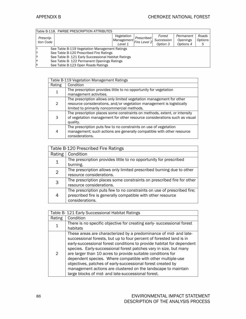
APPENDIX B CHEROKEE NATIONAL FOREST
86 ENVIRONMENTAL IMPACT STATEMENT DESCRIPTION OF THE ANALYSIS PROCESS
Table B-118. FWRBE PRESCRIPTION ATTRIBUTES
Prescrip-tion Code
Vegetation Management
Level 1
Prescribed Fire Level 2
Forest Succession
Option 3
Permanent Openings Options 4
Roads Options
5 1 See Table B-119 Vegetation Management Ratings 2 See Table B-120 Prescribed Fire Ratings 3 See Table B- 121 Early Successional Habitat Ratings 4 See Table B- 122 Permanent Openings Ratings 5 See Table B-123 Open Roads Ratings
Table B-119 Vegetation Management Ratings Rating Condition
1 The prescription provides little to no opportunity for vegetation management activities.
2 The prescription allows only limited vegetation management for other resource considerations, and/or vegetation management is logistically limited to primarily noncommercial methods.
3 The prescription places some constraints on methods, extent, or intensity of vegetation management for other resource considerations such as visual quality.
4 The prescription puts few to no constraints on use of vegetation management; such actions are generally compatible with other resource considerations.
Table B-120 Prescribed Fire Ratings Rating Condition
1 The prescription provides little to no opportunity for prescribed burning.
2 The prescription allows only limited prescribed burning due to other resource considerations.
3 The prescription places some constraints on prescribed fire for other resource considerations.
4 The prescription puts few to no constraints on use of prescribed fire; prescribed fire is generally compatible with other resource considerations.
Table B- 121 Early Successional Habitat Ratings Rating Condition
1 There is no specific objective for creating early- successional forest habitats
2
These areas are characterized by a predominance of mid- and late-successional forests, but up to four percent of forested land is in early-successional forest conditions to provide habitat for dependent species. Early-successional forest patches vary in size, but many are larger than 10 acres to provide suitable conditions for dependent species. Where compatible with other multiple-use objectives, patches of early-successional forest created by management actions are clustered on the landscape to maintain large blocks of mid- and late-successional forest.
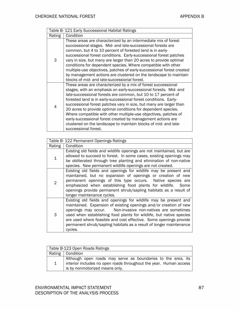
CHEROKEE NATIONAL FOREST APPENDIX B
ENVIRONMENTAL IMPACT STATEMENT 87 DESCRIPTION OF THE ANALYSIS PROCESS
Table B- 121 Early Successional Habitat Ratings Rating Condition
3
These areas are characterized by an intermediate mix of forest successional stages. Mid- and late-successional forests are common, but 4 to 10 percent of forested land is in early-successional forest conditions. Early-successional forest patches vary in size, but many are larger than 20 acres to provide optimal conditions for dependent species. Where compatible with other multiple-use objectives, patches of early-successional forest created by management actions are clustered on the landscape to maintain blocks of mid- and late-successional forest.
4
These areas are characterized by a mix of forest successional stages, with an emphasis on early-successional forests. Mid- and late-successional forests are common, but 10 to 17 percent of forested land is in early-successional forest conditions. Early-successional forest patches vary in size, but many are larger than 20 acres to provide optimal conditions for dependent species. Where compatible with other multiple-use objectives, patches of early-successional forest created by management actions are clustered on the landscape to maintain blocks of mid- and late-successional forest.
Table B- 122 Permanent Openings Ratings Rating Condition
1
Existing old fields and wildlife openings are not maintained, but are allowed to succeed to forest. In some cases, existing openings may be obliterated through tree planting and elimination of non-native species. New permanent wildlife openings are not created.
2
Existing old fields and openings for wildlife may be present and maintained, but no expansion of openings or creation of new permanent openings of this type occurs. Native species are emphasized when establishing food plants for wildlife. Some openings provide permanent shrub/sapling habitats as a result of longer maintenance cycles.
3
Existing old fields and openings for wildlife may be present and maintained. Expansion of existing openings and/or creation of new openings may occur. Non-invasive non-natives are sometimes used when establishing food plants for wildlife, but native species are used where feasible and cost effective. Some openings provide permanent shrub/sapling habitats as a result of longer maintenance cycles.
Table B-123 Open Roads Ratings Rating Condition
1 Although open roads may serve as boundaries to the area, its interior includes no open roads throughout the year. Human access is by nonmotorized means only.

APPENDIX B CHEROKEE NATIONAL FOREST
88 ENVIRONMENTAL IMPACT STATEMENT DESCRIPTION OF THE ANALYSIS PROCESS
Table B-123 Open Roads Ratings Rating Condition
2
Density of open roads and/or motorized trails decreases over time as roads and/or trails that are unneeded or are causing undesirable resource impacts are closed. This decrease results in improvements in remote recreational opportunity, habitat for disturbance-sensitive wildlife, and water quality.
3 Density of open roads and/or motorized vehicle trails remains near the current level throughout the planning period, with only small increases or decreases.
4 Density of open roads and/or motorized vehicle trails may increase to provide improved access to national forest resources and recreational opportunity.
The following tables are used in the socio-economic analysis
Table 124 Budget and Employment Data Resource Units Alt. F Alt. A Alt. B Alt. D Alt. E Alt. G Alt. I
Recreation M $ $1478 $1684 $1478 $1478 $1678 $1478 $1678 Timber M $ 887 1157 1210 1315 842 892 1052 SWA M $ 243 243 195 267 243 170 243 Range M $ 0 0 0 0 0 0 0 Minerals M $ 46 46 46 46 46 46 46 Wildlife & Fish M $ 790 1061 1110 1206 772 859 965 Roads & Engineering M $ 2121 2482 2473 3095 1984 2132 2502
Protection (Fire & For. Health) M $ 2057 2057 2057 2057 2057 2057 2057
Lands (includes Lands and WCF) M $ 554 554 554 554 554 554 554
Plan, Inv. Monitor M $ 595 819 819 819 819 819 655 Employment Permanent Persons 179 176 172 173 176 172 173 Other than Permanent Persons 144 220 144 144 210 180 180

CHEROKEE NATIONAL FOREST APPENDIX B
ENVIRONMENTAL IMPACT STATEMENT 89 DESCRIPTION OF THE ANALYSIS PROCESS
TABLE B-125. COUNTY AND STATE POPULATION CHARACTERISTICS OF COUNTIES WITH NATIONAL FOREST LAND, 1980
Persons White Black Other Race % Minority
State of Tennessee 4,591,000 3,835,500 725,940 63,803 17.2
Tennessee Counties Carter 50,205 49,647 426 352 1.5 Cocke 28,792 28,020 668 332 3.5 Greene 54,422 53,010 1,233 489 3.2 Johnson 13,745 13,623 86 117 1.5 McMinn 41,878 39,629 2,043 431 5.9 Monroe 28,700 27,745 888 229 3.9 Polk 13,602 13,566 5 79 0.6 Sullivan 143,970 140,860 2,607 1,131 2.6 Unicoi 16,362 16,300 4 158 1.0 Washington 88,755 85,269 3,004 946 4.5 North Carolina County Ashe 22,325 22,097 182 141 1.4
FOREST COUNTY TOTAL 22,325 22,097 182 141 3.1 FOREST COUNTY AVERAGE 45,705 44,524 1,013 400 3.1
Source: U.S. Bureau of Census.
TABLE B-126. COUNTY AND STATE POPULATION CHARACTERISTICS OF COUNTIES WITH NATIONAL FOREST LAND, 1990 Persons White Black Other Race % Minority
State of Tennessee 4,591,000 3,835,500 725,940 63,803 17.2
Tennessee Counties Carter 50,205 49,647 426 352 1.5 Cocke 28,792 28,020 668 332 3.5 Greene 54,422 53,010 1,233 489 3.2 Johnson 13,745 13,623 86 117 1.5 McMinn 41,878 39,629 2,043 431 5.9 Monroe 28,700 27,745 888 229 3.9 Polk 13,602 13,566 5 79 0.6 Sullivan 143,970 140,860 2,607 1,131 2.6 Unicoi 16,362 16,300 4 158 1.0 Washington 88,755 85,269 3,004 946 4.5 North Carolina County Ashe 22,325 22,097 182 141 1.4
FOREST COUNTY TOTAL 22,325 22,097 182 141 3.1
FOREST COUNTY AVERAGE 45,705 44,524 1,013 400 3.1

APPENDIX B CHEROKEE NATIONAL FOREST
90 ENVIRONMENTAL IMPACT STATEMENT DESCRIPTION OF THE ANALYSIS PROCESS
TABLE B-128. PERCENT CHANGE 1980–2000
% Change 1980–1990 % Change 1990–00
Population Minority Population Population Minority
Population State of Tennessee 6.2 5.0 16.7 28.2% Tennessee Counties Carter 2.6 0.8 10.2 25.3% Cocke 1.2 -30.5 15.2 39.1% Greene 2.6 -8.5 12.6 20.4% Johnson 0.2 -57.1 27.1 531.0% McMinn 1.2 -11.1 15.6 38.7% Monroe 6.4 -14.7 27.6 58.1% Polk 0.3 -22.6 17.6 58.5% Sullivan -0.3 -7.2 6.6 21.4% Unicoi 1.1 -74.7 6.8 492.7% Washington 4.0 -6.6 16.1 54.2% North Carolina County Ashe -0.5 -18.6 9.8 111.8%
FOREST COUNTY AVERAGE 1.7 -11.1 12.8 42.9%
TABLE B-127. COUNTY AND STATE POPULATION CHARACTERISTICS OF COUNTIES WITH NATIONAL FOREST LAND, 2000 Persons White Black Other Race % Minority
State of Tennessee 5,689,283 4,626,419 932,809 130,055 18.7
Tennessee Counties Carter 56,742 55,760 566 416 1.7 Cocke 33,565 32,598 669 298 2.9 Greene 62,909 61,012 1,329 568 3.0 Johnson 17,499 16,950 424 125 3.1 McMinn 49,015 45,964 2,195 856 6.2 Monroe 38,961 37,454 884 623 3.9 Polk 16,050 15,947 22 81 0.6 Sullivan 153,048 148,834 2,688 1,326 2.8 Unicoi 17,667 17,424 12 231 1.4 Washington 107,198 101,508 4,091 1,599 5.3 North Carolina County Ashe 24,384 23,827 182 395 2.3 FOREST COUNTY TOTAL 577.038 557,278 13,242 6,518 3.4
FOREST COUNTY AVERAGE 52,458 50,661 1,204 593 3.4

CHEROKEE NATIONAL FOREST APPENDIX B
ENVIRONMENTAL IMPACT STATEMENT 91 DESCRIPTION OF THE ANALYSIS PROCESS
TABLE B-129. COUNTY AND STATE POPULATION CHARACTERISTICS OF COUNTIES WITH NATIONALFOREST LAND, 1980, 1990, AND 2000
Population Density
1980 1990 1980–90 2000 1990–00 Area in Sq. Miles
Person/ Sq. Mi.
Person/ Sq. Mi. % of Change Person/ Sq.
Mi. % of Change
State of Tennessee 41219.5 111.4 118.3 6.2 138.0 16.7
Tennessee Counties Carter 341 147.2 151.0 2.6 166.4 1.7 Cocke 434 66.3 67.1 1.2 77.3 2.9 Greene 622 87.5 89.8 2.6 101.1 3.0 Johnson 298 46.1 46.2 0.2 58.7 3.1 McMinn 430 97.4 98.6 1.2 114.0 6.2 Monroe 635 45.2 48.1 6.4 61.4 3.9 Polk 435 31.3 31.4 0.3 36.9 0.6 Sullivan 413 348.6 347.7 -0.3 370.6 2.8 Unicoi 186 88.0 89.0 1.1 95.0 1.4 Washington 326 272.3 283.2 4.0 328.8 5.3
North Carolina County
Ashe 426 52.4 52.1 -0.5 57.2 2.3 FOREST COUNTY TOTAL 426 110.6 112.5 1.7 126.9 1.1
FOREST COUNTY AVERAGE 413 N/A N/A N/A N/A N/A
N/A = Not Applicable or Not Available Source: U.S. Bureau of Census.

APPENDIX B CHEROKEE NATIONAL FOREST
92 ENVIRONMENTAL IMPACT STATEMENT DESCRIPTION OF THE ANALYSIS PROCESS
TABLE B-130. COUNTY AND STATE POPULATION CHARACTERISTICS OF COUNTIES WITH NATIONAL FOREST LAND, 1980 AND 1990 (URBAN/RURAL)
1980 1990 Urban Rural % Rural Urban Rural % Rural
State of Tennessee 2,773,600 1,817,500 39.6 2,969,948 1,907,237 39.1
Tennessee Counties Carter 25,911 24,294 48.4 26,128 25,377 49.3 Cocke 7,580 21,212 73.7 7,123 22,018 75.6 Greene 14,097 40,325 74.1 13,532 42,321 75.8 Johnson 0 13,745 100.0 0 13,766 100.0 McMinn 15,838 26,040 62.2 15,881 26,502 62.5 Monroe 7,609 21,091 73.5 8,087 22,454 73.5 Polk 0 13,602 100.0 0 13,643 100.0 Sullivan 106,320 37,653 26.2 103,352 40,244 28.0 Unicoi 7,652 8,710 53.2 5,015 11,534 69.7 Washington 57,242 31,513 35.5 61,474 30,841 33.4 North Carolina County
Ashe 0 22,325 100.0 0 22,209 100.0
FOREST COUNTY TOTAL 0 22,325 51.8 0 22,209 53.0
FOREST COUNTY AVERAGE 22,023 23,683 51.8 21,872 24,628 53.0
Source: U.S. Bureau of Census.

CHEROKEE NATIONAL FOREST APPENDIX B
ENVIRONMENTAL IMPACT STATEMENT 93 DESCRIPTION OF THE ANALYSIS PROCESS
TABLE B-131. COUNTY AND STATE UNEMPLOYMENT/INCOME IN COUNTIES WITH NATIONAL FOREST LANDS, 1980 AND 1990
1980 1990 Real Average Annual Income
Unemployment%
Per Capita Income
Median Income
Unemployment %
Per Capita Income
Median Income
% Change 1980–90 Per Capita
Income
% Change 1980–90 Median Income
State of Tennessee 7.3 $6,212 $16,564 5.1 $12,255 $29,546 2.2 1.2
Tennessee Counties Carter 7.6 $4,923 $13,240 6.2 $9,809 $22,520 2.3 0.7 Cocke 17.6 $4,412 $11,933 12.2 $8,574 $20,644 2.0 0.8 Greene 8.2 $5,216 $14,544 6.9 $10,161 $25,600 2.1 1.0 Johnson 7.0 $4,084 $11,058 13.4 $7,531 $18,024 1.5 0.2 McMinn 9.5 $5,791 $15,980 6.0 $10,508 $26,207 1.3 0.3 Monroe 13.5 $4,970 $13,497 7.6 $9,080 $22,999 1.4 0.7 Polk 10.2 $4,661 $13,972 10.5 $9,311 $23,934 2.3 0.7 Sullivan 5.5 $6,497 $17,807 3.7 $12,725 $30,167 2.1 0.6 Unicoi 8.2 $5,237 $14,191 7.1 $10,727 $26,283 2.6 1.5 Washington 6.4 $6,397 $16,473 4.5 $11,949 $29,701 1.6 1.3
North Carolina County
Ashe 10.5 $4,652 $11,835 4.7 $9,545 $22,695 2.6 1.9
FOREST COUNTYTOTAL N/A N/A N/A N/A N/A N/A N/A N/A
FOREST COUNTYAVERAGE N/A $5,167 $14,048 7.5 $9,993 $24,434 2.0 0.9
N/A = Not Applicable or Not Available Source: U.S. Bureau of Census

APPENDIX B CHEROKEE NATIONAL FOREST
94 ENVIRONMENTAL IMPACT STATEMENT DESCRIPTION OF THE ANALYSIS PROCESS
TABLE B-132. PEOPLE OF ALL AGES IN POVERTY, 1989 AND 1995
1989 Percentage 1995 Percentage
Estimate 90% Confidence Interval Estimate 90% Confidence
Interval State of Tennessee 15.7 15.6 to 15.8 14.7 13.9 to 15.5
Tennessee Counties Carter 18 17.0 to 19.0 17.1 13.7 to 20.5 Cocke 25.3 23.8 to 26.8 21.7 17.4 to 26.1 Greene 16.9 16.1 to 17.7 16.2 13.0 to 19.4 Johnson 28.5 26.5 to 30.5 23.3 18.4 to 28.1 McMinn 17.2 16.2 to 18.2 14.6 11.7 to 17.5 Monroe 17.8 16.5 to 19.1 17.9 14.3 to 21.5 Polk 18.3 16.6 to 20.0 16.2 12.9 to 19.4 Sullivan 13.6 13.1 to 14.1 13.6 10.9 to 16.2 Unicoi 17.1 15.3 to 18.8 15.1 12.0 to 18.1 Washington 15.5 14.8 to 16.3 13.9 11.2 to 16.7
North Carolina County Ashe 18.4 17.1 to 19.8 15.5 12.4 to 18.6
SIMPLE AVERAGE 18.8 16.8
Source: U.S. Bureau of Census, Small Area Income and Poverty Estimates Program

CHEROKEE NATIONAL FOREST APPENDIX B
ENVIRONMENTAL IMPACT STATEMENT 95 DESCRIPTION OF THE ANALYSIS PROCESS
TABLE B-133. HOUSEHOLD DATA, 1980 AND 1990
65+ Households % Change Persons per Household % of All Households
Female
1980–90 1980 1990 1980 1990 State of Tennessee 17.7% 2.77 2.56 6.2% 6.7% Tennessee Counties Carter 23.2% 2.76 2.49 4.4% 4.3% Cocke 13.4% 2.83 2.58 6.1% 6.4% Greene 19.2% 2.76 2.52 4.0% 5.1% Johnson 19.3% 2.83 2.52 4.8% 5.5% McMinn 17.6% 2.81 2.55 1.4% 1.6% Monroe 23.6% 2.93 2.63 4.4% 4.8% Polk 20.7% 2.95 2.66 4.7% 3.4% Sullivan 31.3% 2.75 2.49 4.4% 4.5% Unicoi 21.9% 2.74 2.46 3.3% 3.3% Washington 29.3% 2.71 2.45 5.0% 5.1%
North Carolina County
Ashe 16.2% 2.77 2.48 3.0% 3.5%
CHEROKEE NF TOTAL 24.3% 4.2% 4.5%
CHEROKEE NF AVERAGE 24.3% 2.80 2.50 4.2% 4.5%
Source: U.S. Bureau of Census

APPENDIX B CHEROKEE NATIONAL FOREST
96 ENVIRONMENTAL IMPACT STATEMENT DESCRIPTION OF THE ANALYSIS PROCESS
TABLE B-134. HOUSING DATA, 1980, 1990, AND 2000 Total Housing Units Housing Units
% of Change Median Value 1980 1990 2000 1970–
80 1980–
90 1990-
00 1980 1990
State of Tennessee 1,747,390 2,026,067 2,32,905 34.3 15.9 20.4 $35,600 $58,400
Tennessee Counties Carter 19,315 21,779 23,486 31.2 12.8 19.0 $27,800 $43,800Cocke 11,305 12,282 13,762 38.6 8.6 29.0 $26,100 $40,300Greene 21,132 23,270 25,756 31.9 10.1 20.8 $30,200 $44,500Johnson 5,385 6,090 6,827 31.7 13.1 29.4 $25,900 $41,300McMinn 15,797 17,616 19,721 30.8 11.5 22.8 $30,300 $45,600Monroe 11,002 12,803 15,329 42.2 16.4 35.0 $26,800 $40,200Polk 5,090 5,659 6,448 28.7 11.2 30.2 $21,100 $37,800Sullivan 54,976 60,623 63,556 30.3 10.3 13.9 $36,700 $55,600Unicoi 6,400 7,076 7,516 23.2 10.6 16.1 $30,600 $48,100Washington 33,673 38,378 44,195 38.9 14.0 24.5 $37,300 $57,300North Carolina County Ashe 9,525 11,119 10,411 35.7 16.7 19.3 $33,200 $57,600CHEROKEE NF TOTAL 193,600 216,695 237,007 33.2 11.9 21.1CHEROKEE NF AVERAGE 17,600 19,700 21,546 33.2 11.9 21.1 $29,636 $46,555
Source: U.S. Bureau of Census.

CHEROKEE NATIONAL FOREST APPENDIX B
ENVIRONMENTAL IMPACT STATEMENT 97 DESCRIPTION OF THE ANALYSIS PROCESS
TABLE B-135. PERSONAL INCOME AND TRANSFER PAYMENTS, 1990 AND 1997
Per Capita Personal Income % of Change
Per Capita Government Transfer Payment
1990 1997 1990–97 1990 1997 1990–97 State of Tennessee $16,309 $22,699 4.8% $2,604 $4,079 6.6% Tennessee Counties Carter $11,899 $15,482 3.8% $2,407 $4,708 9.1% Cocke $11,638 $15,703 4.4% $2,583 $3,909 7.2% Greene $13,356 $17,841 4.2% $2,411 $4,894 9.6% Johnson $9,868 $12,447 3.4% $3,130 $4,016 7.6% McMinn $13,872 $17,512 3.4% $2,549 $4,833 6.4% Monroe $11,643 $16,187 4.8% $2,556 $3,983 6.6% Polk $11,835 $17,098 5.4% $2,939 $4,036 6.7% Sullivan $16,844 $22,133 4.0% $2,589 $4,797 7.2% Unicoi $14,055 $18,208 3.8% $3,130 $4,140 6.9% Washington $15,958 $21,637 4.4% $2,699 $4,977 6.9% North Carolina County Ashe $13,093 $18,523 5.1% $2,554 $4,154 6.4% CHEROKEE NF AVERAGE $13,096 $17,525 4.2% $2,686 $4,404 7.3% NOTE: Dollars are in nominal terms (year of occurrence). Source: U.S. Department of Commerce, Bureau of Economic Analysis, Regional Economic InformationSystem database.
TABLE B-136. COUNTY EMPLOYMENT AND UNEMPLOYMENT RATES, 1997 Unemployment Rate 1997 (f/d) % State of Tennessee 5.4 Tennessee Counties Carter 7.2 Cocke 9.9 Greene 9.4 Johnson 9.4 McMinn 8.0 Monroe 9.1 Polk 7.8 Sullivan 3.9 Union 3.6 Washington 4.2
North Carolina County Ashe 9.4 COUNTY TOTAL 6.4
COUNTY AVERAGE 6.4
Source: U.S. Bureau of Labor Statistics Local Area Unemployment.

APPENDIX B CHEROKEE NATIONAL FOREST
98 ENVIRONMENTAL IMPACT STATEMENT DESCRIPTION OF THE ANALYSIS PROCESS
TABLE B-137. DIVERSITY OF THE CHEROKEE NF ANALYSIS AREA’S ECONOMY BY MAJOR INDUSTRY SECTOR, 1985 AND 1996
Industry Industry Output
% of Output Total
Industry Output
% of Output Total
Employment % of Total Employment % of Total
Total Income
% of Total
Total Income
% of Total
1985* 1996* 1985 1996 1985 1996 Agriculture $402.6 2.8 $579.9 2.6 $10,315 5.0 $12,339 2.6 $86.8 2.4 $226.3 4.3 Mining $29.4 0.2 $23.2 0.1 $402 0.2 $201 0.1 $5.2 0.1 $12.7 0.1 Construction $664.4 4.6 $1,623.9 7.4 $10,230 5.0 $20,989 7.4 $138.9 3.9 $603.6 7.3 Other Manufacturing $7,245.3 49.8 $8,171.5 37.3 $64,906 31.7 $57,940 37.3 $1,303.3 36.3 $2,968.8 20.1 Mfg.—SIC 24 Lumber & Wood Prods. $134.8 0.9 $231.0 1.1 $2,426 1.2 $1,969 1.1 $78.0 2.2 $75.8 0.7
Mfg.—SIC 25 Wood Furniture & Fixtures $193.6 1.3 $489.1 2.2 $3,813 1.9 $4,613 2.2 $0.9 0.0 $165.4 1.6
Mfg.—SIC 26 Paper & Pulp Products $634.7 4.4 $769.9 3.5 $4,151 2.0 $3,748 3.5 $10.4 0.3 $275.8 1.3
Total Manufacturing $8,208.4 56.4 $9,661.5 44.1 $75,296 36.8 $68,270 44.1 $1,392.6 38.8 $3,485.9 23.7 Transportation & Utilities—Non-Tourism $691.2 4.7 $1,279.1 5.8 $7,619 3.7 $9,720 5.8 $380.7 10.6 $605.3 3.4
Finance, Insurance, Real Estate $572.7 3.9 $1,608.6 7.3 $8,155 4.0 $12,084 7.3 $214.2 6.0 $1,019.1 4.2
Services—Non-Tourism $1,192.5 8.2 $3,317.5 15.1 $28,841 14.1 $66,866 15.1 $277.1 7.7 $1,928.2 23.2 Wholesale & Retail Trade—Non-Tourism $1,508.1 10.4 $2,153.5 9.8 $33,797 16.5 $54,282 9.8 $338.1 9.4 $1,213.4 18.8
Recreational Related Wholesale $1.3 0.0 $0.0 0.0 $24 0.0 $0 0.0 $1.0 0.0 $0.0 0.0
Recreational Related Retail Trade $13.2 0.1 $0.0 0.0 $357 0.2 $0 0.0 $2.8 0.1 $0.0 0.0
Local, Interurban Passenger Transit $1.1 0.0 $9.7 0.0 $25 0.0 $332 0.0 $0.0 0.0 $6.2 0.1
Recreation Related Industries Air Transportation $8.6 0.1 $8.3 0.0 $11 0.0 $88 0.0 $0.3 0.0 $4.0 0.0 Wholesale & Retail Trade $63.4 0.4 $57.4 0.3 $1,412 0.7 $982 0.3 $15.9 0.4 $32.8 0.3
General Merchandise $0.0 0.0 $9.9 0.0 $0 0.0 $324 0.0 $0.0 0.0 $5.8 0.1

CHEROKEE NATIONAL FOREST APPENDIX B
ENVIRONMENTAL IMPACT STATEMENT 99 DESCRIPTION OF THE ANALYSIS PROCESS
TABLE B-137. DIVERSITY OF THE CHEROKEE NF ANALYSIS AREA’S ECONOMY BY MAJOR INDUSTRY SECTOR, 1985 AND 1996
Industry Industry Output
% of Output Total
Industry Output
% of Output Total
Employment % of Total Employment % of Total
Total Income
% of Total
Total Income
% of Total
1985* 1996* 1985 1996 1985 1996 Stores Food Stores $0.0 0.0 $10.2 0.0 $0 0.0 $390 0.0 $0.0 0.0 $7.1 0.1 Eating & Drinking $53.5 0.4 $81.9 0.4 $1,233 0.6 $2,511 0.4 $6.3 0.2 $35.0 0.9 Miscellaneous Retail $0.0 0.0 $11.5 0.1 $0 0.0 $412 0.1 $0.0 0.0 $7.8 0.1 Hotels & Lodging Places $19.8 0.1 $26.9 0.1 $522 0.3 $650 0.1 $3.2 0.1 $11.9 0.2
Laundry, Cleaning & Shoe Repair $3.8 0.0 $5.6 0.0 $153 0.1 $228 0.0 $0.8 0.0 $3.7 0.1
Automobile Rental & Leasing $2.6 0.0 $2.2 0.0 $26 0.0 $228 0.0 $0.0 0.0 $1.1 0.0
Automobile Repair & Services $9.3 0.1 $15.2 0.1 $138 0.1 $212 0.1 $1.8 0.0 $6.3 0.1
Amusement & Recreation Services, N.E.C.
$2.9 0.0 $17.4 0.1 $114 0.1 $594 0.1 $1.2 0.0 $9.1 0.2
Total Tourism Estimate $179.7 1.2 $256.2 1.2 $4,014 2.0 $6,750 1.2 $33.3 0.9 $130.8 2.3
Government $1,092.2 7.5 $1,378.2 6.3 $24,211 11.8 $34,797 6.3 $700.6 19.5 $1,189.4 12.1 Other—Miscellaneous $20.9 0.1 $42.5 0.2 $1,658 0.8 $1,689 0.2 $20.6 0.6 $42.5 0.6 *Dollars in Millions Source: 1985 and 1996 IMPLAN Data.


CHEROKEE NATIONAL FOREST APPENDIX B
ENVIRONMENTAL IMPACT STATEMENT 101 DESCRIPTION OF THE ANALYSIS PROCESS
TABLE B-138. NET EXPORTS, 1985 AND 1996 Net Exports—Exports
Less Imports
Net Exporting Industries as a Percentage of Total Positive
Exporting Industries Commodity 1985 1996 1985 1996
Agriculture -$81.7 -$84.2 0.0 0.0 Mining -$502.7 $386.1 0.0 9.5 Construction -$67.0 -$216.9 0.0 0.0 Other Manufacturing $1,906.6 -$1,132.7 65.8 0.0 Mfg.—SIC 24 Lumber & Wood Prods. -$10.6 $46.5 0.0 1.1 Mfg.—SIC 25 Wood Furniture & Fixtures $142.6 -$264.7 4.9 0.0 Mfg.—SIC 26 Paper & Pulp Products $249.5 -$351.4 8.6 0.0 Total Manufacturing $2,288.1 -$1,702.2 78.9 0.0 Existing in Tourism Estimate: Transportation & Utilities -$1.9 $418.9 0.0 10.3 Local, Interurban Passenger Transit -$85.6 $13.1 0.0 0.3 Air Transportation -$85.6 $107.1 0.0 2.6 Wholesale & Retail Trade—Non-Tourism -$254.1 $581.0 0.0 14.3 Recreation Related Wholesale Trade -$6.1 $0.0 0.0 0.0 Recreation Related Retail Trade -$8.5 $0.0 0.0 0.0 General Merchandise Stores $0.0 $32.0 0.0 0.8 Food Stores $0.0 $57.4 0.0 1.4 Eating & Drinking $33.1 -$72.6 1.1 0.0 Miscellaneous Retail $0.0 $51.0 0.0 1.3 Finance, Insurance, and Real Estate -$1,045.3 $1,472.2 0.0 36.2 Hotels and Lodging Places -$32.3 $105.9 0.0 2.6 Laundry, Cleaning, and Shoe Repair $11.5 -$13.8 0.4 0.0 Services—Non-Tourism -$546.7 $617.4 0.0 15.2 Automobile Rental and Leasing -$19.4 $44.2 0.0 1.1 Automobile Repair and Services -$42.0 $32.3 0.0 0.8 Amusement and Recreation Services, N.E.C. -$7.3 $32.5 0.0 0.8
Total for Commodities in Tourism Estimate (ex, 433, 447, 456, 465) -$242.2 $389.0 0.0 9.6
Commodities for 433, 447, 456, 465 -$1,847.9 $3,089.5 0.0 76.0 Estimate of Trade in Tourism Estimate -$23.3 $37.0 0.0 0.9 Government $555.2 -$70.8 19.2 0.0 Other—Miscellaneous -$141.1 $68.0 0.0 1.7 TOTAL NET TRADE (EXPORTS) -$39.2 $1,858.6 100.0 100.0 TOTAL POSITIVE TRADE INDUSTRIES (EXPORTS) $2,898.4 $4,065.5
NOTE: 1996 IMPLAN did not have Recreation Related Wholesale and Retail Trade.
TABLE B-139. PAYMENT IN LIEU OF TAXES PAYMENTS TO COUNTIES, 1990 AND 1999 Payments % of Change
1990 1999 1990–99 State of Tennessee $501,796 $699,638 39.4 Tennessee Counties Carter $13,279 $39,472 197.3 Cocke $21,353 $36,815 72.4

APPENDIX B CHEROKEE NATIONAL FOREST
102 ENVIRONMENTAL IMPACT STATEMENT DESCRIPTION OF THE ANALYSIS PROCESS
TABLE B-139. PAYMENT IN LIEU OF TAXES PAYMENTS TO COUNTIES, 1990 AND 1999 Payments % of Change
1990 1999 1990–99 Greene $5,997 $17,820 197.1 Johnson $8,027 $23,914 197.9 McMinn $345 $1,016 194.5 Monroe $22,913 $67,397 194.1 Polk $23,866 $70,201 194.1 Sullivan $5,888 $17,339 194.5 Unicoi $8,353 $25,840 209.3 Washington $2,713 $7,647 181.9
North Carolina County
Ashe $4,184 $1,421 -66.0 FOREST COUNTY TOTAL $116,918 $308,882 164.2 FOREST COUNTY TOTAL AS %OF STATE TOTAL 23.3% 44.1% —
Source: U.S. Bureau of Land Management.
TABLE B-140. 25 PERCENT PAYMENTS BY COUNTY WITH NATIONAL FOREST LANDS, 1986, 1989, 1992, 1995, 1997 Counties
within National Forest
Boundary
1986 1989 1992 1995 1997
% Change 1986–
97
Tennessee Counties Carter $65,471. $58,855 $68,845 $59,129 $59,121 -9.7 Cocke $34,925 $31,399 $37,338 $34,105 $34,376 -1.6 Greene $29,579 $26,513 $30,986 $26,822 $26,665 -9.8 Johnson $39,584 $35,563 $41,682 $35,934 $35,789 -9.6 McMinn $1,706 $1,529 $1,786 $1,530 $1,520 -10.9 Monroe $113,349 $101,514 $118,548 $101,554 $100,915 -11.0 Polk $117,963 $105,736 $123,479 $105,778 $105,113 -10.9 Sullivan $29,101 $26,085 $30,470 $26,127 $25,962 -10.8 Unicoi $42,381 $38,231 $44,699 $39,449 $39,229 -7.4 Washington $13,410 $12,020 $14,037 $11,521 $11,448 -14.6 North Carolina County Ashe $254 $228 $266 $228 $226 -10.9 FOREST COUNTY TOTAL
$487,728 $437,678 $512,141 $442,180 $440,371 -9.7
Source: USDA Forest Service, Rocky Mountain Research Station.

CHEROKEE NATIONAL FOREST APPENDIX B
ENVIRONMENTAL IMPACT STATEMENT 103 DESCRIPTION OF THE ANALYSIS PROCESS
TABLE B-141. LAND-USE PERCENT, 1982 AND 1992
% Share
Forest Farm Urban Residual Counties within National
Forest Boundary Acres
1982 1992 1982 1992 1982 1992 1982 1992 Tennessee Counties Carter 931,640,000 20.6 19.9 33.3 31.8 4.7 6.1 41.4 42.2Cocke 1,177,760,000 33.2 33.5 36.5 36.4 1.9 2.7 28.4 27.4Greene 1,602,720,000 57.4 56.9 24.2 23.1 3.0 3.8 15.4 16.2Johnson 785,820,000 21.3 20.4 48.0 47.7 1.4 2.2 29.3 29.8McMinn 1,109,940,000 41.1 39.0 46.7 46.4 4.1 4.8 8.1 9.8Monroe 1,717,280,000 32.3 32.1 26.5 26.1 1.8 2.0 39.4 39.8Polk 1,143,730,000 14.5 15.3 21.5 20.7 1.7 2.7 62.4 61.4Sullivan 1,105,730,000 35.7 32.6 28.0 26.9 14.3 18.5 22.0 22.0Unicoi 518,190,000 11.1 9.0 35.8 34.7 3.7 5.4 49.5 51.0Washington 844,090,000 57.7 54.7 15.6 14.9 8.0 10.5 18.7 19.9North Carolina County
Ashe 1,123,970,000 31.8 30.2 59.0 59.0 3.0 4.3 6.2 6.6
ACRES WITHIN FORESTBOUNDARY 12,060,870,000
WEIGHTED AVERAGEFOR FOREST 34.4 33.3 33.3 32.6 4.1 5.4 28.2 28.6
Source: Natural Resource Information System
TABLE B-142. SHANNON-WEAVER ENTROPHY INDICIES Forest Boundary Counties 1977 Four Digit SIC 1993 Four Digit SIC
Tennessee Counties Carter 0.50839 0.59960 Cocke 0.57273 0.62677 Greene 0.60760 0.63824 Johnsonn 0.37700 0.55403 Mcminn 0.56874 0.64269 Monroe 0.51297 0.62226 Polk 0.39216 0.53718 Sullivan 0.56289 0.66452 Unicoi 0.50283 0.60532 Washington 0.56447 0.66557 North Carolina Counties Ashe 0.50801 0.59654 Forest Boundary Area Weighted Average 0.55210 0.64380
TENNESSEE 0.66887 0.74161 UNITED STATES 0.66483 0.73973 Source: USDA Forest Service, IMI

APPENDIX B CHEROKEE NATIONAL FOREST
104 ENVIRONMENTAL IMPACT STATEMENT DESCRIPTION OF THE ANALYSIS PROCESS
TABLE B-143. PERCENTAGE OF LOCAL RESIDENTS 16 OR OLDER INDICATING THE STATED MANAGEMENT OBJECTIVE IS IMPORTANT AND PERCENTAGE INDICATING EXTREMELY IMPORTANT BY FOREST, SUBREGION, AND REGIONWIDE IN THE SOUTHERN APPALACHIANS
Forests
Forest Management Objective Cherokee (N=2352)
Nantahala (N=2080)
Pisgah (N=1704)
Combined Forests
Subregion
Southern Appa-
lachian Region
Protect streams, lakes, and watershed areas 93.0/79.2 93.0/79.6 94.5/80.2 93.3/80.2 91.9/79.2
Protect wildlife habitats 91.0/74.5 91.0/73.6 91.4/74.7 91.2/74.0 89.9/72.7 Protect old growth forests 86.0/67.4 86.3/67.6 87.3/68.5 86.3/67.9 85.3/66.2 Habitat for wildlife and bird viewing 84.9/61.4 84.2/61.5 86.7/64.8 84.9/62.2 84.0/61.4
Allow cultural uses of forests 75.3/53.3 73.9/50.5 76.3/55.2 75.2/52.9 72.5/51.3 Open areas for wildlife 75.8/49.7 72.9/47.9 76.5/49.6 74.5/48.7 73.9/48.4 Use controlled fires 74.3/53.4 72.6/50.3 74.6/56.6 73.9/52.5 74.5/53.2 Trail systems for non-motorized recreation 71.3/41.0 69.9/40.6 71.1/39.9 71.0/40.2 68.7/39.5
Designate more areas as wilderness 67.3/42.0 68.4/42.5 67.4/41.8 68.4/41.7 67.1/41.4
Restrict mineral removals 66.5/51.6 66.5/50.2 66.9/52.5 66.5/51.1 64.1/48.6 Increase law enforcement 68.0/48.2 63.8/44.7 68.0/47.6 66.4/46.8 67.8/48.2 Increase acres in the National Forest 66.4/44.8 65.3/43.7 64.5/43.3 66.2/44.7 65.2/44.1
Allow diversity of uses such as grazing, recreation, and wildlife habitat
63.9/36.8 64.7/35.8 65.6/38.4 64.8/37.5 65.0/36.6
Make management decisions at the local level 64.2/35.9 63.2/34.5 66.8/40.0 64.0/35.8 63.8/37.1
Allow recreation fees that go back to management 59.3/33.8 59.8/33.6 61.2/36.5 59.2/33.9 58.6/32.9
Allow management activities near streams 59.6/33.8 56.8/31.1 61.1/35.3 58.1/32.8 60.9/35.5
Limit people who visit wilderness 49.8/26.4 51.1/27.2 50.8/27.7 50.6/27.0 48.0/26.2
Limit people on a river at one time 48.1/27.7 49.5/29.7 47.9/26.6 49.1/28.8 47.2/28.8
Trade public for private lands to eliminate in-holdings or acquire natural areas
45.4/23.2 45.7/22.6 48.0/25.4 45.7/23.4 44.8/22.9
Increase wildlife for hunting 44.4/25.0 41.3/24.2 46.6/27.7 43.9/25.3 46.6/27.8
Allow harvesting and mining to support communities 33.7/18.5 32.4/16.5 36.0/21.0 34.5/18.6 36.2/20.1
Expand commercial recreation services 34.6/19.1 31.1/17.8 33.5/18.3 34.2/18.9 36.3/20.2
New paved roads for cars 31.3/19.5 30.3/17.8 34.0/20.4 32.0/19.3 34.5/20.0
Allow recreational gold prospecting and dredging 23.1/12.0 23.2/12.6 23.8/12.8 22.7/12.3 24.2/11.7
Expand access for motorized off-highway vehicles 22.7/12.4 21.5/11.7 23.7/13.2 22.6/12.4 22.8/13.1
Allow commercial leasing of oil and gas rights 18.6/11.2 17.6/10.0 20.5/12.2 18.7/11.1 19.7/11.6
CHEROKEE NATIONAL FOREST
ENVIRONMENTAL IMPACT STATEMENT 105 ROADLESS AREA EVALUATIONS
APPENDIX C: ROADLESS AREA EVALUATIONS
NAME: BALD MOUNTAIN ID. NUMBER: 04007
1. OVERVIEW
a. ACRES: Forest Service 11,708 (Tennessee portion only) Private 36 Total 11,744
This study includes only acres in the Tennessee portion of Bald Mountain roadless area.
b. LOCATION, VICINITY AND ACCESS: Bald Mountain roadless area is located in CNF, Nolichucky/Unaka Ranger District, Greene County, Tennessee. This area adjoins 10,971 acres on Pisgah National Forest in Madison County, North Carolina; the entire 22,988 acres is known as Bald Mountain roadless area. The portion in CNF is generally bounded by Forest Development Road (FDR) 331 (Jennings Creek) to the north; FDR 94 (Horse Creek Four-Wheel Drive Road) to the north and east; the Appalachian National Scenic Trail (A.T.: FDT 1), the Tennessee - North Carolina state line, utility corridor, and private land to the east; FDR 98 (Greene Mountain Road) to the south; and private property, Davis Creek, and Round Knob Branch to the west. The area is found within U.S.G.S. Tennessee - North Carolina Quadrangles Greystone and Davey Crockett Lake. Major vehicle access is provided by FDR 42, Upper Paint Creek, 0.33 miles; FDR 88, Greystone, 0.74 miles; FDR 94, Horse Creek, 3.22 miles; FDR 98, 0.27 miles; FDR 120, 0.66 miles; FDR 331, Old Forge Road, 0.74 miles; FDR 358, Firescald Road, 2.20 miles; FDR 358A, Kennedy Cabin Road, 0.67 miles; FDR 5092, Rocky Ridge Road 0.41 miles; Camp Creek Road, 0.60 miles and an additional 0.75 miles of undesignated road.
There are several forest trails within the roadless area; including 1.33 miles of FDT 1 (A.T.). A 2.20 mile OHV trail, Bullen Hollow (FDT 2) is located in the area. A number of horse trails and sections of horse trails are concentrated in this area; this designation also allows bicyclists. These are FDT 13, Greene Mountain, 2.74 miles; FDT 21 - Jennings Creek, 0.76 mile (a section); FDT 22, Poplar Cove, 1.62 miles; FDT 24, Cowbell Hollow, 1.66 miles and FDT 195, Little Jennings Creek, 0.45 mile (a section). Hiking trails in the roadless area include FDT 12, Petes Branch, 0.43 mile; FDT 14, Sarvis Cove, 2.30 miles; FDT 17, Phillips Hollow, 2.59 miles; FDT 18, Artie Hollow, 1.64 miles; FDT 19, Davis Creek, 1.43 miles; FDT 189, Marguerite Falls, 0.62 mile. Another 1.30 miles of undesignated trail conclude the 21.1 miles of trail in this area.
Total improved road mileage is 10.59 miles (GIS calculated.)
Total maintained trail mileage is 21.1 miles (GIS calculated.)
APPENDIX C CHEROKEE NATIONAL FOREST
106 ENVIRONMENTAL IMPACT STATEMENT ROADLESS AREA EVALUATIONS
c-e. GEOGRAPHY, TOPOGRAPHY, AND VEGETATION (INCLUDING ECOSYSTEM TYPE): This area lies in the Central Appalachian Forest-Meadow province of the Southern Appalachian Mountains. Landform consists of mountain peaks and ranges separated by intermountain basins. Bald Mountain is a mountain ridge divided by a series of steep sideslope drains. Elevation ranges approximately from 1,800' near Camp Creek to 4,400' along a ridge of the A.T. Soils are Dystrochrepts, Kanhapludults, and Hapluduts with mixed and kaolinitic mineralogy and mesic and udic moisture regimes. Vegetation is mainly broadleaf deciduous species (white, chestnut, and scarlet oaks) with conifers on ridge crests and southern exposures. Mesophytic species such as yellow poplar and hemlock are present on moist sites. This area has been further classified as being in the Metasedimentary Mountains subsection of the Blue Ridge Mountains section ecological unit classification.
f. CURRENT USE: The area is primarily used for dispersed recreation activities such as hunting, fishing, hiking, horseback riding, mountain biking, ORVing and primitive camping. A trail shelter (Jerry Cabin) is located on the A.T. and receives moderate use. Three developed recreation sites adjacent to the area impact use; these are Old Forge Recreation Area, Horse Creek Recreation area, and Round Knob Picnic Area. OHVs were allowed on FDR 88 and 94, but that use is currently being phased out. FDT 2, Bullen Hollow is a designated OHV trail. There are six improved roads in the area, FDR 88, 0.74 mile; FDR 120 , 0.66 mile; FDR 358, 2.20 miles; FDR 358 A, 0.67 mile; FDR 5092, 0.41 mile; Camp Creek Road, 0.60 mile (provides access to private land) and there is 0.75 mile of undesignated roads. Also included in the road mileage are four portions of roads that form the roadless area boundary: FDR 42, 0.33 mile; FDR 94, 3.22 miles; FDR 98, 0.27 mile and FDR 331, 0.74 mile. Motorized access is provided along FDR 94 from the Horse Creek Recreation Area in Tennessee once a year to a cemetery site within the North Carolina portion of Bald Mountain. A private inholding within the area near the western boundary is approximately 36 acres in size. Twenty-one acres of wildlife openings (including several balds) are present and being maintained. There is also an underline utility special use, American Telephone and Telegraph, #4029, that parallels FDR 94 and FDT 14.
g-h. APPEARANCE OF THE AREA AND CHARACTERISTICS OF SURROUNDING CONTIGUOUS AREAS: A timber sale in 1996 resulted in 124 acres of new openings within the area. Five acres of watershed restoration occurred on an old road within the area prior to 1998. A flood in August 2001 has significantly affected this area. There are a number of landslides in the area especially along Greene Mountain. Some of the roads, including FDR 98 and FDR 94, and trails also received damage. These considerations, along with 21 acres of maintained wildlife openings, Jerry Cabin trail shelter, and 10.59 miles of improved road, influence the natural appearance of the area. Although most of the area was timbered in the past, few obvious signs remain and these are disappearing into forest growth. The watershed improvement project is regaining a natural appearance but still contrasts with its surroundings. The surrounding land contrasts dramatically with the area as state roads are paved, forest development roads are improved and graveled, utility corridors are present, major recreation developments occur on national forest land, improvements are present on private land and development in the rural area is

CHEROKEE NATIONAL FOREST APPENDIX C
ENVIRONMENTAL IMPACT STATEMENT 107 ROADLESS AREA EVALUATIONS
beginning. Motorized access in the form of OHV roads and trails occur along the periphery of the roadless area and Bullen Hollow Trail (FDT 2) lies inside the area.
i. KEY ATTRACTIONS: The A.T. traverses through the roadless area. All of Bald Mountain Ridge Scenic Area (8,653 acres) lies within this roadless area. Several balds are being maintained as wildlife openings and provide excellent viewing opportunities. Two waterfalls are in the area: Pete’s Branch, a 45-foot wet season fall, and Marguerite Falls, a 50-foot, cascading waterfall.
2. WILDERNESS CAPABILITY.
a-b. NATURAL INTEGRITY AND APPEARANCE: Natural processes are operating within the area but part of the area is affected by outside forces. Most of Bald Mountain roadless area appears to be natural but there are signs of recent disturbance. One hundred and twenty-four acres were harvested in 1996 but the overall total is less than one percent for the entire CNF portion of the roadless area. Twenty-one acres of maintained wildlife openings are present but again represent less than one percent of the total area. These openings are maintained by mowing. There are 10.59 miles of maintained improved roads within the area that are travelled frequently and approximately 21.1 miles of maintained trail. There is a moderately used trail shelter along the A.T., with several impact areas caused by recreational visitors near the shelter. Five acres of watershed restoration has occurred on an old road in the area but it and other old roads and travelways have been abandoned. Their appearance is gradually muted by the forces of nature.
c. OPPORTUNITY FOR SOLITUDE, CHALLENGE AND PRIMITIVE RECREATION: Bald Mountain roadless area is 11,744 acres in size (CNF portion only) and is located on National Forest land. Included in this total is a private inholding within the area that is approximately 36 acres in size. Bald Mountain is a mountain ridge divided by series of steep sideslope drains. Elevation ranges from 1,800' at the drains to 4,400' along the ridge crest. A solitude core area of 4,232 acres in a dog bone shape pattern has been identified on the CNF portion. The relationship of core acres of solitude to the roadless area is approximately 35 percent. Ten improved roads (10.59 miles) are located within or are boundaries for the roadless area. FDT 2 is a designated OHV use trail. Several of the trails, including Marguerite Falls (FDT 195) and Jennings Creek Loop, are very popular with local users and tourists. Visitor use on the other trails for the most part is moderate with small group sizes. The designated horse trails do tend to have larger groups than the hiking trails. With the exceptions of the improved roads and FDT 2, visitors tend to feel like that they are in an unconfined, natural area. Noise from the surrounding lands as well as three developed recreation sites adjacent to the area can be heard along the periphery of the roadless area. Noise is also a factor on FDT 2 and its associated trailhead, and at times reduces the feeling of solitude and isolation. Noise impacts and the reduced feeling of isolation and solitude are also felt when the improved roads within the area are being used by the public and Forest Service activities. An agreement established in the 1980s allows motorized access on FDR 94 to the A.T. once a year to a cemetery site in the North Carolina portion of the roadless area for a Decoration Day. At these times, impacts to solitude will occur and diminish this attribute.

APPENDIX C CHEROKEE NATIONAL FOREST
108 ENVIRONMENTAL IMPACT STATEMENT ROADLESS AREA EVALUATIONS
It is possible that one may encounter life-threatening situations but one does not expect them. It is possible that one may become lost. Level of personal risk increases as one gets further away from the edge of the roadless area and away from trails. Within the area there are vestiges of isolated, scattered pockets of forest primeval but there are also areas of evidence of human impact. The features of the area require the visitor to use some degree of outdoor skills to traverse the area.
Bald Mountain roadless area presents a wide range of dispersed recreational activities typical of CNF as a whole. Activities such as hiking, hunting, primitive camping, A.T. through-hiking, horseback riding, mountain bicycling, as well as OHV riding, are present in the area. Bald Mountain roadless area has the atypical attribute of a greater concentration of roads, trails and types of trails than is usually found with roadless area designation.
d. SPECIAL FEATURES (ECOLOGICAL, GEOLOGICAL, SCIENTIFIC, EDUCATIONAL, SCENIC, HISTORICAL AND RARE AND ENDANGERED PLANTS AND ANIMALS): Bald Mountain is in the Metasedimentary Mountain subsection of the Blue Ridge Mountain ecosystem section (11,744 acres). This ecosystem subsection and section is represented by the following wildernesses on the CNF: Big Frog, Little Frog Mountain, Cohutta, Bald River Gorge, Citico Creek, Joyce Kilmer - Slickrock, Gee Creek, and Sampson Mountain (48,712 acres).
Bald Mountain roadless area contains a diversity of geologic features that are typical of the Southern Appalachian Mountains. The presence of waterfalls, springs, rock cliffs, and rocky exposures, draw people to the area to experience the scenic views from the rocky overlooks. Geologic rock types of this area consist of the Erwin Formation (white, vitreous quartzite, massive, with interbeds of dark-green silty and sandy shale, minor siltstones and very fine sandstone); Hampton Formation (dark greenish-gray, silty and sandy shale, micaceous shale; numerous layers of medium-grained, feldspathic, thinly bedded sandstone); Unicoi Formation (sequence of gray feldspathic sandstone, arkose, conglomerate, graywacke, siltstone and shale; greenish amygdaloidal basalt flows); Sevier Shale (calcareous, bluish-gray shale with thin gray limestone layers; sandstone, siltstone and locally conglomerate); Sandsuck Formation (olive-green and gray, argillaceous, micaceous shale with coarse feldspathic sandstone and quartz-pebble conglomerate); Knox Group which has Mascot Dolomite (light-gray, fine-grained, well bedded cherty dolomite; mottled [red and green] dolomite characteristic; interbeds of bluish-gray limestone in upper part; chert-matrix quartz sandstone at base); Kingsport Formation (gray, fine-grained, sparingly cherty dolomite with basal dense, gray limestone sequence); Longview Dolomite (siliceous, gray, fine grained, medium bedded dolomite; interbeds of gray limestone in upper part); Chepultepec Dolomite (light-gray fine grained well bedded dolomite, moderately chert; fine grained limestone locally in upper part; quartz limestone beds at base); and Copper Ridge Dolomite (coarse, dark-gray, knotty dolomite, asphaltic in places, with much gray, medium-grained, well bedded dolomite; abundant chert, arytozoons typical).
There are no designated research natural areas or experimental forests within the roadless area. Unique vegetation communities that may have the potential to contribute to scientific or educational value in the future include: high elevation rocky

CHEROKEE NATIONAL FOREST APPENDIX C
ENVIRONMENTAL IMPACT STATEMENT 109 ROADLESS AREA EVALUATIONS
summits (Blackstack Cliffs and White Rock Cliffs); high elevation grassy balds (near the summit of Bald Mountain); and Marguerite Falls. Two regional sensitive plant species [Sweet Pinesap (Monotropsis odorata) and Ash-leaved Bush-pea (Thermopsis fraxinifolia)] have been identified as occurring in this roadless area, though other sensitive species are also known to occur in the area. Bush Pea needs some disturbance (fire, disease, and roadside maintenance) in order to persist.
Approximately 25 percent of the area is in the Mixed Mesophytic ecological community type. The remainder of the area is approximately 21 percent Xeric Pine and Pine-Oak, 17 percent Dry and Dry-Mesic Oak-Pine, and 17 percent Dry-Mesic Oak. Possible old growth is present on approximately 19 acres (19 acres of Dry and Xeric Oak, which represents less than one percent of this forest community type for the entire national forest). These acres are within the unsuitable land base. Possible old growth makes up less than one percent of the roadless area. Approximately 10,882 acres (93%) are in the late successional forest class and 522 acres are in the mid-successional forest class.
The foreground along major streams in the Bald Mountain roadless area, approximately 38 acres, is classified as Scenic Attractiveness Class A - Distinctive. All of Bald Mountain Ridge Scenic Area (8,653 acres) is inventoried as Scenic Attractiveness Class A.
Horse Creek, Squibb Creek, Sarvis Cove, West Fork Dry Creek, Round Knob Branch, Davis Creek, Jennings Creek, Dry Creek, Phillips Hollow, Paint Creek and Artie Hollow are coldwater streams supporting populations of rainbow trout and/or brook trout.
e. SIZE, SHAPE AND MANAGEABILITY: As described previously under items 1b, 1c, 1e, and 2c, the size and shape of Bald Mountain roadless area makes its preservation as potential wilderness practical. The boundary follows topographic features, property boundary lines, and human improvements such as roads and power lines. Although surrounding lands contrast dramatically with the area, most of the effects are limited to the periphery along the boundary of the roadless area. Except the atypically large interior road and trail mileage, most activities that occur would not dominate the user's wilderness experience. High ridges and distance are more likely to limit the sights and sounds of civilization than the actual boundaries. The private inholding near the western boundary does have the potential to impact wilderness attributes but the surrounding steep ridges and side drains will buffer the magnitude of the potential impacts.
f. BOUNDARY CONDITIONS, NEEDS AND MANAGEMENT REQUIREMENTS: The boundary follows obvious human made features such as roads, powerlines and property line boundaries as well as natural features such as ridges and creeks. An offset from the boundary roads such as FDR 331, FDR 98, FDR 94 and FDR 42 would enhance the wilderness characteristics of the area by avoiding impacts that are a result of engineering work to the road (brush clearing, grading, culvert installation and cleaning, gravel placement, and road alignment). Offsets of approximately 300 feet from the center lines of boundary roads is recommended. A utility line along with Highway 42 (near Paint Creek) serves as part of the boundary in the southern half of the roadless area. An offset of 300 feet is recommended from the center line of the utility line. The following areas need to be excluded from the

APPENDIX C CHEROKEE NATIONAL FOREST
110 ENVIRONMENTAL IMPACT STATEMENT ROADLESS AREA EVALUATIONS
roadless area: two water tanks and a special use permit (spring and road) near Horse Creek recreation area; Bullen Hollow Trailhead, Old Forge and Round Knob recreation sites; and the Viking Mountain land tracts, including land development and associated improvements on Camp Creek Bald that the Forest Service has acquired.
3. AVAILABILITY FOR WILDERNESS
a. RECREATION, INCLUDING TOURISM: There are no developed recreation sites in the Bald Mountain roadless area, though three very popular recreation sites are adjacent to the area. There are five (or portions of them) National Forest Recreation Survey (NFRS) sites within Bald Mountain roadless area. They are all general occupancy sites (NFRS site 10.0, 24 acres; NFRS site 11.0, 38 acres; NFRS site 15.0, 37 acres; NFRS site 16.0, 46 acres; and NFRS site 19.0, 2 of 14 acres). There are no immediate plans to develop any of these sites and wilderness designation would eliminate future development. The A.T. traverses through the roadless area, along with 19.8 additional miles of hiking, horseback riding, mountain biking and motorcycle trails. Wilderness designation would preclude OHV use on FDT 2 (Bullen Hollow) as well as other motorized and bicycling use within the area.
b. WILDLIFE: Fishery management activities would be limited. These include monitoring the known trout populations (identified in Section 2d), surveying additional streams (Crum Branch) for trout populations, constructing fish structures to improve fish habitat and restoring brook trout populations. Twenty-one miles of wildlife openings are maintained by annual mowing; this type management would be eliminated if the area is designated wilderness.
c. WATER AVAILABILITY AND USE: The majority of the Tennessee portion of this roadless area contains the headwaters of streams that drain into Nolichucky River. A small part of the roadless area in Tennessee contains headwater streams that drain to Paint Creek, a tributary of French Broad River. All of the roadless area in North Carolina contains headwater streams that drain to Laurel Creek, a tributary of French Broad River. There is a special use permit for a spring box (domestic water supply) within this roadless area. Water quality should remain at its current level whether or not the area is designated wilderness. Mitigation measures for ground-disturbing activities in non-wilderness areas should minimize adverse impacts on water quality. Ground disturbing activities in wilderness are held to a minimum.
d-f. LIVESTOCK, TIMBER AND MINERALS: There are no livestock operations nor potential for such operations.
Approximately 14 percent or 1,659 acres of Bald Mountain roadless area is classified as suitable for timber production. In the last ten years, approximately 124 acres of timber have been harvested. Timber harvest and the associated production of wood products from this area would be precluded by wilderness designation. This amounts to less than one percent of the lands suitable for timber production on CNF.
Hard rock mineral production potential is low and unlikely at the present time. Within CNF portion of the roadless area, mineral rights in Tracts U-729 and U-729 (1,269 acres) Tract FB-534 (56 acres) and Tract FB-99 (152.84 acres) are in third party ownership. The remaining mineral rights are owned by the federal government. No

CHEROKEE NATIONAL FOREST APPENDIX C
ENVIRONMENTAL IMPACT STATEMENT 111 ROADLESS AREA EVALUATIONS
oil and gas leases have been issued within the area due to the unlikely discovery of either resource.
g. CULTURAL RESOURCES: The area contains a moderate to high potential for significant prehistoric and historic cultural resources. Bald Mountain roadless area has been partially surveyed and contains twenty-three identified cultural resource sites. These have been classified as Class II sites which require additional evaluation to determine if they are eligible for listing in the National Register of Historic Places (pursuant to 36 CFR 60.)
h. LAND USES: An underground utility corridor special use is issued in this area to American Telephone and Telegraph, #4029. The corridor generally parallels FDR 94 and FDT 14 and would need to be excluded if the area is designated wilderness. Also, motorized access is granted one day a year to a cemetery site on the North Carolina portion of the roadless area. Access is from the Tennessee side along FDR 94.
i. MANAGEMENT CONSIDERATIONS (FIRE, INSECTS/DISEASE, AND NON-FEDERAL LANDS): Approximately 36 acres of private land would be affected by wilderness designation. Traditional access would continue but other activities associated with improvement of the private land could be impacted by wilderness designation.
Since 1986, nine wildfires totaling 3,597 acres have occurred within the area, the largest being a 1,393 acre fire in 1988. Present fire control techniques could be altered if this roadless area was designated wilderness. Mechanized ground-fire suppression is an important management tool that would be lost unless specifically approved in a wilderness resource management plan. Prescribed burning will be curtailed; most or all of the area will be removed from prescribed burn blocks if this roadless area is designated wilderness.
There are 1,393 acres of oak decline damaged stands and 793 acres of oak host type ranked as vulnerable. Without active management, the trend would be to see more vulnerable stands affected by oak decline and mortality rates to increase with time. However, the acres within the suitable land base (which relates to active management) are only 31 acres of oak declined damaged stands and 79 acres of oak host type ranked as vulnerable.
The north end of CNF is expected to be in the generally infested area for gypsy moth in the next ten years. Mortality in already stressed stands can be severe (up to 25-30%) following a first defoliation. Oaks are preferred hosts and it can be expected that those acres analyzed for oak decline would be at increased risk of mortality following defoliation. The ridges and southern slopes where southern yellow pine types occur have been impacted by 1998-2002 southern pine beetle epidemic. Restorations effort either through prescribed burning and/or planting would be affected if wilderness designation occurred. There are 150 acres of hemlock forest type susceptible to hemlock wooly adelgid but none of these acres are in the suitable land base.

APPENDIX C CHEROKEE NATIONAL FOREST
112 ENVIRONMENTAL IMPACT STATEMENT ROADLESS AREA EVALUATIONS
4. WILDERNESS NEED
a-c. SUPPLY, DEMAND AND PROXIMITY TO POPULATION CENTERS: In Virginia, Tennessee, North and South Carolina and Georgia, there are currently 495,390 acres of Congressionally-designated wilderness in the southern Appalachian mountains. Cordell estimates that wilderness use will increase 171% over the next 50 years. Sampson Mountain Wilderness (7,992 acres) lies near a portion of the eastern boundary of this roadless area. Other wildernesses in CNF within a 50-mile radius include Unaka Mountain (4,496 acres), Pond Mountain (6,929 acres) and Big Laurel Branch (6,332 acres). There are 57,177 acres of roadless areas in the northern districts of CNF; this roadless area includes an additional SAA-inventoried 10,971 acres in North Carolina. Designated wildernesses and SAA-inventoried roadless areas form a total of approximately 82,900 acres in the northern districts of CNF.
Bald Mountain Roadless Area (11,744 acres) is in the Metasedimentary Mountain subsection of the Blue Ridge Mountain ecosystem section. In the Southern Appalachian Mountains, 29 wildernesses and 90 roadless areas occur in this ecosystem section and 11 wildernesses and 21 roadless areas occur in this ecosystem subsection.
According to a recent study, visiting a wilderness or undeveloped Roadless area ranked as the fifth most popular outdoor recreation activity for visitors to CNF. Cordell estimates that wilderness use will increase 171% over the next 50 years. A total of 42.5 percent of the interviewees selected this activity, as compared to 39.2 percent in the southern Appalachians and 32.0 percent nationally. Day hiking was slightly more popular, at 43.1 percent, while backpacking on trails ranked 11.2 percent. The same group was asked to rank the importance of management objectives, and the following percentages were noted:
Protect old growth forests 86.0%
Trail systems for non-motorized recreation 71.3%
Designate more areas as wilderness 67.3%
Limit people who visit wilderness 49.8%
(Source: National Survey on Recreation and the Environment, version 12, November 2001 – April 2002.)
Within 100 to 250 miles of Bald Mountain Roadless Area are the following population centers over 50,000:
Within a 100-mile radius: Asheville and Gastonia, NC; Greenville, SC; Knoxville, TN
Within a 200-mile radius: Atlanta, Augusta and Sandy Springs, GA; Lexington, KY; Charlotte, Greensboro, High Point, and Winston-Salem, NC; Columbia, SC; Chattanooga, TN; Danville and Roanoke, VA; Charleston and Huntington, WV
Within a 250-mile radius: Macon, GA; Louisville KY; Raleigh, NC; Nashville/Davidson County, TN; Lynchburg, VA
CHEROKEE NATIONAL FOREST APPENDIX C
ENVIRONMENTAL IMPACT STATEMENT 113 ROADLESS AREA EVALUATIONS
d. WILDERNESS HABITAT FOR CERTAIN BIOTIC SPECIES: In this roadless area, no species have been identified as needing the sanctuary of wilderness.
e. BOUNDARY ADJUSTMENTS: 300-foot offsets from the centerlines of FDR 331, FDR 98, FDR 94 and FDR 42 and a utility line along with Highway 42 near Paint Creek. The following areas need to be excluded from the roadless area: two water tanks and a special use permit (spring and road) near Horse Creek recreation area; Bullen Hollow Trailhead, Old Forge and Round Knob recreation sites; and the Viking Mountain land tracts, including land development and associated improvements on Camp Creek Bald that the Forest Service has acquired.

APPENDIX C CHEROKEE NATIONAL FOREST
114 ENVIRONMENTAL IMPACT STATEMENT ROADLESS AREA EVALUATIONS
NAME: BALD RIVER GORGE ADDITION ID. NUMBER: 04018
1. OVERVIEW
a. ACRES: Forest Service 1,737 Private 0 Total 1,737
b. LOCATION, VICINITY AND ACCESS: Bald River Gorge Addition roadless area is located on CNF, Tellico Ranger District, Monroe County, Tennessee. The area is generally bounded by Bald River Gorge Wilderness to the east, FDR 126 (Bald River) to the south, FDR 40631 to the north and FDR 384 D, 40641, 384 C, and 40631 to the west. The area is found within U.S.G.S. Tennessee Quadrangles Bald River Falls. FDR 126, an open, all season, aggregate road along the entire southern boundary, provides major vehicle access. FDR 384C along the western boundary is similar in nature to FDR 126. FDRs 384D, 40631 and 40641, to the west, are restricted, closed, improved roads. There are no improved roads within the roadless area. One forest trail, FDT 136 - Gravel Stand Top, a motorcycle trail, lays within the roadless area, along with a portion of FDT 161 - Basin Lead Trail, a designated hiking trail.
Total improved road mileage is 0. (GIS indicates portions of boundary roads in the amount of 0.38 miles)
Total maintained trail mileage is 3.16 miles.
c-e. GEOGRAPHY, TOPOGRAPHY, AND VEGETATION (INCLUDING ECOSYSTEM TYPE): This area lies in the Central Appalachian Forest-Meadow province of the Southern Appalachian Mountains. Landform consists of mountain peaks and ranges separated by intermountain basins. Bald River Gorge Addition is a mountain ridge divided by a series of steep sideslope drains. Elevation ranges approximately from 1600' at the drain bottoms to 3160' at Gravelstand Top. Soils are Dystrochrepts, Kanhapludults, and Hapluduts with mixed and kaolinitic mineralogy and mesic and udic moisture regimes. Vegetation is mainly broadleaf deciduous species (white, chestnut, and scarlet oaks) with conifers on ridge crests and southern exposures. The recent southern pine beetle outbreak has changed vegetative type on some ridges. Mesophytic species such as yellow poplar and hemlock are present on moist sites. This area has been further classified as being in the Metasedimentary Mountains subsection of the Blue Ridge Mountains section ecological unit classification.
f. CURRENT USE: The area is primarily used for dispersed recreation activities such as hunting and fishing. FDT 136 is a motorcycle trail that is lightly used due to its poor location, short length and user inconvenience. There are two wildlife improvements in the area, a one-quarter mile linear wildlife opening and a one-acre plot.
g-h. APPEARANCE OF THE AREA AND SURROUNDING CHARACTERISTICS OF CONTIGUOUS AREAS: Most of the area was timbered in the past, with an extensive network of temporary roads. These temporary roads have been utilized over the past few years for wildfire suppression. The forest development roads along the southern, northern, and western boundaries, wildfires, southern pine beetle kill and past timbering practices have significantly affected the natural appearance of the area.

CHEROKEE NATIONAL FOREST APPENDIX C
ENVIRONMENTAL IMPACT STATEMENT 115 ROADLESS AREA EVALUATIONS
i. KEY ATTRACTIONS: None have been identified.
2. WILDERNESS CAPABILITY
a-b. NATURAL INTEGRITY AND APPEARANCE: Natural processes are operating within the area but the area is affected by outside forces. Portions of Bald River Gorge Addition roadless area appears to be natural but there are numerous signs of recent disturbance, many of which relate to wildfire suppression efforts. Approximately 3.16 miles of maintained trail exist in the roadless area for motorcycle and hiking use.
c. OPPORTUNITY FOR SOLITUDE, CHALLENGE AND PRIMITIVE RECREATION: Bald River Gorge Addition roadless area is 1,737 acres in size and is located entirely on National Forest land. Bald River Gorge Addition is a mountain ridge divided by series of steep sideslope drains. Elevation ranges from 1600' at the drains to 3100' along the ridge crest. A solitude core area of 478 acres exists in a block extending westward from the existing wilderness boundary, more or less following the shape of the existing boundary. The relationship of core acres of solitude to the roadless area is approximately 28 percent. There are no improved roads located within the roadless area, but there are two trails: a motorcycle trail and a portion of Basin Lead Trail (hiking only). Visitor use for the most part is light with small group sizes. With the exception of the motorcycle trail, visitors tend to feel like that they are in a unconfined, natural area. Noise from the surrounding lands can be heard along the periphery of the roadless area.
It is possible that one may encounter life-threatening situations but one does not expect them. It is possible that one may become lost. Level of personal risk increases as one gets further away from the edge of the roadless area and away from the trail. Within the area there are some minor vestiges of isolated, scattered pockets of forest primeval but there is a greater degree of evidence of human impact. The features of the area require the visitor to use a degree of outdoor skills to traverse the area.
Bald River Gorge Addition roadless area presents a range of dispersed recreational activities typically found in CNF as a whole. Activities such as hunting, fishing and primitive camping are present in the area.
d. SPECIAL FEATURES (ECOLOGICAL, GEOLOGICAL, SCIENTIFIC, EDUCATIONAL, SCENIC, HISTORICAL AND RARE AND ENDANGERED PLANTS AND ANIMALS): Bald River Gorge Addition (1,737 acres) is in the Metasedimentary Mountain subsection of the Blue Ridge Mountain ecosystem section. This ecosystem subsection and section is represented by the following wildernesses on CNF: Big Frog, Little Frog Mountain, Cohutta, Bald River Gorge, Citico Creek, Joyce Kilmer - Slickrock, Gee Creek, and Sampson Mountain Addition (48,712 acres).
Bald River Gorge Addition roadless area contains a limited diversity of geologic features that are typical of the Southern Appalachian Mountains. The presence of streams, springs, and rock exposure draw people to the area to experience the scenic views.
Geologic rock types of this area are the Great Smokey Group that contains Anakeesta Formation (dark-gray, bluish-gray, and black slate with dark-gray interbeds of fine-grin

APPENDIX C CHEROKEE NATIONAL FOREST
116 ENVIRONMENTAL IMPACT STATEMENT ROADLESS AREA EVALUATIONS
sandstone); Thunderbird Sandstone (coarse, gray feldspathic sandstone, graywacke, and conglomerate); and Elkmont Sandstone (coarse to fine, gray feldspathic sandstone, graywacke, and fine conglomerate).
There are no designated research natural areas or experimental forests within the roadless area. There are no known unique vegetation communities that retain any attributes that have the potential to significantly contribute to any scientific or educational value at this time.
Approximately 49 percent of the area is in the Xeric Pine and Pine-oak ecological community type. Another 26 percent is in the Dry-Mesic Oak community type with the remaining percentages made up of miscellaneous community types. No old growth has been identified in this roadless area. Approximately 1,169 acres (67%) are in the late forest successional type. Another 362 acres have been identified in the mid-successional forest type.
Bald River Gorge Addition roadless area has approximately 149 acres classified as Scenic Attractiveness Class A - Distinctive. These acres were identified as foreground along major streams in the area.
e. SIZE, SHAPE AND MANAGEMENT: As described previously under items 1b, 1c, 1e, and 2c, the size and shape of Bald River Gorge addition roadless area makes its preservation as potential wilderness practical. The boundary follows topographic features and human improvements such as roads. Although surrounding lands and roads to the north, south and west contrast dramatically with the area, the effects are limited to the periphery along the boundary of the roadless area and as such, any activity that does occur would not dominate the user's wilderness experience. High ridges and distance are more likely to limit the sights and sounds of civilization than the actual boundaries. Private lands to the northwest and southwest are at such a distance that they do not encroach upon the area with non-compatible uses and activities.
f. BOUNDARY CONDITIONS, NEEDS AND MANAGEMENT: The boundary follows obvious human made features such as roads and natural features such as ridges and streams. An offset from the boundary roads such as FDR 126, 384C, 384D, 40631 and 40641 would enhance the wilderness characteristics of the area by avoiding impacts that are a result of engineering work to the road (brush clearing, grading, culvert installation and cleaning, gravel placement, road alignment, etc.). Offsets of approximately 300 feet from the center lines of boundary roads is recommended.
3. WILDERNESS AVAILABILITY.
a. RECREATION, INCLUDING TOURISM: There are no developed recreation sites or National Forest Recreation Survey (NFRS) sites within the roadless area. Designation as wilderness would remove FDT 136 as a motorcycle trail and most likely result in it being abandoned or designated as a hiking trail.
b. WILDLIFE: There are two wildlife improvements in the area, a one-quarter mile linear wildlife opening and a one-acre plot. These would be abandoned if the area were designated as wilderness.

CHEROKEE NATIONAL FOREST APPENDIX C
ENVIRONMENTAL IMPACT STATEMENT 117 ROADLESS AREA EVALUATIONS
c. WATER AVAILABILITY AND USE: This roadless area contains the headwaters of several streams that drain directly into Tellico River and the headwaters of several streams that drain into Wildcat Creek, a tributary of Tellico River. In spite of its name, this area is not a part of the Bald River watershed. There are no known water storage needs or any existing special use water permits. Water quality should remain at its current level whether or not the area is designated wilderness. Mitigation measures for ground-disturbing activities in non-wilderness areas should minimize adverse impacts on water quality. Ground disturbing activities in wilderness are held to a minimum.
d-f. LIVESTOCK, TIMBER AND MINERALS: There are no livestock operations or potential for such operations.
Approximately 91 percent or 1,585 acres of Bald River Gorge Addition roadless area is classified as suitable for timber production. Timber harvest and the associated production of wood products from this area would be precluded by wilderness designation. This amounts to less than one percent of the lands suitable for timber production on CNF.
Hard rock mineral production is low and unlikely at the present time. All mineral rights are in federal ownership. No oil and gas leases have been issued within the area due to the unlikely discovery of either resource.
g. CULTURAL RESOURCES: The area contains a moderate to high potential for additional significant prehistoric and historic cultural resources. Bald River Gorge Addition roadless area has been partially surveyed and contains three identified cultural resource sites. These have been classified as Class II sites which require additional evaluation to determine if they are eligible for listing in the National Register of Historic Places (pursuant to 36 CFR 60).
h. LAND USES: No special use permits have been issued for lands in this area.
i. MANAGMENT CONSIDERATIONS (FIRE, INSECT/DISEASE AND NON-FEDERAL LANDS): No private lands would be affected if this area was designated as wilderness.
Present fire control techniques could be altered if this roadless area was designated wilderness. Mechanized ground-fire suppression is an important management tool that would be lost unless specifically approved in a wilderness resource management plan. This area is at the epicenter of recent arson-related wildfire activity. Since 1985, twelve fires totaling 193 acres have occurred within the area. Prescribed burning will be curtailed; most of the area will be removed from prescribed burn blocks if this roadless area is designated wilderness.
There are 47 acres of oak decline damaged stands and 424 acres of oak host type ranked as vulnerable. Without active management, the trend would be to see more vulnerable stands affected by oak decline and mortality rates to increase with time. However, the suitable land base (which relates to active management) includes 47 acres of oak decline damaged stands and 139 acres of oak host type ranked as vulnerable. There are a total of 31 acres of southern yellow pine types greater than 70 years of age at a moderate to high risk of southern pine beetle attack. An

APPENDIX C CHEROKEE NATIONAL FOREST
118 ENVIRONMENTAL IMPACT STATEMENT ROADLESS AREA EVALUATIONS
additional 417 acres will be at a moderate to high risk within the next ten years. However, the acres within the suitable land base are currently 31 acres at a moderate to high risk and an additional 382 acres at a moderate to high risk within the next ten years.
4. WILDERNESS NEED
a-c. SUPPLY, DEMAND, AND PROXIMITY TO POPULATION CENTERS: In Virginia, Tennessee, South Carolina and Georgia, there are currently 428,545 acres of Congressionally-designated wilderness in the southern Appalachian mountains. Cordell estimates that wilderness use will increase 171% over the next 50 years. Bald River Gorge Addition Roadless Area shares its eastern boundary with Bald River Gorge Wilderness (3,721 acres). Existing designated wilderness in CNF (Bald River Gorge; Citico Creek, 16,226 acres; and Joyce Kilmer-Slickrock, 3,832 acres in the Tennessee portion) forms a block of 23,779 acres in Monroe County. An additional 13,562 acres is included in the North Carolina portion of Joyce Kilmer-Slickrock Wilderness. There are also 26,657 acres of SAA-inventoried roadless areas in CNF in Monroe County. Other designated wildernesses in east Tennessee within a 50-mile radius include Gee Creek (2,493 acres), Little Frog Mountain (4,666 acres), Big Frog (7,993 acres) and Cohutta (1,709 acres). An additional 1,342 acres SAA-inventoried roadless areas are adjacent to Little Frog Mountain and Big Frog Wildernesses. Designated wildernesses and SAA-inventoried roadless areas form a total of 68,639 acres in the southern districts of CNF.
Bald River Gorge Addition (1,737 acres) is in the Metasedimentary Mountain subsection of the Blue Ridge Mountain ecosystem section. In the Southern Appalachian Mountains, 29 wildernesses and 90 roadless areas occur in this ecosystem section and 11 wildernesses and 21 roadless areas occur in this ecosystem subsection.
According to a recent study, visiting a wilderness or undeveloped Roadless area ranked as the fifth most popular outdoor recreation activity for visitors to CNF. A total of 42.5 percent of the interviewees selected this activity, as compared to 39.2 percent in the Southern Appalachians and 32.0 percent nationally. Day hiking was slightly more popular, at 43.1 percent, while backpacking on trails ranked 11.2 percent. The same group was asked to rank the importance of management objectives, and the following percentages were noted:
Protect old growth forests 86.0%
Trail systems for non-motorized recreation 71.3%
Designate more areas as wilderness 67.3%
Limit people who visit wilderness 49.8%
(Source: National Survey on Recreation and the Environment, version 12, November 2001 – April 2002.)
Within 100 to 250 miles of Bald River Gorge Wilderness and Bald River Gorge Addition are the following population centers over 50,000:
CHEROKEE NATIONAL FOREST APPENDIX C
ENVIRONMENTAL IMPACT STATEMENT 119 ROADLESS AREA EVALUATIONS
Within a 100-mile radius: Sandy Springs, GA; Asheville, NC; Chattanooga and Knoxville, TN
Within a 200-mile radius: Birmingham and Huntsville, AL; Augusta, Atlanta, Columbus, Macon, GA; Lexington, KY; Charlotte, Gastonia, NC; Greenville, SC; Clarksville and Nashville, TN
Within a 250-mile radius: Montgomery and Tuscaloosa, AL; Louisville and Owensboro, KY; Greensboro, High Point and Winston-Salem, NC; Columbia, SC; Huntington, WV
d. WILDERNESS HABITAT FOR CERTAIN BIOTIC SPECIES: In this roadless area, no species have been identified as needing the sanctuary of wilderness.
e. BOUNDARY ADJUSTMENTS: 300-foot offsets from the centerlines of boundary roads such as FDR 126, 384C, 384D, 40631 and 40641.

APPENDIX C CHEROKEE NATIONAL FOREST
120 ENVIRONMENTAL IMPACT STATEMENT ROADLESS AREA EVALUATIONS
NAME: BEAVERDAM CREEK ID. NUMBER: 04014
1. OVERVIEW:
a. ACRES: Forest Service 6,263 (Cherokee-5,130 acres, Jefferson-1,133 acres)
Private 0 Total 6,263
b. LOCATION, VICINTIY AND ACCESS: Beaverdam Creek roadless area is located on CNF, Watauga Ranger District, Sullivan and Johnson Counties, Tennessee and Jefferson National Forest, Mount Rogers National Recreation Area, Washington County, Virginia. The area is generally bounded by private land to the west; Forest Development Road (FDR) 32 to the north; private land, utility lines, and Beaverdam Creek to the east; and drains (Dark Hollow) and (Rockhouse Run) to the west and south. The area is found within U.S.G.S. Tennessee - Virginia Quadrangles Shady Valley, Laurel Bloomery, and Damascus. Major vehicle access is provided by FDR 32 to the north and Virginia Highway 716 and Tennessee Highway 133 to the east. There are four improved roads (FDR 32, Denton Valley Rd – 0.60 miles; FDR 60833, Lower Dark Hollow - 0.15 mile; FDR 60851, Beaverdam - 2.46 miles; and FDR 60852, Stillhouse Spur - 0.09 mile) within the roadless area. There are also three trails within the area, the Appalachian National Scenic Trail (A.T.: FDT 1), 3.99 miles, Backbone Rock Trail (FDT 53), 2.00 miles, and Tennessee Trail (FDT 4561), 0.9 mile.
Total improved road mileage is 3.30 miles.
Total trail mileage is 5.99 miles.
c-e. GEOGRAPHY, TOPOGRAPHY AND VEGETATION TYPE (INCLUDING ECOSYSTEM TYPE): This area lies in the Central Appalachian Forest-Meadow province of the Southern Appalachian Mountains. Landform consists of mountain peaks and ranges separated by intermountain basins. Beaverdam Creek is a mountain ridge (Holston Mountain) divided by a series of small, steep sideslope drains. Elevation ranges approximately from 2000' at Beaverdam Creek to 3808' at Haunted, a ridgetop benchmark along the A.T. Soils are Dystrochrepts, Kanhapludults, and Hapluduts with mixed kaolinitic and micaeous mineralogy with mesic temperature and udic moisture regimes. Vegetation is composed of mainly broadleaf deciduous species (white and scarlet oaks) with mixed mesophytic species and yellow poplar at low elevations, with pitch pine on drier and disturbed sites, and chestnut oak and northern red oak at moderate elevations. This area has been further classified as being in the Southern Blue Ridge Mountains subsection of the Blue Ridge Mountains section ecological unit classification.
f. CURRENT USE: The area is primarily used for dispersed recreation activities such as hunting and hiking the A.T. A timber sale in 1998 resulted in 18 acres of new openings within area (Compartment 85). Post-sale vegetative treatments have occurred within the timber sale stands. Two wildlife openings are currently maintained, one near Haunted Hollow (approximately three acres in size) and a one-quarter acre opening near Dark Hollow.
g-h. APPEARANCE OF THE AREA AND CHARACTERISTICS OF SURROUNDING CONTIGUOUS AREAS: With the exception of the recent timber sale (18 acres), the

CHEROKEE NATIONAL FOREST APPENDIX C
ENVIRONMENTAL IMPACT STATEMENT 121 ROADLESS AREA EVALUATIONS
two wildlife openings (3.25 acres), 5.99 miles of improved trail and 3.3 miles of improved road, the majority of the area has a natural appearance. Although most of the area was timbered in the past, few obvious signs remain and those are disappearing into forest growth. The surrounding land to the north and east contrasts dramatically with the area: roads are paved state highways, utility corridors adjoin the roadless boundary, and development is beginning to occur on private land. Backbone Rock, a Forest Service developed recreation area, adjoins the roadless area to the east on Tennessee Highway 133.
i. KEY ATTRACTIONS: Those acres identified on Jefferson National Forest are part of Mount Rogers National Recreation Area. The A.T. bisects the roadless area literally in half as it traverses the crest of Holston Mountain for more than five miles.
2. WILDERNESS CAPABILITY:
a-b. NATURAL INTEGRITY AND APPEARANCE: Natural processes are operating within the area and the area is minimally affected by outside forces. Beaverdam Creek roadless area appears to be natural but there are signs of recent disturbance. There are 18 acres of 0-10 age class within this roadless area. There are two maintained wildlife openings (3.25 acres). There are 3.30 miles of maintained improved road within the area and 5.99 miles of maintained trail.
c. OPPORTUNITY FOR SOLITUDE, CHALLENGE AND PRIMITIVE RECREATION: Beaverdam Creek roadless area is 6,263 acres in size and is located entirely on National Forest land. Beaverdam Creek is a mountain ridge (Holston Mountain) divided by a series of steep sideslope drains. Elevation ranges from 2200' at the drains to 3800' along the ridge crest. A solitude core area of 3,036 acres exists in a center block that generally follows the roadless area boundary. The relationship of core acres of solitude to the roadless area is approximately 49 percent. There are four improved roads (3.3 total miles) and three trails (5.99 miles)within the roadless area. Visitor use for the most part is light with small group sizes. Visitors feel like that they are in a unconfined, natural area. Noise from the surrounding lands can be heard along the periphery (state highways, private land, Backbone Rock Recreation Area, etc.) of the roadless area. Noise impacts and the reduced feeling of solitude and isolation are also felt when the improved roads within the area are being used for Forest Service activities.
It is possible that one may encounter life-threatening situations but one does not expect them. It is possible that one may become lost. Level of personal risk increases as one gets further away from the edge of the roadless area and away from the improved road and trails. Within the area there are some vestiges of isolated, scattered pockets of forest primeval but there is a degree of evidence of human impact. The features of the area require the visitor to use a degree of outdoor skills to traverse the area.
Beaverdam Creek roadless area presents a range of dispersed recreational activities typically found on CNF as a whole. Activities such as hiking, hunting, fishing, A.T. thru-hiking, and primitive camping are present in the area.
APPENDIX C CHEROKEE NATIONAL FOREST
122 ENVIRONMENTAL IMPACT STATEMENT ROADLESS AREA EVALUATIONS
d. SPECIAL FEATURES (ECOLOGICAL, GEOLOGICAL, SCIENTIFIC, EDUCATIONAL, SCENIC, HISTORICAL AND RARE AND ENDANGERED PLANTS AND ANIMALS): Beaverdam Creek roadless area (6,263 acres) is in the Southern Blue Ridge Mountain subsection of the Blue Ridge Mountain ecosystem section. This ecosystem subsection and section is represented by the following wildernesses on the CNF: Big Laurel Branch, Pond Mountain, and Unaka Mountain (17,757 acres).
Beaverdam Creek roadless area contains a diversity of geologic features typical of the Southern Appalachian Mountains that draw people into the area to experience the scenic views. Geologic rock types of this area consist of the Erwin Formation (white, vitreous quartzite, massive, with interbeds of dark-green silty and sandy shale, minor siltstones and very fine sandstone); Hampton Formation (dark greenish-gray, silty and sandy shale, micaceous shale; numerous layers of medium-grained, feldspathic, thinly bedded sandstone); Unicoi Formation (sequence of gray feldspathic sandstone, arkose, conglomerate, graywacke, siltstone and shale; greenish amygdaloidal basalt flows) and Shady Dolomite(light-gray, well-bedded dolomite with thin-to medium-bedded gray limestone; yellowish-brown residual clays with "jasperoid" diagnostic).
There are no designated research natural areas or experimental forests with the roadless area. There are 76 acres of Table Mountain pine, a unique botanical community that may have the potential to contribute to scientific or educational value in the future. In addition, Fritzs Breathing (Lowes) Cave is on the periphery of its protection area (approximately one acre) within this roadless area. Carolina Saxifrage (Saxifraga caroliniana), a regional sensitive plant species has been identified as occurring in the roadless area.
Approximately 35 percent of the area is in the Mixed Mesophytic ecological community type. Another 28 percent is estimated in the Dry-Mesic Oak type, 18 percent in the Dry and Xeric Oak type and the remaining in miscellaneous community types. No old growth has been identified in this roadless area. Approximately 4,723 acres (92%) are in the late forest successional type. Another 208 acres have been identified in the mid-successional forest type.
Beaverdam Creek roadless area has approximately 35 acres classified as Scenic Attractiveness Class A - Distinctive. These acres were identified as foreground along major streams in the area.
e. SIZE, SHAPE AND MANAGEABILITY: As described previously under items 1b, 1c, 1e, and 2c, the size and shape of Beaverdam Creek roadless area makes its preservation as potential wilderness practical. The boundary follows topographic features, property boundary lines, and human improvements such as roads and utility lines. Although surrounding lands contrast dramatically with the area, the effects are limited to the periphery along the boundary of the roadless area and as such, any activity that does occur would not dominate the user's wilderness experience. High ridges and distance are more likely to limit the sights and sounds of civilization than the actual boundaries. The private land near the western boundary does have the potential to impact wilderness attributes but the surrounding steep ridges and side drains may buffer the magnitude of the potential impacts.
CHEROKEE NATIONAL FOREST APPENDIX C
ENVIRONMENTAL IMPACT STATEMENT 123 ROADLESS AREA EVALUATIONS
f. BOUNDARY CONDITIONS, NEEDS AND MANAGEMENT REQUIREMENTS: The boundary follows obvious human-made features such as roads and property line boundaries as well as natural features such as ridges and creeks. An offset from the boundary roads such as FDR 32 would enhance the wilderness characteristics of the area by avoiding impacts that are a result of engineering work to the road (brush clearing, grading, culvert installation and cleaning, gravel placement, road alignment, etc.). An offset of approximately 300 feet from the center line of existing roads is recommended. Along the east side of the roadless area, the boundary meanders back and forth between Highway 133, Beaverdam Creek and the private property line. An offset of 300 feet is recommended for Highway 133. The mean high water mark on the west bank of Beaverdam Creek is recommended for use as the roadless area boundary. Just north of the Backbone Rock recreation area, the boundary follows the property line and not Beaverdam Creek. Areas to be excluded in the roadless area include the Backbone Rock Recreation Area and the Backbone Rock trailhead parking areas.
3. WILDERNESS AVAILABILITY:
a. RECREATION, INCLUDING TOURISM: There are no developed recreation sites within this roadless area. There is one National Forest Recreation Survey site (NFRS site 139.0 - 21 acres), a general occupancy site but there are no immediate plans to develop this site. Wilderness designation would prohibit its future development. The A.T. traverses through the area as do two other trails (see Overview). Acres on Jefferson National Forest are part of the Mount Rogers National Recreation Area.
b. WILDLIFE AND FISHERIES: This roadless area is part of Kettlefoot Bear Reserve designated by the Tennessee Wildlife Resources Agency (TWRA). Two wildlife openings (3.23 acres) would not be managed if the area was designated wilderness.
c. WATER AVAILABILITY AND USE: Holston Mountain divides this roadless area into two watersheds. The northern portion with small, headwater streams drains northerly to South Fork Holston River and a southern portion with small, headwater streams drains southerly to Beaverdam Creek. Beaverdam Creek is a tributary stream of South Fork Holston River. There are no known water storage needs or any existing special use water permits. Water quality should remain at its current level whether or not the area is designated wilderness. Mitigation measures for ground-disturbing activities in non-wilderness areas should minimize adverse impacts on water quality. Ground disturbing activities in wilderness are held to a minimum.
d-f. LIVESTOCK, TIMBER AND MINERALS: There are no livestock operations nor potential for such operations.
Approximately 40 percent or 2,499 acres of the Beaverdam Creek roadless area is classified as suitable for timber production. Timber sale in 1998 resulted in 18 acres of new openings within area (Compartment 85). Post-sale vegetative treatments have occurred within the timber sale stands. Timber harvest and the associated production of wood products from this area would be precluded by wilderness

APPENDIX C CHEROKEE NATIONAL FOREST
124 ENVIRONMENTAL IMPACT STATEMENT ROADLESS AREA EVALUATIONS
designation. This amounts to less than one percent of the lands suitable for timber production on CNF.
Hard rock mineral production is low and unlikely at the present time. All mineral rights are in federal ownership. No oil and gas leases have been issued within the roadless area as discovery for these natural resources are low and unlikely.
g. CULTURAL RESOURCES: This area contains a moderate to high potential for additional significant prehistoric and historic cultural resources. Beaverdam Creek roadless area has been partially surveyed and contains seven identified cultural resource sites. These have been classified as Class II sites which require additional evaluation to determine if they are eligible for listing in the National Register of Historic Places (pursuant to 36 CFR 60). It also contains an additional three sites that have been classified as Class III sites, which are not eligible for listing in the National Register of Historic Places.
h. LAND USES: There is one special use permit within the roadless acreage. WAT 13, Outfitter Guide permit has been issued to Trestle and Tailrace Flyfishing Inc.
i. MANAGEMENT CONSIDERATIONS (FIRE, INSECTS/DISEASE, AND NON-FEDRAL LANDS): No private lands would be affected if the area was designated as wilderness. Since 1985, four wildfires totaling 310 acres have occurred within the area, including one lightening strike. Present fire control techniques, including use of heavy machinery and chainsaws, could be altered if this roadless area was designated wilderness. Mechanized ground-fire suppression is an important management tool that would be lost unless specifically approved in a wilderness resource management plan. Prescribed burning will be curtailed; most or all of the area will be removed from prescribed burn blocks if this roadless area is designated as wilderness.
There are 1,522 acres of oak decline damaged stands and 1,002 acres of oak host type ranked as vulnerable. Without active management, the trend would be to see more vulnerable stands affected by oak decline and mortality rates to increase with time. However, the suitable land base (which relates to active management) includes 375 acres of oak declined damaged stands and 278 acres of oak host type ranked as vulnerable.
The north end of CNF is expected to be in the generally infested area for gypsy moth in the next ten years. Mortality in already stressed stands can be severe (up to 25-30%) following a first defoliation. Oaks are preferred hosts and it can be expected that those acres analyzed for oak decline would be at increased risk of mortality following defoliation. There are a total of 130 acres of southern yellow pine types greater than 70 years of age at a moderate to high risk of southern pine beetle attack. No additional acres will be at a moderate to high risk within the next ten years. However, the acres within the suitable land base are currently 54 acres at a moderate to high risk.
4. WILDERNESS NEED
a-c. SUPPLY, DEMAND, PROXIMITY TO POPULATION CENTERS: In Virginia, Tennessee, North and South Carolina and Georgia, there are currently 495,390 acres of Congressionally-designated wilderness in the southern Appalachian mountains.
CHEROKEE NATIONAL FOREST APPENDIX C
ENVIRONMENTAL IMPACT STATEMENT 125 ROADLESS AREA EVALUATIONS
Cordell estimates that wilderness use will increase 171% over the next 50 years. Beaverdam Creek roadless area lies in the same county as two other SAA-inventoried roadless areas, London Bridge Branch and Rogers Ridge, and within a 50-mile radius of four existing designated wildernesses in Tennessee (Big Laurel Branch, Pond Mountain, Unaka Mountain and Sampson Mountain). Designated wildernesses and SAA-inventoried roadless areas form a total of 82,926 acres in the northern districts of CNF.
Beaverdam Creek Roadless Area (6,263 acres) is in the Southern Blue Ridge Mountain subsection of the Blue Ridge Mountain ecosystem section. In the Southern Appalachian Mountains, 29 wildernesses and 90 roadless areas occur in this ecosystem section and 19 wildernesses and 62 roadless areas occur in this ecosystem subsection.
According to a recent study, visiting a wilderness or undeveloped Roadless area ranked as the fifth most popular outdoor recreation activity for visitors to CNF. A total of 42.5 percent of the interviewees selected this activity, as compared to 39.2 percent in the Southern Appalachians and 32.0 percent nationally. Day hiking was slightly more popular, at 43.1 percent, while backpacking on trails ranked 11.2 percent. The same group was asked to rank the importance of management objectives, and the following percentages were noted:
Protect old growth forests 86.0%
Trail systems for non-motorized recreation 71.3%
Designate more areas as wilderness 67.3%
Limit people who visit wilderness 49.8%
(Source: National Survey on Recreation and the Environment, version 12, November 2001 – April 2002.)
Within approximately 100 to 250 miles of Beaverdam Creek Roadless Area are the following population centers over 50,000:
Within a 100-mile radius: Asheville and Gastonia, NC
Within a 200-mile radius: Lexington, KY; Charlotte, Durham, Fayetteville, Greensboro, High Point, Raleigh and Winston-Salem, NC; Columbia and Greeneville, SC; Knoxville, TN; Danville, Lynchburg and Roanoke, VA; Charleston and Huntington, WV
Within a 250-mile radius: Atlanta, Augusta and Sandy Springs, GA; Louisville KY; Cincinnati, Ohio; Chattanooga, TN
d. WILDERNESS HABITAT FOR CERTAIN BIOTIC SPECIES: In this roadless area, no species have been identified as requiring the sanctuary of wilderness.
e. BOUNDARY ADJUSTMENTS include 300-foot offsets from the centerlines of boundary roads such as Virginia Highway 716, Tennessee Highway 133 and FDR 32. The mean high water mark on the west bank of Beaverdam Creek is recommended for use as the roadless area boundary. Just north of the Backbone Rock recreation
APPENDIX C CHEROKEE NATIONAL FOREST
126 ENVIRONMENTAL IMPACT STATEMENT ROADLESS AREA EVALUATIONS
area, the boundary follows the property line and not Beaverdam Creek. Areas to be excluded in the roadless area include the Backbone Rock Recreation Area and the Backbone Rock trailhead parking areas.

CHEROKEE NATIONAL FOREST APPENDIX C
ENVIRONMENTAL IMPACT STATEMENT 127 ROADLESS AREA EVALUATIONS
NAME: BIG FROG ADDITION ID. NUMBER: 04017
1. OVERVIEW:
a. ACRES: Forest Service 365 Private 0 Total 365
b. LOCATION, VICINITY, AND ACCESS: Big Frog Addition roadless area adjoins a portion of the northeast boundary of Big Frog Wilderness. It is located on CNF, Ocoee/Hiwassee Ranger District, Polk County, Tennessee. The area is generally bounded by Big Frog Wilderness to the west and south, Forest Development Road 221 to the north and east, and on the southeast by Payne Branch to Tarklin Gap at the existing Big Frog Wilderness boundary. The area is found within U.S.G.S. Tennessee Quadrangle Ducktown. Major vehicle access is provided by FDR 221 (Peavine Sheeds Creek road).
Zero miles of improved road or trail.
c-e. GEOGRAPHY, TOPOGRAPHY, AND VEGETATION (INCLUDING ECOSYSTEM TYPE): This area lies in the Central Appalachian Forest-Meadow province of the Southern Appalachian Mountains. Landform consists of mountain peaks and ranges separated by intermountain basins. Big Frog Addition is a mountain ridge divided by a series of small, steep sideslope drains. Elevation ranges approximately from 1600' at the drain bottoms to 2100' at the ridgetop. Soils are Dystrochrepts, Kanhapludults, and Hapluduts with mixed and kaolinitic mineralogy and mesic and udic moisture regimes. Vegetation is mainly broadleaf deciduous species (white, chestnut, and scarlet oaks) with conifers on ridge crests and southern exposures. Mesophytic species such as yellow poplar and hemlock are present on moist sites. This area has been further classified as being in the Metasedimentary Mountains subsection of the Blue Ridge Mountains section ecological unit classification.
f. CURRENT USE: The area is primarily used for dispersed recreation activities such as hunting and hiking. There are no developed trails or recreation sites in the roadless area. Visitation levels are low due to lack of any recreation or transportation developments within the tract.
g-h. APPEARANCE OF THE AREA AND CHARACTERISTICS OF THE SURROUNDING CONTIGUOUS AREA: With the exception of the adjacent forest development road (FDR 221), the majority of the area is natural appearing. Although most of the area was timbered in the past, few obvious signs remain and those are disappearing into forest growth. This area adjoins Big Frog Wilderness to the west and south and is very similar in appearance and nature to the wilderness.
i. KEY ATTRACTIONS: No key attractions have been identified in this area.
2. WILDERNESS CAPABILITY:
a-b. NATURAL INTEGRITY AND APPEARANCE: Natural processes are operating within the area and the area is minimally affected by outside forces. Big Frog Addition roadless area appears to be natural and there are few signs of recent disturbance. There are no acres of 0-10 age classes within this roadless area nor any wildlife openings.

APPENDIX C CHEROKEE NATIONAL FOREST
128 ENVIRONMENTAL IMPACT STATEMENT ROADLESS AREA EVALUATIONS
c. OPPORTUNITY FOR SOLITUDE, CHALLENGE AND PRIMITIVE RECREATION: Big Frog Addition roadless area is 365 acres in size and is located entirely on National Forest land. Big Frog Addition is a mountain ridge divided by series of steep sideslope drains. Elevation ranges from 1600' at the drains to 2100' along the ridge crest. A solitude core area of 102 acres exists in a block extending eastward from the existing wilderness boundary, more or less following the shape of the existing boundary. The relationship of core acres of solitude to the roadless area is approximately 28 percent. There are no improved roads or trails located within the roadless area. Visitor use is extremely light, for the most part is nonexistent. Any visitors would feel like that they are in a unconfined, natural area. Noise from the surrounding lands can be heard along the periphery of the roadless area.
It is possible that one may encounter life-threatening situations but one does not expect them. It is possible that one may become lost. Level of personal risk increases as one gets further away from the edge of the roadless area. Within the area there are some minor vestiges of isolated, scattered pockets of forest primeval but there is a greater degree of evidence of human impact. The features of the area require the visitor to use a minimal degree of outdoor skills to traverse the area.
Big Frog Addition roadless area presents a limited range of dispersed recreational activities typically found on CNF as a whole. Activities such as hiking and hunting off-trail are present in the area.
d. SPECIAL FEATURES (ECOLOGICAL, GEOLOGICAL, SCIENTIFIC, EDUCATIONAL, SCENIC, HISTORICAL, RARE AND ENDANGERED PLANTS AND ANIMALS): Big Frog Addition (365 acres) is in the Metasedimentary Mountain subsection of the Blue Ridge Mountain ecosystem section. This ecosystem subsection and section is represented by the following wildernesses on CNF: Big Frog, Little Frog Mountain, Cohutta, Citico Creek, Joyce Kilmer - Slickrock, Gee Creek, Bald River Gorge and Sampson Mountain (48,712 acres).
Big Frog Addition roadless area contains a limited diversity of geologic features that are typical of the Southern Appalachian Mountains. Geologic rock types of this area are generally grouped as Metagraywacke that consist of Metasedimentary - metagraywacke, mica schist, quartzite, and amphibolite.
There are no designated research natural areas or experimental forests within the roadless area. There are no known unique vegetation communities that retain any attributes that have the potential to significantly contribute to any scientific or educational value at this time.
Approximately 37 percent of the area is in the Dry-Mesic Oak ecological community type. Another 32 percent has been identified to be in the Mixed Mesophytic type and the remaining in miscellaneous types. No old growth has been identified in this roadless area. Approximately 253 acres (69%) is in the late forest successional type. The remaining acres are mixed among the various forest successional types.
Within the roadless area, Payne Branch and its tributaries contain fisheries populations. All trout species are considered significant on CNF with brook trout considered a native species.

CHEROKEE NATIONAL FOREST APPENDIX C
ENVIRONMENTAL IMPACT STATEMENT 129 ROADLESS AREA EVALUATIONS
e. SIZE, SHAPE AND MANAGEABILITY: As described previously under items 1b, 1c, 1e, and 2c, the size and shape of Big Frog Addition roadless area makes its preservation as potential wilderness practical. The boundary follows topographic features, existing wilderness boundary and human improvements such as roads. Surrounding lands do not contrast dramatically with the area and the effects of FDR 221 and 1347 are limited to the periphery along the boundary of the roadless area. Any activity that does occur would not dominate the user's wilderness experience. FDR 1347 is closed to the public (gated) and does not affect the area with the exception of the potential for illegal motorized vehicle access and use. High ridges and distance are more likely to limit the sights and sounds of civilization than the actual boundaries.
f. BOUNDARY CONDITIONS, NEEDS AND MANAGEMENT REQUIREMENTS: The boundary follows obvious human made features such as roads and natural features such as ridges and drains. An offset from the boundary road (FDR 221) would enhance the wilderness characteristics of the area by avoiding impacts that are a result of engineering work to the road (brush clearing, grading, culvert installation and cleaning, gravel placement, road alignment, etc.). An offset of approximately 300 feet from the center line of FDR 221 is recommended.
3. WILDERNESS AVAILABILITY:
a. RECREATION INCLUDING TOURISM: There are no developed recreation sites within this roadless area. There is one National Forest Recreation Survey site (NFRS site 165 - 94 acres out of 120 acres) in the roadless area. While there are no immediate plans to develop this general occupancy site, wilderness designation would prohibit any future development of the site.
b. WILDLIFE AND FISHERIES: This roadless area contains the headwaters of Payne Branch, a tributary stream of Tumbling Creek. Tumbling Creek is a tributary stream of Ocoee River. Fisheries management activities are related to monitoring the known fisheries populations (identified in section 2d) and surveying additional tributaries to Payne Branch for those populations.
c. WATER AVAILABILITY AND USE: There are no known water storage needs or any existing special use water permits. Water quality should remain at its current level whether or not the area is designated wilderness. Mitigation measures for ground-disturbing activities in non-wilderness areas should minimize adverse impacts on water quality. Ground disturbing activities in wilderness are held to a minimum.
d-f. LIVESTOCK, TIMBER AND MINERALS: There are no livestock operations nor potential for such operations.
Approximately 47 percent or 170 acres of Big Frog Addition roadless area is classified as suitable for timber production. In the last 15 years, no acres of timber have been harvested. Timber harvest and the associated production of wood products from this area would be precluded by wilderness designation. This amounts to less than one percent of the lands suitable for timber production on CNF.
Hard rock mineral production is low and unlikely at the present time. All mineral rights are in federal ownership. No oil and gas leases have been issued within the

APPENDIX C CHEROKEE NATIONAL FOREST
130 ENVIRONMENTAL IMPACT STATEMENT ROADLESS AREA EVALUATIONS
roadless area as the potential for discovery of these natural resources is low and unlikely.
g. CULTURAL RESOURCES: The area contains a moderate to high potential for additional significant prehistoric and historic cultural resources. Big Frog Addition roadless area has been partially surveyed and contains three identified cultural resource sites. These have been classified as Class II sites that require additional evaluation to determine if they are eligible for listing in the National Register of Historic Places (pursuant to 36 CFR 60).
h. LAND USES: No special use permits have been issued for lands in the area.
i. MANAGEMENT CONSIDERATIONS (FIRE, INSECTS/DISEASE, AND NON FEDERAL LANDS): No private lands would be affected if the area was designated as wilderness.
Since 1985, only four small fires totaling 20 acres have occurred within the area. Present fire control techniques could be altered if this roadless area was designated wilderness. Mechanized ground-fire suppression is an important management tool that would be lost unless specifically approved in a wilderness resource management plan. Prescribed burning will be curtailed; most or all of the area will be removed from prescribed burn blocks is this roadless area is designated wilderness.
There are no acres of oak decline damaged stands and 70 acres of oak host type ranked as vulnerable. Without active management, the trend would be to see more vulnerable stands affected by oak decline and mortality rates to increase with time. However, the acres within the suitable land base (which relates to active management) are no acres of oak declined damaged stands and 70 acres of oak host type ranked as vulnerable. All stands of southern yellow pine and white pine are at risk of southern pine beetle attack over the next ten years due to drought conditions, age of stands, and the ongoing southern pine beetle outbreak that began in 1998. There are several locations in or near the roadless area already impacted by southern pine beetle infestation.
4. WILDERNESS NEED
a-c. SUPPLY, DEMAND, PROXIMITY TO POPULATION CENTERS: In Virginia, Tennessee, South Carolina and Georgia, there are currently 428,545 acres of Congressionally-designated wilderness in the southern Appalachian mountains. Cordell estimates that wilderness use will increase 171% over the next 50 years. Big Frog Roadless Area shares its western boundary with Big Frog Wilderness (7,993 acres in TN). Existing designated wilderness (Big Frog, Cohutta [1,709 acres in Tennessee], and Little Frog Mountain [4,666 acres] forms a block of 14,368 acres in Polk County. An additional 35,357 acres are included in the Georgia portions of Big Frog and Cohutta Wildernesses. Other designated wildernesses in east Tennessee within a 50-mile radius include Bald River Gorge, 3,721 acres; Citico Creek, 16,226 acres; Gee Creek, 2,493 acres; and Joyce Kilmer-Slickrock, 3,832 acres in the Tennessee portion. There are also 27,999 acres of SAA-inventoried roadless areas in CNF’s southern districts. Designated wildernesses and SAA-inventoried roadless areas form a total of approximately 68,600 acres in the southern districts of CNF.
CHEROKEE NATIONAL FOREST APPENDIX C
ENVIRONMENTAL IMPACT STATEMENT 131 ROADLESS AREA EVALUATIONS
Big Frog Addition Roadless Area (365 acres) is in the Metasedimentary Mountain subsection of the Blue Ridge Mountain ecosystem section. In the Southern Appalachian Mountains, 29 wildernesses and 90 roadless areas occur in this ecosystem section and 11 wildernesses and 21 roadless areas occur in this ecosystem subsection.
According to a recent study, visiting a wilderness or undeveloped Roadless area ranked as the fifth most popular outdoor recreation activity for visitors to CNF. A total of 42.5 percent of the interviewees selected this activity, as compared to 39.2 percent in the Southern Appalachians and 32.0 percent nationally. Day hiking was slightly more popular, at 43.1 percent, while backpacking on trails ranked 11.2 percent. The same group was asked to rank the importance of management objectives, and the following percentages were noted:
Protect old growth forests 86.0%
Trail systems for non-motorized recreation 71.3%
Designate more areas as wilderness 67.3%
Limit people who visit wilderness 49.8%
(Source: National Survey on Recreation and the Environment, version 12, November 2001 – April 2002.)
Within approximately 100 to 250 miles of Big Frog Wilderness and Big Frog Roadless Area are the following population centers over 50,000:
Within a 100-mile radius: Atlanta, Sandy Springs, GA; Chattanooga and Knoxville, TN
Within a 200-mile radius: Birmingham and Huntsville, AL; Augusta, Columbus, Macon, GA; Asheville and Gastonia, NC; Greenville, SC; Clarksville and Nashville, TN
Within a 250-mile radius: Montgomery and Tuscaloosa, AL; Albany, GA; Lexington, Louisville and Owensboro, KY; Charlotte and Winston-Salem, NC; Columbia, SC
d. WILDERNESS HABITAT FOR CERTAIN BIOTIC SPECIES: In this roadless area, no species have been identified as needing the sanctuary of wilderness.
e. BOUNDARY ADJUSTMENTS: 300-foot offset from the center line of FDR 221.
APPENDIX C CHEROKEE NATIONAL FOREST
132 ENVIRONMENTAL IMPACT STATEMENT ROADLESS AREA EVALUATIONS
NAME: BIG LAUREL BRANCH ADDITION ID. NUMBER: 04012
1. OVERVIEW:
a. ACRES: Forest Service 5,572 Private 17 Total 5,589
b. LOCATION, VICINITY AND ACCESS: Big Laurel Branch Addition roadless area is north of and adjoins Big Laurel Branch Wilderness. It is located on CNF, Watauga Ranger District, Carter and Johnson Counties, Tennessee. The area is generally bounded by Big Laurel Branch Wilderness to the south, TVA utility line and access roads to the west and north, and private property to the east. The area is found within U.S.G.S. Tennessee Quadrangles Carter, Doe, and Watauga Dam. There is one improved road within the roadless area, FDR 60202, Cress Branch, and several TVA access roads along the boundary. In addition, 0.18 miles of unimproved road provides access to an inholding of private land. Appalachian National Scenic Trail (A.T.) bisects the area literally in two (along the ridge) for 4.57 miles.
Total improved road mileage is 0.09 miles. Total unimproved road mileage is 0.18 miles.
Total maintained trail mileage is 4.57 miles.
c-e. GEOGRAPHY, TOPOGRAPHY AND VEGETATION (INCLUDING ECOSYSTEM TYPE): This area lies in the Central Appalachian Forest-Meadow province of the Southern Appalachian Mountains. Landform consists of mountain peaks and ranges separated by intermountain basins. Big Laurel Branch Addition is a mountain ridge (Iron Mountain) divided by a series of small, steep sideslope drains. Elevation ranges approximately from 2200' at the drains to 4160' at a ridgetop along the A.T. (just north of Turkeypen Gap). Soils are Dystrochrepts, Kanhapludults, and Hapluduts with mixed kaolinitic and micaceous mineralogy with mesic temperature and udic moisture regimes. Vegetation is composed of mainly broadleaf deciduous species (white and scarlet oaks) with mixed mesophytic species and yellow poplar at low elevations, with pitch pine on drier and disturbed sites, and chestnut oak and northern red oak at moderate elevations. This area has been further classified as being in the Southern Blue Ridge Mountains subsection of the Blue Ridge Mountains section ecological unit classification.
f. CURRENT USE: The area is primarily used for dispersed recreation activities such as hunting and hiking the A.T. There is a private inholding approximately 17 acres in size, including a hunting cabin, within this roadless area.
g-h. APPEARANCE OF THE AREA AND CHARACTERISTICS OF SURROUNDING CONTIGUOUS AREAS: With the exception of the TVA utility line and access roads along the western and northern boundaries, the majority of the area has a natural appearance. Although most of the area was timbered in the past, few obvious signs remain and those are disappearing into forest growth. This area adjoins the Big Laurel Branch Wilderness to the south and is very similar in appearance and nature

CHEROKEE NATIONAL FOREST APPENDIX C
ENVIRONMENTAL IMPACT STATEMENT 133 ROADLESS AREA EVALUATIONS
to the wilderness. A road is part of the special use permit (0.1 acre) issued to the Dry Hollow Water Association for a spring used as domestic water supply.
i. KEY ATTRACTIONS: The A.T. bisects the roadless area for its entire length along the crest of Iron Mountain.
2. WILDERNESS CAPABILITY:
a-b. NATURAL INTEGRITY AND APPEARANCE: Natural processes are operating within the area and the area is minimally affected by outside forces. Big Laurel Branch Addition roadless area appears to be natural but there are a few signs of recent disturbance. There are no acres of 0-10 age classes or any maintained wildlife openings within this roadless area. There are 0.27 miles of maintained improved/unimproved road within the area and 4.57 miles of maintained trail. The special use permit for the spring box (domestic water supply) and associated access road contrast with the natural surroundings and detract from the scenic values and natural appearance.
c. OPPORTUNITY FOR SOLITUDE, CHALLENGE AND PRIMITIVE RECREATION: Big Laurel Branch Addition roadless area is 5,589 acres in size and is located entirely on National Forest land. Big Laurel Branch Addition is a mountain ridge divided by series of steep sideslope drains. Elevation ranges from 2200' at the drains to 4100' along the ridge crest. A solitude core area of 4,305 acres exists in a center block that generally extends northward from the existing wilderness boundary. The relationship of core acres of solitude to the roadless area is approximately 77 percent. There is one improved road within the roadless area, FDR 60202, Cress Branch, 0.09 miles and several TVA access roads within the boundary resulting in 0.18 miles in length. The A.T. bisects the area literally in two (along the ridge) for 4.57 miles.
Visitor use for the most part is light with small group sizes. Visitors feel like that they are in a unconfined, natural area. Noise from the surrounding lands can be heard along the periphery of the roadless area. Noise impacts and the reduced feeling of solitude and isolation are also felt when the improved roads within the area are being used for Forest Service activities.
It is possible that one may encounter life-threatening situations but one does not expect them. It is possible that one may become lost. Level of personal risk increases as one gets further away from the edge of the roadless area and away from the improved road and trails. Within the area there are some vestiges of isolated, scattered pockets of forest primeval but there is a degree of evidence of human impact. The features of the area require the visitor to use a degree of outdoor skills to traverse the area.
Big Laurel Branch Addition roadless area presents a range of dispersed recreational activities typically found on CNF as a whole. Activities such as hiking, hunting, A.T. thru-hiking and primitive camping are present in the area.
d. SPECIAL FEATURES (ECOLOGICAL, GEOLOGICAL, SCIENTIFIC, EDUCATIONAL, SCENIC, HISTORICAL AND RARE AND ENDANGERED PLANTS AND ANIMALS): Big Laurel Branch Addition (5,589 acres) is in the Southern Blue Ridge Mountain subsection of the Blue Ridge Mountain ecosystem section. This ecosystem
APPENDIX C CHEROKEE NATIONAL FOREST
134 ENVIRONMENTAL IMPACT STATEMENT ROADLESS AREA EVALUATIONS
subsection and section is represented by the following wildernesses on CNF: Big Laurel Branch, Pond Mountain, and Unaka Mountain (17,757 acres).
Big Laurel Branch Addition roadless area contains a diversity of geologic features typical of the southern Appalachian Mountains that draw people to the area to experience the scenic views. Geologic rock types of this area consist of the Erwin Formation (white, vitreous quartzite, massive, with interbeds of dark-green silty and sandy shale, minor siltstones and very fine sandstone); Hampton Formation (dark greenish-gray, silty and sandy shale, micaceous shale; numerous layers of medium-grained, feldspathic, thinly bedded sandstone); Unicoi Formation (sequence of gray feldspathic sandstone, arkose, conglomerate, graywacke, siltstone and shale; greenish amygdaloidal basalt flows).
There are no designated research natural areas or experimental forests with the roadless area. There are no known unique vegetation communities that retain any attributes that have the potential to significantly contribute to any scientific or educational value at this time, although several sensitive species occur in this area.
Approximately 35 percent of the area is in the Dry-Mesic Oak ecological community type. Another 27 percent is in the Dry and Xeric Oak type, 17 percent in the Mixed Mesophytic type, 13 percent in the Dry and Dry-Mesic Oak-Pine type and the remaining in miscellaneous types. No old growth has been identified within this roadless area. Currently there are no stands in the 0-10 age class. Approximately 5,255 acres (94%) is in the late successional forest type. The remaining acres are scattered within the other successional classes.
Big Laurel Branch Addition roadless area has approximately 80 acres classified as Scenic Attractiveness Class A - Distinctive. These acres were identified as foreground along major streams in the area.
e. SIZE, SHAPE AND MANAGEABILITY: As described previously under items 1b, 1c, 1e, and 2c, the size and shape of Big Laurel Branch roadless area makes its preservation as potential wilderness practical. The boundary follows topographic features, property boundary lines, and human improvements such as roads and utility lines. Although surrounding lands contrast dramatically with the area, the effects are limited to the periphery along the boundary of the roadless area and as such, any activity that does occur would not dominate the user's wilderness experience. High ridges and distance are more likely to limit the sights and sounds of civilization than the actual boundaries. The private inholding near the eastern boundary does have the potential to impact wilderness attributes but the surrounding steep ridges will buffer the magnitude of the potential impacts.
f. BOUNDARY CONDITIONS, NEEDS AND MANAGEMENT REQUIREMENTS: The boundary follows obvious human made features such as roads and property line boundaries as well as natural features such as ridges and drains. A offset from the TVA utility line access roads would enhance the wilderness characteristics of the area by avoiding impacts that are a result of engineering work to the road (brush clearing, grading, culvert installation and cleaning, gravel placement, road alignment, etc.). Offsets of approximately 300 feet from the center lines of these existing roads is recommended. In addition to the TVA access roads on the western boundary, a

CHEROKEE NATIONAL FOREST APPENDIX C
ENVIRONMENTAL IMPACT STATEMENT 135 ROADLESS AREA EVALUATIONS
offset of 300 feet is recommended for the TVA utility line in those places where the utility line forms the boundary of the roadless area instead of the access roads.
3. WILDERNESS AVAILABILITY:
a. RECREATION, INCLUDING TOURISM: There are no developed recreation sites or National Forest Recreation Survey (NFRS) sites within this roadless area. The A.T. bisects the area for its entire length along the crest of Iron Mountain.
b.WILDLIFE AND FISHERIES: N/A
c. WATER AVAILABILITY AND USE: Iron Mountain divides this roadless area into an eastern portion with small, headwater streams draining southeasterly to Watauga River and a western portion with small, headwater streams draining westerly to Stony Creek. Stony Creek is a tributary stream of Watauga River. There is a special use permit for a spring box (domestic water supply) within this roadless area. Water quality is likely to remain at its current level whether or not the area is designated wilderness. Mitigation measures for ground-disturbing activities in non-wilderness areas should minimize adverse impacts on water quality. Ground disturbing activities in wilderness are held to a minimum.
d-f. LIVESTOCK, TIMBER AND MINERALS: There are no livestock operations nor potential for such operations.
Approximately 31 percent or 1,704 acres of Big Laurel Branch Addition roadless area is classified as suitable for timber production. In the last ten years, no acres of timber have been harvested. Timber harvest and the associated production of wood products from this area would be precluded by wilderness designation. This amounts to less than one percent of the lands suitable for timber production on CNF.
Hard rock mineral production potential is low and unlikely at the present time. Mineral rights have been reserved by the vendor on Tract WT-319 (1715.06 acres) and Tracts WT-320/320I (273.5 acres); the remaining mineral rights in this roadless area are in federal ownership. No oil and gas leases have been issued within this roadless area as the discovery for these natural resources is low and unlikely.
g. CULTURAL RESOURCES: The area contains moderate to high potential for additional significant prehistoric and historic cultural resources. There are no recorded cultural resource sites potentially eligible for listing in the National Register of Historic Places.
h. LAND USES: A special use permit has been issued for a spring and access road to the spring site (0.1 mile). Special use permit 1059, related to the area powerline, has been issued to T.V.A. and special use 5797 has been issued to the Dry Hollow Water Association. Designation as wilderness would allow the use of the spring but the access road may be closed to motorized use.
i. MANAGEMENT CONSIDERATIONS (FIRE, INSECTS/DISEASE, AND NON-FEDERAL LANDS): Approximately 17 acres of private land would be affected if the area was designated as wilderness. Traditional access to this private land would continue but other improvements could be impacted by wilderness designation.

APPENDIX C CHEROKEE NATIONAL FOREST
136 ENVIRONMENTAL IMPACT STATEMENT ROADLESS AREA EVALUATIONS
Since 1985, there have been no recorded wildfires within the area. Present fire control techniques, including use of heavy machinery and chainsaws, could be altered if this roadless area was designated wilderness. Mechanized ground-fire suppression is an important management tool that would be lost unless specifically approved in a wilderness resource management plan. Prescribed burning will be curtailed; most or all of the area will be removed from prescribed burn blocks if this roadless area is designated as wilderness.
The ridges and southern slopes where southern yellow pine types occur have been impacted by 1998-2002 southern pine beetle epidemic. Restoration efforts either through prescribed burning and/or planting would be affected if wilderness designation occurs. There are 2,411 acres of oak decline damaged stands and 1,561 acres of oak host type ranked as vulnerable. Without active management, the trend would be to see more vulnerable stands affected by oak decline and mortality rates to increase with time. However, the acres within the suitable land base (which relates to active management) are 693 acres of oak declined damaged stands and 457 acres of oak host type ranked as vulnerable. The north end of CNF is expected to be in the generally infested area for gypsy moth in the next ten years. Mortality in already stressed stands can be severe (up to 25-30%) following a first defoliation. Oaks are preferred hosts and it can be expected that those acres analyzed for oak decline would be at increased risk of mortality following defoliation. There are a total of 103 acres of southern yellow pine types greater than 70 years of age at a moderate to high risk of southern pine beetle attack. No additional acres will be at a moderate to high risk within the next ten years. However, there are no acres within the suitable land base that are at a moderate to high risk.
4. WILDERNESS NEED
a-c. SUPPLY, DEMAND, PROXIMITY TO POPULATION CENTERS: In Virginia, Tennessee, North and South Carolina and Georgia, there are currently 495,390 acres of Congressionally-designated wilderness in the southern Appalachian mountains. Cordell estimates that wilderness use will increase 171% over the next 50 years. Big Laurel Branch Wilderness (6,332 acres) shares its eastern boundary with this roadless area. Other wildernesses in CNF within a 50-mile radius include Sampson Mountain (7,992 acres), Pond Mountain (6,929 acres) and Unaka Mountain (4,496 acres). There are 57,177 acres of roadless areas in the northern districts of CNF. Designated wildernesses and SAA-inventoried roadless areas form a total of approximately 82,900 acres in the northern districts of CNF.
Big Laurel Branch Addition roadless area (5,589 acres) is in the Southern Blue Ridge Mountain subsection of the Blue Ridge Mountain ecosystem section. In the Southern Appalachian Mountains, 29 wildernesses and 90 roadless areas occur in this ecosystem section and 19 wildernesses and 62 roadless areas occur in this ecosystem subsection.
According to a recent study, visiting a wilderness or undeveloped Roadless area ranked as the fifth most popular outdoor recreation activity for visitors to CNF. A total of 42.5 percent of the interviewees selected this activity, as compared to 39.2 percent in the Southern Appalachians and 32.0 percent nationally. Day hiking was slightly more popular, at 43.1 percent, while backpacking on trails ranked 11.2

CHEROKEE NATIONAL FOREST APPENDIX C
ENVIRONMENTAL IMPACT STATEMENT 137 ROADLESS AREA EVALUATIONS
percent. The same group was asked to rank the importance of management objectives, and the following percentages were noted:
Protect old growth forests 86.0%
Trail systems for non-motorized recreation 71.3%
Designate more areas as wilderness 67.3%
Limit people who visit wilderness 49.8%
(Source: National Survey on Recreation and the Environment, version 12, November 2001 – April 2002.)
Within approximately 100 to 250 miles of Big Laurel Branch Wilderness and Big Laurel Branch Addition Roadless area are the following population centers over 50,000:
Within a 100-mile radius: Asheville and Gastonia, NC
Within a 200-mile radius: Lexington, KY; Charlotte, Durham, Fayetteville, Greensboro, High Point, Raleigh and Winston-Salem, NC; Columbia and Greeneville, SC; Chattanooga and Knoxville, TN; Danville, Lynchburg and Roanoke, VA; Charleston and Huntington, WV
Within a 250-mile radius: Atlanta, Augusta and Sandy Springs, GA; Louisville KY; Cincinnati, Ohio
d. WILDERNESS HABITAT FOR CERTAIN BIOTIC SPECIES: In this roadless area, no species have been identified as needing the sanctuary of wilderness.
e. BOUNDARY ADJUSTMENTS: 300-foot offset from the centerline of the TVA utility line and access roads, whichever is closest to the roadless area boundary.

APPENDIX C CHEROKEE NATIONAL FOREST
138 ENVIRONMENTAL IMPACT STATEMENT ROADLESS AREA EVALUATIONS
NAME: BRUSHY RIDGE ID. NUMBER: 04005
1. OVERVIEW.
a. ACRES: Forest Service 7,389 Private 0 Total 7,389
b. LOCATION, VICINITY AND ACCESS: Brushy Ridge roadless area is located on CNF, Tellico Ranger District, Monroe County, Tennessee. The area is generally bounded by Forest Development Road (FDR) 217 to the south, TN Highway 165 (Cherohala Skyway) to the the north and east, and the western boundary is defined by a ridge line just east of Long Branch. The area is found within U.S.G.S. Tennessee - North Carolina Quadrangle Big Junction and U.S.G.S. Tennessee Quadrangle Bald River Falls. Major vehicle access is provided by FDR 217 (North River Road), an open, all season, aggregate road along the southern boundary and by TN165, a open, all season, paved road. One improved road lies within the roadless area , FDR 40802 - 1.18 miles in length, and there are five identified forest trails (FDT 89 - Sugar Cove, FDT 92 - McNabb Creek, FDT 93 - Laurel Branch, FDT 94 - Big Indian Branch, and FDT 101 - Hemlock), all of which are designated for hiking.
Total improved road mileage is 1.18 miles. Total maintained trail mileage is 14.2 miles.
c-e. GEOGRAPHY, TOPOGRAPHY, AND VEGETATION (INCLUDING ECOSYSTEM TYPE): This area lies in the Central Appalachian Forest-Meadow province of the Southern Appalachian Mountains. Landform consists of mountain peaks and ranges separated by intermountain basins. Brushy Ridge is a mountain ridge divided by a series of steep sideslope drains. Elevation ranges approximately from 1800' at the drain bottoms to 4500' at Beech Gap. Soils are Dystrochrepts, Kanhapludults, and Hapluduts with mixed and kaolinitic mineralogy and mesic and udic moisture regimes. Vegetation is mainly broadleaf deciduous species (white, chestnut, and scarlet oaks) with conifers on ridge crests and southern exposures. There has been some change in vegetative type due to the southern pine beetle outbreak. Mesophytic species such as yellow poplar and hemlock are present on moist sites. This area has been further classified as being in the Metasedimentary Mountains subsection of the Blue Ridge Mountains section ecological unit classification.
f. CURRENT USE: The area is primarily used for dispersed recreation activities such as hunting, fishing and hiking. There are two developed campgrounds (McNabb Creek and North River) as well as several dispersed recreation sites along FDR 217 that forms the southern boundary. FDR 217 is a popular dispersed area for anglers who fish North River. Cherohala Skyway (TN165) abuts the northern boundary. This National Scenic Byway provides panoramic views of the area and is extremely popular, especially during the fall foliage season. There is some illegal horseback use on Sugar Cove and Big Indian Branch Trails.
g-h. APPEARANCE OF THE AREA AND SURROUNDING CHARACTERISTICS OF CONTIGUOUS AREAS: The majority of the area is natural appearing, with the exception of roads and development along the southern and northern boundaries. Contrasts along these boundaries are due to the developed and dispersed recreation
CHEROKEE NATIONAL FOREST APPENDIX C
ENVIRONMENTAL IMPACT STATEMENT 139 ROADLESS AREA EVALUATIONS
sites, wildlife openings, FDR 217, and TN165. Near McNabb Creek and Laurel Branch, along an area of approximately 1/4 mile, remains evidence (cables, plastic pipe, catchments, etc.) of the construction of TN165. Most of the area was timbered in the past, but few obvious signs remain and these are disappearing into forest growth. Two wildlife openings are currently maintained. The improved road (FDR 40802) within the roadless area contrasts with the surroundings and is currently used by the Forest Service as a linear wildlife opening.
i. KEY ATTRACTIONS: North River Bog, a unique ecological area and rare community, is within the roadless area. Sugar Cove waterfall is also located within the area. A native brook trout restoration project is currently in progress in Sugar Cove Branch. Scenic views are provided from TN165 (Cherohala Skyway, a National Scenic Byway).
2. WILDERNESS CAPABILITY.
a-b. NATURAL INTEGRITY AND APPEARANCE: Natural processes are operating within the area and the area is minimally affected by outside forces. Brushy Ridge roadless area appears to be natural but there are signs of recent disturbance. There are two maintained wildlife openings. Remnants remain from the construction of TN165 (cables, plastic pipe, catchments, etc.) near the "Anakeesta" rock formations in the vicinity of McNabb Creek and Laurel Branch.
c. OPPORTUNITY FOR SOLITUDE, CHALLENGE AND PRIMITIVE RECREATION: Brushy Ridge roadless area is 7,389 acres in size and is located entirely on National Forest land. Brushy Ridge is a mountain ridge divided by series of steep sideslope drains. Elevation ranges from 1800' at the drains to 4500' along the ridge crest. A solitude core area of 2,878 acres exists in a center block that generally follows the roadless area boundary. The relationship of core acres of solitude to the roadless area is approximately 39 percent. There is one improved road (1.18 miles) and five trails within the roadless area (14.2 miles). Visitor use for the most part is light with small group sizes. Visitors feel like that they are in an unconfined, natural area. Noise from the surrounding lands (developed campgrounds, several dispersed recreation sites and TN 165) can be heard along the periphery of the roadless area. Noise impacts and the reduced feeling of isolation are also felt when the improved road is used for Forest Service activities.
It is possible that one may encounter life-threatening situations but one does not expect them. It is possible that one may become lost. Level of personal risk increases as one gets further away from the edge of the roadless area and away from the improved road and trails. Within the area there are some vestiges of isolated, scattered pockets of forest primeval but there is a degree of evidence of human impact. The features of the area require the visitor to use a degree of outdoor skills to traverse the area.
Brushy Ridge roadless area does present a range of dispersed recreational activities typically found on CNF as a whole. Activities such as hiking, hunting, primitive camping and fishing are present in the area.
d. SPECIAL FEATURES (ECOLOGICAL. GEOLOGICAL. SCIENTIFIC, EDUCATIONAL, SCENIC, HISTORICAL AND RARE AND ENDANGERED PLANTS AND

APPENDIX C CHEROKEE NATIONAL FOREST
140 ENVIRONMENTAL IMPACT STATEMENT ROADLESS AREA EVALUATIONS
ANIMALS): Brushy Ridge (7,389 acres) is in the Metasedimentary Mountain subsection of the Blue Ridge Mountain ecosystem section. This ecosystem subsection and section is represented by the following wildernesses on CNF: Cohutta, Big Frog, Little Frog, Citico Creek, Joyce Kilmer - Slickrock, Gee Creek, Bald River Gorge and Sampson Mountain (48,712 acres).
Brushy Ridge roadless area contains a diversity of geologic features that are typical of the Southern Appalachian Mountains.
Geologic rock types of this area are the Great Smokey Group that contains Anakeesta Formation (dark-gray, bluish-gray, and black slate with dark-gray interbeds of fine-grin sandstone); Thunderbird Sandstone (coarse, gray feldspathic sandstone, graywacke, and conglomerate); and Elkmont Sandstone (coarse to fine, gray feldspathic sandstone, graywacke, and fine conglomerate).
There are no designated research natural areas or experimental forests within the roadless area, but there are 46 acres of Table Mountain pine, a unique vegetation community that may have the potential to contribute to scientific or educational value in the future. Sugar Cove waterfall is also located within the area. North River Bog, a unique ecological area, is within the roadless area.
Approximately 29 percent of this area is in the Mixed Mesophytic ecological community type. Another 28 percent is in the Dry and Xeric Oak type, 18 percent in the Xeric Pine and Pine-oak type, and the remaining in miscellaneous types. Old growth is present on approximately 50 acres: 39 acres of Northern Hardwoods which represents three percent of this forest community type on the national forest and 11 acres of Dry and Xeric Oak which represents less than one percent of this forest community type on the national forest. The 39 acres of Northern Hardwoods are within the suitable land bas, while the 11 acres of Dry and Xeric Oak are within the unsuitable land base. Old growth makes up less than one percent of the roadless area. Approximately 6,931 acres (94%) is in the late successional type. Another 155 acres is in the mid-successional forest type.
Brushy Ridge roadless area has approximately 925 acres classified as Scenic Attractiveness Class A - Distinctive. These acres were identified as foreground along major streams in the area.
The following streams contain trout species in this roadless area: Sugar Cove (brook trout), Meadow Branch (brook trout, rainbow trout), and North River (rainbow trout, brown trout). NOTE: all trout species are considered significant on CNF with brook trout considered a native species.
Sorex palustris punctulatus (Southern water shrew), is a regional sensitive mammal and has been identified as occurring within this roadless area.
e. SIZE, SHAPE AND MANAGEABILITY: As described previously under items 1b, 1c, 1e, and 2c, the size and shape of Brushy Ridge roadless area makes its preservation as potential wilderness practical. The boundary follows topographic features, and human improvements such as roads. Although surrounding lands contrast with the area, the effects are limited to the periphery along the boundary of the roadless area and as such, any activity that does occur would not dominate the

CHEROKEE NATIONAL FOREST APPENDIX C
ENVIRONMENTAL IMPACT STATEMENT 141 ROADLESS AREA EVALUATIONS
user's wilderness experience. High ridges and distance are more likely to limit the sights and sounds of civilization than the actual boundaries.
f. BOUNDARY CONDITIONS, NEEDS AND MANAGEMENT REQUIREMENTS: The boundary follows obvious human made features such as roads as well as natural features such as ridges and streams. An offset from the boundary roads (such as TN165 and FDR 217) would enhance the wilderness characteristics of the area by avoiding impacts that are a result of engineering work to the road (brush clearing, grading, culvert installation and cleaning, gravel placement, road alignment, etc.). Offsets of approximately 300 feet from the center lines of these roads is recommended. An additional offset of approximately 1/4 mile is necessary near McNabb Creek and Laurel Branch on TN165 to avoid the improvements associated with the "Anakeesta" rock formations and road construction. The boundary needs to exclude the McNabb Creek Recreation Area, North River Campground, and dispersed recreation sites along FDR 217.
3. WILDERNESS AVAILABILITY.
a. RECREATION INCLUDING TOURISM: There are no developed recreation sites within this roadless area. There are several National Forest Recreation Survey (NFRS) Sites (general occupancy sites) that are in or partially within the roadless area (NFRS site 10.0 - 1 out 18 acres; NFRS site 192.0 - 33 acres; NFRS site 41.0B - 47 of 64 acres; NFRS site 42.0 - 12 of 26 acres; and NFRS site 56.0 - 19 acres). There are no immediate plans to develop any of these sites, and wilderness designation would prohibit any future development. There are five developed hiking trails within the roadless area (see Overview).
b. WILDLIFE: Fishery management activities are related to monitoring the known trout populations (identified in Section 2d) and the periodic removal of competing trout and other fish from brook trout streams. Sugar Cove Branch is a brook trout restoration project. Management activities for the Southern water shrew are directed to protecting the existing population and its habitat and identification of any additional population occurrences within the roadless area.
c. WATER AVAILABILITY AND USE: This roadless area contains several headwater streams which drain directly into North River, and makes up about 70 percent of the entire watershed. This river is a major tributary of Tellico River. There are no known water storage needs or any existing special use water permits. Water quality should remain at its current level whether or not the area is designated wilderness. Mitigation measures for ground-disturbing activities in non-wilderness areas should minimize adverse impacts on water quality. Ground disturbing activities in wilderness are held to a minimum.
d-f. LIVESTOCK, TIMBER AND MINERALS: There are no livestock operations nor potential for such operations.
Approximately 46 percent or 3,428 acres of the Brushy Ridge roadless area is classified as suitable for timber production. In the last 15 years, approximately 265 acres of timber have been harvested. Timber harvest and the associated production of wood products from this area would be precluded by wilderness designation. This amounts to about one percent of the lands suitable for timber production on CNF.

APPENDIX C CHEROKEE NATIONAL FOREST
142 ENVIRONMENTAL IMPACT STATEMENT ROADLESS AREA EVALUATIONS
Hard rock mineral production potential is low and unlikely at the present time. All mineral rights are in federal ownership. No oil and gas leases have been issued within this roadless area as the potential for these natural resources is low and unlikely.
g. CULTURAL RESOURCES: The area contains a moderate to high potential for additional significant prehistoric and historic cultural resources. Brushy Ridge roadless area has been partially surveyed and contains thirteen identified cultural resource sites. These have been classified as Class II sites which require additional evaluation to determine if they are eligible for listing in the National Register of Historic Places (pursuant to 36 CFR 60).
h. LAND USES: No special use permits have been issued for lands in the area.
i. MANAGEMENT CONSIDERATIONS (FIRE, INSECT/DISEASE AND NON- FEDERAL LANDS): No private lands would be affected if the area was designated as wilderness.
Since 1985, only two small fires totaling 29.5 acres have occurred within the area. Present fire control techniques could be altered if this roadless area was designated wilderness. Mechanized ground-fire suppression is an important management tool that would be lost unless specifically approved in a wilderness resource management plan. Prescribed burning will be curtailed; most or all of the area will be removed from prescribed burn blocks if this roadless area is desginated wilderness.
There are 989 acres of oak decline damaged stands and 497 acres of oak host type ranked as vulnerable. Without active management, the trend would be to see more vulnerable stands affected by oak decline and mortality rates to increase with time. However, within the suitable land base (which relates to active management) are 75 acres of oak declined damaged stands and 202 acres of oak host type ranked as vulnerable. There are a total of 1,131 acres of southern yellow pine types greater than 70 years of age at a moderate to high risk of southern pine beetle attack. An additional 99 acres will be at a moderate to high risk within the next ten years. However, the acres within the suitable land base are currently 66 acres at a moderate to high risk and no additional acres at a moderate to high risk within the next ten years. There are 86 acres of hemlock forest type susceptible to hemlock wooly adelgid but only 30 of these acres are in the suitable land base.
4. WILDERNESS NEED
a-c. SUPPLY, DEMAND, PROXIMITY TO POPULATION CENTERS: In Virginia, Tennessee, South Carolina and Georgia, there are currently 428,545 acres of Congressionally-designated wilderness in the southern Appalachian mountains. Cordell estimates that wilderness use will increase 171% over the next 50 years. Brushy Ridge Roadless Area lies in close proximity to Bald River Gorge Wilderness (3,721 acres). Existing designated wilderness (Bald River Gorge; Citico Creek, 16,226 acres; and Joyce Kilmer-Slickrock, 3,832 acres in the Tennessee portion) forms a block of 23,779 acres in Monroe County. An additional 13,562 acres is included in the North Carolina portion of Joyce Kilmer-Slickrock Wilderness. There are also 26,657 acres of SAA-inventoried roadless areas in CNF in Monroe County.

CHEROKEE NATIONAL FOREST APPENDIX C
ENVIRONMENTAL IMPACT STATEMENT 143 ROADLESS AREA EVALUATIONS
Other designated wildernesses in east Tennessee within a 50-mile radius include Gee Creek (2,493 acres), Little Frog Mountain (4,666 acres), Big Frog (7,993 acres) and Cohutta (1,709 acres). An additional 1,342 acres SAA-inventoried roadless areas are adjacent to Little Frog Mountain and Big Frog Wildernesses. Designated wildernesses and SAA-inventoried roadless areas form a total of approximately 68,600 acres in the southern districts of CNF.
Brushy Ridge Roadless Area (7,389 acres) is in the Metasedimentary Mountain subsection of the Blue Ridge Mountain ecosystem section. In the Southern Appalachian Mountains, 29 wildernesses and 90 roadless areas occur in this ecosystem section and 11 wildernesses and 21 roadless areas occur in this ecosystem subsection.
According to a recent study, visiting a wilderness or undeveloped roadless area ranked as the fifth most popular outdoor recreation activity for visitors to CNF. A total of 42.5 percent of the interviewees selected this activity, as compared to 39.2 percent in the southern Appalachians and 32.0 percent nationally. Day hiking was slightly more popular, at 43.1 percent, while backpacking on trails ranked 11.2 percent. The same group was asked to rank the importance of management objectives, and the following percentages were noted:
Protect old growth forests 86.0%
Trail systems for non-motorized recreation 71.3%
Designate more areas as wilderness 67.3%
Limit people who visit wilderness 49.8%
(Source: National Survey on Recreation and the Environment, version 12, November 2001 – April 2002.)
Within approximately 100 to 250 miles of Bald River Gorge Wilderness and Brushy Ridge Roadless Area are the following population centers over 50,000:
Within a 100-mile radius: Sandy Springs, GA; Asheville, NC; Chattanooga and Knoxville, TN
Within a 200-mile radius: Birmingham and Huntsville, AL; Augusta, Atlanta, Columbus, Macon, GA; Lexington, KY; Charlotte, Gastonia, NC; Greenville, SC; Clarksville and Nashville, TN
Within a 250-mile radius: Montgomery and Tuscaloosa, AL; Louisville and Owensboro, KY; Greensboro, High Point and Winston-Salem, NC; Columbia, SC; Huntington, WV.
d. WILDERNESS HABITAT FOR CERTAIN BIOTIC SPECIES: In this roadless area, no species have been identified as needing the sanctuary of wilderness. North River Bog is an identified rare community; the Southern Water Shrew and less than 50 acres of Table Mountain pine are found within this Roadless area.
e. BOUNDARY ADJUSTMENTS: 300-foot offsets from the centerlines of boundary roads such as TN165 and FDR 217 and an additional offset of

APPENDIX C CHEROKEE NATIONAL FOREST
144 ENVIRONMENTAL IMPACT STATEMENT ROADLESS AREA EVALUATIONS
approximately 1/4 mile is necessary near McNabb Creek and Laurel Branch on TN165 to avoid the improvements associated with the "Anakeesta" rock formations and road construction. The boundary needs to exclude the McNabb Creek Recreation Area, North River Campground, and dispersed recreation sites along FDR 217, FDR 126, 384C, 384D, 40631 and 40641.

CHEROKEE NATIONAL FOREST APPENDIX C
ENVIRONMENTAL IMPACT STATEMENT 145 ROADLESS AREA EVALUATIONS
NAME: DEVILS BACKBONE ID. NUMBER: 04016
1. OVERVIEW.
a. Acres: Forest Service 4,283 Private 0 Total 4,283
b. LOCATION, VICINITY AND ACCESS: Devils Backbone roadless area is located on CNF, Nolichucky/Unaka Ranger District, Cocke County, Tennessee. The area is generally bounded by Pigeon River and Interstate 40 to the south, County Road 1323 and private land to the west, a utility corridor to the north and east and Forest Development Road (FDR) 110 to the east. The area is found within U.S.G.S. Tennessee - North Carolina Quadrangle Hartford and U.S.G.S. Tennessee Quadrangle Newport. Major vehicle access is provided by FDR 110 (Rich Top Road), a closed road to the public and a small section of FDR 207 (Hall Top Road). Within the roadless area Rich Top Road stretches for 1.91 miles. Stone Mountain Trail (FDT 9) is a hiking trail in this roadless area.
Total improved road mileage is 2.08 miles (GIS calclated.)
Total maintained trail mileage is 3.02 miles (GIS calculated.)
c-e. GEOGRAPHY, TOPOGRAPHY, AND VEGETATION (INCLUDING ECOSYSTEM TYPE): This area lies in the Central Appalachian Forest-Meadow province of the Southern Appalachian Mountains. Landform consists of mountain peaks and ranges separated by intermountain basins. Devils Backbone is a mountain ridge divided by a series of steep sideslope drains. Elevation ranges from about 1400' at the drain bottoms to 3610' at Hall Top. Soils are Dystrochrepts, Kanhapludults, and Hapluduts with mixed and kaolinitic mineralogy and mesic and udic moisture regimes. Vegetation is mainly broadleaf deciduous species (white, chestnut, and scarlet oaks) with conifers on ridge crests and southern exposures. Mesophytic species such as yellow poplar and hemlock are present on moist sites. This area has been further classified as being in the Metasedimentary Mountains subsection of the Blue Ridge Mountains section ecological unit classification.
f. CURRENT USE: The area is primarily used for dispersed recreation activities such as hunting and hiking. There are three special use permits for spring boxes within the area. There is also an outfitter/guide special use permit for horseback riding on Stone Mountain Trail and FDR 110. Two special use utility permits, #4013, Bellsouth Telephone and #4031, Newport Electric System, border the area. Approximately four acres (dozed fire line and watershed rehabilitation work) are in non-native vegetation. Rich Top Road is mowed and maintained in part as a linear wildlife opening.
g-h. APPEARANCE OF THE AREA AND CHARACTERISTICS OF SURROUNDING CONTIGUOUS AREAS: Activities along the southern and northern boundaries contrast with the area’s natural appearance due to the presence of Interstate 40 to the south and the utility corridor to the north (Hall Top electronic site). Although most of the area was timbered in the past, few obvious signs remain and these are disappearing into forest growth. The improved road within the roadless area contrasts with the surroundings and is currently used by the Forest Service for management activities.

APPENDIX C CHEROKEE NATIONAL FOREST
146 ENVIRONMENTAL IMPACT STATEMENT ROADLESS AREA EVALUATIONS
i. KEY ATTRACTIONS: Mill Creek parallels the eastern boundary of Devils Backbone. Numerous cliffs and outcroppings in the area provide unique habitat and present scenic opportunities. I-40 Welcome Center (TDOT) is located near the southeast boundary. The section of Pigeon River from Hartford around the southernmost tip of this roadless area is popular for commercial whitewater rafting.
2. WILDERNESS CAPABILITY
a-b. NATURAL INTEGRITY AND APPEARANCE: Natural processes are operating within the area. The area is affected by outside forces, particularly sounds and views of busy I-40. Portions of Devils Backbone roadless area appear to be natural but there are signs of recent disturbance. Approximately four acres are in non-native vegetation as a result of watershed rehabilitation work. In the past ten years post-sale vegetative treatments have occurred on 58 acres of the area. There are no acres in the 0 -10 age class attributed to timber harvesting within this roadless area, but there are a number of acres in regeneration as a result of wildfires and southern pine beetle damage. There are 2.08 miles of maintained improved road and approximately 3.02 miles of maintained trail within the area. There are three special use permits for spring boxes (domestic water supply) within the area but, for the most part, these are not readily apparent to the casual user and blend with the natural surroundings.
c. OPPORTUNITY FOR SOLITUDE, CHALLENGE AND PRIMITIVE RECREATION: Devils Backbone roadless area is 4,283 acres in size and is located entirely on National Forest land. Devils Backbone is a mountain ridge divided by series of steep sideslope drains. Elevation ranges from 1,400' at the drains to 3,600' along the ridge crest. A solitude core area of 2,367 acres exists in a block along the western side of the roadless area. The relationship of core acres of solitude to the roadless area is approximately 55 percent. One improved road (2.08 total miles) is located within the roadless area. There is one trail (FDT 9) within the roadless area. Visitor use has traditionally been light with small group sizes, but is increasing. One outfitter/guide special use permit for horseback riding is currently operating within the area. With the exception of the improved road, visitors tend to feel like they are in a unconfined, natural area, although noise from the surrounding lands as well as Interstate 40 can be heard throughout the roadless area. Noise impacts and the reduced feeling of isolation and solitude are also felt when the improved road within the area is being used for Forest Service activities.
It is possible that one may encounter life-threatening situations but one does not expect them. It is possible that one may become lost. Level of personal risk increases as one gets further away from the edge of the roadless area and away from the improved road and trail. Within the area there are a few vestiges of isolated, scattered pockets of forest primeval but there is a greater degree of evidence of human impact. The features of the area require the visitor to use some degree of outdoor skills to traverse the area.
Devils Backbone roadless area presents a limited range of dispersed recreational activities typically found on CNF as a whole. Activities such as hiking, horseback riding, mountain biking, hunting and primitive camping are present in the area.

CHEROKEE NATIONAL FOREST APPENDIX C
ENVIRONMENTAL IMPACT STATEMENT 147 ROADLESS AREA EVALUATIONS
d. SPECIAL FEATURES (ECOLOGICAL, GEOLOGICAL, SCIENTIFIC, EDUCATIONAL, SCENIC HISTORICAL AND RARE AND ENDANGERED PLANTS AND ANIMALS): Devils Backbone roadless area (4,283 acres) is in the Metasedimentary Mountain subsection of the Blue Ridge Mountain ecosystem section. This ecosystem subsection and section is represented by the following wildernesses on the CNF: Big Frog, Little Frog, Cohutta, Bald River Gorge, Citico Creek, Joyce Kilmer - Slickrock, Gee Creek, and Sampson Mountain (48,712 acres).
Devils Backbone roadless area contains a limited diversity of geologic features that are typical of the Southern Appalachian Mountains. The presence of rocky exposures and cliffs draw people to the area to experience the scenic views. Geologic rock types of this area consist of the Erwin Formation (white, vitreous quartzite, massive, with interbeds of dark-green silty and sandy shale, minor siltstones and very fine sandstone); Hampton Formation (dark greenish-gray, silty and sandy shale, micaceous shale; numerous layers of medium-grained, feldspathic, thinly bedded sandstone); Unicoi Formation (sequence of gray feldspathic sandstone, arkose, conglomerate, graywacke, siltstone and shale; greenish amygdaloidal basalt flows) and Shady Dolomite (light-gray, well-bedded dolomite with thin-to medium-bedded gray limestone; yellowish-brown residual clays with "jasperoid" diagnostic).
There are no designated research natural areas or experimental forests within the roadless area. There are 119 acres of Table Mountain pine, a unique botanical community that may have the potential to contribute to scientific or educational value in the future. There are two NFRS sites in the area; site 39, Mill Creek, 39 acres and site 60, Rich Top, 170 acres.
Approximately 33 percent of the area is in the Xeric Pine and Pine-Oak ecological community type. Another 30 percent is in the Dry-Mesic Oak type, 15 percent in the Dry and Dry-Mesic Oak-Pine type, and the remaining in miscellaneous types. Possible old growth is present on approximately 578 acres (356 acres of Dry Mesic Oak which represents approximately 15 percent of this forest community type on the national forest; 56 acres of Xeric Pine and Pine-Oak which represents three percent of this forest community type on the national forest; 103 acres of Dry and Dry Mesic Oak-Pine which represents 4.5 percent of this forest community type found on the national forest; 62 acres of Dry and Xeric Oak which represents less than one percent of this forest community found on national forest land; and two acres of Mixed Mesophytic which represents less than one percent of this forest community found on the national forest). With the exception of 127 acres of Dry Mesic Oak, all the possible old growth is within the suitable land base. Possible old growth makes up approximately thirteen percent of the roadless area. Approximately 3,189 acres (75%) is in the late successional forest type. The remaining acres are scattered throughout the various successional classes.
e. SIZE, SHAPE AND MANAGEABILITY: As described previously (under items 1b, 1c, 1e, and 2c) the size and shape of Devils Backbone roadless area makes its preservation as potential wilderness practical. The boundary follows topographic features, property boundary lines, and human improvements such as roads and utility lines. High ridges and distance are more likely to limit the sights and sounds of civilization than the actual boundaries. The private lands to the west and Interstate

APPENDIX C CHEROKEE NATIONAL FOREST
148 ENVIRONMENTAL IMPACT STATEMENT ROADLESS AREA EVALUATIONS
40 have the potential to impact wilderness attributes but the surrounding steep ridges and side drains may buffer the magnitude of the potential impacts.
f. BOUNDARY CONDITIONS, NEEDS AND MANAGEMENT REQUIREMENTS: The boundary follows obvious human made features such as roads and property line boundaries as well as natural features such as ridges. An offset from the boundary roads such as County Road 1323 would enhance the wilderness characteristics of the area by avoiding impacts that are a result of engineering work to the road (brush clearing, grading, culvert installation and cleaning, gravel placement, road alignment, etc.). Offsets of approximately 300 feet from the center lines of boundary roads is recommended. A utility line along County Road 1323 also requires an offset; a 300-foot offset is recommended where the utility line is closer to the roadless boundary than the county road and a 300 foot offset (from the center line) is also recommended for the utility line along the northern boundary to Hall Top. Hall Top electronic site, the adjacent private cemetery, a portion of the access road to the cemetery, as well as a special use permit for cultivation and a trailhead parking area, both located near the entrance of FDR 110, need to be excluded from the roadless area.
3. WILDERNESS AVAILABILITY:
a. RECREATION, INCLUDING TOURISM: There are no developed recreation sites within this roadless area. There are two general occupancy National Forest Recreation Survey sites (NFRS site 39.0, 15 of 39 acres; and NFRS site 60.0, 170.0 acres) within the roadless area. There are no immediate plans to develop these sites. Wilderness designation would prohibit future development. Dispersed recreation, hiking, mountain biking and horseback riding have increased since the rafting industry boom on Pigeon River and the Outfitter/Guide special use permit. Some of these activities, including mountain bicycling, would be prohibited if the area were designated wilderness.
b. WILDLIFE: No activities are currently identified.
c. WATER AVAILABILITY AND USE: The headwaters of several tributaries that drain directly to the Pigeon River are located within this roadless area. There are three special use permits for spring boxes (domestic water supply) within this roadless area. Water quality should remain at its current level whether or not the area is designated wilderness. Mitigation measures for ground-disturbing activities in non-wilderness areas should minimize adverse impacts on water quality. Ground disturbing activities in wilderness are held to a minimum.
d-f. LIVESTOCK, TIMBER AND MINERALS: There are no livestock operations nor potential for such operations. Approximately 58 percent or 2,499 acres of the Devils Backbone roadless area is classified as suitable for timber production. In the last ten years, no acres of timber have been harvested. Timber harvest and the associated production of wood products from this area would be precluded by wilderness designation. This amounts to less than one percent of the lands suitable for timber production on the CNF. Hard rock mineral production potential is low and unlikely at the present time. All mineral rights are in federal ownership. No oil and

CHEROKEE NATIONAL FOREST APPENDIX C
ENVIRONMENTAL IMPACT STATEMENT 149 ROADLESS AREA EVALUATIONS
gas leases have been issued within the roadless area as the dicovery of these natural resources is low and unlikely.
g. CULTURAL RESOURCES: The area contains a moderate to high potential for significant prehistoric and historic cultural resources. Devils Backbone roadless area has been partially surveyed and contains five identified cultural resource sites. Three have been classified as Class II sites which require additional evaluation to determine if they are eligible for listing in the National Register of Historic Places (pursuant to 36 CFR 60). The other two have been classified as Class III sites, which are not eligible for listing in the National Register of Historic Places.
h. LAND USE: There are three special use permits for spring boxes (domestic water supply) within this roadless area. Designation as wilderness would in all probability allow for the continuation of these permits. An outfitter/guide permit for horseback riding was issued in FY2001 on FDR 110 and a portion of FDT 9, Stone Mountain Trail.
i. MANAGEMENT CONSIDERATIONS (FIRE, INSECTS/DISEASE, AND NON-FEDERAL LANDS): No private land would be affected if the area was designated as wilderness.
Historically, this area is prone to frequent large wildfires as evidenced by the numerous fire scars visible. Since 1985, fourteen fires totaling 3,991 acres have occurred within the area. The four largest fires (850 acres in 1987, 860 acres in 1994, 875 acres in 1994 and 628 acres in 2000) required the use of mechanized earth moving equipment (dozers) to control them. Since 1994 two large fires have required additional overhead and outside resources. Present fire control techniques could be altered if this roadless area was designated wilderness. Mechanized ground-fire suppression is an important management tool that would be lost unless specifically approved in a wilderness resource management plan. Without control by mechanized equipment, wildfire size is likely to increase and could include the entire roadless area acreage. Wilderness designation would limit the option of using this kind of fire fighting equipment, potentially creating threats to the homes and private lands that border the area. Prescribed burning will be curtailed; most or all of the area will be removed from prescibed burn blocks if this roadlss area is designated wilderness.
There are 85 acres of oak decline damaged stands and 161 acres of oak host type ranked as vulnerable. Without active management, the trend would be to see more vulnerable stands affected by oak decline and mortality rates to increase with time. However, the acres within the suitable land base (which relates to active management) are only 40 acres of oak declined damaged stands and 161 acres of oak host type ranked as vulnerable. The north end of CNF is expected to be in the generally infested area for gypsy moth in the next ten years. Mortality in already stressed stands can be severe (up to 25-30%) following a first defoliation. Oaks are preferred hosts and it can be expected that those acres analyzed for oak decline would be at increased risk of mortality following defoliation. The ridges and southern slopes where southern yellow pine types occur have been impacted by 1998-2002 southern pine beetle epidemic. Restoration efforts either through prescribed burning and/or planting would be affected if wilderness designation occurs.

APPENDIX C CHEROKEE NATIONAL FOREST
150 ENVIRONMENTAL IMPACT STATEMENT ROADLESS AREA EVALUATIONS
4. WILDERNESS NEED
a-c. SUPPLY, DEMAND, AND PROXIMITY TO POPULATION CENTERS : In Virginia, Tennessee, South Carolina and Georgia, there are currently 428,545 acres of Congressionally-designated wilderness in the southern Appalachian mountains. Cordell estimates that wilderness use will increase 171% over the next 50 years. Devils Backbone Roadless Area lies near Great Smoky Mountains National Park, with 464,544 acres of roadless area. Other wildernesses in the northern portion of CNF include Sampson Mountain (7,992 acres), Unaka Mountain (4,496 acres), Pond Mountain (6,929 acres) and Big Laurel Branch (6,332 acres). There are 57,177 acres of roadless areas in the northern districts of CNF. Designated wildernesses and SAA-inventoried roadless areas form a total of approximately 82,900 acres in the northern districts of CNF.
Devils Backbone Roadless Area (4,283 acres) is in the Metasedimentary Mountain subsection of the Blue Ridge Mountain ecosystem section. In the Southern Appalachian Mountains, 29 wildernesses and 90 roadless areas occur in this ecosystem section and 11 wildernesses and 21 roadless areas occur in this ecosystem subsection.
According to a recent study, visiting a wilderness or undeveloped Roadless area ranked as the fifth most popular outdoor recreation activity for visitors to CNF. A total of 42.5 percent of the interviewees selected this activity, as compared to 39.2 percent in the southern Appalachians and 32.0 percent nationally. Day hiking was slightly more popular, at 43.1 percent, while backpacking on trails ranked 11.2 percent. The same group was asked to rank the importance of management objectives, and the following percentages were noted:
Protect old growth forests 86.0%
Trail systems for non-motorized recreation 71.3%
Designate more areas as wilderness 67.3%
Limit people who visit wilderness 49.8%
(Source: National Survey on Recreation and the Environment, version 12, November 2001 – April 2002.)
Within approximately 100 to 250 miles of Devils Backbone Roadless Area are the following population centers over 50,000:
Within a 100-mile radius: Asheville; Greenville, SC; Knoxville, TN
Within a 250-mile radius: Atlanta, Augusta and Sandy Springs, GA; Lexington, KY; Charlotte, Gastonia, NC Greensboro, High Point, and Winston-Salem, NC; Columbia, SC; Chattanooga and Nashville/Davidson County, TN; Danville and Roanoke, VA; Charleston and Huntington.
d. WILDERNESS HABITAT FOR CERTAIN BIOTIC SPECIES: In this roadless area, no species have been identified as needing the sanctuary of wilderness. There are 119 acres of Table Mountain pine.

CHEROKEE NATIONAL FOREST APPENDIX C
ENVIRONMENTAL IMPACT STATEMENT 151 ROADLESS AREA EVALUATIONS
e. BOUNDARY ADJUSTMENTS: 300-foot offset from the centerline of County Road 1323 or the utility line along County Road 1323, whichever is closer to the roadless area boundary, and a 300-foot offset from the center of the utility line along the northern boundary to Hall Top. Hall Top electronic site, the adjacent private cemetery, a portion of the access road to the cemetery, as well as a special use permit for cultivation and a trailhead parking area, both located near the entrance of FDR 110, need to be excluded from the roadless area.

APPENDIX C CHEROKEE NATIONAL FOREST
152 ENVIRONMENTAL IMPACT STATEMENT ROADLESS AREA EVALUATIONS
NAME: FLINT MILL GAP ID. NUMBER: 04013
1. OVERVIEW:
a. ACRES: Forest Service 9,629 Private 0 Total 9,629
b. LOCATION, VICINITY AND ACCESS: Flint Mill Gap roadless area is located on CNF, Watauga Ranger District, Sullivan, Carter, and Johnson Counties, Tennessee. The area is generally bounded by private land and Tennessee Highway 91 to the east and south; Little Marklin Branch and Holston Mountain Trail to the south and west; FDR 87 A & B to the west and north; and the Appalachian National Scenic Trail (A.T.) to the north. The area is found within U.S.G.S. Tennessee Quadrangles Holston Valley, Shady Valley, Doe, and Carter. Major vehicle access is provided by FDR 87 to the west and TN 91 to the southeast. Five improved roads lie within the roadless area (FDR 56 A, Holston High Knob – 0.02 miles; FDR 6079, Barry Road – 0.73 miles; FDR 87A – Fishdam SE – 1.30 miles; FDR 87B – Fishdam NE – 1.30 miles; TN 91, Stoney Creek Highway – 0.50 miles). There are also 0.09 miles of non-designated roading within this roadless area. The A.T. (FDT 1) traverses the northern part of the roadless area (approximately 3.98 miles) and includes a cinderblock trail shelter (Double Springs Shelter) at Double Springs. A portion of Holston Mountain Trail (FDT 44, 5.83 miles) forms part of the southern boundary (to Flint Mill Gap) and then extends northward to its junction with the A.T. at Double Springs. Flint Mill (FDT 49, 1.0 miles); a portion of Flatwoods Horse Trail (FDT 46, 1.80 miles) and Josiah (FDT 50, 1.29 miles) are also located within the roadless area. Both North Stoney Creek (FDT 42, 1.83 miles) and Upper Stoney Creek (FDT 197, 2.54 miles) are no longer maintained.
Total improved road mileage is 3.84 miles Total unimproved road mileage is 0.09 miles
Total trail mileage is 13.9 miles
c-e. GEOGRAPHY, TOPOGRAPHY AND VEGETATION (INCLUDING ECOSYSTEM TYPE): This area lies in the Central Appalachian Forest-Meadow province of the Southern Appalachian Mountains. Landform consists of mountain peaks and ranges separated by intermountain basins. Flint Mill Gap is a mountain ridge (Holston Mountain) divided by a series of small, steep sideslope drains. Elevation ranges approximately from 2000' at the drains to 4247' at Rich Knob. Soils are Dystrochrepts, Kanhapludults, and Hapluduts with mixed kaolinitic and micaceous mineralogy with mesic temperature and udic moisture regimes. Vegetation is composed of mainly broadleaf deciduous species (white and scarlet oaks) with mixed mesophytic species and yellow poplar at low elevations, with pitch pine on drier and disturbed sites, and chestnut oak and northern red oak at moderate elevations. This area has been further classified as being in the Southern Blue Ridge Mountains subsection of the Blue Ridge Mountains section ecological unit classification.
f. CURRENT USE: The area is primarily used for dispersed recreation activities such as hunting and hiking with some horseback and bicycle use. Three wildlife openings within the area total five acres (ranging in size from 1 to 2.5 acres). Timber

CHEROKEE NATIONAL FOREST APPENDIX C
ENVIRONMENTAL IMPACT STATEMENT 153 ROADLESS AREA EVALUATIONS
sales have occurred in eight stands in Compartments 79, 100, 101, and 102 in the last ten years, resulting in 142 acres of new openings. The area was logged on the northern edge (along 87B) in the 1970s and 1980s. Wildlife openings within this area are results of the recent and previous timber sales. Post-sale vegetative treatments have occurred within the timber sale stands.
g-h. APPEARANCE OF THE AREA AND CHARACTERISTICS OF SURROUNDING CONTIGUOUS AREAS: Although most of the area was timbered in the past, few obvious signs of historic logging remain and those are disappearing into forest growth. Recent timber sales (142 acres), the three wildlife openings (5 acres), 3.94 miles of improved system road, 13.9 miles of trail and the cinderblock trail shelter located in the roadless area contrast with the characteristics of their immediate surroundings, although the majority of the area has a natural appearance. The state highway, forest development roads and electronic site at Holston Mountain and improvements on private land along the eastern and southern boundaries also contrast dramatically with the roadless area.
i. KEY ATTRACTIONS: The A.T. traverses through the area and a trail shelter is located at Double Springs. Approximately half of Stoney Creek Scenic Area (3,920 total acres) is located within the roadless area.
2. WILDERNESS CAPABILITY:
a-b. NATURAL INTEGRITY AND APPEARANCE: Natural processes are operating within the area and the area is minimally affected by outside forces. Flint Mill Gap roadless area appears to be natural but there are signs of recent disturbance. There are 142 acres of 0-10 age classes (less than 2% of the area) and three maintained wildlife openings (5 acres) within this roadless area. There are 3.94 miles of maintained improved road, along with 13.9 miles of maintained trail. Double Springs trail shelter, along the A.T., is heavily used, together with several impact areas caused by recreational visitors near the shelter.
c. OPPORTUNITY FOR SOLITUDE, CHALLENGE AND PRIMITIVE RECREATION: Flint Mill Gap roadless area is 9,629 acres in size and is located entirely on National Forest land. Flint Mill Gap is a mountain ridge divided by series of steep sideslope drains. Elevation ranges from 2000' at the drains to 4200' along the ridge crest. A solitude core area of 5,588 acres exists in a elongated center block that generally follows the roadless area boundary. The relationship of core acres of solitude to the roadless area is approximately 58 percent. There are five improved road (3.85 total miles) and five trails within the roadless area (13.9 miles). Visitor use for the most part is light with small group sizes, except during spring thru-hiker season and at other times along the A.T. Visitors feel like that they are in a unconfined, natural area. Noise from the surrounding lands can be heard along the periphery of the roadless area. Noise impacts and the reduced feeling of solitude and isolation are also felt when the improved roads within the area are being used for Forest Service activities.
It is possible that one may encounter life-threatening situations but one does not expect them. It is possible that one may become lost. Level of personal risk increases as one gets further away from the edge of the roadless area and away from

APPENDIX C CHEROKEE NATIONAL FOREST
154 ENVIRONMENTAL IMPACT STATEMENT ROADLESS AREA EVALUATIONS
the improved road and trails. Within the area there are some vestiges of isolated, scattered pockets of forest primeval but there is a degree of evidence of human impact. The features of the area require the visitor to use a degree of outdoor skills to traverse the area.
Flint Mill Gap roadless area presents a range of dispersed recreational activities typically found in CNF as a whole. Activities such as hiking, hunting, Appalachian Trail thru-hiking, and primitive camping are present in the area.
d. SPECIAL FEATURES (ECOLOGICAL GEOLOGICAL, SCIENTIFIC, EDUCATIONAL, SCENIC, HISTORICAL, AND RARE AND ENDANGERED PLANTS AND ANIMALS): Flint Mill Gap (9,629 acres) is in the Southern Blue Ridge Mountain subsection of the Blue Ridge Mountain ecosystem section. This ecosystem subsection and section is represented by the following wildernesses on the CNF: Big Laurel Branch, Pond Mountain, and Unaka Mountain (17,757 acres).
Flint Mill Gap roadless area contains a diversity of geologic features (creeks, waterfalls, and rock outcroppings) typical of the Southern Appalachian Mountains and that draw people to the area to experience the scenery. Flint Rock (a rock outcropping) is a well known geologic feature that provides scenic views westward to South Holston Lake and the surrounding valley. Geologic rock types of this area consist of the Erwin Formation (white, vitreous quartzite, massive, with interbeds of dark-green silty and sandy shale, minor siltstones and very fine sandstone); Hampton Formation (dark greenish-gray, silty and sandy shale, micaceous shale; numerous layers of medium-grained, feldspathic, thinly bedded sandstone); Unicoi Formation (sequence of gray feldspathic sandstone, arkose, conglomerate, graywacke, siltstone and shale; greenish amygdaloidal basalt flows); and Sevier Shale (calcareous, bluish-gray shale with thin gray limestone layers; sandstone, siltstone and locally conglomerate).
There are no designated research natural areas or experimental forests within the roadless area. There are 284 acres of Table Mountain pine, a unique botanical community that may have the potential to contribute to scientific or educational value in the future. A sphagnum bog is located on Cross Mountain and contains the same attributes for potential study as the Table Mountain pine.
Approximately 46 percent of this area is in the Dry-Mesic Oak ecological community type. Another 29 percent is in the Mixed Mesophytic type and the remaining in miscellaneous types. Possible old growth is present on approximately 28 acres (26 acres of Dry and Xeric Oak which represent less than one percent of this forest community type on the national forest; and two acres of Northern Hardwoods which represents less than one percent of this forest community type on the national forest). The 28 acres of possible old growth are within the unsuitable land base. Possible old growth makes up less than one percent of the roadless area. Approximately 9,286 acres (98%) is in the late successional forest type class. Another 142 acres is in the mid-successional type class.
Approximately 821 acres of Flint Mill Gap roadless area, identified as foreground along major streams, are classified as Scenic Attractiveness Class A - Distinctive. In

CHEROKEE NATIONAL FOREST APPENDIX C
ENVIRONMENTAL IMPACT STATEMENT 155 ROADLESS AREA EVALUATIONS
addition, all the acres of Stoney Creek Scenic Area that lie within this roadless area are considered Scenic Attractiveness Class A – Distinctive.
These streams contain trout species in this roadless area: Left Prong Big Creek, Josiah Creek, Fishdam Creek, and Sharps Creek, all rainbow trout streams. (All trout species are considered significant on CNF, with brook trout considered a native species)
e. SIZE, SHAPE AND MANAGEABILITY: As described previously under items 1b, 1c, 1e, and 2c, the size and shape of Flint Mill Gap roadless area makes its preservation as potential wilderness practical. The boundary follows topographic features, property boundary lines, and human improvements such as roads and trails. Although surrounding lands contrast dramatically with the area, the effects are limited to the periphery along the boundary of the roadless area and as such, any activity that does occur would not dominate the user's wilderness experience. High ridges and distance are more likely to limit the sights and sounds of civilization than the actual boundaries. The private lands near the southern and northern boundaries do have the potential to impact wilderness attributes but the surrounding steep ridges and side drains will buffer the magnitude of the potential impacts.
f. BOUNDARY CONDITIONS, NEEDS AND MANAGEMENT REQUIREMENTS: The boundary follows obvious human made features such as roads, trails and property line boundaries as well as natural features such as ridges and drains. An offset from boundary roads such as FDR 87A and B and TN 91 would enhance the wilderness characteristics of the area by avoiding impacts that are a result of engineering work to the road (brush clearing, grading, culvert installation and cleaning, gravel placement, road alignment, etc.). An offset of approximately 300 feet from the center line of existing roads is recommended. Areas to be excluded from the roadless area include: Holston High Knob electronic site (utility line, parking area, special use permits, and access road); A.T. trailhead parking on TN 91; the wildlife opening at Flint Mill Gap; and the private property near Double Spring shelter.
3. WILDERNESS AVAILABILTY:
a. RECREATION, INCLUDING TOURISM: There are no developed recreation sites within the roadless area. There are several National Forest Recreation Survey sites within or partially within the roadless area (NFRS site 119.0 - 12 of 24 acres; NFRS site 126.0 - 29 acres; NFRS site 129.0 - 18 of 30 acres; NFRS site 55.0 - 41 acres; and NFRS site 56.0 - 425 acres). All are general occupancy sites except NFRS site 56.0, a potential six acre lake planned as both an occupancy and swim site. The A.T. traverses through the area and a trail shelter is located at Double Springs. Four additional hiking trails (see Overview) and approximately half of the Stoney Creek Scenic Area (3,920 total acres) are located within the roadless area.
b. WILDLIFE AND FISHERIES: Fishery management activities are related to monitoring the known trout populations (identified in Section 2d). Wildlife management including mowing is ongoing in this area.
c. WATER AVAILABILITY AND USE: Holston Mountain divides this roadless area into a northern portion with small, headwater streams draining northerly to the South Fork Holston River and a southern portion with small, headwater streams

APPENDIX C CHEROKEE NATIONAL FOREST
156 ENVIRONMENTAL IMPACT STATEMENT ROADLESS AREA EVALUATIONS
draining southerly to Stoney Creek. Stoney Creek is a tributary stream of the Watauga River. In addition, the northeastern corner of this roadless area contains the headwaters of several small streams that drain into Beaverdam Creek, a tributary of the South Fork Holston River. There are no known water storage needs or any existing special use water permits. Water quality should remain at its current level whether or not the area is designated wilderness. Mitigation measures for ground-disturbing activities in non-wilderness areas should minimize adverse impacts on water quality. Ground disturbing activities in wilderness are held to a minimum.
d-f. LIVESTOCK, TIMBER AND MINERALS: There are no livestock operations nor potential for such operations.
Approximately 22 percent or 2,067 acres of the Flint Mill Gap roadless area is classified as suitable for timber production. In the last ten years, approximately 142 acres of timber have been harvested. Timber harvest and the associated production of wood products from this area would be precluded by wilderness designation. This amounts to less than one percent of the lands suitable for timber production on the CNF.
Hard rock mineral production is low and unlikely at this time. The majority of the mineral rights have been reserved by the vendor on Tract WT-319 II (10,510.46 total acres). The remaining mineral rights are in federal ownership. No oil and gas leases have been issued within this roadless area as the potential for discovery of these natural resources is low and unlikely.
g. CULTURAL RESOURCES: The area contains a moderate to high potential for additional significant prehistoric and historic cultural resources. The Flint Mill Gap roadless area has been partially surveyed and contains sixteen identified cultural resource sites. These have been classified as Class II sites which require additional evaluation to determine if they are eligible for listing in the National Historic Register of Historic Places (pursuant to 36 CFR 60).
h. LAND USES: No special use permits have been issued for lands in this area.
i. MANAGEMENT CONSIDERATIONS (FIRE INSECTS/DESEASE, AND NON-FEDERAL LANDS): The private land northwest of Double Springs shelter has no defined legal access. Wilderness designation may preclude access to this land via the crest of Cross Mountain.
Since 1985, eleven small fires totaling 627 acres have occurred within the area with the largest fire being 320 acres in size (1994). Present fire control techniques, including use of heavy machinery and chainsaws, could be altered if this roadless area was designated wilderness. Mechanized ground-fire suppression is an important management tool that would be lost unless specifically approved in a wilderness resource management plan. Prescribed burning will be curtailed; most or all of the area will be removed from prescribed burn blocks if this roadless area is designated as wilderness.
There are 2,362 acres of oak decline damaged stands and 2,436 acres of oak host type ranked as vulnerable. Without active management, the trend would be to see more vulnerable stands affected by oak decline and mortality rates to increase with

CHEROKEE NATIONAL FOREST APPENDIX C
ENVIRONMENTAL IMPACT STATEMENT 157 ROADLESS AREA EVALUATIONS
time. However, within the suitable land base (which relates to active management) are 364 acres of oak declined damaged stands and 401 acres of oak host type ranked as vulnerable.
The ridges and southern slopes where southern yellow pine types occur have been impacted by 1998-2002 southern pine beetle epidemic. Restoration efforts either through prescribed burning and/or planting would be affected if wilderness designation occurs.
The northern districts of CNF are expected to be in the generally infested area for gypsy moth in the next ten years. Mortality in already stressed stands can be severe (up to 25-30%) following a first defoliation. Oaks are preferred hosts and it can be expected that those acres analyzed for oak decline would be at increased risk of mortality following defoliation.
There are a total of 457 acres of southern yellow pine types greater than 70 years of age at a moderate to high risk of southern pine beetle attack. An additional 46 acres will be at a moderate to high risk within the next ten years. However, within the suitable land base are currently 11 acres at a moderate to high risk and no additional acres at a moderate to high risk within the next ten years.
4. WILDERNESS NEED
a-c. SUPPLY, DEMAND, AND PROXIMITY TO POPULATION CENTERS: In Virginia, Tennessee, North and South Carolina and Georgia, there are currently 495,390 acres of Congressionally-designated wilderness in the southern Appalachian mountains. Cordell estimates that wilderness use will increase 171% over the next 50 years. Flint Mill Gap roadless area lies within a 50-mile radius of four existing designated wildernesses in Tennessee (Big Laurel Branch, Pond Mountain, Unaka Mountain and Sampson Mountain). Designated wildernesses and SAA-inventoried roadless areas form a total of approximately 82,900 acres in the northern districts of CNF.
Flint Mill Gap Roadless Area (9,629 acres) is in the Southern Blue Ridge Mountain subsection of the Blue Ridge Mountain ecosystem section. In the Southern Appalachian Mountains, 29 wildernesses and 90 roadless areas occur in this ecosystem section and 19 wildernesses and 62 roadless areas occur in this ecosystem subsection.
According to a recent study, visiting a wilderness or undeveloped Roadless area ranked as the fifth most popular outdoor recreation activity for visitors to CNF. A total of 42.5 percent of the interviewees selected this activity, as compared to 39.2 percent in the Southern Appalachians and 32.0 percent nationally. Day hiking was slightly more popular, at 43.1 percent, while backpacking on trails ranked 11.2 percent. The same group was asked to rank the importance of management objectives, and the following percentages were noted:
Protect old growth forests 86.0%
Trail systems for non-motorized recreation 71.3%
Designate more areas as wilderness 67.3%

APPENDIX C CHEROKEE NATIONAL FOREST
158 ENVIRONMENTAL IMPACT STATEMENT ROADLESS AREA EVALUATIONS
Limit people who visit wilderness 49.8%
(Source: National Survey on Recreation and the Environment, version 12, November 2001 – April 2002.)
Within approximately 100 to 250 miles of Flint Mill Gap Roadless Area are the following population centers over 50,000:
Within a 100-mile radius: Asheville and Gastonia, NC
Within a 200-mile radius: Lexington, KY; Charlotte, Durham, Fayetteville, Greensboro, High Point, Raleigh and Winston-Salem, NC; Columbia and Greeneville, SC; Knoxville, TN; Danville, Lynchburg and Roanoke, VA; Charleston and Huntington, WV
Within a 250-mile radius: Atlanta, Augusta and Sandy Springs, GA; Louisville KY; Cincinnati, Ohio; Chattanooga, TN.
d. WILDERNESS HABITAT FOR CERTAIN BIOTIC SPECIES: In this roadless area, no species have been identified as requiring the sanctuary of wilderness. There are 284 acres of Table Mountain pine, a unique botanical community that may have the potential to contribute to scientific or educational value in the future. A sphagnum bog is located on Cross Mountain and contains the same attributes for potential study as the Table Mountain pine.
e. BOUNDARY ADJUSTMENTS include a 300-foot offset from the centerlines of boundary roads, FDR 87A and B and TN. Areas to be excluded from the boundary include: Holston High Knob electronic site (utility line, parking area, special use permits, and access road); A.T. trailhead parking on TN 91; the wildlife opening at Flint Mill Gap; and the private property near Double Spring shelter.
CHEROKEE NATIONAL FOREST APPENDIX C
ENVIRONMENTAL IMPACT STATEMENT 159 ROADLESS AREA EVALUATIONS
NAME: JOYCE KILMER-SLICKROCK ADDITION ID. NUMBER: 04006
1. OVERVIEW. a. ACRES: Forest Service 1,425 Private 0 Total 1,425
b. LOCATION, VICINITY AND ACCESS: Joyce Kilmer-Slickrock Addition roadless area is located on CNF, Tellico Ranger District, Monroe County, Tennessee. The area is generally bounded by Joyce Kilmer-Slickrock and Citico Creek Wildernesses to the south, private land to the the north, Little Tennessee River to the east, and the western boundary is defined by a ridge line just west of Tallassee Creek. The area is found within U.S.G.S. Tennessee - North Carolina Quadrangle Tapoco and U.S.G.S. Tennessee Quadrangle White Oak Flats. Major vehicle access is provide by FDR 2659 (Double Camp Road), an open, all season, aggregate road along the western boundary. There is one identified forest trail (FDT 106 - Stiffknee), a hiking trail that passes through this roadless area for approximately three-quarter mile. FDT 95 (Fodderstack) meanders along the southwestern boundary and is a designated horse trail.
Total improved road mileage is 0.0. Total maintained trail mileage is 0.76 miles.
c-e. GEOGRAPHY, TOPOGRAPHY, AND VEGETATION (INCLUDING ECOSYSTEM TYPE): This area lies in the Central Appalachian Forest-Meadow province of the Southern Appalachian Mountains. Landform consists of mountain peaks and ranges separated by intermountain basins. Joyce Kilmer-Slickrock Addition is a mountain ridge divided by a series of steep sideslope drains. Elevation ranges approximately from 1081' at the Little Tennessee River to 3125' at a ridgetop north of Little Fodderstack. Soils are Dystrochrepts, Kanhapludults, and Hapluduts with mixed and kaolinitic mineralogy and mesic and udic moisture regimes. Vegetation is mainly broadleaf deciduous species (white, chestnut, and scarlet oaks) with conifers on ridge crests and southern exposures. The southern pine beetle outbreak may have changed some of the vegetative types. Mesophytic species such as yellow poplar and hemlock are present on moist sites. This area has been further classified as being in the Metasedimentary Mountains subsection of the Blue Ridge Mountains section ecological unit classification.
f. CURRENT USE: The area is primarily used for dispersed recreation activities such as hunting and hiking. There is a developed trailhead parking lot at Farr Gap that accesses both FDT 95, Fodderstack (a horse trail) and FDT 106, Stiffknee (a hiking trail) near the southwestern boundary.
g-h. APPEARANCE OF THE AREA AND SURROUNDING CHARACTERISTICS OF CONTIGUOUS AREAS: The majority of the area is natural appearing. Although most of the area was timbered in the past, few obvious signs remain and these are disappearing into forest growth. There are two old woods roads that have been treated as soil improvement projects and have been vegetated. They are regaining a natural appearance but still contrast with their surroundings.

APPENDIX C CHEROKEE NATIONAL FOREST
160 ENVIRONMENTAL IMPACT STATEMENT ROADLESS AREA EVALUATIONS
i. KEY ATTRACTIONS: None have been identified.
2. WILDERNESS CAPABILITY.
a-b. NATURAL INTEGRITY AND APPEARANCE: Natural processes are operating within the area and the area is minimally affected by outside forces. Joyce Kilmer-Slickrock Addition roadless area appears to be natural but there are signs of recent disturbance. Two old woods roads have been treated as soil improvement projects and their appearance is being muted by the forces of nature. There are no wildlife openings.
c. OPPORTUNITY FOR SOLITUDE, CHALLENGE AND PRIMITIVE RECREATION: Joyce Kilmer-Slickrock Addition roadless area is 1,425 acres in size and is located entirely on National Forest land. Joyce Kilmer-Slickrock Addition is a mountain ridge divided by series of steep sideslope drains. Elevation ranges from 1100' at the Little Tennessee River to 3100' along the ridge crest. A solitude core area of 1,160 acres exists in a block extending northward from the existing wilderness boundary. The relationship of core acres of solitude to the roadless area is approximately 81 percent. There are no improved roads located within the roadless area. Fodderstack Trail (a horse trail that also allows bicyclists) meanders in and out of the roadless area along its southwestern boundary. Stiffknee Trail (a hiking trail) passes through the roadless area for less than one mile before it enters Citico/Joyce Kilmer-Slickrock Wilderness. Visitor use for the most part is light with small group sizes. The designated horse trail tends to have larger group sizes than the hiking trail. Visitors feel like that they are in an unconfined, natural area. Noise from the surrounding lands can be heard along the western and eastern peripheries of the roadless area.
It is possible that one may encounter life-threatening situations but one does not expect them. It is possible that one may become lost. Level of personal risk increases as one gets further away from the edge of the roadless area and away from the trails. Within the area there are some vestiges of isolated, scattered pockets of forest primeval but there is a degree of evidence of human impact. The features of the area require the visitor to use a degree of outdoor skills to traverse the area.
Joyce Kilmer-Slickrock Addition roadless area presents a range of dispersed recreational activities typically found in CNF as a whole. Activities such as hiking, hunting, primitive camping, and horseback riding are present in the area.
d. SPECIAL FEATURES (ECOLOGICAL, GEOLOGICAL, SCIENTIFIC, EDUCATIONAL, SCENIC, HISTORICAL AND RARE AND ENDANGERED PLANTS AND ANIMALS: Joyce Kilmer-Slickrock Addition (1,425 acres) is in the Metasedimentary Mountain subsection of the Blue Ridge Mountain ecosystem section. This ecosystem subsection and section is represented by the following wildernesses on the CNF: Big Frog, Little Frog Mountain, Cohutta, Citico Creek, Joyce Kilmer - Slickrock, Gee Creek, Bald River Gorge, and Sampson Mountain (48,712 acres).
Joyce Kilmer-Slickrock Addition roadless area contains a limited diversity of geologic features that are typical of the Southern Appalachian Mountains.
Geologic rock types of this area are the Great Smokey Group that contains Anakeesta Formation (dark-gray, bluish-gray, and black slate with dark-gray interbeds of fine-grin sandstone); Thunderbird Sandstone (coarse, gray feldspathic sandstone, graywacke,
CHEROKEE NATIONAL FOREST APPENDIX C
ENVIRONMENTAL IMPACT STATEMENT 161 ROADLESS AREA EVALUATIONS
and conglomerate); and Elkmont Sandstone (coarse to fine, gray feldspathic sandstone, graywacke, and fine conglomerate).
There are no designated research natural areas or experimental forests within the roadless area. There are no known unique vegetation communities that retain any attributes that have the potential to significantly contribute to any scientific or educational value at this time.
Approximately 36 percent of the area is in the Xeric Pine and Pine-oak ecological community type. Another 32 percent is in the Dry-Mesic Oak type, 18 percent in the Dry and Xeric Oak type and the remaining in miscellaneous types. No old growth has been identified within this roadless area. Approximately 1,358 acres (95%) is in the late forest successional type. The remaining acres are scattered throuhout the various successional classes.
Little Slickrock Stream in this roadless area contains rainbow, brown, and brook trout. All trout species are considered significant on CNF with brook trout considered a native species.
e. SIZE, SHAPE AND MANAGEABILITY: As described previously under items 1b, 1c, 1e, and 2c, the size and shape of Joyce Kilmer - Slickrock Addition roadless area makes its preservation as potential wilderness practical. The boundary follows topographic features, property boundary lines, and human improvements such as roads. Surrounding lands do not contrast dramatically with the area. Effects of FDR 2659 are limited to the periphery along the boundary of the roadless area and, as such, any activity that does occur would not dominate the user's wilderness experience. High ridges and distance are more likely to limit the sights and sounds of civilization than the actual boundaries. The private land to the north does have the potential to impact wilderness attributes but the surrounding steep ridges and side drains will buffer the magnitude of the potential impacts so as to not dominate the user's wilderness experience.
f. BOUNDARY CONDITIONS, NEEDS AND MANAGEMENT REQUIREMENTS: The boundary follows obvious human made features such as property line boundaries as well as natural features such as ridges. The trailhead parking lot at Farr Gap needs to be excluded from the roadless area.
3. WILDERNESS AVAILABILITY
a. RECREATION, INCLUDING TOURISM: There are no developed recreation sites or National Forest Recreation Survey (NFRS) sites in this roadless area. FDT 95 is a designated horse trail that meanders along the southwest boundary. There is a designated hiking trail in the area (see Overview).
b. WILDLIFE: Fishery management activities are related to monitoring the known trout populations (identified in Section 2d) and the periodic removal of competing trout and other fish from brook trout streams.
c. WATER AVAILABILITY AND USE: This roadless area contains portions of the headwaters of Tallassee Creek, First Creek and Goat Creek. These drain directly into Little Tennessee River. There are no known water storage needs or any existing special use water permits. Water quality should remain at its current level whether or

APPENDIX C CHEROKEE NATIONAL FOREST
162 ENVIRONMENTAL IMPACT STATEMENT ROADLESS AREA EVALUATIONS
not the area is designated wilderness. Mitigation measures for ground-disturbing activities in non-wilderness areas should minimize adverse impacts on water quality. Ground disturbing activities in wilderness are held to a minimum.
d-f. LIVESTOCK, TIMBER AND MINERALS: There are no livestock operations nor potential for such operations.
Approximately 12 percent or 175 acres of the Joyce Kilmer - Slickrock Addition roadless area is classified as suitable for timber production. This amounts to less than one percent of the lands suitable for timber production on CNF. There has been no timber harvested in the last ten years. Timber harvest and the associated production of wood products from this area would be precluded by wilderness designation.
Hard rock mineral production potential is low and unlikely at the present time. All mineral rights are in federal ownership. No oil and gas leases have been issued within this roadless area as the discovery of these natural resources is low and unlikely.
g. CULTURAL RESOURCES: The area contains a moderate to high potential for additional significant prehistoric and historic cultural resources. There are no recorded cultural resource sites potentially eligible for listing in the National Register of Historic Places.
h. LAND USES: No special use permits have been issued for lands in this area.
i. MANAGEMENT CONSIDERATIONS (FIRE, INSECT/DISEASE, AND NON- FEDERAL LANDS): No private lands would be affected if the area was designated as wilderness.
Since 1985, there has been one 250 acre wildfire within the area. Present fire control techniques could be altered if this roadless area was designated wilderness. Mechanized ground-fire suppression is an important management tool that would be lost unless specifically approved in a wilderness resource management plan. Prescribed burning will be curtailed; most of the area will be removed from prescribed burn blocks if this roadless area is designated wilderness.
There are 154 acres of oak decline damaged stands and 75 acres of oak host type ranked as vulnerable. Without active management, the trend would be to see more vulnerable stands affected by oak decline and mortality rates to increase with time. However, within the suitable land base (which relates to active management) none of these acres are ranked as vulnerable. There are a total of 391 acres of southern yellow pine types greater than 70 years of age at a moderate to high risk of southern pine beetle attack. An additional 21 acres will be at a moderate to high risk within the next ten years. However, there are no acres within the suitable land base that are moderate to high risk now or within the next ten years.
4. WILDERNESS NEED
a-c. SUPPLY, DEMAND, AND PROXIMITY TO POPULATION CENTERS: In Virginia, Tennessee, South Carolina and Georgia, there are currently 428,545 acres of Congressionally-designated wilderness in the southern Appalachian mountains.

CHEROKEE NATIONAL FOREST APPENDIX C
ENVIRONMENTAL IMPACT STATEMENT 163 ROADLESS AREA EVALUATIONS
Cordell estimates that wilderness use will increase 171% over the next 50 years. Joyce Kilmer-Slickrock Addition Roadless Area shares its southern boundary with Joyce Kilmer-Slickrock Wilderness (17,394 acres in NC and TN). Existing designated wilderness (Joyce Kilmer-Slickrock, 3,832 acres in the Tennessee portion; Bald River Gorge, 3,721 acres; and Citico Creek, 16,226 acres) forms a block of 23,779 acres in Monroe County. An additional 13,562 acres is included in the North Carolina portion of Joyce Kilmer-Slickrock Wilderness. There are also 26,657 acres of SAA-inventoried roadless areas in CNF in Monroe County. Other designated wildernesses in east Tennessee within a 50-mile radius include Gee Creek (2,493 acres), Little Frog Mountain (4,666 acres), Big Frog (7,993 acres) and Cohutta (1,709 acres). An additional 1,342 acres SAA-inventoried roadless areas are adjacent to Little Frog Mountain and Big Frog Wildernesses. Designated wildernesses and SAA-inventoried roadless areas form a total of approximately 68,600 acres in the southern districts of CNF.
Joyce Kilmer-Slickrock Roadless Area (1,425 acres) is in the Metasedimentary Mountain subsection of the Blue Ridge Mountain ecosystem section. In the Southern Appalachian Mountains, 29 wildernesses and 90 roadless areas occur in this ecosystem section and 11 wildernesses and 21 roadless areas occur in this ecosystem subsection.
According to a recent study, visiting a wilderness or undeveloped Roadless area ranked as the fifth most popular outdoor recreation activity for visitors to CNF. A total of 42.5 percent of the interviewees selected this activity, as compared to 39.2 percent in the Southern Appalachians and 32.0 percent nationally. Day hiking was slightly more popular, at 43.1 percent, while backpacking on trails ranked 11.2 percent. The same group was asked to rank the importance of management objectives, and the following percentages were noted:
Protect old growth forests 86.0%
Trail systems for non-motorized recreation 71.3%
Designate more areas as wilderness 67.3%
Limit people who visit wilderness 49.8%
(Source: National Survey on Recreation and the Environment, version 12, November 2001 – April 2002.)
Within approximately 100 to 250 miles of Joyce Kilmer-Slickrock Wilderness and Joyce Kilmer-Slickrock Addition Roadless Area are the following population centers over 50,000:
Within a 100-mile radius: Asheville, NC; Greenville, SC; Chattanooga and Knoxville, TN
Within a 200-mile radius: Huntsville, AL; Augusta, Atlanta, Columbus, Macon, and Sandy Springs GA; Lexington, KY; Charlotte and Gastonia, NC; Clarksville and Nashville, TN

APPENDIX C CHEROKEE NATIONAL FOREST
164 ENVIRONMENTAL IMPACT STATEMENT ROADLESS AREA EVALUATIONS
Within a 250-mile radius: Birmingham, Montgomery and Tuscaloosa, AL; Louisville and Owensboro, KY; Greensboro and High Point, NC; Columbia, SC; Charleston and Huntington, WV.
d. WILDERNESS HABITAT FOR CERTAIN BIOTIC SPECIES: In this roadless area, no species have been identified as needing the sanctuary of wilderness.
e. BOUNDARY ADJUSTMENTS: Exclude the trailhead at Farr Gap from the wilderness boundary.
CHEROKEE NATIONAL FOREST APPENDIX C
ENVIRONMENTAL IMPACT STATEMENT 165 ROADLESS AREA EVALUATIONS
NAME: LITTLE FROG ADDITION NE ID. NUMBER: 04001
1. OVERVIEW:
a. ACRES: Forest Service 335 Private 0 Total 335
b. LOCATION, VICINITY AND ACCESS: Little Frog Addition NE roadless area adjoins the northeast boundary of Little Frog Mountain Wilderness. It is located on CNF, Ocoee/Hiwassee Ranger District, Polk County, Tennessee. The area is generally bounded by private land to the east, Forest Development Road (FDR) 68 to the north, and Little Frog Wilderness to the west and south. The area is found within U.S.G.S. Tennessee Quadrangle Ducktown. Major vehicle access is provided by FDR 68 (Kimsey Highway), a gravel, all season, public road. There are no improved roads or developed Forest Service trails within the roadless area.
Total miles of improved roads or trails are Zero.
c-e. GEOGRAPHY, TOPOGRAPHY, AND VEGETATION (INCLUDING ECOSYSTEM TYPE): This area lies in the Central Appalachian Forest-Meadow province of the Southern Appalachian Mountains. Landform consists of mountain peaks and ranges separated by intermountain basins. Little Frog Addition NE is a mountain ridge divided by a series of small, steep sideslope drains. Elevation ranges approximately from 2000' at the drain bottoms to 2800' at the ridgetop. Soils are Dystrochrepts, Kanhapludults, and Hapluduts with mixed and kaolinitic mineralogy and mesic and udic moisture regimes. Vegetation is mainly broadleaf deciduous species (white, chestnut, and scarlet oaks) with conifers on ridge crests and southern exposures. Mesophytic species such as yellow poplar and hemlock are present on moist sites. This area has been further classified as being in the Metasedimentary Mountains subsection of the Blue Ridge Mountains section ecological unit classification.
f. CURRENT USE: The area is primarily used for dispersed recreation activities such as off-trail hunting and hiking.
g-h. APPEARANCE OF THE AREA AND CHARACTERISTICS OF THE SURROUNDING CONTIGUOUS AREA: With the exception of land harvested during a timber sale in 1990 (32 acres) and the adjacent forest development road (FDR 68), the majority of the area is natural appearing. Although most of the area was timbered in the past, few obvious signs remain and those are disappearing into forest growth. This area adjoins Little Frog Mountain Wilderness to the west and south, and is very similar in appearance and nature to the wilderness.
i. KEY ATTRACTIONS: No key attractions have been identified in this area.
2. WILDERNESS CAPABILITY:
a-b. NATURAL INTEGRITY AND APPEARANCE: Natural processes are operating within the area and the area is minimally affected by outside forces. Little Frog Addition NE roadless area is natural appearing with few signs of recent disturbance. There are no acres of 0-10 age classes within this roadless area.

APPENDIX C CHEROKEE NATIONAL FOREST
166 ENVIRONMENTAL IMPACT STATEMENT ROADLESS AREA EVALUATIONS
c. OPPORTUNITY FOR SOLITUDE, CHALLENGE AND PRIMITIVE RECREATION: Little Frog Addition NE roadless area is 335 acres in size and is located entirely on National Forest land. Little Frog Addition NE is a mountain ridge divided by series of steep sideslope drains. Elevation ranges from 2000' at the drains to 2800' along the ridge crest. A solitude core area of 156 acres exists in a block extending east - northeast from the existing wilderness boundary. The relationship of core acres of solitude to the roadless area is approximately 47 percent. No improved roads or trails are located within the roadless area. Visitor use is extremely light and, for the most part, is nonexistent. Any visitors feel like that they are in a unconfined, natural area. Noise from the surrounding lands can be heard along the periphery of the roadless area.
It is possible that one may encounter life-threatening situations but one does not expect them. It is possible that one may become lost. Level of personal risk increases as one gets further away from the edge of the roadless area. Within the area there are some minor vestiges of isolated, scattered pockets of forest primeval but there is a greater degree of evidence of human impact. The features of the area require the visitor to use a minimal degree of outdoor skills to traverse the area.
Little Frog Addition NE roadless area does present a limited range of dispersed recreational activities typically found on CNF as a whole. Activities such as hiking and hunting are present in the area.
d. SPECIAL FEATURES (ECOLOGICAL, GEOLOGICAL, SCIENTIFIC, EDUCATIONAL, SSCENIC, HISTORICAL, RARE AND ENDANGERED PLANTS AND ANIMALS): Little Frog Addition NE (335 acres) is in the Metasedimentary Mountain subsection of the Blue Ridge Mountain ecosystem section. This ecosystem subsection and section is represented by the following wildernesses on CNF: Big Frog, Little Frog Mountain, Cohutta, Citico Creek, Joyce Kilmer - Slickrock, Gee Creek, Bald River Gorge, and Sampson Mountain (48,712 acres).
Little Frog Addition NE roadless area contains a limited diversity of geologic features that are typical of the Southern Appalachian Mountains. Geologic rock types of this area are generally grouped as Metagraywacke that consist of Metasedimentary - metagraywacke, mica schist, quartzite, and amphibolite.
There are no designated research natural areas or experimental forests with the roadless area. There are no known unique vegetation communities that retain any attributes that have the potential to significantly contribute to any scientific or educational value at this time.
Approximately 81 percent of the area is in the Dry and Xeric Oak ecological community type. The remainder of the area is comprised of miscellaneous types. No old growth has been identified in this roadless area. Approximately 269 acres (80%) is in the late successional forest type. The remaining acres are scattered throught the other successional classes.
Within the roadless area, Deweese Branch and its tributaries have fisheries populations. While all trout species are considered significant on CNF, with brook trout considered a native species, trout populations have not been found within the roadless area.

CHEROKEE NATIONAL FOREST APPENDIX C
ENVIRONMENTAL IMPACT STATEMENT 167 ROADLESS AREA EVALUATIONS
e. SIZE, SHAPE AND MANAGEABILITY: As described previously under items 1b, 1c, 1e, and 2c, the size and shape of Little Frog Addition NE roadless area makes its preservation as potential wilderness practical. The boundary follows topographic features, wilderness and private property boundary lines, and human improvements such as roads. Surrounding lands do not contrast dramatically with the area. The effects of FDR 68 are limited to periphery along the boundary of the roadless area and as such, any activity that does occur would not dominate the user's wilderness experience. High ridges and distance are more likely to limit the sights and sounds of civilization than the actual boundaries.
f. BOUNDARY CONDITIONS, NEEDS AND MANAGEMENT REQUIREMENTS: The boundary follows obvious human made features such as roads and property line boundaries as well as natural features such as ridges. An offset from the boundary road (FDR 68) would enhance the wilderness characteristics of the area by avoiding impacts that are a result of engineering work to the road (brush clearing, grading, culvert installation and cleaning, gravel placement, road alignment, etc.). An offset of approximately 300 feet from the center line of FDR 68 is recommended.
3. WILDERNESS AVAILABILITY:
a. RECREATION AND TOURISM: No recreational facilities, developed recreation sites or National Forest Recreation Survey (NFRS) sites are within this roadless area.
b. WILDLIFE AND FISHERIES: Fisheries management activities are related to monitoring known fisheries populations and surveying additional streams for those populations.
c. WATER AVAILABILITY AND USE: This roadless area contains a portion of the headwaters of Deweese Creek. This is a small headwater stream of Brush Creek that drains into Ocoee River. There are no known water storage needs or any existing special use water permits. Water quality should remain at its current level whether or not the area is designated wilderness. Mitigation measures for ground-disturbing activities in non-wilderness areas should minimize adverse impacts on water quality. Ground disturbing activities in wilderness are held to a minimum.
d-f. LIVESTOCK, TIMBER AND MINERALS: There are no livestock operations nor potential for such operations.
Approximately 75 percent or 252 acres of Little Frog Addition NE roadless area is classified as suitable for timber production. In the last 15 years, approximately 32 acres of timber have been harvested. Timber harvest and the associated production of wood products from this area would be precluded by wilderness designation. This amounts to less than one percent of the lands suitable for timber production In CNF.
Hard rock mineral production potential is low and unlikely at this time. All mineral rights are in federal ownership. No oil and gas leases have been issued within this roadless area as the potential of discovery for these natural resources is low and unlikely.
g. CULTURAL RESOURCES: The area contains a moderate to high potential for additional significant prehistoric and historic cultural resources. There are no

APPENDIX C CHEROKEE NATIONAL FOREST
168 ENVIRONMENTAL IMPACT STATEMENT ROADLESS AREA EVALUATIONS
recorded cultural resource sites potentially eligible for listing in the National Register of Historic Places.
h. LAND USES: No special use permits have been issued for lands in the area.
i. MANAGEMENT CONSIDERATIONS (FIRE, INSECTS/DISEASE AND NON-FEDERAL LANDS): Private lands along the shared boundary could be affected if the area was designated as wilderness.
Since 1985, no wildfires have been recorded within the area. However, wildfires occur periodically along Ocoee Gorge and FDR 68 (Kimsey Highway). and could potentially spread into Little Frog Wilderness and its additions. Present fire control techniques could be altered if this roadless area was designated wilderness. Mechanized ground-fire suppression is an important management tool that would be lost unless specifically approved in a wilderness resource management plan. Private land immediately adjacent to the east boundary is developed with homes and other structures, and urban interface suppression would be complicated by wilderness designation. Conflict between wilderness suppression tactics and high-value property resources on adjacent private lands could occur. Prescribed burning will be curtailed; most if not all of the area will be removed from prescribed burn blocks is this roadless area is designated wilderness.
There are 168 acres of oak decline damaged stands and no acres of oak host type ranked as vulnerable. Without active management, the trend would be to see more vulnerable stands affected by oak decline and mortality rates to increase with time. However, the acres within the suitable land base (which relates to active management) are 168 acres of oak declined damaged stands. All stands of southern yellow pine and white pine are at risk of southern pine beetle attack during the next ten years due to drought conditions and the ongoing pine beetle infestation that began in 1998.
4. WILDERNESS NEED
a-c. SUPPLY, DEMAND, AND PROXIMITY TO POPULATION CENTERS: In Virginia, Tennessee, South Carolina and Georgia, there are currently 428,545 acres of Congressionally-designated wilderness in the southern Appalachian mountains. Cordell estimates that wilderness use will increase 171% over the next 50 years. Little Frog Addition NE Roadless Area shares its western boundary with Little Frog Mountain Wilderness (4,666 acres). Existing designated wilderness (Little Frog Mountain; Big Frog (7,993 acres; and Cohutta, 1,709 acres in Tennessee) forms a block of 14,368 acres in Polk County. An additional 35,357 acres are included in the Georgia portions of Big Frog and Cohutta Wildernesses. Other designated wildernesses in east Tennessee within a 50-mile radius include Bald River Gorge, 3,721 acres; Citico Creek, 16,226 acres; Gee Creek, 2,493 acres; and Joyce Kilmer-Slickrock, 3,832 acres in the Tennessee portion. There are also 27,999 acres of SAA-inventoried roadless areas in CNF’s southern districts. Designated wildernesses and SAA-inventoried roadless areas form a total of approximately 68,600 acres in the southern districts of CNF.
Little Frog Addition NE roadless area (365 acres) is in the Metasedimentary Mountain subsection of the Blue Ridge Mountain ecosystem section. In the Southern
CHEROKEE NATIONAL FOREST APPENDIX C
ENVIRONMENTAL IMPACT STATEMENT 169 ROADLESS AREA EVALUATIONS
Appalachian Mountains, 29 wildernesses and 90 roadless areas occur in this ecosystem section and 11 wildernesses and 21 roadless areas occur in this ecosystem subsection.
According to a recent study, visiting a wilderness or undeveloped Roadless area ranked as the fifth most popular outdoor recreation activity for visitors to CNF. A total of 42.5 percent of the interviewees selected this activity, as compared to 39.2 percent in the southern Appalachians and 32.0 percent nationally. Day hiking was slightly more popular, at 43.1 percent, while backpacking on trails ranked 11.2 percent. The same group was asked to rank the importance of management objectives, and the following percentages were noted:
Protect old growth forests 86.0%
Trail systems for non-motorized recreation 71.3%
Designate more areas as wilderness 67.3%
Limit people who visit wilderness 49.8%
(Source: National Survey on Recreation and the Environment, version 12, November 2001 – April 2002.)
Within approximately 100 to 250 miles of Little Frog Mountain Wilderness and Little Frog Addition NE Roadless Area are the following population centers over 50,000:
Within a 100-mile radius: Atlanta, Sandy Springs, GA; Chattanooga and Knoxville, TN
Within a 200-mile radius: Birmingham and Huntsville, AL; Augusta, Columbus, Macon, GA; Asheville and Gastonia, NC; Greenville, SC; Clarksville and Nashville, TN
Within a 250-mile radius: Montgomery and Tuscaloosa, AL; Albany, GA; Lexington, Louisville and Owensboro, KY; Charlotte and Winston-Salem, NC; Columbia, SC.
d. WILDERNESS HABITAT FOR CERTAIN BIOTIC SPECIES: In this roadless area, no species have been identified as needing the sanctuary of wilderness.
e. BOUNDARY ADJUSTMENTS: 300-foot offset from the center line of FDR 68.

APPENDIX C CHEROKEE NATIONAL FOREST
170 ENVIRONMENTAL IMPACT STATEMENT ROADLESS AREA EVALUATIONS
NAME: LITTLE FROG ADDITION NW ID. NUMBER: 04002
1. OVERVIEW:
a. ACRES: Forest Service 642 Private 0 Total 642
b. LOCATION, VICINITY AND ACCESS: Little Frog Addition NW roadless area adjoins the northwest boundary of Little Frog Mountain Wilderness. It is located on CNF, Ocoee/Hiwassee Ranger District, Polk County, Tennessee. The area is generally bounded by Little Frog Mountain Wilderness to the east, Forest Development Road (FDR) 68 to the north, and a TVA utility line and FDR 33172 to the west and south. The area is found within U.S.G.S. Tennessee Quadrangle Ducktown. Major vehicle access is provided by FDR 68 (Kimsey Highway), a gravel, all season, public road. There are no improved roads within the roadless area. Dry Pond Lead Trail (FDT 76) meanders in and out of the area for short distances and provides access along the entire eastern boundary of the roadless area. The trail lies between the roadless area and the Little Frog Mountain Wilderness boundary (east of this roadless area).
Total miles of improved roads are Zero. Total maintained trail mileage is 1.03 miles (GIS calculated).
c-e. GEOGRAPHY, TOPOGRAPHY, AND VEGETATION (INCLUDING ECOSYSTEM TYPE): This area lies in the Central Appalachian Forest-Meadow province of the Southern Appalachian Mountains. Landform consists of mountain peaks and ranges separated by intermountain basins. Little Frog Addition NW is a mountain ridge divided by a series of small, steep sideslope drains. Elevation ranges approximately from 1600' at the drain bottoms to 2800' at the ridgetop. Soils are Dystrochrepts, Kanhapludults, and Hapluduts with mixed and kaolinitic mineralogy and mesic and udic moisture regimes. Vegetation is mainly broadleaf deciduous species (white, chestnut, and scarlet oaks) with conifers on ridge crests and southern exposures. Mesophytic species such as yellow poplar and hemlock are present on moist sites. This area has been further classified as being in the Metasedimentary Mountains subsection of the Blue Ridge Mountains section ecological unit classification.
f. CURRENT USE: The area is primarily used for dispersed recreation activities such as hunting and hiking. Two special use permits have been issued for lands in the area: Bellsouth Telecommunications, Permit #4013, for telephone and fiber optic line and TVA, Permit #HIW1056, for power transmission line.
g-h. APPEARANCE OF THE AREA AND CHARACTERISTICS OF SURROUNDING CONTIGUOUS AREA: With the exception of the TVA utility line and forest development roads (FDR 68 and FDR 33172) along the western and southern boundary, the majority of the area is natural appearing. Although most of the area was timbered in the past, few obvious signs remain and those are disappearing into forest growth. This area adjoins the Little Frog Mountain Wilderness to the east and is very similar in appearance and nature to the wilderness.
i. KEY ATTRACTIONS: No key attractions have been identified in this area.
2. WILDERNESS CAPABILITY:

CHEROKEE NATIONAL FOREST APPENDIX C
ENVIRONMENTAL IMPACT STATEMENT 171 ROADLESS AREA EVALUATIONS
a-b. NATURAL INTEGRITY AND APPEARANCE: Little Frog Addition NW roadless area appears to be natural but there are signs of recent disturbance. Natural processes are operating within the area and it is minimally affected by outside forces. There are no acres of 0-10 age classes within this roadless area or any wildlife openings. On the western boundary of the roadless area are native grass plots associated with the powerline and its access road. Visual disturbance and noise resulting from maintenance and other management activities in these areas and facilities could affect adjacent nearby roadless area.
c. OPPORTUNITY FOR SOLITUDE, CHALLENGE AND PRIMITIVE RECREATION: Little Frog Addition NW roadless area is 642 acres in size and is located entirely on National Forest land. Little Frog Addition NW is a mountain ridge divided by series of steep sideslope drains. Elevation ranges from 1600' at the drains to 2800' along the ridge crest. A solitude core area of 233 acres exists in a block extending westward from the existing wilderness boundary. The relationship of core acres of solitude to the roadless area is approximately 36 percent. There are no improved roads located within the roadless area. Dry Pond Lead Trail meanders in and out of the roadless area along its eastern boundary. Visitor use for the most part is light with small group sizes. Visitors feel like that they are in a unconfined, natural area. Noise from the surrounding lands can be heard along the periphery of the roadless area. Maintenance or reconstruction of the powerline on the western boundary could also impact the the area for periods of time with regards to noise or visual impacts.
It is possible that one may encounter life-threatening situations but one does not expect them. It is possible that one may become lost. Level of personal risk increases as one gets further away from the edge of the roadless area and away from the trail. Within the area there are some minor vestiges of isolated, scattered pockets of forest primeval but there is a greater degree of evidence of human impact. The features of the area require the visitor to use a minimal degree of outdoor skills to traverse the area.
Little Frog Addition NW roadless area presents a limited range of dispersed recreational activities typically found in CNF as a whole. Activities such as hiking and hunting are present in the area. Low levels of hiking use and trail maintenance are present along the entire length of the Dry Pond Lead Trail (FDT 76) that forms the eastern boundary between the roadless area and wilderness.
d. SPECIAL FEATURES (ECOLOGICAL, GEOLOGICAL, SCIENTIFIC, EDUCATIONAL, SCENIC, HISTORICAL, RARE AND ENDANGERED PLANTS AND ANIMALS): Little Frog Addition NW (642 acres) is in the Metasedimentary Mountain subsection of the Blue Ridge Mountain ecosystem section. This ecosystem subsection and section is represented by the following wildernesses on the CNF: Big Frog, Little Frog Mountain, Cohutta, Citico Creek, Joyce Kilmer - Slickrock, Gee Creek, Bald River Gorge, and Sampson Mountain (48,712 acres).
Little Frog Addition NW roadless area contains a limited diversity of geologic features that are typical of the Southern Appalachian Mountains. Geologic rock types of this area are generally grouped as Metagraywacke that consist of Metasedimentary - metagraywacke, mica schist, quartzite, and amphibolite.

APPENDIX C CHEROKEE NATIONAL FOREST
172 ENVIRONMENTAL IMPACT STATEMENT ROADLESS AREA EVALUATIONS
There are no designated research natural areas or experimental forests within the roadless area. There are no known unique vegetation communities that retain any attributes that have the potential to significantly contribute to any scientific or educational value at this time.
Approximately 38 percent of the area is in the Dry and Dry-Mesic Oak-pine ecological community type. Another 33 percent is in the Xeric Pine and Pine-oak type and the remaining in miscellaneous types. No possible old growth is present in this roadless area. Approximately 336 acres (52%) is in the mid-successional forest type class. Another 196 acres is in the late succesional forest type class.
e. SIZE, SHAPE AND MANAGEABILITY: As described previously under items 1b, 1c, 1e, and 2c, the size and shape of Little Frog Addition NW roadless area makes its preservation as potential wilderness practical. The boundary follows topographic features, wilderness boundary and human improvements such as roads and utility lines. Although surrounding lands provide contrast to the area, the effects are limited to the periphery along the boundary of the roadless area and as such, any activity that does occur would not dominate the user's wilderness experience. High ridges and distance are more likely to limit the sights and sounds of civilization than the actual boundaries.
f. BOUNDARY CONDITIONS, NEEDS AND MANAGEMENT REQUIREMENTS: The boundary follows obvious human made features such as roads and utility line, private land and wlderness boundaries. An offset from the boundary roads (FDR 68 and FDR 33172) would enhance the wilderness characteristics of the area by avoiding impacts that are a result of engineering work to the road (brush clearing, grading, culvert installation and cleaning, gravel placement, road alignment, etc.). Offsets of approximately 300 feet from the center lines of these roads is recommended. In addition, the TVA utility line on the west boundary in conjunction with FDR 33172 needs to be offset 300 feet from its center line when it is nearer the roadless boundary than FDR 33172.
3. WILDERNESS AVAILABILITY:
a. RECREATION AND TOURISM: There are no developed recreation sites or National Forest Recreation Survey (NFRS) sites in this roadless area. A hiking trail meanders along the boundary of the roadless area (see Overview).
b. WILDLIFE AND FISHERIES: There are no streams within the roadless area supporting fisheries populations. Native grass sites for wildlife habitat are maintained along the western boundary of the roadless area near the existing powerlines. These are maintained by prescribed burning annually.
c. WATER AVAILABILITY AND USE: This roadless area contains a portion of the headwaters of Gassaway Creek. This creek drains directly into Ocoee River. There are no known water storage needs or any existing special use water permits. Water quality should remain at its current level whether or not the area is designated wilderness. Mitigation measures for ground-disturbing activities in non-wilderness areas should minimize adverse impacts on water quality. Ground disturbing activities in wilderness are held to a minimum.
CHEROKEE NATIONAL FOREST APPENDIX C
ENVIRONMENTAL IMPACT STATEMENT 173 ROADLESS AREA EVALUATIONS
d-f. LIVESTOCK, TIMBER AND MINERALS: There are no livestock operations nor potential for such operations.
Approximately 59 percent or 381 acres of the Little Frog Addition NW roadless area is classified as suitable for timber production. This amounts to less than one percent of the lands suitable for timber production on CNF. In the last ten years, no acres of timber have been harvested. Timber harvest and the associated production of wood products from this area would be precluded by wilderness designation.
Hard rock mining production potential is low and unlikely at this time. All mineral rights are in federal ownership. No oil and gas leases have been issued within this roadless area. The potential for discovery of these natural resources is low and unlikely.
g. CULTURAL RESOURCES: The area contains a moderate to high potential for additional significant prehistoric and historic cultural resources. The Little Frog Addition NW roadless area has been partially surveyed and contains four identified cultural resource sites. These have been classified as Class II sites that require additional evaluation to determine if they are eligible for listing in the National Register of Historic Places (pursuant to 36 CFR 60).
h. LAND USES: Two special use permits have been issued for lands in the area: Bellsouth Telecommunications, Permit #4013, for telephone and fiber optic line and TVA, Permit #HIW1056, for power transmission line.
i. MANAGEMENT CONSIDERATIONS (FIRE, INSECTS/DISEASE AND NON-FEDERAL LANDS): No private lands would be affected if the area was designated as wilderness.
Since 1985, no wildfires have been recorded within the area. Present fire control techniques could be altered if this roadless area was designated wilderness. Mechanized ground-fire suppression is an important management tool that would be lost unless specifically approved in a wilderness resource management plan. The Rogers Branch prescribed burn that included most of this roadless area was completed in 1999, and this area is scheduled for prescribed burn again in calendar year 2004. Prescribed burning will be curtailed; most, if not all, of the area will be removed from prescribed burn blocks if this roadless area is designated wilderness. There are no acres of oak decline damaged stands and 313 acres of oak host type ranked as vulnerable. Without active management, the trend would be to see more vulnerable stands affected by oak decline and mortality rates to increase with time. However, the acres within the suitable land base (which relates to active management) are only 12 acres of oak host type ranked as vulnerable. All acres of southern yellow pine and white pine are at risk from southern pine beetle attack over the next ten years. The combination of drought and the ongoing southern pine beetle outbreak that began in 1998 threatens these stands. There are a total of 17 acres of southern yellow pine types greater than 70 years of age at a moderate to high risk of southern pine beetle attack. However, the acres within the suitable land base are currently zero.

APPENDIX C CHEROKEE NATIONAL FOREST
174 ENVIRONMENTAL IMPACT STATEMENT ROADLESS AREA EVALUATIONS
4. WILDERNESS NEED
a-c. SUPPLY, DEMAND, PROXIMITY TO POPULATON CENTERS: In Virginia, Tennessee, South Carolina and Georgia, there are currently 428,545 acres of Congressionally-designated wilderness in the southern Appalachian mountains. Cordell estimates that wilderness use will increase 171% over the next 50 years. Little Frog Addition NW Roadless Area shares its eastern boundary with Little Frog Mountain Wilderness (4,666 acres). Existing designated wilderness (Little Frog Mountain; Big Frog (7,993 acres; and Cohutta, 1,709 acres in Tennessee) forms a block of 14,368 acres in Polk County. An additional 35,357 acres are included in the Georgia portions of Big Frog and Cohutta Wildernesses. Other designated wildernesses in east Tennessee within a 50-mile radius include Bald River Gorge, 3,721 acres; Citico Creek, 16,226 acres; Gee Creek, 2,493 acres; and Joyce Kilmer-Slickrock, 3,832 acres in the Tennessee portion. There are also 27,999 acres of SAA-inventoried roadless areas in CNF’s southern districts. Designated wildernesses and SAA-inventoried roadless areas form a total of approximately 68,600 acres in the southern districts of CNF.
Little Frog Addition NW Roadless Area (642 acres) is in the Metasedimentary Mountain subsection of the Blue Ridge Mountain ecosystem section. In the Southern Appalachian Mountains, 29 wildernesses and 90 roadless areas occur in this ecosystem section and 11 wildernesses and 21 roadless areas occur in this ecosystem subsection.
According to a recent study, visiting a wilderness or undeveloped Roadless area ranked as the fifth most popular outdoor recreation activity for visitors to CNF. A total of 42.5 percent of the interviewees selected this activity, as compared to 39.2 percent in the Southern Appalachians and 32.0 percent nationally. Day hiking was slightly more popular, at 43.1 percent, while backpacking on trails ranked 11.2 percent. The same group was asked to rank the importance of management objectives, and the following percentages were noted:
Protect old growth forests 86.0%
Trail systems for non-motorized recreation 71.3%
Designate more areas as wilderness 67.3%
Limit people who visit wilderness 49.8%
(Source: National Survey on Recreation and the Environment, version 12, November 2001 – April 2002.)
Within approximately 100 to 250 miles of Little Frog Mountain Wilderness and Little Frog Addition NW Roadless Area are the following population centers over 50,000:
Within a 100-mile radius: Atlanta, Sandy Springs, GA; Chattanooga and Knoxville, TN
Within a 200-mile radius: Birmingham and Huntsville, AL; Augusta, Columbus, Macon, GA; Asheville and Gastonia, NC; Greenville, SC; Clarksville and Nashville, TN
CHEROKEE NATIONAL FOREST APPENDIX C
ENVIRONMENTAL IMPACT STATEMENT 175 ROADLESS AREA EVALUATIONS
Within a 250-mile radius: Montgomery and Tuscaloosa, AL; Albany, GA; Lexington, Louisville and Owensboro, KY; Charlotte and Winston-Salem, NC; Columbia, SC.
d. WILDERNESS HABITAT FOR CERTAIN BIOTIC SPECIES: In this roadless area, no species have been identified as needing the sanctuary of wilderness.
e. BOUNDARY ADJUSTMENTS: 300-foot offsets from the center lines of FDR 68, FDR 33172 and the TVA utility line on the west boundary in conjunction with FDR 33172 when it is nearer the roadless boundary than FDR 33172.

APPENDIX C CHEROKEE NATIONAL FOREST
176 ENVIRONMENTAL IMPACT STATEMENT ROADLESS AREA EVALUATIONS
NAME: LONDON BRIDGE BRANCH ID. NUMBER: 04015
1. OVERVIEW:
a. ACRES: Forest Service 4,284 (Cherokee: 3,431 acres, Jefferson: 853 acres).
Private 0 Total 4,284
b. LOCATION, VICINITY AND ACCESS: London Bridge Branch roadless area is located on CNF, Watauga Ranger District, Johnson County, Tennessee and Jefferson National Forest, Mount Rogers National Recreation Area, Washington County, Virginia. The area is generally bounded by private land, VA 716 & TN 133 to the west and north; TN 91 and a telephone line to the east and Sutherland Trail Road (FDR 322), ridge and hollows to the south on CNF. The area is found within U.S.G.S. Tennessee Quadrangle Laurel Bloomery. Major vehicle access is provided by TN 91 (0.42 miles) to the east. There are two improved roads within the roadless area , a portion of TN91, 0.42 miles and FDR 60111, 0.01 mile). There are 0.01 miles of unimproved road in the area. Iron Mountain Trail (FDT 54 [TN]/FDT 301[VA]) bisects the area in half and is 3.06 miles in length in the area.
Total improved road mileage is 1.43 miles. Total unimproved road mileage is 0.01 miles.
Total maintained trail mileage is 3.06 miles.
c-e. GEOGRAPHY, TOPOGRAPHY AND VEGETATION (INCLUDING ECOSYSTEM TYPE): This area lies in the Central Appalachian Forest-Meadow province of the Southern Appalachian Mountains. Landform consists of mountain peaks and ranges separated by intermountain basins. London Bridge Branch is a mountain ridge (Iron Mountain) divided by a series of small, steep sideslope drains. Elevation ranges approximately from 2000' at the drains to 3600' on the ridgetop along the Iron Mountain Trail. Soils are Dystrochrepts, Kanhapludults, and Hapluduts with mixed kaolinitic and micaceous mineralogy with mesic temperature and udic moisture regimes. Vegetation is mainly composed of broadleaf deciduous species (white and scarlet oaks) with mixed mesophytic species and yellow poplar at low elevations, with pitch pine on drier and disturbed sites, and chestnut oak and northern red oak at moderate elevations. This area has been further classified as being in the Southern Blue Ridge Mountains subsection of the Blue Ridge Mountains section ecological unit classification.
f. CURRENT USE: The area is primarily used for dispersed recreation activities such as hunting and hiking. There are three wildlife openings within the area that total 1.5 acres (each approximately 0.5 acre in size) and FDR 60111 is utilized as a linear wildlife opening (3.5 acres).
g-h. APPEARANCE OF THE AREA AND CHARACTERISTICS OF SURROUNDING CONTIGUOUS AREAS: Recent timber sales (30 acres), the three wildlife openings (1.5 acres), 3.06 miles of trails and 1.43 miles of improved system road located in the roadless area contrast with the characteristics of the immediate surroundings, although the majority of the area has a natural appearance. Most of the area was timbered in the past, but few obvious signs remain and those are disappearing into

CHEROKEE NATIONAL FOREST APPENDIX C
ENVIRONMENTAL IMPACT STATEMENT 177 ROADLESS AREA EVALUATIONS
forest growth. The state highways, telephone line, and private land along the eastern, western and northern boundaries contrast dramatically with the roadless area.
i. KEY ATTRACTIONS: Those acres identified on the Jefferson National Forest are part of the Mount Rogers National Recreation Area.
2. WILDERNESS CAPABILITY:
a-b. NATURAL INTEGRITY AND APPEARANCE: Natural processes are operating within the area and the area is minimally affected by outside forces. London Bridge Branch roadless area appears to be natural but there are signs of recent disturbance. There are 30 acres of 0-10 age classes and three maintained wildlife openings (1.5 acres) within this roadless area. There are 1.43 miles of maintained improved road within the area and 3.06 miles of maintained trail.
c. OPPORTUNITY FOR SOLITUDE, CHALLENGE AND PRIMITIVE RECREATION: London Bridge Branch roadless area is 4,284 acres in size and is located entirely on NFS land. London Bridge Branch is a mountain ridge divided by series of steep sideslope drains. Elevation ranges from 2000' at the drains to 3600' along the ridge crest. A solitude core area of 2,759 acres exists in a center block that generally follows the roadless area boundary as well as a small disjointed area in the southeast corner of the roadless area. The relationship of core acres of solitude to the roadless area is approximately 65 percent. There are two improved roads ( 1.43 total miles) located within the roadless area. There is one trail within the roadless area (3.06 miles). Visitor use for the most part is light with small group sizes. Visitors feel like that they are in a unconfined, natural area. Noise from the surrounding lands can be heard along the periphery of the roadless area. Noise impacts and the reduced feeling of solitude and isolation are also felt when the improved road within the area is being used for Forest Service activities.
It is possible that one may encounter life-threatening situations but one does not expect them. It is possible that one may become lost. Level of personal risk increases as one gets further away from the edge of the roadless area and away from the improved road and trails. Within the area there are some vestiges of isolated, scattered pockets of forest primeval but there is a degree of evidence of human impact. The features of the area require the visitor to use a degree of outdoor skills to traverse the area.
London Bridge Branch roadless area presents a range of dispersed recreational activities typically found on CNF as a whole. Activities such as hiking, hunting, fishing and primitive camping are present in the area.
d. SPECIAL FEATURES (ECOLOGICAL, GEOLOGICAL, SCIENTIFIC, EDUCATIONAL, SCENIC, HISTORICAL AND RARE AND ENDANGERED PLANTS AND ANIMALS): London Bridge Branch is in the Southern Blue Ridge Mountain subsection of the Blue Ridge Mountain ecosystem section (4,284 acres). This ecosystem subsection and section is represented by the following wildernesses on the CNF: Big Laurel Branch, Pond Mountain, and Unaka Mountain (17,757 acres).
London Bridge Branch roadless area contains a diversity of geologic features typical of the Southern Appalachian Mountains that draw people to the area to experience

APPENDIX C CHEROKEE NATIONAL FOREST
178 ENVIRONMENTAL IMPACT STATEMENT ROADLESS AREA EVALUATIONS
the scenic views. Geologic rock types of this area consist of the Erwin Formation (white, vitreous quartzite, massive, with interbeds of dark-green silty and sandy shale, minor siltstones and very fine sandstone); Hampton Formation (dark greenish-gray, silty and sandy shale, micaceous shale; numerous layers of medium-grained, feldspathic, thinly bedded sandstone); Unicoi Formation (sequence of gray feldspathic sandstone, arkose, conglomerate, graywacke, siltstone and shale; greenish amygdaloidal basalt flows) and Shady Dolomite (light-gray, well-bedded dolomite with thin-to medium-bedded gray limestone; yellowish-brown residual clays with "jasperoid" diagnostic).
There are no designated research natural areas or experimental forests with the roadless area. There are no known unique vegetation communities that retain any attributes that have the potential to significantly contribute to any scientific or educational value at this time.
Approximately 34 percent of the area is in the Mixed Mesophytic ecological community type. Another 30 percent is in the Dry and Xeric Oak type, 22 percent in the Dry and Dry-Mesic Oak-Pine type, and the remaining in miscellaneous types. Possible old growth is present on approximately 123 acres (17 acres of Mixed Mesophytic forest which represents approximately one percent of this forest community type on the national forest; 71 acres of Xeric Pine and Pine-Oak which represents four percent of this forest community type on the national forest; 21 acres of Dry and Xeric Oak which represents less than one percent of this forest community type on the national forest; and 16 acres of Dry and Dry Mesic Oak-Pine which represents less than one percent of this forest community type on the national forest). These acres are within the unsuitable land base. Possible old growth makes up approximately three percent of the roadless area. Approximately 3,189 acres (93%) is in the late successional forest type class. The remaining acres are scattered throught the remaining successional classes.
The following streams contain trout populations in this roadless area: Laurel Creek (brown trout, rainbow trout) and Lyons Branch (rainbow trout). All trout species are considered significant on CNF with brook trout considered a native species.
e. SIZE, SHAPE, AND MANAGEABILITY: As described previously under items 1b, 1c, 1e, and 2c, the size and shape of London Bridge Branch roadless area makes its preservation as potential wilderness practical. The boundary follows topographic features, property boundary lines, and human improvements such as roads. Although surrounding lands contrast dramatically with the area, the effects are limited to the periphery along the boundary of the roadless area and as such, any activity that does occur would not dominate the user's wilderness experience. High ridges and distance are more likely to limit the sights and sounds of civilization than the actual boundaries. The private lands near the western, northern, and southeastern boundaries do have the potential to impact wilderness attributes but the surrounding steep ridges and side drains will buffer the magnitude of the potential impacts.
f. BOUNDARY CONDITIONS, NEEDS AND MANAGEMENT REQUIREMENTS: The boundary follows obvious human made features such as roads and property line boundaries as well as natural features such as ridges and drains. Offsets from the

CHEROKEE NATIONAL FOREST APPENDIX C
ENVIRONMENTAL IMPACT STATEMENT 179 ROADLESS AREA EVALUATIONS
boundary roads such as VA176 and TN133 would enhance the wilderness characteristics of the area by avoiding impacts that are a result of engineering work to the road (brush clearing, grading, culvert installation and cleaning, gravel placement, road alignment, etc.). Offsets of approximately 300 feet from the center lines of boundary roads is recommended. In addition, the boundary along the east side of the roadless area meanders between TN 91, phone line right of way, and a utility line. The boundary needs to be offset 300 feet from these improvements where they form the roadless area boundary. Areas to be excluded from the roadless area include the old CCC house and associated outbuildings on Jefferson National Forest off TN133 and Camp Ahistadi (organization camp) along TN91.
3. AVAILABILTY FOR WILDERNESS:
a. RECREATION, INCLUDING TOURISM: There are no developed recreation sites and no National Forest Recreation Survey sites in this roadless area. A hiking trail bisects the area (see Overview). Those acres identified on Jefferson National Forest are part of the Mount Rogers National Recreation Area.
b. WILDLIFE AND FISHERIES: This area is part of the Kettlefoot Bear Reserve designated by Tennessee Wildlife Resources Agency (TWRA). Fishery management activities are related to monitoring the known trout populations (identified in Section 2d), surveying additional streams (Reservoir Branch and London Bridge Branch) for trout populations, and the periodic removal of competing trout and other fish from brook trout streams.
c. WATER AVAILABILTY AND USE: The western two-thirds of this roadless area contains the headwaters of several small streams that drain into Beaverdam Creek. The eastern third of this roadless area contains the headwaters of several small streams that drain into Laurel Creek. Both of these larger streams are tributaries of the South Fork Holston River. There are no known water storage needs or any existing special use water permits. Water quality should remain at its current level whether or not the area is designated wilderness. Mitigation measures for ground-disturbing activities in non-wilderness areas should minimize adverse impacts on water quality. Ground disturbing activities in wilderness are held to a minimum.
d-f. LIVESTOCK, TIMBER AND MINERALS: There are no livestock operations nor potential for such operations.
Nearly 28 percent or 1,167 acres of the London Bridge Branch roadless area is classified as suitable for timber production. In the last ten years, approximately 30 acres of timber have been harvested. Timber harvest and the associated production of wood products from this area would be precluded by wilderness designation. This amounts to less than one percent of the lands suitable for timber production on the CNF.
Hard rock mineral production potential is low and unlikely at this time. Except for Tract U-436 (13 acres of outstanding mineral rights), all mineral rights are in federal ownership. No oil and gas leases have been issued within the roadless area. The potential discovery of these natural resources in this roadless area is low and unlikely.

APPENDIX C CHEROKEE NATIONAL FOREST
180 ENVIRONMENTAL IMPACT STATEMENT ROADLESS AREA EVALUATIONS
g. CULTURAL RESOURCES: The area contains moderate to high potential for additional significant prehistoric and historic cultural resources. There are no recorded cultural resource sites potentially eligible for listing in the National Register of Historic Places.
h. LAND USES: No special use permits have been issued for lands within the roadless area.
i. MANAGEMENT CONSIDERATIONS (FIRE, INSECTS/DISEASE, AND NON-FEDERAL LANDS): Although private lands form almost half the boundaries of this roadless area, there are no privately-owned lands inside the area would be affected if the roadless area was designated as wilderness.
A timber sale in 1993 resulted in 30 acres of new openings within this area. A previous timber sale within this area was planted with oak in 1986. Post-sale vegetative treatments have occurred within the timber sale stands
Since 1985, no wildfires have beed recorded within the area. Present fire control techniques could be altered if this roadless area was designated wilderness. Mechanized ground-fire suppression is an important management tool that would be lost unless specifically approved in a wilderness resource management plan. Prescribed burning will be curtailed; most or all of the area will be removed from prescribed burn blocks if this roadless area is designated as wilderness.
There are 1,387 acres of oak decline damaged stands and 216 acres of oak host type ranked as vulnerable. Without active management, the trend would be to see more vulnerable stands affected by oak decline and mortality rates to increase with time. However, the acres within the suitable land base (which relates to active management) are 181 acres of oak declined damaged stands and 151 acres of oak host type ranked as vulnerable. The north end of CNF is expected to be in the generally infested area for gypsy moth in the next ten years. Mortality in already stressed stands can be severe (up to 25-30%) following a first defoliation. Oaks are preferred hosts and it can be expected that those acres analyzed for oak decline would be at increased risk of mortality following defoliation. There are a total of 126 acres of southern yellow pine types greater than 70 years of age at a moderate to high risk of southern pine beetle attack. No additional acres will be at a moderate to high risk within the next ten years. However, these 126 acres are not within the suitable land base.
4. WILDERNESS NEED
a-c. SUPPLY, DEMAND, AND PROXIMITY TO POPULATION CENTERS: In Virginia, Tennessee, North and South Carolina and Georgia, there are currently 495,390 acres of Congressionally-designated wilderness in the southern Appalachian mountains. Cordell estimates that wilderness use will increase 171% over the next 50 years. London Bridge Branch roadless area lies in the same county as two other SAA-inventoried roadless areas, Beaverdam Creek and Rogers Ridge, and within a 50-mile radius of four existing designated wildernesses in Tennessee (Big Laurel Branch, Pond Mountain, Unaka Mountain and Sampson Mountain). Designated wildernesses and SAA-inventoried roadless areas form a total of approximately 82,900 acres in the northern districts of CNF.

CHEROKEE NATIONAL FOREST APPENDIX C
ENVIRONMENTAL IMPACT STATEMENT 181 ROADLESS AREA EVALUATIONS
London Bridge Branch Roadless Area (4,229 acres) is in the Southern Blue Ridge Mountain subsection of the Blue Ridge Mountain ecosystem section. In the southern Appalachian Mountains, 29 wildernesses and 90 roadless areas occur in this ecosystem section and 19 wildernesses and 62 roadless areas occur in this ecosystem subsection.
According to a recent study, visiting a wilderness or undeveloped Roadless area ranked as the fifth most popular outdoor recreation activity for visitors to CNF. A total of 42.5 percent of the interviewees selected this activity, as compared to 39.2 percent in the southern Appalachians and 32.0 percent nationally. Day hiking was slightly more popular, at 43.1 percent, while backpacking on trails ranked 11.2 percent. The same group was asked to rank the importance of management objectives, and the following percentages were noted:
Protect old growth forests 86.0%
Trail systems for non-motorized recreation 71.3%
Designate more areas as wilderness 67.3%
Limit people who visit wilderness 49.8%
(Source: National Survey on Recreation and the Environment, version 12, November 2001 – April 2002.)
Within approximately 100 to 250 miles of London Bridge Branch Roadless Area are the following population centers over 50,000:
Within a 100-mile radius: Asheville and Gastonia, NC
Within a 200-mile radius: Lexington, KY; Charlotte, Durham, Fayetteville, Greensboro, High Point, Raleigh and Winston-Salem, NC; Columbia and Greeneville, SC; Knoxville, TN; Danville, Lynchburg and Roanoke, VA; Charleston and Huntington, WV
Within a 250-mile radius: Atlanta, Augusta and Sandy Springs, GA; Louisville KY; Cincinnati, Ohio; Chattanooga, TN.
d. WILDERNESS HABITAT FOR CERTAIN BIOTIC SPECIES: In this roadless area, no species have been identified as requiring the sanctuary of wilderness.
e. BOUNDARY ADJUSTMENTS include 300-foot offsets from the centerlines of boundary roads such as VA 716 and TN 133. The boundary along the east side of the roadless area meanders between TN 91, phone line right of way, and a utility line. The boundary needs to be offset 300 feet from these improvements where they form the roadless area boundary. Areas to be excluded from the roadless area include the old CCC house and associated outbuildings on Jefferson National Forest off TN133 and Camp Ahistadi (organization camp) along TN91.

APPENDIX C CHEROKEE NATIONAL FOREST
182 ENVIRONMENTAL IMPACT STATEMENT ROADLESS AREA EVALUATIONS
NAME: ROGERS RIDGE ID. NUMBER: 04010
1. OVERVIEW:
a. ACRES: Forest Service 4,914 (Cherokee: 4,734 acres, Jefferson: 180 acres).
Private 19 Total 4,933
b. LOCATION, VICINITY AND ACCESS: Rogers Ridge roadless area is located on CNF, Watauga Ranger District, Johnson County, Tennessee and Jefferson National Forest, Mount Rogers National Recreation Area, Washington County, Virginia. The area is generally bounded by private land and 2.1 miles of non-system road on Piney Knob Ridge (access to private land) to the west, north, and east and FDR 123 to the south. The area is found within U.S.G.S. Tennessee-North Carolina-Virginia Quadrangle Grayson. Major vehicle access is provided by county roads and FDR 123, Gentry Creek (0.16 miles) to the south and VA 726 to the north. There are two improved roads within the roadless area (FDR 123, Gentry Creek – 0.16 miles and FDR 124, Whetstone Branch – 2.32 miles). There are two trails in the area, FDT 192 - Rogers Ridge Horse Trail (5.81 miles) and FDT 51 - Gentry Creek Falls Trail (2.62 miles).
Total improved road mileage is 2.48 miles. Total trail mileage is 8.43 miles).
c-e. GEOGRAPHY, TOPOGRAPHY, AND VEGETATION (INCLUDING ECOSYSTEM TYPE): This area lies in the Central Appalachian Forest-Meadow province of the southern Appalachian Mountains. Landform consists of mountain peaks and ranges separated by intermountain basins. Rogers Ridge is a mountain ridge divided by a series of small, steep sideslope drains. Elevation ranges approximately from 2600' at the drains to 4880' on the ridgetop near Mt. Rogers 5. Soils are Dystrochrepts, Kanhapludults, and Hapluduts with mixed kaolinitic and micaceous mineralogy with mesic temperature and udic moisture regimes. Vegetation is composed of mainly broadleaf deciduous species (white and scarlet oaks) with mixed mesophytic species and yellow poplar at low elevations, with pitch pine on drier and disturbed sites, and chestnut oak and northern red oak at moderate elevations. This area has been further classified as being in the Southern Blue Ridge Mountains subsection of the Blue Ridge Mountains section ecological unit classification.
f. CURRENT USE: The area is primarily used for dispersed recreation activities such as hunting, hiking, and horseback riding. There are two private inholdings within the area: the upper tract is approximately 13 acres in size and the lower tract about six acres. A concrete shed is located on the upper tract and two access ways (0.2 mile) provide for ingress and egress. Current development on private inholdings includes the construction of hunting cabins.
g-h. APPEARANCE OF THE AREA AND CHARACTERISTICS OF SURROUNDING CONTIGUOUS AREA: The 2.48 miles of improved system road located in the roadless area, 8.43 miles of trail, and the concrete shed and hunting cabins on the private inholdings contrast with the characteristics of the immediate surroundings, although the majority of the area has a natural appearance. Although most of the area was

CHEROKEE NATIONAL FOREST APPENDIX C
ENVIRONMENTAL IMPACT STATEMENT 183 ROADLESS AREA EVALUATIONS
timbered in the past, few obvious signs remain and those are disappearing into forest growth. The private land along the boundary includes houses, roads, tree nurseries, and other improvements and contrasts with the roadless area. There is illegal OHV use within the area.
i. KEY ATTRACTIONS: Those acres identified on the Jefferson National Forest are part of the Mount Rogers National Recreation Area. Approximately 3,000 acres of the roadless area lie within the Rogers Ridge/Gentry Creek Scenic Area (3,865 total acres). Gentry Creek Falls is a tiered double horsetail waterfall on Gentry Creek. There are also several high elevation mountain balds.
2. WILDERNESS CAPABILITY:
a-b. NATURAL INTEGRITY AND APPEARANCE: Natural processes are operating within the area and the area is minimally affected by outside forces. Rogers Ridge roadless area appears to be natural but there are signs of recent disturbance. There are 2.48 miles of maintained improved road, 8.43 miles of maintained trail, and 19 acres of private inholdings. There are no acres of 0-10 age classes nor any maintained wildlife openings within this roadless area.
c. OPPORTUNITY FOR SOLITUDE, CHALLENGE AND PRIMITIVE RECREATION: Rogers Ridge roadless area is 4,933 acres in size and is located entirely on National Forest land. Rogers Ridge is a mountain ridge divided by series of steep sideslope drains. Elevation ranges from 2600' at the drains to 4800' along the ridge crest. A solitude core area of 2,000 acres exists in a elongated dog bone shape pattern. The relationship of core acres of solitude to the roadless area is approximately 40 percent. There are two improved roads (2.48 total miles) located within the roadless area. There are two trails within the roadless area (8.43 miles), one of which is a horse trail. Visitor use for the most part is light with small group sizes. The designated horse trail tends to have larger group sizes than the hiking trail. Visitors feel like that they are in a unconfined, natural area. Noise from the surrounding lands can be heard along the periphery of the roadless area. Noise impacts and the reduced feeling of solitude and isolation are also felt when the improved road within the area is being used for Forest Service activities.
It is possible that one may encounter life-threatening situations but one does not expect them. It is possible that one may become lost. Level of personal risk increases as one gets further away from the edge of the roadless area and away from the improved road and trails. Within the area there are some vestiges of isolated, scattered pockets of forest primeval but there is a degree of evidence of human impact. The features of the area require the visitor to use a degree of outdoor skills to traverse the area.
Rogers Ridge roadless area presents a range of dispersed recreational activities typically found in CNF as a whole. Activities such as hiking, hunting, fishing and primitive camping are present in the area. There is illegal OHV use in the area.
d. SPECIAL FEATURES (ECOLOGICAL, GEOLOGICAL, SCIENTIFIC, EDUCATIONAL, SCENIC, HISTORICAL, AND RARE AND ENDANGERED PLANTS AND ANIALS); Rogers Ridge roadless area (4,933 acres) is in the Southern Blue Ridge Mountain subsection of the Blue Ridge Mountain ecosystem section. This ecosystem

APPENDIX C CHEROKEE NATIONAL FOREST
184 ENVIRONMENTAL IMPACT STATEMENT ROADLESS AREA EVALUATIONS
subsection and section is represented by the following wildernesses on the CNF: Big Laurel Branch, Pond Mountain, and Unaka Mountain (17,757 acres).
Rogers Ridge roadless area contains a diversity of geologic features (mountain balds, waterfalls, creeks, etc.) typical of the Southern Appalachian Mountains that draw people to the area to experience the scenic views. Geologic rock types of this area consist of the Erwin Formation (white, vitreous quartzite, massive, with interbeds of dark-green silty and sandy shale, minor siltstones and very fine sandstone); Hampton Formation (dark greenish-gray, silty and sandy shale, micaceous shale; numerous layers of medium-grained, feldspathic, thinly bedded sandstone); Unicoi Formation (sequence of gray feldspathic sandstone, arkose, conglomerate, graywacke, siltstone and shale; greenish amygdaloidal basalt flows) and the Mount Rogers Group (metavolcanics, typically purplish and reddish; massive lavas and tuffs; altered rhyolites and quartz latites; strongly foliated; interbedded arkose, shale and conglomerate).
There are no designated research natural areas or experimental forests within the roadless area. A number of high elevation grassy balds, a unique vegetation community that may have the potential to significantly contribute to scientific or educational values, are located within this roadless area, as well as Gentry Creek waterfall. Mountain bittercress (Cardmine clematits), Blue Ridge St. John's-Wort (Hypericum Mitchellianum) and Mountain rattlesnake-root (Prenanthes roanensis), all regional sensitive plant species, have been identified as occurring in this roadless area. Whetstone Branch area is an inventoried rare community.
Approximately 35 percent of the area is in the Northern Hardwood ecological community type. Another 21 percent is in the Mixed Mesophytic type, 19 percent in the Dry and Dry-Mesic Oak-Pine type, 18 percent in the Dry-Mesic Oak type, and the remaining in miscellaneous types. Possible old growth is present on approximately 309 acres of Northern Hardwood forest which represents 27 percent of this forest community type on the national forest. These acres are within the unsuitable land base. Possible old growth makes up approximately six percent of the roadless area. Approximately 3,244 acres (68%) are in the late forest successional type. Another 1,347 acres are in the mid-successional forest type class.
Approximately 282 acres, identified as foreground along major streams, are classified as Scenic Attractiveness Class A - Distinctive. All the acreage of Rogers Ridge/Gentry Creek Scenic Area that falls within this roadless area are also classified as Scenic Attractiveness Class A – Distinctive.
The following streams contain trout populations in this roadless area: Gentry Creek (rainbow trout, brook trout), Grindstone Branch (rainbow trout, brook trout), Cut Laurel Branch (rainbow trout, brook trout), Kate Branch (rainbow trout, brook trout), Richardson Branch (brook trout), and Whetstone Branch (brook trout). All trout species are considered significant on CNF with brook trout considered a native species.
e. SIZE, SHAPE AND MANAGEABILITY: As described previously under items 1b, 1c, 1e, and 2c, the size and shape of Rogers Ridge roadless area makes its preservation as potential wilderness practical. The boundary follows topographic

CHEROKEE NATIONAL FOREST APPENDIX C
ENVIRONMENTAL IMPACT STATEMENT 185 ROADLESS AREA EVALUATIONS
features, property boundary lines and human improvements such as roads. Although surrounding lands contrast dramatically with the area, the effects are limited to the periphery along the boundary of the roadless area and, as such, any activity that does occur would not dominate the user's wilderness experience. High ridges and distance are more likely to limit the sights and sounds of civilization than the actual boundaries. The private inholdings near the western and southern boundary do have the potential to impact wilderness attributes but the surrounding steep ridges and side drains will buffer the magnitude of the potential impacts.
f. BOUNDARY CONDITIONS, NEEDS AND MANAGEMENT REQUIREMENTS: The boundary follows obvious human made features such as roads and property line boundaries as well as natural features such ridges. An offset from the boundary roads such as FDR 123 would enhance the wilderness characteristics of the area by avoiding impacts that are a result of engineering work to the road (brush clearing, grading, culvert installation and cleaning, gravel placement, road alignment, etc.). Offsets of approximately 300 feet from the center lines of boundary roads is recommended. The trailhead parking areas for FDTs 192 and 51 should be excluded from the roadless area.
3. WILDERNESS AVAILABILITY:
a. RECREATION INCLUDING TOURISM: There are no developed recreation sites within this roadless area. There is one National Forest Recreation Survey site (NFRS site 54.0 - 24 acres) within the roadless area. There are no immediate plans to develop this site, and designation as wilderness would prevent this site from being developed. There are two trails in the roadless area, including one to Gentry Creek Falls. (see Overview). Those acres identified on the Jefferson National Forest are part of the Mount Rogers National Recreation Area. In the vicinity, there is potential for development of Laurel Creek Greenway along the historic railway line; the greenway design could could include the Gentry Creek logging spur.
b. WILDLIFE AND FISHERIES: Fishery management activities are related to monitoring the known trout populations (identified in Section 2d), surveying additional streams (Gilbert Branch) for trout populations, and the periodic removal of competing trout and other fish from brook trout streams.
c. WATER AVAILABILITY AND USE: This roadless area contains the headwaters of Gentry Creek, a tributary stream of Laurel Creek which drains into the South Fork Holston River. It also contains the headwaters of McQueen Branch which is a headwater stream of the South Fork Holston River. There are no known water storage needs or any existing special use water permits. Water quality should remain at its current level whether or not the area is designated wilderness. Mitigation measures for ground-disturbing activities in non-wilderness areas should minimize adverse impacts on water quality. Ground disturbing activities in wilderness are held to a minimum.
d-f. LIVESTOCK, TIMBER AND MINERALS: There are no livestock operations nor potential for such operations.Approximately four percent or 180 acres of the Rogers Ridge roadless area is classified as suitable for timber production. In the last ten years, no acres of timber have been harvested. Timber harvest and the

APPENDIX C CHEROKEE NATIONAL FOREST
186 ENVIRONMENTAL IMPACT STATEMENT ROADLESS AREA EVALUATIONS
associated production of wood products from this area would be precluded by wilderness designation. This amounts to less than one percent of the lands suitable for timber production on CNF.
Hard rock minerial production potential is low and unlikely at this time. All mineral rights are in federal ownership. No gas and oil leases have been issued in the roadless area as the potential for discovery of these natural resources is low and unlikely.
g. CULTURAL RESOURCES: The area contains a moderate to high potential for adding prehistoric and historic cultural resources. The Rogers Ridge roadless area has been partially surveyed and contains six identified cultural resource sites. These have been classified as Class II sites which require additional evaluation to determine if they are eligible for listing in the National Register of Historic Places (pursuant to 36 CFR 60).
h. LAND USES: No special use permits have been issued for lands in the area.
i. MANAGEMENT CONSIDERATIONS (FIRE, INSECTS/DISEASE AND NON-FEDERAL LANDS): Two private inholdings (13 and 6 acres) would be affected if the area was designated as wilderness. Traditional access would be allowed but improvements to the private lands may be impacted by wilderness designation.
Since 1985, there have been no recorded wildfires within the area. Present fire control techniques, including use of heavy machinery and chainsaws, could be altered if this roadless area was designated wilderness. Mechanized ground-fire suppression is an important management tool that would be lost unless specifically approved in a wilderness resource management plan. In 2000, one prescribed burn was conducted on Rogers Ridge, including 770 acres of this roadless area. Prescribed burning will be curtailed; most or all of the area will be removed from prescribed burn blocks if this roadless area is designated as wilderness. The scenic qualities of Rogers Ridge are presently maintained by prescribed fire.
There are 1,336 acres of oak decline damaged stands and 107 acres of oak host type ranked as vulnerable. Without active management, the trend would be to see more vulnerable stands affected by oak decline and mortality rates to increase with time. However, the acres within the suitable land base (which relates to active management) are zero. The north end of the CNF is expected to be in the generally infested area for gypsy moth in the next ten years. Mortality in already stressed stands can be severe (up to 25-30%) following a first defoliation. Oaks are preferred hosts and it can be expected that those acres analyzed for oak decline would be at increased risk of mortality following defoliation. There are a total of 24 acres of southern yellow pine types greater than 70 years of age at a moderate to high risk of southern pine beetle attack. No additional acres will be at a moderate to high risk within the next ten years. However, these acres are not within the suitable land base.
4. WILDERNESS NEED
a-c. SUPPLY, DEMAND, AND PROXIMITY TO POPULATION CENTERS: In Virginia, Tennessee, North and South Carolina and Georgia, there are currently 495,390 acres of Congressionally-designated wilderness in the southern

CHEROKEE NATIONAL FOREST APPENDIX C
ENVIRONMENTAL IMPACT STATEMENT 187 ROADLESS AREA EVALUATIONS
Appalachian mountains. Cordell estimates that wilderness use will increase 171% over the next 50 years. Rogers Ridge roadless area lies in the same county as two other SAA-inventoried roadless areas, Beaverdam Creek and London Bridge Branch, and within a 50-mile radius of four existing designated wildernesses in Tennessee (Big Laurel Branch, Pond Mountain, Unaka Mountain and Sampson Mountain). Designated wildernesses and SAA-inventoried roadless areas form a total of approximately 82,900 acres in the northern districts of CNF.
Rogers Ridge Roadless Area (4,933 acres) is in the Southern Blue Ridge Mountain subsection of the Blue Ridge Mountain ecosystem section. In the Southern Appalachian Mountains, 29 wildernesses and 90 roadless areas occur in this ecosystem section and 19 wildernesses and 62 roadless areas occur in this ecosystem subsection.
According to a recent study, visiting a wilderness or undeveloped Roadless area ranked as the fifth most popular outdoor recreation activity for visitors to CNF. A total of 42.5 percent of the interviewees selected this activity, as compared to 39.2 percent in the southern Appalachians and 32.0 percent nationally. Day hiking was slightly more popular, at 43.1 percent, while backpacking on trails ranked 11.2 percent. The same group was asked to rank the importance of management objectives, and the following percentages were noted:
Protect old growth forests 86.0%
Trail systems for non-motorized recreation 71.3%
Designate more areas as wilderness 67.3%
Limit people who visit wilderness 49.8%
(Source: National Survey on Recreation and the Environment, version 12, November 2001 – April 2002.)
Within approximately 100 to 250 miles of Rogers Ridge Roadless Area are the following population centers over 50,000:
Within a 100-mile radius: Asheville and Gastonia, NC
Within a 200-mile radius: Lexington, KY; Charlotte, Durham, Fayetteville, Greensboro, High Point, Raleigh and Winston-Salem, NC; Columbia and Greeneville, SC; Knoxville, TN; Danville, Lynchburg and Roanoke, VA; Charleston and Huntington, WV
Within a 250-mile radius: Atlanta, Augusta and Sandy Springs, GA; Louisville KY; Cincinnati, Ohio; Chattanooga, TN.
d. WILDERNESS HABITAT FOR CERTAIN BIOTIC SPECIES: In this roadless area, no species have been identified as requiring the sanctuary of wilderness. Mountain Bittercress (Cardmine clematits), Blue Ridge St. John's-Wort (Hypericum Mitchellianum) and Mountain Rattlesnake-Root (Prenanthes roanensis), all regional sensitive plant species, have been identified as occurring in this area. Whetstone Branch area is an inventoried rare community. A number of high elevation grassy

APPENDIX C CHEROKEE NATIONAL FOREST
188 ENVIRONMENTAL IMPACT STATEMENT ROADLESS AREA EVALUATIONS
balds, a unique vegetation community that may have the potential to significantly contribute to scientific or educational values.
e. BOUNDARY ADJUSTMENTS include 300-foot offsets from the centerline of the boundary road FDR 123. The trailhead parking areas for FDTs 192 and 51 should be excluded from the boundary.

CHEROKEE NATIONAL FOREST APPENDIX C
ENVIRONMENTAL IMPACT STATEMENT 189 ROADLESS AREA EVALUATIONS
NAME: SAMPSON MOUNTAIN ADDITION ID. NUMBER: 04008
1. OVERVIEW
a. ACRES: Forest Service 3,069 Private 0 Total 3,069
b. LOCATION, VICINITY AND ACCESS: Sampson Mountain Addition roadless area is located on CNF, Nolichucky/Unaka Ranger District, Washington and Unicoi Counties, Tennessee. The area is generally bounded by Forest Development Road (FDR) 25 to the east, a portion of Longarm Ridge to the southeast, Sampson Mountain Wilderness to the south and southwest and private land to the west and north. The area is found within U.S.G.S. Tennessee Quadrangles Flag Pond and Telford. Major vehicle access is provided by FDR 25 (Clark Creek Road), an open, all season, gravel road. FDR 25 extends into the roadless area for 1.00 miles. Note: Due to floods in August, 2001, FDR 25 is currently closed to the public, but is expected to reopen by winter 2004. Hell Hollow Trail (FDT 124 - 0.66 miles) is a hiking trail within this roadless area.
Total improved road mileage is 1.00 miles (GIS calculated.)
Total maintained trail mileage is 0.66 miles (GIS calculated.)
c-e. GEOGRAPHY, TOPOGRAPHY, AND VEGETATION (INCLUDING ECOSYSTEM TYPE): This area lies in the Central Appalachian Forest-Meadow province of the Southern Appalachian Mountains. Landform consists of mountain peaks and ranges separated by intermountain basins. Sampson Mountain Addition is a mountain ridge divided by a series of steep sideslope drains. Elevation ranges approximately from 1700' along Clark Creek to 3158' at Flattop. Soils are Dystrochrepts, Kanhapludults, and Hapluduts with mixed and kaolinitic mineralogy and mesic and udic moisture regimes. Vegetation is mainly broadleaf deciduous species (white, chestnut, and scarlet oaks) with conifers on ridge crests and southern exposures. Mesophytic species such as yellow poplar and hemlock are present on moist sites. This area has been further classified as being in the Metasedimentary Mountains subsection of the Blue Ridge Mountains section ecological unit classification.
f. CURRENT USE: The area is primarily used for dispersed recreation activities such as hunting, fishing, hiking, and swimming. Clark Creek is a one of the few “Put and Take” streams in CNF’s northern districts. Tennessee Wildlife Resource Agency stocks rainbow trout on a regular basis. Several stream and fish structures are present. There is a one-acre wildlife opening off FDR 25. There are two special uses within the area, a spring box for domestic water use and an outfitter/guide permit for horseback riding along FDR 25.
g-h. APPEARANCE OF THE AREA AND CHARACTERISTICS OF SURROUNDING CONTIGUOUS AREAS: With the exception of the northern boundary and FDR 25, the majority of the area is to be natural appearing. The northern boundary contrasts with the rest of the area due to private land development. FDR 25 to the east and Clark Creek contain numerous improvements (fish structures, culverts, bridges, etc.) that contrast with the natural appearance. Although most of the area was timbered in the past, few obvious signs remain and these are disappearing into forest growth. A one-
APPENDIX C CHEROKEE NATIONAL FOREST
190 ENVIRONMENTAL IMPACT STATEMENT ROADLESS AREA EVALUATIONS
acre wildlife opening is currently maintained. The portion of FDR 25 within the roadless area contrast with the surroundings as it is an improved road and is currently used by the Forest Service for management activities and forest users to access the area for dispersed recreation.
i. KEY ATTRACTIONS: Trout fisheries are associated with Clark Creek. Southeast of FDR 25 is a deep water hole (Sally Hole) and the historic Clarkville Iron Furnace. Just east of the proposed roadless area is FDT 115 that leads to popular Sill Branch Falls.
2. WILDERNESS CAPABILITY:
a-b. NATURAL INTEGRITY AND APPEARANCE: Natural processes are operating within the area and the area is minimally affected by outside forces. Sampson Mountain Addition roadless area has some signs of recent disturbance. There are no existing 0-10 age classes within this roadless area. Approximately one acre is in non-native vegetation as a maintained wildlife opening. There is one mile of maintained improved road within the area and approximately 0.66 miles of maintained trail. There are numerous improvements along and within the roadless area boundary along Clark Creek (fish structures, culverts, etc.) that contrast with the natural surroundings. There is one special use permit for a spring box (domestic water supply) within the area but, due to the limited size and because it blends in with the natural surroundings of the area, it is not obvious to the casual observer.
c. OPPORTUNITY FOR SOLITUDE, CHALLENGE AND PRIMITIVE RECREATION: Sampson Mountain Addition roadless area is 3,069 acres in size and is located entirely on National Forest land. Sampson Mountain Addition is a mountain ridge divided by series of steep sideslope drains. Elevation ranges from 1,700' at the drains to 3,100' along the ridge crest. A solitude core area of 1,748 acres exists in a block extending north from the existing wilderness. The relationship of core acres of solitude to the roadless area is approximately 57 percent. A portion of one improved road (1.00 total miles) is located within the roadless area. There is one trail within the roadless area. Interior visitor use for the most part is light with small group sizes. However visitor use along the road and creek can be quite heavy. With the exception of the improved road, visitors tend to feel like that they are in a unconfined, natural area. Noise from the surrounding lands can be heard along the periphery of the roadless area. Noise impacts and the reduced feeling of isolation and solitude are also felt when the improved road within the area is being used for Forest Service activities.
It is possible that one may encounter life-threatening situations but one does not expect them. It is possible that one may become lost. Level of personal risk increases as one gets further away from the edge of the roadless area and away from the improved road and trail. Within the area there are vestiges of isolated, scattered pockets of forest primeval but there is evidence of human impact. The features of the area require the visitor to use a degree of outdoor skills to traverse the area.
Sampson Mountain Addition roadless area presents a range of dispersed recreational activities of typically found on CNF. Activities such as hiking, hunting, fishing, and primitive camping are present in the area.

CHEROKEE NATIONAL FOREST APPENDIX C
ENVIRONMENTAL IMPACT STATEMENT 191 ROADLESS AREA EVALUATIONS
d. SPECIAL FEATURES (ECOLOGICAL, GEOLOGICAL, SCIENTIFIC, EDUCATIONAL, SCENIC, HISTORICAL AND RARE AND ENDANGERED PLANTS AND ANIMALS): Sampson Mountain Addition (3,069 acres) is in the Metasedimentary Mountain subsection of the Blue Ridge Mountain ecosystem section. This ecosystem subsection and section is represented by the following wildernesses on the CNF: Big Frog, Little Frog, Cohutta, Bald River Gorge, Citico Creek, Joyce Kilmer - Slickrock, Gee Creek, and Sampson Mountain (48,712 acres).
Sampson Mountain Addition roadless area contains a diversity of geologic features that are typical of the Southern Appalachian Mountains. The presence of waterfalls, streams, springs, rocky exposures and cliffs draw people to the area to experience the scenic views from the rocky overlooks and waterfalls. Geologic rock types of this area consist of the Snowbird Group that contains Pigeon Sandstone (laminated greenish quartzose and feldspathic siltstone; minor fine gray sandstone); Roarking Fork Sandstone (Interbedded, massive feldspathic sandstone, greenish siltstone, and greenish phyllite); Metcalf Phyllite (lustrous, pale green and silvery sericitic and chloritic phyllite); Longarm Quartzite (Feldspathic quartzite and arkose); Wading Branch Formation (medium to dark-gray sandy slate to coarse, pebbly feldspathic sandstone and graywacke); Erwin Formation (white, vitreous quartzite, massive, with interbeds of dark-green silty and sandy shale, minor siltstones and very fine sandstone); Hampton Formation (dark greenish-gray, silty and sandy shale, micaceous shale; numerous layers of medium-grained, feldspathic, thinly bedded sandstone); Unicoi Formation (sequence of gray feldspathic sandstone, arkose, conglomerate, graywacke, siltstone and shale; greenish amygdaloidal basalt flows); and Chickamuga Group (upper part) that contains Reedsville Shale (greenish-gray calcareous shale); an unamed Limestone Unit (Medium-grained, fossiliferous gray limestone, shaley in part); Martinsburg Shale (bluish-gray, calcareous clay shale, with thin beds of nodular gray, fossiliferous limestone; thin layers of metabentonite near the base).
There are no designated research natural areas or experimental forests within the roadless area. There are no known unique vegetation communities that retain any attributes that have the potential to significantly contribute to any scientific or educational value at this time.
Approximately 45 percent of this area is in the Xeric Pine and Pine-Oak ecological community type. Another 32 percent is in the Dry-Mesic Oak type and the remaining in miscellaneous types. Possible old growth is present on approximately 39 acres of Dry Mesic Oak which represents three percent of this forest community on the national forest. These acres are within the unsuitable land base. Possible old growth makes up less than two percent of the roadless area. Approximately 2,034 acres (66%) is in the late successional forest type class. Another 336 acres are in the mid-successional forest type class.
Inside Sampson Mountain Addition roadless area, the foregrounds along major streams, approximately 160 acres, are classified as Scenic Attractiveness Class A - Distinctive.
Clark Creek contains a rainbow trout population. All trout species are considered significant on the CNF with brook trout considered a native species.
APPENDIX C CHEROKEE NATIONAL FOREST
192 ENVIRONMENTAL IMPACT STATEMENT ROADLESS AREA EVALUATIONS
e. SIZE, SHAPE AND MANAGEABILITY: As described previously under items 1b, 1c, 1e, and 2c, the size and shape of Sampson Mountain Addition roadless area makes its preservation as potential wilderness practical. The boundary follows topographic features, property boundary lines, and human improvements such as roads. Although surrounding lands contrast with the area, the effects are limited to the periphery along the boundary of the roadless area and as such, any activity that does occur would not dominate the user's wilderness experience. High ridges and distance are more likely to limit the sights and sounds of civilization than the actual boundaries. The private land near the northern and western boundary has the potential to impact wilderness attributes but the surrounding steep ridges and side drains will buffer the magnitude of the potential impacts.
f. BOUNDARY CONDITIONS, NEEDS AND MANAGEMENT REQUIREMENTS: The boundary follows obvious human made features such as roads and property line boundaries as well as natural features such as ridges. An offset from boundary road FDR 25 would enhance the wilderness characteristics of the area by avoiding impacts that are a result of engineering work to the road (brush clearing, grading, culvert installation and cleaning, gravel placement, road alignment, etc.) The eastern boundary meanders between Clark Creek and FDR 25; a 300-foot offset is recommended from either when it forms the boundary of the roadless area. This wil allow possibility of trailhead construction and continued maintenance of one-acre wildlife opening east of Sally Hole. Currently, the southeastern boundary leaves FDR 25 and runs along the crest of LongArm Ridge. It is recommended that the boundary be adjusted to a 300-foot offset off FDR 25 to the ppoint that it intersects with the Sampson Mountain Wilderness boundary.
3. AVAILABILITY FOR WILDERNESS:
a. RECREATION, INCLUDING TOURISM: There are no developed recreation sites within this roadless area. One general occupancy National Forest Recreation Survey site (8 of 19 acres in NFRS site 13) is partially located within the roadless area. Wilderness designation would prevent future development of this site. Clark Creek along the eastern boundary is a stocked trout stream popular with anglers. Designation as wilderness could possibly prevent the stocking of Clark Creek in the future.
b. WILDLIFE: Fishery management activities, such as monitoring fish populations in Clark Creek and additional streams, fish stocking, fish habitat improvements, and restoration of brook trout populations may be effected by a wilderness classification.
c. WATER AVAILABILITY AND USE: The northern portion of this roadless area contains the headwaters of several streams that drain directly into Nolichucky River. The southern portion contains several headwater streams that drain into Clark Creek. Clark Creek is a tributary stream of Nolichucky River. There is one special use permit for a spring box (domestic water supply) within this roadless area. Water quality should remain at its current level whether or not the area is designated wilderness. Mitigation measures for ground-disturbing activities in non-wilderness areas should minimize adverse impacts on water quality. Ground disturbing activities in wilderness are held to a minimum.
CHEROKEE NATIONAL FOREST APPENDIX C
ENVIRONMENTAL IMPACT STATEMENT 193 ROADLESS AREA EVALUATIONS
d-f. LIVESTOCK, TIMBER AND MINERALS: There are no livestock operations nor potential for such operations.
Approximately six percent or 190 acres of the Sampson Mountain Addition roadless area is classified as suitable for timber production. In the last ten years, no timber has been harvested. Timber harvest and the associated production of wood products from this area would be precluded by wilderness designation. This amounts to less than one percent of the lands suitable for timber production on CNF.
Hard rock mineral production potential is low and unlikely at the current time. Mineral rights to Tract U-598 (625 acres) are owned by a third party. The remaining mineral rights are in federal ownership. No oil and gas leases have been issued within the roadless area as the discovery potential for these natural resources is low and unlikely.
g. CULTURAL RESOURCES: The area contains a moderate to high potential for significant prehistoric and historic cultural resource. There are no recorded cultural resource sites potentially eligible for listing in the National Register of Historic Places.
h. LAND USES: There is a special use permit for a spring box (domestic water supply) within this roadless area. This permit would probably be allowed if the area was designated as wilderness. There is an outfitter/guide special use permit for horseback riding on FDR 25 (Rich Mountain Trail Rides).
i. MANAGEMENT CONSIDERATIONS (FIRE, INSECTS/DISEASE, AND NON-FEDERAL LANDS): No private lands would be affected if the area was designated as wilderness.
Since 1985, four wildfires have occurred within the area for a total of 725 acres. Present fire control techniques could be altered if this roadless area was designated wilderness. Mechanized ground-fire suppression is an important management tool that would be lost unless specifically approved in a wilderness resource management plan. Prescribed burning will be curtailed; most or all of the area will be removed from prescribed burn blocks if this roadless area is designated wilderness.
There are 733 acres of oak decline damaged stands and 39 acres of oak host type ranked as vulnerable. Without active management, the trend would be to see more vulnerable stands affected by oak decline and mortality rates to increase with time. However, there are no acres within the suitable land base (which relates to active management) for oak declined damaged stands and oak host type ranked as vulnerable. The north end of CNF is expected to be in the generally infested area for gypsy moth in the next ten years. Mortality in already stressed stands can be severe (up to 25-30%) following a first defoliation. Oaks are preferred hosts and it can be expected that those acres analyzed for oak decline would be at increased risk of mortality following defoliation. The ridges and southern slopes where southern yellow pine types occur have been impacted by 1998-2002 southern pine beetle epidemic. Restoration efforts either through prescribed burning and/or planting would be affected if wilderness designation would occur.
APPENDIX C CHEROKEE NATIONAL FOREST
194 ENVIRONMENTAL IMPACT STATEMENT ROADLESS AREA EVALUATIONS
4. WILDERNESS NEED
a-c. SUPPLY, DEMAND, PROXIMITY TO POPULATION CENTERS: In Virginia, Tennessee, South Carolina and Georgia, there are currently 428,545 acres of Congressionally-designated wilderness in the southern Appalachian mountains. Cordell estimates that wilderness use will increase 171% over the next 50 years. Sampson Mountain Wilderness (7,992 acres) shares its northeastern boundary with this roadless area; the combination of existing designated wilderness and this roadless area (3,069 acres) will form a total block of 11,061 acres in the tri-county corner of Greene, Washington and Unicoi counties. Other wildernesses in CNF within a 50-mile radius include Unaka Mountain (4,496 acres), Pond Mountain (6,929 acres) and Big Laurel Branch (6,332 acres). There are 57,177 acres of roadless areas in the northern districts of CNF. Designated wildernesses and SAA-inventoried roadless areas form a total of approximately 82,900 acres in the northern districts of CNF.
Sampson Mountain Addition Roadless Area (3,069 acres) is in the Metasedimentary Mountain subsection of the Blue Ridge Mountain ecosystem section. In the Southern Appalachian Mountains, 29 wildernesses and 90 roadless areas occur in this ecosystem section and 11 wildernesses and 21 roadless areas occur in this ecosystem subsection.
According to a recent study, visiting a wilderness or undeveloped roadless area ranked as the fifth most popular outdoor recreation activity for visitors to CNF. A total of 42.5 percent of the interviewees selected this activity, as compared to 39.2 percent in the Southern Appalachians and 32.0 percent nationally. Day hiking was slightly more popular, at 43.1 percent, while backpacking on trails ranked 11.2 percent. The same group was asked to rank the importance of management objectives, and the following percentages were noted:
Protect old growth forests 86.0%
Trail systems for non-motorized recreation 71.3%
Designate more areas as wilderness 67.3%
Limit people who visit wilderness 49.8%
(Source: National Survey on Recreation and the Environment, version 12, November 2001 – April 2002.)
Within approximately 100 to 250 miles of Sampson Mountain Wilderness and Sampson Mountain Addition Roadless Area are the following population centers over 50,000:
Within a 100-mile radius: Asheville and Gastonia, NC; Greenville, SC; Knoxville, TN
Within a 200-mile radius: Atlanta, Augusta and Sandy Springs, GA; Lexington, KY; Charlotte, Greensboro, High Point, and Winston-Salem, NC; Columbia, SC; Chattanooga, TN; Danville and Roanoke, VA; Charleston and Huntington, WV

CHEROKEE NATIONAL FOREST APPENDIX C
ENVIRONMENTAL IMPACT STATEMENT 195 ROADLESS AREA EVALUATIONS
Within a 250-mile radius: Macon, GA; Louisville KY; Raleigh, NC; Nashville/Davidson County, TN; Lynchburg, VA.
d. WILDERNESS HABITAT FOR CERTAIN BIOTIC SPECIES: Potential populations of brook trout will be affected by minimal or no management resulting in wilderness designation, but could be increased with other designations. General inaccessibility of the area will allow sustainability of species, whichever designation, with the exception of those that might depend on fire through the prescribed burn rotation. In this roadless area, no species have been identified as needing the sanctuary of wilderness.
e. BOUNDARY ADJUSTMENTS: 300-foot offset from the centerline of FDR 25 and Clark Creek, whichever is greater, when either forms the boundary of the roadless area. Currently, the southeastern boundary leaves FDR 25 and runs along the crest of LongArm Ridge. It is recommended that the boundary be adjusted to a 300-foot offset off FDR 25 to the point that it intersects with the Sampson Mountain Wilderness boundary.

APPENDIX C CHEROKEE NATIONAL FOREST
196 ENVIRONMENTAL IMPACT STATEMENT ROADLESS AREA EVALUATIONS
NAME: SLIDE HOLLOW ID. NUMBER: 04009
1. OVERVIEW.
a. ACRES: Forest Service 4,395 (Cherokee: 4,195 acres, Pisgah: 200 acres)
Private 0 Total 4,395
b. LOCATION, VICINITY AND ACCESS: Slide Hollow roadless area is located on CNF, Watauga Ranger District, Carter County, Tennessee and Pisgah National Forest, Pisgah Ranger District, Avery County, North Carolina. The area is generally bounded by private land and Elk River to the east, private land and FDR 50 (Walnut Mountain Road) to the south and west, and a county road (White Oak Ridge Road) and private land to the east and north. The area is found within U.S.G.S. Tennessee Quadrangles Watauga Dam, Elk Mills, Elk Park, and White Rock Mountain. Major vehicle access is provided by County Road 50 to the west and NC 1305 to the south. There are three improved roads within the roadless area (FDR 6035, Fork Ridge – 0.73 miles; FDR 6036, Flint Ridge – 0.86 miles; FDR 60361, Vanderpool Ridge – 0.96 miles). There are 0.84 miles of undesignated roads in the area. The Appalachian National Scenic Trail (A.T.: FDT 1) traverses part of the roadless area for 2.96 miles and includes a burned trail shelter (Don Nelan shelter).
Total improved road mileage is 2.55 miles Total unimproved road mileage is 0.84 miles
Total trail mileage is 2.96 miles
c-e. GEOGRAPHY, TOPOGRAPHY AND VEGETATION (INCLUDING ECOSYSTEM TYPE): This area lies in the Central Appalachian Forest-Meadow province of the Southern Appalachian Mountains. Landform consists of mountain peaks and ranges separated by intermountain basins. Slide Hollow is a mountain ridge divided by a series of small, steep sideslope drains. Elevation ranges approximately from 2200' at the drains to 3600' at several ridgetops. Soils are Dystrochrepts, Kanhapludults, and Hapluduts with mixed kaolinitic and micaceous mineralogy with mesic temperature and udic moisture regimes. Vegetation is mainly broadleaf deciduous species (white and scarlet oaks) with mixed mesophytic species and yellow poplar at low elevations, with pitch pine on drier and disturbed sites, and chestnut oak and northern red oak at moderate elevations. This area has been further classified as being in the Southern Blue Ridge Mountains subsection of the Blue Ridge Mountains section ecological unit classification.
f. CURRENT USE: The area is primarily used for dispersed recreation activities such as hunting and hiking. There is also illegal all-terrain vehicle use. A timber sale has been approved, but not implemented, within the roadless area. There is a proposal to do an extensive relocation of the A.T. (4.7 miles) and to construct a new trail shelter at a different location to replace the burned Don Nelan Shelter.
g-h. APPEARANCE OF THE AREA AND CHARACTERISTICS OF SURROUNDING CONTIGUOUS AREAS: The 2.55 miles of improved system roads, other unimproved roads and 2.96 miles of trail located in the roadless area contrasts with the immediate surrounding characteristics, although the majority of the area has a

CHEROKEE NATIONAL FOREST APPENDIX C
ENVIRONMENTAL IMPACT STATEMENT 197 ROADLESS AREA EVALUATIONS
natural appearance. Although most of the area was timbered in the past, the evidence of past logging in the area, with its associated travel corridors, will eventually return to forested growth. The county roads and improvements on private land along roadless area boundaries contrast with the roadless area. Access along Elk River will be necessary to maintain several openings for scenery and wildlife located along the river and the A.T.
i. KEY ATTRACTIONS: The A.T. traverses the area. There are also several prominent and popular waterfalls on the Elk River and its tributaries.
2. WILDERNESS CAPACITY.
a-b. NATURAL INTEGRITY AND APPEARANCE: Natural processes are operating within the area and are minimally affected by outside forces. Slide Hollow roadless area appears to be natural but there are signs of recent disturbance. There are 2.55 miles of maintained improved roads and other unimproved roads within the area and 2.96 miles of maintained trail. The burned remains of the A.T. shelter is also evidence of human impacts. This area was heavily logging in the period 1950-1970’s, resulting in many old logging roads where illegal OHV traffic occurs. Except for this use, the appearance of many abandoned old roads and travelways within the area is beginning to become muted by the forces of nature. There are no acres of 0-10 age classes nor any maintained wildlife openings within this roadless area.
c. OPPORTUNITY FOR SOLITUDE, CHALLENGE AND PRIMITIVE RECREATION: Slide Hollow roadless area is 4,370 acres in size and is located entirely on National Forest land. Slide Hollow is a mountain ridge divided by series of steep sideslope drains. Elevation ranges from 2200' at the drains to 3600' along the ridge crest. A solitude core area of 2,285 acres exists in a elongated dog bone shape pattern. The relationship of core acres of solitude to the roadless area is approximately 52 percent. There are three improved roads (totalling 2.55 miles) within the roadless area. There is one trail within the roadless area (2.96 miles). Visitor use for the most part is light with small group sizes. Visitors feel like that they are in a unconfined, natural area. Noise from the surrounding lands can be heard along the periphery of the roadless area. Noise impacts and the reduced feeling of solitude and isolation are also felt when the improved road within the area is being used for Forest Service activities.
It is possible that one may encounter life-threatening situations but one does not expect them. It is possible that one may become lost. Level of personal risk increases as one gets further away from the edge of the roadless area and away from the improved road and trails. Within the area there are some vestiges of isolated, scattered pockets of forest primeval but there is a degree of evidence of human impact. The features of the area require the visitor to use a degree of outdoor skills to traverse the area.
Slide Hollow roadless area presents a range of dispersed recreational activities typically found on CNF as a whole. Activities such as hiking, hunting, fishing and primitive camping are present in the area.
APPENDIX C CHEROKEE NATIONAL FOREST
198 ENVIRONMENTAL IMPACT STATEMENT ROADLESS AREA EVALUATIONS
d. SPECIAL FEATURES (ECOLOGICAL, GEOLOGICAL, SCIENTIFIC, EDUCATIONAL, SCENIC, HISTORIC, RARE AND ENDANGERED PLANTS AND ANIMALS): Slide Hollow roadless area (4,395 acres) is in the Southern Blue Ridge Mountain subsection of the Blue Ridge Mountain ecosystem section. This ecosystem subsection and section is represented by the following wildernesses on the CNF: Big Laurel Branch, Pond Mountain, and Unaka Mountain (17,757 acres).
Slide Hollow roadless area contains a diversity of geologic features typical to the Southern Appalachian Mountains that draw people to the area to experience the scenic views. Geologic rock types of this area consist of the Erwin Formation (white, vitreous quartzite, massive, with interbeds of dark-green silty and sandy shale, minor siltstones and very fine sandstone); Beech Granite [granite, porphytic, light-gray to reddish, coarse potash feldspar crystals with clustered interstitial mafics (chloritized biotite and hornblende), includes Max Patch Granite)]; and Cranberry Granite (complex of inter-tonguing rock types including migmatite, granitic gneisses, monzonite, quartz diorite,greenstone, mica and hornblende schists, abundant granitic pegmatite).
There are no designated research Natural Areas or experimental forests within the roadless area. Appalachian gentian (Gentiana austromontana) and White-leaved sunflower (Helianthus glaucophyllus), two regional sensitive plant species, have been identified in this roadless area.
Approximately 46 percent of this area is in the Mixed Mesophytic ecological community type. Another 17 percent is in the Dry-Mesic Oak type, 14 percent in the Dry and Dry-Mesic Oak-Pine type and the remaining in miscellaneous types. No old growth has been identified in this roadless area.
e. SIZE, SHAPE AND MANAGEABILITY: As described previously under items 1b, 1c, 1e, and 2c, the size and shape of Slide Hollow roadless area makes its preservation as potential wilderness practical. The boundary follows topographic features, property boundary lines, and human improvements such as roads. Although surrounding lands contrast dramatically with the area, the effects are limited to the periphery along the boundary of the roadless area and as such, any activity that does occur would not dominate the user's wilderness experience. High ridges and distance are more likely to limit the sights and sounds of civilization than the actual boundaries. The private lands near the northwestern boundary have been recently harvested and private lands to the northeast, east, and south have the potential to impact wilderness attributes.
f. BOUNDARY CONDITIONS, NEEDS AND MANAGEMENT REQUIREMENTS: The boundary follows obvious human made features such as roads and property line boundaries as well as natural features such as Elk River. Offsets from the boundary roads such as White Oak Ridge Road (county owned road) would enhance the wilderness characteristics of the area by avoiding impacts that are a result of engineering work to the road (brush clearing, grading, culvert installation and cleaning, gravel placement, road alignment, etc.). Offsets of approximately 300 feet from the center lines of boundary roads is recommended.

CHEROKEE NATIONAL FOREST APPENDIX C
ENVIRONMENTAL IMPACT STATEMENT 199 ROADLESS AREA EVALUATIONS
3. AVAILABILITY FOR WILDERNESS:
a. RECREATION, INCLUDING TOURISM: There are no developed recreation sites within this roadless area. There are two potential National Forest Recreation Survey sites (NFRS site 142 - ten acres, and NFRS site 143, eight of 19 acres; both general occupancy sites) within the roadless area. Wilderness designation would prevent these sites from being developed. Within the roadless area, there is a proposal to do an extensive relocation of the A.T. (4.7 miles) and to replace the burned Don Nelan Shelter with new construction at a different location.
b. WILDLIFE: This area is part of the Laurel Fork Bear reserve designated by Tennessee Wildlife Resources Agency (TWRA). Ongoing wildlife management including mowing occurs in this area.
c. WATER AVAILABILITY AND USE: This roadless area contains the headwaters of several streams that drain directly into Elk River. Elk River is a tributary of Watauga River. There are no known water storage needs or any existing special use water permits. Water quality should remain at its current level whether or not the area is designated wilderness. Mitigation measures for ground-disturbing activities in non-wilderness areas should minimize adverse impacts on water quality. Ground disturbing activities in wilderness are held to a minimum.
d-f. LIVESTOCK, TIMBER AND MINERALS: There are no livestock operations nor potential for such operations.
Approximately 65 percent or 2,838 acres of the Slide Hollow roadless area is classified as suitable for timber production. In the last ten years, no acres of timber have been harvested. Timber harvest and the associated production of wood products from this area would be precluded by wilderness designation. This amounts to less than one percent of the lands suitable for timber production on CNF.
Hardrock mineral production potential is low and unlikely at this time. Mineral rights for the majority of the roadless area are third party owned (Tract U-72, 4011 acres). No gas or oil leases have been issued within the roadless area as the potential for discovery of these natural resources is low and unlikely.
g. CULTURAL RESOURCES: The area contains a moderate to high potential for additional prehistoric and historic cultural resources. Slide Hollow roadless area has been partially surveyed and contains four identified cultural sites. These sites have been classified as Class III sites, which are not eligible for listing in the National Register of Historic Places.
h. LAND USES: No special use permits have been issued for land in the area.
i. MANAGEMENT CONSIDERATIONS (FIRE, INSECTS/DISEASE, AND NON-FEDERAL LANDS): No private lands would be affected if the area was designated as wilderness.
Since 1985, four small fires totaling five acres have occurred within the area. Present fire control techniques could be altered if this roadless area was designated wilderness. Mechanized ground-fire suppression is an important management tool that would be lost unless specifically approved in a wilderness resource management

APPENDIX C CHEROKEE NATIONAL FOREST
200 ENVIRONMENTAL IMPACT STATEMENT ROADLESS AREA EVALUATIONS
plan. Prescribed burning will be curtailed; most or all of the area will be removed from prescribed burn blocks if this roadless area is designated as wilderness.
There are 738 acres of oak decline damaged stands and 183 acres of oak host type ranked as vulnerable. Without active management, the trend would be to see more vulnerable stands affected by oak decline and mortality rates to increase with time. However, the acres within the suitable land base (which relates to active management) are 495 acres of oak declined damaged stands and 161 acres of oak host type ranked as vulnerable. The north end of CNF is expected to be in the generally infested area for gypsy moth in the next ten years. Mortality in already stressed stands can be severe (up to 25-30%) following a first defoliation. Oaks are preferred hosts and it can be expected that those acres analyzed for oak decline would be at increased risk of mortality following defoliation. There are no acres of southern yellow pine types greater than 70 years of age at a moderate to high risk of southern pine beetle attack nor will there be any within the next ten years. There are 71 acres of hemlock forest type susceptible to hemlock wooly adelgid and all of these acres are in the suitable land base.
4. WILDERNESS NEED
a-c. SUPPLY, DEMAND, PROXIMITY TO POPULATION CENTERS: In Virginia, Tennessee, North and South Carolina and Georgia, there are currently 495,390 acres of Congressionally-designated wilderness in the southern Appalachian mountains. Cordell estimates that wilderness use will increase 171% over the next 50 years. Slide Hollow roadless area lies within a 50-mile radius of four existing designated wildernesses in Tennessee (Big Laurel Branch, Pond Mountain, Unaka Mountain and Sampson Mountain). Designated wildernesses and SAA-inventoried roadless areas form a total of approximately 82,900 acres in the northern districts of CNF.
Slide Hollow Roadless Area (4,915 acres) is in the Southern Blue Ridge Mountain subsection of the Blue Ridge Mountain ecosystem section. In the Southern Appalachian Mountains, 29 wildernesses and 90 roadless areas occur in this ecosystem section and 19 wildernesses and 62 roadless areas occur in this ecosystem subsection.
According to a recent study, visiting a wilderness or undeveloped Roadless area ranked as the fifth most popular outdoor recreation activity for visitors to CNF. A total of 42.5 percent of the interviewees selected this activity, as compared to 39.2 percent in the Southern Appalachians and 32.0 percent nationally. Day hiking was slightly more popular, at 43.1 percent, while backpacking on trails ranked 11.2 percent. The same group was asked to rank the importance of management objectives, and the following percentages were noted:
Protect old growth forests 86.0%
Trail systems for non-motorized recreation 71.3%
Designate more areas as wilderness 67.3%
Limit people who visit wilderness 49.8%

CHEROKEE NATIONAL FOREST APPENDIX C
ENVIRONMENTAL IMPACT STATEMENT 201 ROADLESS AREA EVALUATIONS
(Source: National Survey on Recreation and the Environment, version 12, November 2001 – April 2002.)
Within approximately 100 to 250 miles of Slide Hollow Roadless Area are the following population centers over 50,000:
Within a 100-mile radius: Asheville and Gastonia, NC
Within a 200-mile radius: Lexington, KY; Charlotte, Durham, Fayetteville, Greensboro, High Point, Raleigh and Winston-Salem, NC; Columbia and Greeneville, SC; Knoxville, TN; Danville, Lynchburg and Roanoke, VA; Charleston and Huntington, WV.
Within a 250-mile radius: Atlanta, Augusta and Sandy Springs, GA; Louisville KY; Cincinnati, Ohio; Chattanooga, TN.
d. WILDERNESS HABITAT FOR CERTAIN BIOTIC SPECIES: In this roadless area, no species have been identified as requiring the sanctuary of wilderness. Appalachian gentian (Gentiana austromontana) and White-Leaved Sunflower (Helianthus glaucophyllus), two regional sensitive plant species, have been identified in this area.
e. BOUNDARY ADJUSTMENTS include a 300-foot offset from the centerline of the boundary road, White Oak Ridge Road (county owned road).

APPENDIX C CHEROKEE NATIONAL FOREST
202 ENVIRONMENTAL IMPACT STATEMENT ROADLESS AREA EVALUATIONS
NAME: STONE MOUNTAIN ID. NUMBER: 04011
1. OVERVIEW.
a. Acres: Forest Service 5,373 Private 0 Total 5,373
b. LOCATION, VICINITY AND ACCESS: Stone Mountain roadless area is located on CNF, Nolichucky/Unaka Ranger District, in Carter and Unicoi Counties, Tennessee. The area is administratively managed by Watauga Ranger District. The area is generally bounded by Forest Development Roads (FDR) 53351 and 53352 and private property to the east, private land and TN 361 to the north, private land to the west, and Brummett Hollow to the south. The area is found within U.S.G.S. Tennessee Quadrangles Unicoi, Iron Mountain Gap and Elizabethton. Major vehicle access is provided by FDRs 53351, 53352, 313, and 313 A. There are five improved roads within the roadless area ( TN 361, Three Mountain Road – 0.08 miles, FDR 5311, Gum Hollow – 0.87 miles, FDR 53351, Piney Grove Road – 0.29 miles, FDR 313, Irishman Branch – 0.15 miles and FDR 5340, Honeycomb Mountain – 0.41 miles) and 0.16 miles of unidentified roads in the area. Two trails in the area are not currently maintained; they were formerly identified as hiking trails, FDT 34 - Sandy Gap (1.52 miles, once a much longer trail) and FDT 35 - Stone Mountain (1.37 miles).
Total improved road mileage is 1.80 miles Total unimproved road mileage is 0.16 miles
Total improved trail mileage is currently 0 miles
c-e. GEOPGRAPHY, TOPOGRAPHY, AND VEGETATION (INCLUDING ECOSYSTEM TYPE): According to ecological mapping, this area lies in the Central Appalachian Forest-Meadow province of the southern Appalachian Mountains. Landform consists of mountain peaks and ranges separated by intermountain basins. Stone Mountain is a mountain ridge divided by a series of small, steep sideslope drains. Elevation ranges approximately from 2200' at the drains to 3600' along the ridgetops. Soils are Dystrochrepts, Kanhapludults, and Hapluduts with mixed kaolinitic and micaceous mineralogy with mesic temperature and udic moisture regimes. Vegetation is mainly broadleaf deciduous species (white and scarlet oaks) with mixed mesophytic species and yellow poplar at low elevations, with pitch pine on drier and disturbed sites, and chestnut oak and northern red oak at moderate elevations. This area has been further classified as being in the Southern Blue Ridge Mountains subsection of the Blue Ridge Mountains section ecological unit classification.
f. CURRENT USE: The area is primarily used for dispersed recreation activities such as hunting and hiking. Currently there are no stands in the 0-10 age class. All previous timber sale units are in the 11-30 age class. A one-acre wildlife opening along FDR 5340 and a 1 1/2 acre opening at the end of FDR 53351 are being maintained.
g-h. APPEARANCE OF THE AREA AND CHARACTERISTICS OF SURROUNDING CONTIGUOUS AREAS: With the exception of the two wildlife openings (2.5 acres) and 1.80 miles of improved road, the majority of the area is natural appearing. However,
CHEROKEE NATIONAL FOREST APPENDIX C
ENVIRONMENTAL IMPACT STATEMENT 203 ROADLESS AREA EVALUATIONS
the area does contrast with the surrounding private land that is primarily residential in nature. These residential areas are accessed by paved or graveled state and county roads. Although most of the area was timbered in the past, few obvious signs remain and these are disappearing into forest growth.
i. KEY ATTRACTIONS: None have been identified. Trails are not currently maintained but once contributed to a longer system along the crest of the mountain.
2. WILDERNESS CAPABILITY:
a-b. NATURAL INTEGRITY AND APPEARANCE: Natural processes are operating within the area and the area is minimally affected by outside forces. Stone Mountain roadless area appears to be natural but there are signs of recent disturbance. There are 1.80 miles of improved roads in the area and two maintained wildlife openings (2.5 acres). There are no acres in the 0-10 age class within this roadless area.
c. OPPORTUNITY FOR SOLITUDE, CHALLENGE AND PRIMITIVE RECREATION: Stone Mountain roadless area is 5,373 acres in size and is located entirely on National Forest land. Stone Mountain is a mountain ridge divided by series of steep sideslope drains. Elevation ranges from 2200' at the drains to 3600' along the ridge crest. A solitude core area of 2,772 acres exists in a elongated center block that generally follows the roadless area boundary. The relationship of core acres of solitude to the roadless area is approximately 52 percent. There are portions of five improved roads (1.80 total miles) located within the roadless area. Visitor use for the most part is light with small group sizes. Visitors feel like that they are in a unconfined, natural area. Noise from the surrounding lands can be heard along the periphery of the roadless area. Noise impacts and the reduced feeling of solitude and isolation are also felt when the improved roads within the area are being used for Forest Service activities.
It is possible that one may encounter life-threatening situations but one does not expect them. It is possible that one may become lost. Level of personal risk increases as one gets further away from the edge of the roadless area and away from the improved road and trails. Within the area there are some vestiges of isolated, scattered pockets of forest primeval but there is a degree of evidence of human impact. The features of the area require the visitor to use a degree of outdoor skills to traverse the area.
Stone Mountain roadless area presents a range of dispersed recreational activities typically found on CNF as a whole. Activities such as hiking, hunting and primitive camping are present in the area.
d. SPECIAL FEATURES (ECOLOGICAL, GEOLOGICAL, SCIENTIFIC, EDUCATIONAL, SCENIC, HISTORICAL, AND RARE AND ENDANGERED PLANTS AND ANIMALS: Stone Mountain roadless area (5,373 acres) is in the Southern Blue Ridge Mountain subsection of the Blue Ridge Mountain ecosystem section. This ecosystem subsection and section is represented by the following wildernesses on the CNF: Big Laurel Branch, Pond Mountain, and Unaka Mountain (17,757 acres).
Stone Mountain roadless area contains a diversity of geologic features typical of the southern Appalachian Mountains that draw people to the area to experience the scenic views. Geologic rock types of this area consist of the Erwin Formation (white,

APPENDIX C CHEROKEE NATIONAL FOREST
204 ENVIRONMENTAL IMPACT STATEMENT ROADLESS AREA EVALUATIONS
vitreous quartzite, massive, with interbeds of dark-green silty and sandy shale, minor siltstones and very fine sandstone); Hampton Formation (dark greenish-gray, silty and sandy shale, micaceous shale; numerous layers of medium-grained, feldspathic, thinly bedded sandstone); Unicoi Formation (Sequence of gray feldspathic sandstone, arkose, conglomerate, graywacke, siltstone and shale; greenish amygdaloidal basalt flows); Shady Dolomite (light-gray, well-bedded dolomite with thin-to medium-bedded gray limestone; yellowish-brown residual clays with "jasperoid" diagnostic); and Rome Formation [variegated (red, green, yellow) shale and siltstone; gray, fine-grained sandstone (middle and west), abundant limestone and dolomite (east)].
There are no designated research natural areas or experimental forests within the roadless area. Appalachian gentian (Gentiana austromontana), a regional sensitive plant species, has been identified as occurring in this roadless area.
Approximately 23 percent of the area is in the Dry and Xeric Oak ecological community type. Another 20 percent is in the Mixed Mesophytic type and 20 percent in the Dry and Dry-Mesic Oak-Pine types, 17 percent in Dry-Mesic Oak type and the remaining in miscellaneous types. Possible old growth is present on approximately 313 acres (122 acres of Xeric Pine and Pine-Oak which represents six percent of this forest community type on the national forest; 147 acres of Dry and Xeric Oak which represents two percent of this forest community type on the national forest; and 44 acres of Dry and Dry Mesic Oak-Pine which represents two percent of this forest community type on the national forest). Of the 122 acres of Xeric Pine and Pine-Oak and the 147 acres of Dry and Xeric Oak, 75 acres and 61 acres are within the suitable land base. None of the Dry and Dry Mesic Oak-Pine acres are in the suitable land base. Possible old growth makes up approximately six percent of the roadless area. Approximately 4,694 acres (87%) is in the late forest successional forest type class. Another 336 acres are in the mid-successional forest type class.
e. SIZE, SHAPE AND MANAGEABILITY: As described previously under items 1b, 1c, 1e, and 2c, the size and shape of Stone Mountain roadless area makes its preservation as potential wilderness practical. The boundary follows topographic features, property boundary lines, and human improvements such as roads. Although surrounding lands contrast dramatically with the area, the effects are limited to the periphery along the boundary of the roadless area and as such, any activity that does occur would not dominate the user's wilderness experience. High ridges and distance are more likely to limit the sights and sounds of civilization than the actual boundaries.
f. BOUNDARY CONDITIONS, NEEDS AND MANAGEMENT REQUIREMENTS: The boundary follows obvious human made features such as roads and property line boundaries as well as natural features such as ridges. An offset from the boundary roads such as TN 361 would enhance the wilderness characteristics of the area by avoiding impacts that are a result of engineering work to the road (brush clearing, grading, culvert installation and cleaning, gravel placement, road alignment, etc.). An offset of approximately 300 feet from the center lines boundary roads is recommended.

CHEROKEE NATIONAL FOREST APPENDIX C
ENVIRONMENTAL IMPACT STATEMENT 205 ROADLESS AREA EVALUATIONS
3. AVAILABILITY FOR WILDERNESS.
a. RECREATION INCLUDING TOURISM: There are no developed recreation sites in this roadless area. There is a potential National Recreation Survey Site (NFRS 29.0 - 17 of 39 acres, general occupancy site) partially located within the roadless area. Designation as wilderness would prevent development of this site. There are two hiking trails in the area that are currently not maintained (see Overview); these may be considered for horse use at a later date.
b.WILDLIFE: This area is actively managed for wildlife including routine mowing activities. There is a desire to add more wildlfe openings in the Piney Grove area.
c. WATER AVAILABILITY AND USE: This roadless area forms a boundary of two watersheds. It contains several headwater streams of Scioto Creek, a tributary stream of North Indian Creek. North Indian Creek is a tributary stream of Nolichucky River. The roadless area also contains several headwater streams of Dry Creek and Gap Creek, tributary streams of Watauga River. There are no known water storage needs or any existing special use water permits. Water quality should remain at its current level whether or not the area is designated wilderness. Mitigation measures for ground-disturbing activities in non-wilderness areas should minimize adverse impacts on water quality. Ground disturbing activities in wilderness are held to a minimum.
d-f. LIVESTOCK, TIMBER AND MINERALS: There are no livestock operations nor potential for such operations.
Approximately 67 percent or 3,576 acres of the Stone Mountain roadless area is classified as suitable for timber production. This amounts to about one percent of the lands suitable for timber production on CNF. In the last ten years, approximately 155 acres of timber have been harvested. Timber harvest and the associated production of wood products from this area would be precluded by wilderness designation.
Hard rock mineral production potential is low and unlikely at this time. All mineral rights are in federal ownership. No oil and gas leases have been issued within this roadless area as the discovery potential for these natural resources is low and unlikely.
g. CULTURAL RESOURCES: The area contains moderate to high potential for additional significant prehistoric and historic cultural resources. Stone Mountain roadless area has been partially surveyed and contains three identified cultural sites. These sites have been classified as Class III sites which are not eligible for listing in the National Register of Historic Places.
h. LAND USES: There is one Special Use Permit: Permit #4044 is issued to Elizabethton Electric System for a powerline
i. MANAGEMENT CONSIDERATIONS (FIRE, INSECTS/DISEASE, AND NON-FEDERAL LANDS: No private land would be affected if the area was designated as wilderness.
APPENDIX C CHEROKEE NATIONAL FOREST
206 ENVIRONMENTAL IMPACT STATEMENT ROADLESS AREA EVALUATIONS
Since 1985, three small fires totaling 346 acres have occurred. Present fire control techniques could be altered if this roadless area was designated wilderness. Mechanized ground-fire suppression is an important management tool that would be lost unless specifically approved in a wilderness resource management plan. Adjacent to this area, there are populated private lands and residential communities where concern over wildfire danger may be an issue. Prescribed burning will be curtailed; most or all of the area will be removed from prescribed burn blocks if this roadless area is designated as wilderness.
There are 1,008 acres of oak decline damaged stands and 456 acres of oak host type ranked as vulnerable. Without active management, the trend would be to see more vulnerable stands affected by oak decline and mortality rates to increase with time. However, the acres within the suitable land base (which relates to active management) are 514 acres of oak declined damaged stands and 204 acres of oak host type ranked as vulnerable.
The north end of the CNF is expected to be in the generally infested area for gypsy moth in the next ten years. Mortality in already stressed stands can be severe (up to 25-30%) following a first defoliation. Oaks are preferred hosts and it can be expected that those acres analyzed for oak decline would be at increased risk of mortality following defoliation. The ridges and southern slopes where southern yellow pine types occur have been impacted by 1998-2002 southern pine beetle epidemic. Restorations effort either through prescribed burning and/or planting would be affected if the area is designated as wilderness. There are a total of 574 acres of southern yellow pine types greater than 70 years of age at a moderate to high risk of southern pine beetle attack. An additional 14 acres will be at a moderate to high risk within the next ten years. However, the acres within the suitable land base are currently 257 acres at a moderate to high risk and no additional acres at a moderate to high risk within the next ten years.
4. WILDERNESS NEED
a-c. SUPPLY, DEMAND, PROXIMITY TO POPULATION CENTERS: In Virginia, Tennessee, North and South Carolina and Georgia, there are currently 495,390 acres of Congressionally-designated wilderness in the southern Appalachian mountains. Cordell estimates that wilderness use will increase 171% over the next 50 years. Unaka Mountain Wilderness (4,496 acres) lies near this roadless area. Other wildernesses in CNF within a 50-mile radius include Sampson Mountain (7,992 acres), Pond Mountain (6,929 acres) and Big Laurel Branch (6,332 acres). There are approximately 57,200 acres of roadless areas in the northern districts of CNF. Designated wildernesses and SAA-inventoried roadless areas form a total of approximately 82,900 acres in the northern districts of CNF.
Stone Mountain roadless area (5,373 acres) is in the Southern Blue Ridge Mountain subsection of the Blue Ridge Mountain ecosystem section. In the southern Appalachian Mountains, 29 wildernesses and 90 roadless areas occur in this ecosystem section and 19 wildernesses and 62 roadless areas occur in this ecosystem subsection.

CHEROKEE NATIONAL FOREST APPENDIX C
ENVIRONMENTAL IMPACT STATEMENT 207 ROADLESS AREA EVALUATIONS
According to a recent study, visiting a wilderness or undeveloped roadless area ranked as the fifth most popular outdoor recreation activity for visitors to CNF. A total of 42.5 percent of the interviewees selected this activity, as compared to 39.2 percent in the southern Appalachians and 32.0 percent nationally. Day hiking was slightly more popular, at 43.1 percent, while backpacking on trails ranked 11.2 percent. The same group was asked to rank the importance of management objectives, and the following percentages were noted:
Protect old growth forests 86.0%
Trail systems for non-motorized recreation 71.3%
Designate more areas as wilderness 67.3%
Limit people who visit wilderness 49.8%
(Source: National Survey on Recreation and the Environment, version 12, November 2001 – April 2002.)
Within approximately 100 to 250 miles of Stone Mountain Roadless Area are the following population centers over 50,000:
Within a 100-mile radius: Asheville and Gastonia, NC; Greenville, SC; Knoxville, TN
Within a 200-mile radius: Augusta and Sandy Springs, GA; Lexington, KY; Charlotte, Durham, Fayetteville, Greensboro, High Point, and Winston-Salem, NC; Columbia, SC; Chattanooga, TN; Danville, Lynchburg and Roanoke, VA; Charleston and Huntington, WV
Within a 250-mile radius: Atlanta Macon, GA; Louisville KY; Raleigh, NC; Cincinnati, OH; Nashville/Davidson County, TN.
d. WILDERNESS HABITAT FOR CERTAIN BIOTIC SPECIES: In this roadless area, no species have been identified as needing the sanctuary of wilderness. Appalachian gentian (Gentiana austromontana), a regional sensitive plant species, has been identified as occurring in this roadless area.
e. BOUNDARY ADJUSTMENTS: 300-foot offset from the centerline of TN 361.

APPENDIX C CHEROKEE NATIONAL FOREST
208 ENVIRONMENTAL IMPACT STATEMENT ROADLESS AREA EVALUATIONS
NAME: SYCAMORE CREEK ID. NUMBER: 04004
1. OVERVIEW.
a. ACRES: Forest Service 6,994 Private 0 Total 6,994
b. LOCATION, VICINITY AND ACCESS: Sycamore Creek roadless area is located on CNF, Tellico Ranger District, Monroe County, Tennessee. The area is generally bounded by Forest Development Road (FDR) 210 to the south, FDR 2417, 61 and 61B to the the north, the western boundary is defined by a ridge line just east of Spivey Cove Campground, and the North Carolina - Tennessee state boundary to the east. The area is found within U.S.G.S. Tennessee - North Carolina Quadrangle Big Junction. Major vehicle access is provided by FDR 210 (Tellico River Road), an open, all season, paved road along the southern boundary. FDR 2417 is a restricted, improved road closed to public vehicular use. FDR 61 and 61B are improved, aggregate surfaced roads open to the public. Three improved roads lie within the roadless area: FDR 210G - 1.51 miles, FDR 40892 - 0.73 miles, and FDR 40723 (that serves a wildlife opening) - 0.13 miles. There are two identified forest trails, FDT 86 - Whigg and FDT 163 – Sycamore, both of which are hiking trails within this roadless area. The proposed Benton McKaye Trail may pass though this roadless area.
Total improved road miles is 2.37 miles.
Total maintained trail mileage is 7.55 miles.
c-e. GEOGRAPHY, TOPOGRAPHY, AND VEGETATION (INCLUDING ECOSYSTEM TYPE): This area lies in the Central Appalachian Forest-Meadow province of the southern Appalachian Mountains. Landform consists of mountain peaks and ranges separated by intermountain basins. Sycamore Creek is a mountain ridge divided by a series of steep sideslope drains. Elevation ranges approximately from 2000' at the drain bottoms to 5317' at Laurel Top. Soils are Dystrochrepts, Kanhapludults, and Hapluduts with mixed and kaolinitic mineralogy and mesic and udic moisture regimes. Vegetation is mainly broadleaf deciduous species (white, chestnut, and scarlet oaks) with conifers on ridge crests and southern exposures. The outbreak of Southern pine beetle has changed some of the vegetative types. Mesophytic species such as yellow poplar and hemlock are present on moist sites. This area has been further classified as being in the Metasedimentary Mountains subsection of the Blue Ridge Mountains section ecological unit classification.
f. CURRENT USE: The area is primarily used for dispersed recreation activities such as hunting, fishing and hiking. There are several developed campgrounds and recreation sites along FDR 210 near the southern boundary. FDR 210 is a popular area for anglers who fish the Tellico River. Pheasant Fields fish rearing pools are located just outside the roadless boundary. Cherohala Skyway (TN Highway 165) abuts this area near Haw Knob and Big Junction in the northeast corner. There is illegal OHV use from upper Tellico area in the vicinity of private land and Big Junction along the state line.

CHEROKEE NATIONAL FOREST APPENDIX C
ENVIRONMENTAL IMPACT STATEMENT 209 ROADLESS AREA EVALUATIONS
g-h. APPEARANCE OF THE AREA AND SURROUNDING CHARACTERISTICS OF CONTIGUOUS AREAS: The majority of the area appears to be natural appearing with the exception of the southern and western boundaries. Contiguous areas along these boundaries contrast with the roadless area due to the recreation sites, wildlife openings, special use permits, utility line, FDR 210, and the dam and improvements associated with the fish rearing pools. Most of the area was timbered in the past, but few obvious signs remain and these are disappearing into forest growth. A one-acre wildlife opening is currently maintained. Within the roadless area, three improved roads, currently used by the Forest Service for management activities, contrast with the surroundings. A large tract of private land adjoins this roadless area on its eastern boundary. This private land is located in Cherokee County, North Carolina, along the TN-NC state boundary.
i. KEY ATTRACTIONS: A native brook trout restoration project is currently in progress in Rough Ridge Creek and one is proposed for Sycamore Creek. Rough Ridge waterfall is in this area.
2. WILDERNESS CAPABILITY.
a-b. NATURAL INTEGRITY AND APPEARANCE: Natural processes are operating within the area and the area is minimally affected by outside forces. Sycamore Creek roadless area appears to be natural but there are signs of recent disturbance, including a one-acre maintained wildlife opening, 2.37 miles of maintained improved road and 7.55 miles of maintained trail. As part of the permit to TWRA, a dam is located within the roadless area at Pheasant Branch. This dam contrasts with the natural environment but, because of surrounding vegetation and its location, this contrast is limited to the immediate vicinity
c. OPPORTUNITY FOR SOLITUDE, CHALLENGE AND PRIMITIVE RECREATION: Sycamore Creek roadless area is 6,994 acres in size and is located entirely on National Forest land. Sycamore Creek is a mountain ridge divided by series of steep sideslope drains. Elevation ranges from 2000' at the drains to 5300' along the ridge crest. A solitude core area of 3,666 acres exists in a center block that generally follows the roadless area boundary. The relationship of core acres of solitude to the roadless area is approximately 52 percent. There are three improved roads (2.37 total miles) and two trails within the roadless area (7.55 miles). Visitor use for the most part is light with small group sizes. Visitors feel like that they are in a unconfined, natural area. Noise from the surrounding lands (private land, developed campgrounds and several dispersed recreation sites) can be heard along the periphery of the roadless area. Noise impacts and the reduced feeling of solitude and isolation are also felt when the improved roads within the area are being used for Forest Service activities.
It is possible that one may encounter life-threatening situations but one does not expect them. It is possible that one may become lost. Level of personal risk increases as one gets further away from the edge of the roadless area and away from the improved road and trails. Within the area there are some vestiges of isolated, scattered pockets of forest primeval but there is a degree of evidence of human impact. The features of the area require the visitor to use a degree of outdoor skills to traverse the area.

APPENDIX C CHEROKEE NATIONAL FOREST
210 ENVIRONMENTAL IMPACT STATEMENT ROADLESS AREA EVALUATIONS
Sycamore Creek roadless area presents a range of dispersed recreational activities that are typically found on CNF as a whole. Activities such as hiking, hunting, primitive camping and fishing are present in the area.
d. SPECIAL FEATURES (ECOLOGICAL, GEOLOGICAL, SCIENTIFIC, EDUCATIONAL, SCENIC, HISTORICAL AND RARE AND ENDANGERED PLANTS AND ANIMALS): Sycamore Creek is in the Metasedimentary Mountain subsection of the Blue Ridge Mountain ecosystem section (6,994 acres). This ecosystem subsection and section is represented by the following wildernesses on CNF: Cohutta, Joyce Kilmer - Slickrock, Citico Creek, Gee Creek, and Big Frog, Little Frog Mountain, Bald River Gorge and Sampson Mountain (48,712 acres).
Sycamore Creek roadless area contains a diversity of geologic features that are typical of the southern Appalachian Mountains.
Geologic rock types of this area are the Great Smokey Group that contains Anakeesta Formation (dark-gray, bluish-gray, and black slate with dark-gray interbeds of fine-grin sandstone); Thunderbird Sandstone (coarse, gray feldspathic sandstone, graywacke, and conglomerate); and Elkmont Sandstone (coarse to fine, gray feldspathic sandstone, graywacke, and fine conglomerate).
There are no designated research natural areas or experimental forests within the roadless area. A portion of this roadless area is considered occupied habitat for the Carolina Northern flying squirrel, a federal endangered species. Rough Ridge waterfall is in this area.
Approximately 40 percent of this area is in the Mixed Mesophytic ecological community type. Another 21 percent is in the Dry and Xeric Oak type, 13 percent in Dry-Mesic Oak type and the remaining in miscellaneous types.
Old growth is present on approximately 125 acres (53 acres of Conifer-Hardwood forest which represents 31 percent of this forest community type on the national forest and 72 acres of Mixed Mesophytic which represents six percent of this forest community type on the national forest. These acres are within the suitable land base. Old growth makes up less than two percent of the roadless area. Approximately 6,219 acres (89%) is in the late forest successional type class. Another 572 acres are in the mid-succssional forest type class.
Sycamore Creek roadless area has approximately 876 acres classified as Scenic Attractiveness Class A - Distinctive. These acres were identified as foreground along major streams in the area.
The following streams contain trout populations in this roadless area: Sycamore Creek and its tributaries (brook trout, rainbow trout) and Rough Ridge and its tributaries (brook trout, rainbow trout). NOTE: all trout species are considered significant on CNF with brook trout considered a native species.
e. SIZE, SHAPE AND MANAGEABILITY: As described previously under items 1b, 1c, 1e, and 2c, the size and shape of Sycamore Creek roadless area makes its preservation as potential wilderness practical. The boundary follows topographic features, property boundary lines, and human improvements such as roads. Although surrounding lands dramatically contrast with the area (particularly along the

CHEROKEE NATIONAL FOREST APPENDIX C
ENVIRONMENTAL IMPACT STATEMENT 211 ROADLESS AREA EVALUATIONS
southwest boundary), the effects are limited to the periphery along the boundary of the roadless area and as such, any activity that does occur would not dominate the user's wilderness experience. High ridges and distance are more likely to limit the sights and sounds of civilization than the actual boundaries. The private land to the east and west does have the potential to impact wilderness attributes but the surrounding steep ridges will buffer the magnitude of the potential impacts.
f. BOUNDARY CONDITIONS, NEEDS AND MANAGEMENT REQUIREMENTS: The boundary follows obvious human made features such as roads, utility lines and property line boundaries as well as natural features such as ridges and streams. An offset from boundary roads such as FDR 210 and TN165 would enhance the wilderness characteristics of the area by avoiding impacts that are a result of engineering work to the road (brush clearing, grading, culvert installation and cleaning, gravel placement, road alignment, etc.). From the center lines of roads along the boundaries, an offset of approximately 300 feet is recommended. The west boundary of the roadless area will at times follow FDR 210, Tellico River, a utility line, and property line to the south and east. An offset from the road and utility line is recommended at 300 feet from their center lines. The high water mark of Tellico River is recommended for its boundary. The special use permit to Tennessee Wildlife Resource Agency (TWRA) for the Pheasant Pools fish rearing facility needs to be excluded as well as the dam that is currently located within the roadless area at Pheasant Branch. Recreation cabins under permit also need to be excluded as well as FDR 210B that provides access to these cabins.
3. WILDERNESS AVAILABILITY.
a. RECREATION, INCLUDING TOURISM: There are no developed recreation sites within this roadless area. However, there are several potential National Forest Recreation Survey (NFRS) sites or portions of them within this roadless area (NFRS site 172.0 - one acre; NFRS site 32.0 - 11 of 74 acres; NFRS site 33.0 - three of nine acres; NFRS site 34.0 - 34 acres; NFRS site 35.0A - 19 acres; NFRS site 35.0B - 42 acres; NFRS site 36.1 - one acre; and NFRS site 4.9 - 6 of 23 acres). All of the potential NFRS sites are general occupancy sites. There are no immediate plans to develop any of these sites, but wilderness designation will prevent their development. There are two developed trails in this roadless area, both currently designated for hiking (see Overview). The proposed Benton McKaye Trail may pass though this roadless area.
b. WILDLIFE: Fishery management activities are related to monitoring the known trout populations (identified in Section 2d), surveying additional streams for trout populations, and the periodic removal of competing trout and other fish from brook trout streams. Rough Ridge Creek is a brook trout restoration project.
A portion of this area is occupied by the Carolina northern flying squirrel, a federal endangered species. Special restrictions and management practices and activities are in place to protect this species.
c. WATER AVAILABILITY AND USE: Several headwater tributaries of Tellico River are located within this roadless area. The largest of the these tributaries are Rough Ridge Creek and Sycamore Creek. There is one special use for domestic
APPENDIX C CHEROKEE NATIONAL FOREST
212 ENVIRONMENTAL IMPACT STATEMENT ROADLESS AREA EVALUATIONS
water sources within this roadless area and Sycamore Creek is used as a supplemental water source for the Pheasant Pools fish rearing facility. In addition, Pheasant Branch contains a dam and six inch water line used by the TWRA for its brook trout rearing facility. An additional water line (located in an unnamed hollow) is being used to supply water for domestic stock at the fish rearing facilities. Water quality should remain at its current level whether or not the area is designated wilderness. Mitigation measures for ground-disturbing activities in non-wilderness areas should minimize adverse impacts on water quality. Ground disturbing activities in wilderness are held to a minimum.
d-f. LIVESTOCK, TIMBER AND MINERALS: There are no livestock operations nor potential for such operations.
Approximately 44 percent or 3,085 acres of the Sycamore Creek roadless area is classified as suitable for timber production. There has been no timber harvesting or road building in the last ten years. Timber harvest and the associated production of wood products from this area would be precluded by wilderness designation. This amounts to approximately one percent of the lands suitable for timber production on CNF.
Hard rock mineral production is low and unlikely at the present time. All mineral rights are in federal ownership. No gas or oil leases have been issued within this roadless area. The potential for discovery of these natural resources is low and unlikely.
g. CULTURAL RESOURCES: The Sycamore Creek roadless area has been partially surveyed and contains three identified cultural resource sites. These have been classified as Class II sites which require additional evaluation to determine if they are eligible for listing in the National Register of Historic Places (pursuant to 36 CFR 60). The area contains a moderate to high potential for additional significant prehistoric and historic cultural resources.
h. LAND USES: A special use permit for a spring as part of a recreational residence is in this area. In addition, a dam, six inch water line, and use of another spring, all part of the permit to TWRA for the Pheasant Branch trout rearing facility, would be affected. The recreational residence spring is not functional at this time and in all probability will remain so. If the area is designated as wilderness, the dam and water line will need to be removed unless special exemptions are enacted.
i. MANAGEMENT CONSIDERATIONS, (FIRE, INSECT/DISEASE, AND NON- FEDERAL LANDS): No private lands would be affected if this area was designated as wilderness.
Since 1985, no recorded wildfires have occurred within the area. Present fire control techniques could be altered if this roadless area was designated wilderness. Mechanized ground-fire suppression is an important management tool that would be lost unless specifically approved in a wilderness resource management plan. Prescribed burning will be curtailed; most of the area will be removed from prescribed burn blocks if this roadless area is designatied wilderness.
There are 591 acres of oak decline damaged stands and 114 acres of oak host type ranked as vulnerable. Without active management, the trend would be to see more

CHEROKEE NATIONAL FOREST APPENDIX C
ENVIRONMENTAL IMPACT STATEMENT 213 ROADLESS AREA EVALUATIONS
vulnerable stands affected by oak decline and mortality rates to increase with time. However, the acres within the suitable land base (which relate to active management) are 131 acres of oak declined damaged stands and 279 acres of oak host type ranked as vulnerable. There are a total of 15 acres of southern yellow pine types greater than 70 years of age at a moderate to high risk of southern pine beetle attack. An additional 238 acres will be at a moderate to high risk within the next ten years. However, within the suitable land base are currently 15 acres at a moderate to high risk and no additional acres at a moderate to high risk within the next ten years. There are 509 acres of hemlock forest type susceptible to hemlock wooly adelgid but only 236 of these acres are in the suitable land base.
4. WILDERNESS NEED
a-c. SUPPLY, DEMAND, PROXIMITY TO POPULATION CENTERS: In Virginia, Tennessee, South Carolina and Georgia, there are currently 428,545 acres of Congressionally-designated wilderness in the southern Appalachian mountains. Cordell estimates that wilderness use will increase 171% over the next 50 years. Sycamore Creek Roadless Area lies in close proximity to Bald River Gorge Wilderness (3,721 acres). Existing designated wilderness (Bald River Gorge; Citico Creek, 16,226 acres; and Joyce Kilmer-Slickrock, 3,832 acres in the Tennessee portion) forms a block of 23,779 acres in Monroe County. An additional 13,562 acres is included in the North Carolina portion of Joyce Kilmer-Slickrock Wilderness. There are also 26,657 acres of SAA-inventoried roadless areas in CNF in Monroe County. Other designated wildernesses in east Tennessee within a 50-mile radius include Gee Creek (2,493 acres), Little Frog Mountain (4,666 acres), Big Frog (7,993 acres) and Cohutta (1,709 acres). An additional 1,342 acres SAA-inventoried roadless areas are adjacent to Little Frog Mountain and Big Frog Wildernesses. Designated wildernesses and SAA-inventoried roadless areas form a total of approximately 68,600 acres in the southern districts of CNF.
Sycamore Creek Roadless Area (6,994 acres) is in the Metasedimentary Mountains subsection of the Blue Ridge Mountain ecosystem section. In the southern Appalachian Mountains, 29 wildernesses and 90 roadless areas occur in this ecosystem section and 11 wildernesses and 21 roadless areas occur in this ecosystem subsection.
According to a recent study, visiting a wilderness or undeveloped Roadless area ranked as the fifth most popular outdoor recreation activity for visitors to CNF. A total of 42.5 percent of the interviewees selected this activity, as compared to 39.2 percent in the southern Appalachians and 32.0 percent nationally. Day hiking was slightly more popular, at 43.1 percent, while backpacking on trails ranked 11.2 percent. The same group was asked to rank the importance of management objectives, and the following percentages were noted:
Protect old growth forests 86.0%
Trail systems for non-motorized recreation 71.3%
Designate more areas as wilderness 67.3%
Limit people who visit wilderness 49.8%

APPENDIX C CHEROKEE NATIONAL FOREST
214 ENVIRONMENTAL IMPACT STATEMENT ROADLESS AREA EVALUATIONS
(Source: National Survey on Recreation and the Environment, version 12, November 2001 – April 2002.)
Within approximately 100 to 250 miles of Bald River Gorge Wilderness and Sycamore Creek Roadless Area are the following population centers over 50,000:
Within a 100-mile radius: Sandy Springs, GA; Asheville, NC; Chattanooga and Knoxville, TN
Within a 200-mile radius: Birmingham and Huntsville, AL; Augusta, Atlanta, Columbus, Macon, GA; Lexington, KY; Charlotte, Gastonia, NC; Greenville, SC; Clarksville and Nashville, TN
Within a 250-mile radius: Montgomery and Tuscaloosa, AL; Louisville and Owensboro, KY; Greensboro, High Point and Winston-Salem, NC; Columbia, SC; Huntington, WV.
d. WILDERNESS HABITAT FOR CERTAIN BIOTIC SPECIES: In this roadless area, no species have been identified as needing the sanctuary of wilderness. The area is considered occupied habitat for the Carolina Northern flying squirrel.
e. BOUNDARY ADJUSTMENTS: 300-foot offsets from the centerlines of boundary roads such as TN165. The west boundary of the roadless area will at times follow FDR 210, Tellico River, a utility line, and property line to the south and east. An offset from the road and utility line is recommended at 300 feet from their center lines. The high water mark of Tellico River is recommended for its boundary. The special use permit to TWRA for the Pheasant Pools fish rearing facility needs to be excluded as well as the dam that is currently located within the roadless area at Pheasant Branch. Recreation cabins under permit also need to be excluded as well as FDR 210B that provides access to these cabins.
CHEROKEE NATIONAL FOREST APPENDIX C
ENVIRONMENTAL IMPACT STATEMENT 215 ROADLESS AREA EVALUATIONS
NAME: UPPER BALD RIVER ID. NUMBER: 04003
1. OVERVIEW.
a. ACRES: Forest Service 9,112 Private 0 Total 9,112
b. LOCATION, VICINITY AND ACCESS: Upper Bald River roadless area is located on CNF, Tellico Ranger District, Monroe County, Tennessee. The area is generally bounded by Forest Development Road (FDR) 40921 to the east, FDR 126 (Bald River) to the north, FDR 126C and a utility line to Waucheesi Mountain to the west and the North Carolina - Tennessee state boundary to the south. The area is found within U.S.G.S. Tennessee Quadrangles Bald River Falls and Big Junction, and North Carolina Quadrangles Unaka and McDaniel Bald. Major vehicle access is provided by FDR 126, an open, all season, aggregate road along the entire northern boundary. FDR 126C along the western boundary is an improved, open road to the top of Waucheesi Mountain. FDR 40921, to the east, is a restricted, gated, aggregate road. There are two improved roads within the roadless area, FDR 44201 near Basin Gap (1.17 miles in length) and Beaverdam Spur (0.39 miles) that serves wildlife openings. Two forest trails fall within this area: FDT 85 - Kirkland Trail is designated for hiking and FDT 180 – Brookshire Creek is a designated horse trail. The proposed Benton McKaye Trail may pass though this roadless area.
Total improved road mileage is 1.56 miles. Total maintained trail mileage is 7.93 miles.
c-e. GEOGRAPHY, TOPOGRAPHY, AND VEGETATION (INCLUDING ECOSYSTEM TYPE): This area lies in the Central Appalachian Forest-Meadow province of the southern Appalachian Mountains. Landform consists of mountain peaks and ranges separated by intermountain basins. Upper Bald River is a mountain ridge divided by a series of steep sideslope drains. Elevation ranges approximately from 1800' at the drain bottoms to 4259' at Beaverdam Bald. Soils are Dystrochrepts, Kanhapludults, and Hapluduts with mixed and kaolinitic mineralogy and mesic and udic moisture regimes. Vegetation is mainly broadleaf deciduous species (white, chestnut, and scarlet oaks) with conifers on ridge crests and southern exposures. The southern pine beetle outbreak has changed some of the vegetative types. Mesophytic species such as yellow poplar and hemlock are present on moist sites. This area has been further classified as being in the Metasedimentary Mountains subsection of the Blue Ridge Mountains section ecological unit classification.
f. CURRENT USE: The area is primarily used for dispersed recreation activities such as hunting, fishing, hiking and horseback riding. Holly Flats, a developed campground, is located off FDR 126, along the northern boundary of the roadless area. This campground is adjacent to, but excluded from, this roadless area. Illegal ATV use comes from Nantahala National Forest’s ORV area, using the old Sugar Mountain Trail, Brookshire Creek Trail, along the state line near Sandy Gap and private land and at Sled Runner Gap. Five wildlife openings, a total of approximately 4 ½ acres, are maintained.

APPENDIX C CHEROKEE NATIONAL FOREST
216 ENVIRONMENTAL IMPACT STATEMENT ROADLESS AREA EVALUATIONS
g-h. APPEARANCE OF THE AREA AND SURROUNDING CHARACTERISTICS OF CONTIGUOUS AREAS: Most of the area is natural appearing, with the exception of the utility line and forest development roads along the eastern, northern, and western boundaries. Most of the area was timbered in the past, but few obvious signs remain and these are disappearing into forest growth. There are five wildlife openings, four one-half acre wildlife openings near Beaverdam Bald and a 2-acre opening near the northern end of Brookshire Creek Trail. A fish barrier on Henderson Branch and several fish habitat structures on Henderson Branch and Kirkland Creek are maintained. FDR 44201, a restricted, gated, improved Forest Service road running 1.17 miles southeast from Basin Gap, contrasts with the surrounding environment. There are two private tracts of land that adjoin this roadless area, one near Hipps and Sandy Gaps on the southwest boundary and the other near Beaverdam Bald near the southeastern boundary.
i. KEY ATTRACTIONS: A native brook trout restoration project is currently in progress in both Brookshire and Henderson Creeks.
2. WILDERNESS CAPABILITY.
a-b. NATURAL INTEGRITY AND APPEARANCE: Natural processes are operating within the area and the area is minimally affected by outside forces. Upper Bald River roadless area appears to be natural but there are signs of recent disturbance and activity. Five wildlife openings (approximately four acres) are maintained. There are 1.56 miles of maintained improved roads and 7.93 miles of maintained hiking/horse trails within the area, as well as roads along the eastern, northern and western boundaries.
c. OPPORTUNITY FOR SOLITUDE, CHALLENGE AND PRIMITIVE RECREATION: Upper Bald River roadless area is 9,112 acres in size and is located entirely on NFS land. Upper Bald River is a mountain ridge divided by series of steep sideslope drains. Elevation ranges from 1800' at the drains to 4200' along the ridge crest. A solitude core area of 6,822 acres exists in a center block that generally follows the roadless area boundary. The relationship of core acres of solitude to the roadless area is approximately 75 percent. There are two improved roads (1.56 total miles) located within the roadless area. There are two trails within the roadless area (7.93 miles). Visitor use for the most part is light with small group sizes. Visitors feel like that they are in a unconfined, natural area. Noise from the surrounding lands (Holly Flats campground, Bald River Road and the road to Wauchessi Mountain) can be heard along the periphery of the roadless area. Noise impacts and the reduced feeling of solitude and isolation are also felt when the improved roads within the area are being used for Forest Service activities.
It is possible that one may encounter life-threatening situations but one does not expect them. It is possible that one may become lost. Level of personal risk increases as one gets further away from the edge of the roadless area and away from the improved road and trails. Within the area there are some vestiges of isolated, scattered pockets of forest primeval but there is a degree of evidence of human impact. The features of the area require the visitor to use a degree of outdoor skills to traverse the area.
CHEROKEE NATIONAL FOREST APPENDIX C
ENVIRONMENTAL IMPACT STATEMENT 217 ROADLESS AREA EVALUATIONS
Upper Bald River roadless area provides opportunities for a range of dispersed recreational activities typically found in CNF as a whole. Activities such as hiking, hunting, primitive camping, horseback riding and fishing occur in the area.
d. SPECIAL FEATURES (ECOLOGICAL, GEOLOGICAL, SCIENTIFIC, EDUCATIONAL, SCENIC, HISTORICAL AND RARE AND ENDANGERED PLANTS AND ANIMALS): Upper Bald River (9,112 acres) is in the Metasedimentary Mountain subsection of the Blue Ridge Mountain ecosystem section. This ecosystem subsection and section is represented by the following wildernesses on the CNF: Big Frog, Little Frog Mountain, Cohutta, Citico Creek, Joyce Kilmer - Slickrock, Gee Creek, Bald River Gorge, and Sampson Mountain (48,712 acres).
Upper Bald River roadless area contains a diversity of geologic features typical to the southern Appalachian Mountains. Features like waterfalls, springs, creeks and streams draw people to the area to experience the scenic views.
Geologic rock types of this area are the Great Smokey Group that contains Anakeesta Formation (dark-gray, bluish-gray, and black slate with dark-gray interbeds of fine-grin sandstone); Thunderbird Sandstone (coarse, gray feldspathic sandstone, graywacke, and conglomerate); and Elkmont Sandstone (coarse to fine, gray feldspathic sandstone, graywacke, and fine conglomerate).
There are no designated research natural areas or experimental forests in the roadless area. There are no known unique vegetation communities that retain any attributes that have the potential to significantly contribute to any scientific or educational value at this time.
Approximately 43 percent of this area is in the Mixed Mesophytic ecological community type. Another 28 percent is in the Dry-Mesic Oak type, 11 percent in the Dry and Xeric Oak type and the remaining in miscellaneous types. Possible old growth is present on approximately 17 acres of Dry and Xeric Oak which represents less than one percent of this forest community type on the national forest. The 17 acres of possible old growth are within the suitable land base. Possible old growth makes up less than one percent of the roadless area. Approximately 8,697 acres (95%) is in the late successional forest type class. The remaining acres are scattered throughout the remaining successional classes.
Upper Bald River roadless area has approximately 983 acres classified as Scenic Attractiveness Class A - Distinctive. These acres were identified as foreground along major streams in the area.
The following streams in this roadless area contain trout populations: Kirkland Creek (brook trout, rainbow trout), Brookshire Creek (brook trout, rainbow trout), and Bald River (brook trout, rainbow trout, brown trout). Note: all trout species are considered significant on CNF with brook trout considered a native species.
Sorex palustris punctulatus (Southern water shrew), a regional sensitive mammal, has been identified as occurring in this roadless area.
e. SIZE, SHAPE AND MANAGEABILITY: As described previously under items 1b, 1c, 1e, and 2c, the size and shape of Upper Bald River roadless area makes its preservation as potential wilderness practical. The boundary follows topographic

APPENDIX C CHEROKEE NATIONAL FOREST
218 ENVIRONMENTAL IMPACT STATEMENT ROADLESS AREA EVALUATIONS
features, property boundary lines, and human improvements such as roads and utility lines. Although surrounding lands provide contrast to the area, the effects are limited to the periphery along the boundary of the roadless area. Activities that do occur will not dominate the user's wilderness experience. High ridges and distance are more likely to limit the sights and sounds of civilization than the actual boundaries. Privately-owned tracts of land along the southern and southwestern boundaries have the potential to impact wilderness attributes, but the surrounding steep ridges and side drains will buffer the magnitude of potential impacts.
f. BOUNDARY CONDITIONS, NEEDS AND MANAGEMENT REQUIREMENTS: The boundary follows obvious human made features such as roads and property line boundaries as well as ridges, streams and natural features. An offset from boundary roads such as FDR 126 and 40921 will enhance the wilderness characteristics of the area by avoiding impacts that are a result of engineering work to the road (brush clearing, grading, culvert installation and cleaning, gravel placement, road alignment, etc.). An offset of approximately 300 feet from the center lines of these roads is recommended. The western boundary needs to be offset from FDR 126C and/or the utility line to the top of Waucheesi Mountain (whichever one is closest to the roadless area boundary), a recommended distance of 300 feet from the center line of either the road or utility line. Holly Flats campground, Waucheesi Mountain electronic site, the 2-acre wildlife opening near Brookshire Creek Trail and at least four (if not all five) wildlife openings near Beaverdam Bald should be excluded from the roadless area. A gate restricting access to the westernmost 0.39-mile segment of FDR 24-2 (Beaverdam Spur) will help protect the wildlife openings at Beaverdam Bald, the area’s trails and general forest from illegal ATV use.
3. WILDERNESS AVAILABILITY.
a. RECREATION, INCLUDING TOURISM: Although Holly Flats campground lies along the northern boundary, there are no developed recreation sites within this roadless area. However, there are several National Forest Recreation Survey (NFRS) sites or portions of them within the roadless area (NFRS site 199.0 - eight acres; NFRS site 31.0 - 56 acres; NFRS site 58.0 - 35 acres; NFRS site 59.0A - ten acres; NFRS site 59.0B - 17 acres; NFRS site 59.0C - 23 acres; NFRS site 62.0B - seven of ten acres; NFRS site 64.0 - 11 of 43 acres; NFRS site 65.0 - 23 acres; and NFRS site 66.0 - 60 acres). All of the NFRS sites are general occupancy sites. There are no immediate plans to develop any of these potential NFRS sites and a wilderness designation will prevent these sites from being developed. Within the roadless area, there are two designated trails (see Overview). Bicycle use of Brookshire Creek horse trail will be discontinued if the area becomes wilderness. The proposed Benton McKaye Trail, a hiking trail, may pass though this roadless area.
b. WILDLIFE: Fishery management activities are related to monitoring the known trout populations (identified in Section 2d), surveying additional streams (Barrett Branch and Waucheesi Creek) for trout populations, and the periodic removal of competing trout and other fish from brook trout streams. Some of these fisheries activities could be discontinued if the area is designed wilderness. Vegetation in wildlife openings and balds can be managed by mechanical means in those openings excluded from the roadless area boundary. Those balds that lie
CHEROKEE NATIONAL FOREST APPENDIX C
ENVIRONMENTAL IMPACT STATEMENT 219 ROADLESS AREA EVALUATIONS
inside the boundary will be allowed to revegetate naturally or can be managed by means that are compatible with wilderness characteristics. Management activities related to the Southern Water Shrew are designed to protect the existing population and its habitat and to identify any other populations in the area. Monitoring through non-mechanical means may continue.
c. WATER AVAILABILITY AND USE: This roadless area encompasses the headwaters of the Bald River drainage, containing several headwater streams that drain directly into Bald River. About 60 percent of the entire watershed area of Bald River, a major tributary of Tellico River, lies inside this roadless area. There are no known water storage needs or any existing special use water permits. Water quality should remain at its current level whether or not the area is designated wilderness or managed to protect its remote, roadless characteristics. Mitigation measures for ground-disturbing activities in non-wilderness areas should minimize adverse impacts on water quality. Ground disturbing activities in wilderness are held to a minimum.
d-f. LIVESTOCK, TIMBER AND MINERALS: There are no livestock operations nor potential for such operations.
Approximately 60 percent or 5,469 acres of the Upper Bald River roadless area is classified as suitable for timber production. This amounts to about 1.6 percent of the lands suitable for timber production on CNF. No timber has been harvested in this roadless area in the last ten years. Timber harvest and the associated production of wood products from this area would be precluded by wilderness designation.
Hardrock mineral production potential is low and unlikely at this time. All mineral rights are in federal ownership. No oil and gas leases have been issued within this roadless area as the potential for discovery of these natural resources is low and unlikely.
g. CULTURAL RESOURCES: The area contains a moderate to high potential for additional significant prehistoric and historic cultural resources. The Upper Bald River roadless area has been partially surveyed and contains three identified cultural resource sites. These have been classified as Class II sites which require additional evaluation to determine if they are eligible for listing in the National Register of Historic Places (pursuant to 36 CFR 60).
h. LAND USES: No special use permits for land have been issued for the area.
i. MANAGEMENT CONSIDERATIONS (FIRE, INSECT/DISEASE AND NON FEDERAL LANDS): With privately-owned tracts excluded from the roadless area boundary, private land would not be affected if the area was designated as wilderness except for changes to fire suppression methods as described below.
Present fire control techniques could be altered if this roadless area was designated wilderness. Mechanized ground-fire suppression is an important management tool that would be lost unless specifically approved in a wilderness resource management plan. Since 1985, however, only one small fire totaling five acres has occurred within the area. One prescribed burn, 1600 acres, has taken place in the area. Prescribed

APPENDIX C CHEROKEE NATIONAL FOREST
220 ENVIRONMENTAL IMPACT STATEMENT ROADLESS AREA EVALUATIONS
burning will be curtailed; most or all of the area will be removed from prescribed burn blocks if the roadless area is designated wilderness.
There are 320 acres of oak decline damaged stands and 1,370 acres of oak host type ranked as vulnerable. Without active management, the trend would be to see more vulnerable stands affected by oak decline and mortality rates increasing with time. However, within the suitable land base (relating to active management), 163 acres of oak declined damaged stands and 544 acres of oak host type are ranked as vulnerable. There are a total of 1,109 acres of southern yellow pine types greater than 70 years of age at a moderate to high risk of southern pine beetle attack. An additional 102 acres will be at a moderate to high risk within the next ten years. Within the suitable land base are currently 434 acres at a moderate to high risk and an additional 102 acres at a moderate to high risk within the next ten years. There are 108 acres of hemlock forest type susceptible to hemlock wooly adelgid; 86 of these acres are in the suitable land base.
4. WILDERNESS NEED
a-c. SUPPLY, DEMAND, PROXIMITY TO POPULATION CENTERS: Cordell estimates that wilderness use will increase 171% over the next 50 years. The southern boundary of Bald River Gorge Wilderness (3,721 acres) is separated from the northern boundary of this roadless area by Bald River Road, FDR# 126. There are 23,779 acres of existing designated wilderness (Bald River Gorge; Citico Creek, 16,226 acres; and Joyce Kilmer-Slickrock, 3,832 acres in Tennessee) in Monroe County. An additional 13,562 acres is included in the North Carolina portion of Joyce Kilmer-Slickrock Wilderness. There are also 26,657 acres of SAA-inventoried roadless areas in CNF in Monroe County. Other designated wildernesses in east Tennessee within a 50-mile radius include Gee Creek (2,493 acres), Little Frog Mountain (4,666 acres), Big Frog (7,993 acres) and Cohutta (1,709 acres). An additional 1,342 acres SAA-inventoried roadless areas are adjacent to Little Frog Mountain and Big Frog Wildernesses. Designated wildernesses and SAA-inventoried Roadless Areas form a total of approximately 68,600 acres in the southern districts of CNF.
Upper Bald River Roadless Area (9,112 acres) is in the Metasedimentary Mountain subsection of the Blue Ridge Mountain ecosystem section. In the southern Appalachian Mountains, 29 wildernesses and 90 roadless areas occur in this ecosystem section and 11 wildernesses and 21 roadless areas occur in this ecosystem subsection.
According to a recent study, visiting a wilderness or undeveloped Roadless area ranked as the fifth most popular outdoor recreation activity for visitors to CNF. A total of 42.5 percent of the interviewees selected this activity, as compared to 39.2 percent in the southern Appalachians and 32.0 percent nationally. Day hiking was slightly more popular, at 43.1 percent, while backpacking on trails ranked 11.2 percent. The same group was asked to rank the importance of management objectives, and the following percentages were noted:
Protect old growth forests 86.0%
Trail systems for non-motorized recreation 71.3%

CHEROKEE NATIONAL FOREST APPENDIX C
ENVIRONMENTAL IMPACT STATEMENT 221 ROADLESS AREA EVALUATIONS
Designate more areas as wilderness 67.3%
Limit people who visit wilderness 49.8%
(Source: National Survey on Recreation and the Environment, version 12, November 2001 – April 2002.)
Within approximately 100 to 250 miles of Bald River Gorge Wilderness and Upper Bald River Roadless Area are the following population centers over 50,000:
Within a 100-mile radius: Sandy Springs, GA; Asheville, NC; Chattanooga and Knoxville, TN
Within a 200-mile radius: Birmingham and Huntsville, AL; Augusta, Atlanta, Columbus, Macon, GA; Lexington, KY; Charlotte, Gastonia, NC; Greenville, SC; Clarksville and Nashville, TN
Within a 250-mile radius: Montgomery and Tuscaloosa, AL; Louisville and Owensboro, KY; Greensboro, High Point and Winston-Salem, NC; Columbia, SC; Huntington, WV.
d. WILDERNESS HABITAT FOR CERTAIN BIOTIC SPECIES: In this roadless area, no species have been identified as needing the sanctuary of wilderness. Brook trout and the Southern Water Shrew are the two species most affected; a wilderness designation may actually restrict their continuing monitoring efforts.
e. BOUNDARY ADJUSTMENTS: 300-foot offsets from the centerlines of boundary roads such as FDR 126 and 40921; the western boundary needs to be offset from FDR 126C and/or the utility line to the top of Waucheesi Mountain (whichever one is closest to the roadless area boundary), a recommended distance of 300 feet from the center line of either the road or utility line. Holly Flats campground, Waucheesi Mountain electronic site, the 2-acre wildlife opening near Brookshire Creek Trail and at least four (if not all five) wildlife openings near Beaverdam Bald should be excluded from the roadless area. A gate restricting access to the westernmost 0.39-mile segment of FDR 24-2 (Beaverdam Spur) will help protect the wildlife openings at Beaverdam Bald, the area’s trails and general forest from illegal ATV use.


CHEROKEE NATIONAL FOREST APPENDIX C
ENVIRONMENTAL IMPACT STATEMENT 223 ROADLESS AREA EVALUATIONS
Figure C-1. Bald River Gorge Addition Roadless Area

APPENDIX C CHEROKEE NATIONAL FOREST
224 ENVIRONMENTAL IMPACT STATEMENT ROADLESS AREA EVALUATIONS
Figure C-2. Bald Mountain Roadless Area

CHEROKEE NATIONAL FOREST APPENDIX C
ENVIRONMENTAL IMPACT STATEMENT 225 ROADLESS AREA EVALUATIONS
Figure C-3. Beaver Dam Creek Roadless Area

APPENDIX C CHEROKEE NATIONAL FOREST
226 ENVIRONMENTAL IMPACT STATEMENT ROADLESS AREA EVALUATIONS
Figure C-4. Big Frog Addition Roadless Area

CHEROKEE NATIONAL FOREST APPENDIX C
ENVIRONMENTAL IMPACT STATEMENT 227 ROADLESS AREA EVALUATIONS
Figure C-5. Big Laurel Branch Roadless Area
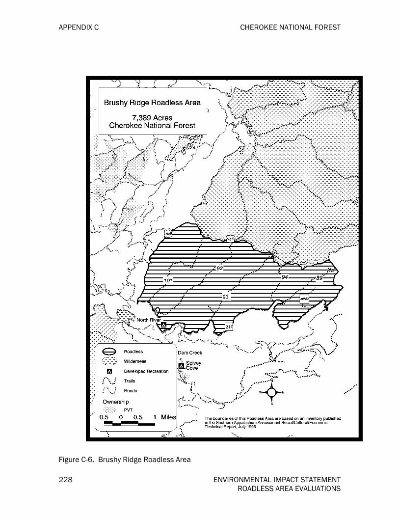
APPENDIX C CHEROKEE NATIONAL FOREST
228 ENVIRONMENTAL IMPACT STATEMENT ROADLESS AREA EVALUATIONS
Figure C-6. Brushy Ridge Roadless Area

CHEROKEE NATIONAL FOREST APPENDIX C
ENVIRONMENTAL IMPACT STATEMENT 229 ROADLESS AREA EVALUATIONS
Figure C-7. Devil’s Backbone Roadless Area

APPENDIX C CHEROKEE NATIONAL FOREST
230 ENVIRONMENTAL IMPACT STATEMENT ROADLESS AREA EVALUATIONS
Figure C-8. Flint Mill Gap Roadless Area

CHEROKEE NATIONAL FOREST APPENDIX C
ENVIRONMENTAL IMPACT STATEMENT 231 ROADLESS AREA EVALUATIONS
Figure C-9. Little Frog Addition NE Roadless Area

APPENDIX C CHEROKEE NATIONAL FOREST
232 ENVIRONMENTAL IMPACT STATEMENT ROADLESS AREA EVALUATIONS
Figure C-10. Little Frog Addition NW Roadless Area
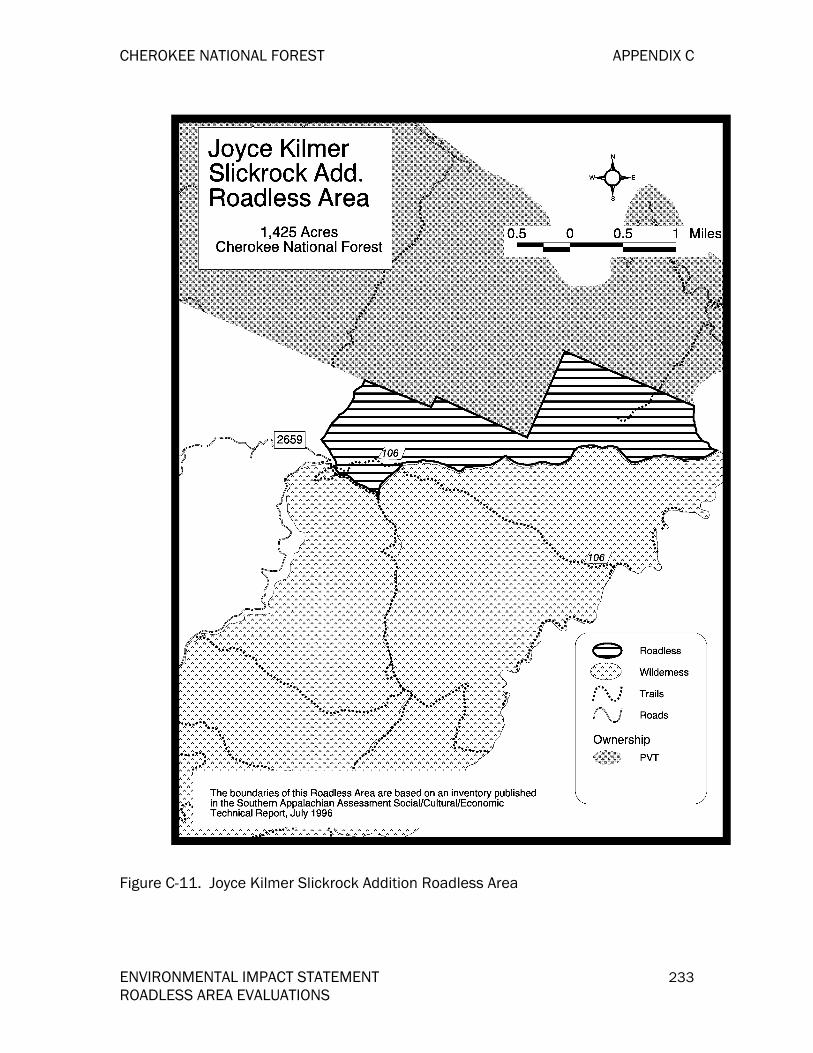
CHEROKEE NATIONAL FOREST APPENDIX C
ENVIRONMENTAL IMPACT STATEMENT 233 ROADLESS AREA EVALUATIONS
Figure C-11. Joyce Kilmer Slickrock Addition Roadless Area
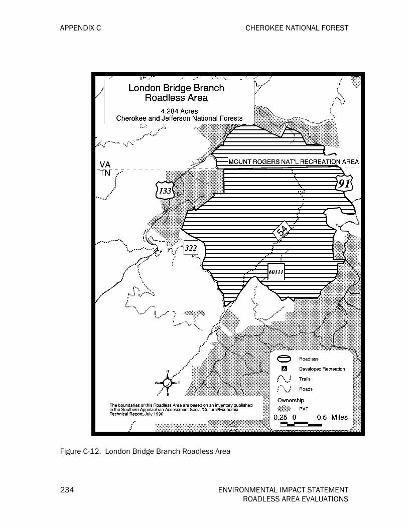
APPENDIX C CHEROKEE NATIONAL FOREST
234 ENVIRONMENTAL IMPACT STATEMENT ROADLESS AREA EVALUATIONS
Figure C-12. London Bridge Branch Roadless Area

CHEROKEE NATIONAL FOREST APPENDIX C
ENVIRONMENTAL IMPACT STATEMENT 235 ROADLESS AREA EVALUATIONS
Figure C-13. Rogers Ridge Roadless Area

APPENDIX C CHEROKEE NATIONAL FOREST
236 ENVIRONMENTAL IMPACT STATEMENT ROADLESS AREA EVALUATIONS
Figure C-14. Sampson Mountain Addition Roadless Area

CHEROKEE NATIONAL FOREST APPENDIX C
ENVIRONMENTAL IMPACT STATEMENT 237 ROADLESS AREA EVALUATIONS
Figure C-15. Slide Hollow Roadless Area

APPENDIX C CHEROKEE NATIONAL FOREST
238 ENVIRONMENTAL IMPACT STATEMENT ROADLESS AREA EVALUATIONS
Figure C-16. Stone Mountain Roadless Area
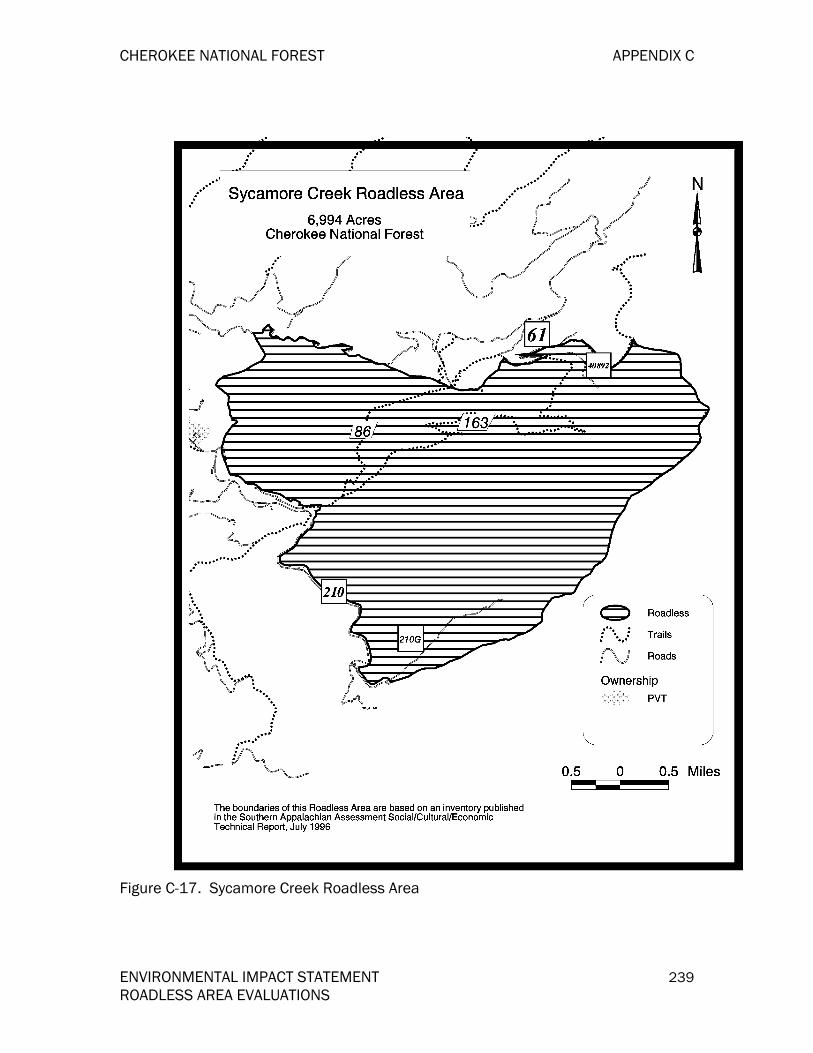
CHEROKEE NATIONAL FOREST APPENDIX C
ENVIRONMENTAL IMPACT STATEMENT 239 ROADLESS AREA EVALUATIONS
Figure C-17. Sycamore Creek Roadless Area

APPENDIX C CHEROKEE NATIONAL FOREST
240 ENVIRONMENTAL IMPACT STATEMENT ROADLESS AREA EVALUATIONS
Figure C-18. Upper Bald River Roadless Area

CHEROKEE NATIONAL FOREST
ENVIRONMENTAL IMPACT STATEMENT 241
APPENDIX D: WILD AND SCENIC RIVERS
INTRODUCTION Appendix D contains eligibility evaluations for Beaverdam Creek, Elk River, and Laurel Creek for inclusion in the National Wild and Scenic Rivers System. For reference, the results of a 1991 eligibility study on the Conasauga River, Hiwassee River and Tellico River are included. These evaluations discuss the potential classifications of the rivers as Wild, Scenic, or Recreational.
The Chattohoochee-Oconee National Forest has conducted an eligibility study for segments of the Conasauga River in Georgia . Appendixes for the Chattahoochee-Oconee forest plan revision will provide additional information concerning these segments.
As used in the National Wild and Scenic Rivers Act, the term "river" means a flowing body of water or estuary or a section, portion, or tributary thereof, including rivers, creeks, runs, kills, rills, and small lakes.
Section II explains the process for eligibility determinations and gives the eligibility criteria for scenic, recreational, geologic, wildlife, fisheries and aquatic, botanical/ecological and heritage/cultural values.
Section III lists suitability criteria. A determination that a river is eligible does not necessarily mean that it will meet suitability criteria. If a river is found to be suited and is recommended for designation by the Forest Service, it goes before Congress as a candidate for designation into the National Wild and Scenic Rivers System.
Section IV contains the actual evaluations of candidate rivers and the classifications assigned.
THE PROCESS: HOW RIVERS ARE EVALUATED The first step in the process is the identification of the waterways within the CNF and a determination whether those identified are eligible to be added to the National Wild and Scenic Rivers System. If found eligible, the second step is to make a determination as to the potential classification of the river, either as a National Wild, Scenic, or Recreational River.
The Land and Resource Management Planning Handbook, Forest Service Handbook 1909.12, Chapter 8, gives direction for identification and evaluation of rivers. FSH 1909.12 provides direction that each river identified in the Nationwide River Inventory that crosses NFS lands should be studied as part of the forest land management planning process. FSH 1909.12 also provides direction that other rivers can be identified in the land management planning process.

APPENDIX D CHEROKEE NATIONAL FOREST
242 ENVIRONMENTAL IMPACT STATEMENT WILD AND SCENIC RIVERS
Nine waterways were identified in the Nationwide Rivers Inventory, conducted by the Department of Interior, National Park Service. These are the Conasauga, Doe, French Broad, Hiwassee, Little Tennessee, Ocoee, Nolichucky, Tellico, and Watauga. In earlier studies, eligibility for these rivers has been determined. Parts of all of the rivers are eligible except for the Little Tennessee and the Ocoee. A suitability study has been completed on the Nolichucky River, recommending that a portion of it be classified as scenic.
A separate study has been drafted for the Hiwassee and Tellico Rivers, but no recommendation has been published yet. The Chattahoochee National Forest is the lead forest on the Conasauga River analysis, and a recommendation will be made in the Cherokee revised plan. The remaining eligible rivers have been deferred to the state of Tennessee for study.
Three rivers within the Forest were identified during the scoping process, for evaluation.
The evaluation criteria for each resource were prepared by consulting sections 1(b) and 2(b) of the W&S Rivers Act, FSH 1909.12, Chapter 8, and Federal Register, Vol. 47, No. 173, and the Kisatchie National Forest and George Washington National Forest criteria. The criteria were also reviewed by the Regional Office.
The first two steps in the Wild and Scenic Rivers evaluation process are part of the inventory for the AMS. This study addresses the first two steps only. The third step in the process assesses the suitability of those rivers found eligible. The suitability study involves extensive public involvement and includes the social/political issues. It determines if there is sufficient support for designation. The suitability study can be made as part of the Forest Plan Revision or later, as time and funding permit.
For a stream to be eligible for designation to the W&S River System, it must be free-flowing and the adjoining land determined to be "outstandingly remarkable" in one or more of the following values.
Scenic
Recreational
Geological
Fisheries and Aquatic
Wildlife
Heritage/Cultural
Botanical/Ecological
As used in the National Wild and Scenic Rivers Act, the term "rivers" means a flowing body of water or estuary or a section, portion, or tributary thereof, including rivers, creeks, runs, kills, rills, and small lakes.
Within each value category, rivers are rated as one of the following:

CHEROKEE NATIONAL FOREST APPENDIX D
ENVIRONMENTAL IMPACT STATEMENT 243 WILD AND SCENIC RIVERS
Class A. Outstandingly remarkable values (ORVs) with national significance, having qualities which are nationally significant. Class B. Outstandingly remarkable values (ORVs) with regional significance, having qualities significant in the physiographic province. Class C. Locally significant values, with qualities that are shared with one of the many equally significant rivers in the physiographic province. Class D. Values locally common to the Forest, with qualities that are common in the local area and in the physiographic province, but with no outstanding qualities.
Since there are two physiographic provinces within the Forest, resource values for each river being evaluated are compared with values of other rivers in the same physiographic province. The two physiographic provinces on the Forest are the Blue Ridge and the Ridge and Valley.
The National Wild and Scenic Rivers Act sets no specific requirements concerning the length of a river segment being considered, but states that a river segment is of sufficient length if, when managed as a wild, scenic, or recreational river area, the "outstandingly remarkable" values are protected.
The determination of whether a river or river segment contains outstandingly remarkable values is, for the most part, a judgment based on the qualities of a river relative to the other rivers in the physiographic province. Listed below are the eligibility criteria established for the CNF.
ELIGIBILITY CRITERIA BY RESOURCE If a river or segment of river is found to have a class A or B value for any of the resource values and is free-flowing, it would be eligible. The determination is based on professional judgment of Forest Service specialists.
Recreation Values
Class A. Outstandingly remarkable recreation values with national significance provide recreational opportunities which are, or have the potential to be, unique enough to attract visitors from well outside of the physiographic province and be known at a national level. Significant numbers of visitors would be willing to travel long distances, generally at least a 24-hour trip if by motor vehicle, to use the river resources for recreational purposes. River-related opportunities could include, but are not limited to viewing nature, viewing geological formations or cascades, water sports such as rafting or canoeing, trail use (either non-motorized or motorized), wildlife observations, fishing, hunting, and photography.
Class B. Outstandingly remarkable recreation values with regional significance provide recreational opportunities which are, or have the potential to be, an outstandingly remarkable recreational attraction within the physiographic province and attract, or have the potential to attract, visitors from outside the physiographic province. Significant numbers of visitors would be willing to travel moderate distances, over three hours, to use the river resources for recreational purposes. River-related opportunities could include, but are not limited to viewing nature, viewing geological formations or cascades, water sports such as rafting or canoeing,

APPENDIX D CHEROKEE NATIONAL FOREST
244 ENVIRONMENTAL IMPACT STATEMENT WILD AND SCENIC RIVERS
trail use (either non-motorized or motorized), wildlife observations, fishing, hunting, and photography.
Class C. Locally significant recreational values provide recreation opportunities which are, or have the potential to be, significant for the Forest, however, they are common throughout the physiographic province.
Class D. Locally common recreational values to the Forest provide recreational opportunities that are common throughout the Forest.
Scenic Values
Each landscape has its own unique natural scenic qualities. This inherent scenic attractiveness is a human perception of the natural beauty of landscape attributes based on the composition of landforms, rockforms, water forms and vegetative cover. Inherent scenic attractiveness also reflects the natural ability of a landscape to produce varying degrees of scenic satisfaction, varying degrees of positive physiological responses such as heart rate deceleration, and varying degrees of positive psychological responses such as general feelings of well-being.
Inherent scenic attractiveness considers not only natural variety, but also unity, vividness, intactness, coherence, mystery, uniqueness, harmony, balance and pattern and is assessed in relation to individual landscape character type (physiographic province). Character type is defined as an area of land that has common distinguishing natural visual characteristics. Scenic value assessment for eligibility in this exercise will utilize concepts and premises set forth in the U.S. Forest Service Scenery Management System (SMS). Rivers and streams that classify as "distinctive" under SMS will qualify for either a Class "A" or Class "B" designation in this study. Those that classify as "typical" will qualify for a Class "C" rating and "indistinctive" will qualify as a Class "D" rating.
It is not appropriate to compare inherent scenic attractiveness of water landscapes in one landscape character type to another. Therefore, during the scenic resource evaluation report, we will look at the scenic values of each river or stream as it compares with others within the same physiographic character type and then determine whether or not it may be outstandingly remarkable on a national scale.
Another measure of the scenic value of an area is the presence of "Special Places.” The Scenery Management System describes them as "...specific locations and expanses in outdoor settings that have attractions and features that are identified as unique, different, distinctive, and extraordinary to people.” Special places along streams and rivers may range from a particular small cascade and pool with enclosing rocks and vegetation to an entire stream corridor. That presence of moderate to high numbers of special places can increase the scenic value of an area dramatically.
The general scenic eligibility criteria are listed below, followed by inherent scenic attractiveness guidelines for watercourses within the three physiographic provinces. The guidelines will be used to determine within which class a particular watercourse falls.
CHEROKEE NATIONAL FOREST APPENDIX D
ENVIRONMENTAL IMPACT STATEMENT 245 WILD AND SCENIC RIVERS
Class A. Outstandingly remarkable scenic values of national significance (Distinctive Nationally) include land forms with unusual or outstanding topographic features. Continuously flowing, with numerous flow characteristics, i.e., falls, cascades, rapids, pools, meanders or adjacent "distinctive" landforms, rockforms, or vegetation. The landscape elements of landform, vegetation, water, color, and related factors result in notable or exemplary visual features and/or attractions. Forest cover is continuous or if broken, has a high degree of vegetation patterns and unusual or outstanding diversity in plant species. Scenery and visual attractions are highly diverse over the majority of the river or river corridor. Special features might include focal points that are visually striking, particularly memorable, or rare in the province, e.g., rock arches, deep potholes, large or unusual trees; exceptional opportunities to view wildlife or wildflowers; important historic or cultural features.
Class B. Outstandingly remarkable scenic values with regional significance (Distinctive Regionally) include land forms with regionally significant topographic features. The landscape elements of landform, vegetation, water, color and related factors are of physiographic province significance. The forest cover is continuous or if broken, has a high degree of vegetation patterns which are regionally significant. Special features such as landforms, rockforms and vegetation are similar to others considered to be "distinctive" within the physiographic province. The river corridor may possess a moderate to high number of "special place" areas.
Class C. Locally significant scenic values indicate some variety in the terrain, but landform features are typical throughout the physiographic province. Forest cover is continuous with some variety in vegetation patterns and a common diversity in plant species. Corridors exhibit what would be considered a typical number of "special places" for the local area.
Class D. Locally common scenic values to the Forest indicate landscape elements which are common to streams throughout the Forest. An occasional "special place" may be found along the river/stream corridor, but in general the streams and their corridors are non-distinctive.
Fisheries/Aquatic Values
Class A. Outstandingly remarkable fisheries/aquatic values with national significance feature wild trout and native trout or resident fish populations occurring solely because of the character of the stream. The area within the river corridor provides exceptionally high quality habitat for fish and aquatic organisms of national importance or may provide unique habitat or fish or an essential bridge in habitat conditions for federal- or state-listed threatened, endangered, or sensitive species. Diversity and quality of habitats are important considerations and could, in themselves, lead to a determination of outstandingly remarkable.
Class B. Outstandingly remarkable fisheries/aquatic values with regional significance indicate an area within a river corridor which provides quality habitat for fish or aquatic organisms that are unique to the physiographic province in which the area is located. It is important to recognize diverse habitats since they in themselves could have outstandingly remarkable values.

APPENDIX D CHEROKEE NATIONAL FOREST
246 ENVIRONMENTAL IMPACT STATEMENT WILD AND SCENIC RIVERS
Class C. Locally significant fisheries/aquatic values indicate high quality fish or aquatic community habitat. These values are usually associated with quality fishing areas, however, these types of areas are common throughout the physiographic province.
Class D. Locally common fisheries/aquatic values to the Forest indicate that fish or aquatic community habitats are not unique, rare, or critical. These areas are common throughout the Forest.
Wildlife Values
Class A. Outstandingly remarkable wildlife value of national significance include resident wildlife populations that occur only because of the character of the stream and/or the riparian vegetation adjacent to the stream. The area within the river corridor provides exceptionally high quality habitat for wildlife of national significance or may provide unique habitat or a critical link in habitat conditions for federal- or state-listed threatened, endangered or sensitive species. Diversity of habitats is an important consideration and could, in itself, lead to a determination of outstandingly remarkable.
Class B. Outstandingly remarkable wildlife values of regional significance indicate that the area within the river corridor provides quality habitat for wildlife not common to the physiographic province. Diversity and quality of habitats is an important consideration and could lead to a determination of outstandingly remarkable.
Class C. Locally significant wildlife values indicate high quality wildlife habitat. These values are usually associated with quality hunting or wildlife viewing areas. However, these habitat types are common throughout the physiographic province.
Class D. Locally common wildlife values to the Forest indicate that the wildlife and wildlife habitats are not unique, rare, or critical. These areas are common throughout the Forest.
Geologic Values
Class A. Outstandingly remarkable geologic values of national significance which indicate that the river or the area within the river corridor contains an example(s) of a geologic feature, process, or phenomena that is rare, unusual, or unique. The feature(s) may be in an unusually active stage of development, represent a textbook example, and/or represent a significant or rare combination of geologic features.
Class B. Outstandingly remarkable geologic values with regional significance indicate that the river or the area within the river corridor contains an example(s) of a geologic feature, process, or phenomena that is rare, unusual, one-of-a-kind, or significant in the physiographic province.
Class C. Locally significant geologic values indicate the geomorphic features and formations may be significant in the forest, but are typical of those commonly found in the physiographic province. There may be opportunities for geologic study.

CHEROKEE NATIONAL FOREST APPENDIX D
ENVIRONMENTAL IMPACT STATEMENT 247 WILD AND SCENIC RIVERS
Class D. Locally common geologic values to the Forest indicate that the geomorphic features are common throughout the Forest and offer no significant geologic features.
Botanical/Ecological Values
Class A. Outstandingly remarkable botanical and ecological values with national significance indicate that the riparian forest along the river corridor is contiguous, with no human-caused fragmentation. Geologic features which harbor unique plants or plant communities may be present, and there are no exotic and/or invading weed species present. The area within the river corridor could provide exceptionally high quality habitat for plant species of national importance or may provide unique habitat for federally-listed threatened and endangered species. The occurrence of nationally rare plant species and/or communities could in itself lead to a determination of outstandingly remarkable if it thrives in a high quality habitat.
Class B. Outstandingly remarkable botanical and ecological values with regional significance indicate that the riparian or bottomland forest along the river corridor is contiguous, with no human-made fragmentation. There may be some localized invasion of exotic and/or invading weedy species, however, the invasions are localized enough to be controllable. Geologic features which harbor plants or plant communities unique in the physiographic province, or the occurrence of plants species or plant communities uncommon or rare in the province, could in itself lead to a determination of regionally outstandingly remarkable if it thrives in a high quality habitat.
Class C. Locally significant botanical and ecological values indicate that the riparian forest along the river corridor remains largely contiguous, however, there may be fragmentation caused by human activity. Locally significant plant communities may be present along the river corridor. There may also be some uncontrolled invasions of exotic weedy species.
Class D. Locally common botanical and ecological values to the Forest indicate that the plant species and/or communities are common to the area. The Forest may be greatly disturbed by artificial means and/or highly fragmented. Other disturbed and/or artificial communities and uncontrollable invasion of exotics may be present.
Heritage/Cultural Values
Class A. Outstandingly remarkable cultural/historic values of national significance indicate the cultural resource sites within the corridor have unusual characteristics or exceptional research or interpretive values of national significance. These river corridors contain sites of national importance and meet the criteria for listing on the National Register of Historic Places (36 CFR 60).
Class B. Outstandingly remarkable cultural/historic values of regional significance indicate that the river corridors contain sites of regional significance that meet the criteria for listing on the National Register of Historic Places. Sites contain cultural or historic characteristics significant to the physiographic province.

APPENDIX D CHEROKEE NATIONAL FOREST
248 ENVIRONMENTAL IMPACT STATEMENT WILD AND SCENIC RIVERS
Class C. Locally significant cultural/historic values indicate that the river corridors contain sites of state and local significance that meet the criteria for listing on the National Register of Historic Places. Sites may be similar to other sites known throughout the physiographic region, but are unique to the local area. Some sites may have been disturbed prior to being archeologically recorded. This also includes known sites that have not been evaluated respective to National Register of Historic Places criteria.
Class D. Locally common cultural/historic values to the Forest indicate that the river corridors contain sites common to the Forest or state. Known sites have been determined ineligible for listing in the National Register of Historic Places but may have interpretive value.
CLASSIFICATION CRITERIA
The second step is a determination of the potential classification. The National Wild and Scenic Rivers Act (Section 2 (b)) states that "if included (in the National Wild and Scenic Rivers System, each river) shall be classified, designated, and administered" as a WILD, a SCENIC, or a RECREATIONAL river area. The classification selection is based on the conditions of the river and the adjacent land at the time of the evaluation. A river may be divided into segments by these classifications, based on current conditions.
A potential classification determination is needed to guide management of the stream and surrounding lands during the period before a W&S Rivers suitability study is made. In addition to protecting and, to the extent practical, enhancing ORVs, management and development of a river identified as eligible for designation and its corridor will not be modified to the degree that eligibility or classification will be affected.
The following three river classifications are possible. A brief definition follows each classification.
Wild River Areas. Those rivers or sections of rivers that are free of impoundments and generally inaccessible except by trail, with watersheds or shorelines essentially primitive and waters unpolluted. These represent vestiges of primitive America.
Scenic River Areas. Those rivers or sections that are free of impoundments, with shorelines or watersheds still largely primitive and shorelines largely undeveloped, but accessible in places by roads.
Recreational River Areas. Those rivers or sections of rivers that are readily accessible by road or railroad, that may have some development along their shorelines, and that may have undergone some impoundment or diversion in the past.
SUITABILITY CRITERIA
Determinations of suitability for inclusion in the National Wild and Scenic Rivers System are made by state agencies, the Forest Service, and other federal agencies. Criteria that determine suitability include the following:
The current status of land ownership and use in the area;
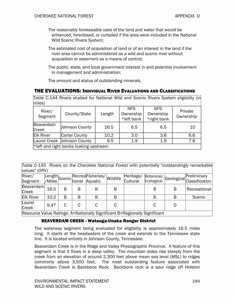
CHEROKEE NATIONAL FOREST APPENDIX D
ENVIRONMENTAL IMPACT STATEMENT 249 WILD AND SCENIC RIVERS
The reasonably foreseeable uses of the land and water that would be enhanced, foreclosed, or curtailed if the area were included in the National Wild Scenic Rivers System;
The estimated cost of acquisition of land or of an interest in the land if the river area cannot be administered as a wild and scenic river without acquisition or easement as a means of control;
The public, state, and local government interest in and potential involvement in management and administration;
The amount and status of outstanding minerals.
THE EVALUATIONS: INDIVIDUAL RIVER EVALUATIONS AND CLASSIFICATIONS Table C-144 Rivers studied for National Wild and Scenic Rivers System eligibility (inmiles)
River/ Segment County/State Length
NFS Ownership *left bank
NFS Ownership *right bank
Private Ownership
Beaverdam Creek Johnson County 16.5 6.5 6.5 10
Elk River Carter County 10.2 3.0 3.6 6.6 Laurel Creek Johnson County 9.5 1.9 1.9 7.6 *left and right banks looking upstream
Table C-145 Rivers on the Cherokee National Forest with potentially "outstandingly remarkablevalues" (ORV) River/ Segment
Length/Miles Scenic Recrea
tional Fisheries/ Aquatic Wildlife Heritage/
Cultural Botanical/ Ecological Geological Preliminary
Classification BeaverdamCreek 16.5 B B B B B B Recreational
Elk River 10.2 B B B B B B Scenic Laurel Creek 9.47 C C C C C D
Resource Value Ratings: A=Nationally Significant B=Regionally Significant
BEAVERDAM CREEK - Watauga-Unaka Ranger District
The waterway segment being evaluated for eligibility is approximately 16.5 miles long. It starts at the headwaters of the creek and extends to the Tennessee state line. It is located entirely in Johnson County, Tennessee.
Beaverdam Creek is in the Ridge and Valley Physiographic Province. A feature of this segment is that it flows in a deep valley. The mountain sides rise steeply from the creek from an elevation of around 2,300 feet above mean sea level (MSL) to ridges commonly above 3,500 feet. The most outstanding feature associated with Beaverdam Creek is Backbone Rock. Backbone rock is a spur ridge off Holston

APPENDIX D CHEROKEE NATIONAL FOREST
250 ENVIRONMENTAL IMPACT STATEMENT WILD AND SCENIC RIVERS
Mountain which ends sharply at a large bend in the creek. There is a roadcut into the rock through which the highway passes.
Beaverdam Creek is a tributary of Laurel Creek in the Holston River watershed. Water quality is good.
TN Highway 133 parallels Beaverdam Creek throughout the CNF. Several gravel Forest Service roads lead off from TN 133. All these roads are gated closed to public motorized vehicle use; and are used occasionally for administrative purposes. These gated roads are open to use by hikers, horses, and mountain bicycles, unless specifically signed otherwise. A number of pull-offs and short spur roads along TN 133 provide parking for anglers and other Forest users.
Backbone Rock Recreation Area lies within the creek corridor. Backbone Rock is a unique rock formation located where Beaverdam Creek flows past a spur ridge of Holston Mountain. At the turn of the 20th century (1900-1901), a railroad was constructed to transport timber, logs, and chestnut extract for the tanning of hides from Shady Valley and the Crandull community, through Sutherland and Damascus, and on to the main line railroad at Abingdon. VA. A tunnel was drilled through Backbone Rock to allow passage. When the first train passed through the tunnel in 1901, an additional notch was cut in the very top of the tunnel to allow passage of the railcar mounted, steam powered, log loader. Total height of the Backbone Rock at the tunnel is approximately 76 feet. Backbone Rock is approximately 22 foot through at the narrowest point and is locally known as the "Shortest Tunnel in the World.”
Eventually, the railroad was abandoned as the private timber holdings in the area were harvested. The railroad was replaced with a roadway for automobiles and is now TN 133. At the time of the major timbering operations, the U.S. Government did not own any land around Backbone Rock -- all the logging was done on privately owned lands. In 1913, the Forest Service purchased 22,000 acres, including Backbone Rock, from the E.W. Sheafer heirs. Since the early 1920s it has been a popular site for public recreation.
In the 1930s a picnic and camping area, including two covered picnic shelters or "arbors,” was constructed at Backbone Rock by the Civilian Conservation Corps as a part of President Franklin D. Roosevelt's New Deal. Hiking trails, including one to the top of Backbone Rock which required extensive rockwork, were built. The recreation facilities at Backbone Rock were extensively reworked in the early 1960s as part of the Accelerated Public Works Program. In the mid-1990s the Forest Service worked with Northeast Correctional Center of the Tennessee Department of Corrections to renovate Backbone Rock Recreation Area. A crew of ten supervised inmates reworked all 11 campsites, extensively renovated both CCC picnic pavilions, and made much needed improvements throughout the area over 11 months.
Permitted activities at Backbone Rock Recreation Area include picnicking, hiking, and camping within designated sites. There is a fee for all uses. Swimming is allowed at your own risk; there is no designated swim site. Short hikes include the Backbone Rock Trail (1/4 mile) and Backbone Falls Trail (1/2 mile). Backbone Rock Trail (# 53) also connects with the Appalachian Trail (#1) on the crest of Holston Mountain (2.4

CHEROKEE NATIONAL FOREST APPENDIX D
ENVIRONMENTAL IMPACT STATEMENT 251 WILD AND SCENIC RIVERS
miles). Rock Climbing and rappelling are popular. Fishing is permitted and special regulations apply to a section of Beaverdam Creek upstream from the recreation area. The section of National Forest land along Beaverdam Creek is a popular "driving for pleasure" route and has appeared in several regional and national publications. Trout fishing is increasing in popularity; Beaverdam Creek draws anglers from throughout northeast Tennessee and southwest Virginia.
The scenic features of distinctive rockforms and vegetation combined with relatively easy access attract a wide variety of recreationists and sightseers.
Two roadless areas, inventoried in 1995 as part of the SAA, may be considered to include portions of Beaverdam Creek in Tennessee. These two areas are Beaverdam Creek Roadless Area and Iron Mountain Roadless Area. A third inventoried roadless area, London Bridge Branch, includes portions of Beaverdam Creek in Virginia.
Beaverdam Creek is designated by the Tennessee Wildlife Resources Agency as a Wild Trout Stream. Beaverdam Creek contains wild populations of rainbow and brown trout. The upper reaches and tributaries contain native brook trout. The stream is also stocked with rainbow trout downstream from Tank Hollow. Special fishing regulations apply to Beaverdam Creek from Tank Hollow Road upstream to Birch Branch. These regulations permit fishing with only single hook, artificial lures, and limit creel to three trout per day. A size limit of 6" for brook trout and 9" for rainbow and trout apply.
Beaverdam Creek and its tributaries also contains hellbender (Cryptobranchus alleganiensis) and Tennessee dace (Phoxinus tennesseensis). The hellbender, a candidate for federally listing, is geographically rare, but locally common. The Tennessee dace, a Forest sensitive species, is endemic to this region and known only in Tennessee and Virginia.
Beaverdam Creek Eligibil ity Evaluation
Scenic Values: This segment of Beaverdam Creek has a variety of distinctive vegetative and rockforms features in and adjacent to the stream. This segment of stream is moderate to fast moving with lots of visible rocks and boulders in the streamcourse. Hemlock, rhododendrons, and a variety of hardwoods shade the creek and give the stream corridor a lush appearance--especially in the spring, summer, and fall. Backbone Rock is a distinctive rockforms and cultural feature and attracts hikers, picnickers, rock climbers, and sightseers. There are several other "special places" popular along the stream corridor including wading and swimming spots and favorite places for trout fishing. The Scenery Management System inventory and the Visual Management System now in effect in the 1986 Forest Plan both have this segment of creek rated as Class A-Distinctive.
A Class B rating, regionally significant, is assigned.
Recreational Values: Beaverdam Creek is an important recreation resource on the Forest with many visitors coming significant distances to camp, fish, hike, hunt, view scenery, and rock climb. Few other areas on the Forest offer a similar variety of recreation opportunities as accessible to the public. Beaverdam Creek is a significant recreation resource and draws visitors from well outside the region.

APPENDIX D CHEROKEE NATIONAL FOREST
252 ENVIRONMENTAL IMPACT STATEMENT WILD AND SCENIC RIVERS
A class rating of B, regionally significant, is assigned.
Fisheries/Aquatic Values: Beaverdam Creek has a high quality wild trout fishery and aquatic community. It is a significant Forest resource for recreational fishing and habitat for two rare species: hellbender (Cryptobranchus alleganiensis), a candidate for federal listing, and Tennessee dace (Phoxinus tennesseensis), a Forest sensitive species.
A class B rating, regionally significant, is assigned to the fisheries/aquatic values.
Wildlife Values: Beaverdam Creek contains a mixture of high quality riparian, wetland, cliff, mesic and xeric forest conditions which provide a diverse array of habitat for wildlife. Its regional significance is best noted by its inclusion within the Kettlefoot Bear Reserve, but several state rare and regional rare species have also been documented within this drainage.
A class B rating, regionally significant, is assigned to the wildlife values.
Heritage/Cultural Resource Values: A class D rating, locally common, is assigned.
Botanical Values: Beaverdam Creek provides high quality examples of riparian and cliff communities. Several bogs are also present within this drainage which provide habitat for several species which are typically found in more northern latitudes. Plant diversity is very high due to the wide array of habitat conditions which are present and includes some species which are found nowhere else in the State of Tennessee. Several state listed species, southern Appalachian endemics, and one regionally sensitive species are known to occur in the drainage.
A class B rating, regionally significant, is assigned to the botanical values.
Geologic Values: Beaverdam Creek cuts through two geologic formations (Hardeman 1966). The upper drainage flows through Shady Dolomite; a well bedded dolomite with thin to medium bedded gray limestone and diagnostic jasperoid yellowish brown clays. The lower drainage flows through the Erwin Formation which contains white, vitreous quartzite with interbeds of dark-green silty and sandy shale, siltstone, and fine grained sandstone. These formations are locally common. Beaverdam Creek contains one unique geologic feature, a sharp spur ridge known as Backbone Rock. Backbone Rock has been featured in many magazines and newspapers and is a drawing card for many visitors throughout the region.
A class B rating, regionally significant is assigned.
Beaverdam Creek Eligibil ity and Classification
Beaverdam Creek is eligible for designation under the National Wild and Scenic Rivers Act. Recreation, scenic, fisheries/aquatics, wildlife, geologic, and botanical/ecological values are rated outstandingly remarkable, regionally significant. It is also free-flowing.
A preliminary classification for the 16.5 miles according to FSH 1909, Chapter 8, is for a recreational river. This determination is based mostly on shoreline development and accessibility. Most of the shoreline is accessible by trail and a Tennessee highway. Also, the Backbone Rock Recreation Area is located on the waterway.

CHEROKEE NATIONAL FOREST APPENDIX D
ENVIRONMENTAL IMPACT STATEMENT 253 WILD AND SCENIC RIVERS
ELK RIVER - Watauga-Unaka Ranger District
The segment of the Elk River under consideration extends from Watauga Reservoir to the Tennessee state line, it is 16.5 miles in length. It lies entirely within Carter County, Tennessee.
The Elk River is in the Blue Ridge Physiographic Province. It flows through a narrow valley from 2,200 feet above MSL to ridge tops around 2,800 feet. All flats in the corridor outside of Forest Service ownership have improvements on them.
A power line falls within 1/4 mile of the channel for most of the segment. This segment forms a portion of the boundary of the Slide Hollow Roadless Area, inventoried in 1995 as part of the SAA. Access to this area is primarily from Elk Park, North Carolina, and the community of Poga in Tennessee. Forest Roads 190 and 6038, and their spurs, provide important access for TVA to an electric transmission line. These two roads are gated. The roads and power line basically parallel the river. Road 190 crosses the river at a major ford just upstream from the TN/NC state line. Access to the river is difficult and limited. The Appalachian Trail (#1) runs nearby and is planned to be relocated immediately adjacent to the river for approximately 3/4 mile to capitalize on the outstanding scenery. Several significant waterfalls occur on the Elk River and its tributaries in this area. Current recreation uses includes fishing, hiking, horseback riding. A developed USFS picnic area at Big Falls, just upstream from this river segment, is administered by the National Forests in North Carolina.
This segment of the Elk River flows through a rugged scenic gorge. Several waterfalls in the gorge have been featured in regional publications. The Appalachian Trail is being relocated partly to take advantage of the scenic qualities of the gorge. Several recent land acquisitions provide increased scenic protection for the gorge and the Appalachian Trail corridor.
The Elk River is a high quality Blue Ridge stream supporting a diverse aquatic community. Rock bass, bluegill, and brook trout are present in this river, although it is not known to be a significant fishery.
Elk River Eligibility Evaluation
Scenic Values: This segment of the Elk River features very rugged landform and rockforms and numerous waterfalls and boulders. The stream course and gorge is relatively remote because of its ruggedness. Several of the waterfalls are well-known as scenic features. The new Scenery Management System inventory has this segment of river rated as Class A-Distinctive.
A Class B rating, regionally significant, is assigned.
Recreation Values: Elk River is an important dispersed recreation resource on the Forest with visitors coming significant distances to fish, hike, hunt, camp, and enjoy waterplay. Few other areas on the Forest offer a similar setting of recreation opportunities to the public. Elk River is a significant recreation resource and draws visitors from well outside the region.
A class rating of B, regionally significant, is assigned.

APPENDIX D CHEROKEE NATIONAL FOREST
254 ENVIRONMENTAL IMPACT STATEMENT WILD AND SCENIC RIVERS
Fisheries/Aquatic Values: Although the Elk River is not a significant fishery, it is as high quality stream that provides a variety of habitats for a diverse aquatic community.
A class C rating, locally significant, is assigned to the fisheries/aquatic values.
Wildlife Values: The Elk River watershed consists of a variety of habitat conditions which provide habitat for a large array of wildlife species. This includes cliffs and waterfalls which are considered regionally sensitive communities. Inventory work in the area has been very minimal, but suitable habitat conditions are present for several federally listed, state listed, and regionally rare species including the Peregrine Falcon, Gray Bat, and Hellbender.
A class B rating, regionally significant, is assigned to the wildlife values.
Heritage/Cultural Resource Values: A class D rating, locally common, is assigned.
Botanical Values: The Elk River Drainage provides some high quality examples of mesic hardwood, cove and floodplain forest, as well as spray cliff, cliff, and rock bar communities. Plant diversity is very high due to the wide array of habitat conditions which are present. Botanical work within the drainage has been minimal due to poor access to the area, but some rare species and southern Appalachian endemics are known to occur. Some exotic species are also present, but they do not represent a significant threat to the ecological community at this time. The most notable find at this time is the presence of Pale Corydalis, which is only known from a few other sites in the state. More intensive botanical work is needed, and the probability of finding additional rare species occurrences is very high. Given the habitat diversity which is present, several significant finds are anticipated.
A class B rating, Regionally significant, is assigned to the botanical values.
Geologic Values: The Elk River cuts through five geologic formations (Hardeman 1966). As it enters Tennessee from North Carolina, the river cuts through the Beech Granite; a light gray to reddish porphyritic granite containing coarse, potash feldspar crystals with chloritized biotite and hornblende which give it a spotted appearance. It briefly edges the Unicoi formation (which contains white, vitreous quartzite with interbeds of dark green, silty and sandy shale, siltstone, and fine-grained sandstone) before entering the Hampton Formation (a dark green, micaceous shale with numerous layers of medium-grained, feldspathic, thinly bedded sandstone) below Twisting Falls. At Slide Hollow, the river passes through the Erwin Formation which contains white, vitreous quartzite with interbeds of dark green, silty and sandy shale, siltstone, and fine-grained sandstone. Between Nowhere Branch and the Stout Hill Bridge crossing, the river cuts through Shady Dolomite, a well-bedded dolomite with thin to medium-bedded gray limestone and diagnostic jasperoid yellowish brown clays. From this point to Watauga Lake, the river flows through the Rome Formation; a variegated (red, green, yellow) shale and siltstone that also contains limestone and dolomite. These formations are locally common, but it is not often that you are able to view these formations in such close proximity to one another.
A class C rating, locally significant is assigned.

CHEROKEE NATIONAL FOREST APPENDIX D
ENVIRONMENTAL IMPACT STATEMENT 255 WILD AND SCENIC RIVERS
Elk River Eligibil ity and Classification
Elk River is eligible for designation under the National Wild and Scenic Rivers Act. Recreation, scenic, fisheries/aquatics, wildlife, and botanical/ecological values are rated outstandingly remarkable, regionally significant. It is also free-flowing.
A preliminary classification for the 10.2 miles, according to FSH 1909, Chapter 8, is for a scenic river. For the most part, this determination is based on limited access and the short length of the segment.
LAUREL CREEK - Watauga/Unaka Ranger District
The segment of Laurel Creek under consideration extends 9.5 miles, with 1.9 falling within lands administered by the CNF. This segment extends from the headwaters to the Tennessee state line. Laurel Creek flows into Holston River.
This creek is in the Ridge and Valley Physiographic Province.
The segment under consideration forms a portion of the boundary of the London Bridge Branch Roadless Area in both Tennessee and Virginia, and was inventoried in 1995 as part of the SAA. Tennessee Highway 91 runs parallel to, and immediately adjacent to the creek. Telephone and electric service lines run along the creek and highway. Camp Ahistadi, a special use organization camp, is located along the creek on National Forest land. One of the access points to the Iron Mountain Trail (#54) is at Camp Ahistadi. The creek is stocked by TWRA in Tennessee, and by Virginia Inland Fish and Game in Virginia. This creek is also called Laurel Bloomery Creek.
This segment of Laurel Creek has some scenic features such as rockforms and vegetation but the features are common regionally. The stream is also somewhat visually degraded by adjacent power lines, telephone lines, and TN Highway 91. Only 1.89 miles of the stream corridor is in National Forest ownership.
Laurel Creek contains wild populations of rainbow and brown trout. The stream is also stocked with rainbow trout. Laurel Creek is a popular trout stream.
Laurel Creek Eligibil ity Evaluation
Scenic Values: This segment of Laurel Creek has some scenic features such as rockform and vegetation but the features are common regionally. This segment of the stream corridor is somewhat degraded visually with electric and telephone lines running adjacent and parallel to the creek. TN Highway 91 also runs parallel and immediately adjacent to the creek. The new Scenery Management System inventory and the Visual Management System now in effect in the Forest Plan both have this segment of creek rated as Class B-Common.
A Class C rating, locally significant, is assigned.
Recreation Values: Laurel Creek offers some dispersed recreation opportunities, particularly for fishing, hiking (Iron Mountain Trail access), and hunting access. However, these opportunities are limited by the relatively short distance on NFS land. Laurel Creek draws pass-through visitors from the local area and some pass-through visitors from outside the region.
A class rating of C, locally significant, is assigned.
APPENDIX D CHEROKEE NATIONAL FOREST
256 ENVIRONMENTAL IMPACT STATEMENT WILD AND SCENIC RIVERS
Fisheries/Aquatic Values: Laurel Creek has a high quality wild trout fishery and is a significant Forest resource.
A class C rating, locally significant, is assigned to the fisheries/aquatic values.
Wildlife Values: Laurel Creek is located adjacent to the eastern border of the Kettlefoot Bear Reserve. Although this area provides quality habitat, some portions of the drainage are disturbed. It does provide suitable habitat for several rare or sensitive species, but none have been recorded in the area. Although habitat quality is high in many areas, it does not contain any habitat with regionally outstanding values.
A class C rating, locally significant, is assigned to the wildlife values.
Heritage/Cultural Resource Values: A class D rating, locally common, is assigned.
Botanical Values: Laurel Creek provides some examples of high quality mesic hardwood forests, but given the close proximity of Highway 91 to Laurel Creek, riparian conditions along the east bank are poor in many areas. Some state rare species have been recorded in the area, but some exotic species are also present.
A class C rating, locally significant, is assigned to the botanical values.
Geologic Values: Laurel Creek cuts through two geologic formations (Hardeman 1966). The upper drainage flows through the Rome Formation; a variegated (red, green, yellow) shale and siltstone that also contains limestone and dolomite. The lower drainage flows through the Unicoi Formation which contains a sequence of gray, feldspathic sandstone, arkose, conglomerate, graywacke, siltstone, and shale. Amygdaloidal basalt flows are also present near the middle and base. These formations are locally common.
A class D rating, locally common is assigned.
Laurel Eligibility and Classification
This segment of Laurel Creek is not eligible for designation under the National Wild and Scenic Rivers Act. No values were found to be outstandingly remarkable at the regional or national level. It is also free-flowing.
RIVERS FOR WHICH ELIGIBILITY WAS DETERMINED IN 1991 HIWASSEE RIVER – Ocoee Ranger District
The Hiwassee River watershed is a patchwork of public and private land ownership. Public lands are managed by the Cherokee and Nantahala National Forests, Tennessee Valley Authority, and state and local governments. The watershed encompasses approximately 2700 square miles of land in Georgia, North Carolina, and Tennessee. About 68 percent of the total watershed acreage is in private ownership.
The study corridor of the Hiwassee River is located in Polk County, Tennessee on the CNF. The study section has been determined to be free flowing from the Apalachia Powerhouse to the Forest proclamation boundary at Long Island (10.5 miles). The Tennessee Valley Authority and Forest Service property line at Apalachia Powerhouse

CHEROKEE NATIONAL FOREST APPENDIX D
ENVIRONMENTAL IMPACT STATEMENT 257 WILD AND SCENIC RIVERS
is the upstream boundary of the study area while the proclamation boundary at Long Island (near Quinn Springs) is the downstream boundary. The Hiwassee is managed as a State Scenic River by the Tennessee Department of Environment and Conservation in cooperation with CNF, Tennessee Wildlife Resources Agency and Tennessee Valley Authority. The area is a well-known boating and fishing stream. Features along the river include designated quality trout waters, developed recreation sites, roads, railroad, a private campground, commercial float services, stores, and private dwellings.
The river is accessed via Forest Development Road (FDR) 27 and 108 (Hood Mountain Road). Forest Development Road 27 is located on the north side of the river, which begins near Gee Creek and extends to Childers Creek and extends to the Apalachia Powerhouse. Developed recreation sites along FDR 108 include Childers Creek Picnic Area, Hood Mountain Overlook, Big Ben Parking Area, Pine Thicket Picnic area, Towee Picnic area and Boat Launch, and Powerhouse Boat Launch. State Route 30 (Kimsey Highway) parallels the southern shore form US 411 to Reliance. Picnic areas may be found along State Route 30 at Taylors Island and Hiwassee Picnic Area.
Forest Development Trails (FDT) are located within the river corridor. Portions of the John Muir National Recreation Trail, #152, extend on the north side of the river from Childers Creek upstream to Apalachia Powerhouse. Fisherman’s Trail, #167, parallels the river from the left bank downstream between Quinn Springs Fishermen Access and Hiwassee Picnic Area.
There is one highway bridge located across Hiwassee River at Reliance (Tellico-Reliance Road). A railroad trestle used by CSX Railroad is located upstream from the highway bridge. A food bridge is located at the Apalachia Powerhouse.
Waters released from the Apalachia Powerhouse are received from a tunnel extending 12 miles upstream. Incidental flood control benefits from Apalachia (sic) Dam provides water to the powerhouse. Releases occur almost every day. Periods without water releases are extremely infrequent in a given year. Water discharged from the powerhouse is usually cool even in the summer. This river provided opportunities for recreational boating, fishing, and sustains commercial outfitter operations for guided fishing and float services. Necessary equipment for these various river uses may be obtained from stores located within the river corridor.
Private land comprises 28 percent of the river corridor. Uses of these lands include local businesses, private camping, primary and secondary residences, and agricultural lands.
TELLICO RIVER – Tellico Ranger District
Tellico River watershed includes approximately 285 square miles of land in Cherokee County, North Carolina and Monroe County, Tennessee. A small portion of the watershed in North Carolina is privately owned. The remaining acreage in North Carolina is in federal ownership managed by the Nantahala National Forest. In Tennessee, portions of the watershed are in private ownership: the CNF manages federal ownership.

APPENDIX D CHEROKEE NATIONAL FOREST
258 ENVIRONMENTAL IMPACT STATEMENT WILD AND SCENIC RIVERS
The Tellico River corridor is located in Monroe County, Tennessee on the CNF and in Cherokee County, North Carolina on the Nantahala National Forest. This study section, which extends 22.8 miles, was determined to be free flowing from the headwaters, at the Cherokee and Graham County line in North Carolina to the McDaniel Bridge at River Mile 30 near Tellico Plains, Tennessee. The river is managed in cooperation with Tennessee Wildlife Resources Agency (TWRA) and North Carolina Wildlife Resources Commission (NCWRC). There are numerous recreation sites along the corridor, a developed Off Highway Vehicle Are in North Carolina, the community of Green Cove (primary and summer residences), several stores, and a motel. The area is readily access by roads and receives a large number of anglers and some canoeists and kayakers each year.
The river corridor is “V” shaped with several large cliff areas carved by the river. Due to extreme variations in topography, different geological forms may be viewed. Two caves are exposed and appear to have been formed by physical processes. Class III, IV, and V rapids ere formed by bedrock and boulders. Scenic waterfalls are located at Baby Falls and Bald River Falls near the confluence of Bald River and Tellico River. Forest Development Road 210 (Tellico River Road) parallels the river to the North Carolina state line where it becomes Forest Development Road 420. Several vehicular crossings and food bridges cross the river accessed from FDR 210 in Tennessee. There are bridges, fords, and numerous crossings of tributaries within the corridor for the Tellico River in North Carolina.
The Tellico River is a coldwater stream that supports native trout populations. Trout are provided for stocking by TWRA from the confluence of Turkey Creek to the North Carolina/Tennessee state line. The process of stocking fish in the stream enhances the numerous fishing opportunities available. The trout used for stocking are reared in the Tellico Hatchery located within the river corridor. This stream is classified as one of the prime put-and-take streams in east Tennessee (TWRA, personal communication). The Tellico River from the headwaters in North Carolina to the North Carolina /Tennessee state line is classified as Wild Trout waters.
The Tellico River Road is the primary access to the Tellico River and receives heavy use throughout the year. Developed recreation opportunities along the river include Spivey Cove Campground accessed by FDR 210F, Davis Branch Campground, Big Oak Campground, and State Line Campground. Picnic areas include Dam Creek, Walnut Grove, Bald River Falls, and Pheasant Fields. Designated parking is available at Panther Branch and Oosterneck. Dispersed recreation areas include Baby Falls, North River Checking Station, Joe Floyd, Sugar Flats, Holder Cove, Rock Quarry, and State Line. Bald River Wilderness is accessible from Tellico River Road.
Within the Tellico River corridor in North Carolina, there is a developed Off Highway Vehicle Area. This area consists of a system of roads available for four-wheel drive, all terrain vehicles, and motorcycle traffic. There are nine dispersed campsites along these roads.
Canoe and kayak use occurs on the Tellico River when sufficient water discharge occurs. At present, there are no special used permits issued for outfitting and guiding.

CHEROKEE NATIONAL FOREST APPENDIX D
ENVIRONMENTAL IMPACT STATEMENT 259 WILD AND SCENIC RIVERS
The community of Green Cove is accessed by FDR 210. Facilities on this privately owned land consists of two local stores providing groceries, hunting, and fishing supplies. There are also numerous summer residences located here as well as a few year round residents. A motel provides lodging for sportsmen and sightseers throughout the year.
Study Segments
The study segment of the Hiwassee River reaches 10.5 miles immediately below the Apalachia Powerhouse to the Forest proclamation boundary at Long Island (near Quinn Springs).
The study segment of the Tellico River comprised 5.8 miles of North Carolina from the headwaters to the Tennessee state line and 17.0 miles in Tennessee from the state line to near River Mile 30 at the McDaniel Bridge. The total mileage is 22.8 miles.
The recommended corridor boundary for the Hiwassee and Tellico River study segment is an average of ¼ mile from the left and right riverbanks.
Table D-146 Geographic Charteristics of Hiwassee and Tellico Segments
River Drainage
Area-Totala (miles2)
Drainage Area-
Elig.Segmentb (miles2)
Total River Length (miles)
Segment Length (miles)
River Mile
Hiwassee 2700 1263 138.3 10.5 43.0 to 53.5
Tellico 285 106 52.8 17.0 in
TN 5.8 in NC
30.0 to 48.0 48 to
headwaters aFrom headwaters to confluence with Tennessee River and Little Tennessee River, respectively bFrom headwaters to lower limit of eligible segment
Hiwassee Eligibil ity Assessment Scenic: Landform has some variety and relief. Rock features are common with some bluffs present. Vegetative cover is expected with pine and hardwood forests. Flow sustains river characteristics although there are daily fluctuations from an impoundment. There are several small rapids within this section. Water clarity is good but sometimes turbid. No waterfalls are present. Manmade structures include three bridges, a railroad, power lines and developed recreational areas. A “common” rating is given.
Recreational: This section of the Hiwassee is located in the Southern Blue Ridge Region province. Swimming and picnicking use in this section is moderate since there are developed recreational areas. Demand on the fishery resource is high and concentrated with one section of this segment being designated a Trophy Trout stream. Flow and current river management sustains recreational use from three to four seasons. Expected species of wildlife can normally be viewed within the river corridor. A variety of Class I-III rapids are represented during the season of use.

APPENDIX D CHEROKEE NATIONAL FOREST
260 ENVIRONMENTAL IMPACT STATEMENT WILD AND SCENIC RIVERS
Rafting outfitters use the river at developed put-ins and take-outs. A “distinctive” rating is assigned to the recreational values.
Geologic: The Hiwassee B section flows from the Apalachia (sic) Powerhouse to US 411. The river flows through Precambrian-aged meta-sedimentary rocks of the Great Smokey Mountain Group (discussed in Hiwassee A) and a narrow area of Cambrian-aged Shady dolomite. The river section terminates just past where it has cut through the Starr Mountain Window. This window exposes younger Cambrian-age rock formations through older Pre-Cambrian–aged formations. This window is at the boundary between the Blue Ridge and Valley and ridge provinces. This explains the presence of old magnesium and manganese (and possibly zinc) mines. Dolomite is a calcium and magnesium carbonated sedimentary rock and both manganese and zinc can associate with this formation. According to the Tennessee geologic map, the river section flows across four faults within and between the Cambrian and Pre-Cambrian-aged rocks. While cliffs and other outcrops of the Precambrian rock outcrop prominently up-river, this section near the west end is clearly the most interestingly geologically. However, similar windows are exposed in many places in both Tennessee and North Carolina, although this is the most westerly exposure. Also, a large part of both the north and south parts of Starr Mountain lie out of the corridor and dense vegetation and soils makes the formations difficult to see. As with the Tellico, the Hiwassee B section is “common” but has much potential.
Fish and Wildlife: The diversity of aquatic fauna is exceptional. This section provides habitat for fish species typical of both cold waters and warm waters, fluctuating with the releases from the powerhouse. There is potential for rare mussels within this section; also, there are two Federally listed candidate species present (Varicose rock snail and Slabsided pearly mussel). A Federally listed endangered species, Yellow-blossom pearly mussel, is found in this section. State listed species include Osprey, Yellow darter, Mountain redbelly dace and Blotchside darter. This section is a significant Trophy Trout section, although this is a "put and take" fishery stocked with non-native trout. This section does not support a native trout population. Habitat quality is exceptional. A “distinctive” rating is assigned to the fish and wildlife values.
Historical and Cultural: Two significant cultural resource complexes are located along the Hiwassee River corridor. The first of these includes sites associated with the railroad that connects the Tennessee Valley with Copperhill, Tennessee (circa 1885). Sites associated with this complex and eligible for inclusion in the NRHP include the Higdon Hotel and Switchman’s House located at Reliance, Tennessee and the iron mining area located at the mouth of Gee Creek (stamping mill foundations, concrete flume remains,) and housing and loading dock remains (located at Austral, Tennessee). The five-segment, iron Prat through truss bridge that spans the Hiwassee River at Reliance, Tennessee is now on the NRHP. A “common” rating has been assigned.
Botanical Features: Plant species diversity is typical or expected. One Federally listed Candidate species found in the corridor is Saxifraga careyana (C3C, State S, Carey saxifrage). State listed species also located in the corridor include Cardamine flagellifera (T, Bitter cress) and Isoetes macrospora (E, Lake quillwort). A “distinctive” rating is assigned to the botanical features values.
CHEROKEE NATIONAL FOREST APPENDIX D
ENVIRONMENTAL IMPACT STATEMENT 261 WILD AND SCENIC RIVERS
Eligibility:
Hiwassee B is eligible for the Wild and Scenic Rivers Act because it is free flowing and has outstandingly remarkable recreational, fish and wildlife, and botanical values.
Potential Classification:
Since Hiwassee B has been determined to be eligible for designation, a determination of the potential classification that would result from designation is needed. The entire segment form RM 42 to RM 53.5 can qualify for a recreational classification.
Tell ico Eligibil ity Assessment
Scenic: The landform is typical of the Southern Blue Ridge region with some variety and relief. Rock features, such as road cuts, bluffs and boulders, are obvious within the river corridor. Vegetative cover is diverse in pattern with pine and hardwood stands and burn-scared areas. River aesthetics are exceptional with Bald River Falls, Baby Falls, and other cascading waterfall areas. Gradient is steep within the segment causing several rapids. Water clarity is good but seasonally turbid. Manmade structures include roads, recreational areas, cabins, and a power line. A scenic value of “common” is given to this segment.
Recreational: This section of river is located in the Southern Blue Ridge province. Swimming and picnicking use is high and concentrated in this section. This type use is expected to continue due to developed sites within the river corridor. Most developed areas are restricted to day use, but there are opportunities for camping within the river corridor. Demand on the fishery resource is high with concentrated use. This particular segment is a stocked trout stream with good highway access that broadens the spectrum of users that frequent this stream. The flow sustains the recreational use form one to two seasons. Wildlife viewed in that which is normally seen within a river corridor. A variety Class I – IV rapids are represented within the normal season of use. A “distinctive” rating is assigned to the recreational values.
Geologic: The river flows through Precambrian rocks of the Smokey Mountain group. These rocks are meta-conglomerates, meta sandstones and slates and are part of a larger sequence known as the Ocoee Supergroup that make up a large section of the southern Appalachian Blue Ridge province. The river is an incisive river with a “V” shape. Several large sections of cliffs have been carved by the river. Since the river flows nearly perpendicular to the strike and opposite of dip, excellent structures are exposed. One area appears to have the original sedimentary bedding and cross-bedding exposed.
Two caves are exposed in the river. They appear to have been formed by physical processes and are not geologically distinctive. The Tellico is fed by many streams high into the watershed. Scenic falls are seen at on Bald River, near its confluence with the Tellico. Rapids formed by bedrock and boulders form Class III, IV, and V rapids.
Fortunately, the access to State Line Campground provides opportunities to study the formations, as it would be difficult to study the river. The features exposed are not
APPENDIX D CHEROKEE NATIONAL FOREST
262 ENVIRONMENTAL IMPACT STATEMENT WILD AND SCENIC RIVERS
unique, but are not common, either. The river has a nearly perpendicular to strike orientation which makes the best exposure of structures. However, there are enough other areas that are crossed by roads and water that does not make “distinctive” the proper classification. Although there is much potential, a “common” rating has been assigned for the geologic values.
Historical and Cultural: The Tellico River retains the broadest range of known cultural resources of the rivers considered here. Beginning at the Tennessee/North Carolina sate line, these include: numerous logging camps, splash dams, bridges and shay railroad grades (the Tellico River Road being located on an old railroad bed) associated with late 19th/early 20th century logging operations (Babcock Lumber Co.) in the upper Tellico River drainage; significant sites relating to Civilian Conservation Corps activities (e.g. the Tellico Ranger Station, CCC camp remains at Spivey Cove, Dam Creek Picnic Area, numerous examples of rock retaining walls and roadwork); and sites relating to the early iron industry (the Furnace road and associated mining fields, the furnace master’s house – the Mansion – located at the mouth of the gorge). A “distinctive” rating is assigned.
Fish and Wildlife: The river supports an expected or typical diversity of terrestrial and aquatic fauna compared to similar streams. A Federally listed candidate species, the Southern water shrew, is found within the corridor. State listed species found here include Tangerine darter, Blotchside darter, Masked shrew, Smokey shrew, and Woodland jumping mouse. The headwaters of the Tellico, located in North Carolina, support native brook trout. Further downstream, populations of rainbow and brown trout are stocked. Habitat quality is typical or expected. A “distinctive” rating has been assigned to fish and wildlife values.
Botanical Features: Plant species diversity is typical or expected. A State listed species is present within the corridor, Lobelia amoena (S, Southern lobelia). A “distinctive” rating has been assigned to botanical features value.
Eligibility:
Tellico C is determined eligible for designation under the Wild and Scenic Rivers Act because it is free flowing and has outstandingly remarkable recreational values, historical and cultural, and botanical values.
Potential Classification:
Since Tellico C has been determined to be eligible for designation, a determination of the potential classification that would result from designation is needed. The entire segment from RM 29 to RM 47 can qualify for a recreational classification.
Suitability Status
A suitability study for the above-mentioned rivers was initiated with the appropriate NEPA process. A decision on the suitability study was never finalized. The Forest Supervisor decided that this study be incorporated into the Forest’s LRMP Plan Revision instead of having two separate processes going at the same time. However, finalizing the suitability study and making a recommendation on the disposition for

CHEROKEE NATIONAL FOREST APPENDIX D
ENVIRONMENTAL IMPACT STATEMENT 263 WILD AND SCENIC RIVERS
potential inclusion in the National Wild and Scenic River System has been delayed until a later date.
CONASAUGA RIVER – Ocoee Ranger District
DESCRIPTION
The Nationwide Inventory (NRI) identifies a total of 11 miles of the Conasauga as potentially eligible for designation in Tennessee, beginning at the Georgia/Tennessee state line (RM 64) to the Georgia/Tennessee state line (RM 75). The river is divided up into 2 segments based on changes in federal and private ownership. Conasauga B goes from RM 64 to RM 70 in Tennessee and is within the Ridge and Valley Region. Conasauga C starts at the FS/Private boundary (RM 70) and continues to Taylors Branch (74.5) in Tennessee. Small portions of the river “loop” down into Georgia, but are managed by Cherokee NF. This section is located in the Southern Blue Ridge Region. Eligibility of the small ¼ mile stretch from Taylor’s Branch to the Tennessee/Georgia state line (RM 75) will be evaluated with Georgia’s segments of the Conasauga River at a later date.
There are no impoundments along either of the segments identified. Most of the shoreline is undeveloped forested land with the Forest Service boundary and a mixture of homesites, agricultural and forested land on private.
CONASAUGA B
ASSESSMENT
Scenic: This portion of the Conasauga River is typical of a Ridge and Valley province. The terrain has some variety in landform and relief with over half in flat agricultural cropland. Rock features are scarce with few rock outcrops along the banks. Vegetative cover is somewhat diverse with sections of forest and agricultural land. The stream is wide in most places with a gradual gradient, so that the river is slow with uniform flow characteristics. Water clarity is exceptional for this size river due to the headwaters coming from the Cohutta Wilderness and other NFS land. Manmade features are found along the river corridor and are moderately distractive with bridges, railroad, roads, power lines, dispersed recreational areas, buildings and sparsely vegetative stream banks in places. The overall scenic value of this river is considered “common.”
Recreational: Swimming and picknicking use is low and dispersed. Fishery use is also low and sparse. Flow sustains recreational use from one to two seasons. Expected species of wildlife can be viewed within the river corridor. Few rapids are

APPENDIX D CHEROKEE NATIONAL FOREST
264 ENVIRONMENTAL IMPACT STATEMENT WILD AND SCENIC RIVERS
represented during the normal season of use. A “common” rating is assigned to the recreational values.
Geologic: The Conasauga B sectiona passes the Blue Ridge to Valley and Ridge boundary with few exposures. Parts of the river resembled the C section of the Conasauaga and the rocks can be studied. No caves are present. A “common” rating is assigned for geologic values.
Fish and Wildlife: This section of the river supports an exceptional variety of aquatic species, especially fish. Portions of this section are designated as critical habitat for two federally listed endangered fish species, the amber darter and Conasauga logperch. The Trispot darter, a state listed species, has also been found in this section. Aquatic habitat quality is distinctive due to the exceptional water quality for a river of this size in the Gulf of Mexico drainage. A “distinctive” rating is assigned to the fish and wildlife values.
Historical and Cutural: The most noteworthy historic property is the location of McNair’s stand (at the point where Highway 411 crosses the river). This site, eligible for the National Register of Historic Places (NRHP), served as the lower point of the Conasauga Portage (1805-1840); an 11-mile portage which extended north to Hildebrand’s Boatyard on the Ocoee River. This portage served as an important river commerce route, linking the Tennessee and Mobile drainages through what was then Cherokee Territory. Creek Indian interruption of this route led to the Creek Indian War (1814-1816), the subsequent alteration of this portage route to become part of a larger federal military supply route (the present Old Federal Road) for the federal military commander, General Andrew Jackson, and the fortification of the route with the installation of Fort Marr (Old Fort, Tennessee—a blockhouse which is now located in Benton, Tennessee). Although some of these items mentioned are not fully within the river corridor, all items are interrelated and could be interpreted from the river corridor. A “distinctive” rating is assigned.
Botanical Features: Plant species diversity is typical or expected. No TES or unique plant species are known to occur in the corridor. A “common” rating is assigned.
ELIGIBILITY
Conasauga B is determined to be eligible for designation under the Wild and Scenic Rivers Act because it is free flowing and is found to have outstandingly remarkable fish and wildlife, and cultural and historical values.

CHEROKEE NATIONAL FOREST APPENDIX D
ENVIRONMENTAL IMPACT STATEMENT 265 WILD AND SCENIC RIVERS
POTENTIAL CLASSIFICATION
Since Conasauga B has been determined to be eligible for designation, a determination of potential classification that would result from designation is needed. Five miles from RM 64 to RM 70 qualifies for a recreational classification
CONASAUGA C
ASSESSMENT
Scenic: Ths segment is typical of the Southern Blue Ridge region. The landform is considered typical with some variety in relief along the floodplain and riparian area. Rock features are typical with some exposed bluffs and boulders within the corridor. Vegetative cover is expected with a mixture of pine and hardwood stands. The river is wide with a varied gradient causing the river to move at an expected pace as it goes through the small rapids and pools. No waterfalls are present. Water clarity is very good for this size river due to the headwaters originating from the Cohutta Wilderness and NFS land. The lack of manmade features along this portion of the river makes it distinctive, although an overall scenic value of “common” is assigned.
Recreational: Swimming and picnicking use is low and concentrated at a few access points. Fishery use is low and sparse. Flows sustains the recreational use from one to two seasons. Expected wildelife species can be viewed within the river corricor A variety of Class I-III rapids are represented during the season of use. A “common” rating is assigned to the recreational values.
Geologic: The Conasauga River has the distinction of being the only river in the study that is not part of the Tennessee River Valley. The Conasauga C section begins in the Precambrian-aged Smokey Mountain Group formations, meanders in and out of Georgia and the section ends near Willis Springs, TN. The river exposes nice outcrops of the Great Smoky Mountain Group Rocks and flows gently, allowing their study. There are probably small caves formed as a result of physical weathering but not observed. A “common” rating is assigned for geologic values.
Fish and Wildlife: This section of the river supports an exceptional variety of aquatic species, including fish and mussels. A portion of this section is designated as critical habitat for a federally listed endangered fish species, the Conasauga logperch. Also present is the trispot darter, a state listed fish species. Aquatic habitat quality is distinctive due to the exceptional water quality for a river of this size in the Gulf of Mexico drainage. A “distinctive” rating is assigned to the fish and wildlife values.
Historical and Cultural: No NRHP sites have been identified for Conasauga C. However, it is likely this segment retains eligible sites relating to the late 19th/early 20th century logging operations in the area as well as late historic Cherokee sites. A “common” rating is assigned.
Botanical Features: Plant species diversity is typical or expected. One state listed species is found in two locations in the corridor. Xerpphyllum asphodoides (T,

APPENDIX D CHEROKEE NATIONAL FOREST
266 ENVIRONMENTAL IMPACT STATEMENT WILD AND SCENIC RIVERS
Eastern turkeybeard). A “distinctive” rating is assigned to the botanical feature values.
ELIGIBILITY
Conasauga C is eligible for designation under the Wild and Scenic Rivers Act because it was found to be free flowing and has been determined to have outstandingly remarkable fish and wildlife, and botanical values.
POTENTIAL CLASSIFICATION
Since Conasauga C has been determined to be eligible for designation, a determination of the potential classification that would result from designation is needed. The entire segment from RM 70 to RM 74.5 can qualify for a wild classification.

CHEROKEE NATIONAL FOREST
ENVIRONMENTAL IMPACT STATEMENT 267 TERRESTRIAL SPECIES VIABILITY
APPENDIX E: TERRESTRIAL SPECIES VIABILITY
Table K. Key to Variables
Habitat Abundance – Values used to categorize projected abundance of each habitat element after 50 years of implementing each forest plan revision alternative.
Code Description
R Rare. The habitat element is rare, with generally less than 100 occurrences, or patches of the element generally covering less than one percent of the planning area. O Occasional. The habitat element is encountered occasionally, and generally found on one to ten percent of the planning area. C Common. The habitat element is abundant and frequently encountered, and generally found on more than ten percent of the planning area.
Habitat Distribution – Values used to categorize projected distribution of each habitat element after 50 years of implementing each forest plan revision alternative.
Code Description
P Poor. The habitat element is poorly distributed within the planning area and intermixed lands relative to conditions present prior to European settlement. Number and size of high quality habitat patches is greatly reduced. F Fair. The habitat element is fairly well distributed within the planning area and intermixed lands relative to conditions present prior to European settlement. Number and size of high quality habitat patches is somewhat reduced,. G Good. The habitat element is well distributed within the planning area and intermixed lands relative to conditions present prior to European settlement. Number and size of high quality habitat patches is similar to or only slightly reduced relative to reference conditions.
Likelihood of Limitation – General likelihood that the habitat element will be limiting to viability of associated species based on its abundance and distribution. See text for description of process used to determine likelihood of limitation.
Code Description L Low M Moderate H High

APPENDIX E CHEROKEE NATIONAL FOREST
268 ENVIRONMENTAL IMPACT STATEMENT TERRESTRIAL SPECIES VIABILITY
Management Effect – Values used to categorize the role of management effects on each habitat element for each forest plan revision alternative.
Code Description
1 Abundance and distribution of the habitat element is maintained or improved by providing optimal protection, maintenance, and restoration to all occurrences (with limited exceptions in some cases). Little additional opportunity exists to decrease risk to viability of associated species because management is at or near optimal.
2 Abundance and distribution of the habitat element is improved through purposeful restoration, either through active management or passively by providing for successional progression. Opportunity for decreasing risk to associated species is primarily through increasing rates of restoration, where possible.
3 The habitat element is maintained at approximately current distribution and abundance, though location of elements may shift over time as a result of management action or inaction. Opportunity to reduce risk to viability of associated species is primarily through adopting and implementing objectives to increase abundance and distribution of the habitat element.
4 Regardless of management efforts, the habitat element is expected to decrease in distribution and abundance as a result of factors substantially outside of Forest Service control (e.g., invasive pests, acid deposition). Opportunity to reduce risk to viability of associated species is primarily through cooperative ventures with other agencies and organizations.
5 The habitat element is expected to decrease in distribution and abundance as a result of management action or inaction. Opportunity to reduce risk to viability of associated species is primarily through adopting and implementing objectives to maintain or increase this habitat element.

CHEROKEE NATIONAL FOREST APPENDIX E
ENVIRONMENTAL IMPACT STATEMENT 269 TERRESTRIAL SPECIES VIABILITY
Table K. Summary of expected abundance, distribution, likelihood of limitation, and management effects for habitat elements by forest plan revision alternatives.
Alternative
Habitat Elements A B D E F G I
Bogs, Fens, Seeps, Seasonal Ponds Abundance R R R R R R R Distribution P P P P P P P Likelihood of Limitation H H H H H H H Management Effects 1 1 1 1 3 1 1
Open Wetlands Abundance R R R R R R R Distribution P P P P P P P Likelihood of Limitation H H H H H H H Management Effects 1 1 1 1 3 1 1
River Channels Abundance R R R R R R R Distribution F F F F P F F Likelihood of Limitation H H H H H H H Management Effects 1 1 1 1 3 1 1
Glades and Barrens Abundance R R R R R R R Distribution F F F F P F F Likelihood of Limitation H H H H H H H Management Effects 1 1 1 1 3 1 1
Carolina Hemlock Forests Abundance R R R R R R R Distribution P P P P P P P Likelihood of Limitation H H H H H H H Management Effects 4 4 4 4 4 4 4
Table Mountain Pine Forests Abundance R R R R R R R Distribution P P G P P P G Likelihood of Limitation H H M H H H M Management Effects 2 2 2 2 5 2 2
Spruce-Fir Forests

APPENDIX E CHEROKEE NATIONAL FOREST
270 ENVIRONMENTAL IMPACT STATEMENT TERRESTRIAL SPECIES VIABILITY
Abundance R R R R R R R Distribution P P P P P P P Likelihood of Limitation H H H H H H H Management Effects 4 4 4 4 4 4 4
Beech Gap Forests Abundance R R R R R R R Distribution F F F F P F F Likelihood of Limitation H H H H H H H Management Effects 1 1 1 1 3 1 1
Basic Mesic Forests Abundance R R R R R R R Distribution F F F F P F F Likelihood of Limitation H H H H H H H Management Effects 1 1 1 1 3 1 1
Rock Outcrops and Cliffs Abundance R R R R R R R Distribution G G G G F G G Likelihood of Limitation M M M M H M M Management Effects 1 1 1 1 3 1 1
Spray Cliffs Abundance R R R R R R R Distribution G G G G F G G Likelihood of Limitation M M M M H M M Management Effects 1 1 1 1 3 1 1
Grassy Balds Abundance R R R R R R R Distribution F F F F F F F Likelihood of Limitation H H H H H H H Management Effects 1 1 1 1 3 1 1
Shrub Balds Abundance R R R R R R R Distribution F F F F P F F Likelihood of Limitation H H H H H H H Management Effects 1 1 1 1 3 1 1
Canebrakes Abundance R R R R R R R

CHEROKEE NATIONAL FOREST APPENDIX E
ENVIRONMENTAL IMPACT STATEMENT 271 TERRESTRIAL SPECIES VIABILITY
Distribution P P P P P P P Likelihood of Limitation H H H H H H H Management Effects 2 2 2 2 5 2 2
Caves and Mines Abundance R R R R R R R Distribution F F F F P F F Likelihood of Limitation H H H H H H H Management Effects 1 1 1 1 3 1 1
Mature Mesic Hardwood Forests Abundance C C C C C C C Distribution F F P F P F P Likelihood of Limitation L L M L M L M Management Effects 2 2 5 2 5 2 3
Mature High-Elevation Mesic Hardwood Forests Abundance O O O O O O O Distribution F F P F P F F Likelihood of Limitation M M H M H M M Management Effects 3 3 5 3 5 3 3
Mature Hemlock Forests Abundance R R R R R R R Distribution P P P P P P P Likelihood of Limitation H H H H H H H Management Effects 4 4 4 4 4 4 4
Mature Oak Forests Abundance C C C C C C C Distribution F F F F F F F Likelihood of Limitation L L L L L L L Management Effects 3 2 5 2 5 2 3
Mature Yellow Pine Forests Abundance O O O O O O O Distribution F F F F F F F Likelihood of Limitation M M M M M M M Management Effects 2 2 2 2 2 2 2
Early-Successional Forests Abundance O O C R C R O Distribution F F G P G P F

APPENDIX E CHEROKEE NATIONAL FOREST
272 ENVIRONMENTAL IMPACT STATEMENT TERRESTRIAL SPECIES VIABILITY
Likelihood of Limitation M M L H L H M Management Effects 2 2 2 5 2 5 2
High Elevation Early Succession Abundance R R O R O R R Distribution F F G P G P F Likelihood of Limitation H H L H L H H Management Effects 2 2 2 3 2 3 2
Mature Forest Interiors Abundance C C C C C C C Distribution G G F G F G G Likelihood of Limitation L L L L L L L Management Effects 3 3 5 3 5 3 3
Canopy Gaps Abundance C C C C C C C Distribution F F P F P F F Likelihood of Limitation L L M L M L L Management Effects 2 2 2 2 2 2 2
Woodlands, Savannas, and Grasslands Abundance R O R R R R O Distribution P F P P P P F Likelihood of Limitation H M H H H H M Management Effects 3 2 3 3 3 3 2
Mixed Landscapes Abundance C C C C C C C Distribution G G G G G G G Likelihood of Limitation L L L L L L L Management Effects 3 3 3 3 3 3 3
Late Successional Riparian Abundance C C C C C C C Distribution F F F F F F F Likelihood of Limitation L L L L L L L Management Effects 3 3 3 3 3 3 3
Early-Successional Riparian Abundance R R R R R R R Distribution F F F F F F F Likelihood of Limitation H H H H H H H
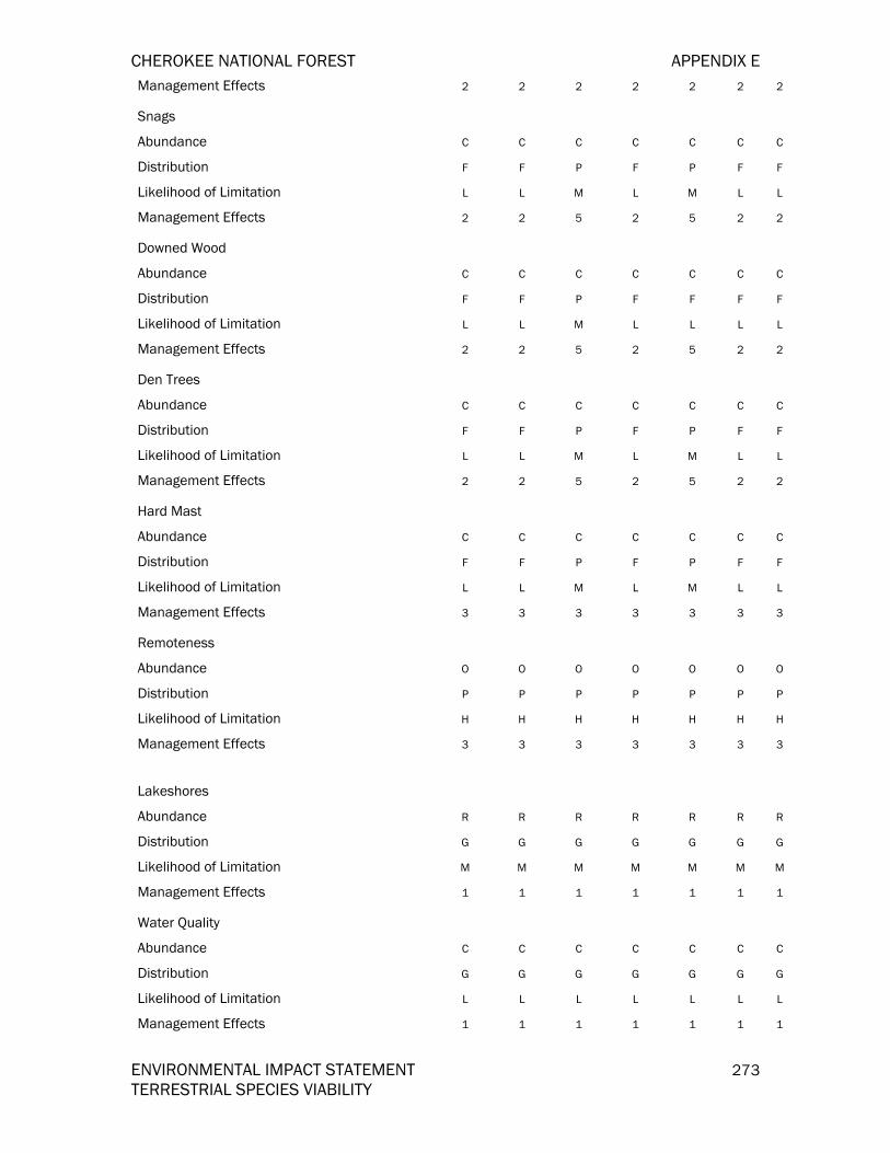
CHEROKEE NATIONAL FOREST APPENDIX E
ENVIRONMENTAL IMPACT STATEMENT 273 TERRESTRIAL SPECIES VIABILITY
Management Effects 2 2 2 2 2 2 2
Snags Abundance C C C C C C C Distribution F F P F P F F Likelihood of Limitation L L M L M L L Management Effects 2 2 5 2 5 2 2
Downed Wood Abundance C C C C C C C Distribution F F P F F F F Likelihood of Limitation L L M L L L L Management Effects 2 2 5 2 5 2 2
Den Trees Abundance C C C C C C C Distribution F F P F P F F Likelihood of Limitation L L M L M L L Management Effects 2 2 5 2 5 2 2
Hard Mast Abundance C C C C C C C Distribution F F P F P F F Likelihood of Limitation L L M L M L L Management Effects 3 3 3 3 3 3 3
Remoteness Abundance O O O O O O O Distribution P P P P P P P Likelihood of Limitation H H H H H H H Management Effects 3 3 3 3 3 3 3
Lakeshores Abundance R R R R R R R Distribution G G G G G G G Likelihood of Limitation M M M M M M M Management Effects 1 1 1 1 1 1 1
Water Quality Abundance C C C C C C C Distribution G G G G G G G Likelihood of Limitation L L L L L L L Management Effects 1 1 1 1 1 1 1
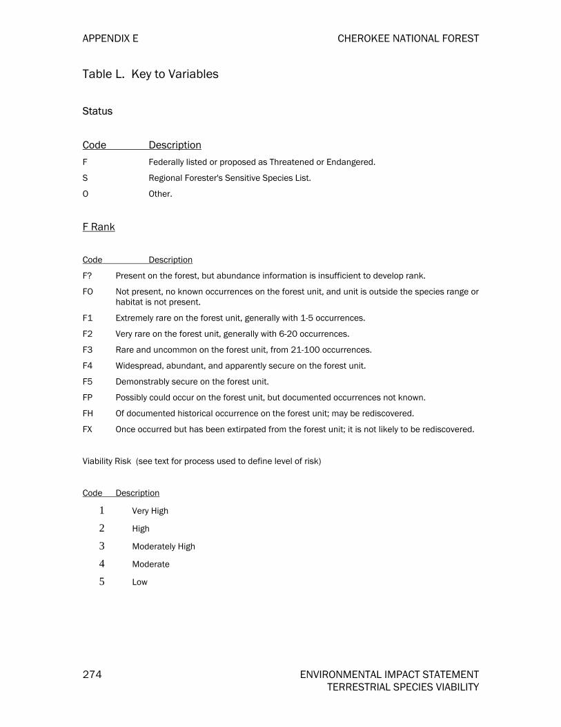
APPENDIX E CHEROKEE NATIONAL FOREST
274 ENVIRONMENTAL IMPACT STATEMENT TERRESTRIAL SPECIES VIABILITY
Table L. Key to Variables
Status
Code Description
F Federally listed or proposed as Threatened or Endangered.
S Regional Forester's Sensitive Species List.
O Other.
F Rank
Code Description
F? Present on the forest, but abundance information is insufficient to develop rank.
FO Not present, no known occurrences on the forest unit, and unit is outside the species range or habitat is not present.
F1 Extremely rare on the forest unit, generally with 1-5 occurrences.
F2 Very rare on the forest unit, generally with 6-20 occurrences.
F3 Rare and uncommon on the forest unit, from 21-100 occurrences.
F4 Widespread, abundant, and apparently secure on the forest unit.
F5 Demonstrably secure on the forest unit.
FP Possibly could occur on the forest unit, but documented occurrences not known.
FH Of documented historical occurrence on the forest unit; may be rediscovered.
FX Once occurred but has been extirpated from the forest unit; it is not likely to be rediscovered.
Viability Risk (see text for process used to define level of risk)
Code Description
1 Very High
2 High
3 Moderately High
4 Moderate
5 Low
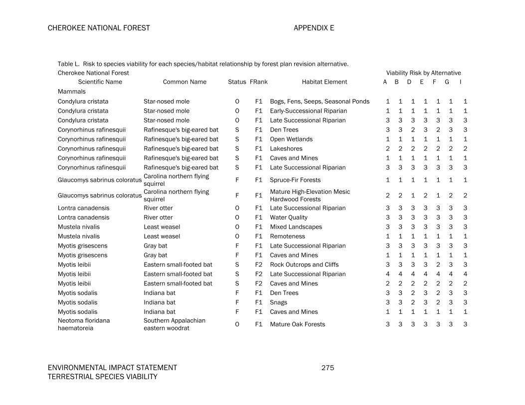
CHEROKEE NATIONAL FOREST APPENDIX E
ENVIRONMENTAL IMPACT STATEMENT 275 TERRESTRIAL SPECIES VIABILITY
Table L. Risk to species viability for each species/habitat relationship by forest plan revision alternative. Cherokee National Forest Viability Risk by Alternative
Scientific Name Common Name Status FRank Habitat Element A B D E F G I
Mammals
Condylura cristata Star-nosed mole O F1 Bogs, Fens, Seeps, Seasonal Ponds 1 1 1 1 1 1 1Condylura cristata Star-nosed mole O F1 Early-Successional Riparian 1 1 1 1 1 1 1Condylura cristata Star-nosed mole O F1 Late Successional Riparian 3 3 3 3 3 3 3Corynorhinus rafinesquii Rafinesque's big-eared bat S F1 Den Trees 3 3 2 3 2 3 3Corynorhinus rafinesquii Rafinesque's big-eared bat S F1 Open Wetlands 1 1 1 1 1 1 1Corynorhinus rafinesquii Rafinesque's big-eared bat S F1 Lakeshores 2 2 2 2 2 2 2Corynorhinus rafinesquii Rafinesque's big-eared bat S F1 Caves and Mines 1 1 1 1 1 1 1Corynorhinus rafinesquii Rafinesque's big-eared bat S F1 Late Successional Riparian 3 3 3 3 3 3 3
Glaucomys sabrinus coloratus Carolina northern flying squirrel F F1 Spruce-Fir Forests 1 1 1 1 1 1 1
Glaucomys sabrinus coloratus Carolina northern flying squirrel F F1 Mature High-Elevation Mesic
Hardwood Forests 2 2 1 2 1 2 2
Lontra canadensis River otter O F1 Late Successional Riparian 3 3 3 3 3 3 3Lontra canadensis River otter O F1 Water Quality 3 3 3 3 3 3 3Mustela nivalis Least weasel O F1 Mixed Landscapes 3 3 3 3 3 3 3Mustela nivalis Least weasel O F1 Remoteness 1 1 1 1 1 1 1Myotis grisescens Gray bat F F1 Late Successional Riparian 3 3 3 3 3 3 3Myotis grisescens Gray bat F F1 Caves and Mines 1 1 1 1 1 1 1Myotis leibii Eastern small-footed bat S F2 Rock Outcrops and Cliffs 3 3 3 3 2 3 3Myotis leibii Eastern small-footed bat S F2 Late Successional Riparian 4 4 4 4 4 4 4Myotis leibii Eastern small-footed bat S F2 Caves and Mines 2 2 2 2 2 2 2Myotis sodalis Indiana bat F F1 Den Trees 3 3 2 3 2 3 3Myotis sodalis Indiana bat F F1 Snags 3 3 2 3 2 3 3Myotis sodalis Indiana bat F F1 Caves and Mines 1 1 1 1 1 1 1Neotoma floridana haematoreia
Southern Appalachian eastern woodrat O F1 Mature Oak Forests 3 3 3 3 3 3 3

APPENDIX E CHEROKEE NATIONAL FOREST
276 ENVIRONMENTAL IMPACT STATEMENT TERRESTRIAL SPECIES VIABILITY
Table L. Risk to species viability for each species/habitat relationship by forest plan revision alternative. Cherokee National Forest Viability Risk by Alternative
Scientific Name Common Name Status FRank Habitat Element A B D E F G I Neotoma floridana haematoreia
Southern Appalachian eastern woodrat O F1 Glades and Barrens 1 1 1 1 1 1 1
Neotoma floridana haematoreia
Southern Appalachian eastern woodrat O F1 Woodlands, Savannas, and Grasslands 1 2 1 1 1 1 2
Neotoma floridana haematoreia
Southern Appalachian eastern woodrat O F1 Rock Outcrops and Cliffs 2 2 2 2 1 2 2
Neotoma magister Allegheny woodrat O F1 Rock Outcrops and Cliffs 2 2 2 2 1 2 2
Parascalops breweri Hairy-tailed mole O F1 Mature High-Elevation Mesic Hardwood Forests 2 2 1 2 1 2 2
Sorex cinereus cinereus Masked shrew O F3 Late Successional Riparian 5 5 5 5 5 5 5Sorex dispar Long-tailed shrew O F2 Rock Outcrops and Cliffs 3 3 3 3 2 3 3Sorex palustris punctulatus Southern water shrew O F1 Bogs, Fens, Seeps, Seasonal Ponds 1 1 1 1 1 1 1Sorex palustris punctulatus Southern water shrew O F1 Late Successional Riparian 3 3 3 3 3 3 3Sorex palustris punctulatus Southern water shrew O F1 Downed Wood 3 3 2 3 3 3 3Spilogale putorius Spotted skunk O F1 Mature Mesic Hardwood Forests 3 3 2 3 2 3 2Spilogale putorius Spotted skunk O F1 Rock Outcrops and Cliffs 2 2 2 2 1 2 2Sylvilagus transitionalis New England cottontail O F1 High Elevation Early Succession 1 1 3 1 3 1 1Synaptomys cooperi Southern bog lemming O F1 Bogs, Fens, Seeps, Seasonal Ponds 1 1 1 1 1 1 1Synaptomys cooperi Southern bog lemming O F1 Open Wetlands 1 1 1 1 1 1 1Birds Accipiter cooperii Cooper's hawk O F3 Mixed Landscapes 5 5 5 5 5 5 5Accipiter striatus Sharp-shinned hawk O F3 Mature Mesic Hardwood Forests 5 5 4 5 4 5 4
Accipiter striatus Sharp-shinned hawk O F3 Mature Hemlock Forests 3 3 3 3 3 3 3
Aegolius acadicus Northern saw-whet owl O F1 Snags 3 3 2 3 2 3 3Aegolius acadicus Northern saw-whet owl O F1 Spruce-Fir Forests 1 1 1 1 1 1 1Aegolius acadicus Northern saw-whet owl O F1 Remoteness 1 1 1 1 1 1 1Caprimulgus carolinensis Chuck-wills-widow O F3 Mixed Landscapes 5 5 5 5 5 5 5Caprimulgus carolinensis Chuck-wills-widow O F3 Mature Yellow Pine Forests 4 4 4 4 4 4 4
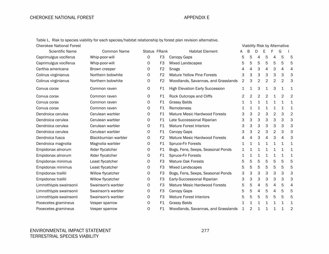
CHEROKEE NATIONAL FOREST APPENDIX E
ENVIRONMENTAL IMPACT STATEMENT 277 TERRESTRIAL SPECIES VIABILITY
Table L. Risk to species viability for each species/habitat relationship by forest plan revision alternative. Cherokee National Forest Viability Risk by Alternative
Scientific Name Common Name Status FRank Habitat Element A B D E F G I Caprimulgus vociferus Whip-poor-will O F3 Canopy Gaps 5 5 4 5 4 5 5Caprimulgus vociferus Whip-poor-will O F3 Mixed Landscapes 5 5 5 5 5 5 5Certhia americana Brown creeper O F2 Snags 4 4 3 4 3 4 4Colinus virginianus Northern bobwhite O F2 Mature Yellow Pine Forests 3 3 3 3 3 3 3Colinus virginianus Northern bobwhite O F2 Woodlands, Savannas, and Grasslands 2 3 2 2 2 2 3
Corvus corax Common raven O F1 High Elevation Early Succession 1 1 3 1 3 1 1
Corvus corax Common raven O F1 Rock Outcrops and Cliffs 2 2 2 2 1 2 2Corvus corax Common raven O F1 Grassy Balds 1 1 1 1 1 1 1Corvus corax Common raven O F1 Remoteness 1 1 1 1 1 1 1Dendroica cerulea Cerulean warbler O F1 Mature Mesic Hardwood Forests 3 3 2 3 2 3 2Dendroica cerulea Cerulean warbler O F1 Late Successional Riparian 3 3 3 3 3 3 3Dendroica cerulea Cerulean warbler O F1 Mature Forest Interiors 3 3 3 3 3 3 3Dendroica cerulea Cerulean warbler O F1 Canopy Gaps 3 3 2 3 2 3 3Dendroica fusca Blackburnian warbler O F2 Mature Mesic Hardwood Forests 4 4 3 4 3 4 3Dendroica magnolia Magnolia warbler O F1 Spruce-Fir Forests 1 1 1 1 1 1 1Empidonax alnorum Alder flycatcher O F1 Bogs, Fens, Seeps, Seasonal Ponds 1 1 1 1 1 1 1Empidonax alnorum Alder flycatcher O F1 Spruce-Fir Forests 1 1 1 1 1 1 1Empidonax minimus Least flycatcher O F3 Mature Oak Forests 5 5 5 5 5 5 5Empidonax minimus Least flycatcher O F3 Mixed Landscapes 5 5 5 5 5 5 5Empidonax traillii Willow flycatcher O F3 Bogs, Fens, Seeps, Seasonal Ponds 3 3 3 3 3 3 3Empidonax traillii Willow flycatcher O F3 Early-Successional Riparian 3 3 3 3 3 3 3Limnothlypis swainsonii Swainson's warbler O F3 Mature Mesic Hardwood Forests 5 5 4 5 4 5 4Limnothlypis swainsonii Swainson's warbler O F3 Canopy Gaps 5 5 4 5 4 5 5Limnothlypis swainsonii Swainson's warbler O F3 Mature Forest Interiors 5 5 5 5 5 5 5Pooecetes gramineus Vesper sparrow O F1 Grassy Balds 1 1 1 1 1 1 1Pooecetes gramineus Vesper sparrow O F1 Woodlands, Savannas, and Grasslands 1 2 1 1 1 1 2
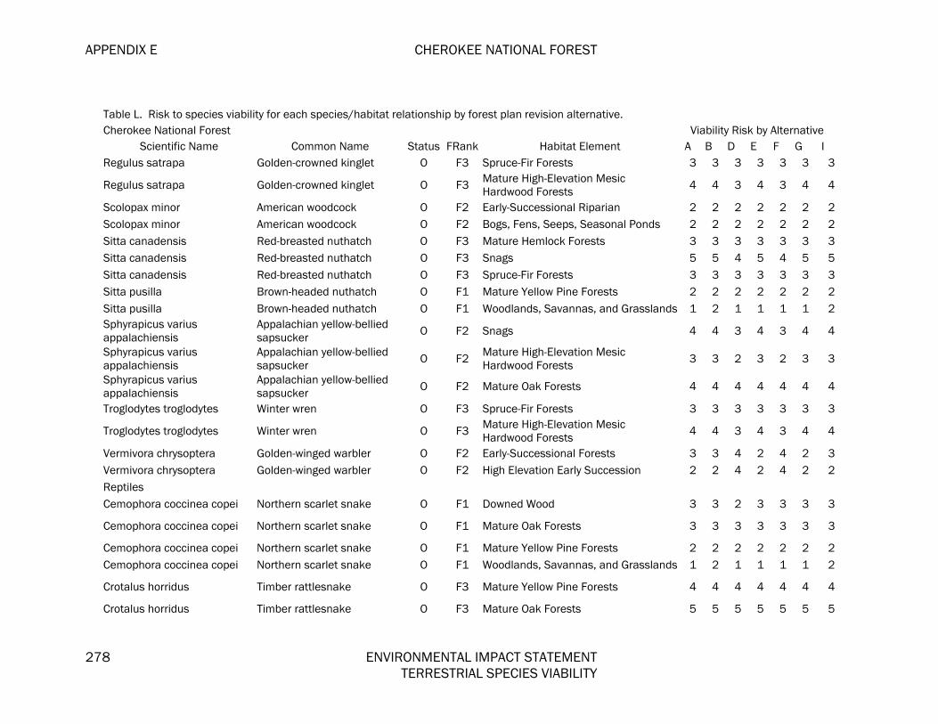
APPENDIX E CHEROKEE NATIONAL FOREST
278 ENVIRONMENTAL IMPACT STATEMENT TERRESTRIAL SPECIES VIABILITY
Table L. Risk to species viability for each species/habitat relationship by forest plan revision alternative. Cherokee National Forest Viability Risk by Alternative
Scientific Name Common Name Status FRank Habitat Element A B D E F G I Regulus satrapa Golden-crowned kinglet O F3 Spruce-Fir Forests 3 3 3 3 3 3 3
Regulus satrapa Golden-crowned kinglet O F3 Mature High-Elevation Mesic Hardwood Forests 4 4 3 4 3 4 4
Scolopax minor American woodcock O F2 Early-Successional Riparian 2 2 2 2 2 2 2Scolopax minor American woodcock O F2 Bogs, Fens, Seeps, Seasonal Ponds 2 2 2 2 2 2 2Sitta canadensis Red-breasted nuthatch O F3 Mature Hemlock Forests 3 3 3 3 3 3 3Sitta canadensis Red-breasted nuthatch O F3 Snags 5 5 4 5 4 5 5Sitta canadensis Red-breasted nuthatch O F3 Spruce-Fir Forests 3 3 3 3 3 3 3Sitta pusilla Brown-headed nuthatch O F1 Mature Yellow Pine Forests 2 2 2 2 2 2 2Sitta pusilla Brown-headed nuthatch O F1 Woodlands, Savannas, and Grasslands 1 2 1 1 1 1 2Sphyrapicus varius appalachiensis
Appalachian yellow-bellied sapsucker O F2 Snags 4 4 3 4 3 4 4
Sphyrapicus varius appalachiensis
Appalachian yellow-bellied sapsucker O F2 Mature High-Elevation Mesic
Hardwood Forests 3 3 2 3 2 3 3
Sphyrapicus varius appalachiensis
Appalachian yellow-bellied sapsucker O F2 Mature Oak Forests 4 4 4 4 4 4 4
Troglodytes troglodytes Winter wren O F3 Spruce-Fir Forests 3 3 3 3 3 3 3
Troglodytes troglodytes Winter wren O F3 Mature High-Elevation Mesic Hardwood Forests 4 4 3 4 3 4 4
Vermivora chrysoptera Golden-winged warbler O F2 Early-Successional Forests 3 3 4 2 4 2 3Vermivora chrysoptera Golden-winged warbler O F2 High Elevation Early Succession 2 2 4 2 4 2 2Reptiles Cemophora coccinea copei Northern scarlet snake O F1 Downed Wood 3 3 2 3 3 3 3
Cemophora coccinea copei Northern scarlet snake O F1 Mature Oak Forests 3 3 3 3 3 3 3
Cemophora coccinea copei Northern scarlet snake O F1 Mature Yellow Pine Forests 2 2 2 2 2 2 2Cemophora coccinea copei Northern scarlet snake O F1 Woodlands, Savannas, and Grasslands 1 2 1 1 1 1 2
Crotalus horridus Timber rattlesnake O F3 Mature Yellow Pine Forests 4 4 4 4 4 4 4
Crotalus horridus Timber rattlesnake O F3 Mature Oak Forests 5 5 5 5 5 5 5

CHEROKEE NATIONAL FOREST APPENDIX E
ENVIRONMENTAL IMPACT STATEMENT 279 TERRESTRIAL SPECIES VIABILITY
Table L. Risk to species viability for each species/habitat relationship by forest plan revision alternative. Cherokee National Forest Viability Risk by Alternative
Scientific Name Common Name Status FRank Habitat Element A B D E F G I Crotalus horridus Timber rattlesnake O F3 Downed Wood 5 5 4 5 5 5 5Crotalus horridus Timber rattlesnake O F3 Rock Outcrops and Cliffs 4 4 4 4 3 4 4
Crotalus horridus Timber rattlesnake O F3 Woodlands, Savannas, and Grasslands 3 4 3 3 3 3 4
Elaphe guttata guttata Corn snake O F1 Downed Wood 3 3 2 3 3 3 3Elaphe guttata guttata Corn snake O F1 Mature Yellow Pine Forests 2 2 2 2 2 2 2Elaphe guttata guttata Corn snake O F1 Woodlands, Savannas, and Grasslands 1 2 1 1 1 1 2Elaphe guttata guttata Corn snake O F1 Snags 3 3 2 3 2 3 3Eumeces anthracinus anthracinus Northern coal skink O F1 Downed Wood 3 3 2 3 3 3 3
Eumeces anthracinus anthracinus Northern coal skink O F1 Late Successional Riparian 3 3 3 3 3 3 3
Eumeces inexpectatus Southeastern five-lined skink O F1 Mature Yellow Pine Forests 2 2 2 2 2 2 2Eumeces inexpectatus Southeastern five-lined skink O F1 Mature Oak Forests 3 3 3 3 3 3 3Eumeces inexpectatus Southeastern five-lined skink O F1 Canopy Gaps 3 3 2 3 2 3 3Eumeces inexpectatus Southeastern five-lined skink O F1 Downed Wood 3 3 2 3 3 3 3Ophisaurus attenuatus longicaudus Eastern slender glass lizard O F1 Mature Oak Forests 3 3 3 3 3 3 3
Ophisaurus attenuatus longicaudus Eastern slender glass lizard O F1 Mixed Landscapes 3 3 3 3 3 3 3
Ophisaurus attenuatus longicaudus Eastern slender glass lizard O F1 Woodlands, Savannas, and Grasslands 1 2 1 1 1 1 2
Pituophis melanoleucus melanoleucus Northern pine snake O F1 Downed Wood 3 3 2 3 3 3 3
Pituophis melanoleucus melanoleucus Northern pine snake O F1 Mature Yellow Pine Forests 2 2 2 2 2 2 2
Pituophis melanoleucus melanoleucus Northern pine snake O F1 Woodlands, Savannas, and Grasslands 1 2 1 1 1 1 2
Amphibians Ambystoma talpoideum Mole salamander O F1 Downed Wood 3 3 2 3 3 3 3Ambystoma talpoideum Mole salamander O F1 Mature Mesic Hardwood Forests 3 3 2 3 2 3 2

APPENDIX E CHEROKEE NATIONAL FOREST
280 ENVIRONMENTAL IMPACT STATEMENT TERRESTRIAL SPECIES VIABILITY
Table L. Risk to species viability for each species/habitat relationship by forest plan revision alternative. Cherokee National Forest Viability Risk by Alternative
Scientific Name Common Name Status FRank Habitat Element A B D E F G I Ambystoma talpoideum Mole salamander O F1 Late Successional Riparian 3 3 3 3 3 3 3Desmognathus aeneus Seepage salamander O F3 Mature Mesic Hardwood Forests 5 5 4 5 4 5 4Desmognathus aeneus Seepage salamander O F3 Downed Wood 5 5 4 5 5 5 5Desmognathus aeneus Seepage salamander O F3 Bogs, Fens, Seeps, Seasonal Ponds 3 3 3 3 3 3 3
Desmognathus carolinensis Carolina mountain dusky salamander O F3 Bogs, Fens, Seeps, Seasonal Ponds 3 3 3 3 3 3 3
Desmognathus carolinensis Carolina mountain dusky salamander O F3 Spruce-Fir Forests 3 3 3 3 3 3 3
Desmognathus carolinensis Carolina mountain dusky salamander O F3 Mature Mesic Hardwood Forests 5 5 4 5 4 5 4
Desmognathus carolinensis Carolina mountain dusky salamander O F3 Downed Wood 5 5 4 5 5 5 5
Desmognathus carolinensis Carolina mountain dusky salamander O F3 Late Successional Riparian 5 5 5 5 5 5 5
Desmognathus ochrophaeus Mountain dusky salamander O F3 Bogs, Fens, Seeps, Seasonal Ponds 3 3 3 3 3 3 3Desmognathus ochrophaeus Mountain dusky salamander O F3 Downed Wood 5 5 4 5 5 5 5Desmognathus ochrophaeus Mountain dusky salamander O F3 Late Successional Riparian 5 5 5 5 5 5 5Desmognathus ochrophaeus Mountain dusky salamander O F3 Mature Mesic Hardwood Forests 5 5 4 5 4 5 4
Desmognathus santeetlah Santeetlah dusky salamander S F1 Downed Wood 3 3 2 3 3 3 3
Desmognathus santeetlah Santeetlah dusky salamander S F1 Late Successional Riparian 3 3 3 3 3 3 3
Desmognathus santeetlah Santeetlah dusky salamander S F1 Mature Mesic Hardwood Forests 3 3 2 3 2 3 2
Desmognathus santeetlah Santeetlah dusky salamander S F1 Bogs, Fens, Seeps, Seasonal Ponds 1 1 1 1 1 1 1
Desmognathus wrighti Pigmy salamander O F1 Downed Wood 3 3 2 3 3 3 3Desmognathus wrighti Pigmy salamander O F1 Spruce-Fir Forests 1 1 1 1 1 1 1Desmognathus wrighti Pigmy salamander O F1 Mature Mesic Hardwood Forests 3 3 2 3 2 3 2Eurycea junaluska Junaluska salamander S F1 Late Successional Riparian 3 3 3 3 3 3 3

CHEROKEE NATIONAL FOREST APPENDIX E
ENVIRONMENTAL IMPACT STATEMENT 281 TERRESTRIAL SPECIES VIABILITY
Table L. Risk to species viability for each species/habitat relationship by forest plan revision alternative. Cherokee National Forest Viability Risk by Alternative
Scientific Name Common Name Status FRank Habitat Element A B D E F G I Eurycea longicauda Longtail salamander O F3 Downed Wood 5 5 4 5 5 5 5Eurycea longicauda Longtail salamander O F3 Late Successional Riparian 5 5 5 5 5 5 5Eurycea longicauda Longtail salamander O F3 Bogs, Fens, Seeps, Seasonal Ponds 3 3 3 3 3 3 3Plethodon aureolus Tellico salamander S F2 Mature Mesic Hardwood Forests 4 4 3 4 3 4 3Plethodon aureolus Tellico salamander S F2 Downed Wood 4 4 3 4 4 4 4Plethodon aureolus Tellico salamander S F2 Late Successional Riparian 4 4 4 4 4 4 4Plethodon dorsalis Zigzag salamander O F2 Mature Mesic Hardwood Forests 4 4 3 4 3 4 3Plethodon dorsalis Zigzag salamander O F2 Downed Wood 4 4 3 4 4 4 4
Plethodon dorsalis Zigzag salamander O F2 Late Successional Riparian 4 4 4 4 4 4 4
Plethodon dorsalis Zigzag salamander O F2 Bogs, Fens, Seeps, Seasonal Ponds 2 2 2 2 2 2 2
Plethodon teyahalee Southern Appalachian salamander S F2 Downed Wood 4 4 3 4 4 4 4
Plethodon teyahalee Southern Appalachian salamander S F2 Mature Mesic Hardwood Forests 4 4 3 4 3 4 3
Plethodon ventralis Southern zigzag salamander O F1 Downed Wood 3 3 2 3 3 3 3 Plethodon ventralis Southern zigzag salamander O F1 Mature Mesic Hardwood Forests 3 3 2 3 2 3 2 Plethodon welleri Weller's salamander S F2 Downed Wood 4 4 3 4 4 4 4 Plethodon welleri Weller's salamander S F2 Spruce-Fir Forests 2 2 2 2 2 2 2 Plethodon yonahlossee Yonahlossee salamander O F2 Downed Wood 4 4 3 4 4 4 4 Plethodon yonahlossee Yonahlossee salamander O F2 Mature Mesic Hardwood Forests 4 4 3 4 3 4 3 Pseudacris brachyphona Mountain chorus frog O F2 Bogs, Fens, Seeps, Seasonal Ponds 2 2 2 2 2 2 2Pseudacris brachyphona Mountain chorus frog O F2 Late Successional Riparian 4 4 4 4 4 4 4Pseudacris brachyphona Mountain chorus frog O F2 Mature Mesic Hardwood Forests 4 4 3 4 3 4 3Pseudotriton montanus Eastern mud salamander O F2 Late Successional Riparian 4 4 4 4 4 4 4Pseudotriton montanus Eastern mud salamander O F2 Downed Wood 4 4 3 4 4 4 4Pseudotriton montanus Eastern mud salamander O F2 Open Wetlands 2 2 2 2 2 2 2Pseudotriton montanus Eastern mud salamander O F2 Bogs, Fens, Seeps, Seasonal Ponds 2 2 2 2 2 2 2Invertebrates

APPENDIX E CHEROKEE NATIONAL FOREST
282 ENVIRONMENTAL IMPACT STATEMENT TERRESTRIAL SPECIES VIABILITY
Table L. Risk to species viability for each species/habitat relationship by forest plan revision alternative. Cherokee National Forest Viability Risk by Alternative
Scientific Name Common Name Status FRank Habitat Element A B D E F G I Discus bryanti Saw-tooth disc O F2 Mature Oak Forests 4 4 4 4 4 4 4Discus bryanti Saw-tooth disc O F2 Rock Outcrops and Cliffs 3 3 3 3 2 3 3Discus bryanti Saw-tooth disc O F2 Downed Wood 4 4 3 4 4 4 4Glyphyalinia junaluskana Dark glyph O F1 Downed Wood 3 3 2 3 3 3 3Glyphyalinia junaluskana Dark glyph O F1 Mature Mesic Hardwood Forests 3 3 2 3 2 3 2Glyphyalinia ocoae Blue-gray glyph O F2 Downed Wood 4 4 3 4 4 4 4Glyphyalinia ocoae Blue-gray glyph O F2 Mature Mesic Hardwood Forests 4 4 3 4 3 4 3Glyphyalinia pentadelphia Pink glyph O F3 Downed Wood 5 5 4 5 5 5 5Glyphyalinia pentadelphia Pink glyph O F3 Mature Mesic Hardwood Forests 5 5 4 5 4 5 4Glyphyalinia vanattai Honey glyph O F1 Downed Wood 3 3 2 3 3 3 3Glyphyalinia vanattai Honey glyph O F1 Mature Mesic Hardwood Forests 3 3 2 3 2 3 2Haplotrema kendeighi Blue-footed lancetooth O F1 Downed Wood 3 3 2 3 3 3 3
Haplotrema kendeighi Blue-footed lancetooth O F1 Mature High-Elevation Mesic Hardwood Forests 2 2 1 2 1 2 2
Helicodiscus fimbriatus Fringed coil O F2 Mature Mesic Hardwood Forests 4 4 3 4 3 4 3Helicodiscus fimbriatus Fringed coil O F2 Rock Outcrops and Cliffs 3 3 3 3 2 3 3Helicodiscus fimbriatus Fringed coil O F2 Downed Wood 4 4 3 4 4 4 4Helicodiscus multidens Twighlight coil O F1 Bogs, Fens, Seeps, Seasonal Ponds 1 1 1 1 1 1 1Helicodiscus multidens Twighlight coil O F1 Caves and Mines 1 1 1 1 1 1 1
Mesodon andrewsae Balsam globe O F2 Mature Mesic Hardwood Forests 4 4 3 4 3 4 3
Mesodon andrewsae Balsam globe O F2 Rock Outcrops and Cliffs 3 3 3 3 2 3 3Mesodon andrewsae Balsam globe O F2 Bogs, Fens, Seeps, Seasonal Ponds 2 2 2 2 2 2 2Mesodon archeri Ocoee covert O F2 Downed Wood 4 4 3 4 4 4 4Mesodon archeri Ocoee covert O F2 Rock Outcrops and Cliffs 3 3 3 3 2 3 3
Mesodon chilhoweensis Queen crater O F1 Mature High-Elevation Mesic Hardwood Forests 2 2 1 2 1 2 2
Mesodon chilhoweensis Queen crater O F1 Beech Gap Forests 1 1 1 1 1 1 1Mesomphix andrewsae Mountain button O F2 Mature Mesic Hardwood Forests 4 4 3 4 3 4 3
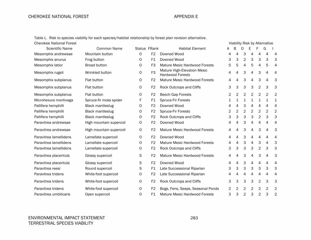
CHEROKEE NATIONAL FOREST APPENDIX E
ENVIRONMENTAL IMPACT STATEMENT 283 TERRESTRIAL SPECIES VIABILITY
Table L. Risk to species viability for each species/habitat relationship by forest plan revision alternative. Cherokee National Forest Viability Risk by Alternative
Scientific Name Common Name Status FRank Habitat Element A B D E F G I Mesomphix andrewsae Mountain button O F2 Downed Wood 4 4 3 4 4 4 4Mesomphix anurus Frog button O F1 Downed Wood 3 3 2 3 3 3 3Mesomphix latior Broad button O F3 Mature Mesic Hardwood Forests 5 5 4 5 4 5 4
Mesomphix rugeli Wrinkled button O F3 Mature High-Elevation Mesic Hardwood Forests 4 4 3 4 3 4 4
Mesomphix subplanus Flat button O F2 Mature Mesic Hardwood Forests 4 4 3 4 3 4 3
Mesomphix subplanus Flat button O F2 Rock Outcrops and Cliffs 3 3 3 3 2 3 3
Mesomphix subplanus Flat button O F2 Beech Gap Forests 2 2 2 2 2 2 2Microhexura montivaga Spruce-fir moss spider F F1 Spruce-Fir Forests 1 1 1 1 1 1 1Pallifera hemphilli Black mantleslug O F2 Downed Wood 4 4 3 4 4 4 4Pallifera hemphilli Black mantleslug O F2 Spruce-Fir Forests 2 2 2 2 2 2 2Pallifera hemphilli Black mantleslug O F2 Rock Outcrops and Cliffs 3 3 3 3 2 3 3Paravitrea andrewsae High mountain supercoil O F2 Downed Wood 4 4 3 4 4 4 4
Paravitrea andrewsae High mountain supercoil O F2 Mature Mesic Hardwood Forests 4 4 3 4 3 4 3
Paravitrea lamellidens Lamellate supercoil O F2 Downed Wood 4 4 3 4 4 4 4Paravitrea lamellidens Lamellate supercoil O F2 Mature Mesic Hardwood Forests 4 4 3 4 3 4 3Paravitrea lamellidens Lamellate supercoil O F2 Rock Outcrops and Cliffs 3 3 3 3 2 3 3
Paravitrea placentula Glossy supercoil S F2 Mature Mesic Hardwood Forests 4 4 3 4 3 4 3
Paravitrea placentula Glossy supercoil S F2 Downed Wood 4 4 3 4 4 4 4Paravitrea reesi Round supercoil S F1 Late Successional Riparian 3 3 3 3 3 3 3Paravitrea tridens White-foot supercoil O F2 Late Successional Riparian 4 4 4 4 4 4 4
Paravitrea tridens White-foot supercoil O F2 Rock Outcrops and Cliffs 3 3 3 3 2 3 3
Paravitrea tridens White-foot supercoil O F2 Bogs, Fens, Seeps, Seasonal Ponds 2 2 2 2 2 2 2Paravitrea umbilicaris Open supercoil O F1 Mature Mesic Hardwood Forests 3 3 2 3 2 3 2

APPENDIX E CHEROKEE NATIONAL FOREST
284 ENVIRONMENTAL IMPACT STATEMENT TERRESTRIAL SPECIES VIABILITY
Table L. Risk to species viability for each species/habitat relationship by forest plan revision alternative. Cherokee National Forest Viability Risk by Alternative
Scientific Name Common Name Status FRank Habitat Element A B D E F G I
Paravitrea umbilicaris Open supercoil O F1 Downed Wood 3 3 2 3 3 3 3
Paravitrea varidens Roan supercoil O F1 Mature Mesic Hardwood Forests 3 3 2 3 2 3 2Paravitrea varidens Roan supercoil O F1 Downed Wood 3 3 2 3 3 3 3Patera clarki Dwarf proud globe O F1 Downed Wood 3 3 2 3 3 3 3
Patera clarki Dwarf proud globe O F1 Mature High-Elevation Mesic Hardwood Forests 2 2 1 2 1 2 2
Speyeria diana Diana fritillary S F3 Mature Mesic Hardwood Forests 5 5 4 5 4 5 4Speyeria diana Diana fritillary S F3 Canopy Gaps 5 5 4 5 4 5 5Stenotrema altispira Highland slitmouth O F2 Bogs, Fens, Seeps, Seasonal Ponds 2 2 2 2 2 2 2Stenotrema altispira Highland slitmouth O F2 Downed Wood 4 4 3 4 4 4 4Stenotrema altispira Highland slitmouth O F2 Rock Outcrops and Cliffs 3 3 3 3 2 3 3Stenotrema barbigerum Fringed slitmouth O F2 Downed Wood 4 4 3 4 4 4 4Stenotrema barbigerum Fringed slitmouth O F2 Late Successional Riparian 4 4 4 4 4 4 4
Stenotrema cohuttense Cohutta slitmouth O F2 Downed Wood 4 4 3 4 4 4 4
Stenotrema magnafumosum Appalachian slitmouth O F3 Downed Wood 5 5 4 5 5 5 5Triodopsis anteridon Carter threetooth O F1 Downed Wood 3 3 2 3 3 3 3Ventridens arcellus Golden dome O F2 Rock Outcrops and Cliffs 3 3 3 3 2 3 3Ventridens arcellus Golden dome O F2 Downed Wood 4 4 3 4 4 4 4Ventridens collisella Sculptured dome O F2 Basic Mesic Forests 2 2 2 2 2 2 2Ventridens collisella Sculptured dome O F2 Mature Mesic Hardwood Forests 4 4 3 4 3 4 3Ventridens collisella Sculptured dome O F2 Downed Wood 4 4 3 4 4 4 4
Ventridens decussatus Crossed dome O F3 Bogs, Fens, Seeps, Seasonal Ponds 3 3 3 3 3 3 3
Ventridens decussatus Crossed dome O F3 Downed Wood 5 5 4 5 5 5 5Ventridens lasmodon Hollow dome O F3 Basic Mesic Forests 3 3 3 3 3 3 3Ventridens lasmodon Hollow dome O F3 Mature Mesic Hardwood Forests 5 5 4 5 4 5 4
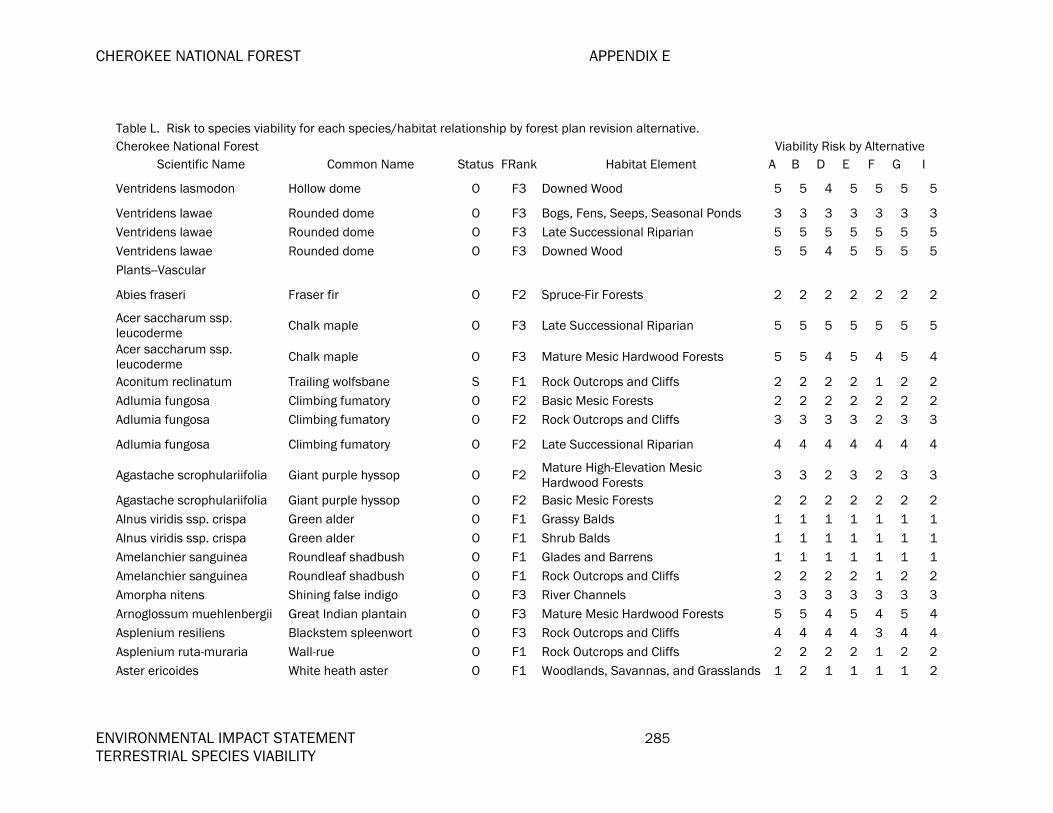
CHEROKEE NATIONAL FOREST APPENDIX E
ENVIRONMENTAL IMPACT STATEMENT 285 TERRESTRIAL SPECIES VIABILITY
Table L. Risk to species viability for each species/habitat relationship by forest plan revision alternative. Cherokee National Forest Viability Risk by Alternative
Scientific Name Common Name Status FRank Habitat Element A B D E F G I
Ventridens lasmodon Hollow dome O F3 Downed Wood 5 5 4 5 5 5 5
Ventridens lawae Rounded dome O F3 Bogs, Fens, Seeps, Seasonal Ponds 3 3 3 3 3 3 3Ventridens lawae Rounded dome O F3 Late Successional Riparian 5 5 5 5 5 5 5Ventridens lawae Rounded dome O F3 Downed Wood 5 5 4 5 5 5 5Plants--Vascular
Abies fraseri Fraser fir O F2 Spruce-Fir Forests 2 2 2 2 2 2 2
Acer saccharum ssp. leucoderme Chalk maple O F3 Late Successional Riparian 5 5 5 5 5 5 5
Acer saccharum ssp. leucoderme Chalk maple O F3 Mature Mesic Hardwood Forests 5 5 4 5 4 5 4
Aconitum reclinatum Trailing wolfsbane S F1 Rock Outcrops and Cliffs 2 2 2 2 1 2 2Adlumia fungosa Climbing fumatory O F2 Basic Mesic Forests 2 2 2 2 2 2 2Adlumia fungosa Climbing fumatory O F2 Rock Outcrops and Cliffs 3 3 3 3 2 3 3
Adlumia fungosa Climbing fumatory O F2 Late Successional Riparian 4 4 4 4 4 4 4
Agastache scrophulariifolia Giant purple hyssop O F2 Mature High-Elevation Mesic Hardwood Forests 3 3 2 3 2 3 3
Agastache scrophulariifolia Giant purple hyssop O F2 Basic Mesic Forests 2 2 2 2 2 2 2Alnus viridis ssp. crispa Green alder O F1 Grassy Balds 1 1 1 1 1 1 1Alnus viridis ssp. crispa Green alder O F1 Shrub Balds 1 1 1 1 1 1 1Amelanchier sanguinea Roundleaf shadbush O F1 Glades and Barrens 1 1 1 1 1 1 1Amelanchier sanguinea Roundleaf shadbush O F1 Rock Outcrops and Cliffs 2 2 2 2 1 2 2Amorpha nitens Shining false indigo O F3 River Channels 3 3 3 3 3 3 3Arnoglossum muehlenbergii Great Indian plantain O F3 Mature Mesic Hardwood Forests 5 5 4 5 4 5 4Asplenium resiliens Blackstem spleenwort O F3 Rock Outcrops and Cliffs 4 4 4 4 3 4 4Asplenium ruta-muraria Wall-rue O F1 Rock Outcrops and Cliffs 2 2 2 2 1 2 2Aster ericoides White heath aster O F1 Woodlands, Savannas, and Grasslands 1 2 1 1 1 1 2

APPENDIX E CHEROKEE NATIONAL FOREST
286 ENVIRONMENTAL IMPACT STATEMENT TERRESTRIAL SPECIES VIABILITY
Table L. Risk to species viability for each species/habitat relationship by forest plan revision alternative. Cherokee National Forest Viability Risk by Alternative
Scientific Name Common Name Status FRank Habitat Element A B D E F G I
Athyrium pycnocarpon Narrow-leaved glade fern O F2 Mature High-Elevation Mesic Hardwood Forests 3 3 2 3 2 3 3
Athyrium pycnocarpon Narrow-leaved glade fern O F2 Mature Mesic Hardwood Forests 4 4 3 4 3 4 3Bartonia virginica Yellow screwstem O F2 Bogs, Fens, Seeps, Seasonal Ponds 2 2 2 2 2 2 2Botrychium jenmanii Alabama grape fern S F1 Mature Oak Forests 3 3 3 3 3 3 3Botrychium jenmanii Alabama grape fern S F1 Mixed Landscapes 3 3 3 3 3 3 3Botrychium jenmanii Alabama grape fern S F1 Canopy Gaps 3 3 2 3 2 3 3Botrychium jenmanii Alabama grape fern S F1 Woodlands, Savannas, and Grasslands 1 2 1 1 1 1 2Botrychium matricariifolium Chamomile grape fern O F1 Woodlands, Savannas, and Grasslands 1 2 1 1 1 1 2Botrychium matricariifolium Chamomile grape fern O F1 Mature Mesic Hardwood Forests 3 3 2 3 2 3 2
Botrychium oneidense Blunt-lobed grape fern O F1 Mature High-Elevation Mesic Hardwood Forests 2 2 1 2 1 2 2
Botrychium oneidense Blunt-lobed grape fern O F1 Bogs, Fens, Seeps, Seasonal Ponds 1 1 1 1 1 1 1
Boykinia aconitifolia Brook saxifrage O F2 Spray Cliffs 3 3 3 3 2 3 3Boykinia aconitifolia Brook saxifrage O F2 River Channels 2 2 2 2 2 2 2
Brachyelytrum septentrionale Northern shorthusk O F1 Mature High-Elevation Mesic Hardwood Forests 2 2 1 2 1 2 2
Brachyelytrum septentrionale Northern shorthusk O F1 Spruce-Fir Forests 1 1 1 1 1 1 1Buckleya distichophylla Piratebush S F2 Mature Oak Forests 4 4 4 4 4 4 4Buckleya distichophylla Piratebush S F2 Carolina Hemlock Forests 2 2 2 2 2 2 2Buckleya distichophylla Piratebush S F2 Rock Outcrops and Cliffs 3 3 3 3 2 3 3
Calamagrostis canadensis Canada reedgrass O F1 Grassy Balds 1 1 1 1 1 1 1
Calamagrostis canadensis Canada reedgrass O F1 Mature High-Elevation Mesic Hardwood Forests 2 2 1 2 1 2 2
Calamagrostis canadensis Canada reedgrass O F1 Spruce-Fir Forests 1 1 1 1 1 1 1
Calamagrostis canadensis Canada reedgrass O F1 Bogs, Fens, Seeps, Seasonal Ponds 1 1 1 1 1 1 1
Calamagrostis porteri Porter's reedgrass O F1 Rock Outcrops and Cliffs 2 2 2 2 1 2 2

CHEROKEE NATIONAL FOREST APPENDIX E
ENVIRONMENTAL IMPACT STATEMENT 287 TERRESTRIAL SPECIES VIABILITY
Table L. Risk to species viability for each species/habitat relationship by forest plan revision alternative. Cherokee National Forest Viability Risk by Alternative
Scientific Name Common Name Status FRank Habitat Element A B D E F G I Calopogon tuberosus Grass pink O F3 Bogs, Fens, Seeps, Seasonal Ponds 3 3 3 3 3 3 3Caltha palustris Marsh marigold O F1 Bogs, Fens, Seeps, Seasonal Ponds 1 1 1 1 1 1 1Campanula aparinoides Marsh bellflower O F1 Bogs, Fens, Seeps, Seasonal Ponds 1 1 1 1 1 1 1Cardamine clematitis Mountain bittercress S F2 Spruce-Fir Forests 2 2 2 2 2 2 2
Cardamine clematitis Mountain bittercress S F2 Mature High-Elevation Mesic Hardwood Forests 3 3 2 3 2 3 3
Cardamine clematitis Mountain bittercress S F2 Bogs, Fens, Seeps, Seasonal Ponds 2 2 2 2 2 2 2
Cardamine flagellifera Bittercress O F2 Bogs, Fens, Seeps, Seasonal Ponds 2 2 2 2 2 2 2Cardamine flagellifera Bittercress O F2 Mature Mesic Hardwood Forests 4 4 3 4 3 4 3Cardamine rotundifolia Round-leaved watercress O F2 Bogs, Fens, Seeps, Seasonal Ponds 2 2 2 2 2 2 2Carex aenea Bronze sedge O F1 Grassy Balds 1 1 1 1 1 1 1Carex aestivalis Summer sedge O F2 Mixed Landscapes 4 4 4 4 4 4 4Carex appalachica Appalachian sedge O F1 Shrub Balds 1 1 1 1 1 1 1
Carex appalachica Appalachian sedge O F1 Canopy Gaps 3 3 2 3 2 3 3
Carex argyrantha Hay sedge O F1 Rock Outcrops and Cliffs 2 2 2 2 1 2 2Carex bromoides ssp. montana Blue Ridge brome sedge O F1 Bogs, Fens, Seeps, Seasonal Ponds 1 1 1 1 1 1 1
Carex cherokeensis Cherokee sedge O F2 Mature Mesic Hardwood Forests 4 4 3 4 3 4 3Carex eburnea Bristle-leaf sedge O F1 Rock Outcrops and Cliffs 2 2 2 2 1 2 2Carex gracillima Graceful sedge O F1 Basic Mesic Forests 1 1 1 1 1 1 1Carex gracillima Graceful sedge O F1 Late Successional Riparian 3 3 3 3 3 3 3Carex hitchcockiana Hitchcock's sedge O F1 Mature Mesic Hardwood Forests 3 3 2 3 2 3 2Carex joorii Cypress-swamp sedge O F2 Open Wetlands 2 2 2 2 2 2 2Carex leptonervia Wood sedge O F2 Mature Mesic Hardwood Forests 4 4 3 4 3 4 3Carex leptonervia Wood sedge O F2 Canopy Gaps 4 4 3 4 3 4 4
Carex leptonervia Wood sedge O F2 Mature High-Elevation Mesic Hardwood Forests 3 3 2 3 2 3 3

APPENDIX E CHEROKEE NATIONAL FOREST
288 ENVIRONMENTAL IMPACT STATEMENT TERRESTRIAL SPECIES VIABILITY
Table L. Risk to species viability for each species/habitat relationship by forest plan revision alternative. Cherokee National Forest Viability Risk by Alternative
Scientific Name Common Name Status FRank Habitat Element A B D E F G I Carex leptonervia Wood sedge O F2 Rock Outcrops and Cliffs 3 3 3 3 2 3 3
Carex lucorum Sedge O F1 Mature High-Elevation Mesic Hardwood Forests 2 2 1 2 1 2 2
Carex manhartii Manhart's sedge O F1 Mature Mesic Hardwood Forests 3 3 2 3 2 3 2Carex misera Wretched sedge S F1 Bogs, Fens, Seeps, Seasonal Ponds 1 1 1 1 1 1 1Carex misera Wretched sedge S F1 Rock Outcrops and Cliffs 2 2 2 2 1 2 2Carex pallescens Pale sedge O F1 Grassy Balds 1 1 1 1 1 1 1
Carex platyphylla Sedge O F2 Mature Mesic Hardwood Forests 4 4 3 4 3 4 3
Carex purpurifera Purple sedge O F1 Basic Mesic Forests 1 1 1 1 1 1 1Carex purpurifera Purple sedge O F1 Mature Mesic Hardwood Forests 3 3 2 3 2 3 2
Carex roanensis Roan Mountain sedge S F2 Mature Mesic Hardwood Forests 4 4 3 4 3 4 3
Carex ruthii Ruth's sedge O F2 Bogs, Fens, Seeps, Seasonal Ponds 2 2 2 2 2 2 2Carex scabrata Rough sedge O F1 Bogs, Fens, Seeps, Seasonal Ponds 1 1 1 1 1 1 1Carex stricta Tussock caric sedge O F2 Bogs, Fens, Seeps, Seasonal Ponds 2 2 2 2 2 2 2Castanea dentata American chestnut O F3 Mature Mesic Hardwood Forests 5 5 4 5 4 5 4Caulophyllum giganteum Giant blue cohosh O F1 Mature Mesic Hardwood Forests 3 3 2 3 2 3 2Caulophyllum giganteum Giant blue cohosh O F1 Basic Mesic Forests 1 1 1 1 1 1 1Cheilanthes alabamensis Alabama lip-fern O F2 Rock Outcrops and Cliffs 3 3 3 3 2 3 3Chelone lyonii Pink turtlehead O F3 Basic Mesic Forests 3 3 3 3 3 3 3Chelone lyonii Pink turtlehead O F3 Spruce-Fir Forests 3 3 3 3 3 3 3Chelone lyonii Pink turtlehead O F3 Grassy Balds 3 3 3 3 3 3 3Chrysogonum virginianum Green-and-gold O F1 Mature Mesic Hardwood Forests 3 3 2 3 2 3 2Chrysogonum virginianum Green-and-gold O F1 Canopy Gaps 3 3 2 3 2 3 3Chrysosplenium americanum Golden saxifrage O F3 Late Successional Riparian 5 5 5 5 5 5 5Chrysosplenium americanum Golden saxifrage O F3 Bogs, Fens, Seeps, Seasonal Ponds 3 3 3 3 3 3 3Circaea alpina ssp. alpina Small enchanter's O F3 Mature Mesic Hardwood Forests 5 5 4 5 4 5 4

CHEROKEE NATIONAL FOREST APPENDIX E
ENVIRONMENTAL IMPACT STATEMENT 289 TERRESTRIAL SPECIES VIABILITY
Table L. Risk to species viability for each species/habitat relationship by forest plan revision alternative. Cherokee National Forest Viability Risk by Alternative
Scientific Name Common Name Status FRank Habitat Element A B D E F G I nightshade
Cirsium altissimum Tall thistle O F3 Mature Oak Forests 5 5 5 5 5 5 5Cirsium altissimum Tall thistle O F3 Woodlands, Savannas, and Grasslands 3 4 3 3 3 3 4Cirsium carolinianum Carolina thistle O F3 Glades and Barrens 3 3 3 3 3 3 3
Cladrastis kentukea Yellowwood O F3 Mature High-Elevation Mesic Hardwood Forests 4 4 3 4 3 4 4
Cladrastis kentukea Yellowwood O F3 Basic Mesic Forests 3 3 3 3 3 3 3Clintonia borealis blue bead lily O F2 Spruce-Fir Forests 2 2 2 2 2 2 2
Clintonia borealis blue bead lily O F2 Mature High-Elevation Mesic Hardwood Forests 3 3 2 3 2 3 3
Coeloglossum viride var. virescens Long-bracted green orchis O F1 Mature Mesic Hardwood Forests 3 3 2 3 2 3 2
Corallorhiza maculata Spotted coralroot O F1 Mature High-Elevation Mesic Hardwood Forests 2 2 1 2 1 2 2
Coreopsis delphiniifolia Larkspur-leaved coreopsis O F1 Woodlands, Savannas, and Grasslands 1 2 1 1 1 1 2Coreopsis latifolia Broadleaf coreopsis S F2 Mature Mesic Hardwood Forests 4 4 3 4 3 4 3
Coreopsis latifolia Broadleaf coreopsis S F2 Mature High-Elevation Mesic Hardwood Forests 3 3 2 3 2 3 3
Corydalis sempervirens Pale corydalis O F1 Rock Outcrops and Cliffs 2 2 2 2 1 2 2
Cymophyllus fraserianus Fraser's sedge O F3 Mature High-Elevation Mesic Hardwood Forests 4 4 3 4 3 4 4
Cymophyllus fraserianus Fraser's sedge O F3 Late Successional Riparian 5 5 5 5 5 5 5Cymophyllus fraserianus Fraser's sedge O F3 Mature Hemlock Forests 3 3 3 3 3 3 3Cyperus dentatus Toothed sedge O F1 Open Wetlands 1 1 1 1 1 1 1Cypripedium parviflorum var. parviflorum Small yellow lady's slipper O F2 Mature Mesic Hardwood Forests 4 4 3 4 3 4 3
Cypripedium parviflorum var. parviflorum Small yellow lady's slipper O F2 Bogs, Fens, Seeps, Seasonal Ponds 2 2 2 2 2 2 2
Cypripedium reginae Showy lady's-slipper O F1 Bogs, Fens, Seeps, Seasonal Ponds 1 1 1 1 1 1 1Diervilla lonicera Northern bush honeysuckle O F1 Shrub Balds 1 1 1 1 1 1 1

APPENDIX E CHEROKEE NATIONAL FOREST
290 ENVIRONMENTAL IMPACT STATEMENT TERRESTRIAL SPECIES VIABILITY
Table L. Risk to species viability for each species/habitat relationship by forest plan revision alternative. Cherokee National Forest Viability Risk by Alternative
Scientific Name Common Name Status FRank Habitat Element A B D E F G I
Diervilla lonicera Northern bush honeysuckle O F1 Glades and Barrens 1 1 1 1 1 1 1
Diervilla lonicera Northern bush honeysuckle O F1 Rock Outcrops and Cliffs 2 2 2 2 1 2 2
Diervilla rivularis River bush honeysuckle S F2 Early-Successional Riparian 2 2 2 2 2 2 2
Diervilla rivularis River bush honeysuckle S F2 Bogs, Fens, Seeps, Seasonal Ponds 2 2 2 2 2 2 2Diervilla rivularis River bush honeysuckle S F2 Late Successional Riparian 4 4 4 4 4 4 4
Diphasiastrum tristachyum Ground cedar O F2 Mature High-Elevation Mesic Hardwood Forests 3 3 2 3 2 3 3
Diphylleia cymosa Umbrella leaf O F3 Mature High-Elevation Mesic Hardwood Forests 4 4 3 4 3 4 4
Diphylleia cymosa Umbrella leaf O F3 Bogs, Fens, Seeps, Seasonal Ponds 3 3 3 3 3 3 3
Dirca palustris Leatherwood O F3 Basic Mesic Forests 3 3 3 3 3 3 3
Dirca palustris Leatherwood O F3 Late Successional Riparian 5 5 5 5 5 5 5
Dirca palustris Leatherwood O F3 Mature Mesic Hardwood Forests 5 5 4 5 4 5 4
Dodecatheon meadia ssp. meadia Eastern shooting star O F3 Bogs, Fens, Seeps, Seasonal Ponds 3 3 3 3 3 3 3
Dodecatheon meadia ssp. meadia Eastern shooting star O F3 Basic Mesic Forests 3 3 3 3 3 3 3
Draba ramosissima Branching whitlow-grass O F1 Woodlands, Savannas, and Grasslands 1 2 1 1 1 1 2Draba ramosissima Branching whitlow-grass O F1 Glades and Barrens 1 1 1 1 1 1 1Dryopteris carthusiana Spinulose shield fern O F1 Bogs, Fens, Seeps, Seasonal Ponds 1 1 1 1 1 1 1Dryopteris cristata Crested shield fern O F1 Bogs, Fens, Seeps, Seasonal Ponds 1 1 1 1 1 1 1Dryopteris goldiana Goldie's woodfern O F2 Bogs, Fens, Seeps, Seasonal Ponds 2 2 2 2 2 2 2Elodea canadensis Broad waterweed O F1 Lakeshores 2 2 2 2 2 2 2Elodea canadensis Broad waterweed O F1 Open Wetlands 1 1 1 1 1 1 1Epilobium angustifolium Fireweed O F2 Grassy Balds 2 2 2 2 2 2 2

CHEROKEE NATIONAL FOREST APPENDIX E
ENVIRONMENTAL IMPACT STATEMENT 291 TERRESTRIAL SPECIES VIABILITY
Table L. Risk to species viability for each species/habitat relationship by forest plan revision alternative. Cherokee National Forest Viability Risk by Alternative
Scientific Name Common Name Status FRank Habitat Element A B D E F G I Epilobium angustifolium Fireweed O F2 Woodlands, Savannas, and Grasslands 2 3 2 2 2 2 3Epilobium angustifolium Fireweed O F2 Canopy Gaps 4 4 3 4 3 4 4Epilobium ciliatum Hair willow-herb O F1 Bogs, Fens, Seeps, Seasonal Ponds 1 1 1 1 1 1 1Epilobium ciliatum Hair willow-herb O F1 Grassy Balds 1 1 1 1 1 1 1
Eriophorum virginicum Tawny cotton-grass O F1 Bogs, Fens, Seeps, Seasonal Ponds 1 1 1 1 1 1 1
Eupatorium steelei Steele's joe-pye weed O F2 High Elevation Early Succession 2 2 4 2 4 2 2
Eupatorium steelei Steele's joe-pye weed O F2 Canopy Gaps 4 4 3 4 3 4 4
Eupatorium steelei Steele's joe-pye weed O F2 Mature High-Elevation Mesic Hardwood Forests 3 3 2 3 2 3 3
Fothergilla major Witch alder S F1 Mature Oak Forests 3 3 3 3 3 3 3Fothergilla major Witch alder S F1 Late Successional Riparian 3 3 3 3 3 3 3Fothergilla major Witch alder S F1 Woodlands, Savannas, and Grasslands 1 2 1 1 1 1 2Fuirena squarrosa Hairy umbrella-sedge O F1 Bogs, Fens, Seeps, Seasonal Ponds 1 1 1 1 1 1 1Gentiana austromontana Appalachian gentian S F3 Grassy Balds 3 3 3 3 3 3 3
Gentiana austromontana Appalachian gentian S F3 Mature High-Elevation Mesic Hardwood Forests 4 4 3 4 3 4 4
Geum geniculatum Bent avens S F1 Grassy Balds 1 1 1 1 1 1 1Geum geniculatum Bent avens S F1 Bogs, Fens, Seeps, Seasonal Ponds 1 1 1 1 1 1 1
Geum geniculatum Bent avens S F1 Mature High-Elevation Mesic Hardwood Forests 2 2 1 2 1 2 2
Geum radiatum Spreading avens F F1 Grassy Balds 1 1 1 1 1 1 1
Geum radiatum Spreading avens F F1 Rock Outcrops and Cliffs 2 2 2 2 1 2 2Goodyera repens var. ophioides Dwarf rattlesnake plantain O F1 Mature Hemlock Forests 1 1 1 1 1 1 1
Goodyera repens var. ophioides Dwarf rattlesnake plantain O F1 Mature Mesic Hardwood Forests 3 3 2 3 2 3 2
Hedyotis purpurea var. Roan mountain bluet F F1 Rock Outcrops and Cliffs 2 2 2 2 1 2 2

APPENDIX E CHEROKEE NATIONAL FOREST
292 ENVIRONMENTAL IMPACT STATEMENT TERRESTRIAL SPECIES VIABILITY
Table L. Risk to species viability for each species/habitat relationship by forest plan revision alternative. Cherokee National Forest Viability Risk by Alternative
Scientific Name Common Name Status FRank Habitat Element A B D E F G I montana Hedyotis purpurea var. montana Roan mountain bluet F F1 Grassy Balds 1 1 1 1 1 1 1
Helianthus glaucophyllus White-leaved sunflower S F2 Canopy Gaps 4 4 3 4 3 4 4Helianthus glaucophyllus White-leaved sunflower S F2 Mature Mesic Hardwood Forests 4 4 3 4 3 4 3
Heracleum maximum Cow parsnip O F2 Mature High-Elevation Mesic Hardwood Forests 3 3 2 3 2 3 3
Heracleum maximum Cow parsnip O F2 Spruce-Fir Forests 2 2 2 2 2 2 2Heracleum maximum Cow parsnip O F2 Canopy Gaps 4 4 3 4 3 4 4Heracleum maximum Cow parsnip O F2 Shrub Balds 2 2 2 2 2 2 2Heracleum maximum Cow parsnip O F2 High Elevation Early Succession 2 2 4 2 4 2 2Heracleum maximum Cow parsnip O F2 Grassy Balds 2 2 2 2 2 2 2Heuchera longiflora Long-flowered alumroot O F2 Rock Outcrops and Cliffs 3 3 3 3 2 3 3
Hexalectris spicata Crested coral root O F3 Mature Mesic Hardwood Forests 5 5 4 5 4 5 4
Hexastylis virginica Virginia heartleaf O F1 Mixed Landscapes 3 3 3 3 3 3 3Hieracium scabrum Rough hawkweed O F1 Mature Oak Forests 3 3 3 3 3 3 3
Hieracium scabrum Rough hawkweed O F1 Mixed Landscapes 3 3 3 3 3 3 3
Hieracium scabrum Rough hawkweed O F1 Woodlands, Savannas, and Grasslands 1 2 1 1 1 1 2Huperzia appalachiana Appalachian fir clubmoss O F1 Rock Outcrops and Cliffs 2 2 2 2 1 2 2Hydrastis canadensis Goldenseal O F1 Mature Mesic Hardwood Forests 3 3 2 3 2 3 2Hydrastis canadensis Goldenseal O F1 Basic Mesic Forests 1 1 1 1 1 1 1Hydrocotyle americana American pennywort O F1 Open Wetlands 1 1 1 1 1 1 1Hydrocotyle americana American pennywort O F1 Bogs, Fens, Seeps, Seasonal Ponds 1 1 1 1 1 1 1Hydrophyllum macrophyllum Largeleaf waterleaf O F3 Mature Mesic Hardwood Forests 5 5 4 5 4 5 4Hydrophyllum macrophyllum Largeleaf waterleaf O F3 Basic Mesic Forests 3 3 3 3 3 3 3Hydrophyllum virginianum John's cabbage O F3 Mature Mesic Hardwood Forests 5 5 4 5 4 5 4
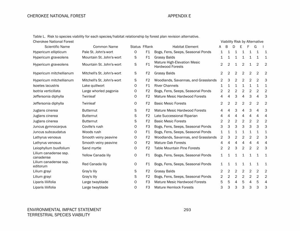
CHEROKEE NATIONAL FOREST APPENDIX E
ENVIRONMENTAL IMPACT STATEMENT 293 TERRESTRIAL SPECIES VIABILITY
Table L. Risk to species viability for each species/habitat relationship by forest plan revision alternative. Cherokee National Forest Viability Risk by Alternative
Scientific Name Common Name Status FRank Habitat Element A B D E F G I Hypericum ellipticum Pale St. John's-wort O F1 Bogs, Fens, Seeps, Seasonal Ponds 1 1 1 1 1 1 1Hypericum graveolens Mountain St. John's-wort S F1 Grassy Balds 1 1 1 1 1 1 1
Hypericum graveolens Mountain St. John's-wort S F1 Mature High-Elevation Mesic Hardwood Forests 2 2 1 2 1 2 2
Hypericum mitchellianum Mitchell's St. John's-wort S F2 Grassy Balds 2 2 2 2 2 2 2
Hypericum mitchellianum Mitchell's St. John's-wort S F2 Woodlands, Savannas, and Grasslands 2 3 2 2 2 2 3Isoetes lacustris Lake quillwort O F1 River Channels 1 1 1 1 1 1 1Isotria verticillata Large whorled pagonia O F2 Bogs, Fens, Seeps, Seasonal Ponds 2 2 2 2 2 2 2Jeffersonia diphylla Twinleaf O F2 Mature Mesic Hardwood Forests 4 4 3 4 3 4 3
Jeffersonia diphylla Twinleaf O F2 Basic Mesic Forests 2 2 2 2 2 2 2
Juglans cinerea Butternut S F2 Mature Mesic Hardwood Forests 4 4 3 4 3 4 3Juglans cinerea Butternut S F2 Late Successional Riparian 4 4 4 4 4 4 4Juglans cinerea Butternut S F2 Basic Mesic Forests 2 2 2 2 2 2 2Juncus gymnocarpus Coville's rush O F3 Bogs, Fens, Seeps, Seasonal Ponds 3 3 3 3 3 3 3Juncus subcaudatus Woods rush O F1 Bogs, Fens, Seeps, Seasonal Ponds 1 1 1 1 1 1 1Lathyrus venosus Smooth veiny peavine O F2 Woodlands, Savannas, and Grasslands 2 3 2 2 2 2 3Lathyrus venosus Smooth veiny peavine O F2 Mature Oak Forests 4 4 4 4 4 4 4Leiophyllum buxifolium Sand myrtle O F2 Table Mountain Pine Forests 2 2 3 2 2 2 3Lilium canadense ssp. canadense Yellow Canada lily O F1 Bogs, Fens, Seeps, Seasonal Ponds 1 1 1 1 1 1 1
Lilium canadense ssp. editorum Red Canada lily O F1 Bogs, Fens, Seeps, Seasonal Ponds 1 1 1 1 1 1 1
Lilium grayi Gray's lily S F2 Grassy Balds 2 2 2 2 2 2 2Lilium grayi Gray's lily S F2 Bogs, Fens, Seeps, Seasonal Ponds 2 2 2 2 2 2 2Liparis liliifolia Large twayblade O F3 Mature Mesic Hardwood Forests 5 5 4 5 4 5 4Liparis liliifolia Large twayblade O F3 Mature Hemlock Forests 3 3 3 3 3 3 3
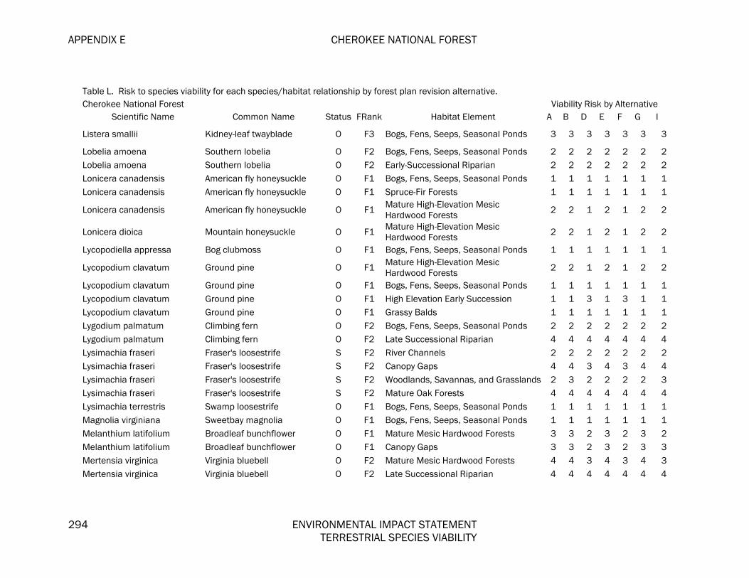
APPENDIX E CHEROKEE NATIONAL FOREST
294 ENVIRONMENTAL IMPACT STATEMENT TERRESTRIAL SPECIES VIABILITY
Table L. Risk to species viability for each species/habitat relationship by forest plan revision alternative. Cherokee National Forest Viability Risk by Alternative
Scientific Name Common Name Status FRank Habitat Element A B D E F G I
Listera smallii Kidney-leaf twayblade O F3 Bogs, Fens, Seeps, Seasonal Ponds 3 3 3 3 3 3 3
Lobelia amoena Southern lobelia O F2 Bogs, Fens, Seeps, Seasonal Ponds 2 2 2 2 2 2 2Lobelia amoena Southern lobelia O F2 Early-Successional Riparian 2 2 2 2 2 2 2Lonicera canadensis American fly honeysuckle O F1 Bogs, Fens, Seeps, Seasonal Ponds 1 1 1 1 1 1 1Lonicera canadensis American fly honeysuckle O F1 Spruce-Fir Forests 1 1 1 1 1 1 1
Lonicera canadensis American fly honeysuckle O F1 Mature High-Elevation Mesic Hardwood Forests 2 2 1 2 1 2 2
Lonicera dioica Mountain honeysuckle O F1 Mature High-Elevation Mesic Hardwood Forests 2 2 1 2 1 2 2
Lycopodiella appressa Bog clubmoss O F1 Bogs, Fens, Seeps, Seasonal Ponds 1 1 1 1 1 1 1
Lycopodium clavatum Ground pine O F1 Mature High-Elevation Mesic Hardwood Forests 2 2 1 2 1 2 2
Lycopodium clavatum Ground pine O F1 Bogs, Fens, Seeps, Seasonal Ponds 1 1 1 1 1 1 1Lycopodium clavatum Ground pine O F1 High Elevation Early Succession 1 1 3 1 3 1 1Lycopodium clavatum Ground pine O F1 Grassy Balds 1 1 1 1 1 1 1Lygodium palmatum Climbing fern O F2 Bogs, Fens, Seeps, Seasonal Ponds 2 2 2 2 2 2 2Lygodium palmatum Climbing fern O F2 Late Successional Riparian 4 4 4 4 4 4 4Lysimachia fraseri Fraser's loosestrife S F2 River Channels 2 2 2 2 2 2 2Lysimachia fraseri Fraser's loosestrife S F2 Canopy Gaps 4 4 3 4 3 4 4Lysimachia fraseri Fraser's loosestrife S F2 Woodlands, Savannas, and Grasslands 2 3 2 2 2 2 3Lysimachia fraseri Fraser's loosestrife S F2 Mature Oak Forests 4 4 4 4 4 4 4Lysimachia terrestris Swamp loosestrife O F1 Bogs, Fens, Seeps, Seasonal Ponds 1 1 1 1 1 1 1Magnolia virginiana Sweetbay magnolia O F1 Bogs, Fens, Seeps, Seasonal Ponds 1 1 1 1 1 1 1Melanthium latifolium Broadleaf bunchflower O F1 Mature Mesic Hardwood Forests 3 3 2 3 2 3 2Melanthium latifolium Broadleaf bunchflower O F1 Canopy Gaps 3 3 2 3 2 3 3Mertensia virginica Virginia bluebell O F2 Mature Mesic Hardwood Forests 4 4 3 4 3 4 3Mertensia virginica Virginia bluebell O F2 Late Successional Riparian 4 4 4 4 4 4 4

CHEROKEE NATIONAL FOREST APPENDIX E
ENVIRONMENTAL IMPACT STATEMENT 295 TERRESTRIAL SPECIES VIABILITY
Table L. Risk to species viability for each species/habitat relationship by forest plan revision alternative. Cherokee National Forest Viability Risk by Alternative
Scientific Name Common Name Status FRank Habitat Element A B D E F G I Minuartia groenlandica Mountain sandwort O F1 Glades and Barrens 1 1 1 1 1 1 1Minuartia groenlandica Mountain sandwort O F1 Rock Outcrops and Cliffs 2 2 2 2 1 2 2Monotropsis odorata Sweet pinesap S F2 Woodlands, Savannas, and Grasslands 2 3 2 2 2 2 3Monotropsis odorata Sweet pinesap S F2 Mature Mesic Hardwood Forests 4 4 3 4 3 4 3
Monotropsis odorata Sweet pinesap S F2 Mature Oak Forests 4 4 4 4 4 4 4
Nestronia umbellula Nestronia O F1 Woodlands, Savannas, and Grasslands 1 2 1 1 1 1 2
Nestronia umbellula Nestronia O F1 Mature Oak Forests 3 3 3 3 3 3 3
Orontium aquaticum Golden club O F2 River Channels 2 2 2 2 2 2 2Orontium aquaticum Golden club O F2 Bogs, Fens, Seeps, Seasonal Ponds 2 2 2 2 2 2 2Packera schweinitziana Robbin's ragwort O F1 Grassy Balds 1 1 1 1 1 1 1Panax trifolius Dwarf ginseng O F2 Mature Mesic Hardwood Forests 4 4 3 4 3 4 3
Paronychia argyrocoma Silverling O F1 Rock Outcrops and Cliffs 2 2 2 2 1 2 2
Pedicularis lanceolata Swamp lousewort O F1 Bogs, Fens, Seeps, Seasonal Ponds 1 1 1 1 1 1 1Pellaea atropurpurea Purple-stem cliffbreak O F3 Rock Outcrops and Cliffs 4 4 4 4 3 4 4Phacelia dubia Phacelia O F3 Glades and Barrens 3 3 3 3 3 3 3Phacelia fimbriata Fringed scorpion-weed O F2 Basic Mesic Forests 2 2 2 2 2 2 2
Phacelia fimbriata Fringed scorpion-weed O F2 Mature High-Elevation Mesic Hardwood Forests 3 3 2 3 2 3 3
Phacelia fimbriata Fringed scorpion-weed O F2 Spruce-Fir Forests 2 2 2 2 2 2 2Phegopteris connectilis Northern beech fern O F1 Spray Cliffs 2 2 2 2 1 2 2
Phlox amplifolia Broadleaf phlox O F2 Mature High-Elevation Mesic Hardwood Forests 3 3 2 3 2 3 3
Pityopsis ruthii Ruth's golden aster F F1 River Channels 1 1 1 1 1 1 1Platanthera flava var. herbiola Turbercled rein-orchid O F1 Bogs, Fens, Seeps, Seasonal Ponds 1 1 1 1 1 1 1
Platanthera grandiflora Large purple fringed orchid O F2 Bogs, Fens, Seeps, Seasonal Ponds 2 2 2 2 2 2 2
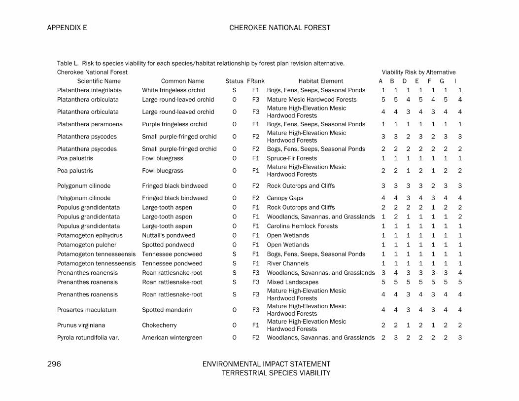
APPENDIX E CHEROKEE NATIONAL FOREST
296 ENVIRONMENTAL IMPACT STATEMENT TERRESTRIAL SPECIES VIABILITY
Table L. Risk to species viability for each species/habitat relationship by forest plan revision alternative. Cherokee National Forest Viability Risk by Alternative
Scientific Name Common Name Status FRank Habitat Element A B D E F G I Platanthera integrilabia White fringeless orchid S F1 Bogs, Fens, Seeps, Seasonal Ponds 1 1 1 1 1 1 1Platanthera orbiculata Large round-leaved orchid O F3 Mature Mesic Hardwood Forests 5 5 4 5 4 5 4
Platanthera orbiculata Large round-leaved orchid O F3 Mature High-Elevation Mesic Hardwood Forests 4 4 3 4 3 4 4
Platanthera peramoena Purple fringeless orchid O F1 Bogs, Fens, Seeps, Seasonal Ponds 1 1 1 1 1 1 1
Platanthera psycodes Small purple-fringed orchid O F2 Mature High-Elevation Mesic Hardwood Forests 3 3 2 3 2 3 3
Platanthera psycodes Small purple-fringed orchid O F2 Bogs, Fens, Seeps, Seasonal Ponds 2 2 2 2 2 2 2Poa palustris Fowl bluegrass O F1 Spruce-Fir Forests 1 1 1 1 1 1 1
Poa palustris Fowl bluegrass O F1 Mature High-Elevation Mesic Hardwood Forests 2 2 1 2 1 2 2
Polygonum cilinode Fringed black bindweed O F2 Rock Outcrops and Cliffs 3 3 3 3 2 3 3
Polygonum cilinode Fringed black bindweed O F2 Canopy Gaps 4 4 3 4 3 4 4Populus grandidentata Large-tooth aspen O F1 Rock Outcrops and Cliffs 2 2 2 2 1 2 2Populus grandidentata Large-tooth aspen O F1 Woodlands, Savannas, and Grasslands 1 2 1 1 1 1 2Populus grandidentata Large-tooth aspen O F1 Carolina Hemlock Forests 1 1 1 1 1 1 1Potamogeton epihydrus Nuttall's pondweed O F1 Open Wetlands 1 1 1 1 1 1 1Potamogeton pulcher Spotted pondweed O F1 Open Wetlands 1 1 1 1 1 1 1Potamogeton tennesseensis Tennessee pondweed S F1 Bogs, Fens, Seeps, Seasonal Ponds 1 1 1 1 1 1 1Potamogeton tennesseensis Tennessee pondweed S F1 River Channels 1 1 1 1 1 1 1Prenanthes roanensis Roan rattlesnake-root S F3 Woodlands, Savannas, and Grasslands 3 4 3 3 3 3 4Prenanthes roanensis Roan rattlesnake-root S F3 Mixed Landscapes 5 5 5 5 5 5 5
Prenanthes roanensis Roan rattlesnake-root S F3 Mature High-Elevation Mesic Hardwood Forests 4 4 3 4 3 4 4
Prosartes maculatum Spotted mandarin O F3 Mature High-Elevation Mesic Hardwood Forests 4 4 3 4 3 4 4
Prunus virginiana Chokecherry O F1 Mature High-Elevation Mesic Hardwood Forests 2 2 1 2 1 2 2
Pyrola rotundifolia var. American wintergreen O F2 Woodlands, Savannas, and Grasslands 2 3 2 2 2 2 3

CHEROKEE NATIONAL FOREST APPENDIX E
ENVIRONMENTAL IMPACT STATEMENT 297 TERRESTRIAL SPECIES VIABILITY
Table L. Risk to species viability for each species/habitat relationship by forest plan revision alternative. Cherokee National Forest Viability Risk by Alternative
Scientific Name Common Name Status FRank Habitat Element A B D E F G I americana
Ranunculus fascicularis Early buttercup O F2 Woodlands, Savannas, and Grasslands 2 3 2 2 2 2 3Ranunculus fascicularis Early buttercup O F2 Glades and Barrens 2 2 2 2 2 2 2Rhododendron cumberlandense Cumberland azalea O F2 Grassy Balds 2 2 2 2 2 2 2
Rhododendron cumberlandense Cumberland azalea O F2 Mature High-Elevation Mesic
Hardwood Forests 3 3 2 3 2 3 3
Rhododendron cumberlandense Cumberland azalea O F2 Mature Oak Forests 4 4 4 4 4 4 4
Sacciolepis striata Gibbous panic-grass O F1 Open Wetlands 1 1 1 1 1 1 1Sacciolepis striata Gibbous panic-grass O F1 River Channels 1 1 1 1 1 1 1Sanguisorba canadensis Canada burnet O F1 Bogs, Fens, Seeps, Seasonal Ponds 1 1 1 1 1 1 1Sanicula trifoliata Large-fruited snakeroot O F3 Basic Mesic Forests 3 3 3 3 3 3 3Sanicula trifoliata Large-fruited snakeroot O F3 Mature Mesic Hardwood Forests 5 5 4 5 4 5 4Saxifraga careyana Golden-eye saxifrage O F3 Bogs, Fens, Seeps, Seasonal Ponds 3 3 3 3 3 3 3Saxifraga careyana Golden-eye saxifrage O F3 Spray Cliffs 4 4 4 4 3 4 4Saxifraga caroliniana Carolina saxifrage S F1 Bogs, Fens, Seeps, Seasonal Ponds 1 1 1 1 1 1 1Saxifraga caroliniana Carolina saxifrage S F1 Spray Cliffs 2 2 2 2 1 2 2
Scutellaria pseudoserrata Skullcap S F3 Mature Mesic Hardwood Forests 5 5 4 5 4 5 4
Scutellaria saxatilis Rock skullcap S F3 Mature Mesic Hardwood Forests 5 5 4 5 4 5 4
Scutellaria saxatilis Rock skullcap S F3 Mature High-Elevation Mesic Hardwood Forests 4 4 3 4 3 4 4
Sedum nevii Nevius' stonecrop S F2 Rock Outcrops and Cliffs 3 3 3 3 2 3 3Shortia galacifolia var. galacifolia Oconee bell S F1 Mature Hemlock Forests 1 1 1 1 1 1 1
Sibbaldiopsis tridentata Three-toothed cinquefoil O F2 Glades and Barrens 2 2 2 2 2 2 2
Sibbaldiopsis tridentata Three-toothed cinquefoil O F2 Grassy Balds 2 2 2 2 2 2 2Sibbaldiopsis tridentata Three-toothed cinquefoil O F2 Rock Outcrops and Cliffs 3 3 3 3 2 3 3

APPENDIX E CHEROKEE NATIONAL FOREST
298 ENVIRONMENTAL IMPACT STATEMENT TERRESTRIAL SPECIES VIABILITY
Table L. Risk to species viability for each species/habitat relationship by forest plan revision alternative. Cherokee National Forest Viability Risk by Alternative
Scientific Name Common Name Status FRank Habitat Element A B D E F G I Silene ovata Mountain catchfly S F1 Mature Mesic Hardwood Forests 3 3 2 3 2 3 2Silene ovata Mountain catchfly S F1 Mixed Landscapes 3 3 3 3 3 3 3
Silene ovata Mountain catchfly S F1 Early-Successional Forests 2 2 3 1 3 1 2
Smilax hugeri Huger's carrion-flower O F1 Mature Mesic Hardwood Forests 3 3 2 3 2 3 2Solidago spithamaea Blue Ridge goldenrod F F1 Rock Outcrops and Cliffs 2 2 2 2 1 2 2
Spiraea alba Narrow-leaved meadow-sweet O F1 Bogs, Fens, Seeps, Seasonal Ponds 1 1 1 1 1 1 1
Spiranthes lucida Shining ladies'-tresses O F1 Bogs, Fens, Seeps, Seasonal Ponds 1 1 1 1 1 1 1
Sporobolus clandestinus Rough dropseed O F1 Rock Outcrops and Cliffs 2 2 2 2 1 2 2
Stachys clingmanii Clingman's hedge-nettle S F1 Spruce-Fir Forests 1 1 1 1 1 1 1
Stachys clingmanii Clingman's hedge-nettle S F1 Mature High-Elevation Mesic Hardwood Forests 2 2 1 2 1 2 2
Stellaria alsine Trailing stitchwort O F1 Bogs, Fens, Seeps, Seasonal Ponds 1 1 1 1 1 1 1Stellaria longifolia Longleaf stitchwort O F1 Open Wetlands 1 1 1 1 1 1 1Stellaria longifolia Longleaf stitchwort O F1 Bogs, Fens, Seeps, Seasonal Ponds 1 1 1 1 1 1 1Stewartia ovata Mountain camellia O F3 Mature Hemlock Forests 3 3 3 3 3 3 3Stewartia ovata Mountain camellia O F3 Late Successional Riparian 5 5 5 5 5 5 5Streptopus amplexifolius White mandarin O F1 Spruce-Fir Forests 1 1 1 1 1 1 1
Streptopus amplexifolius White mandarin O F1 Mature High-Elevation Mesic Hardwood Forests 2 2 1 2 1 2 2
Streptopus roseus Rosy twisted-stalk O F2 Spruce-Fir Forests 2 2 2 2 2 2 2
Streptopus roseus Rosy twisted-stalk O F2 Mature High-Elevation Mesic Hardwood Forests 3 3 2 3 2 3 3
Styrax grandifolius Bigleaf snowbell O F2 Mature Oak Forests 4 4 4 4 4 4 4
Styrax grandifolius Bigleaf snowbell O F2 Mature Mesic Hardwood Forests 4 4 3 4 3 4 3Symplocos tinctoria Horse sugar O F2 Late Successional Riparian 4 4 4 4 4 4 4

CHEROKEE NATIONAL FOREST APPENDIX E
ENVIRONMENTAL IMPACT STATEMENT 299 TERRESTRIAL SPECIES VIABILITY
Table L. Risk to species viability for each species/habitat relationship by forest plan revision alternative. Cherokee National Forest Viability Risk by Alternative
Scientific Name Common Name Status FRank Habitat Element A B D E F G I
Symplocos tinctoria Horse sugar O F2 Mature Mesic Hardwood Forests 4 4 3 4 3 4 3
Thaspium pinnatifidum Mountain thaspium S F1 Woodlands, Savannas, and Grasslands 1 2 1 1 1 1 2Thaspium pinnatifidum Mountain thaspium S F1 Glades and Barrens 1 1 1 1 1 1 1
Thermopsis fraxinifolia Ash-leaved bushpea O F3 Mature Oak Forests 5 5 5 5 5 5 5
Thuja occidentalis Northern white cedar O F1 River Channels 1 1 1 1 1 1 1Thuja occidentalis Northern white cedar O F1 Rock Outcrops and Cliffs 2 2 2 2 1 2 2Trichomanes boschianum Bristle fern O F1 Rock Outcrops and Cliffs 2 2 2 2 1 2 2Trichomanes petersii Dwarf filmy fern O F1 Rock Outcrops and Cliffs 2 2 2 2 1 2 2Trichophorum caespitosum Tufted club-rush O F1 Bogs, Fens, Seeps, Seasonal Ponds 1 1 1 1 1 1 1Trichophorum caespitosum Tufted club-rush O F1 Rock Outcrops and Cliffs 2 2 2 2 1 2 2
Trientalis borealis Northern starflower O F1 Mature High-Elevation Mesic Hardwood Forests 2 2 1 2 1 2 2
Trillium rugelii Southern nodding trillium S F1 Basic Mesic Forests 1 1 1 1 1 1 1Trillium rugelii Southern nodding trillium S F1 Mature Mesic Hardwood Forests 3 3 2 3 2 3 2
Trillium simile Sweet white trillium S F3 Mature Mesic Hardwood Forests 5 5 4 5 4 5 4
Trillium undulatum Painted trillium O F3 Bogs, Fens, Seeps, Seasonal Ponds 3 3 3 3 3 3 3Trillium undulatum Painted trillium O F3 Mature Hemlock Forests 3 3 3 3 3 3 3
Triosteum aurantiacum Horse gentian O F2 Basic Mesic Forests 2 2 2 2 2 2 2
Triosteum aurantiacum Horse gentian O F2 Woodlands, Savannas, and Grasslands 2 3 2 2 2 2 3Triphora trianthophora Nodding pogonia O F3 Mature Mesic Hardwood Forests 5 5 4 5 4 5 4Tsuga caroliniana Carolina hemlock S F3 Carolina Hemlock Forests 3 3 3 3 3 3 3Vaccinium erythrocarpum Bear berry O F3 Spruce-Fir Forests 3 3 3 3 3 3 3Vaccinium erythrocarpum Bear berry O F3 Rock Outcrops and Cliffs 4 4 4 4 3 4 4Vaccinium erythrocarpum Bear berry O F3 Shrub Balds 3 3 3 3 3 3 3Vaccinium erythrocarpum Bear berry O F3 Mature High-Elevation Mesic 4 4 3 4 3 4 4
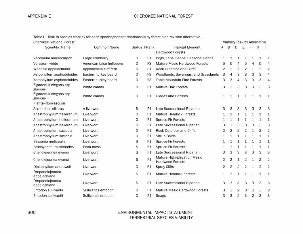
APPENDIX E CHEROKEE NATIONAL FOREST
300 ENVIRONMENTAL IMPACT STATEMENT TERRESTRIAL SPECIES VIABILITY
Table L. Risk to species viability for each species/habitat relationship by forest plan revision alternative. Cherokee National Forest Viability Risk by Alternative
Scientific Name Common Name Status FRank Habitat Element A B D E F G I Hardwood Forests
Vaccinium macrocarpon Large cranberry O F1 Bogs, Fens, Seeps, Seasonal Ponds 1 1 1 1 1 1 1Veratrum viride American false hellebore O F3 Mature Mesic Hardwood Forests 5 5 4 5 4 5 4Woodsia appalachiana Appalachian cliff fern O F1 Rock Outcrops and Cliffs 2 2 2 2 1 2 2Xerophyllum asphodeloides Eastern turkey beard O F3 Woodlands, Savannas, and Grasslands 3 4 3 3 3 3 4Xerophyllum asphodeloides Eastern turkey beard O F3 Table Mountain Pine Forests 3 3 4 3 3 3 4Zigadenus elegans ssp. glaucus White camas O F1 Mature Oak Forests 3 3 3 3 3 3 3
Zigadenus elegans ssp. glaucus White camas O F1 Glades and Barrens 1 1 1 1 1 1 1
Plants--Nonvascular Acrobolbus ciliatus A liverwort S F1 Late Successional Riparian 3 3 3 3 3 3 3Anastrophyllum helleranum Liverwort O F1 Mature Hemlock Forests 1 1 1 1 1 1 1Anastrophyllum helleranum Liverwort O F1 Spruce-Fir Forests 1 1 1 1 1 1 1Anastrophyllum helleranum Liverwort O F1 Late Successional Riparian 3 3 3 3 3 3 3Anastrophyllum saxicola Liverwort O F1 Rock Outcrops and Cliffs 2 2 2 2 1 2 2Anastrophyllum saxicola Liverwort O F1 Shrub Balds 1 1 1 1 1 1 1Bazzania nudicaulis Liverwort S F1 Spruce-Fir Forests 1 1 1 1 1 1 1Brachydontium trichodes Peak moss S F1 Spruce-Fir Forests 1 1 1 1 1 1 1Cheilolejeunea evansii Liverwort S F1 Late Successional Riparian 3 3 3 3 3 3 3
Cheilolejeunea evansii Liverwort S F1 Mature High-Elevation Mesic Hardwood Forests 2 2 1 2 1 2 2
Diplophyllum andrewsii Liverwort O F1 Spray Cliffs 2 2 2 2 1 2 2Drepanolejeunea appalachiana Liverwort S F1 Mature Hemlock Forests 1 1 1 1 1 1 1
Drepanolejeunea appalachiana Liverwort S F1 Late Successional Riparian 3 3 3 3 3 3 3
Entodon sullivantii Sullivant's entodon O F1 Mature Mesic Hardwood Forests 3 3 2 3 2 3 2Entodon sullivantii Sullivant's entodon O F1 Snags 3 3 2 3 2 3 3

CHEROKEE NATIONAL FOREST APPENDIX E
ENVIRONMENTAL IMPACT STATEMENT 301 TERRESTRIAL SPECIES VIABILITY
Table L. Risk to species viability for each species/habitat relationship by forest plan revision alternative. Cherokee National Forest Viability Risk by Alternative
Scientific Name Common Name Status FRank Habitat Element A B D E F G I Fissidens appalachensis Appalachian pocket moss O F1 River Channels 1 1 1 1 1 1 1Fissidens appalachensis Appalachian pocket moss O F1 Late Successional Riparian 3 3 3 3 3 3 3Frullania plana Liverwort O F1 Late Successional Riparian 3 3 3 3 3 3 3Frullania plana Liverwort O F1 Mature Mesic Hardwood Forests 3 3 2 3 2 3 2
Frullania plana Liverwort O F1 Spray Cliffs 2 2 2 2 1 2 2
Frullania plana Liverwort O F1 Mature High-Elevation Mesic Hardwood Forests 2 2 1 2 1 2 2
Gymnoderma lineare Rock gnome lichen F F1 Spray Cliffs 2 2 2 2 1 2 2Gymnoderma lineare Rock gnome lichen F F1 Rock Outcrops and Cliffs 2 2 2 2 1 2 2Hydrothyria venosa Aquatic lichen S F1 River Channels 1 1 1 1 1 1 1Lejeunea blomquistii Liverwort S F1 Late Successional Riparian 3 3 3 3 3 3 3
Leptodontium excelsum Grandfather Mountain excelsum S F1 Spruce-Fir Forests 1 1 1 1 1 1 1
Leptoscyphus cuneifolius Liverwort O F1 Spruce-Fir Forests 1 1 1 1 1 1 1Lophocolea appalachiana Liverwort S F1 Spray Cliffs 2 2 2 2 1 2 2
Lophocolea appalachiana Liverwort S F1 Late Successional Riparian 3 3 3 3 3 3 3
Megaceros aenigmaticus Hornwort S F2 Late Successional Riparian 4 4 4 4 4 4 4
Megaceros aenigmaticus Hornwort S F2 River Channels 2 2 2 2 2 2 2
Metzgeria fruticulosa Liverwort S F1 Rock Outcrops and Cliffs 2 2 2 2 1 2 2Metzgeria fruticulosa Liverwort S F1 Spruce-Fir Forests 1 1 1 1 1 1 1Metzgeria fruticulosa Liverwort S F1 Spray Cliffs 2 2 2 2 1 2 2Nardia lescurii Liverwort S F1 Rock Outcrops and Cliffs 2 2 2 2 1 2 2Nardia lescurii Liverwort S F1 Spray Cliffs 2 2 2 2 1 2 2Nardia lescurii Liverwort S F1 Late Successional Riparian 3 3 3 3 3 3 3Pellia appalachiana Liverwort O F1 Rock Outcrops and Cliffs 2 2 2 2 1 2 2Pellia appalachiana Liverwort O F1 Late Successional Riparian 3 3 3 3 3 3 3

APPENDIX E CHEROKEE NATIONAL FOREST
302 ENVIRONMENTAL IMPACT STATEMENT TERRESTRIAL SPECIES VIABILITY
Table L. Risk to species viability for each species/habitat relationship by forest plan revision alternative. Cherokee National Forest Viability Risk by Alternative
Scientific Name Common Name Status FRank Habitat Element A B D E F G I Plagiochila caduciloba Liverwort S F1 Mature Mesic Hardwood Forests 3 3 2 3 2 3 2Plagiochila caduciloba Liverwort S F1 Rock Outcrops and Cliffs 2 2 2 2 1 2 2Plagiochila corniculata Liverwort O F1 Spruce-Fir Forests 1 1 1 1 1 1 1Plagiochila echinata Liverwort S F1 Late Successional Riparian 3 3 3 3 3 3 3Plagiochila echinata Liverwort S F1 Rock Outcrops and Cliffs 2 2 2 2 1 2 2Plagiochila ludoviciana Liverwort O F1 Spray Cliffs 2 2 2 2 1 2 2
Plagiochila ludoviciana Liverwort O F1 Late Successional Riparian 3 3 3 3 3 3 3
Plagiochila sullivantii var. spinigera Sullivant's leafy liverwort S F1 Late Successional Riparian 3 3 3 3 3 3 3
Plagiochila sullivantii var. spinigera Sullivant's leafy liverwort S F1 Mature Hemlock Forests 1 1 1 1 1 1 1
Plagiochila sullivantii var. spinigera Sullivant's leafy liverwort S F1 Spray Cliffs 2 2 2 2 1 2 2
Plagiochila sullivantii var. sullivantii Sullivant's leafy liverwort S F1 Spray Cliffs 2 2 2 2 1 2 2
Plagiochila sullivantii var. sullivantii Sullivant's leafy liverwort S F1 Late Successional Riparian 3 3 3 3 3 3 3
Plagiochila sullivantii var. sullivantii Sullivant's leafy liverwort S F1 Rock Outcrops and Cliffs 2 2 2 2 1 2 2
Porella japonica ssp appalachiana Appalachian porella S F1 Late Successional Riparian 3 3 3 3 3 3 3
Porella japonica ssp appalachiana Appalachian porella S F1 Rock Outcrops and Cliffs 2 2 2 2 1 2 2
Radula tenax Liverwort O F1 Late Successional Riparian 3 3 3 3 3 3 3Radula tenax Liverwort O F1 Spray Cliffs 2 2 2 2 1 2 2Radula tenax Liverwort O F1 Mature Mesic Hardwood Forests 3 3 2 3 2 3 2
Radula tenax Liverwort O F1 Mature High-Elevation Mesic Hardwood Forests 2 2 1 2 1 2 2
Radula voluta Liverwort S F1 Late Successional Riparian 3 3 3 3 3 3 3Radula voluta Liverwort S F1 Rock Outcrops and Cliffs 2 2 2 2 1 2 2
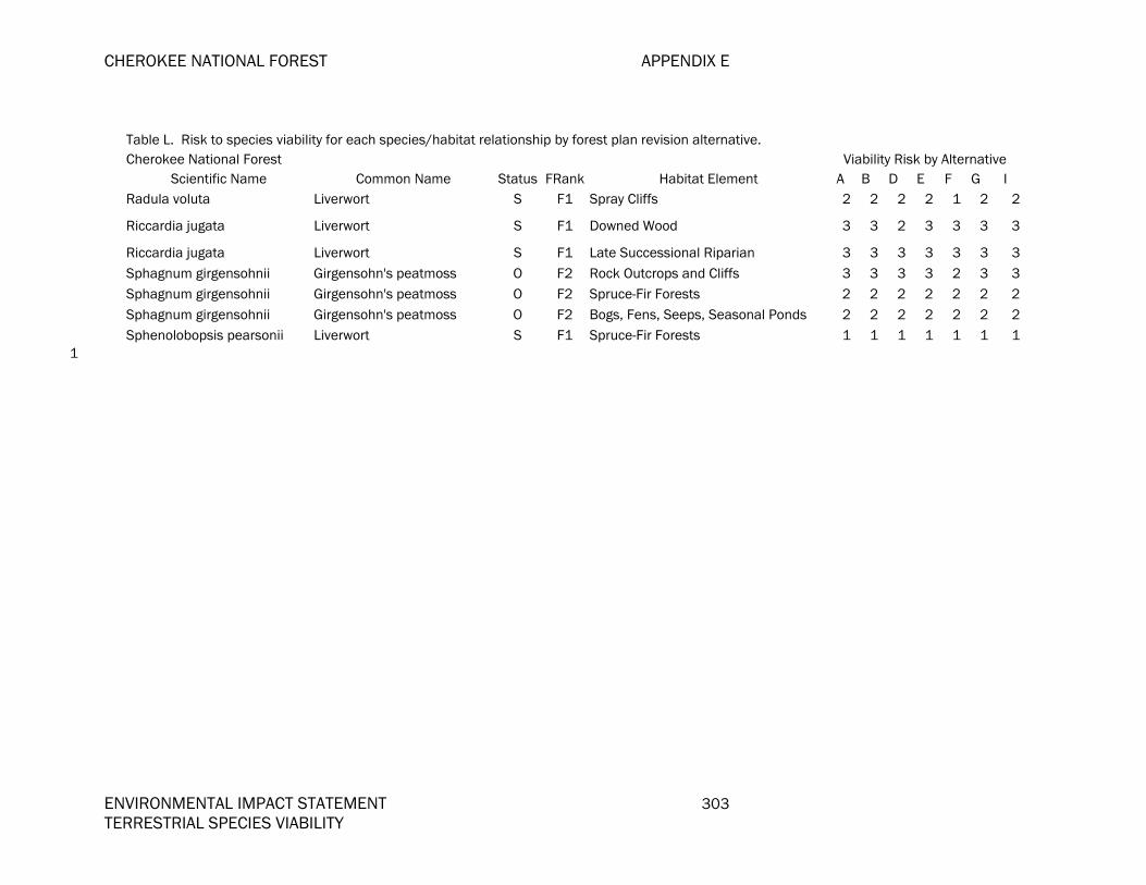
CHEROKEE NATIONAL FOREST APPENDIX E
ENVIRONMENTAL IMPACT STATEMENT 303 TERRESTRIAL SPECIES VIABILITY
Table L. Risk to species viability for each species/habitat relationship by forest plan revision alternative. Cherokee National Forest Viability Risk by Alternative
Scientific Name Common Name Status FRank Habitat Element A B D E F G I Radula voluta Liverwort S F1 Spray Cliffs 2 2 2 2 1 2 2
Riccardia jugata Liverwort S F1 Downed Wood 3 3 2 3 3 3 3
Riccardia jugata Liverwort S F1 Late Successional Riparian 3 3 3 3 3 3 3Sphagnum girgensohnii Girgensohn's peatmoss O F2 Rock Outcrops and Cliffs 3 3 3 3 2 3 3Sphagnum girgensohnii Girgensohn's peatmoss O F2 Spruce-Fir Forests 2 2 2 2 2 2 2Sphagnum girgensohnii Girgensohn's peatmoss O F2 Bogs, Fens, Seeps, Seasonal Ponds 2 2 2 2 2 2 2Sphenolobopsis pearsonii Liverwort S F1 Spruce-Fir Forests 1 1 1 1 1 1 1
1

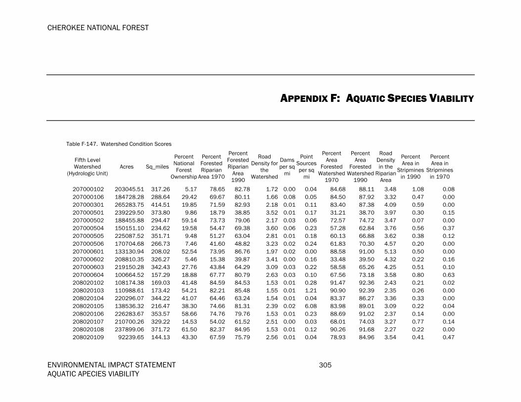
CHEROKEE NATIONAL FOREST
ENVIRONMENTAL IMPACT STATEMENT 305 AQUATIC APECIES VIABILITY
APPENDIX F: AQUATIC SPECIES VIABILITY
Table F-147. Watershed Condition Scores
Fifth Level Watershed
(Hydrologic Unit) Acres Sq_miles
Percent National Forest
Ownership
Percent Forested Riparian
Area 1970
Percent Forested Riparian
Area 1990
Road Density for
the Watershed
Dams per sq
mi
Point Sourcesper sq
mi
Percent Area
Forested Watershed
1970
Percent Area
Forested Watershed
1990
Road Density in the
RiparianArea
Percent Area in
Stripminesin 1990
Percent Area in
Stripmines in 1970
207000102 203045.51 317.26 5.17 78.65 82.78 1.72 0.00 0.04 84.68 88.11 3.48 1.08 0.08207000106 184728.28 288.64 29.42 69.67 80.11 1.66 0.08 0.05 84.50 87.92 3.32 0.47 0.00207000301 265283.75 414.51 19.85 71.59 82.93 2.18 0.01 0.11 83.40 87.38 4.09 0.59 0.00207000501 239229.50 373.80 9.86 18.79 38.85 3.52 0.01 0.17 31.21 38.70 3.97 0.30 0.15207000502 188455.88 294.47 59.14 73.73 79.06 2.17 0.03 0.06 72.57 74.72 3.47 0.07 0.00207000504 150151.10 234.62 19.58 54.47 69.38 3.60 0.06 0.23 57.28 62.84 3.76 0.56 0.37207000505 225087.52 351.71 9.48 51.27 63.04 2.81 0.01 0.18 60.13 66.88 3.62 0.38 0.12207000506 170704.68 266.73 7.46 41.60 48.82 3.23 0.02 0.24 61.83 70.30 4.57 0.20 0.00207000601 133130.94 208.02 52.54 73.95 86.76 1.97 0.02 0.00 88.58 91.00 5.13 0.50 0.00207000602 208810.35 326.27 5.46 15.38 39.87 3.41 0.00 0.16 33.48 39.50 4.32 0.22 0.16207000603 219150.28 342.43 27.76 43.84 64.29 3.09 0.03 0.22 58.58 65.26 4.25 0.51 0.10207000604 100664.52 157.29 18.88 67.77 80.79 2.63 0.03 0.10 67.56 73.18 3.58 0.80 0.63208020102 108174.38 169.03 41.48 84.59 84.53 1.53 0.01 0.28 91.47 92.36 2.43 0.21 0.02208020103 110988.61 173.42 54.21 82.21 85.48 1.55 0.01 1.21 90.90 92.39 2.35 0.26 0.00208020104 220296.07 344.22 41.07 64.46 63.24 1.54 0.01 0.04 83.37 86.27 3.36 0.33 0.00208020105 138536.32 216.47 38.30 74.66 81.31 2.39 0.02 6.08 83.98 89.01 3.09 0.22 0.04208020106 226283.67 353.57 58.66 74.76 79.76 1.53 0.01 0.23 88.69 91.02 2.37 0.14 0.00208020107 210700.26 329.22 14.53 54.02 61.52 2.51 0.00 0.03 68.01 74.03 3.27 0.77 0.14208020108 237899.06 371.72 61.50 82.37 84.95 1.53 0.01 0.12 90.26 91.68 2.27 0.22 0.00208020109 92239.65 144.13 43.30 67.59 75.79 2.56 0.01 0.04 78.93 84.96 3.54 0.41 0.47

APPENDIX F CHEROKEE NATIONAL FOREST
306 ENVIRONMENTAL IMPACT STATEMENT AQUATIC SPECIES VIABILITY
Table F-147. Watershed Condition Scores
Fifth Level Watershed
(Hydrologic Unit) Acres Sq_miles
Percent National Forest
Ownership
Percent Forested Riparian
Area 1970
Percent Forested Riparian
Area 1990
Road Density for
the Watershed
Dams per sq
mi
Point Sourcesper sq
mi
Percent Area
Forested Watershed
1970
Percent Area
Forested Watershed
1990
Road Density in the
RiparianArea
Percent Area in
Stripminesin 1990
Percent Area in
Stripmines in 1970
208020201 150864.46 235.73 58.82 71.98 77.87 1.62 0.01 0.01 88.69 91.51 3.31 0.30 0.21208020202 53423.67 83.48 29.52 49.15 60.25 2.46 0.01 0.00 80.41 85.82 3.72 0.25 0.30208020203 176833.32 276.31 9.05 44.22 51.48 3.04 0.01 0.11 51.07 58.57 3.97 0.24 0.20208020204 75901.05 118.60 33.91 61.91 67.76 2.37 0.03 0.00 66.53 71.08 3.32 0.24 0.26208020205 79108.56 123.61 4.28 56.92 65.60 2.27 0.02 0.06 68.26 74.78 3.78 0.57 0.00208020301 238983.20 373.42 21.46 70.21 76.86 3.58 0.08 0.39 71.36 79.68 3.05 0.49 0.06208020303 169320.60 264.57 17.51 64.47 73.71 2.31 0.02 0.02 74.48 81.26 2.67 0.85 0.26208020304 98156.63 153.37 8.47 63.45 73.22 2.35 0.05 0.07 70.66 78.70 2.45 1.12 0.00208020306 158491.32 247.65 0.94 69.88 79.13 2.71 0.04 0.65 80.01 87.71 3.39 0.55 0.00301010101 162570.75 254.02 1.28 71.48 74.51 2.74 0.00 0.09 78.38 81.11 3.54 0.20 0.09301010102 202807.60 316.89 0.81 52.89 62.71 5.37 0.03 1.11 55.93 66.31 5.38 0.67 0.33301010107 164738.72 257.41 2.06 59.99 71.68 3.06 0.01 0.04 58.89 70.37 2.80 0.75 0.12301010108 248105.19 387.67 1.98 50.52 61.73 3.19 0.05 0.10 52.99 64.32 2.66 0.61 0.12305010601 77209.59 120.64 26.09 83.07 69.54 2.19 0.07 0.17 82.09 80.35 1.13 0.12 0.00305010602 93715.20 146.43 0.65 85.95 83.64 2.15 0.07 0.12 81.70 78.18 1.01 0.20 0.00305010603 33945.06 53.04 0.75 79.32 79.49 3.31 0.08 0.15 73.39 75.30 1.41 0.43 0.13305010604 104557.41 163.37 1.19 89.25 85.99 2.05 0.09 0.14 82.71 82.48 1.22 0.17 0.00305010605 146313.14 228.62 7.28 80.04 62.02 2.04 0.03 0.07 80.95 77.39 1.20 0.29 0.06305010607 155264.51 242.61 0.01 90.76 87.38 1.96 0.05 0.10 88.03 84.11 1.06 0.13 0.19305010705 82980.30 129.66 16.64 81.67 84.97 2.40 0.05 0.10 72.21 79.99 1.35 0.13 0.00305010706 139665.84 218.23 3.47 75.68 78.79 4.15 0.11 0.88 63.82 72.10 2.38 0.17 0.00305010707 73620.84 115.03 30.69 86.61 86.82 2.41 0.03 0.07 85.50 84.71 1.03 0.12 0.00305010802 83423.13 130.35 23.23 79.75 84.78 2.72 0.06 0.22 78.57 83.47 1.42 0.07 0.11305010804 76744.66 119.92 23.42 78.75 83.17 3.07 0.12 0.25 73.35 78.63 1.41 0.26 0.16305010805 61976.41 96.84 48.32 93.02 91.13 2.36 0.04 0.05 88.20 85.73 1.06 0.11 0.00305010806 43291.27 67.64 43.01 89.56 91.62 2.05 0.03 0.22 87.95 90.61 0.54 0.09 0.00305010915 182436.35 285.06 0.07 66.32 68.28 2.77 0.10 0.17 56.41 63.23 1.49 0.30 0.17306010102 31889.42 49.83 4.60 98.51 80.62 1.22 0.10 0.26 99.10 88.23 1.27 0.23 0.00306010105 104995.73 164.06 13.67 86.14 72.35 3.66 0.12 0.20 81.43 78.95 2.74 0.06 0.00306010108 47959.17 74.94 3.39 55.64 72.65 5.15 0.19 0.36 52.23 67.06 3.52 0.26 0.11

CHEROKEE NATIONAL FOREST APPENDIX G
ENVIRONMENTAL IMPACT STATEMENT 307 AQUATIC SPECIES VIABILITY
Table F-147. Watershed Condition Scores
Fifth Level Watershed
(Hydrologic Unit) Acres Sq_miles
Percent National Forest
Ownership
Percent Forested Riparian
Area 1970
Percent Forested Riparian
Area 1990
Road Density for
the Watershed
Dams per sq
mi
Point Sourcesper sq
mi
Percent Area
Forested Watershed
1970
Percent Area
Forested Watershed
1990
Road Density in the
RiparianArea
Percent Area in
Stripminesin 1990
Percent Area in
Stripmines in 1970
306010201 178752.45 279.31 56.30 90.61 92.02 2.44 0.06 0.13 93.16 95.53 3.06 0.01 0.00306010207 121318.71 189.56 54.91 95.25 89.28 2.45 0.04 0.10 97.05 95.70 3.84 0.00 0.02306010208 83365.65 130.26 35.68 84.17 83.36 2.67 0.08 0.12 89.92 90.40 2.53 0.09 0.00306010212 70774.04 110.59 41.23 92.01 91.63 2.46 0.10 0.10 92.19 94.00 1.90 0.02 0.00306010310 87046.20 136.01 3.27 95.23 68.50 2.43 0.04 0.05 95.26 69.93 1.90 0.30 0.00306010314 217307.22 339.55 6.06 66.74 75.19 2.28 0.06 0.04 60.70 70.59 1.38 0.07 0.00306010315 145999.19 228.13 26.72 81.54 79.90 2.33 0.05 0.10 75.07 75.97 1.27 0.06 0.00306010401 195136.50 304.91 11.89 61.79 71.56 3.24 0.11 0.11 59.69 69.91 2.25 0.11 0.05306010603 13647.16 21.32 27.80 99.36 72.88 1.96 0.09 0.19 99.66 85.89 1.22 0.05 0.00306010701 159216.93 248.78 8.70 86.31 84.49 2.59 0.03 0.23 82.08 80.02 1.53 0.09 0.00306010702 182662.99 285.42 15.33 86.10 79.98 2.49 0.04 0.08 84.02 78.12 1.64 0.03 0.00306010704 131509.86 205.49 13.57 94.93 85.76 2.34 0.17 0.04 92.83 84.26 1.41 0.09 0.02307010106 98577.64 154.03 5.30 77.83 75.96 2.62 0.10 0.12 72.79 72.59 1.48 0.05 0.00307010107 100314.75 156.74 21.38 84.44 78.58 1.39 0.03 0.01 83.52 79.90 0.64 0.21 0.06307010109 114242.57 178.51 4.46 72.36 74.20 2.69 0.11 0.08 61.03 66.33 1.61 0.10 0.00307010111 75532.42 118.02 0.47 82.11 69.13 2.22 0.07 0.11 82.81 75.64 1.30 0.37 0.00307010112 107528.02 168.02 0.02 75.23 50.87 2.57 0.10 0.02 76.65 66.00 1.49 0.24 0.00307010114 139919.25 218.63 0.84 70.05 72.18 2.20 0.13 0.07 67.11 66.60 1.35 0.15 0.00307010115 50586.33 79.04 27.41 90.03 82.94 1.97 0.05 0.05 90.92 85.98 1.76 0.30 0.00307010116 132353.39 206.81 11.32 82.02 81.00 2.02 0.11 0.02 81.08 78.04 1.16 0.05 0.00307010117 138960.32 217.13 15.43 95.12 79.57 1.89 0.06 0.04 93.95 85.80 1.66 0.20 0.00307010310 124394.71 194.37 11.83 84.86 84.42 2.34 0.05 0.17 83.94 83.60 1.40 0.00 0.04307010313 138209.14 215.96 12.16 92.44 87.87 1.85 0.10 0.14 92.07 88.51 1.09 0.55 0.12313000101 99591.58 155.61 39.31 88.73 90.90 2.88 0.15 0.10 92.78 94.08 3.22 0.01 0.00313000102 101919.25 159.25 16.93 71.47 78.42 3.91 0.15 0.13 73.84 80.16 3.43 0.09 0.07313000105 86420.91 135.04 31.03 87.23 90.42 2.94 0.11 0.14 88.13 91.51 2.97 0.03 0.00313000106 62527.12 97.70 18.57 87.00 89.82 3.67 0.02 0.66 87.67 91.55 3.43 0.10 0.00314010305 52209.41 81.58 2.31 61.56 79.35 2.63 0.06 0.28 51.77 70.01 1.97 0.00 0.00314010307 19363.95 30.26 14.03 82.34 85.83 2.34 0.00 0.00 77.79 77.12 1.74 0.00 0.00314010308 78827.17 123.17 21.36 75.56 80.38 2.64 0.01 0.23 61.21 72.59 1.69 0.00 0.00

APPENDIX F CHEROKEE NATIONAL FOREST
308 ENVIRONMENTAL IMPACT STATEMENT AQUATIC SPECIES VIABILITY
Table F-147. Watershed Condition Scores
Fifth Level Watershed
(Hydrologic Unit) Acres Sq_miles
Percent National Forest
Ownership
Percent Forested Riparian
Area 1970
Percent Forested Riparian
Area 1990
Road Density for
the Watershed
Dams per sq
mi
Point Sourcesper sq
mi
Percent Area
Forested Watershed
1970
Percent Area
Forested Watershed
1990
Road Density in the
RiparianArea
Percent Area in
Stripminesin 1990
Percent Area in
Stripmines in 1970
314010309 55349.05 86.48 9.60 81.48 88.99 2.11 0.01 0.00 71.77 79.41 1.40 0.00 0.00314010311 13057.00 20.40 1.49 63.56 69.83 2.08 0.00 0.00 61.91 73.63 1.34 0.01 0.00314010401 96240.85 150.38 47.97 90.63 91.61 1.75 0.01 0.01 82.25 86.87 1.29 0.00 0.00314010410 36860.75 57.60 12.80 94.34 92.38 2.40 0.05 0.00 91.24 91.81 1.01 0.04 0.02314030105 105280.16 164.50 2.76 77.30 83.67 2.17 0.02 0.09 72.30 79.51 1.32 0.00 0.00314030401 127689.07 199.52 3.50 71.03 89.18 2.20 0.01 0.00 79.95 88.20 1.62 0.13 0.07315010102 91717.77 143.31 19.62 62.25 69.06 3.07 0.06 0.24 67.03 71.76 2.41 0.01 0.05315010103 114528.11 178.95 1.84 53.04 58.83 4.12 0.07 0.59 59.95 66.11 3.70 0.31 0.39315010104 74677.70 116.69 26.42 83.99 84.87 2.77 0.07 0.42 89.23 87.56 2.14 0.06 0.07315010105 69240.17 108.19 7.51 68.25 71.13 3.48 0.05 1.16 72.68 72.46 2.98 0.00 0.00315010201 86824.60 135.67 16.94 93.07 90.36 3.28 0.11 0.05 95.83 93.63 3.86 0.03 0.00315010202 59628.37 93.17 21.70 91.94 88.46 3.60 0.27 0.19 95.94 95.59 4.20 0.21 0.00315010203 46771.87 73.08 27.92 95.90 93.81 2.94 0.10 0.01 98.71 97.22 3.37 0.00 0.00315010204 46178.39 72.16 2.34 97.80 76.60 4.37 0.11 0.12 96.66 88.20 3.16 0.08 0.00315010301 75509.60 117.99 10.60 61.05 63.98 2.99 0.07 0.17 64.85 68.66 2.24 0.03 0.12315010303 28553.57 44.62 36.07 84.46 79.29 1.31 0.09 0.02 90.52 86.68 1.48 0.00 0.00315010304 52152.91 81.49 14.42 78.70 74.47 1.75 0.12 0.10 82.23 79.06 1.66 1.21 0.00315010305 91634.41 143.18 24.39 71.41 72.27 1.84 0.02 0.03 80.77 80.91 2.03 0.22 0.00315010401 114134.66 178.34 22.88 93.30 91.40 2.71 0.08 0.12 94.55 92.37 2.22 0.00 0.00315010402 62536.92 97.72 6.69 94.04 92.62 2.48 0.06 0.00 95.54 93.53 2.34 0.00 0.00315010503 114188.20 178.42 1.80 68.92 67.43 2.93 0.04 0.19 77.54 75.36 2.71 0.05 0.03315010504 74409.47 116.27 3.67 62.74 65.65 3.17 0.07 0.11 71.74 74.42 2.98 0.03 0.00315010522 106652.57 166.65 25.78 80.82 82.36 2.08 0.08 0.41 80.23 84.54 1.89 0.00 0.00315010524 35223.18 55.04 6.24 82.59 80.52 1.95 0.09 2.33 85.27 86.28 2.68 0.10 0.00315010617 97886.86 152.95 1.28 61.31 67.14 3.65 0.08 0.48 63.78 75.27 3.79 0.14 0.22315010624 60440.36 94.44 71.00 88.02 88.49 1.62 0.10 0.12 88.68 91.51 1.29 0.00 0.00315010625 151155.86 236.19 23.08 58.87 71.75 3.99 0.05 0.76 65.12 76.56 3.09 0.42 0.27315010626 73095.66 114.21 35.80 69.71 74.01 2.63 0.08 0.09 77.24 79.10 2.75 0.00 0.00315010633 112471.92 175.74 22.25 76.37 82.81 2.77 0.04 0.47 80.81 86.27 2.49 0.03 0.03315010701 128914.99 201.43 21.98 69.40 74.61 3.54 0.07 0.54 73.28 78.30 2.91 0.49 0.54

CHEROKEE NATIONAL FOREST APPENDIX G
ENVIRONMENTAL IMPACT STATEMENT 309 AQUATIC SPECIES VIABILITY
Table F-147. Watershed Condition Scores
Fifth Level Watershed
(Hydrologic Unit) Acres Sq_miles
Percent National Forest
Ownership
Percent Forested Riparian
Area 1970
Percent Forested Riparian
Area 1990
Road Density for
the Watershed
Dams per sq
mi
Point Sourcesper sq
mi
Percent Area
Forested Watershed
1970
Percent Area
Forested Watershed
1990
Road Density in the
RiparianArea
Percent Area in
Stripminesin 1990
Percent Area in
Stripmines in 1970
315010711 97789.50 152.80 11.14 90.40 86.33 2.20 0.05 0.20 92.76 91.05 1.71 0.00 0.00315010714 83407.31 130.33 0.66 83.24 85.92 2.59 0.04 0.10 85.02 88.73 2.06 0.00 0.00315010806 20425.40 31.92 2.26 95.15 93.68 2.29 0.09 0.03 94.35 94.59 1.82 0.00 0.00315010809 40118.72 62.69 19.26 88.67 90.48 2.02 0.05 0.11 92.88 93.43 1.52 0.04 0.00315010812 16163.72 25.26 38.47 86.44 86.22 3.33 0.16 0.48 87.58 90.31 3.29 0.04 0.00315010814 31256.87 48.84 20.60 79.37 75.52 2.73 0.18 0.39 84.62 86.80 2.51 0.00 0.00315010815 34768.54 54.33 32.37 81.83 81.58 1.68 0.02 0.64 88.57 91.11 1.20 0.00 0.00315020122 108247.28 169.14 7.78 76.25 84.24 2.11 0.02 0.05 78.94 85.90 1.87 0.12 0.85315020125 43958.17 68.69 0.49 81.82 89.65 3.48 0.10 0.15 78.82 83.67 2.64 0.00 0.00315020209 76019.91 118.78 0.04 83.24 85.05 2.22 0.01 0.13 85.65 84.64 1.42 0.19 0.04315020212 97722.54 152.69 24.48 82.67 84.41 2.37 0.01 0.07 83.77 87.17 1.93 0.04 0.00315020213 59068.27 92.30 24.04 82.12 80.80 1.96 0.01 0.10 91.30 90.08 1.80 0.00 0.00315020214 93083.37 145.45 10.52 82.82 80.92 1.53 0.01 0.01 87.07 85.67 1.56 0.04 0.00315020216 152263.19 237.92 21.58 81.37 89.81 1.65 0.01 0.01 84.59 90.06 1.21 0.00 0.00316011303 113464.98 177.29 30.10 89.94 90.20 1.83 0.01 0.13 94.08 92.84 1.85 0.00 0.31316011306 23608.80 36.89 40.36 80.10 84.44 2.22 0.03 0.08 80.00 81.52 2.88 0.00 0.00316011307 43355.49 67.74 0.02 76.44 77.20 1.88 0.01 0.07 69.76 77.16 1.57 0.00 0.00316011309 70686.38 110.45 26.52 89.46 89.91 1.53 0.01 0.01 88.44 91.14 1.41 0.00 0.00316011312 127219.84 198.78 1.65 82.28 84.89 1.76 0.22 0.04 84.74 86.38 1.49 0.00 0.00505000101 184188.91 287.80 3.11 63.94 79.53 2.52 0.01 0.18 71.64 86.66 5.08 0.05 0.00505000103 216717.56 338.63 2.46 43.39 59.72 3.03 0.04 0.09 46.92 68.02 4.00 0.06 0.00505000104 145341.85 227.10 8.82 44.53 62.54 3.34 0.00 0.13 50.58 71.66 4.45 0.02 0.11505000105 48853.75 76.34 22.47 53.05 68.36 2.21 0.00 0.01 59.32 77.74 3.79 0.52 0.00505000106 116752.72 182.43 4.11 42.34 54.47 3.06 0.02 0.07 43.86 58.92 3.56 0.13 0.13505000107 88743.25 138.66 32.50 44.57 55.40 2.02 0.02 0.00 53.49 62.30 2.96 0.11 0.15505000108 173822.67 271.60 18.42 42.36 47.91 2.71 0.00 0.10 48.17 53.14 3.04 0.22 0.14505000110 242503.54 378.92 9.57 54.45 54.44 3.99 0.01 0.36 51.33 55.90 3.83 0.10 0.09505000201 126777.26 198.09 26.09 61.47 63.54 2.22 0.00 0.02 74.28 78.05 2.98 0.56 0.13505000202 199723.43 312.07 30.54 60.03 64.63 1.71 0.01 0.04 75.03 78.26 2.57 0.42 0.00505000203 152690.23 238.58 19.72 59.76 64.78 1.70 0.01 0.03 74.28 80.34 3.41 0.13 0.00
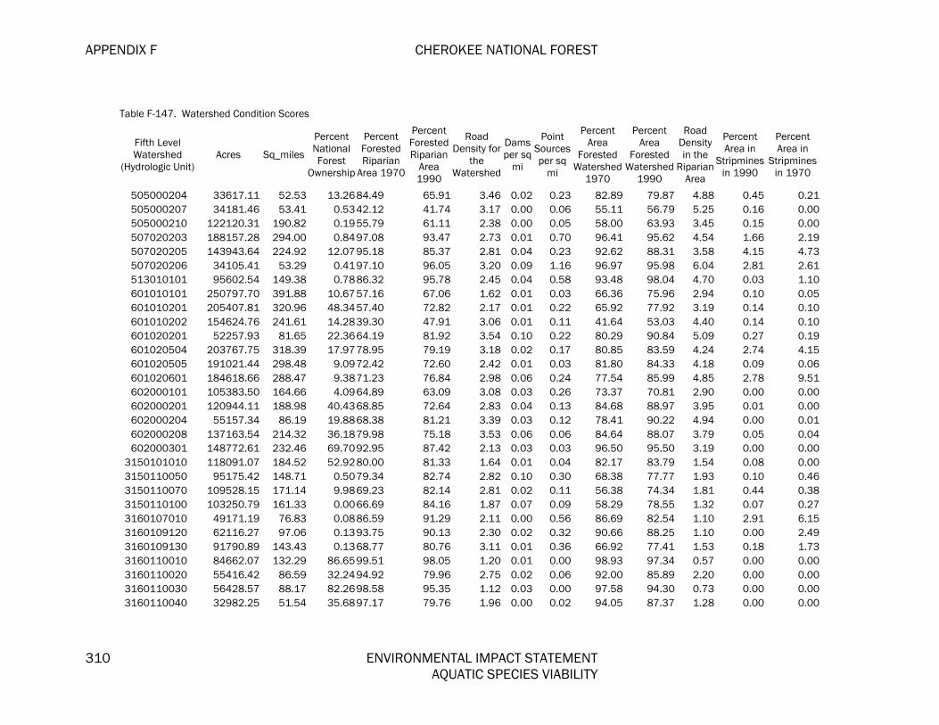
APPENDIX F CHEROKEE NATIONAL FOREST
310 ENVIRONMENTAL IMPACT STATEMENT AQUATIC SPECIES VIABILITY
Table F-147. Watershed Condition Scores
Fifth Level Watershed
(Hydrologic Unit) Acres Sq_miles
Percent National Forest
Ownership
Percent Forested Riparian
Area 1970
Percent Forested Riparian
Area 1990
Road Density for
the Watershed
Dams per sq
mi
Point Sourcesper sq
mi
Percent Area
Forested Watershed
1970
Percent Area
Forested Watershed
1990
Road Density in the
RiparianArea
Percent Area in
Stripminesin 1990
Percent Area in
Stripmines in 1970
505000204 33617.11 52.53 13.2684.49 65.91 3.46 0.02 0.23 82.89 79.87 4.88 0.45 0.21505000207 34181.46 53.41 0.5342.12 41.74 3.17 0.00 0.06 55.11 56.79 5.25 0.16 0.00505000210 122120.31 190.82 0.1955.79 61.11 2.38 0.00 0.05 58.00 63.93 3.45 0.15 0.00507020203 188157.28 294.00 0.8497.08 93.47 2.73 0.01 0.70 96.41 95.62 4.54 1.66 2.19507020205 143943.64 224.92 12.0795.18 85.37 2.81 0.04 0.23 92.62 88.31 3.58 4.15 4.73507020206 34105.41 53.29 0.4197.10 96.05 3.20 0.09 1.16 96.97 95.98 6.04 2.81 2.61513010101 95602.54 149.38 0.7886.32 95.78 2.45 0.04 0.58 93.48 98.04 4.70 0.03 1.10601010101 250797.70 391.88 10.6757.16 67.06 1.62 0.01 0.03 66.36 75.96 2.94 0.10 0.05601010201 205407.81 320.96 48.3457.40 72.82 2.17 0.01 0.22 65.92 77.92 3.19 0.14 0.10601010202 154624.76 241.61 14.2839.30 47.91 3.06 0.01 0.11 41.64 53.03 4.40 0.14 0.10601020201 52257.93 81.65 22.3664.19 81.92 3.54 0.10 0.22 80.29 90.84 5.09 0.27 0.19601020504 203767.75 318.39 17.9778.95 79.19 3.18 0.02 0.17 80.85 83.59 4.24 2.74 4.15601020505 191021.44 298.48 9.0972.42 72.60 2.42 0.01 0.03 81.80 84.33 4.18 0.09 0.06601020601 184618.66 288.47 9.3871.23 76.84 2.98 0.06 0.24 77.54 85.99 4.85 2.78 9.51602000101 105383.50 164.66 4.0964.89 63.09 3.08 0.03 0.26 73.37 70.81 2.90 0.00 0.00602000201 120944.11 188.98 40.4368.85 72.64 2.83 0.04 0.13 84.68 88.97 3.95 0.01 0.00602000204 55157.34 86.19 19.8868.38 81.21 3.39 0.03 0.12 78.41 90.22 4.94 0.00 0.01602000208 137163.54 214.32 36.1879.98 75.18 3.53 0.06 0.06 84.64 88.07 3.79 0.05 0.04602000301 148772.61 232.46 69.7092.95 87.42 2.13 0.03 0.03 96.50 95.50 3.19 0.00 0.00
3150101010 118091.07 184.52 52.9280.00 81.33 1.64 0.01 0.04 82.17 83.79 1.54 0.08 0.003150110050 95175.42 148.71 0.5079.34 82.74 2.82 0.10 0.30 68.38 77.77 1.93 0.10 0.463150110070 109528.15 171.14 9.9869.23 82.14 2.81 0.02 0.11 56.38 74.34 1.81 0.44 0.383150110100 103250.79 161.33 0.0066.69 84.16 1.87 0.07 0.09 58.29 78.55 1.32 0.07 0.273160107010 49171.19 76.83 0.0886.59 91.29 2.11 0.00 0.56 86.69 82.54 1.10 2.91 6.153160109120 62116.27 97.06 0.1393.75 90.13 2.30 0.02 0.32 90.66 88.25 1.10 0.00 2.493160109130 91790.89 143.43 0.1368.77 80.76 3.11 0.01 0.36 66.92 77.41 1.53 0.18 1.733160110010 84662.07 132.29 86.6599.51 98.05 1.20 0.01 0.00 98.93 97.34 0.57 0.00 0.003160110020 55416.42 86.59 32.2494.92 79.96 2.75 0.02 0.06 92.00 85.89 2.20 0.00 0.003160110030 56428.57 88.17 82.2698.58 95.35 1.12 0.03 0.00 97.58 94.30 0.73 0.00 0.003160110040 32982.25 51.54 35.6897.17 79.76 1.96 0.00 0.02 94.05 87.37 1.28 0.00 0.00
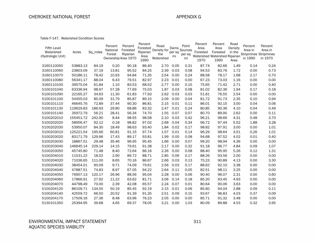
CHEROKEE NATIONAL FOREST APPENDIX G
ENVIRONMENTAL IMPACT STATEMENT 311 AQUATIC SPECIES VIABILITY
Table F-147. Watershed Condition Scores
Fifth Level Watershed
(Hydrologic Unit) Acres Sq_miles
Percent National Forest
Ownership
Percent Forested Riparian
Area 1970
Percent Forested Riparian
Area 1990
Road Density for
the Watershed
Dams per sq
mi
Point Sourcesper sq
mi
Percent Area
Forested Watershed
1970
Percent Area
Forested Watershed
1990
Road Density in the
RiparianArea
Percent Area in
Stripminesin 1990
Percent Area in
Stripmines in 1970
3160110050 53883.13 84.19 0.20 90.18 86.40 2.70 0.05 0.31 87.74 82.66 1.49 0.14 0.243160110060 23803.09 37.19 13.81 95.52 84.25 2.39 0.03 0.08 94.53 83.76 1.72 0.00 0.733160110070 50186.11 78.42 10.93 94.84 71.35 2.54 0.00 0.24 88.58 78.17 1.68 2.17 0.703160110080 56341.17 88.04 6.43 79.51 82.97 2.23 0.01 0.00 67.23 73.03 1.16 0.00 0.003160110100 39575.04 61.84 1.10 83.53 68.52 2.77 0.00 0.15 75.65 71.42 2.71 0.00 0.405100101040 63336.94 98.97 57.28 77.69 75.03 1.87 0.03 0.08 81.02 82.36 1.94 0.17 0.185100101090 22165.27 34.63 11.30 61.83 77.93 2.62 0.03 0.03 51.81 76.55 2.54 0.00 0.005100101100 54455.03 85.09 31.79 85.87 89.15 2.09 0.00 0.04 81.72 91.73 2.35 0.10 0.945100101110 46645.76 72.89 37.44 90.30 86.81 2.15 0.01 0.11 86.01 92.15 3.00 0.04 0.065100101130 119629.83 186.93 29.80 68.86 83.32 2.47 0.01 0.24 80.85 90.36 4.10 0.04 0.495100101140 35972.79 56.21 28.41 56.34 74.70 1.55 0.07 0.07 80.70 89.95 2.62 0.00 0.115100202010 155451.72 242.90 8.44 98.55 98.58 2.10 0.03 0.42 96.21 98.66 4.31 0.48 3.705100202020 58956.47 92.12 0.18 98.82 97.02 2.68 0.04 0.34 96.72 97.44 5.52 1.88 3.285100202030 53950.07 84.30 18.49 98.63 93.40 1.84 0.02 0.17 98.82 97.91 3.00 0.00 1.015100203010 125221.54 195.66 60.81 91.15 97.74 1.57 0.01 0.14 96.29 98.64 3.51 0.26 1.015100203020 83171.79 129.96 17.43 89.17 93.81 1.99 0.00 0.08 94.68 97.52 4.02 0.01 0.405100203030 18867.51 29.48 35.46 96.95 95.45 1.66 0.00 0.07 99.20 98.94 4.36 0.00 0.005100203040 146645.14 229.14 14.15 79.61 91.38 2.17 0.00 0.32 91.18 96.77 4.84 0.09 1.075100203050 45745.80 71.48 8.40 72.64 86.16 2.26 0.00 0.08 88.40 95.95 5.26 0.12 1.315100204010 11531.22 18.02 2.90 89.72 88.71 2.85 0.06 0.17 88.26 93.56 2.00 0.00 0.005100204020 71036.65 111.00 8.65 70.16 86.67 2.66 0.03 0.13 75.23 90.89 4.13 0.00 3.305100204030 38454.01 60.09 9.71 74.09 79.61 2.56 0.03 0.17 88.62 92.10 3.38 0.00 0.005100204040 47887.51 74.83 8.97 67.05 94.22 2.64 0.11 0.05 82.51 98.11 3.25 0.00 0.005100204050 76907.13 120.17 26.96 88.56 95.04 2.28 0.00 0.06 90.40 96.07 2.31 0.00 0.605100204060 17866.91 27.92 11.22 63.62 81.71 3.06 0.14 0.18 85.20 93.45 4.93 0.00 0.005100204070 44798.49 70.00 2.39 42.08 65.57 2.24 0.07 0.01 80.64 90.06 3.63 0.00 0.005100204120 86109.71 134.55 50.19 85.45 92.19 2.15 0.01 0.06 85.60 94.04 2.88 0.09 0.115100204140 42559.72 66.50 20.52 91.39 91.35 2.51 0.09 0.15 93.67 96.83 4.03 0.37 0.095100204170 17509.16 27.36 8.48 63.96 76.23 2.05 0.00 0.00 85.71 91.32 3.48 0.00 0.005130101350 25394.95 39.68 4.65 69.37 78.05 3.21 0.00 1.03 80.09 89.88 4.53 0.32 3.95

APPENDIX F CHEROKEE NATIONAL FOREST
312 ENVIRONMENTAL IMPACT STATEMENT AQUATIC SPECIES VIABILITY
Table F-147. Watershed Condition Scores
Fifth Level Watershed
(Hydrologic Unit) Acres Sq_miles
Percent National Forest
Ownership
Percent Forested Riparian
Area 1970
Percent Forested Riparian
Area 1990
Road Density for
the Watershed
Dams per sq
mi
Point Sourcesper sq
mi
Percent Area
Forested Watershed
1970
Percent Area
Forested Watershed
1990
Road Density in the
RiparianArea
Percent Area in
Stripminesin 1990
Percent Area in
Stripmines in 1970
5130101360 10710.87 16.74 17.06 70.41 82.10 1.80 0.00 0.12 83.15 90.57 3.58 0.00 4.315130101370 66427.69 103.80 57.62 92.46 89.32 1.86 0.02 0.12 91.57 94.94 1.21 0.00 1.185130101400 83818.76 130.97 19.47 87.12 94.38 1.26 0.01 0.47 88.47 96.79 2.25 0.08 7.685130101410 35502.40 55.47 29.74 83.35 90.45 2.55 0.02 0.23 83.03 92.08 1.95 0.00 4.305130101420 16710.80 26.11 62.27 96.73 98.07 3.63 0.11 0.77 85.51 92.45 1.27 0.00 0.005130101430 26549.66 41.49 71.60 98.36 99.14 2.17 0.00 0.12 96.33 97.91 1.24 0.00 0.185130101440 8197.95 12.81 54.26 89.68 95.28 1.94 0.00 0.08 90.14 95.69 1.71 0.00 0.065130101450 61458.66 96.03 38.94 81.12 69.40 3.04 0.02 0.17 67.85 79.07 1.65 0.00 0.565130102030 55416.90 86.59 44.55 77.23 89.45 2.42 0.07 0.23 74.81 89.62 3.48 0.00 0.625130102040 59891.09 93.58 10.21 78.57 83.34 2.97 0.01 0.47 70.45 84.40 3.06 0.06 1.745130102050 39538.25 61.78 38.73 87.41 95.05 2.39 0.03 0.11 87.39 95.42 2.68 0.15 1.325130102060 92223.33 144.10 6.76 66.39 77.65 2.97 0.01 0.17 74.31 85.73 4.02 0.08 0.875130102070 72424.84 113.17 46.72 95.56 95.02 1.88 0.02 0.08 90.72 96.10 1.77 0.35 1.895130102080 26031.27 40.68 3.88 86.33 95.17 2.22 0.00 0.07 88.58 96.59 3.51 0.00 1.965130102090 30443.18 47.57 34.47 82.80 92.76 2.91 0.04 0.36 66.54 82.68 1.54 0.00 1.175130102100 13074.40 20.43 89.58 99.29 99.30 1.81 0.00 0.00 97.56 99.23 1.49 0.00 0.045130103010 36425.63 56.92 60.74 95.01 70.15 2.36 0.00 0.07 92.98 92.54 1.30 0.00 0.975130103020 16049.71 25.08 95.11 100.00 98.76 2.06 0.00 0.28 96.92 98.97 0.64 0.00 0.525130103040 24246.31 37.89 9.64 92.58 92.87 2.57 0.00 0.05 88.24 94.41 1.81 0.00 0.585130104250 75497.31 117.97 43.30 95.05 90.01 2.39 0.02 0.08 92.77 95.95 1.89 0.00 1.825130104270 31947.40 49.92 5.51 83.42 93.65 2.99 0.02 0.30 79.61 91.77 2.78 0.00 3.525130104290 40157.37 62.75 60.64 99.22 99.57 1.80 0.02 0.05 99.08 99.56 2.16 0.00 0.225130104310 78272.99 122.30 5.10 76.76 87.15 1.82 0.00 0.02 89.54 94.89 2.54 0.00 0.866010102030 155162.94 242.45 23.78 58.34 55.89 3.11 0.01 0.25 55.07 60.43 3.49 0.17 0.096010103010 106527.02 166.45 9.27 57.83 77.83 2.70 0.00 0.35 65.23 82.53 3.45 0.15 0.056010103020 139650.10 218.21 11.54 63.35 75.77 3.97 0.06 0.42 68.67 85.43 4.85 0.08 0.046010103030 52739.45 82.41 8.58 85.50 87.98 3.44 0.06 0.49 84.08 92.43 4.38 0.03 0.006010103040 87355.55 136.50 36.84 78.89 89.52 2.88 0.02 0.26 84.51 93.18 4.38 0.04 0.006010103050 37659.72 58.84 63.09 72.53 86.41 1.96 0.00 0.41 78.01 89.90 2.95 0.02 0.006010103060 86081.88 134.51 16.96 52.04 70.80 5.94 0.02 1.61 52.94 70.73 6.55 0.24 0.50
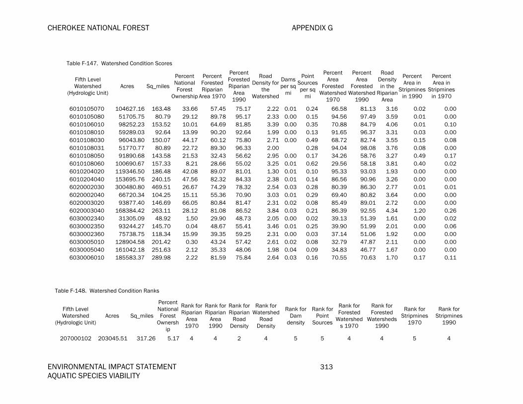
CHEROKEE NATIONAL FOREST APPENDIX G
ENVIRONMENTAL IMPACT STATEMENT 313 AQUATIC SPECIES VIABILITY
Table F-147. Watershed Condition Scores
Fifth Level Watershed
(Hydrologic Unit) Acres Sq_miles
Percent National Forest
Ownership
Percent Forested Riparian
Area 1970
Percent Forested Riparian
Area 1990
Road Density for
the Watershed
Dams per sq
mi
Point Sourcesper sq
mi
Percent Area
Forested Watershed
1970
Percent Area
Forested Watershed
1990
Road Density in the
RiparianArea
Percent Area in
Stripminesin 1990
Percent Area in
Stripmines in 1970
6010105070 104627.16 163.48 33.66 57.45 75.17 2.22 0.01 0.24 66.58 81.13 3.16 0.02 0.006010105080 51705.75 80.79 29.12 89.78 95.17 2.33 0.00 0.15 94.56 97.49 3.59 0.01 0.006010106010 98252.23 153.52 10.01 64.69 81.85 3.39 0.00 0.35 70.88 84.79 4.06 0.01 0.106010108010 59289.03 92.64 13.99 90.20 92.64 1.99 0.00 0.13 91.65 96.37 3.31 0.03 0.006010108030 96043.80 150.07 44.17 60.12 75.80 2.71 0.00 0.49 68.72 82.74 3.55 0.15 0.086010108031 51770.77 80.89 22.72 89.30 96.33 2.00 0.28 94.04 98.08 3.76 0.08 0.006010108050 91890.68 143.58 21.53 32.43 56.62 2.95 0.00 0.17 34.26 58.76 3.27 0.49 0.176010108060 100690.67 157.33 8.21 28.66 55.02 3.25 0.01 0.62 29.56 58.18 3.81 0.40 0.026010204020 119346.50 186.48 42.08 89.07 81.01 1.30 0.01 0.10 95.33 93.03 1.93 0.00 0.006010204040 153695.76 240.15 47.56 82.32 84.33 2.38 0.01 0.14 86.56 90.96 3.26 0.00 0.006020002030 300480.80 469.51 26.67 74.29 78.32 2.54 0.03 0.28 80.39 86.30 2.77 0.01 0.016020002040 66720.34 104.25 15.11 55.36 70.90 3.03 0.01 0.29 69.40 80.82 3.64 0.00 0.006020003020 93877.40 146.69 66.05 80.84 81.47 2.31 0.02 0.08 85.49 89.01 2.72 0.00 0.006020003040 168384.42 263.11 28.12 81.08 86.52 3.84 0.03 0.21 86.39 92.55 4.34 1.20 0.266030002340 31305.09 48.92 1.50 29.90 48.73 2.05 0.00 0.02 39.13 51.39 1.61 0.00 0.026030002350 93244.27 145.70 0.04 48.67 55.41 3.46 0.01 0.25 39.90 51.99 2.01 0.00 0.066030002360 75738.75 118.34 15.99 39.35 59.25 2.31 0.00 0.03 37.14 51.06 1.92 0.00 0.006030005010 128904.58 201.42 0.30 43.24 57.42 2.61 0.02 0.08 32.79 47.87 2.11 0.00 0.006030005040 161042.18 251.63 2.12 35.33 48.06 1.98 0.04 0.09 34.83 46.77 1.67 0.00 0.006030006010 185583.37 289.98 2.22 81.59 75.84 2.64 0.03 0.16 70.55 70.63 1.70 0.17 0.11
Table F-148. Watershed Condition Ranks
Fifth Level Watershed
(Hydrologic Unit)Acres Sq_miles
Percent National Forest
Ownership
Rank for Riparian
Area 1970
Rank for Riparian
Area 1990
Rank for Riparian
Road Density
Rank for Watershed
Road Density
Rank for Dam
density
Rank for Point
Sources
Rank for Forested
Watersheds 1970
Rank for Forested
Watersheds 1990
Rank for Stripmines
1970
Rank for Stripmines
1990
207000102 203045.51 317.26 5.17 4 4 2 4 5 5 4 4 5 4

APPENDIX F CHEROKEE NATIONAL FOREST
314 ENVIRONMENTAL IMPACT STATEMENT AQUATIC SPECIES VIABILITY
Table F-148. Watershed Condition Ranks
Fifth Level Watershed
(Hydrologic Unit)Acres Sq_miles
Percent National Forest
Ownership
Rank for Riparian
Area 1970
Rank for Riparian
Area 1990
Rank for Riparian
Road Density
Rank for Watershed
Road Density
Rank for Dam
density
Rank for Point
Sources
Rank for Forested
Watersheds 1970
Rank for Forested
Watersheds 1990
Rank for Stripmines
1970
Rank for Stripmines
1990
207000106 184728.28 288.64 29.42 3 4 2 4 3 5 4 4 5 4 207000301 265283.75 414.51 19.85 3 4 2 4 5 4 4 4 5 4 207000501 239229.50 373.80 9.86 1 1 2 2 5 4 1 1 5 5 207000502 188455.88 294.47 59.14 3 4 2 4 4 5 3 3 5 5 207000504 150151.10 234.62 19.58 2 3 2 2 4 3 2 3 5 4 207000505 225087.52 351.71 9.48 2 2 2 3 5 4 2 3 5 5 207000506 170704.68 266.73 7.46 1 2 1 2 5 3 2 3 5 5 207000601 133130.94 208.02 52.54 3 4 1 4 5 5 4 5 5 4 207000602 208810.35 326.27 5.46 1 1 1 2 5 4 1 1 5 5 207000603 219150.28 342.43 27.76 1 2 2 2 5 3 2 3 5 4 207000604 100664.52 157.29 18.88 3 4 2 3 5 4 3 3 4 4 208020102 108174.38 169.03 41.48 4 4 3 4 5 3 5 5 5 5 208020103 110988.61 173.42 54.21 4 4 3 4 5 2 5 5 5 5 208020104 220296.07 344.22 41.07 2 2 2 4 5 5 4 4 5 5 208020105 138536.32 216.47 38.30 3 4 3 3 5 1 4 5 5 5 208020106 226283.67 353.57 58.66 3 4 3 4 5 3 4 5 5 5 208020107 210700.26 329.22 14.53 2 2 2 3 5 5 3 3 5 4 208020108 237899.06 371.72 61.50 4 4 3 4 5 4 5 5 5 5 208020109 92239.65 144.13 43.30 3 3 2 3 5 5 4 4 4 4 208020201 150864.46 235.73 58.82 3 4 2 4 5 5 4 5 5 5 208020202 53423.67 83.48 29.52 2 2 2 3 5 5 4 4 5 5 208020203 176833.32 276.31 9.05 1 2 2 2 5 4 2 2 5 5 208020204 75901.05 118.60 33.91 2 3 2 3 5 5 3 3 5 5 208020205 79108.56 123.61 4.28 2 3 2 3 5 5 3 3 5 4 208020301 238983.20 373.42 21.46 3 4 3 2 3 3 3 4 5 4 208020303 169320.60 264.57 17.51 2 3 3 3 5 5 3 4 5 4 208020304 98156.63 153.37 8.47 2 3 3 3 4 5 3 4 5 4 208020306 158491.32 247.65 0.94 3 4 2 3 4 3 4 4 5 4 301010101 162570.75 254.02 1.28 3 3 2 3 5 5 4 4 5 5 301010102 202807.60 316.89 0.81 2 2 1 1 5 2 2 3 5 4
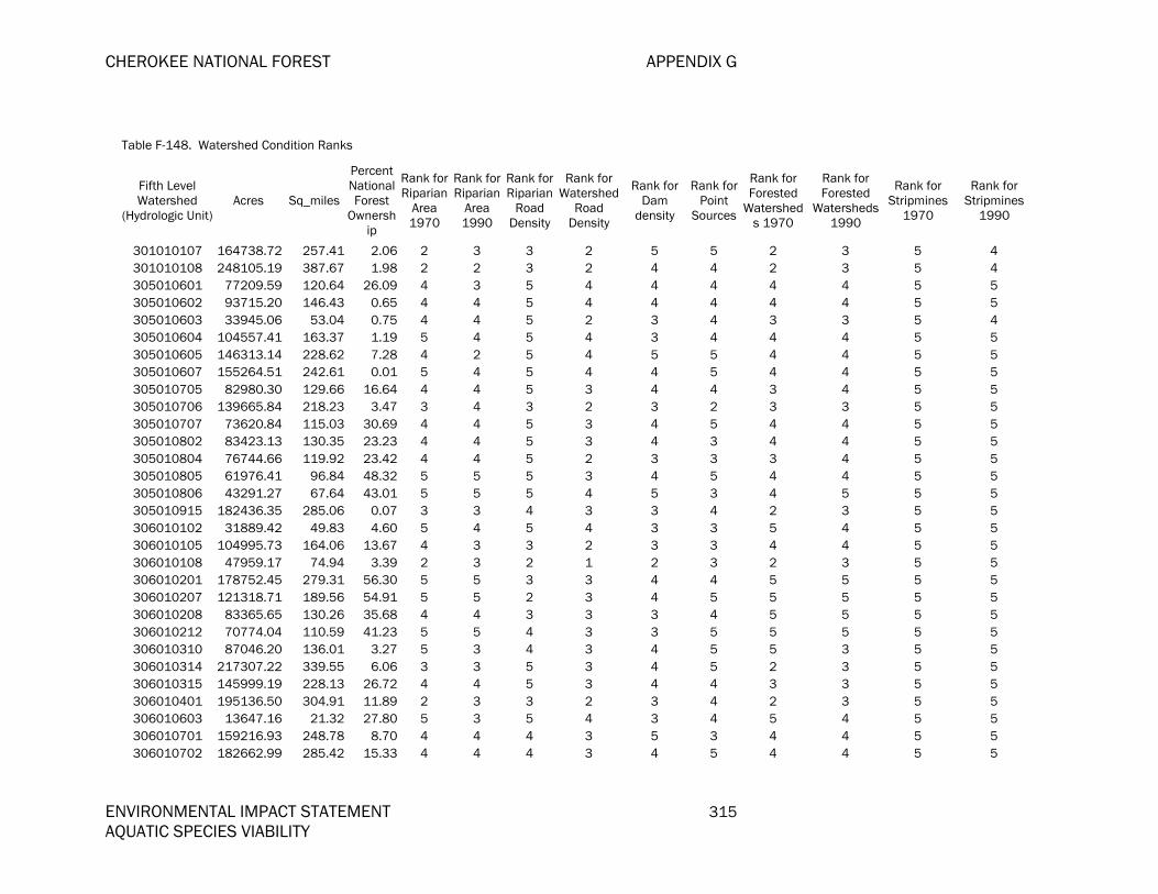
CHEROKEE NATIONAL FOREST APPENDIX G
ENVIRONMENTAL IMPACT STATEMENT 315 AQUATIC SPECIES VIABILITY
Table F-148. Watershed Condition Ranks
Fifth Level Watershed
(Hydrologic Unit)Acres Sq_miles
Percent National Forest
Ownership
Rank for Riparian
Area 1970
Rank for Riparian
Area 1990
Rank for Riparian
Road Density
Rank for Watershed
Road Density
Rank for Dam
density
Rank for Point
Sources
Rank for Forested
Watersheds 1970
Rank for Forested
Watersheds 1990
Rank for Stripmines
1970
Rank for Stripmines
1990
301010107 164738.72 257.41 2.06 2 3 3 2 5 5 2 3 5 4 301010108 248105.19 387.67 1.98 2 2 3 2 4 4 2 3 5 4 305010601 77209.59 120.64 26.09 4 3 5 4 4 4 4 4 5 5 305010602 93715.20 146.43 0.65 4 4 5 4 4 4 4 4 5 5 305010603 33945.06 53.04 0.75 4 4 5 2 3 4 3 3 5 4 305010604 104557.41 163.37 1.19 5 4 5 4 3 4 4 4 5 5 305010605 146313.14 228.62 7.28 4 2 5 4 5 5 4 4 5 5 305010607 155264.51 242.61 0.01 5 4 5 4 4 5 4 4 5 5 305010705 82980.30 129.66 16.64 4 4 5 3 4 4 3 4 5 5 305010706 139665.84 218.23 3.47 3 4 3 2 3 2 3 3 5 5 305010707 73620.84 115.03 30.69 4 4 5 3 4 5 4 4 5 5 305010802 83423.13 130.35 23.23 4 4 5 3 4 3 4 4 5 5 305010804 76744.66 119.92 23.42 4 4 5 2 3 3 3 4 5 5 305010805 61976.41 96.84 48.32 5 5 5 3 4 5 4 4 5 5 305010806 43291.27 67.64 43.01 5 5 5 4 5 3 4 5 5 5 305010915 182436.35 285.06 0.07 3 3 4 3 3 4 2 3 5 5 306010102 31889.42 49.83 4.60 5 4 5 4 3 3 5 4 5 5 306010105 104995.73 164.06 13.67 4 3 3 2 3 3 4 4 5 5 306010108 47959.17 74.94 3.39 2 3 2 1 2 3 2 3 5 5 306010201 178752.45 279.31 56.30 5 5 3 3 4 4 5 5 5 5 306010207 121318.71 189.56 54.91 5 5 2 3 4 5 5 5 5 5 306010208 83365.65 130.26 35.68 4 4 3 3 3 4 5 5 5 5 306010212 70774.04 110.59 41.23 5 5 4 3 3 5 5 5 5 5 306010310 87046.20 136.01 3.27 5 3 4 3 4 5 5 3 5 5 306010314 217307.22 339.55 6.06 3 3 5 3 4 5 2 3 5 5 306010315 145999.19 228.13 26.72 4 4 5 3 4 4 3 3 5 5 306010401 195136.50 304.91 11.89 2 3 3 2 3 4 2 3 5 5 306010603 13647.16 21.32 27.80 5 3 5 4 3 4 5 4 5 5 306010701 159216.93 248.78 8.70 4 4 4 3 5 3 4 4 5 5 306010702 182662.99 285.42 15.33 4 4 4 3 4 5 4 4 5 5

APPENDIX F CHEROKEE NATIONAL FOREST
316 ENVIRONMENTAL IMPACT STATEMENT AQUATIC SPECIES VIABILITY
Table F-148. Watershed Condition Ranks
Fifth Level Watershed
(Hydrologic Unit)Acres Sq_miles
Percent National Forest
Ownership
Rank for Riparian
Area 1970
Rank for Riparian
Area 1990
Rank for Riparian
Road Density
Rank for Watershed
Road Density
Rank for Dam
density
Rank for Point
Sources
Rank for Forested
Watersheds 1970
Rank for Forested
Watersheds 1990
Rank for Stripmines
1970
Rank for Stripmines
1990
306010704 131509.86 205.49 13.57 5 4 5 3 2 5 5 4 5 5 307010106 98577.64 154.03 5.30 4 3 4 3 3 4 3 3 5 5 307010107 100314.75 156.74 21.38 4 4 5 4 5 5 4 4 5 5 307010109 114242.57 178.51 4.46 3 3 4 3 3 5 2 3 5 5 307010111 75532.42 118.02 0.47 4 3 5 4 4 4 4 3 5 5 307010112 107528.02 168.02 0.02 3 2 4 3 3 5 4 3 5 5 307010114 139919.25 218.63 0.84 3 3 5 4 2 5 3 3 5 5 307010115 50586.33 79.04 27.41 5 4 4 4 4 5 5 4 5 5 307010116 132353.39 206.81 11.32 4 4 5 4 3 5 4 4 5 5 307010117 138960.32 217.13 15.43 5 4 4 4 4 5 5 4 5 5 307010310 124394.71 194.37 11.83 4 4 5 3 4 4 4 4 5 5 307010313 138209.14 215.96 12.16 5 4 5 4 3 4 5 4 5 4 313000101 99591.58 155.61 39.31 5 5 2 3 2 4 5 5 5 5 313000102 101919.25 159.25 16.93 3 4 2 2 2 4 3 4 5 5 313000105 86420.91 135.04 31.03 4 5 3 3 3 4 4 5 5 5 313000106 62527.12 97.70 18.57 4 5 2 2 5 3 4 5 5 5 314010305 52209.41 81.58 2.31 2 4 4 3 4 3 2 3 5 5 314010307 19363.95 30.26 14.03 4 4 4 3 5 5 4 4 5 5 314010308 78827.17 123.17 21.36 3 4 4 3 5 3 2 3 5 5 314010309 55349.05 86.48 9.60 4 5 5 4 5 5 3 4 5 5 314010311 13057.00 20.40 1.49 2 3 5 4 5 5 2 3 5 5 314010401 96240.85 150.38 47.97 5 5 5 4 5 5 4 4 5 5 314010410 36860.75 57.60 12.80 5 5 5 3 4 5 5 5 5 5 314030105 105280.16 164.50 2.76 4 4 5 4 5 5 3 4 5 5 314030401 127689.07 199.52 3.50 3 5 4 4 5 5 4 4 5 5 315010102 91717.77 143.31 19.62 2 3 3 2 4 3 3 3 5 5 315010103 114528.11 178.95 1.84 2 2 2 2 4 3 2 3 5 5 315010104 74677.70 116.69 26.42 4 4 4 3 4 3 5 4 5 5 315010105 69240.17 108.19 7.51 3 3 3 2 4 2 3 3 5 5 315010201 86824.60 135.67 16.94 5 5 2 2 3 5 5 5 5 5
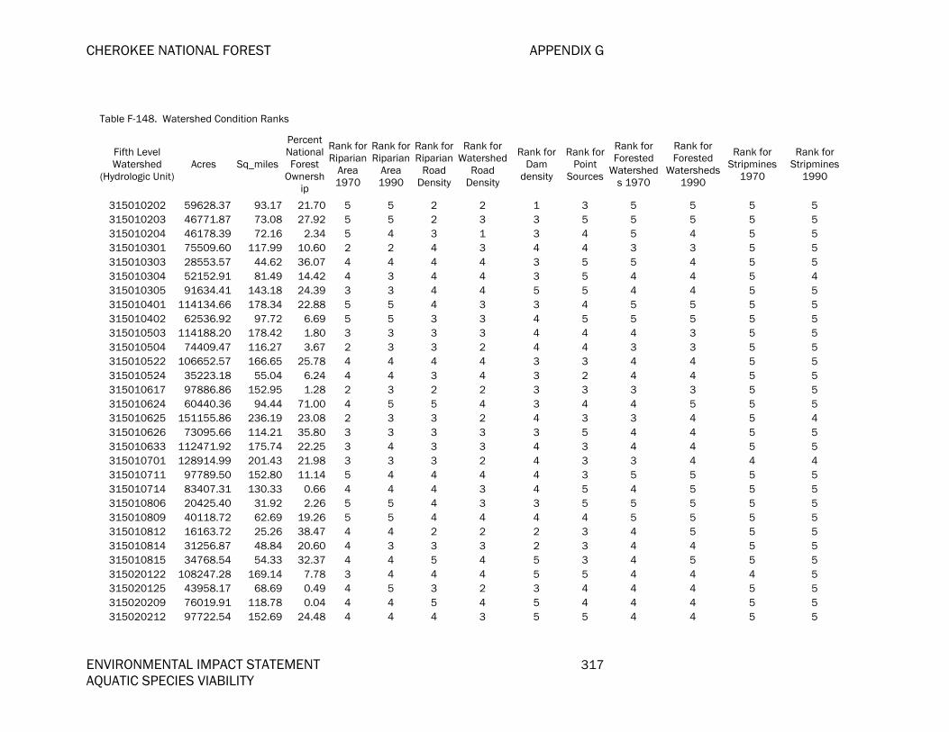
CHEROKEE NATIONAL FOREST APPENDIX G
ENVIRONMENTAL IMPACT STATEMENT 317 AQUATIC SPECIES VIABILITY
Table F-148. Watershed Condition Ranks
Fifth Level Watershed
(Hydrologic Unit)Acres Sq_miles
Percent National Forest
Ownership
Rank for Riparian
Area 1970
Rank for Riparian
Area 1990
Rank for Riparian
Road Density
Rank for Watershed
Road Density
Rank for Dam
density
Rank for Point
Sources
Rank for Forested
Watersheds 1970
Rank for Forested
Watersheds 1990
Rank for Stripmines
1970
Rank for Stripmines
1990
315010202 59628.37 93.17 21.70 5 5 2 2 1 3 5 5 5 5 315010203 46771.87 73.08 27.92 5 5 2 3 3 5 5 5 5 5 315010204 46178.39 72.16 2.34 5 4 3 1 3 4 5 4 5 5 315010301 75509.60 117.99 10.60 2 2 4 3 4 4 3 3 5 5 315010303 28553.57 44.62 36.07 4 4 4 4 3 5 5 4 5 5 315010304 52152.91 81.49 14.42 4 3 4 4 3 5 4 4 5 4 315010305 91634.41 143.18 24.39 3 3 4 4 5 5 4 4 5 5 315010401 114134.66 178.34 22.88 5 5 4 3 3 4 5 5 5 5 315010402 62536.92 97.72 6.69 5 5 3 3 4 5 5 5 5 5 315010503 114188.20 178.42 1.80 3 3 3 3 4 4 4 3 5 5 315010504 74409.47 116.27 3.67 2 3 3 2 4 4 3 3 5 5 315010522 106652.57 166.65 25.78 4 4 4 4 3 3 4 4 5 5 315010524 35223.18 55.04 6.24 4 4 3 4 3 2 4 4 5 5 315010617 97886.86 152.95 1.28 2 3 2 2 3 3 3 3 5 5 315010624 60440.36 94.44 71.00 4 5 5 4 3 4 4 5 5 5 315010625 151155.86 236.19 23.08 2 3 3 2 4 3 3 4 5 4 315010626 73095.66 114.21 35.80 3 3 3 3 3 5 4 4 5 5 315010633 112471.92 175.74 22.25 3 4 3 3 4 3 4 4 5 5 315010701 128914.99 201.43 21.98 3 3 3 2 4 3 3 4 4 4 315010711 97789.50 152.80 11.14 5 4 4 4 4 3 5 5 5 5 315010714 83407.31 130.33 0.66 4 4 4 3 4 5 4 5 5 5 315010806 20425.40 31.92 2.26 5 5 4 3 3 5 5 5 5 5 315010809 40118.72 62.69 19.26 5 5 4 4 4 4 5 5 5 5 315010812 16163.72 25.26 38.47 4 4 2 2 2 3 4 5 5 5 315010814 31256.87 48.84 20.60 4 3 3 3 2 3 4 4 5 5 315010815 34768.54 54.33 32.37 4 4 5 4 5 3 4 5 5 5 315020122 108247.28 169.14 7.78 3 4 4 4 5 5 4 4 4 5 315020125 43958.17 68.69 0.49 4 5 3 2 3 4 4 4 5 5 315020209 76019.91 118.78 0.04 4 4 5 4 5 4 4 4 5 5 315020212 97722.54 152.69 24.48 4 4 4 3 5 5 4 4 5 5

APPENDIX F CHEROKEE NATIONAL FOREST
318 ENVIRONMENTAL IMPACT STATEMENT AQUATIC SPECIES VIABILITY
Table F-148. Watershed Condition Ranks
Fifth Level Watershed
(Hydrologic Unit)Acres Sq_miles
Percent National Forest
Ownership
Rank for Riparian
Area 1970
Rank for Riparian
Area 1990
Rank for Riparian
Road Density
Rank for Watershed
Road Density
Rank for Dam
density
Rank for Point
Sources
Rank for Forested
Watersheds 1970
Rank for Forested
Watersheds 1990
Rank for Stripmines
1970
Rank for Stripmines
1990
315020213 59068.27 92.30 24.04 4 4 4 4 5 5 5 5 5 5 315020214 93083.37 145.45 10.52 4 4 4 4 5 5 4 4 5 5 315020216 152263.19 237.92 21.58 4 5 5 4 5 5 4 5 5 5 316011303 113464.98 177.29 30.10 5 5 4 4 5 4 5 5 5 5 316011306 23608.80 36.89 40.36 4 4 3 4 5 5 4 4 5 5 316011307 43355.49 67.74 0.02 3 4 4 4 5 5 3 4 5 5 316011309 70686.38 110.45 26.52 5 5 5 4 5 5 4 5 5 5 316011312 127219.84 198.78 1.65 4 4 4 4 1 5 4 4 5 5 505000101 184188.91 287.80 3.11 2 4 1 3 5 4 3 4 5 5 505000103 216717.56 338.63 2.46 1 2 2 2 4 5 2 3 5 5 505000104 145341.85 227.10 8.82 1 2 1 2 5 4 2 3 5 5 505000105 48853.75 76.34 22.47 2 3 2 4 5 5 2 4 5 4 505000106 116752.72 182.43 4.11 1 2 2 2 5 5 1 2 5 5 505000107 88743.25 138.66 32.50 1 2 3 4 5 5 2 2 5 5 505000108 173822.67 271.60 18.42 1 2 3 3 5 5 2 2 5 5 505000110 242503.54 378.92 9.57 2 2 2 2 5 3 2 2 5 5 505000201 126777.26 198.09 26.09 2 2 3 4 5 5 3 4 5 4 505000202 199723.43 312.07 30.54 2 3 3 4 5 5 3 4 5 4 505000203 152690.23 238.58 19.72 2 3 2 4 5 5 3 4 5 5 505000204 33617.11 52.53 13.26 4 3 1 2 5 3 4 4 5 4 505000207 34181.46 53.41 0.53 1 1 1 2 5 5 2 2 5 5 505000210 122120.31 190.82 0.19 2 2 2 3 5 5 2 3 5 5 507020203 188157.28 294.00 0.84 5 5 1 3 5 3 5 5 3 3 507020205 143943.64 224.92 12.07 5 4 2 3 4 3 5 4 1 2 507020206 34105.41 53.29 0.41 5 5 1 2 3 2 5 5 3 2 513010101 95602.54 149.38 0.78 4 5 1 3 4 3 5 5 4 5 601010101 250797.70 391.88 10.67 2 3 3 4 5 5 3 3 5 5 601010201 205407.81 320.96 48.34 2 3 2 4 5 3 3 4 5 5 601010202 154624.76 241.61 14.28 1 2 1 2 5 4 1 2 5 5 601020201 52257.93 81.65 22.36 2 4 1 2 3 3 4 5 5 5
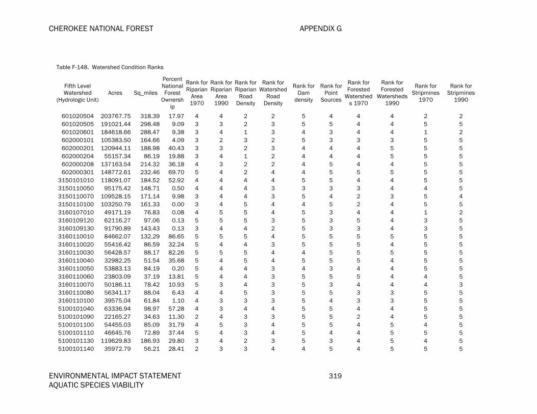
CHEROKEE NATIONAL FOREST APPENDIX G
ENVIRONMENTAL IMPACT STATEMENT 319 AQUATIC SPECIES VIABILITY
Table F-148. Watershed Condition Ranks
Fifth Level Watershed
(Hydrologic Unit)Acres Sq_miles
Percent National Forest
Ownership
Rank for Riparian
Area 1970
Rank for Riparian
Area 1990
Rank for Riparian
Road Density
Rank for Watershed
Road Density
Rank for Dam
density
Rank for Point
Sources
Rank for Forested
Watersheds 1970
Rank for Forested
Watersheds 1990
Rank for Stripmines
1970
Rank for Stripmines
1990
601020504 203767.75 318.39 17.97 4 4 2 2 5 4 4 4 2 2 601020505 191021.44 298.48 9.09 3 3 2 3 5 5 4 4 5 5 601020601 184618.66 288.47 9.38 3 4 1 3 4 3 4 4 1 2 602000101 105383.50 164.66 4.09 3 2 3 2 5 3 3 3 5 5 602000201 120944.11 188.98 40.43 3 3 2 3 4 4 4 5 5 5 602000204 55157.34 86.19 19.88 3 4 1 2 4 4 4 5 5 5 602000208 137163.54 214.32 36.18 4 3 2 2 4 5 4 4 5 5 602000301 148772.61 232.46 69.70 5 4 2 4 4 5 5 5 5 5
3150101010 118091.07 184.52 52.92 4 4 4 4 5 5 4 4 5 5 3150110050 95175.42 148.71 0.50 4 4 4 3 3 3 3 4 4 5 3150110070 109528.15 171.14 9.98 3 4 4 3 5 4 2 3 5 4 3150110100 103250.79 161.33 0.00 3 4 5 4 4 5 2 4 5 5 3160107010 49171.19 76.83 0.08 4 5 5 4 5 3 4 4 1 2 3160109120 62116.27 97.06 0.13 5 5 5 3 5 3 5 4 3 5 3160109130 91790.89 143.43 0.13 3 4 4 2 5 3 3 4 3 5 3160110010 84662.07 132.29 86.65 5 5 5 4 5 5 5 5 5 5 3160110020 55416.42 86.59 32.24 5 4 4 3 5 5 5 4 5 5 3160110030 56428.57 88.17 82.26 5 5 5 4 4 5 5 5 5 5 3160110040 32982.25 51.54 35.68 5 4 5 4 5 5 5 4 5 5 3160110050 53883.13 84.19 0.20 5 4 4 3 4 3 4 4 5 5 3160110060 23803.09 37.19 13.81 5 4 4 3 5 5 5 4 4 5 3160110070 50186.11 78.42 10.93 5 3 4 3 5 3 4 4 4 3 3160110080 56341.17 88.04 6.43 4 4 5 3 5 5 3 3 5 5 3160110100 39575.04 61.84 1.10 4 3 3 3 5 4 3 3 5 5 5100101040 63336.94 98.97 57.28 4 3 4 4 5 5 4 4 5 5 5100101090 22165.27 34.63 11.30 2 4 3 3 5 5 2 4 5 5 5100101100 54455.03 85.09 31.79 4 5 3 4 5 5 4 5 4 5 5100101110 46645.76 72.89 37.44 5 4 3 4 5 4 4 5 5 5 5100101130 119629.83 186.93 29.80 3 4 2 3 5 3 4 5 4 5 5100101140 35972.79 56.21 28.41 2 3 3 4 4 5 4 5 5 5

APPENDIX F CHEROKEE NATIONAL FOREST
320 ENVIRONMENTAL IMPACT STATEMENT AQUATIC SPECIES VIABILITY
Table F-148. Watershed Condition Ranks
Fifth Level Watershed
(Hydrologic Unit)Acres Sq_miles
Percent National Forest
Ownership
Rank for Riparian
Area 1970
Rank for Riparian
Area 1990
Rank for Riparian
Road Density
Rank for Watershed
Road Density
Rank for Dam
density
Rank for Point
Sources
Rank for Forested
Watersheds 1970
Rank for Forested
Watersheds 1990
Rank for Stripmines
1970
Rank for Stripmines
1990
5100202010 155451.72 242.90 8.44 5 5 1 4 5 3 5 5 2 4 5100202020 58956.47 92.12 0.18 5 5 1 3 4 3 5 5 2 3 5100202030 53950.07 84.30 18.49 5 5 3 4 5 4 5 5 4 5 5100203010 125221.54 195.66 60.81 5 5 2 4 5 4 5 5 4 5 5100203020 83171.79 129.96 17.43 5 5 2 4 5 5 5 5 4 5 5100203030 18867.51 29.48 35.46 5 5 1 4 5 5 5 5 5 5 5100203040 146645.14 229.14 14.15 4 5 1 4 5 3 5 5 4 5 5100203050 45745.80 71.48 8.40 3 4 1 3 5 5 4 5 4 5 5100204010 11531.22 18.02 2.90 5 5 4 3 4 4 4 5 5 5 5100204020 71036.65 111.00 8.65 3 4 2 3 5 4 3 5 2 5 5100204030 38454.01 60.09 9.71 3 4 2 3 4 4 4 5 5 5 5100204040 47887.51 74.83 8.97 3 5 2 3 3 5 4 5 5 5 5100204050 76907.13 120.17 26.96 5 5 3 3 5 5 5 5 4 5 5100204060 17866.91 27.92 11.22 2 4 1 2 2 4 4 5 5 5 5100204070 44798.49 70.00 2.39 1 3 2 3 4 5 4 5 5 5 5100204120 86109.71 134.55 50.19 4 5 3 4 5 5 4 5 5 5 5100204140 42559.72 66.50 20.52 5 5 2 3 3 4 5 5 5 5 5100204170 17509.16 27.36 8.48 2 3 2 4 5 5 4 5 5 5 5130101350 25394.95 39.68 4.65 3 4 1 2 5 2 4 5 2 5 5130101360 10710.87 16.74 17.06 3 4 2 4 5 4 4 5 2 5 5130101370 66427.69 103.80 57.62 5 5 5 4 5 4 5 5 4 5 5130101400 83818.76 130.97 19.47 4 5 3 4 5 3 4 5 1 5 5130101410 35502.40 55.47 29.74 4 5 4 3 5 3 4 5 2 5 5130101420 16710.80 26.11 62.27 5 5 5 2 3 3 4 5 5 5 5130101430 26549.66 41.49 71.60 5 5 5 4 5 4 5 5 5 5 5130101440 8197.95 12.81 54.26 5 5 4 4 5 5 5 5 5 5 5130101450 61458.66 96.03 38.94 4 3 4 2 5 4 3 4 4 5 5130102030 55416.90 86.59 44.55 4 5 2 3 4 3 3 5 4 5 5130102040 59891.09 93.58 10.21 4 4 3 3 5 3 3 4 3 5 5130102050 39538.25 61.78 38.73 4 5 3 3 5 4 4 5 4 5

CHEROKEE NATIONAL FOREST APPENDIX G
ENVIRONMENTAL IMPACT STATEMENT 321 AQUATIC SPECIES VIABILITY
Table F-148. Watershed Condition Ranks
Fifth Level Watershed
(Hydrologic Unit)Acres Sq_miles
Percent National Forest
Ownership
Rank for Riparian
Area 1970
Rank for Riparian
Area 1990
Rank for Riparian
Road Density
Rank for Watershed
Road Density
Rank for Dam
density
Rank for Point
Sources
Rank for Forested
Watersheds 1970
Rank for Forested
Watersheds 1990
Rank for Stripmines
1970
Rank for Stripmines
1990
5130102060 92223.33 144.10 6.76 3 4 2 3 5 4 3 4 4 5 5130102070 72424.84 113.17 46.72 5 5 4 4 5 5 5 5 3 5 5130102080 26031.27 40.68 3.88 4 5 2 4 5 5 4 5 3 5 5130102090 30443.18 47.57 34.47 4 5 4 3 4 3 3 4 4 5 5130102100 13074.40 20.43 89.58 5 5 4 4 5 5 5 5 5 5 5130103010 36425.63 56.92 60.74 5 3 5 3 5 5 5 5 4 5 5130103020 16049.71 25.08 95.11 5 5 5 4 5 3 5 5 4 5 5130103040 24246.31 37.89 9.64 5 5 4 3 5 5 4 5 4 5 5130104250 75497.31 117.97 43.30 5 5 4 3 5 5 5 5 3 5 5130104270 31947.40 49.92 5.51 4 5 3 3 5 3 4 5 2 5 5130104290 40157.37 62.75 60.64 5 5 4 4 5 5 5 5 5 5 5130104310 78272.99 122.30 5.10 3 4 3 4 5 5 5 5 4 5 6010102030 155162.94 242.45 23.78 2 2 2 2 5 3 2 2 5 5 6010103010 106527.02 166.45 9.27 2 4 2 3 5 3 3 4 5 5 6010103020 139650.10 218.21 11.54 2 3 1 2 4 3 3 4 5 5 6010103030 52739.45 82.41 8.58 4 4 1 2 4 3 4 5 5 5 6010103040 87355.55 136.50 36.84 4 5 1 3 5 3 4 5 5 5 6010103050 37659.72 58.84 63.09 3 4 3 4 5 3 4 5 5 5 6010103060 86081.88 134.51 16.96 2 3 1 1 5 2 2 3 4 5 6010105070 104627.16 163.48 33.66 2 3 3 4 5 3 3 4 5 5 6010105080 51705.75 80.79 29.12 5 5 2 3 5 4 5 5 5 5 6010106010 98252.23 153.52 10.01 2 4 2 2 5 3 3 4 5 5 6010108010 59289.03 92.64 13.99 5 5 2 4 5 4 5 5 5 5 6010108030 96043.80 150.07 44.17 2 3 2 3 5 3 3 4 5 5 6010108031 51770.77 80.89 22.72 5 5 2 4 5 3 5 5 5 5 6010108050 91890.68 143.58 21.53 1 2 2 3 5 4 1 2 5 4 6010108060 100690.67 157.33 8.21 1 2 2 2 5 3 1 2 5 4 6010204020 119346.50 186.48 42.08 5 4 4 4 5 4 5 5 5 5 6010204040 153695.76 240.15 47.56 4 4 2 3 5 4 4 5 5 5 6020002030 300480.80 469.51 26.67 3 4 3 3 4 3 4 4 5 5

APPENDIX F CHEROKEE NATIONAL FOREST
322 ENVIRONMENTAL IMPACT STATEMENT AQUATIC SPECIES VIABILITY
Table F-148. Watershed Condition Ranks
Fifth Level Watershed
(Hydrologic Unit)Acres Sq_miles
Percent National Forest
Ownership
Rank for Riparian
Area 1970
Rank for Riparian
Area 1990
Rank for Riparian
Road Density
Rank for Watershed
Road Density
Rank for Dam
density
Rank for Point
Sources
Rank for Forested
Watersheds 1970
Rank for Forested
Watersheds 1990
Rank for Stripmines
1970
Rank for Stripmines
1990
6020002040 66720.34 104.25 15.11 2 3 2 2 5 3 3 4 5 5 6020003020 93877.40 146.69 66.05 4 4 3 3 5 5 4 5 5 5 6020003040 168384.42 263.11 28.12 4 4 1 2 5 3 4 5 5 4 6030002340 31305.09 48.92 1.50 1 2 4 4 5 5 1 2 5 5 6030002350 93244.27 145.70 0.04 2 2 4 2 5 3 1 2 5 5 6030002360 75738.75 118.34 15.99 1 2 4 3 5 5 1 2 5 5 6030005010 128904.58 201.42 0.30 1 2 4 3 5 5 1 2 5 5 6030005040 161042.18 251.63 2.12 1 2 4 4 4 5 1 2 5 5 6030006010 185583.37 289.98 2.22 4 3 4 3 5 4 3 3 5 5

CHEROKEE NATIONAL FOREST APPENDIX G
ENVIRONMENTAL IMPACT STATEMENT 323 AQUATIC SPECIES VIABILITY
Table F-149. Watershed Condition Ranks
Fifth Level Watershed (Hydrologic
Unit)
Acres Sq_miles
Watershed Condition metric for
Toxic
Watershed Condition metric for
Temperature
Watershed Condition metric for
Altered flow
Presence (=1) of Species
susceptable to Sediment
Presence (=1) of Species
susceptable to Point source
Presence (=1) of Species
susceptable to
temperature
Presence (=1) of Species
susceptable to Altered
flows
Combination of Condition and Stressor for Sediment
Combination of Condition and Stressor
for Point Sources
Combination of Condition and Stressor
for Temperature
Combination of Condition and Stressor for Altered
Flows
Percent National Forest
Ownership
207000102 203045.51 317.26 5.00 3.33 3.83 1 1 1 1 3.8 5 3.333 3.833 5.17
207000106 184728.28 288.64 5.00 3.00 3.17 29.42
207000301 265283.75 414.51 4.00 3.00 3.83 19.85
207000501 239229.50 373.80 4.00 1.33 4.00 9.86
207000502 188455.88 294.47 5.00 3.00 3.67 1 1 0 1 3.4 5 0 3.667 59.14
207000504 150151.10 234.62 3.00 2.33 3.50 1 1 0 1 2.8 3 0 3.5 19.58
207000505 225087.52 351.71 4.00 2.00 4.00 0 1 0 0 0 4 0 0 9.48
207000506 170704.68 266.73 3.00 1.33 3.67 1 1 0 1 2.6 3 0 3.667 7.46
207000601 133130.94 208.02 5.00 2.67 3.50 1 1 0 0 3.8 5 0 0 52.54
207000602 208810.35 326.27 4.00 1.00 3.67 1 1 0 1 2 4 0 3.667 5.46
207000603 219150.28 342.43 3.00 1.67 3.83 1 1 0 1 2.8 3 0 3.833 27.76
207000604 100664.52 157.29 4.00 3.00 3.67 1 1 0 1 3 4 0 3.667 18.88
208020102 108174.38 169.03 3.00 3.67 4.33 0 0 0 1 0 0 0 4.333 41.48
208020103 110988.61 173.42 2.00 3.67 4.33 1 1 1 1 4.4 2 3.667 4.333 54.21
208020104 220296.07 344.22 5.00 2.00 4.00 1 1 0 1 3.8 5 0 4 41.07
208020105 138536.32 216.47 1.00 3.33 4.33 1 1 0 1 4 1 0 4.333 38.30
208020106 226283.67 353.57 3.00 3.33 4.33 1 1 0 1 4.2 3 0 4.333 58.66
208020107 210700.26 329.22 5.00 2.00 3.83 1 1 0 1 3.2 5 0 3.833 14.53
208020108 237899.06 371.72 4.00 3.67 4.33 1 1 0 1 4.4 4 0 4.333 61.50
208020109 92239.65 144.13 5.00 2.67 3.67 1 1 0 1 3.4 5 0 3.667 43.30
208020201 150864.46 235.73 5.00 3.00 4.00 1 1 0 0 4 5 0 0 58.82
208020202 53423.67 83.48 5.00 2.00 4.00 29.52
208020203 176833.32 276.31 4.00 1.67 4.00 1 1 0 1 2.6 4 0 4 9.05
208020204 75901.05 118.60 5.00 2.33 4.00 33.91
208020205 79108.56 123.61 5.00 2.33 3.83 1 1 0 1 3.2 5 0 3.833 4.28
208020301 238983.20 373.42 3.00 3.33 3.50 1 1 0 1 3.4 3 0 3.5 21.46
208020303 169320.60 264.57 5.00 2.67 4.17 17.51
208020304 98156.63 153.37 5.00 2.67 3.83 8.47

APPENDIX F CHEROKEE NATIONAL FOREST
324 ENVIRONMENTAL IMPACT STATEMENT AQUATIC SPECIES VIABILITY
Table F-149. Watershed Condition Ranks
Fifth Level Watershed (Hydrologic
Unit)
Acres Sq_miles
Watershed Condition metric for
Toxic
Watershed Condition metric for
Temperature
Watershed Condition metric for
Altered flow
Presence (=1) of Species
susceptable to Sediment
Presence (=1) of Species
susceptable to Point source
Presence (=1) of Species
susceptable to
temperature
Presence (=1) of Species
susceptable to Altered
flows
Combination of Condition and Stressor for Sediment
Combination of Condition and Stressor
for Point Sources
Combination of Condition and Stressor
for Temperature
Combination of Condition and Stressor for Altered
Flows
Percent National Forest
Ownership
208020306 158491.32 247.65 3.00 3.00 3.50 0.94
301010101 162570.75 254.02 5.00 2.67 4.00 1 1 0 1 3.6 5 0 4 1.28
301010102 202807.60 316.89 2.00 1.67 3.50 1 1 0 1 2.4 2 0 3.5 0.81
301010107 164738.72 257.41 5.00 2.67 4.17 2.06
301010108 248105.19 387.67 4.00 2.33 3.83 1.98
305010601 77209.59 120.64 4.00 4.00 4.67 1 1 0 0 4.4 4 0 0 26.09
305010602 93715.20 146.43 4.00 4.33 4.67 0.65
305010603 33945.06 53.04 4.00 4.33 4.17 1 1 0 0 3.6 4 0 0 0.75
305010604 104557.41 163.37 4.00 4.67 4.33 1 1 0 0 4.4 4 0 0 1.19
305010605 146313.14 228.62 5.00 3.67 5.00 1 1 0 0 4.4 5 0 0 7.28
305010607 155264.51 242.61 5.00 4.67 4.67 1 1 0 0 4.4 5 0 0 0.01
305010705 82980.30 129.66 4.00 4.33 4.67 1 1 0 0 4 4 0 0 16.64
305010706 139665.84 218.23 2.00 3.33 3.67 1 1 0 0 3.2 2 0 0 3.47
305010707 73620.84 115.03 5.00 4.33 4.67 1 1 0 0 4.2 5 0 0 30.69
305010802 83423.13 130.35 3.00 4.33 4.67 1 1 0 0 4.2 3 0 0 23.23
305010804 76744.66 119.92 3.00 4.33 4.33 1 1 0 0 3.8 3 0 0 23.42
305010805 61976.41 96.84 5.00 5.00 4.67 1 1 0 0 4.2 5 0 0 48.32
305010806 43291.27 67.64 3.00 5.00 5.00 1 1 0 0 4.6 3 0 0 43.01
305010915 182436.35 285.06 4.00 3.33 4.00 1 1 0 0 3.4 4 0 0 0.07
306010102 31889.42 49.83 3.00 4.67 4.33 1 1 0 0 4.6 3 0 0 4.60
306010105 104995.73 164.06 3.00 3.33 3.67 1 1 0 0 3.6 3 0 0 13.67
306010108 47959.17 74.94 3.00 2.33 3.00 1 1 0 0 2.6 3 0 0 3.39
306010201 178752.45 279.31 4.00 4.33 4.00 1 1 0 1 4.2 4 0 4 56.30
306010207 121318.71 189.56 5.00 4.00 3.67 0 1 1 0 0 5 4 0 54.91
306010208 83365.65 130.26 4.00 3.67 3.67 1 1 1 0 4.2 4 3.667 0 35.68
306010212 70774.04 110.59 5.00 4.67 4.00 1 1 0 0 4.4 5 0 0 41.23
306010310 87046.20 136.01 5.00 4.00 4.33 3.27
306010314 217307.22 339.55 5.00 3.67 4.67 6.06
306010315 145999.19 228.13 4.00 4.33 4.67 26.72

CHEROKEE NATIONAL FOREST APPENDIX G
ENVIRONMENTAL IMPACT STATEMENT 325 AQUATIC SPECIES VIABILITY
Table F-149. Watershed Condition Ranks
Fifth Level Watershed (Hydrologic
Unit)
Acres Sq_miles
Watershed Condition metric for
Toxic
Watershed Condition metric for
Temperature
Watershed Condition metric for
Altered flow
Presence (=1) of Species
susceptable to Sediment
Presence (=1) of Species
susceptable to Point source
Presence (=1) of Species
susceptable to
temperature
Presence (=1) of Species
susceptable to Altered
flows
Combination of Condition and Stressor for Sediment
Combination of Condition and Stressor
for Point Sources
Combination of Condition and Stressor
for Temperature
Combination of Condition and Stressor for Altered
Flows
Percent National Forest
Ownership
306010401 195136.50 304.91 4.00 2.67 3.67 1 1 0 0 3 4 0 0 11.89
306010603 13647.16 21.32 4.00 4.33 4.33 27.80
306010701 159216.93 248.78 3.00 4.00 4.67 1 1 0 1 4 3 0 4.667 8.70
306010702 182662.99 285.42 5.00 4.00 4.33 1 1 0 1 4 5 0 4.333 15.33
306010704 131509.86 205.49 5.00 4.67 4.00 1 1 0 1 4.4 5 0 4 13.57
307010106 98577.64 154.03 4.00 3.67 4.00 1 1 0 1 3.6 4 0 4 5.30
307010107 100314.75 156.74 5.00 4.33 5.00 1 1 0 1 4.4 5 0 5 21.38
307010109 114242.57 178.51 5.00 3.33 4.00 1 1 0 1 3.4 5 0 4 4.46
307010111 75532.42 118.02 4.00 4.00 4.67 0 1 0 1 0 4 0 4.667 0.47
307010112 107528.02 168.02 5.00 3.00 4.00 0 1 0 1 0 5 0 4 0.02
307010114 139919.25 218.63 5.00 3.67 4.00 0 1 0 1 0 5 0 4 0.84
307010115 50586.33 79.04 5.00 4.33 4.33 0 1 0 1 0 5 0 4.333 27.41
307010116 132353.39 206.81 5.00 4.33 4.33 0 1 0 1 0 5 0 4.333 11.32
307010117 138960.32 217.13 5.00 4.33 4.33 0 1 0 1 0 5 0 4.333 15.43
307010310 124394.71 194.37 4.00 4.33 4.67 1 1 0 1 4.2 4 0 4.667 11.83
307010313 138209.14 215.96 4.00 4.67 4.17 1 1 0 1 4.6 4 0 4.167 12.16
313000101 99591.58 155.61 4.00 4.00 3.00 1 1 1 1 4 4 4 3 39.31
313000102 101919.25 159.25 4.00 3.00 3.00 1 1 1 1 3.2 4 3 3 16.93
313000105 86420.91 135.04 4.00 4.00 3.67 1 1 1 1 4 4 4 3.667 31.03
313000106 62527.12 97.70 3.00 3.67 4.00 1 1 1 1 3.6 3 3.667 4 18.57
314010305 52209.41 81.58 3.00 3.33 4.33 1 1 0 1 3.4 3 0 4.333 2.31
314010307 19363.95 30.26 5.00 4.00 4.67 1 1 0 1 4 5 0 4.667 14.03
314010308 78827.17 123.17 3.00 3.67 4.67 1 1 1 1 3.4 3 3.667 4.667 21.36
314010309 55349.05 86.48 5.00 4.67 5.00 1 1 0 1 4.2 5 0 5 9.60
314010311 13057.00 20.40 5.00 3.33 5.00 1.49
314010401 96240.85 150.38 5.00 5.00 5.00 1 1 0 1 4.4 5 0 5 47.97
314010410 36860.75 57.60 5.00 5.00 4.67 1 1 0 1 4.6 5 0 4.667 12.80
314030105 105280.16 164.50 5.00 4.33 5.00 1 1 1 1 4.2 5 4.333 5 2.76
314030401 127689.07 199.52 5.00 4.00 4.67 1 1 1 1 4.2 5 4 4.667 3.50

APPENDIX F CHEROKEE NATIONAL FOREST
326 ENVIRONMENTAL IMPACT STATEMENT AQUATIC SPECIES VIABILITY
Table F-149. Watershed Condition Ranks
Fifth Level Watershed (Hydrologic
Unit)
Acres Sq_miles
Watershed Condition metric for
Toxic
Watershed Condition metric for
Temperature
Watershed Condition metric for
Altered flow
Presence (=1) of Species
susceptable to Sediment
Presence (=1) of Species
susceptable to Point source
Presence (=1) of Species
susceptable to
temperature
Presence (=1) of Species
susceptable to Altered
flows
Combination of Condition and Stressor for Sediment
Combination of Condition and Stressor
for Point Sources
Combination of Condition and Stressor
for Temperature
Combination of Condition and Stressor for Altered
Flows
Percent National Forest
Ownership
315010102 91717.77 143.31 3.00 2.67 4.00 1 1 1 1 3.2 3 2.667 4 19.62
315010103 114528.11 178.95 3.00 2.00 3.67 1 1 1 1 2.8 3 2 3.667 1.84
315010104 74677.70 116.69 3.00 4.00 4.33 0 0 0 0 0 0 0 0 26.42
315010105 69240.17 108.19 2.00 3.00 4.00 1 1 1 1 3.2 2 3 4 7.51
315010201 86824.60 135.67 5.00 4.00 3.33 1 1 0 1 3.8 5 0 3.333 16.94
315010202 59628.37 93.17 3.00 4.00 2.67 1 1 1 1 3.8 3 4 2.667 21.70
315010203 46771.87 73.08 5.00 4.00 3.33 1 1 1 1 4 5 4 3.333 27.92
315010204 46178.39 72.16 4.00 4.00 3.67 1 1 1 1 3.6 4 4 3.667 2.34
315010301 75509.60 117.99 4.00 2.67 4.33 1 1 1 1 3.6 4 2.667 4.333 10.60
315010303 28553.57 44.62 5.00 4.00 4.00 1 1 1 1 4.4 5 4 4 36.07
315010304 52152.91 81.49 5.00 3.67 3.83 14.42
315010305 91634.41 143.18 5.00 3.33 4.67 24.39
315010401 114134.66 178.34 4.00 4.67 4.00 1 1 1 1 4.4 4 4.667 4 22.88
315010402 62536.92 97.72 5.00 4.33 4.00 1 1 1 1 4.2 5 4.333 4 6.69
315010503 114188.20 178.42 4.00 3.00 4.00 1 1 1 1 3.6 4 3 4 1.80
315010504 74409.47 116.27 4.00 2.67 4.00 1 1 1 1 3.2 4 2.667 4 3.67
315010522 106652.57 166.65 3.00 4.00 4.00 1 1 1 1 4.2 3 4 4 25.78
315010524 35223.18 55.04 2.00 3.67 3.67 1 1 0 1 4 2 0 3.667 6.24
315010617 97886.86 152.95 3.00 2.33 3.33 1.28
315010624 60440.36 94.44 4.00 4.67 4.33 1 1 1 1 4.6 4 4.667 4.333 71.00
315010625 151155.86 236.19 3.00 2.67 3.83 1 1 1 1 3.4 3 2.667 3.833 23.08
315010626 73095.66 114.21 5.00 3.00 3.67 1 1 1 1 3.8 5 3 3.667 35.80
315010633 112471.92 175.74 3.00 3.33 4.00 1 1 1 1 3.8 3 3.333 4 22.25
315010701 128914.99 201.43 3.00 3.00 3.67 1 1 1 1 3.2 3 3 3.667 21.98
315010711 97789.50 152.80 3.00 4.33 4.33 1 1 1 1 4.6 3 4.333 4.333 11.14
315010714 83407.31 130.33 5.00 4.00 4.33 1 1 0 1 4.2 5 0 4.333 0.66
315010806 20425.40 31.92 5.00 4.67 4.00 1 1 0 1 4.4 5 0 4 2.26
315010809 40118.72 62.69 4.00 4.67 4.33 1 1 1 1 4.6 4 4.667 4.333 19.26
315010812 16163.72 25.26 3.00 3.33 3.00 1 1 1 1 3.6 3 3.333 3 38.47

CHEROKEE NATIONAL FOREST APPENDIX G
ENVIRONMENTAL IMPACT STATEMENT 327 AQUATIC SPECIES VIABILITY
Table F-149. Watershed Condition Ranks
Fifth Level Watershed (Hydrologic
Unit)
Acres Sq_miles
Watershed Condition metric for
Toxic
Watershed Condition metric for
Temperature
Watershed Condition metric for
Altered flow
Presence (=1) of Species
susceptable to Sediment
Presence (=1) of Species
susceptable to Point source
Presence (=1) of Species
susceptable to
temperature
Presence (=1) of Species
susceptable to Altered
flows
Combination of Condition and Stressor for Sediment
Combination of Condition and Stressor
for Point Sources
Combination of Condition and Stressor
for Temperature
Combination of Condition and Stressor for Altered
Flows
Percent National Forest
Ownership
315010814 31256.87 48.84 3.00 3.33 3.33 1 1 1 1 3.8 3 3.333 3.333 20.60
315010815 34768.54 54.33 3.00 4.33 5.00 1 1 1 1 4.6 3 4.333 5 32.37
315020122 108247.28 169.14 5.00 3.67 4.50 1 1 1 1 4 5 3.667 4.5 7.78
315020125 43958.17 68.69 4.00 4.00 3.67 0.49
315020209 76019.91 118.78 4.00 4.33 5.00 0.04
315020212 97722.54 152.69 5.00 4.00 4.67 1 1 1 1 4 5 4 4.667 24.48
315020213 59068.27 92.30 5.00 4.00 4.67 1 1 1 1 4.6 5 4 4.667 24.04
315020214 93083.37 145.45 5.00 4.00 4.67 1 1 1 1 4.2 5 4 4.667 10.52
315020216 152263.19 237.92 5.00 4.67 5.00 1 1 0 1 4.6 5 0 5 21.58
316011303 113464.98 177.29 4.00 4.67 4.67 1 1 1 1 4.6 4 4.667 4.667 30.10
316011306 23608.80 36.89 5.00 3.67 4.33 1 1 1 0 4 5 3.667 0 40.36
316011307 43355.49 67.74 5.00 3.67 4.67 0.02
316011309 70686.38 110.45 5.00 5.00 5.00 1 1 1 0 4.6 5 5 0 26.52
316011312 127219.84 198.78 5.00 4.00 3.33 1 1 1 1 4.2 5 4 3.333 1.65
505000101 184188.91 287.80 4.00 2.33 3.67 3.11
505000103 216717.56 338.63 5.00 1.67 3.67 1 1 0 0 2.8 5 0 0 2.46
505000104 145341.85 227.10 4.00 1.33 3.67 1 1 0 1 2.6 4 0 3.667 8.82
505000105 48853.75 76.34 5.00 2.33 3.83 1 1 0 0 3.4 5 0 0 22.47
505000106 116752.72 182.43 5.00 1.67 4.00 1 1 1 1 2.4 5 1.667 4 4.11
505000107 88743.25 138.66 5.00 2.00 4.33 1 1 0 1 3.2 5 0 4.333 32.50
505000108 173822.67 271.60 5.00 2.00 4.33 1 1 1 1 3 5 2 4.333 18.42
505000110 242503.54 378.92 3.00 2.00 4.00 1 1 0 1 2.6 3 0 4 9.57
505000201 126777.26 198.09 5.00 2.33 4.17 1 1 1 1 3.8 5 2.333 4.167 26.09
505000202 199723.43 312.07 5.00 2.67 4.17 1 1 1 1 3.8 5 2.667 4.167 30.54
505000203 152690.23 238.58 5.00 2.33 4.00 1 1 1 1 3.6 5 2.333 4 19.72
505000204 33617.11 52.53 3.00 2.67 3.50 1 1 1 1 3.2 3 2.667 3.5 13.26
505000207 34181.46 53.41 5.00 1.00 3.67 1 1 0 0 2.4 5 0 0 0.53
505000210 122120.31 190.82 5.00 2.00 4.00 0.19
507020203 188157.28 294.00 3.00 3.67 3.00 0.84

APPENDIX F CHEROKEE NATIONAL FOREST
328 ENVIRONMENTAL IMPACT STATEMENT AQUATIC SPECIES VIABILITY
Table F-149. Watershed Condition Ranks
Fifth Level Watershed (Hydrologic
Unit)
Acres Sq_miles
Watershed Condition metric for
Toxic
Watershed Condition metric for
Temperature
Watershed Condition metric for
Altered flow
Presence (=1) of Species
susceptable to Sediment
Presence (=1) of Species
susceptable to Point source
Presence (=1) of Species
susceptable to
temperature
Presence (=1) of Species
susceptable to Altered
flows
Combination of Condition and Stressor for Sediment
Combination of Condition and Stressor
for Point Sources
Combination of Condition and Stressor
for Temperature
Combination of Condition and Stressor for Altered
Flows
Percent National Forest
Ownership
507020205 143943.64 224.92 3.00 3.67 2.50 1 1 0 0 3 3 0 0 12.07
507020206 34105.41 53.29 2.00 3.67 2.17 0.41
513010101 95602.54 149.38 3.00 3.33 3.17 0 1 0 1 0 3 0 3.167 0.78
601010101 250797.70 391.88 5.00 2.67 4.33 1 1 1 1 3.6 5 2.667 4.333 10.67
601010201 205407.81 320.96 3.00 2.33 4.00 1 1 1 1 3.6 3 2.333 4 48.34
601010202 154624.76 241.61 4.00 1.33 3.67 1 1 1 1 2.2 4 1.333 3.667 14.28
601020201 52257.93 81.65 3.00 2.33 3.00 1 1 0 0 3.4 3 0 0 22.36
601020504 203767.75 318.39 4.00 3.33 3.00 1 1 0 1 2.8 4 0 3 17.97
601020505 191021.44 298.48 5.00 2.67 4.00 1 1 0 1 3.6 5 0 4 9.09
601020601 184618.66 288.47 3.00 2.67 2.17 1 1 0 1 2.6 3 0 2.167 9.38
602000101 105383.50 164.66 3.00 2.67 4.33 1 1 0 1 3.2 3 0 4.333 4.09
602000201 120944.11 188.98 4.00 2.67 3.67 1 1 0 1 3.8 4 0 3.667 40.43
602000204 55157.34 86.19 4.00 2.67 3.33 1 1 0 1 3.4 4 0 3.333 19.88
602000208 137163.54 214.32 5.00 3.00 3.67 1 1 0 1 3.4 5 0 3.667 36.18
602000301 148772.61 232.46 5.00 3.67 3.67 1 1 0 1 4.2 5 0 3.667 69.70
3150101010 118091.07 184.52 5.00 4.00 4.67 1 1 1 1 4.2 5 4 4.667 52.92
3150110050 95175.42 148.71 3.00 4.00 3.83 1 1 1 1 3.6 3 4 3.833 0.50
3150110070 109528.15 171.14 4.00 3.67 4.50 1 1 1 1 3.4 4 3.667 4.5 9.98
3150110100 103250.79 161.33 5.00 4.00 4.67 0.00
3160107010 49171.19 76.83 3.00 4.67 3.83 0.08
3160109120 62116.27 97.06 3.00 5.00 4.67 0.13
3160109130 91790.89 143.43 3.00 3.67 4.33 0.13
3160110010 84662.07 132.29 5.00 5.00 5.00 1 1 1 1 4.8 5 5 5 86.65
3160110020 55416.42 86.59 5.00 4.33 4.67 1 1 0 1 4.2 5 0 4.667 32.24
3160110030 56428.57 88.17 5.00 5.00 4.67 1 1 0 1 4.8 5 0 4.667 82.26
3160110040 32982.25 51.54 5.00 4.67 5.00 1 1 0 1 4.6 5 0 5 35.68
3160110050 53883.13 84.19 3.00 4.33 4.33 0.20
3160110060 23803.09 37.19 5.00 4.33 4.50 1 1 1 1 4 5 4.333 4.5 13.81
3160110070 50186.11 78.42 3.00 4.00 4.17 10.93
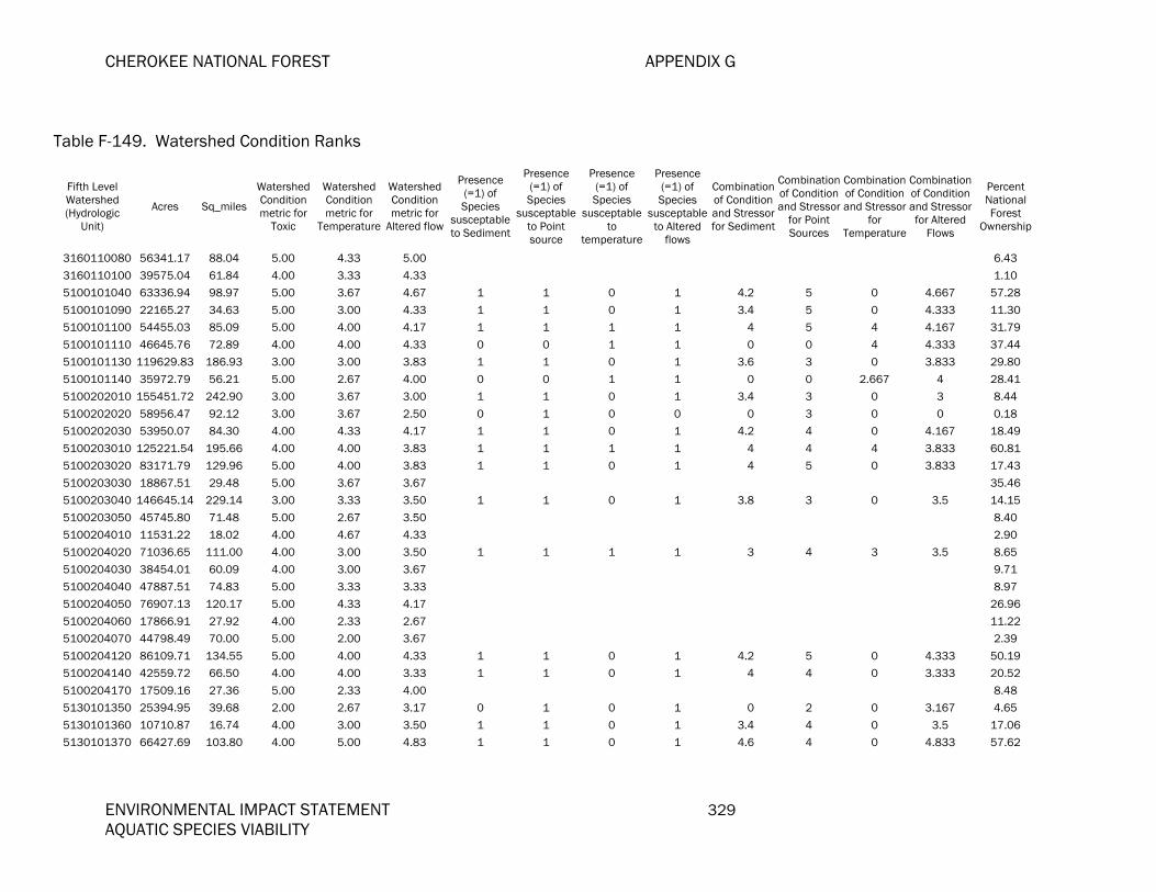
CHEROKEE NATIONAL FOREST APPENDIX G
ENVIRONMENTAL IMPACT STATEMENT 329 AQUATIC SPECIES VIABILITY
Table F-149. Watershed Condition Ranks
Fifth Level Watershed (Hydrologic
Unit)
Acres Sq_miles
Watershed Condition metric for
Toxic
Watershed Condition metric for
Temperature
Watershed Condition metric for
Altered flow
Presence (=1) of Species
susceptable to Sediment
Presence (=1) of Species
susceptable to Point source
Presence (=1) of Species
susceptable to
temperature
Presence (=1) of Species
susceptable to Altered
flows
Combination of Condition and Stressor for Sediment
Combination of Condition and Stressor
for Point Sources
Combination of Condition and Stressor
for Temperature
Combination of Condition and Stressor for Altered
Flows
Percent National Forest
Ownership
3160110080 56341.17 88.04 5.00 4.33 5.00 6.43
3160110100 39575.04 61.84 4.00 3.33 4.33 1.10
5100101040 63336.94 98.97 5.00 3.67 4.67 1 1 0 1 4.2 5 0 4.667 57.28
5100101090 22165.27 34.63 5.00 3.00 4.33 1 1 0 1 3.4 5 0 4.333 11.30
5100101100 54455.03 85.09 5.00 4.00 4.17 1 1 1 1 4 5 4 4.167 31.79
5100101110 46645.76 72.89 4.00 4.00 4.33 0 0 1 1 0 0 4 4.333 37.44
5100101130 119629.83 186.93 3.00 3.00 3.83 1 1 0 1 3.6 3 0 3.833 29.80
5100101140 35972.79 56.21 5.00 2.67 4.00 0 0 1 1 0 0 2.667 4 28.41
5100202010 155451.72 242.90 3.00 3.67 3.00 1 1 0 1 3.4 3 0 3 8.44
5100202020 58956.47 92.12 3.00 3.67 2.50 0 1 0 0 0 3 0 0 0.18
5100202030 53950.07 84.30 4.00 4.33 4.17 1 1 0 1 4.2 4 0 4.167 18.49
5100203010 125221.54 195.66 4.00 4.00 3.83 1 1 1 1 4 4 4 3.833 60.81
5100203020 83171.79 129.96 5.00 4.00 3.83 1 1 0 1 4 5 0 3.833 17.43
5100203030 18867.51 29.48 5.00 3.67 3.67 35.46
5100203040 146645.14 229.14 3.00 3.33 3.50 1 1 0 1 3.8 3 0 3.5 14.15
5100203050 45745.80 71.48 5.00 2.67 3.50 8.40
5100204010 11531.22 18.02 4.00 4.67 4.33 2.90
5100204020 71036.65 111.00 4.00 3.00 3.50 1 1 1 1 3 4 3 3.5 8.65
5100204030 38454.01 60.09 4.00 3.00 3.67 9.71
5100204040 47887.51 74.83 5.00 3.33 3.33 8.97
5100204050 76907.13 120.17 5.00 4.33 4.17 26.96
5100204060 17866.91 27.92 4.00 2.33 2.67 11.22
5100204070 44798.49 70.00 5.00 2.00 3.67 2.39
5100204120 86109.71 134.55 5.00 4.00 4.33 1 1 0 1 4.2 5 0 4.333 50.19
5100204140 42559.72 66.50 4.00 4.00 3.33 1 1 0 1 4 4 0 3.333 20.52
5100204170 17509.16 27.36 5.00 2.33 4.00 8.48
5130101350 25394.95 39.68 2.00 2.67 3.17 0 1 0 1 0 2 0 3.167 4.65
5130101360 10710.87 16.74 4.00 3.00 3.50 1 1 0 1 3.4 4 0 3.5 17.06
5130101370 66427.69 103.80 4.00 5.00 4.83 1 1 0 1 4.6 4 0 4.833 57.62

APPENDIX F CHEROKEE NATIONAL FOREST
330 ENVIRONMENTAL IMPACT STATEMENT AQUATIC SPECIES VIABILITY
Table F-149. Watershed Condition Ranks
Fifth Level Watershed (Hydrologic
Unit)
Acres Sq_miles
Watershed Condition metric for
Toxic
Watershed Condition metric for
Temperature
Watershed Condition metric for
Altered flow
Presence (=1) of Species
susceptable to Sediment
Presence (=1) of Species
susceptable to Point source
Presence (=1) of Species
susceptable to
temperature
Presence (=1) of Species
susceptable to Altered
flows
Combination of Condition and Stressor for Sediment
Combination of Condition and Stressor
for Point Sources
Combination of Condition and Stressor
for Temperature
Combination of Condition and Stressor for Altered
Flows
Percent National Forest
Ownership
5130101400 83818.76 130.97 3.00 4.00 3.67 1 1 0 1 3.4 3 0 3.667 19.47
5130101410 35502.40 55.47 3.00 4.33 4.17 1 1 1 1 3.6 3 4.333 4.167 29.74
5130101420 16710.80 26.11 3.00 5.00 4.33 1 1 0 1 4.2 3 0 4.333 62.27
5130101430 26549.66 41.49 4.00 5.00 5.00 1 1 0 1 4.8 4 0 5 71.60
5130101440 8197.95 12.81 5.00 4.67 4.67 54.26
5130101450 61458.66 96.03 4.00 3.67 4.50 0 1 0 1 0 4 0 4.5 38.94
5130102030 55416.90 86.59 3.00 3.67 3.50 1 1 1 1 3.4 3 3.667 3.5 44.55
5130102040 59891.09 93.58 3.00 3.67 4.00 1 1 0 1 3.2 3 0 4 10.21
5130102050 39538.25 61.78 4.00 4.00 4.17 1 1 0 1 3.8 4 0 4.167 38.73
5130102060 92223.33 144.10 4.00 3.00 3.83 1 1 1 1 3.2 4 3 3.833 6.76
5130102070 72424.84 113.17 5.00 4.67 4.33 1 1 0 1 4.2 5 0 4.333 46.72
5130102080 26031.27 40.68 5.00 3.67 3.67 3.88
5130102090 30443.18 47.57 3.00 4.33 4.17 1 1 0 1 3.6 3 0 4.167 34.47
5130102100 13074.40 20.43 5.00 4.67 4.67 89.58
5130103010 36425.63 56.92 5.00 4.33 4.83 1 1 0 1 4.4 5 0 4.833 60.74
5130103020 16049.71 25.08 3.00 5.00 4.83 0 1 0 1 0 3 0 4.833 95.11
5130103040 24246.31 37.89 5.00 4.67 4.50 1 1 0 1 4 5 0 4.5 9.64
5130104250 75497.31 117.97 5.00 4.67 4.33 1 1 0 1 4 5 0 4.333 43.30
5130104270 31947.40 49.92 3.00 4.00 3.83 1 1 0 1 3.4 3 0 3.833 5.51
5130104290 40157.37 62.75 5.00 4.67 4.67 1 1 0 1 4.6 5 0 4.667 60.64
5130104310 78272.99 122.30 5.00 3.33 4.17 1 1 1 1 4.2 5 3.333 4.167 5.10
6010102030 155162.94 242.45 3.00 2.00 4.00 1 1 1 1 2.6 3 2 4 23.78
6010103010 106527.02 166.45 3.00 2.67 4.00 1 1 1 1 3.4 3 2.667 4 9.27
6010103020 139650.10 218.21 3.00 2.00 3.33 1 1 1 1 3 3 2 3.333 11.54
6010103030 52739.45 82.41 3.00 3.00 3.33 1 1 1 1 3.4 3 3 3.333 8.58
6010103040 87355.55 136.50 3.00 3.33 3.67 1 1 1 1 3.6 3 3.333 3.667 36.84
6010103050 37659.72 58.84 3.00 3.33 4.33 1 1 1 1 4.2 3 3.333 4.333 63.09
6010103060 86081.88 134.51 2.00 2.00 3.50 1 1 1 1 2.2 2 2 3.5 16.96
6010105070 104627.16 163.48 3.00 2.67 4.33 1 1 0 1 3.8 3 0 4.333 33.66

CHEROKEE NATIONAL FOREST APPENDIX G
ENVIRONMENTAL IMPACT STATEMENT 331 AQUATIC SPECIES VIABILITY
Table F-149. Watershed Condition Ranks
Fifth Level Watershed (Hydrologic
Unit)
Acres Sq_miles
Watershed Condition metric for
Toxic
Watershed Condition metric for
Temperature
Watershed Condition metric for
Altered flow
Presence (=1) of Species
susceptable to Sediment
Presence (=1) of Species
susceptable to Point source
Presence (=1) of Species
susceptable to
temperature
Presence (=1) of Species
susceptable to Altered
flows
Combination of Condition and Stressor for Sediment
Combination of Condition and Stressor
for Point Sources
Combination of Condition and Stressor
for Temperature
Combination of Condition and Stressor for Altered
Flows
Percent National Forest
Ownership
6010105080 51705.75 80.79 4.00 4.00 4.00 1 1 0 1 4 4 0 4 29.12
6010106010 98252.23 153.52 3.00 2.67 4.00 1 1 0 1 3.2 3 0 4 10.01
6010108010 59289.03 92.64 4.00 4.00 4.00 1 1 1 1 4.2 4 4 4 13.99
6010108030 96043.80 150.07 3.00 2.33 4.00 1 1 1 1 3.4 3 2.333 4 44.17
6010108031 51770.77 80.89 3.00 4.00 4.00 1 1 0 1 4.2 3 0 4 22.72
6010108050 91890.68 143.58 4.00 1.67 3.83 1 1 0 1 2.6 4 0 3.833 21.53
6010108060 100690.67 157.33 3.00 1.67 3.83 1 1 1 1 2.4 3 1.667 3.833 8.21
6010204020 119346.50 186.48 4.00 4.33 4.67 1 1 0 1 4.6 4 0 4.667 42.08
6010204040 153695.76 240.15 4.00 3.33 4.00 1 1 0 1 3.8 4 0 4 47.56
6020002030 300480.80 469.51 3.00 3.33 4.00 1 1 0 1 3.8 3 0 4 26.67
6020002040 66720.34 104.25 3.00 2.33 4.00 1 1 0 1 3.2 3 0 4 15.11
6020003020 93877.40 146.69 5.00 3.67 4.33 1 1 0 1 4 5 0 4.333 66.05
6020003040 168384.42 263.11 3.00 3.00 3.50 1 1 0 1 3.4 3 0 3.5 28.12
6030002340 31305.09 48.92 5.00 2.33 4.67 1.50
6030002350 93244.27 145.70 3.00 2.67 4.67 0.04
6030002360 75738.75 118.34 5.00 2.33 4.67 15.99
6030005010 128904.58 201.42 5.00 2.33 4.67 0.30
6030005040 161042.18 251.63 5.00 2.33 4.33 1 1 1 1 3.2 5 2.333 4.333 2.12
6030006010 185583.37 289.98 4.00 3.67 4.67 1 1 1 1 3.6 4 3.667 4.667 2.22

APPENDIX F CHEROKEE NATIONAL FOREST
332 ENVIRONMENTAL IMPACT STATEMENT AQUATIC SPECIES VIABILITY
Table F-150. Species sensitivities and the number of watersheds they occur in for all forest in plan revision: Chatthoochee-Oconee (CONF), National Forests in Alabama (NFA), Cherokee (CNF), Francis-Marion (FMNF), Jefferson (JNF), and Daniel Boone (DBNF).
Conservation Rankings Species Sensitivities Number of COMMON NAME SCIENTIFIC NAME G-RANK FEDERAL AFS National Forest Sediment Pt Source Temp Alt Flow Watersheds
A crayfish Cambarus cymatilis G3 E CONF No No No No 3 Rusty Grave Digger Crayfish Cambarus multus G1 T NFA No No No No 8 Hiwassee Headwaters crayfish Cambarus parrishi G2 E CONF No No No No 1 Lake sturgeon Acipenser fulvescens G3 T DBNF Yes Yes No Yes 1 Gulf sturgeon Acipenser oxyrinchus desotoi G3T2 T T NFA Yes Yes No Yes 7 Kosztarab's common stonefly Acroneuria kosztarabi G1 JNF Yes Yes No No 1 Canada darner Aeshna canadensis G5 JNF Yes Yes Yes No 1 spring blue darner Aeshna mutata G3G4 JNF Yes Yes Yes No 2 black-tipped darner Aeshna tuberculifera G4 JNF Yes Yes No Yes 9 green-striped darner Aeshna verticalis G5 JNF Yes Yes No No 1 Cumberland elktoe Alasmidonta atropurpurea G1G2 E DBNF Yes Yes No No 3 elktoe Alasmidonta marginata G4 V JNF, DBNF Yes Yes No Yes 11 Appachchian elktoe Alasmidonta raveneliana G1 E CNF Yes Yes No Yes 1 Brook floater Alasmidonta varicosa G3 V JNF, FMNF Yes Yes No Yes 7 Slippershell mussel Alasmidonta viridis G4G5 V JNF Yes Yes No Yes 1 a stonefly Alloperla furcula G2 NFA Yes Yes No Yes 2 Alabama shad Alosa alabamae G3 V NFA Yes Yes No Yes 4 Florida sand darter Ammocrypta bifascia G3 CS NFA Yes Yes No Yes 6 Western sand darter Ammocrypta clara G3 V JNF Yes Yes No Yes 1 Eastern sand darter Ammocrypta pellucida V DBNF Yes Yes No Yes 9 comet darner Anax longipes G5 JNF Yes Yes No Yes 3 Cumberland papershell Anodontoides denigratus G1 DBNF Yes Yes No Yes 1 Rayed creekshell Anodontoides radiatus G3 V NFA Yes Yes No Yes 3 lilypad clubtail Arigomphus furcifer G5 JNF Yes Yes No No 1 A cave springtail Arrhopalites carolynae G2G3 JNF Yes Yes No No 3 A cave springtail Arrhopalites commorus G1G2 JNF No Yes No No 2 A cave springtail Arrhopalites sacer G2 JNF Yes Yes No No 2 a mayfly Baetisca becki G1 NFA Yes Yes No No 7 Cheaha beloneurian stonefly Beloneuria jamesae G1 NFA Yes Yes No No 4 A caddisfly Brachycentrus numerosus G2 NFA Yes Yes No No 4

CHEROKEE NATIONAL FOREST APPENDIX G
ENVIRONMENTAL IMPACT STATEMENT 333 AQUATIC SPECIES VIABILITY
Table F-150. Species sensitivities and the number of watersheds they occur in for all forest in plan revision: Chatthoochee-Oconee (CONF), National Forests in Alabama (NFA), Cherokee (CNF), Francis-Marion (FMNF), Jefferson (JNF), and Daniel Boone (DBNF).
Conservation Rankings Species Sensitivities Number of COMMON NAME SCIENTIFIC NAME G-RANK FEDERAL AFS National Forest Sediment Pt Source Temp Alt Flow Watersheds
A caddisfly Brachycercus nasutus G2G3 NFA Yes Yes No No 6 Incurved cave isopod Caecidotea incurva G4 JNF Yes Yes No Yes 3 Appalachian jewelwing Calopteryx angustipennis G2G3 JNF Yes Yes No Yes 5 Big South Fork crayfish Cambarus bouchardi G2 E DBNF Yes Yes No Yes 2 Oconee stream crayfish Cambarus chaugaensis G2 E FMNF Yes Yes No No 2 A crayfish Cambarus englishi G2 V NFA Yes Yes No No 5 Chickamauga crayfish Cambarus extraneus G1 T CONF Yes Yes No No 1 Little Tennessee River crayfish Cambarus georgiae G3 E CONF Yes Yes No No 1 A crayfish Cambarus halli G2 V NFA Yes Yes No No 7 A crayfish Cambarus speciosus G3G4 E CONF Yes Yes No No 6 A crayfish Cambarus veteranus G1 T JNF Yes Yes No Yes 1 A caddisfly Cheumatopsyche bibbensis G1G3 NFA Yes Yes No No 3 Helma's net-spinning caddisfly Cheumatopsyche helma G2 NFA, CNF Yes Yes No No 26 A caddisfly Cheumatopsyche kinlockensis G2 NFA Yes Yes No No 1 Peters' cheumatopsyche Cheumatopsyche petersi G4 NFA Yes Yes No No 8 Redside dace Clinostomus elongatus G5 CS DBNF No Yes Yes Yes 3 delta-spotted spiketail Cordulegaster diastatops G2 JNF Yes Yes No Yes 1 Say's spiketail Cordulegaster sayi G5 NFA Yes Yes No No 8 American emerald Cordulia shurtleffi G4Q JNF Yes Yes No No 4 Black sculpin Cottus baileyi G3G4 CS JNF Yes Yes No No 1 Hellbender Cryptobranchus alleganiensis G3 FMNF, JNF Yes Yes No No 2 crystal darter Crystallaria asprella G2G3 V NFA Yes Yes No Yes 6 Spectaclecase Cumberlandia monodonta G2 T JNF Yes Yes No Yes 1 blue shiner Cyprinella caerulea G3 T E CONF, NFA, CNF Yes Yes Yes Yes 11 Ocmulgee shiner Cyprinella callisema G2G3 CS CONF No Yes No Yes 11 Bluestripe shiner Cyprinella callitaenia G5 V CONF Yes Yes Yes Yes 4 Steelcolor shiner Cyprinella whipplei G3 CS JNF Yes Yes No Yes 1 Altamaha shiner Cyprinella xaenura G1 V CONF Yes Yes No Yes 3 Fanshell Cyprogenia stegaria G2 E E JNF Yes Yes No Yes 2 Dromedary Pearlymussel Dromus dromas G1 E E DBNF, JNF Yes Yes No Yes 2 Acute elimia Elimia acuta G1 NFA Yes Yes No Yes 2 Ample elimia Elimia ampla G1Q NFA Yes Yes No Yes 2

APPENDIX F CHEROKEE NATIONAL FOREST
334 ENVIRONMENTAL IMPACT STATEMENT AQUATIC SPECIES VIABILITY
Table F-150. Species sensitivities and the number of watersheds they occur in for all forest in plan revision: Chatthoochee-Oconee (CONF), National Forests in Alabama (NFA), Cherokee (CNF), Francis-Marion (FMNF), Jefferson (JNF), and Daniel Boone (DBNF).
Conservation Rankings Species Sensitivities Number of COMMON NAME SCIENTIFIC NAME G-RANK FEDERAL AFS National Forest Sediment Pt Source Temp Alt Flow Watersheds
Lilyshoals elimia Elimia annettae G1 NFA Yes Yes No Yes 1 Walnut elimia Elimia bellula G3 NFA Yes Yes No Yes 2 Cahawba elimia Elimia cahawbensis G1 NFA Yes Yes No Yes 1 Prune elimia Elimia chiltonensis G3 NFA Yes Yes No Yes 3 Riffle elimia Elimia clara G1 NFA Yes Yes No Yes 3 Lacy elimia Elimia crenatella G1Q T NFA Yes Yes No Yes 5 Compact elimia Elimia showalteri G3Q NFA Yes Yes No Yes 1 Alabama spike Elliptio arca G5 T NFA Yes Yes No Yes 3 Elephant ear Elliptio crassidens G2G3 CS JNF Yes Yes No Yes 2 Yellow lance Elliptio lanceolata G5 E JNF Yes Yes No Yes 4 Hagen's bluet Enallagma hageni G1 JNF Yes Yes No No 3 Cumberlandian combshell Epioblasma brevidens G1 E E JNF, NFA, DBNF Yes Yes No Yes 7 Oyster mussel Epioblasma capsaeformis G1 E E JNF, DBNF Yes Yes No Yes 6 Yellow Blossom Epioblasma florentina florentina G1T1 E E DBNF Yes Yes No Yes 2 Tan riffleshell Epioblasma florentina walkeri GH E E JNF, DBNF, CNF Yes Yes No Yes 4 Upland combshell Epioblasma metastriata G1 E E CONF, NFA Yes Yes No Yes 4 Purple Catspaw Epioblasma obliquata obliquata GHQ DBNF Yes Yes No Yes 1 Southern acornshell Epioblasma othcaloogensis G2TX E E CONF, NFA Yes Yes No Yes 3 Green-blossom pearlymussel Epioblasma torulosa gubernaculum G3 E E JNF Yes Yes No Yes 2 Snuffbox Epioblasma triquetra G5 T JNF, DBNF Yes Yes No Yes 9 beaverpond baskettail Epitheca canis G3 JNF Yes Yes No No 1 Robust baskettail Epitheca spinosa G2 NFA Yes Yes No No 8 Spotfin chub (turquoise shiner) Erimonax monacha G1 T E JNF Yes Yes No Yes 2 Slender chub Erimystax cahni G3 T E JNF Yes Yes No No 2 Sharphead darter Etheostoma acuticeps G2 V JNF Yes Yes Yes Yes 5 Warrior darter (Sipsey Fork) Etheostoma bellator (sp cf 1) G2 CS NFA Yes Yes Yes Yes 1 holiday darter Etheostoma brevirostrum G4 T CONF, NFA, CNF Yes Yes Yes Yes 6 Greenfin darter Etheostoma chlorobranchium G2G3 CS JNF No Yes Yes No 1 lipstick darter Etheostoma chuckwachatte G2G3 V NFA Yes Yes No No 5 Ashy darter Etheostoma cinereum G3 T DBNF Yes Yes No Yes 8 Carolina darter Etheostoma collis G3 V FMNF Yes Yes No No 13 Choctawhachee darter Etheostoma davisoni G1G2 CS NFA Yes Yes No No 5

CHEROKEE NATIONAL FOREST APPENDIX G
ENVIRONMENTAL IMPACT STATEMENT 335 AQUATIC SPECIES VIABILITY
Table F-150. Species sensitivities and the number of watersheds they occur in for all forest in plan revision: Chatthoochee-Oconee (CONF), National Forests in Alabama (NFA), Cherokee (CNF), Francis-Marion (FMNF), Jefferson (JNF), and Daniel Boone (DBNF).
Conservation Rankings Species Sensitivities Number of COMMON NAME SCIENTIFIC NAME G-RANK FEDERAL AFS National Forest Sediment Pt Source Temp Alt Flow Watersheds
coldwater darter Etheostoma ditrema G2 T CONF, NFA, CNF Yes Yes Yes No 7 Tuskaloosa Darter Etheostoma douglasi G1 CS NFA Yes Yes No Yes 3 Etowah darter Etheostoma etowahae E E CONF Yes Yes Yes Yes 1 Spotted darter Etheostoma maculatum G3 V DBNF Yes Yes Yes Yes 1 Candy darter Etheostoma osburni G1 V JNF Yes Yes Yes Yes 6 Goldstripe darter Etheostoma parvapinne G1 CS NFA Yes Yes Yes No 12 Duskytail darter Etheostoma percnurum G1G2 CS JNF, DBNF, CNF Yes Yes No Yes 5 Rush darter Etheostoma phytophyllum G4 E NFA Yes Yes Yes Yes 1 Alabama darter Etheostoma ramseyi CS NFA Yes Yes No Yes 5 Arrow darter Etheostoma sagitta spilotum G2 V DBNF Yes Yes No Yes 9 Cherokee darter Etheostoma scotti G2 T T CONF Yes Yes Yes Yes 2 undescribed blueface darter Etheostoma sp. cf. zonistium CS NFA Yes Yes Yes No 3 Cumberland Johnny darter Etheostoma susanae G3 T DBNF Yes Yes No Yes 9 Tippecanoe darter Etheostoma tippecanoe G1 V JNF, DBNF Yes Yes No Yes 5 trispot darter Etheostoma trisella G2 V CONF, CNF Yes Yes Yes Yes 5 Tuscumbia darter Etheostoma tuscumbia G3 V NFA Yes Yes Yes No 1 wounded darter Etheostoma vulneratum G3G4 V CNF, CONF Yes Yes No Yes 9 Backwater darter Etheostoma zonifer G2G3 CS NFA No Yes No No 4 Tennessee pigtoe Fusconaia barnesiana G1 V JNF, CNF Yes Yes No Yes 7 Shiny pigtoe Fusconaia cor G1 E E JNF Yes Yes No Yes 4 Fine-rayed pigtoe Fusconaia cuneolus G2 E E JNF Yes Yes No Yes 2 Atlantic pigtoe Fusconaia masoni T JNF Yes Yes No Yes 2 Long-solid Fusconaia subrotunda subrotunda G3 V DBNF Yes Yes No Yes 2 Purple pigtoe Fusconaia succissa G4 V NFA Yes Yes No Yes 4 beaverpond clubtail Gomphus borealis G2G3 JNF Yes Yes No No 1 Cherokee clubtail Gomphus consanguis G4 FMNF, CNF Yes Yes No No 25 harpoon clubtail Gomphus descriptus G3 JNF Yes Yes No No 1 Twin-striped clubtail Gomphus geminatus G3 NFA Yes Yes No No 8 Hodges' clubtail Gomphus hodgesi G4 NFA Yes Yes No No 8 Cocoa clubtail Gomphus hybridus G2 NFA Yes Yes No No 4 Septima's clubtail Gomphus septima G3 NFA Yes Yes No No 4 Green-faced clubtail Gomphus viridifrons G2 JNF, CNF Yes Yes No No 31

APPENDIX F CHEROKEE NATIONAL FOREST
336 ENVIRONMENTAL IMPACT STATEMENT AQUATIC SPECIES VIABILITY
Table F-150. Species sensitivities and the number of watersheds they occur in for all forest in plan revision: Chatthoochee-Oconee (CONF), National Forests in Alabama (NFA), Cherokee (CNF), Francis-Marion (FMNF), Jefferson (JNF), and Daniel Boone (DBNF).
Conservation Rankings Species Sensitivities Number of COMMON NAME SCIENTIFIC NAME G-RANK FEDERAL AFS National Forest Sediment Pt Source Temp Alt Flow Watersheds
a dragonfly Gomphyus parvidens G1 NFA Yes Yes No No 6 Cracking pearlymussel Hemistena lata G2 E E JNF, DBNF Yes Yes No Yes 4 Mississippi silvery minnow Hybognathus nuchalis G3 CS NFA No Yes No Yes 7 Lined chub Hybopsis lineapunctata G1G3 V CONF, NFA, CNF Yes Yes Yes Yes 19 Maureen's shale stream beetle Hydraena maureenae G5 JNF Yes Yes No No 2 A caddisfly Hydropsyche hageni G1 NFA Yes Yes No No 1 Berner's microcaddisfly Hydroptila berneri G1 NFA Yes Yes No No 3 A caddisfly Hydroptila cheaha G1 NFA Yes Yes No No 3 A caddisfly Hydroptila choccolocco G1 NFA Yes Yes No No 2 A caddisfly Hydroptila lagoi G2 NFA Yes Yes No No 1 A caddisfly Hydroptila paralatosa G1 NFA Yes Yes No No 4 A caddisfly Hydroptila patriciae G1 NFA Yes Yes No No 4 A caddisfly Hydroptila setigera G3G4 NFA Yes Yes No No 2 Ohio lamprey Ichthyomyzon bdellium G4 CS DBNF No Yes No No 5 Northern Brook lamprey Ichthyomyzon fossor G3G4 CS DBNF No Yes No No 5 Mountain brook lamprey Ichthyomyzon greeleyi G2 CS JNF, CONF, DBNF,CNF No Yes No No 23 Spiny riversnail Io fluvialis G1 JNF No Yes No No 4 Beartown perlodid stonefly Isoperla major G3G4 JNF No Yes No No 1 American Brook lamprey Lampetra appendix G2 CS DBNF Yes Yes No Yes 4 Fine-lined pocketbook Lampsilis altilis G2 T T CONF, NFA, CNF Yes Yes No Yes 19 Southern sandshell Lampsilis australis T NFA Yes Yes No Yes 4 Pocketbook Lampsilis ovata G2 V DBNF Yes Yes No Yes 4 Orange-nacre mucket Lampsilis perovalis G4 T NFA Yes Yes No Yes 8 double-striped clubtail Lanthus parvulus G5T2T3 JNF Yes Yes No No 3 Alabama heelsplitter Lasmigona complanta alabamensis G1 V NFA Yes Yes No Yes 2 Carolina heelsplitter Lasmigona decorata G3 E E FMNF Yes Yes No Yes 3 Tennessee Heelsplitter Lasmigona holstonia G3 V CONF, NFA,JNF, CNF Yes Yes No Yes 13 Green floater Lasmigona subviridis G1 T JNF, CNF Yes Yes No Yes 16 Birdwing pearlymussel Lemiox rimosus G5 E E JNF Yes Yes No Yes 2 Fragile papershell Leptodea fragilis G4 CS JNF Yes Yes No Yes 3 Johnson's pronggill mayfly Leptophlebia johnsoni G5T5 JNF Yes Yes No No 1 northern common spreadwing Lestes disjunctus disjunctus G5 JNF Yes Yes No No 4

CHEROKEE NATIONAL FOREST APPENDIX G
ENVIRONMENTAL IMPACT STATEMENT 337 AQUATIC SPECIES VIABILITY
Table F-150. Species sensitivities and the number of watersheds they occur in for all forest in plan revision: Chatthoochee-Oconee (CONF), National Forests in Alabama (NFA), Cherokee (CNF), Francis-Marion (FMNF), Jefferson (JNF), and Daniel Boone (DBNF).
Conservation Rankings Species Sensitivities Number of COMMON NAME SCIENTIFIC NAME G-RANK FEDERAL AFS National Forest Sediment Pt Source Temp Alt Flow Watersheds
frosted whiteface Leucorrhinia frigida G5 JNF Yes Yes No No 1 Hudsonian whiteface Leucorrhinia hudsonica G5 JNF Yes Yes No No 1 dot-tailed whiteface Leucorrhinia intacta G2 JNF Yes Yes No No 5 Slabside pearlymussel Lexingtonia dolabelloides G5 T JNF, CNF Yes Yes No Yes 7 chalk-fronted corporal skimmer Libellula julia (AKA Ladona julia) G5 JNF Yes Yes No Yes 1 Black sandshell Ligumia recta G3 V JNF Yes Yes No Yes 3 Mountain river cruiser Macromia margarita G1 FMNF, CNF Yes Yes No No 25 Alabama pearlshell Margaritifera marrianae G1 E NFA Yes Yes No Yes 2 MOCCASINSHELL, ALABAMA Medionidus acutissimus G1 T T CONF, NFA Yes Yes No Yes 1No MOCCASINSHELL, COOSA Medionidus parvulus G2 E E CONF, NFA Yes Yes No Yes 7 William's giant stonefly Megaleuctra williamsae G3G4 JNF, CNF Yes Yes No No 16 Racovitza's terrestrial cave isopod Miktoniscus racovitzae G1 JNF No Yes No No 5 Robust redhorse Moxostoma robustum G2 E CONF, FMNF Yes Yes No No 6 Black Warrior waterdog Necturus alabamensis G5 NFA Yes Yes No Yes 3 sedge sprite Nehalennia irene JNF Yes Yes No No 1 Palezone Shiner Notropis albizonatus G3 DBNF Yes Yes No Yes 2 Popeye shiner Notropis ariommus G5 V JNF, CONF Yes Yes No Yes 5 Emerald shiner Notropis atherinoides G2 CS JNF No Yes No No 2 Cahaba shiner Notropis cahabae G3 E E NFA Yes Yes No No 2 Highscale shiner Notropis hypsilepis G2G3 V CONF No Yes Yes No 3 Roughhead shiner Notropis semperasper V JNF No Yes No Yes 6 Sawfin shiner Notropis sp. Cf. spectrunculus G2 CS DBNF No Yes Yes Yes 4 Skygazer shiner Notropis uranoscopus G1 CS NFA No Yes No No 5 MADTOM, SMOKY Noturus baileyi G1 E E CNF Yes Yes No Yes 1 MADTON, YELLOWFIN Noturus flavipinnis G2 T E CNF Yes Yes No Yes 1 Orangefin madtom Noturus gilberti G3 T JNF Yes Yes No Yes 4 Frecklebelly madtom Noturus munitus T CONF, NFA, CNF No Yes No Yes 4 Northern madtom Noturus stigmosus G1G2 V DBNF Yes Yes No Yes 2 Southern hickorynut Obovaria jacksoniana G2 V NFA Yes Yes No Yes 1 A caddisfly Oecetis morsei G3Q NFA Yes Yes No No 2 Allegheny Snaketail Ophiogomphus alleghaniensis G1G2 NFA, JNF, CNF Yes Yes No No 27 Edmund's snaketail Ophiogomphus edmundo G3 CNF Yes Yes No No 1

APPENDIX F CHEROKEE NATIONAL FOREST
338 ENVIRONMENTAL IMPACT STATEMENT AQUATIC SPECIES VIABILITY
Table F-150. Species sensitivities and the number of watersheds they occur in for all forest in plan revision: Chatthoochee-Oconee (CONF), National Forests in Alabama (NFA), Cherokee (CNF), Francis-Marion (FMNF), Jefferson (JNF), and Daniel Boone (DBNF).
Conservation Rankings Species Sensitivities Number of COMMON NAME SCIENTIFIC NAME G-RANK FEDERAL AFS National Forest Sediment Pt Source Temp Alt Flow Watersheds
Appalachian snaketail Ophiogomphus incurvatus G1 FMNF, NFA, CNF Yes Yes No No 33 Little-wing pearlymussel Pegias fabula G1G2 E E JNF, DBNF Yes Yes No Yes 9 amber darter Percina antesella G2 E E CONF Yes Yes No Yes 3 goldline darter Percina aurolineata G2 T T CONF, NFA Yes Yes No Yes 7 Southern logperch Percina austroperca G2 V NFA Yes Yes No No 1 Coal darter Percina brevicauda G2 T NFA Yes Yes No Yes 6 Blotchside logperch Percina burtoni V JNF, DBNF, CNF Yes Yes No Yes 6 Gilt darter Percina evides G2 CS DBNF Yes Yes No Yes 3 Consauga logperch Percina jenkinsi G2 E E CONF Yes Yes Yes Yes 2 freckled darter Percina lenticula G3 T CONF, NFA No Yes No Yes 1No Longhead darter Percina macrocephala G3 T JNF, CNF, DBNF Yes Yes Yes Yes 12 Bronze darter Percina palmaris G1G2 CS NFA, CNF Yes Yes No Yes 15 Roanoke logperch Percina rex G3 E E JNF Yes Yes No Yes 2 Sipsey Fork Warrior darter Percina sp.cf. macrocephala 1 G3 T NFA Yes Yes No No 1 Tallapoosa muscadine bridled darter Percina sp.cf. macrocephala 2 G3 T NFA Yes Yes Yes No 5 olive darter Percina squamata G2 V CONF, DBNF, CNF Yes Yes No Yes 23 DARTER, SNAIL Percina tanasi G3G4 T T CNF Yes Yes No Yes 3 Fatlips minnow Phenacobius crassilabrum G3G4 CS JNF, CONF, CNF Yes Yes No Yes 17 Kanawha minnow Phenacobius teretulus G2G3 CS JNF No Yes No No 4 Blackside dace Phoxinus cumberlandensis G2G3 T E JNF, DBNF No Yes No Yes 14 Tennessee dace Phoxinus tennesseensis G3 V JNF, CNF Yes Yes No Yes 1No Sheepnose Plethobasus cyphyus T JNF, DBNF Yes Yes No Yes 3 Clubshell Pleurobema clava G1 E DBNF Yes Yes No Yes 3 James River spinymussel Pleurobema collina G3 E E JNF Yes Yes No Yes 5 Ohio river pigtoe Pleurobema cordatum G1G2 V JNF Yes Yes No Yes 1 Southern clubshell Pleurobema decisum G1 E E CONF, NFA Yes Yes No Yes 9 Dark pigtoe Pleurobema furvum G1 E E NFA Yes Yes No Yes 5 Southern pigtoe Pleurobema georgianum G1 E E CONF, NFA Yes Yes No Yes 8 Georgia pigtoe Pleurobema hanleyianum G3 C E CONF, NFA, CNF Yes Yes No Yes 5 Tennessee clubshell Pleurobema oviforme G1 V JNF, DBNF, CNF Yes Yes No Yes 1No Ovate clubshell Pleurobema perovatum G1 E E NFA Yes Yes No Yes 8 Rough pigtoe Pleurobema plenum E JNF Yes Yes No Yes 1

CHEROKEE NATIONAL FOREST APPENDIX G
ENVIRONMENTAL IMPACT STATEMENT 339 AQUATIC SPECIES VIABILITY
Table F-150. Species sensitivities and the number of watersheds they occur in for all forest in plan revision: Chatthoochee-Oconee (CONF), National Forests in Alabama (NFA), Cherokee (CNF), Francis-Marion (FMNF), Jefferson (JNF), and Daniel Boone (DBNF).
Conservation Rankings Species Sensitivities Number of COMMON NAME SCIENTIFIC NAME G-RANK FEDERAL AFS National Forest Sediment Pt Source Temp Alt Flow Watersheds
Pyramid pigtoe Pleurobema pyramidatum G2 T DBNF Yes Yes No Yes 1 Pyramid pigtoe Pleurobema rubrum G1 T JNF Yes Yes No Yes 1 Ringed hornsnail Pleurocera annulifera G1G3 NFA No Yes No No 1 Carlson's polycentropus caddisfly Polycentropus carlsoni NFA No Yes No No 1 Paddlefish Polyodon spathula G3 V DBNF No Yes No Yes 2 A crayfish Procambarus marthae G3 V NFA No Yes No No 11 Belle's sanddragon Progomphus bellei G1 NFA Yes Yes No No 1 Triangular kidneyshell Ptychobranchus greeni G1 E E CONF, NFA Yes Yes No Yes 11 Southern kidneyshell Ptychobranchus jonesi T NFA Yes Yes No Yes 1 Fluted Kidneyshell Ptychobranchus subtentum G3Q V DBNF Yes Yes No Yes 6 Inflated floater Pyganodon gibbosa G3T3 V CONF Yes Yes No Yes 2 Rough rabbitsfoot Quadrula cylindrica strigillata G1 E E JNF Yes Yes No Yes 3 Cumberland monkeyface pearlymussel Quadrula intermedia G5 E E JNF Yes Yes No Yes 1 Pimpleback Quadrula pustulosa G3 JNF Yes Yes No Yes 2 Ridged mapleleaf Quadrula rumphiana G1 V CONF, NFA Yes Yes No Yes 5 Appalachian monkeyface pearlymussel Quadrula sparsa GX E E JNF Yes Yes No Yes 2 Rough Rockshell Quadrula tuberosa G1 E DBNF Yes Yes No Yes 1 A caddisfly Rhyacophila carolae G3 NFA Yes Yes No No 1 Salamander mussel Simpsonaias ambigua G5 V DBNF Yes Yes No Yes 2 slender emerald Somatochlora elongata G3 JNF Yes Yes No No 2 Treetop emerald dragonfly Somatochlora provacans G5 NFA Yes Yes No No 4 Williamson's emerald Somatochlora williamsoni G6 JNF Yes Yes No No 1 Alabama creekmussel Strophitus connasaugaensis G3 V CONF, NFA Yes Yes No Yes 5 Southern creekmussel Strophitus subvexus G2 V NFA Yes Yes No Yes 6 James Cave amphipod Stygobromus abditus G2G3 JNF No Yes No No 4 Cumberland Cave amphipod Stygobromus cumberlandus G1G2 JNF No Yes No No 2 Craig County cave amphipod Stygobromus estesi G1G2 JNF No Yes No No 2 Montgomery County cave amphipod Stygobromus fergusoni G2G4 JNF No Yes No No 2 Shenandoah Valley cave amphipod Stygobromus gracilipes G1 JNF No Yes No No 5 Alleghany County cave amphipod Stygobromus hoffmani G2G3 JNF No Yes No No 1 Bath County cave amphipod Stygobromus mundus G2 JNF No Yes No No 2 Sherando spinosoid amphipod Stygobromus sp. 7 G3 JNF No Yes No No 1

APPENDIX F CHEROKEE NATIONAL FOREST
340 ENVIRONMENTAL IMPACT STATEMENT AQUATIC SPECIES VIABILITY
Table F-150. Species sensitivities and the number of watersheds they occur in for all forest in plan revision: Chatthoochee-Oconee (CONF), National Forests in Alabama (NFA), Cherokee (CNF), Francis-Marion (FMNF), Jefferson (JNF), and Daniel Boone (DBNF).
Conservation Rankings Species Sensitivities Number of COMMON NAME SCIENTIFIC NAME G-RANK FEDERAL AFS National Forest Sediment Pt Source Temp Alt Flow Watersheds
Laura's clubtail Stylurus laurae G3 NFA Yes Yes No No 4 Townes' clubtail Stylurus townesi G5 NFA Yes Yes No No 1 white-faced meadowhawk Sympetrum obtrusum G1 JNF Yes Yes No No 2 Nelson's early black stonefly Taeniopteryx nelsoni G2 JNF Yes Yes No No 1 Lobed roach-like stonefly Tallaperla lobata G2 JNF Yes Yes No Yes 1 Purple lilliput Toxolasma lividus G5 V JNF Yes Yes No Yes 5 Deertoe Truncilla truncata G1 CS JNF Yes Yes No Yes 2 Tulatoma snail Tulotoma magnifica G4 E NFA Yes Yes No Yes 4 Southern cavefish Typhlichthys subterraneus G2 DBNF No Yes No No 1 Choctaw bean Villosa choctawensis G5 T NFA Yes Yes No Yes 7 Little Spectaclecase Villosa lienosa G3 CS DBNF Yes Yes No Yes 9 Alabama rainbow Villosa nebulosa G1 T NFA, CNF Yes Yes No Yes 9 Purple bean Villosa perpurpurea G2 E E JNF Yes Yes No Yes 1 Cumberland bean Villosa trabalis G4 T E JNF, CNF, DBNF Yes Yes No Yes 11 Mountain clubshell Villosa vanuxemensis G4T4 V DBNF Yes Yes No Yes 3 Coosa combshell Villosa vanuxemensis umbrans G4T5 V NFA, CNF Yes Yes No Yes 4

CHEROKEE NATIONAL FOREST
ENVIRONMENTAL IMPACT STATEMENT 341 AIR QUALITY
APPENDIX G: AIR QUALITY AND AIR QUALITY RELATED VALUES
Overview
Through a series of legislative and regulatory requirements, federal land management agencies have the unique responsibility to not only protect the air, land, and water resources under their respective authorities from degradation associated with the impacts of air pollution emitted outside the borders of Agency lands (Clean Air Act, 1990), but to protect those same resources from the impacts of air pollutants produced within those borders (Clean Air Act, 1990, Organic Act, 1977, Wilderness Act, 1997). The authority and responsibility to protect resources within National Forest lands are not limited to Class I Wilderness Areas, but requires federal land managers to take the necessary steps to protect all federal lands from those impacts. The Clean Air Act of 1990 contains numerous sections dealing with these responsibilities, and Section 101(c) states the primary purpose of the Act:
“A primary goal of this Act is to encourage or otherwise promote reasonable Federal, State, and local governmental actions, consistent with the provisions of this Act, for pollution prevention.” (Clean Air Act, 1990)
Further, the NFMA states that Land and Resource Management Plans are, in part, specifically based on:
“…recognition that the National Forests are ecosystems, and their management for goods and services requires an awareness and consideration of the interrelationships among plants, animals, soil, water, air, and other environmental factors within such ecosystems” (NFMA, 1976).
The CNF contains portions of two Class I Wilderness Areas; the Cohutta Wilderness and Joyce Kilmer – Slickrock Wilderness. These wildernesses are afforded special protection via the Clean Air Act. The Clean Air Act requires federal land managers to identify Air Quality Related Values (AQRV), or resources important to the areas that might be affected by air pollution. For Cohutta and Joyce Kilmer – Slickrock Wilderness these include visibility, water quality and vegetation. The Great Smoky Mountains National Park (administered by the Department of Interior) is another Class I area located between the southern and northern districts of the CNF. In this analysis the term AQRV will apply to any resources within the national forest boundary that might be affected by air pollution, including those resources on Class II lands.
This analysis has three primary purposes:
Assess the existing state of air quality in and near the CNF,

APPENDIX G CHEROKEE NATIONAL FOREST
342 ENVIRONMENTAL IMPACT STATEMENT AIR QUALITY
Estimate the future state (within the time horizon of the LMP) of air quality within and near the CNF, and how emissions from activities on the CNF might affect air quality, and
Estimate existing and future impacts of air quality on the natural resources (AQRV) of the CNF.
Area and Scope
Unlike the analysis area for the CNF LMP, which only assesses national forest lands, this analysis encompasses two large areas. Due to the regional nature of air quality issues, it is imperative that a much larger area than just national forest lands be analyzed. Therefore, two specific geographic areas have been selected:
An area encompassing all lands within a 120 miles radius of the CNF and
A second area encompassing all lands within a 30 miles radius of the CNF.
Rationale for the two separate assessment areas
120 mile radius buffer – A large analysis area is needed due to the regional transport of air pollutants and the chemical reactions that occur in the atmosphere, i.e. the conversion of “primary” pollutants (sulfur dioxide) into “secondary” pollutants (sulfates). This analysis area is consistent with the U.S. Environmental Protection Agency (EPA), which routinely analyzes air emissions over multi-State regions across the United States.
Broad-based emissions inventories, such as the EPA’s National Emissions Inventory (U.S. EPA, 1995), are commonly used to summarize the pollutant specific emission totals per county. The Southern Appalachian Mountains Initiative (SAMI) recently completed a large scale emissions inventory for 1990 and estimates of future emissions (after implementation of recent laws, rules and regulations) for the years 2010 and 2040. SAMI’s emissions inventories for 1990 and 2040 will be used in this analysis and the analysis area will include counties having a boundary within 120 miles of the CNF (Figure H-1).
30 mile radius buffer – this smaller geographic area focuses on air quality monitoring data. There is no air quality monitors located on the CNF. Therefore, to get an adequate sampling of air quality monitoring data near the CNF, an analysis area was established to obtain a reasonable sampling of air monitoring data. The area defined by the 30 miles radius from the CNF was deemed adequate to obtain a reasonable number of air quality monitoring stations to select among that may represent air quality on the CNF.
The 120 mile analysis area lies within the borders of eight states: (1) Tennessee, (2) Kentucky, (3) West Virginia, (4) Virginia, (5) North Carolina, (6) South Carolina, (7) Georgia, and (8) Alabama (Figure H-1). The area is comprised of 273 counties, and 23 of those counties intersect with the CNF. Air pollutant emissions within this area are considered to have the greatest impact on the AQRV of the CNF, while at the

CHEROKEE NATIONAL FOREST APPENDIX G
ENVIRONMENTAL IMPACT STATEMENT 343 AIR QUALITY
same time the analysis area encompasses all lands that may be affected by emissions from activities on CNF lands.
The 30 mile assessment area lies within the borders of five states: (1) Tennessee, (2) Virginia, (3) North Carolina, (4) Tennessee, and (5) Georgia (Figure H-1). This region is being evaluated to obtain a reasonable amount of air quality data.
Figure G-1: Analysis Areas 30 and 120 miles from CNF boundary
Data Sources and Methods of Analysis
This analysis compares numerical emission inventories, air quality monitoring data, meteorological data, and distances between sources and the CNF and Metropolitan Statistical Areas to make informed decisions regarding the current air quality. Air quality on and near the CNF will be assessed in relationship to the National Ambient Air Quality Standards (NAAQS), and in terms of effects on AQRVs. The following is a listing of information used in the analysis:
Determined the location and extent of nonattainment areas within and adjacent to the analysis area (U.S. EPA, 2002b).
Used the SAMI 1990 and 2040 emissions inventory for all source categories (SAMI, 2002). Analysis was conducted using both county level and point (individual) sources and focused on those counties and individual sources that may most affect the CNF, i.e. with 120 miles of the CNF boundary, or conversely the area where activities on the CNF may affect air quality.
Obtained the location and determined the suitability of ozone (U.S. EPA, 2002a), wet and dry acid deposition (CASTNet, 2002), and visibility monitoring (IMPROVE 2002a) data within 30 miles (Figure H-2) of CNF.
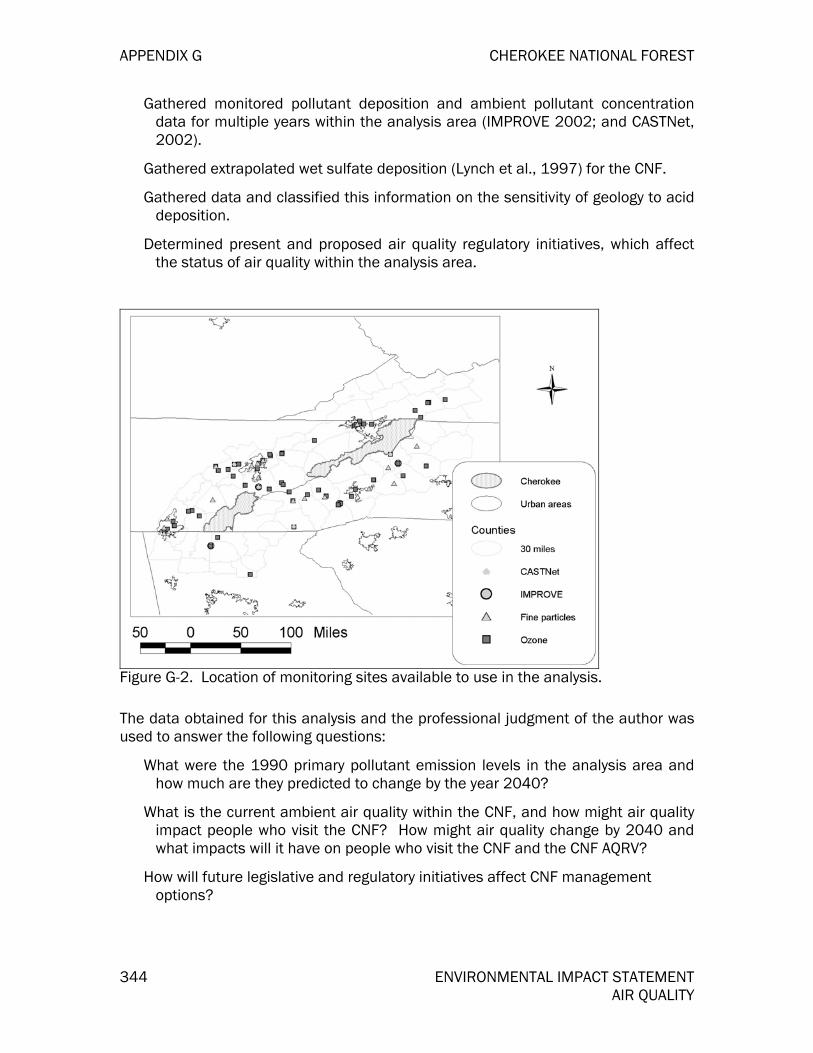
APPENDIX G CHEROKEE NATIONAL FOREST
344 ENVIRONMENTAL IMPACT STATEMENT AIR QUALITY
Gathered monitored pollutant deposition and ambient pollutant concentration data for multiple years within the analysis area (IMPROVE 2002; and CASTNet, 2002).
Gathered extrapolated wet sulfate deposition (Lynch et al., 1997) for the CNF.
Gathered data and classified this information on the sensitivity of geology to acid deposition.
Determined present and proposed air quality regulatory initiatives, which affect the status of air quality within the analysis area.
Figure G-2. Location of monitoring sites available to use in the analysis.
The data obtained for this analysis and the professional judgment of the author was used to answer the following questions:
What were the 1990 primary pollutant emission levels in the analysis area and how much are they predicted to change by the year 2040?
What is the current ambient air quality within the CNF, and how might air quality impact people who visit the CNF? How might air quality change by 2040 and what impacts will it have on people who visit the CNF and the CNF AQRV?
How will future legislative and regulatory initiatives affect CNF management options?

CHEROKEE NATIONAL FOREST APPENDIX G
ENVIRONMENTAL IMPACT STATEMENT 345 AIR QUALITY
Air Quality Assessment
National Ambient Air Quality Standards
The Clean Air Act established six criteria air pollutants: sulfur dioxide, nitrogen oxides, ozone, particulate matter, carbon monoxide and lead. State, tribal, and local air regulatory agencies measure these pollutants in selected areas to monitor their levels. The National Ambient Air Quality Standards (NAAQS) are the concentration thresholds of these pollutants that indicate unsafe air quality conditions for human health and welfare. Those areas not meeting the NAAQS are designated as nonattainment. An area specific management plans must be written by each air agency having authority once EPA designates an area as nonattainment. These plans must be incorporated into the affected State, Local, or Tribal Implementation Plan. The goal of the Implementation Plan is to bring the affected areas back into attainment with the NAAQS.
For urban areas across the United States that fail to meet the NAAQS, the EPA and air regulatory agency normally classifies an entire “metropolitan statistical area” (MSA) as a nonattainment area. Such a classification is made if at least one air quality monitoring station, within a county that lies within an urban/metropolitan area, registers a specific exceedance for one, or more, of the NAAQS. For example, the entire Atlanta MSA area is classified as nonattainment for ozone, even though maybe not all monitors within the MSA exceed the NAAQS for ozone. Figure H-3 shows the location of the 20 MSAs within 120 miles. of the CNF. The Johnson City-Kingsport-Bristol MSA contains a portion of the CNF, while the Asheville, Chattanooga, and Knoxville MSA are adjacent to the CNF.
Figure G-3. The 20 Metropolitan Statistical Areas within 120 miles of the CNF.

APPENDIX G CHEROKEE NATIONAL FOREST
346 ENVIRONMENTAL IMPACT STATEMENT AIR QUALITY
Currently there are three MSA nonattainment areas within 120 miles of the CNF (Figure H-4). One area exceeds the sulfur dioxide standard, and two exceed the previous, (though it is still being enforced) ozone standard of 0.12 parts per million. There is also one ozone nonattainment area on the Jefferson National Forest in an area above 4500 feet elevation in Smyth County, Virginia on the summit of Whitetop Mountain. This area is classified as a marginal, rural transport, ozone nonattainment area. Whitetop Mountain is the highest point in Virginia and is located on the Mount Rogers National Recreation Area.
Figure G-4. Nonattainment Areas within 120 miles of the CNF.
It is important for the CNF to track air quality within and near the CNF boundary because the attainment status of specific areas can affect forest management activities. While automobiles used by CNF personnel, smoke produced from campfires, and other non-regulated combustion sources within the CNF may have an impact on the quality of air within the analysis area; smoke from managed prescribed fire is assumed to be the only CNF management activity to produce significant amounts of emissions. Aside from the nonattainment areas already mention (Figure H-4), it is possible that numerous counties and metropolitan areas will be classified as nonattainment for the new ozone (8-hour) standard and PM2.5 standard within the planning horizon of the CNF LMP Revision. This will be discussed under the appropriate pollutant sections.
Background and Statistics of the Analysis Area
The CNF is found within an area of the United States with an increasing population, which has had an increase demand for the combustion of fossil fuels to produce energy for electricity and transportation (SAMI, 2002). The CNF is within a day’s drive of a large percentage of the United State’s population and 36 urban areas and

CHEROKEE NATIONAL FOREST APPENDIX G
ENVIRONMENTAL IMPACT STATEMENT 347 AIR QUALITY
numerous towns are near the CNF. Four major cities, Nashville, Birmingham, Atlanta, and Charlotte are among the urban areas about 120 miles from the CNF (Figure H-5). The CNF is located within the rugged terrain of the Blue Ridge Province of the southern Appalachian Mountains.
Figure G-5. Location of urban areas near the CNF.
The effects of air pollutants on an area are not only related to levels of primary pollutant emissions within the area, but are also related to dominate weather patterns in the region. Weather conditions such as temperature, humidity precipitation and air mass pressure can dictate the formation of secondary pollutants (such as ozone), the pollutant’s effects, and pollutant dissipation and dispersion from an area. Primary pollutants emitted in one area can travel to another via moving air masses, and the effects of the pollutants can be observed in an area far from the actual emission source. Similarly, pollutants emitted in an area can become trapped under an inversion layer or a stable high-pressure air mass, causing a build up of pollutants that are unable to dissipate, causing serious health risk in the region. For this reason, it is important not only to consider pollutant emissions when conducting an analysis of air quality in a given area, but also to consider predominant weather patterns. It must be stressed however, that pollutants can be transported from any direction. Therefore, the heaviest deposition or most serious ozone concentration episodes may occur at any time from any direction.
However, the SAMI (2002) analysis has shown that on the most polluted days (during hot summer days with air stagnations) if emissions of sulfur dioxide and nitrogen oxides were reduced in Tennessee the greatest reduction in fine particles and ozone will occur in Tennessee. Also, the reductions in Tennessee would provide some reductions in fine particles and ozone in neighboring states. This finding is similar for
APPENDIX G CHEROKEE NATIONAL FOREST
348 ENVIRONMENTAL IMPACT STATEMENT AIR QUALITY
each of the states adjacent to Tennessee. In regards to wet acid deposition the largest reductions on the CNF would occur if there were reductions of the air pollution precursors in Alabama and Georgia (SAMI, 2002).
Pollutants Considered
Due to the complicated nature of air pollutant formation and transport, it is often difficult to discuss air quality issues in a simple format. The air quality in any region is impacted by exhaust from mobile sources such as automobiles, trucks, and aircraft; emissions from various point source industrial processes such as coal-fired power plants; dust from roads; biogenic emissions from natural processes such as wildfires and plant growth; as well as numerous other types of emission sources. While primary pollutant emissions can give an indication of the status of air quality, these primary pollutants can undergo reactions in the atmosphere to produce secondary pollutants. Often the secondary pollutants have the greatest impact on the AQRV of the CNF and impact the health of visitors to the CNF.
In attempt to present the information in a logical sequence the primary pollutants and their sources are discussed first in the Primary Pollutants section. Information on monitoring results for PM2.5 is presented in this section as well. The secondary pollutants formed from the primary pollutants are mentioned in the primary pollutant discussion, but are not discussed in detail there. The Secondary Pollutant section contains a more detailed discussion of secondary pollutant formation and effects, as well as monitoring information.
Regional climate change resulting from emissions of carbon dioxide and other greenhouse gases is not discussed in this analysis. It is recognized that resources in the CNF could be susceptible to climate change, as well as be an important source of removing carbon dioxide from the atmosphere. However, uncertainty concerning the nature of regional climatic changes and global aspects of the phenomenon place this issue outside the scope of the analysis.
Primary Pollutants
Three primary pollutants were selected to incorporate into this report. They represent three of the six “Criteria Pollutants” recognized by the EPA (U.S. EPA, 1995).
Nitrogen oxides
Sulfur dioxide
Particulate matter, 2.5 microns and smaller (PM2.5)
The first two of these pollutants are precursors that form secondary pollutants suspected of having the most profound effects on the resources of the CNF and the Class I areas. These effects include visibility reductions and impacts to vegetation and aquatic ecosystems. Subsequent information presented on the primary pollutants includes the location and intensity of emissions relative to the CNF, as well as probable future trends. In this report, the secondary pollutants discussed are those most likely to affect CNF resources.

CHEROKEE NATIONAL FOREST APPENDIX G
ENVIRONMENTAL IMPACT STATEMENT 349 AIR QUALITY
Nitrogen Oxides
More than 95 percent of nitrogen oxide emissions are in the form of nitric oxide. In the presence of volatile organic compounds and sunlight, nitrogen oxides are rapidly converted in the atmosphere to ozone. Available evidence suggests that nitrogen oxides are a controlling factor in the formation of ground-level ozone in rural areas of the Southern United States (Chameides and Cowling, 1995). When trapped in sufficient quantities, nitrogen dioxide can be seen as a brownish haze. Secondary pollutants formed from nitrogen oxides also reduce visibility and contribute to acid deposition.
The counties containing the largest urban areas have the greatest emissions of nitrogen oxides from highway vehicles (Figure H-6) because of: 1) the large number of vehicles driven by people in these areas, 2) people are driving more miles each year since they live further from the location of their work, and 3) recently there has been an increase in purchase of vehicle types that have greater emissions than passenger vehicles and light duty trucks (SAMI, 2002). Examining the 1990 estimates for total nitrogen oxide emission there are other counties with large annual emissions because of large point sources (Figure H-7). Most of these point sources are coal-fired electrical generating units, but there are a few industrial sources (such as Tennessee Eastman Company near Kingsport, Tennessee) that also release large amounts of nitrogen oxides annually. Coal-fired power plants comprise 35 percent of the total nitrogen oxides, whereas nitrogen oxide emissions from highway vehicles are slightly less (34 percent).
Figure G-6. Counties with the greatest emissions of nitrogen oxides (tons) from highway vehicles using a 1990 emissions inventory (SAMI, 2002)

APPENDIX G CHEROKEE NATIONAL FOREST
350 ENVIRONMENTAL IMPACT STATEMENT AIR QUALITY
Figure G-7. Total nitrogen oxide emission (tons) in 1990 and location of point sources of nitrogen oxides greater than or equal to 10,000 tons per year (SAMI, 2002).
Though the population and energy demands are likely to increase in the future (SAMI, 2002) the emissions of nitrogen oxides are expected to decrease in many counties by the year 2040 (Figure H-8). Total nitrogen oxide emissions are predicted to decrease by 60 percent by 2040 in comparison to the 1990 emission estimates. The largest decreases will occur in those counties with coal-fired electrical utilities where pollution control devices were mandated by the EPA nitrogen oxide State Implementation Rule. By 2040 the use of lower emission vehicles and reformulated gasoline (also called low-sulfur fuel) will also reduce nitrogen oxides from mobile sources. It should be noted that Blount County and Union County, Tennessee are expected to have increases in nitrogen oxides, but these increases are expected to be less than 500 tons per year (Figure H-8). The SAMI results do not include all of the nitrogen oxides reductions currently planned by the Tennessee Valley Authority, or the implementation of North Carolina’s Clean Smoke Stacks Bill (S 1078). The North Carolina legislation will reduce nitrogen oxides from coal-fired electrical utilities by about 70 percent from 1995 levels. There is also likely to be further decreases in future nitrogen oxide emissions as the eight states near the CNF implement pollution control strategies to meet the new 8-hour ozone standard.

CHEROKEE NATIONAL FOREST APPENDIX G
ENVIRONMENTAL IMPACT STATEMENT 351 AIR QUALITY
Figure G-8. Changes in total nitrogen oxide emission (tons) in 2040 and location of point sources of nitrogen oxides greater than or equal to 10,000 tons in 1990 (SAMI, 2002).
Sulfur dioxide
Sulfur dioxide is an important pollutant that can be transformed into fine particles that obscure visibility and impact human health, and is the main contributor to acidification of soils and streams in the southeastern United States.
Coal-fired electrical utilities are the largest source of sulfur dioxide emissions (78 percent) near the CNF. The most important coal-fired electrical units impacting the CNF include those operated by the Tennessee Valley Authority (TVA) and units to the south and southwest operated by Southern Companies (Figure H-9). Most of the coal-fired electrical facilities were built before 1980 (and therefore are “grandfathered” under the Clean Air Act Amendments) and do not have to reduce emissions unless there is a major modification at the facility, or the company plans to make reduction to fulfill the Title IV requirements of the 1990 Clean Air Act Amendments, or implementation of the Regional Haze Rules dictates reductions of sulfur dioxide emissions in order to improve visibility in the Class I areas. The results from the SAMI analysis indicate that by 2040 many of the large sulfur dioxide sources near the CNF will reduce emissions by about 61 percent. The largest emissions will continue to be emitted from facilities to the southwest of the CNF (Figure H-10). Further reductions in North Carolina are expected, in comparison to Figure H-10, since the SAMI results do not include the sulfur dioxide emissions anticipated under the Clean Smoke Stakes Bill (S 1078).

APPENDIX G CHEROKEE NATIONAL FOREST
352 ENVIRONMENTAL IMPACT STATEMENT AIR QUALITY
Figure G-9. Location sulfur dioxide sources emitting greater than or equal to 10,000 tons in 1990 (SAMI, 2002).
Figure G-10. Sulfur dioxide emission estimates (tons) for the year 2040 (SAMI, 2002).
CHEROKEE NATIONAL FOREST APPENDIX G
ENVIRONMENTAL IMPACT STATEMENT 353 AIR QUALITY
Particulate Matter (PM2.5)
Particulate matter (PM) is the general term used for a mixture of solid particles and liquid droplets found in the air. Some particles are large or dark enough to be seen as soot or smoke. Others are so small they can be detected only with an electron microscope. PM2.5 describes the "fine" particles that are less than or equal to 2.5 micrometers in diameter. “Coarse” particles refer to particles greater than 2.5, but less than or equal to ten micrometers in diameter. PM10 refers to all particles less than or equal to ten micrometers in diameter. Particulate matter can result from primary emissions, and secondary atmospheric formation. "Primary" particles, such as dust from roads or elemental carbon (soot) from wood combustion, are emitted directly into the atmosphere. "Secondary" particles are formed in the atmosphere from primary gaseous emissions. Examples include sulfates, formed from sulfur dioxide emissions from power plants and industrial facilities; and nitrates, formed from nitrogen oxides emissions from power plants, automobiles and other types of combustion sources. The chemical composition of particles depends on location, time of year, and weather. Generally, measured fine particulate is composed mostly of secondary particles, and coarse particulate is composed largely of primary particles. This section will focus on primary particulate emissions; the formation of secondary particulates will be discussed under secondary pollutants. This section will also examine estimates of the amount of fine particulates measured in the atmosphere, which is a combination of both the primary and secondary particulates.
Primary fine particles come from many different sources, including industrial and residential combustion, coal-fired power plants, vehicle exhaust, and agriculture and forestry burning. Due to the wide range of fine particle sources, their compositions vary widely. Figure H-11 below shows the total primary, solid PM2.5 emissions from all sources. The counties with the largest emissions (tons) in 1990 (SAMI, 2002) occur near the larger urban areas and where coal-fired power plants are located. It should be noted there are large uncertainties when estimating primary particulate emissions (SAMI, 2002).

APPENDIX G CHEROKEE NATIONAL FOREST
354 ENVIRONMENTAL IMPACT STATEMENT AIR QUALITY
Figure G-11. Total fine particulate (PM2.5) emissions (tons) in 1990 (SAMI, 2002).
Collectively, fine particles can lead to deterioration of visibility in the national forest and Class I areas, and are associated with significant respiratory and cardiovascular-related problems (U.S. EPA, 2000). When inhaled, particles can accumulate in the respiratory system and are associated with numerous adverse health effects. Exposure to coarse particles is primarily associated with the aggravation of respiratory conditions, such as asthma. Fine particles are closely associated with increased hospital admissions and emergency room visits for heart and lung disease, increased respiratory disease and symptoms such as asthma, decreased lung function, and even premature death. Sensitive groups are at greater risk and include the elderly; individuals with cardiopulmonary disease, such as asthma; and children. For this reason, fine particle levels are monitored, and NAAQS have been set for this pollutant.
Both annual and 24-hour PM2.5 and PM10 NAAQS have been established. For PM2.5, the 3-year average for the annual arithmetic mean for all 24-hour sampling periods can be no more than 15 micrograms per cubic meter (ug/m3), or the 3-year average of the annual 24-hour sampling period 98th percentile can be no more then 65 ug/m3. Table H-1 indicates the annual average PM2.5 is the NAAQS most likely to be violated in the future, while the 24-hour average (please note the maximum values are presented and not the 98th percentile) NAAQS is unlikely to be exceeded when the data from closest monitoring sites to the CNF are averaged for three years. It should be noted there is a long monitoring record for PM10, and the NAAQS has not been violated in the past at sites near the CNF.
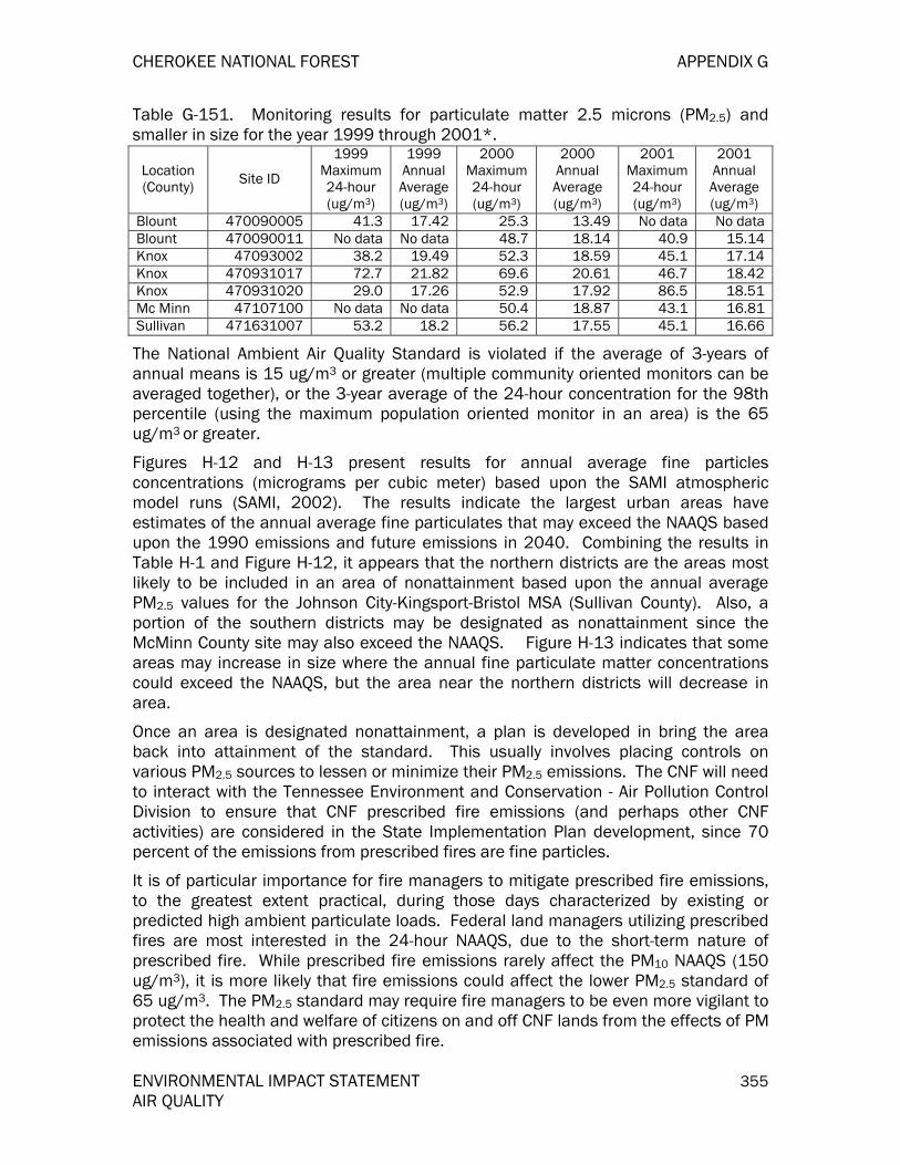
CHEROKEE NATIONAL FOREST APPENDIX G
ENVIRONMENTAL IMPACT STATEMENT 355 AIR QUALITY
Table G-151. Monitoring results for particulate matter 2.5 microns (PM2.5) and smaller in size for the year 1999 through 2001*.
Location (County) Site ID
1999 Maximum 24-hour (ug/m3)
1999 Annual Average (ug/m3)
2000 Maximum 24-hour (ug/m3)
2000 Annual Average (ug/m3)
2001 Maximum 24-hour (ug/m3)
2001 Annual Average (ug/m3)
Blount 470090005 41.3 17.42 25.3 13.49 No data No data Blount 470090011 No data No data 48.7 18.14 40.9 15.14 Knox 47093002 38.2 19.49 52.3 18.59 45.1 17.14 Knox 470931017 72.7 21.82 69.6 20.61 46.7 18.42 Knox 470931020 29.0 17.26 52.9 17.92 86.5 18.51 Mc Minn 47107100 No data No data 50.4 18.87 43.1 16.81 Sullivan 471631007 53.2 18.2 56.2 17.55 45.1 16.66
The National Ambient Air Quality Standard is violated if the average of 3-years of annual means is 15 ug/m3 or greater (multiple community oriented monitors can be averaged together), or the 3-year average of the 24-hour concentration for the 98th percentile (using the maximum population oriented monitor in an area) is the 65 ug/m3 or greater.
Figures H-12 and H-13 present results for annual average fine particles concentrations (micrograms per cubic meter) based upon the SAMI atmospheric model runs (SAMI, 2002). The results indicate the largest urban areas have estimates of the annual average fine particulates that may exceed the NAAQS based upon the 1990 emissions and future emissions in 2040. Combining the results in Table H-1 and Figure H-12, it appears that the northern districts are the areas most likely to be included in an area of nonattainment based upon the annual average PM2.5 values for the Johnson City-Kingsport-Bristol MSA (Sullivan County). Also, a portion of the southern districts may be designated as nonattainment since the McMinn County site may also exceed the NAAQS. Figure H-13 indicates that some areas may increase in size where the annual fine particulate matter concentrations could exceed the NAAQS, but the area near the northern districts will decrease in area.
Once an area is designated nonattainment, a plan is developed in bring the area back into attainment of the standard. This usually involves placing controls on various PM2.5 sources to lessen or minimize their PM2.5 emissions. The CNF will need to interact with the Tennessee Environment and Conservation - Air Pollution Control Division to ensure that CNF prescribed fire emissions (and perhaps other CNF activities) are considered in the State Implementation Plan development, since 70 percent of the emissions from prescribed fires are fine particles.
It is of particular importance for fire managers to mitigate prescribed fire emissions, to the greatest extent practical, during those days characterized by existing or predicted high ambient particulate loads. Federal land managers utilizing prescribed fires are most interested in the 24-hour NAAQS, due to the short-term nature of prescribed fire. While prescribed fire emissions rarely affect the PM10 NAAQS (150 ug/m3), it is more likely that fire emissions could affect the lower PM2.5 standard of 65 ug/m3. The PM2.5 standard may require fire managers to be even more vigilant to protect the health and welfare of citizens on and off CNF lands from the effects of PM emissions associated with prescribed fire.

APPENDIX G CHEROKEE NATIONAL FOREST
356 ENVIRONMENTAL IMPACT STATEMENT AIR QUALITY
Figure G-12. Estimated annual average fine particle mass (micrograms per cubic meter) based upon 1990 emissions using at atmospheric model (SAMI, 2002)
Figure G-13. Estimated annual average fine particle mass (micrograms per cubic meter) based upon 2040 emissions using at atmospheric model (SAMI, 2002)

CHEROKEE NATIONAL FOREST APPENDIX G
ENVIRONMENTAL IMPACT STATEMENT 357 AIR QUALITY
Secondary Pollutants
Three broad classes of secondary pollutants are considered in this report because they are most likely to have the greatest impact on the CNF AQRV:
Sulfur and nitrogen deposition as they contribute to acid deposition,
Ozone (O3) and its effects on vegetation,
Fine particulate (PM2.5) and its effect on visibility (regional haze).
Primary pollutants emitted from stationary and mobile sources undergo transformations in the atmosphere and are converted to secondary air pollutants (Malm, 1999). Sulfates are “the main contributor” to regional haze, and both sulfur and nitrogen compounds contribute to acid deposition. These secondary pollutants can be transported hundreds of miles. However, based on numerous Agency sanctioned modeling studies, those pollution sources within 120 miles of any given area appear to have the most significant impact on that area’s resources.
Acid deposition - sulfur and nitrogen deposition
The secondary pollutants forming sulfur and nitrogen compounds are of great importance due to their combined contribution to acid deposition and regional haze. Acid deposition refers to acid compounds that are deposited from the atmosphere in the rain, cloud, snow, fog, or dry deposition (seen as visibility impairment). Typically, elevations above 2624 feet (800 meters) elevations have the greatest deposition because these areas receive frequent high concentrations of acid compounds from cloud cover (NAPAP, 1991). Data collected at Joyce Kilmer-Slickrock Wilderness indicates weather related events (mostly cloud formations) were obscuring the peaks from being seen about 48 percent of the time (Air Resource Specialists, 1995).
Historically, the southern portion of the CNF has had the largest deposition of sulfur compounds. Rich copper ore deposits were discovered by European settlers in 1843 in the Copper Basin of Polk County, Tennessee. The mining in combination with open-pit, charcoal-fired smelters were in existence between the 1850’s and 1904. The forest (trees and eventually roots) were harvested to provide fuel for the fires used to refine the oar which roasted two to three months. The uncontrolled emissions and roasting of the high sulfur oar released large quantities of sulfur dioxide into the atmosphere. After 1904 another smelting technique was used to refine the oar, but sulfur dioxide was still uncontrolled and being released into the atmosphere. By 1909 most of the sulfur dioxide gas was captured and used to produce sulfuric acid (Quinn, 1991). However, the combination of deforestation plus the very high sulfur dioxide and sulfuric acid (at levels toxic to vegetation) levels in the atmosphere caused severe environmental damage within and near the Copper basin (Figure H-14), as well as noticeable symptoms on the foliage of vegetation over a large area (Figure H-15) (Maher, 1964). In the 1930’s, several Federal and State agencies, and the mining companies worked cooperatively together to plant trees and other vegetation in the Basin. Some areas had the vegetation survive after the initial plantings, but other denuded areas were fertilized with major nutrient or agricultural limestone prior to and/or after planting with vegetation (Muncy, 1986). The applications of fertilizers high in base cations – calcium, magnesium, and

APPENDIX G CHEROKEE NATIONAL FOREST
358 ENVIRONMENTAL IMPACT STATEMENT AIR QUALITY
potassium – were beneficial to the Cooper basin because these elements are essential for healthy plant growth. However, in some cases the bases were loss due to severe erosion of the topsoil and subsoil. CNF soils lacking in base cations can exhibit symptoms of branch die back or reduced root growth, or a yellowing of the crowns. The appearance of yellowing crowns can still be found on loblolly pine growing near the center of the Copper basin today.
Figure G-14. Picture of the Copper Hill basin taken prior to 1955 shows the environmental damage caused by sulfur compounds, and deforestation (used by permission from the Copper Hill Museum, Ducktown, Tennessee).

CHEROKEE NATIONAL FOREST APPENDIX G
ENVIRONMENTAL IMPACT STATEMENT 359 AIR QUALITY
Figure G-15. Location of documented effects from copper smeltering and deforestation (after Maher, 1964).
Healthy forest ecosystems have the ability to recycle the nutrients, so the losses are minimal. For example, calcium is an essential element for the formation of cell walls. Each year there are leaves, as well as some branches and dead trees that fall to the ground. Microbial and other biological activity break down the dead tissue and release a portion of the calcium into the soil. The calcium has a positive charge and can attach to the negatively charged soil particles. The vegetation can once again use the calcium when it absorbed through the fine roots. However, some calcium is released into the soil water solution and carried into the stream where it can be used by the aquatic biota for growth (especially internal or external skeletal growth). Calcium and other base cations are replaced in the soils as there are released from weathered rocks, or deposited from windblown soil.
Current deposition of sulfur and nitrogen compounds is having impacts to the AQRV of the CNF. Sulfur compounds in particular have an adverse impact to some high elevation ecosystems on the CNF because the amount in the soil has been increasing since the soils have the ability to retain the sulfur. Sulfur in rainfall is deposited as sulfuric acid (H2 SO4). As the sulfuric acid moves through the soil it will disassociate into two hydrogen ions (which can reduce the pH of the soil) and a negatively charged sulfate particle. Once the sulfate particle is in soil solution it will maintain an ionic balance by attaching to an equivalent amount of positively charged base cations. The long-term impact of excessive sulfur deposition is a depletion of base cations essential for vegetation growth, as well as the inability of headwater streams to buffer the inputs of acid compounds. For streams system this buffering capacity is measured as the acid neutralizing capacity, or ANC. Typically, it is desirable to have streams systems with an ANC value of 50 micro-equivalents per

APPENDIX G CHEROKEE NATIONAL FOREST
360 ENVIRONMENTAL IMPACT STATEMENT AIR QUALITY
liter or greater in order to protect the aquatic biotic found in cold mountain streams from the unhealthy impacts of episodic acidification.
Throughout the CNF there are many soils which have developed from rocks that are low in base cations and have a high or medium sensitivity to acid deposition (Figure H-16). Furthermore, there are soils in some areas within and near the CNF, such as within the Joyce Kilmer--Slickrock Wilderness (Vose et al., unpublished), that are saturated with sulfur compounds and as the sulfates are released overtime then greater amounts of base cations, especially calcium, will be depleted. Stream water sulfate concentrations are expected to continue to increase in the future as well as a corresponding decrease in stream ANC. Many streams within a watershed at Joyce Kilmer may have started with a pre-1900 ANC value between 71 and 112 micro-equivalents per liter (Sullivan and Cosby, 2002a). However, the range by the year 2040 with the expected trend in deposition (SAMI, 2002) is predicted to decrease the ANC range to between ten and 94 micro-equivalents per liter (Sullivan and Cosby, 2002b).
Figure H-16. Sensitivity of parent rock material to acid deposition. Note the area mapped included all 5th level hydrologic unit codes intersecting the CNF (source: classification of unpublished U.S. Geological Survey data).
Rainfall with little to no air pollution from the combustion of fossil fuels is naturally acid with a pH of about 5.6. Forested ecosystems, especially conifer types, do naturally acidify soils at a slow rate from biological processes and the naturally acidic rainfall. However, the excessive amounts of acid deposition have accelerated the rate of soil acidification. As was mentioned previously, there are two hydrogen ions released when sulfuric acid comes in contact with the soil. As the hydrogen ion concentration of the soil increases then the pH of the soil will decrease. If the soil pH

CHEROKEE NATIONAL FOREST APPENDIX G
ENVIRONMENTAL IMPACT STATEMENT 361 AIR QUALITY
drops below 4.5 then aluminum, an abundant element normally bound in the soil, will become released. High concentrations of aluminum can interfere with the uptake of base cations needed by the vegetation for growth. Also, at high concentrations it can kill the fine roots, which leads to less area for water and nutrient uptake, which is essential for good health. Aluminum can also become mobilized and released into the soil water solution and reach high concentration in some streams. Toxic levels of aluminum can kill fish and other aquatic organisms needed for a healthy and biological diverse aquatic ecosystem.
Nitrogen deposition for many ecosystems (especially lower elevations) is beneficial since nitrogen availability is usually a limiting factor for vegetation growth. The nitrogen deposited can be in the form of ammonia (NH3), nitric acid (HNO3) and/or nitrate (NO3). High elevation ecosystems that have cooler temperatures, lower microbial activity, and thin soil with low base cation availability can be sensitive to nitrogen deposition, such as is found with some spruce-fir ecosystems. Too much deposition of nitrogen compounds can remove base cations needed for biological growth, as well as interfere with winter “hardening off” with red spruce trees.
Data and Analysis
Current, wet and dry deposition of total sulfur and nitrogen have been estimated near the CNF for the northern districts at the CASTNet monitoring sites called Speedwell (SPD111, 1184 feet elevation, source: http://www.epa.gov/castnet//sites /spd111.html) and Cranberry (PNF126, 3999 feet elevation, (source: http://www.epa.gov/castnet//sites/pnf126.html). The southern districts are represented by data from a high elevation site at Noland Divide in the Great Smoky Mountains National Park. Researchers have used data collected throughout the region from wet deposition monitors, rainfall data, and elevation to predict wet sulfate deposition across the landscape (Lynch et al., 1997). The results for predicted wet sulfate deposition have been included in a risk assessment to identify which 5th level hydrologic unit code (HUC) has the greatest sensitivity to acidification. Nitrate deposition was not included in the analysis because the deposition estimates are correlated with sulfate estimates and sulfate deposition is believed to be having a greater impact to the CNF AQRV then nitrate. Elevations above 2624 feet (800 meters) are at a higher risk of acidification because the soils may be thin and cold, and there is greater deposition of acid compounds. Elevation is also included in the analysis as well as the sensitivity of the parent geological types to acid deposition (Figure H-16).
Limited water quality sampling has also been conducted on the CNF to estimate the distribution of streams in five ANC classes (Bulger et al., 1995). Thirty streams were sampled in late 1999 and early 2000, and most (n = 29) were sampled again in early 2002. Streams were randomly selected from eight strata, based upon the amount of sulfur deposition and the geological sensitivivity classification presented in the SAA (SAMAB, 1996). All of the stream sample locations and strata were above 3000 feet elevation. This area of the CNF considered to be the most sensitive to acid deposition.

APPENDIX G CHEROKEE NATIONAL FOREST
362 ENVIRONMENTAL IMPACT STATEMENT AIR QUALITY
Current and Future Conditions
The range in nitrogen annual deposition at the Speedwell and Cranberry sites is between 6.4 and 8.4 kilograms per hectare per year. Deposition of nitrogen compounds is likely to be greater at elevations above 2624 feet elevation due to the deposition from clouds. Some scientists have estimated acid deposition from clouds can be twice the levels of wet plus dry deposition. If this assumption is true then elevations above 2624 feet elevation on the northern districts could be receiving a total of 16.8 kilograms per hectare of nitrogen deposition. Deposition of nitrogen compounds is likely to be greater at the southern districts (nearer to large nitrogen oxide sources, see Figure H-7). Measurements from a high elevation site (Noland Divide, 5708 feet elevation) in the Great Smoky Mountains National Park had an average total (wet plus dry plus clouds) nitrogen deposition of approximately 32 kilograms per hectare per year (SAMI, 2002)
Deposition of sulfur compounds can be as sulfur dioxide (SO2), or wet or dry sulfates (SO42-). Current annual sulfur deposition on the CNF is estimated to be between 9.6 and 13 kilograms per hectare for the northern districts. Areas with cloud deposition (above 2624 feet elevation) could be receiving as much as 26 kilograms per hectare using the estimates provided at the Cranberry monitoring site. The results of a statistical modeling technique (Lynch et al., 1997) provide estimates of the 1983 through 1999 average wet sulfur deposition (multiplying sulfate deposition values by 3.0 converts the values to sulfur deposition). Adjusting for the portion that could be dry deposition, the lower elevation sites on the southern districts had an average total sulfur deposition of 14.9 (range: 9.6 to 23.4) kilograms per hectare per year; while the higher elevations had a greater average of 18.2 (range 10.5 to 25.0) kilograms per hectare per year. The average estimate for the wet and dry deposition for the northern districts was lower than the southern districts. The lower elevation sites on the northern districts had an average total sulfur deposition of 10.7 (range: 7.2 to 17.1) kilograms per hectare per year; while the higher elevations had approximately the same average of 12.5 (range 7.2 to 17.5) kilograms per hectare per year. The Great Smoky Mountains National Park is estimated to have a total (wet plus dry plus cloud) sulfur deposition of 43 kilograms per hectare (SAMI, 2002), which is lower than the maximum total sulfur deposition estimated for the high elevations on the southern districts (50 kilograms per hectare).
Streams with an ANC value of 50 microequivalents per liter or less are of concern because sensitive aquatic biota can be adversely impacted (Bulger et al., 1995). In the southern Appalachians it is has been estimated 6.6 percent of the streams have an ANC value below 51 (Table H-2), and most of these streams are located at elevations above 3000 feet (SAMI, 2002). The two years of sampling water quality on the CNF support the notion that high elevations can have low ANC values. About one-third of the streams sampled had ANC values of biological concern, and about one-third could continue to acidify and be a concern in the future (Table H-2). Continued sampling of streams should be conducted periodically on the CNF to estimate the percentage of streams in each of the ANC classes, and if there is a significant increase in the percentage of streams with ANC values that could adversely impact the aquatic biota.
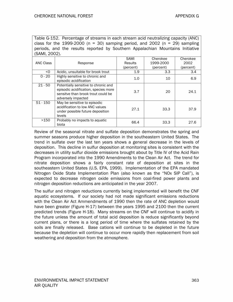
CHEROKEE NATIONAL FOREST APPENDIX G
ENVIRONMENTAL IMPACT STATEMENT 363 AIR QUALITY
Table G-152. Percentage of streams in each stream acid neutralizing capacity (ANC) class for the 1999-2000 (n = 30) samping period, and 2002 (n = 29) sampling periods, and the results reported by Southern Appalachian Mountains Initiative (SAMI, 2002).
ANC Class Response SAMI
Results (percent)
Cherokee 1999-2000
(percent)
Cherokee 2002
(percent) <0 Acidic, unsuitable for brook trout 1.9 3.3 3.4
0 - 20 Highly sensitive to chronic and episodic acidification 1.0 10 6.9
21 - 50 Potentially sensitive to chronic and episodic acidification, species more sensitve than brook trout could be adversely impacted
3.7 20 24.1
51 - 150 May be sensitive to episodic acidification to low ANC values under possible future deposition levels
27.1 33.3 37.9
>150 Probably no impacts to aquatic biota 66.4 33.3 27.6
Review of the seasonal nitrate and sulfate deposition demonstrates the spring and summer seasons produce higher deposition in the southeastern United States. The trend in sulfate over the last ten years shows a general decrease in the levels of deposition. This decline in sulfur deposition at monitoring sites is consistent with the decreases in utility sulfur dioxide emissions brought about by Title IV of the Acid Rain Program incorporated into the 1990 Amendments to the Clean Air Act. The trend for nitrate deposition shows a fairly constant rate of deposition at sites in the southeastern United States (U.S. EPA, 1999). Implementation of the EPA mandated Nitrogen Oxide State Implementation Plan (also known as the “NOx SIP Call”), is expected to decrease nitrogen oxide emissions from coal-fired power plants and nitrogen deposition reductions are anticipated in the year 2007.
The sulfur and nitrogen reductions currently being implemented will benefit the CNF aquatic ecosystems. If our society had not made significant emissions reductions with the Clean Air Act Ammendments of 1990 then the rate of ANC depletion would have been greater (Figure H-17) between the years 1995 and 2100 then the current predicted trends (Figure H-18). Many streams on the CNF will continue to acidify in the future unless the amount of total acid deposition is reduce significantly beyond current plans, or there is a long period of time where the sulfates retained by the soils are finally released. Base cations will continue to be depleted in the future because the depletion will continue to occur more rapidly then replacement from soil weathering and deposition from the atmosphere.

APPENDIX G CHEROKEE NATIONAL FOREST
364 ENVIRONMENTAL IMPACT STATEMENT AIR QUALITY
-40
-20
0
20
40
60
80
100
120
1995 2010 2040 2100
AN
C (u
eq p
er li
ter)
Cherokee -- Laural Branch Cherokee -- Toms Branch Cherokee -- Sugar Cove BranchCohutta -- Beech Creek GSMNP -- Nolard Branch NW
Figure G-17. Predicted trend in acid neutralizing capacity (ANC) if sulfur and nitrogen deposition were held constant at 1995 levels (SAMI, 2002).
-40
-20
0
20
40
60
80
100
120
1995 2010 2040 2100
AN
C (u
eq p
er li
ter)
Cherokee -- Laural Branch Cherokee -- Toms Branch Cherokee -- Sugar Cove BranchCohutta -- Beech Creek GSMNP -- Nolard Branch NW
Figure G-18. Predicted trend acid neutralizing capacity (ANC) with implementation of current laws, rules, and regulations (SAMI, 2002).
Numerous studies and assessments have shown headwater streams in the southern Appalachian Mountains are being affected by historic and current levels of acid deposition (Webb et al., 1994; Bulger et al., 1995; and SAMI, 2002). These studies also show significant reductions in acid deposition, beyond those already scheduled

CHEROKEE NATIONAL FOREST APPENDIX G
ENVIRONMENTAL IMPACT STATEMENT 365 AIR QUALITY
by the Title IV Clean Air Act Amendments of 1990, will be necessary to maintain the current water chemistry let alone improve ANC in those streams already showing signs of acidification. A major reason for this apparent lack of response is because of the high levels of sulfates retained by soils at the high elevations. Most likely, it will take hundreds of years for the stream ANC to recover in many aquatic systems, unless mitigation with appropriate fertilizers high in base cations were applied to the watersheds.
Risk Assessment
Previous studies which examined ANC values in the southern Appalachians have found about 6.6 percent of the streams with a low buffering capacity (ANC < 50 microequivalents per liter). The streams with a low ANC were typically found at high elevations on soils with low amounts of base cations (SAMI, 2002), such as is found throughout the CNF (see Figure H-16). An analysis was performed to determine which 5th level HUCs have the greatest risk of effects of acidification to the soils or streams. An index was developed to sort the watersheds by multiplying the average sulfate deposition for the watershed, times the percentage of the watershed with high elevation, medium or high sensitive parent rock material. The watersheds with the greatest index values are considered to have the greatest risk of potential impacts from acid deposition
Figure G-19. Average (1983 – 1999) sulfur deposition (kilograms per hectare) patterns for the 5th level hydrologic water units (HUCS) that the CNF is within.
The average wet sulfur depositon for the 5th level HUCS which the CNF is within ranged between 3.6 and 12.5 kilograms per hectare per year (Figure H-19) using the average of the years 1983 through 1999. Among the 23 HUCs the mean sulfate

APPENDIX G CHEROKEE NATIONAL FOREST
366 ENVIRONMENTAL IMPACT STATEMENT AIR QUALITY
deposition ranged between 14.7 and 26.0 kilograms per hectare in wet sulfur deposition. The HUCs with the greatest risk values occurred in those watersheds where the percentage of the watershed having geology classified as medium or high risk of sensitivity (SAMI, 2002) to acid deposition, and a large percentage of the areas is above 2624 feet elevation. The watersheds classified with the greatest risk for impacts from acid deposiiton are in the northern part of the CNF along the North Carolina and Virginia borders (Figure H-23).
Figure G-20. Fifth level hydrologic unit codes (i.e. watersheds) with the lowest numbers have the greatest risk of adverse impacts due to acid deposition.
Caution should be used when using the results in Figure H-20. The results do not say the highest risk areas are having adverse impacts to the AQRV, but instead these areas should be examined first using other indicators – such as the amount of sulfur and base cations in the soil, or the ANC of samples collected from streams. Other factors will also influence the amount of cations available in the soils and streams, such as the historical landuse of an area, the frequency or severity of previous wildfires, or even if the area has small inclusions with the watershed that are rich in cations that are positively influencing the buffering capacity of a stream.
Ozone
Ground-level ozone is a naturally occurring compound found in the atmosphere. In the upper atmosphere the ozone protects us from the sun’s ultraviolet radiation. The production of ozone occurs when nitrogen oxides and volatile organic compounds (trees are the major emission source) go through a chemical reaction on warm sunny days. The highest ozone concentrations in Tennessee occur between March and October when atmospheric conditions are condusive for ozone formation. The ozone molecule is composed of three oxygen molecules (O3), and is less stable than the

CHEROKEE NATIONAL FOREST APPENDIX G
ENVIRONMENTAL IMPACT STATEMENT 367 AIR QUALITY
oxygen we breathe (O2). The unstable ozone molecule reacts with the tissues inside a human lung and can be a serious health problem for the elderly, children with developing lungs and any other person with lung disease, such as asthma. People involved in vigorous outdoor activities, such as hikers and forest service employees doing field work, can also have unhealthy impacts from high ozone exposures.
Ozone concentrations vary across the landscape. The greatest concentrations are typically found in large metropolitan areas, like Atlanta, where ozone can be at levels that are unhealthy for people (see Figure H-4). At rural low elevation (less than 3500 feet) sites the ozone exposures will be less than large urban areas. Figure H-21 shows a typical urban pattern found at a Sullivan County site (about 1550 feet elevation) and the average ozone exposures for each hour begins to increase about 7:00 A.M. and the maximums occur in the afternoon between 12:00 and 5:00 P.M. The Sullivan County site is located within Johnson City-Kingsport-Bristol MSA (see Figure H-3). Ozone concentrations build during the daylight hours as the temperature and solar radiation increases. During this same time period the nitrogen oxide emissions increase from vehicles as people go to work and conduct other daily activities; and coal-fired power plants increase electrical generation to meet the increased demand to cool businesses and people’s homes on hot days. Another increase in nitrogen oxide emissions occurs in the early evening as people return to their homes for the night. However, the nitrogen oxides released in the late evening and at night will react with (i.e. remove) the ozone and decrease the ozone concentration into the early morning hours. Ozone is not formed during the night because the temperatures decrease and there is no sunlight to initiate the chemical reactions. Conversely, in the early evening and nighttime the nitrogen oxides are not released in large quantities at the high elevations so there is not a decrease in ozone during the night and into the early morning hours (Figure H-21). Actually, the highest ozone exposures at high elevations typically occur between 10:00 P.M. and 3:00 A.M. since ozone produced downwind of urban areas and coal-fired power plants are transported to the rural high elevation sites. Consequently, vegetation at the higher elevations is exposed to more ozone during the growing season than vegetation growing at the middle or lower elevations.
Figure G-21. Average ozone exposure for each hour of the day during April through October 1998. The monitoring site at Purchase Knob (4780 feet) shows the high

APPENDIX G CHEROKEE NATIONAL FOREST
368 ENVIRONMENTAL IMPACT STATEMENT AIR QUALITY
elevations are receiving greater ozone exposures than the Sullivan County site located at a lower elevation (1550 feet).
Data and Analysis
There is an abundance of ozone monitoring sites within 30 miles of the CNF, especially in the urban areas (see Figure H-2). Thirteen of the 58 ozone sites were chosen to be included in this analysis (Figure H-22). The hourly ozone data were obtained from the Forest Service Natural Resource Information System (NRIS) website and SAMI (SAMI, 2002), and the data analysis was accomplished using the Ozone Calculator. The NRIS data and the Ozone Calculator software can be found at:
5. Data: http://webcam.srs.fs.fed.us/calculator/US/us_regions.htm
6. Software: http://webcam.srs.fs.fed.us/calculator/technical_support.htm
Figure G-22. Location of ozone monitors sites where the data is considered to represent the CNF.
Eleven sites were used to examine if the ozone NAAQS has been exceeded within or near the forest. These 11 sites included those thought to represent the air quality on the CNF, as well as data from sites where any portion of the MSA was within 30 miles of the CNF boundary. The CNF effects analysis was conducted using eight sites and two sites that were included in the SAMI analysis: Look Rock and Cranberry (Figure H-22). Also, the SAMI data (for the years 1993 through 1995) was examined to see how ozone exposures and NAAQS at these two sites may change in the future with decrease emissions of nitrogen oxides.

CHEROKEE NATIONAL FOREST APPENDIX G
ENVIRONMENTAL IMPACT STATEMENT 369 AIR QUALITY
Potential Ozone Nonattainment Areas
All 11 ozone monitoring sites used in this analysis exceeded the current ozone NAAQS (Figure H-23). The ozone NAAQS is based upon a three year average of the 4th highest daily 8-hour running average, and if the average is 0.085 ppm or higher the site is considered to have exceeded the ozone NAAQS. There could be numerous areas within 30 miles of the CNF boundary that are designated as nonattainment, as is shown in Figure H-23. The reader should be cautioned though the official nonattainment designations will be proposed by the Governors of Georgia, North Carolina, Tennessee, and Virginia; however, it is the EPA that will determine the areas designated as nonattainment. The EPA could designate a larger area as nonattainment then what is currently shown in Figure H-23. Designation of nonattainment areas is most likely to occur in April, 2004. The results in Figure H-23 also suggest that on hot sunny days the ozone concentrations are probably unhealthy for some people who are involved in vigorous outdoor activities on the most of the CNF. If ozone monitoring was conducted at several places on the CNF then there would be a high likelihood these sites, especially any at high elevations, would also exceed the ozone NAAQS.
Figure G-23. Area that could be designated nonattainment for the 8-hour ozone standard based upon using 1998 through 2000 data
The nonattainment designation will have serious implications for the CNF’s management activities. Any project proposed in an area designated as nonattainment, (such as the Johnson City-Kingsport-Bristol MSA), must be approved by the Tennessee Department of Environmental Control – Air Pollution Control Division before the CNF line officer can approve the project. Projects that emit above 100 tons per year of nitrogen oxides or 100 tons per year of volatile organic
APPENDIX G CHEROKEE NATIONAL FOREST
370 ENVIRONMENTAL IMPACT STATEMENT AIR QUALITY
compounds will be subject to these General Conformity Rules. This will be especially important for any activities where combustion of fossil fuels will occur and/or prescribe fires occur in the months of March through October.
The CNF can expect some decreases in the ozone exposures in the future. The 3-year average (1993 through 1995) of two sites used in the SAMI analysis (SAMI, 2002) does indicate the anticipated nitrogen oxide reductions (see Figure H-8) will reduce the 4th highest daily 8-hour average. The 3-year average for the Look Rock site exceeded the NAAQS with a value of 0.092 ppm, while the Cranberry site had a value of 0.080 ppm, i.e. below the NAAQS. If the SAMI estimated nitrogen oxide reductions are realized then both sites would be below the ozone NAAQS by 2040. It should be noted there is a high likelihood of attaining the ozone NAAQS at these two sites since the SAMI analysis did not include what pollution reductions would be needed to attain the 8-hour standard. The air pollution control agencies near the CNF will be developing and implementing State Implementation Plans to bring areas into attainment of the ozone NAAQS before the year 2040.
Ozone effects to forest vegetation
Ozone can impact herbaceous plants, shrubs, trees, and agricultural crops. Most ozone effects research has focused on agricultural crops because of the documented large economic losses; however, some work has been done relating ozone exposures to effects on forest tree species. In the SAMI analysis (2002) there were seven trees species where enough data were available to use in their regional analysis. However, it should be recognized there are at least 100 trees species in the southern Appalachians and most of these tree species (along with herbaceous plants and shrubs) sensitivity to ozone has not been tested using controlled experiments. Therefore, there is uncertainty in regard to the extent of ozone impact to vegetation on the CNF.
Under good soil moisture and nutrient conditions there are cells (called stomata) in the leaf which open and allow carbon dioxide to enter. In the chloroplasts (these make a leaf green) the carbon dioxide, inorganic salts, and water combine with the aid of sunlight to produce food in the form of simple sugars. These sugars can be used by the trees as energy to assist with repairing damage to cells in the tree, and also are stored in the roots to assist with the next seasons growth. Trees that have adequate food reserves in the roots may be able to out-compete neighboring trees if they can grow larger in crown area, in height, and in the amount of area where fine roots can absorb water and nutrients. A tree that is taller and larger in crown width will have more leaves receiving sunlight so it can produce more food to be used in the future. Therefore, a large dominant tree out-competes adjacent smaller trees for the resources necessary to survive.
Ozone enters through openings into the leaf just like the carbon dioxide. Once inside the leaf the plant may expend energy to produce biochemicals that neutralize the ozone. For other species the ozone kill numerous chloroplasts and this can result in less simple sugars produce by the plants. There is a range of responses of vegetation to ozone exposures and the death of the chloroplasts. Some species consistently exhibit symptoms on the upper leaf surface and have been used as “bioindicators”, which indicates ozone exposures are causing a physiological

CHEROKEE NATIONAL FOREST APPENDIX G
ENVIRONMENTAL IMPACT STATEMENT 371 AIR QUALITY
response to the individual and/or species. Other species may or may not have ozone symptoms, but there is a reduction in the total amount of biomass produced by the tree, so the tree is not as competitive with neighboring trees. Also, there are areas of the United States where the ozone exposures are so high the trees are weakened by the ozone and bark beetles attack and kill the weakened trees, such is the case in the San Bernardino Mountains adjacent to Los Angeles, California. Ozone effects within and between species does vary and perhaps the largest concern for the CNF, especially in the areas designated as wilderness, is the reduction in biological diversity and abundance of ozone sensitive species.
The presence of ozone symptoms is not an accurate indicator of how much growth loss has occurred to a sensitive plant from ozone exposure. Therefore, some air resource specialists rely upon measurements taken with ozone monitoring equipment to predict if growth (i.e. biomass) reductions have occurred. The ozone monitors used in this assessment (Figure H-24) were used to assess if growth reductions could be occurring to sensitive tree species found on the forest. The data were summarized for eight ozone monitoring sites using hourly average ozone concentrations from April through October. Researchers and technical specialists have examined ways to estimate growth loss to vegetation, with the use of exposure indices, based on those hourly values.
Figure G-24. Location of ozone monitors where the data was used to estimate vegetation effects on the CNF.
Among FS air quality specialists there are two important statistics used in combination to estimate growth loss to vegetation when summarizing data from ozone monitors (FLAG, 2000). The first is called the N100 and it is the number of hours the measured ozone concentration is greater than or equal to 0.100 parts per
APPENDIX G CHEROKEE NATIONAL FOREST
372 ENVIRONMENTAL IMPACT STATEMENT AIR QUALITY
million (ppm). Experimental trials with a frequent number of peaks (hourly averages greater than or equal to 0.100 ppm) have been demonstrated to cause greater growth loss to vegetation than trials with no peaks in the exposure regime (Hogsett et al., 1985; Mussleman et al., 1983; and Mussleman et al., 1986). The second statistic is a means to summarize the cumulative (seasonal) ozone exposure and it is called the W126 (Lefohn and Runeckles, 1987). The W126 was developed as another biologically meaningful way to summarize hourly average ozone data. The W126 index places a greater weight on the measured values as the concentrations increase. Thus, it is possible for a high W126 value to occur with few to no hours above 0.100 ppm. Therefore, in order to more accurately estimate growth suppression due to ozone exposure, it is also necessary to determine the number of hours the ozone concentrations are greater than or equal to 0.100 ppm. It should also be noted the lack of N100 values does not mean ozone symptoms will not be present when field surveys are conducted.
Black cherry and yellow-poplar are among the species that suffer the greatest growth suppression from ozone exposure. Factors affecting the actual dose of ozone that enters the leaf to cause growth loss include soil moisture availability, soil nutrient availability, the amount of leaf resistance to ozone penetration, and other micrometeorological conditions (Lefohn, 1998). For example, during times of drought, leaf stomata do not allow as much ozone to enter the leaf as during times of normal precipitation. However, it should be noted during periods of prolonged drought there could be severe growth reductions, but these reduction are probably not attributable to ozone even if the concentrations are very high.
The Ozone Calculator using a series of equations (Lefohn, 1998) to estimate the maximum amount of growth loss that could occur for a species using the W126 and N100 values at a site. The percent growth loss is probably greatest for the high elevation areas or exposed ridge tops on the CNF near the Knoxville MSA (see Figure H-25). At the Look Rock and Cove Mountain sites the estimated black cherry maximum biomass reductions (based upon two studies) is 43.6 to 56.2 percent, while the yellow-poplar biomass reductions (based upon two studies) is 44.6 to 99.9 percent. These values may be representative (if soil moisture, nutrients, and microclimatic conditions were adequate to allow ozone uptake) of the Citico and Joyce Kilmer/Slickrock Wilderness, and the southwestern portion of the northern districts. The ozone exposures on the CNF, especially the N100, decrease as the distance from Knoxville increases or as the elevation decreases. Black cherry growth reductions are typically below 40 percent while the yellow-poplar biomass reductions are typically below 30 percent (Figure H-25).

CHEROKEE NATIONAL FOREST APPENDIX G
ENVIRONMENTAL IMPACT STATEMENT 373 AIR QUALITY
Figure G-25. Estimated annual range in maximum black cherry (bc) and yellow-poplar (yp) biomass reductions using 1998 through 2000 data. Note: the biomass reductions will be less during periods of drought or low soil moisture.
SAMI addressed the changes likely to occur in ozone exposures and changes in forest stands using several emission management scenarios (SAMI, 2002). Reductions by the year 2040 in nitrogen oxides are likely to reduce the number of hours the concentrations are greater than 0.050 ppm, especially the N100 values. The reduction in the cumulative (W126) exposures and the N100 is likely to cause a shift in competition between species within forest stands (SAMI, 2002). Total basal area in forests in the SAMI region (including the CNF) is not likely to change even if ozone concentrations are reduced, but there is likely to be changes in the basal area among species within a forest stand. This is especially true for cove hardwoods and possibly loblolly pine—hardwood stands. CNF types are unlikely to shift in abundance, and tree mortality in direct response to ozone is not expected. However, SAMI showed current levels of ozone may be having an adverse impact to natural processes in the Class I areas across the region. Individual species, such as yellow-poplar, did show a positive response to reductions in ozone (SAMI, 2002).
Particulate Matter (PM10 and PM2.5) and Regional Haze
The beautiful mountain scenery is one of the main reasons tourists visit the CNF and other areas in Appalachia (Appalachian Regional Commission, 1970). During the last four decades, the Eastern United States has seen a significant, regional reduction in visibility, brought on by a corresponding increase in ambient levels of PM10 and PM2.5 (IMPROVE, 2002). This regional reduction in visibility is called regional haze. The estimated natural background visibility for the eastern United States is 93+28 miles (NAAP, 1991). However, there has been a significant

APPENDIX G CHEROKEE NATIONAL FOREST
374 ENVIRONMENTAL IMPACT STATEMENT AIR QUALITY
reduction in how far a person can see distant views, as well as how clearly a person can see the mountains. Secondary fine particles (PM2.5) are primarily responsible for the visibility impairment. Secondary fine particles are formed when combustion gases are chemically transformed into particles. In the eastern United States it is sulfate particles (transformed sulfur dioxide) from coal-fired power plants that comprise most of the measured fine particle mass (IMPROVE, 2000). Seventy-eight percent of the sulfur dioxide emissions within 120 miles (see Figure H-9) of the CNF are released from coal-fired power plants. Furthermore, the sulfates particles can cause even greater amounts of visibility impairment when the relative humidity is high. A humid atmosphere alone does not result in visibility reductions. Sulfate particles grow in size when they attach to water molecules in the atmosphere and they become the perfect size to cause visibility impairment by scattering the sun’s light (Malm, 1999).
Data and Analysis
The Inter-agency Monitoring of Protected Visual Environments (IMPROVE), a national network of particulate monitors established for the protection of Class I Wilderness Areas, has monitored the constituents of regional haze for more than two decades. The locations of four IMPROVE monitors near the national forest are shown in Figure H-26. Only the data (March, 1998 through May, 1999) for the Great Smoky Mountains National Park was used in the analysis since this site had fine particle data available, and IMPROVE considers this data to also represent the Joyce Kilmer-Slickrock Wilderness. Also, data were used from the SAMI analysis (1991 through 1995) for Joyce Kilmer-Slickrock and Cohutta Wilderness to examine how visibility is likely to change in the future (SAMI, 2002). Visual analysis was accomplished using the WinHaze program (http://webcam.srs.fs.fed.us/winhaze.htm).

CHEROKEE NATIONAL FOREST APPENDIX G
ENVIRONMENTAL IMPACT STATEMENT 375 AIR QUALITY
Figure G-26. IMPROVE monitoring sites near the National Forest.
Fine particle impacts to visibility
On the days (with a relative humidity of 80 percent) classified as having the lowest fine particle mass (3.9 ug/m3) the estimated visibility is 60 miles, but on the highest mass (20.65 ug/m3) days the visibility is reduced significantly to 16 miles (Figure H-27). The days with the poorest visibility are most likely to occur starting in May and continue through September (Air Resource Specialists, 1995) during the time when most people are visiting the CNF. Throughout the year, people are most likely to see a uniform haze – like a white or gray veil – obscure the beautiful mountains (Air Resource Specialists, 1995). Sulfates are the most important fine particles contributing to visibility impairment. On the low mass days they comprise 53 percent of the total mass while on the highest mass days the sulfates are 68 percent of the total. Organics (released primarily from vegetation as volatile organic compounds) are the second most important fine particles measured and if organics were the most abundant then there would be a bluish cast to the mountains – hence the name Blue Ridge Mountains.

APPENDIX G CHEROKEE NATIONAL FOREST
376 ENVIRONMENTAL IMPACT STATEMENT AIR QUALITY
Figure G-27. Visual representation at Joyce Kilmer-Slickrock Wilderness using the 1988 through 1995 IMPROVE data collected at Great Smoky Mountains National Park. The image on the left shows visibility on a low fine particle mass day (90 miles), while the image on the right shows a high fine particle mass day (16 miles). Relative humidity was set at 80 percent when using the WinHaze model.
The results from the IMPROVE monitors indicate regional haze, caused by elevated particulate loading, is heavily impacting the CNF. It is important to note the pollutants associated with regional haze have also been associated with acid deposition and respiratory health issues. Thus, it can be concluded that high, primary sulfur dioxide and nitrogen (nitrogen deposition and ozone) emissions can have a significant impact on the forest resources, as they are transformed into their secondary forms.
The EPA's Acid Rain Program, established under Title IV of the 1990 Clean Air Act Amendments, calls for major reductions in emissions of sulfur dioxide and nitrogen oxides, the pollutants that cause acid rain and contribute to visibility reductions. The program uses market incentives to achieve a nationwide limit on sulfur dioxide emissions more cost effectively than traditional regulatory methods. The Acid Rain Program requires a two-phased tightening of restrictions on fossil fuel-fired power plants, resulting in a permanent cap on sulfur dioxide of 8.95 million tons nationwide, half the amount emitted in 1980. Phase I of the sulfur program ran from 1995 through 1999 and affected roughly 440 of the larger, higher emitting utility units, primarily in the Eastern United States. Phase II began in 2000 and extends to all Acid Rain sources throughout the country (over 2,000 units nationwide) (U.S. EPA, 2001).
Sulfur dioxide is expected to decrease by at least 61 percent by the year 2040 in the counties within 120 miles of the CNF (see Figure H-10). Further reductions by coal-fired power plants in North Carolina (especially if the facility in Asheville puts on

CHEROKEE NATIONAL FOREST APPENDIX G
ENVIRONMENTAL IMPACT STATEMENT 377 AIR QUALITY
controls) and the Tennessee Valley Authority are likely to contribute to further reduction then what SAMI (2002) estimated for the year 2040. SAMI did estimate what visibility may be like between the 1991 through 1995 average and the year 2040. For Joyce Kilmer-Slickrock Wilderness the annual average visibility was estimated to be 23.4 miles, but with the current laws, rules and regulations in place the average is expected to improve to 28.5 miles. Summertime visibility is worst with an average of 13.8 miles. The SAMI (2002) estimates for summertime visibility are expected to improve by the year 2040 to 21.1 miles. Similar patterns are also expected for Cohutta Wilderness. The annual average visibility estimate based upon the SAMI (2002) analysis is 19.5 miles and it is predicted to improve to 24.5 miles by the year 2040. Summertime visibility at Cohutta Wilderness was estimated to be 15.7 miles and visibility is expected to improve to 24.3 miles.
Management Constraints and Regulatory Mandates
The USDA Forest Service is mandated, as are all federal land management agencies, to follow the directives of the Clean Air Act and the National Environmental Protection Act in mitigating the effects of Agency activities on the health and welfare of surrounding communities, as well as to Agency resources. Those areas not meeting NAAQS are designated as nonattainment, and an area specific management plan to demonstrate what emissions reductions will take place must be written by each air agency having authority. These plans must then be incorporated into the state Implementation Plan. The goal of the state Implementation Plan is to bring the affected areas back into attainment with the standards. If any part of a CNF is within a nonattainment area, the CNF must conduct a Conformity Analysis to determine if its activities conform to the state Implementation Plan.
Wildland fire is the primary activity on the CNF that will produce large amounts of air pollution. The smoke associated with wildland fire produces particulate matter and lesser amounts of other pollutants, including nitrogen oxides. Nitrogen oxide emissions are quite small for each ton of vegetation consumed and are unlikely to affect ozone attainment, unless frequent fires or large fires are conducted during March through October. However, particulate emissions are much greater and will be of concern to state and local air regulators because of the possibility of affecting the PM2.5 attainment status of the CNF or adjacent areas. No part of the CNF is presently within a nonattainment area.
The revised NAAQS for ozone and particulate matter (PM2.5) will most likely bring nonattainment status to the Johnson City-Kingsport-Bristol MSA (see Figure H-4). This area includes a portion of the northern districts on the CNF. Nonattainment designation is also likely for areas near the CNF such as: Asheville, Atlanta, Birmingham, Chattanooga, Knoxville, Lenoir, all of the Great Smoky Mountains National Park, and certain areas above 4000 feet elevation in western North Carolina. If the EPA designates these areas as nonattainment for ozone there may be a greater interest in emissions from managed prescribed fires within the time span of the revised LMP.
It will be critical for the Forest staff to work with the state and local air pollution control agencies and any regional air quality consortiums. The current model (such as SAMI) to solve air quality problems is to bring all interested parties together to
APPENDIX G CHEROKEE NATIONAL FOREST
378 ENVIRONMENTAL IMPACT STATEMENT AIR QUALITY
gather ideas on how to solve the problems. The CNF must be ready to participate in these groups to articulate why prescribed fire is needed as tool for forest management. Also, the CNF needs to continue evaluating what impact air pollution may causing to people on the CNF. Finally, the CNF needs to work with the State and local air pollution control agencies, and other interested parties to seek ways air pollution emissions can be reduced, so adverse impacts no longer continue to the CNF AQRV.
REFERENCES Air Resource Specialists. 1995. Historical data summaries and permanent photographic
archive for Joyce Kilmer-Slickrock Wilderness, North Carolina. 1988 – 1992. Fort Collins, Colorado.
Appalachian Regional Commission. 1970. Annual report. 1666 Connecticut Ave., NW, Washington, DC. 159 pp.
Bulger A., Cosby, J., and Webb, R. 1995. Acid Rain: Current and Projected Status of Coldwater Fish Communities in the Southeastern US in the Context of Continued Acid Deposition. A Coldwater Conservation Fund Report.
CASTNet, 2002. Clean Air Status and Trends Network . http://www.epa.gov/castnet/ Chameides, W.L. and Cowling, Ellis B.1995. The State of the Southern Oxidant Study (SOS):
Policy-relevant findings in ozone pollution research 1988-1994. Southern Oxidant Study. Raleigh, NC: College of Forest Resources, North Carolina State University. 136p.
Clean Air Act, 1990. 42 U.S.C. 7401-7671q FLAG, 2000. Federal Land Managers’ Air Quality Related Values Workgroup, Phase I Report.
U.S. Forest Service-Air Quality Program, National Park Service-Air Resources Division, and U.S. Fish and Wildlife Service-Air Quality Branch.
Fryar, Roger. 2003 Draft. A Mid-Scale Assessment of Fire Regimes and Condition Classes (FROCC) for the Southern Region. USDA Forest Service Southern Region.
Hogsett, W. E.; Plocher M; Wildman V.; Tingey, D. T. and Benett, J. P. 1985. Growth response of two varieties of slash pine seedlings to chronic ozone exposures. Can. J. Botany 63:2369-2376.
IMPROVE, 2000. Spatial and Seasonal Patterns and Temporal Variability of Haze and its Constituents in the United States, Report III. ISSN: 0730-5352-47. Ft. Collins, Colorado: Cooperative Institute for Research in the Atmosphere.
IMPROVE, 2002. Interagency Monitoring of Protected Visual Environments website. http://vista.cira.colostate.edu/improve/
Lefohn, A. S. and Runeckles, V. C. 1987. Establishing a standard to protect vegetation - ozone exposure/dose considerations. Atmos. Environ. 21:561-568.
Lefohn, A. S., 1998. The identification of ozone exposures that result in vegetation visible injury and growth loss for specific species in the Southern Appalachian Mountain region. Report on file at: Southern Appalachian Mountain Intitiative, 59 Woodfin Place, Asheville, NC 28801.
Lynch, James A.; Grimm, Jeffrey W., and Corbett, Edward S. 1997. Enhancement of regional wet deposition estimate based on modeled precipitation inputs. University Park PA: The Pennsylvania State University, School of Forest Resources.
CHEROKEE NATIONAL FOREST APPENDIX G
ENVIRONMENTAL IMPACT STATEMENT 379 AIR QUALITY
Maher, Stuart. 1964. The brown iron ores of east Tennessee. State of Tennessee Department of Conservatoin, Division of Geology, Report of Investigations No. 19, Nashville.
Malm, William C. 1999. Introduction to Visibility. Cooperative Institute for Research in the Atmosphere (CIRA), Ft. Collins, CO. 68 pp.
Muncy, Jack A. 1986. A plan for revegetation completion of Tennessee’s Copper Basin. Tennessee Valley Authority, Norris, Tennessee, 36 pp.
Mussleman, R. C.; Oshima, R. J. and Gallavan, R. E. 1983. Significance of pollutant concentration distribution in the response of 'red kidney' beans to ozone. J. Am. Soc. Hort. Sci. 108:347-351.
Mussleman, R. C.; Huerta, A. J.; McCool, P. M.; and Oshima, R. J. 1986. Response of beans to simulated ambient and uniform ozone distribution with equal peak concentrations. J. Am. Soc. Hort. Sci. 111:470-473.
National Forest Management Act. 1976. 36 C.F.R. 219.1(b)(3).
NAPAP. 1991. Acidic Deposition: State of Science and Technology. Summary Report of the U.S. National Acid Precipitation Assessment Program. National Acid Precipitation Assessment Program. Washington, DC. 265 pp.
Organic Act, 1977. 16 U.S.C. Sections 551, 1601(a), 1602(5)(C), and 1609(a),
Quinn, M. L. 1991. The Appalachian Mountains’ copper basin and the concept of environmental susceptibility. Environmental Management 15(2): 179-194.
Southern Appalachian Mountains Initiative. 2002. Final Report. Asheville, North Carolina. 171 pp.
Southern Appalachian Man and the Biosphere (SAMAB). 1996. The Southern Appalachian Assessment Aquatics Technical Report. Report 2 of 5. Atlanta: U.S. Department of Agriculture, Forest Service, Southern Region. 166 pp.
Sullivan, T. J. and Cosby, B. J. 2002a. Critical loads of sulfur deposition to protect streams within Joyce Kilmer and Shining Rock Wilderness areas from future acidification. Report from E&S Environmental Chemistry, Inc. Corvallis, Oregon. 21 pp.
Sullivan, T. J. and Cosby, B. J. 2002b. Model projections of future streamwater chemistry in streams within Joyce Kilmer Wilderness area. Report from E&S Environmental Chemistry, Inc. Corvallis, Oregon. 14 pp.
U.S. Environmental Protection Agency (U.S. EPA), 1995. National air pollutant emission trends, 1900-1994. EPA-454/R-95-011. Research Triangle Park. NC: U.S. Environmental Protection Agency, Office of Air Quality Planning and Standards. 64p.
U.S. Environmental Protection Agency (U.S. EPA), 2000. Analyses of 1999 PM data for the PM NAAQS Review. Office of Air Quality Plannning and Standards. Accessed via: http://www.epa.gov/oar/oaqps/pm25/analyses.html
U.S. Environmental Protection Agency (U.S. EPA), 2001. U.S. EPA Title IV Electric Utility Sources, taken from EPA’s TTN website, http://www.epa.gov/ttn/.
APPENDIX G CHEROKEE NATIONAL FOREST
380 ENVIRONMENTAL IMPACT STATEMENT AIR QUALITY
U.S. Environmental Protection Agency (U.S. EPA), 2002a. Aerometric Information Retrieval System. Research Triangle Park, NC: U.S. Environmental Protection Agency, Office of Air Quality Planning and Standards. http://www.epa.gov/air/data/net.html
U.S. Environmental Protection Agency (U.S. EPA), 2002b. Nonattainment sites, http://www.epa.gov/oar/oaqps/greenbk/
Wilderness Act, 1997. 36 C.F.R. 293.2
Vose, J., Elliott, K., Johnson, D., Knoepp, J., Swank, W., and Jackson, W. unpublished. Simulated Effects of Altered S Deposition on Nutrient Cycling in an Old Growth Ecosystem.
Webb, J.R., F. Deviney, J. Galloway, C. Rhinehart, P. Thompson and S. Wilson. 1994. The Acid-Base Status of Native Brook Trout Streams in the Mountains of Virginia: A Regional Assessment Based on the Virginia Trout Stream Sensitivity Study. Department of Environmental Sciences, University of Virginia, Charlottesville, VA.