Southwest LRT Supplemental Environmental Assessment
109
METRO Green Line LRT Extension (SWLRT) Prepared by the Metropolitan Council Supplemental Environmental Assessment Southwest Light Rail Transit February 16, 2018
-
Upload
khangminh22 -
Category
Documents
-
view
2 -
download
0
Transcript of Southwest LRT Supplemental Environmental Assessment

METRO Green Line LRT Extension (SWLRT)
Prepared by the
Metropolitan Council
Supplemental Environmental Assessment
Southwest Light Rail Transit February 16, 2018

SOUTHWEST LIGHT RAIL TRANSIT PROJECT SUPPLEMENTAL ENVIRONMENTAL ASSESSMENT
Prepared by: Federal Transit Administration (FTA)
Metropolitan Council
Pursuant to:
National Environmental Policy Act of 1969 (NEPA), as amended, 42 U.S.C. Section 4332 et seq.; Council of Environmental Quality (CEQ) regulations, 40 CFR Part 1500 et seq., Implementing NEPA; Federal Transit Laws, 49 U.S.C. Chapter 53; Environmental Impact and Related Procedures, 23 CFR Part 771, a joint regulation of the Federal Highway Administration and Federal Transit Administration implementing NEPA and CEQ regulations; Section 106 of the National Historic Preservation Act of 1966, 54-~U.S.C. Section
306108; Section 4(f) of the Department of Transportation Act of 1966, as amended, 49 U.S.C. Section 303; Section 6(f) (3) of the Land and Water Conservation Fund Act of 1965, 16 U.S.C. Section 4601-4 et seq.; Clean Air Act, as amended, 42 U.S.C. Section 7 401 et seq.; Endangered Species Act of 1973 (16 U.S.C. 15311544, 87 Stat. 884 ); Uniform Relocation Assistance and Real Property Acquisition Policies Act of 1970, as amended, 42 U.S.C. Section 4601 et seq.; Executive Order No. 12898 (Federal Actions to Address Environmental Justice in Minority and Low Income Populations); Executive Order No. 13166 (Improving Access to Services for Persons with Limited English Proficiency); Executive Order No. 11988 (Floodplain Management) as amended; other applicable federal laws and procedures; and all relevant laws and procedures of the State of Minnesota.
Program Director, Rail New Starts Date of Approval Metropolitan Council
Regional Administrator Date of Approval Federal Transit Administration, Region V
This page intentionally blank.
Southwest LRT Supplemental EA i
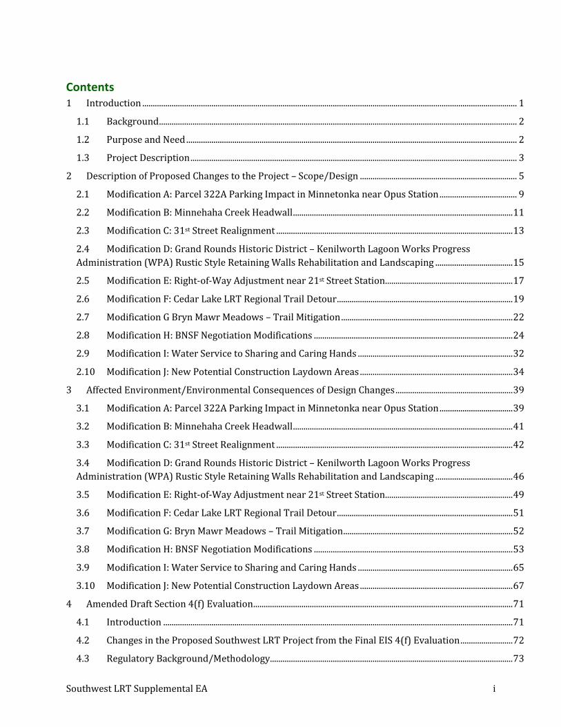
Contents 1 Introduction ................................................................................................................................................................................... 1
1.1 Background ........................................................................................................................................................................... 2
1.2 Purpose and Need .............................................................................................................................................................. 2
1.3 Project Description ............................................................................................................................................................ 3
2 Description of Proposed Changes to the Project – Scope/Design ........................................................................... 5
2.1 Modification A: Parcel 322A Parking Impact in Minnetonka near Opus Station ..................................... 9
2.2 Modification B: Minnehaha Creek Headwall ......................................................................................................... 11
2.3 Modification C: 31st Street Realignment ................................................................................................................. 13
2.4 Modification D: Grand Rounds Historic District – Kenilworth Lagoon Works Progress
Administration (WPA) Rustic Style Retaining Walls Rehabilitation and Landscaping ..................................... 15
2.5 Modification E: Right-of-Way Adjustment near 21st Street Station ............................................................. 17
2.6 Modification F: Cedar Lake LRT Regional Trail Detour .................................................................................... 19
2.7 Modification G Bryn Mawr Meadows – Trail Mitigation .................................................................................. 22
2.8 Modification H: BNSF Negotiation Modifications ............................................................................................... 24
2.9 Modification I: Water Service to Sharing and Caring Hands .......................................................................... 32
2.10 Modification J: New Potential Construction Laydown Areas ......................................................................... 34
3 Affected Environment/Environmental Consequences of Design Changes ........................................................ 39
3.1 Modification A: Parcel 322A Parking Impact in Minnetonka near Opus Station ................................... 39
3.2 Modification B: Minnehaha Creek Headwall ......................................................................................................... 41
3.3 Modification C: 31st Street Realignment ................................................................................................................. 42
3.4 Modification D: Grand Rounds Historic District – Kenilworth Lagoon Works Progress
Administration (WPA) Rustic Style Retaining Walls Rehabilitation and Landscaping ..................................... 46
3.5 Modification E: Right-of-Way Adjustment near 21st Street Station ............................................................. 49
3.6 Modification F: Cedar Lake LRT Regional Trail Detour .................................................................................... 51
3.7 Modification G: Bryn Mawr Meadows – Trail Mitigation ................................................................................. 52
3.8 Modification H: BNSF Negotiation Modifications ............................................................................................... 53
3.9 Modification I: Water Service to Sharing and Caring Hands .......................................................................... 65
3.10 Modification J: New Potential Construction Laydown Areas ......................................................................... 67
4 Amended Draft Section 4(f) Evaluation ............................................................................................................................ 71
4.1 Introduction ....................................................................................................................................................................... 71
4.2 Changes in the Proposed Southwest LRT Project from the Final EIS 4(f) Evaluation ......................... 72
4.3 Regulatory Background/Methodology.................................................................................................................... 73

Southwest LRT Supplemental EA ii
4.4 Use of Section 4(f) Property in the Project Study Area .................................................................................... 76
4.5 Coordination....................................................................................................................................................................... 98
4.6 Preliminary Determination of Section 4(f) Use ................................................................................................... 99
5 Comments and Coordination ................................................................................................................................................ 99
5.1 Public Engagement – BNSF Negotiation Modifications .................................................................................... 99
5.2 USFWS ................................................................................................................................................................................ 101
5.3 MnHPO ............................................................................................................................................................................... 101
5.4 Public Review ................................................................................................................................................................ 101
6 Commitments and Recommendations ........................................................................................................................... 101
List of Tables
Table 2-1: Proposed Modifications ................................................................................................................................................ 7
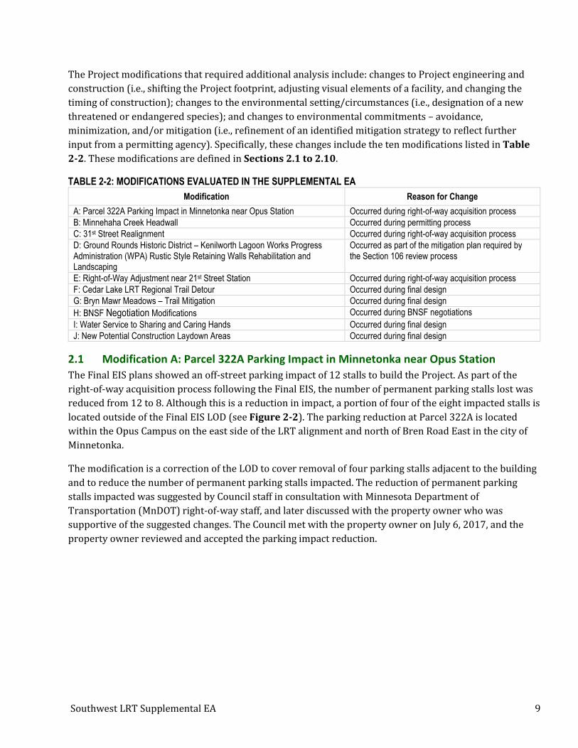
Table 2-2: Modifications Evaluated in the Supplemental EA .............................................................................................. 9
Table 3-1: Summary by Resource Category for Modification A ....................................................................................... 39
Table 3-2: Right-of-Way Summary for Parcel 322A Parking Impact ............................................................................. 40
Table 3-3: Summary by Resource Category for Modification B ....................................................................................... 41
Table 3-4: Summary by Resource Category for Modification C ....................................................................................... 42
Table 3-5: Right-of-Way Summary for 31st Street Realignment ...................................................................................... 43
Table 3-6: What’s In My Neighborhood Database Search within 550 Feet of 31st Street Realignment .......... 44
Table 3-7: Table from Phase II ESA of Sites within 550 Feet of 31st Street Realignment ...................................... 45
Table 3-8: Summary by Resource Category for Modification D ....................................................................................... 46
Table 3-9: Summary by Resource Category for Modification E ....................................................................................... 49
Table 3-10: Summary for Right-of-Way Adjustment near 21st Street Station............................................................ 50
Table 3-11: Summary by Resource Category for Modification F ..................................................................................... 51
Table 3-12: Summary by Resource Category for Modification G ..................................................................................... 52
Table 3-13: Summary by Resource Category for Modification H .................................................................................... 53
Table 3-14: Right-of-Way Summary for BNSF Negotiation Modifications .................................................................. 55
Table 3-15: Summary by Resource Category for Modification I ...................................................................................... 65
Table 3-16: What’s In My Neighborhood Database Search within 550 Feet of Water Service to Sharing and
Caring Hands ......................................................................................................................................................................................... 66
Table 3-17: Table from Phase II ESA of Sites near Sharing and Caring Hands .......................................................... 66
Table 3-18: Summary by Resource Category for Modification J ...................................................................................... 67
Table 3-19: What’s In My Neighborhood Database Search within 550 Feet of Laydown Area #1 ................... 69

Southwest LRT Supplemental EA iii
Table 3-20: What’s In My Neighborhood Database Search within 550 Feet of Laydown Areas #4 and #5 .. 69
Table 4-1: Impacts to Section 4(f) Properties.......................................................................................................................... 72
Table 4-2: Comparison of Impacts to StPM&M / GN Railway Historic District in the Final EIS and Amended
Draft Section 4(f) Evaluation .......................................................................................................................................................... 72
Table 4-3: Section 4(f) Property Evaluated in this Amended Draft Section 4(f) Evaluation ............................... 76
Table 4-4: Corridor Protection Treatments Considered ..................................................................................................... 86
List of Figures
Figure 1-1: Light Rail Alignment from the Final EIS ............................................................................................................... 4
Figure 2-1: Location of Project Modifications Evaluated in the Supplemental EA ..................................................... 8
Figure 2-2: Modification A: Parking Impact in Minnetonka near Opus Station ......................................................... 10
Figure 2-3: Modification B: Minnehaha Creek Headwall .................................................................................................... 12
Figure 2-4: Modification C: 31st Street Realignment ........................................................................................................... 14
Figure 2-5: Modification D: Grand Rounds Historic District – Kenilworth Lagoon Works Progress
Administration (WPA) Rustic Style Retaining Walls Rehabilitation and Landscaping .......................................... 16
Figure 2-6: Modification E: Right-of-Way Adjustment near 21st Street Station ....................................................... 18
Figure 2-7: Modification F: Cedar Lake LRT Regional Trail Detour (page 1 of 2) .................................................... 20
Figure 2-8: Modification G: Bryan Mawr Meadows ............................................................................................................... 23
Figure 2-9: Modificaiton H: BNSF Negotiation Modifications (page 1 of 5) ................................................................ 27
Figure 2-10: Modification H: BNSF Negotation Modifications (page 2 of 5) ............................................................... 28
Figure 2-11: Modification H: BNSF Negotiation Modifications (page 3 of 5) ............................................................. 29
Figure 2-12: Modification H: BNSF Negotiation Modifications (page 4 of 5) ............................................................ 30
Figure 2-13: Modification H: BNSF Negotiation Modifications (page 5 of 5) ............................................................. 31
Figure 2-14: Modification I: Water Service to Sharing and Caring Hands ................................................................... 33
Figure 2-15: Modification J: New Potential Construction Laydown Areas (page 1 of 4) ....................................... 35
Figure 2-16: Modification J: New Potential Construction Laydown Areas (page 2 of 4) ....................................... 36
Figure 2-17: Modification J: New Potential Construction Laydown Areas (page 3 of 4) ....................................... 37
Figure 2-18: Modification J: New Potential Construction Laydown Areas (page 4 of 4) ....................................... 38
Figure 3-1: Visualization of the CPB in the Bryn Mawr Meadows Area (View A)..................................................... 57
Figure 3-2: Plan of the CPB in the Bryn Mawr Meadows Area (View A) ...................................................................... 58
Figure 3-3: Visualization of the CPB in the Bryn Mawr Station Area (View B) .......................................................... 58
Figure 3-4: Visualization of the CPB in the Bryn Mawr Station Area (View B) .......................................................... 58
Figure 3-5: Existing Noise Walls in Relation to CPB Wall ................................................................................................... 61
Figure 4-1: Overview Map of 7th Street North to Linden Yards in Minneapolis ........................................................ 79

Southwest LRT Supplemental EA iv
Figure 4-2: Overview Map of Linden yards to Cedar Lake Yard in Minneapolis ....................................................... 80
Figure 4-3: Overview Map of Glenwood Avenue Bridges ................................................................................................... 81
Figure 4-4: Altnerative 3C-1 ........................................................................................................................................................... 90
Figure 4-5: Alternative 3C-2 ........................................................................................................................................................... 92
Figure 4-6: Alignment 1 – LPA Modified Alignment ............................................................................................................. 95
Figure 4-7: Alignment 2 – Alignment Selected to Advance in the Final EIS ................................................................ 96
Figure 4-8: Alignment 3 – Platform Located on a Diagonal Through Holden Street ............................................... 96
List of Appendices
Appendix A: Agency Coordination and Correspondence
Appendix B: 2013 Royalston Station/Interchange Project Connection Technical Issue Resolution
Appendix C: Corridor Protection Barrier Noise Assessment
Appendix D: Public Involvement
Appendix E: Rusty Patched Bumble Bee Memorandum
Southwest LRT Supplemental EA 1
1 Introduction The Federal Transit Administration (FTA) is the lead federal agency for the Southwest Light Rail Transit
(LRT) project. The Metropolitan Council is the project sponsor, federal grant applicant, and, under the
Minnesota Environmental Policy Act (MEPA), the designated Responsible Governmental Unit (RGU).
This Supplemental Environmental Assessment (Supplemental EA) has been prepared in accordance with
23 CFR Part 771.130 by the Metropolitan Council and the FTA to address changes in project design from
those analyzed in the Southwest Light Rail Transit Final Environmental Impact Statement (Final EIS),
Record of Decision (ROD), and Adequacy Determination (2016), which are a result of the Project’s
advancement into final engineering. This document analyzes whether there have been significant changes
to the proposed action, the affected environment, and the anticipated impacts or the proposed mitigation
measures required. Under MEPA, this Supplemental EA will serve as the state environmental assessment
worksheet (EAW) to evaluate the proposed changes to the Project. The analysis documented in this
Supplemental EA will be used by the Metropolitan Council to reach an informed and appropriate decision
whether to issue a Negative Declaration for the revised project (pursuant to Minnesota Rules, part
4410.1700) or that a Supplemental EIS is warranted.
Since publication of the Southwest LRT Final EIS, and issuance of the ROD, and state Adequacy
Determination in 2016, project modifications have been identified as engineering has advanced. Several of
these modifications have been due to comments or requests for clarifications from stakeholders as the
design has advanced. These Project changes range from administrative plan changes (i.e., detail or
dimension updates) to technical modifications (i.e., additions or modifications to the design of the LRT or
related equipment). These changes were evaluated to determine whether they have the potential to
change environmental impacts (for example, by screening for changes outside the limits of disturbance
(LOD)1 previously evaluated for the Project in the Final EIS.). It was concluded that the implementation of
many of these administrative plan changes and technical modifications will not result in impacts outside
of the LOD as defined in the Final EIS and will not result in increased Project-related environmental, social,
or economic impacts. These changes are therefore not evaluated in this document.
Since the publication of the Final EIS, and issuance of the ROD, and state Adequacy Determination, there
have also been design modifications to the Project that were identified during final design and permitting
processes that required further analysis to determine potential changes to impacts or mitigation. Ten of
these modifications, defined in Section 2, are the subject of this Supplemental EA.
The scope of this Supplemental EA is to report changes compared to the Project described in the
Southwest LRT Final EIS, ROD, and Adequacy Determination. This document contains the following
elements:
• Project Background
• Purpose and Need
• Description of the Proposed Changes
• Affected Environment and Environmental Consequences of Design Changes
1 Limits of disturbance is the area where the Project will result in permanent or temporary ground disturbances.

Southwest LRT Supplemental EA 2
• Amended Draft Section 4(f) Evaluation
• Comments and Coordination
• Commitments and Recommendations
The Southwest LRT Project Supplemental EA/Amended Draft Section 4(f) Evaluation will be available for
public review and comment following the federal and state environmental distribution requirements.
1.1 Background
The environmental decision-making process for the Southwest LRT Project dates to 2007 and is
documented in the following reports:
• Southwest Transitway Alternatives Analysis Final Report (Hennepin County Regional Railroad
Authority (HCRRA), 2007)
• Southwest Transitway Scoping Summary Report (HCRRA, 2009; amended in 2012)
• Southwest Transitway Draft Environmental Impact Statement (Draft EIS) (HCRRA, 2012)
• Southwest Light Rail Transit (METRO Green Line Extension) Supplemental Draft EIS (Metropolitan
Council (Council), 2015)
• Southwest Light Rail Transit (METRO Green Line Extension) Final EIS (Council, 2016)
• Record of Decision (ROD) on the Southwest Light Rail Transit Project (METRO Green Line Extension)
(Federal Transit Administration (FTA), 2016)
• Adequacy Determination on the Southwest Light Rail Transit Project (Council, 2016)
The Project’s Final EIS was published in May 2016, the issuance of the ROD in July 2016, and the state
Adequacy Determination followed in August 2016. The Project was defined in the Final EIS based on the
Project’s 60% plans. Since the issuance of the ROD and Adequacy Determination, the project has advanced
into final engineering.
1.2 Purpose and Need
As documented in the ROD, the purpose of the Southwest LRT Project includes the following:
• The Southwest LRT Project will improve access and mobility to jobs and activity centers in the
Minneapolis central business district, as well as along the entire length of the corridor for reverse-
commute trips to the expanding suburban employment centers.
• The Southwest LRT Project will provide a competitive, cost-effective travel option that will attract
choice riders to the transit system. The competitive and reliable travel time for the Southwest LRT
Project is attributed to the diagonal nature of the line compared to the north-south/east-west
orientation of the roadway network and to the increasing levels of congestion of the roadway
network.
• The Southwest LRT Project will be part of the region’s system of transitways integrated to support
regional transportation efficiency. Since the late 1990s, the Southwest LRT Project has been
identified by the Council as warranting a high level of transit investment to respond to increasing
travel demand in a highly-congested area of the region. Due to congestion levels on the roadway
network, speed and use limitations of the shoulder bus operations, and capacity constraints in
downtown Minneapolis, a bus option is limited in its ability to adequately serve the travel demand
and to provide reliable travel times.

Southwest LRT Supplemental EA 3
Four primary need factors make the Southwest LRT Project important for people who live and work in the
southwest metropolitan area:
• Declining mobility;
• Limited competitive, reliable transit options for choice riders and people who rely on public
transportation, including reverse-commute riders;
• Need to maintain a balanced and economically competitive multimodal freight system; and
• Regional/local plans calling for investment in additional light rail transit projects in the region.
The Project’s purpose and need has not changed since the issuance of the ROD and state Adequacy
Determination, and no future changes to the purpose and need will occur.
1.3 Project Description
As defined in the Final EIS, ROD, and state Adequacy Determination, the Southwest LRT Project
(Southwest LRT Project or Project) is approximately 14.5 miles of new double track light rail alignment
planned as an extension of the METRO Green Line (Central Corridor LRT), which will operate from
downtown Minneapolis through the communities of St. Louis Park, Hopkins, Minnetonka, and Eden
Prairie, passing proximate to the city of Edina. Southwest LRT will operate primarily at-grade, with
structures providing grade separation of LRT crossings, roadways, and water bodies at specified locations.
For just under one-half mile, it will operate in a shallow LRT tunnel in the Kenilworth Corridor between
West Lake Street and just south of the Kenilworth Lagoon, with an at-grade light rail bridge over the
lagoon.
The planned light rail alignment from Eden Prairie to Target Field in Minneapolis will have 16 stations:
SouthWest, Eden Prairie Town Center (deferred), Golden Triangle, and City West Stations in Eden Prairie;
Opus Station in Minnetonka; Shady Oak, Downtown Hopkins, and Blake Stations in Hopkins; Louisiana,
Wooddale, and Beltline Stations in St. Louis Park; and West Lake, Penn, 21st Street, Van White, and
Royalston Stations in Minneapolis (see Figure 1-1). Major elements that will be incorporated onto the
station platforms include shelters, lighting, furniture, and fencing and railing. All stations will include
accessible connections to local street networks and sidewalks. The alignment also includes approximately
2,500 additional park-and-ride spaces, accommodations for passenger drop-off, and bicycle and
pedestrian access, as well as new or restructured local bus route connection stations to nearby residential,
commercial, and education destinations. Freight rail operations will remain in the existing location in the
Kenilworth Corridor. The light rail and freight rail alignments will be co-located for approximately 5.9
miles through the Bass Lake Spur and Kenilworth Corridor, as well as approximately 1.4 miles in the
Wayzata Subdivision.

Southwest LRT Supplemental EA 4
FIGURE 1-1: LIGHT RAIL ALIGNMENT FROM THE FINAL EIS2
An additional 27 light rail vehicles (LRVs) will be added to the Green Line fleet for the operation of the
Project. The additional LRVs will be stored and maintained in the new operations and maintenance facility
(OMF) to be located in Hopkins. In general, light maintenance activities and the storage of vehicles not in
service will occur within enclosed structures, although some maintenance activities, including moving
vehicles between functional areas within the OMF, will occur outside of buildings. Activities on the 15-acre
site will include washing, routine cleaning, routine maintenance, and inspections of the trains; parts
storage; and maintenance-related office functions. The planned Hopkins OMF site will include a network
of light rail switching track, an approximately 110-space surface parking lot for employees and visitors,
storage and maintenance of nonrevenue vehicles, and office space for employees. An LRV storage barn will
include five storage bays (with six vehicles per bay) to accommodate a total of 30 vehicles. The storage
barn will be designed to accommodate future expansion on Council property, including a sixth storage bay
on the west side of the facility to house a total of 36 vehicles. Heavy maintenance of the Project’s LRVs,
including wheel truing, major body repair, and painting, will occur at the existing Franklin Street OMF,
2 Note: Since the publication of the Final EIS, the following stations have changed names: Penn Station is now Bryn Mawr Station, Van White Station is now Bassett Creek Valley Station, and Royalston Station is now Royalston Avenue/Farmers Market Station.
Southwest LRT Supplemental EA 5
which is outside of the Project vicinity and will not need to be expanded to accommodate the LRVs added
for the Project.
The Project will require facilities to provide signaling and power to the light rail alignment and LRVs.
Active devices, such as traffic signals, railroad-type flashers, and bells, are planned to control traffic at
locations where the light rail alignment will cross public streets. The Project includes 20 traction power
substation (TPSS) facilities that will provide power for the LRVs through an overhead wire system. The
TPSS facilities will be completely enclosed and will include perimeter fencing. The Project also includes 25
signal bungalow sites, which will house the equipment to operate and monitor the signals that regulate
light rail train movement on the alignment. Appendix E of the Final EIS lists and illustrates the TPSS and
signal bungalow sites along the light rail alignment.
Relative to roadways, the Project includes intersection modifications, new traffic signals, changes to
existing traffic signals, and other traffic management techniques. Those roadway modifications will be at
intersections and at-grade light rail crossings of roadways within the roadways and traffic study area. The
Project also includes bicycle and pedestrian improvements that will provide safe bicycle and pedestrian
crossings of the proposed light rail alignment. The bicycle and pedestrian improvements will help
accommodate the light rail and roadway improvements and will provide bicycle and pedestrian
connections to the light rail stations.
The Final EIS also evaluated a range of Locally Requested Capital Investments (LRCIs). LRCIs are
improvements proposed by Eden Prairie, Minnetonka, Hopkins, St. Louis Park, and Hennepin County to be
undertaken separate from, but contingent upon, implementation of the Locally Preferred Alternative
(LPA). These improvements are not needed to support the base function of the LPA, nor do they represent
mitigation for any impact of the LPA. These activities may be implemented independently by the
stakeholders at a future date and are not conditions of the Project. However, in most cases, implementing
a LRCI separately would not be as efficient as constructing the LRCI in coordination with the Project. The
Final EIS included LRCIs to show the full range of potential Project components, evaluate the impacts, and
ensure mitigation measures are provided for LRCIs, where applicable. No additional LRCIs have been
added since the publication of the Final EIS and issuance of the ROD and state Adequacy Determination.
2 Description of Proposed Changes to the Project – Scope/Design Since the publication of the Final EIS, and issuance of the ROD and state Adequacy Determination, there
have been design modifications to the Project identified during final design that required further analysis
to determine potential changes to impacts or mitigation. The Project modifications are located along the
corridor in the cities of Minneapolis, Minnetonka, and St. Louis Park. No modifications are located within
the cities of Hopkins or Eden Prairie. Locations of Project modifications along the LRT alignment are
shown in Figure 2-1.
The focus of this Supplemental EA is on the Project modifications and whether the changes affect the
environmental impacts, as identified in the Final EIS, ROD and state Adequacy Determination. The
resource categories studied in the Final EIS were evaluated against the Project modifications to assess the
potential change in impacts and/or mitigation measures. This section describes the background for each
Project modification and summarizes impacts identified in the Final EIS. Table 2-1 documents the Project

Southwest LRT Supplemental EA 6
modifications and indicates with green circles () which resource categories could be affected by the
proposed changes. These resource categories are evaluated in this Supplemental EA to determine whether
the design modifications result in an additional impact or increase the severity of the impact compared to
the findings in the Final EIS. Based on the scale, type of impact, and location of the Project modifications,
some resource categories were not evaluated further as they did not alter the impacts and/or mitigation
findings from the Final EIS.
Section 3 provides the resulting analysis for each identified design modification and the affected resource
categories. Threatened and endangered species were evaluated per Section 7 of the Endangered Species
Act of 1973 on a corridor-wide level, and further analysis is documented in Section 5.2 and Appendix E.

Southwest LRT Supplemental EA 7
TABLE 2-1: PROPOSED MODIFICATIONS
RESOURCE CATEGORIES EVALUATED IN THE FINAL EIS M
od
ific
atio
n ID
Project Modification Description S
ecti
on
7 (
Th
reat
ened
an
d
En
dan
ger
ed S
pec
ies)
3
Lan
d U
se
Eco
no
mic
Act
ivit
y
Nei
gh
bo
rho
od
an
d
Co
mm
un
ity
Acq
uis
itio
ns
and
Dis
pla
cem
ents
Cu
ltu
ral R
eso
urc
es
Par
ks, R
ec, A
nd
Op
en
Sp
ace
Vis
ual
Qu
alit
y an
d
Aes
thet
ics
Geo
log
y an
d G
rou
nd
wat
er
Res
ou
rces
Su
rfac
e W
ater
Res
ou
rces
Eco
syst
ems
Air
Qu
alit
y
No
ise/
Vib
rati
on
Haz
ard
ou
s an
d
Co
nta
min
ated
Mat
eria
ls
Uti
litie
s
En
erg
y
Cu
mu
lati
ve Im
pac
ts
Pu
blic
Tra
nsp
ort
atio
n
Ro
adw
ays
and
Tra
ffic
Par
kin
g
Fre
igh
t R
ail
Ped
estr
ian
an
d B
icyc
le
Saf
ety
and
Sec
uri
ty
En
viro
nm
enta
l Ju
stic
e
Sec
tio
n 4
(f)
A Parcel 322A Parking Impact in Minnetonka near Opus Station
B Minnehaha Creek Headwall
C 31st Street Realignment
D
Grand Rounds Historic District – Kenilworth Lagoon Works Progress Administration (WPA) Rustic Style Retaining Walls Rehabilitation and Landscaping
E Right-of-Way Adjustment near 21st Street Station
F Cedar Lake LRT Regional Trail Detour
G Bryn Mawr Meadows – Trail Mitigation
H BNSF Negotiation Modifications
I Water Service to Sharing and Caring Hands
J New Potential Construction Laydown Areas
3 Update to Section 7 (Threatened and Endangered Species) is a corridor-wide resource category reflecting the change in the Rusty Patched Bumble Bee status since the publication of the Final EIS, and issuance of the ROD and state Adequacy Determination. For more information, refer to Section 5.2 and Appendix E of this document.

Southwest LRT Supplemental EA 8
FIGURE 2-1: LOCATION OF PROJECT MODIFICATIONS EVALUATED IN THE SUPPLEMENTAL EA
Southwest LRT Supplemental EA 9
The Project modifications that required additional analysis include: changes to Project engineering and
construction (i.e., shifting the Project footprint, adjusting visual elements of a facility, and changing the
timing of construction); changes to the environmental setting/circumstances (i.e., designation of a new
threatened or endangered species); and changes to environmental commitments – avoidance,
minimization, and/or mitigation (i.e., refinement of an identified mitigation strategy to reflect further
input from a permitting agency). Specifically, these changes include the ten modifications listed in Table
2-2. These modifications are defined in Sections 2.1 to 2.10.
TABLE 2-2: MODIFICATIONS EVALUATED IN THE SUPPLEMENTAL EA
Modification Reason for Change
A: Parcel 322A Parking Impact in Minnetonka near Opus Station Occurred during right-of-way acquisition process
B: Minnehaha Creek Headwall Occurred during permitting process
C: 31st Street Realignment Occurred during right-of-way acquisition process
D: Ground Rounds Historic District – Kenilworth Lagoon Works Progress Administration (WPA) Rustic Style Retaining Walls Rehabilitation and Landscaping
Occurred as part of the mitigation plan required by the Section 106 review process
E: Right-of-Way Adjustment near 21st Street Station Occurred during right-of-way acquisition process
F: Cedar Lake LRT Regional Trail Detour Occurred during final design
G: Bryn Mawr Meadows – Trail Mitigation Occurred during final design
H: BNSF Negotiation Modifications Occurred during BNSF negotiations
I: Water Service to Sharing and Caring Hands Occurred during final design
J: New Potential Construction Laydown Areas Occurred during final design
2.1 Modification A: Parcel 322A Parking Impact in Minnetonka near Opus Station
The Final EIS plans showed an off-street parking impact of 12 stalls to build the Project. As part of the
right-of-way acquisition process following the Final EIS, the number of permanent parking stalls lost was
reduced from 12 to 8. Although this is a reduction in impact, a portion of four of the eight impacted stalls is
located outside of the Final EIS LOD (see Figure 2-2). The parking reduction at Parcel 322A is located
within the Opus Campus on the east side of the LRT alignment and north of Bren Road East in the city of
Minnetonka.
The modification is a correction of the LOD to cover removal of four parking stalls adjacent to the building
and to reduce the number of permanent parking stalls impacted. The reduction of permanent parking
stalls impacted was suggested by Council staff in consultation with Minnesota Department of
Transportation (MnDOT) right-of-way staff, and later discussed with the property owner who was
supportive of the suggested changes. The Council met with the property owner on July 6, 2017, and the
property owner reviewed and accepted the parking impact reduction.

Southwest LRT Supplemental EA 10
FIGURE 2-2: MODIFICATION A: PARKING IMPACT IN MINNETONKA NEAR OPUS STATION
Southwest LRT Supplemental EA 11
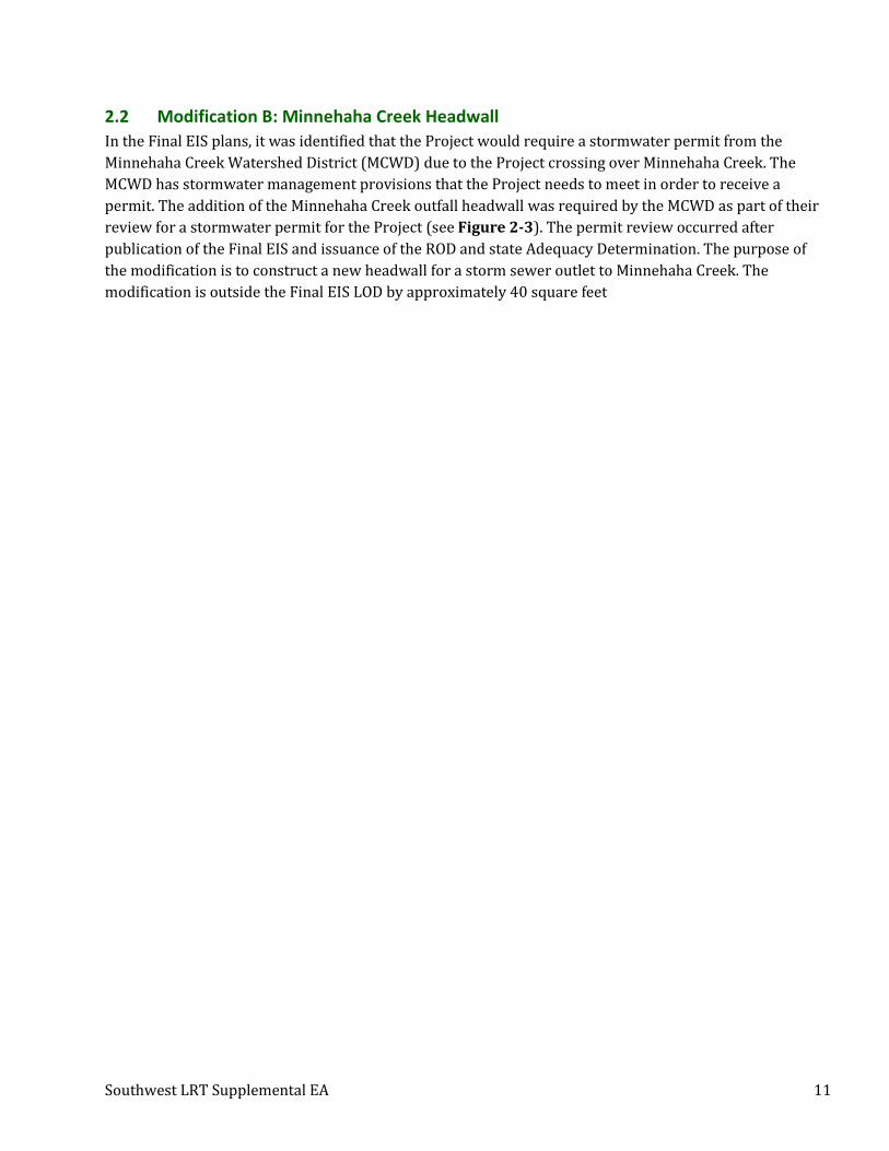
2.2 Modification B: Minnehaha Creek Headwall
In the Final EIS plans, it was identified that the Project would require a stormwater permit from the
Minnehaha Creek Watershed District (MCWD) due to the Project crossing over Minnehaha Creek. The
MCWD has stormwater management provisions that the Project needs to meet in order to receive a
permit. The addition of the Minnehaha Creek outfall headwall was required by the MCWD as part of their
review for a stormwater permit for the Project (see Figure 2-3). The permit review occurred after
publication of the Final EIS and issuance of the ROD and state Adequacy Determination. The purpose of
the modification is to construct a new headwall for a storm sewer outlet to Minnehaha Creek. The
modification is outside the Final EIS LOD by approximately 40 square feet

Southwest LRT Supplemental EA 12
FIGURE 2-3: MODIFICATION B: MINNEHAHA CREEK HEADWALL

Southwest LRT Supplemental EA 13
2.3 Modification C: 31st Street Realignment
The realignment of 31st Street is located near the West Lake Station between Chowen Avenue South and
Abbott Avenue South in Minneapolis. The Final EIS preliminary engineering plans included a realignment
of 31st Street. As part of a redevelopment proposal by an adjacent land owner after the Final EIS was
published in 2016, the property owner, with the support of the City of Minneapolis, requested the
realignment be modified to maximize developable space on their property. The negotiations for this
change started in 2017 and are still ongoing with the property owner.
This modification allows for a parcel that is more suitable for redevelopment, which is consistent with
both the City of Minneapolis Plan for Sustainable Growth (2009) and Hennepin County Transitional
Station Area Action Plan (2013) goals for this area. With this modification, 31st Street will shift
approximately 80 feet to the north (see Figure 2-4).

Southwest LRT Supplemental EA 14
FIGURE 2-4: MODIFICATION C: 31ST STREET REALIGNMENT

Southwest LRT Supplemental EA 15
2.4 Modification D: Grand Rounds Historic District – Kenilworth Lagoon Works Progress
Administration (WPA) Rustic Style Retaining Walls Rehabilitation and Landscaping
The Final EIS plans show the light rail alignment descending into a shallow cut-and-cover tunnel for just
under one-half mile, from approximately 400 feet north of West Lake Station and returning to grade
approximately 500 feet south of the Kenilworth Lagoon. The alignment will continue north at-grade and in
the Kenilworth Corridor (crossing the Kenilworth Lagoon on a new light rail bridge over the Cedar Lake
Channel), until it reaches the proposed at-grade 21st Street Station. The Final EIS evaluated and disclosed
that there was an adverse effect finding under Section 106 to the Kenilworth Lagoon, which is a
contributing element to both the Grand Rounds Historic District and the Lake of the Isles Residential
Historic District, both of which have been determined eligible for inclusion in the National Register of
Historic Places (NRHP.). The adverse effect was due to the partial destruction and alteration of the
contributing WPA Rustic style retaining walls and landscape for construction of new bridges for the
Project. The mitigation measure identified was to implement the Section 106 Memorandum of Agreement
(MOA) mitigation for the bridge design (a complete list of mitigation measures is outlined in Section
3.4.4.1 of the Final EIS on page 3-122).
As part of the Section 106 mitigation for the adverse effect, the LOD has increased by approximately 0.32
acre to extend past the Kenilworth Lagoon/Cedar Lake Channel bridges in order to rehabilitate portions of
the WPA Rustic style retaining walls and plant vegetation along the Kenilworth Lagoon/Cedar Lake
Channel (see Figure 2-5) in line with the Secretary of Interior’s Standards for the Treatment of Historic
Properties (SOI Standards). One of the mitigation measures identified through the Section 106 process and
stipulated in the MOA to resolve the adverse effect was the rehabilitation and reconstruction of the
Kenilworth Lagoon WPA Rustic style retaining walls. At the time the Final EIS was published, the
geographic extent of the rehabilitation and reconstruction was not yet known and was later determined
through further consultation. The terms of the MOA have been applied, including consultation to develop
construction plans and design review. The design of the repair work was discussed in consulting meetings
in September 2016 to discuss the boundaries and type of repair work. Review of 90% and 100% plans
occurred in August 2016 and April 2017. The repair work identified through the Section 106 process and
stipulated in the MOA for this Project modification includes the following:
• Reconstruction of walls that must be removed for construction of the Project; and
• Rehabilitation, restoration, and preservation of the walls that will remain as shown in the
engineering plans.
The MOA also required additional consultation with consulting parties under Section 106 to inform the
100% plans for additional Southwest LRT Project elements within and in the vicinity of the Grand Rounds
Historic District, including the Kenilworth Lagoon. A consulting meeting was held in June 2017 to discuss
the proposed planting locations and plant types. The outcome of discussions with consulting parties
included plantings in locations outside the LOD evaluated in the Final EIS. The current plans for
landscaping around the Kenilworth Channel extend 0.07 acre outside the LOD evaluated in the Final EIS,
and the retaining wall reconstruction extends outside of the LOD by 0.25 acre, for a total increase of 0.32
acre.

Southwest LRT Supplemental EA 16
FIGURE 2-5: MODIFICATION D: GRAND ROUNDS HISTORIC DISTRICT – KENILWORTH LAGOON WORKS PROGRESS ADMINISTRATION (WPA) RUSTIC
STYLE RETAINING WALLS REHABILITATION AND LANDSCAPING

Southwest LRT Supplemental EA 17
2.5 Modification E: Right-of-Way Adjustment near 21st Street Station
The preliminary engineering plans from the Final EIS show a partial property acquisition and a temporary
construction easement needed for the Project from a private property located on Thomas Avenue South in
Minneapolis near the 21st Street Station. The Kenilworth Trail runs parallel to the Project’s alignment, and
the Final EIS plans show the trail shifting to accommodate the Project. A 66-foot long retaining wall was
shown in the Final EIS plans along the east side of the Kenilworth Trail, just northeast of the 21st Street
Station on Thomas Avenue South to accommodate grading for the trail shift. A 6-foot tall, 66-foot long
chain-link fence on top of the retaining wall was also planned to provide fall protection.
After publication of the Final EIS, the property owner on Thomas Avenue South raised concerns and the
Council determined that it would make modifications to better address grades near the 21st Street Station.
The planned retaining wall and fence is being extended to accommodate grades by approximately 66 feet
for the wall and 25-feet of wood fence (see Figure 2-6). The portion of the fence that continues past the
property on Thomas Avenue South is chain-link and is approximately 41-feet long. Minor grading of the
adjacent property owner’s backyard is required because of the extension of the retaining wall. The area to
be graded is outside the Final EIS LOD by approximately 1,500 square feet. The Property owner agreed to
the easement terms on December 28, 2017.

Southwest LRT Supplemental EA 18
FIGURE 2-6: MODIFICATION E: RIGHT-OF-WAY ADJUSTMENT NEAR 21ST STREET STATION

Southwest LRT Supplemental EA 19
2.6 Modification F: Cedar Lake LRT Regional Trail Detour
The Final EIS plans show that portions of the light rail alignment will be located within or adjacent to the
Cedar Lake LRT Regional Trail. In the Final EIS, the trail was identified to generally remain open during
construction, with limited temporary closures. The Final EIS identified that the Cedar Lake LRT Regional
Trail will be maintained on temporary detour facilities within the existing right-of-way for portions of the
construction period. It further indicated that construction of the Project will be phased in such a way that
a paved surface will be maintained for use by pedestrians and bicyclists proximate to the existing trail. At
the trail crossings of Minnehaha Creek and Louisiana Avenue, trail and freight bridge construction will be
phased such that a bridge will be available for pedestrian and bicycle usage during construction.
As design advanced, modifications to the trail closure and detours were defined to maximize construction
efficiency and safety of the trail users. This Project modification includes changing the trail mitigation by
closing the Cedar Lake LRT Regional Trail between Excelsior Boulevard in Hopkins (just east of Trunk
Highway (TH) 169) to France Avenue in Minneapolis (between Beltline and West Lake Street Stations)
during construction. During the closure, two pedestrian and bicycle detours will be provided: North Cedar
Lake Trail or Minnetonka Boulevard (shown in yellow and orange on Figure 2-7). As part of the trail
closure, there will also be a new temporary regional trail built adjacent to the existing corridor to connect
the Cedar Lake LRT Regional Trail to the detour routes (shown in blue on Figure 2-7). This modification
results in no change to the Final EIS LOD.
The Cedar Lake LRT Regional Trail is owned by Hennepin County Regional Railroad Authority (HCRRA)
and leased and operated by Three Rivers Park District. Council staff met several times with the affected
agencies, including the Cities of St. Louis Park, Hopkins, and Minneapolis, and this determination to close
the trail was made at the staff level with the affected agencies. This Project modification will be formalized
during the land transfer agreement that is currently under negotiation between the Council and HCRRA
for the use and ownership of the trail during construction.

Southwest LRT Supplemental EA 20
FIGURE 2-7: MODIFICATION F: CEDAR LAKE LRT REGIONAL TRAIL DETOUR (PAGE 1 OF 2)

Southwest LRT Supplemental EA 21
MODIFICATION F: CEDAR LAKE LRT REGIONAL TRAIL DETOUR (PAGE 2 OF 2)

Southwest LRT Supplemental EA 22
2.7 Modification G Bryn Mawr Meadows – Trail Mitigation
The Final EIS and Final Section 4(f) Evaluation (pages 6-56 through 6-60) outline and assess the Project
impacts to Bryn Mawr Meadows Park in Minneapolis. Included in that analysis was the removal of the
existing Luce Line bicycle/pedestrian bridge that crosses the BNSF freight rail tracks and the addition of a
new bridge that connects the park to the Bassett Creek Valley station (see Figure 2-8). At the time the
Final EIS/Final Section 4(f) Evaluation was completed, the construction approach was to keep the existing
bicycle/pedestrian bridge open while the new bridge was under construction, limiting the time of closure
for north/south access in this area to approximately three months. The park is owned by the Minneapolis
Park and Recreation Board (MPRB), and, at the time of the Final EIS, there was not a detour route
determined during the expected three-month closure. A temporary trail was shown in the Final EIS, within
Bryn Mawr Meadows Park that extended from the existing bridge into the park to make a connection to
the future detour route. The temporary trail will be removed and re-seeded after construction is complete.
The Final EIS documented that there would be a Section 4(f) use with a de minimis impact for the
acquisition of 0.4 acres of a permanent easement to accommodate the replacement of the trail bridge and
modification of the trail alignment in the park.
This Project modification is to enhance the construction efficiency of the Project by closing and removing
the existing bicycle/pedestrian bridge earlier in the construction schedule. This will extend the time
period where north/south pedestrian and bicycle access over the BNSF freight rail tracks is closed from
three-months to approximately one year. A pedestrian and bicycle detour route has recently been
identified and is shown in Figure 2-8. The proposed trail detour will be on existing park trails, and part of
the detour will use the temporary trail identified and analyzed in the Final EIS. Before construction starts
on the bridge, an approximately 1,800-foot section of the detour trail within the Bryn Mawr Meadows
Park will be repaved as part of the Project. The trail re-pavement will take approximately one week to
complete and will occur prior to its use as a detour route. All other activities outlined in the Final Section
4(f) Evaluation remain unchanged.

Southwest LRT Supplemental EA 23
FIGURE 2-8: MODIFICATION G: BRYAN MAWR MEADOWS

Southwest LRT Supplemental EA 24
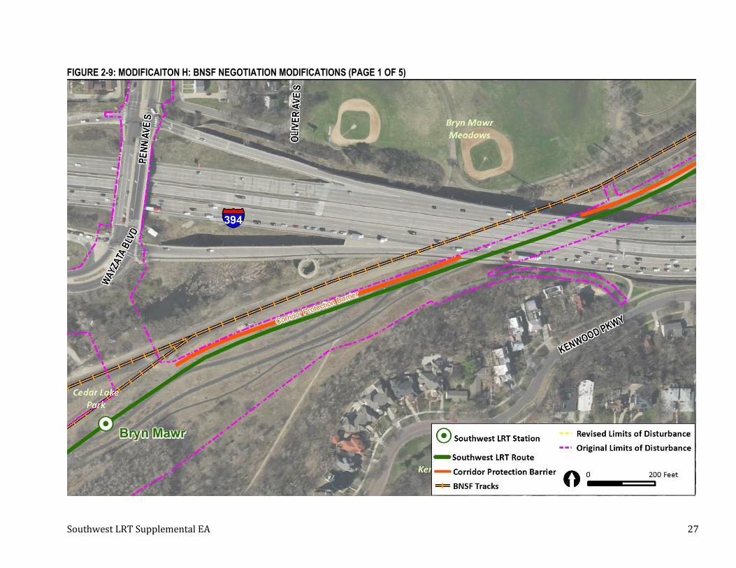
2.8 Modification H: BNSF Negotiation Modifications
In the Final EIS, it was identified that the Project will result in the permanent incorporation of
approximately 1.53 acres of property from the St. Paul, Minneapolis & Manitoba Railroad / Great Northern
Railway Historic District (StPM&M / GN Historic District), and approximately 5.42 acres will be
temporarily occupied for construction access.
The preliminary plans from the Final EIS show that a portion of the StPM&M / GN rail line in Minneapolis
is located within the Project corridor in the Wayzata Subdivision, which is owned by BNSF, and is a
contributing segment of the StPM&M / GN Historic District. The Project as defined in the Final EIS will
shift a segment of the existing BNSF railroad tracks from approximately I-94 to Royalston Avenue (total
length of 2,543 feet) approximately 0 to 25 feet north within the existing railroad right-of-way. The
continuity of the linear resource will be maintained within the historic right-of-way, resulting in a minor
effect to the alignment of the tracks. It was anticipated that a fence between the BNSF tracks and the LRT
alignment would be included as part of the Project once negotiations occurred with BNSF; however, a
fence was not shown in the Final EIS.
On August 16, 2017, the Council authorized negotiations for agreements with BNSF related to portions of a
1.4-mile-long segment of BNSF’s Wayzata Subdivision between downtown Minneapolis and the I-394
bridge and from the I-394 bridge to just east of the Project’s Bryn Mawr Station.
The Project modifications requested as a result of the negotiations include a new freight corridor
protection barrier (CPB) between the Project’s LRT tracks and the BNSF freight tracks for 1.4 miles, an
extension of the Northstar Commuter Rail tail track by 1,830 feet from the current end of the tail track,
and bridge and retaining wall modifications.4 The CPB is being added to the Project because BNSF requires
corridor protection between light rail tracks and BNSF’s Wayzata Subdivision freight rail tracks when they
run side by side. New CPB will increase the total length of the barrier (walls and pier protection) between
the freight and LRT from approximately 1,523 feet (0.29 miles) to 7,105 feet (1.35 miles; includes pier
protection for I-394 and Luce Line Trail bridges that was part of previous design documented in the Final
EIS) in length. The Southwest LRT Project cannot be built on BNSF land without BNSF’s agreement. See
Figure 2-9 to Figure 2-13 for an overview of the locations of these modifications.
The following are descriptions of the modifications required by BNSF:
Northstar Tail Track (shown on Figure 2-12 and Figure 2-13)
• Realign and extend the Northstar Commuter Rail tail track to maintain sufficient space within the
BNSF right-of-way to allow for possible reinstallation of a second main line track:
o Realign existing tail track from its connection with the BNSF main line just south of the 10th
Street North Bridge to current end of track at the 12th Street North (Royalston Avenue)
Bridge.
o Extend tail track west approximately 1,830 feet from the current end of the tail track.
4 The Council consulted with the freight rail companies in connection with the preliminary design and engineering necessary to complete the environmental review of the Southwest LRT Project. After the ROD was issued in July 2016, the Council began discussions with the freight rail companies regarding final design and potential property acquisitions. On August 16, 2017, the Council authorized the negotiation of agreements with BNSF.

Southwest LRT Supplemental EA 25
• Realign fencing and add an additional fence between the BNSF main line track and the Northstar
tail track.
Cedar Lake Trail (shown on Figure 2-12 and Figure 2-13)
• Realign the existing Cedar Lake Trail to accommodate construction of the Northstar tail track
extension:
o Realign the trail from just east of the 12th Street North (Royalston Avenue) Bridge to a
location under the I-94 bridges.
Drainage
• Modify the design of drainage basins and inlets to accommodate the CPB wall, Northstar tail track
extension, and the re-alignment of the Cedar Lake Trail.
LRT over BNSF - Bridge R0697 (shown on Figure 2-13)
• Modify the pier design (Piers 1–9) for heavy construction.
• Adjust the pier spacing of Piers 4 and 5 to mitigate conflict with an existing CenturyLink
underground line.
• Modify the bridge snow barrier section to improve crashworthiness.
Glenwood Avenue - Bridges 27C16 and 27C17 (shown on Figure 2-13)
• Add an infill section of pier protection on the Bridge 27C16 (Glenwood West) pier.
• Modify a Bridge 27C17 (Glenwood East) pier to a solid wall pier design for crash protection
adjacent to the Northstar tail track.
• Revise (increase) the fence height on Bridge 27C17 (Glenwood East) over the Northstar tail track
to match height over the BNSF tracks.
Retaining Walls (shown on Figure 2-13)
• Increase the LOD to realign the Cedar Lake Trail and build new retaining walls.
• Retaining Wall E412:
o Shift the location of the wall several feet to the west to place the wall and its footings
outside of BNSF right-of-way (except at bridge tie-ins).
o Modify the design for the wall to allow it to be shifted, including adjusting the height of the
wall; previously approved 4-foot by 8-foot grid pattern surface finish will not change.
• Retaining Walls E406 and E408:
o Add new Retaining Walls E406 and E408 along realigned trail:
▪ New walls to replace historic walls described under “Historic Retaining Walls.”
▪ Finish surface to match 4-foot by 8-foot grid pattern previously approved for
Retaining Walls E411 and E412.
• Historic Retaining Walls:
o Remove a deteriorated historic formed concrete retaining wall that is a contributing
feature of the StPM&M / GN Historic District and a non-historic concrete block retaining
wall, both on the east/southeast side of the railroad corridor, between the 12th Street

Southwest LRT Supplemental EA 26
pedestrian way and the 12th Street Bridge to accommodate construction of the realigned
Cedar Lake Trail.
o Remove a historic stone masonry retaining wall that is a contributing feature of the
StPM&M / GN Historic District on the east/southeast side of the railroad corridor between
the 12th Street Bridge and Glenwood Avenue Bridge to accommodate construction of the
realigned Cedar Lake Trail.
o Remove remnants of a historic heavy timber retaining wall that is a contributing feature of
the StPM&M / GN Historic District on the west/northwest side of the railroad corridor
between the 12th Street Bridge and Glenwood Avenue Bridge to allow for the construction
of the realigned Retaining Wall E412.
Corridor Protection Barrier Wall (shown on Figure 2-9 to Figure 2-12)
• New permanent easement added to maintain the CPB wall and for freight track drainage.
• Modify the height of CPB Walls E404 and E405 up to Bridge R0697 (LRT over BNSF):
o Increase the minimum height from 6 feet above the railhead to 7.5 feet above the railhead
(approximately 10 feet above grade) on the freight rail side of the walls.
• Add a new 5,582-foot (1.06-mile) CPB wall along the west/northwest side of the LRT tracks from
Retaining Wall E404 at the I-94 bridges to the Bryn Mawr Station:
o Wall will extend 7.5 feet above the railhead (10 feet above grade) on the freight rail side,
visible height on LRT side will vary;
o New CPB walls will increase the total length of the barrier (walls and pier protection)
between the freight and LRT from approximately 1,523 feet (0.29 miles) to 7,105 feet (1.35
miles); includes pier protection for I-394 and Luce Line Trail bridges that was part of
previous design documented in the Final EIS.
• Modify track slabs at Linden Yard utility crossings to accommodate the CPB wall.
Southwest LRT Supplemental EA 27
FIGURE 2-9: MODIFICAITON H: BNSF NEGOTIATION MODIFICATIONS (PAGE 1 OF 5)

Southwest LRT Supplemental EA 28
FIGURE 2-10: MODIFICATION H: BNSF NEGOTATION MODIFICATIONS (PAGE 2 OF 5)
Southwest LRT Supplemental EA 29
FIGURE 2-11: MODIFICATION H: BNSF NEGOTIATION MODIFICATIONS (PAGE 3 OF 5)

Southwest LRT Supplemental EA 30
FIGURE 2-12: MODIFICATION H: BNSF NEGOTIATION MODIFICATIONS (PAGE 4 OF 5)

Southwest LRT Supplemental EA 31
FIGURE 2-13: MODIFICATION H: BNSF NEGOTIATION MODIFICATIONS (PAGE 5 OF 5)

Southwest LRT Supplemental EA 32
2.9 Modification I: Water Service to Sharing and Caring Hands
The Final EIS evaluated and disclosed that within the city of Minneapolis there are multiple water mains
that run parallel to or cross the proposed LRT alignment within the existing HCRRA-owned right-of-way,
Canadian Pacific Railway corridor, and along Royalston Avenue. During final engineering, it was
determined and confirmed by the City of Minneapolis Public Works that the existing water service needed
to be relocated at Royalston Avenue North and 5th Avenue North in Minneapolis (see Figure 2-14). This
modification of water service to the non-profit organization Sharing and Caring Hands at the Royalston
Avenue Station will involve removing and replacing 75 feet of existing 8-inch ductile iron pipe (DIP) water
service to clear the way for proposed drainage structures needed for the Project. The work for this
modification is all underground and a small portion (approximately 5 feet) of the proposed water service
is outside of the LOD evaluated in the Final EIS.

Southwest LRT Supplemental EA 33
FIGURE 2-14: MODIFICATION I: WATER SERVICE TO SHARING AND CARING HANDS

Southwest LRT Supplemental EA 34
2.10 Modification J: New Potential Construction Laydown Areas
Since the publication of the Final EIS and the issuance of the ROD and state Adequacy Determination, five
additional laydown (staging) areas for construction are under consideration based on a constructability
review (see Figure 2-15 to Figure 2-18). These new potential laydown areas are either entirely outside
or have a portion of a parcel outside the LOD defined in the Final EIS. Construction laydown areas are
locations that the Contractor will use for storing/stockpiling materials and equipment. All potential
laydown areas are located on areas that are previously disturbed and where vehicle use will not be
significant. All sites are publicly owned, and the Contractor will be responsible for securing the laydown
site. Once the Project has been completed, the Contractor will be responsible for restoration of the
laydown areas.
2.10.1 Beltline Boulevard Station (Laydown Area #1)
The area immediately south of the Beltline Boulevard Station is being considered as a potential laydown
area during construction (shown on Figure 2-15). Currently, this parcel is a vacant lot owned by HCRRA.
The surrounding land use is primarily commercial and residential development.
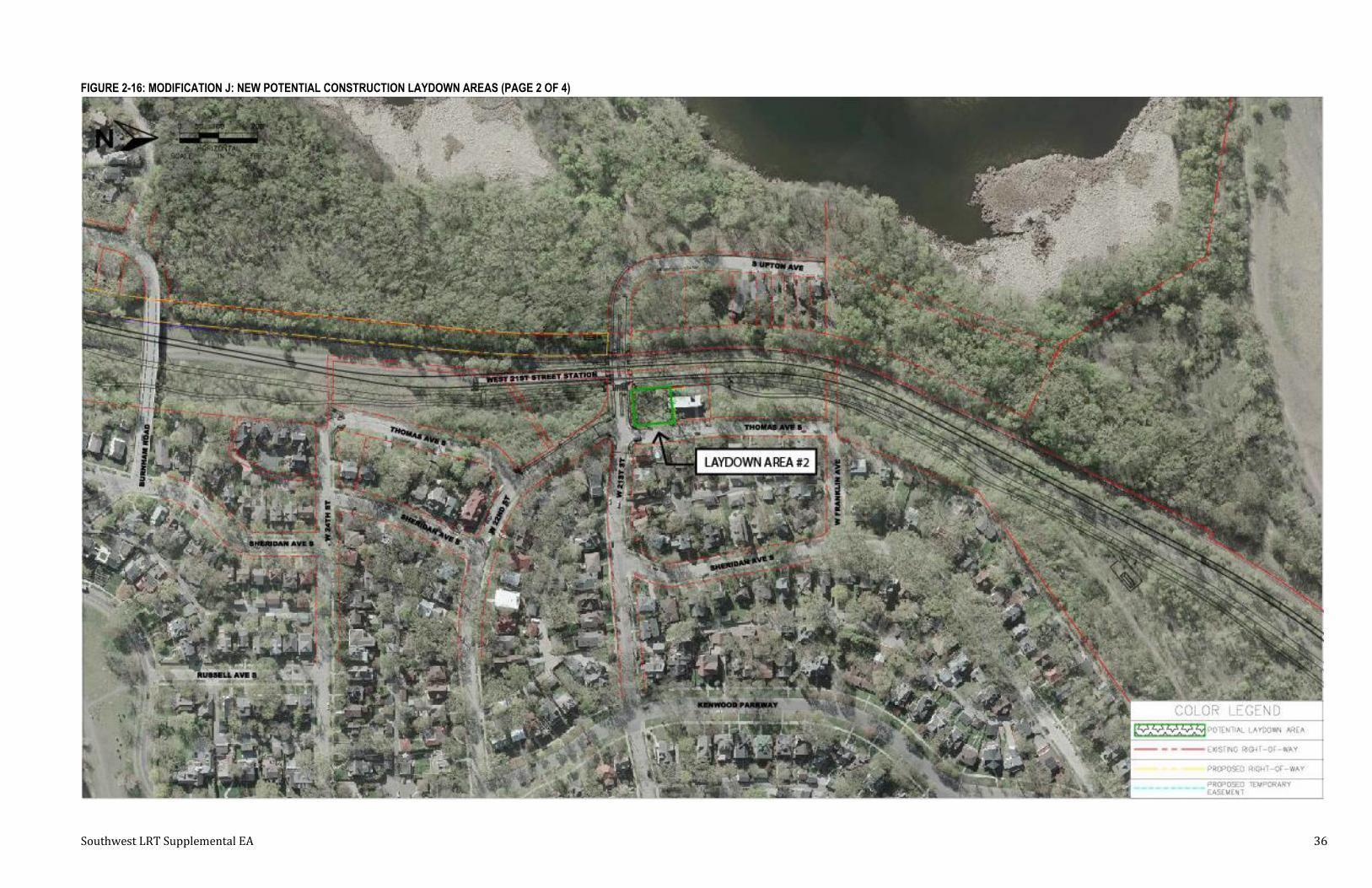
2.10.2 West 21st Street Station (Laydown Area #2)
The area north of West 21st Street near the West 21st Street Station is being considered as a potential
laydown area (shown on Figure 2-16). Currently, this parcel is a vacant lot owned by HCRRA. The
surrounding land use is primarily residential to the north, south, and east. West of the site is the Project
alignment.
2.10.3 Bassett Creek Valley Station (Laydown Area #3)
The area east of Bassett Creek Valley Station and north of I-394 is being considered as a potential laydown
area (shown on Figure 2-17). Currently, this parcel is a commercial lot owned by the City of Minneapolis
Public Works. The site is surrounded by the Project area to the north and west and I-394 to the south and
east. The site is currently used for solid waste and recycling services.
2.10.4 Fremont Avenue North – East and West (Laydown Areas #4 and #5)
The areas on the east and west sides of Fremont Avenue North along 2nd Avenue North are being
considered as potential laydown areas (shown on Figure 2-18). Currently, these two parcels are vacant
residential land owned by the City of Minneapolis. The parcels are surrounded by railroad uses to the
south and west, commercial to the west, and industrial to the north.

Southwest LRT Supplemental EA 35
FIGURE 2-15: MODIFICATION J: NEW POTENTIAL CONSTRUCTION LAYDOWN AREAS (PAGE 1 OF 4)
Southwest LRT Supplemental EA 36
FIGURE 2-16: MODIFICATION J: NEW POTENTIAL CONSTRUCTION LAYDOWN AREAS (PAGE 2 OF 4)

Southwest LRT Supplemental EA 37
FIGURE 2-17: MODIFICATION J: NEW POTENTIAL CONSTRUCTION LAYDOWN AREAS (PAGE 3 OF 4)

Southwest LRT Supplemental EA 38
FIGURE 2-18: MODIFICATION J: NEW POTENTIAL CONSTRUCTION LAYDOWN AREAS (PAGE 4 OF 4)

Southwest LRT Supplemental EA 39
3 Affected Environment/Environmental Consequences of Design Changes The Final EIS evaluated impacts to the following resource categories:
• Land use
• Economic activity
• Neighborhood and community
• Acquisitions and displacements
• Cultural resources
• Parks, recreation areas, and open spaces
• Visual quality and aesthetics
• Geology and groundwater resources
• Surface water resources
• Ecosystems
• Air quality and greenhouse gases
• Noise
• Vibration
• Hazardous and contaminated materials
• Electromagnetic interference and utilities
• Energy
• Cumulative impacts
• Public transportation
• Roadways and traffic
• Parking
• Freight rail
• Pedestrians and bicycles
• Safety and security
• Environmental justice
• Section 4(f)
This Supplemental EA focuses on whether the Project modifications described in Section 2 affect the
environmental impacts and/or mitigation measures as identified in the Final EIS. Resource categories that
could be affected by the proposed changes were evaluated further due to the potential that the
modification could create an additional impact or increase the severity of the impact compared to the
findings in the Final EIS. Based on the scale, type of impact, and location of the Project modifications, some
resource categories were identified that did not require further evaluation.
Threatened and endangered species were evaluated per Section 7 of the Endangered Species Act of 1973
on a corridor-wide level, and further analysis is documented in Section 5.2 and Appendix E.
3.1 Modification A: Parcel 322A Parking Impact in Minnetonka near Opus Station
3.1.1 Summary of Impacts by Resource Category
Table 3-1 provides a summary of resource categories that could be affected by Modification A and were
evaluated further (see Sections 3.1.2 to 3.1.4).
TABLE 3-1: SUMMARY BY RESOURCE CATEGORY FOR MODIFICATION A
Resource Category Impacts Disclosed in Final
EIS New Impacts Change in Impacts
Acquisitions and Displacements
• 12,165 square feet of temporary construction easement
• 5,210 square feet of permanent easement
• 2,719 square feet of permanent utility or transportation easement
• 12,942 square feet of temporary construction easement
• 5,210 square feet of permanent easement
• 2,719 square feet of permanent utility or transportation easement
• +778 square feet of temporary construction easement
• No change in permanent easement
• No change in permanent utility or transportation easement
Cultural Resources None None None
Parking 12 parking stalls lost 8 parking stalls lost 4 fewer stalls lost

Southwest LRT Supplemental EA 40
3.1.2 Acquisitions and Displacements
A portion of four impacted stalls extends outside the Final EIS LOD. The removal of these four stalls was
part of the original design, but the LOD was drawn through the middle of these stalls instead of behind the
curb line next to the building north of the parking lot. The LOD has been updated to include the entirety of
the four stalls. The property owner has agreed to the loss of stalls and will be included in the easement
documentation that is still being finalized with the property owner. A summary of the right-of-way
impacts is shown in Table 3-2.
TABLE 3-2: RIGHT-OF-WAY SUMMARY FOR PARCEL 322A PARKING IMPACT
Impact from Final EIS (Square Feet) New Impact from Project Modification
(Square Feet) Change (Square Feet)
Property (Private)
Temporary Construction
Easement (TCE)
Permanent Easement
(PE)
Permanent Utility or
Transportation Easement (PE-
Other) TCE PE PE-Other TCE PE PE-
Other
Opus - Parcel 322A
12,164 5,210 2,719 12,942 5,210 2,719 +778 0 0
There will be an increase of 778 square feet of temporary construction easement as part of the acquisition
process. Although there is a change in the amount of temporary construction easement, this is a minor
modification and does not result in a change to the acquisitions and displacements mitigation measures
identified in the Final EIS.
3.1.3 Cultural Resources
MnDOT Cultural Resources Unit (CRU) 5 reviewed the proposed Project modification in accordance with
the Section 106 MOA (June 2016) Stipulation II and determined that the portion of the four impacted stalls
outside the Final EIS LOD is within the architecture/history area of potential effect (APE) but falls just
outside the archaeological APE.6 No NRHP listed or eligible historic properties are located in either APE in
the vicinity of the four stalls. A Phase I archaeological survey completed during the preparation of the
Draft EIS for the Project looked at areas immediately outside the archaeological APE, including the
location of the four impacted stalls, and found that they “have been extensively impacted by recent land
use and therefore lack archaeological potential” (SWCA Environmental Consultants, 2012). Therefore, the
proposed Project modification is not a substantive change, as defined in the MOA, and does not have the
potential to affect any known historic properties. No changes to the cultural resources mitigation
measures identified in the Final EIS are necessary due to this Project modification.
5 Per Section 3.5 of the Final EIS, the FTA has delegated specific responsibilities to MnDOT CRU to carry out many aspects of the Section 106 review for this project. FTA detailed these responsibilities in a letter to MnDOT dated December 13, 2012. FTA and MnDOT CRU, in consultation with the Minnesota Historic Preservation Office (MnHPO), defined the Project’s architecture/history and archaeological areas of potential effect (APEs), identified and evaluated historic properties, assessed effects of the Project on historic properties listed in or eligible for inclusion in the National Register of Historic Places (NRHP), and resolved adverse effects. 6 Maps of the archaeological and architecture/history APES for the Southwest LRT Project were included as attachments to the Section 106 MOA that was included in the Final EIS and ROD (2016).

Southwest LRT Supplemental EA 41
3.1.4 Parking
In the Final EIS, off-street parking spaces was primarily related to acquisitions for the Project where the
building and business will remain. Although there is a reduction in the number of parking spaces lost with
this Project modification, there is still a long-term impact related to the acquisition from this property.
Mitigation measures identified in the Final EIS for long-term parking impacts include compensating
business owners and helping to identify suitable replacement locations prior to the displacement of
parking spaces. Because a long-term impact remains, there is no change to the parking mitigation
measures identified in the Final EIS due to this Project modification.
3.2 Modification B: Minnehaha Creek Headwall
3.2.1 Summary of Impacts by Resource Category
Table 3-3 provides a summary of resource categories that could be affected by Modification B and were
evaluated further (see Sections 3.2.2 to 3.2.4).
TABLE 3-3: SUMMARY BY RESOURCE CATEGORY FOR MODIFICATION B
Resource Category Impacts Disclosed in Final EIS New Impacts Change in Impacts
Cultural Resources None None None
Visual Quality and Aesthetics None New headwall facing residential properties on the north
Minimal change to surrounding landscape
Surface Water Resources None None None
3.2.2 Cultural Resources
MnDOT CRU reviewed the new headwall in accordance with MOA Stipulation II. MnDOT CRU determined
that the location of the proposed Project modification is within the archaeological and
architecture/history APEs for Southwest LRT and that there are no NRHP listed or eligible historic
properties located in the vicinity of the proposed headwall. MnDOT CRU also determined that the
modification would not have a visual impact as there are no NRHP listed or eligible historic properties
located in the vicinity of the proposed headwall. Therefore, the proposed Project modification is not a
substantive change, as defined in the MOA, and does not have the potential to affect any known historic
properties. The modification does not change the cultural resources mitigation measures identified in the
Final EIS.
3.2.3 Visual Quality and Aesthetics
Minnehaha Creek is not classified as a state water trail and this section of the Creek is not used for
canoeing, kayaking, boating, swimming, hiking, or camping; therefore, the headwall will not be visible to
any users of the Creek. The headwall is facing residential properties on the north; however, this
modification is a minimal visual change to the surrounding landscape and does not change the visual
quality or warrant any changes to the aesthetics mitigation measures identified in the Final EIS.
3.2.4 Surface Water Resources
This change arose after the MCWD identified capacity concerns with the LRT drainage tying in to the
Powell Road Bypass (an existing storm sewer main). As a response to MCWD’s concerns, the Council
looked at alternatives for discharging the flow in that area and identified a solution of providing a head
discharge directly to Minnehaha Creek. MCWD requested that a new headwall be oriented in a way such
that the flow leaving the head is parallel with the flow direction of Minnehaha Creek due to concerns about

Southwest LRT Supplemental EA 42
eroding the opposite bank of Minnehaha Creek. The headwall was designed to accommodate that request,
and the MCWD has issued a permit to the Project based on this modification. There is no permanent or
temporary wetland or floodplain impact identified at this location, and the headwall location does not
change the surface water resources mitigation measures identified in the Final EIS.
3.3 Modification C: 31st Street Realignment
3.3.1 Summary of Impacts by Resource Category
Table 3-4 provides a summary of resource categories that could be affected by Modification C and were
evaluated further (see Sections 3.3.2 to 3.3.7).
TABLE 3-4: SUMMARY BY RESOURCE CATEGORY FOR MODIFICATION C
Resource Category Impacts Disclosed in Final EIS New Impacts Change in Impacts
Acquisitions and Displacements
• 61,124.7 square feet of temporary construction easement
• 50,352.4 square feet of permanent easement
• No permanent utility or transportation easement
• 72,971.4 square feet of temporary construction easement
• 28,100.7 square feet of permanent easement
• No permanent utility or transportation easement
• +11,846.7 square feet of temporary construction easement
• -22,251.7 square feet of permanent easement
• No change in permanent utility or transportation easement
Cultural Resources None None None
Geology and Groundwater Resources
None None None
Hazardous and Contaminated Materials
• 13 records identified within 550 feet
None None
Utilities • Storm sewer catch basins
• 8-inch water hydrants, gate valve manholes
• Gas main underground
• Overhead electric
• Underground communication fiber
Relocation of existing storm sewer pipe; existing drainage patterns maintained
Relocation of existing storm sewer pipe
Roadways and Traffic None None None
3.3.2 Acquisitions and Displacements
The Final EIS evaluated and disclosed a partial acquisition of 45,956.1 square feet (approximately 1 acre)
from the private property owner. Of the 45,956.10 square feet, 10,172.5 square feet were for a temporary
construction easement and 35,783.6 square feet were a permanent easement (see Table 3-5). For the
Project modification to shift 31st Street to the north, the Project footprint is being adjusted to an impact of
35,551.1 square feet (approximately 0.75 acres): 18,231.4 square feet are for a temporary construction
easement and 17,319.7 square feet is for a permanent easement. The modification of the roadway is
partially within an easement owned by the City and a parcel owned by HCRRA, which requires an increase
of 3,787.8 square feet of temporary construction easement, which was moved from a permanent easement
from what was shown in the Final EIS. MnDOT right-of-way staff have met with all impacted and adjacent
property owners and they are aware of the proposed change. Easement agreements are still ongoing with
the property owners involved.
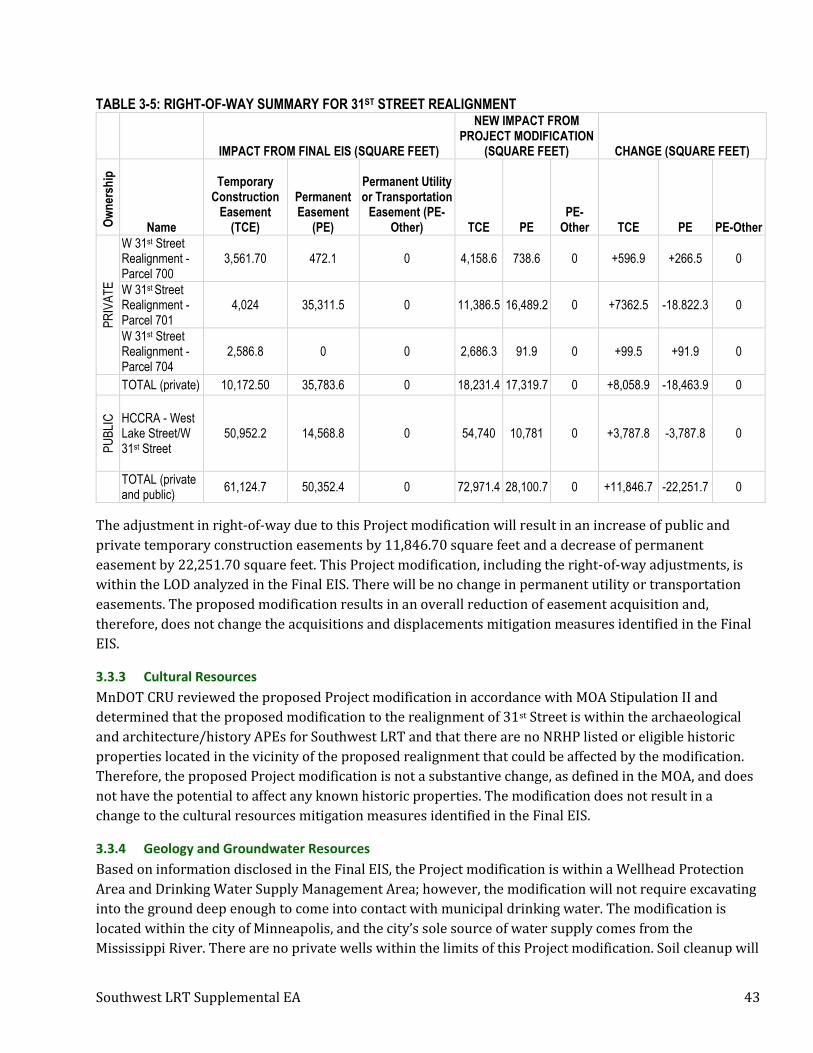
Southwest LRT Supplemental EA 43
TABLE 3-5: RIGHT-OF-WAY SUMMARY FOR 31ST STREET REALIGNMENT
IMPACT FROM FINAL EIS (SQUARE FEET)
NEW IMPACT FROM PROJECT MODIFICATION
(SQUARE FEET) CHANGE (SQUARE FEET)
Ow
ner
ship
Name
Temporary Construction
Easement (TCE)
Permanent Easement
(PE)
Permanent Utility or Transportation
Easement (PE-Other) TCE PE
PE-Other TCE PE PE-Other
PR
IVA
TE
W 31st Street Realignment - Parcel 700
3,561.70 472.1 0 4,158.6 738.6 0 +596.9 +266.5 0
W 31st Street Realignment - Parcel 701
4,024 35,311.5 0 11,386.5 16,489.2 0 +7362.5 -18.822.3 0
W 31st Street Realignment - Parcel 704
2,586.8 0 0 2,686.3 91.9 0 +99.5 +91.9 0
TOTAL (private) 10,172.50 35,783.6 0 18,231.4 17,319.7 0 +8,058.9 -18,463.9 0
PU
BLI
C
HCCRA - West Lake Street/W 31st Street
50,952.2 14,568.8 0 54,740 10,781 0 +3,787.8 -3,787.8 0
TOTAL (private and public)
61,124.7 50,352.4 0 72,971.4 28,100.7 0 +11,846.7 -22,251.7 0
The adjustment in right-of-way due to this Project modification will result in an increase of public and
private temporary construction easements by 11,846.70 square feet and a decrease of permanent
easement by 22,251.70 square feet. This Project modification, including the right-of-way adjustments, is
within the LOD analyzed in the Final EIS. There will be no change in permanent utility or transportation
easements. The proposed modification results in an overall reduction of easement acquisition and,
therefore, does not change the acquisitions and displacements mitigation measures identified in the Final
EIS.
3.3.3 Cultural Resources
MnDOT CRU reviewed the proposed Project modification in accordance with MOA Stipulation II and
determined that the proposed modification to the realignment of 31st Street is within the archaeological
and architecture/history APEs for Southwest LRT and that there are no NRHP listed or eligible historic
properties located in the vicinity of the proposed realignment that could be affected by the modification.
Therefore, the proposed Project modification is not a substantive change, as defined in the MOA, and does
not have the potential to affect any known historic properties. The modification does not result in a
change to the cultural resources mitigation measures identified in the Final EIS.
3.3.4 Geology and Groundwater Resources
Based on information disclosed in the Final EIS, the Project modification is within a Wellhead Protection
Area and Drinking Water Supply Management Area; however, the modification will not require excavating
into the ground deep enough to come into contact with municipal drinking water. The modification is
located within the city of Minneapolis, and the city’s sole source of water supply comes from the
Mississippi River. There are no private wells within the limits of this Project modification. Soil cleanup will

Southwest LRT Supplemental EA 44
occur on site; however, the depth will be no farther than the existing roadbed. The realigned road is not
located on compressible soils so will not require removing and replacing soft soils. The Final EIS indicated
that no mitigation measures are warranted for long-term or short-term impacts to geology because there
will be no adverse impacts due to the effectiveness of identified avoidance measures and Best
Management Practices (BMPs), and there is no change to this conclusion with the modification. The road
realignment was previously evaluated in the Final EIS, and the analysis indicated that the Project will not
adversely affect groundwater supply or flow in the groundwater study area. For these reasons, this Project
modification does not alter the geology and groundwater resources findings or mitigation measures
identified in the Final EIS.
3.3.5 Hazardous and Contaminated Materials
Phase I and Phase II Environmental Site Assessments (ESA) were conducted as part of the hazardous and
contaminated materials review for the Project during the preparation of the Final EIS. The study area for
the hazardous and contaminated materials analysis is based on the review area for the Phase I ESA, which
generally includes an area extending 550 feet on either side of the proposed light rail alignment and
includes the area of this Project modification.
To identify and evaluate sites potentially containing hazardous or regulated materials (such as petroleum
products) or other sources of potential contamination, a governmental database search was conducted as
part of the Phase I ESA work described above. This screening tool identified locations of sites with known
or potential environmental liabilities based on information contained in various state government
databases, including the What’s In My Neighborhood database maintained by the Minnesota Pollution
Control Agency (MPCA).
According to the MPCA’s What’s In My Neighborhood database, there are eight records located within 550
feet of the Project modification. See Table 3-6 for description of records.
TABLE 3-6: WHAT’S IN MY NEIGHBORHOOD DATABASE SEARCH WITHIN 550 FEET OF 31ST STREET REALIGNMENT
Site ID Site Name Activity Active
(Yes/No)
9831 29th St Midtown Greenway Phase I Construction Stormwater No
20563 Jiffy Lube 548 Hazardous Waste, Very Small Quantity Generator; Petroleum Remediation, Leak Site
Yes
188875 Florist Shop Brownfields, Voluntary Investigation and Cleanup Yes
193502 Polansky Dump – 1 Site Assessment Yes
117858 Jiffy Lube Aboveground Tanks; Underground Tanks Yes
118701 Lake Calhoun Properties Underground Tanks No
186773 Former Rail Yard Petroleum Remediation, Leak Site Yes
158110 Whole Foods Market - Lake Calhoun Hazardous Waste, Very small quantity generator Yes
From the Phase II ESA, there are five sites within 550 feet of the Project modification (described in Table
3-7).

Southwest LRT Supplemental EA 45
TABLE 3-7: TABLE FROM PHASE II ESA OF SITES WITHIN 550 FEET OF 31ST STREET REALIGNMENT Site ID Site Name Risk Designation Rationale for Risk Designation
1467 Calhoun Greenway Apartments (area covered within Side ID 193502 listed above)
High Inactive dump site, active VIC, petroleum Brownfield, leak site, known soil/groundwater contamination
147 Apartments Medium8 Stone-cutting business
149 Whole Foods Grocery, retail/ restaurants strip mall (area covered within Side ID 193502 listed above)
High Former dump site, former service station, greenhouse/ nursery, removed USTs, closed Leak/VIC, Environmental Covenant
904 Baker Sales Low9 Unknown historic occupants, potential razed historic structures
915 BP fuel station, fire station High10
Historic dump, long history as a fuel station, auto repair, closed VIC/Leak/Spill, removed/active USTs, Resource Conservation and Recovery Act (RCRA) Small Quantity Generators (SQG)
All sites are listed in the Phase II ESA as exceeding unrestricted use. Site ID 146 and 149 also indicate
significant soil contamination above Industrial Soil Reference Values (SRV). A Response Action Plan
(RAP)11 was developed to determine the appropriate remediation for impacted sites prior to construction.
The RAP is subject to approval by the MPCA prior to the start of any project construction activities within
the affected area. If any hazardous materials are encountered that were not identified in the Phase I and
Phase II ESAs, the Contractor will handle and manage those potentially hazardous materials in compliance
with applicable regulatory standards and dispose of them in accordance with a Hazardous Materials
Abatement Plan for in-place hazardous/regulated materials and the RAP/Construction Contingency Plan
(CCP) for hazardous/regulated materials in the site soils.
The area of impact outside the Final EIS LOD was adequately addressed during the Phase I ESA, which
included the additional area of impact and indicated acceptable risk, and/or by the Phase II ESA, which
adequately characterized conditions adjacent to the original alignment, which included the additional area
of impact. Therefore, there is no change to the hazardous and contaminated materials mitigation measures
identified in the Final EIS due to this Project modification.
3.3.6 Utilities
To identify underground and aboveground utilities that could be affected by the construction of the
Project, a review of the major public and private utilities within the utility study area was conducted
during the Final EIS evaluation. The utility study area is defined as the area where major utilities are
7 Site identification numbers were developed as part of the Phase I ESA process and differ from the Site identification numbers that the MPCA database. 8 Based on site history, SWLRT Phase II ESA results in rail corridor adjacent to this parcel, and proposed right-of-way impact, risk was considered acceptable. 9 Site was investigated as a Phase II ESA addendum to address additional right-of-way impact. Results indicated minor impacts to site soils, so it is listed as a new release. Received a No Association Determination (NAD) letter from MPCA addressing this site on July 13, 2016. 10 The dump site was addressed in other soil borings and test pits as it covered several surrounding parcels. The fire station parcel was investigated in the Phase II ESA because of temporary easement being sought there and no historic data was available from that parcel. The BP Station is outside the LOD and thus not investigated and contaminants of concern were petroleum hydrocarbons so the risk was considered low. 11 The RAP is included in the construction specifications for the Project. The RAP was completed for each segment of the project between May and November of 2015.

Southwest LRT Supplemental EA 46
located within or immediately adjacent to the LOD and that may be relocated by the Project. The major
utilities inventoried are defined as follows:
• Water mains, 18 inches or greater in diameter
• Sanitary sewer lines, 18 inches or greater in diameter
• Sanitary force mains, 8 inches or greater in diameter
• Storm sewer lines, 24 inches or greater in diameter
• Aboveground or underground electrical transmission lines
• Gas-main substations and gas lines 12 inches or greater in diameter
• Communication infrastructure
The realignment of 31st Street will include the relocation of an existing storm sewer pipe to maximize
future redevelopment opportunities. The existing pipe follows the existing roadway alignment, and the
pipe will be relocated to follow the new roadway alignment. Existing drainage patterns will be maintained.
Therefore, there is no change to the mitigation measures for utilities identified in the Final EIS due to this
Project modification.
3.3.7 Roadways and Traffic
A modification to 31st Street was previously identified in the Final EIS and was not identified to cause an
impact to local traffic circulation or the regional roadway system once completed. The Final EIS identified
that there will be temporary lane closures or shifts at Abbott Avenue, Chowen Avenue, and West 32nd
Street intersections during construction but no detour will be required. The shift of the road 80 feet north
will not result in any changes to local traffic circulation, and it is not anticipated to have an impact on the
regional roadway system. Therefore, there is no change to the roadways and traffic mitigation measures
identified in the Final EIS due to this Project modification.
3.4 Modification D: Grand Rounds Historic District – Kenilworth Lagoon Works Progress
Administration (WPA) Rustic Style Retaining Walls Rehabilitation and Landscaping
3.4.1 Summary of Impacts by Resource Category
Table 3-8 provides a summary of resource categories that could be affected by Modification D and were
evaluated further (see Sections 3.4.2 to 3.4.8).
TABLE 3-8: SUMMARY BY RESOURCE CATEGORY FOR MODIFICATION D Resource Category Impacts Disclosed in Final
EIS New Impacts Change in Impacts
Cultural Resources Alters the historic character of the Grand Rounds Historic District
None – landscaping and wall repair was a mitigation measure for the cultural resource being impacted
None
Visual Quality and Aesthetics Low visual impact None None
Surface Water Resources • 5,244 square feet of temporary wetland impact
• 129 square feet of permanent wetland impact
• Removal of 1 cubic yard of floodplain
None None

Southwest LRT Supplemental EA 47
Resource Category Impacts Disclosed in Final EIS
New Impacts Change in Impacts
Ecosystems “No effect” on the Higgins eye (pearly mussel) and Snuffbox mussel
“May affect, not likely to adversely affect” the Rusty patched bumble bee
“May affect, not likely to adversely affect” the Rusty patched bumble bee
Hazardous and Contaminated Materials
None None None
Utilities None None None
Section 4(f) • A Section 4(f) use with a de minimis impact finding (park)
• A Section 4(f) use (historic property)
No change to Section 4(f) impact
No change to Section 4(f) impact
3.4.2 Cultural Resources
In accordance with MOA Stipulation VII.C.ii, additional consultation was conducted with Section 106
consulting parties, including a consultation meeting held on September 15, 2016 to review the 90% plans.
Through this consultation process, the MPRB (a consulting party) requested the 100% plans include a
more naturalistic landscape plan within and in the vicinity of the Kenilworth Lagoon/Channel to better
reflect its historic character as well as more strategic placement of vegetation to help ensure long-term
preservation of the rehabilitated and reconstructed walls. The Minnesota Historic Preservation Office
(MnHPO) agreed with MPRB that the landscaping was overly designed and not compatible with the
natural vegetation features of the historic property’s landscape and, therefore, did not meet the SOI
Standards. The current plans for landscaping around the Kenilworth Channel, which extend 0.07 acre
outside the LOD evaluated in the Final EIS, reflect a naturalistic planting as requested by the MPRB. FTA
and MnDOT CRU reviewed the final construction plans and specifications for the rehabilitation and
reconstruction of the Kenilworth Lagoon WPA Rustic style retaining walls and the revised, final plans for
landscaping within and in the vicinity of the Kenilworth Lagoon, which totaled 0.32 acre outside the Final
EIS LOD, and determined that they met the SOI Standards. In accordance with the MOA, FTA provided
these materials to MnHPO for review, and MnHPO concurred with these materials on July 17, 2017. See
Appendix A for MnDOT CRU and FTA’s review of this Project modification and MnHPO’s concurrence
letter. This Project modification was a result of a mitigation plan required by the MOA as part of the
Section 106 review process and does not change the findings identified in the Final EIS.
3.4.3 Visual Quality and Aesthetics
The Final EIS identified that the new bridge crossing will affect the view within the Kenilworth
Channel/Lagoon; however, the assessment in the Final EIS was that the overall level of visual impact will
be low based on the Federal Highway Administration (FHWA) visual guidelines (discussed in Section
3.8.5). The WPA Rustic style retaining wall repair and naturalist landscaping are mitigation measures
identified through the Section 106 process to minimize the adverse effect resulting from the construction
of the new bridge. These mitigation measures do not create any additional visual or aesthetic impact to the
area as compared to what was studied in the Final EIS.
3.4.4 Surface Water Resources
There are no additional wetland or floodplain impacts associated with the wall repair and landscaping
work. All work will be completed in accordance with the Stormwater Pollution Prevention Plan (SWPPP),
construction specifications, the Construction Protection Plan (CPP), and the Construction Protection Plan

Southwest LRT Supplemental EA 48
for Historic Properties (CPPHP). Therefore, the Project modification will not result in additional wetland
or floodplain impacts.
3.4.5 Ecosystems
The Final EIS review of ecosystems included threatened and endangered species, habitat, and migratory
birds. The habitat surrounding the Kenilworth Lagoon is mostly impervious cover, long grasses, and mixed
trees. The Project change is not located in a regionally significant ecological area or corridor, native plant
community, or site of biological significance.
During the Final EIS, the FTA made a determination that the Project will have “no effect” on the Higgins
eye pearlymussel (Lampsilis higginsii) and Snuffbox mussel (Epioblasma triquetra), or their associated
critical habitats, and that the Project “may affect, but is not likely to adversely affect” the northern long-
eared bat (Myotis septentrionalis). The U.S. Fish and Wildlife Service (USFWS) concurred with these
determinations on September 25, 2015 and October 27, 2015. The listing of the rusty patched bumble bee
(Bombus affinis) as a federally endangered species became effective after issuance of the ROD. The Project
area overlaps with a high potential zone for the rusty patched bumble bee and contains suitable habitat
such as woodlands and open vegetated habitat with flowering plant species. The Council and FTA
consulted with the USFWS in September and October 2017, and February 2018 to confirm the
determination for impacts to the rusty patched bumble bee. FTA has requested concurrence from the
USFWS on a “may affect, not likely to adversely affect” determination. For more information about the
rusty patched bumble bee review, consultation, and determination, see Appendix E and Section 5.2.
In addition, during the Final EIS the Minnesota Department of Natural Resources (MnDNR) identified
occurrences of one endangered species, four threatened species, and six special concern species within the
MnDNR study area.12 Of these, the MnDNR identified one state threatened species, Blanding’s turtle
(Emydoidea blandingii), as the only rare species that may be adversely affected by the proposed Project.
However, the proposed change in the retaining wall and landscaping will not affect the Blanding’s turtle
habitat. The closest Blanding’s turtle element occurrence is 0.9 mile from any area that will be disturbed
by the Project, specifically the additional LOD associated with this modification.
Although it is not anticipated that the Project modification will impact threatened and endangered species,
the vegetation and tree habitat will be altered. Mitigation for changes in vegetation and tree habitat has
been identified in the construction specifications based on the mitigation measures outlined in the Final
EIS and ROD, which includes the following:
• Trees: Avoid disturbance of existing trees. Living and dead trees and large shrubbery that are
displacing wall elements to an extent where the structural integrity of the wall is compromised
shall be removed. Vegetation in the immediate area around a tree may be impacted as necessary to
remove the tree and roots. Removals must be approved by a Council Authorized Representative
(CAR) prior to performing work.
• Vegetation at Grade: Avoid disturbance of existing vegetation. At areas with extensive erosion at
back side of walls where erosion of soil has displaced wall elements to an extent where the
structural integrity of the wall is compromised or where the wall is higher than the adjacent grade,
12 MnDNR study area: defined as the area that extends approximately one mile around the Project’s LOD; used in Threatened and Endangered Species analysis

Southwest LRT Supplemental EA 49
vegetation shall be removed to allow re-grading to a height matching adjacent un-eroded grade.
Removals must be approved by a CAR prior to performing work.
Therefore, no change to the ecosystems mitigation measures identified in the Final EIS are necessary due
to this Project modification.
3.4.6 Hazardous and Contaminated Materials
According to the MPCA’s What’s In My Neighborhood database, there are no records located within 550
feet of this Project modification. From the Phase I ESA, there are no sites located within 550 feet the
Project modification, and the Phase II ESA results indicated low risk of impact in the vicinity of the Project
modification.
The area of impact outside the Final EIS LOD was adequately addressed during the Phase I ESA, which
included the additional area of impact and indicated acceptable risk, and/or by the Phase II ESA, which
adequately characterized conditions adjacent to the additional area of impact. Therefore, there is no
change to the hazardous and contaminated materials mitigation measures identified in the Final EIS due
to this Project modification.
3.4.7 Utilities
There are no utility conflicts identified as part of this Project modification.
3.4.8 Section 4(f)
The Final EIS/Final Section 4(f) Evaluation included the Kenilworth Channel/Lagoon as both a historic
property and park. Under the park section of the Final Section 4(f) Evaluation, a de minimis determination
was reached for the property, with the MPRB serving as the official with jurisdiction (OWJ). Under the
historic property section, a Section 4(f) use was determined for the property, with the MnHPO serving as
the OWJ. As summarized in the cultural resources section (Section 3.4.2), the proposed modifications to
this property since the Final EIS/ROD and Final Section 4(f) Evaluation were a result of the mitigation
process set forth under the Section 106 MOA. Both OWJs were party to the modifications and provided
concurrence on the mitigation measures (see Appendix A for MPRB correspondence indicating
agreement with this modification.). The findings from the Final Section 4(f) Evaluation have not changed
for this property based on the proposed modifications.
3.5 Modification E: Right-of-Way Adjustment near 21st Street Station
3.5.1 Summary of Impacts by Resource Category
Table 3-9 provides a summary of resource categories that could be affected by Modification E and were
evaluated further (see Sections 3.5.2 to 3.5.6).
TABLE 3-9: SUMMARY BY RESOURCE CATEGORY FOR MODIFICATION E
Resource Category Impacts Disclosed in Final EIS
New Impacts Change in Impacts
Acquisitions and Displacements
• 504 square feet of temporary easement
• 175 square feet of permanent easement
• 1,437 square feet of temporary construction easement
• 479 square feet of permanent easement
• +934 square feet of temporary construction easement
• +304 square feet of permanent easement
Cultural Resources None None None

Southwest LRT Supplemental EA 50
Resource Category Impacts Disclosed in Final EIS
New Impacts Change in Impacts
Surface Water Resources None None None
Noise Noise impact on one property on Thomas Avenue South
None None
Hazardous and Contaminated Materials
One record within 550 feet None None
Utilities None None None
3.5.2 Acquisitions and Displacements
Construction of a wood fence on the retaining wall to provide fall protection will require a 1,437-square
foot temporary construction easement and a 479-square foot permanent easement on the property. This
is an increase of 934 square feet of temporary easement and 304 square feet of permanent easement. A
summary of the right-of-way impacts is shown in Table 3-10.
TABLE 3-10: SUMMARY FOR RIGHT-OF-WAY ADJUSTMENT NEAR 21ST STREET STATION
Impact from Final EIS (Square Feet)
New Impact from Project Modification (Square Feet) Change (Square Feet)
Property (Private)
Temporary Construction
Easement (TCE)
Permanent Easement
(PE)
Permanent Utility or
Transportation Easement (PE-
Other) TCE PE PE-Other TCE PE PE-
Other
Parcel 725 504 175 0 1,437 479 0 +934 +304 0
As this Project modification will create both long- and short-term acquisition impacts, the Council will
provide the property owner with monetary compensation that has been agreed to with the property
owner and is in accordance with the Uniform Relocation Assistance and Real Property Acquisition Policies
Act (Uniform Relocation Act), FTA’s Circular 5010.1D Grants Management, and Minnesota Statutes
Chapter 117. The easement agreement with the property owner is still underway. Although there is an
increase in temporary and permanent easement acquisition, the amount does not change the mitigation
measures from what was identified in the Final EIS.
3.5.3 Cultural Resources
MnDOT CRU reviewed the proposed retaining wall, privacy fence, and right-of-way adjustment at the
property along Thomas Avenue South in accordance with MOA Stipulation II and determined that the
location of the proposed Project modification is within the archaeological and architecture/history APEs
for the Southwest LRT 21st Street Station. There are no archaeological resources in the vicinity of the
proposed Project modification. While several NRHP listed or eligible architecture/history properties are
located within the 1/4-mile architecture/history APE for this station, all are at least several hundred feet
from the proposed retaining wall and new fence. Intervening vegetation and/or buildings will block views
of the wall and fence from these properties. Therefore, the proposed Project modification is not a
substantive change as defined in the MOA and would not result in an additional effect or change of effect
to a historic property. Therefore, there is no change to the cultural resources mitigation measures
identified in the Final EIS due to this Project modification.

Southwest LRT Supplemental EA 51
3.5.4 Noise
Installation of the fence is not for the purpose of noise mitigation. No other nearby properties were
identified as impacted in the Final EIS noise evaluation. Therefore, there is no change to the noise
mitigation measures identified in the Final EIS due to this Project modification.
3.5.5 Hazardous and Contaminated Materials
According to the MPCA’s What’s In My Neighborhood database, there are no records located within 550
feet of this Project modification. Therefore, there is no change to the hazardous and contaminated
materials mitigation measures identified in the Final EIS due to this Project modification.
3.5.6 Utilities
Based on the utilities inventoried in the Final EIS, there are no utilities requiring relocation as part of this
Project modification. Therefore, there is no change to the utilities mitigation measures identified in the
Final EIS due to this Project modification.
3.6 Modification F: Cedar Lake LRT Regional Trail Detour
3.6.1 Summary of Impacts by Resource Category
Table 3-11 provides a summary of resource categories that could be affected by Modification F and were
evaluated further (see Section 3.6.2).
TABLE 3-11: SUMMARY BY RESOURCE CATEGORY FOR MODIFICATION F
Resource Category Impacts Disclosed in Final EIS New Impacts Change in Impacts
Pedestrians and Bicycles Temporary closures of Cedar Lake LRT Regional Trail during construction. The detour for the temporary closure was within the existing Cedar Lake LRT Regional Trail right-of-way.
Closure of Cedar Lake LRT Regional Trail between Excelsior Boulevard in Hopkins (just east of TH 169) to France Avenue in Minneapolis (between Beltline and West Lake Street Stations) during construction
Longer closure of Cedar Lake LRT Regional Trail during construction and inclusion of detour routes
3.6.2 Pedestrians and Bicycles
The existing Cedar Lake LRT Regional Trail will be detoured by the Project during construction to similar
facilities that provide transportation connectivity. The trail is owned by HCRRA and operated by Three
Rivers Park District, and both parties have participated in conversations with the Council to determine the
trail detour. The proposed detour will be in place for up to 840 days during construction of the Project.
The lengths of the detour routes along existing paved roads as indicated in Figure 2-7 are as follows:
• Detour from TH 169/Excelsior Boulevard to France Avenue via Minnetonka Boulevard: 5.2 miles
• Detour from TH 169/Excelsior Boulevard to Kenilworth Corridor at Cedar Lake Parkway via North
Cedar Lake Trail: 5.3 miles
• Detour from TH 169/Excelsior Boulevard to Kenilworth Trail connection at Bryn Mawr Station via
North Cedar Lake Trail: 6.1 miles
The Cedar Lake LRT Regional Trail closure was previously identified in the Final EIS to have a short-term
impact during construction. The Project modification to relocate the detour is a minimal change in the

Southwest LRT Supplemental EA 52
mitigation measure, and does not create an additional environmental or social impact. The trail detour is
included in Section 6 of this document.
The Cedar Lake LRT Regional Trail is not a Section 4(f) property. As indicated in the Final EIS, “The
existing trails adjacent to the Project (Cedar Lake Trail, Kenilworth Trail, Cedar Lake LRT Regional Trail,
and Minnesota Bluffs LRT Regional Trail) were constructed on HCRRA property under temporary
agreements between HCRRA and trail permittees. As documented in each trail’s interim use agreements in
Appendix I of the Final EIS, HCRRA permitted these trails as temporary uses with the stipulation that they
may be used until HCRRA develops the corridor for a LRT system or other permitted transportation use;
therefore, these trails are not subject to protection as Section 4(f) property (as per 23 CFR Part 774.11[h])
(page 6-16 of the Final EIS, 2016).
3.7 Modification G: Bryn Mawr Meadows – Trail Mitigation
3.7.1 Summary of Impacts by Resource Category
Table 3-12 provides a summary of resource categories that could be affected by Modification G and were
evaluated further (see Section 3.7.2 to 3.7.3).
TABLE 3-12: SUMMARY BY RESOURCE CATEGORY FOR MODIFICATION G
Resource Category Impacts Disclosed in Final EIS New Impacts Change in Impacts
Pedestrians and Bicycles • Existing bicycle/pedestrian bridge closed and removed and new bridge constructed.
• Closure of north/south access limited to approximately 3-month time period during construction.
• A temporary trail within Bryn Mawr Meadows park was identified.
• Existing bicycle/pedestrian bridge removed and closed earlier in construction process. Closure of north/south access during construction of new bridge estimated at approximately 12 months.
• Trail detour identified to provide north/south access on existing trails.
• Repave section of existing trail in Bryn Mawr Meadows Park.
• Increased closure time during construction period for north/south access over BNSF
• Provision for trail detour routes using existing facilities
• Repaving existing trail section through park to accommodate higher use.
Section 4(f) Section 4(f) use with a de minimis impact finding
No change in Section 4(f) impact
No change in Section 4(f) impact
3.7.2 Pedestrians and Bicycles
This modification will close and remove the existing bicycle/pedestrian bridge earlier in the construction
schedule, thereby extending the time period where north/south access over the BNSF freight rail tracks is
closed to approximately one year. While the bridge is closed, trail users will be detoured to use a path that
runs along the south side of Bryn Mawr Meadows Park to I-394 to Cedar Lake Trail that connects on the
south side of the Luce Line bridge. A temporary trail was previously identified and analyzed in the Final
EIS and will be built between the north side of the Luce Line bridge to connect to the path along Bryn
Mawr Meadows Park. Before construction starts on the bridge, an approximately 1,800-foot section of the
trail within the Bryn Mawr Meadows Park will be repaved as part of the Project. The trail repavement will
take approximately one week to complete and will occur prior to its use as a detour route. The length of

Southwest LRT Supplemental EA 53
the detour route is approximately 1.3 miles. This Project modification and new pedestrian/bicycle detour
was planned in coordination with the MPRB.
The Luce Line pedestrian bridge was previously identified to be removed and replaced with a new bridge
that provides a connection from the park to the Bassett Creek Valley station. This Project modification is a
minimal change in the mitigation measure that was previously identified in the Final EIS and it does not
create an additional environmental or social impact. This mitigation measure is documented in Section 6.
3.7.3 Section 4(f)
The Final EIS documented that there would be a Section 4(f) use with a de minimis impact for the
acquisition of 0.4 acre of permanent easement to accommodate the replacement of the trail bridge and the
temporary trail in the park. The modification to repave and improve the existing park trail that will be
used as a detour and lengthen the duration of the bridge closure does not change the Section 4(f) finding
from the Final EIS. See Appendix A for correspondence with the MPRB regarding this Project
modification.
3.8 Modification H: BNSF Negotiation Modifications
3.8.1 Summary of Impacts by Resource Category
Table 3-13 provides a summary of resource categories that could be affected by Modification H and were
evaluated further (see Sections 3.8.2 to 3.8.14).
TABLE 3-13: SUMMARY BY RESOURCE CATEGORY FOR MODIFICATION H
Resource Category Impacts Disclosed in Final EIS
New Impacts Change in Impacts
Neighborhood and Community None None None
Acquisitions and Displacements
• 28,953 square feet of temporary construction easement
• 219 square feet of permanent easement
• 8,407 square feet of permanent utility of transportation easement
• 23,865 square feet of temporary construction easement
• 6,270 square feet of permanent easement
• 9,212 square feet of permanent easement
• -5,088 square feet of temporary construction easement
• +6,051 square feet of permanent easement
• +805 square feet of permanent easement
Cultural Resources No adverse effect finding on the StPM&M / GN Historic District
Adverse effect on the StPM&M / GN Historic District
Adverse effect on the StPM&M / GN Historic District
Visual Quality and Aesthetics None Moderate degree of visual impact
Moderate degree of visual impact
Geology and Groundwater Resources
None None None
Surface Water Resources None Affected drainage components in areas where the CPB is proposed
Affected drainage components in areas where the CPB is proposed
Ecosystems None None None
Noise None None None
Utilities None None None
Freight Rail None None None
Pedestrians and Bicycles None None None
Safety and Security None None None

Southwest LRT Supplemental EA 54
Resource Category Impacts Disclosed in Final EIS
New Impacts Change in Impacts
Section 4(f) StPM&M / GN Historic District was assessed as a Section 4(f) use with a de minimis impact finding, with a no adverse effect finding under Section 106
4(f) direct use of the StPM&M / GN Historic District
4(f) direct use of the StPM&M / GN Historic District
3.8.2 Neighborhood and Community
Under the community cohesion evaluation in the Final EIS, the following assessment was provided relative
to long-term effects of the Project in the section of the corridor in Minneapolis where the CPB is proposed:
“Light rail alignment will be located adjacent to the existing Wayzata Subdivision, which is an active
freight rail corridor (refer to Exhibit 2.1-5 of the Final EIS). All existing sidewalk, trail, and roadway
crossings of the Wayzata Subdivision will be maintained, and because the existing freight rail alignment is
a current physical barrier, the Project will not create a new physical barrier” (Page 3-76 of the Final EIS,
2016).
The CPB does introduce a physical barrier in the active rail corridor; however, the CPB will not impact use
of or access to the trail (see Visual Quality and Aesthetic section for distances from the Cedar Lake Trail).
Although north/south pedestrian movement does occur in this area, it is not permitted to occur within or
across the rail corridor. The Final EIS plans include a fence in this location that would have also prevented
this access. As part of the Project, there will be access points provided that are safe for pedestrians to
cross the rail corridor (i.e., Bryn Mawr Station, I-394 trail overpass, Luce Line pedestrian bridge). In
addition to the existing access points planned for and identified in the Final EIS, a new pedestrian bridge
will be added at Bryn Mawr Station that will provide an additional access point. Community members
have expressed concerns about the wall creating a perceived barrier between neighborhoods throughout
project development and at public engagement events held in Fall 2017 in relation to this Project
modification (see Section 5.1 for list of meetings and Appendix D for meeting summaries). The addition
of the wall will create a greater physical and visual barrier than a fence, but the comparative increase in
impact is not substantial because the BNSF tracks already create a physical barrier within the corridor.
The impact of the physical and visual barrier does not create a significant impact on the circulation or
connection between neighborhoods. Therefore, there is no change to the neighborhood and community
mitigation measures identified in the Final EIS due to this Project modification.
3.8.3 Acquisitions and Displacements
The Northstar tail track modification requires extending the LOD to accommodate a shift in the Cedar Lake
Trail alignment between 1 and 47 feet to the south of the current Project limits for about 1,400 linear feet.
Additional temporary and transportation easements are needed on City of Minneapolis owned parcels and
on a Hennepin County tax forfeited parcel for the new retaining walls adjacent to the trail near Glenwood
Avenue. Coordination with these entities is still underway through the right-of-way acquisition process.
The CPB is within the Final EIS LOD and does not require additional acquisitions. See Table 3-14 for a
summary of the right-of-way changes.

Southwest LRT Supplemental EA 55
TABLE 3-14: RIGHT-OF-WAY SUMMARY FOR BNSF NEGOTIATION MODIFICATIONS
Impact from Final EIS (Square Feet)
New Impact from Project Modification (Square Feet) Change (Square Feet)
Property (Private)
Temporary Construction
Easement (TCE)
Permanent Easement
(PE)
Permanent Utility or
Transportation Easement (PE-
Other) TCE PE PE-Other TCE PE PE-
Other
Northstar Tail Track (Hen Made Glass)
10,749 219 8,407 8,282 3,226 7,867 -2,467 +3,007 -540
Northstar Tail Track (Reitman)
14,459 0 0 12,029 2,430 0 -2,430 +2,430 0
Northstar Tail Track (Tax Forfeited)
0 0 0 454 614 0 +454 +614 0
Northstar Tail Track (Currie Bldg)
0 0 0 700 0 0 +700 0 0
Northstar Tail Track (Lyles Liquor Lot)
3,745 0 0 2,400 0 1,345 -1,345 0 +1,345
TOTAL 28,953 219 8,407 23,865 6,270 9,212 -5,088 +6,051 +805
The total change is a decrease of 5,088 square feet of temporary construction easement, an increase of
6,051 square feet of permanent easement, and an increase of 805 square feet of permanent utility or
transportation easement. Although there is a change in temporary and permanent easement acquisition,
the amount does not increase the severity of the impact from what was identified in the Final EIS.
3.8.4 Cultural Resources
BNSF’s requirements would necessitate modifications to the Project design that are both within and just
outside the boundaries of the StPM&M / GN Historic District, which has been determined eligible for
inclusion in the NRHP. As such, the Project design modifications required by the negotiations must be
designed in accordance with the SOI Standards as required by MOA Stipulation I.A.
Based on an effects assessment conducted by MnDOT CRU under delegation from FTA, which is
documented in Appendix A, FTA has determined that the Project will now have an Adverse Effect on the
StPM&M / GN Historic District (see Section 4 of this Supplemental EA for more information on this
determination). The introduction of the CPB wall to the historic district and removal of historic retaining
walls will both directly and indirectly alter characteristics of the historic property that qualify it for
inclusion in the NRHP in a manner that would diminish the integrity of the property's design, setting,
feeling, and association.
Therefore, in accordance with MOA Stipulation III, FTA will consult with MnHPO and concurring parties to
the MOA to prepare a mitigation plan to resolve the adverse effects. In addition, as required by MOA
Stipulation I.A., FTA will direct the Council to design changes to Project elements in accordance with the
SOI Standards to help minimize the adverse effects of the Project modifications on the StPM&M / GN
Historic District.
Southwest LRT Supplemental EA 56
When FTA issued its final determination of effect for the Project in 2015, it found that the Project would
have an adverse effect on historic properties. As such, the new adverse effect finding for the StPM&M / GN
Historic District will not change FTA’s final determination of effect for the entire Project.
3.8.5 Visual Quality and Aesthetics
Federal regulations require visual impacts to be addressed for Section 106 resources where setting is a
qualifying characteristic of protected historic properties.
Based on MnDOT CRU’s review of the modifications, the CPB and removal and replacement of historic
retaining walls will create visual elements that diminish the integrity of the StPM&M / GN Historic
District’s significant historic features. More specifically, the introduction of the CPB will create a physical
and visual barrier between the main line track and historic yards that are also contributing elements to
the historic district. The historic walls will also be replaced with new retaining walls that will be set back
from the historic retaining walls, thus altering (widening) the width of the historic cut. Retaining walls will
also be added to partially replace contributing historic earthen embankments dating from the late 1860s
or 1870s that are covered with vegetation, further altering the historic character of the historic district in
this area. As noted above in Section 3.8.4, FTA will consult with MnHPO and consulting parties to the
MOA to prepare a mitigation plan to resolve the adverse effects. The Council will design changes to Project
elements in accordance with the SOI’s Standards (see Section 4.4.3) to help minimize the adverse effects
of the Project modifications on the StPM&M / GN Historic District.
In addition to the Section 106 review, the analysis of the Project’s visual quality and aesthetic effects in the
Final EIS applies the principles of the standardized approach for visual impact assessment developed by
the FHWA (FHWA, 1988). This method has been widely adopted by state highway departments and other
agencies responsible for development of transportation facilities as the standard for evaluation of Project
visual effects. The FTA does not have specific visual assessment guidelines and defers to the FHWA
guidance on visual impact assessment. The method relies on representative-view photographs of the
Project alignment and on visualizations of the Project’s appearance, which provide a tangible sense of the
visual character and quality of the areas that the Project will affect, as well as an idea of how the Project
will affect these visual attributes. The representative views, or “viewpoints,” represent specific locations
within a landscape unit from which a proposed project would be visible. The viewpoint locations are
typically selected to either represent (1) “typical” views from common types of viewing areas from which
a proposed project could be seen, such as a highway or residential area, or (2) specific areas such as parks,
viewpoints, and historic districts that may be impacted by a proposed project. The final determination of
the Project’s level of visual impact on the visual environment entails taking both the degree of visual
change and the level of visual sensitivity of the view into account.
The CPB area was not specifically evaluated in the Visual Resources Technical Report in the Final EIS. The
viewpoints studied in the Final EIS were located just north and south of the CPB area. Therefore, the
Council prepared visualizations of specific viewpoints of the CPB in locations where it is closest to the
Cedar Lake Trail to identify any potential visual impacts to trail users (see Figure 3-1 to Figure 3-4). Trail
users were identified in the Final EIS as users that experience a higher degree of sensitivity to visual
changes than motorists. The visualizations provide a representative view within the Project corridor to
compare existing conditions and the Project modification. The CPB is located north of the LRT alignment
and the Cedar Lake Trail and ranges in distance along the corridor:

Southwest LRT Supplemental EA 57
• In the Bryn Mawr Meadows Area, the CPB (as shown in Figure 3-1 and Figure 3-2):
o is approximately 120 feet from the nearest trail
o is approximately 10 feet tall on the freight side
• In the Bryn Mawr Station Area, the CPB (as shown in Figure 3-3 and Figure 3-4):
o is approximately 70 feet from the future trail
o is approximately 5.5 feet tall on the LRT/trail side
The CPB will not extend higher than 8 feet on the LRT/trail side at any given point from the viewpoint of
trail users and ranges from 70 feet to 270 feet in distance from the trail. The overall level of visual
intactness of the viewpoints will be similar to existing conditions. As evident in the visualizations, the CPB
will be seen from trail users; however, it is a minimal change.
In addition, there will be little change in overall vividness of the area with the CPB. No trees or natural
elements that provide moderately vivid elements of the existing view will be removed. The overall level of
visual intactness of this view will be similar to existing conditions. Lastly, the CPB will cause an intrusion
in the unity of the existing landscape; however, the CPB will be designed to blend into the existing rail
corridor and surrounding urban areas and uses.
Based on the physical change in visual quality combined with the sensitivity of the view from trail users,
the level of impact for this Project modification will result in a moderate degree of visual impact. The
impact will be mitigated through the Section 106 review process and public outreach to work with the
community and Section 106 consulting parties on the design aesthetics of the wall to minimize visual
impacts.
FIGURE 3-1: VISUALIZATION OF THE CPB IN THE BRYN MAWR MEADOWS AREA (VIEW A)

Southwest LRT Supplemental EA 58
FIGURE 3-2: PLAN OF THE CPB IN THE BRYN MAWR MEADOWS AREA (VIEW A)
FIGURE 3-3: VISUALIZATION OF THE CPB IN THE BRYN MAWR STATION AREA (VIEW B)
FIGURE 3-4: VISUALIZATION OF THE CPB IN THE BRYN MAWR STATION AREA (VIEW B)
Southwest LRT Supplemental EA 59
3.8.6 Geology and Groundwater Resources
Along the Project’s LOD, the depth of the soil zone varies notably. Based on information obtained from
previous soil borings, surface soil depths generally vary between four to 20 feet, but some borings have
surface soil depths to about 50 feet. Soil in portions of the Project’s LOD in the railroad corridor and urban
areas contain debris, organic soils, roots, and ashes/cinders. There are no compressible soils found within
this Project modification area. The geology of the Project area is made up of course-grained soils that are
typically resistant to settlement and would provide good bearing support for light rail structures.
The water table between the Bryn Mawr and Royalston Avenue Stations is shallow at approximately 10
feet; however, shallow groundwater below the topsoil zone is not used as a source of potable (drinking)
water by municipalities along the proposed light rail alignment. The CPB is also not located in a Wellhead
Protection Area or a Drinking Water Supply Management Area.
The wall foundations for the CPB consist of drilled shafts and vary in depth but range between 25 to 45
feet and will encounter the water table. The drilled shafts range in space and depth; the typical footing
spacing for 36-inch diameter drilled shafts ranges from 6 feet to 15 feet on center. The construction of the
drilled shaft foundations will require a temporary construction water removal effort to recover the slurry
and any groundwater that infiltrates the drilled shaft excavation area. The drilled shafts do not create a
solid barrier. Therefore, water movement is not expected to be affected. To help minimize risk of
groundwater contamination and settlement during construction, proper BMPs associated with
groundwater removal will be employed during construction. Further, contractor requirements to address
groundwater removal plans and requirements are addressed in the technical construction provisions, the
SWPPP, and the construction permitting for the Project. Therefore, this Project modification does not alter
the mitigation measures identified in the Final EIS for geology and groundwater.
3.8.7 Surface Water Resources
To accomplish the Northstar tail track extension, additional subgrade material (subballast) will be placed
to the east of the shifted freight rail track. As a result, based on the location along the wall, the ditch for
drainage will be a flat subgrade with either a smaller or narrower ditch to the east or no ditch with a drain
tile placed near the barrier separating the freight rail and LRT corridors. This will also require temporary
grading in an open area where the future tail track will be located.
The CPB affects drainage components in this area. Specifically, in areas where the CPB is proposed, all
BNSF drainage and LRT drainage will be drained through completely separate systems as described
below.
3.8.7.1 Drainage Feature Modifications or Removals
The following drainage features will be required for the CPB:
• BMP 726 (Pipe Storage) near station 2862+00 will need to be removed.
• Removal of storm pipe from station 2867+00 to 2873+00 and relocation to the south side of LRT
Track 2 to eliminate the north/south connection through the CPB.
• Removal of the storm pipe run near station 2902+50 to eliminate the north/south connection
through the CPB.
• Removal of the storm pipe run from station 2920+20 to 2919+00 to eliminate the north/south
connection through the CPB.

Southwest LRT Supplemental EA 60
• Modification of BMP 718 (Infiltration Basin) near station 2930+00 to reduce the footprint of the
grading, by adding perforated pipe underneath the infiltration basin.
• Modification of BMP 719 (Infiltration Basin) between stations 2934+00 and 2936+50 to
accommodate relocated bridge piers and a water line. This results in modified BMP outlines and
slightly reduced storage capacity.
3.8.7.2 Drainage Feature Additions
The drainage features that will be needed to address the increased impervious surface of the future tail
track include:
• BNSF North Ditch – This ditch will be added, in combination with storm pipe, to drain the existing
BNSF Wayzata Subdivision, access roads, and turnout/signal pads. This will require new
connections to existing storm pipe.
• BNSF Central Ditch – This ditch will mostly remain the same, with the exception of the removal of
stormwater connections through the CPB.
• BMP 729 – This is an underground BMP that will be added underneath the trail between stations
2933+00 and 2935+00 to accommodate additional impervious surface.
The Council is coordinating with the Bassett Creek Watershed Management Commission to revise the
current Development Proposal permit obtained for the Project. The drainage modifications include below-
ground drainage and ditches along the tracks and trail; however, are all within the Final EIS LOD and do
not impact surface water resources. The refinement to the mitigation measures is included in Section 6.
3.8.8 Ecosystems
The CPB may result in some additional habitat fragmentation that was not addressed in the Final EIS. Bryn
Mawr Meadows Park is located on the north side of the BNSF tracks. The park is mostly ball fields and
small strips of woody vegetation along the tracks. South of the BNSF tracks there is a strip of grassland
and woody vegetation and trees between a wide unvegetated area and I-394. This vegetation extends to
the south side of I-394 to the Bryn Mawr Station area. Previous disturbance on the east end of the CPB
section has eliminated most natural habitat.
Wildlife movement is currently restricted between habitat north and south of the BNSF corridor along
much of the CPB wall length, except for the west end of the CPB. There is an existing noise wall along the
at-grade portions of I-394 and along other portions of I-394, both of which prevent north/south
movements between habitat (see Figure 3-5). The areas where there are gaps in the noise walls lack
vegetation and/or provide little habitat connection to or near the BNSF tracks.
Therefore, the change in fragmentation impact due to extension of the CPB is expected to be negligible, as
the most likely location for wildlife movement across the BNSF tracks today is near the I-394 bridge. The
bridge is near the west end of the CPB wall and such movement would not change substantially as a result
of the CPB. Therefore, this Project modification does not alter the mitigation measures identified in the
Final EIS for ecosystems.

Southwest LRT Supplemental EA 61
FIGURE 3-5: EXISTING NOISE WALLS IN RELATION TO CPB WALL
3.8.9 Noise
In the area of the CPB, the Final EIS indicated that there are no noise impacts. Specifically, sites in the
Kenwood neighborhood are at least two decibels below the moderate impact criteria level. There is a
concern among residents near the BNSF freight tracks that the presence of the CPB would cause
reflections of noise from the freight trains, which would increase noise levels at locations north and south
of the BNSF freight tracks. A noise memorandum was produced in November 2017 to analyze the noise
levels for the CPB, the results of which are described below and attached in Appendix C.
3.8.9.1 Noise Memorandum Summary
The results indicate that the presence of the CPB would increase noise levels to the north of the BNSF
freight tracks by 0 to 0.4 decibels (dB) and that the presence of the CPB would have no effect on the noise
levels to the south of the freight tracks.
The presence of the I-394 bridge (included in the Project design evaluated in the Final EIS) would act as a
noise barrier for residences to both the north and south as the trains travel under the bridge, reducing
both the direct noise and any potential reflected noise from the freight and LRT. There would be no
increase in noise due to the bridge for any locations.

Southwest LRT Supplemental EA 62
Typically, noise level changes of less than 3 dB are not perceptible in an uncontrolled environment such as
outdoor locations. The increase in noise due to the CPB is negligible.
There are no noise impacts identified at any residences or other sensitive receptors in the area, and the
results of this assessment and the effects of the CPB would not change the impact results as identified in
the Final EIS.
3.8.9.2 Analysis – North of Freight Tracks
The freight train acts as a noise barrier for the reflected noise from the train for residences north of the
freight tracks and would block the majority of the reflected noise from the CPB. To assess the effects of the
CPB at locations to the north of the freight tracks, two different noise models were used to assess the
effects of the CPB on noise levels at residences and Bryn Mawr Meadows Park to the north of the freight
tracks. The inputs to both models included the locations of the freight train, the CPB, and the residences
over 800 feet to the north of the freight tracks and the distances between each location. Inputs also
included the elevations of the barrier, train, and residences to determine the heights of each element
relative to each other.
FTA Noise and Vibration Model Results
The first model used was the FTA noise and vibration guidance manual noise barrier model, which
assesses the line source (freight train) propagation, the path lengths, and path length differences due to a
barrier and the associated barrier attenuation to determine the reduction in noise levels due to the
presence of a barrier (the freight train). The model assumed no absorption of noise by the CPB or the
freight train in the path of the reflected noise. The results of the noise modeling indicated an increase in
noise to the north of 0.4 dB at the residences, and an increase of 0 to 0.4 dB at Bryn Mawr Meadows Park,
depending on the location within the park relative to the barrier (a barrier is more effective when the
receiver is closer to the barrier).
SoundPlan Essentials Acoustic Prediction Software Results
The second model used was SoundPlan Essentials acoustic prediction software, which maps noise levels
for outdoor noise sources. The model looked at the noise levels to the north of the tracks with and without
the CPB. The model assumed no absorption of noise by the wall and a short train (300-feet long) as the
barrier between the CPB and the residences. The results indicated an increase in noise to the north of 0.2
dB at the residences and an increase of 0 to 0.2 dB at Bryn Mawr Meadows Park, depending on the
location within the park. For longer train lengths (800 feet and greater), there would be no increase in
noise as the contribution of flanking noise around the train decreases relative to the CPB for longer train
lengths.
3.8.9.3 Analysis – South of Freight Tracks
For residences to the south of the LRT tracks, the light rail vehicle (LRV) would act as a significant noise
barrier to the reflected sound off the CPB and block the reflected noise from the LRV. The LRV is
approximately 10 feet higher in elevation than the CPB, and there would be no path for a reflection from
the CPB to pass over the vehicle. In order to show this, two different noise models were used to assess the
effects of the CPB on noise levels at residences to the south of the LRT tracks. The inputs to both models
included the locations of the LRV, the CPB, and the residences over 250 feet to the south of the LRT tracks
and the distances between each location. Inputs also included the elevations of the barrier, LRV, and
residences to determine the heights of each element relative to each other.
Southwest LRT Supplemental EA 63
FTA Noise and Vibration Model Results
The first model used was the FTA noise and vibration guidance manual noise barrier model, which
assesses the line source (freight train) propagation, the path lengths, and path length differences due to a
barrier and the associated barrier attenuation to determine the reduction in noise levels due to the
presence of a barrier (the freight train). The model assumed no absorption of noise by the CPB or the
freight train in the path of the reflected noise. The results of the noise modeling indicated an increase in
noise to the south of less than 0.1 dB at the residences.
SoundPlan Essentials Acoustic Prediction Software Results
The second model used was SoundPlan Essentials acoustic prediction software, which maps noise levels
for outdoor noise sources. The model looked at the noise levels to the south of the tracks with and without
the CPB. The model assumed no absorption of noise by the wall and the LRVas the barrier between the
CPB and the residences. The results indicated an increase in noise to the south of 0.0 dB at the residences.
3.8.9.4 Conclusion
The results of the noise analysis show that the increases in noise due to the CPB are negligible. Therefore,
this Project modification does not alter the mitigation measures identified in the Final EIS for noise.
3.8.10 Utilities
The Northstar tail track extension alignment is on top of the existing Bassett Creek Tunnel for
approximately 870 feet. The Bassett Creek Tunnel is for stormwater drainage and allows the Bassett Creek
to flow underground to the Mississippi River. The City of Minneapolis has expressed concerns about the
additional loading on top of the tunnel due to the tail track modifications. Recent site visits in coordination
and cooperation with the City of Minneapolis and concrete core samples have been collected that affirm
that the additional loading will not impact the Bassett Creek Tunnel. The Northstar tail track modification
is in conflict with one access manhole to the tunnel. The Council is currently working with the City of
Minneapolis to remove and cap the manhole. Access to the tunnel will not be affected since an adjacent
manhole will provide similar access.
The CPB will need foundations consisting of drilled shafts placed every approximately 7 to 15 feet
depending on soil conditions. Any utilities that the CPB will cross have been surveyed, and the drilled
shafts will be placed to avoid impacts to the utilities. Therefore, this Project modification does not alter the
mitigation measures identified in the Final EIS for utilities.
3.8.11 Freight Rail
The Project modifications to drainage, retaining walls, and utilities will not substantially alter freight rail
operations in the long-term. As noted in Section 4.4.4.3 of the Final EIS, several short-term impacts to
freight rail operations will result from construction activities along the freight rail corridors adjacent to
the Project. To minimize the potential for freight rail disruption, the Council, in coordination with the
affected freight railroad owners and operators, developed specifications for the Contractor to follow in
developing and implementing construction staging and sequencing plans. The plan will facilitate
coordination between the Project and the affected freight railroad owners and operators during
construction activities affecting freight railroad operations to help ensure the Project does not create
unreasonable constraints during construction. This Project modification results in no changes to the
existing plan developed in the Final EIS related to freight rail.
Southwest LRT Supplemental EA 64
3.8.12 Pedestrians and Bicycles
As part of the Project, there will be pedestrian and bicycle access points provided for safe travel
north/south across the rail corridor (i.e., Bryn Mawr Station, I-394 trail overpass, Luce Line pedestrian
bridge). These pedestrian and bicycle access points were planned as part of the design documented in the
Final EIS and remain unchanged with the CPB. In addition to the existing access points, a new pedestrian
bridge will be added at Bryn Mawr Station that will provide an additional access point.
As part of this Project modification, there is an adjustment to the realignment of a portion of the Cedar
Lake Trail located south of the planned LRT between I-94 and Glenwood Avenue. The trail currently
transitions from a 14-foot bike trail and a separate 6-foot pedestrian trail to a 14-foot combined bicycle
and pedestrian trail.
As indicated in the Final EIS, “The existing trails adjacent to the Project (Cedar Lake Trail, Kenilworth
Trail, Cedar Lake LRT Regional Trail, and Minnesota Bluffs LRT Regional Trail) were constructed on
HCRRA property under temporary agreements between HCRRA and trail permittees. As documented in
each trail’s interim use agreements in Appendix I of the Final EIS, HCRRA permitted these trails as
temporary uses with the stipulation that they may be used until HCRRA develops the corridor for a LRT
system or other permitted transportation use; therefore, these trails are not subject to protection as
Section 4(f) property (as per 23 CFR Part 774.11[h])” (Page 6-16 of the Final EIS, 2016). Modifications to
the trail will therefore not require a Section 4(f) evaluation.
The Northstar tail track modification necessitates the shifting of the existing combined 14-foot section of
the Cedar Lake Trail to the south/southeast from approximately 12th Street North to Lyndale Avenue. The
shifting of the trail will increase the LOD into the embankments lining the historic railroad cut in the
vicinity of 12th Street North by approximately 15 feet. This is a shift of the existing trail to the south of its
current location within the extended LOD.
Additionally, with the modification of the Northstar tail track, the point at which the combined trail shifts
approximately 650 feet to the west and is now located under I-94. The existing trail lighting under I-94
will be replaced with new poles and fixtures.
It was previously identified in the Final EIS (Section 4.5) that during construction of the Project there will
be a full closure of a segment of the Cedar Lake Trail that is south of the Project in this area. A pedestrian
and bicycle detour will be in place for the trail closure during construction. The modification does not alter
the impact or mitigation measures for pedestrian and bicycle access that was previously identified in the
Final EIS.
3.8.13 Safety and Security
The CPB Project modification is designed for safety purposes to keep a derailed freight train from colliding
with a light rail train.
The CPB has no breaks in the barrier, and none are required for maintenance design standards with the
barrier length of 1.4 miles. All emergency access was previously planned to be on the south side of the LRT
tracks and will remain in place with the construction of the CPB. Therefore, this Project modification does
not alter the mitigation measures identified in the Final EIS for safety and security.

Southwest LRT Supplemental EA 65
3.8.14 Section 4(f)
Section 6.6.2 of the Final EIS indicated the historic properties in the Project study area and the Section 4(f)
use assessment. The StPM&M / GN Historic District was assessed as a Section 4(f) use with a de minimis
impact, with a no adverse effect finding under Section 106. As noted in the cultural resource Section 3.8.4,
the FTA and MnDOT CRU have, based on these modifications, made an adverse effect finding to the
StPM&M / GN Historic District. With this adverse effect determination to the StPM&M / GN Historic
District, the de minimis impact finding for the Section 4(f) use presented in the Final EIS/Final Section 4(f)
Evaluation is no longer valid. A Section 4(f) Evaluation of these modifications is included in Section 4.
3.9 Modification I: Water Service to Sharing and Caring Hands
3.9.1 Summary of Impacts by Resource Category
Table 3-15 provides a summary of resource categories that could be affected by Modification I and were
evaluated further (see Sections 3.9.2 to 3.9.5).
TABLE 3-15: SUMMARY BY RESOURCE CATEGORY FOR MODIFICATION I
Resource Category Impacts Disclosed in Final EIS New Impacts Change in Impacts
Cultural Resources Adverse effect finding for two archaeological sites in the vicinity of the Project modification
None None
Geology and Groundwater Resources
None None None
Hazardous and Contaminated Materials
11 records located within 550 feet
None None
Utilities None Relocation of water service Relocation of water service
3.9.2 Cultural Resources
MnDOT CRU reviewed the proposed water service to Sharing and Caring Hands in accordance with MOA
Stipulation II and determined that the location of the proposed Project modification is within the
archaeological and architecture/history APEs for the Project. There are two NRHP eligible archaeological
sites in the vicinity of the proposed Project modification that will be destroyed to construct the Project. An
adverse effect finding for both archaeological sites was included in FTA’s Section 106 determination of
effect for the Project (November 2015) and documented in the Final EIS. Mitigation for the adverse effects
are included in the MOA and include a Phase III data recovery of both sites. There are no archaeological
sites within the area of ground disturbance for this Project modification. Therefore, the proposed Project
modification will have no additional effect on historic properties and no additional mitigation is required.
3.9.3 Geology and Groundwater Resources
Based on information disclosed in the Final EIS, the Project modification is not within a Wellhead
Protection Area or Drinking Water Supply Management Area. The modification area is not located on
compressible soils and will not require removing and replacing soft soils. The Final EIS indicated that no
mitigation measures are warranted for long-term or short-term impacts to geology because there will be
no adverse impacts due to the effectiveness of identified avoidance measures and BMPs. It was also
indicated in the Final EIS that the Project will not adversely affect groundwater flow in the groundwater
study area. This Project modification will be constructed with engineering controls to contain releases and
spills to minimize the likelihood of soil and groundwater contamination during construction. Therefore,

Southwest LRT Supplemental EA 66
due to the scale and location of this Project modification, this change does not alter those findings from the
Final EIS.
3.9.4 Hazardous and Contaminated Materials
According to the MPCA’s What’s In My Neighborhood database, there are nine records located within 550
feet of the Project modification. Three of the records are for hazardous waste activity, and the remaining
six records are listed as multiple activities (described in Table 3-16).
TABLE 3-16: WHAT’S IN MY NEIGHBORHOOD DATABASE SEARCH WITHIN 550 FEET OF WATER SERVICE TO
SHARING AND CARING HANDS
Site ID Site Name Activity Active (Yes/No)
110695 Sharing & Caring Hands Hazardous Waste, Very small quantity generator Yes
17962 Benada Aluminum of Minnesota Hazardous Waste No
17821 Simmons Auto Inc Hazardous Waste No
23596 Northside Garage - 7th St Hazardous Waste No
59548 Procolor on Demand Printing Hazardous Waste, Very small quantity generator Yes
145680 Target Royalston T9364 Hazardous Waste, Very small quantity generator Yes
17622 Stark Electronics Hazardous Waste, Very small quantity generator; Underground Tanks
Yes
18610 Northwest Automatic Products Inc Hazardous Waste; Petroleum Remediation, Leak Site; Underground Tanks
No
18672 Sharing & Caring Hands Brownfields, Voluntary Investigation and Cleanup; Hazardous Waste, Very small quantity generator; Petroleum Remediation, Leak Site; Underground Tanks
Yes
From the Phase II ESA, there are two sites within 550 feet of the property (described in Table 3-17).
TABLE 3-17: TABLE FROM PHASE II ESA OF SITES NEAR SHARING AND CARING HANDS
Site ID Site Name Risk Designation Rationale for Risk Designation
344 City of Minneapolis Department of Public Works
Medium
Vehicle maintenance/repair, closed leak, removed underground storage tanks (USTs), active aboveground storage tanks (ASTs), historic railroad spur tracks and coal yard.
345 City of Minneapolis Traffic Engineering and other industrial/commercial facilities
Medium Historic commercial/industrial businesses, closed leak, active USTs, removed and closed in place USTs, closed spill, RCRA SQG/Large Quantity Generators (LQG).
Both Site IDs 344 and 345 are listed in the Phase II ESA as exceeding unrestricted use. A RAP13 was
developed to determine the appropriate remediation for impacted sites prior to construction. The RAP is
subject to approval by the MPCA prior to the start of any project construction activities within the affected
area. If any hazardous materials are encountered that were not identified in the Phase I and Phase II ESAs,
the Contractor will handle and manage those potentially hazardous materials in compliance with
applicable regulatory standards and dispose of them in accordance with a Hazardous Materials Abatement
Plan for in-place hazardous/regulated materials and the RAP/CCP for hazardous/regulated materials in
the site soils.
The area of impact outside the Final EIS LOD was adequately addressed during the Phase I ESA, which
included the additional area of impact and indicated acceptable risk, and/or by the Phase II ESA, which
13 The RAP is included in the construction specifications for the Project. The RAP was completed for each segment of the project between May and November of 2015.
Southwest LRT Supplemental EA 67
adequately characterized conditions adjacent to the additional area of impact. Therefore, this Project
modification does not alter the mitigation measures identified in the Final EIS for hazardous and
contaminated materials.
3.9.5 Utilities
There are no other utilities that need to be relocated or will be affected by this Project modification that
were not already identified in the Final EIS.
3.10 Modification J: New Potential Construction Laydown Areas
3.10.1 Summary of Impacts by Resource Category
Table 3-18 provides a summary of resource categories that could be affected by Modification J and were
evaluated further (see Sections 3.10.2 to 3.10.7).
TABLE 3-18: SUMMARY BY RESOURCE CATEGORY FOR MODIFICATION J
Resource Category Impacts Disclosed in Final EIS New Impacts Change in Impacts
Cultural Resources None None None
Noise None None None
Hazardous and Contaminated Materials
None 14 records within 550 feet 14 records within 550 feet
Utilities None None None
Roadways and Traffic None None None
Safety and Security None None None
Given the developed and urban nature of the proposed laydown areas, this analysis focused on potential
areas of impact associated with using the site as a material/storage area.
3.10.2 Cultural Resources
3.10.2.1 Beltline Boulevard Station (Laydown Area #1)
MnDOT CRU reviewed the potential laydown area located immediately south of the Beltline Boulevard
Station in accordance with MOA Stipulation II and determined that it is entirely within the archaeological
and architecture/history APEs for the Southwest LRT Beltline Boulevard Station.14 No NRHP listed or
eligible archaeological sites were identified within the limits of the proposed laydown area. There are no
NRHP listed or eligible historic properties in the vicinity of the potential laydown area. Therefore,
potential use of this site as a laydown area does not have the potential to affect known historic properties,
and no additional mitigation is required.
3.10.2.2 West 21st Street Station (Laydown Area #2)
MnDOT CRU reviewed the potential laydown area located north of the West 21st Street Station in
accordance with MOA Stipulation II and determined it is entirely within the archaeological and
architecture/history APEs for the Southwest LRT West 21st Street Station. There are no NRHP listed or
eligible archaeological sites within the limits of the proposed laydown area. While there are several NRHP
listed or eligible architecture/history properties located within the 1/4-mile architecture/history APE for
this station, all are at least several hundred feet away from the potential laydown area and intervening
vegetation and/or buildings will block views of the potential laydown area from these historic properties.
14 Maps of the archaeological and architecture/history APES for the Southwest LRT Project were included as attachments to the Section 106 MOA that was included in the Final EIS and ROD (2016).

Southwest LRT Supplemental EA 68
Therefore, potential use of this site as a laydown area does not have the potential to affect known historic
properties, and no additional mitigation is required.
3.10.2.3 Bassett Creek Valley Station (Laydown Area #3)
MnDOT CRU reviewed the potential laydown area located east of Bassett Creek Valley Station and north of
I-394 in accordance with MOA Stipulation II and determined it is entirely within the architecture/history
APE, but portions of it extend beyond the limits of the archaeological APE. However, no archaeology field
work will be conducted because no ground disturbing activity is anticipated. Portions of the potential
laydown area are within the boundaries of the StPM&M / GN Historic District, which has been determined
eligible for inclusion in the NRHP. Specifically, the potential laydown area is with the boundaries of Linden
Yards, which is a contributing element of the historic district and characterized by the wide, open, flat area
constituting the yard. The potential laydown area is currently used as a laydown/storage yard by the City
of Minneapolis. While the potential use as a laydown area would result in construction materials being
brought to the site, provided there is no ground disturbing activity, it would not permanently alter the
integrity of the features of the historic district that qualify it for inclusion in the NRHP. Provided potential
use as a laydown area does not include permanent alteration of the ground surface, the potential use of
this site as a laydown area is not a substantive change, as defined in the MOA, and will not result in an
adverse effect to the StPM&M / GN Historic District.
3.10.2.4 Fremont Avenue North – East and West (Laydown Areas #4 and #5)
MnDOT CRU reviewed the potential laydown areas on the southeast and southwest corners of the
intersection of Fremont Avenue North and 2nd Avenue North and determined that they are entirely outside
the archaeological APE, and the current architecture/history APE is insufficient for accounting for
potential effect per the APE parameters identified in the Southwest LRT Project Research Design
Supplement Number 1 (October 2014). Per the terms of the MOA, FTA, with assistance from MnDOT CRU,
will revise both APEs in this area and conduct a survey of the areas added to identify and evaluate any
historic properties that are listed in or are eligible for inclusion in the NRHP. If any historic properties are
identified, FTA will consult with MnHPO and other Section 106 consulting parties per the terms of the
MOA to consider any potential effects of Southwest LRT on these properties and resolve adverse effects, if
any.
3.10.3 Noise
3.10.3.1 All Potential Laydown Areas (Laydown Areas 1-5)
FTA’s construction noise criteria were used for the short-term noise impact analysis in Section 3.12 of the
Final EIS and documented in Appendix K Noise and Vibration Supporting Documentation. Additionally,
MPCA noise criteria were evaluated for the Project in Appendix K of the Final EIS. MPCA recommended the
Project team work with local jurisdictions to ensure that reasonable measures are taken to limit
construction noise, and the Project will work with local governments to ensure that reasonable measures
are taken to limit construction noise. The mitigation measures identified in the Final EIS will be applied for
all of the potential laydown areas identified as part of this Project modification; however, construction
activities will be limited to storing and accessing equipment on the potential laydown areas, and these
activities are not anticipated to cause noise impacts.

Southwest LRT Supplemental EA 69
3.10.4 Hazardous and Contaminated Materials
3.10.4.1 Beltline Boulevard Station (Laydown Area #1)
According to the MPCA’s What’s In My Neighborhood database, there are two records located within 550
feet of this Project modification (see Table 3-19).
TABLE 3-19: WHAT’S IN MY NEIGHBORHOOD DATABASE SEARCH WITHIN 550 FEET OF LAYDOWN AREA #1
Site ID Site Name Activity Active
(Yes/No)
133126 LifeScan Inc Hazardous Waste No
4786 Pediatric Services
Aboveground Tanks; Comprehensive Environmental Response, Compensation, and Liability Information System (CERCLIS) Site; Hazardous Waste, very small quantity generator; Industrial Stormwater; Petroleum Remediation, Leak Site; Site Assessment; Superfund; Underground Tanks
Yes
Neither of the records listed in Table 3-19 were investigated further in the Phase II ESA, but they are not
anticipated to have an impact on the proposed material/storage area because there will be no ground
disturbance. If any hazardous materials are encountered that were not identified in the Phase I and Phase
II ESAs, the Contractor will handle and manage these potentially hazardous materials in compliance with
applicable regulatory standards and dispose of them in accordance with a Hazardous Materials Abatement
Plan for in-place hazardous/regulated materials and the RAP/CCP for hazardous/regulated materials in
the site soils. Therefore, this Project modification does not alter the mitigation measures identified in the
Final EIS for hazardous and contaminated materials.
3.10.4.2 West 21st Street Station (Laydown Area #2)
According to the MPCA’s What’s In My Neighborhood database, there are no sites located within 550 feet
of this Project modification. The area of impact outside the Final EIS LOD was adequately addressed
during the Phase I ESA, which included the additional area of impact and indicated acceptable risk, and/or
by the Phase II ESA, which adequately characterized conditions adjacent to the additional area of impact.
Therefore, this Project modification does not alter the mitigation measures identified in the Final EIS for
hazardous and contaminated materials.
3.10.4.3 Bassett Creek Valley Station (Laydown Area #3)
According to the MPCA’s What’s In My Neighborhood database, there are no sites located within 550 feet
of this Project modification. The area of impact outside the Final EIS LOD was adequately addressed
during the Phase I ESA, which included the additional area of impact and indicated acceptable risk, and/or
by the Phase II ESA, which adequately characterized conditions adjacent to the additional area of impact.
Therefore, this Project modification does not alter the mitigation measures identified in the Final EIS for
hazardous and contaminated materials.
3.10.4.4 Fremont Avenue North – East and West (Laydown Areas #4 and #5)
According to the MPCA’s What’s In My Neighborhood database, there are 12 records located within 550-
feet of this Project modification (see Table 3-20).
TABLE 3-20: WHAT’S IN MY NEIGHBORHOOD DATABASE SEARCH WITHIN 550 FEET OF LAYDOWN AREAS #4
AND #5
Site ID Site Name Activity Active
(Yes/No) 193744 Wunder Kline Donohue Petroleum Remediation, Leak Site Yes

Southwest LRT Supplemental EA 70
Site ID Site Name Activity Active
(Yes/No) 105264 BC Gateway LLC Hazardous Waste; Underground Tanks No
195431 Freight House Site Brownfields, Voluntary Investigation and Cleanup Yes
19140 Import Engine Parts Hazardous Waste Yes
98204 Demo Site - 2nd Ave S Petroleum Remediation, Leak Site; Underground Tanks Yes
98215 Minneapolis city of CPED - 2nd Ave Hazardous Waste, One time generator Yes
4292 Precision Plating Inc Brownfields, Voluntary Investigation and Cleanup; CERCLIS Site; Hazardous Waste; Industrial Stormwater; Site Assessment; Superfund; Superfund, State Superfund project
Yes
2771 Scrap Metal Processors Inc - Mpls Hazardous Waste, One time generator; Industrial Stormwater; Site Assessment
Yes
207710 Westweld Supply Company Petroleum Remediation, Leak Site Yes
139154 Torrini Companies Hazardous Waste, Very small quantity generator Yes
109441 Scrap Metal Processors Aboveground Tanks Yes
146283 Precision Plating State Superfund Site
Hazardous Waste, Small quantity generator Yes
Site ID 9820415 is the only record located on Laydown Area #5. From the Phase II ESA, Site ID 98204 is
listed as a warehouse with medium risk due to multiple activities (brownfield, RCRA, temporary
generator, razed historic structures). It also exceeds unrestricted reuse.
The laydown site on the west side of Fremont Avenue North (Laydown Area #5) is a high-risk area that
was not investigated in the Phase I or Phase II ESAs, and using it without first investigating and requesting
letters of assurance from MPCA creates unacceptable risk and should be avoided. For this reason, the
Council and MnDOT requested a No Association Determination (assurance letter)16 for the identified
releases to soil and groundwater from the MPCA on October 4, 2017 using historical soil and groundwater
data for parcels on both the east and west sides of Fremont Avenue North. The Council is currently
awaiting a response from the MPCA.
3.10.5 Utilities
3.10.5.1 All Potential Laydown Areas (Laydown Areas 1-5)
The construction activities on the laydown areas will not include any grading or underground work that
would impact utilities. The laydown areas will be mainly used for:
• Storage of materials and equipment
• Delivery of materials and equipment
• Availability of power source
• Rail welding operations and storage
• Opportunity for Contractor labor parking
Existing electric, gas, and communication utilities will be verified prior to construction; however, it is not
anticipated that the use of the site as a laydown area for storage will cause any need to relocate or impact
15 Site ID 98204 is the label identified from the MPCA’s What’s In My Neighborhood database. This same site is listed as Side ID 949 in the Final EIS Phase II ESA. The site identification numbers in the Final EIS were developed as part of the Phase I Environmental Site Assessment process. 16 A No Association Determination letter can be requested from the MPCA for approval for actions at a property that is subject to a known release or a threatened release, as long as certain requirements are met. See the MPCA Voluntary Investigation and Cleanup Guidance Document #4 for more information.

Southwest LRT Supplemental EA 71
utilities. Therefore, the use of these sites as potential laydown areas does not create additional impacts
beyond what was identified in the Final EIS for utilities.
3.10.6 Roadways and Traffic
3.10.6.1 All Potential Laydown Areas (Laydown Areas 1-5)
Project construction will result in short-term (construction) impacts to roadways and traffic for material
and equipment deliveries, worker arrivals and departures, and hauling of excavation and borrow
materials for the potential laydown areas. Mitigation measures identified in the Final EIS are applicable for
the potential laydown areas as well and will be implemented by the Council prior to and during
construction through the Construction Mitigation Plan, which includes a Construction Communication
Plan and a construction staging plan. MnDOT, Hennepin County, and all municipalities affected by
construction activities related to the Project will require compliance with applicable state and local
regulations related to the closing of roadways and the effects of construction activities. Contractors will be
required to comply with all guidelines established in the Minnesota Manual on Uniform Traffic Control
Devices (2015). Construction staging and mitigation documents will be reviewed by appropriate
jurisdictions, and required permits will be secured. Traffic control plans will be developed by the
contractor based on information identified in the construction documents and the Construction Mitigation
Plan. Traffic control plans will be reviewed by appropriate jurisdictions and the Council prior to the
initiation of construction activities.
3.10.7 Safety and Security
3.10.7.1 All Potential Laydown Areas (Laydown Areas 1-5)
The mitigation measures identified in the Final EIS will also be applied to the potential laydown areas. The
construction staging activities are defined and included in the construction contract specifications for the
Project. Both federal Occupational Safety and Health Administration (OSHA) and Minnesota OSHA
standards for safety of construction site personnel will be maintained in order to minimize and/or avoid
construction workers’ injuries. In addition, all contractors will prepare a project safety and health
program along with a site-specific safety plan to ensure that, while on the work site and during
construction activities, contractor and subcontractor personnel comply with the specified safety practices,
codes, and regulations as described in the Project’s Safety and Security Management Plan (SSMP). Specific
construction safety and security management activities are identified in the Project’s SSMP, which are
incorporated into the construction contract specifications. No additional impacts or mitigations measures
are needed for this Project modification.
4 Amended Draft Section 4(f) Evaluation
4.1 Introduction
The Amended Draft Section 4(f) Evaluation provides additional information on one Section 4(f) property
and determination since publication of the Project’s Final Section 4(f) Evaluation. The Final Section 4(f)
Evaluation was published in May 2016 within the Southwest LRT Project Final EIS (see Section 6 of the
Final EIS). This Amended Draft Section 4(f) Evaluation provides a preliminary Section 4(f) direct use
determination for one identified Section 4(f) property in Minneapolis, Minnesota: the St. Paul, Minneapolis
& Manitoba Railroad (StPM&M) / Great Northern (GN) Railway Historic District. The Amended Draft

Southwest LRT Supplemental EA 72
Section 4(f) Evaluation is the result of modifications to the Project as design advanced following
publication of the Final EIS and issuance of the ROD.
Table 4-1 describes the new preliminary determination for the one Section 4(f) property affected by
modifications to the proposed Southwest LRT Project since the Final EIS/Final Section 4(f) Evaluation.
The location of this Section 4(f) property is shown in Figure 4-3, along with the proposed Southwest LRT
Project alignment, stations, and Section 106 APE.
Comments received concerning the Amended Draft Section 4(f) Evaluation will be considered by the FTA
and the entities with jurisdiction over the Section 4(f) property prior to making a Section 4(f)
determination for this property.
TABLE 4-1: IMPACTS TO SECTION 4(F) PROPERTIES
Section 4(f) Property Property
Type Location Official with Jurisdiction
Section 4(f) Qualifying Description
Type of Use
StPM&M / GN Historic District
Historic District
MnHPO Inventory #HE-MPC-16387
MnHPO Eligible for National Register of Historic Places (NRHP)
Direct Use
Appendix A provides additional Section 106 supporting documentation for this Amended Draft Section
4(f) Evaluation.
4.2 Changes in the Proposed Southwest LRT Project from the Final EIS 4(f) Evaluation
Table 4-2 summarizes the change in impacts to the Section 4(f) property in this Amended Draft Section
4(f) Evaluation compared to the Final Section 4(f) Evaluation published as part of the Final EIS in May
2016.
TABLE 4-2: COMPARISON OF IMPACTS TO STPM&M / GN RAILWAY HISTORIC DISTRICT IN THE FINAL EIS AND
AMENDED DRAFT SECTION 4(F) EVALUATION
Section 4(f) Property May 2016 Final Section
4(f) Determination Preliminary Section 4(f)
Determination StPM&M / GN Historic District De minimis Impact Direct Use
4.2.1 Section 4(f) Evaluation from Final EIS
The preliminary plans from the Final EIS showed that a portion of the StPM&M / GN rail line in
Minneapolis is located within the Project corridor. In the Final EIS, it was identified that the Project would
result in the permanent incorporation of approximately 1.5 acres of property from the StPM&M / GN
Historic District, and approximately 5.42 acres will be temporarily occupied for construction access.
The Project would shift a segment of the existing railroad tracks, from approximately I-94 to Royalston
Avenue (total length of 2,543 feet), approximately 0 to 25 feet north within the existing railroad right-of-
way. The continuity of the linear resource would be maintained within the historic right-of-way, resulting
in only a minor effect to the alignment of the tracks, and BNSF trains would continue to be able to use the
line. There would also be minor visual effects from the introduction of the LRT catenary along this section
of the rail corridor. FTA determined that none of these impacts had an adverse effect on the ability of this
NRHP-eligible resource to convey its historic significance or on its historic uses as a railroad and its
movement of goods on the tracks. Based on the preceding discussion and consultation with MnHPO, FTA

Southwest LRT Supplemental EA 73
made a Section 106 determination of No Adverse Effect with respect to Project impacts at the StPM&M /
GN Historic District (see Section 106 consultation documentation in Appendix H of the Final EIS).
4.2.2 Section 4(f) Determination in the Final EIS
As defined in 23 CFR Parts 774.5 and 774.17, a de minimis impact determination under Section 4(f) can
only be made for an historic site if FTA makes a determination for a property of “No Adverse Effect” or “No
Historic Properties Affected” through consultation under Section 106 of the National Historic Preservation
Act (NHPA), and MnHPO concurs with that determination. Because a Section 106 determination of No
Adverse Effect had been made with respect to Project actions at the StPM&M / GN Historic District with
concurrence from the MnHPO, a subsequent de minimis impact determination was issued for the Section
4(f) use.
4.2.3 Amended Draft Section 4(f) Evaluation Summary
FTA is issuing a revised, preliminary Section 4(f) direct use determination of the Section 4(f) property
(StPM&M / GN Historic District) within the Wayzata Subdivision where design modifications to the
Southwest LRT corridor are required by BNSF. The rationale for the revised, preliminary determination is
documented in Section 4.4 and supporting documentation is provided in Appendix A. In general, this
Amended Draft Section 4(f) Evaluation is based on proposed Southwest LRT Project 90% engineering
drawings and design work (see figures in Section 2.8).
4.3 Regulatory Background/Methodology
Section 4(f) of the United States Department of Transportation (USDOT) Act of 1966, 49 USC § 303
(Section 4(f)), is a federal law that protects publicly owned parks, recreation areas, wildlife and/or
waterfowl refuges, and significant historic sites, whether publicly or privately owned. Section 4(f)
requirements apply to all transportation Projects that require funding or other approvals by USDOT,
including FTA. FTA’s Section 4(f) implementing regulations are at 23 CFR Part 774.
This Section 4(f) documentation has been prepared in accordance with 49 USC § 303, the joint FHWA/FTA
regulations for Section 4(f) compliance codified as 23 CFR Part 774, the FHWA Technical Advisory
T6640.8A (FHWA, 1987), and the revised FHWA Section 4(f) Policy Paper (FHWA, 2012). FTA guidance on
Section 4(f) is based on the revised FHWA policy paper.
FTA will seek concurrence from the Official With Jurisdiction (OWJ) on this preliminary determination
prior to making a Final Section 4(f) Determination as required by regulations.
4.3.1 Types of Section 4(f) Properties
Section 4(f) requires consideration of (as listed in 23 CFR Part 774.5):
• Parks and recreational areas of national, state, or local significance that are both publicly owned
and open to the public;
• Publicly owned wildlife and waterfowl refuges of national, state, or local significance that are open
to the public to the extent that public access does not interfere with the primary purpose of the
refuge; and
• Historic sites of national, state, or local significance in public or private ownership regardless of
whether they are open to the public that are listed in, or eligible for, the NRHP (36 CFR Part 60).

Southwest LRT Supplemental EA 74
The one property that is the subject of this Amended Draft Section 4(f) Evaluation is considered under the
definition of historic sites above.
4.3.2 De minimis Impact Determinations
De minimis impacts on historic sites result in the determination of either “No Adverse Effect” or “No
Historic Properties Affected” in compliance with Section 106 of the NHPA.
For a de minimis impact determination to be made for this Section 4(f) historic site, the following
conditions must be met:
• The consulting parties identified as part of the Section 106 process must be consulted;
• The public has been afforded an opportunity to review and comment on the effects of the Project
on the Section 4(f) property; and
• MnHPO, after being informed of the public comments and FTA’s intent to make the de minimis
impact finding, concurs in writing with the de minimis determination.
4.3.3 Section 4(f) Approvals
In addition to the Section 106 analysis, FTA cannot approve the use of a Section 4(f) resource, as defined in
23 CFR Part 774.17, unless FTA determines that:
• There is no feasible and prudent avoidance alternative, as defined in 23 CFR Part 774.17, to the use
of land from the Section 4(f) property, and the action includes all possible planning, as defined in
23 CFR Part 774.17, to minimize harm to the Section 4(f) property resulting from such use; or
• The use of the Section 4(f) property, including any measure(s) to minimize harm (such as any
avoidance, minimization, mitigation, or enhancement features) committed to by the applicant
would have a de minimis impact, as defined in 23 CFR Part 774.17, on the Section 4(f) property and
as described above in Section 4.3.2.
4.3.4 Section 4(f) Evaluation Process
After identifying the Section 4(f) property in the proposed Southwest LRT Project study area, FTA
analyzed whether and how the proposed Southwest LRT Project would impact the Section 4(f) property
and whether the impact qualifies as a use of the property.
If a use is identified, the steps in a Section 4(f) Use evaluation are described below.
4.3.4.1 Analyze Avoidance Alternatives
In this step, FTA considers alternatives that completely avoid the use of a Section 4(f) property. The
avoidance alternatives analysis applies the Section 4(f) feasible and prudent criteria (23 CFR Part
774.17(2) and (3)). An avoidance alternative is not feasible if it cannot be built as a matter of sound
engineering judgment. An avoidance alternative is not considered prudent if:
1. It compromises the Project to a degree that it is unreasonable to proceed with the Project in light
of its stated purpose and need;
2. It results in unacceptable safety or operational problems;
3. After reasonable mitigation, it still causes:
a. Severe social, economic, or environmental impacts
b. Severe disruption to established communities

Southwest LRT Supplemental EA 75
c. Severe disproportionate impacts to minority or low-income populations
d. Severe impacts to environmental resources protected under other federal statutes;
4. It results in additional construction, maintenance, or operational costs of an extraordinary
magnitude;
5. It causes other unique problems or unusual factors; or
6. It involves multiple factors in items (1) through (5) of this definition, that while individually minor,
cumulatively cause unique problems or impacts of extraordinary magnitude.
4.3.4.2 Consider All Possible Planning to Minimize Harm
After determining that there are no feasible and prudent alternatives to avoid the use of Section 4(f)
property, the Section 4(f) evaluation requires the consideration and documentation of all possible
planning to minimize harm to Section 4(f) property (see 23 CFR Part 774.3(a)(2)). All possible planning,
defined in 23 CFR Part 774.17, means that all reasonable measures identified in the Section 4(f) evaluation
to minimize harm or to mitigate for adverse impacts and effects must be included in the Project. All
possible planning to minimize harm is independent of the analysis of feasible and prudent avoidance
alternatives because such analysis would have already occurred in the context of searching for feasible
and prudent alternatives that would avoid Section 4(f) properties altogether under 23 CFR Part 774.3(a).
Minimization and mitigation measures should be determined through consultation with the OWJs over the
Section 4(f) resource. Mitigation measures involving public parks, recreation areas, or wildlife or
waterfowl refuges may involve replacement of land and/or facilities of comparable value and function, or
monetary compensation to enhance remaining land. Mitigation of historic sites usually consists of those
measures necessary to preserve the integrity of the site, which have been agreed to in the Project’s Section
106 Memorandum of Agreement (MOA). The MOA for this Project was executed on June 21, 2016 by FTA,
MnHPO, and other consulting parties in accordance with 36 CFR Part 800.
4.3.4.3 Determine Alternative(s) with Least Overall Harm
If no feasible and prudent alternatives are identified that would avoid using a Section 4(f) property, FTA
also must determine the alternative that would cause the least overall harm to Section 4(f) properties
using the following factors from 23 CFR Part 774.3(c)(1) and the results of considering all possible
planning to minimize harm:
1. The ability to mitigate adverse impacts to each Section 4(f) property.
2. The relative severity of the remaining harm after mitigation.
3. The relative significance of each Section 4(f) property.
4. The views of the OWJs over each property.
5. The degree to which each alternative meets the Project purpose and need.
6. The magnitude of adverse effects to resources not protected by Section 4(f).
7. Substantial cost differences among the alternatives.
4.3.4.4 Coordinate with OWJs
Section 4(f) regulations require coordination with the officials with jurisdiction over the Section 4(f)
property prior to Section 4(f) approval in several situations. The OWJs include:
• The State Historic Preservation Office for the state in which the undertaking is located in for
historic sites; and

Southwest LRT Supplemental EA 76
• Officials of the agency or agencies that own or administer the property in the case of public parks
and recreation areas.
The concurrence of OWJs is required in the case of making de minimis findings or applying the temporary
occupancy exception. See 23 CFR Part 774 for additional information regarding coordination with OWJs.
4.4 Use of Section 4(f) Property in the Project Study Area
This section addresses the use of the previously identified Section 4(f) property within the city of
Minneapolis. Table 4-3 lists the resource name, location, and jurisdictional owner. Figure 4-1 to Figure
4-3 shows the location of the Project modifications within the context of the Project and within the area of
the Project’s alignment in Minneapolis.
TABLE 4-3: SECTION 4(F) PROPERTY EVALUATED IN THIS AMENDED DRAFT SECTION 4(F) EVALUATION
Section 4(f) Property Property
Type Location Official with Jurisdiction
Section 4(f) Qualifying Description
Type of Use
StPM&M / GN Historic District Historic District
Minneapolis; MnHPO Inventory #HE-MPC-16387
MnHPO Eligible for the NRHP Direct Use
4.4.1 Use of Section 4(f) Property in the Proposed Southwest LRT Project Area
On August 16, 2017, the Council authorized negotiation of agreements with BNSF related to portions of a
1.4-mile-long segment of BNSF’s Wayzata Subdivision in Minneapolis between downtown Minneapolis to
the I-394 bridge and from the I-394 bridge to just east of the Project’s Bryn Mawr Station.17 The Project
modifications requested as a result of the negotiations included a new freight corridor protection barrier
(CPB) between the Project’s LRT tracks and the BNSF freight tracks for 1.4 miles, an extension of the
Northstar Commuter Rail tail track by 1,830 feet from the current end of the tail track, and bridge and
retaining wall modifications. MnDOT CRU and FTA determined that there is only one identified historic
property in the Project’s architecture/history and archaeological APEs: the StPM&M / GN Historic District
(a Section 4(f) property). Collectively, the Project changes directly impact a 1.7-mile-long segment of the
StPM&M / GN Historic District.
The following is a list of modifications from the 90% engineering plans that impact the StPM&M / GN
historic district, the Section 4(f) property:
Northstar Tail Track (Figure 4-1 and Figure 4-3)
• Realign and extend the Northstar Commuter Rail tail track to maintain sufficient space within the
BNSF right-of-way to allow for possible reinstallation of a second main line track in the future:
o Realign existing tail track from its connection with the BNSF main line just south of the 10th
Street North Bridge to current end of track at the 12th Street North (Royalston Avenue)
Bridge.
o Extend tail track west approximately 1,830 feet from the current end of the tail track.
17 The Council consulted with the freight rail companies in connection with the preliminary design and engineering necessary to complete the environmental review of the Southwest LRT Project. After the ROD was issued in July 2016, the Council began discussions with the freight rail companies regarding final design and potential property acquisitions. On August 16, 2017, the Council authorized the negotiation of agreements with BNSF.

Southwest LRT Supplemental EA 77
• Realign fencing and add an additional fence between the BNSF main line track and the Northstar
tail track.
• The Northstar tail track extension necessitates the relocation of the existing Cedar Lake Trail to
the south/southeast from approximately 12th Street North to Lyndale Avenue. The relocation of
the trail will increase the LOD into the embankments lining the historic railroad cut in the vicinity
of 12th Street North and will necessitate the removal of historic retaining walls that contribute to
the StPM&M / GN Historic District.
Cedar Lake Trail (Figure 4-1 and Figure 4-3)
• Realign the existing Cedar Lake Trail to accommodate construction of the Northstar tail track
extension:
o Realign the trail from just east of the 12th Street North (Royalston Avenue) Bridge to a
point under the I-94 bridges.
Drainage
• Modify the design of drainage basins and inlets to accommodate the CPB, Northstar tail track
extension, and the re-alignment of the Cedar Lake Trail.
Bridge R0697 (LRT over BNSF) (Figure 4-1 and Figure 4-3)
• Modify the pier design (Piers 1–9) for heavy construction.
• Adjust the pier spacing of Piers 4 and 5 to mitigate conflict with an existing CenturyLink
underground line.
• Modify the bridge barrier to improve crashworthiness.
Bridges 27C16 and 27C17 (Glenwood Avenue bridges) (Figure 4-1 and Figure 4-3)
• Add an infill section of pier protection on the Bridge 27C16 (Glenwood West) pier.
• Modify a Bridge 27C17 (Glenwood East) pier to a solid wall pier design for crash protection
adjacent to tail track.
• Revise (increase) the fence height on Bridge 27C17 (Glenwood East) over the Northstar tail track
to match height over the BNSF tracks.
Retaining Walls (Figure 4-1 and Figure 4-3)
• Increase the limits of disturbance to realign the Cedar Lake Trail and build new walls.
• Retaining Wall E412
o Shift the location of the wall several feet to the west to place the wall and its footings
outside of BNSF right-of-way (except at bridge tie-ins).
o Modify the design for the wall to allow it to be shifted, including adjusting the height of the
wall; the previously reviewed 4-foot by 8-foot pattern finish surface will not change.
• Retaining Walls E406 and E408
o Add new Retaining Walls E406 and E408 along realigned trail:
▪ New walls to replace historic walls described under “Historic Retaining Walls.”

Southwest LRT Supplemental EA 78
▪ Finish surface to match 4-foot by 8-foot grid pattern previously reviewed for
Retaining Walls E411 and E412.
• Historic Retaining Walls
o Remove a deteriorated historic formed concrete retaining wall that is a contributing
feature of the St. Paul, Minneapolis & Manitoba Railroad (StPM&M) / Great Northern
Railway (GN) Historic District and a non-historic concrete block retaining wall, both on the
east/southeast side of the railroad corridor, between the 12th Street pedestrian way and
the 12th Street Bridge to accommodate construction of the realigned Cedar Lake Trail.
o Remove a historic stone masonry retaining wall that is a contributing feature of the
StPM&M / GN Historic District on east/southeast side of the railroad corridor, between the
12th Street Bridge and Glenwood Avenue Bridge to accommodate construction of the
realigned Cedar Lake Trail.
o Remove remnants of a historic heavy timber retaining wall that is a contributing feature of
the StPM&M / GN Historic District on west/northwest side of the railroad corridor
between the 12th Street Bridge and Glenwood Avenue Bridge to allow for the construction
of the realigned Retaining Wall E412.
Corridor Protection Barrier Wall (Figure 4-1 and Figure 4-2)
• New permanent easement added to maintain the CPB wall and for freight track drainage.
• Modify the height of CPB Walls E404 and E405 up to Bridge R0697 (LRT over BNSF):
o Increase the minimum height from 6 feet above the railhead to 7.5 feet above the railhead
(approximately 10 feet above grade) on the freight rail side of the walls.
• Add 5,582-foot long (1.06 miles) new CPB Wall along the west/northwest side of the LRT tracks
from Retaining Wall E404 at the I-94 bridges to the Bryn Mawr Station:
o Wall will extend 7.5 feet above the railhead (10 feet above grade) on the freight rail side,
visible height on LRT side will vary.
o New CPB Walls will increase the total length of the barrier (walls and pier protection)
between the freight and LRT from approximately 1,523 feet (0.29 miles) to 7,105 feet (1.35
miles; includes pier protection for I-394 and Luce Line Trail bridges that was part of
previous design documented in the Final EIS) in length.
• Modify track slabs at Linden Yard utility crossings to accommodate the CPB Wall.
The CPB wall is being added to the Project because BNSF requires corridor protection between light rail
tracks and BNSF’s Wayzata Subdivision freight rail tracks when they run side by side. The Northstar tail
track shift and associated modifications to retaining walls are required by BNSF to retain existing space on
their property. The Southwest LRT Project cannot be built on BNSF land without BNSF’s agreement.

Southwest LRT Supplemental EA 79
FIGURE 4-1: OVERVIEW MAP OF 7TH STREET NORTH TO LINDEN YARDS IN MINNEAPOLIS18
18 Wall E404 is both a retaining wall and corridor protection wall and was included in the Final EIS plans and the 100% design that followed the Final EIS for the project. E404 is proposed to be modified to match the properties of the newly proposed corridor protection wall E403 which ties into the western end of wall E404 at a point 294 feet west of the western edge of the W. Lyndale Ave North bridge.
Southwest LRT Supplemental EA 80
FIGURE 4-2: OVERVIEW MAP OF LINDEN YARDS TO CEDAR LAKE YARD IN MINNEAPOLIS19
19 Although the Osseo Branch of the StPM&M /GN Historic District is within the alignment APE for the Project modifications and is shown on Figure 4-2, FTA determined on January 20, 2016, that the construction of the METRO Blue Line Extension (another FTA undertaking), would result in the destruction of the Osseo Branch. Therefore, effects of the design modifications required by BNSF on the Osseo Branch are not assessed in this Section 4(f) Evaluation.
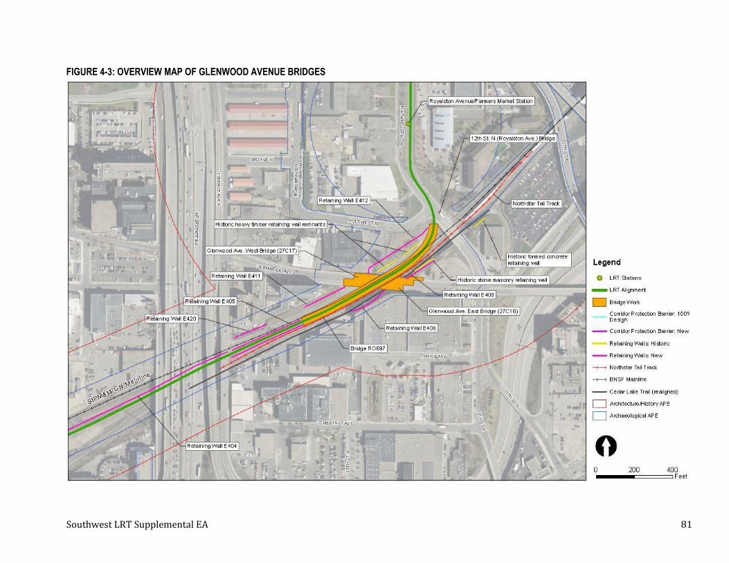
Southwest LRT Supplemental EA 81
FIGURE 4-3: OVERVIEW MAP OF GLENWOOD AVENUE BRIDGES

Southwest LRT Supplemental EA 82
4.4.2 Section 4(f) Property Description
The StPM&M / GN Historic District is an approximately 205-mile-long linear historic district that extends
from Minneapolis Junction in northeast Minneapolis, across the Mississippi River through the Minneapolis
Warehouse Historic District, west through Minneapolis and its several suburbs, and westward across
Minnesota to Breckenridge on the state border with North Dakota. The portion of the historic district
impacted by the Project design modifications is an approximately two-mile-long segment of the 205-mile
historic district in Minneapolis beginning roughly at 7th Street North and extending west of Cedar Lake
Junction. The width of this segment of the historic district varies considerably from approximately 100
feet to hundreds of feet at the railroad yards within the Warehouse District, Linden Yard west of Lyndale
Avenue, and Cedar Lake Yard located between Cedar Lake Junction and Cedar Lake. This segment of the
historic district includes a variety of features, both natural and man-made, and functions that collectively
constitute elements of the historic district. In the approximately two-mile-long segment of the Project
modifications, the historic StPM&M / GN right-of-way is adjacent to and shares the physical space in the
railroad corridor with the Minneapolis & St. Louis Railway (M&StL), which purchased the southern part of
the overall railroad corridor between downtown Minneapolis and Cedar Lake Junction from the StPM&M.
The land area of the railroad corridor that was jointly used by the StPM&M / GN and the M&StL will be
utilized for the proposed Project.
4.4.3 Potential Impacts to the StPM&M / GN Historic District
BNSF’s requirements would necessitate modifications to the Project design that are both within and just
outside the boundaries of the StPM&M / GN Historic District, which has been determined eligible for
inclusion in the NRHP. As such, all Project infrastructure required by the BNSF must be designed in
accordance with the Secretary of Interior’s (SOI’s) Standards for the Treatment of Historic Properties
(Standards) as required by MOA Stipulation I.A.
The effects of the Project design modifications on the StPM&M / GN Historic District include both direct
and indirect effects to an approximately two-mile-long segment of the approximately 205-mile historic
district and include an additional CPB wall, realignment and extension of the Northstar tail track,
realignment of the existing Cedar Lake Trail, drainage modifications, and removal and reconstruction of
historic retaining walls (see Section 4.4.1 for details). The design modifications within and in the vicinity
of the StPM&M / GN Historic District include design changes to previously approved Project elements,
additional alterations and additions to the historic district within a historic cut that extends from just
north of 12th Street North to Lyndale Avenue, and the introduction of an additional CPB wall from just east
of I-94 to the Project’s Bryn Mawr Station.
The new CPB wall will increase the total length of continuous CPB (walls and pier protection) in the
corridor from 1,136 feet (0.22 miles, not including the pier protection under the I-394 and Luce Line Trail
bridges) to 7,105 feet (1.35 miles; includes pier protection for I-394 and Luce Line Trail bridges). The
height of the CPB wall will also increase from a minimum of 6 feet above the railhead to 7.5 feet above the
railhead (approximately 10 feet above grade) on the freight rail side of the walls (visible height on the LRT
side will vary). These design changes are subject to MOA Stipulation I.A, which requires all Project
elements within and in the vicinity of the StPM&M / GN Historic District be designed in accordance with
the SOI’s Standards to minimize effects and avoid adverse effects on the historic district. In the case of the
proposed Project changes, adverse effects cannot be avoided but these elements will be designed to
minimize the adverse effects.

Southwest LRT Supplemental EA 83
The majority of the CPB wall will be constructed within the boundaries of the StPM&M / GN Historic
District, between the LRT tracks and the BNSF main line track. Along the entirety of the segment of the
StPM&M / GN Historic District and its setting where the CPB wall is proposed to be constructed, the
historic district and portions of its setting are characterized by open areas with very flat topography
where multiple tracks and other rail-related shops and industries were located. This condition existed
throughout the period of significance. The open spaces include most of the StPM&M / GN right-of-way as
well as the M&StL right-of-way that was co-located within the same railroad corridor and is an important
character defining feature of the historic district’s setting between 7th Street North and Cedar Lake
Junction in Minneapolis. The introduction of the CPB wall to the historic district will change physical and
spatial relationships of the BNSF main line with other physical features of the overall railroad corridor,
both within the historic district and its setting. It will also create a visual element that diminishes the
integrity of the property's significant historic features. More specifically, the introduction of the CPB will
create a physical and a visual barrier between the main line track and historic yards, which are also
contributing elements to the historic district. The CPB wall within this area diminishes the ability of this
segment of the historic district to convey its magnitude and function, as well as the association of the main
line tracks with their associated yards, and the M&StL main line, which are also important features of the
historic district’s setting. Thus, the introduction of the CPB wall to the historic district will both directly
and indirectly alter characteristics of a historic property that qualify it for inclusion in the NRHP in a
manner that would diminish the integrity of the property's design, setting, feeling, and association.
Therefore, the construction of the CPB wall will result in an adverse effect to the StPM&M / GN Historic
District.
Extension of the Northstar tail track is another condition required for use of BNSF property and
necessitates the relocation of the existing Cedar Lake Trail to the south/southeast from approximately 12th
Street North to Lyndale Avenue. The relocation of the trail will increase the LOD into the embankments
lining the historic railroad cut in the vicinity of 12th Street North; however, they are still within the
archeological and architectural APEs previously established for the Project. The trench and the feeling of
enclosure provided by the edges is an important character defining feature of the railroad corridor in the
area between 12th Street North and Lyndale Avenue. The Project modifications also include the removal of
several historic retaining walls along both sides of the tracks that date from the period of significance and
are contributing elements of the historic district. The historic walls will be replaced with new retaining
walls that will be set back from the historic retaining walls, thus altering (widening) the width of the
historic cut. Retaining walls will also be added to partially replace contributing historic earthen
embankments dating from the late 1860s or 1870s that are covered with vegetation, further altering the
historic character of the historic district in this area. The destruction of the historic retaining walls does
not meet the SOI’s Standards, which recommend that “the replacement of intact or repairable historic
materials or alteration of features, spaces and spatial relationships that characterize a property will be
avoided” and that “new construction will be undertaken in such a manner that, if removed in the future,
the essential form and integrity of the historic property and its environment would be unimpaired.” The
widening of the historic cut and the introduction of taller, modern concrete retaining walls that will
replace historic stone and concrete walls and vegetated earthen embankments will also change the
character of this segment of the historic district, thus further diminishing the ability of this segment of the
historic district to convey its integrity of design, workmanship, setting, feeling, and association. The
further widening of the trench also does not meet the SOI’s Standards, which requires that a new use
Southwest LRT Supplemental EA 84
require only “minimal change to its distinctive materials, features, spaces, and spatial relationships.” While
moving Retaining Wall E412 outside the historic district could be seen as minimizing the impacts of the
new wall, because the spatial relationships of the trench are an important character defining feature of the
historic district in the vicinity of 12th Street North, placing it outside the boundaries alters the spatial
relationships of the trench, so in the future it will feel larger than it was historically. Moreover, the clear
boundaries and setting of the historic district in this area, which are defined by the trench, will no longer
be clearly defined. Collectively, these modifications to the Project will result in the physical destruction of
contributing features of the historic district and will, therefore, adversely affect the integrity of design,
workmanship, setting, feeling, and association of this section of the historic district.
Based on the results of the effects assessment conducted by MnDOT CRU under delegation from FTA,
which is documented in Appendix A, FTA has determined that the Project will now have an Adverse Effect
on the StPM&M / GN Historic District. Therefore, in accordance with MOA Stipulation III, FTA will consult
with MnHPO and consulting parties to the MOA to prepare a mitigation plan to resolve the adverse effects.
In addition, as required by MOA Stipulation I.A., FTA will direct the Council to design changes to Project
elements in accordance with the SOI’s Standards to help minimize the adverse effects of the Project
modifications on the StPM&M / GN Historic District.
4.4.4 Background on Alternative Definition
Section 4.4.5 presents the avoidance alternatives considered and summarizes the FTA and Council
assessment of the feasibility and prudence of those avoidance alternatives. This section analyzes design
modifications that were evaluated prior to and during the negotiations with the BNSF to minimize adverse
effects to the StPM&M / GN Historic District. While these design modifications do not reflect avoidance of
the Section 4(f) use but rather result in a de minimis impact (as determined in the Southwest LRT Final
EIS/Section 4(f) Evaluation), the modifications went through the feasible and prudent evaluation process
to inform the Section 4(f) decision making process.
4.4.4.1 Design Modification Alternative – No CPB Wall or Tail Track Shift
This Design Modification Alternative removes the CPB wall and the Northstar tail track shift from the
Project modifications; however, both the CPB and the tail track are requirements of BNSF as part of the
negotiations for the Project to use a segment of BNSF’s Wayzata Subdivision20. As documented in the Final
EIS/Final Section 4(f) Evaluation, if selected this alternative constitutes a use under Section 4(f) but with a
de minimis impact, which avoids an adverse effect to the Section 4(f) historic property.
Evaluation of Feasibility
As per 23 CFR Part 774.17 of the Section 4(f) regulations, an alternative is not feasible if it cannot be built
as a matter of sound engineering judgment. FTA and the Council have determined that this Design
Modification Alternative will be feasible from an engineering perspective because no construction for the
CPB wall or shifting of the Northstar tail track will be required to implement this alternative.
20 These design modifications are not considered an avoidance alternative, as it results in a de minimis impact. However, to assist in the decision making, this alternative went through the feasible and prudent evaluation process.

Southwest LRT Supplemental EA 85
Evaluation of Prudence
Section 4.3.4 lists the Section 4(f) criteria used by FTA to determine the prudence of an avoidance
alternative as defined in 23 CFR Part 774.17. For this Design Modification Alternative, the most relevant
criteria are the first two:
• It compromises the Project to a degree that it is unreasonable to proceed with the Project in light
of its stated purpose and need; and
• It results in unacceptable safety or operational considerations.
PROJECT PURPOSE AND NEED
The Southwest LRT Project’s purpose and need is summarized in Chapter 1 of the Final EIS and Section
1.2 of this document. The Southwest LRT Project cannot be built on BNSF land without BNSF’s agreement.
One of the terms of the BNSF agreement is that the CPB wall and Northstar tail track extension are built as
part of the Project. If the Design Modification Alternative is selected and results in no CPB wall and no tail
track extension, the stated purpose and need for the Southwest LRT Project will not be met as BNSF will
not allow the Project to be built on its land.
This alternative does not meet the Project’s purpose and need and is not acceptable to BNSF. This Design
Modification Alternative would not meet BNSF requirements, nor would it allow the Council to use BNSF
right-of-way in the Wayzata Subdivision to build the Project.
OPERATIONAL CONSIDERATIONS RELATED TO THE CPB
The Project’s design as proposed in the Final EIS met the Federal Railroad Administration’s (FRA) safety
regulations, which provides a safety jurisdiction determination for the Project in its regulatory role over
the implementation of the Project in the vicinity of existing freight rail. During the Final EIS, FRA’s safety
jurisdiction determination concluded that the proposed Project will be an urban rapid transit operation
and, therefore, FRA will exercise its safety jurisdiction and regulations over five shared highway-rail grade
crossings for the Project.21
During Project design, the Council also followed safety and security policies that establish minimum
requirements for facilities based on local, state, and federal codes or standards, the Council’s guidance, and
the Safety and Security Management Plan (SSMP) for the Project. The policies provide for consistency,
integrity, and safety when operating LRT systems (see Section 4.4 and 4.6 of the Final EIS for additional
discussion of the safety regulations that apply to the Project). A number of these criteria, including the use
of restraining and emergency guardrail, relate to preventing derailments at potentially higher risk
locations. Specifically, the Project includes the following safety commitments as detailed in the Final EIS
and ROD:
• Corridor protection barriers between freight rail and light rail tracks where clearance between
centerlines is less than 25 feet;
• Conform to FTA’s Rail Fixed Guideway Systems; State Safety Oversight Program for Safety and
Security Guidance for Recipients with Major Capital Projects (Circular C 5800.1), covered under 49
CFR Part 633 – Project Management Oversight;
21 The five highway-rail crossings at grade through which freight rail traffic will operate in the corridor that it will share with the Project are located at 5th Avenue South, Blake Road North, Wooddale Avenue, Beltline Boulevard, and 21st Street.

Southwest LRT Supplemental EA 86
• Coordinate with, as applicable, the State of Minnesota railroad and pipeline safety regulations that
went into effect in July 2014 as part of MN Chapter 312; and
• Design shared freight rail and light rail crossings to meet FRA requirements for at-grade crossings,
including requirements for train horn quiet zones as described in the Train Horn Quiet Zone Final
Rule (49 CFR Part 222), where applicable.
During the negotiations that followed the publication of the Final EIS/Final Section 4(f) Evaluation and
issuance of the ROD, the BNSF outlined requirements beyond the safety regulations that the Project was
designed to such that “in the event of a derailment of either a freight train or a light rail train, that neither
train would enter the operating envelope of the other train.” The Council evaluated other corridor
protection treatments as alternatives to a CPB wall that could minimize the potential risk of an incident
between freight and LRT tracks. Table 4-4 summarizes the potential effectiveness of various corridor
protection treatments that were studied by the Council.
TABLE 4-4: CORRIDOR PROTECTION TREATMENTS CONSIDERED
Corridor Protection Treatment
Rationale
1 Monitoring systems
Enables railroad and transit signal and communication systems to warn of a derailment fouling operations of an adjacent track. Potential to be very effective when the train on the adjacent track has sufficient stopping distance.
2 Emergency guardrail
Assists in keeping rolling stock within the track area in the event of a derailment. Assumes inclusion of guardrail could reduce the risk of fouling operations of an adjacent track by 10%.
3
Mechanical monitoring of freight rolling stock
Focus on reducing mechanical-related incidents and derailments. Historical data suggests implementation can decrease mechanical derailments by 64% and, based on BNSF data, reduce derailments overall by 20.5%.
4 Earth berm (6 feet in height)
Limits the dispersion of rolling stock in the event of a derailment. Vertical differentiation could be helpful in minimizing the risk of dispersion fouling operations of an adjacent track.
5 Increase track separation from 25 feet to 40 feet
Limits the dispersion of rolling stock in the event of a derailment due to an increase in track separation.
6 Ditch (6 feet in depth)
Limits the dispersion of rolling stock in the event of a derailment. No papers specifically discuss the potential effectiveness of a ditch as an independent solution. Vertical differentiation could be helpful in minimizing the risk of dispersion fouling operations of an adjacent track.
7 Wall (6 feet in height from top of freight rail)
Limits the dispersion of rolling stock in the event of a derailment by constructing an above-grade physical barrier between freight.
8 LRT on retained embankment
The retaining wall supporting the LRT track can be designed to limit fouling associated with a derailment in a manner similar to Corridor Protection Treatment 7 - Wall above.
9
LRT on vertical structure adjacent to or crossing freight
The use of a vertical structure has the potential to reduce the probability of dispersion of freight rolling stock.
The Council offered these alternative corridor protection measures in Table 4-4 during negotiations;
however, these measures were not acceptable to BNSF. BNSF required additional safety considerations in
the form of extending the CPB wall both in terms of length and height as a condition to allow the Project to
be constructed on BNSF property.
Southwest LRT Supplemental EA 87
OPERATIONAL CONSIDERATIONS RELATED TO THE TAIL TRACK SHIFT
The Council is requesting joint use of land that is governed by a 2007 lease of land agreement between the
Council and BNSF for the land that BNSF owns within the Wayzata Subdivision. The lease details
requirements for storage and access to the Northstar platform and for normal maintenance and operation
of the track. Per these terms detailed in the lease agreement, BNSF is requesting the Northstar tail track
extension be a condition of the right-of-way negotiations to allow the Project to be constructed on BNSF
property.
BNSF is seeking to maintain as much of its current right-of-way as possible so that the company has the
capacity to meet current and potential future needs. The Northstar tail track shift and associated Project
modifications related to drainage and retaining walls are required to preserve existing space on BNSF
property for this purpose.
Design Modification Alternative Determination
As documented in the Final EIS/Final Section 4(f) Evaluation, the Design Modification Alternative (no CPB
wall and no tail track shift) would be a use under Section 4(f) that would have a de minimis impact, as it
would avoid an adverse effect of the Section 4(f) historic resource. The Design Modification Alternative is
feasible to construct, but it is deemed not prudent under criteria defined in 23 CFR Part 774.17.
4.4.5 Avoidance Alternatives Analysis
The Section 4(f) statute requires the selection of an alternative that completely avoids the use of Section
4(f) property if that alternative is deemed feasible and prudent. The No-Build alternative and Avoidance
Alternatives would completely avoid the use of any Section 4(f) property. The following sections
summarize the FTA and Council assessment of the feasibility and prudence of the avoidance alternatives.
4.4.5.1 No-Build Alternative
The No-Build Alternative is required by the National Environmental Policy Act (NEPA) and Minnesota
Environmental Policy Act (MEPA) processes and includes all existing and committed transportation
infrastructure, facilities, and services contained in the Region’s fiscally constrained and federally approved
transportation plan, the Council’s Transportation Policy Plan.
As defined in Chapter 2 – Alternatives Considered in the Final EIS, the No-Build Alternative will completely
avoid a use of the Section 4(f) resource.
Evaluation of Feasibility
As per 23 CFR Part 774.17 of the Section 4(f) regulations, an alternative is not feasible if it cannot be built
as a matter of sound engineering judgment. FTA and the Council have determined that the No-Build
Alternative will be feasible from an engineering perspective because no construction will be required to
implement the alternative.
Evaluation of Prudence
Section 4.3.4 of this document lists the Section 4(f) criteria used by FTA to determine the prudence of an
avoidance alternative as defined in 23 CFR Part 774.17. For the No-Build Alternative, the most relevant
criterion is the first: “It compromises the Project to a degree that it is unreasonable to proceed with the
Project in light of its stated purpose and need.”
Southwest LRT Supplemental EA 88
The Southwest LRT Project’s purpose and need is summarized in Chapter 1 of the Final EIS and Section
1.2 of this document. FTA and the Council have concluded that, while the No-Build Alternative will avoid
the adverse effect and Section 4(f) use, the No-Build Alternative will not adequately support the purpose
and need of the Southwest LRT Project as expressed through the proposed Southwest LRT Project’s
evaluation criteria (see Chapter 2 of the Final EIS). In summary, the No-Build Alternative will be
inconsistent with local and regional comprehensive plans, which include or are consistent with
implementation of the Southwest LRT Project. Furthermore, the No-Build Alternative will not improve
mobility, provide a reliable and efficient travel option, or support an investment in additional light rail
transit in the region, which are key elements of the Southwest LRT Project’s purpose and need (see
Chapter 1 of the Final EIS).
FTA and the Council have determined that the No-Build Alternative will compromise the proposed
Southwest LRT Project to a degree that the stated purpose and need for the Southwest LRT Project will
not be met; therefore, the No-Build Alternative does not constitute a prudent alternative that will fully
avoid the use of the Section 4(f) property.
Avoidance Alternative Determination
The No-Build Alternative will avoid uses of all Section 4(f) resources, but it is deemed not prudent under
the definition in 23 CFR Part 774.17 because it neither addresses nor corrects the transportation purpose
and need that prompted the proposed Southwest LRT Project.
4.4.5.2 Location Avoidance Alternative – Alternative 3C-1 (Nicollet Mall) from the Draft EIS
Alternative 3C-1 (Nicollet Mall) was studied as part of the Draft EIS and is evaluated in this Amended Draft
Section 4(f) Evaluation because this alternative avoids using BNSF right-of-way and therefore will
completely avoid a use of the Section 4(f) resource. Alternative 3C-1 travels between Mitchell Road in
Eden Prairie and downtown Minneapolis, providing service to Eden Prairie, Minnetonka, Hopkins, Edina,
St. Louis Park, and Minneapolis. For additional description and background on the alternatives evaluation
process, see Chapter 8 of the Final EIS and Figure 4-4.
This alternative, as defined in the Draft EIS, included relocating the existing freight rail service operating
on the Bass Lake Spur and the Cedar Lake Junction between just east of Louisiana Avenue in St. Louis Park
and Penn Avenue in Minneapolis to the Minneapolis, Northfield and Southern Railway (MN&S) line in St.
Louis Park. The freight rail relocation would result in the cessation of freight rail service on this section of
the Bass Lake Spur and the HCRRA Cedar Lake Junction (Kenilworth Corridor)22.
This alternative would operate from TH 5 and Mitchell Road on new right-of-way along Technology Drive
through the Golden Triangle/Opus areas to the HCRRA property through Hopkins and St. Louis Park, then
to the Midtown corridor through Minneapolis, to Nicollet Avenue (tunnel from Franklin Avenue to 28th
Street) then Nicollet Mall.
22 Although Alternative 3C-1 did not advance as the Locally Preferred Alternative (LPA), freight rail relocation was studied in the Final EIS. The LPA was adjusted to include a light rail tunnel in the Kenilworth Corridor (generally between West Lake Street and the Kenilworth Lagoon) to retain the existing freight rail service in the Kenworth Corridor, with some modifications to freight rail tracks to accommodate light rail. Freight rail relocation is not being studied again as part of the Supplemental EA or the Amended Draft Section 4(f) Evaluation. For additional background on the LPA selection process, see Chapter 8 of the Final EIS.

Southwest LRT Supplemental EA 89
Stations were proposed at Mitchell Road, Southwest Station, Eden Prairie Town Center, Golden Triangle,
City West, Opus, Shady Oak Road, downtown Hopkins, Blake Road, Louisiana Avenue, Wooddale Avenue,
Beltline Boulevard, West Lake Street, Hennepin Avenue (Uptown), Lyndale Avenue, 28th Street, Franklin
Avenue, 12th Street, 8th Street, and 4th Street.
The evaluation of feasibility and prudence for this alternative is included in Section 4.4.5.3 with the other
location avoidance alternative.

Southwest LRT Supplemental EA 90
FIGURE 4-4: ALTNERATIVE 3C-1
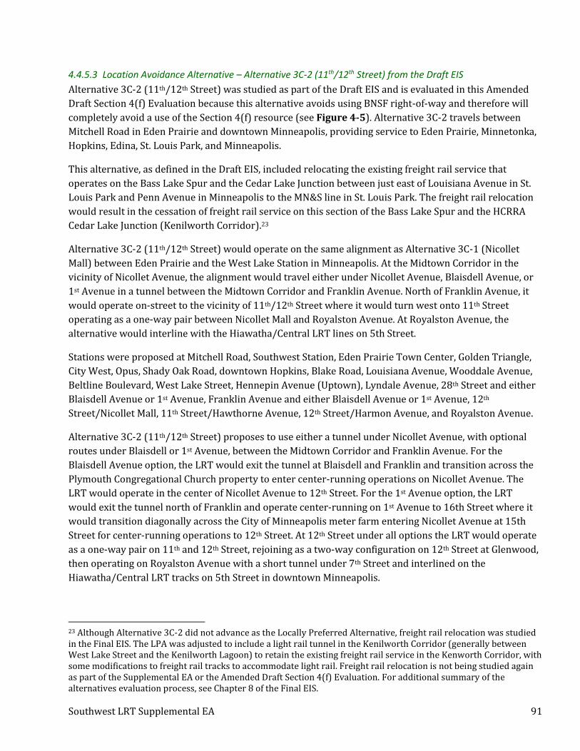
Southwest LRT Supplemental EA 91
4.4.5.3 Location Avoidance Alternative – Alternative 3C-2 (11th/12th Street) from the Draft EIS
Alternative 3C-2 (11th/12th Street) was studied as part of the Draft EIS and is evaluated in this Amended
Draft Section 4(f) Evaluation because this alternative avoids using BNSF right-of-way and therefore will
completely avoid a use of the Section 4(f) resource (see Figure 4-5). Alternative 3C-2 travels between
Mitchell Road in Eden Prairie and downtown Minneapolis, providing service to Eden Prairie, Minnetonka,
Hopkins, Edina, St. Louis Park, and Minneapolis.
This alternative, as defined in the Draft EIS, included relocating the existing freight rail service that
operates on the Bass Lake Spur and the Cedar Lake Junction between just east of Louisiana Avenue in St.
Louis Park and Penn Avenue in Minneapolis to the MN&S line in St. Louis Park. The freight rail relocation
would result in the cessation of freight rail service on this section of the Bass Lake Spur and the HCRRA
Cedar Lake Junction (Kenilworth Corridor).23
Alternative 3C-2 (11th/12th Street) would operate on the same alignment as Alternative 3C-1 (Nicollet
Mall) between Eden Prairie and the West Lake Station in Minneapolis. At the Midtown Corridor in the
vicinity of Nicollet Avenue, the alignment would travel either under Nicollet Avenue, Blaisdell Avenue, or
1st Avenue in a tunnel between the Midtown Corridor and Franklin Avenue. North of Franklin Avenue, it
would operate on-street to the vicinity of 11th/12th Street where it would turn west onto 11th Street
operating as a one-way pair between Nicollet Mall and Royalston Avenue. At Royalston Avenue, the
alternative would interline with the Hiawatha/Central LRT lines on 5th Street.
Stations were proposed at Mitchell Road, Southwest Station, Eden Prairie Town Center, Golden Triangle,
City West, Opus, Shady Oak Road, downtown Hopkins, Blake Road, Louisiana Avenue, Wooddale Avenue,
Beltline Boulevard, West Lake Street, Hennepin Avenue (Uptown), Lyndale Avenue, 28th Street and either
Blaisdell Avenue or 1st Avenue, Franklin Avenue and either Blaisdell Avenue or 1st Avenue, 12th
Street/Nicollet Mall, 11th Street/Hawthorne Avenue, 12th Street/Harmon Avenue, and Royalston Avenue.
Alternative 3C-2 (11th/12th Street) proposes to use either a tunnel under Nicollet Avenue, with optional
routes under Blaisdell or 1st Avenue, between the Midtown Corridor and Franklin Avenue. For the
Blaisdell Avenue option, the LRT would exit the tunnel at Blaisdell and Franklin and transition across the
Plymouth Congregational Church property to enter center-running operations on Nicollet Avenue. The
LRT would operate in the center of Nicollet Avenue to 12th Street. For the 1st Avenue option, the LRT
would exit the tunnel north of Franklin and operate center-running on 1st Avenue to 16th Street where it
would transition diagonally across the City of Minneapolis meter farm entering Nicollet Avenue at 15th
Street for center-running operations to 12th Street. At 12th Street under all options the LRT would operate
as a one-way pair on 11th and 12th Street, rejoining as a two-way configuration on 12th Street at Glenwood,
then operating on Royalston Avenue with a short tunnel under 7th Street and interlined on the
Hiawatha/Central LRT tracks on 5th Street in downtown Minneapolis.
23 Although Alternative 3C-2 did not advance as the Locally Preferred Alternative, freight rail relocation was studied in the Final EIS. The LPA was adjusted to include a light rail tunnel in the Kenilworth Corridor (generally between West Lake Street and the Kenilworth Lagoon) to retain the existing freight rail service in the Kenworth Corridor, with some modifications to freight rail tracks to accommodate light rail. Freight rail relocation is not being studied again as part of the Supplemental EA or the Amended Draft Section 4(f) Evaluation. For additional summary of the alternatives evaluation process, see Chapter 8 of the Final EIS.

Southwest LRT Supplemental EA 92
FIGURE 4-5: ALTERNATIVE 3C-2
Southwest LRT Supplemental EA 93
Evaluation of Feasibility – for Alternatives 3C-1 and 3C-2
Per 23 CFR Part 774.17 of the Section 4(f) regulations, an alternative is not feasible if it cannot be built as a
matter of sound engineering judgment. FTA and the Council have determined that the Location Avoidance
Alternatives 3C-1 and 3C-2 that were evaluated as part of the Draft EIS would be feasible from an
engineering perspective.
Evaluation of Prudence – for Alternatives 3C-1 and 3C-2
For the Location Avoidance Alternatives (3C-1 and 3C-2), the most relevant criteria are:
• It compromises the Project to a degree that it is unreasonable to proceed with the Project in light
of its stated purpose and need;
• It results in unacceptable safety or operational problems;
• It results in additional construction, maintenance, and operation costs of an extraordinary
magnitude; and
• After reasonable mitigation, it still causes severe disruption to established communities.
Both alternatives were previously evaluated in the Draft EIS and found to only partially meet the Project’s
purpose and need. The alternatives will improve access and mobility to jobs; however, they will not
provide a cost-effective transportation option and instead would provide duplicate transit service to the
saturated transit markets in the Uptown Minneapolis area. The service duplication has several
consequences, including higher operating costs and providing a sub-optimal resource for the public. The
Project could not replace the existing bus service operating in Midtown Corridor because this would be
detrimental to the existing service levels and disenfranchise current transit riders as it would need to
operate at a lower service frequency than the current bus service in the Midtown area.
Furthermore, of all the alternatives studied in the Draft EIS, Alternatives 3C-1 and 3C-2 had the highest
costs for acquiring right-of-way and the design would result in severe construction complexity and
permitting. Both alternatives would cost approximately $500 million more than the preferred alternative.
The differences in ridership and travel time benefits for these alternatives were insufficient to offset the
greater capital cost and were unlikely to qualify for federal funding without major revisions. These
combined factors combined could delay implementation and would result in additional costs.
The Location Avoidance Alternatives also were found to have significantly greater numbers of known
historic resources, contaminated properties, and potential noise and vibration receptors than the
preferred alternative. In addition, the two alternatives would have disproportionately high and adverse
effects on low income and minority populations associated with:
• Acquisitions and displacements from 241 parcels from environmental justice areas24;
• Community cohesion (impacts on environmental justice populations resulting from a separation in
the seamless trail network along the Midtown Greenway);
• Construction effects (disruptions associated with the construction of a cut-and-cover tunnel in
environmental justice areas); and
24 Environmental justice area is defined as area in any census tract where 20 percent or more individuals live in poverty and/or 30 percent or more of the population is minority.

Southwest LRT Supplemental EA 94
• Traffic (intersection in environmental justice area degrades from level of service “A” to “E”).
During the Draft EIS, LRT 3A25 was recommended for selection as the Locally Preferred Alternative (LPA).
Based on the information at that time it best met the Project’s purpose and need statement as expressed
by the goals of improving mobility, providing a cost-effective and efficient travel option, preserving the
environment, protecting quality of life, and supporting economic development.
Location Avoidance Alternatives Determination
The Location Avoidance Alternatives (3C-1 and 3C-2) would avoid uses of the Section 4(f) resources
considered in this Evaluation, but neither are deemed prudent under the definition in 23 CFR Part 774.17.
Neither alternative addresses nor corrects the transportation purpose and need that prompted the
proposed Southwest LRT Project, and both will result in operational problems if implemented, cause
severe disruption to established communities, and result in additional construction and operation costs.
4.4.6 All Possible Planning to Minimize Harm Analysis
In addition to a determination that there is no feasible and prudent alternative that avoids the use of a
Section 4(f) resource, the Section 4(f) regulations also state that FTA may not approve the use of a Section
4(f) resource unless it determines that the proposed action includes all possible planning, as defined in 23
CFR Part 774.17, to minimize harm to the property resulting from such use.
4.4.6.1 Refinements to the Preferred Alternative between the Draft EIS and Final EIS
Following the publication of the Southwest LRT Draft EIS, a technical memorandum was produced to
evaluate and determine the preferred alignment south and west of the Royalston Station and within the
BNSF corridor (see Appendix B for the 2013 Royalston Station/Interchange Project Connection (TI-20)
Technical Issue Resolution). The results of the analysis were used to determine the preferred alignment
along this segment of the Project. The three alternatives evaluated in the memorandum included:
1. Alignment 1: The LPA Modified alignment is grade separated over 7th Street, runs in the center
median on Royalston Avenue with a center platform, cuts through Holden Street (closing it to traffic
due to grade differences), and enters the BSNF rail corridor at-grade before passing under the existing
Glenwood Avenue bridge (see Figure 4-6).
2. Alignment 2: This alignment for the Project is grade-separated over 7th Street, runs on a modified east
side Royalston Avenue location with an east side platform, crosses through the intersection of
Royalston Avenue and Holden Street, crosses over the BNSF tracks on a new bridge, crosses Glenwood
Avenue at-grade between two new bridges, and descends to grade in the BNSF corridor before passing
under the existing I-94 bridges (see Figure 4-7).
3. Alignment 3: This alignment for the Project is grade separated over 7th Street, runs on a modified east
side Royalston Avenue location before making a diagonal through Holden Street where the platform is
located, crosses over the BNSF tracks on a new bridge, crosses Glenwood Avenue at-grade between
25 LRT 3A as defined in the Draft EIS travels between Mitchell Road in Eden Prairie and downtown Minneapolis, providing service to Eden Prairie, Minnetonka, Hopkins, Edina, St. Louis Park, and Minneapolis. Stations are proposed at Mitchell Road, Southwest Station, Eden Prairie Town Center, Golden Triangle, City West, Opus, Shady Oak Road, downtown Hopkins, Blake Road, Louisiana Avenue, Wooddale Avenue, Beltline Boulevard, West Lake Street, 21st Street, Penn Avenue, Van White Boulevard, and Royalston Avenue.

Southwest LRT Supplemental EA 95
two new bridges, and descends to grade in the BNSF corridor before passing under the existing I-94
bridges (see Figure 4-8).
FIGURE 4-6: ALIGNMENT 1 – LPA MODIFIED ALIGNMENT

Southwest LRT Supplemental EA 96
FIGURE 4-7: ALIGNMENT 2 – ALIGNMENT SELECTED TO ADVANCE IN THE FINAL EIS
FIGURE 4-8: ALIGNMENT 3 – PLATFORM LOCATED ON A DIAGONAL THROUGH HOLDEN STREET
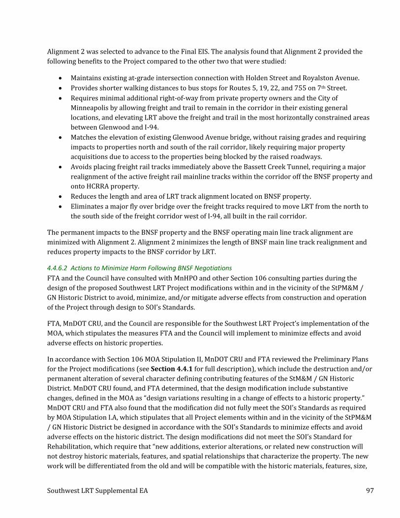
Southwest LRT Supplemental EA 97
Alignment 2 was selected to advance to the Final EIS. The analysis found that Alignment 2 provided the
following benefits to the Project compared to the other two that were studied:
• Maintains existing at-grade intersection connection with Holden Street and Royalston Avenue.
• Provides shorter walking distances to bus stops for Routes 5, 19, 22, and 755 on 7th Street.
• Requires minimal additional right-of-way from private property owners and the City of
Minneapolis by allowing freight and trail to remain in the corridor in their existing general
locations, and elevating LRT above the freight and trail in the most horizontally constrained areas
between Glenwood and I-94.
• Matches the elevation of existing Glenwood Avenue bridge, without raising grades and requiring
impacts to properties north and south of the rail corridor, likely requiring major property
acquisitions due to access to the properties being blocked by the raised roadways.
• Avoids placing freight rail tracks immediately above the Bassett Creek Tunnel, requiring a major
realignment of the active freight rail mainline tracks within the corridor off the BNSF property and
onto HCRRA property.
• Reduces the length and area of LRT track alignment located on BNSF property.
• Eliminates a major fly over bridge over the freight tracks required to move LRT from the north to
the south side of the freight corridor west of I-94, all built in the rail corridor.
The permanent impacts to the BNSF property and the BNSF operating main line track alignment are
minimized with Alignment 2. Alignment 2 minimizes the length of BNSF main line track realignment and
reduces property impacts to the BNSF corridor by LRT.
4.4.6.2 Actions to Minimize Harm Following BNSF Negotiations
FTA and the Council have consulted with MnHPO and other Section 106 consulting parties during the
design of the proposed Southwest LRT Project modifications within and in the vicinity of the StPM&M /
GN Historic District to avoid, minimize, and/or mitigate adverse effects from construction and operation
of the Project through design to SOI’s Standards.
FTA, MnDOT CRU, and the Council are responsible for the Southwest LRT Project’s implementation of the
MOA, which stipulates the measures FTA and the Council will implement to minimize effects and avoid
adverse effects on historic properties.
In accordance with Section 106 MOA Stipulation II, MnDOT CRU and FTA reviewed the Preliminary Plans
for the Project modifications (see Section 4.4.1 for full description), which include the destruction and/or
permanent alteration of several character defining contributing features of the StM&M / GN Historic
District. MnDOT CRU found, and FTA determined, that the design modification include substantive
changes, defined in the MOA as “design variations resulting in a change of effects to a historic property.”
MnDOT CRU and FTA also found that the modification did not fully meet the SOI’s Standards as required
by MOA Stipulation I.A, which stipulates that all Project elements within and in the vicinity of the StPM&M
/ GN Historic District be designed in accordance with the SOI’s Standards to minimize effects and avoid
adverse effects on the historic district. The design modifications did not meet the SOI’s Standard for
Rehabilitation, which require that “new additions, exterior alterations, or related new construction will
not destroy historic materials, features, and spatial relationships that characterize the property. The new
work will be differentiated from the old and will be compatible with the historic materials, features, size,

Southwest LRT Supplemental EA 98
scale and proportion, and massing to protect the integrity of the property and its environment.” FTA and
MnDOT CRU applied the criteria of adverse effect in accordance with 36 CFR Part 800.5(a) and the
Project’s Section 106 MOA and FTA determined under Section 106 that the design changes would have an
adverse effect on the StPM&M / GN Historic District (see MnDOT CRU’s Section 106 Assessment of the CPB
in Appendix A for complete analysis).
FTA and the Council have consulted with MnHPO and identified consulting parties per the terms of MOA
Stipulation III to prepare a mitigation plan to resolve the adverse effect. One of the measures FTA and the
Council agreed to implement as a condition of Project funding was to minimize adverse effects to the
extent feasible. To minimize the adverse effect on the StPM&M / GN Historic District, new infrastructure
constructed for the Project will be designed in accordance with the SOI’s Standard for Rehabilitation that
requires “the new work will be differentiated from the old and will be compatible with the historic
materials, features, size, scale and proportion, and massing to protect the integrity of the property and its
environment.” To the extent feasible, new infrastructure will also be designed in accordance with the SOI’s
Standard for Rehabilitation that requires that “new additions and adjacent or related new construction
will be undertaken in such a manner that, if removed in the future, the essential form and integrity of the
historic property and its environment would be unimpaired.” This will help to minimize the adverse
effects on the StPM&M / GN Historic District and minimize harm resulting from the use of the Section 4(f)
resource.
As noted in MOA Stipulation III, FTA will consult with MnHPO and consulting parties to the MOA to
prepare a mitigation plan that will include options to resolve the adverse effects. This will include
measures such as Minnesota Historic Property Record documentation and physical interpretation in the
form of interpretive panels, integrated elements, and/or online materials.
Based on the summary within this section, FTA has determined in accordance with 23 CFR Part 774.17
that all possible planning to minimize harm to the StPM&M / GN Historic District will be conducted and
implemented through the Southwest LRT Project’s Section 106 process and with the implementation of
the Project’s Section 106 MOA.
4.5 Coordination
This section addresses Section 4(f) coordination and concurrence requirements set forth in 23 CFR Part
774 by providing a summary of the Project’s Section 4(f) coordination activities that have occurred with
regard to the StPM&M / GN Historic District.
4.5.1 Public Engagement
See Section 5.1 for a summary of public engagement activities that have taken place to date regarding the
CPB wall.
4.5.2 Department of Interior
The Amended Draft Section 4(f) Evaluation will be provided to the Department of Interior (DOI) for
review and comment. The DOI’s comments on the Amended Draft Section 4(f) Evaluation will be provided
in the Project’s Final Section 4(f) Evaluation.

Southwest LRT Supplemental EA 99
4.5.3 Officials with Jurisdiction
The official with jurisdiction for this property is MnHPO. Following is a summary of the Section 4(f)
consultation activities that have occurred with officials with jurisdiction since publication of the Final EIS.
• November 28, 2017 meeting with MnHPO and consulting parties under Section 106. See Appendix
A for meeting notes and materials.
4.6 Preliminary Determination of Section 4(f) Use
Based on Southwest LRT Project’s 90% engineering plans for the Project modifications required by the
BNSF and analysis summarized in this Amended Draft Section 4(f) Evaluation, FTA has made the following
preliminary Section 4(f) determination:
• The existing Southwest LRT Project alignment, with the addition of the Project modifications
required by BNSF, would result in a Section 4(f) direct use of the StPM&M / GN Historic District,
and there is no feasible and prudent alternative that would avoid a use of this Section 4(f)
resource. In addition, FTA has determined in accordance with 23 CFR Part 774.17 that all possible
planning to minimize harm has been conducted and implemented. Further, FTA and the Council
have determined that the alternative that would result in the least overall harm to this historic
resource is the existing Project alignment with the proposed Project modifications designed in
accordance with the SOI’s Standards to the extent feasible, as required by the Project’s Section 106
MOA.
5 Comments and Coordination
5.1 Public Engagement – BNSF Negotiation Modifications
The Metropolitan Council takes public engagement seriously as demonstrated by the hundreds of
community meetings, events, and presentations held. The wall design process is no different, and the
Council has created a process to ensure meaningful and transparent engagement (see Appendix D for the
public engagement plan for the CPB wall and meeting summaries). Generally, the input received at these
events was related to a high interest in the design aesthetics for the CPB and concerns regarding the
options for pedestrians crossing the railroad and two LRT lines. The following public engagement
activities have taken place to date regarding the CPB wall.
5.1.1 Bassett Creek Valley Working Group
The Bassett Creek Valley Working Group (BCVWG) was created to:
• Serve as a voice for the community and liaison to the organizations they represent;
• Provide guidance on the aesthetic treatment of the corridor protection barrier wall; and
• Advise on communications and outreach strategies related to the process.
The group had their first meeting on October 4, 2017, toured the corridor on October 12, 2017, and met on
October 27, December 5, 2017, and December 19, 2017. All of the working group’s meeting information,
including agendas, presentations, and meeting notes, are posted on the Project’s website

Southwest LRT Supplemental EA 100
(www.swlrt.org26), under the “Environmental” tab. The work of the BCVWG will be shared with the
SWLRT Corridor Management Committee (CMC) during the design process. SWLRT CMC meetings are
open to the public and advertised on www.swlrt.org and through the Project’s e-mail notification system.
5.1.2 Presentations to Community/Neighborhood Groups
The Council’s outreach team has provided an overview of the CPB wall to, and received feedback from, the
following groups to date:
• Bryn Mawr Neighborhood Association (September 13, 2017 and October 11, 2017)
• Harrison Neighborhood (September 14, 2017)
• Bassett Creek Redevelopment Oversight Committee (September 19, 2017 and October 17, 2017)
Council staff will continue attend additional meetings with the community groups listed above in 2018 to
provide project updates on this topic.
5.1.3 Corridor Tours
The Council hosted two tours with elected officials and staff in September 2017 and one in October 2017.
In addition, three public tours were hosted to encourage local residents to learn about the CPB wall. They
were held on the following dates and times to accommodate a variety of schedules and needs of the public:
• Monday, October 23, 2017, 4:30 - 6:00 p.m.
• Thursday, October 26, 2017, 12:00 - 1:30 p.m.
• Wednesday, November 8, 2017, 7:30 - 9:00 a.m.
5.1.4 Community Open House/Pop-Up Events
A community open house was held on November 15, 2017 as part of the public engagement process.
Approximately 65 members of the public attended the open house where they could discuss design and
Section 106 issues with staff and provide direct input on preferred design options. Materials presented at
the community open house are shared on the Project’s website for members of the public to provide
feedback as well. See Appendix D for the November 15, 2017 meeting summary.
Two pop-up events were held in November 2017 along the trail to share information with commuter and
recreational trail users. The two pop-up events were held at the following times:
• Wednesday, November 29, 2017, 11:30 a.m. – 12:30 p.m.
• Thursday, November 30, 2017, 3:30 p.m. – 4:30 p.m.
The pop-up events were advertised using the Project’s Twitter account, which has 495 followers.
5.1.5 Project Website
The project’s website (www.swlrt.org) serves as the repository of project information for the public. The
website contains a “Construction” page that includes information and a video about the freight rail
corridor protection for the project and will be updated as design progresses.
26 The full URL is https://metrocouncil.org/Transportation/Projects/Light-Rail-Projects/Southwest-LRT/Environmental/Freight-Rail-Corridor-Protection.aspx?source=child

Southwest LRT Supplemental EA 101
5.2 USFWS
The final rule to list the rusty patched bumble bee under the Endangered Species Act was published in the
Federal Register on January 11, 2017, with an effective date of February 10, 2017. The effective date was
subsequently extended to March 21, 2017. The listing became effective after the issuance of the Project’s
ROD.
The Council consulted with the USFWS in September and October 2017 and February 2018 to confirm the
determination for the rusty patched bumble bee (Bombus affinis). See Appendix E for the memorandum
that documents the detailed analysis of the rusty patched bumble bee.
FTA has requested concurrence from the USFWS on a determination of “may affect, not likely to adversely
affect.”
5.3 MnHPO
Based on the results of the assessment of effect analysis for the BNSF negotiation modifications
(Modification H) conducted by MnDOT CRU under delegation from FTA, FTA has issued an adverse effect
finding on the StPM&M / GN Historic District. In accordance with MOA Stipulation III, FTA will consult
with MnHPO and concurring parties to the MOA to prepare a mitigation plan to resolve the adverse effects.
5.4 Public Review
The Southwest LRT Project Supplemental EA/Amended Draft Section 4(f) Evaluation will be available for
public review and comment in accordance with pertinent federal and state environmental review and
distribution requirements.
6 Commitments and Recommendations Attachment A of the Southwest LRT ROD outlines Project mitigation measures and responsible parties by
environmental and transportation category. The proposed changes to the Project evaluated in this
Supplemental EA will result in several modifications to the mitigation measures defined in the ROD, as
summarized below:
• Modification F – Cedar Lake LRT Regional Trail Detour: Revised trail detour route for the
Cedar Lake LRT Regional Trail during construction.
• Modification G – Bryn Mawr Meadows Trail Mitigation: Revised trail detour route during the
Luce Line bicycle/pedestrian bridge closure, relocation, and construction. Trail detour route will
use existing trails and will include repaving approximately 1,800 feet of existing trail in Bryn Mawr
Meadows Park in Minneapolis.
• Modification H – BNSF Negotiation Modifications:
o Drainage modifications for the Northstar tail track extension, required as part of the BNSF
negotiations and agreement.
o Based on the results of the assessment of effect analysis conducted by MnDOT CRU under
delegation from FTA, which is documented in Appendix A, FTA has determined that the
Project will now have an Adverse Effect on the StPM&M / GN Historic District. Therefore,
in accordance with MOA Stipulation III, FTA will consult with MnHPO and concurring
parties to the MOA to prepare a mitigation plan to resolve the adverse effects. In addition,

Southwest LRT Supplemental EA 102
as required by MOA Stipulation I.A., FTA will direct the Council to design proposed changes
to Project elements in accordance with the SOI Standards to help minimize the adverse
effects of the Project modifications on the StPM&M / GN Historic District.
o Based on the physical change in visual quality combined with the sensitivity of the view
from trail users, the level of impact for this Project change will result in a moderate degree
of visual impact. The impact will be mitigated through the Section 106 review process and
public outreach to work with the community and Section 106 consulting parties on the
design aesthetics of the CPB wall to minimize visual impacts.
• Modification J – New Potential Construction Laydown Areas (Fremont Avenue North site –
Laydown Area #5): The laydown site on the west side of Fremont Avenue North is a high-risk
area that was not investigated in the Phase I or Phase II ESAs, and using it without first
investigating and requesting letters of assurance from MPCA creates unacceptable risk and should
be avoided. For this reason, the Council and MnDOT requested a No Association Determination
(assurance letter) for the identified releases to soil and groundwater from the MPCA on October 4,
2017 using historical soil and groundwater data for parcels on both the east and west sides of
Fremont Avenue North. The Council is currently awaiting a response from the MPCA.
The Council has undertaken a thorough analysis of the Project modifications and its impacts. Based on the
analysis documented in this Supplemental EA, coordination with affected agencies, public involvement,
and comment letters received, the Council and FTA will finalize the project commitments and issue an
amended environmental decision document for the proposed changes to the Southwest LRT project since
the publication of the Final EIS and issuance of the ROD in 2016.