Final Environmental Impact Statement for the Four-Forest ...
494
United States Department of Agriculture Final Environmental Impact Statement for the Four-Forest Restoration Initiative Volume 2 Coconino and Kaibab National Forests Coconino County, Arizona Forest Service Southwestern Region MB-R3-04-24 November 2014
-
Upload
khangminh22 -
Category
Documents
-
view
2 -
download
0
Transcript of Final Environmental Impact Statement for the Four-Forest ...

United States Department of Agriculture
Final Environmental Impact Statement for the Four-Forest Restoration Initiative Volume 2 Coconino and Kaibab National Forests Coconino County, Arizona
Forest Service Southwestern Region MB-R3-04-24 November 2014

The U.S. Department of Agriculture (USDA) prohibits discrimination in all its programs and activities on the basis of race, color, national origin, age, disability, and where applicable, sex, marital status, familial status, parental status, religion, sexual orientation, genetic information, political beliefs, reprisal, or because all or part of an individual's income is derived from any public assistance program. (Not all prohibited bases apply to all programs.) Persons with disabilities who require alternative means for communication of program information (Braille, large print, audiotape, etc.) should contact USDA's TARGET Center at (202) 720-2600 (voice and TDD). To file a complaint of discrimination, write to USDA, Director, Office of Civil Rights, 1400 Independence Avenue SW, Washington, DC 20250-9410, or call (800) 795-3272 (voice) or (202) 720-6382 (TDD). USDA is an equal opportunity provider and employer.
Printed on recycled paper – November 2014

Contents Appendix A – Map Packet ........................................................................................................ 563
Appendix B - FEIS Forest Plan Amendments ......................................................................... 565 Background .............................................................................................................................. 565 Alternative B – Coconino National Forest Site-Specific Nonsignificant Forest Plan Amendments ............................................................................................................................ 568 Alternative C – Coconino National Forest Site-Specific Nonsignificant Forest Plan Amendments ............................................................................................................................ 598 Alternative D – Coconino National Forest Site-Specific Nonsignificant Forest Plan Amendments ............................................................................................................................ 634
Appendix C – Design Features, Best Management Practices, and Mitigation ..................... 637
Appendix D – Alternative B through E Implementation Plan ............................................... 683 Description of Plan Components ............................................................................................. 683 Section A – Management Direction, Desired Conditions, and Treatment Design ................. 690 Section B – Decision Matrix .................................................................................................... 731 Section C – Old Tree Implementation Plan ............................................................................. 733 Section D – Modified Large Tree Implementation Plan (Alternatives C and E) ..................... 735 Section E – Density Management and the Relationship Between Treatment Intensity, Tree Group Density, and Overall Average Density ......................................................................... 744
Appendix E – Four Forests Restoration Initiative Adaptive Management, Biophysical and Socioeconomic, Mexican Spotted Owl and Arizona Bugbane Monitoring Plan .................. 747
Outline of This Plan ................................................................................................................. 747 Introduction .............................................................................................................................. 748 Adaptive Management Process: ............................................................................................... 748 Monitoring ............................................................................................................................... 751 Attachment 1. Mexican Spotted Owl Project Monitoring ....................................................... 836 Attachment 2. Arizona Bugbane Administrative Study: Fire effects ...................................... 840 Arizona bugbane and fire ......................................................................................................... 840 Historic and recent Fire ............................................................................................................ 842 Study design ............................................................................................................................. 845 Reporting ................................................................................................................................. 850 Attachment 3. Alternatives B through E springs, channel and road adaptive management actions ...................................................................................................................................... 851
Appendix F – Cumulative Effects ............................................................................................. 857 Authorized Livestock Management ......................................................................................... 857 Timber Harvest ........................................................................................................................ 858 Natural Disturbances – Fire ..................................................................................................... 865 Natural Disturbances – Insect and Disease .............................................................................. 867 Private, State, and Other Agency Activities ............................................................................ 869 Summary of Current and Ongoing Projects ............................................................................. 870 Summary of Reasonably Foreseeable Projects ........................................................................ 876 Reasonably Foreseeable Projects With Insufficient Information for Analysis ....................... 884
Appendix G – Bridge Habitat for Canopy-Dependent Wildlife ........................................... 887
Introduction ................................................................................................................................ 887 Bridge Habitat at the Landscape Scale .................................................................................... 887 Ponderosa Pine Treatment Area Scale (507,839 acres) ........................................................... 889
Final Environmental Impact Statement for the Four-Forest Restoration Initiative Coconino and Kaibab National Forests i

Contents
Bridge Habitat at the Restoration Unit Scale ........................................................................... 894 Bridge Habitat at the Mid-Scale............................................................................................... 897 Conclusions about Bridge Habitat in the 4FRI Project ............................................................ 902
Appendix H – Glossary .............................................................................................................. 905
Appendix I - Summary of Response to Comments on the DEIS ........................................... 919 List of Commenters .................................................................................................................. 919 The Hopi Tribe ......................................................................................................................... 925 Flagstaff Fire Department ........................................................................................................ 930 U.S. Environmental Protection Agency ................................................................................... 932 USDI National Park Service .................................................................................................... 936 The State of Arizona Game and Fish Department ................................................................... 937 Arizona State Forestry Division ............................................................................................... 940 Coconino Natural Resource Conservation District .................................................................. 944 Arizona Department of Environmental Quality ....................................................................... 946 U.S. Department of the Interior ............................................................................................... 947 Eastern Arizona Counties Organization ................................................................................... 955 Summary of Response to Comments on the DEIS .................................................................. 994
References Cited ....................................................................................................................... 1023
Index .......................................................................................................................................... 1047
Final Environmental Impact Statement for the Four-Forest Restoration Initiative ii Coconino and Kaibab National Forests

Contents
Tables Table 103. Summary of Coconino NF forest plan amendments by alternative and theme ......................... 567 Table 104. Alternative B amendment 1; current and proposed Mexican spotted owl forest plan language
(Coconino NF) .................................................................................................................................... 570 Table 105. Alternative B amendment 1 management area acres (Coconino NF) ........................................ 581 Table 106. Alternative B Amendment 2 Management of Canopy Cover and Ponderosa Pine with an Open
Reference Condition in Goshawk Habitat (Coconino NF) ................................................................. 583 Table 107. Alternative B amendment 2 management area (MA) acres (Coconino NF) .............................. 590 Table 108. Timber suitability calculation for the Coconino NF .................................................................. 591 Table 109. Alternative B amendment 3 effect determination for cultural resources (Coconino NF) .......... 594 Table 110. Alternative C amendment 1 Mexican spotted owl current and proposed forest plan language
(Coconino NF) .................................................................................................................................... 600 Table 111. Alternative C Mexican spotted owl amendment 1 management area (MA) acres .................... 616 Table 112. Alternative C amendment 2 management of canopy cover and ponderosa pine with an open
reference condition in goshawk habitat (Coconino NF) ..................................................................... 619 Table 113. Alternative C amendment 2 management area (MA) acres ....................................................... 626 Table 114. Timber suitability calculation for the Coconino NF .................................................................. 627 Table 115. Alternative C amendment 3 effect determination for cultural resources ................................... 630 Table 116. Alternatives B, C, D, and E design features, best management practices, and mitigation ........ 638 Table 117. Annual implementation checklist .............................................................................................. 685 Table 118. Planned acres by treatment type and restoration unit (RU) ....................................................... 686 Table 119. NEPA, NFMA, ESA, CFLR Act compliance evaluation .......................................................... 688 Table 120. Supporting documentation checklist ......................................................................................... 689 Table 121. Mexican spotted owl restricted habitat target/threshold conditions for pine-oak forests .......... 692 Table 122. Restricted other habitat treatment criteria ................................................................................. 695 Table 123. Minimum desired conditions for pine-oak forest areas managed for Recovery nesting/roosting
habitat (USDI FWS 2012) .................................................................................................................. 699 Table 124. Percent of trees, tree groups, and interspaces by treatment intensity (landscapes outside of
goshawk post-fledging areas) ............................................................................................................. 703 Table 125. Landscapes outside of goshawk post-fledging areas wildland-urban interface and unever-aged
treatments stocking guidelines for tree groups ................................................................................... 704 Table 126. Interspace percent and width in Landscapes Outside of Goshawk Post-fledging Areas wildland-
urban interface (WUI) and uneven-aged (UEA) treatments ............................................................... 705 Table 127. Percent of area occupied by trees, tree groups, and interspace in landscapes outside of goshawk
post-fledging areas intermediate thin (IT) .......................................................................................... 706 Table 128. Stocking guidelines for VSS 4 to 6 tree groups in landscapes outside of goshawk post-fledging
areas intermediate thin (IT) treatments ............................................................................................... 708 Table 129. Percent and width of interspace in landscapes outside of goshawk post-fledging areas
intermediate thin (IT) treatments ........................................................................................................ 708 Table 130. Stocking guidelines for tree groups in landscapes outside of goshawk post-fledging areas stand
improvement (SI) treatments .............................................................................................................. 709 Table 131. Interspace percent and width landscapes outside of goshawk post-fledging areas stand
improvement (SI) treatments .............................................................................................................. 709 Table 132. Stocking guidelines for VSS 4 to VSS 6 tree groups in landscapes outside of goshawk post-
fledging areas pine-sage treatments .................................................................................................... 712 Table 133. Percent of area occupied by individual trees, tree groups, and interspace in dispersal post-
fledging family areas / post-fledging family areas uneven-aged (UEA) treatments ........................... 715 Table 134. Stocking guidelines for tree groups in dispersal post-fledging family areas / post-fledging family
areas wildland-urban interface and uneven-aged treatments .............................................................. 717 Table 135. Interspace percent and width in dispersal post-fledging family areas / post-fledging family areas
wildland-urban interface and uneven-aged (UEA) treatments ............................................................ 717 Table 136. Percent of area occupied by trees and interspace for dispersal post-fledging family areas / post-
fledging family areas intermediate thin (IT) ....................................................................................... 719
Final Environmental Impact Statement for the Four-Forest Restoration Initiative Coconino and Kaibab National Forests iii

Contents
Table 137. Dispersal post-fledging family areas / post-fledging family areas intermediate thin (IT) treatments stocking guidelines for VSS 4 – 6 tree groups ................................................................. 720
Table 138. Interspace percent and width in dispersal post-fledging family areas / post-fledging family areas intermediate thin (IT) ......................................................................................................................... 720
Table 139. Percent of area occupied by individual trees, tree groups, and interspaces in dispersal post-fledging family areas / post-fledging family areas stand improvement (SI) treatments ..................... 721
Table 140. Stocking guidelines for tree groups in dispersal post-fledging family areas / post-fledging family areas stand improvement (SI) treatments ........................................................................................... 723
Table 141. Interspace percent and width in dispersal post-fledging family areas / post-fledging family areas stand improvement (SI) treatments .................................................................................................... 723
Table 142. Stocking guidelines for VSS 4–6 tree groups in dispersal post-fledging family areas / post-fledging family areas pine-sage treatments ........................................................................................ 725
Table 143. Minimum structural attributes in suitable goshawk nest stands* .............................................. 727 Table 144. Section B decision matrix for establishing tree groups, interspace, and regeneration openings731 Table 145. Section E the relationship between treatment intensity, tree group density, and overall average
density ................................................................................................................................................ 744 Table 146. Effectiveness monitoring tiers and prioritization ...................................................................... 754 Table 147. Scale terms used by different groups and within this document ............................................... 754 Table 148. Implementation monitoring questions and indicators ............................................................... 756 Table 149 Suggested Indicators: Forest Service and multiparty monitoring needed for adaptive
management ...................................................................................................................................... 781 Table 150. Four Forest Restoration Initiative socioeconomic monitoring framework for social systems .. 804 Table 151. Four Forest Restoration Initiative socioeconomic monitoring framework for economic systems
........................................................................................................................................................... 819 Table 152. Number of ignitions by month over a 25-Year period within the area shown in figure 71 ...... 843 Table 153. Arizona bugbane locations and sites in the Upper West Fork PAC ......................................... 845 Table 154. Selected alternative springs, channels, and roads adaptive management actions ..................... 851 Table 155. Summary of past projects that have influenced existing conditions (2000 to 2014)................. 861 Table 156. Summary of past vegetation and prescribed fire project acres (2000 to 2014) adjacent to the
project area ......................................................................................................................................... 864 Table 157. Coconino and Kaibab NF documented wildfire acres 1940 to 2014 ........................................ 867 Table 158. Acres affected by insect and disease outbreaks by forest (within project area) ........................ 868 Table 159. Past treatments on private, State, and other federally managed lands 2000-2013 .................... 870 Table 160. Current and ongoing vegetation, prescribed fire, and other ground-disturbing projects........... 870 Table 161. Current and ongoing other projects .......................................................................................... 875 Table 162. Reasonably foreseeable vegetation and ground-disturbing projects within and adjacent to the
project area ......................................................................................................................................... 878 Table 163. Other (non-vegetation) reasonably foreseeable projects within the project area ...................... 881 Table 164. Other agency and private lands foreseeable vegetation and prescribed fire projects ................ 881 Table 165. Other foreseeable vegetation and prescribed fire projects outside the project area .................. 882 Table 166. Acres of treatment and non-treatment areas within the 4FRI project area ................................ 888 Table 167. Acres of proposed treatment in terms of post-treatment openness ........................................... 890 Table 168. Post-treatment contributions to bridge habitat provided by each treatment designation .......... 892 Table 169. Proposed post-treatment openness condition (percent) by restoration unit .............................. 895 Table 170. Design features, BMPs, and mitigation measures contributing to bridge habitat ..................... 898 Table 171. Excerpt from section D of the 4FRI implementation guidelines .............................................. 902
Final Environmental Impact Statement for the Four-Forest Restoration Initiative iv Coconino and Kaibab National Forests

Contents
Figures Figure 54. Alternative B amendment 1 Mexican spotted owl PAC treatments ........................................... 578 Figure 55. Alternative B goshawk habitat subject to canopy cover requirements in VSS 4 and VSS 6
(Coconino NF) .................................................................................................................................... 587 Figure 56. Alternative B general locations of savanna and grassland restoration treatments (Coconino NF
and Kaibab NF*) ................................................................................................................................ 588 Figure 57. Alternative C amendment 1 proposed activities in Mexican spotted owl PACs in relation to no
treatment areas (Coconino NF) ........................................................................................................... 609 Figure 58. Alternative C amendment 1 prescribed fire within and outside of Mexican spotted owl core areas
............................................................................................................................................................ 610 Figure 59. Alternative C amendment 1 landscape target and threshold analysis ........................................ 611 Figure 60. Alternative C amendment 1 general locations of Mexican spotted owl target and threshold
habitat managed from 110 to 150 basal area (Coconino NF) ............................................................. 612 Figure 61. Alternative C amendment 1 locations of Mexican spotted owl target and threshold treatments 613 Figure 62. Alternative C general location of goshawk habitat subject to canopy cover requirements in VSS
4 to VSS 6 (Coconino NF and Kaibab NF) ........................................................................................ 623 Figure 63. Alternative C amendment 2 general locations of savanna and grassland restoration treatments
(Coconino NF) .................................................................................................................................... 624 Figure 64. Alternative B amendment 1 Mexican spotted owl PAC treatments ........................................... 635 Figure 65. Old tree characteristics (Thompson 1940) ................................................................................. 734 Figure 66. Old age tree characteristics continued (Thompson 1940) .......................................................... 734 Figure 67. Section E density management and stocking guidelines ............................................................ 746 Figure 68. 4FRI adaptive management process ........................................................................................... 750 Figure 69. Arizona bugbane plants near the fire line on Fry Fire September 2004 ..................................... 841 Figure 70. Arizona bugbane sprouting from roots about a month after the Slide Fire burned though this
population ........................................................................................................................................... 842 Figure 71. Arizona bugbane populations are shown in orange. Lightning fires locations are shown as:
Yellow = January through April; Pink = May through September; Blue = October through December. 2) Perimeters of lightning fires that grew to 10 acres or larger are in green. ...................................... 844
Figure 72. Map of the treatment areas. Arizona bugbane is shown in black. .............................................. 847 Figure 73. Map showing soil units in Arizona bugbane areas to be treated ................................................ 849 Figure 74. Pre-1996 vegetation and prescribed fire projects within the project area .................................. 859 Figure 75. General locations of past projects (post-1996) within the project area ...................................... 865 Figure 76. General locations of current and ongoing projects within or adjacent to the project area.......... 876 Figure 77. General locations of foreseeable projects within or adjacent to the project area ....................... 885 Figure 78. Relative, post-treatment forest density across the 4FRI project area, alternative C ................... 889 Figure 79. Restoration unit boundaries within the 4FRI treatment area ...................................................... 895
Final Environmental Impact Statement for the Four-Forest Restoration Initiative Coconino and Kaibab National Forests v

List of Acronyms
4FRI Four-Forest Restoration Initiative ACHP Advisory Council on Historic
Preservation ADEQ Arizona Department of Environmental
Quality AGFD Arizona Game and Fish Department AUM Animal Unit Month BA Basal area BAER Burned Area Emergency Response BCC Birds of Conservation Concern BCR Bird Conservation Region BE Biological evaluation BMP Best management practice CCF Hundred cubic feet CEQ Council on Environmental Quality CFLR Collaborative Forest Landscape
Restoration CFLRP Collaborative Forest Landscape
Restoration Program CFR Code of Federal Regulations CHU Critical habitat unit CNF Coconino National Forest CO Carbon monoxide CWD Coarse woody debris d.b.h. Diameter at breast height DEIS Draft environmental impact statement dPFA Dispersal post-fledging area d.r.c. diameter at root collar EIS Environmental impact statement EMA Ecosystem management area EPA Environmental Protection Agency EIS Environmental impact statement FEIS Final Environmental Impact Statement FLEA Flagstaff/Lake Mary Ecosystem
Analysis FRCC Fire regime condition class FSH Forest Service Handbook FSM Forest Service Manual FVS Forest Vegetation Simulator FWS United States Fish and Wildlife
Service GIS Geographic information system HUC Hydrologic unit code IBA Important bird area IMPLAN Impact Analysis for Planning IT Intermediate thin KNF Kaibab National Forest LANL Los Alamos National Laboratory LOPFA Landscapes outside post-fledging
family area LTIP Large tree implementation plan LTRS Large tree retention strategy
MA Management area MAUM Thousand animal unit month MIS Management indicator species ML Maintenance level MRNG Management Recommendations for
the Northern Goshawk in the Southwestern United States
MSO Mexican spotted owl NAAQS National Ambient Air Quality
Standards NEPA National Environmental Policy Act NF National Forest NFMA National Forest Management Act NHPA National Historic Preservation Act NMED New Mexico Environment Department NRV Natural Range of Variability PAC Protected activity center PFA Northern goshawk post-fledging
family area PJ Pinyon-juniper PM Particulate matter PNVT Potential natural vegetation type ROS Recreation opportunity spectrum ROW Right-of-way RU Restoration unit SDI Stand density index SHPO State Historic Preservation Office SI Stand improvement SIO Scenery integrity objectives SWCP Soil and water conservation practice TAP Travel analysis process TCP Traditional cultural properties TES Threatened, endangered and sensitive TMR Travel Management Rule TPA Trees per acre UEA Uneven-aged USDA United States Department of
Agriculture USDI United States Department of the
Interior VMS Visual Management System VSS Vegetation structural stages WEPP Water Erosion Prediction Project WFLC Western Forest Leadership Coalition WUI Wildland-urban interface
Final Environmental Impact Statement for the Four-Forest Restoration Initiative Coconino and Kaibab National Forests vi

Appendix A – Map Packet Note: Paper copies of the FEIS include a packet of poster-sized maps for alternatives B, C, D and E. Electronic copies of the FEIS are available in DVD and web-based formats. For those viewing the FEIS electronically, maps can be viewed online or map packets are available upon request.
Final Environmental Impact Statement for the Four-Forest Restoration Initiative Coconino and Kaibab National Forests 563


Appendix B - FEIS Forest Plan Amendments Background Table 103 summarizes the proposed forest plan amendments by alternative and theme. For electronic copy viewers, hyperlinks to each amendment are provided. Since the DEIS was issued in 2012, a revised Kaibab NF Forest Plan became effective (USDA FS 2014). All forest plan amendments for the Kaibab NF have been removed from the FEIS because the alternatives are consistent with the revised Kaibab NF forest plan. The project’s desired conditions for ponderosa pine were based on the best available science for the restoration of southwestern fire-adapted ecosystems (Reynolds et al. 2013). These desired conditions informed the Kaibab NF’s plan revision process. The amendments for Mexican spotted owl were removed because the project is consistent with the forest plan in that a guideline for threatened, endangered and sensitive species directs projects to integrate management objectives and protection measures from approved recovery plans (KNF forest plan, p. 51).With design features and mitigation, alternatives B through E are consistent with forest plan objectives, desired conditions, standards and guidelines, although movement towards desired conditions varies by alternative. Kaibab NF forest plan consistency evaluations are located in each resource report. A consolidated evaluation is in the project record.
Three nonsignificant amendments for the Coconino NF were evaluated in the FEIS. The proposed forest plan amendments are authorized via 36 CFR 219, the Forest Service Planning Rule. Section 219.17(b)(3) of the Rule provides the transition language that allows this project to propose amendments to the Coconino NF forest plan using the provisions of the 1982 Planning Rule. All amendments are a specific, one-time variance for the Coconino NF restoration project. Once the project is complete, current forest plan direction would apply to the project area. The language proposed does not apply to any other forest project.
The purpose of amendment 1 is to bring the alternative in alignment with the revised Mexican Spotted Owl Recovery Plan (USDI FWS 2012) and defer monitoring to the U.S. Fish and Wildlife Service biological opinion that is specific to this project. Amendment 2 clarifies existing direction related to managing canopy cover and interspace in the forest plan. The purpose of amendment is to bring the project into alignment with the best available science (Reynolds et al. 2013) that provides desired conditions for restoring fire-adapted ponderosa pine in the Southwest. Amendment 3 resolves a forest plan error related to the management of heritage resources and is specific to this project. The detailed significance analysis for each amendment is located in appendix B of the FEIS.
Amendments 1 through 3 were evaluated in accordance with the significance amendment criteria in FSM 1926.51 and FSM 1926.52. The significance analysis for each amendment included in the selected alternative is displayed in this appendix.
No amendment alters multiple use forest plan goals and objectives, adjusts management area boundaries or management prescriptions. The changes in standards and guidelines are considered to be minor because they reflect the latest, best available science (Reynolds et al. 2013). The amendments bring the alternatives into alignment with the revised Mexican spotted owl Recovery Plan, although the degree of alignment varies by alternative. No amendment would alter the long-term relationship between levels of multiple-use goods and services originally projected for the
Final Environmental Impact Statement for the Four-Forest Restoration Initiative Coconino and Kaibab National Forests 565

Appendix B – Forest Plan Amendments
Coconino NF. These outputs were specific to a planning period ranging from 10 to 15 years (as identified in 1987). In the preferred alternative (alternative C):
• Amendment 1: The amendment would affect 6,906 acres or 18 percent of Mexican spotted owl PAC habitat on the Coconino NF.
• Amendment 2 is clarification amendment. The canopy cover portion of the amendment would generally affect 137,242 acres (15 percent) of all goshawk habitats on the Coconino NF. Managing 28,653 acres of ponderosa pine for an open reference condition would affect approximately 3 percent of all suitable goshawk habitats on the Forest.
• Amendment 3 is specific to the 355,707 acres of proposed treatments in this project. The amendment would affect about 20 percent of the Coconino NF (which totals 1,821,495 acres).
For these reasons, the amendments would not result in an important effect to the entire land management planning area. Each amendment is a specific, one-time variance for this restoration project. The best available science for management in Southwestern forests Reynolds et al. 2013), the (Coconino NF) forest plan revision process, is affecting ongoing and future analyses. The plan amendments that are specific to this project do not impose direction on ongoing or future analyses.
Changes since Draft Environmental Impact Statement A revised Mexican spotted owl Recovery Plan, issued by the U.S. Fish and Wildlife Service was finalized in December of 2012 (USDI FWS 2012). As consistency evaluation has been added to amendment 1 (Mexican spotted owl) for each alternative to demonstrate consistency with the 2012 recovery plan. The portion of the amendment that adjusted the percent to target and threshold habitat has been removed. The percentages of target and threshold habitat on the Coconino NF meet or exceed requirements.
Acreages in all amendments have been updated as needed (see chapter 1 for discussion on changes from DEIS to FEIS). Since the DEIS was released for public comment in 2013, a revised forest plan for the Kaibab NF became effective. No forest plan amendments would be needed on the Kaibab NF. All Kaibab NF plan amendments were removed (see Background section).
Related Planning Efforts Currently, the Coconino NF is revising its forest plan. A DEIS and draft revised land and resource management plan (hereafter referred to as “Coconino NF draft revised plan” was released for comment in January of 2014 (USDA FS 2013). An analysis was conducted to determine how the proposed amendments align with the Coconino NF draft revised plan (as currently written in 2013). The evaluation is located in the project record.
Final Environmental Impact Statement for the Four-Forest Restoration Initiative 566 Coconino and Kaibab National Forests

Appendix B – Forest Plan Amendments
Table 103. Summary of Coconino NF forest plan amendments by alternative and theme
Alternative Mechanical
Treatments in PACs Treatments in
PAC Core Areas Restricted Habitat
Management
Basal Area in Restricted Target and
Threshold Habitat Population and Habitat
Monitoring
Habitat Treatment in Incremental Percentages
Forest Plan Amendment 1: Theme - Management in Mexican Spotted Owl Habitat on the Coconino NF
A, E N/A B Amendment 1: Allows
mechanical treatment up to 16 inches d.b.h. in 18 PACs
N/A: No PAC core area treatments
Amendment 1: Adds definitions for target and threshold habitat
N/A—basal area in restricted target and threshold habitat remains 150 on both forests
Amendment 1: Defers monitoring to the project’s U.S. Fish and Wildlife Service (FWS) biological opinion
Amendment 1: Defers treatment design to the project’s FWS biological opinion
C Amendment 1: Allows mechanical treatment up to 17.9 inches d.b.h. in 18 PACs and decreases the minimal basal area from 150 to 110 in the 18 PACs
Amendment 1: Allows prescribed fire in 54 core areas
Amendment 1: Adds definitions for target and threshold habitat
Amendment 1:Allows for managing 6,299 acres of restricted target and threshold habitat for a minimum range of 110 to 150 basal area
Amendment 1: Defers monitoring to the project’s FWS biological opinion
Amendment 1: Defers treatment design to the project’s FWS biological opinion
D Amendment 1: Allows mechanical treatment up to 16 inches d.b.h. in 18 PACs
N/A: No PAC core area treatments
Amendment 1: Adds definitions for target and threshold habitat
N/A—basal area in restricted target and threshold habitat remains 150
Amendment 1: Defers MSO monitoring to the project’s FWS biological opinion
Amendment 1: Defers treatment design to the project’s FWS biological opinion
Forest Plan Amendment 2: Theme - Management of Canopy Cover and Ponderosa Pine with an Open Reference Condition within Goshawk Habitat on the Coconino NF
A N/A B-D Amendment 2: (1) adds the desired percentage of interspaces within uneven-aged stands to facilitate restoration, (2) adds the interspaces distance between tree
groups, (3) adds language clarifying where canopy cover is and is not measured, (4) allows 28,952 acres (alternatives B and D) and 28,653 (alternative C only) to be managed for an open reference condition (up to 90 percent open with less than 3 to 5 reserve trees), and (5) adds a definition to the forest plan glossary for the terms: interspaces, open reference condition, and stands.
E N/A: No desired percentage of interspaces would be added. No language clarifying where canopy cover is and is not measured would be added. Zero acres would be managed for up to 90 percent open with less than 3 to 5 reserve trees. No definition of interspace and stands would be added.
Forest Plan Amendment 3: Theme - Effect Determination for Cultural Resources on the Coconino NF
A N/A
B-D Amendment 3: The amendment deletes the standard that would require achieving a “no effect” determination and adds the words “or no adverse effect” to the remaining standard. In effect, management strives to achieve a "no effect" or “no adverse effect” determination.
E N/A: Forest plan standard that would require achieving a “no effect” determination would remain in place.
Final Environmental Impact Statement for the Four-Forest Restoration Initiative Coconino and Kaibab National Forests 567

Appendix B – Forest Plan Amendments
Alternative B – Coconino National Forest Site-Specific Nonsignificant Forest Plan Amendments
Amendment 1. Mexican Spotted Owl Habitat Management (Coconino NF) Background The treatment area contains about 35,019 total acres of Mexican spotted owl protected habitat, most of which occurs in Restoration Unit 1. There are 193 PACs occurring completely or partially on the Coconino and Kaibab National Forests. There are 70 PACs (about 34,183 acres) in the 4FRI treatment area (in areas proposed for mechanical and prescribed fire treatments). The remaining protected habitat (836 acres) occurs on steep slopes where timber harvest has not occurred in the previous 20 years and is not proposed for mechanical treatment. Proposed treatments for steep-slope protected habitat consist of prescribed fire only – no mechanical treatments are proposed for this category of habitat.
In 2011, biologists from the Coconino and Kaibab NFs, the 4FRI team, and the U.S. Fish and Wildlife Service worked together to review individual Mexican spotted owl PACs within the project area. Prior to conducting site visits, the team met with the Rocky Mountain Research Station (RMRS) and requested a summary and synthesize of existing knowledge on the status and ecology of Mexican spotted owls within the ecosystem management unit. Dr. William Block, Program Manager and Supervisory Research Wildlife Biologist at the RMRS and also senior author of the Recovery Plan for the Mexican spotted owl, and Dr. Joseph Ganey, Research Wildlife Biologist at the RMRS, member of the Mexican spotted owl recovery team, and lead scientist on multiple Mexican spotted owl research projects, agreed to our request. Dr. Ganey and other Mexican spotted owl experts published the “Status and ecology of Mexican spotted owls in the Upper Gila Mountains Recovery Unit, Arizona and New Mexico” in 2011 (RMRS-GTR-256). The intent of this report is to aid planners in evaluating potential benefits or impacts of management actions for Mexican spotted owls and their habitat.
The evaluation process included site visits and modeling silvicultural treatments and prescribed fire to move existing owl habitat toward the desired conditions described in the former 1995 Mexican spotted owl recovery plan (USDI FWS 1995) and forest plan. A total of 117 PACs were evaluated within and near the project area. Of this total, 18 were identified as having habitat that could be improved with vegetation treatments. No PACs proposed for treatment are located in designated wilderness. Each stand within the 18 PACs was modeled to identify treatments that would yield the best existing and future Mexican spotted owl habitat conditions. See the wildlife specialist report “Methodology” section for complete details on the habitat evaluation process.
Also in 2011, a geographic layer for restricted habitat across the 4FRI treatment area was developed. Data from the Kaibab and Coconino NFs (based on polygons) was merged with pine-oak data from the Lab of Landscape Ecology and Conservation Biology (raster data; Dr. Steve Sesnie and Jill Rundall, Northern Arizona University). This landscape-scale approach better met the goal of providing continuous replacement nesting and roosting habitat over space and time, as described in the previous (1995) recovery plan and the 1996 “Record of Decision for the Amendment of Eleven Forest Plans.” A new restricted layer was created within the 4FRI treatment area, including designation of target and threshold habitat as described in the former Mexican spotted owl recovery plan.
Final Environmental Impact Statement for the Four-Forest Restoration Initiative 568 Coconino and Kaibab National Forests

Appendix B – Forest Plan Amendments
Mechanical Treatment Up to 16 inches d.b.h. in select PACs (6,906 acres) Mexican spotted owl PAC field reviews, data evaluation, and vegetation simulation modeling indicated 18 Mexican spotted owl PACs (approximately 3,378 acres) would move toward revised Mexican spotted owl Recovery Plan desired conditions from mechanically cutting trees up to 9 inches d.b.h. Treatments up to 9 inches d.b.h. are consistent with the current Coconino NF forest plan.
An additional 6,906 acres within 18 PACs would have nesting and roosting habitat benefits from cutting trees up to 16 inches d.b.h. Mechanical treatments above 9 inches d.b.h. would facilitate the removal of ladder and canopy fuels which would reduce the fire risk in the 18 PACs (to the extent possible). Increasing the range of the mechanical treatment thresholds up to 16 inches d.b.h. within 18 Mexican spotted owl PACs would provide for a higher degree of stand structure improvements to nesting and roosting habitat. The treatments (as allowed by the amendment) would address comments from the U.S. Fish and Wildlife Service and meet the intent of the Revised Mexican spotted owl Recovery Plan by improving nesting roosting habitat (USDI FWS 2012). Figure 54 displays the general location of mechanical treatment up to 16 inches d.b.h., prescribed fire, and areas where no treatment is proposed within Mexican spotted owl PACs.
Incremental Treatments and Monitoring Responses to Spotted Owl Treatments Monitoring assesses the effectiveness of management actions and provides the adaptive framework for more successful management guidelines. Monitoring habitat allows for modeling future forest conditions to determine if there will be adequate habitat to support Mexican spotted owl populations. Occupancy, reproduction and habitat monitoring and final project design for all proposed activities in all Mexican spotted owl habitat was developed in consultation with the U.S. Fish and Wildlife Service. Monitoring requirements from the biological opinion have been incorporated into the FEIS in appendix E.
Target and Threshold Restricted Habitat Because this project was developed while the former recovery plan was in place, many treatments were modeled specifically to meet target and threshold (future nesting and roosting) habitat requirements. Definitions of target and threshold habitat would be added since the current forest plan refers to “threshold” in terms of values and desired conditions (see Coconino NF forest plan, page 65-3.) within restricted habitat and there is no reference to “target” conditions. The continued use of the terms (and definitions) of target and threshold habitat (considered future nesting and roosting habitat as part of restricted habitat is consistent with Revised Mexican spotted owl Recovery Plan’s direction for nesting and roosting in recovery habitat (table C.1 to C.3).
Amendment Description The amendment would remove language that limits PAC treatments in the recovery unit to 10 percent increments and language that requires the selection of an equal number of untreated PACs as controls. The amendment would remove language referencing monitoring (pre- and post-treatment, population, and habitat monitoring). Replacement language defers final project design and monitoring to the U.S. Fish and Wildlife Service biological opinion specific to Mexican spotted owl for the project. The final designs for the project (as required by the biological opinion) have been incorporated into the FEIS appendix D implementation plan.
Final Environmental Impact Statement for the Four-Forest Restoration Initiative Coconino and Kaibab National Forests 569

Appendix B – Forest Plan Amendments
The amendment would add language to allow mechanical treatments up to 16 inches d.b.h. to improve habitat structure (nesting and roosting habitat) in 18 Mexican spotted owl PACs (recovery habitat).
Edited or added text is shown in bold in table 104.
Table 104. Alternative B amendment 1; current and proposed Mexican spotted owl forest plan language (Coconino NF)
Current Coconino NF Forest Plan Direction Proposed New Standard or Guideline Language Mexican spotted owl Standards No corresponding direction currently exists The project will comply with biological opinion
that has been developed in consultation with the U.S. Fish and Wildlife Service.
Provide three levels of habitat management – protected, restricted, and other forest and woodland types to achieve a diversity of habitat conditions across the landscape (Coconino NF forest plan, page 65).
No Change
Protected areas include delineated protected activity centers; mixed conifer and pine-oak forests with slopes greater than 40 percent where timber harvest has not occurred in the last 20 years; and reserved lands which include wilderness, research natural areas, wild and scenic rivers, and congressionally recognized wilderness study areas (Coconino NF forest plan, page 65).
No Change
Restricted areas include all mixed-conifer, pine-oak, and riparian forests outside of protected areas (Coconino NF forest plan, page 65).
No Change
Other forest and woodland types include all ponderosa pine, spruce-fir, woodland, and aspen forests outside protected and restricted areas (Coconino NF forest plan, page 65).
No Change
Survey all potential spotted owl areas including protected, restricted, and other forest and woodland types within an analysis area plus the area 1/2 mile beyond the perimeter of the proposed treatment area (Coconino NF forest plan, page 65).
No Change
Establish a protected activity center at all Mexican spotted owl sites located during surveys and all management territories established since 1989 (Coconino NF forest plan, page 65).
No Change
Final Environmental Impact Statement for the Four-Forest Restoration Initiative 570 Coconino and Kaibab National Forests

Appendix B – Forest Plan Amendments
Current Coconino NF Forest Plan Direction Proposed New Standard or Guideline Language Allow no timber harvest except for firewood and fire risk abatement in established protected activity centers. For protected activity centers destroyed by fire, windstorm, or other natural disaster, salvage timber harvest or declassification may be allowed after evaluation on a case-by-case basis in consultation with U.S. Fish and Wildlife Service (Coconino NF forest plan, page 65).
Allow no timber harvest except for firewood, fire risk abatement, in established protected activity centers except as follows: Allow firewood, fire risk abatement, and habitat structure improvement in the following established protected activity centers: Lake No. 1/Seruchos, Archies, Red Hill, Crawdad, Holdup, Bonita Tank, Red Raspberry, Bear Seep, Mayflower Tank, Knob, T6 Tank, Iris Tank, Frank, Rock Top, Lee Butte, Foxhole, Bar M, and Sawmill Spring. For protected activity centers destroyed by fire, windstorm, or other natural disaster, salvage timber harvest or declassification may be allowed after evaluation on a case-by-case basis in consultation with U.S. Fish and Wildlife Service.
Allow no timber harvest except for fire risk abatement in mixed conifer and pine-oak forests on slopes greater than 40 percent where timber harvest has not occurred in the last 20 years (Coconino NF forest plan, page 65).
No Change
Limit human activity in protected activity centers during the breeding season (Coconino NF forest plan, page 65).
No Change
In protected and restricted areas, when activities conducted in conformance with these standards and guidelines may adversely affect other threatened, endangered, or sensitive species or may conflict with other established recovery plans or conservation agreements; consult with US Fish and Wildlife Service to resolve the conflict (Coconino NF forest plan, page 65-1).
No Change
Monitor changes in owl populations and habitat needed for delisting (Coconino National Forest plan, page 65-1).
The project will comply with biological opinion that has been developed in consultation with the U.S. Fish and Wildlife Service.
Guidelines – General – No Change Guidelines – Protected Areas, Protected Activity Centers Delineate an area of not less than 600 acres around the activity center using boundaries of known habitat polygons and/or topographic features. Written justification for boundary delineation should be provided (Coconino National Forest plan, page 65-1).
No Change
The protected activity center boundary should enclose the best possible owl habitat configured in as compact a unit as possible, with the nest or activity center located near the center (Coconino National Forest plan, page 65-1).
No Change
The activity center is defined as the nest site. In the absence of a known nest, the activity center should be defined as a roost grove commonly used during breeding. In the absence of a known nest or roost, the activity center should be defined as the best nesting and roosting habitat (Coconino NF forest plan, page 65-1).
No Change
Final Environmental Impact Statement for the Four-Forest Restoration Initiative Coconino and Kaibab National Forests 571

Appendix B – Forest Plan Amendments
Current Coconino NF Forest Plan Direction Proposed New Standard or Guideline Language Protected activity center boundaries should not overlap (Coconino NF forest plan, page 65-1).
No Change
Submit protected activity center maps and descriptions to the recovery unit working group for comment as soon as possible after completion of surveys (Coconino NF forest plan, page 65-1).
No Change
Road or trail building in protected activity centers should be avoided but maybe permitted on a case-by-case basis for pressing management reasons (Coconino NF forest plan, page 65-1).
No Change
Generally allow continuation of the level of recreation activities that was occurring prior to listing (Coconino NF forest plan, page 65-1).
No Change
Require bird guides to apply for and obtain a special use permit. A condition of the permit shall be that they obtain a subpermit under the U.S. Fish and Wildlife Service Master Endangered Species permit. The permit should stipulate the sites, dates, number of visits, and maximum group size permissible (Coconino NF forest plan, page 65-1).
No Change
Harvest firewood when it can be done in such a way that effects on the owl are minimized. Manage within the following limitations to minimize effects on the owl (Coconino NF forest plan, page 65-2). Retain key forest species such as oak. Retain key habitat components such as snags and large downed logs. Harvest conifers less than 9 inches in diameter only within those protected activity centers treated to abate fire risk as described below, except for the Clark PAC where trees less than 16 inches diameter will be harvested.
Harvest firewood when it can be done in such a way that effects on the owl are minimized. Manage within the following limitations to minimize effects on the owl. Retain key forest species such as oak. Retain key habitat components such as snags and large downed logs. Harvest conifers less than 9 inches in diameter only within those protected activity centers treated to abate fire risk as described below, except for the Clark PAC where trees less than 16 inches diameter will be harvested area except as follows: Harvest conifers up to 16 inches diameter within the Lake No. 1/Seruchos, Archies, Red Hill, Crawdad, Holdup, Bonita Tank, Red Raspberry, Bear Seep, Mayflower Tank, Knob, T6 Tank, Iris Tank, Frank, Rock Top, Lee Butte, Foxhole, Bar M, and Sawmill Spring PACs to abate fire risk and improve habitat structure.
Final Environmental Impact Statement for the Four-Forest Restoration Initiative 572 Coconino and Kaibab National Forests
Appendix B – Forest Plan Amendments
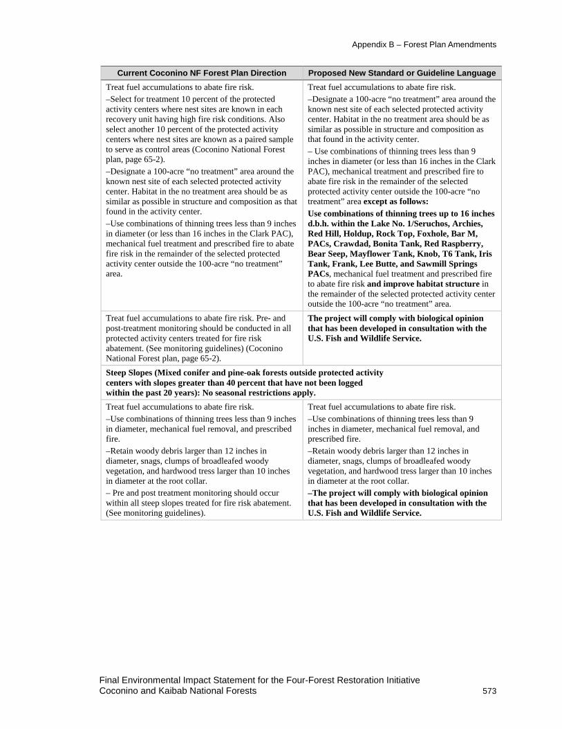
Current Coconino NF Forest Plan Direction Proposed New Standard or Guideline Language Treat fuel accumulations to abate fire risk. –Select for treatment 10 percent of the protected activity centers where nest sites are known in each recovery unit having high fire risk conditions. Also select another 10 percent of the protected activity centers where nest sites are known as a paired sample to serve as control areas (Coconino National Forest plan, page 65-2). –Designate a 100-acre “no treatment” area around the known nest site of each selected protected activity center. Habitat in the no treatment area should be as similar as possible in structure and composition as that found in the activity center. –Use combinations of thinning trees less than 9 inches in diameter (or less than 16 inches in the Clark PAC), mechanical fuel treatment and prescribed fire to abate fire risk in the remainder of the selected protected activity center outside the 100-acre “no treatment” area.
Treat fuel accumulations to abate fire risk. –Designate a 100-acre “no treatment” area around the known nest site of each selected protected activity center. Habitat in the no treatment area should be as similar as possible in structure and composition as that found in the activity center. – Use combinations of thinning trees less than 9 inches in diameter (or less than 16 inches in the Clark PAC), mechanical treatment and prescribed fire to abate fire risk in the remainder of the selected protected activity center outside the 100-acre “no treatment” area except as follows: Use combinations of thinning trees up to 16 inches d.b.h. within the Lake No. 1/Seruchos, Archies, Red Hill, Holdup, Rock Top, Foxhole, Bar M, PACs, Crawdad, Bonita Tank, Red Raspberry, Bear Seep, Mayflower Tank, Knob, T6 Tank, Iris Tank, Frank, Lee Butte, and Sawmill Springs PACs, mechanical fuel treatment and prescribed fire to abate fire risk and improve habitat structure in the remainder of the selected protected activity center outside the 100-acre “no treatment” area.
Treat fuel accumulations to abate fire risk. Pre- and post-treatment monitoring should be conducted in all protected activity centers treated for fire risk abatement. (See monitoring guidelines) (Coconino National Forest plan, page 65-2).
The project will comply with biological opinion that has been developed in consultation with the U.S. Fish and Wildlife Service.
Steep Slopes (Mixed conifer and pine-oak forests outside protected activity centers with slopes greater than 40 percent that have not been logged within the past 20 years): No seasonal restrictions apply. Treat fuel accumulations to abate fire risk. –Use combinations of thinning trees less than 9 inches in diameter, mechanical fuel removal, and prescribed fire. –Retain woody debris larger than 12 inches in diameter, snags, clumps of broadleafed woody vegetation, and hardwood tress larger than 10 inches in diameter at the root collar. – Pre and post treatment monitoring should occur within all steep slopes treated for fire risk abatement. (See monitoring guidelines).
Treat fuel accumulations to abate fire risk. –Use combinations of thinning trees less than 9 inches in diameter, mechanical fuel removal, and prescribed fire. –Retain woody debris larger than 12 inches in diameter, snags, clumps of broadleafed woody vegetation, and hardwood tress larger than 10 inches in diameter at the root collar. –The project will comply with biological opinion that has been developed in consultation with the U.S. Fish and Wildlife Service.
Final Environmental Impact Statement for the Four-Forest Restoration Initiative Coconino and Kaibab National Forests 573

Appendix B – Forest Plan Amendments
Current Coconino NF Forest Plan Direction Proposed New Standard or Guideline Language Reserved Lands (Wilderness, Research Natural Areas, Wild and Scenic Rivers, and Congressionally Recognized Wilderness Study Areas): Allow prescribed fire where appropriate – No change. Restricted Areas (Mixed conifer, pine-oak, and riparian forests) No corresponding direction Target habitat is a category of restricted habitat
intended to provide future nesting and roosting habitat (see glossary definition for restricted habitat). The minimum values identified for the forest attributes represent the threshold for meeting nesting and roosting conditions (see the definition for threshold habitat). They can also be targets to be achieved with time and management. If less than 10 percent of the restricted habitat in ponderosa pine-Gambel oak qualifies as threshold habitat, the areas that can eventually achieve all threshold conditions simultaneously should be identified as target habitat and managed to achieve threshold conditions as rapidly as possible. Because no known nests or roosts occur in restricted habitat, target habitat is considered future nesting and roosting habitat.
No corresponding direction Threshold habitat is a category of restricted habitat intended to provide for future nesting and roosting habitat (see definition for restricted habitat). A variety of forest structural attributes is used to define when nesting and roosting habitat is achieved (summarized in table III.B.1 of the 1995 recovery plan and table C-2 of the 2012 recovery plan). Threshold habitat meets or exceeds these values. When the minimum values identified for the forest attributes are met simultaneously, they represent the threshold of nesting and roosting conditions. Up to 10 percent of restricted habitat in ponderosa pine-Gambel oak should be designated as threshold habitat. Management in threshold habitat cannot lower any of the forest attribute values below the nesting and roosting threshold unless a landscape analysis demonstrates an abundance of this habitat. Because no known nests or roosts occur in restricted habitat, target habitat is managed as future nesting and roosting habitat.
Final Environmental Impact Statement for the Four-Forest Restoration Initiative 574 Coconino and Kaibab National Forests

Appendix B – Forest Plan Amendments
Current Coconino NF Forest Plan Direction Proposed New Standard or Guideline Language Mixed Conifer and Pine-oak Forests (see glossary definition): Manage to ensure a sustained level of owl nesting and roosting habitat well distributed across the landscape. Create replacement owl nesting and roosting habitat where appropriate while providing a diversity of stand conditions across the landscape to ensure habitat for a diversity of prey species. The following table displays the minimum percentage of restricted area which should be managed to have nesting and roosting characteristics. The minimum mixed conifer restricted area includes 10 percent at 170 square feet of basal area and an additional amount of area at 150 square feet of basal area. The additional area of 150 square feet basal area is +10 percent in BR-E and +15 percent in all other recovery units. The variables are for stand averages and are minimum threshold values and must be met simultaneously. In project design, no stands simultaneously meeting or exceeding the minimum threshold values should be reduced below the threshold values unless a districtwide or larger landscape analysis of restricted areas shows that there is a surplus of restricted area acres simultaneously meeting the threshold values. Management should be designed to create minimum threshold conditions on project areas where there is a deficit of stands simultaneously meeting minimum threshold conditions unless the districtwide or larger landscape analysis shows there is a surplus. This table has been modified to contain only information pertinent to the Coconino NF. (Coconino NF forest plan, pages 65-3 to 65-5).
Mixed Conifer and Pine-oak Forests (See glossary definition): Manage to ensure a sustained level of owl nesting and roosting habitat well distributed across the landscape. Create replacement owl nesting and roosting habitat where appropriate while providing a diversity of stand conditions across the landscape to ensure habitat for a diversity of prey species. The following table displays the minimum percentage of restricted area which should be managed to have nesting and roosting characteristics. The minimum mixed conifer restricted area includes up to 10 percent at 170 square feet of basal area and an additional amount of area at 150 square feet basal area. The additional area of 150 square feet of basal area is +10 percent in BR-E and +15 percent in all other recovery units. The variables are for stand averages, are minimum target and threshold habitat values, and must be met simultaneously. In project design, no stands simultaneously meeting or exceeding the minimum target and threshold habitat values should be reduced below target and threshold values unless a districtwide or larger landscape analysis of restricted areas shows that there is a surplus of restricted area acres simultaneously meeting target and threshold values. Management should be designed to create minimum target and threshold habitat conditions on project areas where there is a deficit of stands simultaneously meeting minimum target and threshold habitat conditions unless the districtwide or larger landscape analysis shows there is a surplus. This table has been modified to contain only information pertinent to the Coconino NF.
Variable Mixed Conifer All
Restoration Units
Mixed Conifer Other
Restoration Units
Pine-Oak Target and Threshold Habitat
Restricted Area percent 10 percent +15 percent 10 percent Stand Averages for:
Basal Area 170 150 150 18 inch+ trees/acre 20 20 20
Oak Basal Area NA NA 20
Percent total existing: 12–18 inch 10 10 15 18–24 inch 10 10 15 24+ inch 10 10 15
Final Environmental Impact Statement for the Four-Forest Restoration Initiative Coconino and Kaibab National Forests 575

Appendix B – Forest Plan Amendments
Current Coconino NF Forest Plan Direction Proposed New Standard or Guideline Language Attempt to mimic natural disturbance patterns by incorporating natural variation, such as irregular tree spacing and various patch sizes, into management prescriptions (Coconino National Forest plan, page 65-4).
No Change
Maintain all species of native trees in the landscape including early seral species (Coconino National Forest plan, page 65-4).
No Change
Allow natural canopy gap processes to occur, thus producing horizontal variation in stand structure (Coconino National Forest plan, page 65-4).
No Change
Emphasize uneven-aged management systems. However, both even-aged and uneven-aged systems may be used where appropriate to provide variation in existing stand structure and species diversity. Existing stand conditions will determine which system is appropriate (Coconino National Forest plan, page 65-4).
No Change
Extend rotation ages for even-aged stands to greater than 200 years. Silvicultural prescriptions should explicitly state when vegetative manipulation will cease until rotation age is reached (Coconino National Forest plan, page 65-4).
No Change
Save all trees greater than 24 inches d.b.h. In pine-oak forests, retain existing large oaks and promote growth of additional large oaks (Coconino National Forest plan, page 65-4).
No Change
In pine-oak forests, retain existing large oaks and promote growth of additional large oaks (Coconino National Forest plan, page 65-4).
No Change
Encourage prescribed and prescribed natural fire to reduce hazardous fuel accumulation. Thinning from below may be desirable or necessary before burning to reduce ladder fuels and the risk of crown fire (Coconino National Forest plan, page 65-4).
No Change
Retain substantive amounts of key habitat components: • Snags 18 inches in diameter and larger • Down logs over 12 inches midpoint diameter • Hardwoods for retention, recruitment, and
replacement of large hardwoods
No Change
Riparian Areas – No Change Domestic Livestock Grazing – No Change Old-Growth – No Change Other Forest and Woodland Types – No Change Guidelines for Specific Recovery Units – No Change
Final Environmental Impact Statement for the Four-Forest Restoration Initiative 576 Coconino and Kaibab National Forests

Appendix B – Forest Plan Amendments
Current Coconino NF Forest Plan Direction Proposed New Standard or Guideline Language Monitoring Guidelines
Monitoring and evaluation should be collaboratively planned and coordinated with involvement from each national forest, U.S. Fish and Wildlife Service Ecological Services Field Office, U.S. Fish and Wildlife Service Regional Office, USFS Regional Office, Rocky Mountain Research Station, recovery team, and recovery unit working groups.
The project will comply with biological opinion that has been developed in consultation with the U.S. Fish and Wildlife Service.
Population monitoring should be a collaborative effort with participation of all appropriate resource agencies. (Coconino National Forest plan, page 65-6). Habitat monitoring of gross habitat changes should be a collaborative effort of all appropriate resource agencies. (Coconino National Forest plan, page 65-6). Habitat monitoring of treatment effects (pre- and post-treatment) should be done by the agency conducting the treatment. (Coconino National Forest plan, page 65-6). Prepare an annual monitoring and evaluation report covering all levels of monitoring done in the previous year. The annual report should be forwarded to the regional forester with copies provided to the recovery unit working groups, U.S. Fish and Wildlife Service Ecological Services field offices, and the U.S. Fish and Wildlife Service Regional Office (Coconino National Forest plan, page 65-6). Rangewide: Track gross changes in acres of owl habitat resulting from natural and human-caused disturbances. Acreage changes in vegetation composition, structure, and density should be tracked, evaluated, and reported. Remote sensing techniques should provide an adequate level of accuracy. (Coconino National Forest plan, page 65-6) In protected and restricted areas where silvicultural or fire abatement treatments are planned, monitor treated stands pre- and post-treatment to determine changes and trajectories in fuel levels; snag basal areas; live tree basal areas; volume of down logs over 12 inches in diameter; and basal area of hardwood trees over 10 inches in diameter at the root crown (Coconino National Forest plan, page 65-6). Upper Gila Mountain, Basin and Range East, and Basin and Range West Recovery Units: Assist the recovery team and recovery unit working groups to establish sampling units consisting of 19 to 39 square mile quadrats randomly allocated to habitat strata. Quadrats should be defined based on ecological boundaries such as ridge lines and watersheds. Quadrat boundaries should not traverse owl territories. Twenty percent of the quadrats will be replaced each year at random. Using the sample quadrats, monitor the number of territorial individuals and pairs per quadrat; reproduction; apparent survival; recruitment; and age structure. Track population density both per quadrat and habitat stratum.
The project will comply with biological opinion that has been developed in consultation with the U.S. Fish and Wildlife Service.
Final Environmental Impact Statement for the Four-Forest Restoration Initiative Coconino and Kaibab National Forests 577

Appendix B – Forest Plan Amendments
Figure 54. Alternative B amendment 1 Mexican spotted owl PAC treatments
Consistency with the Mexican Spotted Owl Recovery Plan A revised Mexican spotted owl recovery plan, issued by the U.S. Fish and Wildlife Service was finalized in December of 2012 (USDI FWS 2012). The current (1987) Coconino NF forest plan as amended is consistent with the previous Mexican spotted owl recovery plan (USDI FWS 1995). For this analysis, a forest plan amendment is needed because the current Coconino forest plan provides direction from the former Mexican spotted owl Recovery Plan. Since the DEIS was released for public comment in 2013, direction from the current 2012 revised recovery plan has been incorporated.
Final Environmental Impact Statement for the Four-Forest Restoration Initiative 578 Coconino and Kaibab National Forests

Appendix B – Forest Plan Amendments
The need to evolve from managing solely for firewood collection and fire risk abatement is reflected in the revised 2012 recovery plan. In the revised plan, the U.S. Fish and Wildlife Service states, “Management recommendations are most conservative within PACs, but by no means advocate a “hands-off” approach. The recovery team recognizes situations exist where management is needed to sustain or enhance desired conditions for the owl, including fire-risk reduction, as well as monitoring owl response. Mechanical treatments in some PACs may be needed to achieve these objectives; determining which PACs may benefit from mechanical treatments requires a landscape analysis to determine where the needs of fire risk reduction and habitat enhancement are greatest (USDA FS 2012, page VIII).
The continued use of the terms (and definitions) of target and threshold habitat (considered future nesting and roosting habitat as part of restricted habitat is consistent with Revised Mexican spotted owl Recovery Plan’s direction for nesting and roosting in recovery habitat.
The plan amendment defers Mexican spotted owl occupancy and reproduction monitoring to the project’s biological opinion from the U.S. Fish and Wildlife Service. The monitoring plan developed in cooperation with U.S. Fish and Wildlife Service is in FEIS, Appendix E. Following the current forest plan direction would have resulted in few PACs being treated during the life of the project. Current plan direction suspends treatments until monitoring of the initial sample shows there are no negative impacts, or negative impacts are mitigated by modifying treatments. Following this direction could delay implementation for years, potentially decades’ if changes in populations had to be documented before additional treatments were implemented. Following the current forest plan direction would have resulted in few PACs being treated with the objective of fire-risk reduction or improving condition for the owl during the life of the project.
The deviation from selecting PACs and monitoring in 10 percent increments is consistent with the revised 2012 Mexican spotted owl recovery plan. As noted above, the plan amendment defers monitoring to the project’s biological opinion from the U.S. Fish and Wildlife Service.
Significance Evaluation Per FSM 1926.51, changes to the land management plan that are not significant can result from:
1. Actions that do not significantly alter the multiple-use goals and objectives for long-term land and resource management.
2. Adjustments of management area boundaries or management prescriptions resulting from further onsite analysis when the adjustments do not cause significant changes in the multiple-use goals and objectives for long-term land and resource management.
3. Minor changes in standards and guidelines.
4. Opportunities for additional projects or activities that will contribute to achievement of the management prescription.
Per FSM 1926.52, circumstances that may cause a significant change to a land management plan include:
1. Changes that would significantly alter the long-term relationship between levels of multiple-use goods and services originally projected (see section 219.10(e) of the planning regulations in effect before November 9, 2000 (see 36 CFR parts 200 to 299, revised as of July 1, 2000)), and
Final Environmental Impact Statement for the Four-Forest Restoration Initiative Coconino and Kaibab National Forests 579

Appendix B – Forest Plan Amendments
2. Changes that may have an important effect on the entire land management plan or affect land and resources throughout a large portion of the planning area during the planning period.
Analysis demonstrated that the proposed amendment is nonsignificant (FSM 1926.51) because the actions would not measurably alter the multiple-use goals and objectives for long term land and resource management. How actions could potentially affect timing, location, and size, relationship to forest goals, objectives, outputs, and management prescriptions was evaluated.
Timing: In terms of timing, the forest plan has been in place and amended several times since 1987, and revision efforts are underway. The forest plan incorporated direction (via an amendment) from the Forest Service Southwestern Region’s 1996 “Amendment of Forest Plans Record of Decision” (USDA FS 1996). The actions allowed via the amendment are consistent with existing forest plan direction in that it improves nesting and rooting habitat, reduces the risk of loss from fire, and will comply with the site-specific treatment and monitoring requirements in the U.S. Fish and Wildlife Service biological opinion. Forest plan direction may be amended to incorporate the revised Mexican spotted owl recovery plan (USDI FWS 2012) which recognizes that habitat restoration, in addition to the reduction of fire risk, is key to improving habitat quality.
Location and Size: The treatment area contains about 35,019 total acres of Mexican spotted owl protected habitat, most of which occurs in restoration unit 1. There are 70 PACs (about 34,183 acres) in the 4FRI treatment area. The remaining protected habitat (836 acres) occurs on steep slopes where timber harvest has not occurred in the previous 20 years and is not proposed for mechanical treatment. Proposed treatments for steep-slope protected habitat consist of prescribed fire only – no mechanical treatments are proposed for this category of habitat. There are 187 PACs entirely on or overlapping Coconino National Forest lands.
The amendment would affect 18 (10 percent) of the 187 Coconino NF PACs. The amendment would affect 6,906 acres (20 percent) of PAC habitat in the entire treatment area. Work would be accomplished incrementally over a 10-year period. On average, less than 1,000 acres of PAC habitat would be treated per year. This is expected to balance the need to reduce the risk of crown fire while allowing for monitoring and feedback loops that would allow management to be adaptive.
Relationship to Forest Goals and Objectives: The amendment is consistent with forest plan goals for wildlife and fish of managing habitat to maintain viable populations of wildlife and fish species and improve habitat for selected species (Coconino National Forest plan, replacement page 22-1) and to improve habitat for listed threatened, endangered, or sensitive species of plants and animals and other species as they become threatened or endangered (Coconino National Forest plan, replacement page 23). The amendment is consistent with goals and objectives by protecting conditions and structures used by spotted owls where they exist and to set other stands on a trajectory to grow into replacement nest habitat or to provide conditions for foraging and dispersal (USDI FWS 2012).
The amendment removes language that addresses pre- and post-treatment, population, and habitat monitoring and replaces it with language that focuses on implementing the requirements in the U.S. Fish and Wildlife Service biological opinion for this project. Delaying treatment in PACs would leave occupied Mexican spotted owl habitat at risk of loss from high-severity fire. Arizona’s two largest fires account for nearly a million and half acres of forested land burned since 2002. Both fires included high-severity fire in PAC habitat. Other fires in the Upper Gila Recovery Unit have charred additional acres of Mexican spotted
Final Environmental Impact Statement for the Four-Forest Restoration Initiative 580 Coconino and Kaibab National Forests

Appendix B – Forest Plan Amendments
owl protected habitat. Most climate models suggest that the Southwest will experience higher temperatures and increased variability in precipitation, which will significantly affect fire regimes and forest health (Aumack et al. 2007).
The U.S. Fish and Wildlife Service urges a deliberate and cautious approach to management activities within PACs (USDI FWS 2012). Silvicultural modeling of the proposed treatments indicates limited change to forest structure after implementation (FEIS, chapter 3). However, the treatments are expected to include increased tree growth rates to reduce the time needed for developing large trees (defined as 18 inches d.b.h. and greater in the current recovery plan for the Mexican spotted owl), maintaining existing large trees, and decreasing surface fuels and increasing crown base height. Combined, this should develop and maintain Mexican spotted owl nesting and roosting habitat, a key aspect of the Mexican spotted owl recovery plan.
Forest restoration treatments would be evaluated over time (at least a 10-year period). Through formal consultation with U.S. Fish and Wildlife Service, occupancy, reproduction and habitat monitoring would be designed and implemented to evaluate the effects of prescribed fire and treatments on spotted owl habitat, and to retain or move toward Mexican spotted owl desired future conditions, as described in the recovery plan. The details on accomplishing the monitoring goals have been developed specifically through coordination with the U.S. Fish and Wildlife Service under formal consultation, as described in the Endangered Species Act. In this way, work to protect and improve PAC habitat can be accomplished in a timely manner while emphasizing monitoring and feedback loops to allow management to be adaptive. For these reasons, the amendment as it relates to pre- and post-treatment occupancy, reproduction and habitat monitoring is consistent with forest plan goals and objectives.
Designating target or threshold habitat in the project with the best potential would move toward desired percentages in restricted (recovery) habitat, consistent with forest plan goals and objectives.
Relationship to Management Prescriptions: Table 105 displays the forestwide management area acres that would be affected. The amendment would affect about 4,916 acres (1 percent) of MA 3 and about 1,773 acres (3 percent) of MA 35. Acres within other management areas (MA 4, MA 10, MA 5, MA 9, MA 12, and MA 6) are minor, totaling 217 acres.
Table 105. Alternative B amendment 1 management area acres (Coconino NF)
Management Area
Management Area Description
Forestwide Acres
Proposed Amendment
Acres Forestwide Acres Affected (Percent)
MA 3 Ponderosa Pine Below 40 Percent Slopes
511,015 4,916 1
MA 35 Lake Mary Watershed 62,536 1,773 3 MA 4, 10, 5, 9, 12, and 6
See chapter 1, table 14 307,011 217 less than 1
The amendment intent is consistent with the management emphasis in MA 3 and MA 35 which stresses improving and maintaining the quality of the habitat (MA 3) and moving ponderosa pine toward the desired forest structure, including northern goshawk and Mexican spotted owl habitats (MA 35). The amendment would not impose requirements on future management of Mexican
Final Environmental Impact Statement for the Four-Forest Restoration Initiative Coconino and Kaibab National Forests 581

Appendix B – Forest Plan Amendments
spotted owl PACs as the amendment is site specific to this analysis and only addresses current conditions within protected habitat.
Relationship to Outputs: Outputs identified in the forest plan are associated with million board feet (MMBF) of sawtimber sales and products (meet demand for timber while reducing conflict with other resources), MMBF of firewood sold and free use (provide access to firewood), grazing capacity, and permitted livestock use. Due to the minimal acres affected, the amendment would not alter outputs on a forestwide basis or change the long-term relationship between levels of goods (timber, firewood) and services.
In comparison to the forest’s total suitable timber lands (626,326 acres), the amendment affects about 1 percent of those lands. For this reason, treatments within PACs do not measurably increase or decrease timber outputs or firewood availability. Treatment within PACs would not affect decisions that have been made through separate analyses on grazing capacity or permitted livestock use. There would be no measurable effect to outputs on a forestwide basis or the long-term relationship between levels of goods (timber, firewood) and services from managing restricted habitat up to 10 percent or deferring the final design of treatments and monitoring to the project’s biological opinion.
Amendment 2. Management of Canopy Cover and Ponderosa Pine with an Open Reference Condition within Goshawk Habitat (Coconino NF) Background Canopy cover is defined as “the percentage of a fixed area covered by the crowns of plants delimited by a vertical projection of the outermost perimeter of the spread of foliage” (Reynolds et al. 1992). Obtaining consistent results has been difficult; even the definition of the term is dependent on the method of measurement. To resolve this issue, the Forest Service used the Forest Vegetation Simulation (FVS) crown width model as the basis for developing stocking densities that would achieve desired canopy cover levels. Figure 55 displays general locations of goshawk habitat that is subject to canopy cover requirements in VSS 4 through VSS 6 on the forests.
Nonforested areas (interspaces) occur between individual trees, tree clumps, and tree groups. These nonforested areas (interspaces) are not equivalent to VSS 1. Whereas VSS 1 may provide openings in the short term, this structural stage is expected to regenerate tree cover in the long term. Refer to the silviculture report and the implementation plan (appendix D) which provides minimum stocking guidelines that have been developed to assure canopy cover requirements are met.
Approximately 195,640 acres (61 percent) of the forested areas (within the project area on the Coconino NF) have an open reference condition that corresponds to mollic-integrade soils. The desired condition is to have a portion of these acres (28,952 acres) managed as a relatively open forest with trees typically aggregated in small groups within a grass/forb/shrub matrix (Woolsey 1911, Cooper 1960, White 1985, Pearson 1950, Covington et a1.1997, Abella and Denton 2009). See the soils specialist report for detailed information. Figure 56 displays the location of acres that would be managed for an open reference condition.
Final Environmental Impact Statement for the Four-Forest Restoration Initiative 582 Coconino and Kaibab National Forests

Appendix B – Forest Plan Amendments
Amendment Description In the “Vegetation Management – Landscapes Outside Goshawk Post-fledging Family Areas” and “Vegetation Management –Within Post-fledging Family Areas” section of the forest plan, a site-specific, nonsignificant plan amendment would: (1) add the desired percentage of interspace within uneven-aged stands to facilitate restoration, (2) add the interspace distance between tree groups, (3) add language clarifying where canopy cover is and is not measured, (4) allow 28,952 acres to be managed for an open reference condition (which affects canopy cover guidelines for VSS 4 through VSS 6 groups and reserve trees), and (5) add a definition to the forest plan glossary for the terms interspaces, open reference condition, and stands. Edited or added text is shown in bold in the “Proposed New Guideline Language” column in table 106.
The forest plan directs projects to manage for uneven-aged stand conditions within goshawk habitat. Forested groups consist of an interspersion of six vegetation structural stages (VSS 1 to VSS 6). For the purposes of this amendment, the following definitions apply:
• Stands are defined as a contiguous area of trees sufficiently uniform in forest type, composition, structure, and age class distribution, growing on a site of sufficiently uniform conditions to be a distinguishable unit. Four classification characteristics are generally used to distinguish forest stands: biophysical site (soils, aspect, elevation, plant community association, climate, etc.), species composition, structure (density, and age (1-aged, 2-aged, uneven-aged)), and management emphasis (administrative requirements and local management emphasis that will shape structure over time). Based upon Agency guidelines, the minimum stand mapping size is 10 acres.
• Interspaces are defined as the open space between tree groups intended to be managed for grass/forb/shrub vegetation during the long term. Interspaces may include scattered single trees.
• Open reference condition is defined as forested ponderosa pine areas with mollic-integrade soils to be managed as a relatively open forest with trees typically aggregated in small groups within a grass/forb/shrub matrix.
Table 106. Alternative B Amendment 2 Management of Canopy Cover and Ponderosa Pine with an Open Reference Condition in Goshawk Habitat (Coconino NF)
Current Coconino NF Forest Plan Direction
Proposed New Guideline Language
Landscapes Outside Goshawk Post-fledging Family Areas No similar direction in forest plan General: Within ponderosa pine stands, manage over
time for uneven-aged stand conditions composed of heterogeneous mosaics of tree groups and single trees, with interspaces between tree groups. The size of tree groups, as well as sizes and shapes of interspaces, should be variable. Over time, the spatial location of the tree groups and interspaces may shift within the uneven-aged stand.
Final Environmental Impact Statement for the Four-Forest Restoration Initiative Coconino and Kaibab National Forests 583

Appendix B – Forest Plan Amendments
Current Coconino NF Forest Plan Direction
Proposed New Guideline Language
General: The distribution of vegetation structural stages for ponderosa pine, mixed conifer and spruce-fir forests is 10 percent grass/forb/shrub (VSS 1), 10 percent seedling-sapling (VSS 2), 20 percent young forest (VSS 3), 20 percent mid-aged forest (VSS 4), 20 percent mature forest (VSS 5), 20 percent old forest (VSS 6). NOTE: The specified percentages are a guide and actual percentages are expected to vary + or – up to 3 percent (Coconino NF forest plan, page 65-9).
General: For the areas managed for tree crown development, the distribution of vegetation structural stages for ponderosa pine, mixed conifer, and spruce-fir forests is 10 percent grass/forb/shrub (VSS 1), 10 percent seedling-sapling (VSS 2), 20 percent young forest (VSS 3), 20 percent mid-aged forest (VSS 4), 20 percent mature forest (VSS 5), and 20 percent old forest (VSS 6). Note: the specified percentages are a guide and actual percentages are expected to vary plus or minus up to 3 percent.
The distribution of VSS, tree density, and tree age are a product of site quality in the ecosystem management area. Use site quality to guide in the distribution of VSS, tree density and tree ages. Use site quality to identify and manage dispersal post-fledging family areas and nest habitat at 2–2.5 mile spacing across the landscape (Coconino NF forest plan, page 65-9).
No change
Snags are 18" or larger d.b.h. and 30 feet or larger in height, downed logs are 12 inches in diameter and at least 8 feet long, woody debris is 3 inches or larger on the forest floor, canopy cover is measured with vertical crown projection on average across the landscape (Coconino NF forest plan, page 65-9).
Snags are 18" or larger d.b.h. and 30 feet or larger in height, downed logs are 12 inches in diameter and at least 8 feet long, woody debris is 3 inches or larger on the forest floor, canopy cover as defined by vertical crown projection is evaluated within mid-aged to old forest vegetation structural stage groups (VSS 4, 5, and 6).
No corresponding forest plan direction Develop and maintain a highly diverse vegetation mosaic: 30 to 90 percent of the uneven-aged stand should be under ponderosa pine and deciduous tree crowns. Within areas managed for an open reference condition, 10 to 30 percent of the uneven-aged stand should be under ponderosa pine and deciduous tree crowns.
No corresponding forest plan direction Tree group spatial distribution may be highly variable based on local site and current conditions; the interspaces between groups may range from 20 to 200 feet, but generally between 25 and 100 feet apart from drip line to adjacent drip line. This spacing of groups is not affected by single trees in the interspace.
No corresponding forest plan direction Each tree group is generally dominated by one vegetation structure stage. The spatial arrangement of trees, high dispersion of VSS structural stage diversity, and interspaces comprise each uneven-aged forest stand. Collectively these stands aggregate to uneven-aged forest landscapes, similar to natural conditions.
The order of preferred treatment for woody debris is: (1) prescribed burning, (2) lopping and scattering, (3) hand piling or machine grapple piling, (4) dozer piling (Coconino NF forest plan, page 65-9).
No change
Final Environmental Impact Statement for the Four-Forest Restoration Initiative 584 Coconino and Kaibab National Forests

Appendix B – Forest Plan Amendments
Current Coconino NF Forest Plan Direction
Proposed New Guideline Language
Canopy Cover: Canopy cover guidelines apply only to mid-aged to old forest structural stages (VSS 4, VSS 5, and VSS 6) and not to grass/forb/shrub to young forest structural stages (VSS 1, VSS 2, and VSS 3) (Coconino NF forest plan, page 65-9).
Canopy Cover: Canopy cover guidelines apply only to mid-aged to old forest structural stage groups (VSS 4, VSS 5, and VSS 6) and not to grass/forb/shrub to young forest structural stage groups (VSS 1, VSS 2, and VSS 3) or in interspaces, natural meadows, grasslands, or other areas not managed for forest cover.
Spruce-Fir: Canopy cover for mid-aged forest (VSS 4) should average 1/3 60 percent and 2/3 40 percent, mature forest (VSS 5) should average 60+ percent, and old forest (VSS 6) should average 60+ percent. Maximum opening size is 1 acre with a maximum width of 125 feet. Provide 2 groups of reserve trees per acre with 6 trees per group when opening size exceeds 0.5. Leave at least 3 snags, 5 downed logs, and 10–15 tons of woody debris per acre (Coconino NF forest plan, page 65-9).
No Change
Mixed Conifer: Canopy cover for mid-aged forest (VSS 4) should average 1/3 60+ percent and 2/3 40+ percent, mature forest (VSS 5) should average 50+ percent, and old forest (VSS 6) should average 60+ percent. Maximum opening size is up to 4 acres with a maximum width of up to 200 feet. Retain 1 group of reserve trees per acre of 3–5 trees per group for openings greater than 1 acre in size. Leave at least 3 snags, 5 downed logs, and 10–15 tons of woody debris per acre (Coconino NF forest plan, page 65-10).
No Change
Ponderosa Pine: Canopy Cover for mid-aged forest (VSS 4) should average 40+ percent, mature forest (VSS 5) should average 40+ percent, and old forest (VSS 6) should average 40+ percent. Opening size is up to 4 acres with a maximum width of up to 200 feet. One group of reserve trees, 3–5 trees per group, will be left if the opening is greater than an acre in size. Leave at least 2 snags per acre, 3 downed logs per acre, and 5–7 tons of woody debris per acre (Coconino NF forest plan, page 65-10).
Ponderosa Pine: Canopy cover for mid-aged forest (VSS 4) should average 40+ percent, mature forest (VSS 5) should average 40+ percent, and old forest (VSS 6) should average 40+ percent. Opening size is up to 4 acres with a maximum width of up to 200 feet. One group of reserve trees, three to five trees per group, will be left if the created regeneration opening is greater than an acre in size. Leave at least two snags per acre, three downed logs per acre, and 5 to 7 tons of woody debris per acre. In acres managed for an open reference condition, canopy cover guidelines for VSS 4 through VSS 6 groups do not apply. One group of reserve trees, with a minimum of one to two trees per group will be left if the interspace size is greater than an acre in size. Interspace size is up to 4 acres. Leave at least two snags per acre, three downed logs per acre, and 5 to 7 tons of woody debris per acre
Woodland: manage for uneven-age conditions to sustain a mosaic of vegetation densities (overstory and understory), age classes, and species composition well distributed across the landscape. Provide for reserve trees, snags, and down woody debris (Coconino NF forest plan, page 65-10).
No Change
Final Environmental Impact Statement for the Four-Forest Restoration Initiative Coconino and Kaibab National Forests 585

Appendix B – Forest Plan Amendments
Current Coconino NF Forest Plan Direction
Proposed New Guideline Language
Vegetation Management – Within Post-fledging Family Areas General: Provide for a healthy sustainable forest environment for the post-fledging family needs of goshawks. The principle difference between within the post-fledging family area and outside the post-fledging family area is the higher canopy cover within the post-fledging family area and smaller opening size within the post-fledging family area. Vegetative structural stage distribution and structural conditions are the same within and outside the post-fledging family area (Coconino NF forest plan, page 65-10).
No Change
No similar direction in forest plan Canopy cover is evaluated at the group level within mid-aged to old forest structural stages groups (VSS 4, VSS 5 and VSS 6) and not within grass/forb/shrub to young forest structural stage groups (VSS 1, VSS 2, and VSS 3) or in interspaces, natural meadows and grasslands, or other areas not managed for forest conditions.
Spruce-fir: Canopy Cover for mid-aged forest (VSS 4) should average 60+ percent and for mature (VSS 5) and old forest (VSS 6) should average 70+ percent (Coconino NF forest plan, page 65-10).
No Change
Mixed Conifer: Canopy Cover for mid-aged (VSS 4) to old forest (VSS 6) should average 60+ percent.
No Change
Ponderosa Pine: Canopy Cover for mid-aged forest (VSS 4) should average 1/3 60+ percent and 2/3 50+ percent. Mature (VSS 5) and old forest (VSS 6) should average 50+ percent (Coconino NF forest plan, page 65-10).
No Change
No corresponding forest plan direction Develop and maintain a highly diverse vegetation mosaic: 30 to 90 percent of the uneven-aged stand should be under ponderosa pine and deciduous tree crowns.
No corresponding forest plan direction Tree group spatial distribution may be highly variable based on local site and current conditions; the interspaces between groups may range from 20 to 200 feet, but generally between 25 and 100 feet apart from drip line to adjacent drip line. This spacing of groups is not affected by single trees in the interspace.
No corresponding forest plan direction Each tree group is generally dominated by one vegetation structure stage. The spatial arrangement of trees, high dispersion of vegetation structural stage diversity, and interspaces comprise each uneven-aged forest stand. Collectively these stands aggregate to uneven-aged forest landscapes, similar to natural conditions.
Final Environmental Impact Statement for the Four-Forest Restoration Initiative 586 Coconino and Kaibab National Forests

Appendix B – Forest Plan Amendments
Current Coconino NF Proposed New Guideline Language Forest Plan Direction Glossary
No corresponding forest plan language Interspaces: The open space between tree groups intended to be managed for grass/forb/shrub vegetation during the long term. Interspaces may include scattered single trees.
No corresponding forest plan language Open reference condition: Forested ponderosa pine areas with mollic-integrade soils to be managed as a relatively open forest with trees typically aggregated in small groups within a grass/forb/shrub matrix.
No corresponding forest plan language Stands: Contiguous area of trees sufficiently uniform in forest type, composition, structure, and age class distribution, growing on a site of sufficiently uniform conditions to be a distinguishable unit.
Figure 55. Alternative B goshawk habitat subject to canopy cover requirements in VSS 4 and VSS 6 (Coconino NF) Note: Although goshawk habitat on the Kaibab NF is reflected in this figure, only the Coconino NF plan has explicit canopy cover requirements in VSS4 to VSS 6 and subject to a plan amendment.
Final Environmental Impact Statement for the Four-Forest Restoration Initiative Coconino and Kaibab National Forests 587

Appendix B – Forest Plan Amendments
Figure 56. Alternative B general locations of savanna and grassland restoration treatments (Coconino NF and Kaibab NF*) *Note: Although Kaibab NF treatments are reflected in this figure, only the Coconino NF is subject to a plan amendment.
Significance Evaluation Per FSM 1926.51, changes to the land management plan that are not significant can result from:
1. Actions that do not significantly alter the multiple-use goals and objectives for long term land and resource management.
2. Adjustments of management area boundaries or management prescriptions resulting from further onsite analysis when the adjustments do not cause significant changes in the multiple-use goals and objectives for long term land and resource management.
3. Minor changes in standards and guidelines.
4. Opportunities for additional projects or activities that will contribute to achievement of the management prescription.
Final Environmental Impact Statement for the Four-Forest Restoration Initiative 588 Coconino and Kaibab National Forests

Appendix B – Forest Plan Amendments
Per FSM 1926.52, circumstances that may cause a significant change to a land management plan include:
1. Changes that would significantly alter the long-term relationship between levels of multiple-use goods and services originally projected (see section 219.10(e) of the planning regulations in effect before November 9, 2000 (see 36 CFR parts 200 to 299, revised as of July 1, 2000)), and
2. Changes that may have an important effect on the entire land management plan or affect land and resources throughout a large portion of the planning area during the planning period.
Analysis demonstrated that the proposed amendment is nonsignificant (FSM 1926.51) because the actions would not measurably alter the multiple-use goals and objectives for long term land and resource management and the actions. How actions could potentially affect timing, location and size, relationship to forest goals, objectives, outputs, and management prescriptions was evaluated.
Timing: In terms of timing, the forest plan has been in place (and amended) since 1987 and plan revision efforts are underway.
Location and Size: There is approximately 892, 545 acres of goshawk habitat on the Coconino NF (Cote and Green 2014 personal communication email).
• The canopy cover portion of the amendment would affect 137,313 acres (15 percent) of all goshawk habitat on the Coconino N. For this reason, location and size was determined to be nonsignificant.
• Managing 28,952 acres of ponderosa pine for an open reference condition would affect approximately 3percent of all suitable goshawk habitats on the forest.
For these reasons, location and size was determined to not have an important effect on the entire forest plan or affect a large portion of the planning area during the planning period. The “planning period” (estimated in the forest plan to be 10 to 15 years, page 1) for the 1987 plan has passed and a revised forest plan is imminent (by 2015).
The amendment would facilitate moving over 137,000 acres toward the desired forest structure (tree groups and herbaceous openings) that maximizes prey base species habitat and allows for reintroduction of fire into the ecosystem; and moves approximately 29,000 acres toward historic reference conditions.
Relationship to Forest Goals and Objectives: Alternative B would meet goshawk forest plan canopy cover requirements in VSS 4 to 6 in all acres except the 28,952 acres managed for an open reference condition. In all acres but the open reference condition acres, actions would move toward forest plan desired VSS size class distribution.
The amendment is consistent with forest goals for wildlife and fish of managing habitat to maintain viable populations of wildlife and fish species and improve habitat for selected species (Coconino National Forest Plan, replacement page 22-1) and to improve habitat for listed threatened, endangered, or sensitive species of plants and animals and other species as they become threatened or endangered (Coconino National Forest Plan, replacement page 23).
Relationship to Management Prescriptions: Table 107 displays the acres associated with Coconino NF management areas (MAs).
Final Environmental Impact Statement for the Four-Forest Restoration Initiative Coconino and Kaibab National Forests 589

Appendix B – Forest Plan Amendments
Canopy Cover: Approximately 137,313 acres of forestwide management areas would be affected by the canopy cover portion of the amendment. This equates to affecting less than 1 percent to 9 percent of the management areas (see table 107).The amendment is specific to this project and would not impose definition and clarification requirements on the future management of canopy cover within goshawk habitat.
Open Reference Condition: Approximately 28,952 acres of forestwide management areas would be affected by the open reference condition portion of the amendment. This equates to affecting less than 1 percent to 35 percent of the management areas (see table 107). The amendment is consistent with the management emphasis of providing for multiple uses that includes wildlife habitat (MA 3) and moving ponderosa pine toward desired forest structure, including northern goshawk habitats (MA 35). The amendment is specific to this project and would not impose requirements on the future management of the 28,952 acres of goshawk landscapes outside of goshawk post-fledging areas; however, forest plan revision decisions may change future management.
Table 107. Alternative B amendment 2 management area (MA) acres (Coconino NF)
MA MA Description Forestwide
Acres
Proposed Amendment
Acres
Forestwide Acres
Affected (Percent)
Canopy Cover MA 3 Ponderosa pine below 40 percent
slopes 511,015 92,251 18
MA 35 Lake Mary watershed 62,536 14,334 23
MA 38 West 36,298 12,844 35
MA 6 Unproductive Timber Lands 67,146 4,929 7
MA 37 Walnut Canyon 20,566 3,656 18 MA 20 Highway 180 corridor 7,608 2,087 27
MA 4 Ponderosa pine and mixed conifer greater than 40 percent
46,382 1,612 3
MA 36 Schultz 21,289 798 4
*MA 9, 28, 5, 4, 10, 36, 34, 7, 12,
18, 15, and 14
See chapter 1, table 14 549,579 4,804 less than 1
Open Reference Condition MA 3 Ponderosa pine below 40 percent
slopes 511,015 19,010 4
MA 35 Lake Mary watershed 62,536 5,840 9 MA 10 Transition grassland 160,494 1,288 1
MA 38 West 36,298 1,073 3
**MA 10, 9, 7, 12, 34, 28, and 5
See chapter 1, table 14 474,169 1,740 less than 1
*Acres of MAs range from less than 1 to 1,232 and were aggregated into one category. **Acres of MAs range from less than 1 to 655 and were aggregated into one category.
Relationship to Outputs: Outputs identified in the current forest plan are associated with MMBF of sawtimber sales and products (meet demand for timber while reducing conflict with other resources), MMBF of firewood sold and free use (provide access to firewood), grazing capacity,
Final Environmental Impact Statement for the Four-Forest Restoration Initiative 590 Coconino and Kaibab National Forests

Appendix B – Forest Plan Amendments
and permitted livestock use. No portion of the amendment would affect decisions that have been made through separate analyses on grazing capacity or permitted livestock use.
Timber Suitability: The silviculture analysis evaluated the impact of treatments on timber suitability (see silviculture report). Within the analysis area approximately 214,200 acres on the Coconino NF were considered in the timber suitability class. Unsuitable lands include areas where prescription would preclude timber production such as critical wildlife habitat and developed recreation sites as well as areas where irreversible resource damage occur. Table 108 shows total acres for the Coconino NF as reported in the forest plan and used in the timber suitability calculation.
Table 108. Timber suitability calculation for the Coconino NF Land Category Coconino
Acres Gross area 1,821,495*
Area not administered by the Forest Service (Camp Navajo and private lands)
NFS lands 1,821,495 Non-forested -325,945 Irreversible resource damage
Adequate restocking not assured
Withdrawn (219.14(a)(4)) -101,401
Subtotal: Not-suitable for timber production
-427,346
Lands Tentatively Suitable for Timber production
1,394,149
Management prescriptions preclude timber production
-593,102
Management requirements cannot be met -154,214 Not cost efficient in meeting timber objectives Forested Lands not appropriate for timber harvest
-13,359
Experimental Forest -6,148 Subtotal: Not appropriate for timber production
-766,823
Lands suitable for timber production 627,326 Note: Acreages of NFS lands may vary slightly over time due to factors such as resurvey, improved mapping technology, and updates to corporate GIS layers. *Based on 1987 Coconino Forest Plan (Appendix H)
The Coconino Forest Plan contains the following guidance that directs the management of suitable and unsuitable land.
• On forested lands identified as suitable for commercial timber production, design timber management activities to integrate considerations for economics, water quality, soils, wildlife habitat, recreation opportunities, visual quality, and other values.
Final Environmental Impact Statement for the Four-Forest Restoration Initiative Coconino and Kaibab National Forests 591

Appendix B – Forest Plan Amendments
• Evaluate timber lands adjacent to the Rim within the first decade to determine timber suitability.
• Management for the ponderosa pine/mixed conifer stands and the big tooth maple stands is the same as MA 3, foreground retention and for areas adjacent to foreground Retention lands. See MA 5 for direction for the aspen stands.
• Manage the timber resource to provide a sustained-yield of forest products through integrated stand management.
• Develop and implement a sustained-yield program for firewood and other miscellaneous forest products including posts, poles, Christmas trees, and wildings. Emphasize uneven-aged management for timber cutting areas.
Unsuitable lands within the Coconino NF are unproductive timber lands are within the ponderosa pine vegetation types.
• They are unsuitable for timber harvest because they fall in at least one of the following two categories.
• They do not meet the minimum standards for productivity which is Site Index 40 and/or 20 cubic feet per acre per year.
• There is not reasonable assurance that such lands can be adequately restocked as required by section 219.27(c)(13) of the planning regulations.
Timber Suitability Consistency Evaluation by Forest Vegetation Community
Ponderosa Pine (PP) The ponderosa pine forest vegetation community generally occurs at elevations ranging from 5,800 to 9,200 feet and is dominated by ponderosa pine and commonly includes other species such as oak, juniper, and pinyon. Species such as aspen, Douglas-fir, white fir, and blue spruce may also be present, but occur infrequently as small groups or individual trees. This forest vegetation community typically occurs with an understory of grasses and forbs although it sometimes includes shrubs.
The majority of the project area is the ponderosa pine plant association. Associations are named for the most shade tolerant tree species successfully regenerating, and for an understory species (shrub or herb) which is most diagnostic of the site. The ponderosa pine associations within the project area include two major sub-types: Ponderosa pine-bunchgrass and ponderosa pine-Gambel oak.
Ponderosa pine commonly grows in pure stands and currently is found in even-aged1 and uneven-aged2 structural conditions across the area. The open park-like stands characteristic of the reference conditions for ponderosa pine forests promoted greater faunal diversity and fire resilience than the dense stands of today. Ponderosa pine forests within the project are generally denser and more continuous than in reference conditions (See Chapter 1) and accumulations of forest litter and woody debris are much higher than would have occurred under the historic disturbance regime. Lack of fire disturbance has led to increased tree density and fuel loads that increase the risk of uncharacteristically intense wildfire and drought-related mortality. When fires
1 Even-aged – pertaining to a stand composed of a single age class in which the tree ages are within + 20 percent variability based upon the mature stand age (SAF 1998). 2 Uneven-aged – pertaining to a stand with trees of three or more distinct age classes (SAF 1998).
Final Environmental Impact Statement for the Four-Forest Restoration Initiative 592 Coconino and Kaibab National Forests

Appendix B – Forest Plan Amendments
occur under current conditions, they tend to kill a lot of trees, including the large and old trees. These trees take longer to replace, moving the forest further from desired conditions, and increasing the time it would take to return to desired conditions. There is a high risk of insect and/or disease outbreak, which is also a function of increased tree density (see Forest Health Section). Within this plant series this project would not change any of the timber suitability acres with the proposed treatments.
Gambel Oak within Ponderosa Pine Forest Gambel oak is frequently the only deciduous tree in otherwise pure ponderosa pine forests in the 4FRI analysis area, adding diversity to these forests. A portion of the stands have a large enough component of Gambel oak to be considered pine-oak habitat for Mexican spotted owl (as described in the 1996 forest plan amendment for Mexican spotted owl and Mexican spotted owl Recovery Plan). Similar to pure ponderosa pine forests, pine-Gambel oak forests have become altered since Euro-American settlement in the late 1800s resulting in an overall increase in small- and medium sized Gambel oak stems and a more simplified forest structure (Abella, 2008). Oak management strategies within this project includes conservation of all existing large, old oaks, maintaining a variety of growth forms and managing for densities similar to the range of variability of oak’s evolutionary environment. Within this plant series this project would not change any of the timber suitability acres with the proposed treatments.
Amendment 3. Effect Determination for Cultural Resources (Coconino NF)
Background The Coconino NF forest plan as written has some conflicting direction regarding managing significant or potentially significant sites. One standard (which would be amended for this project) directs management to strive to achieve a “no effect” determination. A second standard (which would be deleted for this project) directs management to achieve a “no effect” determination in consultation with SHPO and ACHP (36 CFR 800). An amendment is proposed to recognize that there could be effects that are not adverse, and that there could be adverse effects that may or may not be fully mitigated. Table 109 displays current and proposed forest plan language. New or edited text is displayed in bold type.
Amendment Description The amendment deletes the standard that addresses achieving a “no effect” determination and adds the words “or no adverse effect” to the remaining standard. Management strives to achieve a “no effect” or “no adverse effect” determination. Edited or added text is shown in bold.
Final Environmental Impact Statement for the Four-Forest Restoration Initiative Coconino and Kaibab National Forests 593

Appendix B – Forest Plan Amendments
Table 109. Alternative B amendment 3 effect determination for cultural resources (Coconino NF)
Current Coconino NF Forest Plan Direction
Proposed New Standards and Guidelines Language
Cultural Resources Consult with Native Americans when projects and activities are planned in sites or areas of known religious or cultural importance (Coconino NF forest plan, page 52).
No Change
Make boughs and herbaceous plant parts used for Native American religious and ceremonial purposes available under conditions and procedures that minimize restrictions, consistent with laws, regulations, and agreements with tribes. The written authorization to the Hopi Tribe for gathering without specific individual permits is an example. This authorization does not include such items as firewood removed from the forest or Kiva logs, which do require a permit (Coconino NF forest plan, page 52).
No Change
The forest complies with the National Historic Preservation Act (NHPA) in decisions involving interactions between cultural and other resources. Cultural resources are managed in coordination with the State Historic Preservation Plan (SHPO). Until evaluated, the minimal level of management for all sites is avoidance and protection (Coconino NF forest plan, page 52).
No Change
Specific standards and guidelines derived from the settlement agreement for the Save the Jemez lawsuit are subject to adjustment, should that agreement be modified. In that event an amendment to the forest plan will be issued (Coconino NF forest plan, page 52).
No Change
Project undertakings are inventoried for cultural resources and areas of Native American religious use. Inventory intensity complies with regional policy, and the settlement agreement for the Save The Jemez Lawsuit, and is determined in consultation with the State Historic Preservation Officer (SHPO). Generally, inventory standards are: One hundred percent survey of all projects causing complete surface disturbance; when less than 100 percent survey is deemed appropriate, the specific sample fraction surveyed is determined in consultation with the State Historic Preservation Officer and is generally greater than 10 percent. Factors determining when sampling is appropriate include projects with dispersed or minimal impacts, low expected archaeological site density, ground cover, and types of archaeological sites present in the area; consultation with appropriate Native American groups; consultation with the SHPO, and if necessary, the Advisory Council on Historic Preservation (ACHP), before project implementation (Coconino NF forest plan, page 52-1).
No Change
Significant, or potentially significant, inventoried sites are managed to achieve a “No Effect” determination, in consultation with the SHPO and ACHP (36 CFR 800) (Coconino National Forest plan, page 53).
Deleted
Monitoring during and after project implementation is done to document site protection and condition (Coconino National Forest plan, page 53).
No Change
Management strives to achieve a “No Effect” determination (Coconino National Forest plan, page 53).
Management strives to achieve a “no effect” or “no adverse effect” determination
Final Environmental Impact Statement for the Four-Forest Restoration Initiative 594 Coconino and Kaibab National Forests

Appendix B – Forest Plan Amendments
Current Coconino NF Forest Plan Direction
Proposed New Standards and Guidelines Language
When sample surveys, rather than 100 percent survey coverage, are done for project clearances, survey locations and sample intensity are based on areas of greatest project impact, likely locations for cultural resource sites based on archaeological experience, land management planning, dispersion of sample coverage, certain topographic features specified in the Save the Jemez lawsuit settlement agreement, and likely areas based on the forest site density predictions (Coconino National Forest plan, page 53).
No Change
Identified sites are evaluated for their National Register eligibility when they are severely damaged, when they will be impacted by an undertaking, or information about the uniqueness, commonness, and characteristics of their site class are sufficiently known to make an informed decision. Sites for which determinations of eligibility have not been made are managed as if they are eligible, unless consultation with the SHPO indicates otherwise (Coconino National Forest plan, page 53).
No Change
For each full-time professional cultural resource specialist employed by the forest, at least two site nominations, one archaeological district nomination, or one thematic or multiple resource nomination will be made each year to the National Register of Historic Places. Or, alternatively, the forest will coordinate with other forests to prepare a joint district, thematic, or multiple resource nomination (Coconino National Forest plan, page 53).
No Change
Inventoried sites allocated to management categories, and/or eligible or potentially eligible for the NRHP or potentially eligible for the NRHP are systematically revisited by regularly scheduled patrols, and by cultural resources specialists to assess natural deterioration, vandalism, or pilfering. Inspections are made at least biannually of properties that have been listed in or nominated to the National Register. Sites most susceptible to natural deterioration and/or human disturbance are monitored frequently. Rapid natural deterioration, or susceptibility to such, requires stabilization, restoration, and/or data recovery. Vandalism or pilfering requires protective measures such as signing, remote sensing, increased patrolling, investigations, stabilization, restoration, and/or data recovery. Specific sites or areas may be closed to off-road driving and withdrawn from mineral entry. Law enforcement is planned and implemented to minimize resource damage and user conflicts. Signing is appropriate to inform and educate the public and minimize direct law enforcement activity. Aggressively pursue violations (Coconino National Forest plan, page 53).
No Change
Continue to interpret cultural resources through lectures, tours, papers, reports, publications, brochures, displays, films, trails, signs, and other opportunities (Coconino National Forest plan, page 54).
No Change
Develop a program to complete 100 percent coverage of the forest’s cultural resource inventory by 2000 (Coconino National Forest plan, page 54).
No Change
Final Environmental Impact Statement for the Four-Forest Restoration Initiative Coconino and Kaibab National Forests 595

Appendix B – Forest Plan Amendments
Current Coconino NF Forest Plan Direction
Proposed New Standards and Guidelines Language
The first priorities for cultural resources protection, enhancement, and interpretation are those sites that are easily accessible, have major interpretive potential, or are in major need of repair. Priority sites for signing are the C. Hart Merriam Base Camp, Honanki Cliff Dwellings, Elden Pueblo, Sacred Mountain, Palatki Cliff Dwellings, and Clear Creek Ruins. Priority sites for repair and stabilization are Honanki Cliff Dwellings, Palatki Cliff Dwellings, Sacred Mountain, Clear Creek Cliff Dwelling, and General Springs Cabin. Priority sites for developing interpretive brochures are Elden Pueblo, Sacred Mountain, Red Tank Draw Petroglyphs, Honanki Cliff Dwellings, Palatki Cliff Dwellings, and Clear Creek Ruins. Priorities are to: Survey to clear projects. Survey to fill in gaps in existing inventory coverage. Survey areas of known high site densities. Survey areas that would do the most to answer current archaeological questions (Coconino National Forest plan, page 54).
No Change
Computerize cultural resource site information by 1990 (Coconino National Forest plan, page 54).
No Change
Maintain a form for tracking compliance of each undertaking with the requirements of the National Historic Preservation Act (Coconino National Forest plan, page 54).
No Change
Stabilize or repair damaged National Register sites or other sites funded by regional priority (Coconino National Forest plan, page 54).
No Change
Continue to develop the Elden Pueblo Interpretive Site and the cooperative education program with the Museum of Northern Arizona (Coconino National Forest plan, page 54).
No Change
Encourage universities to conduct summer field schools to assist in cultural resource survey and excavation work and to provide the forest with scientific knowledge (Coconino National Forest plan, page 54).
No Change
Periodically focus media attention on Elden Pueblo and/or other sites to educate the public and further volunteer interest in resource management. Work with community organizations, businesses, and other agencies to promote Arizona Archaeology Week. Feature significant finds and significant damage in the media to increase public awareness of benefits and problems (Coconino National Forest plan, page 54).
No Change
* Edited and added text is shown in bold.
Significance Evaluation Per FSM 1926.51, changes to the land management plan that are not significant can result from:
1. Actions that do not significantly alter the multiple-use goals and objectives for long term land and resource management.
2. Adjustments of management area boundaries or management prescriptions resulting from further onsite analysis when the adjustments do not cause significant changes in the multiple-use goals and objectives for long term land and resource management.
3. Minor changes in standards and guidelines.
Final Environmental Impact Statement for the Four-Forest Restoration Initiative 596 Coconino and Kaibab National Forests

Appendix B – Forest Plan Amendments
4. Opportunities for additional projects or activities that will contribute to achievement of the management prescription.
Per FSM 1926.52, circumstances that may cause a significant change to a land management plan include:
1. Changes that would significantly alter the long-term relationship between levels of multiple-use goods and services originally projected (see section 219.10(e) of the planning regulations in effect before November 9, 2000 (see 36 CFR parts 200 to 299, revised as of July 1, 2000)), and
2. Changes that may have an important effect on the entire land management plan or affect land and resources throughout a large portion of the planning area during the planning period.
The proposed amendment is nonsignificant (FSM 1926.51) because multiple-use goals and objectives for long term land and resource management and its actions would not be altered. How the amendment could potentially affect timing, location and size, relationship to forest goals, objectives, outputs, and management prescriptions was evaluated.
Timing: In terms of timing, the forest plan has been in place (and amended) since 1987 and plan revision efforts are underway.
Location and Size: Amendment 3 is specific to the 351,529 acres of proposed treatments in this project. This amendment would affect about 19 percent of the Coconino NF (which totals 1,821,495 acres).
This would not have an important effect on the entire land management plan or a large portion of the planning area. For this reason, location and size was determined to be nonsignificant.
Relationship to Forest Goals and Objectives: The amendment would not affect attainment of forest goals and objectives for cultural resources. Cultural resource sites would be located and protected from project activities according to direction in FSM 2360 and 2430 (Coconino NF Forest Plan, page 50) and the requirements of 36 CFR 800 including 36 CFR 800.5, which provides direction for assessing adverse effects and proposing a finding of no adverse effect. Consultation with AZ SHPO would occur as required, and regulation 36 CFR 800 would be followed and met.
Relationship to Management Prescriptions: The amendment would apply to all 23 management areas (MA) as described in the Coconino National Forest plan (pages 46 to 206-113) and in chapter 1 of the DEIS. The amendment would not affect management of the management areas. All cultural resources are currently managed to minimize impacts and to achieve a “no effect” or “no adverse effect” determination whenever possible, in consultation with AZ SHPO, the council, and other consulting parties.
Relationship to Outputs: Outputs identified in the forest plan are associated with MMBF of sawtimber sales and products (meet demand for timber while reducing conflict with other resources), MMBF of firewood sold and free use (provide access to firewood), grazing capacity, and permitted livestock use.The amendment would not affect outputs or change the long-term relationship between levels of goods (timber, firewood) and services. All cultural resources are managed to minimize impacts and to achieve a “no effect” or “no adverse effect” determination whenever possible, in consultation with AZ SHPO, the council, and other consulting parties regardless of forest plan desired outputs.
Final Environmental Impact Statement for the Four-Forest Restoration Initiative Coconino and Kaibab National Forests 597

Appendix B – Forest Plan Amendments
Alternative C – Coconino National Forest Site-Specific Nonsignificant Forest Plan Amendments
Amendment 1. Mexican Spotted Owl Habitat Management (Coconino NF) Background How Mexican spotted owl PACs were initially identified for treatment is the same as described for alternative B, amendment 1. However, the additional treatments in Mexican spotted owl core areas and the change in basal area in target and threshold restricted habitat is a result of comments from the U.S. Fish and Wildlife Service on the proposed action (see chapter 2). The amendment directly aligns treatments with the revised Mexican spotted owl Recovery Plan (see table C.1 to C.3).
Mechanical Treatment Up to 17.9 inches d.b.h. in Select PACs (6,942 acres) Mexican spotted owl PAC field reviews, data evaluation, and vegetation simulation modeling indicated 18 Mexican spotted owl PACs (approximately 3,378 acres or 10 percent of all PACs acres within the treatment area) would move toward recovery plan desired conditions from mechanically cutting trees up to 9 inches d.b.h. Treatments up to 9 inches d.b.h. are consistent with the forest plan. See the wildlife specialist report “Methodology” section for complete details on the habitat evaluation process.
An additional 6,942 acres within 18 PACs would have nesting and roosting habitat benefits from cutting trees up to 17.9 inches d.b.h. Mechanical treatments above 9 inches d.b.h. would facilitate the removal of ladder and canopy fuels which would reduce the fire risk in the 18 PACs (to the extent possible). Increasing the range of the mechanical treatment thresholds up to 18 inches d.b.h. within 18 Mexican spotted owl PACs would provide for a higher degree of stand structure improvements to nesting and roosting habitat. The proposal addresses comments from the U.S. Fish and Wildlife Service and is in alignment with the revised Mexican spotted owl recovery plan (USDI FWS 2012). Figure 57 displays the general location of mechanical treatment up to 17.9- inch d.b.h., prescribed fire, and areas where no treatment is proposed within Mexican spotted owl PACs.
Prescribed Fire within 54 PAC Core Areas (About 5,400 acres) In order to improve habitat conditions outside of the 100-acre core area within 54 PACs, there is a need to use prescribed fire within select PAC core areas. Without the use of low-intensity prescribed fire within the core, each core area would need to have fire line constructed around it to prevent fire from entering the nest site during treatment in the surrounding PAC habitat. Depending on site and weather conditions, this could be anything from a 3-foot-wide hand line to a dozer line. The number of acres potentially affected from fire line activities within PACs would likely range from 0.80 (hand line) acre to 3.2 (dozer) acres. Most fire line would require post-treatment habitat rehabilitation.
Burning in Mexican spotted owl PACs is difficult as there is a need to address the high fuel loadings while maintaining many of the habitat elements that contribute to fuel loading. Burning has to be conducted in a very short timeframe to avoid the breeding season (i.e., the nonbreeding season – September 1 to February 28). Lining 54 core areas greater than or equal to 100 acres would be expensive in terms of time, money, and other resource commitments. In many projects,
Final Environmental Impact Statement for the Four-Forest Restoration Initiative 598 Coconino and Kaibab National Forests

Appendix B – Forest Plan Amendments
PAC treatments have been eliminated for these reasons. Applying low intensity prescribed burning within the 100-acre core areas would eliminate the need for fire line construction and would potentially minimize impacts to protected habitat. Figure 58 displays the general location of Mexican spotted owl PACs proposed for prescribed burning including where burning would occur within core areas.
Manage 6,299 Acres of Mexican spotted owl Restricted Target and Threshold Habitat for a Minimum of 110 to 150 Square Feet Basal Area The development of 6,299 acres of restricted target and threshold habitats would be managed toward meeting a 110 to 150 square feet basal area for Mexican spotted owl nest and roost habitat as recommended in the revised Mexican spotted owl recovery plan (USDI FWS 2012). It would allow more of the uncharacteristic in-growth of mid-aged and mid-sized trees that currently dominate the 4FRI landscape to be removed while retaining nesting and roosting habitat components. Thinning more of these trees would improve forest health, increasing the ability to retain large trees and increase large tree growth rates as described in the revised recovery plan (USDI FWS 2012). This would increase forest spatial heterogeneity, improve tree age diversity, and benefit prey habitat. Increasing the basal area range would provide opportunities to mimic canopy gap processes which produce horizontal variation in stand structure. These changes would both increase and retain nesting and roosting structure and increase understory cover. Research suggests that small mammal biomass (including voles and mice) drives spotted owl reproductive output, and thinning smaller trees would improve subcanopy flight zone, thereby increasing Mexican spotted owl foraging effectiveness. Figure 59 displays the extent of the landscape analysis conducted to designate Mexican spotted owl restricted habitat for the project. Figure 60 displays the project’s designated Mexican spotted owl restricted habitat. Figure 61 displays treatments in Mexican spotted owl target and threshold habitat.
Incremental Treatments and Monitoring Responses to Spotted Owl Treatments Monitoring assesses the effectiveness of management actions and provides the adaptive framework for more successful management guidelines. Monitoring habitat allows for modeling future forest conditions to determine if there will be adequate habitat to support Mexican spotted owl populations. Occupancy, reproduction and habitat monitoring and final project design for all proposed activities in all Mexican spotted owl habitat was developed in consultation with the U.S. Fish and Wildlife Service. Monitoring requirements from the biological opinion have been incorporated into the FEIS in appendix E.
Target and Threshold Restricted Habitat Because this project was developed while the former recovery plan was in place, many treatments were modeled specifically to meet target and threshold (future nesting and roosting) habitat requirements. Definitions of target and threshold habitat would be added since the current forest plan refers to “threshold” in terms of values and desired conditions (see Coconino NF forest plan, page 65-3.) within restricted habitat and there is no reference to “target” conditions. The continued use of the terms (and definitions) of target and threshold habitat (considered future nesting and roosting habitat as part of restricted habitat is consistent with Revised Mexican spotted owl Recovery Plan’s direction for nesting and roosting in recovery habitat (table C.1 to C.3).
Final Environmental Impact Statement for the Four-Forest Restoration Initiative Coconino and Kaibab National Forests 599

Appendix B – Forest Plan Amendments
Amendment Description Amendment 1 would allow mechanical treatments up to 17.9 inches d.b.h. to improve habitat structure (nesting and roosting habitat) in 18 Mexican spotted owl PACs. It would allow low intensity prescribed fire within 54 Mexican spotted owl PAC core areas. The amendment would remove language that limits PAC treatments in the recovery unit to 10 percent increments and language that requires the selection of an equal number of untreated PACs as controls. The amendment would remove language referencing monitoring (pre- and post-treatment, population, and habitat). Replacement language would defer final project design and monitoring to the U.S. Fish and Wildlife Service’ biological opinion specific to Mexican spotted owl for the project (see table 110; replacement language is shown in bold throughout the table).
Definitions of target and threshold habitat would be added since the current forest plan refers to “threshold” in terms of values and desired conditions (see Coconino NF forest plan, page 65-3.) within restricted habitat, and there is no reference to “target” conditions. In restricted pine-oak habitat, it would allow 6,299 acres of restricted target or threshold habitat to be managed for a minimum range of 110 to 150 feet of basal area.
Table 110. Alternative C amendment 1 Mexican spotted owl current and proposed forest plan language (Coconino NF)
Current Coconino NF Forest Plan Direction Proposed New Standard or Guideline Language Mexican spotted owl Standards No corresponding direction currently exists The project will comply with the biological
opinion that has been developed in consultation with the U.S. Fish and Wildlife Service.
Provide three levels of habitat management - protected, restricted, and other forest and woodland types to achieve a diversity of habitat conditions across the landscape (Coconino NF forest plan, page 65).
No Change
Protected areas include delineated protected activity centers; mixed conifer and pine-oak forests with slopes greater than 40 percent where timber harvest has not occurred in the last 20 years; and reserved lands which include wilderness, research natural areas, wild and scenic rivers, and congressionally recognized wilderness study areas (Coconino NF forest plan, page 65).
No Change
Restricted areas include all mixed-conifer, pine-oak, and riparian forests outside of protected areas (Coconino NF forest plan, page 65).
No Change
Other forest and woodland types include all ponderosa pine, spruce-fir, woodland, and aspen forests outside protected and restricted areas (Coconino NF forest plan, page 65).
No Change
Survey all potential spotted owl areas including protected, restricted, and other forest and woodland types within an analysis area plus the area 1/2 mile beyond the perimeter of the proposed treatment area (Coconino NF forest plan, page 65).
No Change
Final Environmental Impact Statement for the Four-Forest Restoration Initiative 600 Coconino and Kaibab National Forests

Appendix B – Forest Plan Amendments
Current Coconino NF Forest Plan Direction Proposed New Standard or Guideline Language Establish a protected activity center at all Mexican spotted owl sites located during surveys and all management territories established since 1989 (Coconino NF forest plan, page 65).
No Change
Allow no timber harvest except for firewood and fire risk abatement in established protected activity centers. For protected activity centers destroyed by fire, windstorm, or other natural disaster, salvage timber harvest or declassification may be allowed after evaluation on a case-by-case basis in consultation with US Fish and Wildlife Service (Coconino NF forest plan, page 65).
Allow no timber harvest except for firewood and fire risk abatement in established protected activity centers except as follows: Allow firewood, fire risk abatement, and habitat structure improvement in the following established protected activity centers: Lake No. 1/Seruchos, Archies, Red Hill, Crawdad, Holdup, Bonita Tank, Red Raspberry, Bear Seep, Mayflower Tank, Knob, T6 Tank, Iris Tank, Frank, Rock Top, Lee Butte, Foxhole, Bar M, and Sawmill Spring. For protected activity centers destroyed by fire, windstorm, or other natural disaster, salvage timber harvest or declassification may be allowed after evaluation on a case-by-case basis in consultation with the U.S. Fish and Wildlife Service.
Allow no timber harvest except for fire risk abatement in mixed conifer and pine-oak forests on slopes greater than 40 percent where timber harvest has not occurred in the last 20 years (Coconino NF forest plan, page 65).
No Change
Limit human activity in protected activity centers during the breeding season (Coconino NF forest plan, page 65).
No Change
In protected and restricted areas, when activities conducted in conformance with these standards and guidelines may adversely affect other threatened, endangered, or sensitive species or may conflict with other established recovery plans or conservation agreements; consult with U.S. Fish and Wildlife Service to resolve the conflict (Coconino NF forest plan, page 65-1).
No Change
Monitor changes in owl populations and habitat needed for delisting (Coconino NF forest plan, page 65-1).
The project will comply with the biological opinion that has been developed in consultation with the U.S. Fish and Wildlife Service.
Guidelines – General – No Change Guidelines – Protected Areas, Protected Activity Centers Delineate an area of not less than 600 acres around the activity center using boundaries of known habitat polygons and/or topographic features. Written justification for boundary delineation should be provided (Coconino NF forest plan, page 65-1).
No Change
The protected activity center boundary should enclose the best possible owl habitat configured in as compact a unit as possible, with the nest or activity center located near the center (Coconino NF forest plan, page 65-1).
No Change
Final Environmental Impact Statement for the Four-Forest Restoration Initiative Coconino and Kaibab National Forests 601

Appendix B – Forest Plan Amendments
Current Coconino NF Forest Plan Direction Proposed New Standard or Guideline Language The activity center is defined as the nest site. In the absence of a known nest, the activity center should be defined as a roost grove commonly used during breeding. In the absence of a known nest or roost, the activity center should be defined as the best nesting and roosting habitat (Coconino NF forest plan, page 65-1).
No Change
Protected activity center boundaries should not overlap (Coconino NF forest plan, page 65-1).
No Change
Submit protected activity center maps and descriptions to the recovery unit working group for comment as soon as possible after completion of surveys (Coconino NF forest plan, page 65-1).
No Change
Road or trail building in protected activity centers should be avoided but maybe permitted on a case-by-case basis for pressing management reasons (Coconino NF forest plan, page 65-1).
No Change
Generally allow continuation of the level of recreation activities that was occurring prior to listing (Coconino NF forest plan, page 65-1).
No Change
Require bird guides to apply for and obtain a special use permit. A condition of the permit shall be that they obtain a subpermit under the U.S. Fish and Wildlife Service Master Endangered Species permit. The permit should stipulate the sites, dates, number of visits, and maximum group size permissible (Coconino NF forest plan, page 65-1).
No Change
Harvest firewood when it can be done in such a way that effects on the owl are minimized. Manage within the following limitations to minimize effects on the owl (Coconino NF forest plan, page 65-2). Retain key forest species such as oak. Retain key habitat components such as snags and large downed logs. Harvest conifers less than 9 inches in diameter only within those protected activity centers treated to abate fire risk as described below, except for the Clark PAC where trees less than 16 inches diameter will be harvested.
Harvest firewood when it can be done in such a way that effects on the owl are minimized. Manage within the following limitations to minimize effects on the owl. Retain key forest species such as oak. Retain key habitat components such as snags and large downed logs. Harvest conifers less than 9 inches in diameter only within those protected activity centers treated to abate fire risk as described below, except for the Clark PAC where trees less than 16 inches diameter will be harvested area except as follows: Harvest conifers up to 17.9 inches diameter within the Lake No. 1/Seruchos, Archies, Red Hill, Crawdad, Holdup, Bonita Tank, Red Raspberry, Bear Seep, Mayflower Tank, Knob, T6 Tank, Iris Tank, Frank, Rock Top, Lee Butte, Foxhole, Bar M, and Sawmill Spring PACs to abate fire risk and improve habitat structure.
Final Environmental Impact Statement for the Four-Forest Restoration Initiative 602 Coconino and Kaibab National Forests

Appendix B – Forest Plan Amendments
Current Coconino NF Forest Plan Direction Proposed New Standard or Guideline Language Treat fuel accumulations to abate fire risk. –Select for treatment 10 percent of the protected activity centers where nest sites are known in each recovery unit having high fire risk conditions. Also select another 10 percent of the protected activity centers where nest sites are known as a paired sample to serve as control areas (Coconino NF forest plan, page 65-2). –Designate a 100-acre “no treatment” area around the known nest site of each selected protected activity center. Habitat in the no treatment area should be as similar as possible in structure and composition as that found in the activity center. –Use combinations of thinning trees less than 9 inches in diameter (or less than 16 inches in the Clark PAC), mechanical fuel treatment and prescribed fire to abate fire risk in the remainder of the selected protected activity center outside the 100-acre “no treatment” area.
Treat fuel accumulations to abate fire risk. –Designate a 100-acre “no treatment” area around the known nest site of each selected protected activity center. Habitat in the no treatment area should be as similar as possible in structure and composition as that found in the activity center. – Use combinations of thinning trees less than 9 inches in diameter (or less than 16 inches in the Clark PAC), mechanical treatment and prescribed fire to abate fire risk in the remainder of the selected protected activity center outside the 100-acre “no treatment” area except as follows: Use combinations of thinning trees up to 17.9 inches d.b.h. within the Lake No. 1/Seruchos, Archies, Red Hill, Holdup, Rock Top, Foxhole, Bar M, PACs, Crawdad, Bonita Tank, Red Raspberry, Bear Seep, Mayflower Tank, Knob, T6 Tank, Iris Tank, Frank, Lee Butte, and Sawmill Springs PACs, mechanical fuel treatment and prescribed fire to abate fire risk and improve habitat structure in the remainder of the selected protected activity center outside the 100-acre “no treatment” area. Use low intensity prescribed fire within 54 select 100-acre core areas to eliminate the need for fire line construction. – Retain woody debris larger than 12 inches in diameter, snags, clumps of broad-leafed woody vegetation, and hardwood trees larger than 10 inches in diameter at the root collar. –Use light prescribed burns in nonselected protected activity centers on a case-by-case basis. Burning should avoid a 100-acre “no treatment” area around the activity center except as follows: Use low intensity prescribed fire within 54 select 100-acre core areas to eliminate the need for fire line construction. Large woody debris, snags, clumps of broad-leafed woody vegetation should be retained and hardwood trees larger than 10 inches diameter at the root collar. – The project will comply with the biological opinion that has been developed in consultation with the U.S. Fish and Wildlife Service.
Treat fuel accumulations to abate fire risk. Pre and post treatment monitoring should be conducted in all protected activity centers treated for fire risk abatement. (See monitoring guidelines) (Coconino NF forest plan, page 65-2)
Final Environmental Impact Statement for the Four-Forest Restoration Initiative Coconino and Kaibab National Forests 603

Appendix B – Forest Plan Amendments
Current Coconino NF Forest Plan Direction Proposed New Standard or Guideline Language Steep Slopes (Mixed conifer and pine-oak forests outside protected activity centers with slopes greater than 40 percent that have not been logged within the past 20 years): No seasonal restrictions apply. Treat fuel accumulations to abate fire risk. –Use combinations of thinning trees less than 9 inches in diameter, mechanical fuel removal, and prescribed fire. –Retain woody debris larger than 12 inches in diameter, snags, clumps of broadleafed woody vegetation, and hardwood trees larger than 10 inches in diameter at the root collar. – Pre and post treatment monitoring should occur within all steep slopes treated for fire risk abatement. (See monitoring guidelines)
Treat fuel accumulations to abate fire risk. –Use combinations of thinning trees less than 9 inches in diameter, mechanical fuel removal, and prescribed fire. –Retain woody debris larger than 12 inches in diameter, snags, clumps of broadleafed woody vegetation, and hardwood trees larger than 10 inches in diameter at the root collar. – The project will comply with the biological opinion that has been developed in consultation with the U.S. Fish and Wildlife Service.
Reserved Lands (Wilderness, Research Natural Areas, Wild and Scenic Rivers, and Congressionally Recognized Wilderness Study Areas): Allow prescribed fire where appropriate – No change. Restricted Areas (Mixed conifer, pine-oak, and riparian forests) No corresponding direction Target habitat is a category of restricted habitat
intended to provide future nesting and roosting habitat (see glossary definition for restricted habitat). The minimum values identified for the forest attributes represent the threshold for meeting nesting and roosting conditions (see the definition for threshold habitat). They can also be targets to be achieved with time and management. If less than 10 percent of the restricted habitat in ponderosa pine-Gambel oak qualifies as threshold habitat, the areas that can eventually achieve all threshold conditions simultaneously should be identified as target habitat and managed to achieve threshold conditions as rapidly as possible. Because no known nests or roosts occur in restricted habitat, target habitat is considered future nesting and roosting habitat.
Final Environmental Impact Statement for the Four-Forest Restoration Initiative 604 Coconino and Kaibab National Forests

Appendix B – Forest Plan Amendments
Current Coconino NF Forest Plan Direction Proposed New Standard or Guideline Language No corresponding direction Threshold habitat is a category of restricted
habitat intended to provide for future nesting and roosting habitat (see definition for restricted habitat). A variety of forest structural attributes are used to define when nesting and roosting habitat is achieved (summarized in table III.B.1 of the 1995 recovery plan and table C-2 of the 2012 recovery plan). Threshold habitat meets or exceeds these values. When the minimum values identified for the forest attributes are met simultaneously, they represent the threshold of nesting and roosting conditions. Up to 10 percent of restricted habitat in ponderosa pine-Gambel oak should be designated as threshold habitat. Management in threshold habitat cannot lower any of the forest attribute values below the nesting and roosting threshold unless a landscape analysis demonstrates an abundance of this habitat. Because no known nests or roosts occur in restricted habitat, target habitat is managed as future nesting and roosting habitat.
Mixed Conifer and Pine-oak Forests (See glossary definition): Manage to ensure a sustained level of owl nesting and roosting habitat well distributed across the landscape. Create replacement owl nesting and roosting habitat where appropriate while providing a diversity of stand conditions across the landscape to ensure habitat for a diversity of prey species. The following table displays the minimum percentage of restricted area which should be managed to have nesting and roosting characteristics. The minimum mixed conifer restricted area includes 10 percent at 170 square feet basal area and an additional amount of area at 150 square feet basal area. The additional area of 150 square feet basal area is +10 percent in BR-E and +15 percent in all other recovery units. The variables are for stand averages and are minimum threshold values and must be met simultaneously. In project design, no stands simultaneously meeting or exceeding the minimum threshold values should be reduced below the threshold values unless a district-wide or larger landscape analysis of restricted areas shows that there is a surplus of restricted area acres simultaneously meeting the threshold values. Management should be designed to create minimum threshold conditions on project areas where there is a deficit of stands simultaneously meeting minimum threshold conditions unless the district-wide or larger landscape analysis shows there is a surplus. This table has been modified to contain only information pertinent to the Coconino NF. (Coconino NF forest plan, pages 65-3 to 65-5).
Mixed Conifer and Pine-oak Forests (See glossary definition): Manage to ensure a sustained level of owl nesting and roosting habitat well distributed across the landscape. Create replacement owl nesting and roosting habitat where appropriate while providing a diversity of stand conditions across the landscape to ensure habitat for a diversity of prey species. The following table displays the minimum percentage of restricted area which should be managed to have nesting and roosting characteristics. The minimum mixed conifer restricted area includes up to 10 percent at 170 square feet basal area and an additional amount of area at 150 square feet basal area. The additional area of 150 square feet basal area is +10 percent in BR-E and +15 percent in all other recovery units. In pine-oak, the minimum restricted area includes up to 10 percent at 110 to 150 square feet basal area. The variables are for stand averages and are minimum target and threshold habitat values and must be met simultaneously. In project design, no stands simultaneously meeting or exceeding the minimum target and threshold habitat values should be reduced below target and threshold values unless a districtwide or larger landscape analysis of restricted areas shows that there is a surplus of restricted area acres simultaneously meeting target and threshold values. Management should be designed to create minimum target and threshold habitat conditions on project areas where there is a deficit of stands simultaneously meeting minimum target and threshold habitat conditions unless the districtwide or larger landscape analysis shows there is a surplus. This table has been modified to contain only information pertinent to the Coconino NF.
Final Environmental Impact Statement for the Four-Forest Restoration Initiative Coconino and Kaibab National Forests 605

Appendix B – Forest Plan Amendments
Variable Mixed Conifer All
Restoration Units
Mixed Conifer Other
Restoration Units
Pine-Oak Target and Threshold Habitat
Restricted Area percent 10 percent +15 percent 10 percent Stand Averages for:
Basal Area 170 150 110-150 18 inch+ trees/acre 20 20 20
Oak Basal Area NA NA 20 Percent total existing:
12–18 inch 10 10 15 18–24 inch 10 10 15 24+ inch 10 10 15
Proposed New Standard or Guideline
Current Coconino NF Forest Plan Direction Language Attempt to mimic natural disturbance patterns by No Change incorporating natural variation, such as irregular tree spacing and various patch sizes, into management prescriptions (Coconino National Forest plan, page 65-4). Maintain all species of native trees in the landscape No Change including early seral species (Coconino National Forest plan, page 65-4). Allow natural canopy gap processes to occur, thus No Change producing horizontal variation in stand structure (Coconino National Forest plan, page 65-4). Emphasize uneven-aged management systems. However, No Change both even-aged and uneven-aged systems may be used where appropriate to provide variation in existing stand structure and species diversity. Existing stand conditions will determine which system is appropriate (Coconino National Forest plan, page 65-4). Extend rotation ages for even-aged stands to greater than No Change 200 years. Silvicultural prescriptions should explicitly state when vegetative manipulation will cease until rotation age is reached (Coconino National Forest plan, page 65-4). Save all trees greater than 24 inches d.b.h. In pine-oak No Change forests, retain existing large oaks and promote growth of additional large oaks (Coconino National Forest plan, page 65-4). In pine-oak forests, retain existing large oaks and promote No Change growth of additional large oaks (Coconino National Forest plan, page 65-4). Encourage prescribed and prescribed natural fire to No Change reduce hazardous fuel accumulation. Thinning from below may be desirable or necessary before burning to reduce ladder fuels and the risk of crown fire (Coconino National Forest plan, page 65-4).
Final Environmental Impact Statement for the Four-Forest Restoration Initiative 606 Coconino and Kaibab National Forests

Appendix B – Forest Plan Amendments
Current Coconino NF Forest Plan Direction Proposed New Standard or Guideline
Language Retain substantive amounts of key habitat components: • Snags 18 inches in diameter and larger • Down logs over 12 inches midpoint diameter • Hardwoods for retention, recruitment, and replacement
of large hardwoods
No Change
Riparian Areas – No Change Domestic Livestock Grazing – No Change Old-Growth – No Change Other Forest and Woodland Types – No Change Guidelines for Specific Recovery Units – No Change Monitoring Guidelines Monitoring and evaluation should be collaboratively planned and coordinated with involvement from each national forest, U.S. Fish and Wildlife Service Ecological Services Field Office, U.S. Fish and Wildlife Service Regional Office, FS Regional Office, Rocky Mountain Research Station, recovery team, and recovery unit working groups.
The project will comply with biological opinion that has been developed in consultation with the U.S. Fish and Wildlife Service.
Population monitoring should be a collaborative effort with participation of all appropriate resource agencies. (Coconino National Forest plan, page 65-6). Habitat monitoring of gross habitat changes should be a collaborative effort of all appropriate resource agencies. (Coconino National Forest plan, page 65-6). Habitat monitoring of treatment effects (pre- and post-treatment) should be done by the agency conducting the treatment. (Coconino National Forest plan, page 65-6). Prepare an annual monitoring and evaluation report covering all levels of monitoring done in the previous year. The annual report should be forwarded to the regional forester with copies provided to the recovery unit working groups, U.S. Fish and Wildlife Service Ecological Services field offices, and the U.S. Fish and Wildlife Service Regional Office (Coconino National Forest plan, page 65-6). Rangewide: Track gross changes in acres of owl habitat resulting from natural and human-caused disturbances. Acreage changes in vegetation composition, structure, and density should be tracked, evaluated, and reported. Remote sensing techniques should provide an adequate level of accuracy. (Coconino National Forest plan, page 65-6) In protected and restricted areas where silvicultural or fire abatement treatments are planned, monitor treated stands pre- and post-treatment to determine changes and trajectories in fuel levels; snag basal areas; live tree basal areas; volume of down logs over 12 inches in diameter; and basal area of hardwood trees over 10 inches in diameter at the root crown (Coconino National Forest plan, page 65-6).
Final Environmental Impact Statement for the Four-Forest Restoration Initiative Coconino and Kaibab National Forests 607

Appendix B – Forest Plan Amendments
Current Coconino NF Forest Plan Direction Proposed New Standard or Guideline
Language Upper Gila Mountain, Basin and Range East, and Basin and Range West Recovery Units: Assist the recovery team and recovery unit working groups to establish sampling units consisting of 19 to 39 square mile quadrats randomly allocated to habitat strata. Quadrats should be defined based on ecological boundaries such as ridge lines and watersheds. Quadrat boundaries should not traverse owl territories. Twenty percent of the quadrats will be replaced each year at random. Using the sample quadrats, monitor the number of territorial individuals and pairs per quadrat; reproduction; apparent survival; recruitment; and age structure. Track population density both per quadrat and habitat stratum.
The project will comply with biological opinion that has been developed in consultation with the U.S. Fish and Wildlife Service.
Final Environmental Impact Statement for the Four-Forest Restoration Initiative 608 Coconino and Kaibab National Forests

Appendix B – Forest Plan Amendments
Figure 57. Alternative C amendment 1 proposed activities in Mexican spotted owl PACs in relation to no treatment areas (Coconino NF)
Final Environmental Impact Statement for the Four-Forest Restoration Initiative Coconino and Kaibab National Forests 609

Appendix B – Forest Plan Amendments
Figure 58. Alternative C amendment 1 prescribed fire within and outside of Mexican spotted owl core areas
Final Environmental Impact Statement for the Four-Forest Restoration Initiative 610 Coconino and Kaibab National Forests

Appendix B – Forest Plan Amendments
Figure 59. Alternative C amendment 1 landscape target and threshold analysis Note: Although the Kaibab NF is displayed on the figure, no plan amendments are needed/proposed.
Final Environmental Impact Statement for the Four-Forest Restoration Initiative Coconino and Kaibab National Forests 611

Appendix B – Forest Plan Amendments
Figure 60. Alternative C amendment 1 general locations of Mexican spotted owl target and threshold habitat managed from 110 to 150 square feet basal area (Coconino NF)
Final Environmental Impact Statement for the Four-Forest Restoration Initiative 612 Coconino and Kaibab National Forests

Appendix B – Forest Plan Amendments
Figure 61. Alternative C amendment 1 locations of Mexican spotted owl target and threshold treatments Note: Although the Kaibab NF is displayed on the figure, no plan amendments are needed/proposed.
Consistency with the Revised Mexican spotted owl Recovery Plan The need to evolve from managing solely for firewood collection and fire risk abatement is reflected in the revised 2012 recovery plan. In the revised plan, the U.S. Fish and Wildlife Service states, “Management recommendations are most conservative within PACs, but by no means advocate a “hands-off” approach. The recovery team recognizes situations exist where management is needed to sustain or enhance desired conditions for the owl, including fire-risk reduction, as well as monitoring owl response. Mechanical treatments in some PACs may be
Final Environmental Impact Statement for the Four-Forest Restoration Initiative Coconino and Kaibab National Forests 613

Appendix B – Forest Plan Amendments
needed to achieve these objectives; determining which PACs may benefit from mechanical treatments requires a landscape analysis to determine where the needs of fire risk reduction and habitat enhancement are greatest. PACs are the only form of protected habitat included in this revised Plan” (USDA FS 2012, page VIII). Treatments that would improve habitat by treating up to 17.9 inches d.b.h. is consistent with direction for retaining large trees in the revised Mexican spotted owl recovery plan (page 268 and table C.1-C.3 on pages 274 to 278).
By definition, PAC habitat and especially core areas have high fuel loading and the uncharacteristic accumulation of ground fuels puts them at further risk. Reducing fuels to reduce the risk of high-severity fire in these important habitats would contribute toward conservation of this threatened species. The amendment (allowing low intensity prescribed burning within the 100-acre core area) would eliminate the need for hand line and/or dozer line construction, allow for the maximum number of surrounding PAC acres to be treated with prescribed fire, and would potentially minimize up to 560 acres of ground disturbance to PAC habitat. Reducing fire risk in core areas is consistent with the direction in the Mexican spotted owl recovery plan, “Planned ignitions (prescribed fire) and unplanned ignitions (wildland fire) should be allowed to enter cores only if they are expected to burn with low fire severity and intensity. Fire lines, check-lines, backfiring, and similar fire management tactics can be used to reduce fire effects and to maintain key habitat elements (e.g., hardwoods, large downed logs, snags, and large trees)” (Revised Mexican spotted owl Recovery Plan, page 263).
Managing for 110 to 150 square feet basal area is consistent with the minimum desired conditions for pine-oak forests managed for Recovery nesting/roosting habitat (page 278, table C.3). The continued use of the terms (and definitions) of target and threshold habitat (considered future nesting and roosting habitat as part of restricted habitat is consistent with Revised Mexican spotted owl Recovery Plan’s direction for nesting and roosting in recovery habitat (see page 274, table C1).
The plan amendment defers monitoring to the project’s biological opinion from the U.S. Fish and Wildlife Service. Following the current forest plan direction would have resulted in few PACs being treated during the life of the project. Current plan direction suspends treatments until monitoring of the initial sample shows there are no negative impacts, or negative impacts are mitigated by modifying treatments. Following this direction could delay implementation for years, potentially decades’ if changes in populations had to be documented before additional treatments were implemented. Following the current forest plan direction would have resulted in few PACs being treated with the objective of fire-risk reduction or improving condition for the owl during the life of the project.
The deviation from selecting PACs and monitoring in 10 percent increments is consistent with the revised 2012 Mexican spotted owl recovery plan which states mechanical treatments can be conducted in up to 20 percent of the total non-core PAC area within each ecosystem management unit (treatments can exceed 20 percent of the non-core acreage a single PAC (page 274, table C.1). As noted above, the plan amendment defers monitoring to the project’s biological opinion from the U.S. Fish and Wildlife Service. This amendment meets the intent of the revised (2012) recovery plan by reducing the potential for creating excessively fragmented habitat and managing stands based on their capability to attain desired stand conditions. This amendment does not affect habitat designated in previous projects or in mixed-conifer habitat.
Final Environmental Impact Statement for the Four-Forest Restoration Initiative 614 Coconino and Kaibab National Forests

Appendix B – Forest Plan Amendments
Significance Evaluation Per FSM 1926.51, changes to the land management plan that are not significant can result from:
1. Actions that do not significantly alter the multiple-use goals and objectives for long term land and resource management.
2. Adjustments of management area boundaries or management prescriptions resulting from further onsite analysis when the adjustments do not cause significant changes in the multiple-use goals and objectives for long term land and resource management.
3. Minor changes in standards and guidelines.
4. Opportunities for additional projects or activities that will contribute to achievement of the management prescription.
Per FSM 1926.52, circumstances that may cause a significant change to a land management plan include:
1. Changes that would significantly alter the long-term relationship between levels of multiple-use goods and services originally projected (see section 219.10(e) of the planning regulations in effect before November 9, 2000 (see 36 CFR parts 200 to 299, revised as of July 1, 2000)), and
2. Changes that may have an important effect on the entire land management plan or affect land and resources throughout a large portion of the planning area during the planning period.
Analysis demonstrated that the proposed amendment is nonsignificant (FSM 1926.51) because the actions would not measurably alter the multiple-use goals and objectives for long term land and resource management and the actions. How actions could potentially affect timing, location and size, relationship to forest goals, objectives, outputs, and management prescriptions was evaluated.
Timing: In terms of timing, the forest plan has been in place and amended several times since 1987, and revision efforts are underway. The forest plan incorporated direction (via an amendment) from the Forest Service Southwestern Region’s 1996 “Amendment of Forest Plans Record of Decision” (USDA FS 1996). ). The actions allowed via the amendment are consistent with existing forest plan direction in that it improves nesting and rooting habitat, reduces the risk of loss from fire, and will comply with the site-specific treatment and monitoring requirements in the U.S. Fish and Wildlife Service biological opinion. Forest plan direction may be amended to incorporate the revised Mexican spotted owl recovery plan (USDI FWS 2012) which recognizes that habitat restoration, in addition to the reduction of fire risk, is key to improving habitat quality.
Location and Size: The treatment area contains about 35,019 total acres of Mexican spotted owl protected habitat, most of which occurs in restoration unit 1. There are 70 PACs (about 34,183 acres) in the 4FRI treatment area. The remaining protected habitat (836 acres) occurs on steep slopes where timber harvest has not occurred in the previous 20 years and is not proposed for mechanical treatment. Proposed treatments for steep-slope protected habitat consist of prescribed fire only – no mechanical treatments are proposed for this category of habitat. There are 187 PACs entirely on or overlapping Coconino National Forest lands.
Mechanical treatment would affect 18 (10 percent) of the 187 Coconino NF PACs and 6,942 acres (20 percent) of PAC habitat in the entire treatment area. Prescribed burning within 54 core areas
Final Environmental Impact Statement for the Four-Forest Restoration Initiative Coconino and Kaibab National Forests 615

Appendix B – Forest Plan Amendments
would potentially result in 5,400 acres of ground disturbance (100 acres per PAC). About 29 percent of all Coconino NF PAC core areas would be affected by the amendment.
Changing the minimum basal area value in restricted habitat would only apply to target and threshold acres (those restricted acres being managed for nesting/roosting habitat as defined in the forest plan). About 6,299 acres (8 percent) of restricted target or threshold habitat would be affected by using a basal area range of 110 to 150 within the treatment area. This equates to affecting about 13 percent of the total (48,292 acres) Mexican spotted owl restricted habitat on the Coconino NF’s portion of the project area. Note: There are 8,388 acres of restricted habitat total across both forests that would be managed for 110-150 square feet basal area.
Work would be accomplished incrementally over a 10-year period. On average, less than 1,000 acres of PAC habitat would be treated per year. This is expected to balance the need to reduce the risk of crown fire while allowing for monitoring and feedback loops that would allow management to be adaptive.
Relationship to Forest Goals and Objectives: The amendment is consistent with forest plan goals for wildlife and fish of managing habitat to maintain viable populations of wildlife and fish species, and improving habitat for selected species (Coconino National Forest plan, replacement page 22-1). It is consistent with the goal to improve habitat for listed threatened, endangered, or sensitive species of plants and animals, and other species as they become threatened or endangered (Coconino National Forest plan, replacement page 23). The amendment is consistent with goals and objectives by protecting conditions and structures used by Mexican spotted owls where they exist and to set other stands on a trajectory to grow into replacement nest habitat or to provide conditions for foraging and dispersal (USDI FWS 1995, 2012).
Relationship to Management Prescriptions: Mechanical thinning up to 17.9 inches d.b.h. in 18 Mexican spotted owl PACs would affect less than 1 to 3 percent of the forestwide management area acres (table 111). Using prescribed fire within 54 Mexican spotted owl PAC core areas (about 5,400 acres) would affect between 1 and 5 percent of the forestwide management area acres. Managing 6,299 acres of restricted habitat to a range of 110 to 150 square feet basal area would affect less than 1 percent to 3 percent of the forestwide management areas. The amendment intent is consistent with the management emphasis of providing for multiple uses that includes wildlife habitat and meeting Mexican spotted owl standards and guidelines which emphasize improving and maintaining the quality of the habitat (MA 3) and moving ponderosa pine toward desired forest structure, including northern goshawk and Mexican spotted owl habitats (MA 35).
Relationship to Outputs: Outputs identified in the forest plan are associated with MMBF of sawtimber sales and products (meet demand for timber while reducing conflict with other resources), MMBF of firewood sold and free use (provide access to firewood), grazing capacity, and permitted livestock use. The amendment would not affect outputs or change the long-term relationship between levels of goods (timber, firewood) and services. Due to the minimal acres affected, the amendment would not alter outputs on a forestwide basis or change the long-term relationship between levels of goods (timber, firewood) and services.
Final Environmental Impact Statement for the Four-Forest Restoration Initiative 616 Coconino and Kaibab National Forests

Appendix B – Forest Plan Amendments
In comparison the forest’s total suitable timber lands (626,326 acres), the amendment would affect about 1 percent of those lands. For this reason, mechanical treatment within PACs and the minimal (6,299) acres treated in restricted habitat do not measurably increase or decrease timber outputs or firewood availability. There would be no measurable effect to outputs on a forestwide basis or the long-term relationship between levels of goods (timber, firewood) and services from using prescribed fire in 54 core areas, managing restricted habitat up to 10 percent, managing restricted habitat for a basal area of 110 to 150 square feet, or deferring the final design of treatments and monitoring to the project’s biological opinion. The amendment would not affect decisions that have been made through separate analyses on grazing capacity or permitted livestock use.
Table 111. Alternative C Mexican spotted owl amendment 1 management area (MA) acres
MA MA Description Forestwide
Acres Proposed Amendment
Acres Forestwide Acres Affected (Percent)
Mechanical Treatment Up to 17.9 inches d.b.h. MA 3 Ponderosa pine below
40 percent slopes 511,015 4,941 1
MA 35 Lake Mary watershed 62,536 1,782 3
MA 4, 10, 5, 9, 12, and 6
See chapter 1, table 14 307,011 218 less than 1
Prescribed Fire within 54 Mexican Spotted Owl PAC Core Areas MA 3 Ponderosa pine below
40 percent slopes 511,015 3,600 1
MA 35 Lake Mary watershed 62,536 1,614 3 MA 5 Aspen 3,450 186 5
110 to 150 Square Feet Basal Area in Mexican Spotted Owl Restricted Habitat MA 3 Ponderosa pine below
40 percent slopes 511,015 3,957 1
MA 35 Lake Mary watershed 62,536 1,903 3
MA 37 and MA 38
Walnut Canyon and West
20,566 to 36,298 312 less than 1
Various MAs Various 127
Amendment 2. Management of Canopy Cover and Ponderosa Pine with an Open Reference Condition within Goshawk Habitat (Coconino NF) Background Canopy cover is defined as “the percentage of a fixed area covered by the crowns of plants delimited by a vertical projection of the outermost perimeter of the spread of foliage” (Reynolds et al. 1992). Obtaining consistent results has been difficult; even the definition of the term is dependent on the method of measurement. To resolve this issue, the Forest Service used the Forest Vegetation Simulation (FVS) crown width model as the basis for developing stocking densities that would achieve desired canopy cover levels. Figure 62 displays general locations of goshawk habitat that is subject to canopy cover requirements in VSS 4 through VSS 6 on the forests.
Final Environmental Impact Statement for the Four-Forest Restoration Initiative Coconino and Kaibab National Forests 617

Appendix B – Forest Plan Amendments
Nonforested areas (interspaces) occur between individual trees, tree clumps, and tree groups. These nonforested areas (interspaces) are not equivalent to VSS 1. Whereas VSS 1 may provide openings in the short term, this structural stage is expected to regenerate tree cover in the long term. Refer to the silviculture report and the implementation plan (appendix D) which provides minimum stocking guidelines that have been developed to assure canopy cover requirements are met.
Approximately 195,640 acres (61 percent) of the forested areas (within the project area on the Coconino NF) have an open reference condition that corresponds to mollic-integrade soils. The desired condition is to have a portion of these acres (28,653 acres) managed as a relatively open forest with trees typically aggregated in small groups within a grass/forb/shrub matrix (Woolsey 1911, Cooper 1960, White 1985, Pearson 1950, Covington et a1.1997, Abella and Denton 2009). See the soils specialist report for detailed information.
Amendment Description In the “Vegetation Management – Landscapes Outside Goshawk Post-fledging Family Areas” and “Vegetation Management –Within Post-fledging Family Areas” section of the forest plan, a site-specific, nonsignificant plan amendment would: (1) add the desired percentage of interspace within uneven-aged stands to facilitate restoration, (2) add the interspace distance between tree groups, (3) add language clarifying where canopy cover is and is not measured, (4) allow 28,653 acres to be managed for an open reference condition which affects canopy cover guidelines for VSS 4 through VSS 6 groups and reserve trees, and (5) add a definition to the forest plan glossary for the terms interspaces, open reference condition, and stands.
The forest plan directs projects to manage for uneven-aged stand conditions within goshawk habitat. Forested groups consist of an interspersion of six vegetation structural stages (VSS 1 to VSS 6). For the purposes of this amendment, the following definitions apply:
• Stands are defined as a contiguous area of trees sufficiently uniform in forest type, composition, structure, and age class distribution, growing on a site of sufficiently uniform conditions to be a distinguishable unit. Four classification characteristics are generally used to distinguish forest stands: biophysical site (soils, aspect, elevation, plant community association, climate, etc.), species composition, structure (density, and age (1-aged, 2-aged, uneven-aged)), and management emphasis (administrative requirements and local management emphasis that will shape structure over time). Based upon Agency guidelines, the minimum stand mapping size is 10 acres.
• Interspaces are defined as the open space between tree groups intended to be managed for grass/forb/shrub vegetation during the long term. Interspaces may include scattered single trees.
• Open reference condition is defined as forested ponderosa pine areas with mollic-integrade soils to be managed as a relatively open forest with trees typically aggregated in small groups within a grass/forb/shrub matrix.
Edited or added verbiage is shown in bold in table 112.
Final Environmental Impact Statement for the Four-Forest Restoration Initiative 618 Coconino and Kaibab National Forests

Appendix B – Forest Plan Amendments
Table 112. Alternative C amendment 2 management of canopy cover and ponderosa pine with an open reference condition in goshawk habitat (Coconino NF)
Current Coconino NF Forest Plan Direction Proposed New Guideline Language
Landscapes Outside of Goshawk Post-fledging Areas No similar direction in forest plan General: Within ponderosa pine stands, manage over time
for uneven-aged stand conditions composed of heterogeneous mosaics of tree groups and single trees, with interspaces between tree groups. The size of tree groups, as well as sizes and shapes of interspaces, should be variable. Over time, the spatial location of the tree groups and interspaces may shift within the uneven-aged stand.
General: The distribution of vegetation structural stages for ponderosa pine, mixed conifer and spruce-fir forests is 10 percent grass/forb/shrub (VSS 1), 10 percent seedling-sapling (VSS 2), 20 percent young forest (VSS 3), 20 percent mid-aged forest (VSS 4), 20 percent mature forest (VSS 5), 20 percent old forest (VSS 6). NOTE: The specified percentages are a guide and actual percentages are expected to vary + or – up to 3 percent (Coconino NF forest plan, page 65-9).
General: For the areas managed for tree crown development, the distribution of vegetation structural stages for ponderosa pine, mixed conifer and spruce-fir forests is 10 percent grass/forb/shrub (VSS 1), 10 percent seedling-sapling (VSS 2), 20 percent young forest (VSS 3), 20 percent mid-aged forest (VSS 4), 20 percent mature forest (VSS 5), and 20 percent old forest (VSS 6). Note: the specified percentages are a guide, and actual percentages are expected to vary plus or minus up to 3 percent.
The distribution of VSS, tree density, and tree age are a product of site quality in the ecosystem management area. Use site quality to guide in the distribution of VSS, tree density, and tree ages. Use site quality to identify and manage dispersal post-fledging family areas and nest habitat at 2 - 2.5 mile spacing across the landscape (Coconino NF forest plan, page 65-9).
No Change
Snags are 18" or larger d.b.h. and 30 feet or larger in height, downed logs are 12 inches in diameter and at least 8 feet long, woody debris is 3 inches or larger on the forest floor, canopy cover is measured with vertical crown projection on average across the landscape (Coconino NF forest plan, page 65-9).
Snags are 18" or larger d.b.h. and 30 feet or larger in height, downed logs are 12 inches in diameter and at least 8 feet long, woody debris is 3 inches or larger on the forest floor, canopy cover as defined by vertical crown projection is evaluated within mid-aged to old forest vegetation structural stage groups (VSS 4, 5, and 6).
No corresponding forest plan direction Develop and maintain a highly diverse vegetation mosaic: 30 to 90 percent of the uneven-aged stand should be under ponderosa pine and deciduous tree crowns. Within areas managed for an open reference condition, 10 to 30 percent of the uneven-aged stand should be under ponderosa pine and deciduous tree crowns.
No corresponding forest plan direction Tree group spatial distribution may be highly variable based on local site and current conditions; the interspaces between groups may range from 20 to 200 feet, but generally between 25 and 100 feet apart from drip line to adjacent drip line. This spacing of groups is not affected by single trees in the interspace.
Final Environmental Impact Statement for the Four-Forest Restoration Initiative Coconino and Kaibab National Forests 619

Appendix B – Forest Plan Amendments
Current Coconino NF Forest Plan Direction Proposed New Guideline Language
No corresponding forest plan direction Each tree group is generally dominated by one vegetation structure stage. The spatial arrangement of trees, high dispersion of vegetation structural stage diversity, and interspaces comprise each uneven-aged forest stand. Collectively these stands aggregate to uneven-aged forest landscapes, similar to natural conditions.
The order of preferred treatment for woody debris is: (1) prescribed burning, (2) lopping and scattering, (3) hand piling or machine grapple piling, (4) dozer piling (Coconino NF forest plan, page 65-9).
No Change
Canopy Cover: Canopy cover guidelines apply only to mid-aged to old forest structural stages (VSS 4, VSS 5, and VSS 6) and not to grass/forb/shrub to young forest structural stages (VSS 1, VSS 2, and VSS 3) (Coconino NF forest plan, page 65-9).
Canopy Cover: Canopy cover guidelines apply only to mid-aged to old forest structural stage groups (VSS 4, VSS 5, and VSS 6) and not to grass/forb/shrub to young forest structural stage groups (VSS 1, VSS 2, and VSS 3) or in interspaces, natural meadows, grasslands, or other areas not managed for forest cover.
No corresponding forest plan direction Canopy cover is evaluated at the group level within mid-aged to old forest structural stages groups (VSS 4, VSS 5 and VSS 6) and not within grass/forb/shrub to young forest structural stage groups (VSS 1, VSS 2, and VSS 3) or in interspaces, natural meadows and grasslands, or other areas not managed for forest conditions.
Spruce-Fir: Canopy cover for mid-aged forest (VSS 4) should average 1/3 60 percent and 2/3 40 percent, mature forest (VSS 5) should average 60+ percent, and old forest (VSS 6) should average 60+ percent. Maximum opening size is 1 acre with a maximum width of 125 feet. Provide 2 groups of reserve trees per acre with 6 trees per group when opening size exceeds 0.5. Leave at least 3 snags, 5 downed logs, and 10–15 tons of woody debris per acre (Coconino NF forest plan, page 65-9).
No Change
Mixed Conifer: Canopy cover for mid-aged forest (VSS 4) should average 1/3 60+ percent and 2/3 40+ percent, mature forest (VSS 5) should average 50+ percent, and old forest (VSS 6) should average 60+ percent. Maximum opening size is up to 4 acres with a maximum width of up to 200 feet. Retain 1 group of reserve trees per acre of 3–5 trees per group for openings greater than 1 acre in size. Leave at least 3 snags, 5 downed logs, and 10–15 tons of woody debris per acre (Coconino NF forest plan, page 65-10).
No Change
Final Environmental Impact Statement for the Four-Forest Restoration Initiative 620 Coconino and Kaibab National Forests

Appendix B – Forest Plan Amendments
Current Coconino NF Forest Plan Direction Proposed New Guideline Language
Ponderosa Pine: Canopy Cover for mid-aged forest (VSS 4) should average 40+ percent, mature forest (VSS 5) should average 40+ percent, and old forest (VSS 6) should average 40+ percent. Opening size is up to 4 acres with a maximum width of up to 200 feet. One group of reserve trees, 3–5 trees per group, will be left if the opening is greater than an acre in size. Leave at least 2 snags per acre, 3 downed logs per acre, and 5–7 tons of woody debris per acre (Coconino NF forest plan, page 65-10).
Ponderosa Pine: Canopy cover for mid-aged forest (VSS 4) should average 40+ percent, mature forest (VSS 5) should average 40+ percent, and old forest (VSS 6) should average 40+ percent. Opening size is up to 4 acres with a maximum width of up to 200 feet. One group of reserve trees, three to five trees per group, will be left if the created regeneration opening is greater than an acre in size. Leave at least two snags per acre, three downed logs per acre, and 5–7 tons of woody debris per acre. In acres managed for an open reference condition, canopy cover guidelines for VSS 4 through VSS 6 groups do not apply. One group of reserve trees, with a minimum of one to two trees per group will be left if the interspace size is greater than an acre in size. Interspace size is up to 4 acres. Leave at least two snags per acre, three downed logs per acre, and 5–7 tons of woody debris per acre
Woodland: manage for uneven age conditions to sustain a mosaic of vegetation densities (overstory and understory), age classes, and species composition well distributed across the landscape. Provide for reserve trees, snags, and down woody debris (Coconino NF forest plan, page 65-10).
No Change
Vegetation Management – Within Post-fledging Family Areas General: Provide for a healthy sustainable forest environment for the post-fledging family needs of goshawks. The principle difference between within the post-fledging family area and outside the post-fledging family area is the higher canopy cover within the post-fledging family area and smaller opening size within the post-fledging family area. Vegetative Structural Stage distribution and structural conditions are the same within and outside the post-fledging family area (Coconino NF forest plan, page 65-10).
No Change
No similar direction in forest plan Canopy cover is evaluated at the group level within mid-aged to old forest structural stages groups (VSS 4, VSS 5 and VSS 6) and not within grass/forb/shrub to young forest structural stage groups (VSS 1, VSS 2, and VSS 3) or in interspaces, natural meadows and grasslands, or other areas not managed for forest conditions.
Spruce-fir: Canopy Cover for mid-aged forest (VSS 4) should average 60+ percent and for mature (VSS 5) and old forest (VSS 6) should average 70+ percent (Coconino NF forest plan, page 65-10).
No Change
Mixed Conifer: Canopy Cover for mid-aged (VSS 4) to old forest (VSS 6) should average 60+ percent.
No Change
Final Environmental Impact Statement for the Four-Forest Restoration Initiative Coconino and Kaibab National Forests 621

Appendix B – Forest Plan Amendments
Current Coconino NF Forest Plan Direction Proposed New Guideline Language
Ponderosa Pine: Canopy Cover for mid-aged forest (VSS 4) should average 1/3 60+ percent and 2/3 50+ percent. Mature (VSS 5) and old forest (VSS 6) should average 50+ percent (Coconino NF forest plan, page 65-10).
No Change
No corresponding forest plan direction Develop and maintain a highly diverse vegetation mosaic: 30 to 90 percent of the uneven-aged stand should be under ponderosa pine and deciduous tree crowns.
No corresponding forest plan direction Tree group spatial distribution may be highly variable based on local site and current conditions; the interspaces between groups may range from 20 to 200 feet, but generally between 25 and 100 feet apart from drip line to adjacent drip line. This spacing of groups is not affected by single trees in the interspace.
No corresponding forest plan direction Each tree group is generally dominated by one vegetation structure stage. The spatial arrangement of trees, high dispersion of VSS structural stage diversity, and interspaces comprise each uneven-aged forest stand. Collectively these stands aggregate to uneven-aged forest landscapes, similar to natural conditions.
Glossary No corresponding forest plan language Interspaces: The open space between tree groups intended
to be managed for grass/forb/shrub vegetation during the long term. Interspaces may include scattered single trees.
No corresponding forest plan language Open reference condition: Forested ponderosa pine areas with mollic-integrade soils to be managed as a relatively open forest with trees typically aggregated in small groups within a grass/forb/shrub matrix.
No corresponding forest plan language Stands: Contiguous area of trees sufficiently uniform in forest type, composition, structure, and age class distribution, growing on a site of sufficiently uniform conditions to be a distinguishable unit.
Final Environmental Impact Statement for the Four-Forest Restoration Initiative 622 Coconino and Kaibab National Forests

Appendix B – Forest Plan Amendments
Figure 62. Alternative C general location of goshawk habitat subject to canopy cover requirements in VSS 4 to VSS 6 (Coconino NF and Kaibab NF) *Note: Although goshawk habitat on the Kaibab NF is reflected in this figure, only the Coconino NF plan has explicit canopy cover requirements in VSS4 to VSS 6 and subject to a plan amendment.
Final Environmental Impact Statement for the Four-Forest Restoration Initiative Coconino and Kaibab National Forests 623

Appendix B – Forest Plan Amendments
Figure 63. Alternative C amendment 2 general locations of savanna and grassland restoration treatments (Coconino NF) *Note: Although Kaibab NF treatments are reflected in this figure, only the Coconino NF is subject to a plan amendment.
Significance Evaluation Per FSM 1926.51, changes to the land management plan that are not significant can result from:
1. Actions that do not significantly alter the multiple-use goals and objectives for long-term land and resource management.
2. Adjustments of management area boundaries or management prescriptions resulting from further onsite analysis when the adjustments do not cause significant changes in the multiple-use goals and objectives for long term land and resource management.
3. Minor changes in standards and guidelines.
4. Opportunities for additional projects or activities that will contribute to achievement of the management prescription.
Final Environmental Impact Statement for the Four-Forest Restoration Initiative 624 Coconino and Kaibab National Forests

Appendix B – Forest Plan Amendments
Per FSM 1926.52, circumstances that may cause a significant change to a land management plan include:
1. Changes that would significantly alter the long-term relationship between levels of multiple-use goods and services originally projected (see section 219.10(e) of the planning regulations in effect before November 9, 2000 (see 36 CFR parts 200 to 299, revised as of July 1, 2000)), and
2. Changes that may have an important effect on the entire land management plan or affect land and resources throughout a large portion of the planning area during the planning period.
Analysis demonstrated that the proposed amendment is nonsignificant (FSM 1926.51) because the actions would not significantly alter the multiple-use goals and objectives for long term land and resource management and the actions. How actions could potentially affect timing, location and size, relationship to forest goals, objectives, outputs, and management prescriptions was evaluated.
Timing: In terms of timing, the forest plan has been in place (and amended) since 1987 and plan revision efforts are underway.
Location and Size: There is approximately 892, 545 acres of goshawk habitat on the Coconino NF (Cote and Green 2014 personal communication email).
The canopy cover portion of the amendment would generally affect 137,242 acres (15 percent) of all goshawk habitat on the Coconino NF.
• The canopy cover portion of the amendment that clarifies measurement occurs at the group level-only would affect 98,986 acres (11 percent) of all goshawk habitat on the Coconino NF.
• Managing 28,653 acres of ponderosa pine for an open reference condition would affect approximately 3 percent of all suitable goshawk habitats on the forest.
For these reasons, location and size was determined to be nonsignificant. The amendment would facilitate moving over 137,000 acres toward the desired forest structure (groups and clumps with herbaceous openings) that maximizes prey base species habitat and allows for the reintroduction of fire into the ecosystem; and moves over 28,000 acres toward historic reference conditions.
Relationship to Forest Goals and Objectives: Alternative C would meet goshawk forest plan canopy cover requirements in VSS 4 to 6 in all acres except the 28,653 acres managed for an open reference condition. In all acres but the open reference condition acres, actions would move toward the desired VSS size class distribution.
The amendment is consistent with forest goals for wildlife and fish of managing habitat to maintain viable populations of wildlife and fish species and improve habitat for selected species (Coconino National Forest plan, replacement page 22-1). It is consistent with the goal to improve habitat for listed threatened, endangered, or sensitive species of plants and animals and other species as they become threatened or endangered (Coconino National Forest plan, replacement page 23).
Relationship to Management Prescriptions: Table 113 displays the acres associated with Coconino NF management areas (MAs).
Final Environmental Impact Statement for the Four-Forest Restoration Initiative Coconino and Kaibab National Forests 625
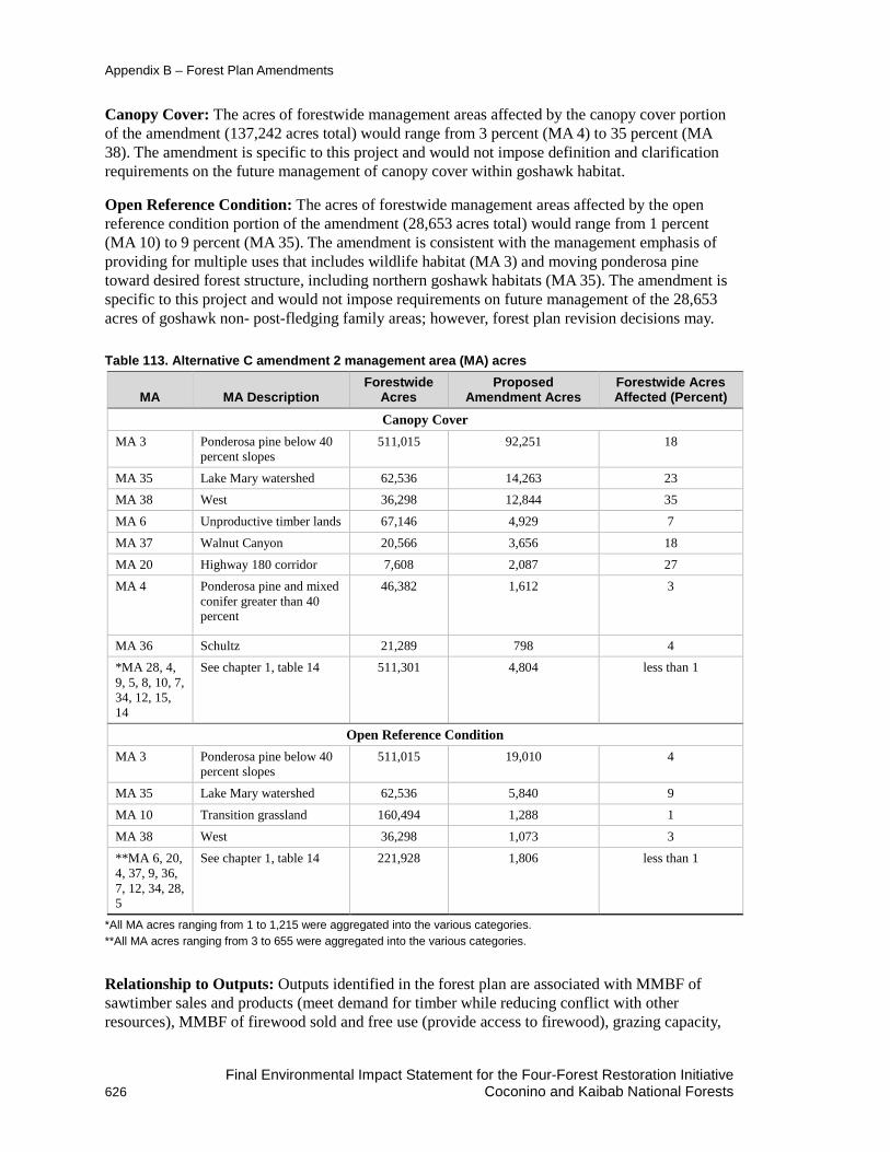
Appendix B – Forest Plan Amendments
Canopy Cover: The acres of forestwide management areas affected by the canopy cover portion of the amendment (137,242 acres total) would range from 3 percent (MA 4) to 35 percent (MA 38). The amendment is specific to this project and would not impose definition and clarification requirements on the future management of canopy cover within goshawk habitat.
Open Reference Condition: The acres of forestwide management areas affected by the open reference condition portion of the amendment (28,653 acres total) would range from 1 percent (MA 10) to 9 percent (MA 35). The amendment is consistent with the management emphasis of providing for multiple uses that includes wildlife habitat (MA 3) and moving ponderosa pine toward desired forest structure, including northern goshawk habitats (MA 35). The amendment is specific to this project and would not impose requirements on future management of the 28,653 acres of goshawk non- post-fledging family areas; however, forest plan revision decisions may.
Table 113. Alternative C amendment 2 management area (MA) acres
MA MA Description Forestwide
Acres Proposed
Amendment Acres Forestwide Acres Affected (Percent)
Canopy Cover MA 3 Ponderosa pine below 40
percent slopes 511,015 92,251 18
MA 35 Lake Mary watershed 62,536 14,263 23 MA 38 West 36,298 12,844 35
MA 6 Unproductive timber lands 67,146 4,929 7
MA 37 Walnut Canyon 20,566 3,656 18
MA 20 Highway 180 corridor 7,608 2,087 27 MA 4 Ponderosa pine and mixed
conifer greater than 40 percent
46,382 1,612 3
MA 36 Schultz 21,289 798 4 *MA 28, 4, 9, 5, 8, 10, 7, 34, 12, 15, 14
See chapter 1, table 14 511,301 4,804 less than 1
Open Reference Condition MA 3 Ponderosa pine below 40
percent slopes 511,015 19,010 4
MA 35 Lake Mary watershed 62,536 5,840 9
MA 10 Transition grassland 160,494 1,288 1
MA 38 West 36,298 1,073 3
**MA 6, 20, 4, 37, 9, 36, 7, 12, 34, 28, 5
See chapter 1, table 14 221,928 1,806 less than 1
*All MA acres ranging from 1 to 1,215 were aggregated into the various categories. **All MA acres ranging from 3 to 655 were aggregated into the various categories.
Relationship to Outputs: Outputs identified in the forest plan are associated with MMBF of sawtimber sales and products (meet demand for timber while reducing conflict with other resources), MMBF of firewood sold and free use (provide access to firewood), grazing capacity,
Final Environmental Impact Statement for the Four-Forest Restoration Initiative 626 Coconino and Kaibab National Forests

Appendix B – Forest Plan Amendments
and permitted livestock use. The amendment would not affect outputs or change the long-term relationship between levels of goods (timber, firewood) and services. No portion of the amendment would affect decisions that have been made through separate analyses on grazing capacity or permitted livestock use.
The canopy cover portion of the amendment provides clarification and disclosure of methods for meeting forest plan requirements. It has no relationship to outputs or to the relationship between the level of goods (timber, firewood) and services and would not result in a change in land productivity or timber suitability classification.
Timber Suitability: The silviculture analysis evaluated the impact of treatments on timber suitability (see silviculture report). Within the analysis area approximately 214,200 acres on the Coconino NF were considered in the timber suitability class. Unsuitable lands include areas where prescription would preclude timber production such as critical wildlife habitat and developed recreation sites as well as areas where irreversible resource damage occur. Table 114 shows total acres for the Coconino NF as reported in the forest plan and used in the timber suitability calculation.
Table 114. Timber suitability calculation for the Coconino NF Land Category Coconino
Acres Gross area 1,821,495* Area not administered by the Forest Service (Camp Navajo and private lands)
NFS lands 1,821,495 Non-forested -325,945 Irreversible resource damage
Adequate restocking not assured
Withdrawn (219.14(a)(4)) -101,401
Subtotal: Not-suitable for timber production
-427,346
Lands Tentatively Suitable for Timber production
1,394,149
Management prescriptions preclude timber production
-593,102
Management requirements cannot be met -154,214 Not cost efficient in meeting timber objectives Forested Lands not appropriate for timber harvest
-13,359
Experimental Forest -6,148
Subtotal: Not appropriate for timber production
-766,823
Lands suitable for timber production 627,326 Note: Acreages of NFS lands may vary slightly over time due to factors such as resurvey, improved mapping technology, and updates to corporate GIS layers. *Based on 1987 Coconino Forest Plan (Appendix H)
Final Environmental Impact Statement for the Four-Forest Restoration Initiative Coconino and Kaibab National Forests 627

Appendix B – Forest Plan Amendments
The Coconino Forest Plan contains the following guidance that directs the management of suitable and unsuitable land.
• On forested lands identified as suitable for commercial timber production, design timber management activities to integrate considerations for economics, water quality, soils, wildlife habitat, recreation opportunities, visual quality, and other values.
• Evaluate timber lands adjacent to the Rim within the first decade to determine timber suitability.
• Management for the ponderosa pine/mixed conifer stands and the big tooth maple stands is the same as MA 3, foreground retention and for areas adjacent to foreground Retention lands. See MA 5 for direction for the aspen stands.
• Manage the timber resource to provide a sustained-yield of forest products through integrated stand management.
• Develop and implement a sustained-yield program for firewood and other miscellaneous forest products including posts, poles, Christmas trees, and wildings. Emphasize uneven-aged management for timber cutting areas.
Unsuitable lands within the Coconino NF are unproductive timber lands are within the ponderosa pine vegetation types.
• They are unsuitable for timber harvest because they fall in at least one of the following two categories.
• They do not meet the minimum standards for productivity which is Site Index 40 and/or 20 cubic feet per acre per year.
• There is not reasonable assurance that such lands can be adequately restocked as required by section 219.27(c)(13) of the planning regulations.
Timber Suitability Consistency Evaluation by Forest Vegetation Community
Ponderosa Pine (PP) The ponderosa pine forest vegetation community generally occurs at elevations ranging from 5,800 to 9,200 feet and is dominated by ponderosa pine and commonly includes other species such as oak, juniper, and pinyon. Species such as aspen, Douglas-fir, white fir, and blue spruce may also be present, but occur infrequently as small groups or individual trees. This forest vegetation community typically occurs with an understory of grasses and forbs although it sometimes includes shrubs.
The majority of the project area is the ponderosa pine plant association. Associations are named for the most shade tolerant tree species successfully regenerating, and for an understory species (shrub or herb) which is most diagnostic of the site. The ponderosa pine associations within the project area include two major sub-types: Ponderosa pine-bunchgrass and ponderosa pine-Gambel oak.
Ponderosa pine commonly grows in pure stands and currently is found in even-aged3 and uneven-aged4 structural conditions across the area. The open park-like stands characteristic of the
3 Even-aged – pertaining to a stand composed of a single age class in which the tree ages are within + 20 percent variability based upon the mature stand age (SAF 1998).
Final Environmental Impact Statement for the Four-Forest Restoration Initiative 628 Coconino and Kaibab National Forests

Appendix B – Forest Plan Amendments
reference conditions for ponderosa pine forests promoted greater faunal diversity and fire resilience than the dense stands of today. Ponderosa pine forests within the project are generally denser and more continuous than in reference conditions (See Chapter 1) and accumulations of forest litter and woody debris are much higher than would have occurred under the historic disturbance regime. Lack of fire disturbance has led to increased tree density and fuel loads that increase the risk of uncharacteristically intense wildfire and drought-related mortality. When fires occur under current conditions, they tend to kill a lot of trees, including the large and old trees. These trees take longer to replace, moving the forest further from desired conditions, and increasing the time it would take to return to desired conditions. There is a high risk of insect and/or disease outbreak, which is also a function of increased tree density (see Forest Health Section). Within this plant series this project would not change any of the timber suitability acres with the proposed treatments.
Gambel Oak within Ponderosa Pine Forest Gambel oak is frequently the only deciduous tree in otherwise pure ponderosa pine forests in the 4FRI analysis area, adding diversity to these forests. A portion of the stands have a large enough component of Gambel oak to be considered pine-oak habitat for Mexican spotted owl (as described in the 1996 forest plan amendment for Mexican spotted owl and Mexican spotted owl Recovery Plan). Similar to pure ponderosa pine forests, pine-Gambel oak forests have become altered since Euro-American settlement in the late 1800s resulting in an overall increase in small- and medium sized Gambel oak stems and a more simplified forest structure (Abella, 2008). Oak management strategies within this project includes conservation of all existing large, old oaks, maintaining a variety of growth forms and managing for densities similar to the range of variability of oak’s evolutionary environment. Within this plant series this project would not change any of the timber suitability acres with the proposed treatments.
Amendment 3. Effect Determination for Cultural Resources Background The Coconino NF forest plan as written has some conflicting direction regarding managing significant or potentially significant sites. One standard (which would be amended for this project) directs management to strive to achieve a “no effect” determination. A second standard (which would be deleted for this project) directs management to achieve a “no effect” determination in consultation with SHPO and ACHP (36 CFR 800). An amendment is proposed to recognize that there could be effects that are not adverse, and that there could be adverse effects that may or may not be fully mitigated.
Amendment Description The amendment deletes the standard that addresses achieving a “no effect” determination and adds the words “or no adverse effect” to the remaining standard. Management strives to achieve a “no effect” or “no adverse effect” determination. Table 115 displays current and proposed forest plan language. New or edited text is displayed in bold text.
4 Uneven-aged – pertaining to a stand with trees of three or more distinct age classes (SAF 1998).
Final Environmental Impact Statement for the Four-Forest Restoration Initiative Coconino and Kaibab National Forests 629

Appendix B – Forest Plan Amendments
Table 115. Alternative C amendment 3 effect determination for cultural resources
Current Coconino NF Forest Plan Direction
Proposed New Standards and
Guidelines Language Cultural Resources Consult with Native Americans when projects and activities are planned in sites or areas of known religious or cultural importance (Coconino NF forest plan, page 52).
No Change
Make boughs and herbaceous plant parts used for Native American religious and ceremonial purposes available under conditions and procedures that minimize restrictions, consistent with laws, regulations, and agreements with tribes. The written authorization to the Hopi Tribe for gathering without specific individual permits is an example. This authorization does not include such items as firewood removed from the forest or Kiva logs, which do require a permit (Coconino NF forest plan, page 52).
No Change
The forest complies with the National Historic Preservation Act (NHPA) in decisions involving interactions between cultural and other resources. Cultural resources are managed in coordination with the State Historic Preservation Plan (SHPO). Until evaluated, the minimal level of management for all sites is avoidance and protection (Coconino NF forest plan, page 52).
No change
Specific standards and guidelines derived from the settlement agreement for the Save the Jemez lawsuit are subject to adjustment, should that agreement be modified. In that event an amendment to the forest plan will be issued (Coconino NF forest plan, page 52).
No Change
Project undertakings are inventoried for cultural resources and areas of Native American religious use. Inventory intensity complies with regional policy, and the settlement agreement for the Save The Jemez Lawsuit, and is determined in consultation with the State Historic Preservation Officer (SHPO). Generally, inventory standards are: One hundred percent survey of all projects causing complete surface disturbance; When less than 100 percent survey is deemed appropriate, the specific sample fraction surveyed is determined in consultation with the State Historic Preservation Officer and is generally greater than 10 percent. Factors determining when sampling is appropriate include projects with dispersed or minimal impacts, low expected archaeological site density, ground cover, and types of archaeological sites present in the area; Consultation with appropriate Native American groups; Consultation with the SHPO, and if necessary, the Advisory Council on Historic Preservation (ACHP), before project implementation (Coconino NF forest plan, page 52-1).
No Change
Significant, or potentially significant, inventoried sites are managed to achieve a “No Effect” determination, in consultation with the SHPO and ACHP (36 CFR 800) (Coconino NF forest plan, page 53).
Standard would be removed
Monitoring during and after project implementation is done to document site protection and condition (Coconino NF forest plan, page 53).
No Change
Management strives to achieve a “No Effect” determination (Coconino NF forest plan, page 53).
Management strives to achieve a “no effect” or “no adverse effect” determination
Final Environmental Impact Statement for the Four-Forest Restoration Initiative 630 Coconino and Kaibab National Forests

Appendix B – Forest Plan Amendments
Current Coconino NF Forest Plan Direction
Proposed New Standards and
Guidelines Language When sample surveys, rather than 100 percent survey coverage, are done for project clearances, survey locations and sample intensity are based on areas of greatest project impact, likely locations for cultural resource sites based on archaeological experience, land management planning, dispersion of sample coverage, certain topographic features specified in the Save the Jemez lawsuit settlement agreement, and likely areas based on the Forest site density predictions (Coconino NF forest plan, page 53).
No Change
Identified sites are evaluated for their National Register eligibility when they are severely damaged, when they will be impacted by an undertaking, or information about the uniqueness, commonness, and characteristics of their site class are sufficiently known to make an informed decision. Sites for which determinations of eligibility have not been made are managed as if they are eligible, unless consultation with the SHPO indicates otherwise (Coconino NF forest plan, page 53).
No Change
For each full-time professional cultural resource specialist employed by the forest, at least two site nominations, one archaeological district nomination, or one thematic or multiple resource nomination will be made each year to the National Register of Historic Places. Or, alternatively, the forest will coordinate with other forests to prepare a joint district, thematic, or multiple resource nomination (Coconino NF forest plan, page 53).
No Change
Inventoried sites allocated to management categories, and/or eligible or potentially eligible for the NRHP or potentially eligible for the NRHP are systematically revisited by regularly scheduled patrols, and by cultural resources specialists to assess natural deterioration, vandalism, or pilfering. Inspections are made at least biannually of properties that have been listed in or nominated to the National Register. Sites most susceptible to natural deterioration and/or human disturbance are monitored frequently. Rapid natural deterioration, or susceptibility to such, requires stabilization, restoration, and/or data recovery. Vandalism or pilfering requires protective measures such as signing, remote sensing, increased patrolling, investigations, stabilization, restoration, and/or data recovery. Specific sites or areas may be closed to off-road driving and withdrawn from mineral entry. Law enforcement is planned and implemented to minimize resource damage and user conflicts. Signing is appropriate to inform and educate the public and minimize direct law enforcement activity. Aggressively pursue violations (Coconino NF forest plan, page 53).
No Change
Continue to interpret cultural resources through lectures, tours, papers, reports, publications, brochures, displays, films, trails, signs, and other opportunities. (Coconino NF forest plan, page 54).
No Change
Develop a program to complete 100 percent coverage of the Forest’s cultural resource inventory by 2000 (Coconino NF forest plan, page 54).
No Change
Final Environmental Impact Statement for the Four-Forest Restoration Initiative Coconino and Kaibab National Forests 631

Appendix B – Forest Plan Amendments
Current Coconino NF Forest Plan Direction
Proposed New Standards and
Guidelines Language The first priorities for cultural resources protection, enhancement, and interpretation are those sites that are easily accessible, have major interpretive potential, or are in major need of repair. Priority sites for signing are the C. Hart Merriam Base Camp, Honanki Cliff Dwellings, Elden Pueblo, Sacred Mountain, Palatki Cliff Dwellings, and Clear Creek Ruins. Priority sites for repair and stabilization are Honanki Cliff Dwellings, Palatki Cliff Dwellings, Sacred Mountain, Clear Creek Cliff Dwelling, and General Springs Cabin. Priority sites for developing interpretive brochures are Elden Pueblo, Sacred Mountain, Red Tank Draw Petroglyphs, Honanki Cliff Dwellings, Palatki Cliff Dwellings, and Clear Creek Ruins. Priorities are to: Survey to clear projects. Survey to fill in gaps in existing inventory coverage. Survey areas of known high site densities. Survey areas that would do the most to answer current archaeological questions (Coconino NF forest plan, page 54).
No Change
Computerize cultural resource site information by 1990 (Coconino NF forest plan, page 54).
No Change
Maintain a form for tracking compliance of each undertaking with the requirements of the National Historic Preservation Act (Coconino NF forest plan, page 54).
No Change
Stabilize or repair damaged National Register sites or other sites funded by regional priority (Coconino NF forest plan, page 54).
No Change
Continue to develop the Elden Pueblo Interpretive Site and the cooperative education program with the Museum of Northern Arizona (Coconino NF forest plan, page 54).
No Change
Encourage universities to conduct summer field schools to assist in cultural resource survey and excavation work and to provide the forest with scientific knowledge (Coconino NF forest plan, page 54).
No Change
Periodically focus media attention on Elden Pueblo and/or other sites to educate the public and further volunteer interest in resource management. Work with community organizations, businesses, and other agencies to promote Arizona Archaeology Week. Feature significant finds and significant damage in the media to increase public awareness of benefits and problems (Coconino NF forest plan, page 54).
No Change
Significance Evaluation Per FSM 1926.51, changes to the land management plan that are not significant can result from:
1. Actions that do not significantly alter the multiple-use goals and objectives for long term land and resource management.
2. Adjustments of management area boundaries or management prescriptions resulting from further onsite analysis when the adjustments do not cause significant changes in the multiple-use goals and objectives for long term land and resource management.
3. Minor changes in standards and guidelines.
Final Environmental Impact Statement for the Four-Forest Restoration Initiative 632 Coconino and Kaibab National Forests

Appendix B – Forest Plan Amendments
4. Opportunities for additional projects or activities that will contribute to achievement of the management prescription.
Per FSM 1926.52, circumstances that may cause a significant change to a land management plan include:
1. Changes that would significantly alter the long-term relationship between levels of multiple-use goods and services originally projected (see section 219.10(e) of the planning regulations in effect before November 9, 2000 (see 36 CFR parts 200 to 299, revised as of July 1, 2000)), and
2. Changes that may have an important effect on the entire land management plan or affect land and resources throughout a large portion of the planning area during the planning period.
The proposed amendment is nonsignificant (FSM 1926.51) because multiple-use goals and objectives for long term land and resource management and its actions would not be altered. How the amendment could potentially affect timing, location and size, relationship to forest goals, objectives, outputs, and management prescriptions was evaluated.
Timing: In terms of timing, the forest plan has been in place (and amended) since 1987, and plan revision efforts are underway.
Location and Size: Amendment 3 is specific to the 355,707 acres of proposed treatments in this project. In alternative C this would affect about 20 percent of the Coconino NF (which totals 1,821,495 acres).
This would not have an important effect on the entire land management plan or a large portion of the planning area. For this reason, location and size was determined to be nonsignificant.
Relationship to Forest Goals and Objectives: The amendment would not affect attainment of forest goals and objectives for cultural resources. Cultural resource sites would be located and protected from project activities according to direction in FSM 2360 and 2430 (Coconino NF forest plan, page 50) and the requirements of 36 CFR 800 including 36 CFR 800.5 which provides direction for assessing adverse effects and proposing a finding of no adverse effect. Consultation with AZ SHPO would occur as required and regulation 36 CFR 800 would be followed and met.
Relationship to Management Prescriptions: The amendment would apply to all 23 management areas (MAs) as described in the Coconino National Forest plan (pages 46 to 206-113) and in chapter 1 of the DEIS. The amendment would not affect the management of the management areas. All cultural resources are currently managed to minimize impacts and to achieve a “no effect” or “no adverse effect” determination whenever possible, in consultation with AZ SHPO, the council, and other consulting parties.
Relationship to Outputs: Outputs identified in the forest plan are associated with MMBF of sawtimber sales and products (meet demand for timber while reducing conflict with other resources), MMBF of firewood sold and free use (provide access to firewood), grazing capacity, and permitted livestock use. The amendment would not affect outputs or change the long-term relationship between levels of goods (timber, firewood) and services.
The amendment would not affect outputs or change the long-term relationship between levels of goods (timber, firewood) and services. All cultural resources are managed to minimize impacts and to achieve a “no effect” or “no adverse effect” determination whenever possible, in
Final Environmental Impact Statement for the Four-Forest Restoration Initiative Coconino and Kaibab National Forests 633
Appendix B – Forest Plan Amendments
consultation with AZ SHPO, the council, and other consulting parties regardless of forest plan desired outputs.
Alternative D – Coconino National Forest Site-Specific Nonsignificant Forest Plan Amendments
Amendment 1. Mexican Spotted Owl Habitat Management (Coconino NF) Amendment Description This amendment is the same as described for alternative B in that the amendment allows mechanical treatment up to 16 inches d.b.h. in 18 PACs Mexican spotted owl PACs. Although alternative D reduces the acres that would receive prescribed fire, the amendment would still be required to address mechanical treatment above 9 inches d.b.h., eliminating incremental treatments within PACs, and deferring monitoring to the project’s U.S. Fish and Wildlife Service biological opinion. Figure 64 displays mechanical Mexican spotted owl PAC treatments locations. No prescribed fire would occur within PACs.
Final Environmental Impact Statement for the Four-Forest Restoration Initiative 634 Coconino and Kaibab National Forests

Appendix B – Forest Plan Amendments
Figure 64. Alternative B amendment 1 Mexican spotted owl PAC treatments
Amendment 2. Management of Canopy Cover and Ponderosa Pine with an Open Reference Condition within Goshawk Habitat (Coconino NF) This amendment is similar to alternative B. The key difference between the alternatives is the acres that would receive prescribed fire. In alternative D, the acres of prescribed fire would be reduced by about 69 percent, from 583,330 acres in alternative B to 178,441 acres. Any difference in acres of prescribed fire would not eliminate the need for a plan amendment that addresses managing acres for an open reference condition.
Final Environmental Impact Statement for the Four-Forest Restoration Initiative Coconino and Kaibab National Forests 635

Appendix B – Forest Plan Amendments
Amendment 3. Effect Determination for Cultural Resources (Coconino NF) Amendment 3 is the similar to alternative B. However, 331,794 acres or 18 percent of the Coconino NF would be affected by the amendment. The reduction in acres to receive prescribed fire in alternative D would not eliminate the need for a plan amendment that addresses managing for “no effect” or “no adverse effect” for heritage resources.
Final Environmental Impact Statement for the Four-Forest Restoration Initiative 636 Coconino and Kaibab National Forests

Appendix C – Design Features, Best Management Practices, and Mitigation Design features, best management practices (BMPs), and mitigation that are common to all action alternatives (B–E) are presented for each resource with one exception. Silviculture design features can be found in Appendix D – Implementation Plan.
Final Environmental Impact Statement for the Four-Forest Restoration Initiative Coconino and Kaibab National Forests 637

Appendix C – Design Features, BMPs, and Mitigation
Table 116. Alternatives B, C, D, and E design features, best management practices, and mitigation
Design Criteria Number Description
Purpose
Comment or Purpose Forest Plan Compliance
Specialist Recommendation
Aquatics
A1 See Soil and Water: SW1 to SW 43 Botany
B1 Follow forest plan direction for special areas including botanical areas.
X Preserve special features and meet intent of designation.
B2 Determine potential occurrences and habitat of Southwestern Region sensitive plants in potential activity areas when planning for implementation. Identify potential species and survey the area to be treated before implementation.
X Complies with FSM direction 2670. Manual direction (FSM 2670.5(19)) emphasizes that management actions should avoid or minimize impacts to sensitive species.
B3 Mitigate negative effects from management actions on Southwestern Region sensitive plants during design and implementation.
X Complies with FSM direction, minimizes impacts to Southwestern Region sensitive plants.
B4 Prohibit slash pile construction within populations of Southwestern Region sensitive plants. Construct slash piles at least 10 to 20 feet away from known populations of Southwestern Region sensitive plants. Place slash piles on previously used locations such as old piling sites, old log deck sites, or other disturbed sites to avoid severe disturbance to additional locations where possible. Monitor slash pile sites after burning and control noxious or invasive weeds (see FE10).
X Mitigates effects of disturbance and burning. Reduces loss of native seed bank, limits extent of severe disturbances, and reduces severely disturbed sites that are more prone to invasion by noxious or invasive weeds.
B5 Prohibit temporary road construction and reconstruction, tracked vehicles, and pits within populations of Southwestern Region sensitive plants.
X Eliminates direct loss of plants.
B6 Prohibit construction and reconstruction of log landings in identified populations of Southwestern Region sensitive plants.
X Mitigates effects of disturbance. Follows management plan guidance of the management plan for Hedeoma diffusum (Flagstaff pennyroyal).
Final Environmental Impact Statement for the Four-Forest Restoration Initiative 638 Coconino and Kaibab National Forests

Appendix C – Design Features, BMPs, and Mitigation
Design Criteria Number Description
Purpose
Comment or Purpose Forest Plan Compliance
Specialist Recommendation
B7 Follow the guidance of the “Arizona Bugbane Conservation Assessment and Strategy, Coconino and Kaibab NFs” (1995) when planning activities near Arizona bugbane populations. An example of mitigation for this species includes preservation of shade and cool microsites for existing populations. This may require special attention in upland areas near canyon edges.
X Mitigates effects to Arizona bugbane, a U.S. Fish and Wildlife Service candidate species. Follows guidance of conservation assessment and strategy and complies with policy.
B8 Manage fire severity in all entries in or near Arizona bugbane populations to minimize tree mortality.
X Preserves the shady, mesic environment and overstory needed for Arizona bugbane.
B9 Follow the guidance of the management plan for Hedeoma diffusum (Flagstaff pennyroyal) when working in suitable habitat for this species. Examples of mitigations include restrictions on distance for building temporary roads near existing populations.
X Forest plan compliance.
B10 Deferrals and groups may include Southwestern Region sensitive plant groups where practical, using areas not occupied by the plants as interspaces.
X Provide protection and shade needed by the sensitive plants while allowing for the least impact on clump/group/interspace design and layout during implementation and help mitigate impacts to Southwestern Region sensitive plants.
B11 Survey springs and channels for Southwestern Region sensitive plants before implementation and identify locations. Inform the forest botanist if new locations are found and mitigate effects to plants and populations. Mitigations include avoiding plants, altering designs, or including plants in enclosures. Incorporates buffer strips along drainages. See soil and water SW8.
X Protects populations and habitat of Southwestern Region sensitive plants. Protects sneezeweed since it grows in ephemeral stream courses, springs, ponds, stock tanks, and meadows.
Final Environmental Impact Statement for the Four-Forest Restoration Initiative Coconino and Kaibab National Forests 639

Appendix C – Design Features, BMPs, and Mitigation
Design Criteria Number Description
Purpose
Comment or Purpose Forest Plan Compliance
Specialist Recommendation
B12 Survey springs and channels for Bebb’s willow before implementation and identify locations. Inform the forest botanist if new locations are found and mitigate effects to plants and populations. Mitigations include avoiding plants, altering designs, or including plants in enclosures. Identify opportunities to enhance Bebb’s willow where plants are decadent or dying. Manual grubbing of grasses may be used to increase the likelihood of planting success.
X – Coconino NF only
Protects populations and habitat of Bebb’s willow. Bebb’s willow stands would be enhanced by using cuttings, planting locally cultivated plants, and fencing existing or newly planted willows.
B13 Manage prescribed fires/burn to promote native species, hinder weed species germination, use as an aid to control of existing weed infestations, and to prevent the spread of existing weeds.
X Promote healthy native plant communities and reduces the risk of noxious or invasive weed invasions.
B14 Review watershed BMPs for project area and incorporate mitigations for Arizona sneezeweed into BMPs.
X Watershed BMPs often serve as good mitigations for Arizona sneezeweed since it grows in ephemeral stream courses, springs, ponds, stock tanks and meadows.
B15 Review various sites such as spring restoration for opportunities to introduce and restore Bebb’s willow to supplement existing locations on the forest and introduce young plants into areas where plants are decadent and dying. Bebb’s willow stands would be enhanced by using cuttings, planting locally cultivated plants, and fencing existing or newly planted willows. Manual grubbing of grasses may be used to increase the likelihood of planting success. Fire lines would be placed around Bebb’s willows and dead branches within the clumps would be removed before prescribed burning adjacent areas to reduce the risk of fire impacting willows.
X Aids in restoring Bebb’s willow which is a Southwestern Region sensitive species for the Coconino NF and a rare species on the landscape for both forests.
Final Environmental Impact Statement for the Four-Forest Restoration Initiative 640 Coconino and Kaibab National Forests

Appendix C – Design Features, BMPs, and Mitigation
Design Criteria Number Description
Purpose
Comment or Purpose Forest Plan Compliance
Specialist Recommendation
B15 Follow the guidance in appendix B of the “Final Environmental Impact Statement for Integrated Treatment of Noxious or Invasive Weeds, Coconino, Kaibab, and Prescott NFs within Coconino, Gila, Mojave, and Yavapai Counties, Arizona” including: (1) surveying the treatment area and evaluating weeds present before implementation; avoiding or removing sources of weed seed and propagules to prevent new weed infestations and the spread of existing weeds; (2) treating weed infestations within treatment units before implementing treatments; (3) managing prescribed fires as an aid to control of existing weed infestations and to prevent the spread of existing weeds; and (4) monitoring slash pile sites after burning and control noxious or invasive weeds.
X Provides guidance and mitigation for noxious or invasive weeds and complies with amendment 20 of the Coconino NF forest plan.
B16 Treat weed infestations within treatment units before implementing treatments.
X Forest plan direction Amendment 20 Coconino National Forest Plan.
B17 Monitor slash pile sites after burning and control noxious or invasive weeds.
X Controls weeds, reduces risk of invasion and reduces risk to native species by reducing weed competition.
B18 Prevent spread of potential and existing noxious or invasive weeds by vehicles used in management activities by washing vehicles and equipment prior to entering the project area and when moving from one area to another.
X Mitigates effects of management actions on existing and potential noxious or invasive weed infestations, Forest plan direction is complementary to Timber Sale Contract Clause CT WO-C/CT 6. 36 and watershed best management practices.
B19 Review Timber Sale contract clauses for vehicle cleaning and incorporate appropriate clauses.
X Complementary to B18.
B20 Incorporate the Best Management Practices for noxious or invasive weeds as listed in appendix B of the Final Environmental Impact Statement for Integrated Treatment of Noxious or Invasive Weeds into all management actions. See appendix F of the botany report.
X Required by the forest plan (Amendment 20 of the Coconino National Forest Plan.
Final Environmental Impact Statement for the Four-Forest Restoration Initiative Coconino and Kaibab National Forests 641

Appendix C – Design Features, BMPs, and Mitigation
Design Criteria Number Description
Purpose
Comment or Purpose Forest Plan Compliance
Specialist Recommendation
B21 Monitor the effects of treatment on Region 3 sensitive plants after treatments are completed.
X Provides opportunities to obtain knowledge on local species that are often poorly understood. Allows for adaptive management in future treatments.
B22 Timing of prescribed fire and herbicide application in areas with leafy spurge will be determined by the District Fuels Specialist and District Weeds Coordinator at the time of implementation. The most successful herbicide treatments for populations of leafy spurge on the Coconino National Forest have been in the fall. However, the logistics of treating plants with herbicide in the fall after burning may be difficult. The above ground portions of the plants will be absent and resources would have been drawn into the underground storage structures of the plants. A spring herbicide treatment following a fall burn may be necessary to address help facilitate control but this issue will be addressed on a site specific basis.
X Allows prescribed fire to occur in our near existing populations of leafy spurge while providing for control of it. Allows on the ground, site-specific assessment and coordination of the prescribed fire and control of leafy spurge on a site-specific basis.
B23 Fire should be excluded from leafy spurge areas where biological control insects for leafy spurge are active during the summer months generally from mid-May to August, except if monitoring and surveys fail to detect the presence of the biological control insects. Prescribed fire may be implemented during that time if the insects are absent from the site and there are no other resource concerns. Monitoring prior to implementation would be needed to confirm the presence/absence of the insects.
X Protects the financial investment and potential control provided by the biological control insects that have been released in the past and may be released in the future while allowing prescribed fire to be implemented in the affected areas.
B24 Incorporate surveys for rare and endemic plants into surveys for Region 3 sensitive plants and/or noxious or invasive weeds prior to implementation. Survey needs will be dependent on known or potential occurrences in the treatment areas.
X Addresses the desired conditions for rare or endemic species in the Kaibab NF Plan (2014) and the Coconino NF plan (in revision).
B25 Apply mitigations B2 through B 8 and B10 through B12 and B14 as needed to address the effects to rare and endemic plant species.
X Addresses management effects to rare and endemic species as well as to Region 3 sensitive plants.
Final Environmental Impact Statement for the Four-Forest Restoration Initiative 642 Coconino and Kaibab National Forests

Appendix C – Design Features, BMPs, and Mitigation
Design Criteria Number Description
Purpose
Comment or Purpose Forest Plan Compliance
Specialist Recommendation
B26 Consult the Rare Plant Guidebook) in preparation) (if available) at the time of implementation.
X Guidebook is designed to provide identification aids, potential habitat information and potential risks to species for analysis and implementation.
Fire Ecology FE1 Burn unit size, as well as strategic placement, would be a
consideration in designing units and implementation prioritization (Finney et al. 2003).
X Arrangements of large treatment areas are more effective at reducing fire behavior than arrangements of smaller ones. Larger burn blocks, when possible, would also be mitigation for emissions by increasing the potential number of acres that could be burned in a burn window. Larger burn units would produce more smoke when prescribed fires are implemented, but for a shorter duration.
FE2 Prescribed fire (pile, broadcast, and jackpot burning) would occur in accordance with Arizona Department of Environmental Quality (ADEQ) requirements.
X Regulatory requirement.
FE3 Emission reduction techniques (see FE8) would be utilized when possible to minimize impacts to sensitive receptors of burn unit(s). Project design for prescribed fire and strategies for managing wildfires should incorporate as many emission reduction techniques as feasible, subject to economic, technical, and safety criteria, and land management objectives. Decision documents (which define the objectives and document line officer approval of the strategies chosen for wildfires) should identify smoke-sensitive receptors, and include objectives and courses of action to minimize and mitigate impacts to those receptors as feasible.
X Emission reduction techniques are recommended by the ADEQ as techniques that can be effective for minimizing impacts to sensitive receptors.
Final Environmental Impact Statement for the Four-Forest Restoration Initiative Coconino and Kaibab National Forests 643

Appendix C – Design Features, BMPs, and Mitigation
Design Criteria Number Description
Purpose
Comment or Purpose Forest Plan Compliance
Specialist Recommendation
FE4 As needed, the burning of hand piles or machine piles would occur when conditions are favorable and risk of fire spread is low. Piles would be located far enough away from residual trees and shrub patches to minimize canopy scorch or damage to ponderosa pine or large oak (greater than 6 inch d.b.h.) where it is not desirable. Individual piles or groups of piles may have fireline cut around them if necessary to meet objectives.
X Prevent undesirable impacts.
FE5 Firelines would be used to facilitate broadcast burns or pile burning operations as needed: (1) Firelines may consist of natural barriers, roads and trails, or may be constructed as needed. Line construction may consist of removing woody and/or herbaceous vegetation, removing surface fuels, pruning, or cutting breaks in fuels by hand, ATV (drag lines), or a dozer as needed, (2) Fireline width would be determined as adjacent fuels and expected fire behavior dictate, assuming compliance with the requirements of cultural, wildlife, and other resource areas, (3) Constructed firelines would be rehabilitated, which may include pulling removed material back into the lines, hand constructing water diversion channels and/or water bars, laying shrubs or woody debris in the lines following burning, or other methods appropriate to the site, and (4) Fireline construction would be coordinated with wildlife and heritage.
X Facilitate broadcast burns or pile burning operations.
FE6 Mechanical treatments following broadcast burns would occur after surface vegetation has recovered sufficiently to minimize impacts from the mechanical treatments (generally 1 to 3 years). Prescribed fire treatments following mechanical treatments would occur after there has been adequate surface vegetation recovery that fuel loads are sufficient to meet the objectives of a prescribed burn.
X Minimize impacts from mechanical treatments on vegetation and soil.
FE7 Prescribed fires may be conducted before or after mechanical treatments. The sequencing of prescribed fires and mechanical treatments would be decided on a site-specific basis, depending on the site, burn windows, available resources, thinning schedules, etc.
X Increase the flexibility for implementing both prescribed fire and mechanical treatments.
Final Environmental Impact Statement for the Four-Forest Restoration Initiative 644 Coconino and Kaibab National Forests

Appendix C – Design Features, BMPs, and Mitigation
Design Criteria Number Description
Purpose
Comment or Purpose Forest Plan Compliance
Specialist Recommendation
FE8 The following ADEQ emissions reduction techniques (ERTs) would be used when practicable to minimize impacts to sensitive receptors: pre-burn fuel removal, mechanical processing, increased burning frequency, aerial/ mass ignition, high moisture in large fuels, rapid mop-up, air curtain incinerators, burn before green-up, backing fire, maintain fireline intensity, underburn before litterfall, isolating fuels, concentrating fuels, mosaic/jackpot burning, moist litter and duff, burn before large activity fuels cure, and utilize piles.
X Reduce emissions from prescribed fire.
FE9 Mitigation and design features for smoke impacts include: (1) Reducing the emissions produced for a given area treated, (2) Redistributing/diluting the emissions through meteorological scheduling and by coordinating with other burners in the airshed. Dilution involves controlling the rate of emissions or scheduling for dispersion to assure tolerable concentrations of smoke in designated areas, and (3) Avoidance uses meteorological conditions when scheduling burning in order to avoid incursions of wildland fire smoke into smoke sensitive areas. Also see FE8 for ERTs.
X X See FE 9.
FE10 When prescribed burns are conducted in areas with, or near known populations of invasive weeds, follow-up monitoring would be conducted. Also see Botany B4.
X Detect new weed infestations before they spread.
FE 11 See Rangeland Management: R1, R4, and R5. X Prevent damage or loss of infrastructure.
Final Environmental Impact Statement for the Four-Forest Restoration Initiative Coconino and Kaibab National Forests 645

Appendix C – Design Features, BMPs, and Mitigation
Design Criteria Number Description
Purpose
Comment or Purpose Forest Plan Compliance
Specialist Recommendation
FE12 When practicable, damage or mortality to old trees, and large trees would be mitigated by implementing prescription parameters, ignition techniques, raking, wetting, thinning, compressing slash, or otherwise mitigating fire impacts to the degree necessary to meet burn objectives and minimize fireline intensity and heat per unit area in the vicinity of old trees. Trees identified as being of particular concern (e.g. trees with known nests or roots for herons, eagles, osprey, or other raptors, occupied nest cores, or critical areas in PACs) would be managed in accordance with wildlife design features (see wildlife). Prepare old trees 1 year or more before a burn if possible.
X Old trees are rare components and are under-represented across the project area. Implementing mitigation measures when possible is a critical component of restoration on a landscape scale. Large trees that are not old are not as susceptible to damage from fire. Mitigation measures that can be implemented a year or more before a burn, such as thinning or raking, may improve the health of the tree, improving its response to fire.
FE13 Mitigation measures and design features for wildlife species including Mexican spotted owl, golden eagle, bald eagle, pronghorn, northern goshawk, bats, northern leopard frog, turkey, deer, and other wildlife can be found in the wildlife section.
X Forest plan compliance.
FE14 Aspen, Gambel oak, pine-sage: fire effects would be managed primarily by implementing prescriptions and ignition techniques to meet objectives in pine-sage systems. In Gambel oak, avoid lighting near the bases of large oak boles.
X To meet burn objectives.
FE15 Concerned/interested public will be given as much warning as possible in advance of prescribed burns via notices, press releases, email lists, public announcements, phone lists, or other notification methods as appropriate.
X To provide advanced notice for publics concerned about potential impacts from emissions resulting from prescribed fires.
FE16 Range and fire managers will coordinate grazing schedules and prescribed fires on allotments within burn units to ensure there is sufficient surface fuel to allow burn objectives to be met. If grazing cannot cease long enough for sufficient fuel to build up to meet objectives, planned prescribed fires will be postponed until there can be sufficient fuel to meet objectives.
X To improve the ability of prescribed fire managers to meet objectives when implementing prescribed fires.
Final Environmental Impact Statement for the Four-Forest Restoration Initiative 646 Coconino and Kaibab National Forests

Appendix C – Design Features, BMPs, and Mitigation
Design Criteria Number Description
Purpose
Comment or Purpose Forest Plan Compliance
Specialist Recommendation
FE17 Coarse woody debris will be managed to achieve forest plan direction, though it may take more than one entry when the current conditions are deficit (i.e. are below forest plan guidelines). KNF: 1 – 5 tons per acre in wildland-urban interface unless there are conflicts with other resource needs. (Refer to KNF revised forest plan page 98). Other areas in ponderosa pine on the KNF 3 – 10 tons per acre. CNF: 5 – 7 tons per acre in ponderosa pine.
X To provide levels of coarse woody debris to address the need for habitat (cover), soils (organic material and limited areas of high burn severity), and fire (limited areas of high burn severity and a high resistance to control).
Heritage Resources and Tribal Relations HR/TR-1 The forest would comply with the NHPA for all ground-disturbing
undertakings. Effects to cultural resources would be determined in consultation with the SHPO and other consulting parties. Potential effects would be addressed through site avoidance strategies and implementing the site protection measures listed in the Southwestern Region programmatic agreement (PA), appendix J and in the 4FRI heritage strategy and section 106 clearance report.
X Regulatory requirement. Compliance with NHPA and Southwestern Region PA with AZ SHPO.
HR/TR-2 Consult with Native Americans in compliance with NHPA, AIRFA, EO 13007, EO 13175, and other applicable Executive Orders and legislation, particularly when projects and activities are planned in sites or areas of known religious or cultural significance.
X Regulatory requirement. Compliance with NHPA and Southwestern Region PA with AZ SHPO.
HR/TR-3 Project undertakings would be inventoried for cultural resources and areas of Native American religious and cultural use.
X Regulatory requirement. Compliance with NHPA and Southwestern Region PA with AZ SHPO.
HR/TR-4 Eligible, or potentially eligible, cultural resources would be managed to achieve a “no effect” or “no adverse effect” determination whenever possible, in consultation with the SHPO and ACHP (36 CFR 800).
X Regulatory requirement. Compliance with NHPA and Southwestern Region PA with AZ SHPO.
HR/TR-5 Monitoring during and after project implementation would occur to document site protection and condition. Also see FE5.
X Forest plan compliance.
HR/TR-6 See Recreation and Scenery RS3 and RS5 for mitigation related to historic roads and trails.
X Forest plan compliance.
Final Environmental Impact Statement for the Four-Forest Restoration Initiative Coconino and Kaibab National Forests 647

Appendix C – Design Features, BMPs, and Mitigation
Design Criteria Number Description
Purpose
Comment or Purpose Forest Plan Compliance
Specialist Recommendation
HR-TR-7 Prior to initiating and during the heritage analysis for -specific task orders, the forests would consult with federally recognized tribes to identify traditional use areas and, if necessary, develop project-specific mitigation measures to accommodate traditional use of the forest by tribal members.
X Regulatory requirement. Compliance with NHPA and Southwestern Region PA with AZ SHPO. Forest plan compliance.
HR-TR-8 Fuels and other treatment timing would be adjusted as possible to avoid seasonal plant gathering and ceremonial use.
X Continued coordination with tribes during implementation.
HR-TR-9 See FE 5 . HR-TR-10 In accordance with regulations (43 CFR 10) governing application
of the Native American Graves Protection and Repatriation Act of 1990 (NAGPRA), if human remains, funerary objects, sacred objects, or objects of cultural patrimony are inadvertently encountered, operations in the area must immediately cease and the Forest Archaeologist notified. The Forest Archaeologist will work to initiate consultation with the affected tribe (s) to implement any requirements listed in NAGPRA and the PA and develop a plan to mitigate for the effects to the find.
X Regulatory requirement. Compliance with NHPA and Southwestern Region PA with AZ SHPO. Forest plan compliance.
HR-TR 11 Should any previously unidentified cultural materials be discovered during project implementation, work must cease immediately and the Forest Archaeologist must be contacted to initiate the consultation process as outlined in the Advisory Council on Historic Preservation Regulations (36 CFR Part 800.13).
X Regulatory requirement. Compliance with NHPA and Southwestern Region PA with AZ SHPO. Forest plan compliance.
Rangeland Management R1 Historic range monitoring sites including witness trees/posts, 1inch
angle iron stakes, and any other site location markers would be protected. These sites would not be excluded from treatment but care needs to be taken to avoid loss of these site markers. These sites would not be used as locations for temporary access roads, skid trails, landing areas, or large slash piles.
X Avoid site damage.
R2 The sale administrator would work closely with the district range staff to determine pasture use during harvest activities.
X Avoid infrastructure damage, and retain allotment and pasture fences within a harvest area.
Final Environmental Impact Statement for the Four-Forest Restoration Initiative 648 Coconino and Kaibab National Forests

Appendix C – Design Features, BMPs, and Mitigation
Design Criteria Number Description
Purpose
Comment or Purpose Forest Plan Compliance
Specialist Recommendation
R3 All fences in the cutting area would be protected from harvest activities. Skid trail layout would keep equipment on one side of the fence to avoid having to cut fences. Temporary cattle guards would be installed on all haul roads where gates exist within active grazed pastures. All cattle guards on harvest haul roads would be maintained throughout hauling activities.
X Protect infrastructure.
R4 Burning often damages/destroys wood stays and h-brace posts in existing pasture/allotment fencing. Protection of these fences is critical for implementation of planned grazing systems and is important to reduce the costs of replacing these items. Even with protection, wood stays and h-braces would be damaged by the fire. The cost of prescribed burning would include fence protection measures and replacement/reconstruction costs for burned wood stays and h-braces. Fire personnel will look at using the fence lines as burn area boundaries whenever possible to reduce these impacts.
X Limit the numbers of pastures affected by the fires in a given year. Protect fences that are critical to the implementation of planned grazing systems and reduce the costs of replacing these items.
R5 Fire personnel would coordinate with district range staff to schedule main pasture burning to limit impacts to allotment grazing management. The general goal would be to limit burns to no more than one main grazing pasture/year/allotment in allotments with a less than, or equal to, six pasture grazing system.
X Minimize disruption to grazing.
R6 Burns would be restricted to no more than two main grazing pastures/year/allotment in allotments with a greater than six pasture grazing system. Main pastures are pastures that are large enough to hold the allotment’s livestock for more than an average of 20 days per year. This is a general rule of thumb; however, each allotment has specific situations that would need to be addressed.
X Minimize disruption to grazing.
Final Environmental Impact Statement for the Four-Forest Restoration Initiative Coconino and Kaibab National Forests 649

Appendix C – Design Features, BMPs, and Mitigation
Design Criteria Number Description
Purpose
Comment or Purpose Forest Plan Compliance
Specialist Recommendation
R7 Restrictions in grazing of livestock would primarily occur after significant burns in a pasture. Post-fire grazing may resume within a pasture when soil and perennial plants, that would likely be grazed, would not be permanently damaged by livestock. The range management definition for this is range readiness. Plants are ready for grazing when at least one of the following characteristics is present: 1) seed heads or flowers, 2) multiple leaves or branches, and/or 3) a root system that does not allow plants to be easily pulled from the ground. These characteristics provide evidence of plant recovery, high vigor and reproductive ability. An estimate of this restriction is not available because of each pasture and burn is unique. Climatic conditions, soils, vegetation, the severity of fire effects, burn amount, and pasture management can vary greatly from year to year or from pasture to pasture.
X Assessment of post-fire range readiness.
R8 Range and fire managers will coordinate grazing schedules and prescribed fires on allotments within burn units to ensure there is sufficient surface fuel to allow burn objectives to be met. If grazing cannot cease long enough for sufficient fuel to build up to meet objectives, planned prescribed fires will be postponed until there can be sufficient fuel to meet objectives.
X Assessment of post-fire range readiness.
R9 The removal or exclusion of livestock water would be mitigated with alternative water sources, providing lanes to the water, or piping water to a livestock drinker.
X Provide alternate water sources.
Final Environmental Impact Statement for the Four-Forest Restoration Initiative 650 Coconino and Kaibab National Forests

Appendix C – Design Features, BMPs, and Mitigation
Design Criteria Number Description
Purpose
Comment or Purpose Forest Plan Compliance
Specialist Recommendation
Recreation, Trails, Scenery, and Special Areas RS1 Edges of Individual Units: (a) Edges of treatment units would be
shaped and/or feathered (create gentle transitions from more to fewer trees or fewer to more trees) to avoid abrupt changes between treated and untreated areas; (b) where the treatment unit is adjacent to denser forest (treated or untreated), the percent of thinning within the transition zone (150–250 feet) would be progressively reduced toward the denser edges of the unit; (c) where the treatment unit interfaces with an opening (including savanna and grassland treatments, and natural openings) the transition zone would progressively increase toward the open edges of the unit; (d) soften edges by thinning adjacent to the existing unit boundaries. Treat up to the edges; do not leave a screen of trees. Favor groups of trees complying with the prescribed treatment that visually connect with the unit’s edge to avoid an abrupt and noticeable change; (e) treatment boundaries should extend up and over ridgelines to avoid the “Mohawk” look; and (f) avoid widely spaced individual trees that are silhouetted along the skylines.
X X Compliance with forest plans.
RS2 Unit Marking: (a) Avoid using trails as boundaries and (b) avoid abrupt changes between treatment units. Use the techniques suggested for edges of treatment units (above). Where feasible strive to have the minimal marking of trees within the Arizona Trail corridor.
X X Compliance with forest plans.
RS3 Road, Skid Trail, and Landing Construction: (a) Utilize dust abatement methods during haul of logs on the following roads shown in the table during the season when dust is likely and funding is available. Coordinate with Coconino County on the application and timing of application of dust abatement on road segments that have county maintenance responsibilities:
X X Compliance with forest plans.
Final Environmental Impact Statement for the Four-Forest Restoration Initiative Coconino and Kaibab National Forests 651

Appendix C – Design Features, BMPs, and Mitigation
Design Criteria Number Description
Purpose
Comment or Purpose Forest Plan Compliance
Specialist Recommendation
(b) Where new temporary roads and skid trails meet a primary travel route, they should intersect at a right angle, then curve after the junction, to minimize the length of route seem from the primary travel route; (c) Log landings, temporary roads, and skid trails should be minimized within sensitive viewsheds such as those next to developed recreation sites, private homes or communities, paved and passenger car level roads and trails; (d) Highest emphasis for slash treatment, temporary road closures and road decommissioning will be placed on foreground (up to 300 feet) of developed recreation sites, private homes or communities, and concern level 1 roads (paved roads and passenger car level roads) and trails, especially those designated as national scenic, historic or recreation trails; (e) Log landings, skid trails and temporary roads will be rehabilitated including restoring proper drainage, and reseeding as needed with native species; (f) To hasten recovery and help eliminate unauthorized motorized and non-motorized use of skid trails and temporary roads, use physical measures such as re-contouring, pulling slash and rocks across the line, placing cull logs perpendicular to the route, and disguising entrances, (g) Avoid using FS designated trails as skid trails or for temporary roads, (h) National Scenic, Historic, and Recreation Trails as well as forest system trails (motorized and non-motorized) will not be used for temporary roads or skid trails. It is acceptable to make perpendicular trail crossings. The locations of crossings will be
Final Environmental Impact Statement for the Four-Forest Restoration Initiative 652 Coconino and Kaibab National Forests

Appendix C – Design Features, BMPs, and Mitigation
Design Criteria Number Description
Purpose
Comment or Purpose Forest Plan Compliance
Specialist Recommendation
designated. Trail crossings will be restored to pre-project condition after use, (i) Crossing of the Arizona Trail will be done sparingly and only if no other alternative exists. These crossing locations will be coordinated with District Recreation Staff; and, (j) Large, upright trail cairns used on Beale Wagon Road and Overland Trail must be protected. Locate cairns ahead of time. Logging operations will not damage the cairns.
RS4 Cull Logs, Stump Heights, and Slash Treatments: Cull logs would not be abandoned on landings. Use cull logs for closing temporary roads and decommissioning roads. Cull logs may also be suitable to use as down woody material, but must be scattered away from the landings. Stump heights should be cut as low as possible, with a maximum height of 12 inches. In the foreground of sensitive roads, trails, recreation sites, private homes/ communities, strive to make stump heights 6 inches or lower, with 12 inch heights as the exception, and rarely occurring. Slash must be treated or removed. In the seen area immediate foreground of sensitive places (within 300 feet of the centerline of concern level 1 roads or trails, or 300 feet from the boundary of a recreation site or private land/communities). Where whole tree logging occurs, machine piling may occur to the back of log landings. Prioritize slash burning in these locations within one year or as soon as possible after treatment. If conventional logging is used and trees are delimbed and topped in the forest, machine piled slash should be placed at least 300 feet away from the centerline of roads and trails, developed recreation sites, or private land/communities. In these instances, piles should be burned as soon as possible or within 3 years. Root wads and other debris in sensitive foreground areas would be removed, buried, burned, or chipped. If materials are buried, locate in previously disturbed areas where possible. Beyond sensitive immediate foreground areas, it is acceptable to scatter these or use them to help close temporary roads or skid trails. If slash is not removed in grassland treatment areas, it is acceptable to create machine piles 300 feet away from the centerline of sensitive roads and trails, developed recreation sites, and private land/communities. Place project-generated slash outside of
X X Compliance with forest plans.
Final Environmental Impact Statement for the Four-Forest Restoration Initiative Coconino and Kaibab National Forests 653

Appendix C – Design Features, BMPs, and Mitigation
Design Criteria Number Description
Purpose
Comment or Purpose Forest Plan Compliance
Specialist Recommendation
permitted utility line and pipeline rights-of-way; do not interfere with utility corridor management.
RS5 Fire Control Lines: (1) Generally restore control lines to a near undisturbed condition in the foregrounds (within 300 feet) of sensitive roads, trails, and developed recreation sites, (2) To hasten recovery and help eliminate unauthorized motorized and nonmotorized use of control lines in these areas, use measures such as recontouring, pulling slash and rocks across the line, and disguising entrances, and (3) Do not use motorized equipment on national scenic, historic and recreation trails, or other forest system trails if these are used for control lines. Coordinate with the district recreation staff regarding use of national trails as control lines.
X X Compliance with forest plans.
RS6 Coordinate with landscape architect prior to implementing jackstraw, spring, and road restoration treatments. Do not implement jack straw treatments within 1,000 feet of the Arizona Trail. Also see SW37 and T8.
X X Maintain scenic integrity.
RS7 Recreation and Other Trail Mitigation: Recreation Sites: (i) Proposed mechanical treatments and prescribed fire adjacent to developed recreation sites must be reviewed and approved by the district ranger. Treatments may occur within Ten-X, Kaibab Lake and White Horse Lake Campgrounds. Work with the district recreation staff to determine boundaries or no treatment zones around constructed features that need to be protected in the campgrounds. Treatments around the perimeter of the campgrounds are encouraged. The timing of treatments must be worked out with districts. Treatment would generally occur in fall, winter, or spring. Activity slash must be piled in agreed upon locations, and treated as soon as possible. If campgrounds remain open into fall and winter, provide information about upcoming closures and management activities onsite, at FS offices, and FS Web sites. Thinning and burning is appropriate at Garland Prairie Vista and Oakhill Snowplay Area, but constructed features must be protected from damage. Work with the district recreation staff to establish boundaries to protect constructed features. Provide public notice and information about treatment locations,
X X Compliance with forest plans, inform public, and reduce impacts to recreational opportunities.
Final Environmental Impact Statement for the Four-Forest Restoration Initiative 654 Coconino and Kaibab National Forests

Appendix C – Design Features, BMPs, and Mitigation
Design Criteria Number Description
Purpose
Comment or Purpose Forest Plan Compliance
Specialist Recommendation
timing, and the type of treatment occurring prior to and during vegetation and fire treatments. (i) Consider use of a hotline or link on our Web pages that would indicate closures or hazards that may be encountered, also use media and make sure frontliners are well informed about activities occurring on the districts and forests.
(a) Place warning signs on all trail access points and along trails where treatment activities are occurring. It is also appropriate to place warning signs at developed recreation sites to inform visitors. (b) When mechanical treatment and burning are occurring along open trails, slash will be pulled back immediately within 100 feet of the centerline of the trail corridor. (c) If trails are temporarily closed due to harvesting, the trail tread will be cleared of all slash. (d) Character trees that have unique shape or form along the Arizona Trail should be retained where feasible within the applicable prescription. Avoid lines of trees; strive to achieve a grouped appearance to avoid abrupt changes in the landscape character along the trail corridor. (e) Implement road closures, one-way traffic, and area closure restrictions as deemed necessary by forest officials for health and safety concerns during any operation. (f) Work with District Recreation specialists to ensure well marked and publicized detour routes for the Arizona Trail during operational closures within the project, and (g) Prohibit treatment activities in specifically designated units and the forest system roads associated with these units during times of highest recreation use. The highest recreation use and associated traffic occurs during the weeks of Federal observed Memorial Day, July 4th, and Labor Day.
Final Environmental Impact Statement for the Four-Forest Restoration Initiative Coconino and Kaibab National Forests 655

Appendix C – Design Features, BMPs, and Mitigation
Design Criteria Number Description
Purpose
Comment or Purpose Forest Plan Compliance
Specialist Recommendation
RS8 In Semiprimitive Nonmotorized recreation opportunity spectrum classes specifically (occurring on about 7 percent of the approximately 598,764 acres): (a) Temporary roads should not generally be built. If they are used, they would be restored to original conditions when projects are completed, (b) Strive to make stump heights 6 inch or lower, with 12 inch heights the exception, and rarely occurring, (c) Slash must be treated or removed in these areas, and (d) Use existing barriers (roads) and natural barriers as control lines whenever possible.
X Compliance with forest plans.
RS9 Cave and karst protection, see W40 X Compliance with forest plans. RS10 See SW21, SW37, W46, and W47 for additional fence mitigation. X Silviculture – See Appendix D, Implementation Plan Soils and Watershed SW1 Implement best management practices prior to project
implementation. X Minimize impacts to soil and
water resources from project implementation, to minimize nonpoint source pollution, to adhere to the Clean Water Act, and to adhere to the intergovernmental agreement between the Southwestern Region of the Forest Service and the ADEQ.
SW2 Minimize mechanical operations when ground conditions are such that soil compaction can occur. All activities should be limited/restricted to when soils are dry or frozen. If compaction occurs, mitigate through ripping, seeding, and covering compacted areas with slash.
X Minimize soil compaction, soil detachment, and sediment transport. To maintain long term soil productivity.
SW3 All fueling of vehicles would be done on a designated protected, upland site. If more than 1,320 of gallons of petroleum products are to be stored onsite above ground or if a single container exceeds 660 gallons, then a spill prevention control and countermeasures plan (SPCC) would be prepared as per 40 CFR 112.
X Prevent contamination of waters from accidental spills.
Final Environmental Impact Statement for the Four-Forest Restoration Initiative 656 Coconino and Kaibab National Forests

Appendix C – Design Features, BMPs, and Mitigation
Design Criteria Number Description
Purpose
Comment or Purpose Forest Plan Compliance
Specialist Recommendation
SW4 The following applies to any personnel implementing ground-disturbing actions: Prior to moving off-road equipment onto a project area, contractor shall identify the location of the equipment’s most recent operation. Contractor shall not move any off-road equipment that last operated in an area infested with one or more invasive species of concern onto the sale area without having cleaned such equipment of seeds, soil, vegetative matter, and other debris that could contain or hold seeds, and having notified the Forest Service, as provided in (iii). If the location of prior operation cannot be identified, then contractor shall assume that the location is infested with invasive species of concern. If the contractor has worked in areas where potential chytrid fungus could occur, contractor shall assume chytrid fungus is present and must disinfect equipment prior to work adjacent to water bodies. (i – intentionally omitted) (ii) Prior to moving off-road equipment from a cutting unit or cutting area that is shown on contract area or sale area map to be infested with invasive species of concern to, or through any other area that is shown as being free of invasive species of concern, or infested with a different invasive species, contractor shall clean such equipment of seeds, soil, vegetative matter, and other debris that could contain or hold seeds and/or disinfect as necessary, and shall notify the Forest Service, as provided in (iii). (iii) Prior to moving any off-road equipment subject to the cleaning and disinfecting requirements set forth above, contractor, shall advise the Forest Service of its cleaning measures and make the equipment available for inspection. Forest Service shall have 2 days, excluding weekends and Federal holidays, to inspect equipment after it has been made available. After satisfactory inspection or after such 2-day period, contractor may move the equipment as planned. Equipment shall be considered clean when a visual inspection does not disclose seeds, soil, vegetative matter, and other debris that could contain or hold seeds. Contractor shall not be required to disassemble equipment unless so directed by the Forest Service after inspection.
X Minimize the spread of nonnative species.
Final Environmental Impact Statement for the Four-Forest Restoration Initiative Coconino and Kaibab National Forests 657

Appendix C – Design Features, BMPs, and Mitigation
Design Criteria Number Description
Purpose
Comment or Purpose Forest Plan Compliance
Specialist Recommendation
(iv) If contractor desires to clean off-road equipment on national forest land, such as at the end of a project or prior to moving to, or through an area that is free of invasive species of concern, contractor shall obtain prior approval from contracting officer as to the location for such cleaning and measures, if any, for controlling impacts.
SW5 If construction crews are to live onsite, then an approved camp and suitable sanitation facilities must be provided.
X Protect surface and subsurface water from unacceptable levels of bacteria, nutrients, and chemical pollutants.
SW6 On areas to be prescribed burned, fire prescriptions should be designed to minimize soil temperatures over the entire area. High severity fire should occur on no more than 10 percent of the treatment area. Fire prescriptions should be designed so that soil and fuel moisture temperatures are such that burn severity is minimized and soil health and productivity are maintained. If containment lines are put in place, rehabilitate lines after use by either rolling berm back over the entire fire line, spreading slash across the fire line, or waterbarring the fire line. If line is only to be waterbarred, disguise the first 400 feet of line to discourage use as a trail.
X X Maintain long term soil productivity and minimize sediment delivery from containment lines.
SW7 On areas to be prescribed burned, manage for 5–7 tons per acre of coarse woody debris in ponderosa pine on the Coconino NF and 3-10 tons per acres in ponderosa pine on the Kaibab NF to maintain long term soil productivity outside of the buffers around private land. Within the pinyon-juniper cover type, snags would be managed for one per acre over 75 percent of the area and coarse woody debris would be managed for an after-treatment average of 1–3 tons per acre (Huffman personal communication 2012). Where available, a portion of the coarse woody debris in pinyon-juniper would include two logs greater than or equal to10 inch and greater than or equal to10 feet in length.
X X Maintain long term soil productivity.
Final Environmental Impact Statement for the Four-Forest Restoration Initiative 658 Coconino and Kaibab National Forests

Appendix C – Design Features, BMPs, and Mitigation
Design Criteria Number Description
Purpose
Comment or Purpose Forest Plan Compliance
Specialist Recommendation
SW8 On areas to be prescribed burned, establish filter strips (also known as streamside management zones). These stream reaches would be designated as protected stream courses. The following are recommendations to protect stream courses. Riparian stream course: • Severe erosion hazard: 120 feet on each side of stream course. • Moderate erosion hazard: 100 feet on each side of stream course. • Slight erosion hazard: 70 feet on each side of stream course. Nonriparian stream course: • Severe erosion hazard: 100 feet on each side of stream course. • Moderate erosion hazard: 70 feet on each side of stream course. • Slight erosion hazard: 35 feet on each side of stream course. Do not ignite fuels within this buffer area. Some creep may occur into the buffer (also see SW31).
X Minimize sediment and/or ash delivery into drainages and maintain water quality.
SW9 All burning will be coordinated daily with the Arizona Department of Environmental Quality (ADEQ). Burning will not take place on any portion of the project without prior approval from ADEQ. Coordination with ADEQ will take place through the Kaibab and Coconino National Forest Zone Dispatch Center and the Prescribed Burning Boss.
X To ensure that smoke management objectives are met.
SW10 Complete all required permitting (404 permits) and Water Quality Certification (if necessary), prior to project implementation.
X To comply with Clean Water Act provisions.
SW11 Site rehabilitation on upland sites for stream channel and road rehabilitation projects where ground disturbance occurs: seed at 5 pounds per acre with native, certified weed-free seed mix. Potential vegetation for individual sites should utilize the Kaibab and Coconino NFs TES to identify species to be utilized. Where feasible, protect site with slash spread across the disturbed area to create microclimates and protect from grazing ungulates.
X X To minimize soil erosion and minimize noxious weed spread.
Final Environmental Impact Statement for the Four-Forest Restoration Initiative Coconino and Kaibab National Forests 659

Appendix C – Design Features, BMPs, and Mitigation
Design Criteria Number Description
Purpose
Comment or Purpose Forest Plan Compliance
Specialist Recommendation
SW12 Site rehabilitation on riparian sites for stream channel and road reconstruction projects where ground disturbance occurs: seed at 5 pounds per acre with certified weed-free native seed mix to rehabilitate the site and minimize impacts of noxious weeds. Potential vegetation for individual sites should utilize the Kaibab and Coconino NFs TES to identify species to be utilized. Where feasible, protect site with a variety of methods (e.g., ungulate proof fence, spreading slash, etc.).
X X To comply with State and Federal water quality standards by minimizing soil erosion through the stabilizing influence of vegetation ground cover. Minimize noxious weed spread.
SW13 Install silt fences and/or waddles downstream from ground-disturbing activities in stream channels to minimize the chance of sediment being lost downstream during construction and until revegetation is completed.
X Comply with State and Federal water quality standards by minimizing soil erosion through the stabilizing influence of vegetation ground cover. Minimize noxious weed spread.
SW14 Provide site protection on newly disturbed soils (e.g., hydromulch, erosion mat, spread slash, etc.) in channel restoration and road reconstruction sites on all sites as needed and where feasible.
X To comply with State and Federal water quality standards by minimizing sediment delivery to drainages, minimize impacts on severe erosion hazard soils, to create microclimate for regeneration of grass/forb community, and minimize noxious weed spread.
SW15 Bring rock material from a local upland site to any headcut drop structures that may be installed in channel restoration projects.
X Minimize disturbance in drainage systems and minimize sediment production within channel.
Final Environmental Impact Statement for the Four-Forest Restoration Initiative 660 Coconino and Kaibab National Forests

Appendix C – Design Features, BMPs, and Mitigation
Design Criteria Number Description
Purpose
Comment or Purpose Forest Plan Compliance
Specialist Recommendation
SW16 Site rehabilitation on disturbed sites and stream channel shaping on previously decommissioned roads: site rehabilitation consists of several revegetation methods, such as, but not limited to: (1) Store sod removed from the initial ground disturbance and replace the sod from the top of the bank on the disturbed site; (2) Seed with a native seed mix (see BMPs above); (3) Protect site with slash spread across the disturbed area to create microclimates and protect from grazing ungulates. Slash placement would be limited to the upper two-thirds of the bank to limit transport downstream of woody material; (4) Fence out ungulates for 1 to 2 years (or until the site has reestablished); (5) consider the use of mycorrhizal inoculum on severely disturbed sites where no topsoil is left; and (6) install erosion mat.
X X Comply with State and Federal water quality standards by minimizing soil erosion through the stabilizing influence of vegetation ground cover. Minimize noxious weed spread.
SW17 Do not borrow road fill or embankment materials from the stream channel or meadow surface on road maintenance projects. End-load all material hauled onsite and compact fill.
X Minimize disturbance in drainage systems and minimize sediment production within channel.
SW18 Where feasible, relocate roads out of filter strips into an upland position. If this is not feasible, use riprap or velocity checks to stabilize or disperse outfall on road maintenance projects when roads are located within filter strips.
X Minimize sediment delivery into drainage, minimize disturbance in drainage systems, and minimize sediment production within channel.
SW19 At riparian stream reach restoration sites, restore riparian dependent grasses through (1) seeding of native species and (2) planting plugs of rushes, sedges, and spike rushes to improve success of regeneration efforts. Fence with ungulate proof fencing for 1 to 2 years (or until plants are established) if grazing is inhibiting regeneration efforts.
X Comply with State and Federal water quality standards by minimizing soil erosion through stabilization of ground cover. Minimize noxious weed spread.
SW20 On areas that have had roads previously decommissioned and the remaining roadbed will be removed, add slash/or erosion mat and seed to the disturbed areas.
X Add surface roughness a to comply with State and Federal water quality standards by minimizing soil erosion through stabilization of ground cover and to diminish the impact of the first rain event and to speed recovery of the site.
Final Environmental Impact Statement for the Four-Forest Restoration Initiative Coconino and Kaibab National Forests 661

Appendix C – Design Features, BMPs, and Mitigation
Design Criteria Number Description
Purpose
Comment or Purpose Forest Plan Compliance
Specialist Recommendation
SW21 As a condition of approval for use of a temporary road within a Timber Sale Contract or Stewardship Contract, temporary roads will be decommissioned by the purchaser/contractor immediately after use using the adaptive management actions listed in appendix A of the Transportation Specialist Report and BMPs for rehabilitation of ground disturbed sites in the soils design feature section.
X To restore to desired conditions and ensure that temporary roads do not become de facto new roads.
SW22 Do not allow or approve new temporary road construction in filter strips. If feasible, avoid new temporary road locations in severe erosion hazard soils. If necessary to have a temporary road on severe erosion hazard soils, utilize BMPs outlined in the Soil and Water section to avoid affects from severe erosion hazard soils.
X To minimize adverse environmental effects within stream filter strips and on severe erosion hazard soils.
SW23 At spring restoration sites, restore riparian dependent species through (1) seeding of native species and (2) planting plugs/cuttings of native plants to improve success of regeneration efforts. Fence with ungulate proof fencing for 1 to 2 years (or until plants are established) if grazing is inhibiting regeneration efforts. See W46 and W47 for additional fence mitigation.
X Comply with State and Federal water quality standards by minimizing soil erosion through stabilization of ground cover. Minimize noxious weed spread.
SW24 Do not blade roads when the road surface is too dry. If the road surface is too dry, a water truck can apply water or the project can be scheduled for when adequate moisture occurs to complete the project.
X Minimize sediment detachment and to minimize impacts on severe erosion soils.
SW25 In grassland restoration sites, limit skidding and designate skid trails if wood is to be removed. Where material is not to be removed, do not skid logs in meadows, and lop and scatter is the preferred method of treating slash. Do not machine pile within meadows. If skidding has to occur across a riparian or nonriparian stream course, designate any crossing prior to skidding.
X Minimize impacts to streams and soils in meadows from tree harvesting operations.
SW26 Skid trails and decommissioned roads would have slash placed on the trail or cross-ditched (waterbarred) to break the energy flow of water. Placing slash on skid trails is the preferred method to dissipate the energy flow of water. Waterbars are only to be implemented with equipment with an articulating blade (no skidders) or by hand.
X Minimize soil erosion and maintain soil productivity. Minimize impacts on severe erosion soils.
Final Environmental Impact Statement for the Four-Forest Restoration Initiative 662 Coconino and Kaibab National Forests

Appendix C – Design Features, BMPs, and Mitigation
Design Criteria Number Description
Purpose
Comment or Purpose Forest Plan Compliance
Specialist Recommendation
SW27 Landing locations will be in upland positions out of meadows and riparian and nonriparian filter strips.
X Minimize sediment delivery into drainage and minimize impacts on severe erosion soils.
SW28 Mechanical harvest or mechanical fuel treatment are only allowed on cinder cones greater than 25 percent slope with designated skid trails and slash mats placed on the skid trails. On other sites, mechanized harvesting can occur up to 40 percent slopes.
X - Coconino NF only
Maintain long term soil productivity on slopes with severe erosion hazard potential.
SW29 Designated skid trails and log landings would be required within the Integrated Resource Service Contract (IRCS) (BMP 24.18 in FSH 2509.22) on all cutting units. Skid trail design should not have long, straight skid trails that would direct water flow. Skid trails should also be located out of filter strips (exceptions are at approved crossings).
X Minimize the number of acres disturbed and minimize impacts on severe erosion soils.
SW30 Felling to the lead would be required within the integrated resource service contract to minimize ground disturbance from skidding operations (BMP 24.18).
X Felling of timber should be done to minimize ground disturbance from skidding operations and to minimize impacts on severe erosion soils.
SW31 The integrated resource service contract outlines the timing and application of erosion control methods to minimize soil loss and sedimentation of stream courses. Seed mix can include any of the following certified weed-free native species at a minimum of 5 pounds per acre pure live seed. Potential vegetation for individual sites should utilize the Kaibab and Coconino NFs’ TES to identify species to be utilized. Corresponding BMPs from FSH 2509.22 to minimize soil loss and sedimentation include 24.13, 24.21, 24.22, 24.23, 24.24, and 24.25. The preferred erosion control method on the skid trails in the harvest areas would be by spreading slash. Other acceptable erosion control measures include, but are not limited to, waterbarring (waterbars should not be more than 2 feet deep and need at least a 10 feet leadout). Waterbars are only to be implemented with equipment with an articulating blade (no skidders) or by hand to remove berms, seed, mulch, and cross-rip. Erosion control after skidding operations must be timely to minimize the effects of log skidding.
X Minimize soil loss and sedimentation of stream courses from skidding operations. Minimize noxious weed spread and reestablish native vegetation. Minimize impacts on severe erosion soils.
Final Environmental Impact Statement for the Four-Forest Restoration Initiative Coconino and Kaibab National Forests 663

Appendix C – Design Features, BMPs, and Mitigation
Design Criteria Number Description
Purpose
Comment or Purpose Forest Plan Compliance
Specialist Recommendation
SW32 Road drainage is controlled by a variety of methods (BMP 41.14) including rolling the grade, insloping, outsloping, crowning, water spreading ditches, and contour trenching. Sediment loads at drainage structures can be reduced by installing sediment filters, rock and vegetative energy dissipaters, and settling ponds. Design of roads is included in the transportation plan of the IRSC and T-specs.
X Minimize soil movement, maintain water quality, and minimize impacts on severe erosion soils.
SW33 Road maintenance (BMP 41.25) through the integrated resource service contract should require pre-haul and post-haul maintenance on all roads to be used for haul.
X To minimize soil movement, maintain water quality, and to minimize impacts on severe erosion soils.
Final Environmental Impact Statement for the Four-Forest Restoration Initiative 664 Coconino and Kaibab National Forests

Appendix C – Design Features, BMPs, and Mitigation
Design Criteria Number Description
Purpose
Comment or Purpose Forest Plan Compliance
Specialist Recommendation
SW34 The designation of filter strips (also known as streamside management zones) minimizes onsite soil movement from timber harvest activities along stream courses (BMP 24.16). These stream reaches will be designated as protected stream courses. Locations of protected stream courses are included in the individual task order maps and will be designated with a protected stream course designation. The following are recommendations to protect stream courses within the proposed tree harvest units in relation to riparian and nonriparian stream courses. The guidelines for filter strip designation are as follows: Riparian stream course: • Severe erosion hazard: 120 feet on each side of stream course. • Moderate erosion hazard: 100 feet on each side of stream course. • Slight erosion hazard: 70 feet on each side of stream course. Nonriparian stream course: • Severe erosion hazard: 100 feet on each side of stream course. • Moderate erosion hazard: 70 feet on each side of stream course. • Slight erosion hazard: 35 feet on each side of stream course. Accepted harvest activities within riparian and nonriparian filter strips include mechanical and conventional tree felling and limited skidding on designated skid trails and not across stream courses. Landings, decking areas, machine piles, and roads (except at designated crossings) are planned outside of riparian and nonriparian filter strips.
X Filter sediment and/or providing bank stability on all stream courses and to minimize impacts on severe erosion soils. To implement the Oak Creek E. Coli TMDL and Lake Mary Region Mercury TMDL and to filter sediment and/or provide bank stability.
SW35 Manage for 5 to 7 tons (forest plan consistency) per acre of coarse woody debris in ponderosa pine sites that will be left on-site on all cutting unit sites except in areas of identified wildland-urban interface treatments. Within the pinyon-juniper cover type maintain the following where possible: 1 snag per acre and 1 to 3 tons of coarse woody debris (CWD) per acre (specialist recommendation). Where available, a portion of the coarse woody debris would include two logs greater than or equal to10 inches and greater than or equal to 10 feet in length (specialist recommendation).
X Promote long term soil productivity.
Final Environmental Impact Statement for the Four-Forest Restoration Initiative Coconino and Kaibab National Forests 665

Appendix C – Design Features, BMPs, and Mitigation
Design Criteria Number Description
Purpose
Comment or Purpose Forest Plan Compliance
Specialist Recommendation
SW36 Mechanical crushing of lopped slash can only occur on 0–25 percent slopes.
X Incorporate slash into the soil to promote long term soil productivity.
SW37 Identify landings, staging area for heavy equipment, and sites for any in-woods processing sites outside of filter strips and meadows. Sites would be rehabilitated after use by methods such as, but not limited to: (1) ripping to remove compaction, (2) seeding with certified weed-free native seed to 5 pounds per acre. Potential vegetation for individual sites should utilize the Kaibab and Coconino NFs’ TES to identify species to be utilized, and (3) spreading of slash to disguise the site and provide for a mulch for seeds.
X Minimize and mitigate impacts from activities that compact sites, restore long term soil productivity, and minimize impacts on severe erosion soils.
SW38 Within the pinyon-juniper cover type, snags would be managed for 1 per acre over 75 percent of the area and coarse woody debris (CWD) would be managed for an after treatment average of 1 to 3 tons per acre. Where available, a portion of the coarse woody debris would include two logs greater than or equal to 10 inches and greater than or equal to 10 feet in length (Huffman per. Com from Brewer, 2008).
X To promote long-term soil productivity.
SW39 Provide soil and site protection on newly disturbed soils located on temporary roads on soils with severe erosion hazard as needed. Avoid locating temporary roads on soils with severe erosion hazard. Where unavoidable, provide soil protection through implementation of any of the following methods to control sediment and protect water quality. Methods may include, but are not limited to: wattling, hydromulching, straw or woodshred mulching, spread slash, erosion mats, terraces, blankets, mats, silt fences, riprapping, tackifiers, soil seals, seeding and side drains, and appropriately spaced water bars or water spreading drainage features. Temporary roads will be decommissioned and footprint obliterated and protected with any of the above methods.
To protect long-term soil productivity and water quality
Final Environmental Impact Statement for the Four-Forest Restoration Initiative 666 Coconino and Kaibab National Forests

Appendix C – Design Features, BMPs, and Mitigation
Design Criteria Number Description
Purpose
Comment or Purpose Forest Plan Compliance
Specialist Recommendation
SW40 Defer mechanical thinning and prescribed fire activities in the Slide Fire (perimeter) until 5 years after the signed decision at the earliest.
X X To minimize impacts to Oak Creek (Arizona Unique Water) from sediment. This BMP will allow for adequate post-fire recovery of soil and vegetation resources and minimize the cumulative effects from the fire
SW41 Defer mechanical thinning and prescribed fire activities within the Slide Fire perimeter until adequate vegetative ground cover (plant litter, duff and basal area) is present (minimum of about 60 percent in ponderosa pine vegetation types) to filter and reduce sediment delivery into streamcourses.
X X To minimize impacts to the water quality of West Fork of Oak Creek and Oak Creek (Arizona Unique Water) from sediment. The BMP will assure streamside management zone is capable of filtering into connected perennial waters downstream.
SW42 Within the pinyon-juniper cover type, snags would be managed for 1 per acre over 75 percent of the area and coarse woody debris (CWD) would be managed for an after treatment average of 1 to 3 tons per acre. Where available, a portion of the coarse woody debris would include two logs greater than or equal to 10 inches and greater than or equal to 10 feet in length (Huffman per. Com from Brewer, 2008).
X To promote long-term soil productivity
SW43 Provide soil and site protection on newly disturbed soils located on temporary roads on soils with severe erosion hazard as needed. Avoid locating temporary roads on soils with severe erosion hazard. Where unavoidable, provide soil protection through implementation of any of the following methods to control sediment and protect water quality. Methods may include, but are not limited to: wattling, hydromulching, straw or woodshred mulching, spread slash, erosion mats, terraces, blankets, mats, silt fences, riprapping, tackifiers, soil seals, seeding and side drains, and appropriately spaced water bars or water spreading drainage features. Temporary roads will be decommissioned and footprint obliterated and protected with any of the above methods.
X To protect long-term soil productivity and water quality
Final Environmental Impact Statement for the Four-Forest Restoration Initiative Coconino and Kaibab National Forests 667

Appendix C – Design Features, BMPs, and Mitigation
Design Criteria Number Description
Purpose
Comment or Purpose Forest Plan Compliance
Specialist Recommendation
Transportation T1 Utilize accepted engineering practices and manual direction for
maintenance and reconstruction practices. X Maintain a safe and economic
road system. T2 Coordinate any road use in association with the El Paso and
Transwestern high-pressure natural gas pipelines. Hauling can occur at designated crossings with sufficient pad material. No hauling is proposed down these gas pipelines on Forest Roads 160, 796, 6796, 09007P, 09008P, 09228D, 09229Y, and 09231Q.
X Prevent damage to high-pressure gas pipelines.
T3 On areas to be prescribed burned, if decommissioned roads are to be used as fire lines, return decommissioned roads to that condition post-burning. Rehabilitation of the surface should refer to the soil and water BMPs for rehabilitation of fire lines and disturbed areas.
X Discourage use on previously decommissioned roads and maintain a safe and economic road system.
T4 Utilize road safety signage with any project road activities that are related to project implementation.
X Provide for user safety.
T5 See SW22 T6 Utilize the closest material source that has the specified material
type for all road maintenance/reconstruction/relocation to projects. X Minimize energy use for road
maintenance/reconstruction/relocation activities.
T7 Road maintenance through the timber sale contract or stewardship contract should require pre-haul and post-haul maintenance on all roads to be used for haul.
X Provide for a safe travel surface and provide for access to the project area.
T8 Utilize mitigation measures for soil and water, recreation, cultural resources, timber/silviculture, wildlife and botany/noxious weeds in project design to minimize resource impacts from the transportation system. Work with landscape architect to design structures that reduce impacts to scenic quality.
X Minimize resource impacts from the transportation system.
T9 As a condition of approval for use of a temporary road within a Timber Sale Contract or Stewardship Contract, temporary roads will be decommissioned by the purchaser/contractor when mechanical treatments are finished using the adaptive management actions listed in appendix A of the Transportation Report.
X X To restore to desired conditions and ensure that they do not become de facto new roads.
Final Environmental Impact Statement for the Four-Forest Restoration Initiative 668 Coconino and Kaibab National Forests

Appendix C – Design Features, BMPs, and Mitigation
Design Criteria Number Description
Purpose
Comment or Purpose Forest Plan Compliance
Specialist Recommendation
T10 Do not allow or approve new temporary road construction in filter strips. If feasible, avoid new temporary road locations in severe erosion hazard soils. If necessary to have a temporary road on severe erosion hazard soils, utilize BMPs outlined in the Soil and Water section to avoid affects from severe erosion hazard soils.
X X To minimize adverse environmental effects within stream filter strips and on severe erosion hazard soils.
T11 Temporary roads locations should be located in existing openings out of filter strips and avoid removal of trees where feasible. If trees need to be removed, avoid old and large trees and oaks and aspen trees where feasible.
X X To minimize adverse effects to tree structure, filter strips and minimize road disturbance from temporary roads and need for fills in stump holes.
Wildlife W1 Coordinate and implement management activities within PACs to
reduce potential disturbance and minimize the frequency and duration of operations within and immediately adjacent to these areas.
X To minimize adverse effects to Mexican spotted owls while restoring Mexican spotted owl habitat, contribute towards the recovery of the owl, and meet forest plan (ESA) compliance.
W2 Survey all potential spotted owl areas including protected, restricted, and other forest and woodland types within the implementation area plus the area 1/2 mile beyond the perimeter of the proposed treatment area.
X To minimize adverse effects to Mexican spotted owls while restoring Mexican spotted owl habitat, contribute towards the recovery of the owl, and meet forest plan (ESA) compliance.
W3 Establish a protected activity center at all new Mexican spotted owl sites located during project surveys.
X To minimize adverse effects to Mexican spotted owls while restoring Mexican spotted owl habitat, contribute towards the recovery of the owl, and meet forest plan (ESA) compliance.
W4 If new PACs are established in areas with planned or ongoing 4FRI activities then existing design features would apply to management activities.
X To minimize adverse effects to Mexican spotted owls while restoring Mexican spotted owl habitat, contribute towards the recovery of the owl, and meet forest plan (ESA) compliance.
Final Environmental Impact Statement for the Four-Forest Restoration Initiative Coconino and Kaibab National Forests 669

Appendix C – Design Features, BMPs, and Mitigation
Design Criteria Number Description
Purpose
Comment or Purpose Forest Plan Compliance
Specialist Recommendation
W5 All contractors associated with thinning and burning activities, transportation of equipment and forest products, research, or restoration activities would be briefed on the Mexican spotted owl, know to report sightings and to whom, avoid harassment of the owl, and are informed as to who to contact and what to do if an owl is incidentally injured, killed, or found injured or dead on the Coconino and/or Kaibab NF.
X To minimize adverse effects to Mexican spotted owls while restoring Mexican spotted owl habitat, contribute towards the recovery of the owl, and meet forest plan (ESA) compliance.
W6 Meet annually with the U.S. Fish and Wildlife Service to discuss planned management activities, review past activities in Mexican spotted owl habitats, and report any known incidental take in the project area. These results will also be provided in a written annual report.
X To minimize adverse effects to Mexican spotted owls while restoring Mexican spotted owl habitat, contribute towards the recovery of the owl, and meet forest plan (ESA) compliance.
W7 Develop and implement a monitoring plan in coordination with the U.S. Fish and Wildlife Service designed to evaluate the effects of thinning and prescribed fire on owls as described in the Mexican spotted owl Recovery Plan (see appendix E).
X To minimize adverse effects to Mexican spotted owls while restoring Mexican spotted owl habitat, contribute towards the recovery of the owl, and meet forest plan (ESA) compliance.
W8 Trees greater than 24 inch d.b.h. would not be harvested in Mexican spotted owl restricted and protected habitat.
X To minimize adverse effects to Mexican spotted owl habitat while restoring Mexican spotted owl habitat, contribute towards the recovery of the owl, and meet forest plan (ESA) compliance.
W9 Pre-and post-treatment habitat monitoring would occur in Mexican spotted owl restricted and protected habitat to ensure retention or development of desired habitat conditions (see appendix E).
X To minimize adverse effects to Mexican spotted owl habitat while restoring Mexican spotted owl habitat, contribute towards the recovery of the owl, and meet forest plan (ESA) compliance.
Final Environmental Impact Statement for the Four-Forest Restoration Initiative 670 Coconino and Kaibab National Forests

Appendix C – Design Features, BMPs, and Mitigation
Design Criteria Number Description
Purpose
Comment or Purpose Forest Plan Compliance
Specialist Recommendation
W10 In Mexican spotted owl PACs, spring restoration would not occur during the breeding season (March 1 to August 31), if occupied, in Rocktop, Sawmill Spring, Red Raspberry and Weimer Spring PACs (i.e., 5 out of 74 proposed spring restoration sites would be affected).
X To minimize adverse effects to Mexican spotted owls while restoring Mexican spotted owl habitat, contribute towards the recovery of the owl, and meet forest plan (ESA) compliance.
W11 In Mexican spotted owl PACs, ephemeral stream restoration would not occur during the breeding season (March 1 to August 31), if occupied, in Bear Seep, Clark, Holdup, Coulter Ridge and Meadow Tank Mexican spotted owl PACs.
X To minimize adverse effects to Mexican spotted owls while restoring Mexican spotted owl habitat, contribute towards the recovery of the owl, and meet forest plan (ESA) compliance.
W12 In Mexican spotted owl PACs, temporary road construction, obliteration, relocation, and maintenance would not occur during the breeding season (March 1 to August 31) if occupied.
X To minimize adverse effects to Mexican spotted owls and meet forest plan (ESA) compliance while restoring Mexican spotted owl habitat.
W13 In Mexican spotted owl PACs, no treatments would occur in PACs during the breeding season (March 1 to August 31) if occupied.
X To minimize adverse effects to Mexican spotted owls and meet forest plan (ESA) compliance while restoring Mexican spotted owl habitat.
W14 In Mexican spotted owl PACs, hauling would generally avoid PACs during the breeding season (March 1 to August 31) unless specific analysis has documented that impacts would not lead to adverse effects. If hauling does occur in a PAC during nesting season vehicles would remain greater than or equal to 0.25 miles from cores areas unless topographic features would reduce noise; trucks would drive less than or equal to 25 miles per hour in PACs.
X To minimize adverse effects to Mexican spotted owls and meet forest plan (ESA) compliance while restoring Mexican spotted owl habitat.
W15 In Mexican spotted owl PACs, no new wire fencing would be constructed in PACs to minimize the risk of owls colliding with new fences. Other alternatives would be used for aspen, seep, spring and ephemeral drainage restoration exclosures. Alternatives would be coordinated with other specialists. If suitable alternatives cannot be identified restoration work would be postponed.
X To minimize adverse effects to Mexican spotted owls and contribute towards the recovery of the owl while restoring Mexican spotted owl habitat.
Final Environmental Impact Statement for the Four-Forest Restoration Initiative Coconino and Kaibab National Forests 671

Appendix C – Design Features, BMPs, and Mitigation
Design Criteria Number Description
Purpose
Comment or Purpose Forest Plan Compliance
Specialist Recommendation
W16 In Mexican spotted owl PACs, coordinate burning spatially and temporally to limit smoke impacts to nesting owls, particularly for PACs with nests in low-lying area (Effective March 1 to August 31).
X To minimize adverse effects to Mexican spotted owls and meet forest plan (ESA) compliance while restoring Mexican spotted owl habitat.
W17 All stands included in the proposed mechanical treatments for 18 Mexican spotted owl PACs would be marked for harvest by hand and marking would be coordinated with the US Fish and Wildlife Service.
X To contribute towards the recovery of the owl, and continue coordination with the U.S. Fish and Wildlife Service during implementation.
W18 Fireline associated with preventing fire from entering Mexican spotted owl PACs and/or core areas would be constructed outside the nesting season in alternatives B D and E.
X To minimize adverse effects to Mexican spotted owls and meet forest plan (ESA) compliance while restoring Mexican spotted owl habitat.
W19 In Mexican spotted owl PACs nest trees would be protected in the design and implementation of prescribed fires.
X To minimize adverse effects to Mexican spotted owls and meet forest plan (ESA) compliance while restoring Mexican spotted owl habitat.
W20 In Mexican spotted owl habitat, burn plans would include mitigations to minimize smoke impacts to nesting birds.
X To minimize adverse effects to Mexican spotted owls and meet forest plan (ESA) compliance.
W21 Implementation would be phased in across the landscape so that not all Mexican spotted owl habitat would be treated in 1 year
X To minimize adverse effects to Mexican spotted owls and meet forest plan (ESA) compliance while restoring Mexican spotted owl habitat.
W22 In Mexican spotted owl PACs, target, threshold, and goshawk post-fledging family areas no old trees would be cut during the rehabilitation of temporary roads.
X To protect/retain old trees and maintain or develop key habitat components.
Final Environmental Impact Statement for the Four-Forest Restoration Initiative 672 Coconino and Kaibab National Forests

Appendix C – Design Features, BMPs, and Mitigation
Design Criteria Number Description
Purpose
Comment or Purpose Forest Plan Compliance
Specialist Recommendation
W23 In northern goshawk nest stands, burn plans covering areas with nesting goshawks and/or known nest trees would include mitigations to minimize smoke impacts to nesting birds and nest trees would be protected
X To minimize disturbance to goshawks while restoring goshawk habitat and meet forest plan compliance.
W24 Fuels in goshawk nesting areas would be evaluated and, if necessary, would be manipulated outside of the breeding period (March 1 to September 30) to ensure low severity fire effects from prescribed fire.
X To minimize disturbance to goshawks while restoring goshawk habitat and meeting forest plan compliance.
W25 In northern goshawk nest stands mechanical treatments would not occur within nest stands, or within replacement nest stands.
X To minimize disturbance to goshawks.
W26 In northern goshawk post-fledging family areas (PFAs), harvest activities would not occur in occupied PFAs during the breeding season unless specific analysis has documented impacts would not trend to listing or loss of viability. PFAs can be cleared for treatment if pre-treatment surveys determine the area is no longer occupied.
X To minimize disturbance to goshawks while restoring goshawk habitat.
W27 Hauling will not occur within PFAs during the breeding season (March 1 through September 30) unless monitoring determines the PFA is not occupied. Exceptions are the Devil Dog PFA (030701015), Barney PFA (030701011), and Black Mesa Tank PFA (030701017) in which there would be no timing restrictions.
X To minimize disturbance to goshawks while restoring goshawk habitat.
W28 In northern goshawk post-fledging family areas (PFAs), spring and ephemeral drainage restoration projects would not occur in the Barney Spring, Tree Spring, Schultz Pass, Squaw, Marteen, Coxcombs, Pumphouse, Walnut, Faye, Marshall Mesa, Newman, Cherry Canyon and Monument 36 PFAs during the breeding season (March 1 to September 30) if occupied. However, work could potentially occur on an individual basis through coordination with the District biologist if specific analysis has documented that impacts will not trend to listing or loss of viability.
X To minimize disturbance to goshawks while restoring goshawk habitat and meeting forest plan compliance.
W29 In northern goshawk post-fledging family areas (PFAs), logging trucks would not exceed 25 miles per hour when traveling through PFAs during the breeding season (March 1 to September 30).
X To minimize disturbance to goshawks while restoring goshawk habitat.
Final Environmental Impact Statement for the Four-Forest Restoration Initiative Coconino and Kaibab National Forests 673

Appendix C – Design Features, BMPs, and Mitigation
Design Criteria Number Description
Purpose
Comment or Purpose Forest Plan Compliance
Specialist Recommendation
W30 In northern goshawk post-fledging family areas (PFAs) road construction, obliteration, relocation, and maintenance would not occur during the breeding season (March 1 to September 30) if occupied.
X To minimize disturbance to goshawks while restoring goshawk habitat and meeting forest plan compliance.
W31 In northern goshawk post-fledging family areas (PFAs) created openings would not exceed 2 acres in goshawk PFAs
X To minimize disturbance to goshawks while restoring goshawk habitat.
W32 In northern goshawk home range burn units would not include more than 5,000 acres of a goshawk pair’s home range as per applicable forest plan guidance.
X To minimize disturbance to goshawks while restoring goshawk habitat and meeting forest plan compliance.
W33 In bald eagle winter concentration areas, retain the tallest snags greater than 18 inch d.b.h.
X To minimize disturbance to goshawks while restoring goshawk habitat and meeting forest plan compliance.
W34 In bald eagle nest sites, no mechanical treatments would occur within a 300 foot radius of bald eagle nest trees (there are 3 bald eagle nest within 300 feet of the project analysis boundary).
X To minimize disturbance to goshawks while restoring goshawk habitat.
W35 In bald eagle nest sites, no vegetation treatments would occur within a buffer of up to ½ mile (2,500 feet), unless mitigated by topography, of an occupied bald or golden eagle nest between March 1 and August 31 (there are 3 bald eagle nests and 19 golden eagle nests within a ½ mile of the project analysis area). Other project activities would be assessed by the district biologist and limited activities may be acceptable.
X To minimize disturbance to goshawks while restoring goshawk habitat.
W36 In bald and golden eagle nest sites burn plans within subunits 1-1, 1-3, 3-5 and 5-2 would be coordinated with the district wildlife biologist to insure nesting eagles would not be adversely impacted from smoke.
X To minimize disturbance to eagles while restoring forest habitat.
W37 In bald eagle winter roost sites, no mechanical treatments would occur around confirmed bald eagle roost sites (300 feet radius around roosts on the Coconino NF and a 10 chain radius on the Kaibab NF).
X To minimize disturbance to eagles while restoring forest habitat and meeting forest plan compliance.
Final Environmental Impact Statement for the Four-Forest Restoration Initiative 674 Coconino and Kaibab National Forests

Appendix C – Design Features, BMPs, and Mitigation
Design Criteria Number Description
Purpose
Comment or Purpose Forest Plan Compliance
Specialist Recommendation
W38 In bald eagle communal roost sites, no project activities would occur within 500 feet of confirmed bald eagle communal roosts from October 15 – April 15.
X To minimize disturbance to eagles while restoring forest habitat and meeting forest plan compliance.
W39 In bald eagle winter concentration areas, retain the tallest snags with diameters greater than or equal to 18 inches.
X To minimize disturbance to eagles while restoring forest habitat and meeting forest plan compliance.
W40 All contractors would be instructed to avoid interacting with condors and to immediately contact the appropriate FS personnel if occurs in the project area. Sighting locations would be forwarded to the Peregrine Fund and the U.S. Fish and Wildlife Service.
X To minimize adverse effects to condors, contribute towards the recovery of the species, and meet forest plan compliance.
W41 Any project activity that may cause imminent harm to condors would temporarily cease until permitted personnel determine the correct course of action.
X To minimize adverse effects to condors, contribute towards the recovery of the species, and meet forest plan compliance.
W42 Project-related work areas would be kept clean (e.g., trash disposed of, scrap materials picked-up, etc.) in order to minimize the possibility of condors accessing inappropriate materials. The FS would complete site visits to ensure clean-up is adequate.
X To minimize adverse effects to condors, contribute towards the recovery of the species, and meet forest plan compliance.
W43 A hazardous material spill plan would be developed and implemented with details on how each hazardous substance would be treated in case of leaks or spills.
X To minimize adverse effects to wildlife, including condors, contribute towards the recovery of the species, and meet forest plan compliance.
W44 Pesticide use would follow the guidelines for California condors as described in the April 2007 Recommended Protection Measures for Pesticide Applications in Region 2 of the U.S. Fish and Wildlife Service.
X To minimize adverse effects to condors, contribute towards the recovery of the species, and meet forest plan compliance.
Final Environmental Impact Statement for the Four-Forest Restoration Initiative Coconino and Kaibab National Forests 675

Appendix C – Design Features, BMPs, and Mitigation
Design Criteria Number Description
Purpose
Comment or Purpose Forest Plan Compliance
Specialist Recommendation
W45 In turkey foraging and roosting cover, retain medium to high canopy cover in ponderosa pine stringers in the pinyon-juniper transition zone and retain clumps of large and old trees along ridges and slopes above the pine and pinyon-juniper transition zone. Target low severity fire to retain yellow pine and roosting cover.
X To minimize disturbance to turkeys while restoring forest habitat and meeting forest plan compliance.
W46 No dominant or co-dominant trees would be cut in great blue heron rookeries. Nest trees would be prepped prior to implementing prescribed fire and ignition mitigations would apply. Timing would avoid mechanical tree harvest while birds are in the nest. Activities would be coordinated with the local biologist.
X Minimize disturbance to rookeries while restoring forest habitat.
W47 Forest plan direction would be met for all raptor species (nest sites): Raptor nests located during project surveys would be monitored prior to project activities. Known nest trees for any raptor species would be prepped prior to implementing prescribed fire. Forest plan buffers would be provided if nests are active: Sharp-shinned hawk: no mechanical treatment buffer of 10 acres around occupied nests; Cooper’s hawk: no mechanical treatment buffer of 15 acres around occupied nests; Osprey: no mechanical treatment buffer of 20 acres around nest sites (occupied or unoccupied) and all logging activities would be restricted within ¼ mile of active nests from March 1 to August 15; Use site specific analysis to determine no-treatment zone around nest site; restrict activities within ¼ mile of nest sites from March 1 to August 15; and, Other raptors: 50 feet buffer around occupied nests would be left uncut.
X To minimize disturbance to raptors while restoring forest habitat and meeting forest plan compliance.
W48 In known deer fawning areas defer logging activities between June 15 and August 31 because of declining trends in populations.
X To minimize disturbance to fawns while they are most vulnerable, restore forest habitat, and meet forest plan compliance.
Final Environmental Impact Statement for the Four-Forest Restoration Initiative 676 Coconino and Kaibab National Forests

Appendix C – Design Features, BMPs, and Mitigation
Design Criteria Number Description
Purpose
Comment or Purpose Forest Plan Compliance
Specialist Recommendation
W49 In pronghorn migration routes on the Williams RD, avoid thinning and burning within the known travel way during the first major snowfall of a given year to allow for seasonal migration. See appendix 8 of the wildlife report.
X Minimize disturbance to migrating pronghorn in a key movement corridor while restoring ecosystem health.
W50 In pronghorn fawning habitat, prescribed fire in Garland Prairie would not occur during May when most fawning occurs.
X Minimize disturbance to pronghorn fawns when they are most vulnerable while restoring grassland habitat.
W51 Prairie dog surveys would be completed in documented prairie dog towns within treatment areas to determine if towns are active. If active towns form a large enough complex to support ferrets, black-footed ferret surveys would be completed prior to implementation within prairie dog towns. Coordinate with local biologists.
X Minimize disturbance to ferrets if undiscovered populations exist in the treatment area, increase information on status of prairie dogs, and meet forest plan (ESA) compliance while restoring grassland habitat.
W52 A 300-foot no mechanical treatment buffer would be designated around 34 cave entrances and around sink hole rims (i.e., karst) to protect cave ecosystems from siltation, protect human health and safety, and reduce potential disturbance to roosting bats. Existing roads could be used for mechanical harvest but no new skid trails would be created. Ignition and other management actions associated with prescribed fire would maintain existing vegetation patterns and follow forest plan guidance for snags and logs while reducing potential for undesirable fire behavior and effects. The intent is to avoid changing the cave/karst microclimate, (including altering vegetation near the inside and outside of the entrance/rim), hydrology, and prevent sedimentation while reducing surface fuels.
X Minimize disturbance to fragile ecosystem components, maintain biodiversity, and meet forest plan compliance while restoring ecosystem health.
W53 In tassle-eared squirrel nest stands, operators would avoid felling trees with active squirrel nests. Coordinate with local biologists.
X Protect active squirrel nests while restoring forest conditions.
Final Environmental Impact Statement for the Four-Forest Restoration Initiative Coconino and Kaibab National Forests 677

Appendix C – Design Features, BMPs, and Mitigation
Design Criteria Number Description
Purpose
Comment or Purpose Forest Plan Compliance
Specialist Recommendation
W54 In northern leopard frog designated occupied/critical breeding sites (6 sites), a no-treatment buffer (no thinning, no direct ignition) ¼ mile distant from tanks or designated along logical topographic breaks (appendix 16). In some cases, the district wildlife biologist may work with implementation teams to determine the habitat protection buffer boundary
X Minimize disturbance while restoring forest conditions and meeting forest plan compliance.
W55 In northern leopard frog potential breeding sites, seasonal restrictions (April 15 through September 15) for all proposed activities would be implemented within a 200 feet buffer (or along logical topographic breaks) at all designated important water sites (i.e., 10 sites in restoration unit 1; appendix 16). In some cases, the district wildlife biologist may work with implementation teams to determine the habitat protection buffer boundary.
X Minimize disturbance while restoring forest conditions and meeting forest plan compliance.
W56 In northern leopard frog dispersal habitat, a 200-ft protection zone (100 feet either side of the stream) would be established around designated stream courses (appendix 16). There would be no thinning and no direct ignition within the protection zones. Designated skid trail crossings through the buffer zone are allowed. Fall burning and burn plans should be coordinated with district wildlife biologists in Subunits 1-2, 1-4, 1-5 and 1-6.
X Minimize disturbance while restoring forest conditions and meeting forest plan compliance.
W57 In northern leopard frog designated occupied/ critical breeding sites (6 sites) mechanized equipment would avoid wetted soils in northern leopard frog habitat unless decontamination practices for Chytrid are employed first.
X Minimize disturbance while restoring forest conditions and meeting forest plan compliance.
W58 In springs identified for restoration, springs would be surveyed for northern leopard frogs prior to implementation of restoration activities.
X Minimize disturbance while restoring springs and spring habitat.
W59 Do not use tanks for water sources that are known to have populations of northern and Chiricahua leopard frogs as water sources for prescribed fire activities. Activities in and around natural or constructed waters would use decontamination procedures to prevent the spread of chytrid (Bd) fungus and other invasive aquatic species, unless an evaluation by a forest biologist determines it unnecessary.
X Minimize disturbance while managing fire and meeting forest plan compliance.
Final Environmental Impact Statement for the Four-Forest Restoration Initiative 678 Coconino and Kaibab National Forests

Appendix C – Design Features, BMPs, and Mitigation
Design Criteria Number Description
Purpose
Comment or Purpose Forest Plan Compliance
Specialist Recommendation
W60 In Arizona black rattlesnake occupied den sites, avoid management practices with potential to cause impacts to hibernacula.
X Minimize disturbance to a key habitat component while restoring forest conditions and meeting forest plan compliance.
W61 In Arizona black rattlesnake occupied den sites, avoid temporary road construction within 300 feet of identified hibernacula locations.
X Minimize disturbance where the species congregates while restoring forest conditions and meeting forest plan compliance.
W62 Within ¼ mile of Arizona black rattlesnake occupied den sites, conduct prescribed fires from November 1 to March 31 (denning season) within ¼ mile of den sites to minimize impacts to snakes. Avoid prescribed fire within ¼ mile of dens outside the denning season.
X Minimize disturbance where the species congregates while restoring forest conditions and meeting forest plan compliance.
W63 Within ¼ mile of Arizona black rattlesnake occupied den sites, ignite slash piles in winter or ignite from the exterior, lighting no more than a contiguous 25 percent of the pile’s edge to minimize impacts to Arizona Black Rattlesnake from April 1 to September 30.
X Minimize disturbance where the species congregates while restoring forest conditions and meeting forest plan compliance.
W64 Do not create interspaces and openings where hiding cover exists near dependable waters identified by the Arizona Game and Fish Department (e.g. stock tanks, lakes, and riparian stream reaches) and through implementation of watershed BMPs.
X Maintain hiding cover where wildlife congregates while restoring forest structure.
W65 Snags and Logs: Protect snags and logs wherever possible by placing landings in existing openings or in areas where snags and/or logs, and old trees would be minimally impacted.
X Maintain key but limited wildlife habitat components while restoring forest structure and meeting forest plan compliance.
W66 Snags and Logs: Protect/provide snags and logs wherever possible through site prep, implementation planning, green tree selection, and ignition techniques to retain greater than 2 snags per acre greater than or equal to 30 feet high and greater than or equal to 18 inch d.b.h. + greater than or equal to 3 logs greater than or equal to 8 feet long and greater than or equal to 12 inch mid-point diam. + 5-7 tons of coarse woody debris (greater than 3 inch diameter) per acre in pine and pine-oak habitat.
X Maintain key but limited wildlife habitat components while restoring forest structure and meeting forest plan compliance.
Final Environmental Impact Statement for the Four-Forest Restoration Initiative Coconino and Kaibab National Forests 679

Appendix C – Design Features, BMPs, and Mitigation
Design Criteria Number Description
Purpose
Comment or Purpose Forest Plan Compliance
Specialist Recommendation
W67 Snags: Retain trees greater than or equal to 18 inch d.b.h. with dead tops, cavities, and lightning strikes wherever possible to provide cavity nesting/foraging habitat (i.e., the living dead) in ponderosa pine habitat.
X Maintain key but limited wildlife habitat components while restoring forest structure.
W68 In pinyon-juniper cover type, snags would be managed for at least 1 per acre over 75 percent of the area (current direction is 1 per acre over 65 percent of the area) and course woody debris would be managed for an after treatment average of 1-3 tons per acre. Where available, woody debris would include 2 logs greater than or equal to 10 inches mid-point diameter and greater than or equal to 10 feet in length.
X X Maintain key wildlife habitat components while restoring forest structure and meeting forest plan compliance.
W69 Snags: Emphasize retention of snags exhibiting loose bark to provide habitat for roosting bats.
X Maintain a key but limited wildlife habitat component while restoring forest structure and meeting forest plan compliance.
W70 Within Group Density (VSS 4-6): Manage mid-aged tree groups for a range of density and structural characteristics by thinning approximately 50 percent of the mid-aged groups to the lower range of desired stocking conditions, approximately 20 percent each to the middle and upper range of desired stocking conditions and approximately 10 percent remain unthinned.
X Maintain a range of structure conditions (i.e., wildlife habitat heterogeneity) while restoring forests and meeting forest plan compliance.
W71 Within Group Structure (VSS 4-6): Enhance and maintain mid-aged, mature or old group structure by retaining individual and clumps of vigorous ponderosa pine seedlings, sapling and poles within the larger group
X Maintain a range of structure conditions (i.e., wildlife habitat heterogeneity) while restoring forest conditions.
Final Environmental Impact Statement for the Four-Forest Restoration Initiative 680 Coconino and Kaibab National Forests

Appendix C – Design Features, BMPs, and Mitigation
Design Criteria Number Description
Purpose
Comment or Purpose Forest Plan Compliance
Specialist Recommendation
W72 For wildlife cover and stand heterogeneity in ponderosa pine cover type: Gambel oak, juniper and pinyon species would not be cut with the following exceptions: seedling/sapling, young and mid-aged pinyon and juniper up to 11 inch diameter at the root collar may be cut within a 50 foot radius of individual or groups of old ponderosa pine (as defined in the old tree implementation strategy); and when there is no other option to facilitate logging operations (skid trail and landing locations). Gambel oak, juniper and pinyon species greater than 5 inch diameter at the root collar (diameter root collar) may be considered as residual trees in the target group spacing and stocking Manage for large oaks (10 inch diameter at the root collar or larger) by removing ponderosa pine up to 18 inch d.b.h. that do not meet the “old tree” definition and do not have interlocking crown with oaks and occur within 30 feet of base of oak 10 inch diameter at the root collar or larger: In areas of savanna restoration and wildland-urban interface PJ mechanical treatment, seedling/sapling, young and mid-aged pinyon and juniper may be cut.
X Maintain a range of structure conditions (i.e., wildlife habitat heterogeneity) while restoring forest conditions.
W73 Burn Plans and Ignition Techniques: Apply fire prescriptions to maintain forest plan levels of coarse woody debris and to maintain the sage in the understory community in pine-sage habitat.
X (coarse woody debris)
X (Sage) Maintain a range of structure conditions (i.e., wildlife habitat heterogeneity) while restoring forest conditions.
W74 Burn Plans: Ensure that the potential cumulative effects of multiple fires burning in a given area do not produce negative effects to local wildlife; coordinate burning between administrative units and between wildlife and fire management to minimize potential disturbance.
X Minimize disturbance to wildlife while conducting restoration activities.
Final Environmental Impact Statement for the Four-Forest Restoration Initiative Coconino and Kaibab National Forests 681

Appendix C – Design Features, BMPs, and Mitigation
Design Criteria Number Description
Purpose
Comment or Purpose Forest Plan Compliance
Specialist Recommendation
W75 Mixed Conifer: 4FRI activities would not include mechanical or fire treatments in mixed conifer habitat. Mixed conifer stands occurring as inclusions within ponderosa pine forest would not be treated, (e.g., nest and roost buffers in Bear Seep and Red Raspberry PACs). Similarly, islands of pine occurring within mixed conifer forest would not be treated. For example, the Mexican spotted owl PAC on Sitgreaves Mtn was dropped from treatment consideration; although there are contiguous stands of ponderosa pine within the PAC, they are surrounded by mixed conifer forest.
X Clarification that restoration treatments do not include mixed conifer forest.
W76 The stakeholder-developed old tree protection strategy would be incorporated into all action alternatives, the implementation plan and the monitoring and adaptive management plans.
X Maintain a key but limited wildlife habitat component while restoring forest structure.
W77 Defer logging in a ¼ mile radius around known black bear den sites from April 15 to June 30.
X Minimize potential for disturbance
Final Environmental Impact Statement for the Four-Forest Restoration Initiative 682 Coconino and Kaibab National Forests

Appendix D – Alternative B through E Implementation Plan The environmental impact statement (EIS) describes the purpose and need, alternatives and the effects of managing the 4FRI project area. This implementation plan is designed to be integral to the selected alternative and record of decision (ROD).
The implementation plan is designed to be consistent with the Coconino NF and Kaibab NF forest plans and with Collaborative Forest Landscape Restoration Act (CFLRA). The Collaborative Forest Landscape Restoration Act requires that restoration treatments maintain or contribute to the development of old growth components, maximizes the retention of large trees, focuses on small diameter tree thinning, does not allow for the establishment of permanent roads, and requires decommissioning of all temporary roads built for treatment purposes.
The process described in this appendix describes the linkage from the EIS to the project specific work without the need for additional NEPA analysis. It must be considered in conjunction with appendix C that provides the design criteria, best management practices, and mitigation measures. Table 117 to table 120 are checklists designed to ensure compliance with the analysis, decision, and other requirements. Essentially, if the quantity of treatments in table 117 and table 118 by resource unit are within the bounds of the treatments analyzed in chapter 3 of the EIS and the specialist’s reports, then the program of work is considered to be consistent with the effects analysis.
Table 119 and table 120 show the compliance evaluation and documentation requirements to also demonstrate this compliance. Sections A through E provide direction that would be used by implementation personnel to ensure that implementation meets the purpose and need and forest plan standards and guidelines. It is the foundation for the formal silvicultural prescriptions. The silvicultural prescriptions would document the desired conditions presented in the analysis, incorporate design features and mitigation (appendix C), and provide the course of action needed to move toward those desired conditions.
Description of Plan Components Table 117: Annual Implementation Checklist. The checklist is designed to track compliance with the NEPA decision and ensure activities are consistent and compliant with the analysis and decision (correct location, appropriate number of acres by treatment type). The checklist is designed to be used by the implementation team leader. Sources of data to populate row three are found in chapter 3 and the specialists reports.
Table 118: Planned Acres by Treatment Type and Restoration Unit. The checklist is designed to facilitate accomplishment reporting. The checklist is designed to be used (at a minimum) by the implementation team leader and forest program managers. Sources of data to populate row three are found in chapter 3 and the specialists reports.
Table 119: National Environmental Policy Act (NEPA), National Forest Management Act (NFMA), Endangered Species Act (ESA), and Collaborative Forest Landscape Restoration Act (CFLRA) Compliance Evaluation. The checklist is designed to ensure resource surveys are completed as required by the forest plan, policy, U.S. Fish and Wildlife Service biological opinion, the Collaborative Forest Landscape Restoration Act, or other requirements. The checklist also ensures that the site-specific treatments are compliant with the NEPA analysis and decision.
Final Environmental Impact Statement for the Four-Forest Restoration Initiative Coconino and Kaibab National Forests 683

Appendix D – Alternatives B-E Implementation Plan
The checklist is designed to be used by the resource specialists who comprise the implementation team and by the Agency’s (delegated) approving official.
Table 120: Supporting Documentation. This checklist is designed to ensure required plans and surveys are tracked annually and are readily accessible to the implementation team and approving official. It would be used in combination with appendix E that shows the adaptive management strategy.
Section A: This section includes existing forest plan management direction, desired conditions, and treatment specific silvicultural design. It is designed to be used by the project silviculturist and implementation team.
Section B: Section B is a decision matrix to be used by the project silviculturist and implementation team to facilitate establishing tree groups, interspace, and regeneration openings as appropriate for each individual treatment.
Section C: This section provides old tree descriptions, illustrations, and guidance used to implement the old tree implementation plan.
Section D: Section D includes guidance and the “Modified Large Tree Implementation Plan”. The guidance is designed to be reviewed by the project’s silviculturist during development of prescriptions and during implementation. Section D only applies to alternative C and E.
Section E: Section E describes the relationship between treatment intensity, tree group density, and overall average density. It includes density management and stocking guidelines. It is designed to be used by the project silviculturist (in the design of prescriptions) and implementation team.
Final Environmental Impact Statement for the Four-Forest Restoration Initiative 684 Coconino and Kaibab National Forests

Appendix D – Alternatives B-E Implementation Plan
Table 117. Annual implementation checklist Implementation Checklist Details
Project name: Project location (legal): Summary of activities proposed in this phase: Is the project located within the project boundary displayed in the FEIS/ROD?
Identify the restoration unit (RU) in which the project phase is located based on the FEIS/ROD.
RU1 RU3 RU4 RU5 RU6
(1) How many acres have been treated by RU since the ROD was signed?
(2) How many remaining acres are available for treatment by RU over the lifetime of the decision? (1–2)
(3) How total many acres will this project (or task order) treat by RU?
(4) Are the acres to be treated by RU less than remaining acres available for treatment? (3–4)
Are acres proposed for treatment by RU within the limits approved by the decision? Yes_____________ No_______________
Final Environmental Impact Statement for the Four-Forest Restoration Initiative Coconino and Kaibab National Forests 685

Appendix D – Alternatives B-E Implementation Plan
Table 118. Planned acres by treatment type and restoration unit (RU) Acre/Miles by Treatment Type to be Implemented in this Phase RU1 RU3 RU4 RU5 RU6 Aspen Prescribed Fire Only
ADGF Research
Grassland Restoration
Grassland Mechanical Intermediate Thin (IT) 10 (10 to 25% interspace)
Intermediate Thin (IT) 25 (25 to 40% interspace)
Intermediate Thin (IT) 40 (40 to 55% interspace)
MSO Threshold
MSO Target
MSO Restricted MSO PAC
MSO PAC Grassland Mechanical
Pine-sage
Savanna (70 to 90% interspace) Stand Improvement (SI) 10 (10 to 25% interspace)
Stand Improvement (SI) 25 (25 to 40% interspace)
Stand Improvement (SI) 40 (40 to 55% interspace)
Uneven-aged (UEA) 10 (10 to 25% interspace)
Uneven-aged (UEA) 25 (25 to 40% interspace)
Final Environmental Impact Statement for the Four-Forest Restoration Initiative 686 Coconino and Kaibab National Forests

Appendix D – Alternatives B-E Implementation Plan
Acre/Miles by Treatment Type to be Implemented in this Phase RU1 RU3 RU4 RU5 RU6 Uneven-aged (UEA) 40 (40 to 55% interspace)
Wildland-Urban Interface (WUI) Pinyon-juniper
Wildland-Urban Interface (WUI) 55
Pile Burning
Broadcast Burning
Jackpot Burning Fire Line Construction
Existing System and Unauthorized Road Decommission
Temporary Road Construction
Temporary Road Decommission as required by CFLRA
Road Reconstruction/Relocation Springs Remove Trees to Pre-settlement
Condition
Remove Noxious Weeds
Prescribed Fire
Protective Measures
Ephemeral Channels
Reestablish Drainage, Slopes, Vegetation
Site Protection Remove or Rehab Stock Tanks
Other
Construct Protective Fencing: Springs/Aspen
Are acres proposed for treatments in this phase within the limits authorized in the decision? Yes_____________ No_______________
Final Environmental Impact Statement for the Four-Forest Restoration Initiative Coconino and Kaibab National Forests 687

Appendix D – Alternatives B-E Implementation Plan
Table 119. NEPA, NFMA, ESA, CFLR Act compliance evaluation Compliance Evaluation Yes No N/A
Is the project within the maximum treatment acres identified in the NEPA decision?
Is treatment design consistent with desired conditions, design criteria, and mitigation?
Are wildlife and botanical surveys, if necessary, complete? Is the action consistent with the FWS biological opinion dated__________?
Are heritage surveys complete? Is the action consistent with the letter of concurrence form the AZ SHPO dated________? Have contacts with tribal representatives been made?
Are rights-of-way and land line locations in place (if applicable)?
Do treatments fully maintain or contribute toward the restoration of old growth stands as required by CFLRA and as consistent with the Old Tree Implementation Plan (section C)
Do treatments maximize the retention of large trees as required by CFLRA and as consistent with the Large Tree Implementation Plan (section D)?
Has the monitoring and adaptive management plan been evaluated to document compliance with law, regulation, policy, and forest plans? Have additional implementation and effectiveness monitoring needs been identified?
As required by CFLR Act, is multiparty monitoring underway?
As required by CFLRA, are no new permanent roads required and has the decommissioning plan been followed? Are adaptive management actions being proposed? If so, clearly analyzed and covered by the decision made?
Has the administrator checklist been completed and signed by the appropriate resource specialists?
Is the treatment (burn) plan completed and signed? • Objectives have been developed in interdisciplinary manner and are clearly delineated? • Objectives are consistent with management direction? • Objectives match those described for RU in NEPA analysis?
Complexity rating______
Do conditions match those described in NEPA analysis? Examples where conditions have changed: New listed species in project area; New invasive species in project area; Change in regulations Burn/treatment plan doesn’t allow implementing design criteria
Have issues identified in the NEPA analysis been reviewed?
Has a post-implementation review been completed (may be filled out after approval)?
Alternative C and E Only: Are treatments consistent with Large Tree Implementation Plan? (section D) Has there been any new or additional NEPA decisions that also need to be considered and is the proposal consistent with these decisions?
Final Environmental Impact Statement for the Four-Forest Restoration Initiative 688 Coconino and Kaibab National Forests

Appendix D – Alternatives B-E Implementation Plan
Table 120. Supporting documentation checklist Document Name Attached?
Y/N Silviculture Prescriptions Burn Plan (includes coordination with ADEQ)
Transportation Safety Plan
Wildlife Surveys
Botany Surveys Archaeological Surveys
Monitoring Results
404/401 permit from the U.S. Army Corps of Engineers for channel restoration projects
ADEQ Water Quality Certification Coordination with Tribes on individual task orders
Project Resource Specialist Review Based on my review, the project is consistent with the Coconino and Kaibab National Forests final environmental impact statement and record of decision (FEIS/ROD) implementing the Coconino and Kaibab NFs restoration project.
Name/Signature Date Resource Area Terrestrial and Aquatic Wildlife Botany
Range
Recreation
Scenery Archaeology and Tribal Relations
Fire
Air Quality/Smoke Lands
Soils and Hydrology
Silviculture
Planning/NEPA Transportation
Public Affairs
Approving Official I have reviewed the activities proposed for this year. Based on my review, the project is consistent with the Coconino and Kaibab National Forests final environmental impact statement and record of decision implementing the Coconino and Kaibab NFs restoration project.
_____________________________________________________ ___________________ Agency Approving Official, Title Date
ATTACHMENTS: (add to as necessary)
Final Environmental Impact Statement for the Four-Forest Restoration Initiative Coconino and Kaibab National Forests 689

Appendix D – Alternatives B-E Implementation Plan
Section A – Management Direction, Desired Conditions, and Treatment Design
Mexican Spotted Owl Habitat
Alternative B, D and E on the Coconino NF only The following guidance applies to alternatives B, D and E on the Coconino National Forest. Initial treatment design is based on the previous (1995) Mexican spotted owl Recovery Plan. However, a crosswalk between the former (1995) Recovery Plan, the 2012 Revised Mexican spotted owl Recovery Plan and the project to document consistency has been developed and is in the project record. On the Coconino NF, alternatives B, D and E treatments exceed the minimal basal areas recommended in the revised recovery plan and alternative E restricts mechanical treatments in PACs to 9 inch d.b.h.
Protected Activity Center (PAC) - Alternatives B, D, and E Vegetation Management Direction: Retain key forest species such as oak; retain key habitat components such as snags and large down logs; in alternative E harvest conifers less than 9 inches in diameter only within those PACs treated to abate fire risk and avoid treatment in 100-acre nest cores as described in the Mexican spotted owl recovery plan. In alternatives B and D, further 4FRI guidelines include the primary objective of improving Mexican spotted owl habitat when mechanically treating PACs potentially cutting trees greater than 9 inches d.b.h. (see plan amendments in FEIS appendix B).
Desired Conditions: Table III.B.1 (USDI FWS 1995) lists guidance for minimum desired structural elements within PACs. This includes 150 square feet of basal area (BA), 30 percent or more of the stand density index in ponderosa pine trees at least18 inches d.b.h., 15 percent or more of the stand density index in ponderosa pine trees between 12- and 18 inches d.b.h., at least20 trees per acre at least18 inches d.b.h., and at least 20 square feet basal area of Gambel oak. Other key habitat components includes snags 18 inches plus, down logs over 12 inches midpoint diameter, hardwoods, and an understory vegetation layer that includes shrubs and herbaceous species.
PAC Mechanical Thin and Burn Treatment Design Each PAC has 100-acre no treatment area around the known nest or roost sites.
Outside the 100-acre no treatment area, trees may be thinned and/or prescribed burns may be used to treat fuels and mitigate fuel hazards where feasible.
Each PAC to be thinned would have an upper diameter limit of trees that may be cut. All trees above that limit would be retained.
Intermediate thinning would be used to increase residual tree health and vigor and reduce fire hazard.
Manage for 150 square feet of basal area where present. Attain 150 square feet of basal area in areas with the site potential capable of sustaining high tree density in alternatives B, D and E. Manage for irregular tree spacing to create canopy gaps and other structural conditions that would be conducive to low intensity prescribed fire treatment.
Final Environmental Impact Statement for the Four-Forest Restoration Initiative 690 Coconino and Kaibab National Forests

Appendix D – Alternatives B-E Implementation Plan
Manage for the sustainability of individual/isolated old ponderosa pine trees as defined in the old tree implementation plan (section C) by reducing crown competition and increasing growing space adjacent to these trees. Remove ponderosa pine trees up to the treatment diameter limit that do not meet the old tree definition and whose crowns are outside the old tree crown drip line (1) within a 50-foot radius that are in the intermediate or suppressed crown positions and (2) that would eliminate direct crown competition on two of the four sides of the old tree.
Manage for the sustainability of large oaks by removing ladder fuels and overtopping trees. Remove ponderosa pine that are within 30 feet of the base of oak 10 inches diameter at root collar (diameter at the root collar) or larger as follows: (1) On the southerly side of the oak (135 to 315 degrees) trees up to 18 inches d.b.h., and (2) On the northerly side of the oak (316 to 134 degrees) trees in the intermediate or suppressed crown positions up to 18 inches d.b.h. Exceptions to removal would be trees that meet the old tree definition and trees that have interlocking crown with oaks.
Gambel oak, juniper, and pinyon species would not be cut as part of the treatments. These species may only be cut when there is no other option to facilitate logging operations (skid trails and landings).
Snags would be managed for two per acre at least 18 inches, coarse woody debris would be managed for 5 to 7 tons per acre, and downed logs would be managed for three per acre at least 12 inches.
Prescribed burns may be used to treat fuels and mitigate fuel hazards where and when feasible by increasing tree canopy base height and reducing litter/duff cover and other surface fuel loading. Prescribed fires are designed to maintain and enhance desired Mexican spotted owl PAC habitat forest structure, tree densities, snag densities, and coarse woody debris levels.
PAC Burn Only Treatment Design Prescribed burns may be used to treat fuels and mitigate fuel hazards where and when feasible.
Prescribed fires are designed to increase tree canopy base height and reduce litter/duff cover and other surface fuel loading.
Prescribed fires are designed to maintain and enhance desired Mexican spotted owl PAC habitat forest structure, tree densities, snag densities, and coarse woody debris levels.
Steep Slopes Vegetation Management Direction: Treat fuel accumulations to abate fire risk. Use combinations of thinning trees less than 9 inches in diameter, mechanical fuel removal, and prescribed fire; retain woody debris larger than 12 inches in diameter, snags, clumps of broad-leafed woody vegetation, and hardwood trees larger than 10 inches diameter at the root collar.
Desired Conditions: Table III.B.1 (USDI FWS 1995) lists structural elements. Other key habitat components includes snags 18 inches plus, down logs over 12 inches midpoint diameter, hardwoods, and an understory vegetation layer that includes shrubs and herbaceous species.
Steep Slopes Burn Only Treatment Design Prescribed burns may be used to treat fuels and mitigate fuel hazards where and when feasible.
Final Environmental Impact Statement for the Four-Forest Restoration Initiative Coconino and Kaibab National Forests 691

Appendix D – Alternatives B-E Implementation Plan
Prescribed fires are designed to increase tree canopy base height and reduce litter/duff cover and other surface fuel loading.
Prescribed fires are designed to maintain and enhance desired Mexican spotted owl protected forest structure, tree densities, snag densities, and coarse woody debris levels.
Restricted Habitat (Table 121) Definition: Pine-oak – ponderosa pine habitat type series; within the Gambel oak or Gambel oak phase of the habitat type; at least 10 percent of the stand basal area or 10 square feet per acre of basal area consists of Gambel oak at least 5 inches diameter at the root collar.
General Vegetation Management Direction: Manage to ensure a sustained level of owl nesting and roosting habitat well distributed across the landscape. Habitat variables are documented in table III.B.1 of the Mexican spotted owl recovery plan (USDI FWS 1995). Management would attempt to mimic natural disturbance patterns by incorporating natural variation, such as irregular tree spacing and various patch sizes. Allow natural canopy gap processes to occur, thus producing horizontal variation in stand structure. Emphasize uneven-aged management systems. Both even-aged and uneven-aged systems may be used where appropriate to provide variation in existing stand structure and species diversity. Save all trees greater than 24 inches d.b.h. Retain existing large oaks and promote growth of additional large oaks. Encourage prescribed fire to reduce hazardous fuel accumulation. Retain substantive amounts of key habitat components (snags 18 inches plus, down logs over 12 inches midpoint diameter, and hardwoods).
Table 121. Mexican spotted owl restricted habitat target/threshold conditions for pine-oak forests Stand Averages
Basal Area (BA) at least 150 square feet basal area
18-inch + trees per acre (TPA) at least 20
Oak BA (square feet) at least 20 square feet basal area
Percent Total Existing stand density index by Size Class 12–18 in. at least 15
18–24 in. at least 15
24+ in. at least 15
Threshold Habitat Vegetation Management Direction: Stand averages currently meet or exceed threshold values in table III.B.1 of the 1995 Mexican spotted owl recovery plan. Management would not reduce variables below the threshold values.
Desired Conditions: Irregular tree spacing and various patch size. Horizontal variation in stand structure. Other key habitat components includes snags 18 inches plus, down logs over 12 inches midpoint diameter, and hardwoods.
Threshold Mechanical Thin and Burn Treatment Design Intermediate thinning would be used to increase residual tree health and vigor and reduce fire hazard.
Final Environmental Impact Statement for the Four-Forest Restoration Initiative 692 Coconino and Kaibab National Forests

Appendix D – Alternatives B-E Implementation Plan
Manage for at least 150 square feet of basal area where present, with a portion of those acres at least 170 square feet of basal area in alternatives B, D and E. Manage to attain 150 square feet of basal area in areas with site potential capable of sustaining high tree density in all alternatives.
Manage for irregular tree spacing to create canopy gaps and other structural conditions that would be conducive to low intensity prescribed fire treatment.
Manage for the sustainability of individual/isolated old ponderosa pine trees as defined in the old tree implementation plan (section C) by reducing crown competition and increasing growing space adjacent to these trees. Remove ponderosa pine trees up to 18 inches d.b.h. that do not meet the old tree definition and whose crowns are outside the old tree crown drip line (1) within a 50-foot radius that are in the intermediate or suppressed crown positions, and (2) that would eliminate direct crown competition on two of the four sides of the old tree.
No trees larger than 24 inches d.b.h. would be cut.
Manage for the sustainability of large oaks by removing ladder fuels and overtopping trees. Remove ponderosa pine that are within 30 feet of the base of oak 10 inches diameter at the root collar or larger as follows: (1) On the southerly side of the oak (135 to 315 degrees) trees up to 18 inches d.b.h., and (2) On the northerly side of the oak (316 to 134 degrees) trees in the intermediate or suppressed crown positions up to 18 inches d.b.h. Exceptions to removal would be trees that meet the old tree definition and trees that have interlocking crown with oaks.
Gambel oak, juniper, and pinyon species would not be cut as part of the treatments. These species may only be cut when there is no other option to facilitate logging operations (skid trails and landings).
Snags would be managed for two per acre at least 18 inches and at least 30 feet in height, coarse woody debris would be managed for 5 to 7 tons per acre, and downed logs would be managed for three per acre at least 12 inches and a minimum of 8 feet in length.
Prescribed burns may be used to treat fuels and mitigate fuel hazards where and when feasible by increasing tree canopy base height and reducing litter/duff cover and other surface fuel loading. Prescribed fires are designed to maintain and enhance desired Mexican spotted owl restricted threshold habitat forest structure, tree densities, snag densities, and coarse woody debris levels.
Threshold Burn Only Treatment Design Prescribed burns may be used to treat fuels and mitigate fuel hazards where and when feasible.
Prescribed fires are designed to increase tree canopy base height and reduce litter/duff cover and other surface fuel loading.
Prescribed fires are designed to maintain and enhance desired Mexican spotted owl restricted threshold habitat forest structure, tree densities, snag densities, and coarse woody debris levels.
Target Vegetation Management Direction: Stand averages currently meet or exceed some threshold values in table III.B.1 of the 1995 Mexican spotted owl recovery plan. Management would not reduce variables that are currently at or above the threshold value below the threshold values. Management would encourage development of threshold values that are lacking.
Final Environmental Impact Statement for the Four-Forest Restoration Initiative Coconino and Kaibab National Forests 693

Appendix D – Alternatives B-E Implementation Plan
Desired Conditions: Irregular tree spacing and various patch size. Horizontal variation in stand structure. Other key habitat components include snags 18 inches plus, down logs greater than 12 inches midpoint diameter, and hardwoods.
Target Mechanical Thin and Burn Treatment Design Intermediate thinning would be used to increase residual tree health and vigor and reduce fire hazard.
Manage for 150 square feet of basal area where present. Attain 150 square feet of basal area in areas where site potential is capable of sustaining high tree density in alternatives B, D, and E.
Manage for irregular tree spacing to create canopy gaps and other structural conditions that would be conducive to low intensity prescribed fire treatment.
Manage for the sustainability of individual/isolated old ponderosa pine trees as defined in the old tree implementation plan (section C) by reducing crown competition and increasing growing space adjacent to these trees. Remove ponderosa pine trees up to 18 inches d.b.h. that do not meet the old tree definition and whose crowns are outside the old tree crown drip line: (1) within a 50-foot radius that are in the intermediate or suppressed crown positions and (2) that would eliminate direct crown competition on two of the four sides of the old tree.
No trees larger than 24 inches d.b.h. would be cut.
Manage for the sustainability of large oaks by removing ladder fuels and overtopping trees. Remove ponderosa pine that are within 30 feet of the base of oak 10 inches diameter at the root collar or larger as follows: (1) On the southerly side of the oak (135 to 315 degrees) trees up to 18 inches d.b.h. and (2) On the northerly side of the oak (316 to 134 degrees) trees in the intermediate or suppressed crown positions up to 18 inches d.b.h. Exceptions to removal would be trees that meet the old tree definition and trees that have interlocking crown with oaks.
Gambel oak, juniper, and pinyon species would not be cut as part of the treatments. These species may only be cut when there is no other option to facilitate logging operations (skid trails and landings).
Snags would be managed for two per acre at least 18 inches and at least 30 feet in height, coarse woody debris would be managed for 5 to 7 tons per acre, and downed logs would be managed for three per acre at least 12 inches and a minimum of 8 feet in length.
Prescribed burns may be used to treat fuels and mitigate fuel hazards where and when feasible by increasing tree canopy base height and reducing litter/duff cover and other surface fuel loading.
Prescribed fires are designed to maintain and enhance desired Mexican spotted owl restricted target habitat forest structure, tree densities, snag densities, and coarse woody debris levels.
Target Burn Only Treatment Design Prescribed burns may be used to treat fuels and mitigate fuel hazards where and when feasible.
Prescribed fires are designed to increase tree canopy base height and reduce litter/duff cover and other surface fuel loading.
Prescribed fires are designed to maintain and enhance desired Mexican spotted owl restricted target habitat forest structure, tree densities, snag densities, and coarse woody debris levels.
Final Environmental Impact Statement for the Four-Forest Restoration Initiative 694 Coconino and Kaibab National Forests

Appendix D – Alternatives B-E Implementation Plan
Restricted Other (Table 122) Vegetation Management Direction: Current stand averages meet few of the threshold values in table III.B.1 of the Mexican spotted owl recovery plan (USDI FWS 1995). Management would encourage development of threshold values that are lacking.
Desired Conditions: Uneven-aged (3-plus size classes). Irregular tree spacing and various patch size. Horizontal variation in stand structure. Other key habitat components includes snags 18 inches plus, down logs over 12 inches midpoint diameter, and hardwoods.
Restricted Other Mechanical Thin and Burn Treatment Design
Uneven age thinning and group selection would be used to establish interspace between tree groups, thin tree groups, and create regeneration openings.
Treatments would strive to attain the following overall average density and structural characteristics described in table 122.
Table 122. Restricted other habitat treatment criteria Stand Averages
Basal Area (BA) 70–90 ft²
Stand density index – % of max 25–40 18-inch + trees/acre (TPA) at least 20
Oak BA (square feet) at least 20+
Percent Total stand density index by Size Class 12–18 in. at least 15 18–24 in. at least 15
24+ in. at least 15
Manage for a range of density and structural characteristics by thinning areas with a southerly aspect to an overall average of 60 to 80 square feet of basal area Manage areas with northerly aspect to an overall average of 80 to 100 square feet of basal area Density would vary within these ranges depending on existing stand structure.
Individual trees and tree groups would occupy approximately 60 to 75 percent of the area.
Treatments are designed to manage for old age trees in order to have and sustain as much old forest structure as possible across the landscape. Treatments would follow the old tree implementation plan (section C) and old trees would not be targeted for cutting. Live conifer trees with existing cavities, dead tops, and lightning scars would also be favored for retention.
Manage for the sustainability of individual/isolated old ponderosa pine trees as defined in the old tree implementation plan (section C) by reducing crown competition and increasing growing space adjacent to these trees. Remove ponderosa pine trees up to 18 inches d.b.h. that do not meet the old tree definition: (1) within a 50-foot radius that are in the intermediate or suppressed crown positions and (2) that would eliminate direct crown competition on two of the four sides of the old tree.
No trees larger than 24 inches d.b.h. would be cut.
Final Environmental Impact Statement for the Four-Forest Restoration Initiative Coconino and Kaibab National Forests 695
Appendix D – Alternatives B-E Implementation Plan
Tree groups, on average, would range in size from 0.1 to 1 acre with northerly aspects. Sites with a preponderance of large trees and highly productive microsites would have larger average group sizes. Overall, average group size would vary within this range depending on site quality, existing stand structure, and pre-settlement tree evidence.
Manage for tree groups with different size classes by retaining individual and clumps of vigorous ponderosa pine seedlings, sapling, and poles within larger mid-aged, mature, or old tree groups.
To meet the desired condition of increasing VSS 5 and 6 size classes, the priority of tree retention within groups would focus on existing large trees (generally, trees within the dominant and codominant crown position). Where size class diversity is not present, 1 to 10 suppressed and intermediate trees per group would be retained for vertical diversity.
Interspace would occupy approximately 25 to 40 percent of the area.
Interspace width between tree groups would average from 25 to 60 feet with a maximum width of 200 feet.
To meet the desired condition of increasing VSS 1 and 2 size classes, regeneration openings (group selection) would account for 10 to 20 percent of tree groups. The percentage would vary within this range depending on current size class distribution. They would average 0.3 to 0.8 acre and would not exceed 200 feet wide. In general, regeneration openings would not be larger than 2 acres. However, they may extend up to 4 acres in specific areas where ponderosa pine mistletoe infections are heavy. Regeneration openings would be created adjacent to tree groups and would not be surrounded by interspace. Where stand structure dictates, regeneration openings would be established by removing groups of trees of VSS3 and smaller diameter VSS4.
Manage moderate to heavy dwarf mistletoe infection centers that are not intended for regeneration openings for improved tree vigor and growth by retaining the best growing large trees (dominant and codominant trees) with the least amount of mistletoe.
Manage for the sustainability of large oaks by removing ladder fuels and overtopping trees. Remove ponderosa pine that are within 30 feet of the base of oak 10 inches diameter at the root collar or larger as follows: (1) On the southerly side of the oak (135 to 315 degrees) trees up to 18 inches d.b.h., and (2) On the northerly side of the oak (316 to 134 degrees) trees in the intermediate or suppressed crown positions up to 18 inches d.b.h. Exceptions to removal would be trees that meet the old tree definition and trees that have interlocking crown with oaks.
Gambel oak, juniper, and pinyon species would not be cut with the following exceptions: seedling/sapling, young, and mid-aged pinyon and juniper up to 11 inches diameter at the root collar may be cut within a 50-foot radius of individual or groups of old ponderosa pine (as defined in the old tree implementation plan in section C), and when there is no other option to facilitate logging operations (skid trail and landing locations).
Gambel oak, juniper, and pinyon species greater than 5 inches diameter at the root collar may be considered as residual trees in the target group spacing and stocking.
Snags would be managed for two per acre at least 18 inches and at least 30 feet in height, coarse woody debris would be managed for 5 to 7 tons per acre; downed logs would be managed for three per acre at least 12 inches and a minimum of 8 feet in length.
Final Environmental Impact Statement for the Four-Forest Restoration Initiative 696 Coconino and Kaibab National Forests

Appendix D – Alternatives B-E Implementation Plan
Prescribed burns may be used to treat fuels and mitigate fuel hazards where and when feasible by increasing tree canopy base height, reducing litter/duff cover, and producing effects that stimulate regeneration and growth of native herbaceous vegetation. Prescribed fires are designed to maintain and enhance desired Mexican spotted owl restricted other habitat forest structure, tree densities, snag densities, and coarse woody debris levels.
Alternative B through E Kaibab NF and Alternative C, Coconino NF The following vegetation management direction, desired conditions and mechanical treatment and burn for Mexican Spotted Owl habitat applies to alternatives B through E on the Kaibab National Forest and alternative C on the Coconino National Forest which has been designed to implement the current revised Mexican spotted owl Recovery Plan (USDI FWS 2012).
Restricted Other Burn Only Treatment Design Prescribed burns may be used to treat fuels and mitigate fuel hazards where and when feasible.
Prescribed fires are designed to increase tree canopy base height, reduce litter/duff cover, and produce effects that stimulate regeneration and growth of native herbaceous vegetation.
Prescribed fires are designed to maintain and enhance desired Mexican spotted owl restricted other forest structure, tree densities, snag densities, and coarse woody debris levels.
Core Area Vegetation Management Direction: Desired conditions should guide management within PACs (USDI FWS 2012). The intent of the core area is to define parts of the PAC that should receive maximum protection by limiting activities that have a high likelihood of disturbing owls or causing abandonment (primarily habitat alteration and certain forms of mechanical noise). The nesting and roosting core area should include habitat that resembles the structural and/or floristic characteristics of the nest and/or roost sites as much as possible (USDI FWS 2012). Vegetation management needs to be coordinated with US Fish and Wildlife Service.
Desired Conditions: Table C2 (USDI FWS 2012) lists guidance for desired conditions within PACs. The desired conditions include the following: Strive for a diversity of patch sizes with minimum contiguous patch size of 1 ha (2.5 ac) with larger patches near activity center; mix of sizes towards periphery. Forest type may dictate patch size (i.e., mixed conifer forests have larger and fewer patches than pine-oak forest). Strive for between patch heterogeneity; horizontal and vertical habitat heterogeneity within patches, including tree species composition. Patches are contiguous and consist of trees of all sizes, unevenly spaced, with interlocking crowns and high canopy cover; tree species diversity, especially with a mixture of hardwoods and shade-tolerant species; diverse composition of vigorous native herbaceous and shrub species; opening sizes between 0.04 - 1 ha (0.1 - 2.5 ac). Openings within a forest are different than natural meadows. Small canopy gaps within forested patches provide for prey habitat diversity. Openings should be small in nesting and roosting patches, may be larger in rest of PAC; and Minimum canopy cover of 40 percent in pine-oak and 60 percent in mixed conifer. Measure canopy cover within stands (USDI FWS 2012).
Protected Activity Center (PAC) Vegetation Management Direction: Desired conditions should guide management within PACs (USDI FWS 2012). The intent of the core area is to define parts of the PAC that should receive maximum protection by limiting activities that have a high likelihood of disturbing owls or
Final Environmental Impact Statement for the Four-Forest Restoration Initiative Coconino and Kaibab National Forests 697

Appendix D – Alternatives B-E Implementation Plan
causing abandonment (primarily habitat alteration and certain forms of mechanical noise). The nesting and roosting core area should include habitat that resembles the structural and/or floristic characteristics of the nest and/or roost sites as much as possible (USDI FWS 2012). Vegetation management needs to be coordinated with US Fish and Wildlife Service.
Desired Conditions: Table C2 (USDI FWS 2012) lists guidance for desired conditions within PACs. The desired conditions include the following: Strive for a diversity of patch sizes with minimum contiguous patch size of 1 ha (2.5 ac) with larger patches near activity center; mix of sizes towards periphery. Forest type may dictate patch size (i.e., mixed conifer forests have larger and fewer patches than pine-oak forest). Strive for between patch heterogeneity; Horizontal and vertical habitat heterogeneity within patches, including tree species composition. Patches are contiguous and consist of trees of all sizes, unevenly spaced, with interlocking crowns and high canopy cover; Tree species diversity, especially with a mixture of hardwoods and shade-tolerant species; Diverse composition of vigorous native herbaceous and shrub species; Opening sizes between 0.04 - 1 ha (0.1 - 2.5 ac). Openings within a forest are different than natural meadows. Small canopy gaps within forested patches provide for prey habitat diversity. Openings should be small in nesting and roosting patches, may be larger in rest of PAC; and minimum canopy cover of 40 percent in pine-oak and 60 percent in mixed conifer. Measure canopy cover within stands (USDI FWS 2012).
Forested Recovery Habitat Definition: Any stand within the Ponderosa pine series that meets the following criteria simultaneously: a. The stand is located in the Upper Gila Mountain ecosystem management unit; b. Habitat types that reflect Gambel oak or a Gambel oak phase of the habitat type; c. more than 10 percent of the stand basal area or 4.6 m2/ha (20 ft2/ac) of basal area consists of Gambel oak over13 cm (5 in) in diameter at root collar.
For planning purposes in Forested Recovery Habitat, there are two types of stands with respect to desired nesting and roosting conditions: those that meet or exceed the conditions and those that do not. The overriding goal is to manage a specified portion of the landscape (see table 123) as recovery nesting and roosting habitat. Thus, managers should identify and protect stands that meet or exceed nesting and roosting conditions and then assess whether or not these stands satisfy the area requirements in table 123. If these stands are not sufficient to meet the area requirements in table 123, managers should identify those stands in the planning area that come closest to meeting nesting and roosting conditions and manage those stands to develop nesting and roosting conditions as rapidly as reasonably possible to meet recommended percentages. Prescriptions may include thinning to promote growth of large trees. Stands that do not meet nesting and roosting conditions and are not designated for development of such can be managed to meet other resource objectives.
Forested Recovery Habitat Managed as Nesting and Roosting Habitat Vegetation Management Direction: The following are excerpts from the current Mexican spotted owl Recovery Plan that display guidelines for forested recovery nesting and roosting habitat (formerly known in USDI FWS 1995 as threshold and target/threshold) as outlined on pages 267 and 268 of the plan.
Recovery nesting and roosting stands that currently meet nesting and roosting conditions: Treatments are allowed within Recovery Habitat stands identified as meeting nesting and roosting conditions, as long as stand conditions remain at or above the values given in table 123. This
Final Environmental Impact Statement for the Four-Forest Restoration Initiative 698 Coconino and Kaibab National Forests

Appendix D – Alternatives B-E Implementation Plan
approach allows for treatments to reduce fire risks, lessen insect or disease problems, maintain seral species, or meet other ecosystem objectives.
Recovery nesting and roosting stands that currently do not meet nesting and roosting conditions: Stands currently not meeting nesting and roosting conditions but are being managed to meet nesting and roosting area percentages as outlined in table 123 are managed to develop nesting and roosting conditions as rapidly and as reasonably possible to meet recommended percentages. Prescriptions may include thinning to promote growth of large trees.
Desired Conditions: Management activities that influence the owl and its habitat should be conducted according to the following guidelines:
Manage for Nest / Roost Habitat. Manage mixed-conifer and pine-oak forest types in the designated proportions of Table C.3 (USDI FWS 2012, p. 278) to provide continuous nesting and roosting habitat over space and time. Table C.3 from the Recovery plan is displayed in table 123. Management of particular stands should be based on their capability to attain the desired conditions (USDI FWS 2012, Table C-2, pp. 275-277).
Table 123. Minimum desired conditions for pine-oak forest areas managed for Recovery nesting/roosting habitat (USDI FWS 2012)
Forest Type % of area1
% basal area (BA) by size class
Minimum tree BA2
Minimum density of
large trees3
30-46 cm d.b.h.
(12-18 in)
over46 cm d.b.h.
(over18 in)
Pine-oak4 20 over30 over30 25.3 (110) 30 (12)
1. Percent of area pertains to the percent of the planning area, subregion, and/or region in the specified forest type that should be managed for threshold conditions.
2. As in m2/ha (ft2/acre), and include all trees over1 inch d.b.h. (i.e., any species). We emphasize that values shown are minimums, not targets.
3. Trees over 46 cm (18 inches) d.b.h. Density is tree/ha (trees/acre). Again, values shown are minimums rather than targets. We encourage retention of large trees.
4. Pine-oak forest type: at least 10 percent of the stand basal area or 4.6 m2/ha (20 ft2/ac) of basal area consist of Gambel oak at least 13 cm (5 in) diameter at the root collar
Recovery Nesting and Roosting Stands that Currently Do Not Meet Nesting and Roosting Conditions and Recovery Nesting and Roosting Stands that Currently Do Not Meet Nesting and Roosting Conditions Thin and Burn Treatment Design Treatments Within Recovery Nesting and Roosting Stands: No stand that meets table 123 conditions should be treated in such a way as to lower that stand below those conditions until ecosystem assessments can document that a surplus of these stands exist at larger landscape levels (e.g., no less than the size of a FS District). This does not preclude use of treatments to reduce fire risks or lessen insect or disease problems, nor does it preclude management to meet other ecosystem objectives, as long as stand-level conditions remain at or above the values given in table 123.
Select Appropriate Stands to Manage: Management should emphasize attainment of nesting and roosting conditions as quickly as reasonably possible (USDI FWS 2012). Identify and assign stands that would reach these conditions soonest to satisfy area requirements in table 123.
Final Environmental Impact Statement for the Four-Forest Restoration Initiative Coconino and Kaibab National Forests 699

Appendix D – Alternatives B-E Implementation Plan
Retain Large Trees: Stand conditions that provide the owl’s nesting habitat frequently vary above the minimum values given in table 123. Further, important stand conditions cannot be replaced quickly. In particular, removing large trees in a stand identified as habitat could reduce its suitability as nesting habitat or increase the time required to develop suitable nesting habitat. Because it takes many years for trees to reach large size, that trees at least 46- cm (18 inches) d.b.h. not be removed in stands designated as recovery nesting and roosting habitat unless there are compelling safety reasons to do so or if it can be demonstrated that removal of those trees will not be detrimental to owl habitat (USDI FWS 2012).
Strive for Spatial Heterogeneity: Incorporate natural variation, such as irregular tree spacing and various stand/patch/group/clump sizes, into management prescriptions. Strive for heterogeneity both within and between stands. Attempt to mimic natural disturbance patterns and natural landscape heterogeneity. Allow natural canopy gap processes to occur, or mimic those processes through active management, thus producing horizontal variation in stand structure (USDI FWS 2012).
Manage for Species Diversity. Maintain all species of native vegetation on the landscape, including early seral species. Allow for variation in existing stand structures and provide for species diversity (USDI FWS 2012).
Emphasize Large Hardwoods. Within pine-oak and other forest types where hardwoods are a component of owl habitat, emphasis should be placed on management that retains, and promotes the growth of additional, large hardwoods (USDI FWS 2012).
Recovery Nesting and roosting Stands that currently meet Nesting and roosting Conditions and Recovery Nesting and roosting Stands that currently do not meet Nesting and roosting Conditions Burn Only Treatment Design Prescribed burns may be used to treat fuels and mitigate fuel hazards where and when feasible.
Prescribed fires are designed to increase tree canopy base height and reduce litter/duff cover and other surface fuel loading.
Prescribed fires are designed to maintain and enhance desired Mexican spotted owl habitat forest structure, tree densities, snag densities, and coarse woody debris levels.
Forested Recovery Foraging/Non-Breeding Habitat General Vegetation Management Direction: The following are excerpts from the current Mexican spotted owl Recovery Plan that display guidelines for Forested Recovery Foraging/Non-breeding Habitat as outlined on pages 268-270 of the plan. The intent is to manage recovery habitat so that important but difficult-to-replace habitat elements are conserved while allowing management flexibility. Management should strive to maintain conditions where multiple components occur in proximity to one another. The collective goal of guidelines for Forested Recovery Habitat is to provide spotted owl habitat that is well distributed over space and time. Accomplishing this goal requires maintaining or creating stand structures typical of nesting and roosting habitats, and sustaining them in sufficient amounts and distribution to support a healthy population of Mexican spotted owls (USDI FWS 2012).
Final Environmental Impact Statement for the Four-Forest Restoration Initiative 700 Coconino and Kaibab National Forests

Appendix D – Alternatives B-E Implementation Plan
Forested Recovery Foraging/Non-Breeding Habitat Mechanical and Burn Treatment Design The following treatment designs apply to alternative C on the Coconino NF and alternatives B through E on the Kaibab NF. The treatments are designed to implement the current Mexican spotted owl recovery Plan (USDI FWS 2012).
Emphasize Large Hardwoods: Within pine-oak and other forest types where hardwoods are a component of owl habitat, emphasis should be placed on management that retains, and promotes the growth of additional, large hardwoods (USDI FWS 2012).
Retain Large Trees: Strive to retain (do not cut) all trees over 61 cm (over 24 inches) d.b.h., the average diameter of nest trees, unless overriding management situations require their removal to protect human safety and/or property (e.g., the removal of hazard trees along roads, in campgrounds, and along power lines), or in situations where leaving large trees precludes reducing threats to owl habitat (e.g., creating a fuel break). Manage to take reasonable steps to minimize the loss of trees over 61 cm (24 in) d.b.h. Large trees killed by fire will provide a source for recruitment of large snags and eventual large logs; these snags should be retained unless their removal is necessary for public or worker safety (USDI FWS 2012).
Retain Key Owl Habitat Elements: Design and implement management treatments within Forested Recovery Foraging/Non-breeding habitat so that most hardwoods, large snags (over 46 cm [18 in] d.b.h.), large downed logs (over 46 cm [18 in] diameter at any point), trees (over 46 cm [18 in] d.b.h.) are retained, unless this conflicts with forest restoration and/or owl habitat enhancement goals. When implementing this guideline, managers should strive to achieve a balance between retaining a sufficient density and distribution of important features that spotted owls may require and reducing the risk of losing existing roosting and nesting habitat from insect epidemics and stand-replacing fires.
Forested Recovery Foraging/Non-Breeding Habitat Burn Only Treatment Design Prescribed burns may be used to treat fuels and mitigate fuel hazards where and when feasible.
Prescribed fires are designed to increase tree canopy base height, reduce litter/duff cover, and produce effects that stimulate regeneration and growth of native herbaceous vegetation.
Prescribed fires are designed to maintain and enhance desired Mexican spotted owl restricted other forest structure, tree densities, snag densities, and coarse woody debris levels.
Goshawk Habitat General – Ponderosa Pine The description below includes language from RMRS GTR 217 (1992 Reynolds et al.) and is used for this project as a means to track movement towards desired conditions. This language is consistent with the current Coconino NF forest plan, but the language is absent from the Kaibab NF forest plan. The language is consistent Kaibab NF forest plan components including objectives, desired conditions and guidelines (see forest plan consistency crosswalk in the vegetation specialist report). The following applies to alternatives B through E on all guidance, unless noted otherwise.
Vegetation Management Direction: Manage for uneven-age stand conditions for live trees and retain live reserve trees, snags, downed logs, and woody debris levels throughout ponderosa pine forest cover types. Manage for old age trees such that as much old forest structure as possible is
Final Environmental Impact Statement for the Four-Forest Restoration Initiative Coconino and Kaibab National Forests 701

Appendix D – Alternatives B-E Implementation Plan
sustained over time across the landscape. Provide for or preserve existing clumps of trees with interlocking crowns. Sustain a mosaic of vegetation densities (overstory and understory), age classes, and species composition across the landscape. Encourage aspen and oak regeneration. Provide habitat for goshawk prey.
Desired Conditions: Highly interspersed, heterogeneous pattern and size of tree groups and interspace across the landscape. Tree groups are dominated by trees of a similar age and range from young to old (uneven-aged). Interspace has a robust herbaceous layer. Where possible create smooth transitions between treated and untreated areas by shaping and feathering edges to make the forest more natural appearing.
Landscapes Outside of Goshawk Post-fledging Areas (LOPFA) – Ponderosa Pine Vegetation Management Direction: On the Kaibab NF, the predominate vegetation management strategies are for uneven-aged management systems. This is because vegetation management objectives were only developed for the ponderosa pine and frequent fire vegetation types, both of which have uneven aged desired conditions. Even aged management prescriptions are, however, used as a strategy for achieving the desired uneven-aged conditions over the long term. On the Coconino NF for Northern goshawk habitats, distribution of vegetation structural stages for ponderosa pine – 10 percent grass/forb/shrub (VSS 1), 10 percent seedling-sapling (VSS 2), 20 percent young forest (VSS 3), 20 percent mid-aged forest (VSS 4), 20 percent mature forest (VSS 5), 20 percent old forest (VSS6). The distribution of VSS, tree density, and tree age are a product of site quality in the EMA. Use site quality to guide in the distribution of VSS, tree density, and tree ages. Snags are at least 18 inches d.b.h. and at least 30 feet in height, downed logs are 12 inches in diameter and are at least 8 feet long, woody debris is at least 3 inches on the forest floor, canopy cover is measured with vertical crown projection on average across the landscape. Canopy cover guidelines apply only to mid-aged to old forest structural stages (VSS 4, VSS 5 and VSS 6). The VSS distribution of the Coconino NF plan is consistent with the Kaibab NF direction of uneven-aged management and would be used as a metric for moving toward the uneven-aged desired conditions on the Kaibab NF.
In alternatives B-D, additional project-specific direction is documented in the forest plan amendments that clarify openness and clarify that guidelines for canopy cover apply to mid-aged to old forest structural stage dominated tree groups across the landscapes outside of goshawk post-fledging areas. See FEIS, appendix B.
Desired Conditions: Uneven-aged with a balance of size classes. Within group structure specific to mid-aged to old classes (VSS 4 to 6) includes open understories, interlocking tree crowns, abundant large limbs, and shade.
Landscapes Outside of Goshawk Post-fledging Areas, WUI55, UEA40, UEA25 and UEA10 Mechanical Thin and Burn Treatments Design Uneven-age thinning and group selection would be used to establish interspace between individual trees and tree groups, thin tree groups, and create regeneration openings within landscapes outside of goshawk post-fledging areas with none to low dwarf mistletoe infections that are uneven age or even age with a quadratic mean diameter at least 8.5 inches.
Treatments would strive to attain an overall average density of 50 to 70 square feet of basal area and 15 to 35 percent of maximum stand density index inclusive of groups, interspaces, and regeneration openings. Density would vary within this range depending on treatment intensity
Final Environmental Impact Statement for the Four-Forest Restoration Initiative 702 Coconino and Kaibab National Forests

Appendix D – Alternatives B-E Implementation Plan
and existing stand structure. See section E for more detail on the relationship of overall density to interspace, tree groups, and regeneration openings.
Individual trees, tree groups, and interspaces would occupy the following percent of the area by treatment intensity as displayed in table 124.
Table 124. Percent of trees, tree groups, and interspaces by treatment intensity (landscapes outside of goshawk post-fledging areas)
Treatment Type and Intensity
Percent of Area Occupied by Individual Trees and Tree
Percent of Area Occupied by Interspace
WUI55 30–45 55–70 UEA40 45–60 40–55 UEA25 60–75 25–40 UEA10 75–90 10–25
Individual trees, tree groups, and interspaces would be managed to move toward a balance of age classes, both within and from tree group to tree group, by reducing the most abundant tree size classes and maintaining the underrepresented tree size classes.
Treatments are designed to manage for old age trees in order to have and sustain as much old forest structure as possible across the landscape. Treatments would follow the old tree implementation plan (section C) and old trees would not be targeted for cutting. Live conifer trees with existing cavities, dead tops, and lightning scars would also be favored for retention.
Per the Collaborative Forest Landscape Restoration Act requirements, treatments in alternatives B through E are designed to focus on small diameter tree thinning, with the objective of maximizing the retention of large trees – thus meeting desired conditions of increasing VSS 5 and 6 age classes as soon as possible. In alternatives C and E, treatments would also follow the guidance in section D, the large tree implementation plan.
To meet the desired condition of increasing VSS 5 and 6 size class, priority of tree retention within groups would focus on existing large trees (generally, trees within the dominant and codominant crown position). Where age class diversity is not present, suppressed and intermediate trees would be retained for vertical diversity.
Manage for the sustainability of individual/isolated old ponderosa pine trees as defined in the old tree implementation plan (section C) by reducing crown competition and increasing growing space adjacent to these trees. Remove ponderosa pine trees up to 18 inches d.b.h. that do not meet the old tree definition: (1) within a 50-foot radius that are in the intermediate or suppressed crown positions, and, (2) that would eliminate direct crown competition on two of the four sides of the old tree.
Openings, on average, would range in size from 0.1 to 1 acre with some exceeding 1 acre (but not to exceed 4 acres). Expected outcomes include treatment unit and landscape heterogeneity. The range of openings would be implemented with variable distribution of opening size. Variability of opening size and location would be determined by aspect, site quality, existing stand structure and pre-settlement tree evidence. Tree groups, on average, would range in size from 0.1 to 1 acre with northerly aspects. Sites with a preponderance of large trees and highly productive microsites would have larger average group sizes. Overall, the average group size would vary within this range depending on site quality, existing stand structure, and pre-settlement tree evidence.
Final Environmental Impact Statement for the Four-Forest Restoration Initiative Coconino and Kaibab National Forests 703

Appendix D – Alternatives B-E Implementation Plan
On the Kaibab NF, the predominant vegetation management strategies are for uneven-aged management systems. This is because vegetation management objectives were only developed for the ponderosa pine and frequent fire vegetation types, both of which have uneven aged desired conditions. Even aged management prescriptions are, however, used as a strategy for achieving the desired uneven-aged conditions over the long term. On the Coconino NF tree group density in goshawk habitat would be managed to meet the canopy cover requirement (Coconino NF only) of 40 plus percent within mid-aged forest (VSS4), mature forest (VSS5), and old forest (VSS6) tree groups except as noted in non- wildland-urban interface stands below. There is no specific guidance in the current Kaibab NF plan for goshawk habitat except in post-fledging family areas. The guidance for the Coconino NF would be used as guidance on the Kaibab NF as well and is consistent with the uneven-aged management guidance of the Kaibab NF plan. This would assure that immature tree groups (VSS 2 and 3) are managed to maintain tree stocking necessary to provide for the desired canopy cover as the groups mature to VSS 4, 5, and 6. By following the stocking guidelines and maintaining interlocking or nearly interlocking tree crowns, tree group density would meet and exceed the canopy cover requirements. Stocking guidelines for tree groups for the WUI55, UEA40, UEA25, and UEA10 mechanical thin treatments are as described in table 125.
Table 125. Landscapes outside of goshawk post-fledging areas wildland-urban interface and unever-aged treatments stocking guidelines for tree groups
VSS Class (% of area)
d.b.h. Class
(inches)
Typical Trees Per Group Stocking at the Midpoint Diameter of the VSS Class1
Within Group Trees Per Acre Range²
1/10-ac group
¼-ac group
½-ac group
¾-ac group
1-ac group
Lower Density
Middle Density
Upper Density
1 & 2 (20)
0–4.9 19 48 96 144 193 134–302 NA NA
3 (20) 5–11.9 14 34 68 102 136 83–215 NA NA 4 (20) 12–17.9 5 12 23 35 46 35–115 70–146 89–185 5 (20) 18–23.9 3 8 15 23 30 19–59 43–79 54–96 6 (20) at least 24 2 5 11 16 21 18–38 40–49 51–61
1. These are typical values for the mid-point diameter of the VSS class. Densities within the VSS 4, 5, and 6 classes are equivalent to 40 percent canopy cover. Densities within the VSS 1, 2, and 3 classes are to maintain tree stocking necessary to provide for desired canopy cover as the groups mature to VSS 4, 5, and 6.
2. Variation in tree group stocking above the minimum required to maintain canopy cover can occur and is desired. The smallest TPA number for the range pertains to the largest diameter of the VSS class; the highest TPA number for the range pertains to the smallest diameter of the VSS class. See section E for further detail on stocking by diameter.
On approximately 23,500 acres (about 12,200 acres on the Coconino and 11,300 acres on the Kaibab NF, respectively) of uneven-aged (UEA) 40 and UEA 25 non- wildland-urban interface stands with a preponderance of large trees (at a minimum all VSS 5 and 6 stands and VSS 4 stands with a mean basal area greater than 70 of the VSS4 size class and a mean trees per acre less than 100 of the VSS 4 size class) would be managed for greater residual canopy cover and density of large trees. Residual stand structure would be managed at the upper end of natural range of variability for ponderosa pine in the non- wildland-urban interface stands that meet these conditions. This would be accomplished by focusing treatments towards the lower end of the identified intensity range, managing for larger group sizes (see below), and/or retaining additional large trees Post treatment canopy cover in these stands would meet or exceed forest plan guidance for canopy cover, and is intended to achieve 40 percent canopy cover at the stand scale (alternative C and E only).
Final Environmental Impact Statement for the Four-Forest Restoration Initiative 704 Coconino and Kaibab National Forests

Appendix D – Alternatives B-E Implementation Plan
Manage for tree groups with different size classes by retaining individual and clumps of vigorous ponderosa pine seedlings, sapling, and poles within larger mid-aged, mature, or old tree groups.
Large trees would be the basis for forming groups. Large trees (generally, dominant and codominant crown position) would have priority for retention within groups. Where size class diversity is not present, 1 to 10 suppressed and intermediate trees per group would be retained for vertical diversity.
Interspace width between tree groups would average from 25 to 120 feet with a maximum width of 200 feet. Average interspace width would vary depending on treatment intensity as described in table 126.
Table 126. Interspace percent and width in Landscapes Outside of Goshawk Post-fledging Areas wildland-urban interface (WUI) and uneven-aged (UEA) treatments
Treatment Type and Intensity
Percent of Area Occupied by Interspace
Average Interspace Width (feet)
WUI55 55–70 80–120 UEA40 40–55 60–100 UEA25 25–40 40–60 UEA10 10–25 25–40
Regeneration openings (group selection) account for 10 to 20 percent of tree groups. The percentage would vary within this range depending on current VSS distribution. They would average 0.3 to 0.8 acre and would be no larger than 4 acres or 200 feet wide. Where stand structure dictates, establish regeneration openings by removing groups of trees of VSS3 and smaller diameter VSS4. Regeneration openings would be created adjacent to tree groups and would not be surrounded by interspace.
One group of reserve trees, three to five trees per group, would be left in created regeneration openings greater than an acre in size.
Manage for the sustainability of large oaks by removing ladder fuels and overtopping trees. Remove ponderosa pine that are within 30 feet of the base of oak 10 inches diameter at the root collar or larger as follows: (1) On the southerly side of the oak (135 to 315 degrees) trees up to 18 inches d.b.h. and (2) On the northerly side of the oak (316 to 134 degrees) trees in the intermediate or suppressed crown positions up to 18 inches d.b.h. Exceptions to removal would be trees that meet the old tree definition and trees that have interlocking crown with oaks.
Gambel oak, juniper, and pinyon species would not be cut with the following exceptions: seedling/sapling, young, and mid-aged pinyon and juniper up to 11 inches diameter at the root collar may be cut within a 50-foot radius of individual or groups of old ponderosa pine (as defined in the old tree implementation plan in section C), and when there is no other option to facilitate logging operations (skid trail and landing locations).
Gambel oak, juniper, and pinyon species greater than 5 inches diameter at the root collar may be considered as residual trees in the target group spacing and stocking.
Snags would be managed for two per acre at least 18 inches, coarse woody debris would be managed for 5 to 7 tons per acre, and downed logs would be managed for three per acre at least 12 inches.
Final Environmental Impact Statement for the Four-Forest Restoration Initiative Coconino and Kaibab National Forests 705

Appendix D – Alternatives B-E Implementation Plan
Prescribed burns may be used to treat fuels and mitigate fuel hazards where and when feasible by increasing tree canopy base height, reducing litter/duff cover, and producing effects that stimulate regeneration and growth of native herbaceous vegetation.
Prescribed fires are designed to maintain and enhance desired landscapes outside of goshawk post-fledging areas uneven-aged forest structure, tree densities, snag densities, and coarse woody debris levels.
Landscapes Outside of Goshawk Post-fledging Areas Uneven-aged (UEA) Treatment– Arizona Department of Game and Fish Design Mechanical Thin and Burn (Alternative C) Design The design is the same as landscapes outside of goshawk post-fledging areas UEA 10 with the exception of group size. Tree group size is dependent on experimental design and would range in size from 1 to 15 acres.
Landscapes Outside of Goshawk Post-fledging Areas Intermediate Thin (IT) 40, 25, and 10 Mechanical Thin and Burn Treatments Design Intermediate thinning (IT) would be used to establish interspace between individual trees and tree groups and thin tree groups within landscapes outside of goshawk post-fledging areas sites with moderate to high dwarf mistletoe infection that are uneven age or even age with a quadratic mean diameter at least 8.5 inches.
Treatments would strive to attain an overall average density of 70 to 90 square feet of basal area and 25 to 40 percent of maximum stand density index inclusive of groups and interspaces. Density would vary within these ranges depending on treatment intensity and existing stand structure. See section D for more detail on the relationship of overall density to interspace and tree groups.
Individual trees, tree groups, and interspaces would occupy the following percent of the area by treatment intensity as described in table 127.
Table 127. Percent of area occupied by trees, tree groups, and interspace in landscapes outside of goshawk post-fledging areas intermediate thin (IT)
Treatment Type and Intensity
Percent of Area Occupied by Individual Trees and Tree Groups
Percent of Area Occupied by Interspace
IT40 45–60 40–55 IT25 60–75 25–40 IT10 75–90 10–25
Treatments are designed to manage for old age trees in order to have and sustain as much old forest structure as possible across the landscape. Treatments would follow the old tree implementation plan (section C), and old trees would not be targeted for cutting. Live conifer trees with existing cavities, dead tops, and lightning scars would also be favored for retention.
Per the Collaborative Forest Landscape Restoration Act requirements, treatments in alternatives B through E are designed to focus on small diameter tree thinning, with the objective of maximizing the retention of large trees – thus meeting desired conditions of increasing VSS 5 and 6 age classes as soon as possible. In alternatives C and E, treatments would also follow the guidance in section D, the large tree implementation plan.
Final Environmental Impact Statement for the Four-Forest Restoration Initiative 706 Coconino and Kaibab National Forests

Appendix D – Alternatives B-E Implementation Plan
To meet the desired condition of increasing VSS 5 and 6 size class, priority of tree retention within groups would focus on existing large trees (generally, trees within the dominant and codominant crown position). Where age class diversity is not present, suppressed and intermediate trees would be retained for vertical diversity.
On approximately 11,600 acres (about 8,900 acres on the Coconino and 2,700 acres on the Kaibab NF, respectively) of IT 40 and IT 25 non-wildland-urban interface stands with a preponderance of large trees (at a minimum all VSS 5 and 6 stands and VSS 4 stands with a mean basal area greater than 70 of the VSS4 size class and a mean trees per acre less than 100 of the VSS 4 size class) would be managed for greater residual canopy cover and density of large trees. Residual stand structure would be managed at the upper end of natural range of variability for ponderosa pine in the non- wildland-urban interface stands that meet these conditions. This would be accomplished by focusing treatments towards the lower end of the identified intensity range, managing for larger group sizes (see below), and/or retaining additional large trees. Post treatment canopy cover in these stands would meet or exceed forest plan guidance for canopy cover, and is intended to achieve 40 percent canopy cover at the stand scale (alternative C and E only).
Manage for the sustainability of individual/isolated old ponderosa pine trees as defined in the old tree implementation plan (section C) by reducing crown competition and increasing growing space adjacent to these trees. Remove ponderosa pine trees up to 18 inches d.b.h. that do not meet the old tree definition: (1) within a 50-foot radius that are in the intermediate or suppressed crown positions, and, (2) that would eliminate direct crown competition on two of the four sides of the old tree.
Openings, on average, would range in size from 0.1 to 1 acre with some exceeding 1 acre (but not to exceed 4 acres). Expected outcomes include treatment unit and landscape heterogeneity. The range of openings would be implemented with variable distribution of opening size. Variability of opening size and location are determined by aspect, site quality, existing stand structure and pre-settlement tree evidence. Tree groups, on average, would range in size from 0.1 to 1 acre with northerly aspects. Sites with a preponderance of large trees and highly productive microsites would have larger average group sizes. Overall, average group size would vary within this range depending on site quality, existing stand structure, and pre-settlement tree evidence.
Tree groups would be managed to improve tree vigor and growth by retaining the best growing dominant and codominant trees with the least amount of mistletoe within each group.
On the Kaibab NF, the predominant vegetation management strategies are for uneven-aged management systems. This is because vegetation management objectives were only developed for the ponderosa pine and frequent fire vegetation types, both of which have uneven aged desired conditions. Even aged management prescriptions are, however, used as a strategy for achieving the desired uneven-aged conditions over the long term. The following metrics (below) may be used on the Kaibab NF to assess movement towards uneven-aged conditions. Tree group density would be managed to meet the canopy cover requirement (Coconino NF only) of 40 plus percent within mid-aged forest (VSS4), mature forest (VSS5), and old forest (VSS6) tree groups. By following the stocking guidelines and maintaining interlocking or nearly interlocking tree crowns, tree group density would meet and exceed the canopy cover requirements. Stocking guidelines for VSS 4, 5, and 6 tree groups for the IT40, IT25, and IT10 mechanical thin treatments are as described in table 128 and table 129.
Final Environmental Impact Statement for the Four-Forest Restoration Initiative Coconino and Kaibab National Forests 707

Appendix D – Alternatives B-E Implementation Plan
Table 128. Stocking guidelines for VSS 4 to 6 tree groups in landscapes outside of goshawk post-fledging areas intermediate thin (IT) treatments
VSS Class (% of area)
d.b.h. Class
(inches)
Typical Trees Per Group Stocking at the Midpoint Diameter of the VSS Class¹
Within Group Trees Per Acre Range²
1/10-ac group
¼-ac group
½-ac group
¾-ac group
1-ac group
Lower Density
Middle Density
Upper Density
4 (20) 12–17.9 5 12 23 35 46 35–115 70–146 89–185 5 (20) 18–23.9 3 8 15 23 30 19–59 43–79 54–96 6 (20) at least
24 2 5 11 16 21 18–38 40–49 51–61
1. These are typical values for the mid-point diameter of the VSS class. Densities within the VSS 4, 5, and 6 classes are equivalent to 40 percent canopy cover. Densities within the VSS 1, 2, and 3 classes are to maintain tree stocking necessary to provide for desired canopy cover as the groups mature to VSS 4, 5, and 6.
2. Variation in tree group stocking above the minimum required to maintain canopy cover can occur and is desired. The smallest trees per acre number for the range pertains to the largest diameter of the VSS class. The highest trees per acre number for the range pertains to the smallest diameter of the VSS class. See section E for further detail on stocking by diameter.
Interspace width between tree groups would average from 25 to 80 feet with a maximum width of 200 feet. Average interspace width would vary depending on treatment intensity as described in table 129.
Table 129. Percent and width of interspace in landscapes outside of goshawk post-fledging areas intermediate thin (IT) treatments
Treatment Type and Intensity
Percent of Area Occupied by Interspace
Average Interspace Width (feet)
IT40 40–55 60–80 IT25 25–40 40–60 IT10 10–25 25–40
Treatments are designed to manage for old age trees in order to have and sustain as much old forest structure as possible across the landscape. Treatments would follow the old tree implementation plan (section C), and old trees would not be targeted for cutting. Live conifer trees with existing cavities, dead tops, and lightning scars would also be favored for retention.
Per the Collaborative Forest Landscape Restoration Act requirements, treatments in alternatives B through E are designed to focus on small diameter tree thinning, with the objective of maximizing the retention of large trees – thus meeting desired conditions of increasing VSS 5 and 6 age classes as soon as possible. In alternatives C and E, treatments would also follow the guidance in section D, the large tree implementation plan.
To meet the desired condition of increasing VSS 5 and 6 age class, priority of tree retention within groups would focus on existing large trees (generally, trees within the dominant and codominant crown position). Where age class diversity is not present, suppressed and intermediate trees would be retained for vertical diversity.
Tree groups would be managed to improve tree vigor and growth by retaining the best growing dominant and codominant trees.
Final Environmental Impact Statement for the Four-Forest Restoration Initiative 708 Coconino and Kaibab National Forests

Appendix D – Alternatives B-E Implementation Plan
Landscapes Outside of Goshawk Post-fledging Areas Stand Improvement (SI) 40, 25, and 10 Mechanical Thin and Burn Treatments Design On the Kaibab NF, the predominate vegetation management strategies are for uneven-aged management systems. This is because vegetation management objectives were only developed for the ponderosa pine and frequent fire vegetation types, both of which have uneven aged desired conditions. Even aged management prescriptions are, however, used as a strategy for achieving the desired uneven-aged conditions over the long term. The following metrics may be used on the Kaibab NF to assess movement towards uneven-aged conditions. Tree group density would be managed to meet the canopy cover requirement (Coconino NF only) of 40 plus percent within mid-aged forest (VSS 4), mature forest (VSS 5), and old forest (VSS 6) tree groups. This would assure that immature tree groups (VSS 2 and 3) are managed to maintain tree stocking necessary to provide for desired canopy cover as the groups mature to VSS 4, 5, and 6. By following the stocking guidelines and maintaining interlocking or nearly interlocking tree crowns, tree group density would meet and exceed the canopy cover requirements. Stocking guidelines for tree groups for the SI40, SI25, and SI10 mechanical thin treatments are as described in table 130.
Table 130. Stocking guidelines for tree groups in landscapes outside of goshawk post-fledging areas stand improvement (SI) treatments
VSS Class (% of area)
d.b.h. Class
(inches)
Typical Trees Per Group Stocking at the Midpoint Diameter of the VSS Class¹
Within Group Trees Per Acre Range²
1/10-ac group
¼-ac group
½-ac group
¾-ac group
1-ac group
Lower Density
Middle Density
Upper Density
1 & 2 (20)
0–4.9 19 48 96 144 193 134–302 NA NA
3 (20) 5–11.9 14 34 68 102 136 83–215 NA NA 4 (20) 12–17.9 5 12 23 35 46 35–115 70–146 89–185 5 (20) 18–23.9 3 8 15 23 30 19–59 43–79 54–96 6 (20) at least
24 2 5 11 16 21 18–38 40–49 51–61
1. These are typical values for the mid-point diameter of the VSS class. Densities within the VSS 4, 5, and 6 classes are equivalent to 40 percent canopy cover. Densities within the VSS 1, 2, and 3 classes are to maintain tree stocking necessary to provide for desired canopy cover as the groups mature to VSS 4, 5, and 6.
2. Variation in tree group stocking above the minimum required to maintain canopy cover can occur and is desired. The smallest trees per acre number for the range pertains to the largest diameter of the VSS class, the highest trees per acre number for the range pertains to the smallest diameter of the VSS class. See section D for further detail on stocking by diameter.
Interspace width between tree groups would average from 25 to 80 feet with a maximum width of 200 feet. Average interspace width would vary depending on treatment intensity as described in table 131.
Table 131. Interspace percent and width landscapes outside of goshawk post-fledging areas stand improvement (SI) treatments
Treatment Type and Intensity
Percent of Area Occupied by Interspace
Average Interspace Width (feet)
SI40 40–55 60–80 SI25 25–40 40–60 SI10 10–25 25–40
Final Environmental Impact Statement for the Four-Forest Restoration Initiative Coconino and Kaibab National Forests 709

Appendix D – Alternatives B-E Implementation Plan
Treatments are designed to manage for old age trees in order to have and sustain as much old forest structure as possible across the landscape. Treatments would follow the old tree implementation strategy, and old trees would not be targeted for cutting. Live conifer trees with existing cavities, dead tops, and lightning scars would also be favored for retention.
Per the Collaborative Forest Landscape Restoration Act requirements, treatments are designed to focus on small diameter tree thinning, with the objective of maximizing the retention of large trees – thus meeting desired conditions of increasing VSS 5 and 6 age classes as soon as possible. Treatments would follow the large tree implementation plan.
To meet the desired condition of increasing VSS 5 and 6 age class, priority of tree retention within groups would ill focus on existing large trees (generally, trees within the dominant and codominant crown position). Where age class diversity is not present, suppressed and intermediate trees would be retained for vertical diversity.
On approximately 22 acres (22 acres on the Coconino) of SI 25 non-wildland-urban interface stands with a preponderance of large trees (at a minimum all VSS 5 and 6 stands and VSS 4 stands with a mean basal area greater than 70 of the VSS4 size class and a mean trees per acre less than 100 of the VSS 4 size class) would be managed for greater residual canopy cover and density of large trees. Residual stand structure would be managed at the upper end of natural range of variability for ponderosa pine in the non- wildland-urban interface stands that meet these conditions. This would be accomplished by focusing treatments towards the lower end of the identified intensity range, managing for larger group sizes (see below), and/or retaining additional large trees Post treatment canopy cover in these stands would meet or exceed forest plan guidance for canopy cover, and is intended to achieve 40 percent canopy cover at the stand scale (alternative C and E only).
Manage for the sustainability of large oaks by removing ladder fuels and overtopping trees. Remove ponderosa pine that are within 30 feet of the base of oak 10 inches diameter at the root collar or larger as follows: (1) On the southerly side of the oak (135 to 315 degrees) trees up to 18 inches d.b.h., and, (2) On the northerly side of the oak (316 to 134 degrees) trees in the intermediate or suppressed crown positions up to 18 inches d.b.h. Exceptions to removal would be trees that meet the old tree definition and trees that have interlocking crown with oaks.
Gambel oak, juniper, and pinyon species would not be cut with the following exceptions: seedling/sapling, young, and mid-aged pinyon and juniper up to 11 inches diameter at the root collar may be cut within a 50-foot radius of individual or groups of old ponderosa pine (as defined in the old tree implementation plan – section C), and when there is no other option to facilitate logging operations (skid trail and landing locations).
Gambel oak, juniper, and pinyon species greater than 5 inches diameter at the root collar may be considered as residual trees in the target group spacing and stocking.
Snags would be managed for two per acre at least 18 inches, coarse woody debris would be managed for 5 to 7 tons per acre, and downed logs would be managed for three per acre at least 12 inches.
Prescribed burns may be used to treat fuels and mitigate fuel hazards where and when feasible by increasing tree canopy base height, reducing litter/duff cover, and producing effects that stimulate regeneration and growth of native herbaceous vegetation.
Final Environmental Impact Statement for the Four-Forest Restoration Initiative 710 Coconino and Kaibab National Forests

Appendix D – Alternatives B-E Implementation Plan
Prescribed fires are designed to maintain and enhance desired landscapes outside of goshawk post-fledging areas stand improvement (SI) forest structure, tree densities, snag densities, and coarse woody debris levels.
Landscapes Outside of Goshawk Post-fledging Areas Pine Sage Mechanical and Burn Treatment Design Restore pre-settlement tree density and pattern using pre-settlement evidence as guidance.
Treatment would strive to attain an overall average density of 30 to 50 square feet of basal area and 15 to 25 percent of maximum stand density index inclusive of individual trees, tree groups, and interspaces. Density would vary within this range depending on existing stand structure. See section E for more detail on the relationship of overall density to interspace and tree groups.
Treatments are designed to manage for old age trees in order to have and sustain as much old forest structure as possible across the landscape. Treatments would follow the old tree implementation plan (section C) and old trees would not be targeted for cutting. Live conifer trees with existing cavities, dead tops, and lightning scars would also be favored for retention.
Per the Collaborative Forest Landscape Restoration Act requirements, treatments in alternatives B through E are designed to focus on small diameter tree thinning, with the objective of maximizing the retention of large trees – thus meeting desired conditions of increasing VSS 5 and 6 age classes as soon as possible. In alternatives C and E, treatments would also follow the guidance in section D, the large tree implementation plan.
To meet the desired condition of increasing VSS 5 and 6 age class, priority of tree retention within groups would focus on existing large trees (generally, trees within the dominant and codominant crown position). Where age class diversity is not present, suppressed and intermediate trees would be retained for vertical diversity.
Retain all pre-settlement trees and the largest post-settlement trees available that most closely resemble old trees in size and form as replacement trees adjacent to pre-settlement tree evidences. Some younger trees would also be retained to maintain uneven-aged structure. On the Kaibab NF, the predominate vegetation management strategies are for uneven-aged management systems. This is because vegetation management objectives were only developed for the ponderosa pine and frequent fire vegetation types, both of which have uneven aged desired conditions. Even aged management prescriptions are, however, used as a strategy for achieving the desired uneven-aged conditions over the long term. The following metrics may be used on the Kaibab NF to assess movement towards uneven-aged conditions. Replacement tree density would be managed to meet the attain a canopy cover of 40 plus percent within mid-aged forest (VSS 4), mature forest (VSS 5), and old forest (VSS 6) tree groups. By following the stocking guidelines and maintaining interlocking or nearly interlocking tree crowns, tree group density would meet and exceed the canopy cover requirements. See table 132 for the stocking guidelines for VSS 4, 5, and 6 tree groups for the pine-sage mechanical thin treatments.
Final Environmental Impact Statement for the Four-Forest Restoration Initiative Coconino and Kaibab National Forests 711

Appendix D – Alternatives B-E Implementation Plan
Table 132. Stocking guidelines for VSS 4 to VSS 6 tree groups in landscapes outside of goshawk post-fledging areas pine-sage treatments
VSS Class (% of area)
d.b.h. Class
(inches)
Typical Trees Per Group Stocking at the Midpoint Diameter of the VSS Class¹
Within Group Trees Per Acre Range²
1/10-ac group
¼-ac group
½-ac group
¾-ac group
1-ac group
Lower Density
Middle Density
Upper Density
4 (20) 12–17.9 5 12 23 35 46 35–115 70–146 89–185 5 (20) 18–23.9 3 8 15 23 30 19–59 43–79 54–96 6 (20) at least
24 2 5 11 16 21 18–38 40–49 51–61
1. These are typical values for the mid-point diameter of the VSS class. Densities within the VSS 4, 5, and 6 classes are equivalent to 40 percent canopy cover. Densities within the VSS 1, 2, and 3 classes are to maintain tree stocking necessary to provide for desired canopy cover as the groups mature to VSS 4, 5, and 6.
2. Variation in tree group stocking above the minimum required to maintain canopy cover can occur and is desired. The smallest trees per acre number for the range pertains to the largest diameter of the VSS class, the highest trees per acre number for the range pertains to the smallest diameter of the VSS class. See section D for further detail on stocking by diameter.
Manage for the sustainability of large oaks by removing ladder fuels and overtopping trees. Remove ponderosa pine that are within 30 feet of the base of oak 10 inches diameter at the root collar or larger as follows: (1) On the southerly side of the oak (135 to 315 degrees) trees up to 18 inches d.b.h. and (2) On the northerly side of the oak (316 to 134 degrees) trees in the intermediate or suppressed crown positions up to 18 inches d.b.h. Exceptions to removal would be trees that meet the old tree definition and trees that have interlocking crown with oaks.
Gambel oak would not be cut unless there is no other option to facilitate logging operations (skid trail and landing locations).
Juniper and pinyon species in the seedling/sapling, young, and mid-aged stages would generally be cut except where needed as replacements for pre-settlement trees. Mature juniper and pinyon would only be cut when there is no other option to facilitate logging operations (skid trail and landing locations).
Gambel oak, juniper, and pinyon species greater than 5 inches diameter at the root collar may be considered as residual trees in the target group spacing and stocking.
Snags would be managed for two per acre at least 18 inches, coarse woody debris would be managed for 5 to 7 tons per acre, and downed logs would be managed for three per acre at least 12 inches.
Prescribed burns may be used to treat fuels and mitigate fuel hazards where and when feasible by increasing tree canopy base height, reducing litter/duff cover, and producing effects that stimulate regeneration and growth of native herbaceous vegetation.
Prescribed fires are designed to maintain and enhance desired understory composition and cover as well as landscapes outside of goshawk post-fledging areas pine sage forest structure, tree densities, snag densities, and coarse woody debris levels.
Final Environmental Impact Statement for the Four-Forest Restoration Initiative 712 Coconino and Kaibab National Forests

Appendix D – Alternatives B-E Implementation Plan
Savanna/Grassland Restoration Mechanical and Burn Treatments Design Note: Savanna treatments only apply to alternatives B-D.
In alternatives B-D only, restore pre-settlement tree density and pattern using pre-settlement evidence as guidance. Manage for an open reference condition with 10 to 30 percent of the area under ponderosa pine and deciduous tree crowns (see forest plan consistency evaluation in silviculture report).
Treatments are designed to manage for old age trees in order to have and sustain as much old forest structure as possible across the landscape. Treatments would follow the old tree implementation plan (section C) and old trees would not be targeted for cutting. Live conifer trees with existing cavities, dead tops, and lightning scars would also be favored for retention.
Per the Collaborative Forest Landscape Restoration Act requirements, treatments in alternatives B through E are designed to focus on small diameter tree thinning, with the objective of maximizing the retention of large trees – thus meeting desired conditions of increasing VSS 5 and 6 age classes as soon as possible. In alternatives C and E, treatments would also follow the guidance in section D, the large tree implementation plan.
To meet the desired condition of increasing VSS 5 and 6 age class, priority of tree retention within groups would focus on existing large trees (generally, trees within the dominant and codominant crown position). Where age class diversity is not present, suppressed and intermediate trees would be retained for vertical diversity.
Tree group arrangement, size, and density are a function of existing pre-settlement trees and evidence. Retain all pre-settlement trees and the largest post-settlement trees that most closely resemble old trees in size and form as replacement trees adjacent to pre-settlement tree evidences at a 1:1 ratio. Some younger trees would also be retained to maintain uneven-aged structure. A higher leave tree to evidence ratio may be required to maintain the desired tree cover range.
In Alternatives B-D, manage for a range of 70 to 90 percent of the treatment area as interspace (grass/forb) between tree groups or individuals. Amount of interspace would vary within this range depending on current conditions.
Manage for the sustainability of large oaks by removing ladder fuels and overtopping trees. Remove ponderosa pine that are within 30 feet of the base of oak 10 inches diameter at the root collar or larger as follows: (1) On the southerly side of the oak (135 to 315 degrees) trees up to 18 inches d.b.h., and, (2) On the northerly side of the oak (316 to 134 degrees) trees in the intermediate or suppressed crown positions up to 18 inches d.b.h. Exceptions to removal would be trees that meet the old tree definition and trees that have interlocking crown with oaks.
Gambel oak would not be cut unless there is no other option to facilitate logging operations (skid trail and landing locations).
Juniper and pinyon species in the seedling/sapling, young, and mid-aged stages would generally be cut except where needed as replacements for pre-settlement trees. Mature juniper and pinyon would only be cut when there is no other option to facilitate logging operations (skid trail and landing locations).
Final Environmental Impact Statement for the Four-Forest Restoration Initiative Coconino and Kaibab National Forests 713

Appendix D – Alternatives B-E Implementation Plan
Snags would be managed for two per acre at least 18 inches, coarse woody debris would be managed for 5 to 7 tons per acre, and downed logs would be managed for three per acre at least 12 inches.
Prescribed burns may be used to treat fuels and mitigate fuel hazards where and when feasible by increasing tree canopy base height, reducing litter/duff cover, and producing effects that stimulate regeneration and growth of native herbaceous vegetation.
In alternative B-D, prescribed fires are designed to maintain and enhance desired landscapes outside of goshawk post-fledging areas savanna/grassland forest structure, tree densities, snag densities, and coarse woody debris levels. In alternative E, prescribed fires are designed to maintain and enhance desired landscapes outside of goshawk post-fledging areas uneven-aged/grassland forest structure, tree densities, snag densities, and coarse woody debris levels.
Landscapes Outside of Goshawk Post-fledging Areas Burn Only Treatment Design Prescribed burns may be used to treat fuels and mitigate fuel hazards where and when feasible.
Prescribed fires are designed to increase tree canopy base height, reduce litter/duff cover, and produce effects that stimulate regeneration and growth of native herbaceous vegetation.
Prescribed fires are designed to maintain and enhance desired landscapes outside of goshawk post-fledging areas forest structure, tree densities, snag densities, and coarse woody debris levels.
Goshawk Post-Fledging Family Area – Ponderosa Pine Vegetation Management Direction: Provide for a healthy, sustainable forest environment for the post-fledging family area (PFA) needs. The principle difference between “within the post-fledging family area” and “outside the post-fledging family area” is the higher canopy cover and smaller opening size within the post-fledging family area. Forest conditions in the post-fledging family areas contain 10 to 20 percent higher basal area in mid-aged to old tree groups than in the general forest for the Kaibab NF. The following guidance for the Coconino NF can be used as a metric to arrive at the higher density of 10 to 20 percent higher basal area recommended in the current Kaibab NF plan. For the Coconino NF, vegetative structural stage distribution and structural conditions are the same within and outside the post-fledging family area. Ponderosa pine canopy cover for mid-aged forest (VSS 4) should average one-third 60 plus percent and two-thirds 50 plus percent. Mature (VSS 5) and old forest (VSS 6) should average 50 plus percent. In alternative B-D, forest plan amendment direction (FEIS, appendix B) clarifies that canopy cover guidelines apply to mid-aged to old forest structural stage dominated tree groups (see forest plan consistency crosswalk for the Kaibab NF in the vegetation report)
Desired Conditions: Uneven-aged with a balance of age classes. Within group structure specific to mid-aged to old classes (VSS 4 to 6) includes open understories, interlocking tree crowns, abundant large limbs, and shade.
Dispersal Post-fledging Family Areas / Post-fledging Family Areas in Uneven-aged Treatment (UEA) Types 40, 25, and 10 Mechanical Thin and Burn Treatments Design Uneven-age thinning and group selection would be used to establish interspace between individual trees and tree groups, thin tree groups, and create regeneration openings within dispersal post-fledging family areas / post-fledging family areas with none to low dwarf mistletoe infections that are uneven age or even age with a quadratic mean diameter at least 8.5 inches.
Final Environmental Impact Statement for the Four-Forest Restoration Initiative 714 Coconino and Kaibab National Forests

Appendix D – Alternatives B-E Implementation Plan
Treatments would strive to attain an overall average density of 70 to 80 square feet of basal area and 25 to 40 percent of maximum stand density index inclusive of groups, interspaces, and regeneration openings. Density would vary within this range depending on treatment intensity and existing stand structure. See section E for more detail on the relationship of overall density to interspace, tree groups, and regeneration openings.
Individual trees, tree groups, and interspaces would occupy the following percent of the area by treatment intensity as described in table 133.
Table 133. Percent of area occupied by individual trees, tree groups, and interspace in dispersal post-fledging family areas / post-fledging family areas uneven-aged (UEA) treatments
Treatment Type and Intensity
Percent of Area Occupied by Individual Trees and Tree Groups
Percent of Area Occupied by Interspace
UEA40 45–60 40–55
UEA25 60–75 25–40 UEA10 75–90 10–25
Individual trees, tree groups, and interspaces would be managed to move toward a balance of age classes, both within and from tree group to tree group, by reducing the most abundant tree size classes and maintaining the underrepresented tree size classes.
Treatments are designed to manage for old age trees in order to have and sustain as much old forest structure as possible across the landscape. Treatments would follow the old tree implementation plan (section C) and old trees would not be targeted for cutting. Live conifer trees with existing cavities, dead tops, and lightning scars would also be favored for retention.
Per the Collaborative Forest Landscape Restoration Act requirements, treatments in alternatives B through E are designed to focus on small diameter tree thinning, with the objective of maximizing the retention of large trees – thus meeting desired conditions of increasing VSS 5 and 6 age classes as soon as possible. In alternatives C and E, treatments would also follow the guidance in section D, the large tree implementation plan.
To meet the desired condition of increasing VSS 5 and 6 age class, priority of tree retention within groups would focus on existing large trees (generally, trees within the dominant and codominant crown position). Where age class diversity is not present, suppressed and intermediate trees would be retained for vertical diversity.
On approximately 2,000 acres (about 700 acres on the Coconino and 1,300 acres on the Kaibab) of dispersal post-fledging family area UEA 25, dispersal post-fledging family area UEA 40, post-fledging family area UEA 25 and post-fledging family area UEA 40 non- wildland-urban interface stands with a preponderance of large trees (at a minimum all VSS 5 and 6 stands and VSS 4 stands with a mean basal area greater than 70 of the VSS4 size class and a mean trees per acre less than 100 of the VSS 4 size class) would be managed for greater residual canopy cover and density of large trees. Residual stand structure would be managed at the upper end of natural range of variability for ponderosa pine in the non-wildland-urban interface stands that meet these conditions. This would be accomplished by focusing treatments towards the lower end of the identified intensity range, managing for larger group sizes (see below), and/or retaining additional large trees. Post treatment canopy cover in these stands would meet or exceed forest plan guidance for canopy cover, and is intended to achieve for mid-aged forest (VSS 4) on average 1/3
Final Environmental Impact Statement for the Four-Forest Restoration Initiative Coconino and Kaibab National Forests 715

Appendix D – Alternatives B-E Implementation Plan
60+ percent and 2/3 50+ percent and for mature (VSS 5) and old forest (VSS 6) should average 50+ percent canopy cover at the stand scale (alternative C and E only).
Manage for the sustainability of individual/isolated old ponderosa pine trees as defined in the old tree implementation plan (section C) by reducing crown competition and increasing growing space adjacent to these trees. Remove ponderosa pine trees up to 18 inches d.b.h. that do not meet the old tree definition: (1) within a 50-foot radius that are in the intermediate or suppressed crown positions, and (2) that would eliminate direct crown competition on two of the four sides of the old tree.
Openings, on average, would range in size from 0.1 to 1 acre with some exceeding 1 acre (but not to exceed 4 acres). Expected outcomes include treatment unit and landscape heterogeneity. The range of openings would be implemented with variable distribution of opening size. Variability of opening size and location would be determined by aspect, site quality, existing stand structure and pre-settlement tree evidence. Tree groups, on average, would range in size from 0.1 to 1 acre with northerly aspects. Sites with a preponderance of large trees and highly productive microsites would have larger average group sizes (.25 to 1 acre). Overall, average group size would vary within this range depending on site quality, existing stand structure, and pre-settlement tree evidence.
Forest conditions in some areas contain 10 to 20 percent higher basal area in mid-aged to old tree groups than in the general forest for the Kaibab NF. The following guidance for the Coconino NF can be used as a metric to arrive at the higher density recommended in the current Kaibab NF plan. Tree group density would be managed to meet the canopy cover requirement (Coconino NF only) of mid-aged forest (VSS 4) should average one-third 60 plus percent and two-thirds 50 plus percent. Mature (VSS 5) and old forest (VSS 6) should average 50 plus percent tree groups and to assure that immature tree groups (VSS 2 and 3) are managed to maintain tree stocking necessary to provide for desired canopy cover as the groups mature to VSS 4, 5, and 6. By following the stocking guidelines and maintaining interlocking or nearly interlocking tree crowns, tree group density would meet and exceed the canopy cover requirements. Stocking guidelines for tree groups for the dispersal post-fledging family areas / post-fledging family areas UEA40, UEA25, and UEA10 mechanical thin treatments are described in table 134.
Manage for tree groups with different age classes by retaining individual and clumps of vigorous ponderosa pine seedlings, sapling, and poles within larger mid-aged, mature, or old tree groups.
Final Environmental Impact Statement for the Four-Forest Restoration Initiative 716 Coconino and Kaibab National Forests

Appendix D – Alternatives B-E Implementation Plan
Table 134. Stocking guidelines for tree groups in dispersal post-fledging family areas / post-fledging family areas wildland-urban interface and uneven-aged treatments
VSS Class (% of area)
d.b.h. Class
(inches)
Typical Trees Per Group Stocking at the Midpoint Diameter of the VSS Class¹
Within Group Trees Per Acre Range²
1/10-ac group
¼-ac group
½-ac group
¾-ac group
1-ac group
Lower Density
Middle Density
Upper Density
1 & 2 (20)
0–4.9 19 48 96 144 193 134–302 NA NA
3 (20) 5–11.9 14 34 68 102 136 83–215 NA NA 4 (20) 12–17.9 7 18 35 53 70 51–115 70–146 89–185 5 (20) 18–23.9 4 10 20 29 39 28–59 43–79 54–96 6 (20) at least
24 3 7 14 20 27 26–38 40–49 51–61
1. These are typical values for the mid-point diameter of the VSS class. Densities within the VSS 4 classes are equivalent to 55 percent canopy cover (guidance for 1/3 60 percent and 2/3 50 is actually 53 percent, 55 percent is a higher average percent canopy cover than the minimum guidance); Densities within the VSS 5 and VSS 6 classes are equivalent to 50 percent canopy cover. Densities within the VSS 1, 2, and 3 classes are to maintain tree stocking necessary to provide for desired canopy cover as the groups mature to VSS 4, 5, and 6.
2. Variation in tree group stocking above the minimum required to maintain canopy cover can occur and is desired. The smallest trees per acre number for the range pertains to the largest diameter of the VSS class, the highest trees per acre number for the range pertains to the smallest diameter of the VSS class. See section D for further detail on stocking by diameter.
Interspace width between tree groups would average from 25 to 70 feet with a maximum width of 200 feet. Average interspace width would vary depending on treatment intensity as described in table 135.
Table 135. Interspace percent and width in dispersal post-fledging family areas / post-fledging family areas wildland-urban interface and uneven-aged (UEA) treatments
Treatment Type and Intensity
Percent of Area Occupied by Interspace Average Interspace Width (feet)
UEA40 40–55 55–70 UEA25 25–40 40–55 UEA10 10–25 25–40
Regeneration openings (group selection) account for 10 to 20 percent of tree groups. They would average 0.3 to 0.8 acre and would be no larger than 2 acres or 200 feet wide. Where stand structure dictates, establish regeneration openings by removing groups of trees of VSS3 and smaller diameter VSS4. Regeneration openings would be created adjacent to tree groups and would not be surrounded by interspace.
One group of reserve trees, three to five trees per group, would be left in created regeneration openings greater than an acre in size.
Manage for the sustainability of large oaks by removing ladder fuels and overtopping trees. Remove ponderosa pine that are within 30 feet of the base of oak 10 inches diameter at the root collar or larger as follows: (1) On the southerly side of the oak (135 to 315 degrees) trees up to 18 inches d.b.h., and (2) On the northerly side of the oak (316 to 134 degrees) trees in the intermediate or suppressed crown positions up to 18 inches d.b.h. Exceptions to removal would be trees that meet the old tree definition and trees that have interlocking crown with oaks.
Final Environmental Impact Statement for the Four-Forest Restoration Initiative Coconino and Kaibab National Forests 717

Appendix D – Alternatives B-E Implementation Plan
Gambel oak, juniper, and pinyon species would not be cut with the following exceptions: seedling/sapling, young, and mid-aged pinyon and juniper up to 11 inches diameter at the root collar may be cut within a 50-foot radius of individual or groups of old ponderosa pine (as defined in the old tree implementation strategy), and when there is no other option to facilitate logging operations (skid trail and landing locations).
Gambel oak, juniper, and pinyon species greater than 5 inches diameter at the root collar may be considered as residual trees in the target group spacing and stocking.
Snags would be managed for two per acre at least 18 inches, coarse woody debris would be managed for 5 to 7 tons per acre, and downed logs would be managed for three per acre at least 12 inches.
Prescribed burns may be used to treat fuels and mitigate fuel hazards where and when feasible by increasing tree canopy base height, reducing litter/duff cover, and producing effects that stimulate regeneration and growth of native herbaceous vegetation.
Prescribed fires are designed to maintain and enhance desired dispersal post-fledging family areas / post-fledging family areas with uneven-aged forest structure, tree densities, snag densities, and coarse woody debris levels.
Dispersal Post-fledging Family Areas / Post-fledging Family Areas Uneven-aged (UEA) Forest– Arizona Department of Game and Fish Design Mechanical Thin and Burn (Alternative C) Design Treatment design is similar to dispersal post-fledging family areas / post-fledging family areas UEA10 with the exception of group size. Tree group size is dependent on experimental design and would range in size from 1 to 15 acres.
Dispersal Post-fledging Family Areas / Post-fledging Family Areas Intermediate Thin (IT)40, 25 and 10 Mechanical Thin and Burn Treatments Design Intermediate thinning would be used to establish interspace between individual trees and tree groups and thin tree groups within dispersal post-fledging family areas / post-fledging family areas with moderate to high dwarf mistletoe infection that are uneven age or even age with a quadratic mean diameter at least 8.5 inches.
Treatments would strive to attain an overall average density of 70 to 90 square feet of basal area and 25 to 40 percent of maximum stand density index inclusive of groups and interspaces. Density would vary within this range depending on treatment intensity and existing stand structure. See section E for more detail on the relationship of overall density to interspace and tree groups.
Individual trees, tree groups, and interspaces would occupy the following percent of the area by treatment intensity as described in table 136.
Treatments are designed to manage for old age trees in order to have and sustain as much old forest structure as possible across the landscape. Treatments would follow the old tree implementation strategy and old trees would not be targeted for cutting. Live conifer trees with existing cavities, dead tops, and lightning scars would also be favored for retention.
Final Environmental Impact Statement for the Four-Forest Restoration Initiative 718 Coconino and Kaibab National Forests

Appendix D – Alternatives B-E Implementation Plan
Table 136. Percent of area occupied by trees and interspace for dispersal post-fledging family areas / post-fledging family areas intermediate thin (IT)
Treatment Type and Intensity
Percent of Area Occupied by Individual Trees and Tree Groups
Percent of Area Occupied by Interspace
IT40 45–60 40–55 IT25 60–75 25–40 IT10 75–90 10–25
Manage for the sustainability of individual/isolated old ponderosa pine trees as defined in the old tree implementation plan (section C) by reducing crown competition and increasing growing space adjacent to these trees. Remove ponderosa pine trees up to 18 inches d.b.h. that do not meet the old tree definition: (1) within a 50-foot radius that are in the intermediate or suppressed crown positions, and (2) that would eliminate direct crown competition on two of the four sides of the old tree.
Per the Collaborative Forest Landscape Restoration Act requirements, treatments in alternatives B through E are designed to focus on small diameter tree thinning, with the objective of maximizing the retention of large trees – thus meeting desired conditions of increasing VSS 5 and 6 age classes as soon as possible. In alternatives C and E, treatments would also follow the guidance in section D, the large tree implementation plan.
To meet the desired condition of increasing VSS 5 and 6 age class, priority of tree retention within groups would focus on existing large trees (generally, trees within the dominant and codominant crown position). Where age class diversity is not present, suppressed and intermediate trees would be retained for vertical diversity.
On approximately 1,100 acres (about 900 acres on the Coconino and 200 acres on the Kaibab) of dispersal post-fledging family areas IT 25, dispersal post-fledging family areas IT 40, post-fledging family areas IT 25 and post-fledging family areas IT 40 stands that are not wildland-urban interface with a preponderance of large trees (at a minimum all VSS 5 and 6 stands and VSS 4 stands with a mean basal area greater than 70 of the VSS4 size class and a mean trees per acre less than 100 of the VSS 4 size class) would be managed for greater residual canopy cover and density of large trees. Residual stand structure would be managed at the upper end of natural range of variability for ponderosa pine in the non- wildland-urban interface stands that meet these conditions. This would be accomplished by focusing treatments towards the lower end of the identified intensity range, managing for larger group sizes (see below), and/or retaining additional large trees. Post treatment canopy cover in these stands would meet or exceed forest plan guidance for canopy cover, and is intended to achieve for mid-aged forest (VSS 4) on average 1/3 60+ percent and 2/3 50+ percent and for mature (VSS 5) and old forest (VSS 6) should average 50+ percent canopy cover at the stand scale (alternative C and E only).
Openings, on average, would range in size from 0.1 to 1 acre with some exceeding 1 acre (but not to exceed 4 acres). Expected outcomes include treatment unit and landscape heterogeneity. The range of openings would be implemented with variable distribution of opening size. Variability of opening size and location would be determined by aspect, site quality, existing stand structure and pre-settlement tree evidence. Tree groups, on average, would range in size from 0.1 to 1 acre with northerly aspects. Sites with a preponderance of large trees and highly productive microsites would have larger average group sizes (0.25-1 acre in size). Overall, average group size would vary within this range depending on site quality, existing stand structure, and pre-settlement tree evidence.
Final Environmental Impact Statement for the Four-Forest Restoration Initiative Coconino and Kaibab National Forests 719

Appendix D – Alternatives B-E Implementation Plan
Tree groups would be managed to improve tree vigor and growth by retaining the best growing dominant and codominant trees with the least amount of mistletoe within each group.
Forest conditions in some areas contain 10 to 20 percent higher basal area in mid-aged to old tree groups than in the general forest for the Kaibab NF. The following guidance for the Coconino NF can be used as a metric to arrive at the higher density recommended in the current Kaibab NF plan. Tree group density would be managed to meet the canopy cover requirement (Coconino NF only) of mid-aged forest (VSS 4) should average one-third 60 plus percent and two-thirds 50 plus percent. Mature (VSS 5) and old forest (VSS 6) should average 50 plus percent tree groups. By following the stocking guidelines and maintaining interlocking or nearly interlocking tree crowns, tree group density would meet and exceed the canopy cover requirements. Stocking guidelines for VSS 4, 5, and 6 tree groups for the dispersal post-fledging family areas / post-fledging family areas IT40, IT25, and IT10 mechanical thin treatments are described in table 137 and table 138.
Table 137. Dispersal post-fledging family areas / post-fledging family areas intermediate thin (IT) treatments stocking guidelines for VSS 4 – 6 tree groups
VSS Class (% of area)
d.b.h. Class
(inches)
Typical Trees Per Group Stocking at the Midpoint Diameter of the VSS Class¹
Within Group Trees Per Acre Range²
1/10-ac group
¼-ac group
½-ac group
¾-ac group
1-ac group
Lower Density
Middle Density
Upper Density
4 (20) 12–17.9 7 18 35 53 70 51–115 70–146 89–185 5 (20) 18–23.9 4 10 20 29 39 28–59 43–79 54–96 6 (20) at least
24 3 7 14 20 27 26–38 40–49 51–61
1. These are typical values for the mid-point diameter of the VSS class. Densities within the VSS 4 classes are equivalent to 55 percent canopy cover(guidance for 1/3 60 percent and 2/3 50 is actually 53 percent, 55 percent is a higher average percent canopy cover than the minimum guidance); Densities within the VSS 5 and VSS 6 classes are equivalent to 50 percent canopy cover. Densities within the VSS 1, 2, and 3 classes are to maintain tree stocking necessary to provide for desired canopy cover as the groups mature to VSS 4, 5 and 6.
2. Variation in tree group stocking above the minimum required to maintain canopy cover can occur and is desired. The smallest trees per acre number for the range pertains to the largest diameter of the VSS class, the highest trees per acre number for the range pertains to the smallest diameter of the VSS class. See section D for further detail on stocking by diameter.
Interspace width between tree groups would average from 25 to 80 feet with a maximum width of 200 feet. Average interspace width would vary depending on treatment intensity as described in table 138.
Table 138. Interspace percent and width in dispersal post-fledging family areas / post-fledging family areas intermediate thin (IT)
Treatment Type and Intensity
Percent of Area Occupied by Interspace Average Interspace Width
IT40 40–55 60–80 IT25 25–40 40–60 IT10 10–25 25–40
Manage for the sustainability of large oaks by removing ladder fuels and overtopping trees. Remove ponderosa pine that are within 30 feet of the base of oak 10 inches diameter at the root collar or larger as follows: (1) On the southerly side of the oak (135 to 315 degrees) trees up to 18 inches d.b.h., and, (2) On the northerly side of the oak (316 to 134 degrees) trees in the
Final Environmental Impact Statement for the Four-Forest Restoration Initiative 720 Coconino and Kaibab National Forests

Appendix D – Alternatives B-E Implementation Plan
intermediate or suppressed crown positions up to 18 inches d.b.h. Exceptions to removal would be trees that meet the old tree definition and trees that have interlocking crown with oaks.
Gambel oak, juniper, and pinyon species would not be cut with the following exceptions: seedling/sapling, young, and mid-aged pinyon and juniper up to 11 inches diameter at the root collar may be cut within a 50-foot radius of individual or groups of old ponderosa pine (as defined in the old tree implementation plan, section C); and when there is no other option to facilitate logging operations (skid trail and landing locations).
Gambel oak, juniper, and pinyon species greater than 5 inches diameter at the root collar may be considered as residual trees in the target group spacing and stocking.
Snags would be managed for two per acre at least 18 inches, coarse woody debris would be managed for 5 to 7 tons per acre, and downed logs would be managed for three per acre at least 12 inches.
Prescribed burns may be used to treat fuels and mitigate fuel hazards where and when feasible by increasing tree canopy base height, reducing litter/duff cover, and producing effects that stimulate regeneration and growth of native herbaceous vegetation.
Prescribed fires are designed to maintain and enhance desired dispersal post-fledging family areas / post-fledging family areas intermediate thin forest structure, tree densities, snag densities, and coarse woody debris levels.
Dispersal Post-fledging Family Areas / Post-fledging Family Areas Stand Improvement (SI)40, 25, and 10 Mechanical Thin and Burn Treatments Design Stand improvement thinning would be used to establish interspace between individual trees and tree groups and thin tree groups within dispersal post-fledging family areas / post-fledging family areas even-age sites with a quadratic mean diameter ≤ 8.5 inches and with none to low dwarf mistletoe infection.
Treatments would strive to attain a stand average density of 20 to 25 percent of maximum stand density index inclusive of groups and interspaces. These ranges would vary depending on treatment intensity and existing stand structure. See section E for more detail on the relationship of overall density to interspace and tree groups.
Individual trees, tree groups, and interspaces would occupy the following percent of the area by treatment intensity as described in table 139.
Table 139. Percent of area occupied by individual trees, tree groups, and interspaces in dispersal post-fledging family areas / post-fledging family areas stand improvement (SI) treatments
Treatment Type and Intensity
Percent of Area Occupied by Individual Trees and Tree Groups
Percent of Area Occupied by Interspace
SI40 45–60 40–55 SI25 60–75 25–40 SI10 75–90 10–25
Treatments are designed to manage for old age trees in order to have and sustain as much old forest structure as possible across the landscape. Treatments would follow the old tree
Final Environmental Impact Statement for the Four-Forest Restoration Initiative Coconino and Kaibab National Forests 721

Appendix D – Alternatives B-E Implementation Plan
implementation plan (section C), and old trees would not be targeted for cutting. Live conifer trees with existing cavities, dead tops, and lightning scars would also be favored for retention.
Per the Collaborative Forest Landscape Restoration Act requirements, treatments in alternatives B through E are designed to focus on small diameter tree thinning, with the objective of maximizing the retention of large trees – thus meeting desired conditions of increasing VSS 5 and 6 age classes as soon as possible. In alternatives C and E, treatments would also follow the guidance in section D, the large tree implementation plan.
To meet the desired condition of increasing VSS 5 and 6 age class, priority of tree retention within groups would focus on existing large trees (generally, trees within the dominant and codominant crown position). Where age class diversity is not present, suppressed and intermediate trees would be retained for vertical diversity.
On approximately 37 acres (about 37 acres on the Coconino) of post-fledging family area SI 25 non- wildland-urban interface stands with a preponderance of large trees (at a minimum all VSS 5 and 6 stands and VSS 4 stands with a mean basal area greater than 70 of the VSS4 size class and a mean trees per acre less than 100 of the VSS 4 size class) would be managed for greater residual canopy cover and density of large trees. Residual stand structure would be managed at the upper end of natural range of variability for ponderosa pine in the non-wildland-urban interface stands that meet these conditions. This would be accomplished by focusing treatments towards the lower end of the identified intensity range, managing for larger group sizes (see below), and/or retaining additional large trees. Post treatment canopy cover in these stands would meet or exceed forest plan guidance for canopy cover, and is intended to achieve for mid-aged forest (VSS 4) on average 1/3 60+ percent and 2/3 50+ percent and for mature (VSS 5) and old forest (VSS 6) should average 50+ percent canopy cover at the stand scale (alternative C and E only).
Manage for the sustainability of individual/isolated old ponderosa pine trees as defined in the old tree implementation strategy by reducing crown competition and increasing growing space adjacent to these trees. Remove ponderosa pine trees up to 18 inches d.b.h. that do not meet the old tree definition: (1) within a 50-foot radius that are in the intermediate or suppressed crown positions, and, (2) that would eliminate direct crown competition on two of the four sides of the old tree.
Openings, on average, would range in size from 0.1 to 1 acre with some exceeding 1 acre (but not to exceed 4 acres). Expected outcomes include treatment unit and landscape heterogeneity. The range of openings would be implemented with variable distribution of opening size. Variability of opening size and location would be determined by aspect, site quality, existing stand structure and pre-settlement tree evidence. Tree groups would be managed to improve tree vigor and growth by retaining the best growing dominant and codominant trees.
Forest conditions in some areas contain 10 to 20 percent higher basal area in mid-aged to old tree groups than in the general forest for the Kaibab NF. The following guidance for the Coconino NF can be used as a metric to arrive at the higher density recommended in the current Kaibab NF plan. Tree group density would be managed to meet the canopy cover requirement (Coconino NF only) of mid-aged forest (VSS 4) should average one-third 60 plus percent and two-thirds 50 plus percent. Mature (VSS 5) and old forest (VSS 6) should average 50 plus percent tree groups and to assure that immature tree groups (VSS 2 and 3) are managed to maintain tree stocking necessary to provide for desired canopy cover as the groups mature to VSS 4, 5 and 6. By following the stocking guidelines and maintaining interlocking or nearly interlocking tree crowns, tree group
Final Environmental Impact Statement for the Four-Forest Restoration Initiative 722 Coconino and Kaibab National Forests

Appendix D – Alternatives B-E Implementation Plan
density would meet and exceed the canopy cover requirements. Stocking guidelines for tree groups for the dispersal post-fledging family areas / post-fledging family areas stand improvement types SI40, SI25, and SI10 mechanical thin treatments are described in table 140 (see Kaibab NF forest plan consistency crosswalk in the vegetation report).
Table 140. Stocking guidelines for tree groups in dispersal post-fledging family areas / post-fledging family areas stand improvement (SI) treatments
VSS Class (% of area)
d.b.h. Class
(inches)
Typical Trees Per Group Stocking at the Midpoint Diameter of the VSS Class¹
Within Group Trees Per Acre Range²
1/10-ac group
¼-ac group
½-ac group
¾-ac group
1-ac group
Lower Density
Middle Density
Upper Density
1 & 2 (20)
0–4.9 19 48 96 144 193 134–302 NA NA
3 (20) 5–11.9 14 34 68 102 136 83–215 NA NA 4 (20) 12–17.9 7 18 35 53 70 51–115 70–146 89–185 5 (20) 18–23.9 4 10 20 29 39 28–59 43–79 54–96 6 (20) at least
24 3 7 14 20 27 26–38 40–49 51–61
1. These are typical values for the mid-point diameter of the VSS class. Densities within the VSS 4 classes are equivalent to 55 percent canopy cover(guidance for 1/3 60 percent and 2/3 50 is actually 53 percent, 55 percent is a higher average percent canopy cover than the minimum guidance); densities within the VSS 5 and VSS 6 classes are equivalent to 50 percent canopy cover. Densities within the VSS 1, 2, and 3 classes are to maintain tree stocking necessary to provide for desired canopy cover as the groups mature to VSS 4, 5, and 6.
2. Variation in tree group stocking above the minimum required to maintain canopy cover can occur and is desired. The smallest trees per acre number for the range pertains to the largest diameter of the VSS class, the highest trees per acre number for the range pertains to the smallest diameter of the VSS class. See section D for further detail on stocking by diameter.
Interspace width between tree groups would average from 25 to 80 feet with a maximum width of 200 feet. Average interspace width would vary depending on treatment intensity as described in table 141.
Table 141. Interspace percent and width in dispersal post-fledging family areas / post-fledging family areas stand improvement (SI) treatments
Treatment Type and Intensity
Percent of Area Occupied by Interspace Average Interspace Width (feet)
SI40 40–55 60–80 SI25 25–40 40–60 SI10 10–25 25–40
Manage for the sustainability of large oaks by removing ladder fuels and overtopping trees. Remove ponderosa pine that are within 30 feet of the base of oak 10 inches diameter at the root collar or larger as follows: (1) On the southerly side of the oak (135 to 315 degrees) trees up to 18 inches d.b.h., and (2) On the northerly side of the oak (316 to 134 degrees) trees in the intermediate or suppressed crown positions up to 18 inches d.b.h. Exceptions to removal would be trees that meet the old tree definition and trees that have interlocking crown with oaks.
Gambel oak, juniper, and pinyon species would not be cut with the following exceptions: seedling/sapling, young, and mid-aged pinyon and juniper up to 11 inches diameter at the root collar may be cut within a 50-foot radius of individual or groups of old ponderosa pine (as
Final Environmental Impact Statement for the Four-Forest Restoration Initiative Coconino and Kaibab National Forests 723

Appendix D – Alternatives B-E Implementation Plan
defined in the old tree implementation plan, section C); and, when there is no other option to facilitate logging operations (skid trail and landing locations).
Gambel oak, juniper, and pinyon species greater than 5 inches diameter at the root collar may be considered as residual trees in the target group spacing and stocking.
Snags would be managed for two per acre at least 18 inches, coarse woody debris would be managed for 5 to 7 tons per acre, and downed logs would be managed for three per acre at least 12 inches.
Prescribed burns may be used to treat fuels and mitigate fuel hazards where and when feasible by increasing tree canopy base height, reducing litter/duff cover, and producing effects that stimulate regeneration and growth of native herbaceous vegetation.
Prescribed fires are designed to maintain and enhance desired dispersal post-fledging family areas / post-fledging family areas stand improvement (SI) forest structure, tree densities, snag densities, and coarse woody debris levels.
Dispersal Post-fledging Family Areas / Post-fledging Family Areas Pine Sage Mechanical and Burn Treatment Design Restore pre-settlement tree density and pattern using pre-settlement evidence as guidance.
Treatments would strive to attain an overall stand average density of 30 to 50 square feet of basal area and 15 to 25 percent of maximum stand density index inclusive of individual trees, tree groups, and interspaces. Density would vary within this range depending on existing stand structure. See section E for more detail on the relationship of overall density to interspace and tree groups.
Treatments are designed to manage for old age trees in order to have and sustain as much old forest structure as possible across the landscape. Treatments would follow the old tree implementation plan (section C), and old trees would not be targeted for cutting. Live conifer trees with existing cavities, dead tops, and lightning scars would also be favored for retention.
Retain all pre-settlement trees and the largest post-settlement trees available that most closely resemble old trees in size and form as replacement trees adjacent to pre-settlement tree evidences. Some younger trees would also be retained to maintain uneven-aged structure.
Per the Collaborative Forest Landscape Restoration Act requirements, treatments in alternatives B through E are designed to focus on small diameter tree thinning, with the objective of maximizing the retention of large trees – thus meeting desired conditions of increasing VSS 5 and 6 age classes as soon as possible. In alternatives C and E, treatments would also follow the guidance in section D, the large tree implementation plan.
To meet the desired condition of increasing VSS 5 and 6 age class, priority of tree retention within groups would focus on existing large trees (generally, trees within the dominant and codominant crown position). Where age class diversity is not present, suppressed and intermediate trees would be retained for vertical diversity.
On approximately 87 acres (about 87 acres on the Kaibab NF) of post-fledging family areas pine sage non- wildland-urban interface stands with a preponderance of large trees (at a minimum all VSS 5 and 6 stands and VSS 4 stands with a mean basal area greater than 70 of the VSS4 size class and a mean trees per acre less than 100 of the VSS 4 size class) would be managed for
Final Environmental Impact Statement for the Four-Forest Restoration Initiative 724 Coconino and Kaibab National Forests

Appendix D – Alternatives B-E Implementation Plan
greater residual canopy cover and density of large trees. Residual stand structure would be managed at the upper end of natural range of variability for ponderosa pine in the non- wildland-urban interface stands that meet these conditions. This would be accomplished by focusing treatments towards the lower end of the identified intensity range, managing for larger group sizes (see below), and/or retaining additional large trees. Post treatment canopy cover in these stands would meet or exceed 40 percent, measured at the stand scale (alternative C and E only).
Replacement tree density would be managed to meet the canopy cover requirement of mid-aged forest (VSS 4) should average one-third 60 plus percent and two-thirds 50 plus percent. Mature (VSS 5) and old forest (VSS 6) should average 50 plus percent tree groups. By following the stocking guidelines and maintaining interlocking or nearly interlocking tree crowns, tree group density would meet and exceed the canopy cover requirements. Stocking guidelines for VSS 4, 5 and 6 tree groups for the pine sage mechanical thin treatments are as described in table 142.
Manage for the sustainability of large oaks by removing ladder fuels and overtopping trees. Remove ponderosa pine that are within 30 feet of the base of oak 10 inches diameter at the root collar or larger as follows: (1) On the southerly side of the oak (135 to 315 degrees) trees up to 18 inches d.b.h., and, (2) On the northerly side of the oak (316 to 134 degrees) trees in the intermediate or suppressed crown positions up to 18 inches d.b.h. Exceptions to removal would be trees that meet the old tree definition and trees that have interlocking crown with oaks.
Gambel oak would not be cut unless there is no other option to facilitate logging operations (skid trail and landing locations).
Table 142. Stocking guidelines for VSS 4–6 tree groups in dispersal post-fledging family areas / post-fledging family areas pine-sage treatments
VSS Class (% of area)
d.b.h. Class
(inches)
Typical Trees Per Group Stocking at the Midpoint Diameter of the VSS Class¹
Within Group Trees Per Acre Range²
1/10-ac group
¼-ac group
½-ac group
¾-ac group
1-ac group
Lower Density
Middle Density
Upper Density
4 (20) 12–17.9 7 18 35 53 70 51–115 70–146 89–185 5 (20) 18–23.9 4 10 20 29 39 28–59 43–79 54–96 6 (20) at least
24 3 7 14 20 27 26–38 40–49 51–61
1. These are typical values for the mid-point diameter of the VSS class. Densities within the VSS 4 classes are equivalent to 55 percent canopy cover(guidance for 1/3 60 percent and 2/3 50 is actually 53 percent, 55 percent is a higher average percent canopy cover than the minimum guidance); Densities within the VSS 5 and VSS 6 classes are equivalent to 50 percent canopy cover. Densities within the VSS 1, 2, and 3 classes are to maintain tree stocking necessary to provide for desired canopy cover as the groups mature to VSS 4, 5 and 6.
2. Variation in tree group stocking above the minimum required to maintain canopy cover can occur and is desired. The smallest trees per acre number for the range pertains to the largest diameter of the VSS class, the highest trees per acre number for the range pertains to the smallest diameter of the VSS class. See section D for further detail on stocking by diameter.
Juniper and pinyon species in the seedling/sapling, young, and mid-aged stages would generally be cut except where needed as replacements for pre-settlement trees. Mature juniper and pinyon would only be cut when there is no other option to facilitate logging operations (skid trail and landing locations).
Gambel oak, juniper, and pinyon species greater than 5 inches diameter at the root collar may be considered as residual trees in the target group spacing and stocking.
Final Environmental Impact Statement for the Four-Forest Restoration Initiative Coconino and Kaibab National Forests 725

Appendix D – Alternatives B-E Implementation Plan
Snags would be managed for two per acre at least 18 inches, coarse woody debris would be managed for 5 to 7 tons per acre, and downed logs would be managed for three per acre at least 12 inches.
Prescribed burns may be used to treat fuels and mitigate fuel hazards where and when feasible by increasing tree canopy base height, reducing litter/duff cover, and producing effects that stimulate regeneration and growth of native herbaceous vegetation. Prescribed fires are designed to maintain and enhance desired dispersal post-fledging family areas / post-fledging family areas savanna/grassland forest structure, tree densities, snag densities, and coarse woody debris levels.
Dispersal Post-fledging Family Areas / Post-fledging Family Areas Burn Only Treatment Design Prescribed burns may be used to treat fuels and mitigate fuel hazards where and when feasible.
Prescribed fires are designed to increase tree canopy base height, reduce litter/duff cover, and produce effects that stimulate regeneration and growth of native herbaceous vegetation.
Prescribed fires are designed to maintain and enhance desired dispersal post-fledging family areas / post-fledging family areas forest structure, tree densities, snag densities, and coarse woody debris levels.
Nest Area Vegetation Management Direction: Provide unique nesting habitat conditions for goshawks. Important features include trees of mature to old age with high canopy cover. The structure of the vegetation within nest areas is associated with the forest type, and tree age, size and density, and the developmental history of the stand. Table 143 represents RMRS-GTR-217 attributes required for goshawks on location with “low” and “high” site productivity. The nesting area contains only mature to old forest (VSS 5 and 6) having a canopy cover (measured vertically) between 50 to 70 percent with old forest VSS 6 trees 200 to 300 years old. Nonuniform spacing of tree and clumpiness is desirable (see Kaibab NF forest plan consistency crosswalk in the vegetation report).
Desired Conditions: Even-aged dominated by mature and/or old forest structural stages.
Goshawk Nest Area Burn Only Treatment Design Prescribed burns may be used to treat fuels and mitigate fuel hazards where and when feasible.
Prescribed fires are designed to increase tree canopy base height and reduce litter/duff cover and other surface fuel loading.
Prescribed fires are designed to maintain and enhance desired dispersal post-fledging family areas / post-fledging family areas forest structure, tree densities, snag densities, and coarse woody debris levels. Desired goshawk nest stand structural attributes are as described in table 143.
Final Environmental Impact Statement for the Four-Forest Restoration Initiative 726 Coconino and Kaibab National Forests

Appendix D – Alternatives B-E Implementation Plan
Table 143. Minimum structural attributes in suitable goshawk nest stands* Structural Attribute Minimum Metrics
Site Index under 55 at least 55 Trees/Acre 40 30 Mean d.b.h. (in.) 16 22 Age (yrs.) 200+ 200+ Total basal area (sq. ft./acre) 120 140 Overstory canopy cover 50+ 60+ VSS 5B-6 5B-6
* GTR-RM-217, southwest ponderosa pine cover types
Landscapes Outside of Goshawk Post-fledging Areas (LOPFA) – Pinyon-Juniper Vegetation Management Direction: Manage for uneven-age conditions to sustain a mosaic of vegetation densities (overstory and understory), age classes, and species composition well distributed across the landscape. Provide for reserve trees, snags, and down woody debris.
Desired Conditions: Mosaic of young and mature, species diverse patches of trees interspersed with interspace across the landscape to promote the growth of sagebrush, oak, cliffrose, and other shrubs and herbaceous understory species. Mature patches would be structurally diverse, containing large live and dead standing trees as well as trees with dead or broken tops, gnarls, and burls. The structure and composition reflects the natural range of variability.
Pinyon Juniper (PJ) Wildland-urban Interface Mechanical Thin and Burn Treatment Design Uneven-age thinning would be used to establish interspace between tree groups and thin tree groups within landscapes outside of goshawk post-fledging areas pinyon juniper sites.
Treatments are designed to manage for old age trees in order to have and sustain as much old forest structure as possible across the landscape. Treatments would follow the old tree implementation plan (section C), and old trees would not be targeted for cutting. Live conifer trees with existing cavities and dead tops would also be favored for retention.
Retain one to three groups per acre containing approximately 5 to 30 trees each (averaging 30 to 60 trees per acre across the site). Form groups around existing concentrations of large, mature trees. Retain additional healthy, young, free-to-grow trees within groups where possible.
Between groups, thin from below to 16 inches diameter at the root collar for pinyon and juniper and 16 inches d.b.h. for ponderosa pine.
Where ponderosa pine is present, retain all pre-settlement yellow pines and one to two replacement blackjacks per existing yellow pine or pre-settlement evidence (i.e., to approximate the naturally occurring stand composition). Replacement blackjacks should be comprised of a variety of size classes. Blackjacks would be retained within 100 feet of the yellow pine or pre-settlement evidence they are replacing.
Manage for the sustainability of large oaks by removing ladder fuels and overtopping trees. Remove ponderosa pine that are within 30 feet of the base of oak 10 inches diameter at the root collar or larger as follows: (1) On the southerly side of the oak (135 to 315 degrees) trees up to 18
Final Environmental Impact Statement for the Four-Forest Restoration Initiative Coconino and Kaibab National Forests 727

Appendix D – Alternatives B-E Implementation Plan
inches d.b.h., and, (2) On the northerly side of the oak (316 to 134 degrees) trees in the intermediate or suppressed crown positions up to 18 inches d.b.h. Exceptions to removal would be trees that meet the old tree definition and trees that have interlocking crown with oaks.
Gambel oak would not be cut with the exception of when there is no other option to facilitate logging operations (skid trail and landing locations).
Snags would be managed for one per acre over 75 percent of the area and coarse woody debris would be managed for an after treatment average of 1 to 3 tons per acre. Where available, a portion of the coarse woody debris would include two logs at least 10 inches and at least 10 feet in length.
Prescribed burns may be used to treat fuels and mitigate fuel hazards where and when feasible by increasing tree canopy base height, reducing litter/duff cover, and producing effects that stimulate regeneration and growth of native herbaceous vegetation.
Prescribed fires are designed to maintain and enhance desired landscapes outside of goshawk post-fledging areas pinyon juniper wildland-urban interface forest structure, tree densities, snag densities, and coarse woody debris levels.
Other Areas outside Mexican Spotted Owl and Goshawk Habitats
Aspen Vegetation Management Direction: Conifer removal, partial removal of overstory aspen, ground-disturbing activities, and fire would be used to stimulate aspen sprouting in areas that have or previously had aspen.
Desired Conditions: Aspen is successfully regenerating and recruiting into older and larger size classes. Size classes have a natural distribution, with the greatest number of stems in the smallest classes. Coniferous species comprise less than 10 percent of the overstory.
Aspen Mechanical Thin and Burn Treatment Design Inclusions of aspen remnants within portions of ponderosa pine stands would be regenerated by removing all post-settlement conifers from within 100 feet of the aspen clone. Some removal of aspen within the clone as well as ground-disturbing activity or burning may occur to stimulate suckering.
Per the Collaborative Forest Landscape Restoration Act requirements, treatments in alternatives B through E are designed to focus on small diameter tree thinning, with the objective of maximizing the retention of large trees – thus meeting desired conditions of increasing VSS 5 and 6 age classes as soon as possible. In alternatives C and E, treatments would also follow the guidance in section D, the large tree implementation plan.
To meet the desired condition of increasing VSS 5 and 6 age class, priority of tree retention within groups would focus on existing large trees (generally, trees within the dominant and codominant crown position). Where age class diversity is not present, suppressed and intermediate trees would be retained for vertical diversity.
Treatments are designed to manage for old age trees in order to have and sustain as much old forest structure as possible across the landscape. Treatments would follow the old tree
Final Environmental Impact Statement for the Four-Forest Restoration Initiative 728 Coconino and Kaibab National Forests

Appendix D – Alternatives B-E Implementation Plan
implementation plan (section C), and old trees would not be targeted for cutting. Live conifer trees with existing cavities, dead tops, and lightning scars would also be favored for retention.
Snags would be managed for two per acre at least 18 inches, coarse woody debris would be managed for 5 to 7 tons per acre, and downed logs would be managed for three per acre at least 12 inches.
Each clone would be evaluated as to need for fencing or creation of other barriers to reduce ungulate browsing of regenerating aspen.
Prescribed burns may be used where and when feasible to treat fuels, mitigate fuel hazards, and to produce effects that stimulate aspen suckering and regeneration, and growth of native herbaceous vegetation. Prescribed fires are designed to maintain and enhance desired aspen forest structure, tree densities, snag densities, and coarse woody debris levels.
Aspen Burn Only Treatment Design Inclusions of aspen remnants within portions of ponderosa pine stands would be regenerated by prescribed burning to stimulate suckering.
Prescribed burns are designed to reduce post-settlement conifer stocking within 100 feet of the aspen clone and disturb the site with sufficient intensity to encourage aspen regeneration.
Each clone would be evaluated as to need for fencing or creation of other barriers to reduce ungulate browsing of regenerating aspen.
Grassland Vegetation Management Direction: Reduce conifer encroachment within grasslands as identified by mollisol soils.
Desired Conditions: Restore historic grassland/forest edge as indicated by existing pre-settlement conifers and evidence of pre-settlement conifers.
Grassland Mechanical Thin and Burn Treatment Design (Alternative C Only) Treatments are designed to promote and reestablish the historic meadow edge as defined by pre-settlement trees and evidences and the current forest structure of young trees encroaching on the edge of the grassland.
Treatments are designed to manage for old age trees in order to have and sustain as much old forest structure as possible across the landscape. Treatments would follow the old tree implementation plan (section C), and old trees would not be targeted for cutting. Live conifer trees with existing cavities and dead tops would also be favored for retention.
Tree group arrangement, size, and density are a function of existing pre-settlement trees and evidence. Retain all pre-settlement trees and the largest post-settlement trees that most closely resemble old trees in size and form as replacement trees adjacent to pre-settlement tree evidences at a 1:1 ratio. Ponderosa pine, pinyon, and juniper not meeting long-lived characteristics may be removed.
Gambel oak would be retained.
Final Environmental Impact Statement for the Four-Forest Restoration Initiative Coconino and Kaibab National Forests 729

Appendix D – Alternatives B-E Implementation Plan
Prescribed burns may be used where and when feasible to treat fuels, mitigate fuel hazards, and to produce effects that stimulate regeneration and growth of native herbaceous vegetation.
Prescribed fires are designed to maintain and enhance desired grassland conditions.
Final Environmental Impact Statement for the Four-Forest Restoration Initiative 730 Coconino and Kaibab National Forests

Appendix D – Alternatives B-E Implementation Plan
Section B – Decision Matrix Table 144. Section B decision matrix for establishing tree groups, interspace, and regeneration openings
Feature Placement Reserve Trees within Feature Thinning
Thinning Leave Tree Criteria
Large Tree Implementation Plan (Alternative C)
Tree Group 1 – Abundance of pre-settlement tree evidence 2 – Underrepresented tree classes (e.g., free to grow seedling/saplings; trees of different cohort than neighboring trees) 3 – High percentage of trees exhibiting good health and vigor 4- Groups dominated by a preponderance of large young trees
1 – Old tree characteristics (old tree implementation plan) regardless of size 2 – Oak, pinyon, and juniper with exceptions 3 – Wildlife trees (cavities, dead tops)
Tree group stocking guidelines.
1 – Trees in the dominant and codominant crown position exhibiting vigor relative to age regardless of size (usually large young trees) 2 – Crown ratio >40% desirable; crown ratio 25–40% acceptable 3 – Free of mistletoe or low dwarf mistletoe rating relative to neighboring trees; free of pine beetle activity 4 – Trees >12″ high percentage of interlocking crown; Trees <12″ ability to develop interlocking crown
Heavily-Stocked Stands (with high BA) Generated by a Preponderance of Large, Young Trees
Does the decision matrix meet the conditions described by the large tree implementation plan category: Yes ______
No ______
If no, describe what the condition(s) is, and why it does not meet the exception:
_____________________________________
_____________________________________
Ponderosa Pine/Gambel Oak Forest Does the decision matrix meet the conditions described by the large tree implementation plan category: Yes ______
No ______
If no, describe what the condition(s) is, and why it does not meet the exception:
_____________________________________
_____________________________________
Final Environmental Impact Statement for the Four-Forest Restoration Initiative Coconino and Kaibab National Forests 731

Appendix D – Alternatives B-E Implementation Plan
Feature Placement Reserve Trees within Feature Thinning
Thinning Leave Tree Criteria
Large Tree Implementation Plan (Alternative C)
Interspace 1 – Little to no pre–settlement tree evidence 2 – Existing nonstocked openings 3 – High percentage of trees exhibiting poor health and vigor 4 - Contiguous area of well-represented cohorts
1 – Old tree characteristics (old tree implementation plan) regardless of size. 2 – Oak, pinyon and juniper 3 – Wildlife trees (cavities, dead tops)
NA NA Within-Stand Openings: Does the decision matrix meet the conditions described by the large tree implementation plan category: Yes ______
No ______
If no, describe what the condition(s) is, and why it does not meet the exception: ____________________________________
____________________________________
Regeneration Opening
1 – Contiguous area of well-represented cohort. 2 – Isolated patch of mistletoe infected trees within the well-represented cohort. 3 – Adjacent to seed bearing tree groups that are free of mistletoe infection. 4- Where stand structure dictates, establish regeneration openings by removing groups of trees of VSS3 and smaller diameter VSS4. Avoid placing in preponderance of large young trees.
1 – Old tree characteristics (old tree implementation plan) regardless of size. 2 – Oak, pinyon, and juniper 3 – Wildlife trees (cavities, dead tops) 4 – Largest, healthiest, seed bearing ponderosa pine (within openings >1 ac)
NA NA NA
Final Environmental Impact Statement for the Four-Forest Restoration Initiative 732 Coconino and Kaibab National Forests

Appendix D – Alternatives B-E Implementation Plan
Section C – Old Tree Implementation Plan Old Tree Descriptions and Illustrations Old trees (approximately over 150 years old) would be retained, with few exceptions, regardless of their diameter, within the 4FRI on the Coconino and Kaibab NF’s EIS area. Removal of old trees would be rare. Exceptions would be made for threats to human health and safety, and those rare circumstances where the removal of an old tree is necessary in order to prevent additional habitat degradation. Old trees would not be cut for forest health issues or to balance age or size class distributions.
One example of a situation where the removal of an old tree is necessary in order to prevent additional habitat degradation is in the rare case of an old tree growing on the side of an existing curve in a road. Logging equipment may require a wider turning radius. The options are to relocate the road or cut the old tree and widen the curve to accommodate the larger turning radius. Relocating the road would result in a larger area of the forest being permanently disturbed, versus cutting the large tree and widening the curves radius. This is an example where cutting the old tree would result in less habitat degradation then relocating a road.
Old trees would be determined by the following characteristics described by Thomson (1940) as 3 (intermediate-mature) and 4 (mature to over-mature).
• Age – Approximately 150 years and older.
• D.b.h. – Site dependent.
• Bark – ranging from reddish brown, shading to black in the top with moderately large plates between the fissures to reddish brown to yellow, with very wide, long, and smooth plates.
• Tops – ranging from pyramidal or rounded (occasionally pointed) to flat (making no further height growth).
• Branching – ranging from upturned in upper third of the crown, horizontal in the middle third, and drooping in the lower third of the crown to mostly large, drooping, gnarled, or crooked. Branch whorls range from incomplete and indistinct except at the top to completely indistinct and incomplete.
Figure 65 and figure 66 display illustrations of size class 3 (intermediate-mature) and size class 4 (mature-overmature) from Thompson 1940.
Final Environmental Impact Statement for the Four-Forest Restoration Initiative Coconino and Kaibab National Forests 733

Appendix D – Alternatives B-E Implementation Plan
Figure 65. Old tree characteristics (Thompson 1940)
Figure 66. Old age tree characteristics continued (Thompson 1940)
Final Environmental Impact Statement for the Four-Forest Restoration Initiative 734 Coconino and Kaibab National Forests

Appendix D – Alternatives B-E Implementation Plan
Section D – Modified Large Tree Implementation Plan (Alternatives C and E)
Introduction The large tree implementation plan is specific to alternative C and E. It is designed to reflect the Collaborative Forest Landscape Restoration Act requirements regarding large tree retention by clarifying the intent to focus restoration treatments on small-diameter tree thinning, to retain large trees whenever possible, and to more specifically design treatments so that large trees would be retained unless they must be cut to meet the desired conditions listed in the categories below. It responds to comments received during scoping (August 2011). The plan’s desired conditions are consistent with the summarized desired conditions found in the project’s purpose and need and the plan provides additional citations that support the desired conditions. It incorporates the old tree implementation plan by reference.
For the purpose of this document, large post-settlement trees, as defined by the socio-political process, are those that are 16 inches d.b.h. or larger. Trees greater than or equal to 18 inches d.b.h. represent VSS 5 and 6. VSS 5 and 6 represent the largest and (sometimes) oldest trees. These size classes best correspond with the successional age classification system that was developed to address the forest dynamics of southwestern ponderosa pine.
The plan may not include every instance where large post-settlement trees may be cut. There may be additional areas and/or circumstances where large post-settlement trees need to be removed in order to achieve restoration objectives. During implementation (prescription development), if a condition exists that does not the meet the desired conditions included in this strategy, no large trees would be cut until the NEPA decision is reviewed by the Forest Service implementation team. The team would decide whether the action is consistent with the analysis and the decision made. This information would be made part of the annual implementation plan checklist/compliance review that is recommended by the team and approved by the forest supervisor.
Seeps and Springs Seeps are locations where surface-emergent groundwater causes ephemeral or perennial moist soil or bedrock. Standing or running water is infrequent or absent. Vegetation and other biological diversity are adapted to mesic soils. Springs are small areas where surface-emergent groundwater causes ephemeral or perennial standing or running water and wet or moist soils. Vegetation and other biological diversity are adapted to mesic soils or aquatic environments (Feth and Hem 1963).
Seeps and springs exhibit unique, often isolated biophysical conditions that can sustain unique, mesic-adapted biological diversity, and can facilitate endemism and speciation. Springs also provide water and other habitat to terrestrial wildlife. Due to the absence of frequent fires in the presence of livestock grazing, the establishment of large post-settlement trees may reduce available soil moisture (Simonin et al. 2007) and block the sunlight necessary to support the unique biophysical conditions associated with seeps and springs.
Removal of trees that have encroached upon seeps and springs may constitute a relatively small part of an overall seep and spring restoration effort, when compared to fully addressing root causes of overall degradation. Thinning alone, without addressing other sources of degradation, is
Final Environmental Impact Statement for the Four-Forest Restoration Initiative Coconino and Kaibab National Forests 735

Appendix D – Alternatives B-E Implementation Plan
unlikely to fully restore seeps and springs (Thompson et al. 2002). However, it is a necessary step leading to the restoration of these ecologically important areas.
Desired Conditions • The biophysical conditions in seeps and springs upon which terrestrial, mesic-adapted, and
aquatic native biological diversity depend are conserved and restored.
• The integrity of the spring’s unique biophysical attributes is not compromised by tree shading.
• Mesic soils associated with a seep or spring are not encroached upon by conifers.
• If treatment occurs, an equivalent number of large replacement trees remain where there is evidence that pre-settlement trees have grown in similar root and crown proximity to a particular seep or spring in the past.
Riparian Riparian areas occur along ephemeral or perennial streams or are located downgradient of seeps or springs. These areas exhibit riparian vegetation, mesic soils, and/or aquatic environments.
Riparian areas exhibit unique biophysical conditions that can sustain unique, mesic-adapted, or aquatic biological diversity. Riparian areas and the streams, springs, and seeps connected to them often harbor imperiled species that can be sources of endemism. Riparian areas also provide water and other habitat to terrestrial wildlife. In the absence of frequent fires and in the presence of other competing factors, large post-settlement trees may have become established and grown within riparian areas to the point that they compromise available soil moisture or light that support the unique biophysical conditions that are associated with the riparian areas. However, it is likely to be a very rare circumstance that conifer trees of any size would need to be removed from forested riparian zones.
Desired Conditions • The biophysical conditions in riparian habitat upon which terrestrial and aquatic native
biological diversity depends are conserved and restored.
• The use of soil and water best management practices (BMPs) minimize the impacts of cutting trees within riparian areas.
• Removal of trees constitutes a relatively small part of an overall riparian area restoration effort, when compared to the fundamental causes of overall degradation. Riparian areas are fully restored by using an array of tools that address all sources of degradation.
• Available soil moisture or light that support that area’s unique biophysical conditions is not compromised by growing (rooted) trees.
• If treatment occurs, an equivalent number of large replacement trees remain where there is evidence that pre-settlement trees have grown in similar root and crown proximity to a particular seep or spring in the past.
• Post-treatment snags and logs that include large trees are available onsite.
Wet Meadows High elevation streamside or spring-fed meadows occur in numerous locations throughout the Southwest. However, less than 1 percent of the landscape in the region is characterized as wetland
Final Environmental Impact Statement for the Four-Forest Restoration Initiative 736 Coconino and Kaibab National Forests

Appendix D – Alternatives B-E Implementation Plan
(Dahl 1990), and wet meadows are just one of several wetland types that occur. Patton and Judd (1970) reported that approximately 17,700 hectares of wet meadows occur on national forests in Arizona and New Mexico.
Wet meadows may be referred to as riparian meadows, montane (or high elevation) riparian meadows, sedge meadows, or simply as wet meadows. Wet meadows are usually located in valleys or swales, but may occasionally be found in isolated depressions, such as along the fringes of ponds and lakes with no outlets. Where wet meadows have not been excessively altered, sedges (Carex spp.), rushes (Juncus spp.), and spikerush (Eleocharis spp.) are common species (Patton and Judd 1970, Hendrickson and Minckley 1984, Muldavin et al. 2000). Willow (Salix) and alder (Alnus) species often occur in or adjacent to these meadows (Long 2000, Long 2002, Maschinski 2001, Medina and Steed 2002). High elevation wet meadows frequently occur along a gradient that includes aquatic vegetation at the lower end and mesic meadows, dry meadows, and ponderosa pine or mixed conifer forest at the upper end. These vegetation gradients are closely associated with differences in flooding, depth to water table, and soil characteristics (Judd 1972, Castelli et al. 2000, Dwire et al. 2006). While relatively rare, wet meadows are believed to be of disproportionate value because of their use by wildlife and the range of other ecosystem services they provide. Wet meadows perform many of the same ecosystem functions associated with other wetland types, such as water quality improvement, reduction of flood peaks, and carbon sequestration.
Wet meadows are one of the most heavily altered ecosystems. They have been used extensively for grazing livestock, have become the site of many small dams and stock tanks, have had roads built through them, and have experienced other types of hydrologic alterations. Most notably, the lowering of their water tables due to stream downcutting, surface water diversions, or groundwater withdrawal (Neary and Medina 1996) has occurred. In the presence of livestock grazing and hydrologic changes, large post-settlement trees may have established and grown within wet meadows such that they compromise available soil moisture or light creating unique biophysical conditions.
Desired Conditions • The biophysical conditions of wet meadows upon which terrestrial native biological diversity
depend are conserved and restored.
• Wet meadow function is not impaired by growing (rooted) trees.
• If treatment occurs, an equivalent number of large replacement trees remain where there is evidence that pre-settlement trees have grown in similar root and crown proximity to a particular seep or spring in the past.
• Removal of large trees constitutes a relatively small part of an overall riparian area restoration effort, when compared to the fundamental causes of overall degradation. Wet meadows are fully restored by using an array of tools that address all sources of degradation.
Encroached Grasslands Encroached grasslands are herbaceous ecosystems that have infrequent to no evidence of pine trees growing prior to settlement. The two prevalent grassland categories in the 4FRI landscape are montane (includes subalpine) grasslands and Colorado Plateau (a subset of Great Basin) grasslands, with montane grasslands being most common (Finch 2004). A key indicator of grasslands is the presence of mollisol soils. Mollisol soils are typically deeper with higher rates of accumulation and decomposition of soil organic matter relative to soils in the surrounding
Final Environmental Impact Statement for the Four-Forest Restoration Initiative Coconino and Kaibab National Forests 737

Appendix D – Alternatives B-E Implementation Plan
landscape. Grasslands in this region evolved during the Miocene and Pliocene periods, and the dark, rich soils observed in grasslands today have taken more than 3 million years to produce. In addition to their association with mollic soils, grasslands in this region are maintained by a combination of climate, fire, wind desiccation, and, to a lesser extent, by animal herbivory (Finch 2004).
Typical montane grasslands in this region are characterized by Arizona fescue (Festuca arizonica) meadows on elevated plains of basaltic and sandstone residual soils. Montane grasslands generally occur in small (under 100 acres) to medium sized (100 to 1,000 acres) patches. Historic maintenance of the herbaceous condition in these grasslands is subject to some debate though appears to be primarily driven by periodic fire. The cool-season growth of Arizona fescue also plays a large role in maintenance of parks and openings by directly competing with ponderosa pine seedlings. Identification of grasslands in this region should use a combination of the TES, Southwest Regional GAP Analysis, and Brown and Lowe Vegetation Classification (Brown and Lowe 1982, TNC GIS Layer 2006) among other existing vegetation and soils data.
Prior to European settlement, pine trees were rarely established in grasslands because they were either outcompeted by production of cool-season grasses or killed by frequent fire (Finch 2004). In the late 1800s, unsustainable livestock grazing practices significantly reduced herbaceous cover, reducing competition pressure on pine seedlings. Coupled with the onset of fire suppression in the early 1900s, pine trees rapidly encroached and recruited into native grasslands (e.g., Moore and Huffman 2004, Coop and Givnish 2007). Plant diversity is particularly important in grassland ecosystems. Grassland plots with greater species diversity have been found to be more resistant to drought and to recover more quickly than less diverse plots (Tilman and Downing 1994). This resilience will become even more important in a warming climate. Pine tree removal, restoration of fire, and complementary reductions in livestock grazing pressure are all necessary to restore structure and function of native grasslands.
Desired Conditions • Grasslands are enhanced, maintained, and function with potential natural vegetation (as
defined by vegetative mapping units).
• Grasslands function with a natural fire regime.
• Existing grasslands are not encroached upon by conifers.
• If treatment occurs, an equivalent number of large replacement trees remain where there is evidence that pre-settlement trees have grown in similar root and crown proximity to a particular seep or spring in the past.
Aspen Forest and Woodland Quaking aspen (Populus tremuloides) occurs in small patches throughout the 4FRI project area. Bartos (2001) refers to three broad categories of aspen: (1) stable and regenerating (stable), (2) converting to conifers (seral), and (3) decadent and deteriorating. Almost all of the aspen occurring within ponderosa pine forests of the 4FRI project area is seral aspen, which regenerates after disturbance through root sprouting and rarely from seed production (Quinn and Wu 2001). Favorable soil and moisture conditions maintain stable aspen over time. Aspen stands have been mapped across the entire 4FRI area and map layers are available from existing databases.
Aspen occurs within ponderosa pine forests. It is ecologically important due to the high concentration of biodiversity that depends on aspen for habitat (Tew 1970, DeByle 1985, Finch
Final Environmental Impact Statement for the Four-Forest Restoration Initiative 738 Coconino and Kaibab National Forests

Appendix D – Alternatives B-E Implementation Plan
and Reynolds 1987, Griffis-Kyle and Beier 2002). In addition, stable aspen stands serve as an indicator of ecological integrity (Di Orio et al. 2005). Aspen is currently declining at an alarming rate (Fairweather et al. 2008).
The lack of fire as a natural disturbance regime in southwestern ponderosa pine forests since European settlement has caused much of the aspen dominated lands to cede to conifers (Bartos 2001). Other factors contributing to gradual aspen decline over the past 140 years include reduced regeneration from browsing ungulates (Pearson 1914, Larson 1959, Martin 1965, Jones 1975, Shepperd and Fairweather 1993, Martin 2007). More recently, aerial and ground surveys indicate more rapid decline of aspen, with very high mortality occurring in low and mid-elevation aspen sites. Major factors thought to be causing this rapid decline of aspen include frost events, severe drought, and a host of insects and pathogens (Fairweather et al. 2008) that have served as the “final straws” for already compromised stands.
Desired Conditions • Aspen forests and woodlands are conserved and restored to their appropriate fire regime.
• Aspen is effectively being regenerated or maintained, and regeneration, saplings, and juvenile trees are protected from browsing.
• There is decreased competition from ponderosa pine. Post-settlement ponderosa pine tree numbers do not exceed residual targets that have been identified using pre-settlement conifer tree evidences, site visitations, and collected data.
• Removal of large trees constitutes a relatively small part of the aspen restoration effort, when compared to the fundamental causes of overall degradation. Aspen forests and woodlands are fully restored by using an array of tools that address all sources of degradation.
Ponderosa Pine/Gambel Oak Forest (Pine-Oak PIPO/QUGA) A number of habitat types exist in the southwestern United States that could be described as pine-oak. Ponderosa pine forests are interspersed with Gambel oak trees in locations throughout the 4FRI area in a habitat association referred to as PIPO/QUGA (USDA FS 1997, USDI FWS 1995).
In southwestern ponderosa pine forests, Gambel oak has several growth forms distinguished by stem sizes and the density and spacing of stems within clumps. These include shrubby thickets of small stems, clumps of intermediate-sized stems, and large, mature trees that are influenced by age, disturbance history, and site conditions (Kruse 1992, Rosenstock 1998, Abella and Springer 2008, Abella 2008a). Different growth forms provide important habitat for a large number and variety of wildlife species (Neff et al. 1979, Kruse 1992). These include hiding cover in a landscape with limited woody shrub cover, cavity substrate for birds and bats, roost potential for bats, nest sites for birds, and bark characteristics used by invertebrates. Whether as saplings, shrubby thickets, or larger sized trees, oak adds a high value for wildlife in ponderosa pine forests.
Gambel oak provides high quality wildlife habitat in its various growth forms and is a desirable component of ponderosa pine forests (Neff et al. 1979, Kruse 1992, Bernardos et al. 2004). Gambel oak enhances soils (Klemmedson 1987), wildlife habitat (Kruse 1992, Rosenstock 1998, USDI FWS 1995, Bernardos et al. 2004), and understory community composition (Abella and Springer 2008). Large oak trees are particularly valuable since they typically provide more natural cavities and pockets of decay that allow excavation and use by cavity nesters than conifers. In addition to its important ecological role, Gambel oak has high value to humans as it is
Final Environmental Impact Statement for the Four-Forest Restoration Initiative Coconino and Kaibab National Forests 739

Appendix D – Alternatives B-E Implementation Plan
a popular firewood that possesses superior heat-producing qualities compared to other tree species (Wagstaff 1984).
Although management on public lands with regard to oak has changed to better protect the species, illegal firewood cutting of Gambel oak, and elk and livestock grazing negatively impact oak growth and regeneration (Harper et al. 1985, Clary and Tiedemann 1992). Illegal firewood cutting of Gambel oak continues to result in the removal of rare, large diameter oak trees (Bernardos et al. 2004).
A literature review by Abella and Fulé (2008) found that Gambel oak densities appear to have increased in many areas with fire exclusion, especially in the small and medium diameter stems (under 8 inches d.b.h.). Chambers (2002) found that Gambel oak on the Kaibab and Coconino NFs was distributed in an uneven-aged distribution, dominated by smaller size classes (under 5 centimeter d.b.h.) and few large diameter oak trees. Because of Gambel oak’s slow growth rate, there may be little opportunity for these small Gambel oak trees to attain large diameters (over 85 centimeters) (Chambers 2002).
Pine competition with oak has been identified as an issue in slowing oak growth, particularly for older oaks (Onkonburi 1999). Onkonburi (1999) also found that for northern Arizona forests, pine thinning increased oak incremental growth more than oak thinning and prescribed fire. Fulé (2005) found that oak diameter growth tended to be greater in areas where pine was thinned relative to burn only treatments and controls. Thinning of competing pine trees may promote large oaks with vigorous crowns and enhanced acorn production (Abella 2008b), and may increase oak seedling establishment (Ffolliott and Gottfried 1991).
Desired Conditions All Gambel Oak • Small oak trees develop into larger size classes.
• Fire treatments retain small and shrubby oak in numbers and distribution.
• All growth forms of Gambel oak are present and larger, older oak trees are enhanced and maintained.
• Large, post-settlement trees are not restricting oak development.
• Frequent, low intensity surface fire occurs in ponderosa pine-Gambel oak forests.
• Brushy thicket, pole, and dispersed clump growth forms of Gambel oak are present and maintained by allowing natural self-thinning, thinning dense clumps, and/or burning.
• Gambel oak growth forms are protected from damage during restoration treatments including thinning and post-thinning slash burning.
• Non-wildland-urban interface stands with a preponderance of large trees (at a minimum all VSS 5 and 6 stands and VSS 4 stands with a mean basal area greater than 70 and a mean trees per acreless than 100) would be managed for greater residual canopy cover and density of large trees. Residual stand structure would be managed at the upper end of natural range of variability for ponderosa pine in the non- wildland-urban interface stands that meet these conditions. This would be accomplished by focusing treatments towards the lower end of the identified intensity range, managing for larger group sizes, and/or retaining additional large trees.
Final Environmental Impact Statement for the Four-Forest Restoration Initiative 740 Coconino and Kaibab National Forests

Appendix D – Alternatives B-E Implementation Plan
In Mexican Spotted Owl Restricted Habitat • Within Mexican spotted owl habitat and designated critical habitat, the recovery plan for the
Mexican spotted owl improves key habitat components and primary biological factors, which includes Gambel oak.
• Within 30 feet of oak 10- inch diameter at the root collar or larger, post-settlement mixed conifer trees up to 18 inches d.b.h. (that do not have interlocking crowns with oak) are not restricting oak development.
Outside Mexican spotted owl Restricted Habitat • Large post-settlement trees’ drip lines or roots do not overlap with those of Gambel oak trees
over 8 inch diameter at the root collar.
Within-stand Openings Within-stand openings are small openings (generally 0.05 to 1.0 acres) that were occupied by grasses and wildflowers before settlement (Pearson 1942, White 1985, Covington and Sackett 1992, Sánchez Meador et al. 2009). For the purposes of this strategy, within-stand openings are equivalent to interspaces. The within-stand opening management approach described below is distinct from, and should not be considered as guidance relating to regeneration openings.
Pre-settlement openings can be identified by the lack of stumps, stump holes, and other evidence of pre-settlement tree occupancy (Covington et al. 1997). These openings are most pronounced on sites with heavy textured (e.g., silt-clay loam) soils (Covington and Moore 1994). Current openings include fine-scaled canopy gaps. It is not necessary to have desired within-stand openings and groups located in the same location that they were in before settlement (the site fidelity assumption). Trees might be retained in areas that were openings before settlement, and openings might be established in areas which had previously supported pre-settlement trees.
Within-stand openings appear to have been self-perpetuating before overgrazing and fire exclusion (Pearson 1942, Sánchez Meador et al. 2009). Fully occupied by the roots of grasses and wildflowers as well as those of neighboring groups of trees, these openings had low water and nutrient availability because of intense root competition (Kaye et al. 1998). Heavy surface fuel loads insured that tree seedlings were killed by frequent surface fires, reinforcing the competitive exclusion of tree seedlings (Fulé et al. 1997).
These natural openings appear to have been very important for some species of butterflies, birds, and mammals (Waltz and Covington 2004). Often the largest post-settlement trees, typically a single tree, became established in these natural within-stand openings as soon as herbaceous vegetation was removed by overgrazing (Sánchez Meador et al. 2009). Contemporary within- stand openings or areas dominated by smaller post-settlement trees should be the starting point for restoring more natural within-stand heterogeneity.
Desired Conditions • The pattern of openings within stands that provide natural spatial heterogeneity for biological
diversity are conserved.
• Openings break up fuel continuity to reduce the probability of torching and crowning and restore natural heterogeneity within stands.
• Openings promote snowpack accumulation and retention which benefits groundwater recharge and watershed processes at the fine (1 to 10 acres) scale.
Final Environmental Impact Statement for the Four-Forest Restoration Initiative Coconino and Kaibab National Forests 741

Appendix D – Alternatives B-E Implementation Plan
• The presence of such trees does not prevent the reestablishment of sufficient within-stand openings to emulate natural vegetation patterns based on current stand conditions, pre-settlement evidences, desired future conditions, or other restoration objectives.
• Groups of trees typically range in size from 0.1 acre to 1 acre. Canopy gaps and interspaces between tree groups or individuals are based on site productivity and soil type and range from 10 percent on highly productive sites to as high as 90 percent on those soil types that have an open reference condition.
• Suitable openings for successful natural regeneration in this project would range in size from 3/10 to 8/10 of an acre. Openings would be created by focusing on removal of VSS 3 and lower VSS 4, given the excess of such trees across the project area.
• Non-wildland-urban interface stands with a preponderance of large trees (at a minimum all VSS 5 and 6 stands and VSS 4 stands with a mean basal area greater than 70 and a mean trees per acreless than 100) would be managed for greater residual canopy cover and density of large trees. Residual stand structure would be managed at the upper end of natural range of variability for ponderosa pine in the non- wildland-urban interface stands that meet these conditions. This would be accomplished by focusing treatments towards the lower end of the identified intensity range, managing for larger group sizes, and/or retaining additional large trees.
Heavily-Stocked Stands (with High Basal Area) Generated by a Preponderance of Large, Young Trees In some areas, the increase in post-settlement trees has been so rapid that current stand structure is characterized by high density and high basal area in large, young ponderosa pine trees. These stands or groups of stands exhibit continuous canopy which promotes unnaturally severe fire effects under severe fire weather conditions. At the fine scale, the management approach would apply on a case-by-case basis. The cutting of large trees may be necessary to meet site-specific ecological objectives as listed below. For example, the cutting of large trees may be necessary in order to reduce the potential for crown fire to spread into communities or important habitats that include Mexican spotted owl and/or goshawk nest stands. This approach would apply when other options would not alleviate severe fire effects.
In stands where pre-settlement evidences, restoration objectives, community protection, or other ecological restoration objectives indicate much lower tree density and basal area would be desirable, large post-settlement pines may need to be removed to achieve post-treatment conditions consistent with a desired restoration trajectory. Where evidence indicates higher tree density and basal area would have occurred pre-settlement, only a few large pines may need to be removed. Many of these areas would support crown fire and, thus, require structural modification to reduce crown fire potential and restore understory vegetation that supports surface fire.
Desired Conditions • Natural heterogeneity of forest, savanna, and grasslands occurs at the landscape scale and
within stands.
• Groups are restored by retaining the largest trees on the landscape to reestablish old growth structure in the shortest timeframe possible.
• Decreased shading and interception from the canopy, decreased needle litter and duff, and surface fire restore and maintain a mosaic of natural vegetative communities.
Final Environmental Impact Statement for the Four-Forest Restoration Initiative 742 Coconino and Kaibab National Forests

Appendix D – Alternatives B-E Implementation Plan
• Decreased shading and interception from the canopy fuels allow the growth of continuous herbaceous surface fuels to carry surface fire.
• Reduced horizontal and vertical canopy fuels reduce the potential for crown fire.
• Fire is the principle regulator of forest structure over time.
• Regeneration openings that contribute to the ecological objective of natural heterogeneity of historical forest structure and age class diversity are not encroached upon by trees.
• Non-wildland-urban interface stands with a preponderance of large trees (at a minimum all VSS 5 and 6 stands and VSS 4 stands with a mean basal area greater than 70 and a mean trees per acreless than 100) would be managed for greater residual canopy cover and density of large trees. Residual stand structure would be managed at the upper end of natural range of variability for ponderosa pine in the non- wildland-urban interface stands that meet these conditions. This would be accomplished by focusing treatments towards the lower end of the identified intensity range, managing for larger group sizes, and/or retaining additional large trees.
Final Environmental Impact Statement for the Four-Forest Restoration Initiative Coconino and Kaibab National Forests 743

Appendix D – Alternatives B-E Implementation Plan
Section E – Density Management and the Relationship Between Treatment Intensity, Tree Group Density, and Overall Average Density
Table 145. Section E the relationship between treatment intensity, tree group density, and overall average density
Treatment Intensity
Percent of Area Percent of Treed Area Average Group basal area (BA) to
Achieve Overall BA of:
Interspace Tree
Groups and
Individuals Regeneration 40 50 60 70 80 90 10–25 10 90 90 0 56 67 78 89 100
85 5 59 71 82 94
80 10 63 75 88 100
75 15 67 80 93 107
70 20 71 86 100 114
15 85 85 0 59 71 82 94 106
80 5 63 75 88 100
75 10 67 80 93 107
70 15 71 86 100 114
65 20 77 92 108 123
20 80 80 0 63 75 88 100 113
75 5 67 80 93 107
70 10 71 86 100 114
65 15 77 92 108 123
60 20 83 100 117 133
25–40 25 75 75 0 67 80 93 107 120
70 5 71 86 100 114
65 10 77 92 108 123
60 15 83 100 117 133
55 20 91 109 127 145
30 70 70 0 71 86 100 114 129
65 5 77 92 108 123
60 10 83 100 117 133
55 15 91 109 127 145
50 20 100 120 140 160
35 65 65 0 77 92 108 123 138
60 5 83 100 117 133
55 10 91 109 127 145
50 15 100 120 140 160
45 20 111 133 156 178
40–55 40 60 60 0 67 83 100 117 133 150
55 5 73 91 109 127 145
Final Environmental Impact Statement for the Four-Forest Restoration Initiative 744 Coconino and Kaibab National Forests

Appendix D – Alternatives B-E Implementation Plan
Treatment Intensity
Percent of Area Percent of Treed Area Average Group basal area (BA)
Achieve Overall BA of: to
Interspace Tree
Groups and
Individuals Regeneration 40 50 60 70 80 90 50 10 80 100 120 140 160
45 15 89 111 133 156 178
40 20 100 125 150 175 200
45 55 55 0 73 91 109 127 145 164
50 5 80 100 120 140 160
45 10 89 111 133 156 178
40 15 100 125 150 175 200
35 20 114 143 171 200 229
50 50 50 0 80 100 120 140 160 180
45 5 89 111 133 156 178
40 10 100 125 150 175 200
35 15 114 143 171 200 229
30 20 133 167 200 233 267
55–70 55 45 45 0 89 111 133 156
40 5 100 125 150 175
35 10 114 143 171 200
30 15 133 167 200 233
25 20 160 200 240 280
60 40 40 0 100 125 150 175
35 5 114 143 171 200
30 10 133 167 200 233
25 15 160 200 240 280
20 20 200 250 300 350
65 35 35 0 114 143 171 200
30 5 133 167 200 233
25 10 160 200 240 280
20 15 200 250 300 350
15 20 267 333 400 467 BA = basal area Note: Red fill indicates red stand density index zone for all diameters. Red zone group BA ranges from 125 square feet of basal area for 8 inches quadratic mean diameter to 195square feet of basal area for 24 inches quadratic mean diameter.
Final Environmental Impact Statement for the Four-Forest Restoration Initiative Coconino and Kaibab National Forests 745

Appendix D – Alternatives B-E Implementation Plan
Figure 67. Section E density management and stocking guidelines
Grp QMD 55 60 65 70 75 80 85 90 95 100 105 110 115 120 125 130 135 140 145 150 155 160 165 170 175 180 185 190 1958 158 172 186 200 215 229 243 258 272 286 301 315 329 344 3589 125 136 147 158 169 181 192 204 215 226 238 249 260 272 283 294
10 101 110 119 128 138 147 156 165 174 183 193 202 211 220 229 238 248 25711 83 91 99 106 114 121 129 136 144 152 159 167 174 182 189 197 205 212 22012 70 76 83 89 96 102 108 115 121 127 134 140 146 153 159 166 172 178 185 19113 60 65 71 76 81 87 92 98 103 109 114 119 125 130 136 141 147 152 157 163 16814 51 56 61 66 70 75 80 84 89 94 98 103 108 112 117 122 126 131 136 140 145 15015 45 49 53 57 61 65 69 73 77 81 86 90 94 98 102 106 110 114 118 122 126 13016 39 43 47 50 54 57 61 65 68 72 75 79 82 86 90 93 97 100 104 107 111 115 11817 35 38 41 44 48 51 54 57 60 63 67 70 73 76 79 83 86 89 92 95 98 102 105 10818 31 34 37 40 42 45 48 51 54 57 59 62 65 68 71 74 76 79 82 85 88 91 93 96 9919 28 31 33 36 38 41 43 46 48 51 53 56 58 61 63 66 69 71 74 76 79 81 84 86 89 9120 25 28 30 32 34 37 39 41 43 46 48 50 53 55 57 60 62 64 67 69 71 73 76 78 80 8321 23 25 27 29 31 33 35 37 40 42 44 46 48 50 52 54 56 58 60 62 64 67 69 71 73 75 7722 21 23 25 27 28 30 32 34 36 38 40 42 44 46 47 49 51 53 55 57 59 61 63 64 66 68 70 7223 19 21 23 34 26 28 30 31 33 35 36 38 40 42 43 45 47 49 50 52 54 56 57 59 61 62 64 6624 18 19 21 22 24 26 27 29 30 32 33 35 37 38 40 41 43 45 46 48 49 51 53 54 56 57 59 61 62
Color coding key: Green = SDI zones 1 and 2 (15 to 35% of maximum SDI). This is considered the lower range of stocking. Yellow = SDI zone 3 (36 to 45% of maximum SDI). This is considered the middle range of stocking. Orange = SDI zone 3 (46 to 55% of maximum SDI). This is considered the upper range of stocking.Red = SDI zone 4 (56% + of maximum SDI). Tree groups will not be managed within this zone.Note: SDI "zones" are explained in the silviculture report.
TPA by QMD and BA:Grp BA
Final Environmental Impact Statement for the Four-Forest Restoration Initiative 746 Coconino and Kaibab National Forests

Appendix E – Four Forests Restoration Initiative Adaptive Management, Biophysical and Socioeconomic, Mexican Spotted Owl and Arizona Bugbane Monitoring Plan Outline of This Plan 1) Introduction
2) Adaptive management process
3) Monitoring
a) Requirements for Monitoring
b) Types of Monitoring
c) Monitoring: Desired Conditions, Indicators, Thresholds, and Triggers
d) Monitoring Tiers – Prioritization of Monitoring
e) Scales of Monitoring
f) Implementation Monitoring Overview and Plan
g) Biophysical Monitoring Overview and Plan
h) Socioeconomic Monitoring Plan
Final Environmental Impact Statement for the Four-Forest Restoration Initiative Coconino and Kaibab National Forests 747

Appendix E – Monitoring Plan
Introduction The pace and scale of 4FRI is likely to affect many aspects of the ponderosa pine ecosystems of northern Arizona. The anticipated effects of our treatments are disclosed in the first analysis area Environmental Impact Statement (EIS). Monitoring will help determine if the intended effects are achieved, recognizing that our management should improve as monitoring information is collected and applied.
This section is intended to: 1) clarify the process for both monitoring and adaptive management in the 4FRI landscape; 2) clarify the requirements for monitoring; and 3) describe the collaboratively-developed monitoring and adaptive management plan that is the foundation of the multi-party monitoring framework. The 4FRI Collaborative Stakeholders Group (stakeholders) and the U.S. Forest Service (USFS) coordinated on the design of this monitoring and adaptive management plan, with the intent of integrating it in FEIS and implementing it within the entire 4FRI project. The 4FRI Stakeholder group will also create a Multi-Party Monitoring Board (Monitoring Board) which will work with the USFS to oversee monitoring prioritization, implementation, data storage and assessment. All monitoring results, including positive progress towards desired conditions, and unexpected benefits or challenges, will be used for stakeholder learning and developed into outreach material for broader dissemination.
The selected indicators are based on the desired conditions that were described in not only the purpose and need section but also within each specialist report for the 4FRI project. The emphasis of this project is the restoration of a fire adapted ecosystem. Restoration is defined as “the process of assisting the recovery of resilience and adaptive capacity of ecosystems that have been degraded, damaged, or destroyed. Restoration focuses on establishing the composition, structure, pattern and ecological process necessary to make terrestrial and aquatic ecosystems sustainable, resilient and healthy under current and future conditions.” (FSM 2020.5) The monitoring and adaptive management plan outlines how we will use a multi-scaled suite of indicators and sampling strategies to assess the changes that result from management actions and determine the degree to which they meet desired conditions. Monitoring is intended to determine whether management actions positively affect the ecological processes within the project area and the greater landscape.
While the 4FRI project as a whole encompasses a 2.4-million acre landscape, this analysis area only represents approximately one half of that area. The monitoring and adaptive management plan details the framework and process for monitoring within this analysis area; however, we intend to apply it across the entire initiative area.
Adaptive Management Process: The 4FRI Project is a long-term forest restoration effort that is unprecedented in scale in the southwest region. Implementation of the entire project is anticipated to take over 20 years. Coupled with this size and scope, the project is occurring as the southwest is experiencing increased climatic changes, such as periods of extended drought and increased temperatures—the effects of which are unknown or at a minimum, untested. The uncertainties inherent in a project of this magnitude mandate that management actions be flexible to accommodate needed modifications. This adaptive management plan is intended to provide information that can help the Agency respond to changing conditions and new knowledge.
Adaptive management refers to a “rigorous approach for learning through deliberately designing and applying management actions as experiments” (Murray and Marmorek 2003). Monitoring of
Final Environmental Impact Statement for the Four-Forest Restoration Initiative 748 Coconino and Kaibab National Forests

Appendix E – Monitoring Plan
alternative management actions provides the data for the adaptive management process. When used in an adaptive management framework, monitoring should link landscape management with learning, and ultimately allow for improved efficiency in planning and implementation.
The USFS and Stakeholder Group have collaboratively developed the monitoring and adaptive management plan by taking the desired conditions, and selecting a suite of indicators and metrics that best measure trends towards those desired conditions. To assure that adequate metrics are used to assess trends, the indicators were selected based on attributes that can be easily measured, are precise, sensitive to changes over time, and that satisfy multiple objectives of the monitoring process (Eagan and Estrada-Bustillo 2011, Moote 2011, Derr et al. 2005). Once the indicators were selected, triggers (sometimes described by thresholds) were identified that signify a movement towards an undesired outcome; triggers can help indicate whether or not a change in management is advisable. In some cases, the most current scientific knowledge still does not provide sufficient information to identify quantitative triggers; when this occurs, monitoring data will be analyzed to help develop triggers for future management.
To assure success of the monitoring program, a clear link describing how monitoring information will be utilized in future decision-making is essential (Noon 2003, Williams 2009). In the past, this has been achieved administratively (Mulder et al. 1999, Sitko and Hurteau 2010), legally via the NEPA process (Buckley et al. 2001, CERP 2009), or through collaborative agreements (Gori and Schussman 2005, Greater Flagstaff Forest Partnership 2005). When there is sufficient information to develop a threshold that suggests a trend away from the desired conditions, this plan goes on to describe and outline the potential adaptive management actions. Initially, when a trigger or threshold is reached, the monitoring framework focuses on the need to assess if or how management actions have contributed to the outcomes. The USFS and the multi-party monitoring board will collaboratively evaluate the monitoring data and other relevant data to establish causal relationships. Based on the evaluation, follow-up actions will be developed. These may include, for example, continued monitoring, collecting more refined data, implementing the existing adaptive management action or developing a new adaptive management action. The Stakeholder group may choose to recommend adaptive management actions to the USFS. USFS staff may also develop new adaptive management actions internally. This is a collaborative process; however, ultimately, the deciding official determines what management actions will be implemented.
As the project matures and baseline data is collected, thresholds can be refined to describe specific quantitative ranges that will trigger adaptive management actions. Stakeholders and the USFS are committed to a strong adaptive management process. Concerned stakeholders are more likely to support management actions if they are confident that the results from those actions are not only carefully monitored, but are also used to modify future actions (Rural Voice for Conservation Coatlition 2011). As such, we expect that the Stakeholders will continue to work closely with the USFS and recommend adaptive management actions.
The monitoring and adaptive management plan is intentionally designed as a living document. There is an expectation that indicators, metrics, methods, thresholds, adaptive management actions and monitoring priorities will change (adapt) over the course of the project as information is gained and new questions are revealed. The USFS will collaborate with the Stakeholder Group as we make changes and assess monitoring priorities throughout the life of this document. However, adaptive management actions and their anticipated effects must fall within the scope of those analyzed within the FEIS. If management actions or effects are anticipated to exceed the scope, additional NEPA analysis may be required.
Final Environmental Impact Statement for the Four-Forest Restoration Initiative Coconino and Kaibab National Forests 749

Appendix E – Monitoring Plan
Figure 68. 4FRI adaptive management process
Final Environmental Impact Statement for the Four-Forest Restoration Initiative Coconino and Kaibab National Forests 750

Appendix E – Monitoring Plan
Monitoring
Requirements for Monitoring The 4FRI Project is supported by multiple federal mandates, regulations, and funding programs. As such, there are different monitoring requirements for each of these programs.
Collaborative Forest Landscape Program In 2010, the 4FRI project was selected for funding under the Collaborative Forest Landscape Program. The purpose of the Collaborative Forest Landscape Program is to encourage the collaborative, science-based ecosystem restoration of priority forest landscapes through a process that: 1) encourages ecological, economic and social sustainability; 2) leverages local resources with national and private resources; 3) facilitates the reduction of wildfire management costs, including through reestablishing natural fire regimes and reducing the risk of uncharacteristic wildfire; and 4) demonstrates the degree to which various ecological restoration techniques achieve ecological and watershed health objectives and affect wildfire activity and management cost; and where the use of forest restoration byproducts can offset treatment costs while benefitting local rural economies and improving forest health (U.S. Congress 2009).
Section g-3 of the Act specifies annual reporting on the accomplishments of each selected project. Annual reporting includes: 1) a description of all acres treated and restored through projects implementing the strategy; 2)an evaluation of progress, including performance measures and how prior year evaluations have contributed to improved project performance; 3) a description of community benefits achieved, including any local economic benefits; 4) the results of multiparty monitoring, evaluation, and accountability process. Items 1-3 are compiled locally and sent to the USFS’s Washington Office for annual reporting. The multi-party monitoring (item 4) focuses on effectiveness monitoring and reporting timeframes are dependent on the variables measures but will be included in the 5, 10 and 15-year Collaborative Forest Landscape Restoration Act reporting. Multi-party indicator monitoring is accomplished through a partnership of USFS and partner funding and staff.
The Collaborative Forest Landscape Restoration Project requires multiparty monitoring and reports at 5, 10 and 15 years post the authorizing Act (2009) that include national indicators to assess project goals. Each year, the Four Forest Restoration Initiative receives congressionally appropriated funds under the CFLN budget line item. The amount varies annually; however, the USFS agrees to dedicate 10 percent of the annual CFLN funds to monitoring activities. Monitoring activities covered by this 10 percent allocation are expected to include some of the pre-treatment monitoring, post-treatment effectiveness monitoring and TES species monitoring; however, it will not typically cover implementation monitoring which is funded through the operational budget. More details are provided below.
As the first 15,000 – 30,000 acres of task orders within the 4FRI project area are implemented, monitoring activities will test the assumptions within this document, verify that desired conditions are being achieved, and help refine the adaptive management process. The USFS may use funding sources other than CFLN to support monitoring; however, collaborative partners are expected to support monitoring efforts by soliciting and contributing both in-kind and monetary funds from other sources. National forests may complete project level implementation and compliance monitoring with funding from stewardship retained receipts (see Stewardship Contracting below) as outlined in FSM 2409.19 section 67.2, when there is interest and support from local collaborative partners. Retained receipts may defray some of the direct costs of local
Final Environmental Impact Statement for the Four-Forest Restoration Initiative Coconino and Kaibab National Forests 751

Appendix E – Monitoring Plan
multi-party monitoring and support the collaborative monitoring process by paying for facilitation, meeting rooms, travel, incidental expenses, data collection, and dissemination of monitoring findings to the public.
Stewardship Contracting Stewardship contracting is only one of several administrative tools that can be used for project implementation. While the use of stewardship contracts is beyond the scope of this NEPA analysis, there are monitoring requirements associated with stewardship that have been included in this collaboratively-developed monitoring and adaptive management plan. Currently, the authorizing language for stewardship contracting only requires programmatic process monitoring of: 1) the status of development, execution and administration of stewardship contracts or agreements; 2) the specific accomplishments that have resulted; and 3) the role of local communities in development of agreements or contract plans.
Types of Monitoring Ecological (also referred to as environmental) monitoring is generally undertaken to determine whether the current state of the biophysical system matches or is trending toward some desired condition (Noon 2003). When conducted systematically, monitoring can provide valuable feedback regarding the effects of land management on resource conditions (Palmer and Mulder 1999, Lindenmayer and Likens 2010).
Social monitoring is done to assess society’s perceptions on an issue or groups of issues. Changes in these perceptions are assessed through time as issues change in scope or context.
Economic monitoring is done to assess the economic impact of the 4FRI project. Monitoring activities related to land management can be further classified into three categories: implementation, effectiveness, and validation (Busch and Trexler 2003).
Implementation monitoring is designed to determine the extent to which a management action was carried out as designed (did we do what we said we were going to do?). Implementation monitoring is closely associated with Process monitoring as described above.
Effectiveness monitoring tracks the extent to which the management action achieved its ultimate objective. Effectiveness monitoring refers to an assessment of treatment effects, rather than to measuring whether they were applied as intended or whether they validate a pre-existing concept.
Validation monitoring assesses the degree to which underlying assumptions about ecosystem relationships are supported (Block et al. 2001, Busch and Trexler 2003). Validation monitoring is often closely associated with research and is not integrated in this monitoring plan.
Monitoring: Desired Conditions, Indicators, Thresholds, and Triggers A vital component of a successful adaptive management and monitoring program is an explicit statement of desired conditions that will be a result of the proposed actions. Monitoring efforts use indicators to determine how progress is made towards desired conditions. Thresholds and triggers can be considered as benchmarks that inform management directions (i.e. maintain or modify) (Ringold et al. 1999, Lindenmayer and Likens 2010). These desired conditions should provide information that results in timely adjustment of management activities to better meet objectives and support informed decision making (Noon et al. 1999, Noon 2003).
Final Environmental Impact Statement for the Four-Forest Restoration Initiative 752 Coconino and Kaibab National Forests
Appendix E – Monitoring Plan
In the 4FRI monitoring program, the monitoring indicators are organized by desired conditions that guide the project strategy. The desired conditions are taken from chapter 1, the purpose and need, as well as in chapter 3, the Effects Analysis. The desired conditions and the associated monitoring indicators, thresholds and triggers are presented in table 148. Quantitative standards have been used wherever possible, but many of the desired conditions are qualitative and generalized. Indicator ranges have been described where possible for both desirable as well as undesirable conditions. Triggers and thresholds were developed through literature reviews, expert input, and social values.
Prioritization – Monitoring Tiers Financial resources (both USFS and Stakeholder contributions) will be dedicated to monitoring. However, it is well understood that there will be insufficient funds to monitor all the indicators over the entire treatment area. A multiparty monitoring board will meet periodically to, among other things, prioritize indicator monitoring and identify geographic locations to be monitored. Budgetary limitations will dictate how much and what type of monitoring can be accomplished.
Implementation/compliance monitoring will meet legal and regulatory requirements (table 148) and will be completed annually by the Forest Service using the operational budget. Effectiveness monitoring is also a priority and a key component in meeting our adaptive management goals; however, only a subset of the 4FRI treatment areas will be monitored and, at any one location, only some of the monitoring indicators will be assessed. To help the multiparty monitoring board determine what effectiveness monitoring will be accomplished with available funds, this plan provides a tiered system for monitoring.
Prioritization of the indicators within each tier is expected. All of the Tier 1 indicators need not be monitored before those in Tier 2. Monitoring activities described in the Mexican Spotted Owl and Arizona Bugbane sections will take priority over all other monitoring activities since the biological opinion provided by the US Fish and Wildlife Service is contingent upon that monitoring. Indicators associated with socioeconomic monitoring are considered Tier 1 and will be prioritized along with all of the biophysical indicators.
As new information becomes available and new questions are raised, the indicators or their order of priority may change. Research, which is a part of validation monitoring, is independent of implementation and effectiveness monitoring and will be funded strictly by external entities. The results of relevant research should inform future monitoring prioritization and adaptive management decisions. Table 146 displays the effectiveness monitoring tiers and how they will be prioritized.
Final Environmental Impact Statement for the Four-Forest Restoration Initiative Coconino and Kaibab National Forests 753

Appendix E – Monitoring Plan
Table 146. Effectiveness monitoring tiers and prioritization Monitoring Priority for Type of
Tier Completion Who Will Complete Monitoring Type of Funding Tier 1 1 Multiparty Effectiveness Appropriated, Partner
• USFS • Stakeholders • Agency Partners
Tier 2 (includes research)
2 Multiparty • USFS • Stakeholders • Agency Partners • Research Advocate
Effectiveness, Research, Validation
Appropriated, Partner, Research Advocate
Monitoring Scale The 4FRI will implement management activities at scales beyond those typically used in the management of the National Forests. As such, it is helpful to provide clarification of the scales described in this document. The Forest Service and the Stakeholders sometimes use different terms to describe the same scales. For example, the Forest Service uses the term restoration unit to represent areas ranging in size from 10,000 acres to 100,000 acres. However, stakeholders consider some of the sizes within that range to be a treatment area and some to be a firescape. Table 147 provides a crosswalk of the terminology used by the Forest Service and the Stakeholders to describe various spatial scales. For ease of understanding, all terms have been simplified and grouped as “fine” or “broad” scales indicators. In some cases, it is appropriate to measure an indicator at both scales. However, this does not preclude monitoring efforts that may make finer distinctions; for example, some monitoring can occur at both, or either, the “group” and “site” scale, depending on the questions and information needed to make informed decisions.
Table 147. Scale terms used by different groups and within this document
Size in Acres Stakeholders:
4FRI Landscape Strategy
Forest Service: 4FRI EIS Coconino
and Kaibab
Desired Conditions and Monitoring
Indicators used in the Monitoring Plan
< 1 Group Fine
1-1,000 Site Stand Fine
1,000-10,000 Treatment Area Sub-unit Broad
10,000-100,000 Treatment Area / Firescape Restoration Unit Broad
100,000-1,000,000+ Firescape, Analysis Area, Landscape Analysis Area Broad
Implementation Monitoring Plan Introduction: Implementation monitoring is designed to determine the extent to which a management action was carried out as designed. Not only is this a regulatory requirement, but also a means by which the Forest Service is able to demonstrate measureable progress towards the desired conditions established within this analysis and the forest plans. Appendix C describes a series of design features, BMPs and mitigations that are common to all action alternatives (B-
Final Environmental Impact Statement for the Four-Forest Restoration Initiative 754 Coconino and Kaibab National Forests

Appendix E – Monitoring Plan
D). Appendix D contains the silvicultural design features and the implementation plan. The directions in these appendices are the foundation for all management actions.
Indicator: We employ two indicators to monitor implementation. The first is a quantitative measure of area, volume or distance treated for each natural resource. The second measure is compliance; either the activities were completed in full compliance with all design features, best management practices and mitigations, or they were not.
Scale: As these indicators are related to implementation, they are evaluated at a spatial scale of either the treatment unit area or full task order area.
Method: Compliance with the design features, BMPs, mitigations and the implementation plan will be evaluated at multiple stages. During the development of formal prescriptions, the silviculturist will use the directions in Appendix C and Appendix D to develop the site-specific treatment design. The relevant directions will be brought forward as needed into contract documents. The contract administrators will monitor day to day activities of the contractors as they implement the treatments to ensure compliance. After the task order is completed, resource specialist will also evaluate the finished product to ensure that there is full compliance. Quantitative implementation monitoring ensures compliance through annual reporting requirements.
Data Source: The data sources for compliance indicators are typically sale administrators who monitor the day to day execution of each task order or resource specialists who conduct post-project inspections. The data sources for quantitative indicators are the Forest Service databases of record.
Cost: The cumulative cost associated with ensuring compliance and proper reporting across all the resource areas is expected to range from $500,000 – $700,000 annually. The costs cover contract administration, inspection, data recording and resource specialist reviews.
Trigger/Threshold: The trigger for adaptive management is a compliance failure or failure to report land management activities.
Adaptive Management: In the event of a compliance issue, the adaptive management action will be to re-evaluate the implementation process to determine the source of the failure and if necessary, develop additional compliance monitoring protocols. In the event of a reporting failure, the reports will be corrected to properly reflect the relevant land management activities. The reporting process will be re-evaluated and additional assurance measures may be put in place.
Final Environmental Impact Statement for the Four-Forest Restoration Initiative Coconino and Kaibab National Forests 755
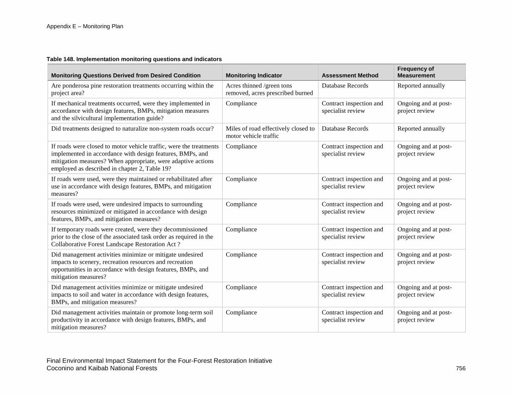
Appendix E – Monitoring Plan
Table 148. Implementation monitoring questions and indicators
Monitoring Questions Derived from Desired Condition Monitoring Indicator Assessment Method Frequency of Measurement
Are ponderosa pine restoration treatments occurring within the project area?
Acres thinned /green tons removed, acres prescribed burned
Database Records Reported annually
If mechanical treatments occurred, were they implemented in accordance with design features, BMPs, mitigation measures and the silvicultural implementation guide?
Compliance Contract inspection and specialist review
Ongoing and at post-project review
Did treatments designed to naturalize non-system roads occur? Miles of road effectively closed to motor vehicle traffic
Database Records Reported annually
If roads were closed to motor vehicle traffic, were the treatments implemented in accordance with design features, BMPs, and mitigation measures? When appropriate, were adaptive actions employed as described in chapter 2, Table 19?
Compliance Contract inspection and specialist review
Ongoing and at post-project review
If roads were used, were they maintained or rehabilitated after use in accordance with design features, BMPs, and mitigation measures?
Compliance Contract inspection and specialist review
Ongoing and at post-project review
If roads were used, were undesired impacts to surrounding resources minimized or mitigated in accordance with design features, BMPs, and mitigation measures?
Compliance Contract inspection and specialist review
Ongoing and at post-project review
If temporary roads were created, were they decommissioned prior to the close of the associated task order as required in the Collaborative Forest Landscape Restoration Act ?
Compliance Contract inspection and specialist review
Ongoing and at post-project review
Did management activities minimize or mitigate undesired impacts to scenery, recreation resources and recreation opportunities in accordance with design features, BMPs, and mitigation measures?
Compliance Contract inspection and specialist review
Ongoing and at post-project review
Did management activities minimize or mitigate undesired impacts to soil and water in accordance with design features, BMPs, and mitigation measures?
Compliance Contract inspection and specialist review
Ongoing and at post-project review
Did management activities maintain or promote long-term soil productivity in accordance with design features, BMPs, and mitigation measures?
Compliance Contract inspection and specialist review
Ongoing and at post-project review
Final Environmental Impact Statement for the Four-Forest Restoration Initiative Coconino and Kaibab National Forests 756

Appendix E – Monitoring Plan
Monitoring Questions Derived from Desired Condition Monitoring Indicator Assessment Method Frequency of Measurement
Did channel restoration treatments occur? Miles and acres of channel restored
Database Records Reported annually
If channel restoration treatments occurred, were they implemented in accordance with design features, BMPs, and mitigation measures? When appropriate, were adaptive actions employed as described in chapter 2, Table 19?
Compliance Contract inspection and specialist review
Ongoing and at post-project review
Did management activities minimize impacts to water resources in a manner that adheres to the Clean Water Act, State and Federal Water Quality Standards, and the intergovernmental agreement between the Southwestern Region and the ADEQ
Compliance Contract inspection and specialist review
Ongoing and at post-project review
Did management activities occur in Mexican spotted owl habitat?
Acres of vegetation treated/green tons removed, acres prescribed burned, acres burned in managed fire
Database Records Reported annually
If management activities occurred in Mexican spotted owl habitat, were they implemented in accordance with design features, BMPs, mitigation measures, and the project biological opinion?
Compliance Contract inspection and specialist review
Ongoing and at post-project review
Were design features, BMPs, mitigation measures and forest plan requirements met for not only threatened, endangered, sensitive species, but also the other wildlife species listed in Appendix C?
Compliance Contract inspection and specialist review
Ongoing and at post-project review
Did treatments designed to reduce or manage noxious weeds and invasive species occur?
Acres treated Database Records Reported annually
Did management activities minimize or mitigate the spread of noxious weeds, invasive species or non-native species in accordance with design features, BMPs, and mitigation measures?
Compliance Contract inspection and specialist review
Ongoing and at post-project review
Did management activities minimize or mitigate undesired impacts to sensitive plants, Arizona Bugbane and Flagstaff pennyroyal; and preserve special areas in accordance with design features, BMPs, and mitigation measures?
Compliance Contract inspection and specialist review
Ongoing and at post-project review
Final Environmental Impact Statement for the Four-Forest Restoration Initiative Coconino and Kaibab National Forests 757

Appendix E – Monitoring Plan
Monitoring Questions Derived from Desired Condition Monitoring Indicator Assessment Method Frequency of Measurement
Did management activities adequately protect Bebb’s willow from fire and ungulates in accordance with design features, BMPs, and mitigation measures?
Compliance Contract inspection and specialist review
Ongoing and at post-project review
Did management activities prevent, minimize or mitigate damage to grazing range sites and infrastructure in accordance with design features, BMPs, and mitigation measures?
Compliance Contract inspection and specialist review
Ongoing and at post-project review
Did management activities limit disruption to grazing activities and ensure post-fire range readiness in accordance with design features, BMPs, and mitigation measures?
Compliance Contract inspection and specialist review
Ongoing and at post-project review
Were planned prescribed fires coordinated with neighboring forests and other affected agencies and communities?
Compliance Contract inspection and specialist review
Ongoing and at post-project review
Did prescribed fires occur in accordance with ADEQ requirements and did they minimize or mitigate undesired impacts to wildlife, soil, water, vegetation and air quality in accordance with design features, BMPs, and mitigation measures?
Compliance Contract inspection and specialist review
Ongoing and at post-project review
Did management activities minimize old and large tree mortality?
Compliance Contract inspection and specialist review
Ongoing and at post-project review
Did management activities result in reduced crown fire potential and movement toward FRCC 1?
Compliance Contract inspection and specialist review
Ongoing and at post-project review
Did the Forest Service consult with the SHPO, ACHP and tribes as required and comply with the requirements of the NHPA and the Southwestern Region PA with the AZ SHPO?
Compliance Contract inspection and specialist review
Ongoing and at post-project review
Did management activities prevent, minimize or mitigate undesired impacts to cultural resources in accordance with design features, BMPs, and mitigation measures?
Compliance Contract inspection and specialist review
Ongoing and at post-project review
Was the public provided information and notification related to vegetation treatments and prescribed fires in accordance with design features, BMPs, and mitigation measures?
Compliance Contract inspection and specialist review
Ongoing and at post-project review
Final Environmental Impact Statement for the Four-Forest Restoration Initiative 758 Coconino and Kaibab National Forests

Appendix E – Monitoring Plan
Biophysical Monitoring Plan Biophysical Monitoring for Structure and Pattern: The USFS distinguishes between desired conditions related to pattern versus those related to structure. Structure relates to the age distribution and the vertical spatial arrangement of the overstory of the forest, while pattern refers to the horizontal distribution of vegetation across a stand or a landscape.
Relevant Desired Conditions I. Conservation of Biological Diversity:
a. Ponderosa pine ecosystems provide the necessary … structure, abundance, distribution… that contributes to the diversity of native plant and animal species…
b. Where fire use is not possible, mechanical treatments are designed to restore and/or maintain forest structure over time.
c. Ponderosa pine ecosystems are composed of all age and size classes within the analysis area and are distributed in patterns more consistent with reference conditions.
d. Ponderosa pine ecosystems are heterogeneous in structure and distribution at the analysis area scale. Openings and densities vary within the analysis area to maintain a mosaic appropriate to support resilience of individual trees and groups of trees.
II. Ecosystem Resilience:
a. Ponderosa pine ecosystems are restored to more natural tree densities in order to maintain availability of moisture and nutrients to support adaptation to climate change without rapid, large-scale type shifts.
III. Conservation and maintenance of soil, water, and air resources:
a. Forest structure supports a variety of natural resource values and processes, including hydrologic function, which meets ecological and human needs.
b. Forest openings are designed to improve snow accumulation and subsequent soil moisture and surface water yield.
Description and Justification Many of the desired conditions related to structural components of ponderosa pine forests specify a need for heterogeneous forests that more closely approximate reference conditions. Investigations of historical ponderosa pine conditions indicate that forests were generally open in structure wherein trees occurred in multi-aged clumps of differing size among abundant understory plant communities (Mast et al. 1999, Waltz et al. 2003, Sánchez Meador et al. 2011). It has been suggested that restoration treatments that focus on creating this structure of uneven-aged tree groups interspersed with openings of various sizes will provide the greatest benefit in terms of biological diversity and ecosystem function (Sabo et al. 2009, Kalies et al. 2010).
Determining the extent to which restoration treatments benefit and affect native plant and animal diversity will require a multi-scaled approach to characterizing several aspects of structural diversity. Wildlife and plants respond to their environment across multiple spatial and temporal scales (Wiens 1989). Indeed, management that creates or maintains structural complexity at the stand or patch scale while preserving a diverse assemblage of stands (or patches) that differ in size and spatial arrangement at broader scales has been identified as a necessary component of managing forested systems for diversity (Lindenmayer et al. 2006). Understanding the
Final Environmental Impact Statement for the Four-Forest Restoration Initiative Coconino and Kaibab National Forests 759

Appendix E – Monitoring Plan
contribution of forest structure and composition to biodiversity is further complicated by the potential existence of “domains of scale” (i.e., areas where a process may behave predictably, but beyond which the process may change in an unpredictable and non-linear way) and that any single scale of measurement is likely to be arbitrary with respect to the process of interest (Wiens 1989).
Forest structure is a multi-dimensional attribute that is not assessed adequately by any single measure. Similarly, heterogeneity in forest structure occurs at multiple scales requiring multiple indicators (Cushman et al. 2008). Thus, two distinct sets of indicators will be used to assess changes in forest structure that result from 4FRI-implemented treatments.
Fine-scale Assessment Tier 1 Suggested Indicators: Age Structure, spatial aggregation • Age Structure (Diameter Distribution): While collecting this information pre-treatment and
post-treatment will likely require a fairly intensive field effort, it will allow us to measure structural complexity in terms of age (size) structure and will also provide information for calculating changes in density and basal area that result from treatment.
♦ Assessment: Field sampling of tree diameter (both pre- and post-treatment) of treated sites
♦ Frequency: Immediately post-treatment (either mechanical or prescribed fire); every 10 years thereafter.
♦ Threshold/Trigger: No threshold determined for this indicator. Also see implementation plan which includes if and how the Large Tree Implementation Plan will be used for specific task orders.
♦ Adaptive Management: Evaluate reasoning for implementing large tree removal. If needed, appropriate adaptive management actions will be developed.
• Spatial Aggregation (Ripley’s K and/or Getis Ord): Measures of spatial aggregation can be used to determine “patchiness”. Statistical tests such as Ripley’s K and Getis Ord can be used to describe spatial properties such as the distribution and clustering of trees as well as canopy cover. These properties can be compared to those of “restored” areas to measure our progress towards historic conditions.
♦ Assessment: Freely available pre- and post-treatment aerial photography of stands identified for treatment
♦ Frequency: Immediately post-treatment (either mechanical or prescribed fire) or as soon as appropriate aerial photography becomes available; every 10 years thereafter.
♦ Threshold/Trigger: No threshold has been identified for this indicator. It will be developed as new information becomes available.
♦ Adaptive Management: No management action has been identified at this time. However, once a threshold has been identified, the corresponding data will be thoroughly reviewed and appropriate adaptive management actions will be developed.
Final Environmental Impact Statement for the Four-Forest Restoration Initiative 760 Coconino and Kaibab National Forests

Appendix E – Monitoring Plan
Broad-Scale Assessment Tier 1 Suggested Indicators: Canopy openness, patch size, patch configuration, patch diversity, and patch evenness. • Canopy Openness (Percent and Characteristics of Openings): Because many of the
treatment types being applied within 4FRI are designed explicitly to achieve a particular post-treatment percentage of canopy openness, we will measure the pre- and post-treatment percentage of canopy cover. This indicator in conjunction with the spatial aggregation statistics can help describe the degree to which 4FRI treatments are achieving “patchiness” and the degree to which those patches vary. Also, tracking the size and orientation of forest openings is important to determine their impacts on snowpack accumulation and retention that affect soil moisture, plant- available soil water and system resilience to climate variability.
♦ Assessment: Utilize USFS tools developed by the Remote Sensing and Application Center (RSAC) to process input images (NAIP, LiDAR, etc.) into canopy/ non canopy patches and assess for spatial pattern (Landscape Indices, FRAGSTATS).
♦ Frequency: Immediately post-treatment (either mechanical or prescribed fire) or as soon as appropriate aerial photography becomes available; every 3-10 years thereafter.
♦ Threshold/Trigger: A deviation from the structure described in table 64 of the Silviculture report
♦ Adaptive Management: Assess potential sources of deviation, including prescription and implementation; increase monitoring efforts in future task orders.
• Patch Size (Patch area, Patch density, Patch Size Distribution): Patch area is a fundamental quantity for understanding landscape composition that can be used both to calculate a variety of other indicators as well as model species richness, occupancy, and distribution in conjunction with field data. Patch density can be used as an index for spatial heterogeneity across a landscape, but has the added utility of being comparable across areas of differing size (e.g., comparisons between treatment areas or restoration units) (McGarigal and Marks 1995). Distribution of patch size provides information on the variability of patch sizes within a particular class (e.g., groups, openings, etc.). These data, in conjunction with mean patch size, can provide information on key aspects of landscape heterogeneity and composition, particularly as patch size changes as a result of restoration treatments. These indicators can provide an indication of the ability of restoration treatments to achieve heterogeneity (and diversity) at spatial extents beyond the stand-level and can be calculated within the freely available FRAGSTATS program (McGarigal et al. 2002).
♦ Assessment: Categorical maps (e.g., groups, openings, etc.) based on satellite imagery and/or aerial photography
♦ Frequency: Annually to track broad-scale change or when suitable imagery becomes available.
♦ Threshold/Trigger: No threshold has been identified for this indicator. It will be developed as new information becomes available.
♦ Adaptive Management: No management action has been identified at this time. However, once a threshold has been identified, the corresponding data will be thoroughly reviewed and appropriate adaptive management actions will be developed.
Final Environmental Impact Statement for the Four-Forest Restoration Initiative Coconino and Kaibab National Forests 761

Appendix E – Monitoring Plan
• Patch Configuration (Nearest neighbor distance distribution and Contagion): These two indicators provide information on landscape configuration (i.e., the spatial arrangement of patches, treatment areas, etc.). Nearest neighbor distances that are narrowly distributed (i.e., little variation) tend to indicate a fairly even distribution of patches across the landscape. Contagion measures both the intermixing of different patch types as well as their spatial distribution. These two indicators provide a characterization of heterogeneity in terms of landscape configuration (i.e., spatial relationships among differing patch types) and has been used to characterize a variety of different landscapes (McGarigal and Marks 1995, Cushman et al. 2008). These indicators are also available within FRAGSTATS (McGarigal and Marks 1995, McGarigal et al. 2002).
♦ Assessment: Categorical maps (e.g., groups, openings, etc.) based on satellite imagery and/or aerial photography
♦ Frequency: Annually to track broad-scale change or when suitable imagery becomes available.
♦ Threshold/Trigger: No threshold has been identified for this indicator. It will be developed as new information becomes available.
♦ Adaptive Management: No management action has been identified at this time. However, once a threshold has been identified, the corresponding data will be thoroughly reviewed and appropriate adaptive management actions will be developed.
• Diversity and Evenness (Simpson’s Diversity and Evenness Indices): These measures have been historically associated with estimates of species diversity; however, in this case they are being used to assess the diversity of patch types across the landscape. Simpson’s diversity index represents the probability that any two randomly drawn patches will be of a different type. A higher value indicates greater diversity of patch types. Similarly, larger values of evenness indicate greater landscape diversity (i.e., less dominance by any particular patch type). FRAGSTATS implements a variety of diversity and evenness indices; however, these were selected because they are considered easier to interpret (McGarigal and Marks 1995, Magurran 2004).
♦ Assessment: Categorical maps (e.g., groups, openings, etc.) based on satellite imagery and/or aerial photography
♦ Frequency: Annually to track broad-scale change or when suitable imagery becomes available.
♦ Threshold/Trigger: No threshold has been identified for this indicator. It will be developed as new information becomes available.
♦ Adaptive Management: No management action has been identified at this time. However, once a threshold has been identified, the corresponding data will be thoroughly reviewed and appropriate adaptive management actions will be developed.
Tier 1 Suggested Indicators: Soil moisture relative to forest opening size and orientation • Forest openings, depending on their size and orientation, promote greater snowpack
accumulation and retention and hence greater soil water storage (Baker and Ffolliott 2003). Deeply rooted plants, such as mature ponderosa pines, that depend on moisture from winter precipitation are expected to be the most affected by changes in snowpack. Per-tree plant-available soil moisture is expected to be higher in thinned ponderosa pine stands than in unthinned stands (Zou et al. 2008), which should promote plant vigor, resilience to climate
Final Environmental Impact Statement for the Four-Forest Restoration Initiative 762 Coconino and Kaibab National Forests

Appendix E – Monitoring Plan
variability and perhaps even resistance to wildfire. If, however, restoration treatments push soil moisture in the opposite direction, recognizing such a trend is critical information that can direct adjustments in treatment approaches. Monitoring of lower elevations, south facing slopes and shallow soils that are susceptible to drying are a priority.
♦ Assessment: Soil moisture measurements made using soil moisture probes, portable Time Domain Reflectometer (TDR) and/or gravimetric analysis at shallow and deep rooting depths according to a statistical design. Soil moisture may be analyzed within the context of a paired watershed study, but additional monitoring could also be conducted at sensitive sites such as lower elevations, south facing slopes and shallow soils
♦ Frequency: Pretreatment, post-treatment, annually during pre- and post-monsoon water stress periods
♦ Threshold/Trigger: Trends of decreasing soil moisture (after adjusting for climatic variability) in stands with similar treatment types and/or physiographic characteristics.
♦ Adaptive Management: Evaluate treatments and make adjustments in treatment methods and forest pattern as appropriate, especially at lower elevations, on south facing slopes and on shallow soils that are susceptible to drying.
Monitoring for Composition Relevant Desired Conditions
I. Conservation of Biological Diversity:
a. Ponderosa pine ecosystems provide the necessary … composition… that contributes to the diversity of native plant and animal species…
b. Viable, ecologically functional populations of native species that include common, listed, rare, and sensitive species persist in natural patterns of distribution and abundance.
c. All pre-settlement trees are retained. d. Understory vegetation composition and abundance are consistent with the natural
range of variability. e. Protect old-growth forest structure during planned and unplanned fires.
[Implementation Monitoring] f. Natural and prescribed fires maintain and enhance but do not degrade habitat for
listed, rare, and sensitive species. g. Habitat management is contributing to the recovery of listed species. h. Planned an unplanned fires support diverse native understory communities and their
associated biodiversity. i. Populations of native species occur in natural patterns of distribution and abundance.
II. Ecosystem Resilience:
a. There is reduced potential for introduction, establishment, and spread of invasive species. Additionally, efforts are made to reduce existing infestations.
b. Exotic species are rare or absent and do not create novel ecological communities following disturbance.
Final Environmental Impact Statement for the Four-Forest Restoration Initiative Coconino and Kaibab National Forests 763

Appendix E – Monitoring Plan
III. Conservation and Maintenance of Soil, Water, and Air Resources: Emissions factors, smoldering and smoke residence times are reduced as fires burn more grass and less green or woody biomass over time.
Description and Justification Many desired conditions are specified to reflect a number of aspects of forest composition. Both the USFS desired conditions for ponderosa pine and 4FRI Stakeholder desired conditions identify certain patch components (e.g., Gambel oak (Quercus gambelii), snags, coarse woody debris, and old-growth) that contribute disproportionately to habitat values and the diversity of a patch or landscape (Bennetts et al. 1996, Kotliar et al. 2002, Bunnell and Houde 2010). In contrast, desired conditions for the understory and wildlife are specified both for their contributions to diversity and their ability to indicate ecosystem functionality.
Monitoring of understory composition could be used as an indication of both ecosystem resilience and soil productivity. Reductions in overstory pine volumes can be correlated with increased understory production (Laughlin and Grace 2006, Laughlin et al. 2005), and this increased understory productivity is a key assumption being used in the 4FRI NEPA analysis. However, stand replacing wildfire in ponderosa pine forests may lead to shifts toward exotic, invasive species dominance in understory plant communities (Crawford et al. 2001). Minimal or temporary increases over time in invasive species populations indicate high ecological resilience. Establishment and rapid spread of invasive species populations may lead to native species replacement and indicate low ecological resilience. Additional consideration for soil properties will be given below; however, for the purposes of this document soil productivity is interpreted as the ability of the soil to sustain native vegetation.
Many of the desired conditions for wildlife species are specified with respect to both viability and natural patterns of distribution and abundance. Historically, viability has been difficult or impossible to assess particularly when resources are limited due to the difficulty of gathering reliable estimates of all of the relevant population rates. Literature searches can provide a valuable starting point; however, case studies of viability rarely reveal generalizations useful for conservation management (Traill et al. 2007). As a potential solution to this issue, Flather et al. 2011 recommend focusing on those factors most likely to cause declines in a species such that it may become unviable particularly when the demographic data necessary for calculating fitness or viability are unknown. Monitoring of population response (particularly productivity and abundance) of threatened, endangered, and rare species should be focused on those areas directly impacted by treatment (e.g., Mexican Spotted Owl Protected Activity Centers within some yet to be determined distance of restoration treatments or wildfire) as these are likely to be directly impacted by the presence of personnel, equipment, and infrastructure associated with treatments and disturbance.
The majority of species affected by 4FRI are likely to be affected through changes in habitat particularly at larger scales. Site occupancy can be used in a monitoring context to reflect the current state of the population, and, through multi-season extensions, provide information related to population trends. Estimating occupancy often require fewer detections than other density estimation techniques allowing for more precise estimates of rare or infrequently detected species (MacKenzie et al. 2003, MacKenzie et al. 2005). Furthermore, efforts to relate occupancy to habitat-relevant covariates allow estimation and prediction of changes in population state due to coarser-scale changes in land-use and climate (e.g., Dickson et al. 2009, Mattsson and Marshall 2009). Deriving these habitat-occupancy relationships using high-resolution satellite imagery
Final Environmental Impact Statement for the Four-Forest Restoration Initiative 764 Coconino and Kaibab National Forests

Appendix E – Monitoring Plan
provides the opportunity to identify the impacts of more localized changes (e.g. forest restoration treatments) across larger spatial scales.
Monitoring for forest composition will require both field measurements and sophisticated modeling techniques to determine the degree to which restoration treatments are achieving desired conditions at all scales. Given uncertainties in the response of both wildlife and invasive species, this monitoring is especially important. Many of the indicators identified below will require significant resources to assess. Financial support from stakeholders and other organizations will be required to adequately monitor these indicators.
Fine-scale Assessment Tier 1 Suggested Indicators: Rare Ecosystem Elements (Springs Protection) Forest restoration thinning has the potential to improve the hydrogeology of springs by increasing soil water storage and groundwater recharge (McCarthy and Dobrowolski 1999). Because springs create rare habitat for multiple threatened species as well as more common wildlife species, understanding the relationship between treatments and spring responses is critical for making adaptive management decisions to optimize springs restoration projects. A collaborative group with skills in spring assessment is available to assist Coconino and Kaibab National Forests in selecting springs for monitoring and restoration. Current partners in the collaboration include Northern Arizona University (NAU), Grand Canyon Trust, Grand Canyon Wildlands Council and the Spring Stewards, but more partners may join in the collaboration at any time.
• Assessment:
♦ Groundwater Dependent Ecosystems Protocol (USDA FS 2011)
♦ Spring discharge measurements
• Frequency: Pre- and post-treatment, every two years following treatment for the first 6 years after treatment, then every 5 years.
• Threshold/Trigger:
♦ No net increase in facultative and obligative wetland species at springs or wet meadows targeted for both forest and spring restoration.
♦ Decrease in spring discharge (adjusted for climate variation) following treatments.
• Adaptive Management: Review spring restoration techniques. Review treatment methods in the recharge area. Make appropriate adjustments.
Tier 1 Suggested Indicators: Understory Species Composition (Percent Foliar Cover, Percent Bare Ground) Native species composition and the percentage of bare mineral soil provide an indication of soil productivity. In addition, restoration treatments have potential to increase abundance of native plant communities (Laughlin et al. 2006, Moore et al. 2006, McGlone et al. 2009b); however, invasive plant species may also increase in cover on sites where restoration thinning, prescribed fire, and livestock grazing occur (McGlone et al. 2009b). Native plant communities that are minimally disturbed during thinning or burning activities may better resist compositional shifts toward invasive species (Korb et al. 2004, McGlone et al. 2011). While assessment at the “Group” scale is not necessary, stand-scale assessment will require field sampling that can be accomplished more easily with university and volunteer partners.
Final Environmental Impact Statement for the Four-Forest Restoration Initiative Coconino and Kaibab National Forests 765
Appendix E – Monitoring Plan
• Assessment: Field collected quadrats.
• Frequency:
♦ Within 5 years of treatment for cover
♦ Within 5 years of treatment for bare soil
♦ Within 10 years of treatment for seedlings
• Threshold/Trigger:
♦ Within 5 years of mechanical treatment, the cover should increase 20 percent +/- 5 percent (15-25 percent) above controls (Laughlin et al 2011).
♦ Within 5 years of treatment (mechanical and/or fire), bare soil should comprise less than 20 percent of area affected by treatment.
♦ Within 10 years of treatment, seedling and sapling density should be within 0.4 to 3.6 plants/hectare/decade on basalt soils (Mast et al 1999).
• Adaptive Management:
♦ If cover threshold is not reached, then re-evaluate treatment for management change, taking into account soils and burn treatment (e.g. reduce overstory basal area).
♦ If bare soil exceeds 20 percent of area within plots, re-evaluate restoration treatment for modification.
♦ If seedlings and saplings fall below this range across sub-units where regeneration is a desired condition, then evaluate implementation of BMPs to increase probability of successful regeneration. If regeneration falls above this range, then more aggressive prescription burning may be necessary to reduce plant density.
Tier 1 Suggested Indicators: Understory Species Composition (Invasive species) With regards to invasive species control, the first and most important management strategy is preventing the establishment or spread of invasive species. The best way to achieve this is by increasing the health and resilience of native plant communities. Below is a list of species most likely to be affected by management.
Watch List: These species are currently not known to fall within 4FRI treatment areas, and if they do show up and are detected, aggressive eradication efforts should be a top priority and applied quickly.
These species include Malta starthistle (Centaurea melitensis L.), Russian olive (Eleagnus angustifolia), Himalayan blackberry (Rubus armeniacus and Rubus discolor), giant reed (Arundo donax), sulfur cinquefoil (Potentilla recta), tree of heaven (Ailanthus altissima), Siberian elm (Ulmus pumila), halogeton (Halogeton glomeratus), dyer’s woad (Isatis tinctoria), Eurasian water-milfoil (Myriophyllum spicatum), oxeye daisy (Leucanthemum vulgare), and Canada thistle (Cirsium arvense).
High Risk: These species currently have limited geographic distribution within 4FRI treatment areas, and if current inventories indicate their presence within treatment areas, these species should be eradicated immediately.
These species include leafy spurge (Euphorbia esula), camelthorn (Alhagi maurorum), yellow starthistle (Centaurea solstitalis), spotted knapweed (Centaurea biebersteinii), diffuse knapweed
Final Environmental Impact Statement for the Four-Forest Restoration Initiative 766 Coconino and Kaibab National Forests

Appendix E – Monitoring Plan
(Centaurea diffusa), Russian knapweed (Acroptilon repens), white top (Cardaria draba), Mediterranean sage (Salvia aethiopis), Scotch thistle (Onopordum acanthium), tamarisk (Tamarix spp.), common teasel (Dipsacus sylvestris), and musk thistle (Carduus nutans).
Medium Risk: These species have widespread distribution within 4FRI treatment areas in large populations, with either no effective treatment, or cost-prohibitive effective treatment, or for which effectiveness of current treatment strategies is unknown or not monitored. Areas should be prioritized for treatment based on risk to conservation value (presence or proximity of TES species) and areas of high wildlife habitat value (e.g., pine- sagebrush ecotones). Weed treatment strategies be monitored for effectiveness to gauge return on investment.
These species include Dalmatian toadflax (Linaria dalmatica), bull thistle (Cirsium vulgare), and wild oats (Avena fatua).
Cheatgrass (Bromus tectorum): Cheatgrass invasion of ponderosa pine systems after restoration-based treatments is a burgeoning issue of significant concern (Keeley and McGinnis 2007, McGlone et al. 2009a and b). Widespread invasion of cheatgrass often shifts invaded ecosystems into irreversible alternate stable states where cheatgrass-mediated fire intervals exclude native understory plants (Brandt and Rickard 1994, D’Antonio and Vitousek 1992, Brooks et al. 2004). Means of prevention and treatment have not been adequately tested or found successful in ponderosa pine systems; however the risk of ecological transformation caused by cheatgrass warrants aggressive monitoring and adaptive management in the 4FRI project. Preventative actions pre-treatment will be just as critical as adaptive management responses post-treatment, and will require identification of areas at risk for cheatgrass invasion prior to project implementation, such as areas where cheatgrass is already present or ecotonal areas adjacent to existing cheatgrass populations.
• Assessment: Percent cover of native and non-native species based on field sampling.
• Frequency: Pre- and immediately post-disturbance (i.e., mechanical thinning, prescribed fire, and wildfire); every 5 years thereafter.
• Thresholds/Triggers:
♦ Identification of new or existing “watch list” or “high risk” invasive species populations.
♦ Identification of new or existing “medium risk” invasive species populations.
♦ Identification of areas at high risk of cheatgrass introduction or spread.
• Adaptive Management:
♦ If inventories, surveys and map checks indicate presence of 'high risk' or 'watch list' species (see narrative), evaluate all BMPs, especially for cleaning equipment moving from infested sites to clean sites. Consider aggressive treatments leading to population eradication. If treatments do not reduce the cover of “watch list” species by 90 percent in one year or “high risk” species by 50 percent in 2 years, consider new approaches to eradication.
♦ If inventories, surveys and map checks indicate presence of 'medium risk' species (see narrative), consider controlling these species on individual basis especially when high value areas or habitats are at risk. If treatments do not reduce the cover of “medium risk” species by 20 percent in 5 years, consider new approaches to weed management.
Final Environmental Impact Statement for the Four-Forest Restoration Initiative Coconino and Kaibab National Forests 767

Appendix E – Monitoring Plan
♦ If inventories, surveys and map checks indicate areas with a high risk of cheatgrass introduction or spread, treatments could include (but should not be limited to):5
Chemically treating and native reseeding of small infestations of cheatgrass prior to thinning and burning
Avoiding whole-tree skidding and other actions that cause significant soil disturbance
Removing slash and avoiding creation of large slash piles resulting from thinning operations
Properly manage grazing so that perennial grasses are maintained
Deferring burns in heavily infested areas
Delaying burns and lengthening fire return intervals post-thinning to allow native perennials time to establish
Applying native, perennial seed (e.g., bottlebrush squirrel tail, which has shown promise in successfully competing with cheatgrass) after fire.
Cleaning equipment and clothing after working in infested areas
Tier 2 Suggested Indicators: Old trees Old Trees (Number of Old Trees): The 4FRI Landscape Strategy places a large emphasis on pre- settlement trees. Furthermore, higher levels of biodiversity have been attributed to those areas that still contain old-growth components (Binkley et al. 2007) and these components may be susceptible to mortality immediately post-treatment (Fulé et al. 2007, Roccaforte et al. 2010). Evidence suggests, however, that this mortality can be avoided through a variety of “protection” measures and that over time restoration treatments can increase the vigor of old trees (Kolb et al. 2007).
• Assessment: Rapid assessment conducted while collecting diameter distribution data on plots (or use of aerial imagery once techniques become available)or other evidence
• Frequency: Immediately post-treatment (either mechanical or prescribed fire); every 5 years thereafter
• Threshold/Trigger: No threshold has been identified for this indicator. It will be developed as new information becomes available.
• Adaptive Management: No management action has been identified at this time. However, once a threshold has been identified, the corresponding data will be thoroughly reviewed and appropriate adaptive management actions will be developed.
Tier 2 Suggested Indicators: Habitat Suitability (Occupancy Probability) Occupancy, in cases where sample sizes are large, can be defined as the proportion of total area occupied and can provide a useful alternative to density or abundance, especially for uncommon species (MacKenzie et al. 2006). More generally, occupancy can also be interpreted as the probability of locating an individual of species x in location y. This interpretation (probability of occupancy) reflects an a priori expectation that a site will be occupied based on a hypothesis
5 If cheatgrass begins to dominate restoration sub-units after thinning and burning treatments within the 4FRI project area, consider delaying further treatments in areas of high risk until the Forest Service, stakeholders and experts can be convened to evaluate alternative management options.
Final Environmental Impact Statement for the Four-Forest Restoration Initiative 768 Coconino and Kaibab National Forests

Appendix E – Monitoring Plan
about the underlying process determining occupancy. The former interpretation (proportion of area occupied) is the realization of that process, given large sample sizes (MacKenzie et al. 2006). Higher probabilities of occupancy may be interpreted to indicate more “use” of a habitat by a particular species. Information on songbird occupancy (based on existing Rocky Mountain Bird Observatory Data) will be used to evaluate changes in songbird species richness and its associated adaptive management strategy.
• Assessment: Field surveys of presence & absence at both treated and untreated sites
• Frequency: Immediately post-treatment and every 2 years thereafter
• Threshold/Trigger: No threshold has been identified for this indicator. It will be developed as new information becomes available.
• Adaptive Management: No management action has been identified at this time. However, once a threshold has been identified, the corresponding data will be thoroughly reviewed and appropriate adaptive management actions will be developed.
Tier 1 Suggested indicator: Songbird Species Richness (Jackknife2, Chao 2, or ICE Species Richness Estimator) While estimating the changes in the aforementioned forest structural components provides some indication of how 4FRI treatments may be contributing to diversity goals, documenting the ways in which restoration treatments facilitate ponderosa pine forests contribution to native diversity ultimately requires knowledge of how diversity is changing over time. We anticipate that the abundance of species will change due to treatment and incidence or occurrence-based estimators are a way of documenting the actual change in the number of species. These incidence based species richness estimators have been shown to be more accurate and potentially less biased than historical estimators of species richness (e.g., Shannon’s Index, Simpson’s Diversity Index) (Walther and Moore 2005). These estimators can be computed within EstimateS, (http://viceroy.eeb.uconn.edu/estimates), a freely available diversity-estimation software program, using existing, ongoing surveys conducted by Rocky Mountain Bird Observatory in conjunction with the Forests.
• Assessment: Field sampling of communities of interest (e.g., songbirds)
• Frequency: Immediately post-treatment (either mechanical or prescribed fire); every 3-5 years thereafter.
• Threshold/Trigger: No threshold has been identified for this indicator. It will be developed as new information becomes available.
• Adaptive Management: No management action has been identified at this time. However, once a threshold has been identified, the corresponding data will be thoroughly reviewed and appropriate adaptive management actions will be developed.
Tier 2 Suggested Indicators: Rare Ecosystem Elements (Percent Cover of Gambel Oak, Aspen, and other Riparian Communities) Oak, aspen, and riparian areas contribute heavily to the diversity of ponderosa pine forests in the Southwest. For example, pine-oak forests tend to have a greater diversity of songbirds and small mammals than ponderosa forests that lack an oak component (Block et al. 2005, Jentsch et al. 2008). Removal of overstory competition from ponderosa pine and more regular low-severity fire are likely to alter the cover and composition of the oak component within treated stands. Removal
Final Environmental Impact Statement for the Four-Forest Restoration Initiative Coconino and Kaibab National Forests 769

Appendix E – Monitoring Plan
of ponderosa pine competition may also encourage aspen regeneration and increase the size of riparian communities due to increases in available water.
• Assessment: Assessment of plot-based percent cover while collecting diameter distribution data (or use of aerial imagery once techniques become available)
• Frequency: Immediately post-treatment (either mechanical or prescribed fire); every 5 years thereafter
• Threshold/Trigger: No threshold has been identified for this indicator. It will be developed as new information becomes available.
• Adaptive Management: No management action has been identified at this time. However, once a threshold has been identified, the corresponding data will be thoroughly reviewed and appropriate adaptive management actions will be developed.
Tier 2 Suggested Indicators: Snags, rare ecosystem elements, understory species composition; responses of rare, sensitive, threatened, and endangered species; habitat “suitability”, species richness, evenness Snags (Number, Size Distribution, Condition): The number and size of snags present will be sampled within treated sites due to their role in providing valuable habitat for a variety of wildlife species (e.g., Kotliar et al. 2002) and the potential for restoration treatments to alter snag composition within treated sites (Bagne et al. 2008, Hessburg et al.2010). In addition, assessing the condition of the snags (sound vs. soft) can provide an indication of the expected longevity for those snags.
• Assessment: Rapid assessment conducted while collecting diameter distribution data on plots (or use of aerial imagery once techniques become available)
• Frequency: Immediately post-treatment (either mechanical or prescribed fire); every 5 years thereafter
• Threshold/Trigger: No threshold has been identified for this indicator. It will be developed as new information becomes available.
• Adaptive Management: No management action has been identified at this time. However, once a threshold has been identified, the corresponding data will be thoroughly reviewed and appropriate adaptive management actions will be developed.
Broad-Scale Assessment
Tier 1 Suggested Indicators: Response of Rare, Threatened, and Endangered Species and Regional Sensitive Species (Population trends) Treatments conducted under 4FRI may affect rare, threatened, or endangered species through a variety of mechanisms and at a variety of scales. This is particularly true for wildlife species such as the Northern Goshawk and Mexican Spotted Owl. Understanding the effects of treatment on productivity (and thus viability) of these species likely requires a research effort beyond the scope of the monitoring proposed here. We will monitor Mexican Spotted Owl as directed by the biological opinion provided by U.S. Fish and Wildlife Service. Northern Goshawk will be monitored according to the field protocols established in the USFS National Goshawk Inventory Guidelines with additional modifications such as those developed by NAU’s Lab of Landscape Ecology and Conservation Biology (LLECB) and the Kaibab National Forest and in current literature.
Final Environmental Impact Statement for the Four-Forest Restoration Initiative 770 Coconino and Kaibab National Forests

Appendix E – Monitoring Plan
• Assessment:
♦ Mexican spotted owl monitored as directed in the U.S. Fish and Wildlife Service biological opinion.
♦ Northern goshawk occupancy monitored using USFS protocols (USDA FS 2006) with modifications developed by LLECB/KNF and current literature.
• Frequency: In accordance with the aforementioned protocols.
• Thresholds/Triggers:
♦ As directed in the Mexican spotted owl section of the U.S. Fish and Wildlife Service biological opinion
♦ If northern goshawk occupancy trends show a decline over a 5 to 10 year average at treatment and 4FRI landscape scales.
• Adaptive Management:
♦ As directed in the Mexican spotted owl section of the U.S. Fish and Wildlife Service biological opinion and in consultation with U.S. Fish and Wildlife Service.
♦ Evaluate treatments and consider increasing or focusing monitoring on area where northern goshawk is declining. Consider comparing to regional monitoring data trends. As a high profile species, additional monitoring may be conducted even if the decline is not a statistically significant.
Tier 2 Suggested Indicators: Wildlife Response (Landscape Predictions of Songbird Species, Richness) Field assessment of these indicators (with the exception of connectivity) can be used in conjunction with remotely sensed habitat covariates to track changes at larger scales and provide information on landscape distribution patterns. In addition, hierarchical modeling could provide a multi-scalar inference by using other information collected from other field assessments identified here. These models can be used to create “map-based” depictions of occupancy and richness that can then be summarized at multiple scales. Development and subsequent validation of these models will be especially critical for threatened, endangered, sensitive, and rare species and will likely require partnership with research institutions. Ongoing field assessment of songbird populations and the subsequent ability to estimate occupancy as a function of forest structural covariates will be critical for this indicator.
• Assessment: Field sampling in conjunction with remote sensing
• Frequency: Annual interpretations of new satellite imagery
• Thresholds/Triggers: Any non-zero decline over a 5-year period within the functional groups listed below
• Adaptive Management:
♦ Closed Canopy Species: Evaluate data and best science available, including upcoming research by AZ Game and Fish. Adaptive management could include implementing one of the following changes:
Increase group density for all treatments.
Increase group size for all treatments.
Final Environmental Impact Statement for the Four-Forest Restoration Initiative Coconino and Kaibab National Forests 771

Appendix E – Monitoring Plan
Reduce intensity of UEA 40-55 treatments within the treatment category to be applied to the next round of task orders.
Identify 25 percent of planned UEA 40-55 treatments and reduce intensity to 25-40 interspace.
♦ Open Canopy Species: Evaluate implementing one of the following changes:
Increase the size of openings in all treatment types.
Identify 25 percent of planned UEA 25-40 treatments and increase intensity to 40-55
♦ Pine-Sage Species: Alter timing of treatment to reduce impacts on sage; Delay post- treatment burning to allow sage recover
♦ Pine-Oak Species: Evaluate implementing one of the following changes:
Restrict ungulate access to stands to allow oak regeneration.
Increase emphasis on management of oak component in non-“Restricted Habitat” stands
Tier 2 Suggested Indicator: Landscape Connectivity and Permeability Changes in landscape connectivity and permeability for several species representing closed canopy (black bear OR grey fox) and open canopy (pronghorn) conditions. Building connectivity models for species that are predicated on various aspects of patch structure, density, and orientation provides an opportunity to evaluate the effects of landscape heterogeneity on a key ecosystem process. Furthermore, these models can be validated through the use of telemetry studies, a property not shared by fire models (our other landscape metric). While a variety of factors can and do influence connectivity, the models will be formulated to reflect specific hypotheses related to landscape structure.
• Assessment: Field sampling in conjunction with remote sensing
• Frequency: Immediately post-treatment; five years post-treatment, ten years post-treatment
• Thresholds/Triggers:
♦ Restriction in bear/fox movement after treatment (reduced connectivity between patches)
♦ No increase in pronghorn movement after treatment
• Adaptive Management:
♦ Bear/Fox: Evaluate implementing one of the following changes:
Increase group size.
Decrease treatment intensity within known pathways
♦ Pronghorn: Evaluate implementing one of the following changes:
Increase opening sizes.
Increase treatment intensity within known pathways
Final Environmental Impact Statement for the Four-Forest Restoration Initiative 772 Coconino and Kaibab National Forests

Appendix E – Monitoring Plan
Biophysical Monitoring for Function (or Process)
Relevant Desired Conditions I. Conservation of Biological Diversity:
a. Ponderosa pine ecosystems provide the necessary … processes…that contributes to the diversity of native plant and animal species…
b. Natural disturbance processes (e.g., fire, drought-mortality, endemic levels of forest pests and pathogens) are the primary agents shaping forest ecosystem structure, dynamics, habitats, and diversity over time.
c. There is low potential for unnaturally severe fire to spread across the Restoration Unit.
d. Wherever practicable, natural fire regimes regulate forest structure and composition. e. Planned and unplanned fires support diverse native understory communities and their
associated biodiversity. II. Ecological Resilience:
a. Ponderosa pine ecosystems in the 4FRI are capable of adapting to or persisting with climate change without rapid, large scale type shifts.
b. Low intensity frequent fire operates as the primary natural process maintaining forest structure and function.
c. Mixed severity fire is sometimes used as a restoration tool in appropriate ecological and social settings (e.g., non-wildland-urban interface areas) to restore and maintain natural forest types[Implementation Monitoring – not addressed in this document]
d. Forest insects and pathogens occur and operate at endemic levels. e. Ponderosa pine ecosystems in the 4FRI are capable of regeneration and recovery
following natural disturbance (e.g., fire, outbreaks of insects and pathogens). f. A majority of the ponderosa pine ecosystems supports frequent, low-intensity fire. g. Mixed severity fire is used as a restoration tool where it is consistent with reference
conditions and safe to do so. [Implementation Monitoring – not addressed in this document .
h. Natural disturbance processes (e.g., fire, endemic pests, and pathogens) are within the natural range of variability.
i. Strategically placed treatments allow fire managers to safely manage planned and unplanned natural ignitions fires in a way that benefits and enhances the resilience of forest ecosystems.
j. Restoration results in forests that are trending toward natural variability, self- regulating, and positioned to adapt to climate change without large, rapid type shifts.
III. Conservation of Soil, Water, and Air Resources:
a. Soil productivity, watershed function, and air quality are not at risk of being degraded by uncharacteristically severe disturbances (e.g., landscape level high- severity fire).
b. Sensitive soils are protected through use of appropriate timber harvesting equipment and techniques to reduce erosion and sedimentation that could otherwise damage aquatic life, increase flooding, reduce reservoir capacity, and increase costs of maintaining infrastructure in the vicinity of waterways. [Implementation Monitoring]
Final Environmental Impact Statement for the Four-Forest Restoration Initiative Coconino and Kaibab National Forests 773

Appendix E – Monitoring Plan
c. Fire is used as a management tool to support hydrologic function while minimizing impacts to soils and other natural resource values. [Implementation Monitoring]
d. Rare and ecologically valuable springs and wet meadows are protected and enhanced through appropriate restoration treatments where needed.
e. Ponderosa pine vegetation treatments are implemented so as to minimize negative impacts to water quality, soil productivity, and air quality. Short- term impacts are minimized through the implementation of best management practices and strategies.
f. Restored ponderosa pine ecosystems accommodate natural and other fires without uncharacteristic impacts to soil productivity and or watershed resources.
g. Ponderosa pine vegetation within the analysis area is managed strategically and at a level appropriate to prevent degradation of air quality beyond regulatory standards (through wildland fire or managed fire).
h. Hydrologic processes are re-established to restore springs and wet meadow ecosystems.
i. Strategically placed treatments allow fire managers to manage planned and unplanned fires in locations, seasons and conditions that maximize smoke dispersion and minimize smoke impacts.
j. Stable, restored ecosystems foster watersheds that yield enhanced water quantity and quality and are resilient to climatic variability.
Description and Justification The majority of 4FRI desired conditions focus on the need to maintain ecosystem processes within the natural range of variability. While the desired conditions are numerous, indicators for assessing them fall into several major categories: ecosystem type shifts, fire size and severity, forest pests and pathogens, soil stability and sedimentation, and the generation of smoke.
An ecosystem that is resilient shows persistence in relationships and low probability of extinction (Holling 1973). A resilient system absorbs fluctuations in state variables (e.g., population numbers) and processes. Persistence and return of characteristic ecosystem structure and function following disturbance indicate high ecological resilience. Rapid, large-scale type shifts indicate low ecological resilience.
Future climate models for the southwestern United States predict warmer and drier conditions (Seager et al. 2007). Potential impacts of climate changes include increased tree morality as a function of drought, fire, and pathogens. In addition, tree regeneration may be affected by loss of seed trees and drought-induced seedling mortality. Potential impacts of climate change are likely to be exacerbated under current forest conditions. Restoration treatments in ponderosa pine forests have the potential to increase growth and vigor of residual trees, lower potential for crown fire, provide growing space and microsites for tree regeneration, and increase available resources for native plant communities (Laughlin et al. 2006, Kolb et al. 2007, Roccaforte et al. 2008). Such effects are likely to buffer the ecosystem against climate change and enhance resilience at fine to coarse scales (Fulé 2008).
Ponderosa pine forests were historically resilient and persisted under a frequent, low-intensity fire regime. Current forest conditions are outside the historical range of variability in terms of tree density and structure. Fire under current structural conditions has greater potential to be stand-replacing, indicating conditions of low ecological resiliency. Restoration treatments that reduce forest density and fuel loading can in turn reduce potential for stand-replacing crown fire (Fulé et al. 2001, Roccaforte et al. 2009).
Final Environmental Impact Statement for the Four-Forest Restoration Initiative 774 Coconino and Kaibab National Forests

Appendix E – Monitoring Plan
Ponderosa pine trees are coevolved with native insect herbivores and pathogens. Forests with endemic levels of insects and pathogens do not experience large-scale and long-term type shifts. Epidemic levels of insects and pathogens may lead to rapid ecological shifts, which represents conditions of low ecological resilience.
Bark beetles, dwarf mistletoe, and to some extent root diseases are the major damaging insects and pathogens of ponderosa pine forests (Wilson and Tkacz 1996). Overly dense forest conditions may lead to increased susceptibility to these agents and result in extensive tree mortality (Wilson and Tkacz 1996, Negrón et al. 2000). Restoration thinning can enhance tree resistance to various insects and pathogens (Kolb et al. 2007). Severe fire effects, whether from prescribed burning or wildfire, can increase susceptibility to damaging insects and pathogens (McHugh et al. 2003).
Hydrologically, there are five fundamental watershed functions, and two secondary functions: (1) collection of the water from rainfall, snowmelt, and storage that becomes runoff, (2) storage of various amounts and durations, (3) discharge of water as runoff (4) sediment transport, and (5) groundwater recharge. In fact, the first and third of these functions have long been incorporated in the commonly-used terms, "catchment" and "watershed"; storage is the inevitable consequence of water being detained within an area between "catching" and "shedding." Ecologically, the watershed functions in two additional ways: (1) it provides diverse sites and pathways along which vital chemical reactions take place, and (2) it provides habitat for the flora and fauna that constitute the biological elements of ecosystems. Large, uncharacteristically severe wildfires such as the Rodeo- Chediski, Schultz and Wallow have had deleterious effects on watershed function through downcutting of channels, soil erosion, and excessive sediment transport (Gottfried et al. 2003, Moody and Martin 2009). Mechanical thinning and prescribed burning can help maintain hydrologic function of ponderosa pine forests. Yet, side effects of restoration treatments, such as soil compaction from heavy equipment and fire-related damage to the soil biotic community and soil nutrient balance, must be monitored to inform adaptive management.
Smoke is a natural consequence of ponderosa pine forest material combustion, and can be managed through a variety of prescribed conditions that managers use in controlling fire, including fuel moisture content, fuel loading and arrangement, air temperature, relative humidity, wind direction and speed, and seasonality of burn (lower atmosphere ventilation). Smoke from forest combustion is also a contributor to visual haze, and the timing, amount, and quality of its generation from controllable sources such as prescribed burns is regulated by the Arizona Department of Environmental Quality (ADEQ) because of smoke’s impacts on human health. While restoration activities accomplished by 4FRI will generate a substantial amount of smoke, coordinated efforts to manage underlying and prescribed conditions will help to mitigate the amount and quality of smoke released, and reduces total impacts on air quality.
With the exception of tree mortality and regeneration dynamics, the ecosystem processes described above operate at broad scales. Thus, assessing progress towards desired conditions will require a variety of remotely sensed and modeled data to interpret the effects of restoration treatments within the context of the larger landscape. Developing more robust and accurate models of these processes will benefit greatly from information gathered as part of a field sampling effort.
Final Environmental Impact Statement for the Four-Forest Restoration Initiative Coconino and Kaibab National Forests 775

Appendix E – Monitoring Plan
Fine-Scale Assessment Tier 2 Suggested Indicators: Tree mortality, regeneration, insect pathogen dynamics, fuel hazard Tree Mortality (Stand Density, Basal Area, and Species Composition): Monitoring for desired conditions with respect to ecosystem type shifts should focus on tree mortality and tree regeneration. Values for stand density, basal area, and percentage species composition can be used to track tree mortality as well as contribute to determining effects of restoration treatments on fire behavior.
• Assessment: Field sampling within treated sites
• Frequency: Immediately post-treatment and every five years thereafter
• Thresholds/Triggers: No threshold has been identified for this indicator. It will be developed as new information becomes available.
• Adaptive Management: No management action has been identified at this time. However, once a threshold has been identified, the corresponding data will be thoroughly reviewed and appropriate adaptive management actions will be developed.
Regeneration (Density of Seedlings, Poles and Saplings): Regeneration is the second critical component of determining whether type shifts are occurring. These measurements require field sampling since it is not possible to assess regeneration accurately using remote sensing technology.
• Assessment: Field sampling within treated sites
• Frequency: Immediately post-treatment and every five years thereafter
• Thresholds/Triggers: No threshold has been identified for this indicator. It will be developed as new information becomes available.
• Adaptive Management: No management action has been identified at this time. However, once a threshold has been identified, the corresponding data will be thoroughly reviewed and appropriate adaptive management actions will be developed.
Insect and Pathogen Dynamics (Bark Beetle Rating, Dwarf Mistletoe Rating, and Number of Trees Affected by Pests/Pathogens): Monitoring of insects and pathogens should focus on levels of tree mortality as described above. In addition, bark beetle and mistletoe rating systems (Hawksworth 1977, Sánchez-Martínez and Wagner 2002) should be used in field plot measurements in order to track changes in levels of occurrence.
• Assessment: Field sampling within treated sites
• Frequency: Immediately post-treatment and every five years thereafter
• Thresholds/Triggers: No threshold has been identified for this indicator. It will be developed as new information becomes available.
• Adaptive Management: No management action has been identified at this time. However, once a threshold has been identified, the corresponding data will be thoroughly reviewed and appropriate adaptive management actions will be developed.
Final Environmental Impact Statement for the Four-Forest Restoration Initiative 776 Coconino and Kaibab National Forests

Appendix E – Monitoring Plan
Fuel Hazard (Crown Bulk Density, Crown Base Height, and Surface Fuel Loading): Monitoring of forests’ potential to support frequent, low-intensity fire should be focused on structural conditions and fuel loading.
• Assessment: Field sampling within treated sites
• Frequency: Immediately post-treatment and every five years thereafter
• Thresholds/Triggers: No threshold has been identified for this indicator. It will be developed as new information becomes available.
• Adaptive Management: No management action has been identified at this time. However, once a threshold has been identified, the corresponding data will be thoroughly reviewed and appropriate adaptive management actions will be developed.
Broad-Scale Assessment
Tier 1 Suggested Indicators: Fuel/fire hazard, fire occurrence, soil and watershed function Fuel/Fire Hazard (Crown Bulk Density, Crown Base Height, Surface Fuel Loading, and Predicted Fire Behavior): These indicators allow assessment of the ability of restoration treatments to meet strategic goals with respect to large-scale, uncharacteristically severe fire. Data to assess these conditions can be obtained from remote sensing techniques (Landfire updates and future LIDAR as data becomes available), although ground truth and calibration plots are likely to be necessary.
• Assessment: Remote sensing information
• Frequency: Immediately post-treatment and every five years thereafter
• Thresholds/Triggers:
♦ After 5 years, less than 25 percent of the analysis land area described as Fire Regime I is predicted to predominantly carry passive or active crown fire
♦ After 10 years, less than 10 percent of the analysis land area described as Fire Regime I is predicted to predominantly carry passive or active crown fire
• Adaptive Management: Evaluate the potential causes and develop appropriate adaptive management actions.
Fire Occurrence (Severity and Size of Fires, Acres of High Severity Fire, Total Acres Burned,): As restoration progresses, the size and severity of wildfire should decrease. Use of freely-available information from the Monitoring Trends in Burn Severity program and Forest-level databases on managed fire can be used to assess how treatments affect size and severity of fires. It should be noted that this assessment is limited to those portions of the landscape where restoration treatments are complete.
• Assessment: Monitoring Trends in Burn Severity data
• Frequency: Available annually for all fires larger than 1000 acres
• Thresholds/Triggers:
♦ Patch size of adjacent pixels expressing stand replacing fires is greater than 50 acres after 5 years
Final Environmental Impact Statement for the Four-Forest Restoration Initiative Coconino and Kaibab National Forests 777

Appendix E – Monitoring Plan
♦ Patch size of adjacent pixels expressing stand replacing fires is greater than 10 acres after 10 years
• Adaptive Management: Evaluate the potential causes (e.g. number of acres treated, prescription type) and develop appropriate adaptive management actions.
Tier 1 Suggested Indicator: Soil & Watershed Function (Water Balance) An important component of forest restoration is to understand the link between forest health or functionality and ecosystem services such as water discharge to human communities. While paired watershed studies in Arizona's ponderosa pine forests have previously established that thinning can increase surface water yield for a period of 6-10 years (Baker 2003), none of the previous treatment types were consistent with restoration treatments, no studies examined the effects of follow-up treatments (e.g. re-establishment of the natural fire return interval), and none of the previous studies quantified the effects on recharge to shallow or regional groundwater aquifers. Also, since none of the previous treatments were on a scale of 4FRI, they did not they have the potential to significantly impact regional water availability or nor did they provided the opportunity to adapt to climate change.
A paired watershed study is planned within the 4FRI boundary that will take advantage of the restoration treatments for study the effects of large-scale treatments on water quality and quantity. A watershed function will be quantified through a water balance determination that includes measurements of precipitation, snow water equivalence (SWE), soil moisture, evapotranspiration (ET), water runoff, and groundwater recharge. Other indicators may be monitored, including sediment discharge from erosion and surface water quality (turbidity and total organic carbon) which may be directly affected by treatments. The watershed study may include collaboration from partners such as NAU, ERI, Salt River Project and potentially other.
• Assessment:
♦ Field data: some snow water equivalence and soil moisture data
Automated data collection - weather stations, precipitation sampling, soil moisture probes, evapotranspiration, stream gages, water quality probes, water quality autosampler
Laboratory analysis - precipitation and runoff water quality (Chloride balance of precipitation and runoff can be used to estimate evapotranspiration and groundwater recharge. Turbidity and total organic carbon measure soil erosion due to thinning and fire treatments)
♦ Remote sensing: snow water equivalence, soil moisture, evapotranspiration and groundwater
• Frequency: Immediately pre- and post-treatment; annual summary each year following treatment with biennial recommendations after 3 years monitoring
• Thresholds/Triggers:
♦ Static or decreasing soil moisture post-treatment
♦ Static or decreasing surface water discharge
♦ Diminished water quality (measured by turbidity and total organic carbon)
♦ Increase in water stress (after accounting for climate variability)
Final Environmental Impact Statement for the Four-Forest Restoration Initiative 778 Coconino and Kaibab National Forests

Appendix E – Monitoring Plan
• Adaptive Management: Evaluate treatment methods and/or BMPs, and consider making adjustments or implementing additional mitigation measures
Tier 1 Suggested Indicator: Soil and Watershed Function (Sensitive Soils Protection) Highly and moderately erodible soils and slopes are classified within the Terrestrial Ecosystem Survey Units (TESU). Forest management activities are planned to avoid impacting these areas to reduce compaction, erosion, and sediment transport downstream. TESU maps can be overlain with management activity maps to ensure that protection has occurred, and field plots could sample areas where mitigation measures were implemented to assess the percentage of area that has been affected.
While the USFS Soil Disturbance Protocol (Page-Dumroese et al. 2009) is a useful qualitative method for evaluating soil impacts from operator actions and for guiding BMPs and mitigation. This information can be supported with additional quantitative measurements that can be used in statistical analyses of trends (DeLuca and Archer 2009).
• Assessment:
♦ Remotely sensed data, TESU maps, field plots
♦ Forest Disturbance Monitoring Protocol 2009 (WO82A and WO82B)
♦ Bulk density and infiltration capacity
• Frequency: Immediately post -treatment and every 5 years thereafter, with more frequent follow -up in heavily impacted places to assess recovery
• Thresholds/Triggers:
♦ Soil disturbance is over 15 percent of the treated area
♦ Increasing bulk density trend
♦ Decreasing infiltration rate trend
• Adaptive Management: Evaluate treatment methods and/or BMPs, and consider making adjustments or implementing additional mitigation measures
Tier 1 Suggested Indicator: Soil and Watershed Function (Soil Productivity) Forest management actions may sometimes cause a reduction in the ability of plants to use nitrogen (an essential nutrient) from soil; these changes are related to soil productivity and can be identified by tracking shifts in the Carbon:Nitrogen ratio (Steve Overby personal communication 2012). Soil productivity can be impacted by restoration activities, especially where soils and soil organisms are disturbed by mechanical treatments and prescribed fire (Owen et al. 2009). Also, changes in forest pattern that affect exposure to solar radiation and soil moisture can change biochemical processes that influence the balance of soil nutrients (Paul and Clark 1996). Because soil nutrition is fundamentally important for plant metabolism, tracking soil nutrition is an effective approach for assessing the effects of restoration treatments on some aspects of forest health.
• Assessment: Test carbon- to-nitrogen ratios from soil samples collected according to a statistical design
Final Environmental Impact Statement for the Four-Forest Restoration Initiative Coconino and Kaibab National Forests 779

Appendix E – Monitoring Plan
• Frequency: Pre-treatment, post-treatment, annually in the first 3 years if a shift in Carbon:Nitrogen is found following treatment until ratio recovers or stabilizes, otherwise every 5 years
• Thresholds/Triggers: Carbon:Nitrogen ratios increasing from ratio values of 12-14 upwards to 30, indicating a reduction in nitrogen availability that would impact plant productivity
• Adaptive Management: Evaluate treatment methods and consider changes in treatment methods and target forest pattern
Tier 2 Suggested Indicators: Tree mortality, Airshed function Tree Mortality (Canopy Cover, Number of Pathogen-affected Patches, Size of Mortality Patches, and Percent of Landscape in Mortality Patches): These indicators can help assess changes in mortality dynamics across the larger 4FRI landscape particularly those that result from endemic pests and pathogens. Freely available data from the National Agricultural Image Program (NAIP) and the National Forest Health Monitoring (NFHM) Program can be used to generate these estimates.
• Assessment: NFHM assessment and NAIP imagery
• Frequency: NFHM data is available annually, NAIP imagery is available every 3 years
• Thresholds/Triggers: No threshold has been identified for this indicator. It will be developed as new information becomes available.
• Adaptive Management: No management action has been identified at this time. However, once a threshold has been identified, the corresponding data will be thoroughly reviewed and appropriate adaptive management actions will be developed.
Airshed Function (Air Quality): There are air quality attainment goals for each geographical “airshed” dictated by ADEQ. Several measures could be used to qualitatively assess the contribution of prescribed burning activities toward the attainment of those ADEQ goals including: the percent of prescribed burns within prescriptions that reduce smoke generation, the percent (by area) of prescribed fires conducted during high ventilation periods (May -September), modeled outputs of smoke from burned slash piles (grams/hectare treated), modeled outputs of smoke from broadcast burns (grams/hectare) and modeled output of smoke avoided from uncharacteristic wildfire (grams/hectare)
• Assessment: Model runs, ADEQ attainment or exceedance ranking
• Frequency: During prescribed and other burns
• Thresholds/Triggers: No threshold has been identified for this indicator. It will be developed as new information becomes available.
• Adaptive Management: No management action has been identified at this time. However, once a threshold has been identified, the corresponding data will be thoroughly reviewed and appropriate adaptive management actions will be developed.
Final Environmental Impact Statement for the Four-Forest Restoration Initiative 780 Coconino and Kaibab National Forests

Appendix E – Monitoring Plan
Table 149 Suggested Indicators: Forest Service and multiparty monitoring needed for adaptive management 6
Indi
cato
r No.
Mon
itorin
g Ti
er
Ecological Framework
Desired Condition or Resource and monitoring Questions Indicator
Indicator Metric
Method and Sampling Techniques
Fine Scale or Broad Scale
Trigger (Threshold indicating possible need for change)
Adaptive Management
Annual Cost Estimate
1 1 Composition Effects to Threatened or Endangered Species are within those disclosed in the Biological Assessment for the 4FRI project
As directed in the U.S. Fish and Wildlife Service (USFWS) biological opinion
Various As directed in the biological opinion
Broad Scale
As described in the biological opinion for this project
As directed in the Mexican spotted owl section of the USFWS biological opinion and in consultation with USFWS
Mexican spotted owl survey $10/acre; PAC survey $175
2 1 Composition Effects to Regional Forester designated Sensitive species within those disclosed in the Sensitive Species Biological Analysis/ Evaluation for the project
Forest trends Various Regional field protocols
Broad Scale
When indicator trends suggest a need for listing under the Endangered Species Act
As appropriate in consultation with USFWS
TBD
6 Fine Scale = Group, Site and Stand Scale; Broad Scale = Subunit, Restoration unit, Forest, Analysis Area, Landscape
Final Environmental Impact Statement for the Four-Forest Restoration Initiative Coconino and Kaibab National Forests 781

Appendix E – Monitoring Plan
Indi
cato
r No.
Mon
itorin
g Ti
er
Ecological Framework
Desired Condition or Resource and monitoring Questions Indicator
Indicator Metric
Method and Sampling Techniques
Fine Scale or Broad Scale
Trigger (Threshold indicating possible need for change)
Adaptive Management
Annual Cost Estimate
3 1 Structure There is reduced potential for introduction, establishment, and spread of invasive species. Additionally, efforts are made to reduce existing infestations.
Invasive Plants Species cover Field methods Fine Scale Identification of new or existing “watch list” or “high risk” invasive species populations
If inventories, surveys and map checks indicate presence of 'high risk' or 'watch list' species (see narrative), evaluate all BMPs, especially for cleaning equipment moving from infested sites to clean sites. Consider aggressive treatments leading to population eradication. If treatments do not reduce the cover of “watch list” species by 90 percent in one year or “high risk” species by 50 percent in 2 years, consider new approaches to eradication.
$80/acre
4 1 Structure There is reduced potential for introduction, establishment, and spread of invasive species. Additionally, efforts are made to reduce existing infestations.
Invasive Plants Species cover Field methods Fine Scale Identification of new or existing “medium risk” invasive species populations
If inventories, surveys and map checks indicate presence of 'medium risk' species (see narrative), consider controlling these species on individual basis especially when high value areas or habitats are at risk. If treatments do not reduce the cover of “medium risk” species by 20 percent in 5 years, consider new approaches to weed management.
$80/acre
Final Environmental Impact Statement for the Four-Forest Restoration Initiative 782 Coconino and Kaibab National Forests

Appendix E – Monitoring Plan
Indi
cato
r No.
Mon
itorin
g Ti
er
Ecological Framework
Desired Condition or Resource and monitoring Questions Indicator
Indicator Metric
Method and Sampling Techniques
Fine Scale or Broad Scale
Trigger (Threshold indicating possible need for change)
Adaptive Management
Annual Cost Estimate
5 1 Structure There is reduced potential for introduction, establishment, and spread of invasive species. Additionally, efforts are made to reduce existing infestations.
Invasive Plants Cheatgrass Resource specialist assessment
Fine Scale Identification of areas at high risk of cheatgrass introduction, spread or dominance
Potential preventative measures are described in the narrative.
$80/acre
6 1 Structure Restore forest structure and pattern, forest health, and vegetation composition and diversity. Ponderosa pine ecosystems are heterogeneous in structure and distribution at the analysis area scale. Openings and densities vary within the analysis area to maintain a mosaic appropriate to support resilience of individual trees and groups of trees. (Many additional)
Landscape Structure
Landscape metrics (patch characteristics; configuration; diversity and evenness)
Remote sensing and spatial pattern analysis tools
Fine and Broad Scale
TBD TBD 20,000
7 1 Composition Understory vegetation composition and abundance are consistent with the natural range of variability.
Diversity (understory communities)
percent cover native species
Field collected - quadrats
Fine Scale Within 5 years of mechanical treatment, the cover should increase 20 percent +/- 5 percent (15-25 percent) above controls
If this threshold is not reached, then re-evaluate treatment for management change, taking into account soils and burn treatment, (e.g. reduce overstory basal area).
*Included in Plot Costs Below
Final Environmental Impact Statement for the Four-Forest Restoration Initiative Coconino and Kaibab National Forests 783

Appendix E – Monitoring Plan
Indi
cato
r No.
Mon
itorin
g Ti
er
Ecological Framework
Desired Condition or Resource and monitoring Questions Indicator
Indicator Metric
Method and Sampling Techniques
Fine Scale or Broad Scale
Trigger (Threshold indicating possible need for change)
Adaptive Management
Annual Cost Estimate
8 1 Composition Understory vegetation composition and abundance are consistent with the natural range of variability.
Diversity (understory communities)
Percent Bare Soil within treatment blocks
Field collected - quadrats
Fine Scale Within 5 years of treatment (mechanical and/or fire), bare soil should comprise less than 20 percent of area affected by treatment.
If bare soil exceeds 20 percent of area within plots, re-evaluate restoration treatment for modification.
*Included in Plot Costs Below
9 1 Composition Understory vegetation composition and abundance are consistent with the natural range of variability.
Diversity (understory communities)
Seedlings and saplings density
Field collected - quadrats
Fine Scale Within 10 years of treatment, seedling and sapling density should be within 0.4 to 3.6 plants/hectare/decade on basalt soils.
If seedlings and saplings fall below this range across sub-units where regeneration is a desired condition, then evaluate implementation of BMPs to increase probability of successful regeneration. If regeneration falls above this range, then more aggressive prescribed burning may be necessary to reduce plant density.
*Included in Plot Costs Below
Final Environmental Impact Statement for the Four-Forest Restoration Initiative 784 Coconino and Kaibab National Forests

Appendix E – Monitoring Plan
Indi
cato
r No.
Mon
itorin
g Ti
er
Ecological Framework
Desired Condition or Resource and monitoring Questions Indicator
Indicator Metric
Method and Sampling Techniques
Fine Scale or Broad Scale
Trigger (Threshold indicating possible need for change)
Adaptive Management
Annual Cost Estimate
10 1 Process There is low potential for unnaturally severe fire to spread across the Restoration Unit.
Fuel/Fire Hazard
Crown bulk density, crown base height, surface fuels, and predicted fire behavior
Remote sensing and modeling
Broad Scale
§ After 5 years, less than 25 percent of the analysis land area described as Fire Regime I is predicted to predominantly carry passive or active crown fire § After 10 years, < 10 percent of the analysis land area described
Evaluate the potential causes and develop appropriate adaptive management actions.
10000
11 1 Process There is low potential for unnaturally severe fire to spread across the Restoration Unit.
Fire Occurrence
Severity and size of fire; acres of high severity fire; and total acres burned
Remote sensing and modeling
Broad Scale
§ Patch size of adjacent pixels expressing stand replacing fires is greater than 50 acres after 5 years § Patch size of adjacent pixels expressing stand replacing fires is greater than 10 acres after 10 years
Evaluate the potential causes (e.g. number of acres treated, prescription type) and develop appropriate adaptive management actions.
TBD
Final Environmental Impact Statement for the Four-Forest Restoration Initiative Coconino and Kaibab National Forests 785

Appendix E – Monitoring Plan
Indi
cato
r No.
Mon
itorin
g Ti
er
Ecological Framework
Desired Condition or Resource and monitoring Questions Indicator
Indicator Metric
Method and Sampling Techniques
Fine Scale or Broad Scale
Trigger (Threshold indicating possible need for change)
Adaptive Management
Annual Cost Estimate
12 1 Process Sensitive soils are protected through use of appropriate timber harvesting equipment and techniques to reduce erosion and sedimentation that could otherwise damage aquatic life, increase flooding, reduce reservoir capacity, and increase costs of maintaining infrastructure in the vicinity of waterways.
Soils Sensitive soil protection
Remotely sensing and field methods
Fine and Broad Scale
Fine Scale- § Increasing bulk density trend § Decreasing infiltration rate trend Broad Scale- § Soil disturbance is > 15 percent of the treated area
Evaluate treatment methods and/or BMPs, and consider making adjustments or implementing additional mitigation measures
TBD
13 1 Process Sensitive soils are protected through use of appropriate timber harvesting equipment and techniques to reduce erosion and sedimentation that could otherwise damage aquatic life, increase flooding, reduce reservoir capacity, and increase costs of maintaining infrastructure in the vicinity of waterways.
Soils Soil productivity
Field methods Fine Scale C:N ratios increasing from 12-14 toward 30, indicating a reduction in nitrogen availability that would impact plant productivity
Evaluate treatments in light of soil processes and make adjustments in treatment methods and forest pattern.
TBD
Final Environmental Impact Statement for the Four-Forest Restoration Initiative 786 Coconino and Kaibab National Forests

Appendix E – Monitoring Plan
Indi
cato
r No.
Mon
itorin
g Ti
er
Ecological Framework
Desired Condition or Resource and monitoring Questions Indicator
Indicator Metric
Method and Sampling Techniques
Fine Scale or Broad Scale
Trigger (Threshold indicating possible need for change)
Adaptive Management
Annual Cost Estimate
14 1 Process Sensitive soils are protected through use of appropriate timber harvesting equipment and techniques to reduce erosion and sedimentation that could otherwise damage aquatic life, increase flooding, reduce reservoir capacity, and increase costs of maintaining infrastructure in the vicinity of waterways.
Soils Soil moisture Soil moisture sensors, time domain reflectometer and gravimetric analysis
Broad Scale
Trends of decreasing soil moisture (after adjusting for climatic variability) in stands with similar treatment types and/or physiographic characteristics.
Evaluate treatments and make adjustments in treatment methods and forest pattern as appropriate, especially at lower elevations, on south facing slopes and on shallow soils that are susceptible to drying.
?
15 1 Process Restored ponderosa pine ecosystems accommodate natural and other fires without uncharacteristic impacts to soil productivity and watershed resources.
Watershed Function
Springs protection
Groundwater Dependent Ecosystems Protocol, discharge measurements
Fine Scale Triggers: 1. No net increase in facultative and obligative wetland species at springs or wet meadows targeted for both forest and spring restoration, 2. Decrease in spring discharge (adjusted for climate variation) following treatments
Review spring restoration techniques. Review treatment methods in the recharge area. Evaluate making appropriate adjustments such as improving structure of patches and openings to promote snow accumulation and retention to enhance recharge.
TBD
Final Environmental Impact Statement for the Four-Forest Restoration Initiative Coconino and Kaibab National Forests 787

Appendix E – Monitoring Plan
Indi
cato
r No.
Mon
itorin
g Ti
er
Ecological Framework
Desired Condition or Resource and monitoring Questions Indicator
Indicator Metric
Method and Sampling Techniques
Fine Scale or Broad Scale
Trigger (Threshold indicating possible need for change)
Adaptive Management
Annual Cost Estimate
16 1 Structure Ponderosa pine ecosystems are heterogeneous in structure and distribution at the analysis area scale. Openings and densities vary within the analysis area to maintain a mosaic appropriate to support resilience of individual trees and groups of trees. Ponderosa pine ecosystems provide the necessary composition, structure, abundance, distribution and process that contribute to the diversity of native plant and animal species across the 2.4 million acre 4FRI landscape.
Canopy Openness
Canopy cover Remote sensing, spatial pattern analysis tools or field sampling
Fine and Broad Scale
A deviation from the structure described in Table 64 of the Silviculture report.
Assess potential sources of deviation and increase monitoring efforts in areas with unexpected deviations
TBD
17 1 Structure Viable, ecologically functional populations of native species that include common, listed, rare, and sensitive species persist in natural patterns of distribution and abundance.
Diversity (wildlife communities)
Songbird species occupancy and richness: closed canopy species
Field (RMBO songbird surveys), RS, Modeling, Statistics
Fine and Broad Scale
Fine Scale- TBD Broad Scale-Any non-zero decline over a 5-year period
Fine Scale- TBD Broad Scale-Evaluate implementing one of the following changes: § Increase group density for all treatments. § Increase group size for all treatments [based on AGFD experiment]. § Reduce intensity of all UEA 40-55 treatments . § Identify 25 percent of planned UEA 40-55 treatments and reduce intensity to 25-40
$1000 per grid (1 grids per 1,000 acres?)
Final Environmental Impact Statement for the Four-Forest Restoration Initiative 788 Coconino and Kaibab National Forests

Appendix E – Monitoring Plan
Indi
cato
r No.
Mon
itorin
g Ti
er
Ecological Framework
Desired Condition or Resource and monitoring Questions Indicator
Indicator Metric
Method and Sampling Techniques
Fine Scale or Broad Scale
Trigger (Threshold indicating possible need for change)
Adaptive Management
Annual Cost Estimate
18 1 Structure Viable, ecologically functional populations of native species that include common, listed, rare, and sensitive species persist in natural patterns of distribution and abundance.
Diversity (wildlife communities)
Songbird species occupancy and richness: open canopy species
Field (RMBO songbird surveys), RS, Modeling, Statistics
Fine and Broad Scale
Fine Scale- TBD Broad Scale-Any non-zero decline over a 5-year period
Fine Scale-TBD Broad Scale- Evaluate implementing one of the following changes: § Increase the size of openings in all treatment types. § Identify 25 percent of planned UEA 25-40 treatments and increase intensity to 40-55
TBD
19 1 Structure Viable, ecologically functional populations of native species that include common, listed, rare, and sensitive species persist in natural patterns of distribution and abundance.
Diversity (wildlife communities)
Songbird species occupancy and richness: pine-sage species
Field (RMBO songbird surveys), RS, Modeling, Statistics
Fine and Broad Scale
Fine Scale- TBD Broad Scale-Any non-zero decline over a 5-year period
Fine Scale- TBD Broad Scale-Evaluate altering timing of treatment to reduce impacts on sage; Evaluate delaying post- treatment burning to allow sage recover
TBD
20 1 Structure Viable, ecologically functional populations of native species that include common, listed, rare, and sensitive species persist in natural patterns of distribution and abundance.
Diversity (wildlife communities)
Songbird species occupancy and richness: pine-oak species
Field (RMBO songbird surveys), RS, Modeling, Statistics
Fine and Broad Scale
Fine Scale- TBD Broad Scale-Any non-zero decline over a 5-year period
Fine Scale- TBD Broad Scale-Evaluate implementing one of the following changes: § Increase the size of openings designated for oak regeneration § Restrict ungulate access to stands to allow oak regeneration. § Increase emphasis on management of oak component in non-“Restricted Habitat” stands
TBD
Final Environmental Impact Statement for the Four-Forest Restoration Initiative Coconino and Kaibab National Forests 789

Appendix E – Monitoring Plan
Indi
cato
r No.
Mon
itorin
g Ti
er
Ecological Framework
Desired Condition or Resource and monitoring Questions Indicator
Indicator Metric
Method and Sampling Techniques
Fine Scale or Broad Scale
Trigger (Threshold indicating possible need for change)
Adaptive Management
Annual Cost Estimate
21 1 Composition Viable, ecologically functional populations of native species that include common, listed, rare, and sensitive species persist in natural patterns of distribution and abundance.
Northern goshawk
Occupancy USFS National Goshawk Inventory Guidelines with modifications developed by LLECB/KNF and current literature
Broad Scale
If northern goshawk occupancy trends show a decline over a 5 to 10 year average at treatment and 4FRI landscape scales
Evaluate treatments and consider increasing or focusing monitoring on area where northern goshawk is declining. Consider comparing to regional monitoring data trends. As a high profile species, additional monitoring may be conducted even if the decline is not a statistically significant
TBD
22 1 Structure Viable, ecologically functional populations of native species that include common, listed, rare, and sensitive species persist in natural patterns of distribution and abundance.
Diversity (wildlife communities)
Changes in landscape connectivity and permeability: bear/fox
Field sampling in conjunction with remote sensing
Broad Scale
Restriction in bear/fox movement after treatment (reduced connectivity between patches)
Evaluate implementing one of the following changes: § Increase group size. § Decrease treatment intensity within known pathways
125000
23 1 Structure Viable, ecologically functional populations of native species that include common, listed, rare, and sensitive species persist in natural patterns of distribution and abundance.
Diversity (wildlife communities)
Changes in landscape connectivity and permeability: pronghorn
Field sampling in conjunction with remote sensing
Broad Scale
No increase in pronghorn movement after treatment
Evaluate implementing one of the following changes: § Increase opening sizes. § Increase treatment intensity within known pathways
125000
Final Environmental Impact Statement for the Four-Forest Restoration Initiative 790 Coconino and Kaibab National Forests

Appendix E – Monitoring Plan
Indi
cato
r No.
Mon
itorin
g Ti
er
Ecological Framework
Desired Condition or Resource and monitoring Questions Indicator
Indicator Metric
Method and Sampling Techniques
Fine Scale or Broad Scale
Trigger (Threshold indicating possible need for change)
Adaptive Management
Annual Cost Estimate
24 1 Structure, Composition & Process
Ponderosa pine ecosystems are composed of all age and size classes within the analysis area and are distributed in patterns more consistent with reference conditions.
Diameter Distributions
Tree diameters, density
Field Methods Fine Scale TBD TBD $2000/plot to install, $1000 to remeasure includes analysis time. (500m grid; 1 plot per 25ha, 61.2 acres)
25 2 Structure, Composition & Process
Protect old-growth forest structure during planned and unplanned fires.
Old Trees Old tree density, conditions
Field Methods Fine Scale Any loss old tree that is cut outside of those identified as allowed in the Old Tree Implementation Plan
TBD; however, when an old tree is cut, the cause or rationale will be reviewed by the MPMB
(*Included in Plot costs)
26 2 Structure Forest insects and pathogens occur and operate at endemic levels.
Insect Pathogens
Bark beetle rating, dwarf mistletoe rating, number of trees affected by pests
Field Methods Fine Scale TBD TBD (*Included in Plot costs)
27 2 Composition Rare and ecologically valuable springs and wet meadows are protected and enhanced through appropriate restoration treatments where needed. Oak and Aspen stands are maintained and enhanced across the landscape.
Rare/ Unique Habitats
Percent cover Field Methods Fine Scale TBD TBD TBD
Final Environmental Impact Statement for the Four-Forest Restoration Initiative Coconino and Kaibab National Forests 791

Appendix E – Monitoring Plan
Indi
cato
r No.
Mon
itorin
g Ti
er
Ecological Framework
Desired Condition or Resource and monitoring Questions Indicator
Indicator Metric
Method and Sampling Techniques
Fine Scale or Broad Scale
Trigger (Threshold indicating possible need for change)
Adaptive Management
Annual Cost Estimate
28 2 Process Restored ponderosa pine ecosystems accommodate natural and other fires without uncharacteristic impacts to soil productivity and watershed resources.
Watershed Function
Water balance § Field data: some snow water equivalence and soil moisture data § Remote sensing: snow water equivalence, soil moisture, evapotranspiration and groundwater
Broad Scale
§ Static or decreasing soil moisture post-treatment § Static or decreasing surface water discharge § Diminished water quality (measured by turbidity and total organic carbon) § Increase in water stress (after accounting for climate variability)
Evaluate treatment methods and/or BMPs, and consider making adjustments or implementing additional mitigation measures
TBD
29 2 Process Ponderosa pine vegetation within the analysis area is managed strategically and at a level appropriate to prevent degradation of air quality beyond regulatory standards (through wildland fire or managed fire).
Air Quality Smoke output Modeling Broad Scale
TBD TBD USFS - 1st Analysis EIS
30 2 Structure, Composition & Process
Ponderosa pine ecosystems are composed of all age and size classes within the analysis area and are distributed in patterns more consistent with reference conditions.
Snags Snag sizes, density, conditions
Field Methods Fine Scale TBD TBD (*Included in Plot costs)
Final Environmental Impact Statement for the Four-Forest Restoration Initiative 792 Coconino and Kaibab National Forests

Appendix E – Monitoring Plan
Indi
cato
r No.
Mon
itorin
g Ti
er
Ecological Framework
Desired Condition or Resource and monitoring Questions Indicator
Indicator Metric
Method and Sampling Techniques
Fine Scale or Broad Scale
Trigger (Threshold indicating possible need for change)
Adaptive Management
Annual Cost Estimate
31 2 Structure, Composition & Process
Protect old-growth forest structure during planned and unplanned fires.
Tree Mortality Stand Density, basal area, and species composition, Canopy cover, number of pathogen-affected patches, size of dead patches and percent of mortality on landscape
Field Methods, NFHM and Remote sensing
Fine and Broad Scale
TBD TBD (*Included in Plot costs)
32 2 Process A majority of the ponderosa pine ecosystems supports frequent, low-intensity fire.
Fuel Hazard Crown bulk density, crown base height, and surface fuels
Fuel load Fine Scale TBD TBD (*Included in Plot costs)
Final Environmental Impact Statement for the Four-Forest Restoration Initiative Coconino and Kaibab National Forests 793

Appendix E – Monitoring Plan
Socioeconomic Monitoring Introduction and Background Preparation and tracking of both the social and economic impacts of the Four Forest Restoration Initiative (4FRI) project is paramount to the success of the project. Social awareness, knowledge and support coupled with economic viability, such as a prepared workforce, adequate infrastructure, and reliable wood supplies, are critical factors that will be primary drivers of the project’s progression. Typically, social and economic monitoring has not been a priority and was identified as one of the five major challenges by the Rural Voice for Conservation Coalition’s (RVCC) Issue Paper (2011) in stating, “There is insufficient monitoring of the social and economic impacts of land management” and they further stressed this as a key recommendation for the U.S. Forest Service (USFS). Robbins and Daniels (2011) affirm this by reiterating, “…that the socioeconomic aspects of restoration are ‘underemphasized, or often ignored all together’” (Aronson et al. 2010). Thus, ensuring integration of ecological, social and economic impacts will augment effective management actions that will address multiple criteria necessary for community health and sustainability.
As the monitoring frameworks were conceptualized, beginning with a broad vision for both social and economic factors affected by restoration can be drawn from the 4FRI Stakeholder Group’s foundational documents, such as the Path Forward (2010a). Within the Path Forward, the importance of integrating monitoring that includes ecological, social and economic impacts was raised in stating, “Landscape-scale restoration efforts should adopt and make full use of rigorous science, including research, monitoring, and adaptive management that enhances our understanding about their ecological, social, and economic implications” (4FRI Stakeholder Group 2010a).
Purpose and Application The purpose of this report is to provide a framework to guide socioeconomic monitoring of the 4FRI project for the First Analysis Area Environmental Impact Statement (EIS). Both the 4FRI Science and Monitoring Working Group (S&MWG) and the USFS will contribute to monitoring the socioeconomic aspects of the project. The 4FRI project is funded through the Omnibus Land Management Act of 2009, Title IV-Forest Landscape Restoration. The 4FRI socioeconomic monitoring process is geared towards the purpose of the Act:
The purpose of this title is to encourage the collaborative, science-based ecosystem restoration of priority forest landscapes through a process that--
1) encourages ecological, economic, and social sustainability;
2) leverages local resources with national and private resources;
3) facilitates the reduction of wildfire management costs, including through reestablishing natural fire regimes and reducing the risk of uncharacteristic wildfire; and
4) demonstrates the degree to which--
(A) various ecological restoration techniques--
(i) achieve ecological and watershed health objectives; and
(ii) affect wildfire activity and management costs; and
Final Environmental Impact Statement for the Four-Forest Restoration Initiative 794 Coconino and Kaibab National Forests

Appendix E – Monitoring Plan
(B) the use of forest restoration byproducts can offset treatment costs while benefitting local rural economies and improving forest health.
The monitoring objectives identified in this report overlap with many of the key social and economic issues analyzed by the USFS in the “Environmental Consequences” section of the EIS. In the EIS, the USFS will assess the social and economic elements of 4FRI implementation. This analysis will include the Coconino and Kaibab National Forests and Coconino, Yavapai and Maricopa counties. Although Maricopa County is not within the Kaibab and Coconino National Forests, it is included in the analysis due to the social and economic linkages between Maricopa County and the assessment area.
There are two main components to the USFS social and economic analysis that include: 1) the affected environment description and, 2) the assessment of environmental consequences. The USFS analysis of the social and economic affected environment description in the EIS considers population and demographic characteristics and trends (e.g. population change and educational attainment), employment and income data (e.g. economic specialization and median income), and environmental justice concerns (e.g. the distribution of minority and low income populations in the study area and their relationship to the Forest lands). This will include estimates of employment and income consequences during the 4FRI implementation lifecycle. Input- output-analyses using IMPLAN (http://www.implan.com) will estimate the employment and income effects of the 4FRI project. Ultimately, the estimates from IMPLAN can be compared to actual economic outcomes that will be collected as primary data from contractors, subcontractors, etc.
The USFS environmental consequences analysis estimates will be primarily a qualitative assessment and will describe how 4FRI implementation activities will affect quality of life, non-market economic values and employment and income in the study area. For quality of life, some of the key indicators are: 1) Particulate matter (PM) pollution from wildfire and prescribed fire (air quality modeling) and how PM pollution may lead to reduced quality of life through activity days, respiratory events, hospital admissions, etc.; 2) recreation opportunities (e.g., 4FRI implementation may temporary displace some activities; uncharacteristic wildfire can have long-term displacement consequences, etc.) and; 3) local economic sustainability; this will extend the quantitative economic discussion of employment and income to the social sphere to discuss how changing economic conditions affect community well-being. Non-market values will be measured chiefly through ecological indicators provided by other USFS specialists in their analysis (e.g. effects on habitat, water quality, soil quality, etc.). The economic efficiency of 4FRI implementation will also be analyzed by the USFS by using data on federal and private expenditures and the projected benefits of ecological restoration.
To supplement the USFS socioeconomic monitoring data and analyses, through multiparty monitoring, the 4FRI Collaborative will utilize the information contained in this report to complete both social and economic monitoring of the 4FRI project. Although this report contains an extensive list of possible objectives that could be monitored, based on the 4FRI Collaborative’s priorities and the information gaps contained in the USFS required socioeconomic monitoring, specific objectives/questions will be targeted. To assure the project’s success and longevity, it is recommended that socioeconomic monitoring is conducted before project implementation and there is immediate and ongoing execution within approximately the first five years of project implementation (Personal Communication, Nielsen 2011). Once socioeconomic monitoring data verifies the 4FRI project is socially and economically on track, the pressing need to conduct this type of monitoring will dissipate and the priority socioeconomic factors can be monitored less frequently to assess longitudinal changes.
Final Environmental Impact Statement for the Four-Forest Restoration Initiative Coconino and Kaibab National Forests 795

Appendix E – Monitoring Plan
The purpose of the joint effort of the S&MWG and the USFS monitoring process is to assess the accuracy of USFS estimates and provide data for adaptive management. In this way, the information provided by the USFS in the EIS, coupled with this monitoring framework, are linked to support a thorough and on-going assessment of social and economic conditions in the study area.
Methodology in Developing Social and Economic Monitoring Framework The 4FRI Science and Monitoring Working Group developed both social and economic monitoring frameworks to assess relevant socioeconomic factors that will determine these effects in planning, implementation and adaptive management of the 4FRI project. Relative to other land management activities, monitoring issues that need to be addressed within ecological restoration projects are broader and should encompass objectives that affect the widest variety of stakeholders (Egan and Estrada-Bustillo 2011; Fulé 2003). As a starting point, social and economic desired conditions from the Landscape Restoration Strategy for the First Analysis Area (landscape restoration strategy) (4FRI Stakeholder Group 2010b) were compiled from the report (appendix A). Additional economic desired conditions were extrapolated from appendix A of the landscape restoration strategy report. Within the landscape restoration strategy report, both economic and social desired conditions were defined within three spatial scales that include landscape, analysis area and firescape. These spatial scales are more applicable to biophysical conditions; therefore, for the purpose of developing this monitoring framework, the socioeconomic desired conditions were not delineated by these spatial scales. At times, the original sets of desired conditions were either repeated within each scale or they were not applicable as a socioeconomic desired condition for monitoring.
Once the final set of desired conditions, or broad goals, were determined, firm, measurable monitoring objectives (University of Oregon 2011) were developed through broad stakeholder input. As objectives were developed, considerations were based on those that the stakeholder group and/or the USFS have the ability to influence and adapt (University of Oregon 2011). Monitoring questions were matched to the objectives to ensure the questions asked provide essential information that is needed to measure the stated objectives. Indicator selection was based on attributes that can be easily measured, are precise, and concisely describe current conditions (Moote 2011) as well as those that are sensitive to changes overtime (Moote 2011; Eagan and Estrada-Bustillo 2011). In addition, indicators that can satisfy multiple objectives should be recognized to assist in the efficacy of the monitoring process (Derr et al. 2005). The methods used to evaluate the selected indicators are described in the Toolbox section of this report. Once the appropriate assessment(s) were delineated, the recommended frequencies of the assessments, how often the monitoring data and analyses are completed, were matched to the assessment. Lastly, data sources, whether primary or secondary, were delineated to retrieve the necessary data to answer the questions. It is important to note that these frameworks should be viewed as a “continuing, inclusive and evolutionary process” (A. Egan Personal Communication 2011) that is malleable and adaptive over time.
Consideration of temporal and spatial scales is critical to the monitoring process and effects should be addressed at micro and macro levels as well as in the short and long-term. For example, results from project-level monitoring will provide necessary information to assess a variety of programmatic (cumulative) monitoring objectives/questions that can be tracked over time (University of Oregon 2011).
The social and economic framework matrices included in this report are not exhaustive; however, provide a basis for framing a 4FRI social and/or economic monitoring project (appendix C and
Final Environmental Impact Statement for the Four-Forest Restoration Initiative 796 Coconino and Kaibab National Forests

Appendix E – Monitoring Plan
D). For example, there may be several monitoring questions for a specific objective; however, the associated monitoring questions may not be relevant and/or appropriated funding will only support answering one of the monitoring questions. Similarly, there is a fairly comprehensive list of indicators; however, not all will be measured for a respective monitoring project. In the end, the purpose of the study, the constituency requesting the information, how the information will be used and, respective funding will ultimately dictate a specific methodology of the monitoring project.
Due to the groundbreaking nature of the landscape scale 4FRI project and the unpredictability of the results, the “If Statements” or triggers for adaptive management, are described as “Undesirable Conditions” (Personal Communication, T. Cheng 2011). The “Undesirable Conditions” have been initially expressed as broad qualitative statements that will delineate trends. As the project matures, and a baseline is established, these triggers can be adjusted to more specific acceptable quantitative ranges that will indicate whether or not adaptive management is necessary for each specific objective/question that is being assessed. In addition, once a contract(s) is awarded and contractors’ business plans are identified, economic triggers can be more clearly delineated and assessments can be designed to determine whether implementation is in line with contractors’ business plans.
In most cases, when socioeconomic studies are conducted, several monitoring questions can be addressed simultaneously, thus increasing the efficiency of the monitoring project. For example, a telephone survey to residents in the first analysis area can provide necessary data for multiple monitoring questions. As economic studies are planned and conducted, when contractor surveys are designed and distributed before project implementation, several indicators can be tracked and these data can be used for multiple monitoring requirements.
Program Evaluation As monitoring protocols are established and implemented for the 4FRI project, program evaluation can be used as an appropriate social science methodology. Program evaluation is a set of “systematic procedures used in seeking facts or principles” so that theoretical positions can be tested (Royse et al. 2010). Program evaluation follows a simple research design procedure that includes four main steps: 1. formulate a problem or question, 2. develop a research design for data collection efforts, 3. collect data, and 4. analyze the data (Royse et al. 2010). Although this design is similar to a traditional research design, the underlying distinction is based on the results. In most instances, in a research design, results can be generalized to a broader population, while results from a program evaluation may only be applicable to the specific project or multiple projects that have distinct similarities. Moreover, program evaluation is designed to facilitate a “structured comparison” so that conclusions have a type of relative valuation (Royce 2010).
Ideally monitoring should be conducted before and after implementation so that pre- and post- measurements can be compared. Due to the ongoing and malleable nature of monitoring, a process evaluation can be conducted throughout the life of the project that provides a program’s description, a program’s monitoring protocol and quality assurance measures (Royse et al. 2010). Due to the nature of process evaluation, operations are documented and will provide the necessary information to replicate or convey the technology of a specific project. Process evaluations are typically used for research and demonstration projects as they provide information that will inform what was learned during project implementation (Royse et al 2010).
To take this one step further, a program logic model developed by the W. K. Kellogg Foundation (2004) supports this application whereas evaluations are seen as adaptive, applying mid-course
Final Environmental Impact Statement for the Four-Forest Restoration Initiative Coconino and Kaibab National Forests 797

Appendix E – Monitoring Plan
adjustments as needed, while at the same time, documenting its successes (W. K. Kellogg Foundation 2004). This evaluative approach also encourages a broad participatory base of all involved stakeholders, from developing the question to analyzing the data. The logic model does not just focus on the outcome but explains what you are doing, the expected results and a series of outcomes from immediate to long-term (W. K. Kellogg Foundation 2004). Moreover, this model helps to identify whether the project is on-track and emphasizes learning as an ongoing process - an integral part of the evaluation.
Institutional Review Board (IRB) When collecting information on human subjects, an Institutional Review Board (IRB) should complete a review of the proposed project. As subjects participate in research projects, he/she should be informed their participation is voluntary and all of their answers are confidential and reported as an aggregate, or as a group response. If research is conducted remotely, through the telephone or the Internet, informed consent is completed verbally or in a screen that is read by the respondent. If participants are interviewed face-to-face, participants should sign consent forms before the interview/focus groups begin. The consent and reviews protect the rights of human subjects when used in research and prevent unethical treatment during the process (Northern Arizona University 2014).
Tool Box for Assessment Scale – Sampling Frame As the purpose of socioeconomic studies is conceptualized, and objectives/questions are designed to study a specific population (e.g. “local”), a concise, self-determined definition is necessary to pinpoint the sampling frame, or scale, of the population under study (University of Oregon 2011). Since this definition is dependent on the purpose of the study and, ultimately how the information will be used, it could vary considerably from study to study. The definition of the study’s population, or the sampling frame, should reflect one or more factors that include geographic (natural, physical), administrative, social, and/or economic boundaries/conditions that are adequately representative of the location, political and/or public service jurisdictions, group of people or economic factors (Environmental Protection Agency 2002).
Study Design Both social and economic monitoring should begin with an assessment of current conditions by establishing baseline data before project implementation and/or education and outreach programs or events. Once a baseline is established, proceeding data collection should occur after major interventions to assess the change from the baseline to post-intervention and continue to assess changes longitudinally to track them over time. Depending on the selected social or economic analysis, accounting for specific issues and concerns within the population or the designated area of the study (e.g. community, city, county, EIS Analysis Area, etc.) should be considered and integrated in the study design (Egan and Estrada-Bustillo 2011). In addition, the study’s design will be dependent on the goals of the study, the constituency, or who is requesting the monitoring results, and ultimately, how the monitoring information will be used. Ideally, socioeconomic monitoring should be a priority and should be implemented immediately and tracked for the first five years to assure the project’s success (Personal Communication, Nielsen 2011).
The type of study that is initiated will dictate whether the purpose of the study is exploratory, descriptive or explanatory. Exploratory studies are typically conducted when researchers are breaking new ground, want to better understand the issue at hand, test the feasibility of developing a more extensive study and/or develop methods to employ in a subsequent study
Final Environmental Impact Statement for the Four-Forest Restoration Initiative 798 Coconino and Kaibab National Forests

Appendix E – Monitoring Plan
(Babbie 2010). Descriptive research is precise reporting or measurements and answers the what, when, how and where questions and explanatory research reports relationships among the area of study and answers the question, why (Babbie 2010). In general, as socioeconomic research designs are conceptualized, more than one study type will be integrated in its design.
To illustrate utilizing multiple study types in assessing social systems affected by the 4FRI project, understanding the general publics’ perceptions will most likely take two types of research to adequately answer the monitoring questions. First, an exploratory study that consists of focus groups of the general public and personal interviews with land managers will provide information that is specific to the defined area of study (e.g. 1st Analysis Area, city, county, Forest etc.). Once this qualitative data is analyzed, this information will give researchers a basis for a more structured (quantitative/qualitative) descriptive and/or explanatory study that is geared towards the population in question. For example, if exploratory studies were conducted in the first and second analysis areas, commonalities and differences can be identified between the subpopulations and subsequently, questions relevant to both populations can be formulated as well as modules that are specific to each subpopulation.
Another key driver in the study’s design is how the information will be used. If the constituency requesting monitoring data requires findings to be representative of the population in question, probability sampling must be employed. This occurs if all of the individuals in the population have an equal chance of being selected and the selection method is randomized. If this is the case, the results of the study can be generalized to the population as a whole (Babbie 2010). Probability sampling verifies the sample is not biased and enables estimates of the precision that the results reflect the study’s population (Fowler 2002). These results can be statistically verified with a sampling error, the degree of inaccuracy in the sampling design, as well as a confidence level, that the results are representative of the population. Non-probability sampling can be appropriate when a complete list of the study’s population is unavailable, resources are limited, study requirements do not dictate stringent probability sampling results or the purpose of the study is exploratory. For example, “purposive sampling” is appropriate when a select number of key informants provide information needed to understand the key issues and is either used to understand specific circumstances and/or develop a more stringent study that can be generalized to a broader population.
To the greatest extent possible, we should ensure that the results of socioeconomic studies are reliable (results consistently yield similar findings) and valid (results adequately represent the concept under consideration) (Royse et al. 2010). However, at times, there is a tradeoff between reliability and validity. Factors such as the purpose of the study, the constituency, and how the results will be used, will aid in determining the degree to which a greater emphasis should be placed on reliability or validity or whether this distinction is necessary.
Data Sources Data sources listed in both the social and economic frameworks include both primary and secondary data. The social analyses primary data collection includes focus groups, interviews, surveys and content analysis. Data collections of this type, if federally sponsored, are subject to the Paperwork Reduction Act (PRA) and must receive PRA clearance from the Office of Management and Budget prior to implementation. Secondary data sources for social analyses included reports by forests, government reports (city, county state and federal) and federal and private databases, such as Headwaters Institute and Firewise Communities USA.
Final Environmental Impact Statement for the Four-Forest Restoration Initiative Coconino and Kaibab National Forests 799

Appendix E – Monitoring Plan
The economic analyses primary data sources include contractor, visitor and business surveys. These data collections, if federally sponsored, are also subject to PRA clearance. Secondary data for the economic analyses include various government reports (forest, municipal, state and federal), previous studies and government databases used in similar studies. As monitoring projects are developed and conducted, data sources in the frameworks will be reassessed and refined and new data sources will be added.
Literature Review Generally, upon initiation of a socioeconomic study, background research through a literature review is conducted to assess previous research on the topic. More specifically, previous studies can assist with determining a study’s design, questionnaire/protocol development, relevant data sources, and various analyses that were used and, whether previous studies reveal consistent findings. In addition, this information can reveal whether there are consistent flaws in previous research that may be remedied (Babbie 2010).
Census Research Census data provide information that is inclusive of all individuals in a population (Fowler 2002). Census data covers 200 specific topics that describe a population or a “community” that includes demographic information such as employment, education, income, a population’s size, and “urban” versus “rural” communities (EPA 2002). Census data can also be used to verify the demographic data in the study group is reflective of the demographics of the area under study.
Survey Research The choice of data collection mode, whether it’s through the mail, telephone, personal interviews or group administration will be based on the sampling frame, the research question, characteristics of the sample, required response rates, question format, availability of trained staff and facilities and funding available for the project (Fowler 2002).
Surveys are one of the best methods used to describe a population’s attitudes and orientations that are too large to observe directly and provide a standardized measurement across individuals in a given population (Fowler 2002). There are self-administered questionnaires and survey administered by interviewers. Self-administered surveys through the mail or on the Internet are generally less representative of a population due to typically low response rates. In administering Internet surveys, many times the population is not representative as the sampling frame is not inclusive of the entire population, nor is the Internet regularly accessible to a broader population. However, Internet surveys can be appropriate to populations that have known computer access, such as USFS employees. In general, telephone surveys delivered by a live interviewer tend to be the most reliable method to collect data as the response rate is much higher, thus reveling results that are more indicative of the group that is being studied. Also, telephone survey methodology, although not perfect, provides a sampling frame that is most inclusive of a population. A note of caution - automated telephone surveys will not yield reliable results for many reasons such as, the respondent’s identity is not verified (e.g. a child on the phone), there may be screener questions that verifies specific information about a respondent in the household and there is no assurance that the question was understood and did not need to be repeated. In general surveys, coupled with valid operationalization of concepts through appropriately worded questions, provide uncanny accuracy of a population’s beliefs and attitudes (Babbie 2010). In addition, data collection through surveys can also provide a population’s characteristics (demographics) that can be linked to the responses thus, increasing understanding of specific group’s perceptions or beliefs (EPA 2002).
Final Environmental Impact Statement for the Four-Forest Restoration Initiative 800 Coconino and Kaibab National Forests

Appendix E – Monitoring Plan
Data collection of telephone surveys is streamlined through the use of computer programs, such as Computer Assisted Telephone Interviewing (CATI). These programs allow for survey question programming and results are recorded as the interview is conducted. Not only does this improve data collection entry error but also, the phone numbers in the sample are randomized (Random Digit Dialing -RDD) and shown on the screen for the interviewer to call. In addition, programs such as these allow for responses, whether they are closed- or open-ended, to be directly exported into programs such as Statistical Package for the Social Sciences (SPSS) for analysis.
For the 4FRI project, generally if researchers are seeking broad public opinion and attitudes about a number of issues, telephone surveys will yield results that can be generalized to the population. For more specific economic data, if secondary data is available from reliable sources, these will be used. In addition, primary data collected through self-administered surveys from contractors or others involved in the restoration process, are the best method, as contractors need to track the information and refer to their records. In collecting primary data from contractors, the sooner they are aware of these efforts and receive the survey forms/files, the easier it will be for them to track the necessary information.
Personal Interviews and Focus Groups Personal interviews that occur face-to-face can be appropriate when the questions require: qualitative in-depth answers, high response rates, interviewer observation, longer interviews, rapport building and allow for multi data collection modes that could include diagrams (Fowler 2002). Personal interviews can include key informants that will provide valuable in-depth information such as, USFS personnel and community leaders such as, the County Board of Supervisors. Focus groups are a useful tool and usually engage 12-15 people in a guided discussion of a topic. The participants would not statistically represent segments of the population; therefore, this mode of observation is used to more deeply explore a topic and become more familiar with the issues under consideration (Babbie 2010). These results can be used to design a descriptive or explanatory study and/or used for strategic planning efforts (EPA 2002).
Content Analysis Content analysis is used when various mediums of communication provide information in either a written form, such as newspaper articles, or in a multimedia format such as movies, speeches, photos etc. (Environmental Protection Agency 2002). These analyses reveal recorded historic human communication or the artifacts of a social group (Babbie 2010). Content analysis will reveal what has been communicated and the analysis will answer the question “why” it was communicated and “what was the effect” of the communication (Babbie 2010). To complete the qualitative analyses of the various formats, a software program, NVivo (2012), can be used for evaluation of the data.
Collaborative Performance The first collaborative performance evaluation has been conducted through a Survey Monkey instrument developed in conjunction with the 4FRI Stakeholders and the US Institute for Conflict Resolution (October 2011, Appendix E). In addition, a separate evaluation conducted by Northern Arizona University (W. Greer, E. Nielsen) and Colorado State University (T. Cheng) that includes a 4FRI Case History and a Collaborative Governance Case History will supplement the 4FRI Collaborative’s effectiveness and performance measures (May 2012). The intent is to track performance over time and to adaptively manage the Collaborative so that improvements are made to key areas identified by stakeholders.
Final Environmental Impact Statement for the Four-Forest Restoration Initiative Coconino and Kaibab National Forests 801

Appendix E – Monitoring Plan
Economic Analyses Economic analyses are essential tools for planning, prioritizing and evaluating restoration projects (Robbins and Daniels 2011). Economics will provide a suite of tools to inform decision-making and improve transparency in selecting projects (Robbins and Daniels 2011). Based on a recent review of literature in describing economic concepts in the context of ecological restoration, Robbins and Daniels (2011) outline decision-analysis frameworks that incorporate an inclusive array of restoration benefits and costs. A “travel costs method” is employed to determine values associated with recreational sites by assessing visitor time and expenditures. “Stated preference method” or assessing willingness to pay for environmental improvements is used when indirect values, such as watershed protection, are being assessed. The stated preference method can be measured by a “contingent valuation,” or how much individuals are willing to pay for a policy or project. As an alternative, an “experimental choice method” can be employed as a non-monetary valuation that asks individuals to choose from a set of alternatives and rank their preferences. “Benefit costs analysis” includes total benefits or revenues and costs (using a weighted distribution of each) of a project over time with a defendable discount rate. Alternatively, “cost effective analysis” can provide a framework to compare relative costs of alternative methods geared towards achieving the same outcome. Lastly, “multi-criteria decision analysis” uses nonmonetary values through relative quantitative or qualitative performance scores. This review also revealed that although direct costs and revenues should be easy to capture, they are rarely reported. To address this lack of accounting, as suggested early in this report, streamlining expenditure, revenue and employment data reporting with prepared protocols and contractor reporting forms as well as creating a centralized data base prior to project implementation, should assist in closing this gap.
Additionally, to capture local economic conditions, economic base theory, a causal model, can be employed that divides the local economy into two sectors: 1) a basic, or non-local and 2) non-basic, or local. This theory is grounded on the premise that the basic sector, or those businesses that are dependent on non-local firms to buy their products, is the driver of the local economy. Thus, the local economy is strongest when it is not dependent on local factors and can better insulate itself from local economic downturns. This distinction is important because the means of strengthening a local economy is to develop and enhance the basic sector (McClure 2009).
Prioritization Although there are a multitude of monitoring objectives/questions in both the social and economic frameworks, due to identified preferences of the stakeholders and limitations in resources, objectives/questions need to be prioritized by the 4FRI Stakeholders. A basis for prioritizing the questions/objectives are issues and concerns that are relevant to the communities that are directly affected by the ensuing forest restoration efforts as well as those across the four Forests and the State.
In a study conducted by Egan and Estrada-Bustillo (2011), a model to prioritize socioeconomic indicators was developed through a Delphi process. Based on project objectives and availability of resources, results indicate there are three levels of indicators that include: 1) a core set that utilizes minimum effort at the forest or stand level; 2) includes the set of core indicators and balances ecological with socioeconomic dimensions and is used for long-term projects requiring more time and expertise and; 3) includes the first two sets of indicators; however, the primary focus is socioeconomic outcomes and is used across jurisdictions on landscape-scale projects and requires the highest level of expertise and resources. In addition to the recommended intensity of the socioeconomic monitoring, specific indicators can be weighted in using an average/median
Final Environmental Impact Statement for the Four-Forest Restoration Initiative 802 Coconino and Kaibab National Forests

Appendix E – Monitoring Plan
rating. Based on these results, overall socioeconomic objectives/questions can be identified, will provide guidance in selecting the best indicators for the assessment, and can guide resource allocation for a given project.
Adaptive Management To complete the adaptive management loop, an initial assessment of the public’s awareness, knowledge and support of pressing issues, as well as critical economic factors and conditions, is necessary to determine effects of outreach as well as implementation. Once these factors are understood, hypothesis testing of changes in behavior are developed, empirical data is collected and tracked to monitor the effectiveness of future outreach and implementation efforts. These steps tie back in to the logic model that explains what you are doing, the expected results and a series of outcomes from immediate to long-term (W.K. Kellogg Foundation 2004). Using this model helps to identify whether the project is on-track and emphasizes learning as an ongoing process - an integral part of the evaluation and a critical component of the adaptive management model.
According to a study conducted by Brown and Squirrell (2010), adaptive management is premised on flexibility and job security that enables risk taking. To integrate consistent adaptive management within the USFS, results from this study suggest the need to establish mutual trust between key stakeholders, such as other agencies, nongovernmental organizations, citizens, politicians and the courts, and the USFS. Due to the groundbreaking nature of the 4FRI project and the lack of science based adaptive management within the USFS, solidifying the adaptive management process is a critical step in ensuring the project’s success. Stakeholders that are concerned about potential management outcomes are more likely to support management actions if they are confident results from these actions are carefully monitored (Rural Voice for Conservation Coalition 2011). In the end, monitoring should not be viewed as an added expense, but as an instrument that can ultimately reduce overall costs by minimizing ineffective management practices and potentially reducing objections and litigation (Rural Voice for Conservation Coalition 2011). Table 150 and table 151 show the socioeconomic monitoring framework.
Final Environmental Impact Statement for the Four-Forest Restoration Initiative Coconino and Kaibab National Forests 803

Appendix E – Monitoring Plan
Table 150. Four Forest Restoration Initiative socioeconomic monitoring framework for social systems
Objective Monitoring Question
Monitoring Indicator(s)
(Metric) Assessment Frequency of Assessment Data Source
Threshold IF (Undesirable Conditions)
I. GOAL: There is broad public awareness, understanding, knowledge and support for collaboratively based forest restoration decisions, processes, and outcomes, including the use of fire as a management tool.
There is broad public awareness for collaboratively based forest restoration.
Is the public aware of the collaboratively-based 4FRI forest restoration project (e.g. current decisions, processes and outcomes)?
Awareness of the collaboratively-based 4FRI forest restoration project (e.g. current decisions, processes and outcomes).
1. Focus groups with community members. 2. Interviews with land managers/key decision-makers. 3. Telephone survey with residents in study area.
Pre- post-implementation outreach. Track annually for first 5 years post.
Focus group, interview and survey results.
The public is unaware of the collaboratively-based 4FRI forest restoration project (e.g. current decisions, processes and outcomes).
There is broad public understanding/ knowledge for collaboratively based forest restoration.
Is the public knowledgeable of the collaboratively-based 4FRI forest restoration efforts (e.g. current decisions, processes and outcomes)?
Public's understanding/ knowledge for collaboratively-based forest restoration.
1. Focus groups with community members. 2. Interviews with land managers/key decision-makers. 3. Telephone survey with residents in study area.
Pre- post-implementation outreach. Track annually for first 5 years post.
Focus group, interview and survey results.
The public is not knowledgeable of collaboratively-based forest restoration.
There is broad public support/acceptance for collaboratively based forest restoration.
Is there broad public support/acceptance for the collaboratively-based 4FRI forest restoration project (e.g. current decisions, processes and outcomes)?
Support /acceptance for collaboratively-based 4FRI forest restoration project (e.g. current decisions, processes and outcomes).
1. Focus groups with community members. 2. Interviews with land managers/key decision-makers. 3. Telephone survey with residents in study area.
Pre- post-implementation outreach. Track annually for first 5 years post.
Focus group, interview and survey results.
The public does not support/accept collaboratively-based forest restoration.
Number of objections and lawsuits for 4FRI projects are minimized.
Are the number of objections and lawsuits for 4FRI projects at a minimum and/or decreasing?
Number & length of time of lawsuits.
Objections database available at: http://www.fs.fed.us/emc/applit/(Cortner et. al 2003).
Track annually for first 5 years post/analysis area.
Objections database available at: http://www.fs.fed.us/emc/applit/ (Cortner et. al 2003).
Objections and lawsuits for 4FRI projects are delaying project implementation.
Final Environmental Impact Statement for the Four-Forest Restoration Initiative 804 Coconino and Kaibab National Forests

Appendix E – Monitoring Plan
Objective Monitoring Question
Monitoring Indicator(s)
(Metric) Assessment Frequency of Assessment Data Source
Threshold IF (Undesirable Conditions)
There is broad public awareness for the use of fire as a management tool.
Is the public aware of the use of fire as a management tool?
Public awareness for the use of fire as a management tool.
1. Focus groups with community members. 2. Interviews with land managers/key decision-makers. 3. Telephone survey with residents in study area.
Pre- post-implementation outreach. Track annually for first 5 years post.
Focus group, interview and survey results.
The public is unaware of the use of fire as a management tool.
There is broad public understanding/ knowledge for the use of fire as a management tool.
Does the public understand/have knowledge of the use of fire as a management tool?
Public understanding/ knowledge for the use of fire as a management tool.
1. Focus groups with community members. 2. Interviews with land managers/key decision-makers. 3. Telephone survey with residents in study area.
Pre- post-implementation outreach. Track annually for first 5 years post.
Focus group, interview and survey results.
The public does not have the understanding/ knowledge for the use of fire as a management tool.
There is broad public support/acceptance for the use of fire as a management tool.
Does the public support/accept the use of fire as a management tool?
Public support/acceptance for the use of fire as a management tool.
1. Focus groups with community members. 2. Interviews with land managers/key decision-makers. 3. Telephone survey with residents in study area.
Pre- post-implementation outreach. Track annually for first 5 years post.
Focus group, interview and survey results.
The public does not support/accept the use of fire as a management tool.
II. GOAL: The public is knowledgeable/understands, accepts/supports the byproduct of smoke from prescribed and managed fires.
The public is knowledgeable/ understands the byproduct of smoke from prescribed/managed/ pile fires (presence & duration.)
Is the public knowledgeable/ understands why prescribed/managed/pile fires are necessary and will have the byproduct of smoke?
Public knowledgeable / understanding of why prescribed fire is necessary and will have the byproduct of smoke.
1. Focus groups with community members. 2. Interviews with land managers/key decision-makers. 3. Telephone survey with residents in study area. 4. USFS complaint logs.
Pre- post-implementation outreach. Track annually for first 5 years post.
Focus group, interview and survey results.
Public does not understand why prescribed fire is necessary and will have the byproduct of smoke.
Final Environmental Impact Statement for the Four-Forest Restoration Initiative Coconino and Kaibab National Forests 805

Appendix E – Monitoring Plan
Objective Monitoring Question
Monitoring Indicator(s)
(Metric) Assessment Frequency of Assessment Data Source
Threshold IF (Undesirable Conditions)
The public accepts/supports the byproduct of smoke from prescribed/managed/pile fires (presence & duration.).
Does the public accepts/support the byproduct of smoke from prescribed/managed/pile fires?
Public acceptance/ support of the byproduct of smoke from prescribed fire.
1. Focus groups with community members. 2. Interviews with land managers/key decision-makers. 3. Telephone survey with residents in study area. 4. USFS complaint logs.
Pre- post-implementation outreach. Track annually for first 5 years post.
Focus group, interview and survey results.
Public does not accept/support the byproduct of smoke from prescribed fire.
III. GOAL: The public understands, accepts, and supports fire’s natural role in forest ecosystems.
The public understands fire’s natural role in forest ecosystems.
Does the public understand fire’s natural role in forest ecosystems?
Public understanding fire’s natural role in forest ecosystems.
1. Focus groups with community members. 2. Interviews with land managers/key decision-makers. 3. Telephone survey with residents in study area.
Pre- post-implementation outreach. Track annually for first 5 years post.
Focus group, interview and survey results.
Public does not understand fire’s natural role in forest ecosystems.
The public accepts/ supports fire’s natural role in forest ecosystems.
Does the public accept/support fire’s natural role in forest ecosystems?
Public acceptance/ support for fire’s natural role in forest ecosystems.
1. Focus groups with community members. 2. Interviews with land managers/key decision-makers. 3. Telephone survey with residents in study area.
Pre- post-implementation outreach. Track annually for first 5 years post.
Focus group, interview and survey results.
Public does not accept/ support fire’s natural role in forest ecosystems.
IV. GOAL: Rural communities are protected from high-severity fire and their quality of life is enhanced through forest restoration.
Rural communities' risks from high-severity fire are reduced.
Is the frequency and size of high severity fires decreasing?
1. Frequency of wildfires. 2. Size (acres) of wildfires.
Frequency and & size of wildfires 5 years post-4FRI implementation vs. frequency and duration of wildfires 5 years pre-4FRI implementation.
5 years USFS by Forests (Greater Flagstaff Forest Partnership 2010).
Rural communities' risk from high-severity fire are not decreasing.
Final Environmental Impact Statement for the Four-Forest Restoration Initiative 806 Coconino and Kaibab National Forests

Appendix E – Monitoring Plan
Objective Monitoring Question
Monitoring Indicator(s)
(Metric) Assessment Frequency of Assessment Data Source
Threshold IF (Undesirable Conditions)
Rural community residents' perceived risk of high-severity fire is reduced.
[If frequency and size of high severity fires are decreasing] Do rural community residents' perceive rural communities are being protected from high-severity fire?
Rural community residents' perception of risk of high severity fires.
1. Focus groups with community members. 2. Interviews with land managers/key decision-makers. 3. Telephone survey with residents in study area.
Pre- post-implementation outreach. Track annually for first 5 years post.
Focus group, interview and survey results.
Rural community residents' perceived risk of high-severity fire is not decreasing.
Landowners adjacent to or in the proximity of the four forests (e.g. state, private, tribal, municipal, etc.) are encouraged to participate in restoring all forested lands in Northern Arizona.
Q1: Are landowners adjacent to or in the proximity of the four forests participating in restoring their forested lands? Q2: What programs are in place to encourage land owners to treat their lands?
Q1/Q2: 1. Land ownership, location, number and total dollar value of: State Fire Assistance grants, Tribal Forest Protection Act, AZ Forest Health Program, Forest Stewardship Program, etc. 2. Fire behavior including adjacent non-USFS lands.
Q1: Tracking land ownership/location and respective treatments (fire behavior). Q2: 1. Tracking outreach efforts to state, private, tribal, municipal landowners. 2. Tracking land ownership, location number and total $ value of grants awarded.
5 years 1. Headwaters Institute. 2. State, private, tribal, municipal grant/project reports. 3. USFS by Forests. 4. 4FRI Stakeholder Group.
Landowners adjacent to or in the proximity of the four forests (e.g. state, private, tribal, municipal, etc.) are not encouraged to participate/are not restoring forested lands in Northern Arizona.
Final Environmental Impact Statement for the Four-Forest Restoration Initiative Coconino and Kaibab National Forests 807

Appendix E – Monitoring Plan
Objective Monitoring Question
Monitoring Indicator(s)
(Metric) Assessment Frequency of Assessment Data Source
Threshold IF (Undesirable Conditions)
V. GOAL: Social values and recreational opportunities are protected and/or enhanced through forest restoration activities. Recreational opportunities are protected through forest restoration activities.
Q1: Are recreational opportunities protected as restoration projects are implemented? Q2: Does the public perceive recreational opportunities are protected through forest restoration activities?
Q1: Number & type of recreational activities. Q2: Public perception of protection of recreational opportunities through forest restoration activities.
Q1: Analysis of USFS, AZG&F, USFWS reports. Q2: 1. Focus groups with community members. 2. Interviews with land managers/key decision-makers. 3. Telephone survey with residents in study area.
Pre- post-implementation outreach. Track annually for first 5 years post.
Q1: 1. National Visitor Use Monitoring Program (USDA FS 2011). 2. Headwaters Institute 3. AZG&F The Economic Importance of Fishing and Hunting (utilizes IMPLAN input/output model) (Silberman2002). 4. USFWS National Survey of Fishing, Wildlife, Hunting, & Wildlife Assoc. Recreation (USDI FWS 2006). 5. Visitor surveys. Q2: Focus group, interview and survey results.
Recreational opportunities are not protected as forest restoration activities occur.
Recreational opportunities are enhanced through forest restoration activities.
Q1: Are recreational opportunities improving as restoration projects are implemented? Q2: Does the public perceive recreational opportunities are improving as forest restoration activities are occurring?
Q1: Number & type of recreational activities. Q2: Public perception of improving recreational opportunities as forest restoration activities are occurring.
Q1: 1. Analysis of USFS, AZG&F, USFWS reports. 2. Visitor surveys Q2: 1. Focus groups with community members. 2. Interviews with land managers/key decision-makers. 3. Telephone survey with residents in study area.
Pre- post-implementation/ outreach. Track annually for first 5 years post.
As above. Q1: Recreational opportunities are not improving as restoration projects are implemented. Q2: Public perceives recreational opportunities are not improving as forest restoration activities are occurring.
Final Environmental Impact Statement for the Four-Forest Restoration Initiative 808 Coconino and Kaibab National Forests

Appendix E – Monitoring Plan
Objective Monitoring Question
Monitoring Indicator(s)
(Metric) Assessment Frequency of Assessment Data Source
Threshold IF (Undesirable Conditions)
Aesthetic values are protected through forest restoration activities.
Does the public perceive aesthetic values are protected through forest restoration activities?
Public perception that aesthetic values are protected through forest restoration activities.
1. Focus groups with community members. 2. Interviews with land managers/key decision-makers. 3. Telephone survey with residents in study area. 4. Comparative analysis of field trips to treated vs. untreated sites (*timing relevant to post-implementation is critical-minimum one-year post).
1. Pre- post-implementation/ outreach. Track annually for first 5 years post.
1. Focus group, interview and survey results. 2. Headwaters Institute.
The public perceives that aesthetic values are not being protected as forest restoration activities are occurring.
Aesthetic values are enhanced through forest restoration activities.
Does the public perceive aesthetic values are enhanced through forest restoration activities?
Public perception that aesthetic values are enhanced through forest restoration activities.
1. Focus groups with community members. 2. Interviews with land managers/key decision-makers. 3. Telephone survey with residents in study area. 4. Comparative analysis of field trips to treated vs. untreated sites (*timing relevant to post-implementation is critical-minimum one-year post).
1. Pre- post-implementation outreach. Track annually for first 5 years post.
1. Focus group, interview and survey results. 2. Headwaters Institute.
The public perceives that aesthetic values are not enhanced as forest restoration activities are occurring.
Final Environmental Impact Statement for the Four-Forest Restoration Initiative Coconino and Kaibab National Forests 809

Appendix E – Monitoring Plan
Objective Monitoring Question
Monitoring Indicator(s)
(Metric) Assessment Frequency of Assessment Data Source
Threshold IF (Undesirable Conditions)
VI. GOAL: Rural communities play an active part in reducing fire risk by implementing FireWise actions and creating defensible space around their property. Rural community residents are aware/ knowledgeable of FireWise principles/ FireWise communities.
Are rural community residents aware/ knowledgeable of FireWise principles/FireWise communities?
Public awareness/ knowledge for FireWise principles.
1. Focus groups with community members. 2. Interviews with fire prevention managers. 3. Telephone survey with residents in study area.
Pre- post-implementation outreach. Track annually for first 5 years post.
Focus group, interview and survey results.
Rural community residents are unaware/not knowledgeable of FireWise principles/ FireWise communities.
Rural community residents are aware/ knowledgeable of implementing defensible space.
Are rural community residents aware/ knowledgeable of implementing defensible space?
Public awareness/ knowledge of implementing defensible space.
1. Focus groups with community members. 2. Interviews with fire prevention managers. 3. Telephone survey with residents in study area.
Pre- post-implementation outreach. Track annually for first 5 years post.
Focus group, interview and survey results.
Rural community residents are unaware/not knowledgeable of implementing defensible space.
Number of communities that are recognized as FireWise increases.
Are the number of communities that are recognized as FireWise increasing?
Number of communities recognized as FireWise.
Track no. of communities recognized as Firewise.
Pre- post-implementation /outreach. 5 years.
Firewise Communities USA (http://www.firewise.org/Communities/USA-Recognition-Program.aspx).
Number of communities that are recognized as FireWise is not increasing.
VII. GOAL: There is broad public support for the 4FRI Collaborative as forest restoration activities are implemented.
The public is aware of the 4FRI Collaborative.
Is the public aware of the 4FRI Collaborative?
Public awareness of the 4FRI Collaborative.
1. Focus groups with community members. 2. Interviews with land managers/key decision-makers. 3. Telephone survey with residents in study area.
Pre- post-implementation outreach. Track annually for first 5 years post.
Focus group, interview and survey results.
The public is not aware of the 4FRI Collaborative.
Final Environmental Impact Statement for the Four-Forest Restoration Initiative 810 Coconino and Kaibab National Forests

Appendix E – Monitoring Plan
Objective Monitoring Question
Monitoring Indicator(s)
(Metric) Assessment Frequency of Assessment Data Source
Threshold IF (Undesirable Conditions)
The public is knowledgeable/understands the 4FRI Collaborative's role in the 4FRI Initiative.
Is the public knowledgeable/understands the 4FRI Collaborative's role in the 4FRI Initiative?
Public's knowledge of the 4FRI Collaborative's role in the 4FRI Initiative.
1. Focus groups with community members. 2. Interviews with land managers/key decision-makers. 3. Telephone survey with residents in study area.
Pre- post-implementation/outreach. Track annually for first 5 years post.
Focus group, interview and survey results.
The public does not understand the 4FRI Collaborative's role in the 4FRI Initiative.
The public is supportive of the 4FRI Collaborative.
Is the public supportive of the 4FRI Collaborative?
Public support for the 4FRI Collaborative.
1. Focus groups with community members. 2. Interviews with land managers/key decision-makers. 3. Telephone survey with residents in study area.
Pre- post-implementation outreach. Track annually for first 5 years post.
Focus group, interview and survey results.
The public is not supportive of the 4FRI Collaborative.
VIII. GOAL: There is public support for the US Forest Service (USFS) as forest restoration activities are implemented.
The public is aware of the USFS's involvement/role with the 4FRI Collaborative.
Is the public aware of the USFS's involvement/role with the 4FRI Collaborative?
Public awareness for the USFS's involvement/role with the 4FRI Collaborative.
1. Focus groups with community members. 2. Interviews with land managers/key decision-makers. 3. Telephone survey with residents in study area.
Pre- post-implementation outreach. Track annually for first 5 years post.
Focus group, interview and survey results.
The public is not aware of the USFS's involvement/role with the 4FRI Collaborative.
The public is aware of the USFS's involvement with the 4FRI Project.
Is the public aware of the USFS's involvement with the 4FRI Project?
Public awareness for the USFS's involvement/role with the 4FRI Project.
1. Focus groups with community members. 2. Interviews with land managers/key decision-makers. 3. Telephone survey with residents in study area.
Pre- post-implementation outreach. Track annually for first 5 years post.
Focus group, interview and survey results.
The public is not aware of the USFS's involvement with the 4FRI Project.
Final Environmental Impact Statement for the Four-Forest Restoration Initiative Coconino and Kaibab National Forests 811

Appendix E – Monitoring Plan
Objective Monitoring Question
Monitoring Indicator(s)
(Metric) Assessment Frequency of Assessment Data Source
Threshold IF (Undesirable Conditions)
The public is supportive of the USFS's involvement with the 4FRI Collaborative.
Is there public support/acceptance for the USFS's involvement with the 4FRI Collaborative?
Public support for the USFS's involvement with the 4FRI Collaborative.
1. Focus groups with community members. 2. Interviews with land managers/key decision-makers. 3. Telephone survey with residents in study area.
Pre- post-implementation outreach. Track annually for first 5 years post.
Focus group, interview and survey results.
The public is not supportive of the USFS's involvement with the 4FRI Collaborative.
The public is supportive of the USFS's involvement with the 4FRI Project.
Is there public support/acceptance for the USFS's involvement with the 4FRI Project?
Public support for the USFS's involvement with the 4FRI Project.
1. Focus groups with community members. 2. Interviews with land managers/key decision-makers. 3. Telephone survey with residents in study area.
Pre- post-implementation outreach. Track annually for first 5 years post.
Focus group, interview and survey results.
The public is not supportive of the USFS's involvement with the 4FRI Project.
IX. GOAL: The general public is aware, knowledgeable and supportive of 4FRI implemented treatments within the analysis area.
The general public is aware of 4FRI implemented treatments within the analysis area.
Is the general public aware of 4FRI implemented treatments within the analysis area?
Public awareness of 4FRI implemented treatments within the analysis area.
1. Focus groups with community members. 2. Interviews with land managers/key decision-makers. 3. Telephone survey with residents in study area.
Pre- post-implementation outreach. Track annually for first 5 years post.
Focus group, interview and survey results.
The general public is unaware of 4FRI implemented treatments within the analysis area.
Final Environmental Impact Statement for the Four-Forest Restoration Initiative 812 Coconino and Kaibab National Forests

Appendix E – Monitoring Plan
Objective Monitoring Question
Monitoring Indicator(s)
(Metric) Assessment Frequency of Assessment Data Source
Threshold IF (Undesirable Conditions)
The general public is knowledgeable/ understands 4FRI implemented treatments (mechanical thinning, road alteration, etc. as necessary tools) for ecological restoration within the analysis area.
Is the general public knowledgeable/ understands 4FRI implemented treatments for ecological restoration within the analysis area?
Public knowledge/ understanding 4FRI implemented treatments (mechanical thinning, road alteration, etc.) as necessary tools for ecological restoration within the analysis area.
1. Focus groups with community members. 2. Interviews with land managers/key decision-makers. 3. Telephone survey with residents in study area.
Pre- post-implementation/outreach. Track annually for first 5 years post.
Focus group, interview and survey results.
The general public is not knowledgeable/does not understand 4FRI implemented treatments (mechanical thinning, road alteration, etc.) as necessary tools for ecological restoration within the analysis area.
The general public is supportive of 4FRI implemented treatments within the analysis area.
Is the general public supportive of 4FRI implemented treatments within the analysis area?
Public support for 4FRI implemented treatments within the analysis area.
1. Focus groups with community members. 2. Interviews with land managers/key decision-makers. 3. Telephone survey with residents in study area.
Pre- post-implementation/outreach. Track annually for first 5 years post.
Focus group, interview and survey results.
The general public is not supportive of 4FRI implemented treatments within the analysis area.
Final Environmental Impact Statement for the Four-Forest Restoration Initiative Coconino and Kaibab National Forests 813

Appendix E – Monitoring Plan
Objective Monitoring Question
Monitoring Indicator(s)
(Metric) Assessment Frequency of Assessment Data Source
Threshold IF (Undesirable Conditions)
There is ample notification to the public of 4FRI implemented projects that may include road construction, mechanical thinning, prescribed and managed fires, etc.
Q1: Does the public believe there is ample notification of restoration projects? Q2: What campaigns and public notifications are in place to inform the public of restoration treatments and/or prep for those treatments?
Q1: Public perception of notification of restoration projects/activities. Q2: Website postings, newspaper, radio, direct signage in the forest, 4FRI 800#, etc.
Q1: 1. Focus groups with community members. 2. Interviews with land managers/key decision-makers. 3. Telephone survey with residents in study area. Q2: Number, type, content analysis of public campaigns/ notifications.
Pre- post-implementation outreach. Track annually for first 5 years post.
Q1: Focus group, interview and survey results. Q2: Results from content analysis.
Q1: Public perception of notifications of 4FRI implemented projects is not sufficient (road construction, mechanical thinning, prescribed and managed fires, etc.). Q2: An insufficient amount of campaigns and public notifications are in place to adequately inform the public of restoration treatments and/or prep for those treatments.
X. GOAL: The general public is aware of 4FRI educational and outreach programs and has the opportunity to participate in the 4FRI effort.
The general public is aware of 4FRI educational and outreach programs.
Is the general public aware of 4FRI educational and outreach programs?
Public awareness of 4FRI educational and outreach programs.
1. Focus groups with community members. 2. Interviews with land managers/key decision-makers. 3. Telephone survey with residents in study area.
Pre- post-implementation outreach. Track annually for first 5 years post.
Focus group, interview and survey results.
The general public is unaware of 4FRI educational and outreach programs.
Final Environmental Impact Statement for the Four-Forest Restoration Initiative 814 Coconino and Kaibab National Forests

Appendix E – Monitoring Plan
Objective Monitoring Question
Monitoring Indicator(s)
(Metric) Assessment Frequency of Assessment Data Source
Threshold IF (Undesirable Conditions)
The general public has the opportunity to participate in the 4FRI educational and outreach programs.
Does the general public have the opportunity to participate in the 4FRI educational and outreach programs?
Public's opportunity to participate in the 4FRI educational and outreach programs.
1. Focus groups with community members. 2. Interviews with land managers/key decision-makers. 3. Telephone survey with residents in study area. 4. Number, frequency, type of educational and outreach programs.
Annual 1. Focus group, interview and survey results. 2. USFS by forest. 3. 4FRI Collaborative Stakeholder group.
The general public has not had ample opportunity to participate in the 4FRI educational and outreach programs.
Youth are aware of 4FRI educational and outreach programs.
Are youth aware of 4FRI educational and outreach programs?
Youth awareness for 4FRI educational and outreach programs.
1. Focus groups with community members.2. Interviews with land managers/key decision-makers.3. Telephone survey with residents in study area.
Pre- post-implementation outreach. Track annually for first 5 years post.
Focus group, interview and survey results.
Youth are not aware of 4FRI educational and outreach programs.
Youth has the opportunity to participate in the 4FRI educational and outreach programs.
Do youth have the opportunity to participate in the 4FRI educational and outreach programs?
Opportunities for youth to participate in the 4FRI educational and outreach programs.
1. Focus groups with community members. 2. Interviews with land managers/key decision-makers. 3. Telephone survey with residents in study area. 4. Survey local youth group coordinators. 5. Number, frequency, type of youth programs related to the 4FRI effort.
Pre- post-implementation outreach. Track annually for first 5 years post.
Focus group, interview and survey results.
Youth have not had ample opportunity to participate in the 4FRI educational and outreach programs.
Final Environmental Impact Statement for the Four-Forest Restoration Initiative Coconino and Kaibab National Forests 815

Appendix E – Monitoring Plan
Objective Monitoring Question
Monitoring Indicator(s)
(Metric) Assessment Frequency of Assessment Data Source
Threshold IF (Undesirable Conditions)
Low income/minority populations are aware of 4FRI educational and outreach programs.
Are low income/minority populations aware of 4FRI educational and outreach programs?
Awareness of low income/minority populations of 4FRI educational and outreach programs.
1. Focus groups with community members. 2. Interviews with land managers/key decision-makers. 3. Telephone survey with residents in study area. 4. Oversample low income/minority populations. 5. Number, frequency, type of outreach programs geared towards low income/minority populations related to the 4FRI effort.
Pre- post-implementation outreach. Track annually for first 5 years post.
Focus group, interview and survey results.
Low income/minority populations are unaware of 4FRI educational and outreach programs.
Low income/minority populations have the opportunity to participate in the 4FRI educational and outreach programs.
Do low income/minority populations have the opportunity to participate in the 4FRI educational and outreach programs?
Low income/minority populations opportunity to participate in the 4FRI educational and outreach programs.
1. Focus groups with community members. 2. Interviews with land managers/key decision-makers. 3. Telephone survey with residents in study area. 4. Oversample low income/minority populations. 5. Number, frequency, type of outreach programs geared towards low income/minority populations related to the 4FRI effort.
Pre- post-implementation outreach. Track annually for first 5 years post.
Focus group, interview and survey results.
Low income/minority populations have not had ample opportunity to participate in the 4FRI educational and outreach programs.
Final Environmental Impact Statement for the Four-Forest Restoration Initiative 816 Coconino and Kaibab National Forests

Appendix E – Monitoring Plan
Objective Monitoring Question
Monitoring Indicator(s)
(Metric) Assessment Frequency of Assessment Data Source
Threshold IF (Undesirable Conditions)
The general public has the opportunity to participate in the 4FRI effort.
Does the general public have the opportunity to participate in the 4FRI effort?
Public's opportunity to participate in the 4FRI effort.
1. Focus groups with community members. 2. Interviews with land managers/key decision-makers. 3. Telephone survey with residents in study area. 4. Number, frequency, type of outreach programs for public participation in the 4FRI effort.
Pre- post-implementation/outreach. Track annually for first 5 years post.
Focus group, interview and survey results.
The general public has not had ample opportunity to participate in the 4FRI effort.
XI. GOAL: Treatments within the analysis area minimize short-term impacts and enhance vegetation characteristics valued by Forest users over the long-term.
Treatments within the analysis area minimize short-term impacts such as skid trails, decks, excessive slash, roads etc.
Q1: What are the short-term impacts of concern to Forest users? Q2: Are treatments within the analysis area minimizing short-term impacts such as: skid trails, decks, excessive slash, roads etc.?
Q1: Treatments' short-term impacts of concern to forest users. Q2: Public's perception of short-term impacts of treatments.
Q1: Review BMP monitoring reports. Q2: 1. Focus groups with community members. 2. Interviews with land managers/key decision-makers. 3. Telephone survey with residents in study area. 4. Field trips/focus groups to restoration sites.
Pre- post-implementation outreach. Track annually for first 5 years post.
Q1: BMP Reports Q2: Focus group, interview, field trip and survey results.
Treatments within the analysis area are not minimizing short-term impacts of concern to forest users (e.g. skid trails, decks, excessive slash, etc.).
Final Environmental Impact Statement for the Four-Forest Restoration Initiative Coconino and Kaibab National Forests 817

Appendix E – Monitoring Plan
Objective Monitoring Question
Monitoring Indicator(s)
(Metric) Assessment Frequency of Assessment Data Source
Threshold IF (Undesirable Conditions)
Treatments within the analysis area enhance vegetation characteristics valued by Forest users over the long-term.
Q1: What are the vegetative characteristics valued by Forest users over the long-term? Q2: Do these treatments enhance vegetation characteristics valued by Forest users over the long-term?
Q1: Vegetative characteristics valued by Forest users over the long-term. Q2: Public's perception of vegetative characteristics that are valued by Forest users over the long-term.
1. Focus groups with community members. 2. Interviews with land managers/key decision-makers. 3. Telephone survey with residents in study area. 4. Field trips/focus groups to restoration sites.
Pre- post-implementation outreach. Track annually for first 5 years post.
Focus group, interview and survey results.
Treatments within the analysis area do not enhance vegetation characteristics that are valued by Forest users over the long-term.
Final Environmental Impact Statement for the Four-Forest Restoration Initiative 818 Coconino and Kaibab National Forests

Appendix E – Monitoring Plan
Table 151. Four Forest Restoration Initiative socioeconomic monitoring framework for economic systems
Objective Monitoring Question
Monitoring Indicator(s) (Metric) Assessment
Frequency of Assessment Data Source
Threshold IF… (Undesirable Conditions)
I. GOAL: The byproducts of mechanical forest restoration offset the costs of treatment implementation.
Wood byproduct sales exceed the costs of implementation (Contractors are operating at a profit and the USFS does not have to pay contractors' treatment costs).
Q1: Do byproduct sales exceed operational costs? Q2: Are treatments adequately sequenced to enable contractors to offset their overall operational costs? Q3: Are USFS contracting costs decreasing?
Q1: 1. Operational costs of treatments: a. Mobilization: to move equipment from site to site, to move operators (daily) from homebase to site. b. Loading: cutting, skidding, delimbing, piling slash, loading stems. c. Haul: transport costs from landing to processing site (time & distance). 2. Amount of wood and its value (4FRI Stakeholder Group 2010c). 3. Degree of deviation from business plan(s). Q2: 1. No. of task orders and location. 2. Wood yields/task order ((4FRI Stakeholder Group 2010c).
Q1: Operational costs of treatments vs. amount of wood & its value ((4FRI Stakeholder Group 2010c). Q2: Average wood yields vs. No. of task orders balanced on a semi-annual or quarterly basis ((4FRI Stakeholder Group 2010c).
Dependent on business plan(s).
1. Contractor surveys 2. USFS business plans (D. Jaworski Personal Communication 2011). 3. Contracts: federal databases a.USAspending.gov b. USFS Natural Resource Manager Database (University of Oregon 2011). 4. Headwaters Institute
Q1: Operational cost of treatments exceeds byproduct sales. Q2: Average wood yields per task order does not support contractors operating at a profit.
Final Environmental Impact Statement for the Four-Forest Restoration Initiative Coconino and Kaibab National Forests 819

Appendix E – Monitoring Plan
Objective Monitoring Question
Monitoring Indicator(s) (Metric) Assessment
Frequency of Assessment Data Source
Threshold IF… (Undesirable Conditions)
II. GOAL: The economic value of ecosystem services provided by restored forests (such as the value of recreation or water) are captured and reinvested to support forest restoration and ecosystem management.
The economic value of ecosystem services provided by restored forests, such as the value of recreation/tourism, are captured and reinvested to support forest restoration and ecosystem management.
Q1: What is the increase (percent) in direct service revenues related to recreation/tourism? Q2: What is the increase (percent) in revenues associated w/fee imposed recreation activities (e.g. hunting, fishing, pass/entry fees etc.)? Q3: 1. Has a portion of the determined value of increased recreational revenues been reinvested in forest restoration? 2. How many collaborators are involved in contributing to this program?
Q1: 1. Lodging, 2. Restaurant, 3. Groceries, 4. Gas/Oil, 5. Other transportation, 6. Activities, 7. Admissions/ Fees, 8. Souvenirs/ Other expenditures (USDA FS 2011). Q2: 1. AZG&F license sales by County. 2. Visitor fees. Q3: Dollar value of fees invested in forest restoration activities.
Q1-Q3: Travel cost method using: USFS, AZG&F, USFWS reports tracked with investments made in forest restoration from fees/licenses/ private revenues.
5 years (USDA FS 2011; USDI FWS 2006)
Q1: 1. National Visitor Use Monitoring Program (USDA FS 2005). 2. Headwaters Institute Q2: 1. AZG&F The Economic Importance of Fishing and Hunting (utilizes IMPLAN input/output model) (Silberman 2002). 2. USFWS National Survey of Fishing, Wildlife, Hunting, & Wildlife Assoc. Recreation (USDI FWS 2006). 3. Visitor surveys. Q3: S&MWG database
Q1/Q2: Direct service revenues and license fees related to recreation/tourism are decreasing as forest restoration activities are occurring. Q3: A portion of revenues generated from recreation and tourism are not being reinvested in forest restoration activities.
Final Environmental Impact Statement for the Four-Forest Restoration Initiative 820 Coconino and Kaibab National Forests

Appendix E – Monitoring Plan
Objective Monitoring Question
Monitoring Indicator(s) (Metric) Assessment
Frequency of Assessment Data Source
Threshold IF… (Undesirable Conditions)
The economic value of ecosystem services provided by restored forests, such as the value of water, are captured and reinvested to support forest restoration and ecosystem management.
Q1: What is the effect in water yield, pre- post-restoration? Q2: What is the effect in sedimentation, pre- post-restoration? Q3: What is the economic value of increase/loss of water yield? Q4: [If increased] Has a portion of the determined value of increased water yield been reinvested in forest restoration? Q5: Are restoration projects reducing the costs of producing a potable water supply? Q6: How many collaborators are involved in contributing to this program and what is the $ value of each?
Q1/Q2: SRP Paired Watershed Study Costs associated w/: a. Transport, b. Treating, c. Developing new/existing water supplies, d. Capture, e. Delivery Q3-Q5: Watershed fund revenues (e.g. assess a fee to each water consumer based on use per 5,000 gallons per month (Santa Fe Watershed Association 2009; City of Flagstaff 2010). a. Operation & maintenance expenses b. Taxes/transfers c. Capital additions/replacement d. Debt services (principle/interest) e. Allocated indirect costs f. Administration (City of Flagstaff 2010).
Q1/Q2: SRP Paired Watershed Study compares results to Beaver Creek and Castle Creek Watershed Studies (Arizona Forest Resource Task Group 2010). Q3-Q5: Determined value of increased water yield vs. proportion of this value invested in forest restoration activities.
Dependent on SRP Study and Promotion of Ecosystem Services Investment.
Q1/Q2: 1.SRP/NAU 2. Beaver Creek Watershed Study 3. Castle Creek Watershed Study (Arizona Forest Resource Task Group 2010). 4. Watershed Conditions Framework (USFS). Q4/Q5/Q6: 1. City of Flagstaff Utilities (Water) Dept. 2. Long-term Financial Plan & Rate & Fee Study (City of Flagstaff 2010). 3. S&MWG database.
Q1: Water yield is decreasing as restoration activities are occurring. Q2: Sedimentation is increasing as restoration activities are occurring. Q3: A portion of revenues generated from watershed restoration and protection are not being reinvested in forest restoration activities. Q5: Restoration projects are not assisting in reducing the costs of producing a potable water supply.
Final Environmental Impact Statement for the Four-Forest Restoration Initiative Coconino and Kaibab National Forests 821

Appendix E – Monitoring Plan
Objective Monitoring Question
Monitoring Indicator(s) (Metric) Assessment
Frequency of Assessment Data Source
Threshold IF… (Undesirable Conditions)
The economic value of ecosystem services provided by restored forests, such as wildlife habitat creation and preservation, are captured and reinvested to support forest restoration and ecosystem management.
Are forest restoration activities maintaining and enhancing habitat for wildlife to an extent that biodiversity offsets and compensation programs can be implemented and resulting funds are reinvested into forest restoration activities?
1. Wetland & Stream Ecosystems Compensation. 2. Endangered Species Compensation. 3. Conservation Banking (Madsen et al. 2010).
Value of compensation for preservation of wetland and stream ecosystems and endangered species vs. the proportion reinvested into forest restoration activities (Madsen et al. 2010).
10 years USFWS NMFS (Madsen et al. 2010).
Forest restoration activities are not maintaining and enhancing habitat for wildlife to an extent that biodiversity offsets and compensation programs can be implemented and resulting funds are reinvested into forest restoration activities.
The economic value of ecosystem services provided by restored forests, such as wildfire cost savings, are captured and reinvested to support forest restoration and ecosystem management.
Q1: What are the fire suppression costs incurred 5 years post 4FRI implementation and how does this compare to 5 years pre 4FRI implementation? Q2: What is the amount of cost savings (avoided costs vs. treatment costs) of wildfire suppression that has been reinvested in forest restoration activities?
Q1: Federal, state and local suppression costs, Private property losses (insured & uninsured), Damage to utility lines, Damage to recreation facilities, Loss of timber resources, Aid to evacuees (WFLC 2010), resurveying land boundaries (M. Lata Personal Communication 2011). Q2: 1. Acres treated & $ amount/acre of risk reduction. 2. Dollar value reinvested in restoration activities.
Wildfire suppression costs 5 years post-4FRI implementation (control for increases in population and housing) vs. the amount of cost savings that is reinvested in forest restoration activities.
5 years post-implementation
Q1: 1. Direct suppression costs obtained from: USFS, BLM, NRCD, NIFC, State, County, FEMA, DHS, Insurance companies, American Red Cross (Western Forestry Leadership Coalition 2010). Q1/Q2: 1. Direct treatment costs obtained from: USFS, contractors. 2. Headwaters Economics (population/housing). 3. USFS budget staff (D. Jaworski Personal Communication 2011) 4. S&MWG database.
Q1: Fire suppression costs are not decreasing (5 years post 4FRI when compared to 5 years pre 4FRI). Q2: A proportion of cost savings of wildfire suppression has not been reinvested in forest restoration activities.
Final Environmental Impact Statement for the Four-Forest Restoration Initiative 822 Coconino and Kaibab National Forests

Appendix E – Monitoring Plan
Objective Monitoring Question
Monitoring Indicator(s) (Metric) Assessment
Frequency of Assessment Data Source
Threshold IF… (Undesirable Conditions)
III. GOAL: Rural communities receive direct and indirect economic benefits and ecosystem services as a result of forest restoration and resilient forests. Forest restoration activities will create direct quality jobs in rural communities in Arizona.
Q1: How many direct jobs have been created by forest restoration activities? Q2: What is the quality of the jobs? Q3: Are the jobs filled by local residents? Q4: How many direct jobs have been filled by low-income/minority populations?
Q1-Q3: Number, Types (FT vs. PT vs. seasonal), Positions, percent of jobs over total employment (Egan and Estrada-Bustillo 2011) Average length of employment, percent receiving benefits or payments in lieu of, Wages (average/worker, family-supported), Locations, percent of contracts w/ on the job training, Safety (percent and number of contracts without job related injuries/illnesses resulting in lost work time), percent and number of local workforce (resident zip codes), Distance traveled to work (University of Oregon 2011).
Economic Impact Analysis: Direct reporting of primary and secondary data.
Annual 1. Contractor reporting form/survey. 2. Headwaters Institute (EPS-HDT Socioeconomic profiles). 3. Bureau of Labor Statistics (Stynes 1992).
Q1: Forest restoration activities have not created a sufficient number of direct jobs. Q2: Forest restoration activities have not created a sufficient number of quality jobs (e.g. FT, positions, benefits, trainings, safety, etc.). Q3: Forest restoration activities have not created a sufficient number of jobs that are filled by local residents.
Final Environmental Impact Statement for the Four-Forest Restoration Initiative Coconino and Kaibab National Forests 823

Appendix E – Monitoring Plan
Objective Monitoring Question
Monitoring Indicator(s) (Metric) Assessment
Frequency of Assessment Data Source
Threshold IF… (Undesirable Conditions)
Forest restoration activities will create indirect jobs in rural communities in Arizona.
How many indirect jobs have been created by forest restoration activities?
Direct Jobs: Number, Types (FT vs. PT), Average length of employment (University of Oregon 2011).
Region specific dollar-tracking and multiplier effects of direct employment (for every dollar spent by a business, some number of dollars are created) (Egan and Estrada-Bustillo 2011, Sitko and Hurteau 2010, Stynes 1992).
Annual 1. Contractor reporting form/survey. 2. Headwaters Institute (EPS-HDT Socioeconomic profiles). 3. Bureau of Labor Statistics (Stynes 1992).
Forest restoration activities have not created a sufficient number of indirect jobs.
Forest restoration activities will create increased retail sales/services in rural communities in Arizona.
Q1: Has city/county sales tax on goods and services increased as forest restoration activities have occurred? Q2: Have retail sales/service revenues increased as forest restoration activities have occurred?
Q1: City/county sales tax on goods and services. Q2: Retail sales & services revenue.
Dollar-tracking and multiplier effects (region-specific) (Sitko and Hurteau 2010) of business activity (Stynes 1992).
Annual 1. AZ Dept. of Revenue. 2. City reports. 3. County reports. 4. US Census Bureau. 5. U.S. Department of Labor, Bureau of Labor Statistics. 6. Arizona Indicators (Morrison Institute of Public Policy 2011).
Q1: City/county sales tax on goods and services has not increased as forest restoration projects have been implemented. Q2: Retail sales & services revenue has not increased as forest restoration projects have been implemented.
Final Environmental Impact Statement for the Four-Forest Restoration Initiative 824 Coconino and Kaibab National Forests

Appendix E – Monitoring Plan
Objective Monitoring Question
Monitoring Indicator(s) (Metric) Assessment
Frequency of Assessment Data Source
Threshold IF… (Undesirable Conditions)
Forest restoration activities will create increased tax revenues (e.g. property tax, business expenditures) in rural communities in Arizona.
Q1: Have taxes generated from forest industry business expenditures increased as forest restoration activities have occurred? Q2: Have property/sales tax/school revenues generated from forest industry employees (direct/indirect jobs) increased as forest restoration activities have occurred?
Q1: 1. Sales of wood products. 2. Capital expenditures of project materials. 3. Subcontract thinning services (Sitko and Hurteau 2010). Q2: 1. Sales/property taxes generated by employees (direct & indirect) (by county). 2. School revenues generated by avg. family. 3. Sales tax generated by avg. per capita expenditures on consumable goods/supplies (by county) (Sitko and Hurteau 2010).
Q1/Q2: Total net employee revenue based on jobs estimates and economic contributions from forest industry employees (direct/indirect). Indirect jobs: use regional multiplier effect, input/output modeling) (Sitko and Hurteau 2010).
Annual 1. Contractor reporting form/survey. 2. U.S. Bureau of Economic Analysis (Sitko and Hurteau 2010). 3. Headwaters Institute (EPS-HDT Socioeconomic profiles).
Q1: Taxes generated from forest industry business expenditures have not increased as forest restoration activities are implemented. Q2: Property/sales tax/school revenues generated from forest industry employees (direct/indirect jobs) have not increased as forest restoration activities are implemented.
Final Environmental Impact Statement for the Four-Forest Restoration Initiative Coconino and Kaibab National Forests 825

Appendix E – Monitoring Plan
Objective Monitoring Question
Monitoring Indicator(s) (Metric) Assessment
Frequency of Assessment Data Source
Threshold IF… (Undesirable Conditions)
Forest restoration activities will increase recreation/tourism in rural communities in Arizona.
Q1: Has recreation increased as forest restoration activities have occurred? Q2: Has tourism increased as forest restoration activities have occurred? Q3: Has tourism related jobs/housing increased as forest restoration activities have occurred?
Q1: 1. AZG&F license sales by County. 2. Visitor days Q2: 1. Lodging 2. Restaurant 3. Groceries 4. Gas/Oil 5. Other transportation 6. Activities 7. Admissions/Fees 8. Souvenirs/Other expenditures (USDA FS 2005). 9. Tourism tax (e.g. Flagstaff Bed, Board & Booze (BBB) tax). Q3: 1. Travel and tourism jobs (seasonal employment). 2. Housing related to tourism jobs.
Economic Impact Analysis: Track flow of economic activity associated with tourism.
5 years (USDA FS 2011; USDI FWS 2006).
1. National Visitor Use Monitoring Program (USDA FS 2005). 2. AZG&F The Economic Importance of Fishing and Hunting (utilizes IMPLAN input/output model) (Silberman 2002). 3. USFWS National Survey of Fishing, Wildlife, Hunting, & Wildlife Assoc. Recreation (USDI FWS 2006). 4. Sales Tax by City (if applicable, Tourism tax). 5. AZG&F 6. Headwaters Institute (EPS-HDT SE profiles). 7. Visitor surveys.
Q1: Recreation has decreased as forest restoration activities have occurred. Q2: Tourism has decreased as forest restoration activities have occurred. Q3: Tourism related jobs/housing has decreased as forest restoration activities have occurred.
Opportunity for local contractors to conduct restoration work increases.
Q1: Have opportunities for local contractors to conduct restoration work increased? Q2: What is the proportion of local to non-local awards? Q3: Where are the contractors located?
Q1/Q3: Location of businesses (zip code by county) Q2: Percentage of local contracted businesses (contractor and subcontractors) and total contractual amount for each (University of Oregon 2011).
Comparative analysis of local contract awards vs. non-local number of contracts and respective value).
Every ten years or length of the contract.
1. Contracts: federal databases 2. USAspending.gov 3. USFS Natural Resource Manager Database (University of Oregon 2011).
Q1: Opportunities for local contractors to conduct restoration work has not increased. Q2/Q3: Local awards are proportionally lower than non-local awards (# of contracts and respective value).
Final Environmental Impact Statement for the Four-Forest Restoration Initiative 826 Coconino and Kaibab National Forests

Appendix E – Monitoring Plan
Objective Monitoring Question
Monitoring Indicator(s) (Metric) Assessment
Frequency of Assessment Data Source
Threshold IF… (Undesirable Conditions)
Construction and/or improvement of infrastructure required for forest restoration activities increase revenues to local businesses.
Have revenues to local businesses providing supplies for infrastructure increased?
Revenues of local businesses providing supplies for infrastructure.
Economic Impact Analysis: Track flow of economic activity associated with construction and/or improvement of infrastructure.
Dependent on timing of infrastructure development/improvement.
1. Contractor reporting form/survey. 2. Local business reporting form/survey. 3. U.S. Bureau of Economic Analysis (Sitko and Hurteau 2010).
Revenues to local businesses supporting construction and/or improvement of infrastructure does not increase.
IV. GOAL: The average net cost per acre of treatment and/or prep, administrative costs in the 4FRI project/analysis area are reduced significantly.
The average net cost (operational costs of the contract) of treatment per acre in the 4FRI project area over a thirty-year period (the life of the project) is decreasing over time.
Are the average net cost of treatment per acre that are attached to the contract in the 4FRI project area decreasing as new contracts are released and awarded?
Operational cost (per acre) attached to the contract (D Fleishman Personal Communication 2011).
Tracking and comparison of operational costs of contracts.
Every ten years or length of the contract.
1. Contracts: federal databases: a. USAspending.gov b. USFS Natural Resource Manager Database (University of Oregon 2011).
The average net costs of treatment per acre that are attached to the contract in the 4FRI project area are increasing as new contracts are released and awarded.
The average net cost of treatment per acre in the analysis area for preparation and administration costs are reduced over time.
Q1: What is the difference in average net cost of treatment per acre in the analysis area for preparation and administrative costs associated with different restoration designations (e.g., description vs. prescription)? Q2: Is average net cost of treatment per acre in the analysis area for preparation and administration costs reduced over time?
Costs include: 1. Project prep 2.Task order/contract administration 3. Planning under NEPA/NFMA 4. Project management 5. Project-level monitoring 6. Contract monitoring (4FRI Stakeholder Group 2010c; Sitko and Hurteau 2010).
Q1: Cost effective analysis (Robbins and Daniels 2011). Q2: Tracking and comparison of prep and admin costs of contracts.
Every ten years or length of the contract.
Southwestern Region Restoration Task Group (4FRI Stakeholder Group 2010b).
Q1: Various restoration designation costs are not analyzed and compared. Q2: The average net cost of treatment per acre in the analysis area for preparation and administration costs is increasing over time.
Final Environmental Impact Statement for the Four-Forest Restoration Initiative Coconino and Kaibab National Forests 827

Appendix E – Monitoring Plan
Objective Monitoring Question
Monitoring Indicator(s) (Metric) Assessment
Frequency of Assessment Data Source
Threshold IF… (Undesirable Conditions)
Mechanical treatment costs are reduced. * See Rx fire costs GOAL: Wildfire management costs are reduced; aggressive fire suppression is unneeded or rare (below).
Are mechanical treatment costs decreasing over time?
1. Move equipment and operators 2. Cutting 3. Skidding 4. Delimbing 5. Loading 6. Slash piling 7. Road Maintenance 8. Overhead (4FRI Stakeholder Group 2010c).
Tracking of mechanical costs over time.
5 years Contractor surveys. Mechanical treatment costs increasing over time.
V. GOAL: Sufficient harvest and manufacturing capacity exists to achieve restoration of at least 300,000 acres in the next ten years. Sufficient contractor capability exists to harvest approx. 30,000 acres per year.
Is there sufficient contractor capability to harvest approx. 30,000 acres per year?
1. Total number of contracts by work type, size and distribution (# of task orders & corresponding acres) (Mosley & Davis, 2010; University of Oregon 2011; 4FRI Stakeholder Group 2010c). 2. Financial incentive programs (e.g. grants, loan guarantees, tax incentives) available to contractors (4FRI Stakeholder Group 2010c).
1. Track contracts by work type, size and distribution. 2. Track financial incentive programs.
Every ten years or length of the contract.
1. Contracts, federal databases a. USAspending.gov b. USFS Natural Resource Manager Database (University of Oregon 2011). 2. Contractor surveys 3. Headwaters Institute-Payments from federal lands (financial incentive programs).
There is insufficient contractor capability to harvest approx. 30,000 acres per year.
Sufficient private infrastructure exists to utilize woody biomass extracted from approx. 30,000 acres per year.
Is there sufficient private infrastructure to utilize woody biomass extracted from approx. 30,000 acres per year?
1. Volume of material produced per biomass plant vs. volume utilized. 2. Location of private infrastructure relative to harvesting activities.
Track type of infrastructure, location and corresponding processing capability.
Tracked annually across ten years (or length of the contract).
Contractor surveys. There is insufficient private infrastructure to process woody biomass extracted from approx. 30,000 acres per year.
Final Environmental Impact Statement for the Four-Forest Restoration Initiative 828 Coconino and Kaibab National Forests

Appendix E – Monitoring Plan
Objective Monitoring Question
Monitoring Indicator(s) (Metric) Assessment
Frequency of Assessment Data Source
Threshold IF… (Undesirable Conditions)
A sufficient workforce (public & private) exists to harvest and utilize wood byproducts extracted from approx. 30,000 acres per year.
Is there a sufficient workforce (public & private) to harvest and utilize wood byproducts extracted from approx. 30,000 acres per year?
1. # of FTE USFS employees designated for project planning, administration, and implementation. 2. # of FTE private sector employees designated for harvesting & processing. 3. USFS workload (dependent on current conditions-e.g. shift from overgrown forest to savannah system, shift from planning to implementation). 4. USFS workforce by position.
1. # of FTE USFS employees designated vs. # of USFS employees needed to plan/administer/ implement 30,000 acres per year. 2. # of private employees trained and hired vs. # of employees needed to harvest/process 30,000 acres per year. 3. USFS workload vs. USFS positions (M. Lata Personal Communication 2011).
Tracked annually across ten years or length of the contract.
1. USFS by forest. 2. Headwaters Institute (EPS-HDT Socioeconomic profiles). 3. Bureau of Labor Statistics (Stynes 1992). 4. Contractor reporting form/survey.
There is an insufficient workforce (public & private) to harvest and process woody biomass extracted from approx. 30,000 acres per year.
VI. GOAL: Wildfire management costs are reduced; aggressive fire suppression is unneeded or rare.
Direct wildfire suppression costs in 4FRI treated areas are reduced.
Q1: Are direct costs associated with wildfire suppression in 4FRI treated areas decreasing as forest restoration projects are implemented over time? Q2: What is the difference between direct wildfire suppression costs in 4FRI treated areas and treatment (planning, prep, admin & operational) costs?
Q1: Wildfire Suppression Costs: (as above). Q2: 1. Planning, prep, admin costs: (as above). 2. Operational Costs: (as above).
Q1: Wildfire suppression costs 5 years post-4FRI implementation (control for increases in population and housing) vs. wildfire suppression costs 5 years pre-4FRI implementation. Q2: Wildfire suppression costs 5 years post-4FRI implementation vs. treatment costs (planning, prep, admin & operational costs).
5 years Q1: 1. Direct suppression costs obtained from: USFS, BLM, NRCD, NIFC, State, County, FEMA, DHS, Insurance companies, American Red Cross (Western Forest Leadership Coalition 2010). 2. Headwaters Institute (EPS-HDT Socioeconomic profiles). 3. USFS budget staff (D. Jaworski Personal Communication 2011). Q2: 1. Southwestern Region Restoration Task Group (4FRI Stakeholder Group 2010c ). 2. Contractor surveys.
Q1: Direct costs associated with wildfire suppression are increasing as forest restoration projects are implemented over time. Q2: Direct wildfire suppression costs are higher than treatment (planning, prep, admin & operational) costs.
Final Environmental Impact Statement for the Four-Forest Restoration Initiative Coconino and Kaibab National Forests 829

Appendix E – Monitoring Plan
Objective Monitoring Question
Monitoring Indicator(s) (Metric) Assessment
Frequency of Assessment Data Source
Threshold IF… (Undesirable Conditions)
Short-term (direct) rehabilitation costs are reduced.
Are short-term (direct) rehabilitation costs associated with wildfire rehabilitation decreasing as forest restoration projects are implemented over time (e.g. Burned Area Emergency Rehabilitation (BAER))?
BAER funds appropriated (tracked annually) (Western Forest Leadership Coalition 2010).
BAER expenditures 5 years post-4FRI implementation vs. BAER expenditures 5 years pre-4FRI implementation.
5 years (annual expenditures)
USFS BAER expenditure database (Western Forest Leadership Coalition 2010).
Short-term (direct) rehabilitation costs associated with wildfire rehabilitation are increasing as forest restoration projects are implemented over time.
Wildfire suppression frequency and duration in 4FRI treated areas are reduced.
Are wildfire suppression efforts in 4FRI treated areas frequency and duration decreasing as forest restoration projects are implemented over time?
1. Frequency of wildfires. 2. Duration of wildfires.
Frequency and duration of wildfires 5 years post-4FRI implementation vs. frequency and duration of wildfires 5 years pre-4FRI implementation.
5 years USFS by Forests (Greater Flagstaff Forest Partnership 2010).
Wildfire suppression efforts frequency and duration are increasing as forest restoration projects are implemented.
Managed fire frequency and duration are increasing.
Are managed fire frequency and duration increasing as forest restoration projects are implemented over time?
1. Frequency of managed fires. 2. Duration of managed fires.
Frequency and duration of managed fires 5 years post-4FRI implementation vs. frequency and duration of managed fires 5 years pre-4FRI implementation.
5 years USFS by Forests (Greater Flagstaff Forest Partnership 2010).
Managed fire frequency and duration are decreasing as forest restoration projects are implemented.
Prescribed fire frequency and duration are reduced.
Are prescribed fire frequency and duration decreasing as forest restoration projects are implemented over time?
1. Frequency of prescribed fires. 2. Duration of prescribed fires.
Frequency and duration of prescribed fires 10 years post-4FRI implementation vs. frequency and duration of prescribed fires 10 years pre-4FRI implementation.
10 years USFS by Forests (Greater Flagstaff Forest Partnership 2010).
Prescribed fire frequency and duration are increasing as forest restoration projects are implemented.
Final Environmental Impact Statement for the Four-Forest Restoration Initiative 830 Coconino and Kaibab National Forests

Appendix E – Monitoring Plan
Objective Monitoring Question
Monitoring Indicator(s) (Metric) Assessment
Frequency of Assessment Data Source
Threshold IF… (Undesirable Conditions)
Prescribed fire costs are reduced.
Are prescribed fire costs decreasing as forest restoration projects are implemented over time?
1. Burn plans 2. Prep work 3. Cutting hand lines” 4. Implement burn 5. Monitor burn (4FRI Stakeholder Group 2011c).
Costs of prescribed fires 10 years post-4FRI implementation vs. costs of prescribed fires 10 years pre-4FRI implementation.
10 years USFS budget staff (D. Jaworski Personal Communication 2011).
Prescribed fire costs are increasing as forest restoration projects are implemented.
Reduce size, and frequency of pile burns.
Q1: Is the frequency and size of pile burns decreasing as forest restoration projects are implemented over time? Q2: Is the volume of slash that is chipped (not burned) increasing?
Q1: 1. Frequency of pile burns. 2. Size of pile burns. Q2: Volume of slash that is chipped.
Q1: Frequency and size of pile burns 10 years post-4FRI implementation vs. frequency and size of pile burns 10 years pre-4FRI implementation. Q2: Volume of slash chipped 10 years post-4FRI implementation vs. volume 10 years pre-4FRI implementation.
10 years USFS by Forests (Greater Flagstaff Forest Partnership 2010).
Size and frequency of pile burns is increasing and volume of slash that is chipped is decreasing as forest restoration projects are implemented.
VII. GOAL: There is a sufficient market place for small diameter wood products. A sufficient market exists to consume wood biomass products.
Is there a sufficient market to sell wood biomass products?
1. # of businesses and type of wood biomass material purchased (e.g. clean chips, dirty chips, roundwood and sawtimber) (Sitko and Hurteau 2010). 2. Dollar amount and/or percent of available inventory/sales businesses purchased.
Economic Impact Analysis: include # of businesses, type of small diameter wood material purchased and dollar amount and/or percent of available inventory/sales businesses purchased.
5 years Business surveys There is an insufficient market to sell small diameter wood products.
Final Environmental Impact Statement for the Four-Forest Restoration Initiative Coconino and Kaibab National Forests 831

Appendix E – Monitoring Plan
Objective Monitoring Question
Monitoring Indicator(s) (Metric) Assessment
Frequency of Assessment Data Source
Threshold IF… (Undesirable Conditions)
Economic value of wood biomass products is sufficient to profitably process small diameter wood products.
Does the market value of wood products exceed production costs?
1. Sales ($ value) of wood products. 2. Production costs: raw materials (wood products), hauling, petroleum products, mill equipment/parts, heavy equipment/parts, electricity, vehicle parts/tires, and transport equipment (Sitko and Hurteau 2010).
Financial analysis: Compare sales of wood products to production costs.
5 years Business surveys The market value of wood products does not exceed production costs.
Increase the amount of wood products (wood biomass and value-added) that are processed locally.
What is the proportion of biomass processed locally vs. non-local?
1. Number of local businesses processing small diameter wood products. 2. Number of non-local businesses processing small diameter wood products. 3. Amount of wood (volume) products processed locally. 4. Amount of wood (volume) products processed non-locally (Greater Flagstaff Forest Partnership 2005).
1. Compare # of local vs. non-local businesses (percent each). 2. Compare local vs. non-local business volume of wood product production (percent each).
5 years 1. Contractor surveys. 2. Contracts, federal databases a. USAspending.gov b. USFS Natural Resource Manager Database (University of Oregon 2011).
The proportion of biomass processed locally is lower than biomass processed outside of the defined local area.
Increase the amount of wood products (wood biomass and value-added) that are distributed locally.
Q1: Where are the wood products distributed? Q2: What is the proportion of end-products distributed locally vs. non-local?
Q1: Location of wood product distribution. Q2: Volume/quantity of wood products distributed locally and non-local.
Compare location of wood product distribution and proportion of volume of wood products distributed locally vs non-local.
5 years 1. Contractor surveys. 2. Contracts, federal databases a. USAspending.gov b. USFS Natural Resource Manager Database (University of Oregon 2011).
Q1/Q2: The amount of wood products (small diameter and value-added) that are distributed locally are not increasing.
Final Environmental Impact Statement for the Four-Forest Restoration Initiative 832 Coconino and Kaibab National Forests

Appendix E – Monitoring Plan
Objective Monitoring Question
Monitoring Indicator(s) (Metric) Assessment
Frequency of Assessment Data Source
Threshold IF… (Undesirable Conditions)
Investment, research and development in utilization of wood biomass are increasing.
Is investment, research and development in utilization of wood biomass increasing?
1. Number of forest product industries involved in market research for small diameter wood uses. 2. Amount invested by businesses for development and research. 3. Type and amount of market analysis. 4. Number of companies applying for grants that support small diameter market research (Greater Flagstaff Forest Partnership 2005).
Track # involved in market research for small-diameter wood uses, amount invested, type and intensity of market research, # of companies applying for grants supporting small diameter product development.
5 years 1. Contractor/ business surveys. 2. Headwaters Institute
Investment, research and development in utilization of small diameter trees is not increasing.
Uses for wood biomass and/or value-added products are expanded and diversified.
Q1: What is the type and proportion of the production of wood biomass end-products? Q2: Are uses for wood biomass and/or value-added products expanding and diversifying?
Q1/Q2: Percentage production of: Pellets, Pallets, Molding, Small lumber, Biomass-energy, Livestock bedding, Soil fertilizers, (Sitko and Hurteau 2010) OSB, Plywood, Particle board, Fiberboard, Roundwood products (4FRI Stakeholder Group 2010c).
Compare percent of production of type of wood products and track over time.
5 years Contractor/business surveys. Q1/Q2: Uses for small diameter material and/or value-added products are not expanding and diversifying.
Final Environmental Impact Statement for the Four-Forest Restoration Initiative Coconino and Kaibab National Forests 833

Appendix E – Monitoring Plan
Objective Monitoring Question
Monitoring Indicator(s) (Metric) Assessment
Frequency of Assessment Data Source
Threshold IF… (Undesirable Conditions)
GOAL: There is a predictable wood supply throughout the life of the 4FRI project. Ensure the availability of forest material at a sustainable, consistent level to support appropriate forest product industries throughout the life of the 4FRI project.
Q1: Are the length of contracts sufficient to recover costs and realize return on investment? Q2: Do contracts provide the flexibility to respond to fluctuating markets (e.g. pile and burn slash vs. removal) & redetermination of wood product's value? Q3: Do contracts provide guaranteed treatable acres that will provide a return on investment? Q4: Are objections and lawsuits for 4FRI projects hampering the project's progression?
Q1: 1. Length of contracts. 2. Operational cost incurred to complete contracts (as above). 3. Wood yields and respective value/contract. 4. Number of acres/year USFS admin planning are complete. Q2: 1. Pile/burn costs 2. Slash removal costs 3. Wood product value Q3: 1. Avg. wood yield/ treatable acres/contract 2. Operational cost incurred to complete contracts (as above). Q4: Number and length of time (each) of objections and lawsuits that are delaying the 4FRI project's progression.
Q1: Economic Impact Analysis: 1. Operational costs vs. wood yields and respective value. 2. # of acres USFS admin/planning are complete vs. # of acres/contract. Q2: Contract analysis of: 1. Pile/burn slash costs vs. removal costs. 2. Valuation of wood products. Q3: Avg. wood yield per treatable acres/contract and its respective value vs. operational costs. Q4: # & length of time of lawsuits; # of delayed treatable acres, volume and its value.
Ten years or length of the contract.
Q1-Q3: 1. Contractor surveys 2. USFS business plans (D. Jaworski Personal Communication 2011). 3. Contracts: federal databases a. USAspending.gov b. USFS Natural Resource Manager Database (University of Oregon 2011). 4. Headwaters Institute Q4: Objections database available at: http://www.fs.fed.us/emc/applit/ (Cortner et. al 2003).
Q1: The contracts are not long enough to recover costs and realize a return on investment. Q2: Contracts do not provide the flexibility to respond to fluctuating markets & redetermination of wood product's value. Q3: Contracts do not provide guaranteed treatable acres that will yield a return on investment. Q4: Objections and lawsuits for 4FRI projects are significantly delaying the project's progression (acres treated & respective value).
Final Environmental Impact Statement for the Four-Forest Restoration Initiative 834 Coconino and Kaibab National Forests

Appendix E – Monitoring Plan
Acronyms used within Socioeconomics Framework Tables • AZG&F Arizona Game & Fish Department
• BAER Burned Area Emergency Rehabilitation
• BLM Bureau of Land Management
• DHS Department of Homeland Security
• FEMA Federal Emergency Management Agency
• NEPA National Environmental Protection Act
• NIFC National Interagency Fire Center
• NFMA National Forest Management Act
• NMFS National Marine Fisheries Service
• NRCD Natural Resource Conservation Districts
• SRP Salt River Project Power & Water
• SWRRTG Southwestern Region Restoration Task Group
• WMSC White Mountain Stewardship Contract
• USFS United States Forests Service
• FWS United States Fish & Wildlife Service
Final Environmental Impact Statement for the Four-Forest Restoration Initiative Coconino and Kaibab National Forests 835

Appendix E – Monitoring Plan
Attachment 1. Mexican Spotted Owl Project Monitoring
Prepared by: Shaula Hedwall, U.S. Fish and Wildlife Service and the 4FRI Core Team As part of the Four Forest Restoration Initiative Project (4FRI), fuels reduction and prescribed burning activities will occur within Mexican spotted owl protected activity centers (PACs). By definition, PACs are occupied habitat. The effects of treatments to owls and nesting/roosting habitat are not fully known. The Mexican spotted owl Recovery Team felt that PACs can be afforded substantial protection by emphasizing fuels reduction and forest restoration in surrounding areas outside of PACs and nesting and roosting habitat. They also stated that this by no means advocates for a “hands-off” approach in PAC habitat, recognizing that in some cases protection of PAC habitat requires management actions. Some PACs could benefit from well-designed treatments. The Mexican spotted owl Recovery Plan, First Revision (USDI FWS 2012) provides guidance for these treatments and emphasizes the need for monitoring and feedback loops for adaptive management. Well-designed monitoring could provide valuable information on the effects of activities on owls and their habitat. In the long-term, properly designed treatments are known to create habitat conditions that are recognized as not only improving nesting and foraging opportunities, but also reducing the risk of habitat loss to unmanaged wildfires. However, in order to understand the short-term effects of thinning and burning on Mexican spotted owls and their habitat, the Forest Service (FS) and the U.S. Fish and Wildlife Service (FWS) worked together to develop a monitoring plan that focuses on the years immediately before, during and after treatment.
During project analysis, the FS and the U.S. Fish and Wildlife Service collaboratively reviewed 117 PACs in the general 4FRI area. Forest conditions were individually evaluated within each PAC in terms of their potential to support resident Mexican spotted owls and their prey. PAC assessments included dominant forest type (e.g., pine-oak, mixed conifer), habitat structure, available demographic data (based on ongoing occupancy surveys or past research), topographic attributes (e.g., aspect and slope), human access, designated wilderness boundaries, recent and ongoing projects affecting PAC habitat, fire history, status of current habitat and, ultimately, whether mechanical treatments could potentially move the forest towards desired conditions described in the Recovery Plan. It was agreed that no mechanical treatments would occur in core areas.
Once the status of each PAC was determined, potential mechanical treatments were considered in terms of whether they could:
3. Decrease the amount of time needed to increase tree height and diameter;
4. Decrease overall tree density while maintaining overall canopy cover, and
5. Reduce the threat of surface fires becoming crown fires and increase canopy base height to improve flight zone (i.e., improve owl foraging ability).
PACs were not considered for treatment if they were treated in previous projects (n = 32), habitat was not suitable for 4FRI treatments (PACs occurred in habitats outside the scope of 4FRI such as mixed conifer, designated wilderness, or canyon habitat; n = 20), habitat had been previously burned (n = 10), habitat conditions inside PACs were such that treatment was not necessary (n = 11), the balance of conditions inside and outside PACs were such that treating outside the PACs would be adequate and active management would not be necessary inside the PACs (n = 24), or there simply was not enough information available to identify a need for treatment (n = 2).
Final Environmental Impact Statement for the Four-Forest Restoration Initiative 836 Coconino and Kaibab National Forests

Appendix E – Monitoring Plan
Because historical fire return intervals have not been met across most of this landscape, prescribed fire was recommended for all PACs, including a recommendation for using prescribed fire in core areas.
Ultimately, we concluded that 99 of the 117 PACs assessed did not need mechanical treatments. Most of the remaining 18 PACs selected for mechanical treatment are not only believed to have among the lowest quality habitat (in terms of number/density of large trees, canopy cover and other predictors of owl nesting and roosting sites), but also have the greatest potential for long-term improvement if mechanical treatments are implemented.
The U.S. Fish and Wildlife Service and the FS completed field reconnaissance of a subset of PACs chosen for treatments (see the 4FRI Wildlife Specialist Report for more detail). The U.S. Fish and Wildlife Service also reviewed field observations for most of the other PACs proposed for both mechanical thinning and prescribed fire. Vegetation simulation modeling was done to develop potential treatments tailored to individual stand conditions within each PAC. Modeling indicated mechanical treatments could move 10,741 of 35,566 acres (31 percent of total PAC acres) onto a trajectory that better meets the above criteria for habitat within the 18 PACs (see the 4FRI Silviculture report).
While existing occupancy data for these 18 PACs is not comprehensive, there is strong evidence from other PACs supporting the assertion that occupancy rate declines as habitat quality declines. In other words, some of the PACs with low habitat quality are likely to be only intermittently occupied, if at all. There is an acknowledged risk that measuring the effects of treatment on Mexican spotted owl PACs of marginal quality may be confounded by intermittent occupancy prior to treatment. A short-term absence of occupancy post-treatment could be indistinguishable from pre-treatment use if occupancy was originally intermittent. It is, nevertheless, valuable to monitor short-term impacts of treatments in low quality habitat as these are the areas in greatest need of treatment. Additionally, the results may be leveraged with those of other related monitoring efforts to better describe broader trends and there is potential that this effort could set-up long-term monitoring efforts that better address changes to forest structure and the resulting effects to Mexican spotted owls.
The proposed monitoring plan would pair treated and reference PACs within the project area to compare occupancy, reproductive success, and habitat changes. There will be two groups of study PACs. The first group will consist of PACs receiving thinning and burning treatments and corresponding paired reference PACs (Group 1) and the second group of PACs will consist of PACs receiving prescribed fire-only treatments and their corresponding paired reference PACs (Group 2). Criteria for pairing selected treatment and reference PACs will include the following:
• Both treatment and reference PACs must be currently occupied by a pair of spotted owls. It is recognized that this may be problematic due to the potential for inconsistent occupancy in some of the PACs.
• Both treatment and reference PACs should consist of similar habitat (e.g., percentage of pine-oak, etc.).
• Both treatment and reference PACs should have similar environmental conditions (e.g., fire history, management history, etc.).
• Treatment and reference PACs should not have other confounding factors (e.g., heavy recreation, multiple land managers, etc.)
Final Environmental Impact Statement for the Four-Forest Restoration Initiative Coconino and Kaibab National Forests 837

Appendix E – Monitoring Plan
• Treatments in selected PACs should ideally occur across the majority of their spatial extent to maximize the ability to detect cause and effect.
• Reference PACS may come from a pool of PACs including those not proposed for any treatment or PACs where treatment has been deferred in order to maintain an “untreated” condition during the monitoring period. In order to achieve maximum similarity, reference PACs may also be selected from PACs outside of the 4FRI project area.
• PACs may be stratified by treatment type, year of treatment, etc.
Guiding Question: • How do planned thinning and fire treatments affect habitat in the short-term and do the
resulting changes affect short-term occupancy and reproductive success in treated versus untreated PACs?
Identified Response Variables: • Owl occupancy (the percent of PACs occupied before and after treatments).
• Owl reproductive success (ideally the number of fledglings observed per adequately checked pair before and after treatments).
• Habitat change (post-treatment changes for key variables selected from Table C.2 (USDI FWS 2012, pp. 276-277) showing description of desired conditions [DCs]) in forest cover types typically used by Mexican spotted owls for nesting and roosting.
Planned Treatments: • Treatments will likely be variable in spatial extent and intensity (intensity measured by
degree of change in key habitat variables related to desired conditions [see Table C.1]).
General Study Design Approach: • Monitoring will contrast a set of reference PACs to a set of treatment PACs for each PAC
treatment group. As stated above, reference PACs will match the environmental conditions as closely as possible in PACs where treatments are proposed. Treatment PACs will be prioritized for management actions soon after the initiation of the 4FRI. If reference PACs are selected from PACs with assigned treatments, then those treatments will not occur for at least 5 years.
♦ Group 1 PACs are proposed to have both thinning and prescribed fire treatments and will be drawn from those PACs listed in Table 5 of the biological opinion or as described above. Three treatment PACs and 3 paired reference PACs will be selected for Group 1 comparisons. Final treatment PACs and reference PACs will be collaboratively identified by the FS and U.S. Fish and Wildlife Service after occupancy is determined.
♦ Group 2 PACs are proposed to have prescribed fire-only treatments and will be drawn from those listed in Table 6 of the biological opinion or as described above. Three treatment PACs and 3 paired reference PACs will be selected for Group 2 comparisons. Final treatment PACs and reference PACs will be collaboratively identified by the FS and U.S. Fish and Wildlife Service after occupancy is determined.
• Surveys for occupancy and reproductive success will be conducted for at least 2 seasons before treatment.
Final Environmental Impact Statement for the Four-Forest Restoration Initiative 838 Coconino and Kaibab National Forests

Appendix E – Monitoring Plan
• Surveys for occupancy and reproductive success will also be conducted in consecutive years post-treatment starting with the year of mechanical treatment and continuing until 2 years post-prescribed fire treatments. We expect this will total at least 5-6 years of surveys per PAC requiring 3-6 visits per PAC per year.
• Vegetation data will be collected prior to treatment, then 1 year post-mechanical treatment and 2 years post-fire treatment for a total of 3 visits per PAC.
• Vegetation and spotted owl survey protocols will remain consistent across treatments groups and throughout the monitoring period. Combined, this effort could require anywhere from 300 to about 550 PAC visits.
Sampling Considerations: • Sample response variables have been selected to allow estimation of the short-term effects of
treatment on occupancy, reproductive success, and habitat desired conditions.
• Mexican spotted owl data will come from standard survey protocols and should ideally yield determinations of occupancy and reproductive success
• Vegetation data will come from nested variable radius and fixed plot surveys, large diameter woody debris transects and spatial analysis of 1-meter resolution aerial photography. These methods should yield measures of tree species diversity, basal area, large tree frequency (more than 12 inches and more than 18inches d.b.h.), canopy cover and horizontal structural diversity. We have a protocol developed for monitoring conducted on the Flagstaff Watershed Protection Project with U.S. Fish and Wildlife Service and ERI that could be used or modified.
Potential Analytic Approaches: • Simple treatment effect stratified by treatment type and geographic area/cover type. Two-
sample tests, ANOVA, regression-based approaches, power dependent on sample size and variability.
• Subsequent analyses only if treatment effects are apparent – gradient analysis, AIC based model selection if sample size permits use of treatment /habitat covariates.
Quality Control / Assurance • The monitoring plan is a result of agreements reached with the U.S. Fish and Wildlife Service
during the consultation process for the 4FRI.
• FS and U.S. Fish and Wildlife Service will coordinate and plan monitoring work cooperatively
• A written annual report with survey results will be submitted to U.S. Fish and Wildlife Service
Final Environmental Impact Statement for the Four-Forest Restoration Initiative Coconino and Kaibab National Forests 839

Appendix E – Monitoring Plan
Attachment 2. Arizona Bugbane Administrative Study: Fire Effects The FS is collaborating with the U.S. Fish and Wildlife Service to finalize a strategy to monitor the impacts of prescribed fire on Arizona bugbane.
Introduction Arizona bugbane is endemic to northern and central Arizona. It requires shade from forest or riparian overstory. Arizona bugbane is known to occur in mesic habitats, typically along the bottoms and lower slopes of steep, narrow canyons, where the overstory often includes a combination of coniferous and deciduous tree species. Important overstory species include Douglas fir (Pseudotsuga menziesii), white fir (Abies concolor), big tooth maple (Acer saccharum ssp. grandidentatum), Arizona alder (Alnus oblongifolia) and red osier dogwood (Cornus stolonifera).
Preliminary modelling data for Arizona bugbane indicates that it occurs primarily on a certain soil type, soil unit 555. This unit is composed of colluvium material and formed from sandstone and limestone. It tends to occupy a northern aspect, which provides cooler and moister conditions and has a severe erosion hazard. The dominant plant communities are composed of ponderosa pine and mixed conifer with Gambel oak and various shrubs. Within our area of interest, Arizona bugbane also occurs on soil unit 549, which is a colluvium soil of cherty bedrock. Here, the dominant overstory species include ponderosa pine and gambel oak (USDA Forest Service, 1995).
Arizona Bugbane and Fire Arizona bugbane often grows in rocky areas with poor soil where surface fuel may be discontinuous in and/or around the populations. Current knowledge of fire effects on Arizona bugbane is based largely on observations from two local wildfires: the Fry Fire in 2003, and the Slide Fire in 2014, both on the Coconino National Forest (Crisp et al. 2004, 2014 personal observation). The Fry Fire covered 180 acres of upland and canyon habitats in Fry Canyon and was of mixed severity. The highest severity fire effects in areas with individual Arizona bugbane plants initially included loss of the above ground portions. On a subsequent visit in 2004, some Arizona bugbane plants were observed resprouting along the fire line near the canyon bottom, including in some severely burned areas. Observers noted a variety of plant sizes and ages, ranging from immature plants to adults with mature fruits. An adult plant with fruits and blackened soil at the base is shown in (figure 69). The lower portion of the canyon supports mixed-conifer forest and is more mesic than the upland ponderosa pine forest along the rim of the canyon. Arizona bugbane populations were informally monitored again in 2005 and 2010, and plants were persisting and thriving. Although quantitative data has not yet been compiled from the Slide Fire, similar effects immediately post-fire were observed in most affected populations (figure 69 and figure 70). As such, it is possible that Arizona bugbane may be adapted to fire, although the historic fire frequency in areas where it is found may be less than in the surrounding vegetated areas.
A literature search did not return any published data for fire effects to Arizona bugbane. However, based on taxonomic information for the genus Cimicifuga in the Flora of North America, members of the genus Cimicifuga have long-lived perennial rhizomes (see Vol. 3 page 177) that would persist after the top portions of the plants senesces in the fall. This allows the plants to regenerate from the underground rhizomes when conditions are favorable in the spring. Pyke et
Final Environmental Impact Statement for the Four-Forest Restoration Initiative 840 Coconino and Kaibab National Forests

Appendix E – Monitoring Plan
al. (2010) addressed the persistence of plants after wildfires using several traits including life form. Perennial species such as bugbane are categorized as cryptophtyes (see table 1 of article). Plants with this life form are generally one of the most protected from death during fire because the soil insulates the underground portions of the plants. In these cases, the top portions of the plant may be killed, but the underground structures, such as rhizomes, are able to persist (Pyke et al. 2010).
A related species in the same genus, Actaea rubra, has been studied in the Northwestern US. Data are available on the Fire Effects Information System website (Crane 1990). In that species, the tops of plants are removed by fire and then plants regenerate from thick underground caudices, but seedlings did not appear for several years post-fire.
Figure 69. Arizona bugbane plants near the fire line on Fry Fire September 2004
Final Environmental Impact Statement for the Four-Forest Restoration Initiative Coconino and Kaibab National Forests 841

Appendix E – Monitoring Plan
Figure 70. Arizona bugbane sprouting from roots about a month after the Slide Fire burned though this population
Given the frequency of fire in the areas surrounding the populations (figure 71) it seems unlikely that it would not have some adaptations. Even if separated from the frequent fire areas, there would be years when embers would spot near or in populations, an occurrence that is more likely in dry years, or between the end of the spring precipitation and the onset of monsoons.
Historic and recent Fire Over a 25 year period, the majority of natural ignitions within an area of approximately 55,000 acres around known populations of Arizona bugbane occurred from May to September (table 152). Yet in order to help maintain control, prescribed fires are typically implemented before May or after mid-September. It is possible that implementing prescribed fire at these times may produce stress on bugbane, because the plant’s adaptations are likely related to fires occurring during this peak period. The Fry Fire and the Slide Fire are known to have burned into an Arizona bugbane population between May and September.
There is an unnaturally high surface fuel buildup in areas surrounding these populations and possibly within them as well. Although we do not know the details of its fire adaptations, there are concerns about the potential for unnaturally high severity fire effects in and around bugbane populations. Therefore, it seems advisable, based on the limited information available, to use prescribed fire in a manner that seems most likely to benefit the species and to document the effects for informing future management actions.
Final Environmental Impact Statement for the Four-Forest Restoration Initiative 842 Coconino and Kaibab National Forests

Appendix E – Monitoring Plan
Table 152. Number of ignitions by month over a 25-Year period within the area shown in figure 71 January February March April May June
0 0 1 1 12 30 July August September October November December 146 106 39 17 1 0
Final Environmental Impact Statement for the Four-Forest Restoration Initiative Coconino and Kaibab National Forests 843

Appendix E – Monitoring Plan
Figure 71. Arizona bugbane populations are shown in orange. Lightning fires locations are shown as: Yellow = January through April; Pink = May through September; Blue = October through December. 2) Perimeters of lightning fires that grew to 10 acres or larger are in green.
Final Environmental Impact Statement for the Four-Forest Restoration Initiative 844 Coconino and Kaibab National Forests

Appendix E – Monitoring Plan
Study Design To address concerns over the potential fire effects to Arizona bugbane, we are proposing to incorporate into the 4FRI analysis a prescribed burning and monitoring project for population sites in the Upper West Fork area that are currently proposed for treatment. The burning and monitoring project may be carried out as part of this analysis or as a separate administrative study.
Pre-and post-monitoring would occur across multiple Arizona bugbane populations. Areas outside of the 4FRI analysis area may be used for controls or treatment after consultation with district personnel. All activities would be subject to limitations such as human safety, timing restrictions as they apply to Mexican spotted owl nesting seasons, burn windows, wilderness considerations, etc.
As part of 4FRI implementation, prescribed burning may occur in or near some populations of Arizona bugbane. Direct effects to Arizona bugbane could include death or top killing of individual plants, or parts of plants. Indirect effects may come from the decreased shade from decreased canopy cover if trees or portions of tree crowns are killed in the surrounding area; increased sprouting and/or flowering resulting from the post-fire nutrient pulse and decreased litter cover; increased seedling establishment from increased area of exposed mineral soil; or other more complex effects resulting from changes to surface albedo, precipitation reaching the soil, decreased competition, and/or other changes resulting from the fire and the antecedent conditions. Under the current NEPA analysis, mitigations would include managing prescribed fires to keep severity low in and near the bugbane.
This monitoring/burning project was designed by Fire Ecologist, Mary Lata and Forest Botanist, Debra Crisp. We would coordinate with the U.S. Fish and Wildlife Service and a fire specialist in the selection of sites in the West Fork Area for study.
The proposed study area consists of stands within the Upper West Fork Mexican spotted owl PAC (figure 72 and table 156). No bugbane test burning would occur in the core area. The Recovery Plan (USDI FWS 2012) does not recommend burning in Mexican spotted owl PACs during the breeding season (March 1 to August 31) except when non-breeding is confirmed or inferred that year. The area would be surveyed for Mexican spotted owl before implementation of the raking and burning treatments to determine reproductive status of Mexican spotted owl in the PAC.
Table 153. Arizona bugbane locations and sites in the Upper West Fork PAC Restoration subunit Date Collected Location Site Alternative C
3-5 9/12/2012 167 33 Burn Only
3-5 9/12/2012 167 34 Burn Only
3-5 9/12/2012 176 3 Burn Only
3-5 9/1/1980 176 7 Burn Only
3-5 9/12/2012 176 10 Burn Only
The study would include 2 to 3 different treatments as follows:
1. Control (a population with characteristics and location as similar as possible to the one being treated, or a portion of a single large population if treated and untreated areas can be separated by at least 50 meters): The control area would not be burned although, as stated above, it would receive whatever mechanical treatments have been prescribed for the area, and would serve as a comparison for the other two treatments.
Final Environmental Impact Statement for the Four-Forest Restoration Initiative Coconino and Kaibab National Forests 845

Appendix E – Monitoring Plan
2. Prescribed fire (as stated above, this area would be at least 50 meters from a control, or as similar as possible to a control): This area would be subjected to a burning treatment as proposed for the location/site and already incorporated in this alternative. Fire within and adjacent to the bugbane population would be managed to produce only low severity effects.
3. Partial raking with no burning (a portion of the control population): The intent of this treatment is to mimic historical levels of litter and duff under characteristic fire levels without necessarily using fire as a treatment. It would be included in the design if there are sufficient populations or they are sufficiently large to accommodate additional treatments. If historically, these areas burned periodically, even if it was a lower frequency than surrounding areas (there are no site-specific, definitive data for fire frequency in Bugbane populations) it is likely that there would normally have been less litter and duff than is currently observed.
Fireline would be created as needed to aid in administering consistent fire treatments. Individual treatments including controls would be separated by at least 50 meters to minimize the risk of effects from adjacent controls.
The preferred time for conducting burn treatments would be between May and August, when fire would have been historically expected to burn in this area. However, since most areas containing bugbane are near or adjacent to Mexican spotted owl habitat, timing restrictions for Mexican spotted owl may take precedence over the burning treatment and a fall burn would be implemented. A fall burn would be expected to be less harmful than a spring burn because individual plants would have had the preceding growing season to produce and store energy. In addition, plants are emerging in the spring and allocating stored energy to growth and reproduction. Raking (if used) and fire line construction (if needed) would occur immediately prior to the ignition of fire to assure that there is no effect from timing of the raking or the fireline construction. The area to be burned will be on the downhill side (if there is a slope) in order to prevent overland flow from carrying nutrients from the burned area into one of the non-burned areas, potentially biasing results.
Unless safety concerns preempt it, the fire would be monitored during ignition and burning to document fire behavior (rate of spread, flame depth) as it burned through the bugbane. Scorch would be kept to less than five feet in and adjacent to bugbane populations.
Final Environmental Impact Statement for the Four-Forest Restoration Initiative 846 Coconino and Kaibab National Forests

Appendix E – Monitoring Plan
Figure 72. Map of the treatment areas. Arizona bugbane is shown in black.
Final Environmental Impact Statement for the Four-Forest Restoration Initiative Coconino and Kaibab National Forests 847

Appendix E – Monitoring Plan
Design Features 1. Implementation will require coordination between the Forest Botanist, District Wildlife
Biologists, Fuels, Fire Ecologist and Wildlife Biologist, and the U.S. Fish and Wildlife Service.
2. If Mexican spotted owl associated with the Upper West Fork PAC are determined to be non-nesting or are absent based on protocol surveys in zones selected for burning treatments, we would likely burn between May and August. If Mexican spotted owl are nesting, then the burn would occur in the late/summer or fall.
3. Three or more replicates are needed. Areas outside of the current 4FRI analysis area can be considered for use as controls and possibly for burning. Consultation with district personnel should occur before treatment areas outside of 4FRI are selected.
Pre-treatment Data The following data would be collected before burning occurred. The data should be collected less than two weeks prior to treatment, but as close to the implementation of the burn as possible. Fuel moisture data must be collected within a few days of implementation, and not before a precipitation event preceding the fire.
Data to be Collected Collection of the plant data one year prior to the implementation of the treatment, within one week of the date of implementation one year after treatment and then three years after treatment. For example, if the prescribed fire is implemented on September 1st, data would be collected between August 25th and September 7th in years one and three following the burn.
1. Stems per area. Individual stems will be counted as opposed to clumps of plants to avoid the need to determine underground connectivity of the plants. The intent of this metric is to document changes in plant vigor by measuring changes in the number of stems per area
2. Spatial area occupied by the sample population. The intent of this metric is to document the expansion or contraction of the population over time.
3. Evidence of other activities at the site such as grazing by wildlife and/or livestock, recreation, etc.
4. Evidence of past natural events such as flooding, storm damage, insect mortality in the overstory, etc.
5. Canopy/shading including abiotic structures such as cliffs that may be providing shade to the bugbane groups being treated. We anticipate that canopy cover would be measured by a spherical densiometer or a similarly appropriate tool. The same type of instrumentation should be used for each visit and, if possible, the same person/s should collect the data each year since the sample size is small and the collection of this type of data is likely to vary significantly between surveyors.
6. Soil type should be recorded for each site (figure 73).
7. These data should be collected for populations in each treatment (untreated, raking and burning).
Final Environmental Impact Statement for the Four-Forest Restoration Initiative Coconino and Kaibab National Forests 848

Appendix E – Monitoring Plan
Figure 73. Map showing soil units in Arizona bugbane areas to be treated
Fire/fuels 1. Surface fuel loading (litter, duff, downed woody material (pre and post)). This will be
determined by establishing a Brown’s fuel transect.
2. Exposed mineral soil (pre and post)
3. Timing of fire (month/week/day)
4. Fuel moisture (particularly litter and duff)
5. Rate of spread, flaming depth (used to determine residence time)
6. Fire weather at the site.
7. Precipitation on the site, gathered from the nearest reliable source.
Brown’s lines should be read at each visit to the treatment population (untreated, raking, and burning), along with exposed mineral soil. Recent deadfall and tree mortality rates should also be recorded.
Weather Weather data for the date of collection and the season prior should be noted in order to consider the effects of weather on plant growth at the treatment sites.
Final Environmental Impact Statement for the Four-Forest Restoration Initiative Coconino and Kaibab National Forests 849

Appendix E – Monitoring Plan
Reporting Data sheets will be prepared and data recorded in a standard manner on each visit to assure data consistency. Data sheets and field notes will be entered electronically into the 2670 Arizona bugbane file in an area established and designated for the monitoring/study. Data will also be shared with the U.S. Fish and Wildlife Service, 4FRI monitoring coordinator and other interested parties.
Final Environmental Impact Statement for the Four-Forest Restoration Initiative 850 Coconino and Kaibab National Forests

Appendix E – Monitoring Plan
Attachment 3. Alternatives B through E Springs, Channel and Road Adaptive Management Actions
Table 154. Selected alternative springs, channels, and roads adaptive management actions Evaluation
Criteria Desired Condition Existing Condition Possible Management
Actions* Monitoring
Measure Trigger Indicating
Additional Action is Needed (What/When)
Adaptive Options*
Roads and unauthorized routes located in upland (non-meadow) and in meadows
Soils are in satisfactory condition so that soil can resist erosion, recycle nutrients, and absorb water. Understory species (grasses, forbs, and shrubs) diversity is consistent with site potential and provides for infiltration of water and reduction of accelerated erosion. The understory has a variety of heights of cool and warm season vegetation.
Up to 904 miles of road/route are in unsatisfactory soil condition due to accelerated erosion, lack of effective ground cover, and compaction.
1. Reestablish former drainage patterns, stabilize slopes, and restore vegetation;
2. Block the entrance to a road or install water bars;
3. Remove culverts, reestablish drainages, remove unstable fills, pull back road shoulders, and scatter slash on the roadbed;
4. Eliminate the roadbed by restoring natural contours and slopes; and
5. Other methods designed to meet the specific conditions associated with the unneeded road.
• Miles of road treated
• Soil condition assessment
Soil condition is impaired or unsatisfactory as defined in a soil condition assessment. Time is 5 years after treatment.
• Additional drainage • Additional
revegetation efforts (including mulching)
• Short-term fencing to protect revegetation
• Complete removal of roadbed
Final Environmental Impact Statement for the Four-Forest Restoration Initiative Coconino and Kaibab National Forests 851

Appendix E – Monitoring Plan
Evaluation Criteria
Desired Condition Existing Condition Possible Management Actions*
Monitoring Measure
Trigger Indicating Additional Action is
Needed (What/When)
Adaptive Options*
Roads and unauthorized routes located in the filter strips of identified riparian and nonriparian stream courses
Soils are in satisfactory condition so that the soil can resist erosion, recycle nutrients, and absorb water. Understory species (e.g., grasses, forbs, and shrubs) diversity is consistent with site potential and provides for infiltration of water and reduction of accelerated erosion. The understory has a variety of heights of cool and warm season vegetation.
All roads are in unsatisfactory soil condition due to accelerated erosion, lack of effective ground cover, and compaction.
1. Reestablish former drainage patterns, stabilize slopes, and restore vegetation;
2. Block the entrance to a road or install water bars;
3. Remove culverts, reestablish drainages, remove unstable fills, pull back road shoulders, and scatter slash on the roadbed;
4. Eliminate the roadbed by restoring natural contours and slopes; and
5. Other methods designed to meet the specific conditions associated with the unneeded road.
• Miles of road treated
• Soil condition assessment
Soil condition is impaired or unsatisfactory as defined in the soil condition assessment. Time is 5 years after treatment.
• Additional drainage • Additional
revegetation efforts (including mulching)
• Short-term fencing to protect revegetation
Final Environmental Impact Statement for the Four-Forest Restoration Initiative 852 Coconino and Kaibab National Forests

Appendix E – Monitoring Plan
Evaluation Criteria
Desired Condition Existing Condition Possible Management Actions*
Monitoring Measure
Trigger Indicating Additional Action is
Needed (What/When)
Adaptive Options*
Undeveloped spring in a forested setting. Vegetation and soils range from satisfactory condition (waterflow is occurring) to vegetation/ soils are below potential or are impaired/ unsatisfactory (there is no evidence of waterflow from spring).
Springs and associated streams and wetlands have the necessary soil, water, and vegetation attributes to be healthy and functioning at or near potential. Waterflow patterns, recharge rates, and geochemistry are similar to historic levels and persist over time. Water quality and quantity maintain native aquatic and riparian habitat and water for wildlife and designated beneficial uses, consistent with water rights and site capability. Plant distribution and occurrence are resilient to natural disturbances. Soils are in satisfactory condition.
Undeveloped springs occur on both forests in a forested setting. Note: Of the total number of springs, there are six springs on the Coconino NF that are located in forested areas, but the status of development is unknown.
If vegetation/soils are satisfactory options include: • Remove tree canopy to pre-
settlement condition within 2–5 chains of the spring;
• Apply for water right if none exists;
• Prescribe burn, or • No action. If vegetation/soils are below potential or are impaired/unsatisfactory options include: • Remove tree canopy to pre-
settlement condition within 2–5 chains of the spring;
• Apply for water right if none exists;
• Remove noxious weeds; • Prescribe burn; or • Identify stressor and provide
protection measure for the stressor (fence, jackstraw, remove/relocate road/trail etc.) and/or
• Other methods designed to meet the desired conditions.
Properly functioning condition (PFC), Museum of Northern Arizona level 1 monitoring, waterflow (possible new direction for spring monitoring from FS), photo points
Drop in proper functioning condition class, monitoring displays a dropping trend. Monitoring every 1–10 years
• ID stressor, protect from stressor (fence/ jackstraw, close road, relocated road, etc.)
• No action
Final Environmental Impact Statement for the Four-Forest Restoration Initiative Coconino and Kaibab National Forests 853

Appendix E – Monitoring Plan
Evaluation Criteria
Desired Condition Existing Condition Possible Management Actions*
Monitoring Measure
Trigger Indicating Additional Action is
Needed (What/When)
Adaptive Options*
Developed springs in a forested setting. Vegetation and soils range from satisfactory condition (waterflow is occurring) to vegetation/ soils are below potential or are impaired/ unsatisfactory (there is no evidence of waterflow from spring).
Springs and associated streams and wetlands have the necessary soil, water, and vegetation attributes to be healthy and functioning at or near potential. Waterflow patterns, recharge rates, and geochemistry are similar to historic levels and persist over time. Water quality and quantity maintain native aquatic and riparian habitat and water for wildlife and designated beneficial uses, consistent with water rights and site capability. Plant distribution and occurrence are resilient to natural disturbances. Soils are in satisfactory condition.
There are 26 springs on the Kaibab NF that are located in forested areas and the status of development is unknown. There are 40 developed springs on the Coconino NF that are located in forested areas. There are six springs on the Coconino NF that are located in forested areas and the status of development is unknown.
Negotiate with holders of water rights that are non-Forest Service at Alto, Chimney, Dairy, Double, Garden, Griffiths, Howard, Little Elden, Lower Hull, Mud, Pat, Sawmill, Seven Anchor, and Upper Hill Springs on the Coconino National Forest and springs on the Kaibab NF to explore the possibility of releasing water above their water right for riparian conditions. If vegetation/soils are below potential or are impaired/unsatisfactory: • Remove tree canopy to pre-
settlement condition within 2–5 chains of the spring,
• Prescribe burn, • Remove existing water right
(see list above) to expand current riparian conditions,
• Identify stressor and provide protection measure for the stressor (fence, jackstraw, remove/relocate road/trail etc.), and/or
• Apply other methods designed to meet the desired conditions.
proper functioning condition, Museum of Northern Arizona level 1 monitoring, waterflow (possible new direction for spring monitoring from FS), photo points
Drop in proper functioning condition class, monitoring displays a dropping trend. Monitoring every 1–10 years
• ID stressor, protect from stressor (fence/ jackstraw, close road, relocated road, etc.)
• No action
Final Environmental Impact Statement for the Four-Forest Restoration Initiative 854 Coconino and Kaibab National Forests

Appendix E – Monitoring Plan
Evaluation Criteria
Desired Condition Existing Condition Possible Management Actions*
Monitoring Measure
Trigger Indicating Additional Action is
Needed (What/When)
Adaptive Options*
Undeveloped spring in a meadow setting. Vegetation and soils range from satisfactory condition (waterflow is occurring) to vegetation/ soils are below potential or are impaired/ unsatisfactory (there is no evidence of waterflow from spring).
Springs and associated streams and wetlands have the necessary soil, water, and vegetation attributes to be healthy and functioning at or near potential. Waterflow patterns, recharge rates, and geochemistry are similar to historic levels and persist over time. Water quality and quantity maintain native aquatic and riparian habitat and water for wildlife and designated beneficial uses, consistent with water rights and site capability. Plant distribution and occurrence are resilient to natural disturbances. Soils are in satisfactory condition.
Springs occur on the two national forests that are not developed and occur in a meadow setting. There is one spring on the Coconino NF (Scott Spring) that is located in meadow areas, but the status of development is unknown. There is one spring on the Kaibab NF that is located in meadow areas, but the status of development is unknown.
If vegetation/soils are satisfactory: • Apply for water right if none
exists, • Prescribe burn, and/or • Take no action. If vegetation/soils are below potential or are impaired/unsatisfactory: • Apply for water right if none
exists, • Remove noxious weeds, • Prescribe burn, • Identify stressor and provide
protection measure for the stressor (fence, jackstraw, remove/relocate road/trail etc.), and/or select
• Other methods designed to meet the desired conditions.
proper functioning condition, Museum of Northern Arizona level 1 monitoring, waterflow (possible new direction for spring monitoring from FS), photo points
Drop in proper functioning condition class, monitoring displays a dropping trend. Monitoring every 1–10 years
• ID stressor, protect from stressor (fence/ jackstraw, close road, relocate road, etc.)
• No action
Final Environmental Impact Statement for the Four-Forest Restoration Initiative Coconino and Kaibab National Forests 855

Appendix E – Monitoring Plan
Evaluation Criteria
Desired Condition Existing Condition Possible Management Actions*
Monitoring Measure
Trigger Indicating Additional Action is
Needed (What/When)
Adaptive Options*
Developed spring in a meadow setting. Vegetation and soils range from satisfactory condition (waterflow is occurring) to vegetation/ soils are below potential or are impaired/ unsatisfactory (there is no evidence of waterflow from spring).
Springs and associated streams and wetlands have the necessary soil, water, and vegetation attributes to be healthy and functioning at or near potential. Waterflow patterns, recharge rates, and geochemistry are similar to historic levels and persist over time. Water quality and quantity maintain native aquatic and riparian habitat and water for wildlife and designated beneficial uses, consistent with water rights and site capability. Plant distribution and occurrence are resilient to natural disturbances. Soils are in satisfactory condition.
Springs occur on the two national forests that are developed and occur in a meadow setting. There are four springs on the Coconino NF that are located in meadow areas and are developed.
If vegetation/soils are satisfactory: • Prescribe burn, • Re-plumb spring to allow for
water above existing water right to be released to expand current riparian conditions, and /or
• Other methods designed to meet the specific conditions associated.
If vegetation/soils are below potential or are impaired/unsatisfactory: • Prescribe burn, • Remove noxious weeds, • Re-plumb spring to allow for
water above existing water right to be released to expand current riparian conditions,
• Identify stressor and provide protection measure for the stressor (fence, jackstraw, remove/relocate road/trail etc.), and/or
• Other methods designed to meet the desired conditions.
proper functioning condition, Museum of Northern Arizona level 1 monitoring, waterflow (possible new direction for spring monitoring from FS), photo points
Drop in proper functioning condition class, monitoring displays a dropping trend. Monitoring every 1–10 years
• ID stressor, protect from stressor (fence/ jackstraw, close road, relocated road, etc.)
• No action
Final Environmental Impact Statement for the Four-Forest Restoration Initiative 856 Coconino and Kaibab National Forests

Appendix F – Cumulative Effects In response to comments on the DEIS, this appendix has been updated to clarify how this appendix is intended to be used. In addition, activities in the on-going and reasonably foreseeable category have been updated to reflect new information since the DEIS was released in March of 2013.
A summary of past, present, and reasonably foreseeable management actions and natural disturbances are presented here. See the project record for the comprehensive master list of all projects for additional information on each project. Electronic maps that display much more detail are available on the project’s Web site or upon request.
This summary of activities and disturbances is intended to provide the reader of snapshot of those projects and events that have influenced the existing condition of the project area (in terms of vegetation structure, composition, diversity and function). It provides a summary of ongoing and reasonably foreseeable actions that may cumulatively affect specific resources. This appendix is not intended to serve as the project’s cumulative effects analysis. This appendix represents the best available information made available to each resource specialist to determine relevancy to their specific resource. Each resource specialist identified the cumulative effects analysis boundary relevant to their specific resource. The direct and indirect effects of a resource are what drives the cumulative effects analysis. Each specialist reviewed the list (presented here) of actions and events and determined what was relevant to their resource. In some cases, they may have added other projects or events. See chapter 3 for the cumulative effects analysis by resource.
The information provided below for livestock management, timber harvest, post-1996 vegetation management and natural disturbances is intended to summarize past management actions that have influenced (contributed to) existing conditions.
Authorized Livestock Management The information found in this section has been summarized from the range specialist report (Hannemann 2014). It is incorporated by reference. Livestock grazing has occurred on the project area at least since the 1800s. Livestock (sheep and cattle) grazing can be traced back to the 1800s when roads within the forests were used to drive herds between New Mexico and California. By the early 1890s, overgrazing had resulted in changes to understory vegetation by reducing grasses and forbs. By the 1970s, the forests had assigned livestock numbers to allotments and rangeland improvements had been put in place to improve livestock distribution and avoid overutilization on sensitive areas (such as riparian). In 1987 and 1988, the forests’ land management plans were put in place addressing grazing capacity and utilization.
Historic range monitoring data for the project area was reviewed in 2011 (Brewer 2011). Data indicates cool season species increased through the 1990s in response to an increase in cool season moisture. In the last 10 plus years, decreased cool season moisture and increased warm season moisture has increased warm season species like blue grama. Today, excessive tree density (related to past land management practices) is causing a plant conversion to more shade tolerant species (such as bromes and mountain muhly).
Final Environmental Impact Statement for the Four-Forest Restoration Initiative Coconino and Kaibab National Forests 857

Appendix F – Cumulative Effects
Timber Harvest Information on past timber harvests is summarized from the silviculture specialist report and is incorporated by reference (McCusker et al. 2014). Past timber harvest practices influenced vegetation structure, pattern, and composition on about 90 percent of the project area. From the late 1880s to the 1940s, logging that facilitated construction of the railroads was conducted by several lumber and timber companies in the Flagstaff and Williams area. By 1940, the railroads had removed all the profitable lumber that could be easily accessed. In terms of vegetation structure, the largest and oldest tree sizes (VSS 5 and VSS 6) were removed from the project area (and across the Forests in general). Extensive regeneration with no large trees interspersed within the younger age classes became the norm. The pattern on the landscape no longer resembled the historic condition with historic tree groups and patch sizes ranging from 0.1 to 0.75 acre in size and with 2 to 40 or more trees (White 1985).
Past timber sales within the project area such as the 49’er, El Paso (1991), and Moritz sales (1985), all implemented prior to the Southwestern Region’s 1996 amendment of forest plans, targeted the harvest of medium and large diameter trees. In some cases, all trees over 12 inches in diameter were removed. This affected the presence of pre-settlement trees. Today, at the landscape (project area) scale, pre-settlement trees are rare.
The focus on even-aged forest management continued until the mid-1990s, leaving the legacy of current forest conditions. Approximately 50 percent of the project area that received some type of regeneration or shelterwood harvest has regenerated. Many stands are even-aged, dense, and lack age class diversity. Today, at least 84 percent of goshawk non- post-fledging family areas habitat vegetation structural stage 3 (young-aged forest) and 4 (mid-aged forest) is even-aged (FEIS chapter 1 2014). Approximately 74 percent of the project area is classified as having moderately closed to closed tree canopies (4FRI Proposed Action 2011, FEIS chapter 1 2014). Figure 74 (next page) displays the general location of past vegetation projects that occurred prior to 1996.
Post-1996 Vegetation Treatments – Uneven-aged Management, Fire Risk, Restoration After the region-wide 1996 amendment, vegetation objectives included uneven-aged management. A review of the FACTS timber database indicates that treatments designed to promote uneven-aged management began being recorded in 1991 on the Kaibab NF and as early as 1987 on the Coconino NF. However, acres treated in this category continued to be minor in comparison to acres treated with even-aged methods until about 2005 (McCusker et al. 2014).
After 1996, the objective of most vegetation projects in the project area was to reduce the risk of high-severity fire, improve forest health (stand and tree resilience and vigor), and improve understory diversity. Retention of snags and managing for coarse woody debris was further enhanced with the 1996 amendment and made part of project requirements.
The 1996 forest plan amendment also changed treatments in Gambel oak and the species was recognized for its role in managing for ecological diversity and high quality wildlife habitat. From 1996 to 2000, at least seven projects (Spring Valley wildland-urban interface, Upper Basin, Marteen, Ten X and Red Horse Mudderbach, Elk Lee, Beacon, and Parks) totaling 30,000 acres on the Kaibab NF, were treated with objectives including reduced fire risk, savanna and meadow restoration, oak improvement, improved age class structure and diversity, and to maintain industry.
Final Environmental Impact Statement for the Four-Forest Restoration Initiative 858 Coconino and Kaibab National Forests

Appendix F – Cumulative Effects
On the Coconino NF, at least 68,800 acres were planned for treatment for similar purposes (Fire Data FY96 to FY99, 2011). Large projects on the Coconino NF that addressed fire risk included Mint Spring (7,778 acres of mechanical and 12,000 acres of prescribed fire, 1998) and the A-1 project (14,500 acres with mechanical and broadcast prescribed fire, 2000).
Figure 74. Pre-1996 vegetation and prescribed fire projects within the project area
With the exception of older projects that removed large, old trees and promoted even-aged management, most vegetation projects that contributed to the current condition within the project area occurred from 2000 to 2010. Projects implemented from 2010 to 2013 have resulted in minor to no changes(less than 1 percent change) to the current condition as most vegetation and prescribed fire analyses have recent decisions and have not been implemented.
Final Environmental Impact Statement for the Four-Forest Restoration Initiative Coconino and Kaibab National Forests 859

Appendix F – Cumulative Effects
From 2000 to 2014, most vegetation project objectives have included reducing fire risk to communities, improving wildlife habitat in sagebrush (Tusayan district, Kaibab NF) and grasslands, improving winter range wildlife habitat, improving forest health and diversity (moving toward a balance of age classes, reducing mistletoe infection, promoting growth in old, large ponderosa pine, promoting aspen, and restoring ponderosa pine savanna conditions).
On the Coconino NF, examples of projects designed primarily to address fire risk in the project area include Rocky Park Fuels Reduction (13,651 acres, 2001), Kachina Village (11,029 acres, 2003), and Mormon Lake Fuels Reduction (1,820 acres, 2005-2013). Examples of similar projects on the Kaibab NF include Williams High Risk Precommercial Thin (756 acres, 2001), Dogtown Fuels Reduction (8,209 acres, 2004), and Pineaire Fuels Reduction (650 acres, 2004).
Since 2000, at least 6,149 acres have been mechanically treated and prescribed burned on the Kaibab NF to improve wildlife habitat, and 2,485 acres have been treated to improve/restore grasslands. Wildlife habitat improvement projects included Potato Hill Habitat Improvement Project (1,275 acres, 2003), Upper Basin Project (1,884 acres, 2000), and Moqui Antelope Habitat Improvement Project (2,990 acres, 2006). Grassland restoration projects included Garland Prairie (500 acres, 2005), Ida Grassland Restoration (1,800 acres, 2008), and Community Tank Grassland Restoration (185 acres, 2011). On the Coconino NF, almost 7,000 acres were treated (up to 2010) to directly improve wildlife habitat (habitat improvement was the treatment objective). Some of the larger projects (within the project area) on the Coconino NF designed to restore grasslands, woodlands, and wildlife habitats include Hart Prairie Fuels Reduction (9,815 acres, 2010), Elk Park Fuels Reduction (11,100 acres, 2007), and the Slate Mountain Pronghorn Project (2,250 acres, 2010). Projects adjacent to, but outside of, the project area include the Anderson Mesa Project.
Since 2000, over 13,829 acres of treatment on the Kaibab NF have focused on forest health and diversity objectives. Projects include Frenchy (9,319 acres of thinning that include savanna and meadow restoration and prescribed burning, 2003). On the Coconino, projects that addressed fire risk but also included restoration objectives such as meadow, riparian, and grassland restoration include Fort Valley (1,700 acres, 2000), Apache Maid Grass (54,528 acres, 2004), and Woody Ridge (8,599 acres, 2004).
However, even some of the more recent tree thinning projects (from 2000 to 2010) have focused thousands of acres of treatment on the removal of the smallest trees. Some of these treatments were limited in order to comply with the forest plans when treating in Mexican spotted owl protected and restricted habitats. This has produced results similar to treatments conducted in the 1980s – rapid regeneration and high tree density. Projects that focused on removing only the smallest trees (usually up to 9 inches d.b.h.) were primarily focused on reducing fire risk adjacent to public areas such as residential areas and campgrounds. Available data was reviewed and assumptions were made on some projects where data was incomplete.
From 2000 to 2010 on the Kaibab NF, about 3 percent of the project area (of the 596,000 acres proposed for treatment) was treated in a manner that resulted in prolific regeneration.
On both forests, vegetation projects have typically included the construction (and decommissioning) of temporary roads and have decommissioned roads (Fleishman 2014). From approximately 2000 to 2013, approximately 47 miles of temporary road were constructed (and decommissioned), 251 miles of existing road were decommissioned (117 miles on the Kaibab NF and 44 miles on the Coconino NF), and approximately 1 mile was relocated to reduce impacts on resources. Table 155 displays past vegetation, prescribed fire and other ground-disturbing projects
Final Environmental Impact Statement for the Four-Forest Restoration Initiative 860 Coconino and Kaibab National Forests

Appendix F – Cumulative Effects
that have influenced the existing condition. Figure 75 displays the general location of projects post-1996. Table 156 lists projects that are outside but adjacent to the project area.
Table 155. Summary of past projects that have influenced existing conditions (2000 to 2014)
Project Name
Year (NEPA
Decision) Treatment Type
Acres* Mechanical
/Prescribed Fire
Forest/District
Coconino Kaibab
Williams High Risk
2001 Mechanical treatment and pile burn
756/756 Williams
Potato Hill 2003 Mechanical treatment, lop and scatter
1,275/0 Williams
Frenchy 2003 Mechanical treatment and pile burn
9,319/9,319 Williams
Dogtown 2004 Mechanical treatment and pile burn
6,509/6,509 Williams
Clover High 2004 Mechanical treatment and pile burn
385/385 Williams
Pineaire 2004 thin and prescribe, pile burn
650/650 Williams
Williams Followup Mistletoe
2004 Mechanical treatment and pile burn
368/368 Williams
Government Mountain/ Coleman
2005 Mechanical
75/0 Williams
Garland Prairie 2005 Mechanical treatment and lop, pile burn
500/47 Williams
City 2005 Mechanical treatment
and pile burn/ prescribed fire
8,667/12,400 Williams
Kendrick 2005 Mechanical treatment and prescribed fire
Unknown Williams
Flag Tank 2007 Mechanical treatment and prescribed fire
22/36 Williams
IDA Grassland 2008 Mechanical treatment and prescribed fire
1,800/1,800 Williams
Bill Williams Cap 2009 Thin and prescribe burn
10/10 Williams
Community Tank 2011 Mechanical treatment and prescribed fire
185/185 Williams
Upper Basin 2000 Prescribed fire 0/1,884 Tusayan
Tusayan West 2001** Mechanical treatment and prescribed fire
549/850 Tusayan
Tusayan South/Boggy Tank
2000–2002 Mechanical treatment and prescribed fire
2,948/2,948 Tusayan
Ten X 2004 Mechanical treatment and prescribed fire
1,780/700 Tusayan
Topeka 2004 Mechanical treatment and prescribed fire
1,100/1,100 Tusayan
Moqui Antelope 2006 Mechanical 2,990/2,990 Tusayan
Final Environmental Impact Statement for the Four-Forest Restoration Initiative Coconino and Kaibab National Forests 861

Appendix F – Cumulative Effects
Project Name
Year (NEPA
Decision) Treatment Type
Acres* Mechanical
/Prescribed Fire
Forest/District
Coconino Kaibab
Scott 2001 Mechanical, pile, and prescribed fire
721/9,434 Tusayan
X Fire 2009 Mechanical 140/0 Tusayan
O’Connell < 2009 Mechanical 500/0 Tusayan
Arboretum WUI 2000 Mechanical treatment and prescribed fire
602/602 Flagstaff
Eagle Rock Reforestation http://www.fs.fed.us/nepa/nepa_project_exp.php?project=39790
2013
Tree Planting
300 acres Williams
Fort Valley 2000 Mechanical 1,700/0 Mogollon Rim/Flagstaff
A-1 East, West 2000 Mechanical, pile, and prescribed fire
5,517/8,638 Flagstaff
Rocky Park 2001 Mechanical treatment and prescribed fire
5,651/8,000 Flagstaff
Lake Mary 2005 Mechanical treatment and prescribed fire
1,845/3,245 Flagstaff
APS Hazard Tree 2003 Prescribed fire 0/315 Flagstaff
APS Powerline 2007 Mechanical 167/0 Flagstaff
Blue Ridge 69kV 2005 Mechanical treatment and prescribed fire
50/1,300 Mogollon Rim
Doney Park 69kV 2007 Mechanical 9/0 Flagstaff
Kachina Village 2003 Mechanical treatment and prescribed fire
3,801/2,147 Flagstaff
Apache Maid Grass
2004 Mechanical 54,528/0 Mogollon Rim
Woody Ridge 2004 Mechanical treatment and prescribed fire
7,987/11,184 Flagstaff
Mormon Lake Basin Fuels Reduction1
2005-2013 Mechanical treatment and prescribed fire
1,820/1,820 ( of 2,388)
Flagstaff
Skunk Canyon 2005 Prescribed fire 0/831 Flagstaff
Elden1 2002 Mechanical and prescribed fire
200/200 Flagstaff
Eastside 2006-2008 Mechanical treatment and prescribed fire
7,819/20,197 Flagstaff
East Clear Creek 2006 Mechanical treatment and prescribed fire
83/14,500 Mogollon Rim
Elk Park 2007 Mechanical treatment and prescribed fire
1,800/3,500 Flagstaff
Little Draw Aspen 2009 Mechanical 107/0 Flagstaff
Mormon Mountain (thinning around towers)
2007-2008
Mechanical
11 Flagstaff
Final Environmental Impact Statement for the Four-Forest Restoration Initiative 862 Coconino and Kaibab National Forests

Appendix F – Cumulative Effects
Project Name
Year (NEPA
Decision) Treatment Type
Acres* Mechanical
/Prescribed Fire
Forest/District
Coconino Kaibab
Munds Park 2009 Mechanical treatment and prescribed fire
990/2,950 Flagstaff
Slate Mountain 2010 Mechanical 2,250/0 Flagstaff
Schultz Fire BAER
2010 Mechanical (snag removal)
150 snags removed/0
Flagstaff – Not included in
acreage tally
Other Ground Disturbing Projects Tusayan Flood Reduction Project http://www.fs.fed.us/nepa/nepa_project_exp.php?project=39791
2013
Construct 6 water catchment basins
6 acres of disturbance
Tusayan
Stone and Steel Interpretive Trail http://www.fs.fed.us/nepa/nepa_project_exp.php?project=34040
2013
non-motorized trail construction
less than1 mile Williams
124 Road Quarry Expansion http://www.fs.fed.us/nepa/nepa_project_exp.php?project=38561
2012
Pit expansion
2 acres Williams
Acre Summary
Total mechanical/vegetation treatment acres 138,486 (less than 1 percent change since 2010)
Total prescribed fire acres 131,800
(less than 1 percent change since 2010 due to data refinement)
Total “Other” acres 9 (9 acres added since 2010) *Some projects are still in the implementation phase. Acres included here only include acres that have been implemented. **The decision for Tusayan West was 1998 and implementation was 2001. 1. Project information from the Flagstaff Watershed Protection Project (2013)
Final Environmental Impact Statement for the Four-Forest Restoration Initiative Coconino and Kaibab National Forests 863

Appendix F – Cumulative Effects
Table 156. Summary of past vegetation and prescribed fire project acres (2000 to 2014) adjacent to the project area
Project Name Year (NEPA
decision)
Treatment Type Acres Mechanical/
Prescribed Fire
Forest/District Coconino Kaibab
Williams High Risk
2001 Mechanical treatment and pile burn
756/756 data not available
Williams
Potato Hill 2003 Mechanical, lop and scatter
1,275/0 data not available
Williams
Frenchy 2003 Mechanical treatment and prescribed fire
9,319/9,319 data not available
Williams
Dogtown 2004 Mechanical treatment and prescribed fire
6,509/6,509 data not available
Williams
Acre Summary Total mechanical/vegetation treatment acres 17,859 acres (no change since the DEIS)
Total prescribed fire acres 16,584 acres (no change since the DEIS)
Final Environmental Impact Statement for the Four-Forest Restoration Initiative 864 Coconino and Kaibab National Forests

Appendix F – Cumulative Effects
Figure 75. General locations of past projects (post-1996) within the project area
Natural Disturbances – Fire Information on natural disturbances (fire) is summarized from the fire ecology specialist report (Lata 2014) and the report is incorporated by reference. 7
Most of the vegetation types on the Kaibab and Coconino NFs are adapted to the frequent, low-severity fire that occurred periodically prior to Euro-American settlement. In fire-adapted
7 Please note, the fire ecology report also considered projects outside of the project area. For this reason, the project list may vary.
Final Environmental Impact Statement for the Four-Forest Restoration Initiative Coconino and Kaibab National Forests 865

Appendix F – Cumulative Effects
vegetation types, ecosystem function is dependent on this regular disturbance. However, suppressing all fires was common practice, dating back to the late 1800s and mid-1900s. During this time, extensive livestock grazing consumed the abundant grasses with forest reserve management plans often urging heavy grazing to eliminate the herbaceous fuels that allowed surface fires to sweep across the land (Drake 1910). In addition to grazing, early settlers also suppressed fire to protect their livelihood and homes.
Organized fire suppression efforts by the Forest Service date back to the first decade of the 20th century, largely in response to unacceptable fire effects due to heavy slash loads left by railroad logging. In 1935, the Forest Service further instituted a policy that all fires were to be extinguished by 10 a.m. of the day following their detection (Pyne 1982). Throughout most of the 20th century, foresters continued to extinguish all fires regardless of ignition cause, intensity, or degree of danger to human safety or property. Widespread fire suppression efforts continue and a high percentage of Federal resources are focused on suppression (Covington 2003).
As noted in the vegetation management section, without fire, understory seedlings in pine and mixed conifer forests had unprecedented survival rates. White fir, Douglas-fir, and even Engelmann spruce seedlings became established under ponderosa pine stands. Juniper and pinyon seedlings invaded former grassland savannas. The increase in tree density and resulting buildup of woody fuels led to unnaturally large and severe wildfires, insect outbreaks, and reduced biodiversity (Friederici 2004).
Data on wildfire acreages from 1940 to 1970 was derived from Covington 2003. Data on past wildfires that have occurred within the project area from 1970 to 2010 was derived from the project’s fire ecology specialist report (Lata 2014) and data from 2011 to 2013 was derived from the Forest’s fire database using a Forest Service database query, Fire Family Plus, for those districts of the Coconino and Kaibab NFs that are located south of the Grand Canyon in (largely) ponderosa pine vegetation. Acres may include portions of some pinyon-juniper and some mixed conifer vegetation. In addition to this data, each forest’s FACTS database was accessed to provide a subset of individual fires and acres for each forest (Lata 2014). In 2014, the 21,227-acre Slide Fire occurred on the Coconino NF. Burn severity was assessed via Rapid Assessment of Vegetation Condition After Wildfire (RAVG) and soil severity was estimated by Burned Area Reflectance Classification (BARC). Collectively, about 46 percent of the fire burned in the moderate or high soil burn severity class.
Table 157 summarizes (estimates) acres of wildfire since 1940. Overall, wildfire has influenced at least 24 percent (239,433 acres) of the project area since 2001 to June 2014. Severe effects associated with past wildfires are attributed to about 20 to 30 percent (of about 240,000 acres) of the area burned within the project area. These fires affected structure, pattern, composition, and function by creating an even-aged plantation-type tree structure with grass and brush that are no longer contributing to a forested structure. The remaining 70 to 80 percent of the 240,000 acres of wildfires were low- to mixed-severity fires that provided beneficial impacts. These events affected structure, pattern, composition, and function by returning fire—a natural process—to the ponderosa pine system.
As noted in table 155 and table 156, thousands of acres in and adjacent to the project area have been (or are currently being) treated to reduce hazardous fuels or restore the Forests to more resilient conditions. Vegetation was thinned and residual slash reduced/removed through various methods including machine piles and hand piles, chipping, lop and scatter, mastication, and mowing. From 2000 to 2013, at least 47,747 acres on the Williams and Tusayan districts and 90,932 acres on the Coconino NF were treated within the project area.
Final Environmental Impact Statement for the Four-Forest Restoration Initiative 866 Coconino and Kaibab National Forests

Appendix F – Cumulative Effects
Table 157. Coconino and Kaibab NF documented wildfire acres 1940 to 2014
Time Period Project Area Wildfire
(acres affected) 1940–1960 10,139 (Coconino NF only) 1960–1969 1,090 (Coconino NF only) 1970–1980 49,631 1981–1990 7,399 1991–2000 63,397 2001–2010 180,499 2011-2013 37,707 2014 21,227 (Coconino NF, Slide Fire) Total acres 371,088
Natural Disturbances – Insect and Disease Information on natural disturbances (fire) is summarized from the silviculture specialist report (McCusker et al. 2014) and the report is incorporated by reference.
The Coconino NF experienced significant bark beetle outbreaks in the mid-1920s, late 1930s, mid-1960s, late 1970s through early 1980s, and late 1990s through the mid-2000s. The 1950s and 2000s outbreaks appear to be more extensive than other outbreaks, damaging at least 200,000 and 72,000 acres, respectively. Ponderosa pine needleminer defoliated over 9,000 acres of ponderosa pine on the Coconino NF in 1999 (USDA FS 2000).
On the southern portion of the Kaibab NF, western pine beetle activity was reported in late 1970s and early 1980s. The contemporary (2000s) bark beetle outbreak is probably more severe than past outbreaks. Ponderosa pine mortality approached 100 percent in some stands (Gitlin et al. 2006), but averaged only 3.4 percent in a limited number of plots distributed across Williams Ranger District (RD) and Tusayan RD (Negrón et al. 2009).
Southwestern dwarf mistletoe is dispersed throughout the project area where 2 to 31 percent of the commercial ponderosa pine type was infected in the 1980s on the northern half of the Coconino NF, and 25 to 38 percent of the commercial ponderosa pine type was infected on the Williams district (Hessburg and Beatty 1985).
Annual aerial surveys on the Coconino and Kaibab NFs in the summer of 2010 detected ponderosa pine mortality associated with bark beetles on approximately 6,500 acres within the project area. This mortality is most likely associated with the Ips beetle (USDA FS 2011). This survey indicates a tenfold increase in beetle mortality from the 2008 and 2009 surveys, although bark beetle activity in ponderosa pine is currently considered to be at endemic levels. Preliminary results of the 2011 survey indicate a minor reduction in ponderosa pine mortality from 2010. In pinyon-juniper woodlands, both localized and widespread mortality events have occurred over time on the Coconino and south Kaibab NFs. These events have typically been pinyon Ips outbreaks associated with periods of drought, such as occurred in the 1950s, and more recently in the mid-1990s and 2001 through 2003. From 2010 to 2014, saw fly defoliation occurred in the Bull Basin area on the Coconino and Kaibab NFs. Approximately 1 to 5 percent ponderosa pine mortality occurred (Cote personal communication with Gonzalez, 2014).
Final Environmental Impact Statement for the Four-Forest Restoration Initiative Coconino and Kaibab National Forests 867

Appendix F – Cumulative Effects
Juniper mortality from wood borers and Phloeosinus beetles has occurred in areas of poor site quality within the project area during the recent drought (Mueller et al. 2005, USDA FS 2002). Juniper mortality averaged 3.3 percent within an 80 kilometer radius of Flagstaff, with greater mortality on grassland versus nongrassland sites (Gitlin et al. 2006).
In aspen, mortality has been attributed to the severity of the 1999 frost damage, severe drought conditions, and western tent caterpillar defoliation in 2004 and 2005. Although dying trees sprouted, survival has been very low due to browsing by elk. Mortality has been greatest in the low-elevation range. In 2008, Faithweather et al. found that more than 50 percent of surveyed aspen sites below 7,500 feet elevation experienced 97 percent mortality (Fairweather et al. 2008).
In summary, as agents of change, forest insects and diseases have a significant role in forest ecosystem dynamics. Forest insect and disease driven change alters forest ecological processes, forest structure, and composition. At one time or another, all of the vegetation types within the project area have incurred extensive damage by one or more agents (table 158). The transitory agents causing the most extensive and severe damage have been pinyon Ips in pinyon pine, Ips bark beetle species in ponderosa pine, and multiple biotic and abiotic agents in aspen. Each of the vegetation types shows distinct periods of increased insect damage that can be associated with droughts. The most extensive and damaging persistent agent is southwestern dwarf mistletoe in ponderosa pine. More detailed information can be found in Lynch et al. 2008a and 2008b.
Table 158. Acres affected by insect and disease outbreaks by forest (within project area)
Time Period Insect/Disease Type Acres and/or Percent of Forest Affected
Coconino Kaibab
1950s Bark beetle (ponderosa pine) damage 200,000 NA 1950s Wood borers and Phloeosinus beetle
(juniper woodland) mortality Unquantified – described as extensive
1970s to 1980s Western bark beetle (ponderosa pine) NA Unquantified 1980s Southwestern dwarf mistletoe
(ponderosa pine) infection 19,773 to 306,489 (2 to 31 percent)
247,169 to 375,696 (2 to 38 percent)
1999 Needleminer (ponderosa pine) 9,000 NA 2000s Bark beetle (ponderosa pine) damage 72,000 NA 2000s Bark beetle (ponderosa pine) mortality 100 percent mortality in
select stands 29,660 (3 percent)
2002–2005 Wood borers and Phloeosinus beetle (juniper woodland) mortality
3 percent mortality within 50 mile radius around
Flagstaff*
Extensive
2005–2008 1999 frost and 2004–2005 western tent caterpillar defoliation (aspen) mortality
97 percent mortality in greater than 50 percent of surveyed aspen sites below 7,500 feet
(Fairweather et al. 2008). 2010 Bark beetle (ponderosa pine) mortality 6,500
2010-2014 Saw Fly (ponderosa pine defoliation) Bull Basin Area - 2,000 acres with 1 to 5 percent mortality across both Forests
*Accurate acreage number not feasible given the amount of non-FS lands included in the 50 mile radius.
Final Environmental Impact Statement for the Four-Forest Restoration Initiative 868 Coconino and Kaibab National Forests

Appendix F – Cumulative Effects
Private, State, and Other Agency Activities Since 2000, over 105,000 acres of treatments designed to reduce fire risk and/or improve forest resiliency have occurred on private, State, and other agency- managed lands in or adjacent to the project area (table 159).
On the Kaibab NF, from 2001 to 2004, the Rural Communities Fuels Management Partnership thinned over 200 acres of trees on private property in the Parks, Sherwood Forest Estates, Williams, and Sherwood Forest Estates communities to reduce the risk of wildland fire and improve the forest (Kaibab NF news release, August 2004).
The Camp Navajo Army Depot borders both the Kaibab and Coconino NFs and is within the project area. Camp Navajo implemented post tornado recovery by removing storm damaged trees on 939 acres in 2011 and 2012. The project was completed in October of 2012, reducing the risk of bark beetle infestation and resistance to control of wildfires. In addition, pre-commercial thinning (159 acres) and prescribed burning (115 acres) were accomplished in 2012. Commercial thinning began in 2011 on the West Side Timber Sale, but no cutting units have yet been completed. This sale is expected to resume in 2013 (Camp Navajo 2013 data).
Approximately 78,429 acres of fuels reduction treatments were conducted on State and/or private lands from 2000 to 2013 through the Greater Flagstaff Forest Partnership (GFFP) and Arizona State Forestry Division cost-share program (GFFP 2010 Report). Of this amount, over 49,000 acres8 of treatment has occurred within the 180,000-acre GFFP boundary and the GFFP boundary is within the 4FRI project area (GFFP 2011 Report). The GFFP Report (GFFP 2011) states, “The
Partnership continues to receive various grants from AZ State Forestry Division to provide cost---share assistance to cover a portion of the cost of treating private lands within the Flagstaff wildland/urban interface. To date, more than $500,000 has been distributed to 132 property owners to treat 1,200+ acres of land.
Examples of projects include NAU (1,893 acres), Sunset Crater (316 acres), Aizona Department of Game and Fish (54,988 acres), Flagstaff Fire Department (9,203 acres) and 245 acres of fuels reduction on private lands (2013). Treatments were designed for the wildland-urban interface (WUI).
From 2011 to 2013, the City of Flagstaff completed 1,065 acres of thinning, 1,594 acres of debris disposal (pile burning and chipping) and 302 acres of prescribed burning (Summerfeldt 2014).
From 2000 to 2013, the Grand Canyon NP conducted approximately 22,990 acres of mechanical treatment (fuels reduction) and prescribed burning along the south rim. Activities conducted in this vicinity are adjacent to the Tusayan district, Kaibab NF.
Foreseeable hazardous fuels reduction projects (2013 awards from Arizona State Forestry) include 160 acres of treatment in Williams, 100 acres in Tusayan (Tusayan Fire District), 90 acres in the Saskan Ranch Subdivision (Ponderosa Fire District), http://www.azsf.az.gov/WFHF-Grants (March 17, 2014), 190 acres (4 to 10 parcels) in 2014, and 100 acres of prescribed burning through 2014 (Flagstaff Fire Department, personal communication, February 24, 2012). The Grand Canyon NP expects to mechanically treat 311 acres and prescribe burn approximately 2,862 acres in 2014 (Marks and Lata personal communication 2014).
8 Total acres treated include treatment by USFS and all others within the GFFP boundary (GFFP 2011 Report).
Final Environmental Impact Statement for the Four-Forest Restoration Initiative Coconino and Kaibab National Forests 869

Appendix F – Cumulative Effects
Table 159. Past treatments on private, State, and other federally managed lands 2000-2013 Years Agency/Organization Acres Treated
2000–2004 Rural Communities Fuels Management Partnership 200
2000–2013 Arizona State Forestry and Greater Flagstaff Forest Partnership (GFFP)a
78,429b
2000-2013 City of Flagstaff Forest Treatment Activities 2,961
2000–2013 Grand Canyon NP – South Rim 22,990
2011-2012 Camp Navajo Army Depot 1,213
Total 105,793 a. Arizona State Forestry has been included in the GFFP category to display treatment acres that focus on the greater
Flagstaff urban interface. ASF does fund and implement treatments separate from the GFPP. b. Reflects completion of 245 acres in 2013 since the 4FRI DEIS was released in March of 2011.
Summary of Current and Ongoing Projects Approximately 166,897 acres of vegetation treatments and 195,076 acres of prescribed fire (as of 2013) are in the current and ongoing category within the project area (table 160 and figure 76). Table 161 includes other projects considered.
The ongoing and current projects category focuses on those projects that have the potential to affect vegetation (structure, pattern, and composition), natural processes (such as fire), and movement toward increased forest resiliency and function. Specialists evaluated whether additional projects (not included in this list) are relative to their cumulative effects analysis. This category includes vegetation and prescribed fire projects that still have acres remaining for implementation. This list has been updated to reflect data up to 2013.
The Forests have been annually implementing a portion of the total acres specified in the NEPA decisions. It is typical for vegetation and prescribed fire projects to be implemented over a course of 1 to 10 years, depending on size and complexity. Only those acres that remain to be implemented are reflected in this category. Projects that included periodic (maintenance) prescribed fires are included in this category. The assumption for other projects such as power line maintenance conducted by special use permit holders is that the vegetation within the entire right-of-way could be maintained annually.
Table 160. Current and ongoing vegetation, prescribed fire, and other ground-disturbing projects
Project Name Treatment Type
Mechanical / Prescribed Fire
(acres)
Forest/District
Coconino Kaibab
Pomeroy Mechanical and prescribed fire 1,740 / 1,740 Williams KA 1,050 / 1,050 Williams Russell 5,000 / 5,000 Tusayan Community Tank 865 / 865 Williams Bill Williams Cap 10 / 10 Williams
Final Environmental Impact Statement for the Four-Forest Restoration Initiative 870 Coconino and Kaibab National Forests

Appendix F – Cumulative Effects
Project Name Treatment Type
Mechanical / Prescribed Fire
(acres)
Forest/District
Coconino Kaibab Ten X Prescribed fire 700 Tusayan Airport 602 Tusayan South Williams 290 Williams Long Jim 1,300 Tusayan Dogtown Mechanical and prescribed fire 1,700 / 1,700 Williams McCracken Project http://www.fs.fed.us/nepa/nepa_project_exp.php?project=18988
Mechanical and prescribed fire including pine and woodland
savannah treatments 2012 NEPA decision
15,262 / 17,337 Williams
Aspen Restoration Project http://www.fs.fed.us/nepa/nepa_project_exp.php?project=24584
Mechanical and prescribed fire 2011 NEPA decision
402 / 402 Williams
Twin Prescribed fire 1,400 Williams Frenchy 6,529 Williams Tusayan South/Boggy Tank
2,948 Tusayan
Tusayan East 2,600 Tusayan Arboretum 602 Flagstaff Woody Ridge 11,184 Flagstaff Post-Tornado Mechanical
(tree removal) 18,756 Flagstaff and
Mogollon Rim
Hart Prairie Mechanical and prescribed fire 9,815 / 9,815 Flagstaff Munds Park Prescribed fire / 2,950 Flagstaff A-1 East and West / 8,274 Flagstaff
East Clear Creek http://www.redrockcountry.org/nepa/2005-06/east-clear-creek-watershed/dn-and-fonsi.pdf
Mechanical and prescribed fire 1,562 / 4,700 Flagstaff
Marshall Fuels Reduction
Mechanical and prescribed fire 2012 NEPA decision
10,800 / 6,260 Flagstaff
Upper Beaver Watershed Fuels Reduction (90 percent outside the project area)
Mechanical and prescribed fire 2012 NEPA Decision
15,807 / 31,162 Mogollon
Final Environmental Impact Statement for the Four-Forest Restoration Initiative Coconino and Kaibab National Forests 871

Appendix F – Cumulative Effects
Project Name Treatment Type
Mechanical / Prescribed Fire
(acres)
Forest/District
Coconino Kaibab Mountainaire (also covered in GFFP) http://www.redrockcountry.org/nepa/2005-06/mountainaire/mtnr-dn-4-15-06.pdf
Mechanical and prescribed fire 2006 NEPA Decision
13,780 / 15,256 Flagstaff
Wing Mountain http://data.ecosystem-management.org/nepaweb/nepa_project_exp.php?project=33853
Mechanical and prescribed fire, road decommission
2013 NEPA Decision
10,190 / 10,767 Flagstaff
Mormon Lake Basin 2
Mechanical treatment 568 acres / 0 Flagstaff
Mormon Lake Basin 1 and 2
Prescribed fire 0 / 2,388 Flagstaff
Skunk Canyon http://www.redrockcountry.org/nepa/2005-06/skunk-canyon/skunk-canyon-scoping-ltr.pdf
0 / 831 Flagstaff
Eastside http://www.redrockcountry.org/nepa/2007-08-09/eastside/eastside_ea_dn_alvin_122606.pdf
0 / 20,197 Flagstaff
Power lines, oil and gas lines, natural gas/FERC, meter sites, gas compression and substation sites*
Right-of-way vegetation clearing for maintenance
purposes and to reduce fire risk
30,710 / 0 Forestwide
Power lines, oil and gas lines, natural gas/FERC, meter sites, gas compression and substation sites*
Right-of-way vegetation clearing for maintenance
purposes and to reduce fire risk
1,634 / 0 Forestwide
Final Environmental Impact Statement for the Four-Forest Restoration Initiative 872 Coconino and Kaibab National Forests

Appendix F – Cumulative Effects
Project Name Treatment Type
Mechanical / Prescribed Fire
(acres)
Forest/District
Coconino Kaibab Western Area Power Administration Glen Canyon to Pinnacle Peak http://data.ecosystem-management.org/nepaweb/nepa_project_exp.php?project=35015
Mechanical 2013 NEPA decision
4,584 / 0 Flagstaff
Bobs (part of Woody Vegetation project) http://www.redrockcountry.org/nepa/2000-to-04/woody-ridge/woody_dn_fonsi_alvins_final.pdf
Mechanical and prescribed fire 2,000 / 2,000 Flagstaff
Clark’s (part of Elk Park project) http://www.redrockcountry.org/nepa/2005-06/elk-park-fuels-reduc/2007-dn-fonsi.pdf
1,600 / 1,600 Flagstaff
Elk Park Fuels http://www.redrockcountry.org/nepa/2005-06/elk-park-fuels-reduc/2007-dn-fonsi.pdf
2,900 / 2,900 Flagstaff
Jack Smith-Schultz9 http://a123.g.akamai.net/7/123/11558/abc123/forestservic.download.akamai.com/11558/www/nepa/33456_FSPLT2_383267.pdf
2,000 / 2,000 Flagstaff
Weatherford (part of Jack Smith Schultz and Eastside)
1,000 / / 1,000 Flagstaff
Railroad 250 / 250 Flagstaff
9 The Orion Timber Sale (891 acres) is scheduled to be offered for sale in 2014.
Final Environmental Impact Statement for the Four-Forest Restoration Initiative Coconino and Kaibab National Forests 873

Appendix F – Cumulative Effects
Project Name Treatment Type
Mechanical / Prescribed Fire
(acres)
Forest/District
Coconino Kaibab Clints Well Forest Restoration http://a123.g.akamai.net/7/123/11558/abc123/forestservic.download.akamai.com/11558/www/nepa/55233_FSPLT2_375422.pdf
12,912 acres mechanical (includes 10,522 acres of wildland-urban interface) 3,987 acres no treatment
16,467 acres prescribed fire (includes 10,522 acres of wildland-urban interface)
2013 NEPA Decision
12,912 / 16,467 Mogollon Rim (outside project
area)
Kelly Motorized Trails http://data.ecosystem-management.org/nepaweb/nepa_project_exp.php?project=36911
Designate Motorized trails 2012 NEPA decision
95 miles of designated
motorized trails includes 35 miles of
motorcycle trail construction and 43 miles of OHV trail construction , 13
miles of road decommission –
equates to approximately
49,920 acres of new construction and 13
miles of road decommission
Flagstaff district
Summary of Acres Total acres of vegetation treatments (including powerline maintenance) and other ground disturbing actions
166,897 acres (increase of approximately 50 percent since2010)
78 miles (49,920 acres) of new motorized trail construction
13 net miles (8,320 acres) of road decommission Total acres of prescribed fire 195,076 (increase of approximately 50 percent since
2010)
Final Environmental Impact Statement for the Four-Forest Restoration Initiative 874 Coconino and Kaibab National Forests
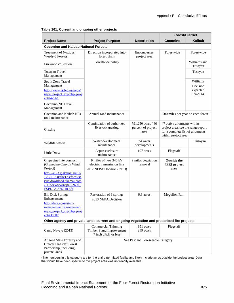
Appendix F – Cumulative Effects
Table 161. Current and ongoing other projects
Project Name Project Purpose Description Forest/District
Coconino Kaibab Coconino and Kaibab National Forests Treatment of Noxious Weeds-3 Forests
Direction incorporated into forest plans
Encompasses project area
Forestwide Forestwide
Firewood collection Forestwide policy Williams and Tusayan
Tusayan Travel Management
Tusayan
South Zone Travel Management http://www.fs.fed.us/nepa/nepa_project_exp.php?project=42961
Williams Decision expected 09/2014
Coconino NF Travel Management
Coconino and Kaibab NFs road maintenance
Annual road maintenance 500 miles per year on each forest
Grazing Continuation of authorized
livestock grazing 791,250 acres / 80 percent of project
area
47 active allotments within project area, see the range report for a complete list of allotments within project area
Wildlife waters Water development maintenance
24 water developments
Tusayan
Little Draw Aspen exclosure maintenance
107 acres Flagstaff
Grapevine Interconnect (Grapevine Canyon Wind Project) http://a123.g.akamai.net/7/123/11558/abc123/forestservic.download.akamai.com/11558/www/nepa/72690_FSPLT2_376210.pdf
9 miles of new 345 kV electric transmission line
2012 NEPA Decision (ROD)
9 miles vegetation removal
Outside the 4FRI project
area
Bill Dick Springs Enhancement http://data.ecosystem-management.org/nepaweb/nepa_project_exp.php?project=38507
Restoration of 3 springs 2013 NEPA Decision
9.3 acres Mogollon Rim
Other agency and private lands current and ongoing vegetation and prescribed fire projects
Camp Navajo (2013) Commercial Thinning
Timber Stand Improvement 7 inch d.b.h. or less
951 acres 399 acres
Flagstaff
Arizona State Forestry and Greater Flagstaff Forest Partnership, including private lands
See Past and Foreseeable Category
*The numbers in this category are for the entire permitted facility and likely include acres outside the project area. Data that would have been specific to the project area was not readily available.
Final Environmental Impact Statement for the Four-Forest Restoration Initiative Coconino and Kaibab National Forests 875

Appendix F – Cumulative Effects
Figure 76. General locations of current and ongoing projects within or adjacent to the project area
Summary of Reasonably Foreseeable Projects Reasonably foreseeable projects for this analysis (table 161, table 162, and figure 77) are defined as those Forest Service projects that have been listed in the forests’ schedule of proposed actions (SOPA). The most recent SOPA for both forests was reviewed in March 2014 (USDA FS 2014). Decisions are imminent or decisions have been made and implementation is about to begin; or the projects are poised for implementation by other (non-FS) parties. The reasonably foreseeable category mostly focuses on those projects that have the potential to affect vegetation (structure, pattern, and composition), natural processes (such as fire), and movement toward increased resiliency and function. Some project, such as the rock pits analysis, would not affect vegetation
Final Environmental Impact Statement for the Four-Forest Restoration Initiative 876 Coconino and Kaibab National Forests

Appendix F – Cumulative Effects
structure, spatial pattern, or composition. However, this project has been included as it may affect how road proposals (and their associated costs) are analyzed and implemented. Specialists also evaluated whether additional projects (not included in this list) would be included in their cumulative effects analysis. In summary:
• Approximately 43,041 acres of vegetation (mechanical) treatments and 58,714 acres of prescribed fire and maintenance burning would be implemented by the Forests in the foreseeable future (within 10 years) (table 162). Table 163 displays other foreseeable projects.
• Approximately 18,448 acres of vegetation (mechanical) treatments and 19,082 acres of prescribed fire and maintenance burning is expected to be implemented on State, private, and other federally managed lands within the foreseeable future (within 10 years) (table 164).
• Projects that are foreseeable but located outside of the project area are displayed in table 165.
Final Environmental Impact Statement for the Four-Forest Restoration Initiative Coconino and Kaibab National Forests 877

Appendix F – Cumulative Effects
Table 162. Reasonably foreseeable vegetation and ground-disturbing projects within and adjacent to the project area
Project Name Treatment Type Metric Forest/District
Project Objective Summary and Status Coconino Kaibab
Bill Williams Mountain Restoration
Mechanical, prescribed fire, roads
11,650 acres mechanical 15,200 acres prescribed fire 28 miles road decommission and 23 miles temporary road construction
Williams Reintroduce fire, reduce stand densities and fire potential, move toward balanced age classes, improve understory composition and productivity, includes 31 acres of cable logging in Mexican spotted owl PACs that would cause a loss of most snags and trees (including snags greater than 18 inch d.b.h. and trees greater than 24 inch d.b.h.) across approximately 15 percent of the area with this proposed treatment within the PAC in order to provide cable corridors and safe logging operations. Approximately 15 percent, or 5 acres, of the PAC area treated with cable logging operations would have most trees removed within these corridors under Alternative 2 (SDEIS, page 6). removes timber suitability on 8,954 acres, thinning above 9 inch d.b.h. in Mexican spotted owl PACs, burning greater than 1 acre in the AZ Bugbane Botanic Area
Status: analysis underway, DEIS was released in 2012, SDEIS was released in October of 2013, a decision is likely in 2014.
Coconino and Kaibab NFs Rock Pit Development
http://a123.g.akamai.net/7/123/11558/abc123/forestservic.download.akamai.com/11558/www/nepa/75515_FSPLT3_1445519.pdf
Existing pit expansion and new pit development
39 pits, 434 acres (new disturbance)
Forestwide Forestwide Create source of materials for road maintenance and management for both forests. Scoping occurred in 2011. An initial assessment of materials occurred in the 1990s.
Status: analysis underway, decision likely in 2014.
Final Environmental Impact Statement for the Four-Forest Restoration Initiative 878 Coconino and Kaibab National Forests

Appendix F – Cumulative Effects
Project Name Treatment Type Metric Forest/District
Project Objective Summary and Status Coconino Kaibab Juan Tank Japanese Tank Brome
http://www.fs.fed.us/nepa/nepa_project_exp.php?project=41566
Prescribed Fire 12, 133 acres Williams Contain and control Japanese brome
Status: Scoping expected in March 2014 and decision in May 2014
Watts Vegetation Project
http://www.fs.fed.us/nepa/nepa_project_exp.php?project=41569
Mechanical and prescribed fire
3,000 acres Tusayan Scoping 01/2014 with decision expected 05/2014
Turkey/ Barney Pasture Forest Health Restoration http://www.fs.fed.us/nepa/nepa_project_exp.php?project=37244
Mechanical and prescribed fire
Potentially 17,838 acres of mechanical and prescribed fire
Flagstaff Reduce dwarf mistletoe, tornado salvage, improve Mexican spotted owl habitat
Status: analysis underway, decision may occur in October 2014; however, 2014 Slide Fire resulted in changed conditions.
Mt. Elden/Dry Lake Hills Recreation http://www.fs.fed.us/nepa/nepa_project_exp.php?project=38239
Trail construction, reconstruction and relocation, trailhead expansion and/or consolidation and the decommission of unauthorized roads and trails in the Mt. Elden ESA and Dry Lake Hills area
Construct: 8 miles of horse trail, 3.5 miles of bike trail, 11 miles of hiking trail, 0.5 mile of climbing trail
Relocate 10.5 miles of existing trail
Decommission unauthorized trails and roads in Mt. Elden ESA
The purpose of the project is to provide enhanced recreation opportunities, mitigate impacts to wildlife habitat, archaeological sites, soil, water, and address community interests.
Status: Scoping occurred in 2013 and a decision is expected in 10/2015
Final Environmental Impact Statement for the Four-Forest Restoration Initiative Coconino and Kaibab National Forests 879

Appendix F – Cumulative Effects
Project Name Treatment Type Metric Forest/District
Project Objective Summary and Status Coconino Kaibab Expand and/or consolidate trailheads
Flagstaff Watershed Protection Project
Mechanical and Prescribed Fire
10,543 acres (7,569 acres Dry Lake Hills and 2,974 acres Mormon Mountain)
Flagstaff 4FRI treatments in Dry Lake Hills and Mormon Mountain removed – deferred to FWPP
Treatments include 1,825 acres of PAC treatments in Mormon Mountain, 1,221 PAC treatments in DryLake Hills, 424 acres of Mexican spotted owl core area treatment in Mormon Mountain, and 396 acres of Mexican spotted owl core area treatment in Dry Lake Hills,103 acres of goshawk nest fuels reduction in Dry Lake Hills, 59 acres of grassland restoration in Dry Lake Hills and 1.733 acres of no treatment due to previous NEPA or site condition
Status: Scoping conducted in April, 2013, decision likely in 2014 with implementation in 2015
Acre Summary Vegetation treatments and foreseeable ground disturbance 43,041 acres (mechanical)
5 net miles of temporary road increase and 23 miles of net trail increase 434 acres (net increase in ground disturbance from pits)
Prescribed fire (including maintenance burning) 58,714 acres
Final Environmental Impact Statement for the Four-Forest Restoration Initiative 880 Coconino and Kaibab National Forests

Appendix F – Cumulative Effects
Table 163. Other (non-vegetation) reasonably foreseeable projects within the project area
Project Name Treatment
Type Metric Forest/District
Project Objective Summary and Status Coconino Kaibab Highway 180 Antelope Crossing http://www.fs.fed.us/nepa/nepa_project_exp.php?project=42905
Fence setback to facilitate pronghorn crossing between summer and winter range
2 miles Williams Scoping will be conducted in March of 2014 and implementation expected in April of 2014
APS NO1 Youngs to Mormon Lake 69kV Powerline
http://a123.g.akamai.net/7/123/11558/abc123/forestservic.download.akamai.com/11558/www/nepa/75515_FSPLT3_1445519.pdf
Existing aerial and buried cable lines – permit reissuance began in 2013
21 miles Flagstaff APS NO1 Youngs to Mormon Lake 69kV Powerline – Red Rock portion of project is outside 4FRI project area Status: Analysis underway, decision likely in 2014
Moonset Pit Existing pit expansion
4.4 acres Williams County request – pit is located in Parks area Status: Decision likely in 2014
Table 164. Other agency and private lands foreseeable vegetation and prescribed fire projects
Project Name Treatment Type Metric Forest/District Project Objective Summary and
Status Coconino Kaibab
Camp Navajo Commercial thinning and Mexican spotted owl target nesting (2014)
154 acres Stand 32 259 acres Stand 70
Flagstaff Williams Reduce fire risk, improve diversity of forest conditions, and reducing tree density in 5 inches to 18 inches d.b.h.
Status: 2013 implementation
Department of Defense AZARNG Thin and Burn
Mechanical and prescribed fire
17,049 acres mechanical and prescribed fire
Ponderosa pine, pine-oak, and grasslands restoration to mitigate fire risk, provide diversity in forest conditions, improve ecosystem health, reduce tree density in 5 inches to 18 inches d.b.h.
Greater Flagstaff Forest Partnership (GFFP)
Mechanical and prescribed fire
535 acres mechanical and prescribed fire
Flagstaff Reduce fire risk on private property Status: implement in 2013 and 2014
Final Environmental Impact Statement for the Four-Forest Restoration Initiative Coconino and Kaibab National Forests 881

Appendix F – Cumulative Effects
Project Name Treatment Type Metric Forest/District Project Objective Summary and
Status Coconino Kaibab
Navajo Nation Mechanical and prescribed fire
140 acres mechanical and prescribed fire
Flagstaff Information provided via the Flagstaff Watershed Protection Project
Grand Canyon NP (South Rim)
Mechanical and prescribed fire
311 acres mechanical and 2,862 acres prescribed fire
Adjacent to Kaibab
Information provided by GCNP
Acre Summary Vegetation mechanical treatments 18,448 acres (less than 1 percent change since 2010)
Prescribed fire and maintenance burning 19,082 acres (less than 1 percent change since 2010)
Table 165. Other foreseeable vegetation and prescribed fire projects outside the project area
Project Name Treatment Type Metric Forest/District
Project Objective Summary and Status Coconino Kaibab
Mahan-Landmark Forest Restoration http://www.fs.fed.us/nepa/nepa_projectt_exp.php?project=37972
Fuels reduction and restoration
42,000-acre project area (there is a slight overlap into the project area but overall 50 percent is outside of the project area)
Mogollon Rim wildland-urban interface treatments on 11,468 acres and 36,621 Acres of restoration treatments including 18,849 acre Of pine restoration, 4,799 acre Mexican spotted owl PAC treatment, 2,620 acre Mexican spotted owl restricted habitat maintenance, 3,183 acre Mexican spotted owl target/threshold maintenance, 1,0344 acres of goshawk post-fledging family areas maintenance, 958 acre Grassland maintenance, 4,730 acre Savannah maintenance, 247 acre Spring maintenance, 247 acre Powerline ROW maintenance.
Allen Lake Restoration http://www.fs.fed.us/nepa/nepa_project_exp.php?project=41762
Wetland restoration 17 acres Mogollon Rim Decision in 2/2014 – implementation will occur in 2014
Final Environmental Impact Statement for the Four-Forest Restoration Initiative 882 Coconino and Kaibab National Forests

Appendix F – Cumulative Effects
Project Name Treatment Type Metric Forest/District
Project Objective Summary and Status Coconino Kaibab Greater Flagstaff Forest Partnership (GFFP)
Mechanical and prescribed fire
535 acres Flagstaff Reduce fire risk on private property Status: implement in 2013 and 2014
Coulter Exper. Forest
Mechanical and prescribed fire
800 acres RMRS Removed from 4FRI treatment acres and analyzed as cumulative
Chiricahua leopard frog
Habitat No specifics available Red Rock Rehab Sycamore and Walts Tank – pinyon-juniper removal Status: Decision expected in 03/2014
Final Environmental Impact Statement for the Four-Forest Restoration Initiative Coconino and Kaibab National Forests 883

Appendix F – Cumulative Effects
Reasonably Foreseeable Projects With Insufficient Information for Analysis The Four-Forest Restoration Initiative, Mogollon Rim of the Coconino NF, Apache-Sitgreaves NFs and Tonto NF, as of March 2014, has no tangible information that would be meaningful for this cumulative effects analysis. No project boundary has been finalized, no decision has been made on the existing and desired condition of resources (no purpose and need for action); therefore, no specific activities have been proposed. For this reason, it was not considered in the cumulative effects reasonably foreseeable category.
Highway 180 Motorized Trails – This project proposes to construct up to 60 miles of motorized trails. As of March, 2014, the project is on hold. For these reasons, it has been eliminated from foreseeable cumulative effects.
Red Rock District (Coconino NF) Pronghorn habitat improvements - The project was to be scoped in 2012. No additional information is available. For this reason, it has been eliminated from reasonably foreseeable cumulative effects.
Mahan-Landmark Forest Restoration – In the DEIS the best available information was used to describe the potential for cumulative effects. Since that time the proposal has not been finalized. A notice of intent to prepare an environmental impact statement is expected to be published in September of 2014. A supplemental cumulative effects analysis will be completed as needed.
Final Environmental Impact Statement for the Four-Forest Restoration Initiative 884 Coconino and Kaibab National Forests

Appendix F – Cumulative Effects
Figure 77. General locations of foreseeable projects within or adjacent to the project area
Final Environmental Impact Statement for the Four-Forest Restoration Initiative Coconino and Kaibab National Forests 885


Appendix G – Bridge Habitat for Canopy-Dependent Wildlife
Sarah Reif, Habitat Program Manager, Region 2, Arizona Game and Fish Department Neil McCusker, 4FRI Silviculturist Mark Nigrelli, 4FRI GIS Specialist Bill Noble 4FRI Wildlife Biologist
Introduction Because much of the 4FRI landscape is dominated by mid-aged trees, the 4FRI project would not achieve desired conditions on all treatment acres immediately post-treatment. It would take time for the largely even-aged forests to develop uneven-aged structure, for trees to mature into larger diameter classes, and for tree canopies within tree groups to reach the desired interlocking crown condition. Because of this time lag, some stakeholders are concerned that post-treatment conditions within the 4FRI project area would not provide sufficient habitat for canopy-dependent wildlife in the short term.
The wildlife species of concern identified by our publics, relative to the delay in achieving desired conditions, include northern goshawks, Mexican spotted owls, Abert’s squirrels, turkeys, mule deer, black bears, and some songbird species. The information provided in this appendix clarifies how post-treatment conditions within the 4FRI project area would provide habitat for canopy-dependent wildlife in the short term. We are referring to those areas as “bridge habitat”, suggesting that these more densely-forested areas would be available to wildlife to bridge the time between treatment and the attainment of desired conditions across the broader landscape.
Bridge Habitat at the Landscape Scale For purposes of this discussion, the landscape is considered to be the 988,764-acre 4FRI Coconino and Kaibab NFs’ analysis area. All treatment area acreages are calculated based on alternative C because it has the most comprehensive set of potential treatments that could impact canopy-dependent wildlife and it is the preferred alternative. To how much bridge habitat would be available to canopy-dependent wildlife post-treatment at the landscape scale it is important to review the acres of treatment and exclusion categories within the project area (table 166). About 40 percent of the project area was excluded from management consideration under this EIS.
Two bridge habitat categories (“other projects” and “wilderness, slopes, PACs”) were analyzed at the scale of the total project area to demonstrate the patch-mosaic of deferrals versus treated areas across the larger landscape. The remainder of the bridge habitat categories that were analyzed were within the ponderosa pine treatment area (507,839 acres) scale. This scale was used to demonstrate how bridge habitat would persist where mechanical treatments and prescribed fire are proposed. The percentages provided for each category are not necessarily additive. Some categories are merely subsets of other categories but they provide several different ways of looking at how we account for closed-canopy species through project design. As table 166 demonstrated, there is a highly diverse mosaic of forest structure that would vary in terms of overall density and openness post-treatment at the landscape scale.
Final Environmental Impact Statement for the Four-Forest Restoration Initiative Coconino and Kaibab National Forests 887

Appendix G – Bridge Habitat for Canopy-dependent Wildlife
Table 166. Acres of treatment and non-treatment areas within the 4FRI project area Area Description Acres
Project Area Total area within 4FRI project boundary
988,764
Exclusions Other projects 213,090 Special management areas (wilderness,
research natural areas, inventoried roadless areas, Camp Navajo, and
experimental forests)
30,668
Non-FS lands 145,156 Miscellaneous (other cover types, no-
treatment protected activity center (PAC) core areas, inaccessible areas,
etc.)
11,138
Total excluded areas within 4FRI project boundary
400,052
Treatment Area Ponderosa pine treatment area 507,839
Other cover types treatment area 80,876
Area within the proposed treatment boundary (includes mechanical
treatment and prescribed burning)
588,716
Other Projects Excluded fuels reduction and forest restoration projects account for 213,090 (22 percent) acres of the total project area (988,764 acres). We can assume that some proportion of these projects would/do retain closed-canopy conditions after treatment, or remain untreated. On average, about 37 percent of a given project on the Coconino and Kaibab NFs is untreated after implementation (Hampton et al. 2008, page 17). Untreated areas are a result of site-scale factors such as archaeological and historical sites, wildlife deferrals, funding issues, steep or rocky terrain, and areas with insufficient road access. Using the 37 percent estimate for untreated acres after project completion, we concluded about 78,843 acres would remain in deferral (i.e., untreated) due to site-scale logistics in the total 4FRI project area. There is no data to accurately estimate acres of closed-canopy conditions in excluded projects. However, we can assume that some proportion of this area would contribute habitat for canopy-dependent species.
Wilderness areas, slopes over 40 percent, and Mexican spotted owl protected activity centers (PACs) not identified for mechanical treatment These areas have not been identified for mechanical treatment and are generally characterized by dense forest conditions used by canopy-dependent wildlife. These areas account for 8 percent (79,699 acres) of the total project area, including 81 of 99 Mexican spotted owl PACs. The 18 PACs with mechanical treatments were not included here, but little change in canopy conditions are expected in those PACs (see “Affected Environment section of the Wildlife report).
Final Environmental Impact Statement for the Four-Forest Restoration Initiative 888 Coconino and Kaibab National Forests

Appendix G – Bridge Habitat for Canopy-dependent Wildlife
Ponderosa Pine Treatment Area Scale (507,839 acres) Although the 4FRI proposes to treat over ½ million acres, treatment intensities are highly variable (table 167 and figure 78). Very open treatments include grasslands and savannas. The most common treatment in the open category would range from 40 to 55 percent open.
Figure 78. Relative, post-treatment forest density across the 4FRI project area, alternative C
Final Environmental Impact Statement for the Four-Forest Restoration Initiative Coconino and Kaibab National Forests 889

Appendix G – Bridge Habitat for Canopy-dependent Wildlife
Table 167. Acres of proposed treatment in terms of post-treatment openness Post-treatment Openness Category Acres Percent of Ponderosa
Pine Treatment Area Very Open 67,553 13
Open 228,860 45 Moderately Closed 141,530 28
Closed 69,897 14
Total 507,839 100
Closed and Moderately-Closed Conditions This category includes mechanically treated and prescribed fire only areas where post-treatment conditions maintain 60 to 90 percent forested cover. Included in this category were some Mexican spotted owl and northern goshawk habitats. Post-treatment openness would range from 10 to 25 percent and 25 to 40 percent open. Mexican spotted owl restricted and target/threshold habitats, and 18 Mexican spotted owl PACs proposed for mechanical treatment would also be in this openness category. About 211,427 acres (42 percent) of the ponderosa pine treatment area would be in this category. About 69,897 acres (14 percent) of the ponderosa pine treatment area would remain in closed condition (75 to 90 percent forested) post-treatment. This percentage includes all those areas listed above, but excludes areas in the 25 to 40 percent open category and areas that are not currently in a closed condition.
Mexican Spotted Owl Protected, Target and Threshold, and Restricted Habitats These habitat designations have specific guidelines per the Mexican spotted owl Recovery Plan to ensure denser forest conditions selected for by the owl. Within the 4FRI project, these designations could be ranked in terms of their forest density, and therefore their provision for other closed-canopy species. Protected habitat is generally densely forested, target and threshold habitats are similar to protected habitat, and restricted habitat is less dense than protected but more densely forested relative to areas outside Mexican spotted owl designations. In regards to 4FRI, habitat definitions are specific to pine-oak forest.
• Protected owl habitat accounts for roughly 35,262 acres, which is about 7 percent of the ponderosa pine treatment area (table 168, see the “Mexican spotted owl PAC Mechanical” and “Protected Prescribed Fire Only” row in the “Post-treatment Density” column). Of this total, 26,120 acres are currently in a closed condition. This includes 70 PACs (18 of which are proposed for some mechanical thinning) and slopes over 40 percent (proposed for prescribed fire only). Protected owl habitat is designed to provide a multi-layered, more closed canopy condition relative to the other habitats in the ponderosa pine treatment area, with an emphasis on managing for large trees (18 inches d.b.h. or greater). The average basal area for protected habitat, based on modeled projections for the year 2020, is 155 square feet per acre.
• Target and threshold habitats include those areas that meet or are approaching nesting and roosting habitat conditions. These areas account for about 2 percent (8,692 acres) of the ponderosa pine treatment area (see Mexican spotted owl target and Mexican spotted owl threshold rows in table 168). Of this total, about 7,489 acres are currently in a closed canopy condition. Per the 1995 Mexican spotted owl Recovery Plan, target and threshold habitats are to be managed for at least 15 percent of total stand density index in each of the three defined ponderosa pine tree size classes (12- to18 inches d.b.h., 18- to 24 inches, and over 24 inches).
Final Environmental Impact Statement for the Four-Forest Restoration Initiative 890 Coconino and Kaibab National Forests

Appendix G – Bridge Habitat for Canopy-dependent Wildlife
The revised Recovery Plan (USDI FWS 2012) addressed the misinterpretation of nest stand data, recommending a stand average of 110 square feet per acre or greater basal area with a preponderance of large trees (18 inches d.b.h. and larger).
• Restricted habitat accounts for 66,419 acres (table 168), which is 13 percent of the ponderosa pine treatment area. Of this total, 42,538 acres (about 64 percent) are currently in a closed condition and another 17,179 acres (about 26 percent) are currently in a moderately closed condition. The guidelines for restricted habitat are less specific in order to meet multiple objectives and operate in conjunction with ecosystem management and existing management guidelines. Objectives for the 4FRI include managing for an abundance of ponderosa pine trees 18 inches d.b.h. and greater, maintain tree form oak, and manage for a stand average of 70 to 90 square feet per acre basal area at the stand level.
Northern goshawk habitat Closed canopy conditions would also be realized within areas managed according to the northern goshawk guidelines. Higher tree density, canopy cover, and larger group sizes would be retained in post-fledging family areas (PFAs) and lands outside post-fledging family areas (LOPFAs) where the current condition and proposed treatments are for 10 to 25 percent interspace (14,933 acres). Denser forest structure would also be retained in northern goshawk nest areas that currently have closed conditions (3,234acres). Areas within post-fledging family areas and landscapes outside of goshawk post-fledging areas that are proposed for prescribed fire only treatments or no treatments that are currently in a closed condition would retain higher tree densities and canopy cover post treatment (16,310 acres). Together, these categories account for about 7 percent of the ponderosa pine treatment area (about 34,477 acres). In addition, post-fledging family areas and landscapes outside of post-fledging areas currently in a moderate closed or closed condition and proposed for moderately-dense treatments (25 to 40 percent interspace) account for about another 8 percent of the ponderosa pine treatment area. Areas within post-fledging family areas, landscapes outside of post-fledging areas and goshawk nest areas that are proposed for prescribed fire only treatments or no treatments account for 22,312 acres, which is about 4 percent of the ponderosa pine treatment area. Together these two categories account for nearly 13 [8+4] percent of the ponderosa pine treatment area and would remain in a moderately closed condition post treatment.
About 41 percent of the ponderosa pine treatment area is landscapes outside of post-fledging areas and post-fledging family areas goshawk habitat proposed for low-density condition (savanna/grassland restoration and 40 to 55 percent interspace) (table 168).
Wildlife movement corridors Efforts were taken to ensure habitat connectivity for canopy-dependent wildlife at the landscape scale using data from known wildlife movement corridors for black bear, turkey, mule deer, and tassel-eared squirrels (AGFD 2011, figure 51). While tassel-eared squirrels are dependent on sufficient areas with connected canopies, black bears and mule deer are habitat generalists that seek cover, but largely use habitat elements independent of forest canopy closure. Closed canopy forest corridors would provide hiding cover for these species. Landscape-scale movement corridors were examined on a stand-by-stand basis. Where closed canopy wildlife corridors overlapped with proposed mechanical treatments, treatment intensities were adjusted to provide closed or moderately-closed canopy conditions post-treatment. In addition to treatment areas that would remain in closed or moderately-closed conditions, roughly 4,169 acres were actively changed from more open to more closed treatments. Treatments were adjusted in five different wildlife movement corridors within the project area. The expected result is the retention of
Final Environmental Impact Statement for the Four-Forest Restoration Initiative Coconino and Kaibab National Forests 891

Appendix G – Bridge Habitat for Canopy-dependent Wildlife
thermal and hiding cover in addition to closed-canopy conditions to facilitate movement across the landscape for a suite of species.
In summary, there are four key considerations with regard to bridge habitat for closed-canopy species at the landscape and treatment scales:
1. A patch-mosaic of bridge habitat would remain available for canopy-dependent wildlife. At a minimum, 8 percent of the project area would be in deferral due to wilderness, slope, and untreated Mexican spotted owl PACs. Potentially another 8 percent of the project area would be in deferral as part of other excluded projects.
2. About 1 in 5 acres (nearly 22 percent of the ponderosa pine treatment area) would be managed as Mexican spotted owl habitat, creating conditions that also provide habitat for other canopy-dependent wildlife.
3. Bridge habitat would be maintained across 42 percent of the ponderosa pine treatment area.
4. Connectivity for closed-canopy species was specifically built into treatment designs separately from Mexican spotted owl and northern goshawk guidelines.
Table 168 provides a detailed summary of acreages and percentages for each treatment category within the ponderosa pine treatment area in terms of post-treatment density and contributions to bridge habitat. Table 168 illustrates the patch-mosaic of post-treatment forest density relative.
Table 168. Post-treatment contributions to bridge habitat provided by each treatment designation Treatment Post-treatment Density Landscape
Scale Bridge Habitat
Mid-scale
Bridge Habitat
Total Acres Percent (%) of
Ponderosa Pine
Treatment Area
Mechanical Treatment Low Density Savanna/Grassland
Restoration X X 56,372 11
landscapes outside of post-fledging areas 40–55%
Interspace
X Some 141,267 28
post-fledging family areas 40–55% Interspace
X Some 12,834 3
Low Density Total
210,472 41
Moderate Density
landscapes outside of post-fledging areas 25–40%
Interspace
X X 52,574 10
Mexican spotted owl Restricted
X X 62,785 12
post-fledging family areas 25–40% Interspace
X X 4,406 1
Moderate Density Total
119,766 24
Final Environmental Impact Statement for the Four-Forest Restoration Initiative 892 Coconino and Kaibab National Forests

Appendix G – Bridge Habitat for Canopy-dependent Wildlife
Treatment Post-treatment Density Landscape Scale Bridge Habitat
Mid-scale
Bridge Habitat
Total Acres Percent (%) of
Ponderosa Pine
Treatment Area
High Density landscapes outside of post-fledging areas 10–25%
Interspace
X X 29,511 6
post-fledging family areas 10–25% Interspace
X X 2,670 1
High Density Total
32,181 6
Very High Density
Mexican spotted owl Threshold
X X 1,892 less than 1
Mexican spotted owl Target
X X 6,495 1
Mexican spotted owl PAC Mechanical
X X 10,284 2
Very High Density Total
18,672 4
Prescribed Fire Only Areas and Areas with No Proposed Treatments Low Density landscapes outside of post-
fledging areas Prescribed Fire Only
Some Some 86,869 17
landscapes outside of post-fledging areas No
Proposed Treatments
Some Some 858 less than 1
Low Density Total
87,728 17
Moderate Density
post-fledging family areas Prescribed Fire Only
X X 3,216 1
post-fledging family areas No Proposed Treatments
X X 92 less than 1
Restricted Prescribed Fire Only
X X 4,187 less than 1
Restricted No Proposed Treatments
X X 1,280 less than 1
Moderate Density Total
6,898 1
Final Environmental Impact Statement for the Four-Forest Restoration Initiative Coconino and Kaibab National Forests 893

Appendix G – Bridge Habitat for Canopy-dependent Wildlife
Treatment Post-treatment Density Landscape Scale Bridge Habitat
Mid-scale
Bridge Habitat
Total Acres Percent (%) of
Ponderosa Pine
Treatment Area
High/Very High Density
post-fledging family areas Nest Area Prescribed Fire
Only
X X 6,836 1
post-fledging family areas Nest Area No Proposed
Treatments
X X 4 less than 1
Threshold Prescribed Fire Only
X X 217 less than 1
Threshold No Proposed Treatments
X X 1 less than 1
Target Prescribed Fire Only
X X 84 less than 1
Target No Proposed Treatments
X X 2 less than 1
Protected Prescribed Fire Only
X X 25,714 5
Protected No Proposed Treatments
X X 244 less than 1
High/Very High Density
Total
32,122 6
Grand Total 507,839 100
Bridge Habitat at the Restoration Unit Scale At the restoration unit scale (figure 79), there are additional ways of accounting for bridge habitat. Factors contributing to bridge habitat at the restoration unit scale include the area remaining in closed and moderately-closed condition post-treatment and areas allocated for old growth.
Closed (less than 25 percent Interspace) to Moderately-Closed (25 to 40 percent Interspace) Canopy Conditions Table 169 summarizes the range of post-treatment openness by restoration unit under alternative C. (Also, see table 64 in the silviculture specialist’s report). The overall range in openness indicates a variety of conditions within restoration units post-treatment. Most of the area within each restoration unit would range from open to moderately closed canopy conditions. Very open and closed conditions would also be represented in each restoration unit, ranging from 2 to 20 percent and from 4 to 21 percent respectively. Restoration unit 1 has the highest percentage of post-treatment habitat in a closed condition, due in large part to ecological conditions such as soil, climate, and site quality that result in a denser reference condition relative to the other restoration units. Restoration unit 1 also contains the highest proportion of Mexican spotted owl habitat relative to the other restoration units. Note that restoration unit 3, 4, and 6 include large areas of savanna, grassland, and pine/sage habitats (e.g., Garland Prairie in restoration unit 3, Government Prairie in restoration unit 4, and pine-sage in restoration unit 6). Savanna and grassland
Final Environmental Impact Statement for the Four-Forest Restoration Initiative 894 Coconino and Kaibab National Forests

Appendix G – Bridge Habitat for Canopy-dependent Wildlife
restoration is based on soil characteristics, and would total 56,372 acres of very open treatment. While maintaining adequate closed canopy conditions has been a topic of concern for some stakeholders, the lack of grassland and savanna habitat is a more significant issue ecologically (Merola-Zwartjes 2005, North American Bird Conservation Initiative 2011, Brown and Makings 2014).
Figure 79. Restoration unit boundaries within the 4FRI treatment area
Table 169. Proposed post-treatment openness condition (percent) by restoration unit restoration unit Very Open Open Moderately Closed Closed
1 11% 40% 29% 21% 3 13% 40% 32% 15%
4 20% 52% 18% 10%
5 14% 58% 24% 4%
6 2% 41% 47% 11%
Final Environmental Impact Statement for the Four-Forest Restoration Initiative Coconino and Kaibab National Forests 895

Appendix G – Bridge Habitat for Canopy-dependent Wildlife
Old-growth Allocations Desired conditions for old growth in ponderosa pine under the Coconino forest plan direction:
• 20 trees per acre at 18 inches d.b.h. and greater and at least 180 years old,
• one snag per acre at least 14 inches d.b.h. and 25 feet tall,
• two down dead tree pieces 12 inches in diameter and 15 feet long,
• basal area at least 90 square feet, and
• canopy cover of at least 50 percent.
Guidelines from the Kaibab forest plan include:
Multi layered canopy, interlocking canopy and old growth Ponderosa Pine Desired Condition: Fine-scale: Crowns of trees within the mid-aged to old groups are interlocking or nearly interlocking and consist of approximately 2 to 40 trees per group. Where Gambel oak comprises more than 10 percent of the basal area, it is not uncommon for canopy cover to be greater than 40 percent. Mid-scale: The ponderosa pine forest vegetation community is characterized by variation in the size and number of tree groups depending on elevation, soil type, aspect, and site productivity. The mosaic of tree groups generally comprises an uneven-aged forest with all age classes and structural stages present. Forest conditions in some areas contain 10 to 20 percent higher basal area in mid-aged to old tree groups than in the general forest (e.g. goshawk post-fledging family areas, Mexican spotted owl nesting and roosting habitat, drainages, and steep north facing slopes). Landscape: The ponderosa pine forest vegetation community is a mosaic of forest conditions composed of structural stages ranging from young to old trees. The forest is generally uneven-aged and open. Groups of old trees are mixed with groups of younger trees. Denser tree conditions exist in some locations such as north facing slopes, canyons, and drainage bottoms. Old growth occurs throughout the landscape, generally in small areas as individual old growth components, or as clumps of old growth. Old growth components include old trees, dead trees (snags), downed wood (coarse woody debris) and structural diversity. The location of old growth shifts on the landscape over time as a result of succession and disturbance (tree growth and mortality).
Vegetation Management in All Forested Communities Guideline: Projects in forested communities that change stand structure should generally retain at least historic frequencies of trees by species across broad age and diameter classes at the mid-scale. On suitable timberlands, projects should retain somewhat higher frequencies of trees across broad diameter classes to allow for future tree harvest. Project design should manage for replacement structural stages to assure continuous representation of old growth over time.
The microhabitat diversity provided by the old trees, multi-storied canopies, snags, and downed logs within old growth areas are rare across the landscape. Functional Mexican spotted owl habitat and portions of northern goshawk habitat are comprised of old-growth forest (see chapter 1, existing and desired conditions for more details). The Coconino forest plan direction is to allocate and maintain at least 20 percent old growth forest within each ecosystem management unit (EMU). For the purposes of the 4FRI project, an ecosystem management unit resembles the 4FRI restoration units, therefore old growth was allocated by restoration unit (see table 38 in the silviculture specialist report).
Final Environmental Impact Statement for the Four-Forest Restoration Initiative 896 Coconino and Kaibab National Forests

Appendix G – Bridge Habitat for Canopy-dependent Wildlife
Forty percent of the ponderosa pine treatment area on the Coconino NF (127,009 acres) and 35 percent (65,810 acres) of the Kaibab NF are allocated for old growth. Old-growth conditions do not currently occur in sufficient quantity on the Coconino and Kaibab NFs. Areas selected for old-growth allocation represent current conditions that most closely resemble old growth. The 4FRI has incorporated a large tree retention policy and alternative C (the preferred alternative) would also include an old tree protection strategy. It is the intent of the 4FRI project to manage allocated areas according to old growth standards to move them towards mature, diverse forests over time. Similar provisions were made for pinyon-juniper habitats. A portion of these areas currently support closed canopy conditions and will continue to do so. More closed canopy conditions will develop in these areas over time, contributing further to closed canopy habitat.
Bridge Habitat at the Mid-Scale Bridge habitat for canopy-dependent wildlife would also occur at the mid-scale in the 4FRI project. Some densely forested areas would be deferred simply due to the vagaries of implementation. The 4FRI project also intentionally plans for bridge habitat at the mid-scale through its desired conditions, design features/best management practices/mitigation, the old and large tree implementation plans, and the silvicultural design and implementation guide. These factors are described below.
Desired Conditions for Bridge Habitat The 4FRI EIS describes treatments intended to meet the described desired conditions. During implementation of the 4FRI project, site specific prescriptions would be developed to implement the treatments and they too would be based on meeting desired conditions. The following subset of desired conditions would help ensure bridge habitat is maintained in the proposed project area (see chapter 1 purpose and need for the full set of desired conditions):
• The desired condition is to restore tree density and pattern to the natural range of variability, while meeting forest plan requirements for Mexican spotted owl protected, target, threshold, and restricted habitats and goshawk nest areas.
• At the fine scale, the desired condition is a ponderosa pine ecosystem consisting of groups of trees that typically range in size from 0.1 acre to 1.0 acre in size. Tree groups would exceed 1-acre in size as needed to respond to site-specific conditions such as the presence of pre-settlement trees or mature trees that are developing old-tree characteristics.
• Tree groups in the mid-age and older VSS classes would have canopies that provide moderate-to-closed conditions and connectivity for wildlife that are dependent on this type of habitat. These conditions are widely distributed on the landscape. At the landscape scale (extent of ponderosa pine vegetation), all canopy density conditions exist and provide for heterogeneity.
• Moderate-to-closed canopy conditions (and the connectivity between groups supporting these conditions) are met in a variety of ways: habitat for goshawk and Mexican spotted owl, steep slopes, buffers for several resources including bald eagle roosts, other raptor nests, heron rookeries, caves, sink holes, and special designations that would not be treated (including wilderness and most research natural areas).
• There is a need to use management strategies that: (1) promote tree regeneration and understory vegetation, (2) move tree canopy density, tree group pattern and interspaces towards the historic range of variability, and (3) provide a mix of open, moderately-closed,
Final Environmental Impact Statement for the Four-Forest Restoration Initiative Coconino and Kaibab National Forests 897

Appendix G – Bridge Habitat for Canopy-dependent Wildlife
and closed-canopy conditions at the fine (group) to landscape (ponderosa pine vegetation) scale.
• There is a need to implement uneven-aged management strategies and manage for high-density, relatively uneven-aged stands in Mexican spotted owl restricted habitat, including target and threshold habitats to meet forest plan and Mexican spotted owl Recovery Plan requirements.
Wildlife Design Features/Best Management Practices/Mitigation Measures Design features, best management practices, and mitigation measures are intended to avoid or minimize adverse effects of management actions on natural resources. They provide safeguards for wildlife and other resources during the implementation phase. Some of these actions would result in a well-distributed network of bridge habitat for wildlife across the larger landscape (table 170). A more complete list of design features, BMPs, and mitigation can be found in appendix C and appendix D of the EIS (the silvicultural design and implementation guide). Selected silvicultural design features that contribute to bridge habitat are described in greater detail below.
Table 170. Design features, BMPs, and mitigation measures contributing to bridge habitat Species/Resource Description
Bald Eagle Nests No mechanical treatments would occur within a 300-foot radius of bald eagle nest trees (about a 6 acre patch for each nest).
Bald Eagle Roosts No mechanical treatments will occur around confirmed bald eagle roost sites (300’ radius around roosts on the Coconino NF and a 10-chain radius on the Kaibab NF).
Vegetation Structural Stages 4, 5, and 6
Within group density – Manage mid-aged tree groups for a range of density and structural characteristics by thinning approximately 50 percent of the mid-aged groups to the lower range of desired stocking conditions, approximately 20 percent each to the middle and upper range of desired stocking conditions, and approximately 10 percent would not be thinned. Within group structure – Enhance and maintain mid-aged, mature, or old group structure by retaining individual and clumps of vigorous ponderosa pine seedlings, saplings, and poles within the larger group.
Caves and Sinkholes A 300-ft no mechanical treatment buffer would be designated around 34 cave entrances (about 6.5 acres each) and around an undetermined number of sink holes (i.e., karst) to protect cave ecosystems from siltation, protect human health and safety, and reduce potential disturbance to roosting bats. Existing roads could be used for mechanical harvest but no new skid trails would be created.
Dependable Waters Hiding cover would be maintained near dependable waters by not targeting drainages for interspaces and openings and through implementation of watershed BMPs.
Great Blue Herons No dominant or co-dominant trees would be cut in rookeries. Nest trees will be prepped prior to implementing prescribed fire.
Mexican spotted owl Trees greater than 24 inches d.b.h. would not be harvested. Mixed Conifer 4FRI activities would not include mechanical or fire treatments in the mixed
conifer inclusions within the ponderosa pine forest (e.g., Mexican spotted owl core areas in treated PACs). Similarly, islands of ponderosa pine within mixed conifer forest would not be treated as part of this project.
Final Environmental Impact Statement for the Four-Forest Restoration Initiative 898 Coconino and Kaibab National Forests

Appendix G – Bridge Habitat for Canopy-dependent Wildlife
Species/Resource Description Northern Leopard Frogs A no-treatment buffer (no thinning, no direct ignition) would extend ¼-mile
from tanks with known northern leopard frog sites, or be designated along logical topographic breaks. In some cases, the district wildlife biologist could work with implementation teams to determine the habitat protection buffer boundary.
Northern Leopard Frogs A 200-ft protection zone (100 feet either side of streamcourse) would be established around designated stream courses for northern leopard frogs. There would be no thinning and no direct ignition of prescribed burning within the protection zones. Designated skid trail crossings through the buffer zones are allowed.
Raptor Nests No mechanical treatment buffers would be designated around raptor nests. Sharp-shinned hawk nests = 10 acres, Cooper’s hawk nests = 15 acres, osprey nests = 20 acres, other raptors = no mechanical treatment buffers within a 50 foot radius (about 0.2 of an acre).
Snags Emphasize retention of snags at least 18 inches d.b.h.. Snags Retain trees at least 18 inches d.b.h. with dead tops, cavities, and lightning
strikes wherever possible to provide cavity nesting/foraging habitat (i.e., the living dead).
Streamside Management Zones On areas to be prescribed burned, establish filter strips (also known as streamside management zones). Applies to riparian and non-riparian streamcourses. Deferral widths range from 35 to 120 feet on each side of the streamcourse.
Turkeys Retain medium to high canopy cover in pine stringers in the pinyon-juniper transition zone and target low-severity burns to retain yellow pine and roosting cover.
Wildlife Cover Gambel oak, juniper, and pinyon species may only be cut as necessary to facilitate logging operations (skid trails and landings) and by design as follows: Within UEA, IT, SI, and wildland-urban interface treatments, pinyon/juniper seedling/sapling and young/mid-aged trees may be cut within a 40-foot radius of individual or groups of old ponderosa pine (as defined in the old tree implementation strategy). Within savanna and wildland-urban interface pinyon-juniper mechanical treatment areas, pinyon/juniper seedling/sapling and young/mid-aged trees may be cut.
Habitat Heterogeneity Manage mid-aged tree groups for a range of density and structural characteristics by thinning approximately 50 percent of the mid-aged groups to the lower range of desired stocking conditions, approximately 20 percent each to the middle and upper range of desired stocking conditions and approximately 10 percent remain unthinned.
Canopy Cover/ Habitat Heterogeneity
Enhance and maintain mid-aged, mature and old group structure by retaining individual and clumps of vigorous ponderosa pine seedlings, sapling and poles within the larger group.
Old and Large Tree Implementation Plans In response to public input from several stakeholders requesting a design feature that included no cutting of pre-settlement old-growth trees, the 4FRI project would implement an Old Tree Protection Strategy. Old trees (approximately 150 years and older) would be retained regardless of their diameter within the 4FRI project area. Exceptions would be made for threats to human health and safety and those rare circumstances where the removal of an old tree is necessary in
Final Environmental Impact Statement for the Four-Forest Restoration Initiative Coconino and Kaibab National Forests 899

Appendix G – Bridge Habitat for Canopy-dependent Wildlife
order to prevent additional habitat degradation (e.g., moving a road out of stream channel). However, exceptions are not expected. Retention of old trees as individuals and groups will contribute significantly to bridge habitat, providing old growth structure for wildlife in the short term.
In response to input from some stakeholders, alternative C includes a Large Tree Retention Strategy. The strategy identifies areas where post-settlement trees 16 inches d.b.h. and larger would be retained and exceptions where removal of trees 16 inches d.b.h. and larger would be necessary to move toward ecological desired conditions. Elsewhere, those trees would be retained, adding to the mid-scale provision of bridge habitat for canopy-dependent wildlife.
Silvicultural Design and Implementation Guide Vertical and horizontal heterogeneity are important components of wildlife habitat in ponderosa pine forests. Restoring variability and diversity to forest structure and pattern is a central desired condition of the 4FRI project. The silvicultural design and implementation guide (hereafter “implementation guide”; appendix D, attachment 1) is intended to translate desired conditions, management direction, and design features into guidance for the district silviculturists responsible for writing site-specific prescriptions in the implementation phase. The intent is to balance the need for flexibility to adapt to on-the-ground realities while ensuring adequate sideboards to minimize or avoid impacts to important resources. Below are examples of how maintenance of bridge habitat would be ensured through the implementation guide.
Implementation Guide—Mexican Spotted Owls Several features of the implementation guide treatment design for the Mexican spotted owl would serve as a proxy for other canopy-dependent wildlife. Design features for the owl are too numerous to list here, but those listed below serve to illustrate specifically how bridge habitat would be maintained at the mid-scale:
• Each PAC has a 100-acre (or greater) core area that would not have mechanical treatments.
• Each PAC to be thinned would have an upper diameter limit of trees that may be cut.
• Manage for 110 to 150 square feet of basal area (depending on alternative) in protected, target, and threshold habitats; basal area in restricted other habitat would range from 70 to 90 ft2.
• Individual trees and tree groups would occupy approximately 60 to 75 percent of the area within restricted other habitat.
• Treatments are designed to manage for old age trees and to sustain as much old forest structure as possible across the landscape. Treatments would follow the Old Tree Protection Plan.
• No trees larger than 18 inches d.b.h. would be cut in protected habitat and no trees larger than 24-inches d.b.h. would be cut in restricted habitats.
• In restricted other habitat, tree groups would, on average, range in size from 0.1 to 1 acre; northerly aspects and highly productive microsites would have larger average group sizes.
• In restricted other habitat, manage for tree groups with different age classes by retaining individual and clumps of vigorous ponderosa pine seedlings, saplings and poles within the larger mid-aged, mature or old tree groups.
Final Environmental Impact Statement for the Four-Forest Restoration Initiative 900 Coconino and Kaibab National Forests

Appendix G – Bridge Habitat for Canopy-dependent Wildlife
• In restricted other habitat, interspace width between tree groups would average from 25 to 60 feet with a maximum width of 200 feet.
• Manage for large oak and pine snags.
• Retain non-ponderosa pine species in the canopy.
• Retain young trees growing within the dripline of old trees in PACs to maximize roosting potential.
Implementation Guide—Northern Goshawks Several features of the treatment design for the northern goshawk would serve as a proxy for other canopy-dependent wildlife. Design features that would contribute towards this goal are numerous, but a few key features are highlighted to illustrate maintenance of bridge habitat. Relevant design features from table 170 are not repeated below.
• Treatments are designed to manage for old age trees, following the Old Tree Protection Plan.
• Treatments would strive to attain an overall stand average density ranging from 40 to 90 square feet of basal area and 15 to 40 percent of maximum stand density index. Density would vary within this range depending on treatment type, intensity, existing stand structure, and site conditions.
• Tree group density would be managed to meet the canopy cover requirement of 40 plus percent within mid-aged forest (VSS4), mature forest (VSS5), and old forest (VSS6) tree groups and to assure that immature tree groups (VSS 2 and 3) are managed to maintain tree stocking necessary to provide for desired canopy cover as the groups mature.
• To achieve overall stand average density targets, basal area and stand density index within tree groups would often need to exceed average target values. Table 171 illustrates how this could work for basal area (see the implementation guide for greater detail). For example, a treatment intensity of 10 to 25 should result in 10 to 25 percent of a stand open and 75 to 90 percent treed. If the objective for a specific stand was 20 percent interspace and 80 percent trees, including 10 percent regeneration, then 70 percent of the treed area would be groups and individual tree. If the overall target basal area was 60, tree groups in the 70 percent treed area would have to average 86 basal area.
• Within-group structure specific to mid-aged to old tree classes (VSS 4 to 6) would include open understories, interlocking tree crowns, abundant large limbs, and shade.
• Tree groups, on average, would range in size from 0.1 to 1 acre. Overall average group size would vary within this range depending on existing stand structure, and pre-settlement tree evidence.
• Maximum interspace width of 200 feet.
• Maximum regeneration opening size of 4 acres or 200 feet wide.
• One group of reserve trees, three to five trees per group, would be left in created regeneration openings larger than 1 acre in size.
• Manage for large oaks.
• Within the proposed Arizona Department of Game and Fish research areas, tree group size is dependent on experimental design and would range in size from 1 to 15 acres.
Final Environmental Impact Statement for the Four-Forest Restoration Initiative Coconino and Kaibab National Forests 901

Appendix G – Bridge Habitat for Canopy-dependent Wildlife
Table 171. Excerpt from section D of the 4FRI implementation guidelines
Treatment Intensity
Percent Area Percent Area with Tree Cover Average Group Basal Area to Achieve
Overall Basal Area
Interspace Tree Groups &
Individuals Regeneration 40 50 60 70 80 90 10–25 10 90 90 0 56 67 78 89 100
85 5 59 71 82 94
80 10 63 75 88 100
75 15 67 80 93 107
70 20 71 86 100 114
15 85 85 0 59 71 82 94 106
80 5 63 75 88 100
75 10 67 80 93 107
70 15 71 86 100 114
65 20 77 92 108 123
20 80 80 0 63 75 88 100 113
75 5 67 80 93 107
70 10 71 86 100 114
65 15 77 92 108 123
60 20 83 100 117 133
Conclusions about Bridge Habitat in the 4FRI Project Closed-canopy, high-density, mid-aged forest conditions are currently common in the 4FRI project area. To achieve ecological objectives (e.g., achieve or move towards the natural range of variability, increase forest resiliency to continuing climate change, maintain existing large and old trees and increase large tree growth rates) and modify landscape-scale fire behavior, continuity of canopy connectedness and overall forest density must be significantly reduced. Given the evolutionary history of canopy-dependent wildlife on this landscape, we can assume that closed-canopy conditions were present within the natural range of variability. The question of how much of the pre-settlement landscape was in this condition remains unanswered, but the literature, including historic stand inventories, stand reconstructions, and site descriptions, combined with soil mapping and photo documentation, consistently concludes that this was not the predominant condition. Nevertheless, the 4FRI project proposes to maintain more closed canopy conditions than likely occurred historically. Some closed canopy forest areas are proposed for long-term management (e.g., Mexican spotted owl habitats) and others could change the next time a management planning analysis is conducted on this landscape (e.g., nest and roost sites for other raptor species that might not be in use in the future). Together, they would provide bridge habitat for canopy-dependent wildlife to span the time between restoration treatments and achievement of desired conditions.
In summary, bridge habitat would be managed for at the mid-scale in four key ways:
1. Desired conditions that strive to attain the full range of natural variability which includes areas for canopy-dependent wildlife,
Final Environmental Impact Statement for the Four-Forest Restoration Initiative 902 Coconino and Kaibab National Forests

Appendix G – Bridge Habitat for Canopy-dependent Wildlife
2. Design features/BMPs/mitigation measures would result in a well-distributed mosaic of small-scale deferrals in a landscape dominated by prescribed fire and mechanical treatments,
3. Implementation guidance for Mexican spotted owl habitat that retains higher forest density and canopy cover relative to the surrounding landscape, and
4. Implementation guidance for northern goshawks that allows for higher density within tree groups given the contribution of interspaces and openings to overall stand averages.
About 40 percent of the landscape within the 4FRI project boundary would be deferred from treatment (table 166). Of those acres treated, about 42 percent would remain in a moderately-closed to closed condition after treatment. Landscape-scaled movement corridors that were independent of site-specific treatment assessments were included in the project design. Old growth allocations account for 38 percent of the ponderosa pine treatment area and are well-distributed across the landscape and would be managed for closed canopy conditions in the long-term. A patch-mosaic of small deferrals would be created all across the 4FRI project area to maintain wildlife-related features such as sinkholes and hiding cover. Implementation guidance in Mexican spotted owl and northern goshawk habitats includes provisions for higher tree densities and canopy cover relative to the surrounding landscape. All of these measures would provide bridge habitat for canopy-dependent wildlife. It is our assumption that by providing more closed-canopy conditions than likely occurred historically, adequate habitat will be provided habitat for canopy-dependent wildlife. Monitoring would be an important test of this assumption, and adaptive management would be employed if outcomes prove otherwise.
Final Environmental Impact Statement for the Four-Forest Restoration Initiative Coconino and Kaibab National Forests 903


Appendix H – Glossary Active crown fire – A fire in which a solid flame develops in the crowns of trees, but the surface and crown phases advance as a linked unit dependent on each other. Adaptive management – Provides an implementation tool that goes beyond the “predict-mitigate-implement” model and incorporates an “implement-monitor-adapt” strategy that provides flexibility to account for inaccurate initial assumptions, to adapt to changes in environmental conditions, or to respond to subsequent monitoring information that indicates that desired conditions are not being met (Forest Service 1909.14.1). Age class – A distinct aggregation (grouping) of trees originating from a single natural event commonly consisting of trees of similar age. Basal area (BA) – The cross-sectional area of all trees, measured in square feet per acre. Biomass – Multiple definitions include: organic matter produced by plants and other photosynthetic organisms; total dry weight of all living organisms that can be supported at each level of a food chain or web; dry weight of all organic matter in plants and animals in an ecosystem; plant materials and animal wastes that function as fuel for fire. Bridge Habitat- Bridge habitat refers to post-treatment conditions within the 4FRI project area that would provide habitat for canopy-dependent wildlife in the short term. Bridge habitat suggests more densely-forested areas would be available to wildlife to bridge the time between treatment and the attainment of desired conditions across the broader landscape. Burn – An effect produced by heating. To undergo combustion, consuming fuel and giving off light, heat, and gasses. Also, an area where fire has occurred in the past. Canopy – A layer of foliage, generally the uppermost layer, in a forest stand. Can be used to refer to midstory or understory vegetation in multilayered stands. Canopy base height (CBH) – A critical factor in crown fire initiation and can be used as an indicator of the potential for crown fire initiation (Agee and Skinner 2005, Stratton 2009, Scott 2003). The desired condition is for CBH to be greater than 18 feet in ponderosa pine. Canopy bulk density (CBD) – For ponderosa pine and pine-oak stands. CBD is a good indicator of potential active crown fire (Stratton 2009, Scott 2003). The desired condition is for average CBD to be less than 0.05 kg/m3 in ponderosa pine. Canopy characteristics – Canopy characteristics include canopy cover, canopy base heights (CBH), and canopy bulk density (CBD) which contribute significantly toward the type of fire that can occur (Scott and Reinhardt 2001). Canopy cover, CBH, and CBD directly affect the incidence and behavior of crown fires and are used for modeling potential fire behavior (Scott 2003, Scott and Reinhardt 2005, Agee and Skinner 2005). Canopy cover – As used in modeling fire in the fire ecology analysis, canopy cover is the horizontal fraction of the ground that is covered directly overhead by tree canopy, the percent of vertically projected canopy cover in the stand (Scott and Reinhardt 2005). Canopy density – In this analysis, the term “openness” is used interchangeably with the term “canopy density.” Openness is the percentage of the forested area that is grass/forb/shrub interspace.
Final Environmental Impact Statement for the Four-Forest Restoration Initiative Coconino and Kaibab National Forests 905

Appendix H – Glossary
Clean Water Act (CWA) – Act that provides the structure for regulating pollutant discharges to waters of the United States. The act’s objective is “…to restore and maintain the chemical, physical, and biological integrity of the Nation’s waters,” and is aimed at controlling both point and nonpoint sources of pollution. The U.S. EPA administers the act, but many permitting, administrative, and enforcement functions are delegated to state governments. In Arizona, the designated agency for enforcement of the Clean Water Act is the Arizona Department of Environmental Quality (ADEQ). Closed road – Intermittent service roads that are closed to vehicular traffic. However, these roads may be available and suitable for nonmotorized uses. The closure period must exceed 1 year. Basic custodial maintenance is performed to keep damage to adjacent resources to an acceptable level and to perpetuate the road to facilitate future management activities. Emphasis is normally given to maintaining drainage facilities and runoff patterns. Planned road deterioration may occur at this maintenance level (USDA Forest Service 2005). Clump – A tight cluster of two to five trees of similar age and size originating from a common rooting zone that typically lean away from each other when mature. A clump is relatively isolated from other clumps or trees within a group of trees. A stand-alone clump of trees can function as a tree group. Condition class (reference FRCC) – A measure of departure from reference conditions that can be used to determine how “at risk” key ecosystem components are in the event of a disturbance event such as fire. Conditional crown fire – A crown fire that is dependent on ladder fuels in adjacent stands in order for fire to access the crowns. In an area with conditional crown fire, ladder fuels are insufficient in a stand for crown fire to initiate, but canopy fuels are sufficient to support crown fire if it moves in from an adjacent stand. Contemporary uses – The use of the forest for traditional and cultural purposes by tribes that have aboriginal ties to the land. Controlled burn – Synonymous with prescribed fire. Coarse woody debris (CWD) – Woody debris larger than 7.5 cm (3 inches) in diameter (Graham et al. 1994). Cover type – Refers to a forest or woodland type, such as ponderosa pine, pine-oak, or mixed-conifer. Crown fire – A fire that advances from top to top of trees or shrubs more or less independent of a surface fire. Crown fires are sometimes classed as independent, conditional, or dependent (active or passive) to distinguish the degree of independence from the surface fire. Crown fires are common in coniferous forests and chaparral shrublands. Declining – The senescent (aging) period in the lifespan of plants that (for trees) includes the presence of large dead and/or dying limbs, snag tops, large, old lightning scars, and other characteristics that indicate the later life stages. Density-related mortality – Based upon established forest density/vigor relationships, density-related mortality begins to occur once the forest reaches 45 to 50 percent of maximum stand density, and mortality is likely at density levels over 60 percent of maximum stand density (Long 1985). Diameter at breast height (d.b.h.) – A standard measure of tree diameter measured approximately 1.5 meters (4.5 feet) above the ground. Disturbance – Any relatively discrete event or series of events, either natural or human induced that causes a change in the existing condition of an ecosystem, community, or population structure and alters the physical environment.
Final Environmental Impact Statement for the Four-Forest Restoration Initiative 906 Coconino and Kaibab National Forests

Appendix H – Glossary
Disturbance regime – A set of recurring conditions due to a variety of disturbances (e.g., fire, flooding, insect outbreak) and their interaction, which characterize an ecosystem within a historic, natural, or human-induced context, within a given climate. This set of recurring conditions includes a specific range for each of the attributes of these disturbances. These attributes include: frequency, rotation period, intensity, severity, seasonality, patch size and distribution, residual structure, causal agent, the relative influence of each causal agent, and how they interact (Suffling and Perera 2004). The attributes researchers choose to represent a regime will vary depending on a researcher’s area of interest (Sousa 1984, Pickett and White 1985, Agee 1993, Skinner and Chang 1996, Turner et al. 2001). An accurate description of a disturbance regime must include the full range of disturbance events, including those that are rare. Diversity – The distribution and abundance of different plant and animal communities and species within the area covered by a land and resource management plan. Drought – Periods of abnormally dry weather sufficiently long enough to cause a serious hydrological imbalance. Drought is a relative term; therefore, any discussion in terms of precipitation deficit must refer to the particular precipitation-related activity that is under discussion. For example, there may be a shortage of precipitation during the growing season resulting in crop damage (agricultural drought), or during the winter runoff and percolation season affecting water supplies (hydrological drought). Duff – The fermentation and humus layer lying below the litter layer and above mineral soil; consisting of partially decomposed organic matter whose origins can still be visually determined, as well as the fully decomposed humus layer. This layer does not include the freshly cast material in the litter layer, nor in the post-burn environment ash (Brown 2000). The top of the duff is where needles, leaves, fruits, and other castoff vegetative material have noticeably begun to decompose. Individual particles usually are bound by fungal mycelia. The bottom of the duff is mineral soil. There is a gradient, not a clear division between litter and duff. Ecological restoration – The process of assisting the recovery of resilience and adaptive capacity of ecosystems that have been degraded, damaged, or destroyed. Restoration focuses on establishing the composition, structure, pattern, and ecological processes necessary to make terrestrial and aquatic ecosystems sustainable, resilient, and healthy under current and future conditions (USDA Forest Service 2008). Ecosystem resiliency - The ability of an ecosystem to absorb and recover from disturbances without altering its inherent functions (SER 2004) Ecosystem sustainability – The capacity of ecosystems to maintain ecosystem services in perpetuity without degradation of its productivity and function at all scales. For example, in the context of a restoration framework, sustainability results in maintaining the key elements in space and time (USDA Forest Service 2013). Environmental justice – The fair treatment and involvement of all people regardless of race, color, national origin, or income with respect to the development, implementation, and enforcement of environmental laws, regulations, and policies. The White House, with Executive Order 12898, elevated environmental justice issues to the Federal agency policy agenda. EO 12898 instructs each Federal agency to identify and address “disproportionately high and adverse human health or environmental effects of its programs, policies, and activities on minority populations and low-income populations” (Clinton 1994). Ephemeral stream – A stream that flows only briefly during and following a period of rainfall in the immediate locality. Erosion – The wearing away of the land surface by rain or irrigation water, wind, ice, or other natural or anthropogenic agents that abrade, detach, and remove geologic parent material or soil from one point on the earth’s surface and deposit it elsewhere.
Final Environmental Impact Statement for the Four-Forest Restoration Initiative Coconino and Kaibab National Forests 907

Appendix H – Glossary
Even-aged stand – A stand of trees composed of a single age class in which the range of tree ages is usually plus or minus 20 percent of rotation (SAF 2008). Even-aged management – The application of a combination of actions that result in the creation of stands in which trees of essentially the same age grow together. Managed even-aged forests are characterized by a distribution of stands of varying ages (and, therefore, tree sizes) throughout the forest area. The difference in age between trees forming the main canopy level of a stand usually does not exceed 20 percent of the age of the stand at harvest rotation age. Regeneration in a particular stand is obtained during a short period at or near the time that a stand has reached the desired age or size for regeneration and is harvested. Clearcut, shelterwood, or seed tree cutting methods produce even-aged stands. Evidence-based restoration – Using indicators of trees standing at the time of settlement that are no longer present as living trees including snags, downed logs, stumps, and stump holes to guide restoration objectives (ERI 2009). Fire-adapted ecosystem – An associated group of plant and animals that have made long term genetic changes in response to the presence of fire in their environment. Fire ecology – The study of fire’s interaction with ecosystems. Fire line intensity – Rate of heat release in the flaming front. Fire regime – A set of recurring fire conditions that characterize an ecosystem, within a historic, natural, or human induced context, within a given climate. This set of recurring conditions includes a specific range of attributes. Sugihara et al. (2006) use the following attributes: seasonality, frequency (fire return interval), intensity, severity, size, spatial complexity, and fire type. An accurate description of a fire regime will include the full range of fire events, including those that are rare and connect to the larger disturbance regime which contains the fire regime as a subset. There are five fire regimes: Fire Regime I – 0 to 35 year frequency and low (surface fires most common, isolated torching can occur) to mixed severity (less than 75 percent of dominant overstory vegetation replaced); Fire Regime II – 0 to 35 year frequency and high severity (greater than 75 percent of dominant overstory vegetation replaced); Fire Regime III – 35 to 100+ year frequency and mixed severity; Fire Regime IV – 35 to 100+ year frequency and high severity; and Fire Regime V – 200+ year frequency and high severity. Fire regime condition class (FRCC) – An ecological evaluation protocol that uses three classes for describing the relative degree of departure from historical fire regimes. Fire return interval – The number of years between two successive fires in a designated area (i.e., the interval between two successive fires); the size of the area must be clearly specified (McPherson and others 1990). Fire risk – In the context of technical risk assessments, the term “risk” considers not only the probability of an event, but also includes values and expected losses. Within wildland fire, “risk” refers only to the probability of ignition (both man- and lightning-caused) (Hardy 2005). Fire type – Flaming front patterns that are characteristic of a fire. First order fire effects – Effects resulting directly from the fire, such as fuel consumption and smoke production. Forage – Browse and herbage which is available and can provide food for animals or be harvested for feeding; or to search for or consume forage (ITR 1734-4). Forbs – A broadleaved, herbaceous plant (e.g., columbine).
Final Environmental Impact Statement for the Four-Forest Restoration Initiative 908 Coconino and Kaibab National Forests

Appendix H – Glossary
Forest health – The perceived condition of a forest derived from concerns about such factors as its age, structure, composition, function, vigor, presence of unusual levels of insects or disease, and resilience to disturbance. Note perception and interpretation of forest health are influenced by individual and cultural viewpoints, land management objectives, spatial and temporal scales, the relative health of the stands that comprise the forest, and the appearance of the forest at a point in time (SAF 2008). Fuel loads – The amount of combustible material present per unit area. Group – A cluster of two or more trees with interlocking or nearly interlocking crowns at maturity surrounded by an opening. The size of tree groups is typically variable depending on forest community and site conditions and can range from fractions of an acre (a two-tree group) to many acres. Trees within groups are typically non-uniformly spaced, some of which may be tightly clumped (SAF 2008). Group selection – A cutting procedure which creates a new age class by removing trees in groups or patches to allow seedlings to become established in the new opening (SAF 1998). Habitat: A place where an animal or plant normally lives, often characterized by a dominant plant form or physical characteristic. Often described for individual species, e.g., spotted owl habitat, it is usually used as a generalization of where an animal may live (Fire Ecology Report 2013). Heritage strategy – A strategy developed in consultation with the Arizona State Historic Preservation Officer to assist in reaching a “No Adverse Effect” determination for the project (see heritage specialist report). Heterogeneity – For the purposes of this analysis, heterogeneity refers to having biodiversity in terms of habitat and forest structure across the landscape. Historic range of variation (HRV) – Refers to ecosystem composition, structure, and process for a specified area and time period. Historic range of variation (HRV) is often used to determine our best estimate of “natural” conditions and functions and, thus, is often our best estimate of the natural range of variability (NRV). Ecosystems change over time. It is assumed that native species have adapted over thousands of years to natural change and that change outside of NRV may affect composition and distribution of species and their persistence (Fire Ecology Report 2013). Hydrologic condition – The current state of the processes controlling the yield, timing, and quality of water in a watershed (FSM 2521.05). Impaired waters – Under section 303(d) of the 1972 Clean Water Act, states, territories, and authorized tribes are required to develop lists of impaired waters. These impaired waters do not meet water quality standards that states, territories, and authorized tribes have set for them, even after point sources of pollution have installed the minimum required levels of pollution control technology. The law requires that these jurisdictions establish priority rankings for waters on the lists and develop TMDLs for these waters. See the water quality and riparian specialist report for additional information. Intermediate thinning – The thinning or cutting of trees to improve the composition, structure, condition, health, and growth of remaining trees (SAF 1998). Interspace(s) – The open space between tree groups intended to be managed for grass/forb/shrub vegetation during the long term. Interspace(s) may include scattered single trees. Invasive – any species which can establish, persist, and spread in an area, and be detrimental or destructive to native ecosystems, habitats, or species, and is difficult to control or eradicate.
Final Environmental Impact Statement for the Four-Forest Restoration Initiative Coconino and Kaibab National Forests 909

Appendix H – Glossary
Kaibab health focus: Multi-stakeholder, collaborative process that prioritized areas most in need of treatment. Primary indicators were related to high risk and high value such as those with closed canopies containing large trees. These areas were identified as high priority for restoration because they already contain many components of the desired condition, and a single treatment may come close to meeting the desired condition, but if lost, would take centuries to replace. See http://www.fs.usda.gov/Internet/FSE_DOCUMENTS/stelprdb5120031.pdf. Ladder fuel – Fuel, such as branches, shrubs, or an understory layer of trees, which allow a fire to spread from the ground to the canopy. Landscape scale – A spatial scale and extent expressed in geographic terms within which to target action, e.g., projects aimed at forest landscape restoration. In this analysis, the landscape scale for vegetation is the ponderosa pine extent. Large tree – A large tree as defined in the revised “Mexican Spotted Owl Recovery Plan” (USDI FWS 2012) is a tree greater than 18 inches d.b.h. Litter – The top layer of the forest, shrubland, or grassland floor above the duff layer, including freshly fallen leaves, needles, bark, flakes, fruits (e.g., acorns, cones), cone scales, dead matted grass, and a variety of accumulated dead organic matter which is unaltered or only slightly decomposed. This layer typically does not include twigs and larger stems. One rough measure to distinguish litter from duff is that you can pick up a piece of litter and tell what it was (a leaf or leaf part, a needle, etc.). Duff is generally not identifiable. There is a gradient, not a clear division between litter and duff. LOPFA – Landscapes outside of goshawk post-fledging family areas as referenced in the Coconino NF forest plan. Management area – The mission, goals, and objectives for the forest are realized by applying groups of management activities to specific units of land. Groups of management activities are called “prescriptions” and the land units are called “management areas.” Mature tree – A tree that has attained most of its potential height growth. Mechanical treatment – Any activity (e.g., silvicultural thinning, biomass removal) performed by human-controlled tools (e.g., chain saw, feller-buncher) that results in the removal or alteration of wood fiber. Does not include the use of fire. Monitoring – A systematic process of collecting and storing data related to natural systems at specific locations and times. Determining a system’s status at various points in time yields information on trends, which is crucial in detecting changes in systems. Mosaic – The spatial arrangement of habitat where there is stand heterogeneity, measured at many spatial scales from the patch, the stand, and the vegetative community. Natural Range of Variability – See historic range of variation Native species – a species which is an indigenous (originating where it is found) member of a biotic community. The term implies that humans were not involved in the dispersal or colonization of the species. Nesting and roosting recovery habitat – Areas managed to replace nesting and roosting habitat lost to disturbance or senescence and to provide new nesting and roosting habitat for a recovering owl population (USDI FWS 2012). Nonmarket values – The benefits and values associated with national forests that do not have a monetary price including clean water and air, biodiversity, forest products, and other goods and services. Nutrient cycling (soil) – The circulation of chemicals necessary for life, from the environment (mostly from soil and water) through organisms and back to the environment.
Final Environmental Impact Statement for the Four-Forest Restoration Initiative 910 Coconino and Kaibab National Forests

Appendix H – Glossary
Old growth – In Southwestern forested ecosystems is defined differently than the traditional definition based on Northwestern infrequent-fire forests. Due to large differences among Southwest forest types and their characteristic disturbances, old growth forests vary extensively in tree size, age classes, presence and abundance of structural elements, stability, and presence of understory. Important structural features of old growth in frequent-fire forests are large trees, old trees, age variability, snags, large dead and downed fuels, and between-patch structural variability (USDA Forest Service 2013) ( Reynolds et al. 2013). Old growth protection and large tree retention strategy (OGP and LTRS) – Strategy developed by the 4FRI stakeholders in 2010 (finalized in 2011), which provides recommendations relating to the retention of large post-settlement and old growth trees. Openness – The percentage of the forested area that is grass/forb/shrub interspace. In this analysis, the term “openness” is used interchangeably with the term “canopy density.” Classifications of openness for the 4FRI analysis are: Very Open = 70 to 90 percent interspace Open = 40 to 70 percent interspace Moderately Closed = 25 to 40 percent interspace Closed = less than 25 percent interspace Operational road maintenance levels – The level of service provided by, and maintenance required for, a specific road, consistent with road management objectives and maintenance criteria (FSH 7709.58, 12.3). There are five levels: Level 1: These are roads that have been placed in storage between intermittent uses. The period of storage must exceed 1 year. Basic custodial maintenance is performed to prevent damage to adjacent resources and to perpetuate the road for future resource management needs. Level 2: Assigned to roads open for use by high-clearance vehicles. Passenger car traffic, user comfort, and user convenience are not considerations. Level 3: Assigned to roads open and maintained for travel by a prudent driver in a standard passenger car. Level 4: Assigned to roads that provide a moderate degree of user comfort and convenience at moderate travel speeds. Most roads are double lane and aggregate surfaced. Level 5. Assigned to roads that provide a high degree of user comfort and convenience. These roads are normally double lane, paved facilities. Overmature tree – A tree that has reached that stage of development when it is declining in vigor and health and reaching the end of its natural lifespan. Indications of later life stages in southwestern ponderosa pine include yellowing bark, large limbs, dead and/or dying limbs, flat tops, snag tops, lightning scars, and burn scars (cat face). Passive crown fire – A fire in the crowns of trees in which trees or groups of trees torch, ignited by the passing front of the fire. The torching trees reinforce the spread rate, but these fires are not basically different from surface fires. PFA – Goshawk post-fledging family area as referenced in the Coconino NF and Kaibab NF forest plans. Pile burning – Activity fuels, once piled by machine or by hand, are burned in place. Planned ignition – The intentional initiation of a wildland fire by hand-held, mechanical, or aerial device where the distance and timing between ignition lines or points, and the sequence of igniting them is determined by environmental conditions (weather, fuel, topography), firing technique, and other factors which influence fire behavior and fire effects (see prescribed fire).
Final Environmental Impact Statement for the Four-Forest Restoration Initiative Coconino and Kaibab National Forests 911

Appendix H – Glossary
Precommercial thinning – The removal of trees not for immediate financial return but to reduce stocking to concentrate growth on the more desirable trees (SAF 2008). Prescribed fire – A wildland fire originating from a planned ignition to meet specific objectives identified in a written, approved, prescribed fire plan for which NEPA requirements (where applicable) have been met prior to ignition (see planned ignition). Proper functioning condition (PFC) – A methodology for assessing the physical functioning of riparian and wetland areas. The term PFC is used to describe both the assessment process and a defined, on-the-ground condition of a riparian-wetland area (National Riparian Service Team Definition, 2013). Protected habitat (Mexican spotted owl) – Protected habitat consists of protected activity centers (PACs), slopes greater than 40 percent where timber harvest has not occurred in the last 20 years (steep slopes), and reserved lands which include wilderness, research natural areas, wild and scenic rivers, and congressionally recognized wilderness study areas. The primary objective for protected habitat is the protection of the best available habitat for Mexican spotted owls while retaining management flexibility to abate high fire risk and to improve habitat conditions for the owl and its prey. Proposed action – In terms of the National Environmental Policy Act, the project, activity, or action that a Federal agency intends to implement or undertake (Coconino NF forest plan glossary). Recovery unit – A specific geographic area, identified mainly from physiographic provinces, used to evaluate the status of Mexican spotted owls and within which to develop specific management guidelines (USDI FWS 2012). The recovery unit specific to this analysis is the Upper Gila Mountain Recovery Unit. Recreational opportunity spectrum (ROS) – A classification system that describes different outdoor recreation settings across the forests using seven standard classes that range from primitive, undeveloped settings to urban, highly developed settings. Attributes typically considered in describing the settings are size, scenic quality, type, and degree of access, remoteness, level of development, social encounters, and the amount of onsite management. See the recreation and scenery report for additional information. Reference condition (also referred to as historic reference condition) – A range of conditions (found in the present or the past) against which the effects of past and future actions can be compared. These states can provide an explicit, historically-based context for comparing different management effects. Examples include periods before fire suppression or the arrival of an invasive species, or a similar but “healthier” modern ecosystem. Ideally, these environmental conditions are based on functioning ecosystems where natural ecosystem structure, composition, and function are operating with limited human intervention (very minor human-caused ecological effects). Regenerate – The act of renewing tree cover by establishing young trees naturally or artificially (SAF 2008). Research natural area (RNA) – An area in as near a natural condition as possible that exemplifies typical or unique vegetation and associated biotic, soil, geologic, and aquatic features. RNAs are set aside to preserve a representative sample of an ecological community, primarily for scientific and educational purposes. Normally between 300 and 1,200 acres in size (Coconino NF forest plan glossary). Residence time – Time required for the flaming front of a fire to pass a stationary point at the surface of the fuel. The length of time the flaming front occupies one point; relates to downward heating and fire effects below the surface. Resiliency – The capacity of a (plant) community or ecosystem to maintain or regain normal function and development following disturbance (SAF 2008).
Final Environmental Impact Statement for the Four-Forest Restoration Initiative 912 Coconino and Kaibab National Forests

Appendix H – Glossary
Resource protection measures – Measures (design features or mitigation) implemented to minimize nonpoint source pollution as outlined in the intergovernmental agreement between the Arizona Department of Environmental Quality and the Southwestern Region of the Forest Service (ADEQ 2008). Restoration subunit (SU) – A contiguous geographic area that ranges from 4,000 acres to 109,000 acres in size. Boundaries are based on 6th code watershed boundaries, state and forest transportation systems, and forest administrative boundaries. Restoration treatments – Treatments that help recover forest ecosystem resilience and the adaptive capacity of forest ecosystems that have been degraded, or are otherwise outside the natural range of variability that would preclude sustainability through time. Restoration unit (RU) – A contiguous geographic area that ranges from 46,000 acres to 335,000 acres in size where a need for change (vegetation structure, pattern, spatial arrangement, potential for destructive fire behavior and effects) has been identified. Restoration unit boundaries are based on 6th code watershed boundaries, state and forest transportation systems, and forest administrative boundaries Restricted habitat (Mexican spotted owl) – In the case of the 4FRI, restricted habitat is ponderosa pine-Gambel oak habitat that does not meet the definitions of protected habitat, i.e., there are no known resident Mexican spotted owls, it is not on a slope with 40 percent or greater slope and has not had timber harvested in the last 20 years, and is not considered a reserved land (e.g., designated wilderness, research natural areas, etc.). The objective in restricted habitat is to manage the landscape to maintain and create replacement owl habitat where appropriate while providing a diversity of stand conditions and stand sizes across the landscape. Riparian area – Riparian ecosystems are distinguished by the presence of free water within the common rooting depth of native perennial plants during at least a portion of the growing season. Riparian ecosystems are normally associated with seeps, springs, streams, marshes, ponds, or lakes. The potential vegetation of these areas commonly includes a mixture of water (aquatic) and land (phreatic) ecosystems (Coconino NF forest plan glossary). Road construction or reconstruction – Supervising, inspecting, actual building, and incurrence of all costs incidental to the construction or reconstruction of a road (36 CFR 212.1). Road decommission – Activities that result in the stabilization and restoration of unneeded roads to a more natural state (36 CFR 212.1, FSM 7705—Transportation System, USDA FS 2003). FSM 7712.11- Exhibit 01 identifies five levels of treatments for road decommissioning which can achieve the intent of the definition. These include blocking the entrance, revegetation waterbarring, removing fills and culverts, establishing drainageways and removing unstable road shoulders, and full obliteration, recontouring, and restoring natural slopes. Road reconstruction and improvement – Any activity that results in an increase of an existing road’s traffic service level, expansion of its capacity, or a change in its original design function. Activities include, but are not limited to, the construction of bridges and major culverts, placing bar ditches, subgrade repairs, shoulder widening, lane widening, ditch widening, roadway prism widening, horizontal and vertical alignment changes, curve widening, and improving site distance at road intersections. Vegetation would likely be removed with these activities. Road reconstruction and relocation – Any activity that moves all or parts of the horizontal and vertical alignment of a road, i.e., the roadway prism to a new location and decommissions the old alignment. Generally, realignments are for the purpose of moving the road location to a more suitable area to mitigate impacts to streams, critical wildlife habitat, and other natural or cultural resources. Often, reconstruction is used interchangeably with road relocation. This activity includes creating a new road alignment in an upland position, installing the proper drainage features, signage, and surfacing on the new road alignment, and decommissioning of the old road alignment. The new road alignment would require the removal of vegetation at the new alignment site.
Final Environmental Impact Statement for the Four-Forest Restoration Initiative Coconino and Kaibab National Forests 913

Appendix H – Glossary
Road (route) obliteration – See road decommission. Road realignment – Activity that results in a new location of an existing road or portions of an existing road and treatment of the old roadway. Scenery management systems (SMS) – Guidance developed by the Forest Service for managing scenery and determining the relative value and importance of scenery in the national forest (also see VMS and the scenery specialist report for additional information). Second order fire effects – The secondary effects of fire such as tree regeneration, plant succession, and changes in site productivity. Although second order fire effects are dependent, in part, on first order fire effects, they also involve interaction with many other nonfire variables (e.g., weather). Severity – The quality or state of distress inflicted by a force. The degree of environmental change caused by a disturbance (e.g., fire). Slash – The residue left on the ground after timber harvest or as a result of storms, fire, girdling, or poisoning. Slash includes unused logs, uprooted stumps, broken or uprooted stems, and the heavier branchwood, lighter tops, twigs, leaves, bark, and chips. Snag – Standing dead tree from which the leaves or needles have fallen. Soil function – The characteristic physical and biological activity of soils that influences productivity, capability, and resiliency (FSM 2521.05). Soil productivity – The capacity of soil, in its normal environment, to support plant growth. (Soil) Tolerance – The point beyond which there is high risk that potential may be permanently altered or impaired through changes in specified physical, chemical, and biological factors brought about by management activities or natural events (FSM 2521.05). Spatial pattern – Arrangement of forested areas and openings on the landscape. Spring – In this analysis, springs are natural water features that existed prior to Euro-American settlement and were probably functional due to lack of human disturbances (USDA FS 2009). Stand – A contiguous area of trees sufficiently uniform in forest type, composition, structure, and age class distribution, growing on a site of sufficiently uniform conditions to be a distinguishable unit. Four classification characteristics are generally used to distinguish forest stands: biophysical site (soils, aspect, elevation, plant community association, climate, etc.), species composition, structure (density, and age (1-aged, 2-aged, uneven-aged)), and management emphasis (administrative requirements and local management emphasis that will shape structure over time). Based upon Agency guidelines, the minimum stand mapping size is 10 acres. Stand density – A measure of the degree of crowding of trees within stocked areas commonly expressed by various growing space ratios (e.g., height/spacing) (SAF 2008). Stand density index (SDI) – A measure of the stocking of a stand of trees based on the number of trees per unit area and diameter at breast height (d.b.h.) of the tree of average basal area. It may also be defined as the degree of crowding within stocked areas, using various growing space ratios based on crown length or diameter, tree height or diameter, and spacing. The computed value of SDI is often compared to the species maximum to determine the relative “stand density” or stocking of the stand. Stand structure – The horizontal and vertical distribution of components of a forest stand including the height, diameter, crown layers, and stems of trees, shrubs, herbaceous understory, snags, and down woody debris (SAF 2008).
Final Environmental Impact Statement for the Four-Forest Restoration Initiative 914 Coconino and Kaibab National Forests

Appendix H – Glossary
State Historic Preservation Office (SHPO) – The state office responsible for consultation and assistance regarding the presence and significance of cultural resources in a project area, efforts needed to find and evaluate them, whether the project will cause harmful effects to the cultural resource, and how to reduce or avoid the harm. Stratum/strata (plural) – A layer of soil with internally consistent characteristics that distinguish it from other layers. Surface fire – A fire that burns over the forest floor, consuming litter, killing aboveground parts of herbaceous plants and shrubs, and typically scorching the bases and crowns of trees. See also backing fire, crown fire, fire, flanking fire, ground fire, head fire, and understory fire. Surface fuel – Fuels lying on or near the surface of the ground, consisting of leaf and needle litter, dead branch material, downed logs, bark, tree cones, and low stature living plants. See also duff, fuel, large woody debris, and litter. Target habitat – A category of Mexican spotted owl restricted habitat intended to provide future nesting and roosting habitat (see definition for restricted habitat). A variety of forest structural attributes is used to define nesting and roosting habitat (summarized in table III.B.1 of the recovery plan and table C-2 of the draft recovery plan). The minimum values identified for the forest attributes represent the threshold for meeting nesting and roosting conditions (see the definition for threshold habitat). They can also be targets to be achieved with time and management. If less than 10 percent of the restricted habitat in ponderosa pine-Gambel oak qualifies as threshold habitat, the areas that can eventually achieve all threshold conditions simultaneously should be identified as target habitat and managed to achieve threshold conditions as rapidly as possible. Because no known Mexican spotted owl nests or roosts occur in restricted habitat, target habitat is considered future nesting and roosting habitat. Temporary road or trail – A road or trail necessary for emergency operations or authorized by contract, permit, lease, or other written authorization that is not a forest road or trail and that is not included in a forest transportation atlas (36 CFR 212). Threatened and endangered species – Species identified by the Secretary of the Interior in accordance with the 1973 Endangered Species Act, as amended. See the wildlife report for additional information. Threshold habitat – A category of Mexican spotted owl restricted habitat intended to provide for future nesting and roosting habitat (see definition for restricted habitat). A variety of forest structural attributes is used to define when nesting and roosting habitat is achieved (summarized in table III.B.1 of the recovery plan and table C-2 of the draft recovery plan). These values are targets that can be achieved with time and management (see definition for target habitat). When the minimum values identified for the forest attributes are met simultaneously, they represent the threshold of nesting and roosting conditions. Ten percent of restricted habitat in ponderosa pine-Gambel oak should be designated as threshold habitat. Management in threshold habitat cannot lower any of the forest attribute values below the nesting and roosting threshold unless a landscape analysis demonstrates an abundance of this habitat. Because no known Mexican spotted owl nests or roosts occur in restricted habitat, target habitat is managed as future nesting and roosting habitat. Total maximum daily load (TMDL) – A written analysis that determines the maximum amount of a pollutant that a surface water can assimilate (the “load”), and still attain water quality standards during all conditions. The TMDL allocates the loading capacity of the surface water to point sources and nonpoint sources identified in the watershed, accounting for natural background levels and seasonal variation, with an allocation set aside as a margin of safety. See the water quality and riparian specialist report for additional information. Torching – See passive crown fire.
Final Environmental Impact Statement for the Four-Forest Restoration Initiative Coconino and Kaibab National Forests 915

Appendix H – Glossary
Traditional cultural property (TCP) – Traditional use areas and places that have been used by cultural groups over generations. TCPs within the project area include the San Francisco Peaks on the Coconino NF and Red Butte and Bill Williams Mountain on the Kaibab NF. Natural springs are also considered TCPs and/or sacred sites by some tribes. Many plants are gathered for ceremonial use on or near TCPs. See appendix A of the heritage report for additional discussion on management of TCPs. Travel Management Rule (TMR) – On December 9, 2005, the Forest Service published the TMR. The Agency rewrote direction for motor vehicle use on National Forest System lands under 36 CFR, Parts 212, 251, and 261, and eliminated 36 CFR 295. The rule was written to address, at least in part, the issue of unmanaged recreation. The rule provides guidance to the Forest Service on how to designate and manage motorized recreation on the forests. The rule requires each national forest and grassland to designate those roads, motorized trails, and areas that are open to motor vehicle use. Trees per acre (TPA) – a count of the total number of trees on an acre. Unauthorized road – A road that is not a forest road or a temporary road or trail and that is not included in a forest transportation atlas (36 CFR 212). Understory – The trees and other woody species growing under a more or less continuous cover of branches and foliage formed collectively by the upper portion of adjacent trees and other woody growth. In this analysis, the term understory is also referred to as “herbaceous understory.” Uneven-aged forests – Forests that are comprised of three or more distinct age classes of trees, either intimately mixed or in small groups. Uneven-aged management – The application of a combination of actions needed to simultaneously maintain continuous high forest cover, recurring regeneration of desirable species, and the orderly growth and development of trees through a range of diameter or age classes (to provide a sustained yield of forest products). Cutting is usually regulated by specifying the number or proportion of trees of particular sizes to retain within each area, thereby maintaining a planned distribution of size classes. Cutting methods that develop and maintain uneven-aged stands are single-tree selection and group selection. Vegetation structural stage (VSS) – A method of describing forest age and tree size from seedling to old forests. The VSS classification is based on the tree size class with the highest square foot of basal area and is an indication of the dominant tree diameter distribution (see silvicultural report for details (McCusker, 2013). Visual Management System (VMS) – The VMS was used to develop visual quality objectives (VQOs) that are prescribed in the forest plan for all lands within the CNF. The VQO classifications range from preservation, retention, partial retention, modification, to maximum modification. The VMS process has been updated in the Scenery Management System (SMS). See the scenery report for additional information. Watershed – The area that contributes water to a drainage or stream (Coconino NF forest plan glossary). Watershed condition – The state of a watershed based upon physical and biological characteristics and processes affecting hydrologic and soil functions (FSM 2521.05). Watershed condition framework – A framework established by the Forest Service that provides a new consistent, comparable, and credible process for improving the health of watersheds on national forests and grasslands. The framework includes a technical guide which provides protocol for assessing watershed condition across all 193 million acres of National Forest System lands (http://www.fs.fed.us/publications/watershed). Water quality – See Clean Water Act
Final Environmental Impact Statement for the Four-Forest Restoration Initiative 916 Coconino and Kaibab National Forests

Appendix H – Glossary
Water yield – The total net amount of water produced including streamflow and groundwater recharge (Coconino NF forest plan glossary). Wildland fire – A general term describing any nonstructure fire that occurs in the wildland. Wildland-urban interface (WUI) – The line, area, or zone where structures and other human development meet or intermingle with undeveloped wildland or vegetation fuels. Wildland-urban interface areas are spread across the project area and are located within or adjacent to the communities of Flagstaff (restoration unit 1, 3, 4, 5), Williams (restoration unit 3, 4), Tusayan (restoration unit 6), Parks (restoration unit 3, 4), Belmont (restoration unit 3, 4), and scattered developments such as Doney Park (restoration unit 5), Munds Park (restoration unit 1), and Kachina Village (restoration unit 3). Woody debris – The dead and downed material on the forest floor consisting of fallen tree trunks and branches.
Final Environmental Impact Statement for the Four-Forest Restoration Initiative Coconino and Kaibab National Forests 917


Appendix I - Summary of Response to Comments on the DEIS All comments received on the draft EIS from Federal, State and local agencies have been included in this appendix on pages 925 to 994. This satisfies Section 102 (c) of NEPA which states, “…comments and views of the appropriate Federal, State and local agencies, which are authorized to develop and enforce environmental standards, shall be made available to the President, the Council on Environmental Quality and to the public…”
Although the project only directly affects Coconino County, comments from the Eastern Arizona Counties Organization has been included to reflect similar comments received from Apache, Gila, Graham, Greenlee and Navajo County.
Per 40 CFR 1503.4, summarized responses to comments received on the draft EIS are included in this appendix. They have been organized by topic. All comments received on the draft EIS are available for public review at: https://cara.ecosystem-management.org/Public/Letter/172405?project=34857. All comments received were reviewed and responded to individually. The complete comment analysis and response document is located in the project record and is available on the project’s website at: http://www.fs.usda.gov/main/4fri/planning.
List of Commenters
Organization Name Letter
Number American Indian Govt. Agency /Elected Official The Hopi Tribe Kuwanwisiwma, Leigh 12 County Government Agency /Elected Official Apache County White, Tom 184 Coconino County NRDC Harger, Scott 176 Eastern Arizona Counties Organization Berlioux, Pascal 76, 133 Graham County John, Drew 89
Federal Agency/Elected Official DOI - Office of Environmental Policy and Compliance
Sanderson Port, Patricia; and Singh, Gurleen
175
Environmental Protection Agency, Region IX Martyn Goforth, Kathleen 71 National Park Service - Wupatki, Sunset Crater, Walnut Canyon
Whitefield, Paul 118
Municipal/City Government Agency /Elected Official
Flagstaff Fire Department Summerfelt, Paul 40 Coconino County Wolff, Ted 1 Gila County Arizona Martin, Tommie 163, 164, 174 Greenlee County Pearson, Yvonne 158 Navajo County Nez, Jonathan 95 State Government Agency /Elected Official
Final Environmental Impact Statement for the Four-Forest Restoration Initiative Coconino and Kaibab National Forests 919

Appendix I – Summary of Response to Comments on the DEIS
Organization Name Letter
Number Arizona Department of Environmental Quality Busby, Brad 135, 156 ADEQ- Water Quality LeStarge, Wendy 16 Arizona State Forestry Division Hunt, Scott
Payne, Jerry 166
AZ Game & Fish Dept Rosenstock, Steve 113 Other groups 4FRI Stakeholder Group Waltz, Amy 98, 155 Arizona Antelope Foundation Dickens, Glen 168, 173 Arizona Elk Society Clark, Steve 181 Arizona Wildlife Federation Mackin, Tom 179 Bellemont HOA Nielsen, Erik 50 Center for Biological Diversity Lininger, Jay 180, 196, 201-
212 Conservation Congress and Wildearth Guardians Boggs, Denise 107, 115, 137 Ecological Restoration Institute Waltz, Amy 165 Friends of Northern Arizona Forests Baierlein, Ralph 72 Grand Canyon Trust McKinnon, Taylor 172 Grand Canyon Wildands Council Burke, Kelly 197 Great Old Broads For Wilderness Hughes, Billie 198 Greater Flagstaff Forests Partnership Gatewood, Steve 169 John Muir Project & Center for Biological Diversity Hanson, Chad 148, 149 NAU Ecological Restoration Institute Sensibaugh, Mark 2 Northern Arizona University Dewhurst, Stephen 177 Northern Arizona University, School of Earth Sciences and Environmental Sustainability
Springer, Abraham 162
Physicians for Social Responsibility Warren, Barbara 6 Salt River Project Ramirez, Celina T 105 Sierra Club - Grand Canyon Chapter Bahr, Sandy 199 Southeast Neighborhood Association, Santa Fe, NM Millard, Elizabeth 79 The Nature Conservancy Graham, Patrick 178 White Mountain Conservation League Winn, Russell 200 Wild wood Consulting Gatewood, Steve 151
Individuals Alfonso, Leonardo 136 Artley, Dick 8, 15, 216-224 Asselin, Dave 37 Aubin, Louise 32 Bacon, Bren 147 Bardwell, Avelina 106 Baric, Leonard 58 Barris, Elizabeth 80
Final Environmental Impact Statement for the Four-Forest Restoration Initiative 920 Coconino and Kaibab National Forests

Appendix I – Summary of Response to Comments on the DEIS
Organization Name Letter
Number Barritt, Harrison 144 Beaty, C. Lee 186 Beety, Nina 167 beninato, stefanie 93 Beste, Carolyn 159 Beste, Michael 160 Bickel, Bettina 35 Blakemore, Sally 87 Blat, Anja 70 Bower, Danielle 39 Boyer, Jan 122 Boyer, Jan 153 Bushbaum, Scott 103 Causer, Richard 26 Chase, Deborah 53 cho, sun 120 Chrisman, B. 117 Clair, Laura 52 Conwell, Douglas 104 Cook, Eryn 56 Cote, Paula 4 Cruz, Nayda 134 Culver, Angela 31 Cummings, Shane 60 Cupani, Shirley 193 Curley, June 25 De Souza, Caylie 194 Decosse, Susan 92 Draxler, Ron 18 Drobeck, Charly 128 Duke, Kathy 187 Dysart, Lorrie 67 Finholt, Tom 114 Firstenberg, Arthur 109 Firstenberg, Arthur 183 Fish, Mary 94 Fleishman, Dick 154 Forlano, Debrianna Mansini 86 Free, Shastina 145 Free, Shastina 150
Final Environmental Impact Statement for the Four-Forest Restoration Initiative Coconino and Kaibab National Forests 921

Appendix I – Summary of Response to Comments on the DEIS
Organization Name Letter
Number Gannon, Connie 116 Gavin, Wili 21 Gibson, Craig 192 Gold, K E 83 Goode, Cutter 127 Grossman, Ellen 110 Gunst, Susan 214 hart, ty 130 Hatfield, Barry 82 Hemenway, Kathy 161 Hicks, Bethany 19 Hilding, Nancy 24 Hildreth, Stephanie 49 Holasek, Dorothy 74 Holasek, Dorothy 75 Honn, Marsha 11 HONN, MELINDA 126 Inch, Terry 119 Ingold, John 213 Jablonsky, Cara 46 Jesse, Ellen 112 [email protected], Anon 14 Kerr, Patrice 170 Krevit, Sheldon 142 Kuharsky, Merry 36 Laieski, Caleb 101 Lamb, Antonia 146 Larsen, Areil 102 Lehan, Diana 69 Lenz, Debby 125 Libbey, Rich 62 Lopez, Maricruz 45 Love, Chris 61 Martinez, Frederick 44 McCreary, R Bruce 88 Mccrohan, Shawn 29 McGuire, Tom 73 McGuire, Tom 182 McLean, Mary 157 McMahon, Annie 30
Final Environmental Impact Statement for the Four-Forest Restoration Initiative 922 Coconino and Kaibab National Forests

Appendix I – Summary of Response to Comments on the DEIS
Organization Name Letter
Number Moore , K E 141 Morris, Michelle 185 Moses, Cate 121 Moskiman, Karen 42 Nidess , Rael 17 Nidess, Rael 3 odin, jane 171 Page, Jennifer 129 parker, carol 124 Pinckard, Elaine 84 Provencio, Henry 96 Provencio, Henry 99 Provost, Clifford 108 Pynn, Jessica 54 Richard, Michelle 68 Ritchie, John 28 Roberts, Jenny 20 Rockwell, Clyde 65 Rogers, Ann 138 Romesburg, Denise 33 Rose, Amanda 78 Sanchez, Yolanda 97 Santori, Nancy 23 Schoonmaker, Duke 13 Seals, Joseph 66 Shaw, Thelma 64 Smallwood, Tracey 152 Smaluk-Nix, Kathleen 34 Smaluk-Nix, Kathleen 38 Smith, Iris 55 Smith, Iris 195 Smith, Rocky 47 Smith, Rocky 188 Souza, Caylie 48 Steinhardt, Ann 43 stewart, douglas 139 Strom, Randy 57 Stuckey, Matthew 189 Sullenberger, Nathan 41 Thomas, Reynold 27
Final Environmental Impact Statement for the Four-Forest Restoration Initiative Coconino and Kaibab National Forests 923

Appendix I – Summary of Response to Comments on the DEIS
Organization Name Letter
Number Thurman, Ricky 190 Vollherbst, Karleen 140 Wachsler, Sharon 123 Warner, Charles 22 Watson, Margaret 91 Weibel, Annemarie 143 Welker, Richard 85 Westcott, Mary 111 Williams, Denise 131 Williamson, Martha 191 winsten, martha 100 Wolf, Pauline 132 Wolslegel, Thomas 59 Worsham, Michael 81
Final Environmental Impact Statement for the Four-Forest Restoration Initiative 924 Coconino and Kaibab National Forests

Appendix I – Summary of Response to Comments on the DEIS
The Hopi Tribe April 9, 2013
Michael R. Williams, Forest Supervisor Kaibab National Forest 800 South Sixth Street Williams, Arizona 86046-2899
M. Earl Stewart, Forest Supervisor Coconino National Forest 1824 South Thompson Street Flagstaff, Arizona 86001-2529
Re: Four Forest Restoration Initiative-Coconino and Kaibab National Forests Draft Environmental Impact Statement
Dear Supervisors Williams and Stewart,
This letter is in response to the Draft Environmental Impact Statement for the Four Forest Initiative, Coconino and Kaibab National Forests regarding a proposal to conduct restoration activities within a 587,923 acres ponderosa pine ecosystem over 10 years_ The Hopi Tribe claims cultural affiliation to prehistoric cultural groups in Coconino, Kaibab, Apache Sitgreaves and Tonto National Forests. The Hopi Cultural Preservation Office supports the identification and avoidance of prehistoric archaeological sites and we consider the prehistoric archaeological sites of our ancestors to be "footprints" and Traditional Cultural Properties. Therefore, we appreciate the Forest 's continuing solicitation of our input and your efforts to address our concerns.
In the enclosed letter dated March 21, 2011, the Hopi Cultural Preservation Office reviewed the Four Forest Restoration Initiative-Coconino and Kaibab National Forest Purpose and Need and Proposed Action. We stated in initial consultations we have been info1med that Appendix J, Standard Consultation Protocol for Large-Scale Fuels Reduction, Vegetation Treatment, and Habitat Improvement Projects pursuant to the First Amended Programmatic Agreement Regarding Historic Property Protection and Responsibilities will apply to these projects.
In the enclosed letter dated June 6, 2011 we reviewed the Heritage Resources Strategy and NEPA Compliance for the Four Forest Restoration Initiative. The Strategy states that 46% of the 530,187 acre project area in the Kaibab National Forest has been surveyed for cultural resources and 3,843 cultural resources have been identified, and 40% of the 817,151 acre project area in the Coconino National Forest has been surveyed and 3,366 cultural resources have been identified.
The Strategy also states that Kaibab and Coconino National Forests have approached their methods of inventory in the ponderosa environments very differently, with the Kaibab conducting 100% survey and the Coconino conducting l 00% survey in high site density areas, but only sample surveys of around 15-25% in low density areas. We understand that this multiple forest survey strategy generally adopts the Appendix J and Coconino approach, and that this strategy is intended to result in a determination of no adverse effect to historic properties.
In our June 6, 2011, letter we asked why the Forests don't adopt the approach Kaibab has employed since the 1970s, rather than the less rigorous Appendix J and Coconino approach to provide consistency in the way compliance is conducted. The Forest Service has acknowledged that the need to improve the health and condition of the forests has resulted from the fire suppression mismanagement of the forests over the last Century. Ifit has been possible for the Kaibab to conduct I 00% surveys for over forty years.is that approach now being diluted because of the sheer size of this proposal?
Final Environmental Impact Statement for the Four-Forest Restoration Initiative Coconino and Kaibab National Forests 925

Appendix I – Summary of Response to Comments on the DEIS
We have also consulted on this proposal at our regular administrative meetings and have stated we looked forward to continuing consultations with the four Forests on the development and implementation of the cultural resources survey plans, and Traditional Cultural Properties and ethnographic studies.
We have now reviewed the Draft Environm ental Impact Statement, and understand Alternative C the Preferred Alternative responds to the issues of conservation of large trees and increased restoration and research. Our March 21, 2011 letter is not cited on page 35, Tribal Consultation . We also understand that in addition to Appendix J, a heritage strategy, initial Section 106 report, and tribal relations analysis have been developed for the project, and that effects on cultural resources from the action alternatives are not considered to be adverse .
However, regardless of whether additional high impact or intense mechanical treatments occur under the preferred alternative, we look forward to continuing consultation on this project including the review of cultural resources survey reports, mitigation of adverse effects, identification and protection of Traditional Cultural Properties, and in the event of any inadvertent discoveries .
Regarding Forest Plan Amendment 3: Effect Determination for Cultural Resources, we understand this is a specific, one-time variance for the Coconino National Forest deletes the standard that addresses achieving a "no effect" determination and adds the words "or no adverse effect"to the remaining standard. More importantly than "no effect" or "no adverse effect" determinations, as demonstrated by both current and potential litigation in the Southwest and across the Country, the Forest Service has yet to integrate its Native American Sacred Sites and Traditional Cultural Properties consultations into its management decisions.
Nevertheless, we also look forward to continuing consultation with the Forest Service in the hope that in the future, these consultations will lead to the integration of the content of tribal consultations into the Forest Service's management decisions. Ifyou have any questions or need additional information, please contact Terry Margart at the Hopi Cultural Preservation Office at 928-734-3619 or tmon:[email protected] .us. Thank you for your consideration .
Enclosure : March 21 and June 6, 2011 letters
xc: Arizona State Historic Preservation Office Henry Provencio, Coconino National Forest Mike Lyndon, Kaibab National Forest Craig Johnson , Coconino National forest Chris Knopp, Apache-Sitgreaves National Forest Neil Bosw01th, Tonto National Forest
Final Environmental Impact Statement for the Four-Forest Restoration Initiative 926 Coconino and Kaibab National Forests

Appendix I – Summary of Response to Comments on the DEIS
The Hopi Tribe Attachment 1 June 6, 2011
M. Earl Stewart, Forest Supervisor
Attention: Craig Johnson, Tribal Relations Specialist Coconino National Forest
1824 South Thompson Street Flagstaff, Arizona 86001-2529
Re: Four Forest Restoration Initiative -Coconino and Kaibab National Forests Heritage Resources Srrategy and NEPA Compliance
Dear Supervisor Stewaii,
This letter is in response to your correspondence dated May 12, 2011, regarding an enclosed Heritage Resources Strategy and NEPA Compliance for rhe Four Forest Restoration Initiative, a proposal to conduct restoration activities within a 750,000 acres ponderosa pine ecosystem over 10 years. The Hopi Tribe claims cultural affiliation to the Archaic, Sinagua, and Cohonina prehistoric cultural groups in the Coconino and Kaibab National Forests. The Hopi Cultural Preservation Office supports the identification and avoidance of prehistoric archaeological sites and we consider the prehistoric archaeological sites of our ancestors to be "footprints" and Traditional Cultural Prope1iies. Therefore, we appreciate the Forests' continuing solicitation of our input an your efforts to address our concerns.
The Hopi Cultural Preservation Office has reviewed the enclosed Four Forest Restoration Initiative -Heritage Resources Strategy and NEPA Compliance. Inour letter on this proposal dated March 21, 2011, we stated that in initial consultations on the Four Forest Restoration Initiative we have been informed that Appendix J, Standard Consultation Protocol for Large-Scale Fuels Reduction, Vegetation Treatment, and Habitat Improvement Projects pursuant to the First Am.ended Programmatic Agreement Regarding Historic Property Protection and Responsibilities will apply to these projects.
The Strategy states that 46% of the 530,187 acre project area in the Kaibab Nationa l Forest has been surveyed for cultural resomces and 3,843 cultural resources have been identified, and 40% of the 817, 151 acre project area in the Coconino National Forest has been surveyed and 3,366 cultural resources have been identified.
The Strategy also states that Kaibab and Coconino National Forests have approached their methods of inventory in the ponderosa environments very differently, with the Kaibab conducting 100% survey and the Coconino conducting I 00% survey in high site density areas, but only sample surveys of around 15-25% in low density areas. We understand that this multiple forest survey strategy generally adopts the Appendix J and Coconino approach, and that this strategy is intended to result in a determination of no adverse effect to historic properties.
To provide consistency in the way compliance is conducted, why don't the Forests adopt the approach Kaibab has employed since the 1970s, rather than the less rigorous Appendix J and Coconino approach? The Forest Service has acknowledged that the need to improve the health and condition of the forests has resulted from the fire suppression mismanagement of the forests over the last Century. Ifit has been possible for the Kaibab to conduct 100% surveys for over forty years, is that approach now being diluted because of the sheer size of this proposal?
We look fornrard to continuing consultations with the Forests on the implementation and review of the cultural resources surveys, as well as Traditional Cultural Properties and ethnographic studies. Ifyou have
Final Environmental Impact Statement for the Four-Forest Restoration Initiative Coconino and Kaibab National Forests 927

Appendix I – Summary of Response to Comments on the DEIS
any questions or need additional information, please contact Terry Margart at the Hopi Cultural Preservation Office at 928-734-3619 or [email protected]. Thank you for your consideration.
Leigh J. Kuwanwishma, Director Hopi Cultural Preservation Office
Enclosure: March 21, 2011, letter to Kaibab and Coconino National Forests
xc: Michael R. Williams, Michael Lyndon, Kaibab National Forest Arizona State Historic Preservation Office
Final Environmental Impact Statement for the Four-Forest Restoration Initiative 928 Coconino and Kaibab National Forests

Appendix I – Summary of Response to Comments on the DEIS
The Hopi Tribe Attachment 2 March 21, 2011
Michael R. Williams, Forest Supervisor Kaibab National Forest 800 South Sixth Street Williams, Arizona 86046-2899
M. Earl Stewart, Forest Supervisor Cocon ino National Forest I 824 South Thompson Street Flagstaff, Arizona 86001-2529
R.e: Four Forest Restoration lnitiarive-Coconino and Kaibab National Foresr Purpose and Need and Proposed Action
Dear Supervisors Williams and Stewart,
This letter is in response to your correspondence dated January 27, 2011, regarding an enclosed proposal to conduct restoration activities within a 750,000 acres ponderosa pine ecosystem over J O years, part of the Four Forest Restoration Initiative. The Hopi Tribe claims cultural affiliation to prehistoric cultural groups in Coconino, Kaibab, Apache Sitgreaves and Tonto National Forests. The Hopi Cultural Preservation Office supports the identification and avoidance of prehistoric archaeological sites and we consider the prehistoric archaeological sites of our ancestors to be "footprints" and Traditional Cultural Properties. Therefore, we appreciate the Forest's continuin'g solkitation of our input and your efforts to address our concerns.
The Hopi Cultural Preservation Office has reviewed the enclosed Four Forest Restoration lnitiative- Coconino and Kaibab National Forest Purpose and Need and Proposed Action. We routinely consult with Coconino, Kaibab, and Apache-Sitgreaves Forest Managers and Archaeologists during regular scheduled meetings on the Forests' Schedule of Proposed Actions. In initial consultations on the Four Forest Restorat ion Initiative we have been infonned that Appendix J. Standard Consultation Protocol for Large-Scale Fuels Reduction, Vegetation Treatment, and Habitat Improvemen t Projects pursuant to the First Amended Programmatic Agreement Regarding Historic Property Protection and Responsibilities will apply to these projects.
Therefore, we look forward to continuing consultations with the four Forests on the development and implementation of the cultural resources survey plans, and Traditional Cultural Properties and ethnographic studies. If you have any questions or need additional infonnation, please contact Teny Margart at the Hopi Cultural Preservation Office at 928-734-3619 or [email protected]. Thank you for your consideration.
Hopi Cultural Preservation Office
cc: Forest Supervisor, Attention: Scott Wood, Tonro National Forest
Forest Supervisor, Attention: Melissa Schroeder, Apache Sitgrcaves National Fo;csts Arizona State Historic Preservation Office
Mike Lyndon, Erin Woodard, Kaibab National Forest Craig Johnson, Coconino National Forest
Final Environmental Impact Statement for the Four-Forest Restoration Initiative Coconino and Kaibab National Forests 929

Appendix I – Summary of Response to Comments on the DEIS
Flagstaff Fire Department 3 May 2013
Earl Stewart Forest Supervisor Coconino National Forest -4FRI 1824 S. Thompson St Flagstaff AZ 86001 SUBJECT: Draft Environmental Impact Statement (DEIS) Four Forests Restoration Initiative
Supervisor Stewart:
On behalf of the City of Flagstaff Fire Dept, we appreciate the huge amount of work that has gone into development of this document, and the opportunity provided to comment. This is truly a historic approach to the pressing need to protect and ensure the long-term sustainability of our forests (and communities) in the greater Flagstaff and northern AZ area. Congratulations are in order for all those who have worked so long and hard to get us to this point.
The four key issues captured on p. iv of the Summary -Prescribed Fire Emissions , Conservation of Large Trees, Post-treatment Canopy Cover and Landscape Openness, and Increased Restoration and Research - seem to adequately describe key issues. Specifically in regards to these issues:
Prescribed Fire Emissions -Emissions from any wildland fire are of concern, but we recognize that emissions produced under prescribed fire conditions are more tolerable, of shorter duration, and far less impactful than that produced by large-scale, destructive wildfire events. We cannot prevent smoke -our forests will burn, and the trend over the past decade or more is toward more severe wildfires. Nor can we afford to overlook the fact that prescribed fire, where we manage both conditions and results, is required for ecosystem health and one of the most cost-effective and proactive tools we have to prevent and/or reduce the catastrophic wildfire (s) in our near future. We applaud the Forest Service for recognizing the challenges of managing fire, but including this treatment in the DEIS.
Conservation of Large Trees - The Large Tree Retention Strategy (LTRS) was developed by various stakeholders over an extended period of time. Although excluded from the August 2011 Proposed Action, it's inclusion in the DEIS is certainly a good-faith effort by the Agency to honor the work of those who labored over its creation and adoption: undoubtedly , there will be comments provided by others in regards to the Strategy incorporation and use, and we encourage the Agency to further incorporate those issues where appropriate and possible.
Post-treatment Canopy Cover and Landscape Openness - We recognize the historical "open forest", and welcome a return to that condition where appropriate and to the extent possible. Such a condition reduces the threat of severe-and-damaging wildfire, and improves resilience to climate change and insect outbreaks. Improvements of understory bio-diversity • and water recharge/yield are also positive aspects of this condition. But we also recognize that for many, too much "openness" can be an issue that moves them away from support of the project, rather than toward it. Recognition of this social reality , and taking steps to address it so it does not become a divisive issue, are marks of an attentive and responsive Agency and we urge you to continue to seek common-ground and understanding.
Increased Restoration and Research: This effort certainly provides unique and valuable opportunities to adaptively manage both treatments and effects, in their broadest possible context (technology, social, ecosystem, etc). Incorporation of new material , such as the MSO Recovery Plan -2012, is an excellent approach. We should not be afraid of seeking out and using such information, for after all, we know very
Final Environmental Impact Statement for the Four-Forest Restoration Initiative 930 Coconino and Kaibab National Forests

Appendix I – Summary of Response to Comments on the DEIS
well the inevitable results of inaction, slow implementation , outdated processes, and the short shelf-life of "state-of-the-art " methodology.
Another issue sure to draw attention is that of Cumulative Effects, especially over such a large landscape and abutting other completed , on-going, or to-be-planned projects. In this regard, I only a different viewpoint: that the cumulative effects of non-action , or action undertaken on the current small-scale model is unsustainable , and that we can no longer stand-by or only nibble at- the-edges while our forests, environment, and our communities are being devastated. Thinking BIG is not easy, and the Agency, and all collaborating entities, is to be congratulated for doing so.
Three particular items drew our attention that if revised would more accurately reflect current reality :
l ) Table 150 (p. 686) -City of Flagstaff efforts are not included (they are separate from, and not necessarily reflected by, the Greater Flagstaff Forests Partnership) ;
2) Table 156 (p. 694) -City of Flagstaff projects and acres are not listed, and, as above, are not necessarily included in or reflected by projects and acres attributed to the Greater Flagstaff Forests Partnership; and
3) Acres identified for the Flagstaff Watershed Protection Project -FWPP - (p. 697) is inaccurate (we recognize that at the time the document was created, what is shown was a rough idea, but the acreage of the FWPP has since been firmly identified).
In closing, we concur with selection of Alternative C as the Preferred Alternative. It treats the most acreage, has the longest positive effect over time, responds to key issues, and incorporates a number of innovative features and approaches. Others will likely provide recommendations or other options to critical items and issues that will warrant evaluation for inclusion in the final EIS. But, we are satisfied with the plan as it now stands, knowing full well that our communities, forests, and all of the northern AZ area is dependent upon this project moving forward.
We look forward to the Record of. Decision (ROD), our continued joint collaboration, treatment implementation , and the opportunity to collectively learn and make a difference in our community and area. Thanks for your leadership, and your eagerness to partner with others, in this effort!
yours for a better tomorrow . . . .
Paul Summerfelt
Wildland Fire Management Officer psummerfel [email protected]
CC: Flagstaff City Council and Leadership Team
Final Environmental Impact Statement for the Four-Forest Restoration Initiative Coconino and Kaibab National Forests 931

Appendix I – Summary of Response to Comments on the DEIS
U.S. Environmental Protection Agency United States Environmental Protection Agency
Region IX 75 Hawthorne Street
San Francisco, CA 94105 May 16, 2013
Mr. Henry Provencio 4FRI Team Leader 1824 South Thompson Street Flagstaff, Arizona 86001
Subject: Draft Environmental Impact Statement for the Four-Forest Restoration Initiative, Coconino County, Arizona (CEQ# 20130076)
Dear Mr. Provencio:
The U.S. Environmental Protection Agency has reviewed the Draft Environmental Impact Statement for the Four-Forest Restoration Initiative pursuant to the National Environmental Policy Act, Council on Environmental Quality regulations (40 CFR Parts 1500-1508), and Section 309 of the Clean Air Act.
The EPA recognizes the Forest Service's commitment, demonstrated in the Four-Forest Restoration Initiative (4FRI or Project) DEIS, to restoration activities within the Coconino and Kaibab National Forests. We also acknowledge the Forest Service's dedication to public outreach and collaboration during the 4FRI NEPA process, and the efforts made to incorporate the best available science into the DEIS. In particular, we appreciate the 4FRI team talcing Jason Gerdes, of my staff, on a site visit of the 4FRI planning area, and working with Jason and EPA Region VIII's Richard Graham to include information in-the-DEIS-on the potential for smoke-fr.om-the -prnposed-pr-escribed fir-e tr-eatments to contain radioactive substances.
Based on our review of the subject DEIS, we have rated the Preferred Alternative and the docwnent as L0-1,Lack of Objections -Adequate (see enclosed EPA Rating Definition'\). The EPA acknowledges the need for the use of mechanical thinning and prescribed fire to achieve long-term restoration objectives. We commend the Forest Service for committing, in the Preferred Alternative, to strong best management practices and soil and water conservation practices to protect sensitive resources during mechanical harvest and fire treatments.
We recognize the challenge the Forest Service faces in implementing a restoration project that will rely heavily on prescribed bums and wildfire to achieve Project objectives. The "Fire Ecology Report" that the Forest Service prepared for this Project explains these challenges well. Although the planning area has good air quality and meets all federal ambient air quality standards, the fine particulate matter generated during wildland fire does present a hwnan health risk. We recommend that the Forest Service work with the interagency Smoke Management Group and commit, in the Final EIS and Record of Decision, to implement best management practices to reduce emissions from prescribed burns and wildfires to the greatest possible extent. We also recommend that the Forest Service analyze and include a description, in the FEIS, of the potential for further reductions in air emissions from future forest treatments by lessening or eliminating pile burning of residual fuels in favor of biomass energy production.
The DEIS includes a detailed and thorough description of the possible effects of climate change on the Project, and is strengthened by incorporating elements of two good planning documents: the "Kaibab
Final Environmental Impact Statement for the Four-Forest Restoration Initiative 932 Coconino and Kaibab National Forests

Appendix I – Summary of Response to Comments on the DEIS
National Forest's Climate Change Approach for Plan Revision," and the "Southwestern Region Climate Change Trends and Forest Planning."We recommend that the Project's adaptive management plan include a commitment to monitor, mitigate, and respond to, the effects of climate change throughout the life of the 4FRI.
We appreciate the opportunity to review this DEIS, and are available to discuss our comments. When the Final EIS is released, please send one CD copy to this office. Ifyou have any questions, please contact me at 415-972-3521, or contact Jason, the lead reviewer for this project. Jason can be reached at 415-947-4221or [email protected] .
Enclosure: Summary of the EPA Rating System
Final Environmental Impact Statement for the Four-Forest Restoration Initiative Coconino and Kaibab National Forests 933

Appendix I – Summary of Response to Comments on the DEIS
Summary of EPA Ratings Definitions This rating system was developed as a means to summarize the U.S. Environmental Protection Agency's(EPA) level of concern with aproposed action. Theratings area combination of alphabetical categories for evaluation of the environmental impacts of the proposal and numerical categories for evaluation of the adequacy of the Environmental Impact Statement (EIS).
Environmental Impact of the Action
''LO" (Lack of Objections) The EPA review has not identified any potential environmental impacts requiring substantive changes to the proposal. The review may have disclosed opportunities for application of mitigation .measures that could be accomplished with no more than minor changes to the proposal.
"EC" (Environmental Concerns) The EPA review has identified environmental impacts that should be avoided in order to fully protect the environment. Corrective measures may require changes to the preferred alternative or application of mitigation 11:1casures that can reduce the environmental impact. BPA would like to work with the lead agency to reduce these impacts.
"EO"(Environmental Objections) The EPA review has identified significant environmental impacts that should be avoided in order to provide adequate protection for the environment. Corrective measures may require substantial changes to the preferred alternative or consideration of some other project alternative (including the no action alternative or a new alternative). EPA intends to work with the lead agency to reduce these impacts.
"EU"(Environmentally Unsatisfactory) The BPA review has identified adverse environmental impacts that arc of sufficient magnitude that they an: unsatisfactory from the standpoint of public health orwelfare orenvironmental quality.EPA intends to work with the lead agency toreduce these impacts. Ifthe potentially unsatisfactory impacts an: not corrected at the finaJ EIS stage, this proposal will be recommended for referral to the Council on Environmental Quality (CEQ).
Adequacy of the Impact Statement
"Category 1" (Adequate) EPA believes the draft EIS adequately sets forth the environmental impact(s) of the preferred alternative and those of the alternatives reasonably available to the project or action. No further analysis or data collection is necessary, but the reviewer may suggest the addition of clarifying Janguage or infonnation.
"Category 2" (Insufficient Information) The draft EIS does not contain sufficient information for EPA to fully assess environmental impacts that should be avoided in order to fully protect the environment, or the EPA reviewer has identified new reasonably available alternatives that are within the spectrum of alternatives analysed in the draft EIS, which could reduce the environmental impacts of the action. The identified additional information, data., analyses, or discussion should be included in the final EIS.
Final Environmental Impact Statement for the Four-Forest Restoration Initiative 934 Coconino and Kaibab National Forests

Appendix I – Summary of Response to Comments on the DEIS
"Category 3"(Inadequate) EPA does not believe that the draft EIS adequately assesses potentially significant environmental impacts of the action, or the EPA reviewer has identified new, reasonably available alternatives that are outside of the spectrum of alternatives analysed in the draft EIS, which should be analysed in order to reduce the potentially significant environmental impacts. EPA believes that the identified additional information, data, analyses, or discussions are of such a magnitude that they should have full public review at a draft stage. EPA does not believe that the draft EIS is adequate for the purposes of the NEPA and/or Section 309 review, and thus should be formally revised and made available for public comment in a supplemental or revised draft EIS. On the basis of the potential significant impacts involved, this proposal could be a candidate for referral to the CEQ.
•From EPA Manual 1640, Policy and Procedures for the Review of Federal Actions Impacting the Environment
Final Environmental Impact Statement for the Four-Forest Restoration Initiative Coconino and Kaibab National Forests 935

Appendix I – Summary of Response to Comments on the DEIS
USDI National Park Service United States Department of the Interior
NATIONAL PARK SERVICE INTERMOUNTAIN REGION
12795 West Alameda Parkway PO Box 25287
Denver, Colorado 80225-0287 IN REPLY REFER TO: ER-13/0194
VIA ELECTRONIC COPY ONLY - NO HARD COPY TO FOLLOW
Memorandum
To: Cheryl Eckhardt, National Park Service
From: Vanessa Sanchez, U.S. Fish and Wildlife Service
Subject: National Park Service Comments on ER-13/0194, Draft Environmental Impact Statement, Four-Forest Restoration Initiative, Coconino and Kaibab Forests
Thank you for the opportunity to review and comment on the Draft Environmental Impact Statement (DEIS) for the Four Forest Restoration Initiative (4FRI). The proposed fire risk reduction and forest health restoration actions under the DEIS are in proximity to and have the potential to affect visitor experience, and cultural and natural resources within Walnut Canyon and Sunset Crater Volcano National Monuments. The Coconino National Forest is already implementing numerous smaller-scale projects covering much of the watersheds and viewsheds for the two national monuments, including the Mountainaire, Elk Park, Eastside, Jack Smith-Schultz, and Marshall wildfire risk reduction and forest health restoration projects. The 4FRI would address fire risk reduction and forest heath within the remaining watershed and view-shed areas.
Over the last eight years, resource management staff with the Flagstaff Area National Monuments have participated in the Coconino National Forest’s collaborative planning process for these earlier projects. As a result, NPS concerns were addressed while planning the earlier projects, and are being carried forward into the landscape-scale 4FRI. The 4FRI action alternatives are also being collaboratively planned with the Greater Flagstaff Forest Partnership and other stakeholders, incorporate the best available ponderosa pine fire ecology science, and fully involve the U.S. Fish and Wildlife Service in the design and implementation of treatments in Mexican spotted owl habitat. The three action alternatives under the 4FRI DEIS are each well planned and will meet mutual NPS objectives for ponderosa pine forest restoration, wildfire risk reduction, wildlife habitat management, watershed function, and scenic quality retention within Walnut Canyon and Sunset Crater Volcano National Monuments.
The NPS fully supports the need to address existing conditions, along with implementing one of the three action alternatives under the Final Environmental Impact Statement.
Thank you very much for the opportunity to comment on this EIS. Please feel free to contact Paul Whitefield, Natural Resource Specialist, Flagstaff Area Monuments, (928) 526-1157 ext.235, with any questions.
cc: Tom Flanagan, NPS-WASO-EQD
Paul Whitefield, NPS-FLAG
Final Environmental Impact Statement for the Four-Forest Restoration Initiative 936 Coconino and Kaibab National Forests

Appendix I – Summary of Response to Comments on the DEIS
The State of Arizona Game and Fish Department 5000 W. Carefree Highway
Phoenix, AZ 85086-5000 (602) 942-3000
WWW.AZGFD.GOV
Mr. Henry Provencio 4FRI Team Leader USDA Forest Service, Coconino National Forest 1824 S. Thompson St. Flagstaff, AZ 86001
Re: Arizona Game and Fish Department Comments, Draft Environmental Impact Statement for the Four Forest Restoration Initiative
Dear Mr. Provencio,
The Department appreciated the opportunity to participate as a cooperating agency in preparation of the 4FRI DEIS, the largest forest restoration project yet undertaken in the western U.S. Our partnership will help ensure that 4 FRI yields the greatest possible benefits to Arizona wildlife and people who value those resources. The Department likewise appreciated the open, transparent, and collaborative approach taken by the Forest Service and incorporation of the recommended watershed and wildlife research efforts. We look forward to continued cooperation with USFS to make this landmark effort a success on the ground. Our general and specific comments on the DEIS follow.
General Comments -DEIS The Old Tree and Modified Large Tree Implementation Plans address challenging social concerns, while providing a science-based framework for retaining ecologically-valuable old trees and providing flexibility needed to meet restoration objectives across a complex landscape. We encourage using similar approaches where appropriate, in future restoration efforts on other Arizona forests.
The Bridge Habitat section of the DEIS does much to address concerns expressed by some stakeholders about the degree of forest openness following treatment and potential effects on canopy-associated wildlife. It would be helpful if these spatial data could also be presented in a temporal context, i.e., illustrating progressive change at multi-year intervals over expected duration ofthe project. We understand that an analysis of this type may not feasible at project area scale; however an example at watershed or similar level would be informative.
The Department welcomes the focus on grassland restoration. Restoring encroached and degraded grasslands will have considerable benefits to pronghorn and other grassland-associated wildlife. In planning these treatments, it is important to ensure connectivity between extant grasslands and areas that will be restored. Please coordinate with our staff to help prioritize and coordinate these efforts.
Riparian, wetland, and spring habitats are uncommon on the project area and of tremendous importance to wildlife. The Department welcomes and supports active improvement and restoration of these areas. Please coordinate with our staff to help prioritize and coordinate these efforts.
Given the spatial extent and duration of the project, it would be helpful if fire and thinning treatments and their effects were analyzed with greater temporal resolution, i.e., more than just before/after snapshots. It
Final Environmental Impact Statement for the Four-Forest Restoration Initiative Coconino and Kaibab National Forests 937

Appendix I – Summary of Response to Comments on the DEIS
would also be helpful if the fire ecology section of the DEIS addressed the potential for large wildfires that could occur on the analysis area during implementation.
The Preferred Alternative includes decomissioning 770 miles of existing roads and 134 miles of unauthorized roads, previously identified through the Travel Management Rule (TMR) process. The Department previously provided comments on travel management for areas included in the 4FRI EIS. We remain committed to fulfilling our public trust responsibilities, preventing resource damage and ensuring that the public has adequate motorized access for wildlife-oriented and other recreational activities.
Treatments on much of the analysis area reflect a regulated forest, sustained yield paradigm, which appears somewhat at odds with the considerable volume of material on natural range of variability, disturbance regimes, and restoration practice cited in the DEIS. For example, the Department has previously expressed and continues to have uncertainty about the use of regeneration openings in the context of forest restoration. That said, we understand that they reflect current guidance in the Forest Plans. However, for future projects, we encourage including alternatives that are more oriented toward ecologically-based restoration.
The Adaptive Management component of the 4FRI project will be key to its success, but is incomplete in the DEIS. The Department recommends continued engagement with the 4FRI stakeholder group to complete this critical element.
The DEIS acknowledges that the preferred alternative will put the analysis area on a trajectory toward restoration but doesn't speak to "what next." When mechanical thinning is completed, will the landscape be maintained by natural and prescribed fire? Or will subsequent entries of mechanical thinning be needed? It would be helpful to give a sense of the long-term management strategy for the area.
Specific Comments -DEIS 1. (Ch1 :Table 3). Please indicate percent interspace ranges (Silvi Report p 33) for canopy openness categories.
2 (Ch1: p21). Please provide more detailed plant community description for "pine-sage" type.
3 (Appendix 3: p 707). Please add definition of "Mid-scale" at first mention, as done for Landscape Scale (p 699).
Specific Comments -Wildlife Specialist's Report 1. (Table 2, p 165). Fawning dates for deer are stated as May IS-August 31. Deer-fawning in the 4FRI area would be later, from July IS basically to Aug 31. Please modifY accordingly.
2 (Table 2, p 165). With respect to roosting habitat for turkey, clumps of older-aged trees along ridges and on slopes above drainages in forests above the transition zone are also important. Please modifY accordingly.
3 (Table 2, p 165). Prescribed, broadcast burning during the nesting season for turkey (April IS-June IS) could result in loss of eggs or poults. We understand this is outside the normal window for such treatments, but nonetheless recommend deferring prescribed broadcast burning during this period.
4 (Table 2, p 165). With respect to pronghorn, we would recommend avoiding mechanical thinning and hauling activities in or near known pronghorn fawning areas during times when fawns are still in the hiding phase (April IS-June IS).
Final Environmental Impact Statement for the Four-Forest Restoration Initiative 938 Coconino and Kaibab National Forests

Appendix I – Summary of Response to Comments on the DEIS
Specific Comments -Fisheries Specialist's Report 1. The BMPs describe ways of reducing the impacts of prescribed burns and thinning activities to springs and to streams with sensitive species. These BMPs are designed to stay compliant with water quality standards of the clean water act. These BMPs are well thought out and are likely to accomplish their intended goal. However, this document recognizes the likely impact to some locations including those with sensitive aquatic species. Please consider monitoring ofwater quality or aquatic resources. This monitoring is necessary for understanding the impacts ofproposed activities to sensitive species within the project area. Monitoring is also necessary when determining if additional mitigation will be necessary for disturbed areas.
2 (p 40). It is implied that Western Mosquitofish is a Sportfish within the state of Arizona. It is not. Pleas remove the term sportfish and replace with fish.
3 (p 40). It is stated that Munds canyon would support native fish species if Odell Lake did not have non-native sport fish. This is speculation. Much of Munds canyon is dry during periods of drought and may not sustain any fish population during dry years.
4 (p 61, 63)The terms "natural state", "natural condition" and "unnatural condition" are used when describing effects of vegetation management and prescribed fire (example p 61 paragraph 3 and p 63 paragraph I) please define "natural" or delete the term and simply define the changes described within the altered or unaltered springs.
In summary, the 4FRl DEIS reflects a fundamental and welcome shift toward restoring natural function ofponderosa pine forests in Northern Arizona and bringing these areas closer to the historical range of natural variability. The Department is pleased to express its support for the Preferred Alternative and associated Forest Plan amendments.
Sincerely,
Craig McMullen Regional Supervisor
Final Environmental Impact Statement for the Four-Forest Restoration Initiative Coconino and Kaibab National Forests 939

Appendix I – Summary of Response to Comments on the DEIS
Arizona State Forestry Division Office of the State Forester 1110 W. Washington Street, Suite 100 Phoenix, AZ 85007 (602) 771-1400
May 28, 2013
Earl Stewart Forest Supervisor Coconino National Forest -4FRI 1824 S. Thompson Street Flagstaff, AZ 86001.
Re: Arizona State Forestry comments, Draft Environmental Impact Statement for the Four Forest Restoration Initiative
Dear Mr. Stewart:
Arizona State Forestry is very pleased to submit comments on the Four Forest Restoration Initiative - Draft Environmental Impact Statement prepared by the Coconino, Kaibab, Apache-Sitgreaves, and Tonto National Forests. State Forestry would like to commend the size and scope ofthis project. The analysis of 988,674 acres with the potential treatment of 593,211 acres has the capability to make a significant difference in catastrophic wildfire loss, forest and watershed restoration, and rural economic development. The Draft Environmental Impact Statement (DEIS) document is the culmination of years of work begun in the Governor's Forest Health Council and continued in the Four Forest Restoration Initiative (4FRI) Collaborative.
This 4FRI project is an example of the collaborative and your staff working together to air the issues, followed by a negotiated zone of agreement, and ending with this huge volume of work. The effort and commitment of all the participants is impressive. We are very pleased to have been included and a partner in this process.
State Forestry is a charter member of the 4FRI Collaborative and was fully involved with the development of their submitted comments. We firmly believe that time is of the essence and that what can be done to expedite the NEPA process and begin treatments is of utmost importance.
The more time that passes before these acres are treated and the fire risk reduced, the more chance there is for catastrophic wildfire with the associated loss of more homes, loss of habitat, and extreme impacts to our watersheds.
We appreciate the opportunity to submit comments from our Agency. We wish to thank the USFS 4FRI team for all of their effort and cooperation in the development of the historic scale DEIS.
Issue 1: Economic Consideration While the DEIS does contain a Socioeconomic Resource Report, we believe that not enough attention was paid to the real potential of income generation. The analysis recognizes a $100 million offset of treatment costs, but the value of the material removed seems overlooked. This is highlighted in a footnote on page
Final Environmental Impact Statement for the Four-Forest Restoration Initiative 940 Coconino and Kaibab National Forests

Appendix I – Summary of Response to Comments on the DEIS
24 of the Socioeconomic Resource Report, which states that the "Chediski fire burned approximately 1 billion board feet of timber, valued at more than $300 million (Morton et al 2003)." While the details of these figures are not given in the DEIS, it is assumed that these figures represent values beyond stumpage.
This project is anticipated to produce "360,000 CCF of timber ...on an average annual basis throughout the 10-year treatment period," DEIS page 280. This is approximately 1.79 billion board feet of timber, that using the same numbers in the DEIS would generate approximately
$537 million. Even though the values in the study may be outdated, we believe the scale and term of this 4FRI project dictate a more thorough economic analysis of the potential timber revenue projections, not just offsetting costs of the federal government.
Restoration and hazardous fuel reduction are commendable goals that could easily be met while purposefully generating revenue to benefit the forests and citizens of the country. Projects of this size, with equal consideration given to economic benefit have the potential of revitalizing the payments in lieu of taxes fund, and could make much more revenue available for local schools and counties.
Issue 2: Prescribed Fire One of the goals of this project is the restoration of natural fire regimes to fire-dependent landscapes and vegetation types. This is a goal that Arizona State Forestry supports. However, it must be done in a well thought out manner and cannot be done when and where conditions do not warrant.
The DEIS, page 40 states: "Two prescribed fires would be conducted on all acres proposed for treatment over the 10-year period." With this hard and fast proclamation, there is a concern that natural resource objectives, public safety, public health, and protection of private property could be compromised. We request that this statement be replaced with one that emphasizes an accelerated prescribed fire program with a goal of burning each proposed acre twice over a ten year period.
Issue 3: Large Tree Retention Strategy State Forestry believes that the essence of stakeholder-produced Old Growth Protection and Large Tree Retention Strategy are included in the DEIS's Old Tree and Modified Large Tree Implementation Plan. The explanations for this decision given on Table 15, pages 60-61 DEIS show that the USFS incorporated the substance and intent of the stakeholder documents. USFS land managers need the flexibility provided in this strategy to make appropriate on-the-ground decisions across this diverse landscape.
Issue 4: Impact to Local Roads and Highways The DEIS, page 302, states "The 4FRI project area encompasses the Arizona communities of Flagstaff, Mountainaire, Munds Park, Kachina Village, Mormon Lake, Doney Park, Parks, Williams, and Tusayan. Major access routes include Interstates 40 and 17, U.S. Highways 89, 180, and 66, State Route 64, County Road 73, and Lake Mary Road (Forest Highway 3)." This project is anticipated to significantly increase logging truck traffic on all these major access routes. A preliminary analysis done by Arizona State Forestry, Governor's Forest Health Council, Eastern Arizona Counties, and others, found that implementing 4FRI will result in approximately a $2 million increase in road maintenance for State, County, and municipal roads.
The Transportation Specialist's Report does not include any analysis of roads not located on the National Forests. We would like to request a more thorough analysis of the impact and cumulative impacts to the local infrastructure be completed and included in the Final EIS and Record of Decision. We offer to help with this analysis and to work with other State and local agencies.
Final Environmental Impact Statement for the Four-Forest Restoration Initiative Coconino and Kaibab National Forests 941

Appendix I – Summary of Response to Comments on the DEIS
Issue 5:Water Yield In the DEIS pages 38-39 and 47, water yield is considered, but only as a potential research item. There is not any emphasis on actually designing treatments to capture snowfall and increase water flow. The effects analysis recognized that water yield from these forest "is likely reduced from historic conditions due to forest ingrowth and dense stand conditions" DEIS, page 102. On this same page, the analysis of alternatives recognizes "Water yield would be expected to increase only slightly in areas where vegetation treatments remove 25 to 50 percent of the overall tree canopy cover within a given watershed." There is not any focus on this issue nor is there text stating that this is an issue of concern. There is no recognition that within the present alternatives, implementation could be designed with the intent of increasing snowfall retention and water yield.
With Arizona's continued drought and significant water demands, this project should do what it can and where it can to consciously increase water yield. We request that the Forest Service recognize this is an important issue that deserves more consideration. In many places, where there are no substantial conflicts with other resource needs, the FS should consider increasing the width of openings to 1.5 to 2 times the tree heights with the intent of increasing snow pack; with the openings generally situated perpendicular to the slope. This should especially be considered on north facing slopes that receive less direct sunlight, thus allowing the snow pack to last longer and get deeper and produce more ground water. The Forest Service should work with experts in this field to design and implement other aspects of treatments that will increase water yield.
Increased snow pack will mean more soil moisture for the trees and shrubs, benefiting wildlife, and should lead to increased water yield. InArizona particularly, this should be something that the National Forests strive for, especially where these treatment designs would work well with the other resources of concern.
Issue 6: Cumulative Effects Two employees of State Forestry met with the Forest Service 4FRI development team to examine the extent of site specific analysis and cumulative effects analysis that was done for this project. Given this, we do have concerns with the cumulative effects analysis. Trying to assess and determine if the cumulative effects analysis was thorough was extremely difficult. The DEIS contains Appendix F - Cumulative Effects, but this has only a portion of the actual cumulative effects in it. Much of the cumulative effects are presented in Chapter 3 - Affected Environment, and most of it is "incorporated by reference" in the specialist reports. In all these places, the cumulative effects were presented in a wide variety of formats. The degree of analysis also varied widely; some analysis was in-depth, gave the measures, and the conclusions were well supported; while other analysis was brief and appears to only be a statement of professional opinion. This could be satisfactory if the measures and the rationale for the professional opinion were also included.
We request that a hard look be given to the cumulative effects analysis; that it be organized and thoroughly indexed. The index should link Chapter 3, Appendix F, and the Specialist reports.
We also request that a common format be used, and the measures be clearly presented. We make this request because cumulative effects as presented may present a very strong vulnerability of the DEIS.
Issue 7: Missing Information In Chapter 3, Affected Environment, page 311, and in Appendix F the Cumulative Effects, page 675, it states "A summary from the range specialist report is presented here and the complete report is incorporated by reference (Hannemann 2013)." On the Forest Service web site,
Final Environmental Impact Statement for the Four-Forest Restoration Initiative 942 Coconino and Kaibab National Forests

Appendix I – Summary of Response to Comments on the DEIS
http://www.fs.usda.gov/detail/4fri/home/?cid=STELPRDB5292025 the referred to range specialist report is not listed. We request that this be made available for review.
Summary The agency is supportive of the preferred alternative and associated Forest Plan amendments. State Forestry commends this historic landscape project that offers the potential to make substantial progress in protection of our forested communities, restoring our forests and watersheds, and providing much needed economic opportunities in our forest dependent communities. The comments submitted by Arizona State Forestry are done so with the intent to strengthen and help speed the implantation ofthis project.
Sincerely,
Scott Hunt State Forester
Final Environmental Impact Statement for the Four-Forest Restoration Initiative Coconino and Kaibab National Forests 943

Appendix I – Summary of Response to Comments on the DEIS
Coconino Natural Resource Conservation District 28 May 2013
Scott Harger Program Range Conservationist Coconino Natural Resource Conservation District (CNRCD) 703 E. Sawmill Road Flagstaff, AZ 86001 928.527.9050 [email protected]
Henry Provencio 4FRI Team Leader 1824 Thompson St. Flagstaff, AZ 66001 928.226.4684 [email protected]
Earl Stewart Forest Supervisor, Coconino National Forest – 4FRI 1824 S. Thompson St. Flagstaff, AZ 86001 Comments submitted via [email protected]
Subject: 4FRI DEIS, 29 March, 2013 (Based on NOA)
Dear All:
CNRCD is pleased to respond to your request for comments on the subject DEIS.
1. This DEIS is a very impressive accomplishment. Despite its unprecedented scope, the collaborative effort associated with 4FRI has made it very familiar and relatively easy to follow, 700 plus pages notwithstanding. We are particularly pleased with the appendices C, F, and G.
CNRCD hopes that Alternative C will be chosen to implement the much needed restoration of this portion of the 4FRI.
2. That same familiarity has raised our confidence level considerably. As a stakeholder in the 4FRI collaboration, we have considered and endorsed the comments submitted by that organization. We think that the DEIS evaluation committee and subcommittees were also the beneficiaries of the extended collaborations, and have submitted a very minimalist set of comments. From the CNRCD standpoint, we wish to emphasis our interest in the USFS responses to 4FRI Key Issues 1 (Degree of Openness) and 6 (Monitoring and Adaptive Management.)
4FRI Issue 1 (Openness.) Since the success of implementing this vast project is largely a product of how treatments are implemented at the stand level, we will be looking hard at the response to collaborative comments regarding quantification of openness, operator training, monitoring, and adaptive management.
4FRI Issue 6 (Monitoring and Adaptive Management.) We always try to stay focused on implementation, impacts, and mitigation when we review an EIS. It is hard for us to know if we should expect the Implementation Plan or the Monitoring and Adaptive Management Plan to be more complete at this stage. Again, we will be looking very hard at the USFS responses to all five recommendations under Key Issue 6, (Monitoring and Adaptive Management,) of the 4FRI Comments.
Final Environmental Impact Statement for the Four-Forest Restoration Initiative 944 Coconino and Kaibab National Forests

Appendix I – Summary of Response to Comments on the DEIS
3. CNRCD is a long-time member of the Greater Flagstaff Forest Partnership (GFFP) and sits on their board. We have reviewed their comments, and endorsed them.
4. CNRCD has the following specific comments and requests to make:
Page 24: Is there a need to “reduce excessive surface fuel loadings in areas adjacent to and within…” values at risk besides MSO habitat, like WUI’s, streamside protection zones, recreation infrastructure, nest sites, and other patches of “dense” forest? We suspect the answer must be yes and needs expansion for the FEIS.
Page 38 1st Para under Response: It is unclear how elements of the Vegetation Analysis have been incorporated. Is it referenced? The results of this analysis probably made their way into one or more tables – could you include a pointer in the text?
Pages 55-56 Grazing and Livestock bullets: Although we are nominally satisfied with the content of the bullet arguments made here regarding grazing as part of an alternative, we strongly suggest that the USFS make a fine point of the adjustments to past practices that will come from reintroduction of fire as a management tool to restored areas with grazing allotments.
Page 339: “Scott Harger, NRCS” should read “Scott Harger, CNRCD”
Pages 397 and 689, Table 152, Grazing; Please send a copy of the Range Specialist Report, Coconino and Kaibab Four-Forest Restoration Initiative (4FRI), DEIS. Ms. Said to be on file at CNF, 4FRI project record. 44pp, to Scott Harger. E-mail preferred.
Pages 573-575 Rangeland Management section: We are surprised to read the statement that “Restrictions in grazing of livestock would primarily occur after prescribed fire in a pasture.” We are not surprised by post-fire restrictions, but by the omission of pre-burn grazing prescriptions to allow for sufficient fine fuels accumulation to support a prescribed burn. If pre-burn restrictions are not needed or expected, would you please specifically say so? This would provide the clarity that is craved by our ranching constituency. This issue has been raised in stakeholder meetings.
Pages 622-625: This is another comment regarding quantification of openness, specifically proportions. We are concerned about ranging sufficiently about the median values for BA, interspaces, etc. We look forward to this discussion in the FEIS.
Page 628, LOPFA Burn Only Treatment Design: Should say “Prescribed fire will be used…” instead of “…may be used…” This is the only case where “may” needs substitution, although we would like to see “will” used in all treatment designs.
Page 641 Prescribed fire bullets, and page 674 App E Table 145: Do the USFS fire regime or FRCC model(s) function for Pine-Sage and Grassland ecotypes? In other words, do the results change after treatment? This is important to understand so that in monitoring we use the right criteria to measure effectiveness. Is it judged by FRCC change, or the fact that prescribed fire may be used subsequent to treatment? A brief clarification in the FEIS would be helpful.
Scott Harger
Cc: CNRCD Clerk of the Board GFFP Admin
Final Environmental Impact Statement for the Four-Forest Restoration Initiative Coconino and Kaibab National Forests 945

Appendix I – Summary of Response to Comments on the DEIS
Arizona Department of Environmental Quality Brad Busby, Smoke Management Coordinator 1110 West Washington Street Phoenix, AZ 85007 (602) 771-7676 [email protected] 5/29/2013 Thank you for the opportunity to comment on the Draft Environmental Impact Statement for the Four-Forest Restoration Initiative. The alternatives described may include the use of prescribed fire, amongst other methods, to achieve land management objectives throughout much of the project area. As you are aware, prescribed fire creates smoke that includes a complex mix of air pollutants. Prescribed fire planning must consider the effects of smoke on sensitive areas and address potential impacts of smoke on air quality and the public in terms of health, nuisance, and visibility.
The project area is large, encompassing many smoke sensitive communities, with some proposed burn areas located near Class I Areas. Clean Air Act (CAA) requirements include the protection of visibility in Class I Areas and avoidance of violations of the National Ambient Air Quality Standards. All Prescribed fire projects must also comply with the requirements of Arizona Administrative Code R18-2-1501 through 1515, Forest and Range Management Burns. These are rules which manage for smoke emissions that are produced from prescribed fire activities in Arizona. A copy of those rules can be obtained at the following Web site:
http://www.azsos.gov/public_services/Title_18/18-02.htm
In addition to these initial measures for air quality, we appreciate your willingness to work within the Arizona Enhanced Smoke Management Program. We encourage you to actively
pursue any emission reduction techniques that can be utilized to mitigate smoke emissions. These techniques should be included in future analyses as measures that will be used to help reduce impacts on air quality. Conducting burns using aerial ignition, burning in a mosaic pattern, isolating fuels, burning before green-up, and using backing fire are just some of the techniques commonly used to reduce emissions from prescribed burns. Additionally, it is always helpful to do a public notification for smoke-sensitive individuals prior to burning as a way to address the public’s potential smoke concerns.
Please contact me if I can be of any assistance or clarify any of the above statements.
Sincerely,
Brad Busby
Arizona Department of Environmental Quality
Smoke Management Coordinator
(602) 771-7676
Final Environmental Impact Statement for the Four-Forest Restoration Initiative 946 Coconino and Kaibab National Forests

Appendix I – Summary of Response to Comments on the DEIS
U.S. Department of the Interior Office of the Secretary
Office of Environmental Policy and Compliance Pacific Southwest Region
333 Bush Street, Suite 515 San Francisco, CA 94104
29 May 2013
Henry Provencio Team Leader Tonto National Forest Supervisor Office U.S. Forest Service 2324 E. McDowell Road Phoenix, Arizona 85006
Subject: Draft Environmental Impact Statement (DEIS) US Forest Service (USFS), Four- Forest Restoration Initiative, Coconino and Kaibab National Forest, AZ
Dear Mr. Provencio:
The Department of the Interior (Department) is providing comments on the U.S. Forest Service’s (USFS) Draft Environmental Impact Statement (DEIS) for the Four-Forest Restoration Initiative (4FRI) on the Coconino and Kaibab National Forests (NFs), Arizona.
We would like to express our support for this important project and appreciation for your willingness to work with us to incorporate listed and sensitive species’ needs into proposed action alternatives. Over the last 8 years, resource management staff within Departmental bureaus have participated in the 4FRI collaborative planning process. The 4FRI would address fire risk reduction and forest health within remaining watershed and view-shed areas.
Mexican Spotted Owl Recovery Plans Overall, the DEIS is inconsistent in how it cites or refers to the original 1995 Mexican Spotted Owl Recovery Plan or the 2012 Revised Recovery Plan for the Mexican Spotted Owl. We recommend the Final EIS and supporting documents clearly articulate which Recovery Plan is being referred to in the text, use the appropriate terminology, and cite it appropriately.
We understand the existing Land and Resource Management Plans (Forest Plans) for the Coconino and Kaibab National Forests include standards and guidelines from the 1995 Recovery Plan, and we appreciate efforts to incorporate information from the 2012 Revised Recovery Plan. However, it is unclear how or which guidance is being applied from which Recovery Plan. If there is any technical assistance we can offer you to provide clarity, please contact the U.S Fish and Wildlife Service (FWS), Flagstaff Ecological Services Field Sub-Office.
Summary Summary, page iii: In the summary, and throughout the DEIS, the word “mortality” is used improperly. “Mortality” is a rate and” fatality” is the act of dying. For example, third paragraph of the summary section states, “The remaining old pines are at risk of mortality from the increased overcrowding of trees…” The old trees are at risk of fatality from the stated factors. We recommend as the DEIS is edited, the use of these terms be corrected throughout.
Final Environmental Impact Statement for the Four-Forest Restoration Initiative Coconino and Kaibab National Forests 947

Appendix I – Summary of Response to Comments on the DEIS
Major Conclusions, page xi: This section states to varying degrees, all action alternatives (B-D) meet the forest structure and pattern, forest health, and vegetation composition and diversity elements of the purpose and need. However, when reviewing summary data and information provided in Chapter 3 (Affected Environment and Environmental Consequences), it is unclear how Alternatives B and D improve large oaks, compared to Alternative C (eighth bullet, page xi).
Large Gambel oak trees are an important key habitat component in ponderosa pine forests for the threatened Mexican spotted owl (Strix occidentalis lucida), their prey species, and many migratory bird species. Alternative C would be more conducive to maintenance and development of large oaks. We recommend providing more clarity regarding this determination in the Final DEIS.
Major Conclusions, page xii: The top of this page states, “All action alternatives provide and sustain long-term Mexican spotted owl nesting and roosting habitat and reduce the risk of high severity wildland fire and other natural disturbances.” After reading Chapter 3, it seems that not all action alternatives are equal in this respect. Both Alternatives B and D allow for burning in 72 Mexican spotted owl Protected Activity Centers (PACs), but exclude the nesting and roosting cores.
One of the comments the Mexican Spotted Owl Recovery Team received consistently from USFS fire management staff over the years is it is unrealistic to implement prescribed burns in most PACs, but exclude the core areas. Since neither Alternative B nor D allows for prescribed fire to enter core areas, these important habitats could be at higher risk for high severity wildland fire in the future and may be adversely impacted by efforts to prevent fire from entering core areas through the creation of fire breaks between the adjoining PAC habitat and the core areas.
We recommend the USFS continue to work with us to determine what actions will provide the most long-term benefit to the Mexican spotted owl nesting and roosting core habitat.
This section also states, “Alternative D (reduced use of prescribed fire) increases forest resiliency to large-scale impacts (including climate) in the short term. In the long term, however, over 300,000 acres would return to pretreatment conditions and would be susceptible to high-severity surface effects, which equates to reduced resiliency to natural disturbance.”
From this description, Alternative D, which allows for prescribed fire on 178,790 acres (or 414,421 acres less than the Preferred Alternative C), does not meet the purpose and need of the project as described on page iii and in Chapter 1. We recommend providing more clarification in the summary and Chapter 3 discussions of Alternative D to better demonstrate how this alternative will reestablish and restore forest structure and pattern, forest health, and vegetation composition and diversity by allowing for the return of fire on only approximately 30 percent of the acres proposed for prescribed burning in Alternatives B and C.
Chapter 1 – Purpose and Need for Action Mexican Spotted Owl Habitat, page 13: The Northern goshawk section on page 12 begins with a summary of the existing acres of habitat in the project area. We recommend this be done for the Mexican spotted owl section as well to improve clarity of the discussion in this section. The habitat acreages are provided in Table 7, but there is no description in the text of the total acres of Mexican spotted owl habitat or definitions of protected, restricted other, and restricted target/threshold habitat.
Final Proposed Action, Amendment 1, page 41: There is a significant typographical error in the second paragraph under this header. The amendment which would allow for designating less than 10 percent of restricted habitat should be for the Kaibab NF, not the Coconino NF.
Final Environmental Impact Statement for the Four-Forest Restoration Initiative 948 Coconino and Kaibab National Forests

Appendix I – Summary of Response to Comments on the DEIS
Final Proposed Action, Amendment 2, page 42: This paragraph is unclear. Is the paragraph stating Amendment 2 would allow for both designating less than 10 percent restricted habitat in pine-oak as target or threshold AND remove language that limits PAC treatments in the recovery unit to 10 percent? In addition, though the current Forest Plan incorporates the 1995 Recovery Plan language regarding treating only 10 percent of the PACs within a Recovery Unit and then evaluating those treatment effects before treating additional acres, this language does not discuss treating in “increments of 10 percent.”
We recommend clarifying the description of this amendment so it is clear to the reader what this amendment is modifying in the Kaibab NF Plan.
Chapter 2 – Alternatives Incorporate the Original Large Tree Retention Strategy (LTRS), pages 56-58: All though this section is designed to articulate to the public why the LTRS was not an alternative analyzed in detail, it neglects to provide information indicating how the USFS intends to protect large trees. We recommend providing examples from proposed Mexican spotted owl and northern goshawk habitat management (included in all action alternatives to some degree) that will work to maintain and protect large, old trees throughout the project area.
This section focuses on all of the reasons why the USFS may need to cut large trees, but does not describe how the alternatives analyzed in detail provide for large tree protection. This comment also applies to the following section regarding limiting mechanical treatments to 16 inches diameter-at-breast height (d.b.h.) trees as a means to preserve large trees. This information could be included by reference with a single sentence added to each section that references later sections in the DEIS.
Although we understand the need to keep these sections brief and to the point regarding why these alternatives were not analyzed in detail, we believe it would support the argument to include a short statement indicating that removal of large, old trees would still be the exception and not the common practice of any of the action alternatives.
Alternative B – Proposed Action, page 63: This section lists several bullets describing the alternative (e.g., number of acres to be thinned and burned, number of acres to be burned only, etc.). This format is repeated for Alternatives C (page 80) and D (page 87). We recommend after each bullet, the Final DEIS provide where the appropriate documentation or data can be found for each of these alternative components. For example, the bullet “Utilize prescribed fire only on approximately 199,435 acres” would be followed by where in the document, website, or other location the information regarding that component could be found.
This would assist the public in finding the information needed to understand each of these alternatives and provide for better communication.
Alternative B Tables and Figures, Table 17, page 70: The treatment description/objective for Mexican spotted owl threshold and target habitat are listed as being the same treatment in this table (this is also true in Tables 24 and 27 for Alternatives C and D, respectively). Threshold habitat is habitat coming close to providing replacement nesting and roosting habitat for Mexican spotted owls.
Though treatments can occur in threshold habitat, it is important key habitat components not be reduced beyond specified points. However, target habitat is habitat on a trajectory to becoming threshold habitat, but may need more active management to develop the habitat components of nesting and roosting habitat. Therefore, habitat identified as threshold should not have the same treatment description/objective as target habitat. We recommend providing additional clarity in the biological assessment regarding treatment descriptions and objectives for Mexican spotted owl target and threshold habitats.
Final Environmental Impact Statement for the Four-Forest Restoration Initiative Coconino and Kaibab National Forests 949

Appendix I – Summary of Response to Comments on the DEIS
Amendment Descriptions for Alternatives B, C, and D (pages 64, 80-81, 87-88): We recommend including information regarding the benefit to the Mexican spotted owl from including the proposed amendments. Currently, these sections clearly articulate how the Forest will not be following the existing forest plans, but do not describe how the use of the amendments could benefit Mexican spotted owl habitat. There may be less confusion regarding the public’s acceptance of these amendments if their habitat management needs were articulated as well.
For example, for Alternative C, Amendment 1 (page 80), the initial cause for and amendment could be modified to state (italicized text is our addition): “Amendment 1 would allow mechanical treatments up to 18-inches d.b.h. in order to improve habitat structure by promoting large tree growth, creating small openings to increase prey habitat diversity, and other site- specific goals in 18 Mexican spotted owl PACs. Large trees in owl PACs would not be targeted for removal, but would be removed as indicated to meet habitat and fuels protection objectives.”
Adding additional explanation clarifies the need and justification for the amendment and should be provided for each of the amendment descriptions.
Tables 21 (page 76), 26 (page 85), and 29 (page 92): We recommend providing clarification as to whether the “Protected Habitat (Acres)” listed in these tables include only PAC acres or if it also includes protected steep-slope habitat. If the acreage includes both PACs and steep-slope habitat, we recommend splitting these out for ease of analysis in the biological assessment.
Chapter 3 – Affected Environment and Environmental Consequences Soils and Watershed, Forest Plan Amendments, Alternative B and D, Coconino NF, Amendment 1 (page 117): This paragraph states Amendment 1 would result in the removal of more trees in 18 Mexican spotted owl PACs since trees up to 16 inches d.b.h. could be removed. The paragraph then goes on to describe removal of additional trees would improve vegetative ground cover. However, we question whether this would result in more trees being removed versus different trees being removed.
The point of increasing the diameter cap is not necessarily to remove more trees (though that may occur), but to improve our ability to implement uneven-aged management. We recommend this analysis should focus more on the desired conditions in PACs (see Revised Recovery Plan, Appendix C, pages 275-277) and less on the number of trees to be removed. We recommend focusing the discussion of effects on how increasing the diameter cap better allows us to meet the desired conditions for owl nesting and roosting habitat (uneven sized/aged groups, multistory canopy), versus merely removing more trees.
This comment also applies to the analysis for the increased diameter cap of 18 inches d.b.h. for mechanical removal of trees in Alternative C.
Soils and Watershed, Forest Plan Amendments, Alternative C, Coconino NF, Amendment 1 (page 118): We recommend including language discussing how there may be adverse effects to PACs from attempting to keep prescribed fire out of nest cores while burning the rest of the PAC. This section describes the benefits of introducing low intensity prescribed fire, but should also include what management actions would need to be implemented (e.g., creation of fire line, cutting of snags) to preclude fire from these areas.
We also recommend stating there would likely be additional acreage within the PAC that would not be burned in order to keep fire from the nest core, so these areas would continue to be at risk from high-severity fire.
Final Environmental Impact Statement for the Four-Forest Restoration Initiative 950 Coconino and Kaibab National Forests

Appendix I – Summary of Response to Comments on the DEIS
Vegetation, Kaibab NF, Amendment 2 in alternatives B and D (page 144) and Amendment 3 in alternative C (page 145): This section states if this amendment did not occur, treatments within Mexican spotted owl habitat would continue to meet the intent of the Mexican spotted owl Recovery Plan. We respectfully disagree with these statements as meeting the intent of both the original 1995 and 2012 Recovery Plans. Though there were specific recommendations to not cut above 9 inches d.b.h. in PACs in the 1995 Recovery Plan, this was included as a protective measure until more could be learned about thinning and burning within PACs.
The overall intent of both plans is to implement actions that maintain and/or enhance owl nesting and roosting habitat while monitoring to learn from these actions. If these amendments are not included and we are unable to use uneven-aged management to remove trees in PACs and increase the resiliency and sustainability of these areas, while monitoring the effects of our actions on owls, we will not meet the intent of the Recovery Plan. We recommend the USFS consider modifying this language throughout the DEIS to better articulate what will happen without the amendments.
Our interpretation is that limited thinning would occur within these PACs (up to 9 inches d.b.h.) that would remove some ladder fuels, but would not allow for release of overtopped Gambel oak, would not allow for creating small openings to increase prey habitat diversity, and would likely not allow us to learn how to treat these areas to maintain Mexican spotted owl occupancy and reproduction.
Terrestrial and Semi-aquatic Wildlife and Plants Table 65, Threatened, endangered, candidate, and sensitive species evaluated in this analysis (page 175): We recommend including in the “Status” column of this table: “the bald eagle (Haliaeetus leucocephalus) is also protected under the Bald and Golden Eagle Protection Act (BGEPA).” In addition, the golden eagle (Aquila chrysaetos) is also a federally-protected species under the BGEPA, and should be included in this table.
The Bald and Golden Eagle Protection Act (16 U.S.C. 668-668c), enacted in 1940, and amended several times, prohibits anyone, without a permit issued by the Secretary of the Interior, from "taking" bald eagles, including their parts, nests, or eggs. BGEPA provides criminal penalties for persons who "take, possess, sell, purchase, barter, offer to sell, purchase or barter, transport, export or import, at any time or any manner, any bald eagle ... [or any golden eagle], alive or dead, or any part, nest, or egg thereof." The Act defines "take" as "pursue, shoot, shoot at, poison, wound, kill, capture, trap, collect, molest or disturb."
"Disturb" means: “to agitate or bother a bald or golden eagle to a degree that causes, or is likely to cause, based on the best scientific information available, 1) injury to an eagle, 2) a decrease in its productivity, by substantially interfering with normal breeding, feeding, or sheltering behavior, or 3) nest abandonment, by substantially interfering with normal breeding, feeding, or sheltering behavior."
In addition to immediate impacts, this definition also covers impacts that result from human- induced alterations initiated around a previously used nest site during a time when eagles are not present, if, upon the eagle's return, such alterations agitate or bother an eagle to a degree that interferes with or interrupts normal breeding, feeding, or sheltering habits, and causes injury, death or nest abandonment.
Mexican spotted owl, Summary of Habitat Conditions (pages 179-180): Though we agree many Mexican spotted owl habitats are at risk from stand density-related mortality, we recommend more detail regarding the current stand conditions be included.
Owls currently reproduce successfully across the project area; if all Mexican spotted owl habitats were in a non-functioning condition, this would not be the case. Though there is much opportunity to improve the
Final Environmental Impact Statement for the Four-Forest Restoration Initiative Coconino and Kaibab National Forests 951

Appendix I – Summary of Response to Comments on the DEIS
resiliency and sustainability of these habitats, we would expect to maintain patches of habitat that continue to be denser than the majority of the landscape in order to provide the canopy cover and other habitat conditions typical of nesting and roosting locations.
In addition, we recommend including a citation for the statement, “There is decreased quality in prey habitat due in part to uncharacteristic canopy connectivity from in-growth of smaller trees inhibiting herbaceous understory development.”
MSO Habitat – Environmental Consequences Alternatives B, C, and D – Direct and Indirect Effects (page 181) and Springs, Ephemeral Channels, Meadows, and Aspen (page 186): Please include in the analysis of effects, the effect of constructing fence within PACs to protect aspen. We would like to see the amount of proposed fencing to be constructed and what materials will be used included in the description of potential effects from the aspen treatments.
Forest Structure in PACs (page 181): For the Final DEIS, we recommend removing all references to the “draft recovery plan.” The Final Revised Recovery Plan for the Mexican Spotted Owl was issued in December 2012 and is no longer a draft document.
Disturbance (page 184): We recommend including more information regarding hauling and potential effects to Mexican spotted owls. It is our understanding that hauling could occur at any hour, including the middle of the night in the early breeding season (March – April) in order for trucks to operate on frozen ground.
In addition, it is possible over the life of this project (10 to 15 years) that with all of the additional trucks moving through Mexican spotted owl habitat at all hours of the day and night, it is possible owl could be struck by a truck. This possibility should be disclosed in the effects section.
This section states, “Core areas would be protected from prescribed fire by using roads, natural barriers, or new fire line to contain burn units. Building line would occur outside the nesting season.” Fire line construction in PACs frequently results in the loss of key habitat components (snags, large logs). Fire lines can also turn into social trails used by motorized vehicles.
We recommend including information regarding these potential effects of eliminating low intensity prescribed fire from all nest cores.
Forest Service Sensitive Species Table 70 and Table 71, Northern leopard frog (pages 194-195, 201): We appreciate you working with us and the Arizona Game and Fish Department to develop and include protective measures for the northern leopard frog (Lithobates pipiens) as a part of this project. Your continued efforts to assist with the conservation of this imperiled species are appreciated.
Table 71, Bald Eagle (page 202): The effects analysis for the bald eagle should include a determination of whether or not take will be avoided (and how) per the BGEPA. In addition, we recommend the analysis of effects include the definition of disturbance from the BGEPA (included in our comments above). The description of effects in this table indicates there could be disturbance of eagles, which would be considered take under the BGEPA.
We will continue to provide technical assistance in regards to the effects analysis and work with you to develop conservation measures to reduce and/or remove adverse effects from the proposed action.
Final Environmental Impact Statement for the Four-Forest Restoration Initiative 952 Coconino and Kaibab National Forests

Appendix I – Summary of Response to Comments on the DEIS
Table 71, Narrow-headed gartersnake (page 211): In the description of environmental consequences for the gartersnake, spring restoration is noted as providing beneficial effects for the species. Which springs has the Forest identified for restoration to improve habitat for the narrow-headed gartersnake?
Northern Goshawk, Environmental Consequences, Other Activities (page 222): This section states that Mexican spotted owl habitat supports lower densities of rodent prey species than would habitat treated to meet goshawk habitat direction in the forest plan. Please provide information in the DEIS to support this statement. Though we agree that providing habitat for a generalist species, such as the northern goshawk, across a large landscape would likely provide for higher densities of some prey species, we disagree that Mexican spotted owl nesting and roosting, foraging, and dispersal habitat does not also provide habitat for a variety of prey species.
In addition, habitat management recommendations in the Revised Recovery Plan for the Mexican Spotted Owl should result in increased prey species diversity and densities across large areas as well (FWS 2012).
Other Protected Species, Golden Eagle (page 222): Because the golden eagle is protected by the BGEPA, we recommend moving the information and discussion regarding the golden eagle up to the section that includes federally-protected species, and so that it is presented closer to the discussion regarding the bald eagle.
Appendix D – Alternatives B Through D Implementation Plan, Section A – Management Direction, Desired Conditions, and Treatment Design, MSO Habitat (pages 610-617): We are available to work with the USFS staff to refine the implementation plan for the Mexican spotted owl and its habitat. We recommend planning an upcoming meeting to refine this guide in order to meet our mutual project tracking needs.
Appendix E – Alternatives B Through D Monitoring and Adaptive Management Plan (pages 659- 674): There will be monitoring conducted to evaluate the effects of the proposed treatments on Mexican spotted owls that has yet to be defined, but will be included in the biological opinion for this project. When completed, we would like to see the monitoring plan adopted into the Adaptive Management Plan.
Appendix G – Bridge Habitat, MSO Protected, target/threshold, and restricted habitats (page 703): This section states, “Protected habitat is generally densely forested, target/threshold habitat is similar to protected habitat, and restricted habitat is slightly less dense than protected but still more densely forested relative to the surrounding treated areas outside of Mexican spotted owl designations.” Tree density is not a key habitat component of Mexican spotted owl habitat.
If we are trying to convey nesting/roosting habitat within protected activity centers and replacement nesting and roosting habitat patches (i.e., target/threshold habitat) provides higher canopy cover, more large trees, and tends to be more decadent than random or other patches of habitat, we would concur. However, we do not believe tree density is a measure of owl habitat. In addition, other restricted habitat (not identified as target/threshold) is treated to varying degrees as described in the DEIS, but our understanding is that it will be relatively open (70 to 90 square feet per acre basal area). We recommend re-wording this initial description to reflect the relatively more closed-canopy condition it will provide versus describing it as “dense.”
Appendix G – Bridge Habitat, Implementation guide – MSO guidance (page 709): We recommend these guidelines be modified to reflect the proposed alternatives. For example, the first bullet states, “Each PAC has a 100-acre, no treatment area around the known nest or roost site.” Depending upon which alternative is implemented this may or may not be true. In Alternative C, some nest cores may be mechanically treated and burned.
Final Environmental Impact Statement for the Four-Forest Restoration Initiative Coconino and Kaibab National Forests 953

Appendix I – Summary of Response to Comments on the DEIS
We encourage the USFS to clearly state this in the appendix to be clear to the reader what design feature will be implemented under each alternative.
We appreciate the opportunity to review 4FRI DEIS. The Department agrees with the USFS that moving forward with the 4FRI project is vital to landscape restoration, wildfire risk reduction, wildlife habitat management, watershed function, and scenic quality and visitor retention with the project area.
The Arizona Ecological Services Field Sub-Office is available to discuss these comments with the USFS. If you have any questions or need additional information, please contact Steve Spangle, Supervisor, Arizona Ecological Services Field Office, Phoenix, Arizona, at 602-242- 0210, or Paul Whitefield, Natural Resource Specialist, Flagstaff Area Monuments, Flagstaff, Arizona, at 928-526-1157 extension 235.
Sincerely,
Patricia Sanderson Port Regional Environmental Officer
cc:
Director, OEPC OEPC Staff Contact: Lisa Chetnik Treichel Regional Director, FWS, Albuquerque, NM Steve Spangle, Supervisor, FWS Paul Whitefield, Flagstaff Area Monuments Michelle Shaughnessy, Assistant Regional Director, FWS Vanessa Burge, NEPA/ER/Sikes Act Coordinator, FWS
Final Environmental Impact Statement for the Four-Forest Restoration Initiative 954 Coconino and Kaibab National Forests

Eastern Arizona Counties Organization 550 N. 9th Place
Show Low, AZ 85901 (928) 637 3037
May 25, 2013
Earl Stewart, Forest Supervisor, Coconino National Forest – 4FRI 1824 S. Thompson Street Flagstaff, AZ 86001 Electronic filing: [email protected]
File Code: Four-Forest Restoration Initiative EIS: Kaibab and Coconino #34857
Re: Eastern Arizona Counties Organization comments on the Draft Environmental Impact Statement for the Four-Forest Restoration Initiative.
Dear Responsible Official,
The Eastern Arizona Counties Organization is a local government organization created in 1993 by joint resolutions of the Boards of Supervisors and an Intergovernmental Agreement (IGA) between the Counties of Apache, Gila, Graham, Greenlee and Navajo to implement Presidential Executive Order 12372 (P.E.0. 12372) Intergovernmental Review of Federal Programs related to the clearinghouse process for review of Federal programs which affect the custom, cultures and economic well-being of the Counties.
The Eastern Arizona Counties Organization has been a stakeholder in the effort to develop and implement landscape scale forested ecosystems restoration for the last decade and has been involved in the creation of the White Mountains Stewardship Project; the Governor’s Forest Health Council’s Statewide Strategy for Restoring Arizona Forests; the collaborative Analysis of Small-Diameter Wood Supply in Northern Arizona; and, what has become the Four Forest Restoration Initiative.
The Eastern Arizona Counties Organization appreciates the opportunity to comment on the Draft Environmental Impact Statement for the Four-Forest Restoration Initiative, and would like to offer the following comments, gap analysis and suggested actions.
For ease of reading, the Eastern Arizona Counties Organization comments have been organized in chapter form, and a table of contents is inserted on the following page to facilitate the navigation of the document.
Final Environmental Impact Statement for the Four-Forest Restoration Initiative Coconino and Kaibab National Forests 955

Appendix I – Summary of Response to Comments on the DEIS
Eastern Arizona Counties Organization’s Objectives as Expressed in its Plans and Policies
Eastern Arizona Counties Organization The Eastern Arizona Counties Organization is a local government organization created in 1993 by joint resolutions of the Boards of Supervisors and an Intergovernmental Agreement (IGA) between the Counties of Apache, Gila, Graham, Greenlee and Navajo to implement Presidential Executive Order 12372 (P.E.0. 12372) Intergovernmental Review of Federal Programs related to the clearinghouse process for review of Federal programs which affect the custom, cultures and economic well-being of the Counties.
Following Arizona Governor Executive Orders 90-21 and 83-6, the Policies and Procedures for Arizona’s Review Process in Compliance with Presidential Executive Order 12372 were established, and Apache, Gila, Graham, Greenlee and Navajo Counties, regrouped into the Eastern Arizona Counties Organization, were designated as County Official Reviewers (COR) for the explicate review of direct federal projects by the U.S . Department of Agriculture and its respective agencies (U.S. Forest Service, Soil Conservation Service and Farmers Home Administration) and the U.S. Department of the Interior and its respective agencies (Bureau of Land Management, National Park Service and U.S. Fish and Wildlife Service) affecting their areas.
For 20 years since its creation, the Eastern Arizona Counties Organization has been representing the custom, culture, health, safety and economic well-being needs of its county members’ residents and visitors with Federal and State agencies engaging in projects addressing a broad range of issues, with an emphasis on natural resources management.
The five counties (“the Counties”) of the Eastern Arizona Counties Organization (“ECO”) are located in eastern Arizona along and beneath the Mogollon Rim that marks the southern edge of the Colorado Plateau. Five characteristics of the Counties are particularly relevant to the Draft Environmental Impact Statement for the Four-Forest Restoration Initiative (“the 4FRI DEIS”):
1) Three of the four national forests regrouped into the Four Forest Restoration Initiative (“4FRI”): the Coconino National Forest, the Apache-Sitgreaves National Forests, and the Tonto National Forest, are located within four of the five ECO Counties: Navajo, Apache, Gila, and Greenlee.
2) The national forests of 4FRI, and other federal lands, occupy a very large proportion of the area of the ECO Counties: 9% of the land in Navajo County, 11% in Apache County, 55% in Gila and 77% in Greenlee County.
3) The landscape scale catastrophic wildfires in the national forests of the Southwest have a disproportionately large impact on the ecological, social and economic life of the ECO Counties, and on the health and safety of their residents and visitors. Four of the five largest wildfires in Arizona, including two of the largest wildfires in the nation, have occurred within the ECO Counties in the last decade: the Rodeo Chediski Fire of 2002 that consumed 460,000 acres; the Willow Fire of 2004 that burned 120,000 acre; the Cave Creek Complex Fire of 2005 that blazed through 244,000 acres and the Wallow Fire of 2011 that charred 538,000 acres.
4) Outdoor recreational activities conducted in the 4FRI national forests, such as, but not limited to, camping, motorized recreation, hunting, fishing, hiking, etc. by the local residents, and by visitors to the ECO Counties recreating from metro Arizona to the Rim Country, have a
Final Environmental Impact Statement for the Four-Forest Restoration Initiative 956 Coconino and Kaibab National Forests

Appendix I – Summary of Response to Comments on the DEIS
disproportionately large impact on the economic well-being and the economic development of the Counties.
5) The ECO Counties individually and collectively have made long term commitments to proactively participate in, assume leadership roles in and provide political support at the state and federal levels for forest restoration and wildfire prevention efforts at local and landscape scales, such as the White Mountain Stewardship Project and the Four Forest Restoration Initiative that the ECO Counties have been instrumental in creating and fostering.
As such, the Eastern Arizona Counties Organization has a special interest in the Draft Environmental Impact Statement for the Four-Forest Restoration Initiative.
While the Eastern Arizona Counties Organization recognizes that it is only one of the many constituents of the U.S. Forest Service, and does not seek special consideration in the current comments and review process, we urge the Responsible Official to pay careful attention and give due consideration to the following comments in view of the uncommonly large effect that Forest Service land management decisions regularly have directly, or may occasionally have indirectly, on the ECO Counties’ residents and visitors’ enjoyment, custom, culture, health, safety and economic well-being.
The ECO Counties individually and collectively have been uniquely involved in:
• Developing the concept of industry funded landscape scale restoration in Arizona;
• Fostering the collaborative agreement that resulted in the 4FRI project;
• Organizing the political support at the state and federal levels that made 4FRI possible;
• Lobbying for the funding of landscape scale restoration in general, and 4FRI in particular, through the Collaborative Forest Landscape Restoration Program (CFLRP); and,
• Resolving regulatory issues with the U.S. Department of Agriculture (USDA) and the U.S. Forest Service Washington Office (USFS WO), such as the cancellation ceiling issue, which hindered the implementation of industry funded landscape scale restoration.
The Eastern Arizona Counties Organization, therefore, understands particularly well the issues at hand, the management processes engaged, the desired future conditions, and the difficulties and challenges involved. ECO appreciates fully the USFS 4FRI Team’s intent to: i) ensure an adaptive management planning and implementation process that is inclusive, efficient, collaborative and science-based to promote healthy, resilient, diverse and productive national forests and grasslands; ii) support natural resources-based rural economic development and employment; and, iii) ensure the enjoyment of the 4FRI national forests by the current and future generations in a balanced approach of preservation, conservation and sustainable exploitation of the natural resources.
In a spirit of continuous improvement, and based on the direct practitioner knowledge and experience gained through a uniquely long, diverse, often productive and sometimes difficult participation in the Forest Service planning and implementation processes, the Eastern Arizona Counties Organization would like to share its comments, its appreciation for the obvious work put into the 4FRI DEIS, and its concerns and suggestions as follows.
Final Environmental Impact Statement for the Four-Forest Restoration Initiative Coconino and Kaibab National Forests 957

Appendix I – Summary of Response to Comments on the DEIS
Role of the Eastern Arizona Counties Organization in the 4FRI DEIS Process The Eastern Arizona Counties Organization recognizes that the 4FRI DEIS is a Forest Service-driven technical process, and generally supports the analysis mechanisms deployed by the USFS 4FRI Team to complete the assessment and the technical part of the planning.
Although the Eastern Arizona Counties Organization and the ECO Counties retain and employ many talented individuals at the peak of the knowledge curve in their respective fields, ECO does not generally define its role in the public lands management process as a role of science provider or resources technical specialist. Rather, as an organization representing the most direct and local expression of democratic government at the individual district or national forest level, ECO more generally defines its role at the policy-making level as it relates to public lands management processes.
Therefore, although several of the following comments do apply to the technical aspects of the 4FRI planning processes, they purposefully do not address specific technical mechanisms thereof, and the Eastern Arizona Counties Organization is mostly satisfied that the USFS methodology is generally satisfactory, and that the studies that the USFS 4FRI Team in their expertise deem reliable, are adequate to support their technical conclusions (Lands Council v. McNair 537 F.3d 981 - 9th Cir. 2008).
Therefore, the Eastern Arizona Counties Organization will focus its engagement in the 4FRI DEIS process, and its comments and suggestions, at the policy-making level and on whether the 4FRI Preferred Alternative contributes to the ECO Counties’ residents’ and visitor’s enjoyment, custom, culture, health, safety and economic well-being. ECO will further focus its engagement on whether the 4FRI Preferred Alternative is consistent with the objectives of the ECO Counties as expressed in their plans and policies; on how the 4FRI project impacts related planning efforts by the ECO Counties; and, on the compatibility with and interrelated impacts of the 4FRI project and the ECO Counties’ plans and policies.
Coordination between the 4FRI Project and the Eastern Arizona Counties Organization’s Objectives, Plans and Policies Per the requirements contained in the 2012 Planning Rule, Title 36 - Parks, Forests, And Public Property, Part 219 - Planning, Subpart A - National Forest System Land Management Planning, Section 4 - Requirements for public participation, subsection (b) Coordination with other public planning efforts, the Eastern Arizona Counties Organization expects that: “The responsible official shall coordinate land management planning with the equivalent and related planning efforts of federally recognized Indian Tribes, Alaska Native Corporations, other Federal agencies, and State and local governments” (36 CFR 219.4 (b)(1)).
The Eastern Arizona Counties Organization further expects that: “The results of this review shall be displayed in the environmental impact statement (EIS) for the plan”, and that “this review shall include consideration of: (i) The objectives of federally recognized Indian Tribes, Alaska Native Corporations, other Federal agencies, and State and local governments, as expressed in their plans and policies; (ii) The compatibility and interrelated impacts of these plans and policies; (iii) Opportunities for the plan to address the impacts identified or to contribute to joint objectives; and, (iv) Opportunities to resolve or reduce conflicts, within the context of developing the plan's desired conditions or objectives” (36 CFR 219.4 (b)(2)).
The Eastern Arizona Counties Organization posits that these statutory requirements are meant by Congress to imply more than a perfunctory review process resulting in a check mark in a
Final Environmental Impact Statement for the Four-Forest Restoration Initiative 958 Coconino and Kaibab National Forests

Appendix I – Summary of Response to Comments on the DEIS
‘coordination box’ and imply a sincere and proactive resolution effort to reduce and resolve potential conflicts between aspects of 4FRI DEIS and objectives expressed in the ECO Counties’ plans and policies; such as, but not limited to, those relevant to forested ecosystems restoration and catastrophic wildfire prevention objectives, watersheds restoration objectives, rangelands resources management objectives, or forest products resources management objectives.
Eastern Arizona Counties Organization Request for Cooperating Agency Status The Eastern Arizona Counties Organization is committed to resolve or reduce potential conflicts between the 4FRI DEIS and the ECO Counties’ plans and policies, and understands that such resolution must take place within the context of developing the 4FRI project’s desired conditions or objectives.
To this effect, it is the intent of the Eastern Arizona Counties Organization to avail itself of the opportunity contained in the 2012 Planning Rule that specifies that: “Where appropriate, the responsible official shall encourage States, counties, and other local governments to seek cooperating agency status in the NEPA process for development, amendment, or revision of a plan” (36 CFR 219.4 (a)(1)(iv)).
Eastern Arizona Counties Organization’s Objectives as Expressed in their Plans and Policies
Eastern Arizona Counties Organization’s Plans The ECO Counties’ policy making decisions and management actions are guided by the ECO Counties plans. These plans guide the actions of the Boards of Supervisors and their county staff toward meeting the present and future enjoyment, custom, culture, health, safety and economic well-being needs of the Counties’ residents or visitors. The ECO Counties planning effort integrates the principles of:
1) Monitoring the effects and impacts of the implementation of the Counties policies, as well as the direct, indirect, individual and cumulative effects and impacts on the Counties and their residents and visitors of the policy decisions and management actions taken by state and federal agency partners;
2) Monitoring all demographic, social, economic, cultural and other variables, whether internal or external, which are relevant to the Counties’ policy making decisions and management actions; and,
3) Dynamic and generally informal adaptive management.
As such, the ECO Counties plans are evolving dynamic plans that constantly adapt, often informally, in response to the evolving ecological, economic, social and cultural environment, and that are formulated as much through the regular deliberations of the ECO Counties’ Boards of Supervisors and the resulting Resolutions of the Boards, as they are in the formal planning documents.
For the purpose of compliance with the statutory requirements of coordination between the 4FRI EIS and the ECO Counties’ objectives as expressed in their plans and policies (36 CFR 219.4 (b)), the ECO Counties plans defined as the accumulation of the formal ECO Counties planning
Final Environmental Impact Statement for the Four-Forest Restoration Initiative Coconino and Kaibab National Forests 959

Appendix I – Summary of Response to Comments on the DEIS
documents and the ECO Counties public record of Boards of Supervisors deliberations and resolutions, are hereby entered into the 4FRI NEPA record.
Eastern Arizona Counties Organization’s Objectives Relating to the 4FRI EIS The Eastern Arizona Counties Organization appreciates and supports the extensive and thorough analysis performed by the USFS 4FRI Team for the 4FRI DEIS, and the discussion of the effects of the no action alternative and the three action alternatives on: Soils and Watershed; Vegetation; Fire Ecology; Air Quality; Terrestrial and Semiaquatic Wildlife and Plants; Aquatics; Noxious and Invasive Weeds; Heritage Resources; Tribal Relations; Socioeconomics; Recreation; Lands and Minerals; Scenery; Range; Transportation; Climate Change; Short-term Uses and Long-term Productivity; Unavoidable Adverse Effects; Irreversible and Irretrievable Commitments of Resources; and, Cumulative Effects.
Multiple resources analyzed individually by the USFS 4FRI Team in the 4FRI DEIS are regrouped in a smaller number of overarching natural resources management policy objectives by the ECO Counties. In no particular order, the Counties’ natural resources management objectives relevant to the 4FRI DEIS comments include:
1) Rangelands Resources Management Objectives. Rangelands Resources Management Objectives address issues such as, but are not limited to, grazing availability, suitability, sustainability; ecological, economic and social carrying capacity; access; contribution to rural economic development; and, contribution to local Western custom and culture.
2) Forest Products Resources Management Objectives. Forest Products Management Resources Objectives address issues such as, but are not limited to, logging availability, suitability, sustainability, productivity, access; contribution to rural economic development; and, contribution to rural Western custom and culture.
3) Mineral and Energy Resources Management Objectives. Mineral and Energy Resources Management Objectives address issues such as, but are not limited to, the availability, suitability, sustainability, productivity, access, and contribution to rural economic development of (a) solid, liquid or gaseous mineral resources and (b) solar, wind, hydropower, geothermal and other natural renewable energy resources.
4) Motorized Travel and Recreation Management Objectives. Motorized Travel and Recreation Management Objectives address issues such as, but are not limited to, motorized access; motorized travel; motorized big game retrieval; motorized dispersed camping; motorized gathering of firewood; motorized access to dispersed fishing; motorized recreation opportunities; inventoried roadless areas; wilderness area designation; motorized access to grazing and logging opportunities; contribution of motorized access, recreation and travel to rural economic development; and, contribution to local Western custom and culture.
5) Forested Ecosystems Restoration and Catastrophic Wildfire Prevention Objectives. Forested Ecosystems Restoration and Catastrophic Wildfire Prevention Objectives address issues such as, but are not limited to, protection of Counties’ residents and visitors; protection of collective and individual real properties; protection of transportation, energy and water collection and distribution infrastructures; ecological restoration of forested ecosystems; local scale restoration projects; landscape scale restoration projects; social license required for the non-
Final Environmental Impact Statement for the Four-Forest Restoration Initiative 960 Coconino and Kaibab National Forests

Appendix I – Summary of Response to Comments on the DEIS
conflictual and non-litigious implementation of restoration efforts (such as the one requested in public statements by former USFS Southwestern Regional Forester Corbin Newman for the Four Forest Restoration Initiative); industry development required to implement and fund restoration efforts through economically viable utilization of the wood products; and, long term guarantees of wood supply necessary to attract private investments in a small diameter utilization infrastructure in northeastern Arizona.
6) Watershed Restoration Objectives. Watershed Restoration Objectives address issues such as, but are not limited to, ecological restoration of watersheds; protection and development of water collection and distribution infrastructures; monetization of watershed ecosystem services; downstream consumption contribution to upstream production investments and maintenance; and, interactions between watershed functions and multiple use functions.
7) Management Areas Designation Objectives. Management Areas Designation Objectives address issues such as, but are not limited to, the nomination, designation, and management of (a) inventoried roadless areas (which are technically not management areas per se but are an administrative designation) and (b) wilderness areas, primitive areas, research natural areas, wildlife quiet areas, and wild and scenic rivers; and, effects on socioeconomic resources and impacts on the other County objectives.
The Eastern Arizona Counties Organization understands that some of these objectives are not directly relevant to the 4FRI DEIS inasmuch as, for example, the 4FRI alternatives are not contemplating the designation of management areas. However, most of these objectives are relevant to the 4FRI DEIS, inasmuch as the 4FRI alternatives either have direct effects on some Counties’ objectives, such as Forested Ecosystems Restoration and Catastrophic Wildfire Prevention Objectives; Forest Products Resources Management Objectives; Watershed Restoration Objectives; and, Rangelands Resources Management Objectives; or, may have indirect effects on some Counties’ objectives, such as Motorized Travel and Recreation Management Objectives.
For the purpose of compliance with the statutory requirements of coordination between the 4FRI EIS and the ECO Counties’ objectives as expressed in their plans and policies (36 CFR 219.4 (b)), this document: Eastern Arizona Counties Organization comments on the Draft Environmental Impact Statement for the Four-Forest Restoration Initiative is hereby incorporated into the ECO Counties’ expressed plans and policies.
The Eastern Arizona Counties Organization, therefore, expects that: i) the Responsible Official shall coordinate land management planning with the ECO Counties equivalent and related planning efforts (36 CFR 219.4 (b)(1)); ii) the consistency review and coordination action shall include consideration of the objectives of the ECO Counties as expressed in their plans and policies; and, iii) the Responsible Official shall consider opportunities to resolve or reduce conflicts, should some arise between the 4FRI DEIS and the ECO Counties’ objectives (36 CFR 219.4 (b)(2)).
Request for Disclosure of Consistency Review and Coordination Action Per the requirements of 36 CFR 219.4 (b)(2), 40 CFR 1502.16(c) and 40 CFR 1506.2, the Eastern Arizona Counties Organization hereby requests that the results of the consistency review and coordination action between the 4FRI DEIS and the ECO Counties’ objectives as expressed in
Final Environmental Impact Statement for the Four-Forest Restoration Initiative Coconino and Kaibab National Forests 961

Appendix I – Summary of Response to Comments on the DEIS
their plans and policies shall be displayed in the Four Forest Restoration Initiative Environmental Impact Statement.
Forested Ecosystems Restoration and Catastrophic Wildfire Prevention Objectives The Eastern Arizona Counties Organization appreciates and supports the fact that all three action alternatives include a clear priority for restoration treatments (PDEIS p. 62).
Constraint on the Eastern Arizona Counties Organization and the 4FRI DEIS Planning Efforts The Eastern Arizona Counties Organization recognizes that the issues of forested ecosystem restoration and forest products management are fundamentally different, and are typically not discussed simultaneously in ecosystems non-departed or little departed from characteristic reference conditions. However, as the Forest Service and ECO both generally acknowledge: current conditions in the forested ecosystems and especially in the ponderosa pine and dry or wet mixed conifers-dominated forests of eastern Arizona are considerably departed from reference conditions, and at risk of continued uncharacteristic disturbances such as landscape scale catastrophic crown fires or insect infestations.
Also, the Eastern Arizona Counties Organization acknowledges and appreciates the efforts made by the Forest Service, and particularly the Arizona national forests, to pioneer larger scale restoration efforts such as the White Mountains Stewardship Project. ECO has been and continues to be supportive of the White Mountain Stewardship Project and of its funding as a practical tool to initiate larger scale treatments and to incentivize the creation of a small diameter trees utilization infrastructure. Simultaneously, ECO acknowledges that the model of subsidized restoration treatments is not scalable at landscape level, as is required to restore the forests of Arizona, for lack of agency funding.
As proposed in the Four Forest Restoration Initiative, an initiative that ECO was instrumental in creating, fostering and developing, landscape scale forest ecological restoration appears currently feasible only if it is funded by the economically viable utilization of the forested byproducts of restoration by private industry. While it is actually not a novation when it comes to forest products, as timber sales have been for centuries an established form of natural resources valuation and have funded the management of the resources, the concept of ecosystem services monetization is relatively new to the discussion of ecological restoration funding, and its full implications are still being tested.
As a consequence, the Eastern Arizona Counties Organization suggests that both the Counties and the USFS 4FRI Team operate under a very specific constraint when it comes to forest restoration, inasmuch as the forest products industry in Arizona is the funding mechanism for landscape scale restoration in eastern Arizona, which imposes the concept of social acceptability or ‘social license’ for appropriate scale industry to fund restoration logging activities at the landscape scale throughout the 4FRI project.
Eastern Arizona Counties Organization’s Forested Ecosystems Restoration and Catastrophic Wildfire Prevention Objectives The Eastern Arizona Counties Organization’s Forested Ecosystems Restoration and Catastrophic Wildfire Prevention Objectives for the upcoming planning cycle include, among others:
Final Environmental Impact Statement for the Four-Forest Restoration Initiative 962 Coconino and Kaibab National Forests

Appendix I – Summary of Response to Comments on the DEIS
1) Design and implement landscape-scale, consensus-based, industry-supported, accelerated community protection and forested ecosystems restoration in the 2.4 million acre ponderosa pine and mixed conifer-dominated forests of the Mogollon Rim.
2) Develop and sustain the social license required by Southwestern Regional Forester Corbin Newman as a prerequisite to the implementation of industry-supported landscape scale restoration.
3) Participate actively in the NEPA process, as a member of the public and as a Cooperating Agency, and provide robust comments to the Forest Service to ensure NEPA process integrity and survivability in the face of potential threats of litigation. Emphasize with the Forest Service a strategy of risk mitigation and focus on the end goal of accelerated restoration over partisan debates and exclusive focus on technical sciences to the detriment of social science and social license.
4) Create in eastern Arizona the wood supply conditions for private industry investments in a new economically viable small diameter trees and residual biomass utilization infrastructure capable of funding the initial ecological restoration thinning of at least 50,000 acres of ponderosa pine and/or mixed conifer-dominated forests annually for the next 20 years, then the maintenance of the desired future conditions in subsequent decades.
5) Wherever and whenever possible, prioritize forest byproducts treatments (mechanical treatments) funded by economically viable utilization, over non-byproducts treatments (fire as first entry thinning treatments) in order to create and sustain the wood supply necessary for a new era of forest products industry-based economic growth and employment in eastern Arizona with multiple industrial scale new investments.
Forest Products Resources Management Objectives The Eastern Arizona Counties Organization appreciates and supports the fact that all three action alternatives include a clear focus on mechanical restoration treatments yielding forest products (PDEIS p. 62).
Challenge for the Eastern Arizona Counties Organization and the 4FRI DEIS planning efforts The inherent challenge faced by the Eastern Arizona Counties Organization and the USFS 4FRI Team is that the priorities typically considered when managing forest products, such as a sustained yield of harvest volumes on a regulated non-declining even-flow basis for the long term, uneven age structures, long term sustained yield capacity (LTSYC), non-declining allowable sale quantity (ASQ), etc., are augmented and complicated, and to a large extent superseded, by the overwhelming priority to complete landscape scale restoration as rapidly as possible for fear of massively disruptive landscape scale catastrophic crown fires and/or landscape scale insect or disease infestations.
Owing to the fact that for the foreseeable future green forest products will likely be byproducts of restoration treatments, and green forest products will likely continue to be at risk of destruction by catastrophic fires if landscape scale restoration is not expeditiously implemented, ECO suggests that forest products management actions for the upcoming planning cycle must be dictated not only by traditional silviculture science and best practices, but primarily by the absolute priority of implementing landscape scale restoration as expeditiously as possible using mechanical treatments that produce the forest products necessary to not only sustain the existing
Final Environmental Impact Statement for the Four-Forest Restoration Initiative Coconino and Kaibab National Forests 963

Appendix I – Summary of Response to Comments on the DEIS
forest industry in the White Mountains, but also to allow robust natural resources-based rural economic development through the creation of an entirely new infrastructure of small diameter trees utilization at industrial scale.
Eastern Arizona Counties Organization’s Forest Products Resources Objectives The Eastern Arizona Counties Organization’s Forest Products Resources Objectives for the upcoming planning cycle include, among others:
1) Create in eastern Arizona the wood supply conditions necessary for private industry investments in a new economically viable small diameter trees and residual biomass utilization infrastructure capable of funding the initial ecological restoration thinning of at least 50,000 acres of ponderosa pine and/or mixed conifer-dominated forests annually for the next 20 years, then the maintenance of the desired future conditions in subsequent decades.
2) Sustain in the White Mountains the wood supply conditions necessary for the continued development and growth of the existing local industry, with expanded economically viable small diameter trees and residual biomass utilization facilities capable of funding the initial ecological restoration thinning of at least 15,000 acres of ponderosa pine and/or mixed conifer-dominated forests annually for the next 20 years, then the maintenance of the desired future conditions in subsequent decades.
3) Subordinate for as long as required in the upcoming planning cycle the scientific silviculture priorities and traditional forest products management methods for sustained yield of harvest volumes on a regulated, non-declining even-flow basis for the long term, to the overriding priority of implementing as expeditiously as possible landscape scale restoration based primarily on mechanical treatments producing forest products.
4) Subordinate for as long as required in the upcoming planning cycle the scientific silviculture priorities and traditional forest products management methods for uneven age management to the overriding necessity of sustaining the social license required to implement landscape scale restoration expeditiously and in a non-conflictual and non-litigious manner, as relates to the protection of old growth and the retention of large trees (upcoming old growth) where vegetative structural stages (VSS) 5 and 6 are deficient at stand or forest scale.
Watershed Restoration Objectives The Eastern Arizona Counties Organization appreciates and supports the analysis performed by the USFS 4FRI Team using the Watershed Condition Framework (WCF) to identify 6th level Hydrologic Unit Code (HUC) Class 1 (Functioning), Class 2 (Functioning-At-Risk) and Class 3 (Impaired) watersheds in the 4FRI project area, and to analyze the direct and indirect effects of the 4FRI project on water quality and water yield.
Critical Role of the Mogollon Rim Watershed for Arizona Uncharacteristic landscape scale forest crown fires in eastern Arizona have a demonstrated negative impact on the conservation and operation of the watersheds in which they occur. In addition to the damages caused to communities and ecosystems by the fires themselves, the most common negative effects on watersheds documented after the Rodeo-Chediski Fire, the Wallow Fire, in some areas, and the Schultz Fire, among others, are: uncharacteristic runoffs, catastrophic flooding, accelerated and aggravated soil erosion, streams and reservoirs sedimentation, and long term severe disturbance of the watershed functions.
Final Environmental Impact Statement for the Four-Forest Restoration Initiative 964 Coconino and Kaibab National Forests

Appendix I – Summary of Response to Comments on the DEIS
The Rim Country constitutes a large portion of the watersheds that contribute significantly to the water supply of the metro Arizona and greater Phoenix area. The threat of additional uncharacteristic landscape scale forest crown fires in eastern Arizona, especially on the south slopes of the Mogollon Rim, raises serious concerns about the conservation and operation of the eastern Arizona watersheds. Additionally, the specific risk to the East Clear Creek watershed poses an existential threat to the Town of Payson’s water supply.
With the growing realization that uncharacteristic landscape scale forest crown fires affect the conservation and operation of the watersheds in which they occur, efforts to protect watersheds have recently been initiated in the Southwest. Several of these efforts focus on the monetization of the ecosystem services provided by the watersheds, and on an attempt to enroll the financial contribution of the downstream beneficiaries of the services (water consumers in this case) to the financial costs of protecting the upstream provider areas and the utility corridors delivering the services (forests, watersheds and water collection and distribution infrastructures at risk of catastrophic fires in this case).
Such efforts were pioneered by the Denver Forest to Faucet project in Colorado, or the Santa Fe Municipal Watershed Protection project in New Mexico, among others. In Arizona, with the active contribution of the Eastern Arizona Counties Organization, an effort to create the Arizona Watersheds Investment Fund (AWIF) is underway, and in Flagstaff, Ballot Question #405 received electors’ approval in November 2012 for the issuance of a $10 million municipal bond to finance the restoration treatments of high threat areas in the Rio de Flag and Lake Mary watersheds to provide greater protection to the community from the impacts of fires and floods.
Therefore, the restoration of forested ecosystems, ponderosa pine and mixed conifer-dominated, in the watersheds of the Mogollon Rim in general, and specifically in the East Clear Creek watershed, is an objective priority, among other areas in eastern Arizona also in need of restoration treatments, for the Eastern Arizona Counties Organization, after the direct protection of communities and infrastructures.
Eastern Arizona Counties Organization’s Watershed Restoration Objectives The Eastern Arizona Counties Organization’s Watershed Restoration Objectives for the upcoming planning cycle include, among others:
1) Prioritize restoration and catastrophic fire prevention treatments in the watersheds, after the direct protection of communities and infrastructures, on the slopes of the Mogollon Rim in general, and specifically in the East Clear Creek, Verde River, Little Colorado River, Upper Gila River, and Upper Salt River watersheds.
2) Develop the Arizona Watersheds Investment Fund (AWIF), and/or similar initiatives in order to fund restoration treatments that cannot be funded by the wood industry utilization of the forest byproducts of restoration in areas where the merchantable material yield is insufficient for mechanical treatments to be economically viable, or access by mechanical harvesting equipment is restricted, such as in steep slopes, high erosion areas, riparian areas, etc.
3) Develop in parallel and in a complementary manner all models of watersheds restoration funding such as industry funding, ecosystem services funding, municipal bonds funding, etc.
Rangelands Resources Management Objectives The Eastern Arizona Counties Organization appreciates the addition of grassland restoration treatments to forestland treatments in Alternative C, the Preferred Alternative. ECO believes that
Final Environmental Impact Statement for the Four-Forest Restoration Initiative Coconino and Kaibab National Forests 965

Appendix I – Summary of Response to Comments on the DEIS
this addition is significant not only because it implies the restoration of approximately 50,000 acres of rangelands, but because it aptly diversifies the concept of landscape scale restoration from a restrictive interpretation of ‘forested ecosystems restoration’ toward a broader concept of truer ‘landscape restoration.’
Eastern Arizona Counties Organization’s Rangelands Resources Management Objectives The Eastern Arizona Counties Organization’s Rangelands Resources Objectives for the upcoming planning cycle include, among others:
1) Restore encroached grasslands, including the most departed semi-desert, Great Basin, and montane subalpine grasslands that have been invaded by trees (subalpine grasslands) and shrubs (semi desert and Great Basin grasslands) by removing trees and shrubs where economically feasible, promoting a mixture of native perennial grass species, implementing the periodic prescriptive use of mixed classes of livestock matching animal feeding habits with specific plant material, and reintroducing a regime of cool surface fires in order to reduce trees and shrubs colonization and erosion hazards, and to increase livestock forage production.
2) Adopt management practices that discourage the establishment of nonnative species and eradicate invasive weed species that have little to no forage value, recognizing the fact that the ecological or economic consequences of different exotic species are not all the same, and that the persistence of some nonnative species that are not necessarily undesirable or controllable, such as Kentucky bluegrass or Bermuda grass, may be beneficial from a socioeconomic perspective and a balanced management for multiple resource objectives.
3) Allocate grass reserves on an allotment-by-allotment basis through proper range management, rather than on a district-by-district basis, which requires additional financial considerations for improvement maintenance.
4) Shift the grassland management process from the concept of balancing livestock grazing with available forage - which only addresses stocking rate - toward the concept of managing the intensity, frequency, seasonality, duration and classes of livestock grazing to accomplish the rangelands resources management objectives.
5) Emphasize adaptive management of the rangelands using a three step rangelands resources management monitoring approach of quantitative monitoring using standard measurements such as stocking rate, ground cover, etc.; qualitative monitoring using measurements such as species composition, age, nutritional value, etc.; and, effectiveness monitoring using outcome measurements such as range health, soil water holding capacity, soil organic content, livestock weight gain, wildlife indicator species, etc., in order to measure whether the management actions produce the site specific and cumulative direct and indirect effects desired.
6) Integrate the scientific research and implement the science-based recommendations developed by rangelands resources management experts and scientists.
7) Preserve the contributions of the rangelands resources to the economic development and the custom and culture of the rural Arizona counties.
Final Environmental Impact Statement for the Four-Forest Restoration Initiative 966 Coconino and Kaibab National Forests

Appendix I – Summary of Response to Comments on the DEIS
Gap Analysis and Suggested Actions for the Final Environmental Impact Statement
Preliminary Comments The Eastern Arizona Counties Organization would like to preface any subsequent comment by the following four preliminary comments:
1. The quality and thoroughness of the work exhibited by the USFS 4FRI Team in the 4FRI DEIS is outstanding. The Eastern Arizona Counties Organization is fully conscious of the fact that an enormous commitment was made and delivered upon by the USFS 4FRI Team, and that a legitimate pride of ownership must rest with the authors of the DEIS, as well as the Specialists’ reports and other documents not published with the 4FRI DEIS but nonetheless part of the 4FRI project record. ECO urges the USFS 4FRI Team to consider the ECO comments NOT as a critic of their work, but as a goodwill effort toward continuous improvement of the 4FRI EIS, and as a proactive effort by ECO to disclose its objectives, plans and policies, and the rationales that support them, to facilitate the statutorily required consistency review, coordination action and conflict reduction regarding potential discrepancies between the 4FRI DEIS and the ECO Counties’ objectives as expressed in their plans and policies and as discussed in this document.
2. Strategically, the Eastern Arizona Counties Organization overwhelmingly supports the 4FRI project, the 4FRI DEIS effort, and the implementation of the 4FRI Preferred Alternative, provided that it is further refined per the following suggestions. Therefore, the following concerns and suggestions are not aimed at questioning the need to implement 4FRI but at pointing out to the USFS 4FRI Team potential issues, gaps or weaknesses in the substance and the process, which could be of a nature to compromise a non-conflictual and non-litigious implementation of the 4FRI project as intended by ECO and the ECO Counties.
3. The Eastern Arizona Counties Organization readily acknowledges that several of the following comments and suggestions have already been addressed and agreed upon by the USFS 4FRI Team in the course of the work conducted by the DEIS Review Workgroup of the 4FRI Stakeholders Group with the USFS 4FRI Team. Also, considering the participation of ECO in both the 4FRI Stakeholders Group and the DEIS Review Workgroup, there is a high probability that there will be some level of repetition and redundancy between the ECO comments and the 4FRI Stakeholders Group comments, as well as comments from other stakeholders. Nonetheless, the NEPA process calls for comments on the DEIS as published, and for the formulation of ECO’s concerns and suggestions, regardless of whether these are echoed in other comments or not.
4. As previously noted, although the Eastern Arizona Counties Organization and the ECO Counties retain and employ many talented individuals at the peak of the knowledge curve in their respective fields, ECO does not generally define its role in the public lands management process as a role of science provider or resources technical specialist. Rather, as a body representing the most direct and local expression of democratic government at the individual district or national forest level, the Eastern Arizona Counties Organization more generally defines its role at the policy-making level as it relates to public lands management processes. ECO, therefore, believes that it is appropriate to comment at the programmatic level, from a Forest Service perspective, and at the objectives level, from a Counties’ policy perspective.
Final Environmental Impact Statement for the Four-Forest Restoration Initiative Coconino and Kaibab National Forests 967

Appendix I – Summary of Response to Comments on the DEIS
Gap between the 4FRI DEIS and the Eastern Arizona Counties Organization’s Objectives, Plans and Policies For clarification, the Eastern Arizona Counties Organization wants to emphasize that although it generally supports the use of Best Available Scientific Information (BASI) for management decision, it does not support the exclusive use of technical sciences to formulate policies or to make strategic decisions that have an important impact on people. ECO believes that these decisions must integrate social sciences in the decision making process. For example, ECO believes that while there is no overwhelming supporting science on either side of the long debated issue of a universal diameter cap for restoration treatments (whether it be 9”, 12”, 16” or 18”), analyzing the issue of a diameter cap from just a technical science perspective is at best incomplete, because the issue of large trees retention is not only a technical issue, but also a social issue that cannot be adequately addressed by an exclusively scientific approach.
Therefore, the Eastern Arizona Counties Organization comments will purposefully not emphasize technical issues of silviculture, such as uneven aged composition, regeneration openings, etc., but will be focused on what the Counties believe to be the crux of the successful and timely implementation of the overriding priority of landscape scale scientifically and socially acceptable – if admittedly imperfect – ecological restoration and catastrophic wildfire prevention. Namely:
• Social acceptability of proposed treatments;
• Speed of completion of landscape scale restoration; and,
• Prioritization of treatments.
Alternative A
Gap analysis Alternative A, the no action alternative, does not offer the option of continuing an existing management approach to landscape scale forested ecosystems restoration in eastern Arizona inasmuch as there is currently no such approach. Alternative A would nonetheless result in the mechanical treatment of approximately 87,000 acres, and in the prescribed fire treatment of approximately 143,000 acres over the next five years (DEIS p. 62). However, the scale and pace of these management actions are incompatible with the urgent need to implement landscape scale restoration as identified in the purpose and needs for the 4FRI NEPA process.
Therefore, the Eastern Arizona Counties Organization wants to communicate unambiguously to the USFS 4FRI Team its opposition to Alternative A.
The Eastern Arizona Counties Organization understands the NEPA requirement for the 4FRI DEIS to analyze a no action alternative, and ECO acknowledges and appreciates the existence of constituencies favoring no action. However, the Eastern Arizona Counties Organization cannot support an alternative that would result in the continuation of an unmitigated high risk of further landscape scale uncharacteristic disturbances such as catastrophic high intensity crown fires, or insect infestations, for the forests of eastern Arizona and their communities.
Consequently, the Eastern Arizona Counties Organization is concerned that Alternative A is in direct conflict with the Counties’ objectives as expressed in their plans and policies.
Suggested action The Eastern Arizona Counties Organization regrets to suggest that there is no possible corrective action to mitigate the incompatibility of Alternative A with the Counties’ objectives as expressed
Final Environmental Impact Statement for the Four-Forest Restoration Initiative 968 Coconino and Kaibab National Forests

Appendix I – Summary of Response to Comments on the DEIS
in their plans and policies, or to resolve or reduce the conflict between Alternative A and the Counties’ objectives as expressed in their plans and policies.
Alternative A is so departed from the Mogollon Rim residents’ and visitors’ past, current, and foreseeable future custom, culture, safety and economic well-being needs, and from the Eastern Arizona Counties Organization and the ECO Counties’ natural resources management objectives, that it does not warrant any further discussion from the Counties’ perspective.
Alternatives B and C
Gap analysis Alternative B (the original Proposed Action) and Alternative C (the Preferred Alternative) both generally meet the purpose and needs of landscape scale restoration in eastern Arizona, as analyzed by the USFS 4FRI Team, and the ECO Counties.
For all practical purposes, Alternative B (the original Proposed Action) and Alternative C (the Preferred Alternative) share many similarities:
1. The acreages treated, both mechanically and by fire-as-a-first-entry (approximately 388,000 acres treated mechanically and 588,000 treated with fire in Alternative B; and, approximately 434,000 acres treated mechanically and 593,000 treated with fire in Alternative C) are very similar; and,
2. The differences in acreage treated mostly result from the addition of grassland treatments to forestland treatments in Alternative C.
Nonetheless, there are some differences between Alternative B (the original Proposed Action) and Alternative C (the Preferred Alternative):
1. The addition of grassland treatments to forestland treatments in the Preferred Alternative is significant inasmuch as it diversifies aptly the concept of landscape scale restoration from a restrictive interpretation of ‘forested ecosystems restoration’ toward a broader concept of truer ‘landscape’ restoration;
2. The increase in mechanical treatments upper limit from 16” to 18” diameter at breast height (d.b.h.) in the Mexican Spotted Owl Protected Activity Centers (MSO PACs) in the Preferred Alternative, while relatively minor from a treatments perspective, is likely to have an impact on the social acceptability of the proposed treatments;
3. The integration of some reworded components of the stakeholders-developed Old Growth Protection and Large Trees Retention Strategy (OGPLTRS) in the Preferred Alternative is likely to have an impact on the social acceptability of the Preferred Alternative; and,
4. The integration of research projects in the Preferred Alternative is a welcome addition.
The Eastern Arizona Counties Organization clearly views the addition of grassland treatments to forestland treatments in Alternative C as a positive step toward meeting the ECO Counties’ Rangelands Resources Management Objectives, and generally supports the integration of research projects into restoration implementation projects, wherever and whenever feasible. ECO further supports the integration of stakeholders-developed strategies and foundational documents such as the Old Growth Protection and Large Trees Retention Strategy (OGPLTRS) in the 4FRI DEIS.
Final Environmental Impact Statement for the Four-Forest Restoration Initiative Coconino and Kaibab National Forests 969

Appendix I – Summary of Response to Comments on the DEIS
Conversely, the Eastern Arizona Counties Organization is concerned that the adaptation of the stakeholders-developed Old Growth Protection and Large Trees Retention Strategy (OGPLTRS) into the USFS 4FRI Team Old Trees Implementation Plan (OTIP) and Large Trees Implementation Plan (LTIP) may have an impact on the social acceptability of the Preferred Alternative, as further discussed in the later section Old Growth And Large Trees.
Therefore, the Eastern Arizona Counties Organization generally supports the concepts presented in Alternative C, the Preferred Alternative, provided that it is further refined per the suggestions offered in the ECO comments, as well as comments from other stakeholders critical to the viability of the 4FRI social license.
However, the Eastern Arizona Counties Organization is concerned that some decisions made by the USFS 4FRI Team may compromise the social license developed for the implementation of the 4FRI project.
Consequently, the Eastern Arizona Counties Organization is concerned that the possible social license risk for the 4FRI DEIS potentially caused by some decisions made by the USFS 4FRI Team that may compromise the social license developed for the implementation of the 4FRI project, present a consistency gap between the 4FRI DEIS and the Counties’ objectives as expressed in their plans and policies and in these comments.
Suggested action The Eastern Arizona Counties Organization respectfully suggests that the USFS 4FRI Team and the Responsible Officials exercise careful judgment in their decisions, in relation to: i) the true material importance of the issues, as opposed to their symbolic or emotional importance; and, ii) the potential effect of litigation on the implementation of the 4FRI project. ECO suggests that a careful and dispassionate costs / benefits analysis be conducted between the minor ecological or silviculture costs possibly attached to some stakeholders’ recommendations, and the major benefits attached to sustaining the 4FRI social license.
Alternative D
Gap analysis Alternative D is identical to Alternative B (the Proposed Action) as regards mechanical treatments. It is also identical to Alternative C (the Preferred Alternative) as regards mechanical treatments, except for the minor difference of upper limit of diameter at breast height (d.b.h.) in the Mexican Spotted Owl Protected Activity Centers (MSO PACs).
The critical difference between Alternative D and Alternatives B and C is the use of fire as a treatment. In alternative D fire would be used on only approximately 179,000 acres, compared to 588,000 acres in Alternative B and 593,000 acres in Alternative C.
The Eastern Arizona Counties Organization is concerned that the drastic reduction in the use of fire as a thinning treatment in Alternative D could prevent the timely completion of landscape scale restoration on the Mogollon Rim within the next 20 years as intended with the 4FRI project. ECO favors, wherever and whenever possible, prioritizing forest byproducts treatments (mechanical treatments) funded by economically viable utilization, over non-byproducts treatments (fire as first entry thinning treatments) in order to create and sustain the wood supply necessary for a new era of forest products industry-based economic growth and employment in eastern Arizona, with multiple industrial scale new investments. However, ECO also recognizes that industry funded mechanical treatments are not appropriate in many sensitive areas such as
Final Environmental Impact Statement for the Four-Forest Restoration Initiative 970 Coconino and Kaibab National Forests

Appendix I – Summary of Response to Comments on the DEIS
steep slopes, fragile soils, riparian areas, etc., or in areas where the merchantable yield of restoration treatments would be economically unviable.
Further, the Eastern Arizona Counties Organization acknowledges that agency funded mechanical treatments or hand thinning are disproportionately expensive as compared to fire thinning, and ECO appreciates that, as discussed in a different context but still related to the implementation of 4FRI treatments in the Apache-Sitgreaves National Forests Land Management Plan PDEIS: “the alternatives were realistically designed to reflect anticipated budgets and workforce capabilities,” and “none of the alternatives would actually treat enough acres fast enough to fully reach desired conditions within the first 5 decades” (A/S PDEIS p. 440). The use of fire as a treatment tool is, therefore, not a luxury from a timeline, economic or practicality perspective, but is instead a necessity.
Additionally, ECO believes that the ecological role of fire is absolutely critical to the long term ecological sustainability of the forested ecosystems of the Southwest, and that a management alternative that would reduce unduly the use of fire could compromise, in the long term, the implementation of post-treatment maintenance burns.
In consequence, the Eastern Arizona Counties Organization wants to communicate unambiguously to the USFS 4FRI Team its opposition to Alternative D.
The Eastern Arizona Counties Organization understands the NEPA requirement for the 4FRI DEIS to analyze significantly different alternatives, and ECO acknowledges and appreciates the existence of constituencies concerned with prescribed fire emissions, and who favor alternatives such as Alternative D. However, the Eastern Arizona Counties Organization cannot support an alternative that could reduce the scope and significantly slow the pace of landscape scale restoration in eastern Arizona, which could result in the unnecessary prolongation of a high risk of further landscape scale uncharacteristic disturbances such as catastrophic high intensity crown fires, or insect infestations, for the forests of eastern Arizona and their communities.
Consequently, the Eastern Arizona Counties Organization is concerned that Alternative D is not compatible with the Counties’ objectives as expressed in their plans and policies.
Suggested action The Eastern Arizona Counties Organization is concerned that there may not be a corrective action to mitigate the incompatibility of Alternative D with the Counties’ objectives as expressed in their plans and policies.
Alternative D is too departed from the Mogollon Rim residents’ and visitors’ past, current, and foreseeable future custom, culture, safety and economic well-being needs, and from the Eastern Arizona Counties Organization and the ECO Counties’ natural resources management objectives, to warrant further discussion from the Counties perspective.
Range of action alternatives
Gap analysis Notwithstanding any of the above, the Eastern Arizona Counties Organization is concerned about the three action alternatives and the range of alternatives that they represent.
Specifically, even though the Eastern Arizona Counties Organization recognizes differences between the three action alternatives as discussed in the previous sections Alternatives B and C and Alternative D, ECO is concerned that the mechanical treatments in each of the three action Final Environmental Impact Statement for the Four-Forest Restoration Initiative Coconino and Kaibab National Forests 971

Appendix I – Summary of Response to Comments on the DEIS
alternatives are similar enough in scale, scope and intensity that the DEIS may not offer an actual range of alternatives when discussing mechanical thinning. Arguably, the difference of upper limit of diameter at breast height (d.b.h.) in the Mexican Spotted Owl Protected Activity Centers (MSO PACs) is minor, and the addition of grassland treatments in Alternative C or the reduction of fire treatments in Alternative D do not affect forestland mechanical treatments per se.
The Eastern Arizona Counties Organization itself is generally satisfied with the mechanical treatments proposed in alternatives B, C and D, provided these treatments are refined to integrate the suggestions of the ECO Counties and other stakeholders integral to the 4FRI social license. However, ECO is concerned that the 4FRI DEIS could be perceived as a DEIS based on a single alternative of mechanical treatments, with nonsignificant variations between the three action alternatives.
Therefore, the Eastern Arizona Counties Organization is concerned that the 4FRI DEIS may fail to comply with the Council on Environmental Quality (CEQ) requirements to provide and analyze a range of alternatives (Sec. 1505.1 (e) and Sec. 1502.14 (a)) and that the absence of a broader range of analyzed mechanical treatments alternatives may present a process risk for the 4FRI DEIS.
Consequently, the Eastern Arizona Counties Organization is concerned that the possible process risk for the 4FRI DEIS potentially caused by the absence of a broader range of analyzed mechanical treatments alternatives, presents a consistency gap between the 4FRI DEIS and the Counties’ objectives as expressed in their plans and policies and in these comments.
Suggested action The Eastern Arizona Counties Organization respectfully suggests that the USFS 4FRI Team request a third party legal review of the NEPA and CEQ requirements in, and of the 4FRI DEIS compliance with, Sec. 1505.1 (e) and Sec. 1502.14 (a).
Degree of openness
Gap analysis The degree of canopy openness in the immediate post-treatment conditions and in the long term desired future conditions has for several years been an issue of debate among the 4FRI stakeholders and the 4FRI collaborative group, including the USFS 4FRI Team, and is likely to remain one. This issue is linked to the discussion of whether vegetative structural stages (VSS) and canopy closure should be measured at group level, as proposed in the 4FRI DEIS, or at stand level, as currently implemented under the Coconino National Forest Plan. Amending the Forest Plan will resolve the technical compliance issue, but it does not address the more fundamental question of whether guidelines originally designed to be implemented at stand or even forest scale (outside Mexican Spotted Owl protected areas) are directly transferable, or not, to groups within stands. Additionally, the creation of interspaces between groups, in addition to the creation of regeneration openings within groups, will undoubtedly result in a significantly lower canopy density than was deemed desirable in the Management Recommendations for the Northern Goshawk in the Southwestern United States.
Clearly, the USFS 4FRI Team has endeavored to be responsive to this concern, as evidenced in the 4FRI DEIS Appendix G Bridge Habitat, Appendix D Alternative B through D Implementation Plan, and in the silviculture Specialist Report. However, the Eastern Arizona Counties Organization is concerned that the issues raised by partner agencies such as the U.S. Fish and Wildlife Service and the Arizona Game and Fish Department, and by a broad range of
Final Environmental Impact Statement for the Four-Forest Restoration Initiative 972 Coconino and Kaibab National Forests

Appendix I – Summary of Response to Comments on the DEIS
stakeholders, have not yet been fully resolved. Questions remain about how and at what scale post-treatment canopy openness will be measured, and how group size, basal area (BA), stand density index (SDI), interspaces, regeneration openings, trees per acre (TPA), and quadratic mean diameter (QMD) interrelate to result in a trajectory toward desired future conditions.
As previously noted, the Eastern Arizona Counties Organization does not generally define its role in the public lands management process as a role of science provider or resources technical specialist. Further, ECO readily admits that it lacks the technical competence to contribute meaningfully to the resolution of arcane technical issues such as density management and the relationship between treatment intensity, tree group density, and overall average density, as relates to the implementation of post-treatment openness. Suffice it to say that the very fact that the discussion continues unabated is concern enough to ECO that a zone of agreement has not been reached, or that the issues have not been understood clearly and broadly enough for the emergence of a general zone of agreement.
The Eastern Arizona Counties Organization understands that differences of opinions will exist regarding desired canopy openness. What concerns ECO is the confusion that exists about questions that should be answered with data, such as:
• Does science support the direct transfer of canopy density guidelines, originally designed to be implemented at stand or even forest scale, to groups (within stands)?
• How does canopy openness measured at group level compare with the reference condition?
• How and at what scale will post-treatment openness be measured in 4FRI?
• Does a range of basal area of 50 to 70 in the largest treatment categories provide enough flexibility for a full range of treatments, considering other metrics such as trees per acre (TPA), stand density index (SDI), percentage of interspace, and percentage of openings?
• How will habitat be provided to closed canopy and high closed canopy dependent species in the post treatment interim between the thinning of their current habitats and the natural development of high and dense canopy cover in the future old growth?
Therefore, the Eastern Arizona Counties Organization is concerned that the direct transfer of canopy density guidelines, originally designed to be implemented at stand or even forest scale, to groups, may be both a process risk and a social license risk for the 4FRI DEIS.
Consequently, the Eastern Arizona Counties Organization is concerned that the possible process risk and social license risk for the 4FRI DEIS potentially caused by the direct transfer of canopy density guidelines, originally designed to be implemented at stand or even forest scale, to groups, presents a consistency gap between the 4FRI DEIS and the Counties’ objectives as expressed in their plans and policies and in these comments.
Suggested action The Eastern Arizona Counties Organization respectfully suggests the USFS 4FRI Team provide a clear and compelling analysis:
1. Presenting the science or, if science is lacking, the reasoning backing their decisions to transfer the canopy density guidelines originally designed to be implemented at stand or even forest scale, to groups;
2. Answering specifically the stakeholders’ questions regarding the assumptions made in Appendix G Bridge Habitat (for example: percentage of openness at stand level including
Final Environmental Impact Statement for the Four-Forest Restoration Initiative Coconino and Kaibab National Forests 973

Appendix I – Summary of Response to Comments on the DEIS
interspaces and regeneration opening; percentage of existing old growth in old growth allocations; relative higher density of canopy in MSO and goshawk habitats post plan amendments; etc.);
3. Providing qualitative and quantitative ‘visual’ descriptions of post treatment objectives, including relative proportions and actual sizes of groups, stands, openings, etc., for each treatment type; and,
4. Explaining clearly how openness will be measured post treatments, how it will be monitored, how the monitoring data will trigger adaptive management, and at what thresholds.
Forest plans amendments
Gap analysis As discussed above, and as analyzed in the 4FRI DEIS, forest plans amendments are technically required for 4FRI to be implemented under the current forest plans of the Coconino and Kaibab national forests. These amendments essentially address management actions (mechanical treatments up to 16” or 18” d.b.h., and low-intensity prescribed fire) in the Mexican Spotted Owl Protected Activity Centers (MSO PACs); and (a) resolve the issues of desired percentage of interspace within uneven-aged stands; (b) add the interspace distance between tree groups; and, (c) add language clarifying where canopy cover is and is not measured to facilitate restoration in goshawk habitat (excluding nest areas). The amendments also remove the cultural resource standard that requires achieving a “no effect” determination, and allow for a “no adverse effect” determination. The amendments further remove language referencing monitoring of Mexican Spotted Owl Protected Activity Centers (pre- and post-treatment, population, and habitat), and defer to the U.S. Fish and Wildlife Service the monitoring and design of the treatments in Mexican Spotted Owl protected habitats.
The Eastern Arizona Counties Organization understands the technical necessity of amending the forest plans and has no specific issue with the concept. However, ECO is concerned about the decision of the USFS 4FRI Team to characterize the amendments as nonsignificant, and to defer 4FRI projects design and monitoring in Mexican Spotted Owl protected habitat to the U.S. Fish & Wildlife Service, without including the U.S. Fish & Wildlife Service monitoring plan and guidelines for projects design in the 4FRI DEIS.
The Forest Service Manual provides guidance in Sec. 1926.52 Changes to the Land Management Plan That are Significant as follows: “2) Changes that may have an important effect on the entire land management plan or affect land and resources throughout a large portion of the planning area during the planning period.”
In the USFS 4FRI Team’s own analysis in Appendix B Forest Plan Amendments: “The canopy cover portion of the amendment would affect 139,308 acres (18 %) of all goshawk habitat on the Coconino NF and about 35 % of goshawk habitat within the project area” (DEIS p. 466); and: “The amendment would affect approximately 20 % of all suitable goshawk habitats on the forest and about 27 % of goshawk habitat within the project area” (DEIS p. 482). It is unclear to the Eastern Arizona Counties Organization if there is an official percentage threshold for significance in the Forest Service regulations, but it seems that the common understanding of the word ‘significant’ - “a noticeably or measurably large amount” (Merriam Webster) - would include 35 % of goshawk habitat within the project area in the Coconino National Forest, or 27 % of goshawk habitat within the project area in the Kaibab National Forest. Citing these two percentages as precisely the reason why “For this reason, location and size (were) determined to
Final Environmental Impact Statement for the Four-Forest Restoration Initiative 974 Coconino and Kaibab National Forests

Appendix I – Summary of Response to Comments on the DEIS
be nonsignificant” (DEIS p. 466 and p.482) seems questionable, unless guided by an agency guideline, in which case a reference would be useful. Additionally, it is unclear how the canopy cover portion of the amendments would affect only 35 % and 27 % of goshawk habitat respectively, although ECO speculates that it is related to higher vegetative structural classes (VSS).
Further, the Eastern Arizona Counties Organization is generally comfortable that habitat restoration and reduction of fire risk are key to improving Mexican Spotted Owl (MSO) habitat quality and, therefore, are aligned with both the current Coconino and Kaibab forest plans, as amended, and the U.S. Fish and Wildlife Service’s (USFWS) revised MSO recovery plan (2012). However, ECO is concerned that deference of treatments design to another agency (USFWS) without integrating this agency’s proposed treatments, or at least guidelines, in the 4FRI DEIS makes it impossible for the 4FRI DEIS Team to analyze the site specific and the cumulative effects of the treatments.
Therefore, the Eastern Arizona Counties Organization is concerned that the characterization of the forest plans amendments as nonsignificant, and the deferral of monitoring and treatments design to the U.S. Fish and Wildlife Service, without the inclusion of a USWFS monitoring plan or treatments guidelines, and without the possibility to analyze their effects in the 4FRI DEIS, may present a process risk for the 4FRI DEIS.
Consequently, the Eastern Arizona Counties Organization is concerned that the possible process risk for the 4FRI DEIS potentially caused by the characterization of the forest plans amendments as nonsignificant, and the deferral of monitoring and treatments design to the U.S. Fish and Wildlife Service, without the possibility to analyze their effects in 4FRI, presents a consistency gap between the 4FRI DEIS and the Counties’ objectives as expressed in their plans and policies and in these comments.
Suggested action The Eastern Arizona Counties Organization respectfully suggests that the USFS 4FRI Team request a third party legal review of the Forest Service Manual requirements in, and of the 4FRI DEIS compliance with, Sec. 1926.52 as relates to a determination of non-significance.
The Eastern Arizona Counties Organization further respectfully suggests that U.S. Fish and Wildlife Service monitoring plan and guidelines for the design of treatments in Mexican Spotted Owl protected habitats be incorporated into the 4FRI DEIS, and that their expected direct and indirect site specific effects be analyzed, presented, and integrated into the cumulative effects analysis.
Old growth
Gap analysis The adaptation of the stakeholders-developed single document Old Growth Protection and Large Trees Retention Strategy (OGPLTRS) by the USFS 4FRI Team resulted in two documents: i) the Old Trees Implementation Plan (OTIP); and, ii) the Large Trees Implementation Plan (LTIP). The Large Trees Implementation Plan (LTIP) is discussed in the following section Large Trees.
Clearly, the focus of the 4FRI stakeholders on old growth protection has been integrated by the USFS 4FRI Team in the 4FRI DEIS. Section C Old Trees Implementation Plan of Appendix D Alternative B through D Implementation Plan captures the essence of the stakeholders’ old growth protection strategy: “Old trees would not be cut for forest health issues or to balance age
Final Environmental Impact Statement for the Four-Forest Restoration Initiative Coconino and Kaibab National Forests 975

Appendix I – Summary of Response to Comments on the DEIS
or size class distributions” (DEIS p. 644). The Eastern Arizona Counties Organization also observes that, as required in order to comply with the forest plans, old growth allocation in the 4FRI DEIS meets the 20% minimum requirement for vegetative structural stage (VSS) 6 Old Forest; and Appendix D Section B Decision Matrix for establishing tree groups, interspace, and regeneration openings, preserves trees with old tree characteristics.
However, the Eastern Arizona Counties Organization observes that, past the affirmative statements in the 4FRI DEIS, the actual field decisions are left open to individual judgment. While “human health and safety” (DEIS p. 644) should be a fairly objective criteria, “additional habitat degradation” may be more open to interpretation, as illustrated in Section C Old Trees Implementation Plan itself where the example of prevention of additional habitat degradation involves … road construction!
Further, the Eastern Arizona Counties Organization also observes that the 4FRI DEIS states that “most sites (allocated to old growth) currently do not fully meet the minimum criteria for old growth conditions as listed in the forest plans” (p. 15). Considering that the purpose of allocating acres to old growth forest is to manage these acres for the fastest possible growth of existing trees toward VSS 6, there is a high likelihood that mature large trees in VSS 5 may be thinned in order to reduce competition for VSS 6 candidates. This decision also involves personal interpretation and individual judgment calls which may prove socially acceptable or disastrous based on the individual making the decision.
Therefore, the Eastern Arizona Counties Organization is generally satisfied with the Old Trees Implementation Plan (OTIP) and old growth management objectives stated in the 4FRI DEIS, but remains concerned that its implementation may be a social license risk for the 4FRI DEIS.
Consequently, the Eastern Arizona Counties Organization is concerned that the possible social license risk for the 4FRI DEIS potentially caused by a misguided implementation of the Old Trees Implementation Plan (OTIP), may present a consistency gap between the 4FRI DEIS and the Counties’ objectives as expressed in their plans and policies and in these comments.
Suggested action The Eastern Arizona Counties Organization respectfully suggests that the USFS 4FRI Team include strict and restrictive guidance regarding the possible removal of old growth, including a maximum number of trees removed according to appropriate metrics such as possibly: per 10 acre block, per mile, per project, or similar.
Large trees
Gap analysis Large trees are particularly precious inasmuch as they represent the ‘future old growth’ necessary to restore the forests of eastern Arizona to an ecologically sustainable condition, and to provide habitat to dense and high canopy dependent species. The old growth ‘allocation’ requirement of 20% in the forest plan, as discussed in the previous section Old Growth, is a ‘paper’ allocation and should not be confused with the ‘actual’ old growth that exists in the lower single digit percentage across the forests, numerically far below the required 20% - or even 10% - and temporally far removed from reaching the required 20%. The deficit of actual vegetative structural stage (VSS) 6 Old Forest is what makes vegetative structural stage (VSS) 4 and 5 Mid-age Forest and Mature Forest important.
Final Environmental Impact Statement for the Four-Forest Restoration Initiative 976 Coconino and Kaibab National Forests

Appendix I – Summary of Response to Comments on the DEIS
This reasoning guided the Eastern Arizona Counties Organization when it participated to the stakeholders development of the Old Growth Protection and Large Trees Retention Strategy (OGPLTRS) that the USFS 4FRI Team adapted into two documents: i) the Old Trees Implementation Plan (OTIP); and, ii) the Large Trees Implementation Plan (LTIP). The Old Trees Implementation Plan (LTIP) is discussed in the previous section Old Growth.
The purpose of the stakeholders’ large trees retention strategy is to emphasize the retention of large trees (VSS 4 and 5) in order to re-establish the old growth necessary for the ecological sustainability of eastern Arizona forests. However, the large trees retention strategy also includes a series of exception mechanisms that codify the socially acceptable removal of large trees (VSS 4 and 5) with a diameter superior to 16” at breast height (d.b.h.), when their removal is necessary to achieve the ecological restoration objective, to increase heterogeneity, and/or to conserve biodiversity. The stakeholders’ document also includes provisions for collaborative adaptive management and collaborative participation to propose decision content, while complying with the statutory retention of the decision making authority by the Responsible Official.
The Eastern Arizona Counties Organization is concerned that the adaptation of the stakeholders-developed large trees retention strategy by the USFS 4FRI Team into the Large Trees Implementation Plan (LTIP) i) does not fully reflect the intent of the stakeholders; and, ii) does not take advantage of the products of the 4FRI collaboration. Specifically:
1. The Forest Service determined that: “The original LTRS did not provide the ability to create regeneration openings using a group selection treatment method within the large, young tree and the within stand openings category” (DEIS p. 57). In so stating, the Forest Service apparently overlooks the fact that removal of individual large young trees is allowed under the exception mechanism, as required to meet the ecological restoration objective. The stakeholders’ intent in constraining the removal of groups of large young trees is to allow the development of future old growth as required in the forest plans, including old growth groups.
2. The Forest Service further determined that: “this would result in a continued imbalance of size classes that would be contrary to the forest plan desired conditions” (DEIS p. 57). In so stating, the Forest Service fails to capitalize on the fact that the 4FRI DEIS already includes several forest plans amendments and that these amendments can address this issue as well. Further, the USFS 4FRI Team does not disclose at what scale the imbalance would occur. Imbalance at group level, or even possibly at stand level, becomes balance at larger scales as groups of VSS 5 future old growth balance large areas devoid of them.
3. The Forest Service also determined that: “The original LTRS would have required the Forest Service to consult with stakeholders should a new exception category be found during implementation (LTRS, page 25). To resolve the potential for Federal Advisory Committee Act (FACA) violations, this consultation requirement was removed” (DEIS p. 57). In so stating, the Forest Service misses an opportunity to take advantage of the MOU signed between the USFS and the stakeholders to address specifically such issues through collaboration incompliance with FACA.
Therefore, the Eastern Arizona Counties Organization is concerned that the adaptation of the stakeholders-developed large trees retention strategy by the USFS 4FRI Team into the Large Trees Implementation Plan (LTIP) is likely to be a significant social license risk for the 4FRI DEIS, and that the risk / benefits analysis of the social license risk vs. the restoration benefits may be unfavorable to 4FRI.
Final Environmental Impact Statement for the Four-Forest Restoration Initiative Coconino and Kaibab National Forests 977

Appendix I – Summary of Response to Comments on the DEIS
Consequently, the Eastern Arizona Counties Organization is concerned that the social license risk for the 4FRI DEIS likely caused by the adaptation of the stakeholders-developed large trees retention strategy by the USFS 4FRI Team into the Large Trees Implementation Plan (LTIP), presents a consistency gap between the 4FRI DEIS and the Counties’ objectives as expressed in their plans and policies and in these comments.
Suggested action The Eastern Arizona Counties Organization respectfully suggests that the USFS 4FRI Team provide a clear and compelling analysis:
1. Presenting at what scale the inability to create regeneration openings using a group selection treatment method within the large, young tree and the within stand openings categories would result in a continued imbalance of size classes;
2. Presenting a collaborative process that would allow the USFS Responsible Officials to comply with the FACA requirements while implementing stakeholders supported adaptive management in case a new exception category would be needed during implementation; and,
3. Presenting language for expanding the amendments plans, if actually necessary, should a multiple scale analysis not address the issue of continued imbalance of size classes.
Prioritization
Gap analysis The Eastern Arizona Counties Organization observes that there are only a mere 5 instances of the word “prioritization” in the 744 page 4FRI DEIS. ECO further observes that none of these instances apply to the discussion of the concept of treatments prioritization, for the obvious reason that there is no discussion of treatments prioritization in the 4FRI DEIS, including in Appendix D Alternative B through D Implementation Plan, or in the specialist reports or in the project record.
The Eastern Arizona Counties Organization also observes that Appendix D Alternative B through D Implementation Plan contains no discussion of timing or sequencing of treatments and that the concept of ‘Implementation Plan’ seems interpreted in the 4FRI DEIS as ‘guidelines to implement’ rather than ‘action plan to implement’ or ‘work plan to implement.’ ECO certainly realizes that minute details of implementation are not a NEPA concern but a contracting management concern. However, ECO also posits that the implementation of a management action as far reaching in scope and temporal and geographical scale as 4FRI, requires a discussion of timing and sequencing, inasmuch as timing and sequencing of treatments are of a nature to potentially impact significantly the site specific effects of individual treatments and the collective cumulated effects of the treatments (understood as the effects of the cumulated treatments within 4FRI, as opposed to the NEPA understanding of cumulative effect of the 4FRI treatments plus other projects).
Further, the concept of ‘Strategic Placement’ of the treatments, in relation to values to be protected, dominant winds, modeled fire behaviors, etc., is critical in the determination of what treatments are most appropriate, how many treatments are required, what treatment intensities are required, and what is the best distribution between treatment types (mechanical vs. fire).
The 4FRI stakeholders worked extensively to produce the Landscape Restoration Strategy for the First Analysis Area (2010) that addressed in detail the concept of geographical and temporal
Final Environmental Impact Statement for the Four-Forest Restoration Initiative 978 Coconino and Kaibab National Forests

Appendix I – Summary of Response to Comments on the DEIS
prioritization. This work was further refined with the participation of the USFS 4FRI Team into a classification of High Resource Values (HRVs) and Medium Resource Values (MRVs). Some elements of this work were utilized by the USFS 4FRI Team in the 4FRI analysis process, but the discussion of strategic placement; geographical and temporal prioritization; and, their impact on: number, type, intensity, individual and cumulated effects of treatments, is missing.
The Eastern Arizona Counties Organization is not inferring the need to re-analyze the location of the treatments. ECO is generally satisfied with the map of treatments location. Rather, ECO is suggesting the need to integrate in the NEPA analysis when and in what order the treatments already identified spatially will take place, as timing and sequencing have a direct impact on the number, type, intensity and effects of treatments.
The Eastern Arizona Counties Organization is not inferring the need to re-analyze the location of the treatments. ECO is generally satisfied with the map of treatments location. However, because the timely implementation of the restoration treatments is critical to meeting the purpose and needs of the proposed action, ECO is concerned that the spatial and temporal sequencing of the treatments may have a significant effect on: i) whether the purpose and needs will be met; and, ii) the number, type, intensity, and individual and cumulated effects of the treatments required to meet the purpose and needs. Consequently, the absence in the 4FRI DEIS of spatial and temporal strategic timing and sequencing of the treatments, and integration of the influence of spatial and temporal prioritization of the treatments on the number, type, intensity, and individual and cumulated effects of treatments, may present a process risk for the 4FRI EIS.
Consequently, the Eastern Arizona Counties Organization is concerned that the possible process risk for the 4FRI DEIS potentially caused by the absence of a discussion of strategic placement, spatial and temporal prioritization, and their influence on the number, type, intensity, and individual and cumulated effects of treatments, presents a consistency gap between the 4FRI DEIS and the Counties’ objectives as expressed in their plans and policies and in these comments.
Suggested action The Eastern Arizona Counties Organization respectfully suggests that the USFS 4FRI Team provide a clear and compelling analysis:
1. Presenting a temporal prioritization of the treatments and a sequenced timeline of implementation for the treatment of 30,000 acres annually over the 10 year life of the 4FRI project;
2. Presenting a spatial prioritization of the treatments and the sequenced locations of the treatments, for the treatment of 30,000 acres annually over the 10 year life of the 4FRI project; and,
3. Presenting how the temporal and spatial prioritization affect the number of treatments, type of treatments, intensity of treatments, direct, indirect, site specific, and cumulated effects of the treatments.
Fire modeling
Gap analysis Fire behavior modeling is a critical part of the 4FRI site specific and cumulative analysis process, and the Eastern Arizona Counties Organization appreciates the fact that a major effort was made along the entire 4FRI analysis process, starting well before the DEIS, or even the Proposed
Final Environmental Impact Statement for the Four-Forest Restoration Initiative Coconino and Kaibab National Forests 979

Appendix I – Summary of Response to Comments on the DEIS
Action, to model the cumulative effects of landscape scale restoration treatments on fire behavior. To ECO, post-treatments and long term future desired conditions fire behaviors represent much of the ‘end game’ in 4FRI, as the restoration of a natural regime of regular cool surface fires is fundamental to the long term ecological sustainability of the forests of eastern Arizona.
Probably as a consequence of the fact that the 4FRI DEIS does not include a specific treatments implementation plan including timing, prioritization and sequencing of treatments in Appendix D Alternative B through D Implementation Plan (see section Prioritization here above), the fire behavior modeling in the 4FRI DEIS only provides a theoretical modeling based on the unrealistic premise that all treatments would happen simultaneously. This is unfortunate because the fire behavior modeling cannot include accurate canopy characteristics (base height, bulk density and cover) or surface fuel loading for any given large area at any given point in time as a result of some treatments being implemented; some treatments not being implemented yet, with fuel load further increasing and canopy characteristics further degrading; and, some treatments having been implemented, possibly as earlier as a decade earlier, with canopy and fuel loading characteristics at various stages of regrowth.
Accordingly, the Eastern Arizona Counties Organization is concerned that post-treatment fire behavior as modeled may not represent reality, and that the analysis of the cumulated effects of the treatments (understood as the effects of the cumulated treatments within 4FRI, as opposed to the NEPA understanding of cumulative effect of the 4FRI treatments plus other projects) may be tainted.
Therefore, the Eastern Arizona Counties Organization is concerned that the modeling of the fire behavior effects of the treatments based on the assumption that all treatments are performed simultaneously, due to the lack of timing and sequencing of the treatments, may present a process risk for the 4FRI DEIS.
Consequently, the Eastern Arizona Counties Organization is concerned that the possible process risk for the 4FRI DEIS potentially caused by the modeling of the fire behavior effects of the treatments based on the assumption that all treatments are performed simultaneously, presents a consistency gap between the 4FRI DEIS and the Counties’ objectives as expressed in their plans and policies and in these comments.
Suggested action The Eastern Arizona Counties Organization respectfully suggests that subsequent to the completion of an analysis presenting a temporal and spatial prioritization of the treatments, the USFS 4FRI Team provide a clear and compelling analysis of the effects of the treatments on fire behavior, presenting
ECO comments on the 4FRI DEIS page 30 of 43
Eastern Arizona Counties Organization 550 N. 9th Place Show Low, AZ 85901 (928) 637 3037
annual or bi-annual fire behavior modeling based on the outcome of the progressive implementation of 30,000 acres of restoration treatments annually over the 10 year life of the 4FRI project, and that the impact of this analysis be integrated in the analysis of the number, type and intensity of treatments required to meet the purpose and needs, and the direct, indirect, site specific, and cumulated effects of the treatments.
Final Environmental Impact Statement for the Four-Forest Restoration Initiative 980 Coconino and Kaibab National Forests

Appendix I – Summary of Response to Comments on the DEIS
Watersheds
Compatibility analysis The ponderosa pine vegetation type in the 4FRI DEIS analysis area is dominated by Class 2 functional at-risk 6th level Hydrologic Unit Code (HUC) watersheds on about 451,500 acres or 46 % of the analysis area. Class 3 impaired watersheds represent about 316,800 acres, or about 32 % of the analysis area. Class 1 properly functioning watersheds represent about 220,400 acres, or about 22 % of the analysis area (DEIS p. 107).
Per the Specialist report, and as summarized in the 4FRI DEIS, the 4FRI restoration treatments under Alternative B (the Proposed Action) and Alternative C (the Preferred Alternative) are expected to result in an improvement in 23% of Class 2 functioning at-risk watersheds (~104,000 acres), and 42% of Class 3 impaired watersheds (~133,000 acres), with 28 miles of improved water flow regimes overall, including 19 miles in Class 2 watersheds that are functioning at risk and 9 miles in Class 3 watersheds currently impaired (DEIS p. 114).
The Eastern Arizona Counties Organization is generally satisfied that the effects of the 4FRI restoration treatments under Alternative B and Alternative C contribute significantly toward the ECO Counties’ objectives as expressed in their plans and policies and in these comments.
Suggested action The Eastern Arizona Counties Organization encourages the USFS 4FRI Team to prioritize wherever and whenever possible restoration and catastrophic fire prevention treatments in the watersheds, after the direct protection of communities and infrastructures.
Continuity between the USFS 4FRI Team work, the 4FRI project record, and the 4FRI DEIS
Gap analysis During its participation in the DEIS Review Workgroup of the 4FRI Stakeholders Group, and the associated work with the USFS 4FRI Team, the Eastern Arizona Counties Organization observed that site specific information can be virtually impossible to access by anyone not deeply immersed with or, for all practical purposes, not a member of the USFS 4FRI Team. Additionally, the site specificity verification process revealed that some of the required Geographic Information System (GIS) data tables or layers were not entered into the official project record.
Therefore, the Eastern Arizona Counties Organization is concerned that the integrity or completeness of the official project record as required under NEPA may be compromised by the accidental omission of technical data and may present a process risk for the 4FRI DEIS.
Consequently, the Eastern Arizona Counties Organization is concerned that the possible process risk for the 4FRI DEIS potentially caused by the fact that the integrity or completeness of the official project record as required under NEPA may be compromised by the accidental omission of technical data, presents a consistency gap between the 4FRI DEIS and the Counties’ objectives as expressed in their plans and policies and in these comments.
Suggested action The Eastern Arizona Counties Organization respectfully suggests that the USFS 4FRI Team conduct a systemic and systematic review of all technical data, GIS or other, used in their analysis, and ensures that it is included in the 4FRI project record. ECO further suggests that the USFS 4FRI Team use the same methodology of random sampling as used by the DEIS Review
Final Environmental Impact Statement for the Four-Forest Restoration Initiative Coconino and Kaibab National Forests 981

Appendix I – Summary of Response to Comments on the DEIS
Workgroup of the 4FRI Stakeholders Group to statistically verify that all required data is included in the project record.
Site specificity
Compatibility analysis During its participation in the DEIS Review Workgroup of the 4FRI Stakeholders Group, and the associated work with the USFS 4FRI Team, the Eastern Arizona Counties Organization verified to its satisfaction that the required site specificity as regards current condition, desired future condition, prescribed treatment, and site specific effects has been provided in the USFS 4FRI Team analysis process.
However, as stated in the above section Continuity between the USFS 4FRI Team work, the 4FRI project record, and the 4FRI DEIS, the site specificity verification process with the USFS 4FRI Team evidenced to both ECO and the USFS 4FRI Team that site specific information can be virtually impossible to access by anyone not deeply immersed with or, for all practical purposes, not a member of the USFS 4FRI Team.
Therefore, the Eastern Arizona Counties Organization is concerned that the difficulty to access site specificity information may present a process risk for the 4FRI DEIS.
Consequently, the Eastern Arizona Counties Organization is concerned that the possible process risk for the 4FRI DEIS potentially caused by the difficulty to access site specificity information, presents a consistency gap between the 4FRI DEIS and the Counties’ objectives as expressed in their plans and policies and in these comments.
Suggested action As discussed with the USFS 4FRI Team, the Eastern Arizona Counties Organization respectfully suggests that the interactive map presented on the 4FRI DEIS website be developed to allow easy ‘point and click’ access to site specific information such as, but not limited to, current condition, desired future condition, prescribed treatment, site specific direct and indirect effects, and contribution to cumulative effects, as well as all the technical information regarding all relevant resources as can be conveniently provided.
Alternatively, if technical or resource constraints preclude the USFS 4FRI Team to develop the above suggested interactive map, or to make it available to the public, the Eastern Arizona Counties Organization respectfully suggests that a ‘point and click’ function could provide information on how to procure the desired site specific data from the project record.
Cumulative effects
Gap analysis Appendix F Cumulative Effects includes a comprehensive list of the past, current and reasonably foreseeable future projects and disturbances included in the cumulative analysis. These projects and disturbances include vegetation projects (mechanical thinning and prescribed fires); recreation projects; other projects; wildfires; insect and disease outbreaks; and, a short discussion of reasonably foreseeable projects with insufficient information for analysis. The list includes projects located on private, State, national forests and other federally managed lands that lie within, adjacent to and outside of the project area. Appendix F Cumulative Effects does not include a discussion of what the cumulative effects of all the projects are, and only includes a brief synopsis of Authorized Livestock Management; Timber Harvest; and, Post-1996 Vegetation
Final Environmental Impact Statement for the Four-Forest Restoration Initiative 982 Coconino and Kaibab National Forests

Appendix I – Summary of Response to Comments on the DEIS
Treatments – Uneven-aged Management, Fire Risk, Restoration summarized from the Specialists’ reports.
Chapter 3 Affected Environment and Environmental Consequences addresses extensively the concept of cumulative effects on Soils and Watershed; Vegetation; Fire Ecology; Air Quality; Terrestrial and Semiaquatic Wildlife and Plants; Aquatics; Noxious and Invasive Weeds; Heritage Resources; Tribal Relations; Socioeconomics; Recreation; Lands and Minerals; Scenery; Range; and, Transportation.
However, the format used to discuss the cumulative effects varies considerably from resource to resource. For example, the Soils and Watershed (DEIS p.105-121) and the Terrestrial and Semiaquatic Wildlife and Plants (DEIS p.173-245) sections include fairly comprehensive descriptions of the cumulative effects and of their rationale. Other sections formulate cumulative effects as opinions, or as summary statements that essentially posit that the past or current projects have achieved or are achieving their stated objectives.
The Cumulative Effects section itself of Chapter 3 is but a two sentence paragraph that states: “A summary of past, present, and reasonably foreseeable management actions and natural disturbances that were evaluated by most resources is located in appendix F. See the project record for the comprehensive master list of all projects and for additional information on each project” (DEIS p. 331).
The Eastern Arizona Counties Organization is generally satisfied that the list of projects considered in the cumulative effect analysis is appropriate, with one notable exception. Since the completion of the 4FRI DEIS, the Flagstaff Watershed Protection Project Proposed Action (PA) has been released (April 2013) and will need to be integrated into the cumulative analysis in the final EIS.
The Eastern Arizona Counties Organization is generally satisfied that the resource specialists have conducted some form of cumulative effects analysis, and ECO realizes that the cumulative effect analysis methodology cannot be identical across resources. However, ECO is concerned that the methodologies for cumulative effects analysis are generally not satisfactorily explained, and may be inconsistent in depth and breadth across resources. ECO is further concerned that the issue of continuity between the project record, the specialists reports, and the DEIS - already identified regarding site specific effects -may also exist regarding cumulative effects.
Therefore, the Eastern Arizona Counties Organization is concerned that potential inconsistencies across resources in the depth, breadth and presentation of the methodologies used for cumulative effects analysis may present a process risk for the 4FRI DEIS.
Consequently, the Eastern Arizona Counties Organization is concerned that the possible process risk for the 4FRI DEIS potentially caused by potential inconsistencies across resources in the depth, breadth and presentation of the methodologies used for cumulative effects analysis, presents a consistency gap between the 4FRI DEIS and the Counties’ objectives as expressed in their plans and policies and in these comments.
Suggested action The Eastern Arizona Counties Organization respectfully suggests that the USFS 4FRI Team include the Flagstaff Watershed Protection Project Proposed Action (April 2013) in the cumulative analysis in the final EIS.
Final Environmental Impact Statement for the Four-Forest Restoration Initiative Coconino and Kaibab National Forests 983

Appendix I – Summary of Response to Comments on the DEIS
The Eastern Arizona Counties Organization further respectfully suggests that each resource section of Chapter 3 Affected Environment and Environmental Consequences include a methodology subsection describing the methodology used for cumulative effects analysis. ECO also suggests that the USFS 4FRI Team review methodologies across resources to ensure consistency of depth and breadth of cumulative effects analysis.
Monitoring
Gap analysis Appendix E Alternative B through D Monitoring and Adaptive Management Plan offers brief one or two sentence descriptions of: types of monitoring (ecological, implementation, effectiveness, validation and Collaborative Forest Landscape Restoration Act (CFLRA)); monitoring prioritization, scales, question and indicators; and, a ten line description of adaptive management. Appendix E also includes Table 143 Implementation monitoring questions, indicators, frequency of measurement, data source, and cost; Table 144 Landscape-scale effectiveness desired conditions, indicators, frequency of measurement, data source, and cost; and, Table 145 Effectiveness monitoring plan.
However, the Eastern Arizona Counties Organization observes that about half of Table 143 Implementation Monitoring is left blank, and for most questions for which the table is not blank, the indicators are crude and the frequency is minimal (typically: annual acres and miles). Table 143 looks more like an annual budgetary reporting table than a project implementation monitoring plan. The quantitative aspect of implementation monitoring seems addressed but the qualitative aspect of implementation monitoring seems largely unaddressed or unanswered. It is surprising that half the table is incomplete, indicating an unfinished product.
The Eastern Arizona Counties Organization also observes that Table 142 Monitoring scales, is left incomplete inasmuch as it does not include any monitoring scale below the sub-unit for the 4FRI DEIS. This, too, indicates an unfinished product. Further, there appears to be a gap in the effectiveness monitoring plan inasmuch as most of the treatments focus on achieving treatments objectives and desired conditions at the stand or even group level, while most of the effectiveness monitoring appears to be planned at the landscape scale.
The Eastern Arizona Counties Organization further observes that Table 144 Landscape-scale Effectiveness offers a fairly comprehensive list of desired future conditions: Conservation of Biological Diversity; Ecosystem Resilience; Water and Air Resources; Economics; Social Systems; and, Heritage Resources. However, the indicators listed are macro level indicators and the frequency of measurement is generally annually or every 5 years, and many sections of the table in the “Data Source/Spatial Scale/Cost” column indicate “No numbers provided.” This further indicates an unfinished product.
The Eastern Arizona Counties Organization also observes that Table 145 Effectiveness Monitoring Plan actually seems to be more of an adaptive management decision matrix than an effectiveness monitoring plan. Adaptive management is addressed in the following section Adaptive Management.
The Eastern Arizona Counties Organization is concerned that the 4FRI DEIS, the Specialists reports and the project record do not include a specific ‘action plan’ or ‘work plan’ and budget, or funding mechanisms, for the monitoring plan. Although the question of who will monitor, and potential funding sources, are nominally mentioned in Table 141 Monitoring plan tiers, the scale, scope and complexity of 4FRI require addressing these questions in a comprehensive fashion that
Final Environmental Impact Statement for the Four-Forest Restoration Initiative 984 Coconino and Kaibab National Forests

Appendix I – Summary of Response to Comments on the DEIS
goes well beyond a passing mention in Table 141. How many man-hours will the implementation of the monitoring plan require? Who will provide these man-hours? How much will it cost? How will it be funded? What are the quality control mechanisms to ensure that monitoring itself - if provided by volunteer (amateur?) third parties - meets required criteria? What mechanisms exist to ensure the integrity of the measures?
Further, the reliance on “stakeholders” and “multiparty (monitoring boards)” in the 4FRI DEIS monitoring plan tiers (Table 141, DEIS p. 660) raises questions which are left unanswered regarding the functioning of the monitoring plan. For example: What is the USFS mechanism to utilize third party developed monitoring data to make agency action adaptive management decisions? What are the mechanisms to deal with adaptive management decisions that may be of a nature to significantly alter the management actions identified in the Record of Decision? Etc.
The Eastern Arizona Counties Organization is further concerned that the ability of the public to review and comment on the 4FRI monitoring ‘action plan’ or ‘work plan’ and budget has been compromised inasmuch as even if the USFS 4FRI Team develops such a plan and budget as an outcome of the comments process, the plan will not be available for public review and comments until a notice of decision is published, unless the USFS 4FRI Team decides to release a second 4FRI Draft EIS (DEIS) or a Supplemental EIS (SEIS). Considering that the 4FRI monitoring ‘action plan’ or ‘work plan’ and budget currently do not exist, it is not possible to submit substantive comments on them and, therefore, a potential objection could be ineligible based on 51.52 - Issues Not Based on Previously Submitted Substantive Formal Comments.
In contrast, the current Forest Service Manual requirements for Plan Monitoring Program Design (Sec. 1921.51) are extremely specific:
“In designing the plan monitoring program, the Responsible Official:
1. Should consider ongoing project and activity monitoring.
2. Should establish and apply a screening process (FSH 1909.12, section 12.1) to ensure that only feasible and meaningful monitoring activities are conducted, and in a manner that is practical and affordable.
3. Should store and manage monitoring data in corporate applications such as Natural Resource Information System whenever the capability exists.
4. Should develop a multi-year monitoring guide that describes protocols, databases, and a monitoring schedule.
5. Shall develop an annual monitoring action or work plan to identify the specific monitoring tasks to be accomplished and the budget and personnel associated with those tasks.”
The Eastern Arizona Counties Organization fully understands that Sec. 1921.51 was initially written to apply at Forest Plan level, and that the 4FRI DEIS is nested at project level within the Coconino and Kaibab forest plans. However, CEQ has made very clear that when mitigation is involved in the NEPA analysis – such as the adaptive management mechanism integrated within the 4FRI DEIS – monitoring is automatically invoked.
Therefore, the Eastern Arizona Counties Organization is concerned that the 4FRI Monitoring Plan may fail to comply with the requirements of Forest Service Manual Sec. 1921.51 in general, and with subsections 4) and 5) in particular; that the ability of the public to review and comment on
Final Environmental Impact Statement for the Four-Forest Restoration Initiative Coconino and Kaibab National Forests 985

Appendix I – Summary of Response to Comments on the DEIS
the 4FRI monitoring action or work plan may have been compromised; and, therefore, the 4FRI Monitoring Plan may present a process risk for the 4FRI DEIS.
Consequently, the Eastern Arizona Counties Organization is concerned that the possible process risk for the 4FRI DEIS potentially caused by the fact that the 4FRI Monitoring Plan may fail to comply with the requirements of Forest Service Manual Sec. 1921.51 in general, and with subsections 4) and 5) in particular, and that the ability of the public to review and comment on the 4FRI monitoring action or work plan may have been compromised, presents a consistency gap between the 4FRI DEIS and the Counties’ objectives as expressed in their plans and policies and in these comments.
Suggested action
Monitoring ‘action plan’ or ‘work plan’ The Eastern Arizona Counties Organization respectfully suggests that the USFS 4FRI Team include in very specific terms: i) quantitative, qualitative and effectiveness monitoring processes; ii) a monitoring ‘action plan’ or ‘work plan’ and budget; and, iii) the resources allocation and funding necessary to implement monitoring in the 4FRI DEIS, to ensure that the monitoring of the 4FRI project implementation is quantifiably and qualitatively implemented.
Practically, the Eastern Arizona Counties Organization suggests a three step monitoring process articulated as follows:
1) Quantitative implementation compliance monitoring. The purpose of the quantitative implementation compliance monitoring is to answer the question: “Was the job done?” While, generally, this assessment is made by the Forest Service contract management team when a contractor is involved, it is suggested that this step becomes the beginning of the process rather than what is often the end of it.
Specific quantitative implementation compliance monitoring measures can be defined at the planning stage and specific resources requirements can be calculated at the planning stage. The ‘action plan’ or ‘work plan’ must include, disclose and commit the Responsible Officials to provide the resources and budget required.
2) Qualitative implementation compliance monitoring. The purpose of the qualitative implementation compliance monitoring is to answer the question: “Was the job done correctly?” The need for qualitative implementation monitoring increases rapidly with the complexity of the actions undertaken. Complex forest restoration prescriptions implemented using designation by description (DxD) or designation by prescription (DxP) create substantial room for interpretation by the operators, and may result in outcomes substantially different on the ground from those intended by the resources specialists who wrote the prescriptions. Verifying that implementation complies not only quantitatively but qualitatively with the management decision is especially important when the third step of monitoring is intended, as effectiveness can only be meaningfully analyzed if the actual treatments outcomes are in compliance with the intended outcomes.
Specific qualitative implementation compliance monitoring measures can be defined at the planning stage and specific resources requirements can be calculated at the planning stage. The ‘action plan’ or ‘work plan’ must include, disclose and commit the Responsible Officials to provide the resources and budget required.
Final Environmental Impact Statement for the Four-Forest Restoration Initiative 986 Coconino and Kaibab National Forests

Appendix I – Summary of Response to Comments on the DEIS
3) Multi-tier and multiple scales effectiveness monitoring. The purpose of the effectiveness monitoring is to answer the question: “Do the outcomes of the management decision produce the intended effects?” The need for effectiveness monitoring increases rapidly with the complexity and spatial and temporal scopes of the management actions undertaken, especially in projects where cumulative effects analysis assumes a speculative nature owing to the scale and duration of the management actions. Landscape scale forest restoration over 2 million acres in 20 years, as endeavored in the 4FRI project, is largely inconceivable without the concept of adaptive management. However, adaptive management is but an empty rhetoric, and any management action and the NEPA analysis thereof is flawed, if robust three step monitoring as described here above is not planned and implemented.
Specific effectiveness monitoring processes can be defined at the planning stage and specific resources requirements can be calculated at the planning stage. The ‘action plan’ or ‘work plan’ must include, disclose and commit the Responsible Officials to provide the resources and budget required.
A three functional steps monitoring process articulated as above can be easily adapted to the three priority tiers identified in the 4FRI stakeholders suggested monitoring plan (2012) and the three monitoring scales identified in Appendix E Alternative B through D Monitoring and Adaptive Management Plan (DEIS p. 660). In presenting the above monitoring process, the Eastern Arizona Counties Organization does not intend to propose an alternative to the stakeholders developed Biophysical and Socioeconomic Monitoring for the desired conditions of the Four Forest Restoration Initiative plan, but to suggest a framework for the associated monitoring ‘action plan’ or ‘work plan’ and budget required under FSM Sec. 1921.51 (4) & (5).
Multi-party monitoring The Eastern Arizona Counties Organization respectfully suggests that the 4FRI DEIS include in very specific terms the requirements for the Responsible Officials to be bound by the findings of multi-party monitoring boards. It is not suggested here that responsible officials surrender their decision making authority to a multi-party monitoring board, or violates the requirements of FACA, but that they should be required to act upon the findings of a multi-party monitoring board in a manner that appropriately addresses the issues raised.
Adaptive management
Gap analysis The Eastern Arizona Counties Organization observes that the words ‘adaptive management’ are used in 61 distinct instances throughout the 4FRI DEIS, and that adaptive management is referred to, throughout the entire 4FRI DEIS, as an integral part of the 4FRI project and as a management tool fully integrated in the 4FRI NEPA process. ECO applauds the commitment of the USFS 4FRI Team to adaptive management, as projects on the scale of 4FRI (~2 million acres in 20 years), or even the first DEIS of 4FRI (~1 million acres in 10 years), where direct, indirect and cumulative effects analysis assumes a speculative nature owing to the scale and duration of the management actions, are largely inconceivable without the concept of adaptive management.
However, the Eastern Arizona Counties Organization observes that aside from a five line description in the Glossary (DEIS p. 341), and a nine line general description in the Appendix E Alternative B through D Monitoring and Adaptive Management Plan (DEIS p. 661-662), there is no presentation or description in the 4FRI DEIS, the specialists reports or the project record, of the adaptive management process. The entire adaptive management plan for the 4FRI project is described as follows: “Monitoring of alternative management actions provides the data for the
Final Environmental Impact Statement for the Four-Forest Restoration Initiative Coconino and Kaibab National Forests 987

Appendix I – Summary of Response to Comments on the DEIS
adaptive management process. As a result of comparing monitoring results to the predicted outcomes, the plan provides a roadmap for adjusting actions or applying new science as long as the anticipated effects are within the scope of impacts analyzed and disclosed in the EIS and record of decision” (DEIS p. 661-662).
The fundamental issues of characterization of system uncertainty through multi-model inference; definition of temporal and spatial scales; indicators selection; analysis, modeling, and conclusiveness of quantitative, qualitative and effectiveness multi-tier and multiple-scale monitoring data; identification of thresholds; evaluation of strategic alternatives; amplitude, timing, scale and iteration of corrective actions; etc., are left untouched.
Additionally, as mentioned in the above section Monitoring, the Eastern Arizona Counties Organization also observes that Table 145 Effectiveness Monitoring Plan actually seems to be more an attempt at an adaptive management decision matrix rather than an effectiveness monitoring plan per se. The table includes some indicators, triggers, and adaptive actions based on landscape scale desired conditions, but many adaptive actions applying to macro level desired conditions are “discontinue” or “prohibit until alternative approach is development (sic)” or “increase” or “re-evaluate”. These are binary or vague. In addition, many of the triggers timelines are 5 or even 10 years long, which may be adapted for some resources, but may not allow, for other resources, the identification of trends, and the implementation of adaptive management actions before the entire 4FRI project, or half of it, is completed.
Similarly, the few lines of adaptive management narrative are vague and general: “Some of the effectiveness monitoring objectives have adaptive management actions that would be taken if the established thresholds are reached or exceeded. Alternatives B, C, and D have specific adaptive management actions for springs, channels, and roads that have been made part of the alternative (see DEIS chapter 2)” (DEIS p. 662).
The Eastern Arizona Counties Organization is concerned that adaptive management is only a concept at this stage; that the specialized techniques and processes of adaptive management may not be fully grasped; and that adaptive management has not been truly engineered into the 4FRI project as an executable management mechanism integral to the 10 year implementation of the 4FRI EIS over one million acres.
Further, the Eastern Arizona Counties Organization is concerned by the reaction to date of the USFS 4FRI Team to such observations: “Adaptive management is not a NEPA requirement.” ECO is concerned that, while it is correct that adaptive management is indeed not a NEPA requirement in the 1982 Planning Rule, it has become one under the 2012 Planning Rule (Forest Service Handbook FSH 1909.12 – 41). Maybe more importantly, ECO is concerned that by making adaptive management a key process of the 4FRI NEPA analysis, the USFS 4FRI Team has in effect constrained itself into designing and implementing a true adaptive management process.
Therefore, the Eastern Arizona Counties Organization is concerned that the absence of a robust adaptive management process, despite the stated reliance on adaptive management to implement restoration treatments on one million acres over 10 years, may present a process risk for the 4FRI DEIS.
Consequently, the Eastern Arizona Counties Organization is concerned that the possible process risk for the 4FRI DEIS potentially caused by the absence of a structured adaptive management plan, presents a consistency gap between the 4FRI DEIS and the Counties’ objectives as expressed in their plans and policies and in these comments.
Final Environmental Impact Statement for the Four-Forest Restoration Initiative 988 Coconino and Kaibab National Forests

Appendix I – Summary of Response to Comments on the DEIS
Suggested action The Eastern Arizona Counties Organization respectfully suggests that the USFS 4FRI Team develop and include in the 4FRI EIS a robust adaptive management plan that includes standardized processes such as:
• Characterization of system uncertainty through multi-model inference;
• Definition of temporal and spatial scales;
• Analysis of indicators selection;
• Analysis, modeling, and conclusiveness of quantitative, qualitative and effectiveness multi-tier and multiple-scale monitoring data;
• Analysis of thresholds;
• Analysis of strategic alternatives; and,
• Analysis of amplitude, timing, scale and iteration of corrective actions.
Planning Process Issues In its review of the proposed directives revising the Forest Service Handbook (FSH 1909.12) and the Forest Service Manual (FSM 1920), and establishing procedures and responsibilities for implementing the 2012 National Forest System Land Management Planning Regulation set out at 36 CFR part 219, the Eastern Arizona Counties Organization identified issues and shortcomings that are likely to affect the 4FRI DEIS.
The Eastern Arizona Counties Organization fully understands that the opportunity to comment on the 4FRI DEIS is neither an opportunity to comment on the 2012 Planning Rule, nor on its implementation directives. Nonetheless, precisely because the 4FRI DEIS will establish the parameters for all subsequent management actions in the 4FRI project for the upcoming 10 years or more, ECO believes that it is appropriate for the 4FRI EIS to specifically include and, therefore, integrate into any subsequent management action, guidelines on: i) how to use of best available scientific information to inform the land management planning process; ii) public participation and the role of collaboration; and, iii) the objection process.
Use of Best Available Scientific Information to Inform the Land Management Planning Process The Eastern Arizona Counties Organization appreciates and supports the important role given to the use of best available scientific information to inform the land management planning process in the proposed directives and in the 4FRI DEIS.
The Eastern Arizona Counties Organization further appreciates and supports the important role given to assessing social and economic sustainability and multiple uses in the assessment process.
Issue However, the Eastern Arizona Counties Organization believes that the proposed directives miss a critical opportunity to provide substantially clear directives to responsible officials in actually integrating social and economic sustainability and multiple uses, and in integrating social and economic science to the framework of best available scientific information to inform their land management planning process, and their management decision making process. Specifically, the assessment of the social, cultural and economic values becomes essentially an exercise in futility
Final Environmental Impact Statement for the Four-Forest Restoration Initiative Coconino and Kaibab National Forests 989

Appendix I – Summary of Response to Comments on the DEIS
if these values are not reflected in the management decisions, and do not balance other values. This lacking is reflected in the 4FRI DEIS.
The Eastern Arizona Counties Organization clearly supports robust science and the full integration of ecological, bio diversity, restoration and conservation values in the management process, and ECO is on record for participating in, and often leading, efforts designed to re-introduce to the ecosystems of eastern Arizona natural ecologically sustainable processes such as a frequent cool surface fire regime. Nevertheless, ECO is observing, and when necessary is committed to mitigate, a tendency to develop and implement pure, uncompromised and uncompromising science, or the currently accepted state of best science - which often proves to be a temporary state, to the detriment of the enjoyment, custom, culture, health, safety and economic well-being of the people.
Additionally, the Eastern Arizona Counties Organization is also observing, and when necessary is also committed to mitigate, the fact that the same temptation to develop and implement pure, uncompromised and uncompromising science, also often causes the weakening of the social consensus with stakeholders who would support the implementation of management decisions based on a balanced approach, but are unwilling to support the invasive implementation of a monolithic and intransigent interpretation of science. For example, many stakeholders are reluctant to support unconditionally the 4FRI DEIS, owing to the science-based decision to cut some of the large trees necessary for the development of the future old growth, in order to create regeneration openings in the name of scientifically driven silviculture. Such decisions may make sense at group level, in forests featuring well balanced classes of vegetative structural stages (VSS), but are difficult to support at stand level or forest level in forests where older VSS classes (VSS 5 and 6) are in recognized deficit at landscape scale, while younger VSS classes (VSS 2, 3 and 4) are overabundant, choke the landscape, and transform it into a ticking fire bomb.
Suggested action The Eastern Arizona Counties Organization suggests that the 4FRI EIS provide clear and unambiguous guidelines to responsible officials to integrate social sustainability and social science into the framework of best available scientific information to inform their management decision making process.
Specifically, the Eastern Arizona Counties Organization suggests that the 4FRI EIS guide responsible officials to implement substantive - even though possibly scientifically imperfect - management actions that move the ecosystems significantly toward the desired future conditions, when such actions are supported by social consensus, rather than spend years attempting to forcibly impose management actions that may be deemed scientifically more perfect but that do not benefit from the support of the social consensus. In other words, ECO suggests that the 4FRI EIS emphasize executing well less than perfect projects now, over developing scientifically perfect projects that are not implemented.
To quote a famous Arizonan: “Extremism in the defense of liberty is no vice” (Barry Goldwater), but the Eastern Arizona Counties Organization would like to propose to the USFS 4FRI Team that extremism in the pursuit of best available scientific information (BASI) may become counterproductive when it results in paralysis by analysis, or inaction by litigation.
Public Participation and the Role of Collaboration The Eastern Arizona Counties Organization appreciates and supports the important role given to public participation and the role of collaboration in the proposed directives and in the 4FRI DEIS.
Final Environmental Impact Statement for the Four-Forest Restoration Initiative 990 Coconino and Kaibab National Forests

Appendix I – Summary of Response to Comments on the DEIS
Issue However, the Eastern Arizona Counties Organization believes that the proposed directives miss a critical opportunity to provide substantially clear directives to responsible officials on two fundamental and overlapping aspects of public participation and the role of collaboration. Specifically: i) sustained and meaningful public participation and engagement require that the public’s input actually influence substantially the decision making process; and, ii) sustained and meaningful collaboration requires that the products of collaboration be honored by the Forest Service. This lacking is reflected in the 4FRI DEIS.
The Eastern Arizona Counties Organization has acquired a long, ineffective, inefficient, unproductive and oftentimes frustrating experience of responsible officials paying lip service to public participation and to the role of collaboration, and ECO believes that the 4FRI EIS must focus the concept of public participation and collaboration away from complying with a process and ‘managing the problem,’ toward developing executable products and ‘resolving the problem.’
Suggested action The Eastern Arizona Counties Organization recognizes that under current federal statutes Forest Service line officers are not allowed to share their decision making authority. Nonetheless, ECO believes that a statutory monopoly of decision making authority does not necessarily imply an operational monopoly on decision content. Therefore, ECO suggests that the 4FRI EIS emphasize that while the line officers retain their sole legal ability to make the decision, they are also required by law and regulation “to meet the needs of present and future generations” (Forest Service Mission Statement), as expressed through true public participation and collaboration, and meaningful consistency reviews with the local governments’ objectives, among other channels.
The Eastern Arizona Counties Organization further suggests that the 4FRI EIS guide responsible officials in retaining their legal decision making authority while allowing the public to participate meaningfully in, influence substantially, and, when appropriate, contribute to alter the content of their decision.
Objection Process The Eastern Arizona Counties Organization appreciates the attempt made by the Forest Service to: i) allow the public a more effective involvement; ii) support the collaborative processes; and, iii) develop better decision-making (U.S. Forest Service Chief Tom Tidwell) by replacing the previous appeal process with the new pre-decisional administrative review, or “objection process”, to be applied under federal regulation to all projects and activities that implement land-management plans and that are documented in an environmental assessment or environmental impact statement.
The Eastern Arizona Counties Organization acknowledges that the U.S. Forest Service announced on March 26, 2013 the final rule governing the objection process for projects and activities implementing land-management plans, and that the final rule was published in the Federal Register on March 27, 2013 after a review of public comments submitted in response to the publication of the proposed rule in 2012. Consequently, ECO fully understands that this comments letter is not an opportunity to comment on the objection process.
Issue However, the Eastern Arizona Counties Organization believes that the recent decision made by the Forest Service to replace the previous appeal process with the new objection process in the
Final Environmental Impact Statement for the Four-Forest Restoration Initiative Coconino and Kaibab National Forests 991

Appendix I – Summary of Response to Comments on the DEIS
4FRI NEPA process does provide an opportunity to address concerns about the objection process implementation, as follows.
Among other significant differences, a critical difference between the previous appeal process and the new objection process is that an objection must be filed prior to an actual decision being made and published. This creates a potentially difficult situation inasmuch as there is a possibility, and in certain cases a probability, that several objections may be filed by several different parties, and that the resolution of these objections may result in a final decision significantly different from the one disclosed in the document published with the notice of a plan subject to objection.
Although the list of objections will be public, the timing of filing of potential objections within the objections filing period may result in the requirement for the public to decide to file, or to abstain to file an objection based on the speculation of what other parties may decide to file, and what the resolutions to such objections might be. Additionally, since a final decision may be influenced significantly by the resolution of an objection that, by definition, happens only after the comments period is closed, parties may be unwillingly put in a situation where, per 51.52 - Issues Not Based on Previously Submitted Substantive Formal Comments, their potential objection may be ineligible.
Additionally, the Eastern Arizona Counties Organization is concerned that Chapter 50 Objection Process in general, section 51.66 - Reviewing Officer Response to Objections and section 51.6 - Resolution of Objections in particular, and specifically section 51.6 paragraph 4: “The reviewing officer responds to the outstanding issues in the objection; The reviewing officer’s response may include instructions to the responsible official as part of the disposition of the objection. The response must be sent to the objecting party(ies) by certified mail, return receipt requested, and posted online” (36 CFR 219.57(b) and sec. 51.64) are focused on the administrative process of disposing of an objection, rather than on the substantial process of actually resolving it.
Suggested action The Eastern Arizona Counties Organization suggests that the 4FRI EIS guide the reviewing officers to exercise careful judgment in their resolution or rejection of objections, in relation to the true material importance of the objections – as opposed to their symbolic or emotional importance, and the potential effect of litigation on the implementation of the project. ECO suggests that a careful and dispassionate costs / benefits analysis be conducted between the minor ecological or silviculture costs possibly attached to some stakeholders’ objections, and the major benefits attached to sustaining the 4FRI social license.
In so suggesting, the Eastern Arizona Counties Organization wants to emphasize that it does not promote indiscriminate and aberrant acceptance of any and all parties’ whims or irrational demands, but a well-considered costs and benefits analysis by Forest Service responsible officials, line officers and reviewing officers of public input in their decision process in view of the relative actual significance or lack thereof of such input, and the overwhelming urgency to act, even if imperfectly in some specific cases, such as the protection of the forests of eastern Arizona against catastrophic landscape scale wildfires.
Summary In summary, the Eastern Arizona Counties Organization wants to re-state its overwhelming support for the 4FRI project, the 4FRI DEIS effort, and the implementation of the 4FRI Preferred Alternative, provided that it is further refined per the suggestions provided by ECO and other stakeholders integral to the sustainability of the 4FRI social license.
Final Environmental Impact Statement for the Four-Forest Restoration Initiative 992 Coconino and Kaibab National Forests

Appendix I – Summary of Response to Comments on the DEIS
Therefore, the concerns and suggestions provided by the Eastern Arizona Counties Organization are not aimed at questioning the need to implement 4FRI, but at pointing out to the USFS 4FRI Team potential issues, gaps or weaknesses in the substance and the process that could be of a nature to compromise a non-conflictual and non-litigious implementation of the 4FRI project, as intended by ECO and the ECO Counties.
The Eastern Arizona Counties Organization is fully aware that per Sec. 1503.4 Response to comments, the USFS 4FRI Team may elect to “Explain why the comments do not warrant further agency response, citing the sources, authorities, or reasons which support the agency's position and, if appropriate, indicate those circumstances which would trigger agency reappraisal or further response” (Sub Sec. 5). However, this is not the expectation of ECO. Rather, ECO expects that the USFS 4FRI Team will receive ECO’s comments in the spirit of continuous improvement and risk mitigation in which they were written, and elect to “Modify alternatives including the proposed action” (Sub Sec. 1), and “Supplement, improve, or modify its analyses” (Sub Sec. 3) as allowed for under Sec. 1503.4.
The Eastern Arizona Counties Organization respectfully submits that the above comments and suggestions are substantive in nature and warrant careful consideration and adoption by the Forest Service.
The Eastern Arizona Counties Organization requests to be kept informed as the 4FRI NEPA process progress; hereby reserves its right to provide further comments as the process unfolds; and, requests that the Forest Service commit to receiving and integrating further comments from ECO as provided.
The Eastern Arizona Counties Organization appreciates the opportunity to comment on the 4FRI DEIS and thanks the USFS 4FRI Team for this opportunity. ECO is committed to partner with the U.S. Forest Service to meet the ECO Counties’ residents’ and visitors’ enjoyment, custom, culture, health, security and economic well-being needs.
Thank you for your consideration.
Respectfully Submitted on behalf and with the approval of the Board of Directors,
Pascal Berlioux, Ph.D. MBA Executive Director Eastern Arizona Counties Organization [email protected]
Final Environmental Impact Statement for the Four-Forest Restoration Initiative Coconino and Kaibab National Forests 993

Appendix I – Summary of Response to Comments on the DEIS
Summary of Response to Comments on the DEIS Approximately 213 letters and/or emails were received on the DEIS. Of these, 71 were form letters. In sum, about 1,000 individual comments were received. This section summarizes and responds to comments by topic. Some topics categorized as outside the scope of this analysis have been included because they were raised in both scoping and DEIS comments and remain unresolved. The complete comment analysis and response document is located in the project record and is available for review on the project website at: http://www.fs.usda.gov/main/4fri/planning. The page numbers referenced in this appendix are from the web version of the DEIS.
Topic 1: NEPA and NFMA Compliance Topic 1-1: Analysis Site-Specificity: Approximately 8 commenters (CARA 8, 107, 137, 180, 196, 198, 199 and 200) stated the DEIS presented an analysis that was programmatic in nature and not site-specific.
Response: The DEIS displays up to 20 specific silvicultural and prescribed fire treatments for each alternative (DEIS, pages 71-72, 83-84 and 90-91). At least 20 treatments were applied to ~30,000 stands based on site specific characteristics (VSS class, species, single story/multi-story structure, etc.) the result was well over 1,000 different outcomes. Table 18 (DEIS, page 74) displays road activities by restoration unit and table 19 (DEIS, page 74) displays miles and/or acres of springs, ephemeral channels and aspen treatments by restoration unit. Figures 27 and 28 in the DEIS display the locations for road, springs and stream treatments (DEIS, pages 75-76). Examples of site-specific analysis are located in chapter 3 of the DEIS (page 105 to page 322) where site-specific effects for each resource are disclosed. For wildlife and overstory tree metrics, the stand (location/site) is the site specific unit that was used to aggregate data up to the individual metrics displayed within the DEIS. For soil and water, the base unit is the terrestrial ecosystem map unit that aggregates up by stand, by treatment type and intensity. For recreation/scenery, the basic units are the respective recreation opportunity class (ROS) and scenery management classes (SMS) that aggregate up. For economics, the timber volumes are aggregated up from location/sites. For range, the basic unit is the range allotment. For transportation, the basic units are the individual road segments. For botany and rare plants, the basic units tie to select Terrestrial Ecosystem Units where the plants are likely to occur as well as previous survey data for both rare plants and noxious weeds. For fire ecology, the base unit is 30 meter pixels from land fire data that are aggregated up.
The Implementation Plan (DEIS, appendix D, page 601) states, “The process described in this appendix describes the linkage from the EIS to the project specific work without the need for additional NEPA analysis. It must be considered in conjunction with appendix C that provides the design criteria, best management practices, and mitigation measures. Tables 112 to 115 are checklists designed to ensure compliance with the analysis, decision, and other requirements. Essentially, if the quantity of treatments in table 112 and table 113 by resource unit are within the bounds of the treatments analyzed in chapter 3 of the EIS and the specialist’s reports, then the program of work is considered to be consistent with the effects analysis. Table 114 and table 115 show the compliance evaluation and documentation requirements to also demonstrate this compliance. Sections A through E provide direction that would be used by implementation personnel to ensure that implementation meets the purpose and need and forest plan standards and guidelines. It is the foundation for the formal silvicultural prescriptions. The silvicultural prescriptions will document the desired conditions presented in the analysis, incorporate design features and mitigation (appendix C), and provide the course of action needed to move toward
Final Environmental Impact Statement for the Four-Forest Restoration Initiative 994 Coconino and Kaibab National Forests

Appendix I – Summary of Response to Comments on the DEIS
those desired conditions (DEIS, page 601). The narrative for table 114 states, “The checklist is designed to ensure resource surveys are completed as required by the forest plan, policy, U.S. Fish and Wildlife Service (FWS) biological opinion, Comprehensive Forest Landscape Restoration Act (CFLR), or other requirements. The checklist also ensures that the site-specific treatments are compliant with the NEPA analysis and decision. The checklist is designed to be used by the resource specialists who comprise the implementation team and by the Agency’s (delegated) approving official” (DEIS, page 601).
The site-specificity of the analysis was tested by the 4FRI stakeholder group on May 12, 2013. In response to comments on the DEIS, the stakeholders wrote, “The Stakeholder Group is concerned that in such a large analysis area, the DEIS might not be detailed enough to disclose site specific impacts of the proposed treatments. To test this concern, three randomly-selected sites were presented to the USFS DEIS development team. For these three stands, we asked to see the data that describes the existing condition, desired condition, proposed treatment, the effects of this treatment on the various resources, and how these effects are considered in the cumulative effects analysis. It took several hours to find all of the requested information for the three sites, but it does appear that extensive site specific analysis went into the DEIS document and we are satisfied that site-specificity is not an issue” (4FRI Stakeholder, 2013 Cara Letter 155).
Most examples of using site-specific data to inform the environmental consequences in the DEIS can be found in the each resource report in the methodology sections. Examples in the DEIS include fire which discloses fire behavior at specific locations of concern, at the subunits, the restoration unit, landscape scales and specific locations (such as Pulliam Airport, Kachina Village, Perkins Telescope, etc. (DEIS, p. 150). How individual Mexican spotted owl PAC treatments were identified for treatment in appendix B pp. 443-444 of the DEIS.
Topic 1-2: Connected Actions: One commenter (CARA 180) stated the analysis was not compliant with NEPA because there are undisclosed connected actions. This concern was addressed in response to comments received on the January 2011 (initial) draft proposed action.
Response: Although the objective for 4FRI is to complete landscape restoration across four forests, this is not equivalent to having a connected action. There is no analysis underway in this EIS that renders decisions that would be needed by the next analysis in order to move forward. By the time the analysis for the Coconino NF and Kaibab NF is complete (with a final FEIS and ROD expected in late 2014 or early 2015) a different strategy may be used for any future analysis. It is unknown whether there may be one analysis or several. Even addressing the next analysis (or analyses) in terms of cumulative effects was too speculative as there are no reasonably foreseeable (quantifiable) proposed activities that can be evaluated in terms of overlap in time and space to the Coconino NF and Kaibab NF analysis. Decisions such as the location of the next analysis or analyses (including analysis boundaries) and the existing and desired conditions for that landscape have not been determined. There is no evidence that the Coconino NF and Kaibab NF proposals as displayed in the DEIS and FEIS will: (i) automatically trigger other actions which may require environmental impact statement, (ii) cannot or will not proceed unless other actions have been taken previously or simultaneously, or (iii) they are interdependent parts of a larger action and depend on the larger action for its justification (40 CFR § 1508.25(a) (1) (i)-(iii)).
We carefully considered if the Rock Pit Development: Coconino and Kaibab National Forests project (http://data.ecosystem-management.org/nepaweb/nepa_project_exp.php?project=34858) that is being conducted for both forests was a connected action. The project was initiated in 2011, The purpose of this project is to develop up to 39 rock pits to provide materials for surfacing
Final Environmental Impact Statement for the Four-Forest Restoration Initiative Coconino and Kaibab National Forests 995

Appendix I – Summary of Response to Comments on the DEIS
roads to maintain safe and sustainable road conditions on both forests. Rock pit development will benefit this project. However, the intent of the project is to provide road maintenance materials for all roads on both forests –it is not specific to this project. For these reasons, the rock pit project was addressed in cumulative effects.
Topic 1-3: Cumulative Effects: Several commenters (CARA 76, 89, 107, 115, 133, 137, 151, 155, 180, 183, 184 and 197-200) stated that the cumulative effects analysis did not include specific projects, such as the Flagstaff Watershed Protection Project (FWPP). Some commenters stated it was unclear how the cumulative effects appendix in the DEIS was to be used since it appeared to be a list of projects with no analysis. Some commenters stated the cumulative effects analysis for Mexican spotted owl and goshawk was inadequate (also see the NEPA and NFMA Compliance section on Connected Actions).
Response: In response to comments on the DEIS and changes that have occurred since the DEIS was published (see chapter 2) all cumulative effects analyses have been updated in the FEIS and specialists’ report to include projects that are reasonably foreseeable, including the FWPP and other natural disturbances (such as the 2014 Slide Fire on the Coconino NF).
Clarifying language has been added to the “Cumulative Effects Appendix F” in the FEIS to reduce the potential for confusion. The intent of the appendix F in the DEIS was to document past and/or historic events and actions that had resulted in the existing/current condition. The intent was to display those actions and events that had the ability to affect vegetation structure, pattern, composition and disturbance regimes. The intent was not to replace the site-specific cumulative effects analysis that each resource conducts.
In the DEIS, the Mexican spotted owl cumulative effects analysis was located on pages 187-189 of the DEIS. The analysis references appendix 12 of the wildlife report where there is an extensive list of projects with notes on the type, size, and objective of each project. Baseline conditions were defined in the text. Table 196 of the wildlife report (page 705) described past projects conducted by the FS and identified the projects by National Forest and Ranger District. Table 197 of the wildlife report (page 719) listed similar information for past projects conducted by other agencies or private land managers. Table 198 (page 720) listed past wildfires to help inform baseline conditions. Table 199 of the wildlife report (page 723) described current and ongoing projects by the FS and identified each project by National Forest and Ranger District. Table 200 (wildlife report) described reasonably foreseeable projects (pp. 734-739). Reasonably foreseeable means that intent and acreage might be known, but until a record of decision is signed, change could occur in the type of treatments proposed, the size of treatments, and the location of treatments. All of these projects (i.e., wildlife report, pp. 705 – 739) were summarized in terms of Mexican spotted owl habitat. An introductory paragraph and seven summary tables followed (wildlife report, pp. 740 – 745). The cumulative effects analysis for past and ongoing projects related to the Mexican spotted owl was divided into effects to forest structure and effects to prey habitat, in line with the project analysis (wildlife report, pp. 319 – 321). The type of action, associated acres, and effects to Mexican spotted owl were discussed. Because there is no certainty as to what might happen, when it will occur, or how large the project will be, reasonably foreseeable actions were addressed separately (page 321). The above actions were summarized on page 187-189 of the DEIS. How these effects relate cumulatively to the 4FRI project was discussed by alternative on pages 188-189 of the DEIS.
However, based on comments on the DEIS and changes between DEIS and FEIS (see the wildlife report for changes that were specific to wildlife), the cumulative effects analysis for Mexican spotted owl was revised. The FEIS wildlife report states, “Because of the size of the 4FRI
Final Environmental Impact Statement for the Four-Forest Restoration Initiative 996 Coconino and Kaibab National Forests

Appendix I – Summary of Response to Comments on the DEIS
analysis area and the large portion of the western Upper Gila Mountain Recovery Unit that it occupies, the analysis area itself was considered adequate for assessing habitat effects to PACs. However, due to the potential for disturbance to owls, the cumulative effects boundary was extended ½ mile beyond the analysis area periphery to account for the spatial component of this analysis...The temporal component in this analysis was defined as 10 years for short-term effects and 30 years for long-term effects” (Wildlife Report, page 400). Projects before 1996 are incorporated into existing conditions. Aspects of existing conditions that are a result of these early projects include a deficit in large trees and snags and even-aged conditions. Pre-1996 projects also had heavy selection pressure for preferred tree genetics to provide healthy trees with good form. This latter effect resulted from harvested areas being regenerated from planting stock or from the selected reserve trees left in seed tree harvest units (Higgins, pers. comm. 2006). Wildlife habitat in the form of nesting, feeding, and loafing sites was reduced by selecting for disease-free trees with symmetric shapes, eliminating fork-top trees, trees with unusual branching patterns, and replanting with selected genetic stock from nurseries.
Current and foreseeable projects within the 4FRI boundary have or will thin a total of 39,111 acres of Mexican spotted owl habitat and use prescribed fire on 37, 585 acres. This is mostly (84 percent) due to work conducted in restricted habitat (Wildlife Report, table 153). Most work done in Mexican spotted owl habitat involves mechanical thinning or prescribed fire. Thinning and burning in Mexican spotted owl habitat would follow forest plan/Recovery Plan guidance with rare exceptions such as powerline right of ways. Other projects also include slash disposal, invasive weed treatments, and limited acres of animal damage control, erosion control, and disease tree harvest (Wildlife Report, Appendix 17). Effects to Mexican spotted owl habitat are broken down into two broad categories: Forest structure and prey habitat. The FEIS cumulative effects analysis for Mexican spotted owl is located on page 400 to page 412 of the wildlife report.
Similar to Mexican spotted owl, the goshawk cumulative effects analysis has been revised since the DEIS was published, see the FEIS, chapter 3.
Topic 1-4: Forest Plan Compliance - Scales of Analysis: One comment (CARA 180) stated the DEIS was not compliant with the forest plans requirement for evaluating old growth habitat at multiple scales – (1) the ecosystem management area; (2) one scale above the ecosystem management area; and (3) one scale below the ecosystem management area. This concern was originally addressed in the June 2011 4FRI Scoping Report (pp. 53-54).
Response: The old growth standards for the Coconino NF states, “Until the forest plan is revised, allocate no less than 20 percent of each forested ecosystem management area to old-growth as depicted in the table below. In the long term, manage old-growth in patterns that provide for a flow of functions and interactions at multiple scales across the landscape through time. Allocations will consist of landscape percentages meeting old-growth conditions and not specific acres” The old growth guideline for the Coconino NF states, “All analyses should be at multiple scales—one scale above and one scale below the ecosystem management areas” (USDA FS 1987, page 70-1).
The DEIS disclosed the scales of analysis (and rationale) on page 15. To be consistent with the Coconino NF forest plan, scales of analysis based on existing divisions of the landscape were developed specifically for the project. The smallest scale is represented at the stand level with stands averaging less than 100 acres in size. The Ecosystem Management Area (EMA) is the restoration sub-unit. Sub-units range in size from 4,000 to 109,000 acres. The scale above the ecosystem management area is the restoration unit, which ranges in size from 46,000 to 335,000 acres.
Final Environmental Impact Statement for the Four-Forest Restoration Initiative Coconino and Kaibab National Forests 997

Appendix I – Summary of Response to Comments on the DEIS
Direction specific to the Coconino NF Management Area 3, Ponderosa Pine Mixed Conifer Less Than 40 percent Slope, Old Growth (Coconino NF Forest Plan, replacement page 127) includes direction written as a standard: “Stands managed for old-growth are 100 to 300 acres in size”. There is no corresponding direction in the revised Kaibab NF plan (USDA FS 2014).
For the Coconino NF, forest plan direction for goshawk, old growth, wildlife hiding and thermal cover, and timber resource management, references conducting evaluations at the ecosystem management areas (EMAs) scale. However, beyond this forest-wide direction, which is a result of the 1996 amendment of 11 forest plans, there is no additional direction in the forest plan regarding the use of ecosystem management areas. For example, there is no relationship or crosswalk between the ecosystem management area to plan management areas. Across the forest, vegetation projects that are required to stratify vegetation and habitat at a scale above and below the ecosystem management area have directly linked the ecosystem management area to a 10,000-acre (10K) block analysis. The 10K blocks have been based on stand boundaries. For those projects that exceeded 10,000 acres, the scale above the ecosystem management area was often a conglomeration of 10,000-acre units (Cote, personal communication with Flagstaff RD 2011).
Using a 10,000-acre scale would have been meaningless for a project of this size. The 10K block was used as a surrogate as a means to get to a landscape scale of analysis. A 10K analysis for this project would be too small to use for assessing impacts at the landscape and ecosystem scale. A key assumption in using the 10K block was if objectives were being met at the 10K, objectives were being met at the larger scale. There was a need to use scales which allowed for meaningful analysis from the small scale to the landscape scale. Coconino NF plan language specifically says blocks may be larger or smaller if approved by the forest supervisor. The Coconino NF supervisor may sign a project record document demonstrating the need, and rationale for, deviating from the 10K analysis (Coconino NF Forest Plan, page 70).
Since the DEIS was published, the Kaibab NF revised its forest plan (USDA FS 2014). Desired conditions (paraphrased) at the fine scale include having tree groups of various age classes and size classes, having crowns of trees within the mid-aged to old groups (Kaibab NF forest plan, p. 17). The (paraphrased) desired condition at the landscape scale (over 10,000 acres) is to have old growth occur throughout the landscape as a component of uneven-aged management with the location of old growth shifting on the landscape as a result of succession and disturbance. Old growth components include old trees, snags, coarse woody debris, and structural diversity (Kaibab NF forest plan page 18). The FEIS reflects the new plan direction. The vegetation analysis in the FEIS (chapter 3) describes how the alternatives move towards desired conditions. The implementation plan (appendix D in both the DEIS and FEIS) describes in detail how treatments would be designed to protect old trees.
Topic 1-5: Interconnected Relationship between the NEPA Analysis and the 4FRI Stewardship Contract: One comment (CARA 180) stated the Forest Service was required to prepare the comprehensive EIS for the 4FRI program before awarding the “Phase 1” contract to Pioneer Forest Products. The Agency violated 40 C.F.R. § 1500.1(b) which states “NEPA procedures must insure that environmental information is available to public officials and citizens before decisions are made and before actions are taken”.
Response: This comment was categorized as outside the scope of this analysis. The Phase 1 4FRI Stewardship contract was not a NEPA decision and is utilizing existing, signed NEPA decisions to implement the contract. Each NEPA decision is designed to meet the intent of their respective forest plans, not a comprehensive restoration strategy. The phase 1 4FRI contract is a mechanism
Final Environmental Impact Statement for the Four-Forest Restoration Initiative 998 Coconino and Kaibab National Forests

Appendix I – Summary of Response to Comments on the DEIS
to implement individual NEPA decisions that, in turn, implement the respective forest plan. The cumulative effects of implementing signed NEPA decisions are disclosed in each respective NEPA document and are tied to future foreseeable actions that were outlined in the Schedule of Proposed actions at the time of the analysis (see DEIS and FEIS appendix F)
Topic 1-6: Programmatic EIS: Approximately 5 commenters (CARA 180, 196, 198, 199, and 200) stated a programmatic EIS should have been conducted as there are connected actions between the 4FRI analyses and segmentation has occurred.
In 2011, conducting a programmatic EIS was ultimately considered outside the scope of this analysis. This concern was addressed in responses to the January 2011 (initial) draft proposed action. Although the objective for 4FRI is to complete landscape restoration across four forests, this is not equivalent to having a connected action. There is no analysis underway in this EIS that renders decisions that would be needed by the next analysis in order to move forward. By the time the analysis for the Coconino NF and Kaibab NF is complete (with a FEIS and draft ROD issued in 2014) a different strategy may be used for any future analysis. It is unknown whether there may be one analysis or several. Even addressing the next analysis (or analyses) in terms of cumulative effects was too speculative as there are no reasonably foreseeable (quantifiable) proposed activities that could be evaluated in terms of an overlap in time and space to the Coconino NF and Kaibab NF analysis.
Decisions such as the definitive location of the next analysis or analyses (including analysis boundaries) and the existing and desired conditions for that landscape have not been determined. As of August 2014, data is being collected. There is no evidence that the Coconino NF and Kaibab NF proposed actions, currently under analysis, will: (i) automatically trigger other actions which may require environmental impact statement, (ii) cannot or will not proceed unless other actions have been taken previously or simultaneously, or (iii) they are interdependent parts of a larger action and depend on the larger action for its justification (40 CFR § 1508.25(a) (1) (i)-(iii)).
Conducting a programmatic EIS would require numerous, segmented analyses in order to move towards the landscape restoration objective. The issue of moving forward with a programmatic EIS versus as project specific EIS was discussed with CEQ on October 14, 2009 when the landscape restoration proposal was being prepared as a CFLR proposal. The Coconino and Kaibab NFs, the Southwestern Regional Office, NEPA/planning representatives from the Agency’s Washington Office, CEQ and 4FRI stakeholder representatives were on the conference call. The notes from this landscape strategy conference call are located in the project record.
Topic 1-7: Range of Alternatives and Comparison of Alternatives: Approximately ten comments (CARA 76, 89, 95, 98, 107, 115, 133, 137, 151, 155, 162, 163, 164, 165, 172, 174, 177, 180, 184, and 196-200) questioned whether an adequate range of alternatives had been evaluated in the DEIS. This topic was categorized as a procedural concern statement and was added to chapter 1 in the FEIS.
Response: The Agency is required to: “Study, develop, and describe appropriate alternatives to recommended courses of action in any proposal which involves unresolved conflicts concerning alternative uses of available resources as provided by section 102(2)(E) of the Act”(40 CFR 1501.2(c)). “The EIS shall document the examination of reasonable alternatives to the proposed action. An alternative should meet the purpose and need and address one or more significant issues related to the proposed action. Since an alternative may be developed to address more than one significant issue, no specific number of alternatives is required or prescribed “(36 CFR
Final Environmental Impact Statement for the Four-Forest Restoration Initiative Coconino and Kaibab National Forests 999

Appendix I – Summary of Response to Comments on the DEIS
220.5(e)). Reasonable alternatives include those that are practical or feasible from the technical and economic standpoint and using common sense, rather than simply desirable from the standpoint of the applicant (40 CFR Section 1502.14). The phrase "range of alternatives" refers to the alternatives discussed in environmental documents. It includes all reasonable alternatives, which must be rigorously explored and objectively evaluated, as well as those other alternatives, which are eliminated from detailed study with a brief discussion of the reasons for eliminating them (40 CFR Section 1502.14).
The DEIS (page 62) included 9 alternatives including no action, three action alternatives and five alternatives that were considered but eliminated from detailed study. The alternatives responded to the issues received from the public (2011 Scoping Report, project record). In response to comments received on the DEIS, a fourth action alternative that would propose no forest plan amendments was analyzed in the FEIS. This increased the number of fully analyzed alternatives to five (four action alternatives and the no action alternative), and increased the number of alternatives considered but eliminated from detailed study to six. More important than the actual number of alternatives, is whether unresolved issues have been addressed through alternative development or environmental analysis. The range of alternatives considered by the responsible officials includes all reasonable alternatives to the proposed action that are analyzed in the document, as well as other alternatives eliminated from detailed study.
Topic 1-8: Significant Forest Plan Amendments: Approximately 22 comments were submitted on this topic (CARA 76, 89, 95, 98, 107, 115,133, 137, 151, 155, 162, 163, 164, 165, 169, 172, 174, 175, 184, and 197-200). Some commenters stated the DEIS (alternatives B-D) failed to support a finding that the plan amendments are nonsignificant. Some commenters stated the public cannot use the data in the analysis to determine the acres affected and to understand how these acres are related to other anticipated uses. Some commenters stated the proposed amendments are significant because they may bring about changes that may have an important effect on the entire land management plan or affect land and resources throughout a large portion of the planning area, see FSM 1926.52 (Jan. 31, 2006).
The environmental cause and effect relationship is the perceived dramatic change in management for Mexican spotted owl that may result in harm to the Mexican spotted owl. On the Coconino NF, the amendments authorized (alternative B-D) mechanical treatments in Mexican spotted owl PACs that exceed 9 inch d.b.h. and authorize the use of prescribed fire in Mexican spotted owl PAC core areas (alternative C). In alternatives B-D all Mexican spotted owl existing monitoring requirements were removed and specific monitoring requirements were deferred to the FWS biological opinion. For goshawk, the amendments on the Coconino NF authorized managing acres for an open reference condition ( up to 90 percent open) and clarified how (and where) canopy cover would be measured.
Some commenters stated the plan amendments are significant because the Forests are including identical plan amendments in similar vegetation projects; therefore, providing direction that must be followed by other projects. Some commenters asked for examples of other projects with nonsignificant plan amendments. Some commenters suggested wording to improve clarity.
Response: In the DEIS, amendments for both the Coconino NF and Kaibab NF were analyzed and determined to be site-specific, nonsignificant forest plan amendments (DEIS, pp. 439-564). . The significance of each amendment was evaluated in accordance with FSH 1926.51 and FSH 1926.52(DEIS appendix B). This topic was added to chapter 1 in the FEIS as a procedural concern.
Final Environmental Impact Statement for the Four-Forest Restoration Initiative 1000 Coconino and Kaibab National Forests

Appendix I – Summary of Response to Comments on the DEIS
In response to comments on the DEIS, an alternative that proposes no forest plan amendments for the Coconino NF (alternative E) was developed. The purpose of the alternative is to allow the public another way to compare and contrast environmental consequences between alternatives. It also (partially) responds to the significance topic. In alternative E, treatments in Mexican spotted owl PAC habitat would be restricted to 9 inch d.b.h. (current Coconino NF forest plan direction). The basal area in threshold habitat would remain 150. There would be no prescribed fire use in Mexican spotted owl PAC core areas. In goshawk habitat, there would be no savanna treatments and there would be no clarification language that describes the relationship between interspaces and canopy closure.
Since the DEIS was issued in 2012, a revised Kaibab NF Forest Plan became effective (USDA FS 2014). All forest plan amendments for the Kaibab NF have been removed from the FEIS because the alternatives are consistent with the revised Kaibab NF forest plan. The project’s desired conditions for ponderosa pine were based on the best available science for the restoration of southwestern fire-adapted ecosystems (Reynolds et al. 2013). These desired conditions informed the Kaibab NF’s plan revision process. The amendments for Mexican spotted owl were removed because the project is consistent with the forest plan in that a guideline for threatened, endangered and sensitive species directs projects to integrate management objectives and protection measures from approved recovery plans (KNF forest plan, p. 51).With design features and mitigation, alternatives B through E are consistent with forest plan objectives, desired conditions, standards and guidelines, although movement towards desired conditions varies by alternative. Kaibab NF forest plan consistency evaluations are located in each resource report. A consolidated evaluation is in the project record.
Three nonsignificant amendments for the Coconino NF were evaluated in the FEIS. The proposed forest plan amendments are authorized via 36 CFR 219, the Forest Service Planning Rule. Section 219.17(b)(3) of the Rule provides the transition language that allows this project to propose amendments to the Coconino NF forest plan using the provisions of the 1982 Planning Rule. All amendments are a specific, one-time variance for the Coconino NF restoration project. Once the project is complete, current forest plan direction would apply to the project area. The language proposed does not apply to any other forest project.
The purpose of amendment 1 is to bring the alternative in alignment with the revised Mexican spotted owl Recovery Plan (USDI FWS 2012) and defer monitoring to the FWS biological opinion that is specific to this project. Amendment 2 clarifies existing direction related to managing canopy cover and interspace in the forest plan. The purpose of amendment is to bring the project into alignment with the best available science (Reynolds et al. 2013) that provides desired conditions for restoring fire-adapted ponderosa pine in the Southwest. Amendment 3 resolves a forest plan error related to the management of heritage resources and is specific to this project. The detailed significance analysis for each amendment is located in appendix B of the FEIS.
Amendments 1 through 3 were evaluated in accordance with the significance amendment criteria in FSM 1926.51 and FSM 1926.52. The significance analysis for each amendment included in the selected alternative is displayed in this appendix.
No amendment alters multiple use forest plan goals and objectives, adjusts management area boundaries or management prescriptions. The changes in standards and guidelines are considered to be minor because they reflect the latest, best available science (Reynolds et al. 2013). The amendments bring the alternatives into alignment with the revised Mexican spotted owl Recovery Plan, although the degree of alignment varies by alternative. No amendment would alter the long-
Final Environmental Impact Statement for the Four-Forest Restoration Initiative Coconino and Kaibab National Forests 1001

Appendix I – Summary of Response to Comments on the DEIS
term relationship between levels of multiple-use goods and services originally projected for the Coconino NF. These outputs were specific to a planning period ranging from 10 to 15 years (as identified in 1987). In the preferred alternative (alternative C):
• Amendment 1: The amendment would affect 6,906 acres or 18 percent of Mexican spotted owl PAC habitat on the Coconino NF.
• Amendment 2 is clarification amendment. The canopy cover portion of the amendment would generally affect 137,242 acres (15 percent) of all goshawk habitats on the Coconino NF. Managing 28,653 acres of ponderosa pine for an open reference condition would affect approximately 3 percent of all suitable goshawk habitats on the Forest.
• Amendment 3 is specific to the 355,707 acres of proposed treatments in this project. The amendment would affect about 20 percent of the Coconino NF (which totals 1,821,495 acres).
For these reasons, the amendments would not result in an important effect to the entire land management planning area. Each amendment is a specific, one-time variance for this restoration project. The best available science for management in Southwestern forests ( Reynolds et al. 2013), the (Coconino NF) forest plan revision process, is affecting ongoing and future analyses. The plan amendments that are specific to this project do not impose direction on ongoing or future analyses.
Some commenters stated the project amendments would impose direction for other ongoing and future vegetation projects. We reviewed the list of vegetation projects that were included in comments on the DEIS. Overall, the forest plan amendments that have been proposed in other vegetation projects reflect the ongoing Coconino NF forest plan revision process, using the best available scientific information ( Reynolds et al. 2013), and being compliant with the revised Mexican spotted owl Recovery Plan (USDI FWS 2012). A complete analysis of other proposed forest plan amendments by project is located in the project record.
In the FEIS, all amendments have been updated to reflect changes in acres (see Changes from DEIS to FEIS in chapter 2of the FEIS).
Topic 2: Project Design, Implementation and the Protection of Large Trees and Old Trees Topic 2-1: Heterogeneity: Approximately 19 comments (CARA 76, 89, 95, 98, 151, 155, 158, 162, 165, 169, 174, 175, 180, 184 and 196-200) and approximately 56 form letters (CARA 19 – form master) asked how the project is designed to contribute to heterogeneity at the landscape scale. Features contributing to heterogeneity include old trees, large trees, seedlings/saplings and young trees (typically ponderosa pine 2 feet tall to ~8.5 inches d.b.h.), Gambel oak, overall tree density, tree group size, tree group density, and openness. The DEIS implementation plan (appendix D) addressed design for each of these criteria: Also see topic 2-5 which addresses the protection of old and large trees.
Old Trees: The DEIS included specific treatment designs that manage for the sustainability of old trees in appendix D (implementation plan) on pages 613-629, 631-637, 639 to 641. Examples of treatment design include: “Treatments are designed to manage for old age trees in order to have and sustain as much old forest structure as possible across the landscape. Treatments would follow the old tree implementation strategy and old trees would not be targeted for cutting. Live conifer trees with existing cavities, dead tops, and lightning scars would also be favored for
Final Environmental Impact Statement for the Four-Forest Restoration Initiative 1002 Coconino and Kaibab National Forests

Appendix I – Summary of Response to Comments on the DEIS
retention” (page 627). Page 627 of the plan also states, “Retain all pre-settlement trees and the largest post-settlement trees that most closely resemble old trees in size and form as replacement trees adjacent to pre-settlement tree evidences at a 1:1 ratio. Some younger trees would also be retained to maintain uneven-aged structure. A higher leave tree to evidence ratio may be required to maintain the desired tree cover range”.
Large Trees: The DEIS included specific treatment designs that manage for the sustainability of large trees in appendix D (implementation plan) on pages 610, 612-614, 616, 618-620, 622-627, 629-630, 632 and 634. In response to feedback and comments received on treating less aggressively and leaving more large trees, canopy cover would be measured at the stand level on about 38,256 acres of goshawk habitat where there is a preponderance of VSS 4, 5 and 6.
Seedlings/Saplings and Young Trees: The DEIS provided direction on how seedlings/saplings and young trees would be managed on pages 616, 620, 629 and 630. For example, the implementation plan states on page 616, “Regeneration openings (group selection) account for 10 to 20 percent of tree groups. The percentage would vary within this range depending on depending on current age class distribution. They would average 0.3 to 0.8 acre and would not exceed 200 feet wide. In general, regeneration openings would not be larger than 2 acres. However, they may extend up to 4 acres in specific areas where ponderosa pine mistletoe infections are heavy. They would only be established by removing groups of trees comprised of the most abundant tree size classes. Regeneration openings would be created adjacent to tree groups and would not be surrounded by interspace”.
Gambel Oak: The DEIS included specific treatment designs that manage for the sustainability of Gambel oak in appendix D (implementation plan) on pages 610-611, 613-614, and 616-617. Pages 611 and 613-614 state, “Gambel oak, juniper, and pinyon species will not be cut as part of the treatments. These species may only be cut when there is no other option to facilitate logging operations (skid trails and landings)”. Pages 620, 622-623, 625-627, 631, 633, 635, 636, and 639 address managing for the sustainability of large oaks by removing ladder fuels and overtopping trees.
Overall Tree Density is addressed in the DEIS (appendix D, implementation plan) on pages 610, 612, 614, 615, 618, 621, 623, 625, 628, 631, 633 and 636. For example, the language on page 610 states, “Manage for 150 square feet of basal area where present or to attain 150 square feet of basal area in areas with site potential capable of sustaining high tree density in alternative B and D. In alternative C, manage for a minimum of 110 square feet of basal area where present or to attain 150 square feet of basal area in areas with site potential capable of sustaining high tree density”.
Tree Group Size is addressed in the DEIS (appendix D, implementation plan) on pages 616, 619, 622, 624, 629, 632, and 634. For example, language on page 616 states, “Tree groups, on average, would range in size from 0.1 to 1 acre with northerly aspects and highly productive microsites having larger average group sizes. Overall, average group size would vary within this range depending on site quality, existing stand structure, and pre-settlement tree evidence”...
Tree Group Density is addressed in the DEIS (appendix D, implementation plan) on pages 619, 624, 626, 629, 632, 634 and 636. For example, the language on page 619 states, “Tree group density would be managed to meet the canopy cover requirement of 40 plus percent within mid-aged forest (VSS4), mature forest (VSS5), and old forest (VSS6) tree groups and to assure that immature tree groups (VSS 2 and 3) are managed to maintain tree stocking necessary to provide for desired canopy cover as the groups mature to VSS 4, 5, and 6. By following the stocking
Final Environmental Impact Statement for the Four-Forest Restoration Initiative Coconino and Kaibab National Forests 1003

Appendix I – Summary of Response to Comments on the DEIS
guidelines and maintaining interlocking or nearly interlocking tree crowns, tree group density would meet and exceed the canopy cover requirements. Stocking guidelines for tree groups for the WUI55, UEA40, UEA25, and UEA10 mechanical thin treatments are as described in table 119”.
Openness is addressed in the DEIS (appendix D, implementation plan) on pages 610, 613-614, 616, 620-624, 627, 629 and 632-635. For example, page 616 states, “Interspace would occupy approximately 25 to 40 percent of the area; Interspace width between tree groups would average from 25 feet to 60 feet with a maximum width of 200 feet”. Table 118 on page 618 displays the percent of area occupied by interspace ranges from 10-70 depending on treatment type and intensity.
In the FEIS, additional analysis conclusions have been included for heterogeneity. For example, in the summary comparison of alternatives table (FEIS chapter 2), a heterogeneity category has been included. Metrics including percent openness or interspace (at landscape and habitat type sub-scale) and spatial arrangement have been used to describe the post-treatment condition. Also see the silviculture report.
Topic 2-3: Alternative C Research Proposal (Paired Watershed Study): Two comments (Cara 98 and 162) recommended refinement of the research proposals included in the DEIS in Alternative C and to identify water yield as a primary objective.
Response: While treatments were not designed solely to benefit water yield, the DEIS evaluated the potential for changes in water yield from treatments, see table 31 and pages 111 to 115. Page 45 (paragraph 3 and 4) of the water quality specialist report evaluates the cumulative differences on water yield between no action (alternative A) and Alternative C. Pages 46 and 47 of the report discuss potential change to water yield associated with prescribed fire. The FEIS evaluates water yield differences by alternative. Recommendations on finalizing the treatments and clearly identifying control watersheds were incorporated into the FEIS. In addition, the title of the proposed activity was changed to paired watershed study to clarify the purpose of the study is not simply to assess water yield but to also assess how landscape-scale treatments affect watersheds.
Topic 2-4: Monitoring and Adaptive Management: Approximately 22 letters (CARA 76, 89, 98, 107, 115, 133, 137, 151, 155, 162, 163, 164, 169, 172, 175, 180, 184 and 196-200 ) and approximately 56 form letters (CARA 19 – master form) were received on the monitoring and adaptive management plan that was included as appendix E in the DEIS. The comments stated the monitoring plan included in the DEIS was incomplete and lacked trigger points for monitoring goshawk. Some commenters stated it was unclear whether Mexican spotted owl monitoring would occur and range-wide Mexican spotted owl monitoring was recommended.
Response: At the time the DEIS was released, formal consultation with FWS (which resulted in a biological opinion) had not been initiated. The FWS signed the biological opinion (AESO/SE 22140 -2011-F-014) for the project on October 20, 2014. Since the DEIS was published, the Forest Service worked with stakeholders and finalized the Adaptive Management, Biophysical and Socioeconomic Monitoring Plan (appendix E); and, a multi-party monitoring board was created to manage and guide monitoring through project implementation.
Appendix E of the FEIS includes goshawk monitoring. A monitoring protocol for Mexican spotted owl was developed by the FWS in collaboration with the Forest Service during the formal consultation process. The protocol includes monitoring breeding pair occupancy reproductive output, and key habitat components across multiple pairs of treatment and reference PACs and also across different treatment types. The data that results from implementing this monitoring
Final Environmental Impact Statement for the Four-Forest Restoration Initiative 1004 Coconino and Kaibab National Forests
Appendix I – Summary of Response to Comments on the DEIS
protocol will help provide important information about the effects of restoration treatments on Mexican spotted owl and will be used to inform adaptive management. A description of these protocols is included in appendix E.
Conducting range-wide monitoring for Mexican spotted owl was considered beyond the scope of this project. Population monitoring at a biologically meaningful scale requires large landscapes that include multiple states and jurisdictions. An undertaking of this scale has been initiated by the USFS Regional Office in cooperation with the Rocky Mountain Bird Observatory. In addition to Mexican spotted owl monitoring, appendix E now incorporates monitoring for Arizona bugbane.
Topic 2-5: Old and Large Tree Protection: Approximately 19 comments (CARA 76, 89, 95, 98, 151, 155, 158, 162, 165, 169, 174, 175, 180, 184, and 196-200) and approximately 56 form letters (CARA 19 – form master) stated it was unclear how old and large trees would be protected. Comments indicated the proposed actions did not adequately protect old trees and promote large trees. Also see topic 2-1 (heterogeneity).
Response: The DEIS included specific treatment designs that manage for the sustainability of old trees in appendix D (implementation plan) on pages 613-629, 631-637, 639 to 641. Examples of treatment design include: “Treatments are designed to manage for old age trees in order to have and sustain as much old forest structure as possible across the landscape. Treatments would follow the old tree implementation strategy and old trees would not be targeted for cutting. Live conifer trees with existing cavities, dead tops, and lightning scars would also be favored for retention” (page 627). Page 627 of the plan also states, “Retain all pre-settlement trees and the largest post-settlement trees that most closely resemble old trees in size and form as replacement trees adjacent to pre-settlement tree evidences at a 1:1 ratio. Some younger trees would also be retained to maintain uneven-aged structure. A higher leave tree to evidence ratio may be required to maintain the desired tree cover range”.
The vegetation analysis disclosed post treatment impacts to old and large trees on pages 140 of the DEIS: “Restoration treatments proposed in alternatives B, C, and D are designed to manage for old age trees in order to have and sustain as much old forest structure as possible across the landscape. Old trees would not be targeted for cutting. Reference the old tree implementation plan in appendix D of the DEIS. The analysis presented for Mexican spotted owl indicates the post-treatment distribution of size classes has good representation in the 18- to 24 inches size classes in all habitats. Stocking in the 24 inches plus size class would have good representation in the restricted other habitat and would be underrepresented in the target/threshold habitat. The goshawk analysis indicates that mature and old forest structural stages that are currently underrepresented would trend toward improved representation in all habitats. Treatments within areas currently allocated old growth would maintain existing old growth structural attributes and would be managed to move toward those conditions over time. The ponderosa pine old growth analysis above indicates old growth structural attributes would continue to develop and improve across the landscape. The forest health discussion presents that the overall sustainability of the ponderosa pine forest would be improved across the landscape including the large/old tree component”.
In response to comments on the DEIS, the purpose and need in chapter 1 was edited to include more language on Collaborative Forest Landscape Restoration Act requirements (a focus on smaller diameter trees) and a large tree desired condition section. The implementation plan (appendix D) was updated to add consistency checks to the Collaborative Forest Landscape Restoration Act (CFLRA). See the annual implementation checklist and NEPA, NFMA, ESA and
Final Environmental Impact Statement for the Four-Forest Restoration Initiative Coconino and Kaibab National Forests 1005

Appendix I – Summary of Response to Comments on the DEIS
CFLRA compliance evaluation tables. Additional design features were added to clarify when large, young trees would be cut. An example of the language can be found in the goshawk LOPFA WUI55, UEA 40, UEA 25 and UEA 10 section.
In response to feedback and comments received on treating less aggressively and leaving more large trees, canopy cover will be measured at the stand level on about 38,256 acres of goshawk habitat where there is a preponderance of VSS 4, 5 and 6.
Topic 2-6: Group Size, Regeneration Openings and Post-Treatment Openness (also see Heterogeneity): Approximately 18 letters (CARA 76, 89, 95, 113, 133, 151, 155, 162, 169, 172, 174, 180, 184, and 196-201) and approximately 56 form letters (CARA 19 – form master) included comments on this topic. Some commenters questioned creating regeneration openings in ponderosa pine forests. Some commenters stated (this action) is not supported because there is little evidence that this pattern exists in historic reconstructions. Some commenters were concerned that regeneration openings would remove young, large trees that should be retained. Clarification on how regeneration groups would be designed (and from what age and size class) was requested. Conversely, some commenters were concerned that the post treatment group density would be too high as a result of having regeneration opening treatments that are too conservative (and will result in an excess of small trees). In this scenario, movement towards stakeholder desired conditions may not be achieved. Some recommendations included adding a proportion of different tree group sizes for each treatment type so that it is clear how much heterogeneity there will be in tree group sizes. Some recommendations asked the FS to provide more detail on the impacts associated with not being able to create regeneration openings, and define the point at which movement towards desired conditions is not achieved.
Response: The implementation plan (DEIS Appendix D) included a variety of designs that utilize a “read the land” approach. For example pages 616, 619, 622, 624, 629, 632, and 634 addressed design. Overall, the average group size would vary depending on site quality, existing stand structure, and pre-settlement tree evidence. Table 139 includes guidance on the placement of tree groups, interspace, and regeneration openings. The placement would vary depending on existing conditions. Along with the design, table 140 (DEIS page 654) emphasizes that interspace, regeneration openings, tree group density, and overall density need to be considered together as opposed to individual entities in order to achieve the desired conditions. This concept is further highlighted in figure 74 (DEIS, page 657) by disclosing the confines at which tree group stocking can be managed in order to achieve a sustainable and resilient forest. For treatments that prescribe interspace and regeneration openings, adjustments to interspace width (and therefore tree group size), and the amount of regeneration openings, may be made during implementation to ensure tree group density remains outside of the “red zone” density.
Group stocking in VSS 4, 5, 6 in goshawk habitat is designed to meet forest plan canopy cover requirements (Coconino NF forest plan) and desired conditions (Kaibab NF forest plan). The amount of regeneration openings that would be implemented is a combination of existing and created regeneration openings that would achieve 10 to 20 percent of the landscape within a treatment area. If there is regeneration on the landscape (existing condition) it would be accounted for and site specific treatments would not be designed to create regeneration. What is existing on the site would dictate the treatment. The stocking guide includes a red zone for the purpose of displaying how the prescriptions would not allow for remaining in or moving into the red zone. For example, 20 percent would be the maximum in the red zone. The project would manage for 10 percent of that. We would adjust the regeneration rate to keep out of the red zone. We would manage for less regeneration openings based on what is on the ground. There may be
Final Environmental Impact Statement for the Four-Forest Restoration Initiative 1006 Coconino and Kaibab National Forests

Appendix I – Summary of Response to Comments on the DEIS
some sites where regeneration openings would not be put in because it would put us into the red zone stocking. This would be determined on site.
In response to comments on the DEIS, additional clarifications regarding the creation of regeneration openings have been made. The implementation plan now emphasizes that when outside of the wildland urban interface (WUI) restoration treatments in goshawk habitat would focus on the removal of small diameter trees and would emphasize large trees retention to move towards deficit stand structure, were applicable. This would be accomplished by placing an emphasis on creating regeneration openings and interspace in areas where vegetation structural class 3 and the smaller VSS 4 trees dominate. The placement of tree groups reserved for retention would focus on areas where the largest trees are already aggregated. These groups would generally range between 0.25 and 1 acre in size. This would result in stands being composed of larger tree groups intermixed with relatively small openings. In stands with a preponderance of large young trees the treatment intensity would be managed to the lower end of the available spectrum. Management in these stands still recognizes the need to create regeneration openings to be able to promote uneven aged stand conditions. The FEIS includes analysis which displays the effects on restoration objectives when adequate interspace and regeneration openings cannot be created (alternative E). This analysis is derived from the silviculture report.
Topic 2-7: Sequencing (prioritization) of Mechanical and Prescribed Fire Treatments: Approximately 21 commenters (CARA 76, 89, 95,133, 151, 155, 158, 162, 163, 164, 165, 172, 174, 180, 184 and 196-201) recommended the environmental analysis address the sequencing of mechanical and prescribed fire treatments. Commenters stated sequencing would assure that those areas that are at most risk from high severity wildfire (or in most need of treatment) being prioritized and treated first.
Response: This recommendation was categorized as outside the scope of this analysis. The disclosure of sequencing within a NEPA document would be problematic because it would bind the Agency to a fixed schedule that may be unattainable due to weather, fires, markets, or other unforeseen circumstances. It would likely result in inaccurate assumptions being used to analyze the environmental consequences for all resources. Although the FEIS does not address implementation sequencing, the operations component of 4FRI will continue working with stakeholders in the spirit of implementing the requirements of the CFLR Act. A 10-year operational plan will be developed. This recommendation is most appropriately addressed in implementation and operations.
Topic 2-8: Strategic Placement of Treatments: Approximately 23 commenters (CARA 76, 89, 95, 107, 115, 133, 137, 151, 155, 158, 162, 163, 164, 165, 172, 174, 180, 184 and 196-201) stated treatments should be strategically placed to promote fire use for resource benefits and increase effectiveness of fire suppression.
Response: This recommendation was categorized as being outside the scope of the analysis and not in alignment with the purpose and need for the project. Treating only strategic locations is a strategy used for hazardous fuels treatments when the primary objective is to modify fire behavior and to reduce high severity fire effects. In ponderosa pine, there is an overlap between hazardous fuel treatments and restoration treatments because restoring ponderosa pine forests generally results in reducing the severity of potential fire effects. Fuel treatments can include such strategies as thinning from below or leaving a minimum distance between tree crowns or boles. Neither of these would put a ponderosa pine forest on a trajectory towards health and resilience. The treatments displayed in the DEIS (alternative C, preferred alternative) and FEIS are designed to put the landscape on a trajectory towards the desired condition by treating the entire landscape,
Final Environmental Impact Statement for the Four-Forest Restoration Initiative Coconino and Kaibab National Forests 1007

Appendix I – Summary of Response to Comments on the DEIS
not just ‘strategically’ placed treatments. Additionally, on a landscape the size of the 4FRI, it would be a gamble to guess where a fire might start, and the variables would be too numerous to make such an assessment valid.
Topic 2-9: Unplanned Ignitions: Approximately 9 commenters (CARA 107, 115, 137, 180, and 196-201) suggested the analysis needed to evaluate and plan for spatially explicit unplanned ignitions.
Response: This recommendation was categorized as outside the scope of the analysis. The only discussion of the management of unplanned ignitions relates to how 4FRI treatments would be expected to increase decision space for line officers when they are considering how to manage unplanned ignitions. Page 129 of the fire ecology report (for the DEIS) states, “Decision space for managing unplanned ignitions would expand as 4FRI (and other projects) are implemented”. Management of unplanned ignitions is also mentioned on pages 158 and 188 of the DEIS.
Topic 2-10: Evidence-Based Full Restoration and Movement towards the Natural Range of Variability: Approximately three commenters (CARA letter 98, 165, and 177) stated designing treatments based on the goshawk guidelines (forest plan) is not ecologically-based restoration. Without developing an evidence-based, full restoration analysis, there is no way to adequately compare the tradeoffs between: a restoration alternative that replicates the historic range of variability (HRV, referred to as the natural range of variability (or variation) in this analysis) and restores forests to pre-fire exclusion conditions, or an analysis that is designed to address restoration and issues associated with forest openness, closed canopy species, and canopy cover/closure. Science that supports ecological restoration includes (but is not limited to) Woolsey (1911), Cooper (1960), White (1985), Pearson (1950), Covington et a1. (1997), and Abella and Denton (2009).
Response: An evidence-based full restoration alternative was considered but eliminated from detailed study (FEIS, chapter 2). Only a summary of the rationale is provided here. See the FEIS chapter 2 and the project record for additional details.
Mexican spotted owl habitat: The evidence-based full restoration alternative would adversely affect the quality and quantity of 100 percent (35,262 acres) of Mexican spotted owl protected habitat. This alternative would not be compliant with the Coconino NF forest plan or the revised Mexican spotted owl Recovery Plan. Because the alternative is not compliant with the revised Mexican spotted owl Recovery Plan, it would not be compliant with the Kaibab NF forest plan (USDA FS 2014). The full restoration alternative is not consistent with the purpose and need for the project.
In target and threshold habitat, forest resiliency and the understory grass/forb/shrub matrix would be improved. However, the low basal area would delay or prevent the development of 8,692 acres of future nesting and roosting habitat. This would limit recovery potential. The full restoration alternative would move the species further away from recovery objectives. The full restoration alternative would not be compliant with the Coconino National forest plan or the revised Mexican spotted owl Recovery Plan. Because it is not compliant with the revised Mexican spotted owl Recovery Plan, it would not be compliant with the Kaibab Land and Resource Management Plan.
In Mexican spotted owl restricted other habitat, due to the low basal area, the full restoration alternative is likely to decrease the quantity and quality of owl habitat even though the basal area averages are similar because there would be a substantial decrease in oak in the full restoration alternative. Reducing oak would not be in alignment with the purpose and need to maintain and promote oak for several species of wildlife in general including Mexican spotted owl (DEIS,
Final Environmental Impact Statement for the Four-Forest Restoration Initiative 1008 Coconino and Kaibab National Forests

Appendix I – Summary of Response to Comments on the DEIS
pages 19, 616-617). Actions that reduce the quality and quantity of the habitat are not consistent with recovery objectives. The full restoration alternative would provide the most understory response (benefit to Mexican spotted owl prey species) and increase the resiliency of the habitat the most to stochastic events such as bark beetle outbreak and climate-influenced changes. However, due to the post treatment basal area and actions that reduce oak, the full restoration alternative would not be consistent with the forest plans or the revised Mexican spotted owl Recovery Plan.
Goshawk Habitat: In goshawk post-fledging family areas nest areas, the lower percent max stand density index range in the full restoration alternative would increase resiliency to natural disturbances. However, approximately 75 percent of nest habitat would be compromised by converting the forested environment to an open landscape interspersed with individual trees or tree groups. Although goshawk habitat use is variable across its range, goshawk consistently seek larger trees and higher canopy cover for nesting. The reduction in coarse woody debris (CWD) that would be expected with full restoration would not be in alignment with forest plan desired conditions for managing coarse woody debris between 3 to 10 tons per acre on the Kaibab NF and 5 to 7 tons per acre on the Coconino NF. The full restoration alternative would reverse the upward trend found in alternative B to a range of 0.6 to 0.8 snags greater than 18 per acre. The downward trend would not be in alignment with desired conditions.
In goshawk dispersal post-fledging family areas / post-fledging family areas, the lower percent max stand density index range in the full restoration alternative would increase resiliency to natural disturbances. However, approximately 68 percent of dispersal post-fledging family areas / post-fledging family areas would be compromised by converting the forested environment to an open landscape interspersed with individual trees or tree groups. Although goshawk habitat use is variable across its range, goshawk consistently seek larger trees and higher canopy cover for nesting. The downward trend that would be expected with full restoration in coarse woody debris would not be in alignment with forest plan desired conditions for managing coarse woody debris between 3 to 10 tons per acre on the Kaibab NF and between 5 and 7 tons per acre on the Coconino NF. The full restoration alternative would result in less movement towards desired conditions for large snags, prolonging poorer habitat conditions.
Topic 2-11: Incorporation of the original Large Tree Retention Strategy: Approximately 17 comments (CARA 76, 89, 95, 133, 158, 163, 164, 174, and 184 [eastern Counties including Apache, Graham, Greenlee, Navajo and Gila], 172, 180, 196-201) stated that incorporating a modified large tree retention strategy did not meet the intent of what the 4FRI stakeholders had provided. Large, young trees and old trees would not be protected and regeneration openings would be developed “on the back” of large, young trees that should be retained. The 4FRI stakeholders (CARA 155) stated, “Some stakeholders felt strongly that the USFS did not meet the intent of the OGP & LTRS in all areas, while other felt that the Old Tree and Modified Large Tree implementation plans included in the DEIS reflected the substance and intent of the stakeholder document and were otherwise sufficient. Consequently, the stakeholder group does not have a 100 percent consensus statement regarding incorporation of the OGP and LTRS into the DEIS”. (pp. 13-14). Approximately 66 (Sierra Club) form letters (CARA 19 – master form) stated the large tree retention strategy should be made integral to the proposed action. Also see Topic 2-5.
Response: The conservation of large trees was identified as issue 2 in the DEIS. In addition to evaluating the issue of large trees, an alternative that addresses the large tree retention strategy was considered but eliminated from detailed study (DEIS, pp. 56 to 58). Since the topic of retaining large trees has (in the past) implied the need for a d.b.h. cutting diameter limit, the DEIS
Final Environmental Impact Statement for the Four-Forest Restoration Initiative Coconino and Kaibab National Forests 1009

Appendix I – Summary of Response to Comments on the DEIS
includes an alternative considered but eliminated that would limit mechanical treatments to 16 inches d.b.h. as a means to protect large trees (DEIS, pp. 58-61).
The DEIS included a process (appendix D) that addressed large tree retention during project implementation. The large tree implementation plan (LTIP) provides guidance on how to conserve and promote large (young) trees in order to increase age classes that are under-represented (while moving towards the desired condition of having uneven-aged forest conditions).
In response to comments on the DEIS, the implementation plan now emphasizes that when outside of the wildland urban interface (WUI) restoration treatments in goshawk habitat would focus on the removal of small diameter trees and would emphasize large trees retention to move towards deficit stand structure, where applicable. This would be accomplished by placing an emphasis on creating regeneration openings and interspace in areas where vegetation structural class 3 and the smaller VSS 4 trees dominate. The placement of tree groups reserved for retention would focus on areas where the largest trees are already aggregated. These groups would generally range between 0.25 and 1 acre in size. This would result in stands being composed of larger tree groups of larger trees intermixed with relatively small openings. In stands with a preponderance of large young trees the treatment intensity would be managed to the lower end of the available spectrum. Management in these stands still recognizes the need to create regeneration openings to be able to promote uneven aged stand conditions.
In addition, in response to questions raised and comments made on the DEIS about treating less aggressively and leaving more large trees, canopy cover would be measured at the stand level on about 38,256 acres where there is a preponderance of VSS 4, 5 and 6.
Topic 2-5: Old and Large Tree Protection: Approximately 19 comments (CARA 76, 89, 95, 98, 151, 155, 158, 162, 165, 169, 174, 175, 180, 184, and 196-200) and approximately 56 form letters (CARA 19 – form master) stated it was unclear how old and large trees would be protected. Comments indicated the proposed actions did not adequately protect old trees and promote large trees. Also see topic 2-1 (heterogeneity).
Response: The DEIS included specific treatment designs that manage for the sustainability of old trees in appendix D (implementation plan) on pages 613-629, 631-637, 639 to 641. Examples of treatment design include: “Treatments are designed to manage for old age trees in order to have and sustain as much old forest structure as possible across the landscape. Treatments would follow the old tree implementation strategy and old trees would not be targeted for cutting. Live conifer trees with existing cavities, dead tops, and lightning scars would also be favored for retention” (page 627). Page 627 of the plan also states, “Retain all pre-settlement trees and the largest post-settlement trees that most closely resemble old trees in size and form as replacement trees adjacent to pre-settlement tree evidences at a 1:1 ratio. Some younger trees would also be retained to maintain uneven-aged structure. A higher leave tree to evidence ratio may be required to maintain the desired tree cover range” .
The vegetation analysis disclosed post treatment impacts to old and large trees on pages 140 of the DEIS: “Restoration treatments proposed in alternatives B, C , and D are designed to manage for old age trees in order to have and sustain as much old forest structure as possible across the landscape. Old trees would not be targeted for cutting. Reference the old tree implementation plan in appendix D of the DEIS. The analysis presented for Mexican spotted owl indicates the post-treatment distribution of size classes has good representation in the 18- to 24-inch size classes in all habitats. Stocking in the 24-inch plus size class would have good representation in the
Final Environmental Impact Statement for the Four-Forest Restoration Initiative 1010 Coconino and Kaibab National Forests
Appendix I – Summary of Response to Comments on the DEIS
restricted other habitat and would be underrepresented in the target/threshold habitat. The goshawk analysis indicates that mature and old forest structural stages that are currently underrepresented would trend toward improved representation in all habitats. Treatments within areas currently allocated old growth would maintain existing old growth structural attributes and would be managed to move toward those conditions over time. The ponderosa pine old growth analysis above indicates old growth structural attributes would continue to develop and improve across the landscape. The forest health discussion presents that the overall sustainability of the ponderosa pine forest would be improved across the landscape including the large/old tree component”.
In response to comments on the DEIS, the purpose and need in chapter 1 was edited to include more language on CFLRA requirements (a focus on smaller diameter trees) and a large tree desired condition section. The implementation plan (appendix D) was updated to add consistency checks to CFLRA. See the annual implementation checklist and NEPA, NFMA, ESA and CFLRA Act compliance evaluation tables. Additional design features were added to clarify when large, young trees would be cut. An example of the language can be found in the goshawk landscapes outside of goshawk post-fledging areas WUI55, UEA 40, UEA 25 and UEA 10 section.
In response to feedback and comments received on treating less aggressively and leaving more large trees, canopy cover would be measured at the stand level on about 38,256 acres of goshawk habitat where there is a preponderance of VSS 4, 5 and 6.
Topic 3: Herbicide Use and Prescribed Fire Emissions Topic 3-1: Use of Herbicides: Commenters (CARA 8 with attachments 9a [CARA 220], and 18 [CARA 223]), 153 and 183) recommended no herbicides be used to treat non-native invasive weeds due to the potential effects to human health and biotic resources. Commenters stated the DEIS did not adequately address the impacts associated with the use of herbicides.
Response: This comment was categorized as being already decided by a previous analysis. The effects of herbicide use were analyzed and disclosed in the Final Environmental Impact Statement for Integrated Treatment of Noxious or Invasive Weeds (2005) for the Kaibab and Coconino NFs. The analysis was incorporated into the Coconino NF Forest Plan as Amendment 20. In the previous Kaibab NF Forest Plan, the analysis and decision had been incorporated as amendment 7. This analysis tiers to the noxious weeds FEIS and decision.
The Noxious or Invasive Weed EIS evaluated the impacts of glyphosate based herbicides and proposed restrictions on the use of these chemicals within limited spray zones (buffers around human habitation and recreation sites), near water and other critical wildlife habitat areas. Restrictions and extra protective measures are outlined in the Appendix B - Design Features, Best Management Practices, Required Protection Measures, and Mitigation Measures of the weed EIS. BMP B15 (DEIS, page 567) incorporates the weeds mitigation measures (appendix B of the weed EIS) in their entirety. The DEIS (page 256) references the incorporation of Appendix B of the Weed EIS into Forest Plan Amendments 20 (CNF) and 7 (KNF). In the FEIS, this language has been updated to reflect a new Kaibab NF Land and Resource Management Plan (USDA FS 2014). While the direction provided in the noxious weeds FEIS still provides direction, it is no longer incorporated into the forest plan.
Topic 3-2: Prescribed Fire Emissions: Approximately 22 comments (CARA 6, 11, 18, 22, 83, 88, 93, 104, 106, 112, 116 - 117, 119, 123,126, 128 – 131, and 159 - 161,) recommended using no prescribed fire due to fire-related emissions and concerns related to public health. This issue was categorized as key in the DEIS (chapter 1, Issue 1).
Final Environmental Impact Statement for the Four-Forest Restoration Initiative Coconino and Kaibab National Forests 1011

Appendix I – Summary of Response to Comments on the DEIS
Response: The DEIS included an alternative that would have eliminated the use of prescribed fire and utilize other methods (DEIS, Eliminate the Use of Prescribed Fire, p. 54). The alternative was considered but eliminated from detailed study because it would not meet various elements of the purpose and need (see DEIS, page 54-56). It would be possible to use mechanical treatments to move biomass offsite and reduce some surface fuels that would have been burned and produced smoke. However, mechanical treatment would not replace the role fire has in improving vegetation composition and diversity on: (1) 59,391 acres of existing grasslands, (2) over 56,000 acres of ponderosa pine with a savanna or grassland reference condition, (3) grassland inclusions within 308,000 acres of ponderosa pine forested areas, (4) 5,261 acres of pine-sage, (5) 1,471 acres of aspen, and (6) thousands of acres where Gambel oak exists within the pine forest. Additional rationale on why the alternative was considered but eliminated is located in the DEIS at page 56.
In response to the concern over emissions from prescribed fire, Alternative D was developed. Alternative D decreases the acres that would receive prescribed fire by over 60 percent when compared to alternative B (proposed action) (DEIS, page v).
The DEIS describes mitigation and design features that would be used to reduce emissions from prescribed fire including:(1) Reducing the emissions produced for a given area treated, (2) Redistributing/ diluting the emissions through meteorological scheduling and by coordinating with other burners in the airshed. Dilution involves controlling the rate of emissions or scheduling for dispersion to assure tolerable concentrations of smoke in designated areas, and (3) Avoidance uses meteorological conditions when scheduling burning in order to avoid incursions of wildland fire smoke into smoke sensitive areas (DEIS, FE9, page 570).
Prescribed fire (pile, broadcast, and jackpot burning) would occur in accordance with Arizona Department of Environmental Quality (ADEQ) requirements. Coordination with ADEQ would take place through the Kaibab and Coconino NF Zone Dispatch Center and the prescribed fire Burn Boss (DEIS, FE2, page 568). Emission reduction techniques (ERTs) that are recommended by Arizona ADEQ would be utilized when possible to minimize impacts to sensitive receptors (including communities) of burn unit(s) (DEIS, FE3, page 568).
The following emission reduction techniques would be used when practicable to minimize impacts to sensitive receptors: pre-burn fuel removal, mechanical processing, increased burning frequency, aerial/mass ignition, high moisture in large fuels, rapid mop up, air curtain incinerators, burn before greenup, backing fire, maintain fire line intensity, underburn before litterfall, isolating fuels, concentrating fuels, mosaic/jackpot burning, moist litter and duff, burn before large activity fuels cure, and utilize piles (DEIS, FE8, page 569). In addition to prescribed fire, the 4FRI is proposing over 388,000 acres of mechanical treatments (DEIS page 40). On the majority of these acres, there would be little slash available for burning which means reduced emissions.
The DEIS (pp. 166-173) and the FEIS (chapter 3) addresses and discloses impacts from prescribed fire as required by the Clean Air Act which establishes National Ambient Air Quality Standards (NAAQS) for six principal pollutants that pose health hazards: carbon monoxide (CO), lead, nitrogen dioxide, particulate matter less than 10 microns in size (PM10), particulate matter less than 2.5 microns in size (PM2.5), ozone, and sulfur dioxide. The DEIS at page 169 addresses regulatory requirements, “Prescribed fire is implemented only with approved site specific burn plans and with smoke management mitigation and approvals. All burning is conducted according to ADEQ standards and regulations. These standards include the legal limits to smoke emissions from prescribed burns as imposed by Federal and State law. The ADEQ enforces these laws by
Final Environmental Impact Statement for the Four-Forest Restoration Initiative 1012 Coconino and Kaibab National Forests

Appendix I – Summary of Response to Comments on the DEIS
regulating the acres that are treated based on expected air impacts. These regulations ensure that effects from all burning meet Clean Air Act requirements. Prescribed fires are initiated under conditions that allow managers to meet both control objectives (fire behavior) and resource objectives (fire effects, including air quality impacts)”. The information disclosed in the environmental consequences of the DEIS and FEIS provide the Responsible Officials and the public with sufficient and relevant information to evaluate the potential adverse effects to the human environment from prescribed fire per CEQ Sec. 15022.22 (b) 3. The disclosure of impacts related to potential emissions from prescribed fire is consistent with CEQ Sec. 1502.22 (b) 4.
Responses to the DEIS raised the issue of mercury as a potential emission from prescribed fire. In the FEIS, the water quality report includes an assessment of the potential for mercury to affect the Lake Mary watershed because the Lake Mary total maximum daily loads (TMDL) indicates the major source of mercury in the Lake Mary Region (LMR) is atmospheric deposition with some mercury originating from natural geologic materials (primarily from former volcanic activity). The analysis concludes specific BMPs (see FEIS appendix B) would minimize or mitigate the potential for mercury to be mobilized in sediment and delivered to water bodies (Water Quality and Riparian Report, pp. 54-55).
The FEIS fire ecology report includes a discussion on mercury and emissions. Experts at the Environmental Protection Agency (Region 9), the Agency’s liaison to the Arizona Department of Environmental Quality, and the Agency’s Washington Office were contacted in order to consider the best available information. Overall, after reviewing available literature (Selin 2009, Obrist et al. 2008, Biswas et al. 2007, Wiedinmyer and Friedli 2007, Friedli et al. 2003) and consulting the Environmental Protection Agency (Jason Gerdes, personal communication 3/11/2014) and the Agency’s Washington Office Air Quality lead (Peter Lahm, personal communication 3/11/2014) and the USFS’s liaison to the Air Quality Division of the Arizona Department of Environmental Quality (Ron Sherren, personal communication 3/11/2014). Information available for analyzing the potential for mercury emissions as a result of prescribed fire is considered to be incomplete and unavailable relevant to determining reasonably foreseeable adverse impacts to the human environment as directed by CEQ Sec. 1502.22 (b) 1.
Topic 4: Wildlife and Its Habitat Topic 4-1: Adverse Effects to Mexican spotted owl: Approximately 9 commenters (CARA 24, 107, 137, 180, and 196-200) stated that the level of treatment and acres of treatment within Mexican spotted owl habitat was excessive and would result in uncertainty in terms of how Mexican spotted owl and its habitat would be affected. Some commenters stated all action alternatives (via forest plan amendments) would remove forest plan monitoring requirements to the detriment of the species. Some commenters concluded the analysis was not compliant with the 2012 (revised) Mexican spotted owl Recovery Plan.
Response: The DEIS states that treatments in alternative C (preferred alternative), “includes recommendations from the U.S. Fish and Wildlife Service (FWS) by increasing prescribed burning treatments within protected Mexican spotted owl habitat (to improve the quality of owl roosting and nesting habitat), and aligning treatments in threshold habitat with the “Mexican Spotted Owl Recovery Plan, First Revision” (USDI FWS 2012) (DEIS, page 47). Alternatives B-D included forest plan amendments. In response to comments on the DEIS, an alternative that proposes no forest plan amendments was developed (alternative E). In the FEIS, each resource discloses the effects associated with omitting plan amendments.
Final Environmental Impact Statement for the Four-Forest Restoration Initiative Coconino and Kaibab National Forests 1013

Appendix I – Summary of Response to Comments on the DEIS
Additional analysis has been added to the FEIS. A summary in chapter 2 on the environmental consequences for Mexican spotted owl habitat states, “In Mexican spotted owl nesting and roosting habitat, there would be no change between alternatives A-E in percent of openness. The percent openness (degree of heterogeneity) would remain the same as the existing condition. This is because thinning treatments would limit the removal of the overstory structure. In alternative A in Mexican spotted owl restricted (all) habitat, the percent of openness would remain the same as in the existing condition. Existing interspace would continue to be encroached upon by expanding tree crowns and ingrowth. In alternatives B through E there would be little change in the very open to open categories”.
In Mexican spotted owl protected habitat, several of the forest metrics are similar across alternatives in 2020 because minimal actions are proposed in PACs. Thinning, (not group selection) is proposed in PACs, in part to limit affects to overstory structure The percent of stand density index max would decrease in all alternatives as a result of the proposed thinning. PACs would still remain in the highest density category (“extremely high density”), although alternative C would move the percent of maximum stand density index to the bottom of this category in 2020, almost achieving a “high density” ranking (high density equals percent maximum stand density index of 55 and lower). The potential decrease in crown fire risk is most prominent in alternative C, and alternative D makes the least change relative to the no action alternative. Implementing two prescribed fires would decrease surface fuel loading and increase canopy base height. The reduction in surface fuel loading would decrease the potential surface fire flame lengths. The higher canopy base height would mean it would take longer flame lengths to initiate crown fire. These two changes decrease the potential of high severity fire effects.
Alternative D is the only (action) alternative where at least 30 percent of the habitat would return to fire regime condition class (FRCC) 3, contrary to the purpose and need. A key result of these treatments would be increases in the percent of trees 24 inches d.b.h. and greater. Alternatives B-D would increase the density of this size-class the most. A similar pattern is evident among alternatives for trees in the next largest size-class (18 to 23.9 inches d.b.h.). Growing trees into the largest size-classes takes time and creating more large trees would be an important contribution to nesting and roosting habitat. Decreasing competition around presettlement trees should enhance their survival and overall health and potentially result in more large trees than displayed in the model results. Reducing abundant quantities of mid-sized trees and increasing areas dominated by large trees should improve Mexican spotted owl nesting and roosting habitat (USDI FWS 1995, May and Gutierrez 2002, May et al. 2004, Blakesley et al. 2005).
The biological assessment for the project was submitted to the FWS in February of 2014. The biological assessment concluded long-term effects of the 4FRI should be beneficial to Mexican spotted owls by enhancing key habitat components for Mexican spotted owl and their prey. The likelihood of maintaining Mexican spotted owl habitat into the future is also enhanced by reducing the predicted risks from climate change-induced changes in temperature and precipitation patterns. However, there is potential for short-term adverse effects to owls and their habitat (Noble 2014). Because of the short-term risks of adverse effects, the project “may affect and is likely to adversely affect Mexican spotted owls and their habitat, g critical habitat”, (Biological Assessment, pp. 238-239). The FWS biological opinion (AESO/SE 22140-2011-F-0145), which was signed by the FWS on October 20 , 2014 affirmed this effects determination. The FWS found the selected alternative will not jeopardize the continued existence of the Mexican spotted owl, and will not destroy or adversely modify its designated critical habitat (USDI FWS 2014, page 33).
Final Environmental Impact Statement for the Four-Forest Restoration Initiative 1014 Coconino and Kaibab National Forests

Appendix I – Summary of Response to Comments on the DEIS
Topic 4-2: Adverse Effects to Northern Goshawk: Approximately 8 commenters (CARA 107, 137, 180, 196-200) stated that the level of treatment and acres of treatment within goshawk habitat was too intense and would result in fragmentation of the habitat and cause a decline in the species.
Response: Post treatment landscape openness in goshawk habitat was presented as issue 3 in the DEIS. In the DEIS, the analysis of goshawk habitat components is located on pages 126 to 133 of the DEIS.
In response to comments on the DEIS and to address changes since the DEIS was published, the goshawk analysis was revised and additional analysis has been added to the FEIS. A summary in chapter 2 on the environmental consequences for goshawk includes the following effects:
• Alternative A would not improve habitat quality, resiliency and sustainability. In all goshawk habitat, no action results in the habitat being at highest risk of increasing densities, increased fire risk, and increased to insect and disease risk. These results are contrary to forest structure, forest health, and resiliency and function desired conditions.
• Mechanical treatments in alternatives B, C, and-D would improve age-class diversity and move towards more open, uneven-aged conditions. The percent of stand density index max would decrease in all action alternatives as a result of the proposed thinning. The percent of stand density index max in landscapes outside of goshawk post-fledging areas habitat would decrease to the high end of moderate density in alternatives B and C and decrease to high density in alternatives D and E in the short term (2020). All action alternatives would shift or remain in high density by 2050. Primary benefits from these changes in forest structure are that the risks of large scale loss of habitat from disturbances such uncharacteristic fire, bark beetles, and density-related mortality would be reduced.
• Trees greater than 24 inches d.b.h. in uneven-aged forest structure would increase as a result of these treatments in all alternatives. Alternatives B and C would increase the distribution of this size class to 20 percent of the area by 2020 whereas alternative D would increase to 15 percent, and alternative E would increase to 18 (from an existing distribution of 11 percent). In alternative A increases the percent to 13 by 2020. Trees greater than 24 inches d.b.h. in even-aged forest structure would increase to 4 percent in alternatives B and C; 3 percent in alternative D; 2 percent in alternative E; and not change in alternative A (from an existing level of 1 percent).
• Alternatives D and E would increase the distribution of trees in the next largest size-class (18 to 23.9 inches d.b.h.) in uneven-aged condition to 28 percent; alternative C would increase the distribution to 30 percent and would increase to 29 percent in alternative E. In comparison, alternative A decreases the percent in 2020 to 12 percent but increases by 2050 to 27 percent. In even-aged forest structure, this next largest size class would increase to 22 percent in alternatives B and C, increase to 19 percent in alternative D and increase to 18 percent in alternative E, from an existing level of 8 percent. In alternative A, there is an increase of 21 percent by 2050. Growing trees into the largest size-classes takes time and creating more large trees would be an important contribution to prey and foraging habitat.
• Substantial increases in the average pounds per acre of understory biomass in all action alternatives would improve cover and food for birds and mammals preyed upon by goshawks as well as the invertebrates that are an important food source for goshawk prey. Alternatives B and C would have the most improvement followed by alternatives E, then D. This would also favor conditions conducive to the spread of low severity fire rather than crown fire. Crown fire would have more severe effects to vegetation and soil. Prey habitat would
Final Environmental Impact Statement for the Four-Forest Restoration Initiative Coconino and Kaibab National Forests 1015

Appendix I – Summary of Response to Comments on the DEIS
improve as coarse woody debris increases to desired conditions by 2050. In the short term, tons per acre of coarse woody debris would fall below desired in alternatives B, C, and E. Only alternative D would meet desired conditions in the short term (2020). Alternative A, since there are not treatments proposed, would be at the highest risk of increasing densities, increased fire risk, increases to insect and diseases, and increased risks to goshawk landscapes outside of goshawk post-fledging areas habitat.
In response to feedback and comments received on treating less aggressively and leaving more large trees, in alternatives C and E canopy cover would be measured at the stand level on about 38,256 acres of goshawk habitat where there is a preponderance of VSS 4, 5 and 6.
In the wildlife report that has been prepared for the FEIS, the determination of effect for goshawk for the preferred alternative states, “Implementation of alternative C may impact individuals, but is not likely to cause a trend to federal listing or loss of viability” (Wildlife Report, page 473, FEIS, chapter 3).
Topic 4-3: Habitat Fragmentation: One commenter (CARA 217 (Opposing View Attachment 4) and 224 (Opposing View Attachment 1) stated that road construction, salvage logging, and clear-cutting timber operations would fragment the habitat of many wildlife species including Ovenbirds, grizzly bears, martens, and fishers, among other species.
Response: Issues related to salvage logging were considered to be outside the scope of this analysis as no salvage is being proposed. The purpose of the project is to reestablish and restore forest structure and pattern, forest health, and vegetation composition and diversity (DEIS, page 9). The wildlife biologist for the project reviewed the comments and literature provided and found an unpublished paper that discusses the effects of habitat fragmentation had been submitted. The project does not have any prescription that proposes clearcuts. The DEIS discusses habitat connectivity for wildlife species on page 174. The complete analysis for bridge habitat for canopy-dependent wildlife can be found in appendix G of the DEIS and appendix 3 of the wildlife report. The terrestrial wildlife specialist report discloses habitat fragmentation for wildlife species in several areas: page 120 for four spotted skippling; page 144, 585 and 592 for pronghorn; page 176 discusses climate change and habitat fragmentation; page 194 for the Mexican spotted owl; page 375 for nitocris fritillary; page 380 for Navajo Mogollon vole; page 385 for long-tailed vole; page 386 for the drawf shrew; page 388 for the Merriam’s shrew; page 521-523, 634, and 674 for effects to understory species. Habitat effects could be similar to those that would occur with severe wildfire and could ultimately lead to habitat fragmentation or vegetation type conversions (DEIS, chapter 1). A portion of the article discusses buffers. Part of the topic description as presented by the commenter implies the paper addresses the specific use of clearcutting – which is not relevant to this project.
Topic 5: Soil and Water Topic 5-1: Clarification and Corrections: Some comments requested clarification on the watershed research and suggested clarification or correction language for the FEIS and final reports (CARA 98, 151, 155, 162 and 166).
Response: As requested, the water quality and soils report made corrections (to affected watersheds) and revised the language related to the watershed research. The FEIS (chapter 1 and 2) reflects the recommendations and corrections.
Topic 5-2: Adverse Impacts to soil and water resources: Some comments (approximately 10) stated new road construction and ground-based logging may significantly impact soils and water quality; therefore, soil and water impacts are a significant issue for the EIS (CARA 180, 196-201,
Final Environmental Impact Statement for the Four-Forest Restoration Initiative 1016 Coconino and Kaibab National Forests

Appendix I – Summary of Response to Comments on the DEIS
217 and 224). Some opposing views included literature from other geographic locations including Michigan and the northwest (CARA 8). Some comments (CARA 8) included (popular not peer reviewed) science that suggested the project (timber harvest and road actions) would result in high soil erosion due to debris slides.
Response: The potential impacts to soil and water resources would not result in significant environmental effects. Therefore, it was not categorized as a “significant” issue. The project has been designed to maintain soil productivity and function and meet the Clean Water Act (routine disclosures).
Chapter 3 of the DEIS disclosed the affected environment for each resource (including roads) and the direct/indirect environmental consequences associated with the action alternatives in chapter 3, from page 105 to page 332 . Effects analysis of roads (transportation) can be found in the DEIS on pages 318-321. Table 31, chapter 2, page 96 of the DEIS provides a comparison of the predicted effects of proposed treatments by alternative. The best (and relevant) available science, information, first-hand knowledge of the resources within the project area and experience with past and similar projects informed the effects analysis.
The DEIS included design features, mitigation measures and the following soil and water BMPs in appendix C, page 565 of DEIS. These features would be implemented (for temporary road construction) to maintain and protect soil productivity, minimize sediment delivery and improve and protect water quality. The chapter 3 soil and water analysis (DEIS, table 32) and the soils specialist report (pp. 62-92 and attachment 1, page 165) show less than 15 percent soil disturbance would occur (including temporary road construction) under all action alternatives. The alternatives would not exceed the 15 percent soil disturbance threshold that has been identified as maintaining long term soil productivity.
No new permanent roads would be constructed for this project. Temporary roads would be constructed to provide necessary access for forest treatments and decommissioned after use. The effects of roads are analyzed and disclosed in chapter 3 of the DEIS. Appendix C provides design features, BMPs, and mitigation measures to protect soils and water quality as they relate to roads. The Riparian and Water Quality Specialist’s Report provides a detailed description of the effects of forest roads on page 50 and 62-64.
In response to comments on the DEIS, a new design feature which addresses activities on soils with severe erosion hazard was developed. Design feature SW43 (FEIS appendix C) was developed to protect long-term soil productivity and water quality: “Provide soil and site protection on newly disturbed soils located on temporary roads on soils with severe erosion hazard as needed. Avoid locating temporary roads on soils with severe erosion hazard. Where unavoidable, provide soil protection through implementation of any of the following methods to control sediment and protect water quality. Methods may include, but are not limited to: wattling, hydromulching, straw or woodshred mulching, spread slash, erosion mats, terraces, blankets, mats, silt fences, riprapping, tackifiers, soil seals, seeding and side drains, and appropriately spaced water bars or water spreading drainage features. Temporary roads would be decommissioned and protected with any of the above methods”. A new design feature was developed (FEIS, appendix C) to clarify temporary roads would be decommissioned by the purchaser/contractor when mechanical treatments are finished using the adaptive management actions listed in appendix A of the Transportation Specialist report.
Final Environmental Impact Statement for the Four-Forest Restoration Initiative Coconino and Kaibab National Forests 1017

Appendix I – Summary of Response to Comments on the DEIS
Soil and site productivity can be negatively affected if protective design features and best management practices are not made part of the action. The 4FRI project minimizes vegetation treatment impacts to soil and site productivity through implementation of design features, mitigation measures and the following soil and water BMPs listed and located in appendix C of the DEIS. They have been developed and will be implemented (for timber harvest and fuels operations and retention of coarse woody debris) to maintain and protect soil productivity, minimize sediment delivery and improve and protect water quality. The chapter 3 soil and water analysis (and soils specialist report) shows less than 15 percent soil disturbance (average at the watershed level) would occur (including temporary road construction) under all action alternatives which is less than 15 percent soil disturbance threshold identified that would maintain long term soil productivity.
Topic 6: Opposing Science Some comments (CARA 148 and 149) stated the DEIS failed to consider new science for Mexican spotted owl and wildland fire and fire regime condition class (FRCC). One comment (CARA 8 with attachment 221) stated the DEIS failed to adequately address the latest science regarding the sufficiency of only treating in the wildland urban interface. Approximately three form letters (Cara 109 is the master form letter) questioned the best available science used to evaluate potential impacts from climate change. The complete response to the comments and questions on climate-related science is in the fire ecology report in appendix H. The complete response to CARA 109 is in the project record.
Response: Only a summary response is provided here. Each resource evaluated all literature submitted as part of comment letters. A complete review of the science is included in the individual response report and in the specialist reports. An opposing science discussion by resource (as applicable) is presented in chapter 3 of the FEIS.
A few commenters (CARA 148, 149, 8 with attachments, 183 and 153) cited publications that suggest that crown fire was historically much more prevalent in the project area, even in ponderosa pine, than is concluded in the DEIS and in the specialists’ reports, in particular the Fire Ecology, Silvicultural, and Wildlife Reports (Williams and Baker 2013, Williams and Baker 2012). One of the assumptions which is used to make this claim is that the science supporting frequent, low severity fires, is based on “small, scattered studies”. In fact, the Fire Ecology report cites over 25 studies that are specific to the project area, and about 50 additional studies that specifically include the rest of Arizona and/or the southwest. Included is a 110 page General Technical Report (Dahms and Geils 1997), that completed an assessment of forest ecosystem health in the southwest, and an 85 page report by The Nature Conservancy (Smith 2006) on historical and current landscape conditions for ponderosa pine in the southwest. The preponderance of science does not agree with Williams and Baker, and was soundly refuted by Fulé et al. (2013). Fulé et al. (2013) has 18 co-authors, including many of the leading researchers of fire ecology in southwestern United States. Reconstructions of dry western U.S. forests in the late 19th century in Arizona, Colorado and Oregon based on General Land Office records were used by Williams and Baker (2012) to infer past fire regimes that had substantial moderate and high-severity burning. They concluded that the patterns of present-day large, high-severity fires are not distinguishable from historical patterns. Fulé et al. (2013) presented evidence of important errors in their study. First, the use of tree size distributions to reconstruct past fire severity and extent is not supported by empirical age–size relationships nor by studies that directly quantified disturbance history in these forests. Second, the fire severity classification of Williams and Baker (2013) is qualitatively different from most modern classification schemes, and is based on different types of data, leading to an inappropriate comparison. Third, while Williams and Baker
Final Environmental Impact Statement for the Four-Forest Restoration Initiative 1018 Coconino and Kaibab National Forests
Appendix I – Summary of Response to Comments on the DEIS
(2013) asserted ‘surprising’ heterogeneity in their reconstructions of stand density and species composition, their data are not substantially different from many previous studies which reached very different conclusions about subsequent forest and fire behavior changes. Contrary to the conclusions of Williams and Baker (2013), the preponderance of scientific evidence indicates that conservation of dry forest ecosystems in the western United States and their ecological, social and economic value is not consistent with a present-day disturbance regime of large, high severity fires, especially under changing climate (Fulé et al. 2013).
Many papers cited by commenters objecting to mechanical treatments attempted to apply the ecology and/or fire regimes of ecosystems other than ponderosa pine (mixed conifer, spruce fir) or ponderosa pine in the northwest (Northern California, Oregon, Idaho). Ponderosa pine has distinct variations within its geographic range (Oliver and Ryker 1990), and the populations of ponderosa pine in northern Arizona have some fundamental genetic differences from pines in other areas within the range of Ponderosa species (Conkle and Critchfield 1988). There are differences in the openness of crown growth, number of needles, and other characteristics. These two populations would not be expected to have identical fire regimes, even if the study was restricted to ponderosa pine.
There were multiple comments from people objecting to ‘fuels treatments’, ‘hazardous fuels treatments’, and/or ‘fuels project/s’ (CARA 8, 180). Ecosystem restoration treatments and fuel treatments are not synonymous. Some ecosystem restoration treatments reduce fuel hazard, but not all fuel treatments restore ecosystems. Ecosystem restoration treatments are often designed to recreate presettlement fire regimes, stand structures and species compositions while fuel treatment objectives are primarily to reduce fuels to lessen fire behavior or severity—this is known as ‘hazard reduction’ (Reinhardt et al. 2008).
Finney (2001, 2007), and Finney et al. (2007) focused on ‘fuels management’, which is appropriately used for managing fire behavior when that is the primary concern. However, treating only 20 percent of the landscape, which Finney has shown can be effective in managing fire behavior, would not achieve ecosystem restoration on a landscape scale. An analysis that focuses on where treatments would best minimize fire behavior, may or may not support restoration objectives across the landscape (which include conservation of large and old trees, enhancing large oak, enhancing aspen clones, and other treatments).
Of the 586,110 acres proposed for treatment in this EIS, there are about 535 acres of proposed wildland-urban interface (fuels) treatments. All of the 535 are contiguous and are in restoration unit6 adjacent to the town of Tusayan. With the exception of these acres, the objectives of this EIS are restoration, not hazardous fuels reduction.
One commenter (Cara 8) made multiple references to the work of Jack Cohen (Cohen 1996-2001, 2003, 2008) and related papers. Cohen’s research generally addresses concerns about structure protection, as evidenced by the titles of the 9 Cohen papers referenced by the commenter:
• Reducing the Wildland Fire Threat to Homes: Where and How Much (1999)
• Examination of the Home Destruction in Los Alamos Associated with the Cerro Grande Fire (2000)
• Preventing Disaster – Home Ignitability in the Wildland-Urban Interface (2000)
• What is the Wildland Fire Threat to Homes? (2000)
• Thoughts on the Wildland-Urban Interface Fire Problem (2003)
Final Environmental Impact Statement for the Four-Forest Restoration Initiative Coconino and Kaibab National Forests 1019

Appendix I – Summary of Response to Comments on the DEIS
• The Wildland-Urban Interface Fire Problem: A Consequence of the Fire Exclusion Paradigm (2008)
• Modeling Potential Structure Ignitions from Flame Radiation Exposure with Implications for Wildland/Urban Interface Fire Management (1996)
• Structure Ignition Assessment Can Help Reduce Fire Damages in the wildland-urban interface (1997)
• Saving Homes from Wildfires: Regulating the Home Ignition Zone (2001)
We reviewed all these papers, and found the relevancy in these papers was limited to that portion of the 4FRI treatments (~535 acres) that have a fuels/ wildland-urban interface focus, and how that treatment would be expected to decrease the intensity of a wildfire approaching a wildland-urban interface area.
On those ~535 acres where the proposed treatments are actually fuels treatments, the treatments proposed align with the suggestions here that ‘fuels treatments’ should focus on creating conditions in which fire can occur without devastating consequences, rather than on creating conditions conducive to fire suppression. There was no new information or information that could otherwise inform the analysis. In summary, treating only wildland-urban interface areas would not meet the purpose and need for restoration and the request to create an alternative was considered to be beyond the scope of the 4FRI and not reasonable enough to warrant alternative development.
Climate Change: The first contention stated the use of Woods et al. (2012) was not valid because the literature was an unpublished report. The final report was issued later in 2013, with no changes in conclusions, and the reference has been updated in the final report. Reviews and syntheses of multiple research studies have always been a valuable source of information. Combining and/or comparing multiple datasets in one document can produce added value because the studies can be viewed in context with others, and the combined data sets may strengthen or weaken conclusions from the individual studies, and/or produce new conclusions by remixed data and conclusions. Woods et al. (2012) took data and results from published studies (mostly from northern Arizona) and synthesized a new study to estimate the potential for restoration efforts (4FRI in particular) to mitigate the risk of catastrophic wildfire and stabilize carbon storage in ponderosa pine forests. The study specifically addressed the area proposed for treatment by the 4FRI, so is pertinent. This report is available upon request and is in the project record.
A second contention in the form letter was that Hurteau and North (2009) was not a relevant study to the project and the conclusions not consistent with the project analysis because the 4FRI DEIS did not consider soil carbon. The commenter found the conclusions and assumptions in this paper questionable. However, no specifics were provided that would assist with a response.
The stated purpose of this study was to “determine if current aboveground forest carbon stocks in fire-excluded southwestern ponderosa pine forest are higher than pre-fire exclusion carbon stocks reconstructed from 1876, quantify the carbon costs of thinning treatments to reduce high-severity wildfire risk, and compare post treatment (thinning and burning) carbon stocks with reconstructed 1876 carbon stocks.” This study is not cited in the DEIS or in the Fire Ecology report as a reference for the idea that ‘burning a forest turns it into a carbon sink’, though it does point out that high severity fire can turn a forest into a carbon source. It is cited to support the statement (which we agree with) that fire-excluded forests contain more carbon that non-fire excluded
Final Environmental Impact Statement for the Four-Forest Restoration Initiative 1020 Coconino and Kaibab National Forests

Appendix I – Summary of Response to Comments on the DEIS
forests. It also supports the idea that these forests are at greater risk of high-severity fire than non-fire excluded forests.
The third contention stated Savage and Mast (2005) was cited in the DEIS to support of a statement about carbon emissions but the study does not even contain the word “carbon.” The fire ecology analysis cited Savage and Mast to describe potential effects from high severity fire. On page 251 of the fire ecology report states, “Savage and Mast (2005) showed that these conditions can persist for decades”. The integrity of a forest structure and species composition (Savage and Mast 2005) is relevant to carbon sequestration and climate change dynamics.
The fourth contention stated Finkral and Evans (2008) data was not relevant to the 4FRI analysis because “Their study area was near Flagstaff, in the region of this project, and they estimated a 2.8 percent annual risk of fire in the area. This is a 36-year fire rotation, contradicting the frequent-fire assumption that the Forest Service is using to justify burning the area every 5 years”.
Finkral and Evans discuss some of the research that has been done on restoration and carbon sequestration, and point out that “…dense forests have become a sink for carbon and an offset to the rising concentrations of greenhouse gases in the atmosphere…’, but conclude that in a stand-replacing fire, a thinned stand would release 2410 kg C ha_1 less to the atmosphere than an untreated stand. However, the thinning treatment resulted in stand structural changes that make the stand less likely to support a crown fire and therefore more likely to avoid the carbon releases associated with crown fires, even under extreme fire conditions. So the decrease in C released would be even lower. The 2.8 percent number includes all the successful suppression efforts over the 15 years used to calculate the annual risk (1986 – 2000), and only included fires over 50 acres. The actual number of ignitions is much greater than that, and forest conditions that support high severity/high intensity fire have increased in the 14 years since the (Sisk et al. 2004) study was completed. It is unclear where the ‘every 5 years’ number comes from. Regardless of the source, fire rotation and ‘every 5 years’ are not the same thing. Fire rotation is the length of time necessary for an area equal to the entire area of interest to burn. Fire return interval (implied by ‘every 5 years’) is the period of time between fires at a given point, or the arithmetic average of all fire intervals in a given area over a given time period. The 4FRI analysis does not discuss fire rotation, as it is not relevant to the analysis. The preferred average fire return interval in the ponderosa pine in the project area is 10 years. This is supported by the preponderance of published scientific literature (see Fire Ecology Report pg. 48).
A final contention related to using Baker 2009 and Campbell 2012 in the context of fuel treatments. Regarding Baker (2009), if all else is the same (surface fuel loading, etc.), we agree there can be more intense fire in an area that is thinned. The following is from the Fire Ecology report (pgs. 28 – 29): “Reducing canopy fuel loading may increase surface fire behavior because more wind and sunlight can reach the surface, however overall fire behavior is more significant:
“Modifying canopy fuels as prescribed in this method may lead to increased surface fire intensity and spread rate under the same environmental conditions, even if surface fuels are the same before and after canopy treatment. Reducing crown bulk density to preclude crown fire leads to increases in the wind adjustment factor (the proportion of 20-ft windspeed that reaches midflame height). Also, a more open canopy may lead to lower fine dead fuel moisture content. These factors increase surface fire intensity and spread rate. Therefore, canopy fuel treatments reduce the potential for crown fire at the expense of slightly increased surface fire spread rate and intensit. However, critical levels of fire behavior (limit of manual or mechanical control) are less likely to be reached in stands treated to withstand crown fires, as all crown fires are uncontrollable. Though surface intensity may be increased after treatment, a fire that remains on
Final Environmental Impact Statement for the Four-Forest Restoration Initiative Coconino and Kaibab National Forests 1021

Appendix I – Summary of Response to Comments on the DEIS
the surface beneath a timber stand is generally controllable” (Scott 2003). However, following prescribed fire, surface fuel loading would be lower, effectively decreasing the potential fire intensity.”
Campbell et al. 2012 evaluated the effects of fuel treatments and wildfire on forest C stocks. With the exception of 535 acres of fuel reduction in a wildland-urban interface area, the 4FRI is proposing restoration treatments, not fuel treatments. They state: “…removing fine canopy fuels (i.e. leaves and twigs) practically necessitates removing the branches and boles to which they are attached, conventional fuel-reduction treatments usually remove more C from a forest stand than would a wildfire burning in an untreated stand”. The treatments proposed in the 4FRI are not at all ‘conventional fuel-reduction’ treatments. They are restoration treatments which are designed to produce and/or promote multi-story/multi-age stands.
Final Environmental Impact Statement for the Four-Forest Restoration Initiative 1022 Coconino and Kaibab National Forests

References Cited Appendix B – Forest Plan Amendments Abella, S.R., and C.W. Denton. 2009. Spatial variation in reference conditions: Historical tree
density and pattern on a Pinus ponderosa landscape. Canadian Journal of Forestry 39:2391–2403.
Aumack, E., T. Sisk, and J. Palumbo. 2007. Statewide strategy for restoring Arizona’s forests. Arizona Governor’s Forest Health Council. 140 pp.
Cooper, C.F. 1960. Changes in vegetation, structure, and growth of southwestern pine forests since white settlement. Ecological Monographs 30:129–164.
Covington, W.W., P.Z. Fulé, M.M. Moore, S.C. Hart, T.E. Kolb, J.N. Mast, S.S. Sackett, and M.R. Wagner. 1997. Restoring ecosystem health in ponderosa pine forests of the southwest. Journal of Forestry 94(4):23–29.
National Forest System Land Management Planning, 36 CFR 219. 2012.
Pearson, G.A. 1950. Management of ponderosa pine in the Southwest: As developed by research and experimental practice. Agriculture Monograph No. 6. USDA Forest Service, Fort Collins, CO. 34 pp.
Protection of Historic Properties, 36 CFR 800. Code of Federal Regulations, 36 CFR 800. 2000, as amended 2004.
Reynolds, Richard T., Russell T. Graham, M. Hildegard Reiser, and others. 1992. Management recommendations for the northern goshawk in the southwestern United States. Gen. Tech. Rep. RM-217, Ft. Collins, CO: U.S. Department of Agriculture, Forest Service, Rocky Mountain Forest and Range Experiment Station. 90 pp.
USDI Fish and Wildlife Service. 1995. Recovery Plan for the Mexican Spotted Owl: Vol. I. Albuquerque, NM. 172 pp.
USDI Fish and Wildlife Service. 2012. Mexican Spotted Owl Recovery Plan, First Revision (Strix occidentalis lucida). U.S. Fish and Wildlife Service. Albuquerque, NM, USA. 414 pp.
USDA Forest Service. 2013. Coconino National Forest Draft Land Management Plan. USDA Forest Service, Southwestern Region. pp. 178. Available online: http://www.fs.usda.gov/Internet/FSE_DOCUMENTS/stelprdb5334962.pdf.
USDA Forest Service. 1987. Coconino National Forest Land and Resource Management Plan and amendments. USDA Forest Service, Southwestern Region. 270 pp. Available online: http://www.redrockcountry.org/about-us/fpr/current-forest-plan-w-amends.pdf.
Ganey, Joseph L., James P. Ward, Jr., and David W. Willey. 2011. Status and ecology of Mexican spotted owls in the Upper Gila Mountains recovery unit, Arizona and New Mexico. Gen. Tech. Rep. RMRS-GTR-256WWW. Fort Collins, CO: U.S. Department of Agriculture, Forest Service, Rocky Mountain Research Station. 94 pp.
Final Environmental Impact Statement for the Four-Forest Restoration Initiative Coconino and Kaibab National Forests 1023

References Cited
USDA Forest Service. 2014. Land and Resource Management Plan for the Kaibab National Forest. USDA Forest Service, Southwestern Region. 208 pp. Available online: http://prdp2fs.ess.usda.gov/detail/kaibab/landmanagement/planning/?cid=stelprdb5106605.
USDA Forest Service. 2006. Chapter 1926.51 –1926.52. In FSH 1900-Planning: Amendment No. 1900-2006-2. Washington, DC. Forest Service National Headquarters. January 31. Available online: http://www.fs.fed.us/im/directives/fsm/1900/1920.doc.
USDA Forest Service. 1996. Record of Decision for the Amendment of Eleven Forest Plans. Southwestern Region. Albuquerque, New Mexico. 96 pp. Available online: http://www.fs.usda.gov/detail/r3/landmanagement/planning/?cid=stelprdb5211559.
White, A.S. 1985. Pre-settlement regeneration patterns in a Southwestern ponderosa pine stand. Ecology 66:589–594.
Woolsey, T.S. Jr. 1911. Western yellow pine in Arizona and New Mexico. USDA Forest Service, Bulletin 101. Washington, DC.
Appendix C – Best Management Practices, Design Features and Mitigation Huffman and Steinke. 2010. Personal Communication.
Huffman and Steinke. 2010. Personal Communication from Brewer, 2008.
USDA Forest Service. 2014. Land and Resource Management Plan for the Kaibab National Forest. USDA Forest Service, Southwestern Region. 208 pp. Available online: http://prdp2fs.ess.usda.gov/detail/kaibab/landmanagement/planning/?cid=stelprdb5106605.
USDI Fish and Wildlife Service. 2007. Recommended Protection Measures For Pesticide Applications in Region 2 of the U.S. Fish and Wildlife Service. Region 2. Environmental Contaminants Program. Austin, Texas. April 2007. 199 pp. Available online: http://www.fws.gov/southwest/es/arizona/Documents/ECReports/RPMPA_2007.pdf.
Appendix D – Implementation Plan Abella, Scott R. 2008a. Managing Gambel oak in southwestern ponderosa pine forests: the status
of our knowledge. Gen. Tech. Rep. RMRS-GTR-218. Fort Collins, CO: U.S. Department of Agriculture, Forest Service, Rocky Mountain Research Station. 27 pp. Available online at: http://www.fs.fed.us/rm/pubs/rmrs_gtr218.pdf.
Abella, Scott R. 2008b. Gambel oak growth forms: management opportunities for increasing ecosystem diversity. Res. Note RMRSRN-37. Fort Collins, CO: U.S. Department of Agriculture, Forest Service, Rocky Mountain Research Station. 6 pp. Available online at: http://www.fs.fed.us/rm/pubs/rmrs_rn037.pdf.
Abella, Scott R. and Peter Z. Fulé. 2008. Fire Effects on Gambel Oak in Southwestern Ponderosa Pine-Oak Forests. RMRSRN-34. Fort Collins, CO: U.S. Department of Agriculture, Forest Service, Rocky Mountain Research Station. 8 pp.
Final Environmental Impact Statement for the Four-Forest Restoration Initiative 1024 Coconino and Kaibab National Forests

References Cited
Abella, Scott R. and Judith D. Springer. 2008. Canopy-tree influences along a soil parent material gradient in Pinus ponderosa-Quercus gambelii forests, northern Arizona. Journal of the Torrey Botanical Society 135:26–36. Available online: http://faculty.unlv.edu/abellas2/files/Abella%202008%20canopy-tree%20influences%20in%20pine-oak%20forests%20JTBS.pdf.
Abella, S.R., W.W. Covington, P.Z. Fulé, L.B. Lentile, A.J. Sánchez Meador, and P. Morgan. 2007. Past, present, and future old growth in frequent-fire conifer forests of the western United States. Ecology and Society 12(2):16. Available online: http://www.ecologyandsociety.org/vol12/iss2/art16.
Bartos, D.L. 2001. Landscape dynamics of aspen and conifer forests. Pages 5–14 In: Shepperd, Wayne D.; Dan Binkley; Dale L. Bartos; Thomas J. Stohlgren; and Lane G. Eskew, compilers. Sustaining Aspen in Western Landscapes: Symposium Proceedings; 13–15 June 2000; Grand Junction, CO. Proceedings RMRS-P-18. Fort Collins, CO: U.S. Department of Agriculture, Forest Service, Rocky Mountain Research Station. 460 pp. Available online: http://www.fs.fed.us/rm/pubs/rmrs_p018/rmrs_p018_005_014.pdf.
Bernardos, D.A., C.L. Chambers, and M.J. Rabe. 2004. Selection of Gambel oak roosts by Southwestern myotis in ponderosa pine-dominated forests, northern Arizona. Journal of Wildlife Management 68(3):595–601. Available online: http://www.bioone.org/doi/pdf/10.2193/0022-541X%282004%29068%5B0595%3ASOGORB%5D2.0.CO%3B2.
Brown, D.E., and C.H. Lowe. 1982. Biotic communities of the Southwest (scale 1:1,000,000). General Technical Report RM-78, United States Forest Service, Fort Collins, CO. Reprinted and revised 1994 by University Utah Press, Salt Lake City, UT. Available online: http://sdfsnet.srnr.arizona.edu/data/alris/alris04/metadata/natveg.shp.html
Castelli, R.M., J.C. Chambers, and R.J. Tausch. 2000. Soil-plant relations along a soil-water gradient in Great Basin riparian meadows. Wetlands 20(2):251–266. Available online: http://images.water.nv.gov/images/Misc/spring%20valley%20hearings/USFWS/FWS-2007.pdf.
Chambers, C.L. 2002. Final Report: status and habitat use of oaks. Arizona Game and Fish Heritage Grant I98012. 52 pp.
Clary, W.P., and A.R. Tiedemann. 1992. Ecology and values of Gambel oak woodlands. Pages 87–95 In P.F. Ffolliott, G.J. Gottfried, D.A. Bennett, V.M. Hernandex, C.A. Ortega-Rubio, and R.H. Hamre, eds. Ecology and management of oak and associated woodlands: perspectives in the southwestern U.S. and northern Mexico. USDA Forest Service GTR RM-218.
Coop, J.D., and Thomas J. Givnish. 2007. Spatial and temporal patterns of recent forest encroachment in montane grasslands of the Valles Caldera, NM, USA. Journal of Biogeography 34(5):914–927.
Covington, W.W., P.Z. Fulé, M.M. Moore, S.C. Hart, T.E. Kolb, J.N. Mast, S.S. Sackett, and M.R. Wagner. 1997. Restoring ecosystem health in ponderosa pine forests of the Southwest. Journal of Forestry 95:23–29. Available online: http://cpluhna.nau.edu/Research/pinerestoration.htm.
Final Environmental Impact Statement for the Four-Forest Restoration Initiative Coconino and Kaibab National Forests 1025

References Cited
Covington, W.W., and M.M. Moore. 1994. Southwestern Ponderosa Forest Structure: Changes since Euro-American settlement. Journal of Forestry 92(1):39–47.
Covington, W.W., and S.S. Sackett. 1992. Soil mineral nitrogen changes following prescribed burning in ponderosa pine. Forest Ecology and Management 54:175–191. Available online: http://www4.nau.edu/direnet/publications/publications_c/files/Covington_WW_Sackett_SS_Soil_mineral_nitrogen_changes_following.pdf.
Dahl, T.E. 1990. Wetland losses in the United States, 1780s to 1980s. U.S. Department of the Interior, Fish and Wildlife Service, Washington, DC. 21 pp. Available online: http://www.npwrc.usgs.gov/resource/wetlands/wetloss/.
DeByle, Norbert V., and Robert P. Winokur, editors. 1985. Aspen: Ecology and management in the western United States. General Technical Report RM-119. Fort Collins, CO: U.S. Department of Agriculture, Forest Service, Rocky Mountain Forest and Range Experiment Station. 283 pp. Available online: http://www.fs.fed.us/rm/pubs_rm/rm_gtr119.pdf.
Di Orio, A.P., R. Callas, and R.J. Schaefer. 2005. Forty-eight year decline and fragmentation of aspen (Populus tremuloides) in the South Warner Mountains of California. Forest Ecology & Management 206: 307–313. Available online: http://www.sciencedirect.com/science/article/pii/S037811270400814X.
Dwire, K.A., J.B. Kauffman, and J.E. Baham. 2006. Plant species distribution in relation to water-table depth and soil redox potential in montane riparian meadows. Wetlands 26(1): 131–146.
Fairweather, M.L., B.W. Geils, and M. Manthei. 2008. Aspen decline on the Coconino National Forest. Pages 53–62 In: McWilliams, M.G., editor. Proceedings of the 55th Western International Forest Disease Work Conference, 2007 October 15–19, Sedona, AZ. Salem, OR: Oregon Department of Forestry. Available online: http://www.fs.fed.us/rm/pubs_other/rmrs_2008_fairweather_m001.pdf.
Feth, H., and J.D. Hem.1963. Reconnaissance of headwater springs in the Gila River drainage basin. Arizona: U.S. Geological Survey Water-Supply Paper I6I9-H. 54 p. 4 sheets, scales 1:500,000, and 1:63,360.
Finch, Deborah M., Editor. 2004. Assessment of grassland ecosystem conditions in the Southwestern United States. Volume 1. Gen. Tech. Rep. RMRS-GTR-135 Vol. 1. Fort Collins, CO: U.S. Department of Agriculture, Forest Service, Rocky Mountain Research Station. 167 pp. Available online: http://www.fs.fed.us/rm/pubs/rmrs_gtr135_2.pdf.
Finch, D.M. and R.T. Reynolds. 1987. Bird response to understory variation and conifer succession in aspen forests. Pages 87–96. in Emerick, J., S.Q. Foster, L. Hayden-Wing, J. Hodgson, J.W. Monarch, A. Smith, O. Thorne, and J. Todd, editors. Issues and technology in the management of impacted wildlife. Thorne Ecological Institute. Boulder, CO.
Final Environmental Impact Statement for the Four-Forest Restoration Initiative 1026 Coconino and Kaibab National Forests

References Cited
Ffolliott, Peter F., and Gerald J. Gottfried. 1991. Natural tree regeneration after clearcutting in Arizona’s ponderosa pine forests: two long-term case studies. Res. Note RM-507. Fort Collins, CO: U.S. Department of Agriculture, Forest Service, Rocky Mountain Forest and Range Experiment Station. 6 pp.
Fulé, Peter Z., Daniel C. Laughlin, and W. Wallace Covington. 2005. Pine-oak forest dynamics five years after ecological restoration treatments, AZ, USA. Forest Ecology and Management. 218:129–145. Available online: http://www.sciencedirect.com/science/article/pii/S0378112705004573.
Fulé, P.Z., W.W. Covington, and M.M. Moore. 1997. Determining reference conditions for ecosystem management of southwestern ponderosa pine forests. Ecological Applications 7: 895–908. Available online: http://library.eri.nau.edu/gsdl/collect/erilibra/index/assoc/hash31bc.dir/doc.pdf.
Gage, E., and D.J. Cooper. 2008. Historic range of variation assessment for wetland and riparian ecosystems, U.S. Forest Service Region 2. USDA Forest Service, Region 2, Golden, CO.
Griffis-Kyle, K.L.and P. Beier. 2002. Small isolated aspen stands enrich bird communities in southwestern ponderosa pine forests. Biological Conservation. 110(3):375–385.
Harper, K.T., F.J. Wagstaff, and L.M. Kunzler. 1985. Biology and management of the Gambel oak vegetative type: a literature review. USDA Forest Service General Technical Report INT-179. Intermountain Research Station. Ogden, UT, USA.
Hendrickson, D.A., and W.L. Minckley. 1985. Ciénegas – vanishing climax communities of the American Southwest. Desert Plants 6:131–175. Available online: http://www.rmrs.nau/publications/madrean/bibfiles/Riparian.doc.
Jones, J.R. 1975. Regeneration on an aspen clearcut in Arizona. U.S. Forest Service Research Note RM-285, Fort Collins, CO, USA. http://www.fs.fed.us/rm/pubs_rm/rm_gtr119/rm_gtr119_197_208.pdf.
Judd, B.I. 1972. Vegetation zones around a small pond in the White Mountains of Arizona. Great Basin Naturalist 32(2):91–96.
Kaye, J.P., and S.C. Hart. 1998. Ecological Restoration alters nitrogen transformations in a ponderosa pine-bunchgrass ecosystem. Northern Arizona University. Coll. Of Ecosystem Science and Mgmt. School of Forestry. Flagstaff, AZ. 86011-5018. Available online: http://www.scopus.com/record/display.url?eid=2-s2.0-0031106985&origin=reflist#.
Klemmedson, James O. 1987. Influence of oak in pine forests of central Arizona on selected nutrients of forest floor and soil. Soil Science Society of America Journal 51:1623−1628.
Kruse, William H. 1992. Quantifying wildlife habitats within Gambel oak/forest/woodland vegetation associations in Arizona. Pages 182–186.
Larson, M.M. 1959. Regenerating aspen by suckering in the Southwest. Rocky Mountain Forest and Range Experimental Station, Research Note 39, 2 pp.
Final Environmental Impact Statement for the Four-Forest Restoration Initiative Coconino and Kaibab National Forests 1027

References Cited
Long, J.W. 2000. Restoration of Gooseberry Creek. Pages 356–358 In P.F. Ffolliott, M.B. Baker Jr., C.B. Edminster, B. Carleton, M.C. Dillon, and K.C. Mora (tech. eds.). Proceedings of land stewardship in the 21st Century: The contributions of watershed management. USDA Forest Service Proceedings RMRS-P-13, Rocky Mountain Research Station, Fort Collins, CO, USA. Available online: http://www.fs.fed.us/rm/pubs/rmrs_p013/rmrs_p013_356_358.pdf.
Long, J.W. 2002. Evaluating recovery of riparian wetlands on the White Mountain Apache Reservation. Ph.D. dissertation, Northern Arizona University, Flagstaff, AZ, USA.
Machinski, J. 2001. Impacts of ungulate herbivores on a rare willow at the southern edge of its range. Biological Conservation 101:119–130.
Martin, E.C. 1965. Growth and change in structure of an aspen stand after a harvest cutting. Res. Note RM-45. Fort Collins, CO: U.S. Department of Agriculture, Forest Service, Rocky Mountain Forest and Range Experiment Station. 2 pp.
Martin, T.E. 2007. Climate correlates of 20 years of trophic changes in a high-elevation riparian system. Ecology 88(2):367–380. Available online: http://www.umt.edu/mcwru/personnel/martin/PDF%20Martin/Martin%202007%20Ecology%20Climate%20correlates.pdf.
Medina, A.L., and J.E. Steed. 2002. West Fork Allotment riparian monitoring study 1993–1999. USDA Forest Service, Rocky Mountain Research Station, Final Project Report Volume I.
Moore, Margaret M., and D.W. Huffman. 2004. Tree Encroachment on meadows of the North Rim, Grand Canyon National Park, AZ, USA. Arctic, Antarctic, and Alpine Research 36 (4):474–483. Available online: http://library.eri.nau.edu/gsdl/collect/erilibra/index/assoc/HASHc37e.dir/doc.pdf.
Muldavin, E., P. Durkin, M. Bradley, M. Stuever, and P. Mehlhop. 2000. Handbook of wetland vegetation communities of New Mexico, Volume I: Classification and community descriptions. New Mexico Natural Heritage Program, Biology Department, University of New Mexico, Albuquerque, NM, USA. Available online: http://nhnm.unm.edu/vlibrary/pubs_archive/nhnm/nonsensitive/U00MUL01NMUS.pdf.
Neary, D.G., and A.L. Medina. 1996. Geomorphic response of a montane riparian habitat to interaction of ungulates, vegetation, and hydrology. Pages 143–147. In Shaw, D.W., and D.M. Finch (tech. coords.). Desired future conditions for southwestern riparian ecosystems: bringing interests and concerns together. USDA Forest Service General Technical Report RM-GTR-272. Rocky Mountain Forest and Range Experiment Station, Fort Collins, CO. Available online: http://www.fs.fed.us/rm/pubs_rm/rm_gtr272/rm_gtr272_143_147.pdf.
Neff, Don J., Clay Y. McCulloch, David E. Brown, Charles H. Lowe, and Janet F. Barstad. 1979. Forest, range, and watershed management for enhancement of wildlife habitat in Arizona. Special report no. 7. Phoenix, AZ: Arizona Game and Fish Department. 109 pp.
Onkonburi, Jeanmarie. 1999. Growth response of Gambel oak to thinning and burning: implications for ecological restoration. Flagstaff, AZ: Northern Arizona University. 129 pp. Unpublished dissertation.
Final Environmental Impact Statement for the Four-Forest Restoration Initiative 1028 Coconino and Kaibab National Forests

References Cited
Patton, D.R., and B.I. Judd. 1970. The role of wet meadows as wildlife habitat in the Southwest. Journal of Range Management 23(4):272–275. Available online: http://www.environmentalevidencejournal.org/content/pdf/2047-2382-1-11.pdf.
Pearson, G.A. 1914. The role of aspen in the reforestation of mountain burns in Arizona and New Mexico. Plant World 17: 249–260.
Pearson, G.A. 1942. Herbaceous vegetation a factor in natural regeneration of ponderosa pine in the Southwest. Ecological Monographs 12: 316–338.
Quinn, R.D., and L. Wu. 2001. Quaking Aspen Reproduce from Seed After Wildfire in the Mountains of Southeastern Arizona. USDA Forest Service Proceedings RMRS-P-18. Available online: http://www.fs.fed.us/rm/pubs/rmrs_p018/rmrs_p018_369_376.pdf.
Reynolds, Richard T., Russell T. Graham, Russell T., M. Hildegard Reiser, and others. 1992. Management recommendations for the northern goshawk in the southwestern United States. Gen. Tech. Rep. RM-217, Ft. Collins, CO: U.S. Department of Agriculture, Forest Service, Rocky Mountain Forest and Range Experiment Station. 90 pp.
Rosenstock, Steven S. 1998. Influence of Gambel oak on breeding birds in ponderosa pine forests of northern Arizona. The Condor 100:485–492. Available online at: http://library.eri.nau.edu/gsdl/collect/erilibra/index/assoc/HASH0133.dir/doc.pdf.
Sanchez-Meador, A.J., M.M. Moore, J.D. Bakker, and P.F. Parysow. 2009. 108 years of change in spatial pattern following selective harvest of a Pinus ponderosa stand in northern Arizona, USA. Journal of Vegetation Science 20:79–90. Available online: http://faculty.washington.edu/jbakker/publications/Sanchez.Meador.et.al.2009.pdf.
Shepperd, W. D., and M. L. Fairweather. 1993. Impact of large ungulates in restoration of aspen communities in a southwestern ponderosa pine ecosystem. Pages 344-347 in Sustainable ecological systems: implementing an ecological approach to land management (W. W. Covington and L. F. DeBano, editors). U.S. Forest Service General Technical Report RM-247.
Simonin, K., T.E. Kolb, M. Montes-Helu, and G.W. Koch. 2007. The Influence of Thinning on Components of Stand Water Balance in a Ponderosa Pine Forest During and After Extreme Drought. ScientDirect. Agricultural and Meteorology. Volume 143 (2007). 226–276. Available online: http://www4.nau.edu/direnet/publications/publications_s/files/Simonin_K_Kolb_TE_Montes_Helu_M_etal_The_influence_of_thinning.pdf.
Tew, R.K. 1970. Seasonal variation in the nutrient content of aspen foliage. Journal of Wildlife Management 34(2):475–478.
The Nature Conservancy. 2006. Biotic Communities of the Southwest GIS layer. Available online: http://azconservation.org/downloads/category/gis/.
Thompson, Walter, G. 1940. A growth rate classification of southwestern ponderosa pine. Journal of Forestry 38: 547-552.
Final Environmental Impact Statement for the Four-Forest Restoration Initiative Coconino and Kaibab National Forests 1029

References Cited
Thompson, Bruce C., Patricia L. Matusik-Rowan, and Kenneth G. Boykin. 2002. Prioritizing conservation potential of arid-land montane natural springs and associated riparian areas. Journal of Arid Environments 50:527–547. Available online: http://www.sciencedirect.com/science/article/pii/S014019630190922X.
Tilman, D. and J.A. Downing. 1994. Biodiversity and Stability in Grasslands. Nature 367: 363−365. Available online: http://www.nature.com/nature/journal/v367/n6461/pdf/367363a0.pdf.
USDA Forest Service. 1987. Coconino National Forest Land and Resource Management Plan and amendments. USDA Forest Service, Southwestern Region. 270 pp. Available online: http://www.redrockcountry.org/about-us/fpr/current-forest-plan-w-amends.pdf.
______ 1997. Plant associations of Arizona and New Mexico Volume 1: Forests. Edition 3 USDA Forest Service, SW Region Habitat Typing Guides. 291 pp.
______. 2014. Land and Resource Management Plan for the Kaibab National Forest. USDA Forest Service, Southwestern Region. 208 pp. Available online: http://prdp2fs.ess.usda.gov/detail/kaibab/landmanagement/planning/?cid=stelprdb5106605.
USDI Fish and Wildlife Service. 1995. Recovery Plan for the Mexican spotted owl: Vol. I. Albuquerque, NM. 172 pp. Available online: http://www.fws.gov/southwest/es/arizona/Documents/RecoveryPlans/MexicanSpottedOwl.pdf.
______. 2012a. Recovery Plan for the Mexican Spotted owl (Strix occidentalis lucida), First Revision. USFWS, Albuquerque, New Mexico, USA. 414 pp. Available online: http://www.fws.gov/southwest/es/arizona/Documents/RecoveryPlans/MexicanSpottedOwl.pdf.
Wagstaff, E.J. 1984. Economic considerations in use and management of Gambel oak for firewood. U.S. Forest Service, Intermountain Range Experiment Station, GTR INT-165, Ogden, UT, USA.
Waltz, A.E.M., and W.W. Covington. 2004. Ecological restoration treatments increase butterfly richness and abundance: mechanisms of response. Restoration Ecology 12:85–96. Available online: http://library.eri.nau.edu/gsdl/collect/erilibra/index/assoc/HASHf395.dir/doc.pdf.
White, A.S. 1985. Pre-settlement regeneration patterns in a southwestern ponderosa pine stand. Ecology 66:589–594.
Appendix E – Monitoring and Adaptive Management Arizona Forest Resources Task Group. 2010. Arizona forest resource assessment: A collaborative
analysis of forest-related conditions, trends, threats, and opportunities. Retrieved on October 25, 2011 from: http://www.azsf.az.gov/userfiles/file/Arizona%20Forest%20Resource%20Assessment%20- %20June%2018%202010%20-%20Submittal%20Draft.pdf; last accessed August 3, 2010.
Final Environmental Impact Statement for the Four-Forest Restoration Initiative 1030 Coconino and Kaibab National Forests

References Cited
Aronson, J., J.N. Blignaut, S.J. Milton, D. LeMaitre, K.J. Esler, and A. Limouzin. 2010. Are socioeconomic benefits of restoration adequately quantified? A meta-analysis of recent papers (2000−2008). Restoration Ecology 18:143−154.
Babbie, E. 2010. The Practice of Social Research. 12ed. Belmont, CA: Wadsworth/Thomson Learning.
Bagne, K.E., K.L. Purcell, and J.T. Rotenberry. 2008. Prescribed fire, snag population dynamics, and avian nest site selection. Forest Ecology and Management. 225:99−105.
Baker, M.B. and P.F. Ffolliott. 2003. Role of snow hydrology in watershed management. Journal of the Arizona-Nevada Academy of Science 35(1):42−47.
Baker, M.B., Jr. 2003. Hydrology. Chapter 10 in Ecological Restoration of Southwestern Ponderosa Pine Forests. Peter Friederici, ed. Washington, D.C.:Island Press. 161−174.
Bennets, R.E., G.C. White, F.G. Hawksworth, and S.E. Severs. 1996. The influence of Dwarf Mistletoe on bird communities in Colorado ponderosa pine forests. Ecological Applications 6(3):899−909.
Binkley, D., T. Sisk, C. Chambers, J. Springer, and W. Block. 2007. The role of old-growth forests in frequent-fire landscapes. Ecology and Society 12(2):18.
Block, W.A., A.B. Franklin, J.P. Ward, J.L. Ganey, and G.C. White. 2001. Design and implementation of monitoring studies to evaluate the success of ecological restoration on wildlife. Restoration Ecology 9:293−303.
Block, W.M., A.B. Franklin, J.P.J. Ward, J.L. Ganey, and G.C. White. 2001. Design and Implementation of Monitoring Studies to Evaluate the Success of Ecological Restoration on Wildlife. Restoration Ecology 9:293−303.
Block, W.M., J.L. Ganey, P.E. Scott, and R. King. 2005. Prey ecology of Mexican spotted owls in pine-oak forests of northern Arizona. Journal of Wildlife Management 69: 618–629.
Bormann, B.T., R.W. Haynes, and J.R. Martin. 2007. Adaptive Management of Forest Ecosystems: Did Some Rubber Hit the Road? BioScience 57:186−185.
Brandt C.A., and W.H. Rickard. 1994. Alien taxa in the North American shrub-steppe four decades after cessation of livestock grazing and cultivation agriculture. Biological Conservation 68:95–105.
Brooks M.L. C.M., D'Antonio, D.M. Richardson, J.B. Grace, J.E. Keeley, J.M. DiTomaso, R. J. Hobbs, M. Pellant, and D. Pyke. 2004. Effects of invasive alien plants on fire regimes. BioScience 54:677−688
Brown, G., and T. Squirrell. 2010. Organizational Learning and the Fate of Adaptive Management in the US Forest Service. Journal of Forestry. 108(8):379−388.
Buckley, B., C. Cloyd, D. Mummey, E. Obermeyer, J. Sleeper, and P. Thomas. 2001. Five Rivers landscape management project, Waldport Ranger District, Siuslaw National Forest: Final Environmental Impact Statement. Siuslaw National Forest, Corvallis, OR.
Final Environmental Impact Statement for the Four-Forest Restoration Initiative Coconino and Kaibab National Forests 1031

References Cited
Bunnell, F.L., and I. Houde. 2010. Down wood and biodiversity – implications to forest practices. Environmental Reviews 18(1):397−421.
Busch, David, E., and Joel C. Trexler. 2003. Monitoring ecosystems: interdisciplinary approaches for evaluating ecoregional initiatives. Island Press:Washington, D.C. ISBN: 1559638516. 384 pp. Available online: http://www.sciencedirect.com/science/article/pii/S0921800903003082.
CERP. 2009. CERP monitoring and assessment plan. Comprehensive Everglades Restoration Plan, Jacksonville, FL.
Cheng, T. Personal Communication. 2011. Director and Professor, Colorado Forest Restoration Institute, Colorado State University. Fort Collins, CO.
City of Flagstaff. 2010. Wildland Financial Services. Long-term Financial Plan and Rate and Fee Study. Temecula, CA. Retrieved on October 25, 2011, from: http://www.flagstaff.az.gov/DocumentView.aspx?DID=11196
Cortner, H.J., G.M.R. Teich, and J. Vaughn. 2003. Analyzing USDA Forest Service Appeals: Phase I, the Database. Flagstaff, AZ: Ecological Restoration Institute.
Crane, M.F. 1990. Actaea rubra. In: Fire Effects Information System. Department of Agriculture, Forest Service. Rocky Mountain Research Station.
Crawford, J.A., C.-H.A. Wahren, S. Kyle, and W.H. Moir. 2001. Responses of Exotic Plant Species to Fires in Pinus ponderosa Forests in Northern Arizona. Journal of Vegetation Science. 12: 261−268.
Crisp, D.L. 2004. Survival and recruitment of bull thistle (Cirsium vulgare (savi) Tenore) after pile burning and litter removal. Northern Arizona University. Flagstaff, AZ.
Cushman, S.A. and E.L. Landguth. 2010. Spurious correlations and inference in landscape genetics. Molecular Ecology 19(17):3592−3602.
Cushman, S.A., K. McGarigal, and M.C. Neel. 2008. Parsimony in landscape metrics: strength, universality, and consistency. Ecological Indicators 8(5), 691−703.
D’Antonio, C.M., and P.M. Vitousek. 1992. Biological invasions by exotic grasses, the grass/fire cycle, and global change. Annual Review of Ecology and Systematics 23:63−87.
DeLuca, T.H. and V. Archer. 2009. Forest soil quality standards should quantifiable. Journal of Soil and Water Conservation 64:118A−23A
Derr, T., A. Moote, M. Savage, M. Schumann, J. Abrams, L. McCarthy, and K. Lowe. 2005. Handbook Four: Monitoring Ecological Effects. 2d ed. Flagstaff, Arizona: Ecological Restoration Institute.
Dickson, B.G., E. Fleishman, D.S. Dobkin, and S.R. Hurteau. 2009. Relationship Between Avifaunal Occupancy and Riparian Vegetation in the Central Great Basin (Nevada, USA). Restoration Ecology 17:722–730.
Egan, A. September 2011. Personal Communication. Director and Professor, New Mexico Forest and Watershed Restoration Institute. Las Vegas, New Mexico.
Final Environmental Impact Statement for the Four-Forest Restoration Initiative 1032 Coconino and Kaibab National Forests

References Cited
Egan, A. and V. Estrada-Bustillo. 2011. Socio-Economic Indicators for Forest Restoration Projects. Las Vegas, New Mexico: New Mexico Forest and Watershed Restoration Institute. Las Vegas, New Mexico.
Environmental Protection Agency. 2002. Community Culture and the Environment: A Guide to Understanding a Sense of Place. U.S. EPA (EPA 842_B-001-003). Office of Water, Washington, DC.
Flather, C.H., G.D. Hayward, S.R. Beissinger, and P.A. Stephens. 2011. Minimum viable populations: Is there a ‘magic number’ for conservation practitioners? Trends in Ecology and Evolution 26:307–316.
Fleishman, R. October 2011. Personal Communication. USFS Assistant Team Leader. Four Forest Restoration Initiative. Region 3.
Four Forest Restoration Initiative (4FRI) Stakeholder Group. 2010a. The Path Forward. Retrieved on January 13, 2012, from: http://www.4fri.org/pdfs/path_forward_032410.pdf.
Four Forest Restoration Initiative (4FRI) Stakeholder Group. 2010b. Landscape Restoration Strategy for the First Analysis Area. Retrieved on January 13, 2012, from: http://www.4fri.org/pdfs/documents/collaboration/landscape_strategy_report_first_analysis_area_111210.pdf.
Four Forest Restoration Initiative (4FRI) Stakeholder Group. 2010c. Economics and Utilization Analysis. Retrieved on January 13, 2012, from: http://www.4fri.org/pdfs/documents/CFLRP/econ_and_utilization_final_draft.pdf
Fowler, F.J. 2002. Survey Research Methods. 3rd Edition. Newbury Park, CA: Sage Publications. Document on file at the Coconino National Forest Supervisor’s Office.
Fulé, P.Z. 2003. Monitoring. In: Pages 402−416. Peter Friederici, ed. Ecological Restoration of Southwestern Ponderosa Pine Forests. Washington, DC: Island Press.
Fulé, P.Z. 2008. Does it make sense to restore wildland fire in changing climate? Restoration Ecology 16:526−531.
Fulé, P.Z., C. McHugh, T.A. Heinlein, and W.W. Covington. 2001. Potential fire behavior is reduced following forest restoration treatments. In: Vance, R.K., C.B. Edminster, W.W. Covington, and J.A. Blake (comps). Ponderosa pine ecosystems restoration and conservation: steps towards stewardship. USDA Forest Service Proceedings, RMRS-22 28035. Rocky Mountain Research Station, Odgen, UT.
Fulé, P.Z., J.P. Roccaforte, and W.W. Covington. 2007. Post-treatment tree mortality after forest ecological restoration, Arizona, United States. Environmental Management 40:623−634.
Gori, D. and H. Schussman. 2005. State of the Las Cienegas National Conservation Area. Part I: condition and trend of the desert grassland and watershed. The Nature Conservancy of Arizona. Forest Plan. USDA Forest Service, Pacific Northwest Research Station, Portland, OR.
Final Environmental Impact Statement for the Four-Forest Restoration Initiative Coconino and Kaibab National Forests 1033

References Cited
Gottfried G.J., D.G. Neary, M.B. Baker, Jr., and P.F. Ffolliott. 2003. Impacts of wildfires on hydrologic processes in forest ecosystems: two case studies. In Proceedings, First Interagency Conference on Research in the Watersheds, 27–30 October 2003, Benson, AZ. (Eds, K.G. Renard, S.A. McElroy, W.J Gburek, H.E. Canfield, and R.L. Scott) USDA Agricultural Research Service, 668–673.
Greater Flagstaff Forest Partnership. 2005. Draft adaptive management framework. Greater Flagstaff Forests Partnership, Flagstaff, AZ.
Hawksworth, F.G. 1977. The 6-class dwarf mistletoe rating system. USDA Forest Service General Technical Report, Rocky Mountain Forest and Range Experiment Station, RM-48.
Hessburg P.F., N.A. Povak, and R.B. Salter. 2010. Thinning and prescribed fire effects on snag abundance and spatial pattern in an eastern cascade range dry forest, Washington, USA. Forest Science 56:74–87.
Holling, C.S. 1973. Resilience and stability of ecological systems. Annual review of ecology and systematics 4:1-23.
Jaworski, D. December 2011. Personal Communication. USFS Social Scientist.USDA Forest TEAMS Enterprise Unit. Tucson, AZ.
Jentsch, S., R.W. Mannan, B.G. Dickson, and W.M. Block. 2008. Associations Among Breeding Birds and Gambel Oak in Southwestern Ponderosa Pine Forests. Journal of Wildlife Management 72: 994–1000
Kalies, E.L., C.L. Chambers, and W.W. Covington. 2010. Wildlife responses to thinning and burning treatments in southwestern conifer forests: a meta-analysis. Forest Ecology and Management 259:333–342.
Keeley, J.E. and T.W. McGinnis. 2007. Impact of prescribed fire and other factors on cheatgrass persistence in a Sierra Nevada ponderosa pine forest. International Journal of Wildland Fire 16:96−106.
Kolb, T.E., J.K. Agee, P.Z. Fulé, N.G. McDowell, K. Pearson, A. Sala, and R.H. Waring. 2007. Perpetuating old ponderosa pine. Forest Ecology and Management 249:141−157.
Korb, J.E., N.C. Johnson, and W.W. Covington. 2004. Slash pile burning effects on soil biotic and chemical properties and plant establishment: Recommendations for amelioration. Restoration Ecology 12(1):52−62.
Kotliar, N.B., S. Hejl, R.L. Hutto, V.A. Saab, C.P. Melcher, and M.E. McFadzen. 2002. Effects of fire and post-fire salvage logging on avian communities in conifer-dominated forests of the western United States. Studies in Avian Biology 25:49−64.
Kruse, William H. 1992. Quantifying wildlife habitats within Gambel oak/forest/woodland vegetation associations in Arizona. Pages 182−186 In: Ffolliott, Peter F.; Gerald J. Gottfried; Duane A. Bennett; C. Victor Manuel Hernandez; Alfredo Ortega-Rubio; and R.H. Hamre, tech. coords. Ecology and management of oaks and associated woodlands: perspectives in the southwestern United States and northern Mexico; 1992 April 27−30; Sierra Vista, AZ. Gen. Tech. Rep. RM-218. Fort Collins, CO: U.S. Department of Agriculture, Forest Service, Rocky Mountain Forest and Range Experiment Station
Final Environmental Impact Statement for the Four-Forest Restoration Initiative 1034 Coconino and Kaibab National Forests

References Cited
Lata, M. October 2011. Personal Communication. USFS Fire Ecologist. Four Forest Restoration Initiative. Region 3.
Laughlin, D.C. and J.B. Grace. 2006. A multivariate model of plant species richness in forested systems: old-growth montane forests with a long history of fire. Oikos 114:60−70
Laughlin, D.C., J.D. Bakker, and P.Z. Fule. 2005. Understory plant community structure in lower montane and subalpine forests, Grand Canyon National Park, USA. Journal of Biogeography 32:2083−2102.
Laughlin, D.C., M.M. Moore, J.D. Bakker, C.A. Casey, J.D. Springer, P.Z. Fule´, and W.W. Covington. 2006. Assessing targets for restoration of herbaceous vegetation in ponderosa pine forests. Restoration Ecology 14:548–560.
Lindenmayer, D.B. and G.E. Likens. 2009. Adaptive monitoring: a new paradigm for long-term research and monitoring. Trends in Ecology & Evolution 24:482−486.
Lindenmayer, D.B. and G.E. Likens. 2010. The science and application of ecological monitoring. Biological Conservation 143:1317−1328.
Lindenmayer, D.B., C.R. Margules, and D.B. Botkin. 2000. Indicators of biodiversity for ecologically sustainable forest management. Conservation Biology 14:941−950.
Lindenmayer, D.B., J.F. Franklin, and J. Fischer. 2006. General management principles and a checklist of strategies to guide forest biodiversity conservation. Biological conservation 131(3):433−445.
Lindenmayer, Gene E., and David B. Likens. 2010. A strategic plan for an Australian Long-Term Environmental Monitoring Network. Austral Ecology (2011) 36:1–8. Available online: http://onlinelibrary.wiley.com/doi/10.1111/j.1442-9993.2010.02179.x/pdf.
Lint, J., B.R. Noon, R. Anthony, E. Forsman, M.G. Raphael, M. Collopy, and E. Starkey. 1999. Northern spotted owl effectiveness monitoring plan for the Northwest Forest Plan. USDA Forest Service, Pacific Northwest Research Station, Portland, OR.
Machmer, M. and C. Steeger. 2002. Effectiveness monitoring guidelines for ecosystem restoration. Habitat Branch, Ministry of Water, Land and Air Protection, Victoria, B.C.
MacKenzie, D.I., and J A. Royle. 2005. Designing occupancy studies: general advice and allocating survey effort. Journal of Applied Ecology 42:1105−1114.
MacKenzie, D.I., J.D. Nichols, J.A. Royle, K.H. Pollock, L.L. Bailey, and J.E. Hines. 2006. Occupancy estimation and modeling: inferring patterns and dynamics of species occurrence. Elsevier, Amsterdam. Document on file at the Coconino National Forest Supervisor’s Office.
MacKenzie, D.I., J.D. Nichols, J.E. Hines, M.G. Knutson, and A.B. Franklin. 2003. Estimating site occupancy, colonization, and local extinction when a species is detected imperfectly. Ecology 84(8):2200−2207.
Madsen, B., N. Carroll, and K.M. Brands. 2010. State of Biodiversity Markets: Offset and Compensation Programs Worldwide. Retrieved on November 3, 2011, from: http://www.ecosystemmarketplace.com/documents/acrobat/sbdmr.pdf
Final Environmental Impact Statement for the Four-Forest Restoration Initiative Coconino and Kaibab National Forests 1035

References Cited
Madsen, S., D. Evans, T. Hamer, P. Henson, S. Miller, S. K. Nelson, D. Roby, and M. Stapanian. 1999. Marbled murrelet effectiveness monitoring plan for the Northwest Forest Plan. U.S. Department of Agriculture, Forest Service Pacific Northwest Research Station, Portland, Oregon, General Technical Report PNW-GTR-439.
Magurran, A.E. 2004. Measuring biological diversity. Oxford:Blackwell Science Ltd.
Mast, J.N., P.Z. Fule´, M.M. Moore, W.W. Covington, and A.E.M. Waltz. 1999. Restoration of presettlement age structure of an Arizona ponderosa pine forest. Ecological Applications 9:228–39.
Mattsson, B.J. and M.R. Marshall. 2009. Occupancy modeling as a framework for designing avian monitoring programs: a case study along Appalachian streams in southern West Virginia. Proceedings of the Fourth International Partners in Flight Conference (eds: T.D. Rich, C.D. Thompson, D. Demarest and C. Arizmendi), McAllen, TX. 617–632.
McCarthy, F.J. and J.P. Dobrowolski. 1999. Ground water source areas and flow paths to springs rejuvenated by juniper removal at Johnson Pass, Utah. Olsen, D. and J.P. Potyondy (eds.), AWRA Symposium Proceedings. Wildland Hydrology 437−443.
McClure Consulting. 2009. White Mountain Stewardship Project Economic Assessment.
McGarigal, K., and S.A. Cushman. 2002. The Gradient Concept of Landscape Structure: Or, Why Are There So Many Patches. Available at the following website: http://www.umass.edu/landeco/pubs/mcgarigal.cushman.2005.pdf
McGarigal K, S.A. Cushman, M.C. Neel, and E. Ene. 2002. FRAGSTATS: spatial pattern analysis program for categorical maps. Computer software program produced at the University of Massachusetts, Amherst. http://www.umass.edu/landeco/research/fragstats/fragstats.html.
McGarigal, K., and B.J. Marks. 1995. Spatial pattern analysis program for quantifying landscape structure. Gen. Tech. Rep. PNW-GTR-351. U.S. Department of Agriculture, Forest Service, Pacific Northwest Research Station.
McGlone, C., C. Sieg, and T. Kolb. 2011. Invasion resistance and persistence: established plants win, even with disturbance and high propagule pressure. Biol Invasions 13:291–304.
McGlone, C., J. Springer, and D. Laughlin. 2009b. Can pine forest restoration promote a diverse and abundant understory and simultaneously resist nonnative invasion? Forest Ecology and Management, 258:2638–2646.
McGlone, C., J. Springer, and W. Covington. 2009a. Cheatgrass encroachment on a ponderosa pine ecological restoration project in northern Arizona. Ecological Restoration 27:37−46.
McHugh, C.W., T.E. Kolb, and J.L. Wilson. 2003. Bark Beetle attacks on ponderosa pine following fire in northern Arizona. Environmental Entomology. 32:510−522.
Moody J.A., and D.A. Martin. 2009. Synthesis of sediment yields after wildland fire in different rainfall regimes in the western United States. International Journal of Wildland Fire 18:96–115.
Final Environmental Impact Statement for the Four-Forest Restoration Initiative 1036 Coconino and Kaibab National Forests

References Cited
Moore, M.M., C.A. Casey, J.D. Bakker, et al. 2006. Herbaceous vegetation responses (1992−2004) to restoration treatments in a ponderosa pine forest. Rangeland Ecol. Manage 59:135−144.
Moote, A. 2011. Multiparty Monitoring and Stewardship Contracting: A Tool for Adaptive Management V2. Portland OR. Sustainable Northwest.
Moote, A. 2013. Closing the Feedback Loop : Evaluation and Adaption in Collaborative Resource Management. Ecological Restoration Institute, Sustainable Northwest, National Forest Foundation, Watershed Center, Forest Guild, United States Forest Service.
Morrison Institute for Public Policy. Arizona Indicators. Retrieved on December 30, 2011, from: http://arizonaindicators.org/economy/taxable-retail-sales
Mosley, C., and E.J. Davis, 2010. Stewardship Contracting for Large-Scale Projects. Ecosystem Workforce Program Working Paper Number 25. University of Oregon. Eugene, OR.
Mottek Consulting. 2010. The Greater Flagstaff Forests Partnership Prescribed/Wildfire Fire Smoke and Health Study Phase I – Methodological Design. Unpublished.
Mulder, B.S., B.R. Noon, T.A. Spies, M.G. Raphael, C.J. Palmer, A.R. Olsen, G.H. Reeves, and H.H. Welsh, editors. 1999. The strategy and design of the effectiveness monitoring program for the Northwest Forest Plan. USDA Forest Service, Pacific Northwest Research Station, Portland, OR.
Muñoz-Erickson, T.A., B. Aguilar-González, and T.D. Sisk. 2007. Linking ecosystem health indicators and collaborative management: a systematic framework to evaluate ecological and social outcomes. Ecology and Society 12(2):6. http://www.ecologyandsociety.org/vol12/iss2/art6/
Murray, C. and D. Marmorek. 2003. Adaptive Management and Ecological Restoration. Chapter 24, in: Freiderici, P. (ed.). 2003. Ecological Restoration of Southwestern Ponderosa Pine. Island Press:Washington.
Negron, J.F., J.L. Wilson, and J.A. Anhold. 2000. Stand conditions associated with roundheaded pine beetle (Coleoptera: Scolytidae) infestations in Arizona and Utah. Environ. Entomol. 29:20−27
Nielsen, E. 2011. Personal Communication. Assistant Professor, School of Earth Sciences and Environmental Sustainability, Northern Arizona University. Flagstaff, Arizona.
Noon, B.R. 2003. Conceptual issues in monitoring ecological resources. Pages 27−71 in D. E. Busch and J. C. Trexler, editors. Monitoring ecosystems: Interdisciplinary approaches for evaluating ecoregional initiatives. Island Press:Washington.
Noon, B.R., T.A. Spies, and M.G. Raphael. 1999. Conceptual basis for designing an effectiveness monitoring program. Pages 21−48 in B.S. Mulder, B.R. Noon, T.A. Spies, M.G. Raphael, C.J. Palmer, A.R. Olsen, G.H. Reeves, and H.H. Welsh, editors. Effectiveness monitoring program for the Northwest Forest Plan. USDA Forest Service, Pacific Northwest Research Station, Portland, OR.
Final Environmental Impact Statement for the Four-Forest Restoration Initiative Coconino and Kaibab National Forests 1037

References Cited
Northern Arizona University. 2014. Applying for institutional review board approval. Northern Arizona University: Research Compliance. Retrieved September 17, 2014, from: http://nau.edu/Research/Compliance/Human-Subjects/IRB-Approval/
NVivo. 2012. QSR International. Software for Qualitative Research – From Content Analysis and Evaluation to Market Research. Retrieved on April 3, 2012, from: http://www.qsrinternational.com/products_nvivo.aspx
Omnibus Public Land Management Act of 2009. Public Law 111-11. Title IV. Section 4401 to 4404. Available online: http://www.gpo.gov/fdsys/pkg/BILLS-111hr146enr/pdf/BILLS-111hr146enr.pdf.
Orsi, F., D. Geneletti, and A.C. Newton. Towards a common set of criteria and indicators to identify forest restoration priorities: An expert panel-based approach. Ecological Indicators. In Press, Corrected Proof.
Overby, Steven. 2012. Personal Communication. Soil Scientist, USDA Forest Service
Owen, S.M., C.H. Sieg, C.A. Gehring and M.A. Bowker. 2009. Above- and below-ground responses to tree thinning depend on the treatment of tree debris. Forest Ecology and Management 259:71–80.
Page-Dumroese, D.S., A.M. Abbott, and T.M. Rice. 2009a. Forest soil disturbance monitoring protocol. Volume 1: Rapid Assessment. Gen. Tech. Rep. WO-82a. U.S. Department of Agriculture, Forest Service.
Page-Dumroese, D.S., A.M. Abbott, and T.M. Rice. 2009b. Forest soil disturbance monitoring protocol.Volume II: Supplementary methods, statistics, and data collection. U.S. Department of Agriculture, Forest Service.
Palmer, C.J., and B.S. Mulder. 1999. Components of the Effectiveness Monitoring Program. Chapter 4 (p. 69–97) In: B.S. Mulder, B.R. Noon, T.A. Spies, M.G. Raphael, C.J. Palmer, A.R. Olsen, G.H. Reeves, and H.H. Welsh, editors. The Strategy and Design of the Effectiveness Monitoring Program for the Northwest Forest Plan, USDA Forest Service Pacific Northwest Research Station General Technical Report, PNW-GTR-437. Available online: http://www.fs.fed.us/pnw/pubs/pnw_gtr437.pdf.
Paul, E.A., and F.E. Clark. 1996. Soil Microbiology and Biochemistry, 2nd Edition. Academic Press, New York.
Pyke, D.A., M.L. Brooks, and C. D’Antonio. 2010. Fire as a Restoration Tool. A decision framework for predicting the control of enhancement of plants using fire. Restoration Ecology 18(3):274−284.
Ringold, P.L., B.S. Mulder, J. Alegria, R.L. Czaplewski, T. Tolle, and K. Burnett. 1999. Establishing a regional monitoring strategy: The Northwest Forest Plan. Environmental Management 23:179−192.
Robbins, A.S.T. and J.M. Daniels. 2011. Restoration and Economics: A Union Waiting to Happen? Restoration Ecology 20(1):10-17.
Final Environmental Impact Statement for the Four-Forest Restoration Initiative 1038 Coconino and Kaibab National Forests

References Cited
Roccaforte, J.P., P.Z. Fulé, and W.W. Covington. 2009. Assessing changes in canopy fuels and potential fire behavior following ponderosa pine restoration. Fire Management Today 69(2):47−50.
Roccaforte, J.P., P.Z Fule, and W.W. Covington. 2010. Monitoring Landscape-Scale Ponderosa Pine Restoration Treatment Implementation and Effectiveness. Restoration Ecology, 18(6):820−833.
Royse, D., B.A. Thyer, D.K. Padgett, and T.K. Logan. 2010. Program Evaluation. 3d ed. Belmont, WA: Wadsworth/Thompson Learning. Document on file at the Coconino National Forest Supervisor’s Office.
Rural Voice for Conservation Coalition’s (RVCC) Issue Paper. 2011. Monitoring: An Essential Tool for Achieving Environmental, Social, and Economic Goal. Retrieved on August 26, 2011, from: http://www.sustainablenorthwest.org/resources/rvcc-issuepapers/2011%20Monitoring%20Issue%20Paper_4c_web.pdf
Sabo, J.L., J.C. Finlay, and D.M. Post. 2009. Food chains in freshwaters. Annals of the New York Academy of Sciences 1162(1):187−220.
Sánchez Meador, A.J., P.F. Parysow, and M.M. Moore. 2011. A new method for delineating tree patches and assessing spatial reference conditions of ponderosa pine forests in northern Arizona. Restoration Ecology 19:490−499.
Sánchez-Martınez, G., and M.R. Wagner. 2002. Bark beetle community structure under four ponderosa pine forest stand conditions in northern Arizona. Forest Ecology and Management 170(1):145−160.
Santa Fe Watershed Association. 2009. Santa Fe Municipal Watershed Plan 2010−2029. Santa Fe, NM. USDA Forest Service Collaborative Forest Restoration Program.
Seager, R., M. Ting, I. Held, Y. Kushnir, J. Lu, G. Vecchi, H. Huang, N. Harnik, A. Leetmaa, N. Lau, C. Li, J. Velez, and N. Naik. 2007. Model Projections of an Imminent Transition to a More Arid Climate in Southwestern North America, pp. 1−4. Accessed April 5, 2007, from http://www.sciencexpress.org.
Seidenberg, J., J. Springer, T. Nicolet, M. Battaglia, and C. Votja. 2009. Southwest Ecological Restoration Institutes biophysical monitoring workshop report. Northern Arizona University, Ecological Restoration Institute, Flagstaff, AZ.
Silberman, J. 2002. The Economic Importance of Fishing and Hunting. Arizona State University, School of Management. Retrieved on October 24, 2011, from: http://www.azgfd.gov/pdfs/w_c/FISHING_HUNTING%20Report.pdf
Sitko, S. and S. Hurteau. 2010. Evaluating the impacts of forest treatments: The first five years of the White Mountain Stewardship Project. The Nature Conservancy, Phoenix, AZ.
Sommers, P. 2001. Monitoring socioeconomic trends in the Northern Spotted Owl region: Framework, trends update, and community level monitoring recommendations. USDOI USGS Forest and Rangeland Ecosystem Science Center - Cascadia Field Station, Seattle, WA.
Final Environmental Impact Statement for the Four-Forest Restoration Initiative Coconino and Kaibab National Forests 1039

References Cited
Stynes, D.J. 1992. Economic Impacts of Tourism. Retrieved on November 5, 2011, from: http://www.google.com/search?client=safari&rls=en&q=stynes+economic+impact+of+tourism&ie=UTF-8&oe=UTF-8
Traill, L.W., C.J.A. Bradshaw, and B.W. Brook. 2007. Minimum viable population size: a meta-analysis of 30 years of published estimates. Biological Conservation 139:159–166.
U.S. Congress. 2009. Omnibus Public Land Management Act of 2009. Public Law 111-11, section 4001.
U.S. Department of Agriculture. 2012. Groundwater-Dependent Ecosystems: Level II Inventory Field Guide. General Technical Report WO-86b.
U.S. Department of Agriculture, Forest Service. 2011. National Visitor Use Monitoring Program. Retrieved on October 24, 2011, from: http://apps.fs.usda.gov/nrm/nvum/results/Forest.aspx/Home?Forest=A03004&Round=2.
_______2013. Collaborative Forest Landscape Restoration Program. Overview. 1 page. Available online: http://www.fs.fed.us/restoration/CFLRP/index.shtml/ (accessed on January 13, 2013).
U.S. Department of the Interior, Fish and Wildlife Service, and U.S. Department of Commerce, U.S. Census Bureau. 2006. National Survey of Fishing, Hunting, and Wildlife-Associated Recreation. Retrieved on October 24, 2011, from: http://www.azgfd.gov/w_c/documents/fhw06-az.pdf
U.S. Department of the Interior, Fish and Wildlife Service. 2012. Final Recovery Plan for the Mexican Spotted Owl (Strix occidentalis lucida), First Revision. U.S. Fish and Wildlife Service. Albuquerque, NM, USA. 413 pp.
University of Oregon. 2011. Institute for a Sustainable Environment. Ecosystem Workforce Program. Quick Guide to Monitoring Economic Impacts of Ecosystem Restoration and Stewardship. Eugene, OR.
W.K. Kellogg Foundation’s Web-based Evaluation Handbook. 2004. W.K. Kellogg Foundation. Retrieved April 3, 2012, from: http://www.wkkf.org/knowledge-center/resources/2006/02/WK-Kellogg-Foundation-Logic-Model-Development-Guide.aspx
Walther, B.A., and J.L. Moore. 2005. The concepts of bias, precision and accuracy, and their use in testing the performance of species richness estimators, with a literature review of estimator performance. Ecography 28(6):815−829.
Western Forestry Leadership Coalition. 2010. Lead Author: Dale, Lisa. The True Cost of Wildfire in the Western U. S. Lakewood, CO.
Wiens, J.A. 1989. Spatial scaling in ecology. Functional ecology 3(4):385−397.
Williams, B.K. 2009. Markov decision processes in natural resources management: Observability and uncertainty. Ecological Modelling 220(6):830−840.
Final Environmental Impact Statement for the Four-Forest Restoration Initiative 1040 Coconino and Kaibab National Forests

References Cited
Williams, B.K., R.C. Szaro, and C.D. Shapiro. 2009. Adaptive Management: The U.S. Department of the Interior technical guide. Adaptive Management Working Group, U.S. Department of the Interior, Washington, D.C.
Wilson, J.L., and B.M. Tkacz. 1996. Historical perspectives on forest insects and pathogens in the Southwest: implications for restoration of ponderosa pine and mixed conifer forests. In Proceedings of conference on adaptive ecosystem restoration and management: Restoration of cordilleran conifer landscapes of North America (pp. 26−31).
Woodbridge, B., and C. Hargis. 2006. Northern Goshawk Inventory and Monitoring Technical Guide. Gen. Tech. Rep. WO-71. U.S. Department of Agriculture, Forest Service.
Zou, C.B., D.D. Breshears, B.D. Newman, B.P. Wilcox, M.O. Gard, and P.M. Rich. 2008. Soil water dynamics under low-versus high-ponderosa pine tree density: Ecohydrological functioning and restoration implications. Ecohydrology 1:309–315 (http://www.interscience.wiley.com) DOI: 10.1002/eco.17.
Appendix F – Cumulative Effects Adams, Judy. 2011. Personal communication with Paula Cote. WAPA Proposal for treating 1,400-
foot KV Corridor within the 4FRI Project Area. October 20, 2011.
Arizona State Forestry. 2012. Personal communication with Aaron Greene, Assistant Fire Management Officer. State and Private Lands Fuels and Vegetation Data for 2011. January 9, 2012.
Brewer, D.G. 2011. Parker 3 Step analysis for 4FRI project area. Manuscript on file at the Coconino NF 4FRI Project Record.
Centennial West Clean Line, LLC. 2011. Project Introduction Sheet: Proposed Centennial West Clean Line Transmission Project. October 26, 2011. 7 pp.
Covington, Wallace. 2003. The Evolutionary and Historical Context for Restoration. In: Friederici, P. Ecological Restoration of Southwestern Ponderosa Pine Forests. Arizona: Arizona Board of Regents. Page 40.
Drake, W.M. 1910. A report on the Coconino National Forest. Unpublished report, Coconino National Forest, Flagstaff, AZ.
Fairweather, M.L., K. Barton, B. Geils, and M. Manthei. 2008. Aspen Decline on the Coconino National Forest. In: McWilliams, M.G. comp. Proceedings of the 55th Western International Forest Disease Work Conference; October 15–19, 2007; Sedona, AZ. Salem, OR; Oregon Department of Forestry.
Flagstaff Fire Department. 2012. Foreseeable Fuels Reduction Treatments. Personal Communication with Paula Cote, 4FRI. February 24, 2012.
Fleishman, Richard. 2012. Coconino Timber Sales First EIS Area Late 1960s to Early 1980s. Mormon Lake District, Coconino NF Timber Atlas.
Fleishman, Richard. 2011. Final Revised Shelfstock Acres. April 24, 2011. 1 page.
Final Environmental Impact Statement for the Four-Forest Restoration Initiative Coconino and Kaibab National Forests 1041

References Cited
Fleishman, Richard. 2014. Transportation Specialist’s Report, Four-Forest Restoration Initiative, Coconino and Kaibab National Forest. 31 pp.
Friederici, P. 2004. Establishing reference condition for southwestern ponderosa pine forest. Working papers in southwestern ponderosa pine forest restoration. Ecological Restoration Institute. Flagstaff, AZ. 16 pp.
Gonzalez, Richard. 2014. Personal communication with Paula Cote. Insect and Disease Updates for cumulative effect. March 17, 2014.
Greater Flagstaff Forest Partnership. 2010. Annual Report. Available online: http://www.gffp.org/docs/GFFP_2010_Annual_Report.pdf. 2 pp.
Greater Flagstaff Forest Partnership. 2011. Annual Report. Available online: http://www.gffp.org/docs/GFFP_20101_Annual_Report.pdf.
Gitlin, A.R., C.M. Sthultz, M.A. Bowker, S. Stumpf, K.L. Paxton, K. Kennedy, A. Muñoz, J.K. Bailey, and T.G. Whitham. 2006. Mortality gradients within and among dominant plant populations as barometers of ecosystem change during extreme drought. Conservation Biology 20:1477–1486.
Hannemann, Mike. 2014. Range Specialist Report, Coconino and Kaibab Four-Forest Restoration Initiative (4FRI), FEIS. Manuscript on file at Coconino NF, 4FRI project record. 43 pp.
Hessburg, P.F., and J.S. Beatty. 1985. Incidence, severity, and growth losses associated with ponderosa pine dwarf mistletoe on the Coconino National Forest, Arizona. USDA Forest Service, Southwestern Region, R3-85-12, 30 pp.
Holmes, John. 2011. Personal communication with Paula Cote. South Kaibab Sale History. August 18, 2011.
Lata, Mary. 2014. Fire Ecology, Fuels and Air Quality Specialist Report, Four-Forest Restoration Initiative. Manuscript on file at Coconino NF, 4FRI project record. October 15, 2014.
Lata, Mary. 2014. Grand Canyon National Park 2011 and 2011 Fires. Personal communication with Christopher Marks, AFMO, Grand Canyon National Park. March 19, 2014.
Lynch, A.M., J.H. Anhold, and J.D. McMillin, S.M. Dudley, R.A. Fitzgibbon, and M.L. Fairweather. 2008a. Forest insect and disease activity on the Coconino NF, 1918–2006. USDA Forest Service, Report for the Coconino NF/Regional Analysis Team. Available online: http://www.fs.usda.gov/Internet/FSE_DOCUMENTS/fsbdev3_021382.pdf.
Lynch, A.M., J.H. Anhold, and J.D. McMillin, S.M. Dudley, R.A. Fitzgibbon, and M.L. Fairweather. 2008b. Forest insect and disease activity on the Kaibab NF and Grand Canyon N.P., 1918–2006. USDA Forest Service, Draft Report for the Kaibab NF Regional Analysis Team. Available online: http://www.fs.usda.gov/Internet/FSE_DOCUMENTS/fsbdev3_021515.pdf.
MacDonald, Christopher D. 2014. Water Quality and Riparian Areas Specialist Report, 4FRI, Coconino and Kaibab National Forests.
Final Environmental Impact Statement for the Four-Forest Restoration Initiative 1042 Coconino and Kaibab National Forests

References Cited
Marks, Chris. 2014. Assistant Fire Management Officer for Grand Canyon NP personal communication with Mary Lata, March 19, 2014. Status of ongoing and reasonably foreseeable vegetation and prescribed fire projects at Grand Canyon National Park.
McCusker, Neil. 2012. Coconino FACTS database queries run by 4FRI Silviculturist Neil McCusker. 3 pp.
McCusker, Neil, Richard Gonzalez, and Randy Fuller. 2014. Four-Forest Restoration Initiative, Silvicultural Specialist Report. Manuscript on file at Coconino NF, 4FRI project record.
Mueller, R.C., C.M. Scudder, M.E. Porter, R.T. Trotter, C.A. Gehring, and T.G. Whitham. 2005. Differential tree mortality in response to severe drought: evidence for long-term vegetation shifts. Journal of Ecology 93:1085–1093.
Negrón, J.F., J.D. McMillin, J.A. Anhold, and D. Coulson. 2009. Bark beetle-caused mortality in a drought-affected ponderosa pine landscape in Arizona, USA. Forest Ecology and Management 257:1353–1362.
Newbauer, Kim. 2012. Coconino Cut Volume by Fiscal Year: 1946 to 1989.
Newbauer, Kim. 2012. Coconino Historic Sold Offered Volumes: 1999.
Newbauer, Kim. 2012. Sale History: 1995.
Pyne, Stephen J. 1982. Fire in America: A Cultural History of Wildland and Rural Fire. Princeton, NJ: Princeton University Press. pp. 79−80.
Rowe, Julie. 2012. Personal communication with Paula Cote and Henry Provencio. Acres of power, oil, and gas lines. March 27, 2012.
Steinke, Rory. 2014. Soil and Watershed Resources Specialist’s Report, 4 Forest Restoration Initiative. Manuscript on file at Coconino NF, 4FRI project record.
U.S. Department of Defense. 2012. Camp Navajo Army Depot. Camp Navajo Treatments. Bruce Buttrey. March 12, 2012.
U.S. Department of Defense. 2013. Camp Navajo Army Depot. Camp Navajo Treatments. Bruce Buttrey. April 1, 2013.
U.S. Department of Agriculture, Forest Service. 2000. Forest insect and disease conditions in the Southwestern Region, 1999. USDA Forest Service, Southwestern Region, R3-00-01: Albuquerque, NM. 17 pp.
______. 2003. Assessment of Grassland/Savannah Invasion by Trees on the Williams Ranger District Kaibab National Forest. Kaibab National Forest. October 30, 2003, corrected January 19, 2005.
______. 2004. News release: Crews To Begin Tree Removal on Private Property Next Month. Kaibab National Forest Newsroom. August 30, 2004.
______. 2005. Socio-Economic Assessment for the Kaibab National Forest. Prepared for the Southwest Region. The University of Arizona School of Natural Resources. 145 pp.
Final Environmental Impact Statement for the Four-Forest Restoration Initiative Coconino and Kaibab National Forests 1043

References Cited
______. 2008. Kaibab National Forest Ecological Sustainability Report. Manuscript on File at the Coconino National Forest, 4FRI Project Record. Kaibab National Forest. Southwestern Region. 104 pp. Available online: http://www.fs.usda.gov/Internet/FSE_DOCUMENTS/fsm91_050014.pdf.
_____. 2009. Coconino National Forest Ecological Sustainability Report. September 2009. Coconino National Forest. Southwestern Region. 208 pp.
_____. 2011. Forest insect and disease conditions in the Southwestern Region, 2010. USDA Forest Service, Southwestern Region, Forestry and Forest Health, PR-R3-16-7, 45 pp. Albuquerque, NM. Available online: http://www.fs.usda.gov/Internet/FSE_DOCUMENTS/stelprdb5316384.pdf.
_____. 2011. Proposed Action for Four-Forest Restoration Initiative, Coconino and Kaibab National Forests, Coconino County, Arizona. Four-Forest Restoration Initiative Coconino and Kaibab National Forests Proposed Action. Manuscript on file at the Coconino National Forest, 4FRI Project Record. 127 pp.
_____. 2012. FACTS timber database query. Neil McCusker, 4FRI Silviculturist. Manuscript on file at the Coconino National Forest, 4FRI Project Record. 3 pp.
_____. 2012–1971. Coconino and Kaibab NF File Code 1950 NEPA Project Records. Manuscript on file at the Coconino National Forest, 4FRI Project Record. 500 pp.
_____. 2013. Coconino National Forest Schedule of Proposed Actions (SOPA). Accessed online at: http://www.fs.fed.us/sopa/forest-level.php?110304 on January 8, 2013.
_____. 2013. Kaibab National Forest Schedule of Proposed Actions (SOPA). Available online: http://www.fs.fed.us/sopa/forest-level.php?110307. Accessed on January 8, 2013.
_____. 2014. Coconino National Forest Schedule of Proposed Actions (SOPA). Accessed online at: http://www.fs.fed.us/sopa/forest-level.php?110304 on March 7, 2014.
_____. 2014. Kaibab National Forest Schedule of Proposed Actions (SOPA). Available online: http://www.fs.fed.us/sopa/forest-level.php?110307. Accessed on March 7, 2014.
Walton, Colby. 2012. Tusayan Wildlife Waters. Arizona Department of Game and Fish Personal communication with Paula Cote, 4FRI. January 31, 2012.
White, A.S. 1985. Pre-settlement regeneration patterns in a Southwestern ponderosa pine stand. Ecology 66:589–594.
Appendix G – Bridge Habitat Arizona Game and Fish Department. 2011. The Coconino County Wildlife Connectivity
Assessment: Report on Stakeholder Input. 52 pp.
Brown, D.E., and E. Makings. 2014. A guide to North American grasslands. Desert Plants 29:1−160.
Final Environmental Impact Statement for the Four-Forest Restoration Initiative 1044 Coconino and Kaibab National Forests

References Cited
Hampton, H.M., S.E. Sesnie, B.G. Dickson, J.M. Rundall, T.D Sisk, G.B. Snider, and J.D. Bailey. 2008. Analysis of Small-Diameter Wood Supply in Northern Arizona. Forest Ecosystem Restoration Analysis Project, Center for Environmental Sciences and Education, Northern Arizona University. 210 pp.
Merola-Zwartjes, M. 2005. Birds of Southwestern grasslands: Status, conservation, and management. In: Finch, Deborah M., Editor. Assessment of grassland ecosystem conditions in the Southwestern United States: wildlife and fish—volume 2. Gen. Tech. Rep. RMRS-GTR-135-vol. 2. Fort Collins, CO: U.S. Department of Agriculture, Forest Service, Rocky Mountain Research Station. 71−140
North American Bird Conservation Initiative, U.S. Committee. 2011. The State of the Birds 2011: Report on Public Lands and Waters. U.S. Department of Interior: Washington, DC. 2011
USDA Forest Service. 1987. Coconino National Forest Plan. USDA Forest Service. Southwestern Region. 274 pp. Available online: http://www.fs.usda.gov/detail/coconino/landmanagement/planning/?cid=stelprdb5334653
USDA Forest Service. 2014. Land and Resource Management Plan for the Kaibab National Forest. USDA Forest Service. Southwestern Region. 208 pp. Available online: http://www.fs.usda.gov/Internet/FSE_DOCUMENTS/stelprd3791580.pdf
USDI Fish and Wildlife Service. 2012d. Recovery Plan for the Mexican Spotted owl (Strix occidentalis lucida), First Revision. Albuquerque, NM USA. 414 pp.
Appendix I – Response to Comment Conkle, M.T., and W.B. Critchfield. 1988. Genetic Variation and Hybridication of Ponderosa Pine
in Symposium Proceedings, Ponderosa Pine the Species and its Management. Morphologically. Pullman, Washington, USA: Washington State University, 27–43.
Finney, M.A. 2001. Design of Treatment Patterns for Modifying Fire Growth and Behavior. Forest Science 47(2).
Finney, M.A., R.C. Seli, C.W. McHugh, A.A. Ager, B. Bahro, and J.K. Agee. 2007. Simulation of long-term landscape-level fuel treatment effects on large wildfires. International Journal of Wildland Fire 16:712–727.
Fulé, P.Z., T.W. Swetnam, P.M. Brown, D.A. Falk, D.L. Peterson, C.D. Allen, G.H. Aplet, M.A. Battaglia, D. Binkley, C. Farris, R.E. Keene, E.Q. Margolis, H. Grissino-Mayer, C. Miller, C. Hull Sieg, C. Skinner, S.L. Stephens, and A. Taylor. 2013. Unsupported inferences of high-severity fire in historical dry forests of the western United States: response to Williams and Baker. Global Ecology and Biogeography 23(7):925−830.
Higgins, B.J. 2008. Personal communications. Forest Planner, Kaibab National Forest, Williams, AZ.
Nobel, William. 2014. Biological Assessment for the Four-Forest Restoration Initiative. On file in the project record at the Coconino NF. February, 2014. pp. 238−239.
Oliver, W.W. and R.A. Ryker. 1990. Pinus ponderosa. Pp. 413-424 in R.M. Burns and B.H. Honkala (technical coordinators) Silvics of North America, Vol. 1. Agri. Handbook 654, USDA Forest Service, Washington, D.C.
Final Environmental Impact Statement for the Four-Forest Restoration Initiative Coconino and Kaibab National Forests 1045

References Cited
Reinhardt, E.D., R.E. Keane, D.E. Calkin, and J.D. Cohen. 2008. Objectives and considerations for wildland fuel treatment in forested ecosystems of the interior western United States. Forest Ecology and Management 256:1997–2006.
USDA Forest Service 2014. Land and Resource Management Plan for the Kaibab National Forest. USDA Forest Service. Southwestern Region. 208 pp. Available online: http://www.fs.usda.gov/Internet/FSE_DOCUMENTS/stelprd3791580.pdf
Williams, M.A., and W.L. Baker. 2012. ‘Spatially extensive reconstructions show variable-severity fire and heterogeneous structure in historical western United States dry forests’. Global Ecology and Biogeography 21(10):1042−1052.
Williams, M.A., and W.L. Baker. 2013. Variability of historical forest structure and fire across ponderosa pine landscapes of the Coconino Plateau and south rim of Grand Canyon National Park, Arizona, USA. Landscape Ecology 28:297−310. DOI 10.1007/s10980-012-9835-z.
Final Environmental Impact Statement for the Four-Forest Restoration Initiative 1046 Coconino and Kaibab National Forests

Index adaptive management, i, ii, iii, v, vi, 642,
662, 668, 682, 684, 688, 747, 748, 749, 750, 751, 752, 753, 755, 760, 761, 762, 763, 765, 766, 767, 768, 769, 770, 771, 772, 775, 776, 777, 778, 779, 780, 781, 785, 794, 796, 797, 803, 836, 851, 903, 933, 938, 944, 953, 957, 959, 966, 974, 977, 978, 984, 985, 987, 988, 989, 1004, 1005, 1017
air quality, vii, 689, 758, 773, 774, 775, 780, 792, 795, 932, 946, 960, 983, 1012, 1013 emissions, iii, 643, 645, 646, 764, 930,
932, 946, 971, 1011, 1012, 1013, 1021 alternatives
alternative A (no action), 968, 969, 1015, 1016
alternative B (proposed action), i, iv, vi, 568, 570, 578, 581, 583, 587, 588, 589, 590, 594, 635, 683, 690, 697, 948, 949, 950, 969, 970, 972, 975, 978, 980, 981, 984, 987
alternative C (preferred alternative), i, iv, vi, 598, 600, 609, 610, 611, 612, 613, 616, 619, 623, 624, 625, 626, 630, 688, 697, 706, 718, 729, 731, 845, 926, 931, 944, 948, 950, 953, 965, 969, 970, 972, 981, 1004
alternative D, i, 634, 948, 970, 971, 1012, 1014
comparison, 999, 1004 aquatic species, 678, 939
bark beetle, 776, 867, 868, 869, 1009, 1015 best management practices, i, ii, iii, iv, v,
637, 638, 640, 641, 656, 661, 662, 663, 668, 669, 679, 683, 736, 754, 755, 756, 757, 758, 766, 767, 774, 779, 782, 784, 786, 792, 897, 898, 903, 932, 939, 994, 1011, 1013, 1017, 1018
climate change, 759, 773, 774, 778, 902, 930, 932, 960, 1014, 1016, 1018, 1020, 1021
Collaborative Forest Landscape Restoration Program, vii, 683, 703, 706, 708, 710, 711, 713, 715, 719, 722, 724, 728, 735, 751, 756, 957, 984, 1005, 1040
critical habitat, 741, 1014
design features, i, ii, iii, iv, 565, 637, 638, 645, 646, 669, 683, 754, 755, 756, 757, 758, 848, 897, 898, 900, 901, 913, 994, 1001, 1006, 1011, 1012, 1017, 1018
desired conditions, i, 690, 691, 692, 694, 695, 697, 698, 699, 702, 714, 726, 727, 728, 729, 736, 737, 738, 739, 740, 741, 742, 747, 752, 754, 756, 759, 763, 773, 781, 851, 896, 953
dwarf mistletoe, 696, 702, 706, 714, 718, 721, 731, 775, 776, 791, 867, 868, 879
economic impact, 752, 794, 823, 826, 827, 831, 834
employment and income, 795
federal, state, and local agencies, ii, 919 fire ecology, 643, 865, 866, 905, 909, 932,
936, 938, 960, 983, 994, 1008, 1013, 1018, 1020, 1021 fire behavior, 643, 644, 677, 776, 777,
785, 807, 846, 902, 905, 911, 913, 978, 980, 995, 1007, 1013, 1019, 1021
fire regime condition class, vii, 758, 906, 908, 945, 1014, 1018
forest health, vi, 581, 593, 599, 629, 733, 751, 774, 778, 779, 780, 783, 795, 807, 858, 860, 879, 889, 890, 892, 902, 903, 906, 909, 936, 940, 941, 947, 948, 955, 975, 1005, 1011, 1015, 1016
forest plan amendments, i, iii, 565, 568, 598, 634, 950, 974, 1000, 1011, 1023 amendment 1, i, 568, 598, 634 amendment 2, i, 582, 617, 635 amendment 3, i, 593, 629, 636
forest products, iii, 592, 628, 670, 910, 916, 959, 960, 961, 962, 963, 964, 970, 998
goshawk habitat, i, iv, vi, 566, 567, 582, 583, 587, 589, 590, 617, 618, 619, 623, 625, 626, 635, 673, 674, 701, 702, 704, 728, 890, 891, 896, 903, 949, 953, 974, 1001, 1002, 1003, 1006, 1007, 1009, 1010, 1011, 1015, 1016 post-fledging family areas (PFAs), 583,
586, 618, 621, 714, 718, 721, 724, 726 grazing allotments, 945
habitat connectivity, 891, 1016
Final Environmental Impact Statement for the Four-Forest Restoration Initiative Coconino and Kaibab National Forests 1047

Index
heritage resources, 565, 636, 647, 925, 927, 960, 983, 984, 1001
implementation plans Large Tree Implementation Plan, i, ii,
684, 688, 731, 735, 760, 899, 937, 941 Old Tree Implementation Plan, i, 688,
733, 791 project implementation plan, 994
issues, iii, 944, 985, 989, 992, 1016, 1026 Issue 1 – prescribed fire emissions, iii,
940, 944, 1011 Issue 2 – conservation of large trees, iii,
941 Issue 3 – post-treatment canopy cover and
landscape openness, iii, 941 Issue 4 – increased restoration and
research, iii, 941
livestock grazing, 735, 737, 738, 740, 765, 866, 875, 966
Mexican spotted owl habitat, i, 567, 568, 569, 580, 581, 598, 599, 616, 634, 669, 670, 671, 672, 690, 700, 741, 757, 846, 879, 892, 894, 896, 902, 903, 936, 948, 950, 951, 952, 953, 996, 997, 1008, 1013, 1014
monitoring, i, ii, iii, 567, 569, 577, 594, 599, 607, 630, 642, 647, 689, 747, 748, 751, 752, 753, 754, 756, 759, 763, 764, 765, 773, 774, 776, 777, 779, 780, 781, 794, 796, 804, 808, 819, 820, 826, 836, 838, 851, 853, 854, 855, 856, 903, 910, 939, 944, 953, 959, 984, 985, 986, 987, 988, 1004
natural range of variability (NRV), vii, 704, 707, 710, 715, 719, 722, 725, 727, 740, 742, 743, 763, 773, 774, 783, 784, 897, 902, 909, 910, 913, 938, 1008
opposing science, iii, 1018
prescribed fire, iii, 598, 617, 686, 687, 861, 864, 870, 879, 880, 890, 893, 894, 930, 941, 1007, 1011, 1012
range resources, 857, 942 recreation opportunity spectrum (ROS), 656 resiliency, 774, 869, 870, 876, 902, 907,
912, 914, 948, 951, 952, 1008, 1009, 1015
scenery, 912, 916 sensitive species, 565, 571, 580, 589, 601,
616, 625, 638, 640, 757, 763, 770, 781, 788, 789, 790, 939, 947, 951, 952, 1001
smoke sensitive areas, 645, 1012 soil and water resources, 656, 773, 775, 777,
778, 779, 787, 792, 936, 950, 954, 960, 961, 964, 983 erosion, 659, 660, 662, 663, 665, 666,
667, 669, 840, 966, 1017 soil productivity, 656, 658, 662, 663, 665,
666, 667, 756, 764, 765, 774, 779, 787, 792, 1017, 1018
stand density, 690, 692, 695, 702, 706, 711, 715, 718, 721, 724, 745, 776, 793, 890, 901, 906, 914, 951, 973, 1009, 1014, 1015, 1019
threatened, endangered, and proposed candidate species, 639
traditional cultural properties, 925, 926, 927, 929
tribal relations, 647, 689, 926, 927, 960, 983
unavoidable adverse effects, 960
vegetation analysis, 998, 1005, 1010
water quality and quantity, 853, 854, 855, 856, 964
Final Environmental Impact Statement for the Four-Forest Restoration Initiative 1048 Coconino and Kaibab National Forests