FINAL ENVIRONMENTAL IMPACT STATEMENT - Department ...
1110
FINAL ENVIRONMENTAL IMPACT STATEMENT Volume 3 – Appendices Thirty Meter Telescope Project Island of Hawai‘i Proposing Agency: University of Hawai‘i at Hilo This Environmental Document was Prepared Pursuant to Hawai‘i Revised Statutes, Chapter 343, Environmental Impact Statement Law and Chapter 200 of Title 11, Hawai‘i Administrative Rules, Department of Health, Environmental Impact Statement Rules May 8, 2010
-
Upload
khangminh22 -
Category
Documents
-
view
2 -
download
0
Transcript of FINAL ENVIRONMENTAL IMPACT STATEMENT - Department ...
FINAL ENVIRONMENTAL IMPACT
STATEMENT Volume 3 – Appendices
Thirty Meter Telescope Project
Island of Hawai‘i
Proposing Agency: University of Hawai‘i at Hilo
This Environmental Document was Prepared Pursuant to Hawai‘i Revised Statutes, Chapter 343, Environmental Impact Statement Law and Chapter 200 of Title 11, Hawai‘i Administrative
Rules, Department of Health, Environmental Impact Statement Rules
May 8, 2010


Final EIS: TMT Observatory Page A-1
Appendix A. Mailing List
Federal Agencies U.S. Army Corps of Engineers U.S. Department of Agriculture – National
Resources Conservation Service U.S. Department of Commerce – National
Oceanic and Atmospheric Administration U.S. Department of Energy U.S. Department of Homeland Security U.S. Department of Interior
- Fish and Wildlife Service - National Parks Service - U.S. Geological Survey
U.S. Department of Transportation U.S. Environmental Protection Agency National Aeronautics and Space Administration
– Office of Space Science, Astronomy and Physics Division
State Agencies Department of Accounting and General Services Department of Agriculture Department of Budget and Finance Department of Business, Economic
Development and Tourism (DBEDT); Energy and Planning Divisions
Department of Defense Department of Education Department of Hawaiian Home Lands Department of Health Department of Land and Natural Resources Department of the Attorney General Department of Transportation Hawai‘i State Civil Defense Office of Hawaiian Affairs
University of Hawai‘i Center for Hawaiian Studies College of Agriculture, Forestry, and Natural
Resource Management (Hilo) College of Hawaiian Language (Hilo) College of Tropical Agriculture and Human
Resources (M�noa) Environmental Center ‘Imiloa Astronomy Center of Hawai‘i Institute for Astronomy Mauna Kea Support Services Office of Mauna Kea Management Kahu K� Mauna Mauna Kea Management Board Water Resources Research Center
County of Hawai‘i Big Island Visitors Bureau Civil Defense Agency Department of Design and Construction Department of Environmental Management Department of Finance Department of Parks and Recreation Department of Planning Department of Public Works Department of Research and Development Department of Transportation Services Department of Water Supply Fire Department Mass Transit Agency Office of Housing and Community Development Office of the County Clerk Office of the Prosecuting Attorney Police Department

Page A-2 Final EIS: TMT Observatory
Elected Officials U.S. Senator Daniel K. Inouye U.S. Senator Daniel K. Akaka U.S. Congressperson Neil Abercrombie (1) U.S. Congressperson Mazie Hirono (2) Governor, State of Hawai‘i, Linda Lingle State Senator Dwight Takamine (1) State Senator Russell S. Kokubum (2) State Senator Josh Green (3) State Representative Mark M. Nakashima (1) State Representative Jerry L. Chang (2) State Representative Clift Tsuji (3) State Representative Faye P. Hanohano (4) State Representative Robert N. Herkes (5) State Representative Denny Coffman (6) State Representative Cindy Evans (7) Mayor, County of Hawai‘i, Billy Kanoi Hawai‘i County Councilperson Dominic
Yagong (1) Hawai‘i County Councilperson Donald Ikeda (2) Hawai‘i County Councilperson J Yoshimoto (3) Hawai‘i County Councilperson Dennis Onishi
(4) Hawai‘i County Councilperson Emily I. Naeole
(5) Hawai‘i County Councilperson Guy Enriques
(6) Hawai‘i County Councilperson Brenda Ford (7) Hawai‘i County Councilperson, Kelly Greenwell
(8) Hawai‘i County Councilperson, Pete Hoffmann
(9)
Local Schools Connections DeSilva Elementary Ha‘aheo Elementary Hawai‘i Academy of Arts and Sciences Hawai‘i Prepatory Academy Hilo High Hilo Intermediate Hilo Union Holualoa Elementary Honaunau Elementary Honoka‘a Elementary Honoka‘a High and Intermediate Ho‘okena Elementary Innovations Ka ‘Umeke Ka‘eo Kahakai Elementary Kalanianaole Elementary and Intermediate Kanu o ka ‘�ina Kapi‘olani Elementary Ka‘� High and P�hala Elementary Kaumana Elementary Ke Ana La‘ahana Ke Kula Nawahiokalaniopuu Iki Lab Ke Kula ‘o ‘Ehunuikaimalino Kea‘au Elementary Kea‘au High Kea‘au Intermediate Kealakehe Elementary Kealakehe High Kealakehe Intermediate Keaukaha Elementary Keonepoko Elementary Kohala Elementary Kohala High Kohala Intermediate Konawaena Elementary Konawaena High Konawaena Intermediate Kua o ka La Laup�hoehoe High and Elementary Mountain View Elementary

Final EIS: TMT Observatory Page A-3
Na‘alehu Elementary and Intermediate Pa‘auilo Elementary and Intermediate P�hoa Elementary P�hoa High and Intermediate Volcano School of Arts and Sciences Wai�kea Elementary Wai�kea High Wai�kea Intermediate Waiakeawaena Elementary Waikoloa Elementary Waimea Elementary Waimea Middle Waters of Life West Hawai‘i Explorations Academy
LibrariesHawai‘i State Library DBEDT Library Hawai‘i Island Libraries:
- Bond Memorial - Hilo - H�lualoa - Honoka‘a - Kailua - Kona - Kea‘au - Kealakekua - Laup�hoehoe - Mt. View - N�‘�lehu - P�hala - P�hoa - Thelma Parker
Kaua‘i Island Libraries: - Hanap�p� - Kapa‘a - K�loa - L�hu‘e - Princeville - Waimea
L�na‘i Island – L�na‘i Maui Island Libraries:
- H�na - Kahului - K�hei - Lahaina
- Makawao - Wailuku
Moloka‘i Island – Moloka‘i O‘ahu Island Libraries:
- ‘Aiea - ‘�ina Haina - ‘Ewa Beach - Hawai‘i Kai - Kahuku - Kailua - Kaimuk� - Kalihi-P�lama - K�ne‘ohe - Kapolei - LBPH - Liliha - M�noa - McCully-M� ‘ili‘ili - Mililani - Pearl City - Salt Lake - Wahiaw� - Waialua - Wai‘anae - Waik�k�-Kapahulu - Waim�nalo - Waipahu
University of Hawai‘i at M�noa Hamilton Library
University of Hawai‘i Hilo Library Hawai‘i Community College Library Legislative Reference Bureau
News Media Honolulu Advertiser Honolulu Star Bulletin Hawai‘i Tribune Herald West Hawai‘i Today
Organizations‘Ahahui Ku Mauna ‘Ahahui M�lama I Ka L�kahi American Friends Service Committee Association of Hawaiian Civic Clubs Bishop Museum

Page A-4 Final EIS: TMT Observatory
Center for Biological Diversity Conservation Council for Hawai‘i Earthjustice Edith Kanaka‘ole Foundation Enterprise Honolulu Environment Hawai‘i Environmental Defense EnviroWatch Friends of Haleakala National Park Hawai‘i - La‘ieikawai Association Hawai‘i Institute for Human Rights Hawai‘i People's Fund Hawai‘i Audubon Society Hawai‘i Business Roundtable Hawai‘i Conservation Alliance Hawai‘i Ecotourism Association Hawai‘i Island Chamber of Commerce Hawai‘i Island Economic Development Board Hawaiian Ecosystems at Risk Hawaiian Historical Society Hawai‘i’s Thousand Friends Healthy Hawai‘i Coalition Historic Hawai‘i Foundation James Kent Associates Ka‘� Preservation KAHEA Kanaka Council Moku O Keawe Kilakila o Haleakal� Kohala Center Kohanaiki ‘Ohana Kona-Kohala Chamber of Commerce Life of the Land Malama O Puna Maui Tomorrow Foundation, Inc. Mauna Kea Anaina Hou Na Maka o ka ‘�ina Native Hawaiian Advisory Council Native Hawaiian Chamber of Commerce Nature Conservancy of Hawai‘i Pacific Resource Partnership Pele Defense Fund Pulama Ia Kona Heritage Preservation Council Royal Order of Kamehameha I Sierra Club
Temple of Lono
IndividualsMona Abadir Alida Adamek A. Adamson Leslie Agorastos Moaikeala Akaka Moanikeala Akaka Michael Akau Scott Aken Anthony Ching Ako Jim Albertini Catherine Allegretti Imaikalani Anakaniami Sarah Anderson Satya Anubhuti Taft Armandroff R.M Arnett Lisa Asato Andea Aseff Colin Aspin Warlito Astrande Mikel Athon Meghan Au Alan Axelrod Bryan Azevedo Keoki Baclayon Lisa Bail Paul Baillie Carl Barash L. Barbero John & Chris Barnett Bonnie Bator Randy Bautista Sabrina Baxter-Thrower Lisa Bedinger John Begg Walter Bell Susan Bender Daniel Bent Daryl Berg Ed Bernal Jason Bestamente

Final EIS: TMT Observatory Page A-5
Christiane Betz Matt Binder Daniel Birchall David Bishaw Bernice Bishop-Kanoa Larry Black Patricia Blair David Bohn Kyle Boyd Kat Brady Fred Braun Rosie Braun Jill Breaux Andrea Brower Sheldon Brown Wanda Brown Alana Bryant Leon Buchner Glen Burris Erica Burt David A. Byrne Heidi Byron Loui Cabebe Nancy Cabral Fred Cachola Anna Cariagu Jerry Carr Joe Carvauo Keomailani Case Lloyd Case Kanoe Cazimero Dawn Chang Muncel Chang Clarence Ching Saw Ching Donna Ching Anthony Ching Ako Newton J. Chiu Terrilani Chong Pradeepta Chowdhury Pat Chu Roberta Chu Kathleen Chung Duane L. & Gretchen W. Cobeen
Wheeler Cole Paul Coleman Kenneth Conklin L. Brent Cook Patti Cook Booby Cooper Robert E. Cooper Andrew Cooper Linda Copman Nlohea Cordela Tara Cornelisse Dave Corrigan Maggie Costigan Gi Crabbe Simon Craig John Cross Donna Cussac Pam Daugherty Keith Davenport Carol Davies David S. De Luz, Jr. Gerald De mello Laurel De Mello Nick Deeley Jessica DelaCruz Gerald Demello Gerald Demollo Mary Detrick Mary Dias Dav Dinner Ben Discoe Hajime Dochin Fred Dodge Shannon Dodge Vince Dodge Richard Dods Raquel Dow Jaline Eason Frederika Ebel Britany Edwards Jesse Eiben Leningrad Elarionoff Dennis & Marge Elwell Ron Englund

Page A-6 Final EIS: TMT Observatory
Eloise Engman Guy Enriques Bob & Margot Enrst Duane Erway Marjorie Erway Cindy Evans Mei-Chiao Fang Yen Wen Fang Garid Faria Erva Farnsworth Hanalei Fergerstrom Harry Fergerstrom Kali Fermantez June Fernandez Jerry Ferro Stephen Fischer Matt Fisk Mike Fitzgerald Dennis Florer Katy Fogg Roger Fontes Allie and Roy Forbes Rick Frazier Michael K. Fujimoto Duane Fujiyama Ronald Fujiyoshi Fred Fukuchi Keoki Fukumitsu Wayne Fukunaga Jody Fulford Clayort Gamazut Joshua Garfein Suzanne Garrett Joyce Gay Tom Geballe Maryjane Genco Paul Gessert Guido Giacometti James Gilberston Lawrence Goff Dawn Gohara Mark Goldman William Golisch David & Anne Gomes
Donald Goo Debbie Goodwin Mima Goto Leah Gourker Kuapapakai Graff Daphne Gray Joseph Green Linda Gregoire Charles Grogan Kale Gumapae Richard Ha Bill Haig John Hamilton John & Ginger Hamilton Val Hanohano Cory Harden Janice Harvey Masa Hayasui John Hayes Toby Hazel William Healy Moses Heauu Kevin Hedlund Walter Heen John Heide Paula Helfrich Sandy Hess Inge Heyer Thomas Higashida Gwendolyn Hill Candice Hilton Steve Hirakami Joe Hiscott Nelson Ho Mary Holley William Hoohuli Bruce Hopper Matthew Hoshide-Andrade Clyde Hugh J. Kimo Hugho L Humphrey's Tiffany Edwards Hunt Michealene Iaukea-Lum Suzanne Iida

Final EIS: TMT Observatory Page A-7
Vickie Innis Jennifer Ire Leslie Isemoto Ricky Ishibashi W. Iwasa Kim Jackson Jamila Jarman Daniel Grant Johnson Delton Johnson Sherri Grant Johnson Darryl Johnston Rick Johnston B Jones Fithian Jones Luana Jones Richard Jones Jim Juvik Sonia Juvik Russell Kackley Keala Kahuanui Ekela Kahwami Lei Kalamau Jo-Ann Kalamau Alex Kalawe Herriag Kalua Ciro Kamai Dwynn Kamai Nahokualakaikawaikapuokalani
Kamakawiwoole Jeitn Kanu Annette Kaohelaulii Drew Kapp Kanoe Kapu Ana Kariaga Christine Kauahikaua Pualani Kauila Harold Kaula Kaiko Kaunale Luana Kawelu Kehaulani Kea Pono Kealoha Kapua Keliikoa-Kamai Josephine Keliipio L.V. Kelly
Reynold Kemalauiul Denise Kenoi W. D. Keomailani-Case Mike Kido Jo Kim Lester Kimula Ka'iu Kimuna Art and Rene Kimura Ka‘iu Kimura Lei Kimura Lester Kimura paahana Kincaid Malia Kipapa Pohau & Larry Kirkland Dave Kisor Jim Klyman Wiley Knight Graham Paul Knopp Paul Koehla Jerry Konanni Jerry Konanui Klement Kondratovich Rich Koval Trina Kudlacek Manuel Kuloloio Brenda Kwon Carmen L Terry Ladwig Tony Ladwig David Lahuaa Leslie Ann Laing Kerstin Lampert Joan Lander Carlton Lane Evelyn Lane Lloyd Lane Ann Lau Betty Lau Fred Lau Vanda Lawson Donna Lching Kimo Lee Laura Lee Paul Leong

Page A-8 Final EIS: TMT Observatory
Mark Lessing Corey Ann Lewin Danny Li Lila Liebmann Noa Lincoln-Chong Pete Lindsey Denise Lindsey Clifford Livermore Skye Loe Valerie Loh Paul Lowe Christy Luce Kelden Lukzen Jim LuPiba Jim Lyke Denise Lytle Barney Magrath Gail Makuakanelindi Al Martinez Anthony Marzi Bob Masuda Bryan Matsumoto Theo & Mose Mauga J. Mauhili B.A McClintock Ruby McDonald Lindsay McDougall Nancy McGilvray Kawika McKegan Pablo McLoud Dan Taulapapa McMullin Patrick McNeely Terry McNeely Darlene Meiden Anakura Melemai Jeff Melrose Peter Michael David Milotta Myles Miyasato James Monk Jan Moon Carolyn Moore Darryl Moses Paul Moss
Lee Motteler Becky Moylan Donn Mukensnable Gloria Ann Muraki Tom Murdic Malie Myentier LaVerne Nahinu Elijah Navarro Daniel Navratil Ron Needham John Nel Geoff Nelson Summer Nemeth Christopher Neyman Chieu Nguyen Katherine Nguyen Kathleen Nielsen Kathleen Nielsen Kihei Niheu Kani K. Keana'aina Ohana Suzanna Ohoiner Katrin O'Leary Jon Olsen Thomas Orton Johni Ota Christian Pa Sharlynn Paet Enoch Page Sandra Parker Susan Parker Mya Paw'u Tom Peek William and Maria Pendered Cassandra Phillips Doug Phillips Brittany Pierce Kimo Pihana Frances Pitzer Kealoha Pluiotte Herbert Poepoe Steve Pollard Gerald Pozen Jackie Prell Charlene Prickett

Final EIS: TMT Observatory Page A-9
Margaret Primacio Greg Pronesti Ed Pskowski Noelah Pua Nina Puhipau Pauline Pule Pauline Pule Pamela Punihaole Solvejg Raabe Cornelia Radich Diana Radich Cornelia Radich Paul Rambaut Gaia Reblitz Christine Reed David Reed Tyrone Reinhardt Shel Remington Marian Reyes Odette Rickert Herbert Ritke Cstherine Robbins Mary Robertson Robert Rodman Richard Rodrigues John F. Roney Michael Roposh Karen Rosen Don and Celeste Rudny Alexa Russell Jeff Sacher George Salazar Chaunnel Pake Salmon J. William Sanborn Daniel Sanchez Peter Sanderson Ian Sandison Suzy Sanxter Joan Schaal Barbara Schaefer Kia'gina Schubert Stephen Scribner Nathan Secrest John Sevick
David Seyfarth Daniel Sharpenberg David Shaw Amy Shiroma Forest Shower Damien Silva Gail Silva Damien Silva Phoenix T.M. Simeona Cynthia Simms Bri Simonian Philip Simonian Lanny Sinkin Yvonne Siu-Runyan James Skibby Edward Smart Teena Smart Cha Smith A. Ku'ulei Snyder Kent Sonoda Carter Spencer Amy Stahl Daniel Stauffer Krista Steinfeld Aaron Stene John Steuber Megan Stevens Justin Stevick Siunny Stewart Elizabeth Stone Fred Stone Bill Stormont Kimo Stowell Ann Strong Yoshikazu Sueaobu Kazu Suenobu Curt Sumida Barton Susan Gyongyi Szirom Gerald Taber Milford Tabura Paul Tallett Evonne Tallett Paul Nolan Tallett

Page A-10 Final EIS: TMT Observatory
Miwa Tamanaha Nimr Tamimi Wayne Taneh Jack Telaneus Mark Temkin Chris Thomas Thomas Tizard Taro Togo Leona Toler Moana Towares Marti Townsend Kaliko Trapp John Tremblay Ash Tsuji Damon Tucker Carl Ullerich Rowena Vaca Rob Van Green Leo VanGoyn Christian Veillet Glen Venezio Dwight Vicente Carla Von Keomailani VonGogh Leo VonGoyn Virginia Walden Thomas Walsh Bill Walters Christine Walters Diane Wane Guy Ward Bob Ware Miranda Watson Dharma (Darlene) Wease Leimomi Wheeler John White Marge White Amy Wiecking Bob Wilkins James K. Willis James 'Kimo' Wilson Lisa Winborne David Wissmar Kanoa Withington
Jesse Wu Antonie Wurster Alison Yahna Thomas Ah Yee Aileen Yeh Peter Young Phyllis and Lanny Younger Pablo Yurkievich Douglas Zang

Final EIS: TMT Observatory Page B-1
Appendix B. Summary of Scoping Comments
Responses to individual scoping comments were not prepared; responses are within the body of the Draft EIS document. Copies of all scoping comments submitted are available upon request to the Proposing Agency, UH Hilo, Office of the Chancellor (see contact information in Section 1.7). This section provides a summary of the substantive scoping comments received.
Cultural, Archaeological, and Historical Resources Numerous comments were received regarding cultural resources, and while the comments expressed a wide range of sentiments, all made it clear that Maunakea is a sacred place revered by many. There were multiple statements condemning the past development of Maunakea as desecration and abuse. Some emphasized the need for cultural sensitivity and awareness training for anyone wishing to visit the summit, so as to fully understand and recognize the importance of the mountain and its features. Many comments underscored the need for the protection of cultural sites, resources, and practices, as well as the maintenance of access to the summit. Some comments expressed the sentiment that due to the lack of respect shown in the past and by other projects, many Native Hawaiians stand opposed to any further projects on the mountain, regardless of whether the project would or would not have impacts. Others stated that the development of a cultural affairs team or office, made up of Native Hawaiians with extensive knowledge of the mountain or lineal ties to it, within the TMT Observatory Corporation may help the Project connect with local and Native Hawaiian groups, and allow for continued cooperation and collaboration for the duration of the Project. Some comments likened the observatory and its research to the ancient Native Hawaiian practice of navigating by the stars. Numerous comments supported the TMT Observatory Corporation funding cultural programs already in place. Some commentors were appreciative of the efforts made by the TMT Observatory Corporation to meet with local and Native Hawaiian groups and maintain an open dialogue with them.
Biological Resources Comments pertaining to the biological resources of Maunakea focused on the W�kiu Bug, palila, m�mane, and silversword, as well as their respective habitats. Many of the comments discussed the need for protecting these species and ensuring that their habitats remain healthy.
Visual and Aesthetic Resources The comments regarding visual and aesthetic resources mainly focused on requests to see simulations of what the Project would look like on the mountain, including a preliminary design of the structure, with approximate dimensions. Other comments discussed the adverse impact of the existing observatories on the summit on cultural practitioners and residents. Some commentors wondered if TMT could perhaps be painted or coated with something other than

Page B-2 Final EIS: TMT Observatory
white or reflective coating, in an effort to minimize the visual impact. Another suggestion was to bury the observatory, at least partially, to lessen the amount that is visible.
Water Resources and Wastewater The most frequent comment about water resources and wastewater was that there should be no discharge of wastewater to the mountain; instead, all of it should be collected and trucked down off the mountain.
Solid Waste and Hazardous Waste Management The comments received discussing solid and hazardous waste were almost entirely focused on the hazardous wastes that could be produced by the Project, including all chemicals and products that could be potentially harmful. The mirror-coating process to be used by the TMT was another large focus that was brought up. Some comments suggested the creation of a hazardous material and waste officer whose duty would be to oversee all such activities.
Socioeconomic Conditions A number of comments were received regarding the social and economic conditions, and possibilities due to the Project. One of the most frequent statements expressed the need for the consideration of future generations of Hawai‘i, and how the Project could benefit the existing and coming generations. Multiple suggestions were given, including establishing, or supporting existing, scholarship and/or internship programs; providing on-the-job training or vocational training programs at the local college to encourage the involvement of local residents with the Project; and performing outreach efforts to local schools and community groups to raise interest in astronomy and the research performed in the observatories. Other ideas to benefit the community included funding of community centers, health clinics, or research efforts not necessarily associated with the Project. There were also concerns raised, in particular about the low level of local hiring and that most of the high-paying jobs at the observatories are held by people not originally from Hawai‘i. Multiple comments asked for detailed and precise information about the positions to be created by the Project with their associated salaries, and how these positions are anticipated to be distributed between Native Hawaiians, long-term residents of Hawai‘i, and people brought into the state; another suggestion was to break the employment information down by educational or vocational requirement. Some expressed concerns about the implications of creating a number of new, high-paying jobs on the island’s communities, in that those jobs would then lead to possible rises in property values and taxes, prices of goods, and other increases.
Land Use Plans, Policies, and Controls Many of the comments pertaining to land use focused on the siting of the Project. Some comments suggested the dismantling of an older observatory and using that site for the TMT. Other comments focused on placing the TMT as close to existing facilities and infrastructure as possible, in order to minimize the amount of new disturbance to the mountain. Some questioned whether the Project would qualify for a Conservation District Use Permit (CDUP).

Final EIS: TMT Observatory Page B-3
Roadways and Traffic The main concern about traffic was that the Project could lead to more traffic on the mountain, which already experiences periods of congestion, particularly during times of snow. One suggestion that was provided was to pave the unpaved section of Mauna Kea Access Road as a means of mitigation for the Project.
Power and Communications The sole comment received regarding power and communications sought information about how much electrical power the Project would use.
Climate, Meteorology, Air Quality, and Lighting The possible effects of climate change, and impacts of such changes on the Project, were brought up a few times in the comments. The other focus was on the vog currently being experienced by the island, and whether it would have any impact on the Project.
TMT Project Comments were largely related to what the TMT would be able to accomplish, and what made it so different from existing telescopes. Related to this, some comments also wanted to see objectives, missions, and priorities for the TMT, including what types of research would be performed. A comment that was received multiple times involved whether or not the military would have access to or interest in the TMT. The location of the Headquarters was asked by a few commentors. Other frequent comments focused on the request for a complete life-cycle analysis of the Project, from construction through operation to dismantling. Another comment was about the restoration plan for the site; that it needs to be prepared and include evidence that funding for the restoration work would be there when needed. A complete comparison between siting TMT on Maunakea and in Chile was asked for a few times, including all associated costs, impacts, and the analysis used to arrive at the conclusion of which site would be best to make the investment in. The past analysis from the sites surveyed that narrowed it down to the final two choices was of interest to some commentors. Some comments indicated that the same information from the Outrigger EIS should be used for the cumulative impacts analysis for the TMT project.
Other Comments Numerous comments were received that, while valid and important, are not within the scope of environmental analysis of this Draft EIS. Many of these comments expressed concern and disappointment with the amount of rent paid by the existing observatories for the use of the mountain. Another comment’s concern was the expiration date of the lease that allows the lands to be used and subleased by the University of Hawai‘i (UH). Some comments stated that UH has proven to be a poor steward of the mountain by past actions and occurrences, and that the trust of many on the island has been broken. The last-approved management plan limited the number of telescopes to 13, which has been reached, and the point was brought up that any new development would exceed that maximum. The decommissioning of older, less advanced telescopes was a comment that was made numerous times, as well. Comments focused on the

Page B-4 Final EIS: TMT Observatory
Comprehensive Management Plan (CMP) were also numerous and wide-ranging. The most frequent one was that the CMP being done by UH would not meet the legal requirements pertaining to the document, and that without a proper CMP an EIS would not be able to be completed. Another comment made was about the ownership of ceded lands, which include the Project site; that the ownership is still unclear and therefore, the lands should not be used in this manner.

Draft EIS: Proposed TMT Observatory Page C-1
Appendix C. Draft EIS Comment Form

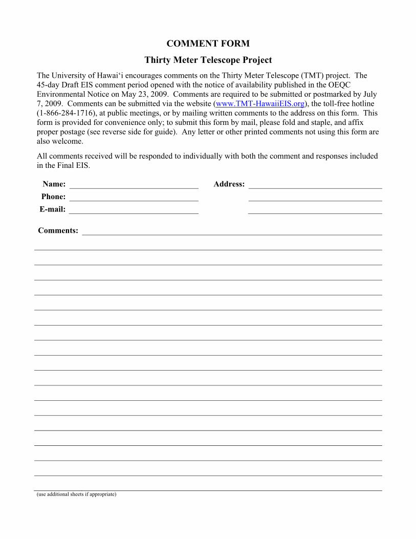
COMMENT FORM
Thirty Meter Telescope Project The University of Hawai‘i encourages comments on the Thirty Meter Telescope (TMT) project. The 45-day Draft EIS comment period opened with the notice of availability published in the OEQC Environmental Notice on May 23, 2009. Comments are required to be submitted or postmarked by July 7, 2009. Comments can be submitted via the website (www.TMT-HawaiiEIS.org), the toll-free hotline (1-866-284-1716), at public meetings, or by mailing written comments to the address on this form. This form is provided for convenience only; to submit this form by mail, please fold and staple, and affix proper postage (see reverse side for guide). Any letter or other printed comments not using this form are also welcome.
All comments received will be responded to individually with both the comment and responses included in the Final EIS.
Name: Address:
Phone:
E-mail:
Comments:
(use additional sheets if appropriate)

Fold Here Return Address: Place
Postage Here
University of Hawai‘i at Hilo Office of the Chancellor 200 W. K�wili Street Hilo, Hawai‘i 96720-4091 STAPLE HERE

Final EIS: TMT Observatory Page D-1
Appendix D. Cultural Impact Assessment Report


Final EIS: TMT Observatory Page D-3
Preface The Cultural Impact Assessment for the Thirty Meter Telescope (TMT) Observatory Project and TMT Mid-Level Facility Project, Maunakea, Ka‘ohe Ahupua‘a, H�m�kua District, Hawai‘i Island (the “TMT CIA”) provides a summary of traditional and historic background, from the perspective of the Native Hawaiian traditions, and summary of archaeological research for the Project area. Traditional and historic backgrounds and summaries of archaeological research are also available in the Archaeological Inventory Survey for the Thirty-Meter-Telescope (TMT) Observatory Project, Maunakea, Ka‘ohe Ahupua‘a, H�m�kua District, Hawai‘i Island (Appendix G of this Final EIS) and the Archaeological Study and Assessment for the Thirty-Meter-Telescope (TMT) Observatory Project Ancillary Facilities, Hale P�haku Area, Maunakea, Ka‘ohe Ahupua‘a, H�m�kua District, Hawai‘i Island (Appendix H of this Final EIS). Within the body of this Final EIS, historic and archaeological resources are discussed in Section 3.3, Archaeologic/Historic Resources.
The TMT CIA also provides summaries of community consultations with 29 persons (including interviews with 16 persons, four of them since the Draft EIS was completed) performed exclusively for the TMT CIA and describes potential mitigation measures reflecting those consultations. Cultural resources and the Project’s potential impact on cultural resources are discussed in Section 3.2, Cultural Resources, of this Final EIS. The discussion presented in Section 3.2 of this Final EIS includes information from the TMT CIA and from other sources. The TMT CIA includes only information collected during the development of the TMT CIA. For example, the TMT CIA does not include the following information, which is considered in Section 3.2 of the Final EIS:
� Comments received from individuals and organizations during the 45-day Draft EIS public review and comment period. Comments were received from Hawaiian Civic Clubs and Hawaiian and kama‘�ina individuals, among others, and are presented in Chapter 8, Volume 2, Responses to Comments, of this Final EIS.
� The Office of Hawaiian Affairs (OHA) adoption of a motion on July 2, 2009, that “In consideration of various cultural and economic factors, the OHA Board of Trustees resolves to support the selection of Maunakea, Hawai‘i as the site for the proposed Thirty Meter Telescope Project.”
As illustrated in the TMT CIA consultations and discussed in Section 3.2 of the Final EIS, there exists a wide range of opinions concerning the Project’s potential impacts on cultural resources and practices. Opinions range from recommendation for no further development of any kind on Maunakea, to support for astronomy on Maunakea, in coexistence with cultural practices, including construction of the TMT Observatory and support facilities.
As detailed in Section 3.2.4, Mitigation Measures, of this Final EIS, TMT has committed to a number of mitigation measures to address the Project’s potential impact to cultural resources. These include measures similar to the mitigation measures recommended in the TMT CIA, with the exception of locating the observatory on a recycled site (because of greater environmental effects associated with that location) and nominating the summit region as a Traditional Cultural Property (because only the land owner can make such a nomination). Beyond the measures identified in the TMT CIA, TMT has committed to a number of additional mitigation measures, including reduced observatory operations on identified days of cultural observance, collaboration with ‘Imiloa on a number of issues including exhibits regarding cultural resources that can be used at the Visitor Information Station (VIS) and other locations, and a Community Benefit Package (CBP).


O‘ahu Office P.O. Box 1114 Kailua, Hawai‘i 96734 Ph.: (808) 262-9972 Fax: (808) 262-4950
www.culturalsurveys.com
Maui Office 1993 Main St. Wailuku, Hawai‘i 96793 Ph: (808) 242-9882 Fax: (808) 244-1994
Cultural Impact Assessment for the Thirty Meter Telescope (TMT) Observatory Project and
TMT Mid-Level Facility Project, Maunakea, Ka‘ohe Ahupua‘a, H�m�kua District, Hawai‘i Island TMK: [3] 4-4-015:001 por., 009 por., 012 por.
Prepared for Parsons Brinckerhoff
Prepared by Mindy Simonson, M.A.
and Hallett H. Hammatt, Ph.D.
Cultural Surveys Hawai‘i, Inc. Kailua, Hawai‘i
(Job Code: MAUNA KEA 2)
February 2010

Cultural Surveys Hawai‘i Job Code: MAUNA KEA 2 Management Summary
CIA for the TMT Observatory and TMT Mid-Level Facility Project i TMK: [3] 4-4-015:001 por., 009 por., 012 por.
Management Summary Reference Cultural Impact Assessment for the Thirty Meter Telescope (TMT)
Observatory Project and TMT Mid-Level Project, Maunakea, Ka‘ohe Ahupua‘a, H�m�kua District, Hawai‘i Island, TMK: [3] 4-4-015:001 por., 009 por., 012 por.
Date February 2010 Project Number Cultural Surveys Hawai‘i (CSH) Job Code: MAUNA KEA 2 Project Location The proposed TMT Observatory Project area is located on the northern
plateau of the Maunakea summit area, within Area E of the Astronomy Precinct of the Mauna Kea Science Reserve. Approximately 3.5 miles south of the proposed TMT Observatory Project site, are the TMT Mid-Level Facility, two discreet parcels located in the Hale P�haku area, at approximately 2,800 m (9,200 ft.) elevation on the southern slope of Maunakea. The Project areas are depicted on the U.S. Geological Survey 7.5-Minute Series Topographic Map, Mauna Kea Quadrangle (1993) (Figure 1).
Land Jurisdiction State of Hawai‘i Agencies State of Hawai‘i Department of Health, Office of Environmental
Quality Control (DOH/OEQC), and State Historic Preservation Division (SHPD), Department of Land and Natural Resources (DLNR)
Project Description The proposed Thirty Meter Telescope (TMT) Observatory Project involves the construction of the TMT Observatory and associated infrastructure on an approximately 5-acre site within Area E of the Astronomy Precinct. Minimally, land disturbing activities would include grading of the TMT Observatory Project site and Access Way and excavations associated with building construction and installation of subsurface utilities.
The proposed TMT Mid-Level Facility includes construction staging areas and development of dormitories and offices for TMT Observatory Project construction personnel. The proposed Project also involves upgrades to the existing Hawai‘i Electric Light Company (HELCO) power substation near Hale P�haku. Minimally, land disturbing activities would include grading of the construction staging areas, and excavations associated with construction of dormitory/office building, installation of subsurface utilities, and substation upgrades.
In January 2010, Project proponent PB changed the acreage of the proposed TMT Mid-Level Facility near Hale P�haku from approximately six acres to 3.2 acres after the community consultation was conducted. The downsized acreage has been noted in this report along with figures that have been revised to depict the reduced acreage. In addition, the above paragraph contains language that has been changed at the request of PB after community consultation was

Cultural Surveys Hawai‘i Job Code: MAUNA KEA 2 Management Summary
CIA for the TMT Observatory and TMT Mid-Level Facility Project ii TMK: [3] 4-4-015:001 por., 009 por., 012 por.
completed.
Project Acreage The footprint of the proposed TMT Observatory Project ground disturbance measures approximately 5 acres. The footprint of the proposed TMT Mid-Level Facility measures approximately 3.2 acres (see Figures 1-3).
Area of Potential Effect (APE)
The APE for the TMT Observatory Project includes the entire approximately 36-acre Area E of the Astronomy Precinct, as the precise location of the 5-acre Project area has yet to be determined. The APE for the TMT Mid-Level Facility includes an approximately 6-acre area which includes the 3.2 acres now planned for use. The APE also includes the rest of the island of Hawai‘i and other Hawaiian Islands.
Document Purpose The Project requires compliance with the State of Hawai‘i environmental review process (Hawai‘i Revised Statutes [HRS] Chapter 343), which requires consideration of a proposed project’s effect on cultural practices and resources. At the request of Parsons Brinckerhoff (PB), CSH conducted this Cultural Impact Assessment (CIA). Through document research and cultural consultation efforts, this report provides information pertinent to the assessment of the proposed Projects’ impacts to cultural practices and resources (per the Office of Environmental Quality Control’s Guidelines for Assessing Cultural Impacts) which may include Traditional Cultural Properties (TCPs) of ongoing cultural significance that may be eligible for inclusion on the State Register of Historic Places, in accordance with Hawai‘i State Historic Preservation Statute (Chapter 6E) guidelines for significance criteria (HAR §13-275-6) under Criterion E. The document is intended to support the Project’s environmental review and may also serve to support the Project’s historic preservation review under HRS Chapter 6E-8 and Hawai‘i Administrative Rules (HAR) Chapter 13-275.
Consultation Effort Twenty-eight Hawaiian organizations, agencies and 38 community members were contacted in order to identify potentially knowledgeable individuals with cultural expertise and/or knowledge of the Project area and the vicinity. The agencies consulted include the State Historic Preservation Division (SHPD), the Office of Hawaiian Affairs (OHA), and the Hawai‘i Island Burial Council (HIBC) in addition to community groups such as Mauna Kea Anaina Hou, Royal Order of Kamehameha ‘E kahi, Mamalahoa, Hilo Chapter and Hale o Lono. This effort was made by letter, e-mail, telephone, and in person contact. In the majority of cases, letters were mailed along with a map and an aerial photograph of the Project area.
Note on Spelling of Maunakea
For this CIA, both spelling variations of the name Maunakea are used. The two word format—Mauna Kea—is used to address official entities such as the “Mauna Kea Science Reserve” and when quoting content

Cultural Surveys Hawai‘i Job Code: MAUNA KEA 2 Management Summary
CIA for the TMT Observatory and TMT Mid-Level Facility Project iii TMK: [3] 4-4-015:001 por., 009 por., 012 por.
from other sources such as books or past published interviews that include the name of the mountain as two words. All other uses of the mountain will be written as one word, Maunakea. See Section 3.2 on Place Names for further details on the spelling of Maunakea.
Results of Background Research
Background research conducted for this Project yields the following results:
1. Maunakea is a sacred cultural landscape; symbolic of W�kea (the ‘Sky Father’ to all Hawaiians), home of Poli‘ahu, the goddess of snow and foe of Pele (the fire goddess), and of many other resident deities and supernatural entities (e.g., L�l�noe, K�kahau‘ula and Mo‘oinanea) and the piko (umbilical cord) of the island-child, Hawai‘i which connects the land to the heavens (Maly and Maly 2005:v); home of Waiau, the highest permanent lake in the Hawaiian Islands; location of the highest and most extensive basalt quarry in all of Polynesia and perhaps the entire world; and numerous trails, ahu (stone markers), heiau (temple, place of worship) and cinder cone pu‘u (hills).
2. Maunakea is rich in mo‘olelo (legends), mele (songs), oli (chants), and ‘�lelo no‘eau (proverbs, poetical sayings) associated with akua (God, male and female deities, spirits) and storied places (wahi pana). Poli‘ahu, the snow goddess, and Pele, the volcano goddess, engaged in legendary battles to control Maunakea. Pele also had legendary battles with the pig demi-god Kamapua‘a on the summit of Maunakea. Numerous stories of W�kea and Papa, Poli‘ahu, L�l�noe, K�kahau‘ula and Mo‘oinanea, to name a few, are written into the landscape.
3. The TMT Observatory Project area is located on a plateau at 13,150 feet elevation north of the summit cone, Pu‘u K�kahau‘ula. The Hale P�haku Project area is located at approximately 9,200 feet in elevation. Maunakea, the tallest mountain in the Hawaiian Islands at 13,796 feet elevation, is also the tallest mountain on earth as measured from the ocean floor to the summit, a distance of some 29,500 feet (thus, exceeding by approximately 1,000 feet the non-volcanic Mount Everest).
4. Vegetation is almost non-existent in the summit region of Maunakea; the tree-line is located nearly a mile in elevation below the summit (at approximately 9,000 feet elevation); the highest major vegetation zone, known as the Alpine Scrub Zone, generally ends at approximately 11,300 feet elevation. Plants in the so-called Alpine Stone Desert Zone

Cultural Surveys Hawai‘i Job Code: MAUNA KEA 2 Management Summary
CIA for the TMT Observatory and TMT Mid-Level Facility Project iv TMK: [3] 4-4-015:001 por., 009 por., 012 por.
of the summit region are mostly limited to small lichens and mosses. More plant life is present in the Hale P�haku Project area characterized by scrub vegetation including a number of natives such as m�mane (Sophora chrysophylla), p�kiawe (Styphelia tameiameiae) and the endangered endemic, ‘�hinahina, also known as Maunakea silversword (Argyroxiphium sandwicense) as well as introduced exotics such as mullein (Verbascum thapsus) and various grasses.
5. Maunakea translates literally as white (kea) mountain (mauna), so named for its breathtaking snow-capped summit. However, according to N� Maka o ka ‘�ina (2008) and according to other authorities on Hawaiian culture (e.g., Kep� Maly, Pualani Kanahele), Maunakea has numerous other meanings and translations. It is a short version of Mauna a W�kea, a name that connects it to the sky father, W�kea; this would be one of its kaona (hidden or more subtle meanings).
6. Hale P�haku, literally “stone house,” refers to the two stone cabins constructed by the Civilian Conservation Corps in 1936 and 1939 at an elevation of 9,220 feet on the southern slope of Maunakea. L.W. Bryan, who served as the Territorial Forestry Office and oversaw the construction of the “stone houses,” also named them Hale P�haku.
7. Pu‘u Poli‘ahu is named for Poli‘ahu, “the woman who wears the snow mantle of Mauna Kea;” Poli‘ahu, which is also the name of a land division on Maunakea, is translated as “garment [for the] bosom (referring to the snow)” by Pukui et al. (1974) and as “Snow goddess of Mauna Kea. Lit. Bosom goddess” by Pukui and Elbert (1986). Maly and Maly include a citation by W.D. Alexander regarding the naming of Pu‘u Poli‘ahu. As the peak was nameless, Alexander called it “Poliahu” since it had “a poetical name, being that of the demigoddess with snow mantle who haunts Mauna Kea” (Maly and Maly 2005:200).
8. Waiau, the permanent lake located within Pu‘u Waiau near the summit of Maunakea at approximately 13,020 feet elevation, translates as “swirling water,” and is associated with the snow goddess Poli‘ahu and is guarded by the supernatural water spirit (mo‘o) known as Mo‘oinanea. Queen Emma went to the top of Maunakea to bathe in the waters of Waiau. The ceremony was to cleanse in Lake Waiau at the piko of the island. The water caught at Lake Waiau is considered pure water of the gods much like the

Cultural Surveys Hawai‘i Job Code: MAUNA KEA 2 Management Summary
CIA for the TMT Observatory and TMT Mid-Level Facility Project v TMK: [3] 4-4-015:001 por., 009 por., 012 por.
water caught in the piko of the kalo (taro) leaf and is thought of as being pure, therefore it is used medicinally (N� Maka o ka ‘�ina 2008).
9. The Mauna Kea Adze Quarry, also known as Ke-ana-k�ko‘i, “the adze-making cave” (Pukui et al. 1974:103), is located on the southern slopes of the mountain, at elevations up to 12,400 feet. The site was listed on the National Register of Historic Places in 1969, and the Hawai‘i State Register of Historic Places in 1981.
10. The ahupua‘a of Ka‘ohe was government land on which four native claims were made following the M�hele in 1848. Only one kuleana claim was awarded in the entire ahupua‘a. The single awarded claim indicates coffee, arrowroot, banana, and taro were all cultivated in the lands of Ka‘ohe. Ka‘ohe was also known as a habitat for uwa‘u, or ‘ua‘u (dark-rumped petrel) seabirds that reside in rocky, dry, elevated areas (Foster 1893).
11. While historic accounts and mo‘olelo tell of the presence burials on Maunakea (Maly and Maly 2005), archaeological evidence until recently, was relatively limited concerning confirmed human burials in the summit region. Prior to 2005, archaeological authorities on Maunakea, including Pat McCoy, had documented only one confirmed burial site (with multiple burials) and four possible burial sites in the summit region (McCoy 1991). All of these sites are located on Pu‘u M�kanaka to the northeast of the subject Project area. In progress work by McCoy and Nees however, has documented 28 sites designated as burials and possible burials (McCoy et al. 2008).
12. Several extensive cultural studies have been previously carried out for Maunakea (McEldowney 1982; Kanahele and Kanahele 1997; Maly 1998; Langlas et al. 1999; Maly 1999; PHRI 1999; Maly and Maly 2005). The most comprehensive study by Maly and Maly (2005) builds on archival and oral historical research conducted by the authors beginning in 1996 (to 2005) and presents a wide range of information on natural and cultural beliefs, resources and practices associated with Maunakea. Among the many critical findings of Maly and Maly’s (2005) cumulative research is the emphasis on Maunakea as a sacred landscape and native lore associated with traditional knowledge of the heavens—documenting 270 Hawaiian names for stars.
13. Past studies identify Traditional Cultural Properties (TCP)

Cultural Surveys Hawai‘i Job Code: MAUNA KEA 2 Management Summary
CIA for the TMT Observatory and TMT Mid-Level Facility Project vi TMK: [3] 4-4-015:001 por., 009 por., 012 por.
on Maunakea. Three places that have been identified by the SHPD as TCPs and documented in a study done by PHRI (1999) are: (1) K�kahau‘ula, the summit (Site 21438), (2) L�l�noe (Site 21439) and (3) Lake Waiau (Site 21440). Other traditional places may also qualify (see Figure 6). Maly (1998:29) has suggested the entire Maunakea summit region down to the 6,000 foot elevation contour be designated a Traditional Cultural Property see (Figure 16).
14. Archival and oral-historical evidence confirms that Maunakea has long been, and continues to be, a place where significant cultural practices are carried out: where, the piko of newborn children are taken to Pu‘u K�kahau‘ula and Lake Waiau to ensure long life and safety; the remains of individuals with generational ties to Maunakea are taken to pu‘u and the summit plateau for interment (Maly and Maly 2005:vi); shrines and stone markers are erected and; ceremonial and other activities occur related to birth, death, healing, navigation and more.
Summary of Community Consultation (Individuals)
CSH attempted to contact 60 community members (government agency or community organization representatives, or individuals such as cultural and lineal descendants, and cultural practitioners) for the purposes of this CIA. Twenty-five people responded and 14 k�puna (elders) and/or kama‘�ina (native born) were interviewed for more in-depth contributions. The results of cultural consultations indicate that there are major concerns (and several ancillary ones) regarding potential adverse impacts on cultural and natural resources and associated beliefs and practices as result of the proposed development of the Thirty Meter Telescope, construction of the staging area for the TMT Observatory Project and the HELCO electrical transformer needed to supply electrical power to the TMT Observatory Project:
1. All of the community members interviewed for this study stress that Maunakea is a sacred landscape and that any future development activities on the mountain proceed with greater awareness of, and the utmost respect for Hawaiian culture, Hawaiians’ spiritual connection to the mountain, and the sanctity of Maunakea.
2. Several participants discussed the association of Maunakea with other places in Polynesia, from its shared tradition of Polynesian celestial observation and navigation to its cultural and spiritual links in mo‘olelo (myths, legends, oral histories), wahi pana (legendary or storied places), mele (chants and songs) and poetical sayings as well as proverbs (�lelo no‘eau).
Cultural Surveys Hawai‘i Job Code: MAUNA KEA 2 Management Summary
CIA for the TMT Observatory and TMT Mid-Level Facility Project vii TMK: [3] 4-4-015:001 por., 009 por., 012 por.
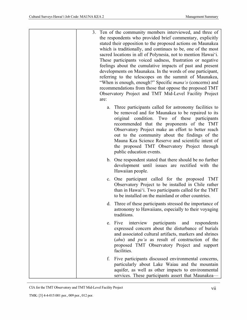
3. Ten of the community members interviewed, and three of the respondents who provided brief commentary, explicitly stated their opposition to the proposed actions on Maunakea which is traditionally, and continues to be, one of the most sacred locations in all of Polynesia, not to mention Hawai‘i. These participants voiced sadness, frustration or negative feelings about the cumulative impacts of past and present developments on Maunakea. In the words of one participant, referring to the telescopes on the summit of Maunakea, “When is enough, enough?” Specific mana‘o (concerns) and recommendations from those that oppose the proposed TMT Observatory Project and TMT Mid-Level Facility Project are:
a. Three participants called for astronomy facilities to be removed and for Maunakea to be repaired to its original condition. Two of these participants recommended that the proponents of the TMT Observatory Project make an effort to better reach out to the community about the findings of the Mauna Kea Science Reserve and scientific intent of the proposed TMT Observatory Project through public education events.
b. One respondent stated that there should be no further development until issues are rectified with the Hawaiian people.
c. One participant called for the proposed TMT Observatory Project to be installed in Chile rather than in Hawai‘i. Two participants called for the TMT to be installed on the mainland or other countries.
d. Three of these participants stressed the importance of astronomy to Hawaiians, especially to their voyaging traditions.
e. Five interview participants and respondents expressed concern about the disturbance of burials and associated cultural artifacts, markers and shrines (ahu) and pu‘u as result of construction of the proposed TMT Observatory Project and support facilities.
f. Five participants discussed environmental concerns, particularly about Lake Waiau and the mountain aquifer, as well as other impacts to environmental services. These participants assert that Maunakea—

Cultural Surveys Hawai‘i Job Code: MAUNA KEA 2 Management Summary
CIA for the TMT Observatory and TMT Mid-Level Facility Project viii TMK: [3] 4-4-015:001 por., 009 por., 012 por.
the principle aquifier and watershed for Hawai‘i Island—is being contaminated by human use (i.e., sewage and toxic chemicals leaching from astronomy facilities). Participants also mention the threatened endemic Maunakea W�kiu Bug (Nysius wekiuicola) and cleaning up trash left by visitors to Maunakea.
g. One participant notes that the entire Mauna Kea Science Reserve has been identified by SHPD as an historic district; suggesting that a Cultural Reserve be created and that the following landscape features qualify as TCPs: the Mauna Kea Adze Quarry Complex; the cluster of three pu‘u of K�kahau‘ula that make up the summit region of Maunakea; Lake Waiau; and L�l�noe, referring to the pu‘u southeast of the summit and within the Science Reserve (Section 7.7, Appendix D).
h. Five participants question legal aspects of the lease agreement between the University of Hawai‘i and the State and legitimacy of the Mauna Kea Science Reserve to operate on ceded and/or occupied lands.
i. Three participants question the benefits to the local economy and education promised by past and proposed telescope projects on Maunakea.
j. One participant commented on the view plane and noted that if the TMT project did proceed with development on Maunakea, it should be built away from sacred sites on the summit. S/he added that it should be built off the summit at the 13,000 ft. level near the VLBA (Very Long Base Array) Telescope Facility to avoid interfering with the major view planes of the summit area and to avoid being visibly intrusive from lower levels on the island (e.g., Waimea).
4. Three participants interviewed for this CIA, and one respondent who provided brief commentary, are in favor of the development of the TMT Observatory Project and its associated facilities on Maunakea. These participants recommend Project proponents proceed with care and respect to the sacredness of Maunakea and advised mitigation measures and/or alternatives to the current proposed design and location of the TMT Observatory Project and support facilities. In the words of one participant, “The future of Maunakea…can serve as an

Cultural Surveys Hawai‘i Job Code: MAUNA KEA 2 Management Summary
CIA for the TMT Observatory and TMT Mid-Level Facility Project ix TMK: [3] 4-4-015:001 por., 009 por., 012 por.
educational center and a place for man to view the stars and the universe but it has to remain a sacred and holy place. It’s like stepping into a sanctuary, a very sacred place of peace, a place that one can learn the things beyond what man knows now.” Concerns and recommendations from these participants are:
a. One participant believes the TMT Observatory Project should be built on a recycled site. He states that if an outdated telescope site on Maunakea is identified, the site should be recycled for TMT Observatory Project usage to avoid unnecessary intrusions that detracts from the beauty and majesty of Maunakea.
b. Oneparticipant calls for a process to be put in place that respects community and allows projects such as TMT Observatory Project telescope to continue.
c. One participant recommends the removal of all other telescopes and that only one telescope be utilized and shared by interested parties.
d. All three of these participants state that if the TMT Observatory Project proceeds, it should be developed to blend in with the natural setting and not detract from the natural beauty and sacredness of Maunakea.
5. Interviewees discussed salient features of the cultural landscape, resources and associated uses of Maunakea including, mo‘olelo about W�kea and Papa, Poli‘ahu, L�l�noe, K�kahau‘ula and Mo‘oinanea; the summit as an area where families take the piko of their babies to bury, and where the bones or ashes of deceased family members are placed; burials and burial complexes; shrines and stone markers; navigation traditions and astronomy; the adze quarry; ancient and historic trails; the healing and purifying waters of Lake Waiau and snow and ice collected for medicinal and ceremonial purposes; bird hunting; and other past and present cultural practices (see Sections 7 and 8).
Agency Responses CSH received comment in writing from the SHPD and OHA:
1. SHPD, responding in a memo sent on May 4, 2009 states, “As you may have discerned from the most recent Mauna Kea Comprehensive Management Plan (MCMP) for the UH Management Area (January 2009) and the public hearings for that plan that Maunakea is a very sensitive subject that truly needs and deserves more time to consider

Cultural Surveys Hawai‘i Job Code: MAUNA KEA 2 Management Summary
CIA for the TMT Observatory and TMT Mid-Level Facility Project x TMK: [3] 4-4-015:001 por., 009 por., 012 por.
all the cultural impacts to this iconic symbol of all cultural connections including but not limited to the genealogical connections, and the spiritual connections to all of the deities in the Hawaiian cosmos and to the kanaka maoli world view.” Additionally, SHPD recognizes Maunakea’s place in Hawaiian navigation as “the first sighting for voyaging canoes to arrive safely to our islands in the middle of the Pacific [and] a significant part of the Pacific Rim mythological connections to all the Pacific Rim.” SHPD recommends:
a. An assessment of buildings no longer functional be done before building new structures or “perhaps no more development on this sacred mountain;”
b. access for cultural practitioners be clearly addressed and defined;
c. the entire summit of Maunakea be treated as one traditional cultural landscape and not as a piecemeal analysis of just the Science Reserve and that;
d. more community outreach occur for all cultural impacts on the summit and the proposed area to properly assessed—see list of contacts in the MCMP.
2. OHA, responding in a letter dated January 9, 2009 (Appendix C), acknowledges the different perspectives on Maunakea as a spiritual, sacred place, home to “wao akua” (dwelling, place of the gods) and the place where the presence of numerous ahu and iwi k�puna provide silent testimony that generations of Hawaiians have worshipped and buried loved ones at “the highest point possible to rest in peace.” The “life sustaining waters known as Kanekawaiola…contribute to a healthy natural environment, which in turn allows man to thrive.” The letter describes the 40-year debate surrounding the development of Maunakea and recommends that the current proposed TMT Observatory Project study be viewed in context of this long history to “consider the overall impacts of development on Mauna Kea.” OHA suggests several parties for consultation. In a letter dated May 27, 2009, OHA wrote that the comments provided in their initial letter of January 9, 2009 remain the same (Appendix C), despite the addition of the TMT Mid-Level Facility Project area information to the CIA.
3. Both the SHPD and OHA asked that the current proposed

Cultural Surveys Hawai‘i Job Code: MAUNA KEA 2 Management Summary
CIA for the TMT Observatory and TMT Mid-Level Facility Project xi TMK: [3] 4-4-015:001 por., 009 por., 012 por.
TMT Observatory Project and TMT Mid-Level Facility Project be viewed in light of the long history of development on Maunakea and cumulative impacts to cultural resources and practices and not on an isolated basis.
Summary of Additional Community Consultation
After the DEIS, Project proponent PB requested CSH contact additional community members (government agency or community organization representatives, or individuals such as cultural and lineal descendants, and cultural practitioners) for the purposes of this CIA. Four individuals (Mr. Ed Stevens, Mr. Gene Leslie, Mr. Patrick Kahawaiola‘a, and Mrs. Ululani Sherlock) were referred by PB to CSH. The remaining four individuals (Mr. Paul Chung-Hoon of the Royal Order of Kamehameha, Superintendent Geraldine Bell, Dr. Pualani Kanahele, and Mrs. Cynthia Nazara) were contacted at the recommendation of Mrs. Sherlock. Of these eight, four people responded and two k�puna (elders) and/or kama‘�ina (native born) were interviewed for more in-depth contributions. The results of the additional community consultations indicate that there are major concerns (and several ancillary ones) regarding potential adverse impacts on cultural and natural resources and associated beliefs and practices as result of the proposed development of the Thirty Meter Telescope, construction of the staging area for the TMT Observatory Project and the HELCO electrical transformer needed to supply electrical power to the TMT Observatory Project:
1. All four of the additional community members contacted emphasize the historic and sacred place Maunakea occupies in Hawaiian beliefs and practices:
a. Two participants note that Maunakea should not be crowded with more telescopes, with one of the participants stating “culturally, there’s no more room for new telescopes on Mauna Kea…the most sacred part of Mauna Kea, the summit, is already overbuilt, overcrowded with telescopes.”
b. One respondent states “the entire Pu‘u is considered sacred from the ocean to the very top of Mauna Kea” and that “mere digging…is considered by most a desecration of Mauna Kea in itself.” Another participant calls for the observation of the sacredness of the mountain by not leaving anything manmade on the summit as to do so “diminishes the mana [power] that adds to the sacredness of Mauna Kea.” This same participant discusses “the three levels of transition” that an individual passes on the way to the summit, which lies at the 13,000 ft level and above,

Cultural Surveys Hawai‘i Job Code: MAUNA KEA 2 Management Summary
CIA for the TMT Observatory and TMT Mid-Level Facility Project xii TMK: [3] 4-4-015:001 por., 009 por., 012 por.
where only ali‘i (chiefs, royalty) and the priesthood could go.
c. One participant discusses the belief that Maunakea belongs to Hawaiians, stating that “the mountain, the highest part of the land, comes to us with an alloidal title.”
d. One participant described how traditional practitioners such as members of h�lau (meeting house for either canoe or hula instruction) or those from Royal Orders and Ali‘i Societies “often go to the Summit to perform their rituals, respects and present Ho‘okupu.” Another participant notes the ongoing practice of people bringing the “piko [umbilical cord] of their young ones [to the summit].”
2. Two participants express their preference for the de-commissioning of telescopes from the summit.
a. One participant states that telescopes should be taken out as they get older and near “obsolescence,” so that “the summit would be cleared whether it be 20 years or 50 years…there would be no remaining telescope facilities on the summit.”
b. One participant notes that if a replacement telescope is needed, then the lower northern plateau, the proposed location for the TMT, would be his area of preference for the replacement telescope, as that location is “more benign and [it] has less cultural artifacts that can be disturbed.”
3. Of the four who responded or were interviewed, three community members state their support for the development of the TMT Observatory Project and its associated facilities on Maunakea. However, they stress that any development of the TMT and its supporting facilities should be kept far away from any historic or cultural features and sites such as ahu and iwi k�puna. They also call for Project proponents to proceed with extreme care and respect for the sacredness of Maunakea in addition to addressing several critical issues:
a. One of these participants, the president of the Keaukaha Community Association, states that “the association is opposed to any new development, without some of it [telescopes] being taken down.” Another participant states that he does not see a

Cultural Surveys Hawai‘i Job Code: MAUNA KEA 2 Management Summary
CIA for the TMT Observatory and TMT Mid-Level Facility Project xiii TMK: [3] 4-4-015:001 por., 009 por., 012 por.
cultural impact, but if anything temporary will be put up, it should be taken down.
b. Another participant calls the TMT telescope “an outstanding piece of equipment” that has “amazing potential.” However, he stresses that before the TMT can go ahead, the master lease has to be revised and modified so that “it would be fair and equitable to all” with “appropriate compensation” to help educate students.
c. One participant notes that the proposed location for the TMT, the northern plateau, is an area that does not have iwi or heiau. However, he sees a problem regarding “the proximity to several pu‘u.” He adds that in the event that iwi are found, “they would have to stop.”
d. One participant points to the lack of “any cultural historic objects within a 200 ft. radius of the site” while another participant notes that the proposed supporting facilities such as dormitories and a cafeteria are necessary, and will have little or no impact at Hale P�haku.
4. All four community members stress their concern for cultural features and historic sites to remain undisturbed.
a. Two of these members discuss the importance of treating iwi k�puna with respect and extreme care if any additional burials are found.
b. One respondent recommends that k�puna from the ahupua‘a as well as the HIBC be consulted in the event that any inadvertent burial sites are uncovered during ground disturbances.
c. One participant notes that the location of burial caves on Maunakea are known only to the ‘ohana (family) caring for the iwi k�puna.
5. One respondent raises the issue of pollution. She asks who will be responsible for transporting waste and/or water run-off away from Maunakea. She voices concern about the light pollution that may be generated by the temporary dormitory at night. She also voices concerns about waste generated by hunters and tourists visiting Maunakea.
6. One participant provides the background, history and purpose of Kahu Ku Mauna (“Guardians of the Mountain”),

Cultural Surveys Hawai‘i Job Code: MAUNA KEA 2 Management Summary
CIA for the TMT Observatory and TMT Mid-Level Facility Project xiv TMK: [3] 4-4-015:001 por., 009 por., 012 por.
while another participant describes the group’s deep understanding of the cultural protocol for the mountain.
Summary of Community Consultation
For 15 participants in this cultural impact study, as well as a few invited participants who opted not to participate in the CIA study (see Section 6.1.1), there are no mitigation measures that could begin to address the variety of cultural concerns and concomitant issues (legal, economic and environmental) raised by the proposed actions; future developments are viewed as further desecration of a sacred mountain (a realm of the gods) and do not honor Maunakea’s place in Native Hawaiian contributions to navigation and astronomy. For seven participants in this assessment, careful planning, better attention to community desires and cultural concerns regarding protection of Maunakea, access to cultural and natural resources and other considerations suggest a way forward; the proposed actions are viewed as an extension of Native Hawaiian knowledge of the stars and voyaging traditions.
Recommendations Recommendations are based on a synthesis of all available findings to date, including background research and community consultation, gathered during preparation of this CIA. Some of the themes expressed in past CIAs and cultural studies completed for Maunakea (Sections 4.7 and 4.8) were echoed in this current assessment:
1. Based on the majority view of participants in this current study who have voiced their concerns against proposed actions on Maunakea, it was recommended that Project proponents strongly consider no further development, including the TMT Observatory Project and the TMT Mid-Level Facility at Hale P�haku, take place on Maunakea. Consequent to their determination of no action, it is further suggested that Project proponents consider alternative proposals and remediation measures suggested by CIA study participants (see Community Consultation Results above and Mitigation Measures below).
Mitigation Measures
The following mitigation measures are offered as a way to remediate and address present and future adverse impacts to Hawaiian cultural beliefs, practices and resources as result of developments on Maunakea generally, and specifically for the proposed TMT Observatory Project and TMT Mid-Level Facility Project:
1. Should the Project move forward in Hawai‘i, faithful attention to the following measures may help minimize adverse impacts:
a. As expressed by one participant in this current study and several participants in past cultural studies (see

Cultural Surveys Hawai‘i Job Code: MAUNA KEA 2 Management Summary
CIA for the TMT Observatory and TMT Mid-Level Facility Project xv TMK: [3] 4-4-015:001 por., 009 por., 012 por.
Maly 1998, 1999; Maly and Maly 2005), it is recommended that the TMT Observatory Project be built on a recycled site of an outdated telescope on the summit instead of Area E of the Northern Plateau.
b. An exit plan should be created, including an estimated life span for the TMT Observatory Project and a detailed strategy for the removal of the TMT Observatory Project from the summit of Maunakea, before development begins.
c. Cultural monitors should be present during ground disturbance and construction phases of the TMT Observatory Project and its TMT Mid-Level Facility Project. In addition, personnel involved in development activities in the Project area should be informed of the possibility of inadvertent cultural finds, including human remains. Should cultural or burial sites be identified during ground disturbance, all work should immediately cease, and the appropriate agencies notified pursuant to applicable law.
d. Access for all cultural practitioners to culturally significant sites on Maunakea should be clearly addressed, defined and allowed before, during and after construction of the TMT Observatory Project and its TMT Mid-Level Facility.
e. Project proponents should consider expansion and further development of education programs, such as the star gazing program at the annual Makahiki festival, that share the findings of the TMT Observatory and astronomy research with schools and the general public. At the same time, Project proponents should consider training programs for TMT Observatory staff that incorporate Polynesian perspectives in the study of astronomy.
f. Based on prior cultural studies (e.g., Maly 1998, PHRI 1999) and the statements of respondents in this CIA—including the SHPD—it is recommended that the landowners (State of Hawai‘i) explore the possibility of nominating the entire summit region of Maunakea, from the 6,000 foot level to the summit at Pu‘u K�kahau‘ula as Traditional Cultural Property for the State Register of Historic Places. The SHPD

Cultural Surveys Hawai‘i Job Code: MAUNA KEA 2 Management Summary
CIA for the TMT Observatory and TMT Mid-Level Facility Project xvi TMK: [3] 4-4-015:001 por., 009 por., 012 por.
maintains the Hawai‘i and National Register of Historic Places and processes all nominations to either register (see http://www.state.hi.us/dlnr/hpd/ hpinvntory.htm).
g. Generally, it is recommended that Project proponents—to employ a phrase used by OHA in their response letter for this CIA—develop a paradigmatic shift in how they engage with the community in a way that truly recognizes cumulative impacts and addresses interrelated concerns (cultural, legal, environmental and socio-economic) enumerated in this CIA report.

Cultural Surveys Hawai‘i Job Code: MAUNA KEA 2
CIA for the TMT Observatory and TMT Mid-Level Facility Project xvii TMK: [3] 4-4-015:001 por., 009 por., 012 por.
Table of Contents Management Summary ............................................................................................................ i�
Section 1 Introduction ............................................................................................................. 1�
1.1 Project Background ....................................................................................................................... 1�1.2 Document Purpose ......................................................................................................................... 2�1.3 Scope of Work ............................................................................................................................... 2�1.4 Environmental Setting for the TMT Observatory Project Area ..................................................... 6�
1.4.1 Natural Environment............................................................................................................... 6�1.4.2 Built Environment .................................................................................................................. 7�
1.5 Environmental Setting for TMT Mid-Level Facility ..................................................................... 7�1.5.1 Natural Environment............................................................................................................... 7�1.5.2 Built Environment .................................................................................................................. 8�
Section 2 Methods .................................................................................................................. 10�
2.1 Archival Research ........................................................................................................................ 10�2.2 Community Consultation ............................................................................................................. 10�
2.2.1 Sampling and Recruitment .................................................................................................... 10�2.2.2 Informed Consent Protocol ................................................................................................... 11�2.2.3 Interview Techniques ............................................................................................................ 11�2.2.4 Protection of Sensitive Information ...................................................................................... 12�
2.3 Compensation and Contributions to Community ........................................................................ 12�
Section 3 Traditional Background ........................................................................................ 14�
3.1 Overview ...................................................................................................................................... 14�3.2 Place Names ................................................................................................................................. 16�
3.2.1 Mauna Kea or Maunakea: Why is Maunakea spelled as one word? .................................... 16�3.3 Mo‘olelo Associated with Specific Place Names ........................................................................ 18�
3.3.1 Maunakea .............................................................................................................................. 18�3.3.2 H�loa and Kalo on Maunakea ............................................................................................... 21�3.3.3 K�kahau‘ula .......................................................................................................................... 22�3.3.4 Poli‘ahu ................................................................................................................................. 26�3.3.5 Poli‘ahu and Pele .................................................................................................................. 29�3.3.6 L�l�noe ................................................................................................................................... 30�3.3.7 Hale P�haku .......................................................................................................................... 30�
3.4 Cinder Cone Peaks ....................................................................................................................... 31�3.5 Lake Waiau .................................................................................................................................. 31�3.6 Mauna Kea Adze Quarry ............................................................................................................. 33�3.7 Religious Shrines ......................................................................................................................... 35�3.8 Burials .......................................................................................................................................... 35�3.9 Trails ............................................................................................................................................ 40�3.10 Oli (Chants), Pule (Prayers) and Mele (Songs) ......................................................................... 40�
Section 4 Historical Background .......................................................................................... 44�
4.1 Overview ...................................................................................................................................... 44�4.2 Early Post-Contact Period ............................................................................................................ 44�4.3 The M�hele .................................................................................................................................. 48�

Cultural Surveys Hawai‘i Job Code: MAUNA KEA 2
CIA for the TMT Observatory and TMT Mid-Level Facility Project xviii TMK: [3] 4-4-015:001 por., 009 por., 012 por.
4.4 Middle 19th Century ..................................................................................................................... 52�4.5 Late 19th century .......................................................................................................................... 53�
4.5.1 Humu‘ula Sheep Ranch ........................................................................................................ 53�4.6 Twentieth Century ....................................................................................................................... 54�4.7 Previous CIA and Cultural Studies for Maunakea ....................................................................... 54�
4.7.1 McEldowney (1982) ............................................................................................................. 56�4.7.2 Kanahele and Kanahele 1997 ............................................................................................... 58�4.7.3 Maly 1998 ............................................................................................................................. 58�4.7.4 Langlas et al. 1999 ................................................................................................................ 58�4.7.5 Maly 1999 ............................................................................................................................. 58�4.7.6 PHRI 1999 ............................................................................................................................ 59�4.7.7 Maly and Maly (2005) .......................................................................................................... 59�
4.8 Summary Observations ................................................................................................................ 60�
Section 5 Archaeological Research ....................................................................................... 64�
5.1 Overview ...................................................................................................................................... 64�5.2 Early Observations ....................................................................................................................... 69�5.3 Formal Studies ............................................................................................................................. 76�
5.3.1 Cleghorn (1982) .................................................................................................................... 76�5.3.2 McCoy (1982) ....................................................................................................................... 76�5.3.3 McCoy (1984) ....................................................................................................................... 77�5.3.4 McCoy (1985) ....................................................................................................................... 77�5.3.5 McCoy (1986) ....................................................................................................................... 78�5.3.6 Hammatt and Borthwick (1988) ........................................................................................... 78�5.3.7 Borthwick and Hammatt (1990) ........................................................................................... 78�5.3.8 Robins and Hammatt (1990) ................................................................................................. 78�5.3.9 Borthwick and Hammatt (1993) ........................................................................................... 79�5.3.10 McCoy (1999) ..................................................................................................................... 79�5.3.11 Hammatt and Shideler (2002) ............................................................................................. 80�5.3.12 Hammatt (2009a) ................................................................................................................ 80�5.3.13 Hammatt (2009b) ................................................................................................................ 80�5.3.14 McCoy et al. (2009 in progress) ......................................................................................... 81�5.3.15 McCoy and Nees (in progress) ........................................................................................... 81�5.3.16 Traditional Cultural Properties ........................................................................................... 81�
5.4 Summary Observations ................................................................................................................ 81�5.4.1 Burials and Possible Burials ................................................................................................. 81�5.4.2 Shrines .................................................................................................................................. 82�5.4.3 Adze Quarries and Manufacturing Workshops ..................................................................... 83�
Section 6 Community Consultation ...................................................................................... 84�
6.1 Community Consultation Effort .................................................................................................. 84�6.1.1 Community Respondents: A Note on Non-Participation ...................................................... 84�6.1.2 Community Outreach and Consultation Table ..................................................................... 85�
6.2 Other Statements ........................................................................................................................ 104�6.2.1 Office of Hawaiian Affairs ................................................................................................. 104�6.2.2 Mr. P.F. “Ski” Kwiatkowski ............................................................................................... 104�6.2.3 Mr. Isaac Harp .................................................................................................................... 106�
Section 7 Summaries of Kama‘�ina “Talk Story” Interviews ......................................... 111�

Cultural Surveys Hawai‘i Job Code: MAUNA KEA 2
CIA for the TMT Observatory and TMT Mid-Level Facility Project xix TMK: [3] 4-4-015:001 por., 009 por., 012 por.
7.1 Talk Story Interviews................................................................................................................. 111�7.2 Acknowledgements .................................................................................................................... 111�7.3 Mr. Arthur Mahi ........................................................................................................................ 111�7.4 Mr. Kalikokalehua Kanaele ....................................................................................................... 113�7.5 Mr. Kimo Keali‘i Pihana ........................................................................................................... 118�7.6 Mr. and Mrs. Burt and Sheila Okin ........................................................................................... 130�7.7 Ms. Kealoha Pisciotta ................................................................................................................ 131�7.8 Mr. Leningrad Elarionoff ........................................................................................................... 146�7.9 Ms. Ku‘ulei Keakealani ............................................................................................................. 152�7.10 Mr. George Van Gieson ........................................................................................................... 158�7.11 Mr. Kelly Greenwell ................................................................................................................ 161�7.12 Mr. Daniel Akaka, Jr................................................................................................................ 166�7.13 Mr. Clarence Kukauakahi “Ku” Ching .................................................................................... 169�7.14 Additional Statements .............................................................................................................. 171�
7.14.1 Mrs. Cynthia Nazara ......................................................................................................... 171�7.14.2 Mrs. Ululani Sherlock ....................................................................................................... 171�
7.15 Additional Interviews .............................................................................................................. 172�7.15.1 Mr. Ed Stevens .................................................................................................................. 172�7.15.2 Mr. Patrick Kahawaiola‘a ................................................................................................. 178�
Section 8 Cultural Landscape of Maunakea ...................................................................... 181�
8.1 Overview .................................................................................................................................... 181�8.1.1 Gathering and Hunting Practices ........................................................................................ 181�8.1.2 Freshwater and Marine Resources ...................................................................................... 182�8.1.3 Cultural and Historic Properties ......................................................................................... 184�8.1.4 Burials ................................................................................................................................. 187�8.1.5 Trails ................................................................................................................................... 189�8.1.6 Wahi Pana (Storied Places) ................................................................................................. 191�
Section 9 Summary and Recommendations ...................................................................... 195�
9.1 Results of Background Research ............................................................................................... 195�9.2 Summary of Community Consultation (Individuals) ................................................................ 197�9.3 Agency Responses ..................................................................................................................... 200�9.4 Summary of Additional Community Consultation .................................................................... 201�9.5 Summary of Community Consultation ...................................................................................... 203�9.6 Recommendations ...................................................................................................................... 203�9.7 Mitigation Measures .................................................................................................................. 204�
Section 10 References Cited ................................................................................................ 206�
Appendix A Authorization and Release Form .................................................................. A-1�
Appendix B Executive Summary Copied from Maly and Maly (2005:v-viii) ................ B-1�
Appendix C Office of Hawaiian Affairs Letters ................................................................ C-1�
Appendix D Written Testimony of Kealoha Pisciotta ...................................................... D-1�
Appendix E Resolution on TMT Observatory (Isaac Harp) ............................................ E-1�

Cultural Surveys Hawai‘i Job Code: MAUNA KEA 2
CIA for the TMT Observatory and TMT Mid-Level Facility Project xx TMK: [3] 4-4-015:001 por., 009 por., 012 por.
Appendix F TMT Mid-Level Facility Map ......................................................................... F-1�

Cultural Surveys Hawai‘i Job Code: MAUNA KEA 2
CIA for the TMT Observatory and TMT Mid-Level Facility Project xxi TMK: [3] 4-4-015:001 por., 009 por., 012 por.
List of Figures
Figure 1. U.S. Geological Survey 7.5-Minute Series Topographic Map, Mauna Kea Quadrangle (1993), showing the location of the Project areas ................................................................3
Figure 2. Portion of Tax Map Key (TMK) 4-4-015, showing the location of the Project areas .....4 Figure 3. Aerial photograph (source: U.S.D.A. 2000), showing the location of the Project areas ..5 Figure 4. U.S. Geological Survey Topographic Map, Mauna Kea Quadrangle (1993) with
overlay of the Soil Survey of the Island of Hawai‘i (Sato et al. 1973), showing sediment types within the Project areas ..............................................................................................9
Figure 5. The summit region of Maunakea showing some of its main cinder-cone pu‘u and an astronomical observatory, top center of the image (source: Ziegler 2002) .......................14
Figure 6. Culturally significant landscape sites and features in the vicinity of the Project area ...15 Figure 7. A representative large debris pile of discarded flakes and adze preforms at the
Maunakea quarry site (source: Kirch 1985) .......................................................................34 Figure 8. Detail of one of the rockshelter sites associated with the Mauna Kea Adze Quarry
showing many preforms (source: Kirch 1985) ..................................................................34 Figure 9. Photograph of cinder cones of Maunakea with Waiau (lower left) (Brigham 1909) .....45 Figure 10. 1909 photograph of Lake Waiau from Brigham ..........................................................46 Figure 11. Recent 2009 photograph of Lake Waiau (source: CSH Researcher Brian Cruz) .........46 Figure 12. Photograph of cinder cones of Maunakea from Hitchcock (1911) ..............................47 Figure 13. Hitchcock’s copy of W.D. Alexander’s 1892 map of the summit region ....................47 Figure 14. Portion of 1862 S.C. Wiltse map of Humu‘ula (R.M. 668) showing the location of the
Project areas .......................................................................................................................50 Figure 15. Portion of 1892 C.J. Lyons map (R.M. 1641) of Ka‘ohe, H�m�kua and Humu‘ula
showing the location of the TMT Observatory Project area ..............................................51 Figure 16. Map showing the proposed Traditional Cultural Property boundaries at the Maunakea
summit region down to the 6,000 foot elevation contour based on Maly (1999) ..............62 Figure 17. Map showing the three SHPD designated TCPs in the Maunakea summit region
(adapted from McCoy et al. 2008:2-25) ............................................................................63 Figure 18. Traditional Hawaiian religious shrine at the Mauna Kea Adze Quarry (source: Kirch
1985) ..................................................................................................................................65 Figure 19. Map showing historic properties in the Maunakea summit region (adapted from
McCoy et al. 2008:2-16) ....................................................................................................66 Figure 20. Map showing find spots in the Maunakea summit region (adapted from McCoy et al.
2008:2-33) ..........................................................................................................................67 Figure 21. Map showing historic properties near the Hale P�haku Project area (adapted from
McCoy et al. 2008:2-21) ....................................................................................................68 Figure 22. May 4, 2009 SHPD memo response...........................................................................103 Figure 23. Leningrad Elarionoff shows the lehua from one of the ‘�hi‘a trees he has
grown.(source: CSH Researcher Margaret Magat) ..........................................................148 Figure 24. Salmon-colored lehua on an ‘�hi‘a tree tended by Mr. Elarionoff in Waimea Nature
Park.(source: CSH Researcher Margaret Magat) .............................................................149 Figure 25. Mr. Danny Akaka Jr. stands in front of one of Mauna Lani’s fishponds.(source: CSH
Researcher Margaret Magat) ............................................................................................168 Figure 26. Photograph of the snow-covered shoreline of Lake Waiau by CSH (2009) ..............184

Cultural Surveys Hawai‘i Job Code: MAUNA KEA 2
CIA for the TMT Observatory and TMT Mid-Level Facility Project xxii TMK: [3] 4-4-015:001 por., 009 por., 012 por.
Figure 27. Lele at Pu‘u K�kahau‘ula on the summit of Maunakea built in 1997 by the Royal Order of Kamehameha (source: CSH) .............................................................................186
List of Tables Table 1. LCA claims in Ka‘ohe Ahupua‘a ....................................................................................48 Table 2. Maunakea Management Plans .........................................................................................55 Table 3. Cultural Studies in the Maunakea Summit Area .............................................................56 Table 4. Archaeological Studies in the Maunakea Summit Area ..................................................71 Table 5. Documented Archaeological Sites in the Summit Region...............................................73 Table 6. Community Contacts and Consultation Effort ................................................................89

Cultural Surveys Hawai‘i Job Code MAUNA KEA 2 Introduction
CIA for the TMT Observatory and TMT Mid-Level Facility Project 1 TMK: [3] 4-4-015:001 por., 009 por., 012 por.
Section 1 Introduction
1.1 Project Background Cultural Survey Hawai‘i, Inc. (CSH) conducted this Cultural Impact Assessment (CIA) for
the proposed construction and operation of the Thirty Meter Telescope Observatory Project (TMT), an optical-infrared telescope on an estimated 5 acres of presently undeveloped land of the 525-acre Astronomy Precinct of the Science Reserve near the top of Maunakea. Approximately 3.5 miles south of the proposed TMT Observatory Project site, is the TMT Mid-Level Facility, two discreet parcels located in the Hale P�haku area, at approximately 2,800 m (9,200 ft.) elevation on the southern slope of Maunakea. The Project would be located in Ka‘ohe Ahupua‘a, H�m�kua District, on the island of Hawai‘i, on a portion of TMK: (3) 4-4-015: 009 and 012 (Figures 1 through 3).
The proposed TMT Observatory Project would be located within the western portion of the area known as the northern plateau within the Astronomy Precinct. More specifically, the area being considered is the general vicinity of the 36-acre area designed Area E in the Mauna Kea Science Reserve Master Plan (UH 2000). Area E ranges in elevation from 13,100 to 13,300 feet and is located approximately half a mile northwest of the nine existing optical-infrared telescopes located near the summit at elevations of 13,600 to 13,775 feet. The entire Mauna Kea Science Reserve is designated part of the State of Hawai‘i Conservation District, resource subzone. Ancillary facilities include an access road from the end of the current Access Way near the summit to the new telescope site would need to be developed.
When the TMT Observatory Project’s CIA consultation was initiated on November 24, 2008, communication with Project proponents indicated that the proposed Thirty Meter Telescope CIA consisted mainly of the actual construction of the TMT Observatory Project within the 36-acre area known as Area E in the Mauna Kea Science Reserve Master Plan. In February 2009, CSH was informed that the TMT Observatory Project will also include a construction staging area located at the 9,200 foot level Hale P�haku site, approximately 3.5 miles south of the proposed TMT Observatory Project site. Additionally, included in the proposed TMT Observatory Project description is a new electrical transformer to be installed at the Hawaiian Electric Light Company (HELCO) site located at the Hale P�haku site. For this reason, CSH sent out a second round of community consultation letters in February 2009 to include the additional information regarding the construction staging area and the electrical transformer in order to provide community participants the opportunity to provide further comments and concerns.
The footprint of the proposed ground disturbance for the TMT Observatory Project measures approximately 5 acres. However, the precise 5-acre Project area is not yet determined, so the entire approximately 36-acre Area E of the Astronomy Precinct is included in the Project area. The Area of Potential Effect (APE) for this TMT Observatory includes the 36-acre area of the possible construction footprint as well as the approximately 6-acre which includes the 3.2 acres now planned for the proposed TMT Mid-Level Facility. For the purposes of this CIA, the APE considers the Project area/s within the larger cultural context of the ahupua‘a of Ka‘ohe; Hawai‘i Island and other islands of Hawai‘i. This assessment further includes consideration of the cumulative effects of the proposed Project on traditional Hawaiian practices and resources in and around the Project area.

Cultural Surveys Hawai‘i Job Code MAUNA KEA 2 Introduction
CIA for the TMT Observatory and TMT Mid-Level Facility Project 2 TMK: [3] 4-4-015:001 por., 009 por., 012 por.
On May 11, 2009, an updated map of the TMT Mid-Level Facility was provided by project proponents for this assessment and has been inserted in Appendix F. It is important to note that this updated map of the TMT Mid-Level Facility was not used in the community consultation efforts for this assessment. Additionally, on January 2010, the acreage of the proposed TMT Mid-Level Facility near Hale P�haku was changed by PB from approximately six acres to 3.2 acres after the community consultation was conducted. The downsized acreage has been noted in this report along with figures that have been revised to depict the reduced acreage.
1.2 Document Purpose The Project requires compliance with the State of Hawai‘i environmental review process
[Hawai‘i Revised Statutes (HRS) Chapter 343], which requires consideration of a proposed Project’s effect on cultural practices. CSH conducted this CIA at the request of Parsons Brinckerhoff (PB). Through document research and cultural consultation efforts this report provides information pertinent to the assessment of the proposed Project’s impacts to cultural practices and resources (per the Office of Environmental Quality Control’s Guidelines for Assessing Cultural Impacts) which may include Traditional Cultural Properties (TCPs) of ongoing cultural significance that may be eligible for inclusion on the State Register of Historic Places, in accordance with Hawai‘i State Historic Preservation Statute (Chapter 6E) guidelines for significance criteria (HAR §13-275-6) under Criterion E which states to be significant an historic property shall:
Have an important value to the Native Hawaiian people or to another ethnic group of the state due to associations with cultural practices once carried out, or still carried out, at the property or due to associations with traditional beliefs, events or oral accounts—these associations being important to the group’s history and cultural identity.
The document is intended to support the Project’s environmental review and may also serve to support the Project’s historic preservation review under HRS Chapter 6E-8 and Hawai‘i Administrative Rules Chapter 13-275.
1.3 Scope of Work The scope of work for this CIA includes:
1. Examination of cultural and historical resources, including Land Commission documents, historic maps, and previous research reports, with the specific purpose of identifying traditional Hawaiian activities including gathering of plant, animal, and other resources as may be indicated in the historic record.
2. A review of previous archaeological work at and near the subject parcel that may be relevant to reconstructions of traditional land use activities; and to the identification and description of cultural resources, practices, and beliefs associated with the parcel.

Cultural Surveys Hawai‘i Job Code MAUNA KEA 2 Introduction
CIA for the TMT Observatory and TMT Mid-Level Facility Project 3 TMK: [3] 4-4-015:001 por., 009 por., 012 por.
Figure 1. U.S. Geological Survey 7.5-Minute Series Topographic Map, Mauna Kea Quadrangle (1993), showing the location of the Project areas

Cultural Surveys Hawai‘i Job Code MAUNA KEA 2 Introduction
CIA for the TMT Observatory and TMT Mid-Level Facility Project 4 TMK: [3] 4-4-015:001 por., 009 por., 012 por.
Figure 2. Portion of Tax Map Key (TMK) 4-4-015, showing the location of the Project areas

Cultural Surveys Hawai‘i Job Code MAUNA KEA 2 Introduction
CIA for the TMT Observatory and TMT Mid-Level Facility Project 5 TMK: [3] 4-4-015:001 por., 009 por., 012 por.
Figure 3. Aerial photograph (source: U.S.D.A. 2000), showing the location of the Project areas

Cultural Surveys Hawai‘i Job Code MAUNA KEA 2 Introduction
CIA for the TMT Observatory and TMT Mid-Level Facility Project 6 TMK: [3] 4-4-015:001 por., 009 por., 012 por.
3. Consultation and interviews with knowledgeable parties regarding traditional cultural practices at or near the parcel; present uses of the parcel; and/or other (non-Hawaiian) practices, uses, or traditions associated with the parcel.
4. Preparation of a report that summarizes the results of these research activities and provides recommendations based on findings.
1.4 Environmental Setting for the TMT Observatory Project Area
1.4.1 Natural Environment The information in this subsection is based on the following primary sources: Macdonald et
al. (1983), Juvik and Juvik (1998) and Ziegler (2002).
The TMT Observatory Project area is located on a plateau at 13,150 feet elevation north of the summit cone, Pu‘u K�kahau‘ula. Maunakea, the tallest mountain in the Hawaiian Islands at 13,796 feet elevation, is also the tallest mountain on earth as measured from the ocean floor to the summit, a distance of some 29,500 feet (thus, exceeding by approximately 1,000 feet the non-volcanic Mount Everest). This massive “shield volcano,” one of five making up the island of Hawai‘i (the others are Maunaloa, K�lauea, Kohala and Hual�lai), has formed through the action of the Pacific Plate moving over a more or less stable “hot spot” located deep within the earth that generates magma (molten rock). The oldest exposed basalts (cooled magma) from Maunakea have been dated to approximately 250,000 years ago, and the mountain is in its dormant Postshield Stage (highly unlikely to erupt but possible). No historic (i.e., prior to the late 1700s) eruptions have been reported for Maunakea, which last erupted approximately 4,500 years ago.
Unlike mountain-top regions in other parts of Hawai‘i Island and the rest of the Hawaiian Islands, the summit of Maunakea is actually very arid, receiving less than 15 inches of rainfall, and appropriately classified as an “alpine desert.” Most of precipitation is in the form of freezing fog and snow. This aridity is due to a meteorological phenomenon known as the “inversion layer,” in which a layer of relatively warm air between approximately 5,000 and 7,000 feet elevation impedes the upward rising of relatively cooler, moisten-laden air.
Light snows are common in the “winter months” at the summit, and frost is a nightly occurrence year-round. The monthly average temperature ranges from 25 to 60 degrees Fahrenheit with winter storms often depositing up to several feet of snow in the higher elevations. Maunakea was glaciated (i.e., covered with snow and ice-pack that did not melt during the summer) in the Late Pleistocene, and the primary geological activity shaping the summit terrain is glaciation. Several main glacial features present on the summit region include glacial striations on bedrock outcrop, the sculpted configuration of cinder cones, and the formation of Lake Waiau and P�hakuloa Gulch as a result of glacial melt-water. The summit region’s ground surface is generally characterized by rubbly ground moraine deposits and Hawaiite ‘a‘� flows of Late Pleistocene origin (Figure 4), partially mantled by cinder, coarse ash, and spindle bombs (McCoy 1982:A-29). The lowest temperature ever recorded in historic times in the Hawaiian Islands (9°F) was atop Maunakea. Permafrost is still present a few meters below the present ground surface in the summit region.

Cultural Surveys Hawai‘i Job Code MAUNA KEA 2 Introduction
CIA for the TMT Observatory and TMT Mid-Level Facility Project 7 TMK: [3] 4-4-015:001 por., 009 por., 012 por.
Vegetation is almost non-existent in the summit region of Maunakea; the tree-line is located nearly a mile in elevation below the summit (at approximately 9,000 feet elevation); the highest major vegetation zone, known as the Alpine Scrub Zone, generally ends at approximately 11,300 feet elevation. Plants in the so-called Alpine Stone Desert Zone of the summit region are mostly limited to small lichens and mosses. However, due to daily convection currents (warm winds moving upslope), the summit experiences a special type of local ecosystem known as the High-Altitude Aeolian Ecosystem in which insects and other small arthropods (and sometimes small birds) are driven up to the summit, whose low temperatures immediately kill or immobilize them. The endemic Maunakea W�kiu Bug (Nysius wekiuicola), which has lost the ability to fly, has developed a remarkable specialization (extremely low body temperature that withstands below-freezing conditions) that allows it to feed on immobilized or dead insects and arthropods driven up by the wind. According to Ziegler (2002:209), there are other similar creatures in this most forbidding environment, including a non-described species of black rock centipede only 1 cm long.
As discussed in more detail below, it is important to understand that Native Hawaiians were utilizing this Alpine Stone Desert Zone in pre-Contact times, as evidenced by the extraordinary (State and National Register of Historic Places site) Mauna Kea Adze Quarry, one of the largest traditional adze quarries in the world, located up to 12,400 feet elevation, a little over two miles south of the TMT Observatory Project area; and as indicated by many dozens of shrines at or above 13,000 feet elevation. The basalt available between approximately 11,000 and 12,400 feet elevation on Maunakea is generally perceived by expert stone workers to be the highest quality material available in the Hawaiian Islands. Several old trails exist in and around the TMT Observatory Project area that testify to the long-term utilization of the Alpine Stone Desert by the Native Hawaiians.
1.4.2 Built Environment The TMT Observatory Project area is located at the end of an existing 4-wheel-drive road that
was originally built in the 1960s to develop the general summit area for a number of astronomical observatories. Today, there are 13 main observatories and associated facilities located in the general vicinity of the TMT Observatory Project area.
1.5 Environmental Setting for TMT Mid-Level Facility
1.5.1 Natural Environment The environmental setting of the Hale P�haku area has been well described by McCoy
(1990:237-92; 1991:4-9) and the reader is referred to his work for a thorough study and references. A brief overview is presented in this study, based on Dr. McCoy’s work. The current TMT Mid-Level Facility Project area is located on a gently sloping saddle area surrounded by prominent cinder cones, including Pu‘u Kalepeamoa, Pu‘u Ha‘iwahine, and Kilohana. Pu‘u Kalepeamoa is understood as an older hawaii-ite cone which contains a large number of cored bombs many of which are formed of angular mafic blocks with dunnite and gabbro inclusions (McCoy 1991:6). Pu‘u Kalepeamoa is understood as the likely source for much of the raw material worked at the Pu‘u Kalepeamoa site complex (see Section 5.3 and Table 4). The

Cultural Surveys Hawai‘i Job Code MAUNA KEA 2 Introduction
CIA for the TMT Observatory and TMT Mid-Level Facility Project 8 TMK: [3] 4-4-015:001 por., 009 por., 012 por.
surrounding geology includes cinder cones, lava flows and air fall deposits termed Laupahoehoe Volcanics understood as probably less than 40,000 years old.
Elevations within the TMT Mid-Level Facility Project area range from approximately 2,780-2,805 m (9,120-9,200 ft.) above mean sea level. The TMT Mid-Level Facility Project area receives an average of approximately 650 mm (26 in.) of annual rainfall (Giambelluca et al. 1986). Sediments within the TMT Mid-Level Facility Project area are listed as Huikau Extremely Stony Loamy Sand (rHLD) and Cinder Land (rCL) (see Figure 4). Soils of the Huikau Series are described as “somewhat excessively drained loamy sands that formed in volcanic ash, pumice, and cinders” (Sato et al. 1973). Cinder Land is described as “bedded cinders, pumice, and ash…The particles have jagged edges and a glassy appearance and show little or no evidence of soil development” (Sato et al. 1973).
The TMT Mid-Level Facility Project area lies close to the timberline and the vegetation is generally a subalpine xerophytic scrub of both native and non-native, introduced plants such as p�kiawe (Styphelia tameiameiae), noho-anu (Geranium cuneatum), ‘�helo (Vaccinium reticulatum), na‘ena‘e (Raillardia ciliolata), kalamoho fern (Pellaea ternifolia), ‘�heahea (Chenopodium oahuensis), pilo (Coprosma montana), m�mane (Sophora chrysophylla) and the endangered endemic, ‘�hinahina, also known as Maunakea silversword (Argyroxiphium sandwicense), as well as introduced exotics such as mullein (Verbascum thapsus) and a variety of native and exotic grasses. It seems probable that prior to human utilization of this area, and the presence of feral goats and sheep, that the m�mane vegetation was more extensive and diverse (McCoy 1990:91). The work of McCoy (1990) has also emphasized the “non-subsistence” nature of this alpine environment, and it is understood that virtually all food to support temporary habitation in the area would have been imported from lower elevations.
1.5.2 Built Environment The eastern portion of the TMT Mid-Level Facility Project area is adjacent to the Mauna Kea
Access Way and includes components of the Hale P�haku Mid-Level Astronomy Facilities. Development in the Hale P�haku area includes the Onizuka Center for International Astronomy, the Visitor Information Station (a.k.a. Ranger Station), and construction laborer residences. The construction laborer residences are located within the current TMT Mid-Level Facility Project area and include two dormitory structures and four cabins. The western portion of the TMT Mid-Level Facility Project area consists of the existing HELCO power substation within a fenced enclosure. The vicinity of the TMT Mid-Level Facility Project area is generally undeveloped, with the exception of jeep roads.

Cultural Surveys Hawai‘i Job Code MAUNA KEA 2 Introduction
CIA for the TMT Observatory and TMT Mid-Level Facility Project 9 TMK: [3] 4-4-015:001 por., 009 por., 012 por.
Figure 4. U.S. Geological Survey Topographic Map, Mauna Kea Quadrangle (1993) with overlay of the Soil Survey of the Island of Hawai‘i (Sato et al. 1973), showing sediment types within the Project areas
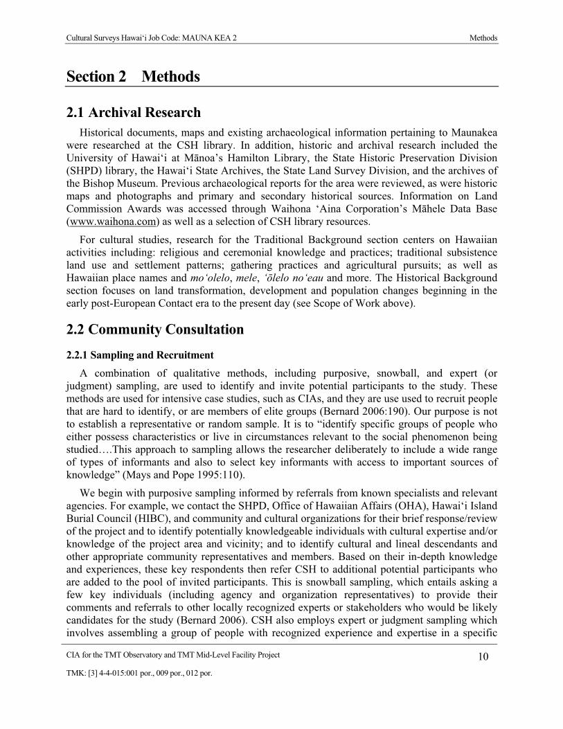
Cultural Surveys Hawai‘i Job Code: MAUNA KEA 2 Methods
CIA for the TMT Observatory and TMT Mid-Level Facility Project 10 TMK: [3] 4-4-015:001 por., 009 por., 012 por.
Section 2 Methods
2.1 Archival Research Historical documents, maps and existing archaeological information pertaining to Maunakea
were researched at the CSH library. In addition, historic and archival research included the University of Hawai‘i at M�noa’s Hamilton Library, the State Historic Preservation Division (SHPD) library, the Hawai‘i State Archives, the State Land Survey Division, and the archives of the Bishop Museum. Previous archaeological reports for the area were reviewed, as were historic maps and photographs and primary and secondary historical sources. Information on Land Commission Awards was accessed through Waihona ‘Aina Corporation’s M�hele Data Base (www.waihona.com) as well as a selection of CSH library resources.
For cultural studies, research for the Traditional Background section centers on Hawaiian activities including: religious and ceremonial knowledge and practices; traditional subsistence land use and settlement patterns; gathering practices and agricultural pursuits; as well as Hawaiian place names and mo‘olelo, mele, ‘�lelo no‘eau and more. The Historical Background section focuses on land transformation, development and population changes beginning in the early post-European Contact era to the present day (see Scope of Work above).
2.2 Community Consultation
2.2.1 Sampling and Recruitment A combination of qualitative methods, including purposive, snowball, and expert (or
judgment) sampling, are used to identify and invite potential participants to the study. These methods are used for intensive case studies, such as CIAs, and they are use used to recruit people that are hard to identify, or are members of elite groups (Bernard 2006:190). Our purpose is not to establish a representative or random sample. It is to “identify specific groups of people who either possess characteristics or live in circumstances relevant to the social phenomenon being studied….This approach to sampling allows the researcher deliberately to include a wide range of types of informants and also to select key informants with access to important sources of knowledge” (Mays and Pope 1995:110).
We begin with purposive sampling informed by referrals from known specialists and relevant agencies. For example, we contact the SHPD, Office of Hawaiian Affairs (OHA), Hawai‘i Island Burial Council (HIBC), and community and cultural organizations for their brief response/review of the project and to identify potentially knowledgeable individuals with cultural expertise and/or knowledge of the project area and vicinity; and to identify cultural and lineal descendants and other appropriate community representatives and members. Based on their in-depth knowledge and experiences, these key respondents then refer CSH to additional potential participants who are added to the pool of invited participants. This is snowball sampling, which entails asking a few key individuals (including agency and organization representatives) to provide their comments and referrals to other locally recognized experts or stakeholders who would be likely candidates for the study (Bernard 2006). CSH also employs expert or judgment sampling which involves assembling a group of people with recognized experience and expertise in a specific

Cultural Surveys Hawai‘i Job Code: MAUNA KEA 2 Methods
CIA for the TMT Observatory and TMT Mid-Level Facility Project 11 TMK: [3] 4-4-015:001 por., 009 por., 012 por.
area (http://www.socialresearchmethods.net/kb/sampnon.php; Bernard 2006). CSH maintains a database that draws on over two decades of established relationships with community contacts: cultural practitioners and specialists, community representatives and cultural and lineal descendants. The names of new potential contacts are also provided by colleagues at CSH and from the researchers’ familiarity with people who live in or around the study area. Researchers often attend public forums (e.g., Neighborhood Board, Burial Council and Civic Club meetings) in (or near) the study area to scope for participants. A discussion of the consultation process can be found in Section 6 on Community Consultations. Please refer to Table 6, Section 6 for a complete list of individuals and organizations contacted.
CSH focuses on obtaining in-depth information with a high level of validity from a focused group of relevant stakeholders and local experts. Our qualitative methods do not aim to survey an entire population or subgroup. A depth of understanding about complex issues cannot be gained through comprehensive surveying. Our qualitative methodologies do not include quantitative (statistical) analyses, yet they are recognized as rigorous and thorough. Bernard (2006:25) describes the qualitative methods as “a kind of measurement, an integral part of the complex whole that comprises scientific research.” Depending on the size and complexity of the project, CSH reports include in-depth contributions from about one-third of all participating respondents. Typically this means three to twelve interviews.
2.2.2 Informed Consent Protocol An informed consent process is conducted as follows: (1) before beginning the interview the
CSH researcher explains to the participant how the consent process works, the project purpose, the intent of the study and how his/her information will be used; (2) the researcher gives him/her a copy of the Authorization and Release Form to read and sign (Appendix A); (3) if the person chooses to participate by way of signing the consent form or providing oral consent, the researcher begins the interview; (4) the interviewee receives a copy of the Authorization and Release Form for his/her records, while the original is stored at CSH; (5) after the interview is summarized at CSH (and possibly transcribed in full), the study participant is afforded an opportunity to review the interview notes (or transcription) and summary and to make any corrections, deletions or additions to the substance of his/her testimony/oral history interview; this is accomplished primarily via phone, post or email follow up and secondarily by in-person visits; (6) participants receive the final approved interview, photographs and the audio-recording and/or transcripts of their interview if it was recorded. They are also given information on how to view the draft report on the OEQC website and offered a hardcopy of the report once the report is a public document.
Should an interviewee agree to participate on the condition that his/her name is withheld, procedures are followed to protect his/her confidentiality (see Protection of Sensitive Information below).
2.2.3 Interview Techniques To assist in discussion of natural and cultural resources and cultural practices specific to the
study area, CSH initiates “talk story” sessions (i.e., unstructured and semi-structured interviews as described by Bernard 2006) by asking questions from the following broad categories: gathering practices and mauka (upland, mountain) and makai (lowland, ocean) resources, burials,

Cultural Surveys Hawai‘i Job Code: MAUNA KEA 2 Methods
CIA for the TMT Observatory and TMT Mid-Level Facility Project 12 TMK: [3] 4-4-015:001 por., 009 por., 012 por.
trails, historic properties and wahi pana (storied or legendary places). The interview protocol is tailored to the specific natural and cultural features of the landscape in the study area identified through archival research and community consultation. For example, Hawaiian voyaging, navigation and astronomy were emphasized for this CIA. These interviews and oral histories supplement and provide depth to consultations from government agencies and community organizations that may provide brief responses, reviews and/or referrals gathered via phone, email and occasionally face-to-face commentary.
2.2.3.1 Field Visit Initially, CSH researchers visit the project area to become familiar with the land and
recognized (or potential) cultural places and historic properties in preparation for interviews. All field activities are performed in a manner so as to minimize impact to the natural and cultural environment in the project area. Where appropriate, Hawaiian protocol is used before going on to the study area and may include the offering of ho‘okupu (offering, gift), pule (prayer) and oli (chant).
2.2.3.2 In-depth Interviews and Oral Histories Interviews are conducted at a place of the study participant’s choosing (usually at the
participant’s home or at a public meeting place). Following the consent protocol outlined above, interviews may be recorded on tape and in handwritten notes, and the participant photographed. The interview typically lasts one to four hours, and records the who, what, when and where of the interview. In addition to questions outlined above, the interviewee is asked to provided biographical information (e.g., connection to the study area, genealogy, professional and volunteer affiliations, etc.).
2.2.4 Protection of Sensitive Information It is sometimes the case that participants in cultural studies agree to contribute their comments
or be interviewed for a study on the condition that their names are withheld from the report. Their reasons for doing so vary from concern about protecting the identity of resource collectors and/or revealing the precise location of certain natural and cultural resources to opposition to the proposed project. For the interviewee who agrees to participate on the condition that his/her name is withheld from public disclosure, CSH takes all precautions to make sure his/her contribution remains confidential. The confidentiality of subjects is maintained via protected files. For this reason, CIA reports sometimes include a subsection of Summaries of Kama‘�ina “Talk Story” Interviews entitled, Additional Statements.
2.3 Compensation and Contributions to Community Many individuals and communities have generously worked with CSH over the years to
identify and document the rich natural and cultural resources of these islands for cultural impact, ethno-historical and, more recently, traditional cultural places (TCP) studies. CSH makes every effort to provide some form of compensation to individuals and communities who contribute to cultural studies. This is done in a variety of ways: individual interview participants are compensated for their time in the form of a small honorarium and/or other makana (gift);

Cultural Surveys Hawai‘i Job Code: MAUNA KEA 2 Methods
CIA for the TMT Observatory and TMT Mid-Level Facility Project 13 TMK: [3] 4-4-015:001 por., 009 por., 012 por.
community organization representatives (who may not be allowed to receive a gift) are asked if they would like a donation to a Hawaiian charter school or nonprofit of their choice to be made anonymously or in the name of the individual or organization participating in the study; contributors are provided their transcripts, interview summaries, photographs and—when possible—a copy of the CIA report; CSH is working to identify a public repository for all cultural studies that will allow easy access to current and past reports; CSH staff do volunteer work for community initiatives that serve to preserve and protect historic and cultural resources (for example, in L�na‘i and Kaho‘olawe). Generally our goals are to provide educational opportunities to students through internships, to share our knowledge of historic preservation and cultural resources and the State and Federal laws that guide the historic preservation process, and, through involvement in an ongoing working group of public and private stakeholders, to improve and strengthen the Chapter 343 (environmental review) process.

Cultural Surveys Hawai‘i Job Code: MAUNA KEA 2 Traditional Background
CIA for the TMT Observatory and TMT Mid-Level Facility Project 14 TMK: [3] 4-4-015:001 por., 009 por., 012 por.
Section 3 Traditional Background
3.1 Overview This section focuses on the traditional background of Maunakea. For the purposes of this
background section, the subject Project area is defined as the entire summit area of the mountain, including its many culturally-significant landscape features and natural resources (Figure 5). Because Maunakea is such a prominent landform, and because Hawaiian traditions recognize its connections with many other places, more distant associations with other parts of Hawai‘i Island and with other islands are also documented and assessed.
This section includes important examples and excerpts from previous studies of the cultural significance of Maunakea to Hawaiians including Kanahele and Kanahele (1997) and Maly (1998, 1999, 2005); numerous examples and observations are also included from an excellent website maintained by N� Maka o ka ‘�ina (2008).
Maunakea is a sacred cultural landscape to Native Hawaiians. It is symbolic of W�kea (the ‘Sky Father’ to Hawaiians), home of Poli‘ahu, the goddess of snow and foe of Pele (the fire goddess), and of many other resident deities and supernatural entities (e.g., L�l�noe, K�kahau‘ula and Mo‘oinanea); home of Waiau, the highest permanent lake in the Hawaiian Islands; location of the highest and most extensive basalt quarry in all of Polynesia and perhaps the entire world; and numerous trails, ahu (stone markers), religious shrines and cinder-cone pu‘u (hills) (Figure 6).
Figure 5. The summit region of Maunakea showing some of its main cinder-cone pu‘u and an astronomical observatory, top center of the image (source: Ziegler 2002)

Cultural Surveys Hawai‘i Job Code: MAUNA KEA 2 Traditional Background
CIA for the TMT Observatory and TMT Mid-Level Facility Project 15 TMK: [3] 4-4-015:001 por., 009 por., 012 por.
Figure 6. Culturally significant landscape sites and features in the vicinity of the Project area

Cultural Surveys Hawai‘i Job Code: MAUNA KEA 2 Traditional Background
CIA for the TMT Observatory and TMT Mid-Level Facility Project 16 TMK: [3] 4-4-015:001 por., 009 por., 012 por.
3.2 Place Names Translations presented without attribution in this subsection are from Pukui et al. (1974).
Spelling and diacriticals also follow Pukui et al.’s (1974) usage.
3.2.1 Mauna Kea or Maunakea: Why is Maunakea spelled as one word? In Pukui’s et al.’s (1974) “Place Names of Hawaii” Mauna Kea is listed as two words
“Mauna” and “Kea” and is literally translated as “white mountain (often the mountain is snowcapped)” (Pukui et al. 1974:148). A recent 2008 article in the Office of Hawaiian Affairs newspaper “Ka Wai Ola” presents a good argument for spelling Mauna Kea as one word—Maunakea. The article is presented in full below:
By Larry Kimura
Hawaiian names, both personal and place names, are usually made up of several root words combined together to represent the person or place. Hawaiian tradition is to write these root words together as a single word, for example, Kamehameha not Ka Mehameha, Kal�kaua not Ka L� Kaua, Waik�k� not Wai K�k�, Keauhou not Ke Au Hou. The Hawaiian tradition is different from the English one, as in English the parts of a place name are sometimes written separately, e.g., Mount Vernon, New York, Red River Valley. It is also common in English to write “native” names as separate words: Sitting Bull, Crazy Horse, Red Cloud.
The Hawaiian tradition is based in the Hawaiian grammar of the oral language that marks separate words differently from names. In the case of the two mountains on Hawai‘i Island that scientist from outside Hawai‘i have come to dominate, Maunakea and Maunaloa, American English spelling traditions have been imposed on earlier Hawaiian spelling traditions. The earlier Hawaiian spelling traditions can be seen in places with the same name where American scientist have not had as much of an influence, e.g., Maunaloa on Moloka‘i, Maunakea Street in Honolulu, and the Maunakea family name. Older Hawaiian writings also include examples of Maunakea and Maunaloa written as one word when referring to the mountains on Hawai‘i.
Larry Kimura is an assistant professor at Ka Haka ‘Ula O Ke‘elik�lani College of Hawaiian Language, University of Hawai‘I at Hilo. (Vol. 25, No. 11, November 2008:16)
For this CIA, both spelling variations will be used. The two word format—Mauna Kea—will be used to address official entities such as the Mauna Kea Science Reserve and when citing content from other sources such as books or past, published interviews. For all other uses in the text, the name of the mountain will be written as one word—Maunakea.
Maunakea translates literally as white (kea) mountain (mauna), so named for its breathtaking snow-capped summit. However, according to N� Maka o ka ‘�ina (2008) and other authorities on Hawaiian culture (e.g., Kep� Maly, Pualani Kanahele), Maunakea has numerous other

Cultural Surveys Hawai‘i Job Code: MAUNA KEA 2 Traditional Background
CIA for the TMT Observatory and TMT Mid-Level Facility Project 17 TMK: [3] 4-4-015:001 por., 009 por., 012 por.
meanings and translations. It is a short version of Mauna a W�kea, a name that refers to the sky father, W�kea; this would be one of its kaona (hidden or more subtle meanings). An excerpt from Maly’s testimony to the Hawai‘i Island Burial Council in 2000 (reproduced by N� Maka o ka ‘�ina 2008) effectively illustrates this point:
When I spoke with kupuna about Mauna Kea, some of them believed that the name shouldn’t be translated literally “white mountain.”
Mauna Kea, not just simply the “white mountain” because it’s periodically snow-covered. But that it is Mauna Akea, Ka Piko a Wakea. The summit, the piko that ties this earth to Wakea, the God father who is the sky.
They see it as the piko kaulana o ka ‘aina, the famous peak, summit of the land. But that peak, or piko, is also what we would call navel or belly button. It’s that which connects you back to the generations preceding you.
‘Aha ho‘owili mo‘o, this line, this cord that connects the Hawaiian people from these lands, from these islands, which were the children of the gods or creative forces of nature, back to their cosmic origins.
Not just “white mountain.” The mountain of Wakea, the progenitor of the Hawaiian race.
Waiau, the permanent lake located within Pu‘u Waiau near the summit of Maunakea at approximately 13,020 feet elevation, translates as “swirling water,” and is associated with the snow goddess Poli‘ahu.
Pu‘u K�kahau‘ula, which is the highest of several cinder-cones peaks around the summit of Maunakea, is located less than one mile southeast of the Project area. According to N� Maka o ka ‘�ina (2008), K�kahau‘ula translates as “[the peak of] K� of the red-tinted snow,” in reference to the light effects of the rising sun on this, the highest of peaks of Maunakea.
Pu‘u Poli‘ahu is named for Poli‘ahu, “the woman who wears the snow mantle of Mauna Kea”; Poli‘ahu, which is also the name of a land division on Maunakea, is translated as “garment [for the] bosom (referring to the snow)” by Pukui et al. (1974) and as “Snow goddess of Mauna Kea. Lit. Bosom goddess” by Pukui and Elbert (1986).
Maly and Maly (2005:200) include a citation by W.D. Alexander regarding the naming of Pu‘u Poli‘ahu. As the peak was nameless, Alexander called it “Poliahu” because he believed it to be “a poetical name, being that of the demigoddess with snow mantle who haunts Mauna Kea” (Maly and Maly 2005:200). This assignation of names to various places and peaks of Maunakea by non-Hawaiians was not an uncommon occurrence (Maly and Maly 2005).
Pu‘u L�l�noe, also known simply as L�l�noe, is one of the major peaks (approximately 12,956 feet elevation) near the summit of Maunakea; L�l�noe translates as “mists,” and is associated with a goddess of mists by the same name, sister of Poli‘ahu.
Other main pu‘u in the summit area include Pu‘u Kanakaleonui, which translates as “loud-voiced man”; Pu‘u M�kanaka, which translates as “hill crowded with people (m�- is short for maka)”; and Pu‘u Loa, or the “long hill.” It is worth stating that there are many places named
Cultural Surveys Hawai‘i Job Code: MAUNA KEA 2 Traditional Background
CIA for the TMT Observatory and TMT Mid-Level Facility Project 18 TMK: [3] 4-4-015:001 por., 009 por., 012 por.
pu‘u loa in the Hawaiian Islands, since it is a fairly generic descriptor. Another pu‘u is Papalek�k� , which Pukui et al. (1974) do not define.
Keanak�ko‘i (or Ke-ana-k�ko‘i), literally “the adze-making cave” (Pukui et al. 1974:103), is named for an ancient and most famous basalt quarry complex extending up to 12,400 feet in elevation on the southern slope of Maunakea. It is important to note that this place name is also fairly common in the Hawaiian Islands, and refers more generally to places at which excellent basalt for tool-making can be obtained. This particular Keanak�ko‘i on Maunakea, however, is the finest such source in the islands (see discussion below).
Hale P�haku, literally “stone house,” refers to the two stone cabins constructed by the Civilian Conservation Corps (CCC) in 1936 and 1939 at an elevation of 9,220 feet on the southern slope of Maunakea. L.W. Bryan, who served as the Territorial Forestry Office and oversaw the construction of the “stone houses,” also named them Hale P�haku.
3.3 Mo‘olelo Associated with Specific Place Names
3.3.1 Maunakea There are several references to associations between Maunakea and other islands, including
an overlook and pali (cliff) at Haleakal� Crater on Maui:
Hahai‘o Kaha‘i me Haui i� Pele i ka ‘�ina o Maui, hakak� l�kou i ke alo o Kamohoali‘i. P�‘�‘� ka iwi o Pele, m�kole ka maka o K�nemilohai i ka uahi. Hoaka ke ko‘i‘ula o Pele i luna o ‘Alenuih�h�, k�haka lunalilo‘o Mauna Kea i ka ‘ihi‘awa‘awa. Kaha‘i and Haui pursued Pele to the land of Maui where they battled in Kamohoali‘i’s presence, Pele’s bones scattered in the crater of ‘Alenuih�h�, where K�nemilohai’s eyes are inflamed by smoke. The red cloud of Pele flames above ‘Alenuih�h� where Mauna Kea rises abovethe storm. (Landgraf 2003)
Pukui provides two relevant ‘�lelo no‘eau (proverbs or poetical sayings) dealing with Maunakea: 1) Mauna Kea, kuahiwi ku ha‘o i ka m�lie (Mauna Kea, standing alone in the calm) and 2) Poli‘ahu, ka wahine kapa hau anu o Mauna Kea (Poli‘ahu, the woman who wears the snow mantle of Mauna Kea) (Pukui 1983:234, 294). These sayings reflect a number of important Hawaiian beliefs and values about Maunakea, including her unique status as the unparalleled “top of the world,” her calm and reassuring presence, and her gifts of hau (snow).
A common reference to Maunakea is as the most visible landmark of the islands. Hence, the Maunakea summit has become symbolic for the Hawaiian Islands. In Fornander’s “The Legend of Kila (He Ka‘ao no Kila),” the ruling chief of Kaua‘i, M�‘�keha commands his son Kila to set sail in a double canoe for the Society Islands. As they leave the relative safety of the waters of the Hawaiian Islands they have their first strife with malevolent monster demi-gods of the deep when “they sailed on until the islands of Hawai‘i here were blotted out of sight and the land

Cultural Surveys Hawai‘i Job Code: MAUNA KEA 2 Traditional Background
CIA for the TMT Observatory and TMT Mid-Level Facility Project 19 TMK: [3] 4-4-015:001 por., 009 por., 012 por.
disappeared and all that could be seen was the top of Maunakea…(Holo aku la l�kou a nah� n� moku o Hawai‘i nei, a nalowale ka ‘�ina, koe o Mauna Kea, ‘a‘ole i nalowale)” (Fornander 1919: Volume IV:160-161).
In Fornander’s “Story of ‘Umi: One of the Most Noted of Hawaiian Kings (He Mo‘olelo no ‘Umi: Kek�hi Ali‘i Kaulana o ko Hawai‘i Nei Pae‘�ina),” the ruling chief ‘Umi-a-L�loa leads a war party out of Waipi‘o, H�m�kua, to attack Hilo:
Up through the mountains of Mauna Kea and right back of Ka�mana, running towards Hilo, was a short cut over the mountains to the trail of Poli‘ahu and the well of Poli‘ahu at the top of Mauna Kea, the trail leading down to Hilo. It was an old trail for those of H�m�kua, of Kohala and of Waimea to take when going to Hilo. Therefore, preparations were made and the army ascended the Mauna Kea mountain and descended on the upper side of Hilo…
Aia ma ke kuahiwi a ma ka mauna o Mauna Kea, a mauka pono o Ka�mana iho i kai o Hilo, he alanui p�kole ma ke kuahiwi, o ke alanui o Poli‘ahu a me ka punawai o Poli‘ahu, iluna pono o Mauna Kea, a iho ma ka ‘ao‘ao ma Hilo. He alanui kahiko ia, no ko H�m�kua, no ko Kohala, a me ko Waimea, ke hele ma Hilo. Nolaila, ho‘omakaukau iho la ka pi‘i o ka huaka‘i kaua ma Mauna Kea, a iho ma ka ‘ao‘ao maluna o Hilo…(Fornander 1919: Volume IV:224-225)
As Fornander (1919) documents in “Legend of K�ap�ka‘a (He Ka‘ao no K�ap�ka‘a),” the hero, K�ap�ka‘a, is sailing in a double canoe with the ruling chief Keawenuia‘umi past Kaua‘i for Kaula Rock. When the ruling chief and his men fall asleep, K�ap�ka‘a turns the canoe around and sails straight for the Big Island and: “…when they saw the top of Mauna Kea above the mist, passing and repassing in the distance like a pointed cloud. At this the men all woke up at the call ‘There is Hawaii’ (… ‘ike aku la l�kou i ka piko o Mauna Kea i loko o ka ‘ohu, e m�‘alo ana me he ‘�pua la. O n� k�naka a pau o luna o ka wa‘a, aia ‘ae la l�kou, ‘aia o Hawai‘i’)” (Fornander 1919: Volume V:124-125). This is another account of Maunakea as a significant landmark for long-distance voyagers in Polynesia.
Fornander also recounts “Tradition of Kamapua‘a (Ka‘ao no Kamapua‘a),” the pig deity sees the fires of Pele, the goddess of volcanoes, and begins to chant:
The fire by Lonomakua O ke ahi a Lonomakua la, Of the woman Pele A ka wahine a Pele, It is burning in the uplands of Puna Ke a ala i uka o Puna, By the white snow of Mauna Kea I ka hau a‘ia‘i o Mauna Kea The smoke darkens the heaven I ka uwahi p� i ka lani (Fornander 1919: Volume V:340-341)
Here, the brilliant whiteness of the snows (hau a‘ia‘i) of Maunakea provide poetic contrast with the darkening smoke (uwahi p�) of Pele.
In Fornander’s “Legend of P�p�kea (Ka‘ao no P�p�kea),” is an account of several columns of Hawai‘i Island warriors rushing to repel an attack by the Maui ruling chief Kamalalawalu with the forces converging in the vicinity of H�k�‘ula Hill in Waimea. Some 112,000 (ehiku lau mano k�naka) defenders from Ka‘� District are related to have approached “from ‘�haikea

Cultural Surveys Hawai‘i Job Code: MAUNA KEA 2 Traditional Background
CIA for the TMT Observatory and TMT Mid-Level Facility Project 20 TMK: [3] 4-4-015:001 por., 009 por., 012 por.
between Mauna Kea and Hual�lai (Ma ‘�haikea mai, mawaena o Mauna Kea a me Hual�lai)” (Fornander 1919: Volume V:436-451).
Fornander (1919) provides an account of “Famous Men of Early Days (Po‘e Kaulana o ka W� i Hala)” he tells a story of Uma of P�ehuehu, Kohala, who lived in the time of Kamehameha I and was of very small stature (‘u‘uku loa). He was an expert in the art of bone-breaking (akamai loa ia i ka lua). Uma has a number of adventures dispatching brigands and muggers as he proceeds from Pu‘uhue in southern Kohala to Kapia at Waimea, looking toward Maunakea (e n�n� ala ia Mauna Kea kuahiwi), proceeding on to Manauea Stream and on to Pu‘u o Moeawa at Mahiki between Waimea and H�m�kua, and then on to Kaupakuea in upper Hilo. The passing reference to Maunakea appears to serve as a geographic reference to Kapia. Kapia may be the first place from which Maunakea can be seen as one traverses the mid-slope of the west side of the Kohala Range arcing around to the southeast. The account notes that at the time “there was much robbery amongst the people in lonely places (he nui loa ka p�w� ana o n� kan�ka ‘oia w� ma n� wahi mehameha),” and certainly suggests that the trails around the north slope of Maunakea were among such lonely places (Fornander 1919: Volume V:500-501).
Fornander also tells of “The Flood in Hawaii in the Olden Times (No Ke Kaiakahinali‘i Ma Hawaii Nei)” is an odd account of the goddess Pele bringing “the sea of Kahinali‘i” to Hawai‘i at a time when “here in Hawaii in the earliest times there was no sea (ma Hawaii nei mamua loa, ‘a‘ole he kai…)” (Fornander 1919: Volume V:524-525). Pele poured out the sea from her head submerging almost all of the land except for the highest peaks including Maunakea (…ua koe iki ‘ae kek�hi wahi, ‘oia no o luna o Haleakal�, a me Mauna Kea a me Mauna loa, ‘a‘ole i nalowale loa…) and then caused the sea to recede to what it is today.
In Thrum’s (1907) Hawaiian Folk Tales, A Collection of Native Legends, a chapter on “Pele and the Deluge” appears to have been borrowed from the preceding Fornander account or shares a common source, and relates effectively the same story.
Kal�kaua’s Legends and Myths of Hawaii details an account of “Umi, the Peasant Prince of Hawai‘i” which includes a number of passing references to Maunakea (such as comparing the color of an old priest’s hair to the snows of Maunakea) but one account merits particular mention (Kal�kaua 1888:249-315). In a side bar story about the fabulous conch shell trumpet known as the Kiha-p� is the following vignette:
In obedience to the revelation of a kaula [seer] of great sanctity, he [Kiha] had secretly deposited it [the Kiha-pu] in a cave near the summit of Mauna Kea and retired to a valley below. Near the middle of the following night a sound unearthly and terrible came echoing down the mountain-side, followed by a hurricane which uprooted trees and tore great rocks from their fastenings and hurled them into the gorges below. The earth trembled as if a volcano was about to burst forth, and a ruddy light hung about the summit. The sound ceased, the wind fell to a whisper, and Kiha rose to his feet in the darkness and said: “It is well. The great [deity] Lono has kept faith. He has blown the sacred trumpet, and henceforth it will have the voice of a god!” The next morning he repaired to the cave, and found the shell, not where he had left it, but on the top of a huge rock with which the entrance had been forever closed. He raised the trumpet to his lips and such sound as his heart desired came forth at the bidding of his breath. He

Cultural Surveys Hawai‘i Job Code: MAUNA KEA 2 Traditional Background
CIA for the TMT Observatory and TMT Mid-Level Facility Project 21 TMK: [3] 4-4-015:001 por., 009 por., 012 por.
breathed a simple call to his subjects, and it was heard the distance of a day’s journey. He gave a battle-blast, and his ears were stunned with the mingled cries and groans of conflict. He ventured an appeal to the unseen, and to a weird music around him rose gnomes, fairies and grinning monsters. He returned elated to the palace, and more and more, as its strange voices were heard, did the Kiha-pu become an object of awe and wonder. (Kal�kaua 1888:254)
Thus the summit region of Maunakea is associated with the actions of deities, transformation of the Kiha-p�, and the imparting of qualities of awe and wonder.
Also in Kal�kaua’s Legends and Myths of Hawaii regarding Lono and Kaikilani is an account of the prowess of the ruling chief Lonoikamakahiki: “He outran the fleetest…as in bringing a ball of snow from the top of Mauna Kea” (Kal�kaua 1888:322). Thrum’s Hawaiian Folk Tales also has a chapter on Lono and Kaikilani that describes Lono as the deity Lono whom we encounter “reclining on the bosom of a cloud that rested over Mauna Kea” (Thrum 1923:108-116).
Kal�kaua’s account of: “Kahavari, Chief of Puna” is a brief sidebar discussion of the demi-god “Kana” who had the capacity to elongate himself so as to walk between the islands of the Hawaiian chain (Kal�kaua 1888:501-507). It is asserted that when Kana waded back from the southern lands of Kahiki “he hung his mantle to dry on Mauna Kea, which was then an active volcano” (Kal�kaua 1888:503). The tale seems to play on the height of the mountain and appears to provide an alternate explanation for whose cape explains the summit mantle of snow.
In Thrum’s (1907) Hawaiian Folk Tales is a chapter on Hawaiian “Legends Resembling Old Testament History.” Thrum relates the following:
In the Hawaiian group there are several legends of the Flood. One legend relates that in the time of Nu‘u, or Nana-nu‘u (also pronounced lana, that is floating), the flood, kaiakahinali‘i, came upon the earth and destroyed all living beings; that Nu‘u, by command of his god, built a large vessel with a house on top of it, which was called and is referred to in chants as “He wa‘a h�lau Ali‘i o ka Moku,” the royal vessel, in which he and his family, consisting of his wife Lilinoe, his three sons and their wives, were saved. When the flood subsided, K�ne, K�, and Lono entered the wa‘a h�lau of Nu‘u, and told him to go out. He did so, and found himself on the top of Mauna Kea (the highest mountain on the island of Hawai‘i). He called a cave there after the name of his wife, and the cave remains there to this day – as the legend says in testimony of the fact. (Thrum 1907:20)
3.3.2 H�loa and Kalo on Maunakea Hawaiian genealogy reveals the importance of kalo (taro) and the reasons Hawaiians have
such a sacred connection to this plant and to Maunakea. According to Hawaiian mythology, the first man was born from the taro plant. W�kea, the sky father, and Papahanaumoku, the earth mother, on the summit of Maunakea, birthed a child who was premature.
The first-born son of W�kea was of premature birth (keiki alualu) and was given the name of Haloa-naka. The little thing died, however, and its body was buried in the ground at one end of the house. After a while, from the child’s body, shot up a

Cultural Surveys Hawai‘i Job Code: MAUNA KEA 2 Traditional Background
CIA for the TMT Observatory and TMT Mid-Level Facility Project 22 TMK: [3] 4-4-015:001 por., 009 por., 012 por.
taro plant, the leaf of which was named lau-kapa-lili, quivering leaf; but the stem was given the name Haloa.
After that, another child was born to them whom they called Haloa, from the stalk of the taro. He is the progenitor of all the peoples of the earth. (Malo 1951:244)
H�loa is therefore both plant and man. “W�kea’s stillborn son is reborn as a taro plant which produces his second son, a human child H�loa” (Kanahele 1995:18). Taro therefore becomes a metaphor for life, because both need to be rooted in good soil and nourished with waters of K�ne. The kalo stalks and Hawaiians both grow towards the sun, striving to be nearer to the heavenly spirit, and as every plant must die, so too will every human. What remains of the plant lives on for the next generations. Because of this close interconnection between life and kalo, kalo and poi (pounded taro thinned with water) thereby became the main staples of the Hawaiian diet (Kanahele 1995:18).
For nutritional and spiritual significance lo‘i kalo became vital for Hawaiian way of life. The work was for men and required marshland, a large supply of kalo cuttings, and advanced irrigation systems (Kanahele 1995:19-22).
3.3.3 K�kahau‘ula K�kahau‘ula, or K� of the red-tinted snow, is Maunakea’s highest pu‘u. The following
mo‘olelo about the love affair between K�kahau‘ula and Poli‘ahu (another nearby peak named for the goddess of snows) comes from the July, 1931, edition of the Paradise of the Pacific, and was recounted by Ahuena (source: website maintained by N� Maka o ka ‘�ina 2008):
The Betrothal of the Pink God and the Snow Goddess The Pink Snow Is Always Seen Upon Mauna Kea by Ahuena (edited)
Tell me one of your many legends, Puna, some tale belonging to the Big Island of Hawaii …something different, something altogether apart from the lore of Pele, goddess of Volcanoes, creator of the Islands.
So spoke a tawny-skinned young girl to her indulgent old Hawaiian nurse whose bent form bespoke four score years and more.
Her devoted old nurse sat on the edge of the mat, facing her.
Let us finish this task first…while I tell you the legend of the betrothal of the Pink God and the Snow Goddess of Mauna Kea. The Pink God's devotion to the Snow Goddess of Mauna Kea is most wonderful to behold. He is known as the most constant lover on the island of Hawaii.
“How beautiful!” exclaimed the maiden. “What a pleasure it would be to see them in real life — but continue with the story, please.”
Then the old nurse’s voice floated out in a low tremulous chant, apparently chiding the young girl for her impatience —

Cultural Surveys Hawai‘i Job Code: MAUNA KEA 2 Traditional Background
CIA for the TMT Observatory and TMT Mid-Level Facility Project 23 TMK: [3] 4-4-015:001 por., 009 por., 012 por.
The youths of Kohala never travel unprepared; Their kapa togas are already on; They heed not the rain nor the wind for their shoulders are ever kept warm. So worry not for thou shalt hear The story of the Pink God of Mauna Kea whose glowing beam is seen afar, And she of the snow-white bosom Whose heart melts at his caress.
“Listen,” continued Puna, “the Pink Snow is always seen on Mauna Kea, the great white mountain that towers above and almost touches the blue heavens. Its summit of snow-clad peaks clings to the clouds that float near the sun, at Hikiana (the Beginning), where the rosy Kipu‘upu‘u (chilling) rain continually dwells and comes sweeping down to the district of Waimea and at Lanimamao, and away up on this great white mountain dwells a beautiful snow-white maiden whose name is Poliahu…who wears a wreath of the silvery, snow-white hina-hina blossoms that grow upon the mountain tops.
She is known as the Snow Goddess of Mauna Kea. She is the favorite daughter of the red-headed god, Ka-ne, Creator of Waters, and the Goddess of the Mist called Hina. Her nurse’s name is Lihau (the Chilling Frost).
Ka-ne, her father, created a silvery swimming pool with beautiful clear water within it for Poliahu, upon the summit of Mauna Kea, reflecting the heavens, forming a basin behind the snow-clad peaks. And in this wonderful, cool basin of Wai-au…he placed a Merman there, as a sentinel, to guard over it and keep a loving watch over the Snow Goddess. The name of this favored sentinel was Moo-i-nanea. [note, this description of Moo-i-nanea as a male is almost certainly in error, as these supernatural water spirits, mo‘o, were always female in Hawaiian traditions.] It was, and is, he that drives all admiring lovers from there, all who dare climb the mountain slopes and steep precipices to catch a glimpse of Poliahu and chant poems of love and admiration to her. Others he entrances until they become numb and fall asleep before they can behold the face of the beautiful Snow Goddess as she passes by on her way to the icy pool.
But there was a devoted lover whom he helped to cross the kapu pool, for he found this lover to be constant and true despite his trials and disappointment.
This lover was the handsomest and most daring man that he had ever seen. He was known as Ku-kahau-ula (The Pink Tinted Snow’s Arrival), the Pink-Tinted Snow-God of Mauna Kea, who made daily pilgrimages to court the Snow Goddess at morn and in afternoon.
Throwing his pink kapa toga over his shoulders, and starting down on the first sun’s ray, beyond Haehae, the Land of Desire at the eastern gateway of the sun at Kahiki (the Beyond), he tried to approach as near as possible the place where she dwelt upon the snow-capped mountain. He watched her each day as she played

Cultural Surveys Hawai‘i Job Code: MAUNA KEA 2 Traditional Background
CIA for the TMT Observatory and TMT Mid-Level Facility Project 24 TMK: [3] 4-4-015:001 por., 009 por., 012 por.
with the kini-akuas (fairies) amongst the silversword (hina-hina) near the pool, and, sometimes further down near the fern belt. But her faithful attendant, Lihau (the Chilling Frost), was always with her.
Each day he became more fascinated and made every effort to reach her abode and court her — win her for his bride — but Lili-noe, another sprite (the Fine Rain) drove him back, and at other times when he started, Pele’s sister at the eastern gateway of the sun endeavored to entice him away, all striving to prevent him visiting Poliahu, at Mauna Kea.
Undaunted, he continued his pilgrimages, sending his beam towards Mauna Kea. One day when Poliahu had grown into womanhood, the handsome prince espied her, identifying her by her fine soft white kapa robe that Hina, her mother, had beaten out so beautifully from the bark of the Wauke plant with her magic kapa beater, until it resembled soft white clouds when finished. Her nurse, Lihau, wrapped it around her.
Poliahu was coming slowly down the mountainside almost to where plant life grew when he saw her, and immediately was enraptured with her beauty, beholding her from his place of vantage. Her sparkling face and divine form were radiantly beautiful, and it seemed to him that she even out-rivaled the silvery-white hina-hina blossoms. Throwing his pink kapa toga over his shoulder again, he hastened to greet her, but her nurse, Lihau (the Chilling Frost) and Kipu‘upu‘u (the Hail) came out and found her. It became so chilly he withdrew his beam.
However, that did not weaken his resolution to court her. The next day he departed earlier than usual on his love quest — for he planned all night how this feat of winning the Snow Goddess for his own could be accomplished, and when dawn arrived he departed bravely, but Lilinoe (the Fine Rain) chased him away again. Again and again he made the attempt at each new dawn of day and near sunset, approaching closer and closer, until one day Poliahu's mother, Hina (Goddess of Mist) discovered him just as he was nearing the Snow Goddess’ abode. She immediately covered the mountain with mist and sent out Lilinoe (the Fine Rain), and then the biting, black, drizzling rains, Kua-uli and Kipu‘upu‘u to sweep across the forest, all in her anger and fear of losing her beautiful snow-white child.
So, the Snow Goddess was hidden from view, and he had to return alone to the Land of Paradise, disappointed.
Another dawn came and he started again, wearing his usual pink kapa robe, full of hope, and determined to win his heart’s desire that day.
Hina, who was on guard, saw him and sent the biting black rain after him. He glided back and forth and waited until the rain had disappeared, when he departed again, his pink kapa so vivid as he traversed the heavens that its reflection caused a glorious rainbow to arch. When the sentinel Merman saw the rainbow caused by the radiant form of the Pink God reflected in the mist, he understood the omen of love and took pity on him, and blew his conch shell, calling out to him:

Cultural Surveys Hawai‘i Job Code: MAUNA KEA 2 Traditional Background
CIA for the TMT Observatory and TMT Mid-Level Facility Project 25 TMK: [3] 4-4-015:001 por., 009 por., 012 por.
“Oh, Magnificent Pink Lord, come tomorrow at dawn and I will show you the way to meet Poliahu and conquer Hina; come with thy iridescent pink robe; part the Gray Veil of Night, and send thy red glow to fascinate her;
“I have watched thee daily as thou sailed the heavens in quest of thy loved one, at morn and in afternoons, and am convinced of your love; come to the swimming pool; be not afraid of Lihau’s anger; you can overcome her coldness.”
Ku-kahau-ula did as he was told, and as he started down in all his radiant beauty, he saw Moo-i-nanea beckoning and he came a little nearer to the topmost peak with his pink kapa cloth outspread prepared to throw one end of it over the shoulder of the Snow Goddess.
Poliahu, seeing him at that moment, called out to her mother in ecstasy and delight.
“Oh, Hina! Behold the handsome one as he stands at the very edge of the sun’s ray — all ray himself — and his rosy form is sending a warmth to my bosom. He is wearing a pink helmet and is swathed in a pink cape. Look, mother Hina! Call to him to come nearer that I may chant a message of aloha to him.”
Hina was beside herself with fear and grief at the possibility of losing her daughter, for she saw that his beauty had attracted Poliahu, and again, she sent the biting, driving rain and the cold, white mist over the land until the Pink Snow God was lost in the fog and it took him some time to find his home. He became discouraged, and he chanted to the sentinel of the pool, appealing to him to come to his assistance, for he was burning with an unquenchable love for Poliahu.
“Lead me over the swimming pool, to my beloved; to the gods Ka-ne and Hina that they may know of my devotion.”
“‘Then,’ the sentinel called to him, ‘come, brave one of the sky, but you must first conceal your beautiful pink kapa robe from view until you arrive at the pool; then take it out and wear it that you may go forward and snare the goddess with it. But you must come humbly, steadily and stealthily, spreading your radiant pink kapa well out as you approach the Goddess of the Treasure Bosom, Queen of the Snow.’
“Ku-kahau-ula followed the instructions minutely. The sun’s ray glided over the swimming pool causing a rainbow to arch, turning the silvery waters to a shimmering pink. As the god approached the spot where the snow-white goddess was reclining upon a couch of snow and hina-hina blossoms, clad in her soft white kapa robe, her faithful nurse was watching over her in the sacred stillness of the mountains.
“He advanced slowly, his pink robe outspread, radiantly gilding the brow of Mauna Kea with its glorious hue, until it was almost noon, chanting softly to her of his love, in the stillness of god's acres until he was close enough to throw his brilliant pink toga over her shoulder. Drawing her within his arms, he wrapped the robe entirely around her until they both were concealed within its folds.

Cultural Surveys Hawai‘i Job Code: MAUNA KEA 2 Traditional Background
CIA for the TMT Observatory and TMT Mid-Level Facility Project 26 TMK: [3] 4-4-015:001 por., 009 por., 012 por.
“The Merman, Moo-i-nanea, blew the conch-shell that the world would know of the betrothal, and chanted these words:
Ku-kahau-ula and Poliahu, Oh! These two were betrothed in the Chilling Frost In the cold region of Mauna Kea; They are the residents of the uplands, The children of the thicket of wild-woods The thicket that radiates their love From the summit of Mauna Kea Is most beautiful to behold; ‘Tis there the pink Sun’s beam Embraces and kisses the snow.
“And, from these early days, when the gods were betrothed on the heights of Mauna Kea we have followed the tradition of their marriage ceremony, the chieftain men, folding the feather cape of kapa around the chosen maiden, just as the sun’s ray is reflected on the snow mountain and turns it pink at morn and noon and the treasure-heart of the goddess melts and overflows with love and feeds the mountain streams with her refreshing gift for man and nature to thrive upon.
“You have heard of the waters of Poliahu that our ancient and noble chieftains of that great island preferred to any other, to quench their thirst with, and how each day, starting at early dawn, carrying their water gourds all the way up the steep slopes of Mauna Kea, to a place called Pohaku-loa to fetch the drinking water from the melted snow accumulated there, bestowed by the goddess, for their feudal lords.
“Well, child, that is the aloha of Ku-kahau-ula and Poli-ahu who were betrothed in the cold region.”
Then, as the story ended, and a chant floated out upon the air and faded away, the young girl sighed, and said, dreamily:
“Thank you, Puna,” and smilingly gazed out toward the glinting blue sea of Waikiki and whispered,
“I, too, shall watch for the arrival of the glorious sunbeam that brings happiness and plenty, called the Pink God (Ku-kahau-ula) of Mauna Kea.”
3.3.4 Poli‘ahu Poli‘ahu lives within Lake Waiau atop Maunakea, from which she emerges each winter and to
which she returns with the summer sun. She and her sisters are closely associated with Maunakea and are sometimes referred to as the “Four Sisters.” At other times, Poli‘ahu’s sisters are referred to as her maidens (Beckwith 1976:222). The four sisters were born as fully grown women who had great talents and wisdom. Waiau is the guardian of the lake that bears her name. The lake provides drinking and bathing water where Waiau bathes Poli‘ahu. Waiau sometimes assumes a bird form to fly to sources of sweet water to fill her drinking gourd. L�l�noe is the goddess of the mists of the mountain. She maintains Poli‘ahu’s hair so that it will float like a cloud at the

Cultural Surveys Hawai‘i Job Code: MAUNA KEA 2 Traditional Background
CIA for the TMT Observatory and TMT Mid-Level Facility Project 27 TMK: [3] 4-4-015:001 por., 009 por., 012 por.
summit. The fourth sister, Kahoupokane is the goddess of Hual�lai. Known as a master kapa maker, the sound of thunder is said to be Kahoupokane beating her kappa while during heavy rains, Kahoupokane is tossing water on her kapa while she beats it (Ka‘ahele Hawa‘i 1999).
There are many mo‘olelo regarding Poli‘ahu, usually in association with her sisters, and also with other major gods and goddesses such as Hina (‘Moon Goddess’), W�kea, K�ne, K�, and others that date from very ancient Hawaiian cosmological times. Westervelt (1915), for example, translated and published a lengthy story entitled “Ke Au Mele Mele, The Maid of the Golden Cloud,” a brief portion of which is reproduced below. This small part of the legend ties the natural phenomenon of snow atop Maunakea to Poli‘ahu’s mischievous nature:
[Referring to a high chief of the Hilo area] The chief looked up Mauna Kea and there saw the mountain women, who lived in the white land above the trees. Poliahu stood above the precipices in her kupua-ano (wizard character), revealing herself as a very beautiful woman wearing a white mantle.
When the chief and his friends came near the cold place where she was sitting, she invited them to her home, inland and mountainward. The chief asked his friends to go with him to the mountain house of the beauty of Mauna Kea.
They were well entertained. Poliahu called her sisters, Lilinoe and Ka-lau-a-kolea, beautiful girls, and gave them sweet-sounding shells to blow. All through the night they made music and chanted the stirring songs of the grand mountains, The chief delighted in Poliahu and lived many months on the mountain.
One morning Paliula in her home above Hilo awoke from a dream in which she saw Poliahu and the chief together, so she told Wakea, asking if the dream were true. Wakea, by her magic power [note, in many other legends and mo‘olelo, Wakea is a male form], looked over the island and saw the three young men living with the three maidens of the snow mantle. She called with a penetrating voice for the chief to return to his own home. She went in the form of a great bird and brought him back.
But Poliahu followed, met the chief secretly and took him up to Mauna Kea again, covering the mountain with snow so that Wakea could not go find them. (Westervelt 1915)
McDonald and Weissich (2003), citing Westervelt’s classic Hawaiian Legends of Volcanoes (1991), discuss a special lei (Lei P�pahi) dedicated to Poli‘ahu:
Lei-o-Poli‘ahu is a striking lei, a composition primarily of silver and white to commemorate the snow goddess Poli‘ahu. Hawaiian mythology features several snow maidens with white mantles, all of exceptional beauty, wit, and wisdom. They were adventuresome and were enemies of Pele, the volcano goddess. Poli‘ahu, the best known of the snow goddesses, is clearly visible each year as her dazzling mantle of white turns the great mountain Mauna Kea into a “white mountain.”
‘O Poli‘ahu ke kua wahine o ka mauna nui

Cultural Surveys Hawai‘i Job Code: MAUNA KEA 2 Traditional Background
CIA for the TMT Observatory and TMT Mid-Level Facility Project 28 TMK: [3] 4-4-015:001 por., 009 por., 012 por.
‘O kona mau panuhele ‘O ka ‘a‘ahu hau ma Mauna Kea ‘O ka hau po‘i ma Waiau ‘O ka noe lana wale ma Lilinoe A ka nohoanu lahilahi Ka pua ke‘oke‘o a l� ka poni A ka lau hinahina He ‘�lana pono na ke akua Poli‘ahu, the goddess of the great mountain Whose favorites are The mantle of snow on Mauna Kea The icy shroud on Waiau The drifting mist on Lilinoe And the delicate nohoanu That delicate flower with a touch of purple And glistening silvery leaves A prescribed offering for the goddess
(McDonald and Weissich 2003:70)
Lei-o-Poli‘ahu is made of white plants and plant-parts such as the white flowers and silvery leaves of nohoanu (Geranium cuneatum), the white liko (newly opened colored leaves) and mu‘o (leaf buds) of ‘�hi‘a (Metrosideros spp.), pa‘iniu (Astelia spp.), p�kiawe and white limu (seaweeds, algae, lichens, mosses and liverworts), in this case a type of lichen typically collected from branches and tree trunks at high elevations—areas identified with Poli‘ahu. These botanical components of the Lei-o-Poli‘ahu can be found “along the eastern segment of the long trail in the saddle between Mauna Loa and Mauna Kea that connects Hilo and North Kona” (McDonald and Weissich 2003:72).
In his retelling of the Story of ‘Umi-a-L�loa (the 16th century ruler of Hawai‘i), Kamakau describes the time when ‘Umi was mistreated by his in-laws at Hilo, and names a trail and a spring at the summit of Maunakea called “Poli‘ahu”:
As soon as they were released in Hilo, ‘Umi and his companions returned to Hamakua and went down to Waipi‘o. There he conferred with his chiefs and his father’s old war leaders. It was decided to make war on the chiefs of Hilo and to go without delay by way of Mauna Kea. From back of Ka‘umana they were to descend to Hilo. It was shorter to go by way of the mountain to the trail of Poli‘ahu and Poli‘ahu’s spring at the top of Mauna Kea, and then down toward Hilo. It was an ancient trail used by those of Hamakua, Kohala, and Waimea to go to Hilo. (Kamakau 1992:16)
In Kal�kaua’s Legends and Myths of Hawaii (1888:455-480) account of: “Laie i ka Wai,” a kupua (supernatural chief) of Wailua, Kaua‘i, named Aiwohikupua is sailing the seas of H�m�kua, Hawai‘i, and “saw a woman of extraordinary beauty reclining on a cliff by the shore. She was graceful in every movement and wore a snow-white mantle. They landed and made her acquaintance. Her name was Poli‘ahu of Mauna Kea” (Kal�kaua 1888: 462). She relates that she

Cultural Surveys Hawai‘i Job Code: MAUNA KEA 2 Traditional Background
CIA for the TMT Observatory and TMT Mid-Level Facility Project 29 TMK: [3] 4-4-015:001 por., 009 por., 012 por.
is also supernatural (“kupua”). They promise to marry and exchange mantles. Eventually Aiwohikupua returns in state to claim Poli‘ahu. “The three mountains [understood as Mauna Kea, Mauna Loa and Hual�lai] were covered with snow, which was the sign promised by Poli‘ahu.” Aiwohikupua and his party “were met by Poli‘ahu, Lilinoe, Waiau and Kahoupokane, the three later being mountain goddesses. The men suffered from cold but on being apprised of the fact Poli‘ahu and her friends removed their snow mantles, causing snow on the mountains to retire to its usual limits” (Kal�kaua 1888: 467). The couple sailed to Kaua‘i but Poli‘ahu soon learns of the fecklessness of Aiwohikupua: “Poli‘ahu was enraged and returned to Mauna Kea.” Poli‘ahu repeated thwarts Aiwohikupua’s love life by sending waves of cold or heat over the object of his affections: “Poli‘ahu sent the chill of her snow mantle upon her rival, and she was benumbed with cold…” When Aiwohikupua met his new bride at noon the next day to consummate their marriage “Poli‘ahu put on her sun mantle, and a scorching heat almost consumed her rival” (Kal�kaua 1888: 468).
3.3.5 Poli‘ahu and Pele Poli‘ahu, the snow goddess, and Pele, the volcano goddess, engaged in legendary battles to
control Maunakea. The following legend is often told and relates how the outcome of an h�lua (sled) competition established control over portions of the mountain and formed the peninsula of Laup�hoehoe.
Pele loved the holua-coasting—the race of sleds, long and narrow, down sloping, grassy hillsides. She usually appeared as a woman of wonderfully beautiful countenance and form-a stranger unknown to any of the different companies entering into the sport.…
Poliahu and her friends had come down Mauna Kea to a sloping hillside south of Hamakua. Suddenly in their midst appeared a stranger of surpassing beauty. Poliahu welcomed her and the races were continued. Some of the legend-tellers think that Pele was angered by the superiority, real or fancied, of Poliahu. The ground began to grow warm and Poliahu knew her enemy.
Pele threw off all disguise and called for the forces of fire to burst open the doors of the subterranean caverns of Mauna Kea. Up toward the mountain she marshaled her fire-fountains. Poliahu fled toward the summit. The snow-mantle was seized by the outbursting lava and began to burn up. Poliahu grasped the robe, dragging it away and carrying it with her. Soon she regained strength and threw the mantle over the mountain.
There were earthquakes upon earthquakes, shaking the great island from sea to sea. The mountains trembled while the tossing waves of the conflict between fire and snow passed through and over them. Great rock precipices staggered and fell down the sides of the mountains. Clouds gathered over the mountain summit at the call of the snow-goddess. Each cloud was gray with frozen moisture and the snows fell deep and fast on the mountain. Farther and farther down the sides the snow-mantle unfolded until it dropped on the very fountains of fire. The lava chilled and hardened and choked the flowing, burning rivers.

Cultural Surveys Hawai‘i Job Code: MAUNA KEA 2 Traditional Background
CIA for the TMT Observatory and TMT Mid-Level Facility Project 30 TMK: [3] 4-4-015:001 por., 009 por., 012 por.
Pele’s servants became her enemies. The lava, becoming stone, filled up the holes out of which the red melted mass was trying to force itself. Checked and chilled, the lava streams were beaten back into the depths of Mauna Loa and Kilauea. The fire-rivers, already rushing to the sea, were narrowed and driven downward so rapidly that they leaped out from the land, becoming immediately the prey of the remorseless ocean.
Thus the ragged mass of Laupahoe-hoe formed, and the great ledge of the arch of Onomea, and the different sharp and torn lavas in the edge of the sea which mark the various eruptions of centuries past. (Westervelt 1916:60-62)
3.3.6 L�l�noe This peak of Maunakea, L�l�noe, is associated with mo‘olelo about a legendary “woman of the
mountains” who was reportedly buried on Maunakea. Kamakau, whose description makes it evident that L�l�noe was understood by post-Contact Hawaiians to have been of great antiquity, makes two related references to this legendary figure:
It was on old custom to hide the bones of chiefs who were beloved, as ‘Umi’s bones were hidden by Koi, in order that they might not be made into arrows to shoot rats with, into fishhooks, needles for sewing tapa, or kahili handles, as is still done today. There is a story told about the bones of Pae which illustrates this custom. Pae was a kahuna and high chief in the time of ‘Umi son of Liloa [i.e., early 16th century] and a descendant of Lilinoe, the woman of the mountains…(Kamakau 1992:215)
The year 1828 is notable for the visit of Ka-‘ahumanu to Hawaii to fulfill a vow that she made to attempt the recovery of the bones of Lilinoe on Mauna Kea where her body was said to have lain for more than a thousand years in a well-preserved condition, not even the hair having fallen out. Others deny this and say her body was too well-hidden ever to have been found. Her [L�l�noe] offspring count from Hua-nui-i-ka-la‘ila‘i; she was the ancestress of ruling chiefs, and from her line was born ‘Umi-ka-lani…It is said that Ka‘ahumanu did not find the bones of Lilinoe, but only those of Liloa…[and others]. (Kamakau 1992:285)
3.3.7 Hale P�haku L. W. Bryan, of the Territorial Forestry Office for the island of Hawai‘i from 1922 to 1949,
and from 1949 to 1961 the Territorial Forester, built the two stone houses at Hale P�haku with the Conservation Corps in 1936 and 1939 (Rosendahl 1999:C-6). He named Hale P�haku after a heiau (temple, place of worship) (Maly, personal communication 2009).
‘Umi-a-L�loa, the renowned mid 1500s king, constructed heiau in honor of Halulu, the god who provided his power. The following excerpt from Maly and Maly (2005:28-29) tells of ‘Umi’s heiau:
…He (‘Umi) also built a heiau (temple) below Pohaku Hanalei, it is called the ahua o Hanalei (altar of Hanalei); and on the side of Mauna Kea, by where one

Cultural Surveys Hawai‘i Job Code: MAUNA KEA 2 Traditional Background
CIA for the TMT Observatory and TMT Mid-Level Facility Project 31 TMK: [3] 4-4-015:001 por., 009 por., 012 por.
travels to Hilo, he built the third of his temples, at the place called Puukekee [also written Puu Keekee in historical texts]; and there at Mauna Halepohaku he built the fourth of his temples; there, it is said, Umi dwelt with his many people. It is said that Umi was a chief who dwelt upon the mountain, it was because of his love of his people, that he (‘Umi) returned and dwelt in the middle of the island [Ahu-a-Umi], that is where he dwelt with his beloved people. His commoners lived along the shores, and they brought food for them (in the uplands), from one side of the island to the other… [Ke Au Okoa; Mei 22, 1865; Maly, translator] (Maly and Maly 2005:28-29)
3.4 Cinder Cone Peaks Numerous cinder cone pu‘u are located around the Maunakea summit area. The main peaks in
the vicinity of the Project area include: Pu‘u K�kahau‘ula, which is the highest of several cinder cones peaks around the summit of Maunakea, Pu‘u L�l�noe, Pu‘u Kanakaleonui, Pu‘u M�kanaka, Pu‘u Papalek�k�, Pu‘u Kanakaleonui, Pu‘u Poli‘ahu and Pu‘u Waiau.
From a geological perspective, these cinder cones formed during the latest phase of shield-building of the volcano. The nearly symmetrical shape of these formations is a truly remarkable and beautiful sight; most of these pu‘u are wahi pana and all are associated with specific mo‘olelo that connect the landscape, genealogy and actual and/or legendary people, demi-gods and -goddesses and gods and goddesses.
Kealoha Pisciotta, in an interview reproduced by N� Maka o ka ‘�ina (2008), has this to say about the many pu‘u of the Maunakea summit region:
Another level of the desecration is the leveling of the pu‘u, or the cinder cones. The cinder cones are sacred in and of themselves because they make up some of the kino lau, or the divine bodily manifestations of the gods.
For example, you can look up and see the image of Poli‘ahu laying down. She’s the woman of the mountain. That’s her place. And when it’s covered with snow, it appears as though she’s lying on a bed of clouds, a ring of clouds. And you can see her very clearly.
Unfortunately though, Poli‘ahu’s image and bodily form is being destroyed. They are altering the images of our deities because the pu‘u[s] are being leveled and the telescopes are being built on top of her.
3.5 Lake Waiau Lake Waiau, situated within Pu‘u Waiau, is the highest permanent lake in the Hawaiian
Islands at 13,020 feet elevation, and one of the highest permanent lakes in the world. Its area extent varies throughout the year, but is typically on the order of a couple hundred feet in diameter and is full of algae and microscopic life. It is generally assumed that in this otherwise arid region, this lake is permanent, on account of the underlying substrate that consists of a permafrost zone only three meters below the ground surface. This permafrost zone blocks the downward seepage of water into the porous bedrock (Ziegler 2002).

Cultural Surveys Hawai‘i Job Code: MAUNA KEA 2 Traditional Background
CIA for the TMT Observatory and TMT Mid-Level Facility Project 32 TMK: [3] 4-4-015:001 por., 009 por., 012 por.
Some Hawaiian perspectives on Waiau’s remarkable qualities are provided by N� Maka o ka ‘�ina (2008):
That glacier formed Lake Waiau, and it gave birth, I believe, to a lot of the springs that we now have. Some of that water is very, very old. Waiau is another of the kupua [supernatural being]. Waiau is the kupua of Lake Waiau on Mauna Kea. So Waiau is the keeper of all these hidden waters. Under Mauna Kea, under the lake and all the way through that whole area are large streams of water. And Waiau as the kupua, is the keeper of all those springs and hidden reservoirs, the great water supply of that island (the words of Keawe Vredenburg)
There’s a mystery about the lake and that is that it doesn’t seem to have enough water to actually maintain itself. People say, gee, it’s not that deep of a lake and it should evaporate because in the higher altitude there’s less moisture. It’s very arid. However, they [scientists] think that there is an ice cap down through the lava tube. So it holds the water in the lake (the words of Kealoha Pisciotta).
Lake Waiau is home of the goddess of snow, Poli‘ahu, and is guarded by the supernatural water spirit (mo‘o) known as Mo‘o-i-nanea, or “the matriarch of all mo‘o gods and goddesses,” according N� Maka o Ka ‘�ina (2008). Waiau is located along the major Waiki‘i-Waiau Trail (see Figure 6).
Westervelt relates that Waiau was one of the “four maidens with white mantles” in Hawaiian legends (Westervelt 1916:56), but:
…has been almost entirely forgotten. There is a beautiful lake glistening in one of the crater-cones on the summit of the mountain. This was sometimes called “The +Bottomless Lake,” and was supposed to go down deep into the heart of the mountain. It is really forty feet in its greatest depth—deep enough for the bath of the goddess. The name Wai-au means water of sufficient depth to bathe.
(Westervelt 1916:56)
According to N� Maka o ka ‘�ina (2008),
Water captured in the piko (the center) of a taro leaf, the nodes of bamboo or the coconut is considered pure and sacred water because it has not touched the ground. Similarly and even more so, the water of Lake Waiau, suspended high above in the realm of Wakea, is considered the most sacred.
Hunters and other regular visitors to the mountain collect the water from Waiau and bring it back to the family to drink for good health.
Water from Waiau continues to be used in rituals of dedication, such as the blessing of a new canoe.
Waiau is also an area where families take the piko, or umbilical cords of their babies, to bury, and where the bones or ashes of deceased family members are placed.

Cultural Surveys Hawai‘i Job Code: MAUNA KEA 2 Traditional Background
CIA for the TMT Observatory and TMT Mid-Level Facility Project 33 TMK: [3] 4-4-015:001 por., 009 por., 012 por.
Maly’s (1999) research demonstrates that the waters of Waiau were considered to be highly sacred by Hawaiians in the 19th century:
Mauna Kea falls in the senior line genealogy. During the 1880’s, Emma Rooke, the wife of the late Alexander Liholiho Kamehameha, and David La‘amea Kalakaua were in competition for the position of ruling chief for this kingdom of Hawai‘i. Both of them needed to prove their connection to the senior line and connect back to a wahi pana [legendary or storied place].
David La‘amea Kalakaua went to Kanaloa-Kaho‘olawe to bathe in the waters of the ocean god Kanaloa. Emma went to the top of Mauna Kea to bathe in the waters of Waiau. The ceremony was to cleanse in Lake Waiau at the piko of the island. The water caught at Lake Waiau was considered pure water of the gods much like the water caught in the piko of the kalo leaf is thought of as being pure therefore it was used medicinally. (N� Maka o ka ‘�ina 2008)
3.6 Mauna Kea Adze Quarry This brief subsection is based primarily on Kirch’s (1985) summary. The Mauna Kea Adze
Quarry (State Inventory of Historic Properties [SIHP] No. 50-10-23-4136), also known as Ke-ana-k�ko‘i “the adze-making cave” (Pukui et al. 1974:103)”, is located on the southern slopes of the mountain, at elevations up to 12,400 feet. The site was listed on the National Register of Historic Places in 1969, and the Hawai‘i State Register of Historic Places in 1981.
The quarry occupies an area of at least 4,800 acres and is the largest site of its kind in all of Polynesia; in fact, there are very few quarry sites of its kind and size in the entire world (Figure 7 and Figure 8). Kirch explains:
The attraction that drew prehistoric Hawaiians to these inhospitable heights, inducing them to brave sudden and frequently severe winds and snowstorms, was a single flow of extremely hard and dense blue-black basalt, probably the best single source of adz rock in the archipelago. The flow had erupted at a time when the summit of Mauna Kea was capped with glacial ice, with the sudden cooling effect causing the extreme density of the basalt. (Kirch 1985:179-180)
Archaeological surveys of the quarry site have identified hundreds of features, including “extraction areas…workshops, open-air shelters, shrines, overhang shelters, and rockshelters” (Kirch 1985:180). Plant and animal food debris has also been recovered in excavation, which has yielded radiocarbon-dated hearth materials from as early as the fifteenth century. Other evidence suggests the quarry was likely used up until the time of European contact (i.e., late 18th century).
Abbott (1992), citing Allen (1981), notes that p�polo (glossy nightshade, Solanum americanum) seeds have been recovered in excavations at the Mauna Kea Adze Quarry and dated to A.D. 1650.
Paul Cleghorn, who analyzed much of the Maunakea quarry material for his dissertation (1982) and has conducted extensive experiments with its properties and production techniques, characterized the makers of these tools as follows:
.

Cultural Surveys Hawai‘i Job Code: MAUNA KEA 2 Traditional Background
CIA for the TMT Observatory and TMT Mid-Level Facility Project 34 TMK: [3] 4-4-015:001 por., 009 por., 012 por.
Figure 7. A representative large debris pile of discarded flakes and adze preforms at the
Maunakea quarry site (source: Kirch 1985)
Figure 8. Detail of one of the rockshelter sites associated with the Mauna Kea Adze Quarry
showing many preforms (source: Kirch 1985)

Cultural Surveys Hawai‘i Job Code: MAUNA KEA 2 Traditional Background
CIA for the TMT Observatory and TMT Mid-Level Facility Project 35 TMK: [3] 4-4-015:001 por., 009 por., 012 por.
…there was a tremendous amount of standardization at the Quarry—standardization in adze form, standardization in size proportions, and standardization in procedure. This high degree of standardization supports the contention that the adze makers were craft specialists.
This study has also provided details on the development of behavior at the Quarry. It appears that expert craftsmen worked at the escarpment where there was abundant raw material. Novices or, perhaps more accurately, apprentices foraged for suitable raw material on the outwash plain, where they practiced their skills. (Cleghorn 1982:343)
3.7 Religious Shrines As discussed in significant detail below (see Section 5), archaeologists have documented at
least 79 religious shrines in the Maunakea summit region. Unlike traditional heiau in lower altitudes throughout the Hawaiian Islands—which were commonly constructed in the form of stone platforms, enclosures, walls, and other such features—the shrines atop Maunakea almost exclusively consist of large slabs of basalt that have been uprighted into vertical positions. Sometimes these upright slabs are balanced on small rock piles, ahu, or cairns, but frequently these slabs are situated directly atop exposed bedrock.
Some of these shrines are associated with informal stone-tool workshops and evidence of temporary site occupation (shelter areas). Archaeologist Pat McCoy, who has spent extensive time studying these sites, believes at least some of the sites were used as locations for performing traditional ceremonies related to “rites of passage” (McCoy 1999)
3.8 Burials The subject of the presence of burials in the Maunakea summit region is a topic of
considerable disagreement between the scientific, archaeological perspective, on one hand, and Native Hawaiian perspectives, on the other. The details are presented in full below (see Section 5.4.1). While historic accounts and mo‘olelo tell of the presence burials on Maunakea (Maly and Maly 2005), archaeological evidence until recently, was relatively limited concerning confirmed human burials in the summit region. Prior to 2005, archaeological authorities on Maunakea, including Pat McCoy, had documented only one confirmed burial site (with multiple burials) and four possible burial sites in the summit region (McCoy 1991). All of these sites are located on Pu‘u M�kanaka to the northeast of the subject Project area. However, McCoy (1999:28) also comments:
There is good reason to expect that more burials are to be found in the Science Reserve on the tops of cinder cones, either in cairns or in a small rockshelter or overhang. The basis of this prediction is that all of the known and suspected burial sites on the summit plateau are located on the tops of cinder cones and, more particularly, on the southern and eastern sides. No burials have been found on the sides or at the base of a cone, or on a ridgetop amongst any of the shrines. There in fact appears to be a clear separation between burial locations and shrine locations.

Cultural Surveys Hawai‘i Job Code: MAUNA KEA 2 Traditional Background
CIA for the TMT Observatory and TMT Mid-Level Facility Project 36 TMK: [3] 4-4-015:001 por., 009 por., 012 por.
His comments appear to be apt as current in progress work by McCoy and Nees has documented 28 sites designated as burials and possible burials (McCoy et al. 2008).
There are widespread perceptions among many K�naka Maoli (Native Hawaiians), some of which are backed by various types of documentary evidence, that the area holds or once held many more burials than archaeologists have been able to document. The following information regarding burials on Maunakea is from a website maintained by N� Maka o ka ‘�ina (2008); it has been reproduced here verbatim (except for formatting changes):
The whole mountain throughout history was used as a burial ground of the highest born and most sacred ancestors. And like the kupuna say, so many generations that they have turned to dust. But their spirit remains. (Kealoha Pisciotta, Mauna Kea Anaina Hou, excerpt from Mauna Kea – Temple Under Siege)
I am Hawaiian. Our people are up there. (Manu Aluli Meyer, Philosopher of Education, interview)
There’s many of our kupuna’s and ali‘i’s buried on top that mountain, many more burial sites that have never been found. (Lloyd Case, Public meetings on Mauna Kea Science Reserve Master Plan, May, 1999)
Our ancestors were buried there for generations. They don’t bury only on the surface. They buried layers and layers and layers and layers, generations through generations, all the way to the top. You cannot cut, you cannot cut the mountain. You must preserve and protect. (Hannah Reeves, Public meetings on Mauna Kea Science Reserve Master Plan, May, 1999)
In the olden time, it was a common practice of the natives in the surrounding region to carry up the bones of their deceased relatives to the summit plateau for burial. (W. D. Alexander, “The Ascent of Mauna Kea, Hawaii”, in the September 20, 1892 issue of the Hawaiian Gazette)
This high altitude area was also used as burial grounds. In particular, the cinder cones at and below the summit region…have been identified as burial areas. (Kep� Maly, From Mauna Kea – Kuahiwi Ku Ha‘o i ka M�lie, A Report on Archival and Historical Documentary Research Ahupua‘a of Humu‘ula, Ka‘ohe, districts of Hilo and Hamakua, Island of Hawai‘i, Kumu Pono Associates and Native Lands Institute, 1997)
Boundary Commission testimonies for ahupua‘a in Hamakua district include references to burials on cinder cones. (M. J. Tomonari-Tuggle. Bird Catchers and Bullock Hunters in The Upland Mauna Kea Forest; a cultural Resource Overview of the Hakalau Forest National Wildlife Refuge, Island of Hawai‘i, International Archaeological Research Institute, Inc., August 1996)

Cultural Surveys Hawai‘i Job Code: MAUNA KEA 2 Traditional Background
CIA for the TMT Observatory and TMT Mid-Level Facility Project 37 TMK: [3] 4-4-015:001 por., 009 por., 012 por.
The accounts of late 19th and early 20th century visitors to the mountain in conjunction with native boundary testimony, establish the use of both the mountain’s upper slopes and the summit plateau as burial grounds.
Other observations of “graves” or “uncovered graves, eroded by high winds”…specifically locate burials within the summit plateau and suggest that interments in loose cinders were not necessarily marked by surface features or structures. (McEldowney 1982, McCoy 1982)
All of the known and suspected burials in the Science Reserve are located in cairns situated on the tops of cinder cones.
There are numerous references to human burials on the northern and eastern slopes of Mauna Kea, some at elevations that would fall within the boundaries of the Science Reserve. The practice of burying the dead in remote, high elevation areas may have been a common practice, based on the information collected by Thomas Thrum:
The use of the craters within Haleakala as burial places, far removed from places of habitation, is quite in keeping with ancient Hawaiian practice. Distances and difficulties were no bar to faithful execution in carrying out the instruction of a dying relative or friend. (Thrum 1921)
There are four other sites in the surveyed areas of the Science Reserve that have been identified as possible burials. There is good reason to expect that more burials are to be found in the Science Reserve on the tops of cinder cones, either in cairns or in a small rockshelter or overhang. The basis for this prediction is that all of the known and suspected burial sites on the summit plateau are located on the tops of cinder cones and, more particularly, on the southern and eastern sides. No burials have been found on the sides or at the base of a cone, or on a ridgetop amongst any of the shrines. There in fact appears to be a clear separation between burial locations and shrine locations. (McCoy 1999)
Eben Low’s obituary: Ebenezer P.K. Low, 89, a man who loved the Big Island ranch country died Sunday. He has asked that his body be cremated and the ashes strewn across the top of Mauna Kea. His daughter Clorinda Lucas, said that his request will be taken care of. Mrs. Annabelle Ruddle of Hilo, his eldest living daughter, flew to Honolulu for the private services. His full name was Ebenezer Parker Kahekawaioumaokauaamaluihi Low. (Maly 1999)
And in the olden days, when our grandparents, they die…then that’s when we take the people where they want to go. Like my grandparents, they came from Kalapana side so they like to be up Mauna Kea mountain facing towards Kalapana. In 1944, we took them up there.

Cultural Surveys Hawai‘i Job Code: MAUNA KEA 2 Traditional Background
CIA for the TMT Observatory and TMT Mid-Level Facility Project 38 TMK: [3] 4-4-015:001 por., 009 por., 012 por.
And not only us. There’s lot of kupuna been buried up there on the mountain besides my kupuna. Lot of people take the bone up there. But people come over here that don’t have aloha for our kupuna, they don’t care. Now the mountain get lot of building. We don’t know if the bones have been dug out or the bulldozer push them over the side. And they’re still finding bones, people’s bones that coming out from Mauna Kea. And that’s what I don’t like. I like them leave alone. (Arthur “Aka” Mike‘ele Mahi, Interview, May 2005)
Hawaiians and observatory staff have mentioned over the years the rumors of burials being disturbed and destroyed. Has there been any attempt by UH/IFA to investigate persistent rumors that Hawaiian burials have been dug up during construction activities? (Sierra Club comments on Draft EIS, Mauna Kea Science Reserve Master Plan)
Archaeological surveys promised by IFA [Institute for Astronomy] in 1985 remain unfinished despite concerns from Native Hawaiians, archeologists and others that burials may be disturbed during continued telescope construction. These concerns arise from long-standing oral histories which say that the summit of Mauna Kea is the burial ground of the highest born and most sacred ancestors. Nineteenth Century archaeological surveys also confirm that Native Hawaiian burials were “commonplace” on the upper slopes of Mauna Kea. (Nelson Ho, “Astronomy director’s response disappointing”, Viewpoint, Hawai‘i Tribune Herald 7/11/96)
All of the current observatories and/or telescopes were built without the completion of archaeological surveys. So how can they know if they disturbed any sites or not? Some of the pu‘u’s, the cinder cones, in order to accommodate the telescope foundations, were just leveled. They were leveled in some cases as much as 40 feet. It’s also important to us because the pu‘u’s are the burial places. And we don’t have any way of knowing if our burials were disturbed or not. (Kealoha Pisciotta, Mauna Kea Anaina Hou; interview, Mauna Kea – Temple Under Siege)
Would bulldozing cemeteries be allowed anywhere else in the world? (Carol Nervig, testimony before University of Hawai‘i Board of Regents, June 2000)
The bones, the ‘ohana up on the mountain. Walking on our ancestors, stepping on our ancestors. (Richard Kupihea Romero, Public meetings on Mauna Kea Science Reserve Master Plan, May, 1999)
And how dare you put an observatory on top there, on our graves, on the grave site of my ancestors. How dare you do that? (Reynolds Kamakawiwo‘ole, Public meetings on Mauna Kea Science Reserve Master Plan, May, 1999)
Cultural Surveys Hawai‘i Job Code: MAUNA KEA 2 Traditional Background
CIA for the TMT Observatory and TMT Mid-Level Facility Project 39 TMK: [3] 4-4-015:001 por., 009 por., 012 por.
We cannot turn our back on our ancestors and say, “You know what, ancestors, can you just move your bones now?” No. We won’t do it. We will fight in every way possible we can. If it was your church, I would expect you to do the same. If it was your graveyard or the graveyard of your mother or your father or your grandfather, I would expect you to do the same. (Ali‘i ‘Aimoku Ali‘i Sir Paul K. Neves, Royal Order of Kamehameha I, Moku o Mamalahoa, Heiau Helu Elua; testimony, NASA town meeting on Keck Outrigger Telescopes Project, October 2001)
The practice of removing burials for development has a long history in Hawai‘i. In the late 1980’s, when over one thousand bodies were removed for the construction of a beach resort on Maui, public opposition and outrage came to a head and forced the developers to move their site. Legislation was passed to establish burial councils on all islands to protect ancestral remains. Today, laws call for Hawaiian families to be notified when potential development may impact the burial sites of their kupuna, or ancestors. But in the very act of protecting family burial sites, the burial councils are forced to reveal their locations. And sorry, but I feel it personally. It hits me when somebody tell me my kupuna is buried there and I gotta prove ‘em. Our belief is that the secret places, where they stay and how they kept it, is supposed to remain secret. (Member of Hawai‘i Island Burial Council, Council meeting 3/30/2000)
Under burial law, where known or possible burials exist, a burial treatment plan must be created. We know that the pu‘u’s are the burial sites. We don’t know all the burials that are here. And, that’s why we need to resolve the burial issues on Mauna Kea. (Kealoha Pisciotta, Mauna Kea Anaina Hou; interview)
In the past, there may have been some misunderstanding or cases where people might have found bones and those bones were probably misplaced or whatever. And so, in order to avoid that kind of misunderstanding, what we’re attempting to do is hire a cultural monitor and an archeologist who will be there at the time of the construction so that there would not be any misunderstanding and any mistrust, so that the Hawaiian community would feel that there is someone who is actually watching what the construction crew is doing. So this is the one step that NASA’s taking to try to get someone like that on board. So we will not only have a cultural monitor who’ll be there during construction, but we’ll also have an archeologist who will also be available, who are trained to know what to look for. (John Lee, NASA; town meeting on Keck Outrigger Telescopes Project October 2001)

Cultural Surveys Hawai‘i Job Code: MAUNA KEA 2 Traditional Background
CIA for the TMT Observatory and TMT Mid-Level Facility Project 40 TMK: [3] 4-4-015:001 por., 009 por., 012 por.
3.9 Trails As depicted in Figure 6 (above), there are several trails traversing the Maunakea summit
region including, from the west, the Waiki‘i-Waiau Trail leading up to Waiau; from the northwest, the Makah�lua-Kemole-Waiau Trail also leading up to Waiau; from the northeast, the Maunakea-‘Umi Koa Trail, leading to and from the H�m�kua area; and, from the south and leading to the Mauna Kea Adze Quarry, the Mauna Kea-Humu‘ula Trail.
3.10 Oli (Chants), Pule (Prayers) and Mele (Songs) There are many different oli (chants), pule (prayers) and mele (songs) about Maunakea and its
summit region. The following examples and brief accompanying comments are from the N� Maka o ka ‘�ina website (2008). These examples date from different times periods: some are modern, some are post-Contact in age, and some are much older (e.g., excerpts from the Kumulipo or creation chant). These oli, pule and mele associate Maunakea with the original progenitors of life in Hawai‘i, including W�kea and Papa, with the mountain’s status as the piko of the mokupuni (island), and with various mountaintop deities:
In some genealogical chants, Mauna Kea is referred to as “Ka Mauna o Kea” (Wakea’s Mountain), and it is likened to the first-born of the island of Hawai‘i (Pukui and Korn 1973). A mele hanau (birth chant) for Kauikeaouli (Kamehameha III) describes Mauna Kea in this genealogical context:
O hanau ka mauna a Kea Born of Kea was the mountain
‘Opu‘u a‘e ka mauna a Kea The mountain of Kea budded forth
‘O Wakea ke kane, ‘o Papa Wakea was the husband, Papa
‘O Walinu‘u ka wahine. Walinu‘u was the wife
Hanau Ho‘ohoku he wahine Born was Ho‘ohoku, a daughter
Hanau Haloa he ali‘i, Born was Haloa, a chief
Hanau ka mauna, Born was the mountain,
He keiki mauna na Kea... a mountain-son of Kea
A Social Impact Assessment Indigenous Hawaiian Cultural Values of the Proposed Saddle Road Alignments Kanahele, Pualani K. and Edward L.H. Kanahele 1997

Cultural Surveys Hawai‘i Job Code: MAUNA KEA 2 Traditional Background
CIA for the TMT Observatory and TMT Mid-Level Facility Project 41 TMK: [3] 4-4-015:001 por., 009 por., 012 por.
Mauna Kea is the piko of the island and this is another reason this area is considered sacred. This piko is the initial provider of the land mass of Hawai‘i mokupuni. Hawai‘i was also the first child of Papa and Wakea as stated in “Mele a Paku‘i”:
‘O Wakea Kahikoluamea ea Wakea the son of Kahikoluamea
‘O Papa, Papa-nui-hanau-moku ka wahine Papa, Papa-nui-hanau-moku the wife
Hanau o Kahiki-ku, Kahiki-moe Kahiki-ku and Kahiki-moe were born
Hanau ke ‘apapanu‘u The upper stratum was born
Hanau ke ‘apapalani The uppermost stratus was born
Hanau Hawai‘i i ka moku makahiapo Hawai‘i was born, the first-born of the islands
Ke keiki makahiapo a laua The first born child of the two
Wakea laua ‘o Kane Of Wakea together with Kane
‘O Papa Walinu‘u ka wahine And Papa of Walinu‘u was the woman
In 1980, Tutu Kawena Pukui shared a mele (chant) she had composed for Mauna Kea with me.
O Poli‘ahu i ke kualono o Mauna Kea Poli‘ahu is on the mountaintop of Mauna Kea
Noho ana i ka lau o ke kuahiwi Dwelling on the expanse of the mountain.
Wahine noho anu o uka o Lihu‘e Woman who dwells in the cold above Lihu‘e [on the Waimea plain]
E ku ana iluna o ke ki‘eki‘e Standing atop the heights
Ho‘anoano wale ana i Pali-uli e... Awe-inspiring [as seen from] Pali-uli...
Excerpts from Mauna Kea – Kuahiwi Ku Ha‘o i ka Malie, A Report on Archival and Historical Documentary Research, Ahupua‘a of Humu‘ula, Ka‘ohe, districts of Hilo and Hamakua, Island of Hawai‘i, by Kep� Maly, ©1997 Kep� Maly, Kumu Pono Associates and Native Lands Institute

Cultural Surveys Hawai‘i Job Code: MAUNA KEA 2 Traditional Background
CIA for the TMT Observatory and TMT Mid-Level Facility Project 42 TMK: [3] 4-4-015:001 por., 009 por., 012 por.
Maunakea translation by Mary Kawena Pukui
E aha ‘ia ana o Mauna Kea What is doing with Mauna Kea?
Kuahiwi ‘alo pu me ka kehau Mountain ever moist with dew
Alawa iho ‘oe ia Mauna Loa Take a glance at Mauna Loa
Kohu moa uakea i ka malie It is like a white cock standing in the calm
Ku aku au mahalo o ka nani I stand and admire the beautiful scene
Ka haale a ka wai hui a ka manu The rippling of the cold water of the birds
Kau aku ka manao a e ike lihi Think constantly and to glimpse
Ka uwahi noe a o Kilauea Of the gray, misty smoke of Kilauea
Ke hea mai nei Halemaumau Halema‘uma‘u is calling
‘Ena‘ena i ke ahi a ke wahine She who is ever burning with the woman’s fire
Ka wahine kui pua lehua o Olaa The woman who strings the lehua blossoms of ‘Ola‘a
I hoa hoouipo no ka Malanai Is the sweetheart of the Malanai wind
I ahona Puna i ka hone a ke kai Relieving Puna in the sweetness by the sea
Ke ala o ka hinano ka‘u aloha And the fragrance of the hinano I love so well
Aloha ia uka puanuanu I love the chilly uplands
I ka hoopulu ia e ke kehau in the wet and the snow
Haina ia mai ana ka puana This is the end of my chant
Pulu elo i ka wai a ka Naulu.
Cultural Surveys Hawai‘i Job Code: MAUNA KEA 2 Traditional Background
CIA for the TMT Observatory and TMT Mid-Level Facility Project 43 TMK: [3] 4-4-015:001 por., 009 por., 012 por.
Soaked, drenched in the water of the sudden shower.
Aia na kulu pakaua ko loku mau la ma na Kona i keia mau la. There are dripping raindrops downpour unceasing days there at Kona to this day.
Ola aku la no hoi ia mau kini! lived that return many.

Cultural Surveys Hawai‘i Job Code: MAUNA KEA 2 Historical Background
CIA for the TMT Observatory and TMT Mid-Level Facility Project 44 TMK: [3] 4-4-015:001 por., 009 por., 012 por.
Section 4 Historical Background
4.1 Overview Historical documents about Maunakea focus on early observations by explorers, missionaries
and others as well as on scientific expeditions to the summit area. This information often provides bits and pieces of Native Hawaiian perceptions and ideas about the mountain, although these are invariably intermixed with biased views of the natives, themselves, held by those who created the documents. These early observations also inform us about how climatic and natural-resource conditions have changed over the last 200 years.
More recently, starting in the 1960s, Maunakea has been home to numerous astronomical observatories, the construction of which is a direct result of the finest conditions for such scientific work on the planet. It is worth mentioning at this point that the initial construction of these observatories predated the Native Hawaiian renaissance of the 1970s that included a revival of the Hawaiian language and led directly to the contemporary Hawaiian sovereignty movement and other cultural revivals.
4.2 Early Post-Contact Period The first recorded ascent of Maunakea was in 1823 by the missionary Joseph Goodrich (who
lived 1794-1852). Like many missionaries, the Yale-educated Goodrich was also a naturalist and he published his observations on Hawai‘i Island volcanoes in the American Journal of Science in 1826 and 1829. According to records, the preacher hiked from Waimea to the Maunakea summit and back to Waimea in one 24-hour marathon. He approached via Kawaihae and Waimea. In the vicinity of Waimea he spent the night (at approximately 2,700 feet elevation). Leaving early, and approaching the summit from the north, he followed a steep ravine reaching the tree line at about 9,000 feet elevation approximately 15 miles from Waimea where he rested for a few hours recording the temperature at 43o F at sunset. At 11:00 PM, he pushed on in bright moonlight encountering snow at 1:00 AM and recording a temperature of 27o F. Goodrich attained the highest of several summits around 3:00 AM noting the presence of a pile of stones which he assumed had been constructed by Hawaiians. He roughly retraced his steps back to the vicinity of Waimea. Given that all of his time above 9,000 feet was in the dead of night and the distance he needed to cover, few details were recorded. Goodrich made a second trip up Maunakea in 1825 noting dead sheep on one of the cones at an estimated 13,612 feet elevation and speculating they had been driven there by wild dogs. For 150 years, the near perfect Pu‘u Hau Kea (elevation 13,441 feet), as it is presently known, was popularly known as the “Goodrich Cone” (see Kilmartin 1974:13; Macdonald et al. 1983:18, etc.) in his honor.
Hitchcock (1911) described several early scientific ascents of Maunakea (Figure 9 through Figure 13):
Several of the party of the Blonde [i.e., the H.M.S. Blonde] ascended Mauna Kea in July, 1825, accompanied by a “missionary and botanist.” Rev. Mr. Goodrich of Hilo writes of an ascent made by him in August 27, 1825. He brought back specimens of the “granite” [i.e., basalt] from the summit, as well as the fine

Cultural Surveys Hawai‘i Job Code: MAUNA KEA 2 Historical Background
CIA for the TMT Observatory and TMT Mid-Level Facility Project 45 TMK: [3] 4-4-015:001 por., 009 por., 012 por.
grained basalt used for the manufacture of adzes. James Jackson Jarves climbed to the summit in 1840, bringing back specimens of “augite, hornblende and olivine.” He looked into Mokuaweoweo and reported that there were no signs of activity, not even ascending vapors. In the early part of January, 1841, Dr. Charles Pickering of the Wilkes Exploring Expedition, made the ascent and noted the same features mentioned by his predecessors, such as the ice and several cones of volcanic origin. In a desolate and gravelly plain he found a few plants suggestive of a colder climate, probably the same that were brought back by Mr. Preston and named authoritatively, such as Cystopteris fragilis, Trisetum glomeratum, Poa annua and Deschampsia australis.
The English botanist David Douglas (for whom the common name of the Western American Douglas Fir [Pseudotsuga menzies] was named) carried out scientific ascents of Maunakea and Maunaloa and died of mysterious circumstances (at the age of 36) on the slopes of Maunakea in 1834 (Ziegler 2002).
Figure 9. Photograph of cinder cones of Maunakea with Waiau (lower left) (Brigham 1909)

Cultural Surveys Hawai‘i Job Code: MAUNA KEA 2 Historical Background
CIA for the TMT Observatory and TMT Mid-Level Facility Project 46 TMK: [3] 4-4-015:001 por., 009 por., 012 por.
Figure 10. 1909 photograph of Lake Waiau from Brigham
Figure 11. 2009 photograph of Lake Waiau (source: CSH Researcher Brian Cruz)

Cultural Surveys Hawai‘i Job Code: MAUNA KEA 2 Historical Background
CIA for the TMT Observatory and TMT Mid-Level Facility Project 47 TMK: [3] 4-4-015:001 por., 009 por., 012 por.
Figure 12. Photograph of cinder cones of Maunakea from Hitchcock (1911)
Figure 13. Hitchcock’s copy of W.D. Alexander’s 1892 map of the summit region

Cultural Surveys Hawai‘i Job Code: MAUNA KEA 2 Historical Background
CIA for the TMT Observatory and TMT Mid-Level Facility Project 48 TMK: [3] 4-4-015:001 por., 009 por., 012 por.
4.3 The M�hele The Organic Acts of 1845 and 1846 initiated the process of the M�hele, the division of
Hawaiian lands, which introduced private property into Hawaiian society. In 1848, the crown and the ali‘i (chiefs, royalty) received their land titles. The ahupua‘a of Ka‘ohe was designated as Crown land, and on January 27, 1848 was relinquished by Victoria Kamamalu to Kamehameha III (Buke Mahele, 1848:5–6). In March of the same year, Kamehameha III gave Ka‘ohe to the Government Land inventory (Buke Mahele, 1848:191). These same records state that four native claims were registered in Ka‘ohe Ahupua‘a (Table 1) but only one was awarded.
Table 1. LCA claims in Ka‘ohe Ahupua‘a
LCA Claimant District Ahupuaa Ili Award
08297 Kookooku H�m�kua Koholalele, Ka‘ohe
Lipelau Awarded 1 �pana in Koholalele
10180 Malao, Tatina
H�m�kua Kemau 2, Kaohe
Kahaumake, Manele, Haleolono
Awarded 2 �pana in Kemau 2
03705B Koolau H�m�kua Ka‘ohe Awarded 1 �pana in Ka‘ohe
03722B Keopohaku H�m�kua Ka‘ohe None The following testimony was provided as Native Testimony in support of Koolau’s claim on
October 30th, 1848: Keopohaku, sworn, He has seen in Kaohu ahupuaa of Hamakua, Hawaii, 10 sections.
Section 1: House site: All konohiki boundaries, 2 houses for Koolau, no fence.
Section 2: All konohiki boundaries, 1 cultivated taro kihapai.
Section 3: Mauka, Kohala, Makai also by konohikiHilo by Nuumalolo's land. 1 cultivated taro kihapai.
Section 4: All konohiki boundaries, 1 cultivated potato kihapai.
Section 5: Mauka & Kohala by konohiki. Makai by Moano's land. Hilo by konohiki. 1 cultivated banana and coffee kihapai.
Section 6: Koholalele ahupuaa: All konohiki boundaries, 2 cultivated banana kihapai.

Cultural Surveys Hawai‘i Job Code: MAUNA KEA 2 Historical Background
CIA for the TMT Observatory and TMT Mid-Level Facility Project 49 TMK: [3] 4-4-015:001 por., 009 por., 012 por.
Section 7: All konohiki boundaries, 1 cultivated coffee kihapai.
Section 8: All konohiki boundaries, 1 cultivated arrowroot kihapai.
Section 9: All konohiki boundaries, 1 cultivated arrowroot kihapai.
Section 10: All konohiki boundaries, 1 cultivated taro kihapai.
Land from Keopohaku in 1836; no one has objected to him.
(Native Testimony; 389v4)
Of the ten �pana that Koolau claimed, he was awarded only one 7-acre �pana. This was the sole kuleana award in Ka‘ohe Ahupua‘a. This single awarded kuleana claim indicates coffee, arrowroot, banana, and taro were all cultivated in the lands of Ka‘ohe.
The 1862 S.C. Wiltse map of Humu‘ula (Register Map 668/Figure 14) and the 1892 C.J. Lyons map of Ka‘ohe, H�m�kua and Humu‘ula (Register Map 1641/Figure 15) show the summit portion of the Project area. Questions related to the location of the eastern boundary of Ka‘ohe and the western boundary of the ahupua‘a of Humu‘ula, led to an investigation by the Commissioner of Boundaries in the late 19th century. The 1892 map is likely related to that decision.
Testimonies regarding ahupua‘a boundaries were initially heard in 1873, although the Ka‘ohe and Humu‘ula boundary was not completely documented. Additional testimonies were provided and a determination was made. In 1891 the boundary was determined to run along the Kaula Gulch (Foster 1893:455). This area supported the habitats of two native bird species:
From the mass of evidence taken we find that in ancient time the main value of the land of Kaohe was the “uwa‘o,” a sea-bird, whose habitat was the dry, rocky and elevated portion of the mountain. The habitat of the bird “oo,” whose feathers were valuable, was in the mamane of Humuula. So the bird-catchers, retainers of the chief to whom Humuula was assigned, were limited to this area on which to take the “oo,” and could not take the “uwa‘o,” for those belonged to Kaohe. (Foster 1893:456)
The “uwa‘u” bird is also spelled ‘ua‘u; this is a dark-rumped petrel.
During a discussion of the testimony, court documents note that:
The kamaainas of forty years ago [1851] were less likely then to be mistaken as to the correct boundaries of lands than those of these days. They lived on the lands, pursuing their occupations under the chiefs of gathering feathers, canoe making and getting articles of various kinds from the mountains. (Foster 1893:458)
McEldowney’s (1982:A-10) ethno-historical summary of the Maunakea summit region provides Boundary Commission Testimony of a man named Haiki for the disputed boundary. He asserts that: “my parents told me Humuula went to Kaluakaakoi and Poliahu. We used to go there after adzes for Humuula people.”

Cultural Surveys Hawai‘i Job Code: MAUNA KEA 2 Historical Background
CIA for the TMT Observatory and TMT Mid-Level Facility Project 50 TMK: [3] 4-4-015:001 por., 009 por., 012 por.
Figure 14. Portion of 1862 S.C. Wiltse map of Humu‘ula (R.M. 668) showing the location of the Project areas

Cultural Surveys Hawai‘i Job Code: MAUNA KEA 2 Historical Background
CIA for the TMT Observatory and TMT Mid-Level Facility Project 51 TMK: [3] 4-4-015:001 por., 009 por., 012 por.
Figure 15. Portion of 1892 C.J. Lyons map (R.M. 1641) of Ka‘ohe, H�m�kua and Humu‘ula showing the location of the TMT Observatory Project area

Cultural Surveys Hawai‘i Job Code: MAUNA KEA 2 Historical Background
CIA for the TMT Observatory and TMT Mid-Level Facility Project 52 TMK: [3] 4-4-015:001 por., 009 por., 012 por.
Maly’s 1999 archival study included a reference in border testimony to burials within Ka‘ohe Ahupua‘a:
[Pu‘uokihi] it belongs to Kaohe and above that is where people were buried in old times, when people used to make fishhooks from the bones. [Testimony of Kahue, 1880, BCB, Hawai‘i, B:444] (Maly 1999:D-4).
4.4 Middle 19th Century Wilkes (1856) discusses a scientific ascent of Maunakea in 1841 by Drs. Pickering and
Brackenridge. Many of the details describe the long journey of ascent beginning in Hilo, rather than describing the summit region, itself; however, some of the details provide important observations about the presence and distribution (especially elevation) of natural resources that differ from contemporary data. These mid-19th century observations, in conjunction with modern data, provide comparative information about long-term change on the mountain.
Wilkes’ description of Pickering and Brackenridge’s ascent begins near Hilo, and mentions the names of Native Hawaiian guides and their chief:
They [Pickering and Brackenridge] were furnished with guides, among them Sandwich Jack, our bullock-driver, whose true name was Dawson, though he went by the sobriquet of Billy Lilly. They set out on the 8th of January, attended by natives from Hilo, belonging to [the chief] Kanuha, having agreed to pay each of them fifty cents a day. (Wilkes 1856:200)
After arriving for the night seven miles from Hilo at a dilapidated sawmill belonging to “Mr. Castle” and managed by a man named Simons, there was a disagreement or miscommunication regarding compensation between the Hawaiian guides and porters and their chief (Kanuha), which took a day to resolve. Traveling through a forest of “ohea (Callistemon)” and “koa (Acacia),” they encountered many unique fern species, including an edible one, and watched as one of the young men of the group tried (unsuccessfully) to capture a large bird. They also encountered many heads of cattle, thought to have been introduced by Vancouver in 1795, and Native Hawaiians hunting them. This was despite the fact that “[t]he cattle have been tabooed for five years, from the year 1840, in consequence of the slaughter that had been made among them” (Wilkes 1856:200).
At the location of these observations of feral cattle, described as no higher than 5,000 feet elevation, the expedition noted the presence of frost:
From these natives [hunters of cattle] they procured some jerked beef, and were told that ice had formed there the night before. The effects of frost on the foliage was evident, and yet the elevation did not exceed five thousand feet. (Wilkes 1856:200-201)
Later, Wilkes states:
On the 12th, they started at sunrise, and by eleven o’clock found they had cleared the forest. Their altitude was about six thousand feet…The ground was frozen, and the pools of water were covered with a thin ice. (Wilkes 1856:201)

Cultural Surveys Hawai‘i Job Code: MAUNA KEA 2 Historical Background
CIA for the TMT Observatory and TMT Mid-Level Facility Project 53 TMK: [3] 4-4-015:001 por., 009 por., 012 por.
It seems that during this time (1841), the mountain was a much colder place than it is now, when frost and ice do not extend down to the elevation of 5,000-6,000 feet. This may be at least partially explained by the fact that the 16th through the mid-19th century was the approximate time of three interspersed global cold periods collectively known as the “Little Ice Age.”
Regarding the vegetation on Maunakea, Wilkes (1856) states that, unlike Maunaloa—where vegetation stops at around 7,000 feet elevation, vegetation on Maunakea “continued to twelve thousand, and a few scattered plants may even be found within a few hundred feet of the top of Mauna Kea.” He also notes that m�mane (Sophora chrysophylla) “occupies a belt eleven thousand feet high” on Maunakea, which suggests a significantly higher treeline than at present, where m�mane occur no higher than above 9,000 feet elevation.
4.5 Late 19th century Bryan (1915), describing Hitchcock’s 1885 ascent of Maunakea, noted:
When not covered with snow the surface of the plateau of Mauna Kea is described as a desolate gravelly plain on which occur five or six species of plants resembling those of the colder climates of high altitudes. As reported by Professor MacCaughey, the lake at the summit [Waiau], though very cold throughout the year, supports a luxuriant growth of green algae. (Bryan 1915:152)
W.D. Alexander, Surveyor General, ascended Maunakea along the Waimea-Waiki‘i trail in 1892. His description of the route is as follows:
A wagon road made by the owners of the Humuula Sheep Ranch leads from Waimea around the western and southern sides of Mauna Kea. On the western side of the mountain it passes through a region which only needs more rainfall to make it a superb grazing country. The ancient forests here, as at Waimea have been nearly exterminated, but a fine grove of mamane trees still survives at the Auwaiakeakua Ranch. The manienie grass is gradually spreading and will in time add immensely to the value of the land. At the half-way station, called Waikii, water tanks and a rest house have been provided for teamsters.
4.5.1 Humu‘ula Sheep Ranch In 1897, 137,200 acres of Ka‘ohe Ahupua‘a were leased by the Humu‘ula Sheep Station
Company. The lease state was described as, “Subject to homestead reservation: term, 15 years” (Mitchell 1903:586).
The Humu‘ula Sheep Station Company began as the Waimea Grazing & Agricultural Company, which by the mid 1860s, leased most of the upper elevations of Ka‘ohe, as well as Waimea and Humu‘ula. Frank Spencer, the owner, sold the leases.
One of these leases was sold to Parker Ranch. Parker Ranch held the lease to most of the Ka‘ohe mountain lands until 1905 when leases were withdrawn on lands between the 7,500 and the 9,500-foot elevation to establish the Mauna Kea Forest Reserve (Maly and Maly 2005:522). Parker Ranch continues to utilize lower portions of Ka‘ohe for grazing (Maly and Maly 2005:viii).
Cultural Surveys Hawai‘i Job Code: MAUNA KEA 2 Historical Background
CIA for the TMT Observatory and TMT Mid-Level Facility Project 54 TMK: [3] 4-4-015:001 por., 009 por., 012 por.
Parker Ranch continued to hold land in the Humu‘ula lands and continued their ranching activities. Initially focusing on sheep ranching until 1964 when it ended its sheep program, Parker Ranch carried out it’s cattle operations until the end of their lease in August of 2002 (Maly and Maly 2005:vii).
4.6 Twentieth Century In 1936, the CCC carried out improvements to the old Maunakea-Humu‘ula Trail from near
the main base of the sheep station at Kalaieha to the summit (Bryan 1938). The first stone cabin at Hale P�haku was constructed at approximately the same time. The second stone cabin was built in 1939. L.W. Bryan, at that time the Acting Territorial Forester, wrote in a 1938 article that the original stone house measured 16 by 20 feet and was equipped with a 2,000 gallon water tank and a large stove. The summit road only extended to Hale P�haku in 1938 (Bryan 1938:38).
Starting in the early 1960s, Maunakea was promoted as a prime location for developing astronomical facilities by a group of business leaders on Hawai‘i led by Mr. Tetsuo Akiyama. A road was built to the summit in 1964, with the support of then Governor John A. Burns. After testing at the top of the mountain showed superb conditions for astronomical observations, two facilities were constructed by the University of Hawai‘i at the end of the decade. By the turn of the millennium, Maunakea was home to a total of 13 astronomical facilities, making it “the largest concentration of telescopes in the world” with facilities being operated by astronomers from ten countries (Juvik and Juvik 1998).
Some of the most important recent discoveries in the field of astronomy have taken place at observatories on Maunakea, and proponents and advocates of these facilities have stressed that this work in many ways represents a continuation of the long tradition of Polynesian celestial observation and navigation that was integral to the initial discovery and peopling of the Hawaiian Islands (Juvik and Juvik 1998). At the same time, many K�naka Maoli (or Native Hawaiian) individuals and groups have become increasingly opposed to any additional development atop Maunakea; a sacred mountain which should not be subject to additional ground disturbance, vehicular traffic, trash and human wastes.
The Onizuka Center for International Astronomy Visitors Information Center was constructed in 1986 within the vicinity of Hale P�haku.
4.7 Previous CIA and Cultural Studies for Maunakea Several extensive cultural studies and management plans have been previously carried out for
Maunakea. This section summarizes these studies. Some of these studies, particularly Maly (1999) and Maly and Maly (2005), have provided details for the current study.
Management plans for Maunakea dating from 1977 to 2000 are listed on the Mauna Kea Comprehensive Management Plan website (http://www.mkcmp.com/about). Table 2 was taken from the website and summarizes the management plans written for Maunakea.

Cultural Surveys Hawai‘i Job Code: MAUNA KEA 2 Historical Background
CIA for the TMT Observatory and TMT Mid-Level Facility Project 55 TMK: [3] 4-4-015:001 por., 009 por., 012 por.
Table 2. Maunakea Management Plans
Year Description of Management Plan Approved by 1977 Mauna Kea Plan. Adopted by DLNR to serve as policy
framework for the management of Mauna Kea. The plan divided Maunakea into five management areas and described acceptable uses and management controls for each area. (1998 audit report)
BLNR (Board of Land and Natural Resources)
1980 Hale P�haku Master Plan. Prepared by DLNR to address the mid-level facility at Hale P�haku. Served as a guide to UH in the design and construction of the astronomy mid-level facility. The plan incorporated the needs of the six telescopes in the operation at that time, allocated space for public restoration and set controls for future expansion. (1998 audit report).
1982 Research Development Plan (RDP) for the Mauna Kea Science Reserve and Related Facilities. UH approved the RDP as its own research development plan for the Mauna Kea Science Reserve and Hale P�haku facilities. The RDP was to serve as a programmatic master plan for the continued development of the Mauna Kea Science Reserve.
UH Board of Regents
1983 Mauna Kea Science Reserve Complex Development Plan. UH developed this plan to facilitate the implementation of the specific research facilities identified in the plan. The plan consisted of two components. The first component was a complex development plan to provide the physical planning framework to implement the UH Research Development Plan. The objective of the document was to guide and control development in order to preserve the scientific, physical, and environmental integrity of the mountain. The second component was the environmental impact statement (EIS) to evaluate the general impact of implementing the actions proposed in the complex development plan and propose mitigating actions for potential negative impacts. (1998 audit report).
UH Board of Regents
1985 University of Hawai‘i Mauna Kea Management Plan. Revised management plan to address concerns from DLNR and the public. BLNR retained management control over the commercial activities. (1998 audit report)
BLNR
1995 Revised Management Plan for the UH Management Areas on Mauna Kea. Adopted by UH and DLNR to improve control over commercial uses in the summit area. All management responsibilities, except those related directly to astronomical facilities or the summit road, are transferred back to DLNR. This plan replaced and superseded the 1985 Management Plan. (1998 audit report)
BLNR

Cultural Surveys Hawai‘i Job Code: MAUNA KEA 2 Historical Background
CIA for the TMT Observatory and TMT Mid-Level Facility Project 56 TMK: [3] 4-4-015:001 por., 009 por., 012 por.
Year Description of Management Plan Approved by 2000 UH Mauna Kea Science Reserve Master Plan. Adopted by the UH
Board of Regents as the policy framework for the responsible stewardship and use of university managed lands on Maunakea. Master Plan created a new management structure, housed within the University of Hawai‘i at Hilo, as the local management authority over Maunakea. UH also established the astronomy precinct, which confines astronomy development to 525 acres within the MKSR. (2000 audit report).
UH Board of Regents
2008 Preliminary Draft Report: Cultural Resource Management Plan for the University of Hawai‘i Management Areas on Mauna Kea, Ka‘ohe Hamakua, Island of Hawai‘i TMK (3) 4-4-012, 015
Draft
This section reviews relevant previous cultural research in the Maunakea summit region (Table 3). Several CIA and cultural study reports have been previously prepared since the 1980s for the Maunakea summit region.
Table 3. Cultural Studies in the Maunakea Summit Area
Reference Comments McEldowney 1982
First ethnographic study prepared and included in an EIS. No consultations were conducted.
Kanahele and Kanahele 1997
Cultural assessment for the proposed realignment of the Saddle Road, detailed discussion of cultural values, protocols and practices
Maly 1998 Archival and historical documentary research, including “limited” oral historical interviews not formally part of the study
Langlas et al. 1999
Archaeological Inventory Survey and cultural assessment along Saddle Road and Hawai‘i Defense Access Road
Maly 1999 Oral history and consultation study including 22 interviews, and 3 interviews dating 1956-1967 translated by Maly
PHRI 1999 First Cultural Impact Assessment study prepared for the University of Hawai‘i Mauna Kea Science Reserve Master Plan Project Area. Basis of the study was Maly (1999)
Maly and Maly 2005
The study’s Executive Summary appears in Appendix B of this current document. Study includes extensive background research and oral histories and recommendations that have been ongoing since 1996.
4.7.1 McEldowney (1982) Holly McEldowney (1982), then of the B. P. Bishop Museum Department of Anthropology,
produced an Ethnographic Background report for the Maunakea Summit Region for the Research

Cultural Surveys Hawai‘i Job Code: MAUNA KEA 2 Historical Background
CIA for the TMT Observatory and TMT Mid-Level Facility Project 57 TMK: [3] 4-4-015:001 por., 009 por., 012 por.
Corporation of the University of Hawai‘i as part of an EIS for a Mauna Kea Science Reserve Master Plan. The data are presented in three sections addressing 1) myths and legends and “oral traditions,” 2) land use practices and cultural activities and ,3) a study of place names.
McEldowney (1982:A-5) starts by relating a tradition of the goddess Poli‘ahu from Haleole’s (1863) story of L�‘ieikawai. While McEldowney relates this as a “Hawaiian tradition recorded by S. N. Haleole,” L�‘ieikawai has increasingly been recognized as a “romance” that undoubtedly utilized pre-Contact traditions and motifs but was self-consciously more in the nature of a work of imagination than a recordation of traditional legends. Haleole’s traditions of Poli‘ahu, however, have almost nothing to do with Maunakea (although “L�l�noe” is given as the name of one of Poli‘ahu’s companions). McEldowney also discusses Westervelt’s accounts of Poli‘ahu and opines that Westervelt “took the unwarranted license to assign each of the ‘goddesses of the snow covered mountains’ to specific localities” (McEldowney 1982:A-6). This appears to be the case as popular assignations of the names of deities to specific land-forms are modern appellations. McEldowney then briefly discusses mentions of Maunakea, Poli‘ahu, L�l�noe in works by Fornander, Kamakau, Kal�kaua and Thrum. She notes the common case (as exemplified in Haleole’s L�‘ieikawai and Fornander’s Hawai‘i Loa legend) of characters and themes inserted into more recent versions of older legends. McEldowney notes that “Otherwise Mauna Kea is mentioned only briefly and rarely as the backdrop to more compelling events, or to characterize the attributes of a figure or an event by analogy” (McEldowney 1982:A-7).
McEldowney points out that: “Several early accounts report that Hawaiians were reluctant to travel or serve as guides on inland journeys, or that they professed no knowledge of these areas, leading to the false impression that these regions constituted a wilderness unknown to the Hawaiian people” (McEldowney 1982:A-7, A-8). This generality is even more pronounced for the summit plateau of Maunakea, where almost all early post-Contact visitors made the final ascent to the summit without native guides. The only report of Hawaiians on Maunakea prior to the 1870s Boundary Commission accounts is Kamakau’s reference to Ka‘ahumanu’s 1828 visit “to Hawaii to fulfill a vow that she had made to attempt the recovery of the bones of Lilinoe on Mauna Kea…” (Kamakau 1992:285). It is unclear whether Ka‘ahumanu or her retainers actually ascended the mountain but: “It is said Ka‘ahumanu did not find the bones of Lilinoe….” (Kamakau 1992:285).
McEldowney relates western visitors’ accounts of Hawaiians acquiring birds, hardwoods, fine-grained basalt, sandalwood and wild cattle in this region (McEldowney 1982:A-8, A-9). The first specific Hawaiian account of activities on the mountain discussed in the McEldowney study is in the Boundary Commission Testimony of a certain Haiki who asserts: “my parents told me Humuula went to Kaluakaakoi and Poliahu. We used to go there after adzes for Humuula people” (McEldowney 1982:A-10). As McEldowney notes: “Haiki’s overall testimony and placement of the boundary was rejected by the commission” (McEldowney 1982:A-10).
Similar to her study of legends, myths and early accounts of land use, McEldowney’s accounts of place names also emphasizes the dearth of information, the lack of specificity of that information, and the suspicious nature of the paucity of early data. McEldowney points out that guides and informants were often familiar with land features but traveled from landmark to landmark rather than on trails. She notes that access to the mountain in the second half of the 1800s appeared to utilize ranching establishments (Humuula Sheep Station, Umikoa Ranch) and

Cultural Surveys Hawai‘i Job Code: MAUNA KEA 2 Historical Background
CIA for the TMT Observatory and TMT Mid-Level Facility Project 58 TMK: [3] 4-4-015:001 por., 009 por., 012 por.
may not have related to pre-Contact approaches (McEldowney 1982). Many Hawaiian place names were noted to be modern.
4.7.2 Kanahele and Kanahele 1997 Kanahele and Kanahele are native cultural practitioners and authorities on Native Hawaiian
customs, beliefs, and practices (Maly 1999:D-18). The cultural assessment was conducted for the proposed realignment of the Saddle Road (Hwy 200). The study discussed the broader cultural impacts addressing the cultural and natural landscape from the summit of Maunakea down to the ocean. This is evident in their following conclusions:
The native Hawaiian was a creature of the land and his environment was his environment was his life line. He recognized and practice respect for hierarchy of hiapo for man and land alike. The mountain is sacred because it the sacred child of W�kea. It is also the nourishment source for our land. The mountains and the land were genealogically connected to him through the original ancestor, W�kea and Papa. The mountains or land, water and sky were a necessary part of life cycle. (Kanahele and Kanahele 1997 as cited in May 1999:D-21)
4.7.3 Maly 1998 Maly (1998) conducted archival and historical documentary research for Maunakea from
August 1996 to March 1997 for the Native Lands Institute: Research and Policy Analysis. The study “reported on Native Hawaiian traditions, history culture, practices, and beliefs; and post contact history for the summit and mountain slopes of Mauna Kea” (Maly 1998:1). Maly also mentions that he conducted “limited oral historical interviews” that were not “part of a formal study of Mauna Kea” (Maly 1998:61). Individuals that were interviewed expressed a strong attachment to Maunakea’s landscape and those interviewed “feel disheartened about the highly visible presence and impact of the telescopes and development on the summit” (Maly 1998:61).
4.7.4 Langlas et al. 1999 Langlas conducted and archaeological inventory as well as cultural assessment for the
proposed realignment of the Saddle Road (Hwy 200). As part of the cultural assessment, Langlas interviewed several area present and past residents. Information acquired in the interviews provided details on both pre- and post-Contact land uses, including trails, adze manufacture, bird catching, cattle hunting, and ritual sites.
4.7.5 Maly 1999 In 1999 Maly prepared an oral history and consultation study with archival literature research
for an update of the Mauna Kea Science Reserve and Hale P�haku Complex development plan for Group 70 International. Since the author had previously researched and reported on the same Maunakea summit area from August 1996 to May 1998, this study “focused on oral history interviews, limited archival research, and development of an overview of several recent studies which provide important historical documentation of Mauna Kea” (Maly 1999:iii). During the study, 22 individuals were interviewed. Maly also spoke to over 100 people in the course of the study. The general consensus was that the construction of additional observatories was

Cultural Surveys Hawai‘i Job Code: MAUNA KEA 2 Historical Background
CIA for the TMT Observatory and TMT Mid-Level Facility Project 59 TMK: [3] 4-4-015:001 por., 009 por., 012 por.
“inappropriate due to their deep respect for Mauna Kea”; two of the individuals hesitated to support additional development; and one individual stated the observatories “provided important knowledge to mankind” and the benefits outweighed the concerns (Maly 1999:25). The basis of the concerns is related to the “cultural attachment” of Native Hawaiians to Mauna Kea. Maly explains that cultural attachment:
…embodies the tangible and intangible values of a culture. It is how a people identify with and personify the environment (both natural and manmade) around them. Cultural attachment is demonstrated in the intimate relationship (developed over generations of experiences) that people of a particular culture share with their landscape – for example, the geographic features, natural phenomena and resources, and traditional sites etc., that make up their surroundings. This attachment to environment bears direct relationship to beliefs, practices, cultural evolution, and identity of a people. In Hawai‘i, cultural attachment is manifest in the very core of Hawaiian spirituality and attachment to landscape, the creative forces of nature which gave birth to the islands (e.g., Hawai‘i), mountains (e.g., Mauna Kea) and all forms of nature, also gave birth to na kanaka (the people), thus in Hawaiian tradition, island and mankind share the same genealogy. (Maly 1999:27)
4.7.6 PHRI 1999 In 1999, Paul H. Rosendahl, Ph.D., Inc. (PHRI) prepared a Cultural Impact Assessment study
for the University of Hawai‘i Mauna Kea Science Reserve Master Plan Project Area. The basis of the study was “the oral history and consultation study carried out by Cultural Resources Specialist Kep� Maly” [Maly’s 1999 study – see above] (PHRI 1999:ii). The document notes that a good faith effort was made to “identify the full range of Native Hawaiian cultural practices, features, and beliefs” associated specifically with the Science Reserve project area. PHRI recommended that “a comprehensive plan for both the short-term and long-term management of the Science Reserve Master Plan project area is vital for the protection and preservation of significant traditional cultural resources.”
Three places that have been identified by SHPD as traditional cultural properties and documented in the PHRI study are: 1) K�kahau‘ula, the summit (Site 21438), 2) L�l�noe (Site 21439), and 3) Lake Waiau (Site 21440). Other traditional places that may qualify include: 1) Pu‘u Poli‘ahu, 2) Pu‘u M�kanaka and Kaup�, 3) K�ka‘iau-‘Umiko Trail, and 4) Mauna Kea-Humu‘ula Trail (see Figure 6).
4.7.7 Maly and Maly (2005) Maly and Maly (2005) prepared a study for the Office of Mauna Kea Management (OMKM)
that: compiled a detailed collection of archival-historical records, and conducted oral history interview with k�puna and elder kama‘�ina, pertaining to the ahupua‘a (native land divisions) of Ka‘ohe, Humu‘ula and neighboring ‘�ina mauna (mountain lands) of Mauna Kea, on the island of Hawai‘i. (Maly and Maly 2005:v).
Cultural Surveys Hawai‘i Job Code: MAUNA KEA 2 Historical Background
CIA for the TMT Observatory and TMT Mid-Level Facility Project 60 TMK: [3] 4-4-015:001 por., 009 por., 012 por.
The document includes research and interviews that Maly and Maly have been conducting since 1996. Additional research, including translations of Hawaiian documents and oral history interviews were conducted for the study. Compiling historic documentation of the traditions and history of Mauna Kea into a single document was one of the study’s primary goals (Maly and Maly 2005:v). The study’s Executive Summary appears in Appendix B of this document.
In addition to the interviews, the study cited numerous sources among which are included native accounts translated from Hawaiian language sources, Kingdom and government records, post-Contact visitors’ journals, ranching and lease records and narratives from the many scientific expeditions.
The study looked at not solely the summit of Maunakea but adapted a broader perspective encompassing the ahupua‘a of Ka‘ohe, Humu‘ula and neighboring ‘�ina mauna (mountain lands) as well and acknowledging Maunakea as a sacred landscape (Figure 16 and Figure 17).
As Maly and Maly point out, an additional purpose of this study was to address the native lore associated with traditional knowledge of the heavens. Some of their conclusions in this regard are that:
as is the case in all areas of Hawaiian life, the traditions, customs and practices associated with the ‘oihana kilokilo (astronomy) and kilo h�k� (observing and discerning the nature of the stars) were deeply tied to the spiritual beliefs of the Hawaiian people. The stars are physical manifestations of the gods who created the heavens, earth, and humankind, or are body-forms granted to select individuals or beings of nature (Maly and Maly 2005:vi)
Based upon their research, Maly and Maly were able to document 270 Hawaiian names for stars.
The study also discusses the land uses of Maunakea and the traditional knowledge and practices associated with it, including such places and activities as: Maunakea, Pu‘u o K�kahau‘ula, Waiau, Pu‘u Poli‘ahu and Pu‘u L�l�noe, heiau and ahu, trails, resource collection sites, shelters, water collection, and bird hunting.
4.8 Summary Observations The majority of the cultural studies previously conducted regarding Maunakea are based upon
archival and historical research. Maly’s 1999 study was the first study to conduct more intensive consultation with community members. The interviews from Maly (1999), and the other studies in which interviews were conducted, particularly Langlas et al. 1999 and Maly and Maly 2005, presented several themes common throughout all of the studies. These themes address both cultural observations as well as development concerns.
Overall Cultural Themes:
� Maunakea is the most sacred place, for some, too sacred to even talk about
� Spirituality and healing qualities are attributed to being on Maunakea; still visited in present times for prayer and restoration

Cultural Surveys Hawai‘i Job Code: MAUNA KEA 2 Historical Background
CIA for the TMT Observatory and TMT Mid-Level Facility Project 61 TMK: [3] 4-4-015:001 por., 009 por., 012 por.
� The landscape of Maunakea is a “significant facet” of a Hawaiian’s identity (Group 70 International 2000:V-13)
� Maunakea holds significance for community members as individuals and as Hawaiians
� “In both its genealogical associations and its physical presence on the island landscape, Mauna Kea is a source of awe and inspiration for the Hawaiian people. In Hawaiian practice elders are revered – they are the connection to one’s past – and they are looked to for spiritual guidance. Because of its place in the Hawaiian genealogies, Mauna Kea, the landscape itself is a sacred ancestor.” (Maly 1999:D-25)
� Burial sites are present in the upper heights of Maunakea (between 7,000 ft and 12,000 ft elevation)
� Maunakea is still actively utilized for cultural practices including the gathering of resources, prayer, and the releasing of cremated human remains
Thematic Development Concerns/Recommendations:
� No further development of observatories on Maunakea
� No further development of Maunakea
� Reservations regarding development do not completely eliminate further development if concerns can be satisfactorily addressed
� Protection of landscape, including view planes is a major concern; the high visibility of the observatories and their impact on the landscape is not favorable
� Effect on the rest of Hawai‘i must be considered when addressing development on Maunakea; in traditional Hawaiian context, Maunakea is Hawai‘i, not just the summit
� Must facilitate access to and use of traditional sites and resources for those continuing their cultural practices on Maunakea; cultural practitioners and community members with ties to Maunakea should be consulted
� Sites of existing or obsolete observatories should be recycled for use in further development
� State of Hawai‘i – University of Hawai‘i should be grateful for their use of Maunakea’s resources and use them wisely
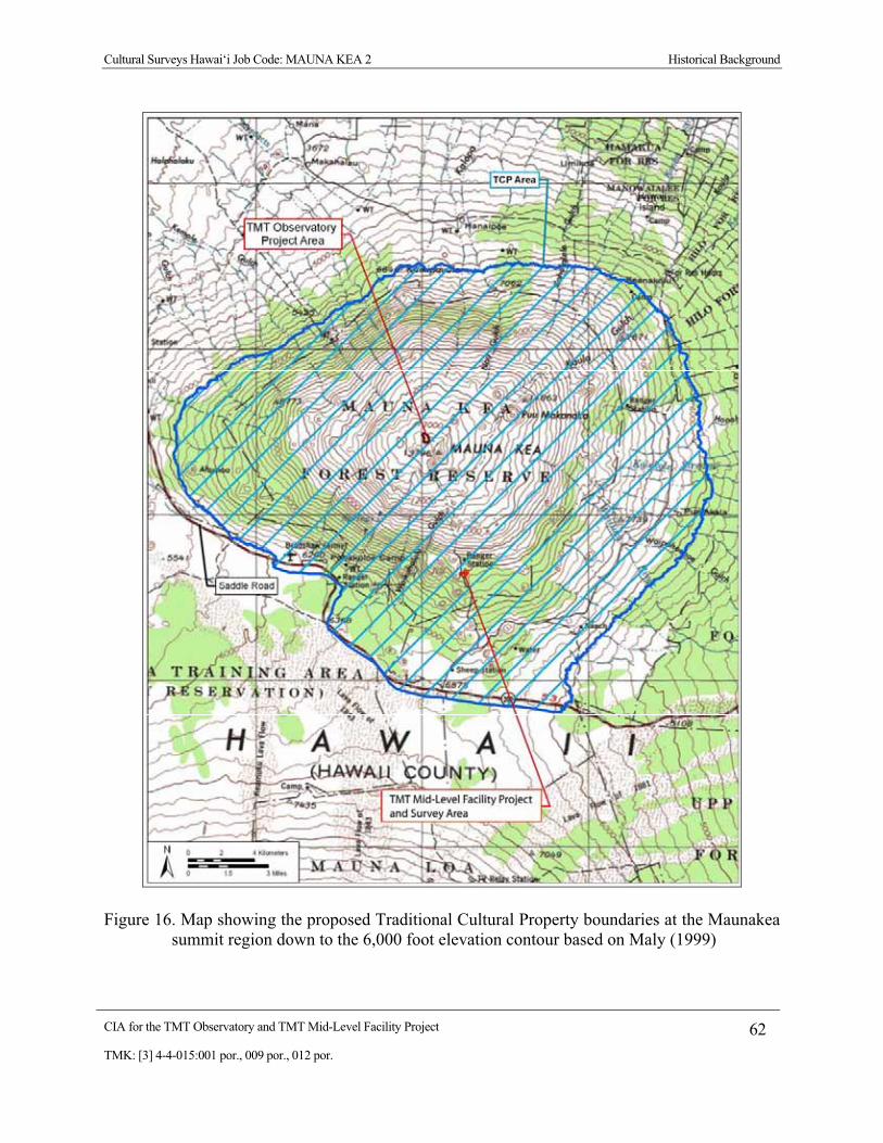
Cultural Surveys Hawai‘i Job Code: MAUNA KEA 2 Historical Background
CIA for the TMT Observatory and TMT Mid-Level Facility Project 62 TMK: [3] 4-4-015:001 por., 009 por., 012 por.
Figure 16. Map showing the proposed Traditional Cultural Property boundaries at the Maunakea summit region down to the 6,000 foot elevation contour based on Maly (1999)

Cultural Surveys Hawai‘i Job Code: MAUNA KEA 2 Historical Background
CIA for the TMT Observatory and TMT Mid-Level Facility Project 63 TMK: [3] 4-4-015:001 por., 009 por., 012 por.
Figure 17. Map showing the three SHPD designated TCPs in the Maunakea summit region (adapted from McCoy et al. 2008:2-25)
Cultural Surveys Hawai‘i Job Code: MAUNA KEA 2 Archaeological Research
CIA for the TMT Observatory and TMT Mid-Level Facility Project 64 TMK: [3] 4-4-015:001 por., 009 por., 012 por.
Section 5 Archaeological Research
5.1 Overview This section reviews relevant previous archaeological research in the Maunakea summit
region. The single most outstanding aspect of the archaeological record around the Project area is the high number of shrines to the virtual exclusion of all other types of sites. At least 79 shrine sites (three that are also lithic workshops) have been documented in the summit region, comprising approximately 83% of known sites in the region. Shrines typically consist of one or more large basalt slabs turned upright and arranged in different formations (Figure 18), sometimes associated with other foundation stones or rock piles (i.e., “cairns”). Several burials or possible burials have been documented in the summit region. A few stone markers and sites of unknown function have also been documented. Overall, the very high proportion of shrines near the summit is noteworthy and unique in comparison to most other places on Hawai‘i Island.
Numerous historic properties have been previously documented in the Maunakea summit region (Figure 19). There are also a large number of remains present that do not qualify as historic properties (Figure 20). These remains are referred to as “find spots” and are either clearly modern or their age and function is unable to be determined (McCoy et al. 2008:2-1).
Five archaeological sites—all shrines—have been documented within approximately 1,000 feet of the TMT Observatory Project area: three of these (16171, 16172 and 21200) consist of single uprights; Site 16172, the closest site to the TMT Observatory Project area, is approximately 250 feet north of the northern boundary of the Project area. The other two sites are a pair of cairns with several uprights (16170) and a pair of uprights (16169). As discussed above (Section 3.9), several trails pass through the summit region; the closest to the Project area is about 1.5 miles to the west and south (see Figure 6).
Several historic properties have also been identified in the area surrounding the Hale P�haku Project area (Figure 21). These sites include primarily stone tool workshop locations and shrines.

Cultural Surveys Hawai‘i Job Code: MAUNA KEA 2 Archaeological Research
CIA for the TMT Observatory and TMT Mid-Level Facility Project 65 TMK: [3] 4-4-015:001 por., 009 por., 012 por.
Figure 18. Traditional Hawaiian religious shrine at the Mauna Kea Adze Quarry (source: Kirch 1985)

Cultural Surveys Hawai‘i Job Code: MAUNA KEA 2 Archaeological Research
CIA for the TMT Observatory and TMT Mid-Level Facility Project 66 TMK: [3] 4-4-015:001 por., 009 por., 012 por.
Figure 19. Map showing historic properties in the Maunakea summit region (adapted from
McCoy et al. 2008:2-16)

Cultural Surveys Hawai‘i Job Code: MAUNA KEA 2 Archaeological Research
CIA for the TMT Observatory and TMT Mid-Level Facility Project 67 TMK: [3] 4-4-015:001 por., 009 por., 012 por.
Figure 20. Map showing find spots in the Maunakea summit region (adapted from McCoy et al. 2008:2-33)

Cultural Surveys Hawai‘i Job Code: MAUNA KEA 2 Archaeological Research
CIA for the TMT Observatory and TMT Mid-Level Facility Project 68 TMK: [3] 4-4-015:001 por., 009 por., 012 por.
Figure 21. Map showing historic properties near the TMT Mid-Level Facility Project area (adapted from McCoy et al. 2008:2-21)

Cultural Surveys Hawai‘i Job Code: MAUNA KEA 2 Archaeological Research
CIA for the TMT Observatory and TMT Mid-Level Facility Project 69 TMK: [3] 4-4-015:001 por., 009 por., 012 por.
5.2 Early Observations Early documentation of archaeological sites in the upper reaches of Maunakea was somewhat
anecdotal and ad hoc. McEldowney’s (1982:A-11) summary of the ethnographic background of the Maunakea summit region notes:
Although most accounts speak in general terms, those that specifically locate the presence of human bones, “graves,” “burial caves” or mortuary features indicate that burials are “not uncommon” between 7,800 ft and 13,000 ft elevation along the northern and eastern slopes of Mauna Kea (Alexander 1892; Preston 1895:601; Gregory 1921; Aitken 1935:48; Gregory and Wentworth 1937:1720; Kilmartin 1974:15; Bryan 1927:106; Hamakua Site Records, Dept. Anthro, B.P. Bishop Mus.).
On the first recorded ascent of Maunakea in 1823, Rev. Goodrich (see Section 4.2) noted the presence of a pile of stones which he assumed had been constructed by Hawaiians. Goodrich’s time on the mountain, however, was extremely brief and his observations about archaeological matters, at least, were quite cursory.
William D. Alexander described a trip up Maunakea with a surveying party, and observed:
That same afternoon [July 25, 1892] the surveyors occupied the summit of Lilinoe, a high rocky crater, a mile southeast of the central hills [the “summit”] and a little over 13,000 feet in elevation. Here, as at other places on the plateau, ancient graves are to be found. In olden times it was a common practice of the natives in the surrounding region to carry up the bones of their deceased relatives to the summit plateau for burial. (cited in McCoy 1999)
McCoy discusses a visit in 1975 to the summit of L�l�noe in which he described two adjacent cairns on the eastern rim and comments that: “If the cairns that were recorded in 1975 were in fact the same graves [as described by William D. Alexander in 1892] the remains had been removed sometime prior because no human bone was visible at that time” (McCoy 1999:27). It is also possible that Alexander was in error in his assessment of the function of the cairns.
Jerome Kilmartin (1974) published a brief reminiscence reflecting on his involvement in a 1925 United States Geological Survey project to map the Lake Waiau topographic quadrangle. That 1925 work put him in the summit region for more than five months in 1925. He did not return again until 1971. Kilmartin’s 1925 U.S. Geological Survey work was facilitated by the Umikoa Ranch based at approximately 3,500 foot elevation above K�ka‘iau in H�m�kua. The team established a base camp at Pu‘u Kihe (7,821 feet elevation), where water and forage were available, and a summit camp (Camp 3) of four tents at Lake Waiau.
Kilmartin reported little archaeological detail, but did note that at Pu‘u M�kanaka (elevation 12,414 feet):
On the rim I found a partially uncovered grave, eroded by high winds, with an incomplete human skeleton. This was unknown as far as I could discover, to anyone familiar with the area. The name Pu‘u M�kanaka means “Hill crowded with many people” and the grave must have been ancient. (Kilmartin 1974:15)

Cultural Surveys Hawai‘i Job Code: MAUNA KEA 2 Archaeological Research
CIA for the TMT Observatory and TMT Mid-Level Facility Project 70 TMK: [3] 4-4-015:001 por., 009 por., 012 por.
He also notes:
Ancient stone piles, quarries, walls, platforms, and burial caves are sufficient evidence that early Hawaiians were familiar with Mauna Kea’s highlands. Stone chips from adze manufacture are found near a cave at 12,360 feet. …(Kilmartin 1974:13)
It may also be noted in passing that the U.S. Geological Survey party created archaeological sites of their own (and perhaps many):
…the wind was so strong I thought surely we would be blown away. However the ahu (stone pile) that we built did give a little protection after I had made a setup with the plane table only two feet above the ground. (Kilmartin 1974:15)
Kenneth Pike Emory was the first person to have described the distinctive shrine features of Maunakea in a brief, popular piece published in Paradise of the Pacific magazine (April 1938). Emory was struck by the “immense quantity of chipped stone” and posited that the piles of debitage were “the largest so far recorded anywhere in the world.” He concluded that the evidence of “chips and rejects” was the result of skilled adze makers and that “they were able to create a stone-tool industry on a scale unequaled in the stone-age because of the superior social organization of the Hawaiian people.” Emory noted similarities of the shrines to a shrine on Maunaloa photographed by the geologist Dr. T. A. Jaggar in 1919 and also to the shrines of Necker Island. Emory posited that in the shrines “each upright stone stood for a separate god” and referred to them as “‘eho” (“a collection of stone gods”)—a term used in the Tuamotus as well as Hawaii to designate an alignment of upright stones.
Wentworth and Powers (1943) carried out geological studies on Maunakea in 1939 that noted archaeological sites in the Hopukani and Liloe Springs area. They noted stone walls that they interpreted as a trap to impound wild cattle that frequented the springs and certain older sites:
In the area to the east and up the slope from the springs are numerous small heaps of pre-European stone adz workings. Certain lava caves contain evidence of habitation, suggesting that the springs were frequented by adz workers. The latter not only secured adz material from lava flows in places but carried on a surprising amount of casual prospecting on dense basalt boulders included in the moraines and outwash strewn several thousand feet down the mountain. (Wentworth and Powers 1943:544)
Two tables are provided below detailing both previous archaeological studies of the summit region (Table 4) and documented archaeological sites within the summit region prior to the on-going McCoy and Nees study (Table 5).

Cultural Surveys Hawai‘i Job Code: MAUNA KEA 2 Archaeological Research
CIA for the TMT Observatory and TMT Mid-Level Facility Project 71 TMK: [3] 4-4-015:001 por., 009 por., 012 por.
Table 4. Archaeological Studies in the Maunakea Summit Area
Reference Nature of Study Area of Study Comments McCoy 1976
“The Mauna Kea Quarry Project: A First Analysis”
Mauna Kea Adze Quarry Complex
--
McCoy 1977a “Archaeological Investigations at the, Hawaii: Preliminary Results of the 1975-76 Fieldwork”
Mauna Kea Adze Quarry Complex
--
McCoy 1977b “A Summary of the 1975 Field Investigations”
Mauna Kea Adze Quarry Complex
--
McCoy 1978 Account of the “The B.P. Bishop Museum Mauna Kea Adz Quarry Project.”
Mauna Kea Adze Quarry Complex
--
McCoy 1979 Reconnaissance survey Hale P�haku -- Allen 1981 Adze quarry analysis thesis Mauna Kea Adze Quarry
Complex --
McCoy 1981 “Stones For the Gods: Ritualism in the Mauna Kea Adz Quarry Industry, Hawaii.”
Mauna Kea Adze Quarry Complex
--
Cleghorn 1982 University of Hawai‘i Ph.D. dissertation in Anthropology on Mauna Kea Adze Quarry lithics
Mauna Kea Adze Quarry complex in the vicinity of Pu‘u Ko‘oko‘olau
Focuses on technological analysis and experimental tests. Some 534 archaeological site components of 38 designated sites are briefly summarized.
McCoy 1982 Reconnaissance survey ~1,000 acres of the summit and north slope (down to 13,000 ft. elevation)
Documents 22 sites including an open air shelter and 21 shrine sites.
Kam and Ota 1983
Reconnaissance survey Mauna Kea Observatory Power Line
--
McCoy 1984a Summary of the 1984 fieldwork
Mauna Kea Summit Region --
McCoy 1984b Archaeological reconnaissance
Hopukani, Waihu & Liloe Springs area, west side of P�hakuloa Gulch between 8,640 and 10,400 ft. elevation
Documents six archaeological sites and a number of find spots (More thorough coverage is presented in McCoy 1986).
McCoy 1985 Reconnaissance survey ~40 acres extending on both sides of the Mauna Kea Observatory Access Way between 9,080 and 9,400 ft. elevation
Preliminary report for Pu‘u Kalepeamoa Site documenting five lithic scatters and two shrines used for the manufacture of hammerstones and octopus lure sinkers. Ritual was an integral part of the manufacturing process
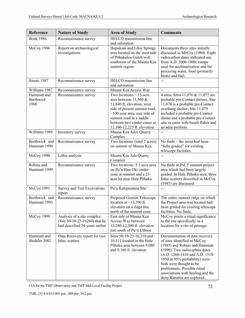
Cultural Surveys Hawai‘i Job Code: MAUNA KEA 2 Archaeological Research
CIA for the TMT Observatory and TMT Mid-Level Facility Project 72 TMK: [3] 4-4-015:001 por., 009 por., 012 por.
Reference Nature of Study Area of Study Comments Bonk 1986 Reconnaissance survey HELCO transmission line
and substation --
McCoy 1986 Report on archaeological investigations
Hopukani and Liloe Springs area located on the west side of P�hakuloa Gulch well southwest of the Mauna Kea summit region
Documents three sites initially discussed in McCoy (1984). Eight radiocarbon dates indicated use from A.D. 1000-1800; camps used for acclimatization and for procuring water, food (primarily birds) and fuel.
Sinoto 1987 Reconnaissance survey HELCO transmission line and substation
--
Williams 1987 Reconnaissance survey Mauna Kea Access Way -- Hammatt and Borthwick 1988
Reconnaissance survey Two locations: ~15-acre area between 11,560 & 11,840 ft. elevation, west side of present summit road; ~100-acre area, east side of summit road in a saddle between two cinder cones at 12,100-12,225 ft. elevation
4 sites: Sites 11,076 & 11,077 are probable pre-Contact shrines; Site 11,078 is a probable pre-Contact overhang shelter; Site 11,079 included a probable pre-Contact shrine and a probable pre-Contact ahu or cairn with basalt flakes and an adze preform.
Williams 1989 Inventory survey Mauna Kea Adze Quarry Complex
--
Borthwick and Hammatt 1990
Reconnaissance survey Two locations (total 2 acres) on summit of Mauna Kea.
No finds – the areas had been “fully graded” for existing telescope facilities.
McCoy 1990 Lithic analysis Mauna Kea Adz Quarry Complex
--
Robins and Hammatt 1990
Reconnaissance survey Two locations: 5.1-acre area on Pu‘u Hau Oki cinder cone at summit and a 21-acre lot near Hale P�haku
No finds at JNLT summit project area which had been largely graded. In Hale P�haku area, three lithic scatters described in McCoy (1985) are discussed.
McCoy 1991 Survey and Test Excavations report
Pu‘u Kalepeamoa Site --
Borthwick and Hammatt 1993
Reconnaissance survey Proposed Gemini Telescope location at ~13,700 ft. elevation on a ridge line north of the summit cone
The entire summit ridge on which the Project area was located had been graded for existing telescope facilities. No finds.
McCoy 1999 Analysis of a site complex (Site 50-10-23-16204) that he had described 24 years earlier
East side of Mauna Kea Access Way between 12,240-12,300 ft. elevation just south of Pu‘u L�l�noe
McCoy posits a ritual significance to the site specifically as a location for a rite of passage.
Hammatt and Shideler 2002
Data Recovery report for two lithic scatters
Sites 50-10-23-10,310 and -10,311 located in the Hale P�haku area between 9,080 and 9,160 ft. elevation
Documentation of data recovery of sites identified in McCoy (1985) and Robins and Hammatt (1990). Two radiocarbon dates (A.D. 1260-1410 and A.D. 1510-1950 at 95% probability) were both were thought to be problematic. Possible ritual associations with healing and the deity Kanaloa are explored.

Cultural Surveys Hawai‘i Job Code: MAUNA KEA 2 Archaeological Research
CIA for the TMT Observatory and TMT Mid-Level Facility Project 73 TMK: [3] 4-4-015:001 por., 009 por., 012 por.
Reference Nature of Study Area of Study Comments McCoy 2005 Monitoring Septic tank excavations -- McCoy et al. 2005
Inventory survey Mauna Kea Science Reserve --
McCoy and Nees 2006
Inventory survey Mauna Kea Science Reserve --
Hammatt 2009a
Archaeological Assessment Proposed Thirty-Meter-Telescope Observatory (TMT) Project on the northern plateau of the Mauna Kea summit area, within Area E of the Astronomy Precinct of the Mauna Kea Science Reserve
No findings
Hammatt 2009b
Archaeological Assessment TMT Mid-Level Facility area at approximately 2,800 m (9,200 ft.) elevation on the southern slope of Mauna Kea
No findings
McCoy and Nees (in progress)
Inventory survey Mauna Kea summit region In progress
Table 5. Documented Archaeological Sites in the Summit Region
SIHP # Elevation Description Function 11077 12320 Single upright Shrine
11079 12313 Lithic scatter of adze manufacturing byproducts and 2 associated cairns
“Workshop” and possible shrine
16163 12880 Platform/pavement with 14 uprights Shrine
16164 13397 3 to 5 uprights on platform and 1 isolated upright Shrine
16165 13362 Single row of 2 uprights Shrine
16166 13422 2 rows of uprights, 8 to possibly 9 total Shrine
16167 13395 Single row of 2 uprights Shrine
16168 13098 Semi-enclosure with 21 to possibly 25 uprights Shrine
16169 13210 Single row of 2 uprights Shrine
16170 13139 2 cairns with 3 to possibly 4 uprights Shrine
16171 13087 Single upright Shrine
16172 13218 Single upright Shrine
16173 13009 7 dispersed uprights Shrine
16174 13075 Boulder with 1 to possibly 8 uprights on the side Shrine
16175 NA 5 cairns with 1 upright each Shrine
16176 13078 Single row of 3 uprights Shrine

Cultural Surveys Hawai‘i Job Code: MAUNA KEA 2 Archaeological Research
CIA for the TMT Observatory and TMT Mid-Level Facility Project 74 TMK: [3] 4-4-015:001 por., 009 por., 012 por.
SIHP # Elevation Description Function 16177 13118 Single row of 3 uprights Shrine
16178 13236 Single upright Shrine
16179 13122 Single row of 3 uprights Shrine
16180 13086 Boulder with 3 uprights Shrine
16181 13401 Single upright Shrine
16182 13155 3 to 5 uprights Shrine
16184 13072 Semi-enclosure with 24 uprights Shrine
16185 13008 Single row of 3 uprights Shrine
16186 13076 Single row of 2 and possibly 3 uprights Shrine
16187 12775 Single row of 9 uprights Shrine
16188 12857 Single upright Shrine
16189 12902 Single row of 3 and possibly 4 uprights Shrine
16190 12956 Single row of 10 and off-set uprights Shrine
16191 12889 Single row of 4 uprights Shrine
16192 12842 2 sets of uprights, 6 total Shrine
16193 12843 Single upright Shrine
16194 12673 Single row of 12 - 14 uprights Shrine
16195 NA 2 cairns Possible burial
16196 12953 Single row of 2 uprights Shrine
16197 12953 Single upright Shrine
16198 12930 2-tiered platform with 7 uprights Shrine
16199 12991 1 and possibly 4 uprights Shrine
16200 12975 Single row of 5 and possibly 6 uprights Shrine
16201 12990 Single row of 3 uprights Shrine
16202 13006 Single upright Shrine
16203 13145 Single row of 2 and possibly 3 uprights and a lithic scatter of adze manufacturing byproducts
Adze “workshop” and shrine
16204 12332 5 shrines, 26 stone-walled enclosures and a lithic scatter of adze manufacturing byproducts
Adze “workshop” and shrine complex
16248 NA Series of cairns Burial
18682 12955 Single row of 3 uprights Shrine
18683 13012 Single row of 2 uprights Shrine
21197 13052 2 platforms with a total of 5 uprights Shrine
21198 13043 Single upright Shrine

Cultural Surveys Hawai‘i Job Code: MAUNA KEA 2 Archaeological Research
CIA for the TMT Observatory and TMT Mid-Level Facility Project 75 TMK: [3] 4-4-015:001 por., 009 por., 012 por.
SIHP # Elevation Description Function 21199 12876 Single upright Shrine
21200 13165 Single upright Shrine
21201 13087 Single row of 2 uprights Shrine
21202 13048 Single row of 6 to possibly 7 uprights Shrine
21203 13034 Single row of 2 uprights Shrine
21204 12925 3 areas of stacked rock Unknown
21205 13484 Single upright Shrine
21206 12754 Single upright Shrine
21207 12787 Single upright Shrine
21208 12799 1 to 2 uprights on a boulder Shrine
21209 NA Cairn on summit Unknown
21210 12233 Single upright Shrine
21211 12275 Single row of 2 uprights on a platform and a lithic scatter of adze manufacturing byproducts
Adze “workshop” and shrine
21212 12385 Single row of 2 uprights Shrine
21213 12249 3 piles of rocks with 1 upright Shrine
21214 12241 Single row of 5 and possibly 7 uprights Shrine
21406 NA Single upright Shrine
21407 12952 Single row of 2 uprights Shrine
21408 12913 Single upright Shrine
21409 12984 Single upright Shrine
21410 12801 Single row of 5 uprights Shrine
21411 12815 Cairn Marker
21412 NA Cairn Marker
21413 NA Cairn Possible burial
21414 NA Cairn Possible burial
21415 13130 Cairn on boulder Unknown
21416 12792 Cairn Possible burial
21417 12974 Cairn Unknown
21418 12889 3 and possibly 4 uprights on top and to the side of a boulder Shrine
21419 12495 Single upright Shrine
21420 12152 Enclosure with 11 and possibly 12 uprights and a nearby stone platform
Shrine
21421 12731 2 cairns, one with a possible upright and an isolated upright Shrine

Cultural Surveys Hawai‘i Job Code: MAUNA KEA 2 Archaeological Research
CIA for the TMT Observatory and TMT Mid-Level Facility Project 76 TMK: [3] 4-4-015:001 por., 009 por., 012 por.
SIHP # Elevation Description Function 21422 12847 Single upright Shrine
21423 NA Stones on boulder Marker
21424 12320 4 to 5 uprights on a platform and boulder Shrine
21425 12523 Single upright Shrine
21426 12568 Single row of 4 uprights Shrine
21427 12635 Terrace with possible upright Unknown
21428 12720 Single upright Shrine
21429 12719 Single upright Shrine
21430 13111 Single row of 3 uprights Shrine
21431 12532 Semi-enclosure with 7 to 10 uprights Shrine
21432 13044 Single row of 2 uprights Shrine
21433 12579 Single upright Shrine
21434 12551 8 stones on a boulder Unknown
21435 12564 Cairn and boulder with 1 upright Shrine
5.3 Formal Studies This section presents additional descriptions of the most important findings of the works
summarized in Table 4.
5.3.1 Cleghorn (1982) Cleghorn (1982) produced his University of Hawai‘i Ph.D. dissertation in Anthropology on
Mauna Kea Adze Quarry lithics focusing on technological analysis and experimental tests. Some 534 archaeological site components of 38 designated sites of the Mauna Kea Adze Quarry complex in the vicinity of Pu‘u Ko‘oko‘olau were briefly summarized (sites are referred to by Bishop Museum site nomenclature).
5.3.2 McCoy (1982) Patrick McCoy (1982) documented reconnaissance-level surveying of approximately 1,000
acres of the summit and north slope (down to 13,000 ft). McCoy notes that: Few, if any, archaeological sites were predicted to occur within the boundaries of the Project area, given the high altitude location and presumed absence of exploitable resources, including adze-quality stone, which on present evidence is restricted to the south slope of the mountain. (McCoy 1982)
Thus, it was far beyond expectations when 22 sites were recorded including an open-air (i.e., non-cave and non-rockshelter) shelter and 21 shrine sites. McCoy was quite familiar with the “occupational shrines” near the adze quarries but concluded the function of these shrines located away from the main quarrying area was unknown. McCoy posits:

Cultural Surveys Hawai‘i Job Code: MAUNA KEA 2 Archaeological Research
CIA for the TMT Observatory and TMT Mid-Level Facility Project 77 TMK: [3] 4-4-015:001 por., 009 por., 012 por.
…that these structures were erected by travelers, most probably in propitiation of mountain spirits. Such practices are universal in the high mountain regions of the world. (McCoy 1982:A-37)
McCoy does note, however, that the majority of the shrines were located in a narrow 200-foot contour interval band between 12,900-foot and 13,100-foot elevation. He theorizes that this clearly defined vertical zonation site pattern is the result of utilization of a break in slope at the edge of the summit plateau where: “when viewed from either the base of the steep inclined slope directly below, or from the base of the summit cones above, is a relatively flat horizon on which the shrine uprights are silhouetted and therefore visible from some distance” (McCoy 1982). McCoy associates these shrines with “the request for permission to pass over the summit” and notes that this indicates a preponderance of access from the northern, windward side of the islands consistent with the inclusion of the land within H�m�kua District. He further posits that the distribution of the shrines may relate to “the lower margins of snow fields” and possibly, by extension, to the goddess Poli‘ahu. McCoy notes that at least one of the more complex shrine sites, “The placement of offerings and whatever other ritual took place here appear to have been intentionally directed away from Mauna Kea. The possibility of astronomical concepts being operative is explored.” McCoy also suggests that smaller sites were built and utilized by one or a few individuals while more complex shrines were built and utilized by a larger kin group and that perhaps “each structure would represent a separate social unit that had exclusive use rights.” McCoy recommended intensive archaeological survey and avoidance of construction and related activities on or in proximity to known archaeological sites.
5.3.3 McCoy (1984) McCoy’s (1984) archaeological reconnaissance report for the Hopukani, Waihu, and Liloe
Springs area documents six archaeological sites and a number of find spots located on the west side of P�hakuloa Gulch between 8,640 and 10,400 feet elevation. The work was associated with a P�hakuloa Training Area (PTA) pipe line project. This preliminary report was elaborated upon in McCoy’s later (1986) study.
5.3.4 McCoy (1985) McCoy’s (1985) preliminary report for the Pu‘u Kalepeamoa Site documents three
archaeological surveys for a proposed new construction laborer camp at Hale P�haku located just above and below the Hawaii Institute for Astronomy’s Mid-Level Facility encompassing a total of approximately 40 acres. This project was located on both sides of the Mauna Kea Observatory Access Way between 9,080 and 9,400-foot elevation. Five lithic scatters and two shrines were recorded. These archaeological features were understood as functionally integrated components of a single activity system and one Bishop Museum site number was assigned (lithic scatters nos. 1 and 2 would subsequently be given SIHP Nos. 50-10-23-10,310 and -10,311, respectively). McCoy concluded that the primary activity at the site was the manufacture of hammerstones and octopus lure sinkers from the crystalline dunite and gabro deposits on the slopes of Pu‘u Kalepeamoa but he noted that ritual was an integral part of the manufacturing process. Further research was recommended. The lithic scatters would be subject to further documentation (Robins and Hammatt 1990) and data recovery work (Hammatt and Shideler 2002).

Cultural Surveys Hawai‘i Job Code: MAUNA KEA 2 Archaeological Research
CIA for the TMT Observatory and TMT Mid-Level Facility Project 78 TMK: [3] 4-4-015:001 por., 009 por., 012 por.
5.3.5 McCoy (1986) McCoy’s (1986) report on archaeological investigations for the Hopukani and Liloe Springs
area documents three mid-level sites located on the west side of P�hakuloa Gulch well southwest of the Maunakea summit region (that were initially discussed in McCoy 1984). These sites included a rock shelter at Hopukani Spring (10,400 foot elevation), the Hopukani Rockshelter (10,160 foot elevation) and an open camp site at Liloe Spring (8,921 foot elevation) Eight radiocarbon dates indicated use spanning A.D. 1000 to A.D. 1800. It was concluded that these camps were used for acclimatization and for procuring water, food (primarily birds) and fuel.
5.3.6 Hammatt and Borthwick (1988) CSH (Hammatt and Borthwick 1988) carried out an Archaeological Reconnaissance Survey
of two locations for proposed antennas for the National Radio Astronomy Observatory. An approximately 15-acre relatively level location between the 11,560 foot and 11,840 foot elevations on the southeastern slope of the summit region on the west side of the present summit road was examined but no archaeological sites were observed. Another approximately 100-acre location on the east side of the summit road in a saddle between two cinder cones at the 12,100 to 12,225 foot elevation was also examined and four archaeological sites were documented (none of which appear to have been previously recorded). Sites 11,076 and 11,077 are probable pre-Contact shrines; Site 11,078 is a probable pre-Contact overhang shelter with a stacked stone alignment; and Site 11,079 had two components: a probable pre-Contact shrine and a probable pre-Contact ahu, or cairn, with basalt flakes and an adze preform present. Preservation of the four sites was recommended but it was thought that the antenna project potentially would be compatible with such preservation of the four relatively small and discrete sites in the large acreage.
5.3.7 Borthwick and Hammatt (1990) In 1990, CSH carried out an Archaeological Reconnaissance Survey of two locations for the
proposed Galileo Telescope on the summit of Maunakea. The study was of an approximately 2-acre portion of the summit ridge that (at that time) included the UKRT, U.H. 2.2 m, U.H. 24-inch telescopes and Medical Support facilities. The study notes that previous work (McCoy 1982) had identified no sites in the summit region (above circa 13,330 foot elevation). Borthwick and Hammatt (1990) note that the entire summit ridge on which the project areas were located had been “fully graded” for existing telescope facilities and no archaeological features were observed; no further work was recommended.
5.3.8 Robins and Hammatt (1990) CSH carried out another Archaeological Reconnaissance Survey in 1990 for the Japan
National Large Telescope (JNLT) project at both the summit and the Hale P�haku area. The actual JNLT summit construction area was an approximately 5.1-acre area on Pu‘u Hauoki cinder cone in the northern portion of the Mauna Kea Science Reserve approximately 61 m (200 feet) west of the existing W. M. Keck Observatory and 304 m (800 feet) north of a paved “spur road” passing by the Submillimeter Telescope (CSO). The JNLT summit project area had been largely graded although certain undisturbed outcrop formations were present. No archaeological features were identified within the JNLT summit project area.

Cultural Surveys Hawai‘i Job Code: MAUNA KEA 2 Archaeological Research
CIA for the TMT Observatory and TMT Mid-Level Facility Project 79 TMK: [3] 4-4-015:001 por., 009 por., 012 por.
The Robins and Hammatt (1990) study also included several areas near the TMT Mid-Level Facility Complex (OCIA) including a small dormitory construction area located approximately 134 m (440 feet) east of the Mauna Kea Observatory Access Way at 9,245 foot elevation (where no sites were observed). An approximately 21-acre lot surrounding the dormitory delineated on the west and north side by the Mauna Kea Observatory Access Way and to the south by an existing jeep road was also included in the study. Two archaeological features were newly described and three previously identified sites were recorded in the approximately 21-acre lot. The two newly-described features included a small oval enclosure and a roughly square enclosure that were both thought to be relatively recent constructions (no formal SIHP site numbers were assigned). The three previously-recorded (McCoy 1985) sites included three lithic scatters (lithic scatters nos. 1, 2 and 5) that McCoy had understood as being functionally-integrated components of a single site. Further work at the lithic scatters was recommended. CSH completed a later Data Recovery report (Hammatt and Shideler 2002) for lithic scatters nos. 1 and 2.
5.3.9 Borthwick and Hammatt (1993) In 1993 CSH carried out an Archaeological Reconnaissance Survey for the proposed Gemini
Telescope location at approximately 13,700 foot elevation on a ridge line north of the summit cone. The study notes that previous work (McCoy 1982) had identified no sites in the summit region above circa 13,330 foot elevation. The study notes that the entire summit ridge on which the project area was located had been graded for existing telescope facilities and no archaeological features were observed; no further work was recommended.
5.3.10 McCoy (1999) McCoy (1999) wrote up an analysis of a site complex (SIHP No. 50-10-23-16204), that he
had described 24 years earlier, located on the east side of the Mauna Kea Access Way between 12,240 and 12,300 foot elevation just south of Pu‘u L�l�noe. The site included five shrines and three enclosure complexes. The complex was notably located 500 m from the nearest known source of worked raw lithic material and was perceived as “isolated.” McCoy noted that when viewed in terms of the natural environment and human productivity, “the location of this site appears to be irrational” (1999:14). Of particular interest were some 26 very small open-air enclosures (typical interior area approximately 1.6 m2). This led McCoy to posit a ritual significance to the site, specifically as a location for rites of passage.
McCoy goes on to consider the form of the upright slabs of (typically unworked) basalt that were arranged into the many shrines of Maunakea and Site 16204, in particular. McCoy posits that pointed uprights symbolize gods and that flat-topped slabs symbolize goddesses (McCoy assumes that the Hawaiian goddesses L�l�noe and Poli‘ahu were worshipped). Determining the affinities of the slabs is complicated by the presence of other forms (“angled,” “gabled,” “rounded” and “notched”) and the general difficulty of determining whether a particular stone was an upright at all.
McCoy argues that evidence supporting an unusual ritual function (rites of passage) includes:
� Unusual orientations of four of the five shrines,
� Lack of evidence of habitation,

Cultural Surveys Hawai‘i Job Code: MAUNA KEA 2 Archaeological Research
CIA for the TMT Observatory and TMT Mid-Level Facility Project 80 TMK: [3] 4-4-015:001 por., 009 por., 012 por.
� Unusual “lack of a cohesive structure” among the lithic byproducts present in the artifact assemblages – suggesting “symbolic manufacture and use,”
� The numerous (26) very small open-air enclosures that were “too small to accommodate a person and a fire hearth” of no obvious purpose and believed to relate to temporary day-time use.
McCoy concludes that the small enclosures “may symbolically represent both a womb and a grave” and that the site “was the locus of initiation rites” related to “formal initiation rites for groups of apprentices” (McCoy 1999).
5.3.11 Hammatt and Shideler (2002) In 2002 CSH completed a Data Recovery report for two lithic scatters (SIHP Nos. 50-10-23-
10,310 and -10,311) located in the Hale P�haku area between 9,080 and 9,160 foot elevation. These sites were first recorded by McCoy (1985:11-12) as Lithic Scatter No. 1 (SIHP No. 50-10-23-10,310) and Lithic Scatter No. 2 (SIHP No. 50-10-23-10,311) of the Pu‘u Kalepeamoa Complex. Initially, the University of Hawai‘i Institute of Astronomy planned to preserve the two lithic scatters; however, dormitory construction increased erosion in the vicinity and, in consultation with the SHPD, a data recovery program was developed. Data recovery fieldwork included mapping, surface collection and four 1 m2 test units (two at each of the two sites). Two radiocarbon dates (A.D. 1260-1410 and A.D. 1510-1950 at 95% probability) were obtained but both were thought to be problematic. It was concluded that the sites were modest, out-lying, open, lithic workshop sites with octopus lure sinker manufacture of both “coffee-bean” and “bread-loaf” morphological types. It was concluded that the location of the sites was associated with a micro-climate of slightly greater moisture, slightly greater soil and slightly greater protection from the wind at the top of a natural drainage that favored m�mane forest growth—which in turn provided greater protection from the elements, fuel and construction materials. It is suggested that the endeavor to produce octopus lures may have had other purposes than food procurement and the affinities with healing prayers (pule he‘e) dedicated to the deity Kanaloa are explored.
5.3.12 Hammatt (2009a) CSH conducted an Archaeological Inventory Survey for the Thirty Meter Telescope
Observatory Project (TMT) in 2008. No historic properties were identified within the approximately 36-acre survey area. Previously identified historic properties in the vicinity of the survey area were found and confirmed to be outside of the survey area. CSH’s effect recommendation for the proposed TMT Observatory Project is “no historic properties affected,” therefore the final report was submitted as an Archaeological Assessment.
5.3.13 Hammatt (2009b) CSH conducted an Archaeological Inventory Survey for construction staging areas and
development of housing in the Hale P�haku area in 2009. The project is a component of the TMT Observatory Project and involves the construction of ancillary facilities. Previously identified historic properties in the vicinity of the survey area were found and confirmed to be outside of the survey area. CSH’s effect recommendation for the proposed TMT Observatory
Cultural Surveys Hawai‘i Job Code: MAUNA KEA 2 Archaeological Research
CIA for the TMT Observatory and TMT Mid-Level Facility Project 81 TMK: [3] 4-4-015:001 por., 009 por., 012 por.
Project Ancillary Facilities is “no historic properties affected,” therefore the final report was submitted to SHPD as an Archaeological Assessment.
5.3.14 McCoy et al. (2009 in progress)
5.3.15 McCoy and Nees (in progress) As the Hammatt inventory surveys (2009a, 2009b) were being prepared, CSH archaeologists
interacted with Dr. Patrick McCoy at the offices of Pacific Consulting Services, Inc. and also within the Project area. This study should greatly advance our knowledge of traditional Hawaiian use of the Maunakea summit region. Though drafts of this extensive survey project are not yet available, McCoy does detail some of the findings in the Preliminary Draft Report: Cultural Resource Management Plan for the University of Hawai‘i Management Areas on Mauna Kea, Ka‘ohe Hamakua, Island of Hawai‘i TMK (3) 4-4-012, 015 (McCoy et al 2008). As of the publishing of this draft CRMP, McCoy et al. had documented 223 sites in the Mauna Kea Science Reserve, including 93 previously documented sites. These 223 site also include 28 sites which McCoy et al. are designating as burials and possible burials (McCoy et al. 2008:2-20, 2-23).
5.3.16 Traditional Cultural Properties The SHPD has designated three prominent localities on Maunakea as Traditional Cultural
Properties (TCP) due to their cultural significance to the Hawaiian people. Several additional prominent locations in the summit region are also considered culturally significant (see Figure 6). Additionally, a large area on the mountain’s summit has been determined to be eligible for listing on the National Register of Historic Places as a historic district. Maly (Maly 1998:29) has suggested the entire Maunakea summit region down to the 6,000 foot elevation contour be designated a Traditional Cultural Property (see Figure 16).
5.4 Summary Observations
5.4.1 Burials and Possible Burials McCoy (1999) presents a summary discussion of burials and possible burials on Maunakea
noting that there are numerous traditions of burials at high elevations on Maunakea. He begins by presenting the account of Jerome Kilmartin (1974) who in 1925 personally observed human remains on Pu‘u M�kanaka. McCoy relates that in 1991 he and others observed human bones within several cairns on the southern rim of Pu‘u M�kanaka. He also notes that “several other spatially discrete groups of cairns, each comprised of two to three individual cairns, were found on the southern or eastern rim” (1999:26) [of Pu‘u M�kanaka] – suggesting that these may also contain human skeletal remains.
Pu‘u M�kanaka is the only documented place in the uplands of Maunakea in which human remains have been confirmed—although McCoy makes reference to “the well-known burial center at Kanakaleonui” and also to “a small group of cairns on the eastern rim of Pu‘u Waiau that are also believed to be burials” (McCoy 1999).

Cultural Surveys Hawai‘i Job Code: MAUNA KEA 2 Archaeological Research
CIA for the TMT Observatory and TMT Mid-Level Facility Project 82 TMK: [3] 4-4-015:001 por., 009 por., 012 por.
McCoy (1999:26) then goes on to discuss four “possible burial sites” (16195, 21413, 21414 and 21416). Although no human remains were observed, these were thought to be burials due to the morphological similarity of these cairns to those on Pu‘u M�kanaka and Kanakaleonui, their dissimilarity to other cairns (which are more cylindrical), and their presence on the eastern or southern rim of cinder cones.
McCoy clearly suggests that Site 16195, consisting of two adjacent cairns on the eastern rim of Pu‘u L�l�noe (recorded by McCoy in 1975), are “possible burials” (1999:27). This conclusion is based on William D. Alexander’s 1892 account of “ancient graves” on the summit of Pu‘u L�l�noe. McCoy comments that: “If the cairns that were recorded in 1975 were in fact the same graves [as described by William D. Alexander in 1892] the remains had been removed sometime prior because no human bone was visible at that time” (1999:27). It appears that by 1975 these features were no longer graves but may have functioned as graves previously.
McCoy (1999:27) then discusses three possible burial cairn sites (21413, 21414 and 21416) located on the southern and eastern rim of an unnamed cinder cone. This cinder cone is 12,840-foot high and located approximately 1 kilometer northwest of the Mauna Kea Ice Age Natural Area Reserve). McCoy’s discussion indicates that these may well be graves on the basis of form and location.
McCoy concludes:
There is good reason to expect that more burials are to be found in the Science Reserve on the tops of cinder cones, either in cairns or in a small rockshelter or overhang. The basis of this prediction is that all of the known and suspected burial sites on the summit plateau are located on the tops of cinder cones and, more particularly, on the southern and eastern sides. No burials have been found on the sides or at the base of a cone, or on a ridgetop amongst any of the shrines. There in fact appears to be a clear separation between burial locations and shrine locations. (1999:28)
His comments have proven to be apt as current in progress work by McCoy and Nees has documented 28 sites designated as burials and possible burials (McCoy et al. 2008).
In striking contrast to the earlier archaeological data is the belief of some contemporary Hawaiians that the summit region of Maunakea is something of a burial ground (“There’s lot of k�puna been buried up there…” and several similar concerns at www.mauna-a-wakea.info/maunakea/F4_burials.html). Allied with this line of thinking are rumors of burials disturbed and destroyed by prior observatory developments (“Would bulldozing cemeteries be allowed anywhere else in the world?” www.mauna-a-wakea.info/maunakea/F4_burials.html).
5.4.2 Shrines In McCoy’s analysis of a total of 93 sites identified in the Maunakea summit area Science
Reserve some 76, or 81.7%, are classified as shrines (and an additional eight shrines are components of adze manufacturing workshop sites) (McCoy 1999:3). McCoy concludes that; “The vast majority of shrines are conspicuously sighted in the landscape, either on a ridgetop, or at a break in the slope, which generally seems to correspond to either a lava flow margin or a change in the slope of a glacial moraine” (1999:6). McCoy notes that “there are no shrines in the Science Reserve located on top of a cinder cone.”

Cultural Surveys Hawai‘i Job Code: MAUNA KEA 2 Archaeological Research
CIA for the TMT Observatory and TMT Mid-Level Facility Project 83 TMK: [3] 4-4-015:001 por., 009 por., 012 por.
As previously noted McCoy noted an unusually high density of shrines located in a narrow 200-foot contour interval band between 12,900 and 13,100-foot elevation on the north side of Mauna Kea that he attributes to a visually preferable location (1982:A-37).
5.4.3 Adze Quarries and Manufacturing Workshops Based upon McCoy’s 1999 summary analysis of site typology, the only quarries were in the
extreme southern portion of the Maunakea summit area Science Reserve (the Mauna Kea Adze Quarry; SIHP No. 50-10-23-4136). McCoy does describe four adze manufacturing workshops (11079, 16203, 16204 and 21211) defined in part by their location in areas absent of naturally occurring stone-tool quality raw material. All four of these adze manufacturing workshops are on the south face of the mountain on the east side of the main Mauna Kea Observatory Access Way.

Cultural Surveys Hawai‘i Job Code: MAUNA KEA 2 Community Consultation
CIA for the TMT Observatory and TMT Mid-Level Facility Project 84 TMK: [3] 4-4-015:001 por., 009 por., 012 por.
Section 6 Community Consultation
6.1 Community Consultation Effort An effort was made to contact and consult with Hawaiian cultural organizations, government
agencies, and individuals who might have knowledge of and/or concerns about Hawaiian cultural practices, resources and beliefs related to Maunakea. This effort was made by letter, e-mail, telephone, and in person. In most cases, letters with a detailed description of the proposed action and conceptual plan provided by Parsons Brinckerhoff, along with an aerial photograph and USGS map of the Project area and two figures depicting proposed TCPs: trails, sites and view corridors adapted from Maly 1999 (see Figures 6 and 16), were mailed to community contacts.
6.1.1 Community Respondents: A Note on Non-Participation It is important to understand that community response to the proposed TMT and support
facilities projects is represented not only by those who agreed to participate in this consultation, but also—and perhaps as importantly—by those who chose not to participate. A number of likely contributors to this cultural impact study by way of their cultural use, knowledge, attachment and generational ties to Maunakea (‘ohana that have for generations brought family piko and iwi k�puna to the summit), as well as those committed to community advocacy for the protection of Maunakea, declined to provide comment for this CIA. Their reasons for non-participation vary, but generally underscore decades of discontent with how developments on Maunakea (and attendant studies and management plans) have been undertaken. Many are fatigued by multiple cultural studies and public meetings that have similarly sought their mana‘o; a subset of this group are frustrated by the continued construction of telescopes on Maunakea with what appears to be little to no attention to their earlier testimonies regarding cultural concerns and sometimes expressed opposition to further development on Maunakea. It is the perception of many community contacts—including those inclined to support the proposed actions—that past recommended mitigation measures have often been ignored (e.g., recycling telescope sites no longer in use, cultural education and protocols for scientists and visitors, access to cultural and natural resources). It is further assumed by these community contacts that the TMT Observatory and TMT Mid-Level Facility Projects will similarly proceed without regard to community consultation outcomes. Instead of participating in this study, to express their disapproval for the proposed projects, a few organizations and individuals committed to protection of Maunakea and cultural activities and resources on the mountain prefer to pursue an independent, legal course of action and/or express their concerns at public forums. The words of one participant in this current cultural impact study (Ms. Ku‘ulei Keakealani) summarize the general sentiment of many (participants and non-participants alike) that the voices of Hawaiian community members have not been heard:
…there is a harsh reality for some reason that’s on my heart that says, if this already has been stamped with a seal of approval that this is going through…if we are there at that point and that is the game we are in—again that is just a reference because I know by no means is this a game—then what are ways [to respond to this]…It’s beyond having the Hawaiian people recognized or heard or they sit on the board. That’s all wonderful and we need all these things, but then…how much

Cultural Surveys Hawai‘i Job Code: MAUNA KEA 2 Community Consultation
CIA for the TMT Observatory and TMT Mid-Level Facility Project 85 TMK: [3] 4-4-015:001 por., 009 por., 012 por.
have they listened to us? If the majority of the testimony is “No, don’t put that TMT there,” and it still goes in anyway, did it just not matter that we all said, “no, no”?
The results of the community consultation for this CIA, while elucidating many of the key cultural issues surrounding Maunakea, may not reflect the wealth of concerns possessed by many other members of the Native Hawaiian community who chose not to be interviewed for this study. As such, the findings of past and current cultural studies and management plans (see Section 4.7) provide necessary complementary information to this report. In particular, the oral-history interviews of many elders (some now deceased) included in Appendix B of Maly and Maly (2005) and found in Maly (1999) serve as important documentation of many facets of Hawaiian customary practices, understandings of the cultural landscape and ongoing attachment of K�naka Maoli and kama‘�ina to Maunakea for further reference.
6.1.2 Community Outreach and Consultation Table As described in Section 1.1., when the TMT Observatory Project’s CIA consultation was
initiated in November 2008, communication with Project proponents indicated that the proposed Thirty Meter Telescope CIA consisted mainly of the actual construction of the TMT Observatory Project within the 36-acre area known as Area E in the Mauna Kea Science Reserve Master Plan. In February 2009, CSH was informed that the TMT Observatory Project will also include a construction staging area located at the 9,000 foot level Hale P�haku site, approximately 3.5 miles south of the proposed TMT Observatory Project site. Also included in the proposed TMT Observatory Project description is a new electrical transformer to be installed at the Hawaiian Electric Light Company (HELCO) site also located at the Hale P�haku site. For this reason, CSH sent out a second round of community consultation letters in February 2009 to include the additional information regarding the construction staging area and the electrical transformer in order to provide study participants the opportunity for additional comments and concerns.
The change in Project acreage from approximately 6 acres to 3.2 acres in the Hale P�haku area is not reflected in the outreach letters below because the community consultation took place from November 2008 to December 2010 when the information regarding the new Project acreage was unknown. Because the original Project area was downsized to a smaller area than what was originally proposed, CSH will not re-initiate further community consultation at this time.
Initial community outreach letters sent to community contacts in November 2008 along with an aerial image and a USGS map were mailed with the following text:
Cultural Surveys Hawai‘i (CSH) is conducting a Cultural Impact Assessment (CIA) for the proposed construction and operation of the Thirty Meter Telescope (TMT), an optical-infrared telescope on an estimated 4 acres of presently undeveloped land of the 525-acre Astronomy Precinct of the Science Reserve near the top of Mauna Kea. The project would be located in Ka‘ohe Ahupua‘a, H�m�kua District, on the island of Hawai‘i, on a portion of TMK: (3) 4-4-015: 009 and 012. Please see the attached figures: USGS and aerial photographs of the proposed project area, maps of the Mauna Kea summit, considered a Traditional Cultural Property, and other TCPs, including trails, sites and view corridors

Cultural Surveys Hawai‘i Job Code: MAUNA KEA 2 Community Consultation
CIA for the TMT Observatory and TMT Mid-Level Facility Project 86 TMK: [3] 4-4-015:001 por., 009 por., 012 por.
adapted from Kep� Maly’s 1999 Oral History and Consultation study for the Mauna Kea Science Reserve Master Plan (UH 2000).
The proposed telescope facility would be located within the western portion of the area known as the northern plateau within the Astronomy Precinct. More specifically, the area being considered is the general vicinity of the 36-acre area designed Area E in the Mauna Kea Science Reserve Master Plan (UH, 2000). Area E ranges in elevation from 13,100 to 13,300 feet and is located approximately half a mile northwest of the nine existing optical-infrared telescopes located near the summit at elevations of 13,600 to 13,775 feet. The entire Mauna Kea Science Reserve is designated part of the State of Hawai‘i Conservation District, resource subzone. Ancillary facilities include an access road from the end of the current access road near the summit to the new telescope site would need to be developed.
The purpose of this cultural study is to assess potential impacts to cultural practices, beliefs and resources as a result of the proposed TMT development on Mauna Kea. We are seeking your k�kua and guidance regarding on any of the following:
� General history and present and past land use of the project area. � Knowledge of cultural sites which may be impacted by future
development of the project area - for example, historic sites, archaeological sites, and burials.
� Knowledge of traditional gathering practices in the project area, both past and ongoing.
� Cultural associations of the project area, such as legends and traditional uses.
� Referrals of k�puna or elders and kama‘�ina who might be willing to share their cultural knowledge of the project area and the surrounding ahupua‘a lands.
� Any other cultural concerns the community might have related to Hawaiian cultural practices within or in the vicinity of the project area.
In February 2009, new letters which include the additional project information for the construction staging area and the electrical transformer were sent to community contacts with the following text:
Cultural Surveys Hawai‘i (CSH) is conducting a Cultural Impact Assessment (CIA) for the proposed construction and operation of the Thirty Meter Telescope (TMT), an optical-infrared telescope on an estimated 4 acres of presently undeveloped land of the 525-acre Astronomy Precinct of the Science Reserve near the top of Mauna Kea. Previous outreach letters sent to our community consultants for the proposed Thirty Meter Telescope Project CIA did not include a project description for the Hawaiian Electric Light Company (HELCO) electrical transformer, which will supply power to the TMT, and a construction staging area, both of which are located approximately 3.5 miles south of the proposed

Cultural Surveys Hawai‘i Job Code: MAUNA KEA 2 Community Consultation
CIA for the TMT Observatory and TMT Mid-Level Facility Project 87 TMK: [3] 4-4-015:001 por., 009 por., 012 por.
TMT site. Information regarding the electrical transformer and the construction staging area was provided to CSH by project proponents on February 13, 2009 and are both included below with the original project description.
The project would be located in Ka‘ohe Ahupua‘a, H�m�kua District, on the island of Hawai‘i, on a portion of TMK: (3) 4-4-015: 009 and 012. Please see the attached figures: USGS and aerial photographs of the proposed project area, maps of the Mauna Kea summit, considered a Traditional Cultural Property (TCP), and other TCPs, including trails, sites and view corridors adapted from Kep� Maly’s 1999 Oral History and Consultation study for the Mauna Kea Science Reserve Master Plan (UH 2000).
The proposed telescope facility would be located within the western portion of the area known as the northern plateau within the Astronomy Precinct. More specifically, the area being considered is the general vicinity of the 36-acre area designed Area E in the Mauna Kea Science Reserve Master Plan (UH, 2000). Area E ranges in elevation from 13,100 to 13,300 feet and is located approximately half a mile northwest of the nine existing optical-infrared telescopes located near the summit at elevations of 13,600 to 13,775 feet. The entire Mauna Kea Science Reserve is designated part of the State of Hawai‘i Conservation District, resource subzone. Ancillary facilities include an access road from the end of the current access road near the summit to the new telescope site would need to be developed.
The proposed Thirty Meter Telescope construction staging area will include a temporary dormitory complete with restroom facilities, a cafeteria, and a parking area (Figure 5). The proposed staging areas, located both in and adjacent to the Hale P�haku site, will also be used to stage both construction equipment and materials needed for the construction of the TMT. A new transformer will be added to the existing HELCO site near Hale P�haku. The new transformer may require an expansion of the fenced-in area at the HELCO site. From there, new wires will be placed in existing underground conduit to provide power to the TMT Observatory.
The purpose of this cultural study is to assess potential impacts to cultural practices, beliefs and resources as a result of the proposed TMT development on Mauna Kea. We are seeking your k�kua and guidance regarding on any of the following:
� General history and present and past land use of the project area. � Knowledge of cultural sites which may be impacted by future
development of the project area - for example, historic sites, archaeological sites, and burials.
� Knowledge of traditional gathering practices in the project area, both past and ongoing.
� Cultural associations of the project area, such as legends and traditional uses.

Cultural Surveys Hawai‘i Job Code: MAUNA KEA 2 Community Consultation
CIA for the TMT Observatory and TMT Mid-Level Facility Project 88 TMK: [3] 4-4-015:001 por., 009 por., 012 por.
� Referrals of k�puna or elders and kama‘�ina who might be willing to share their cultural knowledge of the project area and the surrounding ahupua‘a lands.
� Any other cultural concerns the community might have related to Hawaiian cultural practices within or in the vicinity of the project area.
At the request of PB, a third phase of consultation was conducted from October to December 2009 (using the outreach letter above). The Project proponents provided the names of community members including Mr. Ed Stevens, Mr. Gene Leslie, Mr. Patrick Kahawaiola‘a, and Mrs. Ululani Sherlock. The other four people contacted (Mr. Paul Chung-Hoon of the Royal Order of Kamehameha, Superintendent Geraldine Bell, Dr. Pualani Kanahele, and Mrs. Cynthia Nazara) were referred by Mrs. Ululani Sherlock. Of these four, one community member, Mrs. Cynthia Nazara, had already been contacted before the additional consulation.
Several (one - nine) attempts were made to contact individuals, organizations, and agencies apposite to the CIA for the subject project. The results of all consultations are presented in Table 6; brief consultation responses and review letters from government agencies are included below the table. Excerpts from more extensive interviews and statements related to the proposed project and its environs are presented in Section 7 below.

Cultural Surveys Hawai‘i Job Code: MAUNA KEA 2 Community Consultation
CIA for the TMT Observatory and TMT Mid-Level Facility Project 89 TMK: [3] 4-4-015:001 por., 009 por., 012 por.
Table 6. Community Contacts and Consultation Effort
Name Affiliation, Background Comments Ail�, William Hui M�lama I Na K�puna
‘O Hawai‘i Nei CSH sent letter on December 5, 2008 and sent revised letter on April 2, 2009.
Akaka, Danny Director of Cultural Affairs at Mauna Lani and Kahu
CSH mailed letter and maps on December 1, 2008. CSH emailed follow up letter on January 21, 2009. CSH again emailed letter and maps on January 25, 2009 and emailed follow up on February 12, 2009. CSH interviewed Mr. Akaka Jr. on February 24, 2009 after showing him the changes in the Project description. See Section 7 below for full interview.
Ako, Val Kupuna, Kama‘�ina CSH mailed letter on November 29, 2008 and sent revised letter on February 25, 2009. CSH called on March 25, 2009 and talked with Mr. Ako, who responded with the following statement: “That one I’m in opposition. Enough is enough, but they are not satisfied. They are just for money. There are Hawaiians who want to go ahead with that [TMT] telescope. I’d rather the mountain stay as it is. Enough telescopes already.” In reply to the proposed changes, Mr. Ako stated: “Like I said, enough is enough already.”
Alapai, Howard Kupuna, Kama‘�ina CSH sent letter on November 29, 2008 and mailed revised letter on February 28, 2009. CSH called on March 26, 2009 and again on April 7, 2009. Mr. Alapai declined to comment.
Arakaki, Aric Superintendent, National Park Service, Ala Kahakai National
CSH sent letter on November 29, 2008 and again on January 16, 2009. CSH sent revised letter on

Cultural Surveys Hawai‘i Job Code: MAUNA KEA 2 Community Consultation
CIA for the TMT Observatory and TMT Mid-Level Facility Project 90 TMK: [3] 4-4-015:001 por., 009 por., 012 por.
Name Affiliation, Background Comments Historic Trail February 28, 2009. CSH emailed
a follow up letter and re-sent maps on April 1, 2009.
Ayau, Halealoha Hui M�lama I Na K�puna ‘O Hawai‘i Nei
CSH sent letter on April 2, 2009. Mr. Ayau replied on April 3, 2009 with the following statement: “Aloha no kakou, Our comments are as follows. As many have stated before us, Mauna Kea is kapu [restricted, prohibited]. It is the largest ahu in all of Hawai‘i which contributes to it being a sacred place. There are already many intrusions into its kapu space and adding another such intrusion that serves no spiritual function further diminishes the mana [power] of Mauna Kea. We wonder how Hawaiian spiritual practices would be affected by the building of the TMT Project, whether our akua [God, male and female deities, spirits], kini akua [countless spirits and gods] or ‘aumakua [family or personal gods] would view the TMT has being there to honor their role in our lives or whether they would view it is our continued inability to maintain the kapu of these sacred places. The bottom line is that the TMT like the other telescopes on Mauna Kea lacks spiritual function for cultural practitioners. Mahalo for the opportunity to share our mana‘o on this Project.” Edward Halealoha Ayau Donna Kainaniokalihiwai Kahaunaele
Baybayan, Chad Kalepa ‘Ahahui K� Mauna CSH sent letter on April 14,

Cultural Surveys Hawai‘i Job Code: MAUNA KEA 2 Community Consultation
CIA for the TMT Observatory and TMT Mid-Level Facility Project 91 TMK: [3] 4-4-015:001 por., 009 por., 012 por.
Name Affiliation, Background Comments 2008. Letter was returned April 20, 2009 as undeliverable.
Bell, Geraldine Superintendent, Kaloko-Honokohau National Historical Park
Superintendent Bell was referred by Mrs. Sherlock as part of the additional consultation. CSH sent mail on November 2, 2009. On November 5, 2009, Superintendent Bell emailed the following: “Although I live in Waimea, my focus as superintendent of two national historical parks on the westside of the island has been the Kaloko-Honokohau and Honaunau areas. I'm sorry to say that I will not be able to provide you such detailed information regarding the area surrounding Mauna Kea.”
Boston, Richard Kaloko-Honok�hau National Historic Park
CSH sent letter on November 29, 2008. CSH called and left message on January 20, 2009. CSH was contacted on January 20, 2009 and told that Mr. Boston no longer worked at Kaloko-Honok�hau National Historic Park.
Carpenter, Alan Archaeologist, Hawai‘i State Parks Division
CSH sent letter on November 29, 2008 and again on January 16, 2009. CSH sent revised letter on February 28, 2009. CSH mailed letter and maps on April 2, 2009.
Cayan, Phyllis “Coochie”
State Historic Preservation Division, History and Cultural Branch Chief
CSH sent letter on November 29, 2008 and mailed revised letter on April 2, 2009. CSH sent an email and left a phone message on April 27, 2009. SHPD sent a memo via email in response to the initial letter pertaining specifically to the TMT Observatory Project area on May 4, 2009. The response is included below this table (Figure 22).
Chang, Clement Trail and Access Specialist, CSH sent letter on November 29,

Cultural Surveys Hawai‘i Job Code: MAUNA KEA 2 Community Consultation
CIA for the TMT Observatory and TMT Mid-Level Facility Project 92 TMK: [3] 4-4-015:001 por., 009 por., 012 por.
Name Affiliation, Background Comments Na Ala Hele Trail and Access Program, Department of Land and Natural Resources
2008 and again on January 16, 2009. CSH sent revised letter on February 28, 2009. CSH again mailed letter and maps on April 2, 2009.
Ching, Clarence Hawai‘i Island kupuna CSH called Mr. Clarence Kukauakahi (Ku) Ching on February 20, 2009. CSH conducted an interview with Mr. Ching on February 27, 2009 in Hilo. Follow up interviews were conducted on May 6, 2009 and August 20, 2009. See Section 7 below for full interview.
Chung-Hoon, Paul Sir, Royal Order of Kamehameha I
Mr. Chung-Hoon was referred by Mrs. Sherlock as part of the additional consultation. CSH sent mail on November 2, 2009. The letter was returned on November 5, 2009. CSH called on November 10, 2009 but the number was not in service. CSH mailed another letter to the address of the Royal Order of Kamehameha I on November 16, 2009. CSH received an email on November 19, 2009 from Ali‘i Sir Russell Pai, Ku‘auhau O Kona, who stated: “On behalf of Ali‘i Sir Paul Chung-Hoon, Ali‘iaimoku O Kona, we have received your letter concerning the Cultural Impact Assessment for the TMT. Mahalo for the information and we do not have any questions at this time. We are referring the letter to our brothers on the east side, Moku O Mamala Hoa, under the leadership if Ali'iaimoku Pua Ishibashi. Although both Chapters work together on issues, Mauna Kea falls into their

Cultural Surveys Hawai‘i Job Code: MAUNA KEA 2 Community Consultation
CIA for the TMT Observatory and TMT Mid-Level Facility Project 93 TMK: [3] 4-4-015:001 por., 009 por., 012 por.
Name Affiliation, Background Comments jurisdiction. Should they have any concerns or questions, they will contact you.”
Elarionoff, Leningrad Kama‘�ina and Hawai‘i Island Burial Council member
CSH mailed letter and maps on December 1, 2008. CSH called and left message with Mrs. Elarionoff on January 26, 2009. CSH called and left message January 29, 2009 and again on January 30, 2009. CSH met with Mr. Elarionoff on January 31, 2009. See Section 7 below for full interview.
Eoff, Karen Community activist and president of Kohanaiki Ohana
CSH sent letter on November 29, 2008 and again on January 16, 2009. CSH sent revised letter on March 5, 2009. CSH emailed letter and maps again on April 2, 2009.
Fergerstrom, Harry “Hank” Hawai‘i Island kama‘�ina CSH sent letter on April 13, 2009 and again on April 20, 2009.
Flores, Kalani Lecturer of Hawaiian History, University of Hawai‘i
CSH sent letter on November 29, 2008 and sent revised letter on April 13, 2009. Mr. Flores replied on April 17, 2009 saying he would provide a written statement for this Project.
Gmirkin, Rick Archaeologist, Ala Kahakai Trail
CSH sent letter on November 29, 2008 and again on January 16, 2009. CSH sent revised letter on February 28, 2009. CSH called and left a message on April 8, 2009.
Greenwell, Kelly Hawai‘i Island Farmer CSH mailed letter and maps on November 29, 2008. CSH called on December 4, 2008 and met with Mr. Greenwell on December 10, 2008. CSH sent revised Project changes on February 28, 2009. CSH called and left message on March 23, 2009. CSH emailed Project changes on the same day. See

Cultural Surveys Hawai‘i Job Code: MAUNA KEA 2 Community Consultation
CIA for the TMT Observatory and TMT Mid-Level Facility Project 94 TMK: [3] 4-4-015:001 por., 009 por., 012 por.
Name Affiliation, Background Comments Section 7 below for full interview.
Guiles, Peter ‘Imiloa Astronomy Center Executive Director
CSH sent letter on December 5, 2008 and sent revised letter on April 2, 2009.
Halemau, Karin Hawai‘i Island kupuna CSH sent letter on November 29, 2008 and again on January 16, 2009. CSH sent revised letter on February 28, 2009. Mr. Halemau replied by phone on March 11, 2009 with the following statement: “My whole feeling is anything concerned with this generation and the next is good…if anything could educate the next generation, which would be good.”
Harp, Isaac Hawai‘i Island kama‘�ina CSH mailed letter and maps on November 29, 2008. CSH sent email follow up on January 16, 2009. Mr. Harp replied via email on January 17, 2009. CSH sent email with revised Project description on March 20, 2009. Mr. Harp replied via email on March 22, 2009. See Section 6 below for full statement.
Hoke, Arthur Kahu K� Mauna CSH sent letter on April 13, 2009. Letter was returned on April 17, 2009. CSH sent another letter on April 21, 2009 to a newer address. CSH sent the letter and figures April 21, 2009 via email.
Kahawaiola‘a, Patrick Hawai‘i Island kama‘�ina and president of Keaukaha Community Association
Project proponent PB requested Mr. Kahawaiola‘a be contacted as part of the additional consultation. CSH called and left message on October 20, 2009. CSH called on October 26, 2009 but was unable to reach Mr. Kahawaiola‘a. CSH called on October 30, 2009 and Mr.

Cultural Surveys Hawai‘i Job Code: MAUNA KEA 2 Community Consultation
CIA for the TMT Observatory and TMT Mid-Level Facility Project 95 TMK: [3] 4-4-015:001 por., 009 por., 012 por.
Name Affiliation, Background Comments Kahawaiola‘a indicated that he would like the information mailed to him. CSH mailed information on November 2, 2009. CSH called and left message on November 4, 2009. CSH called on November 9, 2009 and Mr. Kahawaiola‘a stated to call back on Thursday, November 12, 2009 for a November 13, 2009 appointment. CSH called on November 12, 2009 and talked briefly with Mr. Kahawaiola‘a. He stated that he would call back another day. CSH called on November 16, 2009 and left a message. CSH called and interviewed Mr. Kahawaiola‘a on November 23, 2009. See Section 7 below.
Kakalia, Tiffnie Kahu K� Mauna CSH sent letter on April 13, 2009. Letter was returned on April 17, 2009. CSH sent new letter on April 20, 2009 to a newer address.
Kanaele, Kalikokalehua Hale o Lono CSH sent letter and maps on January 5, 2009. CSH conducted an interview with Mr. Kanaele on February 13, 2009 in P�hoa. See Section 7 below for full interview.
Kanahele, Dr. Pualani
Founder of Edith Kanaka‘ole Foundation; Kumu Hula and Cultural Practitioner
Dr. Pualani Kanahele was referred by Mrs. Sherlock as part of the additional consultation. Because of Mrs. Sherlock’s referral, CSH emailed letter and maps on November 5, 2009.
Keakealani, Ku‘ulei Ka‘upulehu Interpretive Center, Curator
CSH mailed letter and maps on November 29, 2008. CSH emailed follow up on January 17, 2009. Ms. Keakealani emailed CSH on January 18, 2009 and said that she would call CSH.

Cultural Surveys Hawai‘i Job Code: MAUNA KEA 2 Community Consultation
CIA for the TMT Observatory and TMT Mid-Level Facility Project 96 TMK: [3] 4-4-015:001 por., 009 por., 012 por.
Name Affiliation, Background Comments CSH called on February 12, 2009 and met with Ms. Keakealani on February 19, 2009 to discuss project changes. See Section 7 below for full interview.
Keanaaina, Duane Hawai‘i Island kama‘�ina CSH sent letter on November 29, 2008. CSH called on January 27, 2009 and on March 11, 2009. CSH showed revised Project changes on March 20, 2009. Mr. Keanaaina declined to comment.
Kimura, Kaiu ‘Imiloa Astronomy Center Associate Director
CSH sent letter on December 5, 2008.
Kwiatowski, P.F. “Ski” Author on two books on Hawaiian Petroglyphs and Tattoos
CSH mailed letter and maps on November 29, 2008. CSH called and left message January 13, 2009 and January 30, 2009. CSH emailed revised letter and maps on March 5, 2009. Mr. Kwiatkowski replied on March 6, 2009. See Section 6 below for full statement.
Lee, Reggie State Department of Conservation and Resource Enforcement, DLNR
CSH sent letter on November 29, 2008 and again on January 16, 2009. CSH sent revised letter on March 5, 2009.
Leslie, Gene President, Hawaiian Civic Club of Kona- Kuakini
Project proponent PB requested Mr. Leslie be contacted as part of the additional consultation. CSH attempted to locate Mr. Leslie’s business on October 12, 2009. CSH called and left a message on October 12, 2009 and again on October 13, 2009. Mr. Leslie called on October 14, 2009 and stated he had no further wish to comment, as the letter from the civic club dated July 3, 2009, stated all that he had to say. CSH called on October 30, 2009 and left message asking if Mr. Leslie can refer any club members to CSH to comment on the

Cultural Surveys Hawai‘i Job Code: MAUNA KEA 2 Community Consultation
CIA for the TMT Observatory and TMT Mid-Level Facility Project 97 TMK: [3] 4-4-015:001 por., 009 por., 012 por.
Name Affiliation, Background Comments proposed project. CSH called on November 10, 2009 and November 16, 2009 and left the same message. Mr. Leslie called CSH on November 17, 2009 and stated he does not have any further comments.
Lightner, Leina‘ala
Hawai‘i Island kupuna CSH sent letter on November 29, 2008 and again on January 16, 2009. CSH sent revised letter and maps to Mrs. Lightner on February 19, 2009. Mrs. Lightner declined to comment.
Mahi, Arthur Hawai‘i Island kupuna CSH mailed letter and maps on November 29, 2008. CSH called December 1, 2008 and December 2, 2008. CSH met with Kupuna Mahi on December 3, 2008. CSH called January 21, 2009 and January 26, 2009 and left messages. CSH called January 30, 2009 and February 6, 2009. CSH called with changes regarding Project description on March 11, 2009. See Section 7 below for full interview.
Maigret, Mary Anne Archaeologist, Division of State Parks, Hawai‘i Island
CSH sent letter on November 29, 2008 and again on January 16, 2009. CSH sent revised letter on February 28, 2009. CSH emailed letter and maps on April 2, 2009.
Mallow, Antoinette Keahiolalo
Kahu K� Mauna, Hawaiian Civic Club of Hilo, Na Pua No‘eau
CSH sent letter on April 14, 2009 and sent second letter on April 20, 2009.
Mau, Lehua Lopez Hawai‘i Island Land Trust Executive Director
CSH sent letter on April 14, 2009 and sent second letter on April 20, 2009. However, the second letter was returned.
McDonald, Ruby Community Resources Manager, Office of Hawaiian Affairs
CSH sent letter and maps on December 12, 2008. CSH emailed revised letter and maps on April 2, 2009. CSH mailed letter and maps on April 3, 2009.
McKenna, Dan Palomar Observatory, CSH sent letter on November 29,
Cultural Surveys Hawai‘i Job Code: MAUNA KEA 2 Community Consultation
CIA for the TMT Observatory and TMT Mid-Level Facility Project 98 TMK: [3] 4-4-015:001 por., 009 por., 012 por.
Name Affiliation, Background Comments Superintendent 2008 and again on January 16,
2009. CSH sent revised letter on March 5, 2009. Mr. McKenna declined to comment.
Medeiros, Clarence Hawai‘i Island kama‘�ina CSH sent letter on November 29, 2008. Mr. Medeiros replied December 6, 2008; referred CSH to contact E. Kalani Flores and Burt and Sheila Okin.
Meyer, Manu Aluli University of Hawai‘i Hilo, professor of education
CSH sent letter on December 5, 2008. CSH sent revised letter on April 14, 2009 and an email on April 20, 2009.
Naleimaile, Sean Kahu K� Mauna CSH sent letter on April 14, 2009 and sent second letter on April 20, 2009. CSH called on April 21, 2009 and Mr. Naleimaile declined to comment.
N�mu‘o, Clyde Administrator, Office of Hawaiian Affairs
CSH sent letter on November 29, 2008 and sent revised letter on April 2, 2009. The response to the initial letter pertaining specifically to the TMT Observatory Project area is summarized below this table. In a letter dated May 27, 2009, OHA wrote that the comments provided in the initial response letter of January 9, 2009 remain the same. See Appendix C for OHA letters.
Nazara, Cynthia Member, Hawai‘i Burial Council
CSH first sent information to Mrs. Nazara on November 29, 2008 and again on January 16, 2009. CSH mailed revised information on February 28, 2009. CSH called and left a message on March 26, 2009. Mrs. Sherlock referred Mrs. Nazara as part of the additional consultation. CSH called on November 16, 2009, November 18, 2009, November 19, 2009 and November 23, 2009 and left
Cultural Surveys Hawai‘i Job Code: MAUNA KEA 2 Community Consultation
CIA for the TMT Observatory and TMT Mid-Level Facility Project 99 TMK: [3] 4-4-015:001 por., 009 por., 012 por.
Name Affiliation, Background Comments messages. CSH called again on November 25, 2009 and Mrs. Nazara stated she will contact CSH soon. CSH called and left a message on December 4, 2009. Mrs. Nazara called on December 4, 2009 and stated that she will make a statement soon. CSH called and talked to Mrs. Nazara on December 7, 2009, at which time she stated that she will email CSH with a statement. CSH called on December 9, 2009 and she said she will send a statement as an individual and not as a Burial Council member. Mrs. Nazara emailed a short comment on December 9, 2009. See Section 7 below.
Neves, Paul K. Ali‘i ‘Aimoku
Sir, Royal Order of Kamehameha
CSH sent letter on December 5, 2008 and sent revised letter on April 14, 2009.
Nihoa, Moke and Lei Hawai‘i Island kama‘�ina CSH sent letter on February 28, 2009. Mr. and Mrs. Nihoa expressed that they are against the proposed TMT Project because of the United States illegal occupation in Hawai‘i.
Okin, Burt and Sheila Hawai‘i Island kama‘�ina CSH emailed letter and maps on January 26, 2009. CSH interviewed Mr. Okin on January 23, 2009. Mr. and Mrs. Okin sent additional statements on February 2, 2009. CSH sent revised Project description via email on March 5, 2009 and March 22, 2009. Mr. and Mrs. Okin had no comment on the Project changes. See Section 7 below for full interview.
Omphroy, Leilehua Kahu K� Mauna CSH sent letter on April 14, 2009. CSH sent a second letter on April 20, 2009.
Cultural Surveys Hawai‘i Job Code: MAUNA KEA 2 Community Consultation
CIA for the TMT Observatory and TMT Mid-Level Facility Project 100 TMK: [3] 4-4-015:001 por., 009 por., 012 por.
Name Affiliation, Background Comments Ontai, Kalai ‘Imiloa Astronomy Center CSH sent letter on December 5,
2008 and sent revised letter on April 14, 2009. CSH sent follow up letter on April 20, 2009.
Pihana, Kimo Keali‘i Hawai‘i Island Park Ranger and kupuna
CSH mailed letter and maps on January 5, 2009. CSH conducted an interview with Mr. Pihana on February 4, 2009. See Section 7 below for full interview.
Pisciotta, Kealoha Mauna Kea Anaina Hou CSH mailed letter and maps on January 5, 2009. CSH interviewed Ms. Pisciotta on January 19, 2009. See Section 7 below for full interview and Appendix D for written testimony.
Pau, Puhi N� Maka o ka ‘�ina CSH sent letter on December 5, 2008 and sent revised letter on April 2, 2009.
Sherlock, Ululani Member, Hawai‘i Burial Council
PB requested Mrs. Sherlock be contacted as part of the additional consultation. CSH emailed letter and figures on October 20, 2009. CSH called Mrs. Sherlock the same day and she indicated she will contact CSH. CSH emailed a follow up letter on October 26, 2009. Mrs. Sherlock emailed CSH the same day, providing several referrals and a follow up question on water run-off. CSH called Mrs. Sherlock on October 30, 2009 and she made referrals, including Paul Chun-Hoon, Kimo Lee, Cynthia Nazara, Superintendent Geraldine Bell and Dr. Pualani Kanahele. She also indicated that she will expand on her email in the future. Mrs. Sherlock sent an email approving use of the last three paragraphs of her email on October 31, 2009. CSH sent a follow up email with answers on

Cultural Surveys Hawai‘i Job Code: MAUNA KEA 2 Community Consultation
CIA for the TMT Observatory and TMT Mid-Level Facility Project 101 TMK: [3] 4-4-015:001 por., 009 por., 012 por.
Name Affiliation, Background Comments November 2, 2009. See Section 7 below.
Soehren, Mr. Lloyd J. Archaeologist, expert on place names
CSH sent letter and maps on November 29, 2008. Mr. Soehren contacted CSH on December 6, 2008 by email and stated that he does not have “particular knowledge of the project area.” CSH did not send the revised Project description to Mr. Soehren.
Spielman, Elisabeth Tita Resident of Waimea CSH sent letter and maps on December 5, 2008. In December, in a phone conversation, Mrs. Spielman stated that she “said everything I had to say” for Kep� Maly’s report.
Stevens, Ed Stevens Kama‘�ina, member of Kahu Ku Mauna
CSH originally sent letter and figures on April 9, 2009. Mr. Stevens called CSH on April 15, 2009 and asked some questions. He stated that Kahu Ku Mauna would meet on April 22, 2009 and that they may share a statement after the meeting. On October 9, 2009, Project proponent PB requested Mr. Stevens be contacted as part of the additional consultation. On the same day, CSH called Mr. Stevens and arranged for an interview. Mr. Stevens asked if it would be a conflict of interest if he commented as he is with Kahu Ku Mauna. On October 12, 2009, Mr. Stevens was interviewed by CSH after he emphasized he was speaking as an individual, a kama‘�ina and not as a member of Kahu Ku Mauna. Mr. Stevens called on October 25, 2009 and requested to meet with CSH regarding changes in his statement. CSH called and left

Cultural Surveys Hawai‘i Job Code: MAUNA KEA 2 Community Consultation
CIA for the TMT Observatory and TMT Mid-Level Facility Project 102 TMK: [3] 4-4-015:001 por., 009 por., 012 por.
Name Affiliation, Background Comments message October 26, 2009. CSH met Mr. Stevens on October 27, 2009. CSH emailed Mr. Stevens the revised statement on October 29, 2009. Mr. Stevens called on November 2, 2009, stating he made additional changes. He gave final approval to this second revision on November 3, 2009. See Section 7 below table.
Sterling, Jo-Anne Kahanamoku
Hawai‘i Island kupuna CSH mailed letter and maps on January 27, 2009. Ms. Sterling called CSH on January 30, 2009 and declined to make a comment.
Tamanaha, Miwa KAHEA: The Hawaiian Environmental Alliance
CSH sent letters and maps on December 5, 2008 and sent revised letter and figures through email on April 4, 2009.
Takamine, Vicky Holt ‘Ilio‘ulaokalani Coalition, president
CSH sent letter and maps on December 5, 2008 and sent revised letter and maps on April 2, 2009.
Ursua, Larry Hawai‘i Island kumu hula CSH sent letter and maps on November 29, 2008.
Van Gieson, George Volcano Fire Station Fire Chief
CSH mailed letter and maps on November 29, 2008. CSH called January 26, 2009. CSH interviewed Mr. Van Gieson on February 11, 2009. CSH sent changes on March 9, 2009 via email and called on the same day. CSH called on March 20, 2009 and Mr. Van Gieson provided statement regarding changes. See Section 7 below for full interview.
Young, Charles Chair, Hawai‘i Island Burial Council
CSH sent letter on November 29, 2008. CSH left message on January 26, 2009 and again on February 12, 2009. CSH sent revised letter on February 28, 2009. CSH called and left message on March 23, 2009.

Cultural Surveys Hawai‘i Job Code: MAUNA KEA 2 Community Consultation
CIA for the TMT Observatory and TMT Mid-Level Facility Project 103 TMK: [3] 4-4-015:001 por., 009 por., 012 por.
Figure 22. May 4, 2009 SHPD memo response

Cultural Surveys Hawai‘i Job Code: MAUNA KEA 2 Community Consultation
CIA for the TMT Observatory and TMT Mid-Level Facility Project 104 TMK: [3] 4-4-015:001 por., 009 por., 012 por.
6.2 Other Statements
6.2.1 Office of Hawaiian Affairs In its response letter dated January 9, 2009 (see Appendix C for full letter), OHA describes
the ongoing debate surrounding the development on Maunakea and offers several recommendations.
OHA notes that Maunakea is a spiritual, sacred place, home to “wao akua” (dwelling, place of the gods) and where “Papa and Wakea meet in the physical world.” Maunakea stops “the rainclouds which provide pristine life sustaining water known as Kanekawaiola,” thus contributing to “a healthy natural environment, which in turn allows man to thrive.” It is the place where “numerous ahu and iwi k�puna known to be situated in the summit area provide silent testimony that generation upon generation of Hawaiians” have worshipped and buried loved ones “at the highest point possible to rest in peace.”
At the same time, OHA recognizes the unique atmospheric conditions that make Maunakea an ideal place for observation of even the farthest galaxies and for this reason it hosts “the world’s largest astronomical observatory with telescopes operated by astronomers from eleven countries.”
OHA recommends that due to this 40-year-long debate surrounded the continued development of Maunakea which “has intensified and the divide between the above mentioned perspectives has not changed,” that the, “proposed TMT project should be viewed as one part of this long history.” The letter further states, “With this in mind, your assessment should…consider the overall impacts of development on Mauna Kea.”
OHA also refers CSH to the following individuals and organizations for consultation: Kealoha Pisciotta, Clarence Ching, Reynolds Kamakawiwo‘ole, Ke‘alakahi Meyers, the Royal Order of Kamehameha I, KAHEA, the Edith Kanaka‘ole Foundation, Kahu K� Mauna and the ‘Imiloa Astronomy Center.
CSH later contacted OHA with the additional TMT Mid-Level Facility Project Area description and figures on April 2, 2009. In a response letter dated May 27, 2009 (see Appendix C for full letter) OHA wrote, “Thank you for continuing consultation at this stage. Our comments detailed in our initial response letter dated January 9, 2009 remain the same. We look forward to the opportunity to review the draft assessment and provide additional comments.”
6.2.2 Mr. P.F. “Ski” Kwiatkowski CSH contacted Mr. P.F. Kwiatkowski regarding the proposed Project and he replied via email
on March 6, 2009.� Mr. Kwiatkowski is part Polish, Portuguese, and Hawaiian. An expert on Hawaiian petroglyphs and Hawaiian tattoos, he has written two books, Na Ki‘i P�haku: A Hawaiian Petroglyph Primer and The Hawaiian Tattoo. Mr. Kwiatkowski was raised in the Kapahulu area of O‘ahu. He has lived in Hawai‘i Island for 30 years, and by his own estimate, he has walked and hiked about 80 percent of the island. Mr. Kwiatkowski is a supporter of astronomy, but he questions the way that Maunakea has been “managed” by the University of Hawai‘i and the State of Hawai‘i, as well as the proliferation of telescopes through the years.

Cultural Surveys Hawai‘i Job Code: MAUNA KEA 2 Community Consultation
CIA for the TMT Observatory and TMT Mid-Level Facility Project 105 TMK: [3] 4-4-015:001 por., 009 por., 012 por.
I will let you know a few things that have always been on my mind regarding Mauna Kea. Firstly, it is a very beautiful and inspiring mountain, not only to the Native Hawaiians of these islands, but to all who view her for the first time. To the Hawaiian, it is a place of awe, silence and reverence. A place filled with story and myth and one of the greatest resources of quality adze material in the entire Polynesian triangle.
Now let’s back up a few decades. When the State of Hawai‘i (read: the people who run the government, not the people that actually comprise the State) decided that they would allow telescopes on the top of Mauna Kea, there was no cohesive Hawaiian group or organization to voice a Hawaiian opinion on whether or not there should be anything on the mountain but what nature put there. So, with no opposition, telescopes miraculously appeared at the summit.
When I first saw this, it was a fairly sad sight to see, as the unblemished view of Mauna Kea had suddenly sprouted a pimple, and then another and another and another. My lone voice would not have been sufficient to stop this from happening and many other Hawaiians and non-Hawaiians alike felt the same way. Opposing government was unpatriotic and likened to being a hippie protester.
Fast forward to just a few years ago....The University of Hawai‘i, the entity that “manages” the mountain, now has the authority to do pretty much whatever it wants on the mountain, not taking into account that much of the land it “manages” is actually ceded lands from the Kingdom of Hawai‘i. Whether or not that makes a difference is a moot point, as the will of the people is supposed to be manifested through the State Government, when, in actual fact, it is not.
I am an avid fan of astronomy, have been from the time I got my first plastic telescope at age 9 and saw the craters of the moon for the first time. I have a small 8-inch telescope that allows me to explore the universe from my front yard in the Kohala Mountains. I am not against astronomy or the wonderful results it produces in research. I cannot change the past; the telescopes were put there without any opposition. It is a sense, thought, that the State of Hawai‘i and the University of Hawai‘i will see additional telescopes up there, come hell or high water and “public” opinion be damned.
I do not care to see more of Mauna Kea turned over to PRIVATE use, and I use the word PRIVATE because no one of us is allowed into any of the facilities there unless there is an “open house” where they give people the dog-and-pony show to keep resentment of the existing facilities to a minimum, and even then, not many people take advantage of this once-a-year event. In the past, everyone was allowed access to the recreational winter aspect of Mauna Kea and to a degree that continues, although in a more whimsical way. I say whimsical as sometimes, for no apparent reason, there is a Mauna Kea ranger at the closed gate at Hale P�haku telling people that they cannot go up to enjoy the snow as it is not safe. And then, in the very next minute, the ranger allows a small caravan of vehicles

Cultural Surveys Hawai‘i Job Code: MAUNA KEA 2 Community Consultation
CIA for the TMT Observatory and TMT Mid-Level Facility Project 106 TMK: [3] 4-4-015:001 por., 009 por., 012 por.
(with no special equipment of any kind) to proceed through the gate and up to the summit. When questioned, the ranger responded that they were “scientists” as if to imply that they had some mystical power over the elements that we mere mortals did not have. That is like rubbing it in, that the University of Hawai‘i can pick and choose who enters and that we can do nothing about it. Now it comes down to environmental and cultural impact statements and studies, and guess who is going to make those assessments? The fox that guards the henhouse, the University itself is going to make its own assessments!! The fix is in, how blatant can anyone entity be?
Anyway, I have ranted long enough, I have made my position known and I have but one post script. A few years ago some well meaning, but uninformed, Hawaiians erected an ahu, altar, at the summit of Pu‘u Kahau‘ula, the highest point, presently, on Mauna Kea. I researched why they would do such an inappropriate thing and the response I got was “To show the Haole that we were here first.” That particular response showed me that they didn't realize they were doing the very thing they are against. Pu‘u Kahau‘ula is a sacred spot on a revered mountain. Didn't they realize that if the Hawaiians of long ago wanted to put something up there they would have? That site was left alone to leave it pure and unblemished, untouched by man, and then these uninformed people try to make a statement doing the very thing they are against, disturbing the sacredness of that high place. Auwe !!
6.2.3 Mr. Isaac Harp Mr. Isaac Harp was born 50 years ago in New Orleans. His father was of Native American
Cherokee and Irish descent, who met his mother Agnes Puakalehua Nihi-Harp, a pure Hawaiian, in Honolulu while he was stationed in the Navy. In 1963, the young Harp arrived in Hawai‘i. Mr. Harp was involved in commercial fishing from the mid-1980s to the mid-1990s, and he is knowledgeable about traditional fishing practices, thanks in part from knowledge shared by many of his relatives, including Uncle Val Ako. Mr. Harp married his wife Tammy on Kamehameha Day 21 years ago. He has five children: Isaac “Ikey” Chun, 36; stepson Chad Neizman, 30; Samson Harp, 27; Jacob Harp, 20; and Cherish Harp, 19. Mr. Harp remains active in the community and is a Hawaiian cultural practitioner. On January 17, 2009, Mr. Harp shared the following statement via email to CSH.
In regards to your inquiry for consultation with Native Hawaiians on the proposed Thirty Meter Telescope, please see the attached Resolution from Na Kupuna O Moku O Keawe adopted November 15, 2008 [see Appendix E]. The resolution reflects my sentiment as well as the sentiment of other members of Na Kupuna O Moku O Keawe, elder representatives of descendants of Hawaiian Kingdom nationals residing on the island of Hawai‘i.
Under International Laws of Occupation, when a sovereign nation such as Hawai‘i is lawfully or unlawfully occupied by a foreign nation such as the United States, the occupying nation must apply the laws of the occupied nation rather

Cultural Surveys Hawai‘i Job Code: MAUNA KEA 2 Community Consultation
CIA for the TMT Observatory and TMT Mid-Level Facility Project 107 TMK: [3] 4-4-015:001 por., 009 por., 012 por.
than fabricating their own laws and applying their fabricated laws within the occupied nation.
In relation to the statement above, under International Laws of Occupation, when the governing body of an occupied nation is absent, the elders of the citizenry of the occupied nation represent the lawful authority of governance.
It is well-known and documented that the United States’ Newlands Resolution approved by a simple majority of the United States Congress on July 4, 1898 and signed on July 7 by President of the United States William McKinley, purporting to annex Hawai‘i to the United States, was an illegitimate action having no basis in law beyond the borders of the United States.
Additionally, it is well-documented that the large majority of the citizenry of the sovereign Hawaiian Kingdom opposed the United States’ desire to annex Hawai‘i as witnessed in several anti-annexation petitions that were submitted to the United States Congress. The anti-annexation petitions clearly blocked any annexation attempt by the United States to annex Hawai‘i. Regardless of the fact, the United States Congress selected to ignore the will of the citizenry of the Hawaiian Kingdom by proceeding with their unlawful attempt to annex Hawai‘i with no Treaty of Annexation. Clearly, there was never a lawful United States annexation of Hawai‘i.
Finally, in 1959 there was a pathetic and unlawful attempt by the United States Congress to establish Hawai‘i as the 50th state of the United States. The statehood ballot that was created for this charade was illegitimate at first because the only choice was statehood, and secondly because United States citizens living in Hawai‘i and United States military personnel stationed in Hawai‘i were allowed to participate in the 1959 vote, which thrice invalidates the statehood process.
Therefore, lacking the support of the lawful governing body, Na Kupuna O Moku O Keawe, the proposal to construct a Thirty Meter Telescope on the Sacred Kanaka Maoli Temple known as Mauna Kea should be gracefully and quietly withdrawn. Na Kupuna O Moku O Keawe further suggests that telescope proponents read the attached resolution [see Appendix E] to gain an increased understanding of why Na Kupuna O Moku O Keawe has taken the position that is expressed in the resolution.
In response to the proposed changes in the Project description involving the electrical transformer and construction of the staging area, Mr. Harp provided the following statement to CSH via email on March 23, 2008:
It appears that the proponents of the proposed Thirty Meter Telescope Observatory Project (TMT) had planned their release of information for their proposed TMT in segments rather than in its entirety in an attempt to minimize the appearance of the full impacts that would occur by their proposed project. All

Cultural Surveys Hawai‘i Job Code: MAUNA KEA 2 Community Consultation
CIA for the TMT Observatory and TMT Mid-Level Facility Project 108 TMK: [3] 4-4-015:001 por., 009 por., 012 por.
aspects of the TMT proposal, including supporting utilities, supporting areas, supporting structures, and supporting activities on our sacred mauna must be disclosed and viewed in its entirety from a cumulative perspective rather than from a fractionalized section-by-section viewpoint. This intentional practice of deception is nothing new to the people of Hawai‘i when it comes to the University of Hawai‘i, in particular their Institute for Astronomy and their astronomy partners. The people of Hawai‘i have been lied to time and time again by the University of Hawai‘i in their quest for world fame to attract prestige and funding from the international community.
The greed of the University of Hawai‘i is insatiable and this appetite is an ongoing threat for all of Hawai‘i and its people regardless of race. Why would the Research Corporation of the University of Hawai‘i voluntarily conduct research activities to enhance the killing power of the war machine of the United States government? What would drive what is supposedly an educational institution to conduct experiments on chemicals and biological agents of warfare? The answer is quite clear: the University of Hawai‘i would do whatever it takes to boost their incoming funding regardless of the source, and boost themselves into the international spotlight regardless of the risks or consequences placed on Hawai‘i and its people.
The University of Hawai‘i has supported and continues to support the unlimited desecration of more and more of our sacred and religious sites on Haleakala and Mauna Kea to quench their yearning for recognition by the international astronomy community. Astronomy interests from around the world have come to Hawai‘i by invitation from the University of Hawai‘i to forever destroy sacred and religious sites, and volcanic landscapes that can never be replaced. To allow and even support such destruction to quench a curiosity for knowledge about the universe is unforgivable.
Hypocrites within the University of Hawai‘i Institute for Astronomy have continually abused the host culture by ignoring expressed spiritual and religious concerns, then they selectively use the host culture to falsely portray themselves as sensitive to the host culture as witnessed on their website http://www.ifa.hawaii.edu/haleakala/cultural/, which is related to the Haleakala observatories. Here they use parts of the maoli kumulipo and go so far as to include on their website:
“Hawaiian Protocol for Sacred Places:
E Ui No Ka Ae Ask Permission,
E Mahalo Aku Give Thanks,

Cultural Surveys Hawai‘i Job Code: MAUNA KEA 2 Community Consultation
CIA for the TMT Observatory and TMT Mid-Level Facility Project 109 TMK: [3] 4-4-015:001 por., 009 por., 012 por.
E Komo Me ka Hoano Enter With Reverence,
I Ka hele aku, e hoomaamau i ka wahi! When you leave, return it as you found it!”
Hawai‘i’s sacred and religious sites that have been desecrated and destroyed in the name of astronomy can never be returned to how they were before the astronomy community took aim at them.
Who owns Haleakala and Mauna Kea? It is well-documented and widely recognized that the lands astronomy facilities in Hawai‘i occupy are not owned by the State of Hawai‘i, who are merely custodians of the land under the belligerent United States occupation of Hawai‘i. As custodians of these lands, the State of Hawai‘i is responsible for insuring that these lands are preserved unmolested for the eventual return to the rightful claimants, descendants of Hawai‘i nationals regardless of race.
Although the State of Hawai‘i and the Federal government of the United States pretend that these lands were ceded by the Republic of Hawai‘i to the United States, who ceded these lands to the State of Hawai‘i, the charade has been exposed as a farce. The self-proclaimed Republic of Hawai‘i had no authority to cede anything to the United States; therefore, the United States had nothing to cede to the State of Hawai‘i .
By this testimony, I hereby charge the State of Hawai‘i, as custodians of these sacred and religious sites, with gross negligence and intentional mismanagement of these sites. By allowing the University of Hawai‘i and their global astronomy partners to desecrate and destroy these sacred and religious sites to build their telescopes and supporting utilities and facilities, the State of Hawai‘i is guilty of the acts of intentional desecration and destruction of sacred and religious sites of Hawai‘i .
Therefore, I demand of the State of Hawai‘i, the University of Hawai‘i, and all nations with astronomy facilities upon Hawai‘i’s sacred Haleakala and Mauna Kea to remove all evidence of your presence from our sacred sites, and to repair to the fullest extent possible the original condition of these sites as they were before “...you found it!”
There is also the matter of restitution to the many concerned who have worked hours, days, weeks, months, years, and in some cases, decades on efforts to prevent the desecration and destruction inflicted on our sacred mauna by astronomy interests. Perhaps the State of Hawai‘i could acquire a few billion dollars from the congressionally approved economic stimulus package to provide

Cultural Surveys Hawai‘i Job Code: MAUNA KEA 2 Community Consultation
CIA for the TMT Observatory and TMT Mid-Level Facility Project 110 TMK: [3] 4-4-015:001 por., 009 por., 012 por.
restitution to these concerned individuals, groups, organizations, and cultural practitioners.
Finally, there is no restitution that can heal the decades of pain felt by thousands of Hawai‘i ‘s people, pain that was caused by the actions of insensitive foreigners. The best remedial action that can be taken is for the offenders to clean up their messes, restore to the fullest extent possible the sites that have been desecrated or destroyed, and pack up and go home to their ancestral lands and do what they will there.
On April 3, 2009, Mr. Harp added the following cultural concerns via email:
Besides what I have already shared with you, my “cultural concerns” regarding Mauna Kea astronomy development includes fear of unintentional disturbance of kahiko burials on Mauna Kea, some of which are hundreds of years old or older. Many of these are burials of persons from the highest ranks of maoli society whose iwi (bones) were carried to Mauna Kea from all corners of Hawaii for interment on the summit, the realm of Wakea and Papa.
Were excavations for existing astronomy facilities, roads, utilities, etc. overseen by cultural monitors? If not, perhaps iwi, moe pu [lit., ‘to put to sleep with’, referring to artifacts placed with the dead], and cultural artifacts have already been disturbed by previous astronomy related development and gone unreported.
I am concerned that the many toxic chemicals used by and the sewage produced by the astronomy industry have the potential of polluting of the sacred healing wai (waters) of Waiau. My concern also extends to the health and safety of the wai from our aquifer that maoli and non-maoli alike depend on for life. Perhaps the wai has already been polluted. Was a baseline study of the wai of Waiau and of the aquifer been conducted prior to astronomy development?
The wekiu is almost gone and further disturbance of their habitat could eliminate them altogether. Who is responsible for this, and what is the plan for wekiu population recovery?
I am concerned that there may be further desecration of this sacred site from continued astronomy development. How does one go about stopping the destruction of one’s place of worship? Would the astronomy industry build facilities on sites of religious importance to their culture?
I am concerned that the astronomy industry is robbing maoli, and non-maoli who respect maoli culture, of their enjoyment of life. In what seems like a never ending cycle, we must put our lives aside to defend and protect our sacred mauna. When will it end...

Cultural Surveys Hawai‘i Job Code: MAUNA KEA 2 Kama‘�ina “Talk Story” Interviews
CIA for the TMT Observatory and TMT Mid-Level Facility Project 111 TMK: [3] 4-4-015:001 por., 009 por., 012 por.
Section 7 Summaries of Kama‘�ina “Talk Story” Interviews
7.1 Talk Story Interviews Kama‘�ina and k�puna with knowledge of the proposed Projects and study area participated
in “talk story” sessions for this CIA. The approach of CSH to cultural impact studies affords community contacts an opportunity to review transcriptions and/or interview notes and to make any corrections, deletions or additions to the substance of their testimony. CSH employs snowball sampling, an informed consent process and semi-structured interviews (cf. Bernard 2006). CSH attempted to contact 58 individuals for this CIA (see Table 5, above); 30 responded; and 14 participated in talk story interviews. To assist in discussion of natural and cultural resources and any cultural beliefs and practices associated with the Project areas within the larger context of Maunakea, CSH initiated talk story sessions with questions from the following broad categories: Gathering and Hunting, Ritual and Ceremonial Practices, Freshwater and Marine Resources, Burials, Trails and Cultural and Historic Properties. Presented below are brief backgrounds of participants’ “talk story” sessions and their comments and concerns about the proposed Project area.
7.2 Acknowledgements The authors and researchers of this CIA extend our deep appreciation to everyone who took
time to speak and share their mana‘o with CSH in talk story interviews and in brief phone, post or email consultations noted in Table 6; including contacts who opted not to contribute to the current CIA, but nevertheless spent time explaining their position on the proposed Projects. We request that if these interviews are used in future documents, the words of contributors are reproduced accurately and not in any way altered, and that report preparers obtain the express written consent of the interviewees.
7.3 Mr. Arthur Mahi CSH interviewed Kupuna Arthur Mahi in his Hamanamana home on December 3, 2008. Born
July 5, 1933 in Laup�hoehoe, North Hilo, Kupuna Mahi is a pureblood Native Hawaiian who was raised in the traditional Hawaiian way of life. His maternal great-great grandfather was Kuakahela, who was the konohiki (headman) of Ka‘�p�lehu Ahupua‘a when Kuakini was the governor. As a baby, he was given in the h�nai (adoptive) custom to his maternal grandfather, Keaua Kuakahela, who was born in 1870 and skilled in Hawaiian beliefs and practices. Kupuna Mahi was chosen by his grandfather to carry on the knowledge of Hawaiian culture.
A former paniolo (cowboy), he worked for Hu‘ehu‘e Ranch in the 1930s to 1946. In 1947, he was drafted in the army. Kupuna Mahi was stationed in Korea, Lebanon, Philippines and Vietnam, among other places, and was a member of the military police. Married to his wife Theresa for 55 years, Kupuna Mahi has 18 h�nai children, including his own. He is knowledgeable about traditional fishing, trails, native plants and other Hawaiian cultural resources, beliefs and practices.

Cultural Surveys Hawai‘i Job Code: MAUNA KEA 2 Kama‘�ina “Talk Story” Interviews
CIA for the TMT Observatory and TMT Mid-Level Facility Project 112 TMK: [3] 4-4-015:001 por., 009 por., 012 por.
When CSH asked about Maunakea’s cultural resources and sites, Kupuna Mahi noted that Lake Waiau is a pristine alpine lake that was reserved for the ali‘i and is now being used by people who wrongly believe that it is for healing and cleansing. He stated the lake should be kept free from contamination as it is a source of pure drinking water:
Cleansing is only for ali‘i nui, not for anybody cleansing. No healing the water will bring them. It only dirties the water. We know when people use the lake to clean themselves. It’s not good because it’s people’s water. The water goes down to the ocean, and it is clean water. All the mountains water comes from up there.
Kupuna Mahi stated that it was obvious when visitors use the lake because of what they leave behind:
People are there because of the green scum bucket they leave there. Lake Waiau is sacred for ali‘i…not for any Tom, Dick, and Harry. On top of that, they throw a lot of rubbish in there. People don’t care…they come and do their thing and think it’s theirs. But it belongs to people in Hawai‘i. It isn’t theirs unless the k�puna (grandparents, ancestors) say so.
When CSH asked what he thinks about the proposed TMT Observatory Project, Kupuna Mahi emphasized the sacredness of Maunakea:
The mountain is sacred, but people like UH is supposed to care for it. But they don’t care for it. The mountain is our kupuna (grandparent, ancestor), it is a man mountain. We use the mountain as a guide for us, that’s why we call it our kupuna. No do nothing. No add anymore. The hell with scientists…they n�ele [inquisitive, nosy] somebody. They probe and look…see? We like no more nothing. As a kupuna of Kona, no like. I don’t care what people say, put back the mountain like it was. Clean it up. Put [the] mountain like it was…I don’t like observatory on top of the mountain. Leave the mountain alone.
Upon hearing the details of the proposed location of the TMT Observatory Project on the Maunakea Science Reserve area, Kupuna Mahi stated:
There’s no scientific area. I don’t want to see anything on that mountain. Enough already! Tell scientists go somewhere else; go China, Russia, someplace else. Why here? We like our land free, free from junk. We like our land to be free, and leave our animals alone and stuff.
He suggested that the telescope could be put on the mainland and other countries. Kupuna Mahi also discussed how the k�puna of Hawai‘i did not give their permission for the other telescopes to be built, and whatever financial windfall the telescopes were promised to bring has never materialized:
Put the dome in the mainland. People of Hawai‘i didn’t give permission. K�puna did not give permission. The young ones did it, and they didn’t get paid. And now they get mad. They say Hawai‘i gets money, but I stay here all my life and I didn’t see any money. That’s why I don’t believe.

Cultural Surveys Hawai‘i Job Code: MAUNA KEA 2 Kama‘�ina “Talk Story” Interviews
CIA for the TMT Observatory and TMT Mid-Level Facility Project 113 TMK: [3] 4-4-015:001 por., 009 por., 012 por.
Kupuna Mahi noted the glaring obtrusiveness of the present buildings on Maunakea and again firmly stressed his opposition to the proposed Project and the role of the mountain as a guide for people:
For me, I don’t want any more telescopes. The ones on top ruin the mountain. Now Sierra Club is eradicating our animals. They are paid by the [former] President Bush. Send them back home. They are killing our sheep, our goats, whatever. They no care where we get our food. The mountain is no place for anybody to put anything on top. Stop making everything worse. We are guided by the mountain, when we are out in the ocean so we know where we are…the mountain is our kupuna.
CSH contacted Kupuna Mahi on March 11, 2009 regarding the changes in the Project description. Kupuna Mahi replied:
No way Jose…the mountain is not their recreation. I pity the mountain. It doesn’t benefit us; it’s just the agony of defeat. Go take it someplace else. Leave mountain alone. Put it [telescope] someplace else or somewhere else, on the mainland, China, or Japan. Hawai‘i is small. We don’t need problems.
Regarding the presence of current telescopes on the mountain, Kupuna Mahi stated:
When people come to Hawai‘i, they come to see the real Hawai‘i. We used to talk to the mountain. But now, there is a barnacle on the mountain.
7.4 Mr. Kalikokalehua Kanaele Mr. Kalikokalehua Vernon Kanaele was born and raised in Hilo on July 28, 1949 to Ms.
Verna ‘�ina. Mr. Kanaele is a cultural practitioner and activist. Mr. Kanaele has been involved with many of the past issues concerning Maunakea and continues his traditional cultural practices throughout Hawai‘i. CSH conducted an interview with Mr. Kanaele on February 13, 2009 in P�hoa. When asked what Native Hawaiian Organization he belongs to and their association with Maunakea, Mr. Kanaele stated:
The organization was called Kaulana N� Pua, it was between 1977 after they killed George Helm. Aunty Edith Kanaka‘ole changed our name to “K�h�pai o Lono.” From there we went into the Hale o Lono teaching which was makahiki [yearly]. Because of the set up of Kaho‘olawe we decided to use Lono. Every other one if you make mistake, you get cracks. Lono going to give you couple slaps but get back on trail and do this, he is not going really give cracks. We are always approaching our issues that way. I would say we have been taking care the first part of our people like the keiki [children] and kamali‘i [progeny, children or royal children] because we have eight generations in our whole society, keiki, kamali‘i, ‘�pio [youth], m�kua [parents, uncles, aunts, etc.], k�puna, kua [generations back], ka ‘elem�kua, and ka ‘elem�kule [elder generations]. When you talk about the maka‘�inana [commoners], it is m�kua [parents] and kua that is the commoners. That is the PTA or Parents Teacher Association. They are
Cultural Surveys Hawai‘i Job Code: MAUNA KEA 2 Kama‘�ina “Talk Story” Interviews
CIA for the TMT Observatory and TMT Mid-Level Facility Project 114 TMK: [3] 4-4-015:001 por., 009 por., 012 por.
going give you free. What is m�kua? So you understand that in our society we not talking some feudal nation, we talking ‘ohana [family]. You confuse us by saying, “You feudal with the other guy, Kamehameha…” It is all kinds of separate jurisdictions within our societies. This is our main society which will take care of all that. So when we look at it that way, then we can understand “civilization.” Those five things that create “civilized nations”; clothing, shelter, health, food, and education—that’s prevailing then.
In our family structure they set up their “hale mua” [men’s eating house] up to their frozen food section and the teachings of our gods and goddesses and the separation of land to “n� wao” [the realms] systems. N� wao hook us in where ahupua‘a makes borders. N� wao take us through the elevations to the spiral to the very top (referring to Maunakea) and come back down. And they make the wider spiral and finally going around the world. Like how we did in the beginning when you follow the stars and you want to see how everything just comes back to our creation story (Kumulipo).
What our real job in this whole thing is all about and the interruptions that has happened to our people and the other people which is our ‘ohana too. It took us that long, we had to go away from a whole teaching and then go to a Christian story to understand where we are standing right now and what our job is and who everybody is compared to how it was before. It went towards a different kind of creation story, you know, got to watch the movie cause she made us bite the apple and our older brother jealous of us and like kill us, all this kind things. That is not conducive to a paternal kind of teaching to a maternal kind of teaching. The guys only confuse and abuse, so when we look at all of this go back to what they are doing up there on that mountain. To that altar, ka mole, we tap one prayer what we are doing up there. Like try do them one by one down here, lean the heiau, no can because too much. You would need the whole ‘ohana for do that. Everybody who lives there got to understand what they have to do in their area. If you do the prayer from the top you can clean up from going down and this way come up. You clean them that way. When you do them that way, you do assort. Sometimes you have to use rainbow, I call it combined prayers of the four directions.
‘�o ka lani nui a maomao, ‘�lalo‘ole [those that sit supreme in the heavens] those people up there are going to come and give us this mana. The peoples of our ‘ohana are going to come to us. When you come up there when they looked up they going see the rainbow. The culture committee OHA grumble with me taking up n�n� [observations, attention]…Natives of their…Hawaiians is a political term, kanaka is our race. When they make our nationality our race that is where the brain wash is. You can circumvent our whole political system right now defining us as Native Hawaiians. There are no such things, like Native Americans. Americans are a bit fiction with all these rules. What? You have to make us one fiction too in order to have jurisdiction of our minds. How they call

Cultural Surveys Hawai‘i Job Code: MAUNA KEA 2 Kama‘�ina “Talk Story” Interviews
CIA for the TMT Observatory and TMT Mid-Level Facility Project 115 TMK: [3] 4-4-015:001 por., 009 por., 012 por.
it? Subject matter, jurisdiction. If you believe that to be true then it is, but if you question that you’ll find it’s not true.
Mr. Kanaele shared his mana‘o (thoughts, beliefs, theories) about the early issues of Maunakea and how the native activist would react:
In the 60s, but everybody was behind that. Because it was not polluting and all of that kind of stuff. I can’t say everybody was behind it. The mana‘o of the activist at that time was it was a sacred mountain. We participated that time in questioning what everything was. In the 70s it is just building this whole mechanism.
I used to live on the University of Hawai‘i. My father became custodian in 1955 so we moved up there and we stayed at the University from 1955 I think he retired in the 70s, but during that time they had many things happening. Astronomy was just beginning; you know they had their astronomers’ right there by the Gym. They brought down the big telescopes and you set it up there and you look from right there. It was not up Maunakea. During the [19]60s, I think that is when they planned all that [referring to present site of Maunakea]. In those days, most of us were pretty well brainwashed. I could not see and understand what was happening around us. Nobody really questioned aloha ‘�ina [love of the land] things. Maybe a few people, like the Aunty Peggy and Aunty Emma, they were always watching at that time. I met them through the hula things. I used to dance for my Aunty in the earlier days.
Well, they couldn’t at that time because you have to remember now, Christianity, we were just coming out of the Sunday thing. We could just buy liquor on Sunday. What we are talking about here, they probably talked soft kind inside the kitchen [whispering]. The kids could listen but who understood? And then we would come in and then they would speak Hawaiian.
So you know this movement has been going on a long time. Before we were born and back then what happened was only certain people whole them because we talk to loud, you could lose your business, your house could burn, if you had wooden house, you have to watch your house, until the Hawaiians make their own gangs control their own underground things and then started to nail these people back that they created law against that kind of things. Before you could do because never have law at that time.
Finally the k�puna went to Statehood just because of the clinic things they had no control of the diseases that were brought here. So once we became state then we have this whole structure for watch out for our kids. Before never have nothing. But the deal from that day to now they never understand the price they had to pay for that. That our ocean [is] now from a healing ocean was turned into something that can kill you. Not because it gets rough because of the staph and mutated staph on top of everything that they went put there. By us not paying attention to aloha
Cultural Surveys Hawai‘i Job Code: MAUNA KEA 2 Kama‘�ina “Talk Story” Interviews
CIA for the TMT Observatory and TMT Mid-Level Facility Project 116 TMK: [3] 4-4-015:001 por., 009 por., 012 por.
‘�ina, oh we were too busy working for them that we never understand that! This stuff going come up out 20-40 years from now, they say, “I no care that happened 20-40 years ago.” Who is going to be around to say, “Oh that was us.” They never even care if it was their kid was the one who catch the staph and die. They never know it was going to be that way. The only guys who knew were the guys who made something like the EIS, which is why the EIS is good to have it now. They no can pull the wool over your eyes.
They had no means, they had no mana until they go over there and make those guys m�lama [care for] the k�puna bones then they get burial council. All of a sudden they had power. They never had power before. Why you think we had to do that? Because they had no power. Well, we finally blew up! It took us long time. To learn all these things and have our people out there to set up these things to bring us eleven guys over from Big Island for do this stuff. You know how much that cost? Lucky thing we on Kaho‘olawe so we can set up and get all the money and jump on the plane. We no care, main thing we show our people you can win that way. When they flew over Kahana Valley, they had enough k�puna and ‘�pio [youth] and the keiki [children] over there to stand up and say something. Before they had to fly us around to do that kind of stuff.
But this Maunakea issue is not like that. All our people say, “ENOUGH ALREADY.” I don’t know which part of enough they don’t understand. Enough already! Do good now. Do good with what you get and then maybe later on ask the next generation and then be that good steward you would not have to worry about nothing of this. Questioning your integrity or your honor. We not supposed to do it. UH is supposed to be teaching that stuff. What is going on when it becomes like this? When Ali‘i O N� Moku said, “Education to desecration isn’t education at all.” That is what we are talking about. Now you are going take them away all the way there to our people, that are not important enough. What is that? This plantation stuff we just finished that, Big Island just finished that going through that whole thing. Some people you going do that to, you going rub them wrong they going smile at you and stab you as soon as they can find one weak spot in you, your dead, and good for you, cause what you got to come see people like us for help heal you.
When asked about his involvement with the Royal Order of Kamehameha, Mr. Kanaele responded:
I just finished doing Kea‘au and we was living up in Mountain View. Kealoha came over and at that time this kahu was living with me from New Zealand, Rotorangi Kaulua Porangi and she came to see him and talk to him about Maunakea and her experiences up there and what she has seen and her visitations and all kind of stuff she has experienced. She was asking us for help on what can we do about it. So finally, they look at me. The buck stops here, once we going do it there is no turning back. Once we start we cannot stop. The first thing we have to do is join the Royal Order of Kamehameha because up there is sacred. That

Cultural Surveys Hawai‘i Job Code: MAUNA KEA 2 Kama‘�ina “Talk Story” Interviews
CIA for the TMT Observatory and TMT Mid-Level Facility Project 117 TMK: [3] 4-4-015:001 por., 009 por., 012 por.
belongs in the realms of the gods. The only guys I know that really go up there is you got to be chief, kahuna [priest, expert, specialist]. Rank your blood get in there and the only people that can rent is your blood is these people. Because from the Kingdom time if you look back there when number 5 put this in he put that deliberately, he not only made the commitments, he brought all the chiefs. Even the banished ones he brought back in under the order. So all the families now are back in under him, because his great was not through might, his great was through eight generations alive and kept him going until he died, then have the sicknesses. He had control over the sicknesses until he make. As soon as he make, everything just went broke. If you notice in history, the kapu was broken. You couldn’t control them that way, but you could understand that this one comes from this area, and that one comes from that area. We are all ‘ohana we the Hawaiian race.
When asked about any ongoing Native Hawaiian traditional cultural practices on Maunakea, Mr. Kanaele mentioned:
Ceremony and kahuna practices and whatever needs to be done now! In this time with whatever is left for us to use. Our ancestors’ say, “They so happy to see us.” They don’t care how we come…just come!!!!! Come home. We your gods!!! It is not scary kind. We no need scare ourselves. This way we all family again, the k�naka. Our k�puna had to doom their way in order to save our people from becoming cheating our friends. When we look at this whole thing we look at them as friends who stole from us. When we joined the Order they never know who we were. When I started to explain to them, he goes, “Ah, aaaa…” Then we brought some of the practices back. The Christian all get crazy. I explain no, look at it as a friendship kind of thing.
Mr. Kanaele shares his mana‘o on the myths and legends associated with Maunakea:
To the rest of our ‘ohana that is the only mountain. Everywhere or any place you go the highest hill is Maunakea. The second highest is Maunaloa and then you go around the world. That is our sacred mountain. It is a male mountain with many females. If you know already that is good teachings, creation and pro-creation. On the female mountain would have male gods on their mountain for the balance. The way I always look at our culture is as ‘ohana. We have to resist when they try to bring that other mana‘o in like the feudal thing. We need to claim our lands and Maunakea all our mountains. Once I went into the Royal Order then I understood the different duties of each office, the ali‘i okana [district], he creates the konohiki [Headman of an ahupua‘a land division under the chief side], my office creates the security part this is because of my genealogy of Ke‘eaumoku guys, I can actually right title.
Who the god up there? K�ne, but coming up there K� is around then Lono, and of course and out to the deep blue is Kanaloa. Where as you go up the place then going get kanahelehele [forests] to the kini akua and then on top of that is K�ne. The priesthood of K�ne and then the dog guys and then all these people. Why they call them dog guys? Because they wear dog skin, cause cold up there.

Cultural Surveys Hawai‘i Job Code: MAUNA KEA 2 Kama‘�ina “Talk Story” Interviews
CIA for the TMT Observatory and TMT Mid-Level Facility Project 118 TMK: [3] 4-4-015:001 por., 009 por., 012 por.
When asked about any concerns he may have on potential impacts to traditional cultural practices that may occur due to the proposed development, Mr. Kanaele stated:
Before I went up there, it always symbolized everything. When I left here to go to American and came back. That mountain was imprinted up there…po‘o [summit, head], when it got lonely or funny, it was there, mean. It brought me home. I could feel myself come home too. That is how heavy that place is. After I went up there then I understood what that experience was all about. Going up there, we went up there like shining nights in white armor we going save the mountain, all we could was go up there and cry and ask talents we never had. So we could understand to do in the correct manner and correct protocol to explain Maunakea. To explain any place we needed to focus on. Then we understood aloha ‘�ina.
My concerns are in the last EIS, substantial and adverse impacts. You have to falsify some kind of documents in order to kill this. We are dealing with one aquifer and all the waste is going into that aquifer. The mountain itself is a great filtering system; inside of it has a hose that represents rivers underneath and on top. The melted ice and rain, all that seeps right into the aquifers and then down to the rest of the ‘�ina. Maunakea is blue and Maunaloa is red. So you can see where the water goes. They are tampering with the main source of our water.
7.5 Mr. Kimo Keali‘i Pihana Mr. Kimo Keali‘i Pihana was born in the small town of Wahiaw�, central O‘ahu, on October
22, 1942 to Mr. Eddie Fabian Pihana and Mrs. Keali‘i Pihana. Mr. Pihana and his wife Leila Terouru Tarere Taina Pihana moved to Hilo 20 years ago. He is a retired OMKM (Office of Mauna Kea Management) Ranger and has retired from the United States Army. Mr. Pihana is a member of the Royal Order of Kamehameha ‘E kahi, Mamalahoa, Hilo Chapter, a voting member of the Office of Hawaiian Affairs, a member to the Ruling Chiefs of Hawai‘i, Pu‘u Kohola, and a member to the Kingdom of Hawai‘i #10000138. CSH conducted an interview with Mr. Pihana on February 4, 2009.
When asked about his work as a cultural practitioner, Mr. Pihana commented:
As a cultural practitioner, my title was given to me by the Royal Order of Kamehameha ‘E kahi, M�malahoa Hilo Chapter, as Kahuna Kuhikuhi Pu‘uoni, caretaker to all of the shrines here in Hawai‘i nei, not only on the Big Island but throughout most of the islands here in Hawai‘i nei.
I have been able to work with all different Hawaiian Groups here like the N� Ali‘i O Hawai‘i Nei, the wahine group [a local chapter of Hawaiian women associated with the Ali‘i of Hawai‘i] and the Ka‘ahumanu Group [‘Ahahui Ka‘ahumanu Hawaiian Civic Club]. I have participated in a lot of Hawaiian activities throughout the years, like Kamehameha Day, the lei draping ceremony of the new Statue we have here in Pi‘opi‘o, sponsored by the Kamehameha Alumni Association. Other places throughout the island like ‘Ahu ‘Ena in Kona, the residence of Kamehameha and the place of his death is where we do a yearly

Cultural Surveys Hawai‘i Job Code: MAUNA KEA 2 Kama‘�ina “Talk Story” Interviews
CIA for the TMT Observatory and TMT Mid-Level Facility Project 119 TMK: [3] 4-4-015:001 por., 009 por., 012 por.
retreat and workshops to bring awareness to the general public and to our people. We need to honor our ancestors and be part of a group that is still able to be proud of [who] they are and yet continue my education by going back to College today; learning who I am and my culture by going into areas like Waipi‘o Valley. Doing arts and crafts with our children and general public at Pu‘u Kohol�. I practice weaving with ti leaf [Cordyline fruticosa], olon� [Touchardia latifolia], and lauhala [Pandanus tectorius]. I learned different l�‘au [plants] at times throughout my life by people like Papa [Henry] ‘Auwai. I still have a lot more to learn and that is one of my reasons for going back to college.
My mentors on this island when I moved here, was ‘Anak� Pua Kanahele, ‘Anakala Ali‘i, Arthur Mahi of Kona, Ali‘i Ernest Akoni of Hilo, Papa Akau of Kawaihae, ‘Anak� Maile Akim Siu, and ‘Anak� Ahuna. Kupuna’s here in the Hilo District. Also I have been working with many other elders, throughout Waimea, Puna, and the Ka‘� district.
Mr. Pihana shares his thoughts about his work and association with Maunakea:
Back in 1997 I was already a member of the Royal Order of Kamehameha. We were asked to resolve some of the issues that were being brought to our attention and we needed to find out how we can help as far as being able to bring awareness of protocol and respect to our people of Hawai‘i and its culture. We needed someone that would take the initiative to help the University of Hawai‘i understand that part of the problem of Maunakea was the cultural area was sort of put in the back seat. So, my first assignment was to of course to apply for a job and as an interpreter, a cultural interpreter. I applied and was hired in 2000 by RCUH M�noa after about a year as a N�n� ‘�ina [one who oversees the land], they asked me how we can make it so that…because they didn’t have any job position and stewardship So we came up with the idea of a program today known as their Rangers of Maunakea. It is not federal, it is State [run] by the University of Hawai‘i. We are secondary enforcement for health and safety, which is a program I have built from the ground up. We created many new positions such as employment that would bring interest of our local people that are now in high school and college to look forward at something they might be able to get a job in to work up there—a job to work on the mountain. First of all we had to come up with ideas on how can we generate interest in our people because not everybody was happy with what was going on top of Maunakea.
The kua‘�ina are the people of the back land, the original inhabitance living on this island all of a sudden became hurt or you might say angry because they know that there was some restrictions to the mountain and they did not know how to approach the development and the University about the top of Maunakea. My position was to bring awareness to the University of Hawai‘i, meet with the board of regions, Chancellor Rose Tang, and meet with newly created Office of Maunakea Management, Kahu K� Mauna. They are cultural advisors to the University. We can then voice our concerns, because many time people were sort

Cultural Surveys Hawai‘i Job Code: MAUNA KEA 2 Kama‘�ina “Talk Story” Interviews
CIA for the TMT Observatory and TMT Mid-Level Facility Project 120 TMK: [3] 4-4-015:001 por., 009 por., 012 por.
of reluctant because of it being a State position and citizenship. For myself, prior to getting a job on the mountain, one of the last questions was asked to me by the person who was interviewing me for the job was if I was an American citizen. The answer to that was and is no, I am Hawaiian citizen first and yes I am American citizen also because of the change from territory to statehood, I am in a position to say so. And we have excepted changes today, but we still need to know that our kuleana [responsibility] is to remember our ancestors, our genealogy, who we are, where we come from and things like this and how can help even the local people understand what responsibility they have when they go beyond the realm of wao kanaka [an inland region where people may live or occasionally frequent]. We need to understand wao Lono and also wao akua [a distant mountain, inland, often forested region, believed inhabited only by spirits or gods]. Many of the scientist[s] and people that I know today have a better understanding of the spiritual connection that everyone has, not only the Hawaiians, but many nations that come to Maunakea have a much deeper respect and learn a better responsibility of leaving their ‘�pala or rubbish all over the place, a program which keeps an eye on that. That was part of our creating of this new Ranger Program they have today and also help our visitors and local people so they don’t get into trouble when they are up there and most of them understand protocol much better today.
We have created different stages of the mountain so people who cannot get to the top can give their respect to the mountain at Pu‘u Huluhulu at Hale P�haku at the 9,000 foot level. I think by this way we have satisfied them at least at some part. The other part of my job and my responsibility was to bring the telescopes back down to the level of the people. In the year 2001 I asked a few of the people who had their own personal telescopes if they don’t mind coming down and do a star gazing program at the yearly Makahiki festival we have here in Hilo. I had good cooperation from observers and astronomers from Gemini, Canada, France, Hawai‘i, University of Hawai‘i, and some people from the visitor’s station and set them up in Keaukaha at Puhi Bay and we had quite a bit of people. That kind of brought about a new program into the University System of creating another position of people that would contribute their times and efforts doing outreach to the schools. It helps create the ‘Imiloa Astronomy Center in Hilo. Today people who are not able to go to the top of Maunakea can enjoy the idea of science and culture right here at this level, here in Hilo at the University Park area, this way people don’t feel being left out. We have been able to satisfy all nations not only the United States, Europe and Asia, Hawai‘i has made its place in astronomy and science world doing work out there in space and the discovery of new planets and stars educating our people so that we can learn how to utilize our idea of science. Science doesn’t really work unless you can apply it especially if you are going out into space and they want to colonize other planets such as Mars and mahina [moon], the moon.

Cultural Surveys Hawai‘i Job Code: MAUNA KEA 2 Kama‘�ina “Talk Story” Interviews
CIA for the TMT Observatory and TMT Mid-Level Facility Project 121 TMK: [3] 4-4-015:001 por., 009 por., 012 por.
So the future generations are very near of colonizing other areas outside of the planet earth. Preparation and engineering and education play a very important role. Today most of the observatories out there are at the edge of the universe utilizing their entire antenna, mirrors, and their data information on how to discover sounds and asteroids, which there are the possibilities that there may be another impact of an asteroid coming to this plant. If that problem occurs they should be prepared to divert an asteroid utilizing their science, skills, and scientist to divert it so we don’t go through another big impact that would create devastation on this planet.
Humans can continue to survive on planet earth and maybe even colonize other planets. Luckily the Ranger Program was in place we were able secure and bring those people back in safely. Without that Stewardship Program in place a lot of people would have gotten injured—people getting hurt needing medical attention or medivac off the mountain. We had two people die out there. All rangers are required to become First Responders. You must attend several special classes on how to be good international interpreters not only local. Hard work and a lot of studies, a lot of care, keep yourself spiritually connected, mentally awake, and you have to be almost like being “Maui’” because you are protecting not only Papah�naumoku, but W�kea. You are looking at the heavens everyday and every night. You kind of get to know the real meaning of how it is to be up there. It gets lonely; it gets very close to the Gods and goddess that exist out there. It gave me time to reflect back because this is where the Kumulipo starts. Today I am retired, but I have all my Kumulipo intact. I am still doing more research. I carry one of the biggest charts on the genealogy throughout the islands. It help me grow a little bit better with the understanding on why I was asked to go up there and help the people and the University of Hawai‘i understand much better on who we are. I help to create a DVD, “The First Life.” I also help create the new “Mauna Kea Guide to Hawai‘i’s Sacred Mountain.” I was asked to share my mana‘o in the forward of the guide. I was able to help create that book and the film by PBS and today it is one of the biggest selling items on the mountain.
I will share my mana‘o with you, the following comes from the forward from the Mauna Kea Guide to Hawai‘i’s Sacred Mountain:
Welcome to Hawai‘i’s sacred mountain, Mauna O W�kea. Visiting Maunakea is an adventure; one that allows us to step back in time in realm of the gods of the Hawaiian people. In the stars astronomers can trace the ancient history of the Universe, but we Hawaiians go to Maunakea in search of our mana or divine power in a quest to understand our ancient spiritual connections. On the mountain we can feel the close relationship between heaven and earth. People of many nations say that it is a sacred place for them where they experience awe and reverence as we do. As a Hawaiian cultural practitioner and care taker of the mountain I am often asked on how visitors should conduct themselves on Maunakea. I suggest that they say a silent prayer take a general moment for
Cultural Surveys Hawai‘i Job Code: MAUNA KEA 2 Kama‘�ina “Talk Story” Interviews
CIA for the TMT Observatory and TMT Mid-Level Facility Project 122 TMK: [3] 4-4-015:001 por., 009 por., 012 por.
greeting the mountain and then walk with respect on our sacred place of worship. I share how we must m�lama the ‘�ina or take care of the land, take care of people and preserve the culture. We Hawaiians are fiercely proud of the accomplishments of our ancestors who navigated the vast Pacific Ocean by the stars, a thousand years before Galileo first pointed his telescope towards the heavens. Maunakea was a land mark for ancient navigators and is today a center for that revolving science of astronomy as we scope our place in the universe. As a Ranger on Maunakea I have enjoyed working with many astronomers who are generally people of goodwill and from whom I have learned much about the stars, but despite all of their accomplishments I do feel that much more needs to be done to bring awareness of and respect for Hawaiian culture on the mountain. Science does play an important role in people’s lives, but it is not everything. A spiritual connection is just as important. This is symbolized for the modern Hawaiians by the humble stone and wooden lele, the altar at the summit. I welcome you to Maunakea also known as Mauna O W�kea, the mountain of the God W�kea from whom all things Hawaiian are descendant. Here you may experience and enjoy beautiful sunrises, sunsets, and evening star gazing under the northern and part of the southern sky. Here too are preserved many magical wonders of the Hawaiian Nation we all need to continue to perpetuate and protect this land as well as the legends and mythology passed down through the ages for our own and future generations. We must all continue to be good stewards of this sacred mountain.
When asked about the amount of telescopes now on the mountain, Mr. Pihana stated:
I am not a scientist, but from what I have gathered from all the years of working with all of the top scientist of the world, to include NASA and other exchanging of ideas from other scientist, the bigger the better, but when you look at it from a local Hawaiian perspective living here on this island, again we are going into the womb of what we consider sacred on Maunakea. My idea of no more development is no more development on the mountain period, is my mana‘o. I might get out-voted, that I know, but if I do at least I have made my testimony so that we cannot curve this idea of development because, one of the things they are saying is they are creating jobs. Not everyone will be able to work up there. You have to be very healthy and conscious with high education requirements.
We have many local people on Maunakea as of now, maintenance, custodians, cooks, security, and at the Visitor’s Center we have many young Hawaiian people, and a mixed group of people, but we also have people in the observatories that are engineers, technicians, plumbers, observers, and controllers of the telescopes themselves; many operators that work at the lower levels in Hilo and Waimea. Some of the astronomers don’t even go to the mountain. They work from their air-conditioned offices in the lower part of the land and also connected fiber optic to Maui. What it does is it keeps us abreast of what is really going on in space and the progress that is going on today as far as new discoveries of stars, planets, and finding out that Pluto is not a planet.

Cultural Surveys Hawai‘i Job Code: MAUNA KEA 2 Kama‘�ina “Talk Story” Interviews
CIA for the TMT Observatory and TMT Mid-Level Facility Project 123 TMK: [3] 4-4-015:001 por., 009 por., 012 por.
As a young person when I was growing up we always looked up in the heavens and see the twinkle of the stars, today I look at science and they took the twinkle out of the stars. They kind of took the romance away. Just imagine, colonizing the moon.
We have a connection to W�kea the heavens; many cultures have spiritual connections to their highest mountain and Maunakea is one of those places. What are we going to gain or what how is it going to help people that live on this planet—if there is something that we don’t know. If there is that they can come back and bring back from out there that could probably replace oil. We don’t know. Science has taken it many steps further and drawing water out of rocks. That is part of their project that they are working on right now.
Other programs are utilizing the use of minerals that could replace fossil fuel here on this planet. We don’t have all the answers yet, but then imagine colonizing another planet. It will not be an easy chore. Many people won’t be able to make that journey and some will fail and of course some will come back. We have already seen that happen in our time where we have lost quite a few of our astronauts.
Onizuka was a local born astronaut is one example. He dared to go out there and ready to lead and of course he did open up a lot of doors bringing awareness to the people of Hawai‘i. From a young boy growing up in Hawai‘i become one of the first astronauts to go out into space many times until that accident.
Mr. Pihana spoke about his cultural associations with Maunakea:
My cultural association with Maunakea is when I first put together the Royal Order of Kamehameha to greet Princess Saiaku of Japan and their emperor to Maunakea. I had to go through the Japanese Embassy in Honolulu to assist her and to recognize her because of her diplomatic and very high position of government with Japan and Hawai‘i relationship. We put a group of people together especially the ruling chiefs and chiefs of Hawai‘i to be present when she arrived at the Visitor Center, at the nine thousand foot level. We were able to greet her and let the University of Hawai‘i witness that the people of Hawai‘i were interested on what is taking place on the mountain. There was a slight indifference on how we were going to do the right thing in protocol and respect to foreign visitors such as the Princess. We have also had visitors from the United Kingdom who visited. There were other dignitaries such as Prince Phillip and other countries that needed to make a presence on the mountain. The people and the chiefs of Hawai‘i are ready and willing to protect this mountain and to help our k�puna understand that we have not forgotten about them [and] to teach our future generations as far as being able to understand. After all the development was already in place and now we needed to get to work and understand on how we work together much better than against each because it is very important that we be diplomatic and be the ambassadors to the people of Hawai‘i and for those
Cultural Surveys Hawai‘i Job Code: MAUNA KEA 2 Kama‘�ina “Talk Story” Interviews
CIA for the TMT Observatory and TMT Mid-Level Facility Project 124 TMK: [3] 4-4-015:001 por., 009 por., 012 por.
who cannot go up there. I have had a lot of k�puna that were afraid to go up there because they believe in the old system. That the mountain is under some kind of kapu or restriction and they did not want to break that kapu. So, it took a lot of meetings, conferences, and work to finally get the word out to the people of Hawai‘i that if you take certain ideas and learn the proper protocol to approach this high mountain not only of science, but of sacredness and the spiritual connection to our Kumulipo and to learn more about the significance of why it is important for us to help in the preservation of this area and leave it in tact and not build another city of some type on top of our sacred mountain. There have been many different articles in the newspaper that say, “There is too much on the mountain, too much rubbish, too much tourist on the mountain, and the foreigners are to blame for all the pilikia [trouble] out there.” We are all involved in this; astronomy is nothing new to the Hawaiian people. We are navigators of Polynesia; we are on the ocean and on these islands prior to western contact and Captain Cook. So navigation on the ocean, the Polynesian navigators is still one of the best in the world today. This is another giant step if we become involved and become partners then we become of the work that is now available so that our children will become educated. We tell them to go to school get educated; after you get educated you are standing in the un-employment line. We want to make it available so it can reach out and touch many different people even those with disabilities.
I fortunate that I was able to finish up my time on Maunakea with honor. I have been there eight years and have retired from the University of Hawai‘i M�noa system. I received my retirement gathering by all my bosses and I collected all the different ideas of how we were able to come this close. Some of the comments I was given by Ed Stevens. When he first set eyes on me on Maunakea, he was scared. Others said I was very intimidating. That is the role I had to play to bring to the University some kind of awareness, that—hey, we are still alive, we are still here, we demand respect, and we need for you people to understand that we need a plan and better program to bring not only awareness and education, but bringing people from foreign lands to come and visit that the mountain is considered very sacred like all high mountains!
The development that is what there already, we need to understand whatever data collection and information they are getting from all the work being done up there happened a long time ago. Astronomy was introduced into the islands during the time of King David Kal�kaua. He had one of the first observatories and telescopes set up for him in Honolulu by Dr. Forbes of the United Kingdom. So here we had another government at the early time, United Kingdom, Great Britain, today that is why our flag has part of the UK emblem on top of our flag. We were subjects to the United Kingdom at one time. Today of course there is a different government in place and we still respect the United Kingdom as part of our government in existence until today, but our citizenship today of course has been changed to the United States of America.

Cultural Surveys Hawai‘i Job Code: MAUNA KEA 2 Kama‘�ina “Talk Story” Interviews
CIA for the TMT Observatory and TMT Mid-Level Facility Project 125 TMK: [3] 4-4-015:001 por., 009 por., 012 por.
I myself did my testimony for the thirty meter [telescope] development and I have also been accused many of times of being a traitor to the culture and I think I have proved many people wrong, because I lasted all the way to my retirement. I help to create many good jobs and brought awareness throughout the world. Not only in Hawai‘i by working with and along side, not agreeing to everything they want to have done on the mountain, but how to better take care of our ‘�ina and respect the culture so that we have people just trampling out there and removing some of the p�haku [rocks] that you are not supposed to take off, but then we still do have people and work alongside archaeologist from Bishop Museum, Pat McCoy, and the State Archaeologist who have been working out there for about twenty or thirty years and have collected a lot of good information. We have protected the burial sites much better, we know where they are at and of course we don’t want to see any more development up there. That is my mana‘o. It must go through a process of muster.
When asked about his knowledge of burials and burial practices on Maunakea, Mr. Pihana mentioned:
The burial grounds are much further out than that area, 13 North they call it, but even then it is too close to our k�puna and early caretakers of the mountain have been put up there, some of our ali‘i are buried up there. It would really be another hurt or you are going to put more salt on the wound so to speak and I don’t think our people are going to accept that development. You are going to have a bigger protest than ever because of that, other things, because of conflict of interest out there. When it comes to who we are and employees to the employer that if we were to disagree it would be a conflict of interest, and many of local people of course, even like myself, were threatened with termination if we don’t agree. For example, the removal of the kuahu lele that sits on Pu‘u W�kiu was a destroyed that didn’t like to see that shrine up there at one point. I was responsible for helping and placing that shrine up there. The other part is that once found out, they were probably angry that were wasn’t going to be accepting some of the changes out there, the only comment I had when I first comment when I first started working for the University that if they are going to renovate or they are going to improve that they stay within the imprint and footprint they have now and not go any further outside of that. I believe other project failed to come about and that was the Keck [Observatory] who wanted to put outriggers out there, which did not happen.
Early development where one of the observatories was on top of Pu‘u Poli‘ahu, prior to me working at the university that observatory was removed brought down and taken off Pu‘u Poli‘ahu I had brought the new established Office of Maunakea Management, Office of Hawaiian Affairs, Civic Clubs, and many other community leader, and other local community leaders to close the road to Poli‘ahu. Today there is only a trail and the only way to get up there is by walking. No vehicles allowed on top of that mountain. No vehicles allowed at the Lake. No vehicles allowed into the area where we consider where our burial

Cultural Surveys Hawai‘i Job Code: MAUNA KEA 2 Kama‘�ina “Talk Story” Interviews
CIA for the TMT Observatory and TMT Mid-Level Facility Project 126 TMK: [3] 4-4-015:001 por., 009 por., 012 por.
grounds are. Pu‘u M�hoe and Pu‘u M�kanaka, those areas are off limits even to hikers.
Yes, ashes are still being taken up there. I have a lot of people, non-Hawaiians also that have somehow got up there and distributed their family’s ashes which is, at some time for me, it was hard that have left ashes. People bring all kinds; they even bring their ashes of their pets and animals up there. We can tell by doing the research and looking at the bone and teeth with some of the archaeologist and scientist out there. The biggest one I have seen brought up there by the Visitor’s Center was a horse. It is on one of the Visitor’s Centers, not the University area, the area that is under the control of Department of Land and Natural Resources. So there are some areas that DLNR has appreciates the fact that we are there and that the caretakers are on board and Stewardship Program is on and the Rangers suggesting they might take it someplace else. I had family members and people bring falling warriors from Iraq, Iran and Vietnam and even going back to Korea.
Hawaiians bring their ashes up and distributing it in areas and holding their vigil. These are some of the things that are hard to control and stop. We don’t want to see full body kind of ceremony and ashes goes back to dust. Once it is mixed in with the cinder, soil, the lepo up there we don’t see. People today are also doing at point spreading of ashes in the ocean in different areas. So, as myself as a Hawaiian practitioner I kind of look at this that is not being desecration at all it is something that we cannot avoid sometimes and other times we can discourage, but other times we try to bring awareness that the soldier should have been taken to Punchbowl and place where they know, because they are not familiar with Maunakea or maybe a family plot. We have been able to see some of these ceremonies take place and once they are going on it is kind of rude to stop it. We also many nations and leave their prayers or their prayer sticks, their flags and other things and I feel for them.
I had a group come in from Tibet and talked with them. They were a group called a climb for Tibet. So other leaders from around the world have sent some of their people to distribute some of their ashes of their family on Maunakea. Sometimes it is after the fact, they tell us later on, because they don’t want to let us know, they know we are going to stop them, but we warn them and caution them.
Mr. Pihana shared his concern about safety on Maunakea:
We have had few people to go out there and get hurt and sick. Luckily the Ranger Program was in place we were able secure and bring those people back in safely. Without that Stewardship Program in place a lot of people would have gotten injured, people getting hurt needing medical attention or medivac off the mountain. We had two people die out there. All rangers are required to become First Responders. You must attend several special classes on how to be good international interpreters not only local. Hard work and a lot of studies, a lot of care, keep yourself spiritually connected, mentally awake, and you have to be

Cultural Surveys Hawai‘i Job Code: MAUNA KEA 2 Kama‘�ina “Talk Story” Interviews
CIA for the TMT Observatory and TMT Mid-Level Facility Project 127 TMK: [3] 4-4-015:001 por., 009 por., 012 por.
almost like being “Maui,” because you are protecting not only Papah�naumoku, but W�kea. You are looking at the heavens everyday and every night, you kind of get to know the real meaning of how it is to be up there. It gets lonely; it gets very close to the Gods and goddess that exist out there.
When asked about his knowledge of any ongoing Native Hawaiian traditional cultural practices on Maunakea, Mr. Pihana mentioned:
Going back to the times of ‘Umi who had set up his shrines all over this island in celebration. By then the priest were concerned with studying the stars and navigation. Also the time of the year to celebrate the solstice and also the equinox. We were able to bring that practice up to the summit of Pu‘u W�kiu today. So that we can seek reverence towards the idea of our ancestors leaving behind information that we could go to higher places and do the same type of work they do below.
Umi was navigating the stars. The star chart, the moon phase and also the directional between from here to Hawai‘i. Today teachers, cultural practitioners visit the Lake Waiau, the place where Poli‘ahu would go into her sacred lake and be protected by her mo‘o. I was always thought he was a white mo‘o, but he is red. I have been able to see that. The placing of the human piko or umbilical cord, an ancient and still a practice of today—the beginning point of our people. I was able to put my son’s piko in Lake Waiau after I started working there and my son participated with me, he was turning seventeen at that time. I was just moved by being able by going out there and see the place clean not being desecrated, very serene. We consider this a tradition to the Hawaiians. It keeps it as a safe place for our future longevity of our family. There are many other families, generations that have done the same. Larry Kimura has his family up there; the Lindsey Family is up there. So those places need to be more and more protected and still witness in today in their life time that the practices of old still go on, do their hula, practices, and walk in the footsteps of their ancestors without getting overwhelmed by the development on the mountain.
We need to protect the environment up there, the animals, insects and all natural resources. We are conscious about that. The idea of being able to look up into the heaven and still be able to learn the old names of stars and constellations such as those we use in navigation. People like to go and practice at the night time too. They also need to learn to respect it more.
Practices we have established in the year 2000 until today is a yearly gathering of people to go up and pay tribute to the mountain first, by going through the proper protocol from the Naha Stone in Hilo from there we stop at the Ka�mana Caves and then we go to Pu‘u Huluhulu area where we conducted the practices of setting up a kuahu, the center part to the island to rest and acclimate. They can leave ho‘okupu [tribute, gift or gratification], they can do practice there hula, and then we k�hea [call, greet, name, summon] from there and after that we mount up in

Cultural Surveys Hawai‘i Job Code: MAUNA KEA 2 Kama‘�ina “Talk Story” Interviews
CIA for the TMT Observatory and TMT Mid-Level Facility Project 128 TMK: [3] 4-4-015:001 por., 009 por., 012 por.
vehicles today and drive up to the Hale P�haku where we set up another kuahu lele where the silversword plants are located, so people again have another place to offer ho‘okupu and give prayer and reconnect themselves. They are going through the different realms as they come up to the summit.
People come to do their practices in the Pu‘u L�l�noe area and other places. I have been able to work with other people who set up areas where they can go and pay their respects to L�l�noe. In Pu‘u L�l�noe there is no shrine, but we have seen others come and make shrine for today. Ed Steven, which is his favorite area to sit down and make himself ready to continue his way up the mountain.
Then we head up to the top and from there they can see the rest of the pu‘u as they go up, Pu‘u Haukea, Pu‘u Kea, Pu‘u Hauoki, Pu‘u P�haku, Pu‘u Poli‘ahu, Pu‘u W�kiu, Pu‘u K�kahau‘ula. From there they prepare themselves to take their journey out to the top of the summit known as Pu‘u W�kiu. They have protocol to approach the shrine; they have protocol to ask permission to be in reverence to the area. As they gradually climb to the top of the summit they are in full reverence in respect to the elders and the idea of being able to accomplish their quest. To go up there to see what our ancestors seen and the only obstruction is the people don’t like to look at the observatories so they look towards Maunaloa, Hilo, and Hualalai. They have to come back off, when we come off the summit area, we close with prayer, mahalo, forgiveness, and all the other things so that we don’t get overwhelmed and many do once they make that connection. It can be exhausting and at times we need to get oxygen to them. At one point, being overwhelmed and gathered we are just glad that some of the k�puna that I met, Leinala‘ala was one that called herself L�l�noe in some places and Poli‘ahu, the snow goddess and before she passed we had a short gathering together and she said, “You know if I pass, I would like to be on Maunakea, which is where Kealoha comes in and she put Aunty up there.
Mr. Pihana speaks on his knowledge of the reverence to the pu‘u and akua associated with Maunakea:
I think it is idea to give reverence to all the pu‘u that is place names up there in recognition of their existence and their connection to the Kumulipo, because in the Kumulipo all of these areas on Maunakea are mentioned.
As far as we can see today, most of it looking at Poli‘ahu, the snow goddess, she comes along almost daily even though you don’t see the snow, she is there, because of hau, the cold, the winds, makani. The senior of the male side are very powerful ones, other gods and goddess that reflect thunder and lighting, K�ne. Those ideas of recognition of acknowledgement. I have done many ceremony where out of the clear sky while doing our prayers and giving our thanks to Maunakea and all of the gods and goddess that reside in this area, that are the guardians of this mountain actually appear by snowing, hail, thunder which is to me an acknowledgement from a higher stratum.

Cultural Surveys Hawai‘i Job Code: MAUNA KEA 2 Kama‘�ina “Talk Story” Interviews
CIA for the TMT Observatory and TMT Mid-Level Facility Project 129 TMK: [3] 4-4-015:001 por., 009 por., 012 por.
We assemble the gods. The god of lightening, Kahekili, Ku, the stratum is straight up, K�ne, Lono all the gods. They all come to an essential point of the mountain.
Their idea of marriage and birth it is also being recognized because without marriage there wouldn’t be any birth so have to continue understand that a little bit better on the creation part of man and the creation of the birth of the islands. Things like this is why cultural practitioners that go up there acknowledge all of this that was put forth before them, passed down from generation to generation, by the their ancestors. People even come from faraway places such as Borabora, Tahiti, Nuku Hiwa, Aotearoa, around the world, the Pacific Region center on the top of Maunakea. We have had other Polynesian Nations come and do their testimony, from Samoa, Tonga, and Fiji. Today we get out there coming up other Polynesians that have never been to the islands and they go up and give reverence and respect by hearing that some of these practitioners have brought down that it is okay to go up there and acknowledge your ancestors and share the mountain because of the highest temple today in the world. I am just glad that I was part of helping to create that program and bring it forward again. We are having visitors and astronomers to the mountain acknowledging what we have set up as proper protocol to come to this mountain.
When asked about what concerns he may have on potential impacts to ongoing traditional cultural practices on Maunakea, Mr. Pihana stated:
I been in 13 North, this is the area that they have set up to put a portable station to collect data. I was one of the first practitioners to have that power to remove and close the road to the 13 North. The only reason I had closed the road was to make sure that public scrutiny and public quorums be held so that everybody’s mana‘o can get on the table that if we allow it we really have to think before we say, “Yes,” to this development. We look across the island to Maui from the area and Maui and Kaho’olawe is looking back of what the people of Hawai‘i is going to do and if they allow it to happen, the only thing I could say is, “Good luck and have the best of my respect and hope that you do a good job and that it would benefit the world.” And you have show proof that you can do well by your words, “One up, two down.” You cannot have it all. I think in the beginning of the Master Plan even though the 30 meter was already on the table that they had promised to remove some of their other telescopes because this is joint venture and I think the first one that would be removed is Canada, France, Hawai‘i and the people there are going to lose their job. The other part is that you cannot replace what you already removed in that area. Another one that was said to be removed is property of University of Hawai‘i 88, but then we got other plan that comes forward by the Air Force and probably even NASA, so the Government place a big role in decision making, “Put them up, money talks,” everything else walks. Having the TMT up there will bring a bigger impact, the more visitors, and a major impact.

Cultural Surveys Hawai‘i Job Code: MAUNA KEA 2 Kama‘�ina “Talk Story” Interviews
CIA for the TMT Observatory and TMT Mid-Level Facility Project 130 TMK: [3] 4-4-015:001 por., 009 por., 012 por.
My main concern is that it is going to hurt the Hawaiian people again. It will hurt their eyes and spirit. It hurts the eyes already. I have not been up there since I have retired. I need time, after giving my testimony at the 30 meter; I made a promise to myself that I really don’t want to see the 30 meter developed up there. I told them in Canada, France, and Hawai‘i, because it was like saying, “I re-nig I went back on my word as a Hawaiian.” Not only the practitioners, and if it does develop, like I said before sometimes we can come to agreement and sometimes we cannot satisfy everybody. I received a word from of my old uncles that live on Kaua‘i, one of the high Chiefs, “It is okay to discipline.” I took that statement seriously, but there are always disagreements in everything we do. I have been told many times and called many different names when I went up there and try to bring awareness, to all sides. It didn’t stop them to overdevelop O‘ahu or this island also. Population growth, jobs are very scarce and very demanding. Education is very demanding. What are we going to do with our people? If it is going to create good work for the majority of the people, as a whole, then you might say it is a good to build up here. There are other areas in the world that can use the jobs and the moneys, not necessarily Chile, countries like Mexico who need the jobs, but here we already have enough telescopes.
Mr. Pihana shares some knowledge of the myths and legends associated with Maunakea:
Then the myths and legends will become very scarce; it will all focus on the observatories. They myths and legends I know about is the night marchers, and they are constantly at work. I had many visitors and employees that have had many spiritual experiences out there and unexplained happenings and have recorded it on film, because these guardians that are still on duty are showing themselves that they are asking, “Who are you? What are you doing up here? Where are you from? Go home, you don’t belong here.” I had a Japanese film crew and I was escorting them form 8 o’clock in the evening to 3 o’clock in the morning just to get a shot of the moon and the camera man and soundman noticed giants walking across the valley between Subaru and Cal-Tech. They stopped work and came down to ask me to escort them back down to Hale P�haku which I did. Their question was, “Are their giants on the mountain?” Yes, these are guardians to the mountain and area, they are known as the night Marchers, not only walking below lands, but up here too. They show themselves because they don’t really want to be exposed. They want everything up there now to be left alone.
The myth of Poli‘ahu lives and when she comes home everybody stops working because she closes the road.
7.6 Mr. and Mrs. Burt and Sheila Okin CSH interviewed Mr. Okin via telephone on Jan. 23, 2009. He and his wife are residents of
Waimea. Mrs. Okin is Native Hawaiian. She is a retired teacher. Mr. Okin is a retired air pollution meteorologist. Both are active volunteers in several community projects. When
Cultural Surveys Hawai‘i Job Code: MAUNA KEA 2 Kama‘�ina “Talk Story” Interviews
CIA for the TMT Observatory and TMT Mid-Level Facility Project 131 TMK: [3] 4-4-015:001 por., 009 por., 012 por.
informed about the proposed Project changes involving a staging area and electrical transformer, Mr. and Mrs. Okin did not have any additional comments. When CSH asked if they wanted to share their mana‘o regarding cultural sites, resources and practices in the proposed Project area, Mr. Okin stated that they did not feel they had anything to add.
Regarding the proposed TMT Observatory Project itself, Mr. Okin noted the following:
I am neutral about it. There is a cultural imperative that has to be acknowledged and respected. There is also scientific information that we need to gather in the long run that may aid us in how we look at the universe. We eventually may need to know what goes in our universe, because in the long run, who knows what information we need to understand the expanse of the universe, our place in it, and how it will affect our long-term survival.
Mr. Okin stressed that respect has to come from the two parties involved, those who are against and those who are for the Project. He stated that it is his hope that there will be some kind of process that can be put in place so that worthy projects can be done while respecting the Hawaiian cultural imperative.
It has to be done with both sides. Nothing can be done with disrespect. We have to find some way before projects go forward, and we need to explore the culture with those who know it best.
In a follow up email to CSH on Feb. 2, 2009, Mrs. Okin wrote the following:
I have learned that several of the companies who have placed telescopes on Maunakea have not lived up to their agreements re: caring for the area on the mountain that they use. I don’t think that there should be any further development until those issues are rectified to the satisfaction of Native Hawaiian groups who also care for the mountain. Every group using Maunakea needs to come together and take responsibility because you cannot act as an individual entity when it comes to caring for a sacred place or any place. Everyone is affected by what one group does.
7.7 Ms. Kealoha Pisciotta Ms. Kealoha Pisciotta was born on the island of O‘ahu. Her mo‘ok�‘auhau or genealogical
line comes from the island of Kaua‘i. Her ancestral lineage is of the Oniha ‘Ohana originally, but they were lawe h�nai (traditional adoption practice) to the families of Ka‘anape‘a and Kamahukilani, Kaua‘i lines. Ms. Pisciotta is the founder of the Native Hawaiian organization Anaina Hou, a group of Native Hawaiians and supporters who advocate for the protection of Maunakea. On March 14, 2009, Ms. Pisciotta provided written testimony for the proposed TMT Observatory Project on Maunakea. Her written testimony is included in Appendix D. CSH conducted an interview with Ms. Pisciotta on January 19, 2009:
CSH: Let me start by asking you to share your past history and association with Maunakea?

Cultural Surveys Hawai‘i Job Code: MAUNA KEA 2 Kama‘�ina “Talk Story” Interviews
CIA for the TMT Observatory and TMT Mid-Level Facility Project 132 TMK: [3] 4-4-015:001 por., 009 por., 012 por.
KP: I worked for the British government for 12 years and I lived and worked on Maunakea for 12 years. My job title was telescope systems specialists, which is a name for the people who run the instrumentation and the observing for the visiting astronomers. The telescope I specifically worked for was James Clark Maxwell Sub millimeter Radio Telescope. It is jointly owned by the British Dutch and Canadian government, actually British Canadian, Dutch in that order and ran by the Royal Observatory of Edenborough. I also work for a little while for the Cal-Tech Sub-millimeter Observatory as a Technician. I have familiar genealogical ties to the mountain and some of the iwi there, actually ancient and modern. I feel it is important to mention modern because that is still in ongoing cultural practice continuing today. Famous people of today have their ‘ohana there.
CSH: Okay, what about burials up there? How will they be impacted?
KP: Burials are in the pu‘u and along important astronomical alignments. Burials are hard to talk about, on the one hand you need to speak to it to have them protected on the other hand culturally the different levels of kapu on speaking to it. One of our greatest concerns is that there has been no actual burial treatment plan. The one plan that the Hawai‘i Island Burial Council basically said is the best treatment is no development, because the burials include not only important national figures, but also important spiritual figures. So, the question is what is the burial treatment for L�l�noe? The problem has been is that there have been reports. Mr. Patrick McCoy and Holly McEldowney have done extensive work on the burials, but they never got to finish their work. Also Pu‘u M�kanaka, of course it is listed only as a burial, but really it is a burial complex, hence the name M�kanaka. The problem is to not list it as one when it has many. The k�puna have testified extensively in the past as eyewitness that on Pu‘u M�kanaka that there is so many iwi that you can see them through the cinder. So they immediately know better not go over there.
So destruction of the cinder cones and the landscape itself is the danger to iwi. They, University of Hawai‘i, also mistakenly put a whole bunch of burial information on the web, which they realized was bad after the burial council complained about it, so I think one of the big concerns is the generalized disrespect for that fact that we have burial complexes that Maunakea is a burial ground and no one seems concerned about that. A good example on how it still continued is when the families brought the personal artifacts of their sons who were killed in the Iraq war. One of the father’s is Hawaiian. Kupuna Clarence Ching helped to facilitate the bringing of them up there. Through protocol he placed all of these personal artifacts inside the lele on the summit. And now there was ahu that formed underneath it from years of people placing the p�haku, and the burial artifacts were placed inside of it so their personal items were put inside. When that was desecrated the second time someone had used a hatched to hack down the legs of the lele and then just threw all of those p�haku around and these

Cultural Surveys Hawai‘i Job Code: MAUNA KEA 2 Kama‘�ina “Talk Story” Interviews
CIA for the TMT Observatory and TMT Mid-Level Facility Project 133 TMK: [3] 4-4-015:001 por., 009 por., 012 por.
boys artifacts came out and tourist found them. The state is supposed to protect these things.
At my own ahu site, it is hard for me to say is my own, it is where I go from time ago. Many people go there. The reason why I tell them to go there is because it is a place where they can go and [not] disturb historic sites. My Aunty Kamakahukilani, she asked to be placed in certain places and that was one of them. When the University personnel (tour guides and rangers) destroyed it, they destroyed her remains (ashes). That is more than desecration. It never ends. And you know how? We just went up to collect medicine in the big snow for water and it was gone again. That one was put up by Paul Neves of the Royal Order of Kamehameha, me and Keomailani. If we do it again we are going to file because initially when it was first taken by the University tour guide, Hugh Grossman in 1998, when it was discovered that he had taken the ‘aum�kua stone of my family. He had taken it to the dump. Then I recovered it and I put it back. I tried to file a claim when he had taken it, but DOCARE [Division of Conservation and Resources Enforcement] actually investigated me instead of him. My family worship sight has been desecrated and destroyed seven times now this year is the eighth time.
CSH: What does the acronym stand for?
KP: Department of Conservation and Natural Resource Enforcement, I think. We have actually a good relationship and we would like to see them supported because they are the actual lawful enforcement arm of the state that is legally able to cite people for violations on historic properties. The DOCARE investigated me because they were told by someone at the University that I should be cited for having my ‘aum�kua stone in the natural area reserve. So I went to find out if they had investigated the desecration and they said, “We found you innocent.” Who actually helped me was Holly McEldowney as the SHPD at that point. She had Mark Smith write a letter on my behalf confirming that I had not destroyed or desecrated or impacted any historic sites within that area and kind of to affirm that I have a right to continue my practice. Nobody got cited in the end, but the University did force Mr. Hugh Grossman to apologize and the head of the Institute for Art wrote a letter saying, “It would never happen again.” The problem is it has happened seven times. The fifth time the stone that was given to me to replace my ‘aum�kua stone which was originally taken; I don’t know where the original or the second p�haku is they have never been found. Aunty Leina‘ala Apiki McCcord gave me one of her family stone from her family of Aunty ‘Iolani Luahine. She said, “You bring this until you can find another one from your family.” So that was placed there and it is no longer there too. Both stones have been taken.
My controversy with that is two-fold. As a matter of fact, when I called the police to report it, I said, “This is probably going to sound really strange, but there is a man who has taken my family p�haku and it is in his car and I need you to help to

Cultural Surveys Hawai‘i Job Code: MAUNA KEA 2 Kama‘�ina “Talk Story” Interviews
CIA for the TMT Observatory and TMT Mid-Level Facility Project 134 TMK: [3] 4-4-015:001 por., 009 por., 012 por.
get it back.” Because he was outright caught with it in his car, the brother, a Hawaiian police officer, said, “What! They take your p�haku?” He then said, “Sister, you go and ask him first, politely, for it to be returned to you and if he does not return it, you call us back and we will come and assist you.” I had to explain to him it is my p�haku, but it is dedicated. I gave it as a gift because I am giving myself as a gift as part of my contribution to help m�lama the mountain. So, yes it is of my family, but yes it is that I needed a place to go every day when I went to work. That is why it is there and nobody touched it for 12 years. Holly McEldowney also wrote on this—that our practice is a continuance of a traditional and cultural practice. I gave my ho‘okupu because I work there and to ask permission.
The other thing is, when I spoke to the University about it they said, “Well it is modern and it doesn’t belong on the mountain.” I said, “Well, what is modern, how old is the p�haku?” So I said, “Well, how are you determining what is modern and what is ancient? Who do you have that is qualified to determine that? Are you going to measure the age of the stone, well that won’t help you? Are you going to measure the size, does the size matter here? What metric do you use to determine what is old and what is new?” Our p�haku is old. How am I to know that they are not touching the ancient sites, because you believe they are modern? Who? The University is not the judges and jury of our practices. Neither are they politically appointed. They need to follow the law which is to protect our rights to continue our practice. It is not the UH’s right to tell us what to do on our own ‘�ina [land]. Sometimes the archaeologist would call me and ask me to look at a site because I have seen it [a] long time. So, they think that something was different with it and they would ask me, “Do you think was this a half circle or a complete circle site, Kealoha?” I would say, “I will go look.” The other thing too is that sometimes there is clear evidence that a p�haku is missing because of the rain shadow. Like if you look at many of the adz flakes, many of them have that shadow. So you can tell it is like a finger print left. I want to know who at made the University the authority to determine who is pono [proper, correct, moral] and who is not, who has a right to do something and who doesn’t. It is not that I don’t recognize we want to be careful; we don’t want to interfere with the ancient sites in which we need to preserve them in their natural form.
CSH: What about the possibility of sites within the Project area?
KP: Yes, let us look. Oh, sure, that is part of the problem.
CSH: Are these sites, still cared after by our Native Hawaiian organizations, like yours?
KP: Yes, and many others too. Like Uncle Clarence Ching, individuals as well and families linked to Poli‘ahu’s Family.

Cultural Surveys Hawai‘i Job Code: MAUNA KEA 2 Kama‘�ina “Talk Story” Interviews
CIA for the TMT Observatory and TMT Mid-Level Facility Project 135 TMK: [3] 4-4-015:001 por., 009 por., 012 por.
CSH: Of the many issues on Maunakea, what about the past and present land use on Maunakea and that relationship to what is proposed for this Project?
KP: The State Land Division which is now the DLNR, it was called something different in 1968, but when they issued a lease for what is now known as the Science Reserve. I think it is everything above eleven thousand feet except for the pie shape of the Natural Area Reserve. The UH has no jurisdiction over the Natural Area Reserve. I don’t know why there is no Cultural Reserve only a Science Reserve, because the mountains significance even way back then it is eligible. It is a national landmark the lake, then it is eligible for National Historic Register as a historic district, but all of those things were because of the geology, the archaeology, the cultural traditional properties and the fact that it is watershed a principal watershed for Hawai‘i Island. So, we have this big area designated conservation, the natural area reserve is that big pie shape. The University was given the lease to build an observatory and so that what was the original lease was for.
CSH: Was that 1968?
KP: Yes, 1968.
CSH: For one observatory?
KP: Yes, and support structure, that is when they put in a diesel generator and stuff like that.
CSH: What observatory was that?
KP: I think it was the Air Force. That one is now down replaced by the Gemini Telescope which is substantially bigger than the little Air Force one. This [is a] breach of the lease, by the way.
CSH: So they have taken down and used those areas for new ones?
KP: Yes, the difference though the Air Force one is very small. The Air Force shared it with UH. So, they did take it down and then they erected the giant Gemini. So the footprint is still bigger. That is one of our problems is that the size keeps getting bigger. You can conceivably see that happening depending on the project.
After being given the lease to build this observatory people were already upset because they really didn’t want to see the mountain changed. Many people, they are always saying, “Well, Hawaiians weren’t objecting then.” Well, Hawaiians didn’t actually identify themselves as Hawaiian act then we couldn’t speak our own language then, but the hunters were Hawaiian, along with other ethnicities. They were also environmental people and groups who supported like Mae Mall;

Cultural Surveys Hawai‘i Job Code: MAUNA KEA 2 Kama‘�ina “Talk Story” Interviews
CIA for the TMT Observatory and TMT Mid-Level Facility Project 136 TMK: [3] 4-4-015:001 por., 009 por., 012 por.
she was a major player in that; fearful of the ‘ua‘o bird [an endangered seabird, Pterodroma phaeopygia, considered to by some as ‘aumakua]—she was a bird person. The other species those are unique, so unique that they are not found in anywhere else on the planet. In the 70s, they [built] several, let me say a number of telescopes, I think it is three or five, without permits which just aggravated the initial public concern. So, public outrage broke out and in the 70s people think we are the only ones who were upset, no. In the 70s they marched on the capitol and they carried signs that said, “Maunakea belongs to the people” principally because they were concerned that the astronomy community was taking over the mountain. Was not their concern real? So, what happened was this fact was brought forth that UH had built without permits illegally. The University had just been saying, “Yes, we can do what you want.” So, the State had to intervene and it was actually Governor Ariyoshi at that time who ordered the BLNR to do a plan that would quell public concerns and protect Maunakea and its resources.
CSH: BLNR or DLNR
KP: Well, I think it was DLNR it became a board a little bit later (BLNR). It is the Land and Natural Resource Division. He ordered them because they are in charge of the conservation district and only those to do a plan that would help accommodate the multiple uses on the mountain. In that plan they established a legal limit on the number of telescopes that are allowed to be on Maunakea. That limit was thirteen including those six initial telescopes that had already been put up, so they didn’t ask them to tear them down. They said, “You can’t do that anymore.” And now there is a limit. Now what is an agreeable reasonable number that the science community can live with and the people can live with? The people obviously didn’t want to live with anymore. The science community said, “Okay, we will agree to 13.” They actually integrated the science at the time, the biological science, and the cultural ethnographic studies. In the 1983-85 Plan they said, “Look, the caring capacity is thirteen,” because that is a huge resource. Now the Smithsonian can build up to twenty four? So we are way beyond thirteen which means the UH continues to violate their lease. Not only was it in number, but it was a limited size and height. It is mostly the Institute for Astronomy; they are the arm of the University that is doing it. So, we now are beyond thirteen, not only is the number, but they size and height, only 125 feet max, height and diameter. That 13 limit is actually eleven major telescopes and two minor. So they included the Air Force and the NASA. So they removed the Air Force and put in the Gemini, which is significantly bigger. They put in Array, the Smithsonian Array [reference to the Submillimeter Array, funded by the Smithsonian Institution and the Academia Sinica] and that has as many as 24 pads covering I think an area of ½ mile in diameter. So that footprint is huge. They have all underground cable with no studies. They have this giant telescope mover that lifts the telescopes up off those pads and moves them around. It is a huge complex, a huge infrastructure going on there. So, then when NASA wanted to build the 4 to 6 more outriggers in a five acre area where the Keck I and Keck II are which

Cultural Surveys Hawai‘i Job Code: MAUNA KEA 2 Kama‘�ina “Talk Story” Interviews
CIA for the TMT Observatory and TMT Mid-Level Facility Project 137 TMK: [3] 4-4-015:001 por., 009 por., 012 por.
would really increase that density it was too much. So the latest set of people came forward and argued, Native Hawaiians, Royal Order of Kamehameha, our group, Hank Fergerstrom, Ka L�hui and many organizations came forward, KAHEA and Sierra Club, Life of the land. They said, “Wait a minute….” because they remember the legal limit was set to 13. There is no legal justification for building more. Here is the thing the University is not accepting as a reality for them, they are claiming, “Well, that plan only went to the year 2000. So that limit is over. We can exceed the limit now.” And that is why they did that second plan, the 2000 plan we all had to testify for over and over again. We missed an important feature back then and that feature was the University is not the one who can do the plan. So the 2000 University Plan is not a legal document and that has been confirmed now in the courts. The Court said, “The UH 2000 MP has not been approved by BLNR and is not a legal plan.” The Court said, “That is not a document that is legal.” So we must fall back on the last legal plan. The last legal plan said, “13 only.” It is still legal because it just said, “At least the 2000.” It didn’t say only to 2000. It is open, because the deal is what they were trying to say was, “In 2000 we should probably reassess the condition of the environment to see how much impact we can sustain?” All the data we have today came from 1982. Hydrology, bug studies, cultural studies, there is a couple new ones for the w�kiu [summit, peak] because they made it worse for the University, 99.7 percent reduction in population.
When the University was doing this next plan, we looked at and realized it wasn’t a Conservation Plan it was a Development Plan because they just want to build more. It is not a plan for conservation it is a plan for development. And we knew that, but we did submit to them, “If you must do this plan, you need to implement this structure, because it is not just that a plan needs to be done, but who does it?” We continuously told them, “You are not the agency, DLNR are the ones who controls conservation.” The way we tried to explain it is to say, “If I am a police officer, then I am empowered by the State to be armed and use deadly force.” I cannot take that gun and give to a civilian and say, “Shoot that criminal.” Only I am empowered by the State to shoot the criminal as Police Officer. So we kept saying, “What is happening here is you are shifting the legal authority to the University claiming that you can do it. You may not do it because you are not BLNR. BLNR is the only ones that can do it.” So eventually we had to challenge that in court. The problem with the Maunakea Management Board is that most were appointed by Senator Inouye and now they are just appointed by the University itself. That is not okay they are all political appointed that serve the community and not the people. That is one problem, the second problem is that they are not a legal body, well they are not a body who can tell people what to do that is for sure, because they were created in that 2000 Plan. It is not a plan contemplated by the rules of DLNR, so he threw it out. He also said, “The 1995 Plan that was approved by BLNR did not mention anymore development.” So there is a limit.

Cultural Surveys Hawai‘i Job Code: MAUNA KEA 2 Kama‘�ina “Talk Story” Interviews
CIA for the TMT Observatory and TMT Mid-Level Facility Project 138 TMK: [3] 4-4-015:001 por., 009 por., 012 por.
CSH: Can we talk about your knowledge of cultural sites within the Project area and the mountain?
KP: Yes. [Looking at maps] Trails…there are ahu all over the mountain.
CSH: How has your past work helped you in your efforts to both understand the need of astronomy and the need to keep the mountain sacred?
KP: I think it is unfortunate and I have been coming out a little bit more on this now because I am tired of it. I feel that the astronomers are there to do astronomy and we don’t object to astronomy. The astronomers are not there to hurt anybody; they are not there to offend the host culture, maybe there are a few who don’t care, but most are good. They are not there to hurt the environment. Most astronomers want to be environmentally conscious. The problem is and this is what I am telling the astronomy community is, if you continue to listen to the University lawyers and only the University’s side of the argument you are going to get in trouble, because you are going to come out and say things that already have been decided in a court of law. The difference between the political arguments and legal arguments is that in court you have to prove what you claim. In politics people say all kinds of things but they don’t have to provide actual evidence, the University making arguments that they lost in court. That means that they cannot introduce evidence to contravene our evidence. Our evidence is 10 thousand documents of hazardous materials used on the mountain and no record of UH removing them. Our evidence is that hazardous waste can go directly in the ground because they have no proper waste containment. If the community’s water becomes toxic, where do we go? On the other hand they can fix that. It is completely fixable problem, but the University continues to manipulate everyone involved. So we have come out to say, “Look, we are not going to let you keep saying that Hawaiians or the environmentalists are against astronomy.” Because we have stated publicly and in written form that astronomy is a noble endeavor that should be support, however, not at the expense of everything else and good science should include environmental science, the geology, hydrology, the ethnographic studies, archaeology: all of it is science and our cultural tradition is science.
The lake is a significant site because it is like a wai ea [Lit., aerated water, water used for purification], which was significant for marking time, seasons, even a mirror to the stars above. Many of the ahu around the lake are markers for directionals. So there are directionals not only of the primary four pillars, north, south, east, and west, but also the solstice, so you have the eight, the he‘e [octopus], nanana [spider], the pe‘a [bat].
The Ahu-a-Umi is in between the three great pu‘u. I have spoken with Aunty Kawena Rubillite Johnson because she has done significant work on the trigonometry of our heiau. I grew up with her youngest daughter L�l�noe and so I have known her for years. Years ago she asked me to look for Ahu-a-Umi

Cultural Surveys Hawai‘i Job Code: MAUNA KEA 2 Kama‘�ina “Talk Story” Interviews
CIA for the TMT Observatory and TMT Mid-Level Facility Project 139 TMK: [3] 4-4-015:001 por., 009 por., 012 por.
because I called her to say, “Aunty….” So I said, “Aunty I am working on Maunakea.” The first thing she asked me if I could see Ahu-a-Umi. I said, “No….I am in the telescope.” So she said, “Go outside and see if you can see it.” And she directed me to look for it and what it looked like and everything. So I had never gotten to go until Uncle Clarence [Ching] made a huaka‘i [trip, voyage] and we went then. It took us two days to get in there. Amazing! So I called Aunty Kawena and I said, “What would you like me to do?” She said, “Go measure the alignments from Ahu- a-Umi to Maunakea. Especially look for the one relating to Venus.” So I said, “Okay.” Because I had measured the alignments from Maunakea and they just went to Ahu-a-Umi. So we have the alignments both ways on Maunakea. The kupuna told me to find the solstice equinox alignment because those are kind of critical for things. So I struggled with that. I couldn’t make the initial alignments because I didn’t know where they were standing. I struggled and struggled. The story I was being told was you need to know them because the alignments established on Maunakea become the baseline alignments at the other places and you’ll see them if you can establish that. I had a dream and the dream kind of shook me up because it was an iwi kupuna . I was looking at the kupuna(’s) back and he was pointing in this direction and he had this beautiful hulu [feather] cape on the bottom of it had a big black iridescent feather star. Where he was pointing I had no idea what that was meant for. Is there something going on I started to look around. I asked Aunty Kawena and went to see her about this dream. I had two significant dreams in a row. One the iwi grabbed my ankle when I was standing on a pu‘u and it was a pu‘u that Subaru and that is Pu‘u Kohol� the back of the kohol� [whale] which is the alignment with Pu‘u Kohol� that was leveled in order accommodate Subaru. Aunty asked me, “So, you have this vision, where were you in the dream? Where you in the dream? Where outside of the dream looking in? And where was the kupuna in relation to you?” I said, “I was standing behind and he was pointing in this direction.” And then I told her about the star pattern and she said, “How many points did the star have?” I said, “I cannot remember, Aunty.” So she went from there and then she said, “Maybe you need to ask for clarification.” So, I forgot about it for awhile about a month later it came. I saw it all clear. I called her up and said, “There is eight points. He’s pointing north because he is standing on a ridge and I can tell is because I can feel the wind.” I know the direction. She said, “That is very significant.” Then she gave me that the number 8 is a magical number to the Hawaiian. So, I took the directional and I made the alignments based upon where the kupuna in my dream was standing, where I was. Then I drew the lines just for our summit area first. Then I said, “Okay, if this is correct, if this is establishing where I am supposed to look from.” If this is correct then exactly on the solstice of December 21/22 I should see the sunlight and the crack of dawn hit this pu‘u. So that is how I made my vision become scientific. And if that was true then these were correct because you cannot mess up after you get the first data point. So I waited that morning for sunrise it happened. Then I drew all eight lines out all the way to Poli‘ahu Heiau on Kaua‘i. So that is a view plane. These solstices and equinoxes are of one view plane that must be protected.

Cultural Surveys Hawai‘i Job Code: MAUNA KEA 2 Kama‘�ina “Talk Story” Interviews
CIA for the TMT Observatory and TMT Mid-Level Facility Project 140 TMK: [3] 4-4-015:001 por., 009 por., 012 por.
I went to Kaua‘i to test my theory too. If in fact I was at Poli‘ahu Heiau and I measured the alignments and they are completely aligned to the Maunakea alignments. When the navigators for our recent canoes came up to the mountain, some wanted to go to the lake, some wanted to go up to the summit to the lele, because the lele is aligned. We gave them snow water to take with them, but they needed to go to the lake to see the sky reflected in the lake. They are codifying the alignments in their mind’s eye. That is how the k�puna could see the pathway, see in the lake hold it in their minds and follow it on the sea. Some people say, “The navigation is all about the ocean.” But it is really all about the sky. That is where the difficulty is on finding the mo‘olelo on Maunakea. It isn’t just under Maunakea it is under all the navigational lore. I remember Kep� Maly talking with me years ago, and I kept saying, “You know what you see on the ground Kep� is only the reflection of the heavens? This is our connection. When you are looking you have to look for those things over head.” Mrs. Johnson told me that too.
Our k�puna could tell and some say that this is a modern myth that modern science taught us the idea of the procession the 26,000 year cycle. It is not true, the ancient Magi, the Egyptian Priest and the navigator chiefs of Polynesian all knew those things, and they made the alignments in accordance with that. Twenty six thousand years, we are basically being able to plot the motion of the heavens over a 26,000 year cycle. So that means that motion is really small, so small that in one humans life it would take them 70 years or so to detect it. They set up the p�haku and they are watching the same star and that same star is moving slowly over time and they caught that the nautical sign. Then they knew that is found they found their seasons and that is how they led their lives. Again I called Aunty, I said, “We found this chant and this chant is saying that Canopus and Vega are the pole stars.” But that was 12 thousand years ago. So I am saying, “How can that be, 12, 000 years ago we aren’t recorded as being here.” She said, “There is any easy answer, perhaps it is proto-Polynesia.” That is a really exact measurement because we know when Canopus and Vega were there. Because of that movement of the 26,000 and where it comes in is in our Kumulipo because the number of w� [epoch, era, period of time] are broken down into the epoch periods. So, it is not just like everything just happened in days, it was here is and as we progressed in time. So, that our cultural things are antiquated and not science. [That] is not acceptable. Because our ancient knowledge is repeatable and it is measurable and that is what is required in science. Nainoa Thompson, before Papa Mau, they demonstrated that our ancient knowledge has relevance today, that by using the same ancient knowledge we can still go and find all of Polynesia. We populated 10 million square miles of islands, I mean if you are off by only a degree you are off by hundreds of miles on the earth. It was an acute observation. So our ancient kahuna had the same skills. I am not saying that we are better than the scientist today, I am saying give credit where it is due, and that we were able to circumnavigate the globe millennia before western science. So
Cultural Surveys Hawai‘i Job Code: MAUNA KEA 2 Kama‘�ina “Talk Story” Interviews
CIA for the TMT Observatory and TMT Mid-Level Facility Project 141 TMK: [3] 4-4-015:001 por., 009 por., 012 por.
science would do well to recognize our star knowledge as science and stop calling it myth.
CSH: What are the cultural practices you have witnessed and participated in on Maunakea?
KP: Burials, contemporary and historic. Contemporary burials though I am not going to say that it is only limited to, but it tends to be more of the ashes, not all because people are still fighting the health department on the Hawaiian burial of bone. I have personally participated in a number of them. Other families have called me to help them and I have. This has involved their personal affects and belongings or things people would otherwise bury with their iwi. It is still done today. Sometimes people bury it or sometimes they leave it at the ahu or lele. In doing that they are placing it in the hands of the ancestors and for the benefit of those who have past and now to come.
CSH: You were talking about collection or gathering of ice, water, and snow?
KP: Yes, it is an old practice. There are reports of the ali‘i(’s) travels to the mountain and bringing the ice down in big blocks on horseback, even contemporary times. They would use it for medicinal purposes, temple ceremonies, and other kind of cultural protocol. The water that is collected from Maunakea is water that is used for bringing life back or taking it. I only work on the side of bringing back life. We were blocked before at one point from gathering. For example sometimes we want to collect it while snow is falling and we were blocked, the road was blocked. Not because it was a safety hazard, I mean after working twelve years on the mountain I can tell the difference if it is a burial stone or not. Anyways the practice wouldn’t live very long if all the practitioners died doing it. We were collecting it for Uncle Genesis for example, he had the lung cancer and then he drank all the water and it went into remission. For five years. So we still go and collect it for many people. A few years ago, Papa Auwai said, to his haum�na [students] who communicated it to me, because I often get for them and Aunty Margaret, they don’t want to use the lake water anymore. So, that is what has caused us a lot of concern, we want to know is the lake clean? Is anything going in there? So why don’t the authorities want to know if the sewage is hazardous material has contaminated the water or not?
Ceremony at the lake…there is a lot of that. All different kinds, Queen Emma went there to hi‘u wai [bathe for water purification] before her election and to demonstrate her worthiness and mo‘ok�‘auhau or genealogy. We found her ahu site. We have the GPS of it because we knew where it was. But they got the actual meets and bounds from mo‘olelo that was found on the east coast and then Kep� brought it back and then him and Uncle Clarence guys did a huaka‘i. There [are] p�n� wai [springs] that you can collect from. There is the lake pu‘u, Waiau, but there is another one, p�haku I think. Uncle Clay is the one who knew all the names of all the pu‘u from paniolo days. P�haku and M�hoe…they collect water.

Cultural Surveys Hawai‘i Job Code: MAUNA KEA 2 Kama‘�ina “Talk Story” Interviews
CIA for the TMT Observatory and TMT Mid-Level Facility Project 142 TMK: [3] 4-4-015:001 por., 009 por., 012 por.
Perhaps it is because of the cinder cone it has ice plug. The other things is the fossil ice and the ice from the last ice age which still exist on the mountain maybe just 4 feet if you go below 2 to 4 feet you can hit that in certain spots. So, there is the collection of fossil snow and ice. The underground ice is important for some l�‘au [reference to l�‘au lapa‘au, or medical practitioners] people. There is actually water from Maunakea that is collected in the ocean.
CSH: What about the summer and winter solstices?
KP: Well you have the winter and summer solstice and then you have the equinoxes. They are conducted by the Royal Order of Kamehameha specifically can handle the temple kind. I know other people who go up at different times for doing different kind of ceremony. Then there is the navigational uses of lakes and other pu‘u, because of the pu‘u being markers. That is important because the landscape is the environment of our belief, so changes to the landscape alter the belief, they can take away or they can enhance it. Obviously placing the lele, Kaliko Kanaele was so clear about it. We need to re-center the focus. After I had done the alignments, we re-done some of those and then watched to verify that what I had seen was true. Once I re-did the alignments for the ceremony that I realized the kua, the backbone has been leveled. So if that would be the central place directly looking north where you would start it, but we cannot do it because there is the University telescope so we did it over here. So it has been changed. There is perfect demonstration of this. It is a beautiful picture taken by Richard Wainscot; it is a picture of facing the Southern Cross, which is significant for navigation because it is used for keeping time. The Southern Cross is used for keeping time at night on the sea. You can perfectly keep time of the 24 hour clock just using the southern cross at night time, so the rising and the setting of the southern cross. Before obviously you can see the view plain was clear, but when they built the Gemini they took that view plain out and that view plain, so when you are standing in the traditional setting you can no longer see the Southern Cross. The picture we have has the glow of the volcano on one side, and Gemini in the forefront, but Gemini did not put the whole dome on, so the southern cross is right in the middle of dome structure, so now with the dome on it the view of the Southern Cross is obstructed. Then you have the other type of ceremony which is for deity.
CSH: Who are the gods associated with Maunakea?
KP: There all the male pantheon gods, then the eight females. The story throughout Polynesia is the story of the god K�ne. For example in Aotearoa they speak about him bringing the three baskets of knowledge down. There are our own stories where they talk about K�ne not wanting to do it, told to me by my Aunty Kamaka. He was told that you have now go up to Maunakea and take care of your responsibility after the floods mentioned in the Kumulipo. He did not want to go, but the kupuna who used to go before could not go anymore. So the moral of the story is that K�ne had to go because of the kupuna told him too. It

Cultural Surveys Hawai‘i Job Code: MAUNA KEA 2 Kama‘�ina “Talk Story” Interviews
CIA for the TMT Observatory and TMT Mid-Level Facility Project 143 TMK: [3] 4-4-015:001 por., 009 por., 012 por.
was his love for the kupuna is what made him willing to break through the limits of not wanting to do something or feeling that is not my kuleana. The main stories of K�ne are about the creation and also of him asking Poli‘ahu to care for the kupua children. The other story identifies Mo‘oinanea [legendary serpent goddess] as the one to do it, those stories are actually in the book called Moku‘ula on Maui. Maunakea is featured in this book through the Mo‘oinanea story. Because Mo‘oinanea has three principle places that she is always at; one is Pu‘uloa, Kaimanahila, and the lake. The other stories of K�ne and Kanaloa, they say Maunakea is where they meet. That is where the fresh water and salt water meet, that is also where the p� [darkness] meets. The deepest p� is the p� of the sea and the p� of the heavens, right there is the lake.
Papa and W�kea, W�kea as Orion is super significant for navigation because Orion’s belt rises due east and sets due west, so you must know Orion and of course Orion comes winter and there was a time that I really got it because some say the sword is the ‘ule [penis], so at certain angles you can see right over the summit how they are touching is loving embrace. Papa is clear when there is no snow and then is Poli‘ahu when there is snow. And those alignments are significant and major. There are different levels of each story as there are the levels of heavens. Papa and W�kea come to meet here in the Kumulipo. Bringing it all through their names will tell it all.
There is L�l�noe, the sister of Poli‘ahu, her iwi are recorded to be there. Fornander also have some of those K�ne stories. I read this one that describes Poli‘ahu being able to see Poli‘ahu from Paliuli. Is it a state of mind that they are referring to or it is a place? and then one day I walked out and the snow had been perfect and there was a cloud bank, a typical cloud bank that always is on the mountain, and right there you could see her whole body, her face, her hair, her shoulder, and her arm, her nene [nipples of a woman’s breast] and then of course the telescopes are right there by her ‘�p� [belly, stomach] and her nene and then you go down and then two pu‘u on the mountain that if you look from Hilo side, like looking from Moku‘ula is a good way to see, and then you can see her two feet. Then what happens is that she floats like a cloud of the tree line. So when I saw that it is a state of mind too because you have to be open to it. Because when I went out I was thinking about her and then all of a sudden I saw here, and once I saw, I could not see her anymore, so her kino lau [different forms taken by a supernatural body] is codified and to be seen especially during solstice, her kino lau manifested herself so that you can see her in the snow time. The legends tell of her adorning her k�hei [shawl, cape], or mantle. Yes, and the telescope levels the pu‘u, her image and kino lau on the top of Maunakea.
Let me just say something about the later stories of Pele and her sister Poli‘ahu. You hear it usually framed in a conflicting way, but this is what I think. That there were probably some battles between the malihini akua [foreign or non-native god, often referred to as Pele who traveled to Hawai‘i from Kahiki] and the older one,
Cultural Surveys Hawai‘i Job Code: MAUNA KEA 2 Kama‘�ina “Talk Story” Interviews
CIA for the TMT Observatory and TMT Mid-Level Facility Project 144 TMK: [3] 4-4-015:001 por., 009 por., 012 por.
possible water and fire, mo‘o, fire, but in truth I think it is also a story that is telling us that you have to have both, because without them we cannot have those elements or the wai, which is K�ne ka wai ola [the life giving waters of K�ne]. The fires and ice make the water. In one of the things we submitted to the court also as to demonstrate the traditional use and the cultural mo‘olelo is as our k�puna told. We had a satellite photograph from NASA in infrared and you can see Maunakea with no snow now is blue in color and Maunaloa is really a brilliant red. What it is showing because it is an infrared is that Maunaloa is hot even underground it can penetrate and you can see the heat coming through Maunaloa, but Maunakea doesn’t have any heat. It is all brilliant blue and what that is showing is the fossil ice underneath. That fossil ice is perpetually re-circulated with the freeze and frost cycle of the mist, which is the deity L�l�noe. Everyone always talks about exactly watching the lunar arise and she shows herself in the evening and morning, those are the primary times to see her. She comes right over it looks like a waterfall made of mist because the changes in the temperature cause the mist to drop really fast, and I have watched her come around the telescopes of the summit. Where I worked was in the valley so I could watch it drop down like a big waterfall of mist coming down. Then Namakaokaha‘i comes on Pele’s journey’s here. Then she has to advocate for her sister who gotten herself in trouble and was frozen. I think it tells us the story that even the malihini akua have to abide by the k�n�wai or ‘law’ of every ‘�ina that may precede them. Every ‘�ina has k�n�wai. The significance of Maunakea is because the higher you go the farther back you go to the point of creation to ascend into. Below is the land root and heaven above, so it is principle spot that touches the two that brings the lewa [levels of heaven explained in next sentence] together. The lewa are the levels of the heavens. The Papa and W�kea come together there, they are significant in relationship to the mountain, for here is the mo‘olelo of their relationship to or navigation. Our navigation is hinged upon our ability to understand what we now in modern terms as celestial equator. All that is means that our equator is expanded out so that we have an understanding of a dome of the sky.
The story of the connection between Papa and W�kea through the aka [shadow] that holds them together [the piko], when they separated when the gods and K�ne lifted up the pillars, the four directions of the heavens, they propped them up to give them space to live and flourish and for man to come into being. That is the wao akua and they were given the wao kanaka [realm of men]. When they separated they were connected by the by the aka, which is the piko and when they come together we see that. That also was the demonstration on how we drew our celestial equator, because once you have one direction if it is north, south or east or west, we have the southern cross in the south, so we got that one and then we Hokupa‘a [North Star or immovable star] in the north we need an east and west, and then that east and west is set by W�kea. Orion transverse east and west you always know where you are especially the three stars in the best is due east and west and never changes. So it records that as well so Maunakea sits in the middle

Cultural Surveys Hawai‘i Job Code: MAUNA KEA 2 Kama‘�ina “Talk Story” Interviews
CIA for the TMT Observatory and TMT Mid-Level Facility Project 145 TMK: [3] 4-4-015:001 por., 009 por., 012 por.
and that is what the early kilo to see and assess. From that then they can set all along the whole archipelago the base line. Different heiau for different reasons but obviously the ones that have any kind of relationship to the deities related to Maunakea also their alignment.
CSH: What are the resources that may be impacted?
KP: Water. Let us talk about the lake in the context of cultural practices. As home of Mo‘oinanea, the Royal Order of Kamehameha feels they have specific duty here is because Mo‘oinanea, when you go back into the genealogies. It is pretty much a mystical realm, Mo‘oinanea comes through and her first descendant is Kihawahine is the one who gives birth to the entire mo‘o clans in Hawai‘i. Their birth place being at Waik�k� and Pu‘uloa and that is why her kino lau is the mother of pearl shell. The story in the 1800s Pu‘uloa is raided along with the northwest Hawaiian Islands. Pearl and Hermes reef were pretty much fished out of all of our pearl shells, but about the same time a mo‘olelo came out where it is said that she was angry because a chief severely punished one of the kama‘�ina for taking the pearl shell when it was kapu, but the kama‘�ina was starving so Mo‘oinanea became angry and took the pearl shell to Tahiti, so if you see a pearl shell, right at the time that mo‘olelo is gone, and the pearl shell has gone to Tahiti and what today the pearl shell is flourishing there; which is beautiful so it connects of kua mo‘o [the back of the mo‘o] and it is all through Mo‘oinanea too. The navigator has her with the pearl shell I on their wa‘a [canoe]. She is significant because she is also is the caregiver of the kupua [demigod or supernatural being] and other ali‘i children. When the sacred chief Keopuolani is the bearer of the Kiha [supernatural lizard] and because of that Kamehameha had to marry her. Her lover was Wahilani. Kiha was her kino lau. I know that there are some people that go up to give ceremony for Mo‘oinanea, that is their primary deity. The ones I know that are of the mo‘o clan.
The resources up there are one of the earliest ones is the ‘ua‘u, the dark rump petrel, a bird. It is a high altitude bird that flies hundreds of miles out to sea to feed and then comes back to Maunakea to nest. They are always in the high altitude. One of them was making a noise one time and went out to look for it, but I could not find it, but I could hear it. I was looking and looking that is when I found one of the water caves with the water shooting down. So there is a lot of water flow up there. The ‘ua‘u was there before because during the times of the ali‘i there were a lot of remains, it is interesting question, what does that mean or lead, they must have been eating them. The ‘ua‘u were reserved for the ali‘i to eat and there are many remains found of the ‘ua‘u.
The w�kiu bug was not the first concern, because there is eleven other species of plants and animals that are also threatened. Some of them are lichen species, grass species, bugs, and tree species. Palila [native honey creeper Loxioides bailleui] is another. I have personally seen ‘io [the endemic Hawaiian hawk, Buteo solitarius], and pueo [Hawaiian owl, Asio flammeus] too. Why we saw them that

Cultural Surveys Hawai‘i Job Code: MAUNA KEA 2 Kama‘�ina “Talk Story” Interviews
CIA for the TMT Observatory and TMT Mid-Level Facility Project 146 TMK: [3] 4-4-015:001 por., 009 por., 012 por.
high up is a question. I can understand the ‘io, but not the pueo. During the dedication of the Smithsonian there was an ‘io flying higher than normal. The tree line is very important because it is the home of our native bird species and realms, no more mosquitoes.
CSH: Let us close with what are your concerns about the potential impact to traditional cultural practices?
KP: First I think there has been enough built. This telescope is going to be so huge; the size of modern sports stadium, there is just no way won’t it impact some kind of resource or traditional cultural practice. We have compromised so much already. Our traditional ways, our customs and beliefs, customs never change tradition may evolve. We have to adapt, for example we have to put the lele over there because we cannot put it on the kua, because it is gone and a telescope is in the way. Don’t forget the K�kahau‘ula riding the sunbeam to court Poli‘ahu every morning—significant telling of the story. Ahu-a-Umi and the alignment with Venus. These are impacted with more construction and destruction of the landscape.
Our traditions are not antiquated, they are ancient, but that does not mean they are useless in the world today and their science. They are not just religious belief they have practical use to us every day. Many of the scientist learn about certain things because of the mo‘olelo not because of the science. They would not have learned to look for unless someone communicated to them, “Well, did you look for this? Because this happens.” We did not have any NASA satellite pictures of the two mauna but yet we know all the elements about them. We have a continuous base of knowledge that spans millennium and indigenous people is critical to the world because of the fact that it is continuous. It is unbroken knowledge and observation from generations, therefore modern science should actually learn to utilize it in a better way. Modern science is young compared to the ancient science. We don’t want to eliminate native knowledge. The idea that astronomy is somehow superior to this knowledge because what astronomy does is good in which we support that, but it is not fulfilled. You cannot look one way and not the other. The fact is astronomy is flourishing on Maunakea and what is not flourishing is the practices being repeated because of the destruction of the landscape our ceremonies are impacted.
In the end good science is science that learns from the past and protects knowledge as well as collects new knowledge.
Mahalo no.
7.8 Mr. Leningrad Elarionoff CSH interviewed Mr. Leningrad Elarionoff in Waimea, Hawai‘i, on January 31, 2009 (Figure
23 and Figure 24). Mr. Elarionoff comes from a Hawaiian-Russian background. His father,

Cultural Surveys Hawai‘i Job Code: MAUNA KEA 2 Kama‘�ina “Talk Story” Interviews
CIA for the TMT Observatory and TMT Mid-Level Facility Project 147 TMK: [3] 4-4-015:001 por., 009 por., 012 por.
Gregorio, left Russia with his family in 1910 when he was 10 years old. Mr. Elarionoff’s grandfather had worked for Czar Nicholas II who was later assassinated along with his entire family in 1917. When his grandfather, Evan Elarionoff, realized that his allegiance to the Czar would probably get him sent to Siberia under the new administration, he fled the country with his family.
In San Francisco, the grandfather of Mr. Elarionoff learned that Parker Ranch was searching for employees to farm the lands of Waiki‘i, Hawai‘i. A.W. Carter was the ranch manager at that time and he controlled the ranch with an iron fist. The grandfather settled in Waiki‘i with his son Gregorio and other Russian immigrants. At a young age, Gregorio was put in charge of the Parker Ranch farming operation at Waiki‘i. Eventually, he met and married Ms. Nancy Awaa‘a, a Hawaiian with a little bit of Irish and Chinese who was born in Kawaihae uka (uplands).
During this period of time, Parker Ranch maintained a huge population of sheep and regularly harvested the wool. Then with the introduction of synthetics in the 1930s, the market for wool diminished. Gregorio Elarionoff was assigned to reduce the sizable sheep population by getting rid of the sheep by the thousands. The method employed required channeling the sheep into a narrow, single file, with a chute on the edge of a ravine. As the sheep ran through the chute, men on each side would then stab the sheep with long bladed knives. As the knife was withdrawn, the sheep would run down the embankment and eventually die far away from the area without blocking the chute. Gregorio Elarionoff complained to the authorities about this project in that it was cruel and they were prohibited from recovering some of the meat for home use. He was subsequently fired and relocated his family to Honu‘apo (lit., “turtle back”), at the southeast side of Hawai‘i, in Ka‘u. Gregorio was hired to work on the Honu‘apo Landing operating the crane that loaded sugar pallets onto boats called launches which ferried it out to large sugar ships which transported the raw sugar to refineries. Between sugar ships, Gregorio was assigned to the fishing detail that supplied fish for the community. It was during this time that Leningrad was born and raised along with his four brothers on property that they had bought in Kioloka‘a, Ka‘u.
After attending Pahala High School (now Ka‘u High School), Mr. Elarionoff worked for the Hutchinson Sugar Plantation in Ka‘u, and the Satellite Tracking Station at South Point before attending college in California. Upon his return to Hawai‘i, Mr. Elarionoff joined the Hawaii Police Department and retired as a Police Captain, District Commander in 1994 while residing in Waimea. At retirement, he became an active politician and was elected as a county council member. For the past four years, Mr. Elarionoff has been a Hawai‘i Island Burial Council member. He currently is a volunteer on the Waimea Trails and Greenways committee working to establish a trail through the town and he also does volunteer work to maintain and enlarge the Waimea Nature Park. In his spare time, he grows ‘�hi‘a trees with a variety of lehua (flowers of the ‘�hi‘a tree) colors. He asked that this interview be considered his mana‘o as a private citizen, and not as an official burial council member.

Cultural Surveys Hawai‘i Job Code: MAUNA KEA 2 Kama‘�ina “Talk Story” Interviews
CIA for the TMT Observatory and TMT Mid-Level Facility Project 148 TMK: [3] 4-4-015:001 por., 009 por., 012 por.
Figure 23. Leningrad Elarionoff shows the lehua from one of the ‘�hi‘a trees he has grown (source: CSH Researcher Margaret Magat)
While giving CSH a tour around the nature park, Mr. Elarionoff told a mo‘olelo about the meaning of the place name “Waikoloa.” Pointing to the dry Waikoloa Stream bed that flows through the town of Waimea, he related that because the stream bed is covered with rocks of every shape and size; when the stream flows, it causes the rocks to tumble. The sound of the tumbling rocks is referred to as “koloa” (Hawaiian duck, Anas wyvilliana) in the Hawaiian language, and is similar to the sound a duck makes while filtering underwater in search for food. Mr. Elarionoff points out that the word for water in Hawaiian is “wai,” and when combined with the word describing the sound of the tumbling rocks, the complete word would be “Waikoloa” which has been incorrectly interpreted by some to mean “duck water.”

Cultural Surveys Hawai‘i Job Code: MAUNA KEA 2 Kama‘�ina “Talk Story” Interviews
CIA for the TMT Observatory and TMT Mid-Level Facility Project 149 TMK: [3] 4-4-015:001 por., 009 por., 012 por.
Figure 24. Salmon-colored lehua on an ‘�hi‘a tree tended by Mr. Elarionoff in Waimea Nature Park (source: CSH Researcher Margaret Magat)
When CSH asked what he thinks about the proposed TMT Observatory Project, Mr. Elarionoff began with a story about his mother’s family. He noted that his mother’s maiden name was Awa‘a (wa‘a means “canoe or boat”). According to Mr. Elarionoff, family history hints that his grandfather on his mother’s side was related to skilled canoe travelers who came to Hawai‘i from some distant land.
Imagine traveling by canoe on an open ocean with no pre-knowledge of a destination. The only drive being the need to explore and the belief in a land destined to be called home, guided by fate for three thousand miles over uncharted waters with limited supplies of food and water. Their motivation is beyond understanding, their determination unwavering and their success a testimony to what a true explorer is capable of accomplishing. Their explorations were limited by their abilities but today, technology has expanded explorations to beyond our physical world. Given the opportunity, I believe that our ancestors would have explored outer space. Maunakea is a gift preserved for eons for just such a purpose.
The proposed TMT Observatory Project has his support, in part because of the history of Hawaiians as avid explorers of the world around them and beyond. Mr. Elarionoff stated:
For me, Maunakea is the logical place to continue the explorations my ancestors began many years ago. Now that we have basically conquered the world,

Cultural Surveys Hawai‘i Job Code: MAUNA KEA 2 Kama‘�ina “Talk Story” Interviews
CIA for the TMT Observatory and TMT Mid-Level Facility Project 150 TMK: [3] 4-4-015:001 por., 009 por., 012 por.
everything that is above the water anyway, where else is there to go? My cultural upbringing is full of respect for our ancestors who conquered the earth, understood and managed the resources available to them. They treated the island as a gift, not as a god. I feel that if my mother’s side of the family had the opportunity to shoot off into space, they would jump at the chance. They would view Maunakea as a launching pad, a monument preserved for explorations beyond imagination. Until a few years ago, the mountain was uninhabitable, a very harsh environment. That harshness has preserved it for us today. It provides an opportunity so we, like our ancestors, can still explore. I think that our mountain is a fantastic gift. Whether it is God-given, nature-given, or whatever, it is still a gift. So let’s make the best use of it. If we need to worship, let us worship the Giver, not the gift.
According to Mr. Elarionoff, the worshipping of the mountain is something that he likens to the Old Testament story where the Israelites were wandering in the desert and venomous snakes bit them. To heal them, God instructed Moses to make a bronze serpent and place it on a pole so whoever looked at it would be healed. As time passed, the bronze snake became the object of worship when in reality; it was just a piece of bronze.
I take issue with the guys who talk about worshipping the mountain and wonder how they are able to associate worshiping of the mountain with the Hawaiian culture. I have never heard any old-timer or family member ever speak about stuff like that. They treated the mountain with great respect and honor and believed that it had mana but not to the point of being worthy of worship. It was always looked upon as something majestic, a Ku Pa‘a [immoveable foundation], something that we could depend on. We may not know what is in it, we may not understand why it is there, but it is there.
In my Christian upbringing…I’m thinking of my mother’s side…we were taught that God is all powerful, you don’t have to go up the mountain top to meet him. He comes down to you, and he meets you in your heart. So when I hear people talking about worshipping the mountain, it’s really hard for me to comprehend why…
To me it’s going backwards. It’s what God has given us to enhance island living, to provide direction as in mauka, the opposite of makai, but some chose to worship it instead…
As far as he is concerned, Maunakea is meant to be put to greater use.
Maunakea is the anchor that secures our island to the ocean floor. It is a product of time during the formation of our islands. It didn’t appear by some miracle---floating down through the mist and landing on the ocean. No, it came up from the middle of the ocean. It took eons and eons for the mountain to build up to what it is today. So as far as I’m concerned, the best use of the mountain would be for us to explore it and explore from it. I don’t see it as being sacrilegious or anything close to that.

Cultural Surveys Hawai‘i Job Code: MAUNA KEA 2 Kama‘�ina “Talk Story” Interviews
CIA for the TMT Observatory and TMT Mid-Level Facility Project 151 TMK: [3] 4-4-015:001 por., 009 por., 012 por.
When CSH asked if he knew of cultural resources, sites and practices in Maunakea, Mr. Elarionoff described his first visit to the top of the mountain where he saw the famous large basalt adze quarries. The rock piles were up to 15 feet high, he estimated.
It was many years ago, I don’t remember who the first person is that took me up there...We explored the adze factories. It was fascinating, fascinating. You go up there, and you see these rocks. The rock piles are taller than these trees. There were five [of those piles] with hundreds of adzes in various stages of completion just lying around. It was obvious that to chip the rocks into rough finish implements, the craftsmen used other rocks, [as] they didn’t have metal. The chips that were broken off fell to the ground and just piled up and piled up until it covered the side of the hill in a slope 30 to 50 feet long and who knows how deep. The amount of rock chips was amazing. If they brought the rocks down here to the warm area to work on it, it wouldn’t chip. It couldn’t. Basalt is hard and in the cold, it gets really brittle. So that’s the most productive place to chip and rough shape it...when you get to the halfway finished product, you bring it down to the warm, comfortable climate and you finish it, sand it down then polish it on another rock to make it smooth and sharp.
Mr. Elarionoff finds the dedication and hardiness of ancient Hawaiians to be admirable and intriguing.
To me it is fascinating...we sit here today and it is cold. Can you imagine what Maunakea was like? What did they wear to keep from freezing?—ti (k�, Cordyline terminalis) leaf? They couldn’t walk from the warm area to the top of the mountain in one day’s time and go back home after dark. They had to have slept up there and worked up there. In that harsh environment, some of them may have died and remain buried.
It is feasible that some of the burials that are present in Maunakea may be related to the adze makers, said Mr. Elarionoff.
Because of their dedication to adze making and their craftsmanship, it is fitting that they be buried up there. The same honor afforded fisherman. A fisherman is buried in his canoe in a cave down by the ocean. The principle is the same. To have burials on the mountain is not a mystical thing like some strange god came down and got buried there. It’s a normal thing. People die, and when they die, they rot. So what do you do? You bury them to hide the stench and protect the deceased from scavengers. The craftsman’s life dedication to the culture was to make adze which earned him the right to be buried where he labored.
Another notable cultural feature that Mr. Elarionoff remembers about his trip to Maunakea is the presence of a rock slide where the millions of chips allow for a safe slide down to the bottom. “We used to go down there and slide down the chips…it’s like a water slide only comprised of rock chips.” He also discussed the ways Hawaiians in the past must have broken down big boulders into manageable-sized rocks, asking “How do you suppose they managed to break the rocks into manageable pieces for chipping?”

Cultural Surveys Hawai‘i Job Code: MAUNA KEA 2 Kama‘�ina “Talk Story” Interviews
CIA for the TMT Observatory and TMT Mid-Level Facility Project 152 TMK: [3] 4-4-015:001 por., 009 por., 012 por.
A family member explained to the young Elarionoff that Hawaiians probably found cracks in the boulder and used water to widen the cracks until it split. The tricky part was to keep the water within the crack until it froze and expanded. He noted that once thawed, the process would be repeated. “The process sounds very slow and time consuming but there is no other explanation and they had no means of cutting the rock,” Mr. Elarionoff admitted. “Fortunately, water was available.”
Mr. Elarionoff also described seeing Lake Waiau and its pristine, glacial waters. “It’s clear water, but [is] cold, cold, cold. It’s fresh water.” He stated that he drank from it at the time, but doesn’t know if it would be possible to drink from it now. As a young child, he grew up knowing that it was forbidden to step into the lake or swim in it. “We were prohibited...and found it prohibitive for two reasons; one, the water was too cold to be comfortable and two, out of respect for the lake and future explorers who utilize the lake as a resource for drinking water.”
Although he supports the proposed Project, Mr. Elarionoff emphasized that the dignity of the mountain should be respected and maintained.
The thing that I wanted them to do, the thing that I’m not happy about, is that they have detracted from the majestic-ness of the mountain. By that I mean the road itself is a big scar caused created when the bulldozer came in and cut the road. They pushed the rocks off the side and left them there. They could have cut the road and then removed the excess material. It’s extra work and extra expense, but it would have allowed the mountain to maintain some of its dignity…If you just had a road without all of the extra rock-calling attention to the scar lying around, I think the mountain would look so much nicer. That is something that can and should have been done; it’s not impossible.
He also stressed that old telescope sites should be recycled, rather than constructing new ones on unsullied ground.
I think we should recycle the sites. If an outdated structure is identified and there is a need to build another telescope on the mountain, tear down the old structure and build the new one on the same footprint. The Mountain is valuable and respected by us. Do not sacrifice our cultural monuments for expedience or budget concerns. Another structure can be another unnecessary intrusion that detracts from the beauty and majesty of Maunakea.
When CSH later contacted Mr. Elarionoff regarding the addition of a construction staging area and electrical transformer, he did not have any further comments to add.
7.9 Ms. Ku‘ulei Keakealani CSH interviewed Ms. Ku‘ulei Keakealani on February 19, 2009 at the Ka‘upulehu
Interpretive Center located in Kalaemano, where she is the curator. Ms. Keakealani has been a cultural activist and Hawaiian traditional practitioner for years, and has worked with cultural historian Kep� Maly on several projects including one regarding the ahupua‘a of Pu‘uwa‘awa‘a.
Cultural Surveys Hawai‘i Job Code: MAUNA KEA 2 Kama‘�ina “Talk Story” Interviews
CIA for the TMT Observatory and TMT Mid-Level Facility Project 153 TMK: [3] 4-4-015:001 por., 009 por., 012 por.
When asked about her thoughts on the proposed TMT Observatory Project, Ms. Keakealani stated the following:
I think my first and foremost thoughts would be that it doesn’t need to be done. Not because more research isn’t needed or anything along those lines. The latest technology and research helps educate all of us, but at the same time, it’s about the location…My question is when is enough, enough? I pose that question on many levels to many individuals. Looking at archaeology, when is enough data recovery enough? Do you have to, as an archaeologist, take everything that exists in a particular site to make the most accurate assumption, or prediction about what that particular site was? When is enough, enough?
And so for me, for the summit of Mauna a W�kea, looking at what exists right now, that I do being a resident of Waimea see on a daily basis—open my eyes and it’s there, close my eyes and it’s still there—when is enough, enough? That would be my initial comment.
Ms. Keakealani emphasized that the stories of a place such as Mauna a W�kea are critical to understanding the place itself. Knowing the mo‘olelo wahi pana of a certain area can often change the way one views the place:
If we went to another layer…or dimension, for me, the stories of a place are something that I almost don’t even have words to describe. Sometimes, all I need to know, all you need to know, is the story of a place that’s hundreds and thousands of years old that can change my perspective or your perspective of a place.
As an example of how a mo‘olelo wahi pana of a place can change one’s perspective, Ms. Keakealani gave the story of a pond she once frequented as a teenager in Waimea. At that time, she knew the pond as “Anna’s Pond” where teenage parties were held:
Now years later, hearing this story about that place tells me there is a mo‘o wahine who lives in this pond. This is her name, and here is the story that talks about this stream, this pond, this woman. It changes my perspective about that place. Had I known that—when I was 12, 13 and 16, if my friends and I, at that time the youth of Waimea—had we known and been told those stories, I know that we would have had a level of respect. Whether different ones of us deemed that a true story or not a true story, that wouldn’t have been what was important. It would have been, we know this about this place, there is a mo‘o wahine who lives here, her name is Manaua. I don’t know that we would have carried coolers back there, and drank, and had all of this…raging teenage parties that are probably no way close to the raging teenage parties of today. But that changed my perspective. I now knew the name of the pond…it’s actually called Koh�k�hau. It’s not Anna’s Pond; Anna’s Pond is just a nickname. A common name maybe, that everybody calls it. But its name is Koh�k�hau. There is a mo‘o wahine who guards this water, and her name is Manaua and she does come down into Waimea town; this is the rock that she loves to come and sunbathe and warm her body.

Cultural Surveys Hawai‘i Job Code: MAUNA KEA 2 Kama‘�ina “Talk Story” Interviews
CIA for the TMT Observatory and TMT Mid-Level Facility Project 154 TMK: [3] 4-4-015:001 por., 009 por., 012 por.
And when she is done, she retreats back up to her home at Koh�k�hau. So in that lake, and in sharing that story, a wonderful individual Kep� Maly and prior to Kep�, my grandfather, open this whole new world of stories for me. With Kep�, we find native accounts and native traditions of Maunakea, or Mauna a W�kea.
Ms. Keakealani shared her favorite Native Hawaiian traditional account, concerning Poli‘ahu, the snow goddess. Whenever she tells it to children or adults, she stresses that it is her favorite mo‘olelo:
And so it says that Poli‘ahu is going to be taken, reared and raised, in our language we say “ho‘okama”...raised by K�ne as if she was his own child. And he loves her so much. And it is because Poli‘ahu was so beautiful that her father K�ne places a kapu on her. This kapu that K�ne places on Poli‘ahu is this: she must live and dwell on the summit of Mauna a W�kea. K�ne knows that if any man were to see Poli‘ahu, they would just be enraptured by her beauty. They would be so taken by her beauty that perhaps they would take Poli‘ahu away as their wife. And K�ne, being the protective, loving father as he was, said, “I can’t have that. So I placed this kapu on you, Poli‘ahu, and this is where you will live.”
K�ne knows that Poli‘ahu is going to need attendants, people who are going to care for her, and be with her, and be companions and attendants to her. So in this account, he is first and foremost giving her a nurse…L�hau will be Poli‘ahu’s nurse. L�hau will never ever leave Poli‘ahu’s side. Wherever Poli‘ahu goes, L�hau will go. When we look at translating, or the elemental form of the word L�hau, she is the dew or the frost, first thing in the morning when it’s still cold. So when you see that dew or that frost, that is what L�hau is. So a second attendant that is going to be given to Poli‘ahu is going to bear the name of L�l�noe. L�l�noe…when you look at what her elemental form is, she is this fine misty rain, almost kind of like a fog form. That is L�l�noe. So she is the second attendant that is given to Poli‘ahu to live out her days on the summit of Mauna a W�kea. There’s going to be a third attendant that is going to bear the name “Waiau.”
K�ne is going to dig for, and create for Poli‘ahu her own swimming pool, her own bathing pool. Because yes in fact, Poli‘ahu loves to swim in these cool and very chilling waters. So K�ne is going to dig for her, her own bathing pool which will bear the same name as her third attendant…Lake Waiau on top of Mauna a W�kea. So with her attendants in place, with her bathing pool, that’s all Poli‘ahu would need. K�ne as her father sees to it that she has all these things, the necessities…
At this point, the mo‘olelo is going to pull our story to a faraway place, never named. But there’s going to be a man. And this man is going to dream and dream and dream; every night he dreams. He is going to see this area, this place, mountains. And it is what’s called, kupaianaha [surprising, strange, extraordinary]…it has a weird notion to it, but it’s also kind of intriguing. Because what in fact is this white stuff on these mountains. And so the man is

Cultural Surveys Hawai‘i Job Code: MAUNA KEA 2 Kama‘�ina “Talk Story” Interviews
CIA for the TMT Observatory and TMT Mid-Level Facility Project 155 TMK: [3] 4-4-015:001 por., 009 por., 012 por.
going to dream it and always sees the place…he sees various, a few mountains that are white-capped. And again it intrigues him…
So not only does he see these particular mountain ranges, he also sees a woman. The story will tell us that with this dream, his desires will grow. And it is going to propel him to come and search. And it says his wa‘a is prepared and he is going to come. And lo and behold, yes, once his wa‘a reaches the horizon, what his eyes will behold, he will have confirmation. So he sees potentially Haleakal�, Mauna a W�kea, Maunaloa, Hual�lai—all snow-capped. He has confirmation. “This is the place that I have seen in my dreams.” He knows that if he is to proceed forward, what else will he find but the woman? He will find her too.
One place name is given in the mo‘olelo. It says Kawaihae. His canoe is landed. He is going to come to the second place named in the story which is Waimea. So he is going to be at Waimea and he will look to the expanse of Mauna a W�kea with just excitement. You could almost feel it. The excitement is going to overwhelm him because he knows he is going to find the woman, the woman of his dream. And so he will ascend. He climbs to the summit and what an incredible sight does he come across. There is Poli‘ahu and she is bathing at Lake Waiau. He is just beside himself.
Well, her three attendants will rush out. They approach the stranger and they tell him, “What are you doing? Do you not know where you are at? What has overcome you to come here? You are at the sacred, the h�lau ali‘i o Poli‘ahu.” And he is trying to tell them, “I have come from so far away, and I have seen this in my dream.” And they are telling him, “You must leave.”
The translation of the story actually says that they drive him away. He is going to descend. But it says he is not going to give up. He will return. A second attempt is going to be made. So this man from a faraway land is going to climb again, once again to the summit of Mauna a W�kea. And comes upon virtually the same scene. Poli‘ahu engaged in her favorite past time, which is to lie at the waters of Lake Waiau. The three attendants rush out and they tell him, “You must leave.” He again tries to plead his case. They tell him, “Listen, K�ne her father, has placed this kapu on Poli‘ahu. We upkeep and we uphold this kapu. Listen, you must leave.” And so it says he does.
Like we see very common in our culture, there are water guardians, half-women, half-lizard, if that’s what your mind believes they are; they are called mo‘o wahine. Well, Lake Waiau is no exception. There is a mo‘o wahine and she is named in this story. It says Mo‘oinanea has watched all of this happen and she is actually going to call to K�ne. She says to K�ne, “Come, we must talk.” So Mo‘oinanea will sit with K�ne and she is going to tell K�ne, “It is in the interest of your daughter, Poli‘ahu, if you let her and this man love.” K�ne is a little bit p�‘iwa [startled, surprised]. He is taken by the words of Mo‘oinananea. And he’s going to tell her, “Are you telling me that I should lift this kapu from my

Cultural Surveys Hawai‘i Job Code: MAUNA KEA 2 Kama‘�ina “Talk Story” Interviews
CIA for the TMT Observatory and TMT Mid-Level Facility Project 156 TMK: [3] 4-4-015:001 por., 009 por., 012 por.
daughter?” And Mo‘oinanea said, “No, no, no, no. I’m not asking you to lift the kapu. What I’m asking you to do is to allow them to love. Because K�ne, I have discerned the nature of this man, and you will not, cannot, find any man who is going to love your daughter like this man can.”
K�ne will then call his daughter and call this man before him and he’s going to say to them, “Mo‘oinanea has spoken. And what she says is that I should allow you two to love. And you, this man, this stranger, that only you can love my daughter like no other man can, well, what do you think about this?” So the man is actually going to tell K�ne, “Well, she was right. There is no other man who could love your daughter like me.” And K�ne says, “Is that right?” He says, “Yes, I tell you the truth.” So K�ne says, “Well, this is what I will allow: As Poli‘ahu's father, I will allow love to happen two times, everyday, from no na kau a kau, forever and ever. You can love my daughter at sunrise when the sun first comes up. And the second time you love my daughter everyday is at sunset, when the sun goes down. This is what I allow. Let it be known.”
So for us, we bear witness to them, to this loving. Sunrise and sunset, Mauna a W�kea is going to turn colors. You’ll watch certain time for a distinct amount of time, it’s going to turn hues of pink and purple; some say red. But when you see Mauna a W�kea turn these colors, that is what we are watching. We are watching K�kahau‘ula, who is this man who has traveled afar and seen this dream and comes in search of this woman. So K�kahau‘ula is embracing and placing his love like no other man could, as he loves Poli‘ahu two times, everyday, no na kau a kau, forever and ever.
Referring to the mo‘olelo she narrated, Ms. Keakealani listed the reasons why she is opposed to the proposed Project:
These are the sorts of things in all the identity molecules I have in my body, that identify me and my people. If we still have these stories but no longer have the places, I would definitely say that a large part of that mana is gone. But how much more wonderful for us, for all people—it doesn’t just have to be the Hawaiian people—that not only do we have these stories, but we have the places too, they still can remain in existence. The story says no na kau a kau, when you translate that, that means, forever and ever.
And I just think that, that Thirty Meter Telescope and all of those observatories up there have just overstepped the bounds of going into what is a sacred realm. I don’t know how many people can go to the summit of Mauna a W�kea and not acknowledge that you are in a different realm. That truly is the realm of the goddess Poli‘ahu and of all these other incredibly stronger forces above and beyond us as humans. And you know, in one way or another, you are so aware that you are in a different realm up there.

Cultural Surveys Hawai‘i Job Code: MAUNA KEA 2 Kama‘�ina “Talk Story” Interviews
CIA for the TMT Observatory and TMT Mid-Level Facility Project 157 TMK: [3] 4-4-015:001 por., 009 por., 012 por.
At the same time, I honor science. My grandfather, my mom’s dad…he was a guided missile creator. My grandfather actually made and created…he was one of the top engineers for the Johns Hopkins Space Center, and on contract with NASA and all of the top, leading people in missile making. He made guided missiles, I cannot even imagine that. So I totally honor…I honor that learning and that teaching and all of that information that we can get from there, from that study and that discipline. But to me, the summit of Mauna a W�kea is almost off limits, it is. I don’t even know a better word, because I think the word “sacred” is kind of used, overused nowadays. But you go there, and you know, you just know.
And for me, sometimes, I don’t know if you have interviewed Uncle Ed Stevens, but he does have an extreme love for Mauna a W�kea, and he is a person who is really linked to the other side as well. For me, it jolts my heart when he says stuff like, “Poli‘ahu is so sad because she feels everybody has forgotten her. And L�l�noe is sad and K�kahau‘ula is sad.” If you look at any map, these are all the names of those top pu‘u up there, the summit of Mauna a W�kea. You have Pu‘u L�l�noe, Pu‘u Kukahau‘ula, Pu‘u Poli‘ahu. To have an elder be telling us these things, and I know he has a direct communication line—for me. I go back and I say, “Uncle, I haven’t forgotten. And I will tell these stories as long as I can, and let their stories be heard and known.” Hopefully, at least some of the people that hear their stories will become the storytellers and they will speak it and carry it when I am gone. And that is something I hope will never stop. A hundred fifty years from now, those stories are still heard, and said, and told, and felt and known.
Ultimately, Ms. Keakealani urged for the TMT Observatory Project to be located in Chile instead of Hawai‘i.
My bottom line recommendation is to not have it [TMT telescope]. At the same time, there is a harsh reality for some reason that’s on my heart that says, if this already has been stamped with a seal of approval that this is going through…if we are there at that point and that is the game we are in—again that is just a reference because I know by no means is this a game—then what are ways…It’s beyond having the Hawaiian people recognized or heard or they sit on the board, that’s all wonderful and we need all these things, but then how true have the people, how much have they listened to us? If the majority of the testimony is “No, don’t put that TMT there,” and it still goes in anyway, did it just not matter that we all said “no, no?” What about the other site, is it Chile, that there was another potential site for the TMT to go? As far as I know, the people wanted it there. And the people are okay with having it there. If I am wrong, I so stand to be corrected. But as far as I know, it was all good to go on that other site. I would like to revisit that. If there is another option on the table, try to look at Chile than here, than our mountain.

Cultural Surveys Hawai‘i Job Code: MAUNA KEA 2 Kama‘�ina “Talk Story” Interviews
CIA for the TMT Observatory and TMT Mid-Level Facility Project 158 TMK: [3] 4-4-015:001 por., 009 por., 012 por.
7.10 Mr. George Van Gieson CSH interviewed Mr. George Van Gieson by telephone on February 11, 2009. Mr. Van
Gieson’s father is a community activist Hobie Van Gieson and as a young boy, he became active along with his father in helping preserve Hawaiian culture. He is half-Hawaiian and currently works as the Fire Captain of the Volcano Fire Station as well as being the coach for Kamehameha Schools’ air rifle girls’ team. In 1976, he was one of the members of the non-profit H�lua Project Information whose mission was to record and safeguard h�lua throughout Hawai‘i.
Mr. Van Gieson is quite familiar with Maunakea. At 5 years old, he accompanied his uncle, an avid bird hunter, and his aunt to spend all day on top of the mountain. He still regularly visits the mountain to direct firefighters in containing bush fires set to eradicate the invasive gorsebush:
As a kid, I spent a lot of time on the mountain. There were no four-wheel drive cars up there, just military jeeps. My uncle lived on O‘ahu but came over the winter months for the bird season. We caught ring-necked pheasants [Phasianus colchicus], chukars [Alectoris chukar], and Japanese [Coturnix japonica] and Chinese painted quail [button quail, Coturnix Chinensis]. It was beautiful; a whole different world with snow and frost…peaceful and quiet.
When Mr. Van Gieson grew older, he became a bird hunter as well and he would take his own sons, Jonathan, 27, and Jonah, 23, up the mountain along with their friends:
These were real special outings; the kids loved it away from traffic and buildings, a very special place on the island. A lot of times you were above the clouds and you could look at Maunakea, and sometimes Haleakal�. When you go hunting, you go before sunrise. So you have a view of the sunrise, absolutely outstanding.
He is aware of the cultural resources, beliefs and practices regarding Maunakea and its environs, including the practice of putting the piko of infants into Lake Waiau:
When I was researching the h�lua sledding, we went to the adze quarry to see where it was made and what materials it was from. We also went to the lake, which was smaller than I thought. People said it had healing powers, so they went and got water from the lake. And people put the piko of babies into the lake…
It was very sacred. People spoke of the lake with great reverence and the mountain in its entirety. It was a religious site for a lot of old people.
Mr. Van Gieson also discussed the Kumulipo, the creation chant of Hawaiians. “The mountain was the birthplace of the Hawaiian people. That was my understanding.” He feels strongly that the TMT Observatory Project should not be put on the mountain, as it would definitely be an act akin to desecrating the Egyptian pyramids:
I think it would be like putting an escalator on the pyramids. It would take away from it [Maunakea]. I hope they take the…[other telescopes] down when they are done with it.

Cultural Surveys Hawai‘i Job Code: MAUNA KEA 2 Kama‘�ina “Talk Story” Interviews
CIA for the TMT Observatory and TMT Mid-Level Facility Project 159 TMK: [3] 4-4-015:001 por., 009 por., 012 por.
Regarding the lease agreement University of Hawai‘i has with the Board of Land and Natural Resources (BNLR), Mr. Van Gieson said:
This whole thing where the university leases the land for $1, I don’t see the benefits of what they are accomplishing. It just destroys the mountain. If this telescope is as powerful as they say it is, they could put it anywhere. If it’s 10,000 feet, they could put it in California for that matter.
He questions the foundation that is responsible for constructing the telescope, stating:
Something is not right. They are funded by a non-profit foundation, but that foundation expects to profit from their investment. What are the objectives of this TMT group? They are saying they are a non-profit, working with a couple of universities, funded by a school and this foundation.
Do they expect to profit from their investment? If they generate income, why is it not going to the state? Why is the university leasing for a dollar? It’s not up to the university anyway, it’s up to DNLR. I don’t like them; I don’t trust these people; I don’t believe that what they’re doing offsets the damage they are doing to the mountain.
Mr. Van Gieson believes that such projects as the TMT Observatory Project will benefit only a few, and not the majority of the population. He thinks that the proposed Project will lead to further commercialization and to larger and larger telescopes, with no end in sight:
I believe these astronomical projects are largely projects of the wealthy and they do not benefit the general public. At this point in time, there are countries selling tours into space. And that bothers me. Is this where this is going to go? What’s going to be next? Germany has a 100-meter telescope. The TMT telescope is 30 meters and will they want to move to a 100-meter and get bigger and bigger?
I know some people say it’s good for university kids, good for the economy. I don’t think we should sell our mountains for a couple of jobs.
CSH again phoned Mr. Van Gieson on March 20 to inquire if he had additional comments on the changes and the proposed TMT Observatory Project. Mr. Van Gieson began by emphasizing that before any project is done, there must be a study of the cause and effect. Stating that he was a paramedic for 18 years in the fire department, he noted that the training taught him and fellow paramedics not to administer a medication that would require another medication to counteract it:
You have to think things out, look at the cause and effect at what you’re doing before you do them. A lot of people have pet projects that they would like to see personally done, and they haven’t looked at the cause and effect…I wish I knew more about what’s going on, and what the benefits are of having all these telescopes and continually putting more and more. You would think at this age that they could share their information and not need to each have their own telescopes. I’m just wondering what the motives [are] behind having to have their

Cultural Surveys Hawai‘i Job Code: MAUNA KEA 2 Kama‘�ina “Talk Story” Interviews
CIA for the TMT Observatory and TMT Mid-Level Facility Project 160 TMK: [3] 4-4-015:001 por., 009 por., 012 por.
own separate telescopes…It bothers me they are saying that it is so much more powerful [the TMT telescope], so if it is that much more powerful, why do they have to put it on the mountaintop? Why couldn’t they put it in the middle of a desert somewhere? The Mojave Desert is over there on the mainland.
Acknowledging that he has heard that Chile is the other potential site for the proposed TMT Observatory Project, Mr. Van Gieson further explained his opposition to the telescope being in Hawai‘i:
I guess it’s cleaner air, but it’s almost like they are looking at Hawai‘i as a place where they can build it, use the place…and leave a mess behind. Historically, they have done that. The sugar plantations have done that. They’ve come in, they’ve had their sugar business and when they left, they left a whole bunch of trash and junk behind. The exit strategy has got to be in there too, and it has to be set on a timeline that if they put the thing [telescope] up, it’s going to have to be dismantled and everything put back the way it was. The major funding behind it is a private foundation. Even though they say which funds are from a university in Canada, and I think University of Southern California is the other university but there’s $200 million that’s been put in as seed money by a private foundation in San Francisco.
Mr. Van Gieson noted that it would be better if the proponents of the TMT Observatory Project would make an effort to disclose and reach out to the community about the findings of the telescope, something that astronomer Carl Sagan did. Stated Mr. Van Gieson: “He [Sagan] did a bunch of shows and expos…showing everybody what he was doing, the pictures he was taking and what he was finding. I thought that was great.”
When CSH asked if this meant he would be supportive of the proposed TMT Observatory Project if it would do something similar, Mr. Van Gieson said the following:
It seems like they came in and they did the Canada one and the Keck. Nobody knew exactly what was going on. The next thing you know NASA has a telescope up there. All of a sudden there was a bunch of telescopes and nobody knew exactly what they were doing.
He challenged CSH to ask any three people on the street what is happening on top of Maunakea and if they could explain the benefits of the telescope:
Most people don’t know, they don’t understand…That’s where the first telescopes were lacking. They weren’t giving information as to what they were doing up there. The military has a whole bunch of stuff in, and nobody really knew what they were doing. The sugar plantations put out a whole bunch of pesticides and chemicals that they were using, which transferred to the ocean. People weren’t sure unless they were working hands on what was going on. Then the telescopes came in and they were doing things and for years, nobody really knew what they were exactly doing and how it benefited people here. UH received a dollar a year from these telescopes. How does it benefit anybody?

Cultural Surveys Hawai‘i Job Code: MAUNA KEA 2 Kama‘�ina “Talk Story” Interviews
CIA for the TMT Observatory and TMT Mid-Level Facility Project 161 TMK: [3] 4-4-015:001 por., 009 por., 012 por.
As for the proposed changes in the Project description which involves the installation of an electrical transformer and the construction of a staging area to house both equipment and materials needed for the construction of the TMT Observatory Project, Mr. Van Gieson said:
I’ve got to see more benefit for the people than a dollar a year, and I’ve got to see an exit plan where they take everything with them. And a limited time for them to be there. I drive home every morning and I see six telescopes up there from my road. And I’m thinking why do they have to be there? What’s going on and how is it benefiting us? How many of our kids are going into astronomy? What is the intent there?
Mr. Van Gieson compared the installation of the TMT Observatory Project on the mountain to other ventures, such as volcano monitoring, to underscore what he believes is the not-so-clear picture as to why such things are needed:
A lot of the science thing now is very political. There’s a $140 million in Obama’s plan for volcano monitoring. What I hear from volcanologists is “there hasn’t been a large eruption recently and we can’t tell you when and we can’t tell you where but there will be large eruption.” For me, that’s a real stupid thing to do, we all know that. You can apply that to hurricanes, tsunamis, and asteroids striking the earth. In terms of volcanologists, they’re all crawling around on the field and taking extreme risks, and if and when they get into trouble, guess who has to get out and get them? Our fire dept. has to go and get them. I don’t know what benefit they are getting from walking around active lava flows. A lot of college kids come in because they’re all into volcanology and stuff and it’s hard for me to see what they are learning out there. We know it’s hot, we know it smells bad and they shouldn’t be allowed near it. We can’t tell when the next eruption is coming and we can’t tell where it is going to come. So don’t put our firefighters in danger by putting yourself out there where you may get into trouble and we have to go and get you…
According to Mr. Van Gieson, in the end, it is not clear how or what benefits the general public is receiving from such projects as the TMT Observatory Project. “The amount of effort and money invested…it seems to benefit the scientific community, but what do they do with all that?”
7.11 Mr. Kelly Greenwell CSH interviewed Mr. Kelly Greenwell on December 10, 2008. He belongs to the fourth
generation of the Greenwell family who has been involved in agriculture and ranching since the 1840s. His great-grandfather was William Henry Greenwell, who was the father of Frank Greenwell, the founder and owner of Palani Ranch. Frank Greenwell’s son Robert was also a well-known paniolo and the father of Kelly Greenwell.
Recently elected as a member of Hawai‘i County Council, Mr. Greenwell has been active in the community for the last 30 years. Along with Louie Kahanamoku, Herb Kane, Stan Zurin, and Mary Jane Kahanamoku, Mr. Greenwell helped established the Keauhou Canoe club. He also co-

Cultural Surveys Hawai‘i Job Code: MAUNA KEA 2 Kama‘�ina “Talk Story” Interviews
CIA for the TMT Observatory and TMT Mid-Level Facility Project 162 TMK: [3] 4-4-015:001 por., 009 por., 012 por.
founded several other parks, including the Old Airport Park with Mrs. Kunitake. He is a member of the Kona Young Farmers, a well-respected organization whose members are long-time residents and farmers of Kailua-Kona.
Mr. Greenwell considers the TMT Observatory Project as an important project that would bring back the cultural importance of consulting the heavens. He stated:
If you were to look back 500 years, and if you were to look at the …lifestyle and beliefs of people who lived here then, and realize that it was tied in to what we call science today, tied to how you ran your life and how you ran your society, the most important element in their belief system is the heavens…They are able to find direction in something that is constant. Something constant is all important and the heavens are a constant. So they used it as a tool of discovery. It’s not only [Hawaiians] that did this, almost all ancient people did it. If you were then able to have a tool that allowed you to see the heavens in a much more advantaged way, a telescope for instance, that can actually look at what you’re looking at, see what you’re looking at, it would be hugely embraced. It wouldn’t be thought of as a bad thing; it would be thought of as a miracle almost…
If you move forward today, what’s happened to that whole cultural process is that it’s been lost in the day-to-day way people ran their lives; it’s no longer significant what the heavens are doing because we have other means of predicting the future. So the heavens have lost their import, so they’re fading from the cultural processes. There’s not the same degree of respect, there’s not the same degree of wonder.
He noted that Hawaiians in the past would have supported a project such as a telescope which could provide a window to peer into the heavens.
I think [Hawaiians] were a much more fluid people…Consequently; we have the same similarities in language all over the Pacific because they interacted with each other to a much greater degree. Therefore, from a navigational standpoint, the heavens were so important to them. They had to know what it was. If they had a tool that would make that more doable, it would be celebrated, rather than rejected.
Pointing to the flexible nature of Hawaiian culture, Mr. Greenwell cited the history of Hawai‘i when Captain Vancouver showed up with guns and cannons that were integrated into Hawaiian culture, the same as when Christianity was introduced. He stressed that it is the fluid Hawaiian cultural process that needs to be preserved, not just the artifacts.
If you go back and say we want to be culturally responsible at what we’re doing in Maunakea, what you really want to revere, respect, preserve is the process, not the artifact. The artifact may give an indication of what went on, but it’s not what went on. It’s a tool, a guide.
Cultural Surveys Hawai‘i Job Code: MAUNA KEA 2 Kama‘�ina “Talk Story” Interviews
CIA for the TMT Observatory and TMT Mid-Level Facility Project 163 TMK: [3] 4-4-015:001 por., 009 por., 012 por.
In the example of H�k�li‘a, a private residential development in Kona, stones that have been moved are being given undue attention, according to Mr. Greenwell. The focus must instead return to the Hawaiian cultural process, and what the culture can offer the world.
Somebody picked up those stones and moved them. Yes, it is an artifact because it can demonstrate somebody was there and picked up the stuff. But is it meaningful and worth saving? Or is it an insult to the people that you’re saying these people aspired to piling three stones on top of each other? What you want to do is to focus on who were these people and what it is they had that we need today to save the world. Hawaiian culture is so vitally important because it’s different. It’s different because of the fact that it’s accepting, it’s innovative, it’s imaginative, and it accepts other things from other cultures and other happenstance. They take advantage of [it]…You couldn’t survive if they didn’t include into what they were doing, opportunity. And this telescope thing is an opportunity. It’s an opportunity to see the heavens more clearly, more succinctly in a way so they can understand why the moon goes around one speed and why the stars go around another. You don’t say, “Over here, we only use spears, we only use that kind of stuff.” That’s where we’re going right now. That’s very European, that’s very American. “We have our way of doing this and we don’t want to be disturbed.” That’s totally and completely opposite from what the Polynesian culture, Hawaiian culture was all about.
Mindful of the past issues and projects that have led some in the community to object against the treatment that Maunakea has been subjected to, Mr. Greenwell emphasized that the right attitude of respect needs to be present. There has to be a willingness to listen from both sides.
If they went in there with a degree of respect and understanding for those issues…it’s like building any temple, you have to bless the land that’s its built on. You cannot violate the land that the temple is built on. These stargazers, if you will, are akin to a series of temples. And they have to be appreciated as such, and all that’s involved in creating them has to be appreciated. But it’s not an issue of “no, we’re not going to do this.” It’s an issue of who we’re doing it for, and why we are doing it. Who we’re doing it for is very important…When it comes to actually sitting down, and deciding how we are going to build these structures on this mountain, the attitude has to be “we want to listen.” And that is said from both parts. It’s not just the people who are speaking who have a future up there…we’re going to have to think for everybody. It’s a big responsibility.
Mr. Greenwell believes that the Project’s importance is not limited to the here and now, but it is eventually tied to the future of the planet.
Why is it important to look at the stars? What are the opportunities that this presents to the future? What’s the responsibility of the Hawaiian culture? Is it just going to become a list of artifacts, which is where it is headed right now? Artifacts are fine for museums, but the future is where the next generation of humanity is going to reside. And it’s not just our kids and the Hawaiian kids, it’s everybody’s kids. What’s the role of Hawaiiana going to be? What’s its future?

Cultural Surveys Hawai‘i Job Code: MAUNA KEA 2 Kama‘�ina “Talk Story” Interviews
CIA for the TMT Observatory and TMT Mid-Level Facility Project 164 TMK: [3] 4-4-015:001 por., 009 por., 012 por.
What’s the future of this planet? I’m extremely strong believer that if the concepts of the Hawaiian culture are not re-activated, then this place is going to fall apart. I just don’t mean Hawai‘i, but the whole planet. There’s too much antiquated religious thought that is dictating what is going on in the world today…
For Mr. Greenwell, what is needed is a process that will respect what the community wants but at the same time, enable the continuance of projects that are needed. He pointed to a current highway project as an example.
We’re having a problem now with the highway. We can’t move a couple of graves so the highway has to go around it. And I don’t know whose graves those are. I don’t know if the circumstances of them being buried there are for, and I don’t know if anybody does. But I do know that there is a distinct need that we have a highway system for the future. And there’s also a distinct need to have a responsible process put in place for when this occurs, that’s in compliance with everybody who is involved. Can this be done? And the answer is yes, it has to be. Otherwise, everything just stops. And that’s where we are right now. We’re at the place where everything is stopped.
As a young man who was born and raised in Kailua-Kona, Mr. Greenwell could remember the changes that occurred after World War II, and how life had to change.
Hawai‘i has to be part of the future rather than defending its position in the past. Things will change…I can remember going places and having to pack the mules. And then you got a hold of an old jeep and that was revolutionary. You can go up the mountain with a load of whatever, and you couldn’t do that in the past. You’d have to go on horseback. You’d figure in Thomas Jefferson’s time, the fastest thing at the time as 3½ miles per hour. That was a horse. Compare that with going to the moon, in a relatively short amount of time…We’re thinking about building all of those new highways. I would venture to say that in 50 years, we won’t be using any cars. The technology would have evolved, so that you could either get your body from place-to-place or at least get your message from place-to-place without having to go there. It’s like we are going to spend $150 million dollars right now to build this West Hawai‘i Civic government office. There isn’t a thing that goes on in government that can’t be done with a fax machine…and a computer.
Mr. Greenwell considers the government office building project as an unnecessary, expensive one because nothing physical is taking place except the distribution of license plates. His mission as a county council member is to look for sources of funding for community projects that are worthy of being funded.
I’m right now looking at how we can get two to three billion dollars from the Federal fund monies. There’s three hundred billion dollars allocated for things happening in the farm industry. Three hundred billion! That’s a lot of money. But [it] is a lot of tools, a lot of enabling. You have to view money in a different way. Money is not a sign of wealth. It’s a process of getting to wealth.

Cultural Surveys Hawai‘i Job Code: MAUNA KEA 2 Kama‘�ina “Talk Story” Interviews
CIA for the TMT Observatory and TMT Mid-Level Facility Project 165 TMK: [3] 4-4-015:001 por., 009 por., 012 por.
The building of the TMT Observatory Project is a worthy project than the building of a civic center, Mr. Greenwell stated. Instead of a civic center, it would make better sense to build a hospital.
It’s just a matter of priorities. Is the telescope center a matter of priority? I believe it’s more than a priority; it’s an essential element to establishing a cultural tie to who Hawaiians were 500 years ago. In a very real way, it’s a living artifact.
He called for a process of constructing the telescope that would respect the aesthetics of the mountain. One way that could be done is to not paint it white and to bring it down to a lower level. Respect needs to be woven all throughout the process of building the telescope.
I want to see it built…to see some respect for what is [being] built. I don’t think it needs to impact the aesthetics of the mountain itself…To me…respect for nature is not to deface it. You can enhance it, but not deface it…When it comes to the bottom line, the only thing that really counts is that it is done in an appropriate manner, the alternative of that is inappropriate and this is not religious or any other than mechanical. What I have against windmills, they’re ugly and I don’t like them whirling about. It’s the same as solar panels, if we can come up with a way that’s not obtrusive, then I might warm up for it.
To get a clear understanding of how the community will respond to the TMT Observatory Project, Mr. Greenwell recommended that CSH speak to everyday, ordinary people. Also, he stressed the importance of making decisions with the future in mind.
We’re making decisions based on a very limited vision and it’s most important to know what that vision is. We don’t spend enough time researching answers for the future. I think that’s our biggest problem.
I like to think in terms of 1,000 to 10,000 years from now. We may not be physically here anymore, but there will be a planet here. It’s so hard to let go of a little fingernail hold of what we think of as forever…Something like the telescope to broaden our view of the future rather than remembrance of the past cannot be set aside. We have to know as best as we can what’s in the future. In the same way, why it’s important to know what’s in the past.
The grievances that people have about past projects and events on Maunakea do not have to be repeated with this new project, said Mr. Greenwell. He understands, however, why some people are against it.
One of the things that we have to remember is that the mountain belonged to the old ancient Hawaiian culture. But now it belongs to the living, it belongs to the future. The mountain itself does not care who it belongs to. The concept is almost foreign to those claiming ownership. If the mountain does not belong to anybody, the mountain has a future just as much as it has a past. There’s a way to build a relationship and it’s going to come out of the culture of this place but has to be respected by people coming here. And that’s what it boils down to. You are moving into an environment that’s been fortified by a lot of grief, a grief that has
Cultural Surveys Hawai‘i Job Code: MAUNA KEA 2 Kama‘�ina “Talk Story” Interviews
CIA for the TMT Observatory and TMT Mid-Level Facility Project 166 TMK: [3] 4-4-015:001 por., 009 por., 012 por.
come from theft. And this is an opportunity to show it doesn’t have to be that way.
CSH sent revised Project changes on February 2, 2009. On March 25, Mr. Greenwell called CSH and stated the following regarding the Project changes:
Frankly, I don’t know if there is anything that we can do. We’re going to have to have support facilities. I don’t see a problem there, other than to say I’m hoping that whatever is envisioned is what we have already discussed.
7.12 Mr. Daniel Akaka, Jr. CSH met with Mr. Akaka Jr. on Feb. 24, 2009. Mr. Akaka Jr. is the Director of Cultural
Affairs at Mauna Lani (Figure 25). A kahu (minister, guardian) and historian, Mr. Akaka Jr. is also a Hawaiian cultural practitioner and active in the community. Born and raised in Nu‘uanu and Pauoa Valleys, Mr. Akaka Jr. is the son of U.S. Sen. Daniel Akaka. In 1995, he participated in H�k�le‘a’s voyage to the Pacific Northwest and in 1999; he traveled to Mangareva (French Polynesia) as the voyaging canoe’s protocol officer. Last year, Mr. Akaka Jr. also traveled to Japan on the H�k�le‘a. He and his wife, Anna, have five children. They are Kaleihikina, Kahikina, Kapihenui, Kal�, and Ke�nuenueola‘akea.
Familiar with the cultural history of Maunakea, he related one of the most well-known mo‘olelo which pits Poli‘ahu, goddess of the snow, against Pele, goddess of fire:
You know Maunakea is known for its snow. And the goddess of the snow is Poli‘ahu. And the most well-known of the stories of Poli‘ahu is a battle between two physical forces, fire and ice: Pele representing the fire, Poli‘ahu representing the ice and snow. In this mo‘olelo, this story, there was a chief from the island of Kaua‘i, ‘Aiwohikupua, who was betrothed to the legendary L�‘ieikawai of this island. So he prepared his voyage, his journey to meet his fiancée on this island on Hawai‘i. But on this journey, he went to the island of Maui and he was enchanted by this very beautiful woman riding the surf. Because of this mutual interest, they both consented to having an affair while on Maui. Following this brief interlude, he left Maui to seek out L�‘ieikawai here on the island of Hawai‘i.
But as he approached the island of Hawai‘i and gazed at the beauty of Maunakea, he saw the beauty of Poli‘ahu in the mantle of white snow. And he fell in love with Poli‘ahu. They immediately connected with each other. And ‘Aiwohikupua took Poli‘ahu back to the island of Kaua‘i where he was from. He prepared for marriage and little did the chief ‘Aiwohikupua know that the surfer girl he had the affair with on Maui was none other than Pele in the guise of a beautiful woman. And so Pele, jealous [of] the relationship of ‘Aiwohikupua and Poli‘ahu, intervened and broke up their ceremony of betrothal on the island of Kaua‘i. The two forces of nature, Pele and Poli‘ahu, returned to the island of Hawai‘i to battle on the great mountain of Maunakea.

Cultural Surveys Hawai‘i Job Code: MAUNA KEA 2 Kama‘�ina “Talk Story” Interviews
CIA for the TMT Observatory and TMT Mid-Level Facility Project 167 TMK: [3] 4-4-015:001 por., 009 por., 012 por.
It was a great battle. Pele would cause Maunakea to erupt, Poli‘ahu would release her snows and at one point in time, Pele seemed to be winning the battle as the snows would be melted by the fires. But then, Poli‘ahu with renewed strength caused a great snowfall that covered the mountain and covered the lava and solidified it. So Poli‘ahu won that battle. Pele took leave of Maunakea and the relationship that she had with the fickle young chief ‘Aiwohikupua, who left empty-handed. And because of that Poli‘ahu reigns over Maunakea. Maunakea’s never erupted since that battle, not until Pele tries to take over the mountain again. Pele moved over to Mauna Loa and Kilauea where she activates the mountains on occasion. That’s the story of these two eternal opposites of nature, Pele and Poli‘ahu.
When asked about his mana‘o regarding the proposed TMT Observatory Project on Maunakea, he stated the following:
I’d like to first of all say that education is primary to the future of not only Hawai‘i and the Hawaiian people and the rest of the community, but to the nation and the world. Education comes in many forms. So we have to constantly educate ourselves, always knowing that we’re not always educators, but many times…students. We get our education passed from what we’ve learned at home and at school. Things that were passed on from our k�puna as a foundation of the things that we need to carry with us into the 21st century and beyond that even with the new technology knowing that modern technology can be very beneficial.
We also need to be aware of the cultural foundation as well and to find a sense of balance and harmony in that. For our ancestors were very innovative, creative and resourceful, and if they had things like this, they would’ve used it. They were scientists in their own right. They looked at the night sky to use that knowledge to create star paths so they could travel to places where their ancestors came from. So they understood the world that surrounded them through their vast knowledge of the night sky, the many different stars, the moon and the sun. These things are all part of a great creation that was created by God, the Great Spirit who is known as ‘I or ‘Io. And then everything that surrounds man, all things of nature come through this Creator.
So with that understanding, I always like to try to look through the eyes of the ancients to see what is best, what is best for our community, for our children, and the children of the future. Whatever we teach them, whatever we pass on to them will affect their decisions, which may affect the whole world and the universe.

Cultural Surveys Hawai‘i Job Code: MAUNA KEA 2 Kama‘�ina “Talk Story” Interviews
CIA for the TMT Observatory and TMT Mid-Level Facility Project 168 TMK: [3] 4-4-015:001 por., 009 por., 012 por.
Figure 25. Mr. Danny Akaka Jr. stands in front of one of Mauna Lani’s fishponds (source: CSH Researcher Margaret Magat)
In response to the question whether he has any concerns about cultural practices that may be affected by the proposed Project, Mr. Akaka Jr. said:
It has to work in harmony with practitioners. That’s the way it will work best. It is through the knowledge of the practitioner that can help the astronomers as far as how to do things up there, how to take care of the place, their understanding and connection with nature and that you have to become a part of the place. You can’t just come up and feel that this is a place you can desecrate or trash out. It’s a very sacred place. The mountain top is the highest physical point that a man can achieve. Maunakea is the highest mountain on earth. So, the Hawaiian at the summit of Maunakea reached his highest physical achievement for man. Beyond that is the spiritual aspect, the heavens.
We need to instill that understanding to people who are going to be up there and who are going to work there. They need to have respect for this very sacred place. It’s kind of like working on the grounds of a church, you don’t want to be k�pulu [careless, slipshod, untidy, disgusting], you don’t want to desecrate it. Maunakea is also a resting place for many of the ancients. So it’s a very hallowed, very sacred place. So anything that is constructed up there not only has to fit into the nature of the mountain, but it has to be something that can also compliment Maunakea. One needs to understand that it’s a place that at one time, not all

Cultural Surveys Hawai‘i Job Code: MAUNA KEA 2 Kama‘�ina “Talk Story” Interviews
CIA for the TMT Observatory and TMT Mid-Level Facility Project 169 TMK: [3] 4-4-015:001 por., 009 por., 012 por.
Hawaiians were privileged to go to because it was the abode of the gods and a place that was greatly respected.
The future of Maunakea is that yes, it can serve as an educational center and a place for man to view the stars and the universe but it has to remain a sacred and holy place. It’s like stepping into a sanctuary, a very sacred place of peace, a place that one can learn the things beyond what man knows now. There are many secrets, some of which the ancients knew but was never all passed down. So it needs to be a blend of the ancient knowledge and modern knowledge and it needs to be treated as a church would be treated, as a sanctuary.
As for other concerns, Mr. Akaka Jr. stated:
When you look at the mountain now, you see all these different observatories which kind of detract from the sacredness of the mountain. And if we truly feel this knowledge that we gain from learning about the universe, from the heavens will be one that’s beneficial to the world, then all the nations need to work together, need to unite to have one observatory that will represent the world and one that everyone can use. And all of the other observatories should be removed. But it should be a united effort between all the nations. All nations should work together, not in separate facilities, but all in One [Mr. Akaka emphasized that the word “One” should be capitalized]. And maybe this is the theme that all nations should work together in harmony and unite as one.
7.13 Mr. Clarence Kukauakahi “Ku” Ching CSH conducted an interview with Mr. Clarence Kukauakahi (Ku) Ching on February 27,
2009 in Hilo. Follow up interviews were conducted on May 6 and August 20, 2009. He is a former trustee for the Office of Hawaiian Affairs and is currently a subsistence farmer and cultural activist and practitioner on the island of Hawai‘i in Waimea. He provided the following concerns regarding the proposed TMT project on Maunakea:
I am very concerned with the TMT being built on the Northern Plateau on the summit of Maunakea. That area is relatively undisturbed with the exception of a few unpaved dirt roads. If the TMT is built there, it may potentially open the door for future telescopes being built there, and on the far parts of the mountain, as well. So this concerns me. It will set precedence. Once one telescope goes there [on the Northern Plateau], all the unused space on the plateau, and the remainder of the mountain, will now be potential sites for future telescopes.
To have the TMT built near the pu‘u on the northern side of the mountain (away from the summit), where there are traditionally lots of burials to be threatened by telescope development is unthinkable. These pu‘u are where burials of those of non-paramount standing and status were allowed.
Mr. Ching mentioned his concern about the size of the proposed TMT:

Cultural Surveys Hawai‘i Job Code: MAUNA KEA 2 Kama‘�ina “Talk Story” Interviews
CIA for the TMT Observatory and TMT Mid-Level Facility Project 170 TMK: [3] 4-4-015:001 por., 009 por., 012 por.
Another thing that concerns me is that the TMT is gigantic when compared to every other telescope site on the mountain that it makes a mockery of the idea that development on the mountain—and their impacts—should be classified by numbers of telescopes. This particular telescope [TMT] is very big and will cover a land area that may rival all of the other telescopes put together. So when I hear all this talk about the 13 existing telescopes and that by allowing another telescope, it may appear to people that “Oh, it’s only one more telescope, it can’t be that bad,” but really, this site will dwarf all of the other sites. The parcel that the TMT will sit on will be the biggest by far on the summit compared to all the other observatories in total. It seems that the observatories should be compared by the diameters of their mirrors—or the land area their sites encompass—but not by numbers. This makes it additionally confusing when the terms “telescopes” and “observatories” are mentioned as some of the observatories contain multi numbers of telescopes. For instance, while Keck is made up of two major telescopes, is it one observatory or two? It may depend on whether they are in operation as one unit or not.
Because of the size of the telescope, Mr. Ching has expressed his concern that TMT’s electrical consumption may adversely affect the power supply on an island with limited electricity resources:
Do they know how much electricity is required to operate the TMT? I mean our island has limited electricity as it is now. How much electricity are they [TMT] going to consume to keep all their equipment at the right temperature and functioning properly? Not only will the TMT require additional electrical transformers, but there will also be the requirement to dig up new and undisturbed ground on the Northern Plateau for electrical infrastructure? I believe these things need to be addressed. Since there are no existing underground conduits that I’m aware of on the Northern Plateau, my assumption is that there will be trenching done to get the power to the TMT. If this is the case, then how much and where will this desecration be and how deep?
In any case, using up any part of the power capacity of Hawai‘i island creates a problem for present and future consumers of electricity on the island.
Mr. Ching was asked about his thoughts on the proposed TMT development on Maunakea:
Well there are a couple things I’d like to point out. Although I am very much opposed to the TMT being constructed on Maunakea, it is possible that it will either survive or subvert the processes that protect the environmental and cultural integrities of the mountain. However, I am appalled at the 20 tricks (strategies if you please) that the universities (M�noa and UH Hilo) and the TMT folks are forcing on, specifically, cultural practitioners and, generally, the public.
It is interesting to see how “carrots” are put out to influence public attitudes that are then used to influence public opinion and thus the workings of government or to suppress the truth in order to choose the “right” forum. For instance, TMT has

Cultural Surveys Hawai‘i Job Code: MAUNA KEA 2 Kama‘�ina “Talk Story” Interviews
CIA for the TMT Observatory and TMT Mid-Level Facility Project 171 TMK: [3] 4-4-015:001 por., 009 por., 012 por.
lied that it hasn’t used (or has any plans for future use) any federal moneys so it can avoid the “federal” requirements of the National Environmental Protection Act (NEPA). The fact is that TMT has been granted more than $8 Million of National Science Foundation (federal) funds for design and planning and TMT has put out requests for future federal funds for operations and administration.
From a mitigation standpoint regarding the proposed TMT project, Mr. Ching offered the following:
Like I said earlier, if it has to be, if the TMT project is eventually approved to be built on Maunakea, I would not want it on the summit—except that the summit has already been already severely culturally desecrated. I also have severe feelings about building it on the virgin lands of the Northern Plateau. If I were forced to, I would consider building it around the 13,000 foot level, near the VLBA [Very Long Baseline Array Telescope System located below the summit of Maunakea, approximately a three mile drive from the summit] that is a distance away from and not visible from the summit. By being sited there, it would be away from the areas of paramount cultural sacredness and not interfere with the major view planes of the summit area or be so visibly intrusive from lower levels on the island.
7.14 Additional Statements
7.14.1 Mrs. Cynthia Nazara Mrs. Nazara was born on O‘ahu in 1947, and moved to Hawai‘i at age 13. Her great-great
grandfather, William Keanaaina, was the caretaker of Kaloko Fishpond. She is a member of the Hawai‘i Island Burial Council and is actively involved with the Kona Hawaiian Civic Club. She replied to CSH via email on December 9, 2009 with the following statement:
My mana‘o for this particular project for the TMT is as an individual. As you know, I am a freelance Cultural Resource Consultant. I read the project in question. The only concern was that we never go and disturb the “iwi” area and or historical sites. There are sites and burials that have been already identified, but sometimes we come upon others. So, when we do, I would like these concerns to protect them just as we have done in the past. This has to be taken up not only with the HIBC, but with the k�puna of this ‘�ina, more specifically, this ahupua‘a. The mountain holds so much history that we cannot crowd it with more technology in the future.
When CSH contacted Mrs. Nazara for clarification later on December 9, 2009, Mrs.Nazara stated the following: “However, it is all right now what we are trying to do with the TMT.”
7.14.2 Mrs. Ululani Sherlock A member of the Hawai‘i Island Burial Council, Mrs. Sherlock has been involved in issues
related to Mauna Kea for a number of years. She recently fulfilled two years of service with the

Cultural Surveys Hawai‘i Job Code: MAUNA KEA 2 Kama‘�ina “Talk Story” Interviews
CIA for the TMT Observatory and TMT Mid-Level Facility Project 172 TMK: [3] 4-4-015:001 por., 009 por., 012 por.
Office of Mauna Kea Management and was a member of the Kahu Ku Mauna advisory board. CSH contacted Mrs. Sherlock on October 20, 2009. Mrs. Sherlock replied via email on October 26, 2009 with her personal mana‘o as an individual, raising issues about waste and/or water run-off, the light pollution that may be generated by the temporary dormitory at night, and the presence of hunters and tourists visiting Maunakea. Mrs. Sherlock stated the following:
An important concern I would have and share with you is that the entire Pu‘u is considered sacred from the ocean to the very top of Mauna Kea and just the mere digging, which I know will need to occur in order to construct this facility, is considered by most a desecration of Mauna Kea in itself. I know it may seem a little unusual, but the very thought of digging and removing the soil to install a base for the “trailer” is a sensitive issue to a Halau, members of the Royal Orders, Ali‘i Societies and other traditional practitioners, who often go to the Summit to perform their rituals, respects and present Ho‘okupu. There are also burial caves known only to the ‘ohana where remains of iwi k�puna, wrapped in kapa were stored by their ‘ohana.
To begin with, you mentioned “a temporary dormitory complete with restroom facilities, a cafeteria, and parking area, as well as staging areas, located both in and adjacent to the Hale Pohaku site.” I’m assuming you are saying this is where their equipment will be stored temporarily. Will this restroom facility be a “portable unit” trailer and assuming here will be a “septic tank,” who will be responsible for collecting the waste and/or water run-off and how often will it be transported off of Mauna Kea?
Another item that there may be a concern is the lights utilized by the temporary dormitory at night; I’m not completely sure why this was raised during one of meetings, but that might be food for thought. I know there will be other concerns and issues raised during your presentation at a Council meeting such as the fact that often times we’ve noticed hunters just below the Summit during the day and last but not least, there’s the tourist. Whenever the boat docks at the Hilo Harbor Pier, a short walking distance from home on Hawaiian Homelands here in Keaukaha, there will [be] tour buses plus ten, 12, and 14 passenger van loads of people transported to Mauna Kea at least two, three, sometimes four times a week including Sundays, which includes tourists who fly in for the day and then return to Honolulu or wherever they began their trip to see our Pu‘u.
7.15 Additional Interviews
7.15.1 Mr. Ed Stevens CSH met and interviewed Mr. Stevens on October 12, 2009 at his home in Kailua-Kona,
Hawai‘i. At the time of the interview he was 79 years old. Mr. Stevens was born on O‘ahu, but has lived on the island of Hawai‘i since 1968. Since 1961, he has regularly hunted and hiked on Mauna Kea. In the process he has gained knowledge about the mountain, as well as deep appreciation and concern for it. He is a member of the cultural advisory group, Kahu Ku Mauna,

Cultural Surveys Hawai‘i Job Code: MAUNA KEA 2 Kama‘�ina “Talk Story” Interviews
CIA for the TMT Observatory and TMT Mid-Level Facility Project 173 TMK: [3] 4-4-015:001 por., 009 por., 012 por.
since 2000. He is also involved with ‘Oiwi Lokahi O Ka Mokupuni O Keawe, a non-profit organization assisting the Department of Hawaiian Home Lands with land-use plans for areas on the southeastern slopes of Mauna Kea.
Mr. Stevens began the interview by emphasizing that he was speaking as an individual, not as a member of Kahu Ku Mauna.
I want it to be clear that I am speaking for myself and that I do not speak for the University of Hawai‘i, or the cultural advisory group, Kahu Ku Mauna, who are working with the University. I don’t represent them in this interview, because I am talking about my own mana‘o, my own feeling about how Mauna Kea is being used for astronomy. I will be focusing on the cultural impact the TMT will have on Mauna Kea, specifically, at its proposed location at 13 N.
When asked about the history of the group Kahu Ku Mauna, Mr. Stevens explained that his involvement first began in August 1999. He noted at that time, Senator Inouye was searching for a Hawaiian cultural group that could work with the University of Hawai‘i on issues related to the Mauna Kea Science Reserve Master Plan. Along with eight other members of the Hawaiian community, Mr. Stevens was invited to participate in a discussion group. Soon after, the nine individuals of Hawaiian ancestry formed a cultural group and they named themselves, Ahahui Ku Mauna, which Mr. Stevens translated to mean “the group for the mountain.” He described the challenges the group had to face.
We worked in that capacity with nine members of astronomy who were either directors or managers of their respective telescopes. It wasn’t working too good, as we couldn’t get commitments from them, because they could not speak for their institutions. We were getting frustrated because we couldn’t get yes or no answers from them, so we decided to move ahead without them.
We disengaged ourselves from this astronomy group, and in striking out on our own, got the University’s Board of Regents’ attention, who eventually assigned their own subcommittee to meet with us and resolve issues impeding the progress. We got along well…the net result was the Board of Regents had a public meeting in June 2000 and approved and adopted the Mauna Kea Science Reserve Master Plan.
According to Mr. Stevens, the master plan called for three bodies to be formed: Office of Mauna Kea Management (OMKM), Mauna Kea Management Board (MKMB) and a Hawaiian cultural group. “Once the master plan was approved and the three bodies were formed, we took the name Kahu Ku Mauna, which means “Guardians of the Mountain,” noted Mr. Stevens. “Our mission was to take care of Mauna Kea. We worked closely with OMKM, which worked with MKMB on requests concerning the mountain.”
Mr. Stevens stated that the MKMB was the point of review and approval for whatever action needed to be taken and forwarded to the Chancellor of University of Hawai‘i at Hilo for approval. If the project was a major undertaking, it would then be forwarded to the UH Board of Regents for their approval or disapproval.

Cultural Surveys Hawai‘i Job Code: MAUNA KEA 2 Kama‘�ina “Talk Story” Interviews
CIA for the TMT Observatory and TMT Mid-Level Facility Project 174 TMK: [3] 4-4-015:001 por., 009 por., 012 por.
When asked how he got involved with the cultural group, Mr. Stevens stated:
I was invited because of the knowledge I had of Mauna Kea. As a younger man starting in 1961, I did a lot of hunting on the mountain. Thus, as a hunter, I had an intimate association with the mountain. I just loved being up there. It went from wanting to hunt to just wanting to be there. The hunting became secondary and it was more hiking and being up on the mountain. And the result is I got to know the mountain very well. All parts of it, not just specific areas such as the science reserve. Being in hunting and hiking, I covered the whole mountain. As a result, I knew places, I knew place names and I knew the significance of each of the areas. I therefore had good background on Mauna Kea so that when I joined with Ahahui Ku Mauna and then with Kahu Ku Mauna, I had an extensive background and knowledge of the land forms and the place names, etc. That was very valuable for a member, an advisory member, to have that background. In that capacity, I took a leadership role for the group.
When CSH asked Mr. Stevens to share his mana‘o about the TMT proposed project being erected on the northern plateau within the Astronomy Precinct, he expressed the following:
There are two parts to this answer. Culturally, there’s no more room for new telescopes on Mauna Kea. From a cultural viewpoint, the mountain top, the most sacred part of Mauna Kea, the summit, is already overbuilt, overcrowded with telescopes. So when you ask that question, that is the reply that you will get from most Hawaiians, is that we don’t want to see any more new construction. There’s already 13 facilities up there, and it’s overcrowded. They don’t leave much space for us up there. So back to your question, if any proposal is made for a new telescope, and if that telescope went through the process of being approved and it passes all of the requirements, and approval is obtained to build the telescope on Mauna Kea, then that site that is now picked for the TMT at 13 N would be my preference to see it built there…below the summit in the north plateau.
Because there are relatively fewer cultural artifacts in the northern plateau, it would be an appropriate area if a telescope needed to be installed, stressed Mr. Stevens.
What I am saying is that if we have no other choice, and that a telescope is going to be put up there after all the approval[s], then my preference is to put it in the north plateau which is essentially where TMT is being proposed. I see that area as more benign and [it] has less cultural artifacts that can be disturbed.
Mr. Stevens further elaborated on why the northern plateau for the proposed TMT would impose less impact on cultural resources.
The site that was chosen for the TMT has been surveyed for the cultural impact and there are no cultural historic objects within a 200-ft. radius of the site. In other words, the site that they picked is free of bonafide, historical treasures. Now there are some historic sites but they are not within the immediate area that is proposed for the TMT. That makes it simpler in that there is no danger of harming any of the historic sites. Mostly, the historic sites I am talking about are shrines
Cultural Surveys Hawai‘i Job Code: MAUNA KEA 2 Kama‘�ina “Talk Story” Interviews
CIA for the TMT Observatory and TMT Mid-Level Facility Project 175 TMK: [3] 4-4-015:001 por., 009 por., 012 por.
that were built by early Hawaiians to represent their gods and goddesses on the mountain. Unaltered select slabs of stone, the p�haku of a certain size and shape, were stood upright to represent a god or a goddess. So when we say a shrine in this sense, we are talking about slabs of basalt material that were stood upright. Currently, there are at least 222 shrines around the circumference of the summit area, between the 11,000 and 13,000 ft. elevation.
If he was able to choose, Mr. Stevens emphasized that his ultimate choice would be no telescopes on the summit of Maunakea.
What my choice would be, and this is to me important, my choice would be to remove the telescopes from the summit and put them down there. Take them off the summit. I’m talking through attrition; as a telescope gets older, it nears obsolescence, then take it out. And if a replacement is needed, then put it down in the lower area. Following that concept, the vision that we would hold in the Hawaiian community is that eventually, the summit would be cleared whether it be 20 years or 50 years, whatever time it took…we can foresee in the future that the summit would then be returned to us in time so that there would be no remaining telescope facilities on the summit. That they would be, if at all, down in the north-northeast plateau where they will be out of harm’s way in our view and they can function there. They’ve already had several testing done for observation, and maybe not 100 percent as good as the summit, but good enough for them to do their astronomy work. So that’s my mana‘o. As far as eventually, and this is our view of others in the council…in their view, that would be the ultimate goal to see the top cleared and…not so visible. Right now all you see on the summit are telescopes, and that bothers us. So that is the cultural viewpoint, and I speak for myself actually, and I am sure others feel the same way; many others.
Thus, if new telescopes have to be built, Mr. Stevens emphasized that the telescopes should be worthy of being built up there, such as the TMT which he called an “outstanding piece of equipment.” He stated:
…If you are going to put telescopes on the mountain, put only the best that is available. Because Mauna Kea is so special there needs to be a limit as to how many telescopes could go up there. Selecting the best to me is important because we don’t want to see helter-skelter kind of decisions on what to put up there. The TMT telescope, in my view, is an outstanding piece of equipment that is high technology and that is current state-of-the-art. It has amazing potential. Seeing that, I see benefits for the telescope being there. There are two parts also: one is the technical aspect, the other is the benefits of what can be derived by them being up there.
…From the non-Hawaiian viewpoint, looking at it from a scientific view, the TMT has a lot to offer and it is exciting to think about the potential of the telescope. How can you not be excited by something that tremendous? Looking at it from a very practical point-of-view, which is what I am saying, that I think the

Cultural Surveys Hawai‘i Job Code: MAUNA KEA 2 Kama‘�ina “Talk Story” Interviews
CIA for the TMT Observatory and TMT Mid-Level Facility Project 176 TMK: [3] 4-4-015:001 por., 009 por., 012 por.
TMT is a wonderful facility to have. Aside from the scientific viewpoint, the wonders of that telescope, I’m looking at the other benefits that will come from it.
However, Mr. Stevens called for changes to be done to the lease if the TMT telescope will be installed on Mauna Kea. He expressed the following:
When the decision is made for the TMT telescope, it’s approval to go ahead, some major changes will need to be made in the lease. The current lease is a 65-year lease that terminates in year 2033. It was granted to the UH for a dollar a year, and they in turn sub-leased to the other facilities for a dollar a year. So the revenues therein for the 13 facilities, counting the university, is $13 a year---it’s a sin to have that kind of an arrangement for the value of Mauna Kea as an astronomy site.
The way things are set up, we cannot let TMT get a site up there for a dollar a year. That would be absolutely ludicrous. So right now, they realize that and they understand that and they don’t fight it. They acknowledge that the land that’s reserved for TMT…is valuable land; it is priceless because of the ability of astronomy; it is priceless for them. They are not against paying a fee, but currently they can’t deviate from the present policy of a dollar a year. Everybody has it for a dollar a year. So why should TMT not have it for a dollar a year? Well, for one thing, it would be totally objectionable from the Hawaiian community. They need to revise and modify that master lease so that it would be fair and equitable to all; all the telescopes up there. I know that TMT is taking the first step in trying to mitigate that problem, and they are proposing in a way to begin to correct that problem by committing to donating a large amount of money per year into some sort of trust, some sort of endowment which would be used for education for students. It is a large sum of money which they are talking about, which makes appropriate compensation for the land they will use.
For Mr. Stevens, the draft Environmental Impact Statement (EIS) is a useful document. Indicating a copy of the draft EIS on the table, Mr. Stevens stated:
They are looking at proposing ways to mitigate impact. They recognize what we have been saying---that everything done on the mountain adds to the cumulative impact on the mountain. What does this cumulative impact mean? It means the accumulated impact on the sacredness of our mountain. It diminishes rather than improves. So the draft EIS speaks of those things, acknowledges the negative impact on certain things...it has the good and the bad, and you want to look at both, the plus and the minus. How else can you make a fair assessment if you don’t have both sides of the story? …It does have a negative cumulative impact but it is not enough to defer the project. It is minor. Essentially, what I am saying is that I see in the Environmental Impact Statement that they are recognizing the negatives as well as the positives. And that is what we need to have them do. So that those who read that EIS can understand both sides of the issue and not be biased…

Cultural Surveys Hawai‘i Job Code: MAUNA KEA 2 Kama‘�ina “Talk Story” Interviews
CIA for the TMT Observatory and TMT Mid-Level Facility Project 177 TMK: [3] 4-4-015:001 por., 009 por., 012 por.
In response to the question whether he had any recommendations that would help lessen impacts, Mr. Stevens shared the following:
One of the concerns, and they understood that, is to be as far away as you can from any historic sites, any shrine, or ahu. That is the main drive, to not disturb the cultural properties. The site that they have right now for the TMT was selected on that basis that it didn’t have major impact on artifacts. In that northeast plateau, there are large areas of potential, for future, if need be, if it would be allowable to put them there. But again, my thinking being only if they took them off the top, then put them down there.
As for the supporting facilities proposed to be constructed on Hale P�haku, including dormitories, restroom facilities, a parking area and a cafeteria, Mr. Stevens noted:
As far as the facility, it would be warranted to have that because the facilities that are there now are heavily used. So to add staff and allow for staging areas, living quarters, eating quarters, all of those amenities, then it is logical to build facilities to handle their own traffic because the existing facilities are already booked pretty heavily. So yeah, it is necessary to have it there. As far as cultural impact, the area has been thoroughly surveyed for cultural artifacts. There’s a few in that area but they are already defined and they know where these sites are and they can readily be avoided. The proposed facilities for TMT dormitories, eating places etc. have been selected on the basis that there is no cultural impact, or at least, a low level of impact at Hale P�haku.
In addition to discussing the proposed project and the implications of putting the TMT on Mauna Kea, Mr. Stevens also shared some cultural beliefs regarding the mountain. He pointed out that in his more than 40 years hunting and hiking on the mountain, he has become aware of what he calls “three levels of transition.”
One of the things that I pay particular attention to, again, this is my view and there are others that may feel the same, and there are those that may not; when I go to Mauna Kea, there are three levels of transition… As you are progressing upslope, the 11,000 ft. level would be the first transition into “wao akua.” Wao akua is the place where gods dwell. The first level of transition into wao akua is from 11,000 to 12,000 ft. This entry is allowable to all. I am talking about early Hawaiian history where it was open to anyone for access. The next transition was at 12,000 to 13,000 ft. elevation. This was the beginning of the sacred area, more sacred than the first. It is here that you will find in the circumference around the mountain, the area where most of the shrines are found. All these shrines represent gods and goddesses. So you could see it’s like being in a church where all the walls are lined with statues of saints. Catholics I know do that. Those statues are the saints that you pray to, to ask God for something. That’s what those shrines are up there for. In that same church, the 12,000 ft. elevation, the early Hawaiians along the coastline, they know their shrines are there, and they can pray to akua. Now some may dispute that but that is their choice. But I take it as how I get it. The third and final level is at the 13,000 ft. level to the summit.
Cultural Surveys Hawai‘i Job Code: MAUNA KEA 2 Kama‘�ina “Talk Story” Interviews
CIA for the TMT Observatory and TMT Mid-Level Facility Project 178 TMK: [3] 4-4-015:001 por., 009 por., 012 por.
From there on, it is kapu only the priesthood and the ali‘i could go beyond 13,000 elevation.
Historically, Mr. Stevens described the level above the 13, 000 ft. to be free of any kind of manmade structure.
…It was too sacred for the workings of man. When I say that, I mean anything manmade was not appropriate to leave in the summit areas above 13,000 ft. elevation. When the priesthood entered, they entered with reverence and respect. And when they left the mountain after they made their thanksgiving and offerings…they didn’t leave anything back. It was always you leave it the way you found it. That philosophy, I would like to see it enforced today. People in the astronomy community have asked, “If Mauna Kea is so sacred, how come there is no heiau up there?” I had to tell them the story about too sacred for the workings of man. You don’t build stuff up there. You leave it as you found it because it is too sacred to do otherwise. And some acknowledged that, and some denied it, but it’s okay; it’s their choice. But I offer it anyway. Now there’s been a lot of manmade things afterwards. In more recent times, additions and alterations. This has to be stopped because it diminishes the mana that adds to the sacredness of Mauna Kea.
Mr. Stevens ended the interview by summarizing his position on the proposed TMT and what he thinks about the EIS.
I’d like to summarize by saying that the draft EIS thus far, soon to be presented in final copy, is not as perfect as some would like. But I support the EIS because it gives the truths, both good and bad. It gives possible mitigation methods to alleviate some of the wrongs that are up there. Seeing the genuine effort made by the TMT Corporation to do the right thing: if they are going to put their telescope up there, they want to do it right, to do it correctly and avoid the mistakes that were made with the other 13 telescopes. Personally, I support the TMT because of what it stands for and what it can do for us. It gives us an opportunity to look into the deepest space, into the realm of God. Now we can see almost to the edge of the universe. We can see, now, the realm of God through the TMT. It would take us closer to that so we can see the miracles of the universe. So I favor it from a spiritual level, I favor it from a practical level, and I support it, that’s just from me. Thank you.
7.15.2 Mr. Patrick Kahawaiola‘a CSH interviewed Mr. Kahawaiola‘a over the telephone on November 12 and 23, 2009. Mr.
Kahawaiola‘a is the president of the Keaukaha Community Association, a Native Hawaiian organization grounded in Hawaiian culture. Keaukaha was the second Hawaiian Homestead Lands created by the Hawaiian Home Commission Act that was spearheaded by Prince Jonah Kuhio Kalaniana‘ole. Born in 1945 in the homestead, Mr. Kahawaiola‘a remains active in the community and has three children.

Cultural Surveys Hawai‘i Job Code: MAUNA KEA 2 Kama‘�ina “Talk Story” Interviews
CIA for the TMT Observatory and TMT Mid-Level Facility Project 179 TMK: [3] 4-4-015:001 por., 009 por., 012 por.
Describing the community association’s activities, Mr. Kahawaiola‘a stated:
I will say this about Keaukaha Community Association in relationship with Mauna Kea. The Association has gone on record since 1999 with the issue. The Association is opposed to any new development, without some of it [telescopes] being taken down. We haven’t had a dialogue after that. If there is an opportunity to comment, I will. This is an opportunity to comment.
Mr. Kahawaiola‘a noted that two of the four plans that have been approved and are part of the Mauna Kea Comprehensive Management Plan (CMP) have resolved some issues of access. Based on what he knows about the proposed location of the TMT, Mr. Kahawaiola‘a stated that there are no iwi there. He noted many of the k�puna who knew much of Mauna Kea have since passed away. Some of their mana‘o he has gotten from their children. He asserted:
Hawaiians are very specific on sites. If they did something, it would be recorded through the mo‘olelo. Those that I know, families who take care of their iwi there, say there is none over there [where the TMT is being proposed to be located]. There are no heiaus there that have been identified. The problem that I see may be a conflict is regarding the proximity to several pu‘us there. Although people will say the pu‘us there could be burial places, but no one has evidence, that’s what I see.
Explaining that Hawaiians perceive Mauna Kea as sacred, Mr. Kahawaiola‘a noted:
Hawaiians are attached to the land. The Hawaiian culture believes the land, the mountain, the highest part of the land, comes to us with an “alloidal title” argued many times in courts of law, in many places. That being said, regarding the temporary staging area, it’s going to be like what they do in other places. If they find iwi, they would have to stop.
Noting the general discussion in the media regarding the re-internment of iwi, Mr. Kahawaiola‘a gave several examples of past maltreatment of iwi k�puna, including the disinterment of burials by the construction of a new Walmart in Keeaumoku Street in O‘ahu in 2004 where the iwi was stored in a container. Such examples are precisely what he does not want to happen if iwi is unearthed during the proposed TMT project. “In my opinion, it would not be satisfying [to see that] on Mauna Kea,” he stated.
Referring to the information provided by CSH about the proposed TMT project, Mr. Kahawaiola‘a stated:
Looking at it from the perspective you gave, if they are going to put something temporary, take it down. Based on the info given to me by you, when they are building this thing, I don’t see an impact culturally. They have given Kahu Ku Mauna a lot more latitude. If they need to, they’ve been given a broad brush, what is the culturally accepted brush in the protocol to go up the mountain. I’m a little more interested in the next two plans, which involves de-commissioning of some of the telescopes. Therein lies good faith. It’s been there now for 30-40 years;

Cultural Surveys Hawai‘i Job Code: MAUNA KEA 2 Kama‘�ina “Talk Story” Interviews
CIA for the TMT Observatory and TMT Mid-Level Facility Project 180 TMK: [3] 4-4-015:001 por., 009 por., 012 por.
when you de-commission and use the area again, I don’t think they will find anything culturally.
I have asked, looked, pondered the question. Gone to the community where I have asked those who I believe have knowledge of the area and knowledge of the protocol. Several of them have said that they have yet to identify a heiau up in Mauna Kea… Every Hawaiian would be upset if there was heiau that would be flattened. You won’t know about iwi unless they begin construction. I have read the summation [about the TMT] and noted that there will be a buffer. Historically, when you hit a pu‘u, you will find bones.
As for cultural practices on Mauna Kea, Mr. Kahawaiola‘a discusses the bringing of piko for burial up the mountain.
People will tell you that they bring the piko of their young ones. My family, my dad and my mom, believe in putting it in the ocean. Are we to say if they are in the ocean that one can no longer do anything in the water?

Cultural Surveys Hawai‘i Job Code: MAUNA KEA 2 Cultural Landscape of Maunakea
CIA for the TMT Observatory and TMT Mid-Level Facility Project 181 TMK: [3] 4-4-015:001 por., 009 por., 012 por.
Section 8 Cultural Landscape of Maunakea
8.1 Overview Discussions of specific aspects of traditional Hawaiian culture as they may relate to the
Project area are presented below. This section examines cultural resources and practices identified within or in proximity to the subject Project area in the broader context of the encompassing Ka‘ohe Ahupua‘a landscape and the summit of Maunakea. It also provides a sense of the cultural attachment that Native Hawaiians have for Maunakea. As defined above by Maly, “Cultural attachment is demonstrated in the intimate relationship (developed over generations of experiences) that people of a particular culture share with their landscape – for example, the geographic features, natural phenomena and resources, and traditional sites etc., that make up their surroundings. This attachment to environment bears direct relationship to beliefs, practices, cultural evolution, and identity of a people” (Maly 1999:27). Excerpts from “talk story” sessions from past cultural studies and the subject CIA are incorporated throughout this section where applicable.
8.1.1 Gathering and Hunting Practices Maunakea’s unique geographic features and relative isolation have combined to make it a
place of special resources that has long attracted Native Hawaiians and other kama‘�ina seeking to partake of its abundance. For example, both traditional and archaeological evidence illustrates that there are numerous ana and lua k� ko‘i (caves and quarries from which stone was harvested for making tools) (see Maly 2005) where K�naka Maoli have gathered stone for their tools. Perhaps the most renowned of these wahi pana is the Mauna Kea Adze Quarry, also known as Ke-ana-k�ko‘i, “the adze-making cave” (Pukui et al. 1974:103). Recognized on both the State and National Registers of Historic Places, the basalt found between approximately 11,000 and 12,400 feet elevation on Maunakea is among the highest quality in the Hawaiian Islands. Measuring some 4,800 acres, the quarry itself is one of the largest of its kind in the world, certainly in Polynesia (also see Kirch 1985: 179-180; Langlas et al. 1999; McEldowney 1982: A8-A9).
Speaking about the adze quarry, community contact Mr. Leningrad Elarionoff noted:
The rock piles are taller than these trees. There were five [of those piles] with hundreds of adzes in various stages of completion just lying around…The amount of rock chips was amazing. If they brought the rocks down here to the warm area to work on it, it wouldn’t chip. It couldn’t. Basalt is hard and in the cold, it gets really brittle. So that’s the most productive place to chip and rough shape it...
Some rock shelters, including one at Hopukani Spring (10,400 foot elevation), the Hopukani Rockshelter (10,160 foot elevation), and an open camp site at Liloe Spring (8,921 foot elevation) bear witness to the traditional use of such camps for procuring water, food (primarily birds) and fuel, besides being used for acclimatization (see McCoy 1986). Bird walls or bird hunting blinds have been documented by Maly and Maly (2005) as existing “in the form of single, double or tri-sided stone walls” which are meant to keep the hunter hidden from the birds (also see McEldowney 1982 and Langlas et al. 1999, for more accounts of bird hunting).
Cultural Surveys Hawai‘i Job Code: MAUNA KEA 2 Cultural Landscape of Maunakea
CIA for the TMT Observatory and TMT Mid-Level Facility Project 182 TMK: [3] 4-4-015:001 por., 009 por., 012 por.
CIA participants Mr. Ed Stevens and Mr. George Van Gieson hunted on Maunakea. Mr. Van Gieson confirmed the cultural practice of hunting birds on Maunakea. At five years of age, he accompanied his uncle, an avid bird hunter, and his aunt to spend all day on top of the mountain. He still regularly visits the mountain to hunt for birds as well as to direct firefighters in containing bush fires set to eradicate the invasive gorsebush:
As a kid, I spent a lot of time on the mountain. There were no four-wheel drive cars up there; just military jeeps. My uncle lived on O‘ahu but came over the winter months for the bird season. We caught ring-necked pheasants [Phasianus colchicus], chukars [Alectoris chukar], and Japanese [Coturnix japonica] and Chinese painted quail [or button quail, Coturnix chinensis]. It was beautiful; a whole different world with snow and frost…peaceful and quiet (see Section 7 for full interview).
Another participant, Ms. Kealoha Pisciotta, mentioned the ‘ua‘u, “the dark rump petrel, a bird. It is a high altitude bird that flies hundreds of miles out to sea to feed and then comes back to Maunakea to nest…The ‘ua‘u were reserved for the ali‘i to eat and there are many remains found of the ‘ua‘u” (see Section 7 for full interview). Birds were also caught for their feathers, in particular, the ‘�‘�, whose feathers were valuable (Foster 1893:456). Historically, some cattle hunting and sheep hunting was also conducted, but at lower elevations such as 5,000 feet (Langlas et al. 1999).
Because the vegetation at the summit of Maunakea is almost non-existent with the exception of small lichens and moss, gathering of plants was not as prevalent as bird-hunting or the use of basalt for tools. The Alpine Scrub Zone, which ends at about 11,300 feet elevation, is the highest major vegetation zone, with the tree line occurring at around 9,000 feet. Plant life is more abundant around the Hale P�haku Project area including endemic m�mane (Sophora chrysophylla), p�kiawe (Styphelia tameiameiae) and the endangered endemic ‘�hinahina, also known as Maunakea silversword (Argyroxiphium sandwicense). The gathering of fuel on Maunakea (e.g., m�mane) was noted (McCoy 1986) as was the acquisition of hardwoods and sandalwood in the region (McEldowney 1982: A-8, A-9).
Ms. Pisciotta stressed that the tree line is critical as it is home to native bird species, including the pueo or Hawaiian owl (Asio flammeus sandvicensis), the palila (native honey creeper, Loxioides bailleui) and the ‘io (endemic Hawiian hawk, Buteo solitarius)
8.1.2 Freshwater and Marine Resources Maunakea is a major aquifer for Hawai‘i Island (Figure 26). It represents the integrated
system of Hawaiian culture where the surrounding environment is connected to people, as evidenced by the mountain’s role in providing the life-giving waters known as “Kanekawaiola” due to its ability to stop the rainclouds (see OHA statement in Section 6.2). K�ne and Kanaloa are said to meet in Maunakea, with water from Maunakea being collected in the ocean (see Kealoha Pisciotta interview in Section 7 above).
Stated participant Mr. Kalikokalehua Vernon Kanaele: “The mountain is a great filtering system; inside of it has a hose that represents rivers underneath and on top. The melted ice and rain, all that seeps right into the aquifers and then down to the rest of the ‘�ina” (see Section 7
Cultural Surveys Hawai‘i Job Code: MAUNA KEA 2 Cultural Landscape of Maunakea
CIA for the TMT Observatory and TMT Mid-Level Facility Project 183 TMK: [3] 4-4-015:001 por., 009 por., 012 por.
for interview). Other community participants such as Mr. Isaac Harp and Ms. Kealoha Pisciotta also emphasized Maunakea’s role as an aquifer.
The mountain is home to the highest permanent lake in the Hawaiian Islands, Lake Waiau, which contains melted glacial water. Community contact Arthur Mahi noted that Lake Waiau is a pristine alpine lake that was reserved for the ali‘i and is now being used by people who wrongly believe that it is for healing and cleansing. He stated the lake should be kept free from contamination as it is a source of pure drinking water:
Cleansing is only for ali‘i nui, not for anybody cleansing. No healing the water will bring them. It only dirties the water. We know when people use the lake to clean themselves. It’s not good because it’s people’s water. The water goes down to the ocean, and it is clean water. All the mountains water comes from up there (see Section 7 for full interview).
The use of Lake Waiau for drinking water was discussed by CIA participant Mr. Leningrad Elarionoff, who recalled drinking its clear but “cold, cold, cold” fresh water as a young child (see Section 7). He stressed that it was forbidden to step into the lake or swim in it, due to its cold temperature and “out of respect for the lake and future explorers who utilize the lake as a resource for drinking water.”
Considered sacred by Hawaiians, Lake Waiau is reputed to hold special healing properties according to community contact Mr. Isaac Harp. Water from the lake is collected by visitors and hunters who bring it to their families to “drink for good health” (N� Maka o ka ‘�ina 2008) as the water is believed to be the sacred water of K�ne or “ka wai kapu o K�ne” (Maly and Maly 2005: A-3). Ms. Pisciotta noted that Queen Emma bathed in the lake to purify herself (hi‘u wai) “before her election and to demonstrate her worthiness and mo‘ok�‘auhau or genealogy” (see Section 7, Kealoha Pisciotta interview; also see N� Maka o ka ‘�ina 2008).
For Ms. Pisciotta, Lake Waiau also marks time, seasons and the constellations which are reflected in its waters:
The lake is a significant site because it is like a wai ea [Lit., aerated water, water used for purification], which was significant for marking time, seasons, even a mirror to the stars above.
The water of the lake also was also used as a receptacle for the piko of newborns, as it assured “long life and safety” (Maly and Maly 2005: A-3). Cultural contacts Mr. Van Gieson and Mr. Kimo Keali‘i Pihana discussed the practice (also see N� Maka o ka ‘�ina 2008). Said Mr. Pihana:
The placing of the human piko or umbilical cord, an ancient and still a practice of today—the beginning point of our people. I was able to put my son’s piko in Lake Waiau after I started working there and my son participated with me…We consider this a tradition to the Hawaiians. It keeps it as a safe place for our future longevity of our family. There are many other families, generations that have done the same.

Cultural Surveys Hawai‘i Job Code: MAUNA KEA 2 Cultural Landscape of Maunakea
CIA for the TMT Observatory and TMT Mid-Level Facility Project 184 TMK: [3] 4-4-015:001 por., 009 por., 012 por.
Fresh water could also be gathered not just from the lake but in certain p�n�wai (springs), stated Ms. Pisciotta. There are p�haku such as M�hoe that collect water, “perhaps it is because of the cinder cone it has [an] ice plug.” In addition to the water, fossilized ice or ice from the last Ice Age can be obtained by digging two to four feet. Collecting this underground ice and snow is essential for l�‘au lapa‘au (curing medicine). It is an ancient practice, according to Ms. Pisciotta.
There are reports of the ali‘i(’s) travels to the mountain and bringing the ice down in big blocks on horseback, even contemporary times. They would use it for medicinal purposes, temple ceremonies, and other kind of cultural protocol. The water that is collected from Maunakea is water that is used for bringing life back or taking it. I only work on the side of bringing back life.
Figure 26. Photograph of the snow-covered shoreline of Lake Waiau by CSH (2009)
8.1.3 Cultural and Historic Properties Numerous cultural studies on Maunakea have documented a profusion of natural and cultural
beliefs, practices, and resources associated with the mountain, resulting in one study calling for the entire Maunakea summit down to the 6,000 feet elevation to be classified as a Traditional Cultural Property or TCP (Maly 1998). To date, SHPD has named three places as TCPs, specifically the summit K�kahau‘ula made up of a cluster of cones (Site 21438), Pu‘u L�l�noe

Cultural Surveys Hawai‘i Job Code: MAUNA KEA 2 Cultural Landscape of Maunakea
CIA for the TMT Observatory and TMT Mid-Level Facility Project 185 TMK: [3] 4-4-015:001 por., 009 por., 012 por.
(Site 21439), and Lake Waiau (Site 21440) (see PHRI 1999). In addition, the Mauna Kea Adze Quarry, known also as Ke-ana-k�ko‘i, “the adze-making cave” (Pukui et al. 1974:103), was listed on the National Register of Historic Places in 1969, and the Hawai‘i State Register of Historic Places in 1981. CIA participant Mr. Elarionoff described seeing the large basalt adze quarries, and he estimated the rock piles to be 15 feet high.
...It was fascinating, fascinating. You go up there, and you see these rocks…It was obvious that to chip the rocks into rough finish implements, the craftsmen used other rocks, [as] they didn’t have metal. The chips that were broken off fell to the ground and just piled up and piled up until it covered the side of the hill in a slope 30 to 50 feet long and who knows how deep. The amount of rock chips was amazing (see Section 7 for full interview).
Other wahi pana include: Maunakea itself, which has several meanings, one being white (kea) mountain (mauna). It is also known as Mauna a W�kea, the eldest son of W�kea and Papa, ancestors of the Hawaiian race. It is the piko of Hawai‘i Island, linking the heavens to the land (Maly and Maly 2005: A-3); Pu‘u Poli‘ahu, named for the snow goddess of Maunakea and literally translated as “Bosom goddess” (Pukui and Elbert 1986); various heiau and ahu; ana and lua k� ko‘i (caves and quarries used for harvesting stones); ilina or burial features, and othes such as trails, shelters and habitation caves. Historical features from the mid-1800s include walls, fence lines and pens, stone and wooden houses, water collection and storage facilities, and other resource collection sites (see Maly and Maly 2005: A-2 to A-4).
Hale P�haku, which refers to the two stone cabins constructed by the CCC in 1936 and 1939, is located at an elevation of 9,220 feet on the southern slope of Maunakea.
More recently, a lele was constructed at Pu‘u K�kahau‘ula, which is the summit of Maunakea and a place of spiritual worship by Hawaiian cultural practitioners. Translating to “sacrificial altar or stand,” the six-foot-lele (Figure 27) was constructed by the Royal Order of Kamehameha in 1997, “as a place for spiritual ceremonies and as a monument for peace” (Ka Wai Ola, March 2006:6). CIA participant Mr. Pihana stressed the “spiritual connection” people feel for Maunakea, which for the Hawaiians of today is represented by “the humble stone and wooden lele, the altar at the summit” (see Section 7 for full interview). For Ms. Pisciotta, the lele at the summit is “aligned” with the sky and people have brought and buried their personal belongings inside or around it. She noted that there are other lele that have been built in different areas of the mountain such as at Hale P�haku where silversword plants can be found,” so people again have another place to offer ho‘okupu and give prayer and reconnect themselves” (see Section 7 for full interview). Mrs. Sherlock also described the practice of performing rituals and presenting ho‘okupu on the summit.
Ahu has been defined as “stone mounds as land markers” and like heiau, can also mean “ceremonial sites, shrines, and places where mele (chants and offerings were presented)” (Maly and Maly 2005: A-3). Community participant Halealoha Ayau described Maunakea as “the largest ahu in all of Hawai‘i which contributes to it being a sacred place” (see Table 6). Ms. Pisciotta, who has her own personal ahu on the mountain, also discussed the practice of leaving personal artifacts in numerous ahu on Maunakea. Ahu-a-Umi, located between the three great pu‘u, is one of the important ahu, she said. In addition, Ms. Pisciotta pointed out that ahu around Lake Waiau function as “markers for directionals.”

Cultural Surveys Hawai‘i Job Code: MAUNA KEA 2 Cultural Landscape of Maunakea
CIA for the TMT Observatory and TMT Mid-Level Facility Project 186 TMK: [3] 4-4-015:001 por., 009 por., 012 por.
Figure 27. Lele at Pu‘u K�kahau‘ula on the summit of Maunakea built in 1997 by the Royal Order of Kamehameha (source: CSH)
So there are directionals not only of the primary four pillars, north, south, east, and west, but also the solstice, so you have the eight, the he‘e [octopus], nanana [spider], the pe‘a [bat] (see Section 7 for full interview).
Besides ahu, there are shrine sites where the way offerings are placed or rituals held “appear to be intentionally directed away from Mauna Kea,” suggesting astronomical concepts at work (see McCoy 1982). The 22 sites, including an open air shelter and 21 shrine sites, were reported to be between 12,900 to 13,100 feet elevation, implying that these shrines “request for permission to pass over the summit” and that their distribution may relate to “the lower margins of snow fields” which may well extend to the goddess Poli‘ahu (McCoy 1982: A-37). CIA participant Mr. Ed. Stevens identified shrines on Maunakea as “unalterered select slabs of stone, the p�haku of a certain size and shape…stood upright to represent a god or a goddess.” Other structures such as heiau have been also been interpreted by Ms. Pisciotta to be navigational alignments, connecting Poli‘ahu Heiau on Kaua‘i to the summit of Maunakea, for example (see Section 7 for full interview). Heiau have also been specifically built as places to honor deities (Maly and Maly 2005:28-29).

Cultural Surveys Hawai‘i Job Code: MAUNA KEA 2 Cultural Landscape of Maunakea
CIA for the TMT Observatory and TMT Mid-Level Facility Project 187 TMK: [3] 4-4-015:001 por., 009 por., 012 por.
8.1.4 Burials The subject of the presence of burials in the Maunakea summit region is a topic of
considerable disagreement between the scientific, archaeological perspective, on one hand, and Native Hawaiian perspectives, on the other. In short—and the details are presented in full above (see Section 5.4.1), the archaeological evidence until recently was relatively limited concerning confirmed human burials in the summit region. While historical accounts and mo‘olelo tell of the presence burials on Maunakea (Maly and Maly 2005), archaeological evidence is relatively minimal concerning confirmed human burials in the summit region. Early documentation of archaeological sites in the upper reaches of Maunakea was somewhat anecdotal. McEldowney’s summary (1982:A-11) of the ethnographic background of the Maunakea summit region notes:
Although most accounts speak in general terms, those that specifically locate the presence of human bones, “graves,” “burial caves” or mortuary features indicate that burials are “not uncommon” between 7,800 ft and 13,000 ft elevation along the northern and eastern slopes of Mauna Kea.
William D. Alexander described a trip up Maunakea with a surveying party, and observed ancient graves:
That same afternoon [July 25, 1892] the surveyors occupied the summit of Lilinoe, a high rocky crater, a mile southeast of the central hills [the “summit”] and a little over 13,000 feet in elevation. Here, as at other places on the plateau, ancient graves are to be found. In olden times it was a common practice of the natives in the surrounding region to carry up the bones of their deceased relatives to the summit plateau for burial. (cited in McCoy 1999)
Prior to 2005, archaeological authorities on Maunakea, including Pat McCoy, had documented only one confirmed burial site (with multiple burials) and four possible burial sites in the summit region (McCoy 1991). Pu‘u M�kanaka, northeast of the subject project area, is the only documented place in the uplands of Maunakea in which human remains have been confirmed—although McCoy makes reference to “the well-known burial center at Kanakaleonui” and also to “a small group of cairns on the eastern rim of Pu‘u Waiau that are also believed to be burials” (McCoy 1999).
However, McCoy (1999:28) also comments:
There is good reason to expect that more burials are to be found in the Science Reserve on the tops of cinder cones, either in cairns or in a small rockshelter or overhang. The basis of this prediction is that all of the known and suspected burial sites on the summit plateau are located on the tops of cinder cones and, more particularly, on the southern and eastern sides. No burials have been found on the sides or at the base of a cone, or on a ridgetop amongst any of the shrines. There in fact appears to be a clear separation between burial locations and shrine locations.
His predictions have been accurate: current in-progress work by McCoy and Nees has documented 28 sites designated as burials and possible burials (McCoy et al. 2008).

Cultural Surveys Hawai‘i Job Code: MAUNA KEA 2 Cultural Landscape of Maunakea
CIA for the TMT Observatory and TMT Mid-Level Facility Project 188 TMK: [3] 4-4-015:001 por., 009 por., 012 por.
Past ethnographic studies about Maunakea have noted the presence of burials:
Maly’s 1999 archival study included a reference in border testimony to burials within Ka‘ohe Ahupua‘a:
[Pu‘uokihi] it belongs to Kaohe and above that is where people were buried in old times, when people used to make fishhooks from the bones. [Testimony of Kahue, 1880, BCB, Hawai‘i, B:444] (Maly 1999:D-4).
The participants in the subject CIA also stated that there are burials in the area. In a CSH interview with Kealoha Pisciotta, she offered her concerns regarding burials located on Maunakea:
Burials are in the pu‘u and along important astronomical alignments. Burials are hard to talk about: on the one hand, you need to speak to it to have them protected; on the other hand, culturally, the different levels of kapu on speaking to it. One of our greatest concerns is that there has been no actual burial treatment plan. The one plan that the Hawai‘i Island Burial Council [reviewed] basically said…the best treatment is no development, because the burials include not only important national figures, but also important spiritual figures. So, the question is, what is the burial treatment for L�l�noe? The problem has been is that there have been reports. Mr. Patrick McCoy and Holly McEldowney have done extensive work on the burials, but they never got to finish their work. Also Pu‘u M�kanaka, of course it is listed only as a burial, but really it is a burial complex, hence the name M�kanaka. The problem is - do not list it as one when it has many. The k�puna have testified extensively in the past as eyewitness that on Pu‘u M�kanaka that there is so many iwi that you can see them through the cinder. So they immediately know better not go over there.
She also added:
I have familiar genealogical ties to the mountain and some of the iwi there, actually ancient and modern. I feel it is important to mention modern because that is still an ongoing cultural practice continuing today. Famous people of today have their ‘ohana there.
When asked about the cultural practices she has witnessed or participated in she says:
Burials, contemporary and historic. Contemporary burials though I am not going to say that it is only limited to, but it tends to be more of the ashes, not all because people are still fighting the health department on the Hawaiian burial of bone. I have personally participated in a number of them.
It is feasible that some of the burials that are present in Maunakea may be related to the adze makers, stated Mr. Leningrad Elarionoff:
Because of their dedication to adze making and their craftsmanship, it is fitting that they be buried up there. The same honor afforded fisherman. A fisherman is buried in his canoe in a cave down by the ocean. The principle is the same. To

Cultural Surveys Hawai‘i Job Code: MAUNA KEA 2 Cultural Landscape of Maunakea
CIA for the TMT Observatory and TMT Mid-Level Facility Project 189 TMK: [3] 4-4-015:001 por., 009 por., 012 por.
have burials on the mountain is not a mystical thing like some strange god came down and got buried there. It’s a normal thing. People die, and when they die, they rot. So what do you do? You bury them to hide the stench and protect the deceased from scavengers. The craftsman’s life dedication to the culture was to make adze which earned him the right to be buried where he labored.
When asked about his knowledge of burials and burial practices on Maunakea, Mr. Keali‘i Pihana mentioned:
The burial grounds are much further out than that area, 13 North they call it, but even then it is too close to our k�puna and early caretakers of the mountain have been put up there, some of our ali‘i are buried up there. It would really be another hurt or you are going to put more salt on the wound so to speak and I don’t think our people are going to accept that development. You are going to have a bigger protest than ever because of that.
In a written response, Mr. Harp added the following cultural concerns about burials:
Besides what I have already shared with you, my “cultural concerns” regarding Mauna Kea astronomy development includes fear of unintentional disturbance of kahiko burials on Mauna Kea, some of which are hundreds of years old or older. Many of these are burials of persons from the highest ranks of maoli society whose iwi were carried to Mauna Kea from all corners of Hawaii for interment on the summit, the realm of Wakea and Papa.
There are widespread perceptions among many K�naka Maoli, some of which are backed by various types of documentary evidence, that the area holds or once held many more burials than archaeologists have been able to document. In a written statement, Mrs. Ululani Sherlock pointed to burial caves and their location as being “known only to the ‘ohana where remains of iwi k�puna were stored by their ‘ohana.” Further accounts regarding burials on Maunakea can be found on a website maintained by N� Maka o ka ‘�ina (see Section 3.8).
8.1.5 Trails As depicted in Figure 6, there are several trails traversing the Maunakea summit region
including, from the west, the Waiki‘i-Waiau Trail leading up to Waiau; from the northwest, the Makah�lua-Kemole-Waiau Trail also leading up to Waiau; from the northeast, the Mauna Kea-‘Umi Koa Trail, leading to and from the H�m�kua area; and, from the south and leading to the Mauna Kea Adze Quarry, the Mauna Kea-Humu‘ula Trail.
There are several historical references to the trails of Maunakea:
In Fornander’s “Story of ‘Umi: One of the Most Noted of Hawaiian Kings (He Mo‘olelo no ‘Umi: Kek�hi Ali‘i Kaulana o ko Hawai‘i Nei Pae‘�ina),” the ruling chief ‘Umi-a-L�loa leads a war party out of Waipi‘o, H�m�kua, to attack Hilo using the trail of Poli‘ahu:
Up through the mountains of Mauna Kea and right back of Ka�mana, running towards Hilo, was a short cut over the mountains to the trail of Poli‘ahu and the well of Poli‘ahu at the top of Mauna Kea, the trail leading down to Hilo. It was an

Cultural Surveys Hawai‘i Job Code: MAUNA KEA 2 Cultural Landscape of Maunakea
CIA for the TMT Observatory and TMT Mid-Level Facility Project 190 TMK: [3] 4-4-015:001 por., 009 por., 012 por.
old trail for those of H�m�kua, of Kohala and of Waimea to take when going to Hilo. Therefore, preparations were made and the army ascended the Mauna Kea mountain and descended on the upper side of Hilo…(Fornander 1919: Volume IV:224-225)
In his retelling of the Story of ‘Umi-a-L�loa (the 16th century ruler of Hawai‘i), Kamakau describes the time when ‘Umi was mistreated by his in-laws at Hilo, and names a trail and a spring at the summit of Maunakea called “Poli‘ahu:”
As soon as they were released in Hilo, ‘Umi and his companions returned to Hamakua and went down to Waipi‘o. There he conferred with his chiefs and his father’s old war leaders. It was decided to make war on the chiefs of Hilo and to go without delay by way of Mauna Kea. From back of Ka‘umana they were to descend to Hilo. It was shorter to go by way of the mountain to the trail of Poli‘ahu and Poli‘ahu’s spring at the top of Mauna Kea, and then down toward Hilo. It was an ancient trail used by those of Hamakua, Kohala, and Waimea to go to Hilo. (Kamakau 1992:16)
Fornander (1919) provides an account of “Famous Men of Early Days (Po‘e Kaulana o ka W� i Hala)”; he tells a story of Uma of P�ehuehu, Kohala, who lived in the time of Kamehameha I and has a number of adventures dispatching brigands and muggers as he proceeds from southern Kohala to Kapia to upper Hilo. The account notes that at the time “there was much robbery amongst the people in lonely places (he nui loa ka p�w� ana o n� kan�ka ‘oia w� ma n� wahi mehameha),” and certainly suggests that the trails around the north slope of Maunakea were among such lonely places (Fornander 1919: Volume V:500-501).
W.D. Alexander, Surveyor General, ascended Maunakea along the Waimea-Waiki‘i trail in 1892. His description of the route is as follows:
A wagon road made by the owners of the Humuula Sheep Ranch leads from Waimea around the western and southern sides of Mauna Kea. On the western side of the mountain it passes through a region which only needs more rainfall to make it a superb grazing country. The ancient forests here, as at Waimea have been nearly exterminated, but a fine grove of mamane trees still survives at the Auwaiakeakua Ranch. The manienie grass is gradually spreading and will in time add immensely to the value of the land. At the half-way station, called Waikii, water tanks and a rest house have been provided for teamsters.
In 1936, the CCC carried out improvements to the old Maunakea-Humu‘ula Trail from near the main base of the sheep station at Kalaieha to the summit (Bryan 1938). It was recorded that “the summit road only extended to Hale P�haku in 1938” (Bryan 1938:38).
Holly McEldowney’s (1982) ethnohistorical report states that guides and informants were often familiar with land features but traveled from landmark to landmark rather than on trails. She notes that access to the mountain in the second half of the 1800s appeared to utilize ranching establishments, such as Humuula Sheep Station and Umikoa Ranch; and may not have related to pre-Contact approaches (McEldowney 1982). Many Hawaiian place names were noted to be modern.

Cultural Surveys Hawai‘i Job Code: MAUNA KEA 2 Cultural Landscape of Maunakea
CIA for the TMT Observatory and TMT Mid-Level Facility Project 191 TMK: [3] 4-4-015:001 por., 009 por., 012 por.
The botanical components of the Lei-o-Poli‘ahu, including nohoanu, liko, the mu‘o (leaf bud) of ‘�hi‘a, p�kiawe and white limu, can be found “along the eastern segment of the long trail in the saddle between Mauna Loa and Mauna Kea that connects Hilo and North Kona” (McDonald and Weissich 2003:72).
Documented in the PHRI study, SHPD identifies the K�ka‘iau-‘Umiko Trail, and the Mauna Kea-Humu‘ula Trail as traditional cultural properties.
When CSH asked Mr. Pihana about Maunakea’s cultural resources and sites, he stated:
Early development where one of the observatories was on top of Pu‘u Poli‘ahu, prior to me working at the university, that observatory was removed, brought down, and taken off Pu‘u Poli‘ahu I had brought the new established Office of Maunakea Management, Office of Hawaiian Affairs, Civic Clubs, and many other community leaders, and other local community leaders to close the road to Poli‘ahu. Today there is only a trail and the only way to get up there is by walking. No vehicles allowed on top of that mountain. No vehicles allowed at the Lake. No vehicles allowed into the area where we consider where our burial grounds are. Pu‘u M�hoe and Pu‘u M�kanaka, those areas are off limits even to hikers.
Ms. Pisciotta, discussing cultural sites within the Project area and the mountain, also mentioned trails, “all over the mountain.”
8.1.6 Wahi Pana (Storied Places) The project area is associated with a wealth of mo‘olelo and mele about its sacred cultural
landscape. In native lore, it is known as Mauna a W�kea (The Mountain of W�kea), “the first-born mountain son of W�kea and Papa, who were also the progenitors of the Hawaiian race” (Maly and Maly 2005: A-3). It is also the dwelling of snow goddess Poli‘ahu who is the rival of Pele (the fire goddess) and the residence of other deities such as L�l�noe and K�kahau‘ula. The mountain represents the piko of the Hawai‘i Island and is the link of the land to the heavens (Maly and Maly 2005: A-3). Located near the summit at 13, 020 feet, Lake Waiau is named after Waiau, the mountain goddess who is one of the attendants to Poli‘ahu, said to bathe in its cooling waters. The name “Waiau” translates to “swirling water,” and it is guarded by the powerful mo‘o Mo‘oinanea. Many contributors to this CIA such as Mr. Halealoha Ayau emphasized the mana (power) of Maunakea and its kapu space, with Mr. Pihana, Mr. Stevens, and Ms. Keakealani among many stressing its sacredness.
There is also a wealth of ‘�lelo no‘eau describing the ethereal qualities of Maunakea. Two examples are “Mauna Kea, kuahiwi ku ha‘o i ka m�lie (Mauna Kea, standing alone in the calm)” and “Poli‘ahu, ka wahine kapa hau anu o Mauna Kea (Poli‘ahu, the woman who wears the snow mantle of Mauna Kea)” (Pukui 1983:234, 294).
The terrain of the mountain, including the many pu‘u, is also the subject of traditions and stories. It is said that Pu‘u o K�kahau‘ula, the summit cluster of cones named for a form of the god K�, is where people took the piko of their newborn children “to insure long life and safety,” a tradition that is still ongoing (Maly and Maly 2005: A-3) and confirmed by community

Cultural Surveys Hawai‘i Job Code: MAUNA KEA 2 Cultural Landscape of Maunakea
CIA for the TMT Observatory and TMT Mid-Level Facility Project 192 TMK: [3] 4-4-015:001 por., 009 por., 012 por.
participants such as Mr. Patrick Kahawaiola‘a. Lake Waiau is also another place where the piko of newborns were placed, and from where some people collected the sacred water of K�ne or “ka wai kapu o K�ne” for its healing powers (Maly and Maly 2005: A-3).
Pu‘u were also named for goddesses, such as Pu‘u Poli‘ahu, Pu‘u L�l�noe, and Pu‘u Waiau. As CIA contact Ms. Ku‘ulei Keakealani mentioned, the deities would like to be remembered and have their pu‘u respected (see Section 7 for interview). Accounts of burials placed in pu‘u such as Pu‘u M�kanaka are also reported (McCoy et al. 2008). In addition, ceremonies that mark life’s rites of passage take place in the numerous heiau and ahu which also double as navigational markers. There are also stories connected to important heiau like the four sites that ‘Umi-a- L�loa constructed to honor Halulu, the god who provided his power (Maly and Maly 2005:28-29).
Maunakea as a navigational guide is also mentioned in the mo’olelo of community participants. Mr. Arthur Mahi emphasized that the mountain is a kupuna who guides the people of Hawai‘i, especially when one is in the ocean and needs direction. Pu‘u not only contain burials but are critical astronomical alignments, stressed Ms. Kealoha Pisciotta. With help from k�puna, she shared how she found the solstice equinox alignment and her discovery of how one view plane linked Maunakea to Poli‘ahu Heiau on Kaua‘i and vice versa. Canoe navigators often climb up to Maunakea to consult the alignment of the lele, and of Lake Waiau. The navigators could then consult the reflection of the sky on the lake. She stated:
They are codifying the alignments in their mind’s eye. That is how the k�puna could see the pathway, see in the lake, hold it in their minds and follow it on the sea. Some people say, “The navigation is all about the ocean.” But it is really all about the sky. That is where the difficulty is on finding the mo‘olelo on Maunakea. It isn’t just under Maunakea, it is under all the navigational lore. I remember Kep� Maly talking with me years ago, and I kept saying, “You know what you see on the ground, Kep�, is only the reflection of the heavens? This is our connection. When you are looking, you have to look for those things over head.” (see Section 7 for full interview)
According to Ms. Pisciotta, ceremonies observing the winter and summer solstices and the equinoxes are held on Maunakea by the Royal Order of Kamehameha. But she indicated that many others come up at other times to use the navigation of the lakes and to check the pu‘u. Anything that obstructs a view plane on the mountain is bound to destroy the navigational purpose of that particular area by interrupting the alignment.
Then there is the connection of deities and their association with navigation, as pointed out by Ms. Pisciotta.
Papa and W�kea, W�kea as Orion is super significant for navigation because Orion’s belt rises due east and sets due west, so you must know Orion and of course Orion comes winter and there was a time that I really got it because some say the sword is the ‘ule [penis], so at certain angles you can see right over the summit how they are touching is loving embrace. Papa is clear when there is no snow and then is Poli‘ahu when there is snow. And those alignments are significant and major. There are different levels of each story as there are the levels of heavens. (see Section 7 for interview)

Cultural Surveys Hawai‘i Job Code: MAUNA KEA 2 Cultural Landscape of Maunakea
CIA for the TMT Observatory and TMT Mid-Level Facility Project 193 TMK: [3] 4-4-015:001 por., 009 por., 012 por.
Since Orion is always travelling east and west, and Maunakea sits in the middle, the whole archipelago can be set on a base line, stated Ms. Pisciotta. She added that some heiau built on Maunakea that are related to the deities are also aligned with their astronomical appearances.
The goddess L�l�noe, whose name translates to “fine mist,” can be seen when the right weather conditions are in place. Again, her figure can be drawn out with the help of the terrain of the land.
I walked out and the snow had been perfect and there was a cloud bank, a typical cloud bank that always is on the mountain, and right there you could see her whole body, her face, her hair, her shoulder, and her arm, her nene [nipples of a woman’s breast] and then of course the telescopes are right there by her ‘�p� [belly, stomach] and her nene and then you go down and then two pu‘u on the mountain that if you look from Hilo side, like looking from Moku‘ula is a good way to see, and then you can see her two feet. Then what happens is that she floats like a cloud of the tree line. (see Section 7 for full interview).
The different forms of L�li�noe, or her kino lau, can be discerned especially during the solstice, when there is snow. Ms. Pisciotta noted that “the legends tell of her adorning her k�hei [shawl, cape], or mantle.” Because of the leveling of the pu‘u, however, the physical manifestations of deities such as L�l�noe and Poli‘ahu are being destroyed:
Another level of the desecration is the leveling of the pu‘u, or the cinder cones. The cinder cones are sacred in and of themselves because they make up some of the kino lau, or the divine bodily manifestations of the gods…Unfortunately though, Poli‘ahu’s image and bodily form is being destroyed. They are altering the images of our deities because the pu‘u[s] are being leveled and the telescopes are being built on top of her. (see Section 7 for full interview)
There are ahu all over the mountain, noted Ms. Pisciotta, and many by Lake Waiau are markers for directionals (see Section 7 for interview). For example, Ahu-a-‘Umi is aligned with Venus, she said. “Our traditions are not antiquated, they are ancient, but that does not mean they are useless in the world today and their science. They are not just religious belief they have practical use to us every day.”
For Ms. Ku‘ulei Keakealani, the mo‘olelo of what she calls Mauna a W�kea is critical to understanding the place itself. Knowing the mo‘olelo wahi pana of a certain area can often change the way one views the place:
If we went to another layer…or dimension, for me, the stories of a place are something that I almost don’t even have words to describe. Sometimes, all I need to know, all you need to know, is the story of a place that’s hundreds and thousands of years old that can change my perspective or your perspective of a place. (see Section 7 for interview)
She narrated a traditional version of Poli‘ahu and her fateful meeting with K�kahau‘ula. With the help of Mo‘oinanea, her father K�ne reluctantly allows the two lovers to meet twice a day, at sunrise and sunset. When Mauna a W�kea turns into colors of pink, purple and red, we bear

Cultural Surveys Hawai‘i Job Code: MAUNA KEA 2 Cultural Landscape of Maunakea
CIA for the TMT Observatory and TMT Mid-Level Facility Project 194 TMK: [3] 4-4-015:001 por., 009 por., 012 por.
witness to the loving of the two deities. “So K�kahau‘ula is embracing and placing his love like no other man could, as he loves Poli‘ahu two times, everyday, no na kau a kau, forever and ever” (see Section 7 for full account).
Other mo‘olelo such as the one from community contact Mr. Danny Akaka Jr. related the battle that Poli‘ahu has with Pele the fire goddess, her elemental opposite. In this story, the two goddesses fight over ‘Aiwohikupua using fire and ice (see Section 7 for full story).
Trails and springs can also be named after deities, such as the story of ‘Umi-a-L�loa (the 16th century ruler of Hawai‘i) when ‘Umi was mistreated by his in-laws at Hilo, and names a trail and a spring at the summit of Maunakea called “Poli‘ahu.” According to Kamakau, “It was an ancient trail used by those of Hamakua, Kohala, and Waimea to go to Hilo” (Kamakau 1992:16).
Other mo‘olelo tell of spiritual entities like nightmarchers. CIA participant Mr. Kimo Keali‘i Pihana told of many accounts, stating that the nightmarchers’ appearances to visitors and employees are their way of saying:
“Who are you? What are you doing up here? Where are you from? Go home, you don’t belong here.”…Yes, these are guardians to the mountain and area, they are known as the nightmarchers, not only walking below lands, but up here too. They show themselves because they don’t really want to be exposed. They want everything up there now to be left alone.
From years of hiking and hunting on the mountain, Mr. Ed Stevens grew to discern what he calls the “three levels of transition” on the mountain. Just as Mr. Pihana described the nightmarchers as protecting the higher levels of the mountain, Mr. Stevens also discussed the sacred elevations of the mountain. Well aware of the three levels before any signs were posted, Mr. Stevens describes the first level to be 11,000 ft., the first transition into “wao akua,” which he defined as the place where gods dwell. This level is allowable for anyone to enter. From 12,000 to 13,000 ft., the level becomes more sacred and it is here that he notes most shrines are to be found. The last and final level is 13,000 ft. and up, which is forbidden for most, and only ali‘i and the priesthood can enter into this realm.
For the use of Maunakea as a last landmark for the Hawaiian Islands, see Fornander (1919; Volume IV: 160-161). For other mentions of Maunakea, see Fornander (1919; Volume IV: 224-225), Kal�kaua (1888: 249-315), and Maly and Maly (2005).
Cultural Surveys Hawai‘i Job Code: MAUNA KEA 2 Summary and Recommendations
CIA for the TMT Observatory and TMT Mid-Level Facility Project 195 TMK: [3] 4-4-015:001 por., 009 por., 012 por.
Section 9 Summary and Recommendations CSH conducted this CIA at the request of PB. The CIA includes, broadly, the ahupua‘a of
Ka‘ohe, H�m�kua District, on the island of Hawai‘i; and, more specifically, a portion of TMK: (3) 4-4-015: 009 and 012. The proposed Project includes the construction and operation of the Thirty Meter Telescope Observatory Project (TMT) on the Science Reserve located near the summit, and a construction staging area and new electrical transformer, both of which are located at the Hale P�haku site at the 9,200 foot level on Maunakea.
In January 2010, Project proponent PB changed the acreage of the proposed TMT Mid-Level Facility near Hale P�haku from approximately six acres to 3.2 acres after the community consultation was conducted. The downsized acreage has been noted in this report along with figures that have been revised to depict the reduced acreage.
9.1 Results of Background Research Background research conducted for this Project yields the following results:
1. Maunakea is a sacred cultural landscape; symbolic of W�kea (the ‘Sky Father’ to all Hawaiians), home of Poli‘ahu, the goddess of snow and foe of Pele (the fire goddess), and of many other resident deities and supernatural entities (e.g., L�l�noe, K�kahau‘ula and Mo‘oinanea) and the piko (umbilical cord) of the island-child, Hawai‘i which connects the land to the heavens (Maly and Maly 2005:v); home of Waiau, the highest permanent lake in the Hawaiian Islands; location of the highest and most extensive basalt quarry in all of Polynesia and perhaps the entire world; and numerous trails, ahu (stone markers), heiau (temple, place of worship) and cinder cone pu‘u (hills).
2. Maunakea is rich in mo‘olelo (legends), mele (songs), oli (chants), and ‘�lelo no‘eau (proverbs, poetical sayings) associated with akua (God, male and female deities, spirits) and storied places (wahi pana). Poli‘ahu, the snow goddess, and Pele, the volcano goddess, engaged in legendary battles to control Maunakea. Pele also had legendary battles with the pig demi-god Kamapua‘a on the summit of Maunakea. Numerous stories of W�kea and Papa, Poli‘ahu, L�l�noe, K�kahau‘ula and Mo‘oinanea, to name a few, are written into the landscape.
3. The TMT Observatory Project area is located on a plateau at 13,150 feet elevation north of the summit cone, Pu‘u K�kahau‘ula. The Hale P�haku Project area is located at approximately 9,200 feet in elevation. Maunakea, the tallest mountain in the Hawaiian Islands at 13,796 feet elevation, is also the tallest mountain on earth as measured from the ocean floor to the summit, a distance of some 29,500 feet (thus, exceeding by approximately 1,000 feet the non-volcanic Mount Everest).
4. Vegetation is almost non-existent in the summit region of Maunakea; the tree-line is located nearly a mile in elevation below the summit (at approximately 9,000 feet elevation); the highest major vegetation zone, known as the Alpine Scrub Zone, generally ends at approximately 11,300 feet elevation. Plants in the so-called Alpine Stone Desert Zone of the summit region are mostly limited to small lichens and mosses. More plant life is present in the Hale P�haku Project area characterized by

Cultural Surveys Hawai‘i Job Code: MAUNA KEA 2 Summary and Recommendations
CIA for the TMT Observatory and TMT Mid-Level Facility Project 196 TMK: [3] 4-4-015:001 por., 009 por., 012 por.
scrub vegetation including a number of natives such as m�mane (Sophora chrysophylla), p�kiawe (Styphelia tameiameiae) and the endangered endemic, ‘�hinahina, also known as Maunakea silversword (Argyroxiphium sandwicense) as well as introduced exotics such as mullein (Verbascum thapsus) and various grasses.
5. Maunakea translates literally as white (kea) mountain (mauna), so named for its breathtaking snow-capped summit. However, according to N� Maka o ka ‘�ina (2008) and according to other authorities on Hawaiian culture (e.g., Kep� Maly, Pualani Kanahele), Maunakea has numerous other meanings and translations. It is a short version of Mauna a W�kea, a name that connects it to the sky father, W�kea; this would be one of its kaona (hidden or more subtle meanings).
6. Hale P�haku, literally “stone house,” refers to the two stone cabins constructed by the Civilian Conservation Corps in 1936 and 1939 at an elevation of 9,220 feet on the southern slope of Maunakea. L.W. Bryan, who served as the Territorial Forestry Office and oversaw the construction of the “stone houses,” also named them Hale P�haku.
7. Pu‘u Poli‘ahu is named for Poli‘ahu, “the woman who wears the snow mantle of Mauna Kea;” Poli‘ahu, which is also the name of a land division on Maunakea, is translated as “garment [for the] bosom (referring to the snow)” by Pukui et al. (1974) and as “Snow goddess of Mauna Kea. Lit. Bosom goddess” by Pukui and Elbert (1986). Maly and Maly include a citation by W.D. Alexander regarding the naming of Pu‘u Poli‘ahu. As the peak was nameless, Alexander called it “Poliahu” since it had “a poetical name, being that of the demigoddess with snow mantle who haunts Mauna Kea” (Maly and Maly 2005:200).
8. Waiau, the permanent lake located within Pu‘u Waiau near the summit of Maunakea at approximately 13,020 feet elevation, translates as “swirling water,” and is associated with the snow goddess Poli‘ahu and is guarded by the supernatural water spirit (mo‘o) known as Mo‘oinanea. Queen Emma went to the top of Maunakea to bathe in the waters of Waiau. The ceremony was to cleanse in Lake Waiau at the piko of the island. The water caught at Lake Waiau is considered pure water of the gods much like the water caught in the piko of the kalo (taro) leaf and is thought of as being pure, therefore it is used medicinally (N� Maka o ka ‘�ina 2008).
9. The Mauna Kea Adze Quarry, also known as Ke-ana-k�ko‘i, “the adze-making cave” (Pukui et al. 1974:103), is located on the southern slopes of the mountain, at elevations up to 12,400 feet. The site was listed on the National Register of Historic Places in 1969, and the Hawai‘i State Register of Historic Places in 1981.
10. The ahupua‘a of Ka‘ohe was government land on which four native claims were made following the M�hele in 1848. Only one kuleana claim was awarded in the entire ahupua‘a. The single awarded claim indicates coffee, arrowroot, banana, and taro were all cultivated in the lands of Ka‘ohe. Ka‘ohe was also known as a habitat for uwa‘u, or ‘ua‘u (dark-rumped petrel) seabirds that reside in rocky, dry, elevated areas (Foster 1893).

Cultural Surveys Hawai‘i Job Code: MAUNA KEA 2 Summary and Recommendations
CIA for the TMT Observatory and TMT Mid-Level Facility Project 197 TMK: [3] 4-4-015:001 por., 009 por., 012 por.
11. While historic accounts and mo‘olelo tell of the presence burials on Maunakea (Maly and Maly 2005), archaeological evidence until recently, was relatively limited concerning confirmed human burials in the summit region. Prior to 2005, archaeological authorities on Maunakea, including Pat McCoy, had documented only one confirmed burial site (with multiple burials) and four possible burial sites in the summit region (McCoy 1991). All of these sites are located on Pu‘u M�kanaka to the northeast of the subject Project area. In progress work by McCoy and Nees however, has documented 28 sites designated as burials and possible burials (McCoy et al. 2008).
12. Several extensive cultural studies have been previously carried out for Maunakea (McEldowney 1982; Kanahele and Kanahele 1997; Maly 1998; Langlas et al. 1999; Maly 1999; PHRI 1999; Maly and Maly 2005). The most comprehensive study by Maly and Maly (2005) builds on archival and oral historical research conducted by the authors beginning in 1996 (to 2005) and presents a wide range of information on natural and cultural beliefs, resources and practices associated with Maunakea. Among the many critical findings of Maly and Maly’s (2005) cumulative research is the emphasis on Maunakea as a sacred landscape and native lore associated with traditional knowledge of the heavens—documenting 270 Hawaiian names for stars.
13. Past studies identify Traditional Cultural Properties (TCP) on Maunakea. Three places that have been identified by the SHPD as TCPs and documented in a study done by PHRI (1999) are: (1) K�kahau‘ula, the summit (Site 21438), (2) L�l�noe (Site 21439) and (3) Lake Waiau (Site 21440). Other traditional places may also qualify (see Figure 6). Maly (1998:29) has suggested the entire Maunakea summit region down to the 6,000 foot elevation contour be designated a Traditional Cultural Property see (see Figure 16).
14. Archival and oral-historical evidence confirms that Maunakea has long been, and continues to be, a place where significant cultural practices are carried out: where, the piko of newborn children are taken to Pu‘u K�kahau‘ula and Lake Waiau to ensure long life and safety; the remains of individuals with generational ties to Maunakea are taken to pu‘u and the summit plateau for interment (Maly and Maly 2005:vi); shrines and stone markers are erected and; ceremonial and other activities occur related to birth, death, healing, navigation and more.
9.2 Summary of Community Consultation (Individuals) CSH attempted to contact 60 community members (government agency or community organization representatives, or individuals such as cultural and lineal descendants, and cultural practitioners) for the purposes of this CIA. Twenty-five people responded and 14 k�puna (elders) and/or kama‘�ina (native born) were interviewed for more in-depth contributions. The results of cultural consultations indicate that there are major concerns (and several ancillary ones) regarding potential adverse impacts on cultural and natural resources and associated beliefs and practices as result of the proposed development of the Thirty Meter Telescope, construction of the staging area for the TMT Observatory Project and the HELCO electrical transformer needed to supply electrical power to the TMT Observatory Project:

Cultural Surveys Hawai‘i Job Code: MAUNA KEA 2 Summary and Recommendations
CIA for the TMT Observatory and TMT Mid-Level Facility Project 198 TMK: [3] 4-4-015:001 por., 009 por., 012 por.
1. All of the community members interviewed for this study stress that Maunakea is a sacred landscape and that any future development activities on the mountain proceed with greater awareness of, and the utmost respect for Hawaiian culture, Hawaiians’ spiritual connection to the mountain, and the sanctity of Maunakea.
2. Several participants discussed the association of Maunakea with other places in Polynesia, from its shared tradition of Polynesian celestial observation and navigation to its cultural and spiritual links in mo‘olelo (myths, legends, oral histories), wahi pana (legendary or storied places), mele (chants and songs) and poetical sayings as well as proverbs (�lelo no‘eau).
3. Ten of the community members interviewed, and three of the respondents who provided brief commentary, explicitly stated their opposition to the proposed actions on Maunakea which is traditionally, and continues to be, one of the most sacred locations in all of Polynesia, not to mention Hawai‘i. These participants voiced sadness, frustration or negative feelings about the cumulative impacts of past and present developments on Maunakea. In the words of one participant, referring to the telescopes on the summit of Maunakea, “When is enough, enough?” Specific mana‘o (concerns) and recommendations from those that oppose the proposed TMT Observatory Project and TMT Mid-Level Facility Project are:
a. Three participants called for astronomy facilities to be removed and for Maunakea to be repaired to its original condition. Two of these participants recommended that the proponents of the TMT Observatory Project make an effort to better reach out to the community about the findings of the Mauna Kea Science Reserve and scientific intent of the proposed TMT Observatory Project through public education events.
b. One respondent stated that there should be no further development until issues are rectified with the Hawaiian people.
c. One participant called for the proposed TMT Observatory Project to be installed in Chile rather than in Hawai‘i. Two participants called for the TMT to be installed on the mainland or other countries.
d. Three of these participants stressed the importance of astronomy to Hawaiians, especially to their voyaging traditions.
e. Five interview participants and respondents expressed concern about the disturbance of burials and associated cultural artifacts, markers and shrines (ahu) and pu‘u as result of construction of the proposed TMT Observatory Project and support facilities.
f. Five participants discussed environmental concerns, particularly about Lake Waiau and the mountain aquifer, as well as other impacts to environmental services. These participants assert that Maunakea—the principle aquifier and watershed for Hawai‘i Island—is being contaminated by human use (i.e., sewage and toxic chemicals leaching from astronomy facilities). Participants also mention the threatened endemic Maunakea W�kiu Bug (Nysius wekiuicola) and cleaning up trash left by visitors to Maunakea.

Cultural Surveys Hawai‘i Job Code: MAUNA KEA 2 Summary and Recommendations
CIA for the TMT Observatory and TMT Mid-Level Facility Project 199 TMK: [3] 4-4-015:001 por., 009 por., 012 por.
g. One participant notes that the entire Mauna Kea Science Reserve has been identified by SHPD as an historic district; suggesting that a Cultural Reserve be created and that the following landscape features qualify as TCPs: the Mauna Kea Adze Quarry Complex; the cluster of three pu‘u of K�kahau‘ula that make up the summit region of Maunakea; Lake Waiau; and L�l�noe, referring to the pu‘u southeast of the summit and within the Science Reserve (Section 7.7, Appendix D).
h. Five participants question legal aspects of the lease agreement between the University of Hawai‘i and the State and legitimacy of the Mauna Kea Science Reserve to operate on ceded and/or occupied lands.
i. Three participants question the benefits to the local economy and education promised by past and proposed telescope projects on Maunakea.
j. One participant commented on the view plane and noted that if the TMT project did proceed with development on Maunakea, it should be built away from sacred sites on the summit. S/he added that it should be built off the summit at the 13,000 ft. level near the VLBA (Very Long Base Array) Telescope Facility to avoid interfering with the major view planes of the summit area and to avoid being visibly intrusive from lower levels on the island (e.g., Waimea).
4. Three participants interviewed for this CIA, and one respondent who provided brief commentary, are in favor of the development of the TMT Observatory Project and its associated facilities on Maunakea. These participants recommend Project proponents proceed with care and respect to the sacredness of Maunakea and advised mitigation measures and/or alternatives to the current proposed design and location of the TMT Observatory Project and support facilities. In the words of one participant, “The future of Maunakea…can serve as an educational center and a place for man to view the stars and the universe but it has to remain a sacred and holy place. It’s like stepping into a sanctuary, a very sacred place of peace, a place that one can learn the things beyond what man knows now.” Concerns and recommendations from these participants are:
a. One participant believes the TMT Observatory Project should be built on a recycled site. He states that if an outdated telescope site on Maunakea is identified, the site should be recycled for TMT Observatory Project usage to avoid unnecessary intrusions that detracts from the beauty and majesty of Maunakea.
b. One participant calls for a process to be put in place that respects community and allows projects such as TMT Observatory Project telescope to continue.
c. One participant recommends the removal of all other telescopes and that only one telescope be utilized and shared by interested parties.
d. All three of these participants state that if the TMT Observatory Project proceeds, it should be developed to blend in with the natural setting and not detract from the natural beauty and sacredness of Maunakea.

Cultural Surveys Hawai‘i Job Code: MAUNA KEA 2 Summary and Recommendations
CIA for the TMT Observatory and TMT Mid-Level Facility Project 200 TMK: [3] 4-4-015:001 por., 009 por., 012 por.
5. Interviewees discussed salient features of the cultural landscape, resources and associated uses of Maunakea including, mo‘olelo about W�kea and Papa, Poli‘ahu, L�l�noe, K�kahau‘ula and Mo‘oinanea; the summit as an area where families take the piko of their babies to bury, and where the bones or ashes of deceased family members are placed; burials and burial complexes; shrines and stone markers; navigation traditions and astronomy; the adze quarry; ancient and historic trails; the healing and purifying waters of Lake Waiau and snow and ice collected for medicinal and ceremonial purposes; bird hunting; and other past and present cultural practices (see Sections 7 and 8).
9.3 Agency Responses CSH received comment letters from the SHPD and OHA:
1. SHPD, responding in a memo sent on May 4, 2009, states, “As you may have discerned from the most recent Mauna Kea Comprehensive Management Plan (MCMP) for the UH Management Area (January 2009) and the public hearings for that plan that Maunakea is a very sensitive subject that truly needs and deserves more time to consider all the cultural impacts to this iconic symbol of all cultural connections including but not limited to the genealogical connections, and the spiritual connections to all of the deities in the Hawaiian cosmos and to the kanaka maoli world view.” Additionally, SHPD recognizes Maunakea’s place in Hawaiian navigation as “the first sighting for voyaging canoes to arrive safely to our islands in the middle of the Pacific [and] a significant part of the Pacific Rim mythological connections to all the Pacific Rim.” SHPD recommends:
a. An assessment of buildings no longer functional be done before building new structures or “perhaps no more development on this sacred mountain;”
b. Access for cultural practitioners be clearly addressed and defined;
c. The entire summit of Maunakea be treated as one traditional cultural landscape and not as a piecemeal analysis of just the Science Reserve and that;
d. More community outreach occur for all cultural impacts on the summit and the proposed area to properly assessed—see list of contacts in the MCMP.
2. OHA, responding in a letter dated January 9, 2009 (Appendix C), acknowledges the different perspectives on Maunakea as a spiritual, sacred place, home to “wao akua” (dwelling, place of the gods) and the place where the presence of numerous ahu and iwi k�puna provide silent testimony that generations of Hawaiians have worshipped and buried loved ones at “the highest point possible to rest in peace.” The “life sustaining waters known as Kanekawaiola…contribute to a healthy natural environment, which in turn allows man to thrive.” The letter describes the 40-year debate surrounding the development of Maunakea and recommends that the current proposed TMT Observatory Project study be viewed in context of this long history to “consider the overall impacts of development on Mauna Kea.” OHA suggests several parties for consultation. In a letter dated May 27, 2009, OHA wrote that the

Cultural Surveys Hawai‘i Job Code: MAUNA KEA 2 Summary and Recommendations
CIA for the TMT Observatory and TMT Mid-Level Facility Project 201 TMK: [3] 4-4-015:001 por., 009 por., 012 por.
comments provided in their initial letter of January 9, 2009 remain the same (Appendix C), despite the addition of the TMT Mid-Level Facility Project area information to the CIA.
3. Both the SHPD and OHA asked that the current proposed TMT Observatory Project and TMT Mid-Level Facility Project be viewed in light of the long history of development on Maunakea and cumulative impacts to cultural resources and practices and not on an isolated basis.
9.4 Summary of Additional Community Consultation After the DEIS, Project proponent PB requested CSH contact additional community members
(government agency or community organization representatives, or individuals such as cultural and lineal descendants, and cultural practitioners) for the purposes of this CIA. Four individuals (Mr. Ed Stevens, Mr. Gene Leslie, Mr. Patrick Kahawaiola‘a, and Mrs. Ululani Sherlock) were referred by PB to CSH. The remaining four individuals (Mr. Paul Chung-Hoon of the Royal Order of Kamehameha, Superintendent Geraldine Bell, Dr. Pualani Kanahele, and Mrs. Cynthia Nazara) were contacted at the recommendation of Mrs. Sherlock. Of these eight, four people responded and two k�puna (elders) and/or kama‘�ina (native born) were interviewed for more in-depth contributions. The results of the additional community consultations indicate that there are major concerns (and several ancillary ones) regarding potential adverse impacts on cultural and natural resources and associated beliefs and practices as result of the proposed development of the Thirty Meter Telescope, construction of the staging area for the TMT Observatory Project and the HELCO electrical transformer needed to supply electrical power to the TMT Observatory Project:
1. All four of the additional community members contacted emphasize the historic and sacred place Maunakea occupies in Hawaiian beliefs and practices:
a. Two participants note that Maunakea should not be crowded with more telescopes, with one of the participants stating “culturally, there’s no more room for new telescopes on Mauna Kea…the most sacred part of Mauna Kea, the summit, is already overbuilt, overcrowded with telescopes.”
b. One respondent states “the entire Pu‘u is considered sacred from the ocean to the very top of Mauna Kea” and that “mere digging…is considered by most a desecration of Mauna Kea in itself.” Another participant calls for the observation of the sacredness of the mountain by not leaving anything manmade on the summit as to do so “diminishes the mana [power] that adds to the sacredness of Mauna Kea.” This same participant discusses “the three levels of transition” that an individual passes on the way to the summit, which lies at the 13,000 ft level and above, where only ali‘i (chiefs, royalty) and the priesthood could go.
c. One participant discusses the belief that Maunakea belongs to Hawaiians, stating that “the mountain, the highest part of the land, comes to us with an alloidal title.”

Cultural Surveys Hawai‘i Job Code: MAUNA KEA 2 Summary and Recommendations
CIA for the TMT Observatory and TMT Mid-Level Facility Project 202 TMK: [3] 4-4-015:001 por., 009 por., 012 por.
d. One participant described how traditional practitioners such as members of h�lau (meeting house for either canoe or hula instruction) or those from Royal Orders and Ali‘i Societies “often go to the Summit to perform their rituals, respects and present Ho‘okupu.” Another participant notes the ongoing practice of people bringing the “piko [umbilical cord] of their young ones [to the summit].”
2. Two participants express their preference for the de-commissioning of telescopes from the summit.
a. One participant states that telescopes should be taken out as they get older and near “obsolescence,” so that “the summit would be cleared whether it be 20 years or 50 years…there would be no remaining telescope facilities on the summit.”
b. One participant notes that if a replacement telescope is needed, then the lower northern plateau, the proposed location for the TMT, would be his area of preference for the replacement telescope, as that location is “more benign and [it] has less cultural artifacts that can be disturbed.”
3. Of the four who responded or were interviewed, three community members state their support for the development of the TMT Observatory Project and its associated facilities on Maunakea. However, they stress that any development of the TMT and its supporting facilities should be kept far away from any historic or cultural features and sites such as ahu and iwi k�puna. They also call for Project proponents to proceed with extreme care and respect for the sacredness of Maunakea in addition to addressing several critical issues:
a. One of these participants, the president of the Keaukaha Community Association, states that “the association is opposed to any new development, without some of it [telescopes] being taken down.” Another participant states that he does not see a cultural impact, but if anything temporary will be put up, it should be taken down.
b. Another participant calls the TMT telescope “an outstanding piece of equipment” that has “amazing potential.” However, he stresses that before the TMT can go ahead, the master lease has to be revised and modified so that “it would be fair and equitable to all” with “appropriate compensation” to help educate students.
c. One participant notes that the proposed location for the TMT, the northern plateau, is an area that does not have iwi or heiau. However, he sees a problem regarding “the proximity to several pu‘u.” He adds that in the event that iwi are found, “they would have to stop.”
d. One participant points to the lack of “any cultural historic objects within a 200 ft. radius of the site” while another participant notes that the proposed supporting facilities such as dormitories and a cafeteria are necessary, and will have little or no impact at Hale P�haku.

Cultural Surveys Hawai‘i Job Code: MAUNA KEA 2 Summary and Recommendations
CIA for the TMT Observatory and TMT Mid-Level Facility Project 203 TMK: [3] 4-4-015:001 por., 009 por., 012 por.
4. All four community members stress their concern for cultural features and historic sites to remain undisturbed.
a. Two of these members discuss the importance of treating iwi k�puna with respect and extreme care if any additional burials are found.
b. One respondent recommends that k�puna from the ahupua‘a as well as the HIBC be consulted in the event that any inadvertent burial sites are uncovered during ground disturbances.
c. One participant notes that the location of burial caves on Maunakea are known only to the ‘ohana [family] caring for the iwi k�puna.
5. One respondent raises the issue of pollution. She asks who will be responsible for transporting waste and/or water run-off away from Maunakea. She voices concern about the light pollution that may be generated by the temporary dormitory at night. She also voices concerns about waste generated by hunters and tourists visiting Maunakea.
6. One participant provides the background, history and purpose of Kahu Ku Mauna (“Guardians of the Mountain”), while another participant describes the group’s deep understanding of the cultural protocol for the mountain.
9.5 Summary of Community Consultation For 15 participants in this cultural impact study, as well as a few invited participants who
opted not to participate in the CIA study (see Section 6.1.1), there are no mitigation measures that could begin to address the variety of cultural concerns and concomitant issues (legal, economic and environmental) raised by the proposed actions; future developments are viewed as further desecration of a sacred mountain (a realm of the gods) and do not honor Maunakea’s place in Native Hawaiian contributions to navigation and astronomy. For seven participants in this assessment, careful planning, better attention to community desires and cultural concerns regarding protection of Maunakea, access to cultural and natural resources and other considerations suggest a way forward; the proposed actions are viewed as an extension of Native Hawaiian knowledge of the stars and voyaging traditions.
9.6 Recommendations Recommendations are based on a synthesis of all available findings to date, including background research and community consultation, gathered during preparation of this CIA. Some of the themes expressed in past CIAs and cultural studies completed for Maunakea (Sections 4.7 and 4.8) were echoed in this current assessment:
1. Based on the majority view of participants in this current study who have voiced their concerns against proposed actions on Maunakea, it was recommended that Project proponents strongly consider no further development, including the TMT Observatory Project and the TMT Mid-Level Facility at Hale P�haku, take place on Maunakea. Consequent to their determination of no action, it is further suggested that Project proponents consider alternative proposals and remediation measures

Cultural Surveys Hawai‘i Job Code: MAUNA KEA 2 Summary and Recommendations
CIA for the TMT Observatory and TMT Mid-Level Facility Project 204 TMK: [3] 4-4-015:001 por., 009 por., 012 por.
suggested by CIA study participants (see Community Consultation Results above and Mitigation Measures below).
9.7 Mitigation Measures The following mitigation measures are offered as a way to remediate and address present and
future adverse impacts to Hawaiian cultural beliefs, practices and resources as result of developments on Maunakea generally, and specifically for the proposed TMT Observatory Project and TMT Mid-Level Facility Project:
1. Should the Project move forward in Hawai‘i, faithful attention to the following measures may help minimize adverse impacts:
a. As expressed by one participant in this current study and several participants in past cultural studies (see Maly 1998, 1999; Maly and Maly 2005), it is recommended that the TMT Observatory Project be built on a recycled site of an outdated telescope on the summit instead of Area E of the Northern Plateau.
b. An exit plan should be created, including an estimated life span for the TMT Observatory Project and a detailed strategy for the removal of the TMT Observatory Project from the summit of Maunakea, before development begins.
c. Cultural monitors should be present during ground disturbance and construction phases of the TMT Observatory Project and its TMT Mid-Level Facility Project. In addition, personnel involved in development activities in the Project area should be informed of the possibility of inadvertent cultural finds, including human remains. Should cultural or burial sites be identified during ground disturbance, all work should immediately cease, and the appropriate agencies notified pursuant to applicable law.
d. Access for all cultural practitioners to culturally significant sites on Maunakea should be clearly addressed, defined and allowed before, during and after construction of the TMT Observatory Project and its TMT Mid-Level Facility.
e. Project proponents should consider expansion and further development of education programs, such as the star gazing program at the annual Makahiki festival, that share the findings of the TMT Observatory and astronomy research with schools and the general public. At the same time, Project proponents should consider training programs for TMT Observatory staff that incorporate Polynesian perspectives in the study of astronomy.
f. Based on prior cultural studies (e.g., Maly 1998, PHRI 1999) and the statements of respondents in this CIA—including the SHPD—it is recommended that the landowners (State of Hawai‘i) explore the possibility of nominating the entire summit region of Maunakea, from the 6,000 foot level to the summit at Pu‘u K�kahau‘ula as Traditional Cultural Property for the State Register of Historic Places. The SHPD maintains the Hawai‘i and National

Cultural Surveys Hawai‘i Job Code: MAUNA KEA 2 Summary and Recommendations
CIA for the TMT Observatory and TMT Mid-Level Facility Project 205 TMK: [3] 4-4-015:001 por., 009 por., 012 por.
Register of Historic Places and processes all nominations to either register (see http://www.state.hi.us/dlnr/hpd/ hpinvntory.htm).
g. Generally, it is recommended that Project proponents—to employ a phrase used by OHA in their response letter for this CIA—develop a paradigmatic shift in how they engage with the community in a way that truly recognizes cumulative impacts and addresses interrelated concerns (cultural, legal, environmental and socio-economic) enumerated in this CIA report.

Cultural Surveys Hawai‘i Job Code: MAUNA KEA 2 Referemces Cited
CIA for the TMT Observatory and TMT Mid-Level Facility Project 206 TMK: [3] 4-4-015:001 por., 009 por., 012 por.
Section 10 References Cited Abbott, Isabella A.
1992 L�‘au Hawai‘i, Traditional Hawaiian Uses of Plants. Bishop Museum Press, Honolulu.
Aitken, Robert T. 1935 “Archaeology” IN “The Hawaiian Academy of Science Mauna Kea Expedition,”
Manuscript in Bishop Museum Library, Honolulu. Alexander, William D.
1892 The Ascent of Mauna Kea, Hawaii. The Hawaiian Gazette 27:7. Allen, Melinda S.
1981 An Analysis of the Mauna Kea Adze Quarry Archaeobotanical Assemblage. M.A. Thesis, University of Hawai‘i-M�noa, Honolulu.
AstroDay 2009 Mauna Kea Pictures (www.astroday.net).
Beckwith, Martha Warren 1976 Hawaiian Mythology. With Katharine Luomala. University of Hawaii Press,
Honolulu. Bernard, H. Russell
2006 Research Methods in Anthropology: Qualitative and Quantitative Approaches, Fourth Edition. Rowman Altamira, Lanham, Maryland.
Borthwick, Douglas, and Hallett H. Hammatt 1990 Archaeological Reconnaissance Survey of the Proposed Gemini Telescope Site,
Summit of Mauna Kea, Hawai‘i Island, Hawai‘i (TMK 4-4-015:90). Cultural Surveys Hawai‘i, Kailua, Hawai‘i.
1993 Archaeological Reconnaissance Survey of the Proposed Galileo Telescope Sites C and D, Summit of Mauna Kea, Hawai‘i Island, Hawai‘i (TMK 4-4-015:09). Cultural Surveys Hawai‘i, Kailua, Hawai‘i.
Brigham, William T. 1909 Kilauea and Mauna Loa, Volcanoes on the Island of Hawaii. Memoirs of the
Bernice Pauahi Bishop Museum, vol. II, Bishop Museum Press, Honolulu. Bryan, L.W.
1938 Mauna Kea. Paradise of the Pacific. February 1938. 1939 Lake Waiau of Hawaii. Paradise of the Pacific. February 1939.
Bryan, William A. 1915 Natural History of Hawaii: Being an Account of the Hawaiian People, the
Geology and Geography of the Islands, and the Native and Introduced Plants and Animals of the Group. The Hawaiian Gazette Co., Ltd., Honolulu.
1927 The Mauna Kea Forest Reserve. Paradise of the Pacific 40 (12):105-106.

Cultural Surveys Hawai‘i Job Code: MAUNA KEA 2 Referemces Cited
CIA for the TMT Observatory and TMT Mid-Level Facility Project 207 TMK: [3] 4-4-015:001 por., 009 por., 012 por.
Cleghorn, Paul 1982 The Mauna Kea Adz Quarry: Technological Analyses and Experimental Tests.
Ph.D. Dissertation, Dept. of Anthropology, University of Hawai‘i-M�noa. Cordy, Ross
1986 Archaeological Fieldcheck of Several Projects in the Hale P�haku Area of Mauna Kea. Historic Sites Section, Division of State Parks, Hawai‘i Department of Land and Natural Resources, Honolulu.
1991 A Regional Synthesis of Hamakua District, Hawai‘i Island. State Historic Preservation Division, Department of Land and Natural Resources, Honolulu.
Emory, Kenneth P. 1938 The Adze Makers of Mauna Kea. Paradise of the Pacific 50 (4):21-22.
Fornander, Abraham 1919 Fornander Collection of Hawaiian Antiquities and Folk-Lore (Volume IV: 160-
173) “The Legend of Kila (He Kaao no Kila)” Bishop Museum Press Honolulu 1919 Fornander Collection of Hawaiian Antiquities and Folk-Lore (Volume IV: 178-
235) “Story of ‘Umi: One of the Most Noted of Hawaiian Kings (He Mo‘olelo no ‘Umi: Kek�hi Ali‘i Kaulana o ko Hawai‘i Nei Pae‘�ina)”
1919 Fornander Collection of Hawaiian Antiquities and Folk-Lore Volume V: 78-135) “Legend of K�ap�ka‘a (He Ka‘ao no K�ap�ka‘a)”
1919 Fornander Collection of Hawaiian Antiquities and Folk-Lore; Volume V: 314-363) “Tradition of Kamapua‘a (Ka‘ao no Kamapua‘a)
1919 Fornander Collection of Hawaiian Antiquities and Folk-Lore; Volume V: 436-451) “Legend of P�p�kea (Ka‘ao no P�p�kea)
1919 Fornander Collection of Hawaiian Antiquities and Folk-Lore; Volume V: 486-503) “Famous Men of Early Days (Po‘e Kaulana o ka W� i Hala)
1919 Fornander Collection of Hawaiian Antiquities and Folk-Lore; Volume V: 522-527 The Flood in Hawaii in the Olden Times (No Ke Kaiakahinali‘i Ma Hawaii Nei)”
Foster, William 1893 Reports of Decisions Rendere by the Court of the Hawaiian Islands: Criminal,
Divorce, Equity, Law, Probate. September, 1889, to December, 1892, Inclusive. Vol. III. Compiled by William Foster. Hawaiian Gazette Co., Honolulu.
Goodrich, Joseph 1826 Notice of the Volcanic Character of the Islands of Hawaii. American Journal of
Science, Ser. 1, 11:2-7. Gregory, Herbert
1921 “Trip to Mauna Kea.” Field Notes in the B. P. Bishop Museum Library, Honolulu. Gregory, Herbert, and C. Wentworth
1937 General Features and Glacial Geology of Mauna Kea. Hawaii Geological Society of America Bulletin 48 (12):1719-1742.
Group 70 International 2000 Mauna Kea Science Reserve Master Plan, vol 1. The Firm, Honolulu.

Cultural Surveys Hawai‘i Job Code: MAUNA KEA 2 Referemces Cited
CIA for the TMT Observatory and TMT Mid-Level Facility Project 208 TMK: [3] 4-4-015:001 por., 009 por., 012 por.
Hammatt, Hallett H. 2009a Archaeological Assessment for the Thirty-Meter-Telescope (TMT) Project, Mauna
Kea, Ka‘ohe Ahupua‘a, H�m�kua District, Hawai‘i Island, TMK: [3] 4-4-015:009 por. Cultural Surveys Hawai‘i, Kailua, Hawai‘i.
2009b Archaeological Assessment for the Thirty-Meter-Telescope (TMT) Project Ancillary Facilities, Hale P�haku Area, Mauna Kea, Ka‘ohe Ahupua‘a, H�m�kua District, Hawai‘i Island, TMK: [3] 4-4-015:001 por., 012 por. Cultural Surveys Hawai‘i, Kailua, Hawai‘i.
Hammatt, Hallett H., and Douglas Borthwick 1988 Archaeological Reconnaissance of Two Proposed Antenna Sites for The National
Radio Astronomy Observatory, Mauna Kea, Hawai'i. Cultural Surveys Hawai‘i, Kailua, Hawai‘i.
Hammatt, Hallett H., and David W. Shideler 2002 Data Recovery Report for Two Archaeological Lithic Scatters, Sites 50-10-23 -
10,310 and 50-10-23-10,311 at the Pu‘u Kalepeamoa Complex, Hale P�haku, Ka‘ohe Ahupua‘a, Mauna Kea, Hawai‘i Island (TMK 4-4-15:12). Cultural Surveys Hawai‘i, Kailua, Hawai‘i.
Handy, E.S. Craighill, and Elizabeth Green Handy 1991 Native Planters in Old Hawai‘i, Their Life, Lore and Environment. Revised
Edition. Bishop Museum Press, Honolulu. Hitchcock, Charles H.
1911 Hawaii and its Volcanoes. The Hawaiian Gazette, Co., Honolulu. Juvik, Sonia P., and James O. Juvik
1998 Atlas of Hawai‘i, 3rd edition. University of Hawai‘i Press, Honolulu. Ka‘ahele Hawai‘i
1999 Ka Mo‘omeheu o Hawai‘i, Hawaiian Culture. Poliahu, Goddess of Mauna Kea. http://www.kaahelehawaii.com/pages/culture_Poliahu.htm.
Kal�kaua, David 1888 Legends and Myths of Hawaii, The Fables and Folk-lore of a Strange People.
(With Glen Grant). Mutual Publishing, Honolulu. Kanahele, Pualani K., and Edward L.H. Kanahele
1997 A Social Impact Assessment Indigenous Hawaiian Cultural Values of the Proposed Saddle Road Alignments. Hilo, Hawai‘i.
Kamakau, Samuel M. 1992 Ruling Chiefs of Hawaii. Kamehameha Schools Press, Honolulu.
Kilmartin, Jerome O. 1974 Na Mea O Mauna Kea (Things About Mauna Kea). Explorers Journal 52 (1):12-
16. Kimura, Larry
2009 Why is Maunakea spelled as on word? Ka Wai Ola Newspaper, November, 2008. Vol. 25 No. 11, Office of Hawaiian Affairs, Honolulu.

Cultural Surveys Hawai‘i Job Code: MAUNA KEA 2 Referemces Cited
CIA for the TMT Observatory and TMT Mid-Level Facility Project 209 TMK: [3] 4-4-015:001 por., 009 por., 012 por.
Kirch, Patrick V. 1985 Feathered Gods and Fishhooks, An Introduction to Hawaiian Archaeology and
Prehistory. University of Hawai‘i Press, Honolulu. Landgraf, Kapulani
2003 N� Wahi Kapu o Maui. ‘Ai P�haku Press, Honolulu. Langlas, Charles
1999 Archaeological, Historical and Traditional Cultural Property Assessment for the Hawai‘i Defense Access Road A-AD-6(1) and Saddle Road (SR200) Project.
Macdonald, Gordon A., Agatin T. Abbott, and Frank L. Peterson 1983 Volcanoes in the Sea. 2nd edition. University of Hawai‘i Press, Honolulu.
Maly, Kep� 1998 Mauna Kea – Kuahiwi Ku Ha‘o i ka Malie, A Report on Archival and Historical
Documentary Research, Ahupua‘a of Humu‘ula, Ka‘ohe, Districts of Hilo and Hamakua, Island of Hawai‘i. Kumu Pono Associates and Native Lands Institute.
1999 Mauna Kea Science Reserve and Hale P�haku Complex Development Plan Update: Oral History and Consultation Study, and Archival Literature Research, Ahupua‘a of Ka‘ohe (H�m�kua District) and Humu‘ula (Hilo District), Island of Hawai‘i. Kumu Pono Associates.
Maly, Kep�, and Onaona Maly 2005 “Mauna Kea – Ka Piko Kaulana O Ka ‘ina” (Mauna Kea – The Famous
Summit of the Land): A Collection of Native Traditions, Historical Accounts, and Oral History Interviews for: Mauna Kea, the Lands of Ka‘ohe, Humu‘ula and the ‘ina Mauna on the Island of Hawai‘i. Kumu Pono Associates.
Mays, Nicholas and Catherine Pope 1995 Rigour and qualitative research. British Medical Journal 311:109-112.
McCoy, Patrick 1976 The Mauna Kea Quarry Project: A First Analysis. Proceedings of the First
Conference in Natural Sciences (Hawaii Volcanoes National Park), pp. 135-142. 1977a “Archaeological Investigations at the Mauna Kea Adz Quarry Complex, Hawaii:
Preliminary Results of the 1975-76 Fieldwork.” Paper presented at the 42nd Annual Meeting of the Society for American Archaeology, New Orleans.
1977b The Mauna Kea Adz Quarry Project: A Summary of the 1975 Field Investigations. Journal of the Polynesian Society 86 (2):233-244.
1978 “The B.P. Bishop Museum Mauna Kea Adze Quarry Project.” Ms. in Dept. Anthropology, Bishop Museum, Honolulu.
1981 “Stones for the Gods: Ritualism in the Mauna Kea Adz Quarry Industry, Hawaii.” Paper presented at the 46th Annual Meeting for the Society for American Archaeology, San Diego.
1982 Archaeological Reconnaissance Survey in Cultural Resources, Reconnaissance of the Mauna Kea Summit Region. Prepared for Group 70, Dept. of Anthropology, Bishop Museum, Honolulu.

Cultural Surveys Hawai‘i Job Code: MAUNA KEA 2 Referemces Cited
CIA for the TMT Observatory and TMT Mid-Level Facility Project 210 TMK: [3] 4-4-015:001 por., 009 por., 012 por.
1984a Mauna Kea Summit Region Survey: A Summary of the 1984 Fieldwork. Bishop Museum Manuscript on File at the State Historic Preservation Division, Kapolei, Hawai‘i.
1984b Archaeological Reconnaissance of Hopukani, Waihu and Liloe Springs, Mauna Kea, Hawai‘i. Dept. of Anthropology, Bishop Museum, Honolulu.
1985 Preliminary Archaeological Survey of the Pu‘u Kalepeamoa Site, Mauna Kea, Hawaii. Prepared for MCM Planning, Dept. of Anthropology, Bishop Museum, Honolulu.
1986 Archaeological Investigations in the Hopukani, and Liloe Springs Area of the Mauna Kea Adze Quarry, Hawai‘i: A Data Summary Report. Mountain Archaeology Research Corporation and Bishop Museum, Honolulu.
1990 “Subsistence in a ‘Non-Subsistence’ Environment: Factors of Production in a Hawaiian Alpine Desert Adze Quarry,” in Papers from a Symposium at the XV Pacific Science Congress, Dunedin, New Zealand 1983, edited by D. E. Yen and J.M.J. Nummery, ANU, Canberra.
1991 Survey and Test Excavations of the Pu‘u Kalepeamoa Site, Mauna Kea, Hawai‘i. Mountain Archaeology Research Corporation Report for IJH Manoa Facilities Planning and Management Office.
1999 Hawaiian Archaeology: Neither Here Nor There: A Rite of Passage Site on the Eastern Fringes of the Mauna Kea Adze Quarry. Hawaii Hawaiian Archaeology Volume 7, Society for Hawaiian Archaeology, Honolulu.
McCoy, Patrick, Sara Collins, and Steve Clark 2008 Preliminary Draft Report: Cultural Resource Management Plan for the
University of Hawai‘i Management Areas on Mauna Kea, Ka‘ohe Hamakua, Island of Hawai‘i TMK (3) 4-4-012, 015. Pacific Island Consulting Services, Inc, Honolulu.
McDonald, Marie A. 2003 N� Lei Makamae. University of Hawai‘i Press, Honolulu.
McEldowney, Holly 1982 Ethnographic Background of the Mauna Kea Summit Region in Cultural
Resources Reconnaissance of the Mauna Kea Summit Region. Prepared for Group 70, Dept. of Anthropology, Bishop Museum, Honolulu.
Mitchell, John H. 1903 Hawaiian Investigation: Report of Subcommittee on Pacific Islands and Porto
Rico on General Conditions in Hawaii. John H. Mitchell, Chairman subcommittee of the Senate Committee on Pacific Islands. Government Printing Office, Washington, D.C.
N� Maka o ka ‘�ina 2008 Burials on Mauna Kea.
http://www.mauna-a-wakea.info/maunakea/F4_burials.html.

Cultural Surveys Hawai‘i Job Code: MAUNA KEA 2 Referemces Cited
CIA for the TMT Observatory and TMT Mid-Level Facility Project 211 TMK: [3] 4-4-015:001 por., 009 por., 012 por.
Preston, E. D. 1895 “Determination of Latitude, Gravity, and Magnetic Elements at Stations in the
Hawaiian Islands, Including a Result for the Mean Density of the Earth, 1891, 1892” IN Report of the Superintendent of the U.S. Coast and Geodetic Survey for the Fiscal Year Ending June 30, 1893, Part II. Government Printing Office, Washington, D.C.
Pukui, Mary K. 1983 ‘�lelo No‘eau: Hawaiian Proverbs and Poetical Sayings. Bishop Museum
Special Publication No.71, Bernice P. Bishop Museum Press, Honolulu. Pukui, Mary K., Samuel H. Elbert, and Esther Mookini
1974 Place Names of Hawai‘i. University of Hawai‘i Press, Honolulu. Pukui, Mary K., and Samuel H. Elbert
1983 Hawaiian Dictionary. Revised and Updated. University of Hawai‘i Press, Honolulu.
Robins, Jennifer, and Hallett H. Hammatt 1990 Archaeological Reconnaissance for Summit and Mid-Level Facilities for the
Proposed Japan National Large Telescope, Mauna Kea, Hawaii. Cultural Surveys Hawai‘i, Kailua, Hawai‘i.
Paul H. Rosendahl, Ph.D., Inc. 1999 Cultural Impact Assessment Study: Native Hawaiian Cultural Practices,
Features, and Beliefs Associated with the University of Hawai‘i Mauna Kea Science Reserve Master Plan Project Area. PHRI, Inc., Hilo, Hawai‘i.
Thrum, Thomas G. 1907 Hawaiian Folk Tales: A Collection of Native Legends. A. C. McClurg & Co.,
Chicago. 1923 More Hawaiian Folk Tales: A Collection of Native Legends and Traditions. A. C.
McClurg & Co., Chicago. Waihona ‘Aina Corp.
2002 The M�hele Database and The Boundary Commission Database, as maintained by Project Director Victoria S. Creed, (Internet: www.waihona.com).
Wentworth, Chester K., and William F. Powers 1943 Glacial Springs on the Island of Hawaii. Journal of Geology 51 (8):542-547.
Westervelt, William D. 1915 Legends of Gods and Ghosts: (Hawaiian Mythology)/Collected and Translated
from the Hawaiian by W. D. Westervelt. Geo. H. Ellis Co., Boston. 1991 Hawaiian Legends of Volcanoes. Charles E. Tuttle, Co., Rutland, Vermont.
Wilkes, Charles 1856 Narrative of the United States Exploring Expedition During the Years 1838, 1839,
1840, 1841, 1842. G. P. Putnam, Oxford University Press, Oxford.
Cultural Surveys Hawai‘i Job Code: MAUNA KEA 2 Referemces Cited
CIA for the TMT Observatory and TMT Mid-Level Facility Project 212 TMK: [3] 4-4-015:001 por., 009 por., 012 por.
Wong, Sterling Kini 2006 Shrines Desecrated: Sacred structures quickly repaired after attacks at ‘Iolani
Palace and atop Mauna Kea. Ka Wai Ola Newspaper March 2006, Office of Hawaiian Affairs (Internet: www.oha.org/pdf/kwo06/0603/6.pdf).
Ziegler, Alan C. 2002 Hawaiian Natural History, Ecology, and Evolution. University of Hawai‘i Press,
Honolulu.

Cultural Surveys Hawai‘i Job Code: MAUNA KEA 2 Appendix A Authorization and Release Form
CIA for the TMT Observatory and TMT Mid-Level Facility Project A-1 TMK: [3] 4-4-015:001 por., 009 por., 012 por.
Appendix A Authorization and Release Form

Cultural Surveys Hawai‘i Job Code: MAUNA KEA 2 Appendix A Authorization and Release Form
CIA for the TMT Observatory and TMT Mid-Level Facility Project A-2 TMK: [3] 4-4-015:001 por., 009 por., 012 por.

Cultural Surveys Hawai‘i Job Code: MAUNA KEA 2 Appendix B: Maly and Maly (2005)
CIA for the TMT Observatory and TMT Mid-Level Facility Project B-1 TMK: [3] 4-4-015:001 por., 009 por., 012 por.
Appendix B Executive Summary Copied from Maly and Maly (2005:v-viii)
Executive Summary At the request of Stephanie Nagata, on behalf of the University of Hawai‘i-Office of Mauna
Kea Management, Kumu Pono Associates LLC undertook research, compiled a detailed collection of archival-historical records, and conducted oral history interview with k�puna and elder kama‘�ina, pertaining to the ahupua‘a (native land divisions) of Ka‘ohe, Humu‘ula and neighboring ‘�ina mauna (mountain lands) of Mauna Kea, on the island of Hawai‘i. This work was undertaken as a part of ongoing archival and oral historical research conducted by Kumu Pono Associates LLC, since 1996, and builds upon the accounts published by Maly in 1997, 1999, 2002, and 2003. The study is multifaceted, and includes detailed verbatim accounts and descriptions of Mauna Kea, the larger Humu‘ula-Ka‘ohe lands, and ‘�ina mauna, covering the periods of Hawaiian antiquity and traditions, to first-hand accounts of travel on and around Mauna Kea, dating from the early 1820s to the 1960s.
One of the primary goals of this study has been to bring a significant collection of historical resource material, describing – native Hawaiian traditions, traditional and customary practices and beliefs; early descriptions of the landscape, land use, and access; changes in the environment; efforts at conservation of the mountain landscape; and the events leading to development of observatories on Mauna Kea – into one manuscript. Such a manuscript will provide readers with access to the diverse, and at times, difficult to locate, historical narratives that document the cultural landscape, and history of land use on Mauna Kea. It being believed that this information may in turn serve as a platform for informed discussions – in the field of cultural and historical resources – in planning for the future well-being of Mauna Kea as a cultural, natural, and scientific resource.
Because of the nature of the Hawaiian system of beliefs and land management, this study looks not only at the upper regions of Mauna Kea, but also at the lands which lie upon the slopes of Mauna Kea. In the traditional and historical setting, the people living on the lands which rested upon, or even viewed Mauna Kea, shared ties to the upper mountain regions as will. The historical records – including oral testimonies of elder kama‘�ina of the mountain lands – provide readers with detailed descriptions of traditional and customary practices; the nature of land use, and the types of features found on the mountain landscape; and early efforts in conservation on Mauna Kea and the adjoining ‘�ina mauna. The descriptions of land use and subsistence practices range from antiquity to the 1970s, and represent the knowledge of generations of life upon the land.
It is important to note that in the summit region of Mauna Kea (from approximately 11,000 feet and above) and on the lower mountain slopes are found several features named for, or associated with Hawaiian gods and deity. These associations are indicators of Mauna Kea’s place

Cultural Surveys Hawai‘i Job Code: MAUNA KEA 2 Appendix B: Maly and Maly (2005)
CIA for the TMT Observatory and TMT Mid-Level Facility Project B-2 TMK: [3] 4-4-015:001 por., 009 por., 012 por.
in the cultural and history of Hawai‘i as a scared [sic] landscape. With each part contributing to the integrity of the whole cultural, historical, and spiritual setting.
Through the collection of historical-archival texts and oral history interviews, we have found that a wide range of traditional knowledge and practices, including, but not limited to the following, are described for Mauna Kea and the adjoining ‘�ina mauna:
� Mauna Kea - though simply translated as “White Mountain” since at least 1823, the name, Mauna Kea is also known in native traditions and prayers as Mauna a W�kea (Kea), “The Mountain of W�kea.” It is the first-born mountain son of W�kea and Papa, who were also progenitors of the Hawaiian race. Mauna Kea is symbolic of the piko (umbilical cord) of the island-child, Hawai‘i, and that which connects the land to the heavens.
� Pu‘u o K�kahau‘ula1, named for a form of the god K�, where the piko of new-born children were taken to insure long life and safety. This practice is still participated in at the present time.
� Waiau, named for the mountain goddess, Waiau (Ka piko o Waiau), and home of the mo‘o (water-form) goddess Mo‘o-i-nanea. Place where piko of newborn children were taken to ensure long life; and from which “ka wai kapu o K�ne” (the sacred water of K�ne) was collected. These practices are still participated in at the present time.
� Pu‘u Poli‘ahu2 and Pu‘u L�l�noe, named for, and the abode of goddesses of Mauna Kea.
� In 1823, the first missionary party to visit the summit of Mauna Kea learned from the natives that it was “the abode of the gods,” and none could be induced to travel to the summit (Goodrich in Ellis, 1963:292).
� Heiau and ‘ahu – ceremonial sites, shrines, and places where mele (chants and offerings) were presented.
� ‘Ahu – stone mounds as land markers.
� Ana and lua k� ko‘i (caves and quarries from which stone was harvested for making tools).
� Ilina (burial features) extending from the summit to the lowlands. Specific mention is made in several important historical accounts – recorded by both native witnesses and non-Hawaiians – of the presence of burials in the pu‘u and summit plateau of Mauna
1 The name of Pu‘u o K�kahau‘ula is the traditional name of the summit cluster of cones on Mauna Kea, appearing in the
native accounts and cartographic resources until ca. 1932. The recent names, Pu‘u Wekiu, Pu‘u Hau‘oki and Pu‘u Haukea, have unfortunately been used since the 1960s (since the development of astronomy on Mauna Kea), and have displaced the significant spiritual and cultural values and sense of place associated with the traditional name, Pu‘u o K�kanhou‘ula.
2 The place name Poli‘ahu, was recorded in native texts (cf. Kamakau, 1961 in this study), and as a part of Boundary Commission proceedings in 1872 (in this study); it was also widely documented as the name of the primary goddess of Mauna Kea. The specific usage of the place name “Puu Poli‘ahu” (also referred to a Peak A), was apparently given to the present-day location in 1892, by W.D. Alexander, commemorating the goddess, Poli‘ahu (cs. Alexander and Preston, 1892-1893, in this study).
Cultural Surveys Hawai‘i Job Code: MAUNA KEA 2 Appendix B: Maly and Maly (2005)
CIA for the TMT Observatory and TMT Mid-Level Facility Project B-3 TMK: [3] 4-4-015:001 por., 009 por., 012 por.
Kea. The remains of individuals who share ties to Mauna Kea are still taken to the various pu‘u on Mauna Kea for interment.
� Native trails – portions of which, on the ascent to the summit, and around the base of Mauna Kea, are overlaid by modern routes of access.
� Shelters and habitation caves.
� Resource collection sites.
� Later features, dating from the middle 1800s, including pens – such as Kulaka, on Humu‘ula above Pu‘u ‘�‘�; and Aiakala, in Ka‘ohe, above the Pu‘u Nanahu section of the mountain – walls and fence lines.
� Stone and wooden houses.
� Water collection and storage facilities;
� Bird hunting blinds – in the form of single, double or tri-sided stone walls; former garden plots; and other ranch “support” features.
Another facet of this study was a review of native lore associated with traditional knowledge of the heavens. While we have uncovered no specific archival references to native astronomy on Mauna Kea, the association of the gods and deities whose forms are seen in the heavens and whose names are commemorated at locations on Mauna Kea is significant. We have found, that as is the case in all areas of Hawaiian life, the traditions, customs and practices associated with the ‘oihana kilokilo (astronomy) and kilo h�k� (observing and discerning the nature of the stars) were deeply tied to the spiritual beliefs of the Hawaiian people. The stars are physical manifestations of the gods who created the heavens, earth, and humankind, or are body-forms granted to select individuals or beings of nature (Malo 1951 and Beckwith 1951). The combined writings of native and foreign historians on this subject – recorded between the 1830s to 1935 – provide us with a list of more than 270 Hawaiian names for stars (not including alignments of stars which marked the heavens and pathways of traditional navigators).
Also, of importance in discussions regarding modern astronomy on Mauna Kea, the narratives cited in this collection provide readers with first-hand accounts – from archival documents and oral history interviews – of the early days of astronomy on the mountain, including the thoughts and recommendations of the pioneer scientists, responsible agencies, and community members on the Island of Hawai‘i, in regards to use and limitations of Mauna Kea. An example of the kind of information recorded by the early scientists and community on the island of Hawai‘i, between 1964 to 1980, was the development of telescope facilities on Mauna Kea should be carefully limited – by 1980, the recommended number being six observatories.
Historical Land Use on the Mountain Lands As early as the 1820s, introduced cattle, sheep, goats, and wild dogs had made their way up to
the mountain lands, and were bothersome to those who traveled the ‘�ina mauna. In 1834, Scottish naturalist, David Douglas was killed by a wild bullock at Keahua-ai (now called Douglas Pit or Kaluakauka) near the boundary of Humu‘ula and Laup�hoehoe. By 1850, the natural-cultural landscape of the ‘�ina mauna was being significantly altered by the roving herds of wild bullocks, sheep and other ungulates, and ranching interests were being formalized in the

Cultural Surveys Hawai‘i Job Code: MAUNA KEA 2 Appendix B: Maly and Maly (2005)
CIA for the TMT Observatory and TMT Mid-Level Facility Project B-4 TMK: [3] 4-4-015:001 por., 009 por., 012 por.
region. In 1857, the Crown and Government mountain lands of Humu‘ula and Ka‘ohe – including the summit of Mauna Kea – were leased to Francis Spencer and the Waimea Grazing and Agricultural Company, which established ranching stations and operations around the mountain lands. Portions of the land of Pi‘ihonua were leased to native bird hunters in the middle 1860s, and subsequently to native and foreign bullock hunters. As a result, Humu‘ula and the larger ‘�ina mauna have been intensively ranched for more than 150 years.
Because hunting, and subsequently ranching of bullocks, cattle and sheep were the primary historic activities on the mountain lands, areas once forested soon became open pasture land. While the first formal lease of Humu‘ula and Ka‘ohe was issued in 1857 (Keoni Ana to F. Spencer), it was Samuel Parker and Parker Ranch that held the longest lease on the Humu‘ula and Ka‘ohe mountain lands. In between 1900 to 2002, their leases extended around Mauna Kea to the Pu‘u Huluhulu vicinity, and for a period, the leases also included portions of the ‘�ina Hou lands. The Parker Ranch interests initially focused on sheep ranching in the Humu‘ula-Kalai‘eha section, but in 1964, the ranch terminated its [sic] sheep program. Cattle operations were maintained till the end of the Parker lease in August, 2002.
Today, limited ranching of cattle is continued on the lands extending from Humu‘ula to H�naipoe, P�‘auhau, and the Parker Ranch lands – the Humu‘ula section being worked under a permit by the Department of Hawaiian Home Lands, and leases from the State of Hawai‘i. While the Humu‘ula section is still partially grazed, some 6,000 acres between the Pu‘u ‘�‘� and Pu‘uloa, have succumb to an infestation of the introduced gorse (first recorded on the land in 1892), which has had little maintenance since ca. 1980.
As early as 1831, portions of the land of Pi‘ihonua Uka and neighboring forest lands were being worked by Daniel Castle, and later, by the Castle and Hitchcock brothers for lumber milling and bullock hunting operations. Subsequently by the 1860s, native lessees were granted the right of hunting in the Pi‘ihonua uplands. Then in 1887, the ahupua‘a of Pi‘ihonua (everything from above Hilo Town to the upland boundary with Humu‘ula) was leased to John Timoteo Baker, who undertook ranching operations in Pi‘ihonua in the 1890s.
Prior to Baker’s lease, the Puu Oo Ranch Station had been established, with its buildings developed as part of the Humuula Sheep Station Company; this due to an error in locating the boundary between Humu‘ula and Pi‘ihonua. In 1896, the boundary matter was settled, and Baker maintained cattle and livestock ranching operations in the area. Baker sold his lease to W.H. Shipman in 1899, which was followed by the sale of a 40 acre parcel – the Pu‘u Oo Ranch headquarters – in Patent Grant No. 8970, to W.H Shipman, In 1902, Shipman secured leases on the lands of P�pa‘ikou, Makahanaloa and other Hilo District lands, which were incorporated into the Pu‘u Oo ranching operation. W.H. Shipman, Limited, sold its interest in the Pu‘u ‘�‘� parcel in the 1970s, and it remains in private ownership to the present day.
Early leases of the Ka‘ohe mountain lands date back to 1857 (Keoni Ana to F. Spencer), and the operations of Francis Spencer’s Waimea Grazing and Agricultural Company. The lease took in all of the mountain lands (to the summit of Mauna Kea), across Ka‘ohe to its’ Mauna Loa boundary. Activities were all tied to sheep and cattle ranching. Subsequently, in 1870, the lease was acquired by Parker Ranch, which held most of the Ka‘ohe mountain lands until their removal in 1905 for the Mauna Kea Forest Reserve, and later withdrawals as a part of the P�hakuloa Military installation in 1956 (Governor’s Executive Order No. 1719; and Presidential

Cultural Surveys Hawai‘i Job Code: MAUNA KEA 2 Appendix B: Maly and Maly (2005)
CIA for the TMT Observatory and TMT Mid-Level Facility Project B-5 TMK: [3] 4-4-015:001 por., 009 por., 012 por.
Executive Order No. 1167). Portions of the land of Ka‘ohe, generally those on the northern (Waimea) side of Mauna Kea, are still grazed by Parker Ranch. The land of Ka‘ohe IV (the P�hakuloa section), were turned over to the United States Army, and have been used for military training operations since that time.
The summit of Mauna Kea, situated in the ahupua‘a of Ka‘ohe, was noted as a site of importance for modern astronomical observations by the Pendulum Party of 1892. In 1964, the first modern observatory was built on top of Pu‘u Poli‘ahu. By 1965, the National Aeronautics and Space Administration (NASA) and the University of Hawaii initiated their program “to exploit the exciting potentialities of the Mauna Kea site for astronomical purposes” (cf. Newell to Hiatt, Feb. 16, 1965, in this study). In 1967, the University of Hawaii Institute for Astronomy was founded, and in 1968, the Board of Land and Natural Resources leased the entire summit of Mauna Kea to the University by Lease No. S-4191. While the practice and activities associated with astronomy on Mauna Kea represent the shortest of the periods of history and land use described in this study, its forty-one years (at the time of this writing) in the summit region of Mauna Kea, also represent the period of most significant changes in the natural and cultural landscapes on the mountain.
Archival Resources of the Present Study Records cited – many as verbatim transcripts, allowing readers to understand the full context
of the accounts as meant by the original authors – include native accounts translated form Hawaiian language sources; the records of Kingdom and Government agencies; journals of historic visitors; records of the lessees and ranching operations on the mountain lands; and narratives from scientific expeditions to Mauna Kea through the 1960s. There are also cited, a number of the early letters by participants in the development of astronomy on Mauna Kea, dating from 1963 to 1980.
Archival-historical resources were located in the collections of the Hawai‘i State Archives, Survey Division, Land Management Division, and Bureau of Conveyances; the Bishop Museum Archives; the Hawaiian Historical Society; University of Hawai‘i-Hilo Mo‘okini Library; private family collections; the Parker Ranch & Paniolo Preservation Society (PPS) collections; the National Archives and Records Administration, and NOAA Central Library; the Houghton Library-Harvard; the USGS Central Library, Denver; the Hawaiian Historical Society; the Hawaiian Mission Children’s Society Library; the Hilo Public Library; the Archives of the Institute for Astronomy; and in the collection of Kumu Pono Associates LLC. The oral history interviews cited in this study represent selected interviews conducted by Maly between 1999 to 2005, and reflect the recollections of elder native Hawaiians and kama‘�ina of lands of the ‘�ina mauna. The interviewees ranged in age from their 60s to 90s, and in their stories they describe life upon the land, practices associated with travel and work on the mountain lands, and the early days of astronomy on Mauna Kea.

Cultural Surveys Hawai‘i Job Code: MAUNA KEA 2 Appendix C: OHA Letters
CIA for the TMT Observatory and TMT Mid-Level Facility Project C-1 TMK: [3] 4-4-015:001 por., 009 por., 012 por.
Appendix C Office of Hawaiian Affairs Letters

Cultural Surveys Hawai‘i Job Code: MAUNA KEA 2 Appendix C: OHA Letters
CIA for the TMT Observatory and TMT Mid-Level Facility Project C-2 TMK: [3] 4-4-015:001 por., 009 por., 012 por.

Cultural Surveys Hawai‘i Job Code: MAUNA KEA 2 Appendix C: OHA Letters
CIA for the TMT Observatory and TMT Mid-Level Facility Project C-3 TMK: [3] 4-4-015:001 por., 009 por., 012 por.

Cultural Surveys Hawai‘i Job Code: MAUNA KEA 2 Appendix C: OHA Letters
CIA for the TMT Observatory and TMT Mid-Level Facility Project C-4 TMK: [3] 4-4-015:001 por., 009 por., 012 por.

Cultural Surveys Hawai‘i Job Code: MAUNA KEA 2 Appendix D: Written Testimony of Kealoha Pisciotta
CIA for the TMT Observatory and TMT Mid-Level Facility Project D-1 TMK: [3] 4-4-015:001 por., 009 por., 012 por.
Appendix D Written Testimony of Kealoha Pisciotta

Cultural Surveys Hawai‘i Job Code: MAUNA KEA 2 Appendix D: Written Testimony of Kealoha Pisciotta
CIA for the TMT Observatory and TMT Mid-Level Facility Project D-2 TMK: [3] 4-4-015:001 por., 009 por., 012 por.

Cultural Surveys Hawai‘i Job Code: MAUNA KEA 2 Appendix D: Written Testimony of Kealoha Pisciotta
CIA for the TMT Observatory and TMT Mid-Level Facility Project D-3 TMK: [3] 4-4-015:001 por., 009 por., 012 por.
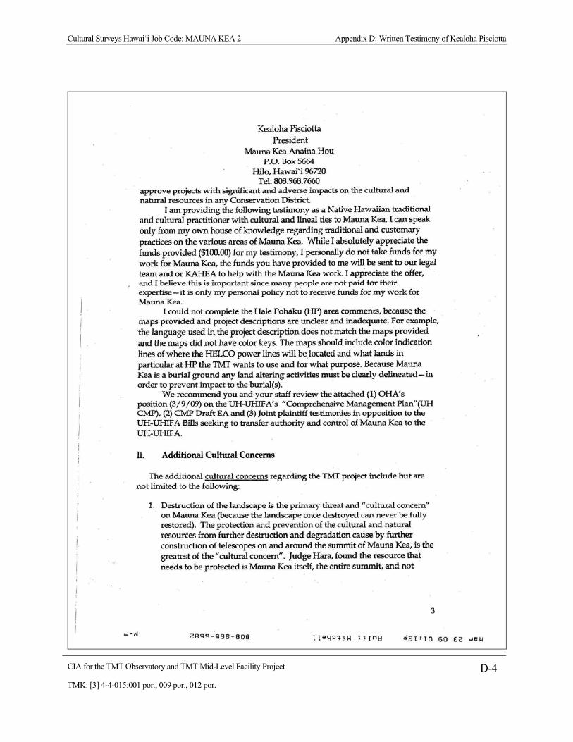
Cultural Surveys Hawai‘i Job Code: MAUNA KEA 2 Appendix D: Written Testimony of Kealoha Pisciotta
CIA for the TMT Observatory and TMT Mid-Level Facility Project D-4 TMK: [3] 4-4-015:001 por., 009 por., 012 por.

Cultural Surveys Hawai‘i Job Code: MAUNA KEA 2 Appendix D: Written Testimony of Kealoha Pisciotta
CIA for the TMT Observatory and TMT Mid-Level Facility Project D-5 TMK: [3] 4-4-015:001 por., 009 por., 012 por.

Cultural Surveys Hawai‘i Job Code: MAUNA KEA 2 Appendix D: Written Testimony of Kealoha Pisciotta
CIA for the TMT Observatory and TMT Mid-Level Facility Project D-6 TMK: [3] 4-4-015:001 por., 009 por., 012 por.

Cultural Surveys Hawai‘i Job Code: MAUNA KEA 2 Appendix D: Written Testimony of Kealoha Pisciotta
CIA for the TMT Observatory and TMT Mid-Level Facility Project D-7 TMK: [3] 4-4-015:001 por., 009 por., 012 por.

Cultural Surveys Hawai‘i Job Code: MAUNA KEA 2 Appendix D: Written Testimony of Kealoha Pisciotta
CIA for the TMT Observatory and TMT Mid-Level Facility Project D-8 TMK: [3] 4-4-015:001 por., 009 por., 012 por.
Cultural Surveys Hawai‘i Job Code: MAUNA KEA 2 Appendix D: Written Testimony of Kealoha Pisciotta
CIA for the TMT Observatory and TMT Mid-Level Facility Project D-9 TMK: [3] 4-4-015:001 por., 009 por., 012 por.

Cultural Surveys Hawai‘i Job Code: MAUNA KEA 2 Appendix E: Resolution on TMT Observatory (Isaac Harp)
CIA for the TMT Observatory and TMT Mid-Level Facility Project E-1 TMK: [3] 4-4-015:001 por., 009 por., 012 por.
Appendix E Resolution on TMT Observatory (Isaac Harp)
Resolution in Opposition to Thirty Meter Telescope (TMT), as amended, was adopted at the duly convened November 15, 2008 meeting of Na Kupuna O Moku O Keawe (“Na Kupuna”) held at Kapa’au, North Kohala, Island of Hawai’i
WHEREAS, Na Kupuna states that the Hawaiian Kingdom was and remains a neutral independent nation, was a member of the Family of Nations until removed under false representation by the United States, and has Treaties with many major nations of the world, including the U.S., France and Great Britain. Here we list for the record those Treaties, Conventions, and other International Agreements of the Hawaiian Kingdom: United States of America, December 23rd, 1826 (Treaty) Great Britain, November 13th, 1836 (Lord E. Russell's Treaty) France, July 17th, 1839 (Captain LaPlace's Convention) France, March 26th, 1846 (Treaty) Great Britain, March 26th, 1846 (Treaty) Denmark, October 19th, 1846 (Treaty) Hamburg, January 8th, 1848 (Treaty) Agreement Touching Consular Notices (Danish and Hamburg Treaties), January 25th, 1848 United States of America, December 20th, 1849 (Treaty) Sweden and Norway, July 1, 1852 (Treaty) Tahiti, November 24th, 1853 Bremen, March 27th, 1854 (Treaty) France, September 8th, 1858 (Treaty) Belgium, October 4th, 1862 (Treaty) Netherlands, October 16th, 1862 (Treaty) Italy, July 22nd, 1863 (Treaty) Spain, October 9th, 1863 (Treaty) Swiss Confederation, July 20th, 1864 (Treaty) Russia, June 19th, 1869 (Treaty) Japan, August 17th, 1871 (Treaty) New South Wales, March 10th, 1874 (Postal Convention) United States of America, January 30th, 1875 (Reciprocity Treaty) German Empire, 1879-80 (Treaty) Portugal, May 5, 1882 (Provisional Convention) United States of America, December 6, 1884 (Supplementary Convention) Hong Kong, December 13th, 1884 (Money Order Regulations) Universal Postal Union, March 21st, 1885 (Additional Act of Lisbon)

Cultural Surveys Hawai‘i Job Code: MAUNA KEA 2 Appendix E: Resolution on TMT Observatory (Isaac Harp)
CIA for the TMT Observatory and TMT Mid-Level Facility Project E-2 TMK: [3] 4-4-015:001 por., 009 por., 012 por.
Japan, January 28th, 1886 (Convention) Universal Postal Union, November 9th, 1886 (Ratification) Samoa, March 20th, 1887 (Treaty)
WHEREAS, Na Kupuna states that the Hawaiian Kingdom continues to exist - as recognized by the Permanent Court of Arbitration at the Hague, Netherlands, that entertained the case of Larsen vs. Hawaiian Kingdom, an arbitration that the U.S. refused to participate in for fear of being cited by the Permanent Court of Arbitration as a belligerent occupier of Hawai‘i; WHEREAS, Na Kupuna - in the absence of an operating government of the Hawaiian Kingdom, and in the absence of a line of succession to a monarch (Hawai'i is a constitutional monarchy) – states henceforth that as recognized under international law, the elders of descendants of Hawai‘i subjects are among the next in line of lawful authority having sole lawful jurisdiction over Hawai'i island. This is an adjunct of Hawaiian Kingdom law that continues, although the present U.S./State of Hawai‘i regimes ignore international laws of occupation by applying their own fabricated laws rather than the laws of the occupied Hawaiian Kingdom. The current situation reflects intentional misrepresentation, deceit and fraud by the U.S./State of Hawai‘i; WHEREAS, Na Kupuna states that the so-called “ceded lands” are lands unlawfully taken from the Hawaiian Kingdom in 1893 and unlawfully “ceded” to the U.S. as part of the unlawful annexation of Hawai‘i to the U.S. in 1898; WHEREAS, Na Kupuna states that the so-called annexation of Hawai‘i to the U.S. in 1898 is a myth, as the attempt was made by a “resolution” of the U.S. Congress - a domestic document having no legal significance outside of the boundaries of the sponsoring nation, the U.S. - and not by legally accepted treaty. Hawai‘i was and remains a foreign nation to the U.S.; WHEREAS, Na Kupuna states that the Republic of Hawai‘i that allegedly “ceded” the Hawaiian Kingdom National lands to the U.S. had no title to those lands. There is no “chain of title” giving any degree of good and legal title to the Republic of Hawai‘i; WHEREAS, Na Kupuna states that the Mauna Kea Science Preserve – upon which numerous astronomical observatories have been built - is part of the so-called “ceded lands” of the State of Hawai‘i; ADDITIONALLY, following current U.S. law - a law that Na Kupuna disagrees with -- under Section 5(f) of the Admissions Act (1959) – the so-called “ceded” lands were transferred to the so-called “State” of Hawai‘i “in trust,” among other things, for the benefit of Native Hawaiians;

Cultural Surveys Hawai‘i Job Code: MAUNA KEA 2 Appendix E: Resolution on TMT Observatory (Isaac Harp)
CIA for the TMT Observatory and TMT Mid-Level Facility Project E-3 TMK: [3] 4-4-015:001 por., 009 por., 012 por.
WHEREAS, Na Kupuna claims lawful jurisdiction and authority over these so-called “ceded” lands;
RECOGNIZING, the U.S. congress, in U.S. Public Law 103-150, dated November 23, 1993, states: Whereas, the indigenous Hawaiian people never directly relinquished their claims to their inherent sovereignty as a people or over their national lands to the United States, either through their monarchy or through a plebiscite or referendum;
WHEREAS, Na Kupuna suggests that the time line offered by TMT's sponsors, allowing 7-years for construction of the facility is grossly understated. Na Kupuna notes that litigation based on the Conservation District Use Application for the Keck Observatories Outrigger Telescope Project is on-going (7 years at the moment). Na Kupuna predicts a probable timeline for the TMT project of: litigation taking place on the Comprehensive Management Plan (CMP) that is in progress (estimated at 7 years), litigation on the TMT EIS (estimated at another 7 years - which will NOT take place concurrently with the CMP litigation), construction of TMT (if the project survives the 14 years of predicted litigation - of another 7 years) and 3 years for decommissioning. The total of 24 years - added to the present date of 2008 moves us into the year 2032 - leaving 1 year for operation of the TMT before termination of University of Hawai‘i’s general lease of the Science Reserve that terminates in 2033; THEREFORE, Na Kupuna states that the $1.1 Billion budget for TMT, combined with costs of litigation, payment of Plaintiffs' attorneys fees, etc., will increase total costs for the TMT to over U.S. $5 Billion. This figure enormously exceeds any practical cost/benefit;
WHEREAS, Na Kupuna states that in recent years, as part of the process for permitting the Keck Observatories Outrigger Telescopes, that NASA generated an EIS that concluded that “past, present and ‘reasonably foreseeable’ future astronomical activities at the summit of Mauna Kea have had a substantial and adverse cumulative impact on the mountain's cultural resources.”;
FURTHERMORE, while TMT attempts to disengage its project from the conclusions of the NASA EIS by stating that it is not a “federal agency” and thus not affected by conclusions of the NASA EIS, it is. TMT is a “federal agency” as it has applied for federal operational funds, or is expected to do so in the future;

Cultural Surveys Hawai‘i Job Code: MAUNA KEA 2 Appendix E: Resolution on TMT Observatory (Isaac Harp)
CIA for the TMT Observatory and TMT Mid-Level Facility Project E-4 TMK: [3] 4-4-015:001 por., 009 por., 012 por.
FURTHERMORE, even if TMT were not a “federal agency,” Na Kupuna believes that any EIS generated by TMT MUST, when considering the same or similar issues as the NASA EIS, come up with the same or similar conclusions; FURTHERMORE, Na Kupuna believes that even if TMT is not a “federal agency,” that BLNR (so-called “State” of Hawai‘i Board of Land and Natural Resources), no matter what the conclusion of a proposed “State” EIS might be - that any and all incremental impacts attributed to the TMT would add further substantial impacts to the conclusions of the NASA EIS of “substantial and adverse cumulative impact ...,” and MUST reject such an application for conservation use permit; MOREOVER, in the event that the proposed TMT EIS results in a conclusion substantially different from NASA’s EIS, Na Kupuna believes that the conclusion of NASA’s EIS (of substantial and adverse cumulative impact) would be the effective determining factor that would attach to all present and proposed astronomy activities on Mauna Kea, including the proposed TMT permit application;
FURTHERMORE, Na Kupuna believes that in the case above, there is no alternate method to handle such potentially conflicting conclusions, but to adopt the conclusion (of the NASA EIS) that best protects the cultural resources, cultural practices, and environmental protections on Mauna Kea; WHEREAS, Na Kupuna and its individual representatives (of the several districts of Hawai’i Island) maintain their cultural beliefs in the sacredness of Mauna Kea; WHEREAS, the principals of TMT Corporation, the sponsors of this proposed telescope with a proposed budget of $1.1 Billion (U.S.) to be potentially situated on Area E of the Mauna Kea Science Preserve are the California Institute for Astronomy, the University of California and the Association of Canadian Universities for Research in Astronomy; WHEREAS, Na Kupuna objects to the involvement of the Association of Canadian Universities for Research in Astronomy, as it is a foreign-based organization of a nation (Canada) that is a participant in the RIMPAC Naval Exercises held periodically in and around Hawai‘i, where in the past, it has taken part in the bombardment of Hawaiian island targets, which are actions Kupuna Council continues to condemn;
FURTHERMORE, Na Kupuna further objects to the involvement of the Association of Canadian Universities for Research in Astronomy, as it is a foreign-based organization of a nation (Canada) that does not support Indigenous Peoples (such as the Hawaiian people of Hawai’i) by refusing to vote in support

Cultural Surveys Hawai‘i Job Code: MAUNA KEA 2 Appendix E: Resolution on TMT Observatory (Isaac Harp)
CIA for the TMT Observatory and TMT Mid-Level Facility Project E-5 TMK: [3] 4-4-015:001 por., 009 por., 012 por.
of the recently passed UN Declaration of the Rights of Indigenous Peoples, which it now wants to use, in its hypocrisy, Hawaiian Indigenous lands - the so-called “ceded” lands - to build its telescope on; FURTHERMORE, Na Kupuna objects to the TMT being sited on Area E of the Mauna Kea Science Reserve as it will begin (and result in) the degradation of a pristine area of sacred Mauna Kea by necessarily building new roads and extending various pernicious infrastructure; ADDITIONALLY, Na Kupuna believes that initiating construction in the currently pristine Area E will set a precedent for opening up this area to further construction of future observatories that will desecrate an increasingly larger area of the sacred temple; FURTHERMORE, Na Kupuna believes that the power requirements of TMT will substantially squander the increasingly deficient power capacity of Hawai’i island - eventually mandating construction of new generating system capacity that will result in increasing the cost of citizens’ electric bills, pro rata or otherwise; ADDITIONALLY, Na Kupuna believes that situating the TMT where it is proposed, with its expected (approximately) 360 feet diameter dome (the ten meter Keck lenses have domes with a diameter of 120 feet), will be very detrimental to the observation and enjoyment of the natural beauty of Mauna Kea. This is especially so for observers from the South Kohala/Waimea area - where this dome - approximately three (3) times the diameter of the individual Keck domes - will be an extreme eyesore. The existing, and much smaller observatories on Mauna Kea already create an excessively ugly scene that is directly responsible for degrading the natural beauty of Mauna Kea; WHEREAS, Na Kupuna states that the Mauna Kea lands are “conservation” lands of the so-called State of Hawai‘i, and are administered and managed with priority as conservation lands; WHEREAS, Na Kupuna believes that no comprehensive studies of the Insecta, Aves and Mammalia classes on Mauna Kea have been done. Members of Na Kupuna, for instance, have knowledge that there are other insects, other than the Wekiu bug, that at times inhabit Mauna Kea, including a number of spiders, lady bugs, etc. Members of Na Kupuna also suggest that the Hawaiian Hoary Bat (Lasiurus cinereus semotus) may be a visitor to the summit areas (the Science Reserve) of Mauna Kea. In addition, there is the report by Kealoha Pisciotta that at a ceremony held outdoors on the summit (a number of years ago when she was an employee on the mountain), that she observed a Hawaiian Hawk or ‘Io (Buteo solitarius) circling directly above the summit;

Cultural Surveys Hawai‘i Job Code: MAUNA KEA 2 Appendix E: Resolution on TMT Observatory (Isaac Harp)
CIA for the TMT Observatory and TMT Mid-Level Facility Project E-6 TMK: [3] 4-4-015:001 por., 009 por., 012 por.
WITH CONCERN, Na Kupuna inquires about the possible use of insecticides/pesticides in and around a possible TMT at Mauna Kea;
WHEREAS, Na Kupuna states that astronomy, whose participants enthusiastically consider their activity to be superior to all other uses on Mauna Kea, is, by law, only a sub-use of the conservation lands on Mauna Kea, not THE major use of Mauna Kea; WHEREAS, Section 171 of Hawai‘i Revised Statutes requires that fair market rent be paid for the lease of any of the so-called “ceded” lands; WHEREAS, Na Kupuna has serious objections to past and present practices that allows lease rent paid by the University of Hawai‘i (lessee - hereinafter “U.H”) of the so-called “ceded” lands from the State of Hawai‘i (lessor) for $1 per year; HOWEVER, Na Kupuna states that if TMT wants to maintain a “legal and lawful” project under Section 171 of Hawai‘i Revised Statutes in the highest ethical and legal standards, then even if not required by U.H. - a fair market lease rent should be voluntarily paid to the Board of Land and Natural Resources (“BLNR”) as agent for the State of Hawai‘i (to whom the rent is owed); WHEREAS, Na Kupuna believes that while public lands are often set aside to public agencies for use in serving the public, subsequent transfer to 3rd parties outside of Hawai‘i government, especially when the benefits go to foreign nations that are obtuse to the Indigenous peoples of Hawai‘i, are, or should be, subject to fair market rents. This is especially so as fair market rents are statutorily mandated by Hawai‘i Revised Statutes; HOWEVER, Na Kupuna suggests that a fair market lease rent be 120% of proposed rents and viewing times that TMT would pay for a similar site in Chile. The additional 20% would make up for detriments (such as deficiencies for currency transactions, access to site, travel time, language, schools for employee children, standard of living, utilities, TV, shopping, site amenities such as wind flow and lower altitude, cultural differences, transportation difficulties, living communities, etc.) that a Chilean location would necessitate; WHEREAS, while BLNR continues to complain of not having sufficient budget for the management and administration of Mauna Kea, Na Kupuna believes that the statutory fair market lease rents could go far to remedy the financial straight-jacket that BLNR is currently saddled with, particularly in this time of U.S. and Hawai‘i state financial instabilities; WHEREAS, Na Kupuna also objects to other foreign-nation telescopes built on its sacred lands, including the Japan National Telescope and the Canada-France

Cultural Surveys Hawai‘i Job Code: MAUNA KEA 2 Appendix E: Resolution on TMT Observatory (Isaac Harp)
CIA for the TMT Observatory and TMT Mid-Level Facility Project E-7 TMK: [3] 4-4-015:001 por., 009 por., 012 por.
Telescope. All telescopes built on Mauna Kea burden the Hawaiian Nation culturally and (by subsidy) economically by paying an insulting rent of $1 a year; WHEREAS, Na Kupuna believes that the foreign-nation telescopes built on our sacred temple constitutes further unlawful occupation of our national lands and these telescopes should be deconstructed and rebuilt on the subject nations’ own national lands;
THEREFORE, Na Kupuna believes that the Association of Canadian Universities for Research in Astronomy should join other similar agencies and/or organizations - to pursue astronomical facilities and projects in its own country; FURTHERMORE, Na Kupuna states that the Hawaiian community, through the Hawai‘i State Office of Hawaiian Affairs (“OHA”), is benefited by 20% of the $1 annual rent (from each observatory) - amounting to 20 cents per year; FURTHERMORE, Na Kupuna states [that] with 13 observatories currently on Mauna Kea, that OHA’s income from astronomy activities amounts to the ridiculous sum of a mere $2.60 per year; WHEREAS, Na Kupuna states that with the inclusion of adaptive optics and interferometry - the twin Keck telescopes having an equivalent resolution of approximately 8 times the lens’ effective diameter – or 80 meters - which when compared with the TMT (of a “single” lens of only 30 meters) - has almost 3 times TMT's resolving power. Other than TMT's light gathering ability - the resolution of the TMT is inferior when compared to the adoptive optic- and interferometry-assisted Keck telescopes and therefore have cost-effective issues; MOREOVER, Na Kupuna believes that the cost/benefit ratio of TMT, when compared to such telescopes as the Keck’s, is skewed to the side of inefficiency; WHEREAS, Na Kupuna observes that Mauna Kea is positioned over one of the major aquifers of Hawai‘i island and MUST be conserved and protected to insure that the life-giving water from this aquifer remains pure for future generations of Hawai‘i Island; WHEREAS, Na Kupuna believes that all water and chemicals taken to the summit of Mauna Kea in support of TMT’s telescope operation, and all human wastes and trash produced, must be taken back down the mountain and disposed of properly. What goes up, must come down; WHEREAS, as the term “Sustainable Astronomy” has been used relative to public relations materials supporting the construction of TMT, Na Kupuna requests a full and comprehensive definition for the term “Sustainable Astronomy;”
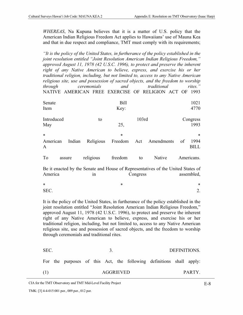
Cultural Surveys Hawai‘i Job Code: MAUNA KEA 2 Appendix E: Resolution on TMT Observatory (Isaac Harp)
CIA for the TMT Observatory and TMT Mid-Level Facility Project E-8 TMK: [3] 4-4-015:001 por., 009 por., 012 por.
WHEREAS, Na Kupuna believes that it is a matter of U.S. policy that the American Indian Religious Freedom Act applies to Hawaiians’ use of Mauna Kea and that in due respect and compliance, TMT must comply with its requirements; “It is the policy of the United States, in furtherance of the policy established in the joint resolution entitled “Joint Resolution American Indian Religious Freedom,” approved August 11, 1978 (42 U.S.C. 1996), to protect and preserve the inherent right of any Native American to believe, express, and exercise his or her traditional religion, including, but not limited to, access to any Native American religious site, use and possession of sacred objects, and the freedom to worship through ceremonials and traditional rites.” NATIVE AMERICAN FREE EXERCISE OF RELIGION ACT OF 1993 Senate Bill 1021 Item Key: 4770 Introduced to 103rd Congress May 25, 1993 * * * American Indian Religious Freedom Act Amendments of 1994 A BILL To assure religious freedom to Native Americans. Be it enacted by the Senate and House of Representatives of the United States of America in Congress assembled, * * * SEC. 2. It is the policy of the United States, in furtherance of the policy established in the joint resolution entitled “Joint Resolution American Indian Religious Freedom,” approved August 11, 1978 (42 U.S.C. 1996), to protect and preserve the inherent right of any Native American to believe, express, and exercise his or her traditional religion, including, but not limited to, access to any Native American religious site, use and possession of sacred objects, and the freedom to worship through ceremonials and traditional rites.
SEC. 3. DEFINITIONS. For the purposes of this Act, the following definitions shall apply: (1) AGGRIEVED PARTY.

Cultural Surveys Hawai‘i Job Code: MAUNA KEA 2 Appendix E: Resolution on TMT Observatory (Isaac Harp)
CIA for the TMT Observatory and TMT Mid-Level Facility Project E-9 TMK: [3] 4-4-015:001 por., 009 por., 012 por.
--The term “aggrieved party” means any Native American practitioner, Native American traditional leader, Indian tribe, or Native Hawaiian organization [including Na Kupuna] as defined by this Act. (8) LAND.--The terms “land,” “lands,” or “public lands” mean surface and subsurface land within the jurisdiction of the United States or the respective States, including submerged land of any kind or interest therein and all water and waterways occupying, adjacent to, or running through the land.; WHEREAS, Na Kupuna recognizes that Native Hawaiians, especially the elderly, suffer very serious health issues relative to the general population of Hawai‘i; WHEREAS, Na Kupuna, on behalf of all kupuna (elders), Native Hawaiians and the general populace of Hawai‘i Island, and the so-called State of Hawai‘i, suggests that, if TMT is eventually permitted to build (after meeting all legal requirements and cultural concerns), although, hopefully, in an area other than Area E, that its Canadian partner, Association of Canadian Universities for Research in Astronomy, advocate for and participant in a program to import pharmaceuticals from Canada - where pharmaceuticals can be acquired for a substantially lesser expense than in the U.S. - to be sold by licensed participating pharmacies for a set (minimal) markup, thereby significantly benefiting citizens’ in their necessary healthcare; NOW, THEREFORE, Na Kupuna O Moku O Keawe opposes the permitting and construction of the TMT and any other telescopes on the sacred mountain of Mauna Kea, Hawai‘i Island, so-called State of Hawai‘i. We also call for the removal of all telescopes and related equipment on the sacred mountain of Mauna Kea as these were never intended for Hawaiian cultural or religious practices. DATED: November 15, 2008, at Kapa’au, North Kohala, Hawai‘i Island, _____________________ _______________________ Signed: Kihei Niheu Witnessed: Isaac Harp

Cultural Surveys Hawai‘i Job Code: MAUNA KEA 2 Appendix F: TMT Mid-Level Facility Map
CIA for the TMT Observatory and TMT Mid-Level Facility Project F-1 TMK: [3] 4-4-015:001 por., 009 por., 012 por.
Appendix F TMT Mid-Level Facility Map


Final EIS: TMT Observatory Page E-1
Appendix E. Cultural Impact Statement (2000 Master Plan)
Paul H. Rosendahl, Ph.D. Inc. (PHRI), 1999. Cultural Impact Assessment Study: Native Hawaiian Cultural Practices, Features, and Beliefs Associated with the University of Hawai‘i Mauna Kea Science Reserve Master Plan Project Area. Prepared for the UH IfA. In the 2000 Master Plan, Appendix N. August 1999.


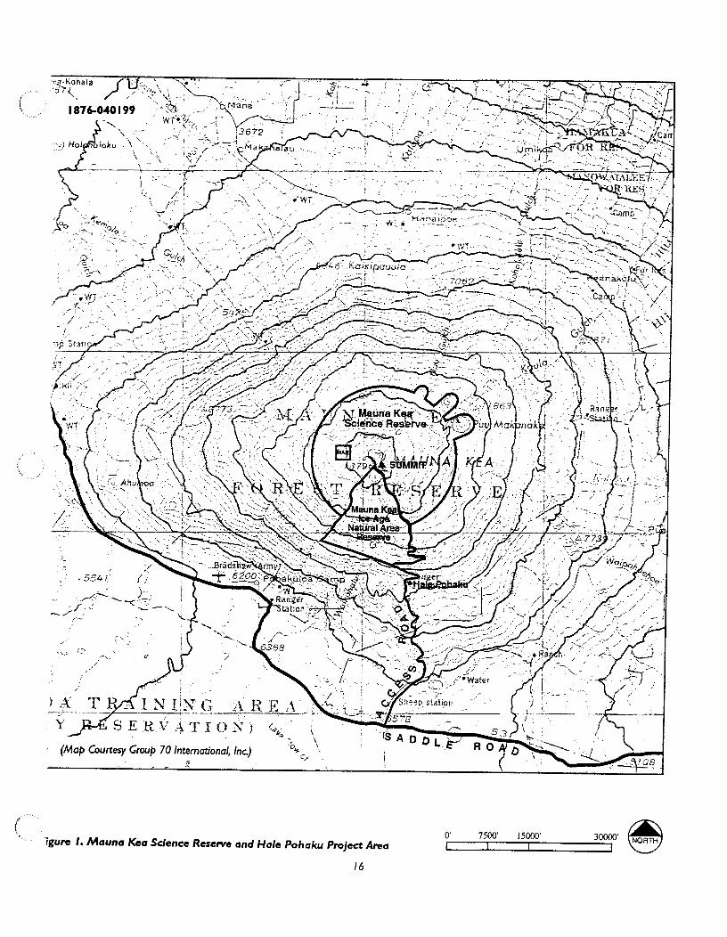


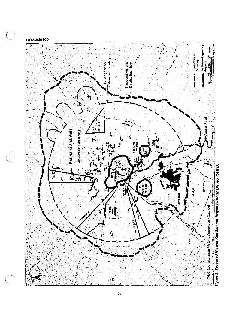


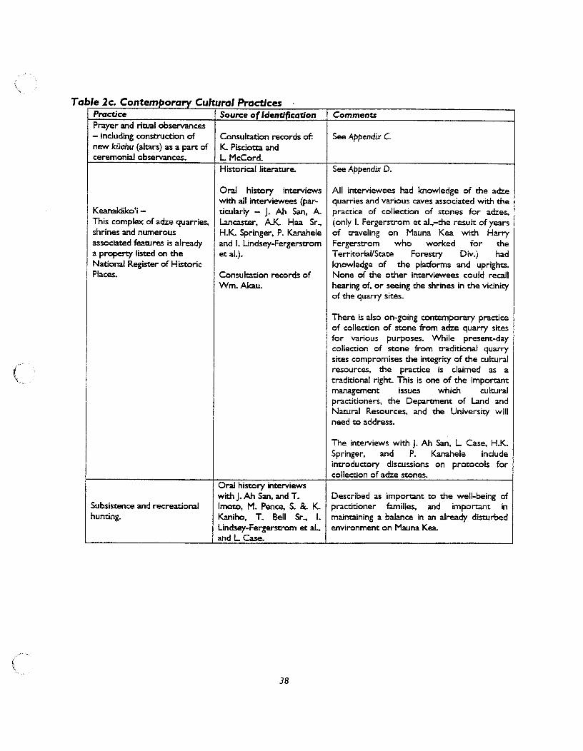


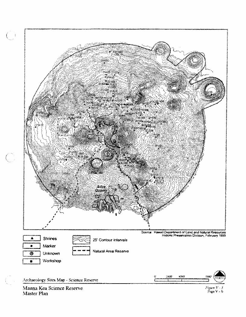


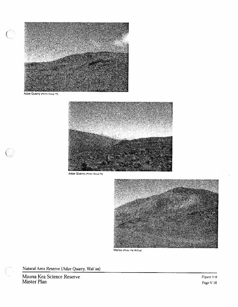


Final EIS: TMT Observatory Page F-1
Appendix F. Mauna Kea-Ka Piko Kaulana o ka ‘�ina (Mauna Kea—The Famous Summit of the Land)
Kumu Pono Associates LLC, 2005. Mauna Kea-Ka Piko Kaulana o ka ‘�ina (Mauna Kea—The Famous Summit of the Land); A collection of Native Traditions, Historical Accounts, and Oral History Interviews for: Mauna Kea, the Lands of Ka‘ohe, Humu‘ula and the ‘�ina Mauna on the Island of Hawai‘i. Prepared for the Office of Mauna Kea Management. March 30, 2005.


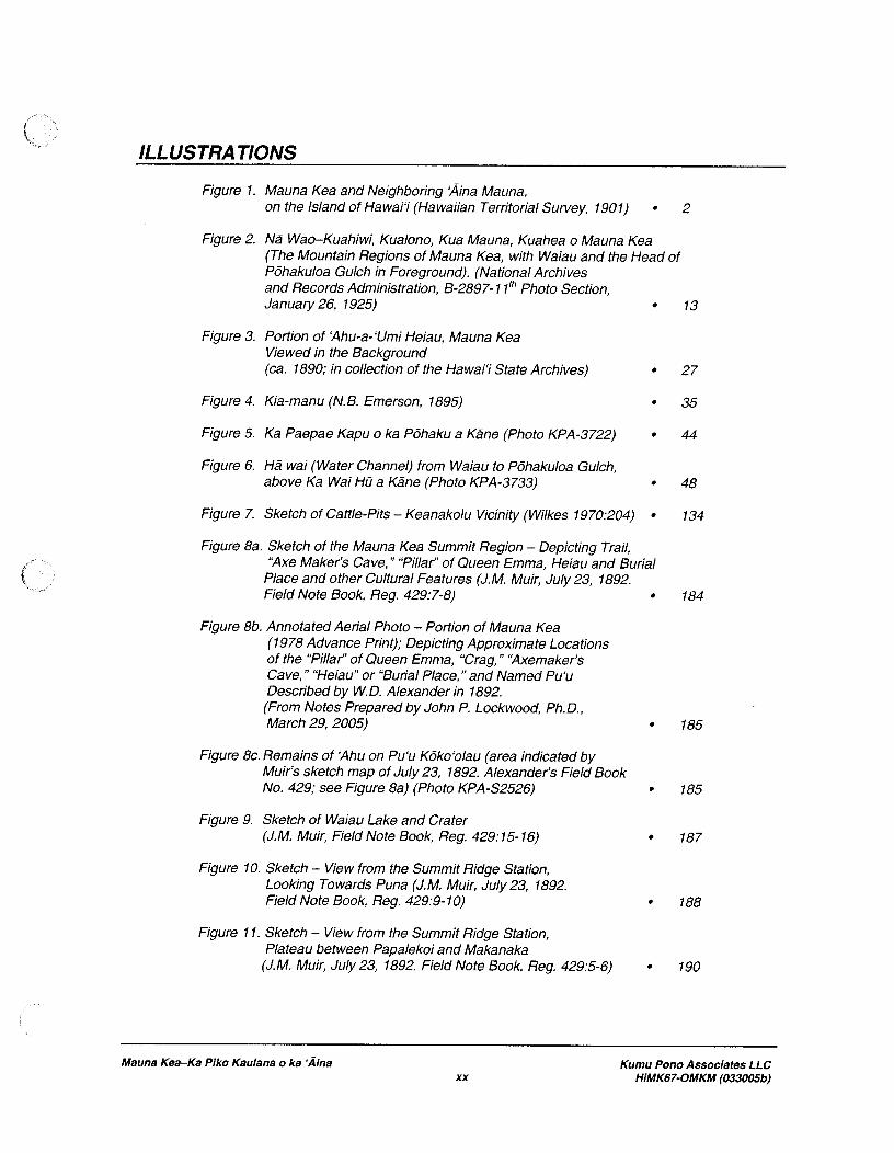


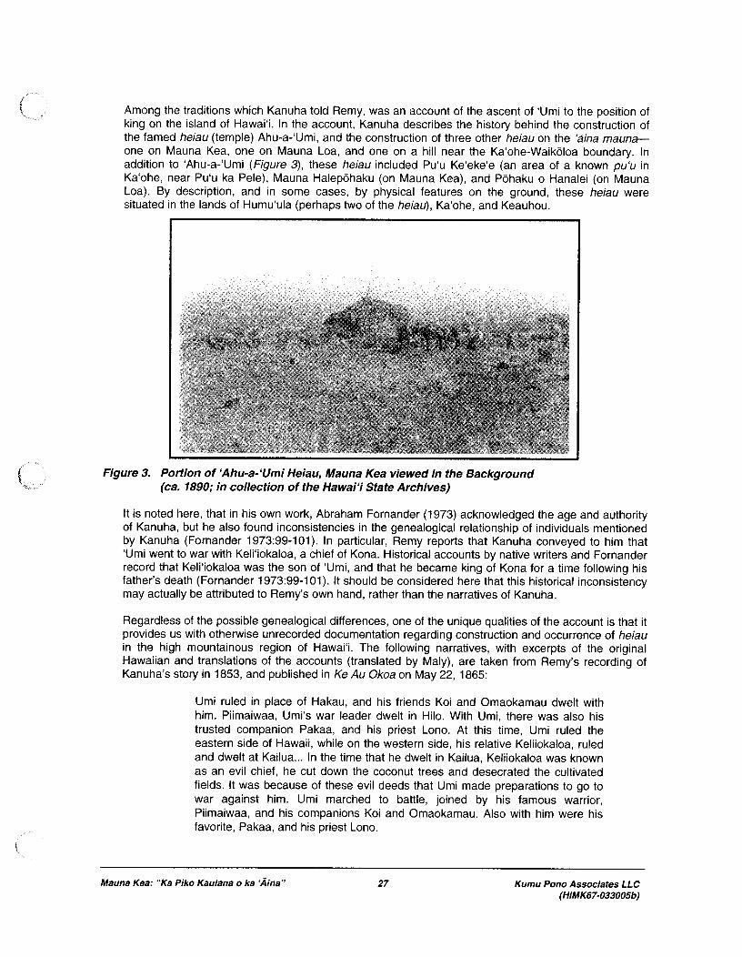


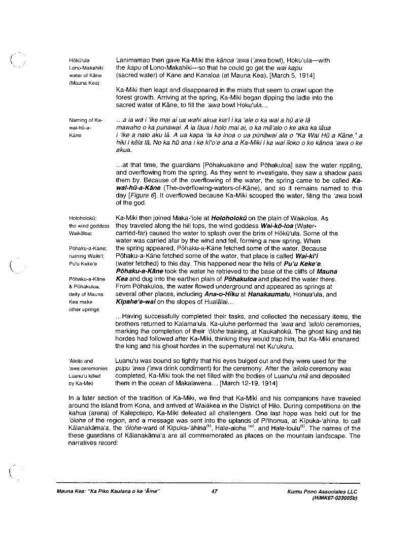


Final EIS: TMT Observatory Page G-1
Appendix G. Archaeological Inventory Survey, Maunakea Summit Area

Final EIS: TMT Observatory Page G-3
Preface The Archaeological Inventory Survey for the Thirty-Meter-Telescope (TMT) Observatory Project, Maunakea, Ka‘ohe, Ahupua‘a, H�m�kua District, Hawai‘i Island, TMK: [3] 4-4-015:009 por. has been updated since the Draft EIS was completed. This report addresses only the Project facilities in the Mauna Kea Science Reserve (MKSR); potential Project facilities in Hale P�haku are discussed in a separate report in Appendix H. The Archaeological Inventory Survey report has been updated to address comments on the report received from State of Hawai‘i Department of Land and Natural Resources, State Historic Preservation Division, in a letter dated October 7, 2009. That letter, and responses to comments in the letter, is included in Chapter 8, Volume 2, of the Final EIS. Changes made to this technical report since the Draft EIS was completed are not illustrated as they are within this preface and the body of the Final EIS. Substantial changes to the Archaeological Inventory Survey report include the following:
� The Project effect has been modified from “no historic properties affected” to “effect with treatment/mitigation commitments.”
� A discussion concerning effects to both the Mauna Kea Summit Region Historic District and K�kahau‘ula Historic Property have been added.
� Treatment/mitigation commitments have been updated.
Within the body of this Final EIS, historic and archaeological resources are discussed in Section 3.3, Archaeologic/Historic Resources..


O‘ahu Office P.O. Box 1114 Kailua, Hawai‘i 96734 Ph.: (808) 262-9972 Fax: (808) 262-4950
www.culturalsurveys.com
Maui Office 1993 Main St. Wailuku, Hawai‘i 96793 Ph: (808) 242-9882 Fax: (808) 244-1994
Archaeological Inventory Survey for the Thirty-Meter-Telescope (TMT) Observatory Project,
Maunakea, Ka‘ohe Ahupua‘a, H�m�kua District, Hawai‘i Island
TMK: [3] 4-4-015:009 por.
Prepared for PB Americas, Inc.
Prepared by Hallett H. Hammatt, Ph.D
Cultural Surveys Hawai‘i, Inc.
Kailua, Hawai‘i (Job Code: MAUNAKEA 1)
April 2010

Cultural Surveys Hawai‘i Job Code: MAUNAKEA 1
Archaeological Inventory Survey for the Thirty-Meter-Telescope (TMT) Project, Maunakea, Hawai‘i iiTMK: [3] 4-4-015:009 por.
Management Summary
Reference Archaeological Inventory Survey for the Thirty-Meter-Telescope (TMT) Observatory Project, Maunakea, Ka‘ohe Ahupua‘a, H�m�kua District, Hawai‘i Island TMK: [3] 4-4-015:009 por.
Date April 2010 Project Number (s) Cultural Surveys Hawai‘i Inc. (CSH) Job Code: MAUNAKEA 1 Investigation Permit Number
The fieldwork component of the archaeological inventory survey was carried out under archaeological permit number 08-14, issued by the Hawai‘i State Historic Preservation Division / Department of Land and Natural Resources (SHPD/DLNR), per Hawai‘i Administrative Rules (HAR) Chapter 13-13-282.
Project Location The approximately 12-acre Project area consists of two discreet parcels and a road corridor located on the northern plateau of the Maunakea summit area. The Project area is depicted on the U.S. Geological Survey 7.5-Minute Series Topographic Map, Mauna Kea Quadrangle (1993).
Land Jurisdiction The Mauna Kea Science Reserve is owned by the State of Hawai‘i, and leased to the University of Hawai‘i (UH) for use as a scientific complex.
Agencies Hawai‘i State Historic Preservation Division / Department of Land and Natural Resources
Project Description The proposed TMT Observatory Project involves the construction of a 30-meter diameter telescope and associated infrastructure on a 5-acre site within Area E of the Astronomy Precinct. The Project also includes construction of an Access Way, consisting of a 0.6-mile long road and utility corridor from existing facilities to the TMT Observatory. In addition, the Batch Plant Staging Area, consisting of a 4-acre area near the summit, would be temporarily used as a staging area during Project construction. Minimally, land disturbing activities would include grading of the TMT Observatory site, Access Way, and Batch Plant Staging Area, and excavations associated with building construction and installation of subsurface utilities.
Project Acreage Approximately 12 acres

Cultural Surveys Hawai‘i Job Code: MAUNAKEA 1
Archaeological Inventory Survey for the Thirty-Meter-Telescope (TMT) Project, Maunakea, Hawai‘i iiiTMK: [3] 4-4-015:009 por.
Area of Potential Effect (APE) and Survey Acreage
The 44-acre survey area for the current study included: Area E of the Astronomy Precinct - 38 acres; the approximately 0.4-mile long portion of the Access Way south of Area E - 1.5 acres; and the Batch Plant Staging Area - 4 acres. Subsequent to the survey, a 5-acre area within the northern portion of Area E was selected as the proposed location of the TMT Observatory. The area of potential effect (APE) is defined as the entire approximately 12-acre Project area.
Historic Preservation Regulatory Context
At the request of PB, CSH conducted an archaeological inventory survey investigation for the proposed TMT Observatory Project. This archaeological inventory survey report was prepared to support the proposed project’s historic preservation review under Hawai‘i Revised Statutes (HRS) Chapter 6E-8/42 and Hawai‘i Administrative Rules (HAR) Chapter 13-275/284. In consultation with the Hawai‘i State Historic Preservation Division (SHPD), the archaeological inventory survey investigation was designed to fulfill the State requirements for an archaeological inventory survey per HAR Chapter 13-13-276. It is also intended to support any Project-related historic preservation consultation with stake-holding State or County agencies and interested Native Hawaiian and community groups.
Fieldwork Effort The CSH field crew included: David W. Shideler, M.A.; Todd Tulchin, B.S.; Trevor Yucha, B.S.; and Lehua Ka‘uhane, B.A., under the overall supervision of Hallett H. Hammatt, Ph.D. Fieldwork was conducted on August 26, 2008 and required 4 person-days to complete.
Number of Historic Properties Identified
Two
Historic Properties Recommended Eligible to the National/Hawai‘i Registers of Historic Places
SIHP # 50-10-23-21438, Pu‘u K�kahau‘ula State Historic Property is a contributing component of the Mauna Kea Summit Region Historic District. SIHP # 50-10-23-26869, Mauna Kea Summit Region Historic District, recommended National/Hawai‘i Register-eligible under Criteria A, B, C, D, and E.
Effect Recommendation
The Access Way portion of the Project area traverses a portion of the SIHP # 50-10-23-21438 Pu‘u K�kahau‘ula State Historic Property. The entire project area is located within the SIHP # 50-10-23-26869 Mauna Kea Summit Region Historic District. Due to the potential adverse effect on significant historic properties, CSH’s project-specific effect recommendation is “effect, with proposed mitigation commitments.”

Cultural Surveys Hawai‘i Job Code: MAUNAKEA 1
Archaeological Inventory Survey for the Thirty-Meter-Telescope (TMT) Project, Maunakea, Hawai‘i ivTMK: [3] 4-4-015:009 por.
Mitigation Recommendation
The main form of mitigation is in the locating of the TMT Observatory off of the summit and well away from all known archaeological sites. Keeping the TMT Observatory and appurtenances more than 200 feet away from all known sites is a major form of mitigation. Similarly, the fact that the TMT Observatory will not be visible from the actual summit is suggested to be a major form of mitigation of impact to both the Pu‘u K�kahau‘ula State Historic Property (SIHP # 50-10-23-21438) and the Mauna Kea Summit Region Historic District (SIHP # 50-10-23-26869).
The probability of any unmarked burials or human skeletal remains being present is regarded as very low inasmuch as: a) burials near the summit have only been reported at cinder cones (primarily on the south and east sides of the summit), b) most reports of burials are at lower elevations, c) no burials have been encountered during development thus far in the Astronomy Precinct, d) there are no burial markers or surface indicators of burials present, and e) the absence of caves in the area and the general desert pavement geology would not be conducive for burial location selection. However, in the unlikely event that cultural resources, including human skeletal remains or other significant cultural deposits, are encountered during the course of Project-related construction activities, all work in the immediate area should stop and the State Historic Preservation Division should be promptly notified.

Cultural Surveys Hawai‘i Job Code: MAUNAKEA 1
Archaeological Inventory Survey for the Thirty-Meter-Telescope (TMT) Project, Maunakea, Hawai‘i vTMK: [3] 4-4-015:009 por.
Table of Contents Management Summary ........................................................................................................... ii�
Section 1 Introduction ............................................................................................................. 1�
1.1 Project Background ....................................................................................................................... 1�1.2 Scope of Work ............................................................................................................................... 1�1.3 Environmental Setting ................................................................................................................... 6�
1.3.1 Natural Environment............................................................................................................... 6�1.3.2 Built Environment .................................................................................................................. 6�
Section 2 Methods .................................................................................................................... 8�
2.1 Field Methods ................................................................................................................................ 8�2.2 Document Review ......................................................................................................................... 8�2.3 Consultation ................................................................................................................................... 8�
Section 3 Background Research ............................................................................................. 9�
3.1 Traditional and Historic Background ............................................................................................ 9�3.1.1 Mythological and Traditional Accounts ................................................................................. 9�3.1.2 Historic Accounts ................................................................................................................. 10�3.1.3 Modern Land Use ................................................................................................................. 12�
3.2 Previous Archaeological Research .............................................................................................. 12�3.2.1 Previous Archaeological Studies .......................................................................................... 12�3.2.2 Culturally Significant Historic Properties ............................................................................. 31�3.2.3 Mauna Kea Summit Region Historic District ....................................................................... 31�
3.3 Background Summary and Predictive Model .............................................................................. 35�3.3.1 Burials and Possible Burials ................................................................................................. 35�3.3.2 Shrines .................................................................................................................................. 36�3.3.3 Adze Quarries and Manufacturing Workshops ..................................................................... 37�3.3.4 Trails and Temporary Habitations ........................................................................................ 37�
Section 4 Results of Fieldwork .............................................................................................. 39�
4.1 Survey Findings ........................................................................................................................... 39�4.1.1 Survey Findings of the Area E Survey Area ......................................................................... 39�4.1.2 Relationship of the Access Way Survey Area to the Pu‘u K�kahau‘ula State Historic
Property ............................................................................................................................................... 44�4.1.3 Survey Findings of the Batch Plant Staging Area ................................................................ 44�4.1.4 Relationship of the Area E Survey Area and the Batch Plant Staging Area to the Mauna
Kea Summit Region Historic District (SIHP # 50-10-23-26869) ....................................................... 45�
Section 5 Significance Assessments ...................................................................................... 54�
Section 6 Project Effect and Mitigation Recommendations ............................................... 56�
6.1 Project Effect ............................................................................................................................... 56�6.1.1 Absence of Direct Impact to Archaeological Sites ............................................................... 56�6.1.2 SIHP # 50-10-23-21438 Pu‘u K�kahau‘ula State Historic Property .................................... 56�6.1.3 SIHP # 50-10-23-26869 Mauna Kea Summit Region Historic District ............................... 57�
6.2 Mitigation Recommendations ...................................................................................................... 59�
Cultural Surveys Hawai‘i Job Code: MAUNAKEA 1
Archaeological Inventory Survey for the Thirty-Meter-Telescope (TMT) Project, Maunakea, Hawai‘i viTMK: [3] 4-4-015:009 por.
6.2.1 Historic Properties and Integrity of Cinder Cones ................................................................ 59�6.2.2 Visual .................................................................................................................................... 60�6.2.3 Roads and Access ................................................................................................................. 60�6.2.4 Employees in the Summit Region ........................................................................................ 60�6.2.5 Accidental Release of Wastewater or Hazardous Substances .............................................. 61�6.2.6 Noise and Dust ...................................................................................................................... 61�6.2.7 Treatments ............................................................................................................................ 61�6.2.8 Off-Site Mitigation ............................................................................................................... 62�6.2.9 Summary of Mitigation ......................................................................................................... 63�
Section 7 References Cited .................................................................................................... 64�
Appendix A Documentation of Potential Historic Properties .............................................. 1�
CSH 1 .................................................................................................................................................. 1�CSH 2 .................................................................................................................................................. 4�

Cultural Surveys Hawai‘i Job Code: MAUNAKEA 1
Archaeological Inventory Survey for the Thirty-Meter-Telescope (TMT) Project, Maunakea, Hawai‘i viiTMK: [3] 4-4-015:009 por.
List of Figures Figure 1. U.S. Geological Survey 7.5-Minute Series Topographic Map, Mauna Kea
Quadrangle (1993), showing the locations of the Project area and survey areas ................2�Figure 2. Portion of Tax Map Key (TMK) 4-4-015, showing the locations of the Project
area and survey areas ...........................................................................................................3�Figure 3. Aerial photograph (source: U.S.D.A. 2000), showing the locations of the Project
area and survey areas ...........................................................................................................4�Figure 4. U.S. Geological Survey 7.5-Minute Series Topographic Map, Mauna Kea
Quadrangle (1993) with overlay of the Soil Survey of the Island of Hawai‘i (Sato et al. 1972), showing sediment types within the Project area ..................................................7�
Figure 5. U.S. Geological Survey Orthophotograph, Mauna Kea Quadrangle (1978), showing the location of the Project area ............................................................................13�
Figure 6. U.S. Geological Survey 7.5-Minute Series Topographic Map, Mauna Kea Quadrangle (1993), showing proposed Traditional Cultural Properties in the summit region of Maunakea (adapted from Maly 1997:Table 2 & Figure 2; Note: All of Maunakea down to the 6,000 foot elevation has been suggested to be a Traditional Cultural Property) (Boundaries shown should be understood as approximate) ................32�
Figure 7. 1:100,000 Scale U.S. Geological Survey Map showing the proposed “Ka Mauna a W�kea or Mauna Kea” Traditional Cultural Property (TCP) down to the recommended 6,000 foot contour (following Maly 1997:29); estimated area approximately 150,000 acres .............................................................................................33�
Figure 8. U.S. Geological Survey 7.5-Minute Series Topographic Map, Mauna Kea Quadrangle (1993), showing the extent of the Mauna Kea Summit Region Historic District (SIHP # 50-10-23-26869) .....................................................................................34�
Figure 9. General view of the Area E survey area, view to northwest, showing existing 4-wheel drive access road and proposed Access Way through the central portion of the survey area ...................................................................................................................40�
Figure 10. General view of the western portion of the Area E survey area, view to northeast .....40�Figure 11. General view of the eastern portion of the Area E survey area, view to north ............41�Figure 12. Example of Hawaiiite basalt exposure within the Area E survey area .........................41�Figure 13. U.S. Geological Survey 7.5-Minute Series Topographic Map, Mauna Kea
Quadrangle (1993), showing the locations of find spots and previously identified historic properties within and in the vicinity of the Observatory and Access Way Project areas .......................................................................................................................42�
Figure 14. Aerial photograph (source: Google Earth 2009), showing the locations of find spots and previously identified historic properties within and in the vicinity of the Observatory and Access Way Project areas .......................................................................43�
Figure 15. Map showing the routes of the two Access Way options (TMT Access Way Option 2 and TMT Access Way Option 3) under consideration extending north from the Maunakea Access Road Loop/SMA Road intersection ......................................46�
Figure 16. General view approaching the Submillimeter Array (at left) and access road leading to Subaru Telescope and Area E, view to northwest. Note: existing paved summit loop portion of the Maunakea Access Road, unimproved road, and

Cultural Surveys Hawai‘i Job Code: MAUNAKEA 1
Archaeological Inventory Survey for the Thirty-Meter-Telescope (TMT) Project, Maunakea, Hawai‘i viiiTMK: [3] 4-4-015:009 por.
infrastructure are on the southwest flank of the Pu‘u K�kahau‘ula State Historic Property (SIHP # 50-10-23-21438) ...................................................................................47�
Figure 17. General view approaching divergence of the Area E access road (at left) and summit loop portion of the Maunakea Access Road leading to the Subaru Telescope, view to north. Note: unimproved road is on the southwest flank of the Pu‘u K�kahau‘ula State Historic Property (SIHP # 50-10-23-21438) ..............................47�
Figure 18. View from the northeast corner of the Submillimeter Array enclosure, showing the TMT Access Way Option 3 alignment corresponding to the unimproved road at upper right and the the TMT Access Way Option 2 alignment corresponding to the unimproved road at center, both are located on the extreme west flank of Pu‘u K�kahau‘ula State Historic Property (SIHP # 50-10-23-21438), view to north ................48�
Figure 19. View showing the TMT Access Way Option 3 alignment corresponding to the unimproved road at upper left and the TMT Access Way Option 2 alignment corresponding to the unimproved road at right, both located on the extreme west flank of Pu‘u K�kahau‘ula State Historic Property (SIHP # 50-10-23-21438), view to southeast.........................................................................................................................49�
Figure 20. U.S. Geological Survey 7.5-Minute Series Topographic Map, Mauna Kea Quadrangle (1993), showing the locations of previously identified historic properties in the vicinity of the Batch Plant Staging Area .................................................50�
Figure 21. Aerial photograph (source: Google Earth 2009), showing the locations of previously identified historic properties in the vicinity of the Batch Plant Staging Area ....................................................................................................................................51�
Figure 22.General view of the eastern portion of the Batch Plant Staging Area, view to northwest ............................................................................................................................52�
Figure 23. General view of western portion of the Batch Plant Staging Area, view to northwest ............................................................................................................................52�
Figure 24. General view of the southeast portion of the Batch Plant Staging Area, view to southeast .............................................................................................................................53�
Figure 25. General view of the southwest portion of the Batch Plant Staging Area, view to south ...................................................................................................................................53�
Figure 26. Illustration of how the TMT Observatory will not be visible from the summit of the Pu‘u K�kahau‘ula State Historic Property (SIHP # 50-10-23-26869. TMT would be in the yellow box is you could see through the mountain ..................................58�
Figure 27. Photograph of CSH 1 understood as a contemporary shrine, view to southwest, showing two upright stones .................................................................................................2�
Figure 28. Photograph of CSH 1 understood as a contemporary shrine, showing southeastern upright stone....................................................................................................3�
Figure 29. Photograph of CSH 1 understood as a contemporary shrine, showing northwestern upright stone ...................................................................................................3�
Figure 30. Photograph of CSH 2 Feature A, initially perceived as a C-shaped temporary habitation structure, view to east .........................................................................................5�
Figure 31. Photograph of CSH 2 Feature B, initially perceived as a temporary habitation terrace, view to east ..............................................................................................................5�
Figure 32. Photograph of CSH 2 Feature C, initially perceived as a temporary habitation terrace, view to northeast .....................................................................................................6

Cultural Surveys Hawai‘i Job Code: MAUNAKEA 1
Archaeological Inventory Survey for the Thirty-Meter-Telescope (TMT) Project, Maunakea, Hawai‘i ixTMK: [3] 4-4-015:009 por.
List of Tables Table 1. Summary of Previous Archaeological Studies on Maunakea ..........................................14�Table 2. Previously Identified Historic Properties in the Summit Region of Maunakea
(source: Draft Mauna Kea Cultural Resource Management Plan - McCoy et al. 2009) ..................................................................................................................................18�

Cultural Surveys Hawai‘i Job Code: MAUNAKEA 1 Introduction
Archaeological Inventory Survey for the Thirty-Meter-Telescope (TMT) Project, Maunakea, Hawai‘i 1TMK: [3] 4-4-015:009 por.
Section 1 Introduction
1.1 Project Background At the request of PB Americas, Inc. (PB), Cultural Surveys Hawai‘i Inc. (CSH) completed an
archaeological inventory survey for the proposed Thirty-Meter-Telescope (TMT) Observatory Project, Ka‘ohe Ahupua‘a, H�m�kua District, Hawai‘i Island TMK: [3] 4-4-015:009 por. The approximately 12-acre Project area consists of two discreet parcels and a road corridor located on the northern plateau of the Maunakea summit area (Figures 1-3). The Project area is depicted on the U.S. Geological Survey 7.5-Minute Series Topographic Map, Mauna Kea Quadrangle (1993).
The Mauna Kea Science Reserve is owned by the State of Hawai‘i, and leased to the University of Hawai‘i (UH) for use as a scientific complex. The proposed TMT Observatory Project involves the construction of a 30-meter diameter telescope and associated infrastructure on a 5-acre site within Area E of the Astronomy Precinct. The Project also includes construction of an Access Way, consisting of a 0.6-mile long road and utility corridor from existing facilities to the TMT Observatory. In addition, the Batch Plant Staging Area, consisting of a 4-acre area near the summit, would be temporarily used as a staging area during Project construction. Minimally, land disturbing activities would include grading of the TMT Observatory site, Access Way, and Batch Plant Staging Area, and excavations associated with building construction and installation of subsurface utilities.
The 44-acre survey area for the current study included: Area E of the Astronomy Precinct - 38 acres; the approximately 0.4-mile long portion of the Access Way south of Area E - 1.5 acres; and the Batch Plant Staging Area - 4 acres. Subsequent to the survey, a 5-acre area within the northern portion of Area E was selected as the proposed location of the TMT Observatory. The area of potential effect (APE) is defined as the entire approximately 12-acre Project area.
At the request of PB, CSH conducted the present archaeological inventory survey investigation, and a companion Cultural Impact Assessment study (Cruz et al. 2009) for the proposed TMT Observatory Project. This archaeological inventory survey report was prepared to support the proposed project’s historic preservation review under Hawai‘i Revised Statutes (HRS) Chapter 6E-8/42 and Hawai‘i Administrative Rules (HAR) Chapter 13-275/284. In consultation with the Hawai‘i State Historic Preservation Division (SHPD), the archaeological inventory survey investigation was designed to fulfill the State requirements for an archaeological inventory survey per HAR Chapter 13-13-276. It is also intended to support any Project-related historic preservation consultation with stake-holding State or County agencies and interested Native Hawaiian and community groups. For more detailed accounts of the project area’s cultural history the reader is referred to the companion Cultural Impact Assessment study (Cruz et al. 2009) and the thorough work of Maly 1997 and Maly and Maly 2005.
1.2 Scope of Work The following scope of work satisfies the State requirements for an archaeological inventory
survey, per HAR Chapter 13-13-276:

Cultural Surveys Hawai‘i Job Code: MAUNAKEA 1 Introduction
Archaeological Inventory Survey for the Thirty-Meter-Telescope (TMT) Project, Maunakea, Hawai‘i 2TMK: [3] 4-4-015:009 por.
Figure 1. U.S. Geological Survey 7.5-Minute Series Topographic Map, Mauna Kea Quadrangle (1993), showing the locations of the Project area and survey areas

Cultural Surveys Hawai‘i Job Code: MAUNAKEA 1 Introduction
Archaeological Inventory Survey for the Thirty-Meter-Telescope (TMT) Project, Maunakea, Hawai‘i 3TMK: [3] 4-4-015:009 por.
Figure 2. Portion of Tax Map Key (TMK) 4-4-015, showing the locations of the Project area and survey areas

Cultural Surveys Hawai‘i Job Code: MAUNAKEA 1 Introduction
Archaeological Inventory Survey for the Thirty-Meter-Telescope (TMT) Project, Maunakea, Hawai‘i 4TMK: [3] 4-4-015:009 por.
Figure 3. Aerial photograph (source: U.S.D.A. 2000), showing the locations of the Project area and survey areas

Cultural Surveys Hawai‘i Job Code: MAUNAKEA 1 Introduction
Archaeological Inventory Survey for the Thirty-Meter-Telescope (TMT) Project, Maunakea, Hawai‘i 5TMK: [3] 4-4-015:009 por.
1. Historic and archaeological background research, including a search of historic maps, written records, Land Commission Award documents, and the reports from prior archaeological investigations. This research focused on the specific Project area’s past land use, with general background on the pre-contact and historic settlement patterns of the ahupua‘a and district. This background information was used to compile a predictive model for the types and locations of historic properties that could be expected within the Project area.
2. A complete (100% coverage) systematic pedestrian inspection of Area E of the Astronomy Precinct, the Access Way, and Batch Plant Staging Area to identify any potential surface historic properties. Surface historic properties were recorded with an evaluation of age, function, interrelationships, and significance. Documentation included photographs, scale drawings, and, if warranted, limited controlled excavation of select sites and/or features, and location of historic properties with GPS survey equipment.
3. As appropriate, consultation with knowledgeable individuals regarding the Project area’s history, past land use, and the function and age of the historic properties documented within the Project area.
4. As appropriate, laboratory work to process and gather relevant environmental and/or archaeological information from collected samples.
5. Preparation of this archaeological inventory survey report, including the following:
a) A Project description;
b) A section of a USGS topographic map showing the survey area boundaries and the location of all recorded historic properties;
c) Historical and archaeological background sections summarizing prehistoric and historic land use of the Project area and its vicinity;
d) Descriptions of all historic properties, including selected photographs, scale drawings, and discussions of age, function, laboratory results, and significance, per the requirements of HAR 13-13-276. Each historic property was assigned a Hawai‘i State Inventory of Historic Properties (SIHP) number;
e) If appropriate, a section concerning cultural consultations [per the requirements of HAR 13-276-5(g) and HAR 13-275].
f) A summary of historic property categories, integrity, and significance based upon the Hawai‘i Register of Historic Places evaluation criteria;
g) A Project effect recommendation;
h) Treatment recommendations to mitigate the Project’s potential adverse effect on historic properties identified in the Project area that are recommended eligible to the Hawai‘i Register of Historic Places.
This scope of work includes full coordination with the State Historic Preservation Division (SHPD), and County relating to archaeological matters. This coordination takes place after consent of the landowner or representatives.

Cultural Surveys Hawai‘i Job Code: MAUNAKEA 1 Introduction
Archaeological Inventory Survey for the Thirty-Meter-Telescope (TMT) Project, Maunakea, Hawai‘i 6TMK: [3] 4-4-015:009 por.
1.3 Environmental Setting
1.3.1 Natural Environment The proposed TMT Observatory site and Access Way are located on a gently sloping plateau
area northwest of the Maunakea summit cone, Pu‘u W�kiu (13,796 ft. elevation). The Batch Plant Staging Area is located immediately west of Pu‘u W�kiu. Elevations within the Project area range from approximately 13,120-13,410 ft. above mean sea level. In general, the summit region of Maunakea is arid, with an average annual rainfall of less than 15 inches (380 mm). Most of the precipitation is in the form of freezing fog and snow. The monthly average temperature ranges from 25-60 degrees Fahrenheit, with winter storms often depositing up to several feet of snow in the higher elevations.
The primary geological activity shaping the Maunakea summit terrain is glaciation. Several main glacial features present on the summit region include glacial striations on bedrock outcrop, the sculpted configuration of cinder cones, and the formation of Lake Wai‘au and P�hakuloa Gulch as a result of glacial melt water. The summit region’s ground surface is generally characterized by rubbly ground moraine deposits and Hawaiite ‘a‘� flows of Late Pleistocene origin, partially mantled by cinder, coarse ash, and spindle bombs from the similar-age Pu‘u Hau Oki and Pu‘u W�kiu cinder cones (McCoy 1982: A-29). Sediments within the Project area consist primarily of Very Stony Land (rVS) (Figure 4). Very Stony Land is described as a “miscellaneous land type consisting of very shallow soil material and a high proportion of ‘a‘� lava outcrops” (Sato et al. 1973). Sediments within the southern portion of the Access Way consist of Cinder Land (rCL). Cinder Land is described as “a miscellaneous land type consisting of bedded cinders, pumice, and ash” (Sato et al. 1973).
Vegetation is almost non-existent in the summit region of Maunakea, with the tree line located at approximately 9,000 foot elevation. The highest major vegetation zone, known as the Alpine Scrub Zone, generally ends at approximately 11,300 feet elevation. Plants in the so-called Alpine Stone Desert Zone of the summit region are mostly limited to small lichens and mosses.
1.3.2 Built Environment The Project area is located within the Astronomy Precinct of the Mauna Kea Science Reserve.
At present, there are eleven astronomical observatories within the precinct, including large telescope domes, radio dishes, and associated infrastructure. Lands within the Project area are undeveloped, with the exception of an existing unpaved 4-wheel drive road that traverses the central portion of the survey area.

Cultural Surveys Hawai‘i Job Code: MAUNAKEA 1 Introduction
Archaeological Inventory Survey for the Thirty-Meter-Telescope (TMT) Project, Maunakea, Hawai‘i 7TMK: [3] 4-4-015:009 por.
Figure 4. U.S. Geological Survey 7.5-Minute Series Topographic Map, Mauna Kea Quadrangle (1993) with overlay of the Soil Survey of the Island of Hawai‘i (Sato et al. 1972), showing sediment types within the Project area

Cultural Surveys Hawai‘i Job Code: MAUNAKEA 1 Methods
Archaeological Inventory Survey for the Thirty-Meter-Telescope (TMT) Project, Maunakea, Hawai‘i 8TMK: [3] 4-4-015:009 por.
Section 2 Methods
2.1 Field Methods The fieldwork component of the archaeological inventory survey was carried out under
archaeological permit number 08-14, issued by the Hawai‘i State Historic Preservation Division / Department of Land and Natural Resources (SHPD/DLNR), per Hawai‘i Administrative Rules (HAR) Chapter 13-13-282. The CSH field crew included: David W. Shideler, M.A.; Todd Tulchin, B.S.; Trevor Yucha, B.S.; and Lehua Ka‘uhane, B.A., under the overall supervision of Hallett H. Hammatt, Ph.D. Fieldwork was conducted on August 26, 2008 and required 4 person-days to complete.
The archaeological inventory survey fieldwork consisted of a complete (100% coverage) pedestrian inspection of Area E of the Astronomy Precinct, the Access Way, and Batch Plant Staging Area. The pedestrian inspection was accomplished through systematic sweeps, generally oriented east-west across the survey area. The interval between the archaeologists was generally approximately 30 feet. The lack of vegetation made for excellent visibility. All potential historic properties encountered were recorded and documented with a written field description, scale drawings, photographs, and each feature was located using Garmin GPSMAP 60CSx GPS survey technology (3-5 m accuracy).
2.2 Document Review Historic and archival research included information obtained from the UH M�noa Hamilton
Library, the State Historic Preservation Division Library, the Hawai‘i State Archives, the State Land Survey Division, and the Archives of the Bishop Museum. Previous archaeological reports for the area were reviewed, as were historic maps and primary and secondary historical sources. This study is particularly indebted to the thorough research of Maly 1997 and Maly and Maly 2005. Information on Land Commission Awards was accessed through Waihona ‘�ina Corporation’s M�hele Data Base (www.waihona.com).
2.3 Consultation The community consultation effort for the proposed TMT Observatory Project is detailed in
the companion Cultural Impact Assessment report (Cruz et al. 2009). In general, Native Hawaiian organizations, government agencies and community members were contacted in order to identify potentially knowledgeable individuals with cultural expertise and/or knowledge of the Project area and the vicinity. The agencies consulted included the SHPD, the Office of Hawaiian Affairs (OHA), and the Hawai‘i Island Burial Council (HIBC).

Cultural Surveys Hawai‘i Job Code: MAUNAKEA 1 Background Research
Archaeological Inventory Survey for the Thirty-Meter-Telescope (TMT) Project, Maunakea, Hawai‘i 9TMK: [3] 4-4-015:009 por.
Section 3 Background Research
3.1 Traditional and Historic Background The traditional and historical background for the Project area is presented at length in a
companion Cultural Impact Assessment study (Ka‘uhane et al. 2009; in progress) to which the reader is referred. A synopsis is presented below.
3.1.1 Mythological and Traditional Accounts Holly McEldowney’s (1982) ethnographic background study of the Maunakea Summit
Region notes the common case (as exemplified in Haleole’s Laieikawai and Fornander’s Hawai‘i Loa legend) of characters and themes inserted into more recent versions of older myths and legends and relatively modern fabrication of lore about Maunakea that has a semblance of antiquity. McEldowney notes that “Otherwise Mauna Kea is mentioned only briefly and rarely as the backdrop to more compelling events, or to characterize the attributes of a figure or an event by analogy.”
A common reference to Maunakea is as a last landmark that can be seen and hence the Maunakea summit becomes symbolic for the Hawaiian Islands. In Fornander’s (1919; Volume IV: 160-161) “The Legend of Kila” and in Fornander’s (1919; Volume V: 124-125) “Legend of K�ap�ka‘a” we see that, as the first sight of land for long-distance voyagers, the summit of Maunakea is symbolic of Hawai‘i (Island).
In Fornander’s (1919; Volume IV: 224-225) “Story of ‘Umi: One of the Most Noted of Hawaiian Kings” (and in Thrum’s 1923: 98-103 More Hawaiian Folk Tales) the ruling chief ‘Umi-a-L�loa leads a war party out of Waipi‘o, H�m�kua arcing far up the slope of Maunakea to attack Hilo. In this account, the name “Poli‘ahu” is associated specifically with a trail and with a water source near the summit.
In Fornander’s (1919; Volume V: 340-341) “Tradition of Kamapua‘a” the pig deity sees the fires of Pele the goddess of volcanoes and begins to chant. The brilliant whiteness of the snows of Maunakea provides poetic contrast with the darkening smoke of Pele.
In Kal�kaua’s Legends and Myths of Hawaii (1888: 249-315) account of “‘Umi, the Peasant Prince of Hawai‘i” are a number of passing references to Maunakea (such as comparing the color of an old priest’s hair to the snows of Maunakea) but one account merits particular mention. In a story about the fabulous conch shell trumpet known as the Kiha-p� is an account that: “In obedience to the revelation of a kaula [seer] of great sanctity, he [Kiha] had secretly deposited it [the Kiha-pu] in a cave near the summit of Mauna Kea …” The trumpet is transformed by the deity Lono so that a battle blast “was heard the distance of a day’s journey.” Thus the summit region of Maunakea is associated with the actions of deity, transformation of the Kiha-p�, and the imparting of qualities of awe and wonder.
In Kal�kaua’s Legends and Myths of Hawaii (1888: 319-331) account of Lono and Kaikilani is an account of the prowess of the ruling chief Lonoikamakahiki: “He outran the fleetest…as in bringing a ball of snow from the top of Mauna Kea” (Kal�kaua 1888: 322). In Thomas G. Thrum’s Hawaiian Folk Tales (1923: 108-116) is a chapter on Lono and Kaikilani that

Cultural Surveys Hawai‘i Job Code: MAUNAKEA 1 Background Research
Archaeological Inventory Survey for the Thirty-Meter-Telescope (TMT) Project, Maunakea, Hawai‘i 10TMK: [3] 4-4-015:009 por.
understands Lono as the deity Lono whom we encounter: “reclining on the bosom of a cloud that rested over Mauna Kea.”
In Kal�kaua’s (1888: 455-480) account of: “Laie i ka Wai” a supernatural (kupua) chief of Wailua Kaua‘i named Aiwohikupua is sailing the seas of H�m�kua, Hawai‘i and:
…saw a woman of extraordinary beauty reclining on a cliff by the shore. She was graceful in every movement and wore a snow-white mantle. They landed and made her acquaintance. Her name was Poli‘ahu of Mauna Kea” (Kal�kaua 1888: 462). She relates that she is also supernatural (“kupua”).
The goddess could produce a snow mantle or a sun mantle at will sending waves of cold or heat over her rivals.
In Kal�kaua’s (1888: 501-507) account of: “Kahavari, Chief of Puna” is a brief discussion of the demi-god “Kana” who had the capacity to elongate himself so as to walk between the islands of the Hawaiian chain. It is asserted that when Kana waded back from the southern lands of Kahiki: “he hung his mantle to dry on Mauna Kea, which was then an active volcano” (Kal�kaua 1888: 503). The tale seems to play on the height of the mountain and appears to provide an alternate explanation for whose cape explains the summit mantle of snow.
A number of accounts of a great flood as in the days of Noah have Maunakea as the only land remaining above the deluge.
3.1.2 Historic Accounts The first recorded ascent of Maunakea was in 1823 by the missionary Joseph Goodrich (1794-
1852). Like many missionaries, the Yale educated Goodrich was also a naturalist and he published his observations on Hawai‘i Island volcanoes in the American Journal of Science in 1826 and 1829. He approached via Kawaihae and Waimea. Goodrich attained the highest of several summits around 3:00 AM noting the presence of a pile of stones which he assumed had been constructed by Hawaiians. He then more or less retraced his steps back to the vicinity of Waimea. Few details are recorded. Goodrich made a second trip up Maunakea in 1825 noting (at a surprisingly early date) dead sheep on one of the cones at an estimated 13,612 ft elevation and speculating they had been driven there by wild dogs.
William D. Alexander (1892) described a trip up Maunakea with a surveying party, recording: [on] the summit of Lilinoe, a high rocky crater, a mile southeast of the central hills [the “summit”] and a little over 13,000 feet in elevation. Here, as at other places on the plateau ancient graves are to be found. In olden times it was a common practice of the natives in the surrounding region to carry up the bones of their deceased relatives to the summit plateau for burial.
Jerome Kilmartin (1974) published a brief reminiscence reflecting on his involvement in a 1925 United States Geological Survey Project to map the Lake Wai‘au topographic quadrangle. That 1925 work put him in the summit region for more than five months and then seemingly he did not return again until 1971. Kilmartin’s 1925 U.S. Geological Survey work approached the summit via the Umikoa Ranch based at approximately 3,500 foot elevation above K�ka‘iau in H�m�kua. Kilmartin reports little archaeological detail but does note a grave at Pu‘u M�kanaka (elevation 12,414 feet). He also notes:
Cultural Surveys Hawai‘i Job Code: MAUNAKEA 1 Background Research
Archaeological Inventory Survey for the Thirty-Meter-Telescope (TMT) Project, Maunakea, Hawai‘i 11TMK: [3] 4-4-015:009 por.
Ancient stone piles, quarries, walls, platforms, and burial caves are sufficient evidence that early Hawaiians were familiar with Mauna Kea’s highlands. Stone chips from adze manufacture are found near a cave at 12,360 feet…[Kilmartin 1974:13]
It may also be noted in passing that the U.S. Geological Survey 1926 survey party created archaeological sites of their own (and perhaps many):
…the wind was so strong I thought surely we would be blown away. However the ahu (stone pile) that we built did give a little protection after I had made a setup with the plane table only two feet above the ground. [Kilmartin 1974:15]
Kenneth Pike Emory is understood (following McCoy 1999:15) as the first person to have described the distinctive shrine features of Maunakea in a brief, popular piece published in Paradise of the Pacific magazine (April 1938). Emory was struck by the “immense quantity of chipped stone” and posited that the piles of debitage were “the largest so far recorded anywhere in the world.” Emory concluded that the evidence of “chips and rejects” was the result of skilled adze makers and that “they were able to create a stone-tool industry on a scale unequaled in the stone-age because of the superior social organization of the Hawaiian people.” Emory posited that in the shrines “each upright stone stood for a separate god” and referred to them as “‘eho” (“a collection of stone gods”) – a term evidently used in the Tuamotus as well as Hawai‘i to designate an alignment of upright stones.
Wentworth and Powers (1943) carried out geological studies on Maunakea in 1939 that noted archaeological sites in the Hopukani and Liloe Springs area. They noted stone walls that they interpreted as a trap to impound wild cattle that frequented the springs and certain older sites:
In the area to the east and up the slope from the springs are numerous small heaps of pre-European stone adze workings. Certain lava caves contain evidence of habitation, suggesting that the springs were frequented by adze workers. The latter not only secured adze material from lava flows in places but carried on a surprising amount of casual prospecting on dense basalt boulders included in the moraines and outwash strewn several thousand feet down the mountain. [Wentworth and Powers 1943:544]
Holly McEldowney in her summary of the ethno-graphic background of the Maunakea summit region (1982:A-11) notes:
Although most accounts speak in general terms, those that specifically locate the presence of human bones, “graves”, “burial caves” or mortuary features indicate that burials are “not uncommon” between 7,800 ft and 13,000 ft elevation along the northern and eastern slopes of Mauna Kea. [Alexander 1892; Preston 1895:601; Gregory 1921; Aitken 1935:48; Gregory and Wentworth 1937:1720; Kilmartin 1974:15; Bryan 1927:106; H�m�kua Site Records, Dept. Anthropology, B.P. Bishop Museum]

Cultural Surveys Hawai‘i Job Code: MAUNAKEA 1 Background Research
Archaeological Inventory Survey for the Thirty-Meter-Telescope (TMT) Project, Maunakea, Hawai‘i 12TMK: [3] 4-4-015:009 por.
3.1.3 Modern Land Use It is understood that in 1936 the Civilian Conservation Corps carried out improvements to the
old Maunakea-Humu‘ula Trail from near the main base of the sheep station at Kalai‘eha to the summit and that the first stone cabin at Hale P�haku was constructed at about that time.
In the early 1960s, researchers from the UH determined that the Maunakea Summit area was exceptional for making astronomical observations. Development of observatories began in 1964 with the construction of the Lunar and Planetary Station atop Pu‘u Poli‘ahu. The Mauna Kea Science Reserve was established in 1968. Currently there are eleven observatories in the Maunakea summit area and one observatory located on the southeastern flank at 12,000 feet. A 1978 aerial photograph of (Figure 5) shows the extent of development in the Maunakea summit area at that time. Note the 4-wheel drive road through the current survey area was constructed by this date.
3.2 Previous Archaeological Research
3.2.1 Previous Archaeological Studies A summary of previous studies is presented in Table 1, with a more detailed summary of
previous archaeological studies on Maunakea following. Previously identified historic properties in the Maunakea summit area are summarized in Table 2.
3.2.1.1 Cleghorn (1982) Paul Cleghorn (1982) produced his UH Ph.D. dissertation in Anthropology on Maunakea adze
quarry lithics focusing on technological analysis and experimental tests. Some 534 archaeological site components of 38 designated sites of the Maunakea adze quarry complex in the vicinity of Pu‘u Ko‘oko‘olau are briefly summarized (sites are referred to by Bishop Museum site nomenclature).
3.2.1.2 McCoy (1982) Patrick McCoy (1982) documents reconnaissance level surveying of approximately 1,000
acres of the summit and north-slope (down to 13,000 ft). McCoy notes that:
Few, if any, archaeological sites were predicted to occur within the boundaries of the project area, given the high altitude location and presumed absence of exploitable resources, including adze-quality stone, which on present evidence is restricted to the south slope of the mountain.
Thus it was far beyond expectations when 22 sites were recorded including an open air shelter and 21 shrine sites. McCoy was quite familiar with the “occupational shrines” near the adze quarries but concluded the function of these shrines was unknown. McCoy posits:
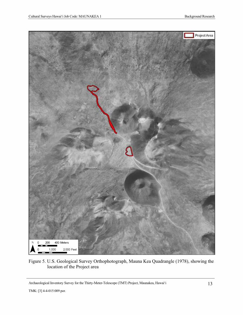
Cultural Surveys Hawai‘i Job Code: MAUNAKEA 1 Background Research
Archaeological Inventory Survey for the Thirty-Meter-Telescope (TMT) Project, Maunakea, Hawai‘i 13TMK: [3] 4-4-015:009 por.
Figure 5. U.S. Geological Survey Orthophotograph, Mauna Kea Quadrangle (1978), showing the location of the Project area
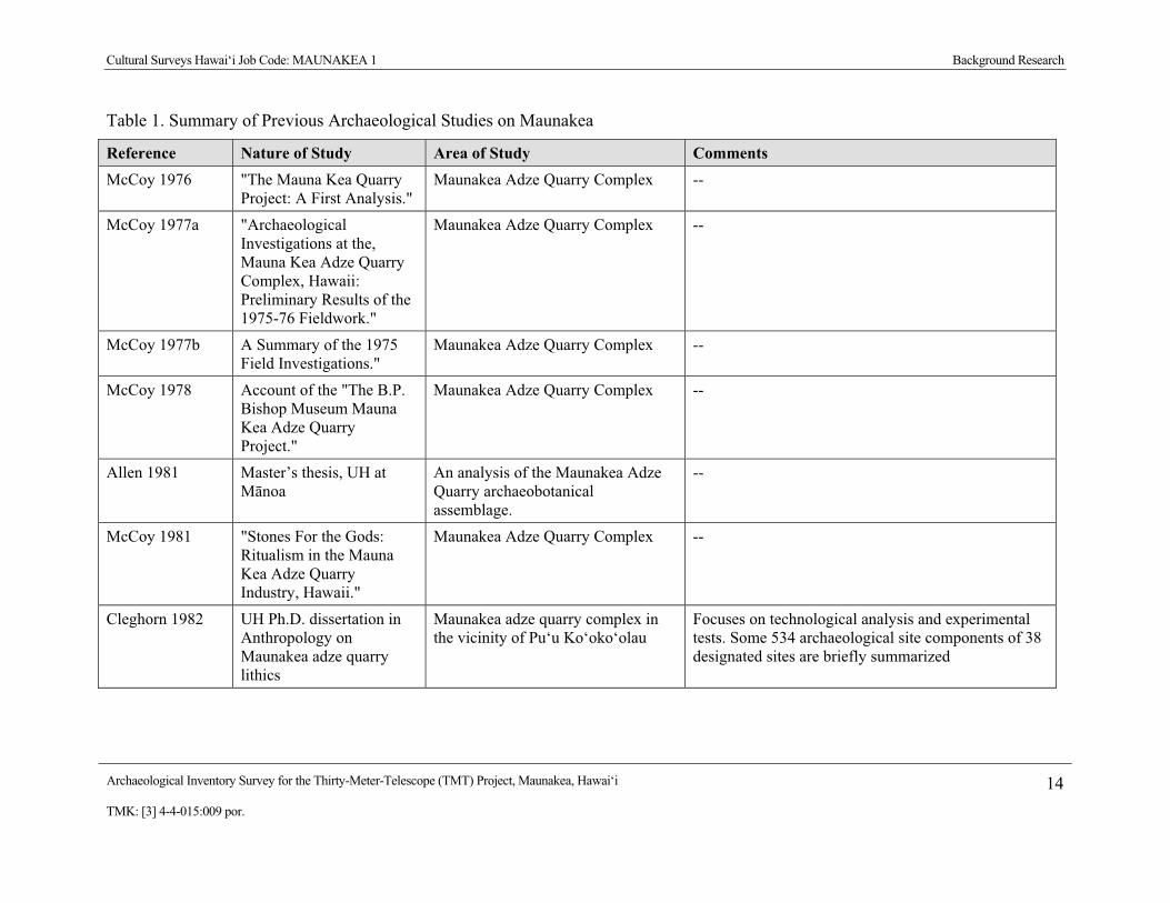
Cultural Surveys Hawai‘i Job Code: MAUNAKEA 1 Background Research
Archaeological Inventory Survey for the Thirty-Meter-Telescope (TMT) Project, Maunakea, Hawai‘i 14TMK: [3] 4-4-015:009 por.
Table 1. Summary of Previous Archaeological Studies on Maunakea
Reference Nature of Study Area of Study Comments McCoy 1976 "The Mauna Kea Quarry
Project: A First Analysis." Maunakea Adze Quarry Complex --
McCoy 1977a "Archaeological Investigations at the, Mauna Kea Adze Quarry Complex, Hawaii: Preliminary Results of the 1975-76 Fieldwork."
Maunakea Adze Quarry Complex --
McCoy 1977b A Summary of the 1975 Field Investigations."
Maunakea Adze Quarry Complex --
McCoy 1978 Account of the "The B.P. Bishop Museum Mauna Kea Adze Quarry Project."
Maunakea Adze Quarry Complex --
Allen 1981 Master’s thesis, UH at M�noa
An analysis of the Maunakea Adze Quarry archaeobotanical assemblage.
--
McCoy 1981 "Stones For the Gods: Ritualism in the Mauna Kea Adze Quarry Industry, Hawaii."
Maunakea Adze Quarry Complex --
Cleghorn 1982 UH Ph.D. dissertation in Anthropology on Maunakea adze quarry lithics
Maunakea adze quarry complex in the vicinity of Pu‘u Ko‘oko‘olau
Focuses on technological analysis and experimental tests. Some 534 archaeological site components of 38 designated sites are briefly summarized

Cultural Surveys Hawai‘i Job Code: MAUNAKEA 1 Background Research
Archaeological Inventory Survey for the Thirty-Meter-Telescope (TMT) Project, Maunakea, Hawai‘i 15TMK: [3] 4-4-015:009 por.
Table 1. Summary of Previous Archaeological Studies on Maunakea (continued)
Reference Nature of Study Area of Study Comments McCoy 1982a Reconnaissance survey Approximately 1,000 acres of the
summit and north slope (down to 13,000’ el.)
Documents 22 sites including an open air shelter and 21 shrine sites
McCoy 1982b Archaeological Survey Proposed Site of the Caltech 10-Meter Telescope
--
McEldowney 1982
Ethnographic Background report
Maunakea Summit Region Documents legends, visitor’s accounts, land use and place names
Kam and Ota 1983
Archaeological Reconnaissance Survey
Mauna Kea Observatory Power line: Upper Portions
--
McCoy 1984a A Summary of the 1984 Fieldwork
Maunakea Summit Region --
McCoy 1984b Archaeological reconnaissance
Hopukani, Waihu, and Liloe Springs area on the west side of P�hakuloa Gulch between 8,640’ and 10,400’ elevation
Documents six archaeological sites and a number of find spots (More thorough coverage is presented in McCoy 1986)
McCoy 1985 Reconnaissance survey Approximately 40 acres extending on both sides of the Maunakea Access Road between 9,080’ and 9,400’
Preliminary report for the Pu‘u Kalepeamoa Site documenting five lithic scatters and 2 shrines used for the manufacture of hammer stones and octopus lure sinkers. Ritual was an integral part of the manufacturing process.
McCoy 1986 Report on archaeological investigations
Hopukani and Liloe Springs area located on the west side of P�hakuloa Gulch well southwest of the Maunakea summit region
Documents 3 mid-level sites (that were initially discussed in McCoy 1984). Eight radio-carbon dates indicated use spanning A.D. 1000 to A.D. 1800. It was concluded that these camps were used for acclimatization and for procuring water, food (primarily fowl) and fuel.

Cultural Surveys Hawai‘i Job Code: MAUNAKEA 1 Background Research
Archaeological Inventory Survey for the Thirty-Meter-Telescope (TMT) Project, Maunakea, Hawai‘i 16TMK: [3] 4-4-015:009 por.
Table 1. Summary of Previous Archaeological Studies on Maunakea (continued)
Reference Nature of Study Area of Study Comments Williams 1987 Post-field letter report on
an Archaeological Reconnaissance Survey
Summit Road between Hale P�haku and a stockpile area
--
Hammatt and Borthwick 1988
Reconnaissance survey Two locations: an approximately 15-acre location between 11,560’ and 11,840’ on the west side of the present summit road and another approximately 100-acre location on the east side of the summit road in a saddle between 2 cinder cones at 12,100’ to 12,225’ elevation
4 sites were documented (none of which appear to have been previously recorded). Sites 11,076, 11,077 are probable pre-contact shrines; Site 11,078 is a probable pre-contact overhang shelter, and Site 11,079 included a probable pre-contact shrine and a probable pre-contact ahu or cairn with basalt flakes and an adze perform present.
Borthwick and Hammatt 1990
Reconnaissance survey Two locations (total 2 acres) on the summit of Maunakea.
No finds – the areas had been “fully graded” for existing telescope facilities.
McCoy 1990 Study of: Factors of Production
Maunakea Adze Quarry Complex --
Robins and Hammatt 1990
Reconnaissance survey Two locations: 5.1 acre area on Pu‘u Hau Oki cinder cone at summit and a 21-acre lot near Hale P�haku
There were no finds at the JNLT summit Project area which had been largely graded. In the Hale P�haku area 3 lithic scatters that were described in McCoy, 1985 are discussed.
McCoy 1991 Survey and Test Excavations report
Pu‘u Kalepeamoa Site --
Borthwick and Hammatt 1993
Reconnaissance survey Proposed Gemini Telescope location at approximately 13,700’ on a ridge line north of the summit cone
Study notes that the entire summit ridge on which the Project area was located had been graded for existing telescope facilities. There were no finds.
McCoy 1993 Letter Report on an Archaeological Inspection
Two Sites Located in the Vicinity of the Smithsonian Sub millimeter Array
--

Cultural Surveys Hawai‘i Job Code: MAUNAKEA 1 Background Research
Archaeological Inventory Survey for the Thirty-Meter-Telescope (TMT) Project, Maunakea, Hawai‘i 17TMK: [3] 4-4-015:009 por.
Table 1. Summary of Previous Archaeological Studies on Maunakea (continued)
Reference Nature of Study Area of Study Comments McCoy 1999 Analysis of a site complex
(site 50-10-23-16204), that he had described 24 years earlier
Located on the east side of the Maunakea Access Road between 12,240’ and 12,300’ elevation just south of Pu‘u L�l�noe
McCoy posits a ritual significance to the site specifically as a location for a rite of passage.
Hammatt and Shideler 2002
Data Recovery report for two lithic scatters
Sites 50-10-23-10,310 and 50-10-23-10,311 located in the Hale P�haku area between 9,080’ and 9,160’ elevation
Documentation of data recovery of sites identified in McCoy, 1985 and Robins and Hammatt, 1990. Two carbon dates (AD 1260-1410 and AD 1510-1950 at 95% probability) were both thought to be problematic. Possible ritual associations with healing and the deity Kanaloa are explored.
PCSI 2005 Archaeological Inventory Survey Interim Report No. 1
Mauna Kea Science Reserve
--
PCSI 2006 Archaeological Inventory Survey Interim Report No. 2
Mauna Kea Science Reserve
--
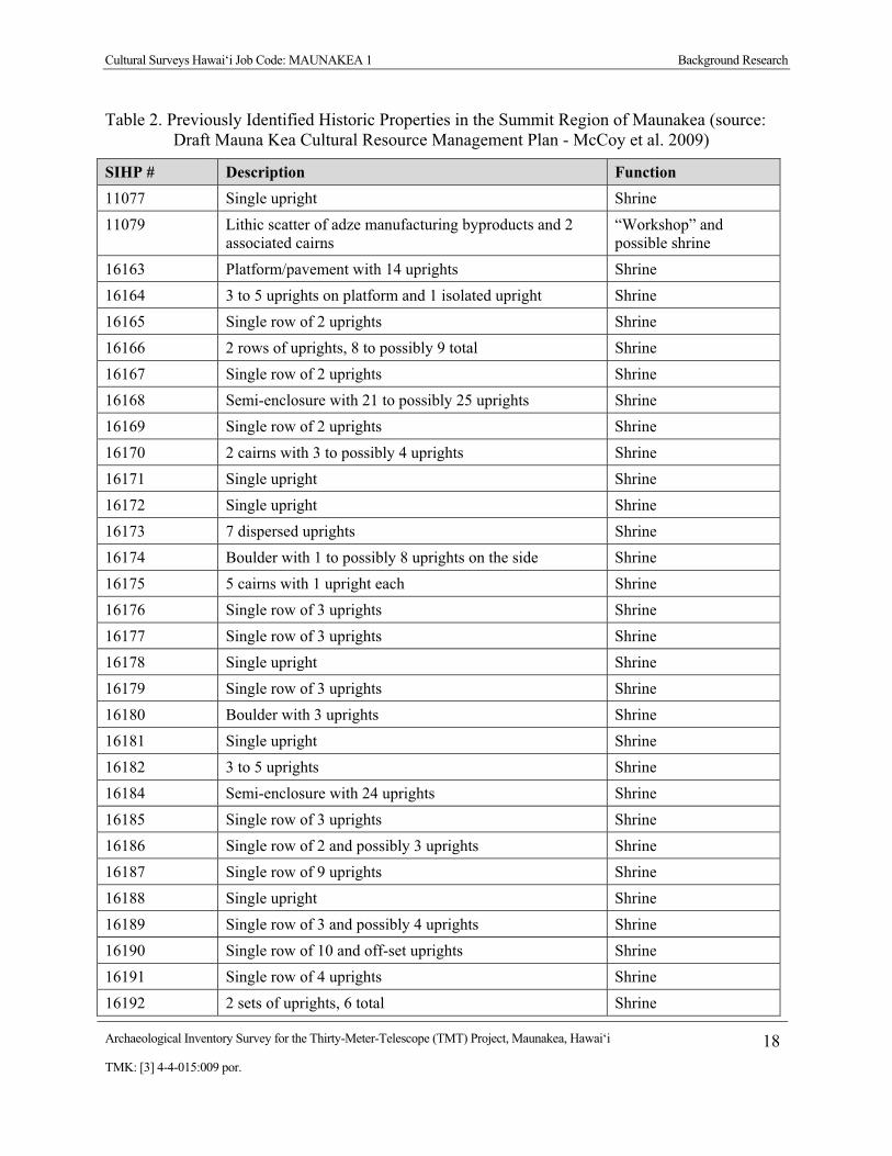
Cultural Surveys Hawai‘i Job Code: MAUNAKEA 1 Background Research
Archaeological Inventory Survey for the Thirty-Meter-Telescope (TMT) Project, Maunakea, Hawai‘i 18TMK: [3] 4-4-015:009 por.
Table 2. Previously Identified Historic Properties in the Summit Region of Maunakea (source: Draft Mauna Kea Cultural Resource Management Plan - McCoy et al. 2009)
SIHP # Description Function 11077 Single upright Shrine 11079 Lithic scatter of adze manufacturing byproducts and 2
associated cairns “Workshop” and possible shrine
16163 Platform/pavement with 14 uprights Shrine 16164 3 to 5 uprights on platform and 1 isolated upright Shrine 16165 Single row of 2 uprights Shrine 16166 2 rows of uprights, 8 to possibly 9 total Shrine 16167 Single row of 2 uprights Shrine 16168 Semi-enclosure with 21 to possibly 25 uprights Shrine 16169 Single row of 2 uprights Shrine 16170 2 cairns with 3 to possibly 4 uprights Shrine 16171 Single upright Shrine 16172 Single upright Shrine 16173 7 dispersed uprights Shrine 16174 Boulder with 1 to possibly 8 uprights on the side Shrine 16175 5 cairns with 1 upright each Shrine 16176 Single row of 3 uprights Shrine 16177 Single row of 3 uprights Shrine 16178 Single upright Shrine 16179 Single row of 3 uprights Shrine 16180 Boulder with 3 uprights Shrine 16181 Single upright Shrine 16182 3 to 5 uprights Shrine 16184 Semi-enclosure with 24 uprights Shrine 16185 Single row of 3 uprights Shrine 16186 Single row of 2 and possibly 3 uprights Shrine 16187 Single row of 9 uprights Shrine 16188 Single upright Shrine 16189 Single row of 3 and possibly 4 uprights Shrine 16190 Single row of 10 and off-set uprights Shrine 16191 Single row of 4 uprights Shrine 16192 2 sets of uprights, 6 total Shrine

Cultural Surveys Hawai‘i Job Code: MAUNAKEA 1 Background Research
Archaeological Inventory Survey for the Thirty-Meter-Telescope (TMT) Project, Maunakea, Hawai‘i 19TMK: [3] 4-4-015:009 por.
Table 2. Previously Identified Historic Properties in the Summit Region of Maunakea (continued)
SIHP # Description Function 16193 Single upright Shrine 16194 Single row of 12 - 14 uprights Shrine 16195 2 cairns Possible burial 16196 Single row of 2 uprights Shrine 16197 Single upright Shrine 16198 2-tiered platform with 7 uprights Shrine 16199 1 to possibly 4 uprights Shrine 16200 Single row of 5 to possibly 6 uprights Shrine 16201 Single row of 3 uprights Shrine 16202 Single upright Shrine 16203 Single row of 2 to possibly 3 uprights and a lithic scatter
of adze manufacturing byproducts Adze “workshop” and shrine
16204 5 shrines, 26 stone-walled enclosures and a lithic scatter of adze manufacturing byproducts
Adze “workshop” and shrine complex
16248 Series of cairns Burial 18682 Single row of 3 uprights Shrine 18683 Single row of 2 uprights Shrine 21197 2 platforms with a total of 5 uprights Shrine 21198 Single upright Shrine 21199 Single upright Shrine 21200 Single upright Shrine 21201 Single row of 2 uprights Shrine 21202 Single row of 6 to possibly 7 uprights Shrine 21203 Single row of 2 uprights Shrine 21204 3 areas of stacked rock Unknown 21205 Single upright Shrine 21206 Single upright Shrine 21207 Single upright Shrine 21208 1 to 2 uprights on a boulder Shrine 21209 Cairn on summit Unknown 21210 Single upright Shrine

Cultural Surveys Hawai‘i Job Code: MAUNAKEA 1 Background Research
Archaeological Inventory Survey for the Thirty-Meter-Telescope (TMT) Project, Maunakea, Hawai‘i 20TMK: [3] 4-4-015:009 por.
Table 2. Previously Identified Historic Properties in the Summit Region of Maunakea (continued)
SIHP # Description Function 21211 Single row of 2 uprights on a platform and a lithic scatter
of adze manufacturing byproducts Adze “workshop” and shrine
21212 Single row of 2 uprights Shrine 21213 3 piles of rocks with 1 upright Shrine 21214 Single row of 5 to possibly 7 uprights Shrine 21406 Single upright Shrine 21407 Single row of 2 uprights Shrine 21408 Single upright Shrine 21409 Single upright Shrine 21410 Single row of 5 uprights Shrine 21411 Cairn Marker? 21412 Cairn Marker? 21413 Cairn Possible burial 21414 Cairn Possible burial 21415 Cairn on boulder Unknown 21416 Cairn Possible burial 21417 Cairn Unknown 21418 3 to possibly 4 uprights on top and to the side of a
boulder Shrine
21419 Single upright Shrine 21420 Enclosure with 11 to possibly 12 uprights and a nearby
stone platform Shrine
21421 2 cairns, one with a possible upright and an isolated upright
Shrine
21422 Single upright Shrine 21423 Stones on boulder Marker? 21424 4 to 5 uprights on a platform and boulder Shrine 21425 Single upright Shrine 21426 Single row of 4 uprights Shrine 21427 Terrace with possible upright Unknown 21428 Single upright Shrine 21429 Single upright Shrine 21430 Single row of 3 uprights Shrine

Cultural Surveys Hawai‘i Job Code: MAUNAKEA 1 Background Research
Archaeological Inventory Survey for the Thirty-Meter-Telescope (TMT) Project, Maunakea, Hawai‘i 21TMK: [3] 4-4-015:009 por.
Table 2. Previously Identified Historic Properties in the Summit Region of Maunakea (continued)
SIHP # Description Function 21431 Semi-enclosure with 7 to 10 uprights Shrine 21432 Single row of 2 uprights Shrine 21433 Single upright Shrine 21434 8 stones on a boulder Unknown 21435 Cairn and boulder with 1 upright Shrine 21436 Cairn Shrine 21437 Lithic scatter of adze manufacturing byproducts Adze workshop 21438 Kukahauula (summit) State Historic Property 21439 Pu`u Lilinoe State Historic Property 21441 3 features with 12 uprights Shrine 21442 Single upright Shrine 21443 Single upright Shrine 21444 Single upright Shrine 21445 3 dispersed uprights Shrine 21446 Single row of 9 uprights, plus two additional uprights Shrine 21447 Single upright Shrine 21448 Two uprights Shrine 21449 Terrace Unknown 21550 3 cairns Historic survey markers 21551 Single upright Shrine 21552 Platform Probable human burial 25760 Lithic scatter of adze manufacturing byproducts Adze workshop 25761 Lithic scatter of adze manufacturing byproducts Adze workshop 25762 Lithic scatter of adze manufacturing byproducts and
enclosures Adze workshop and shelters
25763 Single upright on boulder Shrine 25764 5-8 uprights on mound Shrine 25765 Platform Possible burial 25766 4 mounds Unknown 25767 2 adze preforms Isolate artifacts 25768 Basalt flake Isolate artifacts

Cultural Surveys Hawai‘i Job Code: MAUNAKEA 1 Background Research
Archaeological Inventory Survey for the Thirty-Meter-Telescope (TMT) Project, Maunakea, Hawai‘i 22TMK: [3] 4-4-015:009 por.
Table 2. Previously Identified Historic Properties in the Summit Region of Maunakea (continued)
SIHP # Description Function 25769 Lithic scatter Adze manufacturing 25770 Lithic scatter and rock pile Adze manufacturing;
possible burial 25771 Single upright in soil Shrine or burial 25772 3 uprights, single upright on boulder, a mound, and lithic
scatter of adze manufacturing byproducts Shrines, adze workshop, and markers
25773 Single upright on boulder Shrine 25774 4 pavements/low mounds Unknown 25775 1-2 uprights on boulder Shrine 25776 Cairn, enclosures, lithic scatter of adze manufacturing
byproducts, and 2 possible fallen uprights Shrine, adze workshop, and shelter
25777 Mound Marker 25778 1-2 uprights on boulder Shrine 25779 Lithic scatter of adze manufacturing byproducts, 3
preforms, and hammerstone Adze workshop
25780 Single upright on mound Shrine 25781 3-4 uprights, walled overhang, and lithics Shrine, shelter, and
adze manufacturing 25782 Single upright, lithic scatter of adze manufacturing
byproducts, and 2 enclosures Shrine, adze workshop, and shelter
25783 1 and possible 2 pairs of uprights Shrine 25784 Single upright in bedrock crack Shrine 25785 Rock pile Marker 25786 1-3 uprights on bedrock surface Shrine 25787 3-4 uprights in bedrock crack Shrine 25788 Possible upright Possible shrine 25789 17-20 uprights on bedrock surface and lithic scatter Shrine and offering 25790 2-6 uprights on mound Shrine 25791 Single upright on boulder Shrine 25792 Rock pile with slabs Shrine 25793 4 uprights on bedrock surface Shrine 25794 Single upright in bedrock crack Shrine

Cultural Surveys Hawai‘i Job Code: MAUNAKEA 1 Background Research
Archaeological Inventory Survey for the Thirty-Meter-Telescope (TMT) Project, Maunakea, Hawai‘i 23TMK: [3] 4-4-015:009 por.
Table 2. Previously Identified Historic Properties in the Summit Region of Maunakea (continued)
SIHP # Description Function 25795 Single upright on boulder Shrine 25796 Lithic scatter of adze manufacturing byproducts and
performs Adze workshop
25797 Single upright on boulder Shrine 25798 Single upright on boulder Shrine 25799 Single upright, terrace, pavement, possible boulder shrine Shrine complex 25800 Horseshoe Historic artifact 25801 Lithic scatter of adze manufacturing byproducts Adze workshop 25802 Terrace and mound Burials 25803 Mound Possible burial 25804 Mound Possible burial 25805 Mound Possible burial 25806 3 rock piles/mounds Possible burials 25807 3 mounds Burial 25808 Human remains and terraces Burials 25809 Exposed human remains Burials 25810 4 rock mounds Shrine and markers 25811 Possible upright Possible shrine 25812 Overhang and crude wall Possible burial 25813 Mound with possible uprights (2) Possible shrine 25814 3 mounds on cinder cone Possible burials 25815 Mound Possible burial 25816 Mound Possible burial 25817 2 enclosed areas Shelter 25818 Terrace with 5-7 uprights Shrine 25819 Two groups of uprights (15-16 uprights) Shrine 25820 3 uprights on mound Shrine 25821 Single upright on boulder Shrine 25822 Terrace with 6-9 uprights Shrine 25823 Mound Possible burial 25824 Mound Possible burial

Cultural Surveys Hawai‘i Job Code: MAUNAKEA 1 Background Research
Archaeological Inventory Survey for the Thirty-Meter-Telescope (TMT) Project, Maunakea, Hawai‘i 24TMK: [3] 4-4-015:009 por.
Table 2. Previously Identified Historic Properties in the Summit Region of Maunakea (continued)
SIHP # Description Function 25825 2-3 uprights on mound Shrine 25826 2 uprights on bedrock Shrine 25827 2-4 uprights on bedrock Shrine 25828 Lithic scatter of adze manufacturing byproducts Adze workshop 25829 Mound Possible burial 25830 Platform Possible burial 25831 Mound Possible burial 25832 Mound Possible burial 26217 3 uprights on mound Shrine 26218 Piled cobbles, alignments, historic trash USGS camp site 26219 1-2 uprights on mound Shrine 26220 C-shapes Temporary shelters? 26221 Single upright on bedrock Shrine 26222 1-2 uprights on mound Shrine 26223 Single upright Shrine 26224 3 uprights on bedrock Shrine 26225 Single upright on boulder Shrine 26226 Mound Possible shrine 26227 Single upright on mound and lava tube Shrine and possible
shelter 26228 6-12 uprights on mound Shrine 26229 1-2 uprights on boulder Shrine 26230 Mound Unknown 26231 2 uprights on mound Shrine 26232 Rock wall and find spot Temporary shelter and
marker 26233 6-12 uprights on horseshoe-shaped enclosure Shrine 26234 Single upright Shrine 26235 Single upright Shrine 26236 Single upright Shrine 26237 Mound Possible burial

Cultural Surveys Hawai‘i Job Code: MAUNAKEA 1 Background Research
Archaeological Inventory Survey for the Thirty-Meter-Telescope (TMT) Project, Maunakea, Hawai‘i 25TMK: [3] 4-4-015:009 por.
Table 2. Previously Identified Historic Properties in the Summit Region of Maunakea (continued)
SIHP # Description Function 26238 Single upright on boulder Shrine 26239 Single upright on boulder Shrine 26240 4-5 uprights on mound and single upright in overhang Shrines 26241 Mound Unfinished shrine 26242 Cairns Marker and shrine 26243 Single upright Shrine 26244 Single upright Shrine 26245 Cairn Marker 26246 Cairn Marker 26247 Cairn Marker 26248 3-4 uprights on bedrock Shrine 26249 Lithic scatter of adze manufacturing byproducts Adze workshop 26250 1-3 uprights on mound, single upright on bedrock, and
historic trash Shrines and dump
26251 Single upright Shrine 26252 2 uprights on bedrock Shrine 26253 Complex consisting of multiple uprights, multiple lithic
scatters of adze manufacturing byproducts, and quarried area for adze manufacturing
Shrines, adze workshops, and quarrying areas
26254 3 uprights on mound and cairns Shrines and markers? 26255 Single boulder Shrine 26256 Cairn Marker

Cultural Surveys Hawai‘i Job Code: MAUNAKEA 1 Background Research
Archaeological Inventory Survey for the Thirty-Meter-Telescope (TMT) Project, Maunakea, Hawai‘i 26TMK: [3] 4-4-015:009 por.
…that these structures were erected by travelers, most probably in propitiation of mountain spirits. Such practices are universal in the high mountain regions of the world. [McCoy 1982:A-37]
McCoy does note however that the majority of the shrines were located in a narrow 200-foot contour interval band between 12,900 foot and 13,100-foot elevation. He posits reasonably that this clearly defined vertical zonation site pattern is the result of utilization of a break in slope at the edge of a summit plateau where: “when viewed from either the base of the steep inclined slope directly below, or from the base of the summit cones above, is a relatively flat horizon on which the shrine uprights are silhouetted and therefore visible from some distance.” McCoy associates these shrines with “the request for permission to pass over the summit” and notes that this indicates a preponderance of access from the northern, windward side of the islands consistent with the inclusion of the land within H�m�kua District. He further posits that the distribution of the shrines may relate to “the lower margins of snow fields” and possibly by extension to the goddess Poli‘ahu. McCoy notes that at one of the more complex “Marae” sites “the placement of offerings and whatever other ritual took place here appear to have been intentionally directed away from Maunakea. The possibility of astronomical concepts being operative is explored.” McCoy also posits that smaller sites were built and utilized by one or a few individuals while more complex shrines were built and utilized by a larger kin group and that perhaps “each structure would represent a separate social unit that had exclusive use rights.” McCoy recommends intensive archaeological survey and avoidance of construction and related activities on or in proximity to known archaeological sites.
3.2.1.3 McEldowney (1982) Holly McEldowney (1982), then of the B.P. Bishop Museum Department of Anthropology,
produced an Ethnographic Background report for the Maunakea Summit Region for the Research Corporation of the UH as part of an Environmental Impact Statement for a Mauna Kea Science Reserve Master Plan. The data is presented in three sections addressing 1) myths and legends and “oral traditions”, 2) land use practices and cultural activities, and 3) a study of place names.
McEldowney starts by relating a tradition of the goddess Poli‘ahu from Haleole’s (1863) story of Laieikawai. While McEldowney relates this as a “Hawaiian tradition recorded by S.N. Haleole”, Laieikawai has increasingly been recognized as a “romance”, a Cinderella-like story that undoubtedly utilized pre-contact traditions and motifs but was self-consciously more in the nature of a fairy-tale or work of imagination than a recordation of traditional legends. At any rate Haleole’s traditions of Poli‘ahu have almost nothing to do with Maunakea (although “Lilinoe” is given as the name of one of Poli‘ahu’s companions). McEldowney then goes on to discuss Westervelt’s (originally published in 1916) accounts of Poli‘ahu and opines that Westervelt “took the unwarranted license to assign each of the ‘goddesses of the snow covered mountains’ to specific localities.” This appears to be the case – that popular assignations of the names of deities to specific land-forms are basically modern appellations. McEldowney goes on to briefly discuss mentions of Maunakea, Poli‘ahu, and L�l�noe in works by Fornander, Kamakau, Kal�kaua and Thrum. She notes the common case (as exemplified in Haleole’s Laieikawai and Fornander’s Hawai‘i Loa legend) of characters and themes inserted into more recent versions of older myths and legends. McEldowney notes that “otherwise Maunakea is mentioned only
Cultural Surveys Hawai‘i Job Code: MAUNAKEA 1 Background Research
Archaeological Inventory Survey for the Thirty-Meter-Telescope (TMT) Project, Maunakea, Hawai‘i 27TMK: [3] 4-4-015:009 por.
briefly and rarely as the backdrop to more compelling events, or to characterize the attributes of a figure or an event by analogy.”
McEldowney notes that: “several early accounts report that Hawaiians were reluctant to travel or serve as guides on inland journeys, or that they professed no knowledge of these areas, leading to the false impression that these regions constituted a wilderness unknown to the Hawaiian people.” This generality is even more pronounced for the summit plateau of Maunakea, where almost all early historic visitors made the final ascent to the summit without native guides. The only substantiated report of Hawaiians on Maunakea prior to the 1870s Boundary Commission accounts is Kamakau’s (1961:285) reference to Ka‘ahumanu’s 1828 visit “to Hawaii to fulfill a vow that she had made to attempt the recovery of the bones of Lilinoe on Mauna Kea…” It is unclear whether Ka‘ahumanu or her retainers actually ascended the mountain but: “It is said Ka‘ahumanu did not find the bones of Lilinoe….” (Kamakau 1961:285).
McEldowney relates various western visitors’ accounts of Hawaiians acquiring fowl, hardwoods, fine-grained basalt, sandalwood and wild cattle in “this region.” The first specific Hawaiian account of activities on the mountain brought to light in the McEldowney (1982) study appear to be in the Boundary Commission Testimony of a certain Haiki who asserts that: “my parents told me Humu‘ula went to Kaluakaakoi and Poli‘ahu. We used to go there after adzes for Humu‘ula people.” As McEldowney notes: “Haiki’s overall testimony and placement of the boundary was rejected by the commission.”
Somewhat in keeping with her study of legends and myths and early accounts of land use, McEldowney’s accounts of place names also emphasizes the dearth of information, the lack of specificity of the information, and the suspicious nature of what little early data we do have. McEldowney points out that guides and informants were often familiar with land features but traveled from landmark to landmark rather than on trails per se. She notes that access to the mountain in the second half of the 1800s appeared to utilize ranching establishments (Humu‘ula Sheep Station, Umikoa Ranch) and may not have related to pre-contact approaches. Many Hawaiian place names were noted to be basically modern.
3.2.1.4 McCoy (1984b) Pat McCoy’s (1984b) archaeological reconnaissance report for the Hopukani, Waihu, and
Liloe Springs area documents six archaeological sites and a number of find spots located on the west side of P�hakuloa Gulch between 8,640’ and 10,400’ elevation. The work was associated with a P�hakuloa Training Area (PTA) Pipe Line Project. This preliminary report was elaborated upon in McCoy’s (1986 study).
3.2.1.5 McCoy (1985) Pat McCoy’s (1985) preliminary report for the Pu‘u Kalepeamoa Site documents three
archaeological surveys for a proposed new construction laborer camp at Hale P�haku located just above and below the Hawaii Institute for Astronomy’s Mid-Level Facility encompassing a total of approximately 40 acres located on both sides of the Maunakea Access Road between 9,080 and 9,400-foot elevation. Five lithic scatters and 2 shrines were recorded. These archaeological features were understood as functionally integrated components of a single activity system and one Bishop Museum site number was assigned (lithic scatters no. 1 & 2 would subsequently be
Cultural Surveys Hawai‘i Job Code: MAUNAKEA 1 Background Research
Archaeological Inventory Survey for the Thirty-Meter-Telescope (TMT) Project, Maunakea, Hawai‘i 28TMK: [3] 4-4-015:009 por.
given SIHP #s 50-10-23-10310 and 50-10-23-10311 respectively). McCoy concluded that the primary activity at the site was the manufacture of hammer stones and octopus lure sinkers from the crystalline dunite and gabro deposits on the slopes of Pu‘u Kalepeamoa but he noted that ritual was an integral part of the manufacturing process. Further research was recommended. The lithic scatters would be subject to further documentation (Robins and Hammatt 1990) and data recovery work (Hammatt and Shideler 2002).
3.2.1.6 McCoy (1986) Pat McCoy’s (1986) report on archaeological investigations for the Hopukani and Liloe
Springs area documents three mid-level sites located on the west side of P�hakuloa Gulch well southwest of the Maunakea summit region (that were initially discussed in McCoy 1984). These sites included a rock shelter at Hopukani Spring (10,400 foot elevation), the Hopukani Rock Shelter (10,160 foot elevation) and an open camp site at Liloe Spring (8,921 foot elevation) Eight radio-carbon dates indicated use spanning A.D. 1000 to A.D. 1800. It was concluded that these camps were used for acclimatization and for procuring water, food (primarily fowl) and fuel.
3.2.1.7 Hammatt and Borthwick (1988) Cultural Surveys Hawai‘i (Hammatt and Borthwick 1988) carried out an archaeological
reconnaissance survey of two locations for proposed antennas for the National Radio Astronomy Observatory. An approximately 15-acre relatively level location between the 11,560 foot and 11,840 foot elevations on the southeastern slope of the summit region on the west side of the present summit road was examined but no archaeological sites were observed. Another approximately 100-acre location on the east side of the summit road in a saddle between 2 cinder cones at 12,100 to 12,225 foot elevation was also examined and four archaeological sites were documented (none of which appear to have been previously recorded). Sites -11076, -11077 are probable pre-contact shrines; Site -11078 is a probable pre-contact overhang shelter with a stacked stone alignment, and Site -11079 had two components: a probable pre-contact shrine and a probable pre-contact ahu or cairn with basalt flakes and an adze perform present. Preservation of the four sites was recommended but it was thought that the Antenna Project potentially would be compatible with such preservation of the four relatively small and discrete sites in the large acreage.
3.2.1.8 Borthwick and Hammatt (1990) Cultural Surveys Hawai‘i (Borthwick and Hammatt 1990) carried out an archaeological
reconnaissance survey for two locations for the proposed Galileo Telescope on the summit of Maunakea. The study was of an approximately 2 acre portion of the summit ridge that (at that time) included the UKRT, U.H. 2.2 m, U.H. 24-inch, and Medical Support facilities. The study notes that previous work (McCoy 1982) had identified no sites in the summit region (above approximately 13,330 foot elevation). The study notes that the entire summit ridge on which the Project Areas were located had been “fully graded” for existing telescope facilities and no archaeological features were observed and no further work was recommended.

Cultural Surveys Hawai‘i Job Code: MAUNAKEA 1 Background Research
Archaeological Inventory Survey for the Thirty-Meter-Telescope (TMT) Project, Maunakea, Hawai‘i 29TMK: [3] 4-4-015:009 por.
3.2.1.9 Robins and Hammatt (1990) Cultural Surveys Hawai‘i (Robins and Hammatt 1990) carried out an Archaeological
Reconnaissance Survey Project for the Subaru Observatory at both the summit and the Hale P�haku area. The actual summit construction area was an approximately 5.1 acre area on Pu‘u Hau Oki cinder cone in the northern portion of the Mauna Kea Science Reserve approximately 200 feet west of the existing W. M. Keck Observatory and 800 feet north of a paved “spur road” passing by the Caltech Sub-millimeter Observatory (CSO) facility. The summit project area had been largely graded although certain undisturbed outcrop formations were present. No archaeological features were identified within the Subaru Observatory summit project area.
The Robins and Hammatt (1990) study also included several areas near the Mid-Level Facility Complex (“Onizuka Center for International Astronomy (OCIA)”) including a small dormitory construction area located approximately 440 feet east of the Maunakea Access Road at 9,245 foot elevation (where no sites were observed) and an approximately 21-acre lot surrounding the dormitory delineated on the west and north side by the Maunakea Access Road and to the south by an existing jeep road. Two archaeological features were newly described and three previously identified sites were recorded in the approximately 21-acre lot. The two newly described features included a small oval enclosure and a roughly square enclosure that were both thought to be relatively recent constructions (no formal SIHP site numbers were assigned). The three previously recorded (McCoy 1985) sites included three lithic scatters (lithic scatters # 1, # 2, and #5) that McCoy had understood as being functionally integrated components of a single site. Further work at the lithic scatters was recommended. Cultural Surveys Hawai‘i (Hammatt and Shideler 2002) completed a Data Recovery report for lithic scatters # 1, # 2).
3.2.1.10 Borthwick and Hammatt (1993) Cultural Surveys Hawai‘i (Borthwick and Hammatt 1993) carried out an archaeological
reconnaissance survey for the proposed Gemini Telescope location at approximately 13,700 foot elevation on a ridge line north of the summit cone. The study notes that previous work (McCoy 1982) had identified no sites in the summit region above approximately the 13,330 foot elevation. The study notes that the entire summit ridge on which the project area was located had been graded for existing telescope facilities and no archaeological features were observed and no further work was recommended.
3.2.1.11 McCoy (1999) Patrick McCoy (1999) wrote up an analysis of a site complex (SIHP # 50-10-23-16204), that
he had described 24 years earlier, located on the east side of the Maunakea Access Road between 12,240 ft and 12,300 foot elevation just south of Pu‘u L�l�noe that included five shrines and three enclosure complexes. The complex was notably located about a quarter mile from the nearest known source of worked raw lithic material and was perceived as “isolated”. McCoy (1999:14) noted that when viewed in terms of the natural environment and human productivity “the location of this site appears to be irrational” Of particular interest were some 26 very small open-air enclosures (typical interior area c. 17 square feet). This led McCoy to posit a ritual significance to the site specifically as a location for a rite of passage.

Cultural Surveys Hawai‘i Job Code: MAUNAKEA 1 Background Research
Archaeological Inventory Survey for the Thirty-Meter-Telescope (TMT) Project, Maunakea, Hawai‘i 30TMK: [3] 4-4-015:009 por.
McCoy goes on to consider the form of the upright slabs of (typically un-worked) basalt that were arranged into the many shrines of Maunakea and Site -16204 in particular. McCoy posits that pointed uprights symbolize male gods and that flat-topped ones symbolize female gods (McCoy assumes that the Hawaiian goddesses L�l�noe and Poli‘ahu were worshipped). Determining the affinities of the slabs is complicated by the presence of other forms (“angled”, “gabled”, “rounded” and “notched”) and the general difficulty of determining whether a particular stone was an upright at all.
McCoy posits that evidence supporting an unusual ritual function (rites of passage) includes:
� Unusual orientations of 4 of the 5 shrines,
� Lack of evidence of actual habitation,
� Unusual “lack of a cohesive structure” among the lithic byproducts present in the artifact assemblages – suggesting “symbolic manufacture and use”
� The numerous (26) very small open-air enclosures that were “too small to accommodate a person and a fire hearth” of no obvious purpose and believed to relate to temporary day-time use.
McCoy concludes that the small enclosures “may symbolically represent both a womb and a grave” and that the site “was the locus of initiation rites” related to “formal initiation rites for groups of apprentices”.
3.2.1.12 Hammatt and Shideler (2002) Cultural Surveys Hawai‘i (Hammatt and Shideler 2002) completed a data recovery report for
two lithic scatters (SIHP #s 50-10-23-10310 and 50-10-23-10311) located in the Hale P�haku area between 9,080 foot and 9,160 foot elevation. These sites were first recorded by McCoy (1985:11-12) as Lithic Scatter # 1 (SIHP # 50-10-23-10310) and Lithic Scatter # 2 (SIHP # 50-10-23-10311) of the Pu‘u Kalepeamoa Complex. Initially the UH Institute for Astronomy planned to preserve the two lithic scatters, however, dormitory construction increased erosion in the vicinity and in consultation with the State Historic Preservation Division a data recovery program was agreed to. Data recovery field work included mapping, surface collection and four 1m2 test units (2 at each of the two sites). Two carbon dates (AD 1260-1410 and AD 1510-1950 at 95% probability) were obtained but both were thought to be problematic. It was concluded that the sites were modest, out-lying, open, lithic workshop sites with octopus lure sinker manufacture of both “coffee-bean” and “bread-loaf” morphological types. It was concluded that the location of the sites was associated with a micro-climate of slightly greater moisture, slightly greater soil and slightly greater protection from the wind at the top of a natural drainage that favored m�mane forest growth – which in turn provided greater protection from the elements, fuel and construction materials. It is suggested that the endeavor to produce octopus lures may have had other than quotidian purposes of food procurement and the affinities with healing prayers (Pule he‘e) dedicated to the deity Kanaloa are explored.
3.2.1.13 McCoy et al. (2009 in progress) As this archaeological inventory survey report was being prepared, the authors interacted with
Dr. Patrick McCoy at the offices of Pacific Consulting Services, Inc. and also within the Project
Cultural Surveys Hawai‘i Job Code: MAUNAKEA 1 Background Research
Archaeological Inventory Survey for the Thirty-Meter-Telescope (TMT) Project, Maunakea, Hawai‘i 31TMK: [3] 4-4-015:009 por.
Area. We are thankful for his guidance. We were aware that a major study of the historic properties of the summit region was on-going by Pacific Consulting Services. This study, that should greatly advance our knowledge of traditional Hawaiian use of the Maunakea summit region, was not available as early drafts of this study were being prepared. If publicly available prior to the submission of this study to the SHPD for review it is the intent of the authors to include appropriate reference and germane summary of findings.
3.2.2 Culturally Significant Historic Properties The State Historic Preservation Division has designated several prominent localities on
Maunakea as Culturally Significant Historic Properties due to their cultural significance to the Hawaiian people. The Culturally Significant Historic Properties generally consist of prominent cinder cones and trails. The approximate boundaries of the Culturally Significant Historic Properties are indicated on Figure 6. Maly (1997:29) has suggested the entire Maunakea summit region down to the 6,000 foot elevation contour (Figure 7) be designated a Traditional Cultural Property. Three cinder cones in the summit region of Maunakea have also been designated historic properties. Pu‘u K�kahau‘ula (SIHP # 50-10-23-21438) includes the three cinder cones that comprise the summit of Maunakea. Pu‘u Lilinoe (SIHP # 50-10-23-24139) consists of a cinder cone southeast of the summit. Waiau (SIHP # 50-10-23-21440) includes the small lake and cinder cone southwest of the summit.
Portions of the current Project area, including the Access Way and Batch Plant Staging Area, are partially located within or immediately adjacent to Pu‘u K�kahau‘ula (SIHP # 50-10-23-21438). Pu‘u K�kahau‘ula was documented through oral history interviews as the “generational repository of: piko (umbilical cords of children); ashes of individuals with strong attachment to Mauna Kea; and locations of an ahu (possibly more than one over time) associated with navigational practices and historical surveys” (Maly 1999).
3.2.3 Mauna Kea Summit Region Historic District As a component of the Mauna Kea Science Reserve Master Plan, the State Historic
Preservation Division (SHPD) prepared a Historic Preservation Plan (HPP) that addresses management of historic properties in four management areas: the Mauna Kea Science Reserve, the summit road corridor, the Hale P�haku area, and the Mauna Kea Ice Age Natural Area Reserve (SHPD 2000). The HPP specifies procedures to protect the historic properties within the management areas and to insure appropriate treatment over time.
Through the HPP, the SHPD designated the Maunakea summit region as the Mauna Kea Summit Region Historic District (SIHP # 50-10-23-26869). The Historic District consists of the summit region to roughly 11,000-12,000 ft. elevation, including nearly the entire Mauna Kea Science Reserve and Mauna Kea Ice Age Natural Area Reserve (Figure 8). The historic district boundary corresponds with moraine fields and natural breaks in slope that define perimeter of the Maunakea summit region. The designation of the summit region as a historic district:
allows the significance of the many individual [historic] properties located within the district to be addressed collectively and within the context of the summit’s natural landscape. It also allows the integrity of the district as a whole to be considered when the potential effects of particular activities or projects are evaluated. [SHPD 2000:1]

Cultural Surveys Hawai‘i Job Code: MAUNAKEA 1 Background Research
Archaeological Inventory Survey for the Thirty-Meter-Telescope (TMT) Project, Maunakea, Hawai‘i 32TMK: [3] 4-4-015:009 por.
Figure 6. U.S. Geological Survey 7.5-Minute Series Topographic Map, Mauna Kea Quadrangle (1993), showing proposed Traditional Cultural Properties in the summit region of Maunakea (adapted from Maly 1997:Table 2 & Figure 2; Note: All of Maunakea down to the 6,000 foot elevation has been suggested to be a Traditional Cultural Property) (Boundaries shown should be understood as approximate)

Cultural Surveys Hawai‘i Job Code: MAUNAKEA 1 Background Research
Archaeological Inventory Survey for the Thirty-Meter-Telescope (TMT) Project, Maunakea, Hawai‘i 33TMK: [3] 4-4-015:009 por.
Figure 7. 1:100,000 Scale U.S. Geological Survey Map showing the proposed “Ka Mauna a W�kea or Mauna Kea” Traditional Cultural Property (TCP) down to the recommended 6,000 foot contour (following Maly 1997:29); estimated area approximately 150,000 acres

Cultural Surveys Hawai‘i Job Code: MAUNAKEA 1 Background Research
Archaeological Inventory Survey for the Thirty-Meter-Telescope (TMT) Project, Maunakea, Hawai‘i 34TMK: [3] 4-4-015:009 por.
Figure 8. U.S. Geological Survey 7.5-Minute Series Topographic Map, Mauna Kea Quadrangle (1993), showing the extent of the Mauna Kea Summit Region Historic District (SIHP # 50-10-23-26869)

Cultural Surveys Hawai‘i Job Code: MAUNAKEA 1 Background Research
Archaeological Inventory Survey for the Thirty-Meter-Telescope (TMT) Project, Maunakea, Hawai‘i 35TMK: [3] 4-4-015:009 por.
3.3 Background Summary and Predictive Model
3.3.1 Burials and Possible Burials
3.3.1.1 Archaeological Data on Burials McCoy 1999 presents a summary discussion of burials and possible burials on Maunakea
noting that there are numerous traditions of burials at high elevations on Maunakea. He starts by presenting the account of Jerome Kilmartin (1974) that in 1925 Kilmartin personally observed human remains on Pu‘u M�kanaka. McCoy (1999:26) relates that in 1991 he and others observed human bones within several cairns on the southern rim of Pu‘u M�kanaka. McCoy notes that “several other spatially discrete groups of cairns, each comprised of two to three individual cairns, were found on the southern or eastern rim” [of Pu‘u M�kanaka] – suggesting that these may also contain human skeletal remains.
As far as we know, Pu‘u M�kanaka is the only place in the uplands of Maunakea in which human remains have been confirmed by archaeologists – although McCoy makes reference to “the well-known burial center at Kanakaleonui” and also to “a small group of cairns on the eastern rim of Pu‘u Waiau that are also believed to be burials.”
McCoy (1999:26) then goes on to discuss four “possible burial sites” (SIHP #s -16195, -21413, -21414 and -21416). Although no human remains were observed, these sites were thought to be burials because of: 1) the morphological similarity of these cairns to those on Pu‘u M�kanaka and Kanakaleonui and dissimilarity to other cairns (which are more cylindrical) and the presence on the eastern or southern rim of cinder cones.
McCoy (1999:27) clearly suggests that SIHP # -16195 consisting of 2 adjacent cairns on the eastern rim of Pu‘u L�l�noe (recorded by McCoy in 1975) are “possible burials”. This conclusion appears to be based on William D. Alexander’s 1892 account of “ancient graves” on the summit of Pu‘u L�l�noe. McCoy (1999:27) comments that: “If the cairns that were recorded in 1975 were in fact the same graves [as described by William D. Alexander in 1892] the remains had beenremoved sometime prior because no human bone was visible at that time.” Thus it appears that by 1975 these features were not graves but they may or may not have functioned as such previously (see Maly and Maly 2005 for a discussion of accounts of burials at Pu‘u L�l�noe).
McCoy (1999:27) then discusses three possible burial cairn sites (SIHP #s -21413, -21414 and -21416) located on the southern and eastern rim of an unnamed (approximately 12,840-foot high cinder cone located approximately 0.7 miles northwest of the Mauna Kea Ice Age Natural Area Reserve) indicating that these may well be graves on the basis of form and location.
McCoy (1999:28) concludes: There is good reason to expect that more burials are to be found in the Science Reserve on the tops of cinder cones, either in cairns or in a small rock shelter or overhang. The basis of this prediction is that all of the known and suspected burial sites on the summit plateau are located on the tops of cinder cones and, more particularly, on the southern and eastern sides. No burials have been found on the sides or at the base of a cone, or on a ridge top amongst any of the shrines. There
Cultural Surveys Hawai‘i Job Code: MAUNAKEA 1 Background Research
Archaeological Inventory Survey for the Thirty-Meter-Telescope (TMT) Project, Maunakea, Hawai‘i 36TMK: [3] 4-4-015:009 por.
in fact appears to be a clear separation between burial locations and shrine locations.
3.3.1.2 Informant Data on Burials In striking contrast to the archaeological data (in which the closest confirmed burial appears
to be 3 miles from the summit at Pu‘u Makanaka) is the belief of some contemporary Hawaiians that the summit region of Maunakea is something of a burial ground (“There’s lot of k�puna been buried up there…”; and several similar stated concerns at www.mauna-a-wakea.info/maunakea/F4_burials.html ). Allied with this line of thinking are rumors of burials being disturbed and destroyed by prior observatory developments (“Would bulldozing cemeteries be allowed anywhere else in the world?” and similar stated concerns at www.mauna-a-wakea.info/maunakea/F4_burials.html).
3.3.2 Shrines In McCoy’s (1999:3) analysis of a total of 93 sites identified in the Maunakea summit area
Science Reserve some 76 or 81.7% are classified as shrines (and an additional 8 shrines are components of adze manufacturing workshop sites). McCoy (1999:6) concludes that; “The vast majority of shrines are conspicuously sighted in the landscape, either on a ridge top, or at a break in the slope, which generally seems to correspond to either a lava flow margin or a change in the slope of a glacial moraine.” Of some interest, McCoy notes that “there are no shrines in the Science Reserve located on top of a cinder cone.”
As previously noted (McCoy 1982:A-37), an unusually high density of shrines are located in a narrow 200-foot contour interval band between 12,900 foot and 13,100-foot elevation on the north side of Maunakea in proximity to the present study area. He posits reasonably that this clearly defined vertical zonation site pattern is the result of utilization of a break in slope at the edge of a summit plateau where: “when viewed from either the base of the steep inclined slope directly below, or from the base of the summit cones above, is a relatively flat horizon on which the shrine uprights are silhouetted and therefore visible from some distance.”
3.3.2.1 Kahe Ule Subincision and the Maunakea Summit Region of Ka‘ohe Ahupua‘a, H�m�kua District
A central thesis of McCoy’s (1979:27) study of “A Rite of Passage Site” is that a certain site complex (SIHP # 50-10-23-16204) located at approximately the 12,280-foot level of Maunakea was the locus of initiation rites possibly related to formal initiation rites for groups of apprentices. This argument has support in the curious presence of some twenty-six open air shelters of quite small diameter that appear to have had temporary use. Few would dispute that some of the shrines of the summit region of Maunakea are “occupational shrines” specifically those near the adze quarries incorporating quarried lithic material. However it seems clear that the vast majority of the shrines of the summit region of Maunakea are not near the known adze quarries and do not incorporate quarried lithic material. This gives rise to the consideration that some quite different function may have been operative for many of the Maunakea shrines. One theory is that “these structures were erected by travelers most probably in propitiation of mountain spirits” (McCoy 1982:A-37) While this certainly seems probable as a partial

Cultural Surveys Hawai‘i Job Code: MAUNAKEA 1 Background Research
Archaeological Inventory Survey for the Thirty-Meter-Telescope (TMT) Project, Maunakea, Hawai‘i 37TMK: [3] 4-4-015:009 por.
explanation it may be noted that the distribution of shrines does not suggest travel corridors so much as a broad band of elevation that was preferred for shrine construction.
An alternative theory offered here is that at least some of the shrines of Maunakea are related to the Kahe Ule or subincision practice of Ka‘ohe Ahupua‘a of H�m�kua District. What follows admittedly is less than a convincing argument and is offered only for future consideration.
We know little about the Hawaiian practice of Kahe Ule or subincision of the foreskin but it was almost certainly a ritualized practice involving a group of men, a religious expert (kahuna), a special bladed tool (understood as typically a bamboo knife) and a male youth to be subincised. Gutmanis (1983:55) relates a subincision prayer (bold added for emphasis)
E Ki‘i ka‘ohe i Ho-mai-ka-‘ohe. Bring the bamboo from Ho-mai-ka-‘ohe
Eia ka‘ohe lauli‘i a K�ne Here is the small leafed bamboo of K�ne.
‘Okia i ka maka o ka ma‘i Cut now the foreskin
Ua moku It is divided
Notably the noun “Ka‘ohe” is mentioned three times. While on the one hand the phrase simply means “the bamboo” there seems little question the reference is to a ritual bamboo subincision knife. The general shape of Ka‘ohe bears a vague similarity to a knife as it cuts across the piko of Maunakea and Maunaloa dividing the island.
3.3.3 Adze Quarries and Manufacturing Workshops It appears from McCoy’s (1999) summary analysis of site typology that the only quarries
were in the extreme southern portion of the Mauna Kea Science Reserve (the Ko‘oko‘olau Complex Maunakea Adze Quarry; site 50-10-23-4136). McCoy does describe four adze manufacturing workshops (sites 11079, 16203, 16204 and 21211) defined in part by their being located where there is no naturally occurring stone-tool quality raw material. All four of these adze manufacturing workshops are on the south face of the mountain on the east side of the main Maunakea Access Road. Thus it would appear that few, if any, sites associated with quarrying or adze manufacture would be expected in the present study area.
3.3.4 Trails and Temporary Habitations We have very little real documentation on pre-contact patterns of access to, and temporary
habitation on, the summit region of Maunakea. There appears to be general agreement that: “Neither historic accounts nor archaeological surveys provide firm evidence for the prehistoric trails….historic accounts of trails used don’t necessarily reflect the prehistoric trails in the area.” (Maly 1997: D-12). Notably: “…no trails were mentioned by Hawaiians in the 1870s Boundary Commission records nor do any appear on the 1862 Wiltse map.” (Maly 1997:D-5). The four major trail systems documented in the summit region (from North clockwise: 1. the Maunakea-‘Umi Koa Trail, 2. the Maunakea-Humu‘ula Trail, 3. the Waiki‘i-Pu‘u L�‘au-Wai‘au Trail, and 4. the Makah�lau-Kemole-Wai‘au Trail) may all be largely or even entirely post-contact and primarily horse trails.
Land Boundary Commission testimony, particularly that of a certain Haiki (Boundary Commission Hawaii Volume B page 41), suggests that people of Humu‘ula, North Hilo District

Cultural Surveys Hawai‘i Job Code: MAUNAKEA 1 Background Research
Archaeological Inventory Survey for the Thirty-Meter-Telescope (TMT) Project, Maunakea, Hawai‘i 38TMK: [3] 4-4-015:009 por.
accessed the resources of the Maunakea summit from the southeast. Variously there is an oral history account from Mr. William Akau:
…as a child, William Akau heard his elders talking about visits made by people from other islands to Hawaii. In ancient times, canoes would land in the K�holo vicinity, and people walked the trails along the gentle slopes of Mauna Loa-Mauna Kea to the summit to harvest and shape stone. [Maly 1997:22]
While this account suggests access from North Kona, from due west (K�holo in north, North Kona), it seems unlikely that Hawaiians from other islands accounted for a significant percentage of the pre-contact traffic to the summit region.
Despite these differing accounts mentioned above, the general conception has followed the Land Boundary Commission that determined that the entire summit region of Maunakea lies within Ka‘ohe Ahupua‘a of H�m�kua District and that the socio-political connectedness of the summit lands lay to the north in H�m�kua. This certainly suggests that most of the access would be expected from the north. This would lead to the expectation that much of the evidence of access to the summit region in the form of trail markers or temporary habitation sites might be expected on the north slope.
The prevailing nighttime temperatures and wind would place a premium on any lava tubes or caves that might provide substantial shelter. In the general absence of such landforms on the north slope and summit plateau travelers would be expected to seek very temporary occupation at open habitation sites seeking what protection might be available on the lee side of rock outcroppings and ridges. While too great an emphasis should not be placed on any one account, the pattern of access in the first recorded ascent of Maunakea in 1823 by the missionary Joseph Goodrich may be notable. The preacher appears to have hiked from Waimea to the Maunakea summit and back to Waimea in one 24-hour marathon. In the vicinity of Waimea he spent the night (at approximately 2,700 foot elevation). Leaving early, and approaching the summit from the north, he followed a steep ravine reaching the tree line at about 9,000 feet elevation approximately 15 miles from Waimea where he rested for a few hours recording the temperature at 43o F at sunset. At 11:00 PM he pushed on in bright moonlight encountering snow at 1:00 AM and recording a temperature of 27o F. Goodrich attained the highest of several summits around 3:00 AM and quickly descended.

Cultural Surveys Hawai‘i Job Code: MAUNAKEA 1 Results of Fieldwork
Archaeological Inventory Survey for the Thirty-Meter-Telescope (TMT) Project, Maunakea, Hawai‘i 39TMK: [3] 4-4-015:009 por.
Section 4 Results of Fieldwork
4.1 Survey Findings
4.1.1 Survey Findings of the Area E Survey Area The pedestrian inspection of the Area E survey area was completed at 100% coverage. The
lack of vegetation within the survey area allowed for excellent visibility. An existing unpaved 4-wheel drive road (Figure 9) traverses the central portion of the survey area, in a roughly north-south orientation, generally dividing the survey area into east and west portions. The land surface within the western portion of the survey area is generally gently sloping, with little surface undulations (Figure 10). The land surface within the eastern portion of the survey area is relatively rough, with many lava channels bisecting the land surface, in a generally northwest to southeast orientation (Figure 11). During the pedestrian inspection, areas thought to have higher potential for encountering historic properties, including prominent ridges and Hawaiiite basalt exposures (Figure 12) were carefully examined.
Two potential historic properties were identified within the survey area (Figure 13 and Figure 14). CSH 1 was initially interpreted to be a possible pre-contact shrine, consisting of two upright stones, located in the northwestern portion of the survey area. CSH 2 was initially interpreted to be a possible pre-contact temporary habitation complex, consisting of a C-shaped enclosure and two small terraces, located within a lava channel in the northern portion of the survey area. Documentation of the find spots is presented in Appendix A.
In addition to the pedestrian inspection of the Project Area, previously identified historic properties in the vicinity of the Project Area were re-identified. SIHP #s 50-10-23-16166, -16167, and -16172 shrines were confirmed to be located outside of the survey area.
Following the completion of the pedestrian inspection of the survey area, a site visit was conducted with State Historic Preservation Division (SHPD) staff and Dr. Patrick McCoy to discuss the significance of the two potential historic properties that were identified within the survey area. Following discussions, CSH 1 and CSH 2 were determined to not warrant historic property designation and were therefore not assigned SIHP numbers. CSH 1 was determined to most likely be a modern structure, likely constructed within the last 10 years. This interpretation was based on prior surveys undertaken by McCoy within the current survey area that did not identify the feature. CSH 2 was determined to most likely represent natural geological features that only appeared to have been man-made.
The probability of any unmarked burials or human skeletal remains being present is regarded as very low inasmuch as: a) burials near the summit have only been reported at cinder cones (primarily on the south and east sides of the summit), b) most reports of burials are at lower elevations, c) no burials have been encountered during development thus far in the Astronomy Precinct, d) there are no burial markers or surface indicators of burials present, and e) the absence of caves in the area and the general desert pavement geology would not be conducive for burial location selection.
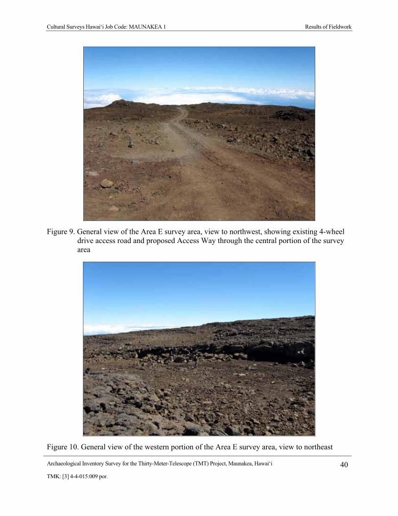
Cultural Surveys Hawai‘i Job Code: MAUNAKEA 1 Results of Fieldwork
Archaeological Inventory Survey for the Thirty-Meter-Telescope (TMT) Project, Maunakea, Hawai‘i 40TMK: [3] 4-4-015:009 por.
Figure 9. General view of the Area E survey area, view to northwest, showing existing 4-wheel drive access road and proposed Access Way through the central portion of the survey area
Figure 10. General view of the western portion of the Area E survey area, view to northeast

Cultural Surveys Hawai‘i Job Code: MAUNAKEA 1 Results of Fieldwork
Archaeological Inventory Survey for the Thirty-Meter-Telescope (TMT) Project, Maunakea, Hawai‘i 41TMK: [3] 4-4-015:009 por.
Figure 11. General view of the eastern portion of the Area E survey area, view to north
Figure 12. Example of Hawaiiite basalt exposure within the Area E survey area
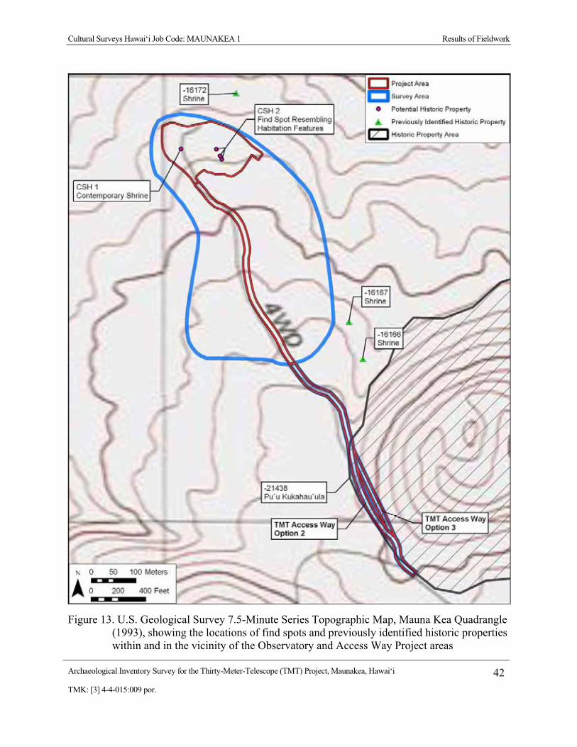
Cultural Surveys Hawai‘i Job Code: MAUNAKEA 1 Results of Fieldwork
Archaeological Inventory Survey for the Thirty-Meter-Telescope (TMT) Project, Maunakea, Hawai‘i 42TMK: [3] 4-4-015:009 por.
Figure 13. U.S. Geological Survey 7.5-Minute Series Topographic Map, Mauna Kea Quadrangle (1993), showing the locations of find spots and previously identified historic properties within and in the vicinity of the Observatory and Access Way Project areas

Cultural Surveys Hawai‘i Job Code: MAUNAKEA 1 Results of Fieldwork
Archaeological Inventory Survey for the Thirty-Meter-Telescope (TMT) Project, Maunakea, Hawai‘i 43TMK: [3] 4-4-015:009 por.
Figure 14. Aerial photograph (source: Google Earth 2009), showing the locations of find spots and previously identified historic properties within and in the vicinity of the Observatory and Access Way Project areas

Cultural Surveys Hawai‘i Job Code: MAUNAKEA 1 Results of Fieldwork
Archaeological Inventory Survey for the Thirty-Meter-Telescope (TMT) Project, Maunakea, Hawai‘i 44TMK: [3] 4-4-015:009 por.
4.1.2 Relationship of the Access Way Survey Area to the Pu‘u K�kahau‘ula State Historic Property
Pu‘u K�kahau‘ula or the summit cinder cone (variously known as Pu‘u W�kiu, Pu‘u Kea, and Pu‘u Hau‘oki) is a State-designated historic property (SIHP # 50-10-23-21438) covering roughly 480 acres. Eight optical/infrared observatories and the summit loop portion of the Maunakea Access Road are presently within the Pu‘u K�kahau‘ula State Historic Property.
Two Access Way options are presently being considered (designated TMT Access Way Option 2 and TMT Access Way Option 3; Option 1 has dropped out of consideration). Although various design alternatives are still under consideration, the TMT Access Way will be paved, with underground conduits for necessary electric and communication cables installed along the access way, and a drainage channel on the downslope side where appropriate.
A small portion of each of the two proposed TMT Observatory Access Way options will traverse the extreme southwestern edge of the Pu‘u K�hahau‘ula State Historic Property (SIHP # 50-10-23-21438) (Figures 13 to 19).
It may be noted that a portion of a common segment of the proposed Access Way options presently is a portion of the Maunakea Access Road Loop servicing the Subaru Observatory (Figures 13 to 17). There are at two existing unimproved roads continuing on to the northwest of the Maunakea Access Road Loop portion of the Maunakea Access Road approximating TMT Access Way Option 2 and TMT Access Way Option 3 (Figures 15, 18 and 19).
4.1.3 Survey Findings of the Batch Plant Staging Area On November 18, 2009, two archaeologists from Cultural Surveys Hawai‘i, Momi Wheeler
B.A. and David W. Shideler M.A., working under the overall supervision of Hallett H. Hammatt Ph.D., carried out a pedestrian inspection of an approximately 4-acre proposed Batch Plant Staging Area (Figures 20 to 25) understood as to be potentially utilized by the TMT Project as a construction staging area during observatory construction. The proposed Batch Plant Staging Area is located approximately 150 m southeast of the California Institute of Technology 10.4 m Submillimeter Telescope and immediately northwest of where the summit access road bifurcates beginning the summit loop road.
Approximately 90% of the proposed batch plant area was observed to have been graded at some time in the past. A small area of undisturbed p�hoehoe outcrop was observed in the central east side. Particular attention was given to searching for any remnant lithic waste flakes or other evidence of traditional Hawaiian use.
No cultural resources were observed and none are believed to be present within the proposed Batch Plant Staging Area. The Batch Plant Staging Area does not lie within the Pu‘u K�kahau‘ula State Historic Property (SIHP # 50-10-23-21438) (Figures 20 and 21), but does lie within the Mauna Kea Summit Region Historic District (SIHP # 50-10-23-26869) (see Figure 8).
Two previously identified historic properties (SIHP #s 50-10-23-16164 and -16165), understood to both be pre-contact shrines, are located in the general vicinity of the Batch Plant Staging Area portion of the Project area (see Figure 20 and Figure 21). These were both briefly re-visited and were determined to both be at their indicated position. Both of these historic properties lie at a distance of more than 200 feet from the designated Batch Plant Staging Area

Cultural Surveys Hawai‘i Job Code: MAUNAKEA 1 Results of Fieldwork
Archaeological Inventory Survey for the Thirty-Meter-Telescope (TMT) Project, Maunakea, Hawai‘i 45TMK: [3] 4-4-015:009 por.
and hence as long as Project activities remain within the designated Batch Plant Staging Area there should be no adverse impact to these historic properties.
4.1.4 Relationship of the Area E Survey Area and the Batch Plant Staging Area to the Mauna Kea Summit Region Historic District (SIHP # 50-10-23-26869)
Both the Area E Survey Area and the Batch Plant Staging Area lie within the west central portion of the Mauna Kea Summit Region Historic District (SIHP # 50-10-23-26869) (see Figure 8). All of the Maunakea summit astronomical infrastructure lies within this designated Historic District.

Cultural Surveys Hawai‘i Job Code: MAUNAKEA 1 Results of Fieldwork
Archaeological Inventory Survey for the Thirty-Meter-Telescope (TMT) Project, Maunakea, Hawai‘i 46TMK: [3] 4-4-015:009 por.
Figure 15. Map showing the routes of the two Access Way options (TMT Access Way Option 2 and TMT Access Way Option 3) under consideration extending north from the Maunakea Access Road Loop/SMA Road intersection

Cultural Surveys Hawai‘i Job Code: MAUNAKEA 1 Results of Fieldwork
Archaeological Inventory Survey for the Thirty-Meter-Telescope (TMT) Project, Maunakea, Hawai‘i 47TMK: [3] 4-4-015:009 por.
Figure 16. General view approaching the Submillimeter Array (at left) and access road leading to Subaru Telescope and Area E, view to northwest. Note: existing paved summit loop portion of the Maunakea Access Road, unimproved road, and infrastructure are on the southwest flank of the Pu‘u K�kahau‘ula State Historic Property (SIHP # 50-10-23-21438)
Figure 17. General view approaching divergence of the Area E access road (at left) and summit loop portion of the Maunakea Access Road leading to the Subaru Telescope, view to north. Note: unimproved road is on the southwest flank of the Pu‘u K�kahau‘ula State Historic Property (SIHP # 50-10-23-21438)

Cultural Surveys Hawai‘i Job Code: MAUNAKEA 1 Results of Fieldwork
Archaeological Inventory Survey for the Thirty-Meter-Telescope (TMT) Project, Maunakea, Hawai‘i 48TMK: [3] 4-4-015:009 por.
Figure 18. View from the northeast corner of the Submillimeter Array enclosure, showing the TMT Access Way Option 3 alignment corresponding to the unimproved road at upper right and the the TMT Access Way Option 2 alignment corresponding to the unimproved road at center, both are located on the extreme west flank of Pu‘u K�kahau‘ula State Historic Property (SIHP # 50-10-23-21438), view to north

Cultural Surveys Hawai‘i Job Code: MAUNAKEA 1 Results of Fieldwork
Archaeological Inventory Survey for the Thirty-Meter-Telescope (TMT) Project, Maunakea, Hawai‘i 49TMK: [3] 4-4-015:009 por.
Figure 19. View showing the TMT Access Way Option 3 alignment corresponding to the unimproved road at upper left and the TMT Access Way Option 2 alignment corresponding to the unimproved road at right, both located on the extreme west flank of Pu‘u K�kahau‘ula State Historic Property (SIHP # 50-10-23-21438), view to southeast

Cultural Surveys Hawai‘i Job Code: MAUNAKEA 1 Results of Fieldwork
Archaeological Inventory Survey for the Thirty-Meter-Telescope (TMT) Project, Maunakea, Hawai‘i 50TMK: [3] 4-4-015:009 por.
Figure 20. U.S. Geological Survey 7.5-Minute Series Topographic Map, Mauna Kea Quadrangle (1993), showing the locations of previously identified historic properties in the vicinity of the Batch Plant Staging Area

Cultural Surveys Hawai‘i Job Code: MAUNAKEA 1 Results of Fieldwork
Archaeological Inventory Survey for the Thirty-Meter-Telescope (TMT) Project, Maunakea, Hawai‘i 51TMK: [3] 4-4-015:009 por.
Figure 21. Aerial photograph (source: Google Earth 2009), showing the locations of previously identified historic properties in the vicinity of the Batch Plant Staging Area

Cultural Surveys Hawai‘i Job Code: MAUNAKEA 1 Results of Fieldwork
Archaeological Inventory Survey for the Thirty-Meter-Telescope (TMT) Project, Maunakea, Hawai‘i 52TMK: [3] 4-4-015:009 por.
Figure 22.General view of the eastern portion of the Batch Plant Staging Area, view to northwest
Figure 23. General view of western portion of the Batch Plant Staging Area, view to northwest

Cultural Surveys Hawai‘i Job Code: MAUNAKEA 1 Results of Fieldwork
Archaeological Inventory Survey for the Thirty-Meter-Telescope (TMT) Project, Maunakea, Hawai‘i 53TMK: [3] 4-4-015:009 por.
Figure 24. General view of the southeast portion of the Batch Plant Staging Area, view to southeast
Figure 25. General view of the southwest portion of the Batch Plant Staging Area, view to south

Cultural Surveys Hawai‘i Job Code: MAUNAKEA 1 Significance Assessments
Archaeological Inventory Survey for the Thirty-Meter-Telescope (TMT) Project, Maunakea, Hawai‘i 54TMK: [3] 4-4-015:009 por.
Section 5 Significance Assessments The five criteria established for evaluating the significance of historic properties and assessing
eligibility for placement on the National/Hawai‘i Registers of Historic Places are:
A Associated with events that have made an important contribution to the broad patterns of our history;
B Associated with the lives of persons important in our past; C Embodies the distinctive characteristics of a type, period, or method of construction,
represents the work of a master, or possesses high artistic value; D Have yielded, or is likely to yield information important for research on prehistory or
history; E Have an important value to the native Hawaiian people or to another ethnic group of
the state due to associations with cultural practices once carried out, or still carried out, at the property, or due to associations with traditional beliefs, events or oral history accounts – these associations being important to the group’s history and cultural identity.
SIHP # 50-10-23-26869 Mauna Kea Summit Region Historic District was previously assessed as significant under Criteria A, B, C, D, and E of the National/Hawai‘i Registers of Historic Places evaluation criteria:
The Mauna Kea Summit Region Historic District is significant under all four National Register criteria, and criterion “e” of the Hawaii Administrative Rules, Chapter §13-275-6. The district is significant under criterion “a” because of the presence of the Mauna Kea Adze Quarry Complex (a National Historic Landmark), which was used over a period of 500 years or more and the hundreds of shrines in and outside of the quarry. Both the quarry and the shrines are associated with broad patterns and events in Hawaiian prehistory. The district is significant under criterion “b” because of the association with several gods who may have been deified ancestors. These include K�kahau`ula, L�l�noe and Waiau. The sites in the adze quarry and many of the shrines embody distinctive characteristics of traditional Hawaiian stone tool manufacture by craft specialists and a distinctive type of shrine construction found in only a few other places in the Hawaiian Islands. These make the district significant under criterion “c.” Studies of the Mauna Kea Adze Quarry Complex and the on-going archaeological survey of the Mauna Kea Science Reserve have already made a significant contribution to our understanding of Hawaiian prehistory and history, and hold the potential to make even more contributions. The district is thus significant under criterion “d.” Finally, the district is significant under criterion “e” because of the presence of numerous burials and the hundreds of shrines which have been interpreted as evidence of a previously unknown land use practice in the form of pilgrimages to the summit of Mauna Kea to worship the gods and goddesses. [McCoy et al. 2009:2-49]
Per the Mauna Kea Historic Preservation Plan [SHPD 2000:20]:

Cultural Surveys Hawai‘i Job Code: MAUNAKEA 1 Significance Assessments
Archaeological Inventory Survey for the Thirty-Meter-Telescope (TMT) Project, Maunakea, Hawai‘i 55TMK: [3] 4-4-015:009 por.
Within the [Mauna Kea Summit Region] historic district, the significance of properties is not evaluated individually because the summit region as a whole is considered eligible for inclusion in the National Register. Instead, the required assessments consider how each newly or previously recorded property potentially affected by a project contributes to the significance of the historic district as a whole.
SIHP # 50-10-23-21438 (Pu‘u K�kahau‘ula) is a contributing component of the Mauna Kea Summit Region Historic District. Pu‘u K�kahau‘ula is significant due to its cultural significance to the Hawaiian people, associations with former and on-going cultural practices, and associations with traditional beliefs, events, and oral history accounts.

Cultural Surveys Hawai‘i Job Code: MAUNAKEA 1 Project Effect and Mitigation Recommendations
Archaeological Inventory Survey for the Thirty-Meter-Telescope (TMT) Project, Maunakea, Hawai‘i 56TMK: [3] 4-4-015:009 por.
Section 6 Project Effect and Mitigation Recommendations The following project effect discussion and cultural resource management recommendations
are intended to facilitate project planning and support the proposed project’s required historic preservation consultation. This discussion is based on the results of this archaeological inventory survey investigation and CSH’s communication with agents for the project proponents regarding the project’s potential impacts to the historic properties described in the Results of Fieldwork section, above.
6.1 Project Effect The proposed TMT Observatory Project involves the construction of a 30-meter diameter
telescope and associated infrastructure on a 5-acre site within Area E of the Astronomy Precinct. The Project also includes construction of an Access Way, consisting of a 0.6-mile long road and utility corridor from existing facilities to the TMT Observatory. In addition, the Batch Plant Staging Area, consisting of a 4-acre area near the summit, would be temporarily used as a staging area during Project construction. Minimally, land disturbing activities would include grading of the TMT Observatory site, Access Way, and Batch Plant Staging Area, and excavations associated with building construction and installation of subsurface utilities.
The TMT Observatory, Access Way, and Batch Plant Staging Area are within the Mauna Kea Summit Region Historic District (SIHP # 50-10-23-26869). The only individual historic property that will be affected by any of these Project components is the Pu‘u K�kahau‘ula State Historic Property (SIHP # 50-10-23-21438).
6.1.1 Absence of Direct Impact to Archaeological Sites The proposed Project will not impact any specific archaeological sites. Three historic
properties (SIHP #s 50-10-23-16166, -16167, and -16172), understood to all be pre-contact shrines, are located in the general vicinity of the Observatory and Access Way portions of the Project area (see Figures 13 and 14). As specified in a 2000 Master Plan, it is understood that Project activities should maintain a 200-foot buffer from these historic properties. All three of these historic properties lie at a distance of more than 200 feet from the designated Project areas, and hence as long as Project activities remain within the designated project areas, there should be no adverse impact to these historic properties.
Similarly, two historic properties (SIHP #s 50-10-23-16164 and -16165), understood to both be pre-contact shrines, are located in the general vicinity of the Batch Plant Staging Area portion of the Project area (see Figures 20 and 21). As specified in a 2000 Master Plan it is understood that Project activities should maintain a 200-foot buffer from these historic properties. Both of these historic properties lie at a distance of more than 200-feet from the designated Batch Plant Staging Area, and hence as long as Project activities remain within the designated Batch Plant Staging Area there should be no adverse impact to these historic properties.
6.1.2 SIHP # 50-10-23-21438 Pu‘u K�kahau‘ula State Historic Property The construction of either of the proposed TMT Access Way options, consisting of an
approximately 0.6-mile long road and utility corridor from existing facilities to the TMT

Cultural Surveys Hawai‘i Job Code: MAUNAKEA 1 Project Effect and Mitigation Recommendations
Archaeological Inventory Survey for the Thirty-Meter-Telescope (TMT) Project, Maunakea, Hawai‘i 57TMK: [3] 4-4-015:009 por.
Observatory will skirt a short stretch (approximately 540 feet) of the extreme western portion of the cinders of Pu‘u K�kahau‘ula (understood as falling within SIHP # 50-10-23-21438) (see Figure 21 and the photograph series of Figure 16 to Figure 19) at approximately the 13,400-foot contour, approximately 400 feet below the 13,796 foot summit. It may be noted that two roughly parallel unimproved tracks lie adjacent to the proposed Access Way further upslope to the east (see Figures 18 and 19). Much of the proposed Access Way alignment follows existing roads that have been established in the summit area. Approximately 230 linear feet of the proposed alignment would involve road construction through Pu‘u K�kahau‘ula cinder lands not previously used as roads. The proposed 26-ft. wide road would be graded, with subsurface utilities installed beneath the road surface. The road would be primarily unpaved, with the exception of the road in the vicinity of the core of the Submillimeter Array (SMA) facility that would be paved to minimize the effects of dust on the SMA antennas.
The to-be-chosen Access Way option will disturb an approximately 1.3-acre area of the 480-acre Pu‘u K�kahau‘ula State Historic Property. This disturbance will occur on the western most extent of Pu‘u K�kahau‘ula at the base of the cinder cone near the SMA. The Access Way affect will primarily be associated with a small 0.3-acre area of disturbance where there currently is no road, but this area is between two existing unimproved roads; the remaining 1.0 acre of disturbance within the Pu‘u K�kahau‘ula State Historic Property would be along one of two existing tracks that will be improved. A retaining wall may or may not be required but some grading will be necessary within the limits of the Pu‘u K�kahau‘ula State Historic Property. Pu‘u K�kahau‘ula, on which eight optical/infrared observatories, a portion of the SMA area, and the loop portion of the Maunakea Access Road sit, will retain its current shape but a small area will be graded and a short section of new road and existing unpaved road at its base will be paved.
The SIHP # 50-10-23-21438 Pu‘u K�kahau‘ula State Historic Property has been massively impacted by the construction and use of the existing loop access road, telescope pads and appurtenances. These impacts include not only effects to the cinder cone itself but also to the surrounding view plane. In an effort to minimize adverse impacts to SIHP # 50-10-23-21438 the TMT observatory was located significantly outside of the designated historic property, well to the northwest.
Whichever of the two Access Way options that is chosen will skirt the lowest edge of SIHP # 50-10-23-21438 at approximately the 13,400-foot contour approximately 400 feet below the 13,796 foot summit of the historic property. The Access Way will have an adverse physical impact to this lowest westernmost portion of the historic property. Additionally, the TMT observatory and appurtenances will be visible to the west and north of the historic property. It may be noted that we understand the observatory will not be visible from the actual summit (Figure 26). Due to the potential adverse effect on this significant historic property, CSH’s project-specific effect recommendation is “effect, with proposed mitigation commitments.”
6.1.3 SIHP # 50-10-23-26869 Mauna Kea Summit Region Historic District The Project area, including the Observatory, the Access Way, and the Batch Plant Staging
Area, is located within the SIHP # 50-10-23-26869 Mauna Kea Summit Region Historic District (see Figure 8). All of the Maunakea summit astronomical infrastructure lies within this designated Historic District. Due to the potential adverse effect on significant historic properties,

Cultural Surveys Hawai‘i Job Code: MAUNAKEA 1 Project Effect and Mitigation Recommendations
Archaeological Inventory Survey for the Thirty-Meter-Telescope (TMT) Project, Maunakea, Hawai‘i 58TMK: [3] 4-4-015:009 por.
Figure 26. Illustration of how the TMT Observatory will not be visible from the summit of the Pu‘u K�kahau‘ula State Historic Property (SIHP # 50-10-23-26869. TMT would be in the yellow box is you could see through the mountain

Cultural Surveys Hawai‘i Job Code: MAUNAKEA 1 Project Effect and Mitigation Recommendations
Archaeological Inventory Survey for the Thirty-Meter-Telescope (TMT) Project, Maunakea, Hawai‘i 59TMK: [3] 4-4-015:009 por.
CSH’s project-specific effect recommendation is “effect, with proposed mitigation commitments.”
6.2 Mitigation Recommendations As discussed in Section 6.1.1 above, the Project is anticipated to have no direct affect on any
archaeological sites per se. However, due to the potential adverse effect on two significant historic properties (Pu‘u K�kahau‘ula State Historic Property, SIHP # 50-10-23-21438 and the Mauna Kea Summit Region Historic District, SIHP # 50-10-23-26869), CSH’s project-specific effect recommendation is: “effect, with proposed mitigation commitments.”
The Mauna Kea Historic Preservation Plan (SHPD 2000:20-21) prepared by SHPD, states:
Within the historic district, the effect of a project on the historic district as a whole needs to be assessed as well as the project’s effect on individual historic properties located within or immediately adjacent to the project area. The effect of a project on the historic district must be addressed even if no individual historic properties are found within or immediately adjacent to the project area.
Effects on a district would consider the visual impact of a facility on the surrounding landscape (i.e., the various land forms creating the setting and context of the multiple historic properties encompassed by the district) and on those individual historic properties which contribute to the significance of the district. Creating a network of roads would affect the historic district because, in addition to altering the landscape, it creates easier access to more areas in the historic district and thus increases the possibility of historic properties being damaged by visitors.
Project affects on the Pu‘u K�kahau‘ula State Historic Property and the Mauna Kea Summit Region Historic District have little to do with specific archaeological sites per se, but rather are closely related to Project impacts on the perceived spiritual and sacred quality of Maunakea. This includes:
� Project affect on the integrity of cinder cones within the district.
� The visual affect of the Project’s man-made structures within the district.
� The affect of Project employees in the summit region.
� The affect of the potential accidental release of wastewater or hazardous substances due to Project activities within the district.
� The affect of noise and dust generated by Project activities within the district.
6.2.1 Historic Properties and Integrity of Cinder Cones The Project affects on the Pu‘u K�kahau‘ula State Historic Property, the only individual
Historic Property within or adjacent to the Mauna Kea Summit Region Historic District affected by the Project, are discussed above. All Project components within the Historic District are more than 200 feet away from individual Historic Properties within the Historic District.

Cultural Surveys Hawai‘i Job Code: MAUNAKEA 1 Project Effect and Mitigation Recommendations
Archaeological Inventory Survey for the Thirty-Meter-Telescope (TMT) Project, Maunakea, Hawai‘i 60TMK: [3] 4-4-015:009 por.
Because Pu‘u K�kahau‘ula is also a cinder cone, the Project affects on it are also the Project affects on the integrity of cinder cones. The only other Project facility that is within 200 feet of a cinder cone in the district is the Batch Plant Staging Area. The Batch Plant Staging Area is located across Maunakea Access Road from the southeastern portion of Pu‘u K�kahau‘ula. The Batch Plant Staging Area has been used during previous construction projects and the Project’s use will be similar to those uses. No additional areas nearby will be disturbed by the Project, including the Pu‘u K�kahau‘ula cinder cone across the road.
The impact of the project will be mitigated by virtue of keeping the Access Way on the extreme lower margin of Pu‘u K�kahau‘ula (SIHP # 50-10-23-21438) at approximately the 13,400-foot contour approximately 400 feet below the 13,796 foot summit of the historic property. By keeping the new Access Way construction within the immediate vicinity of two existing vehicular roads (see Figures 18 and 19) further adverse impact to the cinder cone integrity will be minimized.
6.2.2 Visual The TMT Observatory will not be visible from the summit of the Pu‘u K�kahau‘ula State
Historic Property (see Figure 26). This is due to the presence of the northern ridge of Pu‘u K�kahau‘ula blocking the view from the summit peak. The TMT Observatory will also not be visible from the Pu‘u L�l�noe (SIHP # 50-10-23-21439) and Waiau (SIHP # 50-10-23-21440) State Historic Properties. However, the TMT Observatory will add a new visual element to the northern plateau area that will be visible to varying degrees from the northern ridge of Pu‘u K�kahau‘ula and some of the historic shrines and other historic properties along the northern slopes of Maunakea. The TMT Observatory will appear in the view directly toward the summit from only a few of the shrines on the northern plateau.
Although the TMT Observatory will be built in a relatively undeveloped portion of the Mauna Kea Science Reserve (MKSR) Astronomy Precinct, it will be less visible from within the Historic District than the existing observatories. From all locations within the district that the TMT Observatory will be visible, multiple existing observatories will also be visible.
6.2.3 Roads and Access The Access Way will not create a new road, it will improve an existing road. This
improvement could not be characterized as creating a “network” of roads, but will create easier access to a limited area of the Historic District. The Access Way will only substantially improve access (improve a 4-wheel drive road to an improved dirt road) over a 0.3 mile length starting beyond (north of) the SMA access road. Nevertheless, TMT employees and visitors will be accessing a portion of the Historic District that is currently rarely visited.
The establishment of a specific Access Way will mitigate the present state of affairs in which somewhat braided, ad-hoc vehicular access prevails (see Figures 18 and 19). The establishment of one main access alignment should mitigate the present impacts over a larger area.
6.2.4 Employees in the Summit Region Some Native Hawaiians have expressed that just knowing that Maunakea is there is sufficient;
there is not a strong need to visit. In this framework, the regular presence of any people is not

Cultural Surveys Hawai‘i Job Code: MAUNAKEA 1 Project Effect and Mitigation Recommendations
Archaeological Inventory Survey for the Thirty-Meter-Telescope (TMT) Project, Maunakea, Hawai‘i 61TMK: [3] 4-4-015:009 por.
considered a normal condition for Maunakea and could affect its spiritual and sacred quality, and hence the Historic District. It is estimated that approximately 100 employees currently work at the observatory facilities within MKSR. It is expected that an average of 24 employees will work at the TMT Observatory during daytime operations, with a minimum of 15 and a maximum of 43 possible; nighttime operations will require an average of 6 employees at the facility. Thus there will be a relatively small number of employees within a clearly demarcated facility. A program of employee education emphasizing the importance of minimizing adverse impact to cultural resources will mitigate any adverse impact associated with increased human use of Pu‘u K�kahau‘ula and the Mauna Kea Summit Region Historic District
6.2.5 Accidental Release of Wastewater or Hazardous Substances Some Native Hawaiians have indicated that the practice of releasing domestic wastewater into
the subsurface through septic systems by current observatories desecrates the spiritual and sacred quality of the mountain, and hence the district. The same has been said regarding the potential accidental spillage of wastewater or hazardous substances. For these reasons the Cultural Resources Management Plan (CRMP) requires that all new users remove all domestic wastewater from the mountain for treatment. The Project will comply with this requirement and will not utilize a septic system to dispose of domestic wastewater. No wastewater will be released and all wastewater will be trucked off the mountain for disposal.
6.2.6 Noise and Dust Noise and dust could have an effect on the spiritual and sacred quality of the mountain and
hence the Historic District, respectively. Noise is closely associated with vehicular movements in the summit region and dust is closely associated with vehicular movements on unpaved roads in the summit region. The movements of employees and materials to and from the TMT Observatory will generate noise and dust. The noise and dust generated by Project activities will adversely affect the spiritual and sacred quality of Maunakea and the Historic District. Specific measures will be taken to minimize noise and dust during construction and subsequent routine use of the TMT Observatory.
6.2.7 Treatments The following treatments, commonly known as mitigation measures, will be implemented by
the Project:
� An Archaeological Monitoring Plan will be developed in accordance with HAR section 13-279 and cultural and archaeological monitors will be present at construction sites on Maunakea and have authority to stop work if cultural finds are made, including historic properties. They will also inform workers of the possibility of inadvertent cultural finds, including human remains.
� A Mitigation Plan will be developed and implemented meeting the requirements of HAR section 13-284-8(a)(2). This Mitigation Plan will be developed in consultation with native Hawaiian organizations, including the Office of Hawaiian Affairs, to seek their views on the proposed forms of mitigation.

Cultural Surveys Hawai‘i Job Code: MAUNAKEA 1 Project Effect and Mitigation Recommendations
Archaeological Inventory Survey for the Thirty-Meter-Telescope (TMT) Project, Maunakea, Hawai‘i 62TMK: [3] 4-4-015:009 por.
� In compliance with the CMP and to mitigate potential effects on cultural practices and Historic Properties, among other things, a Cultural and Natural Resources Training Program will be developed and implemented. As discussed in the CMP, the Cultural and Natural Resources Training Program will include educational instruction and materials designed to:
- Impart an understanding of Maunakea’s cultural landscape, including cultural practices, historic properties and their sensitivity to damage, and the rules and regulations regarding the protection of historic properties.
- Make it clear that any disturbance of a historic property is a violation of HRS Chapter 6E-11 and punishable by fine.
- Provide guidance and information as to what constitutes respectful and sensitive behavior while in the summit area.
The training program will be updated regularly to incorporate UH Management Area-wide updates by OMKM. All people involved in TMT Observatory operation and maintenance activities, including but not limited to scientists and support staff, will receive the training on an annual basis.
� To mitigate the TMT Observatory’s visual effect within the Historic District:
- In compliance with the 2000 Master Plan, the TMT Observatory has selected the 13N site within Area E, which, as the 2000 Master Plan details, was selected to minimize the Project’s visual effect.
- The Project has attempted to reduce the TMT Observatory’s visual impact to mitigate its visual effect. Steps include design efforts to reduce its size, finish the support building and fixed structure exterior with a lava color, and finish the dome with a reflective aluminum-like finish similar to the Subaru Observatory.
� To mitigate the Access Way’s effect on K�kahau‘ula and the Historic District, the Access Way Options:
- Have been designed to reduce disturbance by including the steep slopes of Option 2 and modifying Option 3 to a single lane configuration, even though these designs are not desirable from an observatory operation standpoint.
While the TMT Observatory will impact the view plane in certain portions of the Pu‘u K�kahau‘ula State Historic Property (SIHP # 50-10-23-21438) and the Mauna Kea Summit Region Historic District (SIHP # 50-10-23-26869), the impact will be far less than that of any existing observatory (see Figure 26). The location and elevation of the observatory and infrastructure were specifically designed to minimize adverse impacts to view planes within the district (see Figure 26).
6.2.8 Off-Site Mitigation TMT is considering a number of possible mitigation measures that relate to cultural and
archaeology/historic potential impacts. These are presently being discussed with cultural consultants in the context of the on-going, companion Cultural Impact Assessment for the Thirty

Cultural Surveys Hawai‘i Job Code: MAUNAKEA 1 Project Effect and Mitigation Recommendations
Archaeological Inventory Survey for the Thirty-Meter-Telescope (TMT) Project, Maunakea, Hawai‘i 63TMK: [3] 4-4-015:009 por.
Meter Telescope (TMT) Observatory Project and Hale P�haku Mid-Level Support Facilities Project, Maunakea, Ka‘ohe Ahupua‘a, H�m�kua District, Hawai‘i Island, TMK: [3] 4-4-015:001 por., 009 por., 012 por. (Cruz et al. 2009). Specific discussion is focusing on if consultants can (a) provide input to improve or focus proposed off-site mitigation measures; (b) suggest alternative ideas. Below is a list of general concepts but it should be made clear that the TMT Observatory team is not prepared to make any commitments at this time believing that it is appropriate to receive further feedback from the concerned community first (the on-going Cultural Impact Assessment is one avenue to get that feedback). Off-site mitigation measures being presently considered include the following:
1. Help fund the restoration the stone cabins at Hale P�haku and turn them into a cultural interpretive center associated with the Visitor Information Station (VIS)
2. Help fund the expansion of the VIS and generally improve it so that, together with the stone cabins, it provides a well rounded presentation and education regarding cultural (including archaeology), natural, and astronomy.
3. Provide funding to benefit either the University of Hawai‘i at Hilo Hawaiian Studies and Hawaiian Language program or funding to benefit the Hawaiian immersions charter schools (looking for input on what people think would be more beneficial - college level or grade school level funding for cultural programs).
4. Coordinate with Imiloa on the development of programs and informational materials that explore the connection between Hawaiian culture and astronomy.
5. Possibly shutting down operations for 4 or 5 days a year, the most cultural significant days, such as solstice and equinox days.
6. Host annual, or otherwise, cultural events/workshops at Hale P�haku or elsewhere that provide cultural extension to the community - ideas: adze making workshop, how to identify an archaeology site, etc.
7. Fund some translation of chants and then take lessons from them to (a) cultural events/workshops, and/or (b) schools and such.
6.2.9 Summary of Mitigation The main form of mitigation is in the locating of the TMT Observatory off of the summit and
well away from all known archaeological sites. Keeping the TMT Observatory and appurtenances more than 200 feet away from all known sites is a major form of mitigation. Similarly the fact that the TMT Observatory will not be visible from the actual summit (Figure 26) is suggested to be a major form of mitigation of impact to both the Pu‘u K�kahau‘ula State Historic Property (SIHP # 50-10-23-21438) and the Mauna Kea Summit Region Historic District (SIHP # 50-10-23-26869).
The probability of burials or human skeletal remains within the Project area is regarded as very low for reasons given in Section 4.1 above. However, in the unlikely event that cultural resources including but not limited to human remains or other significant cultural deposits are encountered during the course of Project-related construction activities, all work in the immediate area should stop and the State Historic Preservation Division should be promptly notified.

Cultural Surveys Hawai‘i Job Code: MAUNAKEA 1 References Cited
Archaeological Inventory Survey for the Thirty-Meter-Telescope (TMT) Project, Maunakea, Hawai‘i 64TMK: [3] 4-4-015:009 por.
Section 7 References Cited
Aitken, Robert T. 1935 “Archaeology” IN “The Hawaiian Academy of Science Mauna Kea Expedition”
Manuscript in B. P. Bishop Museum Library
Alexander, William D. 1892 “The Ascent of Mauna Kea, Hawaii” The Hawaiian Gazette, 27 (38):7. September 20
Allen, Melinda Sue 1981 An Analysis of the Mauna Kea Adze Quarry Archaeobotanical Assemblage. Master’s
thesis, University of Hawai‘i at M�noa
Bishop Museum n.d. Hamakua Site Records, Department of Anthropology, B.P. Bishop Museum, Honolulu
Borthwick, Douglas and Hallett H. Hammatt 1990 Archaeological Reconnaissance Survey of the Proposed Galileo Telescope Sites C and D,
Summit of Mauna Kea, Hawai‘i Island, Hawai‘i (TMK 4-4-015:09) Cultural Surveys Hawai‘i, Inc., Kailua, HI.
1993 Archaeological Reconnaissance Survey of the Proposed Gemini Telescope Site, Summit of Mauna Kea, Hawai‘i Island, Hawai‘i (TMK 4-4-015:90) Cultural Surveys Hawai‘i, Inc., Kailua, HI.
Bryan, Lester W. 1927 “The Mauna Kea Forest Reserve” Paradise of the Pacific 40 (12): 105-106
Cleghorn, Paul 1982 The Mauna Kea Adze Quarry: Technological Analyses and Experimental Tests. U. of
Hawaii, Dept. of Anthropology, Ph.D. Dissertation.
Cruz, Brian, Mindy Simonson and Hallett H. Hammatt 2009 Cultural Impact Assessment for the Thirty Meter Telescope (TMT) Observatory Project
and Hale P�haku Mid-Level Support Facilities Project, Maunakea, Ka‘ohe Ahupua‘a, H�m�kua District, Hawai‘i Island, TMK: [3] 4-4-015:001 por., 009 por., 012 por. Cultural Surveys Hawai‘i, Kailua Hawai‘i.
Emory, Kenneth Pike 1938 “The Adze Makers of Mauna Kea” Paradise of the Pacific 50 (4): 21-22
Fornander, Abraham 1919 Fornander Collection of Hawaiian Antiquities and Folk-Lore (Volume IV: 160-173)
“The Legend of Kila (He Kaao no Kila)” Bishop Museum Press, Honolulu, HI. 1919 Fornander Collection of Hawaiian Antiquities and Folk-Lore (Volume IV: 178-235)
“Story of ‘Umi: One of the Most Noted of Hawaiian Kings (He Mo‘olelo no ‘Umi: Kek�hi Ali‘i Kaulana o ko Hawai‘i Nei Pae‘�ina)” Bishop Museum Press, Honolulu, HI.
1919 Fornander Collection of Hawaiian Antiquities and Folk-Lore (Volume V: 78-135) “Legend of K�ap�ka‘a (He Ka‘ao no K�ap�ka‘a)” Bishop Museum Press, Honolulu, HI.
Cultural Surveys Hawai‘i Job Code: MAUNAKEA 1 References Cited
Archaeological Inventory Survey for the Thirty-Meter-Telescope (TMT) Project, Maunakea, Hawai‘i 65TMK: [3] 4-4-015:009 por.
1919 Fornander Collection of Hawaiian Antiquities and Folk-Lore (Volume V: 314-363) “Tradition of Kamapua‘a (Ka‘ao no Kamapua‘a)” Bishop Museum Press, Honolulu, HI.
1919 Fornander Collection of Hawaiian Antiquities and Folk-Lore (Volume V: 436-451) “Legend of P�p�kea (Ka‘ao no P�p�kea)” Bishop Museum Press, Honolulu, HI.
1919 Fornander Collection of Hawaiian Antiquities and Folk-Lore (Volume V: 486-503) “Famous Men of Early Days (Po‘e Kaulana o ka W� i Hala)” Bishop Museum Press, Honolulu, HI.
1919 Fornander Collection of Hawaiian Antiquities and Folk-Lore (Volume V: 522-527) “The Flood in Hawaii in the Olden Times (No Ke Kaiakahinali‘i Ma Hawaii Nei)” Bishop Museum Press, Honolulu, HI.
Goodrich, Joseph 1826 “Notice of the Volcanic Character of the Islands of Hawaii” American Journal of Science
Ser. 1, 11:2-7
Gregory, Herbert 1921 “Trip to Mauna Kea” Field Notes in the B. P. Bishop Museum Library
Gregory, Herbert and C. Wentworth 1937 “General Features and Glacial Geology of Mauna Kea” Hawaii Geological Society of
America Bulletin 48 (12):1719-1742
Hammatt, Hallett and Douglas Borthwick 1988 Archaeological Reconnaissance of Two Proposed Antenna Sites for The National Radio
Astronomy Observatory, Mauna Kea, Hawai‘i, Cultural Surveys Hawai‘i, Inc., Kailua, HI
Hammatt, Hallett and David W. Shideler 2002 Data Recovery Report for Two Archaeological Lithic Scatters Sites 50-10-23 -10,310 and
50-10-23-10,311 at The Pu‘u Kalepeamoa Complex, Hale P�haku, Ka‘ohe Ahupua‘a, Mauna Kea, Hawai‘i Island (TMK 4-4-15:12) Cultural Surveys Hawai‘i, Inc., Kailua, HI
Kal�kaua, David 1888 Legends and Myths of Hawaii The Fables and Folk-lore of a Strange People “‘Umi, the
Peasant Prince of Hawai‘i” pages 249-315 1888 Legends and Myths of Hawaii The Fables and Folk-lore of a Strange People “Laie i ka
Wai” Pages 455-480 1888 Legends and Myths of Hawaii The Fables and Folk-lore of a Strange People “Kahavari,
Chief of Puna” Pages 501-507
Kam, Wendell and Jason Ota 1983 Archaeological Reconnaissance Survey of Mauna Kea Observatory Powerline: Upper
Portions, Mauna Kea, Hamakua, Hawaii, State Historic Preservation Division
Kilmartin, Jerome O. 1974 “Na Mea O Mauna Kea (Things About Mauna Kea)” Explorers Journal 52 (1): 12-16

Cultural Surveys Hawai‘i Job Code: MAUNAKEA 1 References Cited
Archaeological Inventory Survey for the Thirty-Meter-Telescope (TMT) Project, Maunakea, Hawai‘i 66TMK: [3] 4-4-015:009 por.
Macdonald, Gordon A., Ogg, Randy and Frank L. Peterson 1983 Volcanoes in the Sea, Second Edition. The Geology of Hawaii, University of
Hawaii Press, Honoulu, HI.
Maly, Kepa 1997 “Mauna Kea - Kuahiwi Ku Ha‘o i Ka Malie”, A Report on Archival and Historical
Documentary Research, Ahupua‘a of Hilo and H�m�kua, Island of Hawai‘i, Kumu Pono Associates, Hilo, HI.
1999 Mauna Kea Science Reserve and Hale Pohaku Complex Development Plan Update: Oral History and Consultant Study, and Archival Literature Research; Ahupua‘a of Ka‘ohe (Hamakua District) and Humu‘ula (Hilo District), Island of Hawai‘i. Kumu Pono Associates, Hilo, HI.
Maly, Kepa and Onaona Maly 2005 Mauna Kea, Ka Piko Kaulana o ka ‘ina (Mauna Kea – The Famous Summit of the
Land) A Collection of Native Traditions, Historical Accounts, and Oral History Interviews for: Mauna Kea, the Lands of Ka‘ohe, Humu‘ula and the ‘ina Mauna on the Island of Hawai‘i, Kumu Pono Associates, LLC.
McCoy, Patrick 1976 "The Mauna Kea Quarry Project: A First Analysis." Proceedings of the First Conference
in Natural Sciences (Hawaii Volcanoes National Park), pp. 135-142. 1977a "Archaeological Investigations at the Mauna Kea Adze Quarry Complex, Hawaii:
Preliminary Results of the 1975-76 Fieldwork." Paper presented at the 42nd Annual Meeting of the Society for American Archaeology, New Orleans, Louisiana.
1977b "The Mauna Kea Adze Quarry Project: A Summary of the 1975 Field Investigations." Journal of the Polynesian Society 86 (2): 233-244.
1978 "The B.P. Bishop Museum Mauna Kea Adze Quarry Project." Ms. in Dept. Anthropology.
1981 "Stones For the Gods: Ritualism in the Mauna Kea Adze Quarry Industry, Hawaii." Paper presented at the 46th Annual Meeting for the Society for American Archaeology, San Diego, California.
1982a Archaeological Reconnaissance Survey in Cultural Resources, Reconnaissance of the Mauna Kea Summit Region, Proposed for Group 70, Bishop Museum, Dept. of Anthropology, Honolulu, HI.
1982b Archaeological Survey of the Proposed Site of the Caltech 10-Meter Telescope on Mauna Kea, Hawaii, Department of Anthropology, B. P. Bishop museum, Honolulu
1984a Mauna Kea Summit Region survey: A Summary of the 1984 Fieldwork. Bishop Museum Manuscript on File at the State Historic Preservation Office, Honolulu, HI.
1984b Archaeological Reconnaissance of Hopukani, Waihu and Liloe Springs, Mauna Kea, Hawai‘i. Dept. of Anthropology, Bernice Pauahi Bishop Museum, Honolulu, HI
1985 Preliminary Archaeological Survey of the Pu‘u Kalepeamoa Site, Mauna Kea, Hawaii, Prepared for MCM Planning, Bishop Museum, Dept. of Anthropology, Honolulu, HI.

Cultural Surveys Hawai‘i Job Code: MAUNAKEA 1 References Cited
Archaeological Inventory Survey for the Thirty-Meter-Telescope (TMT) Project, Maunakea, Hawai‘i 67TMK: [3] 4-4-015:009 por.
1986 Archaeological Investigations in the Hopukani, and Liloe Springs Area of the Mauna Kea Adze Quarry, Hawai‘i: A Data Summary Report. Mountain Archaeology Research Corporation and Bernice Pauahi Bishop Museum, Honolulu, HI
1990 "Subsistence in a 'Non-Subsistence' Environment: Factors of Production in a Hawaiian Alpine Desert Adze Quarry" in Papers from a Symposium at the XV Pacific Science Congress, Dunedin, New Zealand 1983, edited by D. E. Yen and J.M.J. Nummery, ANU, Canberra.
1991 Survey and Test Excavations of the Pu‘u Kalepeamoa Site, Mauna Kea, Hawai‘i. Mountain Archaeology Research Corporation Report for IJH M�noa Facilities Planning and Management Office, Honolulu, HI.
1993 Letter Report on the Inspection of Two Sites Located in the Vicinity of the Smithsonian Submillimeter Array
1999 “Hawaiian Archaeology: Neither Here Nor There: A Rite of Passage Site on the Eastern Fringes of the Mauna Kea Adze Quarry, Hawai‘i” Hawaiian Archaeology Volume 7, 1999 Society for Hawaiian Archaeology
McCoy, Patrick C., Sara Collins, Stephan D. Clark, and Valerie Park 2009 Draft Cultural Resources Management Plan for the University of Hawaii Management
Areas on Mauna Kea, Ka‘ohe Ahupua‘a, H�m�kua District, Hawai‘i Island, State of Hawai‘i (TMK: [3] 4-4-015: 09, 12). Pacific Consulting Services, Inc., Honolulu, HI.
McEldowney, Holly 1982 Ethnographic Background of the Mauna Kea Summit Region IN Cultural Resources
Reconnaissance of the Mauna Kea Summit Region, Prepared for Group 70, Bishop Museum, Dept. of Anthropology.
Pacific Consulting Services, Inc. (PCSI). 2005 Mauna Kea Science Reserve Archaeological Inventory Survey, Ka‘ohe, H�m�kua, Island
of Hawai‘i, Interim Report No. 2. Prepared for the Office of Mauna Kea Management. Pacific Consulting Services, Inc., Honolulu, HI.
PCSI 2006 Mauna Kea Science Reserve Archaeological Inventory Survey, Ka‘ohe, Hamakua, Island
of Hawaii, Interim Report No. 2
Preston, E. D. 1895 “Determination of Latitude, Gravity, and Magnetic Elements at Stations in the Hawaiian
Islands, Including a Result for the Mean Density of the Earth, 1891, 1892” IN Report of the Superintendent of the U.S. Coast and Geodetic Survey for the Fiscal Year Ending June 30, 1893, Part II. Washington: Government Printing Office
Robins, Jennifer and Hallett H. Hammatt 1990 Archaeological Reconnaissance for Summit and Mid-Level Facilities for the Proposed
Japan National Large Telescope, Mauna Kea, Hawai‘i, Cultural Surveys Hawai‘i, Kailua, HI

Cultural Surveys Hawai‘i Job Code: MAUNAKEA 1 References Cited
Archaeological Inventory Survey for the Thirty-Meter-Telescope (TMT) Project, Maunakea, Hawai‘i 68TMK: [3] 4-4-015:009 por.
Sato, H. Warren Ikeda, Robert Paeth, Richard Smythe, and Minoru Takehiro, Jr. 1973 Soil Survey of the Island of Hawaii, U.S. Department of Agriculture and Univ. of Hawaii
Agricultural Experiment Station. (http://www.ctahr.hawaii.edu/soilsurvey/Hawaii/hawaii.htm) Accessed 2/1/09
State of Hawaii Department of Land and Natural Resources, Division of Water and Land Development 1970 An Inventory Survey of Basic Water Resources Data: Island of Hawaii. Report R34.
Honolulu, Hawaii.
State Historic Preservation Division 2000 Appendix F: Mauna Kea Historic Preservation Plan Management Components IN
Mauna Kea Science Reserve Master Plan, University of Hawai‘i, Honolulu, HI.
Thrum, Thomas G. 1907 Hawaiian Folk Tales “Legends Resembling Old Testament History” pages 15- 30. 1907 Hawaiian Folk Tales “Pele and the Deluge” pages 36-38 1923 More Hawaiian Folk Tales, Unknown publisher.
Wentworth, Chester K. and William F. Powers 1943 Glacial Springs on the Island of Hawai‘i, Journal of Geology 51 (8): 542-547
Westervelt, W.D. 1963 Hawaiian Legends of Volcanoes. Reprint [originally published in 1916] Rutland,
Vermont. Charles E. Tuttle Company.
Williams Scott S. 1987 Post-field Letter Report Dated July 7, 1987 to Mr. Clyde Akita on the Archaeological
Reconnaissance Survey of the Summit Road Between Hale Pohaku and the Stockpile Area, Mauna Kea, Hawai‘i Island. B. P. Bishop Museum, Honolulu.

Cultural Surveys Hawai‘i Job Code: MAUNAKEA 1 Appendix A
Archaeological Inventory Survey for the Thirty-Meter-Telescope (TMT) Project, Maunakea, Hawai‘i A-1TMK: [3] 4-4-015:009 por.
Appendix A Documentation of Potential Historic Properties
CSH 1 INITIALLY INTERPRETED SITE TYPE: Shrine INITIALLY INTERPRETED FUNCTION: Ceremonial FEATURES: 1 DIMENSIONS: 6.6 feet NW/SE x 3.3 ft. NE/SW CONDITION: Excellent PROBABLE AGE: Modern TAX MAP KEY: [3] 4-4-015:009 DESCRIPTION:
CSH 1 consists of two upright stones, located in the northwestern portion of the survey area (see Figure 13 and Figure 14). The upright stones, consisting of flat slabs of hawaiiite basalt, are situated on the edge of a natural basalt boulder terrace, measuring approximately 50 ft. long and 2 ft. in height (Figure 27). The upright stones are wedged into cracks within or between the top surface of large boulders, with cobbles used to fill the remaining gaps (i.e. chinking) and support the stones in an upright position (Figure 28 and Figure 29). The upright stones are spaced 4 ft. apart, at a bearing of 132° true north. The southeastern upright stone measures 22 inches high and 10 inches wide, with a thickness of 2 inches. The northwestern stone measures 18.5 inches high and 12 inches wide, with a thickness of 1.5 inches. CSH 1 was initially interpreted to be a pre-contact shrine, similar to shrines previously identified in the vicinity of the project area. However, following consultation with SHPD staff and Dr. Pat McCoy within the project area, the shrine was determined to be a modern structure, likely constructed within the last 10 years.

Cultural Surveys Hawai‘i Job Code: MAUNAKEA 1 Appendix A
Archaeological Inventory Survey for the Thirty-Meter-Telescope (TMT) Project, Maunakea, Hawai‘i A-2TMK: [3] 4-4-015:009 por.
Figure 27. Photograph of CSH 1 understood as a contemporary shrine, view to southwest, showing two upright stones

Cultural Surveys Hawai‘i Job Code: MAUNAKEA 1 Appendix A
Archaeological Inventory Survey for the Thirty-Meter-Telescope (TMT) Project, Maunakea, Hawai‘i A-3TMK: [3] 4-4-015:009 por.
Figure 28. Photograph of CSH 1 understood as a contemporary shrine, showing southeastern upright stone
Figure 29. Photograph of CSH 1 understood as a contemporary shrine, showing northwestern upright stone

Cultural Surveys Hawai‘i Job Code: MAUNAKEA 1 Appendix A
Archaeological Inventory Survey for the Thirty-Meter-Telescope (TMT) Project, Maunakea, Hawai‘i A-4TMK: [3] 4-4-015:009 por.
CSH 2 [The following account relates to how this find spot was initially recorded]
INITIALLY INTERPRETED SITE TYPE: Temporary Habitation Complex INITIALLY INTERPRETED FUNCTION: Temporary Habitation FEATURES: 3 DIMENSIONS: 100 feet NW/SE x 22 feet NE/SW CONDITION: n/a PROBABLE AGE: n/a TAX MAP KEY: [3] 4-4-015:009 DESCRIPTION:
CSH 2 was originally believed to consist of three possible temporary habitation structures, located in the northwestern portion of the project area (see Figure 13 and Figure 14). The possible temporary habitation structures are located within a northwest to southeast trending lava channel, sheltered from the prevailing northeasterly winds. Feature A, the northernmost of the possible structures, is a C-shaped enclosure located at the base of the lava channel (Figure 30). Feature A measures 6.2 feet by 4.9 ft. wide, and utilizes an 2.6 ft. high bedrock outcrop along the eastern edge of the structure, with a 2 ft. high, 1-3 course, stacked boulder and cobble wall along the southeastern edge, forming a C-shaped windbreak. The interior of Feature A is a level, pebble-paved surface, cleared of larger stones. Feature B, located approximately 17 m southeast of Feature A, is a terrace constructed against the northeastern ridge of the lava channel (Figure 31). Feature B measures 6.2 ft. by 4.3 ft. wide and is constructed with a 3.9 ft. high, 3-5 course, roughly stacked boulder and cobble retaining wall along the north and west edges of the structure. The wall retains a level, pebble-paved terrace surface. Feature C, the southernmost of the structures, is a terrace located approximately 30 ft. southeast of Feature B (Figure 32). Feature C, measuring 8.5 ft. by 5 ft., is constructed against the northeastern ridge of the lava channel. A 2.6 ft. high, 2-4 course, roughly stacked boulder and cobble retaining wall is constructed along the southwest portion of the structure, retaining a level, pebble paved terrace surface.
CSH 2 was initially interpreted to be a pre-contact temporary habitation complex. However, following a subsequent on-location consultation with SHPD staff and Dr. Pat McCoy, CSH 2 was determined to most likely consist of natural features.

Cultural Surveys Hawai‘i Job Code: MAUNAKEA 1 Appendix A
Archaeological Inventory Survey for the Thirty-Meter-Telescope (TMT) Project, Maunakea, Hawai‘i A-5TMK: [3] 4-4-015:009 por.
Figure 30. Photograph of CSH 2 Feature A, initially perceived as a C-shaped temporary habitation structure, view to east
Figure 31. Photograph of CSH 2 Feature B, initially perceived as a temporary habitation terrace, view to east

Cultural Surveys Hawai‘i Job Code: MAUNAKEA 1 Appendix A
Archaeological Inventory Survey for the Thirty-Meter-Telescope (TMT) Project, Maunakea, Hawai‘i A-6TMK: [3] 4-4-015:009 por.
Figure 32. Photograph of CSH 2 Feature C, initially perceived as a temporary habitation terrace, view to northeast


Final EIS: TMT Observatory Page H-1
Appendix H. Archaeological Assessment Report, Hale P�haku


Final EIS: TMT Observatory Page H-3
Preface The Archaeological Study and Assessment for the Thirty-Meter-Telescope (TMT) Observatory Project Ancillary Facilities, Hale P�haku Area, Ka‘ohe, Ahupua‘a, H�m�kua District, Hawai‘i Island, TMK: [3] 4-4-015:001 por., 012 por. has been updated since the Draft EIS was completed. This report addresses only the Project facilities in and near Hale P�haku; Project facilities in the Mauna Kea Science Reserve (MKSR) are discussed in a separate report in Appendix G. The Archaeological Study and Assessment report has been updated to address comments on the report received from State of Hawai‘i Department of Land and Natural Resources, State Historic Preservation Division, in a letter dated July 31, 2009. That letter, and responses to comments in the letter, is included in Chapter 8, Volume 2, of the Final EIS. Changes made to this technical report since the Draft EIS was completed are not illustrated as they are within this preface and the body of the Final EIS. Substantial changes to the Archaeological Study and Assessment report include the following:
� Clarifications to the Project, surveyed areas, and APE were made.
� State Inventory of Historic Properties (SIHP) numbers have been indicated for an identified lithic scatter.
Within the body of this Final EIS, historic and archaeological resources are discussed in Section 3.3, Archaeologic/Historic Resources.


O‘ahu Office P.O. Box 1114 Kailua, Hawai‘i 96734 Ph.: (808) 262-9972 Fax: (808) 262-4950
www.culturalsurveys.com
Maui Office 1993 Main St. Wailuku, Hawai‘i 96793 Ph: (808) 242-9882 Fax: (808) 244-1994
Draft Archaeology Study and Assessment for the
Thirty-Meter-Telescope (TMT) Observatory Project Ancillary Facilities, Hale P�haku Area, Maunakea, Ka‘ohe Ahupua‘a, H�m�kua District, Hawai‘i Island
TMK: [3] 4-4-015:001 por., 012 por.
Prepared for PB Americas, Inc.
Prepared by Hallett H. Hammatt, Ph.D.
Cultural Surveys Hawai‘i, Inc.
Kailua, Hawai‘i (Job Code: MAUNAKEA 4)
November 2009

Cultural Surveys Hawai‘i Job Code: MAUNAKEA 4 Management Summary
Archaeology Study and Assessment for the Thirty-Meter-Telescope (TMT) Project, Hale P�haku Area, Maunakea, Hawai‘i iTMK: [3] 4-4-015: 001 por., 012 por.
Management Summary
Reference Archaeology Study and Assessment for the Thirty-Meter-Telescope (TMT) Observatory Project Ancillary Facilities, Hale P�haku Area, Maunakea, Ka‘ohe Ahupua‘a, H�m�kua District, Hawai‘i Island TMK: [3] 4-4-015:001 por., 012 por. (Hammatt 2009)
Date November 2009 Project Number (s) Cultural Surveys Hawai‘i Inc. (CSH) Job Code: MAUNAKEA 4 Investigation Permit Number
The fieldwork component of the archaeological assessment study was carried out under archaeological permit number 09-20, issued by the Hawai‘i State Historic Preservation Division / Department of Land and Natural Resources (SHPD/DLNR), per Hawai‘i Administrative Rules (HAR) Chapter 13-13-282.
Project Location The approximately 6-acre Project area consists of two discreet parcels located in the Hale P�haku area, at approximately 2,800 m (9,200 ft.) elevation on the southern slope of Maunakea. The Project area is depicted on the U.S. Geological Survey 7.5-Minute Series Topographic Map, Mauna Kea Quadrangle (1993) (Figure 1).
Land Jurisdiction State of Hawai‘i Agencies Hawai‘i State Historic Preservation Division / Department of Land and
Natural Resources Project Description The proposed TMT Observatory Project involves the construction of a
thirty (30) meter diameter telescope and associated infrastructure at the Maunakea Summit Area. The current Project area is proposed for use as construction staging areas and development of housing for TMT Project staff and contractors. The proposed Project also involves upgrades to the existing Hawai‘i Electric Light Company (HELCO) power substation at Hale P�haku. Minimally, land disturbing activities would include grading of the construction staging areas, and excavations associated with construction of residential and associated structures, installation of subsurface utilities, and power substation upgrades.
Project Acreage Approximately 6-acres, including the Hale P�haku (5.2 ac.) and HELCO Substation (0.4 ac.) portions

Cultural Surveys Hawai‘i Job Code: MAUNAKEA 4 Management Summary
Archaeology Study and Assessment for the Thirty-Meter-Telescope (TMT) Project, Hale P�haku Area, Maunakea, Hawai‘i iiTMK: [3] 4-4-015:001 por., 012 por.
Area of Potential Effect (APE) and Survey Acreage
The survey area for the current study included four areas of potential development: (i.e. Survey Area A – 5.2 ac., Survey Area B – 1.6 ac., Survey Area C – 1.8 ac., and Survey Area D – 4.8 ac.), as well as an area 200 ft. (60 m) in radius surrounding the existing HELCO substation (i.e. Survey Area E – 7.0 ac.). Subsequent to the survey, Survey Area A was selected as the proposed development area for the Project (i.e. the Hale P�haku Project Area – 5.2 ac.). Project engineers also determined that upgrades to the HELCO substation will occur within the existing fenced enclosure (i.e. the HELCO Substation Project Area – 0.4 ac.), with access to the substation enclosure restricted to the existing substation access road. The area of potential effect (APE) for the Project is defined as the entire approximately 6-acre Project area, consisting of the Hale P�haku and HELCO Substation portions of the Project area.
Historic Preservation Regulatory Context
At the request of PB, CSH conducted the present archaeological inventory survey-level investigation and a companion Cultural Impact Assessment study (Cruz et al. 2009) for the proposed TMT Observatory Project. Per the requirements of Hawai‘i Administrative Rules (HAR) Chapter 13-13-276, the study was conducted to identify, document, and make Hawai‘i Register of Historic Places (Hawai‘i Register) eligibility recommendations for the survey area’s historic properties. Because no historic properties were identified in the survey area, this investigation is termed an archaeological assessment per HAR Chapter 13-13-275-5. This archaeological assessment report was prepared to support the proposed Project’s historic preservation review under Hawai‘i Revised Statutes (HRS) Chapter 6E-8 and HAR Chapter 13-13-275. It is also intended to support any Project-related historic preservation consultation with stake-holding State or County agencies and interested Native Hawaiian and community groups.
Fieldwork Effort The CSH field crew included: David W. Shideler, M.A.; Todd Tulchin, B.S.; Auli‘i Mitchell, B.A.; Brian Cruz, B.A.; Momi Wheeler, B.A; and Lisa Gollin, Ph.D., under the overall supervision of Hallett H. Hammatt, Ph.D. Fieldwork was conducted on February 26, 2009 and required 6 person-days to complete.
Number of Historic Properties Identified within the Project’s APE
None

Cultural Surveys Hawai‘i Job Code: MAUNAKEA 4 Management Summary
Archaeology Study and Assessment for the Thirty-Meter-Telescope (TMT) Project, Hale P�haku Area, Maunakea, Hawai‘i iiiTMK: [3] 4-4-015:001 por., 012 por.
Effect Recommendation
No historic properties were identified within the approximately 6-acre Project area. Three previously identified historic properties in the vicinity of the survey area were re-identified and confirmed to be outside of the Project area. CSH’s effect recommendation for the proposed Thirty-Meter-Telescope (TMT) Observatory Project is “no historic properties affected.”
Mitigation Recommendation
No historic preservation mitigation measures are recommended for the proposed TMT Observatory Project, Hale P�haku Area. We do however recommend that should there be any proposed development more than 20 m north and west from the northwest corner of the HELCO Substation enclosure that there be prior consultation with Dr. Patrick McCoy regarding the previously identified SIHP # 50-10-23-10320 - Locality 8 lithic scatter to determine proper mitigation measures, potentially including data recovery. The probability of any unmarked burials or human skeletal remains being present is regarded as very low inasmuch as: a) burials in the Maunakea uplands have only been reported at cinder cones; b) no burials have been encountered during development thus far in the Hale P�haku Area; c) there are no burial markers or surface indicators of burials present; and d) the absence of caves in the area and the general desert pavement geology would not be conducive for burial location selection. However, in the unlikely event that cultural resources, including human skeletal remains or other significant cultural deposits, are encountered during the course of Project-related construction activities, all work in the immediate area should stop and the State Historic Preservation Division should be promptly notified.

Cultural Surveys Hawai‘i Job Code: MAUNAKEA 4 Introduction
Archaeology Study and Assessment for the Thirty-Meter-Telescope (TMT) Project, Hale P�haku Area, Maunakea, Hawai‘i ivTMK: [3] 4-4-015:001 por., 012 por.
Table of Contents Management Summary ............................................................................................................ i
Section 1 Introduction ............................................................................................................. 1 1.1 Project Background ....................................................................................................................... 1 1.2 Scope of Work ............................................................................................................................... 5 1.3 Environmental Setting ................................................................................................................... 6
1.3.1 Natural Environment............................................................................................................... 6 1.3.2 Built Environment .................................................................................................................. 8
Section 2 Methods .................................................................................................................. 10 2.1 Field Methods .............................................................................................................................. 10 2.2 Document Review ....................................................................................................................... 10 2.3 Consultation................................................................................................................................. 10
Section 3 Background Research ........................................................................................... 11 3.1 Traditional and Historic Background .......................................................................................... 11
3.1.1 Historic Accounts ................................................................................................................. 11 3.1.2 Modern Land Use ................................................................................................................. 11
3.2 Previous Archaeological Research .............................................................................................. 12 3.2.1 Previous Archaeological Studies .......................................................................................... 12 3.2.2 Traditional Cultural Properties ............................................................................................. 16
3.3 Background Summary and Predictive Model .............................................................................. 19 3.3.1 Burials and Possible Burials ................................................................................................. 19 3.3.2 Shrines .................................................................................................................................. 20 3.3.3 Adze Quarries and Manufacturing Workshops..................................................................... 21 3.3.4 Trails and Temporary Habitations ........................................................................................ 21
Section 4 Results of Fieldwork.............................................................................................. 23 4.1 Survey Findings ........................................................................................................................... 23
4.1.1 “Hale P�haku” portion of the Project area............................................................................ 23 4.1.2 Historic Property Descriptions (located approximately 200 feet southeast of the Hale
P�haku portion of the Project area...................................................................................................... 28 4.1.3 “HELCO Substation” portion of the Project area ................................................................. 34 4.1.4 A Comment About Burials ................................................................................................... 39
Section 5 Project Effect and Mitigation Recommendations............................................... 40 5.1 Project Effect ............................................................................................................................... 40 5.2 Mitigation Recommendations...................................................................................................... 40
Section 6 References Cited .................................................................................................... 41
Appendix A Documentation of “Find Spots” ........................................................................ 1 CSH 1 .................................................................................................................................................. 1 CSH 2 .................................................................................................................................................. 2 CSH 3 .................................................................................................................................................. 3 CSH 4 .................................................................................................................................................. 4

Cultural Surveys Hawai‘i Job Code: MAUNAKEA 4 Introduction
Archaeology Study and Assessment for the Thirty-Meter-Telescope (TMT) Project, Hale P�haku Area, Maunakea, Hawai‘i vTMK: [3] 4-4-015:001 por., 012 por.
CSH 5 .................................................................................................................................................. 5 CSH 7 .................................................................................................................................................. 7 CSH 8 .................................................................................................................................................. 9 CSH 9 ................................................................................................................................................ 10 CSH 10 .............................................................................................................................................. 11 CSH 11 .............................................................................................................................................. 12 CSH 12 .............................................................................................................................................. 13 CSH 13 .............................................................................................................................................. 14 Modern Refuse Disposal Areas ......................................................................................................... 15

Cultural Surveys Hawai‘i Job Code: MAUNAKEA 4 Introduction
Archaeology Study and Assessment for the Thirty-Meter-Telescope (TMT) Project, Hale P�haku Area, Maunakea, Hawai‘i viTMK: [3] 4-4-015:001 por., 012 por.
List of Figures Figure 1. U.S. Geological Survey 7.5-Minute Series Topographic Map, Mauna Kea Quadrangle
(1993), showing the locations of the Project area and survey areas ....................................2 Figure 2. Portion of Tax Map Key (TMK) 4-4-015, showing the location of the Project areas .....3 Figure 3. Aerial photograph (source: U.S.D.A. 2000), showing the location of the Project areas..4 Figure 4. U.S. Geological Survey Topographic Map, Mauna Kea Quadrangle (1993) with
overlay of the Soil Survey of the Island of Hawai‘i (Sato et al. 1972), showing sediment types within the Project area ................................................................................................7
Figure 5. General view of the Hale P�haku portion of the Project area, showing existing residential structures within the Project area located immediately east of the Maunakea Access Road, view to east....................................................................................................9
Figure 6. General view of the HELCO substation portion of the Project area, showing the existing power substation area located approximately 820 feet (250 m) west of the Maunakea Access Road, view to north................................................................................9
Figure 7. U.S. Geological Survey Map, Mauna Kea Quadrangle (1993), showing Traditional Cultural Properties in the summit region of Maunakea (adapted from Maly 1997:Table 2 & Figure 2; Note: All of Maunakea down to the 6,000 foot elevation has been suggested to be a Traditional Cultural Property) (Boundaries shown should be understood as approximate) ......................................................................................................................17
Figure 8. 1:250,000 Scale U.S. Geological Survey Map showing “Ka Mauna a W�kea or Mauna Kea” Traditional Cultural Property (TCP) down to the recommended 6,000 foot contour (following Maly 1997:29); estimated area approximately 150,000 acres .........................18
Figure 9. General view of the Hale P�haku portion of the Project area, view to north.................24 Figure 10. General view of the HELCO substation portion of the Project area and vicinity, view
to north ...............................................................................................................................24 Figure 11. U.S. Geological Survey Topographic Map, Mauna Kea Quadrangle (1993), showing
the locations of historic properties and find spots in the vicinity of the Project area ........25 Figure 12. Aerial photograph (source: Google Earth 2009) showing the locations of historic
properties and find spots in the vicinity of the Hale P�haku portion of the Project area ..26 Figure 13. Aerial photograph (source: Google Earth 2009) showing the locations of historic
properties and find spots in the vicinity of the HELCO substation portion of the Project area.....................................................................................................................................27
Figure 14. Plan-view diagram of SIHP # 50-10-23-10313 - Shrine 1 (B.P.B.M. Site 50-Ha-G28-87-S1) (from McCoy 1985:17) ..........................................................................................30
Figure 15. SIHP # 50-10-23-10313 - Shrine 1, showing upright stones and dunite/gabbro offerings, view to north......................................................................................................31
Figure 16. SIHP # 50-10-23-10313 - Shrine 1, showing upright stones and dunite/gabbro offerings, view to west.......................................................................................................31
Figure 17. Plan-view diagram of SIHP # 50-10-23-10315 - Shrine 2 (B.P.B.M. Site 50-Ha-G28-87-S2).................................................................................................................................33
Figure 18. SIHP # 50-10-23-10315 - Shrine 2, showing upright stone and dunite/gabbro offerings, view to northwest ..............................................................................................33
Figure 19. SIHP # 50-10-23-10320 – Locality 8 lithic material, showing water-rounded pebble (possible p�haku ‘eho or “bird stone”) ..............................................................................35

Cultural Surveys Hawai‘i Job Code: MAUNAKEA 4 Introduction
Archaeology Study and Assessment for the Thirty-Meter-Telescope (TMT) Project, Hale P�haku Area, Maunakea, Hawai‘i viiTMK: [3] 4-4-015:001 por., 012 por.
Figure 20. SIHP # 50-10-23-10320 – Locality 8, cluster of lithic material, view to north ...........35 Figure 21. Map showing the locations of components of the Pu‘u Kalepeamoa Site Complex,
including Shrines 1 and 2 (SIHP #s 50-10-23-10313 and -10315) and Locality 8 (SIHP # 50-10-23-10320) (map provided by Dr. McCoy, 2009) ....................................................36
Figure 22. Plan-view diagram of SIHP # 50-10-23-10320 – Locality 8 (B.P.B.M. Site 50-Ha-G28-87) (from McCoy 1991:61) .......................................................................................37
Figure 23. CSH 1, modern ahu, view to northwest .........................................................................1 Figure 24. CSH 2, modern shrine, view to north .............................................................................2 Figure 25. CSH 3, modern ahu, view to west..................................................................................3 Figure 26. CSH 4, modern shrine, view to north .............................................................................4 Figure 27. CSH 5, modern shrine, view to northeast.......................................................................6 Figure 28. CSH 7, linear mound, view to northeast.........................................................................8 Figure 29. CSH 7, linear mound, showing lei offering....................................................................8 Figure 30. CSH 8, letters written with stones ..................................................................................9 Figure 31. CSH 9 mound, view to southwest ................................................................................10 Figure 32. CSH 10, linear mound, view to northwest ...................................................................11 Figure 33. CSH 11, mound, view to west ......................................................................................12 Figure 34. CSH 12, modern shrine, view to west. Note metal cross and cowry shell lei offerings13 Figure 35. CSH 13, linear mound, view to southwest. Note trail to pu‘u summit in background.14 Figure 36. Modern garbage area, near Shrines 1 and 2, view to northeast ....................................16 Figure 37. Modern garbage area 2, view to northeast....................................................................16
List of Tables Table 1. Summary of Previous Archaeological Studies in the Hale P�haku Area ........................13 Table 2. Previously Identified Historic Properties in the Hale P�haku Region of Maunakea.......14

Cultural Surveys Hawai‘i Job Code: MAUNAKEA 4 Introduction
Archaeology Study and Assessment for the Thirty-Meter-Telescope (TMT) Project, Hale P�haku Area, Maunakea, Hawai‘i 1TMK: [3] 4-4-015:001 por., 012 por.
Section 1 Introduction
1.1 Project Background At the request of PB Americas, Inc. (PB), Cultural Surveys Hawai‘i Inc. (CSH) completed an
archaeological assessment for the proposed Thirty-Meter-Telescope (TMT) Observatory Project, Hale P�haku Mid-Level Facilities Area, Ka‘ohe Ahupua‘a, H�m�kua District, Hawai‘i Island (TM:K [3] 4-4-015:001 por., 012 por.). The approximately 6-acre Project area consists of two discreet parcels located in the Hale P�haku area, at approximately 2,800 m (9,200 ft.) elevation on the southern slope of Maunakea (Figures 1-3). The Project area is depicted on the U.S. Geological Survey 7.5-Minute Series Topographic Map, Mauna Kea Quadrangle (1993).
Lands within the Project area are owned by the State of Hawai‘i. The eastern portion of the Project area is leased to, and is managed by, the University of Hawai‘i (UH) as the Hale P�haku Mid-Level Astronomy Facilities. The western portion of the Project area, which consists of the existing Hawai‘i Electric Light Company (HELCO) power substation, is located within the Mauna Kea Forest Reserve. The proposed TMT Project involves the construction of a thirty (30) meter diameter telescope and associated infrastructure at Area E of the Astronomy Precinct, below the summit of Maunakea. The current Project area is proposed for use as construction staging areas and development of housing for TMT Project staff and contractors. The proposed Project also involves upgrades to the existing HELCO power substation at Hale P�haku. Minimally, land disturbing activities would include grading of the construction staging areas, and excavations associated with construction of residential and associated structures, installation of subsurface utilities, and power substation upgrades.
The survey area for the current study included four areas of potential development: (i.e. Survey Area A – 5.2 ac., Survey Area B – 1.6 ac., Survey Area C – 1.8 ac., and Survey Area D – 4.8 ac.), as well as an area 200 ft. (60 m) in radius surrounding the existing HELCO substation (i.e. Survey Area E – 7.0 ac.). Subsequent to the survey, Survey Area A was selected as the proposed development area for the Project (i.e. the Hale P�haku Project Area – 5.2 ac.). Project engineers also determined that upgrades to the HELCO substation will occur within the existing fenced enclosure (i.e. the HELCO Substation Project Area – 0.4 ac.), with access to the substation enclosure restricted to the existing substation access road. The area of potential effect (APE) for the Project is defined as the entire approximately 6-acre Project area, consisting of the Hale P�haku and HELCO Substation portions of the Project area.
At the request of PB, CSH conducted the present archaeological inventory survey-level investigation and a companion Cultural Impact Assessment study (Cruz et al. 2009) for the proposed TMT Observatory Project. Per the requirements of Hawai‘i Administrative Rules (HAR) Chapter 13-13-276, the study was conducted to identify, document, and make Hawai‘i Register of Historic Places (Hawai‘i Register) eligibility recommendations for the Project area’s historic properties. Because no historic properties were identified in the Project area, this investigation is termed an archaeological assessment per HAR Chapter 13-13-284-5. This archaeological assessment report was prepared to support the proposed Project’s historic preservation review under Hawai‘i Revised Statutes (HRS) Chapter 6E-8 and HAR Chapter 13-13-275. It is also intended to support any Project-related historic preservation consultation with

Cultural Surveys Hawai‘i Job Code: MAUNAKEA 4 Introduction
Archaeology Study and Assessment for the Thirty-Meter-Telescope (TMT) Project, Hale P�haku Area, Maunakea, Hawai‘i 2TMK: [3] 4-4-015:001 por., 012 por.
Figure 1. U.S. Geological Survey 7.5-Minute Series Topographic Map, Mauna Kea Quadrangle (1993), showing the locations of the Project area and survey areas
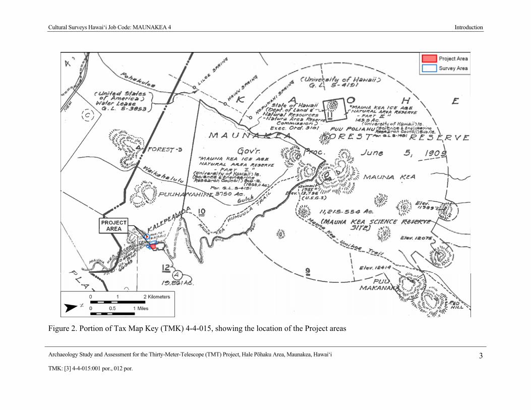
Cultural Surveys Hawai‘i Job Code: MAUNAKEA 4 Introduction
Archaeology Study and Assessment for the Thirty-Meter-Telescope (TMT) Project, Hale P�haku Area, Maunakea, Hawai‘i 3TMK: [3] 4-4-015:001 por., 012 por.
Figure 2. Portion of Tax Map Key (TMK) 4-4-015, showing the location of the Project areas

Cultural Surveys Hawai‘i Job Code: MAUNAKEA 4 Introduction
Archaeology Study and Assessment for the Thirty-Meter-Telescope (TMT) Project, Hale P�haku Area, Maunakea, Hawai‘i 4TMK: [3] 4-4-015:001 por., 012 por.
Figure 3. Aerial photograph (source: U.S.D.A. 2000), showing the location of the Project areas

Cultural Surveys Hawai‘i Job Code: MAUNAKEA 4 Introduction
Archaeology Study and Assessment for the Thirty-Meter-Telescope (TMT) Project, Hale P�haku Area, Maunakea, Hawai‘i 5TMK: [3] 4-4-015:001 por., 012 por.
stake-holding State or County agencies and interested Native Hawaiian and community groups. For more detailed accounts of the project area’s cultural history, the reader is referred to the companion Cultural Impact Assessment study (Cruz et al. 2009) and the thorough work of Maly (1997) and Maly and Maly (2005).
1.2 Scope of Work The following scope of work satisfies the State requirements for an archaeological inventory
survey, per HAR Chapter 13-13-276:
1. Historic and archaeological background research, including a search of historic maps, written records, Land Commission Award documents, and the reports from prior archaeological investigations. This research focused on the specific Project area’s past land use, with general background on the pre-contact and historic settlement patterns of the ahupua‘a and district. This background information was used to compile a predictive model for the types and locations of historic properties that could be expected within the Project area.
2. A complete (100% coverage) systematic pedestrian inspection of the Project area to identify any potential surface historic properties. Surface historic properties were recorded with an evaluation of age, function, interrelationships, and significance. Documentation included photographs, scale drawings, and, if warranted, limited controlled excavation of select sites and/or features, and location of historic properties with GPS survey equipment.
3. As appropriate, consultation with knowledgeable individuals regarding the Project area’s history, past land use, and the function and age of the historic properties documented within the Project area.
4. As appropriate, laboratory work to process and gather relevant environmental and/or archaeological information from collected samples.
5. Preparation of this archaeological assessment report, including the following:
a) A Project description;
b) A section of a USGS topographic map showing the survey area boundaries and the location of all recorded historic properties;
c) Historical and archaeological background sections summarizing prehistoric and historic land use of the Project area and its vicinity;
d) Descriptions of all historic properties, including selected photographs, scale drawings, and discussions of age, function, laboratory results, and significance, per the requirements of HAR 13-13-276. Each historic property was assigned a Hawai‘i State Inventory of Historic Properties (SIHP) number;
e) If appropriate, a section concerning cultural consultations [per the requirements of HAR 13-276-5(g) and HAR 13-275].
f) A summary of historic property categories, integrity, and significance based upon the Hawai‘i Register of Historic Places evaluation criteria;

Cultural Surveys Hawai‘i Job Code: MAUNAKEA 4 Introduction
Archaeology Study and Assessment for the Thirty-Meter-Telescope (TMT) Project, Hale P�haku Area, Maunakea, Hawai‘i 6TMK: [3] 4-4-015:001 por., 012 por.
g) A Project effect recommendation;
h) Treatment recommendations to mitigate the Project’s potential adverse effect on historic properties identified in the Project area that are recommended eligible to the Hawai‘i Register of Historic Places.
This scope of work includes full coordination with the State Historic Preservation Division (SHPD), and County relating to archaeological matters. This coordination takes place after consent of the landowner or representatives.
1.3 Environmental Setting
1.3.1 Natural Environment The environmental setting of the Hale P�haku area has been well described by McCoy
(1990:237-92; 1991:4-9) and the reader is referred to his work for a thorough study and references. A brief overview is presented in this study, based on Dr. McCoy’s work. The current Project area is located on a gently sloping saddle area surrounded by prominent cinder cones, including Pu‘u Kalepeamoa, Pu‘u Haiwahine, and Kilohana. Pu‘u Kalepeamoa is understood as an older hawaii-ite cone which contains a large number of cored bombs many of which are formed of angular mafic blocks with dunite and gabbro inclusions (McCoy 1991:6). Pu‘u Kalepeamoa is understood as the likely source for much of the raw material worked at the Pu‘u Kalepeamoa site complex (see Section 3.2 Previous Archaeological Research). The surrounding geology includes cinder cones, lava flows and air fall deposits termed Laupahoehoe Volcanics understood as probably less than 40,000 years old.
Elevations within the Project area range from approximately 2,780-2,805 m (9,120-9,200 ft.) above mean sea level. The Project area receives an average of approximately 26 inches of annual rainfall (Giambelluca et al. 1986). Sediments within the Project area are listed as Huikau Extremely Stony Loamy Sand (rHLD) and Cinder Land (rCL) (Figure 4). Soils of the Huikau Series are described as “somewhat excessively drained loamy sands that formed in volcanic ash, pumice, and cinders” (Sato et al. 1973). Cinder Land is described as “bedded cinders, pumice, and ash…The particles have jagged edges and a glassy appearance and show little or no evidence of soil development” (Sato et al. 1973).
The Project area lies close to the timberline and the vegetation is generally a subalpine xerophytic scrub of p�kiawe (Styphelia tameiameiae), noho-anu (Geranium cuneatum), ‘�helo (Vaccinium reticulatum), na‘ena‘e (Raillardia ciliolata), kalamoho fern (Pellaea ternifolia), ‘�heahea (Chenopodium oahuensis), pilo (Coprosma montana), m�mane (Sophora chrysophylla), and a variety of native and exotic grasses. It seems probable that prior to human utilization of this area, and the presence of feral goats and sheep, that the m�mane vegetation was more extensive and diverse (McCoy 1990:91). The work of McCoy has also emphasized the “non-subsistence” nature of this alpine environment, and it is understood that virtually all food to support temporary habitation in the area would have been imported from lower elevations.
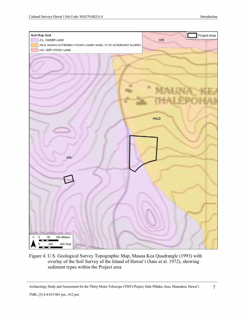
Cultural Surveys Hawai‘i Job Code: MAUNAKEA 4 Introduction
Archaeology Study and Assessment for the Thirty-Meter-Telescope (TMT) Project, Hale P�haku Area, Maunakea, Hawai‘i 7TMK: [3] 4-4-015:001 por., 012 por.
Figure 4. U.S. Geological Survey Topographic Map, Mauna Kea Quadrangle (1993) with overlay of the Soil Survey of the Island of Hawai‘i (Sato et al. 1972), showing sediment types within the Project area

Cultural Surveys Hawai‘i Job Code: MAUNAKEA 4 Introduction
Archaeology Study and Assessment for the Thirty-Meter-Telescope (TMT) Project, Hale P�haku Area, Maunakea, Hawai‘i 8TMK: [3] 4-4-015:001 por., 012 por.
1.3.2 Built Environment The eastern portion of the Project area is adjacent to the Maunakea Access Road and includes
components of the Hale P�haku Mid-Level Astronomy Facilities. Development in the Hale P�haku area includes the Onizuka Center for International Astronomy, the Visitor Information Station (a.k.a. Ranger Station), and construction laborer residences. The construction laborer residences are located within the current Project area and include two dormitory structures and four cabins (Figure 5). The western portion of the Project area consists of the existing HELCO power substation within a fenced enclosure (Figure 6). The vicinity of the Project area is generally undeveloped, with the exception of jeep roads.

Cultural Surveys Hawai‘i Job Code: MAUNAKEA 4 Introduction
Archaeology Study and Assessment for the Thirty-Meter-Telescope (TMT) Project, Hale P�haku Area, Maunakea, Hawai‘i 9TMK: [3] 4-4-015:001 por., 012 por.
Figure 5. General view of the Hale P�haku portion of the Project area, showing existing residential structures within the Project area located immediately east of the Maunakea Access Road, view to east
Figure 6. General view of the HELCO substation portion of the Project area, showing the existing power substation area located approximately 820 feet (250 m) west of the Maunakea Access Road, view to north

Cultural Surveys Hawai‘i Job Code: MAUNAKEA 4 Methods
Archaeology Study and Assessment for the Thirty-Meter-Telescope (TMT) Project, Hale P�haku Area, Maunakea, Hawai‘i 10TMK: [3] 4-4-015:001 por., 012 por.
Section 2 Methods
2.1 Field Methods The fieldwork component of the archaeological assessment study was carried out under
archaeological permit number 09-20, issued by the Hawai‘i State Historic Preservation Division / Department of Land and Natural Resources (SHPD), per Hawai‘i Administrative Rules (HAR) Chapter 13-13-282. The CSH field crew included: David W. Shideler, M.A.; Todd Tulchin, B.S.; Auli‘i Mitchell, B.A.; Brian Cruz, B.A.; Momi Wheeler, B.A; and Lisa Gollin, Ph.D.; under the overall supervision of Hallett H. Hammatt, Ph.D. Fieldwork was conducted on February 26, 2009 and required 6 person-days to complete.
The archaeological assessment fieldwork consisted of a complete (100% coverage) pedestrian inspection of the Project area. The pedestrian inspection was accomplished through systematic sweeps. The interval between the archaeologists was generally 33 feet (10 m). The general lack of vegetation made for excellent visibility. All potential historic properties encountered were recorded and documented with a written field description, scale drawings, photographs, and each feature was located using Garmin GPSMAP 60CSx GPS technology (10 to 16 ft accuracy).
In a number of areas, physical evidence of human activity (typically stone constructions representing a small investment in labor) was observed, but there were believed to be good grounds for concluding that the specific construction was less than fifty years old, and hence the physical evidence of human activity was regarded as inappropriate for designation as a historic property. In order to provide a more complete record, these cases are documented in the present “Appendix A Documentation of Find Spots”. These find spots are not regarded as significant under formally established criteria for designation as historic properties by virtue of their modernity.
2.2 Document Review Historic and archival research included information obtained from the UH M�noa Hamilton
Library, the State Historic Preservation Division Library, the Hawai‘i State Archives, the State Land Survey Division, and the Archives of the Bishop Museum. Previous archaeological reports for the area were reviewed, as were historic maps and primary and secondary historical sources. This study is particularly indebted to the thorough research of Maly (1997) and Maly and Maly (2005). In some cases within this study we have standardized Hawaiian language spelling to conform to current orthography.
2.3 Consultation The community consultation effort for the proposed TMT Observatory Project is detailed in a
companion Cultural Impact Assessment report (Cruz et al. 2009). In general, Native Hawaiian organizations, government agencies and community members were contacted in order to identify potentially knowledgeable individuals with cultural expertise and/or knowledge of the Project area and vicinity. The agencies consulted included the SHPD, the Office of Hawaiian Affairs (OHA), and the Hawai‘i Island Burial Council (HIBC).

Cultural Surveys Hawai‘i Job Code: MAUNAKEA 4 Background Research
Archaeology Study and Assessment for the Thirty-Meter-Telescope (TMT) Project, Hale P�haku Area, Maunakea, Hawai‘i 11TMK: [3] 4-4-015:001 por., 012 por.
Section 3 Background Research
3.1 Traditional and Historic Background The traditional and historical background for the Project area is presented at length in a
companion Cultural Impact Assessment study (Cruz et al. 2009) to which the reader is referred. There is very little traditional information regarding the Hale P�haku area.
‘Umi-a-Liloa, the renowned mid 1500s king, constructed heiau in honor of Halulu, the god who provided his power. The following excerpt from Maly and Maly (2005:28-29) tells of ‘Umi’s heiau including one constructed in the vicinity of Hale P�haku:
…He (‘Umi) also built a heiau (temple) below Pohaku Hanalei, it is called the ahua o Hanalei (altar of Hanalei); and on the side of Mauna Kea, by where one travels to Hilo, he built the third of his temples, at the place called Puukekee [also written Puu Keekee in historical texts]; and there at Mauna Halepohaku he built the fourth of his temples; there, it is said, Umi dwelt with his many people. It is said that Umi was a chief who dwelt upon the mountain, it was because of his love of his people, that he (‘Umi) returned and dwelt in the middle of the island [Ahu-a-Umi], that is where he dwelt with his beloved people. His commoners lived along the shores, and they brought food for them (in the uplands), from one side of the island to the other… [Ke Au Okoa; Mei 22, 1865; Maly, translator] (Maly and Maly 2005:28-29).
There has to our knowledge never been a positive identification of this heiau of ‘Umi “at Mauna Halepohaku.” The reference possibly could be to “Shrine 1” (described below in Section 4.1.2.1) but this is only conjecture.
3.1.1 Historic Accounts The first recorded ascent of Maunakea was in 1823 by the missionary Joseph Goodrich (1794-
1852) (Goodrich 1826). He approached via Kawaihae and Waimea and thus was never near the Hale P�haku area. The vast majority of ascents to the Mauna Loa summit prior to the 1930s appear to have been from the north or east and little discussion of the Hale P�haku area is available.
3.1.2 Modern Land Use L. W. Bryan, of the Territorial Forestry Office for the island of Hawai‘i from 1922 to 1949,
and from 1949 to 1961 the Territorial Forester, built the two stone houses at Hale P�haku with the Conservation Corps in 1936 and 1939 (Rosendahl 1999:C-6). He named Hale P�haku after a heiau (Maly, personal communication 2009).
It is understood that in 1936 the Civilian Conservation Corps carried out improvements to the old Maunakea-Humu‘ula Trail from near the main base of the sheep station at Kalaieha to the summit.

Cultural Surveys Hawai‘i Job Code: MAUNAKEA 4 Background Research
Archaeology Study and Assessment for the Thirty-Meter-Telescope (TMT) Project, Hale P�haku Area, Maunakea, Hawai‘i 12TMK: [3] 4-4-015:001 por., 012 por.
In the early 1960s, researchers from the University of Hawai‘i determined that the Maunakea Summit area was exceptional for making astronomical observations. Development of observatories began in 1964 with the construction of the Lunar and Planetary Station atop Pu‘u Poli‘ahu. The Mauna Kea Science Reserve was established in 1968. Currently there are eleven observatories in the Maunakea summit area and one observatory located on the southeastern flank at 12,000 feet.
3.2 Previous Archaeological Research
3.2.1 Previous Archaeological Studies A summary of previous archaeological studies in the Hale P�haku area is presented in Table
1, with a more detailed discussion below. Previously identified historic properties in the Hale P�haku area are summarized in Table 2.
3.2.1.1 McCoy (1979) Patrick McCoy (1982) documents an archaeological reconnaissance survey for the Mauna
Kea Mid Level Facilities Master Plan but documented no sites at that time.
3.2.1.2 McCoy (1985) Pat McCoy’s (1985) preliminary report for the Pu‘u Kalepeamoa Site documents three
archaeological surveys for a proposed new construction laborer camp at Hale P�haku located just above and below the UH Institute for Astronomy’s Mid-Level Facility encompassing a total of approximately 40 acres located on both sides of the Maunakea Access Road between 9,080 and 9,400-foot elevation. Five lithic scatters and 2 shrines were recorded. These archaeological features were understood as functionally integrated components of a single activity system and one Bishop Museum site number was assigned (lithic scatters no. 1 & 2 would subsequently be given SIHP #s 50-10-23-10310 and 50-10-23-10311 respectively). McCoy concluded that the primary activity at the site was the manufacture of hammer stones and octopus lure sinkers from the crystalline dunite and gabro deposits on the slopes of Pu‘u Kalepeamoa but he noted that ritual was an integral part of the manufacturing process. Further research was recommended. The lithic scatters would be subject to further documentation (Robins and Hammatt 1990) and data recovery work (Hammatt and Shideler 2002).
3.2.1.3 Bonk (1986) In 1986 William Bonk of UH Hilo conducted a reconnaissance level survey for a proposed
HELCO transmission line and the substation area that is a focus of the present study. No historic properties were identified.
3.2.1.4 Sinoto (1987) Aki Sinoto then of the B. P. Bishop Museum began data recovery documentation with survey
and surface collections at eleven different lithic scatter areas. In this and the subsequent McCoy1991 work a total of 2,364 artifacts were recovered along with 129 samples of faunal

Cultural Surveys Hawai‘i Job Code: MAUNAKEA 4 Background Research
Archaeology Study and Assessment for the Thirty-Meter-Telescope (TMT) Project, Hale P�haku Area, Maunakea, Hawai‘i 13TMK: [3] 4-4-015:001 por., 012 por.
Table 1. Summary of Previous Archaeological Studies in the Hale P�haku Area
Reference Nature of Study Area of Study Comments McCoy 1979 Letter Report Dated
August 22, 1979 to Mr. Francis Oda on Archaeological Reconnaissance Survey
Prepared for the Preparation of the Mauna Kea Mid-Elevation Facilities Master Plan.
No sites found
McCoy 1985 Reconnaissance survey Approximately 40 acres extending on both sides of the Maunakea Access Road between 9,080’ and 9,400’
Preliminary report for the Pu‘u Kalepeamoa Site documenting five lithic scatters and two shrines used for the manufacture of hammer stones and octopus lure sinkers. Ritual was an integral part of the manufacturing process.
Bonk 1986 An Archaeological Survey - Papers in Ethnic and Cultural Studies 86-2
Middle Level, Southern Flank of Maunakea
No sites found
Sinoto 1987 Post-Field Report on the Archaeological Surface Survey
Halep�haku Substation Site and Overland Transmission line-Mauka Approach Areas, Halep�haku
Survey and surface collections at eleven different lithic scatters and limited test excavations at two of the scatters
Robins and Hammatt 1990
Reconnaissance survey Two locations: 5.1 acre area on Pu‘u Hau Oki cinder cone at summit and a 21-acre lot near Hale P�haku
There were no finds at the JNLT summit project area which had been largely graded. In the Hale P�haku area 3 lithic scatters that were described in McCoy, 1985 are discussed.
McCoy 1991 Survey and Test Excavations report
Pu‘u Kalepeamoa Site Survey and surface collections at eleven different lithic scatters and limited test excavations at two of the scatters
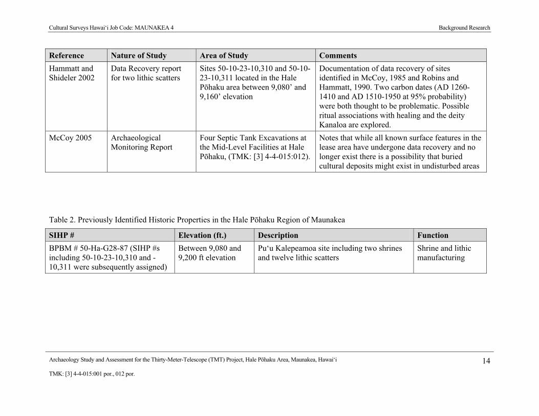
Cultural Surveys Hawai‘i Job Code: MAUNAKEA 4 Background Research
Archaeology Study and Assessment for the Thirty-Meter-Telescope (TMT) Project, Hale P�haku Area, Maunakea, Hawai‘i 14TMK: [3] 4-4-015:001 por., 012 por.
Reference Nature of Study Area of Study Comments Hammatt and Shideler 2002
Data Recovery report for two lithic scatters
Sites 50-10-23-10,310 and 50-10-23-10,311 located in the Hale P�haku area between 9,080’ and 9,160’ elevation
Documentation of data recovery of sites identified in McCoy, 1985 and Robins and Hammatt, 1990. Two carbon dates (AD 1260-1410 and AD 1510-1950 at 95% probability) were both thought to be problematic. Possible ritual associations with healing and the deity Kanaloa are explored.
McCoy 2005 Archaeological Monitoring Report
Four Septic Tank Excavations at the Mid-Level Facilities at Hale P�haku, (TMK: [3] 4-4-015:012).
Notes that while all known surface features in the lease area have undergone data recovery and no longer exist there is a possibility that buried cultural deposits might exist in undisturbed areas
Table 2. Previously Identified Historic Properties in the Hale P�haku Region of Maunakea
SIHP # Elevation (ft.) Description Function BPBM # 50-Ha-G28-87 (SIHP #s including 50-10-23-10,310 and -10,311 were subsequently assigned)
Between 9,080 and 9,200 ft elevation
Pu‘u Kalepeamoa site including two shrines and twelve lithic scatters
Shrine and lithic manufacturing
Cultural Surveys Hawai‘i Job Code: MAUNAKEA 4 Background Research
Archaeology Study and Assessment for the Thirty-Meter-Telescope (TMT) Project, Hale P�haku Area, Maunakea, Hawai‘i 15TMK: [3] 4-4-015:001 por., 012 por.
remains. The lithic assemblage included debitage related to adze manufacture, octopus sinker production and some 20 special purpose bird cooking stones or p�haku ‘eho. Three radio-carbon dates on charcoal samples indicated late pre-contact occupation circa AD 1600 – 1700.
3.2.1.5 Robins and Hammatt (1990) Cultural Surveys Hawai‘i (Robins and Hammatt 1990) carried out an archaeological
reconnaissance survey project for the Subaru Observatory at both the summit and the Hale P�haku area. The Robins and Hammatt (1990) study included several areas near the Mid-Level Facility Complex (“Onizuka Center for International Astronomy (OCIA)”) including a small dormitory construction area located approximately 134 m (440 feet) east of the Maunakea Access Road at 9,245 foot elevation (where no sites were observed) and an approximately 21-acre lot surrounding the dormitory delineated on the west and north side by the Maunakea Access Road and to the south by an existing jeep road. Two archaeological features were newly described and three previously identified sites were recorded in the approximately 21-acre lot. The two newly described features included a small oval enclosure and a roughly square enclosure that were both thought to be relatively recent constructions (no formal SIHP site numbers were assigned). The three previously recorded (McCoy 1985) sites included three lithic scatters (lithic scatters # 1, # 2, and #5) that McCoy had understood as being functionally integrated components of a single site. Further work at the lithic scatters was recommended. Cultural Surveys Hawai‘i (Hammatt and Shideler 2002) completed a Data Recovery report for lithic scatters # 1, # 2.
3.2.1.6 McCoy (1991) Patrick McCoy (1999) wrote up data recovery work and results expanding on the Sinoto
(1987) documentation.
3.2.1.7 Hammatt and Shideler (2002) Cultural Surveys Hawai‘i (Hammatt and Shideler 2002) completed a data recovery report for
two lithic scatters (SIHP #s 50-10-23-10310 and 50-10-23-10311) located in the Hale P�haku area between 9,080 foot and 9,160 foot elevation. These sites were first recorded by McCoy (1985:11-12) as Lithic Scatter # 1 (SIHP # 50-10-23-10310) and Lithic Scatter # 2 (SIHP # 50-10-23-10311) of the Pu‘u Kalepeamoa Complex. Initially the UH Institute for Astronomy planned to preserve the two lithic scatters, however, dormitory construction increased erosion in the vicinity and in consultation with the State Historic Preservation Division a data recovery program was agreed to. Data recovery field work included mapping, surface collection and four 1m2 test units (2 at each of the two sites). Two carbon dates (AD 1260-1410 and AD 1510-1950 at 95% probability) were obtained but both were thought to be problematic. It was concluded that the sites were modest, out-lying, open, lithic workshop sites with octopus lure sinker manufacture of both “coffee-bean” and “bread-loaf” morphological types. It was concluded that the location of the sites was associated with a micro-climate of slightly greater moisture, slightly greater soil and slightly greater protection from the wind at the top of a natural drainage that favored m�mane forest growth – which in turn provided greater protection from the elements, fuel and construction materials. It is suggested that the endeavor to produce octopus lures may
Cultural Surveys Hawai‘i Job Code: MAUNAKEA 4 Background Research
Archaeology Study and Assessment for the Thirty-Meter-Telescope (TMT) Project, Hale P�haku Area, Maunakea, Hawai‘i 16TMK: [3] 4-4-015:001 por., 012 por.
have had other than quotidian purposes of food procurement and the affinities with healing prayers (Pule he‘e) dedicated to the deity Kanaloa are explored.
3.2.1.8 McCoy (2005) The McCoy (2005) archaeological monitoring report for four septic tank excavations at the
Mid-Level Facilities at Hale P�haku identified no new sites. Notes that while all known surface features in the lease area have undergone data recovery and no longer exist there is a possibility that buried cultural deposits might exist in undisturbed areas.
3.2.1.9 McCoy et al. (2009 in progress) As this Archaeological Assessment was being prepared, the authors interacted with Dr.
Patrick McCoy at the offices of Pacific Consulting Services, Inc. and also within the Project area. We are thankful for his guidance. We were aware that a major study of the historic properties of Maunakea was on-going by Pacific Consulting Services. This study, that should greatly advance our knowledge of traditional Hawaiian use of the upper reaches of Maunakea, was not available as early drafts of this study were being prepared. If publicly available prior to the submission of this study to the SHPD for review it is the intent of the authors to include appropriate reference and germane summary of findings.
3.2.2 Traditional Cultural Properties The State Historic Preservation Division has designated several prominent localities on
Maunakea as Traditional Cultural Properties (TCP) due to their cultural significance to the Hawaiian people. The approximate boundaries of the TCPs are indicated on Figure 7. Maly (1997:29) has suggested the entire Maunakea summit region down to the 6,000 foot elevation contour (Figure 8) be designated a Traditional Cultural Property.

Cultural Surveys Hawai‘i Job Code: MAUNAKEA 4 Background Research
Archaeology Study and Assessment for the Thirty-Meter-Telescope (TMT) Project, Hale P�haku Area, Maunakea, Hawai‘i 17TMK: [3] 4-4-015:001 por., 012 por.
Figure 7. U.S. Geological Survey Map, Mauna Kea Quadrangle (1993), showing Traditional Cultural Properties in the summit region of Maunakea (adapted from Maly 1997:Table 2 & Figure 2; Note: All of Maunakea down to the 6,000 foot elevation has been suggested to be a Traditional Cultural Property) (Boundaries shown should be understood as approximate)
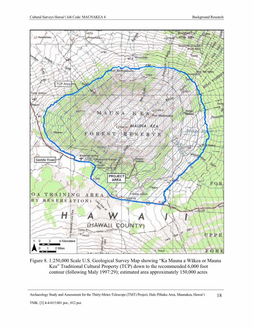
Cultural Surveys Hawai‘i Job Code: MAUNAKEA 4 Background Research
Archaeology Study and Assessment for the Thirty-Meter-Telescope (TMT) Project, Hale P�haku Area, Maunakea, Hawai‘i 18TMK: [3] 4-4-015:001 por., 012 por.
Figure 8. 1:250,000 Scale U.S. Geological Survey Map showing “Ka Mauna a W�kea or Mauna Kea” Traditional Cultural Property (TCP) down to the recommended 6,000 foot contour (following Maly 1997:29); estimated area approximately 150,000 acres

Cultural Surveys Hawai‘i Job Code: MAUNAKEA 4 Background Research
Archaeology Study and Assessment for the Thirty-Meter-Telescope (TMT) Project, Hale P�haku Area, Maunakea, Hawai‘i 19TMK: [3] 4-4-015:001 por., 012 por.
3.3 Background Summary and Predictive Model
3.3.1 Burials and Possible Burials
3.3.1.1 Archaeological Data on Burials McCoy (1999) presents a summary discussion of burials and possible burials on Maunakea
noting that there are numerous traditions of burials at high elevations on Maunakea. He starts by presenting the account of Jerome Kilmartin (1974) that in 1925 Kilmartin personally observed human remains on Pu‘u M�kanaka. McCoy (1999:26) relates that in 1991 he and others observed human bones within several cairns on the southern rim of Pu‘u M�kanaka. McCoy notes that “several other spatially discrete groups of cairns, each comprised of two to three individual cairns, were found on the southern or eastern rim” [of Pu‘u M�kanaka] – suggesting that these may also contain human skeletal remains.
As far as we know, Pu‘u M�kanaka is the only place in the uplands of Maunakea in which human remains have been confirmed by archaeologists – although McCoy makes reference to “the well-known burial center at Kanakaleonui” and also to “a small group of cairns on the eastern rim of Pu‘u Waiau that are also believed to be burials.”
McCoy (1999:26) then goes on to discuss four “possible burial sites” (SIHP #s -16195, -21413, -21414 and -21416). Although no human remains were observed, these constructions were thought to be burials because of: 1) the morphological similarity of these cairns to those on Pu‘u M�kanaka and Kanakaleonui; 2) dissimilarity to other cairns (which are more cylindrical); and 3) the presence on the eastern or southern rim of cinder cones.
McCoy (1999:27) clearly suggests that SIHP # -16195 consisting of two adjacent cairns on the eastern rim of Pu‘u L�l�noe (recorded by McCoy in 1975) are “possible burials”. This conclusion appears to be based on William D. Alexander’s 1892 account of “ancient graves” on the summit of Pu‘u L�l�noe. McCoy (1999:27) comments that: “If the cairns that were recorded in 1975 were in fact the same graves [as described by William D. Alexander in 1892] the remains had been removed sometime prior because no human bone was visible at that time.” Thus it appears that by 1975 these features were not graves, whether or no they had been graves previously (see Maly and Maly 2005 for a discussion of accounts of burials at Pu‘u L�l�noe).
McCoy (1999:27) then discusses three possible burial cairn sites (SIHP #s -21413, -21414 and -21416) located on the southern and eastern rim of an unnamed (approximately 12,840-foot high cinder cone located approximately 0.6 miles northwest of the Mauna Kea Ice Age Natural Area Reserve) indicating that these may well be graves on the basis of form and location.
McCoy (1999:28) concludes:
There is good reason to expect that more burials are to be found in the Science Reserve on the tops of cinder cones, either in cairns or in a small rock shelter or overhang. The basis of this prediction is that all of the known and suspected burial sites on the summit plateau are located on the tops of cinder cones and, more particularly, on the southern and eastern sides. No burials have been found on the sides or at the base of a cone, or on a ridge top amongst any of the shrines. There

Cultural Surveys Hawai‘i Job Code: MAUNAKEA 4 Background Research
Archaeology Study and Assessment for the Thirty-Meter-Telescope (TMT) Project, Hale P�haku Area, Maunakea, Hawai‘i 20TMK: [3] 4-4-015:001 por., 012 por.
in fact appears to be a clear separation between burial locations and shrine locations.
3.3.1.2 Informant Data on Burials In striking contrast to the archaeological data (in which the closest confirmed burial appears
to be 3.1 miles from the summit at Pu‘u M�kanaka) is the belief of some contemporary Hawaiians that the summit region of Maunakea is something of a burial ground (“There’s lot of k�puna been buried up there…”; and several similar stated concerns at www.mauna-a-wakea.info/maunakea/F4_burials.html ). Allied with this line of thinking are rumors of burials being disturbed and destroyed by prior observatory developments (“Would bulldozing cemeteries be allowed anywhere else in the world?” and similar stated concerns at www.mauna-a-wakea.info/maunakea/F4_burials.html).
3.3.2 Shrines In McCoy’s (1999:3) analysis of a total of 93 sites identified in the Maunakea summit area
Science Reserve some 76 or 81.7% are classified as shrines (and an additional 8 shrines are components of adze manufacturing workshop sites). McCoy (1999:6) concludes that; “The vast majority of shrines are conspicuously sighted in the landscape, either on a ridge top, or at a break in the slope, which generally seems to correspond to either a lava flow margin or a change in the slope of a glacial moraine.” Of some interest, McCoy notes that “there are no shrines in the Science Reserve located on top of a cinder cone.”
As previously noted (McCoy 1982:A-37), an unusually high density of shrines are located in a narrow 200-foot contour interval band between 12,900 foot and 13,100-foot elevation on the north side of Maunakea. He posits reasonably that this clearly defined vertical zonation site pattern is the result of utilization of a break in slope at the edge of a summit plateau where: “when viewed from either the base of the steep inclined slope directly below, or from the base of the summit cones above, is a relatively flat horizon on which the shrine uprights are silhouetted and therefore visible from some distance.”
3.3.2.1 Kahe Ule Subincision and the Maunakea Summit Region of Ka‘ohe Ahupua‘a, H�m�kua District
A central thesis of McCoy’s (1979:27) study of “A Rite of Passage Site” is that a certain site complex (SIHP # 50-10-23-16204) located at approximately the 12,280-foot level of Maunakea was the locus of initiation rites possibly related to formal initiation rites for groups of apprentices. This argument has support in the curious presence of some twenty-six open air shelters of quite small diameter that appear to have had temporary use. Few would dispute that some of the shrines of the summit region of Maunakea are “occupational shrines” specifically those near the adze quarries incorporating quarried lithic material. However it seems clear that the majority of the shrines of the summit region of Maunakea are not near the known adze quarries and do not incorporate quarried lithic material. This gives rise to the consideration that some quite different function may have been operative for many of the Maunakea shrines. One theory is that “these structures were erected by travelers most probably in propitiation of mountain spirits” (McCoy 1982:A-37) While this certainly seems probable as a partial

Cultural Surveys Hawai‘i Job Code: MAUNAKEA 4 Background Research
Archaeology Study and Assessment for the Thirty-Meter-Telescope (TMT) Project, Hale P�haku Area, Maunakea, Hawai‘i 21TMK: [3] 4-4-015:001 por., 012 por.
explanation it may be noted that the distribution of shrines does not suggest travel corridors so much as a broad band of elevation that was preferred for shrine construction.
An alternative theory is that at least some of the shrines of Maunakea are related to the Kahe Ule or Subincision practice of Ka‘ohe Ahupua‘a of H�m�kua District. What follows admittedly is less than a convincing argument, but is offered for future consideration.
We know little about the Hawaiian practice of Kahe Ule or Subincision of the foreskin but it was almost certainly a ritualized practice involving a group of men, a religious expert (kahuna), a special bladed tool (understood as typically a bamboo knife) and a male youth to be subincised. Gutmanis (1983:55) relates a subincision prayer (bold added for emphasis)
E Ki‘i ka‘ohe i Ho-mai-ka-‘ohe. Bring the bamboo from Ho-mai-ka-‘ohe
Eia ka‘ohe lauli‘i a K�ne Here is the small leafed bamboo of Kane.
‘Okia i ka maka o ka ma‘i Cut now the foreskin
Ua moku It is divided
Notably the noun “Ka‘ohe” is mentioned three times. While on the one hand the phrase simply means “the bamboo” there seems little question the reference is to a ritual bamboo subincision knife.
The general shape of Ka‘ohe bears a vague similarity to a knife as it cuts across the piko of Maunakea and Maunaloa dividing the island.
3.3.3 Adze Quarries and Manufacturing Workshops It appears from McCoy’s (1999) summary analysis of site typology that the only quarries
were in the extreme southern portion of the Mauna Kea Science Reserve (the Ko‘oko‘olau Complex Maunakea Adze Quarry; SIHP # 50-10-23-4136). McCoy does describe four adze manufacturing workshops (SIHP #s -11079, -16203, -16204 and -21211) defined in part by their being located where there is no naturally occurring stone-tool quality raw material. All four of these adze manufacturing workshops are on the south face of the mountain on the east side of the main Maunakea Access Road.
3.3.4 Trails and Temporary Habitations We have very little real documentation on pre-contact patterns of access to, and temporary
habitation on, the summit region of Maunakea. There appears to be general agreement that: “Neither historic accounts nor archaeological surveys provide firm evidence for the prehistoric trails….historic accounts of trails used don’t necessarily reflect the prehistoric trails in the area.” (Maly 1997: D-12). Notably: “…no trails were mentioned by Hawaiians in the 1870s Boundary Commission records nor do any appear on the 1862 Wiltse map.” (Maly 1997:D-5). The four major trail systems documented in the summit region (from North clockwise: 1. the Maunakea-‘Umi Koa Trail, 2. the Maunakea-Humu‘ula Trail, 3. the Waiki‘i-Pu‘u L�‘au-Wai‘au Trail, and 4. the Makah�lau-Kemole-Wai‘au Trail) may all be largely or even entirely post-contact and primarily horse trails.
Cultural Surveys Hawai‘i Job Code: MAUNAKEA 4 Background Research
Archaeology Study and Assessment for the Thirty-Meter-Telescope (TMT) Project, Hale P�haku Area, Maunakea, Hawai‘i 22TMK: [3] 4-4-015:001 por., 012 por.
Land Boundary Commission testimony, particularly that of a certain Haiki (Boundary Commission Hawaii Volume B page 41), suggests that people of Humu‘ula, North Hilo District accessed the resources of the Maunakea summit from the southeast.
Variously there is an oral history account from Mr. William Akau:
…as a child, William Akau heard his elders talking about visits made by people from other islands to Hawaii. In ancient times, canoes would land in the K�holo vicinity, and people walked the trails along the gentle slopes of Mauna Loa-Mauna Kea to the summit to harvest and shape stone. [Maly 1997:22]
While this account suggests access from North Kona, from due west (K�holo in north, North Kona), it seems unlikely that Hawaiians from other islands accounted for a significant percentage of the pre-contact traffic to the summit region.
Despite these differing accounts mentioned above, the general conception has followed the Land Boundary Commission that determined that the entire summit region of Maunakea lies within Ka‘ohe Ahupua‘a of H�m�kua District and that the socio-political connectedness of the summit lands lay to the north in H�m�kua. This certainly suggests that most of the access would be expected from the north. This would lead to the expectation that much of the evidence of access to the summit region in the form of trail markers or temporary habitation sites might be expected on the north slope.
The prevailing nighttime temperatures and wind would place a premium on any lava tubes or caves that might provide substantial shelter. In the general absence of such landforms on the north slope and summit plateau travelers would be expected to seek very temporary occupation at open habitation sites seeking what protection might be available on the lee side of rock outcroppings and ridges. While too great an emphasis should not be placed on any one account, the pattern of access in the first recorded ascent of Maunakea in 1823 by the missionary Joseph Goodrich may be notable. The preacher appears to have hiked from Waimea to the Maunakea summit and back to Waimea in one 24-hour marathon. In the vicinity of Waimea he spent the night (at approximately 2,700 foot elevation). Leaving early, and approaching the summit from the north, he followed a steep ravine reaching the tree line at about 9,000 feet elevation approximately 15 miles from Waimea where he rested for a few hours recording the temperature at 43o F at sunset. At 11:00 PM he pushed on in bright moonlight encountering snow at 1:00 AM and recording a temperature of 27o F. Goodrich attained the highest of several summits around 3:00 AM and quickly descended.

Cultural Surveys Hawai‘i Job Code: MAUNAKEA 4 Results of Fieldwork
Archaeology Study and Assessment for the Thirty-Meter-Telescope (TMT) Project, Hale P�haku Area, Maunakea, Hawai‘i 23TMK: [3] 4-4-015:001 por., 012 por.
Section 4 Results of Fieldwork
4.1 Survey Findings On February 26, a Cultural Surveys Hawai‘i field crew of six began traversing the Project
area. The pedestrian inspection was accomplished through systematic sweeps. The interval between the archaeologists was generally 33 feet. The general lack of vegetation made for excellent visibility. All potential historic properties encountered were recorded. The Project area was understood as in two physically separate areas: the “Hale P�haku” portion of the Project area that lies on the east side of the Maunakea Access Road and just south of the Visitor Information Station (Figures 9, 11 & 12) and the “HELCO substation” (Figures 10, 11 & 13) portion of the Project area that lies on the west side of the Maunakea Access Road.
In a number of areas, physical evidence of human activity (typically stone constructions representing a small investment in labor) was observed but there were believed to be good grounds for concluding that the specific construction was less than fifty years old and hence the physical evidence of human activity was regarded as inappropriate for designation as a historic property. In order to provide a more complete record, and to avoid any possible misunderstanding, these cases are documented in the present “Appendix A: Documentation of Find Spots.” These find spots (designated CSH 1-5, CSH 7-13, and “Modern Refuse Disposal Areas”) are not regarded as significant under formally established criteria for designation as historic properties by virtue of their modernity.
4.1.1 “Hale P�haku” portion of the Project area The fieldwork began in the “Hale P�haku” portion of the Project area that lies on the east side
of the Maunakea Access Road and just south of the Visitor Information Station (a.k.a. Ranger Station) (Figures 9, 11 & 12). No historic properties were identified within this portion of the Project area. Only one find spot (CSH 1,– described in Appendix A of this study) a modern ahu or small cairn was observed (see Figures 11, 12 & 21) within the Hale P�haku portion of the Project area. Confidence is high that this is contemporary in date, took only a couple of minutes to construct, does not meet established criteria of significance, and is of no formal historic-preservation concern.
An oval, outlined on the relatively clear ground with a single course of the locally-available, scoria, ‘a‘� cobbles, was observed just north (outside) of the Hale P�haku portion of the Project area and was designated as CSH 2 (see Figures 11, 12 & 22 and description in Appendix A of this study). This was understood as a contemporary shrine. Confidence is high that this is contemporary in date, took only a few minutes to construct, does not meet established criteria of significance, and is of no formal historic-preservation concern.
Two small areas of late Twentieth century trash disposal (“Modern Refuse Disposal Areas”) were observed east (outside) of the Hale P�haku portion of the Project area and were briefly documented (see Figures 11, 12, 34 & 35 and description in Appendix A of this study). Confidence is high that these refuse disposal areas are less than fifty years old, took only a few minutes to create, do not meet established criteria of significance, and are of no formal historic-preservation concern.

Cultural Surveys Hawai‘i Job Code: MAUNAKEA 4 Results of Fieldwork
Archaeology Study and Assessment for the Thirty-Meter-Telescope (TMT) Project, Hale P�haku Area, Maunakea, Hawai‘i 24TMK: [3] 4-4-015:001 por., 012 por.
Figure 9. General view of the Hale P�haku portion of the Project area, view to north
Figure 10. General view of the HELCO substation portion of the Project area and vicinity, view to north
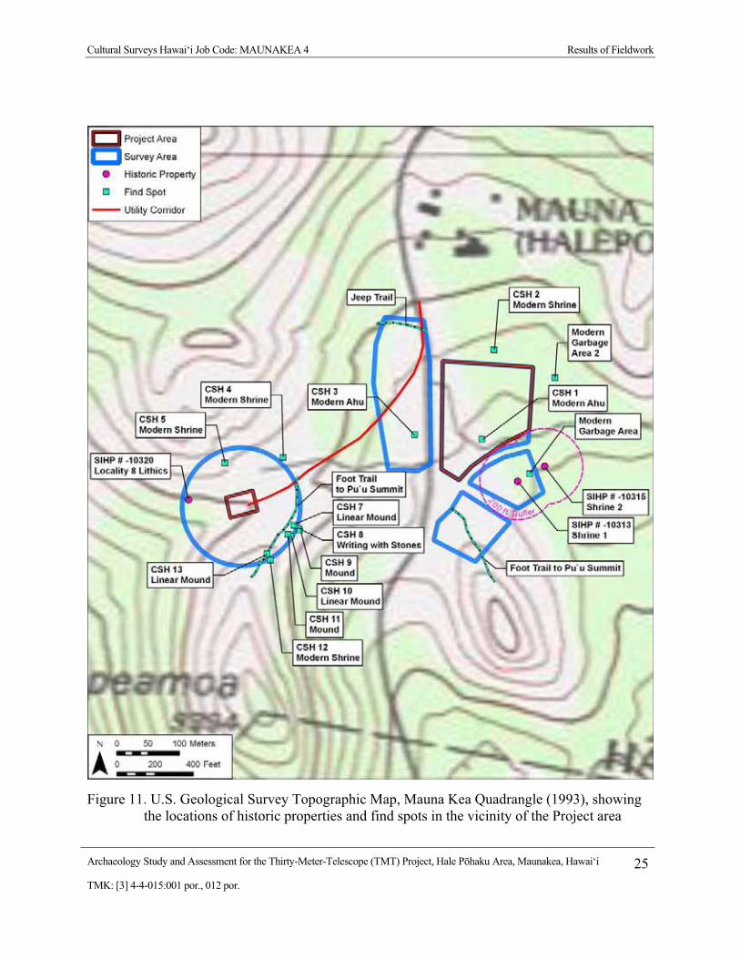
Cultural Surveys Hawai‘i Job Code: MAUNAKEA 4 Results of Fieldwork
Archaeology Study and Assessment for the Thirty-Meter-Telescope (TMT) Project, Hale P�haku Area, Maunakea, Hawai‘i 25TMK: [3] 4-4-015:001 por., 012 por.
Figure 11. U.S. Geological Survey Topographic Map, Mauna Kea Quadrangle (1993), showing the locations of historic properties and find spots in the vicinity of the Project area

Cultural Surveys Hawai‘i Job Code: MAUNAKEA 4 Results of Fieldwork
Archaeology Study and Assessment for the Thirty-Meter-Telescope (TMT) Project, Hale P�haku Area, Maunakea, Hawai‘i 26TMK: [3] 4-4-015:001 por., 012 por.
Figure 12. Aerial photograph (source: Google Earth 2009) showing the locations of historic properties and find spots in the vicinity of the Hale P�haku portion of the Project area

Cultural Surveys Hawai‘i Job Code: MAUNAKEA 4 Results of Fieldwork
Archaeology Study and Assessment for the Thirty-Meter-Telescope (TMT) Project, Hale P�haku Area, Maunakea, Hawai‘i 27TMK: [3] 4-4-015:001 por., 012 por.
Figure 13. Aerial photograph (source: Google Earth 2009) showing the locations of historic properties and find spots in the vicinity of the HELCO substation portion of the Project area

Cultural Surveys Hawai‘i Job Code: MAUNAKEA 4 Results of Fieldwork
Archaeology Study and Assessment for the Thirty-Meter-Telescope (TMT) Project, Hale P�haku Area, Maunakea, Hawai‘i 28TMK: [3] 4-4-015:001 por., 012 por.
4.1.2 Historic Property Descriptions (located approximately 200 feet southeast of the Hale P�haku portion of the Project area
Only two historic properties were identified in the course of the archaeological assessment fieldwork and we need to be very clear they both lie at a distance of 200 feet or more southeast (outside) of the Project area. The preservation boundaries of these sites are understood as 200-feet in radius and it is our understanding these 200 foot buffers will be maintained (see Figures 11 and 12).
4.1.2.1 SIHP # 50-10-23-10313 - Shrine 1 SITE TYPE: Shrine FUNCTION: Ceremonial FEATURES: 1 DIMENSIONS: 18 feet NE/SW x 5 feet NW/SE CONDITION: Good PROBABLE AGE: Pre-contact TAX MAP KEY: [3] 4-4-015:001
DESCRIPTION: SIHP # 50-10-23-10313 was designated as “Shrine 1” (and as B.P. Bishop Museum Site 50-
Ha-G28-87-S1) by McCoy (1985) and was described as follows:
The southernmost structure, designated Shrine 1, is a low, rectangular stone-filled terrace with three and possibly five uprights located on the eastern edge of a rubbly ‘a‘� outcrop. The terrace measures 5.5 m long, 1.5 m wide, and 35 to 50 cm in maximum height along the east, down slope wall. All three walls are crudely stacked chunks of ‘a‘�, one to several courses high. The east wall is partially collapsed, thus explaining the irregular profile in the plan view map [present Figure 15, following]. The row of uprights, which define the back side of the shrine, are located on essentially level ground, which is the basis for describing the main structure as a terrace rather than a platform since not all four side are free-standing walls. There are three standing uprights of similar dimensions projecting 50 cm above ground surface and oriented 21° E of magnetic north, and two other elongated stones that are tentatively regarded as possible uprights. They are all unmodified chunks of ‘a‘�, like the rest of the structure.
On the surface of the terrace, centered in front of the two central uprights, is a “cache” of some 40 angular to subangular stones in the 5 to 10 cm size range (avg. c. 7 cm), with a distinctively red cortex, except for a few smaller broken pieces revealing the internal crystalline matrix of light and dark minerals. These rocks, subsequently identified as dunite and gabbro were clearly deposited on the shrine after it was built., thus leading to the conclusion that they are offerings.
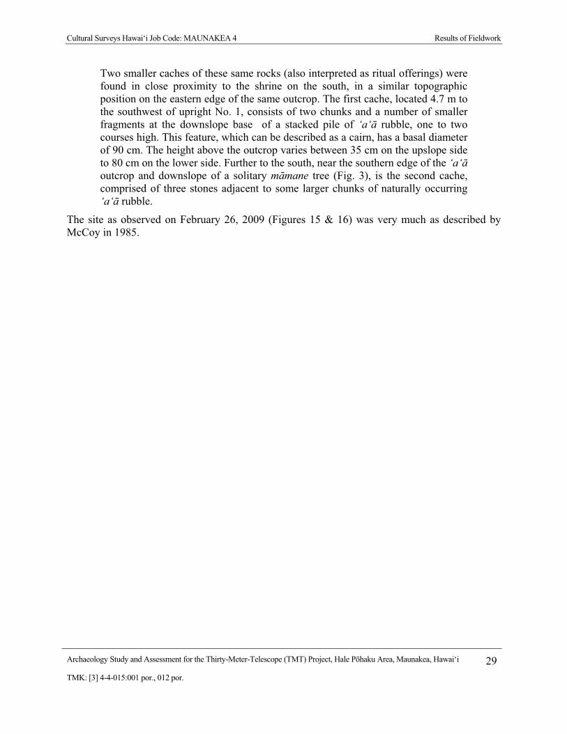
Cultural Surveys Hawai‘i Job Code: MAUNAKEA 4 Results of Fieldwork
Archaeology Study and Assessment for the Thirty-Meter-Telescope (TMT) Project, Hale P�haku Area, Maunakea, Hawai‘i 29TMK: [3] 4-4-015:001 por., 012 por.
Two smaller caches of these same rocks (also interpreted as ritual offerings) were found in close proximity to the shrine on the south, in a similar topographic position on the eastern edge of the same outcrop. The first cache, located 4.7 m to the southwest of upright No. 1, consists of two chunks and a number of smaller fragments at the downslope base of a stacked pile of ‘a‘� rubble, one to two courses high. This feature, which can be described as a cairn, has a basal diameter of 90 cm. The height above the outcrop varies between 35 cm on the upslope side to 80 cm on the lower side. Further to the south, near the southern edge of the ‘a‘� outcrop and downslope of a solitary m�mane tree (Fig. 3), is the second cache, comprised of three stones adjacent to some larger chunks of naturally occurring ‘a‘� rubble.
The site as observed on February 26, 2009 (Figures 15 & 16) was very much as described by McCoy in 1985.

Cultural Surveys Hawai‘i Job Code: MAUNAKEA 4 Results of Fieldwork
Archaeology Study and Assessment for the Thirty-Meter-Telescope (TMT) Project, Hale P�haku Area, Maunakea, Hawai‘i 30TMK: [3] 4-4-015:001 por., 012 por.
Figure 14. Plan-view diagram of SIHP # 50-10-23-10313 - Shrine 1 (B.P.B.M. Site 50-Ha-G28-87-S1) (from McCoy 1985:17)

Cultural Surveys Hawai‘i Job Code: MAUNAKEA 4 Results of Fieldwork
Archaeology Study and Assessment for the Thirty-Meter-Telescope (TMT) Project, Hale P�haku Area, Maunakea, Hawai‘i 31TMK: [3] 4-4-015:001 por., 012 por.
Figure 15. SIHP # 50-10-23-10313 - Shrine 1, showing upright stones and dunite/gabbro offerings, view to north
Figure 16. SIHP # 50-10-23-10313 - Shrine 1, showing upright stones and dunite/gabbro offerings, view to west

Cultural Surveys Hawai‘i Job Code: MAUNAKEA 4 Results of Fieldwork
Archaeology Study and Assessment for the Thirty-Meter-Telescope (TMT) Project, Hale P�haku Area, Maunakea, Hawai‘i 32TMK: [3] 4-4-015:001 por., 012 por.
4.1.2.2 SIHP # 50-10-23-10315 - Shrine 2 SITE TYPE: Shrine FUNCTION: Ceremonial FEATURES: 1 DIMENSIONS: 8.2 feet E/W x 5 feet N/S CONDITION: Good PROBABLE AGE: Pre-contact TAX MAP KEY: [3] 4-4-015:001 DESCRIPTION:
SIHP # 50-10-23-10313 was designated as “Shrine 2” (and as B.P. Bishop Museum Site 50-Ha-G28-87-S2) by McCoy (1985) and was described as follows:
The second shrine, located c. 47 m to the northeast of the first, is similarly located on the eastern edge of an ‘a‘� outcrop. A single upright of ‘a‘� lava, measuring 38 cm high, 35 cm wide, and 17 cm thick, is situated in the approximate center of a small terrace demarcated by the edge of the lava flow and a possible stone alignment on the southwest. A line through the north-south axis of the upright is oriented 8° E of magnetic north. The perpendicular azimuth through the middle of the up right is 78° W of magnetic north, which is aligned with the approximate center of one of the volcanic cone peaks. Five stones of the same type as those described above, including the same colored cortex, are located on the eastern side of the upright on the surface. A few meters northwest is a second possible artificial terrace measuring c. 2 by 2 m.
McCoy then provides the following discussion:
A preliminary interpretation of the data obtained in this project has already been made in terms of the argument that the constellation of dispersed lithic scatters and shrines represent functionally integrated components of a single activity system. In support of this argument, reference has been made to the patterned association of workshops and shrines with comparable material offerings in the Mauna Kea Adze Quarry. It is on the strength of this evidence, denoting ritual as an integral part of the manufacturing process, that the same site definition criteria and rationale employed in the Mauna Kea Adze Quarry research have been adopted in the definition of the Pu‘u Kalepeamoa site.
The site as observed on February 26, 2009 (Figures 17 & 18) was very much as described by McCoy in 1985.

Cultural Surveys Hawai‘i Job Code: MAUNAKEA 4 Results of Fieldwork
Archaeology Study and Assessment for the Thirty-Meter-Telescope (TMT) Project, Hale P�haku Area, Maunakea, Hawai‘i 33TMK: [3] 4-4-015:001 por., 012 por.
Figure 17. Plan-view diagram of SIHP # 50-10-23-10315 - Shrine 2 (B.P.B.M. Site 50-Ha-G28-87-S2)
Figure 18. SIHP # 50-10-23-10315 - Shrine 2, showing upright stone and dunite/gabbro offerings, view to northwest

Cultural Surveys Hawai‘i Job Code: MAUNAKEA 4 Results of Fieldwork
Archaeology Study and Assessment for the Thirty-Meter-Telescope (TMT) Project, Hale P�haku Area, Maunakea, Hawai‘i 34TMK: [3] 4-4-015:001 por., 012 por.
4.1.3 “HELCO Substation” portion of the Project area The HELCO Substation portion of the Project area (see Figures 10, 11 & 13) was associated
with a number of find-spots including CSH 7 to CSH 13 along a trail ascending Pu‘u Lepeamoa on the southeast side and two contemporary shrines (CSH 4 and CSH 5) on the north side (see Figures 24 to 33 and description in Appendix A of this study). These were almost all understood as contemporary shrines. Confidence is high that these are contemporary in date, took only a few minutes to construct, do not meet established criteria of significance, and are of no formal historic-preservation concern. A find approximately 200 feet west of the northwest corner of the HELCO Substation enclosure fence merits further discussion (below).
4.1.3.1 SIHP # 50-10-23-10320 – Locality 8 SITE TYPE: Lithic Scatter FUNCTION: Stone-Working FEATURES: 4 DIMENSIONS: 1.2 m E/W x 0.5 m N/S CONDITION: Good PROBABLE AGE: Pre-contact TAX MAP KEY: [3] 4-4-015:001
DESCRIPTION: A small quantity of what appeared to be quarried lithic material (Figures 19 and 20) was
observed approximately 200 feet west of the northwest corner of the HELCO Substation enclosure, adjacent to the upslope side of the jeep road and near utility pole # 118502. The lithic material is in the general vicinity of a previously identified lithic scatter designated SIHP # 50-10-23-10320 - Locality 8 by McCoy (1991). The lithic specimens include a broken, anomalous, water worn pebble of dense, polished vesicular basalt (Figure 19) that may be a possible “bird stone” that measured 2.0 inches x 1.1 inches wide x 0.6 inches thick. Three cobble-sized fragments of particularly dense lithic material (Figure 20) that appeared to be dunite/gabbro were noted in the immediate vicinity. None of the lithic specimens are believed to be in a natural deposition, but rather have been picked up and placed on the side of a modern road cut in recent times. It is possible that the lithic specimens had been exposed by erosion of the jeep road and were later moved to their present location alongside the road.
Based on consultation with Dr. McCoy, the identified lithic material is believed to be a component of the previously described SIHP # 50-10-23-10320 – Locality 8 lithic scatter. Dr. McCoy provided a current map (Figure 21) showing the locations of the previously identified components of the Pu‘u Kalepeamoa Site Complex. The lithic material observed during the current study is in the general vicinity of the lithic scatter designated Locality 8. Locality 8 (Figure 22) was described by McCoy (1991) as follows:

Cultural Surveys Hawai‘i Job Code: MAUNAKEA 4 Results of Fieldwork
Archaeology Study and Assessment for the Thirty-Meter-Telescope (TMT) Project, Hale P�haku Area, Maunakea, Hawai‘i 35TMK: [3] 4-4-015:001 por., 012 por.
Figure 19. SIHP # 50-10-23-10320 – Locality 8 lithic material, showing water-rounded pebble (possible p�haku ‘eho or “bird stone”)
Figure 20. SIHP # 50-10-23-10320 – Locality 8, cluster of lithic material, view to north

Cultural Surveys Hawai‘i Job Code: MAUNAKEA 4 Results of Fieldwork
Archaeology Study and Assessment for the Thirty-Meter-Telescope (TMT) Project, Hale P�haku Area, Maunakea, Hawai‘i 36TMK: [3] 4-4-015:001 por., 012 por.
Figure 21. Map showing the locations of components of the Pu‘u Kalepeamoa Site Complex, including Shrines 1 and 2 (SIHP #s 50-10-23-10313 and -10315) and Locality 8 (SIHP # 50-10-23-10320) (map provided by Dr. McCoy, 2009)

Cultural Surveys Hawai‘i Job Code: MAUNAKEA 4 Results of Fieldwork
Archaeology Study and Assessment for the Thirty-Meter-Telescope (TMT) Project, Hale P�haku Area, Maunakea, Hawai‘i 37TMK: [3] 4-4-015:001 por., 012 por.
Figure 22. Plan-view diagram of SIHP # 50-10-23-10320 – Locality 8 (B.P.B.M. Site 50-Ha-G28-87) (from McCoy 1991:61)
Cultural Surveys Hawai‘i Job Code: MAUNAKEA 4 Results of Fieldwork
Archaeology Study and Assessment for the Thirty-Meter-Telescope (TMT) Project, Hale P�haku Area, Maunakea, Hawai‘i 38TMK: [3] 4-4-015:001 por., 012 por.
This locality [State Number 50-10-23-10,320], earlier judged as having the highest research potential of any known locality on the site, was the focus of the investigations. In the interim between the reconnaissance survey (Sinoto letter report dated May 29, 1987) and the current work considerable disturbance occurred in the upper east side. Two or more of the dead but still standing mamane trees are being pulled down and the branches broken up, presumably for firewood by campers. At the time of the fieldwork a modern fireplace was located nearby on the west side of the proposed substation. Access to this area is by jeep road which passes directly through the middle of the archaeological remains. The road traffic has already done, and most regrettably continues to do, a considerable amount of damage.
The controlled surface collection area encompassed a total area of roughly 135m2--75 1 m2 grids and roughly 60m2 from the road. Artifacts were collected in 1-meter square grids which were subdivided into four quadrants. Larger artifacts were plotted while smaller artifacts, primarily adze waste flakes, were counted and collected as a lot from within a quadrant. A different collection strategy was used for the material in the middle of the road and disturbed roadside. It was collected in arbitrary 5m long sections that varied in width with the curvature of the road. A total of 184 artifacts or 15.73% of the total 1169 specimens was collected from the road.
The lithic scatter covers an area of roughly 200-250 m2. Test probes [see below] indicate that the surface area is probably a reasonably good representation of the subsurface distribution.
The 1169 artifacts constitute by far the largest assemblage, representing 49.45% of the total artifacts collected. The assemblage is not only the largest but also the most diversified as might be expected. The only piece of volcanic glass from the entire site was found here in addition to most of the bird cooking stones and a large percentage of the utilized flakes and fabricators. Of the 1169 artifacts 1066 or 91.23% of the total is adze manufacturing by-products. A total of 78 small flakes [total weight 44gm] was recovered in the test excavation of unit H8 and 5 flakes from the sample taken from the fire pit in unit H5; the remainder are from the surface. All but two of the 12 adze rejects from the combined assemblages were collected here. [McCoy 1991:57-66]
In addition to the scattered lithic material, Locality 8 was also described as containing structural remains, including a partial enclosure or terrace and a rock concentration. Prior fieldwork conducted at SIHP # 50-10-23-13020 – Locality 8 included a surface collection of artifacts and limited subsurface testing. It was noted in the methods section of the report that “every visible piece of cultural material (lithic and shell) was collected from the surface, including small pieces of shatter and anything protruding from beneath the surface that only rarely required some digging to dislodge it” (McCoy 1991:36). With the exception of the four lithic specimens documented by the present study, no surface lithic material or structural remains were observed in the Locality 8 vicinity.

Cultural Surveys Hawai‘i Job Code: MAUNAKEA 4 Results of Fieldwork
Archaeology Study and Assessment for the Thirty-Meter-Telescope (TMT) Project, Hale P�haku Area, Maunakea, Hawai‘i 39TMK: [3] 4-4-015:001 por., 012 por.
4.1.4 A Comment About Burials The probability of any unmarked burials or human skeletal remains being present is regarded
as very low inasmuch as: a) burials in the Maunakea uplands have only been reported at cinder cones; b) no burials have been encountered during development thus far in the Hale P�haku area; c) there are no burial markers or surface indicators of burials present; and d) the absence of caves in the area and the general desert pavement geology would not be conducive for burial location selection.

Cultural Surveys Hawai‘i Job Code: MAUNAKEA 4 Project Effect and Mitigation Recommendations
Archaeology Study and Assessment for the Thirty-Meter-Telescope (TMT) Project, Hale P�haku Area, Maunakea, Hawai‘i 40TMK: [3] 4-4-015:001 por., 012 por.
Section 5 Project Effect and Mitigation Recommendations
5.1 Project Effect No historic properties were identified within the approximately 6-acre Project area. Three
previously identified historic properties in the vicinity of the Project area were relocated and confirmed to be outside of the Project area. CSH’s effect recommendation for the proposed Thirty-Meter-Telescope (TMT) Observatory Project, Hale P�haku Area, is “no historic properties affected.”
5.2 Mitigation Recommendations No historic preservation mitigation measures are recommended for the proposed TMT
Project, Hale P�haku Area.
We do however recommend that should there be any proposed development more than 20 m north and west from the northwest corner of the HELCO Substation enclosure that there be prior consultation with Dr. Patrick McCoy regarding the previously identified SIHP # 50-10-23-10320 - Locality 8 lithic scatter to determine proper mitigation measures, potentially including data recovery.
As specified in a 2000 Mauna Kea Master Plan, it is understood that Project activities should maintain a 200-foot buffer from shrine sites such as the two shrines (SIHP #s 50-10-23-10313 and -10315, documented at a distance of 200-feet or more south of the Hale P�haku Project area). As long as Project activities remain within the designated Hale P�haku Project area, there should be no adverse impact to these historic properties.
The probability of any unmarked burials or human skeletal remains being present within the Project area is regarded as very low, inasmuch as: a) burials in the Maunakea uplands have only been reported at cinder cones; b) no burials have been encountered during development thus far in the Hale P�haku Area; c) there are no burial markers or surface indicators of burials present; and d) the absence of caves in the area and the general desert pavement geology would not be conducive for burial location selection. However, in the unlikely event that cultural resources including but not limited to human remains or other significant cultural deposits are encountered during the course of Project-related construction activities, all work in the immediate area should stop and the State Historic Preservation Division should be promptly notified.
Cultural Surveys Hawai‘i Job Code: MAUNAKEA 4 References Cited
Archaeology Study and Assessment for the Thirty-Meter-Telescope (TMT) Project, Hale P�haku Area, Maunakea, Hawai‘i 41TMK: [3] 4-4-015:001 por., 012 por.
Section 6 References Cited
Alexander, William D. 1892 “The Ascent of Mauna Kea, Hawaii” The Hawaiian Gazette, 27 (38):7.
September 20
Bonk, William J. 1986 An Archaeological Survey at the Middle Level, Southern Flank of Mauna Kea,
Hawaii, Papers in Ethnic and Cultural Studies 86-2.
Cruz, Brian, Mindy Simonson and Hallett H. Hammatt 2009 Cultural Impact Assessment for the Thirty Meter Telescope (TMT) Observatory
Project and Hale P�haku Mid-Level Support Facilities Project, Maunakea, Ka‘ohe Ahupua‘a, H�m�kua District, Hawai‘i Island, TMK: [3] 4-4-015:001 por., 009 por., 012 por. Cultural Surveys Hawai‘i, Kailua Hawai‘i.
Giambelluca, Thomas W., Michael A. Nullet and Thomas A. Schroeder 1986 Rainfall Atlas of Hawai‘i, Department of Land and Natural Resources, Honolulu,
HI.
Goodrich, Joseph 1826 “Notice of the Volcanic Character of the Islands of Hawaii” American Journal of
Science Ser. 1, 11:2-7
Gutmanis, June 1983 Na Pule Kahiko Ancient Hawaiian Prayers, Editions Limited, Hong Kong
Hammatt, Hallett and David W. Shideler 2002 Data Recovery Report for Two Archaeological Lithic Scatters Sites 50-10-23 -
10,310 and 50-10-23-10,311 at The Pu‘u Kalepeamoa Complex, Hale P�haku, Ka‘ohe Ahupua‘a, Mauna Kea, Hawai‘i Island (TMK 4-4-15:12) Cultural Surveys Hawai‘i, Inc., Kailua, HI
Kilmartin, Jerome O. 1974 “Na Mea O Mauna Kea (Things About Mauna Kea)” Explorers Journal 52 (1):
12-16
Maly, Kepa 1997 Mauna Kea - Kuahiwi Ku Ha‘o i Ka Malie, A Report on Archival and Historical
Documentary Research, Ahupua‘a of Hilo and H�m�kua, Island of Hawai‘i, Kumu Pono Associates, Hilo, HI.
Maly, Kep� and Onaona Maly 2005 Mauna Kea – Ka Piko Kaulana O Ka ‘ina (Mauna Kea – The Famous Summit
of the Land): A Collection of Native Traditions, Historical Accounts, and Oral History Interviews for: Mauna Kea, the Lands of Ka‘ohe, Humu‘ula and the ‘ina Mauna on the Island of Hawai‘i. Kumu Pono Associates.

Cultural Surveys Hawai‘i Job Code: MAUNAKEA 4 References Cited
Archaeology Study and Assessment for the Thirty-Meter-Telescope (TMT) Project, Hale P�haku Area, Maunakea, Hawai‘i 42TMK: [3] 4-4-015:001 por., 012 por.
McCoy, Patrick 1979 Letter Report Dated August 22, 1979 to Mr. Francis Oda on Archaeological
Reconnaissance Survey for the Preparation of the Mauna Kea Mid-Elevation Facilities Master Plan. Department of Anthropology, B. P. Bishop Museum, Honolulu
1985 Preliminary Archaeological Survey of the Pu‘u Kalepeamoa Site, Mauna Kea, Hawaii, Prepared for MCM Planning, Bishop Museum, Dept. of Anthropology, Honolulu, HI.
1990 "Subsistence in a 'Non-Subsistence' Environment: Factors of Production in a Hawaiian Alpine Desert Adze Quarry" in Papers from a Symposium at the XV Pacific Science Congress, Dunedin, New Zealand 1983, edited by D. E. Yen and J.M.J. Nummery, ANU, Canberra.
1991 Survey and Test Excavations of the Pu‘u Kalepeamoa Site, Mauna Kea, Hawai‘i. Mountain Archaeology Research Corporation Report for IJH M�noa Facilities Planning and Management Office, Honolulu, HI.
1999 “Hawaiian Archaeology: Neither Here Nor There: A Rite of Passage Site on the Eastern Fringes of the Mauna Kea Adze Quarry, Hawai‘i” Hawaiian Archaeology Volume 7, 1999 Society for Hawaiian Archaeology
2005 Archaeological Monitoring of Four Septic Tank Excavations at the Mid-Level Facilities Located at Hale Pohaku, Mauna Kea, Ka‘ohe, Hamakua, Island of Hawaii (TMK: [3] 4-4-015:012).
Robins, Jennifer and Hallett H. Hammatt 1990 Archaeological Reconnaissance for Summit and Mid-Level Facilities for the
Proposed Japan National Large Telescope, Mauna Kea, Hawaii, Cultural Surveys Hawai‘i, Kailua, HI
Paul H. Rosendahl, Ph.D., Inc. 1999 Cultural Impact Assessment Study: Native Hawaiian Cultural Practices,
Features, and Beliefs Associated with the University of Hawai‘i Mauna Kea Science Reserve Master Plan Project Area. PHRI, Inc., Hilo, Hawai‘i.
Sato, H. Warren Ikeda, Robert Paeth, Richard Smythe, and Minoru Takehiro, Jr. 1973 Soil Survey of the Island of Hawaii, U.S. Department of Agriculture and Univ. of
Hawaii Agricultural Experiment Station. (http://www.ctahr.hawaii.edu/soilsurvey/Hawaii/hawaii.htm) Accessed 2/1/09
Sinoto, Aki 1987 Post-Field Report on the Archaeological Surface Survey of the Halepohaku
Substation Site and Overland Transmission line-Mauka Approach Areas, Halepohaku, Mauna Kea, Hawai‘i Island. Mountain Archaeology Research Area and Anthropology Dept. B. P. Bishop Museum, Honolulu

Cultural Surveys Hawai‘i Job Code: MAUNAKEA 4 Appendix A
Archaeology Study and Assessment for the Thirty-Meter-Telescope (TMT) Project, Hale P�haku Area, Maunakea, Hawai‘i A-1TMK: [3] 4-4-015:001 por., 012 por.
Appendix A Documentation of “Find Spots”
CSH 1 INITIALLY INTERPRETED SITE TYPE: Ahu (Cairn) INITIALLY INTERPRETED FUNCTION: Ceremonial FEATURES: 1 DIMENSIONS: 20 inches diameter CONDITION: Excellent PROBABLE AGE: Modern TAX MAP KEY: [3] 4-4-015:012
DESCRIPTION: This structure was the only construction documented within the Hale P�haku survey area.
Located in the south central portion of the Hale P�haku survey area (see Figures 12 and 13), the construction (Figure 22) consists of approximately 15 cobble-sized pieces of the locally-available, scoria, ‘a‘� mounded on a small scoria, ‘a‘� outcrop. The bedrock outcrop is in a generally open area and measures approximately 31 inches by 31 inches by 24 inches high with the pile of scoria occupying an area of about 20 inches in diameter and adding another 8 inches above the outcrop. The absence of any dessert varnish, patterns of weathering or retained wind-blown sediment within the small construction suggest that the construction is quite recent. The use of such small pebbles would be atypical of pre-contact Hawaiian ahu construction. The structure is interpreted as a contemporary shrine. Our on-site Hawaiian cultural expert, Mr. Auli‘i Mitchell, supported the conclusion that the modest structure is in fact less than ten years old.
Figure 23. CSH 1, modern ahu, view to northwest

Cultural Surveys Hawai‘i Job Code: MAUNAKEA 4 Appendix A
Archaeology Study and Assessment for the Thirty-Meter-Telescope (TMT) Project, Hale P�haku Area, Maunakea, Hawai‘i A-2TMK: [3] 4-4-015:001 por., 012 por.
CSH 2 INITIALLY INTERPRETED SITE TYPE: Shrine INITIALLY INTERPRETED FUNCTION: Ceremonial FEATURES: 1 DIMENSIONS: 6.9 feet N/S x 3.9 feet E/W CONDITION: Good PROBABLE AGE: Modern TAX MAP KEY: [3] 4-4-015:012
DESCRIPTION: This structure lies approximately 115 feet east (outside) of the northeast corner of the Hale
P�haku survey area (see Figures 12 and 13) and just southeast and down slope of a visitor center parking lot and picnic area. This construction (Figure 23) consists of a single course of the locally-available, scoria, ‘a‘� cobbles delineating an oval perimeter retaining a soil interior that slopes significantly down to the south. The construction is approximately 3.9 foot NE/SW by 6.9 foot NW/SE and was located in the lee of a m�mane (Sophora chrysophylla) tree. A 3.3 foot long piece of steel rebar was observed on the surface at the upslope end of the feature, passing between perimeter stones. Modern trash was observed 13 feet to south. The absence of any settling of the perimeter pebbles into the earth or build-up of wind-blown sediment suggested that the structure was modern. The small size of the selected stones and general casualness of construction suggest that it is not of any antiquity. The structure is interpreted as a contemporary shrine. Our on-site Hawaiian cultural expert, Mr. Auli‘i Mitchell, supported the conclusion that the modest structure is in fact less than ten years old.
Figure 24. CSH 2, modern shrine, view to north

Cultural Surveys Hawai‘i Job Code: MAUNAKEA 4 Appendix A
Archaeology Study and Assessment for the Thirty-Meter-Telescope (TMT) Project, Hale P�haku Area, Maunakea, Hawai‘i A-3TMK: [3] 4-4-015:001 por., 012 por.
CSH 3 INITIALLY INTERPRETED SITE TYPE: Ahu (Cairn) INITIALLY INTERPRETED FUNCTION: Ceremonial FEATURES: 1 DIMENSIONS: 3.9 feet diameter CONDITION: Good PROBABLE AGE: Modern TAX MAP KEY: [3] 4-4-015:001
DESCRIPTION: This structure lies approximately 35 m west of the Maunakea Access Road and is hence
approximately 42 m west (outside) of the south portion of the Hale P�haku survey area (see Figures 12 and 13). This cairn consists of approximately 30 large cobbles of locally-available, scoria, ‘a‘� piled in an area approximately 3.9 feet in diameter and 20 inches high (Figure 24). The absence of any settling of the lowest course of cobbles into the earth or build-up of wind-blown sediment suggested that the structure was modern. The structure is interpreted as a contemporary shrine.
This ahu or cairn was indeed mapped as a portion of McCoy’s (1991) Locality 4 and was believed by him to be modern – a conclusion which we fully support.
Figure 25. CSH 3, modern ahu, view to west
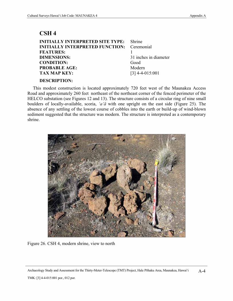
Cultural Surveys Hawai‘i Job Code: MAUNAKEA 4 Appendix A
Archaeology Study and Assessment for the Thirty-Meter-Telescope (TMT) Project, Hale P�haku Area, Maunakea, Hawai‘i A-4TMK: [3] 4-4-015:001 por., 012 por.
CSH 4 INITIALLY INTERPRETED SITE TYPE: Shrine INITIALLY INTERPRETED FUNCTION: Ceremonial FEATURES: 1 DIMENSIONS: 31 inches in diameter CONDITION: Good PROBABLE AGE: Modern TAX MAP KEY: [3] 4-4-015:001
DESCRIPTION: This modest construction is located approximately 720 feet west of the Maunakea Access
Road and approximately 260 feet northeast of the northeast corner of the fenced perimeter of the HELCO substation (see Figures 12 and 13). The structure consists of a circular ring of nine small boulders of locally-available, scoria, ‘a‘� with one upright on the east side (Figure 25). The absence of any settling of the lowest course of cobbles into the earth or build-up of wind-blown sediment suggested that the structure was modern. The structure is interpreted as a contemporary shrine.
Figure 26. CSH 4, modern shrine, view to north

Cultural Surveys Hawai‘i Job Code: MAUNAKEA 4 Appendix A
Archaeology Study and Assessment for the Thirty-Meter-Telescope (TMT) Project, Hale P�haku Area, Maunakea, Hawai‘i A-5TMK: [3] 4-4-015:001 por., 012 por.
CSH 5 INITIALLY INTERPRETED SITE TYPE: Shrine INITIALLY INTERPRETED FUNCTION: Ceremonial FEATURES: 3 DIMENSIONS: 12.1 feet E/W x 7.9 feet N/S CONDITION: Excellent PROBABLE AGE: Modern TAX MAP KEY: [3] 4-4-015:001
DESCRIPTION: This construction is located approximately 200 feet north of the central portion of the northern
fenced perimeter of the HELCO substation (see Figures 12 and 13). The structure is roughly oval, measuring approximately 12.1 feet E/W x 7.9 feet N/S with the perimeter alignment, 1-2 courses of small, locally-available, scoria, ‘a‘� boulders high, and 1-2 course of small boulders wide (Figure 26). The structure is built around a large bedrock ‘a‘� boulder, 3.3 feet x 3.3 feet wide and 31 inches high that dominates the central portion of the structure giving something of a heart-shaped appearance. A m�mane (Sophora chrysophylla) branch was propped up on the large central boulder with piled cobbles. An upright stone is set at the down slope apex, with a stone alignment extending approximately 3 feet (1 m) down slope (SSE) from the upright. The interior surface is relatively clear and level soil. Branch points to Pu‘u Kalepeamoa. A small ahu or cairn was noted a meter to the NE, approximately 24 inches x 20 inches wide and 24 inches high A similar, but collapsed, small ahu or cairn was noted approximately a meter to the NW. The absence of any settling of the lowest course of boulders into the earth or build-up of wind-blown sediment suggested that the structure was modern. The structure is interpreted as a contemporary shrine.

Cultural Surveys Hawai‘i Job Code: MAUNAKEA 4 Appendix A
Archaeology Study and Assessment for the Thirty-Meter-Telescope (TMT) Project, Hale P�haku Area, Maunakea, Hawai‘i A-6TMK: [3] 4-4-015:001 por., 012 por.
Figure 27. CSH 5, modern shrine, view to northeast

Cultural Surveys Hawai‘i Job Code: MAUNAKEA 4 Appendix A
Archaeology Study and Assessment for the Thirty-Meter-Telescope (TMT) Project, Hale P�haku Area, Maunakea, Hawai‘i A-7TMK: [3] 4-4-015:001 por., 012 por.
CSH 7 INITIALLY INTERPRETED SITE TYPE: Linear Mound/ Shrine INITIALLY INTERPRETED FUNCTION: Ceremonial FEATURES: 1 DIMENSIONS: 12.5 feet E/W x 6.9 feet N/S CONDITION: Good PROBABLE AGE: Modern TAX MAP KEY: [3] 4-4-015:001
DESCRIPTION: The find spot designated CSH 7 is located just southeast of an unimproved foot trail
ascending the NNE side of the Pu‘u Lepeamoa cinder cone approximately 200 feet southeast of the southeast corner of the fenced perimeter of the HELCO substation (see Figures 12 and 13). This was the northeastern-most of several mounded piles of boulders along the trail. The structure measures 12.5 feet E/W x 6.9 feet N/S by 3.3 feet high (Figure 27). This linear mound showed no facing, and was constructed of rather informally piled locally-available, scoria, ‘a‘� boulders and cobbles with no clear uprights. Modern garbage was noted within structure. The absence of any settling of the lowest course of boulders into the earth or build-up of wind-blown sediment suggested that the structure was modern. The structure is interpreted as a contemporary shrine.
Remnants of lei or twisted rope offerings were observed within the structure (Figure 28).

Cultural Surveys Hawai‘i Job Code: MAUNAKEA 4 Appendix A
Archaeology Study and Assessment for the Thirty-Meter-Telescope (TMT) Project, Hale P�haku Area, Maunakea, Hawai‘i A-8TMK: [3] 4-4-015:001 por., 012 por.
Figure 28. CSH 7, linear mound, view to northeast
Figure 29. CSH 7, linear mound, showing lei offering

Cultural Surveys Hawai‘i Job Code: MAUNAKEA 4 Appendix A
Archaeology Study and Assessment for the Thirty-Meter-Telescope (TMT) Project, Hale P�haku Area, Maunakea, Hawai‘i A-9TMK: [3] 4-4-015:001 por., 012 por.
CSH 8 INITIALLY INTERPRETED SITE TYPE: Writing with Stones INITIALLY INTERPRETED FUNCTION: Commemorative demarcation with arranged boulders (graffiti) FEATURES: 1 DIMENSIONS: 5 feet NW/SE x 3.3 feet NE/SW CONDITION: Good PROBABLE AGE: Modern TAX MAP KEY: [3] 4-4-015:001 DESCRIPTION:
The find spot designated CSH 8 is located adjacent to CSH 7 and just southeast of an unimproved foot trail ascending the NNE side of the Pu‘u Lepeamoa cinder cone approximately 200 feet southeast of the southeast corner of the fenced perimeter of the HELCO substation (see Figures 12 and 13). This construction consists of what appears to be three letters delineated with a single course of small of small, locally-available, scoria, ‘a‘� boulders (Figure 29). The letters (and meaning) were unclear - possibly “OHS” or “OWS”? The absence of any settling of the alignments of boulders into the earth or build-up of wind-blown sediment suggested that the structure was modern. The structure is interpreted as contemporary graffiti.
Figure 30. CSH 8, letters written with stones

Cultural Surveys Hawai‘i Job Code: MAUNAKEA 4 Appendix A
Archaeology Study and Assessment for the Thirty-Meter-Telescope (TMT) Project, Hale P�haku Area, Maunakea, Hawai‘i A-10TMK: [3] 4-4-015:001 por., 012 por.
CSH 9 INITIALLY INTERPRETED SITE TYPE: Mound INITIALLY INTERPRETED FUNCTION: Ceremonial FEATURES: 1 DIMENSIONS: 5.6 feet NE/SW x 4.6 feet NW/SE CONDITION: Good PROBABLE AGE: Modern TAX MAP KEY: [3] 4-4-015:001
DESCRIPTION: The find spot designated CSH 9 is a small mound located in the immediate vicinity of CSH 7
and CSH 8 and just southeast of an unimproved foot trail ascending the NNE side of the Pu‘u Lepeamoa cinder cone approximately 200 feet southeast of the southeast corner of the fenced perimeter of the HELCO substation (see Figures 12 and 13). The mound measures approximately 5.6 feet NE/SW x 4.6 feet NW/SE and approximately 28 inches high. The mound appears to be constructed of locally-available, scoria, ‘a‘� small boulders placed around a somewhat fragmented in situ large lava bomb rock formation (Figure 30). The absence of any settling of the lowest course of boulders into the earth or build-up of wind-blown sediment suggested that the structure was modern. The structure is interpreted as a contemporary shrine.
Figure 31. CSH 9 mound, view to southwest

Cultural Surveys Hawai‘i Job Code: MAUNAKEA 4 Appendix A
Archaeology Study and Assessment for the Thirty-Meter-Telescope (TMT) Project, Hale P�haku Area, Maunakea, Hawai‘i A-11TMK: [3] 4-4-015:001 por., 012 por.
CSH 10 INITIALLY INTERPRETED SITE TYPE: Linear Mound INITIALLY INTERPRETED FUNCTION: Ceremonial FEATURES: 1 DIMENSIONS: 34 feet NE/SW x 6.6 feet NW/SE CONDITION: Good PROBABLE AGE: Modern TAX MAP KEY: [3] 4-4-015:001
DESCRIPTION: The find spot designated CSH 10 is a large mound located a few meters southwest of the CSH
7, CSH 8 and CSH 9 constructions and just southeast of an unimproved foot trail ascending the NNE side of the Pu‘u Lepeamoa cinder cone approximately 213 feet southeast of the southeast corner of the fenced perimeter of the HELCO substation (see Figures 12 and 13). The mound measures approximately 34 feet NE/SW x 6.6 feet NW/SE and approximately 24 inches high (Figure 31). The mound averages 3.6 feet wide, is typically 2-3 courses high, and 6-7 courses wide of roughly piled locally-available, scoria, ‘a‘� boulders (Figure 30). There are no clear uprights. The absence of any settling of the lowest course of boulders into the earth or build-up of wind-blown sediment suggested that the structure was modern. The structure is interpreted as a contemporary shrine.
Figure 32. CSH 10, linear mound, view to northwest

Cultural Surveys Hawai‘i Job Code: MAUNAKEA 4 Appendix A
Archaeology Study and Assessment for the Thirty-Meter-Telescope (TMT) Project, Hale P�haku Area, Maunakea, Hawai‘i A-12TMK: [3] 4-4-015:001 por., 012 por.
CSH 11 INITIALLY INTERPRETED SITE TYPE: Mound INITIALLY INTERPRETED FUNCTION: Ceremonial FEATURES: 1 DIMENSIONS: 3.6 feet diameter CONDITION: Good PROBABLE AGE: Modern TAX MAP KEY: [3] 4-4-015:001 DESCRIPTION:
The find spot designated CSH 11 is a small mound located a few meters from CSH 10 and just southeast of an unimproved foot trail ascending the NNE side of the Pu‘u Lepeamoa cinder cone approximately 213 feet (65 m) southeast of the southeast corner of the fenced perimeter of the HELCO substation (see Figures 12 and 13). The mound measures approximately 3.6 feet in diameter and approximately 24 inches high (Figure 32). The structure is really just a group of approximately twenty locally-available, scoria, ‘a‘� boulders a single course high. The absence of any settling of the lowest course of boulders into the earth or build-up of wind-blown sediment suggested that the structure was modern. The structure is interpreted as a contemporary shrine.
Figure 33. CSH 11, mound, view to west

Cultural Surveys Hawai‘i Job Code: MAUNAKEA 4 Appendix A
Archaeology Study and Assessment for the Thirty-Meter-Telescope (TMT) Project, Hale P�haku Area, Maunakea, Hawai‘i A-13TMK: [3] 4-4-015:001 por., 012 por.
CSH 12 INITIALLY INTERPRETED SITE TYPE: Shrine INITIALLY INTERPRETED FUNCTION: Ceremonial FEATURES: 1 DIMENSIONS: 31 inches diameter CONDITION: Good PROBABLE AGE: Modern TAX MAP KEY: [3] 4-4-015:001 DESCRIPTION:
The find spot designated CSH 12 is a small mound located in the immediate vicinity of CSH 13 and just southeast of an unimproved foot trail ascending the NNE side of the Pu‘u Lepeamoa cinder cone approximately 230 feet south of the southeast corner of the fenced perimeter of the HELCO substation (see Figures 12 and 13). The mound measures approximately 31 inches in diameter and approximately 2.3 feet high. The mound appears to be constructed of locally-available, scoria, ‘a‘� small boulders (Figure 33). Offerings of American coins (dates of 1979, 1989, 1987, 2006, 1999), shell lei (including one of exotic Cyprea annulus) and a metal cross with green glass inlay were observed. The absence of any settling of the lowest course of boulders into the earth or build-up of wind-blown sediment suggested that the structure was modern. While we cannot rule out that the coins were a recent addition to an older structure it appears most likely they are roughly contemporaneous (i.e. the construction does not pre-date 2006 by much). We note in passing that the shell lei are of exotic shells native to the South Pacific but not Hawai‘i. Should such shells be identified in a pre-contact structure they would be of great interest! The structure is interpreted as a contemporary shrine.
Figure 34. CSH 12, modern shrine, view to west. Note metal cross and cowry shell lei offerings

Cultural Surveys Hawai‘i Job Code: MAUNAKEA 4 Appendix A
Archaeology Study and Assessment for the Thirty-Meter-Telescope (TMT) Project, Hale P�haku Area, Maunakea, Hawai‘i A-14TMK: [3] 4-4-015:001 por., 012 por.
CSH 13 INITIALLY INTERPRETED SITE TYPE: Linear Mound INITIALLY INTERPRETED FUNCTION: Ceremonial FEATURES: 1 DIMENSIONS: 14.7 feet (4.5 m) E/W 3.9 feet (1.2 m) N/S CONDITION: Good PROBABLE AGE: Modern TAX MAP KEY: [3] 4-4-015:001 DESCRIPTION:
The find spot designated CSH 13 is a large mound located near the CSH 11 construction and just northwest of an unimproved foot trail ascending the NNE side of the Pu‘u Lepeamoa cinder cone approximately 230 feet south of the fenced perimeter of the HELCO substation (see Figures 12 and 13). The mound measures approximately 14.7 feet E/W by 3.9 feet N/S and approximately 31 inches high (Figure 34). The mound utilizes a large in situ boulder and is constructed of roughly piled locally-available, scoria, ‘a‘� boulders (Figure 34). There are no clear uprights. The absence of any settling of the lowest course of boulders into the earth or build-up of wind-blown sediment suggested that the structure was modern. The structure is interpreted as a contemporary shrine.
Figure 35. CSH 13, linear mound, view to southwest. Note trail to pu‘u summit in background

Cultural Surveys Hawai‘i Job Code: MAUNAKEA 4 Appendix A
Archaeology Study and Assessment for the Thirty-Meter-Telescope (TMT) Project, Hale P�haku Area, Maunakea, Hawai‘i A-15TMK: [3] 4-4-015:001 por., 012 por.
Modern Refuse Disposal Areas INITIALLY INTERPRETED SITE TYPE: Artifact scatter INITIALLY INTERPRETED FUNCTION: Late Twentieth century refuse disposal FEATURES: 2 DIMENSIONS: Approximately 0.4 acres each CONDITION: Good PROBABLE AGE: Modern TAX MAP KEY: [3] 4-4-015:001, 012
DESCRIPTION: Two late Twentieth century scatters of bottles and cans (“Modern Garbage Area” and
“Modern Garbage Area 2”) were observed just east (outside) of the Hale P�haku Project area (see Figures 12 and 13).
Each of these scatters (Figures 35 and 36) was relatively dense with each having on the order of 150 bottles and cans within an area of approximately 0.4 acres (each) suggesting deliberate disposal of refuse. The presence of “No deposit No return” embossing on some bottles suggested late twentieth century disposal. The timeframe of disposal might be early 1960s. No particular import is attributed to these small refuse disposal areas but they are documented for future reference.
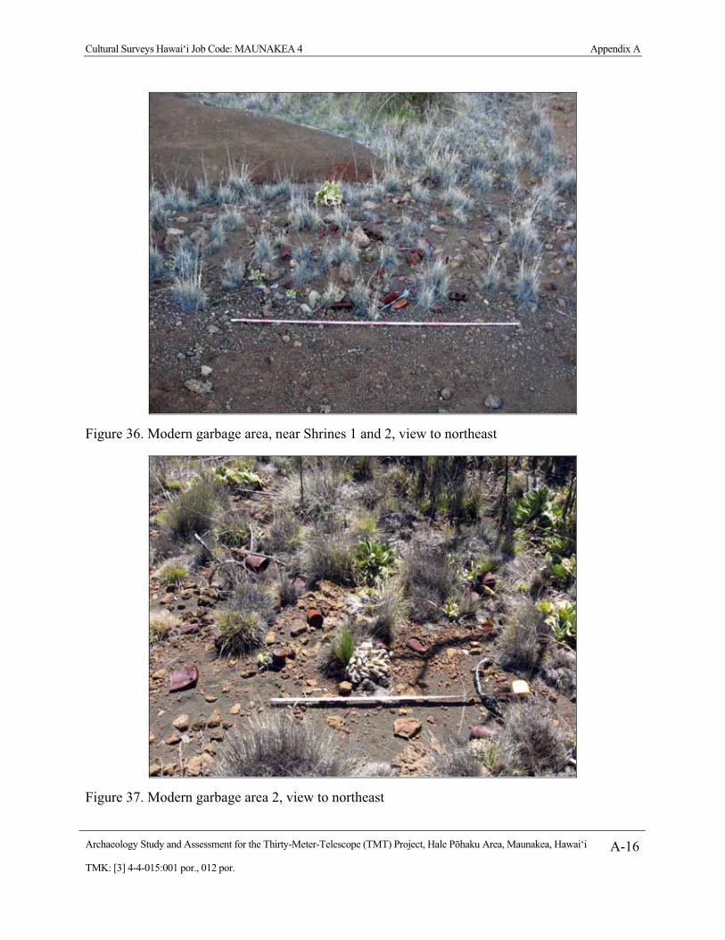
Cultural Surveys Hawai‘i Job Code: MAUNAKEA 4 Appendix A
Archaeology Study and Assessment for the Thirty-Meter-Telescope (TMT) Project, Hale P�haku Area, Maunakea, Hawai‘i A-16TMK: [3] 4-4-015:001 por., 012 por.
Figure 36. Modern garbage area, near Shrines 1 and 2, view to northeast
Figure 37. Modern garbage area 2, view to northeast

Final EIS: TMT Observatory Page I-1
Appendix I. Archaeological Inventory Survey of the Astronomy Precinct in the Mauna Kea Science Reserve
Pacific Commercial Services Inc. (PCSI). 2010b. Final Report, Archaeological Inventory Survey of the Astronomy Precinct in the Mauna Kea Science Reserve, Ka‘ohe, Ahupua‘a, H�m�kua District, Hawai‘i Island, Hawai‘i. Prepared for Office of Mauna Kea Management. January 2010.


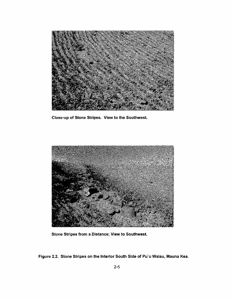


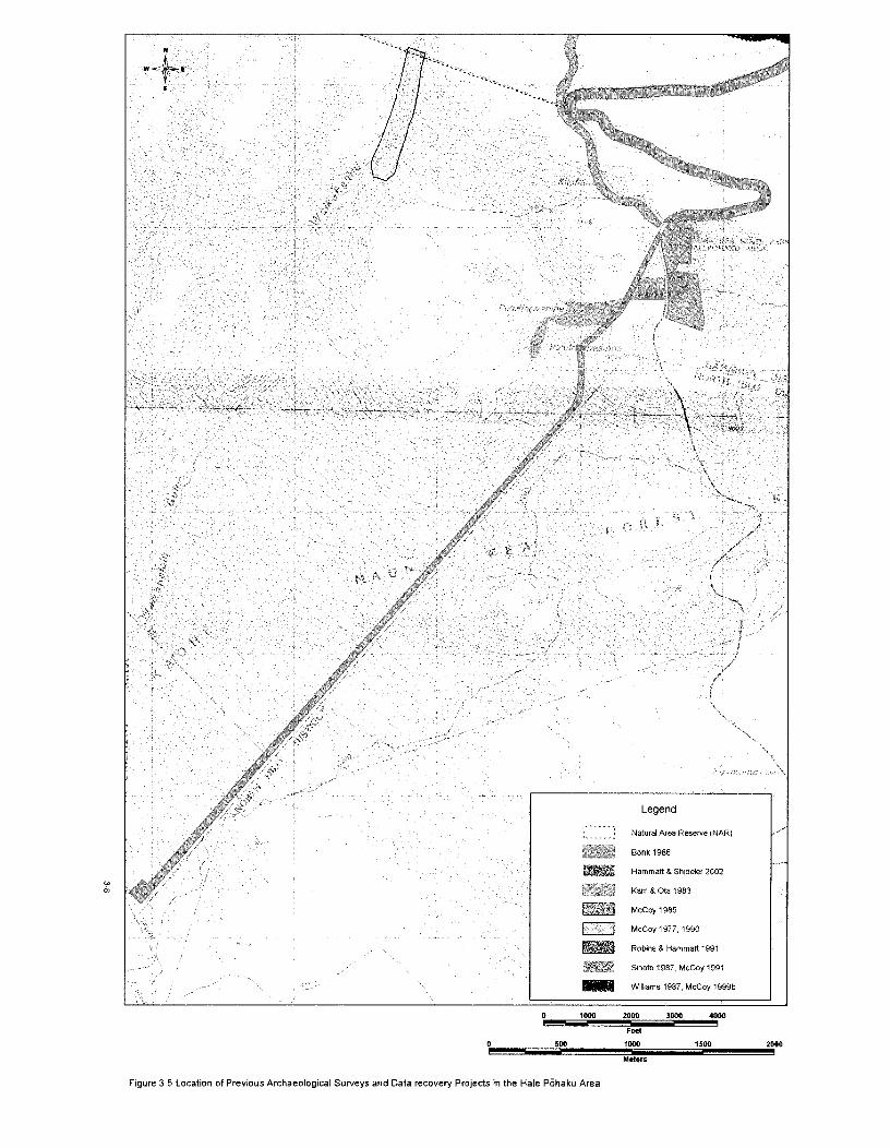


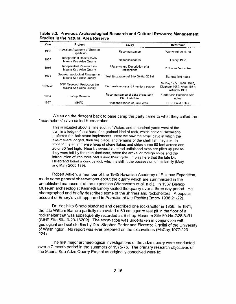


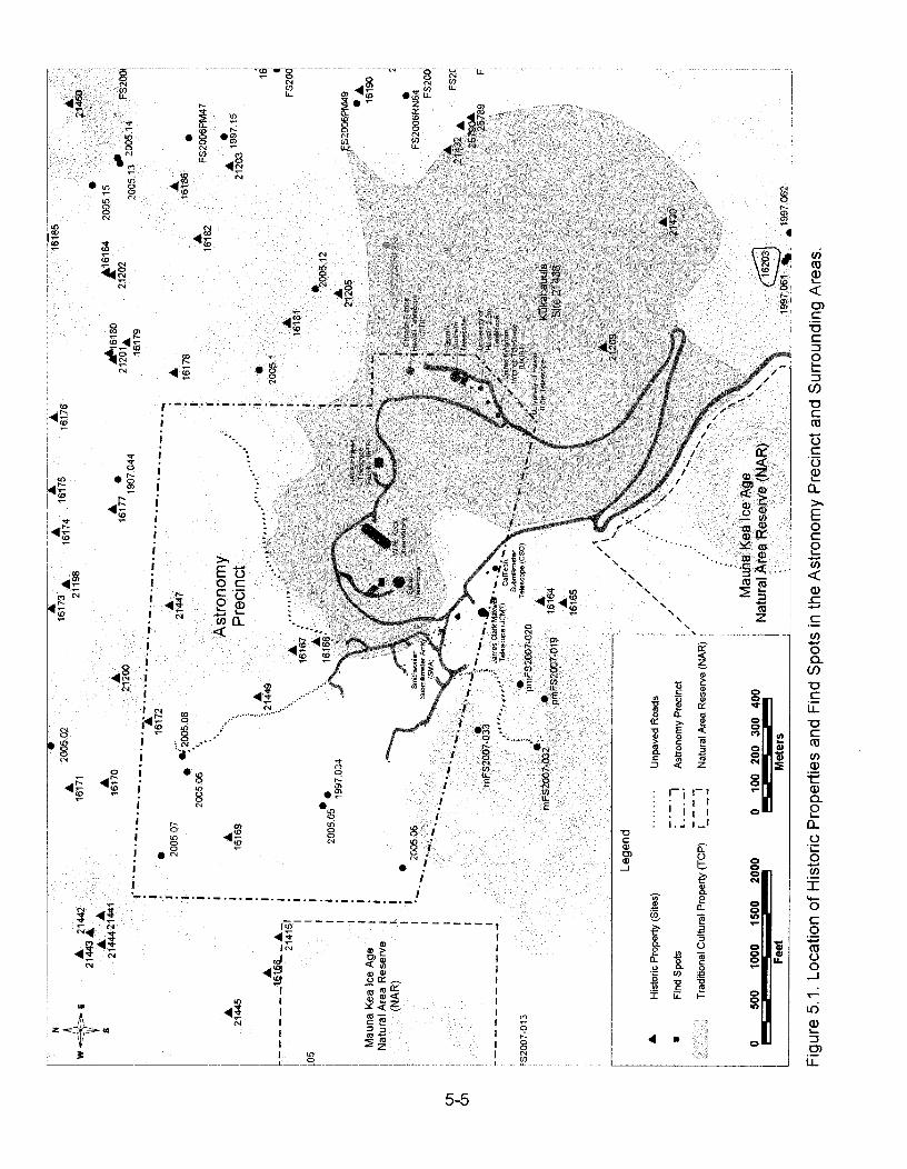


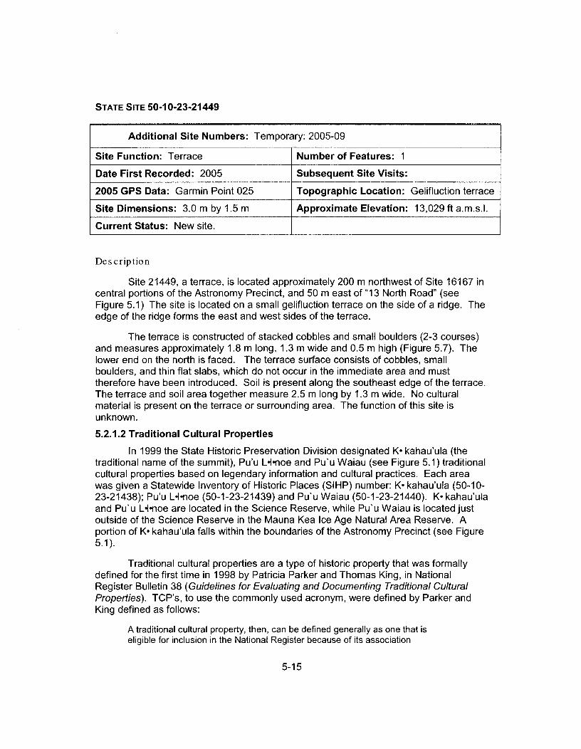


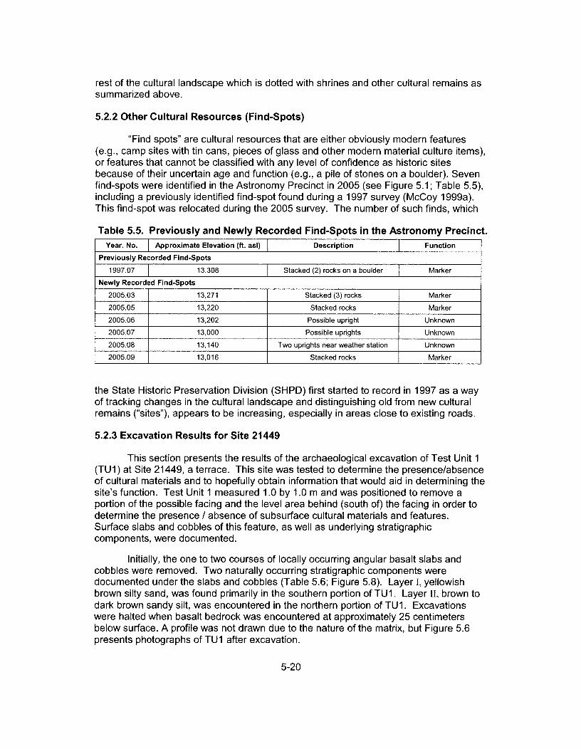
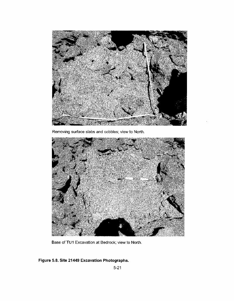


Final EIS: TMT Observatory Page J-1
Appendix J. Mauna Kea Historic Preservation Plan
State Historic Preservation Division (SHPD), 2000. Mauna Kea Historic Preservation Plan, Management Components. Prepared for UH IfA. In the 2000 Master Plan, Appendix F. March 2000.


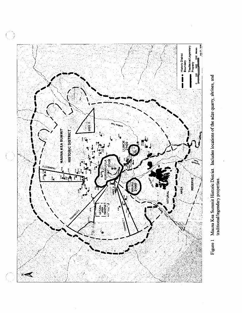


Final EIS: TMT Observatory Page K-1
Appendix K. Biological Resources Technical Report

Final EIS: TMT Observatory Page K-3
Preface The Arthropod and Botanical Inventory and Assessment has been updated since the Draft EIS was completed. Changes made to this technical report since the Draft EIS was completed are not illustrated as they are within this preface and the body of the Final EIS. No substantial changes were made but minor modifications were made related to the Access Way Options, primarily to indicate that Option 1 has been dropped from consideration and Option 3 has been refined to lessen impacts to w�kiu bug habitat. Botanical resources are discussed in Section 3.4 of the Final EIS.


ARTHROPOD AND BOTANICAL INVENTORY AND ASSESSMENT
THIRTY METER TELESCOPE PROJECT MAUNA KEA SCIENCE RESERVE
NORTHERN PLATEAU AND HALE P�HAKU H�M�KUA DISTRICT, ISLAND OF HAWAI‘I
May 2009 Prepared for Parsons Brinckerhoff Honolulu, Hawai‘i
Pacific Analytics, L.L.C. P.O. Box 1064 Corvallis, Oregon 97339 www.statpros.com


Prepared by: Pacific Analytics, L.L.C. Post Office Box 1064 Corvallis, Oregon 97339 Tel. (541) 758-9352 [email protected] www.statpros.com Gregory Brenner Senior Associate / Project Manager The pictures contained in this report are for the exclusive use by Pacific Analytics, L.L.C. and its clients. All photographs are copyrighted by Pacific Analytics, L.L.C. and may not be reproduced or used without the express written permission of Pacific Analytics, L.L.C.

Arthropod and Botanical Inventory and Assessment Pacific Analytics, LLC Thirty Meter Telescope Project, Mauna Kea, Hawai‘i i
TABLE OF CONTENTS 1.0 INTRODUCTION ................................................................................................................1
1.1 TMT Project .........................................................................................................................1 1.2 Physical Setting ....................................................................................................................3 1.3 Current Study .......................................................................................................................4
2.0 METHODS ...........................................................................................................................5 2.1 Permit ...................................................................................................................................5 2.2 Schedule and Personnel .......................................................................................................5 2.3 Nomenclature .......................................................................................................................5 2.4 Arthropod Sampling .............................................................................................................6
2.4.1 Trapping .........................................................................................................................6 2.4.2 Foliage Sampling .........................................................................................................10 2.4.3 Specimen Curation .......................................................................................................11 2.4.4 Identification ................................................................................................................11
2.5 Lichen, Bryophyte, and Botanical Sampling .....................................................................12 2.5.1 Lichen and Bryophyte Sampling .................................................................................12 2.5.2 Botanical Sampling ......................................................................................................13 2.5.3 Identification ................................................................................................................13
3.0 RESULTS AND ANALYSIS .............................................................................................14 3.1 Area E, the Access Way, and Batch Plant Staging Area ...................................................14
3.1.1 Arthropods ...................................................................................................................14 3.1.2 Lichens, Bryophytes, and Vegetation ..........................................................................21 3.1.3 Access Way Options ....................................................................................................24 3.1.4 Summary ......................................................................................................................25
3.2 Construction Staging Area, Hale P�haku ..........................................................................25 3.2.1 Arthropods ...................................................................................................................25 3.2.2 Botanical ......................................................................................................................26 3.2.3 Summary ......................................................................................................................30
4.0 RECOMMENDATIONS ...................................................................................................31 4.1 Area E, Access Way, and Batch Plant Staging Area .........................................................31 4.2 Construction Staging Area, Hale P�haku ..........................................................................33
5.0 BIBLIOGRAPHY ..............................................................................................................35
APPENDIX A ............................................................................................................................ A-1
APPENDIX B .............................................................................................................................B-1
APPENDIX C ............................................................................................................................ C-1

Arthropod and Botanical Inventory and Assessment Pacific Analytics, LLC Thirty Meter Telescope Project, Mauna Kea, Hawai‘i iii
EXECUTIVE SUMMARY The Thirty Meter Telescope (TMT) Observatory Corporation is preparing an Environmental Impact Statement (EIS) for the proposed construction and operation of an optical/infrared observatory within the Astronomy Precinct of the Mauna Kea Science Reserve on Hawai‘i Island in the State of Hawai‘i. The proposed TMT Observatory would be located within the western portion of the area known as the Northern Plateau. During construction, support activities would occur within the existing Batch Plant Staging Area and at a Construction Staging Area within or near the Hale P�haku Mid-Elevation Support Facilities.
Sampling of the flora and arthropod fauna in the proposed use areas was conducted September 25 through October 8, 2008. A second visit occurred February 23 – 25, 2009 to evaluate options for the TMT Mid-Level Facility at and near Hale P�haku. A third visit occurred April 17 – 23, 2009 to sample for W�kiu bugs in Area E, the Batch Plant Staging Area, and along the three options for the Access Way, and to sample for vegetation and arthropods at the proposed TMT Mid-Level Facility.
During the September 2008 sampling, forty-five live-traps were deployed in Area E, along the 4-wheel drive road, at the Batch Plant Staging Area, and at two control sites (Pu‘u Poli‘ahu and the Pu‘u Hau‘oki above the 4-wheel drive road on which the Subaru Observatory sits) for a three-day detection of W�kiu bug (Nysius wekiuicola) presence. Three W�kiu bugs were captured (one 5th instar nymph on Pu‘u Poli‘ahu, one 5th instar nymph and adult female on Pu‘u Hau‘oki). No W�kiu bugs were detected at any of the sites proposed for construction activity. Sixteen other arthropods were detected at the Astronomy Precinct project areas, six of which are endemic to Hawai‘i.
Two days during the Fall sampling period were spent surveying Area E for lichens and mosses; ten lichen and two moss species were found. Seven species of vascular plants were also detected; two native grasses, two non-indigenous weedy species, and three ferns.
Six days during the Fall sampling period were used to survey for arthropods and plants at portion of the planned TMT Mid-Level Facility within Hale P�haku. Twenty-six species of arthropods, nine endemic to Hawai‘i, and sixteen species of plants, none that are endemic to Hawai‘i, were identified there.
During the April 2009 sampling, twenty-four live-traps were deployed in Area E, along the 4-wheel drive road, at the Batch Plant Staging Area, and at two control sites (Pu‘u Poli‘ahu and Pu‘u Hau‘oki) for a three-day detection of W�kiu bug (Nysius wekiuicola) presence. One hundred and five W�kiu bugs of various life stages were captured at the control sites (forty-five on Pu‘u Poli‘ahu and sixty on Pu‘u Hau‘oki). Forty-one W�kiu bugs of various life stages were detected along the 4-wheel drive road (Access Way Options 2 and 3), but none were seen in Area E or at the Batch Plant Staging Area.
Additional sampling at the planned TMT Mid-Level Facility detected seven additional arthropod species, (five endemic, one indigenous, and one purposeful introduction), one endemic snail, and four additional plants (three endemic and one nonindigenous).

Arthropod and Botanical Inventory and Assessment Pacific Analytics, LLC Thirty Meter Telescope Project, Mauna Kea, Hawai‘i iv
The results of the surveys indicate there are no special concerns or legal constraints related to arthropod and botanical resources in the Project areas. No species listed as endangered or threatened species were detected at the Project construction areas (DLNR 1997, Federal Register 1999, 2005, 2006). There are endangered silversword (Argyroxiphium sandwicense sandwicense) in an exclosure adjacent to the proposed TMT Mid-Level Facility which lies within critical habitat of the endangered bird, palila (Loxioides bailleui). One species currently proposed for federal listing, Nysius wekiuicola, was detected along the 4-wheel drive road, within the limits of proposed Access Way Options 2 and 3. Species of Concern were detected at Area E, (the Douglas’ bladder fern, Cystopteris douglasii), and at the proposed TMT Mid-Level Facility (Hylaeus difficillis, H. flavipes, and Succinea konaensis).
Sampling for W�kiu bugs at the edge of snow on Pu‘u Poli‘ahu in April, 2009.
Arthropod and Botanical Inventory and Assessment Pacific Analytics, LLC Thirty Meter Telescope Project, Mauna Kea, Hawai‘i 1
1.0 INTRODUCTION
1.1 TMT Project The TMT Observatory is proposed to be located on Maunakea on Hawai‘i Island in the State of Hawai‘i. Maunakea currently hosts eight optical and/or infrared observatories; the first Maunakea observatories were built in the 1960s. The TMT Observatory would be located on a roughly 5-acre site within the 525-acre Astronomy Precinct of the 11,288-acre Mauna Kea Science Reserve (tax map key [TMK] 4-4-15: 9), below the summit of Maunakea. The entire Science Reserve is designated as part of the State of Hawai‘i Conservation District, resource subzone.
The TMT Observatory would be located in the western portion of the area known as the Northern Plateau within the Astronomy Precinct, within the area identified as Area E in the Mauna Kea Science Reserve Master Plan (UH, 2000). The 2000 Master Plan identified Area E as a preferred location for the future development of a Next Generation Large Telescope (NGLT). Area E, a 36-acre area, was identified as a preferred location because it was anticipated to provide suitable observation conditions with minimum impact on existing facilities, W�kiu bug habitat, archaeological sites, and viewplanes. Area E ranges in elevation from 13,100 to 13,300 feet; the summit of Maunakea is at elevation 13,796 feet. Area E is located approximately 1/2-mile northwest of the eight existing optical/infrared observatories located near the summit, at elevations of 13,600 to 13,775 feet.
Within Area E, the TMT Observatory would be located at one of two locations:
� The Project site near the end of the existing 4-wheel drive road, at an elevation of approximately 13,150 feet at a location known as “13N” in reference to its elevation and its location on the Northern Plateau, or
� An alternative site designated “E2” by the Project because it is a second site being considered within Area E; the area is approximately 500 feet south of 13N along the existing 4-wheel drive road.
The TMT Observatory would be the primary development of the Project, but not the only one. The “Project” is the sum of the following components:
� “TMT Observatory” refers to the components of the Project located below the summit, in the upper elevations of Maunakea. The TMT Observatory generally consists of the 30-meter telescope, instruments, dome, support building, and parking within a roughly five acre area.
� The “Access Way” refers to the portion of road and other infrastructure that would be provided to access and operate the TMT Observatory. Improvements in the Access Way would generally include a surface roadway and underground utilities. Beyond the core of the SMA facility the route of the Access Way would follow the existing SMA roads and
Arthropod and Botanical Inventory and Assessment Pacific Analytics, LLC Thirty Meter Telescope Project, Mauna Kea, Hawai‘i 2
existing 4-wheel drive road to the extent possible. There are three options being considered for the portion of the Access Way from the Maunakea Access Road through the core of the SMA area:
1. Option 1 – Through SMA. (No longer being considered) This option would follow the primary SMA road off the Maunakea Access Road, and then proceed through the lava flow before reconnecting with the SMA road.
2. Option 2 – Near SMA. This option would cut off the Maunakea Access Road at the currently blocked old 4-wheel drive road and connect with the SMA road once beyond the SMA core.
3. Option 3 – 4-Wheel Drive Road. This option would follow the currently blocked old 4-wheel drive road and then connect with the SMA road.
� “TMT Mid-Level Support Facility” refers to facilities and improvements located at or near the existing 20 acre Hale P�haku facility to support the TMT Observatory. This includes all permanent improvements at or near Hale P�haku, which would generally consist of dormitory, office, cafeteria, and recreations facilities in the eastern portion of the lower part of Hale P�haku; a parking area in the western portion of the lower part of Hale P�haku; and electrical and communications equipment.
� “Headquarters” refers to facility located in the lower elevations of Hawai‘i Island to manage activities at and support operation of the TMT Observatory and TMT Mid-Level Support Facility. This includes all permanent improvements at a lower elevation location in Hilo but is not discussed in this report.
� “Satellite Office” refers to the smaller facility located in the lower elevations of Hawai‘i Island to provide additional support to the TMT Observatory and TMT Mid-Level Facility. This includes all permanent improvements at a lower elevation location in Waimea but is not discussed in this report.
� “Construction Areas” would include: 1. “Batch Plant Staging Area” is an approximately 4 acre staging area where the
Maunakea Access Road forks near the summit. This area would primarily be used for storing bulk materials and a cement batch plant.
2. “Hale P�haku Staging Area” is an area at or near Hale P�haku that would be used for construction staging. This area would be used for parking, vehicle washing and inspection prior to proceeding up to the observatory site, and the storage of materials needed for construction work at Hale P�haku.
3. “Port Staging Area” is an existing warehouse and/or yard near the port where Project components are received. This area would be used for receiving materials and assembly of those materials to the extent possible prior to transport to either another staging area or the construction site. This area is not discussed in this report.

Arthropod and Botanical Inventory and Assessment Pacific Analytics, LLC Thirty Meter Telescope Project, Mauna Kea, Hawai‘i 3
1.2 Physical Setting Maunakea is a dormant shield volcano and the tallest mountain on earth, rising more than 32,000 feet from the ocean floor to its summit, 13,796 feet above sea level. At the summit the night sky is dark and transparent, providing what is considered to be among the best astronomical observation conditions in the world (Parker 1994).
The Mauna Kea Science Reserve (MKSR), an 11,288-acre area at the top of Maunakea, is home to the largest observatory complex in the world. The MKSR is leased by the State of Hawai‘i to the University of Hawai‘i (UH), which in turn subleases certain areas to various observatories. Astronomy institutes worldwide make use of the unparalleled astronomical capabilities on Maunakea.
The MKSR is also home to unique plants and animals living in an alpine ecosystem. The summit region is an island within an island, separated from other ecosystems by high elevations as well as vast oceans. The species found there are not only unique; they are sometimes rare2 and limited in population and area of distribution. For example, the W�kiu bug lives only in loose cinder habitats on the cinder cones above 11,715 feet on Maunakea (Porter and Englund 2006). There is a similar species, Nysius aa that occurs in the upper elevations on Maunaloa (Polhemus 1998).
The upper elevations of the MKSR receive almost no rainfall and snow accumulates only during the winter season. Temperatures often drop below freezing at night and reach up to 50º F during the day. Solar radiation is extreme, and evaporation rates are high. The harsh environmental conditions limit the composition of the resident floral and faunal communities found there. Under these harsh conditions, only hardy lichens, mosses, and scattered grasses, shrubs, ferns and arthropods have managed to adapt and survive (Cuddihy 1989).
Below 11,700 feet is an alpine shrublands and grasslands ecosystem growing on ‘a‘a lava flows, cinder cones, and air-fall deposits of lapilli and ash (Wolfe and others 1997). Growing well above the tree line (~9,500 feet), and becoming sparser with increasing elevation, are native shrubs, grasses, sedges, and ferns (Cuddihy 1989). The fauna of the alpine shrub zone has not been well studied. Many species of birds have been observed flying in this zone, but because the principal food resources do not occur here, they are presumably just passing through. There may be resident arthropod species in this zone, but no systematic survey has been conducted.
Below the alpine shrublands and grasslands are the m�mane subalpine woodlands that extend down to the Saddle Road. The open-canopied m�mane forest is home to the endangered bird, 2 There are several terms that are used to describe the status of species. These include: Endangered species – Any species which is in danger of extinction throughout all or a significant portion of its range. Threatened species – Any species which is likely to become endangered within the foreseeable future. Candidate species – Any species being considered by the Secretary of the Interior for listing as an endangered or a threatened species, but not yet the subject of a proposed rule. Species of Concern – Those species about which regulatory agencies have some concerns regarding status and threats, but for which insufficient information is available to indicate a need to list the species under the Endangered Species Act (ESA). Rare species – Those species that occur very seldom, but are not classified threatened or endangered. Sensitive species – Those species which rely on specific habitat conditions that are limited in abundance, restricted in distribution, or are particularly sensitive to development.

Arthropod and Botanical Inventory and Assessment Pacific Analytics, LLC Thirty Meter Telescope Project, Mauna Kea, Hawai‘i 4
palila (Loxioides bailleui). The subalpine woodlands are dry most of the year, and m�mane trees (Sophora chrysophylla) intercept fog that provides them and other plant species with the small amounts of moisture they need to survive (Gerrish 1979). The understory of the subalpine forest is comprised largely of native shrubs. In undisturbed areas clumps of the native grasses are the most abundant ground cover. Non-indigenous plants and grasses are the most abundant ground cover in areas that have been disturbed around Hale P�haku. The m�mane forest on Maunakea has a diverse arthropod fauna. More than 200 arthropod species have been collected there.
Cattle grazing has degraded much of the forest along the lower sections of the Maunakea Access Road. The vegetation of the open pastures is largely introduced grasses including rattail grass, velvetgrass, sweet vernal grass, hairy oatgrass, and fescues (Mueller-Dombois and Fosberg 1998).
1.3 Current Study The Thirty Meter Telescope (TMT) Observatory Corporation, a non-profit organization, is preparing an Environmental Impact Statement (EIS) for the proposed Project. Pacific Analytics, LLC was contracted by Parsons Brinckerhoff, the company preparing the TMT EIS, to conduct an arthropod and botanical inventory and assessment of Area E, the proposed Access Way, the Batch Plant Staging Area, and TMT Mid-Level Support Facility, including a special survey for W�kiu bugs in the affected areas above 11,715 feet.
The primary objectives of the inventory and assessment are to provide a general description of the flora and arthropod fauna of the TMT Project sites, evaluate the habitats, and search for and assess the potential for threatened and endangered species as well as species of concern (DLNR 1997, Federal Register 1999, 2005, USFWS unpublished).
View of Area E and existing 4-wheel drive road.

Arthropod and Botanical Inventory and Assessment Pacific Analytics, LLC Thirty Meter Telescope Project, Mauna Kea, Hawai‘i 5
2.0 METHODS2.1 Permit An application for a Research, Collection and Access Permit was submitted August 14, 2008 to the Hawai‘i Department of Land and Natural Resources (DLNR), Division of Forestry and Wildlife (DOFAW) and after review, a permit (FHM09-170) was granted on September 24, 2008, valid through September 23, 2009. The W�kiu bugs were sampled under separate Research, Collection and Access Permits (FHM08-135 and FHM09-181) granted to Jesse Eiben, valid from December 1, 2007 through April 1, 2010.
2.2 Schedule and Personnel Sampling of the flora and arthropod fauna in Area E, the proposed Access Way, the Batch Plant Staging Area, and portions of the TMT Mid-Level Support Facility was conducted September 25 through October 8, 2008. W�kiu bug traps were opened and operated from September 25 – 28, 2008. A lichen survey in Area E was conducted over two days September 29 – 30, 2008. Arthropod sampling and botanical surveying continued through October 10, 2008.
Additional botanical sampling by was conducted at the proposed TMT Mid-Level Support Facility February 23-24, 2009.
Additional W�kiu bug and arthropod sampling was conducted in the summit region April 20 – 23, 2009 and at the TMT Mid-Level Support Facility April 17 – 23, 2009.
Gregory Brenner, Pacific Analytics, LLC and Jesse Eiben, UH M�noa, were the investigators conducting the arthropod sampling. Dr. Brenner has a PhD in entomology from Oregon State University, Corvallis, and fourteen years of experience studying the arthropod fauna of Hawai‘i, during which he has conducted numerous scientific studies of the arthropods on Maunakea. Mr. Eiben is a Doctoral candidate in the University of Hawai‘i’s Department of Plant and Environmental Protection Sciences and has been conducting research on W�kiu bug autecology and systematics for his dissertation since 2005.
Gregory Brenner and Clifford Smith were the investigators conducting the lichen, bryophyte and botanical sampling. Dr. Brenner is familiar with the flora of Hawai‘i having conducted many scientific studies of the plants on Maunakea and elsewhere in Hawai‘i. Dr. Smith has a PhD in botany and is Professor Emeritus of the Department of Botany, UH M�noa. He is the leading expert in lichens of Hawai‘i, and has conducted research on Hawaiian lichens since 1958.
2.3 Nomenclature The nomenclature used in this report follows the Hawaiian Terrestrial Arthropod Checklist, Third Edition (Nishida 1997) and the Manual of the Flowering Plants of Hawai‘i (Wagner and others 1990). Hawaiian and scientific names are italicized.
Species are discussed as being endemic, indigenous, non-indigenous, adventive, and purposely introduced. These terms are defined as:

Arthropod and Botanical Inventory and Assessment Pacific Analytics, LLC Thirty Meter Telescope Project, Mauna Kea, Hawai‘i 6
� Endemic – A species native to, or restricted to Hawai‘i.
� Indigenous – A species native to Hawai‘i but that naturally occurs outside of Hawai‘i as well.
� Non-indigenous – A species not native to Hawai‘i.
� Adventive – Not native, a species transported into a new habitat by natural means or accidentally by human activity.
� Purposely introduced – A species released in Hawai‘i for a particular purpose, usually to control a weedy plant or another insect.
2.4 Arthropod Sampling
2.4.1 Trapping
W�kiu Bug Traps Pitfall live-traps were used to sample W�kiu bugs in Area E and at the Batch Plant Staging Area. A live-trap design very similar to those described by Englund and others (2002) and Brenner (2002a) was used to attract W�kiu bugs. The modifications in design are as follows.
Two 10oz clear plastic cups were used for each trap. The upper cup was punctured with one small hole in the bottom center through which a small absorbent wick made of tissue (Kimtech Science) was pushed. A small amount of water was poured into the bottom of the lower reservoir cup. The attractant shrimp paste was placed in the upper cup contacting the wick, on a few small pieces of rock in the cup, smeared on the side of the cup, and on a cap rock.
The traps were dug into the available ground substrate with a goal of achieving a depth where moisture was present in the ash layer. The lip of the cup was not necessarily placed flush with the ash layer, and there was no wire mesh surround to provide structure surrounding the cups. This cup design has been successful for attracting and capturing W�kiu bugs during 2007 and 2008 (Eiben, unpublished). A cap rock was placed over the traps and elevated above the ground approximately 0.6 in with smaller rocks.
Most sites selected for sampling used a pair of traps within 16.4 feet of each other in different microhabitat
types (ex. large rock jumble vs. ash layer near the surface) to attempt to sample the diversity of the habitat. The traps were checked daily for three consecutive days after installation. W�kiu bugs captured were removed for the duration of the sampling period to prevent recounts and were held for up to three days in captivity with food and water sources. After sampling was complete, all W�kiu bugs were released near the trap in which they were captured.
In September, 2008, forty-five pitfall live-traps were used to sample for W�kiu bugs. Thirty-three traps were installed within Area E, and three traps were placed along the unused portion of
Installing pitfall live-trap

Arthropod and Botanical Inventory and Assessment Pacific Analytics, LLC Thirty Meter Telescope Project, Mauna Kea, Hawai‘i 7
the 4-wheel drive road that is blocked (Figure 1), two pairs and one single trap were installed at the Batch Plant Staging Area, and one pair was placed on both the Pu‘u Hau‘oki and Pu‘u Poli‘ahu as controls (Figure 2).
Figure 1. Pitfall Live-Traps sites within Area E and along Access Way options.

Arthropod and Botanical Inventory and Assessment Pacific Analytics, LLC Thirty Meter Telescope Project, Mauna Kea, Hawai‘i 8
In April, 2009, twenty-four traps were used to sample for W�kiu bugs. Twelve traps were installed within Area E, six traps were placed along the unused portion of the 4-wheel drive road (Figure 1), one pair was installed at the Batch Plant Staging Area, and one pair was placed on both the Pu‘u Hau‘oki and Pu‘u Poli‘ahu as controls (Figure 2).
Figure 2. Pitfall Live-Traps sites at the Batch Plant Staging Area, Pu‘u Poli‘ahu, and Pu‘u Hau‘oki.

Arthropod and Botanical Inventory and Assessment Pacific Analytics, LLC Thirty Meter Telescope Project, Mauna Kea, Hawai‘i 9
Pitfall Traps Pitfall traps were used to sample the arthropod ground fauna in Area E, along the 4-wheel drive road, and at the Batch Plant Staging Area, in the same locations used to sample for W�kiu bugs (Figures 1 and 2), and at the TMT Mid-Level Support Facility (Figure 3). These traps were 10oz cups placed into the ground so that the lip of the cup is level with the substrate. A small amount of soapy water was placed into the trap to kill and preserve specimens that fall into the traps. A cap rock was placed over the traps and elevated above the ground approximately 0.6 inches with smaller rocks.
The target of pitfall trapping in this study was ground-active arthropod species. Three pitfall traps were set at the Batch Plant Staging Area, and eight were installed in vegetation surrounding the proposed TMT Mid-Level Support Facility. Traps were open for 6 to 8 days, October 2 through October 10, 2008. During the Spring 2009 sampling, two traps were set at the Batch Plant Staging Area, and ten at the TMT Mid-Level Support Facility. Traps were open April 17 through April 23, 2009.
Figure 3. Pitfall Live-Traps sites at the TMT Mid-Level Support Facility.
Arthropod and Botanical Inventory and Assessment Pacific Analytics, LLC Thirty Meter Telescope Project, Mauna Kea, Hawai‘i 10
Bait Trapping Meat is a good attractant for some flies, ants, and beetles. Some insects are attracted to the smell of the rotting meat and come to the trap. The trap consisted of a small plate filled with soapy water with a rock in the center covered with Spam© (Hormel Foods Corporation). Two bait traps were used at the Batch Plant Staging Area and four bait traps were set at the Hale P�haku Construction Staging Area. The traps were left open for 4 days and checked daily in October 2008.
2.4.2 Foliage Sampling Approximately four hours per day for eight days (in October 2008 and April 2009) were used to sample foliage in and surrounding the TMT Mid-Level Support Facility. The entire site and the areas of surrounding foliage were sampled.
� Aerial Netting – Flying insects were captured in aerial nets and placed into killing jars. After the specimens died they were transferred into collecting vials and processed in the laboratory at the end of each day.
� Sweep Netting – Grasses, small shrubs and other low-lying vegetation was sampled with a sweep net. The heavy net was brushed along the top of the vegetation or grass, capturing insects. The insects were placed into killing jars, and later into collecting vials for processing.
� Foliage Beating – Foliage was sampled using beating sheets. A 19.7 inch square sheet was placed under a branch and the stem was struck with a short stick. Arthropods on the foliage were dislodged and fell onto the sheet where they were collected with an aspirator into vials.
� Visual Inspection – Plants were visually inspected for arthropods that were not collected by other methods.
Litter Sifting Rocks and dead logs were turned over and leaf litter was sorted through to locate and collect arthropods. Arthropods were collected into vials using an aspirator or forceps.
Night Sampling UV lights were used to attract moths and other nocturnal insects. A cloth sheet was hung on a rope at night with an ultraviolet fluorescent tubes placed at the top of the sheet. As insects were attracted and alighted on the sheet, they were captured in vials. High winds some nights required that the sheet be placed on the ground with the light suspended a few feet above it to attract insects.
The phases of the moon can influence the attraction of insects to artificial light (Williams and others 1956). A bright moon may compete with the light source resulting in a reduced catch. The moon was waxing during the September/October 2008 sampling period, with approximately 15 to 50 percent illumination.

Arthropod Thirty Met
2.4.3 The contspecies fowere moupoints. Ssmall flie
2.4.4 Identificastudy. ImindigenouB.P. Bish
Referenc1899-1911948e, 19DelfinadMagnaccInsects aInsects ofMull 199Johnson
For specithose by Hymenop1969, 19
and Botanical ter Telescope P
Specimtents of the trfor identificaunted on pinoft-bodied ses and wasps
Identifiation to the s
mportant grouus species whop Museum
ces for gener13) and the 1957, 1958a, o 1980, Chri
ca 2003). Othnd Other Invf Hawai‘i (F
92), and An I1989).
ific groups sUsinger (19ptera include76), Yoshim
Inventory andProject, Mauna
men Curatraps were cl
ation. Hard-bns, either by pecimens, sus, and centip
cation species levelups of endem
were given fim when samp
ral identifica17 volumes o1958b, 1978istiansen andher publicativertebrates o
Fullaway andIntroduction
specialized k936, 1942), Aed Cushman
moto and Ishi
d Assessmenta Kea, Hawai‘i
tion eaned in 70
bodied speciepinning the uch as imma
pedes, were s
l for all specmic species, rst priority fpling and ide
ation of the sof Insects of8, Hardy 196d Bellinger 1ions which wof Hawaiiand Krauss 194 to the Study
keys were neAshlock (196n (1944), Waii (1965), an
percent ethyes, such as bspecimen or
ature stages, stored in via
cimens was nspecies of c
for identificaentification a
pecimens inf Hawai‘i (Z60, 1964, 191992, Liebhewere useful fn Sugar Cane45), Hawaiiay of Insects S
ecessary. Key66), and Gagatanabe (195nd Yoshimoto
yl alcohol anbeetles, true br by gluing tspiders, Colls filled with
not feasible ioncern, and
ation. Specimare complete
ncluded Faunimmerman 1
965, 1981, Teerr and Zimmfor general ie Fields (Wian Insects anSixth Edition
ys used to idgné (1997). K58), Townes o (1965a, 19
The BPu‘u H
Pacific
nd sorted intobugs, large f
the specimenllembola, Psh 90 percent
in the time frpotentially t
mens will bee.
na Hawaiien1948a, 1948bentorio 1969merman 200dentificationilliams 1931nd Their Kinn (Borror, Tr
dentify HeterKeys used to(1958), Bea
965b).
Batch Plant StaHau Kea in th
c Analytics, 11
o the morphoflies and beens to paper syllids, Aphiethyl alcoho
frame for thisthreatening n deposited in
nsis (Sharp (b, 1948c, 19
9, Hardy and00, and Daly n included T), Common
n (Howarth ariplehorn, an
roptera incluo identify ardsley (1961
aging Area wihe background
LLC
o-es
ids, ol.
s non-n the
ed) 948d, d
and The
and nd
uded
1,
ith d.

Arthropod Thirty Met
2.5 LPrior to fbryophytto prepar
2.5.1 An intensOver twospecial atas encounsamplingtaken to aappearan
Three ha
Typewas ewhichTypecoverTypediffer
The undeand counwere repl
and Botanical ter Telescope P
Lichen, Bfield work, ate studies conre the investi
Lichen sive walk-tho eight-hour ttention to thntered. All p
g attention toavoid disturb
nce of archae
abitat types fo
1 - Pahoehoessentially flh ranged fro 2 - Small isred with sma 3 - Rubble rent subtype
1. with s2. where3. where
ersurfaces ofnts were madlaced in thei
Dr. Cl
Inventory andProject, Mauna
Bryophya search was nducted in oigators for fi
and Bryohrough surve
days, Septemhe TMT Obsprincipal habo confirm allbance of flageological sig
found within
oe lave flowlat and smoom about one
slands of ashall stones or of shattered s were found
stones somewe stones restee there was n
f twenty-fivede of lichensir original po
lifford Smith
d Assessmenta Kea, Hawai‘i
yte, and made of the
or near the prield identific
ophyte Sey method wmber 29-30,servatory foobitat types wl species of lgged archaeo
gnificance.
Area E wer
s covered aboth with mane foot to almh covered abo
broken lavastones const
d in Type 3 hwhat embedded on ash subno evidence
e rocks were present to q
osition as pre
examines lich
Botanice literature toroject area. Ication.
amplingwas used to in
2008, two potprint sites,
were investigalichens and bological site
re examined.
bout 50 perceny folds. In s
most six feet dout 10 perce
a. tituted abouthabitat; ded in ash; bsurface; anof ash betwe
e examined equantify abunecisely as po
ens in a lava t
cal Samo review prevIdentification
nventory thepeople walke recording liated. Small cbryophytes ws and any ot
. Those type
ent of the arseveral areasdeep. ent of Area E
t 40 percent
nd een or below
each of the thndance. All ossible.
tube at Area E
Pacific
pling vious botanin guides wer
lichens anded through aichen and brcaves were gwere detectedther site that
s are:
ea. The genes small caves
E. The ash w
of the habita
w the stones.
hree rubble hrocks that w
E of the MKSR
c Analytics, 12
ical, lichen are also consu
d bryophytesall of Area Eryophyte spegiven extra d. Care was gave the
eral topograps were found
was typically
at. Three
habitats subtwere examine
R.
LLC
and ulted
. with
ecies
phy d
types ed

Arthropod and Botanical Inventory and Assessment Pacific Analytics, LLC Thirty Meter Telescope Project, Mauna Kea, Hawai‘i 13
Small samples of all species detected were taken as vouchers. Voucher specimens will be deposited in the B.P. Bishop Museum in Honolulu. Larger specimens were taken of several species whose identity could not be confirmed in the field. These samples were studied in the laboratory or were sent to other lichen experts for identification confirmation.
2.5.2 Botanical Sampling An intensive walk-through survey method was used to record the flora at the three Project construction areas – Area E, the Batch Plant Staging Area, and Mid-Level Support Facility area at Hale P�haku. Plant identifications were made in the field. Plants that could not be positively identified were collected for later determination using plant keys and other identification aides. Notes were taken of the distribution of species within and surrounding each of the sites.
The botanical inventory of Area E and the Batch Plant Staging Area was conducted concurrently with the arthropod and Lichen sampling over six days. Plant species were examined repeatedly as they were encountered to confirm identification.
The botanical inventory at Hale P�haku was conducted over six days between October 1 and October 10, 2008. Species of plants around the perimeter of the Construction Staging Area were visited several times over the six day period to confirm identifications. Additional botanical sampling was conducted February 23-24, 2009 and April 17-23, 2009 to survey the TMT Mid-Level Support Facility beyond the Construction Staging Area.
2.5.3 Identification References for general identification of the specimens included Field Guide to Rare and Unusual Plants on the Island of Hawai‘i (Delay et al 2004), Handbook of Hawaiian Weeds (Haselwood and Motter 1966), Hawaiian Heritage Plants (Kepler 1984), Trailside Plants of Hawai‘i’s National Parks (Lamoureux 1976), Hawaiian Forest Plants (Merlin 1995), Hawai‘i’s Vanishing Flora (Kimura and Nagata 1980), In Gardens of Hawai‘i (Neal 1965), Plants and Flowers of Hawai‘i (Sohmer and Gustafson 1987), A Tropical Garden Flora (Staples and Herbst 2005), Ferns of Hawai‘i (Valier 1995), Manual of the Flowering Plants of Hawai‘i (Wagner and others 1990), and Hawai‘i’s Ferns and Fern Allies (Palmer 2003).
Construction Staging Area at Hale P�haku.

Arthropod and Botanical Inventory and Assessment Pacific Analytics, LLC Thirty Meter Telescope Project, Mauna Kea, Hawai‘i 14
3.0 RESULTS and ANALYSIS 3.1 Area E, the Access Way, and Batch Plant Staging Area
3.1.1 Arthropods
Previous Studies The first reports of insects at high elevations on the Island of Hawai‘i were from Maunaloa (Guppy 1897, Meinecke 1916, Bryan 1916). The first published collection of insects from Maunakea was by Bryan (1923), followed by Bryan (1926) and Swezey and Williams (1932). These first investigators believed that the summit areas were “absolutely sterile” and that all the insects found there were aeolian, i.e., blown up from surrounding lowlands by wind. These early reports mention a few species of parasitic wasps, flies, true bugs, and butterflies that were more commonly found at lower elevations. It is interesting to note that the first hint of a high elevation resident was by Guppy (1897), when he mentioned a “parasitical bug” that was feeding on the bodies of dead butterflies. This insect may have been the a‘a bug not formally described until 1998 (Polhemus 1998).
Insects from high elevations on Maunakea were not mentioned in the literature again until 1971 (Gagné 1971) when acacia psyllids (a lowland species that infests koa) were found in great numbers on observatory walls and washed up in shore debris at Lake Waiau. Howarth (1971) was the first to hypothesize aeolian ecosystems in Hawai‘i in which the major nutrient source is windblown material from outside the ecosystem. While that study was conducted on Kilauea, his new paradigm was soon to be applied to Maunakea.
In 1980, Howarth and Montgomery described the ecology of a high altitude aeolian ecosystem on Maunakea based on new observations of arthropods near the summit (Mull and Mull 1980, Mull 1980). In this landmark paper, the authors report the “discovery” of a new flightless lygaeid bug of the genus Nysius, called the W�kiu bug (Mull and Mull 1980). Ashlock and Gagné (1981) described this new species as Nysius wekiuicola.
At least five studies for Maunakea arthropods have been used to support Environmental Assessments (EA) or EISs. In preparation of the EIS for the Mauna Kea Science Reserve: Complex Development Plan (RCUH 1983), an assessment was made of the arthropod fauna and aeolian ecosystem near the summit of Maunakea (Howarth and Stone 1982). That study found W�kiu bugs in high density on the summit cinder cones, in moderate density on the plateau northeast of the cinder cones, and in low density on the northwest plateau where Area E and the 4-wheel drive road are located (Figure 4). The investigators reported seventeen resident arthropod species, ten presumed to be indigenous Hawaiian arthropods. Besides W�kiu bugs from the area of study, a Lycosid spider (Lycosa sp3.), two mites (Families Anystidae and Eupodidae), three sheetweb spiders (Erigone spp. and one unknown genus), a centipede (Lithobius sp.), two Collembola (Entomobryoides spp.), and a noctuid moth (Archanarta sp.) were also found. Only the lycosid spider was found in high abundance in Area E and along the 3 The abbreviation “sp.” is used when the actual specific name cannot be specified.

Arthropod and Botanical Inventory and Assessment Pacific Analytics, LLC Thirty Meter Telescope Project, Mauna Kea, Hawai‘i 15
4-wheel drive road. The noctuid moth was widely dispersed but nowhere abundant, and was hypothesized to feed on foliose lichens (Howarth and Stone 1982). A third species of Collembola that was found was unidentified, and its status was unknown.
Figure 4. Population Densities of W�kiu Bugs during 1982 Study.
(Source Howarth and Stone 1982)
The study also reported a large number of transient (aeolian) species presumably that were blown up the mountain by wind, and that represented a food source for resident species.
The study concluded that the lava flows and andesitic rocks of Area E and the 4-wheel drive road were habitat to the noctuid moth, Lycosid spider and centipede, and that W�kiu bugs were relatively rare because of the rarity of suitable microhabitat. The islands of talus slopes and highly fractured rocks surrounded by lava flows were thought to have moderately high populations of W�kiu bugs, presumably because the stable rocks provide favorable microclimates.
The next study was a provisional arthropod assessment conducted for the Caltech Submillimeter Observatory (CSO) (Howarth 1982). No W�kiu bugs were detected during the March sampling, but many of the other species identified from the previous study were found to occur at the CSO site.
The 1988 study of the invertebrate fauna at the proposed Very Long Baseline Array (VLBA) site (Montgomery 1988) found no W�kiu bugs, but at least four of the resident native species mentioned in the 1982 study along with several non-indigenous species of flies and wasps.
Northwest Plateau and 4-wheel drive Road where Area E is located

Arthropod and Botanical Inventory and Assessment Pacific Analytics, LLC Thirty Meter Telescope Project, Mauna Kea, Hawai‘i 16
An arthropod assessment of selected areas of the MKSR (Howarth and others 1999) was conducted over two years, 1997 and 1998, to support the revised MKSR Master Plan EIS (UH 1999). The investigators reported nine resident species detected during the sampling, four endemic to Hawai‘i. A total of sixty-nine species of arthropods were collected in this study, ten that were likely endemic to Hawai‘i.
In July 1998, twenty-five pitfall traps were placed along the 4-wheel drive road on the North Plateau (now known as Area E). No W�kiu bugs were detected there during that study, though they were collected on nearby cinder cones.
W�kiu bugs were relatively rare during the 1997/98 study and analysis revealed an average decline of 99.7% in W�kiu bug capture rates compared to the 1982 study. The investigators cited possible causes for the decline as changing weather patterns, habitat disturbances, presence of harmful alien species, and long-term population cycles. Because W�kiu bugs were more abundant in disturbed areas compared to non-disturbed areas, the investigators raised “the possibility that observatory construction had not impacted W�kiu bug or lycosid spider distributions at the summit, outside of the immediate vicinity of paved and covered areas” (Howarth and others 1999).
A 2001 study by the Smithsonian Institution (Polhemus 2001), found W�kiu bugs abundant on Pu‘u Hau Kea inside the Mauna Kea Ice Age Natural Area Reserve adjacent to the MKSR. The cinder cone was found to be composed almost entirely of deep layers of cinder lying over a basal layer of moist, compacted ash. The study was conducted over four days in June 2001 and deployed traps similar to those used during the 1982 Howarth and Stone study. No other arthropods were reported from the sampling.
A long-term baseline monitoring study was started in February 2002 for the Outrigger Telescopes Project proposed for the W.M. Keck Observatory (Brenner 2002a – 2006b). The study comprised ten pitfall live-traps at permanent sampling stations inside the Pu‘u Hau‘oki crater below the Keck Observatory and at ten permanent sampling stations inside Pu‘u W�kiu. Sampling was conducted quarterly from February, 2002 through May, 2006. Microclimate data were taken using HOBO© data loggers to gain understanding about the relationship between W�kiu bug abundance and habitat temperature.
Seven thousand nine hundred and twelve W�kiu bugs were collected over the four and one-half years of sampling. W�kiu bugs were more abundant on Pu‘u Hau‘oki where both Subaru and Keck sit than on Pu‘u W�kiu (Table 1). The results of this study supported the conclusion of the 1999 study, that observatory construction had not impacted W�kiu bug and lycosid spider distributions at the summit, outside of the immediate vicinity of paved and covered areas.
The study also found that W�kiu bug activity appeared to vary with temperature (Figure 5), and populations fluctuated year to year. These results suggest that the 1999 study may have been conducted during years of particularly low W�kiu bug abundance and that the decline reported was an artifact of timing.
Adult W�kiu bug captured in a live-trap during June, 2005.

Arthropod and Botanical Inventory and Assessment Pacific Analytics, LLC Thirty Meter Telescope Project, Mauna Kea, Hawai‘i 17
While the presence of other arthropods was regularly reported in the Quarterly Reports, many of the same species collected in previous studies were detected during this study (Pacific Analytics unpublished data). The noctuid moth was found to be present on both cinder cones that were sampled, along with Lycosid spiders, centipedes, and many other species.
TABLE 1: Quarterly Baseline Monitoring Average Trap Capture Rates Location 1st Quarter 2nd Quarter 3rd Quarter 4th Quarter Year Avg.
Pu‘u W�kiu 2002* 0.03 0.03 0.3 0.2 0.1 Pu‘u W�kiu 2003 2.8 11.5 0.5 0.0 3.7 Pu‘u W�kiu 2004 0.00 2.0 0.03 0.06 0.5 Pu‘u W�kiu 2005 1.14 0.64 1.26 0.12 0.79 Pu‘u W�kiu 2006 0.00 3.12 1.56 Pu‘u Hau‘oki 2002 1.0 10.3 4.0 4.0 4.8 Pu‘u Hau‘oki 2003 18.5 90.6 12.4 0.8 30.6 Pu‘u Hau‘oki 2004 2.1 8.8 0.4 0.21 2.9 Pu‘u Hau‘oki 2005 15.92 5.09 5.99 0.62 6.91 Pu‘u Hau‘oki 2006 0.00 30.16 15.08 The average number of W�kiu bugs per trap per 3-days for each of the Quarterly Baseline Monitoring Sampling Sessions. Yearly average trap capture rates for Baseline Monitoring are in RED. * - different trap locations on Pu‘u W�kiu in 2002 (Source Brenner 2006b)
Figure 9. Plot of Baseline Monitoring Session Average Temperature (Celsius) and Natural Log Average
Number of W�kiu Bug Trap Capture Rate per Session on Pu‘u Hau‘oki. (Source Brenner 2006b)
Research conducted in 2005 studied the composition of cinder in known W�kiu bug habitat on summit cinder cones. This study found evidence of a correlation between the number of W�kiu bugs captured at adjacent monitoring stations during concurrent sampling and the proportion of cinder less than ~2 inches and greater than ~ 0.5 inches. The study also found that the size
Average Temperature and Log Average W�kiu Bug Capture Rate
-0.5
0
0.5
1
1.5
2
2.5
Jan-02 Apr-02 Jul-02 Oct-02 Dec-02 Mar-03 Jun-03 Sep-03 Dec-03 Mar-04 Jun-04
Quarterly Sampling
-2.0
-1.0
0.0
1.0
2.0
3.0
4.0
5.0
6.0
7.0 Log Average Trap Cature Rate Average Air Temperature (Celsius)
Ave
rag
e S
essio
n T
em
pe
ratu
re in
De
gre
es C
elsiu
s L
og
Av
era
ge
W�
kiu
Bug
Tra
p C
aptu
re R
ate

Arthropod and Botanical Inventory and Assessment Pacific Analytics, LLC Thirty Meter Telescope Project, Mauna Kea, Hawai‘i 18
distribution of cinder on Pu‘u W�kiu was not different from that on Pu‘u Hau‘oki (Brenner and Lockwood 2005).
The study concluded that “By placing 0.5 inch to 2 inch restoration cinder 12-inches to 18-inches deep and allowing it to size-sort over time, we feel that the resulting restoration will be similar to existing W�kiu bug habitat where high numbers of these bugs have been found.” The results of the study may be used for future habitat restoration activities.
Four reports of arthropod research were produced by the B.P. Bishop Museum from October, 2002 through April, 2007 (Englund and others 2002, Englund and others 2005, Englund and others 2006, Englund and others 2007) that give an account of the results of sampling over a large portion of the MKSR. The purpose of these studies was to gather information about the distribution of W�kiu bugs throughout the MKSR.
These four studies found W�kiu bugs on at least 15 cinder cones ranging in elevation from 11,715 feet to 13,796 feet. The studies generally conclude that W�kiu bugs are restricted to rims and inner craters of cinder cones where loose cinders provide interstitial spaces large enough to allow movement through the cinder habitat.
The authors hypothesized that weather, abiotic factors, temperature, and substrate moisture all may influence W�kiu bug activity. Trap efficiency of pitfall live-traps vs. glycol dead-traps was examined during these studies. It was reported that glycol dead-traps were about forty times more effective at capturing W�kiu bugs. As a result of these tests, they conclude that there is no quantitative evidence of an actual decline in the population of W�kiu bugs since 1982 (Englund and others 2002).
A fifth report (Porter and Englund 2006) details the accounts of a study on possible geologic factors that may influence W�kiu bugs. This study found the W�kiu bugs appear to prefer non-glaciated cinders and lava spatter in areas where glacial erratics are lacking. They concluded that “Because the [W�kiu] bugs apparently do not like bedrock substrates, telescopes sited on the glacially modified lava flows in the summit region may have little or no local impact on the bugs” (Page 13 in Porter and Englund 2006).
There have been other studies of arthropods in the higher elevations of Maunakea but these studies are ongoing and their data are not complete or available (S. Nagata personal communication).
In summary, considering the information contained in all reports and published papers, at least 114 species of arthropods have been collected from the MKSR. Many of these species’ identifications have not been determined or are undescribed species. Based on known generic distributions, thirty-one of the 114 species were identified as potentially endemic to Hawai‘i.
As many as twelve indigenous Hawaiian species may be residents of the higher elevations of Maunakea, including Area E (Howarth and Stone 1982, Howarth and others 1999). This potential native resident fauna includes three species of spiders, three species of mites, three species of Collembola, a centipede, a moth, and a true bug. There are non-indigenous species thought to also be residents of this region, including mites, spiders, flies, true bugs, and barklice (Howarth and Stone 1982; Howarth and others 1999).

Arthropod and Botanical Inventory and Assessment Pacific Analytics, LLC Thirty Meter Telescope Project, Mauna Kea, Hawai‘i 19
Some of the non-indigenous arthropods reported may pose a threat to the native Hawaiian arthropods that are residents of the higher elevations of the MKSR, as predators or competitors for food resources.
Current Study Results
Findings During the Fall sampling period, twenty-two species of arthropods representing ten orders and eighteen families were collected from the Batch Plant Staging Area, Area E, and along the 4-wheel drive road. While as many as seven of these species collected may be endemic to Hawai‘i, at most four found in Area E could be considered residents of the sites. These include
two spiders, the wolf-spider (Lycosa sp.) and the sheetweb spider (Erigone sp.), the noctuid moth, and perhaps the unknown Collembola species. A fifth indigenous resident species, the W�kiu bug (Nysius wekiuicola) was collected along the 4-wheel drive road.
Despite intensive sampling (123 trap nights), no W�kiu bugs were detected at the Batch Plant Staging Area, in Area E or along the 4-wheel drive road during the October 2008 sampling (Eiben 2008). Three W�kiu bugs were detected at the two control sites, Pu‘u
Hau‘oki and Pu‘u Poli‘ahu, indicating that this species was active in known habitats.
During the Spring sampling period, one hundred and forty-six W�kiu bugs were observed in the baited live-traps and in the immediate vicinity of the traps (Eiben 2009). The counts comprise one hundred and two adult males, thirty-nine adult females, and five nymphs. No W�kiu bugs were captured or observed in Area E or at the Batch Plant. Forty-one W�kiu bugs were found in the six live-traps placed along the proposed Access Way Options 2 and 3. An additional one hundred and five W�kiu bugs were observed in and near traps at the two control sites, sixty at Pu‘u Hau‘oki and forty-five at Pu‘u Poli‘ahu. Eighty-five percent of the W�kiu bugs captured in the live-traps survived and were released into the habitat from which they were collected.
Analysis The arthropod fauna of Area E, the 4-wheel drive road, and the Batch Plant Staging Area was found to be generally the same as that detected in historic collections. Resident native species detected during this study like the Lycosid spider and sheetweb spiders of the genus Erigone, are known from the Northern Plateau as well as being abundant over a large part of the MKSR (Howarth and Stone 1982, Howarth and others 1999). The native noctuid moth is also known from elsewhere in the MKSR and is always noted as being in low abundance (Howarth and Stone 1982, Howarth and others 1999, Pacific Analytics unpublished data). It is unlikely that disturbance and habitat loss due to construction of the Project would significantly impact these species.
The unidentified Collembola that was found at the Batch Plant Staging Area may or may not be endemic to Hawai‘i. The fact that it was detected only at the Batch Plant Staging Area indicates that this species is able to survive a highly disturbed habitat. The cinder stored at the Batch Plant
Lycosid spiders live among rocks.

Arthropod and Botanical Inventory and Assessment Pacific Analytics, LLC Thirty Meter Telescope Project, Mauna Kea, Hawai‘i 20
Staging Area is used for road maintenance and is moved frequently. The rest of the area is used as parking and vehicles regularly move over the open ground. Therefore, it is unlikely that construction activity related to the Project would significantly impact this species.
The other native arthropods that were collected at these sites are not considered residents of the higher elevations of the MKSR and were likely blown into the area by strong winds where they may eventually become prey for the resident species. The Lygaeid bugs found feed on plants and the vegetation at these sites is generally sparse and lacks the host plants necessary to sustain a population of these insects.
The lack of W�kiu bug detection during the September sampling should not be taken as evidence that this species does not use the areas as habitat. W�kiu bugs were detected at low density along the 4-wheel drive road in 1982 (Howarth and Stone 1982). W�kiu bug activity has been found to be seasonally variable and the late September sampling period was not optimal for W�kiu bug detection (Howarth and others 1999, Brenner 2002a-2006b, Polhemus 2001, Englund and others 2002, Englund and others 2005, Englund and others 2006. Englund and others 2007, Eiben pers. com.). As expected, we observed much higher trap capture rates during the Spring sampling period. W�kiu bugs have a seasonal occurrence and are usually much more abundant from March through June (Brenner 2006b, Englund et al. 2007).
The lava substrate in Area E is not considered to be ideal W�kiu bug habitat (Howarth and Stone 1982, Howarth and others 1999, Brenner and Lockwood 2005). W�kiu bugs have only been found in Area E during one study, and occurred during a particularly abundant year for the bugs (Howarth and Stone 1982). No W�kiu bugs have detected at this locality since that study in 1982 until the current study. However, construction activities could potentially impact W�kiu bugs within the Maunakea Summit Region. Dust generated during excavation and site preparation could drift into W�kiu bug habitat. Trash and construction materials may also be blown off the site by the strong summit winds. Dust and wind-blown debris are believed to have an adverse impact on W�kiu bug habitat, but impacts could be mitigated. It is not likely that construction activities within Area E would have a significant impact on the W�kiu bug populations elsewhere within the MKSR if the recommendations in this report are followed (see Section 4.0 Recommendations).
The loose cinder adjacent to the existing 4 wheel-drive road is highly suitable as W�kiu bug habitat, consisting of different sized cinders larger than ½ inch in a depth of 2 to 10 inches above the ash layer (Eiben 2009). Construction of the Access Way options 2 and 3 would disturb that habitat.
W�kiu bugs have never been detected at the Batch Plant Staging Area and are not likely to use the area as habitat. The stockpiled cinder is disturbed regularly because of road maintenance and does not have structure suitable for W�kiu bug habitat. The Batch Plant Staging Area is disturbed regularly and activity there has not appeared to impact W�kiu bug populations elsewhere, therefore construction activities there would not likely have any significant impact. However precautions should be taken to prevent accidental habitat damage and the introduction of non-indigenous arthropods to ensure protection of the native arthropod species within the MKSR (see Section 4.0 Recommendations).

Arthropod and Botanical Inventory and Assessment Pacific Analytics, LLC Thirty Meter Telescope Project, Mauna Kea, Hawai‘i 21
3.1.2 Lichens, Bryophytes, and Vegetation
Previous Studies Early accounts of the high elevation flora of Maunakea began in 1826 (Goodrich 1826). Hartt and Neal (1940) provide an excellent review of the early expeditions to the summit of Maunakea. According to historic reports, few plants grew above 11,000 feet. The early botanists describe the flora as consisting of m�mane (Sophora chrysophylla) extending to about 10,000 feet, and only Dubautia, silverswords, ferns, and grasses extending as high as Lake Waiau (Hartt and Neal 1940).
The first reported systematic survey of mosses and vascular plants from the higher elevations of Maunakea occurred in 1935 (Neal 1939). The investigators reported finding a total of 146 species and varieties from an altitudinal range of 5,800 feet to the summit. Only lichens, mosses, and one fern, Asplenium adiantum nigrum, were detected at the summit region. The report noted that the fern also was observed at many lower altitudes (Neal 1939, Hartt and Neal 1940).
Botanical surveys of the MKSR conducted for evaluating potential impacts due to construction of observatories started in 1982 (Smith and others 1982). The first of these surveys found six resident vascular plants; two indigenous ferns, two indigenous grasses, and two non-indigenous weeds. These species occur elsewhere in the Hawaiian Islands, and the two grasses (Trisetum glomeratum and Agrostis sandwicensis) are more common at lower elevations.
One of the ferns, the endemic Cystopteris douglasii, is designated as a Species of Concern by the U.S. Fish and Wildlife Service (USFWS) (1999). It is known from high elevations on Haleakal� and Maunakea and may also occur in moist forests on Kauai, Oahu, Lanai, and Maui (HBMP
2008, PBIN 2008). The other fern is the spleenwort, ‘iwa‘iwa (Asplenium adiantum-nigrum).
The bryophytes (mosses) from Maunakea were first described by Bartram (1939) and new notes were added in subsequent studies (Bartram 1952). Lichens were not treated systematically until Smith and others (1982) conducted a survey on Maunakea near the summit in their report to support the development of the MKSR Complex Development Plan (RCUH 1983). In this study, which covered the summit region above 13,000 feet, about twenty-five species of lichens and twelve species of mosses were found. Three areas of intense study were found to have a rich variety of lichens, including Pseudephebe pubescens, a lichen species never before collected in Hawai‘i. The investigators
concluded that suitable niches for mosses and lichens were dispersed over the summit area and that limited construction above 13,000 feet would not endanger habitats for these species, but recommended that the three areas of rich lichen variety be surveyed before development to determine if construction would remove any populations of Pseudephebe pubescens.
During development of the CSO, three species of lichens and two species of mosses were added to the summit list (Sohmer and others 1982). Later studies related to the development of the
Rhizocarpon geographicum on rocks in Area E.

Arthropod and Botanical Inventory and Assessment Pacific Analytics, LLC Thirty Meter Telescope Project, Mauna Kea, Hawai‘i 22
Subaru Observatory confirmed the findings of the previous studies and added no new species to the list of plants that occur near the summit of Maunakea (Char 1990). The last study completed for observatory development was conducted in 1992 (Char 1992). The investigators mapped areas of high lichen concentrations; one of these concentrations falls within Area E.
Current Study
Findings Three lichen/bryophyte habitat types were found to occur at Area E and along the 4-wheel drive road (Smith 2008).
Type 1 – Pahoehoe lave flows covered about 50 percent of the area. The general topography was essentially flat and smooth with many folds. In several areas small caves were found which ranged from about one foot to almost six feet deep. Type 2 – Small islands of ash covered about 10 percent of Area E. The ash was typically covered with small stones or broken lava. Type 3 - Rubble of shattered stones constituted about 40 percent of the habitat. Three different subtypes were found in Type 3 habitat;
1. with stones somewhat embedded in ash; 2. where stones rested on ash subsurface; and 3. where there was no evidence of ash between or below the stones.
Ten species of lichens and two species of bryophytes were found within Area E (Appendix B). There is an extremely low cover (<1 percent) of lichens and bryophytes. They are confined to protected habitats almost always on the north-facing sides of rocks or the head of small collapsed lava tubes. In these sheltered, amenable habitats, lichens are locally common.
In 2 quantitative samples from each of these three subtypes, lichens were found only in the subtype b and c habitats. In subtype b, Lecanora polytropa was found under 2 of 50 rocks sampled. In subtype c, Lecanura polytropa was found under 22 of the 50 rocks sampled, and Acarospora sp. was under one of the 50 rocks. None of the L. polytropa had fertile thalli.
There is a marked difference in the distribution of the various lichens. The dark to black species (Rhizocarpon ?hochstetteri, Pseudephebe miniscula, Umbilicaria aprina and U. hirsuta) are found on the open face of northern facing rocks, (Candelariella vitellina, Lecanora polytropa and Lecanora sp.) at the base of northern facing rocks, and (Lepraria ?incana) on the roof of the small lava tubes in Type 1 habitat. The presence of the dark species in the most exposed inhabited areas is in keeping with McEvoy and others (2007) finding that melanic pigments play a photoprotective role in light acclimation. The other species do not have such protection though the apothecia and areoles of L. polytropa are often light to dark grey in more exposed situations. Lepraria species frequently grow in protected shaded and humid habitats.
Lichen colony found at Area E.

Arthropod and Botanical Inventory and Assessment Pacific Analytics, LLC Thirty Meter Telescope Project, Mauna Kea, Hawai‘i 23
It has been hypothesized that the resident native noctuid moth in the Maunakea Summit Region feeds on foliose lichens (Howarth and Stone 1982). This has not been confirmed. The foliose lichens found in Area E do not show evidence of feeding and therefore do not appear to be necessary to support any herbivore trophic level.
None of the lichen species present contain cyanobacteria so if nitrogen fixation is taking place none of it comes from lichens.
Seven species of vascular plants were found in Area E, two native grass species, two introduced weeds and two native spleenwort ferns, and one bladder fern. Three of these species also occur at the Batch Plant Staging Area (Appendix C).
The spleenwort, ‘iwa‘iwa (Asplenium adiantum-nigrum), is a species indigenous to Hawai‘i but found on all major islands in Hawai‘i and elsewhere in the world (Clapham and others 1962, Wagner and others 1990, Palmer 2003). At higher elevations within the MKSR it grows in well protected areas at the base of rocks, between large boulders, or in rock crevices where water accumulates. Elsewhere in Hawai‘i it grows on cinder plains, lava flows, and in dry forests in elevations ranging from 2,000 feet to approximately 13,000 feet (Valier 1995). This fern is uncommon in Area E and at the Batch Plant Staging Area, usually occurring as individual plants in protected areas that are sheltered from direct sun.
The spleenwort, ‘o�li‘i (Asplenium trichomanes subsp. densum), is an endemic species of fern. This delicate fern is uncommon in Area E, occurring in crevices of rocks. Also known from Haleakal�, this species is locally abundant in full sunlight in open areas on lava fields and in k�puka from 3,936- 8,856 feet on East Maui and Hawai‘i (Palmer 2003).
The bladder fern, (Cystopteris douglasii), is a species endemic to Hawai‘i. It occurs in Area E infrequently in open, exposed areas on weathered rock. It is also known from scattered locations throughout the summit (Smith and others 1982).
Analysis There is a very low diversity and cover of plants in Area E, along the 4-wheel drive road, and at the Batch Plant Staging Area. The vascular plants appear to be confined to the western side of the larger p�hoehoe flows in Area E. The two endemic grasses found both occur throughout the Hawaiian Islands and are more abundant at lower elevations (Wagner and others 1990) and therefore not threatened by construction activities. The indigenous spleenwort ferns have a broad
Umbilicaria lichen on rocks in Area E show no sign of herbivore damage.
‘iwa‘iwa grows in rock crevices at Area E.

Arthropod and Botanical Inventory and Assessment Pacific Analytics, LLC Thirty Meter Telescope Project, Mauna Kea, Hawai‘i 24
distribution and are more abundant at lower elevations (Palmer 2003), thus would not be significantly impacted by construction activities.
A few individual bladder ferns (Cystopteris douglasii) were detected at Area E during our survey. This fern is considered a Species of Concern (USFWS 1999). It occurs on five islands in Hawai‘i (Palmer 2003, HBMP 2008, PBIN 2008) and has been designated as a Priority Species-5 plant with more than 5,000 individuals and/or more than 40 populations remaining state wide (Evans and others 2006). On East Maui it grows between 1,500 and 3,000 feet in mesic forests and cave mouths (Palmer 2003). On the Island of Hawai‘i this species is found scattered throughout the higher elevations of the MKSR and on the eastern slopes of Maunaloa in the P�hakuloa Training Area (USACE 2003). Thus, Area E does not provide unique habitat essential for its survival (Char 1990). Populations of this fern in habitats adjacent to Area E and the 4-wheel drive road could be impacted by excessive dust and wind-blown trash that cover these plants and block needed sunlight. Damage to these populations would be reduced by following the recommendations contained in this report (Section 4.0 Recommendations)
The two non-indigenous plant species, Hypocaeris radicata, and Taraxacum officinale are not abundant at the study sites and have not appeared to have spread since 1999.
Lichens and bryophytes were found to be generally confined to the northerly aspect of rocks or under overhangs and even then the abundance of species is much higher in those areas facing north.
There is a very low diversity and cover of lichens and mosses in Area E. All of the species detected are found at somewhat lower elevations at least on the southern side of the mountain, and none of the species are unique to Hawai‘i. Project construction activities would not likely have a significant impact on the plant, lichen, and moss species found at the surveyed sites.
3.1.3 Access Way Options Option 1 – (No longer being considered) The terrain along this option is similar to that found in Area E, and is not considered to be ideal W�kiu bug habitat (Howarth and Stone 1982, Howarth and others 1999, Brenner and Lockwood 2005). No sampling has been conducted here, but it is likely that W�kiu bugs only occupy this area during extreme population explosions that push the insects into marginal habitats.
Option 2 – The terrain along this option has about a 15 percent slope and would require extensive fill to be functional. The ground here is a combination of loose cinder and lava and, like the terrain of Option 1, is not considered to be ideal W�kiu bug habitat, however, ten W�kiu bugs were detected in adjacent habitat during the Spring 2009 sampling session.
Option 3 – The terrain here is loose cinder and is contiguous with Pu‘u Hau‘oki cinder cone. The cinder here is considered to be ideal W�kiu bug habitat, although no W�kiu bugs were collected here during the 2008 sampling, but thirty-one were collected during the Spring 2009 sampling. This option would require disturbing the cinder cone and W�kiu bug habitat, and the road would also bisect and isolate portions of habitat. While W�kiu bugs have been observed crossing existing dirt and cinder roads, none have ever been observed on pavement. Because this option disturbs and displaces W�kiu bug habitat, mitigation measures similar to those proposed

Arthropod and Botanical Inventory and Assessment Pacific Analytics, LLC Thirty Meter Telescope Project, Mauna Kea, Hawai‘i 25
for the Outrigger Telescope Project would likely have to be implemented (see Recommendations).
3.1.4 Summary The results of this arthropod and botanical survey indicate there are no special concerns or legal constraints related to invertebrate and botanical resources in the project areas. No species listed as endangered or threatened were detected at the project construction areas (DLNR 1997, Federal Register 1999, 2005, 2005). One species currently proposed for federal listing, the W�kiu bug (Nysius wekiuicola), was observed along the 4-wheel drive road. Some W�kiu bug habitat could be disturbed if Option 2 or 3 are chosen for the proposed Access Way. The amount would be small compared to the amount of available habitat for this species and would likely not threaten its survival on Maunakea. One species of concern, Douglas’ bladder fern (Cystopteris douglasii), was found in Area E, but this species also occurs on Maui and on the eastern slopes of Maunaloa, thus Area E does not provide unique habitat essential for its survival (Char 1990).
3.2 Construction Staging Area, Hale P�haku
3.2.1 Arthropods
Previous Studies Several entomologists have collected in the m�mane forest near Hale P�haku, but no one has published a systematic study of the arthropods found there. Swezey (1954) summarized early sampling and listed forty-one species from m�mane (Sophora chrysophylla) and twenty different species from naio (Myoporum sandwicense) that occur on the Island of Hawai‘i.
A unpublished 1988 study conducted in the m�mane near Pu‘u La‘au added forty-seven species of insects and spiders to the list of arthropods from the m�mane forest on Maunakea (Gagne and Montgomery unpublished). These species could be expected to occur near Hale P�haku as well. There is no doubt that the subalpine forest arthropod fauna is larger than these studies indicate and that additional studies will likely expand the list.
A recent survey along the Saddle Road realignment route found 214 species of arthropods (USDOT
1997). This is the closest systematic survey to Hale P�haku that has been conducted. Many of the species collected during the study are likely to occur at or near Hale P�haku.
No endangered, threatened, or special status arthropod species were detected during any of the previous studies near Hale P�haku described above.
Honeybee foraging m�mane blossoms.

Arthropod and Botanical Inventory and Assessment Pacific Analytics, LLC Thirty Meter Telescope Project, Mauna Kea, Hawai‘i 26
Current Study
Findings Thirty-three species of arthropods and two snails were observed on or near the TMT Mid-Level Support Facility area within Hale P�haku. Fifteen of the species detected are endemic to Hawai‘i, seventeen are purposeful or adventives non-indigenous species, and three are of unknown origin. The endemic species include the difficult yellow-faced bee, Hylaeus difficillis, the yellow-footed yellow-faced bee, Hylaeus flavipes, a succineid snail, Succinea konaensis, and several common plant bugs and moths.
Analysis The arthropod fauna at the TMT Mid-Level Support Facility area consists mostly of non-indigenous species and common endemic species that are abundant throughout the m�mane forest, and occur on other islands. None of the species found are designated as serious pests, and no ants were detected during the sampling. Two endemic yellow-faced bees were detected; Hylaeus difficillis, and H. flavipes, both previously designated USFWS Species of Concern. Species of Concern is an informal term, and is not defined in the federal Endangered Species Act (ESA). The term commonly refers to species that are declining or appear to be in need of conservation. Many agencies and organizations maintain lists of at-risk species. These lists provide essential information for land management planning and conservation efforts, but the designation carries no special protection and is no longer used by the USFWS Pacific Region (USFWS personal communication). The difficult yellow-faced bee, Hylaeus difficillis, was observed only during the Spring sampling period and normally may forage at higher elevations during warmer weather. This species also occurs on Maui, Lanai, and Molokai and it is unlikely that disturbance due to construction and staging activities of the Project would significantly impact this species. The yellow-footed yellow-faced bee, Hylaeus flavipes, was observed during both sampling periods foraging on m�mane. This species also occurs on Maui and Lanai and construction activities would not likely impact the species.
Little is known about the distribution of the succineid snail. It is known to occur near Pu‘u La‘au on the western slopes of Maunakea. The impact of construction activity on this species is unknown.
3.2.2 Botanical
Previous Studies Many of the same botanists that explored the upper elevations of Maunakea also studied the vegetation of the subalpine m�mane forest (Hartt and Neal 1940). The upper limits of this forest do not reach above 10,000 feet and many of these early botanists noted seeing sheep and cattle grazing in the area.
At least five botanical studies have taken place at Hale P�haku. The first complete study of the flora was conducted for the Hale P�haku Master Plan (Gerrish 1979). M�mane trees six to twenty-five feet tall were found to cover about 25 percent of the undisturbed area. The ground was covered by several common grasses, hairy horseweed (Erigeron bonariensis), common groundsel (Senecio vulgaris), and mullein (Verbascum sp.). In all, thirty-two plant species were identified, nine native to Hawai‘i. One endemic species, Stenogyne microphylla, a trailing

Arthropod and Botanical Inventory and Assessment Pacific Analytics, LLC Thirty Meter Telescope Project, Mauna Kea, Hawai‘i 27
perennial vine up to several feet long, with greenish yellow flowers, is considered rare and occurs only on two islands in Hawai‘i. The second botanical study was conducted in 1985 (Char 1985). In this study of the area twenty-six plant species, nine native to Hawai‘i, were detected where temporary construction housing was built. A small population of the threatened species of Hawaiian catchfly (Silene hawaiiensis) was reported in rocky areas on the steep slopes adjacent to and above the maintenance area in the northern/upslope portion of Hale P�haku.
The third botanical survey at Hale P�haku was conducted to assess the impacts of the new facilities built to support construction of the Subaru Observatory (Char 1990). A total of thirty-seven plant species were observed. The same nine Hawaiian native plants identified in 1979 could still be found at the site.
The fourth study was conducted as part of the MKSR Master Plan EIS (Char 1999). Fifty-three plant species were found to occur, sixteen native to Hawai‘i. The most recent botanical survey at Hale P�haku was conducted at the Construction Staging Area to assess potential impacts on palila habitat due to use by the proposed Outrigger Telescopes Project (Brenner 2004e).
None of the plants identified in these studies that occur below the Visitors Center are listed as threatened and endangered species, nor are any candidates for listing (USFWS 2006).
Current Study
Findings During the Fall sampling period, the entire Construction Staging Area (CSA) and the surrounding region within 100 feet of the area boundaries were surveyed for plants. No m�mane trees were found within the existing construction staging area boundaries, but the area surrounding the existing CSA was found to contain twenty-five. The locations of the sixteen closest m�mane trees surrounding the CSA were mapped (Figure 10).
The groundcover at the CSA and surrounding area is composed of mixture of low growing introduced plants and grasses. Besides the m�mane trees, no other native plants were observed, except possibly some scattered bunches of native grasses outside the CSA boundaries.
Wand mullein (Verbascum virgatum) is common at the Construction Staging Area.
M�mane tree (Sophora chrysophylla) just outside the boundary of Hale P�haku.

Arthropod and Botanical Inventory and Assessment Pacific Analytics, LLC Thirty Meter Telescope Project, Mauna Kea, Hawai‘i 28
Figure 10. Map of Vegetation Surrounding Hale P�haku Construction Staging Area
The ground cover of the site and surrounding area consists of a mixture of grasses, dominated by needlegrass (Nassella cernua). The other plants that make up the ground cover include common groundsel (Senecio vulgaris), pin clover (Erodium cicutarium), woolly mullein (Verbascum thapsus), and evening primrose (Oenothera stricta).
The entire TMT Mid-Level Support Facility area was sampled during the 2009 sampling periods (see Figure 3). The area east of the existing dorms was found to have a moderate density of m�mane trees with an understory of indigenous and nonindigenous grasses and shrubs. Indigenous plants include m�mane trees (Sophora chrysophylla), ‘aheahea (Chenopodium oahuense), hinahina (Geranium cuneatum), m�‘ohi‘ohi (Stenogyne rugosa), littleleaf stenogyne (Stenogyne microphylla), ‘o�li‘i (Asplenium trichomanes subsp. densum), Hawaiian bent grass

Arthropod and Botanical Inventory and Assessment Pacific Analytics, LLC Thirty Meter Telescope Project, Mauna Kea, Hawai‘i 29
(Agrostis sandwicensis), pili grass (Trisetum glomeratum), and another grass (Deschampsia australis).
Analysis The CSA is highly disturbed, mostly open ground with almost no vegetation. The few patches of plants consist of introduced weedy species. The vegetation surrounding the CSA is sparsely
spaced m�mane trees with grass and herbaceous groundcover. This surrounding vegetation may be susceptible to fire and care should be exercised to prevent such an occurrence.
No palila were seen in m�mane trees immediately adjacent to the CSA. The principal locality for palila is at Pu‘u La‘au and palila are rarely seen near Hale P�haku. Fire is a threat to the m�mane forest and precautions should be taken to prevent
it. It is unlikely palila would be significantly impacted by temporary use of the CSA if the recommendations contained in this report are followed.
The indigenous plants that grow within the TMT Mid-Level Support Facility boundary are common and all occur on other islands in Hawai‘i. The proposed approximately 5 acre area studied represents a small fraction of the m�mane subalpine forest habitat and Project use of the area would likely not substantially impact the vegetation surrounding the site.
Area Use Options The area being considered for the TMT Mid-Level Support Facility (Figure 10) is located near the lowest reaches of the Hale P�haku boundary.
The area comprises three general areas; 1) the CSA described above; 2) the land around the Construction Dorms and Cabins; and 3) an area of open ground with scattered m�mane trees above the existing dorms and east of the existing cabins. There are neither native Hawaiian species listed as threatened or endangered, nor any candidates for listing or are species of concern that were found within the entire 4.9 acres being considered. Nine native plant species occur within the area: m�mane trees (Sophora chrysophylla), ‘aheahea (Chenopodium oahuense), hinahina (Geranium cuneatum), m�‘ohi‘ohi (Stenogyne rugosa), littleleaf stenogyne (Stenogyne microphylla), ‘oali‘i (Asplenium trichomanes subsp. densum), Hawaiian bent grass (Agrostis sandwicensis), pili grass (Trisetum glomeratum), and another grass (Deschampsia australis). All
Rabbitfoot clover (Trifolium arvense) is a low growing introduced weedy plant that occur at the
CSA.
Primrose (Oenothera stricta) is one of the more abundant and showy, introduced
weedy plants that occur at the CSA.

Arthropod and Botanical Inventory and Assessment Pacific Analytics, LLC Thirty Meter Telescope Project, Mauna Kea, Hawai‘i 30
of these species occur over a wide range and most on other islands in Hawai‘i and none are considered rare or threatened.
To the east of the area is a forest reserve with native Hawaiian components, including those found within the area, and a fern (Asplenium adiantum-nigrum). The forest reserve is within the designated critical habitat for the federally listed endangered bird palila (Loxioides bailleui). The only serious threats to the surrounding forest reserve that is posed by the use of this area for dormitory development and observatory construction activities are the potential for fire and the increased potential for introduction of non-indigenous plants and arthropods. Other impacts may also include wind-blown trash, construction debris and dust. All of these impacts can easily be mitigated or prevented by implementing sensible and well thought out management practices. Planning for development of the area should include considerations for protecting the surrounding forest reserve and palila critical habitat.
3.2.3 Summary The results of this arthropod and botanical survey at the TMT Mid-Level Support Facility area indicate there are no special concerns or legal constraints related to invertebrate and botanical resources in the Project areas. No species listed as endangered, threatened, or that are currently proposed for listing under either federal or State of Hawai‘i endangered species statutes were detected at the CSA or Area 1 (DLNR 1997, Federal Register 1999, 2005, 2006). The m�mane forest that surrounds Hale P�haku is designated palila critical habitat. Care must be taken to reduce all threats to this habitat by use of the TMT Mid-Level Support Facility. By following the recommendations contained in this report those threats could be reduced. Three invertebrate formally designated Species of Concern occur within the TMT Mid-Level Support Facility boundary, the difficult yellow-faced bee (Hylaeus difficillis), the yellow-footed yellow-faced bee (Hylaeus flavipes), and the succineid snail (Succinea konaensis). The habitat for the two bees is extensive on Maunakea, and construction activity at the TMT Mid-Level Support Facility would likely not impact their populations. Little is known about the distribution of the succineid snail, other than that it is known to occur near Pu‘u La‘au on the western slopes of Maunakea. The impact of construction activities on this species is unknown.

Arthropod and Botanical Inventory and Assessment Pacific Analytics, LLC Thirty Meter Telescope Project, Mauna Kea, Hawai‘i 31
4.0 RECOMMENDATIONS4.1 Area E, Access Way, and Batch Plant Staging Area Habitat Disturbance should be minimized - The rocks and cinder within Area E are home to lichens, mosses, and endemic arthropods, therefore disturbance should be minimized at the construction site and in the surrounding habitats.
Recommendation 1: Disturbance should be minimized. Construction activities should be limited to the footprint pad and road improvements, and no cinder or other materials should be side-cast into adjacent habitat.
Recommendation 2: Dust can impact lichens, mosses, and ferns and is believed to degrade W�kiu bug habitat. Water should be applied to excavation sites and cinder stockpiles to minimize dust generation.
Recommendation 3: High winds can spread dust to surrounding habitat. It is recommended that dust-generating activities be suspended during high winds.
Recommendation 4: (No longer being proposed by the Project) Soil-binding stabilizers such as DuraSoil are currently being used on unpaved roads within the MKSR. These compounds help reduce dust and road maintenance and their use is encouraged. However, soil-binding stabilizers should be used sparingly, and should never be applied to habitat adjacent to the roads or observatory use areas.
Recommendation 5: Oil spills and other contaminating events have occurred at observatories in the past. While these spills have always been contained immediately and have not resulted in serious ecological damage, care should be taken to avoid any spills. The Project staff and contractors should follow Federal guidelines specifying the use and disposal of oil, gasoline, dangerous chemicals, and other substances used during observatory construction and maintenance.
Recommendation 6: Contractors should minimize the amount of on-site paints, thinners, and solvents. Painting and construction equipment should not be cleaned on-site. Contractors should keep a log of hazardous materials brought on-site and report spills immediately to a designated Project representative and the proper authorities.
Recommendation 7: Construction trash containers should be tightly covered to prevent construction wastes from being dispersed by wind.
Recommendation 8: Construction materials stored at the site should be covered with tarps, or anchored in place, and not be susceptible to movement by wind.
Recommendation 9: If construction materials and trash are blown into habitat, they should be collected with a minimum of disturbance.

Arthropod and Botanical Inventory and Assessment Pacific Analytics, LLC Thirty Meter Telescope Project, Mauna Kea, Hawai‘i 32
Recommendation 10: Option 3, developing the existing 4-wheel drive road as the Access Way, should be avoided because it disturbs, displaces, and isolates portions of W�kiu bug habitat. However, as redesigned the impact would be lessened. It would likely require mitigation measures similar to those suggested for the Outrigger Telescopes project, such as habitat restoration. Option 2 crosses marginal W�kiu bug habitat and would likely have no significant impact on W�kiu bugs, but may entail some mitigation. The ideal option from a biological resources view is Option 1. It disturbs a minimal amount of only marginal habitat.
Introduction of non-indigenous arthropods and plants should be avoided – Non-indigenous arthropods can be a threat to native species that reside at or near the summit. Ants are especially threatening and their introduction should be strictly prevented. Introduced plants can change the microhabitat conditions if they become established, thereby facilitating the establishment of other non-indigenous species.
Recommendation 11: Earthmoving equipment should be free of large deposits of soil, dirt and vegetation debris that may harbor alien arthropods and weed seeds.
1. Pressure-wash and/or otherwise remove alien arthropods and weed seeds from equipment and materials before moving them from lower elevations and up the Maunakea Access Road. This cleaning should be done in baseyards in Hilo or Waimea before continuing up Saddle Road.
2. Inspect large trucks, tractors, and other heavy equipment before proceeding up Maunakea Access Road from Hale P�haku. Clean and wash as necessary prior to proceeding up to the summit area.
Recommendation 12: All construction materials, crates, shipping containers, packaging material, and observatory equipment should be free of alien arthropods when delivered to the summit.
1. Inspect shipping crates, containers, and packing materials before shipment to Hawai‘i
2. Inspect construction materials before transport to the summit area
Recommendation 13: Outdoor trash receptacles should be provided for ready disposal of lunch bags and wrappers. These receptacles should be secured to the ground, have attached lids and plastic liners, and be collected frequently to reduce food availability for alien predators.
Recommendation 14: The construction site and staging areas should be monitored to detect new introductions of non-indigenous arthropod and plant species. New alien arthropod and plant introductions detected during monitoring should be eradicated immediately.
1. Ant eradication 2. Yellowjacket eradication 3. Alien spider eradication 4. Weed eradication
Arthropod and Botanical Inventory and Assessment Pacific Analytics, LLC Thirty Meter Telescope Project, Mauna Kea, Hawai‘i 33
4.2 Construction Staging Area, Hale P�haku Habitat Disturbance should be minimized – While the Construction Staging Area and the immediate surrounding area within Hale P�haku are highly disturbed, a native ecosystem exists nearby. Care should be taken to avoid disturbance of that ecosystem.
Recommendation 1: In previous botanical surveys conducted at this site it was recommended that efforts be directed to managing the natural resources on and around the site. The recommendations included plantings of native species and removing introduced species, such as mullein and the newly arrived Madagascar ragwort. These recommendations are still valid today.
Recommendation 2: Because of increased tourist traffic and resident recreational use of the surrounding area, it is possible that more non-indigenous species will be introduced. Construction vehicles and containers for the Project should be cleaned and inspected for alien species before proceeding up the Maunakea Access Road. These inspections are likely to intercept other alien species that may cause harm to the surrounding critical habitat at Hale P�haku.
Recommendation 3: Other habitat protection measures mentioned for Area E are also applicable at Hale P�haku. For example, control of trash, dust, and material is important to minimize disturbance to adjacent habitat. And, it is good practice to limit the amount of hazardous materials to decrease the potential for spills.
Recommendation 4: Another important habitat protection measure especially applicable at Hale P�haku is prevention of fire. The m�mane forest surrounding the construction staging area is dry and susceptible to fire, and once started, a fire may be difficult to control. It is best to take precautions to prevent fire, such as advising personnel of the susceptibility of habitat to fire, limiting smoking to designated areas away from dry grass, and limiting the amount of activity that would cause sparks or fire that may spread to adjacent habitat. It is advisable to have fire extinguishers on hand and the construction staging area personnel should be trained in their use. These are practical measures that are usually applied at construction sites, but are especially important in natural areas where fire may have an impact on endangered species and their habitats.
Recommendation 5: The succineid snail (Succinea konaensis) occurs under fallen, dead trees. If dead trees are to be moved at the TMT Mid-Level Support Facility area, they should be placed outside the disturbance area. It may be preferred to have a qualified biologist present to search for and remove individual snails and relocate them with the dead trees.

Arthropod and Botanical Inventory and Assessment Pacific Analytics, LLC Thirty Meter Telescope Project, Mauna Kea, Hawai‘i 34
Jesse Eiben checking W�kiu bug traps on Pu‘u Hau‘oki in April 2009.

Arthropod and Botanical Inventory and Assessment Pacific Analytics, LLC Thirty Meter Telescope Project, Mauna Kea, Hawai‘i 35
5.0 BIBLIOGRAPHYAshlock, P.D. 1966. New Hawaiian Orsillinae (Hemiptera-Heteroptera: Lygaeidae). Pacific
Insects 8(4): 805-825.
Ashlock, P.D. and W.C. Gagne. 1983. A remarkable new micropterous Nysius species from the aeolian zone of Mauna Kea, Hawai‘i Island (Hemiptera: Heteroptera: Lygaeidae). International Journal of Entomology 25(1):47-55.
Borror, D.J., C.A. Triplehorn, and N.F. Johnson. An Introduction to the Study of Insects. Sixth Edition. Saunders College Press, San Francisco.
Beardsley, J.W. 1961. A review of the Hawaiian Braconidae (Hymenoptera). Proceedings of the Hawaiian Entomological Society 17(3): 333-366.
Beardsley, J.W. 1969. The Anagyrina of the Hawaiian Islands (Hymenoptera: Encyrtidae) with descriptions of two new species. Proceedings of the Hawaiian Entomological Society 20(2): 287-310.
Beardsley, J.W. 1976. A synopsis of the Encyrtidae of the Hawaiian Islands with keys to genera and species (Hymenoptera: Chalcidoidae). Proceedings of the Hawaiian Entomological Society 22(2): 181-228.
Brenner, G.J. 2002a. W�kiu Bug Baseline Monitoring. Quarterly Report, 1st Quarter 2002. A Technical Report Prepared for the W.M. Keck Observatory.
Brenner, G.J. 2002b. W�kiu Bug Baseline Monitoring. Quarterly Report, 2nd Quarter 2002. A Technical Report Prepared for the W.M. Keck Observatory.
Brenner, G.J. 2002c. W�kiu Bug Baseline Monitoring. Quarterly Report, 3rd Quarter 2002. A Technical Report Prepared for the W.M. Keck Observatory.
Brenner, G.J. 2002d. W�kiu Bug Baseline Monitoring. Quarterly Report, 4th Quarter 2002. A Technical Report Prepared for the W.M. Keck Observatory.
Brenner, G.J. 2003a. W�kiu Bug Baseline Monitoring. Quarterly Report, 1st Quarter 2003. A Technical Report Prepared for the W.M. Keck Observatory.
Brenner, G.J. 2003b. W�kiu Bug Baseline Monitoring. Quarterly Report, 2nd Quarter 2003. A Technical Report Prepared for the W.M. Keck Observatory.
Brenner, G.J. 2003c. W�kiu Bug Baseline Monitoring. Quarterly Report, 3rd Quarter 2003. A Technical Report Prepared for the W.M. Keck Observatory.
Brenner, G.J. 2003d. W�kiu Bug Baseline Monitoring. Quarterly Report, 4th Quarter 2003. A Technical Report Prepared for the W.M. Keck Observatory.
Brenner, G.J. 2004a. W�kiu Bug Baseline Monitoring. Quarterly Report, 1st Quarter 2004. A Technical Report Prepared for the W.M. Keck Observatory.

Arthropod and Botanical Inventory and Assessment Pacific Analytics, LLC Thirty Meter Telescope Project, Mauna Kea, Hawai‘i 36
Brenner, G.J. 2004b. W�kiu Bug Baseline Monitoring. Quarterly Report, 2nd Quarter 2004. A Technical Report Prepared for the W.M. Keck Observatory.
Brenner, G.J. 2004c. W�kiu Bug Baseline Monitoring. Quarterly Report, 3rd Quarter 2004. A Technical Report Prepared for the W.M. Keck Observatory.
Brenner, G.J. 2004d. W�kiu Bug Baseline Monitoring. Quarterly Report, 4th Quarter 2004. A Technical Report Prepared for the W.M. Keck Observatory.
Brenner, G.J. 2004e. Botanical Survey Of The Hale P�haku Mid-Elevation Facilities Construction Staging Area. Prepared for The Outrigger Telescopes Project National Aeronautics and Space Administration.
Brenner, G.J. 2005a. W�kiu Bug Baseline Monitoring. Quarterly Report, 1st Quarter 2005. A Technical Report Prepared for the W.M. Keck Observatory.
Brenner, G.J. 2005b. W�kiu Bug Baseline Monitoring. Quarterly Report, 2nd Quarter 2005. A Technical Report Prepared for the W.M. Keck Observatory.
Brenner, G.J. 2005c. W�kiu Bug Baseline Monitoring. Quarterly Report, 3rd Quarter 2005. A Technical Report Prepared for the W.M. Keck Observatory.
Brenner, G.J. 2005d. W�kiu Bug Baseline Monitoring. Quarterly Report, 4th Quarter 2005. A Technical Report Prepared for the W.M. Keck Observatory.
Brenner, G.J. 2006a. W�kiu Bug Baseline Monitoring. Quarterly Report, 1st Quarter 2006. A Technical Report Prepared for the W.M. Keck Observatory.
Brenner, G.J. 2006b. W�kiu Bug Baseline Monitoring. Quarterly Report, 2nd Quarter 2006. A Technical Report Prepared for the W.M. Keck Observatory.
Brenner, G.J. and J. Lockwood. 2005. W�kiu Bug Habitat Quantitative Cinder Evaluation. Technical Report prepared for the Outrigger Telescopes Project. 44 pages.
Bryan, W.A. 1916. Proceedings of the Hawaiian Entomological Society 3:295.
Bryan, W.A. 1923. Insects from the summit of Mauna Kea. Proceedings of the Hawaiian Entomological Society 5:2887-288.
Bryan, W.A. 1926. Additional notes on insects occurring on Mauna Kea and Mauna Loa. Proceedings of the Hawaiian Entomological Society 6:280-282.
Char, W.P. 1985. Botanical survey for the proposed Temporary Construction Camp Housing at Hale P�haku, Mauna Kea, Island of Hawai‘i. Prepared for MCM Planning, June 1985.
Char, W.P. 1990. Botanical Survey, JNLT and Associated Facilities, Mauna Kea, Hawai‘i. Prepared for MCM Planning, September 1990.
Char, W.P. 1992. Botanical Resources Smithsonian Radio Telemetry Facility Mauna Kea, Hawai‘i. Prepared for MCM Planning, September 1992.
Char, W.P. 1999a. Botanical Survey, Hale P�haku Mid-Elevation Facilities, Mauna Kea, Hawai‘i. Prepared for Group 70, Inc. 1999.
Arthropod and Botanical Inventory and Assessment Pacific Analytics, LLC Thirty Meter Telescope Project, Mauna Kea, Hawai‘i 37
Char, W.P. 1999b. Botanical Resources, Mauna Kea, Hawai‘i. Prepared for Group 70, Inc. 1999.
Christiansen, K. and P. Bellinger. 1992. Insects of Hawai‘i Collembola. Volume 15. University of Hawai‘i Press, Honolulu. 445 pp.
Clapham A. R., T. G. Tutin, and E. F. Warburg 1962. Flora of the British Isles. Second edition Cambridge University Press, Cambridge. 1269 pages.
Cuddihy, L.W. and C.P. Stone. 1990. Alteration of Native Hawai‘i Vegetation. Effects of Humans, Their Activities and Introductions. University of Hawai‘i Cooperative National Park Resources Studies Unit, Honolulu, Hawai‘i. 138 pages.
Cushman, R.A. 1944. The Hawaiian species of Enicospilus and Abanchogastra (Hymenoptera: Ichneumonidae). Proc Haw Ent Soc 12(1): 39-56.
Daly, H.V. and K.N. Magnacca 2003 Hawaiian Hylaeus (Nesoprosopis) Bees (Hymenoptera:Apoidea) Volume 17. University of Hawai‘i Press, Honolulu. 234 pp.
Delay, J., M. Merlin, J. Juvik, M. Castillo, and L. Perry. 2004. Field Guide to Rare and Unusual Plants on the Island of Hawai‘i. Lyon Arboretum Special Publication. Hilo Bay Printing Co., Ltd. Hilo, HI.
Department of Land and Natural Resources (DLNR). 1997. Indigenous Wildlife, Endangered and Threatened Wildlife and Plants, and Introduced Birds. Department of Land and Natural Resources, State of Hawai‘i. Administrative Rules §13-1 through §13-134-10, dated February 01, 1997.
Eiben, J. 2008. Results of the Thirty Meter Telescope Proposed Site Evaluation for the W�kiu Bug (Nysius wekiuicola): Fall 2008. Technical Report prepared for Pacific Analytics, LLC. 13 pages.
Englund, R.A. D.A. Polhemus, F.G. Howarth, and S.L. Montgomery. 2002 Range, Habitat, and Ecology of the W�kiu bug (Nysius wekiuicola), a rare insect species unique to Mauna Kea, Hawai‘i Island. Final Report. Hawai‘i Biological Survey Contribution No. 2002-23, 2002.
Englund, R.A., A. Ramsdale, M. McShane, D.J. Preston, S.. Miller, S.L. Montgomery. 2005. Results of 2004 W�kiu bug (Nysius wekiuicola) surveys on Mauna Kea, Hawai‘i Island. Final Report. Hawai‘i Biological Survey Contribution No. 2005-003.
Englund, R.A., Vorsino, R.A., Laederich, H. 2007. Results of the 2006 W�kiu bug (Nysius wekiuicola) surveys on Mauna Kea, Hawai`i Island. Final report. Prepared for Office of Mauna Kea Management, University of Hawai‘i at Hilo, Hilo, Hawai`i. 66 pp.
Englund, R.A., Vorsino, R.A., Laederich, H. , A. Ramsdale, M. McShane. 2006. Results of the 2005 W�kiu bug (Nysius wekiuicola) surveys on Mauna Kea, Hawai`i Island. Final report. Prepared for Office of Mauna Kea Management, University of Hawai‘i at Hilo, Hilo, Hawai`i. 60 pages.
Evans, S.A., L. Schnell, K. Kawakami, J. Taylor, L. Tominaga, B. Tucker and E. Wascher. 2006. Report for the Ecosystem Management Program P�hakuloa Training Area, Island of
Arthropod and Botanical Inventory and Assessment Pacific Analytics, LLC Thirty Meter Telescope Project, Mauna Kea, Hawai‘i 38
Hawai`i July 2003 to December 2005. Prepared by the Center for the Environmental Management of Military Lands, Colorado State University, Ft. Collins, CO.
Federal Register. 1999. Department of the Interior, Fish and Wildlife Service, Endangered and Threatened Wildlife and Plants. 50 CFR 17:11 and 17:12 – December 3, 1999
Federal Register. 2005. Department of the Interior, Fish and Wildlife Service, 50 CFR 17. Endangered and Threatened Wildlife and Plants. Review of Species That Are Candidates or Proposed for Listing as Endangered or Threatened; Annual Notice of Findings on Resubmitted Petition; Annual Description of Progress on Listing Actions. Federal Register, 70 No. 90 (Wednesday, May 11, 2005): 24870-24934.
Federal Register. 2006. Department of the Interior, Fish and Wildlife Service, 50 CFR 17. Endangered and Threatened Wildlife and Plants--Proposed Critical Habitat Designations; Proposed Rule. Federal Register, 70 No. 90 (September 12, 2006): 53755-53835.
Fullaway, D.T. & N.L.H. Krauss. 1945. Common Insects of Hawai‘i. Tongg Publishing Co., Honolulu. 228 pp.
Gagne, W.C. 1971. Notes. Proceedings of the Hawaiian Entomological Society 21(1):25.
Gagne, W.C. 1997. Insular Evolution, Speciation, and Revision of the Hawaiian Genus Nesiomiris (Hemiptera:Miridae). Bishop Museum Bulletin in Entomology 7. Bishop Museum Press, Honolulu.
Gagne and Montgomery 1988 W.C. Gagne and S. Montgomery. Report to U.S. Fish and Wildlife Service on Arthropod Resource Base Inventory: Mauna Kea Canopy – Associated Arthropods. 1988. Unpublished.
Gerrish, G. 1979. Botanical survey of principal site (Hale P�haku) and two alternate sites. Prepared for Group 70, Inc. June 1979.
Goodrich, J. 1826. Letters about volcanoes of Hawai‘i. American Journal of Science, 1st Series 11:2-36.
Guppy, H.B. 1897. On the summit of Mauna Loa. Nature 57:20-21.
Hardy, D.E. 1960. Diptera: Nematocera-Brachycera. Insects of Hawai‘i. A manual of the insects of the Hawaiian Islands, including an enumeration of the species and notes on their origin, distribution, hosts, parasites, etc. Volume 10. Diptera: Nematocera--Brachycera. University of Hawai‘i Press, Honolulu. ix + 368 pp.
Hardy, D.E. 1965. Diptera: Cyclorrhapha II, series Schizophora, section Acalypterae I, family Drosophilidae. Insects of Hawai‘i. A manual of the insects of the Hawaiian Islands, including an enumeration of the species and notes on their origin, distribution, hosts, parasites, etc. Volume 12. University of Hawai‘i Press, Honolulu. vii + 814 pp.
Hardy, D.E. 1966. Descriptions and notes on Hawaiian Drosophilidae (Diptera). Pp. 195-244 In: M.R. Wheeler (ed.). Studies in genetics. III. Morgan centennial issue. The University of Texas, Austin. vi + 563 pp.

Arthropod and Botanical Inventory and Assessment Pacific Analytics, LLC Thirty Meter Telescope Project, Mauna Kea, Hawai‘i 39
Hardy, D.E. 1981. Diptera: Cyclorrhapha IV, series Schizophora, section Calyptratae. Insects of Hawai‘i. A manual of the insects of the Hawaiian Islands, including an enumeration of the species and notes on their origin, distribution, hosts, parasites, etc. Volume 14. University of Hawai‘i Press, Honolulu. vi + 491 pp.
Hardy, D.E. & M.D. Delfinado. 1980. Diptera: Cyclorrhapha III, series Schizophora, section Acalypterae, exclusive of family Drosophilidae. Pp. 1-451 In: Insects of Hawai‘i. A manual of the insects of the Hawaiian Islands, including an enumeration of the species and notes on their origin, distribution, hosts, parasites, etc. Volume 13. University of Hawai‘i Press, Honolulu. vi + 451 pp.
Hartt, C.E. and M.C. Neal. 1940. The Plant Ecology of Mauna Kea, Hawai‘i. Ecology 21(2):237-266.
Haselwood, E.L. and G.G. Motter. 1966. Handbook of Hawaiian Weeds. Experiment Station/Hawaiian Sugar Planters’ Association, Honolulu.
Hawaii Biodiversity and Mapping Program. 2008. Hawaii Biodiversity and Mapping Program website: http://hbmp.hawaii.edu/printpage.asp?spp=PPDRY07020. Accessed November 16, 2008.
Howarth, F. G . 1979 . Neogeoaeolian habitats on new lava flows on Hawai‘i island : an ecosystem supported by windborne debris . Pacific Insects, 20:133-144 .
Howarth, F. G., G. J. Brenner, and D. J. Preston. 1999. An arthropod assessment within selected areas of the Mauna Kea Science Reserve. Prepared for the University of Hawai‘i Institute for Astronomy. 62 pp. plus maps.
Howarth, F.G. and S.L. Montgomery. 1980. Notes on the ecology of the high altitude Aeolian zone on Mauna Kea. ‘Elepaio 41(3):21-22.
Howarth, F.G. and W.P. Mull. 1992. Hawaiian Insects and their Kin. University of Hawai‘i Press, Honolulu.
Howarth, F. G. and F. D. Stone. 1982. An assessment of the arthropod fauna and aeolian ecosystem near the summit of Mauna Kea , Hawai‘i. Prepared for Group 70, Honolulu, Hawai‘i. 18 pp.
Kepler, A.K. 1984. Hawaiian Heritage Plants. The Oriental Publishing Co., Honolulu.
Kimura, B.Y. and K.M. Nagata. 1980, Hawai‘i’s Vanishing Flora. The Oriental Publishing Co., Honolulu.
Lamoureux, C.H. 1976. Trailside Plants of Hawai‘i’s National Parks. Hawai‘i Natural History Association, Hawai‘i Volcanoes National Park, HI.
Liebherr, J.K. and E.C. Zimmerman 2000. Hawaiian Carabidae (coleopteran), Part 1: Introduction and Tribe Platynini. Volume 16. University of Hawai‘i Press, Honolulu. 494 pp.

Arthropod and Botanical Inventory and Assessment Pacific Analytics, LLC Thirty Meter Telescope Project, Mauna Kea, Hawai‘i 40
McEvoy, M., Gauslaa, Y. & Solhaug, K.A. (2007). Changes in pools of depsidones and melanins, and their function, during growth and acclimation under contrasting natural light in the lichen Lobaria pulmonaria. New Phytologist 175(2): 271-282.
Meinecke, W.H. 1916. Insects from the crater of Mauna Loa. Proceedings of the Hawaiian Entomological Society 3:285.
Merlin, M. 1995. Hawaiian Forest Plants. Pacific Guide Books, Honolulu.
Montgomery, S.L. 1988. A Report on the Invertebrate Fauna found on the proposed NRAO VLBA Antenna Facility Site, Mauna Kea Science Reserve, Mauna Kea, Hamakua, Hawai‘i. Technical Report prepared for MCM Planning. Appendix G, Final Supplemental Environmental Impact Statement VLBA Antenna Facility.
Mueller-Dombois, Dieter and F. Raymond Fosberg. 1998. Vegetation of the Tropical Pacific Islands. Springer, New York. 733 pages.
Mull, M.E. 1980. Conservation and Mauna Kea. 'Elepaio, Journal of the Hawaiian Audubon Society 41(11):156.
Mull, M.E. and W.P. Mull. 1980. Perspective: The marvelous mountain. Hawaiian Tribune-Herald. Sunday, Jan. 27; Section B 5.
Neal. M.C. A list of mosses and vascular plants collected on Mauna Kea, August 1935. Proceedings of the Hawaiian Academy of Sciences, B.P. Bishop Museum Special Publication 34: 13, 1939.
Neal, M. 1965. In Gardens of Hawai‘i. B.P. Bishop Museum Special Publication 50, Bishop Museum Press, Honolulu.
Nishida, G. M. 1997. Hawaiian Terrestrial Arthropod Checklist Third Edition. Hawai‘i Biological Survey. Bishop Museum Technical Report No. 12. Bishop Museum, Honolulu.
Pacific Basin Information Node. 2008. U.S. Geological Survey – National Biological Information Infrastructure Pacific Basin Information Node website: http://www2.bishopmuseum.org/natscidb/?w=PBIN&srch=b&pt=t&lst=o&cols=8&rpp=50&pge=1&tID=383068168&lID=1455184240. Accessed November 16, 2008.
Palmer, D.D. 2003. Hawai‘i's Ferns and Fern Allies. University of Hawai‘i Press, Honolulu.
Parker, Barry. 1994. Stairway to the Stars: the Story of the World’s Largest Observatory. Plenum Press, New York, NY. 350 pp.
Polhemus, D.A. 1998. Nysius aa (Heteroptera: Lygaeidae), A new species of micropterous wekiu bug from the summit of Mauna Loa Volcano, Hawai‘i. Proceedings of the Entomological Society of Washington 100(1):25-31.
Polhemus, D.A. 2001. A preliminary survey of W�kiu bug populations at Pu‘u Hau Kea, in the Mauna Kea Ice Age Natural Area Reserve, Hawai‘i Island, Hawai‘i. Appendix 1 in R.A. Englund, D.A. Polhemus, F.G. Howarth, and S.L. Montgomery. Range, Habitat, and

Arthropod and Botanical Inventory and Assessment Pacific Analytics, LLC Thirty Meter Telescope Project, Mauna Kea, Hawai‘i 41
Ecology of the W�kiu bug (Nysius wekiuicola), a rare insect species unique to Mauna Kea, Hawai‘i Island. Final Report. Hawai‘i Biological Survey Contribution No. 2002-023, 2002.
Porter, S.C. and R.A. Englund. 2006. Possible Geologic Factors Influencing the Distribution on the W�kiu Bug on Mauna Kea, Hawai‘i. Final Report prepared for the Office of Mauna Kea Management, Hilo, Hawai‘i. 29 pages.
Pukui, M. K. and S. H. Elbert. 1971. Hawaiian Dictionary. University of Hawai‘i Press, Honolulu. 598 pp.
Research Corporation of the University of Hawai‘i. 1983. Mauna Kea Science reserve: Complex Development Plan Final Environmental Impact Statement. Prepared by Group 70, Honolulu, HI.
Sharp (ed). 1899-1913. Fauna Hawaiiensis. Cambridge-at-the-University-Press.
Smith, C.W. 2008. Mauna Kea Report. The lichens and bryophytes in the proposed Thirty Meter Telescope sites at the summit of Mauna Kea, Hawai‘i. Technical Report prepared for Pacific Analytics, LLC. 7 pages.
Smith, C.W., W.J. Hoe, and P.J. O’Conner. 1982. Botanical survey of the Mauna Kea summit above 13,000 feet. Prepared for Group 70, Honolulu, Hawai‘i. October 1982.
Sohmer, S.H. and R. Gustafson. 1987. Plants and Flowers of Hawai‘i. University of Hawai‘i Press, Honolulu.
Sohmer, S.H., C.W. Smith, and P.J. Kores. 1982. An Archival Report on the Vegetation at the Summit of Mauna Kea with Special Reference to the Proposed Caltech Telescope Site. Technical Report prepared for Group 70. A 10-Meter Telescope for Millimeter and Submillimeter Astronomy at Mauna Kea, Hawai‘i, California Institute of Technology Final Environmental Impact Statement.
Staples, G.W. and D.R. Herbst. 2005. A Tropical Garden Flora. Bishop Museum Press, Honolulu.
Swezey, O.H. and F.X. Williams. 1932. Insects from the summit of Mauna Kea. Proceedings of the Hawaiian Entomological Society 8(1):191-192.
Tentorio, J.M. 1969. Insects of Hawai‘i Volume 11, Supplement. Diptera: Dolichopodidae Appendix (Phoridae). University of Hawai‘i Press, Honolulu. 73 pp.
Townes, H. 1958. Insects of Micronesia Hymenoptera: Ichneumonidae, Stephanidae, and Evaniidae. Insects of Micronesia 19(2):35-87. B.P. Bishop Museum, Honolulu.
U.S. Army Corps of Engineers and Department of the Army. 2003. Draft Environmental Impact Statement, Transformation of the 2nd Brigade, 25th Infantry Division (L) to a Stryker Brigade Combat Team in Hawai‘i. Prepared by Tetra Tech, Honolulu.

Arthropod and Botanical Inventory and Assessment Pacific Analytics, LLC Thirty Meter Telescope Project, Mauna Kea, Hawai‘i 42
U.S. Department of Transportation. 1997. Final Environmental Impact Statement Part I, Saddle Road (State Route 200), Mamalahoa Highway (State Route 190) to Milepost 6, County of Hawai‘i, State of Hawai‘i FHWA Project No. A-AD-6(1).
U.S. Fish and Wildlife Service. 1999. U.S. Fish and Wildlife Service Species List, plants. March 23, 1999. Pacific Islands Ecoregion, Honolulu, HI.
University of Hawai‘i. 1999. Mauna Kea Science Reserve Master Plan. Prepared by Group 70, International, Inc., Honolulu.
University of Hawai‘i. 2000. Mauna Kea Science Reserve Master Plan. Final Environmental Impact Statement. Volume I and II. Prepared by Group 70, International, Inc., Honolulu.
Usinger, R.L. 1936. The genus Geocoris in the Hawaiian Islands (Lygaeidae, Hemiptera). Proc Haw Ent Soc 9(2): 212-215.
Usinger, R.L. 1942. The genus Nysius and its allies in the Hawaiian Islands (Hemiptera, Lygaeidae, Orsillini). Bull B P Bishop Mus 173: 1-167. 13 plates.
Valier, K. 1995. Ferns of Hawai‘i. University of Hawai‘i Press, Honolulu.
Wagner, W.L., D.R. Herbst, and S.H. Sohmer. 1990. Manual of the Flowering Plants of Hawai‘i. University of Hawai‘i Press, Honolulu.
Watanabe, C. 1958. Insects of Micronesia Hymenoptera: Eucharidae. Insects of Micronesia 19(2):1-34. B.P. Bishop Museum, Honolulu.
Western Regional Climate Center. 2008. Mauna Kea Observatory 1, Hawai‘i (516183) website: http://www.wrcc.dri.edu/cgi-bin/cliMAIN.pl?hi6183. Accessed November 2, 2008.
Williams, F.X. 1931. Handbook of the insects and other invertebrates of Hawaiian sugar cane fields. Hawaiian Sugar Planters’ Association, Honolulu. 400 pp.
Wolfe, E.W. and J. Morris. 1996. Geologic Map of the Island of Hawai‘i. U.S. Department of the Interior, U.S. Geological Survey. Miscellaneous Investigations Series Map I-2524-A.
Wolfe, E.W., W.S. Wise, and G.B. Dalrymple. 1997. The Geology and Petrology of Mauna Kea Volcano, Hawai‘i – A Study of Postshield Volcanism. U.S. Geological Survey Professional Paper 1557. United States Government Printing Office, Washington, D.C.
Yoshimoto, C.M. 1965a. Synopsis of Hawaiian Eulophidae including Aphelininae (Hym.: Chalcidoidea). Pac Ins 7(4): 665-699.
Yoshimoto, C.M. 1965b. The Hawaiian Thysaninae (Hym.: Chalcidoidea: Encyrtidae). Pac Ins 7(4): 703-704.
Yoshimoto, C.M. and T. Ishii. 1965. Insects of Micronesia Hymenoptera: Chalcidoidea: Eulophidae, Encyrtidae (part), Pteromalidae. Insects of Micronesia 19(4):109-178. B.P. Bishop Museum, Honolulu.
Zimmerman, E.C. 1948. Introduction. Insects of Hawai‘i. A manual of the insects of the Hawaiian Islands, including an enumeration of the species and notes on their origin,

Arthropod and Botanical Inventory and Assessment Pacific Analytics, LLC Thirty Meter Telescope Project, Mauna Kea, Hawai‘i 43
distribution, hosts, parasites, etc. Volume 1. University of Hawai‘i Press, Honolulu. xx + 206 pp.
Zimmerman, E.C. 1948. Apterygota to Thysanoptera inclusive. Insects of Hawai‘i. A manual of the insects of the Hawaiian Islands, including an enumeration of the species and notes on their origin, distribution, hosts, parasites, etc. Volume 2. University of Hawai‘i Press, Honolulu. viii + 475 pp.
Zimmerman, E.C. 1948. Heteroptera. Insects of Hawai‘i. A manual of the insects of the Hawaiian Islands, including an enumeration of the species and notes on their origin, distribution, hosts, parasites, etc. Volume 3. University of Hawai‘i Press, Honolulu. 255 pp.
Zimmerman, E.C. 1948. Homoptera: Auchenorhyncha. Insects of Hawai‘i. A manual of the insects of the Hawaiian Islands, including an enumeration of the species and notes on their origin, distribution, hosts, parasites, etc. Volume 4. University of Hawai‘i Press, Honolulu. vii + 268 pp.
Zimmerman, E.C. 1948. Homoptera: Sternorhyncha. Insects of Hawai‘i. A manual of the insects of the Hawaiian Islands, including an enumeration of the species and notes on their origin, distribution, hosts, parasites, etc. Volume 5. University of Hawai‘i Press, Honolulu. vii + 464 pp.
Zimmerman, E.C. 1957. Ephemeroptera-Neuroptera-Trichoptera and supplement to volumes 1 to 5. Insects of Hawai‘i. A manual of the insects of the Hawaiian Islands, including an enumeration of the species and notes on their origin, distribution, hosts, parasites, etc. Volume 6. University of Hawai‘i Press, Honolulu. ix + 209 pp.
Zimmerman, E.C. 1958. Macrolepidoptera. Insects of Hawai‘i. A manual of the insects of the Hawaiian Islands, including an enumeration of the species and notes on their origin, distribution, hosts, parasites, etc. Volume 7. University of Hawai‘i Press, Honolulu. ix + 542 pp.
Zimmerman, E.C. 1958. Lepidoptera: Pyraloidea. Insects of Hawai‘i. A manual of the insects of the Hawaiian Islands, including an enumeration of the species and notes on their origin, distribution, hosts, parasites, etc. Volume 8. University of Hawai‘i Press, Honolulu. ix + 456 pp.
Zimmerman, E.C.. 1964. Insects of Hawai‘i. A manual of the insects of the Hawaiian Islands, including an enumeration of the species and notes on their origin, distribution, hosts, parasites, etc. Volume 11. Diptera: Brachycera, Family Dolichopodidae. Cyclorrhapha, series Aschiza. Families Lonchopteridae, Phoridae, Pipunculidae, and Syrphidae. University of Hawai‘i Press, Honolulu. vii + 458 pp.
Zimmerman, E.C. 1978. Microlepidoptera. Part I. Monotrysia, Tineoidea, Tortricoidea, Gracillarioidea, Yponomeutoidea, and Alucitoidea. Insects of Hawai‘i. A manual of the insects of the Hawaiian Islands, including an enumeration of the species and notes on their origin, distribution, hosts, parasites, etc. Volume 9. University of Hawai‘i Press, Honolulu. xx + 882 pp.
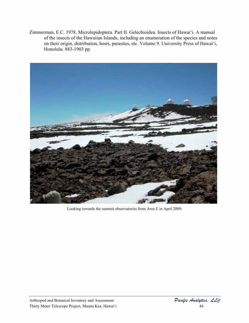
Arthropod and Botanical Inventory and Assessment Pacific Analytics, LLC Thirty Meter Telescope Project, Mauna Kea, Hawai‘i 44
Zimmerman, E.C. 1978. Microlepidoptera. Part II. Gelechioidea. Insects of Hawai‘i. A manual of the insects of the Hawaiian Islands, including an enumeration of the species and notes on their origin, distribution, hosts, parasites, etc. Volume 9. University Press of Hawai‘i, Honolulu. 883-1903 pp.
Looking towards the summit observatories from Area E in April 2009.

Arthropod and Botanical Inventory and Assessment Pacific Analytics, LLC Thirty Meter Telescope Project, Mauna Kea, Hawai‘i A-1
APPENDIX A Results of the Thirty Meter Telescope Proposed Site Evaluation for the
Wekiu Bug (Nysius wekiuicola): Fall 2008.
Technical Report prepared by Jesse Eiben, M.S.
© Pacific Analytics, LLC 2003

Arthropod and Botanical Inventory and Assessment Pacific Analytics, LLC Thirty Meter Telescope Project, Mauna Kea, Hawai‘i A-2
Results of the Thirty Meter Telescope Proposed Site Evaluation for the Wekiu Bug (Nysius wekiuicola): Fall 2008
Prepared for: Pacific Analytics, LLC
PO Box 1064 Corvallis, OR 97339
Prepared by: Jesse Eiben, M.S. 3785 Old Pali Rd.
Honolulu, HI 96817

Arthropod and Botanical Inventory and Assessment Pacific Analytics, LLC Thirty Meter Telescope Project, Mauna Kea, Hawai‘i A-3
Summary A four day sampling regime with the use of 45 baited attractant live traps designed for monitoring the presence and absence of the Wekiu bug (Nysius wekiuicola Ashlock and Gagné) was used to create part of the biological assessment of a proposed site for the Thirty Meter Telescope on Maunakea, Hawai‘i. Three Wekiu bugs were captured and counted before being released at the end of the sampling period on September 28, 2008. No Wekiu bugs were found in the area purported to be directly physically impacted by any possible observatory construction activity. The fall season is not the best time to look for the presence or absence of the Wekiu bug anywhere in its range, so there can be only limited conclusions drawn from this sampling period. However, there is broad accord among scientists that the type of rock substrate in the Northern Plateau is not known to regularly harbor large numbers of Wekiu bugs.
Introduction As part of a project by Pacific Analytics, LLC for the Thirty Meter Telescope Project, I have been contracted to sample for the Wekiu bug in areas selected as possible sites for Project construction on the Northern Plateau of Maunakea. This project is different from, yet is informed by, scientific research I am conducting for my PhD in entomology at the University of Hawai‘i at Manoa involving the life history and population genetics of the Wekiu bug.
The Wekiu bug, Nysius wekiuicola Ashlock and Gagné, on the Island of Hawai‘i has been the focus of much attention in its native range on and near the summit of Hawai‘i’s tallest mountain, Maunakea. Since the bug’s formal description in 1983 by Ashlock and Gagné, the bug’s habitat and life history has been of great interest to scientists, conservationists, and the public as a whole. The specialized life history allowing the Wekiu bug to survive the extremes of temperature, solar radiation, and water and food availability make this insect a true marvel of adaptation. Due to its limited range, specialized habitat requirements, isolated populations, and habitat destruction, the Wekiu bug was is currently a candidate for listing priority 8 under the Endangered Species Act (Endangered, 2006). Explorations of the summit area over the past 10 years by entomologists representing the Bishop Museum, Pacific Analytics, LLC, and the University of Hawai‘i at Manoa have greatly enhanced our knowledge of the types of areas Wekiu bugs inhabit, their behaviors and life history (Pacific Analytics, 2006, Englund et al. 2007, Eiben, unpublished).
The objectives for this study are to provide presence and absence data of the Wekiu bug in a subset of its range on and near the summit of Maunakea as part of the biological assessment of a potential site for a new observatory in the Astronomy Precinct being prepared by Pacific Analytics, LLC.
Materials and Methods
Study Area: The area of Maunakea being sampled for Wekiu bugs is known as Area E on the Northern Plateau of the mountain. In practical terms, the area encompasses a part of the west and northwest zone of the Astronomy Precinct on the summit of Maunakea. Specific locations for wekiu bug live-trap placements were haphazardly selected in Area E, along the 4-wheel drive road to Area E, around the Batch Plant, and in two control locations not in the expected

Arthropod and Botanical Inventory and Assessment Pacific Analytics, LLC Thirty Meter Telescope Project, Mauna Kea, Hawai‘i A-4
construction disturbance areas where Wekiu bugs have been found multiple times in 2007 and 2008 (Eiben, unpublished).
Trapping Methods: A live pitfall trap design very similar to those described by Englund et al. (2002) and Pacific Analytics (2002) was used to attract Wekiu bugs. The modifications in design are as follows. Two 10oz clear plastic cups were used for each trap. The upper cup was punctured with one small hole in the bottom center through which a small absorbent wick made of tissue (Kimtech Science) was pushed. A small amount of water was poured into the bottom of the lower reservoir cup. The attractant shrimp paste was placed in the upper cup contacting the wick, on a few small pieces of rock in the cup, smeared on the side of the cup, and on a cap rock. The traps were dug into the available ground substrate attempting to achieve a depth where moisture was present in the ash layer. The lip of the cup was not necessarily placed flush with ash layer, and there was no wire mesh surround to provide structure surrounding the cups. This cup design has been successful for attracting and capturing Wekiu bugs during 2007 and 2008 (Eiben, unpublished). Most sites selected for sampling used a pair of traps within 16.4 feet of each other in different microhabitat types (ex. large rock jumble vs. ash layer near the surface) to attempt to sample the true diversity of the habitat (see Tables 1 and 2). The traps were checked daily and bugs captured were removed for the duration of the sampling period to prevent recounts. Bugs were held for up to three days in captivity with food and water sources.
Results No Wekiu bugs were observed while hiking through the trapping areas, nor were any Wekiu bugs observed while emplacing the traps. Forty-five traps were placed for three or four days from September 25-28. Three Wekiu bugs were captured in two locations over the sampling period (see Table 1, Table 2, and Figure 1). One adult female and one 5th instar nymph Wekiu bug were captured in the control area near the SE base of Puu Hau Oki on September 26, 2008. One 5th instar nymph Wekiu bug was found in the control area on the E base area of Puu Poliahu on September 28, 2008. All three Wekiu bugs found in the traps were alive and were released alive in good condition where they were captured on September 28, 2008.
Discussion Though the sampling effort (number of traps) for Wekiu bugs during this sampling period was quite intense given the area surveyed, there can be little information drawn from the lack of bugs found in Area E. During the fall season, the number of Wekiu bugs found on Maunakea throughout its range are much less than during other times of the year. The reason for this is unknown. Wekiu bugs are found in much higher numbers during the late spring and early summer, and these areas are correlated to lasting snow pack (Englund et al. 2007). The duration and availability of moisture sources may indeed be a limiting factor for the year-round distribution of the Wekiu bug within its range. The spring sampling period of Area E should be much more informative for determining the presence or absence of the Wekiu bug in the possible construction zone for the Project.
Acknowledgements I would like to thank Greg Brenner of Pacific Analytics, LLC for his help in the field and valuable insights about the Wekiu bug and its habitat. Betsy Gagné at DLNR has proven

Arthropod and Botanical Inventory and Assessment Pacific Analytics, LLC Thirty Meter Telescope Project, Mauna Kea, Hawai‘i A-5
instrumental in obtaining permits for all work relating to the genus Nysius in Hawai‘i. The support of Stephanie Nagata at OMKM is crucial to all work involving the Wekiu bug and is always most helpful.

Arthropod and Botanical Inventory and Assessment Pacific Analytics, LLC Thirty Meter Telescope Project, Mauna Kea, Hawai‘i A-6
Table 1. Detail of baited shrimp trap locations and wekiu bug captures during September, 2008
Site Description Trap Name Paired GPS Coordinates (NAD83) Wekiu Bug Captures traps 25-Sep-08 26-Sep-08 27-Sep-08 28-Sep-08 Site 1 footprint TMT1A Yes 19°49'57.22"N 155°28'52.93"W Install 0 0 0 Site 1 footprint TMT1B Yes Install 0 0 0 Site 1 footprint TMT2A Yes 19°49'57.90"N 155°28'53.69"W Install 0 0 0 Site 1 footprint TMT2B Yes Install 0 0 0 Site 1 footprint TMT3A Yes 19°49'56.35"N 155°28'53.65"W Install 0 0 0 Site 1 footprint TMT3B Yes Install 0 0 0 Site 1 footprint TMT4A Yes 19°49'55.42"N 155°28'53.08"W Install 0 0 0 Site 1 footprint TMT4B Yes Install 0 0 0 Site 1 footprint TMT5A Yes 19°49'53.80"N 155°28'52.97"W Install 0 0 0 Site 1 footprint TMT5B Yes Install 0 0 0 Road TMT6A Yes 19°49'52.46"N 155°28'53.04"W Install 0 0 0 Road TMT6B Yes Install 0 0 0 Road TMT7A Yes 19°49'51.67"N 155°28'50.74"W Install 0 0 0 Road TMT7B Yes Install 0 0 0 Site area TMT8A Yes 19°49'52.10"N 155°28'49.69"W Install 0 0 0 Site area TMT8B Yes Install 0 0 0 Site area TMT9A Yes 19°49'52.68"N 155°28'48.22"W Install 0 0 0 Site area TMT9B Yes Install 0 0 0 Site 2 footprint TMT10A Yes 19°49'41.02"N 155°28'46.45"W Install 0 0 0 Site 2 footprint TMT10B Yes Install 0 0 0 Site 2 footprint TMT11A Yes 19°49'41.84"N 155°28'45.01"W Install 0 0 0 Site 2 footprint TMT11B Yes Install 0 0 0 Site 2 footprint TMT12A Yes 19°49'43.10"N 155°28'44.08"W Install 0 0 0 Site 2 footprint TMT12B Yes Install 0 0 0

Arthropod and Botanical Inventory and Assessment Pacific Analytics, LLC Thirty Meter Telescope Project, Mauna Kea, Hawai‘i A-7
Table 2. Detail of baited shrimp trap locations and wekiu bug captures during September, 2008
Site Description Trap Name Paired GPS Coordinates (NAD83) Wekiu Bug Captures traps 25-Sep-08 26-Sep-08 27-Sep-08 28-Sep-08 Site 2 footprint TMT13A Yes 19°49'43.61"N 155°28'45.84"W Install 0 0 0 Site 2 footprint TMT13B Yes Install 0 0 0 Site 2 footprint TMT14A Yes 19°49'46.49"N 155°28'47.39"W Install 0 0 0 Site 2 footprint TMT14B Yes Install 0 0 0 Site Area TMT15A Yes 19°49'43.79"N 155°28'51.78"W Install 0 0 0 Site Area TMT15B Yes Install 0 0 0 Site Area TMT16A Yes 19°49'45.55"N 155°28'53.47"W Install 0 0 0 Site Area TMT16B Yes Install 0 0 0 Road TMT road1 No 19°49'28.63"N 155°28'40.01"W N/A Install 0 0 Road TMT road2 No 19°49'32.48"N 155°28'41.26"W N/A Install 0 0 Road TMT road3 No 19°49'38.27"N 155°28'44.31"W N/A Install 0 0 Road TMT road4 No 19°49'43.75"N 155°28'48.79"W N/A Install 0 0 Batch plant TMTbatch1A Yes 19°49'12.65"N 155°28'27.44"W N/A Install 0 0 Batch plant TMT batch1B Yes N/A Install 0 0 Batch plant TMT batch2A Yes 19°49'12.72"N 155°28'29.82"W N/A Install 0 0 Batch plant TMT batch2B Yes N/A Install 0 0 Batch plant TMT batch3 No 19°49'11.04"N 155°28'30.52"W N/A Install 0 0 Non-construction TMT Pol contA Yes 19°49'26.54"N 155°28'48.36"W N/A Install 0 1* Non-construction TMT Pol contB Yes N/A Install 0 0 Non-construction TMT Oki contA Yes 19°49'25.72"N 155°28'31.66"W Install 2** 0 0 Non-construction TMT Oki contB Yes Install 0 0 0 *one fifth instar nymph captured **one adult female and one fifth instar nymph captured

Arthropod and Botanical Inventory and Assessment Pacific Analytics, LLC Thirty Meter Telescope Project, Mauna Kea, Hawai‘i A-8
Figure 1. Overview map of study site sample locations within the Astronomy Precinct on
Maunakea, Hawai‘i *Astronomy Precinct outlined in purple **Green dots indicate Wekiu bug capture locations

Arthropod and Botanical Inventory and Assessment Pacific Analytics, LLC Thirty Meter Telescope Project, Mauna Kea, Hawai‘i A-9
References
Ashlock, P. D. and W. C. Gagné. 1983. A remarkable new micropterous Nysius species from the aeolian zone of Mauna Kea, Hawaii Island (Hemiptera: Heteroptera: Lygaeidae). International Journal of Entomology 25(1): 47-55.
Endangered and Threatened Wildlife and Plants; Review of Native Species That Are Candidates or Proposed for Listing as Endangered or Threatened; Annual Notice of Findings on Resubmitted Petitions; Annual Description of Progress on Listing Actions. 2006. Federal Register 71(176): 53756-53835.
Englund, R.A., D.A. Polhemus, F.G. Howarth and S.L. Montgomery. 2002. Range, habitat, and ecological notes on the wekiu bug (Nysius wekiuicola), a rare insect species unique to Mauna Kea, Hawai`i Island. Final report. Prepared for Office of Mauna Kea Management, University of Hawai‘i, Hilo. 49 pp.
Englund, R.A., Vorsino, R.A., Laederich, H. 2007. Results of the 2006 wekiu bug (Nysius wekiuicola) surveys on Mauna Kea, Hawai`i Island. Final report. Prepared for Office of Mauna Kea Management, University of Hawai‘i at Hilo, Hilo, Hawai`i. 66 pp.
Howarth, F. G. and F. D. Stone. 1982. An assessment of the arthropod fauna and aeolian ecosystem near the summit of Mauna Kea, Hawaii. Unpublished consultants' report prepared for Group 70, Honolulu, Hawai‘i. 18 pp.
Pacific Analytics. 2002. W�kiu bug baseline monitoring, June 2002 quarterly report. Consultants report prepared for The Outrigger Telescopes Project, WM Keck Observatory, Kamuela, Hawai‘i. 34 pp.
Pacific Analytics. 2006. Wekiu bug baseline monitoring: Quarterly report 1st quarter 2006. Prepared for The Outrigger Telescopes Project, WM Keck Observatory, Kamuela, Hawai‘i. 36 pp.
Porter, S.C and Englund, R.A. 2006. Possible geologic factors influencing the distribution of the wekiu bug on Mauna Kea, Hawai`i. Final Report. Prepared for Office of Mauna Kea Management, University of Hawai‘i at Hilo, Hawai`i. 32 pp.

Arthropod and Botanical Inventory and Assessment Pacific Analytics, LLC Thirty Meter Telescope Project, Mauna Kea, Hawai‘i B-1
APPENDIX B Results of the Thirty Meter Telescope Proposed Site Evaluation for the
Wekiu Bug (Nysius wekiuicola): Spring 2009.
Technical Report prepared by Jesse Eiben, M.S.
© Pacific Analytics, LLC 2003
Arthropod and Botanical Inventory and Assessment Pacific Analytics, LLC Thirty Meter Telescope Project, Mauna Kea, Hawai‘i B-2
Results of the Thirty Meter Telescope Proposed Site Evaluation for the Wekiu Bug (Nysius wekiuicola): Spring 2009
Prepared for: Pacific Analytics, LLC
PO Box 1064 Corvallis, OR 97339
Prepared by: Jesse Eiben, M.S. 3785 Old Pali Rd.
Honolulu, HI 96817

Arthropod and Botanical Inventory and Assessment Pacific Analytics, LLC Thirty Meter Telescope Project, Mauna Kea, Hawai‘i B-3
Summary A four day sampling regime with the use of 24 baited attractant live traps designed for monitoring the presence and absence of the Wekiu bug (Nysius wekiuicola Ashlock and Gagné) was used to create part of the biological assessment of a proposed site for the Thirty Meter Telescope on Maunakea, Hawai‘i. A total of 146 wekiu bugs were observed and/or captured between April 20 and 23, 2009. In the past, Wekiu bugs have often been captured in greater numbers during late March, April and May than during the summer and fall (Eiben pers. obs.). This cycle of Wekiu bug activity was confirmed during the two sampling periods for the proposed TMT site. Wekiu bugs were found in areas impacted previously by construction and in areas that are considered unaltered habitat. No Wekiu bugs were found in the area of the proposed construction footprint of the Project construction, however there were many Wekiu bugs found along the currently closed unpaved 4-wheel drive road north of the SMA array. This road may be impacted by Project construction, and Wekiu bug habitat and populations will need to be taken into consideration in the event of the road reopening. There is still broad accord among scientists that the type of rock substrate in the Northern Plateau is not known to regularly harbor large numbers of Wekiu bugs, and this was confirmed during the spring 2009 sampling session.
Introduction As part of a project by Pacific Analytics, LLC for the Thirty Meter Telescope, I have been contracted to sample for the Wekiu bug in areas selected as possible sites for observatory facility construction on the Northern Plateau of Maunakea. This project is different from, yet is informed by, scientific research I am conducting for my PhD in entomology at the University of Hawai‘i at Manoa involving the life history and population genetics of the Wekiu bug.
The Wekiu bug, Nysius wekiuicola Ashlock and Gagné, on the Island of Hawai‘i has been the focus of much attention in its native range on and near the summit of Hawai‘i’s tallest mountain, Maunakea. Since the bug’s formal description in 1983 by Ashlock and Gagné, the bug’s habitat and life history has been of great interest to scientists, conservationists, and the public as a whole. The specialized life history allowing the Wekiu bug to survive the extremes of temperature, solar radiation, and water and food availability make this insect a true marvel of adaptation. Due to its limited range, specialized habitat requirements, isolated populations, and habitat destruction, the Wekiu bug is currently a candidate for listing priority 8 under the Endangered Species Act (Endangered, 2006). Explorations of the summit area over the past 10 years by entomologists representing the Bishop Museum, Pacific Analytics, LLC, and the University of Hawai‘i at Manoa have greatly enhanced our knowledge of the types of areas Wekiu bugs inhabit, their behaviors and life history (Pacific Analytics, 2006, Englund et al. 2007, Eiben, unpub.).
The objectives for this study are to provide presence and absence data of the Wekiu bug in a subset of its range on and near the summit of Maunakea as part of the biological assessment of a potential site for a new observatory in the Astronomy Precinct being prepared by Pacific Analytics, LLC.

Arthropod and Botanical Inventory and Assessment Pacific Analytics, LLC Thirty Meter Telescope Project, Mauna Kea, Hawai‘i B-4
Materials and Methods
Study Area: The area of Maunakea being sampled for Wekiu bugs is known as Area E on the Northern Plateau of the mountain. In practical terms, the area encompasses a part of the west and northwest zone of the Astronomy Precinct on the summit of Maunakea. Specific locations for Wekiu bug live-trap placements were haphazardly selected in Area E in the proposed footprint sites of the TMT Project, along the 4-wheel drive road to Area E, around the Batch Plant, and in two control locations not in the expected construction disturbance areas where Wekiu bugs have been found multiple times in 2007 and 2008 (Eiben, unpublished).
Trapping Methods: A live pitfall trap design very similar to those described by Englund et al. (2002) and Pacific Analytics (2002) was used to attract Wekiu bugs. The modifications in design are as follows. Two 10oz clear plastic cups were used for each trap. The upper cup was punctured with one small hole in the bottom center through which a small absorbent wick made of tissue (Kimtech Science) was pushed. A small amount of water was poured into the bottom of the lower reservoir cup. The attractant shrimp paste was placed in the upper cup contacting the wick, on a few small pieces of rock in the cup, smeared on the side of the cup, and on a cap rock. The traps were dug into the available ground substrate attempting to achieve a depth where moisture was present in the ash layer. The lip of the cup was not necessarily placed flush with ash layer, and there was no wire mesh surround to provide structure surrounding the cups. This cup design has been successful for attracting and capturing Wekiu bugs during 2007 and 2008 (Eiben, unpublished). Most sites selected for sampling used a pair of traps within 5 meters of each other in different microhabitat types (ex. large rock jumble vs. ash layer near the surface) to attempt to sample the true diversity of the habitat (see Table 1). The traps were checked daily and bugs captured were removed for the duration of the sampling period to prevent recounts. Bugs were held for up to three days in captivity with food and water sources.
Results A total of 146 Wekiu bugs were observed in the baited traps and in the immediate vicinity of the traps. Twenty four traps were placed for three full days starting on April 20 and removed on April 23. No Wekiu bugs were captured or observed in the area known as Area E on the Northern Plateau (12 traps), nor near the Batch Plant area (2 traps), 41 Wekiu bugs were found in 6 traps along the dirt road that is currently closed adjacent to the SMA array, and 105 Wekiu bugs were captured in four traps in two control locations not in areas with any planned direct impacts by construction activities of the Project (see Table 1, and Figure 1). Five nymph, 102 adult male, and 39 adult female Wekiu bugs were captured in total. Twenty seven live Wekiu bugs captured in the two “Poi Bowl, Pu’u Hau ‘Oki” control trap sites were collected and moved to the University of Hawai‘i lab colony by myself, Jesse Eiben, as per my permit allowances for the life history study of the Wekiu bug. There was an 85 percent survivorship rate of Wekiu bugs trapped in this sampling period with eighteen Wekiu bugs found dead in the traps, and four Wekiu bugs dying in captivity.

Arthropod and Botanical Inventory and Assessment Pacific Analytics, LLC Thirty Meter Telescope Project, Mauna Kea, Hawai‘i B-5
Discussion The sampling effort during the spring sampling session was less intense (24 traps vs. 45 traps) than the fall sampling period because the spring is typically the active season for adult Wekiu bugs. As expected, we observed much higher trapping rates than in the fall of 2008 when Wekiu bugs are scarce and/or not attracted to traps. The weather at the summit during the sampling period of April 20-23, 2009 was quite cold and windy with the daytime high air temperature hovering only slightly above freezing at 34-41ºF and wind gusts up to 94 mph with ~45mph constant wind speeds. The lower trap catches on April 22 could be correlated to the overcast sky the previous day. Wekiu bugs were less likely to be active during the time between the traps were checked because they were simply too cold to be attracted and move in high numbers toward the baited traps on April 21st. Important to note is the complete lack of any recent wind deposited insect food sources for the Wekiu bugs. Virtually no by-catch of other insects was found in the traps, and the snow-covered areas of the mountain observed were bereft of insects.
Wekiu bugs were captured in places characterized as having large areas with an assemblage of different sized rock cinder scoria in a depth of approximately 2-10 inches before the ash layer was reached. This mixed rock tephra is found on the slopes of cinder cones. The areas where Wekiu bugs are found show a constant state of flux, with the scoria slowly moving down slope by the force of gravity and undergoing frost-heaves that continually ‘sift’ dust and ash down in depth thereby creating a natural and very slow sorting of rock scoria with larger rocks nearer the surface and smaller cinders being closer to the ash layer. This habitat type is apparently highly suitable for supporting populations of Wekiu bugs. There are many interconnected reasons why Wekiu bugs are associated with specific type of habitat. Wekiu bugs can use this depth of different sized cinder to thermoregulate by moving through the innumerable crevices that the assortment of rocks create. These crevices also provide paths for escape from predators (most likely the endemic lycosid spider). Temperature and humidity data show the incredible variation found in these few inches of rock, with humidity and temperature being oppositely correlated. Near the ash layer, the temperature is cool with high humidity, and at the surface where Wekiu bugs can bask in the sun, the temperature can be very high (up to 114º F) with extremely low humidity (10 percent) (Eiben unpublished). These microhabitats are necessary for the Wekiu bug physiologically, but can also create areas that hold and preserve prey items on which Wekiu bugs feed. As insects drop from the wind column and sift through the scoria, they can become protected from the intense desiccating conditions found at the surface. Of the traps that attracted Wekiu bugs, some traps were placed in areas with very little depth of this type of cinder tephra, however, since the effective range of these traps is unknown, the bugs could be attracted from adjacent deep cinder zones.
It has previously been shown that Wekiu bugs are found in much higher numbers during the late spring and early summer, and these areas are correlated to lasting snow pack (Englund et al. 2007). During this trapping session and others (Eiben, unpublished), it is apparent that Wekiu bugs are often found in areas that have no current adjacent snow pack (along the dirt road north of SMA, and at the lower trap sites on Pu’u Poliahu and Pu’u Hau ‘Oki). The duration and availability of moisture sources may indeed be a limiting factor for the year-round distribution of the Wekiu bug within its range. When discussing insect populations and habitats, it essential to be cognizant that the individual organism does not seek out and use habitat on a very large scale. Population growth in an area will be at the whim of the food and climate (microclimate)

Arthropod and Botanical Inventory and Assessment Pacific Analytics, LLC Thirty Meter Telescope Project, Mauna Kea, Hawai‘i B-6
available. This is especially true on Maunakea, where weather events can drastically change the time and duration of activity possible and availability of fresh prey items for Wekiu bugs.
Acknowledgements I would like to thank Greg Brenner of Pacific Analytics, LLC for his help in the field and valuable insights about the Wekiu bug and its habitat. Betsy Gagné at DLNR has proven instrumental in obtaining permits for all work relating to the genus Nysius in Hawai‘i. The support of Stephanie Nagata at OMKM is crucial to all work involving the Wekiu bug and is always most helpful.

Arthropod and Botanical Inventory and Assessment Pacific Analytics, LLC Thirty Meter Telescope Project, Mauna Kea, Hawai‘i B-7
Table 1. Detail of baited shrimp trap locations and wekiu bug captures during April, 2009
Site Description Trap Name Paired GPS Coordinates (NAD83) Wekiu Bug Captures traps 20-Apr-09 21-Apr-09 22-Apr-09 23-Apr-09 TOTALS SMA Access Road STMTR1-A No N19 49.482 W155 28.648 Install 9 0 3 = 12 SMA Access Road STMTR1-B No N19 49.481 W155 28.653 Install 3 0 7 = 10 SMA Access Road STMTR2-A No N19 49.505 W155 28.659 Install 2 0 5 = 7 SMA Access Road STMTR2-B No N19 49.503 W155 28.656 Install 1 1 2 = 4 SMA Access Road STMTR3-A No N19 49.549 W155 28.679 Install 1 0 6 = 7 SMA Access Road STMTR3-B No N19 49.549 W155 28.686 Install 0 0 1 = 1 Site 1 Footprint STMTF1-A Yes N19 49.968 W155 28.880 Install 0 0 0 0 Site 1 Footprint STMTF1-A Install 0 0 0 0 Site 1 Footprint STMTF1-B Yes N19 49.975 W155 28.895 Install 0 0 0 0 Site 1 Footprint STMTF1-B Install 0 0 0 0 Site 1 Footprint STMTF1-C Yes N19 49.932 W155 28.898 Install 0 0 0 0 Site 1 Footprint STMTF1-C Install 0 0 0 0 Site 2 Footprint STMTF2-A Yes N19 49.903 W155 28.887 Install 0 0 0 0 Site 2 Footprint STMTF2-A Install 0 0 0 0 Site 2 Footprint STMTF2-B Yes N19 49.908 W155 28.853 Install 0 0 0 0 Site 2 Footprint STMTF2-B Install 0 0 0 0 Site 2 Footprint STMTF2-C Yes N19 49.885 W155 28.849 Install 0 0 0 0 Site 2 Footprint STMTF2-C Install 0 0 0 0 Batch Plant STMTbatch Yes N19 49.175 W155 28.492 Install 0 0 0 0 Batch Plant STMTbatch Install 0 0 0 0 Non-Construction STMTPol-A Yes N19 49.448 W155 28.802 Install - 1 14 6 21 = 42 Non-Construction STMTPol-B Install 2 0 1 = 3 Non-Construction STMTPoi-A Yes N19 49.429 W155 28.517 Install 6 13 16 = 35 Non-Construction STMTPoi-B Install 3 5 17 = 25
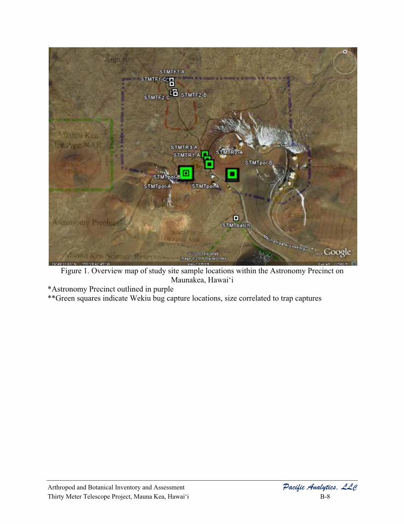
Arthropod and Botanical Inventory and Assessment Pacific Analytics, LLC Thirty Meter Telescope Project, Mauna Kea, Hawai‘i B-8
Figure 1. Overview map of study site sample locations within the Astronomy Precinct on
Maunakea, Hawai‘i *Astronomy Precinct outlined in purple **Green squares indicate Wekiu bug capture locations, size correlated to trap captures

Arthropod and Botanical Inventory and Assessment Pacific Analytics, LLC Thirty Meter Telescope Project, Mauna Kea, Hawai‘i B-9
References
Ashlock, P. D. and W. C. Gagné. 1983. A remarkable new micropterous Nysius species from the aeolian zone of Mauna Kea, Hawaii Island (Hemiptera: Heteroptera: Lygaeidae). International Journal of Entomology 25(1): 47-55.
Endangered and Threatened Wildlife and Plants; Review of Native Species That Are Candidates or Proposed for Listing as Endangered or Threatened; Annual Notice of Findings on Resubmitted Petitions; Annual Description of Progress on Listing Actions. 2006. Federal Register 71(176): 53756-53835.
Englund, R.A., D.A. Polhemus, F.G. Howarth and S.L. Montgomery. 2002. Range, habitat, and ecological notes on the wekiu bug (Nysius wekiuicola), a rare insect species unique to Mauna Kea, Hawai`i Island. Final report. Prepared for Office of Mauna Kea Management, University of Hawai‘i, Hilo. 49 pp.
Englund, R.A., Vorsino, R.A., Laederich, H. 2007. Results of the 2006 wekiu bug (Nysius wekiuicola) surveys on Mauna Kea, Hawai`i Island. Final report. Prepared for Office of Mauna Kea Management, University of Hawai‘i at Hilo, Hilo, Hawai`i. 66 pp.
Howarth, F. G. and F. D. Stone. 1982. An assessment of the arthropod fauna and aeolian ecosystem near the summit of Mauna Kea, Hawaii. Unpublished consultants' report prepared for Group 70, Honolulu, Hawai‘i. 18 pp.
Pacific Analytics. 2002. W�kiu bug baseline monitoring, June 2002 quarterly report. Consultants report prepared for The Outrigger Telescopes Project, WM Keck Observatory, Kamuela, Hawai‘i. 34 pp.
Pacific Analytics. 2006. Wekiu bug baseline monitoring: Quarterly report 1st quarter 2006. Prepared for The Outrigger Telescopes Project, WM Keck Observatory, Kamuela, Hawai‘i. 36 pp.
Porter, S.C and Englund, R.A. 2006. Possible geologic factors influencing the distribution of the wekiu bug on Mauna Kea, Hawai`i. Final Report. Prepared for Office of Mauna Kea Management, University of Hawai‘i at Hilo, Hawai`i. 32 pp.
Arthropod and Botanical Inventory and Assessment Pacific Analytics, LLC Thirty Meter Telescope Project, Mauna Kea, Hawai‘i C-1
APPENDIX C MAUNAKEA REPORT
The lichens and bryophytes in the proposed Thirty Meter Telescope sites at the summit of Maunakea, Hawai‘i
Technical Report prepared by Clifford Smith, Emeritus Professor in Botany,
University of Hawai‘i at Manoa.
© Pacific Analytics, LLC 2003

Arthropod and Botanical Inventory and Assessment Pacific Analytics, LLC Thirty Meter Telescope Project, Mauna Kea, Hawai‘i C-2
MAUNAKEA REPORT The lichens and bryophytes in the proposed Thirty Meter Telescope sites at the summit of
Maunakea, Hawai‘i. Clifford W. Smith, Emeritus Professor in Botany, University of Hawai‘i at Manoa, 3190 Maile Way #410, Honolulu HI 96822. (Email: [email protected]).
INTRODUCTION The summit area of Maunakea is barren land of massive cinder cones above andesite lava flows that erupted during the last period of glaciation; the lava flows erupting below the glacier cooled without crystallizing creating a particularly dense rock (Anon xxxx). The average daytime maximum air temperature is 50.1ºF and the low 24.8ºF; it freezes almost every night of the year (NOAA 2008). Such fluctuations are often referred to as ‘summer every day, winter every night.’ The average annual rainfall is 74 inches/year principally from November through April with little rain during June and July. Snow accumulates during the winter months sufficient for skiing but accumulation records have not been kept. UV radiation is intense; records from the Mauna Loa Observatory at 11,135 foot elevation are much higher than at sea level and will be higher still on the summit area of Maunakea (Bodhaine et al. 1997). Winds at the summit can reach 100 mph sufficient to abrade vegetation from rock surfaces (Anon xxxx).
In a general botanical survey of the summit area above 12,992 feet, Smith et al. (1982) recorded one species of algae, no hornworts or liverworts, possibly 12 species of moss, possibly 25 species of lichen, one fern and five flowering plants. All species occurred in very low abundance though there were very small, highly protected pockets where the lichens and mosses were common.
This survey was confined to a much smaller 40-acre area of the North Plateau.
STUDY SITE The study site was the area being considered for the Thirty Meter Telescope just below the summit of Maunakea, Island of Hawai‘i. The area surveyed is called Area E, a 34-acre zone near the 13N Site located on the North Plateau of the Mauna Kea Science Reserve (MKSR).
METHODOLOGY We spent two days in the area walking through the whole site recording all lichens and bryophytes observed. We search all four principal habitat types and spent some extra time investigating the small caves taking particular care not to disturb anything that looked of archaeological significance. We replaced all rocks that were picked up for examination as precisely as possible. We did disturb some of the rocks on the ground as we slide into the caves. We walked as much as possible on the large rocks and flows to prevent disturbance as well as for safety reasons.
The undersurface of 25 rocks of varying size were examined for lichens in rubble habitats. Counts were made of lichens present on the undersurface of rocks in the rubble areas to quantify abundance in these areas.
We removed small samples of all species found. Voucher specimens will be deposited in the B. P. Bishop Museum in Honolulu, Hawai‘i. Larger specimens were collected of species of whose

Arthropod and Botanical Inventory and Assessment Pacific Analytics, LLC Thirty Meter Telescope Project, Mauna Kea, Hawai‘i C-3
identity we were uncertain so they could be sent to other lichen experts for confirmation of their identity.
HABITAT DESCRIPTION
Substrate types
� Pahoehoe.- About 50% of the habitat was of this type. The general topography was essentially flat and smooth with many folds. The edges of the folds were steep and rounded. There were several areas where the flow had shattered, fallen away creating small cliff-like faces. In several areas particularly at the head of small draws that typically radiated away from the mountain top in a northerly direction, small caves were found which ranged from about one foot to almost six feet deep.
� Aa.- No aa was found in the study area.
� Ash.- Small areas of ash was found in about 10% of the area.
� Rubble of shattered stones - This environment constituted about 40% of the habitat. Because lichens can grow on the undersurface of rocks we counted the number of rocks on their undersurface. We selected three different situations; stones with somewhat embedded in ash, stones where ash subsurface stones rested on ash, stones where there was no evident between or below the stones. Twenty five stones were overturned and examined for lichens and then replaced in their original position, Stones of various sizes were examined. Lichens were found only in the group where ash was not evident. In all but one instance the only lichen found was Lecanora polytropa and none of the thalli were fertile.
Rock surface There are two apparent rock types in the study area a dense bluish coloured rock that breaks with a smooth surface with very few cracks or bubble cavities and a brown rock with a rougher surface and numerous bubble cavities. Both are andesite rock formed under the ancient summit glacier. The rocks are acidic and low in calcium.
Topography The overall topography is approximately 10º slope with a sharp decline to a lower plateau on the eastern side. The slope increases at the northern edge of the study.
� Site 1 has less andesite rock, at least there is less exposed smooth, blue rock, there are also several small ‘draws’ leading down the mountain. They do not appear to be drainage channels. They are important habitat because it is at the head of these draws that one finds good lichen habitat on the rock face and in the small caves underneath.
� Site 2 has large areas of andesite rock with many clean faces of the smooth, blue andesite rock. The draws are much wider here and do not support as good lichen communities.
Temperature The average monthly temperatures at the summit range from -5 to 13ºC (NOAA 2008).

Arthropod and Botanical Inventory and Assessment Pacific Analytics, LLC Thirty Meter Telescope Project, Mauna Kea, Hawai‘i C-4
Average Maximum Temperature (1971-2000). Jan Feb Mar Apr May Jun Jul Aug Sep Oct Nov Dec
Av. (ºF) 42.0 42.5 40.3 41.4 47.5 49.3 50.9 49.9 50.5 48.3 45.1 42.7 46.0 (ºC) 5.6 5.8 4.6 5.2 8.6 9.6 10.5 9.9 10.3 9.1 7.3 5.9 7.8 Average Minimum Temperature (ºF) 26.3 26.1 24.9 26.2 29.0 29.4 30.3 30.9 31.3 29.5 27.8 27.6 28.4 (ºC) -3.2 -3.3 -3.9 -3.2 -1.7 -1.4 -0.9 -0.6 -0.4 -1.4 -2.3 -2.4 -2.0 There is a notable, as yet unmeasured, difference in the temperature of exposed (hot) and shaded (cold) areas of rock faces. The difference is quite abrupt particularly where the aspect of the rock face changes abruptly.
Rainfall (NOAA 2008) Average Precipitation (1971-2000)
Jan Feb Mar Apr May Jun Jul Aug Sep Oct Nov Dec Av. (in.) 0.85 0.15 1.07 0.48 0.97 0.12 0.20 0.75 0.62 0.53 1.26 0.42 7.41 (mm) 216 38 272 122 246 30 51 190 157 135 320 107 1882
SPECIES LIST
Lichens Acarospora c.f. depressa. Small light brown areoles (<3 mm diam.). Not fertile. On the underside of a 15 × 7 cm piece or rubble. Probably much more common lower down. Candelariella cf. vitellina Orange crust rarely more than 1 cm diam. of compact rounded areoles or isolated apothecia. Not fertile. On consolidated ash or Grimmia tussocks in well-sheltered situations exposed to light but not in positions where it is exposed to full sunlight for long periods. A cosmopolitan species on siliceous and non-calcareous rock. The size and clumped, almost erect, nature of the areoles and their separation from the apothecia might suggest that this is a different species. However, the K- staining reaction clearly excludes the possibility that it is a species of Caloplaca. The somewhat unusual growth form may be a

Arthropod and Botanical Inventory and Assessment Pacific Analytics, LLC Thirty Meter Telescope Project, Mauna Kea, Hawai‘i C-5
consequence of the unfavorable environment where the squamules rarely divide but continue to grow. Lecanora polytropa Thallus of small, often indistinct areoles to somewhat continuous yellow-green crusts with frequent apothecia. The apothecia sessile, the margin the same color as the thallus, the disc paler with a somewhat greasy appearance, often partly or completely grayish to black, frequently completely overlapping the areole. On rock in cracks or on Grimmia tussocks in open situations and at the mouth of overhangs. It is also found on the undersurface of rocks in the rubble areas. A cosmopolitan species on siliceous rock. The most widely distributed species in the study area. Lecanora sp. One small (1 cm diam.) thallus of compact white squamules most covered with large apothecia with concolorous margins and 1 mm diam., light buff discs. On a small rock chip among consolidated ash amongst Grimmia. Lepraria ?incana A thin crust of small gray to blue-gray granules with a delicate intervening web of white hyphae. In deep shade of small caves. Generally on the floor but toward the cave mouth also on the roof. The species prefers shaded habitats and is not tolerant of direct rainfall. It requires the very humid conditions found in the protected caves and can absorbed moisture when the relative humidity is higher than 70 percent. Cosmopolitan. Confirmation awaiting chemistry. Pseudephebe minuscula Colonies up to 5 cm diam., black, richly branched, prostrate, closely appressed to the rock face, thread-like, wiry. Not fertile. On exposed, N-facing, vertical or almost so, rock faces. It was only found on the smooth rock face of exposed andesite rock. Common on sheer north-facing rocks at the head of the small draws and occasionally more open areas. Arctic-alpine, circumboreal. Rhizocarpon geographicum An immediately recognizable species of small yellow areoles surrounded by a black hypothallus, with occasional apothecia in the middle or to the edge of the areoles. On exposed, N-facing, vertical or almost so, rock faces. It was only found on the smooth rock face of exposed andesite rock. Cosmopolitan. Arctic-alpine, montane in the tropics. Not common.

Arthropod and Botanical Inventory and Assessment Pacific Analytics, LLC Thirty Meter Telescope Project, Mauna Kea, Hawai‘i C-6
Rhizocarpon sp. Small colonies (1-2 cm diam.) of brown, shiny areoles <0.5 mm diam., interspersed with a black hypothallus. On exposed, N-facing, vertical or almost so, rock faces. It was only found on the smooth rock face of exposed andesite rock. Reminiscent of R. hochstetteri but no apothecia were found. Umbilicaria aprina Small (1-2 cm diam.), gray to black thalli generally closely appressed to the rock face but with ascending edges where crowded, the upper surface with large white crystals particularly along ridges. Attached at one point only (umbilicate). Not fertile. On exposed, N-facing, vertical or almost so, rock faces. It was only found on the smooth rock face of exposed andesite rock. Abundant in a few areas. Also known in greater abundance and size particularly where protected from continuous insolation in the summit area down to at least 3660m. Found on high tropical mountain in Africa and also in Scandinavia and Greenland. The thalli are attached along cracks or in a few small gas pockets on the rock surface. Umbilicaria hirsuta Very similar to U. aprina but the upper surface is brown and there are no crystals on the upper surface. Only one colony was found mixed in with U. aprina A cosmopolitan species found in greater abundance at lower elevations. Lichen Abundance Estimates: Counts of lichens present on the undersurface of 25 rocks in the rubble areas.
Embedded rocks. No lichens in two separate situations. Rocks over ash. Lecanora polytropa under two rocks in one sample, 0 in the other. Rocks not over apparent ash. Lecanora polytropa under ten or 12 rocks in the two samples as well as being on rocks under the rocks examined. Acarospora sp. under one rock.
Bryophytes Grimmia ?pulvinatum Small tussocks of grayish moss with black leaves and a fine white terminal hair. On consolidated ash in well-sheltered situations exposed to light but not in positions where it is exposed to full sunlight for long periods. Pohlia cruda Small tussocks of green moss often with an orange tinge. On consolidated ash in well-sheltered situations exposed to light but not in positions where it is exposed to full sunlight for long periods.

Arthropod and Botanical Inventory and Assessment Pacific Analytics, LLC Thirty Meter Telescope Project, Mauna Kea, Hawai‘i C-7
GENERAL COMMENTS � The lichens and bryophytes are confined to protected habitats almost always on the north-
facing sides of rocks or the head of small collapsed lava tubes.
� There is an extremely low cover (<1 percent) and diversity of lichens (10 species out of a currently known 612 species in the islands) and bryophytes (2 species out of a currently known 273 species in the islands) in the area. In sheltered, amenable habitats, lichens are locally common.
� The distribution of the different lichens is thought to reflect their ability to tolerate UV irradiation, overall light intensity and the availability of water, both liquid and gaseous.
� There is a marked difference in the distribution of the various lichens. The dark to black species (Rhizocarpon ?hochstetteri, Pseudephebe miniscula, Umbilicaria aprina and U. hirsuta) are found on the open face of northern facing rocks, (Candelariella vitellina, Lecanora polytropa and Lecanora sp.) at the base of northern facing rocks and (Lepraria ?incana) on the roof of the small lava tubes or deeper inside the tube). The presence of the dark species in the most exposed inhabited areas is in keeping with McEvoy, M., Gauslaa, Y. & Solhaug, K.A. (2007) finding that melanic pigments play a photoprotective role in light acclimation. The other species do not have such protection though the apothecia and areoles of L. polytropa are often light to dark grey in more exposed situations. Lepraria species frequently grow in protected shaded and humid habitats.
� Concise determinations of some species is not possible under the time constraints of this study even though fruiting bodies may be present. Species growing in such severe habitats, particularly those growing on rocks, produce spores only during favorable conditions. The only sure way of finding good specimens would be to conduct monthly collections for at least one year.
� None of the plants show evidence of feeding and there do not appear to be any obligate herbivores present. Therefore, the plants present do not appear to be necessary to support any herbivore trophic level.
� None of the lichen species present contain cyanobacteria so if nitrogen fixation is taking place up there none of it comes from lichens. Lichens on lava flows down below contribute to the nitrogen budget particularly the very common Stereocaulon vulcani.
RECOMMENDATIONS � Site E2, the upper, more southerly footprint site being considered for Project construction
is the preferred site from a cryptogamic point of view. The number of species is lower and the abundance of those present is lower. There is less sheltered habitat present.
� There is a greater abundance of lichens at the same elevation adjacent to the proposed sites where there are mounds of rocks rather than the solid flows present in the proposed sites.

Arthropod and Botanical Inventory and Assessment Pacific Analytics, LLC Thirty Meter Telescope Project, Mauna Kea, Hawai‘i C-8
CONCLUSIONS � There is a very low diversity and cover of plants in the study area.
� All of the species are found at somewhat lower elevations at least on the southern side of the mountain. None of the species are unique to Hawai‘i.
� Lichens and bryophytes are generally confined to the northerly aspect of rocks or under overhangs and even then the abundance of species is much higher in those facing north.
� The vascular plants appear to be confined to the western side of the larger pahoehoe flows.
� It was gratifying to note that much of the rubbish that was seen in the 1982 Survey of the summit area had been removed.
REFERENCES
Anon. (xxxx). Mauna Kea Science Reserve Master Plan; Final Environmental Impact Statement.
Bodhaine, B.A., Dutton, E.G., Hofmann, D.J., McKenzie, R.L. & Johnston P.V. (1997). UV measurements at Mauna Loa: July 1995 to July 1996. J. Geophysical Research 102(D15): 19,265–19,273.
Gauslaa, Y. & Solhaug, K.A. (2001). Fungal melanins as a sun screen for symbiotic green algae in the lichen Lobaria pulmonaria. Oecologia 126(4): 462-471.
Magnusson, A.H. (1941). New species of Cladonia and Parmelia from the Hawaiian Islands. Arkiv för Botanik\Ark. Bot. 30B(3): 1-9.
Magnusson, A.H. (1955). A catalogue of Hawaiian lichens. Ark. Bot. ser. 2 3(10): 223-402.
Magnusson, A.H. & Zahlbruckner, A. (1943). Hawaiian lichens I. The families Verrucariaceae to Peltigeraceae. Arkiv för Botanik\Ark. Bot. 31A(1): 1-96.
Magnusson, A.H. & Zahlbruckner, A. (1944). Hawaiian lichens. II. The families Lecideaceae to Parmeliaceae. Arkiv för Botanik\Ark. Bot. 31A(6): 1-109.
Magnusson, A.H. & Zahlbruckner, A. (1945). Hawaiian lichens III. The families Usneaceae to Physciaceae. Index. Arkiv för Botanik\Ark. Bot. 32A(2): 1-89.
McEvoy, M., Gauslaa, Y. & Solhaug, K.A. (2007). Changes in pools of depsidones and melanins, and their function, during growth and acclimation under contrasting natural light in the lichen Lobaria pulmonaria. New Phytologist 175(2): 271-282.
Smith, C.W., Hoe, W.J. & O’Connor, P.J. (1982). Botanical Survey of the Mauna Kea Summit above 13,000 ft. Honolulu, Bishop Museum.
Smith, C.W. (2001). The lichen genus Umbilicaria in the Hawaiian Islands. In: McCarthy, P.M., Kantvilas, G., Louwhoff, S.H.J.J. (eds.): Lichenological Contributions in Honour of Jack Elix. Bibliotheca Lichenologica, J. Cramer, Berlin, Stuttgart, pp. 389-394.
Arthropod and Botanical Inventory and Assessment Pacific Analytics, LLC Thirty Meter Telescope Project, Mauna Kea, Hawai‘i C-9
Staples, G.W., Imada, C.T., Hoe, W.J., & Smith, C.W. (2004). A revised checklist of Hawaiian mosses Tropical Bryology 25: 35-69.
NOAA Western Regional Climate Center (2008). Mauna Kea Observatory 1, Hawaii (516183), 1971-2000 Monthly Climate Summary. http://www.wrcc.dri.edu/summary/Climsmhi.html (accessed 10.10.2008).
Respectfully submitted, Clifford W. Smith

Arthropod and Botanical Inventory and Assessment Pacific Analytics, LLC Thirty Meter Telescope Project, Mauna Kea, Hawai‘i C-10
Mauna Loa Observatory (11,135 ft) Average Max. Temperature (ºF) 49.8 49.6 50.2 51.8 53.9 57.2 56.4 56.3 55.8 54.7 52.6 50.6 53.2
Average Min. Temperature (ºF) 33.3 32.9 33.2 34.6 36.6 39.4 38.8 38.9 38.5 37.8 36.2 34.3 36.2
Average Total Precipitation (in.) 2.39 1.53 1.73 1.28 1.01 0.49 1.16 1.49 1.34 1.14 1.74 1.98 17.30
Average Total SnowFall (in.) 0.0 1.0 0.3 1.3 0.0 0.0 0.0 0.0 0.0 0.0 0.0 1.0 3.7 Average Snow Depth (in.) 0 0 0 0 0 0 0 0 0 0 0 0 0
Bodhaine, B.A., Dutton, E.G., Hofmann, D.J., McKenzie, R.L. & Johnston P.V. (1997). UV measurements at Mauna Loa: July 1995 to July 1996. J. Geophysical Research 102(D15): 19,265–19,273.
Abstract A UV spectroradiometer was installed at Mauna Loa Observatory (MLO), Hawai‘i, in July 1995. This instrument, based on a commercially available double monochromator, uses a diffuser mounted as a horizontal receptor inside a quartz dome and views the whole sky. The instrument scans over the 290–450 nm spectral range with a band pass of about 1 nm for each 5° of solar zenith angle (SZA). The UV irradiances measured at MLO are much more intense than at low-altitude midlatitude locations. For observations at SZA 45° the erythemally weighted UV irradiances can exceed 21 W cm�2, which is approximately 15–20% greater than that seen at Lauder, New Zealand, for similar ozone amounts. The difference is primarily due to the higher altitude at MLO (3.4 km). For overhead Sun conditions at MLO the largest value of erythemal UV was 51.3 ± 3.1 W cm�2, which to our knowledge is the highest recorded any-where at the Earth's surface. UV irradiance is strongly correlated (inversely) with Dobson spectrophotometer total ozone measurements at MLO, with higher correlations at shorter wavelengths. The radiative amplification factor (RAF) for erythema at MLO is about 1.33 ± 0.2 at SZA 45°.
McEvoy, M., Gauslaa, Y. & Solhaug, K.A. (2007). Changes in pools of depsidones and melanins, and their function, during growth and acclimation under contrasting natural light in the lichen Lobaria pulmonaria. New Phytologist 175(2): 271-282.
Abstract ["In conclusion, the highly responsive melanic pigments play a photoprotective role in light acclimation, whereas the constant amount of depsidones across a wide spectrum of growth ranges and irradiances is consistent with herbivore defense functions."]


Final EIS: TMT Observatory Page L-1
Appendix L. Geological Technical Report


GEOLOGIC TECHNICAL REPORT
Thirty Meter Telescope Project
Island of Hawai‘i
Prepared by: John. P. Lockwood
Geohazards Consultants International, Inc. P.O. Box 479, Volcano, Hawai‘i 96785
Prepared for: Parsons Brinckerhoff
1001 Bishop Street, Suite 2400 Honolulu, Hawai‘i 96813
April 2009

i
Table of Contents Section Page
1.0 MAUNAKEA SUMMIT REGION .....................................................................................1 1.1 Regional Setting ...................................................................................................................1
1.1.1 Glacial History ...............................................................................................................1 1.1.2 Geologic Hazards ...........................................................................................................2
1.2 Geologic Description of Area E ...........................................................................................4 1.2.1 Glacial Features .............................................................................................................7 1.2.2 Geologic Cross-Section ...............................................................................................11 1.2.3 Soils, Slope Stability, and Construction Perspectives .................................................12 1.2.4 Descriptions of TMT Observatory Sites ......................................................................13 1.2.5 Summary Perspectives on Potential TMT Observatory Construction Sites ................14
1.3 Geologic Description of Area Surrounding Area E ...........................................................15 1.4 Potential Environmental Impact ........................................................................................15 1.5 Mitigation Measures ..........................................................................................................16
2.0 HALE P�HAKU TMT MID-LEVEL FACILITY AREA .............................................16 2.1 Introduction ........................................................................................................................16 2.2 Site Descriptions ................................................................................................................16
2.2.1 Area within Hale P�haku .............................................................................................16 2.2.2 HELCO Transformer Site ............................................................................................17
2.3 Summary ............................................................................................................................17
3.0 REFERENCES CITED .....................................................................................................17

1
1.0 Maunakea Summit Region Geohazards Consultants International, Inc. was requested to prepare a geologic study to evaluate the geologic substrate underlying the proposed sites for the Thirty Meter Telescope (TMT) Project. The principal focus of this report is to describe the geologically unique structures present within the areas being considered for the site of the TMT Observatory on Maunakea, and to evaluate their uniqueness relative to other similar areas on this great volcano.
We were also asked to evaluate the stability of the ground and any soils present as to suitability for construction activities, as well as to discuss geologic hazards that could impact facilities. This report is based on four days of field investigation at the sites, literature research, and inspection of available stereographic aerial photography and satellite imagery. A geologic field evaluation of comparable geologically unique features on Maunakea’s south summit area was also undertaken. Geologic perspectives relative to proposed TMT Mid-Level Facility in the Hale P�haku area are also given as an Addendum at the end of this report.
1.1 Regional Setting Maunakea is one of five volcanoes comprising the Island of Hawai‘i. This dormant shield volcano is the highest of the five, and the highest mountain in the interior Pacific basin. Because of its elevation, Maunakea’s summit has been repeatedly glaciated during the past few hundred thousand years, and preserves the best glacial record of any oceanic volcano on Earth. Maunakea has erupted 12 times within the last 10,000 years, and though it has been at least 4,600 years since its last eruption, it is anticipated that the volcano will erupt again at some time in the future; such an eruption would likely occur on the flanks of the volcano, below the summit and astronomical facilities. The geologic history of Maunakea was thoroughly discussed by Wolfe and others (1997) and in more general terms focusing on unique geologic features by Lockwood (2000).
1.1.1 Glacial History Maunakea’s glacial history was recognized early by Wentworth and Powers (1941) and has been well documented by Porter (1979a, 1979b, 1979c, 1987), and by Porter and others (1977). Although periods of abnormal cold and extensive glacial activity have characterized much of the past two million years on Earth, known as the Pleistocene Epoch, Maunakea only grew high enough to have been glaciated beginning a half million years ago. If present, however, glacial deposits of such older times are buried by younger volcanic rocks, and the earliest glacial deposits exposed are no older than 200,000 years (Wolfe and others, 1997), based on revised radiocarbon dating. The lava flow underlying Area E was erupted during the youngest period of glaciation, known as M�kanaka time. The M�kanaka ice cap completely covered the summit area down to about 12,000 feet between approximately 40,000 and 13,000 years ago, according to the latest radiocarbon-dating of glacial deposits (Wolfe and others, ibid.). The ice cap had an estimated area of around 27 square miles (Porter, 1979c), and was relatively thin at no more than 300 feet thick. The cinder cones of Maunakea’s summit likely projected above the glacier, although they were doubtless snow-covered most of the year. Porter believed that an ice-free

2
interglacial period separated M�kanaka time into an upper and lower period, but Wolfe and others dispute that conclusion and feel that glacial ice was always present during this period. Regardless, surface features of the flow surface in Area E show convincingly that these lavas were emplaced beneath glacial ice or snow.
1.1.2 Geologic Hazards The potential for renewed volcanic activity in this region is extremely remote. Maunakea last erupted about 4,600 years ago, and the volcano is considered to be dormant (Lockwood, 2000; Mullineux and others, 1987). Although Wolfe and others (1997) mapped a dozen separate post-glacial (post- 10,000 year old) eruptive vents on Maunakea’s middle flanks, none younger than 40,000 years occur in the summit area, and future eruptions will likely occur well below the summit and will not pose any direct threat to astronomical facilities.
The most significant geologic hazards that would potentially impact the TMT Observatory are related to seismic activity. Hawai‘i Island is one of the most seismically active areas on Earth, and about two dozen earthquakes with Magnitude 6 or greater have been documented on Hawai‘i since the devastating earthquakes of 1868; those that caused damage are listed in Table 1. Four major earthquakes have occurred on Hawai‘i since the first astronomical facilities were constructed on Maunakea (1975 – M=7.2; 1983 – M=6.7; 1989 – M=6.1; 2006 – M=6.7). The first three of these only caused minor impact to then existing astronomical facilities, but the epicenter of the M=6.7 earthquake in 2006 was closer to the Maunakea summit than the others (Robertson and others, 2006), involved Peak Ground Acceleration forces of up to 0.26 g, and caused minor to significant damages to the Keck, Subaru, UH 88 and CFHT observatories. The Keck observatories were not fully operational for more than three months after this earthquake. Earthquake impacts on these observatories and engineering recommendations to mitigate future damage were discussed in detail at the “Mauna Kea Observatories Earthquake Workshop” held in Kailua-Kona on March 23, 2007 – results reported at http://www.gemini.edu/node/227.
Future earthquakes will impact the Maunakea summit area repeatedly in the future, and any future construction must include design for significant seismic forces. The summit of Maunakea is susceptible to seismic intensities of up to VII on the Modified Mercalli Intensity Scale (Wyss and Koyanagi, 1992; Figure 1).

3
Table 1: Summary of Damage Causing Earthquakes
Date Epicenter Location
Maximum Intensity
Mag Magnitude No. of
Deaths Damage Repair Cost
03 28 1868 Southern Hawai`i IX 7.0 0
Extensive-Southern Hawai`i
Unknown
04 02 1868 Southern Hawai`i XII 7.9 81
>100 houses destroyed in tsunami
Unknown
10 05 1929 Hual�lai VIII 6.5 0 Extensive-Kona Unknown
08 21 1951 Kona VIII 6.9 0 Extensive-Kona Unknown
04 26 1973 North of Hilo VIII 6.2 0 Extensive-Hilo $5.6M
11 29 1975 Kalapana VIII 7.2 2 Extensive-Hilo $4.1M
11 16 1983 Ka`oiki IX 6.7 0 Extensive-Southern Hawai`i
>$6M
06 25 1989 Kalapana VII 6.2 0 Southeast Hawai`i almost $1M
10 15 2006 Kiholo Bay VIII 6.7&6.0 0 NW Hawai`i >$100M
Figure 1: Map showing expected highest Mercalli Intensities for earthquakes expected on the Island of Hawai‘i (modified from Wyss and Koyanagi, 1992).

4
1.2 Geologic Description of Area E Area E (Figure 2) was designated in the 2000 Master Plan as a location for future facilities development. This area bounds the general limits of sites being considered for the location of the TMT Observatory. It is entirely underlain by a single lava flow, erupted between 30,000 and 40,000 years ago1 from a vent located on the saddle between Pu‘u Poli‘ahu and Pu‘u Hau‘oki on which the Subaru Telescope is situated (Figure 2). The flow consists of uniformly dense, fine-grained lavas characterized by abundant microcrystalline plagioclase feldspar platelets. These give the rocks a silvery sheen on fresh-broken surfaces. The flow was emplaced as viscous p�hoehoe, although some ‘a‘a fragmental material may have originally overlain the surface. The eruption that produced this overall flow generated multiple flow lobes that overrode one another as the eruption progressed. An older lobe trends to the northwest, and is overlain by a younger lobe that traveled more northerly (Figure 2). It is probable that growth of each of these major lobes was caused by both vertical inflation of ice-quenched surfaces from subsurface injection of molten material, as well as by surface breakouts that fed short flows above solidified crust. Multiple complex flow lobes may be found at depth during excavation.
Figure 2: Geologic sketch map of the Area E region. The two flows are of identical composition and have similar surface characteristics. They were both derived from a linear vent system between Pu‘u Poli‘ahu and Hau‘oki.
Although the lavas at the surface in Area E are of a uniformly medium-gray color internally, flow surfaces are everywhere weathered, from yellow-brown to orange ochre colors (Figure 3).
1 Two K-Ar radiometric ages have been determined for this flow: 33+/- 12 Ka; 41+/-8 Ka (Wolfe and others (1997).

5
Figure 3: Typical surface of the flow present at surface in Area E. High-standing ground has been eroded by glacial action; low-standing areas are covered by fragmental debris up to a foot thick. Flow surfaces are much more irregular in the northern parts of Area E.
Surficial surface features indicate that most of this flow was emplaced beneath glacial ice or snow. In contrast, the source vent for this flow (Figure 2 and Figure 4) shows no evidence of interaction with water, and fire fountains must have melted through overlying ice during the eruption so that lava fountaining took place and made contact with the air, producing numerous air-cooled volcanic bombs (Figure 5). The flows from this vent traveled down slope to the northwest, beneath a pre-existing thin glacier; the flows preserve many features that document sub-glacial origin. Lava flowage beneath the ice was concentrated in irregular lava channels typically 3-8 feet deep and beneath elongate constructional ridges that are oriented in fan shapes roughly radial to the principal axis of the flow.

6
Figure 4: Spatter cone at the southern end of the flow present at the surface in Area E. This 20' high structure was formed by fire fountains that projected above surrounding ice and snow.
Figure 5: Aerodynamically-shaped fusiform bomb from the source vent. Such bombs show that the vent erupted into the air.

7
A single chemical analysis of this lava flow (Table 2) shows the flow to be of typical hawaiite composition, which is a type of alkali-rich basalt. The petrologic evolution of Maunakea, with perspectives on the prospect of future volcanism is given by Frey and others (1990) as well as by Wolfe and others (ibid.).
Table 2: Chemical analysis of the lava flow underlying Area E (Sample HR-76 - Wolfe and others, 1997). Values in weight percent.
SiO2 Al2O3 FeOx MgO CaO Na2O K2O TiO2 P2O5 MnO Total 50.60 17.00 11.50 4.01 6.97 4.68 1.94 2.70 0.95 .22 100.57
1.2.1 Glacial Features The features described below are unique to glaciated terrains, and are found at no other oceanic volcano in the Pacific. However, the features in Area E are not unique on Maunakea, and better examples are widely distributed in other areas in the summit above the elevation of about 12,000 feet (Lockwood, 2000, Figure 2). The degree of glacial polishing is related to the thickness of the overlying ice that was present; because the glacial ice cap that overlaid Area E was less thick than the glacier overlying lower elevations southeast of the summit, glacial polishing and striations are less developed on the lava flow surface exposed in Area E.
Features associated with sub glacial eruptive activity
Because the flow no present at the surface in Area E was entirely emplaced beneath ice or snow, the actual interface between “fire and ice” was always marked by a zone of melt water, and this water served to very rapidly quench the surface of the flow. Where open channels of molten lava existed at the surface, the margins of those flows repeatedly quenched, narrowing the width of the channels and forming unique structures we term quenching ripples (Figure 6). Such features are common over the top of the flow in most places, within and beyond Area E.

8
Figure 6: Quenching ripples, formed along the margin of a lava channel in the southern part of Area E. These structures indicate the rapidity of cooling of lava channels overlain by ice.
Most molten lava was supplied by flowage beneath a solidified carapace of frozen lava, but where this carapace was breached, especially at flow margins south and east of Area E, bulbous lava protrusions formed rounded structures, termed mega-pillows after the smaller structures commonly formed by submarine lava flows. These unique structures (Figure 7) consist of especially fine-grained, flinty lava with interstitial glass on marginal surfaces. These flinty rocks are similar in texture to the materials quarried by Hawaiian toolmakers at sites near Pu‘u Koko‘olau on Maunakea’s south flank (Cleghorn, 1982; Mills and others, 2008), but were likely obscured by snow during the cooler weather of the past, and would not have been exposed for possible use during the period of active quarrying at lower elevations.

9
Figure 7: Mega-pillow formed as bulbous protrusions of molten lava grew upward into glacial melt water during flow emplacement. The rapidly quenched lava contains volcanic glass indicative of its rapid cooling.
Features associated with post-eruptive glacial erosion
Following emplacement and cooling of the flow no present on the surface in Area E, ice continued to cover the Maunakea summit, and down slope movement of these glaciers modified lava flow surfaces though the erosive power of entrained rock debris and flowing melt water. Any fragmental material originally at the surface was eroded away by torrents of sub-glacial melt water (Figure 8), leaving typically irregular surfaces that reveal the structures of underlying dense lava. Where moving ice directly overlaid lava, hard surfaces were scoured by entrained rock debris, polishing high-standing areas and leaving glacial striations (Figure 9). Glacial polish is not generally well-developed, and is best seen in low-angle incident sunlight. Some of the lava channels may have been roofed during the eruption to form small pyroducts, or lava tubes, but if once present, these thin roofs have generally been removed by glacial erosion.

10
Figure 8: Glacially-eroded surface of the flow near the Alternative E2 site. High-standing areas are glacially polished; low-standing areas probably represent weak areas that were eroded by torrents of glacial meltwater.
Figure 9: Glacially-polished rock outcrop near the Project 13N site. The striations are aligned with the direction of ice transport.

11
As the last glaciers melted in the area 10,000-13,000 years ago, boulders once entrained in the ice were left standing on high places. These boulders, called glacial erratics, give testament to the carrying power of the ice that once flowed above Area E (Figure 10). Such glacial erratics and other debris form extensive deposits of glacial till about a mile down slope, but the glaciers were never extensive enough to form spectacular glacial moraines, of the sorts so well preserved on Maunakea’s south flank.
Figure 10: Glacial erratic near the Project 13N site. This boulder, about 2 feet high, was carried by glaciers to its resting spot, and left behind as the glacier melted away about 10,000-13,000 years ago.
1.2.2 Geologic Cross-Section A geologic cross-section across Area E along the southern edge of the Project 13N site (Figure 11) was constructed to provide an estimate of the thickness of the flow that was emplaced during the eruption event in this area which created the lava no exposed on the surface in Area E, and to show surface terrain variations. From this cross-section it is estimated that the aggregate thickness of all flow layers combined is at least 75 feet; based on the exposed thickness at flow margins. Because lava flows tend to travel along pre-existing depressions, it is likely that most of the flow is thicker than this, especially in the center, and more likely is over 100 feet thick. The pre-existing ground surface in this area evidently sloped locally to the northwest, so that the flow surface slopes in this direction, as well as to the north. Judging from older rocks exposed down slope from Area E, it is possible that this flow overlies a rubbly surface consisting of loose lava fragments and windblown cinders from summit cones, although such material may have been eroded away by glacial activity before the flow was emplaced.

12
Figure 11: Geological cross-section along line A-B in the area of the Alternative E2 site (location shown on Figure 2). Topographic profile from unpublished University of Hawai‘i five foot contour map. The land slopes both to the north and west, and is similar to terrain near the Project 13N site. Vertical exaggeration 5:1.
1.2.3 Soils, Slope Stability, and Construction Perspectives No soils in a conventional sense are present in Area E as the only fragmental material present has not had sufficient time for soil weathering in this arid, alpine environment. Fragmental material is present in most low-lying areas, however, and could be classified as a non-weathered soil. This material consists of unconsolidated debris derived from glacial erosion and mechanical weathering of the adjacent lavas, and is nowhere more than a foot or two in thickness. This material is subject to down slope movement and internal sorting by the periglacial, or non-glacial alpine, processes known as solifluction (Matsuoka, 2001). Because these materials have no internal strength, they must be removed before being overlain by heavy structures.
The flow present at the surface in Area E is composed of dense, fine-grained lava of exceptional strength, and slope stability will not be a problem for well-anchored structures. There are typically few vesicles (gas bubbles) in these lavas, except in the uppermost sections of flows. During flow emplacement, most lava was supplied by subterranean conduits (pyroducts, or lava

13
tubes- Figure 12), but these structures appear to have mostly been filled during late eruption stages. Some pyroduct voids might be encountered at depth within the lavas during excavation, but these structures will likely be small and not laterally extensive. Separate individual flow units will likely be encountered at depth, with vesicular sections at their tops, but the probable absence of any loose debris at flow contacts will not cause any excavation problems. The estimated combined thickness of over 100 feet, of these flows should allow basement foundations to rest on solid lava and not on the more fragmental materials that might lie at greater depths.
Figure 12: Subglacial pyroduct (lava tube) opening in central part of Area E. Such structures transported lava beneath glacier cover during emplacement of the flow, but were mostly filled by late-stage lavas.
1.2.4 Descriptions of TMT Observatory Sites
Project 13N Site
The 13N site near the northern boundary of Area E is characterized by irregular terrain, with local relief of 15-20 feet. No geologically unique features were observed within this area, and much of the original surface has been degraded by road-building and site testing activity. The overall slope of the site is about 5-6 degrees to the north.
Alternative E2 Site
The E2 site is characterized by irregular terrain and relatively deep lava channels that trend northerly across the site. The overall ground slopes steeply to the north at 12-15 degrees, which might cause design problems for structures. A strange east-west-oriented lineament crosses Area E directly south of the E2 site (Figure 13). This linear feature, prominent on aerial photographs (Figure 13), is of uncertain origin and is difficult to identify on the ground. It was initially

14
suspected that this feature might represent a fault or ground fracture, but no indications of any tectonic affinities were observed.
Figure 13: Aerial photo of the flow, showing the flow’s irregular surface morphology and an anomalous east-west-trending lineament immediately south of the Alternative E2 site. An area of stone stripes lies west of Area E. USN photo HAI 11 017 (10 October, 1954), obtained before any road development in the Maunakea summit area.
1.2.5 Summary Perspectives on Potential TMT Observatory Construction Sites
The two sites within Area E that are being considered as potential sites for the TMT Observatory are both located on a stable lava flow that would provide a solid substrate for the envisioned construction activities. This lava flow was emplaced during a period of extensive glaciation on Maunakea, and unique geologic features record the interaction with glacial ice, both during and following eruption. Although such features are unique to Maunakea volcano in the Pacific region, they are common and better preserved elsewhere on the mountain. The Alternative E2 site lies in an area of steep regional terrain slope, and perhaps would involve the most difficult construction design factors of the two sites. The Project 13N site has been previously degraded by prior construction activity, and may be the most appropriate for consideration.

15
1.3 Geologic Description of Area Surrounding Area E The area in the 500 meter-wide zone surrounding Area E includes numerous geologically unique structures, including portions of the Pu‘u Poli‘ahu and Pu‘u Hau‘oki cinder cones to the south and southeast. The northern and western areas of this border zone are mostly underlain by the same lava flow that is present on the surface in Area E, and are characterized by the same sorts of glacial features described in Area E. None of these features are unique to this area or Maunakea, although a small area of stone stripes located about 300 feet west of Area E (Figure 14) deserves mention. These features, formed by periglacial process and studied elsewhere on Maunakea by Werner and Hallet (1993) are uncommon, although more extensive examples are also found to the south, on the slopes of Pu‘u Poli‘ahu and Pu‘u Waiau. However, because of their rarity care should be taken not to impact this small area, shown on Figure 2.
Figure 14: Well-developed stone stripes about 300 feet west of Area E (location shown on Figure 13). These structures are formed by self-sorting during periglacial solifluction transport.
1.4 Potential Environmental Impact Any construction activity associated with the construction of the Access Way or clearing of the footprint for the TMT Observatory would unavoidably remove any surface geologic structures present, such as lava flow morphology and glacial features. However, such geologic features are not unique on Maunakea and are better developed at many other areas – especially on the south summit area adjacent to the Maunakea Access Road.

16
1.5 Mitigation Measures The areas of glacial polish and striations are highly vulnerable to damage by tracked vehicles, and movement of such construction equipment should be limited to the bounds of the Access Way and the TMT Observatory construction site. Exceptionally noteworthy examples of glacial features near the proposed Access Way would be identified prior to the start of construction, and buffer zones established around them so they would be preserved where alternate routing of the road is feasible. Such features are presently unappreciated, and might be identified along the Access Way to enhance public interpretation efforts.
2.0 Hale P�haku TMT Mid-Level Facility Area
2.1 Introduction Geohazards Consultants International, Inc. was requested to conduct a geologic inspection of proposed sites for the TMT Mid-Level Facility at Hale P�haku on the south flank of Maunakea, focusing on the identification and evaluation of any geologically unique features or construction hazards within this area. This brief report summarizes field observations made on 16 February, 2009 at the two separate areas under consideration.
2.2 Site Descriptions The Hale P�haku area is underlain by loose volcanic colluvium (admixed sand, gravel, and cobbles deposited by surface water and wind), extensively impacted by frost action and overlain by soil alteration zones where not disturbed. Because this material is unconsolidated, it is subject to erosion and gullying by flowing surface water during heavy rainfall. The regional geologic structure of the area is shown on a geologic map by Wolfe and others (1997). Note: Allnotations of surface slope are given in geometric, not engineering degrees.
2.2.1 Area within Hale P�haku This 3.2 acre area has been extensively modified by construction around buildings, and is impacted by minor gullying, especially in upper portions where water runoff is concentrated from parking areas and roof drainage. The undisturbed surfaces are covered with loose volcanic cobbles overlying fine grained sand of volcanic origin. Clumps of vegetation have trapped high mounds of aeolian (wind-blown) sand. Slopes are as steep as 8 degrees southward in upper parts, but less than 2 degrees on the south margin of this area. This latter area is presently used as a parking lot for ATV activities.

17
2.2.2 HELCO Transformer Site The transformer station is located within a fenced enclosure located in a natural saddle between Pu‘u Kalepeamoa to the south and a cinder cone and crater associated with Pu‘u Kilohana to the north. The enclosure is mostly sited on a thick layer of imported gravel fill, and has had no impact on surrounding geologic structures. The surface underlying this fill consists of unconsolidated colluvial sand and gravel that has been unaffected by surface water runoff as have lower areas in other sites. The adjoining cinder cone slopes are covered with angular pyroclastic debris - principally broken volcanic bombs.
2.3 Summary The areas being considered for the TMT Mid-Level Facility are entirely underlain by unexceptional volcanic colluvial materials that characterize much of the lower slopes of Maunakea volcano. There are no geologically unique features in these areas. The HELCO transformer site can presumably be expanded to accommodate the increased power needs of the Project without impact on surrounding areas.
The unconsolidated nature of the underlying colluvium at the TMT Mid-Level Facility would require attention during construction to avoid undue erosion. Disturbance of the soil surfaces would expose loose material that is highly vulnerable to erosion by heavy rainfall episodes that can occur very infrequently in this region during thunderstorms. Parking areas should be covered by thick but permeable gravel materials rather than paved in order to reduce water runoff. Permanent facilities should be built above grade on raised foundations to protect against potential flooding.
3.0 References Cited Cleghorn, Paul, 1982, The Mauna Kea adze quarry – technological analysis and experimental
tests: Ph.D. Thesis, Univ. of Hawai‘i Department of Anthropology.
Frey, F.A., Wise, W.S., Garcia, M.O, West, H., Kwon, S.T., and Kennedy, A., 1990, Evolution of Mauna Kea Volcano, Hawai‘i - petrologic and geochemical constraints on postshield volcanism: Journal of Geophysical Research, v. 95, p. 1271-1300.
Gemini Observatory, 2007, “Mauna Kea Observatories Earthquake Workshop”Kailua-Kona - March 23, 2007 : http://www.gemini.edu/node/227.
Lockwood, J. P.,2000, Mauna Kea Science Reserve Geologic Resources Management Plan – Appendix “H” in Group 70, 2000, Mauna Kea Science Reserve Master Plan, Honolulu, ___ pp.
Matsuoka, Norikazu, 2001, Solifluction rates, processes and landforms: a global review: Earth Science Reviews, v. 55, pp.107-134.

18
Mills, P. R., Lundblad, S. P., Suitzer, J.G, McCoy, P. C., and Naleimaile, S. P., 2008, Science and sensitivity – a geochemical characterization of the Mauna Kea adze quarry complex, Hawai‘i Island, Hawai‘i: American Antiquity, v. 73, n. 4, pp. 748-759.
Mullineux, D. R., Peterson, D. W., and Crandell, D. R., 1987, Volcanic Hazards in the Hawaiian Islands, p. 1187-1220 (Chapter 22) in U. S. Geological Survey Professional Paper 1350.
Porter, S.C., 1979a, Quaternary stratigraphy and chronology of Mauna Kea, Hawai‘i - a 380,000 year record of mid-Pacific volcanism and ice-cap glaciation: Geological Society of America Bulletin, Pt. 2, v. 90, p. 908-1093.
Porter, S.C., 1979b, Geologic map of Mauna Kea volcano, Hawai‘i: Geological Society of America, Map and Chart Series MC-30, Scale 1:57,000.
Porter, S. C., 1979c, Hawaiian glacial ages: Quaternary Research, v. 12, pp. 161-167.
Porter, S.C., 1987, Pleistocene subglacial eruptions on Mauna Kea, in Decker, R. W., Wright, T.L., and Stauffer, P.H. (Eds.), Volcanism in Hawai‘i: U.S. Geological Survey Professional Paper 1350, p. 587-598.
Porter, S. C., Stuiver, Minze, and Yang, I. C., 1977, Chronology of Hawaiian glaciations: Science, v. 195, pp 61-63.
Robertson, I.N., Nicholson, P.G. and Brandes, H.G., “Reconnaissance following the October 15th, 2006 Earthquakes on the Island of Hawai’i”, Research Report UHM/CEE/06-07, University of Hawai‘i College of Engineering, Department of Civil and Environmental Engineering; 65 pp, October 26, 2006.
Wentworth, C.K. and Powers, W.E., 1941, Multiple glaciation of Mauna Kea, Hawai‘i: Geological Society of America Bulletin, v. 52, p. 1193-1218.
Werner, B.T. and Hallet, B., 1993, Numerical simulation of self-organized stone stripes: Nature, v. 361, p. 142-145.
Wolfe, E.W., Wise, W.S., and Dalrymple, G.B., 1997, The geology and petrology of Mauna Kea Volcano, Hawaii B a study of postshield volcanism: U.S. Geological Survey Professional Paper 1557, 129 pp.
Wyss, M., and Koyanagi, R. Y., 1992, Isoseismal maps, macroseismic epicenters, and estimated magnitudes of historical earthquakes in the Hawaiian Islands: U. S. Geological Survey Bulletin 2006, 93 p.

Final EIS: TMT Observatory Page M-1
Appendix M. Visual Impact Assessment Technical Report


Final EIS: TMT Observatory Page M-3
Preface The Visual Impact Assessment Technical Report has been updated since the Draft EIS was completed. Changes made to this technical report since the Draft EIS was completed are not illustrated as they are within this preface and the body of the Final EIS. Modifications made include adding viewpoint 18 on the north ridge of K�kahau‘ula and the addition of a visual simulation from within the summit region. Visual and aesthetic resources are discussed in Section 3.5 of the Final EIS.

VISUAL IMPACT ASSESSMENT TECHNICAL REPORT
Thirty Meter Telescope Project
Maunakea Northern Plateau and Hale P�haku, Island of Hawai‘i
TMK 4-4-15: 9 and 12
Proposing Agency: University of Hawai‘i at Hilo
This document was prepared to support the Environmental Impact Statement for the project, which was prepared pursuant to Hawai‘i Revised Statutes, Chapter 343, Environmental Impact
Statement Law and Chapter 200 of Title 11, Hawai‘i Administrative Rules, Department of Health, Environmental Impact Statement Rules
December 2009

This page intentionally left blank.
EIS: Thirty Meter Telescope Observatory Page i
Table of Contents Section Page
1.0� INTRODUCTION AND BACKGROUND ........................................................................1�
1.1� Introduction ..........................................................................................................................1�
1.2� Policy Documents and Previous Studies..............................................................................1�
1.2.1� Mauna Kea Comprehensive Management Plan, 2009 ...................................................1�
1.2.2� Mauna Kea Science Reserve Master Plan, 2000 ...........................................................2�
1.2.3� Mauna Kea Science Reserve Development Plan, 1983 .................................................2�
1.2.4� Conservation District, 1961 ...........................................................................................2�
1.2.5� Outrigger Final EIS, 2005 ..............................................................................................3�
2.0� METHODS ...........................................................................................................................5�
2.1� Coordination ........................................................................................................................5�
2.2� Establishing the Affected Environment ...............................................................................5�
2.2.1� Viewer Groups ...............................................................................................................5�
2.2.2� Viewpoints .....................................................................................................................5�
2.3� Visual Consequences ...........................................................................................................6�
2.3.1� Viewshed Analysis.........................................................................................................6�
2.3.2� Primary View .................................................................................................................6�
2.3.3� Silhouette View ..............................................................................................................7�
2.3.4� Photo Simulations ..........................................................................................................7�
2.4� Mitigation .............................................................................................................................8�
3.0� AFFECTED ENVIRONMENT ..........................................................................................9�
3.1� Maunakea .............................................................................................................................9�
3.1.1� Scenic Vistas and Viewplanes .....................................................................................10�
3.1.2� Viewer Groups .............................................................................................................10�
3.1.3� Viewpoints ...................................................................................................................11�
3.1.4� Existing Telescopes on Maunakea ...............................................................................16�
4.0� CONSEQUENCES .............................................................................................................21�
4.1� No Action Alternative ........................................................................................................21�
4.2� Maunakea ...........................................................................................................................21�
4.2.1� 13N Site .......................................................................................................................26�
4.2.2� E2 Site ..........................................................................................................................44�
4.2.3� Indirect and Cumulative ...............................................................................................50�
5.0� MITIGATION ....................................................................................................................55�
5.1� No Build Alternative ..........................................................................................................55�
5.2� Maunakea ...........................................................................................................................55�

Page ii EIS: Thirty Meter Telescope Observatory
6.0� REFERENCES ...................................................................................................................57�
List of Appendices Appendix Page Appendix A: Photographs of or from the Representative Viewpoints ..........................................1 Appendix B: Viewsheds of Existing Observatories ......................................................................1 Appendix C: Silhouette Analysis by Viewpoint ...........................................................................1
List of Tables Table Page Table 3-1. Description of Viewpoint, Viewer Group and Primary View Direction ......................14 Table 3-2. Existing Observatories on Maunakea ...........................................................................16 Table 3-3. Existing Observatory Visual and Aesthetic Attributes .................................................17 Table 4-1. Visibility of the Proposed 13N Site ..............................................................................28 Table 4-2. Visibility of the Proposed 13N Site within the Primary View Direction .....................28 Table 4-3. Proposed 13N Site - Silhouette Analysis ......................................................................29 Table 4-4. Proposed 13N Site - Summary of Potential Visual Impacts .........................................42 Table 4-5. Visibility of Alternative E2 Site ...................................................................................46 Table 4-6. Visibility of the Alternative E2 Site within the Primary View Direction ....................46 Table 4-7. Alternative E2 Site - Silhouette Analysis .....................................................................47 Table 4-8. E2 Alternative Site - Summary of Potential Visual Impacts ........................................48 Table 4-9. Cumulative Visibility of Proposed 13N Site ................................................................50 Table 4-10. Cumulative Visibility of Alternative E2 Site .............................................................53
List of Figures Figure Page Figure 1-1. Visibility Analysis from the 1983 Mauna Kea Science Reserve Development Plan ...3 Figure 3-1. Viewpoints Used for the Visual Analysis ...................................................................12 Figure 3-2. Primary View from Viewpoints ..................................................................................15 Figure 3-3. Map of Existing Observatories on Maunakea .............................................................18 Figure 3-4. Combined Visibility of Existing Observatories on Maunakea ...................................19 Figure 4-1. Proposed 13N Site and Alternative E2 Site ................................................................22 Figure 4-2. Proposed TMT Observatory Design ...........................................................................24 Figure 4-3. Potential Visibility of the TMT Observatory’s Adaptive Optics Laser ......................25 Figure 4-4. Proposed 13N Site - Viewshed and Primary View Analysis ......................................27

EIS: Thirty Meter Telescope Observatory Page iii
Figure 4-5. Area where TMT would be Viewed in Front of an Existing Observatory ..................30 Figure 4-6. Naked Eye View of Maunakea from Waimea ............................................................32 Figure 4-7. Simulation of TMT Observatory, Aluminum-Like Finish – Binocular View from
Waimea ..................................................................................................................33 Figure 4-8. Simulation of the TMT Observatory, White Finish – Binocular View from Waimea33 Figure 4-9. Simulation of the TMT Observatory, Brown Finish – Binocular View from Waimea34 Figure 4-10. Simulation of the TMT Observatory, Aluminum-Like Finish – Binocular View from
Waimea with Snow ................................................................................................34 Figure 4-11. Simulation of the TMT Observatory, White Finish – Binocular View from Waimea
with Snow ..............................................................................................................35 Figure 4-12. Simulation of the TMT Observatory, Brown Finish – Binocular View from Waimea
with Snow ..............................................................................................................35 Figure 4-13. Naked Eye View of Maunakea near Honoka’a .........................................................36 Figure 4-14. Simulation of the TMT Observatory, Aluminum-Like Finish – Binocular View from
Honoka’a with Snow..............................................................................................36 Figure 4-15. Simulation of the TMT Observatory, White Finish – Binocular view from Honoka’a
with Snow ..............................................................................................................37 Figure 4-16. Simulation of the TMT Observatory, Brown Finish – Binocular view from
Honoka’a with Snow..............................................................................................37 Figure 4-17. Naked Eye View of Maunakea from Waikoloa ........................................................38 Figure 4-18. Simulation of the TMT Observatory, Aluminum-Like Finish – Binocular View from
Waikoloa ................................................................................................................38 Figure 4-19. Simulation of the TMT Observatory, Aluminum-Like Finish – Binocular view from
Waikoloa with Snow ..............................................................................................39 Figure 4-20. Simulation of the TMT Observatory, White Finish – Binocular view from Waikoloa
with Snow ..............................................................................................................39 Figure 4-21. Simulation of the TMT Observatory, Brown Finish – Binocular view from
Waikoloa with Snow ..............................................................................................40 Figure 4-22. Naked Eye View from Near Keck Observatory, Viewing Northwest ......................41 Figure 4-23. Simulation of the TMT Observatory, Aluminum-Like Finish – from Near Keck
Observatory, Viewing Northwest ..........................................................................41 Figure 4-24. E2 Alternative Site – Viewshed and Primary View Analysis ...................................45 Figure 4-25. Proposed 13N Site – Cumulative Visibility Analysis ...............................................52 Figure 4-26. E2 Alternative Site – Cumulative Visibility Analysis ..............................................54 Figure 5-1: Overview of TMT Telescope and Dome Design .......................................................56 Figure 5-2: Comparison of Observatory Dome Sizes to Telescope Focal Ratios ........................56
Acronyms and Abbreviations 3D Three dimensional

Page iv EIS: Thirty Meter Telescope Observatory
AO Adaptive Optics BLNR Board of Land and Natural Resources CFHT Canada France Hawai’i Telescope CMP Comprehensive Management Plan CSO California Institute of Technology Submillimeter Observatory DEM Digital Elevation Model DHHL Department of Hawaiian Home Lands EA Environmental Assessment EIS Environmental Impact Statement EISPN Environmental Impact Statement Preparation Notice FEIS Final Environmental Impact Statement GIS Geographic Information Systems HAR Hawai‘i Administrative Rules HRS Hawai‘i Revised Statutes IRTF NASA Infrared Telescope Facility LUC Land Use Commission NED National Elevation Dataset NGLT Next Generation Large Telescope NPDES National Pollutant Discharge Elimination System Permit OMKM Office of Mauna Kea Management SMA Submillimeter Array TMT Thirty Meter Telescope UH University of Hawai‘i UHIFA University of Hawai‘i Institute for Astronomy UKIRT United Kingdom Infrared Telescope USGD United States Geologic Services

EIS: Thirty Meter Telescope Observatory Page 1
1.0 Introduction and Background
1.1 Introduction The TMT Observatory project (Project) would consist of the construction and operation of an optical/infrared telescope observatory below the summit of Maunakea1 and the associated permanent and temporary ancillary facilities. The permanent ancillary facilities would include an Access Way from the Mauna Kea Access Road to the TMT Observatory 13N site, potential housing and support facilities at TMT Mid-Level Facility within and near by the mid-elevation Hale P�haku facility, and a Headquarters in the University Park of University of Hawaii (UH) Hilo to support operation of the observatory. Temporary construction facilities would also include potential worker housing at Hale P�haku and construction yards near the summit, at Hale P�haku, and near the port where the telescope components would be received.
The purpose of this document is to describe the existing visual conditions, discuss and quantify the visual impacts the Project would have, and identify how the Project mitigates its potential visual impact. The information contained in this discipline report will be used to support the Project’s Environmental Impact Statement (EIS).
1.2 Policy Documents and Previous Studies The following is a summary of the discussion of existing visual conditions of Maunakea and the Island of Hawai’i, and the visual impacts and guidance for new projects contained in existing policy documents and recent environmental studies prepared for the Mauna Kea Astronomy Precinct.
1.2.1 Mauna Kea Comprehensive Management Plan, 2009 The Mauna Kea Comprehensive Management Plan (CMP) provides a management framework for the UH to address existing and future activities in the UH Management Areas. The CMP generally discusses the existing views of Maunakea around the Island of Hawai’i and notes “when skies are clear, the summit region and observatories can be seen from Hilo, Honoka‘a, Waimea, the summit of K�lauea, sections of the Mauna Kea Summit Access Road and much of Puna” (UH 2009). The CMP also generally discusses the views available from the summit of Maunakea and the physical characteristics that make it a good location for astronomy viewing.
1 Maunakea is spelled as one word in this document because it is considered the traditional Hawaiian spelling (Ka Wai Ola, Vos. 25 No. 11). The common “Mauna Kea” spelling is considered an English spelling and is only used in this document where Mauna Kea is used in a proper name, such as the “Mauna Kea Science Reserve.”

Page 2 EIS: Thirty Meter Telescope Observatory
The CMP also recommends actions to address environmental impacts related to the visual environment. One of the recommended actions is to require new observatories to prepare a site restoration plan upon their decommissioning. In addition, the CMP includes an action that allows the leaving of traditional offerings to continue unrestricted, while implementing culturally appropriate guidelines for removing offerings to protect the visual landscape. The CMP also prohibits off-road vehicle use to protect visual resources by reducing the associated scarring of the landscape. The CMP also recommends developing and implementing consistent interpretive signage for the observatories.
1.2.2 Mauna Kea Science Reserve Master Plan, 2000 The 2000 Mauna Kea Science Reserve Master Plan is an update of the 1983 plan and addresses issues and concerns that have arisen in 30 years of development on Maunakea. The 2000 Master Plan provides guidance relative to the physical development of the summit area, such as the location of facilities, character, size, mass, color, and other physical attributes (UH 2000).
The 2000 Master Plan states that new facilities will be located within the Astronomy Precinct because it would “limit visual impact and scattering of facilities by clustering within the existing development area, recognizing that facilities have already been built in this area” (UH 2000). Within the Astronomy Precinct new areas to locate observatories, because they would have minimal visual impacts, were identified as areas D, E and F. The 2000 Master Plan limits future telescope redevelopment on the summit ridge to a maximum height and diameter of approximately 130 feet.
The 2000 Master Plan includes a discussion of a “Next Generation Large Telescope (NGLT)”, which it describes as a telescope with a mirror of 82 to 164 feet (25 to 50 meters) in diameter that may be proposed for the summit of Maunakea. The 2000 Master Plan recognizes that the large scale of a NGLT makes the visual impact considerations very important, and recommends siting such a facility within Area E of the Astronomy Precinct because it would “minimize its visibility” (UH 2000). The 2000 Master Plan also recommends implementing strict design guidelines for the size and color of the NGLT, and recommends that the observatory be built below grade to minimize the apparent height and mass.
1.2.3 Mauna Kea Science Reserve Development Plan, 1983 The 1983 Mauna Kea Science Reserve Development Plan included a visibility analysis for two areas on the summit of Maunakea where future observatories may be proposed. This visibility analysis identified areas on the Island of Hawai’i where the future observatories could be seen. These figures are shown in Figure 1-1.
1.2.4 Conservation District, 1961 In 1961 the Hawaiian State Land Use Law (Act 187), granted the State Land Use Commission (LUC) the power to zone all lands in Hawai’i into three districts: Agriculture, Conservation and Urban. The Conservation District has five subzones: Protective, Limited, Resource, General and Special. Maunakea is designated as Conservation District land, within the Resource subzone. Because the UH Management Areas consist of lands owned by the State, land uses within the UH Management Areas are regulated by the Board of Land and Natural Resources (BLNR), and
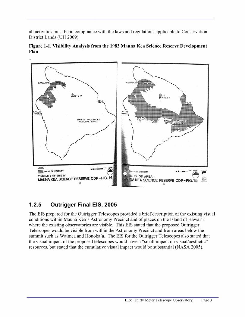
EIS: Thirty Meter Telescope Observatory Page 3
all activities must be in compliance with the laws and regulations applicable to Conservation District Lands (UH 2009).
Figure 1-1. Visibility Analysis from the 1983 Mauna Kea Science Reserve Development Plan
1.2.5 Outrigger Final EIS, 2005 The EIS prepared for the Outrigger Telescopes provided a brief description of the existing visual conditions within Mauna Kea’s Astronomy Precinct and of places on the Island of Hawai’i where the existing observatories are visible. This EIS stated that the proposed Outrigger Telescopes would be visible from within the Astronomy Precinct and from areas below the summit such as Waimea and Honoka’a. The EIS for the Outrigger Telescopes also stated that the visual impact of the proposed telescopes would have a “small impact on visual/aesthetic” resources, but stated that the cumulative visual impact would be substantial (NASA 2005).


EIS: Thirty Meter Telescope Observatory Page 5
2.0 MethodsThis section applies to the methods used during the visual analysis of the proposed TMT Observatory on Maunakea.
2.1 Coordination The following plans were reviewed and consulted:
� Mauna Kea Science Reserve Development Plan, 1983
� Mauna Kea Science Reserve Master Plan, 2000
� Outrigger Final Environmental Impact Statement (FEIS), 2005
� County of Hawai’i General Plan, 2005
� South Kohala Community Development Plan, 2008
� Final Mauna Kea Comprehensive Management Plan (CMP), 2009
Site visits were conducted from October 6 through 9, 2008. The purpose of these visits was to document existing views. Additional visits were made thereafter to take photographs of the summit from various viewpoints.
2.2 Establishing the Affected Environment
2.2.1 Viewer Groups The potential visual impact of the proposed TMT Observatory at the proposed 13N site and the alternative E2 site depends on the type, or group, of people at a location, their activity and their expectation of their experience. An assessment of the various viewer groups and their expectations was made.
2.2.2 Viewpoints Eighteen (18) representative viewpoints were selected to analyze the potential visual impact of locating the TMT Observatory on Maunakea. These viewpoints are locations such as population centers, resorts, Department of Hawaiian Home Lands (DHHL) land, and culturally important locations where various activities occur and where the identified viewer groups would visit. The viewpoints are all located in the northern portion of the island because both the proposed 13N site and the alternative E2 site for the TMT Observatory are north of and below the summit of Maunakea, within Area E as designated in the Mauna Kea Science Reserve Master Plan (2000), and would not be visible from the southern portion of the island.
For the purpose of this report the primary view from a viewpoint is the orientation of the most visually prominent feature. The direction of the primary view from a viewpoint was determined by considering the viewer group and the activities at that location. For example, at a beach

Page 6 EIS: Thirty Meter Telescope Observatory
viewpoint where the main activity is sightseeing and swimming, the primary view would be toward the ocean. For those viewpoints where the panoramic view is important to the viewer group and the activity at that location, no primary view has been specified.
2.3 Visual Consequences The analysis of potential visual impacts from the TMT Observatory at the proposed 13N site and the alternative E2 site includes four elements: 1) a viewshed analysis, including quantifying the area of the island and the island’s population that could see it; 2) whether it would be visible within the direction of the primary view; 3) whether it would be in silhouette; and 4) photo simulations from select viewpoints where the TMT Observatory would be visible.
2.3.1 Viewshed Analysis The first step in the analysis of visual consequences is a viewshed analysis. The viewshed of the TMT Observatory was calculated in terms of the percent of the area of the Island of Hawai’i where it could be visible, and the percent of the island’s population that could see it.
The viewshed for the TMT Observatory was calculated using specific latitude and longitude points and a height for the facility of 180 feet (55 meters) above grade. Topographic data from the U.S. Geological Survey (USGS) was used; specifically the National Elevation Dataset (NED)2. Geographic Information Systems (GIS) software was used to determine areas on the island where at least the top of the TMT Observatory could be visible. The NED is used as a three dimensional (3D) surface in GIS. The topographical changes were calculated using Environmental Science Research Institute’s ArcGIS software package and the associated 3D analyst extension. The viewshed analysis does not take into consideration existing vegetation or structures, which may further obstruct views. Therefore, the viewshed analysis can be considered a worst case scenario.
Once the viewshed was established, 2000 U.S. Census data for the County of Hawai’i was used to determine the population within the viewshed. Population data was taken at the block level; the smallest area in which census data is collected.
2.3.2 Primary View If the viewshed analysis determined that the TMT Observatory would be visible from a viewpoint it was then determined whether it would be visible within the direction of the primary view. This criterion is not applicable to viewpoints where the panoramic view is important to the viewer group and the activity at the location.
2 The USGS National Elevation Dataset (NED) has been developed by merging the highest-resolution, best quality elevation data available across the United States into a seamless raster format. NED is the result of the USGS effort to provide 1:24,000-scale Digital Elevation Model (DEM) data for the conterminous US and 1:63,360-scale DEM data for Alaska. The dataset provides seamless coverage of the United States, HI, AK, and the island territories. NED has a consistent projection (Geographic), resolution (1 arc second), and elevation units (meters). The horizontal datum is NAD83, except for AK, which is NAD27. The vertical datum is NAVD88, except for AK, which is NAVD29. NED is a living dataset that is updated bimonthly to incorporate the "best available" DEM data. As more 1/3 arc second (10m) data covers the US, then this will also be a seamless dataset.

EIS: Thirty Meter Telescope Observatory Page 7
2.3.3 Silhouette View If the viewshed analysis determined that the TMT Observatory could be visible from a viewpoint it was then determined whether the view of the facility would be a prominent silhouette against the sky, or whether it would be seen against the backdrop of Maunakea or one of the existing observatories. The silhouette analysis consists of a profile of the topography between a viewpoint and the TMT Observatory and a line of sight extended from a representative viewer (with a height of 6 feet) at a viewpoint to the top of the proposed TMT Observatory and beyond. If the line of sight extended into the mountainside the view of the TMT Observatory would be against the backdrop of Maunakea; if the line of sight extended into air the view would be either a full or partial silhouette view.
To determine the amount of the TMT Observatory that would be in partial silhouette a line was drawn from the viewer and tangent to the top of the first rise of Maunakea either in front of or behind the TMT Observatory. If the line is tangent to a rise of Maunakea that is behind the TMT Observatory, the portion between the two lines is the amount that would be in silhouette. If the line is tangent to a rise of Maunakea that is in front of the TMT Observatory the portion below that line would not be visible from that viewpoint; the portion between the two lines is the amount that would be visible and in silhouette.
2.3.4 Photo Simulations In compliance with CMP Management Action FLU-4, visual renderings of the TMT Observatory at the proposed 13N site were done for select viewpoints. These simulations help to evaluate the potential visual impact of the TMT Observatory in the context of its proposed setting. To evaluate the visual impact of the color and material of the dome enclosure simulations of the TMT Observatory were also done with different exterior finishes, and for when the summit is bare and when it is covered in snow.
To create these simulations, photos of the summit of Maunakea were acquired from the Canada–France-Hawai’i Telescope (CFHT) with accompanying information such as camera type, lens and frame size, and the latitude and longitude locations of where the photos were taken. The photos used in the simulation were taken with a 600mm/5.6 telephoto lens that shows the summit of Maunakea and the observatories as if a viewer was looking through binoculars. For a “naked eye” perspective, Project personnel took photos from the representative viewpoints using a 50mm focal length, which best approximates what the human eye sees. While in the field, Project personnel also held a ruler at arms length and measured the distance between the existing observatories. This provided an example of the scale of the existing observatories within the view of a typical viewer. For example, the distance between the Keck and Subaru Observatories is 1 millimeter (mm).
Terrain data or DEM (Digital Elevation Model) was acquired from the USGS Seamless Data Distribution Center. The Project’s architect provided a 3D model of the TMT Observatory along with the latitude, longitude and elevation for the location of the proposed structure. Latitude, longitude and elevation data was also acquired for the existing observatories on Maunakea.
Using the above information a 3D model of the summit of Maunakea and the proposed TMT Observatory was created. Within the 3D model a “camera” was created and positioned based on imported location points, and the lens and frame size of the camera used in the original photo.

Page 8 EIS: Thirty Meter Telescope Observatory
The 3D camera position was further refined by “camera matching”; a technique where the 3D camera view is slightly modified to allow for the 3D structures to align with coinciding objects seen in the original photograph. 3D lighting was approximated based on the time of day seen in the photograph. Finally, a composite image was created from a 2D rendering of the TMT Observatory and the original photograph.
2.4 Mitigation The visual impact of the TMT Observatory is due to its proposed size and location on Maunakea. The proposed design and finish of the dome also have a visual impact. These aspects of the TMT Observatory were examined to assess how the Project mitigates its potential visual impacts.

EIS: Thirty Meter Telescope Observatory Page 9
3.0 Affected Environment This section describes the existing visual environment related to Maunakea.
3.1 Maunakea The Island of Hawai’i’s landscape and visual resources are varied. On the northern tip the coast is rugged, covered in dense vegetation and dotted with waterfalls and rivers. Inland, around the town of Waimea (at an elevation of 4,000 feet), the landscape is comprised of rolling pastures used for cattle ranching. The west side of the island consists of popular resorts and beaches but lacks vegetation. The southern and southeastern portions of the island receive lots of rainfall and are covered with lush vegetation; Volcanoes National Park is located in this area. The eastern portion of the island consists of steep terrain with dramatic views of the rain forest and cliffs along the coast.
Maunakea is the highest peak on the Island of Hawai’i; with an elevation of 13,796 feet above sea level. In contrast to the lush coastal areas the summit of Maunakea is an alpine ecosystem. Above the tree line, at roughly 9,500 feet there is little more than low shrubs and above 12,800 feet the vegetation consists mainly of lichens, mosses and small ferns that grow in the cracks and crevices of the cinder cones that comprise the mountain’s dome (UH 2000). A small alpine lake, Lake Wai’au, is situated on the upper southern flank of the mountain. The summit of Maunakea is often obscured by “vog”, volcanic smog formed when sulfur dioxide and other volcanic gases emitting from K�lauea mix with oxygen, moisture and sunlight. During the daylight hours thermally generated winds can draw the vog ashore and upslope (UH 2009). The vog has been especially thick since February 2008 when gas emissions from K�lauea dramatically increased.
Maunakea is one of the best locations in the world for ground-based astronomical observations. The first telescope on the summit of Maunakea was constructed in 1964. Today, there are 11 observatories on Maunakea within the designated Astronomy Precinct and a twelfth located at a lower elevation. The existing facilities are visible from locations such as Hilo, Honoka’a and Waimea. On the west coast of the island the existing telescopes appear most visible at sunset, when they are lit by the setting sun; on the east coast the existing telescopes appear most visible at sunrise.
Existing telescopes on Maunakea as seen from Area E.

Page 10 EIS: Thirty Meter Telescope Observatory
3.1.1 Scenic Vistas and Viewplanes The State of Hawai’i Administrative Rules (HAR) Title 11, Chapter 200, § 11-200-12, lists the significance criteria for a State Environmental Impact Statement; the criteria for which an action shall be determined to have a significant effect on the environment. Significance Criteria 12 is if an action:
“Substantially affects scenic vistas and viewplanes identified in county or state plans or studies”
The County of Hawai’i’s 2005 General Plan includes a chapter on Natural Beauty that recognizes the importance of preserving the island’s natural and scenic beauty. The chapter includes goals, policies and standards to identify and protect scenic vistas and viewplanes. Goal 7.2(b) is to “Protect scenic vistas and view planes from becoming obstructed.” Section 7.4, also provides guidelines for designating sites and vistas of extraordinary natural beauty to be protected, and includes the standard “Distinctive and identifiable landforms distinguished as landmarks, e.g. Mauna Kea, Waipio Valley.”
Around the Island of Hawai’i the following natural beauty sites have been identified that include Maunakea (County of Hawai’i 2005):
� View of Maunakea and Mauna Loa from P�hoa-Kea’au, Volcano-Kea’au Roads, and various Puna subdivisions
� Viewpoint of Hilo Bay with Maunakea in background
� Mauna Kea State Park area
In addition, the South Kohala Development Plan includes a policy to preserve Waimea’s sense of place. The plan recommends the strategy to “protect the pu’u of Waimea that have cultural, historical and visual importance” and which have “grand views of Mauna Kea” (County of Hawai’i 2008).
3.1.2 Viewer Groups According to 2000 U.S. Census data, the Island of Hawai’i is home to roughly 148,000 people. The largest cities are Hilo on the east coast (with about 41,000 residents) and Kailua-Kona on the west side (with about 10,000 residents). There are also several smaller towns such as Waimea, Honoka’a and H�w�.
Tourism is an important industry for all of Hawai’i. The Island of Hawai’i is famous for its volcanoes, such as K�lauea which has been active for more than two decades. Visitors also visit the Island of Hawai’i for its beaches and recreational opportunities such as snorkeling, scuba diving and golf.
In Hawaiian culture Maunakea is recognized as a sacred place. Similar to other Polynesian cultures, the Hawaiians believed their highest points of land were most sacred; Maunakea being the highest mountain in Pacific Polynesia. Maunakea was host to early Hawaiian traditions including religious practices, study of the heavens, and tool making in the Keanakako’i adze quarry. Lake Wai’au was believed to contain pure water which was used in healing and worship

EIS: Thirty Meter Telescope Observatory Page 11
practices. Today, there are still Hawaiians who go to Maunakea for prayer and restoration. (OMKM 2000).
The people that view the Island of Hawai’i, and more specifically Maunakea, can be categorized into three groups, each with a different expectation of their visual experience:
� Residents – Residents place value on the existing condition of the surrounding landscape, particularly as viewed from their homes. Residents would also have views of the island and Maunakea from public places such as commercial centers, beaches and state parks. Residents experience the island’s visual resources, including Maunakea, frequently and for a long duration.
� Sightseers – Sightseers visit the Island of Hawai’i to view the landscape, including the beaches and volcanoes, and for recreational activities. Sightseers would visit the larger cities of Kailua-Kona and Hilo for shopping, dining, and touring activities, and would take scenic drives along the island stopping at scenic overlooks. Sightseers may also be interested in astronomy and visit the observatories on Maunakea. Sightseers would have a temporary experience of Maunakea and the island’s visual resources.
� Cultural Practitioners3 – Cultural Practitioners are native Hawaiians who, as individuals or groups, may visit Maunakea for worship on special occasions or on a regular basis (OMKM 2000). Cultural Practitioners may also visit other important sites on the island with views of Maunakea. Cultural Practitioners place a high value on the island’s visual resources, and particularly on pristine views of Maunakea.
3.1.3 Viewpoints Eighteen (18) representative viewpoints within the northern portion of the island have been identified as places that are of visual significance to the island’s three viewer groups. The viewpoints are all located in the northern portion of the island because the proposed 13N site and the alternative E2 site for the TMT Observatory are north of and below the summit of Maunakea and would not be visible from the southern portion of the island. Figure 3-1 maps the locations of the 18 representative viewpoints.
3 This report only discusses the project’s potential visual impact. For more information on impacts to cultural sites or practices please see the Cultural Impact Assessment, Thirty Meter Telescope.
Existing shrine on the summit of Mauna Kea.

Page 12 EIS: Thirty Meter Telescope Observatory
Figure 3-1. Viewpoints Used for the Visual Analysis

EIS: Thirty Meter Telescope Observatory Page 13
Table 3-1 provides the name and description of each viewpoint, including the main activity that occurs at that location, and states the primary viewer group at the viewpoint. For example, at the Waipio Valley Lookout the primary viewer group is Sightseers. For the Hual�lai Resort, Big Island Country Club, H�puna Beach and Puukohola Heiau State Park, both Residents and Sightseers have been listed as the primary viewer group because of the activities that occur at these locations.
Finally, Table 3-1 states the direction of the primary view from each viewpoint; the orientation of the most visually prominent feature. The primary view has been determined relative to the viewer group and the activities at the viewpoint. The primary view for viewpoints near the coast, such as H�puna Beach and Laup�hoehoe Point, is toward the ocean (makai). For viewpoints that are more inland, such as the Route 250 Puu overlook and Waimea Park, the primary view is towards Maunakea (mauka). At the Big Island Country Club, Pu’u Waawaa and the summit of Maunakea, the panoramic view is important to the viewer group and the location’s use. The direction of the primary view from each viewpoint is mapped in Figure 3-2.
Appendix A includes a photograph of or from the viewpoints. It has been noted if the photograph is of the primary view from the viewpoint.
Primary view from Viewpoint # 13 – Waipio Valley Lookout

Page 14 EIS: Thirty Meter Telescope Observatory
Table 3-1. Description of Viewpoint, Viewer Group and Primary View Direction Viewpoint Location Description Viewer Group Primary View
1 Hual�lai Resort Exclusive, luxury residential community and hotel. Residents / Sightseers West toward the ocean
(makai)
2 Pu’u Waawaa Summit of cinder cone that is of cultural importance to native Hawaiians.
Cultural Practitioners Panoramic
3 Big Island Country Club
Independent (non-resort affiliated) daily-fee golf course. The club includes views of the coastline and of Maunakea.
Residents / Sightseers Panoramic
4 Waikoloa/Mauna Lani Resort development. Sightseers West makai 5 H�puna Beach Public beach near a resort. Sightseers / Residents West makai
6 Puukohola Heiau National historic site and Spencer Beach Park, which includes camping and picnic areas along a beach.
Residents / Sightseers West makai
7 DHHL Kawaihae at Rt. 250
Summit of Hwy 250 between Waimea and H�w�. Residents Southeast toward
Maunakea (mauka)
8 Route 250 Pu’u overlook
Gravel shoulder where cars can pull off of the highway and view Maunakea and North Kona/South Kohala.
Sightseers Southeast mauka
9 DHHL Lalamilo Residential neighborhood within Waimea. Residents Southeast mauka
10 Waimea Park Athletic facilities for sports such as baseball and tennis. Nearby a school.
Residents Southeast mauka
11 DHHL Pu’u Kapu Residential neighborhood within Waimea. Residents Southeast mauka
12 DHHL Waikoloa-Waialeale
Along Old M�mahaloa Hwy through ranch lands. Residents South mauka
13 Waipio Valley Lookout
Formal lookout with parking lot and trail to scenic view. Sightseers Northwest along the
coast 14 Honoka’a Main road into town. Residents Northwest up the coast
15 Laup�hoehoe Point State park with parking lot and picnic facilities along the coast. Sightseers Northeast makai
16 Maunakea Summit (K�kahau’ula)
Highest point on Maunakea. Recognized as a sacred place to native Hawaiians.
Cultural Practitioners Panoramic
17 Lake Wai’au
Small lake near the summit of Maunakea, accessible by a trail. Waters used for healing and worship practices in Hawaiian culture.
Cultural Practitioners West over the lake
18 North ridge of Maunakea summit cinder cone (K�kahau’ula)
North ridge of K�kalau’ula, near Keck, Subaru, IRTF, or CFHT observatories.
Sightseers Panoramic
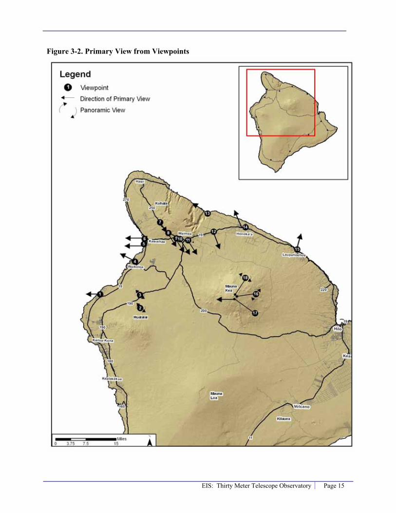
EIS: Thirty Meter Telescope Observatory Page 15
Figure 3-2. Primary View from Viewpoints

Page 16 EIS: Thirty Meter Telescope Observatory
3.1.4 Existing Telescopes on Maunakea There are 11 existing observatories near the summit of Maunakea, eight of which are optical/infrared and three of which are submillimeter/radio observatories. The heights of these existing observatories range from a little over 20-feet to 151-feet. The names, elevation and approximate heights of the existing observatories are listed in Table 3-2. The locations of these observatories within the Astronomy Precinct are shown in Figure 3-3.
Table 3-2. Existing Observatories on Maunakea
MapNumber Observatory
GroundElevation
(feet) Dome Height from Ground
(feet)
Submillimeter/Radio Observatories
1 California Institute of Technology Submillimeter Observatory (CSO) 13,362 63
2 James Clerk Maxwell Telescope (JCMT) 13,390 100 3 Submillimeter Array (SMA) 13,279-13,400 45
Optical/Infrared Observatories 4 Subaru Observatory 13,578 141 (Subaru 2008)
5a, 5b W. M. Keck Observatory (telescopes I and II) Keck 1: 13,714, Keck 2: 13,659 111 (NASA 2005)
6 NASA Infrared Telescope Facility (IRTF) 13,652 53 (IRTF 2008) 7 Canada-France-Hawai‘i Telescope (CFHT) 13,726 125(CFHT 2008) 8 Gemini Northern Observatory 13,764 151 (Gemini 2008) 9 University of Hawai‘I (2.2M) 13,784 80
10 United Kingdom Infrared Telescope (UKIRT) 13,762 61 (UH 1975) 11 University of Hawai‘i – Hilo (0.9M) 13,727 20.25 (UH 2006)
For each existing observatory, Table 3-3 shows the master plan siting area that they are located within, the percent of the area of the island from which the observatory is potentially visible, and the dome color of the observatory. Figure 3-4 shows the combined visibility of the existing 11 observatories near the summit, where the top of at least one of the existing observatories is visible. Individual viewshed maps are included in Appendix B. Based on this analysis, from approximately 43 percent of the island area a viewer would be able to see at least one existing observatory. According to 2000 U.S. Census data 72 percent of the Island of Hawai’i’s population (roughly 107,000 people) is within the viewshed of the existing observatories.

EIS: Thirty Meter Telescope Observatory Page 17
Table 3-3. Existing Observatory Visual and Aesthetic Attributes
Observatory Master Plan Siting Area Viewshed (%) Dome Color
Optical/Infrared Observatories UHH 0.9m A 15 White UH 2.2m A 36 White CFHT A 35 White UKIRT A 26 White Gemini A 39 Aluminum IRTF B 14 Aluminum W. M. Keck Observatory
Keck 1 B 17 White Keck 2 B 16 White
Subaru B 20 Metallic Submillimeter/Radio Observatories CSO C 5 Metallic JCMT C 7 White SMA C 2 N/A

Page 18 EIS: Thirty Meter Telescope Observatory
Figure 3-3. Map of Existing Observatories on Maunakea

EIS: Thirty Meter Telescope Observatory Page 19
Figure 3-4. Combined Visibility of Existing Observatories on Maunakea


EIS: Thirty Meter Telescope Observatory Page 21
4.0 ConsequencesThis section presents the potential visual impacts that would occur from locating the TMT Observatory at the proposed 13N site and the alternative E2 site on Maunakea.
4.1 No Action Alternative The No Action Alternative considers existing conditions and what would be reasonably expected to occur in the foreseeable future, absent the proposed project.
With this alternative the existing CSO Observatory on Maunakea would be decommissioned and the SMA would be expanded from eight to 20 antennas in Area C and D of the Astronomy Precinct. The other existing observatories would remain. These observatories can be seen from 43 percent of the area of the Island of Hawai’i, as shown in Figure 3-4; approximately 72 percent of the population (roughly 106,000 people) is within this existing viewshed.
TMT would not fund construction, installation, or future operation of the TMT Observatory and its supporting facilities at either Maunakea or Cerro Armazonas. The Pan-STARRS project, a telescope consisting of four mirrors each with a diameter of 6 feet (1.8 meters), similar to what is constructed on Haleakala, would occur either at the current location of the UH 2.2 Observatory or the UH 2.2 Observatory would move to Area E and become Pan-STARRS. Also, in the absence of the proposed TMT Observatory, it is likely that in the future another observatory would be developed within Area E pursuant to the CMP.
4.2 Maunakea The proposed 13N site, and the alternative E2 site, for the TMT Observatory are within the Astronomy Precinct on Maunakea in an area northwest of the summit that was identified in the 2000 Master Plan as Area E. These two sites are shown in Figure 4-1. The 2000 Master Plan for Maunakea identified the Area E location as a potential site for a Next Generation Large Telescope (NGLT), similar to the TMT Observatory, primarily because it minimizes visual impacts (OMKM 2000).
In addition to the observatory within the Mauna Kea Astronomy Precinct the project would also require a Support Facility that would be located at Hale P�haku, at an elevation of 9,300 feet, Headquarters in the University Park of UH Hilo, and a satellite office in Waimea. These facilities are not anticipated to have a visual impact due to their limited visibility, because their design would be similar to other developments in these areas, and because there are no designated or recognized visual resources associated with them.

Page 22 EIS: Thirty Meter Telescope Observatory
Figure 4-1. Proposed 13N Site and Alternative E2 Site

EIS: Thirty Meter Telescope Observatory Page 23
Figure 4-2 provides a simulation and cross section of the proposed design of the TMT Observatory. Figure 4-2 shows both the proposed dome enclosure for the telescope and the administrative facilities. In addition to the 13N and E2 sites being below the summit of Maunakea, the cross section shows that part of the TMT Observatory would be below existing grade, which would further minimize the potential visual impact. The proposed maximum height of the dome enclosure is approximately 180 feet (55 meters) above existing grade. The proposed diameter to the exterior of the structure is 216 feet (66 meters). To put this size into perspective, the area is roughly the size of a football field, which is 160 feet (48.8 meters) wide by 300 feet (91.4 meters) long, without sidelines and stands. For height, the TMT Observatory would be similar to the Ilikai Hotel in Honolulu.
As shown in Figure 4-2, natural colors that blend into the landscape would be used for the exterior of the fixed enclosure and the administrative facilities. The proposed coating of the rotating dome enclosure is a reflective aluminum-like finish similar to the Subaru Observatory. The coating on the outer surface of an observatory dome is important to the function of the telescope. If the telescope and inner structure of the enclosure heat up during the day, or cools below the night air temperature, it will cause local air turbulence inside the enclosure that would degrade the telescope image quality. To maintain a consistent temperature inside the dome the TMT Observatory would be constructed with thick insulation and would require daytime air conditioning. The proposed metallic exterior coating on the dome would reduce the amount of energy needed to regulate the temperature.
In general, the existing observatories on Maunakea with a metallic coating (such as Gemini, IRTF, and Subaru) reflect the morning sunrise and evening sunset light and stand out during this period. However, during majority of the day the metallic coating reflects the sky, which helps reduce the visibility of the observatory.
Visibility of the Adaptive Optics Laser
The proposed TMT Observatory would use an adaptive optics (AO) system on the telescope to correct distortions in the view resulting from atmospheric affects. This greatly improves the image that can be obtained from the telescope. The TMT Observatory would be the first astronomy telescope designed from conception to use adaptive optics. The AO system uses a laser pointed into the sky. The multiple overlapping laser beams could be faintly visible to the naked eye as a single beam on moonless nights for a distance of up to 9 miles from the observatory. Figure 4-3 shows a circle with a 9 mile radius around the proposed location of the TMT Observatory; the maximum potential area where the adaptive optics laser may be visible. The area where the laser may be visible consists primarily of ranchlands and forest reserve which are not populated. Therefore, the laser used in the adaptive optics system is expected to have a less than significant visual impact.

Page 24 EIS: Thirty Meter Telescope Observatory
Figure 4-2. Proposed TMT Observatory Design

EIS: Thirty Meter Telescope Observatory Page 25
Figure 4-3. Potential Visibility of the TMT Observatory’s Adaptive Optics Laser

Page 26 EIS: Thirty Meter Telescope Observatory
4.2.1 13N Site
Temporary Impacts
Construction and Decommissioning
Temporary visual impacts from the proposed construction, and the potential future decommissioning, of the TMT Observatory would be associated with the presence of construction equipment and workers, material stockpiles, debris and staging areas. Most of the construction staging and material storage would occur in the area around Hale P�haku, at an elevation of 9,300 feet, which would not be visible from other areas of the island. Dust, and light and glare emanating from construction activities would also have a temporary visual impact. These temporary impacts would be less than significant.
Long-Term Impacts
Scenic Vistas and Viewplanes
Locating the TMT Observatory at the proposed 13N site would not substantially affect scenic vistas and viewplanes identified in the Hawai’i County General Plan or the South Kohala Development Plan. The TMT Observatory would not be visible in the view from Hilo Bay with Maunakea in the background. The TMT Observatory would not be visible in the view of Maunakea from Pahoa-Kea’au, Volcano-Kea’au Roads, and various Puna subdivisions or from locations where Hilo Bay is visible with Maunakea in the background. Although the TMT Observatory may be visible in the view of Maunakea from portions of the South Kohala district and the area around Waimea, it would not block or substantially obstruct the views and viewplanes of the mountain. Therefore, the Project would not exceed significance criteria 12 as stated in §11-200-12 of the HAR.
Viewshed Analysis
A viewshed analysis was conducted to assess which areas of the Island of Hawai’i may have a view of the TMT Observatory at the proposed 13N site. The viewshed analysis is based on topographic information; it does not include existing vegetation or structures which may further obstruct views of the TMT Observatory. Therefore, the viewshed analysis can be considered a worst case scenario.
The results of this analysis are shown in Figure 4-4. In this figure the shaded portions of the island are areas where at least the top of the TMT Observatory may be visible. For the 18 representative viewpoints, a green circle shows that the TMT Observatory would be visible and a red square means it would not be visible. The TMT Observatory could be visible from viewpoints 1-4, 6-12, 14, and 18. The TMT Observatory would not be visible from viewpoints 5, 13 and 15-17.

EIS: Thirty Meter Telescope Observatory Page 27
Figure 4-4. Proposed 13N Site - Viewshed and Primary View Analysis
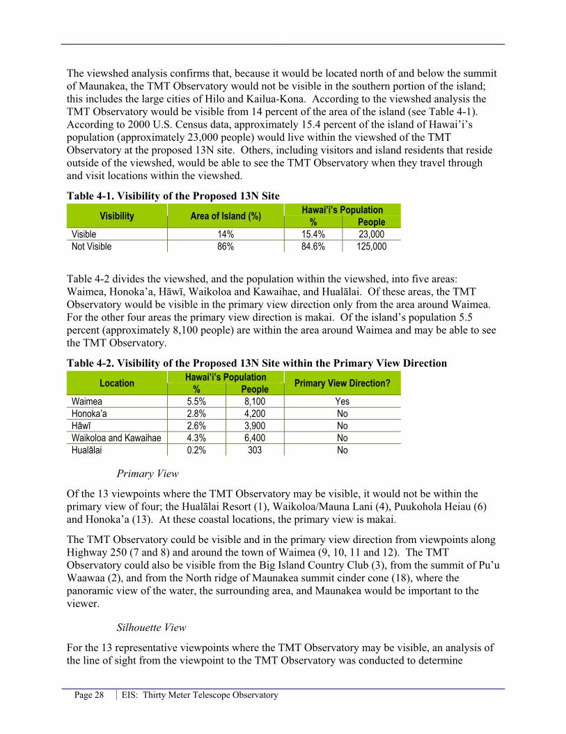
Page 28 EIS: Thirty Meter Telescope Observatory
The viewshed analysis confirms that, because it would be located north of and below the summit of Maunakea, the TMT Observatory would not be visible in the southern portion of the island; this includes the large cities of Hilo and Kailua-Kona. According to the viewshed analysis the TMT Observatory would be visible from 14 percent of the area of the island (see Table 4-1). According to 2000 U.S. Census data, approximately 15.4 percent of the island of Hawai’i’s population (approximately 23,000 people) would live within the viewshed of the TMT Observatory at the proposed 13N site. Others, including visitors and island residents that reside outside of the viewshed, would be able to see the TMT Observatory when they travel through and visit locations within the viewshed.
Table 4-1. Visibility of the Proposed 13N Site
Visibility Area of Island (%) Hawai’i’s Population % People
Visible 14% 15.4% 23,000 Not Visible 86% 84.6% 125,000
Table 4-2 divides the viewshed, and the population within the viewshed, into five areas: Waimea, Honoka’a, H�w�, Waikoloa and Kawaihae, and Hual�lai. Of these areas, the TMT Observatory would be visible in the primary view direction only from the area around Waimea. For the other four areas the primary view direction is makai. Of the island’s population 5.5 percent (approximately 8,100 people) are within the area around Waimea and may be able to see the TMT Observatory.
Table 4-2. Visibility of the Proposed 13N Site within the Primary View Direction
Location Hawai’i’s Population Primary View Direction? % PeopleWaimea 5.5% 8,100 Yes Honoka’a 2.8% 4,200 No H�w� 2.6% 3,900 No Waikoloa and Kawaihae 4.3% 6,400 No Hual�lai 0.2% 303 No
Primary View
Of the 13 viewpoints where the TMT Observatory may be visible, it would not be within the primary view of four; the Hual�lai Resort (1), Waikoloa/Mauna Lani (4), Puukohola Heiau (6) and Honoka’a (13). At these coastal locations, the primary view is makai.
The TMT Observatory could be visible and in the primary view direction from viewpoints along Highway 250 (7 and 8) and around the town of Waimea (9, 10, 11 and 12). The TMT Observatory could also be visible from the Big Island Country Club (3), from the summit of Pu’u Waawaa (2), and from the North ridge of Maunakea summit cinder cone (18), where the panoramic view of the water, the surrounding area, and Maunakea would be important to the viewer.
Silhouette View
For the 13 representative viewpoints where the TMT Observatory may be visible, an analysis of the line of sight from the viewpoint to the TMT Observatory was conducted to determine

EIS: Thirty Meter Telescope Observatory Page 29
whether the view of the facility would be a full or partial silhouette against the sky, or whether it would be seen against the backdrop of Maunakea. For some of these 13 viewpoints the silhouette analysis showed that the view of the TMT Observatory would be partially obstructed from a rise between the viewer and the viewpoint. Table 4-3 summarizes the silhouette analysis for the TMT Observatory at the proposed 13N site. The results of the silhouette analysis are in Appendix C.
Table 4-3. Proposed 13N Site - Silhouette Analysis
Viewpoint LocationPortion of TMT Observatory in
SilhouetteNone Partial Full
1 Hual�lai Resort -- 164 feet (50 m) -- 2 Pu’u Waawaa -- 58 feet (17 m) -- 3 Big Island Country Club -- 82 feet (25 m) -- 4 Waikoloa/Mauna Lani -- 164 feet (50 m) -- 5 H�puna Beach Not Visible 6 Puukohola Heiau -- 164 feet (50 m) -- 7 DHHL Kawaihae at Rt. 250 X -- -- 8 Route 250 Pu’u overlook X -- -- 9 DHHL Lalamilo -- 49 feet (15 m) --
10 Waimea Park -- 89 feet (27 m) -- 11 DHHL Pu’u Kapu -- 98 feet (30 m) -- 12 DHHL Waikoloa-Waialeale -- 164 feet (50 m) -- 13 Waipio Valley Lookout Not Visible 14 Honoka’a -- 82 feet (25 m) -- 15 Laup�hoehoe Point Not Visible 16 Maunakea Summit Not Visible 17 Lake Wai’au Not Visible 18 North ridge (K�kahau‘ula) -- X
From the two viewpoints along Highway 250 (7 and 8) the view of the TMT Observatory would not be in silhouette; it would be visible against the backdrop of Maunakea. This may reduce the prominence of the TMT Observatory in the view from these locations; particularly at sunset, when Maunakea would be back-lit by the setting sun. Only from the northern ridge of K�kahau‘ula (18), which is located on a ridge at an elevation higher than the TMT Observatory, would the full observatory be in silhouette.
From the coastal locations of Hual�lai Resort (1), Waikoloa/Mauna Lani (4) and Puukohola Heiau (6), approximately 165 feet (50 meters) of the TMT Observatory would be in silhouette. From the town of Honoka’a (14), approximately 80 feet (25 meters) of the TMT Observatory would be in silhouette. From these viewpoints the TMT Observatory would not be located within the direction of the primary view, which is makai.
In the area around Waimea (viewpoints 9 through 12), where the TMT Observatory would be visible within the direction of the primary view, the amount of the partial silhouette would range from 50 feet (15 meters) to 165 feet (50 meters). The silhouette analysis also showed that from the Big Island Country Club (3) and Pu’u Waawaa (2) the view of the TMT Observatory would be partially obstructed from a rise of Maunakea between the viewer and the observatory. From portions of the Big Island Country Club (2) the top 80 feet (25 meters) of the TMT Observatory

Page 30 EIS: Thirty Meter Telescope Observatory
would be visible and in silhouette. From the summit of Pu’u Waawaa (3) the top 55 feet (17 meters) would be visible and in silhouette.
The existing observatories on the summit of Maunakea can also affect the silhouette view. From some areas on Hawai’i, the view of the TMT Observatory would be in front of one of Keck 1, Keck 2 or Subaru. These areas are shown in Figure 4-5.
Figure 4-5. Area where TMT would be Viewed in Front of an Existing Observatory

EIS: Thirty Meter Telescope Observatory Page 31
Photo Simulations
Views from Lower Elevation Developed Areas
Photo simulations of the TMT Observatory at the proposed 13N site were created for views from Waimea, near Honoka’a (in the area around viewpoint 12) and Waikoloa. The photos used in these simulations were taken with a 600 mm/5.6 telephoto lens, creating a “binocular view.” For comparison purposes a “naked eye view,” without the aid of binoculars or a telephoto lens, from Waimea, Honoka’a and Waikoloa are provided. These naked eye photos show how, from these locations that are a distance of approximately 19 miles from the summit of Maunakea, the existing observatories appear quite small and do not occupy much of the total view. The naked eye view of the TMT Observatory on Maunakea would be similar. Because the size and design of the TMT Observatory would not be discernable from the naked eye perspective, simulations at this scale were not prepared.
An example of the naked eye view of Maunakea from Waimea is shown in Figure 4-6. Figure 4-7 is a binocular view simulation of the TMT Observatory in the proposed 13N site from Waimea. This simulation shows how the location of the TMT Observatory would be below the summit of Maunakea and the existing observatories. In this view the lower portion of the TMT Observatory would be obscured behind a rise of Maunakea and it would be located in front of one of the existing domes of the Keck Observatory.
In Figure 4-7 the TMT Observatory is shown with a reflective aluminum-like finish on the dome enclosure. In Figure 4-8 the TMT Observatory is shown with a white exterior finish and in Figure 4-9 it is shown in a brown finish. The visual impact of the dome’s exterior finish partly depends on the colors in the landscape of the summit of Maunakea. For much of the year the summit of Maunakea has a reddish-brown color from the volcanic rock. From November through March the summit of Maunakea is white from varying amounts of snow cover. Figure 4-10 through Figure 4-12 provide a photo simulation of the TMT Observatory, as viewed from Waimea, with the three exterior finishes when Maunakea is covered with snow.
Figure 4-13 shows the naked eye view from Honoka’a. Figure 4-14 through Figure 4-16 are binocular view simulations of the TMT Observatory, in the proposed 13N site, near Honoka’a (in the area around Waikoloa-Waialeale, viewpoint 12) with the reflective aluminum-like finish, and the white and brown exterior finish when Maunakea is covered in snow.
Figure 4-17 shows the naked eye view from Waikoloa in the northwest portion of the island. Figure 4-18 shows a binocular view simulation of the TMT Observatory, in the proposed 13N site with a reflective aluminum-like finish, as seen from Waikoloa. Figure 4-19 through Figure 4-21 are binocular view simulations of the TMT Observatory, as seen from Waikoloa when Maunakea is covered in snow, with the reflective aluminum-like, white and brown exterior finish.
As shown in these simulations while the white finish visually blends in with Maunakea when it is snow covered, it would be more visually prominent when the summit is bare. Conversely, the brown finish may blend better with the bare volcanic rock at the summit, but it would stand out more during the snow covered months. The reflective aluminum-like exterior finish reflects the colors of the sky and ground, which would better reflect its setting and have a reduced visual impact year round.

Page 32 EIS: Thirty Meter Telescope Observatory
Figure 4-6. Naked Eye View of Maunakea from Waimea
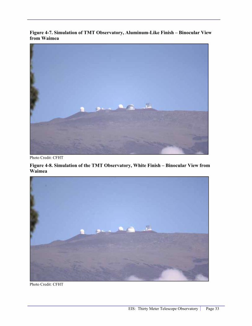
EIS: Thirty Meter Telescope Observatory Page 33
Figure 4-7. Simulation of TMT Observatory, Aluminum-Like Finish – Binocular View from Waimea
Photo Credit: CFHT
Figure 4-8. Simulation of the TMT Observatory, White Finish – Binocular View from Waimea
Photo Credit: CFHT
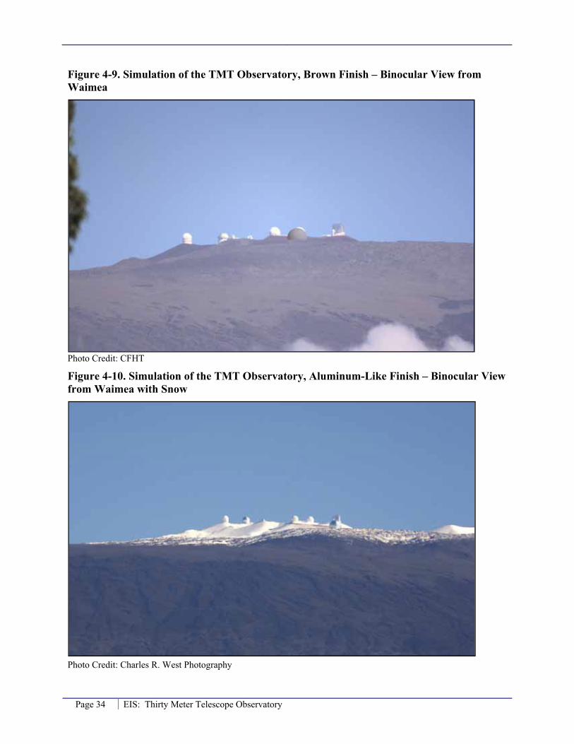
Page 34 EIS: Thirty Meter Telescope Observatory
Figure 4-9. Simulation of the TMT Observatory, Brown Finish – Binocular View from Waimea
Photo Credit: CFHT
Figure 4-10. Simulation of the TMT Observatory, Aluminum-Like Finish – Binocular View from Waimea with Snow
Photo Credit: Charles R. West Photography

EIS: Thirty Meter Telescope Observatory Page 35
Figure 4-11. Simulation of the TMT Observatory, White Finish – Binocular View from Waimea with Snow
Photo Credit: Charles R. West Photography
Figure 4-12. Simulation of the TMT Observatory, Brown Finish – Binocular View from Waimea with Snow
Photo Credit: Charles R. West Photography

Page 36 EIS: Thirty Meter Telescope Observatory
Figure 4-13. Naked Eye View of Maunakea near Honoka’a
Figure 4-14. Simulation of the TMT Observatory, Aluminum-Like Finish – Binocular View from Honoka’a with Snow

EIS: Thirty Meter Telescope Observatory Page 37
Figure 4-15. Simulation of the TMT Observatory, White Finish – Binocular view from Honoka’a with Snow
Figure 4-16. Simulation of the TMT Observatory, Brown Finish – Binocular view from Honoka’a with Snow

Page 38 EIS: Thirty Meter Telescope Observatory
Figure 4-17. Naked Eye View of Maunakea from Waikoloa
Figure 4-18. Simulation of the TMT Observatory, Aluminum-Like Finish – Binocular View from Waikoloa
Photo credit: CFHT

EIS: Thirty Meter Telescope Observatory Page 39
Figure 4-19. Simulation of the TMT Observatory, Aluminum-Like Finish – Binocular view from Waikoloa with Snow
Photo Credit: Charles R. West Photography
Figure 4-20. Simulation of the TMT Observatory, White Finish – Binocular view from Waikoloa with Snow
Photo Credit: Charles R. West Photography

Page 40 EIS: Thirty Meter Telescope Observatory
Figure 4-21. Simulation of the TMT Observatory, Brown Finish – Binocular view from Waikoloa with Snow
Photo Credit: Charles R. West Photography
Views within the Summit Region
Although the TMT Observatory will not be visible from the summit of Maunakea, viewpoint 16, or Lake Waiau, viewpoint 17, it will be visible from other locations within the summit region; primarily, the northern plateau and the northern ridge of K�kahau‘ula, viewpoint 18, where the Subaru, Keck, IRTF, and CFHT observatories are located. Figure 4-22 shows the current view from near the Keck Observatory, viewpoint 18, looking to the northwest over the northern plateau and the TMT Observatory 13N site. Figure 4-23 is a simulation of the TMT Observatory with an aluminum-like finish from the same viewpoint.
As the simulation in Figure 4-23 shows, the TMT Observatory will add a substantial new visual element in the landscape that will be visible from viewpoints along the northern ridge of K�kahau‘ula and by people as they travel within the northern portion of the summit region. Views from the northern ridge of K�kahau‘ula are now dominated by views of observatories, including Subaru, Keck, IRTF, and CFHT, which are located on this ridge. The majority of visitors/sightseers to the summit region and cultural practitioners visit the K�kahau‘ula summit, not the northern ridge of K�kahau‘ula. In addition, TMT’s lower elevation and minimal size and height mean it will not block the view of Maui from the ridge. Nevertheless, the TMT Observatory will add a substantial new visual element to a currently, relatively undeveloped portion of the summit region.

EIS: Thirty Meter Telescope Observatory Page 41
Figure 4-22. Naked Eye View from Near Keck Observatory, Viewing Northwest
Figure 4-23. Simulation of the TMT Observatory, Aluminum-Like Finish – from Near Keck Observatory, Viewing Northwest

Page 42 EIS: Thirty Meter Telescope Observatory
Summary
The potential long-term visual impacts from the proposed 13N site for the TMT Observatory are summarized in Table 4-4.
Table 4-4. Proposed 13N Site - Summary of Potential Visual Impacts
Viewpoint LocationVisual Impact
Is the TMT visible?
Visible in primaryview?
Visible in silhouette? No Partial Full
1 Hual�lai Resort Yes No -- 164 feet (50 m) --
2 Pu’u Waawaa Yes N/A1 -- 58 feet (17 m) -- 3 Big Island Country Club Yes N/A1 -- 82 feet (25 m) --
4 Waikoloa/Mauna Lani Yes No -- 164 feet (50 m) --
5 H�puna Beach No No N/A
6 Puukohola Heiau Yes No -- 164 feet (50 m) --
7 DHHL Kawaihae at Route 250 Yes Yes X -- --
8 Route 250 Pu‘u Overlook Yes Yes X -- -- 9 DHHL Lalamilo Yes Yes -- 49 feet (15 m) -- 10 Waimea Park Yes Yes -- 89 feet (27 m) -- 11 DHHL Pu’u Kapu Yes Yes -- 98 feet (30 m) --
12 DHHL Waikoloa-Waialeale Yes Yes -- 164 feet (50 m) --
13 Waipio Valley Lookout No N/A N/A 14 Honoka’a Yes No -- 82 feet (25 m) -- 15 Laup�hoehoe Point No N/A N/A 16 Maunakea Summit No N/A N/A 17 Lake Waiau No N/A N/A 18 North ridge of K�kahau‘ula Yes N/A1 -- -- X
1 The primary view criterion is not applicable because at these viewpoints the panoramic view is important.
Visual Impact on Viewer Groups
Based on the above analysis, the following is a summary of the potential visual impacts on the three viewer groups from locating the TMT Observatory at the proposed 13N site.
Residents
Most residents of Hawai’i, such as in the cities of Hilo and Kailua-Kona, would not be able to see the TMT Observatory from their homes or public gathering places. From the viewshed analysis approximately 15 percent of the population (23,000 people) would be able to see at least the top of the TMT Observatory. Of these, it would only be within the direction of the primary view of 5.5 percent of the population (8,100 people) in the area around Waimea. However, residents that live outside of the viewshed would be able to see the TMT Observatory when they travel through and visit locations within the viewshed.

EIS: Thirty Meter Telescope Observatory Page 43
The TMT Observatory would also have a visual impact on residents in towns such as Waimea, Waikoloa and the area around Honoka’a. Within these towns the views of Maunakea that residents may have from their homes or gathering places, such as the Waimea Park (10), may be altered. The views from these viewpoints would be in partial silhouette (ranging from 15 meters at DHHL Lalamilo (9) to 50 meters at DHHL Waikoloa-Waialeale (12)), which could make the view more prominent, particularly in the morning when the facility would be back lit by the sun. The extent of the visual impact would be somewhat reduced by the times when the summit of Maunakea would be obscured by vog, clouds, or other causes of limited visibility. In general, the visual impact to the resident viewer group of Hawai’i would be less than significant. The impact to residents of Waimea, while slightly higher, would still be less than significant.
Sightseers
The visual experience for the sightseer viewer group would not be impacted by the TMT Observatory. This is because it would not be visible from the majority of the island including: the larger cities of Kona and Hilo; Volcanoes National Park; or from scenic viewpoints such as Waipio Valley Lookout (13) and Laup�hoehoe Point (15). From viewpoints, such as the Hual�lai Resort (1), where the TMT Observatory could be visible, it would not be within the primary view and would not be expected to impact the visual experience. In addition, sightseers may be interested in astronomy, may plan on visiting the astronomy precinct and enjoy views of the TMT Observatory. The visual impact to sightseers on the island of Hawai’i would be less than significant.
Cultural Practitioners
Finally, as stated in Section 3.1.2, cultural practitioners on the Island of Hawai’i place a high value on pristine views of Maunakea. Of the three representative viewpoints that are from culturally important locations, the TMT Observatory would not be visible from two; the summit of Maunakea (16) and Lake Wai’au (17). The TMT Observatory could be visible from the summit of Pu’u Waawaa, where cultural practitioners may experience a visual impact. The silhouette analysis showed that from Pu’u Waawaa (2) the view of the TMT Observatory would be partially obstructed from a rise of Maunakea between the viewer and the observatory and that only the top 56 feet (17 meters) would be visible and in silhouette. The extent of the visual impact would be somewhat reduced at the times when the summit of Maunakea would be obscured by vog, clouds, or other causes of limited visibility.
Visual impacts are only a component of the Project’s potential cultural impact. For information on the project’s impacts to cultural practices see the Cultural Impact Assessment, Thirty Meter Telescope.
Overall Visual Impact
As discussed above, while the TMT Observatory would be a new visual element within the views of Maunakea (for approximately 14 percent of the island area and could be seen by approximately 15.4 percent of the population, or roughly 23,000 people) it would not obstruct or block existing views of Maunakea from around the Island of Hawai’i. Therefore, the Project would not exceed the applicable significance criteria in §11-200-12 of the HAR and would be expected to have a less than significant visual impact.

Page 44 EIS: Thirty Meter Telescope Observatory
4.2.2 E2 Site
Temporary Impacts
Construction and Decommissioning
At the alternative E2 site the temporary visual impacts, from the proposed construction of the TMT Observatory and the potential future decommissioning of the TMT Observatory, would be the same as described in Section 4.2.1 for the proposed 13N site. These include the presence of construction equipment and workers, dust, and light and glare. These temporary impacts would be less than significant.
Long-Term Impacts
The long-term impacts from the alternative E2 site would be similar to the long-term impacts of the proposed 13N site.
Scenic Vistas and Viewplanes
Locating the TMT Observatory at the alternative E2 site would not substantially affect scenic vistas and viewplanes identified in the Hawai’i County General Plan or the South Kohala Development Plan. The TMT Observatory would not be visible in the view from Hilo Bay with Maunakea in the background. The TMT Observatory would not be visible in the view of Maunakea from Pahoa-Kea’au, Volcano-Kea’au Roads, and various Puna subdivisions or from locations where Hilo Bay is visible with Maunakea in the background. Although the TMT Observatory may be visible in the view of Maunakea from portions of the South Kohala district and the area around Waimea, it would not block the views and viewplanes of the mountain. Therefore, the project would not exceed significance criteria 12 as stated in §11-200-12 of the HAR.
Viewshed Analysis
The results of the viewshed analysis for the alternative E2 site are shown in Figure 4-24. The viewshed analysis confirms that, because it would be located north of and below the summit of Maunakea, the TMT Observatory would not be visible in the southern portion of the island; this includes the large cities of Hilo and Kailua-Kona. According to the viewshed analysis the TMT Observatory would be visible from about 13 percent of the area of the island (see Table 4-5). According to U.S. Census data, approximately 15.1 percent of the Island of Hawai’i’s population (approximately 22,500 people) would be within the viewshed of the TMT Observatory at the alternative E2 site. Others, including visitors and island residents that reside outside the viewshed, would be able to see the TMT Observatory when they travel through and visit locations within the viewshed. Of the representative viewpoints, the TMT Observatory could be visible from viewpoints 1 through 12 and viewpoint 18. The TMT Observatory would not be visible from viewpoints 13 through 17.

EIS: Thirty Meter Telescope Observatory Page 45
Figure 4-24. E2 Alternative Site – Viewshed and Primary View Analysis

Page 46 EIS: Thirty Meter Telescope Observatory
Table 4-5. Visibility of Alternative E2 Site
Visibility Area of Island (%) Hawai’i’s Population % People
Visible 13% 15.1% 22,500 Not Visible 87% 84.9% 126,200
Table 4-6 divides the viewshed, and the population within the viewshed, into five areas: Waimea, Honoka’a, H�w�, Waikoloa and Kawaihae, and Hual�lai. Of these areas, the TMT Observatory would be visible in the primary view direction only from the area around Waimea. For the other four areas the primary view direction is toward the ocean. Of the island’s population 5.4 percent (approximately 8,000 people) are within the area around Waimea and may be able to see the TMT Observatory.
Table 4-6. Visibility of the Alternative E2 Site within the Primary View Direction
Location Hawai’i’s Population Primary View Direction? % PeopleWaimea 5.4% 8,000 Yes Honoka’a 2.8% 4,200 No H�w� 2.6% 3,900 No Waikoloa and Kawaihae 4.3% 6,400 No Hual�lai 0.04% 66 No
Primary View
Of the 13 viewpoints where the TMT Observatory may be visible, it would not be within the primary view of four; the Hual�lai Resort (1), Waikoloa/Mauna Lani (4), H�puna Beach (5) and Puukohola Heiau (6). At these coastal locations, the primary view is westward makai.
The TMT Observatory could be visible and in the primary view direction from viewpoints along Highway 250 (7 and 8) and around the town of Waimea (9, 10, 11 and 12). The TMT Observatory could also be visible from the Big Island Country Club (3), from the summit of Pu’u Waawaa (2), and from the North ridge of Maunakea summit cinder cone (K�kahau‘ula) (18) where the panoramic view of the water, the surrounding area, and Maunakea would be important to the viewer.
Silhouette View
With the alternative E2 site the TMT Observatory would be in partial silhouette from all 13 of the viewpoints where it would be visible. Table 4-7 summarizes the silhouette analysis for the TMT Observatory at the alternative E2 site. The results of the silhouette analysis are shown in Appendix C.

EIS: Thirty Meter Telescope Observatory Page 47
Table 4-7. Alternative E2 Site - Silhouette Analysis
Viewpoint LocationPortion of TMT Observatory in
SilhouetteNone Partial Full
1 Hual�lai Resort -- 141 feet (43 m) -- 2 Pu’u Waawaa -- 43 feet (13 m) -- 3 Big Island Country Club -- 17 feet (5 m) -- 4 Waikoloa/Mauna Lani -- 148 feet (45 m) -- 5 H�puna Beach -- 144 feet (44 m) -- 6 Puukohola Heiau -- 105 feet (32 m) -- 7 DHHL Kawaihae at Route 250 X -- -- 8 Route 250 Pu‘u Overlook X -- -- 9 DHHL Lalamilo -- 40 feet (12 m) --
10 Waimea Park -- 62 feet (19 m) -- 11 DHHL Pu’u Kapu -- 105 feet (32 m) -- 12 DHHL Waikoloa-Waialeale -- 128 feet (39 m) -- 13 Waipio Valley Lookout Not Visible 14 Honoka’a Not Visible 15 Laup�hoehoe Point Not Visible 16 Maunakea Summit Not Visible 17 Lake Wai’au Not Visible
18 North ridge of Maunakea summit cinder cone (K�kahau‘ula)
-- 17 feet (5 m) --
From the two viewpoints along Highway 250 (7 and 8) the view of the TMT Observatory would not be in silhouette; the observatory would be visible against the backdrop of Maunakea. This may reduce the prominence of the TMT Observatory in the view from these locations; particularly at sunset, when Maunakea would be back-lit by the setting sun. From the coastal locations of Hual�lai Resort (1), Waikoloa/Mauna Lani (4), H�puna Beach (5), and Puukohola Heiau (6) between 105 feet (32 meters) and 148 feet (45 meters) of the TMT Observatory would be in silhouette. From these viewpoints the TMT Observatory would not be located within the direction of the primary view, which is toward the water.
In the area around Waimea (viewpoints 9 through 12), where the TMT Observatory would be visible within the direction of the primary view, the amount of the partial silhouette would range from 40 feet (12 meters) to 128 feet (39 meters). The silhouette analysis showed that from the Big Island Country Club (3) and Pu’u Waawaa (2) the view of the TMT Observatory would be partially obstructed from a rise of Maunakea between the viewer and the observatory. From portions of the Big Island Country Club only the top 16 feet (5 meters) of the TMT Observatory would be visible and in silhouette. From the summit of Pu’u Waawaa the top 43 feet (13 meters) would be visible and in silhouette.
In addition to the topography of Maunakea limiting the silhouette of the TMT Observatory, the existing observatories can also affect the silhouette view. The areas where the view of the TMT Observatory would be in front of one of the existing observatories would be similar to what is shown in Figure 4-5.

Page 48 EIS: Thirty Meter Telescope Observatory
Photo Simulations
Photo simulations specific to the alternative E2 site were not created. Because the E2 site is located less than 1,000 feet south of the proposed 13N site the visual representations of the TMT Observatory shown in Figure 4-7 through Figure 4-21 for the 13N site would be very similar for the alternative E2 site.
Summary
The potential long term visual impacts of the alternative E2 site for the TMT Observatory are summarized in Table 4-8.
Table 4-8. E2 Alternative Site - Summary of Potential Visual Impacts
Viewpoint LocationVisual Impact
Is the TMT visible?
Visible in primaryview?
Visible in silhouette? No Partial Full
1 Hual�lai Resort Yes No -- 141 feet (43 m) -- 2 Pu’u Waawaa Yes N/A1 -- 43 feet (13 m) -- 3 Big Island Country Club Yes N/A1 -- 17 feet (5 m) -- 4 Waikoloa/Mauna Lani Yes No -- 148 feet (45 m) -- 5 H�puna Beach Yes No -- 144 feet (44 m) -- 6 Puukohola Heiau Yes No -- 105 feet (32 m) --
7 DHHL Kawaihae at Route 250 Yes Yes X -- --
8 Route 250 Pu‘u Overlook Yes Yes X -- -- 9 DHHL Lalamilo Yes Yes -- 40 feet (12 m) -- 10 Waimea Park Yes Yes -- 62 feet (19 m) -- 11 DHHL Pu’u Kapu Yes Yes -- 105 feet (32 m) -- 12 DHHL Waikoloa-Waialeale Yes Yes -- 128 feet (39 m) -- 13 Waipio Valley Lookout No N/A N/A 14 Honoka’a No2 N/A N/A 15 Laup�hoehoe Point No N/A N/A 16 Maunakea Summit No N/A N/A 17 Lake Wai’au No N/A N/A
18 North ridge of Maunakea summit cinder cone (K�kuhau‘ula)
Yes N/A1 -- 17 feet (5 m) --
1 The primary view criterion is not applicable because at these viewpoints the panoramic view is important. 2 At the specific location for Honoka’a used in the visual analysis the TMT Observatory was not visible. However, there are portions of Honoka’a where the TMT Observatory would be visible.
Visual Impact on Viewer Groups
Based on the above analysis, the following is a summary of the potential visual impacts on the three viewer groups from locating the TMT Observatory at the proposed alternative E2 site.
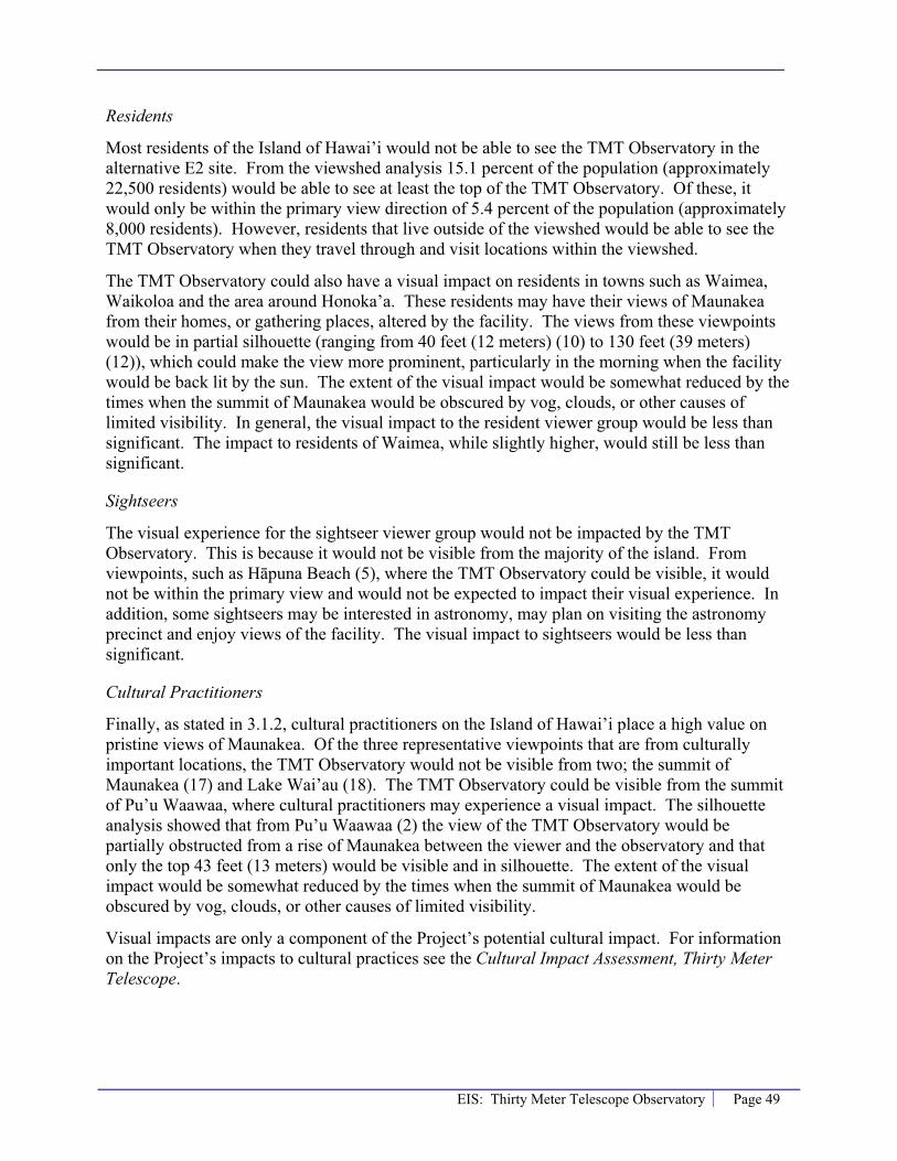
EIS: Thirty Meter Telescope Observatory Page 49
Residents
Most residents of the Island of Hawai’i would not be able to see the TMT Observatory in the alternative E2 site. From the viewshed analysis 15.1 percent of the population (approximately 22,500 residents) would be able to see at least the top of the TMT Observatory. Of these, it would only be within the primary view direction of 5.4 percent of the population (approximately 8,000 residents). However, residents that live outside of the viewshed would be able to see the TMT Observatory when they travel through and visit locations within the viewshed.
The TMT Observatory could also have a visual impact on residents in towns such as Waimea, Waikoloa and the area around Honoka’a. These residents may have their views of Maunakea from their homes, or gathering places, altered by the facility. The views from these viewpoints would be in partial silhouette (ranging from 40 feet (12 meters) (10) to 130 feet (39 meters) (12)), which could make the view more prominent, particularly in the morning when the facility would be back lit by the sun. The extent of the visual impact would be somewhat reduced by the times when the summit of Maunakea would be obscured by vog, clouds, or other causes of limited visibility. In general, the visual impact to the resident viewer group would be less than significant. The impact to residents of Waimea, while slightly higher, would still be less than significant.
Sightseers
The visual experience for the sightseer viewer group would not be impacted by the TMT Observatory. This is because it would not be visible from the majority of the island. From viewpoints, such as H�puna Beach (5), where the TMT Observatory could be visible, it would not be within the primary view and would not be expected to impact their visual experience. In addition, some sightseers may be interested in astronomy, may plan on visiting the astronomy precinct and enjoy views of the facility. The visual impact to sightseers would be less than significant.
Cultural Practitioners
Finally, as stated in 3.1.2, cultural practitioners on the Island of Hawai’i place a high value on pristine views of Maunakea. Of the three representative viewpoints that are from culturally important locations, the TMT Observatory would not be visible from two; the summit of Maunakea (17) and Lake Wai’au (18). The TMT Observatory could be visible from the summit of Pu’u Waawaa, where cultural practitioners may experience a visual impact. The silhouette analysis showed that from Pu’u Waawaa (2) the view of the TMT Observatory would be partially obstructed from a rise of Maunakea between the viewer and the observatory and that only the top 43 feet (13 meters) would be visible and in silhouette. The extent of the visual impact would be somewhat reduced by the times when the summit of Maunakea would be obscured by vog, clouds, or other causes of limited visibility.
Visual impacts are only a component of the Project’s potential cultural impact. For information on the Project’s impacts to cultural practices see the Cultural Impact Assessment, Thirty Meter Telescope.
Page 50 EIS: Thirty Meter Telescope Observatory
Overall Visual Impact
As discussed above, while the TMT Observatory would be a new visual element within the views of Maunakea (for approximately 13 percent of the island area and could be seen by approximately 15.1 percent of the population, or roughly 22,500 people) it would not obstruct or block existing views of Maunakea from around the Island of Hawai’i. Therefore, the Project would not exceed the applicable significance criteria in §11-200-12 of the HAR and would be expected to have a less than significant visual impact.
4.2.3 Indirect and Cumulative
Indirect Impacts
The TMT Observatory is not expected to have any indirect visual impacts.
Cumulative Impacts
A cumulative impact is the incremental impact of a proposed project together with other past, present and reasonably foreseeable future actions. For cumulative visual impacts, the analysis for the TMT Observatory looks at the following two components:
� Would the TMT Observatory be visible in an area of the island where currently no telescopes are visible?
� Which areas of the island would the TMT Observatory be visible in addition to the existing telescopes?
Proposed 13N Site
Table 4-9 summarizes the cumulative visual impact of the TMT Observatory at the proposed 13N site.
Table 4-9. Cumulative Visibility of Proposed 13N Site
Visibility Area of Island (%) Hawai’i’s Population % People
Existing 43% 72% 107,000
New (TMT) 1.2% Less than 1% 72
Figure 4-25 shows the visibility/viewshed of the existing summit observatories on Maunakea (see Section 3.1.4) combined with the viewshed of the TMT Observatory at the proposed 13N site. The green shaded area indicates where the existing summit observatories on Maunakea are visible. This area is approximately 43 percent of the island and is home to approximately 72 percent of the Island of Hawai’i’s population. The portions of the island that are shaded in red are areas where the TMT Observatory would be visible where currently none of the existing telescopes can be seen. The new area where a telescope would be visible is roughly 1.2 percent of the area of the Island of Hawai’i. The majority of this new area is ranch land south of Waimea. Off of Saddle Road there is a residential area, Waikii Ranch, which would be within the area where the TMT Observatory would be the only visible observatory. Using the 2000 U.S. Census average household size of 2.75 people for the County of Hawai’i, the estimated

EIS: Thirty Meter Telescope Observatory Page 51
number of people living in this area is 72 (substantially less than 1 percent of the island’s population).

Page 52 EIS: Thirty Meter Telescope Observatory
Figure 4-25. Proposed 13N Site – Cumulative Visibility Analysis

EIS: Thirty Meter Telescope Observatory Page 53
Table B-1, in Appendix B, shows which of the existing observatories are visible at the 18 representative viewpoints. At the viewpoints where the TMT Observatory would be visible, six to eight of the existing 11 summit observatories are currently visible.
The visual impact of the existing observatories on Maunakea is significant; particularly considering the visual sensitivity of the cultural practitioner viewer group. The visual impact of the TMT Observatory at the proposed 13N site would be less than significant. Nonetheless, when combined with the past, present (existing conditions) and reasonably foreseeable future actions the cumulative visual impact of development on and near the summit of Maunakea, including the proposed TMT Observatory, would continue to be significant.
E2 Alternative Site
The cumulative visual impact of the TMT Observatory at the alternative E2 site would be similar to the proposed 13N site.
Table 4-10 summarizes the cumulative visual impact. Figure 4-26 shows the visibility/viewshed of the existing observatories combined with the viewshed of the TMT Observatory at the alternative E2 site. The new area where a telescope would be visible is roughly 0.9 percent of the area of the Island of Hawai’i. The majority of this new area is ranch land south of Waimea. Off of Saddle Road there is a residential area that would be within the area where the TMT Observatory would be the only telescope visible. Using the 2000 U.S. Census average household size of 2.75 people for the County of Hawai’i, the estimated number of people living in this area is 28 (substantially less than 1 percent of the Island of Hawai’i’s population).
Table 4-10. Cumulative Visibility of Alternative E2 Site
Visibility Area of Island (%) Hawai’i’s Population % People
Existing 43% 72% 107,000
New (TMT) 0.9% Less than 1% 28
Table B-1, in Appendix B, shows which of the existing observatories are visible at the 18 representative viewpoints. At the viewpoints where the TMT Observatory would be visible, six to eight of the existing 11 summit observatories are currently visible.
The visual impact of the existing observatories on Maunakea is significant; particularly considering the visual sensitivity of the cultural practitioner viewer group. The visual impact of the TMT Observatory at the alternative E2 site would be less than significant. Nonetheless, when combined with the past, present (existing conditions) and reasonably foreseeable future actions the cumulative visual impact of development on and near the summit of Maunakea, including the proposed TMT Observatory, would continue to be significant.

Page 54 EIS: Thirty Meter Telescope Observatory
Figure 4-26. E2 Alternative Site – Cumulative Visibility Analysis

EIS: Thirty Meter Telescope Observatory Page 55
5.0 Mitigation
5.1 No Build Alternative There are no Project visual impacts from the No Build Alternative, therefore mitigation is not proposed.
5.2 Maunakea The proposed location for the TMT Observatory is the primary mitigation for the Project’s potential visual impacts. As shown in Section 4.2 because the proposed location of the TMT Observatory is north of and below the summit of Maunakea it would be visible in roughly 14 percent of the Island of Hawai’i and to approximately 15 percent of the population (23,000 people). This is significantly different than if the TMT Observatory were to be placed in a more visible location, such as the summit ridge or pu’u.
The visual impacts of the TMT Observatory, which would house a telescope with a mirror 98 feet (30 meters) in diameter, are also due to the size of the dome enclosure. The proposed diameter of the TMT dome is 216 feet (66 meters). Because the center of the dome would be placed only 36 feet (11 meters) off the ground surface the TMT Observatory would have a height of approximately 180 feet (55 meters) above grade level. This would be the tallest observatory on Maunakea. However, the TMT telescope and the dome enclosure have been designed to minimize the height of the structure, which in turn minimizes the visual impacts (Figure 5-1). The TMT telescope itself has been designed to be much shorter to allow for a much smaller dome. In addition, the enclosure has been designed to fit very tightly around the telescope, leaving only about 20 inches between the telescope and the dome; just enough room for a person.
For comparison purposes, the Keck Observatory consists of two telescopes each with mirrors 33 feet (10 meters) in diameter. The diameter of each Keck dome is 121 feet (37 meters); the height of the Keck dome and other observatories on Maunakea are listed in Table 3-2. Using this ratio of mirror to dome size the TMT telescope would result in a dome with a diameter of 364 feet (111 meters); almost twice what is proposed (Figure 5-2).
Finally, the color, or coating, of the dome enclosure has substantial visual implications. As discussed in Section 4.2 the fixed enclosure and support facilities would be painted with colors that would blend into the landscape. The coating of the dome enclosure would be a reflective aluminum-like finish, similar to the Subaru Observatory. In general, the visual impacts of the existing observatories on Maunakea with an aluminum-like finish (such as Gemini, IRTF and Subaru) are that they reflect the morning sunrise and evening sunset light and stand out during this period. However, during most of the day the coating can reflect the sky, which helps reduce the visibility of the observatory.
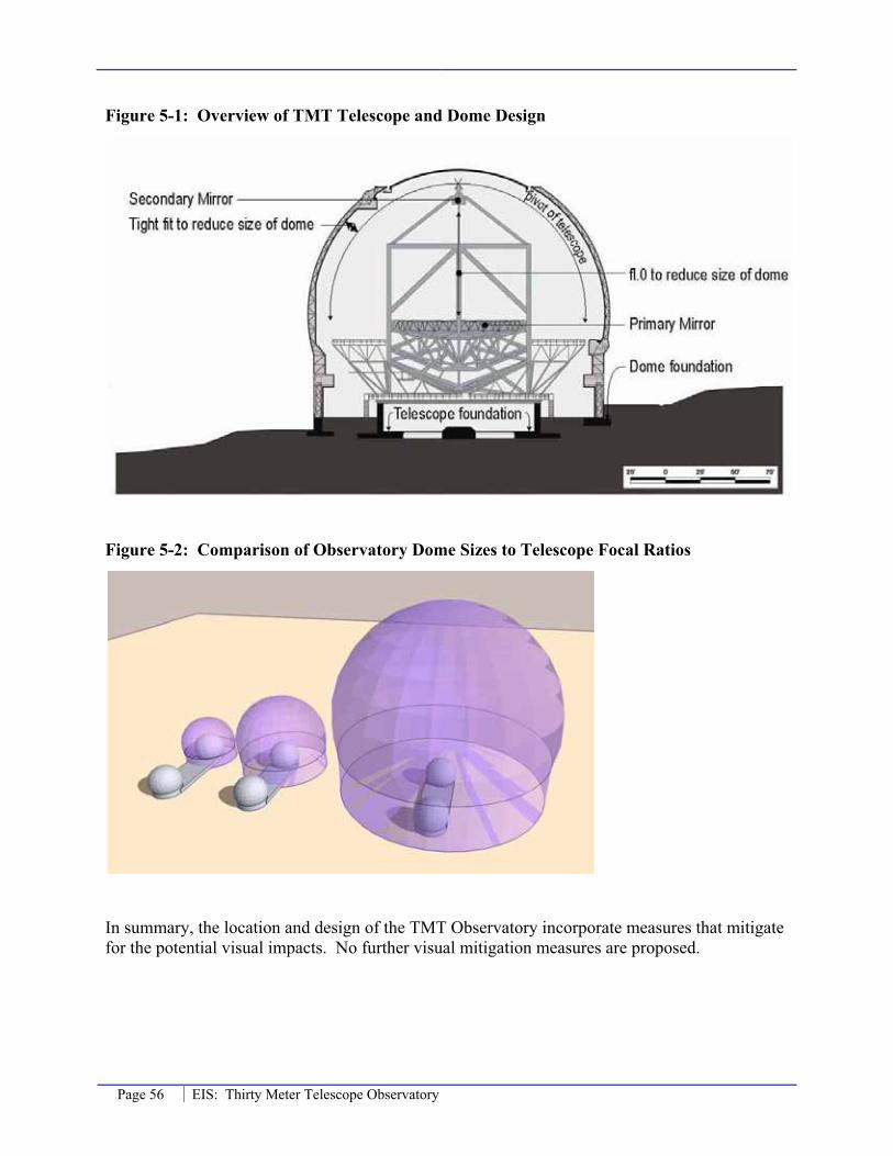
Page 56 EIS: Thirty Meter Telescope Observatory
Figure 5-1: Overview of TMT Telescope and Dome Design
Figure 5-2: Comparison of Observatory Dome Sizes to Telescope Focal Ratios
In summary, the location and design of the TMT Observatory incorporate measures that mitigate for the potential visual impacts. No further visual mitigation measures are proposed.

EIS: Thirty Meter Telescope Observatory Page 57
6.0 ReferencesCFHT. December 2008. CFHT Observatory Manual. http://www.cfht.hawaii.edu/Instruments/ObservatoryManual/CFHT_ObservatoryManual_(Sec_3).html, and photograph description at http://www.cfht.hawaii.edu/Science/Astros/Imageofweek/ciw070800.html
County of Hawai’i. 2005. Hawaii County General Plan.
County of Hawai’i. 2008. South Kohala Development Plan.
Gemini Northern Observatory. December 2008. http://www.gemini.edu/media/factsheets/enclosurefacts.html
IRTF. December 2008. http://iqup.ifa.hawaii.edu/hvac/pages/fy93_nasa_pm9736_a6big.html
National Aeronautics and Space Administration (NASA), Universe Division. February 2005. Final Environmental Impact Statement for the Outrigger Telescopes Project, Mauna Kea Science Reserve, Island of Hawai’i, Volume 1.
Subaru Observatory. December 2008. http://www.naoj.org/Introduction/telescope.html
United States Census Bureau. 2000. Census 2000 Data. URL: http://factfinder.census.gov.
United States Geologic Survey. November 25, 2008. National Elevation Dataset. www.ned.usgs.gov/.
University of Hawai’i. 1975. Final EIS for Existing Operations of the UH Observatory and the Construction and Operation of the new IRTF and UKIRT Observatories.
University of Hawai’i, Office of Mauna Kea Management (OMKM). 1983. Mauna Kea Science Reserve Complex Development Plan.
University of Hawai’i, Office of Mauna Kea Management (OMKM). 2000. Mauna Kea Science Reserve Master Plan.
University of Hawai’i. 2006. Final EA for University of Hawai‘i 24-inch Telescope Observatory Renovation.
University of Hawai’i, Institute for Astronomy. December 2, 2008. www.ifa.hawaii.edu.mko/coordinates.
University of Hawai’i, Office of Mauna Kea Management (OMKM). 2009. Draft Comprehensive Management Plan.
University of Hawai’i. February 25, 2009. Coping with Vog from Puu O’o. http://www.uhh.hawaii.edu/~nat_haz/volcanoes/vog.php


EIS: Thirty Meter Telescope Observatory Page A-1
Appendix A. Photographs of or from the RepresentativeViewpoints

Page A-2 EIS: Thirty Meter Telescope Observatory
Viewpoint 1: Hual�lai Resort
Photo not available.
Viewpoint 2: Pu’u Waawaa
Photo not available.
Viewpoint 3: Big Island Country Club

EIS: Thirty Meter Telescope Observatory Page A-3
Viewpoint 4: Waikoloa/Mauna Lani (View toward Maunakea)
Viewpoint 5: H�puna Beach (Primary View)

Page A-4 EIS: Thirty Meter Telescope Observatory
Viewpoint 6: Puukohola Heiau (Primary View)

EIS: Thirty Meter Telescope Observatory Page A-5
Viewpoint 7: DHHL Kawaihae at Rt. 250 (In the direction of Maunakea)
Viewpoint 8: Route 250 Pu’u Overlook (Primary View)
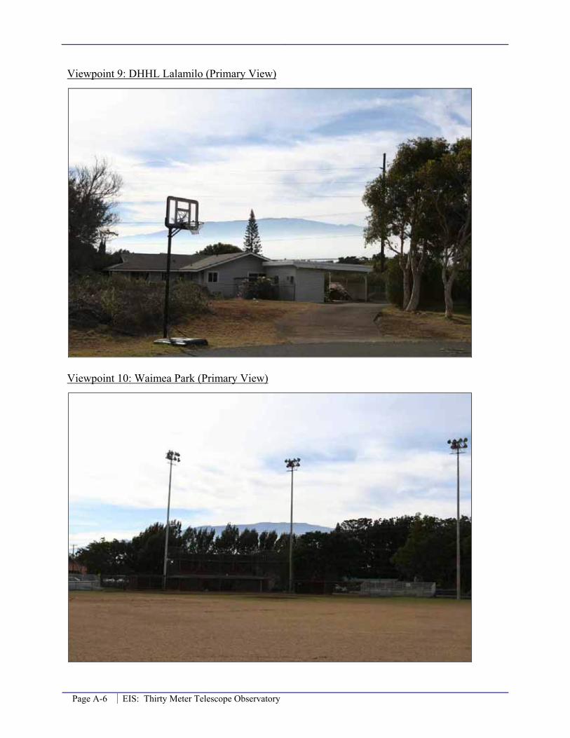
Page A-6 EIS: Thirty Meter Telescope Observatory
Viewpoint 9: DHHL Lalamilo (Primary View)
Viewpoint 10: Waimea Park (Primary View)

EIS: Thirty Meter Telescope Observatory Page A-7
Viewpoint 11: DHHL Pu’u Kapu (Primary View)
Viewpoint 12: DHHL Waikoloa-Waialeale (Primary View)

Page A-8 EIS: Thirty Meter Telescope Observatory
Viewpoint 13: Waipio Valley Lookout (Primary View)
Viewpoint 14: Honoka’a (Primary View)

EIS: Thirty Meter Telescope Observatory Page A-9
Viewpoint 15: Laup�hoehoe Point (Primary View, Top Photo)

Page A-10 EIS: Thirty Meter Telescope Observatory
Viewpoint 16: Maunakea Summit

EIS: Thirty Meter Telescope Observatory Page A-11
Viewpoint 17: Lake Wai’au (Primary View)
Viewpoint 18: North ridge of Maunakea summit cinder cone (K�kuhau‘ula)


EIS: Thirty Meter Telescope Observatory Page B-1
Appendix B. Viewsheds of ExistingObservatories


EIS: Thirty Meter Telescope Observatory Page B-1
Table B-1. Visibility of the TMT Observatory and the Existing Observatories from the Representative Viewpoints
Viewpoint
Number Viewpoint
Name
TMTProposed 13N
Site
TMTAlternati
veE2 Site
CFHT Gemini
UH 2.2 M IRTF Kec
kUKIR
TSubar
u Hilo CSO JCMT SMA
1 Hual�lai Resort X X X X X X X X 2 Pu’u Waawaa X X X X X X
3 Big Island Country Club X X X X X
4 Waikoloa/Mauna Lani X X X X X X X X X
5 H�puna Beach X X X X X X X X X 6 Puukohola Heiau X X X X X X X X X X
7 DHHL Kawaihae at Route 250 X X X X X X X X X X X X
8 Route 250 Pu‘u Overlook X X X X X X X X X X
9 DHHL Lalamilo X X X X X X X X 10 Waimea Park X X X X X X X X 11 DHHL Pu’u Kapu X X X X X X X X
12 DHHL Waikoloa-Waialeale X X X X X X X X X
13 Waipio Valley Lookout
14 Honoka’a X X X X X X X
15 Laup�hoehoe Point
16 Maunakea Summit X X X X X X
17 Lake Wai’au
18 North ridge of K�kahau‘ula X X X X X
CFHT = Canada France Hawai’i Telescope Gemini = Gemini Northern Observatory UH 2.2M = University of Hawai’i 2.2 m IRTF = NASA Infrared Telescope Facility Keck = W.M. Keck Observatory UKIRT = United Kingdom Infrared Telescope Subaru = Subaru Observatory CSO = California Institute of Technology Submillimeter Observatory Hilo = University of Hawi’i 0.9 m JCMT = James Clerk Maxwell Telescope SMA = Submillimeter Array
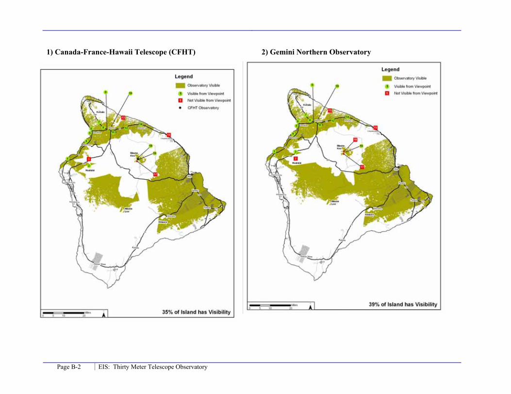
Page B-2 EIS: Thirty Meter Telescope Observatory
1) Canada-France-Hawaii Telescope (CFHT) 2) Gemini Northern Observatory

EIS: Thirty Meter Telescope Observatory Page B-3
3) University of Hawaii 2.2 m Observatory 4) NASA Infrared Telescope (IRTF)

Page B-4 EIS: Thirty Meter Telescope Observatory
5) Keck 1 and Keck 2

EIS: Thirty Meter Telescope Observatory Page B-5
6) United Kingdom Infrared Telescope (UKIRT) 7) Subaru Observatory

Page B-6 EIS: Thirty Meter Telescope Observatory
8) University of Hawaii 0.9 m Telescope (Hilo) 9) Caltech Submillimeter Telescope (CSO)

EIS: Thirty Meter Telescope Observatory Page B-7
10) James Clerk Maxwell Telescope (JCMT) 11) Submillimeter Array (SMA)


EIS: Thirty Meter Telescope Observatory Page C-1
Appendix C. Silhouette Analysis by Viewpoint

Page C-2 EIS: Thirty Meter Telescope Observatory
Hualalai Resort - TMT Proposed 13N Site
0
1000
2000
3000
4000
5000
6000
Elev
atio
n (m
eter
s)
Terrain Line of Sight
TMT Observatory
Viewpoint
Hualalai Resort - TMT Alternative E2 Site
0
1000
2000
3000
4000
5000
6000
Elev
atio
n (m
eter
s)
Terrain Line of Sight
TMT Observatory
Viewpoint
Hualalai Resort - Near TMT Proposed 13N Site
3500
3600
3700
3800
3900
4000
4100
4200
4300
Elev
atio
n (m
eter
s)
Terrain Line of Sight Silhouette Limit
TMT Observatory
Hualalai Resort - Near TMT Alternative E2 Site
3400
3500
3600
3700
3800
3900
4000
4100
4200
Elev
atio
n (m
eter
s)
Terrain Line of Sight Silhouette Limit
TMT Observatory

EIS: Thirty Meter Telescope Observatory Page C-3
Puu Waawaa - TMT Proposed 13N Site
0
1000
2000
3000
4000
5000
6000
Elev
atio
n (m
eter
s)
Terrain Line of Sight
TMT Observatory
Viewpoint
Puu Waawaa - TMT Alternative E2 Site
0
1000
2000
3000
4000
5000
6000
Elev
atio
n (m
eter
s)
Terrain Line of Sight
TMT Observatory
Viewpoint
Puu Waawaa - Near TMT Proposed 13N Site
3600
3700
3800
3900
4000
4100
4200
4300
Elev
atio
n (m
eter
s)
T i Li f Si ht Silh tt Li it
TMT Observatory
Puu Waawaa - Near TMT Alternative E2 Site
3500
3600
3700
3800
3900
4000
4100
4200
Elev
atio
n (m
eter
s)
Terrain Line of Sight Silhouette Limit
TMT Observatory

Page C-4 EIS: Thirty Meter Telescope Observatory
Big Island Country Club - TMT Proposed 13N Site
0
1000
2000
3000
4000
5000
6000
Elev
atio
n (m
eter
s)
Terrain Line of Sight
TMT Observatory
Viewpoint
Big Island Country Club - TMT Alternative E2 Site
0
1000
2000
3000
4000
5000
6000
Elev
atio
n (m
eter
s)
Terrain Line of Sight
TMT Observatory
Viewpoint
Big Island Country Club - Near TMT Proposed 13N Site
3500
3600
3700
3800
3900
4000
4100
4200
4300
Elev
atio
n (m
eter
s)
T i Li f Si ht Silh tt Li it
TMT Observatory
Big Island Country Club - Near TMT Alternative E2 Site
3300
3400
3500
3600
3700
3800
3900
4000
4100
4200
Elev
atio
n (m
eter
s)
Terrain Line of Sight Silhouette Limit
TMT Observatory

EIS: Thirty Meter Telescope Observatory Page C-5
Waikoloa/Mauna Lani - TMT Proposed 13N Site
0
1000
2000
3000
4000
5000
6000
Elev
atio
n (m
eter
s)
Terrain Line of Sight
TMT Observatory
Viewpoint
Waikoloa/Mauna Lani - TMT Alternative E2 Site
0
1000
2000
3000
4000
5000
6000
Elev
atio
n (m
eter
s)
Terrain Line of Sight
TMT Observatory
Viewpoint
Waikoloa/Mauna Lani - Near TMT Proposed 13N Site
3400
3500
3600
3700
3800
3900
4000
4100
4200
4300
4400
Elev
atio
n (m
eter
s)
T i Li f Si ht Silh tt Li it
TMT Observatory
Waikoloa/Mauna Lani - Near TMT Alternative E2 Site
3400
3500
3600
3700
3800
3900
4000
4100
4200
4300
4400
Elev
atio
n (m
eter
s)
Terrain Line of Sight Silhouette Limit
TMT Observatory

Page C-6 EIS: Thirty Meter Telescope Observatory
At site 13N the TMT Observatory would not be visible from Hapuna Beach.
Hapuna Beach - TMT Alternative E2 Site
0
1000
2000
3000
4000
5000
6000
Elev
atio
n (m
eter
s)
Terrain Line of Sight
TMT Observatory
Viewpoint
Hapuna Beach - Near TMT Alternative E2 Site
3300
3400
3500
3600
3700
3800
3900
4000
4100
4200
4300
4400
Elev
atio
n (m
eter
s)
Terrain Line of Sight Silhouette Limit
TMT Observatory
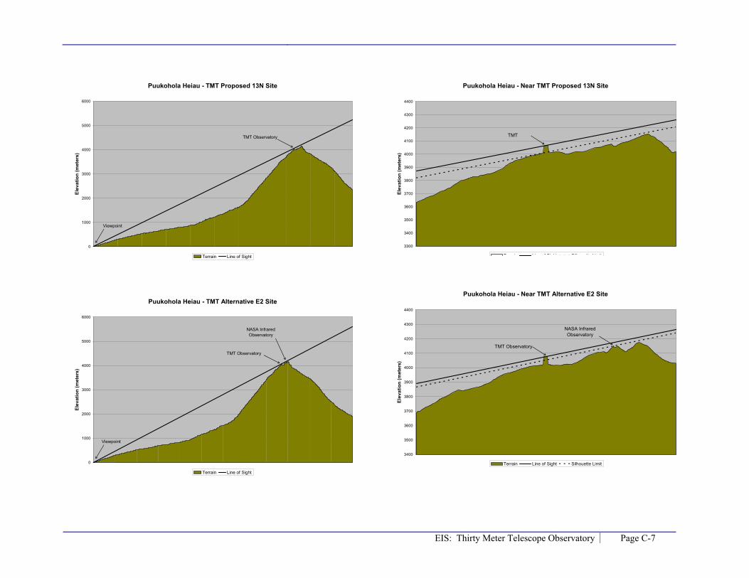
EIS: Thirty Meter Telescope Observatory Page C-7
Puukohola Heiau - TMT Proposed 13N Site
0
1000
2000
3000
4000
5000
6000
Elev
atio
n (m
eter
s)
Terrain Line of Sight
TMT Observatory
Viewpoint
Puukohola Heiau - TMT Alternative E2 Site
0
1000
2000
3000
4000
5000
6000
Elev
atio
n (m
eter
s)
Terrain Line of Sight
TMT Observatory
Viewpoint
NASA Infrared Observatory
Puukohola Heiau - Near TMT Proposed 13N Site
3300
3400
3500
3600
3700
3800
3900
4000
4100
4200
4300
4400
Elev
atio
n (m
eter
s)
Terrain Line of Sight Silhouette Limit
TMT
Puukohola Heiau - Near TMT Alternative E2 Site
3400
3500
3600
3700
3800
3900
4000
4100
4200
4300
4400
Elev
atio
n (m
eter
s)
Terrain Line of Sight Silhouette Limit
TMT Observatory
NASA Infrared Observatory

Page C-8 EIS: Thirty Meter Telescope Observatory
DHHL Kawaihae at Rt. 250 - TMT Proposed 13N Site
0
1000
2000
3000
4000
5000
6000
Elev
atio
n (m
eter
s)
Terrain Line of Sight
TMT Observatory
Viewpoint
Keck 1 Observatory
DHHL Kawaihae at Rt. 250 - TMT Alternative E2 Site
0
1000
2000
3000
4000
5000
6000
Elev
atio
n (m
eter
s)
Terrain Line of Sight
TMT Observatory
Viewpoint
UK Infrared Observatory
DHHL Kawaihae at Rt. 250 - Near TMT Proposed 13N Site
3300
3400
3500
3600
3700
3800
3900
4000
4100
4200
4300
Elev
atio
n (m
eter
s)
T i Li f Si ht/Silh tt Li it
TMT Observatory
Keck 1 Observatory
DHHL Kawaihae at Rt. 250 - Near TMT Alternative E2 Site
3400
3500
3600
3700
3800
3900
4000
4100
4200
4300
Elev
atio
n (m
eter
s)
Terrain Line of Sight
TMT Observatory
UK Infrared Observatory

EIS: Thirty Meter Telescope Observatory Page C-9
Route 250 Puu overlook - TMT Proposed 13N Site
0
1000
2000
3000
4000
5000
6000
Elev
atio
n (m
eter
s)
Terrain Line of Sight
TMT Observatory
Viewpoint
Keck 1 Observatory
Route 250 Puu overlook - TMT Alternative E2 Site
0
1000
2000
3000
4000
5000
6000
Elev
atio
n (m
eter
s)
Terrain Line of Sight
TMT Observatory
Viewpoint
Keck I Observatory
Route 250 Puu overlook - Near TMT Proposed 13N Site
3300
3400
3500
3600
3700
3800
3900
4000
4100
4200
4300
4400
Elev
atio
n (m
eter
s)
T i Li f Si ht/Silh tt Li it
TMT
Keck 1 Observatory
Route 250 Puu overlook - Near TMT Alternative E2 Site
3400
3500
3600
3700
3800
3900
4000
4100
4200
4300
4400
Elev
atio
n (m
eter
s)
Terrain Line of Sight/Silhouette Limit
TMT Observatory
Keck I Observatory

Page C-10 EIS: Thirty Meter Telescope Observatory
DHHL Lalamilo - TMT Proposed 13N Site
0
1000
2000
3000
4000
5000
6000
Elev
atio
n (m
eter
s)
Terrain Line of Sight
TMT Observatory
Viewpoint
Keck 1 Observatory
DHHL Lalamilo - TMT Alternative E2 Site
0
1000
2000
3000
4000
5000
6000
Elev
atio
n (m
eter
s)
Terrain Line of Sight
TMT Observatory
Viewpoint
UK Infrared Observatory
DHHL Lalamilo - Near TMT Proposed 13N Site
3300
3400
3500
3600
3700
3800
3900
4000
4100
4200
4300
4400
Elev
atio
n (m
eter
s)
T i Li f Si ht/Silh tt Li it
TMT Observatory
Keck 1 Observatory
DHHL Lalamilo - Near TMT Alternative E2 Site
3400
3500
3600
3700
3800
3900
4000
4100
4200
4300
4400
Elev
atio
n (m
eter
s)
Terrain Line of Sight Silhouette Limit
TMT Observatory
UK Infrared Observatory

EIS: Thirty Meter Telescope Observatory Page C-11
Waimea Park - TMT Proposed 13N Site
0
1000
2000
3000
4000
5000
6000
Elev
atio
n (m
eter
s)
Terrain Line of Sight
TMT Observatory
Viewpoint
Waimea Park - TMT Alternative E2 Site
0
1000
2000
3000
4000
5000
6000
Elev
atio
n (m
eter
s)
Terrain Line of Sight
TMT Observatory
Viewpoint
Waimea Park - Near TMT Proposed 13N Site
3300
3400
3500
3600
3700
3800
3900
4000
4100
4200
4300
4400
Elev
atio
n (m
eter
s)
T i Li f Si ht Silh tt Li it
TMT Observatory
Waimea Park - Near TMT Alternative 13N Site
3400
3500
3600
3700
3800
3900
4000
4100
4200
4300
4400
Elev
atio
n (m
eter
s)
Terrain Line of Sight Silhouette Limit
TMT Observatory

Page C-12 EIS: Thirty Meter Telescope Observatory
DHHL Puu Kapu - TMT Proposed 13N Site
0
1000
2000
3000
4000
5000
6000
Elev
atio
n (m
eter
s)
Terrain Line of Sight
TMT Observatory
Viewpoint
DHHL Puu Kapu - TMT Alternative E2 Site
0
1000
2000
3000
4000
5000
6000
7000
Elev
atio
n (m
eter
s)
Terrain Line of Sight
TMT Observatory
Viewpoint
DHHL Puu Kapu - Near TMT Proposed 13N Site
3300
3400
3500
3600
3700
3800
3900
4000
4100
4200
4300
4400
Elev
atio
n (m
eter
s)
T i Li f Si ht Silh tt Li it
TMT Observatory
DHHL Puu Kapu - Near TMT Alternative E2 Site
3300
3400
3500
3600
3700
3800
3900
4000
4100
4200
4300
4400
Elev
atio
n (m
eter
s)
Terrain Line of Sight Silhouette Limit
TMT Observatory

EIS: Thirty Meter Telescope Observatory Page C-13
DHHL Waikoloa-Waialeale - TMT Proposed 13N Site
0
1000
2000
3000
4000
5000
6000
Elev
atio
n (m
eter
s)
Terrain Line of Sight
TMT Observatory
Viewpoint
DHHL Waikoloa-Waialeale - TMT Alternative E2 Site
0
1000
2000
3000
4000
5000
6000
7000
Elev
atio
n (m
eter
s)
Terrain Line of Sight
TMT Observatory
Viewpoint
DHHL Waikoloa-Waialeale - Near TMT Proposed 13N Site
3300
3400
3500
3600
3700
3800
3900
4000
4100
4200
4300
4400
Elev
atio
n (m
eter
s)
T i Li f Si ht Silh tt Li it
TMT Observatory
DHHL Waikoloa-Waialeale - Near TMT Alternative E2 Site
3400
3500
3600
3700
3800
3900
4000
4100
4200
4300
4400
Elev
atio
n (m
eter
s)
Terrain Line of Sight Silhoutte Limit
TMT Observatory
James Clerk Maxwell
Observatory

Page C-14 EIS: Thirty Meter Telescope Observatory
At site E2 the TMT Observatory would not be visible from Honoka’a.
Honoka'a - TMT Proposed 13N Site
0
1000
2000
3000
4000
5000
6000
7000
Elev
atio
n (m
eter
s)
Terrain Line of Sight
TMT Observatory
Viewpoint
Honoka'a - Near TMT Proposed 13N Site
3100
3200
3300
3400
3500
3600
3700
3800
3900
4000
4100
4200
Elev
atio
n (m
eter
s)
T i Li f Si ht Silh tt Li it
TMT Observatory

EIS: Thirty Meter Telescope Observatory Page C-15
K�kahau‘ula - TMT Proposed 13N Site
0
500
1000
1500
2000
2500
3000
3500
4000
4500
Elev
atio
n (m
eter
s)
Terrain Line of Sight
K�kahau‘ula - TMT Alternative E2 Site
0
500
1000
1500
2000
2500
3000
3500
4000
4500
Elev
atio
n (m
eter
s)
Terrain Line of Sight
K�kahau‘ula - Near TMT Proposed 13N Site
3850
3900
3950
4000
4050
4100
4150
Elev
atio
n (m
eter
s)
Terrain Line of Sight
K�kahau‘ula - Near TMT Alternative E2 Site
3900
3950
4000
4050
4100
4150
Elev
atio
n (m
eter
s)
Terrain Line of Sight Silhouette Limit