
Sustainability Appraisal/ Strategic Environmental Assessment ...
65
Sustainability Appraisal/ Strategic Environmental Assessment West Bedlington Neighbourhood Plan January 2021 Company no: 10237123 Registered Office: 23 Mead Court, Forest Hall, Newcastle Upon Tyne, NE12 9RF 07802588437 [email protected]
-
Upload
khangminh22 -
Category
Documents
-
view
0 -
download
0
Transcript of Sustainability Appraisal/ Strategic Environmental Assessment ...

Sustainability Appraisal/ Strategic
Environmental Assessment
West Bedlington Neighbourhood Plan
January 2021
Company no: 10237123 Registered Office: 23 Mead Court, Forest Hall, Newcastle Upon Tyne, NE12 9RF 07802588437 [email protected]

West Bedlington Neighbourhood Plan: SEA/ SA Report January 2021
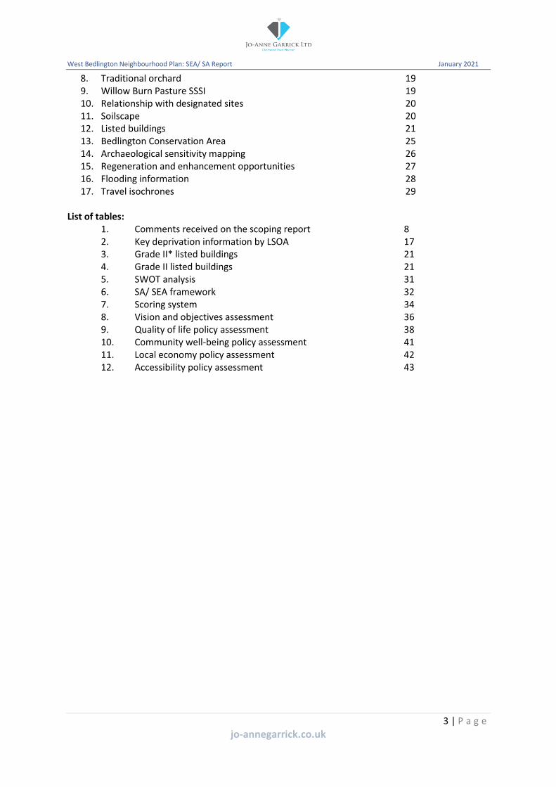
Contents 1. Introduction 4
Context 4 West Bedlington Neighbourhood Plan 4 Background to SA and SEA 6 SEA and neighbourhood plans 6 Comments 10
2. Relevant policies, plans and programmes 11 Introduction 11 National 11 Regional 12 Local 12
3. Baseline information 15 Introduction 15 General characteristics of the area 15 Population 15 Social characteristics 15 Environmental characteristics 17 Economic characteristics 28 Summary of sustainability issues from the baseline 30
4. SA framework 32 Introduction 32 SA/ SEA framework 32 Methodology 34
5. Appraisal of the pre-submission draft neighbourhood plan 35 Introduction 35 Vision and objectives 35 Planning policies 37 Cumulative effects 44 Mitigation measures 45 Habitats regulations assessment 45
6. Next steps 46
Appendix 1: Email from NCC confirming need for SEA 47 Appendix 2: Assessment of policy options 48
List of figures: 1. West Bedlington Neighbourhood Plan Area 4 2. SEA and neighbourhood plan making process 7 3. Indices of multiple deprivation 16 4. Bedlington Country Park Local Nature Reserve 18 5. Areas of ancient woodland 18 6. Deciduous woodland 18 7. National forest inventory 19
2 | P a g e
jo-annegarrick.co.uk
West Bedlington Neighbourhood Plan: SEA/ SA Report January 2021
8. Traditional orchard 19 9. Willow Burn Pasture SSSI 19 10. Relationship with designated sites 20 11. Soilscape 20 12. Listed buildings 21 13. Bedlington Conservation Area 25 14. Archaeological sensitivity mapping 26 15. Regeneration and enhancement opportunities 27 16. Flooding information 28 17. Travel isochrones 29
List of tables: 1. Comments received on the scoping report 8 2. Key deprivation information by LSOA 17 3. Grade II* listed buildings 21 4. Grade II listed buildings 21 5. SWOT analysis 31 6. SA/ SEA framework 32 7. Scoring system 34 8. Vision and objectives assessment 36 9. Quality of life policy assessment 38 10. Community well-being policy assessment 41 11. Local economy policy assessment 42 12. Accessibility policy assessment 43
3 | P a g e
jo-annegarrick.co.uk

West Bedlington Neighbourhood Plan: SEA/ SA Report January 2021
1. Introduction
Context
1.1 This sustainability appraisal report (SAR) has been prepared by Jo-Anne Garrick Ltd on behalf of West Bedlington Town Council to inform the preparation of the West Bedlington Neighbourhood Plan.
West Bedlington Neighbourhood Plan
1.2 On 3 May 2016 the parish of West Bedlington was designated as a neighbourhood area for the purposes of neighbourhood planning (see figure 1). The preparation of the plan is being led by West Bedlington Town Council. Evidence gathering and analysis including public engagement and the sustainability appraisal process has informed the preparation of the pre submission draft plan.
Figure 1: West Bedlington Neighbourhood Plan Area
4 | P a g e
jo-annegarrick.co.uk
West Bedlington Neighbourhood Plan: SEA/ SA Report January 2021
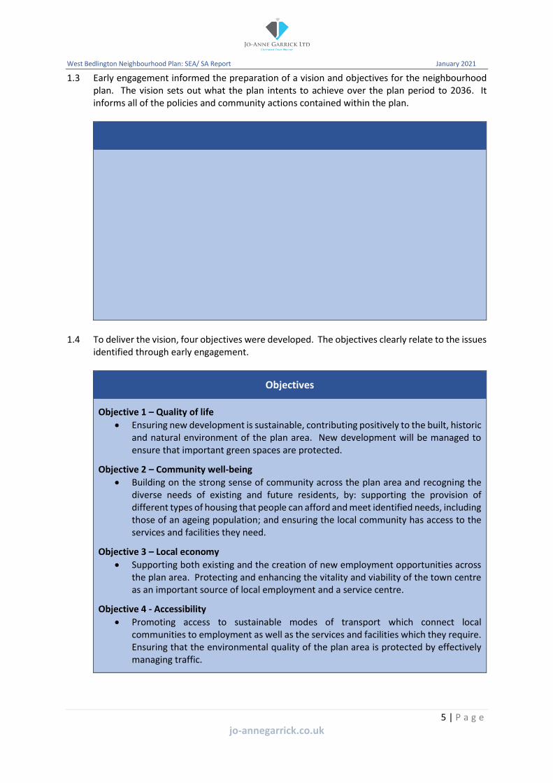
1.3 Early engagement informed the preparation of a vision and objectives for the neighbourhood plan. The vision sets out what the plan intents to achieve over the plan period to 2036. It informs all of the policies and community actions contained within the plan.
-
1.4 To deliver the vision, four objectives were developed. The objectives clearly relate to the issues identified through early engagement.
Objectives
Objective 1 – Quality of life
A Vision for West Bedlington
By 2036 West Bedlington will comprise a sustainable and cohesive community. There will be an appreciation of the importance of the heritage of the area, which is vital to the areas
sense of place, as well as giving local communities a sense of belonging.
Improvements will have been made to the local environment, employment opportunities, services and facilities which will enhance the quality of life of residents. Communities will be well connected, via sustainable transport routes to major employment opportunities as well
as greater services and facilities beyond the plan area.
The important environmental and historic character of the area will have been maintained and enhanced by ensuring new development is of an appropriate scale and design, as well
as reflecting the rural setting of the plan area. Important green spaces will be protected for the benefit of future generations.
• Ensuring new development is sustainable, contributing positively to the built, historic and natural environment of the plan area. New development will be managed to ensure that important green spaces are protected.
Objective 2 – Community well-being
• Building on the strong sense of community across the plan area and recogning the diverse needs of existing and future residents, by: supporting the provision of different types of housing that people can afford and meet identified needs, including those of an ageing population; and ensuring the local community has access to the services and facilities they need.
Objective 3 – Local economy
• Supporting both existing and the creation of new employment opportunities across the plan area. Protecting and enhancing the vitality and viability of the town centre as an important source of local employment and a service centre.
Objective 4 - Accessibility
• Promoting access to sustainable modes of transport which connect local communities to employment as well as the services and facilities which they require. Ensuring that the environmental quality of the plan area is protected by effectively managing traffic.
5 | P a g e
jo-annegarrick.co.uk

West Bedlington Neighbourhood Plan: SEA/ SA Report January 2021
Background to sustainability appraisal and strategic environmental assessment
1.5 The obligation to undertake a sustainability appraisal (SA) is set out in section 39 of the Planning and Compulsory Purchase Act (2004). This requires local development documents to be prepared with a view to contributing to the achievement of sustainable development. The process involves examining the likely effects of the plan and considering how they contribute to social, environmental and economic well-being.
1.6 A strategic environmental assessment (SEA) involves the evaluation of the environmental impacts of a plan. The requirement for a SEA is set out in the European Directive 2001/42/EC. The directive was adopted into UK law as the Environmental Assessment of Plans or Programmes Regulations 2004. This requires:
• An outline of the contents, main objectives of the plan, and relationship with other relevant plans or programmes;
• The relevant aspects of the current state of the environment and the likely evolution of the environment without the implementation of the plan;
• The environmental characteristics of areas likely to be significantly affected;
• Any existing environmental problems which are relevant to the plan including, in particular, those relating to any areas of a particular environmental importance;
• The environmental protection objectives, established at international, European or national level, which are relevant to the plan and the way those objectives and any environmental considerations have been taken into account during its preparation;
• The likely significant effects on the environment;
• The measures envisaged to prevent, reduce, and as fully as possible offset any significant adverse effects on the environment of implementing the plan;
• An outline of the reasons for selecting the alternatives dealt with and a description of how the assessment was undertaken including any difficulties; and
• A description of monitoring measures.
1.7 The SEA process is very similar to the SA process. Government guidance1 suggests incorporating the SEA process into the SA. As this allows a consideration of economic and social effects alongside the environmental effects. Whilst a SA is not a requirement for a neighbourhood plan, given the similarities, the SA approach has been followed for the West Bedlington Neighbourhood Plan.
Strategic environmental assessment and neighbourhood plans
1.8 National planning practice guidance (NPPG) explains that where a neighbourhood plan is likely to have significant environmental effects it may require a SEA. Draft neighbourhood plan proposals are required to be assessed to determine whether they are likely to have significant environmental effects. Where it is concluded that SEA is required an environmental report must be prepared in accordance with the SEA regulations. The guidance goes on to highlight that it may be possible to make use of information and analysis that has been uses in assessing the environmental impact of local plans or spatial development strategies covering the area.
1.9 Guidance explains that the SEA should only focus on what is needed to assess the likely significant effects of the neighbourhood plan. It should therefore focus on the environmental impacts which are likely to be significant. It does not need to be done in any more detail, or
1 Practical Guide to the Strategic Environmental Assessment Directive (ODPM 2005)
6 | P a g e
jo-annegarrick.co.uk
West Bedlington Neighbourhood Plan: SEA/ SA Report January 2021
using more resources than is considered to be appropriate for the content and level of detail in the neighbourhood plan.
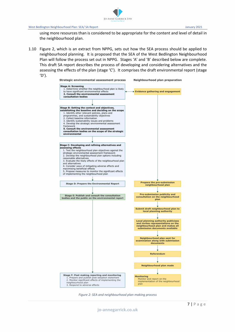
1.10 Figure 2, which is an extract from NPPG, sets out how the SEA process should be applied to neighbourhood planning. It is proposed that the SEA of the West Bedlington Neighbourhood Plan will follow the process set out in NPPG. Stages ‘A’ and ‘B’ described below are complete. This draft SA report describes the process of developing and considering alternatives and the assessing the effects of the plan (stage ‘C’). It comprises the draft environmental report (stage ‘D’).
Figure 2: SEA and neighbourhood plan making process
7 | P a g e
jo-annegarrick.co.uk
West Bedlington Neighbourhood Plan: SEA/ SA Report January 2021
Stage A – Screening
1.11 A screening request was made by West Bedlington Town Council to Northumberland County Council (NCC) under the habitats regulations. This concluded that as a result of the plan promoting residential development, this is sufficient to reach a conclusion that such development would be likely to have significant impacts on European sites designated for their ecological value. This conclusion automatically triggers the need for SEA. See appendix 1.
Stage B - Scoping
1.12 Five key tasks are identified as part of the preparation of a scoping report:
• Identify other relevant policies, plans and programmes;
• Collect baseline information;
• Identify sustainability issues;
• Development the SA/ SEA framework;
• Consult the environmental assessment consultation bodies on the scope of the SA/ SEA.
1.13 Engagement on the SA scoping report took place between 4 October and 11 November 2019. The scoping report has been updated to reflect the comments received.
1.14 Table 1 describes the comments that were received and how they were addressed within the revised scoping report.
Table 1: Comments received on the scoping report
Consultee Comment Response
Natural England No specific comments to make on the SEA scoping report
Noted.
Historic England Agrees that historic environment issues should form part of the SEA but only in proportion to the sensitivity the historic environment within the plan area related to the proposals contained within the draft plan.
Noted.
Reference made to Historic England guidance on the SEA process, which identifies that baseline information should address the significance, condition, sensitivity and capacity of the historic environment’s capacity to accommodate change and the likely effects of alternative solutions.
It is considered that the baseline information proportionately describes the heritage assets across the plan area which is based upon available information.
Explains that it will be important to evaluate the significance of heritage assets and their settings, rather than only rely on the presence or absence of assets. This evaluation is considered to be largely absent from the draft scoping report.
This is accepted and the draft policy on heritage assets clearly refers to the importance of the understanding/ assessment of significance. Reference to significance has been added to section 5 and within the
8 | P a g e
jo-annegarrick.co.uk

West Bedlington Neighbourhood Plan: SEA/ SA Report January 2021
Consultee Comment Response
SA/SEA objectives within section 6.
Any likely significant effects from the plan’s policies and proposals on heritage significance should be avoided or, if not possible, mitigated by amending the draft plan.
Reference to significance has been added to the SA/SEA objectives within section 6.
Opportunities for the historic environment should be considered as well as constraints.
Reference to opportunities offered by the historic environment has been added to section 5
Reference is made to Historic Environment Advice Note 3: The Historic Environment and Site Allocations in Local Plans (2015), which also applies to neighbourhood plans.
Noted.
Environment Agency Support objective 1 relating to the conservation and enhancement of the natural environment which makes reference to designated sites, protected species and net gains for biodiversity. As the River Blyth and Hepscott Burn bound the plan area, it is recommended that water quality is added to objective one.
Reference to the water environment has been added to objective one.
Support reference to the Northumberland Biodiversity Action Plan and the Strategic Flood Risk Assessment for Northumberland.
Noted.
Recommend consideration is also given to other relevant policies, plans and strategies, including flood risk strategies and the Northumbria River Basin Management Plan.
Section 3 has been updated to include reference to these documents.
Reference is made to neighbourhood planning guidance prepared jointly by the Environment Agency, Natural England, Historic England and the Forestry Commission.
Noted.
Stage C – Developing and refining alternatives and assessing effects
1.15 In accordance with the SEA regulations, each proposal contained within the neighbourhood plan and their reasonable alternatives, will be assessed for their likely impacts against the SA/SEA framework. These impacts have been considered in light of the likely evolution of the baseline in the absence of a neighbourhood plan.
9 | P a g e
jo-annegarrick.co.uk

West Bedlington Neighbourhood Plan: SEA/ SA Report January 2021
1.16 The assessment of reasonable alternatives has helped West Bedlington Town Council identify and refine options so that they are more environmentally, socially and economically acceptable. In light of the fact that the requirement for an SEA of the West Bedlington Neighbourhood Plan was triggered as a result of the need for an appropriate assessment, the SA/SEA will help to ensure that significant effects on European sites designated for their ecological value will not arise.
Stage D - Environmental report
1.17 This environmental report is a core output of the SEA process. For the purposes of the SEA Directive, an environmental report must identify, describe and evaluate the likely significant effects on the environment of implementing the neighbourhood plan.
1.18 This SAR accompanies the pre-submission consultation version of the West Bedlington Neighbourhood Plan and is available for comment.
Comments
1.19 Comments are invited on this draft SAR alongside the consultation on the pre submission draft plan and can be made in the following ways:
• By email to: [email protected]; or
• By letter to: West Bedlington Town Council Community Centre Front Street West Bedlington NE22 5TT
1.20 Responses must be received by noon on 7 April 2021.
10 | P a g e
jo-annegarrick.co.uk

West Bedlington Neighbourhood Plan: SEA/ SA Report January 2021
2. Relevant policies, plans and programmes
Introduction
2.1 This section of the SAR provides an overview of the national, regional and local plans and programmes that should be taken into account during the preparation of the West Bedlington Neighbourhood Plan and this SA. The pre submission draft neighbourhood plan contains policies to guide the development of land across the plan area. These policies, together within the policies of the development plan and the National Planning Policy Framework (NPPF) will be used by NCC when determining planning applications in West Bedlington.
National
2.2 The NPPF sets out the government’s planning policies for England and how these are expected to be applied. It sets out requirements for the planning system and provides a framework within which local people and their councils can produce their own distinctive local and neighbourhood plans which reflect the needs and priorities of their communities. The NPPF must be taken into account in the preparation of local and neighbourhood plans and is a material consideration in planning decisions. As a result of the vision and objectives of the neighbourhood plan (described in section 1) the following sections of the NPPF are considered especially relevant:
• Achieving sustainable development (section 2);
• Delivering a sufficient supply of homes (section 5);
• Building a strong, competitive economy (section 6);
• Ensuring the vitality of town centres (section 7);
• Promoting health and safe communities (section 8);
• Promoting sustainable transport (section 9);
• Achieving well-designed places (section 12);
• Meeting the challenge of climate change (section 14);
• Conserving and enhancing the natural environment (section 15); and
• Conserving and enhancing the historic environment (section 16).
2.3 As plan objective two seeks to ensure that new development is sustainable and contributes positively to the built, historic and natural environment of the plan area, the following national level documents are also relevant:
• Planning (Listed Buildings and Conservation Areas) Act (1990) – which changed laws relating to the granting of planning permission for building works, with particular focus on listed buildings and conservation areas. It created special controls for the demolition, alteration or extension of buildings, objects or structures of particular architectural or historic interest, as well as conservation areas;
• Climate Change Act (2008) – which set legally binding emissions targets;
• Delivering our low carbon future (2011) – sets out how the UK will achieve decarbonisation to make the transition to a low carbon economy whist maintaining energy security and minimising costs to consumers, including reference to low carbon buildings;
• Mainstreaming sustainable development (2011) – outlines the government’s commitment to sustainable development and how it will be mainstreamed into overall government policy; and
11 | P a g e
jo-annegarrick.co.uk

West Bedlington Neighbourhood Plan: SEA/ SA Report January 2021
• Biodiversity 2020: A strategy for England’s wildlife and ecosystem services (2011) – explains how the government is implementing international and EU commitments on biodiversity.
Regional
2.4 The Northumbria River Basin Management Plan (NRBMP - 2015) provides a framework for protecting and enhancing the benefits provided by the water environment. As water and land resources are closely linked, the NRBMP informs decisions on land-use planning. The management plan provides information on:
• the baseline classification of water bodies;
• statutory objectives for protected areas;
• statutory objectives for water bodies; and
• summary programme of measures to achieve statutory objectives.
2.5 The NRBMP provides an overview of the river basin, explaining that it covers an area of 9,000km2, extending from the Scottish border to Stockton-upon-Tees, in which approximately 2.5 million people live. It includes all of the neighbourhood plan area. The river basin has a particularly rich diversity of wildlife and habitats, supporting many species of global and national importance. It includes information in relation to key characteristics and the water quality of Northumberland.
Local
2.6 NCC is preparing a new local plan that will guide the preparation of neighbourhood plans and decisions on planning applications up to 2036. Once it is adopted it will replace the saved policies of the Wansbeck District Local Plan (2007). Of the adopted policies, the most relevant to the West Bedlington Neighbourhood Plan are:
• GP1 (location of development) – seeks to focus new development within settlement boundaries and defines criteria to establish when development can take place in the countryside;
• GP4 (accessibility) – requires new development to be located to reduce the need to travel and be accessible to all users by a choice of transport;
• GP5 (landscape character) – requires new development to respect the character of the district’s landscape;
• GP9 (protection of the coastal zone) – seeks to protect the coastal zone and resist development that would cause harm to coastal systems and habitats;
• GP10 (protection of sites of national importance for nature conservation) – requires proposals that are likely to affect sites to be subject to special scrutiny;
• GP11 (protection of sties of local or regional nature conservation significance) – states that development likely to have an adverse effect on a local or regionally important site will not be permitted unless the benefits clearly outweigh the nature conservation value of the site;
• GP13 (biodiversity and wildlife networks) – seeks to protect the biodiversity value of development sites;
• GP14 (demolition of listed buildings) – sets out when consent to demolish a listed building may be given;
• GP15 (changes to listed buildings) – requires sufficient information to be provided on the impact of development proposals to the special architectural or historic interest of a listed building;
12 | P a g e
jo-annegarrick.co.uk

West Bedlington Neighbourhood Plan: SEA/ SA Report January 2021
• GP16 (setting of listed buildings) – states that planning permission will not be granted for development which would have an adverse effect on the setting of a listed building;
• GP19 (protection of conservation areas) – seeks to protect the character or appearance of conservation areas;
• GP22 (flood risk and erosion) – requires developers to consider the risk of their development from flooding and erosion;
• GP30 (visual impact of development) – states that developments that would cause significant harm to the character or quality of the surrounding environment will be refused;
• GP31 (standards of urban design) – identifies design criteria to be considered when assessing planning applications;
• H3 (windfall sites) – defines criteria for the assessment of housing proposals on unallocated sites;
• H5 (design of new housing developments) – identifies design criteria that are expected to be incorporated within housing schemes;
• H8 (extensions to existing houses) – provides design guidance for the assessment of proposals to extend residential dwellings;
• EMP7 (employment generating development in non-designated areas) – identifies criteria that will be considered when assessing proposals for employment uses outside allocated sites;
• EMP8 (retention of general employment areas) – seeks to retain employment areas for employment uses;
• RTC1 (town centre uses) – seeks to focus major retail, leisure, entertainment, indoor sports, offices, arts, culture and tourism development within town centres;
• RTC9 (shop fronts) – requires replacement shop fronts to relate well to the architectural style, scale, proportions, materials and colour of the host building and surrounding street;
• RTC10 (town centre development opportunities) – identifies a town centre opportunity site on Market Place;
• REC1 (strategically important parks and open spaces) – protects strategically important parks and open spaces from inappropriate development;
• REC2 (protection on non-strategic open spaces) – protects open spaces from development unless defined criteria are met;
• REC3 (development on playing fields) – protects playing fields from inappropriate development unless specific criteria are met;
• REC4 (loss of allotments) – protects the loss of allotments unless specific criteria are met;
• REC5 (proposals for new outdoor sports and recreation facilities) – supports the provision of new outdoor sports and recreation facilities within settlements and defines criteria for the assessment of proposals outside settlements;
• REC7 (provision for new outdoor sports and recreation facilities) – requires the provision of indoor and outdoor facilities as part of new residential development proposals;
• CF1 (safeguarding existing community facilities) – seeks to prevent development which would diminish community service provision;
• CF2 (provision of community facilities) – seeks to ensure that community facilities are properly located.
2.7 Consideration has also been given to the policies included within the emerging Northumberland Local Plan (NLP), particularly:
• STP1 (spatial strategy) – seeks to focus employment, housing, retail and services within main towns, of which Bedlington is one;
13 | P a g e
jo-annegarrick.co.uk

West Bedlington Neighbourhood Plan: SEA/ SA Report January 2021
• STP2 (presumption in favour of sustainable development) – requires a positive approach to be taken to the determination of development proposals in accordance with the presumption in favour of sustainable development;
• STP3 (principles of sustainable development) – defines what sustainable development looks like within Northumberland;
• STP4 (climate change mitigation and adaptation) – requires development proposals to mitigate against climate change, defining criteria for consideration through the assessment of proposals;
• STP5 (health and wellbeing) – seeks to ensure that new development supports and enhances the health and wellbeing of communities, residents, workers and visitors;
• STP6 (green infrastructure) – seeks to protect, improve and extend Northumberland’s green infrastructure network;
• STP7 (strategic approach to the Green Belt) – sets out the role of the Green Belt in Northumberland;
• STP8 (development in the Green Belt) – defines how proposals within the Green Belt will be assessed;
• ECN1 (planning strategy for the economy) – states that the plan will deliver economic growth, whilst safeguarding the environment and community well-being;
• TCS1 (hierarchy of centres) – identifies Bedlington as a main town – smaller centre;
• TCS2 (defining centres in main towns) – defines town centre and primary shopping area boundaries in main towns and seeks to focus town centre uses within these defined boundaries;
• TCS3 (maintaining and enhancing the role of centres) – seeks to support the roles of town centres. Promotes the rear of the north side of Front Street Bedlington as a development site and seeks to enhance the town centre;
• HOU3 (housing requirements for neighbourhood plan areas) – defined with within the West Bedlington Neighbourhood Plan Area there is a minimum requirement of 560 dwellings over the period 2016 to 2036;
• HOU6 (affordable housing provision) – defines viability value areas and provides guidance on the provision of affordable housing;
• HOU11 (homes for older and vulnerable people) – seeks to support the provision of housing and other residential accommodation for older people and vulnerable groups;
• QOP1 (design principles) – defines design criteria which should be embedded into new development;
• TRA1 (promoting sustainable connections) – seeks to maximise the use of sustainable modes of transport;
• ENV1 (approaches to assessing the impact of development on the natural, historic and built environment) – requires the character and significance of Northumberland’s distinctive and valued natural, historic and built environments to be conserved, protected and enhanced; and
• INF1 (delivering development related infrastructure) – requires that the impact of developments are properly mitigated and that there is sufficient capacity both on and off site to support needs arising from the development.
2.8 In addition, the following county level plans and programmes have been considered:
• Northumberland Biodiversity Action Plan (2008);
• Northumberland Strategic Flood Risk Assessment (2010 & 2015);
• Northumberland Local Transport Plan 2011-2026; and
• The Northumberland Economic Strategy 2019-24.
14 | P a g e
jo-annegarrick.co.uk

West Bedlington Neighbourhood Plan: SEA/ SA Report January 2021
3. Baseline information
Introduction
3.1 In order to understand the sustainability issues this section of the SA report describes the key social, environmental and economic characteristics of West Bedlington Parish. This has been used to inform the development of sustainability objectives and for predicting and monitoring the effects of the neighbourhood plan policies.
General characteristics of the plan area
3.2 The parish lies in the south east of Northumberland, approximately 10 miles north of Newcastle upon Tyne. It lies wholly within the administrative area of Northumberland County Council. The parish has boundaries with six other parishes: Hepscott and Choppington to the north, East Bedlington and Blyth to the east, Cramlington to the south and Stannington to the west.
3.3 The town council was established in April 2009 following the creation of a unitary authority for the whole of Northumberland, which replaced the previous county council and six district councils. The parish covers two thirds of the town of Bedlington, including the town centre and the villages of Nedderton and Hartford Bridge. A large part of the parish is open countryside, around half of which is covered by Green Belt designation.
3.4 The parish is dissected by a number of main roads:
• A1068 runs from the south of the parish at Hartford Bridge to the north at Glebe Farm;
• A192 runs from Hartford Bridge in the south towards Hepscott Park to the north;
• A193 runs from the east of the parish to the town centre; and
• B1331 runs from the centre of the town to Nedderton to the west.
Population
3.5 Data from the 2011 census shows that the total population for the parish was 9,951. A total of 51.8% (5,157) were female, whilst 48.2% (4,794) were male. The age structure comprised:
• 1,782 (17.9%) aged between 0-15 years;
• 6,316 (63.5%) aged between 16-64 years;
• 1,853 (18.6%) aged 65+ years.
Social characteristics
Housing
3.6 There were a total of 4,375 households, of which 98 were unoccupied. This comprised:
• Detached dwellings: 1,413;
• Semi-detached dwellings: 1,653;
• Terraced dwellings: 853;
• Flat: 444;
• Caravan/ mobile home: 12.
3.7 Of these households: 1,703 were owned with a mortgage; 1,345 were owned outright; 711 were social rented; 494 were private rented (including living rent free); and 24 were in shared ownership.
15 | P a g e
jo-annegarrick.co.uk

West Bedlington Neighbourhood Plan: SEA/ SA Report January 2021
3.8 The census indicated that there were an average of 1.3 cars per household, with: 921 households having no access to a car; 1,800 having access to one car; 1,223 having access to two cars; 259 having access to three cars; and 74 having access to four or more cars.
Health
3.9 Health information available at the county level illustrates that during the period 2015-17 overall the health of the population in Northumberland is better than the England average. Life expectancy for both men and women is higher than the England average. Under 75 mortality rates from cardiovascular diseases is the same as England (72.5 per 100,000) and lower than the north east (82.9 per 100,000). Mortality rates from cancer for those under 75 (132.4 per 100,000) was also lower than both England (134.6) and the north east (155.9). Suicide rates were higher than England (9.9 compared to 9.6) but lower than the north east (10.8).
3.10 The percentage of physically active adults is higher in Northumberland (65.7%) than the north east (62.7%), but lower than England (66.3%). The percentage of adults classified as overweight is lower in Northumberland (62.2%) than the north east (66.5%) but slightly higher than in England (62%).
3.11 The 2011 census contained health information at the parish level, which illustrated:
• Very good health: 4,589 (46.1%);
• Good health: 3,247 (32.6%);
• Fair health: 1,484 (14.9%);
• Bad health: 476 (4.8%); and
• Very bad health: 155 (1.6%).
Deprivation
3.12 The Indices of Multiple Deprivation (IMD) is a composite indicator used to compare deprivation by reference to a wide number of factors, including: employment, income, health, education/ training, barriers to housing, crime and living environment. Figure 3 illustrates that West Bedlington is split into seven lower super output areas (LSOA). Overall deprivation levels range between the 10% least deprived and 50% most deprived.
021E 021F
021D 021C
021A
020A
021B
Figure 3: Indices of Multiple Deprivation
16 | P a g e
jo-annegarrick.co.uk

–
–
West Bedlington Neighbourhood Plan: SEA/ SA Report January 2021
3.13 Table 2 sets out the key information for each LSOA. It should be noted that LSOA 020A does not sit wholly within West Bedlington.
Table 2: Key deprivation information by LSOA
LSOA 21A LSOA 21B LSOA 21C LSOA 21D LSOA 21E LSOA 21F LSOA 20A
Overall (IMD) 30% least deprived
40% least deprived
10% least deprived
20% least deprived
30% most deprived
40% most deprived
50% most deprived
Income 50% least deprived
50% least deprived
20% least deprived
20% least deprived
20% most deprived
30% most deprived
40% most deprived
Employment 50% least deprived
50% least deprived
30% least deprived
20% least deprived
20% most deprived
30% most deprived
40% most deprived
Education 50% least deprived
50% least deprived
20% least deprived
20% least deprived
20% most deprived
30% most deprived
50% most deprived
Health 50% least deprived
30% most deprived
40% least deprived
30% least deprived
20% most deprived
30% most deprived
30% most deprived
Crime 20% least deprived
30% least deprived
10% least deprived
20% least deprived
30% least deprived
30% least deprived
50% most deprived
Barriers to housing
20% least deprived
30% least deprived
40% least deprived
30% most deprived
50% most deprived
10% least deprived
30% least deprived
Living environment
10% least deprived
10% least deprived
10% least deprived
10% least deprived
10% least deprived
10% least deprived
10% least deprived
Income deprivation children
50% most deprived
50% least deprived
20% least deprived
30% least deprived
20% most deprived
30% most deprived
50% most deprived
Income deprivation older people
40% least deprived
50% least deprived
10% least deprived
20% least deprived
40% most deprived
50% most deprived
50% most deprived
3.14 A breakdown of the IMD data reveals that there is a significant variation across the LSOAs that make up the plan area. All LSOAs illustrate a high quality living environment.
Environmental characteristics
Biodiversity
3.15 West Bedlington includes a wide range of species and habitats including: Bedlington Country Park Nature Reserve (figure 4), ancient woodland (figure 5), deciduous woodland (figure 6), woodland included on the national forest inventory (figure 7) and a traditional orchard, which is a priority habitat (figure 8). Whilst there are no Sites of Special Scientific Interest (SSSI) within the parish, the Willow Burn Pasture SSSI (figure 9) lies just outside the boundary within Choppington Parish. In addition, the parish lies within 10km of the Northumberland Coast SSSI, which is also designated as a Special Protection Area and Ramsar Site (figure 10). The plan area lies within a priority area for targeting curlew and lapwing and is important for both farmland and sea birds.
3.16 Residents of the plan area benefit from easy access to a wealth of green spaces, including Humford Woods, Attlee Park, Plessey Woods, Gallager Park and Doctor Pit Park. There are also important environmental designations within the plan area, including ancient woodland, local nature reserves and local wildlife sites.
17 | P a g e
jo-annegarrick.co.uk

West Bedlington Neighbourhood Plan: SEA/ SA Report January 2021
Figure 4: Bedlington Country Park Local Nature Reserve
Figure 5: Areas of ancient woodland
Figure 6: Deciduous woodland
18 | P a g e
jo-annegarrick.co.uk

West Bedlington Neighbourhood Plan: SEA/ SA Report January 2021
Figure 7: National forest inventory
Figure 8: Traditional orchard
Figure 9: Willow Burn Pasture SSSI
19 | P a g e
jo-annegarrick.co.uk

West Bedlington Neighbourhood Plan: SEA/ SA Report January 2021
Figure 10: Relationship with designated sites
Soil
3.17 West Bedlington is primarily covered by grade 3 (good to moderate) agricultural land. Figure 11 illustrates that much of the plan area comprises restored soils, mostly from quarry and opencast spoil (the grey shading). The area identified as green is described as slowly permeable seasonally wet, slightly acid but base-rich loamy and clayey soils.
Figure 11: Soilscape
Heritage assets
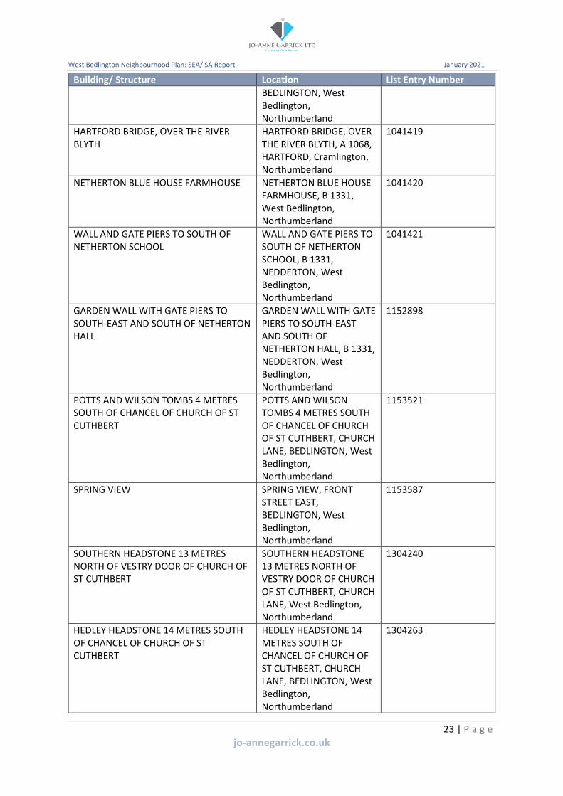
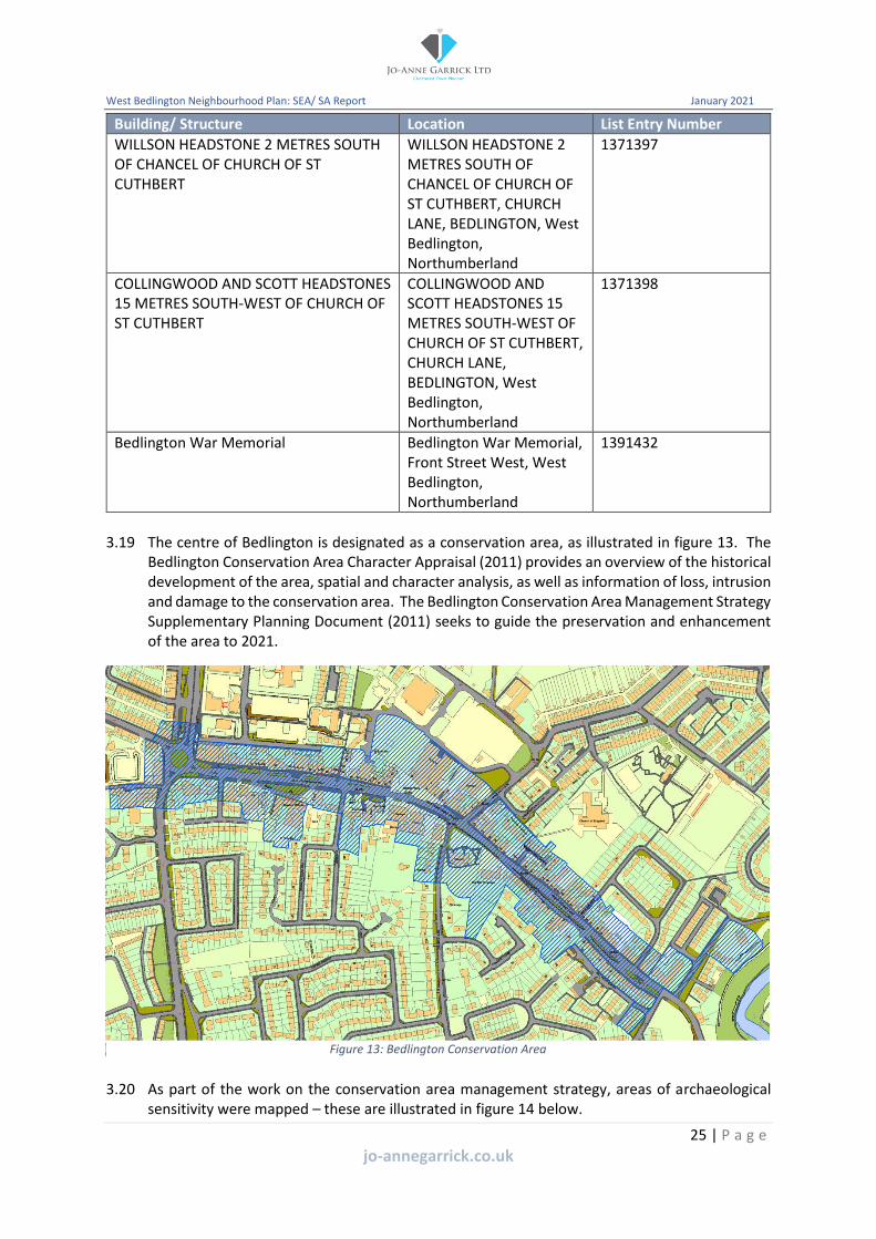
3.18 West Bedlington contains 33 listed buildings, three of which are grade II*. Figure 12 illustrates the location of the listed buildings across the plan area and tables 3 and 4 provide details of the listed buildings.
20 | P a g e
jo-annegarrick.co.uk

West Bedlington Neighbourhood Plan: SEA/ SA Report January 2021
Figure 12: Listed Buildings
Table 3: Grade II* listed buildings
Building/ Structure Location List Entry Number
ENTRANCE SCREEN AND GATES TO HARTFORD HALL
ENTRANCE SCREEN AND GATES TO HARTFORD HALL, HARTFORD, West Bedlington, Northumberland
1041381
Hartford Hall The Hall, Hartford Hall Estate, Bedlington, NE22 6AG, HARTFORD, West Bedlington, Northumberland
1041423
CHURCH OF ST CUTHBERT CHURCH OF ST CUTHBERT, CHURCH LANE, BEDLINGTON, West Bedlington, Northumberland
1153497
Table 4: Grade II listed buildings
Building/ Structure
WALL, GATEWAY AND GATES TO NORTH OF OLD VICARAGE, WITH ATTACHED GATEWAY AND GATE TO CHURCHYARD
Location
WALL, GATEWAY AND GATES TO NORTH OF OLD VICARAGE, WITH ATTACHED GATEWAY AND GATE TO CHURCHYARD, FRONT STREET EAST, BEDLINGTON, West
List Entry Number
1041358
21 | P a g e
jo-annegarrick.co.uk

West Bedlington Neighbourhood Plan: SEA/ SA Report January 2021
Building/ Structure
TROTTER MEMORIAL DRINKING FOUNTAIN
THE CROSS
HARTFORD HALL
Terrace and terrace walls to south of Hartford Hall
GATEPIERS AND ADJACENT WALLS WITH RAILINGS TO CHURCH OF ST CUTHBERT
PAIR OF HEADSTONES 1 METRE EAST OF CHURCH OF ST CUTHBERT
NICHOLSON HEADSTONE 17 METRES SOUTH OF CHANCEL OF CHURCH OF ST CUTHBERT
THE TOWER AND BEECHES
THE OLD VICARAGE
Location
Bedlington, Northumberland
TROTTER MEMORIAL DRINKING FOUNTAIN, FRONT STREET WEST, BEDLINGTON, West Bedlington, Northumberland
THE CROSS, MARKET PLACE, BEDLINGTON, West Bedlington, Northumberland
Hartford Hall Estate, Bedlington, NE22 6AG, HARTFORD, West Bedlington, Northumberland
Hartford Hall Estate, Bedlington, NE22 6AG, HARTFORD, West Bedlington, Northumberland
GATEPIERS AND ADJACENT WALLS WITH RAILINGS TO CHURCH OF ST CUTHBERT, BEDLINGTON, West Bedlington, Northumberland
PAIR OF HEADSTONES 1 METRE EAST OF CHURCH OF ST CUTHBERT, CHURCH LANE, BEDLINGTON, West Bedlington, Northumberland
NICHOLSON HEADSTONE 17 METRES SOUTH OF CHANCEL OF CHURCH OF ST CUTHBERT, CHURCH LANE, BEDLINGTON, West Bedlington, Northumberland
THE TOWER AND BEECHES, CHURCH LANE, BEDLINGTON, West Bedlington, Northumberland
THE OLD VICARAGE, FRONT STREET EAST,
List Entry Number
1041359
1041360
1041379
1041380
1041397
1041398
1041399
1041400
1041401
22 | P a g e
jo-annegarrick.co.uk
West Bedlington Neighbourhood Plan: SEA/ SA Report January 2021
Building/ Structure
HARTFORD BRIDGE, OVER THE RIVER BLYTH
NETHERTON BLUE HOUSE FARMHOUSE
WALL AND GATE PIERS TO SOUTH OF NETHERTON SCHOOL
GARDEN WALL WITH GATE PIERS TO SOUTH-EAST AND SOUTH OF NETHERTON HALL
POTTS AND WILSON TOMBS 4 METRES SOUTH OF CHANCEL OF CHURCH OF ST CUTHBERT
SPRING VIEW
SOUTHERN HEADSTONE 13 METRES NORTH OF VESTRY DOOR OF CHURCH OF ST CUTHBERT
HEDLEY HEADSTONE 14 METRES SOUTH OF CHANCEL OF CHURCH OF ST CUTHBERT
Location
BEDLINGTON, West Bedlington, Northumberland
HARTFORD BRIDGE, OVER THE RIVER BLYTH, A 1068, HARTFORD, Cramlington, Northumberland
NETHERTON BLUE HOUSE FARMHOUSE, B 1331, West Bedlington, Northumberland
WALL AND GATE PIERS TO SOUTH OF NETHERTON SCHOOL, B 1331, NEDDERTON, West Bedlington, Northumberland
GARDEN WALL WITH GATE PIERS TO SOUTH-EAST AND SOUTH OF NETHERTON HALL, B 1331, NEDDERTON, West Bedlington, Northumberland
POTTS AND WILSON TOMBS 4 METRES SOUTH OF CHANCEL OF CHURCH OF ST CUTHBERT, CHURCH LANE, BEDLINGTON, West Bedlington, Northumberland
SPRING VIEW, FRONT STREET EAST, BEDLINGTON, West Bedlington, Northumberland
SOUTHERN HEADSTONE 13 METRES NORTH OF VESTRY DOOR OF CHURCH OF ST CUTHBERT, CHURCH LANE, West Bedlington, Northumberland
HEDLEY HEADSTONE 14 METRES SOUTH OF CHANCEL OF CHURCH OF ST CUTHBERT, CHURCH LANE, BEDLINGTON, West Bedlington, Northumberland
List Entry Number
1041419
1041420
1041421
1152898
1153521
1153587
1304240
1304263
23 | P a g e
jo-annegarrick.co.uk

West Bedlington Neighbourhood Plan: SEA/ SA Report January 2021
Building/ Structure
SPEARMAN HEADSTONE 5 METRES SOUTH OF TOWER OF CHURCH OF ST CUTHBERT
HARTFORD BRIDGE HOUSE
NETHERTON SCHOOL
NETHERTON HALL EAST, WEST AND WEST WING
THE KINGS ARMS PUBLIC HOUSE
BARCLAYS BANK
HARTFORD BRIDGE OVER THE RIVER BLYTH (THAT PART IN BLYTH VALLEY DISTRICT)
Former stable block to east of Hartford Hall
Gate lodge to Hartford Hall
Location List Entry Number
SPEARMAN HEADSTONE 5 1304265 METRES SOUTH OF TOWER OF CHURCH OF ST CUTHBERT, CHURCH LANE, BEDLINGTON, West Bedlington, Northumberland
HARTFORD BRIDGE 1371366 HOUSE, A 1068, HARTFORD, West Bedlington, Northumberland
NETHERTON SCHOOL, B 1371367 1331, NEDDERTON, West Bedlington, Northumberland
NETHERTON HALL EAST, 1371368 WEST AND WEST WING, B 1331, NEDDERTON, West Bedlington, Northumberland
THE KINGS ARMS PUBLIC 1371380 HOUSE, FRONT STREET EAST, BEDLINGTON, West Bedlington, Northumberland
BARCLAYS BANK, MARKET 1371381 PLACE, BEDLINGTON, West Bedlington, Northumberland
HARTFORD BRIDGE OVER 1371387 THE RIVER BLYTH (THAT PART IN BLYTH VALLEY DISTRICT), A1068, West Bedlington, Northumberland
Former stable block to 1371390 east of Hartford Hall, The Stables, Hartford Hall Estate, Bedlington, NE22 6AG, HARTFORD, West Bedlington, Northumberland
The Lodge, Hartford Hall 1371391 Estate, Bedlington, NE22 6AG, HARTFORD, West Bedlington, Northumberland
24 | P a g e
jo-annegarrick.co.uk
West Bedlington Neighbourhood Plan: SEA/ SA Report January 2021
Building/ Structure
WILLSON HEADSTONE 2 METRES SOUTH OF CHANCEL OF CHURCH OF ST CUTHBERT
COLLINGWOOD AND SCOTT HEADSTONES 15 METRES SOUTH-WEST OF CHURCH OF ST CUTHBERT
Bedlington War Memorial
Location
WILLSON HEADSTONE 2 METRES SOUTH OF CHANCEL OF CHURCH OF ST CUTHBERT, CHURCH LANE, BEDLINGTON, West Bedlington, Northumberland
COLLINGWOOD AND SCOTT HEADSTONES 15 METRES SOUTH-WEST OF CHURCH OF ST CUTHBERT, CHURCH LANE, BEDLINGTON, West Bedlington, Northumberland
Bedlington War Memorial, Front Street West, West Bedlington, Northumberland
List Entry Number
1371397
1371398
1391432
3.19 The centre of Bedlington is designated as a conservation area, as illustrated in figure 13. The Bedlington Conservation Area Character Appraisal (2011) provides an overview of the historical development of the area, spatial and character analysis, as well as information of loss, intrusion and damage to the conservation area. The Bedlington Conservation Area Management Strategy Supplementary Planning Document (2011) seeks to guide the preservation and enhancement of the area to 2021.
Figure 13: Bedlington Conservation Area
3.20 As part of the work on the conservation area management strategy, areas of archaeological sensitivity were mapped – these are illustrated in figure 14 below.
25 | P a g e
jo-annegarrick.co.uk

West Bedlington Neighbourhood Plan: SEA/ SA Report January 2021
Figure 14: Archaeological sensitivity mapping
3.21 The conservation management strategy also highlighted regeneration and enhancement opportunities – these are illustrated in figure 15 below.
Figure 15: Regeneration and enhancement opportunities
Air quality
3.22 NCC has a statutory duty to assess and review the air quality in Northumberland. The council reports that air quality in the county is generally good, however it is impacted by: nitrogen dioxide from road traffic near to main roads; particulates from road traffic near to main roads;
26 | P a g e
jo-annegarrick.co.uk

West Bedlington Neighbourhood Plan: SEA/ SA Report January 2021
and naturally occurring ozone near the sea and in the hills of Northumberland. The council continuously measures air quality on Cowpen Road and Blyth town centre. No information is currently available for West Bedlington.
Climate
3.23 The sustainability appraisal report that accompanies the submission NLP2 explains that the emissions in Northumberland are estimated to have decreased significantly between 2005 (3.5 MtCO2e) and 2016 (0.6 MtCO2e). There has been the largest downward trend in per capita carbon emissions in the country between 2010 and 2016 (from 8.7 tCO2 per capita in 2010 to 1.8 tCO2 per capita in 2016). This was largely due to the reduction in large industrial installations. The low per capita emissions figure overall reflects Northumberland’s important role as a carbon sink due to its extensive forestry cover which means that it absorbs substantial amounts of CO2.
3.24 The North East Climate Change Adaptation Study (2008) highlights the following trends in Northumberland’s climate and change in sea level for the period up to 2050: • Slight reduction in overall rainfall but with a change in seasonality with more rain falling
in winter months – upland areas could see winter rain fall increase by up to 14%;
• Drier autumns and springs whilst lower lying and coastal areas could see up to 32% less rainfall in summer;
• Significant increase in severe rainfall events with increased amounts of rainfall and duration;
• Average daily temperatures expected to increase, up to 2.1 degrees in summer and 1.6 degrees in winter. Coastal areas will be warmer with temperatures reducing progressively in land;
• Summer extreme temperatures are likely to increase by around 3oC and summer daily average temperatures expected to reach 25 degrees;
• Heat waves are likely to increase both in duration and intensity with more events above the 28 degrees threshold temperature;
• Reduction in frost days and extreme winter temperatures moving closer to melt point but still below zero. Only the Cheviot Hills can expect spring temperatures below zero;
• Major reduction in winter snowfall and number of days of snow, but this does not mean snowfall events will be any less dramatic as temperatures will still fall below zero and the increase in winter rainfall will mean that snowfall depths do not differ from at present;
• There is to be a small change in average or extreme wind speed;
• There is an expected increase of around 0.3 metres along the Northumberland Coast; and an increase in sea surge levels of up to 0.35 metres; and
• The coast of Northumberland is subject to natural erosion but the prevalence of rocky headlands and foreshores protecting softer bays means that coastal erosion is less of a challenge than elsewhere in England.
Water quality / flooding
3.25 The Northumbria River Basin Management Plan (2015) identifies that between 2009 – 2015, the percentage of all water bodies at ‘good or better’ overall status decreased significantly from 42% (2009) to 26% (2015). Additional biological monitoring and improvements to the design of the monitoring network, put in place by the Environment Agency after 2009, revealed more symptoms of environmental issues. Therefore, the change between 2009 and 2015 reported
2 https://www.northumberland.gov.uk/NorthumberlandCountyCouncil/media/Planning-and-Building/planning%20policy/Local%20Plan/Local-Plan-Submission-SA-Report-Final-May-2019.pdf
27 | P a g e
jo-annegarrick.co.uk

West Bedlington Neighbourhood Plan: SEA/ SA Report January 2021
may not constitute a real environmental deterioration over this period. The management plan states that by 2021, the overall status of all water bodies is expected to improve slightly.
3.26 In 2021, 27% of surface waters are expected to be at good or better overall status, while 30% of groundwater bodies will be expected to be at good or better overall status. In combination 27% of all water bodies are projected to be at good or better status by 2021. An increased level of development could have an impact on designated nature conservation sites due to likely increases in flow from waste water treatment works to accommodate new development.
3.27 The main watercourses of significance within West Bedlington are the River Blyth (which forms the southern and eastern boundary of the parish), the Hepscott Burn (which forms part of the northern boundary). The plan area lies within a medium priority area for countryside stewardship for water quality. Figure 16 provides an extract from the Environment Agency flood map.
Figure 16: Flooding information
Economic characteristics
Employment, qualifications and travel to work
3.28 The 2011 census identifies that the number of residents of working age (16-74) was 7,258. Of this, 5,124 were economically active and 2,134 were economically inactive. Of those who were economically active, the split in employment levels was as follows:
• Employed full-time: 3,097 (42.7%);
• Employed part-time: 1,051 (14.5%);
• Self-employed: 503 (6.9%);
• Unemployed: 287 (4%); and
• Full-time student: 186 (2.6%).
3.29 Those residents who were economically active, indicated their jobs were as follows:
28 | P a g e
jo-annegarrick.co.uk

West Bedlington Neighbourhood Plan: SEA/ SA Report January 2021
• Professional occupations: 768 (16%);
• Associate professional and technical: 659 (13.7%);
• Administrative and secretarial occupations: 658 (13.7%);
• Skilled trade occupations: 523 (10.9%);
• Caring, leisure and other service occupations: 500 (10.4%);
• Managers, directors and senior officials: 492 (10.3%);
• Elementary occupations: 458 (9.6%);
• Sales and customer service occupations: 370 (7.7%);
• Process, plant and machine operatives: 366 (7.6%).
3.30 Those residents who were economically inactive, indicated they were:
• Retired: 1,248 (17.2%);
• Student: 274 (3.8%);
• Long-term sick or disabled: 297 (4.1%);
• Looking after home or family: 222 (3.1%);
• Other: 93 (1.3%).
3.31 A total of 8,169 residents were aged 16 and over and indicated their qualifications were as follows:
• Level 4 qualifications and above: 2,022 (24.8%);
• No qualifications: 1,935 (23.7%);
• Level 2 qualifications: 1,316 (16.1%);
• Level 3 qualifications: 1,152 (14.1%);
• Level 1 qualifications: 1,083 (13.3%);
• Apprenticeship: 339 (4.1%);
• Other qualifications: 322 (3.9%).
3.32 Figure 17 illustrates the travel isochrones for Bedlington and the key employment sites.
Figure 17: Travel isochrones
29 | P a g e
jo-annegarrick.co.uk

West Bedlington Neighbourhood Plan: SEA/ SA Report January 2021
Material assets
3.33 West Bedlington benefits from a range of community assets and other services and facilities including: schools, community centre, retail provision, public houses, cafes, car garages, medical centre, vets, play areas and sports pitches, petrol stations and churches. There is an extensive public right of way network which link the main areas of population with the surrounding countryside.
Summary of sustainability issues from the baseline
3.34 The baseline information identifies the following key sustainability issues to be considered as part of the preparation of the neighbourhood plan and SA.
3.35 Social issues can be summarised as follows:
• Enable the provision of housing to meet the needs of the plan area, including affordable housing and that for an ageing population;
• Improve the health and well-being of people who live in the plan area and promote healthy lifestyles;
• Tackle deprivation;
• Safeguard existing services and facilities and support the provision of new services and facilities;
• Enhance connectivity of the local community to jobs, services and facilities, including by more sustainable modes of transport;
3.36 Environmental issues can be summarised as follows:
• Conserve and enhance biodiversity, protecting the conservation objectives of all designated sites;
• Safeguard and enhance the green infrastructure network;
• Protect, conserve and enhance open spaces and support the provision of new open spaces;
• Encourage development on previously developed land;
• Protect and enhance the quality of water sources and promote efficient use of water resources;
• Locate new development away from areas of flood risk, taking into account the effects of climate change;
• Protect and enhance cultural assets and their settings, recognising the significance of heritage assets;
3.37 Economic issues can be summarised as follows:
• Support the growth and diversification of the local economy;
3.38 A SWOT analysis seeks to capture the key sustainability issues. The SWOT analysis (strengths, weaknesses, opportunities and threats) identifies that there are a number of sustainability issues and challenges facing West Bedlington, as well as strengths and opportunities. The parish provides a high quality environment to its residents. However, the plan will have an important role in managing future development to ensure West Bedlington continues to thrive whilst protecting the important built, historic and natural environment.
30 | P a g e
jo-annegarrick.co.uk

West Bedlington Neighbourhood Plan: SEA/ SA Report January 2021
Table 5: SWOT analysis
Strengths Weaknesses
• Attractive natural environment • Lack of employment opportunities within
• Rich historic assets West Bedlington
• Access to green spaces • Lack of services and facilities
• Access to the countryside • Lack of affordable housing
• Heritage • Town centre
• Allotments • Parking provision
• Wildlife • Access to toilets
• Quality of life
Opportunities Threats
• Recognising the contribution made by the • Potential impact of development on the historic environment to the character of significance of heritage assets and their the plan area setting
• Recognising the value of non-designated • Potential impact of development on the heritage assets natural and water environment
• Improving the health and well-being of • Housing growth the local population • Future pressure on the open countryside
• Protection and enhancement of open • Traffic congestion spaces and green infrastructure • Lack of infrastructure
• Promoting the efficient use of resources • Dog fouling • Protecting and enhancing existing • Antisocial behaviour
facilities • Climate change • Town centre improvements
• Celebrating heritage
• Townscape enhancements – high quality design
• Increasing use of sustainable forms of transport
• Minimising emissions
• Climate change adaptation and mitigation in new development
31 | P a g e
jo-annegarrick.co.uk

-
West Bedlington Neighbourhood Plan: SEA/ SA Report January 2021
4. The Sustainability / Strategic Environmental Assessment
framework
Introduction
4.1 This section describes the approach to the SA. It sets out the appraisal framework and how this has been used to appraise the pre-submission draft West Bedlington Neighbourhood Plan. This provides a way in which sustainability effects can be described, analysed and compared and will be comprised of objectives and indicators.
The SA/ SEA Framework
4.2 The objectives are based on the three strands of sustainability (social, economic and environmental). The SA/ SEA framework used by NCC as part of the development of the NLP has been used as a starting point for the identification of objectives. Table 6 sets out the SA/ SEA framework.
Table 6: SA/ SEA framework
SA/SEA Objective Assessment questions Indicators
1
Conserve and enhance the natural and water environment of the parish
• Will it conserve designated sites and areas of ancient woodland and protected species?
• Will it result in a net gain for the natural environment?
• Will it provide opportunities for people to access the natural environment?
• Will it protect and enhance water quality?
• Number of planning approvals that generated any adverse impacts on biodiversity sites
• Change in area of designated biodiversity sites
• Extent of ancient and semi natural woodland
• Change in water quality
2
Protect and enhance the significance of heritage assets of the parish
• Will it conserve and where appropriate enhance the significance of heritage assets?
• Number and condition of listed buildings
• Number of heritage assets and their settings protected as part of development
3
Conserve and enhance the countryside of the parish
• Will it conserve and enhance the countryside of the parish?
• Will it maintain and enhance the character and distinctiveness of the parish?
• Number of residential and/ or employment development approved outside the defined settlement boundary
4
Conserve and enhance open spaces within the parish
• Will it protect and enhance natural landscapes within the urban area, including recreational open space?
• Will it help deliver a comprehensive network of multifunctional green infrastructure?
• Area of local green space lost to development
• Area of protected open space lost to development
5 Reduce and/ or avoid flood risk to people and property
• Will it help minimise the risk of flooding to people and property?
• Number of properties at risk of flooding
32 | P a g e
jo-annegarrick.co.uk

West Bedlington Neighbourhood Plan: SEA/ SA Report January 2021
SA/SEA Objective Assessment questions Indicators • Will it discourage
development in areas at risk from flooding?
• Number of applications approved contrary to the advice of the Environment Agency
6
Improve the quality, range and accessibility of community services and facilities
• Will it improve the availability and accessibility to local facilities?
• Parish ranking in English indices of deprivation
• Number of new facilities provided
• Number of facilities lost as a result of new development
7
Enable those with identified housing needs to have the opportunity to live in an affordable home in the parish
• Will it provide an adequate supply of affordable housing?
• Number of affordable dwelling completions
• Number registered on the housing waiting list wishing to live in the parish
• Housing affordability ratio
8
Ensure residents live in a safe environment
• Will it promote design of buildings and spaces to reduce crime and the fear of crime?
• Will it help reduce incidence of antisocial behaviour?
• Will it contribute towards road safety?
• Crime rates
9
Increase opportunities for residents and visitors to travel by sustainable modes of transport
• Will it decrease the amount of traffic using the road system?
• Will it reduce adverse impacts of transportation on communities and the environment?
• Will it increase the range, availability and use of sustainable travel choices?
• Number of new sustainable transport facilities provided e.g. bus shelters, cycle lanes
• Level of bus service provision within the parish
• Number of households within a 10 minute walk (approx. 800m) of a bus stop with a frequency of more than 1 per hour during the working day
10
Maintain and enhance infrastructure provision within the parish
• Number of residential properties within 30 minutes public transport time of: a GP; a hospital; a primary school; a secondary school; areas of employment; and major retail centres
• Provision of key infrastructure
11
Maintain and enhance employment opportunities within the parish
• Will it help provide good quality, well paid employment opportunities that meet the needs of local people?
• Net additional employment floorspace completed
• Loss of employment floorspace
• Employment land available
• Number of businesses
33 | P a g e
jo-annegarrick.co.uk

West Bedlington Neighbourhood Plan: SEA/ SA Report January 2021
SA/SEA Objective Assessment questions Indicators • Proportion of residents
economically active/ inactive
• Unemployment rates
12
Maintain and enhance retail facilities within the parish
• Will it promote the vitality and viability of the town centre?
• Will it direct appropriate retail, leisure and/ or employment opportunities to the town centre?
• Vacancy rates within the town centre
Environmental objectives
Social objectives
Economic objectives
Methodology
4.3 The scoring system (table 7) will be used to assess the vision, objectives and policies proposed within the neighbourhood plan.
Table 7: Scoring system
Score Description Symbol Significant positive effect
The proposed policy contributes significantly to the achievement of the objective.
++
Minor positive effect The proposed policy contributes to the achievement of the objective but not significantly.
+
Neutral The proposed policy does not have any effect on the achievement of the objective.
0
Minor negative effect
The proposed policy detracts from the achievement of the objective but not significantly.
-
Significant negative effect
The proposed policy detracts significantly from the achievement of the objective.
--
No relationship There is no clear relationship between the proposed policy and the achievement of the objective or the relationship is negligible.
=
Uncertain The proposed policy has an uncertain relationship to the objective or the relationship is dependent on the way in which the aspect is managed. In addition, insufficient information may be available to enable an appraisal to be made.
?
34 | P a g e
jo-annegarrick.co.uk

West Bedlington Neighbourhood Plan: SEA/ SA Report January 2021
5. Appraisal of the pre-submission draft neighbourhood plan
Introduction
5.1 This section of the SA report assesses the compatibility of the neighbourhood plan vision, objectives and policies (including policy options) with the SA objectives. It also considers the cumulative impact of proposals within the plan and identifies mitigation measures. In addition, reference is made to the habitats regulations assessment, which has been undertaken separately to this SA.
Vision and objectives
Vision
5.2 The vision for the neighbourhood plan identifies the importance of the environment of the area to its sense of place and the need to maintain and enhance this as well as protecting important open spaces. The vision therefore has a positive effect when assessed against the first five SA objectives. It looks to support improvements to the local environment, employment opportunities as well as the provision of services and facilities to enhance the quality of life of residents. This approach results in a positive impact when assessed against objectives 11 and 12. The importance of sustainable transport in providing connections within and beyond the plan area is highlighted. As a result, the vision performs well against SA objectives 6 and 9. No specific reference is made within the vision to flooding, provision of affordable housing, infrastructure, therefore a neutral/ uncertain effect is recorded.
Objective 1 - quality of life
5.3 The first plan objective seeks to ensure new development is sustainable and contributes positive to the built, historic and natural environment and that new development is managed to ensure that important green spaces are protected. As a result, objective 1 should have a significant positive effect when considered against SA objectives 1, 2 and 4. As plan objective 1 makes reference to ensuring development is sustainable, this should result in a positive effect when considered against SA objectives 3 and 6 which seek to conserve and enhance the countryside of the parish and improve accessibility to services. The effect of the first plan objective on the remaining SA objectives is identified as neutral/ uncertain and no specific reference is made to flood risk, housing needs, safety, sustainable modes of transport, infrastructure, employment or retail facilities.
Objective 2 – community well-being
5.4 The second plan objective looks to build on the strong sense of community across the plan area and recognise the diverse needs of existing and future residents. It looks to support the provision of housing, that people can afford and which meets identified needs as well as ensuring the local community have access to the services and facilities they need. As a result plan objective two, should significantly contribute to the achievement of SA objective 7 which seeks to enable those with identified housing needs to have the opportunity to live in an affordable home in the parish. As plan objective two refers to ensuring the community has access to the services and facilities they need, it should have a positive effect on the delivery of SA objectives 6, 8, 9, 10 and 12. As no reference is made to the natural or built environment or the countryside, open spaces, flooding or employment impact on SA objectives 1-5 and 11 the effect is identified as neutral/ uncertain.
35 | P a g e
jo-annegarrick.co.uk

-
West Bedlington Neighbourhood Plan: SEA/ SA Report January 2021
Objective 3 – local economy
5.5 The third plan objective looks to support existing and the creation of new employment opportunities. It also looks to protect and enhance the vitality and viability of the town centre as an important source of local employment and service infrastructure. As a result, plan objective three should significantly contribute to the achievement of SA objectives 6, 11 and 12. In addition, it should have a minor positive effect on SA objectives 9 and 10. As no reference is made to the natural or built environment or the countryside, open spaces, provision of housing, safety or flooding the impact on SA objectives 1-5, 7 and 8 the effect is identified as neutral/ uncertain.
Objective 4 – accessibility
5.6 The fourth plan objective promotes access to sustainable modes of transport which connect communities to employment, services and facilities. It also seeks to ensure that the environmental quality of the plan area is protected by effectively managing traffic. As a result, plan objective four should significantly contribute to the achievement of SA objectives 1, 2, 6, 9 and 10. In addition, it should have a minor positive effect on SA objectives 11 and 12. As no reference is made within plan objective four to the countryside, open spaces, flooding, housing, or safety the impact on SA objectives 3, 4, 5, 7 and 8 is identified as neutral/ uncertain.
Table 8: Assessment of the plan vision and objectives
SA Objective Neighbourhood plan vision and objectives
Vision Quality of life Community well being
Local economy
Accessibility
1.Conserve and enhance the
natural and water environment of the
parish
+ ++ 0/? 0/? ++
2. Protect and enhance the
significance of + ++ 0/? 0/? ++ heritage assets of
the parish
3. Conserve and enhance the
countryside of the parish
+/? + 0/? 0/? 0/?
4. Conserve and enhance open
spaces within the parish
+ ++ 0/? 0/? 0/?
5.Reduce and/ or avoid flood risk to
people and property
0/? 0/? 0/? 0/? 0/?
6.Improve the quality, range and
accessibility of community
+ + + ++ ++
36 | P a g e
jo-annegarrick.co.uk
-
West Bedlington Neighbourhood Plan: SEA/ SA Report January 2021
SA Objective Neighbourhood plan vision and objectives
Vision Quality of life Community well being
Local economy
Accessibility
services and facilities
7.Enable those with identified housing needs to have the opportunity to live
in an affordable home in the parish
0/? 0/? ++ 0/? 0/?
8.Ensure residents live in a safe environment
0/? 0/? +/? 0/? 0/?
9.Increase opportunities for
residents and visitors to travel by sustainable modes
of transport
+ 0/? + + ++
10. Maintain and enhance
infrastructure 0/? 0/? + + ++ provision within
the parish
11. Maintain and enhance
employment + 0/? 0/? ++ + opportunities
within the parish
12. Maintain and enhance retail
facilities within the parish
+ 0/? + ++ +
5.7 The conclusion of the appraisal is that the vision and objectives of the plan are broadly supportive of the SA objectives. No negative effects are predicted and neutral/ uncertain effects have been identified where there is insufficient information to reach a different conclusion.
Planning policies
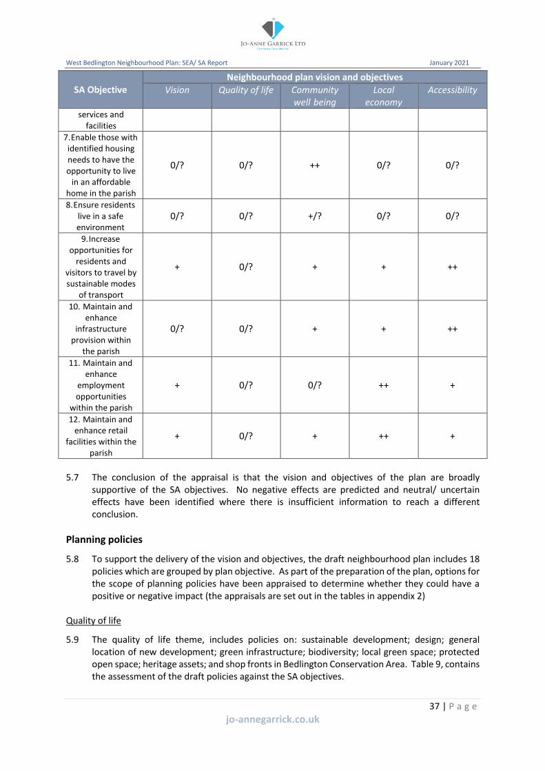
5.8 To support the delivery of the vision and objectives, the draft neighbourhood plan includes 18 policies which are grouped by plan objective. As part of the preparation of the plan, options for the scope of planning policies have been appraised to determine whether they could have a positive or negative impact (the appraisals are set out in the tables in appendix 2)
Quality of life
5.9 The quality of life theme, includes policies on: sustainable development; design; general location of new development; green infrastructure; biodiversity; local green space; protected open space; heritage assets; and shop fronts in Bedlington Conservation Area. Table 9, contains the assessment of the draft policies against the SA objectives.
37 | P a g e
jo-annegarrick.co.uk

West Bedlington Neighbourhood Plan: SEA/ SA Report January 2021
Table 9: Quality of life policy assessment
SA Objective Neighbourhood Plan Policy
WB1 Sus Dev
WB2 Design
WB3 Loc of Dev
WB4 Green Infr
WB5 Biodiv.
WB6 LGS
WB7 POS
WB8 Heritage
WB9 Shop Front
1. Conserve and enhance the natural and water environment of the parish
++ ++ + ++ ++ ++ ++ ? =
2. Protect and enhance the significance of heritage assets of the parish
++ ++ ? ? ? ++ ? ++ ++
3. Conserve and enhance the countryside of the parish
++ ++ ++ ++ ++ ++ ++ ++ =
4. Conserve and enhance open spaces within the parish
++ + ? ++ ++ ++ ++ ++ =
5. Reduce and/ or avoid flood risk to people and property
++ + ? ++ ++ ? ? ? =
6. Improve the quality, range and accessibility of community services and facilities
++ = ++ = = ++ ++ = =
7. Enable those with identified housing needs to have the opportunity to live in an affordable home in the parish
++ = + = - = = ? =
8. Ensure residents live in a safe environment ++ ++ ? = = = = = = 9. Increase opportunities for residents and
visitors to travel by sustainable modes of transport
++ ++ + = = = = = =
10. Maintain and enhance infrastructure provision within the parish
++ ++ + ++ = = = ? =
11. Maintain and enhance employment opportunities within the parish
++ = + = = = = ? -
12. Maintain and enhance retail facilities within the parish
++ = + = = = = ? -
38 | P a g e
jo-annegarrick.co.uk

West Bedlington Neighbourhood Plan: SEA/ SA Report January 2021
5.10 Policy WB1: sustainable development performs well against all of the SA objectives as it seeks to:
• ensure the quality of the natural environment is maintained and enhanced;
• protect or enhance the significance of heritage assets;
• make efficient use of land thereby protecting the countryside;
• support the health and well-being of the local community, this could include protecting and enhancing open spaces, community facilities, providing affordable homes, supporting employment and retail provision, as well as ensuring community safety;
• minimise the impact and mitigate against the likely effects of climate change, including flooding;
• support opportunities for residents and visitors to travel by sustainable modes of transport; and
• maintain and enhance infrastructure provision.
5.11 As a result of the SA, policy WB1 has been amended to include reference to the water environment, flood risk and opportunities for sustainable travel.
5.12 Policy WB2: design, could have a significant positive effect on six of the SA objectives (1, 2, 3, 8, 9 and 10) as it seeks to:
• Minimise water use and adopt the principles of sustainable drainage;
• Consider the impact of noise, air or water pollution;
• Conserve the significance of heritage assets and their settings;
• Consider the impact of the development when viewed from surrounding areas of countryside;
• Protect residential amenity; and
• Create safe, accessible and well-connected environment.
5.13 It is considered that there is no relationship between a number of the SA objectives (6, 7, 11 and 12) and policy WB2.
5.14 Policy WB3: general location of new development, seeks to focus the majority of new development within the settlement boundary identified in the NLP. As a result, this approach could have a significant positive effect on SA objectives 3 and 6 and it should conserve the countryside of the parish and support existing services and facilities. It could also have a positive effect on the conservation of the natural environment, by directing development away from natural environment designations. In addition, the policy could provide opportunities for the local community to access affordable housing within a sustainable location. Given the scope of the policy, the effects on SA objectives 2, 4, 5 and 8 are uncertain.
5.15 Policy WB4: green infrastructure seeks to protect and where practical improve and extend the green infrastructure network across the plan area. As a result it could have a significant positive effect on SA objectives 1, 3, 4, 5 and 10. Green infrastructure is an important element of the natural environment and countryside of the plan area, there are also key links with open spaces within the built up area. Green Infrastructure also has an important role in sustainable drainage and the management of flood risk. As a result of the scope of the policy, the possible effects on SA objective 2 is uncertain and there is considered to be no relationship with objectives 6, 7, 8, 9, 11 and 12.
39 | P a g e
jo-annegarrick.co.uk

West Bedlington Neighbourhood Plan: SEA/ SA Report January 2021
5.16 Policy WB5: biodiversity could have a significant positive effect on SA objectives 1, 3, and 4 as it seeks to protect and enhance biodiversity. A number of the open spaces within the plan area have been identified as important for their wildlife value. As the policy requires a financial contribution linked to the development of new housing, this could have a minor negative impact on the provision of additional affordable housing within the plan area. As a result of the scope of the policy, the possible effects on SA objectives 2 and 5 are uncertain and there is considered to be no relationship between the policy and objectives 6 and 8-12.
5.17 Policy WB6: local green space identifies 12 sites for protection as local green space. For a site to be identified it must be important to the local community. The associated background paper explains that a number of the sites have been identified for protection as a result of historic and wildlife value. In addition, some of the sites lie within the open countryside. As a result, the policy could have a significant positive effect on SA objectives 1, 2, 3, 4 and 6. Because of the scope of the policy, the possible effect on SA objective 5 is uncertain and there is considered to be no relationship between the policy and objectives 7-12.
5.18 Policy WB7: protected open space, identifies over 30 sites to be protected for their contribution to local amenity and the character of the area. These spaces are often used by the local community for both informal and formal recreation and are part of the community infrastructure of the plan area. Therefore, the policy could have a significant positive effect on SA objectives 1, 3, 4, 6 and 10. As a result of the scope of the policy, the possible effect on SA objectives 2 and 5 is uncertain and there is considered to be no relationship between the policy and objectives 7-9, 11 and 12.
5.19 Policy WB8: heritage assets seeks to ensure that the impact of development on the significance of heritage assets is given the appropriate amount of consideration when assessing development proposals. There are heritage assets located across the parish, including in the open countryside and many of the open spaces proposed for protection through the plan have been identified because of their historic importance. As a result, this could have a significant positive effect on SA objectives 2, 3 and 4. As a result of the scope of the policy in that its prime focus is on heritage, the possible effect on SA objectives 1, 5, 7 and 10-12 is uncertain. For example there is the potential for development proposals to be impacted as a result of heritage considerations. There is considered to be no relationship between the policy and SA objectives 6, 8 and 9.
5.20 Policy WB9: shop fronts in Bedlington Conservation Area provides guidance on works to shop fronts within the conservation area. As a result, the policy could have a significant positive effect on SA objective 2. There is the potential for a minor negative effect on SA objectives 11 and 12 as the installation of a higher specification shop front could have financial implications on employers and retail facilities. Given the scope of the policy, there is considered to be no relationship between it and SA objectives 1 and 3-10.
Community well-being
5.21 The community well-being theme, includes policies on: housing mix; affordable housing; community services and facilities; allotments; and infrastructure. Table 10, contains the assessment of the draft policies against the SA objectives.
40 | P a g e
jo-annegarrick.co.uk

West Bedlington Neighbourhood Plan: SEA/ SA Report January 2021
Table 10: Community well-being policy assessment
SA Objective Neighbourhood Plan Policy
WB10 Housing mix
WB11 Affordable housing
WB12 Community services
WB13 Allotments
WB14 Infrastructure
1. Conserve and enhance the natural and water environment of the parish
= = ? + ?
2. Protect and enhance the significance of heritage assets of the parish
= = ? + ?
3. Conserve and enhance the countryside of the parish
= = ? = ?
4. Conserve and enhance open spaces within the parish
= = ++ + ?
5. Reduce and/ or avoid flood risk to people and property
= = ? = ?
6. Improve the quality, range and accessibility of community services and facilities
= = ++ ++ +
7. Enable those with identified housing needs to have the opportunity to live in an affordable home in the parish
++ ++ = = =
8. Ensure residents live in a safe environment = = = = = 9. Increase opportunities for residents and
visitors to travel by sustainable modes of transport
= = ? = +
10. Maintain and enhance infrastructure provision within the parish
= = ++ = ++
11. Maintain and enhance employment opportunities within the parish
+ + + = +
12. Maintain and enhance retail facilities within the parish
= = ? = +
41 | P a g e
jo-annegarrick.co.uk

West Bedlington Neighbourhood Plan: SEA/ SA Report January 2021
5.22 As policy WB10: housing mix seeks to ensure that the type and mix of housing provided through new development will be that which is needed by the local community, this approach could have a significant positive effect on SA objective 7. The provision of appropriate housing could also support employment within the plan area as employers could have access to a greater supply of workers. Given the scope of the policy, it is considered there is no relationship with the other SA objectives. The assessment of policy WB11: affordable housing shows the same results as policy WB10, as it supports the provision of affordable housing where there is an identified need.
5.23 Policy WB12: community services and facilities supports proposals to enhance the provision of facilities and seeks to resist their loss. Community facilities are an important part of the infrastructure of the plan area and can include sports and recreation provision. As a result, the policy could have a significant positive effect on SA objectives 4, 6 and 10. As some community services and facilities within the parish also provide employment, their protection and enhancement could have a positive effect on SA objective 11. As a result of the scope of the policy, there is considered to be an uncertain relationship between it and SA objectives 1-3, 7 and 8 and no relationship with objectives 7 and 8.
5.24 Policy WB13: allotments seeks to protect allotment sites from development and supports the creation of new allotments. Whilst allotments may not fall within the definition of community services and facilities within the NPPF they are important to the local community and as a result their protection could have a significant positive effect on SA objective 6. Allotments within the plan area also support wildlife, have historical connections and are important areas of open space, therefore the policy could have a minor positive effect on SA objectives 1, 2 and 4. Given the scope of the policy, it is considered that there is no relationship between the policy and SA objectives 3, 5 and 7-12.
5.25 Policy WB14: infrastructure requires new development to provide or contribute to the infrastructure requirements that are related to them. As a result, this could have a significant positive effect on SA objective 10. As the provision of infrastructure could support accessibility to services, facilities, employment and retail provision as well as delivering sustainable transport, the policy could also have a minor positive effect on SA objectives 6, 9, 11 and 12. Given the scope of the policy, it is considered that there is no relationship between it and SA objectives 7 and 8.
Local economy
5.26 The local economy theme, includes policies on: employment and Bedlington Town Centre. Table 11, contains the assessment of the draft policies against the SA objectives.
Table 11: Local economy policy assessment
SA Objective Neighbourhood Plan Policy WB15
Employment WB16
Bedlington TC
1. Conserve and enhance the natural and water environment of the parish
+ ?
2. Protect and enhance the significance of heritage assets of the parish
+ ?
3. Conserve and enhance the countryside of the parish
? ?
42 | P a g e
jo-annegarrick.co.uk

West Bedlington Neighbourhood Plan: SEA/ SA Report January 2021
SA Objective Neighbourhood Plan Policy WB15
Employment WB16
Bedlington TC
4. Conserve and enhance open spaces within the parish
? ?
5. Reduce and/ or avoid flood risk to people and property
? ?
6. Improve the quality, range and accessibility of community services and facilities
+ ++
7. Enable those with identified housing needs to have the opportunity to live in an affordable home in the parish
= =
8. Ensure residents live in a safe environment = = 9. Increase opportunities for residents and
visitors to travel by sustainable modes of transport
= ?
10. Maintain and enhance infrastructure provision within the parish
= ?
11. Maintain and enhance employment opportunities within the parish
++ ++
12. Maintain and enhance retail facilities within the parish
+ ++
5.27 Policy WB15: employment supports the creation or protection of job opportunities, highlighting that economic growth will only be supported where it can be achieved without significant impact on the built and natural environment and residential amenity. As a result, the policy could have a significant positive effect on SA objective 11 and a minor positive effect on SA objectives 1, 2, 6 and 12. Given the scope of the policy, the relationship with it on SA objectives 3-5 is considered uncertain, with no relationship to SA objectives 7 and 8.
5.28 Policy WB16: Bedlington Town Centre seeks to ensure that new development helps to maintain and contribute to the role, vitality and viability of the town centre. The town centre provides services, facilities and employment opportunities. Therefore the policy approach could have a significant positive effect on SA objectives 6, 11 and 12. As a result of the scope of the policy, the relationship with SA objectives 1-5, 9 and 10 are considered to be uncertain, with no relationship to SA objectives 7 and 8.
Accessibility
5.29 The accessibility theme, includes policies on: active travel routes and transport and new development. Table 12, contains the assessment of the draft policies against the SA objectives.
Table 12: Accessibility policy assessment
SA Objective Neighbourhood Plan Policy WB17
Active travel routes WB18
Transport & new dev.
1. Conserve and enhance the natural and water environment of the parish
? ?
2. Protect and enhance the significance of heritage assets of the parish
? ?
3. Conserve and enhance the countryside of the parish
+ ?
43 | P a g e
jo-annegarrick.co.uk
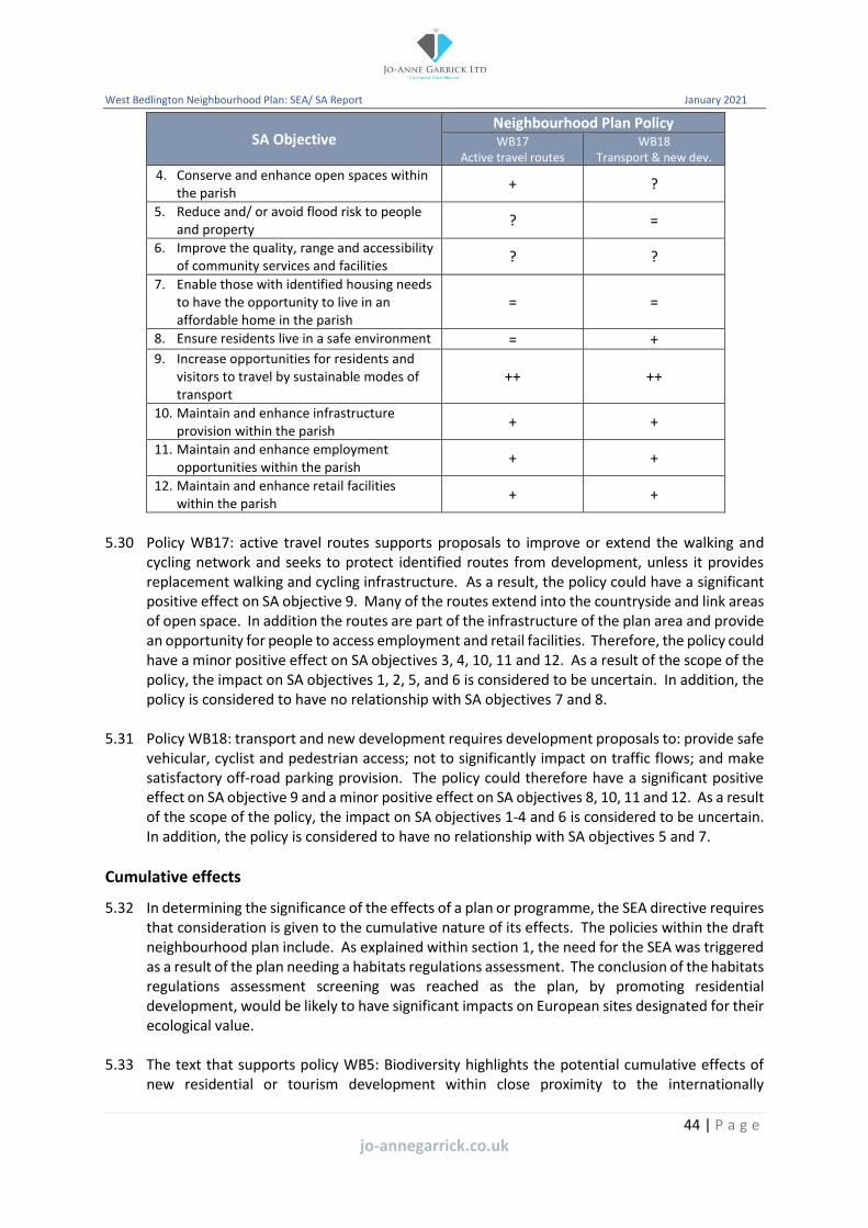
West Bedlington Neighbourhood Plan: SEA/ SA Report January 2021
SA Objective Neighbourhood Plan Policy WB17
Active travel routes WB18
Transport & new dev.
4. Conserve and enhance open spaces within the parish
+ ?
5. Reduce and/ or avoid flood risk to people and property
? =
6. Improve the quality, range and accessibility of community services and facilities
? ?
7. Enable those with identified housing needs to have the opportunity to live in an affordable home in the parish
= =
8. Ensure residents live in a safe environment = + 9. Increase opportunities for residents and
visitors to travel by sustainable modes of transport
++ ++
10. Maintain and enhance infrastructure provision within the parish
+ +
11. Maintain and enhance employment opportunities within the parish
+ +
12. Maintain and enhance retail facilities within the parish
+ +
5.30 Policy WB17: active travel routes supports proposals to improve or extend the walking and cycling network and seeks to protect identified routes from development, unless it provides replacement walking and cycling infrastructure. As a result, the policy could have a significant positive effect on SA objective 9. Many of the routes extend into the countryside and link areas of open space. In addition the routes are part of the infrastructure of the plan area and provide an opportunity for people to access employment and retail facilities. Therefore, the policy could have a minor positive effect on SA objectives 3, 4, 10, 11 and 12. As a result of the scope of the policy, the impact on SA objectives 1, 2, 5, and 6 is considered to be uncertain. In addition, the policy is considered to have no relationship with SA objectives 7 and 8.
5.31 Policy WB18: transport and new development requires development proposals to: provide safe vehicular, cyclist and pedestrian access; not to significantly impact on traffic flows; and make satisfactory off-road parking provision. The policy could therefore have a significant positive effect on SA objective 9 and a minor positive effect on SA objectives 8, 10, 11 and 12. As a result of the scope of the policy, the impact on SA objectives 1-4 and 6 is considered to be uncertain. In addition, the policy is considered to have no relationship with SA objectives 5 and 7.
Cumulative effects
5.32 In determining the significance of the effects of a plan or programme, the SEA directive requires that consideration is given to the cumulative nature of its effects. The policies within the draft neighbourhood plan include. As explained within section 1, the need for the SEA was triggered as a result of the plan needing a habitats regulations assessment. The conclusion of the habitats regulations assessment screening was reached as the plan, by promoting residential development, would be likely to have significant impacts on European sites designated for their ecological value.
5.33 The text that supports policy WB5: Biodiversity highlights the potential cumulative effects of new residential or tourism development within close proximity to the internationally
44 | P a g e
jo-annegarrick.co.uk

West Bedlington Neighbourhood Plan: SEA/ SA Report January 2021
designated coastal areas. This is addressed through the policy which includes a requirement for new development which would result in an increase in residential or tourism accommodation to make an appropriate financial contribution to the Northumberland Mitigation Service.
Mitigation measures
5.34 As a result of the SA of the draft plan, a number of changes have been made to policy WB1: sustainable development. The policy now includes clear references to the water environment, flood risk and opportunities for sustainable travel.
Habitats Regulations Assessment
5.35 As explained within section 1, the habitats regulations screening process identified the need for an appropriate assessment. This relates to the impact of increasing levels of recreational disturbance to European sites on the Northumberland coast arising from new housing and visitor development.
5.36 The HRA screening opinion concluded that policy WB1: sustainable development is likely to have a significant effect on the Northumbria Coast Special Protection Area and Ramsar site. The draft appropriate assessment concludes that because the plan embeds a requirement for mitigation has allowed NCC to ascertain that the plan, in combination with other plans and projects will not have an adverse effect on the Northumbria Coast Special Protection Area and Ramsar site or the North Northumberland Dunes Special Area of Conservation.
45 | P a g e
jo-annegarrick.co.uk

West Bedlington Neighbourhood Plan: SEA/ SA Report January 2021
6. Next steps
6.1 The information contained within this SA has been taken into account in preparing the pre-submission draft neighbourhood plan. This SA report will be consulted on alongside the pre-submission draft neighbourhood plan for 8 weeks.
6.2 Any comments received on this SA will be used to inform the final SA report that will be submitted to NCC alongside the submission draft neighbourhood plan for examination.
6.3 Once adopted, the effects of implementing the neighbourhood plan will be monitored to assess any impacts, including unforeseen adverse impacts. This will need to allow for remediate action to take place. On this basis, each sustainability objective is accompanied by a range of practical indicators. These are to be used to assess the achievement of the policies against the 12 SA objectives.
46 | P a g e
jo-annegarrick.co.uk

West Bedlington Neighbourhood Plan: SEA/ SA Report January 2021
Appendix 1: Email from NCC confirming need for AA and SEA
47 | P a g e
jo-annegarrick.co.uk

West Bedlington Neighbourhood Plan: SEA/ SA Report January 2021
Appendix 2: Assessment of policy options
Policy WB1: Sustainable development
Policy WB1
SA1 Natural Env
SA2 Heritage Assets
SA3 Country-side
SA4 Open spaces
SA5 Flood risk
SA6 Com. services
SA7 Housing needs
SA8 Safe
SA9 Sus. transport
SA10 Infra. provision
SA11 Employ-ment
SA12 Retail facilities
A + + + + + + + + + + + +
B ++ ++ ++ ++ ++ ++ ++ ++ ++ ++ ++ ++
C + + + + + + + + + + + +
Option A: To have a policy that seeks to support development proposals which deliver sustainable development; Option B: Option A plus identification of key considerations against which proposals can be assessed; Option C: Not to have a policy and rely on the NPPF and policies in the NLP.
Appraisal: All options could have positive effects, however option B would allow specific criteria to be identified which are applicable to the delivery of sustainable development across the plan area.
Preferred Policy Option: Option B
48 | P a g e
jo-annegarrick.co.uk
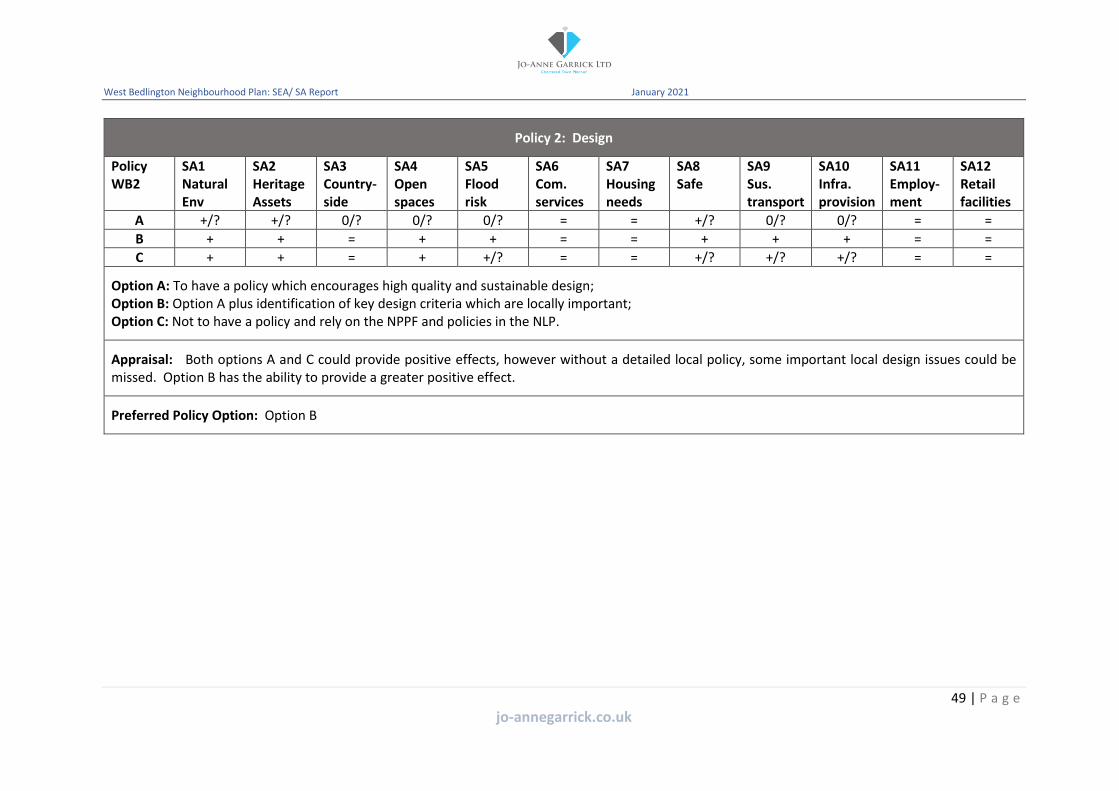
West Bedlington Neighbourhood Plan: SEA/ SA Report January 2021
Policy 2: Design
Policy WB2
SA1 Natural Env
SA2 Heritage Assets
SA3 Country-side
SA4 Open spaces
SA5 Flood risk
SA6 Com. services
SA7 Housing needs
SA8 Safe
SA9 Sus. transport
SA10 Infra. provision
SA11 Employ-ment
SA12 Retail facilities
A +/? +/? 0/? 0/? 0/? = = +/? 0/? 0/? = =
B + + = + + = = + + + = =
C + + = + +/? = = +/? +/? +/? = =
Option A: To have a policy which encourages high quality and sustainable design; Option B: Option A plus identification of key design criteria which are locally important; Option C: Not to have a policy and rely on the NPPF and policies in the NLP.
Appraisal: Both options A and C could provide positive effects, however without a detailed local policy, some important local design issues could be missed. Option B has the ability to provide a greater positive effect.
Preferred Policy Option: Option B
49 | P a g e
jo-annegarrick.co.uk

West Bedlington Neighbourhood Plan: SEA/ SA Report January 2021
Policy WB3: General location of new development
Policy WB3
SA1 Natural Env
SA2 Heritage Assets
SA3 Country-side
SA4 Open spaces
SA5 Flood risk
SA6 Com. services
SA7 Housing needs
SA8 Safe
SA9 Sus. transport
SA10 Infra. provision
SA11 Employ-ment
SA12 Retail facilities
A +/? +/? ++ + = ? = = + + + +
B + +/? ++ + = + = = + + ++ ++
C +/? +/? + +/? = +/? = = +/? +/? +/? +/?
Option A: To have a policy that seeks to resist development in the open countryside; Option B: Option A plus identification of criteria to illustrate when proposals may justify a countryside location; Option C: Not to have a policy and rely on the NPPF and the NLP.
Appraisal: Both options A and B seek to resist development in the open countryside. However, option B allows for some flexibility facilitating proposals which require a countryside location, where it meets identified criteria. Option C would not provide clarity and could fail to support the delivery of the SA objectives.
Preferred Policy Option: Option B
50 | P a g e
jo-annegarrick.co.uk

West Bedlington Neighbourhood Plan: SEA/ SA Report January 2021
Policy WB4: Green infrastructure
Policy WB4
SA1 Natural Env
SA2 Heritage Assets
SA3 Country-side
SA4 Open spaces
SA5 Flood risk
SA6 Com. services
SA7 Housing needs
SA8 Safe
SA9 Sus. transport
SA10 Infra. provision
SA11 Employ-ment
SA12 Retail facilities
A + ? +/? +/? +/? = = = = +/? = =
B ++ +/? + ++ +/? = = = = + = =
C + ? +/? +/? +/? = = = = +/? = =
Option A: To have a policy that seeks to conserve, maintain or enhance the existing green infrastructure network; Option B: Option A plus identification of the green infrastructure network; Option C: Not to have a policy and rely of the NPPF and policies within the NLP.
Appraisal: Both options A and C could provide positive effects, however without a detailed local policy, some important parts of the local green infrastructure could be missed. Option B has the ability to provide a greater positive effect.
Preferred Policy Option:
51 | P a g e
jo-annegarrick.co.uk

West Bedlington Neighbourhood Plan: SEA/ SA Report January 2021
Policy WB5: Biodiversity
Policy WB5
SA1 Natural Env
SA2 Heritage Assets
SA3 Country-side
SA4 Open spaces
SA5 Flood risk
SA6 Com. services
SA7 Housing needs
SA8 Safe
SA9 Sus. transport
SA10 Infra. provision
SA11 Employ-ment
SA12 Retail facilities
A ++ ? ++ + + = = = = = = =
B +/? ? +/? +/? +/? = = = = = = =
Option A: To have a policy which seeks to protect and enhance biodiversity as part of development proposals; Option B: Not to have a policy and rely of the NPPF and policies within the NLP.
Appraisal: Both options would positively seek to protect biodiversity through the assessment of planning applications. However, option A provides more local detail which would have a wider range of sustainability benefits as it would be more locally specific.
Preferred Policy Option: Option A
52 | P a g e
jo-annegarrick.co.uk

West Bedlington Neighbourhood Plan: SEA/ SA Report January 2021
Policy WB6: Local green space
Policy WB6
SA1 Natural Env
SA2 Heritage Assets
SA3 Country-side
SA4 Open spaces
SA5 Flood risk
SA6 Com. services
SA7 Housing needs
SA8 Safe
SA9 Sus. transport
SA10 Infra. provision
SA11 Employ-ment
SA12 Retail facilities
A ++ ++ ++ ++ ? ? = = = + = =
B -- -- ? - ? ? = = = ? = =
Option A: To identify areas of local green space that are important to the local community; Option B: Not to identify areas of local green space and rely on allocations in the NLP.
Appraisal: The NLP is not proposing to allocation areas of local green space. Therefore, by identifying sites within the neighbourhood plan could result in significant positive effects.
Preferred Policy Option: Option A
53 | P a g e
jo-annegarrick.co.uk

West Bedlington Neighbourhood Plan: SEA/ SA Report January 2021
Policy WB7: Protected open space
Policy WB7
SA1 Natural Env
SA2 Heritage Assets
SA3 Country-side
SA4 Open spaces
SA5 Flood risk
SA6 Com. services
SA7 Housing needs
SA8 Safe
SA9 Sus. transport
SA10 Infra. provision
SA11 Employ-ment
SA12 Retail facilities
A +/? ? +/? ++ ? +/? = = = +/? = =
B ++ ? + ++ ? ? = = = + = =
C +/? ? +/? ++ ? +/? = = = +/? = =
Option A: To have a policy which aims to protect areas of open space where they are necessary to meet local need and require the provision of new open space through new development where needed; Option B: Option A plus identification of areas of open space that are of importance to the local community for amenity or recreation purposes; Option C: Do not have a policy and rely on the NPPF and NLP.
Appraisal: Option B could provide the most positive effects. Whilst the NLP identifies areas of open space for protection this may not consider all areas of open space that are important to the local community. Option A, whilst it could have positive effects, may not provide a level of certainty and clarity without the allocation of sites.
Preferred Policy Option: Option B
54 | P a g e
jo-annegarrick.co.uk

West Bedlington Neighbourhood Plan: SEA/ SA Report January 2021
Policy WB8: Heritage assets
Policy WB8
SA1 Natural Env
SA2 Heritage Assets
SA3 Country-side
SA4 Open spaces
SA5 Flood risk
SA6 Com. services
SA7 Housing needs
SA8 Safe
SA9 Sus. transport
SA10 Infra. provision
SA11 Employ-ment
SA12 Retail facilities
A ? + + ++ ? ? = = = = = =
B ? ++ + ++ ? ? = = = = = =
C ? + + ++ ? ? = = = = = =
Option A: To have a policy which seeks to conserve the significance of heritage assets; Option B: Option A plus identification of criteria to aid the assessment of development proposals; Option C: Do not have a policy and rely on the NPPF and NLP.
Appraisal: Option B offers the opportunity to provide more positive effects as it provides additional guidance to assess development proposals which could impact on heritage assets.
Preferred Policy Option: Option B
55 | P a g e
jo-annegarrick.co.uk

West Bedlington Neighbourhood Plan: SEA/ SA Report January 2021
Policy 9: Shop fronts in Bedlington Conservation Area
Policy WB9
SA1 Natural Env
SA2 Heritage Assets
SA3 Country-side
SA4 Open spaces
SA5 Flood risk
SA6 Com. services
SA7 Housing needs
SA8 Safe
SA9 Sus. transport
SA10 Infra. provision
SA11 Employ-ment
SA12 Retail facilities
A = ++ = = = = = = = = - -
B = + = = = = = = = = ? ?
Option A: To have a policy that provides guidance to ensure that new development involving shop fronts protect, enhance and conserve the character of the Bedlington Conservation Area; Option B: Not to have a policy and to rely on the NPPF and NLP.
Appraisal: Both options seek to conserve and enhance the Bedlington Conservation Area. However, as option A provides a greater level of guidance it could provide a greater level of protection to an important historic asset. However, there could be minor negative effects on the employment and retail SA objectives as a result of increased cost.
Preferred Policy Option: Option A
56 | P a g e
jo-annegarrick.co.uk

West Bedlington Neighbourhood Plan: SEA/ SA Report January 2021
Policy WB10: Housing mix
Policy WB10
SA1 Natural Env
SA2 Heritage Assets
SA3 Country-side
SA4 Open spaces
SA5 Flood risk
SA6 Com. services
SA7 Housing needs
SA8 Safe
SA9 Sus. transport
SA10 Infra. provision
SA11 Employ-ment
SA12 Retail facilities
A = = = = = = ++ = = = = =
B = = = = = = + = = = = =
Option A: To have a policy which seeks to ensure that new housing development provides the type and mix of homes that are required in the plan area; Option B: Not to have a policy and rely on the NPPF and NLP.
Appraisal: Both options could provide positive effects in terms of supporting the delivery of a mix of housing housing. The inclusion of a specific policy on housing mix within the neighbourhood plan could provide greater clarity and therefore aid implementation.
Preferred Policy Option: Option A
57 | P a g e
jo-annegarrick.co.uk

West Bedlington Neighbourhood Plan: SEA/ SA Report January 2021
Policy WB11: Affordable housing
Policy WB11
SA1 Natural Env
SA2 Heritage Assets
SA3 Country-side
SA4 Open spaces
SA5 Flood risk
SA6 Com. services
SA7 Housing needs
SA8 Safe
SA9 Sus. transport
SA10 Infra. provision
SA11 Employ-ment
SA12 Retail facilities
A = = = = = = ++ = = = = =
B = = = = = = + = = = = =
Option A: To have a policy which requires the provision of affordable housing on new developments of ten or more dwellings, where there is an identified need; Option B: Not to have a policy and rely on the NPPF and NLP.
Appraisal: Both options could provide positive effects in terms of supporting the delivery of affordable housing. The inclusion of a specific policy on affordable within the neighbourhood plan could provide greater clarity and therefore aid implementation.
Preferred Policy Option: Option A
58 | P a g e
jo-annegarrick.co.uk

West Bedlington Neighbourhood Plan: SEA/ SA Report January 2021
Policy WB12: Community services and facilities
Policy WB12
SA1 Natural Env
SA2 Heritage Assets
SA3 Country-side
SA4 Open spaces
SA5 Flood risk
SA6 Com. services
SA7 Housing needs
SA8 Safe
SA9 Sus. transport
SA10 Infra. provision
SA11 Employ-ment
SA12 Retail facilities
A = ? ? ? = + = = = + + +
B = ? ? ? = + = = = + + +
C = ? ? ? = ++ = = = ++ + +
D = ? ? ? = +/? = ? ? ? = +
Option A: To have a policy that seeks to resist the loss of community facilities; Option B: To have a policy to support the provision of enhanced or new community facilities; Option C: Option A and B combined; Option D: Not to have a policy and rely on the NPPF and NLP.
Appraisal: Whilst all options could result in a positive effect on the provision and protection of community services and facilities, it is considered that option c could result in a significant positive effect as it seeks to both support the provision and resist their loss.
Preferred Policy Option: Option C
59 | P a g e
jo-annegarrick.co.uk
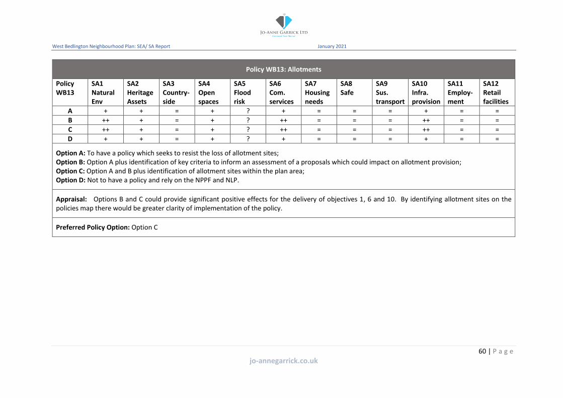
West Bedlington Neighbourhood Plan: SEA/ SA Report January 2021
Policy WB13: Allotments
Policy WB13
SA1 Natural Env
SA2 Heritage Assets
SA3 Country-side
SA4 Open spaces
SA5 Flood risk
SA6 Com. services
SA7 Housing needs
SA8 Safe
SA9 Sus. transport
SA10 Infra. provision
SA11 Employ-ment
SA12 Retail facilities
A + + = + ? + = = = + = =
B ++ + = + ? ++ = = = ++ = =
C ++ + = + ? ++ = = = ++ = =
D + + = + ? + = = = + = =
Option A: To have a policy which seeks to resist the loss of allotment sites; Option B: Option A plus identification of key criteria to inform an assessment of a proposals which could impact on allotment provision; Option C: Option A and B plus identification of allotment sites within the plan area; Option D: Not to have a policy and rely on the NPPF and NLP.
Appraisal: Options B and C could provide significant positive effects for the delivery of objectives 1, 6 and 10. By identifying allotment sites on the policies map there would be greater clarity of implementation of the policy.
Preferred Policy Option: Option C
60 | P a g e
jo-annegarrick.co.uk

West Bedlington Neighbourhood Plan: SEA/ SA Report January 2021
Policy WB14: Infrastructure
Policy WB14
SA1 Natural Env
SA2 Heritage Assets
SA3 Country-side
SA4 Open spaces
SA5 Flood risk
SA6 Com. services
SA7 Housing needs
SA8 Safe
SA9 Sus. transport
SA10 Infra. provision
SA11 Employ-ment
SA12 Retail facilities
A = = = + + ++ = = + ++ + +
B = = = + + + = = + + + +
Option A: To have a policy which supports new and improved infrastructure to meet the identified needs of the community; Option B: Not to have a policy and rely on the NPPF and NLP.
Appraisal: Both options would positively seek to require the delivery of infrastructure through the assessment of planning applications. However, option A would highlight the importance of the delivery of infrastructure within the plan area..
Preferred Policy Option: Option A
61 | P a g e
jo-annegarrick.co.uk

West Bedlington Neighbourhood Plan: SEA/ SA Report January 2021
Policy WB15: Employment
Policy WB15
SA1 Natural Env
SA2 Heritage Assets
SA3 Country-side
SA4 Open spaces
SA5 Flood risk
SA6 Com. services
SA7 Housing needs
SA8 Safe
SA9 Sus. transport
SA10 Infra. provision
SA11 Employ-ment
SA12 Retail facilities
A ?/+ ?/+ ?/+ ?/+ ? ?/+ = = = = ++ +
B + + + + ? + = = = = ++ +
C ?/+ ?/+ ?/+ ?/+ ? ?/+ = = = = ++ +
Option A: To have a policy that seeks to support the development of business units within the plan area; Option B: Option A plus identification of key considerations for the assessment of development proposals; Option C: Not to have a policy and rely on the NPPF and NLP.
Appraisal: Both options A and C could have positive effects on the SA objectives 11 and 12, however without the inclusion of key considerations the effects on the other objectives could be uncertain.
Preferred Policy Option: Option B
62 | P a g e
jo-annegarrick.co.uk
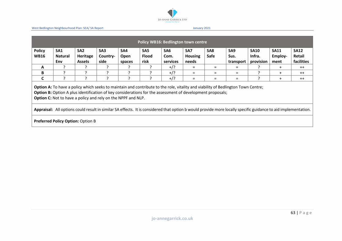
West Bedlington Neighbourhood Plan: SEA/ SA Report January 2021
Policy WB16: Bedlington town centre
Policy WB16
SA1 Natural Env
SA2 Heritage Assets
SA3 Country-side
SA4 Open spaces
SA5 Flood risk
SA6 Com. services
SA7 Housing needs
SA8 Safe
SA9 Sus. transport
SA10 Infra. provision
SA11 Employ-ment
SA12 Retail facilities
A ? ? ? ? ? +/? = = = ? + ++
B ? ? ? ? ? +/? = = = ? + ++
C ? ? ? ? ? +/? = = = ? + ++
Option A: To have a policy which seeks to maintain and contribute to the role, vitality and viability of Bedlington Town Centre; Option B: Option A plus identification of key considerations for the assessment of development proposals; Option C: Not to have a policy and rely on the NPPF and NLP.
Appraisal: All options could result in similar SA effects. It is considered that option b would provide more locally specific guidance to aid implementation.
Preferred Policy Option: Option B
63 | P a g e
jo-annegarrick.co.uk

West Bedlington Neighbourhood Plan: SEA/ SA Report January 2021
Policy WB17: Active travel routes
Policy WB17
SA1 Natural Env
SA2 Heritage Assets
SA3 Country-side
SA4 Open spaces
SA5 Flood risk
SA6 Com. services
SA7 Housing needs
SA8 Safe
SA9 Sus. transport
SA10 Infra. provision
SA11 Employ-ment
SA12 Retail facilities
A ? = ?/+ ? = = = = ++ + + +
B ?/+ = + + = = = = ++ + + +
C ? = ?/+ ? = = = = ++ + + +
Option A: To have a policy which supports the protection and enhancement of active travel routes; Option B: Option A plus identification of important active travel routes to the local community; Option C: Not to have a policy and rely on the NPPF and NLP.
Appraisal: It is considered that without the detail of identifying specific routes the potential sustainability impact could be similar. Option B could therefore have more positive effects.
Preferred Policy Option: Option B
64 | P a g e
jo-annegarrick.co.uk

West Bedlington Neighbourhood Plan: SEA/ SA Report January 2021
Policy WB18: Transport and new development
Policy WB19
SA1 Natural Env
SA2 Heritage Assets
SA3 Country-side
SA4 Open spaces
SA5 Flood risk
SA6 Com. services
SA7 Housing needs
SA8 Safe
SA9 Sus. transport
SA10 Infra. provision
SA11 Employ-ment
SA12 Retail facilities
A ? ? ? ? ? ? = = + + ? ?
B ? ? ? ? ? ? = = + ++ ? ?
C ? ? ? ? ? ? = = + + ? ?
Option A: To have a policy which seeks to ensure that new development fully considers the impact on the transport network; Option B: Option A plus identification of criteria against which proposals will be considered; Option C: Not to have a policy and rely on the NPPF and NLP.
Appraisal: The assessment has identified that option b could provide more positive effects through the provision of infrastructure. It is also considered that this option could highlight the importance of assessing the transport implications of new development across the plan area.
Preferred Policy Option: Option B
65 | P a g e
jo-annegarrick.co.uk