Proponent's Environmental Assessment Ravenswood-Cooley ...
372
Proponent’s Environmental Assessment Ravenswood-Cooley Landing 115 kV Reconductoring Project Prepared for Pacific Gas and Electric Company December 2017 Prepared by Stantec Consulting Services, Inc. 100 California Avenue, Suite 1000 San Francisco, California 94111
-
Upload
khangminh22 -
Category
Documents
-
view
3 -
download
0
Transcript of Proponent's Environmental Assessment Ravenswood-Cooley ...
Proponent’s Environmental Assessment
Ravenswood-Cooley Landing
115 kV Reconductoring Project
Prepared for
Pacific Gas and Electric Company
December 2017
Prepared by
Stantec Consulting Services, Inc. 100 California Avenue, Suite 1000
San Francisco, California 94111

Contents
Pacific Gas and Electric Company December 2017 Ravenswood-Cooley Landing 115 kV Reconductoring Project iii
CONTENTS
Chapter/Section Page
Acronyms and Abbreviations ..................................................................................................... ix 1 PEA Summary .................................................................................................. 1-1
1.1 Overview .............................................................................................................. 1-1 1.2 Agency and Stakeholder Outreach ....................................................................... 1-1
1.2.1 Agency Outreach ..................................................................................... 1-1 1.2.2 Native American Heritage Commission and Tribal Outreach ................. 1-2
1.3 Scope and Organization of the PEA .................................................................... 1-2 1.4 References .......................................................................................................... 1-21
2 Project Description ........................................................................................... 2-1 2.1 Overview .............................................................................................................. 2-1 2.2 Project Objectives, Purpose, and Need ................................................................ 2-1 2.3 Project Location ................................................................................................... 2-4
2.3.1 Ravenswood-Cooley Landing Line ......................................................... 2-4 2.4 Existing System ................................................................................................... 2-4 2.5 Project Components ............................................................................................. 2-6
2.5.1 Power Line Reconductoring .................................................................... 2-6 2.5.2 Tower Modifications ................................................................................ 2-6 2.5.3 Foundation Improvements ....................................................................... 2-8 2.5.4 Temporary Structures ............................................................................... 2-9 2.5.5 Substation Modifications ......................................................................... 2-9
2.6 Right-of-Way Requirements .............................................................................. 2-10 2.7 Construction ....................................................................................................... 2-10
2.7.2 Work Areas ............................................................................................ 2-11 2.7.3 Access Roads ......................................................................................... 2-17 2.7.4 Vegetation Clearance ............................................................................. 2-17 2.7.5 Erosion and Sediment Control and Pollution Prevention during
Construction ........................................................................................... 2-18 2.7.6 Cleanup and Post-Construction Restoration .......................................... 2-18 2.7.7 Construction Workforce and Equipment ............................................... 2-18 2.7.8 Construction Schedule ........................................................................... 2-20
2.8 Operation and Maintenance ............................................................................... 2-21 2.9 Anticipated Permits and Approvals ................................................................... 2-21 2.10 Applicant-Proposed Measures ........................................................................... 2-22 2.11 References .......................................................................................................... 2-32
3 Environmental Setting and Impact Assessment Summary ....................... 3.1-1 3.1 Aesthetics .......................................................................................................... 3.1-1
3.1.1 Introduction ........................................................................................... 3.1-1 3.1.2 Regulatory Background and Methodology ........................................... 3.1-1 3.1.3 Environmental Setting .......................................................................... 3.1-5 3.1.4 Applicant-Proposed Measures and Potential Impacts ......................... 3.1-21 3.1.5 References ........................................................................................... 3.1-25
Contents
December 2017 Pacific Gas and Electric Company iv Ravenswood-Cooley Landing 115 kV Reconductoring Project
3.2 Agricultural and Forest Resources .................................................................... 3.2-1 3.2.1 Introduction ........................................................................................... 3.2-1 3.2.2 Regulatory Background and Methodology ........................................... 3.2-1 3.2.3 Environmental Setting .......................................................................... 3.2-2 3.2.4 Applicant-Proposed Measures and Potential Impacts ........................... 3.2-4 3.2.5 References ............................................................................................. 3.2-5
3.3 Air Quality ........................................................................................................ 3.3-1 3.3.1 Introduction ........................................................................................... 3.3-1 3.3.2 Regulatory Background and Methodology ........................................... 3.3-2 3.3.3 Environmental Setting .......................................................................... 3.3-6 3.3.4 Applicant-Proposed Measures and Potential Impacts ......................... 3.3-10 3.3.5 References ........................................................................................... 3.3-16
3.4 Biological Resources ........................................................................................ 3.4-1 3.4.1 Introduction ........................................................................................... 3.4-1 3.4.2 Regulatory Background and Methodology ........................................... 3.4-2 3.4.3 Environmental Setting ........................................................................ 3.4-11 3.4.4 Applicant-Proposed Measures and Potential Impacts ......................... 3.4-38 3.4.5 References ........................................................................................... 3.4-52
3.5 Cultural Resources ............................................................................................ 3.5-1 3.5.1 Introduction ........................................................................................... 3.5-1 3.5.2 Regulatory Background and Methodology ........................................... 3.5-1 3.5.3 Environmental Setting .......................................................................... 3.5-7 3.5.4 Applicant-Proposed Measures and Potential Impacts ......................... 3.5-22 3.5.5 References ........................................................................................... 3.5-27
3.6 Geology and Soils ............................................................................................. 3.6-1 3.6.1 Introduction ........................................................................................... 3.6-1 3.6.2 Regulatory Background and Methodology ........................................... 3.6-2 3.6.3 Environmental Setting .......................................................................... 3.6-3 3.6.4 Applicant-Proposed Measures and Potential Impacts ......................... 3.6-10 3.6.5 References ........................................................................................... 3.6-14
3.7 Greenhouse Gas Emissions ............................................................................... 3.7-1 3.7.1 Introduction ........................................................................................... 3.7-1 3.7.2 Regulatory Background and Methodology ........................................... 3.7-1 3.7.3 Environmental Setting .......................................................................... 3.7-4 3.7.4 Applicant-Proposed Measures and Potential Impacts ........................... 3.7-6 3.7.5 References ............................................................................................. 3.7-9
3.8 Hazards and Hazardous Materials .................................................................... 3.8-1 3.8.1 Introduction ........................................................................................... 3.8-1 3.8.2 Regulatory Background and Methodology ........................................... 3.8-2 3.8.3 Environmental Setting .......................................................................... 3.8-6 3.8.4 Applicant-Proposed Measures and Potential Impacts ........................... 3.8-9 3.8.5 References ........................................................................................... 3.8-14
3.9 Hydrology and Water Quality ........................................................................... 3.9-1 3.9.1 Introduction ........................................................................................... 3.9-1 3.9.2 Regulatory Background and Methodology ........................................... 3.9-2 3.9.3 Environmental Setting .......................................................................... 3.9-5
Contents
Pacific Gas & Electric Company December 2017 Ravenswood-Cooley Landing 115 kV Reconductoring Project v
3.9.4 Applicant-Proposed Measures and Potential Impacts ........................... 3.9-8 3.9.5 References ........................................................................................... 3.9-12
3.10 Land Use and Planning ................................................................................... 3.10-1 3.10.1 Introduction ......................................................................................... 3.10-1 3.10.2 Regulatory Background and Methodology ......................................... 3.10-1 3.10.3 Environmental Setting ........................................................................ 3.10-3 3.10.4 Applicant-Proposed Measures and Potential Impacts ......................... 3.10-8 3.10.5 References ........................................................................................... 3.10-9
3.11 Mineral Resources .......................................................................................... 3.11-1 3.11.1 Introduction ......................................................................................... 3.11-1 3.11.2 Regulatory Background and Methodology ......................................... 3.11-1 3.11.3 Environmental Setting ........................................................................ 3.11-3 3.11.4 Applicant-Proposed Measures and Potential Impacts ......................... 3.11-3 3.11.5 References ........................................................................................... 3.11-4
3.12 Noise ............................................................................................................... 3.12-1 3.12.1 Introduction ......................................................................................... 3.12-1 3.12.2 Regulatory Background and Methodology ......................................... 3.12-4 3.12.3 Methodology ....................................................................................... 3.12-7 3.12.4 Environmental Setting ........................................................................ 3.12-7 3.12.5 Applicant-Proposed Measures and Potential Impacts ......................... 3.12-8 3.12.6 References ......................................................................................... 3.12-14
3.13 Population and Housing .................................................................................. 3.13-1 3.13.1 Introduction ......................................................................................... 3.13-1 3.13.2 Regulatory Background and Methodology ......................................... 3.13-1 3.13.3 Applicant-Proposed Measures and Potential Impacts ......................... 3.13-3 3.13.4 References ........................................................................................... 3.13-4
3.14 Public Services ................................................................................................ 3.14-1 3.14.1 Introduction ......................................................................................... 3.14-1 3.14.2 Regulatory Background and Methodology ......................................... 3.14-1 3.14.3 Environmental Setting ........................................................................ 3.14-2 3.14.4 Applicant-Proposed Measures and Potential Impacts ......................... 3.14-4 3.14.5 References ........................................................................................... 3.14-6
3.15 Recreation ....................................................................................................... 3.15-1 3.15.1 Introduction ......................................................................................... 3.15-1 3.15.2 Regulatory Background and Methodology ......................................... 3.15-1 3.15.3 Environmental Setting ........................................................................ 3.15-2 3.15.4 Applicant-Proposed Measures and Potential Impacts ......................... 3.15-3 3.15.5 References ........................................................................................... 3.15-5
3.16 Transportation and traffic ............................................................................... 3.16-1 3.16.1 Introduction ......................................................................................... 3.16-1 3.16.2 Regulatory Background and Methodology ......................................... 3.16-2 3.16.3 Environmental Setting ........................................................................ 3.16-3 3.16.4 Applicant-Proposed Measures and Potential Impacts ......................... 3.16-6 3.16.5 References ......................................................................................... 3.16-10
3.17 Utilities and Service Systems.......................................................................... 3.17-1 3.17.1 Introduction ......................................................................................... 3.17-1
Contents
December 2017 Pacific Gas and Electric Company vi Ravenswood-Cooley Landing 115 kV Reconductoring Project
3.17.2 Regulatory Background and Methodology ......................................... 3.17-2 3.17.3 Environmental Setting ........................................................................ 3.17-3 3.17.4 Applicant-Proposed Measures and Potential Impacts ......................... 3.17-6 3.17.5 References ........................................................................................... 3.17-9
3.18 Mandatory Findings of Significance AND Cumulative Impact Analysis ...... 3.18-1 3.18.1 Mandatory Findings of Significance ................................................... 3.18-1 3.18.2 Cumulative Impacts ............................................................................ 3.18-4 3.18.3 Key Projects in the Project Vicinity.................................................... 3.18-4 3.18.4 Analysis of Cumulative Impacts ......................................................... 3.18-8 3.18.5 References ......................................................................................... 3.18-11
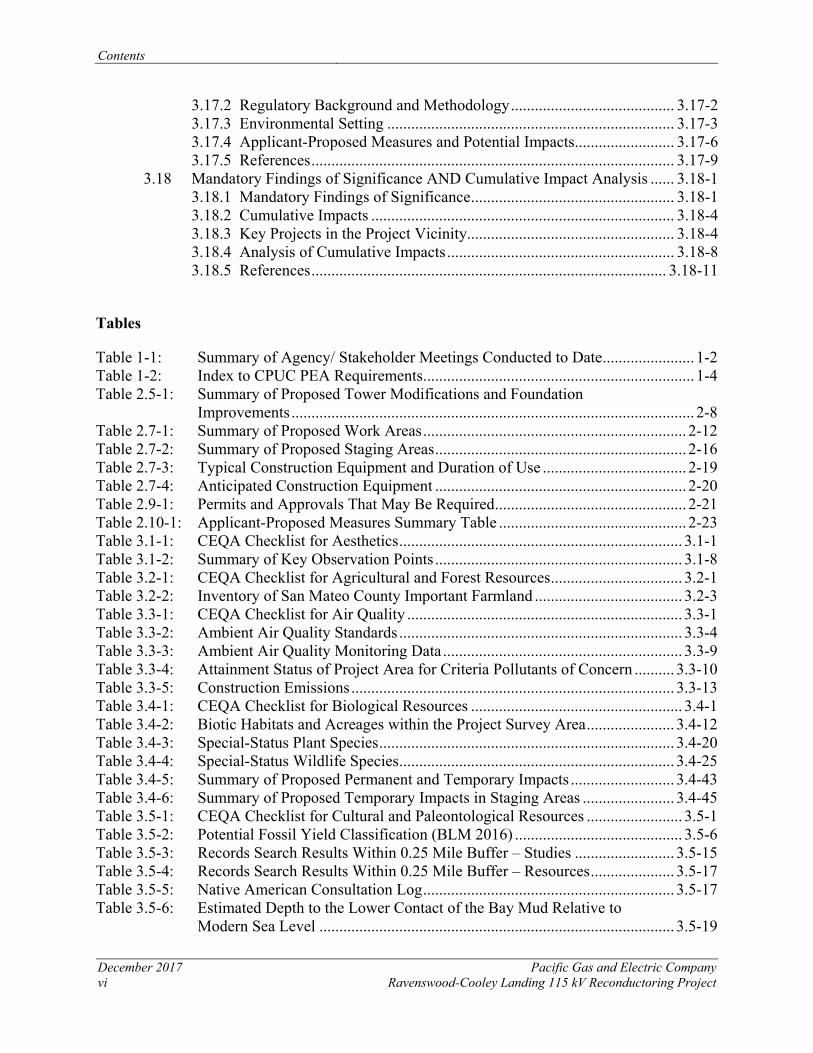
Tables
Table 1-1: Summary of Agency/ Stakeholder Meetings Conducted to Date ....................... 1-2 Table 1-2: Index to CPUC PEA Requirements .................................................................... 1-4 Table 2.5-1: Summary of Proposed Tower Modifications and Foundation
Improvements ..................................................................................................... 2-8 Table 2.7-1: Summary of Proposed Work Areas .................................................................. 2-12 Table 2.7-2: Summary of Proposed Staging Areas ............................................................... 2-16 Table 2.7-3: Typical Construction Equipment and Duration of Use .................................... 2-19 Table 2.7-4: Anticipated Construction Equipment ............................................................... 2-20 Table 2.9-1: Permits and Approvals That May Be Required ................................................ 2-21 Table 2.10-1: Applicant-Proposed Measures Summary Table ............................................... 2-23 Table 3.1-1: CEQA Checklist for Aesthetics ....................................................................... 3.1-1 Table 3.1-2: Summary of Key Observation Points .............................................................. 3.1-8 Table 3.2-1: CEQA Checklist for Agricultural and Forest Resources ................................. 3.2-1 Table 3.2-2: Inventory of San Mateo County Important Farmland ..................................... 3.2-3 Table 3.3-1: CEQA Checklist for Air Quality ..................................................................... 3.3-1 Table 3.3-2: Ambient Air Quality Standards ....................................................................... 3.3-4 Table 3.3-3: Ambient Air Quality Monitoring Data ............................................................ 3.3-9 Table 3.3-4: Attainment Status of Project Area for Criteria Pollutants of Concern .......... 3.3-10 Table 3.3-5: Construction Emissions ................................................................................. 3.3-13 Table 3.4-1: CEQA Checklist for Biological Resources ..................................................... 3.4-1 Table 3.4-2: Biotic Habitats and Acreages within the Project Survey Area ...................... 3.4-12 Table 3.4-3: Special-Status Plant Species .......................................................................... 3.4-20 Table 3.4-4: Special-Status Wildlife Species ..................................................................... 3.4-25 Table 3.4-5: Summary of Proposed Permanent and Temporary Impacts .......................... 3.4-43 Table 3.4-6: Summary of Proposed Temporary Impacts in Staging Areas ....................... 3.4-45 Table 3.5-1: CEQA Checklist for Cultural and Paleontological Resources ........................ 3.5-1 Table 3.5-2: Potential Fossil Yield Classification (BLM 2016) .......................................... 3.5-6 Table 3.5-3: Records Search Results Within 0.25 Mile Buffer – Studies ......................... 3.5-15 Table 3.5-4: Records Search Results Within 0.25 Mile Buffer – Resources ..................... 3.5-17 Table 3.5-5: Native American Consultation Log ............................................................... 3.5-17 Table 3.5-6: Estimated Depth to the Lower Contact of the Bay Mud Relative to
Modern Sea Level ......................................................................................... 3.5-19
Contents
Pacific Gas & Electric Company December 2017 Ravenswood-Cooley Landing 115 kV Reconductoring Project vii
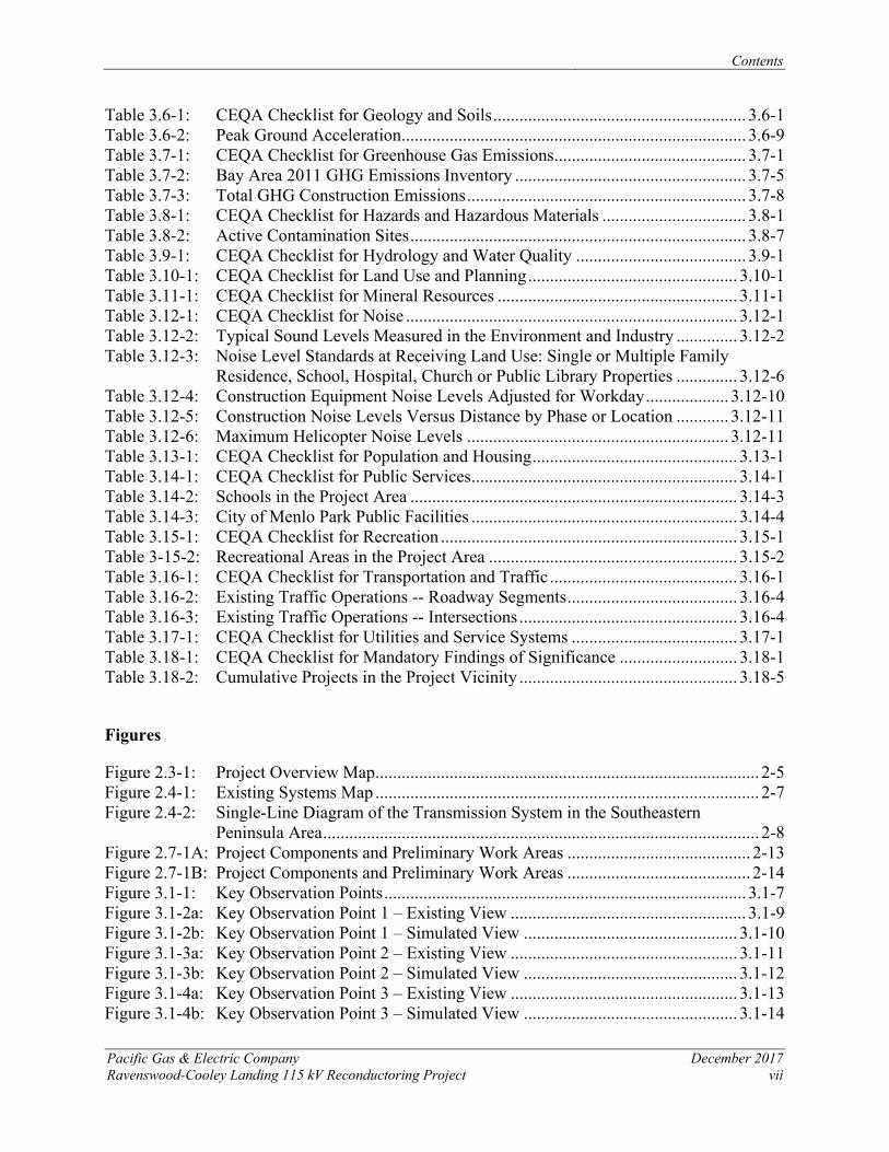
Table 3.6-1: CEQA Checklist for Geology and Soils .......................................................... 3.6-1 Table 3.6-2: Peak Ground Acceleration ............................................................................... 3.6-9 Table 3.7-1: CEQA Checklist for Greenhouse Gas Emissions ............................................ 3.7-1 Table 3.7-2: Bay Area 2011 GHG Emissions Inventory ..................................................... 3.7-5 Table 3.7-3: Total GHG Construction Emissions ................................................................ 3.7-8 Table 3.8-1: CEQA Checklist for Hazards and Hazardous Materials ................................. 3.8-1 Table 3.8-2: Active Contamination Sites ............................................................................. 3.8-7 Table 3.9-1: CEQA Checklist for Hydrology and Water Quality ....................................... 3.9-1 Table 3.10-1: CEQA Checklist for Land Use and Planning ................................................ 3.10-1 Table 3.11-1: CEQA Checklist for Mineral Resources ....................................................... 3.11-1 Table 3.12-1: CEQA Checklist for Noise ............................................................................ 3.12-1 Table 3.12-2: Typical Sound Levels Measured in the Environment and Industry .............. 3.12-2 Table 3.12-3: Noise Level Standards at Receiving Land Use: Single or Multiple Family
Residence, School, Hospital, Church or Public Library Properties .............. 3.12-6 Table 3.12-4: Construction Equipment Noise Levels Adjusted for Workday ................... 3.12-10 Table 3.12-5: Construction Noise Levels Versus Distance by Phase or Location ............ 3.12-11 Table 3.12-6: Maximum Helicopter Noise Levels ............................................................ 3.12-11 Table 3.13-1: CEQA Checklist for Population and Housing ............................................... 3.13-1 Table 3.14-1: CEQA Checklist for Public Services ............................................................. 3.14-1 Table 3.14-2: Schools in the Project Area ........................................................................... 3.14-3 Table 3.14-3: City of Menlo Park Public Facilities ............................................................. 3.14-4 Table 3.15-1: CEQA Checklist for Recreation .................................................................... 3.15-1 Table 3-15-2: Recreational Areas in the Project Area ......................................................... 3.15-2 Table 3.16-1: CEQA Checklist for Transportation and Traffic ........................................... 3.16-1 Table 3.16-2: Existing Traffic Operations -- Roadway Segments ....................................... 3.16-4 Table 3.16-3: Existing Traffic Operations -- Intersections .................................................. 3.16-4 Table 3.17-1: CEQA Checklist for Utilities and Service Systems ...................................... 3.17-1 Table 3.18-1: CEQA Checklist for Mandatory Findings of Significance ........................... 3.18-1 Table 3.18-2: Cumulative Projects in the Project Vicinity .................................................. 3.18-5
Figures
Figure 2.3-1: Project Overview Map ........................................................................................ 2-5 Figure 2.4-1: Existing Systems Map ........................................................................................ 2-7 Figure 2.4-2: Single-Line Diagram of the Transmission System in the Southeastern
Peninsula Area .................................................................................................... 2-8 Figure 2.7-1A: Project Components and Preliminary Work Areas .......................................... 2-13 Figure 2.7-1B: Project Components and Preliminary Work Areas .......................................... 2-14 Figure 3.1-1: Key Observation Points ................................................................................... 3.1-7 Figure 3.1-2a: Key Observation Point 1 – Existing View ...................................................... 3.1-9 Figure 3.1-2b: Key Observation Point 1 – Simulated View ................................................. 3.1-10 Figure 3.1-3a: Key Observation Point 2 – Existing View .................................................... 3.1-11 Figure 3.1-3b: Key Observation Point 2 – Simulated View ................................................. 3.1-12 Figure 3.1-4a: Key Observation Point 3 – Existing View .................................................... 3.1-13 Figure 3.1-4b: Key Observation Point 3 – Simulated View ................................................. 3.1-14
Contents
December 2017 Pacific Gas and Electric Company viii Ravenswood-Cooley Landing 115 kV Reconductoring Project
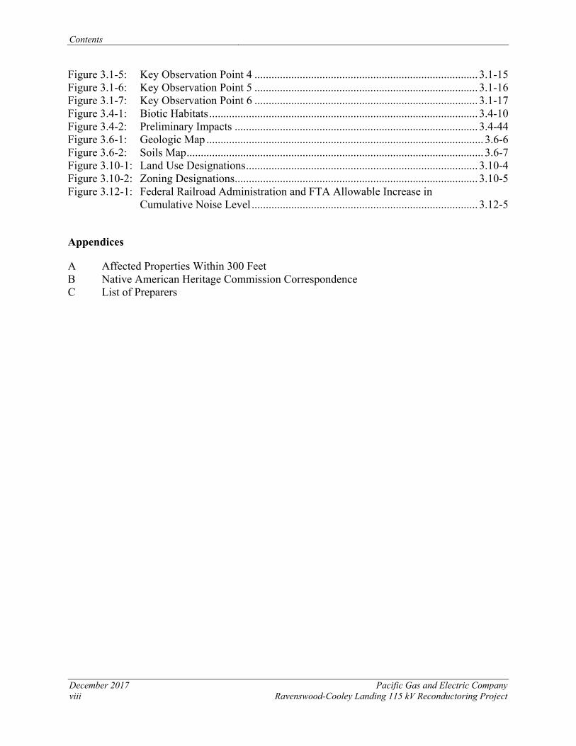
Figure 3.1-5: Key Observation Point 4 ............................................................................... 3.1-15 Figure 3.1-6: Key Observation Point 5 ............................................................................... 3.1-16 Figure 3.1-7: Key Observation Point 6 ............................................................................... 3.1-17 Figure 3.4-1: Biotic Habitats ............................................................................................... 3.4-10 Figure 3.4-2: Preliminary Impacts ...................................................................................... 3.4-44 Figure 3.6-1: Geologic Map .................................................................................................. 3.6-6 Figure 3.6-2: Soils Map ......................................................................................................... 3.6-7 Figure 3.10-1: Land Use Designations .................................................................................. 3.10-4 Figure 3.10-2: Zoning Designations ...................................................................................... 3.10-5 Figure 3.12-1: Federal Railroad Administration and FTA Allowable Increase in
Cumulative Noise Level ................................................................................ 3.12-5
Appendices
A Affected Properties Within 300 Feet B Native American Heritage Commission Correspondence C List of Preparers
Acronyms and Abbreviations
Pacific Gas and Electric Company December 2017 Ravenswood-Cooley Landing 115 kV Reconductoring Project ix
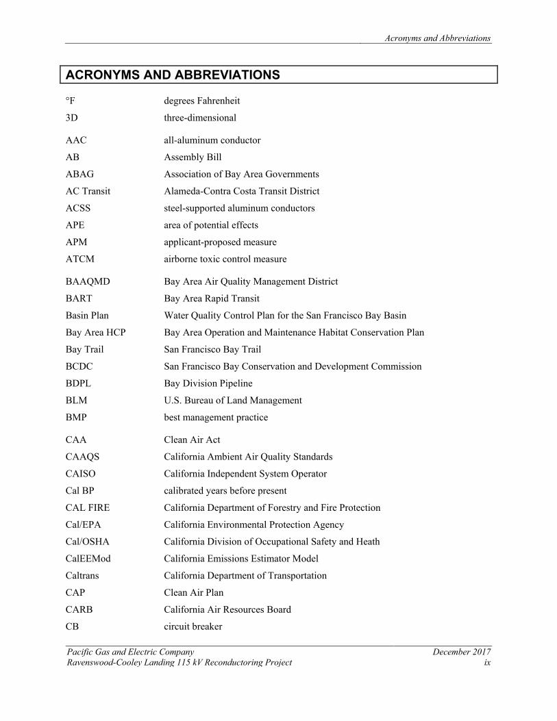
ACRONYMS AND ABBREVIATIONS
°F degrees Fahrenheit
3D three-dimensional
AAC all-aluminum conductor
AB Assembly Bill
ABAG Association of Bay Area Governments
AC Transit Alameda-Contra Costa Transit District
ACSS steel-supported aluminum conductors
APE area of potential effects
APM applicant-proposed measure
ATCM airborne toxic control measure
BAAQMD Bay Area Air Quality Management District
BART Bay Area Rapid Transit
Basin Plan Water Quality Control Plan for the San Francisco Bay Basin
Bay Area HCP Bay Area Operation and Maintenance Habitat Conservation Plan
Bay Trail San Francisco Bay Trail
BCDC San Francisco Bay Conservation and Development Commission
BDPL Bay Division Pipeline
BLM U.S. Bureau of Land Management
BMP best management practice
CAA Clean Air Act
CAAQS California Ambient Air Quality Standards
CAISO California Independent System Operator
Cal BP calibrated years before present
CAL FIRE California Department of Forestry and Fire Protection
Cal/EPA California Environmental Protection Agency
Cal/OSHA California Division of Occupational Safety and Heath
CalEEMod California Emissions Estimator Model
Caltrans California Department of Transportation
CAP Clean Air Plan
CARB California Air Resources Board
CB circuit breaker
Acronyms and Abbreviations
December 2017 Pacific Gas and Electric Company x Ravenswood-Cooley Landing 115 kV Reconductoring Project
C/CAG City/County Association of Governments
CCP Comprehensive Conservation Plan
CCR California Code of Regulations
CDFG California Department of Fish and Game
CDFW California Department of Fish and Wildlife
CDMG California Division of Mines and Geology
CEMA California Emergency Management Agency
CEQA California Environmental Quality Act
CERCLA Comprehensive Environmental Response, Compensation, and Liability Act
CESA California Endangered Species Act
CFR Code of Federal Regulations
CGS California Geological Survey
CH4 methane
CLUP Comprehensive Land Use Plan
CMP Congestion Management Program
CNDDB California Natural Diversity Database
CNEL Community Noise Equivalent Level
CNPS California Native Plant Society
CO carbon monoxide
CO2 carbon dioxide
CO2e carbon dioxide equivalent
CPUC California Public Utilities Commission
CRHR California Register of Historic Resources
CRPR California Rare Plant Rank
CRS Cultural Resource Specialist
CUPA Certified Unified Program Agency
CWA Clean Water Act
dB decibels
dBA A-weighted decibels
DCTL double-circuit tower line
DOC Department of Conservation
DPM diesel particulate matter
DTSC California Department of Toxic Substance Control
DWR Department of Water Resources
Acronyms and Abbreviations
Pacific Gas & Electric Company December 2017 Ravenswood-Cooley Landing 115 kV Reconductoring Project xi
EDR Environmental Data Resources Inc.
EIR Environmental Impact Report
EMF electric and magnetic fields
EPASD East Palo Alto Sanitary District
ESA federal Endangered Species Act
FAA Federal Aviation Administration
FEMA Federal Emergency Management Agency
FESA Federal Endangered Species Act
FHWA Federal Highway Administration
FICUN Federal Interagency Committee on Urban Noise
FIRM Flood Insurance Rate Maps
FMMP Farmland Mapping and Monitoring Program
fps foot (feet) per second
FRA Federal Railroad Administration
FTA Federal Transit Administration
GHG greenhouse gas
GHG Rx Greenhouse Gas Reduction Exchange
GIS Geographic Information System
GO General Order
GPS global positioning system
H2S hydrogen sulfide
HCM Highway Capacity Manual
HCP Habitat Conservation Plan
hp horsepower
HSAA Hazardous Substance Account Act
HSC Health and Safety Code
HTL high tide line
HWCL Hazardous Waste Control Law
kcmil thousand circular mils
KOP key observation point
kV kilovolts
Leq sound pressure level
Acronyms and Abbreviations
December 2017 Pacific Gas and Electric Company xii Ravenswood-Cooley Landing 115 kV Reconductoring Project
LOS level of service
LRP legally responsible person
MBTA Migratory Bird Treaty Act
MMT/Year million metric tons per year
MPROSD MidPeninsula Regional Open Space District
MRZ Mineral Resource Zone
MSL mean sea level
MVA megavolt amperes
MW megawatts
N2O nitrous oxide
NAAQS National Ambient Air Quality Standards
NAHC Native American Heritage Commission
NCCP Natural Communities Conservation Plan
NCP National Oil and Hazardous Substances Pollution Contingency Plan
NEPA National Environmental Policy Act
NERC North American Electric Reliability Corporation
NFIP National Flood Insurance Program
NHPA National Historic Preservation Act
NO2 nitrogen dioxide
NOA naturally occurring asbestos
NOAA Fisheries National Oceanic and Atmospheric Administration’s National Marine Fisheries Service
NOX oxides of nitrogen
NPDES National Pollutant Discharge Elimination System
NRCS Natural Resource Conservation Service
NRHP National Register of Historic Places
NWIC Northwest Information Center
NWR National Wildlife Refuge
O&M operation and maintenance
OHW ordinary high-water
OPGW optical fiber ground wire
OSP Open Space Preserve
PAH polycyclic aromatic hydrocarbon
Acronyms and Abbreviations
Pacific Gas & Electric Company December 2017 Ravenswood-Cooley Landing 115 kV Reconductoring Project xiii
PEA Proponent’s Environmental Assessment
PFYC Potential Fossil Yield Classification
PG&E Pacific Gas and Electric Company
PGA peak ground acceleration
PM particulate matter
PM10 particulate matter with an aerodynamic diameter less than 10 microns
PM2.5 particulate matter with an aerodynamic diameter less than 2.5 microns
PRC Public Resources Code
Project Ravenswood-Cooley Landing Reconductoring Project
PSD Prevention of Significant Deterioration
PTC Permit to Construct
RCRA Resource Conservation and Recovery Act of 1976
RCSD Ravenswood City School District
RM Resource Management
ROG reactive organic gases
ROW right-of-way
RWQCB Regional Water Quality Control Board, San Francisco Bay Region
SamTrans San Mateo County Transit District
SB Senate Bill
SBWMA South Bay Waste Management Authority
SCAQMD South Coast Air Quality Management District
SF San Francisco
SF6 sulfur hexafluoride
SFBAAB San Francisco Bay Area Basin
SFBBO San Francisco Bay Bird Observatory
SFPUC San Francisco Public Utilities Commission
SHMA Seismic Hazards Mapping Act
SHPO State Historic Preservation Office
SIP State Implementation Plan
SMARTS Stormwater Multi-Application Report Tracking System
SMCWPPP San Mateo Countywide Water Pollution Prevention Program
SMP Site Management Plan
SO2 sulfur dioxide
Acronyms and Abbreviations
December 2017 Pacific Gas and Electric Company xiv Ravenswood-Cooley Landing 115 kV Reconductoring Project
SOX sulfur oxide
SR 84 State Route 84
SRP Stormwater Resource Plan
SSC species of special concern
SUP special use permit
SWPPP Storm Water Pollution Prevention Plan
SWRCB State Water Resources Control Board
TCR Tribal Cultural Resource
TMP Traffic Management Plan
TOD Transit-Oriented Development
TPP Transmission Planning Plan
TSP tubular steel pole
Unified Program Unified Hazardous Waste and Hazardous Materials Management Regulatory Program
U.S. United States
U.S.C. United States Code
UCMP University of California Berkeley Museum of Paleontology
USA Underground Service Alert
USACE U.S. Army Corps of Engineers
USDOT U.S. Department of Transportation
USEPA U.S. Environmental Protection Agency
USFWS U.S. Fish and Wildlife Service
USGS U.S. Geological Survey
VRP visibility reducing particles
VTP Voluntary Transfer Plan
WDID Waste Discharge Identification
WEAP Worker Environmental Awareness Program
WSCC Western System Coordinating Council
WSS Web Soil Survey
Chapter 1 – PEA Summary
Pacific Gas and Electric Company December 2017 Ravenswood-Cooley Landing 115 kV Reconductoring Project 1-1
1 PEA SUMMARY
1.1 OVERVIEW
In accordance with the California Public Utilities Commission (CPUC) General Order (G.O.) 131-D, this Proponent’s Environmental Assessment (PEA) has been prepared by Pacific Gas and Electric Company (PG&E) to support the application for a Permit to Construct (PTC) for the Ravenswood-Cooley Landing 115 kilovolt (kV) Reconductoring Project (project).
Pacific Gas and Electric Company (PG&E) proposes to reinforce a portion of the Southeastern Peninsula Area 115 kV transmission system that provides electrical service to San Mateo and Santa Clara counties. The proposed project will replace the conductors (reconductoring) on the approximately 1.6-mile Ravenswood-Cooley Landing 115 kV double-circuit power line between PG&E’s Ravenswood Substation and Cooley Landing Substation in the cities of Menlo Park and East Palo Alto on the southeastern portion of the San Francisco Peninsula. The project will also include installation of a new optical ground wire and modifications of existing lattice steel tower structures to support the new conductors and new optical ground wire.
The project was planned and engineered to avoid or minimize environmental impacts, and Applicant-Proposed Measures (APMs) will be implemented to further avoid or minimize impacts on environmental resources. This Proponent’s Environmental Assessment (PEA) describes the environmental setting, regulations, and APMs for minimizing potential effects, and evaluates potential environmental impacts that could result from construction or operation and maintenance of the project. With implementation of the APMs, all potential project-related impacts will be less than significant.
There are no known areas of controversy, and no major issues that must be resolved related to the project.
1.2 AGENCY AND STAKEHOLDER OUTREACH
1.2.1 AGENCY OUTREACH PG&E met with representatives from the City of Menlo Park and City of East Palo Alto during the planning stages of the project to solicit input on project design and potential environmental issues in the vicinity of the project. PG&E also met with affected landowners along the transmission line. Table 1-1 summarizes the agency meetings that took place in development of this PEA and the PTC application. Coordination with these agencies will continue through the project’s planning process, and discretionary permits will be applied for where necessary.
No local discretionary (e.g., use) permits are required because CPUC has preemptive jurisdiction over the construction, maintenance, and operation of PG&E facilities in California. CPUC’s authority does not preempt special districts, such as Air Quality Management Districts, other state agencies, or the federal government. PG&E will obtain any necessary ministerial building and encroachment permits from local jurisdictions, and CPUC G.O. 131‐D requires the project proponents to comply with local building, design, and safety standards to the greatest degree feasible to minimize project conflicts with local conditions. PG&E will obtain permits,
Chapter 1 – PEA Summary
December 2017 Pacific Gas and Electric Company 1-2 Ravenswood-Cooley Landing 115 kV Reconductoring Project
approvals, and licenses, and will participate in reviews and consultations as needed with federal, state, and local agencies.
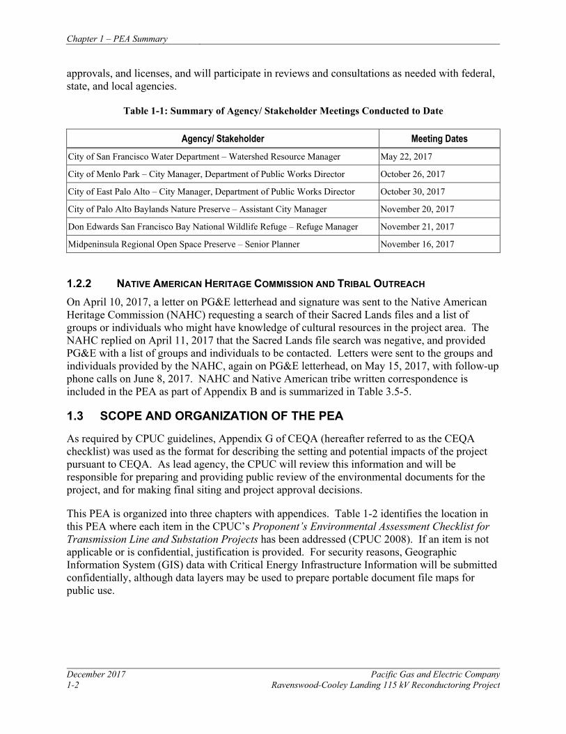
Table 1-1: Summary of Agency/ Stakeholder Meetings Conducted to Date
Agency/ Stakeholder Meeting Dates City of San Francisco Water Department – Watershed Resource Manager May 22, 2017
City of Menlo Park – City Manager, Department of Public Works Director October 26, 2017
City of East Palo Alto – City Manager, Department of Public Works Director October 30, 2017
City of Palo Alto Baylands Nature Preserve – Assistant City Manager November 20, 2017
Don Edwards San Francisco Bay National Wildlife Refuge – Refuge Manager November 21, 2017
Midpeninsula Regional Open Space Preserve – Senior Planner November 16, 2017
1.2.2 NATIVE AMERICAN HERITAGE COMMISSION AND TRIBAL OUTREACH On April 10, 2017, a letter on PG&E letterhead and signature was sent to the Native American Heritage Commission (NAHC) requesting a search of their Sacred Lands files and a list of groups or individuals who might have knowledge of cultural resources in the project area. The NAHC replied on April 11, 2017 that the Sacred Lands file search was negative, and provided PG&E with a list of groups and individuals to be contacted. Letters were sent to the groups and individuals provided by the NAHC, again on PG&E letterhead, on May 15, 2017, with follow-up phone calls on June 8, 2017. NAHC and Native American tribe written correspondence is included in the PEA as part of Appendix B and is summarized in Table 3.5-5.
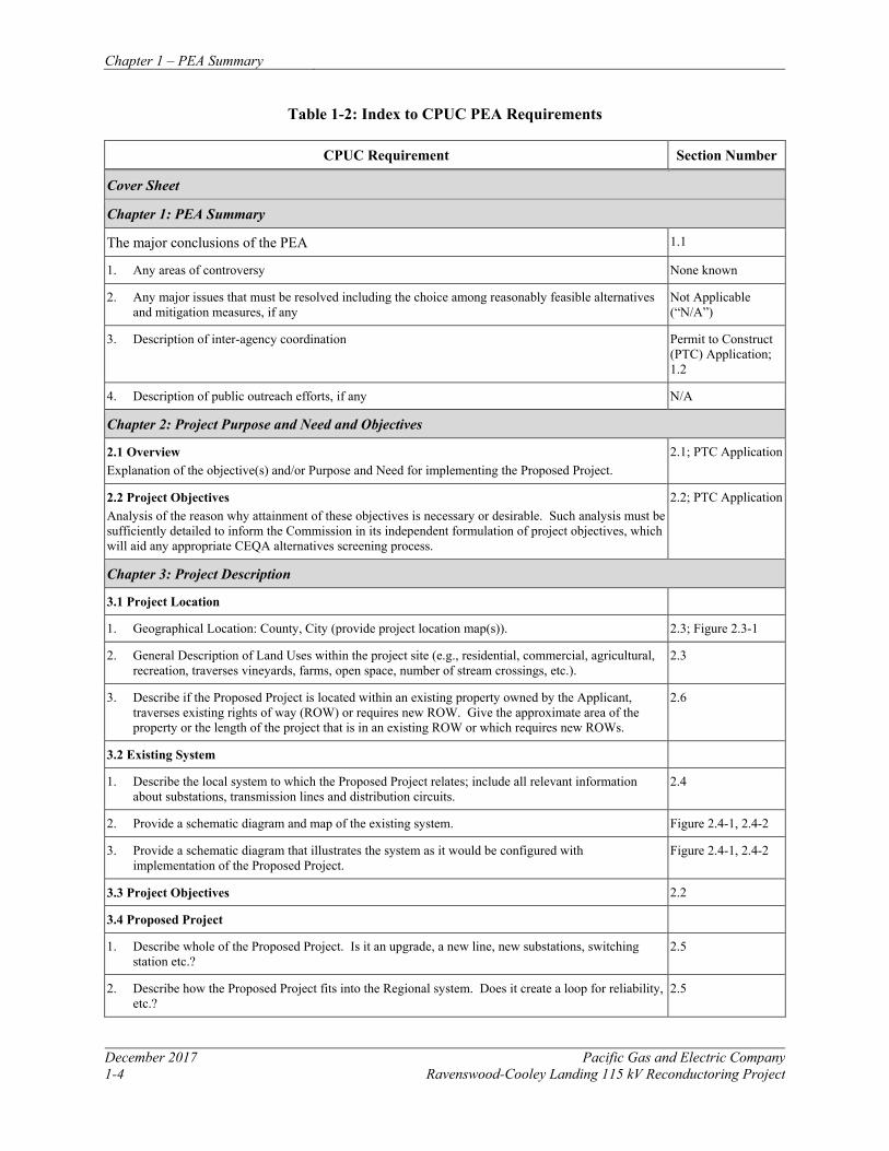
1.3 SCOPE AND ORGANIZATION OF THE PEA
As required by CPUC guidelines, Appendix G of CEQA (hereafter referred to as the CEQA checklist) was used as the format for describing the setting and potential impacts of the project pursuant to CEQA. As lead agency, the CPUC will review this information and will be responsible for preparing and providing public review of the environmental documents for the project, and for making final siting and project approval decisions.
This PEA is organized into three chapters with appendices. Table 1-2 identifies the location in this PEA where each item in the CPUC’s Proponent’s Environmental Assessment Checklist for Transmission Line and Substation Projects has been addressed (CPUC 2008). If an item is not applicable or is confidential, justification is provided. For security reasons, Geographic Information System (GIS) data with Critical Energy Infrastructure Information will be submitted confidentially, although data layers may be used to prepare portable document file maps for public use.
Chapter 1 – PEA Summary
Pacific Gas and Electric Company December 2017 Ravenswood-Cooley Landing 115 kV Reconductoring Project 1-3
This PEA is organized in the following manner: Chapter 2, Project Description, provides a detailed project description, including purpose and need. In addition, the end of this chapter provides a list of the APMs that will be implemented (APMs are described in detail in Table 2.10-1 of Chapter 2 and in Chapter 3, Impact Assessment Summary).
Chapter 3, Environmental Setting and Impact Assessment Summary, describes the environmental setting, and presents an analysis of potential impacts to various categories of resources (as defined in Appendix G of the CEQA Guidelines), which may result from implementing the project. Each subsection includes a description of the regulatory context, environmental setting, resource-specific applicant-proposed measures (APMs) for minimizing potential impacts, and analysis of potential impacts resulting from construction or operation and maintenance of the project. Chapter 3.0 also addresses findings of significance and an analysis of the project’s potential contribution to cumulative projects. This chapter covers all elements of the CEQA checklist, including the following resource area sections:
• 3.1 Aesthetics • 3.10 Land Use and Planning
• 3.2 Agricultural and Forest Resources • 3.11 Mineral Resources
• 3.3 Air Quality • 3.12 Noise
• 3.4 Biological Resources • 3.13 Population and Housing
• 3.5 Cultural Resources • 3.14 Public Services
• 3.6 Geology and Soils • 3.15 Recreation
• 3.7 Greenhouse Gas Emissions • 3.16 Transportation and Traffic
• 3.8 Hazards and Hazardous Materials • 3.17 Utilities and Service Systems
• 3.9 Hydrology and Water Quality • 3.18 Mandatory Findings of Significance and Cumulative Impacts
Appendices include the following: • Appendix A: Affected Properties Within 300 Feet
• Appendix B: Native American Heritage Commission Correspondence
• Appendix C: List of Preparers
Chapter 1 – PEA Summary
December 2017 Pacific Gas and Electric Company 1-4 Ravenswood-Cooley Landing 115 kV Reconductoring Project
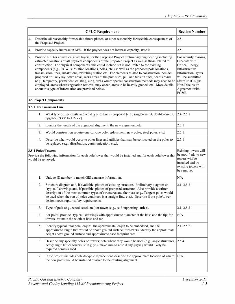
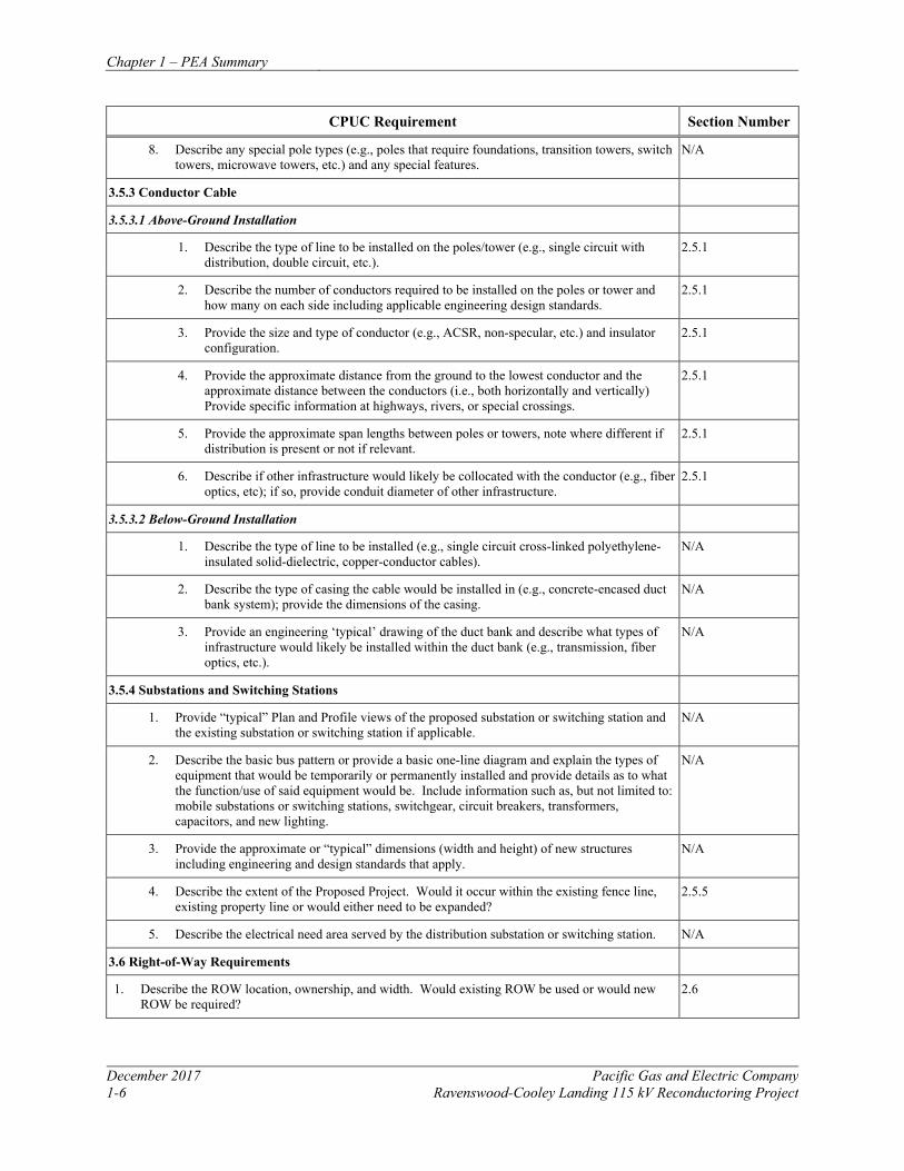
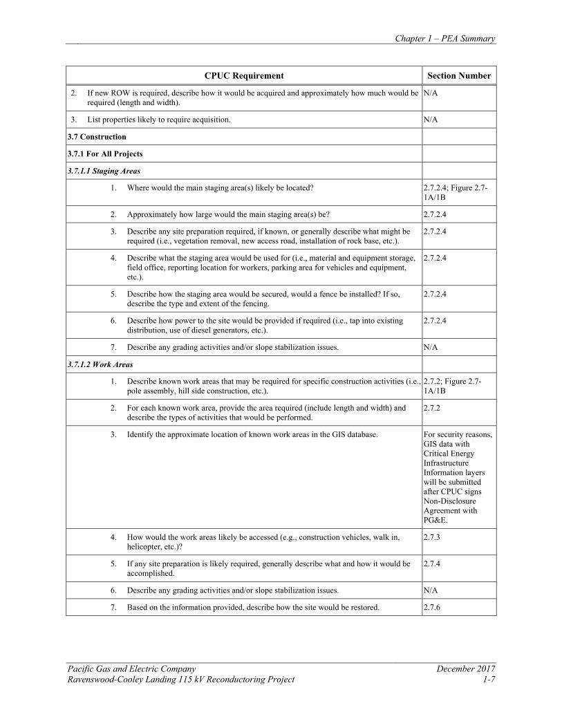
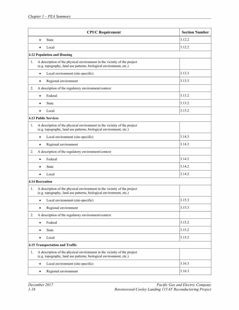
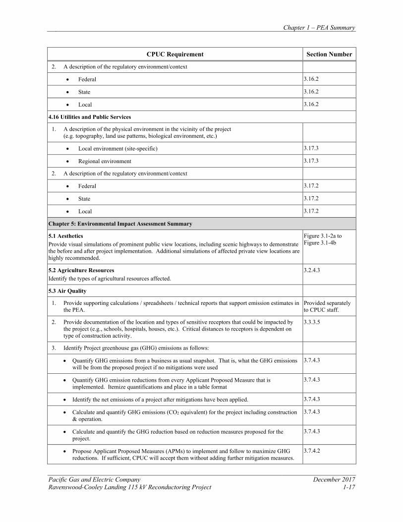
Table 1-2: Index to CPUC PEA Requirements
CPUC Requirement Section Number
Cover Sheet
Chapter 1: PEA Summary
The major conclusions of the PEA 1.1
1. Any areas of controversy None known
2. Any major issues that must be resolved including the choice among reasonably feasible alternatives and mitigation measures, if any
Not Applicable (“N/A”)
3. Description of inter-agency coordination Permit to Construct (PTC) Application; 1.2
4. Description of public outreach efforts, if any N/A
Chapter 2: Project Purpose and Need and Objectives
2.1 Overview Explanation of the objective(s) and/or Purpose and Need for implementing the Proposed Project.
2.1; PTC Application
2.2 Project Objectives Analysis of the reason why attainment of these objectives is necessary or desirable. Such analysis must be sufficiently detailed to inform the Commission in its independent formulation of project objectives, which will aid any appropriate CEQA alternatives screening process.
2.2; PTC Application
Chapter 3: Project Description
3.1 Project Location
1. Geographical Location: County, City (provide project location map(s)). 2.3; Figure 2.3-1
2. General Description of Land Uses within the project site (e.g., residential, commercial, agricultural, recreation, traverses vineyards, farms, open space, number of stream crossings, etc.).
2.3
3. Describe if the Proposed Project is located within an existing property owned by the Applicant, traverses existing rights of way (ROW) or requires new ROW. Give the approximate area of the property or the length of the project that is in an existing ROW or which requires new ROWs.
2.6
3.2 Existing System
1. Describe the local system to which the Proposed Project relates; include all relevant information about substations, transmission lines and distribution circuits.
2.4
2. Provide a schematic diagram and map of the existing system. Figure 2.4-1, 2.4-2
3. Provide a schematic diagram that illustrates the system as it would be configured with implementation of the Proposed Project.
Figure 2.4-1, 2.4-2
3.3 Project Objectives 2.2
3.4 Proposed Project
1. Describe whole of the Proposed Project. Is it an upgrade, a new line, new substations, switching station etc.?
2.5
2. Describe how the Proposed Project fits into the Regional system. Does it create a loop for reliability, etc.?
2.5
Chapter 1 – PEA Summary
Pacific Gas and Electric Company December 2017 Ravenswood-Cooley Landing 115 kV Reconductoring Project 1-5
CPUC Requirement Section Number
3. Describe all reasonably foreseeable future phases, or other reasonably foreseeable consequences of the Proposed Project.
2.5
4. Provide capacity increase in MW. If the project does not increase capacity, state it. 2.5
5. Provide GIS (or equivalent) data layers for the Proposed Project preliminary engineering including estimated locations of all physical components of the Proposed Project as well as those related to construction. For physical components, this could include but is not limited to the existing components (e.g., ROW, substation locations, poles, etc.) as well as the proposed pole locations, transmission lines, substations, switching station etc. For elements related to construction include: proposed or likely lay-down areas, work areas at the pole sites, pull and tension sites, access roads (e.g., temporary, permanent, existing, etc.), areas where special construction methods may need to be employed, areas where vegetation removal may occur, areas to be heavily graded, etc. More details about this type of information are provided below.
For security reasons, GIS data with Critical Energy Infrastructure Information layers will be submitted after CPUC signs Non-Disclosure Agreement with PG&E.
3.5 Project Components
3.5.1 Transmission Line
1. What type of line exists and what type of line is proposed (e.g., single-circuit, double-circuit, upgrade 69 kV to 115 kV).
2.4, 2.5.1
2. Identify the length of the upgraded alignment, the new alignment, etc. 2.5.1
3. Would construction require one-for-one pole replacement, new poles, steel poles, etc.? 2.5.1
4. Describe what would occur to other lines and utilities that may be collocated on the poles to be replaced (e.g., distribution, communication, etc.).
2.5.1
3.5.2 Poles/Towers Provide the following information for each pole/tower that would be installed and for each pole/tower that would be removed:
Existing towers will be modified; no new towers will be installed and no existing towers will be removed.
1. Unique ID number to match GIS database information. N/A
2. Structure diagram and, if available, photos of existing structure. Preliminary diagram or “typical” drawings and, if possible, photos of proposed structure. Also provide a written description of the most common types of structures and their use (e.g., Tangent poles would be used when the run of poles continues in a straight line, etc.). Describe if the pole/tower design meets raptor safety requirements.
2.1, 2.5.2
3. Type of pole (e.g., wood, steel, etc.) or tower (e.g., self-supporting lattice). 2.1, 2.5.2
4. For poles, provide “typical” drawings with approximate diameter at the base and the tip; for towers, estimate the width at base and top.
N/A
5. Identify typical total pole lengths, the approximate length to be embedded, and the approximate length that would be above ground surface; for towers, identify the approximate height above ground surface and approximate base footprint area.
2.1, 2.5.2
6. Describe any specialty poles or towers; note where they would be used (e.g., angle structures, heavy angle lattice towers, stub guys); make sure to note if any guying would likely be required across a road.
2.5.4
7. If the project includes pole-for-pole replacement, describe the approximate location of where the new poles would be installed relative to the existing alignment.
N/A
Chapter 1 – PEA Summary
December 2017 Pacific Gas and Electric Company 1-6 Ravenswood-Cooley Landing 115 kV Reconductoring Project
CPUC Requirement Section Number
8. Describe any special pole types (e.g., poles that require foundations, transition towers, switch towers, microwave towers, etc.) and any special features.
N/A
3.5.3 Conductor Cable
3.5.3.1 Above-Ground Installation
1. Describe the type of line to be installed on the poles/tower (e.g., single circuit with distribution, double circuit, etc.).
2.5.1
2. Describe the number of conductors required to be installed on the poles or tower and how many on each side including applicable engineering design standards.
2.5.1
3. Provide the size and type of conductor (e.g., ACSR, non-specular, etc.) and insulator configuration.
2.5.1
4. Provide the approximate distance from the ground to the lowest conductor and the approximate distance between the conductors (i.e., both horizontally and vertically) Provide specific information at highways, rivers, or special crossings.
2.5.1
5. Provide the approximate span lengths between poles or towers, note where different if distribution is present or not if relevant.
2.5.1
6. Describe if other infrastructure would likely be collocated with the conductor (e.g., fiber optics, etc); if so, provide conduit diameter of other infrastructure.
2.5.1
3.5.3.2 Below-Ground Installation
1. Describe the type of line to be installed (e.g., single circuit cross-linked polyethylene-insulated solid-dielectric, copper-conductor cables).
N/A
2. Describe the type of casing the cable would be installed in (e.g., concrete-encased duct bank system); provide the dimensions of the casing.
N/A
3. Provide an engineering ‘typical’ drawing of the duct bank and describe what types of infrastructure would likely be installed within the duct bank (e.g., transmission, fiber optics, etc.).
N/A
3.5.4 Substations and Switching Stations
1. Provide “typical” Plan and Profile views of the proposed substation or switching station and the existing substation or switching station if applicable.
N/A
2. Describe the basic bus pattern or provide a basic one-line diagram and explain the types of equipment that would be temporarily or permanently installed and provide details as to what the function/use of said equipment would be. Include information such as, but not limited to: mobile substations or switching stations, switchgear, circuit breakers, transformers, capacitors, and new lighting.
N/A
3. Provide the approximate or “typical” dimensions (width and height) of new structures including engineering and design standards that apply.
N/A
4. Describe the extent of the Proposed Project. Would it occur within the existing fence line, existing property line or would either need to be expanded?
2.5.5
5. Describe the electrical need area served by the distribution substation or switching station. N/A
3.6 Right-of-Way Requirements
1. Describe the ROW location, ownership, and width. Would existing ROW be used or would new ROW be required?
2.6
Chapter 1 – PEA Summary
Pacific Gas and Electric Company December 2017 Ravenswood-Cooley Landing 115 kV Reconductoring Project 1-7
CPUC Requirement Section Number
2. If new ROW is required, describe how it would be acquired and approximately how much would be required (length and width).
N/A
3. List properties likely to require acquisition. N/A
3.7 Construction
3.7.1 For All Projects
3.7.1.1 Staging Areas
1. Where would the main staging area(s) likely be located? 2.7.2.4; Figure 2.7-1A/1B
2. Approximately how large would the main staging area(s) be? 2.7.2.4
3. Describe any site preparation required, if known, or generally describe what might be required (i.e., vegetation removal, new access road, installation of rock base, etc.).
2.7.2.4
4. Describe what the staging area would be used for (i.e., material and equipment storage, field office, reporting location for workers, parking area for vehicles and equipment, etc.).
2.7.2.4
5. Describe how the staging area would be secured, would a fence be installed? If so, describe the type and extent of the fencing.
2.7.2.4
6. Describe how power to the site would be provided if required (i.e., tap into existing distribution, use of diesel generators, etc.).
2.7.2.4
7. Describe any grading activities and/or slope stabilization issues. N/A
3.7.1.2 Work Areas
1. Describe known work areas that may be required for specific construction activities (i.e., pole assembly, hill side construction, etc.).
2.7.2; Figure 2.7-1A/1B
2. For each known work area, provide the area required (include length and width) and describe the types of activities that would be performed.
2.7.2
3. Identify the approximate location of known work areas in the GIS database. For security reasons, GIS data with Critical Energy Infrastructure Information layers will be submitted after CPUC signs Non-Disclosure Agreement with PG&E.
4. How would the work areas likely be accessed (e.g., construction vehicles, walk in, helicopter, etc.)?
2.7.3
5. If any site preparation is likely required, generally describe what and how it would be accomplished.
2.7.4
6. Describe any grading activities and/or slope stabilization issues. N/A
7. Based on the information provided, describe how the site would be restored. 2.7.6
Chapter 1 – PEA Summary
December 2017 Pacific Gas and Electric Company 1-8 Ravenswood-Cooley Landing 115 kV Reconductoring Project
CPUC Requirement Section Number
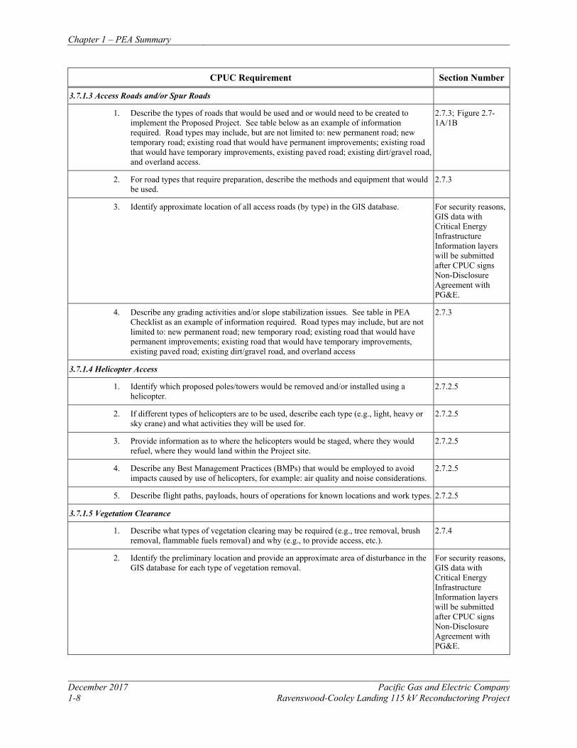
3.7.1.3 Access Roads and/or Spur Roads
1. Describe the types of roads that would be used and or would need to be created to implement the Proposed Project. See table below as an example of information required. Road types may include, but are not limited to: new permanent road; new temporary road; existing road that would have permanent improvements; existing road that would have temporary improvements, existing paved road; existing dirt/gravel road, and overland access.
2.7.3; Figure 2.7-1A/1B
2. For road types that require preparation, describe the methods and equipment that would be used.
2.7.3
3. Identify approximate location of all access roads (by type) in the GIS database. For security reasons, GIS data with Critical Energy Infrastructure Information layers will be submitted after CPUC signs Non-Disclosure Agreement with PG&E.
4. Describe any grading activities and/or slope stabilization issues. See table in PEA Checklist as an example of information required. Road types may include, but are not limited to: new permanent road; new temporary road; existing road that would have permanent improvements; existing road that would have temporary improvements, existing paved road; existing dirt/gravel road, and overland access
2.7.3
3.7.1.4 Helicopter Access
1. Identify which proposed poles/towers would be removed and/or installed using a helicopter.
2.7.2.5
2. If different types of helicopters are to be used, describe each type (e.g., light, heavy or sky crane) and what activities they will be used for.
2.7.2.5
3. Provide information as to where the helicopters would be staged, where they would refuel, where they would land within the Project site.
2.7.2.5
4. Describe any Best Management Practices (BMPs) that would be employed to avoid impacts caused by use of helicopters, for example: air quality and noise considerations.
2.7.2.5
5. Describe flight paths, payloads, hours of operations for known locations and work types. 2.7.2.5
3.7.1.5 Vegetation Clearance
1. Describe what types of vegetation clearing may be required (e.g., tree removal, brush removal, flammable fuels removal) and why (e.g., to provide access, etc.).
2.7.4
2. Identify the preliminary location and provide an approximate area of disturbance in the GIS database for each type of vegetation removal.
For security reasons, GIS data with Critical Energy Infrastructure Information layers will be submitted after CPUC signs Non-Disclosure Agreement with PG&E.
Chapter 1 – PEA Summary
Pacific Gas and Electric Company December 2017 Ravenswood-Cooley Landing 115 kV Reconductoring Project 1-9
CPUC Requirement Section Number
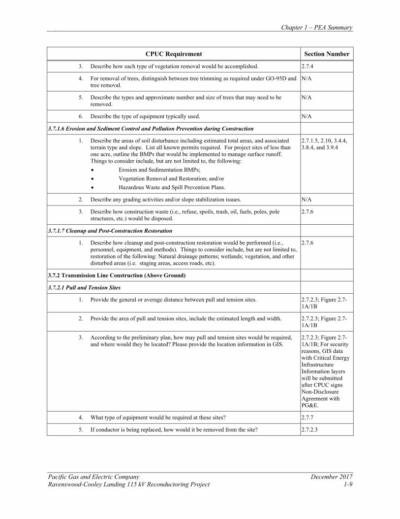
3. Describe how each type of vegetation removal would be accomplished. 2.7.4
4. For removal of trees, distinguish between tree trimming as required under GO-95D and tree removal.
N/A
5. Describe the types and approximate number and size of trees that may need to be removed.
N/A
6. Describe the type of equipment typically used. N/A
3.7.1.6 Erosion and Sediment Control and Pollution Prevention during Construction
1. Describe the areas of soil disturbance including estimated total areas, and associated terrain type and slope. List all known permits required. For project sites of less than one acre, outline the BMPs that would be implemented to manage surface runoff. Things to consider include, but are not limited to, the following: • Erosion and Sedimentation BMPs; • Vegetation Removal and Restoration; and/or • Hazardous Waste and Spill Prevention Plans.
2.7.1.5, 2.10, 3.4.4, 3.8.4, and 3.9.4
2. Describe any grading activities and/or slope stabilization issues. N/A
3. Describe how construction waste (i.e., refuse, spoils, trash, oil, fuels, poles, pole structures, etc.) would be disposed.
2.7.6
3.7.1.7 Cleanup and Post-Construction Restoration
1. Describe how cleanup and post-construction restoration would be performed (i.e., personnel, equipment, and methods). Things to consider include, but are not limited to, restoration of the following: Natural drainage patterns; wetlands; vegetation, and other disturbed areas (i.e. staging areas, access roads, etc).
2.7.6
3.7.2 Transmission Line Construction (Above Ground)
3.7.2.1 Pull and Tension Sites
1. Provide the general or average distance between pull and tension sites. 2.7.2.3; Figure 2.7-1A/1B
2. Provide the area of pull and tension sites, include the estimated length and width. 2.7.2.3; Figure 2.7-1A/1B
3. According to the preliminary plan, how may pull and tension sites would be required, and where would they be located? Please provide the location information in GIS.
2.7.2.3; Figure 2.7-1A/1B; For security reasons, GIS data with Critical Energy Infrastructure Information layers will be submitted after CPUC signs Non-Disclosure Agreement with PG&E.
4. What type of equipment would be required at these sites? 2.7.7
5. If conductor is being replaced, how would it be removed from the site? 2.7.2.3
Chapter 1 – PEA Summary
December 2017 Pacific Gas and Electric Company 1-10 Ravenswood-Cooley Landing 115 kV Reconductoring Project
CPUC Requirement Section Number
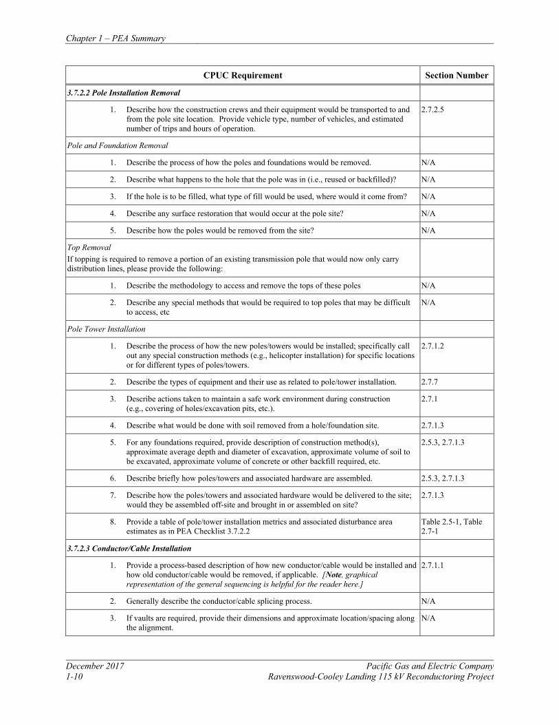
3.7.2.2 Pole Installation Removal
1. Describe how the construction crews and their equipment would be transported to and from the pole site location. Provide vehicle type, number of vehicles, and estimated number of trips and hours of operation.
2.7.2.5
Pole and Foundation Removal
1. Describe the process of how the poles and foundations would be removed. N/A
2. Describe what happens to the hole that the pole was in (i.e., reused or backfilled)? N/A
3. If the hole is to be filled, what type of fill would be used, where would it come from? N/A
4. Describe any surface restoration that would occur at the pole site? N/A
5. Describe how the poles would be removed from the site? N/A
Top Removal If topping is required to remove a portion of an existing transmission pole that would now only carry distribution lines, please provide the following:
1. Describe the methodology to access and remove the tops of these poles N/A
2. Describe any special methods that would be required to top poles that may be difficult to access, etc
N/A
Pole Tower Installation
1. Describe the process of how the new poles/towers would be installed; specifically call out any special construction methods (e.g., helicopter installation) for specific locations or for different types of poles/towers.
2.7.1.2
2. Describe the types of equipment and their use as related to pole/tower installation. 2.7.7
3. Describe actions taken to maintain a safe work environment during construction (e.g., covering of holes/excavation pits, etc.).
2.7.1
4. Describe what would be done with soil removed from a hole/foundation site. 2.7.1.3
5. For any foundations required, provide description of construction method(s), approximate average depth and diameter of excavation, approximate volume of soil to be excavated, approximate volume of concrete or other backfill required, etc.
2.5.3, 2.7.1.3
6. Describe briefly how poles/towers and associated hardware are assembled. 2.5.3, 2.7.1.3
7. Describe how the poles/towers and associated hardware would be delivered to the site; would they be assembled off-site and brought in or assembled on site?
2.7.1.3
8. Provide a table of pole/tower installation metrics and associated disturbance area estimates as in PEA Checklist 3.7.2.2
Table 2.5-1, Table 2.7-1
3.7.2.3 Conductor/Cable Installation
1. Provide a process-based description of how new conductor/cable would be installed and how old conductor/cable would be removed, if applicable. [Note, graphical representation of the general sequencing is helpful for the reader here.]
2.7.1.1
2. Generally describe the conductor/cable splicing process. N/A
3. If vaults are required, provide their dimensions and approximate location/spacing along the alignment.
N/A
Chapter 1 – PEA Summary
Pacific Gas and Electric Company December 2017 Ravenswood-Cooley Landing 115 kV Reconductoring Project 1-11
CPUC Requirement Section Number
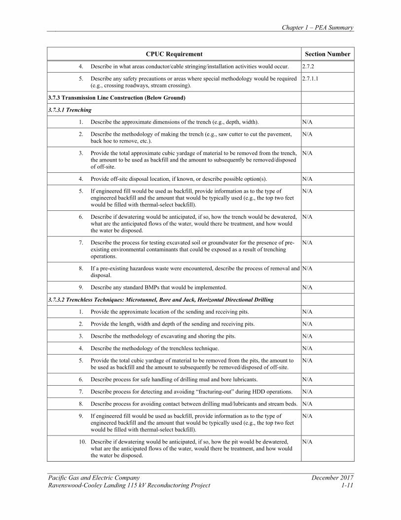
4. Describe in what areas conductor/cable stringing/installation activities would occur. 2.7.2
5. Describe any safety precautions or areas where special methodology would be required (e.g., crossing roadways, stream crossing).
2.7.1.1
3.7.3 Transmission Line Construction (Below Ground)
3.7.3.1 Trenching
1. Describe the approximate dimensions of the trench (e.g., depth, width). N/A
2. Describe the methodology of making the trench (e.g., saw cutter to cut the pavement, back hoe to remove, etc.).
N/A
3. Provide the total approximate cubic yardage of material to be removed from the trench, the amount to be used as backfill and the amount to subsequently be removed/disposed of off-site.
N/A
4. Provide off-site disposal location, if known, or describe possible option(s). N/A
5. If engineered fill would be used as backfill, provide information as to the type of engineered backfill and the amount that would be typically used (e.g., the top two feet would be filled with thermal-select backfill).
N/A
6. Describe if dewatering would be anticipated, if so, how the trench would be dewatered, what are the anticipated flows of the water, would there be treatment, and how would the water be disposed.
N/A
7. Describe the process for testing excavated soil or groundwater for the presence of pre-existing environmental contaminants that could be exposed as a result of trenching operations.
N/A
8. If a pre-existing hazardous waste were encountered, describe the process of removal and disposal.
N/A
9. Describe any standard BMPs that would be implemented. N/A
3.7.3.2 Trenchless Techniques: Microtunnel, Bore and Jack, Horizontal Directional Drilling
1. Provide the approximate location of the sending and receiving pits. N/A
2. Provide the length, width and depth of the sending and receiving pits. N/A
3. Describe the methodology of excavating and shoring the pits. N/A
4. Describe the methodology of the trenchless technique. N/A
5. Provide the total cubic yardage of material to be removed from the pits, the amount to be used as backfill and the amount to subsequently be removed/disposed of off-site.
N/A
6. Describe process for safe handling of drilling mud and bore lubricants. N/A
7. Describe process for detecting and avoiding “fracturing-out” during HDD operations. N/A
8. Describe process for avoiding contact between drilling mud/lubricants and stream beds. N/A
9. If engineered fill would be used as backfill, provide information as to the type of engineered backfill and the amount that would be typically used (e.g., the top two feet would be filled with thermal-select backfill).
N/A
10. Describe if dewatering would be anticipated, if so, how the pit would be dewatered, what are the anticipated flows of the water, would there be treatment, and how would the water be disposed.
N/A
Chapter 1 – PEA Summary
December 2017 Pacific Gas and Electric Company 1-12 Ravenswood-Cooley Landing 115 kV Reconductoring Project
CPUC Requirement Section Number
11. Describe the process for testing excavated soil or groundwater for the presence of pre-existing environmental contaminants.
N/A
12. If a pre-existing hazardous waste were encountered, describe the process of removal and disposal.
N/A
13. Describe any grading activities and/or slope stabilization issues. N/A
14. Describe any standard BMPs that would be implemented. N/A
3.7.4 Substation and Switching Station Construction
1. Describe any earth moving activities that would be required; what type of activity and, if applicable, estimate cubic yards of materials to be reused and/or removed from the site for both site grading and foundation excavation.
N/A
2. Provide a conceptual landscape plan in consultation with the municipality in which the substation or switching station is located.
N/A
3. Describe any grading activities and/or slope stabilization issues. N/A
4. Describe possible relocation of commercial or residential property, if any. N/A
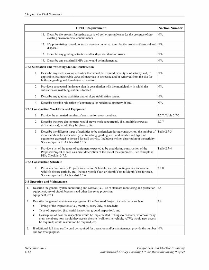
3.7.5 Construction Workforce and Equipment
1. Provide the estimated number of construction crew members. 2.7.7, Table 2.7-3
2. Describe the crew deployment, would crews work concurrently (i.e., multiple crews at different sites); would they be phased, etc.
2.7.7
3. Describe the different types of activities to be undertaken during construction; the number of crew members for each activity i.e. trenching, grading, etc.; and number and types of equipment expected to be used for said activity. Include a written description of the activity. See example in PEA Checklist 3.7.5.
Table 2.7-3
4. Provide a list of the types of equipment expected to be used during construction of the Proposed Project as well as a brief description of the use of the equipment. See example in PEA Checklist 3.7.5.
Table 2.7-4
3.7.6 Construction Schedule
1. Provide a Preliminary Project Construction Schedule; include contingencies for weather, wildlife closure periods, etc. Include Month Year, or Month Year to Month Year for each. See example in PEA Checklist 3.7.6.
2.7.8
3.8 Operation and Maintenance
1. Describe the general system monitoring and control (i.e., use of standard monitoring and protection equipment, use of circuit breakers and other line relay protection equipment, etc.).
2.8
2. Describe the general maintenance program of the Proposed Project, include items such as: • Timing of the inspections (i.e., monthly, every July, as needed); • Type of inspection (i.e., aerial inspection, ground inspection); and • Description of how the inspection would be implemented. Things to consider, who/how many
crew members; how would they access the site (walk to site, vehicle, ATV); would new access be required; would restoration be required, etc.
2.8
3. If additional full time staff would be required for operation and/or maintenance, provide the number and for what purpose.
N/A
Chapter 1 – PEA Summary
Pacific Gas and Electric Company December 2017 Ravenswood-Cooley Landing 115 kV Reconductoring Project 1-13
CPUC Requirement Section Number
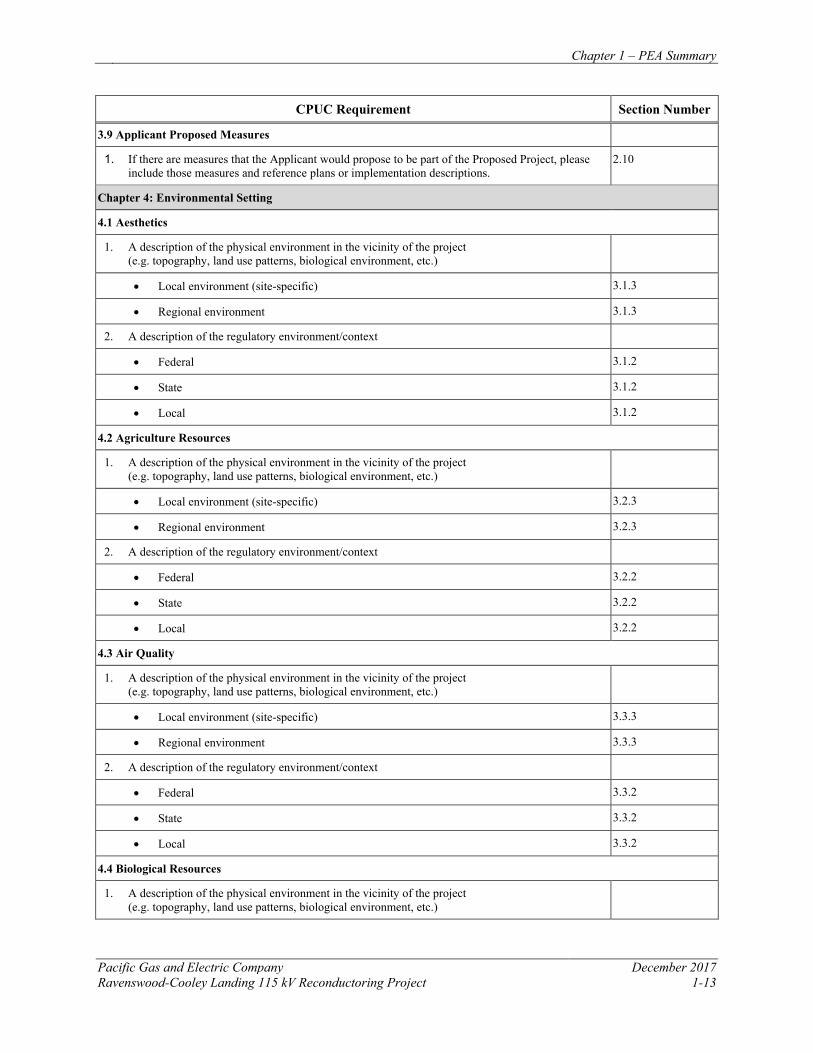
3.9 Applicant Proposed Measures
1. If there are measures that the Applicant would propose to be part of the Proposed Project, please include those measures and reference plans or implementation descriptions.
2.10
Chapter 4: Environmental Setting
4.1 Aesthetics
1. A description of the physical environment in the vicinity of the project (e.g. topography, land use patterns, biological environment, etc.)
• Local environment (site-specific) 3.1.3
• Regional environment 3.1.3
2. A description of the regulatory environment/context
• Federal 3.1.2
• State 3.1.2
• Local 3.1.2
4.2 Agriculture Resources
1. A description of the physical environment in the vicinity of the project (e.g. topography, land use patterns, biological environment, etc.)
• Local environment (site-specific) 3.2.3
• Regional environment 3.2.3
2. A description of the regulatory environment/context
• Federal 3.2.2
• State 3.2.2
• Local 3.2.2
4.3 Air Quality
1. A description of the physical environment in the vicinity of the project (e.g. topography, land use patterns, biological environment, etc.)
• Local environment (site-specific) 3.3.3
• Regional environment 3.3.3
2. A description of the regulatory environment/context
• Federal 3.3.2
• State 3.3.2
• Local 3.3.2
4.4 Biological Resources
1. A description of the physical environment in the vicinity of the project (e.g. topography, land use patterns, biological environment, etc.)
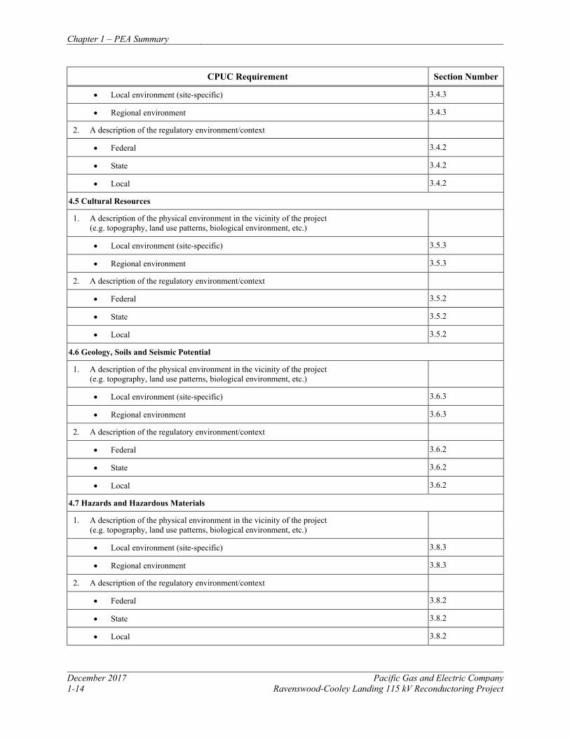
Chapter 1 – PEA Summary
December 2017 Pacific Gas and Electric Company 1-14 Ravenswood-Cooley Landing 115 kV Reconductoring Project
CPUC Requirement Section Number
• Local environment (site-specific) 3.4.3
• Regional environment 3.4.3
2. A description of the regulatory environment/context
• Federal 3.4.2
• State 3.4.2
• Local 3.4.2
4.5 Cultural Resources
1. A description of the physical environment in the vicinity of the project (e.g. topography, land use patterns, biological environment, etc.)
• Local environment (site-specific) 3.5.3
• Regional environment 3.5.3
2. A description of the regulatory environment/context
• Federal 3.5.2
• State 3.5.2
• Local 3.5.2
4.6 Geology, Soils and Seismic Potential
1. A description of the physical environment in the vicinity of the project (e.g. topography, land use patterns, biological environment, etc.)
• Local environment (site-specific) 3.6.3
• Regional environment 3.6.3
2. A description of the regulatory environment/context
• Federal 3.6.2
• State 3.6.2
• Local 3.6.2
4.7 Hazards and Hazardous Materials
1. A description of the physical environment in the vicinity of the project (e.g. topography, land use patterns, biological environment, etc.)
• Local environment (site-specific) 3.8.3
• Regional environment 3.8.3
2. A description of the regulatory environment/context
• Federal 3.8.2
• State 3.8.2
• Local 3.8.2
Chapter 1 – PEA Summary
Pacific Gas and Electric Company December 2017 Ravenswood-Cooley Landing 115 kV Reconductoring Project 1-15
CPUC Requirement Section Number
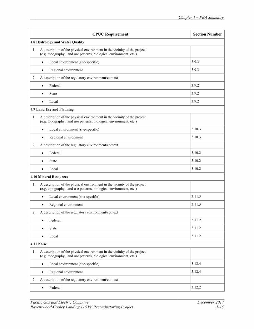
4.8 Hydrology and Water Quality
1. A description of the physical environment in the vicinity of the project (e.g. topography, land use patterns, biological environment, etc.)
• Local environment (site-specific) 3.9.3
• Regional environment 3.9.3
2. A description of the regulatory environment/context
• Federal 3.9.2
• State 3.9.2
• Local 3.9.2
4.9 Land Use and Planning
1. A description of the physical environment in the vicinity of the project (e.g. topography, land use patterns, biological environment, etc.)
• Local environment (site-specific) 3.10.3
• Regional environment 3.10.3
2. A description of the regulatory environment/context
• Federal 3.10.2
• State 3.10.2
• Local 3.10.2
4.10 Mineral Resources
1. A description of the physical environment in the vicinity of the project (e.g. topography, land use patterns, biological environment, etc.)
• Local environment (site-specific) 3.11.3
• Regional environment 3.11.3
2. A description of the regulatory environment/context
• Federal 3.11.2
• State 3.11.2
• Local 3.11.2
4.11 Noise
1. A description of the physical environment in the vicinity of the project (e.g. topography, land use patterns, biological environment, etc.)
• Local environment (site-specific) 3.12.4
• Regional environment 3.12.4
2. A description of the regulatory environment/context
• Federal 3.12.2
Chapter 1 – PEA Summary
December 2017 Pacific Gas and Electric Company 1-16 Ravenswood-Cooley Landing 115 kV Reconductoring Project
CPUC Requirement Section Number
• State 3.12.2
• Local 3.12.2
4.12 Population and Housing
1. A description of the physical environment in the vicinity of the project (e.g. topography, land use patterns, biological environment, etc.)
• Local environment (site-specific) 3.13.3
• Regional environment 3.13.3
2. A description of the regulatory environment/context
• Federal 3.13.2
• State 3.13.2
• Local 3.13.2
4.13 Public Services
1. A description of the physical environment in the vicinity of the project (e.g. topography, land use patterns, biological environment, etc.)
• Local environment (site-specific) 3.14.3
• Regional environment 3.14.3
2. A description of the regulatory environment/context
• Federal 3.14.2
• State 3.14.2
• Local 3.14.2
4.14 Recreation
1. A description of the physical environment in the vicinity of the project (e.g. topography, land use patterns, biological environment, etc.)
• Local environment (site-specific) 3.15.3
• Regional environment 3.15.3
2. A description of the regulatory environment/context
• Federal 3.15.2
• State 3.15.2
• Local 3.15.2
4.15 Transportation and Traffic
1. A description of the physical environment in the vicinity of the project (e.g. topography, land use patterns, biological environment, etc.)
• Local environment (site-specific) 3.16.3
• Regional environment 3.16.3
Chapter 1 – PEA Summary
Pacific Gas and Electric Company December 2017 Ravenswood-Cooley Landing 115 kV Reconductoring Project 1-17
CPUC Requirement Section Number
2. A description of the regulatory environment/context
• Federal 3.16.2
• State 3.16.2
• Local 3.16.2
4.16 Utilities and Public Services
1. A description of the physical environment in the vicinity of the project(e.g. topography, land use patterns, biological environment, etc.)
• Local environment (site-specific) 3.17.3
• Regional environment 3.17.3
2. A description of the regulatory environment/context
• Federal 3.17.2
• State 3.17.2
• Local 3.17.2
Chapter 5: Environmental Impact Assessment Summary
5.1 Aesthetics Provide visual simulations of prominent public view locations, including scenic highways to demonstrate the before and after project implementation. Additional simulations of affected private view locations are highly recommended.
Figure 3.1-2a to Figure 3.1-4b
5.2 Agriculture Resources Identify the types of agricultural resources affected.
3.2.4.3
5.3 Air Quality
1. Provide supporting calculations / spreadsheets / technical reports that support emission estimates inthe PEA.
Provided separately to CPUC staff.
2. Provide documentation of the location and types of sensitive receptors that could be impacted bythe project (e.g., schools, hospitals, houses, etc.). Critical distances to receptors is dependent ontype of construction activity.
3.3.3.5
3. Identify Project greenhouse gas (GHG) emissions as follows:
• Quantify GHG emissions from a business as usual snapshot. That is, what the GHG emissionswill be from the proposed project if no mitigations were used
3.7.4.3
• Quantify GHG emission reductions from every Applicant Proposed Measure that isimplemented. Itemize quantifications and place in a table format
3.7.4.3
• Identify the net emissions of a project after mitigations have been applied. 3.7.4.3
• Calculate and quantify GHG emissions (CO2 equivalent) for the project including construction& operation.
3.7.4.3
• Calculate and quantify the GHG reduction based on reduction measures proposed for theproject.
3.7.4.3
• Propose Applicant Proposed Measures (APMs) to implement and follow to maximize GHGreductions. If sufficient, CPUC will accept them without adding further mitigation measures.
3.7.4.2
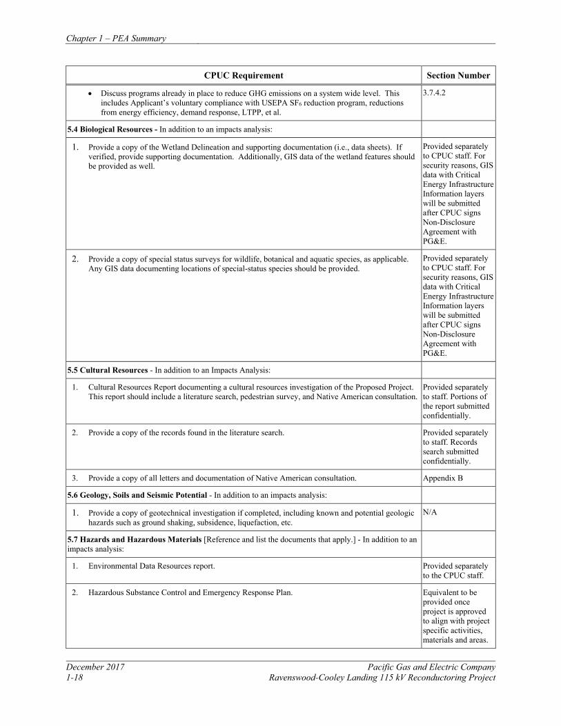
Chapter 1 – PEA Summary
December 2017 Pacific Gas and Electric Company 1-18 Ravenswood-Cooley Landing 115 kV Reconductoring Project
CPUC Requirement Section Number
• Discuss programs already in place to reduce GHG emissions on a system wide level. This includes Applicant’s voluntary compliance with USEPA SF6 reduction program, reductions from energy efficiency, demand response, LTPP, et al.
3.7.4.2
5.4 Biological Resources - In addition to an impacts analysis:
1. Provide a copy of the Wetland Delineation and supporting documentation (i.e., data sheets). If verified, provide supporting documentation. Additionally, GIS data of the wetland features should be provided as well.
Provided separately to CPUC staff. For security reasons, GIS data with Critical Energy Infrastructure Information layers will be submitted after CPUC signs Non-Disclosure Agreement with PG&E.
2. Provide a copy of special status surveys for wildlife, botanical and aquatic species, as applicable. Any GIS data documenting locations of special-status species should be provided.
Provided separately to CPUC staff. For security reasons, GIS data with Critical Energy Infrastructure Information layers will be submitted after CPUC signs Non-Disclosure Agreement with PG&E.
5.5 Cultural Resources - In addition to an Impacts Analysis:
1. Cultural Resources Report documenting a cultural resources investigation of the Proposed Project. This report should include a literature search, pedestrian survey, and Native American consultation.
Provided separately to staff. Portions of the report submitted confidentially.
2. Provide a copy of the records found in the literature search. Provided separately to staff. Records search submitted confidentially.
3. Provide a copy of all letters and documentation of Native American consultation. Appendix B
5.6 Geology, Soils and Seismic Potential - In addition to an impacts analysis:
1. Provide a copy of geotechnical investigation if completed, including known and potential geologic hazards such as ground shaking, subsidence, liquefaction, etc.
N/A
5.7 Hazards and Hazardous Materials [Reference and list the documents that apply.] - In addition to an impacts analysis:
1. Environmental Data Resources report. Provided separately to the CPUC staff.
2. Hazardous Substance Control and Emergency Response Plan. Equivalent to be provided once project is approved to align with project specific activities, materials and areas.
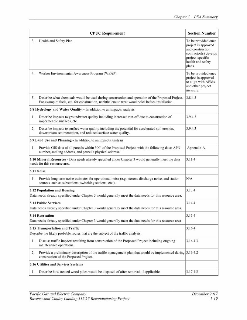
Chapter 1 – PEA Summary
Pacific Gas and Electric Company December 2017 Ravenswood-Cooley Landing 115 kV Reconductoring Project 1-19
CPUC Requirement Section Number
3. Health and Safety Plan. To be provided once project is approved and construction contractor(s) develop project-specific health and safety plans.
4. Worker Environmental Awareness Program (WEAP). To be provided once project is approved to align with APMs and other project measure.
5. Describe what chemicals would be used during construction and operation of the Proposed Project. For example: fuels, etc. for construction, naphthalene to treat wood poles before installation.
3.8.4.3
5.8 Hydrology and Water Quality – In addition to an impacts analysis:
1. Describe impacts to groundwater quality including increased run-off due to construction of impermeable surfaces, etc.
3.9.4.3
2. Describe impacts to surface water quality including the potential for accelerated soil erosion, downstream sedimentation, and reduced surface water quality.
3.9.4.3
5.9 Land Use and Planning - In addition to an impacts analysis:
1. Provide GIS data of all parcels within 300’ of the Proposed Project with the following data: APN number, mailing address, and parcel’s physical address.
Appendix A
5.10 Mineral Resources - Data needs already specified under Chapter 3 would generally meet the data needs for this resource area.
3.11.4
5.11 Noise
1. Provide long term noise estimates for operational noise (e.g., corona discharge noise, and station sources such as substations, switching stations, etc.).
N/A
5.12 Population and Housing Data needs already specified under Chapter 3 would generally meet the data needs for this resource area.
3.13.4
5.13 Public Services Data needs already specified under Chapter 3 would generally meet the data needs for this resource area.
3.14.4
5.14 Recreation Data needs already specified under Chapter 3 would generally meet the data needs for this resource area
3.15.4
5.15 Transportation and Traffic Describe the likely probable routes that are the subject of the traffic analysis.
3.16.4
1. Discuss traffic impacts resulting from construction of the Proposed Project including ongoing maintenance operations.
3.16.4.3
2. Provide a preliminary description of the traffic management plan that would be implemented during construction of the Proposed Project.
3.16.4.2
5.16 Utilities and Services Systems
1. Describe how treated wood poles would be disposed of after removal, if applicable. 3.17.4.2
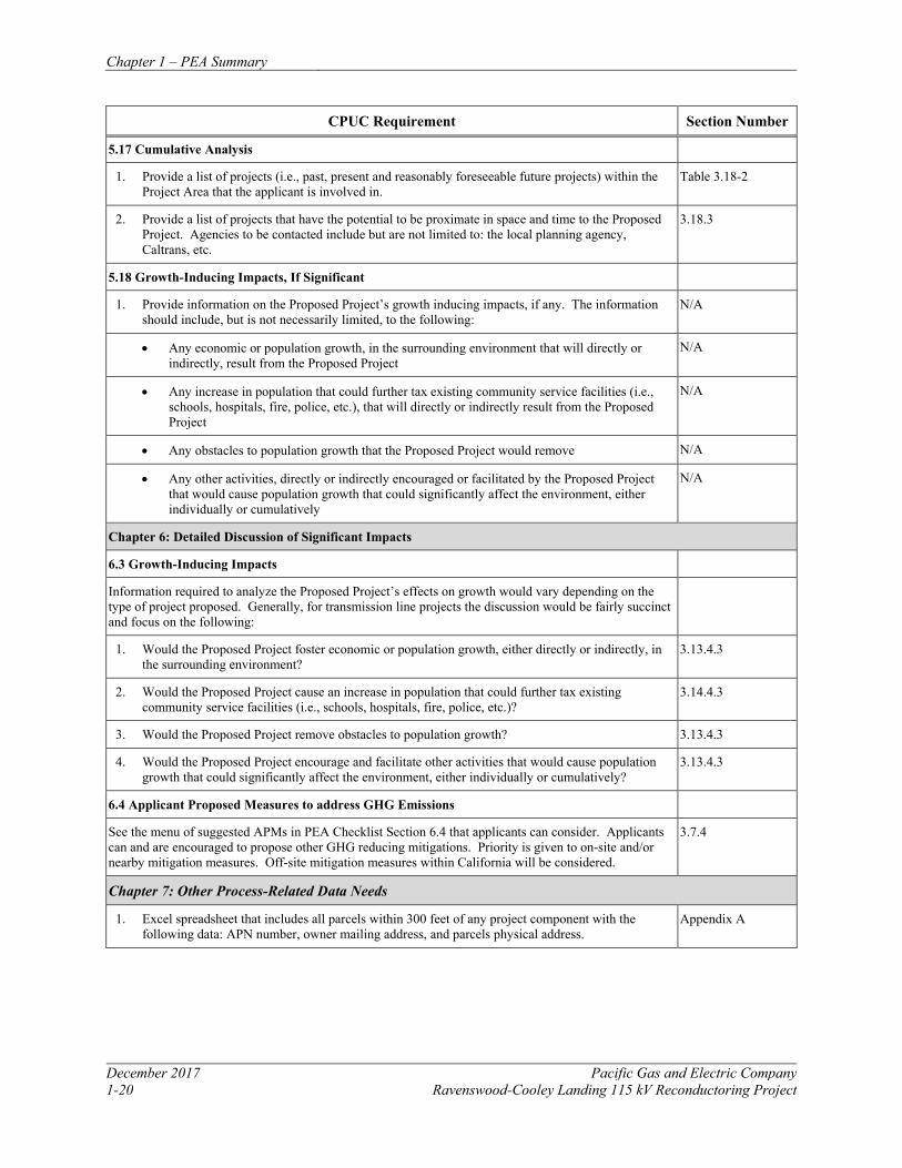
Chapter 1 – PEA Summary
December 2017 Pacific Gas and Electric Company 1-20 Ravenswood-Cooley Landing 115 kV Reconductoring Project
CPUC Requirement Section Number
5.17 Cumulative Analysis
1. Provide a list of projects (i.e., past, present and reasonably foreseeable future projects) within the Project Area that the applicant is involved in.
Table 3.18-2
2. Provide a list of projects that have the potential to be proximate in space and time to the Proposed Project. Agencies to be contacted include but are not limited to: the local planning agency, Caltrans, etc.
3.18.3
5.18 Growth-Inducing Impacts, If Significant
1. Provide information on the Proposed Project’s growth inducing impacts, if any. The information should include, but is not necessarily limited, to the following:
N/A
• Any economic or population growth, in the surrounding environment that will directly or indirectly, result from the Proposed Project
N/A
• Any increase in population that could further tax existing community service facilities (i.e., schools, hospitals, fire, police, etc.), that will directly or indirectly result from the Proposed Project
N/A
• Any obstacles to population growth that the Proposed Project would remove N/A
• Any other activities, directly or indirectly encouraged or facilitated by the Proposed Project that would cause population growth that could significantly affect the environment, either individually or cumulatively
N/A
Chapter 6: Detailed Discussion of Significant Impacts
6.3 Growth-Inducing Impacts
Information required to analyze the Proposed Project’s effects on growth would vary depending on the type of project proposed. Generally, for transmission line projects the discussion would be fairly succinct and focus on the following:
1. Would the Proposed Project foster economic or population growth, either directly or indirectly, in the surrounding environment?
3.13.4.3
2. Would the Proposed Project cause an increase in population that could further tax existing community service facilities (i.e., schools, hospitals, fire, police, etc.)?
3.14.4.3
3. Would the Proposed Project remove obstacles to population growth? 3.13.4.3
4. Would the Proposed Project encourage and facilitate other activities that would cause population growth that could significantly affect the environment, either individually or cumulatively?
3.13.4.3
6.4 Applicant Proposed Measures to address GHG Emissions
See the menu of suggested APMs in PEA Checklist Section 6.4 that applicants can consider. Applicants can and are encouraged to propose other GHG reducing mitigations. Priority is given to on-site and/or nearby mitigation measures. Off-site mitigation measures within California will be considered.
3.7.4
Chapter 7: Other Process-Related Data Needs
1. Excel spreadsheet that includes all parcels within 300 feet of any project component with the following data: APN number, owner mailing address, and parcels physical address.
Appendix A
Chapter 1 – PEA Summary
Pacific Gas and Electric Company December 2017 Ravenswood-Cooley Landing 115 kV Reconductoring Project 1-21
1.4 REFERENCES
California Public Utilities Commission (CPUC). 2008. Proponent’s Environmental Assessment Checklist for Transmission Line and Substation Projects. http://www.cpuc.ca.gov/environment/. Working Draft. November 24

Chapter 2 – Project Description
Pacific Gas and Electric Company December 2017 Ravenswood-Cooley Landing 115 kV Reconductoring Project 2-1
2 PROJECT DESCRIPTION
2.1 OVERVIEW
PG&E proposes to reinforce a portion of the Southeastern Peninsula Area 115 kV transmission system that provides electrical service to San Mateo and Santa Clara counties by replacing the conductors (a process referred to as reconductoring) on the approximately 1.6-mile Ravenswood-Cooley Landing 115 kV power line (Ravenswood-Cooley Landing Line). The Ravenswood-Cooley Landing Line is a double-circuit tower line (DCTL) design supported by nine lattice steel towers between PG&E’s Ravenswood Substation and Cooley Landing Substation in the cities of Menlo Park and East Palo Alto on the southeastern portion of the San Francisco Peninsula.
The proposed project will replace the existing conductors with new steel-supported aluminum conductors, modify existing lattice steel towers, add a new optical fiber ground wire (OPGW) to the system, and reinforce select tower footings. The components of the proposed project include:
• Reconductoring the two 115 kV Ravenswood-Cooley Landing Line circuits with new 477 kcmil steel-supported aluminum conductors (ACSS);
• Reinforcing existing foundations at four towers to support the new conductors;
• Modifying four lattice steel towers to support the new conductors and provide required minimum conductor clearance;
• Installing a new OPGW to increase communication reliability between the two substations; and,
• Modifying and replacing certain related equipment at Cooley Landing Substation.
The proposed project consists of modifications to existing facilities within an existing utility corridor. No material changes in maintenance and operations activities are anticipated with implementation of the project.
2.2 PROJECT OBJECTIVES, PURPOSE, AND NEED
The Southeastern Peninsula area includes the cities of Belmont, San Carlos, Redwood City, Atherton, Menlo Park, East Palo Alto and Palo Alto. PG&E’s 60 kV and 115 kV transmission systems in the Southeastern Peninsula area provide power to six PG&E distribution substations (Belmont, San Carlos, Redwood City, Belle Haven, Glenwood and Menlo) that serve over 98,000 customers, to several customer-owned substations, and also to the City of Palo Alto’s municipal utility. Power system studies by both the CAISO and PG&E have identified the need to improve and upgrade the Ravenswood-Cooley Landing Line to increase capacity in the area to address potential overloads and future load growth. The project will reconductor the Ravenswood-Cooley Landing Line with a conductor that has a higher capacity rating. This higher capacity conductor will mitigate potential overloads on the lines that could result from outages of other elements on the transmission system in the Southeastern Peninsula area. The objectives of the Ravenswood-Cooley Landing Reconductoring Project are:
Chapter 2 – Project Description
December 2017 Pacific Gas and Electric Company 2-2 Ravenswood-Cooley Landing 115 kV Reconductoring Project
• Increase the capacity of the two Ravenswood-Cooley Landing Line circuits to address
existing overload issues and accommodate future area load growth;
• Provide the Southeastern Peninsula area transmission system within San Mateo and Santa Clara counties with greater operational flexibility; and,
• Design and build the project in a safe, cost-effective manner that will also minimize environmental impacts.
Power demand in the Southeastern Peninsula area is generally more than 340 MW on most weekdays and can exceed 460 MW when local temperatures are more than 95⁰F. During the heatwave in early September 2017, the area power demand exceeded 500 MW on September 1. Additionally, new hi-tech facilities and residential developments are being constructed in the area, which will likely result in increased area power demands in the future. For example, Facebook has acquired the Tyco facility in Menlo Park, which is served from the 60 kV transmission system, and they are rebuilding the facility into a new, large campus for their employees.
The 60 kV system in the area is also a back-up source of power to other customers. For instance, Stanford University, which is normally served by a 60 kV line from the Jefferson Substation, can also be supplied from the Cooley Landing-Stanford 60 kV Line, although only up to 20 MW of campus load can be served from Cooley Landing. The Cooley Landing-Los Altos 60 kV Line is a back-up source of power to Los Altos and Loyola Substations. These substations serve over 14,000 customers and have a summer peak demand of over 35 MW.
The Cooley Landing Substation, located in East Palo Alto, is a critical source of power to the 60 kV transmission system in the Southeastern Peninsula area. On a typical day, approximately one third of the total power demand for the area comes through Cooley Landing Substation. Power into Cooley Landing is delivered through the two Ravenswood-Cooley Landing 115 kV Lines. Most of that power is then sent to the local 60 kV system through the two 115/60 kV transformers at Cooley Landing; the remaining power flows down to the City of Palo Alto’s substation via the Cooley Landing-Palo Alto 115 kV Line. On a typical weekday, the power flow on the two 115 kV lines is more than 120 MW. On hot afternoons when the temperature is more than 95⁰F, the flow on the two 115 kV lines can be more than 180 MW.
The Ravenswood-Cooley Landing 115 kV Lines are a DCTL composed of 715.5 kcmil all-aluminum conductor (AAC) conductors. These lines were built in 1970, and the line conductors were given special 3 foot-per-second (fps) summer daytime ratings back in 2005:
• fps normal rating = 780 amperes (amps) (155.4 MVA at 115 kV)
• 3 fps emergency rating = 885 amps (176.3 MVA)
These ratings are only in effect from 10 a.m. to 7 p.m. during the summer months. After 7 p.m., the ratings revert back to PG&E’s standard 2 fps ratings:
Chapter 2 – Project Description
Pacific Gas and Electric Company December 2017 Ravenswood-Cooley Landing 115 kV Reconductoring Project 2-3
• 2 fps normal rating = 703 amps (140.0 MVA)
• 2 fps emergency rating = 802 amps (159.7 MVA)
This capacity issue on the Ravenswood-Cooley Landing Line was first identified nine years ago in 2008. PG&E proposed a project to CAISO to reconductor the Ravenswood-Cooley Landing Line with a conductor that has a summer emergency rating of over 1,100 amps. This would increase the capacity of the two 115 kV lines by more than 24 percent, thus eliminating these overload issues and providing greater operational flexibility for the local transmission system. In 2009, the CAISO approved the project to improve and upgrade the Ravenswood-Cooley Landing Line to address thermal overloads in its 2009 Transmission Planning Plan (TPP).
Since then, the need for the project has been reassessed several times by both CAISO and PG&E to evaluate whether other system reinforcement options address the potential overload and outage issues. The CAISO and PG&E recently completed reassessments in 2017 and determined that the project is still needed and provides the most cost-effective solution to the system issues.
The 2017 reassessment was evaluated against the CAISO’s current Planning Standards, which require higher system reliability in “high density urban load areas.” The Southeastern Peninsula area has been designated as part of a high urban density area by the CAISO. Section 2.6 of the current CAISO Planning Standards states, “For local area long-term planning, the CAISO does not allow non-consequential load dropping in high density urban load areas in lieu of expanding transmission or local resource capability to mitigate North American Electric Reliability Corporation (NERC) TPL-001-4 standard P1-P7 contingencies and impacts on the 115 kV or higher voltage systems.” 1
PG&E recently completed an updated power flow study for the Southeastern Peninsula area to determine the loadings on the two Ravenswood-Cooley Landing Line circuits for various outages on the local transmission system on a hot weekday in the next four years. Overloads on the circuits were seen for several P6 contingencies.2 These contingencies had one of the Ravenswood-Cooley Landing Line circuits out of service combined with another element in the Southeastern Peninsula transmission system out of service. The remaining Ravenswood-Cooley Landing Line circuit was loaded to more than 102% of its 885-amp emergency rating for several contingencies during the afternoon peak demand period, and the line was loaded to more than 101% of its 802-amp emergency rating during evening hours.
Therefore, per the CAISO Planning Standards and to provide PG&E customers in the area and the City of Palo Alto municipal utility with better reliability, PG&E has developed a long-term system upgrade to address these loading issues in this high density urban area. PG&E’s proposed project will reconductor the Ravenswood-Cooley Landing Line with a conductor that has a summer emergency rating of over 1,100 amps. This will increase the capacity of the two
1 Section II.6.1 on Page 6 of the California ISO Planning Standards. 2 A P6 contingency involves outages of two elements in the transmission system. The contingency involves taking one element out of service, readjusting the system , and then taking the second element out of service.
Chapter 2 – Project Description
December 2017 Pacific Gas and Electric Company 2-4 Ravenswood-Cooley Landing 115 kV Reconductoring Project
115 kV circuits by more than 24 percent. As part of this project, the protection schemes at Ravenswood and Cooley Landing will be upgraded so that the Cooley Landing bus-sectionalizing Circuit Breaker No. 122 (CB 122) can operate normally in the “closed” position. Currently, CB 122 is normally operated in the “open” position, resulting in unbalanced loading on the two Ravenswood-Cooley Landing Line circuits in which the No. 1 Line carries more than twice as much power as the No. 2 Line. The protection upgrades will require additional communication between the two substations, hence the need for the OPGW fiber that is being installed as part of the project. With CB 122 normally “closed,” the loadings on the two circuits will be more balanced, providing more system capability and operational flexibility. Altogether, the project will eliminate the overload issues and will provide greater operational flexibility and reliability for the local transmission system.
2.3 PROJECT LOCATION
The proposed project, which consists entirely of modifications to an existing power line, is in southeastern San Mateo County between Ravenswood Substation and Cooley Landing Substation in the cities of Menlo Park and East Palo Alto. The northwest-southeast oriented power line passes through the Don Edwards San Francisco Bay Wildlife Refuge, the Ravenswood Open Space Preserve, and the Palo Alto Baylands Nature Preserve, with single-family residential neighborhoods and industrial uses to the west, and the San Francisco Bay to the east. Figure 2.3-1: Project Overview Map shows the overall project location as well as general existing land use.
2.3.1 RAVENSWOOD-COOLEY LANDING LINE The approximately 1.6-mile Ravenswood-Cooley Landing Line originates at an existing tubular steel pole (TSP) located within the Ravenswood Substation at the north end of the project. From Ravenswood Substation to Tower 1, the line travels approximately 0.1 mile directly west from the TSP to Tower 1 within the Don Edwards San Francisco Bay National Wildlife Refuge. From Tower 1 to Tower 8, the line moves southeast approximately 1.3 miles, crossing over the Bayfront Expressway (State Route [SR] 84) and continuing through the Don Edwards San Francisco National Wildlife Refuge and into the Ravenswood Open Space Preserve, just east of single-family residential neighborhoods. At Tower 8 the line enters the Palo Alto Baylands Nature Preserve then turns directly west for approximately 0.2 mile and terminates at a TSP within the Cooley Landing Substation.
2.4 EXISTING SYSTEM
PG&E’s 60 kV and 115 kV transmission systems in the Southeastern Peninsula area provide power to six distribution substations: Belmont, San Carlos, Redwood City, Belle Haven, Glenwood and Menlo. These substations serve over 98,000 distribution customers in the cities of Belmont, San Carlos, Redwood City, Atherton, Menlo Park and East Palo Alto. Several large customers are supplied with power directly from the local transmission system: CEMEX, Oracle, Stanford Research Institute, Northrop Grumman, and Facebook. The 115 kV system also
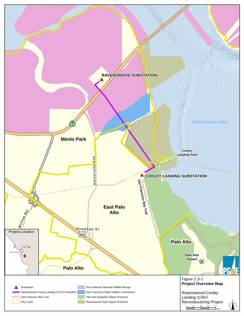
San Francisco Bay Trail
Palo AltoAirport
Palo Alto
Menlo Park
Palo Alto
East PaloAlto
WillowOaks Park
CooleyLanding Park
D o n o h o e S tD o n o h o e S t
Univ
ersi
ty A
veUn
iver
sity
Ave
WWii ll ll
oo wwRR dd
101
COOLEY LANDING SUBSTATION
RAVENSWOOD SUBSTATION
Figure 2.3-1Project Overview MapRavenswood-CooleyLanding 115kVReconductoring Project
SubstationRavenswood-Cooley Landing 115 kV PowerlineSan Francisco Bay TrailCity Limits
Don Edwards National Wildlife RefugeSan Francisco Public Utilities CommissionPalo Alto Baylands Nature PreserveRavenswood Open Space Preserve
0 0.1 0.2 0.3 0.4Miles
San Francisco Bay
bxo2: H:\work\Liddell\RavenswoodCooleyLanding\Figure 2.3-1 Project Overview Map.mxd
Project Location
San Francisco
Chapter 2 – Project Description
December 2017 Pacific Gas and Electric Company 2-6 Ravenswood-Cooley Landing 115 kV Reconductoring Project
delivers power to the municipal utility for the City of Palo Alto. The 60 kV system serves as a back-up source of power to other substations, such as Stanford University and PG&E’s Los Altos and Loyola distribution substations. See Figure 2.4-1: Existing System Map for a map of the existing transmission system, and Figure 2.4-2 for a single-line diagram of the transmission system in the Southeastern Peninsula Area. 2.5 PROJECT COMPONENTS
2.5.1 POWER LINE RECONDUCTORING The approximately 1.6-mile Ravenswood-Cooley Landing Line is a 115 kV DCTL composed of 0.974-inch-diameter 715.5 kcmil AAC. The existing conductor is capable of carrying 703 amps under normal conditions and 802 amps under emergency conditions. To reduce the risk of overloading the Ravenswood-Cooley Landing Lines during peak demand, the project will replace the existing conductors with 0.846-inch-diameter standard 477 kcmil ACSS, which is rated to handle 1,144 amps. The 115 kV conductors are arranged in a vertical configuration, with three conductors on each side of the tower. The new conductors will be replaced in the same configuration as the existing 115 kV conductors. Insulators will be replaced along the entire line. The span distances between structures vary from approximately 680 feet to 1,200 feet.
The project will add an OPGW between Ravenswood and Cooley Landing substations. The OPGW will be used for communication between the two substations and will be attached to new OPGW peaks installed at the top of each tower. The OPGW proposed for the project will be a .675-inch diameter DNO-6580 AlumaCore-48/48/675 or equivalent type fiber.
In accordance with CPUC General Order (GO) 95, the lowest conductor will be installed a minimum of 27 feet above the ground. The minimum ground-to-conductor clearance above SR 84 will be 27 feet. For open water areas considered suitable for sailing, a minimum conductor clearance of 47 feet will be established.
2.5.2 TOWER MODIFICATIONS Tower modifications will consist of installing OPGW peaks to support the new OPGW, cage-top extensions to increase conductor clearance over open water, and structural body modifications to support the additional load from the new conductor. The OPGW peaks are typically 4.5-feet lattice extensions mounted to the top of the tower, and the cage-top extensions are 10-feet lattice extensions with cross arms bolted to the top of the tower. The tower body modifications will entail changing out and adding braces to the lower cage portion of the tower. A summary of proposed tower modifications is included in Table 2.5-1.
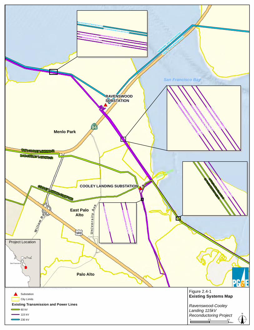
Menlo Park
Palo Alto
East PaloAlto
COOLEY LANDING-STANFORD
BAIR-COOLEY LANDING #1BAIR-COOLEY LANDING #2
TESLA-RAVENSWOOD
NEWARK-RAVENSWOOD
COOLEY LANDING SUBSTATION
RAVENSWOODSUBSTATION
UUnn ii
vv eerr ss
ii ttyy
AA vv ee
MM ii dd dd ll ee ff ii ee ll dd RR dd
WWii ll ll
oo wwRR dd
101
Figure 2.4-1Existing Systems MapRavenswood-CooleyLanding 115kVReconductoring Project
SubstationCity Limits
Existing Transmission and Power Lines60 kV115 kV230 kV 0 0.3 0.6
Miles
bxo2: H:\work\Liddell\RavenswoodCooleyLanding\Figure 2.4-1 Existing Systems Map.mxd
Project Location
San Francisco
San Francisco BayRAVENSWOOD-COOLEY LANDING #1
RAVENSWOOD-AMES #2
RAVENSWOOD-AMES #1
RAVENSWOOD-COOLEY LANDING #2
RAVENSWOOD-PALO ALTO #2
RAVENSWOOD-PALO ALTO #1
RAVENSWOOD-SAN MATEO #1RAVENSWOOD-SAN MATEO #2
RAVENSWOOD-BAIR #1RAVENSWOOD-SAN MATEORAVENSWOOD-BAIR #2
RAVENSWOOD-BAIR #2
RAVENSWOOD-AMES #2
RAVENSWOOD-AMES #1
COOLEY LANDING-LOS ALTOS
COOLEY LANDING-LOS ALTOS
RAVENSWOOD-PALO ALTO #2
RAVENSWOOD-PALO ALTO #1
COOLEY LANDING-PALO ALTO
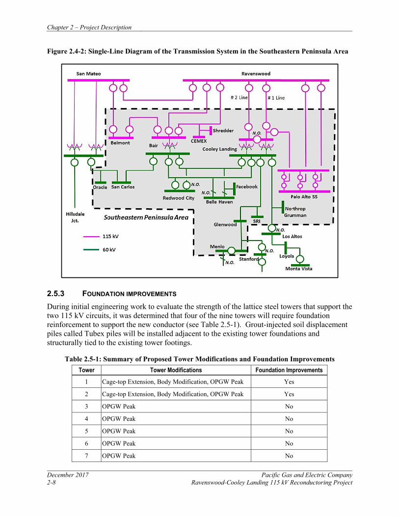
Chapter 2 – Project Description
December 2017 Pacific Gas and Electric Company 2-8 Ravenswood-Cooley Landing 115 kV Reconductoring Project
Figure 2.4-2: Single-Line Diagram of the Transmission System in the Southeastern Peninsula Area
2.5.3 FOUNDATION IMPROVEMENTS During initial engineering work to evaluate the strength of the lattice steel towers that support the two 115 kV circuits, it was determined that four of the nine towers will require foundation reinforcement to support the new conductor (see Table 2.5-1). Grout-injected soil displacement piles called Tubex piles will be installed adjacent to the existing tower foundations and structurally tied to the existing tower footings.
Table 2.5-1: Summary of Proposed Tower Modifications and Foundation Improvements Tower Tower Modifications Foundation Improvements
1 Cage-top Extension, Body Modification, OPGW Peak Yes
2 Cage-top Extension, Body Modification, OPGW Peak Yes
3 OPGW Peak No
4 OPGW Peak No
5 OPGW Peak No
6 OPGW Peak No
7 OPGW Peak No
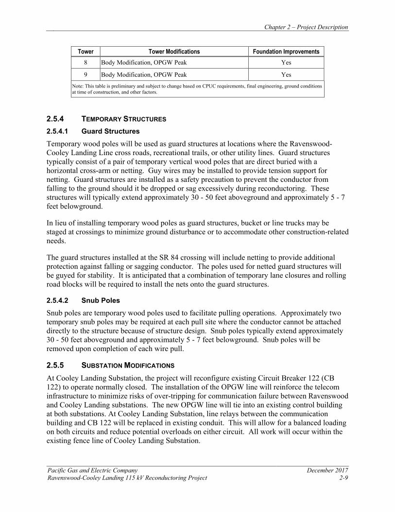
Chapter 2 – Project Description
Pacific Gas and Electric Company December 2017 Ravenswood-Cooley Landing 115 kV Reconductoring Project 2-9
Tower Tower Modifications Foundation Improvements 8 Body Modification, OPGW Peak Yes
9 Body Modification, OPGW Peak Yes
Note: This table is preliminary and subject to change based on CPUC requirements, final engineering, ground conditions at time of construction, and other factors.
2.5.4 TEMPORARY STRUCTURES 2.5.4.1 Guard Structures
Temporary wood poles will be used as guard structures at locations where the Ravenswood-Cooley Landing Line cross roads, recreational trails, or other utility lines. Guard structures typically consist of a pair of temporary vertical wood poles that are direct buried with a horizontal cross-arm or netting. Guy wires may be installed to provide tension support for netting. Guard structures are installed as a safety precaution to prevent the conductor from falling to the ground should it be dropped or sag excessively during reconductoring. These structures will typically extend approximately 30 - 50 feet aboveground and approximately 5 - 7 feet belowground.
In lieu of installing temporary wood poles as guard structures, bucket or line trucks may be staged at crossings to minimize ground disturbance or to accommodate other construction-related needs.
The guard structures installed at the SR 84 crossing will include netting to provide additional protection against falling or sagging conductor. The poles used for netted guard structures will be guyed for stability. It is anticipated that a combination of temporary lane closures and rolling road blocks will be required to install the nets onto the guard structures.
2.5.4.2 Snub Poles
Snub poles are temporary wood poles used to facilitate pulling operations. Approximately two temporary snub poles may be required at each pull site where the conductor cannot be attached directly to the structure because of structure design. Snub poles typically extend approximately 30 - 50 feet aboveground and approximately 5 - 7 feet belowground. Snub poles will be removed upon completion of each wire pull.
2.5.5 SUBSTATION MODIFICATIONS At Cooley Landing Substation, the project will reconfigure existing Circuit Breaker 122 (CB 122) to operate normally closed. The installation of the OPGW line will reinforce the telecom infrastructure to minimize risks of over-tripping for communication failure between Ravenswood and Cooley Landing substations. The new OPGW line will tie into an existing control building at both substations. At Cooley Landing Substation, line relays between the communication building and CB 122 will be replaced in existing conduit. This will allow for a balanced loading on both circuits and reduce potential overloads on either circuit. All work will occur within the existing fence line of Cooley Landing Substation.
Chapter 2 – Project Description
December 2017 Pacific Gas and Electric Company 2-10 Ravenswood-Cooley Landing 115 kV Reconductoring Project
2.6 RIGHT-OF-WAY REQUIREMENTS
PG&E currently has permanent existing easement rights along the entirety of the existing alignment to accommodate the proposed project. PG&E’s easement rights include ingress and egress to the power lines, vegetation removal, tower installation, and reconstruction. PG&E may update or clarify its existing easement rights, as needed, prior to construction. Temporary construction easements may be obtained to accommodate pull sites, staging areas, or other work areas located outside of permanent easements.
Land entitlement issues are not part of this regulatory proceeding in which the CPUC is considering whether to grant or deny PG&E’s application for a permit to upgrade existing electrical facilities. Rather, any land rights issues will be resolved in subsequent negotiations and/or condemnation proceedings in the proper jurisdiction, following the decision by the CPUC on PG&E’s application (see, for example, the Jefferson-Martin 230 kV Transmission Project, A.02-04-043, D.04-08-046, p. 85).
2.7 CONSTRUCTION
The following discussion is preliminary and based on typical construction practices and anticipated construction needs. Final design may require modifications to the expected work areas described herein; however, impacts associated with potential refinements are not anticipated to differ.
2.7.1 POWER LINE CONSTRUCTION 2.7.1.1 Reconductoring
During reconductoring activities, the existing power line will be taken out of service. To replace a conductor, the existing conductor will be detached from its support structure and temporarily lifted. Rollers then will be installed at the conductor’s attachment point and the conductor will be placed onto the rollers. The rollers will allow the existing conductor to be pulled through each structure until the new conductor is ready to be pulled up to the final tension position. Installing rollers and detaching the existing conductor will be accomplished using a helicopter to transport workers and materials to each tower.
A sock line will then be attached to the existing conductor, and a line truck with a drum puller and empty conductor reel will pull the old conductor onto the reel where it will be collected for salvage. The pulling through each structure will be done under controlled tension to keep the conductor elevated and away from obstacles. As a safety precaution during conductor removal, guard structures will be placed where the conductor crosses public roads, recreations trails, or other utility lines to prevent injury or damage if the conductor were to inadvertently fall. The guard structures will vary in design depending on location, but may include installing temporary wood poles, or the use of boom trucks (see Section 2.5.4.1).
Reel stands mounted on a line truck will feed the new conductor along the rollers at each structure while maintaining tension in the line to prevent contact with the ground or other obstacles. After the conductor is pulled into place, conductor sags will be adjusted to required tensions. This sequence will occur three times per circuit. The conductor will then be clamped
Chapter 2 – Project Description
Pacific Gas and Electric Company December 2017 Ravenswood-Cooley Landing 115 kV Reconductoring Project 2-11
to the end of each new insulator as the rollers are removed, and new vibration dampers and other accessories will be installed.
2.7.1.2 Tower Modifications
Installing OPGW peaks and cage-top extensions will be accomplished using a medium-duty helicopter to transport crews and materials to tower locations. The existing towers will be prepared to accommodate the extensions by installing any necessary braces or additional plates at connection points. The OPGW peaks and cage-top extensions will be pre-assembled at staging areas and transported to the individual towers by helicopter where crews will bolt the peaks and extensions onto the existing towers. Most of the body modifications will entail changing out and adding braces to the lower cage portion of the tower. 2.7.1.3 Foundation Improvements
Foundation work at Towers 1, 2, 8, and 9 will consist of installing two Tubex soil displacement piles adjacent to each existing tower footing for a total of eight piles per tower. The installation starts with screwing in an approximately 16-inch-diameter pile, 80- to 100-feet-deep, using a track mounted drill rig. Steel casing is advanced by the drill rig and grout is injected into the void created by the pile casing as the drill progresses. Once the pile is installed to depth, a steel rebar cage is lowered into the casing and the casing is filled with concrete. Any groundwater that accumulates within the pile casing will be dewatered into a baker tank or equivalent for characterization, then disposed of in accordance with the project Storm Water Pollution Prevention Plan (SWPPP) and applicable state and federal regulations as described in Section 3.8, Hazards and Hazardous Materials, and Section 3.9, Hydrology and Water Quality. With the Tubex pile system there are no spoils generated during installation; the soil is displaced laterally and compacted as the drill bit is advanced. No backfill will be needed for this work, and any incidental drill spoils will be stockpiled on plastic for characterization, then removed from the site for transport to an approved disposal facility in accordance with Section 3.8, Hazards and Hazardous Materials.
Once the Tubex piles are in place, a horizontal concrete pile cap will structurally tie the new piles to the existing tower footings. The new concrete pile cap will be formed above the ground surface; no excavation will be required to tie the new piles to the existing foundations.
2.7.1.4 Substation Improvements
Electricians will use hand tools to install new line relays and reconfigure the wiring of CB 122 at Cooley Landing Substation. The OPGW line will also be terminated at the existing control building and interconnected with new telecom processing equipment to be installed within the existing control building.
2.7.2 WORK AREAS The following discussion is preliminary and based on typical construction practices and anticipated construction needs. Final design may require modifications to the expected work areas described in the following paragraphs; however, impacts associated with potential project refinements are not anticipated to differ. Figures 2.7-1A and 2.7-1B show the proposed project
Chapter 2 – Project Description
December 2017 Pacific Gas and Electric Company 2-12 Ravenswood-Cooley Landing 115 kV Reconductoring Project
components and preliminary work areas; Table 2.7-1 provides a summary of proposed work areas.
Table 2.7-1: Summary of Proposed Work Areas
Work Area Work Area Description Access Approximate Work Areas (acres)
Matted Overland Developed
Tower 1 Matted Tower Foundation Work Area Matted Access Route 0.26 0 0
Tower 2 Matted Tower Foundation Work Area Matted Access Route 0.22 0 0
Tower 3 None Helicopter 0 0 0
Tower 4 None Helicopter 0 0 0
Tower 5 None Helicopter 0 0 0
Tower 6 None Helicopter 0 0 0
Tower 7 None Helicopter 0 0 0
Tower 8 Matted Tower Foundation Work Area Matted Access Route 0.16 0 0
Tower 9 Overland Tower Foundation Work Area Bay Road 0 0.30 0
Pull Site A Pull Site SR 84 0 0 0.56
Pull Site B Pull Site Bay Road 0 0 0.17
Guard Structures
Augured Area and Spoils Stockpile SR 84, Bay Road 0 0.03 0.01
Total Approximate Work Area 0.64 0.33 0.74
Note: This table is preliminary and subject to change based on CPUC requirements, final engineering, ground conditions at time of construction, and other factors.
University Avenue
US Fish and Wildlife ServiceUS Fish and Wildlife ServiceRavenswood Ravenswood
Pond SF2Pond SF2
San Francisco Bay Tra
il
Highway 8
4
US Fish andUS Fish andWildlife ServiceWildlife ServiceRavenswood Ravenswood
Pond R2Pond R2
US Fish and Wildlife ServiceUS Fish and Wildlife ServiceRavenswood Ravenswood
Pond SF2Pond SF2
San Francisco PublicSan Francisco PublicUtilities Commission LandsUtilities Commission Lands
SS
San F
ranc
isco Ba
y Tra
il
Existing Access Road
StagingArea 1
StagingArea 3
100' X 100'WorkArea
80' X 80'Work Area
StagingArea 2a
StagingArea 2b
PullSite A
RavenswoodSubstation
Tower 1
Tower 2
Tower 3
Tower 4
Tower 5
TemporaryStub Pole
Figure 2.7-1A. Project Components and Preliminary Work AreasRavenswood-Cooley Landing Reconductoring Project
2017
N:\P
rojec
ts390
0\398
0-01\R
eport
s\PEA
\Fig 1
A Surv
ey Ar
ea.m
xd
Legend
Substation
Existing Towers
Guard Structure
Tower Footing Modification
Temporary Stub Pole
Ravenswood-Cooley LandingPower Lines
Temporary Access Route
Existing Access Road
San Francisco Bay Trail
Staging Area
Work Area
500 0 500250
Feet
Project work areas and other project components areapproximate and subject to change with CPUC review,final engineering, and other project needs
Figure 2.7-1A
Figure 2.7-1B
San Francisco Bay Tra
il
Cooley Cooley Landing Landing
ParkPark
Bay Road
RavenswoodRavenswoodOpen SpaceOpen Space
PreservePreserve
Palo Alto Palo Alto Baylands PreserveBaylands Preserve
San Francisco Bay Trail
stin
g A
cces
s Ro
ad
CooleyLanding
Substation
Tower 4
Tower 5
Tower 6
Tower 7
Tower 8
Tower 9
StagingArea 4
100' X 135'Work Area 80' X 80'
Work Area
PullSite B
Figure 2.7-1B. Project Components and Preliminary Work AreasRavenswood-Cooley Landing 115 kV Reconductoring Project
2017
N:\P
rojec
ts390
0\398
0-01\R
eport
s\PEA
\Fig 1
B Surv
ey Ar
ea.m
xd
Legend
Substation
Existing Towers
Guard Structure
Tower Footing Modification
Ravenswood-Cooley LandingPower Lines
Temporary Access Route
Existing Access Road
San Francisco Bay Trail
Staging Area
Work Area
500 0 500250
Feet
Project work areas and other project components areapproximate and subject to change with CPUC review,final engineering, and other project needs
Figure 2.7-1A
Figure 2.7-1B
Chapter 2 – Project Description
Pacific Gas and Electric Company December 2017 Ravenswood-Cooley Landing 115 kV Reconductoring Project 2-15
2.7.2.1 Tower Foundation Work Areas
To provide access and a stable work area around towers in marshlands (Towers 1, 2, and 8), access routes and tower work areas will be established by placing timber mats or equivalent protective matting over the ground surface. Towers within marshlands will require approximately 0.3 acre of matted work area around the base of the towers. Tower 9, which is in uplands, will require approximately 0.3 acre of overland work area established by mowing existing vegetation. It may be necessary to temporarily remove sections of the maintenance boardwalks to Towers 1, 2, and 8 to facilitate placement of matting. Any sections of boardwalk removed will be replaced following completion of foundation work. No grading is proposed to establish project work areas.
If water is present when foundation work is planned, it may be necessary to construct a temporary cofferdam around the perimeter of the work area to isolate foundation work from open water. Cofferdams may consist of water-filled bladders (e.g., aqua dams), sandbags wrapped in plastic, or other similar means of controlling water from entering the work area. Once the cofferdam is in place, the work area will be dewatered in accordance with the project SWPPP and Section 3.9, Hydrology and Water Quality.
2.7.2.2 Guard Structure Work Areas
To prevent the conductor from sagging onto other utility lines or roads, approximately six temporary guard structures will be installed at crossings of electric lines, recreation trails, and roadways. Two 3-pole guard structures with netting will be placed on each side of SR 84, two single-pole guard structures will be placed on each side of Bay Road, and two single-pole guard structures will be placed on either side of Tower 9 to protect an existing power line. When netting is used, temporary guy wires will be installed to support the additional load on the wood pole structures. Equipment needed to install the wood poles will likely operate from existing disturbed areas, such as road shoulders. It is estimated that installation of each guard structure pole will disturb approximately 100 square feet, accounting for the augured diameter plus stockpiled spoils. Guard structure poles will be installed in disturbed roadsides or developed areas where possible. K-rail will be placed along SR 84 shoulders to isolate the guard structures from vehicle traffic. Construction personnel will be stationed at trail crossings to temporarily hold or redirect recreationists to prevent contact with conductor during pulling operations as described in Section 3.15, Recreation. 2.7.2.3 Pull Sites
When conductors are strung between towers, pull sites are used to raise the conductors to the proper ground clearance height and to the proper line tension. Two pull sites will be needed for pulling conductor onto the Ravenswood-Cooley Landing Line (see Figures 2.7-1A and 2.7-1B). One pull site will be located within the Ravenswood Substation and along the existing gravel road on the west side of the Ravenswood Substation, and the other will be located within the Cooley Landing Substation. Pull sites will have a footprint of approximately 0.2 - 0.6 acre within previously disturbed or developed areas. A temporary wood pole will be installed at each pull site to serve as a snub pole during reconductoring.
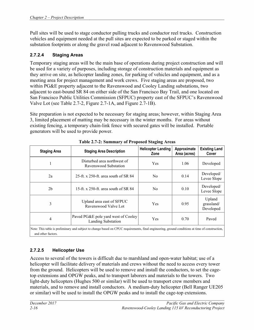
Chapter 2 – Project Description
December 2017 Pacific Gas and Electric Company 2-16 Ravenswood-Cooley Landing 115 kV Reconductoring Project
Pull sites will be used to stage conductor pulling trucks and conductor reel trucks. Construction vehicles and equipment needed at the pull sites are expected to be parked or staged within the substation footprints or along the gravel road adjacent to Ravenswood Substation.
2.7.2.4 Staging Areas
Temporary staging areas will be the main base of operations during project construction and will be used for a variety of purposes, including storage of construction materials and equipment as they arrive on site, as helicopter landing zones, for parking of vehicles and equipment, and as a meeting area for project management and work crews. Five staging areas are proposed, two within PG&E property adjacent to the Ravenswood and Cooley Landing substations, two adjacent to east-bound SR 84 on either side of the San Francisco Bay Trail, and one located on San Francisco Public Utilities Commission (SFPUC) property east of the SFPUC’s Ravenswood Valve Lot (see Table 2.7-2, Figure 2.7-1A, and Figure 2.7-1B).
Site preparation is not expected to be necessary for staging areas; however, within Staging Area 3, limited placement of matting may be necessary in the winter months. For areas without existing fencing, a temporary chain-link fence with secured gates will be installed. Portable generators will be used to provide power.
Table 2.7-2: Summary of Proposed Staging Areas
Staging Area Staging Area Description Helicopter Landing Zone
Approximate Area (acres)
Existing Land Cover
1 Disturbed area northwest of Ravenswood Substation Yes 1.06 Developed
2a 25-ft. x 250-ft. area south of SR 84 No 0.14 Developed/ Levee Slope
2b 15-ft. x 250-ft. area south of SR 84 No 0.10 Developed/ Levee Slope
3 Upland area east of SFPUC Ravenswood Valve Lot Yes 0.95
Upland grassland/ Developed
4 Paved PG&E pole yard west of Cooley Landing Substation Yes 0.70 Paved
Note: This table is preliminary and subject to change based on CPUC requirements, final engineering, ground conditions at time of construction, and other factors.
2.7.2.5 Helicopter Use
Access to several of the towers is difficult due to marshland and open-water habitat; use of a helicopter will facilitate delivery of materials and crews without the need to access every tower from the ground. Helicopters will be used to remove and install the conductors, to set the cage-top extensions and OPGW peaks, and to transport laborers and materials to the towers. Two light-duty helicopters (Hughes 500 or similar) will be used to transport crew members and materials, and to remove and install conductors. A medium-duty helicopter (Bell Ranger UE205 or similar) will be used to install the OPGW peaks and to install the cage-top extensions.
Chapter 2 – Project Description
Pacific Gas and Electric Company December 2017 Ravenswood-Cooley Landing 115 kV Reconductoring Project 2-17
Helicopters will fly directly from the landing zone to the alignment, and will follow the alignment to each tower site. At the end of each day, helicopters will return to a local commercial airport or another appropriately equipped facility. Helicopters will not transport heavy loads over roads or habitable structures.
Temporary landing zones with designated areas for helicopter take-offs and landings will be established within the staging areas identified in Table 2.7-2. Dust suppressants or water will be applied, as needed, to control dust at the landing zone. Helicopters are anticipated to primarily refuel at nearby commercial airports; however, a fuel truck may be available at staging areas to support refueling if needed. Spill prevention measures will be in place for any onsite helicopter refueling in compliance with the project SWPPP.
As detailed in Sections 3.3, Air Quality, 3.8, Hazards and Hazardous Materials, and 3.12, Noise, PG&E best management practices (BMPs) will be implemented at each landing zone to reduce potential impacts related to air quality, hazards and hazardous materials, and noise.
Construction workers using helicopters are required to be certified for helicopter safety, and must produce a certification card to the pilot before they can fly. Personnel and pilots will attend a daily tailboard meeting at the landing zone that covers safety topics for the day, including the route to be taken and work locations to be visited. Helicopter flight plans will be filed with the local Federal Aviation Administration (FAA) office regulating the local air traffic control plan within 14 days of helicopter activities.
2.7.2.6 Substation Modifications
Work will be conducted within the existing control building and outside in existing conduit and at CB 122 at Cooley Substation. No ground disturbance is required and vehicles carrying material and equipment will be parked within the substation paved or graveled areas. Vehicles and equipment and materials delivery will access the substation from the paved Bay Road.
2.7.3 ACCESS ROADS Project work areas will be accessed using a combination of public roads, existing paved and gravel roads, overland routes, and matted temporary access routes across marshlands. No new access roads will be established for the project, no grading is anticipated, and no permanent access roads are proposed. Equipment will access tower work areas within marshlands by placing protective matting (e.g., wooden timber mats, crane pads, swamp mats) onto the existing surface to create an approximately 10-foot-wide equipment access route. A combination of matting and steel plates will be utilized to provide equipment access at grade changes (such as when accessing mudflats or marshlands from upland areas).
2.7.4 VEGETATION CLEARANCE Vegetation clearing will be limited to mowing the existing upland grassland around the base of Tower 9 and within Staging Area 3 to establish work areas, and hand removal of pickleweed prior to the placement of matting at Tower 8. For other matted work areas, matting will be placed directly over existing vegetation and no vegetation clearing is proposed.
Chapter 2 – Project Description
December 2017 Pacific Gas and Electric Company 2-18 Ravenswood-Cooley Landing 115 kV Reconductoring Project
2.7.5 EROSION AND SEDIMENT CONTROL AND POLLUTION PREVENTION DURING CONSTRUCTION
Construction of the project will require ground-disturbing activities associated with tower foundation work and establishment of work areas. Because these activities will result in disturbance of more than one acre, PG&E will obtain coverage under the State Water Resource Control Board (SWRCB) General Permit for Storm Water Discharges Associated with Construction Activity Order No. 2009-0009-DWQ. To obtain coverage under the permit, PG&E will develop and submit permit registration documents—including a Notice of Intent, SWPPP, risk assessment, site map, certification, and annual fee—to the SWRCB prior to initiating construction activities.
PG&E will implement the SWPPP during construction to prevent the discharge of sediment and other pollutants resulting from project construction. The SWPPP will outline implementation of BMPs for each activity that has the potential to degrade surrounding water quality through erosion, sediment runoff, and discharge of other pollutants.
2.7.6 CLEANUP AND POST-CONSTRUCTION RESTORATION Crews will be required to maintain clean work areas and will be instructed that no debris may be left behind at any stage of the project. Packing crates, spare bolts, and construction debris will be picked up and hauled away for recycling or disposal during construction. Conductors removed from the project will be taken to appropriate disposal facilities to be reused, recycled, or disposed of in accordance with applicable law. PG&E will conduct a final survey to ensure that cleanup activities have been successfully completed.
Because no grading is proposed, and work areas will be established by either matting over existing vegetation, or mowing, PG&E does not anticipate needing to actively restore project work areas following construction.
2.7.7 CONSTRUCTION WORKFORCE AND EQUIPMENT Project construction will require a foundation crew, helicopter crew, tower crew, line crew, environmental inspector, and biological monitor. Approximately 15 construction workers will be at the project site on a typical work day; however, because work activities may occur concurrently along the project, up to approximately 25 workers may be somewhere on the project site at any time.
Construction will typically take place between 7 a.m. and 7 p.m., five days per week. Because construction will progress quickly, construction activities are not expected to take place near any one structure location for more than a few days. Nighttime construction is not anticipated, except for certain construction procedures that cannot be interrupted because of safety considerations or to take advantage of line clearances during off-peak hours.
Equipment typically used during project construction is identified in Table 2.7-3: Typical Construction Equipment and Duration of Use. Table 2.7-3 also describes a breakdown of estimated duration of use during construction, including hours or miles per day of operation, and the total duration of use (in days). Table 2.7-4: Anticipated Construction Equipment details the
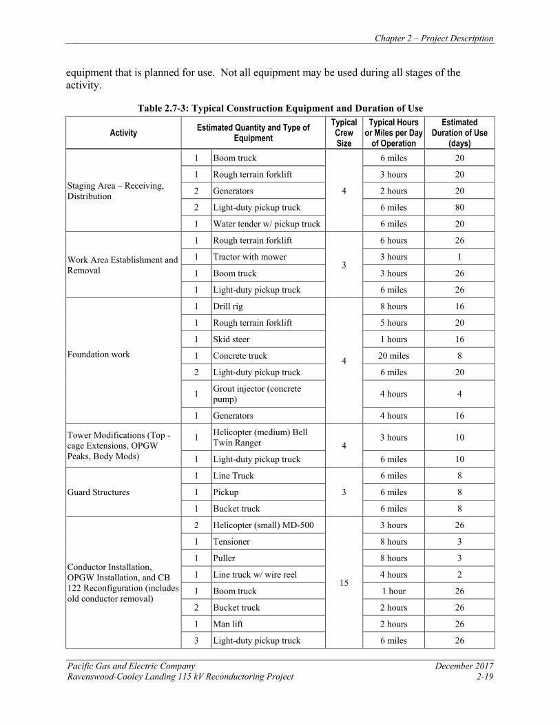
Chapter 2 – Project Description
Pacific Gas and Electric Company December 2017 Ravenswood-Cooley Landing 115 kV Reconductoring Project 2-19
equipment that is planned for use. Not all equipment may be used during all stages of the activity.
Table 2.7-3: Typical Construction Equipment and Duration of Use
Activity Estimated Quantity and Type of Equipment
Typical Crew Size
Typical Hours or Miles per Day
of Operation
Estimated Duration of Use
(days)
Staging Area – Receiving, Distribution
1 Boom truck
4
6 miles 20
1 Rough terrain forklift 3 hours 20
2 Generators 2 hours 20
2 Light-duty pickup truck 6 miles 80
1 Water tender w/ pickup truck 6 miles 20
Work Area Establishment and Removal
1 Rough terrain forklift
3
6 hours 26
1 Tractor with mower 3 hours 1
1 Boom truck 3 hours 26
1 Light-duty pickup truck 6 miles 26
Foundation work
1 Drill rig
4
8 hours 16
1 Rough terrain forklift 5 hours 20
1 Skid steer 1 hours 16
1 Concrete truck 20 miles 8
2 Light-duty pickup truck 6 miles 20
1 Grout injector (concrete pump) 4 hours 4
1 Generators 4 hours 16
Tower Modifications (Top -cage Extensions, OPGW Peaks, Body Mods)
1 Helicopter (medium) Bell Twin Ranger 4
3 hours 10
1 Light-duty pickup truck 6 miles 10
Guard Structures
1 Line Truck
3
6 miles 8
1 Pickup 6 miles 8
1 Bucket truck 6 miles 8
Conductor Installation, OPGW Installation, and CB 122 Reconfiguration (includes old conductor removal)
2 Helicopter (small) MD-500
15
3 hours 26
1 Tensioner 8 hours 3
1 Puller 8 hours 3
1 Line truck w/ wire reel 4 hours 2
1 Boom truck 1 hour 26
2 Bucket truck 2 hours 26
1 Man lift 2 hours 26
3 Light-duty pickup truck 6 miles 26
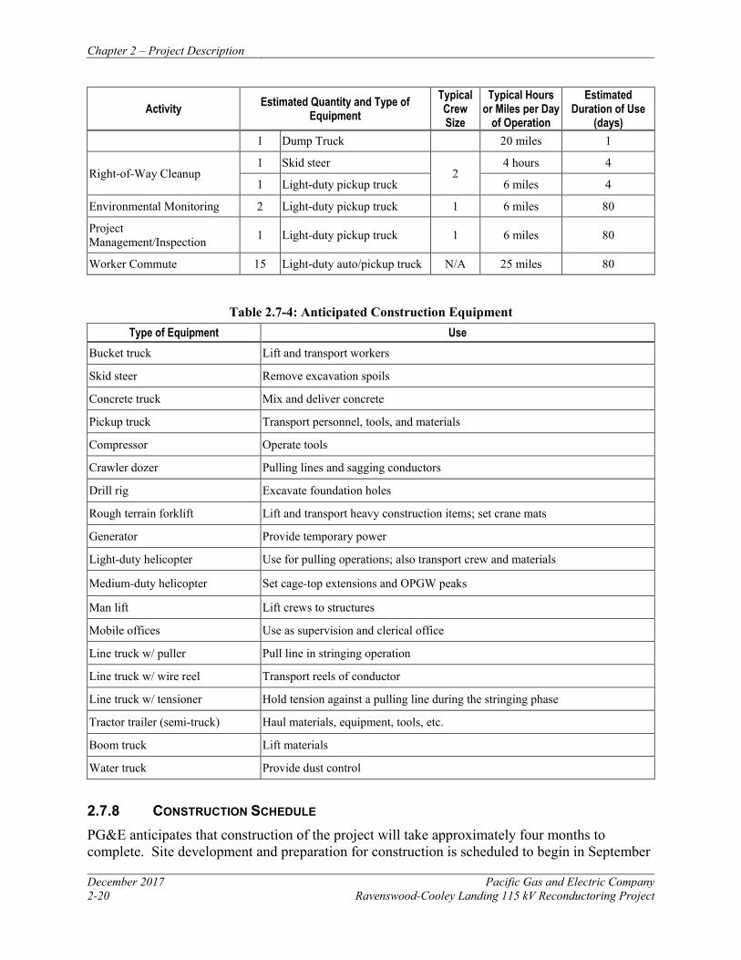
Chapter 2 – Project Description
December 2017 Pacific Gas and Electric Company 2-20 Ravenswood-Cooley Landing 115 kV Reconductoring Project
Activity Estimated Quantity and Type of Equipment
Typical Crew Size
Typical Hours or Miles per Day
of Operation
Estimated Duration of Use
(days) 1 Dump Truck 20 miles 1
Right-of-Way Cleanup 1 Skid steer
2 4 hours 4
1 Light-duty pickup truck 6 miles 4
Environmental Monitoring 2 Light-duty pickup truck 1 6 miles 80
Project Management/Inspection 1 Light-duty pickup truck 1 6 miles 80
Worker Commute 15 Light-duty auto/pickup truck N/A 25 miles 80
Table 2.7-4: Anticipated Construction Equipment Type of Equipment Use
Bucket truck Lift and transport workers
Skid steer Remove excavation spoils
Concrete truck Mix and deliver concrete
Pickup truck Transport personnel, tools, and materials
Compressor Operate tools
Crawler dozer Pulling lines and sagging conductors
Drill rig Excavate foundation holes
Rough terrain forklift Lift and transport heavy construction items; set crane mats
Generator Provide temporary power
Light-duty helicopter Use for pulling operations; also transport crew and materials
Medium-duty helicopter Set cage-top extensions and OPGW peaks
Man lift Lift crews to structures
Mobile offices Use as supervision and clerical office
Line truck w/ puller Pull line in stringing operation
Line truck w/ wire reel Transport reels of conductor
Line truck w/ tensioner Hold tension against a pulling line during the stringing phase
Tractor trailer (semi-truck) Haul materials, equipment, tools, etc.
Boom truck Lift materials
Water truck Provide dust control
2.7.8 CONSTRUCTION SCHEDULE PG&E anticipates that construction of the project will take approximately four months to complete. Site development and preparation for construction is scheduled to begin in September
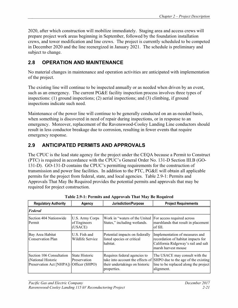
Chapter 2 – Project Description
Pacific Gas and Electric Company December 2017 Ravenswood-Cooley Landing 115 kV Reconductoring Project 2-21
2020, after which construction will mobilize immediately. Staging area and access crews will prepare project work areas beginning in September, followed by the foundation installation crews, and tower modification and line crews. The project is currently scheduled to be competed in December 2020 and the line reenergized in January 2021. The schedule is preliminary and subject to change.
2.8 OPERATION AND MAINTENANCE
No material changes in maintenance and operation activities are anticipated with implementation of the project.
The existing line will continue to be inspected annually or as needed when driven by an event, such as an emergency. The current PG&E facility inspection process involves three types of inspections: (1) ground inspections; (2) aerial inspections; and (3) climbing, if ground inspections indicate such need.
Maintenance of the power line will continue to be generally conducted on an as-needed basis, when something is discovered in need of repair during inspections, or in response to an emergency. Moreover, replacement of the Ravenswood-Cooley Landing Line conductors should result in less conductor breakage due to corrosion, resulting in fewer events that require emergency response.
2.9 ANTICIPATED PERMITS AND APPROVALS
The CPUC is the lead state agency for the project under the CEQA because a Permit to Construct (PTC) is required in accordance with the CPUC’s General Order No. 131-D Section III.B (GO-131-D). GO-131-D contains the CPUC’s permitting requirements for the construction of transmission and power line facilities. In addition to the PTC, PG&E will obtain all applicable permits for the project from federal, state, and local agencies. Table 2.9-1: Permits and Approvals That May Be Required provides the potential permits and approvals that may be required for project construction.
Table 2.9-1: Permits and Approvals That May Be Required Regulatory Authority Agency Jurisdiction/Purpose Project Requirements
Federal
Section 404 Nationwide Permit
U.S. Army Corps of Engineers (USACE)
Work in “waters of the United States,” including wetlands.
For access required across marshlands that result in placement of fill.
Bay Area Habitat Conservation Plan
U.S. Fish and Wildlife Service
Potential impacts on federally listed species or critical habitat.
Implementation of measures and recordation of habitat impacts for California Ridgeway’s rail and salt marsh harvest mouse
Section 106 Consultation (National Historic Preservation Act [NHPA])
State Historic Preservation Officer (SHPO)
Requires federal agencies to take into account the effects of their undertakings on historic properties.
The USACE may consult with the SHPO due to the age of the existing line to be replaced along the project alignment.

Chapter 2 – Project Description
December 2017 Pacific Gas and Electric Company 2-22 Ravenswood-Cooley Landing 115 kV Reconductoring Project
Regulatory Authority Agency Jurisdiction/Purpose Project Requirements Notice of Proposed Construction or Alteration under Federal Aviation Regulations Part 77
FAA Regulations apply to poles and/or towers over 200 feet in height above ground level at its site, or within certain proximities to local Airports.
Alignment structures within 20,000 feet of Palo Alto Airport require filing with the FAA.
State
PTC (GO-131-D) CPUC Construction, modification, or alteration of power line facilities.
A PTC is required under the CPUC’s General Order No. 131-D, Section III.B.
Section 401 Water Quality Certification
Central Coast Regional Water Quality Control Board (RWQCB)
Consistency with state water quality standards.
Water Quality Certification will be required prior to obtaining a Section 404 Permit from the USACE, if required.
Standard Encroachment Permit (discretionary or ministerial)
California Department of Transportation (Caltrans)
For use of the California state highways for other than normal transportation purposes, including construction activities completed within the right-of-way.
A standard encroachment permit may be obtained for reconductoring work across State Route 84.
National Pollution Discharge Elimination System Storm Water Permit (ministerial)
SWRCB Construction activities disturbing 1 acre or more of soil must submit a Notice of Intent to comply with the terms of the general permit.
The project will develop and implement a SWPPP.
Local
Encroachment Permit (ministerial)
City of East Palo Alto
For construction activities completed within city road rights-of-way.
Guard structures will be used when reconductoring across roads.
2.10 APPLICANT-PROPOSED MEASURES
PG&E has incorporated the APMs in Table 2.10-1: Applicant-Proposed Measures as part of the project. These measures include PG&E standard construction practices as well as those measures that are proposed to comply with applicable regulations or reduce specific project impacts. These measures will be implemented with the project elements described previously. With these APMs incorporated, no significant impacts will result from construction and operation of this project.
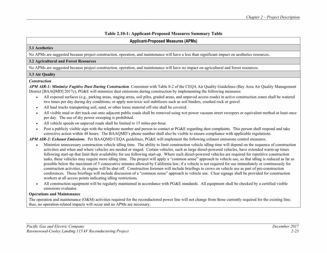
Chapter 2 – Project Description
Pacific Gas and Electric Company December 2017 Ravenswood-Cooley Landing 115 kV Reconductoring Project 2-23
Table 2.10-1: Applicant-Proposed Measures Summary Table
Applicant-Proposed Measures (APMs) 3.1 Aesthetics No APMs are suggested because project construction, operation, and maintenance will have a less than significant impact on aesthetics resources. 3.2 Agricultural and Forest Resources No APMs are suggested because project construction, operation, and maintenance will have no impact on agricultural and forest resources. 3.3 Air Quality Construction APM AIR-1: Minimize Fugitive Dust During Construction. Consistent with Table 8-2 of the CEQA Air Quality Guidelines (Bay Area Air Quality Management District [BAAQMD] 2017c), PG&E will minimize dust emissions during construction by implementing the following measures:
• All exposed surfaces (e.g., parking areas, staging areas, soil piles, graded areas, and unpaved access roads) in active construction zones shall be watered two times per day during dry conditions; or apply non-toxic soil stabilizers such as soil binders, crushed rock or gravel
• All haul trucks transporting soil, sand, or other loose material off-site shall be covered. • All visible mud or dirt track-out onto adjacent public roads shall be removed using wet power vacuum street sweepers or equivalent method at least once
per day. The use of dry power sweeping is prohibited. • All vehicle speeds on unpaved roads shall be limited to 15 miles-per-hour. • Post a publicly visible sign with the telephone number and person to contact at PG&E regarding dust complaints. This person shall respond and take
corrective action within 48 hours. The BAAQMD’s phone number shall also be visible to ensure compliance with applicable regulations. APM AIR-2: Exhaust Emissions. Per BAAQMD CEQA guidelines, PG&E will implement the following exhaust emissions control measures.
• Minimize unnecessary construction vehicle idling time. The ability to limit construction vehicle idling time will depend on the sequence of construction activities and when and where vehicles are needed or staged. Certain vehicles, such as large diesel-powered vehicles, have extended warm-up times following start-up that limit their availability for use following start-up. Where such diesel-powered vehicles are required for repetitive construction tasks, these vehicles may require more idling time. The project will apply a “common sense” approach to vehicle use, so that idling is reduced as far as possible below the maximum of 5 consecutive minutes allowed by California law; if a vehicle is not required for use immediately or continuously for construction activities, its engine will be shut off. Construction foremen will include briefings to crews on vehicle use as part of pre-construction conferences. Those briefings will include discussion of a “common sense” approach to vehicle use. Clear signage shall be provided for construction workers at all access points indicating idling restrictions.
• All construction equipment will be regularly maintained in accordance with PG&E standards. All equipment shall be checked by a certified visible emissions evaluator.
Operations and Maintenance The operation and maintenance (O&M) activities required for the reconductored power line will not change from those currently required for the existing line; thus, no operation-related impacts will occur and no APMs are necessary.
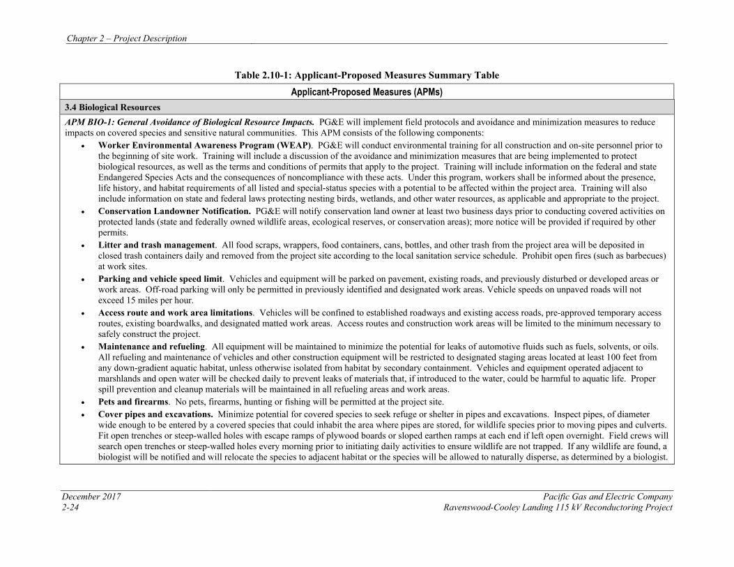
Chapter 2 – Project Description
December 2017 Pacific Gas and Electric Company 2-24 Ravenswood-Cooley Landing 115 kV Reconductoring Project
Table 2.10-1: Applicant-Proposed Measures Summary Table
Applicant-Proposed Measures (APMs) 3.4 Biological Resources APM BIO-1: General Avoidance of Biological Resource Impacts. PG&E will implement field protocols and avoidance and minimization measures to reduce impacts on covered species and sensitive natural communities. This APM consists of the following components:
• Worker Environmental Awareness Program (WEAP). PG&E will conduct environmental training for all construction and on-site personnel prior to the beginning of site work. Training will include a discussion of the avoidance and minimization measures that are being implemented to protect biological resources, as well as the terms and conditions of permits that apply to the project. Training will include information on the federal and state Endangered Species Acts and the consequences of noncompliance with these acts. Under this program, workers shall be informed about the presence, life history, and habitat requirements of all listed and special-status species with a potential to be affected within the project area. Training will also include information on state and federal laws protecting nesting birds, wetlands, and other water resources, as applicable and appropriate to the project.
• Conservation Landowner Notification. PG&E will notify conservation land owner at least two business days prior to conducting covered activities on protected lands (state and federally owned wildlife areas, ecological reserves, or conservation areas); more notice will be provided if required by other permits.
• Litter and trash management. All food scraps, wrappers, food containers, cans, bottles, and other trash from the project area will be deposited in closed trash containers daily and removed from the project site according to the local sanitation service schedule. Prohibit open fires (such as barbecues) at work sites.
• Parking and vehicle speed limit. Vehicles and equipment will be parked on pavement, existing roads, and previously disturbed or developed areas or work areas. Off-road parking will only be permitted in previously identified and designated work areas. Vehicle speeds on unpaved roads will not exceed 15 miles per hour.
• Access route and work area limitations. Vehicles will be confined to established roadways and existing access roads, pre-approved temporary access routes, existing boardwalks, and designated matted work areas. Access routes and construction work areas will be limited to the minimum necessary to safely construct the project.
• Maintenance and refueling. All equipment will be maintained to minimize the potential for leaks of automotive fluids such as fuels, solvents, or oils. All refueling and maintenance of vehicles and other construction equipment will be restricted to designated staging areas located at least 100 feet from any down-gradient aquatic habitat, unless otherwise isolated from habitat by secondary containment. Vehicles and equipment operated adjacent to marshlands and open water will be checked daily to prevent leaks of materials that, if introduced to the water, could be harmful to aquatic life. Proper spill prevention and cleanup materials will be maintained in all refueling areas and work areas.
• Pets and firearms. No pets, firearms, hunting or fishing will be permitted at the project site. • Cover pipes and excavations. Minimize potential for covered species to seek refuge or shelter in pipes and excavations. Inspect pipes, of diameter
wide enough to be entered by a covered species that could inhabit the area where pipes are stored, for wildlife species prior to moving pipes and culverts. Fit open trenches or steep-walled holes with escape ramps of plywood boards or sloped earthen ramps at each end if left open overnight. Field crews will search open trenches or steep-walled holes every morning prior to initiating daily activities to ensure wildlife are not trapped. If any wildlife are found, a biologist will be notified and will relocate the species to adjacent habitat or the species will be allowed to naturally disperse, as determined by a biologist.
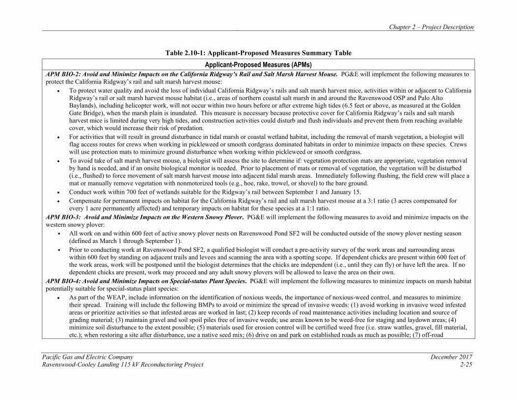
Chapter 2 – Project Description
Pacific Gas and Electric Company December 2017 Ravenswood-Cooley Landing 115 kV Reconductoring Project 2-25
Table 2.10-1: Applicant-Proposed Measures Summary Table
Applicant-Proposed Measures (APMs) APM BIO-2: Avoid and Minimize Impacts on the California Ridgway’s Rail and Salt Marsh Harvest Mouse. PG&E will implement the following measures to protect the California Ridgway’s rail and salt marsh harvest mouse:
• To protect water quality and avoid the loss of individual California Ridgway’s rails and salt marsh harvest mice, activities within or adjacent to California Ridgway’s rail or salt marsh harvest mouse habitat (i.e., areas of northern coastal salt marsh in and around the Ravenswood OSP and Palo Alto Baylands), including helicopter work, will not occur within two hours before or after extreme high tides (6.5 feet or above, as measured at the Golden Gate Bridge), when the marsh plain is inundated. This measure is necessary because protective cover for California Ridgway’s rails and salt marsh harvest mice is limited during very high tides, and construction activities could disturb and flush individuals and prevent them from reaching available cover, which would increase their risk of predation.
• For activities that will result in ground disturbance in tidal marsh or coastal wetland habitat, including the removal of marsh vegetation, a biologist will flag access routes for crews when working in pickleweed or smooth cordgrass dominated habitats in order to minimize impacts on these species. Crews will use protection mats to minimize ground disturbance when working within pickleweed or smooth cordgrass.
• To avoid take of salt marsh harvest mouse, a biologist will assess the site to determine if: vegetation protection mats are appropriate, vegetation removal by hand is needed, and if an onsite biological monitor is needed. Prior to placement of mats or removal of vegetation, the vegetation will be disturbed (i.e., flushed) to force movement of salt marsh harvest mouse into adjacent tidal marsh areas. Immediately following flushing, the field crew will place a mat or manually remove vegetation with nonmotorized tools (e.g., hoe, rake, trowel, or shovel) to the bare ground.
• Conduct work within 700 feet of wetlands suitable for the Ridgway’s rail between September 1 and January 15. • Compensate for permanent impacts on habitat for the California Ridgway’s rail and salt marsh harvest mouse at a 3:1 ratio (3 acres compensated for
every 1 acre permanently affected) and temporary impacts on habitat for these species at a 1:1 ratio. APM BIO-3: Avoid and Minimize Impacts on the Western Snowy Plover. PG&E will implement the following measures to avoid and minimize impacts on the western snowy plover:
• All work on and within 600 feet of active snowy plover nests on Ravenswood Pond SF2 will be conducted outside of the snowy plover nesting season (defined as March 1 through September 1).
• Prior to conducting work at Ravenswood Pond SF2, a qualified biologist will conduct a pre-activity survey of the work areas and surrounding areas within 600 feet by standing on adjacent trails and levees and scanning the area with a spotting scope. If dependent chicks are present within 600 feet of the work areas, work will be postponed until the biologist determines that the chicks are independent (i.e., until they can fly) or have left the area. If no dependent chicks are present, work may proceed and any adult snowy plovers will be allowed to leave the area on their own.
APM BIO-4: Avoid and Minimize Impacts on Special-status Plant Species. PG&E will implement the following measures to minimize impacts on marsh habitat potentially suitable for special-status plant species:
• As part of the WEAP, include information on the identification of noxious weeds, the importance of noxious-weed control, and measures to minimize their spread. Training will include the following BMPs to avoid or minimize the spread of invasive weeds: (1) avoid working in invasive weed infested areas or prioritize activities so that infested areas are worked in last; (2) keep records of road maintenance activities including location and source of grading material; (3) maintain gravel and soil spoil piles free of invasive weeds; use areas known to be weed-free for staging and laydown areas; (4) minimize soil disturbance to the extent possible; (5) materials used for erosion control will be certified weed free (i.e. straw wattles, gravel, fill material, etc.); when restoring a site after disturbance, use a native seed mix; (6) drive on and park on established roads as much as possible; (7) off-road
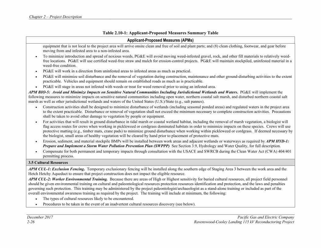
Chapter 2 – Project Description
December 2017 Pacific Gas and Electric Company 2-26 Ravenswood-Cooley Landing 115 kV Reconductoring Project
Table 2.10-1: Applicant-Proposed Measures Summary Table
Applicant-Proposed Measures (APMs) equipment that is not local to the project area will arrive onsite clean and free of soil and plant parts; and (8) clean clothing, footwear, and gear before moving from and infested area to a non-infested area.
• To minimize introduction and spread of noxious weeds, PG&E will avoid moving weed-infested gravel, rock, and other fill materials to relatively weed-free locations. PG&E will use certified weed-free straw and mulch for erosion-control projects. PG&E will maintain stockpiled, uninfested material in a weed-free condition.
• PG&E will work in a direction from uninfested areas to infested areas as much as practical.• PG&E will minimize soil disturbance and the removal of vegetation during construction, maintenance and other ground-disturbing activities to the extent
practicable. Vehicles and equipment should remain on established roads as much as is practicable.• PG&E will stage in areas not infested with weeds or treat for weed removal prior to using an infested area.
APM BIO-5: Avoid and Minimize Impacts on Sensitive Natural Communities Including Jurisdictional Wetlands and Waters. PG&E will implement the following measures to minimize impacts on sensitive natural communities including open water, northern coastal salt marsh, and disturbed northern coastal salt marsh as well as other jurisdictional wetlands and waters of the United States (U.S.)/State (e.g., salt pannes).
• Construction activities shall be designed to minimize disturbance of wetlands (including seasonal ponded areas) and regulated waters in the project areato the extent practicable. Disturbance or removal of vegetation shall not exceed the minimum necessary to complete construction activities. Precautions shall be taken to avoid other damage to vegetation by people or equipment.
• For activities that will result in ground disturbance in tidal marsh or coastal wetland habitat, including the removal of marsh vegetation, a biologist willflag access routes for crews when working in pickleweed or cordgrass dominated habitats in order to minimize impacts on these species. Crews will use protective matting (e.g., timber mats, crane pads) to minimize ground disturbance when working within pickleweed or cordgrass. If deemed necessary by the biologist, small areas of healthy vegetation will be cleared by hand prior to placement of protective mats.
• Erosion, sediment, and material stockpile BMPs will be installed between work areas and adjacent wetlands or waterways as required by APM HYD-1:Prepare and Implement a Storm Water Pollution Prevention Plan (SWPPP) See Section 3.9, Hydrology and Water Quality, for full description.
• Compensate for both permanent and temporary impacts through consultation with the USACE and SWRCB during the Clean Water Act (CWA) 404/401permitting process.
3.5 Cultural Resources APM CUL-1: Exclusion Fencing. Temporary exclusionary fencing will be installed along the southern edge of Staging Area 3 between the work area and the Hetch Hetchy Aqueduct to ensure that project construction does not impact the eligible resource. APM CUL-2: Worker Environmental Training. Because there are areas of High or Highest sensitivity for buried cultural resources, all project field personnel should be given environmental training on cultural and paleontological resources protection resources identification and protection, and the laws and penalties governing such protection. This training may be administered by the project paleontologist/archaeologist as a stand-alone training or included as part of the overall environmental awareness training as required by the project. The training will include at minimum, the following:
• The types of cultural resources likely to be encountered.• Procedures to be taken in the event of an inadvertent cultural resources discovery (see below).
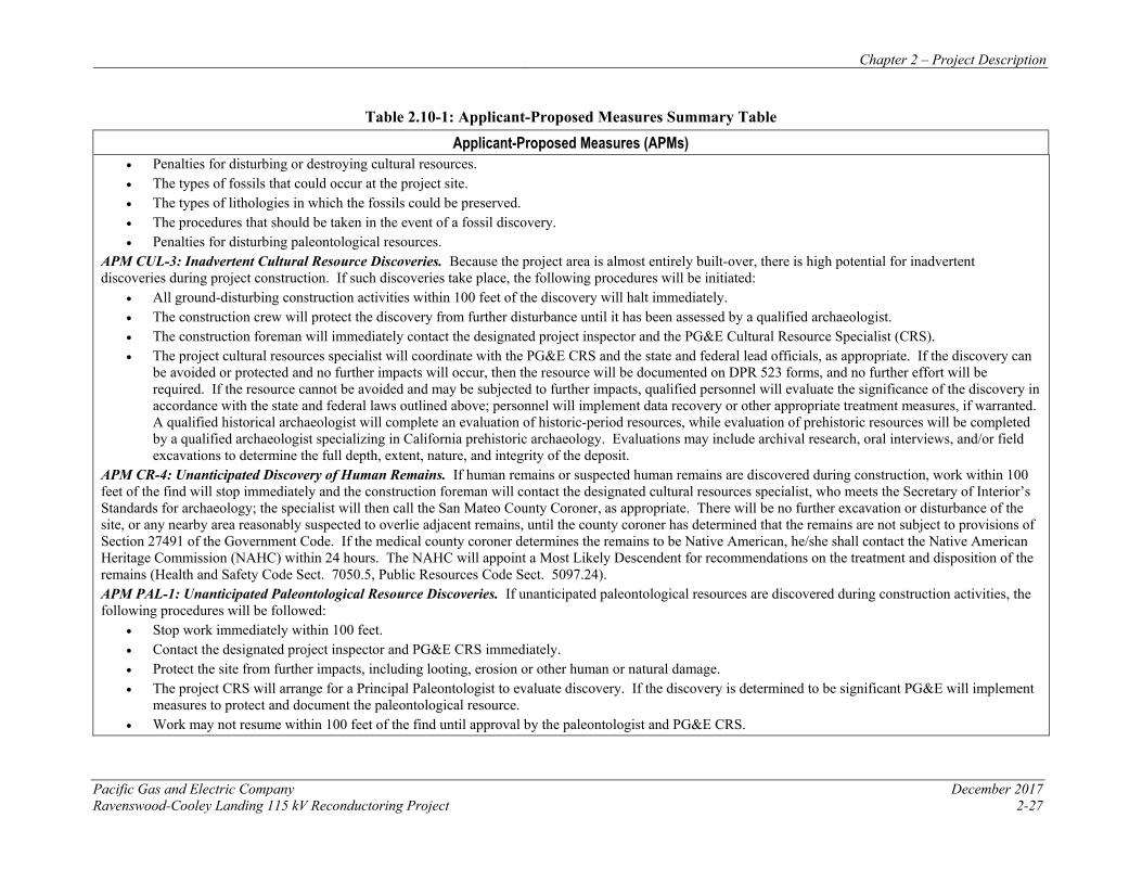
Chapter 2 – Project Description
Pacific Gas and Electric Company December 2017 Ravenswood-Cooley Landing 115 kV Reconductoring Project 2-27
Table 2.10-1: Applicant-Proposed Measures Summary Table
Applicant-Proposed Measures (APMs) • Penalties for disturbing or destroying cultural resources.• The types of fossils that could occur at the project site.• The types of lithologies in which the fossils could be preserved.• The procedures that should be taken in the event of a fossil discovery.• Penalties for disturbing paleontological resources.
APM CUL-3: Inadvertent Cultural Resource Discoveries. Because the project area is almost entirely built-over, there is high potential for inadvertent discoveries during project construction. If such discoveries take place, the following procedures will be initiated:
• All ground-disturbing construction activities within 100 feet of the discovery will halt immediately.• The construction crew will protect the discovery from further disturbance until it has been assessed by a qualified archaeologist.• The construction foreman will immediately contact the designated project inspector and the PG&E Cultural Resource Specialist (CRS).• The project cultural resources specialist will coordinate with the PG&E CRS and the state and federal lead officials, as appropriate. If the discovery can
be avoided or protected and no further impacts will occur, then the resource will be documented on DPR 523 forms, and no further effort will berequired. If the resource cannot be avoided and may be subjected to further impacts, qualified personnel will evaluate the significance of the discovery inaccordance with the state and federal laws outlined above; personnel will implement data recovery or other appropriate treatment measures, if warranted.A qualified historical archaeologist will complete an evaluation of historic-period resources, while evaluation of prehistoric resources will be completedby a qualified archaeologist specializing in California prehistoric archaeology. Evaluations may include archival research, oral interviews, and/or fieldexcavations to determine the full depth, extent, nature, and integrity of the deposit.
APM CR-4: Unanticipated Discovery of Human Remains. If human remains or suspected human remains are discovered during construction, work within 100 feet of the find will stop immediately and the construction foreman will contact the designated cultural resources specialist, who meets the Secretary of Interior’s Standards for archaeology; the specialist will then call the San Mateo County Coroner, as appropriate. There will be no further excavation or disturbance of the site, or any nearby area reasonably suspected to overlie adjacent remains, until the county coroner has determined that the remains are not subject to provisions of Section 27491 of the Government Code. If the medical county coroner determines the remains to be Native American, he/she shall contact the Native American Heritage Commission (NAHC) within 24 hours. The NAHC will appoint a Most Likely Descendent for recommendations on the treatment and disposition of the remains (Health and Safety Code Sect. 7050.5, Public Resources Code Sect. 5097.24). APM PAL-1: Unanticipated Paleontological Resource Discoveries. If unanticipated paleontological resources are discovered during construction activities, the following procedures will be followed:
• Stop work immediately within 100 feet.• Contact the designated project inspector and PG&E CRS immediately.• Protect the site from further impacts, including looting, erosion or other human or natural damage.• The project CRS will arrange for a Principal Paleontologist to evaluate discovery. If the discovery is determined to be significant PG&E will implement
measures to protect and document the paleontological resource.• Work may not resume within 100 feet of the find until approval by the paleontologist and PG&E CRS.
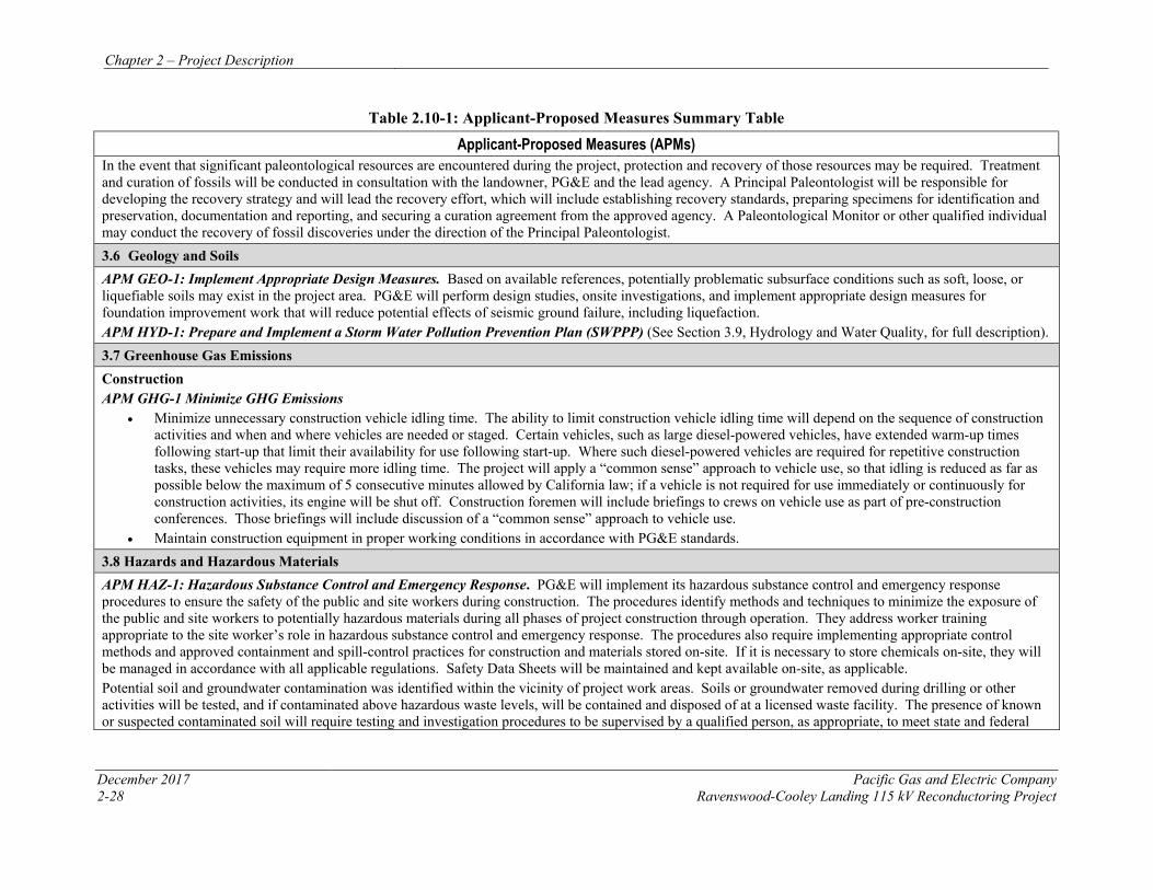
Chapter 2 – Project Description
December 2017 Pacific Gas and Electric Company 2-28 Ravenswood-Cooley Landing 115 kV Reconductoring Project
Table 2.10-1: Applicant-Proposed Measures Summary Table
Applicant-Proposed Measures (APMs) In the event that significant paleontological resources are encountered during the project, protection and recovery of those resources may be required. Treatment and curation of fossils will be conducted in consultation with the landowner, PG&E and the lead agency. A Principal Paleontologist will be responsible for developing the recovery strategy and will lead the recovery effort, which will include establishing recovery standards, preparing specimens for identification and preservation, documentation and reporting, and securing a curation agreement from the approved agency. A Paleontological Monitor or other qualified individual may conduct the recovery of fossil discoveries under the direction of the Principal Paleontologist. 3.6 Geology and Soils APM GEO-1: Implement Appropriate Design Measures. Based on available references, potentially problematic subsurface conditions such as soft, loose, or liquefiable soils may exist in the project area. PG&E will perform design studies, onsite investigations, and implement appropriate design measures for foundation improvement work that will reduce potential effects of seismic ground failure, including liquefaction. APM HYD-1: Prepare and Implement a Storm Water Pollution Prevention Plan (SWPPP) (See Section 3.9, Hydrology and Water Quality, for full description). 3.7 Greenhouse Gas Emissions Construction APM GHG-1 Minimize GHG Emissions
• Minimize unnecessary construction vehicle idling time. The ability to limit construction vehicle idling time will depend on the sequence of constructionactivities and when and where vehicles are needed or staged. Certain vehicles, such as large diesel-powered vehicles, have extended warm-up timesfollowing start-up that limit their availability for use following start-up. Where such diesel-powered vehicles are required for repetitive constructiontasks, these vehicles may require more idling time. The project will apply a “common sense” approach to vehicle use, so that idling is reduced as far aspossible below the maximum of 5 consecutive minutes allowed by California law; if a vehicle is not required for use immediately or continuously forconstruction activities, its engine will be shut off. Construction foremen will include briefings to crews on vehicle use as part of pre-constructionconferences. Those briefings will include discussion of a “common sense” approach to vehicle use.
• Maintain construction equipment in proper working conditions in accordance with PG&E standards.3.8 Hazards and Hazardous Materials APM HAZ-1: Hazardous Substance Control and Emergency Response. PG&E will implement its hazardous substance control and emergency response procedures to ensure the safety of the public and site workers during construction. The procedures identify methods and techniques to minimize the exposure of the public and site workers to potentially hazardous materials during all phases of project construction through operation. They address worker training appropriate to the site worker’s role in hazardous substance control and emergency response. The procedures also require implementing appropriate control methods and approved containment and spill-control practices for construction and materials stored on-site. If it is necessary to store chemicals on-site, they will be managed in accordance with all applicable regulations. Safety Data Sheets will be maintained and kept available on-site, as applicable. Potential soil and groundwater contamination was identified within the vicinity of project work areas. Soils or groundwater removed during drilling or other activities will be tested, and if contaminated above hazardous waste levels, will be contained and disposed of at a licensed waste facility. The presence of known or suspected contaminated soil will require testing and investigation procedures to be supervised by a qualified person, as appropriate, to meet state and federal
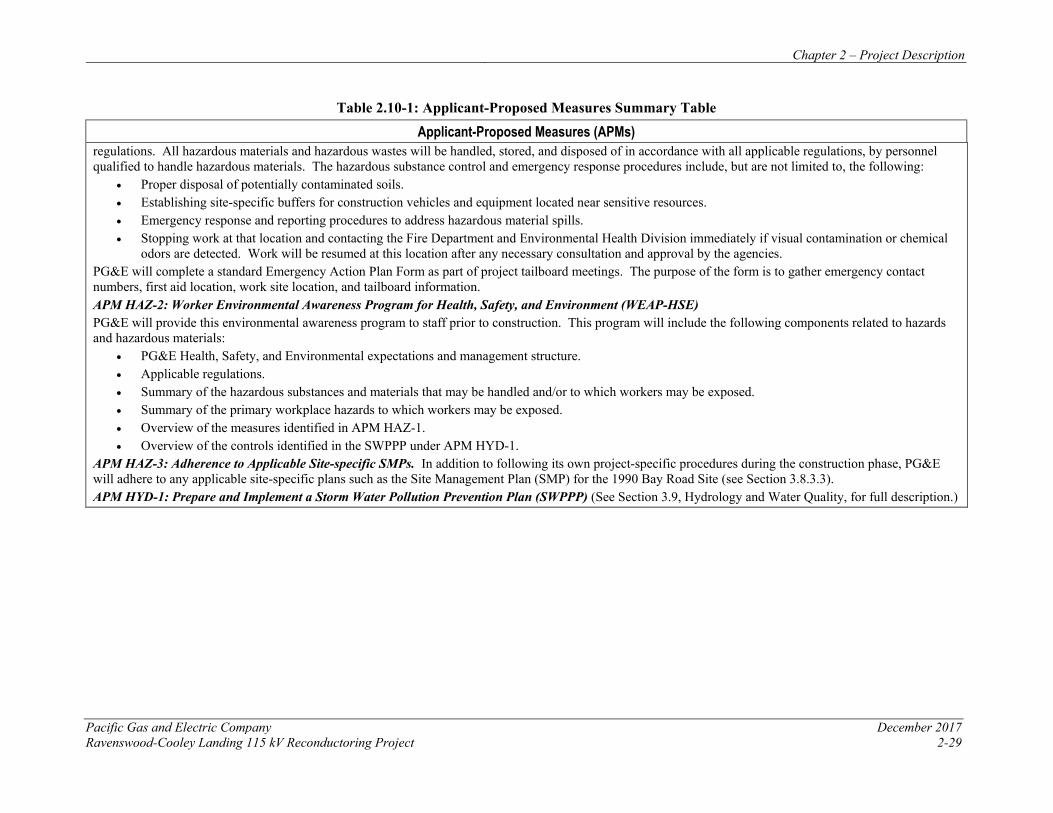
Chapter 2 – Project Description
Pacific Gas and Electric Company December 2017 Ravenswood-Cooley Landing 115 kV Reconductoring Project 2-29
Table 2.10-1: Applicant-Proposed Measures Summary Table
Applicant-Proposed Measures (APMs) regulations. All hazardous materials and hazardous wastes will be handled, stored, and disposed of in accordance with all applicable regulations, by personnel qualified to handle hazardous materials. The hazardous substance control and emergency response procedures include, but are not limited to, the following:
• Proper disposal of potentially contaminated soils.• Establishing site-specific buffers for construction vehicles and equipment located near sensitive resources.• Emergency response and reporting procedures to address hazardous material spills.• Stopping work at that location and contacting the Fire Department and Environmental Health Division immediately if visual contamination or chemical
odors are detected. Work will be resumed at this location after any necessary consultation and approval by the agencies.PG&E will complete a standard Emergency Action Plan Form as part of project tailboard meetings. The purpose of the form is to gather emergency contact numbers, first aid location, work site location, and tailboard information. APM HAZ-2: Worker Environmental Awareness Program for Health, Safety, and Environment (WEAP-HSE) PG&E will provide this environmental awareness program to staff prior to construction. This program will include the following components related to hazards and hazardous materials:
• PG&E Health, Safety, and Environmental expectations and management structure.• Applicable regulations.• Summary of the hazardous substances and materials that may be handled and/or to which workers may be exposed.• Summary of the primary workplace hazards to which workers may be exposed.• Overview of the measures identified in APM HAZ-1.• Overview of the controls identified in the SWPPP under APM HYD-1.
APM HAZ-3: Adherence to Applicable Site-specific SMPs. In addition to following its own project-specific procedures during the construction phase, PG&E will adhere to any applicable site-specific plans such as the Site Management Plan (SMP) for the 1990 Bay Road Site (see Section 3.8.3.3). APM HYD-1: Prepare and Implement a Storm Water Pollution Prevention Plan (SWPPP) (See Section 3.9, Hydrology and Water Quality, for full description.)
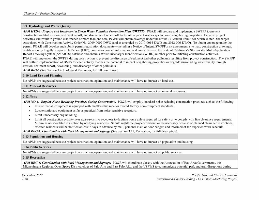
Chapter 2 – Project Description
December 2017 Pacific Gas and Electric Company 2-30 Ravenswood-Cooley Landing 115 kV Reconductoring Project
3.9 Hydrology and Water Quality APM HYD-1: Prepare and Implement a Storm Water Pollution Prevention Plan (SWPPP). PG&E will prepare and implement a SWPPP to prevent construction-related erosion, sediment runoff, and discharge of other pollutants into adjacent waterways and onto neighboring properties. Because project activities will result in ground disturbance of more than one acre, PG&E will obtain coverage under the SWRCB General Permit for Storm Water Discharges Associated with Construction Activity Order No. 2009-0009-DWQ (and as amended by 2010-0014-DWQ and 2012-006-DWQ). To obtain coverage under the permit, PG&E will develop and submit permit registration documents—including a Notice of Intent, SWPPP, risk assessment, site map, construction drawings, certification by Legally Responsible Person (LRP), contractor contact information, and annual fee—to the State of California’s Stormwater Multi-Application Report Tracking System (SMARTS) database and obtain a Waste Discharger Identification (WDID) number prior to initiating construction activities. PG&E will implement the SWPPP during construction to prevent the discharge of sediment and other pollutants resulting from project construction. The SWPPP will outline implementation of BMPs for each activity that has the potential to impact neighboring properties or degrade surrounding water quality through erosion, sediment runoff, dewatering, and discharge of other pollutants. APM BIO-5 (See Section 3.4, Biological Resources, for full description). 3.10 Land Use and Planning No APMs are suggested because project construction, operation, and maintenance will have no impact on land use. 3.11 Mineral Resources No APMs are suggested because project construction, operation, and maintenance will have no impact on mineral resources. 3.12 Noise APM NO-1: Employ Noise-Reducing Practices during Construction. PG&E will employ standard noise-reducing construction practices such as the following:
• Ensure that all equipment is equipped with mufflers that meet or exceed factory new-equipment standards.• Locate stationary equipment as far as practical from noise-sensitive receptors.• Limit unnecessary engine idling.• Limit all construction activity near noise-sensitive receptors to daytime hours unless required for safety or to comply with line clearance requirements.
Minimize noise-related disruption by notifying residents. Should nighttime project construction be necessary because of planned clearance restrictions,affected residents will be notified at least 7 days in advance by mail, personal visit, or door hanger, and informed of the expected work schedule.
APM REC-1: Coordination with Park Management and Signage (See Section 3.15, Recreation, for full description). 3.13 Population and Housing No APMs are suggested because project construction, operation, and maintenance will have no impact on population and housing. 3.14 Public Services No APMs are suggested because project construction, operation, and maintenance will have no impact on public services. 3.15 Recreation APM REC-1: Coordination with Park Management and Signage. PG&E will coordinate closely with the Association of Bay Area Governments, the Midpeninsula Regional Open Space District, cities of Palo Alto and East Palo Alto, and the USFWS to communicate potential park and trail disruptions during
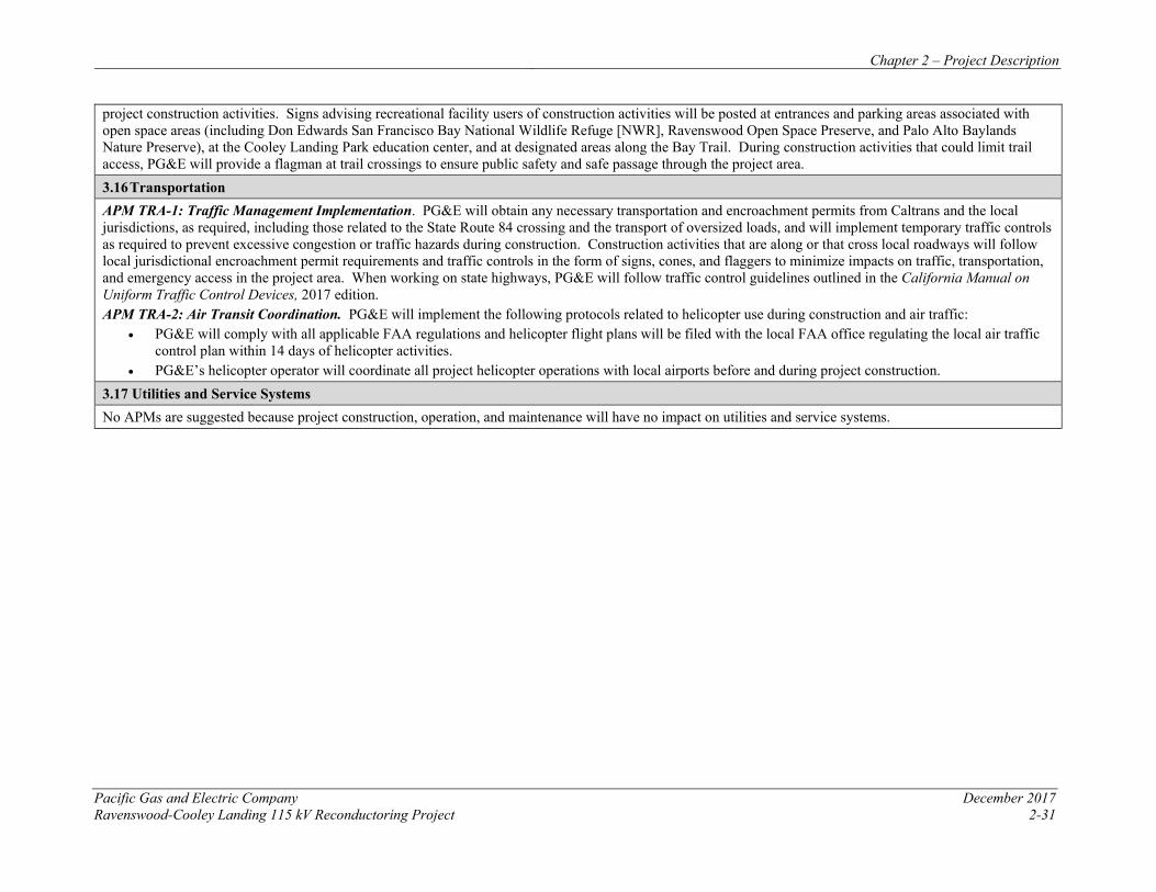
Chapter 2 – Project Description
Pacific Gas and Electric Company December 2017 Ravenswood-Cooley Landing 115 kV Reconductoring Project 2-31
project construction activities. Signs advising recreational facility users of construction activities will be posted at entrances and parking areas associated with open space areas (including Don Edwards San Francisco Bay National Wildlife Refuge [NWR], Ravenswood Open Space Preserve, and Palo Alto Baylands Nature Preserve), at the Cooley Landing Park education center, and at designated areas along the Bay Trail. During construction activities that could limit trail access, PG&E will provide a flagman at trail crossings to ensure public safety and safe passage through the project area. 3.16 Transportation APM TRA-1: Traffic Management Implementation. PG&E will obtain any necessary transportation and encroachment permits from Caltrans and the local jurisdictions, as required, including those related to the State Route 84 crossing and the transport of oversized loads, and will implement temporary traffic controls as required to prevent excessive congestion or traffic hazards during construction. Construction activities that are along or that cross local roadways will follow local jurisdictional encroachment permit requirements and traffic controls in the form of signs, cones, and flaggers to minimize impacts on traffic, transportation, and emergency access in the project area. When working on state highways, PG&E will follow traffic control guidelines outlined in the California Manual on Uniform Traffic Control Devices, 2017 edition. APM TRA-2: Air Transit Coordination. PG&E will implement the following protocols related to helicopter use during construction and air traffic:
• PG&E will comply with all applicable FAA regulations and helicopter flight plans will be filed with the local FAA office regulating the local air traffic control plan within 14 days of helicopter activities.
• PG&E’s helicopter operator will coordinate all project helicopter operations with local airports before and during project construction. 3.17 Utilities and Service Systems No APMs are suggested because project construction, operation, and maintenance will have no impact on utilities and service systems.
Chapter 2 – Project Description
December 2017 Pacific Gas and Electric Company 2-32 Ravenswood-Cooley Landing 115kV Reconductoring Project
2.11 REFERENCES
Bureau of Reclamation (BOR). 2008. Engineering and O&M Guidelines for Crossings, Bureau of Reclamation Water Conveyance Facilities (Canals, Pipelines, and Similar Facilities). Technical Service Center. Denver, Colorado.
California Department of Water Resources (DWR). 2005. Encroachment Permit Guidelines. Division of Operations and Maintenance. Sacramento, California. June.
Energy and Environmental Economics, Inc. (E3). 2015. Western Interconnection Flexibility Assessment, Final Report. December.
Liu, S. 2013. Phase I.A. Direct Testimony of Dr. Shucheng Liu on Behalf of The CAISO Corporation. http://www.caiso.com/Documents/Aug13_2014_InitialTestimony_ShuchengLiu_Phase1A_LTPP_R13-12-010.pdf
Mao, M. and Galjanic, T. 2014b. “Appendix A: Technical Appendix.” Proceeding R.13-12-010, August 13. San Francisco, CA: California Public Utilities Commission.
Pacific Gas and Electric Company (PG&E). 2011. Electric Transmission Preventative Maintenance Manual. TD-1001M. January.
Union of Concerned Scientists. 2015. Achieving 50 Percent Renewable Electricity in California. August.
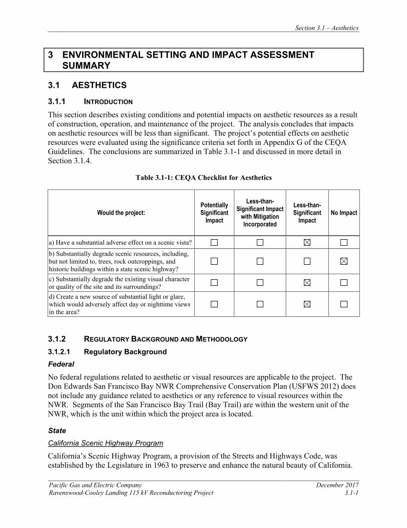
Section 3.1 – Aesthetics
Pacific Gas and Electric Company December 2017 Ravenswood-Cooley Landing 115 kV Reconductoring Project 3.1-1
3 ENVIRONMENTAL SETTING AND IMPACT ASSESSMENT SUMMARY
3.1 AESTHETICS
3.1.1 INTRODUCTION This section describes existing conditions and potential impacts on aesthetic resources as a result of construction, operation, and maintenance of the project. The analysis concludes that impacts on aesthetic resources will be less than significant. The project’s potential effects on aesthetic resources were evaluated using the significance criteria set forth in Appendix G of the CEQA Guidelines. The conclusions are summarized in Table 3.1-1 and discussed in more detail in Section 3.1.4.
Table 3.1-1: CEQA Checklist for Aesthetics
Would the project: Potentially Significant
Impact
Less-than-Significant Impact
with Mitigation Incorporated
Less-than-Significant
Impact No Impact
a) Have a substantial adverse effect on a scenic vista?
b) Substantially degrade scenic resources, including, but not limited to, trees, rock outcroppings, and historic buildings within a state scenic highway?
c) Substantially degrade the existing visual character or quality of the site and its surroundings?
d) Create a new source of substantial light or glare, which would adversely affect day or nighttime views in the area?
3.1.2 REGULATORY BACKGROUND AND METHODOLOGY 3.1.2.1 Regulatory Background Federal
No federal regulations related to aesthetic or visual resources are applicable to the project. The Don Edwards San Francisco Bay NWR Comprehensive Conservation Plan (USFWS 2012) does not include any guidance related to aesthetics or any reference to visual resources within the NWR. Segments of the San Francisco Bay Trail (Bay Trail) are within the western unit of the NWR, which is the unit within which the project area is located.
State California Scenic Highway Program
California’s Scenic Highway Program, a provision of the Streets and Highways Code, was established by the Legislature in 1963 to preserve and enhance the natural beauty of California.
Section 3.1 – Aesthetics
December 2017 Pacific Gas and Electric Company 3.1-2 Ravenswood-Cooley Landing 115kV Reconductoring Project
The State Scenic Highway Program includes highways that are either eligible for designation as scenic highways or have been designated as such. The status of a state scenic highway changes from eligible to officially designated when the local jurisdiction adopts a scenic corridor protection program, applies to the Caltrans for scenic highway approval, and receives the designation from Caltrans (Caltrans 2011). A city or county may propose to add routes with outstanding scenic elements to the list of eligible highways; however, state legislation is required for a highway to be officially designated.
There are no officially designated or eligible state scenic highways in the project area.
Regional Midpeninsula Regional Open Space District
The Ravenswood Open Space Preserve is managed by Midpeninsula Regional Open Space District (MPROSD). The proposed Ravenswood Bay Trail Bayfront to Ravenswood Preserve Project would connect University Avenue in East Palo Alto to the segment of the Bay Trail extending through the Ravenswood Open Space Preserve in Menlo Park, utilizing the existing SFPUC Ravenswood Valve Lot access road.
Local
Because the CPUC has exclusive jurisdiction over project siting, design, and construction, the project is not subject to local discretionary regulations. This section includes a summary of local standards or ordinances that describe the visual character of the project area for informational purposes and to assist with the CEQA review process.
City of Menlo Park
The City of Menlo Park General Plan includes goals, policies, and programs intended to guide development and conservation within Menlo Park, while retaining the existing community character. The General Plan is currently being updated. The Land Use and Circulation Elements, referred to as “ConnectMenlo,” were adopted by the Menlo Park City Council in 2016 (City of Menlo Park 2016). The Open Space / Conservation, Noise and Safety Elements were updated in 2013 (City of Menlo Park 2013).
The Land Use Element identifies the intersection of SR 84 and University Avenue as a gateway, and the eastbound approach to this intersection – and the baylands and Dumbarton Bridge – as a “View Corridor / Scenic Vista.” It also includes the following:
• Goal LU-6 – Preserve open-space lands for recreation; protect natural resources and air and water quality; and protect and enhance scenic qualities.
• Policy LU-6.6 – Public Bay Access. Protect and support public access to the Bay for the scenic enjoyment of open water, sloughs, and marshes including restoration efforts, and completion of the Bay Trail.
The list of Open Space and Conservation goals, policies, and programs in the Open Space / Conservation, Noise and Safety Elements describes the City’s approach to natural resource conservation as including preservation of the visual amenities of Menlo Park’s baylands and
Section 3.1 – Aesthetics
Pacific Gas and Electric Company December 2017 Ravenswood-Cooley Landing 115 kV Reconductoring Project 3.1-3
shoreline, and protection of “lands that have inherent qualities to provide visual amenity, including…scenic water areas, creeks, and the San Francisco Bay” (City of Menlo Park 2013). These elements include the following:
• Goal OSC1 – Maintain, protect, and enhance open space and natural resources: Protect, conserve and enhance valuable natural resources, open areas and designated open space lands rich in scenic value, wildlife or of a fragile ecological nature through conservation and restoration efforts.
• Policy OSC 1.14 – Protection of Conservation and Scenic Area. Protect conservation and scenic areas from deterioration or destruction by vandalism, private actions or public actions.
City of East Palo Alto
The City of East Palo Alto General Plan (City of East Palo Alto 2017) includes a goal in the Parks, Open Space, and Conservation Element (Goal POC-4) targeting protection and preservation of the City’s natural habitat and wildlife, with the intent of preserving the aesthetic and ecological quality of the City’s nearby urban natural resources.
The General Plan implements the Ravenswood / 4 Corners TOD (Transit-Oriented Development) Specific Plan (City of East Palo Alto 2013), which addresses the redevelopment area adjacent to the project area. The Specific Plan envisions new office uses in the easternmost portion of the redevelopment area, just west of the Ravenswood Open Space Preserve. Development guidelines include measures to ensure view corridors toward the open spaces to the west and the following “Key Viewsheds” are identified:
• “Northern Viewshed aligned with proposed alignment of Bay Trail” – Existing Viewshed to be preserved, at eastern end of Purdue Avenue.
• “Central Viewshed aligned with alignment of proposed new street” – Proposed Viewshed east of the current terminus of Notre Dame Avenue.
• “Viewshed aligned with Bay Road” – Existing Viewshed to be preserved, looking down Bay Road toward Cooley Landing from the intersection of Clarke Avenue and Bay Road.
The Specific Plan includes a number of potential new links, spurs or segments associated with the Bay Trail, none of which currently exist. Potential connections could be added within the northeast corner of the Specific Plan area, via a connection loop that would extend from the terminus at Purdue Avenue north of Bay Road and from the midpoint of Pulgas Avenue south of Bay Road, and from Weeks Street in the south to Bay Road.
3.1.2.2 Methodology
This visual analysis is based on review of technical data, including project maps and drawings provided by PG&E, aerial and ground level photographs of the project area, local planning documents, and computer-generated visual simulations. Field observations were conducted in April 2017 to document existing visual conditions in the project area and to identify potentially affected sensitive viewing locations.
Section 3.1 – Aesthetics
December 2017 Pacific Gas and Electric Company 3.1-4 Ravenswood-Cooley Landing 115kV Reconductoring Project
This visual study employs assessment methods based, in part, on the U.S. Department of Transportation, Federal Highway Administration’s (FHWA) and other accepted visual analysis techniques as summarized by Smardon, et al. (1986). This study also addresses the CEQA Guidelines for visual impact analysis.
Views from a representative set of publicly accessible locations are included here to convey a sense of existing visual conditions in the project area. These viewpoints are referred to as Key Observation Points (KOPs). The selection of KOPs, made in concert with PG&E after review of photographs collected during field observations, was intended to reflect the range of views and viewers in the project area. They therefore include viewpoints from where there is likely to be a relatively high volume of viewers, and viewpoints where viewers may be sensitive to changes to the aesthetic environment. Viewers include those using nearby recreational facilities and open spaces, as well as motorists. The rationale for the selection of views is included in the description of the KOPs in Section 3.1.3.1.
The KOPs selected are within the project’s viewshed. A project viewshed is defined as the general area from which a project is visible. For purposes of describing a project’s visual setting and assessing potential visual impacts, the viewshed can be broken down into foreground, middleground, and background zones. The foreground is defined as the zone within 0.25 mile to 0.5 mile or less of the viewer; the middleground is defined as the zone that extends from the foreground to a maximum of 3 to 5 miles of the viewer; and the background zone extends from the middleground to infinity (Smardon et al. 1986). Viewing distance is a key factor that affects the potential degree of project visibility. Visual details generally become apparent to the viewer when they are observed in the foreground, at a distance of 0.25 to 0.5 mile or less. The primary focus of the visual analysis included in this assessment is the foreground viewshed zone, where visual details are most apparent, up to approximately 1 mile from the project area, where change could be noticeable.
The analysis of impacts to aesthetic resources requires description of the existing visual setting and documentation of the changes resulting from the project. The comparison of existing and proposed conditions serves as a basis for evaluation of a project’s effects, and this comparison relies on visual simulations prepared for a subset of the representative KOPs. Simulations show existing views with digital models of project activities included, employing systematic digital photography, computer modeling, and rendering techniques. Photographs collected during field observations were taken using a digital single-lens reflex camera with standard 50-millimeter lens equivalent, which represents an approximately 40-degree horizontal view angle. Viewpoint locations were documented using a global positioning system (GPS) device and base map annotation. Digital aerial photographs and project design information supplied by PG&E provided the basis for developing a three-dimensional (3D) computer model of the new project components (new conductor, cage-top extensions, and OPGW peaks). For each simulation viewpoint, viewer location was input from GPS data, using 5 feet as the assumed eye level elevation. Computer “wireframe” perspective plots were overlaid on the photographs to verify scale and viewpoint location. Digital visual simulation images were then produced, based on computer renderings of the 3D model combined with digital versions of the selected site photographs. Section 3.1.4.3 includes discussion of project effects based on simulated views.
Section 3.1 – Aesthetics
Pacific Gas and Electric Company December 2017 Ravenswood-Cooley Landing 115 kV Reconductoring Project 3.1-5
In general, in the analysis of a project’s visual effects, construction-related impacts are assumed to be temporary and short-term; therefore, while construction activities are discussed where appropriate, this assessment focuses on permanent alterations to the visual environment.
3.1.3 ENVIRONMENTAL SETTING The project site is located in San Mateo County, along the southwestern edge of San Francisco Bay and within lands under the jurisdiction of the cities of Menlo Park and East Palo Alto. Figure 3.1-1 includes a map and an annotated aerial photograph that show the project location within the regional and local landscape context which is described in greater detail below. In this analysis, the project site refers to the proposed reconductored power line extending from the Ravenswood Substation in Menlo Park to the Cooley Landing Substation in East Palo Alto. The project area refers to the portion of the surrounding landscape from which the existing facilities are visible, including the entirety of the baylands and open space preserves traversed by the project and the nearby developed areas from which the project is visible in unobstructed views.
3.1.3.1 Regional Setting
The project area is located in the southeastern portion of the San Francisco Peninsula, within a network of baylands and designated open spaces that form the majority of the San Francisco Bay shoreline in this part of the Bay Area. Elevations within the mostly salt marsh and grassy baylands are generally at or a few feet above sea level. Menlo Park, East Palo Alto, and a number of other incorporated cities comprise a portion of Silicon Valley to the west. This broadly urbanized area is bounded by the Santa Cruz Mountains nine miles west of the project area. Approximately five miles east of the project area, beyond the bay and the Newark unit of the NWR, are southernmost East Bay cities, including Newark and Fremont. Mission Peak, surrounded by the East Bay hills, is approximately 14 miles from the project site.
While views within the developed portions of the region are generally limited by intervening structures and some topography in the western extents, views within the flat baylands areas are expansive and allow the project area to be seen within a broader context. The Bay Trail and other recreational facilities that provide access to the NWR, local and regional parks, and open space preserves, allow for views that show the Santa Cruz Mountains or East Bay hills as backdrop to the cities and bay that border the baylands areas. Views within the baylands areas are less obstructed than those in developed areas; thus, a greater portion of the surrounding area and more features are typically visible in views from these areas.
3.1.3.2 Local Setting
The project extends from PG&E’s Ravenswood Substation, located just north of SR 84, approximately 1.6 miles south to PG&E’s Cooley Landing Substation. The existing 115 kV power line crosses three designated open space preserves: Don Edwards San Francisco Bay NWR, which abuts Ravenswood Substation on the west, north and east; Ravenswood Open Space Preserve, managed by the Midpeninsula Open Space District; and Palo Alto Baylands Nature Preserve, the northern edge of which contains Tower 8. Figure 3.1-1 shows the location of the features described above and elsewhere in this section.
Section 3.1 – Aesthetics
December 2017 Pacific Gas and Electric Company 3.1-6 Ravenswood-Cooley Landing 115kV Reconductoring Project
The project area is characterized visually by the contrast between the mostly undeveloped open space baylands traversed by the project and urbanized areas to the west, and by the constant presence of transmission infrastructure in views. The project is part of a larger utility corridor, appearing alongside two other power lines (Ravenswood-Palo Alto and Ravenswood-Ames), with towers of similar scale and design adjacent to or staggered with the project towers. These lines extend from Ravenswood Substation and extend past Cooley Landing Substation to the south. Collectively, they are the dominant or co-dominant element in all views toward the project area.
Tower 1, adjacent to the southwest of Ravenswood Substation, is within a tidally influenced portion of the NWR. The project crosses SR 84 just south of Ravenswood Substation, along with other power lines. This segment of the highway is a major thoroughfare, connecting the San Francisco Peninsula with the East Bay. The western landing of the Dumbarton Bridge, which extends from Menlo Park to Newark, is approximately 0.25 mile northeast of Ravenswood Substation. Views toward the northern extent of the project site from SR 84 include the expansive NWR wetlands as backdrop.
Tower 2, just south of SR 84, and Tower 3, approximately 0.2 mile further south, are within a restored portion of the South Bay Salt Ponds complex now part of the NWR wetlands. Tower 4 is within ruderal grasslands that contain the SFPUC Ravenswood Valve Lot facility associated with the Hetch Hetchy Water and Power aqueduct that crosses the Bay nearby. The SFPUC facility, while not conspicuous in views, includes structures visible in views toward the project area.
The project continues south crossing an abandoned rail spur and entering the Ravenswood Open Space Preserve, a salt marsh that contains the longest segment of the Bay Trail within the project area. In this area, the project is at its closest proximity to a residential neighborhood. It passes within 0.1 mile of University Village, in northeast East Palo Alto. The portion of the project within the Ravenswood Open Space Preserve, which includes Towers 5, 6, and 7, also crosses the Bay Trail at two separate locations. Tower 7 is within approximately 0.1 mile of an auto salvage yard, which, along with other industrial-appearing facilities, are the primary land uses in the area west of this portion of the project. Unobstructed views toward the bay from within Ravenswood Open Space Preserve are only available east of the transmission corridor; all other views toward the salt marshes include transmission towers and lines as a dominant feature or as a prominent backdrop.
Just south of Bay Road, the project enters the Palo Alto Baylands Nature Preserve at Tower 8, which then turns westward to connect with Tower 9 just east of the Cooley Landing Substation. Cooley Landing, a recreational area that includes a segment of the Bay Trail and walking trails, as well as Cooley Landing Park and the Cooley Landing Educational Center, is approximately 0.2 mile east of where the project crosses Bay Road. Cooley Landing Substation is approximately 0.2 mile west of the Bay Road crossing. Views to the north and south from this portion of the project area are expansive and include salt marsh and transmission facilities. To the east, Cooley Landing is visible with the San Francisco Bay and East Bay hills as backdrop. Evident in views to the west, beyond Cooley Landing Substation and the auto salvage yard, are other industrial-appearing developments and uses, typical of this part of East Palo Alto.
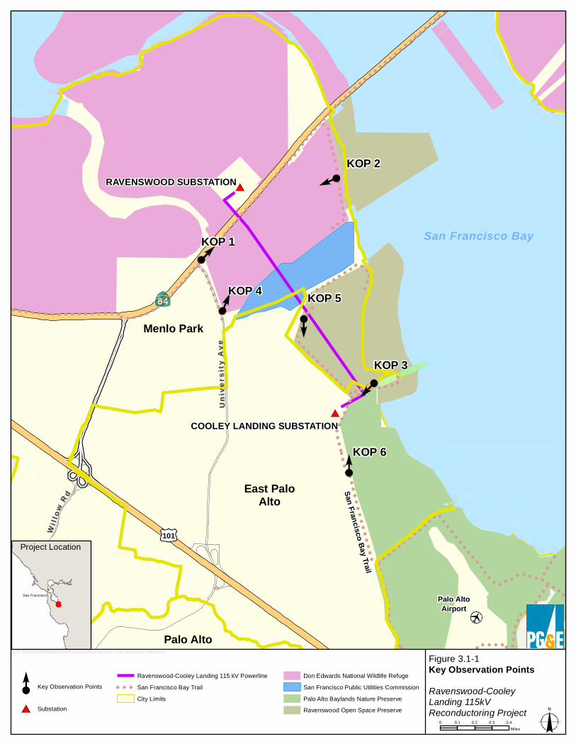
San Francisco Bay Trail
Palo AltoAirport
Menlo Park
Palo Alto
East PaloAlto
COOLEY LANDING SUBSTATION
RAVENSWOOD SUBSTATION
Univ
ersi
ty A
veUn
iver
sity
Ave
WWii ll ll
oo wwRR dd
101
KOP 1
KOP 2
KOP 3
KOP 4 KOP 5
KOP 6
Figure 3.1-1Key Observation PointsRavenswood-CooleyLanding 115kVReconductoring Project
Key Observation Points
Substation
Ravenswood-Cooley Landing 115 kV PowerlineSan Francisco Bay TrailCity Limits
Don Edwards National Wildlife RefugeSan Francisco Public Utilities CommissionPalo Alto Baylands Nature PreserveRavenswood Open Space Preserve
0 0.1 0.2 0.3 0.4Miles
bxo2: H:\work\Liddell\RavenswoodCooleyLanding\Figure 3.1-1 Key Observation Points.mxd
Project Location
San Francisco
San Francisco Bay
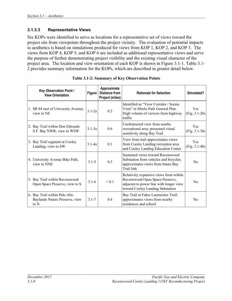
Section 3.1 – Aesthetics
December 2017 Pacific Gas and Electric Company 3.1-8 Ravenswood-Cooley Landing 115kV Reconductoring Project
3.1.3.3 Representative Views
Six KOPs were identified to serve as locations for a representative set of views toward the project site from viewpoints throughout the project vicinity. The evaluation of potential impacts to aesthetics is based on simulations produced for views from KOP 1, KOP 2, and KOP 3. The views from KOP 4, KOP 5, and KOP 6 are included as additional representative views and serve the purpose of further demonstrating project visibility and the existing visual character of the project area. The location and view orientation of each KOP is shown in Figure 3.1-1. Table 3.1-2 provides summary information for the KOPs, which are described in greater detail below.
Table 3.1-2: Summary of Key Observation Points
Key Observation Point / View Orientation Figure
Approximate Distance from Project (miles)
Rationale for Selection Simulated?
1. SR 84 east of University Avenue, view to NE 3.1-2a 0.3
Identified as “View Corridor / Scenic Vista” in Menlo Park General Plan. High volume of viewers from highway traffic
Yes (Fig. 3.1-2b)
2. Bay Trail within Don Edwards S.F. Bay NWR, view to WSW 3.1-3a 0.6
Unobstructed view from nearby recreational area; presumed visual sensitivity along Bay Trail
Yes (Fig. 3.1-3b)
3. Bay Trail segment at Cooley Landing, view to SW 3.1-4a 0.1
View from trail approximates views from Cooley Landing recreation area and Cooley Landing Education Center
Yes (Fig. 3.1-4b)
4. University Avenue Bike Path, view to NNE 3.1-5 0.5
Sustained views toward Ravenswood Substation from vehicles and bicycles; approximates views from future Bay Trail link
No
5. Bay Trail within Ravenswood Open Space Preserve, view to S 3.1-6 < 0.1
Relatively expansive views from within Ravenswood Open Space Preserve, adjacent to power line with longer view toward Cooley Landing Substation
No
6. Bay Trail within Palo Alto Baylands Nature Preserve, view to N
3.1-7 0.4 Bay Trail at Faber Laumeister Trail; approximates views from nearby residences and school
No
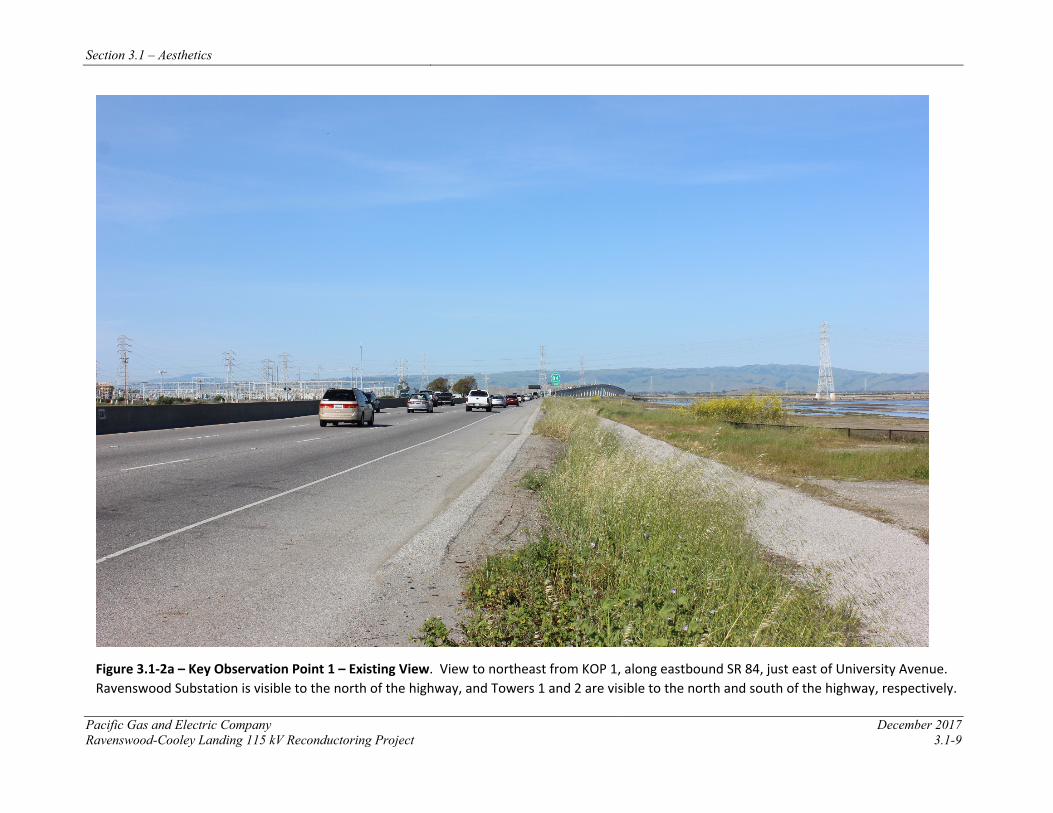
Section 3.1 – Aesthetics
Pacific Gas and Electric Company December 2017 Ravenswood-Cooley Landing 115 kV Reconductoring Project 3.1-9
Figure 3.1-2a – Key Observation Point 1 – Existing View. View to northeast from KOP 1, along eastbound SR 84, just east of University Avenue. Ravenswood Substation is visible to the north of the highway, and Towers 1 and 2 are visible to the north and south of the highway, respectively.
Section 3.1 – Aesthetics
December 2017 Pacific Gas and Electric Company 3.1-10 Ravenswood-Cooley Landing 115 kV Reconductoring Project
Figure 3.1-2b – Key Observation Point 1 – Simulated View. View from KOP 1 with project modifications. Cage-top extensions and OPGW peaks atop Towers 1 and 2 are visible.

Section 3.1 – Aesthetics
Pacific Gas and Electric Company December 2017 Ravenswood-Cooley Landing 115 kV Reconductoring Project 3.1-11
Figure 3.1-3a – Key Observation Point 2 – Existing View. View to the west-southwest from KOP 2, at an observation deck along the San Francisco Bay Trail within the Don Edwards San Francisco Bay National Wildlife Refuge. Ravenswood Substation is visible along the right edge of the view and Towers 1 and 2 are visible extending southward.
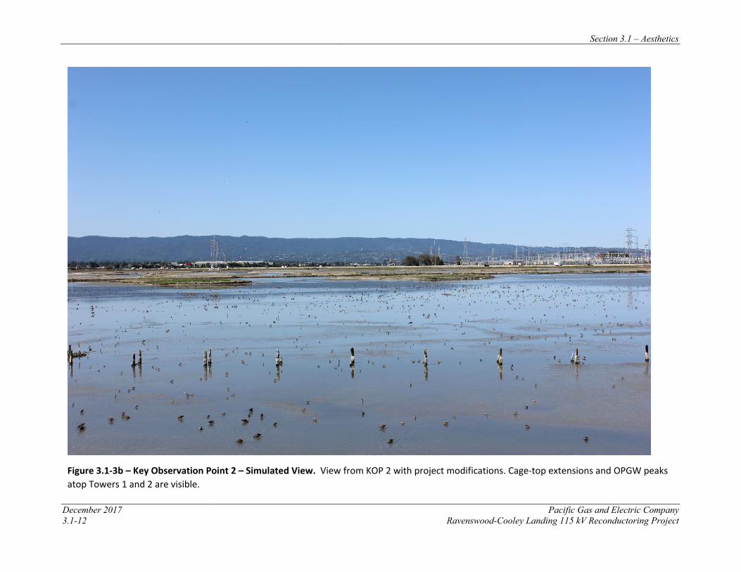
Section 3.1 – Aesthetics
December 2017 Pacific Gas and Electric Company 3.1-12 Ravenswood-Cooley Landing 115 kV Reconductoring Project
Figure 3.1-3b – Key Observation Point 2 – Simulated View. View from KOP 2 with project modifications. Cage-top extensions and OPGW peaks atop Towers 1 and 2 are visible.
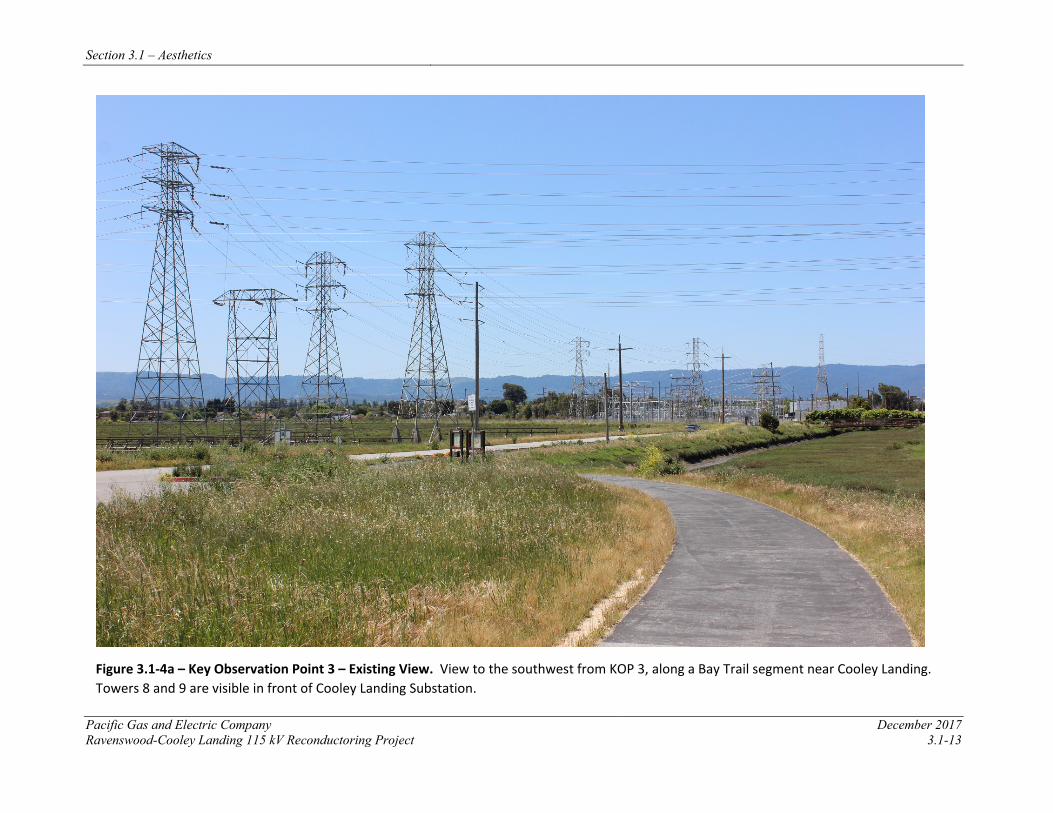
Section 3.1 – Aesthetics
Pacific Gas and Electric Company December 2017 Ravenswood-Cooley Landing 115 kV Reconductoring Project 3.1-13
Figure 3.1-4a – Key Observation Point 3 – Existing View. View to the southwest from KOP 3, along a Bay Trail segment near Cooley Landing. Towers 8 and 9 are visible in front of Cooley Landing Substation.
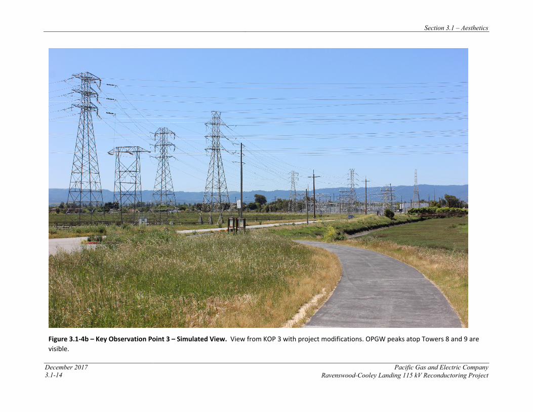
Section 3.1 – Aesthetics
December 2017 Pacific Gas and Electric Company 3.1-14 Ravenswood-Cooley Landing 115 kV Reconductoring Project
Figure 3.1-4b – Key Observation Point 3 – Simulated View. View from KOP 3 with project modifications. OPGW peaks atop Towers 8 and 9 are visible.
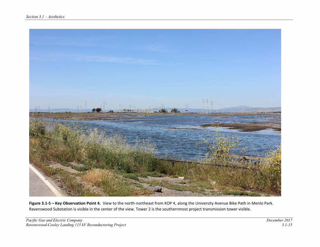
Section 3.1 – Aesthetics
Pacific Gas and Electric Company December 2017 Ravenswood-Cooley Landing 115 kV Reconductoring Project 3.1-15
Figure 3.1-5 – Key Observation Point 4. View to the north-northeast from KOP 4, along the University Avenue Bike Path in Menlo Park. Ravenswood Substation is visible in the center of the view. Tower 2 is the southernmost project transmission tower visible.
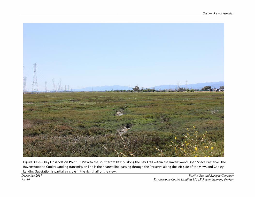
Section 3.1 – Aesthetics
December 2017 Pacific Gas and Electric Company 3.1-16 Ravenswood-Cooley Landing 115 kV Reconductoring Project
Figure 3.1-6 – Key Observation Point 5. View to the south from KOP 5, along the Bay Trail within the Ravenswood Open Space Preserve. The Ravenswood to Cooley Landing transmission line is the nearest line passing through the Preserve along the left side of the view, and Cooley Landing Substation is partially visible in the right half of the view.
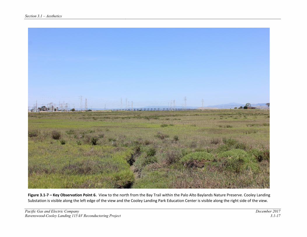
Section 3.1 – Aesthetics
Pacific Gas and Electric Company December 2017 Ravenswood-Cooley Landing 115 kV Reconductoring Project 3.1-17
Figure 3.1-7 – Key Observation Point 6. View to the north from the Bay Trail within the Palo Alto Baylands Nature Preserve. Cooley Landing Substation is visible along the left edge of the view and the Cooley Landing Park Education Center is visible along the right side of the view.

Section 3.1 – Aesthetics
December 2017 Pacific Gas and Electric Company 3.1-18 Ravenswood-Cooley Landing 115kV Reconductoring Project
KOP 1 – SR 84 East of University Avenue
KOP 1 is located just east of the intersection of SR 84 and University Avenue, approximately 0.3 mile southwest of the northern extent of the project. The KOP location adjacent to the Bay Trail bike path that parallels the highway is intended to approximate views from the eastbound lane of SR 84. Ravenswood Substation is visible on the north side of SR 84, and Towers 1 and 2 of the project power line are visible along the left and right edges of the view, respectively (see Figure 3.1-2a). The restored South Bay Salt Ponds, which are part of the Don Edwards San Francisco Bay NWR, are visible in the right half of the view, south of SR 84. A power line extends from Ravenswood Substation to the east, initially appearing alongside the Dumbarton Bridge in a northeasterly direction before turning to the southeast, across the bay in the right side of the view. Despite the visual presence of natural features like the East Bay hills and a portion of the NWR, electrical transmission infrastructure characterizes the view from KOP 1. The numerous towers, which are strong vertical features, are co-dominant with the strong linear elements of the highway and bridge. Further, the towers appear from this vantage point to be aligned in multiple directions where not clustered near the substation. This relative lack of order is detectable within a broader landscape dedicated mainly to conveyance, both electrical and vehicular.
KOP 2 – Bay Trail within Don Edwards San Francisco Bay NWR
KOP 2 is located at an observation deck along a segment of the Bay Trail within Don Edwards San Francisco Bay NWR, approximately 0.6 mile of the northern extent of the project. It was selected for use in this analysis to represent viewers in the eastern extent of the NWR, where birdwatching activities are common. The observation deck is oriented inward, away from the bay and toward the portion of the NWR that includes the project power line (see Figure 3.1-3a). Ravenswood Substation and associated towers are clearly visible, concentrated in the right side of the view. Towers 1 and 2 of the project power line are among the tallest towers in the area and are visible alongside or near other similarly-scaled towers to the right and left of the view’s center, respectively. The NWR wetlands, and the wildlife inhabiting them, are the most vivid element in the view, and from this vantage point, the project appears set back from the more natural-appearing portion of the refuge. The towers are the strongest vertical elements in the view, and some nearest the substation appear to extend above the mountain skyline in the back of the view. However, such encroachment is minor and there is a moderately high degree of intactness in the view: the project area appears distinct from the NWR to the east and urbanized areas to the west, and all of these areas are backdropped by mountains that serve as a natural regional boundary. Viewers at KOP 2 see transmission facilities as prominent, but contained within a limited portion of the landscape.
KOP 3 – Bay Trail Segment at Cooley Landing
KOP 3 is located within Cooley Landing Park, along a segment of the Bay Trail adjacent to the Ravenswood Open Space Preserve and Bay Road. The viewpoint is approximately 0.1 mile east of the southern extent of the project and approximately 0.3 mile from Cooley Landing Substation. It was selected for use in this analysis to represent views to the west toward the project by viewers using trails and other facilities in the Cooley Landing area, including Cooley Landing Park and the Cooley Landing Educational Center, which is approximately 0.1 mile east of the KOP. It also represents views toward the project from Bay Road; eastward views from points along Bay Road west of the project are identified as a “Key Viewshed” in the
Section 3.1 – Aesthetics
Pacific Gas and Electric Company December 2017 Ravenswood-Cooley Landing 115 kV Reconductoring Project 3.1-19
Ravenswood / 4 Corners TOD Specific Plan. Project Tower 8 is visible near the center of the view, beyond the trailhead signs (see Figure 3.1-4a). Tower 9, to which conductors extend westward from Tower 8, is visible in the right half of the view, in front of Cooley Landing Substation. This view is characterized by the intersection of transmission facilities with recreational and open space areas and by the intersection of individual power lines. The southern edge of the Ravenswood Open Space Preserve is visible just north of Bay Road, and the northern extent of the Palo Alto Baylands Nature Preserve, which includes Tower 8, is visible on the southern side of Bay Road. The Ravenswood – Palo Alto line passes through the view in the foreground, and the Ravenswood – Ames line is visible trending toward Cooley Landing Substation before turning southward where it is aligned with the Bay Trail in the portion of the Palo Alto Baylands Nature Preserve south of the substation. Towers appear relatively large, but varied in terms of scale and design. These towers are the view’s dominant feature. Conductors add multiple bands of linear elements that appear to zig-zag across much of the view. While the mountain backdrop and western edge of East Palo Alto’s residential area are visible, they are partially obscured by numerous towers and the substation. In general, viewers at KOP 3, presumed to be in this location for recreational activities, see a landscape dominated by a somewhat cluttered pattern electrical infrastructure from this particular vantage point, typical of such intersections in transmission systems.
KOP 4 – University Avenue Bike Path
KOP 4 is located along the University Avenue bike path in Menlo Park, approximately 0.5 mile south-southwest of Tower 2, which is the nearest of the three tall towers clustered in the center-right of the view (see Figure 3.1-5). This KOP was selected as a representative view to show existing conditions from University Avenue, where viewers include bicycle riders with lanes adjacent to the roadway. It is also near the anticipated Bay Trail connection from the Ravenswood Open Space Preserve to University Avenue. Ravenswood Substation is visible in the center of the view and the existing project power line is visible crossing the view southward from this KOP. These structures are visible beyond the southwestern portion of the Don Edwards San Francisco Bay NWR, which contains the restored salt ponds that characterize this view and reinforce the project’s baylands setting. Within the NWR, land forms are visible, distributed in an irregular pattern and appearing as irregular shapes. This view component, while natural-appearing, contrasts with the transmission facilities which, from this distance and vantage point, appear to cross the view in a relatively orderly manner. The project power line, and other generally north-south oriented lines are the most visible, though towers extending to the east, crossing the bay, are also noticeable. This is a fairly unified view, in which other detectable features – namely SR 84 and the western landing of the Dumbarton Bridge, along with the East Bay hills – are subordinate or serve as back drop to the primary activity evident in views, the transmission of electricity through a baylands setting.
KOP 5 – Bay Trail within Ravenswood Open Space Preserve
KOP 5 is located along the Bay Trail, adjacent to the project power line (within 0.1 mile) and approximately 0.6 mile north of Cooley Landing Substation and the project’s southernmost towers (see Figure 3.1-6). This KOP was selected as a representative view to show existing conditions from a segment of the Bay Trail within Ravenswood Open Space Preserve and to demonstrate potential visibility of the project in views to the south. The view to the south from
Section 3.1 – Aesthetics
December 2017 Pacific Gas and Electric Company 3.1-20 Ravenswood-Cooley Landing 115kV Reconductoring Project
KOP 5 is characterized visually by the appearance of a relatively undisturbed segment of salt marsh bounded to the east and south by transmission infrastructure and other uses that are indiscernible from this distance. Of the three power lines visible along the left side of the view, the Ravenswood-Cooley Landing Line is the one closest to the KOP. Tower 9, the last tower before the line enters Cooley Landing Substation, is nearest the center of the view. The lattice-style towers appear uniformly in the left edge of the view, though differences in scale and form are noticeable. Conductors are detectable from this distance and serve to reinforce the presence of linear corridors in this view. Additional transmission towers located within the western edge of Cooley Landing Substation are visible and appear clustered in the right portion of the view. All built structures appear to be set back from KOP 5, allowing for their visibility, but not dominance, in views to the south. As such, this view is characterized by the enclosing effect that existing power and transmission lines and facilities have relative to the natural-appearing and generally undisturbed open space in the view’s immediate foreground.
KOP 6 – Bay Trail within Palo Alto Baylands Nature Preserve
KOP 6 is located along the Bay Trail within the Palo Alto Baylands Nature Preserve, approximately 0.4 mile south of where the project power line connects to Cooley Landing Substation. This KOP was selected as a representative view to show existing conditions from a segment of the Bay Trail within Palo Alto Baylands Nature Preserve and to demonstrate potential visibility of the project in views to the north. This portion of the Bay Trail intersects with the Faber Laumeister Trail, which extends eastward, and is near a trail access point from an East Palo Alto residential neighborhood and an elementary school. The view is characterized by an undisturbed, open space salt marsh in the foreground against a somewhat symmetrical backdrop: Cooley Landing Substation and the Cooley Landing Education Center bracket the view, with the more distant Dumbarton Bridge apparent in between. Transmission towers appear scattered but contained within this span, with little detectable organization. The East Bay hills, visible in views to the north from this part of the Bay Area, appear along the entirety of the background. This view is characterized by its expansiveness and the subordination of built structures to the natural-appearing open space in the foreground. Cooley Landing Substation and the nearby towers are prominent, and they appear to form a band that extends nearly across the entire view (though only conductors are visible near the education center), but the distance between the KOP and these features diminishes the visual dominance that they would likely have from more proximate viewpoints. The open space that is visible from this location appears minimally encroached upon by any portion of the built environment.
3.1.3.4 Potentially Affected Viewers
Accepted visual assessment methods, including those adopted by the FHWA, establish sensitivity levels as a measure of public concern for changes to scenic quality. Viewer sensitivity, one of the criteria for evaluating visual impact significance, can be divided into high, moderate, and low categories. Factors considered in assigning a sensitivity level include viewer activity, view duration, viewing distance, adjacent land use, and special management or planning designation. Research on the subject suggests that certain activities tend to heighten viewer awareness of visual and scenic resources, while others tend to be distracting (U.S. Department of Transportation 2015). The project viewshed includes several types of concerned viewer groups, primarily recreationists and motorists, but also residents and workers to the west of the project site.
Section 3.1 – Aesthetics
Pacific Gas and Electric Company December 2017 Ravenswood-Cooley Landing 115 kV Reconductoring Project 3.1-21
Recreationists include all people using the Bay Trail and other trails in the baylands open spaces, including walkways within Cooley Landing Park and Bay Trail access points. Recreational activities assumed for these areas are hiking, wildlife observation, and use of interpretive trails and the Cooley Landing Education Center. View duration for this group could range from several minutes to several hours depending on the activity. Viewer sensitivity of this group, presumed to be moderate in size, is considered moderate to high.
Motorists, the largest viewer group, include people traveling on SR 84 and local roads in Menlo Park and East Palo Alto. Travelers on SR 84 are by far the largest part of the motorist viewer group, as the highway is a major commuter link between the San Francisco Peninsula and the East Bay. The project crosses SR 84 just south of Ravenswood Substation. While the highway allows for relatively high rates of speed, commute-time traffic can be substantially congested and duration of views toward the project where it crosses the highway can be moderate, potentially lasting up to a few minutes. Viewer sensitivity of motorists is considered low to moderate.
Bicyclists, who may be recreationists or commuters, would have similarly sustained views toward the crossing of SR 84 from the adjacent bike path. The University Avenue bike path allows for more distant, but also more sustained, views of the project. Viewer sensitivity of bicyclists is considered moderate to high.
Partial, limited views toward the project are visible from the residential neighborhoods just west of the project. While such views are long in duration, most homes in these neighborhoods are oriented away from the project, which is generally screened in views by vegetation, other structures, or fences. Residential viewer sensitivity is considered to be high. Workers in the area are generally considered to have a moderate degree of viewer sensitivity. In the project vicinity, there are several offices and work locations – notably Facebook, which is approximately 0.5 mile from Ravenswood Substation – from which portions of the project are visible in limited views.
3.1.4 APPLICANT-PROPOSED MEASURES AND POTENTIAL IMPACTS The following sections describe significance criteria for aesthetic impacts derived from Appendix G of the CEQA Guidelines and assess potential project-related construction and operational aesthetic impacts.
3.1.4.1 Significance Criteria
According to Section 15002(g) of the CEQA Guidelines, “a significant effect on the environment is defined as a substantial adverse change in the physical conditions which exist in the area affected by the proposed project.” As stated in Section 15064(b) of the CEQA Guidelines, the significance of an activity may vary with the setting. Per Appendix G of the CEQA Guidelines, the potential significance of project-related impacts on aesthetics was evaluated for each of the criteria listed in Table 3.1-1, as discussed in Section 3.1.4.3.
Section 3.1 – Aesthetics
December 2017 Pacific Gas and Electric Company 3.1-22 Ravenswood-Cooley Landing 115kV Reconductoring Project
3.1.4.2 Applicant-Proposed Measures
No APMs are included because project construction, operation, and maintenance will have less-than-significant impacts on aesthetics resources.
3.1.4.3 Potential Impacts
Project impacts related to aesthetics and visual resources were evaluated against the CEQA significance criteria and are discussed below. The impact analysis evaluates potential project impacts during the construction phase and the operation and maintenance phase.
The project includes reconductoring the existing 115 kV power line between Ravenswood Substation and Cooley Landing Substation. Construction activities include installing new conductor, performing minor tower modifications, and establishing required access and work areas, as described in Chapter 2, Project Description. Operation and maintenance activities for the reconductored power line will not change from current practices.
Specific to aesthetics, the project will include the addition of cage-top extensions to two of the line’s nine towers (Towers 1 and 2) and the addition of OPGW peaks to the top of all towers. The cage-top extensions and OPGW peaks will be constructed of materials similar to those used for the existing towers. Cage-top extensions will add approximately 10 feet in height to towers; OPGW peaks will be approximately 4.5 feet. Table 2.5-1 in the Project Description summarizes these changes. Additionally, Towers 1, 2, 8 and 9 will receive foundation improvements that will not substantially alter the appearance of these towers; as such, foundation improvements are not included in the proposed activities evaluated here.
As detailed in Chapter 2, construction-related impacts to aesthetics will be temporary. Construction activities include: matting of work areas around Towers 1, 2, and 8; installation of approximately six temporary guard structures at crossings of electric lines, recreation trails, and roadways; establishment of two pull sites; and preparation of up to five staging areas. Staging areas will include landing zones for the helicopters, which will be used to transport crews and materials to towers where access by ground is difficult. Crews will be required to maintain clean work areas, and PG&E will conduct a final survey to ensure that cleanup activities have been successfully completed.
Because of the temporary effects to aesthetics of construction activities, and because O&M activities required for the upgraded power line will not change from those currently required for the existing system, the following CEQA analysis is focused only on the permanent structural changes described above.
a) Would the project have a substantial adverse effect on a scenic vista? Less than Significant
CEQA requires that the project be evaluated as to whether its implementation has a substantial, adverse effect on a scenic vista. For purposes of this evaluation, a scenic vista is defined as a distant public view along or through an opening or corridor that is recognized and valued for its scenic quality. Based on this definition, views from the following KOPs are considered scenic vistas that could be affected by the project:
Section 3.1 – Aesthetics
Pacific Gas and Electric Company December 2017 Ravenswood-Cooley Landing 115 kV Reconductoring Project 3.1-23
• KOP 1. As noted in Section 3.1.2.1, the eastbound approach to the intersection of SR 84 and University Avenue is identified by the City of Menlo Park as a “View Corridor / Scenic Vista.”
• KOP 2. Observation decks along the Bay Trail within the NWR include interpretive signage identifying flora and fauna visible from these locations. Areas established for the primary purpose of observing features within the surrounding landscape can be considered scenic vistas.
• KOP 3. As noted in Section 3.1.2.1, the City of East Palo Alto identifies views looking down Bay Road toward Cooley Landing from the intersection of Clarke Avenue and Bay Road as an “existing viewshed to be preserved.” The view from KOP 3, while looking from Cooley Landing toward the project, serves to evaluate potential effects from the project on views from Bay Road.
Comparison of the existing view from KOP 1 (Figure 3.1-2a) with a simulated view showing the project (Figure 3.1-2b) indicates that the cage-top extensions and OPGW peaks at Towers 1 and 2 will not substantially alter existing visual conditions in views toward the project. At present, the Ravenswood Substation and nearby towers occupy a substantial portion of the view from KOP 1 and its vicinity. The identification of eastward views from the area just west of this viewpoint as a “View Corridor / Scenic Vista” acknowledges the visual presence of undeveloped and/or reclaimed open spaces adjacent to the roadway, as well as the expansive views across San Francisco Bay in multiple directions. The addition of cage-top extensions and OPGW peaks, including raised conductors and an optical fiber, do not have any adverse effect on such views. These modifications to existing structures will increase slightly the apparent height of these two structures, which appear against an open sky backdrop; no distant feature of the view will be obstructed by the modifications.
Similarly, in views from KOP 2 with the project (Figure 3.1-3b), proposed modifications to Towers 1 and 2 will not substantially alter views from the observation point within the Don Edwards San Francisco Bay NWR. The relatively slight increase in height of the two towers will be noticeable, but not in any way that will compromise the scenic aspects of the view. From this vantage point, Tower 1 will appear to extend slightly above the distant mountain skyline, but no further than other nearby towers to the north already do. The NWR observation deck was established to allow wildlife viewing in the foreground, and while the project will be visible as backdrop in any such view, neither it nor the distant mountains will likely be the focal point of views from KOP 2.
Finally, comparison of existing and simulated views from KOP 3 (Figures 3.1-4a and 3.1-4b, respectively) demonstrates the extent of effects the proposed project modifications will have on views to the east from the “Key Viewshed” portion of Bay Road, which will include Cooley Landing Substation and, where not obscured, Towers 8 and 9. The addition of OPGW peaks will not substantially alter views in this area. The designation of a viewshed indicates the importance of a visual link between this portion of East Palo Alto and the nearby open spaces, baylands, and water. The project will not substantially alter any views that establish such a connection.
Section 3.1 – Aesthetics
December 2017 Pacific Gas and Electric Company 3.1-24 Ravenswood-Cooley Landing 115kV Reconductoring Project
Given the above, the proposed modifications to the project will not have a substantial effect on scenic vistas, and the impacts to scenic vistas will be less than significant.
b) Would the project substantially damage scenic resources, including, but not limited to, trees, rock outcroppings, and historic buildings within a state scenic highway? No Impact
As documented in Section 3.1.4, there are no designated State Scenic Highways within the project viewshed; therefore, the project will not substantially damage scenic resources within a State Scenic Highway and there will be no impact.
c) Would the project substantially degrade the existing visual character or quality of the site and its surroundings? Less than Significant
The proposed cage-top extensions at Towers 1 and 2, and the addition of OPGW peaks and optical fiber at all towers, are the extent of the permanent physical changes that will potentially be visible in views toward the Ravenswood-Cooley Landing Line with the project completed. Such alterations will not constitute a substantial degradation of the existing visual character or quality of the site and its surroundings. Current views from KOP 1 and KOP 3 are characterized by the presence of transmission infrastructure. In these views, as well as those from the representative views KOP 5 and KOP 6, proposed modifications will be visible within an existing transmission corridor or cluster of transmission related facilities; changes will be noticeable in close-in views but difficult to detect in distant views, in which they will appear to be absorbed into their surroundings.
The views from KOP 2 and KOP 4 are characterized by the natural-appearing NWR, to which the project power line serves as a middleground backdrop. A relatively slight increase to the height of two towers visible beyond the NWR will not substantially alter the character of these views, as modifications will be visible above and beyond the natural areas in these views.
Recreationists and motorists, as well as nearby residents, are likely habituated to the presence of transmission infrastructure in the project area. Hikers on the Bay Trail and other trails within the project area are likely to focus their attention on the surrounding landscape, wildlife, or other natural features away from nearby power lines. Visual resources visible in current views will not be obscured with proposed modifications, which will be detectable as incremental, not substantial, changes to the visual landscape.
Overall, the changes brought about by the project will not substantially degrade the existing visual character or quality of the landscape setting. Therefore, impacts will be less than significant.
d) Would the project create a new source of substantial light or glare which would adversely affect day or nighttime views in the area? Less than Significant
PG&E has submitted the required Notice of Proposed Construction and Alteration Application to the Federal Aviation Administration (FAA) for all nine project towers, and the FAA has confirmed the project will not cause any air navigation hazards and marking and lighting are not required for any of the tower modifications. Construction will typically take place between 7 a.m. and 7 p.m., five days per week. Because construction will progress quickly, construction activities are not expected to take place near any one structure location for more than a few days. Nighttime construction that requires lighting is not anticipated, except for certain construction
Section 3.1 – Aesthetics
Pacific Gas and Electric Company December 2017 Ravenswood-Cooley Landing 115 kV Reconductoring Project 3.1-25
procedures that cannot be interrupted because of safety considerations or to take advantage of line clearances during off-peak hours.
Glare exists when a high degree of contrast between bright and dark areas in a field of view make it difficult for the human eye to adjust to differences in brightness. At high levels, glare can make it difficult to see, such as when driving westward at sunset. Extensions will be made of the same material as the existing towers and that a galvanized finish, similar to what was applied to the existing structures, and will therefore likely weather to a dull, non-reflective patina. This will reduce the potential for the project to be a new source of substantial glare.
The project will not create a new source of substantial light or glare adversely affecting day or nighttime views in the area, and impacts will be less than significant.
3.1.5 REFERENCES California Department of Transportation (Caltrans). 2011. California Scenic Highway Program.
http://www.dot.ca.gov/hq/LandArch/16_livability/scenic_highways/. Accessed July 10, 2017.
City of East Palo Alto Community and Economic Development Department. 2013. Ravenswood / 4 Corners TOD Specific Plan. February 22, 2013. Online: http://www.cityofepa.org/ArchiveCenter/ViewFile/Item/125. Accessed July 10, 2017.
City of East Palo Alto Community and Economic Development Department. 2017. Vista 2035 East Palo Alto General Plan. Adopted October 4, 2016; Final Version March 2017. Online: http://www.ci.east-palo-alto.ca.us/index.aspx?NID=177City of Menlo Park Community Development Department, Planning Division. 2013. Accessed July 10, 2017.
City of Menlo Park General Plan Open Space / Conservation, Noise and Safety Elements. Adopted May 21, 2013. Online: http://menlopark.org/DocumentCenter/View/234/. Accessed July 10, 2017.
City of Menlo Park Community Development Department, Planning Division. 2016. General Plan – Public Hearing Draft. Land Use Element, approved November 29, 2016. Online: https://www.menlopark.org/DocumentCenter/View/12613. Accessed on July 10, 2017.
Midpeninsula Regional Open Space District. 2016. Bay Trail Connection at Ravenswood Open Space Preserve – Draft Initial Study / Mitigated Negative Declaration. Online: https://www.openspace.org/our-work/projects/ravenswood-bay-trail. Accessed July 10, 2017.
Smardon, R.C., J.F. Palmer, and J.P. Felleman, editors. 1986. Foundations for Visual Project Analysis. New York: Wiley.
United States Department of Transportation, Federal Highway Administration (FHWA). 2015. Visual Impact Assessment for Highway Projects. Online:
Section 3.1 – Aesthetics
December 2017 Pacific Gas and Electric Company 3.1-26 Ravenswood-Cooley Landing 115kV Reconductoring Project
https://www.environment.fhwa.dot.gov/guidebook/documents/VIA_Guidelines_for_Highway_Projects.asp
United States Fish and Wildlife Service. 2012. Don Edwards San Francisco Bay National Wildlife Refuge Final Comprehensive Conservation Plan. Online: https://www.fws.gov/uploadedFiles/DESFBFinalCCP_sm.pdf. Accessed July 10, 2017.

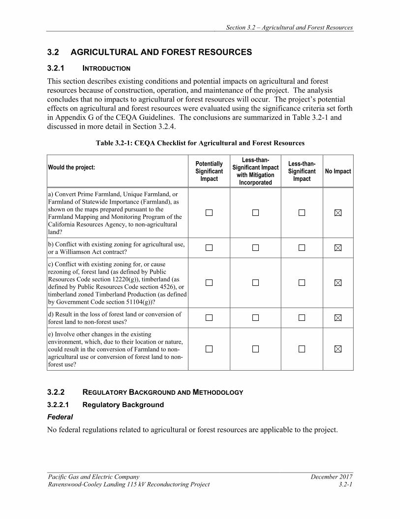
Section 3.2 – Agricultural and Forest Resources
Pacific Gas and Electric Company December 2017 Ravenswood-Cooley Landing 115 kV Reconductoring Project 3.2-1
3.2 AGRICULTURAL AND FOREST RESOURCES
3.2.1 INTRODUCTION This section describes existing conditions and potential impacts on agricultural and forest resources because of construction, operation, and maintenance of the project. The analysis concludes that no impacts to agricultural or forest resources will occur. The project’s potential effects on agricultural and forest resources were evaluated using the significance criteria set forth in Appendix G of the CEQA Guidelines. The conclusions are summarized in Table 3.2-1 and discussed in more detail in Section 3.2.4.
Table 3.2-1: CEQA Checklist for Agricultural and Forest Resources
Would the project: Potentially Significant
Impact
Less-than-Significant Impact
with Mitigation Incorporated
Less-than-Significant
Impact No Impact
a) Convert Prime Farmland, Unique Farmland, or Farmland of Statewide Importance (Farmland), as shown on the maps prepared pursuant to the Farmland Mapping and Monitoring Program of the California Resources Agency, to non-agricultural land?
b) Conflict with existing zoning for agricultural use, or a Williamson Act contract?
c) Conflict with existing zoning for, or cause rezoning of, forest land (as defined by Public Resources Code section 12220(g)), timberland (as defined by Public Resources Code section 4526), or timberland zoned Timberland Production (as defined by Government Code section 51104(g))?
d) Result in the loss of forest land or conversion of forest land to non-forest uses?
e) Involve other changes in the existing environment, which, due to their location or nature, could result in the conversion of Farmland to non-agricultural use or conversion of forest land to non-forest use?
3.2.2 REGULATORY BACKGROUND AND METHODOLOGY 3.2.2.1 Regulatory Background Federal
No federal regulations related to agricultural or forest resources are applicable to the project.
Section 3.2 – Agricultural and Forest Resources
December 2017 Pacific Gas and Electric Company 3.2-2 Ravenswood-Cooley Landing 115kV Reconductoring Project
State Williamson Act The California Land Conservation Act, better known as the Williamson Act (California Government Code Section 51200 et seq.), is designed to preserve agricultural and open space land. It establishes a program of private landowner contracts that voluntarily restrict land to agricultural and open space uses. In return, Williamson Act parcels receive a lower property tax rate consistent with their actual use instead of their market rate value. Lands under contract may also support uses that are “compatible with the agricultural, recreational, or open-space use of [the] land” subject to the contract (California Government Code Section 51201[e]). Under Government Code Section 51238, electric facilities are determined to be a compatible use. There are no Williamson Act parcels within the project area.
Farmland Mapping and Monitoring Program The California Department of Conservation (DOC), under the Division of Land Resource Protection, has established the Farmland Mapping and Monitoring Program (FMMP) to monitor the conversion of the state’s farmland to and from agricultural use. The FMMP identifies and maps agriculturally viable lands, and designates specific categories, including Prime, Unique, non-Prime, or Farmland of Statewide Importance. No farmland that has been designated as Prime, Unique, or Farmland of Statewide Importance is crossed by or adjacent to the project right of way. Additionally, no agriculturally zoned lands or other agricultural resources are present within the project area.
Local
Because the CPUC has exclusive jurisdiction over project siting, design, and construction, the project is not subject to local discretionary regulations. This section includes a summary of local zoning in the project area for agricultural use or forest land, and is provided for informational purposes and to assist with the CEQA review process.
The project area is not within any area exclusively zoned for agricultural uses. Land use and zoning is addressed in greater detail in Section 3.10, Land Use and Planning.
3.2.2.2 Methodology
To evaluate potential effects on agricultural and forest resources the following sources were consulted: DOC FMMP data and maps; Williamson Act contract maps; aerial photographs; County of San Mateo 2015 Agricultural Crop Report; and local land use planning documents. There are no agricultural or forest resources in the vicinity of the project.
3.2.3 ENVIRONMENTAL SETTING Per the Department of Conservation Farmland Mapping and Monitoring Program data for San Mateo County, the project occurs within land categorized as “Other Land” and “Urban and Built-Up Land.” The “Other Land” categorization includes lands that are not classified as farmland, grazing, urban or water body. The “Urban and Built-Up Land” categorization is a parcel with a building density of at least 1 unit to 1.5 acres or 6 structures to a 10-acre parcel (California DOC 2014). The project area does not include any designated or important farmland including Williamson Act contracted lands.
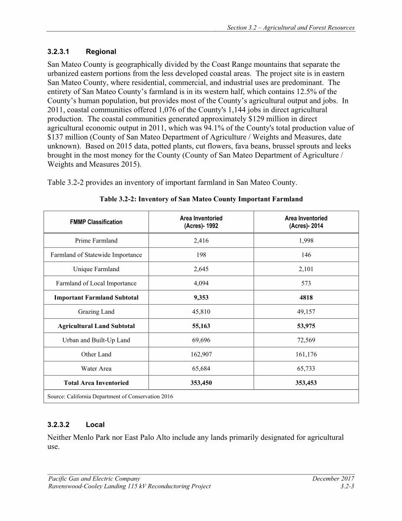
Section 3.2 – Agricultural and Forest Resources
Pacific Gas and Electric Company December 2017 Ravenswood-Cooley Landing 115 kV Reconductoring Project 3.2-3
3.2.3.1 Regional
San Mateo County is geographically divided by the Coast Range mountains that separate the urbanized eastern portions from the less developed coastal areas. The project site is in eastern San Mateo County, where residential, commercial, and industrial uses are predominant. The entirety of San Mateo County’s farmland is in its western half, which contains 12.5% of the County’s human population, but provides most of the County’s agricultural output and jobs. In 2011, coastal communities offered 1,076 of the County's 1,144 jobs in direct agricultural production. The coastal communities generated approximately $129 million in direct agricultural economic output in 2011, which was 94.1% of the County's total production value of $137 million (County of San Mateo Department of Agriculture / Weights and Measures, date unknown). Based on 2015 data, potted plants, cut flowers, fava beans, brussel sprouts and leeks brought in the most money for the County (County of San Mateo Department of Agriculture / Weights and Measures 2015). Table 3.2-2 provides an inventory of important farmland in San Mateo County.
Table 3.2-2: Inventory of San Mateo County Important Farmland
FMMP Classification Area Inventoried (Acres)- 1992
Area Inventoried (Acres)- 2014
Prime Farmland 2,416 1,998
Farmland of Statewide Importance 198 146
Unique Farmland 2,645 2,101
Farmland of Local Importance 4,094 573
Important Farmland Subtotal 9,353 4818
Grazing Land 45,810 49,157
Agricultural Land Subtotal 55,163 53,975
Urban and Built-Up Land 69,696 72,569
Other Land 162,907 161,176
Water Area 65,684 65,733
Total Area Inventoried 353,450 353,453
Source: California Department of Conservation 2016
3.2.3.2 Local
Neither Menlo Park nor East Palo Alto include any lands primarily designated for agricultural use.
Section 3.2 – Agricultural and Forest Resources
December 2017 Pacific Gas and Electric Company 3.2-4 Ravenswood-Cooley Landing 115kV Reconductoring Project
While the City of Menlo Park has a rich agricultural history, it has transitioned from large agricultural farms and residential estates to residential neighborhoods and dense urban development (Connect Menlo 2015).
The City of East Palo Alto supported agricultural land uses dating back to 1849. From 1916 to the early 1920s, poultry farms developed throughout the City, though due to rising property values and contaminated well water sources, many poultry farmers sold their properties. In the 1930’s floriculture dominated East Palo Alto until about the 1950’s (City of East Palo Alto General Plan 1999). Today, agriculture occupies none of the City’s land use. The Weeks Neighborhood began as a part of the original Runnemede agricultural community in the early 1900s. This agricultural heritage is evident through the remaining greenhouses and historic farmstead homes that remain in the neighborhood. The City Plan proposes to allow for continued agricultural uses in the Weeks neighborhood, including nurseries and greenhouses (Urban Ecology 1997).
3.2.4 APPLICANT-PROPOSED MEASURES AND POTENTIAL IMPACTS The following sections describe significance criteria for agricultural and forest resources impacts derived from Appendix G of the CEQA Guidelines and assess potential project-related construction and operational impacts. Because the project will have no impact on agricultural and forest resources, APMs have not been included for this section.
3.2.4.1 Significance Criteria
According to Section 15002(g) of the CEQA Guidelines, “a significant effect on the environment is defined as a substantial adverse change in the physical conditions which exist in the area affected by the proposed project.” As stated in Section 15064(b) of the CEQA Guidelines, the significance of an activity may vary with the setting. Per Appendix G of the CEQA Guidelines, the potential significance of project-related impacts on agricultural and forest resources were evaluated for each of the criteria listed in Table 3.2-1, as discussed in Section 3.2.4.3.
3.2.4.2 Applicant-Proposed Measures
The project will have no impact on agricultural and forest resources, and no APMs are proposed.
3.2.4.3 Potential Impacts
Project impacts on agriculture and forest resources were evaluated against the CEQA significance criteria, as discussed below. This section evaluates potential project impacts from both the construction phase and operation and maintenance phase.
The project includes reconductoring the existing 115 kV power line between Ravenswood Substation and Cooley Landing Substation. Construction activities include installing new conductor, performing minor tower modifications, and establishing required access and work areas, as described in Chapter 2, Project Description. Operation and maintenance activities for the reconductored power line will not change from current practices.
a) Would the project convert Prime Farmland, Unique Farmland, or Farmland of Statewide Importance, as shown on the maps prepared pursuant to the FMMP, to non-agricultural use? No Impact
Section 3.2 – Agricultural and Forest Resources
Pacific Gas and Electric Company December 2017 Ravenswood-Cooley Landing 115 kV Reconductoring Project 3.2-5
The project does not cross any mapped farmlands, and will not require any conversion of agricultural lands to non-agricultural uses. No construction or operation and maintenance impacts related to conversion of agricultural lands will occur. b) Would the project conflict with existing zoning for agricultural use, or a Williamson Act contract? No Impact No locally zoned agricultural lands or Williamson Act contract parcels are crossed by the project; therefore, the project will not conflict with existing agricultural parcels or Williamson Act-contracted parcels. No construction or operation and maintenance impacts to lands under Williamson Act contracts will occur.
c) Would the project conflict with existing zoning for, or cause rezoning of, forest land (as defined in Public Resources Code section 12220(g)), timberland (as defined by Public Resources Code section 4526), or timberland zoned Timberland Production (as defined by Government Code section 51104(g))? No Impact
No areas of protected timberland and no commercial timberland are located within the project area. Therefore, the project will not conflict with existing zoning of forest lands or cause rezoning the rezoning of forest land or timberland. No construction or operation and maintenance impacts will occur.
d) Would the project result in the loss of forest land or conversion of forest land to non-forest use? No Impact
The project area contains no forest land and no project-related disturbance of forest resources will occur. No construction or operation and maintenance impacts to forest land will occur.
e) Would the project involve other changes in the existing environment, which, due to their location or nature, could result in conversion of Farmland to non-agricultural use or conversion of forest land to non-forest use? No Impact
The project will upgrade an existing power line that is located within existing utility corridors. Implementation of the project will not result in any indirect conversion of farmland or forest land to non-agricultural or non-forest uses. No construction or operation and maintenance impacts will occur.
3.2.5 REFERENCES California Department of Conservation Farmland Mapping and Monitoring Program. 2014. San
Mateo County Important Farmland 2014. Online: ftp://ftp.consrv.ca.gov/pub/dlrp/FMMP/pdf/2014/smt14. pdf. Accessed on May 17, 2017.
California Department of Conservation Farmland Mapping and Monitoring Program – San Mateo County Important Farmland Data. 2016. Land Use Conversion Tables, 1992 - 2014. Online: http://www.conservation.ca.gov/dlrp/fmmp/Pages/SanMateo.aspx. Accessed on May 17, 2017.
County of San Mateo Department of Agriculture / Weights and Measures. 2015. Agricultural Crop Report. Online:
Section 3.2 – Agricultural and Forest Resources
December 2017 Pacific Gas and Electric Company 3.2-6 Ravenswood-Cooley Landing 115kV Reconductoring Project
http://agwm.smcgov.org/sites/agwm.smcgov.org/files/documents/files/Crop%20Report%202015%20-%20Final%20-%20PDF%20and%20Web%20x%20Optimized_0.pdf. Accessed on May 17, 2017.
County of San Mateo Department of Agriculture / Weights and Measures. Date Unknown. Economic Contributions of San Mateo County Agriculture. Online: http://agwm.smcgov.org/sites/agwm.smcgov.org/files/documents/files/Ag%20Econ%20Publisher%20-%20For%20Web.pdf. Accessed on May 17, 2017.
City of East Palo Alto Community and Economic Development Department. 2017. Vista 2035 East Palo Alto General Plan. Adopted October 4, 2016.
City of East Palo Alto Community and Economic Development Department. 1999. City of East Palo Alto General Plan. Adopted December 20, 1999.
Connect Menlo. 2015. Land Use: Existing Conditions Report. Online: http://menlopark.org/documentcenter/view/6295. Accessed on May 17, 2017.
Urban Ecology, Inc. 1997. Weeks Neighborhood Plan. Online: http://www.urbanecology.org/downloads/WeeksNeighborhoodPlan.pdf. Accessed on May 17, 2017.
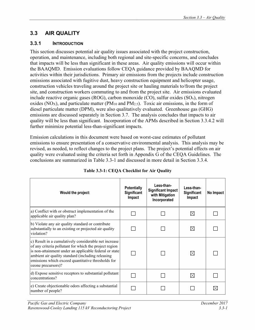
Section 3.3 – Air Quality
Pacific Gas and Electric Company December 2017 Ravenswood-Cooley Landing 115 kV Reconductoring Project 3.3-1
3.3 AIR QUALITY
3.3.1 INTRODUCTION This section discusses potential air quality issues associated with the project construction, operation, and maintenance, including both regional and site-specific concerns, and concludes that impacts will be less than significant in these areas. Air quality emissions will occur within the BAAQMD. Emission evaluations follow CEQA guidance provided by BAAQMD for activities within their jurisdictions. Primary air emissions from the projects include construction emissions associated with fugitive dust, heavy construction equipment and helicopter usage, construction vehicles traveling around the project site or hauling materials to/from the project site, and construction workers commuting to and from the project site. Air emissions evaluated include reactive organic gases (ROG), carbon monoxide (CO), sulfur oxides (SOx), nitrogen oxides (NOX), and particulate matter (PM10 and PM2.5). Toxic air emissions, in the form of diesel particulate matter (DPM), were also qualitatively evaluated. Greenhouse gas (GHG) emissions are discussed separately in Section 3.7. The analysis concludes that impacts to air quality will be less than significant. Incorporation of the APMs described in Section 3.3.4.2 will further minimize potential less-than-significant impacts.
Emission calculations in this document were based on worst-case estimates of pollutant emissions to ensure presentation of a conservative environmental analysis. This analysis may be revised, as needed, to reflect changes to the project plans. The project’s potential effects on air quality were evaluated using the criteria set forth in Appendix G of the CEQA Guidelines. The conclusions are summarized in Table 3.3-1 and discussed in more detail in Section 3.3.4.
Table 3.3-1: CEQA Checklist for Air Quality
Would the project: Potentially Significant
Impact
Less-than-Significant Impact
with Mitigation Incorporated
Less-than-Significant
Impact No Impact
a) Conflict with or obstruct implementation of the applicable air quality plan?
b) Violate any air quality standard or contribute substantially to an existing or projected air quality violation?
c) Result in a cumulatively considerable net increase of any criteria pollutant for which the project region is non-attainment under an applicable federal or state ambient air quality standard (including releasing emissions which exceed quantitative thresholds for ozone precursors)?
d) Expose sensitive receptors to substantial pollutant concentrations?
e) Create objectionable odors affecting a substantial number of people?
Section 3.3 – Air Quality
December 2017 Pacific Gas and Electric Company 3.3-2 Ravenswood-Cooley Landing 115 kV Reconductoring Project
3.3.2 REGULATORY BACKGROUND AND METHODOLOGY 3.3.2.1 Regulatory Background Federal
The federal Clean Air Act (CAA) establishes the statutory framework for regulation of air quality in the United States. Pursuant to this act, the U.S. Environmental Protection Agency (USEPA) has established various regulations to achieve and maintain acceptable air quality, including the adoption of National Ambient Air Quality Standards (NAAQS), mandatory state implementation plan (SIP) or maintenance plan requirements to achieve and maintain NAAQS, and emission standards for both stationary and mobile sources of air pollution. National ambient air quality standards were established in 1970 for six pollutants: CO, ozone (O3), PM10 and PM2.5, nitrogen dioxide (NO2), sulfur dioxide (SO2), and lead. These pollutants are commonly referred to as criteria pollutants, because they are considered the most prevalent air pollutants known to be hazardous to human health. The USEPA designates a region that is meeting the air quality standard for a given pollutant as being in “attainment” for that pollutant; regions not meeting the federal standard are designated as being in “nonattainment” for that pollutant. If a region is designated as nonattainment for a NAAQS, the federal CAA requires the state to develop a SIP to demonstrate how the standard will be attained, including the establishment of specific requirements for review and approval of new or modified stationary sources of air pollution. The CAA Amendments of 1990 directed the USEPA to set standards for toxic air contaminants and required facilities to sharply reduce emissions. Table 3.3-2 summarizes state and federal ambient air quality standards.
State
The California Air Resources Board (CARB) is the state agency responsible for California air quality management, including establishment of California Ambient Air Quality Standards (CAAQS), mobile source emission standards, and GHG regulations, as well as oversight of regional air quality districts and preparation of implementation plans, including regulations for stationary sources of air pollution. The CAAQS are generally more stringent, except for the 1-hour NO2 and SO2 standards, and include more pollutants than the NAAQS (see Table 3.3-2). California specifies four additional criteria pollutants: visibility reducing particles (VRP), sulfates, hydrogen sulfide (H2S), and vinyl chloride. Similar to USEPA, CARB designates counties in California as being in attainment or nonattainment for the CAAQS.
The Air Toxic “Hot Spots” Information and Assessment Act, also known as Assembly Bill 2588 (AB 2588) identifies toxic air contaminant hot spots where emissions from specific stationary sources may expose individuals to an elevated risk of adverse health effects, particularly cancer or reproductive harm. Many toxic air contaminants are also classified as hazardous air pollutants. AB 2588 requires that a business or other establishment identified as a significant stationary source of toxic emissions provide the affected population with information about health risks posed by the emissions. Although DPM is considered a toxic air contaminant under AB 2588, this project is not subject to AB 2588 because the DPM-emitting sources will only be temporarily employed during construction. Operation of the project does not require the
Section 3.3 – Air Quality
Pacific Gas and Electric Company December 2017 Ravenswood-Cooley Landing 115 kV Reconductoring Project 3.3-3
installation of new stationary sources of DPM or emissions of other toxic air contaminants. Therefore, the project is not considered a stationary source of toxic emissions.
Airborne Toxic Control Measure for Diesel Particulate Matter from Portable Engines Rated at 50 Horsepower and Greater In an effort to reduce DPM emissions throughout the state, CARB has established the Airborne Toxic Control Measure (ATCM) for DPM from Portable Engines Rated at 50 Horsepower (hp) and Greater (Title 13, California Code of Regulations {CCR}, Section 93116 [13 CCR 93116]). This ATCM requires portable diesel-fueled engines having a maximum rating of 50 hp and greater to meet fleet-average DPM emissions standards.
Regulation for In-Use Off-Road Diesel-Fueled Fleets CARB has established the Regulation for In-Use Off-Road Diesel-Fueled Fleets to reduce NOx, DPM, and other criteria pollutant emissions from in-use off-road diesel-fueled vehicles (13 CCR 2449). This regulation applies to all self-propelled off-road diesel vehicles rated 25 hp or greater, including vehicles that are rented or leased, and requires restricted vehicle idling time, reporting of vehicle use, and compliance with fleet-average emission standards. Although this regulation does apply to rented or leased vehicles, the compliance responsibility predominantly lies with the rental or leasing company if the vehicles are rented or leased for a period of less than one year.
Airborne Toxic Control Measure to Limit Diesel-Fueled Commercial Motor Vehicle Idling CARB has established the ATCM to Limit Diesel-Fueled Commercial Motor Vehicle Idling to reduce public exposure to DPM and other air contaminants by establishing idling restrictions, emission standards, and other requirements for heavy-duty diesel engines and alternative idle reduction technologies to limit the idling of diesel-fueled commercial motor vehicles (13 CCR 2485).
Asbestos Airborne Toxic Control Measure for Construction, Grading, Quarrying, and Surface Mining Operations CARB has established the Asbestos ATCM for Construction, Grading, Quarrying, and Surface Mining Operations to minimize the generation of asbestos from earth disturbance or construction activities. The Asbestos ATCM applies to any project that will include sites to be disturbed in a geographic ultramafic rock unit area or an area where naturally occurring asbestos (NOA), serpentine, or ultramafic rocks are determined to be present.
In addition, if NOA, serpentine, or ultramafic rock is discovered during earth disturbance activities, the project also will be subject to the Asbestos ATCM. The Asbestos ATCM establishes notification, management practice, mitigation plan, transport and disposal, and administrative (e.g., recordkeeping and reporting) requirements for projects in order to reduce the generation of asbestos from all aspects of construction, grading, quarrying, and mining operations.
Based upon review of the U.S. Geological Survey map detailing natural occurrence of asbestos in California, naturally occurring asbestos is not expected to be present at the project site (California DOC 2011).
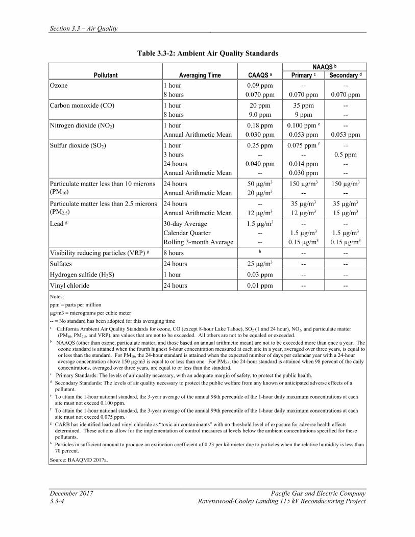
Section 3.3 – Air Quality
December 2017 Pacific Gas and Electric Company 3.3-4 Ravenswood-Cooley Landing 115 kV Reconductoring Project
Table 3.3-2: Ambient Air Quality Standards
Pollutant Averaging Time CAAQS a NAAQS b
Primary c Secondary d Ozone 1 hour
8 hours 0.09 ppm 0.070 ppm
-- 0.070 ppm
-- 0.070 ppm
Carbon monoxide (CO) 1 hour 8 hours
20 ppm 9.0 ppm
35 ppm 9 ppm
-- --
Nitrogen dioxide (NO2) 1 hour Annual Arithmetic Mean
0.18 ppm 0.030 ppm
0.100 ppm e 0.053 ppm
-- 0.053 ppm
Sulfur dioxide (SO2) 1 hour 3 hours 24 hours Annual Arithmetic Mean
0.25 ppm --
0.040 ppm --
0.075 ppm f --
0.014 ppm 0.030 ppm
-- 0.5 ppm
-- --
Particulate matter less than 10 microns (PM10)
24 hours Annual Arithmetic Mean
50 µg/m3 20 µg/m3
150 µg/m3 --
150 µg/m3 --
Particulate matter less than 2.5 microns (PM2.5)
24 hours Annual Arithmetic Mean
-- 12 µg/m3
35 µg/m3 12 µg/m3
35 µg/m3 15 µg/m3
Lead g 30-day Average Calendar Quarter Rolling 3-month Average
1.5 µg/m3 -- --
-- 1.5 µg/m3
0.15 µg/m3
-- 1.5 µg/m3
0.15 µg/m3 Visibility reducing particles (VRP) g 8 hours h -- -- Sulfates 24 hours 25 µg/m3 -- -- Hydrogen sulfide (H2S) 1 hour 0.03 ppm -- -- Vinyl chloride 24 hours 0.01 ppm -- -- Notes: ppm = parts per million µg/m3 = micrograms per cubic meter -- = No standard has been adopted for this averaging time a California Ambient Air Quality Standards for ozone, CO (except 8-hour Lake Tahoe), SO2 (1 and 24 hour), NO2, and particulate matter
(PM10, PM2.5, and VRP), are values that are not to be exceeded. All others are not to be equaled or exceeded. b NAAQS (other than ozone, particulate matter, and those based on annual arithmetic mean) are not to be exceeded more than once a year. The
ozone standard is attained when the fourth highest 8-hour concentration measured at each site in a year, averaged over three years, is equal to or less than the standard. For PM10, the 24-hour standard is attained when the expected number of days per calendar year with a 24-hour average concentration above 150 µg/m3 is equal to or less than one. For PM2.5, the 24-hour standard is attained when 98 percent of the daily concentrations, averaged over three years, are equal to or less than the standard.
c Primary Standards: The levels of air quality necessary, with an adequate margin of safety, to protect the public health. d Secondary Standards: The levels of air quality necessary to protect the public welfare from any known or anticipated adverse effects of a
pollutant. e To attain the 1-hour national standard, the 3-year average of the annual 98th percentile of the 1-hour daily maximum concentrations at each
site must not exceed 0.100 ppm. f To attain the 1-hour national standard, the 3-year average of the annual 99th percentile of the 1-hour daily maximum concentrations at each
site must not exceed 0.075 ppm. g CARB has identified lead and vinyl chloride as “toxic air contaminants” with no threshold level of exposure for adverse health effects
determined. These actions allow for the implementation of control measures at levels below the ambient concentrations specified for these pollutants.
h Particles in sufficient amount to produce an extinction coefficient of 0.23 per kilometer due to particles when the relative humidity is less than 70 percent.
Source: BAAQMD 2017a.
Section 3.3 – Air Quality
Pacific Gas and Electric Company December 2017 Ravenswood-Cooley Landing 115 kV Reconductoring Project 3.3-5
Regional
The project is located within the jurisdiction of the BAAQMD. The BAAQMD is the regional agency charged with preparing, adopting, and implementing emission control measures and standards for stationary sources of air pollution pursuant to delegated state and federal authority. Because the project will not involve construction of new stationary sources, there are no permitting regulations applicable to the project. If the project involves demolition or renovation of a structure(s), as defined in BAAQMD Regulation 11, Rule Asbestos Demolition Renovation, and Manufacturing, notification to the BAAQMD pursuant to Regulation 11, Rule 2 is required. Other requirements include surveying the affected structure and removal of asbestos materials using engineering controls. A certified solid waste facility must perform disposal of asbestos and asbestos-containing material.
Under the California CAA the BAAQMD is required to develop an air quality plan to achieve and/or maintain compliance with federal and state nonattainment criteria pollutants within the air district. The BAAQMD has taken action and developed plans to achieve and/or maintain compliance with the federal 1-hour ozone standard and the federal CO standard. Additionally, recent monitoring data indicate that PM2.5 levels have decreased in the Bay Area since 2008. As a result, CARB submitted a “clean data finding” request to USEPA on behalf of the BAAQMD on December 8, 2011. If approved, the BAAQMD can meet the federal PM2.5 standard by preparing a redesignation request and a PM2.5 maintenance plan or a “clean data” SIP submittal (BAAQMD 2012b). The USEPA issued a Clean Data Finding for the Bay Area on January 9, 2013. The BAAQMD can now meet the federal PM2.5 standard by preparing a re-designation request and a PM2.5 maintenance plan or a “clean data” SIP submittal (BAAQMD 2017b).
On June 2, 2010, the BAAQMD’s Board of Directors unanimously adopted thresholds of significance to assist in the review of projects under CEQA. These Thresholds are designed to establish the level at which the District believed air pollution emissions would cause significant environmental impacts under CEQA and were posted on the BAAQMD’s website and included in the BAAQMD's updated CEQA Guidelines (updated May 2012). The Thresholds are advisory and may be followed by local agencies at their own discretion.
The Thresholds were challenged in court. Following litigation in the trial court, the court of appeal, and the California Supreme Court, all the Thresholds were upheld. However, in an opinion issued on December 17, 2015, the California Supreme Court held that CEQA does not generally require an analysis of the impacts of locating development in areas subject to environmental hazards unless the project would exacerbate existing environmental hazards. The Supreme Court also found that CEQA requires the analysis of exposing people to environmental hazards in specific circumstances, including the location of development near airports, schools near sources of toxic contamination, and certain exemptions for infill and workforce housing. The Supreme Court also held that public agencies remain free to conduct this analysis regardless of whether it is required by CEQA (BAAQMD 2017c).
In view of the Supreme Court’s opinion, local agencies may rely on Thresholds designed to reflect the impact of locating development near areas of toxic air contamination where such an analysis is required by CEQA or where the agency has determined that such an analysis would assist in making a decision about the project. However, the Thresholds are not mandatory and
Section 3.3 – Air Quality
December 2017 Pacific Gas and Electric Company 3.3-6 Ravenswood-Cooley Landing 115 kV Reconductoring Project
agencies should apply them only after determining that they reflect an appropriate measure of a project’s impacts.
BAAQMD published a new version of its CEQA Guidelines dated May 2017, which includes revisions made to address the Supreme Court’s opinion (BAAQMD 2017c).
Lastly, the BAAQMD adopted the Bay Area 2017 Clean Air Plan (CAP) on April 19, 2017. The 2017 Plan provides a regional strategy to protect public health and protect the climate. To protect public health, the plan describes how the air district will continue its progress toward attaining all state and federal air quality standards and eliminating health risk disparities from exposure to air pollution among Bay Area communities. To protect the climate, the plan defines a vision for transitioning the region to a post-carbon economy needed to achieve ambitious greenhouse gas reduction targets for 2030 and 2050, and provides a regional climate protection strategy that will put the Bay Area on a pathway to achieve those GHG reduction targets.
Because the project will not involve construction and operation of new stationary combustion sources, such as emergency generators, there are no federal, state, or regional permitting regulations relevant to the project.
Local
No local (city and county) air quality regulations are applicable to this project.
3.3.2.2 Methodology
Information on air quality impacts was collected from the BAAQMD’s current CEQA Air Quality Guidelines. Short-term construction emissions of CO, SO2, PM10, and PM2.5 were evaluated. Because O3 is formed through chemical reactions in the atmosphere, the O3 precursors NOx and ROG were also evaluated. Construction emissions (excluding those from helicopters), emissions from soil disturbance, and emissions from vehicle travel on paved and unpaved roads were estimated using California Emissions Estimator Model Version 2016.3.1 (CalEEMod). Helicopter emissions were estimated manually using emissions factors obtained from the 2011 Gulfwide Emission Inventory Study prepared for the U.S. Department of the Interior Bureau of Ocean Energy Management and manufacturer data on fuel usage. Detailed construction emission calculations will be provided separately to CPUC staff.
3.3.3 ENVIRONMENTAL SETTING 3.3.3.1 Regional Setting
Information in this section was derived from the May 2017 BAAQMD CEQA Guidelines, “Sample Air Quality Setting” and the Western Regional Climate Center. The project site is located between PG&E’s Ravenswood Substation and Cooley Landing Substation in the cities of Menlo Park and East Palo Alto on the southeastern portion of the San Francisco Peninsula in San Mateo County within the Bay Area Basin. The Bay Area Basin derives its name from the surrounding mountains that confine the movement of air and the pollutants it contains. This area includes all of Alameda, Contra Costa, Marin, Napa, San Francisco, San Mateo, Santa Clara, the western half of Solano, and the southern half of Sonoma counties. The regional climate within the Bay Area Basin is considered semi-arid and is characterized by warm summers, mild winters,
Section 3.3 – Air Quality
Pacific Gas and Electric Company December 2017 Ravenswood-Cooley Landing 115 kV Reconductoring Project 3.3-7
infrequent seasonal rainfall, moderate daytime on-shore breezes, and moderate humidity. In the immediate area, average summer temperatures peak in the in the high 70s Fahrenheit (F) and drop to the low mid-50s F, while average winter temperatures peak in the high 50s F and drop to the upper 30s F. Approximately 80 percent of annual rainfall in the area occurs during the period of November through March.
The peninsula region extends from northwest of San Jose to the Golden Gate Bridge. The Santa Cruz Mountains run up the center of the peninsula, with elevations exceeding 2000 feet at the southern end, decreasing to 500 feet in South San Francisco. Cities in the southeastern peninsula experience warmer temperatures and fewer foggy days because the marine layer is blocked by the ridgeline to the west.
The blocking effect of the Santa Cruz Mountains results in variations in summertime maximum temperatures in different parts of the peninsula. For example, in coastal areas and San Francisco the mean maximum summer temperatures are in the mid-60's, while in Redwood City the mean maximum summer temperatures are in the low-80's. Mean minimum temperatures during the winter months are in the high-30’s to low-40’s on the eastern side of the Peninsula and in the low 40’s on the coast.
Two important gaps in the Santa Cruz Mountains occur on the peninsula. The larger of the two is the San Bruno Gap, extending from Fort Funston on the ocean to the San Francisco Airport. Because the gap is oriented in the same northwest to southeast direction as the prevailing winds, and because the elevations along the gap are less than 200 feet, marine air is easily able to penetrate into the bay. The other gap is the Crystal Springs Gap, between Half Moon Bay and San Carlos. As the sea breeze strengthens on summer afternoons, the gap permits maritime air to pass across the mountains, and its cooling effect is commonly seen from San Mateo to Redwood City.
Annual average wind speeds range from 5 to 10 mph throughout the peninsula, with higher wind speeds usually found along the coast. Winds on the eastern side of the peninsula are often high in certain areas, such as near the San Bruno Gap and the Crystal Springs Gap.
The prevailing winds along the peninsula's coast are from the west, although individual sites can show significant differences. On the east side of the mountains winds are generally from the west, although wind patterns in this area are often influenced greatly by local topographic features.
Air pollution potential is highest along the southeastern portion of the peninsula. This is the area most protected from the high winds and fog of the marine layer. Pollutant transport from upwind sites is common. In the southeastern portion of the peninsula, air pollutant emissions are relatively high due to motor vehicle traffic as well as stationary sources. At the northern end of the peninsula in San Francisco, pollutant emissions are high, especially from motor vehicle congestion. Localized pollutants, such as carbon monoxide, can build up in “urban canyons.” Winds are generally fast enough to carry the pollutants away before they can accumulate.
Section 3.3 – Air Quality
December 2017 Pacific Gas and Electric Company 3.3-8 Ravenswood-Cooley Landing 115 kV Reconductoring Project
3.3.3.2 Ambient Air Quality
Existing air quality conditions in the project area can be characterized in terms of the NAAQS and CAAQS established by the federal and state governments for various pollutants (Table 3.3-2), and by monitoring data collected in the region, which is provided in Table 3.3-3. Monitoring data concentrations typically are expressed in terms of parts per million (ppm) or micrograms per cubic meter (µg/m3).
The air quality monitoring station nearest to the project area is the Redwood City station located at 897 Barron Avenue, which is approximately 4 miles west of the existing Ravenswood Substation. The next closest station that monitors for PM is the San Jose station located at 158 East Jackson Street, which is approximately 17 miles southeast of the existing Ravenswood Substation. Available air quality monitoring data obtained from the CARB are summarized in Table 3.3-3 for the Redwood City and San Jose monitoring stations. These data represent air quality monitoring data from 2014 to 2016. As indicated in Table 3.3-3, the monitoring stations have experienced violations of all federal and state standards except the PM10 NAAQS.
The primary pollutants of concern in the Bay Area Air Basin include ozone, PM10, and PM2.5,
because the air basin is designated as non-attainment for these pollutants by USEPA and/or CARB. Sources of these pollutants are provided below:
• Ozone – O3 is a secondary pollutant; thus, it is not emitted directly into the lower level of the atmosphere. The primary sources of ozone precursors (ROG and NOx) are mobile sources (on‐road and off-road vehicle exhaust).
• NOx - NOx is produced in motor vehicle internal combustion engines and fossil fuel‐fired electric utility and industrial boilers. NO2 forms quickly from NOx emissions. NO2 concentrations near major roads can be 30 to 100 percent higher than those at monitoring stations.
• ROG - Indoor sources of ROG include paints, solvents, aerosol sprays, cleansers, tobacco smoke, etc. Outdoor sources of ROG are from combustion and fuel evaporation. A reduction in ROG emissions reduces certain chemical reactions that contribute to the formulation of ozone. ROG are transformed into organic aerosols in the atmosphere, which contribute to higher PM10 and lower visibility.
• PM10 and PM2.5 - Stationary sources include fuel or wood combustion for electrical utilities, residential space heating, and industrial processes; construction and demolition; metals, minerals, and petrochemicals; wood products processing; mills and elevators used in agriculture; erosion from tilled lands; waste disposal, and recycling. Mobile or transportation-related sources are from vehicle exhaust and road dust. Secondary particles form from reactions in the atmosphere.
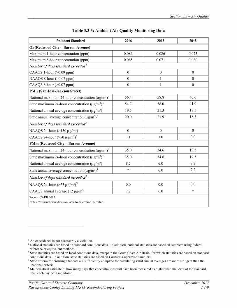
Section 3.3 – Air Quality
Pacific Gas and Electric Company December 2017 Ravenswood-Cooley Landing 115 kV Reconductoring Project 3.3-9
Table 3.3-3: Ambient Air Quality Monitoring Data
Pollutant Standard 2014 2015 2016 O3 (Redwood City – Barron Avenue) Maximum 1-hour concentration (ppm) 0.086 0.086 0.075 Maximum 8-hour concentration (ppm) 0.065 0.071 0.060 Number of days standard exceeded3 CAAQS 1-hour (>0.09 ppm) 0 0 0 NAAQS 8-hour (>0.07 ppm) 0 1 0 CAAQS 8-hour (>0.07 ppm) 0 1 0 PM10 (San Jose-Jackson Street)
National maximum 24-hour concentration (µg/m3)4 56.4 58.8 40.0
State maximum 24-hour concentration (µg/m3)5 54.7 58.0 41.0
National annual average concentration (µg/m3) 19.5 21.3 17.5
State annual average concentration (µg/m3)6 20.0 21.9 18.3
Number of days standard exceeded3
NAAQS 24-hour (>150 µg/m3)7 0 0 0
CAAQS 24-hour (>50 µg/m3)5 3.1 3.0 0.0
PM2.5 (Redwood City – Barron Avenue)
National maximum 24-hour concentration (µg/m3)4 35.0 34.6 19.5
State maximum 24-hour concentration (µg/m3)5 35.0 34.6 19.5
National annual average concentration (µg/m3) 8.5 6.0 7.2
State annual average concentration (µg/m3)4 * 6.0 7.2
Number of days standard exceeded3
NAAQS 24-hour (>35 µg/m3)5 0.0 0.0 0.0
CAAQS annual average (12 µg/m3) 7.2 6.0 * Source: CARB 2017 Notes: *= Insufficient data available to determine the value.
3 An exceedance is not necessarily a violation. 4 National statistics are based on standard conditions data. In addition, national statistics are based on samplers using federal
reference or equivalent methods. 5 State statistics are based on local conditions data, except in the South Coast Air Basin, for which statistics are based on standard conditions data. In addition, state statistics are based on California-approved samplers.
6 State criteria for ensuring that data are sufficiently complete for calculating valid annual averages are more stringent than the national criteria.
7 Mathematical estimate of how many days that concentrations will have been measured as higher than the level of the standard, had each day been monitored.
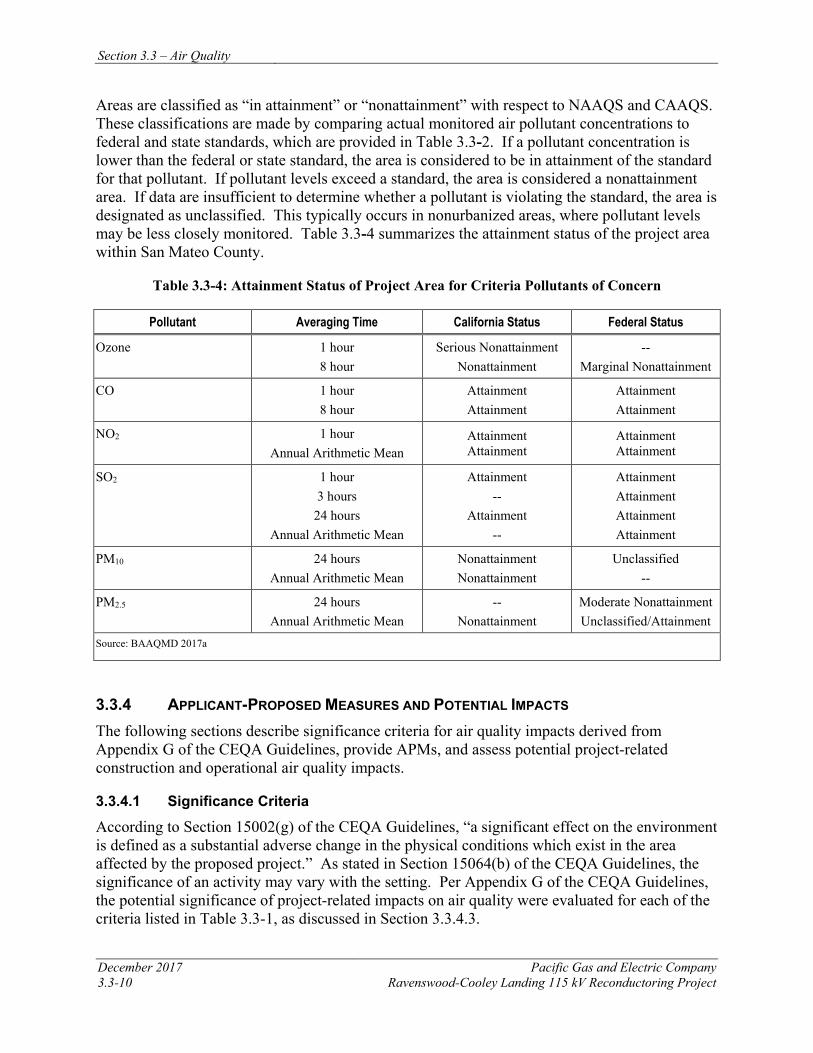
Section 3.3 – Air Quality
December 2017 Pacific Gas and Electric Company 3.3-10 Ravenswood-Cooley Landing 115 kV Reconductoring Project
Areas are classified as “in attainment” or “nonattainment” with respect to NAAQS and CAAQS. These classifications are made by comparing actual monitored air pollutant concentrations to federal and state standards, which are provided in Table 3.3-2. If a pollutant concentration is lower than the federal or state standard, the area is considered to be in attainment of the standard for that pollutant. If pollutant levels exceed a standard, the area is considered a nonattainment area. If data are insufficient to determine whether a pollutant is violating the standard, the area is designated as unclassified. This typically occurs in nonurbanized areas, where pollutant levels may be less closely monitored. Table 3.3-4 summarizes the attainment status of the project area within San Mateo County.
Table 3.3-4: Attainment Status of Project Area for Criteria Pollutants of Concern
Pollutant Averaging Time California Status Federal Status
Ozone 1 hour 8 hour
Serious Nonattainment Nonattainment
-- Marginal Nonattainment
CO 1 hour 8 hour
Attainment Attainment
Attainment Attainment
NO2 1 hour Annual Arithmetic Mean
Attainment Attainment
Attainment Attainment
SO2 1 hour 3 hours
24 hours Annual Arithmetic Mean
Attainment --
Attainment --
Attainment Attainment Attainment Attainment
PM10 24 hours Annual Arithmetic Mean
Nonattainment Nonattainment
Unclassified --
PM2.5 24 hours Annual Arithmetic Mean
-- Nonattainment
Moderate Nonattainment Unclassified/Attainment
Source: BAAQMD 2017a
3.3.4 APPLICANT-PROPOSED MEASURES AND POTENTIAL IMPACTS The following sections describe significance criteria for air quality impacts derived from Appendix G of the CEQA Guidelines, provide APMs, and assess potential project-related construction and operational air quality impacts.
3.3.4.1 Significance Criteria
According to Section 15002(g) of the CEQA Guidelines, “a significant effect on the environment is defined as a substantial adverse change in the physical conditions which exist in the area affected by the proposed project.” As stated in Section 15064(b) of the CEQA Guidelines, the significance of an activity may vary with the setting. Per Appendix G of the CEQA Guidelines, the potential significance of project-related impacts on air quality were evaluated for each of the criteria listed in Table 3.3-1, as discussed in Section 3.3.4.3.
Section 3.3 – Air Quality
Pacific Gas and Electric Company December 2017 Ravenswood-Cooley Landing 115 kV Reconductoring Project 3.3-11
BAAQMD published updated CEQA Guidelines in May 2017 which include recommended thresholds of significance that establish the level at which BAAQMD believes air pollutant emissions would cause significant environmental impacts.
3.3.4.2 Applicant-Proposed Measures
PG&E will implement the following APMs:
Construction
APM AIR-1: Minimize Fugitive Dust During Construction. Consistent with Table 8-2 of the CEQA Air Quality Guidelines (BAAQMD 2017c), PG&E will minimize dust emissions during construction by implementing the following measures:
• All exposed surfaces (e.g., parking areas, staging areas, soil piles, graded areas, and unpaved access roads) in active construction zones shall be watered two times per day during dry conditions; or apply non-toxic soil stabilizers such as soil binders, crushed rock or gravel.
• All haul trucks transporting soil, sand, or other loose material off-site shall be covered.
• All visible mud or dirt track-out onto adjacent public roads shall be removed using wet power vacuum street sweepers or equivalent method at least once per day. The use of dry power sweeping is prohibited.
• All vehicle speeds on unpaved roads shall be limited to 15 miles-per-hour.
• Post a publicly visible sign with the telephone number and person to contact at PG&E regarding dust complaints. This person shall respond and take corrective action within 48 hours. The BAAQMD’s phone number shall also be visible to ensure compliance with applicable regulations.
APM AIR-2: Exhaust Emissions. Per BAAQMD CEQA guidelines, PG&E will implement the following exhaust emissions control measures.
• Minimize unnecessary construction vehicle idling time. The ability to limit construction vehicle idling time will depend on the sequence of construction activities and when and where vehicles are needed or staged. Certain vehicles, such as large diesel-powered vehicles, have extended warm-up times following start-up that limit their availability for use following start-up. Where such diesel-powered vehicles are required for repetitive construction tasks, these vehicles may require more idling time. The project will apply a “common sense” approach to vehicle use, so that idling is reduced as far as possible below the maximum of 5 consecutive minutes allowed by California law; if a vehicle is not required for use immediately or continuously for construction activities, its engine will be shut off. Construction foremen will include briefings to crews on vehicle use as part of pre-construction conferences. Those briefings will include discussion of a “common sense” approach to vehicle use. Clear signage shall be provided for construction workers at all access points indicating idling restrictions.
Section 3.3 – Air Quality
December 2017 Pacific Gas and Electric Company 3.3-12 Ravenswood-Cooley Landing 115 kV Reconductoring Project
• All construction equipment will be regularly maintained in accordance with PG&E standards. All equipment shall be checked by a certified visible emissions evaluator.
Operation and Maintenance
The O&M activities required for the reconductored power line will not change from those currently required for the existing line; thus, no operation-related impacts will occur and no APMs are necessary.
3.3.4.3 Potential Impacts
Project impacts on air quality were evaluated against the CEQA significance criteria, as discussed below. This section evaluates potential project impacts from both the construction phase and O&M phase.
The project includes reconductoring the existing 115 kV power line between Ravenswood Substation and Cooley Landing Substation. Construction activities include installing new conductor, performing minor tower modifications, and establishing required access and work areas, as described in Chapter 2, Project Description. Operation and maintenance activities for the reconductored power line will not change from current practices.
a) Would the project conflict with or obstruct implementation of the applicable air quality plan? Less than Significant
Construction
The applicable air quality plan is the Bay Area 2017 CAP. The primary goals of this plan are to attain air quality standards, reduce population exposure and protect public health, and reduce GHG emissions and protect the climate. A project that would not result in significant and unavoidable air quality impacts may be considered consistent with the Bay Area 2017 CAP.
As discussed in Section 3.3.2.1 Regulatory Background, various regulations that limit emissions of air pollutants apply to the off-road and on-road construction equipment that would be used during construction of the project. The estimated construction emissions are below BAAQMD’s recommended construction-related emissions thresholds published in its CEQA Guidelines from May 2017. The May 2017 thresholds are included in Table 3.3-5: Construction Emissions for comparison purposes.
As previously discussed in Section 3.3.3.2, the maximum daily emissions for a range of pollutants for off- and on-road vehicle were calculated using CalEEMod, and helicopter emissions were calculated manually using emissions factors obtained from the 2011 Gulfwide Emission Inventory Study prepared for the U.S. Department of the Interior. PM and NOx are the primary air pollutants resulting from construction activities. The estimated PM emissions include two types of sources—fugitive dust and exhaust emissions. Typical fugitive dust sources include earth-moving activities (such as grading and improvement of access roads) and vehicle travel across unpaved roads. Notably, the project will not involve extensive ground disturbance, thus fugitive dust emissions associated with reconductoring, tower modifications and travel along access roads will be minimal. Exhaust emissions result from the combustion of fossil fuels in both off-road construction equipment and on-road vehicles. The maximum composite
Section 3.3 – Air Quality
Pacific Gas and Electric Company December 2017 Ravenswood-Cooley Landing 115 kV Reconductoring Project 3.3-13
emission rates generated during construction are presented in Table 3.3-5: Construction Emissions, and are below proposed construction-related emissions thresholds published in the BAAQMD CEQA Guidelines from May 2017.
Table 3.3-5: Construction Emissions
Category Construction Emissionsa
ROG CO NOx SOx PM10 b PM2.5b Total Emissions (tons/project) 0.34 1.08 0.31 0.02 0.05 0.02
Average Emissions and Comparison to Thresholdsc
Construction Year 2020 (lbs/day) 5.60 17.73 5.09 0.36 0.87 0.30
BAAQMD Threshold (lbs/day) 54 - 54 - 82 54
Threshold Exceeded? No No No No No No
Maximum Daily Emissionsd
Construction Year 2020 (lb/day) 3.93 33.20 39.96 0.08 2.06 1.71
Total Emissions by Phase (tons/phase)
Transmission Line Reconductoring
Staging Area – Receiving, Distributione 0.02 0.13 0.06 0.00 0.03 0.01
Work Area Establishment and Removal 0.01 0.05 0.05 0.00 0.02 0.00
Foundation Work 0.01 0.21 0.06 0.00 0.00 0.00
Tower Modifications 0.08 0.10 0.04 0.00 0.00 0.00
Guard Structures 0.00 0.00 0.00 0.00 0.00 0.00
Conductor Installation 0.23 0.30 0.10 0.02 0.00 0.00
Right-of-Way Cleanup 0.00 0.00 0.00 0.00 0.00 0.00 Notes:
a Construction emissions are based on preliminary equipment lists; other equipment may be identified when project design is finalized or during construction if unexpected conditions require additional equipment. b PM10/PM2.5 emissions include both engine exhaust and fugitive dust. c Annual emissions were estimated based on the sum of emissions per phase expected to occur within a given year, as defined by the preliminary project schedule. d Maximum daily emissions were estimated based on the maximum sum of the emissions per phase expected to occur within a given day, as defined by the preliminary project schedule. e On-road emissions from Environmental monitoring, Project Management, and Worker Commute are included in the Staging Area-Receiving, Distribution Phase as they occur for the duration of the project.
The results of the CalEEMod indicate that the total peak PM10 emissions will be approximately 2.06 pounds per day—composed of approximately 0.32 pounds per day from fugitive dust emissions and approximately 1.74 pounds per day from exhaust. PM2.5 emissions will be approximately 1.71 pounds per day. These emission estimates assume a worst-case scenario where all on-road traffic, and helicopter use will coincide with the peak off-road construction
Section 3.3 – Air Quality
December 2017 Pacific Gas and Electric Company 3.3-14 Ravenswood-Cooley Landing 115 kV Reconductoring Project
equipment use. These worst-case PM emission rates will be well below the BAAQMD May 2017 significance threshold of 82 pounds per day for PM10 and 54 pounds per day for PM2.5. Implementation of APM AIR-01 and APM AIR-02 which require the daily watering of unpaved access roads and temporary work areas and limiting vehicle speeds along unpaved access roads to 15 mph will further reduce PM10 emissions. As demonstrated by the emissions calculations presented in Table 3.3-5, the project emissions are well below the BAAQMD May 2017 thresholds of significance for construction emissions and will not conflict with the BAAQMD CAP, thus, PM emission impacts will be less than significant.
The maximum daily emissions of NOx and ROG are anticipated to be approximately 39.96 and 3.93 pounds per day, respectively. As described in the May 2017 BAAQMD CEQA Guidelines, construction emissions are considered to be controlled by the overall air quality attainment plan; however, given the new and more stringent state and federal air quality standards, BAQQMD determined that construction emissions warranted additional controls. The average daily criteria air pollutant and precursor emission levels shown above are recommended as the thresholds of significance for construction activity for exhaust emissions in the BAAQMD May 2017 CEQA Guidelines. These thresholds represent the levels above which a project’s individual emissions would result in a considerable contribution (i.e., significant) to the San Francisco Bay Area Air Basin existing non-attainment air quality conditions, and thus establish a nexus to regional air quality impacts that satisfies CEQA requirements for evidence-based determinations of significant impacts. Emissions below the construction-related criteria air pollutant and precursor emission thresholds are considered less than significant. The project’s emissions of NOx and ROG are below the BAAQMD May 2017 thresholds of significance. As a result, project construction emissions will not conflict with any applicable air quality plans, and impacts will be less than significant.
Operation and Maintenance
Operation and maintenance activities for the reconductored power line will not change from current practices. No impact will occur.
b) Would the project violate any air quality standard or contribute substantially to an existing or projected air quality violation? Less than Significant
The project area is currently designated as a nonattainment area for O3, PM2.5 and PM10. However, the project will not contribute substantially to any existing or project-related air quality violations for O3, PM2.5 and PM10. The project will also be in compliance with the significance limit of 82 pounds per day of PM10 and 54 pounds per day of PM2.5 set by the BAAQMD for construction projects. Due to the short-term nature of these emissions and their compliance with all applicable significance thresholds, impacts from O3, PM2.5 and PM10 will be less than significant. The estimated maximum and average daily project emissions are provided in Table 3.3-5. Due to the short-term nature of these emissions and their compliance with available BAAQMD significance thresholds, the project will not violate any air quality standard or contribute substantially to an existing or projected air quality violation. Therefore, impacts from construction or operation and maintenance of the project will be less than significant.

Section 3.3 – Air Quality
Pacific Gas and Electric Company December 2017 Ravenswood-Cooley Landing 115 kV Reconductoring Project 3.3-15
c) Would the project result in a cumulatively considerable net increase of any criteria pollutant for which the project region is non-attainment under an applicable federal or state ambient air quality standard (including releasing emissions which exceed quantitative thresholds for ozone precursors)? Less than Significant
As shown in Table 3.3-5, construction of the project will lead to a temporary increase in criteria air pollutants. To reduce fugitive dust emissions, PG&E will implement APM AIR-1, which include applying water to exposed areas and reducing vehicle speeds on unpaved areas. To reduce emissions from vehicle and construction equipment exhaust, PG&E will implement APM AIR-2, which includes limiting idling time from large diesel-fueled vehicles and properly maintaining all construction equipment. With implementation of these APMs, all criteria air pollutant emissions will be below the applicable BAAQMD thresholds and impacts will be less than significant.
d) Would the project expose sensitive receptors to substantial pollutant concentrations? Less than Significant
There are no residences located closer than 500 feet from the project alignment. The nearest school to the project is the East Palo Alto Charter School, which is located approximately 0.3 mile south of Staging Area 4. The nearest hospital is the Menlo Park Veterans Administration Hospital, which is located 1.85 mile west of the Cooley Landing Substation. Due to their distance from the project, sensitive receptors (residences) in the project vicinity will not be exposed to increases in criteria air pollutants due to fugitive dust and increased equipment use in the area.
There are no residences within 500 feet of the helicopter landing zones, as such they would not experience increased dust during helicopter take-off and landing activities. Helicopter activities will be infrequent and will only occur for a period of approximately 36 days during the four months of construction. Helicopter landings will generate dust; however, landings will be brief and dust effects will be localized. The nearest residence to a landing zone is approximately 900 feet (Staging Area 4), and that landing zone is paved, so dust generation will be minimal. In addition, the implementation of APM AIR-1 will control fugitive dust in the area through watering or use of a soil stabilizer. As a result, impacts to residences due to fugitive dust will be less than significant.
Construction of the project will involve the use of diesel-fueled vehicles and equipment and will result in the generation of toxic air contaminants, specifically DPM. Construction activities will be temporary, lasting only four months, and will not result in long-term emissions of DPM. Construction phase risks would be considered acute health risks as opposed to cancer and non-cancer chronic risks, which are long-term. Based on the toxic air contaminant trigger levels provided in Table 2-5-1 of BAAQMD Regulation 2-5, DPM contributes to cancer and chronic, non-cancer risk, but not acute, non-cancer risk. Additionally, the emissions estimate indicates that emissions of exhaust in the form of PM10 and PM2.5 (of which diesel-particulate matter would be a fraction of) are below the BAAQMD May 2017 thresholds of significance. Furthermore, construction equipment fleet operators are subject to ARB’s In Use Off Road Equipment Fleet Regulation, which requires the use of increasing amounts of lower-emitting equipment that will help to ensure that risks are minimized.
Section 3.3 – Air Quality
December 2017 Pacific Gas and Electric Company 3.3-16 Ravenswood-Cooley Landing 115 kV Reconductoring Project
Due to the linear nature of the project, construction activities will be spread across the approximately 1.6-mile-long alignment, lasting only a few days at each tower. Implementation of APMs AIR-1 and AIR-2, which includes controlling fugitive dust and reducing idling time, will reduce exposure to sensitive receptors. With implementation of these APMs, impacts to sensitive receptors will be less than significant.
e) Would the project create objectionable odors affecting a substantial number of people? No Impact
Typical odor nuisances include hydrogen sulfide, ammonia, chlorine, and other sulfide-related emissions. No significant sources of these pollutants will exist during construction. An additional potential source of project-related odor is diesel engine emissions. However, as previously described, no residences are located closer than 500 feet from the project alignment. Therefore, the project will not create objectionable odors affecting a substantial number of people. There will be no impact.
3.3.5 REFERENCES Bay Area Air Quality Management District (BAAQMD). 2017a. “Air Quality Standards and
Attainment Status.” http://www.baaqmd.gov/research-and-data/air-quality-standards-and-attainment-status.
Bay Area Air Quality Management District (BAAQMD). 2017b. “Current Plans, Particulate Matter Planning Activities.” http://www.baaqmd.gov/plans-and-climate/air-quality-plans/current-plans.
Bay Area Air Quality Management District (BAAQMD). 2017c. California Environmental Quality Act Air Quality Guidelines. Updated May 2017. http://www.baaqmd.gov/~/media/files/planning-andresearch/ceqa/ceqa_guidelines_may2017-pdf.pdf?la=en
California Air Resources Board (CARB). 2017a. “Ambient Air Quality Standards.” http://www.arb.ca.gov/research/aaqs/aaqs2.pdf.
California Air Resources Board (CARB). 2017b. “Area Designations Maps / State and National.” http://www.arb.ca.gov/desig/adm/adm.htm.
California Air Resources Board (CARB). 2017c. “Top 4 Summary: Select Pollutant, Years, & Area.” http://www.arb.ca.gov/adam/topfour/topfour1.php.
California Air Resources Board (CARB). 2017d. “Almanac Emission Projection Data, 2015 Estimated Annual Average Emissions.” http://www.arb.ca.gov/app/emsinv/emssumcat.php.
California Air Resources Board (CARB). 2017e. “2002-07-29 Asbestos ATCM for Construction, Grading, Quarrying, and Surface Mining Operations.” http://www.arb.ca.gov/toxics/atcm/asb2atcm.htm.
Section 3.3 – Air Quality
Pacific Gas and Electric Company December 2017 Ravenswood-Cooley Landing 115 kV Reconductoring Project 3.3-17
California Department of Conservation. 2011. United States Geological Survey and California Geological Survey Map Sheet 59. Online: http://www.conservation.ca.gov/cgs/minerals/hazardous_minerals/asbestos/Pages/Index.aspx#MS59. Accessed June 19, 2017
Western Regional Climate Center. Historical Climate Information for Palo Alto – 1953-2016. Online: http://www.wrcc.dri.edu/summary/Climsmcca.html. Accessed June 19, 2017
Wilson, D., R. Billings, R. Chang, H. Perez, and J. Sellers. 2014. “Year 2011 Gulfwide Emissions Inventory Study.” U.S. Dept. of the Interior, Bureau of Ocean Energy Management, Gulf of Mexico OCS Region, New Orleans, LA. OCS Study BOEM 2014-666.

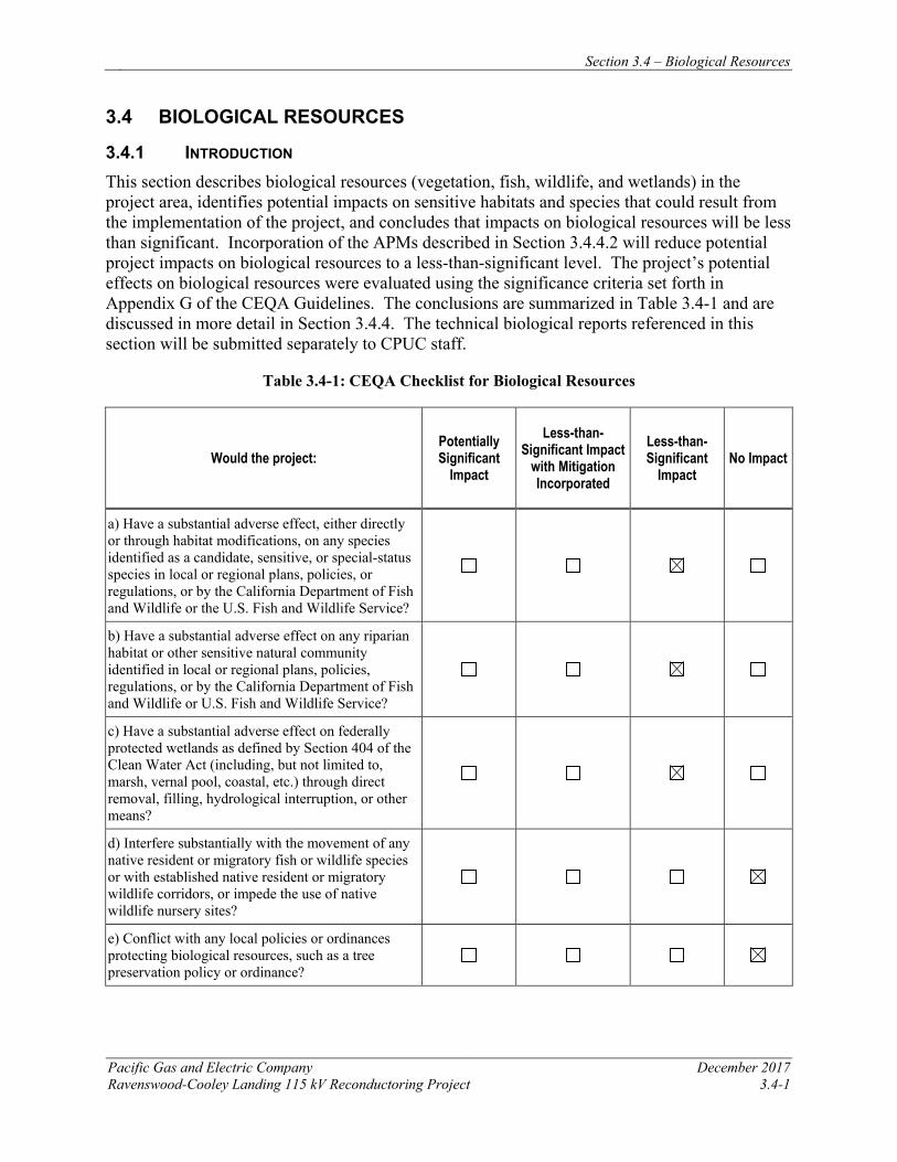
Section 3.4 – Biological Resources
Pacific Gas and Electric Company December 2017 Ravenswood-Cooley Landing 115 kV Reconductoring Project 3.4-1
3.4 BIOLOGICAL RESOURCES
3.4.1 INTRODUCTION This section describes biological resources (vegetation, fish, wildlife, and wetlands) in the project area, identifies potential impacts on sensitive habitats and species that could result from the implementation of the project, and concludes that impacts on biological resources will be less than significant. Incorporation of the APMs described in Section 3.4.4.2 will reduce potential project impacts on biological resources to a less-than-significant level. The project’s potential effects on biological resources were evaluated using the significance criteria set forth in Appendix G of the CEQA Guidelines. The conclusions are summarized in Table 3.4-1 and are discussed in more detail in Section 3.4.4. The technical biological reports referenced in this section will be submitted separately to CPUC staff.
Table 3.4-1: CEQA Checklist for Biological Resources
Would the project: Potentially Significant
Impact
Less-than-Significant Impact
with Mitigation Incorporated
Less-than-Significant
Impact No Impact
a) Have a substantial adverse effect, either directly or through habitat modifications, on any species identified as a candidate, sensitive, or special-status species in local or regional plans, policies, or regulations, or by the California Department of Fish and Wildlife or the U.S. Fish and Wildlife Service?
b) Have a substantial adverse effect on any riparian habitat or other sensitive natural community identified in local or regional plans, policies, regulations, or by the California Department of Fish and Wildlife or U.S. Fish and Wildlife Service?
c) Have a substantial adverse effect on federally protected wetlands as defined by Section 404 of the Clean Water Act (including, but not limited to, marsh, vernal pool, coastal, etc.) through direct removal, filling, hydrological interruption, or other means?
d) Interfere substantially with the movement of any native resident or migratory fish or wildlife species or with established native resident or migratory wildlife corridors, or impede the use of native wildlife nursery sites?
e) Conflict with any local policies or ordinances protecting biological resources, such as a tree preservation policy or ordinance?
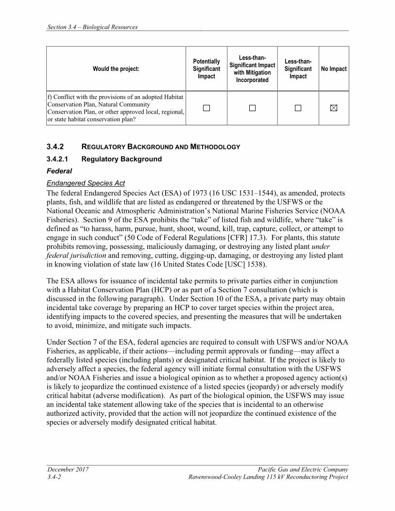
Section 3.4 – Biological Resources
December 2017 Pacific Gas and Electric Company 3.4-2 Ravenswood-Cooley Landing 115 kV Reconductoring Project
Would the project: Potentially Significant
Impact
Less-than-Significant Impact
with Mitigation Incorporated
Less-than-Significant
Impact No Impact
f) Conflict with the provisions of an adopted Habitat Conservation Plan, Natural Community Conservation Plan, or other approved local, regional, or state habitat conservation plan?
3.4.2 REGULATORY BACKGROUND AND METHODOLOGY 3.4.2.1 Regulatory Background Federal Endangered Species Act The federal Endangered Species Act (ESA) of 1973 (16 USC 1531–1544), as amended, protects plants, fish, and wildlife that are listed as endangered or threatened by the USFWS or the National Oceanic and Atmospheric Administration’s National Marine Fisheries Service (NOAA Fisheries). Section 9 of the ESA prohibits the “take” of listed fish and wildlife, where “take” is defined as “to harass, harm, pursue, hunt, shoot, wound, kill, trap, capture, collect, or attempt to engage in such conduct” (50 Code of Federal Regulations [CFR] 17.3). For plants, this statute prohibits removing, possessing, maliciously damaging, or destroying any listed plant under federal jurisdiction and removing, cutting, digging-up, damaging, or destroying any listed plant in knowing violation of state law (16 United States Code [USC] 1538).
The ESA allows for issuance of incidental take permits to private parties either in conjunction with a Habitat Conservation Plan (HCP) or as part of a Section 7 consultation (which is discussed in the following paragraph). Under Section 10 of the ESA, a private party may obtain incidental take coverage by preparing an HCP to cover target species within the project area, identifying impacts to the covered species, and presenting the measures that will be undertaken to avoid, minimize, and mitigate such impacts.
Under Section 7 of the ESA, federal agencies are required to consult with USFWS and/or NOAA Fisheries, as applicable, if their actions—including permit approvals or funding—may affect a federally listed species (including plants) or designated critical habitat. If the project is likely to adversely affect a species, the federal agency will initiate formal consultation with the USFWS and/or NOAA Fisheries and issue a biological opinion as to whether a proposed agency action(s) is likely to jeopardize the continued existence of a listed species (jeopardy) or adversely modify critical habitat (adverse modification). As part of the biological opinion, the USFWS may issue an incidental take statement allowing take of the species that is incidental to an otherwise authorized activity, provided that the action will not jeopardize the continued existence of the species or adversely modify designated critical habitat.
Section 3.4 – Biological Resources
Pacific Gas and Electric Company December 2017 Ravenswood-Cooley Landing 115 kV Reconductoring Project 3.4-3
Migratory Bird Treaty Act The Migratory Bird Treaty Act (MBTA) of 1918 (16 USC Sections 703–711) protects all migratory birds, including active nests and eggs. Birds protected under the MBTA include all native waterfowl, shorebirds, hawks, eagles, owls, doves, and other common birds such as ravens, crows, sparrows, finches, swallows, and others, including their body parts (for example feathers and plumes), active nests, and eggs. A complete list of protected species can be found in 50 CFR 10.13. Enforcement of the provisions of the federal MBTA is the responsibility of USFWS.
Waters and Wetlands: Clean Water Act Sections 401 and 404 The purpose of the CWA (33 USC Section 1251 et seq.) is to “restore and maintain the chemical, physical, and biological integrity of the nation’s waters.” Waters of the U.S. include rivers, streams, estuaries, the territorial seas, ponds, lakes, and wetlands. Wetlands are defined as those areas “that are inundated or saturated by surface or ground water at a frequency and duration sufficient to support, and that under normal circumstances do support, a prevalence of vegetation typically adapted for life in saturated soil conditions” (33 CFR 328.3). Historically, in non-tidal waters, USACE jurisdiction extends to the ordinary high-water (OHW) mark, which is defined in Title 33 CFR Part 328.3. If there are wetlands adjacent to channelized features, the limits of USACE jurisdiction extend beyond the OHW mark to the outer edges of the wetlands. Wetlands that are not adjacent to Waters of the U.S. are termed “isolated wetlands” and, depending on the circumstances, may also be subject to USACE jurisdiction. In tidal waters, USACE jurisdiction extends to the landward extent of vegetation associated with salt or brackish water or the high tide line (HTL). The HTL is defined in 33 CFR Part 328.3 as “the line of intersection of the land with the water’s surface at the maximum height reached by a rising tide.” If there are wetlands adjacent to channelized features, the limits of USACE jurisdiction extend beyond the OHW mark or HTL to the outer edges of the wetlands.
The USACE issues permits for work in wetlands and other waters of the United States based on guidelines established under Section 404 of the CWA. Section 404 of the CWA prohibits the discharge of dredged or fill material into waters of the United States, including wetlands, without a permit from USACE. USEPA also has authority over wetlands and may, under Section 404(c), veto a USACE permit.
Section 401 of the CWA requires all Section 404 permit actions to obtain a state Water Quality Certification or waiver, as described in more detail in Section 3.9, Hydrology and Water Quality.
Rivers and Harbors Act Section 10 Section 10 of the Rivers and Harbors Act of 1899 prohibits the creation of any obstruction to the navigable capacity of Waters of the U.S., including discharge of fill and the building of any wharfs, piers, jetties, and other structures without Congressional approval or authorization by the Chief of Engineers and Secretary of the Army (33 U.S.C. 403).
Navigable Waters of the U.S., which are defined in 33 CFR, Part 329.4, include all waters subject to the ebb and flow of the tide, and/or those which are presently or have historically been used to transport commerce. The shoreward jurisdictional limit of tidal waters is further defined in 33 CFR, Part 329.12 as “the line on the shore reached by the plane of the mean (average) high
Section 3.4 – Biological Resources
December 2017 Pacific Gas and Electric Company 3.4-4 Ravenswood-Cooley Landing 115 kV Reconductoring Project
water.” It is important to understand that the USACE does not regulate wetlands under Section 10, only the aquatic or open waters component of bay habitat, and that there is overlap between Section 10 jurisdiction and Section 404 jurisdiction. According to 33 CFR, Part 329.9, a waterbody that was once navigable in its natural or improved state retains its character as “navigable in law” even though it is not presently used for commerce as a result of changed conditions and/or the presence of obstructions. Historical Section 10 Waters may occur behind levees in areas that are not currently exposed to tidal or muted-tidal influence, and meet the following criteria: (1) the area is presently at or below the mean high water line; (2) the area was historically at or below mean high water in its “unobstructed, natural state”; and (3) there is no evidence that the area was ever above mean high water.
As mentioned above, Section 404 of the CWA authorizes the USACE issue permits to regulate the discharge of dredged or fill material into Waters of the U.S. If a project also proposes to discharge of dredged or fill material and/or introduce of other potential obstructions in navigable Waters of the U.S., a Letter of Permission authorizing these impacts must be obtained from the USACE under Section 10 of the Rivers and Harbors Act.
Don Edwards San Francisco Bay National Wildlife Refuge The project is located within the West Bay Unit of the Don Edwards San Francisco Bay NWR. Easements including PG&E facilities are included in the NWR Comprehensive Conservation Plan’s (CCP’s) description of the West Bay Unit. The project also crosses lands owned by the NWR in the north and, adjacent to Cooley Landing Substation, lands managed by NWR as part of an agreement between Cargill Salt and USFWS.
The USFWS, which manages the NWR, can authorize certain activities on its lands via the issuance of Special Use Permits (SUPs). PG&E performs operation and maintenance of its infrastructure on the NWR under the conditions of a SUP issued by the NWR. The SUP includes conditions pertaining to protection of NWR infrastructure, habitats, and species that must be followed during PG&E’s performance of its activities.
State California Endangered Species Act Sections 2050–2098 of the California Fish and Game Code (the California Endangered Species Act [CESA]) prohibit the take of state-listed endangered and threatened species unless specifically authorized by the CDFW). The state definition of “take” is to hunt, pursue, catch, capture, or kill a member of a listed species or attempt to do so. CDFW administers CESA and authorizes take through permits or memorandums of understanding issued under Section 2081 of CESA, or through a consistency determination issued under section 2080.1. Section 2090 of CESA requires state agencies to comply with threatened and endangered species protection and recovery and to promote conservation of these species.
Fully Protected Species Under the Fish and Game Code Fish and Game Code designates certain fish and wildlife species as “fully protected” under Sections 3511 (birds), 4700 (mammals), 5050 (reptiles and amphibians), and 5515 (fish). Fully
Section 3.4 – Biological Resources
Pacific Gas and Electric Company December 2017 Ravenswood-Cooley Landing 115 kV Reconductoring Project 3.4-5
protected species may not be taken or possessed at any time, and no permits may be issued to PG&E for incidental take of these species.8
Protection for Birds: Fish and Game Code Fish and Game Code Section 3503 et seq. state that it is unlawful to take, possess, or needlessly destroy the nest or eggs of any bird, except as otherwise provided by this code or any regulation made pursuant thereto. Section 3503.5 makes it unlawful to take, possess, or destroy any birds in the orders of Falconiformes or Strigiformes (birds of prey) or to take, possess, or destroy the nest or eggs of any such bird.
Native Plant Protection Act of 1973 The Native Plant Protection Act of 1973 (Fish and Game Code Sections 1900–1913) includes provisions that prohibit the taking of endangered or rare native plants. CDFW administers the Native Plant Protection Act of 1973 and generally regards as rare many plant species included on California Rare Plant Rank (CRPR) 1A, 1B, 2A, and 2B of the California Native Plant Society (CNPS) Inventory of Rare and Endangered Vascular Plants of California. In addition, sometimes CRPR 3 and 4 plants are considered if the population has local significance in the area and is impacted by the project.
Section 1913(b) includes a specific provision to allow for the incidental removal of endangered or rare plant species, if not otherwise salvaged by CDFW, within a right-of-way to allow a public utility to fulfill its obligation to provide service to the public.
California Species of Special Concern Species of Special Concern (SSC) is a category conferred by CDFW to fish and wildlife species that meet the state definition of threatened or endangered, but have not been formally listed (e.g., federally or state-listed species), or are considered at risk of qualifying for threatened or endangered status in the future based on known threats. SSC is an administrative classification only, but these species should be considered “special-status” for the purposes of the CEQA analysis (see the Significance Criteria section of this document).
Porter-Cologne Water Quality Control Act The SWRCB and the nine RWQCBs have jurisdiction over all surface water and groundwater in California, including wetlands, headwaters, and riparian areas. The SWRCB or applicable RWQCB must issue waste discharge requirements for any activity that discharges waste that could affect the quality of waters of the state, as described in more detail in Section 3.9, Hydrology and Water Quality.
McAteer-Petris Act In response to uncoordinated and indiscriminate filling of the Bay, the California legislature passed the McAteer-Petris Act in 1965, establishing the San Francisco Bay Conservation and Development Commission (BCDC) as the management and regulatory agency for the San
8 While take of fully protected species may be authorized by CDFW under a Natural Communities Conservation Plan (NCCP), PG&E activities are not covered by an NCCP so this permitting option is not available.
Section 3.4 – Biological Resources
December 2017 Pacific Gas and Electric Company 3.4-6 Ravenswood-Cooley Landing 115 kV Reconductoring Project
Francisco Bay and Delta. A permit must be obtained from the BCDC for shoreline projects; dredge and fill activities in the Bay or certain tributaries, salt ponds, or managed wetlands; and Suisun Marsh projects. The limits of BCDC jurisdiction are defined in the Bay Plan (BCDC 2012), and include a 100-foot-wide band along the shoreline of the Bay. The “shoreline” is defined as all areas that are subject to tidal action from the south end of the Bay to the Golden Gate (Point Bonita-Point Lobos), and to the Sacramento River line (a line between Stake Point and Simmons Point, extended northeasterly to the mouth of Marshall Cut). In addition, the BCDC will take jurisdiction over the marshlands lying between mean high tide and up to 5 feet above mean sea level (MSL), where marsh vegetation is present; tidelands (land lying between mean high tide and mean low tide); and submerged lands (land lying below mean low tide). In relation to salt ponds, the BCDC will claim “salt ponds consisting of all areas which have been diked off from the Bay and have been used during the three years immediately preceding 1969 for the solar evaporation of Bay water in the course of salt production” (BCDC 2012).
Local
This section includes a summary of local or regional plans, policies, or regulations that identify sensitive or special-status species in the project area, as well as local polices or ordinances that protect biological resources. Because the CPUC has exclusive jurisdiction over the siting, design, and construction of the project, the project is not subject to local discretionary regulations related to biological resources. The following summary is provided for informational purposes and to assist with CEQA review.
City of Palo Alto Baylands Master Plan The City of Palo Alto’s Baylands Master Plan, adopted in 2008, includes the history, environmental setting, and comprehensive planning goals and policies for the Baylands within the project area south of Bay Road within the Tower 8 work area. Policy implementation and City Council actions from 1988 through 2007 are described within the document. Policies specific to the Baylands vegetation and wildlife conservation and management are described in Policy N-1, N-2, and N-8. Policy N-1 echoes the Baylands Master Plan policies regarding both the need for a management plan and the appropriateness of “low-impact” recreation activities in open space areas. Policies N-2 and N-3 programs are to examine and improve management practices for natural habitat and open space areas and review the need for access controls in environmentally sensitive areas, including the Baylands, foothills, and riparian corridors. Policy N-8 specifically calls for the protection of wetlands. In 2005, Catalyst Landscape Architecture Urban Design worked with the City of Palo Alto as well as stakeholders to develop the Site Assessment and Design Guidelines, Palo Alto Baylands Nature Preserve. The document was prepared to help implement the Baylands Master Plan and the Baylands-related policies and programs. The guidelines are intended to be used when designing or reviewing projects located in any part of the Baylands.
3.4.2.2 Methodology
This section summarizes the methods used to identify and analyze potential impacts on special-status species that may occur in the project area. As described below, biologists began their research with a database searches and literature reviews to determine which special-status plants, natural communities, and wildlife might have potential to occur in the project area. Using this
Section 3.4 – Biological Resources
Pacific Gas and Electric Company December 2017 Ravenswood-Cooley Landing 115 kV Reconductoring Project 3.4-7
information, the biologists conducted detailed field surveys of the biological resources survey area, as defined below. A more detailed description of these methods is provided in the project’s Biological Resources Technical Report, which will be provided separately to CPUC staff.
Species Considered to be of Special Status
Special-status species include those that are:
• Listed or candidates for listing as rare, threatened or endangered under the federal ESA or CESA
• Plants included in the online version of the CNPS Inventory of Rare and Endangered Plants of California as CRPR 1A, 1B, 2A, 2B, 3, or 4
• Fish or wildlife designated as a SSC or a fully protected species by the CDFW
• Migratory birds with active nests, defined as containing eggs or dependent young
• Natural communities were considered to be special-status if they were identified on the most recent CDFW List of Vegetation Alliances and Associations as being highly imperiled.
Database Searches
The following biological databases were queried for records of special-status plants, natural communities, and wildlife that might have potential to occur in the project area:
• USFWS list of federally listed and proposed endangered, threatened, and candidate species and their designated critical habitat (USFWS 2017)
• The CNPS’s Rare and Endangered Plant Inventory, including a search of CNPS records for special-status species recorded in San Mateo County (CNPS 2017)
• The CDFW’s California Natural Diversity Database (CNDDB) (2017)
• A CNDDB database search for special-status species typically includes nine U.S. Geological Survey (USGS) 7.5-minute quadrangle maps for a project located within a single quadrangle—the quadrangle that covers the project area, and the eight quadrangles that surround the project quadrangle. However, in this case, the project area spans two quadrangles (Palo Alto and Mountain View, California); therefore, additional quadrangles were searched to account for all the areas surrounding the two project quadrangles, including the Palo Alto, Mountain View, San Mateo, Redwood Point, Newark, Niles, Milpitas, San Jose West, Cupertino, Mindego Hill, La Honda, and Woodside, California USGS quadrangles.
• The USFWS database was queried using a custom polygon that encompassed the project area.
Section 3.4 – Biological Resources
December 2017 Pacific Gas and Electric Company 3.4-8 Ravenswood-Cooley Landing 115 kV Reconductoring Project
Other information sources consulted to determine which special-status species could potentially occur in the project area included:
• Previous biological constraints analyses of the project area, including the PG&E Bay Area Operations & Maintenance Habitat Conservation Plan (PG&E 2016), South Bay Salt Pond Restoration Project Final Environmental Impact Statement/Report (EDAW et al. 2007); and South Bay Salt Pond Restoration Project Final Environmental Impact Statement/Report, Phase 2 (AECOM 2016)
• Soil maps (Natural Resource Conservation Service [NRCS] 2017)
• CDFW’s List of Vegetation Alliances and Associations
• A Manual of California Vegetation (Sawyer et al. 2009)
• Records of birds reported in nearby areas on eBird, an online database of bird distribution and abundance (Cornell Lab of Ornithology 2017)
• The San Mateo County Breeding Bird Atlas (Sequoia Audubon Society 2001)
• Aerial photographs
• Jepson Manual, Second Edition: Vascular Plants of California (Baldwin et al. 2012)
Field Surveys
The biological resources survey area (Survey Area) included the project work areas, staging areas, and the Ravenswood-Cooley Landing Line alignment (Towers 1 through 9), as well as a surrounding 150-foot buffer (see Figure 3.4-1), as access allowed.
The following surveys were conducted for the project:
Reconnaissance Surveys General biological reconnaissance surveys entailed walking the Survey Area (as defined previously), and surveying areas that appeared to support special-status fauna and flora as identified in desktop-level reviews. A reconnaissance-level field survey of the Survey Area was conducted by H. T. Harvey & Associates senior plant and wetland ecologist Danielle Tannourji, M.S., on May 11, 2017 and September 26, 2017, and by H. T. Harvey & Associates senior wildlife ecologists Steve Rottenborn, Ph.D., and Robin Carle, M.S., on May 18, 2017. The purpose of these surveys was to (1) assess existing biotic habitats and general wildlife communities in the Survey Area and in adjacent areas, (2) assess the potential for implementation of the project to impact special-status species and/or their habitats, and (3) identify potential jurisdictional habitats, such as waters of the U.S.
Focused Surveys Focused surveys evaluate the habitat in the Survey Area and its ability to support relevant special-status species. As described above for reconnaissance surveys, the potential for implementation of the project to impact special-status species and/or their habitats was assessed
Section 3.4 – Biological Resources
Pacific Gas and Electric Company December 2017 Ravenswood-Cooley Landing 115 kV Reconductoring Project 3.4-9
in May 2017. In addition, a focused rare plant survey was conducted within and adjacent to Towers 1, 2, and 8 on July 26, 2017 by Ms. Tannourji for potentially occurring summer-blooming special-status plant species.
Likelihood of Presence for Special-Status Species
Using the information generated from literature reviews and field surveys, the list of special-status species with the potential to occur was further refined to reflect the species that may occur within the project area. The likelihood of special-status species occurrence was determined based on natural history parameters, including but not limited to, the species’ range, habitat, foraging needs, migration routes, and reproductive requirements, using the following general categories:
• Present – Reconnaissance-level, focused, or protocol-level surveys documented the occurrence or observation of a species in the project area, or existing information verified the presence of the species.
• Seasonally present – Individuals have been observed in the project area only during certain times of the year.
• Likely to occur (on site) – The species has a strong likelihood to be found in the project area prior to or during construction but has not been directly observed to date during project surveys or based on existing information. The likelihood that a species may occur is based on the following considerations: suitable habitat that meets the life history requirements of the species is present on or near the project area; migration routes or corridors are near or within the project area; records of sighting are documented on or near the project area; and there is an absence of invasive predators. The main assumption is that records of occurrence have been documented within or near the project area, the project area falls within the range of the species, suitable habitat is present, but it is undetermined whether the habitat is currently occupied.
• Potential to occur: There is a possibility that the species can be found in the project area prior to or during construction, but it has not been directly observed to date. The likelihood that a species may occur is based on the following conditions: suitable habitat that meets the life history requirements of the species is present on or near the project area; migration routes or corridors are near or within the project area; and there is an absence of invasive predators. The main assumption is that the project area falls within the range of the species, suitable habitat is present, but no records of sighting are located within or near the project area and it is undetermined whether the habitat is currently occupied.
• Unlikely to occur – The species is not likely to occur in the project area based on the following considerations: lack of suitable habitat and features that are required to satisfy the life history requirements of the species (e.g., absence of foraging habitat; lack of reproductive areas, and lack of sheltering areas); presence of barriers to migration/dispersal; presence of predators or invasive species that inhibit survival or occupation; lack of hibernacula, hibernation areas, or estivation areas on site.
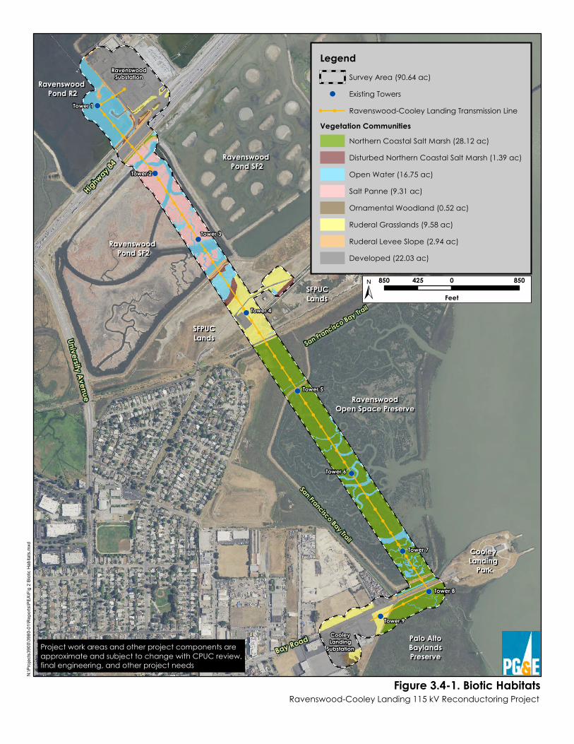
Highway 8
4
University Avenue RavenswoodRavenswoodOpen Space PreserveOpen Space Preserve
Cooley Cooley Landing Landing
ParkPark
Bay Road
San Francisco Bay Trail
Ravenswood Ravenswood Pond SF2Pond SF2
Ravenswood Ravenswood Pond R2Pond R2
Ravenswood Ravenswood Pond SF2Pond SF2
SFPUCSFPUCLandsLands
Palo AltoPalo AltoBaylandsBaylandsPreservePreserve
SFPUCSFPUCLandsLands
San Francisco Bay Trail
RavenswoodSubstation
CooleyLanding
Substation
Tower 1
Tower 2
Tower 3
Tower 4
Tower 5
Tower 6
Tower 7
Tower 8
Tower 9
Figure 3.4-1. Biotic HabitatsRavenswood-Cooley Landing 115 kV Reconductoring Project
N:\P
rojec
ts390
0\398
0-01\R
eport
s\PEA
\Fig 2
Bioti
c Hab
itats.
mxd
LegendSurvey Area (90.64 ac)Existing TowersRavenswood-Cooley Landing Transmission Line
Vegetation CommunitiesNorthern Coastal Salt Marsh (28.12 ac)Disturbed Northern Coastal Salt Marsh (1.39 ac)Open Water (16.75 ac)Salt Panne (9.31 ac)Ornamental Woodland (0.52 ac)Ruderal Grasslands (9.58 ac)Ruderal Levee Slope (2.94 ac)Developed (22.03 ac)
850 0 850425
Feet
Project work areas and other project components areapproximate and subject to change with CPUC review,final engineering, and other project needs
Section 3.4 – Biological Resources
Pacific Gas and Electric Company December 2017 Ravenswood-Cooley Landing 115 kV Reconductoring Project 3.4-11
• Absent – Suitable habitat does not exist in the project area, the species is restricted to or known to be present only within a specific area outside of the project area, or focused or protocol-level surveys did not detect the species.
Unless otherwise noted, the methodology and environmental information presented in this section are summarized from the Biological Resources Technical Report for the Ravenswood-Cooley Landing Reconductoring Project, which will be provided separately to CPUC staff.
3.4.3 ENVIRONMENTAL SETTING 3.4.3.1 Regional
The project area is bounded by the Don Edwards NWR to the north, Ravenswood Open Space Preserve (OSP) and residential communities of East Palo Alto to the west, by the San Francisco Bay to the east, and by the Palo Alto Baylands to the south. The Don Edwards NWR, managed by the USFWS, is a 30,000-acre reserve that spans the southern portion of the San Francisco Bay including tidal and diked marshlands in San Mateo, Santa Clara, and Alameda Counties. The Ravenswood OSP, managed by the Midpeninsula Regional Open Space District, is a 376-acre preserve comprised of two noncontiguous marshland areas located south of the Dumbarton Bridge and adjacent to San Francisco Bay. The Palo Alto Baylands is a large tract of undisturbed marshland consisting of approximately 1,940 acres in both Palo Alto and East Palo Alto, managed by the City of Palo Alto.
The project is situated in the Palo Alto and Mountain View USGS 7.5-minute quadrangles, in the Pulgas Land Grant. There is little natural topographic variation with elevations ranging from approximately 0 to 15 feet North American Vertical Datum of 1988. The project area includes the following five land features as shown on Figure 3.4-1: (1) Ravenswood Pond R2 (just west of the Ravenswood Substation); (2) SR 84 (near the western entrance of the Dumbarton Bridge); (3) Ravenswood Pond SF2 (just south of SR 84); (4) SFPUC lands, including the Hetch-Hetchy Aqueduct; and (5) Bay Road just west of Cooley Landing. In addition, the Ravenswood OSP and Palo Alto Baylands are also labeled for reference.
Climate conditions in the region include a 30-year average of approximately 16 inches of annual precipitation, and an average temperature range from 50ºF to 69ºF (PRISM Climate Group 2017). Relative to the 30-year climate normals, the project area has experienced wetter than normal conditions during the 2016/2017 wet season prior to the May 2017 survey. From November 2016 through April 2017, the region received 19.58 inches of precipitation, which is approximately 122% of the 30-year average for this time period (16.10 inches; 1981–2010) (PRISM Climate Group 2017).
The NRCS maps six soil units in the project area (2017): (1) Botella-Urban land complex, 0 to 5 percent slopes; (2) Novato clay, 0 to 1 percent slopes, tidally flooded; (3) Novato clay, 0 to 1 percent slopes, ponded; (4) Urban land; (5) Urban land-Orthents, cut and fill complex, 0 to 5 percent slopes; and (6) Urban land-Orthents, reclaimed complex, 0 to 2 percent slopes. Botella-Urban land complex comprise approximately 13% of the project area in the developed lands near the Cooley Landing Substation. Botella-Urban land complex soils are defined as well drained mixed alluvium that are nonsaline to very slightly saline, and consists entirely of clay
Section 3.4 – Biological Resources
December 2017 Pacific Gas and Electric Company 3.4-12 Ravenswood-Cooley Landing 115 kV Reconductoring Project
loam (Soil Conservation Service [SCS] 1991). Novato clay comprises approximately 48% of the project area and includes all portions located in the preserved marshlands and regulated salt ponds. This soil type is tidally flooded or ponded, very poorly drained, strongly saline, and consists entirely of clay (SCS 1991). Urban land and Urban land-Orthents comprise approximately 39% of the project area in the developed and ruderal grasslands in the central portion. Urban land and Orthents soils are defined as well drained mixed alluvium that are nonsaline and consist mostly of urban land soil composition (SCS 1991).
Biotic communities associated with the San Francisco Bay and its tributaries within the project region include northern coastal salt marsh, coastal brackish marsh, freshwater marsh, salt panne, open water, ruderal grassland, ornamental woodlands, and developed lands.
Landcover, Vegetation, and Wildlife Habitats
The following plant communities are based on the CDFW’s List of California Terrestrial Natural Communities. Reconnaissance-level surveys identified eight habitat types/land uses in the project area: salt panne, open water, northern coastal salt marsh, disturbed northern coastal salt marsh, ruderal levee slope, ruderal grasslands, ornamental woodland, and developed (see Figure 3.4-1). These habitat types are described in detail below. Table 3.4-2 provides the approximate acreage of each habitat type within the project Survey Area.
Table 3.4-2: Biotic Habitats and Acreages within the Project Survey Area
Biotic Habitats Acreage Wetlands and Aquatic Resources Salt panne 9.31 Open water 16.75 Northern coastal salt marsh 28.12 Disturbed northern coastal salt marsh 1.39 Uplands Ruderal levee slope 2.94 Ruderal grasslands 9.58 Ornamental woodland 0.52 Developed 22.03
Wetlands and Aquatic Resources Salt Panne Salt panne habitat in the Survey Area is located in the southwest part of Ravenswood Pond SF2 and totals approximately 9.31 acres. Salt panne in the project area consists of the seasonally dry, flat, unvegetated land of Ravenswood Pond SF2, which is bisected by several perennial open water channels. This salt panne is separated from the tidal waters of the San Francisco Bay and the managed-pond portion of Pond SF2 via levees and a pond gate located on the eastern edge of the project area just south of SR 84. This shallow, artificial, seasonal pond was designed to
Section 3.4 – Biological Resources
Pacific Gas and Electric Company December 2017 Ravenswood-Cooley Landing 115 kV Reconductoring Project 3.4-13
extract salts from bay waters through natural evaporation during the 20th century by Cargill. It is now managed as part of the South Bay Salt Pond Restoration Project (2017).
The southwest part of Ravenswood Pond SF2 within the project area is managed to provide seasonally ponded habitat during the rainy season and salt panne habitat during the dry season, conditions suitable for nesting and foraging by the western snowy plover (Charadrius alexandrinus nivosus). During the wet season, the salt panne habitat in Pond SF2 provides seasonal shallow-water habitat ideal for foraging by shorebirds and waterfowl, and is particularly important during high tides when the favored foraging habitat of many shorebirds (intertidal mudflats) is flooded. When Pond SF2 contains water, it supports invertebrate species such as brine shrimp (Artemia franciscana) and brine flies (especially Ephydra millbrae), which serve as prey for waterfowl and shorebirds. Bird species that forage in Pond SF2 include the willet (Tringa semipalmata), dunlin (Calidris alpina), American avocet (Recurvirostra americana), western sandpiper (Calidris mauri), marbled godwit (Limosa fedoa), and northern shoveler (Anas clypeata), as well as a number of gull species (Larus spp.).
During the dry season, Pond SF2 does not provide especially valuable habitat for most wildlife species. However, western snowy plovers nest in the salt panne habitat on Pond SF2 during the dry season.
Open Water Areas of open water in the Survey Area are located in Ravenswood Pond R2, Ravenswood Pond SF2, SFPUC lands, the Ravenswood OSP, and the Palo Alto Baylands totaling approximately 16.75 acres. Water levels within Ravenswood Ponds R2 and SF2 are managed via water control structures. Pond R2 typically draws down in summer and is reflooded via a weir from Pond R1 in late fall; the open water in the southwest portion of Pond SF2 dries out in the summer except within the larger channels. Open water areas within SFPUC lands are diked and nontidal, while open water areas within the Ravenswood OSP and Palo Alto Baylands are fully tidal.
The open waters of Ravenswood Pond R2 and Ravenswood Pond SF2 can be manipulated via weirs connecting those ponds to adjacent ponds. Open water habitat in the Ravenswood OSP and Palo Alto Baylands consists of fully tidal marsh channels connected directly to San Francisco Bay. The open water habitat is devoid of vegetation and contains water, viscous mud, and algal growth. The open water present in the Tower 1 work area at Ravenswood Pond R2 was approximately 6 to 24 inches in depth at the time of the May 2017 survey. Two large open water channels in the Tower 2 work area at Ravenswood Pond SF2 ranged from 12 to 24 inches deep with average widths of 25 feet during May of 2017. In addition, two smaller channels were observed under Tower 2 ranging from 2- to 4-feet in width. Just north of the Tower 8 and Bay Road, a tidal, open water channel approximately 20 feet wide and 3 feet deep flows to the Bay.
The wildlife communities present within open water habitats in the project area vary depending on factors such as water depth, salinity, tidal influence, and extent of ponding. As a result, different wildlife communities occur in (1) Ravenswood Ponds R2 and SF2, (2) the diked open water within SFPUC lands, and (3) tidal channels within the Ravenswood OSP and Palo Alto Baylands. These three communities are described below.
Section 3.4 – Biological Resources
December 2017 Pacific Gas and Electric Company 3.4-14 Ravenswood-Cooley Landing 115 kV Reconductoring Project
Pond R2 is likely too saline to support fish (C. Strong, pers. comm.). It receives input from Pond R1, which itself has high salinity, and water leaves R2 only through evaporation, so that salts continue to accumulate in R2. Therefore, fish are not expected to survive in R2. Common fish species expected to occur in the outer portion of Ravenswood Pond SF2 include the topsmelt (Atherinops affinis), threespine stickleback (Gasterosteus aculeatus), longjaw mudsucker (Gillichthys mirabilis), rainwater killifish (Lucania parva), yellowfin goby (Acanthogobius flavimanus), and staghorn sculpin (Leptocottus armatus) (Carpelan 1957, Lonzarich and Smith 1997). However, as in Pond R2, the inner (landward) portion of Pond SF2 where project activities are proposed is expected to be too saline to support fish.
A number of shorebird species forage within open water habitats in Pond SF2, including the black-bellied plover (Pluvialis squatarola), semipalmated plover (Charadrius semipalmatus), dunlin, least sandpiper (Calidris minutilla), western sandpiper, short-billed dowitcher (Limnodromus griseus), long-billed dowitcher (Limnodromus scolopaceus), and willet, when that pond contains water. Salt pond surveys conducted by the USGS identified Ravenswood Pond SF2 as among the South Bay ponds supporting the highest abundance of these species, primarily due to large numbers of western sandpipers and dunlin (USGS Unpublished Preliminary Data), although the majority of shorebirds were using the outer portion of SF2, outside the project area. Shorebird species are not expected to make significant use of Pond R2, as only the margins of this pond are available to them for foraging due to water depth. However, waterfowl such as the mallard (Anas platyrhynchos), bufflehead (Bucephala albeola), common goldeneye (Bucephala clangula), ruddy duck (Oxyura jamaicensis), lesser scaup (Aythya affinis), and greater scaup (Aythya marila) will forage in open water habitats in both Ponds R2 and SF2 to some extent.
The diked open water habitat on SFPUC lands in the project area is not expected to support populations of fish species due to high salinities. Diked marshes provide shallow-water habitat ideal for foraging by shorebirds and waterfowl, similar to the salt panne habitat in Pond SF2 described above. However, due to the small extent of this area, relatively few shorebirds are expected to use this habitat for foraging compared to more the expansive habitats in nearby salt ponds.
Dominant fish species in fully tidal waters include the northern anchovy (Engraulis mordax), shiner perch (Cymatogaster aggregata), white croaker (Genyonemus lineatus), staghorn sculpin, bay goby (Lepidogobius lepidus), plainfin midshipman (Porichthys notatus), English sole (Parophrys vetulus), cheekspot goby (Ilypnus gilberti), and Pacific herring (Clupea pallasi). Many of the fish recorded in the South Bay, including the bat ray (Myliobatus californica), leopard shark (Triakis semifasciata), northern anchovy, gobies, and others, occur in tidal channels within marshes and/or sloughs at high tide when they are inundated. Thus, these tidal channels are productive foraging habitats for estuarine fish in this system (Harvey 1988).
Tidal channels in the project area range in size and depth. The wider, deeper channels located in the Ravenswood OSP in the project area are expected to provide foraging habitat for South Bay fish species. In contrast, the smaller tidal channels located in the Ravenswood OSP and Palo Alto Baylands are too narrow and shallow to support most open-water fish species. However, during high tides and king tide events, these fish species may enter and potentially forage within the upper portions of these smaller channels.
Section 3.4 – Biological Resources
Pacific Gas and Electric Company December 2017 Ravenswood-Cooley Landing 115 kV Reconductoring Project 3.4-15
Bird species that forage along open water areas of tidal channels in the project area include great blue herons (Ardea herodias), great egrets (Ardea alba), and snowy egrets (Egretta thula), as well as many of the shorebird and waterfowl species that make use of salt pond habitats nearby. However, these species prefer to forage on nearby mudflats and salt ponds, and occur along tidal channels in much lower densities.
Northern Coastal Salt Marsh Areas of northern coastal salt marsh occur in fully tidal and diked lands in the project area. This habitat is located on the periphery of Ravenswood Pond SF2, on SFPUC lands southeast of the railroad tracks, throughout the Ravenswood OSP, and throughout the Palo Alto Baylands in the Survey Area totaling approximately 28.12 acres. The northern coastal salt marsh habitat is periodically inundated with water, is subject to tidal ebbs and flows, and is heavily dominated by pickleweed (Salicornia pacifica), which grows in dense mats that are nearly ubiquitous on and around this habitat within the project area. Cordgrass (Spartina sp.) and alkali heath (Frankenia salina) grows in patches along the southern portion of the project area.
Fully tidal salt marsh habitat occurs in the central and southern portions of the project area starting at the Ravenswood OSP approximately 0.1 mile southeast of Staging Area 3 and extending southeast to the Tower 8 work area within the Palo Alto Baylands. Northern coastal salt marsh habitat occurs in diked settings in Ravenswood Pond SF2 along the northern edge of the pond within and adjacent to the proposed work area at Tower 2. This area along the toe of the northern levee bank is characterized by pickleweed, coast plantain (Plantago elongata), and toad rush (Juncus bufonius).
Northern coastal salt marsh supports some of the rarest wildlife species in San Francisco Bay. The California Ridgway’s rail (Rallus obsoletus obsoletus) nests in cordgrass, dense stands of pickleweed, and marsh gumplant (Grindelia stricta) in tidal marsh habitats in the South Bay. This species is found in the lower marsh zone where numerous small tidal channels are present. California black rails (Laterallus jamaicensis coturniculus) are known to occur in northern coastal salt marsh in the project area as winter residents, and it is possible that this species could nest here as well. The salt marsh harvest mouse (Reithrodontomys raviventris) occurs in the upper zone of the salt marsh where pickleweed is the dominant plant. Alameda song sparrows (Melospiza melodia pusillula) and Bryant’s savannah sparrows (Passerculus sandwichensis alaudinus) also nest in salt marshes. Alameda song sparrows prefer dense herbaceous vegetation wherever it occurs throughout the marsh, while savannah sparrows nest in shorter vegetation such as pickleweed and high transitional marshes in upland ecotones.
Shorebirds, swallows, herons, egrets, blackbirds, and other avian species roost and forage, often in large numbers, in tidal salt marsh habitats in the project area, but most do not breed in these areas. Common species that forage on the marsh plain include the black-necked stilt (Himantopus mexicanus), American avocet, and willet.
The extremely small, narrow areas of northern coastal salt marsh located on the western periphery of Ravenswood Pond SF2 are too small and isolated to support native marsh species characteristic of extensive, fully tidal salt marsh habitats. The wildlife communities that occur
Section 3.4 – Biological Resources
December 2017 Pacific Gas and Electric Company 3.4-16 Ravenswood-Cooley Landing 115 kV Reconductoring Project
within these areas are expected to be similar to those in adjacent ruderal levee slope and salt panne habitats.
Disturbed Northern Coastal Salt Marsh Areas of disturbed northern coastal salt marsh occur in narrow strips of habitat on diked lands within the project area. This habitat is located in drainage channels adjacent to the Ravenswood Substation, adjacent to the southern periphery of Ravenswood Pond R2, and within the diked portions of SFPUC lands totaling approximately 1.39 acres within the Survey Area. Disturbed salt marsh habitat in the project area is defined by isolated, monotypic stands of pickleweed found in diked lands. These areas are likely remnant stands of historical tidal marshlands that once occurred in the area prior to being diked. In addition, these low-lying areas are likely fed by groundwater to support the remaining pickleweed-dominated vegetation.
The disturbed northern coastal salt marsh habitat in the project area is similar to that of upper tidal salt marsh habitats in the region, but has been cut off or restricted from full tidal influence by constructed levees. Wildlife species such as the Ridgway’s rail that are associated with fully tidal marshes are absent from these areas. The disturbed northern coastal salt marsh habitat in the project area is also of relatively low quality compared to northern coastal salt marsh habitats elsewhere in region (e.g., those at Ravenswood OSP and the Palo Alto Baylands, described above) due to the patchy distribution of the marsh vegetation and high levels of human disturbance in the adjacent uplands. As such, the majority of wildlife species that occur within this habitat in the project area are not expected to use these small areas of low-quality marsh as their primary habitat.
The disturbed northern coastal salt marsh habitat in the project area provides ostensibly suitable roosting and foraging habitat for many species of shorebirds and waterfowl that occur in the region. However, the high levels of existing human disturbance within and adjacent to these patches of habitat in the project area, as well as the extremely limited extent of these areas, preclude the presence of most of these species. Wetland-associated birds such as the mallard and American coot (Fulica americana) are likely common foragers in these areas. Other bird species such as the northern harrier (Circus cyaneus) and Bryant’s savannah sparrow nest in pickleweed in higher quality marshes in the region and will forage in these areas occasionally. However, most species of marsh-associated birds are expected to occur in this habitat only briefly and in low numbers, if at all.
The endangered salt marsh harvest mouse is dependent on dense vegetative cover, usually in the form of pickleweed and other salt-dependent or salt-tolerant vegetation. Thus, salt marsh harvest mice are unlikely to use the disturbed northern coastal salt marsh habitat in the project area as their primary habitat due to the sparse, patchy distribution of the marsh vegetation there. Other common mammal species, including the house mouse (Mus musculus), deer mouse (Peromyscus maniculatus), and California vole (Microtus californicus) are more likely to occur in the sparse, highly disturbed marsh habitat in the project area. Due to the relatively high levels of salinity, amphibians are expected to be absent from this habitat. However, some reptile species such as the gopher snake (Pituophis catenifer) will forage here.
Section 3.4 – Biological Resources
Pacific Gas and Electric Company December 2017 Ravenswood-Cooley Landing 115 kV Reconductoring Project 3.4-17
Uplands Ruderal Levee Slope Ruderal levee slopes are present in the project area along levees of Ravenswood Pond R2, Ravenswood Pond SF2, SFPUC lands, the Ravenswood OSP, and the Palo Alto Baylands. This habitat is also found along drainages adjacent to the Ravenswood Substation and totals approximately 2.94 acres of the project Survey Area. Ruderal levee slope habitat comprises the narrow strip of upland habitat along the levees within the project area. Ruderal vegetation is situated on a 10-20% slope between the toe and the top of the levees. The ruderal levee slope habitat is dominated by densely-growing weedy forbs and grasses. The herb layer is dominated by non-native, moderately invasive grasses, including ripgut brome (Bromus diandrus), seaside barley (Hordeum marinum), Italian ryegrass (Festuca perennis), and wild oats (Avena sp.) (California Invasive Plant Council 2017). Non-native forbs, such as Italian thistle (Carduus pycnocephalus), black mustard (Brassica nigra), iceplant (Carpobrotus edulis), and spiny sowthistle (Sonchus asper) grow in intermittent, small patches in this habitat.
The wildlife communities inhabiting ruderal levee slopes in the project area are influenced by the presence of both adjacent development (e.g., roads, PG&E substations, and commercial businesses) and natural areas within the Don Edwards NWR, Ravenswood OSP, and Palo Alto Baylands. Adjacent roads and businesses are sources of high levels of human disturbance, which discourage the presence of wildlife species that do not tolerate such disturbance. In contrast, adjacent natural areas support many native species associated with large areas of marsh habitat, including special-status species. Thus, while the ruderal grassland habitat along levee slopes in the project area is not extensive or of high quality, it has the potential to support wildlife species that are both adapted to urban areas and associated with large marsh and aquatic habitats nearby.
Avian species such as the Alameda song sparrow and Bryant’s savannah sparrow may nest and forage within the ruderal habitat on levee slopes in the project area. House finches (Haemorhous mexicanus), lesser goldfinches (Spinus psaltria), golden-crowned sparrows (Zonotrichia atricapilla), and white-crowned sparrows (Zonotrichia leucophrys) are likely to forage in this vegetation. Species that require more extensive grasslands, such as the loggerhead shrike (Lanius ludovicianus), may occur as occasional foragers but are not expected to nest in this habitat. A few burrows of California ground squirrels (Spermophilus beecheyi) were observed on the ruderal levee slopes at the Ravenswoood Substation and adjacent to Tower 8 in the project area, but no burrows of other fossorial mammals were observed in this habitat during the May 2017 site visit. Other rodent species that can potentially occur in the ruderal habitat in the project area include the California vole and deer mouse. Diurnal raptors such as red-tailed hawks (Buteo jamaicensis) forage for these small mammals in ruderal grassland during the day, and at night nocturnal raptors, such as barn owls (Tyto alba), will forage for nocturnal rodents.
Mammals such as the raccoon (Procyon lotor) and striped skunk (Mephitis mephitis) utilize ruderal habitats in the project area for foraging. Species that require dense grassland cover or more expansive grassland areas for foraging, such as the black-tailed jackrabbit (Lepus californicus), are not expected to occur on ruderal levee slopes in the project area due to their isolation from more expansive grassland habitats in the area. Reptiles such as western fence lizards (Sceloporus occidentalis), western terrestrial garter snakes (Thamnophis elegans), and
Section 3.4 – Biological Resources
December 2017 Pacific Gas and Electric Company 3.4-18 Ravenswood-Cooley Landing 115 kV Reconductoring Project
southern alligator lizards (Elgaria multicarinata) may occur in small numbers on ruderal levee slopes in the project area.
Ruderal levee slopes in the project area are important to tidal marsh species during very high tides, such as king tides. During such events, the majority of the marshplain is inundated, and animals such as the California Ridgway’s rail, California black rail, and salt marsh harvest mouse take refuge in the vegetation along ruderal levee slopes.
Ruderal Grassland Ruderal grassland habitat in the project area is located on SFPUC lands northwest of the railroad tracks and in remnant fields adjacent to the Cooley Landing Substation, totaling approximately 9.58 acres within the Survey Area. Much like the ruderal levee slope vegetation, the ruderal grassland in the is composed of densely-growing weedy forbs and grasses such as wild oats, Italian thistle, black mustard, fennel (Foeniculum vulgare), wild radish (Raphanus raphanistrum), iceplant, and a variety of brome grasses. This habitat is restricted to compacted fill soils that have been disturbed previously and are low nutrients with little to topographic relief.
Due to high levels of human disturbance within and immediately adjacent to ruderal grasslands in the project area, most of the wildlife species found in these areas are common species adapted to urban areas. Reptiles such as the western fence lizard and gopher snake as well as mammals such as the house mouse, California vole, western harvest mouse (Reithrodontomys megalotis), and valley pocket gopher (Thomomys bottae) are common in these habitats.
Bird species that occur in these grasslands are also common, widespread species. Few bird species are expected to nest within the ruderal grasslands in the project area, although many bird species will nest in adjacent developed areas and rely on ruderal areas for foraging. These include the mourning dove (Zenaida macroura), black phoebe (Sayornis nigricans), northern mockingbird (Mimus polyglottos), bushtit (Psaltriparus minimus), house finch, lesser goldfinch, and cliff swallow (Petrochelidon pyrrhonota). Winter residents such as the white-crowned sparrow, golden-crowned sparrow, and yellow-rumped warbler (Setophaga coronata) will forage in these habitats during the spring, fall, and winter.
Ruderal habitats provide foraging habitat for diurnal raptors such as red-tailed hawks, northern harriers, and white-tailed kites (Elanus leucurus). These species will nest in adjacent marsh or developed habitats, and forage in ruderal areas year-round.
Ornamental Woodland Small patches of ornamental woodland habitat are located adjacent to the Ravenswood and Cooley Landing substations and total approximately 0.52 acre in the Survey Area. The overstory of ornamental woodlands is composed entirely of a variety of mature eucalyptus trees, the majority of which are blue gum (Eucalyptus globulus). The understory is comprised of weedy grasses and forbs similar to species found in ruderal grassland as described above.
The small patches of ornamental woodland habitat on the site provide nesting sites for common species of birds that occur in adjacent developed areas and ruderal grasslands, such as the native
Section 3.4 – Biological Resources
Pacific Gas and Electric Company December 2017 Ravenswood-Cooley Landing 115 kV Reconductoring Project 3.4-19
mourning dove, house finch, and northern mockingbird, as well as the non-native Eurasian collared-dove (Streptopelia decaocto). Common mammal species such as native raccoons and striped skunks, as well as nonnative Virginia opossums (Didelphis virginianus) will forage and take refuge in these small woodlands. However, these areas of vegetation are too small and isolated to provide important habitat for wildlife species.
Developed Developed portions of the project area include the Ravenswood Substation, State Route 84, Towers 1–9, the Bay Trail, existing access roads, Bay Road, and the Cooley Landing Substation, totaling approximately 22.03 acres within the Survey Area. The developed land is devoid of vegetation and is generally flat. The bike paths are located at the top of the levees and are composed of asphalt. The developed habitat is frequently utilized by humans, and both paved and gravel portions of this habitat are well-maintained.
Few wildlife species are expected to make use of the PG&E Ravenswood and Cooley Landing substations due to high levels of human disturbance and a lack of vegetated areas. Common bird species such as the nonnative European starling (Sturnus vulgaris) and native mourning dove and house finch may nest and forage in these areas. Urban-adapted mammals, such as the native raccoon and nonnative Virginia opossum, may forage in these areas as well.
Towers 1–9 provide potential nesting and roosting sites for red-tailed hawks and common ravens (Corvus corax), although no existing nest structures were observed on these towers during the May 2017 site visit. Raptors such as red-tailed hawks and peregrine falcons (Falco peregrinus) perch on these towers and forage for prey within adjacent marsh habitats. European starlings and American crows (Corvus brachyrhynchos) may also roost communally on towers and power lines in the project area.
Special-Status Species
This section describes special-status species observed (present) during project reconnaissance-level field surveys or recorded in the Survey Area by other, previous studies, and any species considered likely to occur, have potential to occur, or that are seasonally present. Special-status species that are unlikely to be found in the Survey Area are not discussed in this section.
Special-Status Plant Species Eighty-one special-status plant species were identified from the database queries. Seventy-six of these species were eliminated from further consideration and are considered absent because their required soil or habitat types do not occur in the Survey Area, or the Survey Area is outside of the species’ elevation range, or the species is presumed extirpated; therefore, they are not present in the Survey Area. Five special-status plant species initially were considered to be have potential to occur in the Survey Area; these species are identified in Table 3.4-3: Special-Status Plant Species. Special-status plant species with potential to occur in the Survey Area are described in more detail in the following paragraphs.
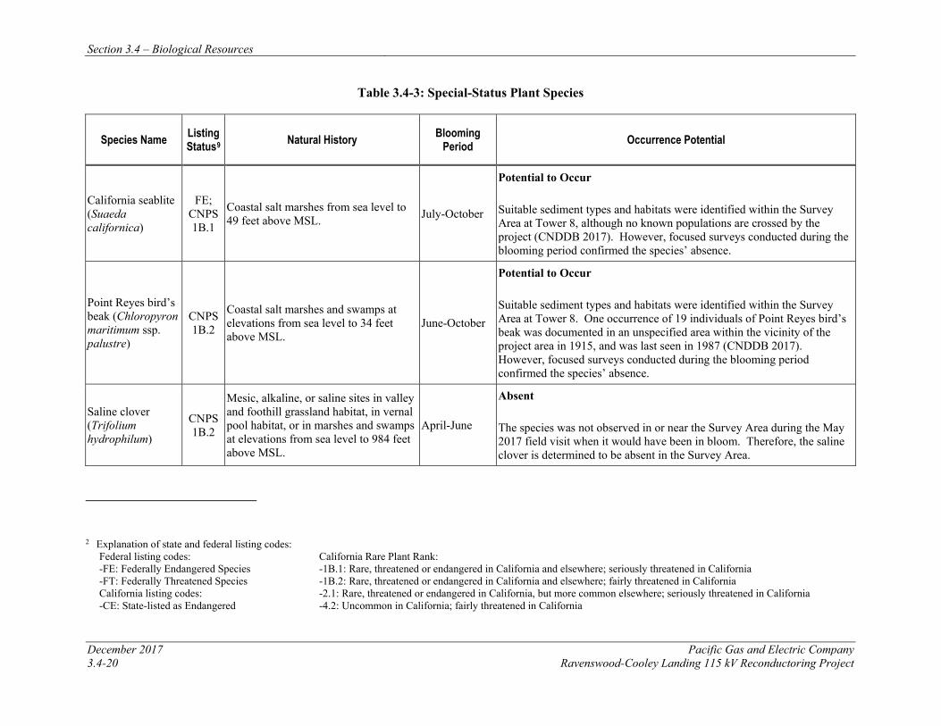
Section 3.4 – Biological Resources
December 2017 Pacific Gas and Electric Company 3.4-20 Ravenswood-Cooley Landing 115 kV Reconductoring Project
Table 3.4-3: Special-Status Plant Species
Species Name Listing Status9 Natural History Blooming
Period Occurrence Potential
California seablite (Suaeda californica)
FE; CNPS 1B.1
Coastal salt marshes from sea level to 49 feet above MSL. July-October
Potential to Occur Suitable sediment types and habitats were identified within the Survey Area at Tower 8, although no known populations are crossed by the project (CNDDB 2017). However, focused surveys conducted during the blooming period confirmed the species’ absence.
Point Reyes bird’s beak (Chloropyron maritimum ssp. palustre)
CNPS 1B.2
Coastal salt marshes and swamps at elevations from sea level to 34 feet above MSL.
June-October
Potential to Occur Suitable sediment types and habitats were identified within the Survey Area at Tower 8. One occurrence of 19 individuals of Point Reyes bird’s beak was documented in an unspecified area within the vicinity of the project area in 1915, and was last seen in 1987 (CNDDB 2017). However, focused surveys conducted during the blooming period confirmed the species’ absence.
Saline clover (Trifolium hydrophilum)
CNPS 1B.2
Mesic, alkaline, or saline sites in valley and foothill grassland habitat, in vernal pool habitat, or in marshes and swamps at elevations from sea level to 984 feet above MSL.
April-June
Absent The species was not observed in or near the Survey Area during the May 2017 field visit when it would have been in bloom. Therefore, the saline clover is determined to be absent in the Survey Area.
2 Explanation of state and federal listing codes: Federal listing codes: -FE: Federally Endangered Species -FT: Federally Threatened Species California listing codes: -CE: State-listed as Endangered
California Rare Plant Rank: -1B.1: Rare, threatened or endangered in California and elsewhere; seriously threatened in California -1B.2: Rare, threatened or endangered in California and elsewhere; fairly threatened in California -2.1: Rare, threatened or endangered in California, but more common elsewhere; seriously threatened in California -4.2: Uncommon in California; fairly threatened in California
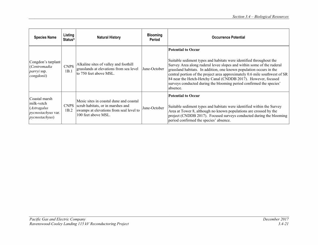
Section 3.4 – Biological Resources
Pacific Gas and Electric Company December 2017 Ravenswood-Cooley Landing 115 kV Reconductoring Project 3.4-21
Species Name Listing Status9 Natural History Blooming
Period Occurrence Potential
Congdon’s tarplant (Centromadia parryi ssp. congdonii)
CNPS 1B.1
Alkaline sites of valley and foothill grasslands at elevations from sea level to 750 feet above MSL.
June-October
Potential to Occur Suitable sediment types and habitats were identified throughout the Survey Area along ruderal levee slopes and within some of the ruderal grassland habitats. In addition, one known population occurs in the central portion of the project area approximately 0.6 mile southwest of SR 84 near the Hetch-Hetchy Canal (CNDDB 2017). However, focused surveys conducted during the blooming period confirmed the species’ absence.
Coastal marsh milk-vetch (Astragalus pycnostachyus var. pycnostachyus)
CNPS 1B.2
Mesic sites in coastal dune and coastal scrub habitats, or in marshes and swamps at elevations from seal level to 100 feet above MSL.
June-October
Potential to Occur Suitable sediment types and habitats were identified within the Survey Area at Tower 8, although no known populations are crossed by the project (CNDDB 2017). Focused surveys conducted during the blooming period confirmed the species’ absence.
Section 3.4 – Biological Resources
December 2017 Pacific Gas and Electric Company 3.4-22 Ravenswood-Cooley Landing 115 kV Reconductoring Project
California seablite California seablite (Suaeda californica) is a succulent, evergreen shrub in the goosefoot (Chenopodiaceae) family that occurs in coastal salt marshes from sea level to 49 feet above MSL (CNPS 2017). It is listed as endangered under the ESA and has a CRPR of 1B.1 (i.e., rare, threatened, or endangered in California and elsewhere; seriously endangered in California). It was historically known to occur throughout margins of coastal salt marshes surrounding San Francisco Bay, but may be extirpated as a result of development, recreational activities, erosion, non-native plants, and habitat alteration. The blooming period extends from July through October. CNDDB records show an occurrence of eight individuals of California seablite, recorded in 1971, existing 1.5 mi southeast of the Tower 8 work area (CNDDB 2017). A recent review of this sighting by the USFWS concluded that this California seablite population is “likely extirpated” (USFWS 2010). However, given the proximity of the prior record and the small possibility that the population may have persisted undetected in low numbers, the potential for this species to occur in the proposed work areas with suitable habitat (i.e., Tower 8) could not be ruled out without focused surveys.
A focused plant survey was conducted for California seablite during its known blooming period within and adjacent to Tower 8 by H. T. Harvey & Associates on July 26, 2017. California seablite was not observed within the project work area nor was it found within the surrounding marshlands within 50 feet of the project boundaries. Given these results and the high probability that the nearby occurrence is likely extirpated, California seablite is considered absent from direct impact areas and is not expected to be impacted by the project during construction.
Point Reyes bird’s beak Point Reyes bird’s beak (Chloropyron maritimum ssp. palustre) is an annual, hemiparasitic herb in the figwort family (Scrophulariaceae) that blooms from June to October. This subspecies is listed as a CNPS 1B.2 plant and occurs only in coastal salt marshes and swamps at elevations from 0 to 34 feet above MSL. The Point Reyes bird’s beak was once common along the coastal regions of California, but extensive loss of suitable salt marsh habitat has severely restricted the range of this herb. Foot traffic, non-native plants, hydrological alterations, cattle grazing, and trampling threaten the species (CNPS 2017). One occurrence of 19 individuals of Point Reyes bird’s beak was documented in an unspecified area within the vicinity of the project area in 1915, and was last seen in 1987. This occurrence is listed as “possibly extirpated” by the CNDDB, as site conditions have changed since its original documentation through increased development and degradation to water quality (CNDDB 2017). Based on this conclusion by the CNDDB, Point Reyes bird’s beak is unlikely to occur in the Survey Area. However, given the proximity of the prior record and the small possibility that the population may have persisted undetected in low numbers, the potential for this species to occur in the proposed work areas could not be ruled out without focused surveys.
A focused plant survey was conducted for Point Reyes bird’s beak during its known blooming period within and adjacent to Tower 8 by H. T. Harvey & Associates on July 26, 2017. Point Reyes bird’s beak was not observed within the project work area nor was it found within the surrounding marshlands within 50 feet of the project boundaries. Given these results and the high probability that the nearby occurrence is likely extirpated, Point Reyes bird’s beak is
Section 3.4 – Biological Resources
Pacific Gas and Electric Company December 2017 Ravenswood-Cooley Landing 115 kV Reconductoring Project 3.4-23
considered absent from direct impact areas and is not expected to be impacted by the project during construction.
Saline clover Saline clover (Trifolium hydrophilum) is an annual herb in the legume (Fabaceae) family listed as a CNPS 1B.2 species that occurs in mesic, alkaline, or saline sites in valley and foothill grassland habitat, in vernal pool habitat, or in marshes and swamps at elevations from 0 to 984 feet above MSL. The blooming period extends from April through June, although in salt marshes the species may flower slightly later than seen in alkaline grassland areas. Many sites where this species historically occurred have been altered through development, trampling, road construction, and vehicular use, and thus no longer contain suitable habitat (CNPS 2017). The CNPS notes that there is a current need for information on the rarity and endangerment of this species (CNPS 2017). In an unspecified area within the vicinity of the project area, one occurrence of eight individuals of saline clover was recorded in 1886, and is presumed extant (CNDDB 2017). However, the species was not observed in any of the proposed work areas containing suitable habitat for the species during the May 2017 survey when it would have been in bloom, and therefore the saline clover is considered absent from direct impact areas and is not expected to be impacted by the project during construction.
Congdon’s tarplant Congdon’s tarplant (Centromadia parryi ssp. congdonii) is an annual herb in the sunflower family (Asteraceae) listed as a CNPS List 1B.1 species that occurs in alkaline sites of valley and foothill grasslands at elevations from 0 to 750 feet above MSL. The blooming period extends from June to October. Many sites where this species historically occurred have been altered through development, trampling, road construction, and vehicular use, and thus no longer contain suitable habitat (CNPS 2017). One location within the Ravenswood area approximately 0.6 mile southwest of SR 84 near the Hetch-Hetchy Canal within the project area, one occurrence of 17 individuals of Congdon’s tarplant was recorded in 2001 and last seen in 2006. This population is presumed extant by CDFW (CNDDB 2017). Given this known occurrence in the project area, the potential for this species to occur in the proposed work areas could not be ruled out without focused surveys.
A focused plant survey was conducted for Congdon’s tarplant during its known blooming period within and adjacent to Towers 1, 2, and 8 by H. T. Harvey & Associates on July 26, 2017. Congdon’s tarplant was not observed within the project work areas nor was it found within the surrounding areas within 50 feet of the project boundaries. Given these results following an above average rainfall season, Congdon’s tarplant is considered absent from direct impact areas and is not expected to be impacted by the project during construction.
Coastal marsh milk-vetch Coastal marsh milk-vetch (Astragalus pycnostachyus var. pycnostachyus) is a perennial herb in the legume (Fabaceae) family listed as a CNPS List 1B.2 species that occurs in mesic sites in coastal dune habitat, in coastal scrub habitat, or in marshes and swamps at elevations from 0 to 100 feet above MSL. The blooming period extends from June through October, although it has been observed in flower as early as April (CNPS 2017). A few sites where this species historically occurred have been altered through development, trampling, road construction, and
Section 3.4 – Biological Resources
December 2017 Pacific Gas and Electric Company 3.4-24 Ravenswood-Cooley Landing 115 kV Reconductoring Project
vehicular use, and thus no longer contain suitable habitat (CNPS 2017). Two historical observations occur in San Mateo County and are presumed extant, one occurrence recorded in 1935 near Pescadero, and one recorded in 1894 near Upper Crystal Springs Reservoir (CNDDB 2017). Given the proximity of the prior extant records and the small possibility that a population may have persisted undetected in low numbers, the potential for this species to occur in the proposed work areas could not be ruled out without focused surveys.
A focused plant survey was conducted for coastal marsh milkvetch during its known blooming period within and adjacent to Tower 8 by H. T. Harvey & Associates on July 26, 2017. Coastal marsh milkvetch was not observed within the project work area nor was it found within the surrounding areas within 50 feet of the project boundaries. Given these results following an above average rainfall season, coastal marsh milkvetch is considered absent from direct impact areas and is not expected to be impacted by the project during construction.
Special-Status Wildlife Species The legal status and likelihood of occurrence of special-status animal species known to occur, or potentially occurring, in the Survey Area vicinity are presented in Table 3.4-4. Most of the special-status wildlife species listed in Table 3.4-4 are not expected to occur in the Survey Area because it lacks suitable habitat, is outside the known range of the species, or is isolated from the nearest known extant populations by development or otherwise unsuitable habitat.
The Survey Area includes areas of open water within portions of Ravenswood Pond R2, Ravenswood Pond SF2, and various sloughs within the Ravenswood OSP and Palo Alto Baylands. As discussed above, Pond R2 and the inner portion of Pond SF2 where project activities are proposed are likely too saline to support fish. The sloughs within the Ravenswood OSP and Palo Alto Baylands are hydrologically connected to the San Francisco Bay, and there is thus some potential for special-status fish species such as the longfin smelt (Spirinchus thaleichthys), Central California Coast steelhead (Oncorhynchus mykiss), and Central Valley fall-run Chinook salmon (Oncorhynchus tshawytscha) to access these areas. Within the Ravenswood OSP and Palo Alto Baylands, these fish species may enter tidal channels within the Survey Area, especially during high tides or king tides, but they are not expected to be present within any of the project impact areas due to the extremely shallow open water habitat present at those locations (e.g., the channels closest Tower 8 are barely large enough for any fish even at high tide). Thus, special-status fish species are absent from the project impact areas, and are not discussed further.
Two bird species that are considered California species of special concern when they are breeding may occur in the Survey Area as nonbreeding transients, foragers, or migrants, but they have not been recorded nesting in, or very close to, the Survey Area. These are the short-eared owl (Asio flammeus) and loggerhead shrike (Lanius ludovicianus). Because these species are considered species of special concern only when nesting, they are not “special-status species” when they occur as nonbreeding visitors to the Survey Area.
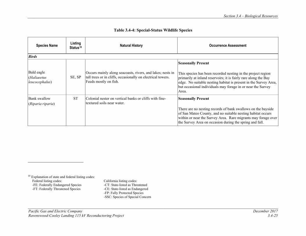
Section 3.4 – Biological Resources
Pacific Gas and Electric Company December 2017 Ravenswood-Cooley Landing 115 kV Reconductoring Project 3.4-25
Table 3.4-4: Special-Status Wildlife Species
Species Name Listing Status10 Natural History Occurrence Assessment
Birds
Bald eagle (Haliaeetus leucocephalus)
SE, SP Occurs mainly along seacoasts, rivers, and lakes; nests in tall trees or in cliffs, occasionally on electrical towers. Feeds mostly on fish.
Seasonally Present This species has been recorded nesting in the project region primarily at inland reservoirs; it is fairly rare along the Bay edge. No suitable nesting habitat is present in the Survey Area, but occasional individuals may forage in or near the Survey Area.
Bank swallow (Riparia riparia)
ST Colonial nester on vertical banks or cliffs with fine-textured soils near water.
Seasonally Present There are no nesting records of bank swallows on the bayside of San Mateo County, and no suitable nesting habitat occurs within or near the Survey Area. Rare migrants may forage over the Survey Area on occasion during the spring and fall.
10 Explanation of state and federal listing codes: Federal listing codes: -FE: Federally Endangered Species -FT: Federally Threatened Species
California listing codes: -CT: State-listed as Threatened -CE: State-listed as Endangered -FP: Fully Protected Species -SSC: Species of Special Concern
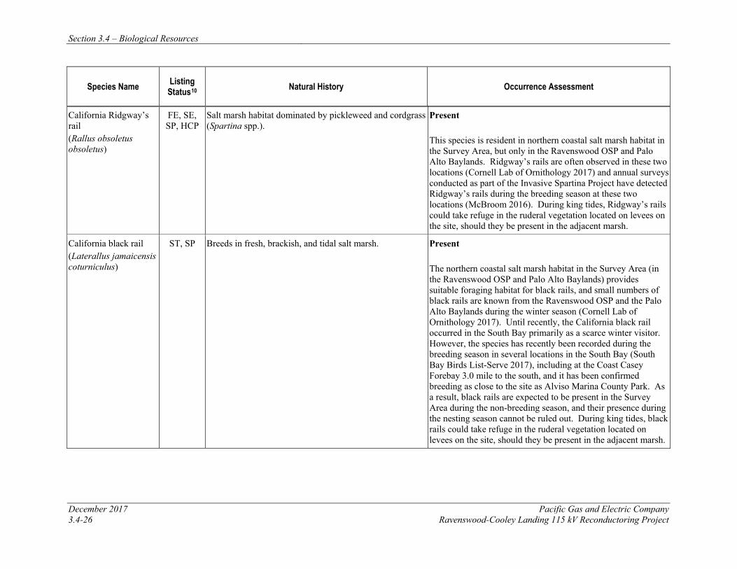
Section 3.4 – Biological Resources
December 2017 Pacific Gas and Electric Company 3.4-26 Ravenswood-Cooley Landing 115 kV Reconductoring Project
Species Name Listing Status10 Natural History Occurrence Assessment
California Ridgway’s rail (Rallus obsoletus obsoletus)
FE, SE, SP, HCP
Salt marsh habitat dominated by pickleweed and cordgrass (Spartina spp.).
Present This species is resident in northern coastal salt marsh habitat in the Survey Area, but only in the Ravenswood OSP and Palo Alto Baylands. Ridgway’s rails are often observed in these two locations (Cornell Lab of Ornithology 2017) and annual surveys conducted as part of the Invasive Spartina Project have detected Ridgway’s rails during the breeding season at these two locations (McBroom 2016). During king tides, Ridgway’s rails could take refuge in the ruderal vegetation located on levees on the site, should they be present in the adjacent marsh.
California black rail (Laterallus jamaicensis coturniculus)
ST, SP Breeds in fresh, brackish, and tidal salt marsh. Present The northern coastal salt marsh habitat in the Survey Area (in the Ravenswood OSP and Palo Alto Baylands) provides suitable foraging habitat for black rails, and small numbers of black rails are known from the Ravenswood OSP and the Palo Alto Baylands during the winter season (Cornell Lab of Ornithology 2017). Until recently, the California black rail occurred in the South Bay primarily as a scarce winter visitor. However, the species has recently been recorded during the breeding season in several locations in the South Bay (South Bay Birds List-Serve 2017), including at the Coast Casey Forebay 3.0 mile to the south, and it has been confirmed breeding as close to the site as Alviso Marina County Park. As a result, black rails are expected to be present in the Survey Area during the non-breeding season, and their presence during the nesting season cannot be ruled out. During king tides, black rails could take refuge in the ruderal vegetation located on levees on the site, should they be present in the adjacent marsh.
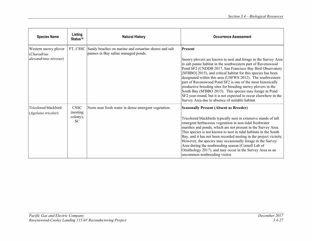
Section 3.4 – Biological Resources
Pacific Gas and Electric Company December 2017 Ravenswood-Cooley Landing 115 kV Reconductoring Project 3.4-27
Species Name Listing Status10 Natural History Occurrence Assessment
Western snowy plover (Charadrius alexandrinus nivosus)
FT, CSSC Sandy beaches on marine and estuarine shores and salt pannes in Bay saline managed ponds.
Present Snowy plovers are known to nest and forage in the Survey Area in salt panne habitat in the southwestern part of Ravenswood Pond SF2 (CNDDB 2017, San Francisco Bay Bird Observatory [SFBBO] 2015), and critical habitat for this species has been designated within this area (USFWS 2012). The southwestern part of Ravenswood Pond SF2 is one of the most historically productive breeding sites for breeding snowy plovers in the South Bay (SFBBO 2015). This species may forage in Pond SF2 year-round, but it is not expected to occur elsewhere in the Survey Area due to absence of suitable habitat.
Tricolored blackbird (Agelaius tricolor)
CSSC (nesting colony),
SC
Nests near fresh water in dense emergent vegetation. Seasonally Present (Absent as Breeder) Tricolored blackbirds typically nest in extensive stands of tall emergent herbaceous vegetation in non-tidal freshwater marshes and ponds, which are not present in the Survey Area. This species is not known to nest in tidal habitats in the South Bay, and it has not been recorded nesting in the project vicinity. However, the species may occasionally forage in the Survey Area during the nonbreeding season (Cornell Lab of Ornithology 2017), and may occur in the Survey Area as an uncommon nonbreeding visitor.
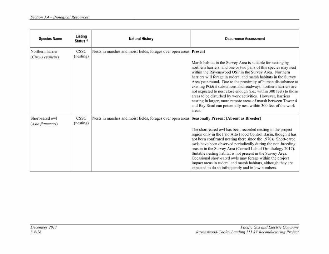
Section 3.4 – Biological Resources
December 2017 Pacific Gas and Electric Company 3.4-28 Ravenswood-Cooley Landing 115 kV Reconductoring Project
Species Name Listing Status10 Natural History Occurrence Assessment
Northern harrier (Circus cyaneus)
CSSC (nesting)
Nests in marshes and moist fields, forages over open areas. Present Marsh habitat in the Survey Area is suitable for nesting by northern harriers, and one or two pairs of this species may nest within the Ravenswood OSP in the Survey Area. Northern harriers will forage in ruderal and marsh habitats in the Survey Area year-round. Due to the proximity of human disturbance at existing PG&E substations and roadways, northern harriers are not expected to nest close enough (i.e., within 300 feet) to those areas to be disturbed by work activities. However, harriers nesting in larger, more remote areas of marsh between Tower 4 and Bay Road can potentially nest within 300 feet of the work areas.
Short-eared owl (Asio flammeus)
CSSC (nesting)
Nests in marshes and moist fields, forages over open areas. Seasonally Present (Absent as Breeder) The short-eared owl has been recorded nesting in the project region only in the Palo Alto Flood Control Basin, though it has not been confirmed nesting there since the 1970s. Short-eared owls have been observed periodically during the non-breeding season in the Survey Area (Cornell Lab of Ornithology 2017). Suitable nesting habitat is not present in the Survey Area. Occasional short-eared owls may forage within the project impact areas in ruderal and marsh habitats, although they are expected to do so infrequently and in low numbers.
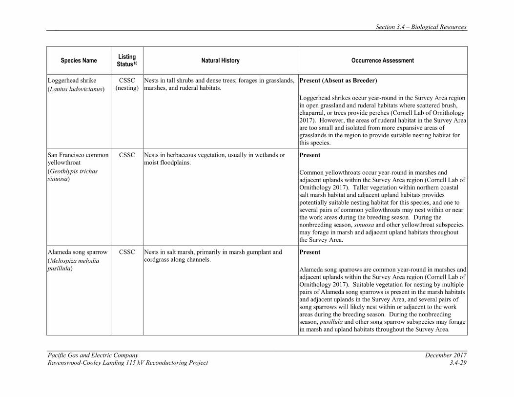
Section 3.4 – Biological Resources
Pacific Gas and Electric Company December 2017 Ravenswood-Cooley Landing 115 kV Reconductoring Project 3.4-29
Species Name Listing Status10 Natural History Occurrence Assessment
Loggerhead shrike (Lanius ludovicianus)
CSSC (nesting)
Nests in tall shrubs and dense trees; forages in grasslands, marshes, and ruderal habitats.
Present (Absent as Breeder) Loggerhead shrikes occur year-round in the Survey Area region in open grassland and ruderal habitats where scattered brush, chaparral, or trees provide perches (Cornell Lab of Ornithology 2017). However, the areas of ruderal habitat in the Survey Area are too small and isolated from more expansive areas of grasslands in the region to provide suitable nesting habitat for this species.
San Francisco common yellowthroat (Geothlypis trichas sinuosa)
CSSC Nests in herbaceous vegetation, usually in wetlands or moist floodplains.
Present Common yellowthroats occur year-round in marshes and adjacent uplands within the Survey Area region (Cornell Lab of Ornithology 2017). Taller vegetation within northern coastal salt marsh habitat and adjacent upland habitats provides potentially suitable nesting habitat for this species, and one to several pairs of common yellowthroats may nest within or near the work areas during the breeding season. During the nonbreeding season, sinuosa and other yellowthroat subspecies may forage in marsh and adjacent upland habitats throughout the Survey Area.
Alameda song sparrow (Melospiza melodia pusillula)
CSSC Nests in salt marsh, primarily in marsh gumplant and cordgrass along channels.
Present Alameda song sparrows are common year-round in marshes and adjacent uplands within the Survey Area region (Cornell Lab of Ornithology 2017). Suitable vegetation for nesting by multiple pairs of Alameda song sparrows is present in the marsh habitats and adjacent uplands in the Survey Area, and several pairs of song sparrows will likely nest within or adjacent to the work areas during the breeding season. During the nonbreeding season, pusillula and other song sparrow subspecies may forage in marsh and upland habitats throughout the Survey Area.
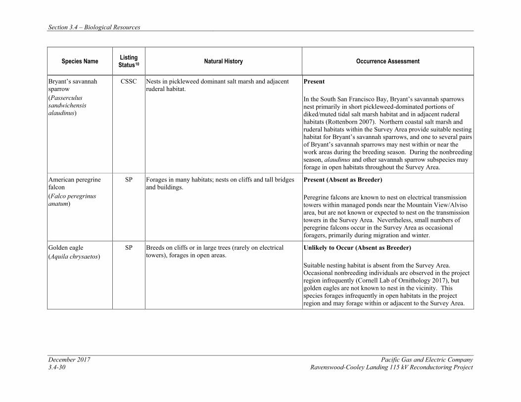
Section 3.4 – Biological Resources
December 2017 Pacific Gas and Electric Company 3.4-30 Ravenswood-Cooley Landing 115 kV Reconductoring Project
Species Name Listing Status10 Natural History Occurrence Assessment
Bryant’s savannah sparrow (Passerculus sandwichensis alaudinus)
CSSC Nests in pickleweed dominant salt marsh and adjacent ruderal habitat.
Present In the South San Francisco Bay, Bryant’s savannah sparrows nest primarily in short pickleweed-dominated portions of diked/muted tidal salt marsh habitat and in adjacent ruderal habitats (Rottenborn 2007). Northern coastal salt marsh and ruderal habitats within the Survey Area provide suitable nesting habitat for Bryant’s savannah sparrows, and one to several pairs of Bryant’s savannah sparrows may nest within or near the work areas during the breeding season. During the nonbreeding season, alaudinus and other savannah sparrow subspecies may forage in open habitats throughout the Survey Area.
American peregrine falcon (Falco peregrinus anatum)
SP Forages in many habitats; nests on cliffs and tall bridges and buildings.
Present (Absent as Breeder) Peregrine falcons are known to nest on electrical transmission towers within managed ponds near the Mountain View/Alviso area, but are not known or expected to nest on the transmission towers in the Survey Area. Nevertheless, small numbers of peregrine falcons occur in the Survey Area as occasional foragers, primarily during migration and winter.
Golden eagle (Aquila chrysaetos)
SP Breeds on cliffs or in large trees (rarely on electrical towers), forages in open areas.
Unlikely to Occur (Absent as Breeder) Suitable nesting habitat is absent from the Survey Area. Occasional nonbreeding individuals are observed in the project region infrequently (Cornell Lab of Ornithology 2017), but golden eagles are not known to nest in the vicinity. This species forages infrequently in open habitats in the project region and may forage within or adjacent to the Survey Area.
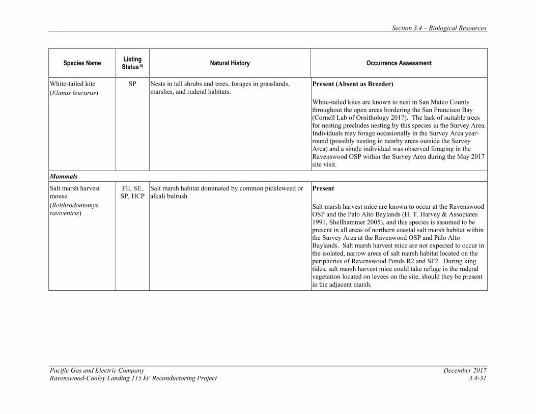
Section 3.4 – Biological Resources
Pacific Gas and Electric Company December 2017 Ravenswood-Cooley Landing 115 kV Reconductoring Project 3.4-31
Species Name Listing Status10 Natural History Occurrence Assessment
White-tailed kite (Elanus leucurus)
SP Nests in tall shrubs and trees, forages in grasslands, marshes, and ruderal habitats.
Present (Absent as Breeder) White-tailed kites are known to nest in San Mateo County throughout the open areas bordering the San Francisco Bay (Cornell Lab of Ornithology 2017). The lack of suitable trees for nesting precludes nesting by this species in the Survey Area. Individuals may forage occasionally in the Survey Area year-round (possibly nesting in nearby areas outside the Survey Area) and a single individual was observed foraging in the Ravenswood OSP within the Survey Area during the May 2017 site visit.
Mammals
Salt marsh harvest mouse (Reithrodontomys raviventris)
FE, SE, SP, HCP
Salt marsh habitat dominated by common pickleweed or alkali bulrush.
Present Salt marsh harvest mice are known to occur at the Ravenswood OSP and the Palo Alto Baylands (H. T. Harvey & Associates 1991, Shellhammer 2005), and this species is assumed to be present in all areas of northern coastal salt marsh habitat within the Survey Area at the Ravenwood OSP and Palo Alto Baylands. Salt marsh harvest mice are not expected to occur in the isolated, narrow areas of salt marsh habitat located on the peripheries of Ravenswood Ponds R2 and SF2. During king tides, salt marsh harvest mice could take refuge in the ruderal vegetation located on levees on the site, should they be present in the adjacent marsh.

Section 3.4 – Biological Resources
December 2017 Pacific Gas and Electric Company 3.4-32 Ravenswood-Cooley Landing 115 kV Reconductoring Project
Species Name Listing Status10 Natural History Occurrence Assessment
Salt marsh wandering shrew (Sorex vagrans halicoetes)
CSSC Medium to high marsh 6 to 8 feet above sea level with abundant driftwood and common pickleweed.
Likely to Occur Salt marsh wandering shrews occur most often in medium-to-high wet tidal marsh (6–8 feet above sea level), with abundant driftwood and other debris for cover (Shellhammer 2000). Typically, they are found in fairly tall pickleweed, in which they build nests, and they may be found within the Survey Area in areas of tall pickleweed. Although there are no known records of this species in the Survey Area, it is presumed to be present in northern coastal salt marsh habitat in the Survey Area where the salt marsh harvest mouse may occur.
Pallid bat (Antrozous pallidus)
CSSC Forages over many habitats; roosts in caves, rock outcrops, buildings, and hollow trees.
Unlikely to Occur (Absent as Breeder) Historically, pallid bats were likely present in a number of locations throughout the project region, but their populations have declined in recent decades. This species has been extirpated as a breeder from urban areas close to the Bay, as is the case in the Survey Area. No suitable roosting habitat is present in the Survey Area and no known maternity colonies are present within or adjacent to the Survey Area. There is a low probability that the species occurs in the project vicinity; however, individuals from more remote colonies could potentially forage on the Survey Area over open habitats on rare occasions.
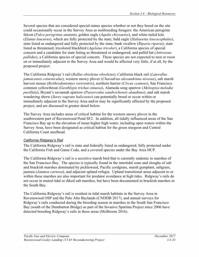
Section 3.4 – Biological Resources
Pacific Gas and Electric Company December 2017 Ravenswood-Cooley Landing 115 kV Reconductoring Project 3.4-33
Several species that are considered special-status species whether or not they breed on the site could occasionally occur in the Survey Area as nonbreeding foragers: the American peregrine falcon (Falco peregrinus anatum), golden eagle (Aquila chrysaetos), and white-tailed kite (Elanus leucurus), which are fully protected by the state; bald eagle (Haliaeetus leucocephalus), state listed as endangered and fully protected by the state; bank swallow (Riparia riparia), state listed as threatened; tricolored blackbird (Agelaius tricolor), a California species of special concern and a candidate for state listing as threatened or endangered; and pallid bat (Antrozous pallidus), a California species of special concern. These species are not expected to nest or roost on or immediately adjacent to the Survey Area and would be affected very little, if at all, by the proposed project.
The California Ridgway’s rail (Rallus obsoletus obsoletus), California black rail (Laterallus jamaicensis coturniculus), western snowy plover (Charadrius alexandrinus nivosus), salt marsh harvest mouse (Reithrodontomys raviventris), northern harrier (Circus cyaneus), San Francisco common yellowthroat (Geothlypis trichas sinuosa), Alameda song sparrow (Melospiza melodia pusillula), Bryant’s savannah sparrow (Passerculus sandwichensis alaudinus), and salt marsh wandering shrew (Sorex vagrans halicoetes) can potentially breed or occur within or immediately adjacent to the Survey Area and/or may be significantly affected by the proposed project, and are discussed in greater detail below.
The Survey Area includes areas of critical habitat for the western snowy plover in the southwestern part of Ravenswood Pond SF2. In addition, all tidally influenced areas of the San Francisco Bay up to the elevation of mean higher high water, including open waters within the Survey Area, have been designated as critical habitat for the green sturgeon and Central California Coast steelhead.
California Ridgway’s Rail The California Ridgway’s rail is state and federally listed as endangered, fully protected under the California Fish and Game Code, and a covered species under the Bay Area HCP.
The California Ridgway’s rail is a secretive marsh bird that is currently endemic to marshes of the San Francisco Bay. The species is typically found in the intertidal zone and sloughs of salt and brackish marshes dominated by pickleweed, Pacific cordgrass, marsh gumplant, saltgrass, jaumea (Jaumea carnosa), and adjacent upland refugia. Upland transitional areas adjacent to or within these marshes are also important for predator avoidance at high tides. Ridgway’s rails do not occur in muted tidal or diked salt marshes, but have been documented in brackish marshes in the South Bay.
The California Ridgway’s rail is resident in tidal marsh habitats in the Survey Area in Ravenswood OSP and the Palo Alto Baylands (CNDDB 2017), and annual surveys for Ridgway’s rails conducted during the breeding season in marshes in the South San Francisco Bay (south of the Dumbarton Bridge) as part of the Invasive Spartina Project since 2006 have detected breeding Ridgway’s rails in these areas (McBroom 2016).
Section 3.4 – Biological Resources
December 2017 Pacific Gas and Electric Company 3.4-34 Ravenswood-Cooley Landy 115 kV Reconductoring Project
No suitable habitat for Ridgway’s rails occurs within the Survey Area at the PG&E Ravenswood Substation, Staging Areas 1–4, Towers 1–4, associated access routes, and work areas, and the species is not known to occur within these areas (CNDDB 2017, McBroom 2016).
Ridgway’s rails are present year-round, and breed, in northern coastal salt marsh habitat in the Ravenswood OSP and Palo Alto Baylands within the Study Area located at or adjacent to Towers 5–9, the Cooley Landing Substation, and associated access routes, work areas, and staging areas (CNDDB 2017, McBroom 2016).
California Black Rail The California black rail is state listed as threatened and fully protected under the California Fish and Game Code.
The California black rail is a small rail that inhabits a variety of marsh types. California black rails are most abundant in extensive tidal marshes with some freshwater input (Evens et al. 1991). They nest primarily in pickleweed-dominated marshes with patches or borders of bulrushes, often near the mouths of creeks. Black rails build nests in tall grasses or marsh vegetation during spring, and lay about six eggs. Nests are usually constructed of pickleweed, and are placed directly on the ground or slightly above ground in vegetation. Black rails feed on terrestrial insects, aquatic invertebrates, and possibly seeds (Trulio and Evens 2000).
California black rails have been recorded in the Survey Area in the Ravenswood OSP, and in nearby portions of the Palo Alto Baylands, during the nonbreeding season (Cornell Lab of Ornithology 2017). The distribution of nonbreeding black rails in the South San Francisco Bay is poorly understood, as they are extremely difficult to detect during the winter. Their numbers in the South Bay have been increasing over the past several years, and there is some possibility that wintering black rails can occur in the Survey Area during the nonbreeding season. Black rails have recently started to nest in the South Bay in tidal marshes in the Alviso area. However, no summering black rails in the South Bay have yet been recorded in the Survey Area.
No suitable habitat for California black rails occurs within the Survey Area at the PG&E Ravenswood Substation, Staging Areas 1–4, Towers 1–4, and associated access routes and work areas, and the species is not known to occur within these areas (CNDDB 2017, Cornell Lab of Ornithology 2017).
Suitable northern coastal salt marsh habitat for California black rails is present in the Ravenswood OSP and Palo Alto Baylands within the Study Area at or adjacent to Towers 5–9, the Cooley Landing Substation, and associated access routes, work areas, and staging areas. California black rails can potentially nest in these marshes during the breeding season, but they are more likely to occur as an occasional winter visitor.
Western Snowy Plover The western snowy plover is federally listed as threatened and a California SSC.
In the South San Francisco Bay, snowy plovers nest on low, barren to sparsely vegetated salt pond levees and islands, at pond edges, and on salt pan areas of dry ponds (Page et al. 2000), and
Section 3.4 – Biological Resources
Pacific Gas and Electric Company December 2017 Ravenswood-Cooley Landing 115 kV Reconductoring Project 3.4-35
preferentially use light-colored substrates such as salt flats (Feeney and Maffei 1991, Marriott 2003). Nesting areas are located near water, where prey (usually brine flies and other insects) are abundant. In some areas, snowy plovers nest within dry salt ponds; in other areas where ponds typically hold water through the summer (e.g., the Newark salt ponds), nests are located primarily on levees. The breeding season of the western snowy plover in California, from nest initiation to fledging of chicks, is considered to be March 1 to September 15. Although snowy plovers can nest as early as March 1, damp nesting substrate in salt ponds, from flooding or normal spring rains, may delay nesting in this habitat until the substrate dries. Some snowy plovers remain in their coastal breeding areas year-round, while others are migratory.
The southwest portion of Pond SF2 provides suitable salt panne nesting habitat for snowy plovers, and this area is one of the most historically productive breeding ponds for snowy plovers in the South Bay (SFBay Bird Observatory 2015). Critical habitat for snowy plovers has been designated within this pond. No additional breeding habitat for snowy plovers is present elsewhere in the Survey Area.
Western snowy plovers occur as foragers year-round in the Survey Area in Ravenswood Pond SF2. However, due to the absence of suitable habitat, the species is unlikely to occur, even as a forager, elsewhere in the Survey Area.
Northern Harrier The northern harrier is a California species of special concern.
The northern harrier nests in marshes and grasslands, usually those with tall vegetation and moisture sufficient to inhibit accessibility of nest sites to predators. This species forages, primarily on small mammals and birds, in a variety of open grassland, ruderal, and agricultural habitats in the project region.
Northern harriers nest within northern coastal salt marsh habitat in the Survey Area on SFPUC lands, at the Ravenswood OSP, and at the Palo Alto Baylands (CNDDB 2017). High levels of existing human disturbances at the PG&E substations, along access routes, and at helicopter landing pads preclude nesting by this species in suitable habitats close enough (i.e., within 300 feet) to these areas to be disturbed by project activities. However, this species may nest within 300 feet of work activities along the Ravenswood-Cooley Landing Line between Tower 4 and Bay Road. Northern harriers forage throughout the marsh and other habitats in the Survey Area year-round, and they may occasionally perch on transmission towers when hunting.
San Francisco Common Yellowthroat The San Francisco common yellowthroat is a California species of special concern.
The San Francisco common yellowthroat inhabits emergent vegetation and nests in fresh and brackish marshes and moist floodplain vegetation around the San Francisco Bay. Common yellowthroats will use small and isolated patches of habitat as long as groundwater is close enough to the surface to encourage the establishment of dense stands of rushes (Scirpus and Juncus spp.), cattails, willows, and other emergent vegetation (Nur et al. 1997, Gardali and Evens 2008). Ideal habitat, however, is composed of extensive, thick riparian, marsh, or
Section 3.4 – Biological Resources
December 2017 Pacific Gas and Electric Company 3.4-36 Ravenswood-Cooley Landy 115 kV Reconductoring Project
herbaceous floodplain vegetation in perpetually moist areas, where few or no brown-headed cowbirds are present (Menges 1998). San Francisco common yellowthroats nest primarily in fresh and brackish marshes, although they will also nest in salt marsh habitats that support tall vegetation (Guzy and Ritchison 1999). This subspecies builds open-cup nests low in the vegetation, and nests from mid-March through late July (Guzy and Ritchison 1999, Gardali and Evens 2008).
The San Francisco common yellowthroat is one of approximately 12 subspecies of common yellowthroat recognized in North America, two of which occur in the project region: the California Species of Special Concern, G. t. sinuosa, and the widespread subspecies, G. t. arizela. Common yellowthroats nesting in the Survey Area are likely of the special-status sinuosa subspecies, but intergrades between the two subspecies may also occur in this area (SFBBO 2012). Because subspecies cannot be reliably distinguished in the field, determination of the presence of the San Francisco common yellowthroat can be achieved only by locating birds that are actively nesting within the breeding range known for the subspecies.
No suitable nesting or foraging habitat for San Francisco common yellowthroats is present adjacent to the Ravenswood Substation, Pond R2, and Pond A2E, and this species is not expected to occur in these areas. The San Francisco common yellowthroat may nest in taller vegetation within northern coastal salt marsh habitats or on ruderal levee slopes on SFPUC lands southwest of Pond SF2, at the Ravenswood OSP, and at the Palo Alto Baylands. During the nonbreeding season, sinuosa and other common yellowthroat subspecies may forage in marsh and ruderal habitats throughout the Survey Area.
Alameda Song Sparrow The Alameda song sparrow is a California SSC.
The Alameda song sparrow is one of three subspecies of song sparrow that breed only in salt marsh habitats of the San Francisco Bay Area (Chan and Spautz 2008). Prime habitat for Alameda song sparrows consists of large areas of tidally influenced salt marsh dominated by cordgrass and gumplant and intersected by open waters, offering dense vegetative cover and singing perches. This subspecies’ primary habitat is fully tidal salt marsh.
No suitable nesting habitat for Alameda song sparrows is present adjacent to the Ravenswood Substation, Pond R2, and Pond A2E. The Alameda song sparrow may nest in northern coastal salt marsh habitat and adjacent ruderal levee slopes on SFPUC lands southwest of Pond SF2, at the Ravenswood OSP, and at the Palo Alto Baylands. During the nonbreeding season, pusillula and other song sparrow subspecies may forage in open habitats throughout the Survey Area.
Bryant’s Savannah Sparrow The Bryant’s savannah sparrow is a California species of special concern.
The Bryant’s savannah sparrow is one of four subspecies of savannah sparrow that breed in California. The alaudinus subspecies occurs primarily along coastal and bay shore areas from Humboldt Bay to Morro Bay (Fitton 2008). It is found year-round in low-elevation, tidally influenced habitat, specifically pickleweed-dominated salt marshes and adjacent grasslands and
Section 3.4 – Biological Resources
Pacific Gas and Electric Company December 2017 Ravenswood-Cooley Landing 115 kV Reconductoring Project 3.4-37
ruderal areas. In the South Bay, Bryant’s savannah sparrows nest primarily in short pickleweed-dominated portions of diked/muted tidal salt marsh habitat, and in adjacent ruderal habitat (Rottenborn 2007).
No suitable nesting habitat for Bryant’s savannah sparrows is present adjacent to the Ravenswood Substation or Pond R2. Bryant’s savannah sparrows may nest in vegetation in areas of higher northern coastal salt marsh habitat and adjacent ruderal habitats around Pond SF2, on SFPUC lands southeast of Pond SF2, at the Ravenswood OSP, and at the Palo Alto Baylands. During the nonbreeding season, alaudinus and other savannah sparrow subspecies may forage in open habitats throughout the Survey Area.
Salt Marsh Harvest Mouse The salt marsh harvest mouse is state and federally listed as endangered, fully protected under the California Fish and Game Code, and a covered species under the Bay Area HCP.
The salt marsh harvest mouse is found only in saline wetlands of the San Francisco Bay and its tributaries. The southern subspecies (R. r. raviventris) is restricted to an area along both sides of San Francisco Bay, from San Mateo County and Alameda County south to Santa Clara County.
The salt marsh harvest mouse has evolved to a life in tidal marshes. This species depends mainly on dense pickleweed as its primary source of food and cover, although it may utilize saltgrass and other salt and brackish marsh vegetation as well. In natural systems, harvest mice can be found in the middle tidal marsh and upland transition zones, with adjacent upland refugia as essential habitat components during high tide events. Although its primary habitat consists of pickleweed-dominated areas in the upper regions of tidal marshes, the salt marsh harvest mouse is also found in diked and muted tidal marshes dominated by pickleweed. Salt marsh harvest mice are capable of breeding year-round, although most reproductive activity likely occurs between March and November, with a peak in mid-summer. Cover-dependent salt marsh harvest mice are unlikely to move long distances over bare areas, and thus, isolation of suitable habitat may lead to genetic isolation of populations or local extinctions.
Salt marsh harvest mice avoid open areas with little or no vegetation, and are not expected to occur in developed areas within the Survey Area. The highly disturbed, narrow patches of northern coastal salt marsh habitat located adjacent to the Ravenswood Substation, Pond R2, and Pond A2E do not provide suitable habitat for the salt marsh harvest mouse, and this species is not expected to occur in these areas. Salt marsh harvest mice may be present in the diked marsh habitat located northeast of Tower 4 and are known to occur in the northern coastal salt marsh habitat located southeast of the railroad tracks on SFPUC lands, in the Ravenswood OSP, and in the Palo Alto Baylands (CNDDB 2017, Shellhammer 2005). This species may also take refuge within ruderal grassland vegetation on levee slopes during high tide events when the adjacent marsh is inundated.
Salt Marsh Wandering Shrew The salt marsh wandering shrew is a California SSC.
Section 3.4 – Biological Resources
December 2017 Pacific Gas and Electric Company 3.4-38 Ravenswood-Cooley Landy 115 kV Reconductoring Project
The salt marsh wandering shrew occurs primarily in medium to high wet tidal marsh (6 to 8 feet above MSL) with abundant driftwood and other debris for cover (Shellhammer 2000). This species has also been recorded in diked marsh habitat. Within these habitats, individuals typically prefer patches of tall pickleweed, in which they build nests. Salt marsh wandering shrews breed and give birth during the spring, however, very little is known about the natural history of this species.
Although this species’ distribution and habitat associations in the South Bay are not well known, the salt marsh wandering shrew is presumed to be potentially present in the same locations where the salt marsh harvest mouse may occur (i.e., in pickleweed-dominated habitats in the Survey Area). Similar to the salt marsh harvest mouse, the salt marsh wandering shrew may also take refuge along ruderal levee slopes during high tide events when the adjacent marsh is inundated.
Habitat Conservation Plans
The project is located within the Plan Area for the PG&E Bay Area Operations & Maintenance Habitat Conservation Plan (Bay Area HCP) (PG&E 2017). The USFWS approved the final 30-year Bay Area HCP and the permit became effective on October 2, 2017. For the purposes of this analysis, PG&E has assumed that the Bay Area HCP adequately assesses power line reconductoring impacts to federally listed species (California Ridgway’s rail and salt marsh harvest mouse) and includes measures to reduce those impacts to less than significant. The relevant APMs derived from the Bay Area HCP are provided below and will ensure impacts to biological resources and listed species will be less than significant.
3.4.4 APPLICANT-PROPOSED MEASURES AND POTENTIAL IMPACTS The following sections describe significance criteria for impacts related to biological resources derived from Appendix G of the CEQA Guidelines, provide APMs to reduce impacts, and assess potential project-related construction and operational impacts on biological resources.
3.4.4.1 Significance Criteria
According to Section 15002(g) of the CEQA Guidelines, “a significant effect on the environment is defined as a substantial adverse change in the physical conditions which exist in the area affected by the proposed project.” As stated in Section 15064(b) of the CEQA Guidelines, the significance of an activity may vary with the setting. Per Appendix G of the CEQA Guidelines, the potential significance of project-related impacts on biological resources were evaluated for each of the criteria listed in Table 3.4-1, as discussed in Section 3.4.4.3.
3.4.4.2 Applicant-Proposed Measures
PG&E will implement the following APMs:
APM BIO-1: General Avoidance of Biological Resource Impacts PG&E will implement field protocols and avoidance and minimization measures to reduce impacts on covered species and sensitive natural communities. This APM consists of the following components:
Section 3.4 – Biological Resources
Pacific Gas and Electric Company December 2017 Ravenswood-Cooley Landing 115 kV Reconductoring Project 3.4-39
• Worker Environmental Awareness Program (WEAP). PG&E will conduct environmental training for all construction and on-site personnel prior to the beginning of site work. Training will include a discussion of the avoidance and minimization measures that are being implemented to protect biological resources, as well as the terms and conditions of permits that apply to the project. Training will include information on the federal and state ESAs and the consequences of noncompliance with these acts. Under this program, workers shall be informed about the presence, life history, and habitat requirements of all listed and special-status species with a potential to be affected within the project area. Training will also include information on state and federal laws protecting nesting birds, wetlands, and other water resources, as applicable and appropriate to the project.
• Conservation Landowner Notification. PG&E will notify conservation land owner at least
two business days prior to conducting covered activities on protected lands (state and federally owned wildlife areas, ecological reserves, or conservation areas); more notice will be provided if required by other permits.
• Litter and trash management. All food scraps, wrappers, food containers, cans, bottles,
and other trash from the project area will be deposited in closed trash containers daily and removed from the project site according to the local sanitation service schedule. Prohibit open fires (such as barbecues) at work sites.
• Parking and vehicle speed limit. Vehicles and equipment will be parked on pavement,
existing roads, and previously disturbed or developed areas or work areas. Off-road parking will only be permitted in previously identified and designated work areas. Vehicle speeds on unpaved roads will not exceed 15 miles per hour.
• Access route and work area limitations. Vehicles will be confined to established roadways and existing access roads, pre-approved temporary access routes, existing boardwalks, and designated matted work areas. Access routes and construction work areas will be limited to the minimum necessary to safely construct the project.
• Maintenance and refueling. All equipment will be maintained to minimize the potential for leaks of automotive fluids such as fuels, solvents, or oils. All refueling and maintenance of vehicles and other construction equipment will be restricted to designated staging areas located at least 100 feet from any down-gradient aquatic habitat, unless otherwise isolated from habitat by secondary containment. Vehicles and equipment operated adjacent to marshlands and open water will be checked daily to prevent leaks of materials that, if introduced to the water, could be harmful to aquatic life. Proper spill prevention and cleanup materials will be maintained in all refueling areas and work areas.
• Pets and firearms. No pets, firearms, hunting or fishing will be permitted at the project site.
• Cover pipes and excavations. Minimize potential for covered species to seek refuge or shelter in pipes and excavations. Inspect pipes, of diameter wide enough to be entered by a covered species that could inhabit the area where pipes are stored, for wildlife species prior to moving pipes and culverts. Fit open trenches or steep-walled holes with escape ramps of
Section 3.4 – Biological Resources
December 2017 Pacific Gas and Electric Company 3.4-40 Ravenswood-Cooley Landy 115 kV Reconductoring Project
plywood boards or sloped earthen ramps at each end if left open overnight. Field crews will search open trenches or steep-walled holes every morning prior to initiating daily activities to ensure wildlife are not trapped. If any wildlife are found, a biologist will be notified and will relocate the species to adjacent habitat or the species will be allowed to naturally disperse, as determined by a biologist.
APM BIO-2: Avoid and Minimize Impacts on the California Ridgway’s Rail and Salt Marsh Harvest Mouse PG&E will implement the following measures to protect the California Ridgway’s rail and salt marsh harvest mouse:
• To protect water quality and avoid the loss of individual California Ridgway’s rails and salt marsh harvest mice, activities within or adjacent to California Ridgway’s rail or salt marsh harvest mouse habitat (i.e., areas of northern coastal salt marsh in and around the Ravenswood OSP and Palo Alto Baylands), including helicopter work, will not occur within two hours before or after extreme high tides (6.5 feet or above, as measured at the Golden Gate Bridge), when the marsh plain is inundated. This measure is necessary because protective cover for California Ridgway’s rails and salt marsh harvest mice is limited during very high tides, and construction activities could disturb and flush individuals and prevent them from reaching available cover, which would increase their risk of predation.
• For activities that will result in ground disturbance in tidal marsh or coastal wetland habitat, including the removal of marsh vegetation, a biologist will flag access routes for crews when working in pickleweed or smooth cordgrass dominated habitats in order to minimize impacts on these species. Crews will use protection mats to minimize ground disturbance when working within pickleweed or smooth cordgrass.
• To avoid take of salt marsh harvest mouse, a biologist will assess the site to determine if vegetation protection mats are appropriate, vegetation removal by hand is needed, and if an onsite biological monitor is needed. Prior to placement of mats or removal of vegetation, the vegetation will be disturbed (i.e., flushed) to force movement of salt marsh harvest mouse into adjacent tidal marsh areas. Immediately following flushing, the field crew will place a mat or manually remove vegetation with nonmotorized tools (e.g., hoe, rake, trowel, or shovel) to the bare ground.
• Conduct work within 700 feet of wetlands suitable for the Ridgway’s rail between September 1 and January 15.
• Compensate for permanent impacts on habitat for the California Ridgway’s rail and salt marsh harvest mouse at a 3:1 ratio (3 acres compensated for every 1 acre permanently affected) and temporary impacts on habitat for these species at a 1:1 ratio.
APM BIO-3: Avoid and Minimize Impacts on the Western Snowy Plover PG&E will implement the following measures to avoid and minimize impacts on the western snowy plover:
Section 3.4 – Biological Resources
Pacific Gas and Electric Company December 2017 Ravenswood-Cooley Landing 115 kV Reconductoring Project 3.4-41
• All work on and within 600 feet of active snowy plover nests on Ravenswood Pond SF2 will be conducted outside of the snowy plover nesting season (defined as March 1 through September 1).
• Prior to conducting work at Ravenswood Pond SF2, a qualified biologist will conduct a pre-activity survey of the work areas and surrounding areas within 600 feet by standing on adjacent trails and levees and scanning the area with a spotting scope. If dependent chicks are present within 600 feet of the work areas, work will be postponed until the biologist determines that the chicks are independent (i.e., until they can fly) or have left the area. If no dependent chicks are present, work may proceed and any adult snowy plovers will be allowed to leave the area on their own.
APM BIO-4: Avoid and Minimize Impacts on Special-status Plant Species PG&E will implement the following measures to minimize impacts on marsh habitat potentially suitable for special-status plant species:
• As part of the WEAP, include information on the identification of noxious weeds, the importance of noxious-weed control, and measures to minimize their spread. Training will include the following BMPs to avoid or minimize the spread of invasive weeds: (1) avoid working in invasive weed infested areas or prioritize activities so that infested areas are worked in last; (2) keep records of road maintenance activities including location and source of grading material; (3) maintain gravel and soil spoil piles free of invasive weeds; use areas known to be weed-free for staging and laydown areas; (4) minimize soil disturbance to the extent possible; (5) materials used for erosion control will be certified weed free (i.e. straw wattles, gravel, fill material, etc.); when restoring a site after disturbance, use a native seed mix; (6) drive on and park on established roads as much as possible; (7) off-road equipment that is not local to the project area will arrive onsite clean and free of soil and plant parts; and (8) clean clothing, footwear, and gear before moving from and infested area to a non-infested area.
• To minimize introduction and spread of noxious weeds, PG&E will avoid moving weed-infested gravel, rock, and other fill materials to relatively weed-free locations. PG&E will use certified weed-free straw and mulch for erosion-control projects. PG&E will maintain stockpiled, uninfested material in a weed-free condition.
• PG&E will work in a direction from uninfested areas to infested areas as much as practical.
• PG&E will minimize soil disturbance and the removal of vegetation during construction, maintenance and other ground-disturbing activities to the extent practicable. Vehicles and equipment should remain on established roads as much as is practicable.
• PG&E will stage in areas not infested with weeds or treat for weed removal prior to using an infested area.
APM BIO-5: Avoid and Minimize Impacts on Sensitive Natural Communities Including Jurisdictional Wetlands and Waters
Section 3.4 – Biological Resources
December 2017 Pacific Gas and Electric Company 3.4-42 Ravenswood-Cooley Landy 115 kV Reconductoring Project
PG&E will implement the following measures to minimize impacts on sensitive natural communities including open water, northern coastal salt marsh, and disturbed northern coastal salt marsh as well as other jurisdictional wetlands and waters of the U.S./State (e.g., salt pannes).
• Construction activities shall be designed to minimize disturbance of wetlands (including seasonal ponded areas) and regulated waters in the project area to the extent practicable. Disturbance or removal of vegetation shall not exceed the minimum necessary to complete construction activities. Precautions shall be taken to avoid other damage to vegetation by people or equipment.
• For activities that will result in ground disturbance in tidal marsh or coastal wetland habitat, including the removal of marsh vegetation, a biologist will flag access routes for crews when working in pickleweed or cordgrass dominated habitats in order to minimize impacts on these species. Crews will use protective matting (e.g., timber mats, crane pads) to minimize ground disturbance when working within pickleweed or cordgrass. If deemed necessary by the biologist, small areas of healthy vegetation will be cleared by hand prior to placement of protective mats.
• Erosion, sediment, and material stockpile BMPs will be installed between work areas and adjacent wetlands or waterways as required by APM HYD-1: Prepare and Implement a Storm Water Pollution Prevention Plan (SWPPP). See Section 3.9, Hydrology and Water Quality, for full description.
• Compensate for both permanent and temporary impacts through consultation with the USACE and SWRCB during the CWA 404/401 permitting process.
3.4.4.3 Potential Impacts
Potential project impacts on biological resources were evaluated against the CEQA significance criteria and are discussed below. The impact analysis evaluates potential project impacts during the construction phase and operation and maintenance phase.
The project includes reconductoring the existing 115 kV power line between Ravenswood Substation and Cooley Landing Substation. Construction activities include installing new conductor, performing minor tower modifications, and establishing required access and work areas, as described in Chapter 2, Project Description. Operation and maintenance activities for the reconductored power line will not change from current practices; thus, no operation-related impacts related to biological resources will occur.
Potential impacts on habitats within the Survey Area are shown on Figure 3.4-2 and summarized for each work area, access route, and staging area in Tables 3.4-5 and 3.4-6, respectively. The impact analysis is focused on construction activities that are required to install the new conductors and reinforce foundations at four tower locations (Towers 1, 2, 8, and 9), and to establish required access and construction work areas. For the purpose of the impact analysis, the location and height of the existing structures are considered part of the existing baseline conditions.
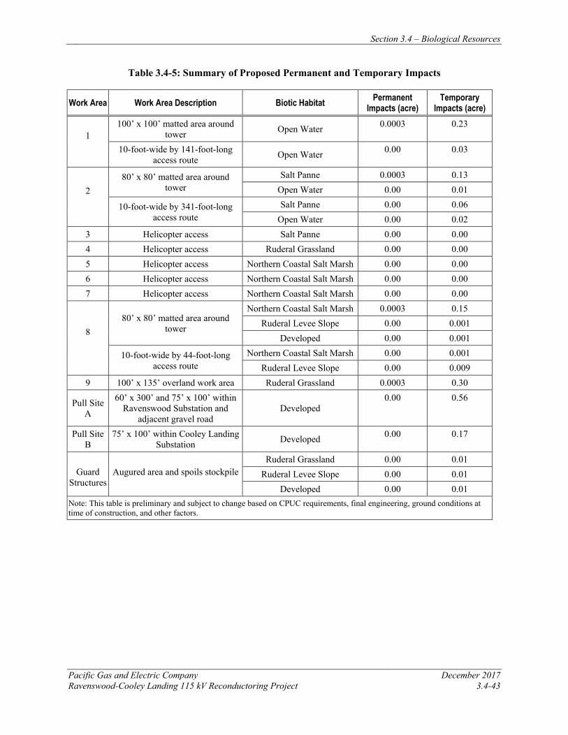
Section 3.4 – Biological Resources
Pacific Gas and Electric Company December 2017 Ravenswood-Cooley Landing 115 kV Reconductoring Project 3.4-43
Table 3.4-5: Summary of Proposed Permanent and Temporary Impacts
Work Area Work Area Description Biotic Habitat Permanent Impacts (acre)
Temporary Impacts (acre)
1 100’ x 100’ matted area around
tower Open Water 0.0003 0.23
10-foot-wide by 141-foot-long access route Open Water 0.00 0.03
2 80’ x 80’ matted area around
tower Salt Panne 0.0003 0.13
Open Water 0.00 0.01
10-foot-wide by 341-foot-long access route
Salt Panne 0.00 0.06 Open Water 0.00 0.02
3 Helicopter access Salt Panne 0.00 0.00 4 Helicopter access Ruderal Grassland 0.00 0.00 5 Helicopter access Northern Coastal Salt Marsh 0.00 0.00 6 Helicopter access Northern Coastal Salt Marsh 0.00 0.00 7 Helicopter access Northern Coastal Salt Marsh 0.00 0.00
8 80’ x 80’ matted area around
tower
Northern Coastal Salt Marsh 0.0003 0.15 Ruderal Levee Slope 0.00 0.001
Developed 0.00 0.001
10-foot-wide by 44-foot-long access route
Northern Coastal Salt Marsh 0.00 0.001 Ruderal Levee Slope 0.00 0.009
9 100’ x 135’ overland work area Ruderal Grassland 0.0003 0.30
Pull Site A
60’ x 300’ and 75’ x 100’ within Ravenswood Substation and
adjacent gravel road Developed
0.00 0.56
Pull Site B
75’ x 100’ within Cooley Landing Substation Developed 0.00 0.17
Guard Structures
Augured area and spoils stockpile Ruderal Grassland 0.00 0.01
Ruderal Levee Slope 0.00 0.01 Developed 0.00 0.01
Note: This table is preliminary and subject to change based on CPUC requirements, final engineering, ground conditions at time of construction, and other factors.
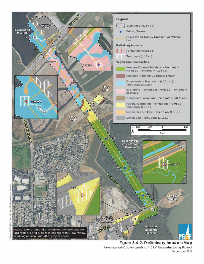
Highway 8
4
University Avenue RavenswoodRavenswood
Open SpaceOpen SpacePreservePreserve
Cooley Cooley Landing Landing
ParkPark
Bay Road
San Francisco Bay Trail
Ravenswood Ravenswood Pond SF2Pond SF2
Ravenswood Ravenswood Pond R2Pond R2
Ravenswood Ravenswood Pond SF2Pond SF2
SFPUCSFPUCLandsLands
Palo AltoPalo AltoBaylandsBaylandsPreservePreserve
SFPUCSFPUCLandsLands
RavenswoodSubstation
CooleyLanding
Substation
Tower 1
Tower 2
Tower 3
Tower 4
Tower 5
Tower 6
Tower 7
Tower 8
Tower 9
2017
N:\P
rojec
ts390
0\398
0-01\R
eport
s\PEA
\Fig 3
Preli
mina
ry Im
pacts
Map
.mxd
Legend
Study Area (90.64 ac)
Existing Towers
Ravenswood-Cooley Landing TransmissionLines
Preliminary Impacts
Permanent (0.001 ac)
Temporary (4.15 ac)
Vegetation Communities
Northern Coastal Salt Marsh - Permanent(<0.01 ac), Temporary (0.14 ac)
Disturbed Northern Coastal Salt Marsh
Open Water - Permanent (<0.01 ac),Temporary (0.39ac)
Salt Panne - Permanent (<0.01 ac), Temporary(0.19 ac)
Ornamental Woodland - Temporary (<0.01 ac)
Ruderal Grasslands - Permanent (<0.01 ac),Temporary (1.12 ac)
Ruderal Levee Slope - Temporary (0.18 ac)
Developed - Temporary (2.13 ac)
850 0 850425
Feet
Figure 4-2. Preliminary Impacts Map Ravenswood-Cooley Landing Reconductoring Project
Tower 1
Tower 2
Tower 8
Tower 9
Project work areas and other project components areapproximate and subject to change with CPUC review,final engineering, and other project needs
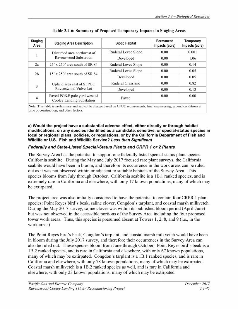
Section 3.4 – Biological Resources
Pacific Gas and Electric Company December 2017 Ravenswood-Cooley Landing 115 kV Reconductoring Project 3.4-45
Table 3.4-6: Summary of Proposed Temporary Impacts in Staging Areas
Staging Area Staging Area Description Biotic Habitat Permanent
Impacts (acre) Temporary
Impacts (acre)
1 Disturbed area northwest of Ravenswood Substation
Ruderal Levee Slope 0.00 0.001 Developed 0.00 1.06
2a 25’ x 250’ area south of SR 84 Ruderal Levee Slope 0.00 0.14
2b 15’ x 250’ area south of SR 84 Ruderal Levee Slope 0.00 0.05
Developed 0.00 0.05
3 Upland area east of SFPUC Ravenswood Valve Lot
Ruderal Grassland 0.00 0.82 Developed 0.00 0.13
4 Paved PG&E pole yard west of Cooley Landing Substation Paved 0.00 0.00
Note: This table is preliminary and subject to change based on CPUC requirements, final engineering, ground conditions at time of construction, and other factors.
a) Would the project have a substantial adverse effect, either directly or through habitatmodifications, on any species identified as a candidate, sensitive, or special-status species in local or regional plans, policies, or regulations, or by the California Department of Fish and Wildlife or U.S. Fish and Wildlife Service? Less than Significant
Federally and State-Listed Special-Status Plants and CRPR 1 or 2 Plants
The Survey Area has the potential to support one federally listed special-status plant species: California seablite. During the May and July 2017 focused rare plant surveys, the California seablite would have been in bloom, and therefore its occurrence in the work areas can be ruled out as it was not observed within or adjacent to suitable habitats of the Survey Area. This species blooms from July through October. California seablite is a 1B.1 ranked species, and is extremely rare in California and elsewhere, with only 17 known populations, many of which may be extirpated.
The project area was also initially considered to have the potential to contain four CRPR 1 plant species: Point Reyes bird’s beak, saline clover, Congdon’s tarplant, and coastal marsh milkvetch. During the May 2017 survey, saline clover was within its published bloom period (April-June) but was not observed in the accessible portions of the Survey Area including the four proposed tower work areas. Thus, this species is presumed absent at Towers 1, 2, 8, and 9 (i.e., in the work areas).
The Point Reyes bird’s beak, Congdon’s tarplant, and coastal marsh milkvetch would have been in bloom during the July 2017 survey, and therefore their occurrences in the Survey Area can also be ruled out. These species bloom from June through October. Point Reyes bird’s beak is a 1B.2 ranked species, and is rare in California and elsewhere, with only 67 known populations, many of which may be extirpated. Congdon’s tarplant is a 1B.1 ranked species, and is rare in California and elsewhere, with only 78 known populations, many of which may be extirpated. Coastal marsh milkvetch is a 1B.2 ranked species as well, and is rare in California and elsewhere, with only 23 known populations, many of which may be extirpated.
Section 3.4 – Biological Resources
December 2017 Pacific Gas and Electric Company 3.4-46 Ravenswood-Cooley Landy 115 kV Reconductoring Project
These rare plants are currently considered absent from the Survey Area. Implementation of APM BIO-4 and APM BIO-5, described above, will avoid and minimize impacts to suitable habitat for these species by constructing a majority of the work from the existing roads and levee banks and minimizing ground disturbance that could affect water quality and sedimentation. Water quality impacts to areas adjacent to the temporary access path, where ground will be disturbed, are also not anticipated due to the implementation of APM BIO-5, which employs standard erosion and sediment control BMPs. With these measures incorporated to prevent impacts to and degradation of habitats capable of supporting special-status plant species, as well as the focused survey results that found all potentially occurring species to be absent from impact areas, impacts from construction and operation and maintenance of the project will be less than significant.
California Ridgway’s Rail and California Black Rail
Project implementation will occur during the period September to February, and in accordance with APM BIO-2, work within 700 feet of nesting habitat for the California Ridgway’s rail will occur only during the period of September 1 through January 15. Therefore, no impacts on nesting rails will occur. However, there is potential for the project to result in the indirect disturbance of foraging California Ridgway’s rails and California black rails due to the noise and activity of workers and equipment during project activities. Noise and disturbance could result in a reduction in foraging efficiency in foraging areas, increased movement or flushing from cover, or altered activity patterns that reduce energy reserves and increase predation risk. Rails could be forced to adjust the boundaries of their territories or to disperse to other habitat areas.
If any foraging California Ridgway’s rails or California black rails are present on site when construction commences, the individuals would disperse before they could be killed or injured. Therefore, foraging individuals will not be directly lost due to construction activities. There would still be some potential for disturbance of foraging individuals of these species in the adjacent marsh as a result of noise or movement of workers and equipment during project construction. Construction activities may also occur at night, when rails are more active. Such effects would not result in substantial harassment or disturbance of individuals, and would not result in a reduction in the populations of either of these species. However, disturbance could cause rails to flush, making them more susceptible to predation, or could preclude them from using high-quality cover that might otherwise conceal them from predators. In particular, if construction were to occur during king tides, when concealing cover is limited, rails that are flushed due to project disturbance would be susceptible to predation. Implementation of APMs BIO-1 and BIO-2 will minimize the potential for such impacts during construction.
The proposed increased height of Towers 8 and 9 by 4.5 feet (5.3%) could potentially improve the quality of perch sites for raptors such as red-tailed hawks and peregrine falcons, which use these towers as hunting perches from which they prey upon rails. However, perches are available for raptors in many locations at the Ravenswood OSP and Palo Alto Baylands, and the increased heights of Towers 8 and 9 is not expected to result in a substantial increase in depredation of rails by raptors.
The project will result in permanent impacts on less than 0.001 acre of northern coastal salt marsh habitat and the temporary disturbance of approximately 0.15 acre of this habitat.
Section 3.4 – Biological Resources
Pacific Gas and Electric Company December 2017 Ravenswood-Cooley Landing 115 kV Reconductoring Project 3.4-47
However, being so close to public areas and access roads, this salt marsh vegetation is not desirable nesting habitat for California Ridgway’s rails or black rails. The project’s permanent impact footprint on northern coastal salt marsh habitat will be minimal, as there are only four towers with eight 16-inch diameter concrete piles that will be installed (a total of 44.7 sq. ft., or 0.001 acre spread across 32 locations). Furthermore, due to the short duration in which work will occur around Tower 8 and the use of mats for accessing the tower, pickleweed in the temporary impact area is expected to recover quickly following project completion, so that no long-term loss or degradation of habitat within the temporary impact areas will occur. Overall, the minimal loss and temporary disturbance of tidal salt marsh foraging habitat for rails as a result of the project constitutes a very small proportion of what is currently available to these species in the Survey Area and in the greater region of the South Bay, and will not substantially reduce foraging opportunities for the rails in the Survey Area. Nevertheless, implementation of APM BIO-2, which includes compensation for permanent impacts on habitat for the California Ridgway’s rail at a 3:1 ratio (3 acres of compensation for every 1 acre permanently affected) and temporary impacts on habitat for this species at a 1:1 ratio, will reduce this impact. Therefore, with implementation of APMs BIO-1 and BIO-2, impacts from construction or operation and maintenance of the project on the California Ridgway’s rail and California black rail will be less than significant.
Western Snowy Plover
Project construction is proposed to occur between September and February, which is outside of the bulk of the nesting season for snowy plovers (although plovers may still have dependent young into September). However, with the implementation of APM BIO-3, which restricts work within 600 feet of plover nesting habitat in Ravenswood Pond SF2 to the period outside of the snowy plover nesting season (defined as March 1 through September 1), the project will have no effect on nesting western snowy plovers. In addition, APM BIO-3 requires a pre-activity survey for adults with dependent young prior to the start of project work at Ravenswood Pond SF2.
The project can potentially result in the disturbance of foraging western snowy plovers due to noise and activity of workers and equipment at Ravenswood Pond SF2. As described above for the California Ridgway’s rail and California black rail, noise may alter foraging behavior. In addition, snowy plovers may have dependent, flightless young for approximately 30 days after eggs have hatched. Project activities can potentially flush adults away from their young, resulting in temporary separation of adults from young or possible abandonment of dependent young. Implementation of APM BIO-3 will avoid such an impact.
The proposed increased height of Tower 2 by 14.5 feet (12.4%) and Tower 3 by 4.5 feet (3.7%) could potentially improve the quality of perch sites for raptors such as red-tailed hawks and peregrine falcons, which use these towers as hunting perches from which they prey upon western snowy plovers. However, perches are available for raptors in many locations at Ravenswood Pond SF2, and the increased heights of Towers 2 and 3 is not expected to result in a substantial increase in depredation of snowy plovers by raptors. Therefore, the impacts from construction or operation and maintenance of the project will be less than significant.
Section 3.4 – Biological Resources
December 2017 Pacific Gas and Electric Company 3.4-48 Ravenswood-Cooley Landy 115 kV Reconductoring Project
Salt Marsh Harvest Mouse and Salt Marsh Wandering Shrew
Small numbers of salt marsh harvest mice and salt marsh wandering shrews may occur in pickleweed-dominated habitats in the work areas, particularly in the work areas and access routes for Tower 8. In the absence of protective measures, direct impacts on the salt marsh harvest mouse and salt marsh wandering shrew could potentially occur as a result of work activities at this location. Project activities may result in the injury or mortality of salt marsh harvest mice and salt marsh wandering shrews as a result of crushing by equipment, vehicle traffic, and worker foot traffic. Individuals that vacate the area because of increased levels of noise and disturbance, including helicopter work over the Ravenswood OSP, may be exposed to increased competition from conspecifics already occupying the area to which they were displaced, and increased levels of predation because of unfamiliarity with the new area or lack of sufficient cover. Project construction and the removal of salt marsh vegetation may expose individual mice and shrews to predation, particularly if construction activities occur during king tides, when cover for these species is very limited. Due to the rarity of these species, any of these project-related impacts on individual salt marsh harvest mice or salt marsh wandering shrews would be significant. During construction, the implementation of APMs BIO-1 and BIO-2 described above will reduce potential impacts of the project on salt marsh harvest mice and salt marsh wandering shrews to a less-than-significant level.
The proposed increased height of Towers 8 and 9 by 4.5 feet (5.3%) could potentially improve the quality of perch sites for raptors such as red-tailed hawks and peregrine falcons, which use these towers as hunting perches from which they prey upon small mammals. However, perches are available for raptors in many locations at the Ravenswood OSP and Palo Alto Baylands Preserve, and the increased heights of Towers 8 and 9 is not expected to result in a substantial increase in depredation of salt marsh harvest mice and salt marsh wandering shrews by raptors.
The project will result in permanent impacts on less than 0.001 acre and temporary impacts on 0.15 acre of northern coastal salt marsh habitat, which is primary habitat for salt marsh harvest mice and salt marsh wandering shrews. As described for the California Ridgway’s rail and California black rail above, the permanent impacts to salt marsh habitat are extremely limited, and the temporary impact areas are expected to recover quickly following project completion, so that no long-term loss or degradation of habitat within the temporary impact areas will occur. Nevertheless, implementation of APM BIO-2, which includes compensation for permanent impacts on habitat for the salt marsh harvest mouse at a 3:1 ratio (3 acres of compensation for every 1 acre permanently affected) and temporary impacts on habitat for this species at a 1:1 ratio, will reduce this impact. Therefore, with implementation of APMs, impacts from construction or operation and maintenance of the project on salt marsh harvest mice and salt marsh wandering shrews will be less than significant.
Northern Harrier, San Francisco Common Yellowthroat, Alameda Song Sparrow, Bryant’s Savannah Sparrow, and White-tailed Kite
The northern harrier, San Francisco common yellowthroat, Alameda song sparrow, and Bryant’s savannah sparrow (California species of special concern) are known to nest, roost, and forage year-round in the project vicinity, and the white-tailed kite (a state fully protected species) could potentially nest nearby (outside the Survey Area).
Section 3.4 – Biological Resources
Pacific Gas and Electric Company December 2017 Ravenswood-Cooley Landing 115 kV Reconductoring Project 3.4-49
Project activities would result in the temporary disturbance of suitable nesting and foraging habitat for these species. In addition, heavy ground disturbance, noise, and vibrations caused by proposed activities could potentially disturb foraging or roosting individuals and cause them to move away from work areas. However, the project is scheduled to occur outside of the nesting season for these species (i.e., between September and February), and therefore no impacts on active nests of these species would occur. The disturbance of small numbers of foraging individuals would represent a very small fraction of the regional population of these species. Additionally, the habitats in the Survey Area that provide suitable habitat for these species represent a small proportion of the habitats that support this species regionally. Therefore, the disturbance of potential nesting, roosting, and foraging habitat will not constitute a significant impact on this species or their habitat.
b) Would the project have a substantial adverse effect on any riparian habitat or other sensitive natural community identified in local or regional plans, policies, regulations, or by the California Department of Fish and Wildlife or U.S. Fish and Wildlife Service? Less than Significant
The CDFW defines sensitive natural communities and vegetation alliances using NatureServe’s standard heritage program methodology (CDFG 2010b). Project impacts on CDFW sensitive natural communities, vegetation alliances/associations, or any such community identified in local or regional plans, policies, and regulations, were considered and evaluated. Furthermore, aquatic, wetland and riparian habitats are also protected under applicable federal, state, or local regulations, and are generally subject to regulation, protection, or consideration by the USACE, RWQCB, CDFW, and/or the USFWS. Impacts to sensitive northern coastal salt marsh habitat are addressed below.
No true riparian habitat is present in the proposed work areas or in the surrounding Survey Area. Project activities that could impact the bank include temporary construction access. However, the vegetation on the levee slope is ruderal and herbaceous, and the access will only be for a short duration. With the incorporation of water quality measures described in APMs BIO-1 and BIO-5, including seeding of disturbed upland areas with a native seed mix to prevent erosion, such impacts from construction or operation and maintenance of the project will be less than significant.
c) Would the project have a substantial adverse effect on federally protected wetlands as defined by Section 404 of the Clean Water Act (including, but not limited to, marsh, vernal pool, coastal, etc.) through direct removal, filling, hydrological interruption, or other means? Less than Significant
Wetlands are considered sensitive environmental resources protected at federal, state, and local levels. They provide unique habitat functions and values for wildlife, and provide habitat for plant species adapted to wetland hydrology. Throughout California, the quality and quantity of wetlands has dramatically declined owing to the construction of dams, dikes, and levees, as well as because of water diversions, the filling of wetlands for development, and the overall degradation of water quality by inputs of runoff from agricultural, urban, and infrastructure development and other sources. The following sections discuss the potential project impacts on wetlands and other waters regulated under Section 404 of the Clean Water Act and describes why such impacts are less than significant.
Section 3.4 – Biological Resources
December 2017 Pacific Gas and Electric Company 3.4-50 Ravenswood-Cooley Landy 115 kV Reconductoring Project
Northern Coastal Salt Marsh
The Survey Area contains sensitive northern coastal salt marsh habitat (G3/S3.2) (CDFG 2010b). This habitat is considered vulnerable on both a global and state scale, and faces a moderate risk of extinction or elimination. In California, northern coastal salt marsh is moderately threatened (CNDDB 2017). Moreover, the “Sarcocornia pacifica (Salicornia depressa) (Pickleweed mats) Alliance” within the northern coastal salt marsh habitat is considered highly imperiled (CDFG 2010a).
Project design and construction methods have been carefully considered to avoid and minimize impacts to northern coastal salt marsh. Project impacts include the permanent loss of less than 0.001 acre of northern coastal salt marsh habitat due to the proposed foundation improvements. Furthermore, the project will compensate for permanent impacts on suitable California Ridgway’s rail and salt marsh harvest mouse habitat at a 3:1 ratio (3 acres compensated for every 1 acre permanently affected). Given that California Ridgway’s rail and salt marsh harvest mouse habitat is representative of northern coastal salt marsh (i.e., jurisdictional wetlands), compensation for impacts to California Ridgway’s rail and salt marsh harvest mouse habitat will also compensate for permanent impacts to jurisdictional wetlands. Temporary impacts of 0.15 acre of California Ridgway’s rail and salt marsh harvest mouse habitat (and therefore, jurisdictional wetlands) will be compensated at a 1:1 ratio as per APM BIO-2, and indirect impacts will be avoided and minimized as per APMs BIO-1 and BIO-5. Therefore, impacts from construction or operation and maintenance of the project will be less than significant.
Spread of Invasive Weeds
Invasive weeds occur in the ruderal levee slope habitat near the Survey Area. Invasive weeds can spread quickly and can be difficult to eradicate. Many non-native, invasive plant species produce seeds that germinate readily following disturbance. Further, disturbed areas are highly susceptible to colonization by non-native, invasive species that occur locally, or whose propagules are transported by personnel, vehicles, and other equipment. Local propagule sources of moderately invasive wild oats, black mustard, ripgut brome, Italian thistle, Italian ryegrass, and seaside barley were observed on and surrounding the immediate vicinity of the work areas during the May 2017 survey. Though these upland species are unlikely to propagate in the northern coastal salt marsh community due to unsuitable, wet conditions, invasive plants adapted to wet conditions may be located adjacent to the staging area and access pathways, and could be inadvertently transported to the work areas during construction activities on construction equipment. Disturbed portions of the Survey Area would be especially vulnerable to invasion by non-native marshland species, which could degrade habitat values and threaten the sensitive northern coastal salt marsh community.
Potential impacts could occur if the project facilitates encroachment of invasive weeds into northern coastal salt marsh habitat. However, implementation of APM-BIO-4 above will ensure avoidance and minimization of impacts from invasive species in the work areas and reduce potential weed-related impacts to northern coastal salt marsh during construction to a less-than-significant level. Operations and maintenance activities will not change from current conditions; therefore, no impact will occur.
Section 3.4 – Biological Resources
Pacific Gas and Electric Company December 2017 Ravenswood-Cooley Landing 115 kV Reconductoring Project 3.4-51
Open Water Habitat
Water quality in the open water habitat could be impacted by construction activities. Disturbances caused by the project could result in an increase of sedimentation and debris in the active slough channels in or near the work areas. This would, in turn, also result in indirect impacts on species that may occur in the open water habitat. Open waters provide substantial habitat value for wildlife, offering potential foraging and dispersal opportunities for aquatic-dependent species. Additionally, these habitats are considered sensitive and are regulated by both federal and state agencies.
Open water channels occur throughout the Survey Area and within the proposed work areas. These channels range in depths of approximately 6 to 24 inches. Channel widths range from approximately 1 foot in the southern portion and up to approximately 60 feet in the north. In the proposed work areas, Ravenswood Pond R2 was fully inundated with an approximate depth of up to 24 inches, whereas Ravenswood Pond SF2 was mostly dry with one large open water channel bisecting the access route to the work area with an approximate depth of 24 inches and a width of approximately 45 feet. There were several dry, narrow channels under Tower 2 observed during the field survey with widths of approximately 1 to 2 feet wide. Due to the proposed foundation improvements at Tower 1, the project will involve the loss of approximately 0.0003 acre of open water habitat. The project will result in 0.29 acres of temporary impacts to open water habitat from access and construction at Towers 1 and 2, but because these open waters are unvegetated, the impact areas will be restored to preconstruction conditions upon the completion of work. Compensation for impacts to open water will be determined through consultation with the USACE and SWRCB during the CWA 404/401 permitting process.
APMs BIO-1 and BIO-5 include measures to minimize adverse impacts to open water habitat by limiting the work footprint in marsh and slough channels to the existing boardwalks and to matted work areas and temporary access routes. Construction personnel will be restricted to the existing boardwalk and matted access routes and work areas for construction within open water habitat.
Impacts to open water will be avoided, minimized, and compensated through implementation of APMs BIO-1 and BIO-5, which include measures to avoid impacts on water quality. With the incorporation of these measures, the impacts on open water habitat from construction and operation and maintenance of the project will be less than significant.
d) Would the project interfere substantially with the movement of any native resident or migratory fish or wildlife species or with established native resident or migratory wildlife corridors, or impede the use of native wildlife nursery sites? No Impact
For many species, the landscape is a mosaic of suitable and unsuitable habitat types. Environmental corridors are segments of land that provide a link between these different habitats while also providing cover. Development that fragments natural habitats (i.e., breaks them into smaller, disjunct pieces) can have a twofold impact on wildlife: first, as habitat patches become smaller they are unable to support as many individuals (patch size); and second, the area between habitat patches may be unsuitable for wildlife species to traverse (connectivity).
Section 3.4 – Biological Resources
December 2017 Pacific Gas and Electric Company 3.4-52 Ravenswood-Cooley Landy 115 kV Reconductoring Project
As described above, the proposed project entails reconductoring an existing power line and reinforcing four tower foundations in the existing alignment. The Survey Area is not located along a major wildlife movement corridor; however, habitats within the Survey Area are utilized by several bird species for nesting and small mammals for breeding, and fish may move through tidal channels within the marshes at the Ravenswood Open Space Preserve and Palo Alto Baylands. The new foundation reinforcements, similar to the existing foundations, will occur in the existing footprint in the marsh and would not impede wildlife movement, result in the fragmentation of natural habitats, or permanently impact any tidal channels that may be used by fish within the marsh. The project will also not result in the substantial loss of natural areas used by fish or other animals. Because the existing alignment has been in operation for over 50 years, levels of temporary disturbance to wildlife resulting from the proposed construction are not expected to change. Therefore, construction or operation and maintenance of the project will have no impact on the movement of any native resident or migratory fish or wildlife species or with established native resident or migratory wildlife corridors, or impede the use of native wildlife nursery sites.
e) Would the project conflict with any local policies or ordinances protecting biological resources, such as a tree preservation policy or ordinance? No Impact
The project’s design and APMs are compatible with the policies of the City of Palo Alto Baylands Master Plan, including the protection of wetlands. No other local policies or ordinances protecting biological resources apply to the project. Thus, the project will have no impact.
f) Would the project conflict with the provisions of an adopted Habitat Conservation Plan, Natural Community Conservation Plan, or other approved local, regional, or state habitat conservation plan? No Impact
The project will not conflict with the provisions of an adopted Habitat Conservation Plan, Natural Community Conservation Plan, or other approved local, regional, or state habitat conservation plan. The Bay Area HCP pertains to the entire Survey Area, and the construction and operation of the project will comply with the adopted strategies as described above.
3.4.5 REFERENCES AECOM. 2016. South Bay Salt Pond Restoration Project Final Environmental Impact
Statement/Report, Phase 2. April.
Baldwin, B. G., D. H. Goldman, D. J. Keil, R. Patterson, T. J. Rosatti, and D. H. Wilken, Editors. 2012. The Jepson Manual: Vascular Plants of California, Second Edition. University of California Press, Berkeley, California.
Bay Conservation and Development Commission (BCDC). 2012. San Francisco Bay Plan. <http://www.bcdc.ca.gov/pdf/bayplan/bayplan.pdf>. Accessed May 2017.
Bland, A. 2017. Little Fish in Big Trouble: the Bay Delta’s Longfin Smelt. <https://www.kcet.org/shows/earth-focus/little-fish-in-big-trouble-the-bay-deltas-longfin-smelt>. Accessed May 2017.
Section 3.4 – Biological Resources
Pacific Gas and Electric Company December 2017 Ravenswood-Cooley Landing 115 kV Reconductoring Project 3.4-53
California Invasive Plant Council. 2017. California Invasive Plant Inventory Database. <http://www.cal-ipc.org/paf/>. Accessed May 2017.
Carpelan, L. H. 1957. Hydrobiology of the Alviso salt ponds. Ecology 38(3): 375-390.
California Department of Fish and Game (CDFG). 2009. Protocols for Surveying and Evaluating Impacts to Special Status Native Plant Populations and Natural Communities. November. Accessed May 2017 from https://www.wildlife.ca.gov/Conservation/Survey-Protocols#377281280-plants.
CDFG. 2010a. Vegetation Classification and Mapping Program: Natural Communities List. <http://www.dfg.ca.gov/biogeodata/vegcamp/ natural_communities.asp>. Accessed May 2017.
CDFG. 2010b. List of Vegetation Alliances and Associations. September. Vegetation Classification and Mapping Program, Sacramento, California.
Chan, Y., and H. Spautz. 2008. Alameda song sparrow (Melospiza melodia pusillula) in W. D. Shuford and T. Gardali, editors, California Bird Species of Special Concern: A Ranked Assessment of Species, Subspecies, and Distinct Populations of Birds of Immediate Conservation Concern in California. Western Field Ornithologists and California Department of Fish and Game, Camarillo and Sacramento, California.
California Natural Diversity Database (CNDDB). 2017. Rarefind 5.0. California Department of Fish and Wildlife. Accessed March and April 2017 from http://www.dfg.ca.gov/biogeodata/cnddb/ mapsanddata.asp.
California Native Plant Society (CNPS). 2017. Inventory of Rare and Endangered Plants. Seventh edition interface. <http://cnps.site.aplus.net/cgi-bin/inv/inventory.cgi>. Accessed May 2017.
Cornell Lab of Ornithology. 2017. eBird. http://www.ebird.org/. Accessed through May 2017.
ECORP. 2012. NOAA ARRA Tidal Marsh Restoration Project, San Francisco Bay Estuary: South Bay Acoustic Tagged Fish Monitoring Study. Ducks Unlimited Project Number US-CA-446-5.
EDAW, Philip Williams and Associates, Ltd. H. T. Harvey & Associates, Brown and Caldwell, and Geomatrix. 2007. South Bay Salt Pond Restoration Project Final Environmental Impact Statement/Report. December.
Evens, J. G., G. W. Page, S. A. Laymon, and R. W. Stallcup. 1991. Distribution, relative abundance, and status of the California black rail in western North America. Condor 93:952–966.
Section 3.4 – Biological Resources
December 2017 Pacific Gas and Electric Company 3.4-54 Ravenswood-Cooley Landy 115 kV Reconductoring Project
Feeney, L. R. and W. A. Maffei. 1991. Snowy Plovers and their habitat at the Baumberg Area and Oliver Salt Ponds Hayward, California March 1989 through May 1990. Hayward, California, Report prepared for the City of Hayward: 162.
Fitton, S. D. 2008. Bryant’s savannah sparrow (Passerculus sandwichensis alaudinus) in W. D. Shuford and T. Gardali, editors. California Bird Species of Special Concern: A Ranked Assessment of Species, Subspecies, and Distinct Populations of Birds of Immediate Conservation Concern in California. Western Field Ornithologists and California Department of Fish and Game, Camarillo and Sacramento, California.
Foxgrover, A. C., B. E. Jaffe. G. T. Hovis, C. A. Martin, J. R. Hubbard, M. R. Samant, and S. M. Sullivan. 2005. Hydrographic Survey of South San Francisco Bay, California. U.S. Geological Survey Open File Report 2007-1169.
Gardali, T., and J. G. Evens. 2008. San Francisco common yellowthroat (Geothlypis trichas sinuosa) in W. D. Shuford and T. Gardali, editors. California Bird Species of Special Concern: A Ranked Assessment of Species, Subspecies, and Distinct Populations of Birds of Immediate Conservation Concern in California. Western Field Ornithologists and California Department of Fish and Game, Camarillo and Sacramento, California.
Google Inc. 2017. Google Earth (Version 7.1.8.3036) [software]. <https://www.google.com/earth>. Accessed May 2017.
Guzy, M. J., and G. Ritchison. 1999. Common yellowthroat (Geothlypis trichas) in A. Poole and F. Gill, editors. The Birds of North America. The Birds of North America, Inc., Philadelphia, Pennsylvania.
Harvey, T. E. 1988. Breeding biology of the California clapper rail in South San Francisco Bay. Transactions of the Western Section of the Wildlife Society 24:98–104.
Hobbs, J. A., P. Moyle, and N. Buckmaster. 2012. Monitoring the Response of Fish Communities to Salt Pond Restoration, Final report. University of California, Davis. Prepared for South Bay Salt Pond Restoration Program and Resource Legacy Fund.
Holland, R. F. 1986. Preliminary Descriptions of the Terrestrial Natural Communities of California. Unpublished report. California Department of Fish and Game, Natural Heritage Division, Sacramento.
H. T. Harvey & Associates. 1991. Special Status Wildlife Species Report for the Ravenswood Industrial Area. Los Gatos, California.
H. T. Harvey & Associates. 1999. Santa Clara Valley Water District California Tiger Salamander Distribution and Status—1999. Los Gatos, California. Prepared for Santa Clara Valley Water District, San Jose, California.
Section 3.4 – Biological Resources
Pacific Gas and Electric Company December 2017 Ravenswood-Cooley Landing 115 kV Reconductoring Project 3.4-55
H. T. Harvey & Associates. 2012. Santa Clara Valley Water District California Tiger Salamander Surveys and Site Assessments at Selected Santa Clara County Locations. August. Los Gatos, California. Prepared for Santa Clara Valley Water District, San Jose.
Lonzarich, D. G. and J. J. Smith 1997. Water chemistry and community structure of saline and hypersaline salt evaporation ponds in San Francisco Bay, California. Calif Fish and Game 83(3): 89-104.
Marriott, M. A. 2003. Microhabitat characteristics predictable of western snowy plover (Charadrius alexandrinus nivosus) nest site selection in South San Francisco Bay. Masters of science thesis. Humboldt State University.
McBroom, J. 2016. California Ridgway’s Rail Surveys for the San Francisco Estuary Invasive Spartina Project 2016. November.
Menges, T. 1998. Common yellowthroat (Geothlypis trichas) in The Riparian Bird Conservation Plan: A Strategy for Reversing the Decline of Riparian-Associated Birds in California. California Partners in Flight.
Nationwide Environmental Title Research. 2017. NETR Online Historical Aerials. Accessed June 2017 from http://www.historicaerials.com/
National Oceanic and Atmospheric Administration (NOAA). 2012. Tidal Benchmark Datum for the Dumbarton Bridge (Station ID: 9414509). Accessed June 2017 from https://tidesandcurrents.noaa.gov/datums.html?id=9414509
Natural Resources Conservation Service. 2017. Web Soil Survey. Accessed May 2017 from <http://websoilsurvey.nrcs.usda.gov/>.
National Wetlands Inventory (NWI). 2017. Wetlands Mapper. U.S. Fish and Wildlife Service Accessed June 2017 from http://www.fws.gov/wetlands/Wetlands-Mapper.html.
Nur, N., S. Zack, J. Evans, and T. Gardali. 1997. Tidal Marsh Birds of the San Francisco Bay Region: Status Distribution, and Conservation of Five Category 2 Taxa. Final draft report. PRBO Conservation Science. Report to U.S. Geological Survey.
Page, G., C. Hickey, and L. Stenzel. 2000. Western Snowy Plover. Pp. 281-284 In Goals Project. 2000. Baylands Ecosystem Species and Community Profiles: Life histories and environmental requirements of key plants, fish and wildlife (P.R. Olofson, ed.). Prepared by San Francisco Bay Area Wetlands Ecosystem Goals Project. San Francisco Bay Regional Water Quality Control Board, Oakland, CA.
Pacific Gas and Electric Company (PG&E). 2017. Bay Area Operation and Maintenance Habitat Conservation Plan. San Francisco, CA.
PRISM Climate Group. 2017. Online PRISM Data Explorer. Oregon State University, Corvallis, OR. Accessed March and April 2017 from: http://www.prism.oregonstate.edu/
Section 3.4 – Biological Resources
December 2017 Pacific Gas and Electric Company 3.4-56 Ravenswood-Cooley Landy 115 kV Reconductoring Project
Rottenborn, S. C. 2007. Savannah sparrow Passerculus sandwichensis. Pages 408–409 in W. G. Bousman, editor. Breeding Bird Atlas of Santa Clara County. Santa Clara Valley Audubon Society, Cupertino, California.
Sawyer, J. O., T. Keeler-Wolf, and J. M. Evens. 2009. A Manual of California Vegetation [online]. Second edition. California Native Plant Society. <http://vegetation.cnps.org/>. Accessed May 2017.
Santa Clara Valley Water District. 2011. Stream Maintenance Program Update 2011–2022, Final Subsequent Environmental Impact Report.
San Francisco Bay Bird Observatory (SFBBO). 2012. Determining the Breeding Extent of the San Francisco Common Yellowthroat and the Alameda Song Sparrow in Santa Clara County, California. Final report. December.
SFBBO. 2015. Western Snowy Plover Monitoring in the San Francisco Bay Annual Report 2015. Prepared for the Don Edwards NWR and CDFW. 79 pp.
Sequoia Audubon Society. 2001. San Mateo County Breeding Bird Atlas. Sequoia Audubon Society, Woodside, CA.
Shellhammer, H. S. 2000. Salt marsh wandering shrew, Sorex vagrans halicoetes. Pages 109–113 in P. R. Olofson, editor. Baylands Ecosystem Species and Community Profiles: Life Histories and Environmental Requirements of Key Plants, Fish and Wildlife. San Francisco Bay Area Wetlands Ecosystem Goals Project. San Francisco Bay Regional Water Quality Control Board, Oakland, California.
Shellhammer, H. 2005. Salt Marsh Harvest Mouse Database and Maps. San Francisco Estuary Institute. <http://www.sfei.org/content/salt-marsh-harvest-mouse-database-and-maps>. Accessed April through April 2017.
Soil Conservation Service (SCS). 1991. Soil Survey of San Mateo County, Eastern Part, and San Francisco County, California. U.S. Department of Agriculture. Prepared with the Reagents of the University of California (Agricultural Experiment Station).
South Bay Salt Pond Restoration Project. 2017. South Bay Salt Pond Restoration Project maps. Accessed June 2017 from http://www.southbayrestoration.org/
Strong, Cheryl. 2017. Don Edwards San Francisco Bay National Wildlife Refuge biologist. Personal communication (via phone) to H. T. Harvey & Associates ecologist Steve Rottenborn, August 14, 2017.
State Water Resources Control Board (SWRCB). 2016. Procedures for Discharges of Dredged or Fill Materials to Waters of the State. Preliminary draft. <http://www.waterboards.ca.gov/water_issues/programs /cwa401/docs/dredge_fill/fnl_drft_prcdrs_20161706.pdf>.
Section 3.4 – Biological Resources
Pacific Gas and Electric Company December 2017 Ravenswood-Cooley Landing 115 kV Reconductoring Project 3.4-57
Trulio, L. A., and J. G. Evens. 2000. California black rail. Pages 342–345 in P. R. Olofson, editor. Baylands Ecosystem Species and Community Profiles: Life Histories and Environmental Requirements of Key Plants, Fish and Wildlife. San Francisco Bay Area Wetlands Ecosystem Goals Project. San Francisco Bay Regional Water Quality Control Board, Oakland, California.
U.S. Fish and Wildlife Service (USFWS). 2010. Suaeda californica (California Sea-blite) Five-Year Review: Summary and Evaluation. Ventura, California.
USFWS. 2012. Endangered and threatened species; revised designation of critical habitat for the Pacific coast population of the western snowy plover. Federal Register 77:36728–36869.
USFWS. 2017. Sacramento Fish & Wildlife Office Species List. Online: at http://www.fws.gov/sacramento/es/spp_lists/auto_list_form.cfm. Accessed in April 2017.
U.S. Geological Survey (USGS). 2005. Preliminary data collected under contract to the California Coastal Conservancy for use by the South Bay Salt Ponds Restoration Project.
Wernette, F. G. 2000. Longfin smelt. Pages 109–113 in P. R. Olofson, editor. Baylands Ecosystem Species and Community Profiles: Life Histories and Environmental Requirements of Key Plants, Fish and Wildlife. San Francisco Bay Area Wetlands Ecosystem Goals Project. San Francisco Bay Regional Water Quality Control Board, Oakland, California

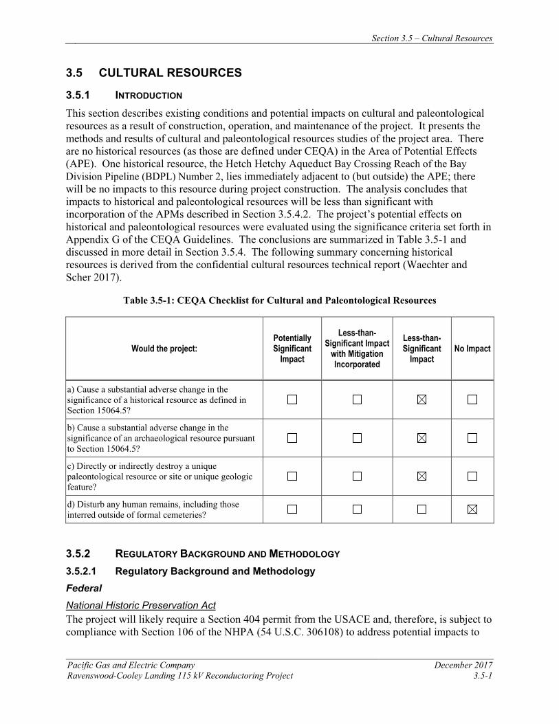
Section 3.5 – Cultural Resources
Pacific Gas and Electric Company December 2017 Ravenswood-Cooley Landing 115 kV Reconductoring Project 3.5-1
3.5 CULTURAL RESOURCES
3.5.1 INTRODUCTION This section describes existing conditions and potential impacts on cultural and paleontological resources as a result of construction, operation, and maintenance of the project. It presents the methods and results of cultural and paleontological resources studies of the project area. There are no historical resources (as those are defined under CEQA) in the Area of Potential Effects (APE). One historical resource, the Hetch Hetchy Aqueduct Bay Crossing Reach of the Bay Division Pipeline (BDPL) Number 2, lies immediately adjacent to (but outside) the APE; there will be no impacts to this resource during project construction. The analysis concludes that impacts to historical and paleontological resources will be less than significant with incorporation of the APMs described in Section 3.5.4.2. The project’s potential effects on historical and paleontological resources were evaluated using the significance criteria set forth in Appendix G of the CEQA Guidelines. The conclusions are summarized in Table 3.5-1 and discussed in more detail in Section 3.5.4. The following summary concerning historical resources is derived from the confidential cultural resources technical report (Waechter and Scher 2017).
Table 3.5-1: CEQA Checklist for Cultural and Paleontological Resources
Would the project: Potentially Significant
Impact
Less-than-Significant Impact
with Mitigation Incorporated
Less-than-Significant
Impact No Impact
a) Cause a substantial adverse change in the significance of a historical resource as defined in Section 15064.5?
b) Cause a substantial adverse change in the significance of an archaeological resource pursuant to Section 15064.5?
c) Directly or indirectly destroy a unique paleontological resource or site or unique geologic feature?
d) Disturb any human remains, including those interred outside of formal cemeteries?
3.5.2 REGULATORY BACKGROUND AND METHODOLOGY 3.5.2.1 Regulatory Background and Methodology Federal National Historic Preservation Act The project will likely require a Section 404 permit from the USACE and, therefore, is subject to compliance with Section 106 of the NHPA (54 U.S.C. 306108) to address potential impacts to
Section 3.5 – Cultural Resources
December 2017 Pacific Gas and Electric Company 3.5-2 Ravenswood-Cooley Landy 115 kV Reconductoring Project
historic properties (resources that are eligible for listing on the National Register of Historic Places [NRHP]).
National Environmental Policy Act Approval of the project by the Army Corps is a federal action, which will require review under the National Environmental Policy Act (NEPA) (42 U.S.C. 4321-4347). NEPA requires federal agencies to consider environmental impacts, including impacts to cultural resources, in their decision-making process before taking a federal action, such as issuing a permit for the project.
Native American Graves Protection and Repatriation Act The Native American Graves Protection and Repatriation Act (25 U.S.C. 3001-3013) requires federal agencies to consult with the appropriate Native American Tribes prior to the intentional or inadvertent excavation of human remains and funerary objects on federal and tribal lands. The act requires development of a Plan of Action.
Archaeological Resource Protection Act The project crosses federal lands, where cultural resources are further protected by the Archaeological Resource Protection Act (16 U.S.C. 470aa-mm), which regulates the excavation of archaeological sites on federal and Indian lands in the United States, and the removal and disposition of archaeological resources.
Paleontological Resource Preservation Act The project crosses federal lands, where paleontological resources are further protected by Paleontological Resource Preservation Act (123 Stat. 1172; 16 U.S.C. 470aaa), which establishes requirements to manage and protect paleontological resources on federal lands.
State California Register of Historical Resources Under Section 21083.2 of CEQA, an important archaeological or historical resource is an object, artifact, structure, or site that is listed on, or eligible for listing on, the California Register of Historical Resources (CRHR). Eligible resources are those that can be clearly shown to meet any of the following criteria:
1. Is associated with events that have made a significant contribution to the broad patterns of California’s history and cultural heritage
2. Is associated with the lives of persons important in our past
3. Embodies the distinctive characteristics of a type, period, region, or method of construction, or represents the work of an important creative individual, or possesses high artistic value
4. Has yielded, or may be likely to yield, information important in prehistory or history
Automatic listings include properties that are listed on the NRHP. In addition, Points of Historical Interest nominated from January 1998 onward are to be jointly listed as Points of Historical Interest and in the CRHR.
Section 3.5 – Cultural Resources
Pacific Gas and Electric Company December 2017 Ravenswood-Cooley Landing 115 kV Reconductoring Project 3.5-3
Resources listed in a local historic register or deemed significant in a historical resources survey, as provided under Public Resources Code (PRC) Section 5024.1(g), are presumed to be historically or culturally significant unless the preponderance of evidence demonstrates that they are not. A resource that is not listed on or determined to be ineligible for listing on the CRHR, not included in a local register of historical resources, or not deemed significant in a historical resources survey may nonetheless be historically significant, as determined by the lead agency (PRC Section 21084.1 and Section 21098.1).
Assembly Bill 52 Assembly Bill 52 (AB 52) established that Tribal Cultural Resources (TCR) must be considered under CEQA and also provided for additional Native American consultation requirements for the Lead Agency. A TCR is a site, feature, place, cultural landscape, sacred place, or object that is considered of cultural value to a California Native American Tribe. A TCR is either:
1. On the California Register of Historical Resource or a local historic register;
2. Eligible for the California Register of Historical Resource or a local historic register; or
3. The lead agency determines that the resource meets the register criteria. A project that has potential to impact a TCR such that it would cause a substantial adverse change constitutes a significant effect on the environment unless mitigation reduces such effects to a less-than-significant level. The Governor’s Office of Planning and Research must issue revised CEQA Guidelines to incorporate AB 52 requirements by July 1, 2016. However, compliance with the law is required beginning July 1, 2015 (prior to issuance of guidance). California Health and Safety Code and Public Resources Code Several provisions of the PRC also govern archaeological finds of human remains and associated objects. Procedures are detailed under PRC Section 5097.98 through 5097.996 for actions to be taken whenever Native American remains are discovered. Furthermore, Section 7050.5 of the California Health and Safety Code states that any person who knowingly mutilates or disinters, wantonly disturbs, or willfully removes human remains in or from any location other than a dedicated cemetery without authority of law is guilty of a misdemeanor, except as provided in Section 5097.99 of the PRC. Any person removing human remains without authority of law or written permission of the person or persons having the right to control the remains under PRC Section 7100 has committed a public offense that is punishable by imprisonment.
PRC Chapter 1.7, Section 5097.5/5097.9 (Stats. 1965, c. 1136, p. 2792), entitled Archaeological, Paleontological, and Historical Sites, defines any unauthorized disturbance or removal of a fossil site or remains on public land as a misdemeanor and specifies that state agencies may undertake surveys, excavations, or other operations as necessary on state lands to preserve or record paleontological resources.
Local
Because the CPUC has exclusive jurisdiction over project siting, design, and construction, the project is not subject to local discretionary regulations. The following description of regulations
Section 3.5 – Cultural Resources
December 2017 Pacific Gas and Electric Company 3.5-4 Ravenswood-Cooley Landy 115 kV Reconductoring Project
that designate local historic resources is provided for informational purposes and to assist with CEQA review.
San Mateo County General Plan Chapter 5 of the San Mateo County General Plan (1981, revised 1986) describes at length the County’s process for identification and management of cultural and paleontological resources. The plan includes a summary of federal and state regulations, a discussion of inventory methods for identification of resources, the role of the Historic Resources Advisory Board, and County zoning and historic preservation ordinances. The plan is available on line at http://planning.smcgov.org/sites/planning.smcgov.org/files/SMC-GP%201986.pdf
3.5.2.2 Methodology Cultural Resources Records Search and Historical Research Records searches were done in the PG&E cultural resources database and at the Northwest Information Center (NWIC) of the California Historical Resources Information System, housed at Sonoma State University. NWIC is a repository of all archaeological site records, previously conducted cultural resources reports, and historical information concerning cultural resources for 16 San Francisco Bay Area counties, including San Mateo County. The records search area included the project APE and a 0.5-mile-wide buffer. Results are presented in Section 3.5.3.4.
Buried-Site Sensitivity The potential for prehistoric archaeological sites to be located within the project area was assessed using a model recently created for the San Francisco Bay-Delta Region (Byrd et al. 2016). Only a small portion of the project area is “terrestrial,” located on land outside of the historic-era extent of the bay. In the urban environment of the San Francisco Bay Area it is important to take into account the fact that extensive landscape modification (cut and fill activities) has occurred in the region during the historic and modern eras. Therefore, the potential for both near-surface (potentially covered by artificial fill) and buried prehistoric sites were assessed for the terrestrial portion of the project area. These assessments are based on surface slope, determined using a digital elevation model, distance to an historic-era stream, and distance to bay or stream confluence, with the potential for buried sites also factoring in landform age, based on mapping by Meyer (2013).
Because the majority of the project area falls within the historic-era extent of the bay prior to infilling, the potential for sites to have been submerged by sea-level rise and therefore to be located beneath bay deposits was also assessed. Assuming that prehistoric people did occupy areas that are now submerged below sea level, they probably located themselves near the channels of freshwater streams and rivers, or near the margins of lakes and estuaries, just as they did in later time periods. Therefore, the “pre-Bay” landscape and the network of prehistoric stream channels that might have drained this landscape need to be factored into prehistoric site sensitivity modeling. The potential for submerged sites was estimated using the same criteria used for the terrestrial site model as based on the configuration of the pre-Bay landscape and the most likely location of former stream channels, taking into account the change over time in the location of the bay margin based on a sea-level rise curve.
Section 3.5 – Cultural Resources
Pacific Gas and Electric Company December 2017 Ravenswood-Cooley Landing 115 kV Reconductoring Project 3.5-5
Archaeological Survey Pedestrian field survey of the project area was greatly limited by the location of the project in tidal mudflats and salt evaporation ponds on the margins of San Francisco Bay. Survey was attempted at various points along the project corridor, but the mudflats/ponds were covered with water and so could not be walked. Where survey was possible, primarily along Bay Road and at the Ravenswood Substation, much of the area was paved and/or built-over.
Architectural History Survey Intensive level field survey of the Ravenswood-Cooley Landing 115 kV power line and wooden boardwalks was conducted on June 13, 2017. The power line and boardwalk were accessed at various points along the project corridor, along Bay Road, and at Ravenswood and Cooley Landing substations.
Native American Coordination On April 10, 2017, a letter was sent to the California Native American Heritage Commission (NAHC), on PG&E letterhead and signed by PG&E Senior Cultural Resources Specialist Christophe Descantes, requesting a search of their Sacred Lands files and a list of groups or individuals who might have knowledge of cultural resources in the project area. The Commission replied on April 11, 2017. The Sacred Lands file search was negative, although the Commission cautioned that such resources might nevertheless be present. They also provided a list of groups and individuals to be contacted. Letters were sent to the groups and individuals provided by the Commission, again on PG&E letterhead, on May 15, 2017, with follow-up phone calls on June 8, 2017. Three of the contacts expressed concern about the project area. A complete log of contacts and responses is provided in Section 3.5.5.2.; NAHC correspondence is included in PEA Appendix B.
Paleontological Resources
This paleontological analysis of existing data included a geologic map review, a literature search, and one institutional record search.
Existing Information Review The geologic map review of the project area included mapping at a scale of 1:24,000 and 1:62,500 by Dibblee and Minch (2007) and Brabb and Pampeyan (1983), respectively. The literature reviewed included published and unpublished scientific papers. A paleontological record search of the project area and 1-mile buffer conducted by the University of California Museum of Paleontology, Berkeley (UCMP), and additional searches were performed in available online databases.
Paleontological Sensitivity The paleontological potential of the project area was evaluated using the federal Potential Fossil Yield Classification (PFYC) system developed by the Bureau of Land Management (BLM 2016). Because of its demonstrated usefulness as a resource management tool, the PFYC has been utilized for many years for projects across the country, regardless of land ownership. It is a predictive resource management tool that classifies geologic units on their likelihood to contain paleontological resources on a scale of 1 (very low potential) to 5 (very high potential). This
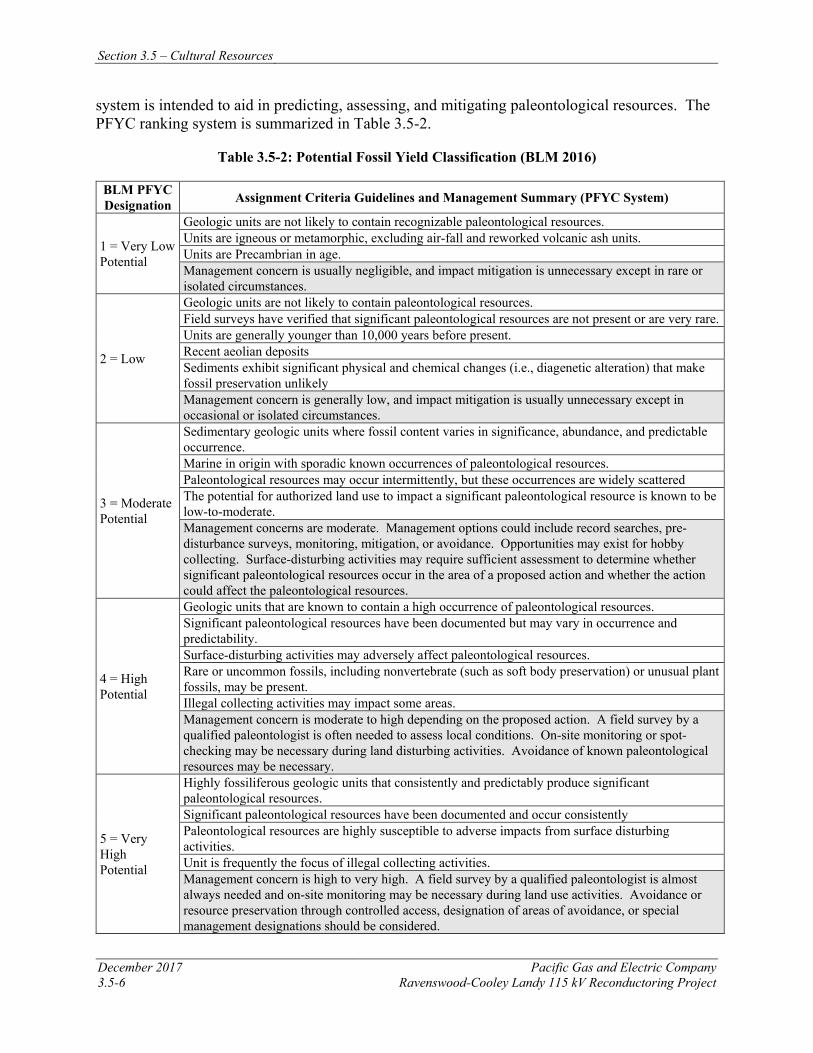
Section 3.5 – Cultural Resources
December 2017 Pacific Gas and Electric Company 3.5-6 Ravenswood-Cooley Landy 115 kV Reconductoring Project
system is intended to aid in predicting, assessing, and mitigating paleontological resources. The PFYC ranking system is summarized in Table 3.5-2.
Table 3.5-2: Potential Fossil Yield Classification (BLM 2016)
BLM PFYC Designation Assignment Criteria Guidelines and Management Summary (PFYC System)
1 = Very Low Potential
Geologic units are not likely to contain recognizable paleontological resources. Units are igneous or metamorphic, excluding air-fall and reworked volcanic ash units. Units are Precambrian in age. Management concern is usually negligible, and impact mitigation is unnecessary except in rare or isolated circumstances.
2 = Low
Geologic units are not likely to contain paleontological resources. Field surveys have verified that significant paleontological resources are not present or are very rare. Units are generally younger than 10,000 years before present. Recent aeolian deposits Sediments exhibit significant physical and chemical changes (i.e., diagenetic alteration) that make fossil preservation unlikely Management concern is generally low, and impact mitigation is usually unnecessary except in occasional or isolated circumstances.
3 = Moderate Potential
Sedimentary geologic units where fossil content varies in significance, abundance, and predictable occurrence. Marine in origin with sporadic known occurrences of paleontological resources. Paleontological resources may occur intermittently, but these occurrences are widely scattered The potential for authorized land use to impact a significant paleontological resource is known to be low-to-moderate. Management concerns are moderate. Management options could include record searches, pre-disturbance surveys, monitoring, mitigation, or avoidance. Opportunities may exist for hobby collecting. Surface-disturbing activities may require sufficient assessment to determine whether significant paleontological resources occur in the area of a proposed action and whether the action could affect the paleontological resources.
4 = High Potential
Geologic units that are known to contain a high occurrence of paleontological resources. Significant paleontological resources have been documented but may vary in occurrence and predictability. Surface-disturbing activities may adversely affect paleontological resources. Rare or uncommon fossils, including nonvertebrate (such as soft body preservation) or unusual plant fossils, may be present. Illegal collecting activities may impact some areas. Management concern is moderate to high depending on the proposed action. A field survey by a qualified paleontologist is often needed to assess local conditions. On-site monitoring or spot-checking may be necessary during land disturbing activities. Avoidance of known paleontological resources may be necessary.
5 = Very High Potential
Highly fossiliferous geologic units that consistently and predictably produce significant paleontological resources. Significant paleontological resources have been documented and occur consistently Paleontological resources are highly susceptible to adverse impacts from surface disturbing activities. Unit is frequently the focus of illegal collecting activities. Management concern is high to very high. A field survey by a qualified paleontologist is almost always needed and on-site monitoring may be necessary during land use activities. Avoidance or resource preservation through controlled access, designation of areas of avoidance, or special management designations should be considered.
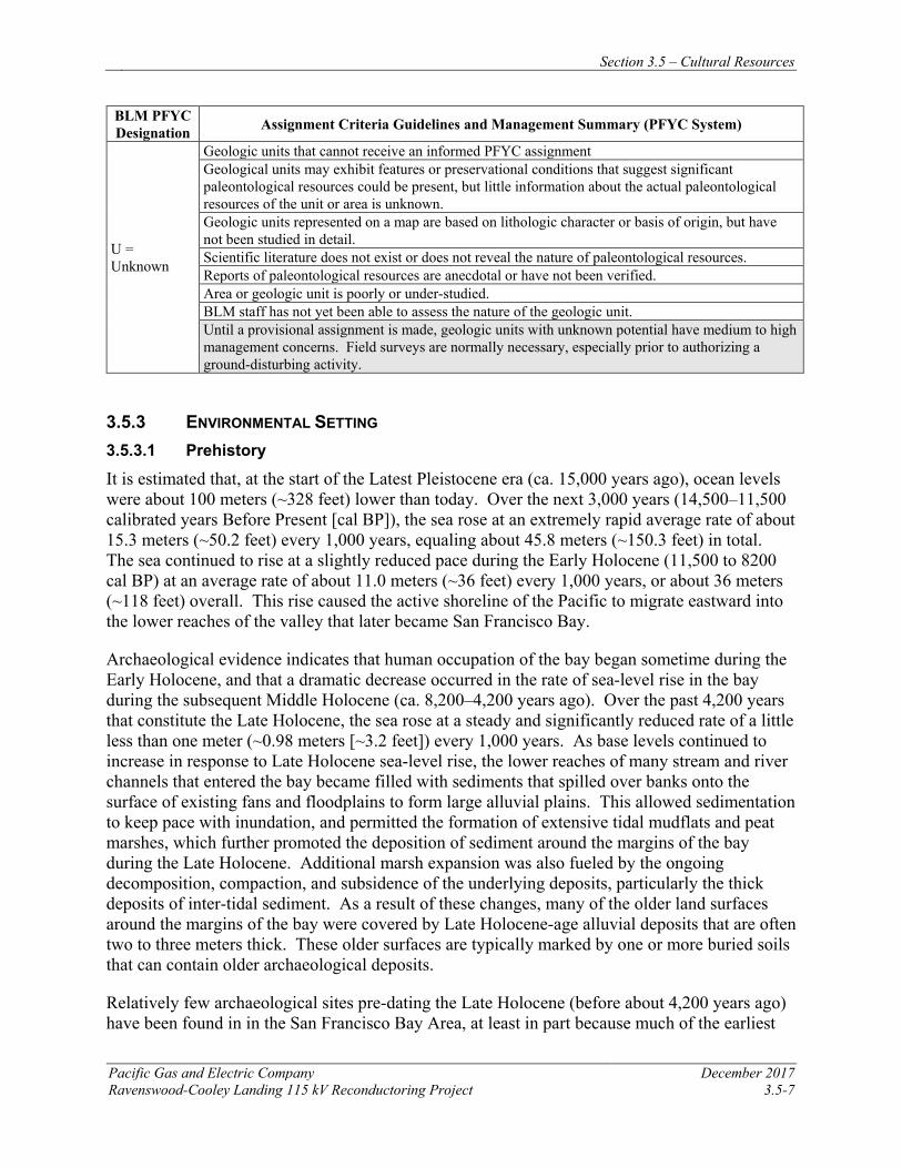
Section 3.5 – Cultural Resources
Pacific Gas and Electric Company December 2017 Ravenswood-Cooley Landing 115 kV Reconductoring Project 3.5-7
BLM PFYC Designation Assignment Criteria Guidelines and Management Summary (PFYC System)
U = Unknown
Geologic units that cannot receive an informed PFYC assignment Geological units may exhibit features or preservational conditions that suggest significant paleontological resources could be present, but little information about the actual paleontological resources of the unit or area is unknown. Geologic units represented on a map are based on lithologic character or basis of origin, but have not been studied in detail. Scientific literature does not exist or does not reveal the nature of paleontological resources. Reports of paleontological resources are anecdotal or have not been verified. Area or geologic unit is poorly or under-studied. BLM staff has not yet been able to assess the nature of the geologic unit. Until a provisional assignment is made, geologic units with unknown potential have medium to high management concerns. Field surveys are normally necessary, especially prior to authorizing a ground-disturbing activity.
3.5.3 ENVIRONMENTAL SETTING 3.5.3.1 Prehistory
It is estimated that, at the start of the Latest Pleistocene era (ca. 15,000 years ago), ocean levels were about 100 meters (~328 feet) lower than today. Over the next 3,000 years (14,500–11,500 calibrated years Before Present [cal BP]), the sea rose at an extremely rapid average rate of about 15.3 meters (~50.2 feet) every 1,000 years, equaling about 45.8 meters (~150.3 feet) in total. The sea continued to rise at a slightly reduced pace during the Early Holocene (11,500 to 8200 cal BP) at an average rate of about 11.0 meters (~36 feet) every 1,000 years, or about 36 meters (~118 feet) overall. This rise caused the active shoreline of the Pacific to migrate eastward into the lower reaches of the valley that later became San Francisco Bay.
Archaeological evidence indicates that human occupation of the bay began sometime during the Early Holocene, and that a dramatic decrease occurred in the rate of sea-level rise in the bay during the subsequent Middle Holocene (ca. 8,200–4,200 years ago). Over the past 4,200 years that constitute the Late Holocene, the sea rose at a steady and significantly reduced rate of a little less than one meter (~0.98 meters [~3.2 feet]) every 1,000 years. As base levels continued to increase in response to Late Holocene sea-level rise, the lower reaches of many stream and river channels that entered the bay became filled with sediments that spilled over banks onto the surface of existing fans and floodplains to form large alluvial plains. This allowed sedimentation to keep pace with inundation, and permitted the formation of extensive tidal mudflats and peat marshes, which further promoted the deposition of sediment around the margins of the bay during the Late Holocene. Additional marsh expansion was also fueled by the ongoing decomposition, compaction, and subsidence of the underlying deposits, particularly the thick deposits of inter-tidal sediment. As a result of these changes, many of the older land surfaces around the margins of the bay were covered by Late Holocene-age alluvial deposits that are often two to three meters thick. These older surfaces are typically marked by one or more buried soils that can contain older archaeological deposits.
Relatively few archaeological sites pre-dating the Late Holocene (before about 4,200 years ago) have been found in in the San Francisco Bay Area, at least in part because much of the earliest
Section 3.5 – Cultural Resources
December 2017 Pacific Gas and Electric Company 3.5-8 Ravenswood-Cooley Landy 115 kV Reconductoring Project
archaeological record is buried by later alluvial deposition as described above, and by urban development. However, at least four prehistoric human skeletons (CA- SJO-225, SMA-273, SFR-028, “Transit Center Skeleton”) have been recovered from between 2.6 and 12.7 meters (8 feet 6 inches and 41 feet 8 inches) below MSL in the greater Bay Area, and the lower portions of the cultural deposits at several other sites lie below or near sea level (ALA-307, ALA-309/310, and CCO-295). Radiocarbon dates from these sites generally fall between about 7,600 and 2,700 years ago. These finds provide clear evidence that much of the early archaeological record remains buried and has yet to be discovered. As a result, very little is known about the nature of local and regional settlement and subsistence practices and the pace of culture change during the first several thousand years that Native Americans occupied the region.
The Late Holocene is very well-documented in the Bay Area, with more than 200 dated sites occupied by complex hunter-gatherers. The beginning of the period saw the establishment of a number of large shell mounds along the bay margins, among them University Village (SMA-77), the Ellis Landing site (CCO-295), the San Bruno Mountain Mound (SMA-40), the Stege Mound (CCO-298), the West Berkley Mound (ALA-307), and ALA-17. Bay margin sites reveal a strong emphasis on marine shellfish (particularly bay mussel and oyster), marine fishes, and marine mammals. In contrast, interior sites emphasized freshwater fish and shellfish along with terrestrial mammals. Nuts and berries appear to have been particularly important plant resources.
More permanent settlement seems to have begun around 2,000–2,500 years ago. This time is considered by archaeologists to have been the “heyday” of mound building and correlated with greater social complexity and ritual elaboration. Terrestrial resources appear to have been more heavily exploited than previously, based on food remains and isotopic analysis of human bone. Shifts in resource emphasis included greater exploitation of deer and mussels, less reliance on oysters, and an increase in the use of acorns. By about 800 years ago, the native inhabitants had adopted bow and arrow technology and established complex trading relationships with neighboring groups. They apparently relied heavily on small seeds as plant foods, while the faunal evidence indicates a wide range of animal resources—notably sea otters, rabbits, deer, clams (Macoma sp.) and horn snails (Cerethedia sp.). These patterns probably continued into the early historic period, at the time of non-native contact.
3.5.3.2 Ethnography
The project area falls within the aboriginal territory of the Ohlone, referred to by some as Costanoans (from the Spanish Costanos for “coastal people”). Most of what is known about the Ohlone comes from the early work of Kroeber (1925) and summary treatment by Levy (1978). Recent interpretations of Ohlone lifeways, sometimes contradictory with earlier studies, come from research with mission records conducted by Milliken (1995). Costanoan is a linguistic subfamily of the Penutian language stock. According to early linguists, there are eight branches of the Costanoan language; each is associated with a geographic location and the tribelet(s) that inhabited the locality. The project area is within the Ramaytush linguistic territory. According to Levy (1978:485), in AD 1770 there were approximately 1,400 Ohlone inhabiting the San Francisco Peninsula speaking Ramaytush. Milliken contradicts this assertion of distinct language groups and suggests that the differences reflect the “amalgamation of later Costanoan speakers at the various missions” (Milliken 1995:26).
Section 3.5 – Cultural Resources
Pacific Gas and Electric Company December 2017 Ravenswood-Cooley Landing 115 kV Reconductoring Project 3.5-9
The basic unit of political organization was a territory-holding group of one or more associated villages and smaller temporary encampments. Contrary to the earlier use by Kroeber and others of the term “tribelet” to describe these groups, Milliken (1995:13) prefers “tribe,” defined as an independent, multifamily, landholding, religious congregation. Each tribe was an autonomous polity numbering 200 to 400 people, under the jurisdiction of a headman and council of elders who served as advisors to the villagers. Permanent villages were established near the coast and on river drainages, while temporary camps were located in prime resource-collecting areas. Some tribes occupied a central village, while others had several villages within a few miles of each other. At the time of Spanish occupation, the San Francisco Bay Area and the Coast Range valleys were dotted with these villages. Kroeber (1925:464) estimates an aboriginal population of 7,000 Ohlone.
Prior to European contact, the native people of the Bay Area were hunters and gatherers. Subsistence activities centered around the seasonal availability of gathered resources such as acorns, nuts, seeds, greens and bulbs; hunting deer, pronghorn, tule elk, smaller animals, sea mammals, and waterfowl; fishing; and collecting shellfish (oysters, mussels, and abalone). The proliferation of shell middens throughout the Bay Area attests to the heavy reliance on marine food resources. The Ohlone practiced burning on an annual basis to ensure an abundance of seed-bearing annuals and forage for large game, and to facilitate the gathering of fall-ripening acorns.
The most common type of housing consisted of small hemispherical huts thatched with grasses and rushes. Other types of village structures included sweathouses, dance enclosures or plazas, and assembly houses. A variety of stone tools were used, including knives, arrow and spear points, handstones and millingslabs, mortars, net sinkers, anchors, and pipes. Chert was obtained from local quarries, and obsidian was acquired in trade. Many perishable items were made from tule (e.g., canoes, mats, and baskets), plant fibers (e.g., cordage, nets, and baskets), and animal skins (sea otter, rabbit, and duck skin blankets). Bedrock mortars, as well as portable variants, were important components of acorn processing technology. Tule balsas were used for transportation and in fishing and duck hunting. Shell beads were gaming and trading commodities as well as ornamental items. Trade relations with neighboring villages and groups were well established. Bows, arrows, basketry materials, paints, and feather blankets were procured from the east, while the Ohlone traded mussels, dried abalone, salt, and abalone shells to the neighboring Yokut groups and provided the Sierra Miwok with Olivella and abalone shell beads.
The aboriginal way of life for the Ohlone was disrupted by the influx of explorers and establishment of missions by the Spanish. Reduced population and displacement of native people caused by missionization and Anglo-American occupation of their land substantially altered their traditional way of life. As a result, the Ohlone are not well known ethnographically. Today many Bay Area Ohlone descendants refer to themselves as the Muwekma Ohlone Tribe, including “all of the known surviving American Indian lineages aboriginal to the San Francisco Bay region who trace their ancestry through the Missions Delores, Santa Clara, and San Jose, and who were also members of the historic Federally Recognized Verona Band of Alameda County” (http://muwekma.org/).
Section 3.5 – Cultural Resources
December 2017 Pacific Gas and Electric Company 3.5-10 Ravenswood-Cooley Landy 115 kV Reconductoring Project
3.5.3.3 History
The non-native history of the San Francisco Bay Area has been written many times by many people: the Spanish Period that began with the crossing of San Francisquito Creek by Gaspar de Portolá in 1769 and saw the establishment of the Franciscan Missions that so drastically changed the lives of the Native people; the Mexican Period of 1821-1846 that began with Mexico’s independence from Spain and ended with the Treaty of Guadalupe Hidalgo, ceding Alta California to the United States; and the American Period of the Gold Rush and subsequent settlement. In this brief discussion, the focus is more narrowly drawn on the project vicinity.
The project area crosses portions of two land grants: the Rancho de las Pulgas (“Ranch of the Fleas”), granted to José Dario Arguello in 1795 (but not patented until 1857), and Rancho San Francisquito, granted to Antonio Buelna in 1839. During the subsequent American Period, the Spanish and Mexican land grants were subdivided and sold off, resulting in the loss of land for many of the original grantees. Rancho Las Pulgas was one of the subdivided grants, and the site of what the Spanish and Mexican officials called the Embarcadero at Redwood Creek became Redwood City, which would be the county seat of San Mateo County when the county was formally created in 1856.
Into the second half of the nineteenth century, land grants continued to be subdivided for towns, individual properties, and, in the 1860s, for the railroad right-of-way. Construction on the San Francisco and San Jose Railroad began in 1861 in the San Francisquito Creek area, with passenger and freight service beginning in 1863. The railroad expanded the agricultural life of California and led to more innovative ways to ship and preserve food supplies, such as transporting fruit and meat in refrigerator cars (developed in 1880).
Nineteenth-century maps depict prominent roads in the region, several dating as far back as the Mexican Period, and some that are still used today. The most prominent of these is El Camino Real, one of the State’s earliest roadways. These early roads were originated as tracks that developed by repeated use. One of the State’s earliest highways, known as Route 2, passed through Palo Alto and other peninsula towns in the early twentieth century. Route 2 served as one of the main north-south trunk lines in California’s new highway system in the 1910s, and in 1926 designated as U.S. Highway 101. By 1940, the growth of Palo Alto prompted construction of a secondary, or bypass, route for U.S. 101 to re-direct traffic around the city’s downtown. The Division of Highways expanded the U.S. 101 bypass to four lanes soon after the end of World War II. Increased traffic demands and continuing growth on the Peninsula and in the Silicon Valley area led to continued modifications.
During the early twentieth century, population in the region expanded. Cities such as Menlo Park and Palo Alto developed, with the latter incorporating Mayfield and Stanford University by the beginning of World War II. Post-war development altered the region from a mostly rural landscape to an increasingly urban one. Commercial development, including salt evaporating ponds, flourished between the Bay and U.S. 101, while residential and commercial uses were wide spread west of U.S. 101. As a result, the landscape has been dramatically altered from its historic-era origins under Spanish and Mexican authority.
Section 3.5 – Cultural Resources
Pacific Gas and Electric Company December 2017 Ravenswood-Cooley Landing 115 kV Reconductoring Project 3.5-11
Local History11
The earliest available USGS topographic quadrangles covering the project alignment show that a large percentage of the area was either marshland or bay until the middle of the twentieth century. Early American Period development of the area, though limited by the lack of dry land, included shipping and agriculture. By the mid-twentieth century, salt evaporation ponds had been constructed over much of the area.
Ravenswood to East Palo Alto In 1848, Adams and Company, a San Francisco Bank, purchased roughly 3,674 acres of the former Pulgas Rancho, including the present project area. Adams and Company hoped the newly purchased area would be the center of a shipping boom, located immediately off the San Francisco Bay and alongside the purported construction of a Pacific & Atlantic Railroad Company rail line. “Ravenswood” would be the “new San Francisco” (Baxter et al. 2007:30). Under that assumption, Adams and Company built a wharf in 1849 (at the eastern end of what is now Bay Road), and residences were soon established. The Pacific & Atlantic Railroad never materialized; however, two years later, rumors that the Central Pacific Railroad would lay tracks along the same route led to renewed interest in the area (Baxter et al. 2007). This too was never realized, and the Ravenswood real estate venture bankrupted Adams and Company. In 1856, the company’s land was sold at public auction. One of the new owners was Dennis Martin:
Cooley Landing itself was created in the mid-1800s by Dennis Martin, an Irishman who purchased a Spanish land grant that extended from the bay up into the redwood canyons above Woodside and Portola Valley. It was then called Martin's Landing. It was used to ship lumber, redwood shingles, wheat and wool north to San Francisco and other cities, originally in flat-bottomed sailing barges, according to reports [(https://www.paloaltoonline.com/news/2009/05/14/huge-historic-cooley-landing-dredge-salvaged-)].
The same article reports that:
The flanks of Cooley Landing were owned by Utah Mining Company, which once harvested oyster shells to use in making cement before the oyster colonies died from sewage discharge from cities around the South Bay. The firm since the 1800s claimed title to hundreds of acres of tide-flooded bay mud extending nearly to the central channel [(https://www.paloaltoonline.com/news/2009/05/14/huge-historic-cooley-landing-dredge-salvaged-)].
The property, located in the municipality of Menlo Park, changed hands many times over the following years, and by 1867 it came under the ownership of Lester P. Cooley (Baxter et al. 2007). Cooley successfully re-invigorated the declining property with the establishment of a lucrative farm and reconstruction of the wharf to provide better protection to docked ships, allowing for year-round shipping of his products. The Ravenswood Wharf became known as
11 Also see Baxter et al. 2007 for a detailed discussion of the history of Cooley Landing.
Section 3.5 – Cultural Resources
December 2017 Pacific Gas and Electric Company 3.5-12 Ravenswood-Cooley Landy 115 kV Reconductoring Project
Cooley’s Landing, by the 1870s. Additionally, he purchased the remaining interest in the property, becoming the sole owner. His growing wealth and prominence led to election as the second mayor of Menlo Park. After Cooley’s death in 1882, the land went to his wife, who oversaw the property with their children. Commercial use of the wharf declined after 1884, and thereafter used primarily by the family (Baxter et al. 2007). The nearby area of “East Palo Alto” remained an unincorporated community within San Mateo County for the next 50 years. The community was reliant upon county funding and was unable to attract large retailers to the area. It was not until 1983 that East Palo Alto was officially incorporated.
Ravenswood Salt Works Today nearly all the project alignment, including the Ravenswood Substation and two of the four towers, overlies salt evaporation ponds built primarily in the 1950s. The ponds have been recorded and evaluated as the Alviso or Schilling Arden Salt Company (common name Ravenswood Salt Works) under Primary number 41-2351. That evaluation concluded that “The Ravenswood Salt Works lack adequate integrity and does [sic] not convey a clear association with the salt industry, thus it does not meet the National Register of Historic Places (NRHP) eligibility criteria for determination as a historic property. The Ravenswood Unit is ineligible to the NRHP” (Speulda-Drews and Valentine 2007:11). That document also notes that:
The Ravenswood Salt Works ponds were created during the twentieth century industrialization, so the potential for archaeological sites related to landings, salt processing plants, or residences is very low. No archaeological sites have been identified within the Ravenswood unit. Prior to the salt ponds the area was salt marsh and subject to tides which limited the availability of land for settlement or habitation sites [Speulda-Drews and Valentine 2007:6].
The evaluation was completed for the USFWS.
Hetch Hetchy Aqueduct The historic Hetch Hetchy Aqueduct lies in the project vicinity (but outside the APE). Planning for the Hetch Hetchy system began at the end of the nineteenth century:
In May 1882, J. P. Dart, an engineer for the San Francisco and Tuolumne Water Company, proposed a route for bringing water from the Tuolumne River, upstream from Jacksonville, to San Francisco. In 1888, George M. Harris pointed out the possibility of the Hetch Hetchy Valley and Tuolumne River water supply to Mayor E. P. Bond, offering to sell his rights to the entire length of the Tuolumne for $220,000. John Henry Quinton, a Los Angeles engineer, investigated Hetch Hetchy and the Tuolumne, reporting to the U.S. Geological Survey in 1891. The U.S. Geological Survey Annual Report 1899-1900 included a study recommending Hetch Hetchy as an adequate water source for San Francisco [SFPUC 2005:20].
The project faced a great deal of controversy and opposition from environmental groups, landowners, and water-rights holders in the Tuolumne River drainage, and it was not until 1934 that the first mountain water was delivered to the San Francisco Peninsula.
Section 3.5 – Cultural Resources
Pacific Gas and Electric Company December 2017 Ravenswood-Cooley Landing 115 kV Reconductoring Project 3.5-13
Portions of the aqueduct have been evaluated for eligibility to the NRHP. At least one segment, at Newark in Alameda County, has been determined eligible and documented in a National Park Service Historic American Engineering Report for the for the Hetch Hetchy Bay Division Pipeline No. 2 project (Renzetta et al. 2008; SFPUC 2009).
Ravenswood-Cooley Landing Line In the 1950s and into the 1960s PG&E constructed multiple fuel-fired steam plants along the coast, whereas PG&E’s 1,340,000 electric customers were focused in Central and Northern California, an area more than 85,000 square miles. The physical distance of generating sources from load areas required an extensive interconnected transmission system. At the end of 1950, PG&E maintained over 10,000 circuit miles of high-voltage transmission lines, 60 kV or higher. Of the 10,000 miles, 6,500 miles were 220 kV lines representing the highest capacity lines and best for long distance transmission in the PG&E system. The continuous demand for electricity required PG&E to upgrade and enlarge the transmission system to keep pace. New transmission lines prevented transformer overloading, connected with new generation systems, and extended transmission into areas with greater demand. In 1940, PG&E had 40,000 miles of transmission and distribution lines; by 1952, they had added 18,000 additional miles and by 1956 there were 67,000 miles of line throughout their territory (Coleman 1952: 334; Root 2012: 11; PG&E 1952; PG&E 1956).
By the end of the 1960s, sustained population growth and increased manufacturing demands from electronics driven industries prompted PG&E to expand its transmission and distribution capacity in Palo Alto, Menlo Park and the greater San Jose region. In 1952, PG&E constructed Cooley Landing Substation (terminus of the Ravenswood-Cooley Landing power line tie line) in East Palo Alto. Anticipated load increases served as the impetus for construction of the new substation. In the early 1950s the U.S. government opened two Army camps and the Ames Research Laboratory, expanded the Navy’s Moffett Field, and constructed a new nuclear reactor at Livermore National Laboratory. Industrial companies established a presence in the area, including Pacific Steel Company, Westinghouse, and General Electric. The Cooley Landing Substation was constructed as a 110/60 kV facility (meaning it had step-down transformers for distribution) primarily fed by the larger Newark 220 kV substation. Within six years of Cooley Landing Substations’ completion, PG&E began planning for construction of additional transmission and distribution infrastructure to increase electrical capacity in the greater Southern San Francisco Bay region (PG&E 1952; PG&E 1960; PG&E 1963; PG&E 1972).
In 1958, PG&E executed the next transmission phase for increasing electrical services to the Southern San Francisco Bay region. The company purchased 40 acres for the Ravenswood Substation and the power line right-of-way. Construction of Ravenswood Substation, a 110/220 kV substation, was to serve estimated future loads for cities and industrial interests surrounding the Southern San Francisco Bay, Easy Bay, and Peninsula. The substation was supplied electricity from Hunters Point, Potrero, and Pittsburg Powerhouses. To increase greater regional connectivity PG&E planned construction of four new transmission lines to link with Ravenswood including Ravenswood-Newark, Ravenswood-Hayward, Ravenswood-San Mateo, and Ravenswood-Cooley Landing (study transmission line) (PG&E 1958).
Section 3.5 – Cultural Resources
December 2017 Pacific Gas and Electric Company 3.5-14 Ravenswood-Cooley Landy 115 kV Reconductoring Project
In 1967, PG&E reorganized their transmission system. The company had long relied on 110 and 220 as the backbone for high-voltage, long distance transmission. However, in the mid-1960s, large-scale intertie projects such as the 500 kV California Oregon Intertie (also known as Path 66) were completed. Utility companies began to pool their resources, creating a larger interconnected grid. Dictated by federal power policy, utility companies came together to form bulk transmission entities. In 1967, Western Systems Coordinating Council (WSCC) formed, consisting of 40 power systems located in western states and remained in existence until 2002 when it merged with three regional transmission associations forming the Western Electricity Coordinating Council (WECC). In addition to WSCC, in the mid-1960s the California Power Pool formed and gave rise to the CAISO. To ensure reliable service across the PG&E system, and in conjuncture with the other public and private agencies, PG&E upgraded their older high voltage transmission systems from 110 and 220 kV to 115 and 230 kV. While PG&E had started building new transmission lines at 230 kV as early as 1955, lines built earlier needed to be upgraded. This change required installation of new substation equipment to allow the existing lines to transmit at a higher capacity. It was also during this time that PG&E segmented longer transmission lines into smaller, circuits (Mazur 2013; Transmission Agency of Northern California 2017).
PG&E had laid out plans for the Ravenswood-Cooley Landing 110 kV power line as early as 1958, however construction of the power line was postponed until 1969. Construction of the 110 kV line, changed to 115 kV in 1967, was to serve peak winter loads of the San Francisco Peninsula, City of Palo Alto, and San Bruno through distribution equipment at Cooley Landing Substation. The Ravenswood-Cooley Landing 115 kV power line was constructed as a tie line connecting the larger Ravenswood 230/115 kV substation with the smaller Cooley Landing 115/60 kV distribution substation. The Ravenswood-Cooley Landing 115 kV power line tie line is part of the larger PG&E trend of increasing reliability and interconnectivity of the electrical grid. The power line utilized standard PG&E 2B and 2D lattice steel tower types, PG&E’s preferred double-circuit configuration first utilized in 1945 as part of the Tesla-Midway power line. The Ravenswood-Cooley Landing 115 kV line was placed in operation in 1970; it has remained in its original configuration since construction (PG&E 1970).
3.5.3.4 Results Records Searches
Although several studies have been carried out within the records search area (Table 3.5-3), only one recorded cultural resource was identified during the records search as being located within the project APE: the Alviso or Schilling Arden Salt Company (also known as the Ravenswood Salt Works District), including levees, evaporation ponds, water control structures, pipes, a pumphouse, and a remnant boat launch (Table 3.5-4). As noted earlier, this resource was determined ineligible (Speulda-Drews and Valentine 2007). As an ineligible resource, the Ravenswood Salt Works will not require avoidance or protection measures.
Although not called out during the records searches, a review of historic maps indicates that the Hetch Hetchy Aqueduct Bay Crossing Reach of the BDPL Number 2 lies immediately adjacent to the project APE:
Section 3.5 – Cultural Resources
Pacific Gas and Electric Company December 2017 Ravenswood-Cooley Landing 115 kV Reconductoring Project 3.5-15
A significant portion of the existing historic Hetch Hetchy aqueduct system between the Newark Valve House on the east side of San Francisco Bay and the Ravenswood Valve House on the west side of the Bay. BDPL Numbers 1 and 2 have been identified as a linear historic district and evaluated as eligible for the National Register of Historic Places and the California Register of Historical Resources [ENTRIX/Ward Joint Venture 2008].
There will be no impact to this eligible historical resource as it is outside the project APE.
Table 3.5-3: Records Search Results Within 0.25 Mile Buffer – Studies
NWIC Report No. Author(s) Title Year
Intersects APE?
S-03021 Dietz, Stephen A. An Archaeological Reconnaissance of the 100.6 Acre Raychem Corporation Properties in Menlo Park, California (letter report)
1976 No
S-03023 Dotta, James A Preliminary Reconnaissance of the Archaeological Resources of the East Palo Alto Redevelopment Project Area No. 1
1974 Yes
S-03063 Cartier, Robert Archeological Evaluation of Sunset Meadows Project
1978 No
S-03146 King, Thomas F., and Ronald Melander
A Preliminary Inventory of Recorded Archaeological Resources in Pacific Gas & Electric Company's South Bay Study Area, San Francisco Bay, California
1973 Yes
S-03163 Dietz, Stephen A. An Archaeological Reconnaissance of the Proposed Dumbarton Bridge Replacement Project (letter report)
1973 Yes
S-05406 Holman, Miley Paul A Report of Archaeological Findings at the Proposed Dumbarton Distribution Center, Menlo Park, California
1981 No
S-05640 Cartier, Robert Cultural Resource Evaluation of the Lucky Acres Project off Demeter Street in the County of San Mateo
1982 No
S-06948 Cartier, Robert Cultural Resource Evaluation of the Menlo Business Park, Phase II, on University Avenue in the City of Menlo Park, County of San Mateo
1984 No
S-07045 Cartier, Robert R. Subsurface Archaeological Evaluation of the Lincoln Property Company EPA Project on Bay Road in East Palo Alto, County of San Mateo
1984 Yes
S-07477 Cartier, Robert; Judy Carrico; and Jeff Hall
Field Methods in Archaeology Class, De Anza College
1985 No
S-24182 Cartier, Robert R. Archival Background Report for the Ravenswood Project, East Palo Alto, CA
2001 Yes
S-28083 Van Bueren, Thad M. Contemplating Household Transitions: Investigations at the Carnduff Dump (CA-SMA-
2004 No
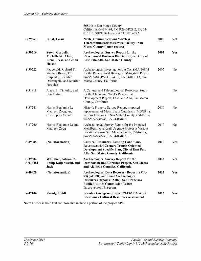
Section 3.5 – Cultural Resources
December 2017 Pacific Gas and Electric Company 3.5-16 Ravenswood-Cooley Landy 115 kV Reconductoring Project
368/H) in San Mateo County, California, 04-SM-84, PM R26.0/R29.2, EA 04-015113, SHPO Reference # COE020627A
S-29367 Billat, Lorna Nextel Communications Wireless Telecommunications Service Facility - San Mateo County (letter report)
2000 Yes
S-30516 Sutch, Cordelia, Michelle St. Clair, Elena Reese, and John Holson
Archaeological Survey Report for the Ravenswood Business District Project, City of East Palo Alto, San Mateo County.
2003 Yes
S-30522 Fitzgerald, Richard T.; Stephen Bryne; Tim Carpenter; Jennifer Darcangelo; and Jennifer Farquhar
Archaeological Investigations at CA-SMA-368/H for the Ravenswood Biological Mitigation Project, 04-SMA-84, PM 41.9/47.1, EA 04-015113, San Mateo County, California
2005 No
S-31818 Jones, E. Timothy; and Ben Matzen
A Cultural and Paleontological Resources Study for the Clarke and Weeks Residential Development Project, East Palo Alto, San Mateo County, California
No
S-37241 Harris, Benjamin J.; Maureen Zogg; and Christopher Caputo
Historic Property Survey Report, proposed replacement of Metal Beam Guardrails (MBGR) at various locations in San Mateo County, California, 04-SMA-VarVar, EA 04-0A8721
2010 No
S-37260 Harris, Benjamin J.; and Maureen Zogg
Archaeological Survey Report for the Proposed Metalbeam Guardrail Upgrade Project at Various Locations across San Mateo County, California, 04-SMA-VarVar, EA 04-0A8721
2010 No
S-39085 (No information) Cultural Resources- Existing Conditions, Ravenswood/4 Corners Transit Oriented Development Specific Plan, City of East Palo Alto, San Mateo County, California
2010 Yes
S-39604; S-036481
Whitaker, Adrian R., Philip Kaijankoski, and Jack
Archaeological Survey Report for the Dumbarton Rail Corridor Project, San Mateo and Alameda Counties, California
2012 Yes
S-40929 (No information) Archaeological Data Recovery Report (SMA-83) (ADRR) and Final Archaeological Resources Report (FARR), San Francisco Public Utilities Commission Water Improvement Program
2013 Yes
S-47106 Koenig, Heidi Invasive Cordgrass Project, 2015-2016 Work Locations - Cultural Resources Assessment
2015 Yes
Note: Entries in bold text are those that include a portion of the project APE.
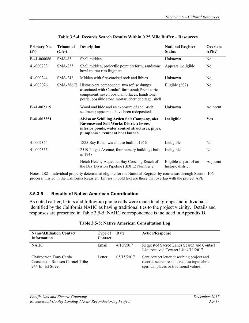
Section 3.5 – Cultural Resources
Pacific Gas and Electric Company December 2017 Ravenswood-Cooley Landing 115 kV Reconductoring Project 3.5-17
Table 3.5-4: Records Search Results Within 0.25 Mile Buffer – Resources
Primary No. (P-)
Trinomial (CA-)
Description National Register Status
Overlaps APE?
P-41-000086 SMA-83 Shell midden Unknown No
41-000233 SMA-235 Shell midden, projectile point preform, sandstone bowl mortar rim fragment
Appears ineligible No
41-000244 SMA-248 Midden with fire-cracked rock and lithics Unknown No
41-002076 SMA-386/H Historic-era component: two refuse dumps associated with Carnduff farmstead; Prehistoric component: seven obsidian bifaces, handstone, pestle, possible stone mortar, chert debitage, shell
Eligible (2S2) No
P-41-002319 Wood and hide and an exposure of shell-rich sediment; appears to have been redeposited.
Unknown Adjacent
P-41-002351 Alviso or Schilling Arden Salt Company, aka Ravenswood Salt Works District: levees, interior ponds, water control structures, pipes, pumphouse, remnant boat launch.
Ineligible Yes
41-002354 1885 Bay Road, warehouse built in 1956 Ineligible No
41-002355 2519 Pulgas Avenue, four nursery buildings built in 1948
Ineligible No
Hetch Hetchy Aqueduct Bay Crossing Reach of the Bay Division Pipeline (BDPL) Number 2
Eligible as part of an historic district
Adjacent
Notes: 2S2 - Individual property determined eligible for the National Register by consensus through Section 106 process. Listed in the California Register. Entries in bold text are those that overlap with the project APE
3.5.3.5 Results of Native American Coordination
As noted earlier, letters and follow-up phone calls were made to all groups and individuals identified by the California NAHC as having traditional ties to the project vicinity. Details and responses are presented in Table 3.5-5; NAHC correspondence is included in Appendix B.
Table 3.5-5: Native American Consultation Log
Name/Affiliation Contact Information
Type of Contact
Date Action/Response
NAHC Email 4/10/2017 Requested Sacred Lands Search and Contact List; received Contact List 4/11/2017
Chairperson Tony Cerda Coastanoan Rumsen Carmel Tribe 244 E. 1st Street
Letter 05/15/2017 Sent contact letter describing project and records search results, request input about spiritual places or traditional values.
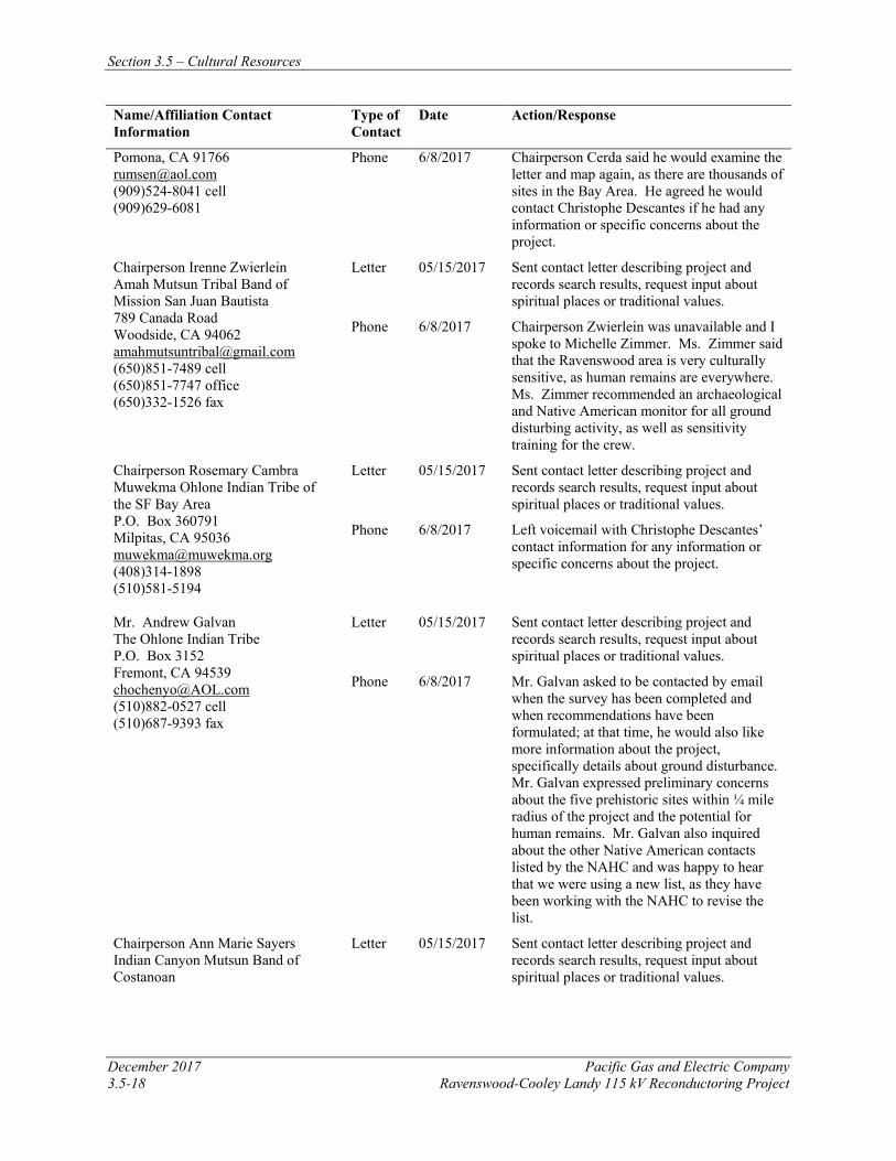
Section 3.5 – Cultural Resources
December 2017 Pacific Gas and Electric Company 3.5-18 Ravenswood-Cooley Landy 115 kV Reconductoring Project
Name/Affiliation Contact Information
Type of Contact
Date Action/Response
Pomona, CA 91766 [email protected] (909)524-8041 cell (909)629-6081
Phone 6/8/2017 Chairperson Cerda said he would examine the letter and map again, as there are thousands of sites in the Bay Area. He agreed he would contact Christophe Descantes if he had any information or specific concerns about the project.
Chairperson Irenne Zwierlein Amah Mutsun Tribal Band of Mission San Juan Bautista 789 Canada Road Woodside, CA 94062 [email protected] (650)851-7489 cell (650)851-7747 office (650)332-1526 fax
Letter 05/15/2017 Sent contact letter describing project and records search results, request input about spiritual places or traditional values.
Phone 6/8/2017 Chairperson Zwierlein was unavailable and I spoke to Michelle Zimmer. Ms. Zimmer said that the Ravenswood area is very culturally sensitive, as human remains are everywhere. Ms. Zimmer recommended an archaeological and Native American monitor for all ground disturbing activity, as well as sensitivity training for the crew.
Chairperson Rosemary Cambra Muwekma Ohlone Indian Tribe of the SF Bay Area P.O. Box 360791 Milpitas, CA 95036 [email protected] (408)314-1898 (510)581-5194
Letter 05/15/2017 Sent contact letter describing project and records search results, request input about spiritual places or traditional values.
Phone 6/8/2017 Left voicemail with Christophe Descantes’ contact information for any information or specific concerns about the project.
Mr. Andrew Galvan The Ohlone Indian Tribe P.O. Box 3152 Fremont, CA 94539 [email protected] (510)882-0527 cell (510)687-9393 fax
Letter 05/15/2017 Sent contact letter describing project and records search results, request input about spiritual places or traditional values.
Phone 6/8/2017 Mr. Galvan asked to be contacted by email when the survey has been completed and when recommendations have been formulated; at that time, he would also like more information about the project, specifically details about ground disturbance. Mr. Galvan expressed preliminary concerns about the five prehistoric sites within ¼ mile radius of the project and the potential for human remains. Mr. Galvan also inquired about the other Native American contacts listed by the NAHC and was happy to hear that we were using a new list, as they have been working with the NAHC to revise the list.
Chairperson Ann Marie Sayers Indian Canyon Mutsun Band of Costanoan
Letter 05/15/2017 Sent contact letter describing project and records search results, request input about spiritual places or traditional values.
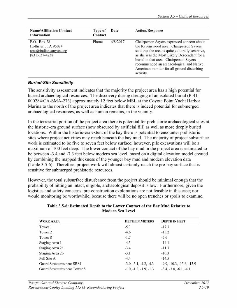
Section 3.5 – Cultural Resources
Pacific Gas and Electric Company December 2017 Ravenswood-Cooley Landing 115 kV Reconductoring Project 3.5-19
Name/Affiliation Contact Information
Type of Contact
Date Action/Response
P.O. Box 28 Hollister , CA 95024 [email protected] (831)637-4238
Phone 6/8/2017 Chairperson Sayers expressed concern about the Ravenswood area. Chairperson Sayers said that the area is quite culturally sensitive, as she was the Most Likely Descendant for a burial in that area. Chairperson Sayers recommended an archaeological and Native American monitor for all ground disturbing activity.
Buried-Site Sensitivity
The sensitivity assessment indicates that the majority the project area has a high potential for buried archaeological resources. The discovery during dredging of an isolated burial (P-41-000284/CA-SMA-273) approximately 12 feet below MSL at the Coyote Point Yacht Harbor Marina to the north of the project area indicates that there is indeed potential for submerged archaeological resources, as well as human remains, in the vicinity.
In the terrestrial portion of the project area there is potential for prehistoric archaeological sites at the historic-era ground surface (now obscured by artificial fill) as well as more deeply buried locations. Within the historic-era extent of the bay there is potential to encounter prehistoric sites where project activities may reach beneath the bay mud. The majority of project subsurface work is estimated to be five to seven feet below surface; however, pile excavations will be a maximum of 100 feet deep. The lower contact of the bay mud in the project area is estimated to be between -3.4 and -7.3 feet below modern sea level, based on a digital elevation model created by combining the mapped thickness of the younger bay mud and modern elevation data (Table 3.5-6). Therefore, project work will almost certainly reach the pre-bay surface that is sensitive for submerged prehistoric resources.
However, the total subsurface disturbance from the project should be minimal enough that the probability of hitting an intact, eligible, archaeological deposit is low. Furthermore, given the logistics and safety concerns, pre-construction explorations are not feasible in this case; nor would monitoring be worthwhile, because there will be no open trenches or spoils to examine.
Table 3.5-6: Estimated Depth to the Lower Contact of the Bay Mud Relative to Modern Sea Level
WORK AREA DEPTH IN METERS DEPTH IN FEET Tower 1 -5.3 -17.3 Tower 2 -4.6 -15.2 Tower 8 -1.7 -5.6 Staging Area 1 -4.3 -14.1 Staging Area 2a -3.4 -11.3 Staging Area 2b -3.1 -10.3 Pull Site A -4.4 -14.5 Guard Structures near SR84 -3.0, -3.1, -4.2, -4.3 -9.9, -10.3, -13.6, -13.9 Guard Structures near Tower 8 -1.0, -1.2, -1.9, -1.3 -3.4, -3.8, -6.1, -4.1
Section 3.5 – Cultural Resources
December 2017 Pacific Gas and Electric Company 3.5-20 Ravenswood-Cooley Landy 115 kV Reconductoring Project
3.5.3.6 Results of Field Inventory
Pedestrian survey of the project area was limited by the extensive mud flats and salt ponds over which the transmission lines pass. Survey was attempted at various points along the project corridor, but the mudflats and salt ponds could not be covered on foot. Where survey was possible, primarily along Bay Road, coverage was completed in tight, 10-meter transects. Most of this area, however, was heavily developed, precluding a complete surface inventory.
Only one feature was identified during fieldwork: a wooden boardwalk that appeared to run the length of the power line. This feature could be observed only from a distance, as it was located along segments of the line within the mudflats or the bay itself. The boardwalk walkway is associated with the construction and maintenance of the line, and these features are being continuously maintained by PG&E (C. Descantes, personal communication, June 26, 2017). According to PG&E project managers, the boardwalk was constructed or replaced since 1987; it therefore does not qualify as an historical resource. Although not yet 50 years of age, the Ravenswood-Cooley Landing Line itself has been evaluated for this study and recommended ineligible for either the NRHP or the CRHR (Root in Waechter and Scher 2017). As noted earlier, the Ravenswood Salt Works were evaluated for the USFWS and recommended ineligible for the National Register (Speulda-Drews and Valentine 2007).
Ravenswood-Cooley Landing Line Evaluation
The approximately 1.6-mile Ravenswood-Cooley Landing 115 kV power line was completed in 1970, it has therefore not yet reached 50 years of age and therefore not presently considered a historic resource. However, in less than three years it will reach that threshold, and the finding of ineligible under all criteria will remain the same. The following explains why Ravenswood-Cooley Landing 115 kV is ineligible as a 48-year-old resource in the same way it will be ineligible as a 50-year-old resource.
The approximately 1.6-mile Ravenswood-Cooley Landing Line is recommended not eligible for listing in the NRHP or CRHR under Criterion A or Criterion 1 as it is representative of PG&E’s post-WWII construction boom and subsequent grid interconnection. Increased manufacturing and military spending facilitated large scale transmission line construction in the greater Southern San Francisco Bay region. From the late 1940s through the 1960s, PG&E added thousands of miles of transmission lines across their service territory. This power line represents one of hundreds of transmission line projects constructed across the PG&E’s service territory in the years following World War II. To increase efficiency and greater connectivity, PG&E embarked on a significant infrastructure upgrade program to keep pace with electrical demands. This power line was a minor infrastructure element originally slated for construction in 1962 but not constructed until 1970. It is not eligible as it has not contributed to national, state, or local history in a significant fashion.
There is no evidence that the Ravenswood-Cooley Landing Line has any important association with any person or persons who made significant contributions to history at the local, state, or national level. It was designed to transmit electricity and was part of a massive utility expansion period that involved several key institutions and individuals. Research did not reveal any notable figures specifically associated with the alignment or its related infrastructure, and research did
Section 3.5 – Cultural Resources
Pacific Gas and Electric Company December 2017 Ravenswood-Cooley Landing 115 kV Reconductoring Project 3.5-21
not indicate the potential for significant associations in this regard. The power line is not recommended eligible under NRHP Criterion B or CRHR Criterion 2.
The Ravenswood-Cooley Landing Line is recommended not eligible for the NRHP under Criterion C or CRHR Criterion 3 because it is not an important example of any type, period, or method of construction and it does not represent the important work of a master architect or engineer. The line consists of standardized steel lattice towers developed in 1945 for the Tesla-Midway power line that have been utilized across California on post-war transmission projects. As such, the physical features of the line express the rapid infrastructure investment that characterized the 1950s and 1960s.
The Ravenswood-Cooley Landing Line is not recommended eligible as a source, or likely source, of important information regarding history, building materials, construction techniques, or advancements in transmission design or engineering. Such alignments are well documented in the historic record and use common construction materials and techniques that would not be deemed significant under NRHP Criterion D or CRHR Criterion 4.
3.5.3.7 Paleontological Resources
The project area is located in the Coastal Ranges geomorphic province, which is an elongated, northwest trending, mountainous terrain that is located between the Pacific Ocean and the Great Valley. Specifically, the project area is located in the southern margin of the San Francisco Bay Area, near Ravenswood Point. The Tertiary- to Quaternary-age sediments within the region rest unconformably on deformed Mesozoic-age rock complexes and consists of terrestrial and marine deposits (Brabb et al. 1998).
Geologic Units and Paleontological Sensitivity Geologic mapping by Dibblee and Minch (2007) and Brabb et al. (1998) indicates that the project area is entirely underlain by Holocene-age sedimentary deposits (Qhbm, Qhb) and artificial fill (Qaf, af, alf), as described in Section 3.6.3.2 and shown on Figure 3.6-1.
Quaternary Old Alluvial Deposits (Qoa) (Not Mapped). Quaternary older sedimentary deposits include older alluvium (Qoa). These alluvial sediments are all Pleistocene age and consist of clay, silt, sand, gravel, and boulders deposited in ancient stream and river systems, although they may be associated with modern channel networks. Older sediments also include bay deposits associated with fluctuating sea levels during glacial and interglacial periods. Quaternary older sediments are generally moderately to well consolidated and often cemented, dissected, and more topographically developed than younger units. Taxonomically diverse and locally abundant Pleistocene fossil animals and plants have been collected from older alluvial deposits throughout California and include mammoth, mastodon, camel, horse, bison, giant ground sloth, peccary, cheetah, lion, saber-tooth cat, capybara, dire wolf, and numerous taxa of smaller mammals (Jefferson 1991). In the Bay Area, as in other parts of California, Pleistocene terrestrial sediments are generally considered highly sensitive for paleontological resources, because of the large number of significant fossil finds they have produced. Pleistocene-age vertebrate fossils recorded within San Mateo County include bird (Aves), horse (Equus), moose/elk (Alces), mammoth (Mammuthus), bison (Bison latifrons), camel (Camelops hesternus), and ground sloth (Glossotherium harlani) (UCMP 2017). Additionally, a recent
Section 3.5 – Cultural Resources
December 2017 Pacific Gas and Electric Company 3.5-22 Ravenswood-Cooley Landy 115 kV Reconductoring Project
study on Pleistocene vertebrate localities near the San Francisco Bay in Santa Clara County (Maguire and Holroyd 2016) reports on three new vertebrate localities and eight previously described localities that were discovered close to the surface (between 2 and 33 foot depths) in Pleistocene deposits. All but two localities were from geologic units mapped as Holocene-age surficial deposits, indicating that Pleistocene deposits are close to the surface in Santa Clara County (Maguire and Holroyd 2016), and a similar situation may exist in the nearby Project area. The study reports on an analysis of 210 fossils that were recovered from a similar depositional environment as is present within the project area and include specimens of mammoth (Mammuthus columbi), sloth (Paramylodon harlani), horse (Equus sp.), bison (Bison sp.), and pronghorn (Capromeryx minor), among other taxa (Maguire and Holroyd 2016).
Quaternary older sedimentary deposits are not mapped at the surface within the project area; however, they are mapped within the project vicinity and likely underlie younger Holocene-age sediments at depth. Quaternary older sedimentary deposits in the project vicinity have a moderate paleontological potential (PFYC 3).
Quaternary Young Surficial Deposits (Qhbm, Qhb). The majority of the project area is mapped as Quaternary young surficial deposits (Qhbm, Qhb), as described in Section 3.6.3.2 and shown on Figure 3.6-1. These deposits consist of Holocene-age sediments that were laid down by fluvial processes (transported by water) and occur as fan or fluvial deposits in valley and estuarine areas. The San Francisco Bay Mud (Qhbm) consists of estuarine deposits composed of predominantly gray, green and blue, unconsolidated organic-rich clay and silty clay with interspersed lenses of sand, peat, gravel, and invertebrate shell fragments (Dibblee and Minch, 2007; Brabb et al., 1998). The basin deposits (Qhb) are described as very fine silty clay to clay deposits occupying flat-floored basins at the distal edge of alluvial fans adjacent to the Qhbm (Brabb et al., 1998). Due to their age, these younger Quaternary deposits typically do not contain significant vertebrate fossils, at least in the uppermost layers, but they may well contain significant vertebrate fossil remains at depth in older deposits. Quaternary surficial sediments have a low paleontological potential (PFYC 2).
Artificial Fill (af, alf, Qaf). Artificial fill (af, Qaf) and artificial levee fill (alf) consist of surface materials that have been disturbed by human activity. These deposits comprise materials that have been impacted and/or imported. Scientifically significant fossils are generally not known from these units, since any discovered resource would lack stratigraphic context. Artificial fill and artificial levee fill have been mapped in portions of the project area (Figure 3.6-1). These deposits have a low paleontological potential (PFYC 2).
Paleontology Record Search Results A paleontological search of records was requested from the by UCMP. The museum responded on April 27, 2017 that there are no localities within the project area (Finger 2017).
3.5.4 APPLICANT-PROPOSED MEASURES AND POTENTIAL IMPACTS The following sections describe significance criteria for impacts related to cultural and paleontological resources derived from Appendix G of the CEQA Guidelines, provide APMs to reduce impacts, and assess potential project-related construction and operational impacts on cultural and paleontological resources.
Section 3.5 – Cultural Resources
Pacific Gas and Electric Company December 2017 Ravenswood-Cooley Landing 115 kV Reconductoring Project 3.5-23
3.5.4.1 Significance Criteria
According to Section 15002(g) of the CEQA Guidelines, “a significant effect on the environment is defined as a substantial adverse change in the physical conditions which exist in the area affected by the proposed project.” As stated in Section 15064(b) of the CEQA Guidelines, the significance of an activity may vary with the setting. Per Appendix G of the CEQA Guidelines, the potential significance of project impacts to cultural and paleontological resources were evaluated for each of the criteria listed in Table 3.5-1, as discussed in Section 3.5.4.3.
3.5.4.2 Applicant-Proposed Measures
PG&E will implement the following APMs:
APM CUL-1: Exclusion Fencing Temporary exclusionary fencing will be installed along the southern edge of Staging Area 3 between the work area and the Hetch Hetchy Aqueduct to ensure that project construction does not impact the eligible resource.
APM CUL-2: Worker Environmental Training Because there are areas of High or Highest sensitivity for buried cultural resources, all project field personnel should be given environmental training on cultural and paleontological resources protection resources identification and protection, and the laws and penalties governing such protection. This training may be administered by the project paleontologist/archaeologist as a stand-alone training or included as part of the overall environmental awareness training as required by the project. The training will include at minimum, the following: • The types of cultural resources likely to be encountered
• Procedures to be taken in the event of an inadvertent cultural resource discovery (see below)
• Penalties for disturbing or destroying cultural resources
• The types of fossils that could occur at the project site
• The types of lithologies in which the fossils could be preserved
• The procedures that should be taken in the event of a fossil discovery
• Penalties for disturbing paleontological resources
APM CUL-3: Inadvertent Cultural Resource Discoveries Because the project area is almost entirely built-over, there is high potential for inadvertent discoveries during project construction. If such discoveries take place, the following procedures will be initiated:
• All ground-disturbing construction activities within 100 feet of the discovery will halt immediately.
Section 3.5 – Cultural Resources
December 2017 Pacific Gas and Electric Company 3.5-24 Ravenswood-Cooley Landy 115 kV Reconductoring Project
• The construction crew will protect the discovery from further disturbance until it has been assessed by a qualified archaeologist.
• The construction foreman will immediately contact the designated project inspector and the PG&E CRS.
• The project cultural resources specialist will coordinate with the PG&E CRS and the state and federal lead officials, as appropriate. If the discovery can be avoided or protected and no further impacts will occur, then the resource will be documented on DPR 523 forms, and no further effort will be required. If the resource cannot be avoided and may be subjected to further impacts, qualified personnel will evaluate the significance of the discovery in accordance with the state and federal laws outlined above; personnel will implement data recovery or other appropriate treatment measures, if warranted. A qualified historical archaeologist will complete an evaluation of historic-period resources, while evaluation of prehistoric resources will be completed by a qualified archaeologist specializing in California prehistoric archaeology. Evaluations may include archival research, oral interviews, and/or field excavations to determine the full depth, extent, nature, and integrity of the deposit.
APM CR-4: Unanticipated Discovery of Human Remains If human remains or suspected human remains are discovered during construction, work within 100 feet of the find will stop immediately and the construction foreman will contact the designated cultural resources specialist, who meets the Secretary of Interior’s Standards for archaeology; the specialist will then call the San Mateo County Coroner, as appropriate. There will be no further excavation or disturbance of the site, or any nearby area reasonably suspected to overlie adjacent remains, until the county coroner has determined that the remains are not subject to provisions of Section 27491 of the Government Code. If the medical county coroner determines the remains to be Native American, he/she shall contact the NAHC within 24 hours. The NAHC will appoint a Most Likely Descendent for recommendations on the treatment and disposition of the remains (Health and Safety Code Sect. 7050.5, Public Resources Code Sect. 5097.24).
APM PAL-1: Unanticipated Paleontological Resource Discoveries If unanticipated paleontological resources are discovered during construction activities, the following procedures will be followed:
• Stop work immediately within 100 feet.
• Contact the designated project inspector and PG&E CRS immediately.
• Protect the site from further impacts, including looting, erosion or other human or natural damage.
• The project CRS will arrange for a Principal Paleontologist to evaluate discovery. If the discovery is determined to be significant PG&E will implement measures to protect and document the paleontological resource.
Section 3.5 – Cultural Resources
Pacific Gas and Electric Company December 2017 Ravenswood-Cooley Landing 115 kV Reconductoring Project 3.5-25
• Work may not resume within 100 feet of the find until approval by the paleontologist and PG&E CRS.
In the event that significant paleontological resources are encountered during the project, protection and recovery of those resources may be required. Treatment and curation of fossils will be conducted in consultation with the landowner, PG&E and the lead agency. A Principal Paleontologist will be responsible for developing the recovery strategy and will lead the recovery effort, which will include establishing recovery standards, preparing specimens for identification and preservation, documentation and reporting, and securing a curation agreement from the approved agency. A Paleontological Monitor or other qualified individual may conduct the recovery of fossil discoveries under the direction of the Principal Paleontologist.
3.5.4.3 Potential Impacts
The project includes reconductoring the existing 115 kV power line between Ravenswood Substation and Cooley Landing Substation. Construction activities include installing new conductor, performing minor tower modifications, and establishing required access and work areas, as described in Chapter 2, Project Description. Operation and maintenance activities for the reconductored power line will not change from current practices.
Cultural Resources Project impacts on cultural resources are defined by Section 106 of the NHPA and by CEQA as a change in the characteristics of a resource that convey its significance or justify its eligibility for inclusion in the NRHP, CRHR, or local register. Direct impacts may occur by (1) physically damaging, destroying, or altering all or part of a resource, (2) altering characteristics of the surrounding environmental setting that contribute to the significance of a resource, (3) allowing a resource to deteriorate through neglect, or (4) incidental discovery of archaeological resources without proper notification. Direct impacts can be assessed by determining the exact location of historical resources and assessing their significance under National Register and CEQA criteria, identifying the types and extent of the proposed impacts and their effect on significant resources, and determining appropriate measures to reduce impacts to less-than-significant levels. Indirect impacts may include changes to the viewshed of a significant resource through introduction of a new project element.
CEQA recommends avoidance or preservation in place as the preferred treatment for eligible properties and unique or significant archaeological or historical resources (PRC 21083.2). If avoidance is not a feasible option, data recovery is a common treatment. For architectural resources, if physical changes to a property—excluding demolition—can be treated following the Secretary of Interior Standards for the Treatment of Historic Properties with Guidelines for Preserving, Rehabilitating, Restoring, and Reconstructing Historic Buildings, the project-related impact on the historical resource will generally be considered reduced below a level of significance.
Potential project impacts related to cultural and paleontological resources were evaluated against the National Register and CEQA significance criteria and are discussed below. The impact analysis evaluates potential project impacts during the construction phase and the O&M phase.
Section 3.5 – Cultural Resources
December 2017 Pacific Gas and Electric Company 3.5-26 Ravenswood-Cooley Landy 115 kV Reconductoring Project
Records searches and field inventory identified three cultural resources in the APE: the Ravenswood Salt Works historic district, over which the Ravenswood-Cooley Landing Line passes; the power line itself; and a wooden boardwalk that runs below and parallel to the power line. All three have been evaluated and recommended as ineligible. Adjacent to, but outside, the APE is one eligible historical resource: the Hetch Hetchy Aqueduct Bay Crossing Reach of the BDPL Number 2.
Paleontological Resources Project impacts on paleontological resources were evaluated based on an assessment of the paleontological sensitivity of identified geologic formations in relation to the proposed project activities. In accordance with Appendix G of the CEQA Guidelines, project impacts on paleontological resources were considered significant if the project would directly or indirectly destroy a unique paleontological resource or site. Sensitivity ratings were employed to assess the likelihood and/or severity of project impacts. The sensitivity ratings provided in Table 3.5-2, which combine a number of relevant considerations, are considered in light of the nature of subsurface disturbance associated with the project, and the significance of impacts is determined based on that information.
a) Would the project cause a substantial adverse change in the significance of a historical resource as defined in Section 15064.5? Less than Significant
Records searches and field inventory identified three cultural resource within the project APE: the Ravenswood Salt Works District, the Ravenswood-Cooley Landing Line, and the wooden boardwalks. These resources have been evaluated and found ineligible for the NRHP or the CRHR. One historical resource, the Hetch Hetchy Aqueduct, is located immediately adjacent to the project work area outside of the project APE. The Aqueduct has been determined eligible for the NRHP; however, the project will have no direct impacts to the Aqueduct because the project work area footprint (Staging Area 3) avoids the Aqueduct. Implementation of APM CUL-1 which requires exclusion fencing between the staging area and the Aqueduct will further ensure that this resource is avoided. As to indirect (visual) impacts, there will be no new permanent impacts beyond those already created by the existing towers, lines, and associated structures. The current setting has been compromised by development of the adjacent city, construction of the 1950s salt works, construction of the Dumbarton Bridge, and construction of the existing Ravenswood Substation and power lines. None of the power line facilities associated with the project more than 50 years old were found to be eligible for inclusion in the NRHP or CRHR and thus do not qualify as historic resources. Implementation of APM CUL-2, which requires preconstruction worker environmental training, and APM CUL-3, which would reduce the potential for damage or destruction to archaeological resources as a result of an inadvertent discovery, will ensure any impacts will be less than significant to historic resources. With these measures, the project will not cause a substantial adverse change in the significance of an archaeological resource.
Section 3.5 – Cultural Resources
Pacific Gas and Electric Company December 2017 Ravenswood-Cooley Landing 115 kV Reconductoring Project 3.5-27
b) Would the project cause a substantial adverse change in the significance of an archaeological resource pursuant to Section 15064.5? Less than Significant
Records searches and field surveys have identified no archaeological resources in the project APE. A geoarchaeological sensitivity analysis has determined that there is a high potential for deeply buried archaeological deposits beneath the bay mud; however, the total subsurface disturbance from the project (less than one acre) will be minimal enough that the probability of hitting an intact, eligible, archaeological deposit is low. In the event of unanticipated discoveries, APM CUL-2 and APM CUL-3 will reduce any impacts to archaeological resources to a less than significant level.
c) Would the project directly or indirectly destroy a unique paleontological resource or site or unique geologic feature? Less than Significant
There are no paleontological resources known from within the project area. Based on the ground disturbance necessary to complete the project, there is the potential for adverse impacts to scientifically significant paleontological resources from moderate sensitivity (PFYC 3) Pleistocene-age sedimentary deposits if encountered at depth beneath the Holocene-age deposits during tower foundation excavation (80 to 100 feet deep). However, the small diameter of the augers proposed for the tower foundations (16 inches) and use of a Tubex pile system makes it unlikely that any scientifically significant fossils will be recovered during foundation improvements. The exact depth at which Pleistocene-age and older sedimentary deposits will be impacted within the project area beneath the younger alluvium is uncertain, however, the remaining project activities (i.e., staging area establishment, vegetation clearance and matting, and guard poles and snub poles installation) are anticipated to be too shallow (5 to 7 feet deep) to extend beyond the Holocene/Pleistocene boundary. Disturbance to low sensitivity (PFYC 2) Holocene young surficial deposits (Qhbm, Qhb) and artificial fill (af, alf, Qaf) have a low potential for adverse impacts to paleontological resources. Therefore, impacts to paleontological resources will be less than significant, and will be further minimized by implementation of APM PAL-1.
d) Would the project disturb any human remains, including those interred outside of formal cemeteries? No Impact
The proposed project will not impact any known graves. Project impacts on human remains are not anticipated. If human remains are discovered, PG&E will implement APM CUL-4. There will be no impact from construction or operation of the project.
3.5.5 REFERENCES Baxter, R., R. A. Scott, and M. G. Hylkema. 2007. Cooley Landing Cultural Resource Inventory
and Assessment. Prepared for the City of East Palo Alto. Past Forward, Inc.
Brabb, E. E., and E. H. Pampeyan. 1983. Geologic map of San Mateo County, California. U.S. Geological Survey Miscellaneous Investigations Map I-1257A, scale 1:62,500.
Brabb, E. E., R. W. Graymer, and D. L. Jones. 1998. Geology of the Palo Alto 30 x 60 minute quadrangle, California: a digital database. U.S. Geological Survey Open-File Report 98-348.
Section 3.5 – Cultural Resources
December 2017 Pacific Gas and Electric Company 3.5-28 Ravenswood-Cooley Landy 115 kV Reconductoring Project
Bureau of Land Management (BLM). 2016. “Potential Fossil Yield Classification system: BLM Instruction Memorandum No. 2016-124”. Online: https://edit.blm.gov/policy/im-2016-124. July 8, 2016. Accessed on May 30, 2017.
Byrd, B., A. Whitaker, P. Mikkelsen, T. Jaffke, P. Kaijankoski, J. Meyer, R. Milliken, J. Rosenthal, and E. Wohlgemuth. 2016. Caltrans District 4 Research Design and Treatment Plan for Native American Archaeological Resources in the San Francisco Bay-Delta Region. Far Western Anthropological Research Group, Inc., Davis, California. Submitted to California Department of Transportation, Oakland, California.
Coleman, C. 1952. PG and E of California, The Centennial Story of Pacific Gas and Electric Company, 1852-1952. McGraw-Hill Book Company. New York.
Dibblee, T. W. and J. A. Minch. 2007. Geologic map of the Palo Alto and Mountain View quadrangles, Alameda, San Mateo and Santa Clara counties, California. Dibblee Geology Center Map DF-350, scale 1:24,000.
ENTRIX/Ward Joint Venture. 2008. Bay Division Pipeline Reliability Upgrade Project: Historical Resources Section 106 Report. Prepared for the San Francisco Public Utilities Commission.
Finger, K. 2017. Personal communication between Barbara Webster/Paleo Solutions and Ken Finger/UCMP “Re: Paleontological record search request – Ravenswood-Cooley Landing Reconductoring Project.” April 27, 2017.
Jefferson, G. T. 1991. “A Catalogue of late Quaternary Vertebrates from California: Part two, Mammals.” Natural History Museum of Los Angeles County Technical Report #7, Pages 1-129.
Kroeber, A. L. 1925. Handbook of the Indians of California. Smithsonian Institution Press, Bulletin 78.
Levy, R. 1978. Costanoan. In California, edited by Richard F. Heizer, pp. 485–495. Handbook of North American Indians Volume 8, William C. Sturtevant general editor. Smithsonian Institution, Washington, DC.
Maguire, K. C. and P. C. Holroyd. 2016. “Pleistocene Vertebrates of Silicon Valley (Santa Clara County).” PaleoBios Vol. 33, No 1, Pages 1-14.
Mazur, A. 2013. Energy and Electricity in Industrialized Nations: The Sociology and Technology of Energy, 1852-1952. Routledge. New York.
Meyer, J. 2013. Final Progress Report for Transportation Enhancement Geoarchaeological Support Study: San Francisco, San Mateo and Santa Clara Counties. Far Western Anthropological Research Group, Inc., Davis, California. Letter report submitted to California Department of Transportation, Oakland, California.
Section 3.5 – Cultural Resources
Pacific Gas and Electric Company December 2017 Ravenswood-Cooley Landing 115 kV Reconductoring Project 3.5-29
Milliken, R. 1995. A Time of Little Choice: The Disintegration of Tribal Culture in the San Francisco Bay Area 1769–1810. Ballena Press Anthropological Papers 43, edited by T. C. Blackburn. Ballena Press, Menlo Park, California.
Murphey, P. C. and D. Daitch. 2007. Paleontological overview of oil shale and tar sands areas in Colorado, Utah and Wyoming. December.
PG&E. 2013. Paleontological Resources Standards and Procedures. Pacific Gas and Electric Company. September 2013.PG&E
_____. 1952. General Maintenance File. “Construct Cooley Landing Substation.” Pacific Gas and Electric Company Archives.
_____. 1952. PG&E Progress. “162 Million More For Expansion.” Pacific Gas and Electric Company Archives.
_____. 1956. PG&E Progress. “It Takes Many Men and Tools.” Pacific Gas and Electric Company Archives.
_____. 1958. General Maintenance File. “Survey and Acquire Ravenswood Substation.” Pacific Gas and Electric Company Archives.
_____. 1960. PG&E Progress. “500 Million Outlay to Meet Growth.” Pacific Gas and Electric Company Archives.
_____. 1963. PG&E Progress. “238 Million for Expansion, Record Outlay for California Growth.” Pacific Gas and Electric Company Archives.
_____.1970. General Maintenance File. “Construct Ravenswood-Cooley Landing 115 kV.” Pacific Gas and Electric Company Archives.
_____. 1972. Hydroelectric: Various. “Power Plant Construction Summary 1945 through 1972.” Pacific Gas and Electric Company Archives.
Renzetta, K., L. Gratreak, P. Stuart, K. Du Tiel, R. Scheswohl, and F. Kaplan. 2008. Historic American Engineering Record for the Bay Crossing Reach of the Bay Division Pipelines No. 1 and 2 (Hetch Hetchy Aqueduct), Newark, Alameda County, California. URS Corporation. Prepared for the San Francisco Public Utilities Commission.
Richards, C. and Raum, J. 2017. Paleontological Technical Study, Ravenswood-Cooley Landing 115 kV Reconductoring Project. Prepared for Stantec and Pacific Gas and Electric Company. Paleo Solutions, Inc., Monrovia, California.
Root, G. 2012. Historic American Engineering Record, CA 2293. Prepared for Pacific Gas and Electric Company.
Section 3.5 – Cultural Resources
December 2017 Pacific Gas and Electric Company 3.5-30 Ravenswood-Cooley Landy 115 kV Reconductoring Project
Root, G and R Herbert. 2013. From Sawdust to Uranium: the History of Electrical Power Generation in Humboldt County and Pacific Gas and Electric Company’s Humboldt Bay Power Plant. Prepared for Pacific Gas and Electric Company.
San Francisco Public Utilities Commission (SFPUC). 2009. Final Environmental Impact Report for the Bay Division Pipeline Reliability Study, Alameda and San Mateo Counties, California. Prepared for the San Francisco Planning Department.
SFPUC. 2005. San Francisco Public Utilities Commission, A History of the Municipal Water Department & Hetch Hetchy System http://sfwater.org/Modules/ShowDocument.aspx?documentID=5224
San Mateo County General Plan. 1986. Available on line at http://planning.smcgov.org/sites/planning.smcgov.org/files/SMC-GP%201986.pdf
Speulda-Drews, L. A. and N. Valentine. 2007. District Record - Alviso or Schilling Arden Salt Company (Ravenswood Salt Works). U.S. Fish and Wildlife Service, Reno, Nevada.
Transmission Agency of Northern California. 2017. California-Oregon Transmission Project. http://www.tanc.us/cotp.html.University of California Museum of Paleontology (UCMP). 2017. UCMP database. Online: http://ucmpdb.berkeley.edu/. Accessed on May 30, 2017.
University of California Museum of Paleontology (UCMP). 2017. Online search of the University of California Museum of Paleontology database, accessed May 30.
Waechter, S. A. and N. Scher. 2017. Cultural Resources Study for the Ravenswood-Cooley Landing 115 kV Power Line Reconductoring Project, San Mateo County, California. Prepared for Pacific Gas & Electric Company, San Francisco, and Stantec Consulting Services, San Francisco. Far Western Anthropological Research Group, Inc., Davis, Califronia.
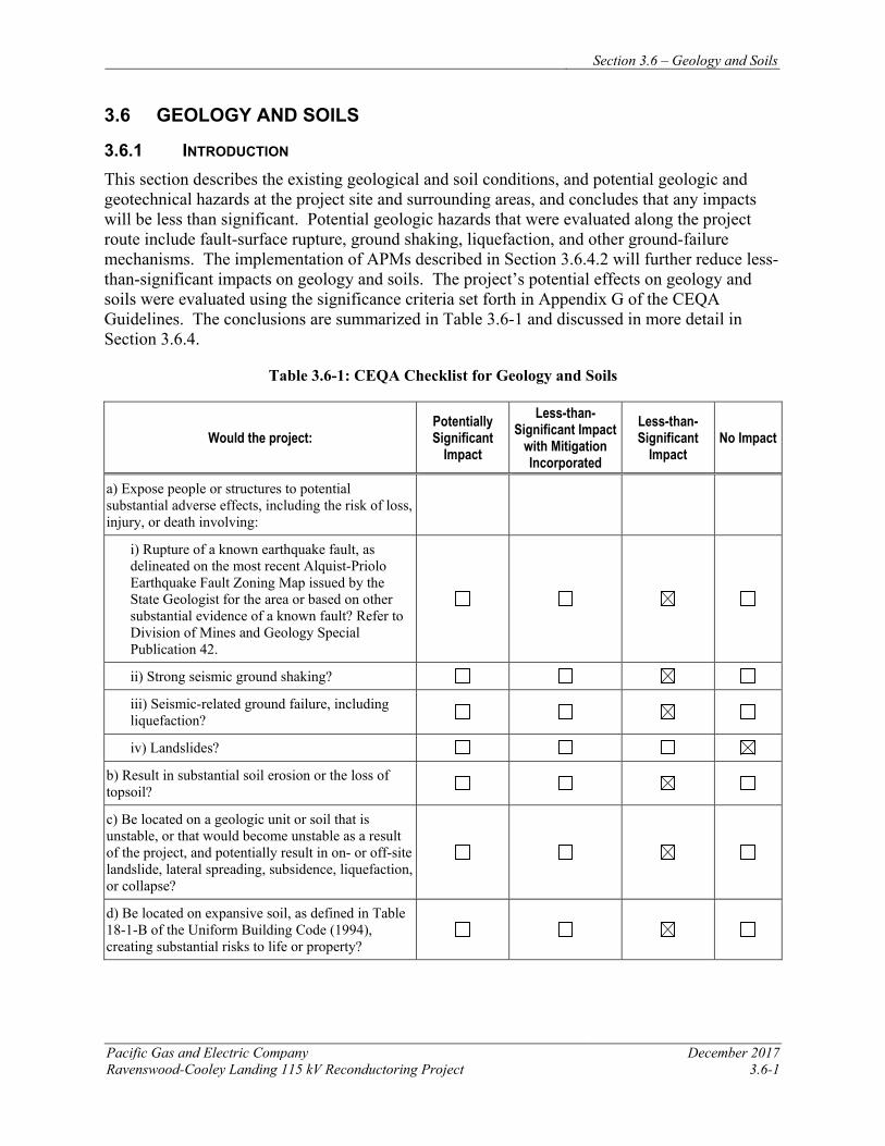
Section 3.6 – Geology and Soils
Pacific Gas and Electric Company December 2017 Ravenswood-Cooley Landing 115 kV Reconductoring Project 3.6-1
3.6 GEOLOGY AND SOILS
3.6.1 INTRODUCTION This section describes the existing geological and soil conditions, and potential geologic and geotechnical hazards at the project site and surrounding areas, and concludes that any impacts will be less than significant. Potential geologic hazards that were evaluated along the project route include fault-surface rupture, ground shaking, liquefaction, and other ground-failure mechanisms. The implementation of APMs described in Section 3.6.4.2 will further reduce less-than-significant impacts on geology and soils. The project’s potential effects on geology and soils were evaluated using the significance criteria set forth in Appendix G of the CEQA Guidelines. The conclusions are summarized in Table 3.6-1 and discussed in more detail in Section 3.6.4.
Table 3.6-1: CEQA Checklist for Geology and Soils
Would the project: Potentially Significant
Impact
Less-than-Significant Impact
with Mitigation Incorporated
Less-than-Significant
Impact No Impact
a) Expose people or structures to potential substantial adverse effects, including the risk of loss, injury, or death involving:
i) Rupture of a known earthquake fault, as delineated on the most recent Alquist-Priolo Earthquake Fault Zoning Map issued by the State Geologist for the area or based on other substantial evidence of a known fault? Refer to Division of Mines and Geology Special Publication 42.
ii) Strong seismic ground shaking?
iii) Seismic-related ground failure, including liquefaction?
iv) Landslides?
b) Result in substantial soil erosion or the loss of topsoil?
c) Be located on a geologic unit or soil that is unstable, or that would become unstable as a result of the project, and potentially result in on- or off-site landslide, lateral spreading, subsidence, liquefaction, or collapse?
d) Be located on expansive soil, as defined in Table 18-1-B of the Uniform Building Code (1994), creating substantial risks to life or property?
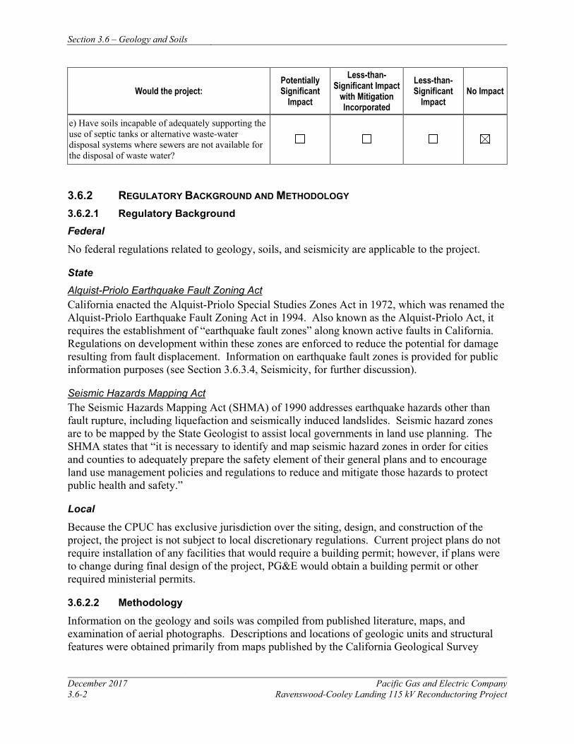
Section 3.6 – Geology and Soils
December 2017 Pacific Gas and Electric Company 3.6-2 Ravenswood-Cooley Landing 115 kV Reconductoring Project
Would the project: Potentially Significant
Impact
Less-than-Significant Impact
with Mitigation Incorporated
Less-than-Significant
Impact No Impact
e) Have soils incapable of adequately supporting the use of septic tanks or alternative waste-water disposal systems where sewers are not available for the disposal of waste water?
3.6.2 REGULATORY BACKGROUND AND METHODOLOGY 3.6.2.1 Regulatory Background Federal
No federal regulations related to geology, soils, and seismicity are applicable to the project.
State Alquist-Priolo Earthquake Fault Zoning Act California enacted the Alquist-Priolo Special Studies Zones Act in 1972, which was renamed the Alquist-Priolo Earthquake Fault Zoning Act in 1994. Also known as the Alquist-Priolo Act, it requires the establishment of “earthquake fault zones” along known active faults in California. Regulations on development within these zones are enforced to reduce the potential for damage resulting from fault displacement. Information on earthquake fault zones is provided for public information purposes (see Section 3.6.3.4, Seismicity, for further discussion).
Seismic Hazards Mapping Act The Seismic Hazards Mapping Act (SHMA) of 1990 addresses earthquake hazards other than fault rupture, including liquefaction and seismically induced landslides. Seismic hazard zones are to be mapped by the State Geologist to assist local governments in land use planning. The SHMA states that “it is necessary to identify and map seismic hazard zones in order for cities and counties to adequately prepare the safety element of their general plans and to encourage land use management policies and regulations to reduce and mitigate those hazards to protect public health and safety.”
Local
Because the CPUC has exclusive jurisdiction over the siting, design, and construction of the project, the project is not subject to local discretionary regulations. Current project plans do not require installation of any facilities that would require a building permit; however, if plans were to change during final design of the project, PG&E would obtain a building permit or other required ministerial permits.
3.6.2.2 Methodology
Information on the geology and soils was compiled from published literature, maps, and examination of aerial photographs. Descriptions and locations of geologic units and structural features were obtained primarily from maps published by the California Geological Survey
Section 3.6 – Geology and Soils
Pacific Gas and Electric Company December 2017 Ravenswood-Cooley Landing 115 kV Reconductoring Project 3.6-3
(CGS) and USGS. Soil descriptions and extents were obtained from mapping by the U.S. Department of Agriculture, NRCS. Seismic information was developed from several sources, including the USGS and CGS.
3.6.3 ENVIRONMENTAL SETTING 3.6.3.1 Regional Setting
The project site is located near the southern margin of the San Francisco Bay Area and near the center of the Coast Ranges geomorphic province. The Coast Ranges province includes mountain ranges (typically 2,000 to 4,000, occasionally 6,000 feet elevation above MSL) and valleys. The ranges and valleys trend northwest, subparallel to the San Andreas fault. The province terminates on the east where strata dip beneath alluvium of the Great Valley; on the west by the Pacific Ocean with mountains rising sharply from uplifted and terraced, wave-cut coast; on the north by South Fork Mountain, which has the characteristic trend of the Coast Ranges, and on the south by the Transverse Ranges. The Coast Ranges are composed of thick late Mesozoic and Cenozoic sedimentary strata. The northern and southern ranges are separated by a depression containing the San Francisco Bay. The San Francisco Peninsula, bounded on the east by San Francisco Bay and on the west by the Pacific Ocean, belongs to the same topographic unit as the Santa Cruz Mountains, which extend approximately 80 miles in a southeasterly direction from San Francisco to the Pajaro River, near Watsonville.
The San Francisco Bay, located east of the project area, occupies a Late Pliocene structural depression that has been flooded several times in response to Pleistocene glacial cycles. Sediment deposition within the basin now occupied by the bay has been strongly influenced by ocean-level fluctuations. During periods of glacial advance, sea levels were lower, leaving the basin dry and subject to alluvial deposition, stream channel erosion, and aeolian (wind-related) processes. During periods of glacial retreat, rising sea levels flooded the basin, resulting in fluvial deposition of fine-grained sediments at the bottom of the bay. Flatlands, created by alluvial deposition of locally derived sediments, are found between the bay margins and the surrounding hills. Historical development around the bay margins has included placement of artificial fill materials bayward of the natural shoreline, significantly altering the shoreline and reducing the size of the bay.
The San Francisco Bay region is located along the complex boundary between two tectonic plates: the North American Plate and the Pacific Plate. As a result, geologic conditions in the project vicinity have been and continue to be primarily controlled by the interaction of these two massive blocks of the earth’s crust. Under the current tectonic regime, the Pacific Plate moves northwestward relative to the North American Plate at a rate of about 5 centimeters per year (De Mets et al. 2010; Antonellis et al. 1999). Within the past several million years, a shift to slightly oblique movement between the two plates has led to formation of the northwest-oriented mountains of the Coast Ranges. Relative movement between the North American and Pacific Plates at the latitude of the San Francisco Bay region is accommodated by predominantly strike-slip motion along a number of major faults, including the San Andreas, Hayward, San Gregorio, and Calaveras faults. In addition to these, countless other faults in the region accommodate relative motion between major faults and relieve compressional stresses along the plate boundary (Norris and Webb 1990).
Section 3.6 – Geology and Soils
December 2017 Pacific Gas and Electric Company 3.6-4 Ravenswood-Cooley Landing 115 kV Reconductoring Project
3.6.3.2 Stratigraphic Units
As shown on Figure 3.6-1, the surface geology of the project site area is mapped primarily as Quaternary bay mud (Qhbm). The Ravenswood substation, a portion of the access road to Staging Area 3, an area just north of this access road and between Towers 3 and 4, and an area between the Cooley Landing Substation and Tower 8 are mapped as artificial fill (af); the levees are mapped as artificial levee fill (alf); and the Cooley Landing Substation area and a small area just south of Tower 4 are mapped as Quaternary basin deposits (Qhb) (Brabb and Pampeyan, 1998). All of these stratigraphic units are Holocene in age, meaning they were deposited in the last 11,700 years.
The San Francisco Bay mud (Qhbm) and basin deposits (Qhb) were laid down by fluvial processes (transported by water) and occur as fan or fluvial deposits in valley and estuarine areas. The San Francisco Bay mud (Qhbm) consists of estuarine deposits composed of predominantly gray, green and blue unconsolidated organic-rich clay and silty clay with interspersed lenses of sand, peat, gravel, and shell fragments; thicknesses can be over 100 feet. The basin deposits (Qhb) are described as very fine silty clay to clay deposits occupying flat-floored basins at the distal edge of alluvial fans adjacent to the Qhbm. Artificial fill (af) and artificial levee fill (alf) consist of surface materials that have been disturbed by human activity. These deposits comprise materials that have been imported and/or modified. They may be loose to very well consolidated, and may contain gravel, sand, silt, clay, rock fragments, organic matter, and manmade debris in various combinations. Artificial fill thickness is variable and may be 100 feet in places; artificial levees may be over 20 feet high in places (Brabb and Pampeyan 1998).
3.6.3.3 Soils
As shown on Figure 3.6-2, the project site surface soils are predominantly mapped as Novato clay, 0 to 1 percent slopes ponded, with the Ravenswood substation area and area around the railroad tracks near the center of the project alignment mapped as Urban land-Orthents, reclaimed complex, 0 to 2 percent slopes. South of Bay Road at the Tower 8 location, soils are mapped as Novato Clay, 0 to 1 percent slopes, tidally flooded. Soils at the Cooley Landing Substation are mapped as Botella-Urban land complex, 0 to 5 percent slopes (NRCS 2011).
The Novato series consists of deep, very poorly-drained clay alluvium originating from mixed sedimentary and metamorphic rocks. They are found in marshes along the margins of the San Francisco Bay. Urban land refers to soils that have been altered or obscured by urban works and structures. Orthents refers to soils that lack horizon development; and in the case of urban settings are also highly altered materials associated with grading and cut-and-fill activities. The urban land soils are described as well-drained tidal flats, with variable profiles to 40 inches below ground surface and silty clay below that. The Orthents and other soils are described as deep, poorly drained and somewhat poorly drained soils on reclaimed tidal flats. The Botella-Urban land complex comprises Botella and similar soils (45 percent), urban land (30 percent), and other minor components (25 percent). The Botella series consists of very deep, well-drained clay loam soils that formed in alluvial material from sedimentary rocks.
Section 3.6 – Geology and Soils
Pacific Gas and Electric Company December 2017 Ravenswood-Cooley Landing 115 kV Reconductoring Project 3.6-5
Expansive soils are those that contain significant amounts of clays that expand when wet and can cause damage to foundations if moisture collects beneath structures. According to NRCS data, some soils within the project site area contain significant amounts of clay and may be prone to expansion and shrinkage.
3.6.3.4 Seismicity Fault Zones
The Alquist-Priolo Act requires the establishment of “earthquake fault zones” along known active faults in California. A fault is considered active if it has generated earthquakes accompanied by surface rupture during historic time (approximately the last 200 years) or has shown evidence of fault displacement during the Holocene period (approximately the last 11,700 years) (Bryant and Hart 2007). A fault is considered potentially active if there is evidence of fault displacement during the Quaternary period (approximately the last 1.6 million years). A fault is considered inactive if the most recent documented fault displacement pre-dates the Quaternary period. For the purposes of this report, multiple sources were used to identify faults within a distance of 10 miles that may potentially affect the site, including the USGS and CGS (see references in Section 3.6.5). A regional map of the fault zones in proximity to the site using data from a CGS source is included on Figure 3.6-1 (Bryant and Hart 2007).
No known active faults cross the project area or are located in the immediate project vicinity (see Figure 3.6-1). The known active faults located within 10 miles of the project area are the San Andreas Fault, located 9 miles southwest and the Hayward Fault located 10 miles northeast, which both exhibit historic surface rupture. Both of these faults are zoned under the Alquist-Priolo Act. The Monte Vista (also Monta Vista) fault, which exhibits Holocene displacement and is also considered active, is located approximately 8 miles south of the project area.
Potentially active Quaternary faults within 10 miles of the project area are the San Jose fault, which is mapped as extending through the project area, the Palo Alto fault, located approximately 2 miles southwest, and the Stanford fault, located approximately 4 miles southwest.
San Andreas Fault System The nearest fault of major historical significance is the San Andreas fault, which passes within a distance of approximately 9 miles of the project area. This active right-lateral, strike-slip fault extends in a northwest-southeast direction to the southwest of the project area. The portion of the San Andreas fault in the project vicinity is referred to as the San Francisco-Mission Santa Clara section. The last known surface rupture of this section occurred in 1838 with a magnitude 7 earthquake that resulted in over 60 kilometers of surface rupture (Jennings and Bryant 2010). The San Andreas fault zone extends from the Gulf of California in Mexico to the Mendocino coast in northern California and accommodates the majority of movement between the Pacific and North American plates. Several active faults along the section of the San Andreas in closest proximity to the project site are not generally considered to be independent seismic sources, but rather to experience movement triggered by seismic events on the San Andreas. Other active, northwest-striking right-lateral faults of the San Andreas fault system associated with historic
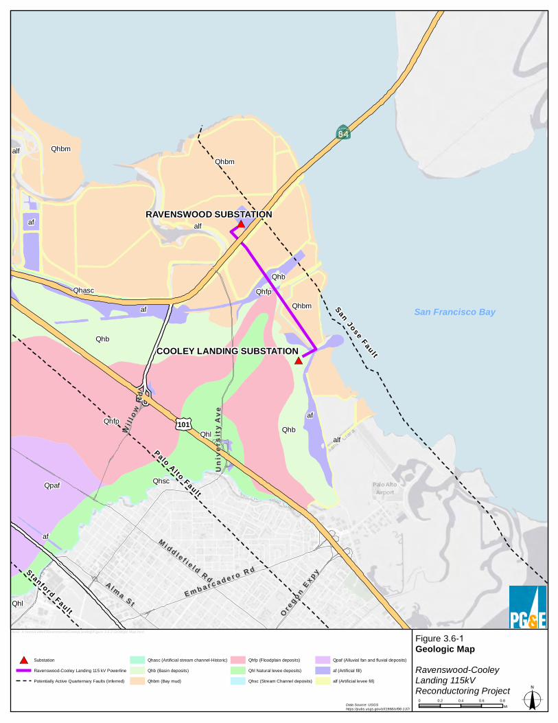
Stanford Faul t
Palo A l to Faul t
San Jose Fau l t
UUnn ii
vv eerr ss
ii ttyy
AAvv ee
WWii ll ll
oo wwRR
dd
O r eg on E
xp y
O regon E
xp y
A l ma S t
A l ma S tE m b a r c a d e r o R d
E m b a r c a d e r o R d
M i dd l e f i e l d R d
M i dd l e f i e l d R d
101
COOLEY LANDING SUBSTATION
RAVENSWOOD SUBSTATIONaf
QhascQhb
QhbmQhfp
Qhl
Qhl Qhbaf
alf
Qhsc
af
Qhbm
Qhb
Qhfp
Qpaf
Qhbmalf
alf
af
Figure 3.6-1 Geologic MapRavenswood-CooleyLanding 115kVReconductoring Project
0 0.2 0.4 0.6 0.8Mi
bxo2: H:\work\Liddell\RavenswoodCooleyLanding\Figure 3.6-2 Geologic Map.mxd
Data Source: USGShttps://pubs.usgs.gov/of/1998/of98-137/
San Francisco Bay
SubstationRavenswood-Cooley Landing 115 kV PowerlinePotentially Active Quarternary Faults (Inferred)
Qhasc (Artificial stream channel-Historic)Qhb (Basin deposits)Qhbm (Bay mud)
Qhfp (Floodplain deposits)Qhl Natural levee deposits)Qhsc (Stream Channel deposits)
Qpaf (Alluvial fan and fluvial deposits)af (Artificial fill)alf (Artificial levee fill)
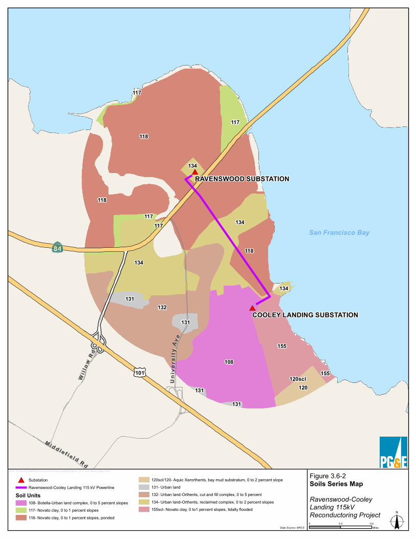
UUnn ii
vv eerr ss
ii ttyy
AA vv ee
MM ii dd dd ll ee ff ii ee ll dd RR dd
WWii ll ll
oo wwRR dd
101
COOLEY LANDING SUBSTATION
RAVENSWOOD SUBSTATION
134
134
134
108
131
117
118
131
134
131
131
117
117
117
118
155
120scl
118
132
155
120
Figure 3.6-2 Soils Series MapRavenswood-CooleyLanding 115kVReconductoring Project
SubstationRavenswood-Cooley Landing 115 kV Powerline
Soil Units108- Botella-Urban land complex, 0 to 5 percent slopes117- Novato clay, 0 to 1 percent slopes118- Novato clay, 0 to 1 percent slopes, ponded
120scl/120- Aquic Xerorthents, bay mud substratum, 0 to 2 percent slope131- Urban land132- Urban land-Orthents, cut and fill complex, 0 to 5 percent 134- Urban land-Orthents, reclaimed complex, 0 to 2 percent slopes155scl- Novato clay, 0 to1 percent slopes, tidally flooded
0 0.3 0.6Miles
bxo2: H:\work\Liddell\RavenswoodCooleyLanding\Figure 3.6-2 Soil Series Map.mxd
Data Source: NRCS
San Francisco Bay
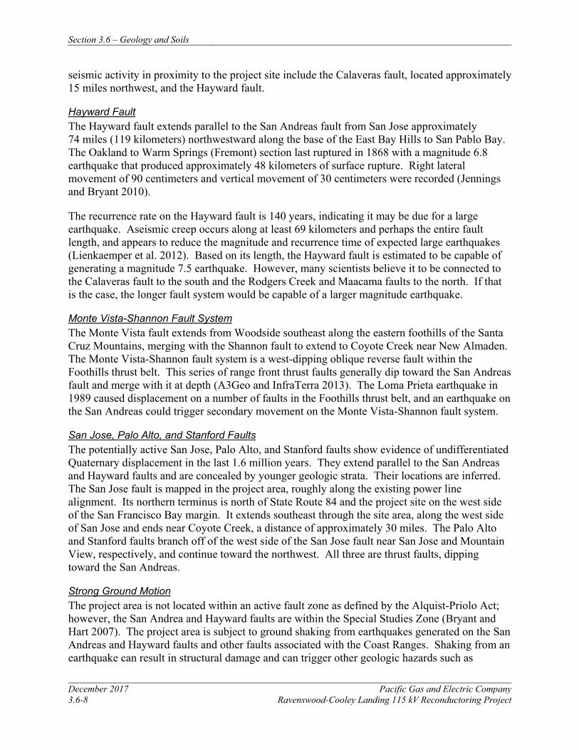
Section 3.6 – Geology and Soils
December 2017 Pacific Gas and Electric Company 3.6-8 Ravenswood-Cooley Landing 115 kV Reconductoring Project
seismic activity in proximity to the project site include the Calaveras fault, located approximately 15 miles northwest, and the Hayward fault.
Hayward Fault The Hayward fault extends parallel to the San Andreas fault from San Jose approximately 74 miles (119 kilometers) northwestward along the base of the East Bay Hills to San Pablo Bay. The Oakland to Warm Springs (Fremont) section last ruptured in 1868 with a magnitude 6.8 earthquake that produced approximately 48 kilometers of surface rupture. Right lateral movement of 90 centimeters and vertical movement of 30 centimeters were recorded (Jennings and Bryant 2010).
The recurrence rate on the Hayward fault is 140 years, indicating it may be due for a large earthquake. Aseismic creep occurs along at least 69 kilometers and perhaps the entire fault length, and appears to reduce the magnitude and recurrence time of expected large earthquakes (Lienkaemper et al. 2012). Based on its length, the Hayward fault is estimated to be capable of generating a magnitude 7.5 earthquake. However, many scientists believe it to be connected to the Calaveras fault to the south and the Rodgers Creek and Maacama faults to the north. If that is the case, the longer fault system would be capable of a larger magnitude earthquake.
Monte Vista-Shannon Fault System The Monte Vista fault extends from Woodside southeast along the eastern foothills of the Santa Cruz Mountains, merging with the Shannon fault to extend to Coyote Creek near New Almaden. The Monte Vista-Shannon fault system is a west-dipping oblique reverse fault within the Foothills thrust belt. This series of range front thrust faults generally dip toward the San Andreas fault and merge with it at depth (A3Geo and InfraTerra 2013). The Loma Prieta earthquake in 1989 caused displacement on a number of faults in the Foothills thrust belt, and an earthquake on the San Andreas could trigger secondary movement on the Monte Vista-Shannon fault system.
San Jose, Palo Alto, and Stanford Faults The potentially active San Jose, Palo Alto, and Stanford faults show evidence of undifferentiated Quaternary displacement in the last 1.6 million years. They extend parallel to the San Andreas and Hayward faults and are concealed by younger geologic strata. Their locations are inferred. The San Jose fault is mapped in the project area, roughly along the existing power line alignment. Its northern terminus is north of State Route 84 and the project site on the west side of the San Francisco Bay margin. It extends southeast through the site area, along the west side of San Jose and ends near Coyote Creek, a distance of approximately 30 miles. The Palo Alto and Stanford faults branch off of the west side of the San Jose fault near San Jose and Mountain View, respectively, and continue toward the northwest. All three are thrust faults, dipping toward the San Andreas.
Strong Ground Motion The project area is not located within an active fault zone as defined by the Alquist-Priolo Act; however, the San Andrea and Hayward faults are within the Special Studies Zone (Bryant and Hart 2007). The project area is subject to ground shaking from earthquakes generated on the San Andreas and Hayward faults and other faults associated with the Coast Ranges. Shaking from an earthquake can result in structural damage and can trigger other geologic hazards such as
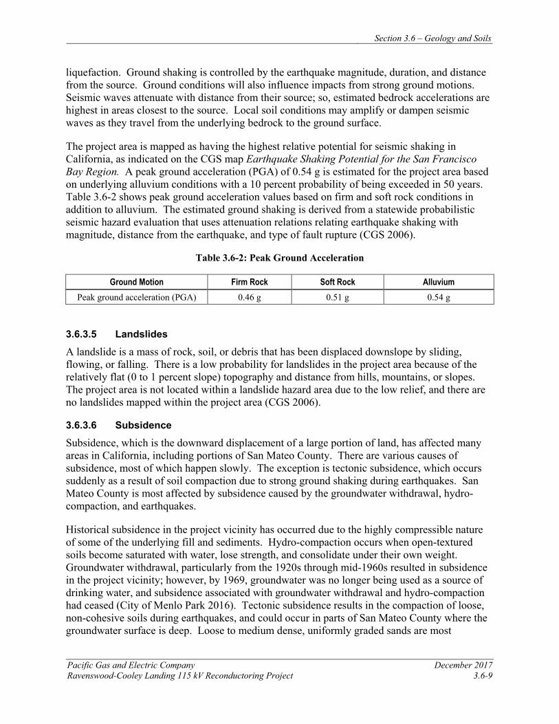
Section 3.6 – Geology and Soils
Pacific Gas and Electric Company December 2017 Ravenswood-Cooley Landing 115 kV Reconductoring Project 3.6-9
liquefaction. Ground shaking is controlled by the earthquake magnitude, duration, and distance from the source. Ground conditions will also influence impacts from strong ground motions. Seismic waves attenuate with distance from their source; so, estimated bedrock accelerations are highest in areas closest to the source. Local soil conditions may amplify or dampen seismic waves as they travel from the underlying bedrock to the ground surface.
The project area is mapped as having the highest relative potential for seismic shaking in California, as indicated on the CGS map Earthquake Shaking Potential for the San Francisco Bay Region. A peak ground acceleration (PGA) of 0.54 g is estimated for the project area based on underlying alluvium conditions with a 10 percent probability of being exceeded in 50 years. Table 3.6-2 shows peak ground acceleration values based on firm and soft rock conditions in addition to alluvium. The estimated ground shaking is derived from a statewide probabilistic seismic hazard evaluation that uses attenuation relations relating earthquake shaking with magnitude, distance from the earthquake, and type of fault rupture (CGS 2006).
Table 3.6-2: Peak Ground Acceleration
Ground Motion Firm Rock Soft Rock Alluvium Peak ground acceleration (PGA) 0.46 g 0.51 g 0.54 g
3.6.3.5 Landslides
A landslide is a mass of rock, soil, or debris that has been displaced downslope by sliding, flowing, or falling. There is a low probability for landslides in the project area because of the relatively flat (0 to 1 percent slope) topography and distance from hills, mountains, or slopes. The project area is not located within a landslide hazard area due to the low relief, and there are no landslides mapped within the project area (CGS 2006).
3.6.3.6 Subsidence
Subsidence, which is the downward displacement of a large portion of land, has affected many areas in California, including portions of San Mateo County. There are various causes of subsidence, most of which happen slowly. The exception is tectonic subsidence, which occurs suddenly as a result of soil compaction due to strong ground shaking during earthquakes. San Mateo County is most affected by subsidence caused by the groundwater withdrawal, hydro-compaction, and earthquakes.
Historical subsidence in the project vicinity has occurred due to the highly compressible nature of some of the underlying fill and sediments. Hydro-compaction occurs when open-textured soils become saturated with water, lose strength, and consolidate under their own weight. Groundwater withdrawal, particularly from the 1920s through mid-1960s resulted in subsidence in the project vicinity; however, by 1969, groundwater was no longer being used as a source of drinking water, and subsidence associated with groundwater withdrawal and hydro-compaction had ceased (City of Menlo Park 2016). Tectonic subsidence results in the compaction of loose, non-cohesive soils during earthquakes, and could occur in parts of San Mateo County where the groundwater surface is deep. Loose to medium dense, uniformly graded sands are most
Section 3.6 – Geology and Soils
December 2017 Pacific Gas and Electric Company 3.6-10 Ravenswood-Cooley Landing 115 kV Reconductoring Project
susceptible. In areas with shallow groundwater, such as the project area, liquefaction is more likely in the event of significant seismic shaking. The potential for ground subsidence due to earthquake motion is largely dependent on the magnitude, duration, and frequency of the earthquake waves.
3.6.3.7 Erosion
Erosion is the process by which rocks, soil, and other land materials are abraded or worn away from the earth’s surface over time. The rate of erosion depends on many factors, including soil type and geologic parent materials, slope and placement of soils, and human activity. The potential for erosion is highest in loose, unconsolidated soils. The steepness of slopes and absence of vegetation are also factors that increase the natural rates of erosion. Thus, erosion potential is high in steep, non-vegetated areas, especially those disturbed by grading or other construction activities.
The susceptibility of a soil to erosion varies and is a function of its characteristics, such as soil texture, soil structure, topography, amount of vegetative cover, and climate. Erosion from water mainly occurs in loose soils on moderate to steep slopes, particularly during high-intensity storm events. Because the topography at the project site is flat, erosion potential is low.
3.6.3.8 Liquefaction
Liquefaction is a phenomenon in which saturated, non-cohesive soils, such as sand and silt, temporarily lose their strength and liquefy when subjected to dynamic forces, such as intense and prolonged ground shaking. The vast majority of liquefaction hazards are associated with sandy soils and silty soils of low plasticity. In order to be susceptible to liquefaction, potentially liquefiable soils must be saturated or nearly saturated. In general, liquefaction hazards are most severe in saturated soils within the upper 50 feet of the ground surface. The potential for liquefaction increases with shallower groundwater.
Liquefaction potential in the project area is very high. The bay mud that underlies most of the project area and surrounding vicinity consists primarily of silty clay, sand, gravel, peat, and shell fragments. The water table in the project area is very shallow, typically less than 5 feet below ground surface. These factors combine to make the low-lying areas that front the bay particularly susceptible to liquefaction. According to hazard maps published by the CGS, the areas generally within 1.75 miles of the west end of the Dumbarton Bridge, which includes the site area, and areas flanking San Francisquito Creek to the northwest, have been designated as liquefaction hazard zones. This type of seismic hazard zone is further defined as an area where historical occurrence of liquefaction, or local geological, geotechnical, and groundwater conditions indicate a potential for permanent ground displacements such that mitigation as defined in Public Resources Code Section 2693(c) would be required (CGS 2006).
3.6.4 APPLICANT-PROPOSED MEASURES AND POTENTIAL IMPACTS The following sections describe significance criteria for impacts related to geology and soils derived from Appendix G of the CEQA Guidelines, provide APMs, and assess potential project-related construction and operational geologic impacts.
Section 3.6 – Geology and Soils
Pacific Gas and Electric Company December 2017 Ravenswood-Cooley Landing 115 kV Reconductoring Project 3.6-11
3.6.4.1 Significance Criteria
According to Section 15002(g) of the CEQA Guidelines, “a significant effect on the environment is defined as a substantial adverse change in the physical conditions which exist in the area affected by the proposed project.” As stated in Section 15064(b) of the CEQA Guidelines, the significance of an activity may vary with the setting. Per Appendix G of the CEQA Guidelines, the potential significance of project impacts related to geology and soils were evaluated for each of the criteria listed in Table 3.6-1, as discussed in Section 3.6.4.3.
3.6.4.2 Applicant-Proposed Measures
PG&E will implement the following APMs:
APM GEO-1: Implement Appropriate Design Measures Based on available references, potentially problematic subsurface conditions such as soft, loose, or liquefiable soils may exist in the project area. PG&E will perform design studies, onsite investigations, and implement appropriate design measures for foundation improvement work that will reduce potential effects of seismic ground failure, including liquefaction.
APM HYD-1: Prepare and Implement a Storm Water Pollution Prevention Plan (SWPPP). See Section 3.9, Hydrology and Water Quality, for full description.
3.6.4.3 Potential Impacts
Project impacts related to geology and soils were evaluated against the CEQA significance criteria and are discussed below. The impact analysis evaluates potential project impacts during the construction phase and the operation and maintenance phase.
The project includes reconductoring the existing 115 kV power line between Ravenswood Substation and Cooley Landing Substation. Construction activities include installing new conductor, performing minor tower modifications, and establishing required access and work areas, as described in Chapter 2, Project Description.
Four of the nine towers that support the 115 kV circuits require foundation improvements; the remaining five will remain unchanged. Based on the anticipated subsurface conditions, PG&E will install grout-injected soil displacement piles called Tubex piles adjacent to the existing tower foundations, and then will structurally tie the new piles to the existing tower footings. Two piles will be installed approximately 80- to 100-feet-deep adjacent to each tower footing, for a total of eight piles per tower.
Operation and maintenance activities for the reconductored power line will not change from current practices.
a) Would the project expose people or structures to potential substantial adverse effects, including the risk of loss, injury, or death involving: i) Rupture of a known earthquake fault as on the most recent Alquist-Priolo Earthquake Fault Zoning Map issued by the State Geologist for the area or based on other substantial evidence
Section 3.6 – Geology and Soils
December 2017 Pacific Gas and Electric Company 3.6-12 Ravenswood-Cooley Landing 115 kV Reconductoring Project
of a known fault, strong seismic ground shaking, seismic-related ground failure, including liquefaction, or landslides? Less than Significant
The project alignment does not cross any faults zoned under the Alquist-Priolo Act, and none of the faults near the project alignment are considered active faults by CGS (see Figure 3.6.1). The San Jose fault, which is mapped in the project area, is a Quaternary fault considered to be potentially active. Surface fault rupture is most likely to occur on active faults (i.e., faults showing evidence of displacement within the last 11,700 years). Younger geologic deposits cover the San Jose fault, and its location is inferred. The project area will not be located in active fault zones, and will not increase the risk of loss, injury, or death from rupture of known earthquake faults. Therefore, the impact will be less than significant.
ii) Strong seismic groundshaking? Less than Significant
Judging from the activity of major regional seismic sources, it is likely that the project will be exposed to at least one moderate or greater earthquake during its operational life, and that the earthquake will be centered close enough to the project to produce strong ground shaking in the project area. The nearby San Andreas fault has produced numerous moderate to large earthquakes, including the 1906 San Francisco earthquake and the 1989 Loma Prieta earthquake, and is a significant seismic source for future strong ground shaking within the project area. A PGA of 0.54 g is estimated for the project area based on underlying alluvium conditions.
In addition to the San Andreas, other active or potentially active faults that present significant potential for strong ground shaking within the project area include the Hayward, San Gregorio, and Calaveras faults. Local soil conditions may amplify or dampen seismic waves as they travel from underlying bedrock to the ground surface. Generally, overhead transmission lines can accommodate strong ground shaking. In fact, wind-loading design requirements for overhead lines are generally more stringent than are those developed to address strong seismic ground shaking. With implementation of APM GEO-1, PG&E will select appropriate design measures in order to minimize soil hazards that could be exacerbated by strong seismic ground shaking. Therefore, impacts associated with strong seismic ground shaking will be less than significant.
iii) Seismic-related ground failure, including liquefaction? Less than Significant
Soil liquefaction causes ground failure that can damage roads, pipelines, underground cables, and buildings with shallow foundations. Liquefaction can occur in areas characterized by water- saturated, cohesionless, granular materials at depths less than 50 feet. Unconsolidated sediments and artificial fills located in the project area and other reclaimed areas along the margin of San Francisco Bay may be subject to liquefaction. The shallow depth to groundwater in the project area increases the potential for liquefaction, because sediments must be saturated for liquefaction to occur. CGS has designated the project area as a Seismic Hazard Zone for liquefaction potential.
With implementation of APM GEO-1, PG&E will perform design studies, onsite investigations, and select design measures that will reduce potential impacts from seismic ground failure, including liquefaction, to a less-than-significant level.
Section 3.6 – Geology and Soils
Pacific Gas and Electric Company December 2017 Ravenswood-Cooley Landing 115 kV Reconductoring Project 3.6-13
iv) Landslides? No impact
The project area has very low relief (0 to 1 percent slope) and is not situated near hills, mountains, or slopes. There are no landslides mapped within the project area, and due to the low relief, the project area is not located within a landslide hazard area (CGS 2006). Therefore, no impact will occur.
b) Would the project result in substantial soil erosion or the loss of topsoil? Less than Significant
The potential for increased erosion exists because of surface-disturbing activities associated with project construction. However, erosion potential will be limited by the scale of construction activities, and because the project site is relatively flat. There is no grading or trenching planned as part of the project. In addition, work areas will either be established by placing protective matting over the ground surface, by mowing existing vegetation, and/or by working on paved surfaces, which individually and in combination will reduce the potential for erosion and subsequent sedimentation. Therefore, impacts from erosion or topsoil loss will be less than significant. The implementation of APM HYD-1 will further reduce any less-than-significant impacts.
c) Would the project be located on a geologic unit or soil that is unstable, or that would become unstable as a result of the project, and potentially result in on- or off-site landslide, lateral spreading, subsidence, liquefaction or collapse? Less than Significant
The project area has very low topographic relief (0 to 1 percent slope), and no mapped landslide hazard areas exist, either within or adjacent to the project alignment. The project area has shallow groundwater and a high potential for liquefaction, but the project will not exacerbate this potential. Rather, the proposed foundation modifications will strengthen the existing tower footings and decrease the potential effects of unstable soil. Implementation of GEO-1 which requires application of appropriate design measures and engineering standards to accommodate problematic soft or loose soils will further reduce less-than-significant impacts.
d) Would the project be located on expansive soil, as defined in Section 1802.3.2 of the California Building Code (2007 or 2010), creating substantial risks to life or property? Less than Significant
Soil units along the alignment primarily consist of clay and silt, with lesser amounts of sand. There is a potential for encountering expansive soils along most of the project alignment. Expansive soils expand during periods of heavy rainfall and contract when moisture evaporates; the resulting volume changes in the soil can result in damage to foundations. The project will not include the construction of any building foundations. Foundation work at the towers will consist of 80- to 100-foot-deep piles that extend below the potential zone of influence of expansive soils. Therefore, the impact will be less than significant.
e) Would the project have soils incapable of adequately supporting the use of septic tanks or alternative waste-water disposal systems where sewers are not available for the disposal of waste water? No impact
The project does not include a waste disposal system; therefore, no impact will occur.
Section 3.6 – Geology and Soils
December 2017 Pacific Gas and Electric Company 3.6-14 Ravenswood-Cooley Landing 115 kV Reconductoring Project
3.6.5 REFERENCES A3Geo and InfraTerra. 2013. Geotechnical Investigation and Geologic Hazard Study Report,
Rinconada Water Treatment Plant Control Building, Santa Clara Valley Water District, Los Gatos, California. April 15, 2013.
Antonelis, K., D. Johnson, M. Miller, and R. Palmer. 1999. “GPS determination of current Pacific-North American Plate Motion.” Geology. Volume 27, Pages 299-302.
Brabb, E.E., and Pampeyan, E.H. 1998. Geology of the onshore part of San Mateo County, California: A digital database. U.S. Geological Survey Open-File Report 98-137, scale 1:62,500.
Brabb, E. E., R. W. Graymer, and D. L. Jones. 2000. Geologic Map of the Palo Alto 30’ x 60’ Quadrangle, California. U.S. Geological Survey Miscellaneous Field Studies Map MF-2332, Version 1.0.
Brabb, E. E., R. W. Graymer, and D. L. Jones. 1998. Geology of the Palo Alto 30 x 60 Minute Quadrangle, California: a digital database. U.S. Geological Survey Open File Report 98-348.
Bryant, W. A., and E. W. Hart. 2007. Fault-Rupture Hazard Zones in California. California Geological Survey Special Publication 42. 42p. (digital version, electronic document available at ftp://ftp.consrv.ca.gov/pub/dmg/pubs/sp/Sp42.pdf).
California Geological Survey (CGS). 2006. Seismic Hazard Zone Report for the Palo Alto 7.5-Minute Quadrangle, San Mateo and Santa Clara Counties, California. Seismic Hazard Zone Report 111.
CGS. 2007. Fault-Rupture Hazard Zones in California. Special Publication 42.
California Seismic Safety Commission. 2003. Earthquake Shaking Potential for the San Francisco Bay Region. Publication No. 03-02.
City of Menlo Park. 2016. Connectmenlo: General Plan Land Use & Circulation Elements and M-2 Area Zoning Update. As amended through June 1, 2016.
De Mets, C., R. G. Gordon, D. F. Argus, and S. Stein. 1990. “Current Plate Motions.” Geophysical Journal International. Volume 101, Pages 425-478.
De Mets, C., Gordon, R.G, and Argus, D.F. 2010. “Geologically Current Plate Motions.” Geophysical Journal International. Volume 181, Pages 1–80.
Dibblee, T. W. and J. A. Minch. 2007. Geologic Map of the Palo Alto and Mountain View Quadrangles, Alameda, San Mateo and Santa Clara counties, California. Santa Barbara, CA. Santa Barbara Museum of Natural History.
Section 3.6 – Geology and Soils
Pacific Gas and Electric Company December 2017 Ravenswood-Cooley Landing 115 kV Reconductoring Project 3.6-15
Jennings, C. W. and W. A. Bryant. 2010. Fault Activity Map of California. California Geological Survey Geologic Data Map No. 6, scale 1:750,000.
Lienkaemper, J. J., F. S. McFarland, R. W. Simpson, R. G. Bilham, D. A. Ponce, J. J. Boatwright, and S. J. Caskey. 2012. “Long-Term Creep Rates on the Hayward Fault: Evidence for Controls on the Size and Frequency of Large Earthquakes.” Bulletin of the Seismological Society of America. Volume 102, No. 1, Pages 31-41.
Norris, R. M. and R. M. Webb. 1990. Geology of California, Second Edition. New York: John Wiley & Sons, Inc.
USDA Natural Resource Conservation Service. Web Soil Survey (WSS). 2011. Soil Survey Area: San Mateo County, Eastern Part, and San Francisco County, California. Survey Area Data: Version 9, Jul 11, 2011. Date(s) aerial images were photographed: 6/12/2005. Online: http://websoilsurvey.nrcs.usda.gov/app/WebSoilSurvey.aspx. Accessed on June 1, 2017.
USGS. 2015. Palo Alto Quadrangle, California, 7.5-Minute Series. U.S. Geological Survey U.S. Topo, scale 1:24,000.

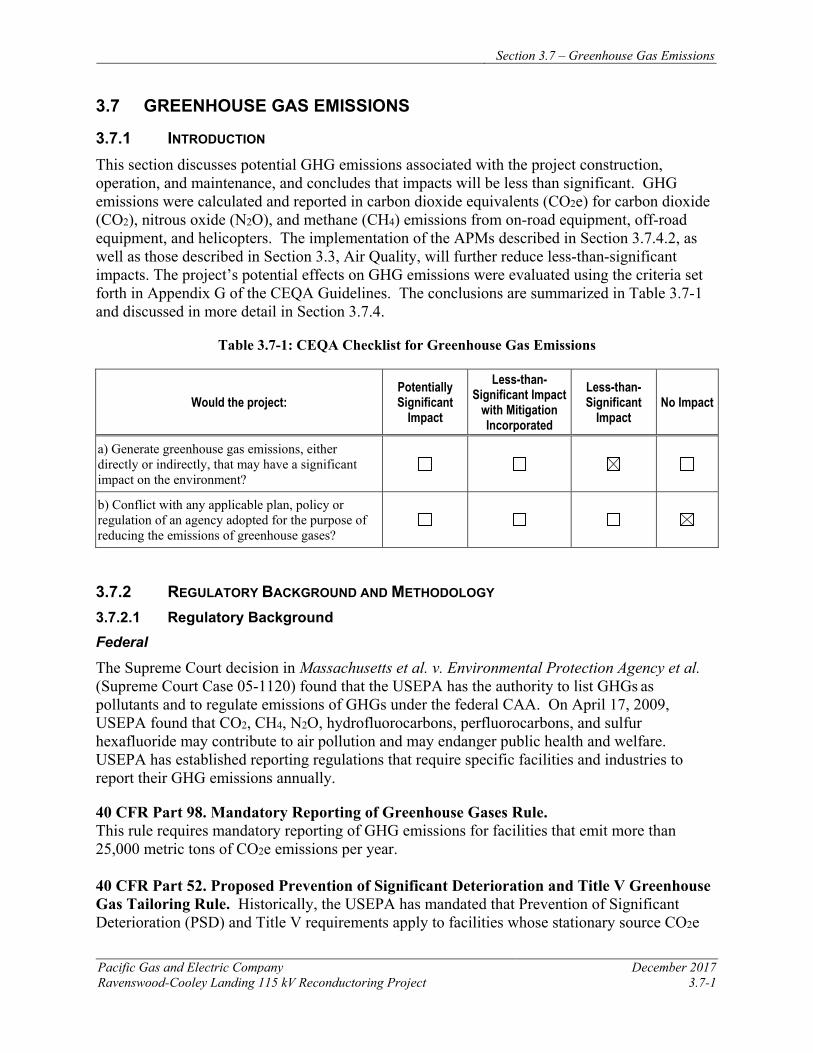
Section 3.7 – Greenhouse Gas Emissions
Pacific Gas and Electric Company December 2017 Ravenswood-Cooley Landing 115 kV Reconductoring Project 3.7-1
3.7 GREENHOUSE GAS EMISSIONS
3.7.1 INTRODUCTION This section discusses potential GHG emissions associated with the project construction, operation, and maintenance, and concludes that impacts will be less than significant. GHG emissions were calculated and reported in carbon dioxide equivalents (CO2e) for carbon dioxide (CO2), nitrous oxide (N2O), and methane (CH4) emissions from on-road equipment, off-road equipment, and helicopters. The implementation of the APMs described in Section 3.7.4.2, as well as those described in Section 3.3, Air Quality, will further reduce less-than-significant impacts. The project’s potential effects on GHG emissions were evaluated using the criteria set forth in Appendix G of the CEQA Guidelines. The conclusions are summarized in Table 3.7-1 and discussed in more detail in Section 3.7.4.
Table 3.7-1: CEQA Checklist for Greenhouse Gas Emissions
Would the project: Potentially Significant
Impact
Less-than-Significant Impact
with Mitigation Incorporated
Less-than-Significant
Impact No Impact
a) Generate greenhouse gas emissions, either directly or indirectly, that may have a significant impact on the environment?
b) Conflict with any applicable plan, policy or regulation of an agency adopted for the purpose of reducing the emissions of greenhouse gases?
3.7.2 REGULATORY BACKGROUND AND METHODOLOGY 3.7.2.1 Regulatory Background Federal
The Supreme Court decision in Massachusetts et al. v. Environmental Protection Agency et al. (Supreme Court Case 05-1120) found that the USEPA has the authority to list GHGs as pollutants and to regulate emissions of GHGs under the federal CAA. On April 17, 2009, USEPA found that CO2, CH4, N2O, hydrofluorocarbons, perfluorocarbons, and sulfur hexafluoride may contribute to air pollution and may endanger public health and welfare. USEPA has established reporting regulations that require specific facilities and industries to report their GHG emissions annually.
40 CFR Part 98. Mandatory Reporting of Greenhouse Gases Rule. This rule requires mandatory reporting of GHG emissions for facilities that emit more than 25,000 metric tons of CO2e emissions per year. 40 CFR Part 52. Proposed Prevention of Significant Deterioration and Title V Greenhouse Gas Tailoring Rule. Historically, the USEPA has mandated that Prevention of Significant Deterioration (PSD) and Title V requirements apply to facilities whose stationary source CO2e
Section 3.7 – Greenhouse Gas Emissions
December 2017 Pacific Gas and Electric Company 3.7-2 Ravenswood-Cooley Landing 115 kV Reconductoring Project
emissions exceed 100,000 tons per year (USEPA 2014b). However, the Supreme Court decision in Utility Air Regulatory Group v. USEPA et al. (Supreme Court Case 12-1146) found that the USEPA does not have the authority to require PSD and Title V permitting for facilities based solely on GHG emissions. Additionally, the Supreme Court found that the USEPA can regulate GHG emissions from sources which are already subject to PSD and Title V requirements due to emissions of other pollutants.
This project is not impacted by these regulations.
State
In 2006, the California State Legislature signed the Global Warming Solutions Act of 2006 (AB 32), which provides the framework for regulating GHG emissions in California. This law requires the CARB to design and implement emission limits, regulations, and other measures such that statewide GHG emissions are reduced in a technologically feasible and cost-effective manner to 1990 levels by 2020. The statewide 2020 emissions limit is 427 million metric tons CO2e.
State Executive Order S-3-05 established GHG reductions targets for the state of California. The targets called for a reduction of GHG emissions to 2000 levels by 2010; a reduction of GHG emissions to 1990 levels by 2020; and a reduction of GHG emissions to 80 percent below 1990 levels by 2050. The California Environmental Protection Agency (Cal/EPA) secretary is required to coordinate development and implementation of strategies to achieve the GHG reduction targets.
Part of CARB’s direction under AB 32 was to develop a scoping plan that contains the main strategies California will use to reduce GHG emissions that cause climate change. The scoping plan includes a range of GHG reduction actions, which include direct regulations, alternative compliance mechanisms, monetary and non-monetary incentives, voluntary actions, market-based mechanisms such as a cap-and-trade system, and an AB 32 cost of implementation fee regulation to fund the program. The CARB is currently in the process of updating the scoping plan to address the near-term 2030 target established by Senate Bill (SB) 32, which is to reduce statewide GHG emissions by 40 percent below 1990 levels by 2030.
CARB’s Regulation for the Mandatory Reporting of Greenhouse Gas Emissions came into effect in January 2009. However, this project is not impacted by these regulations and does not require mandatory reporting.
CARB published a Preliminary Draft Staff Proposal titled Recommended Approaches for Setting Interim Significance Thresholds for Greenhouse Gases under the California Environmental Quality Act in October 2008 that included a proposal that non-transportation-related sources with GHG emissions less than 7,000 metric tons of CO2e per year should be presumed to have a less than significant impact.
On December 30, 2009, the California Natural Resources Agency adopted amendments to the CEQA Guidelines to include analysis of GHG emissions in CEQA documents, deferring
Section 3.7 – Greenhouse Gas Emissions
Pacific Gas and Electric Company December 2017 Ravenswood-Cooley Landing 115 kV Reconductoring Project 3.7-3
significance thresholds to the lead agency. The amendments became effective on March 18, 2010.
A Regulation for Reducing SF6 Emissions from Gas Insulated Switchgear was implemented as part of AB 32, mandating utility-wide reduction of sulfur hexafluoride (SF6) emissions to a 1 percent leak rate by 2020.
In 2006, the Legislature passed the California Global Warming Solutions Act of 2006 (AB 32), which created a comprehensive, multi-year program to reduce greenhouse gas (GHG) emissions in California. AB 32 required the CARB to develop a Scoping Plan that describes the approach California will take to reduce GHGs to achieve the goal of reducing emissions to 1990 levels by 2020. The Scoping Plan was first approved by the CARB in 2008 and must be updated every five years. The First Update to the Scoping Plan was approved by the CARB on May 22, 2014, and builds upon the initial Scoping Plan with new strategies and recommendations
In 2016, the Legislature passed SB 32, which codifies a 2030 GHG emissions reduction target of 40 percent below 1990 levels. With SB 32, the Legislature passed companion legislation AB 197, which provides additional direction for developing the Scoping Plan. CARB is moving forward with a second update to the Scoping Plan to reflect the 2030 target set by Executive Order B-30-15 and codified by SB 32.
Regional
The California Air Pollution Control Officer’s Association has established the Greenhouse Gas Reduction Exchange (GHG Rx) for greenhouse gas emission credits in California. Credits listed on the GHG Rx come from voluntary emission reduction projects and can be purchased to offset GHG emissions.
Local air districts act under state law and their discretionary requirements apply to PG&E utility projects.
As discussed in Section 3.3.2.1, the project is located within the jurisdiction of the BAAQMD. The BAAQMD is the local agency charged with preparing, adopting, and implementing emission control measures and standards for stationary sources of air pollution. Because the project will not involve construction of new stationary sources, there are no permitting regulations applicable to the project. The local plans and guidance documents referenced in Section 3.3.2.1 (i.e., the California Environmental Quality Act Air Quality Guidelines [BAAQMD 2017a] and the 2017 Bay Area Clean Air Plan [CAP] [BAAQMD 2017b]) are also relevant to analyses used to evaluate the project’s GHG emissions.
Lastly, the BAAQMD adopted the Bay Area 2017 CAP on April 19, 2017. The 2017 Plan provides a regional strategy to protect public health and protect the climate. To protect public health, the plan describes how the Air District will continue its progress toward attaining all state and federal air quality standards and eliminating health risk disparities from exposure to air pollution among Bay Area communities. To protect the climate, the plan defines a vision for transitioning the region to a post-carbon economy needed to achieve ambitious greenhouse gas
Section 3.7 – Greenhouse Gas Emissions
December 2017 Pacific Gas and Electric Company 3.7-4 Ravenswood-Cooley Landing 115 kV Reconductoring Project
reduction targets for 2030 and 2050, and provides a regional climate protection strategy that will put the Bay Area on a pathway to achieve those GHG reduction targets.
Local
Because the CPUC has exclusive jurisdiction over project siting, design, and construction of the project, the project is not subject to local (i.e., city and county) discretionary GHG regulations.
3.7.2.2 Methodology
Information on air quality impacts was collected from the BAAQMD’s current CEQA Air Quality Guidelines. Short-term construction emissions of CO2e were evaluated. Construction emissions (excluding those from helicopters), and emissions from vehicle travel on paved and unpaved roads were estimated using California Emissions Estimator Model Version 2016.3.1 (CalEEMod). Helicopter emissions were estimated manually using emissions factors obtained from the 2011 Gulfwide Emission Inventory Study prepared for the U.S. Department of the Interior Bureau of Ocean Energy Management and manufacturer data on fuel usage. Detailed construction emission calculations will be provided separately to CPUC staff.
Operational emissions associated with inspections and ongoing maintenance activities (primarily associated with periodic maintenance vehicle travel) were not estimated as these activities are part of PG&E’s ongoing operations and will not change as a result of the project.
GHG emission calculations in this document were based on worst-case estimates of emissions to ensure presentation of a conservative environmental analysis. This analysis may be revised, as needed, to reflect changes to the project plans.
3.7.3 ENVIRONMENTAL SETTING 3.7.3.1 Regional Setting
GHGs are global concerns, unlike criteria air pollutants or toxic air contaminants that are of regional and/or local concern. Scientific research indicates that observed climate change is most likely a result of increased GHG emissions associated with human activity (Intergovernmental Panel on Climate Change 2007). Global climate change describes a collection of phenomena, such as increasing temperatures and rising sea levels, occurring across the globe due to increasing anthropogenic emissions of GHGs. GHGs contribute to climate change by allowing ultraviolet radiation to enter the atmosphere and warm the Earth’s surface, but also prevent some infrared radiation from the earth from escaping back into space. The largest anthropogenic source of GHGs is the combustion of fossil fuels, which result primarily in CO2 emissions.
As defined in AB 32, “greenhouse gas” or “greenhouse gases” include, but are not limited to CO2, CH4, N2O, hydrofluorocarbons, perfluorocarbons, and SF6. California is a substantial contributor to global GHG emissions. It is the second largest contributor in the United States and the 16th largest in the world (CEC 2006).
The BAAQMD has established a climate protection program to reduce air pollutants that affect public health and reduce emissions of GHG. The program includes measures to promote energy efficiency, reduce vehicle miles traveled, and develop alternative sources of energy.
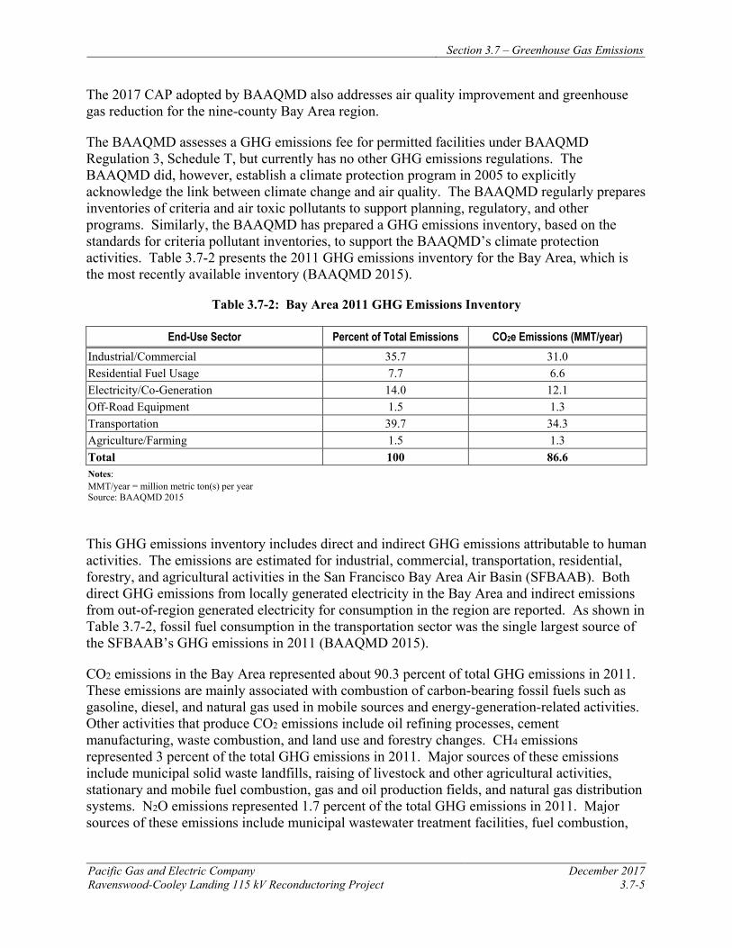
Section 3.7 – Greenhouse Gas Emissions
Pacific Gas and Electric Company December 2017 Ravenswood-Cooley Landing 115 kV Reconductoring Project 3.7-5
The 2017 CAP adopted by BAAQMD also addresses air quality improvement and greenhouse gas reduction for the nine-county Bay Area region.
The BAAQMD assesses a GHG emissions fee for permitted facilities under BAAQMD Regulation 3, Schedule T, but currently has no other GHG emissions regulations. The BAAQMD did, however, establish a climate protection program in 2005 to explicitly acknowledge the link between climate change and air quality. The BAAQMD regularly prepares inventories of criteria and air toxic pollutants to support planning, regulatory, and other programs. Similarly, the BAAQMD has prepared a GHG emissions inventory, based on the standards for criteria pollutant inventories, to support the BAAQMD’s climate protection activities. Table 3.7-2 presents the 2011 GHG emissions inventory for the Bay Area, which is the most recently available inventory (BAAQMD 2015).
Table 3.7-2: Bay Area 2011 GHG Emissions Inventory
End-Use Sector Percent of Total Emissions CO2e Emissions (MMT/year) Industrial/Commercial 35.7 31.0 Residential Fuel Usage 7.7 6.6 Electricity/Co-Generation 14.0 12.1 Off-Road Equipment 1.5 1.3 Transportation 39.7 34.3 Agriculture/Farming 1.5 1.3 Total 100 86.6 Notes: MMT/year = million metric ton(s) per year Source: BAAQMD 2015
This GHG emissions inventory includes direct and indirect GHG emissions attributable to human activities. The emissions are estimated for industrial, commercial, transportation, residential, forestry, and agricultural activities in the San Francisco Bay Area Air Basin (SFBAAB). Both direct GHG emissions from locally generated electricity in the Bay Area and indirect emissions from out-of-region generated electricity for consumption in the region are reported. As shown in Table 3.7-2, fossil fuel consumption in the transportation sector was the single largest source of the SFBAAB’s GHG emissions in 2011 (BAAQMD 2015).
CO2 emissions in the Bay Area represented about 90.3 percent of total GHG emissions in 2011. These emissions are mainly associated with combustion of carbon-bearing fossil fuels such as gasoline, diesel, and natural gas used in mobile sources and energy-generation-related activities. Other activities that produce CO2 emissions include oil refining processes, cement manufacturing, waste combustion, and land use and forestry changes. CH4 emissions represented 3 percent of the total GHG emissions in 2011. Major sources of these emissions include municipal solid waste landfills, raising of livestock and other agricultural activities, stationary and mobile fuel combustion, gas and oil production fields, and natural gas distribution systems. N2O emissions represented 1.7 percent of the total GHG emissions in 2011. Major sources of these emissions include municipal wastewater treatment facilities, fuel combustion,
Section 3.7 – Greenhouse Gas Emissions
December 2017 Pacific Gas and Electric Company 3.7-6 Ravenswood-Cooley Landing 115 kV Reconductoring Project
and agricultural soil and manure management. Emissions from high global warming potential gases such as HFCs, perfluorocarbons, and SF6 made up about 4.9 percent of the total GHG emissions in 2011. Major sources of these emissions include industrial processes such as semiconductor/electronic industry manufacturing, use as refrigerants and other products, and electric power distribution systems (BAAQMD 2015).
3.7.4 APPLICANT-PROPOSED MEASURES AND POTENTIAL IMPACTS The following sections describe significance criteria for GHG emission impacts derived from Appendix G of the CEQA Guidelines, provide APMs, and assess potential project-related construction and operational air quality impacts.
3.7.4.1 Significance Criteria
According to Section 15002(g) of the CEQA Guidelines, “a significant effect on the environment is defined as a substantial adverse change in the physical conditions which exist in the area affected by the proposed project.” As stated in Section 15064(b) of the CEQA Guidelines, the significance of an activity may vary with the setting. CEQA allows for significance criteria established by the applicable air pollution control district(s) to be used to assess the impact of a project related to GHG emissions, at the discretion of the CEQA Lead Agency.
Some California air districts, such as BAAQMD, Monterey Bay Unified, San Luis Obispo County, Ventura County, South Coast, and San Diego County, have adopted, or have recommended for adoption, a significance threshold of 10,000 metric tons CO2e per year for stationary source projects. This threshold was derived from emissions data from the four largest air districts in California and is based on the Executive Order S-3-05 GHG emissions reductions goal of 80 percent below 1990 levels by 2050, which is roughly equivalent to 90 percent below current levels by 2050. This emissions reduction goal goes beyond the AB 32 emissions reduction goal established for 2020. The emissions data suggests that approximately 1 percent of all stationary sources emit greater than 10,000 metric tons CO2e per year and are responsible for 90 percent of GHG emissions. This significance threshold represents a capture rate of 90 percent of all new and modified stationary source-related projects. A 90 percent emissions capture rate means 90 percent of the total emissions from all new or modified stationary source projects would be subject to analysis in an environmental impact report prepared pursuant to CEQA, including analysis of feasible alternatives and imposition of feasible mitigation measures (South Coast Air Quality Management District [SCAQMD] 2008).
As noted above, this GHG significance threshold is intended for long-term operational GHG emissions associated with stationary sources; none of the air districts mentioned above have adopted or have recommended GHG significance thresholds for construction emissions. Therefore, in recent CEQA documents, the CPUC has elected to use an approach to the determination of significance of GHG construction emissions based on guidance developed by the SCAQMD. For construction related GHGs, SCAQMD recommends that total emissions from construction be amortized over 30 years and added to operational emissions and then compared to the operation-based significance threshold of 10,000 metric tons CO2e per year (SCAQMD 2008).
Section 3.7 – Greenhouse Gas Emissions
Pacific Gas and Electric Company December 2017 Ravenswood-Cooley Landing 115 kV Reconductoring Project 3.7-7
Per Appendix G of the CEQA Guidelines, the potential significance of the project’s GHG emissions were evaluated for each of the criteria listed in Table 3.7-1, as discussed in Section 3.7.4.3.
3.7.4.2 Applicant-Proposed Measures
PG&E will implement the following APMs:
Construction
APM GHG-1 Minimize GHG Emissions • Minimize unnecessary construction vehicle idling time. The ability to limit construction
vehicle idling time will depend on the sequence of construction activities and when and where vehicles are needed or staged. Certain vehicles, such as large diesel-powered vehicles, have extended warm-up times following start-up that limit their availability for use following start-up. Where such diesel-powered vehicles are required for repetitive construction tasks, these vehicles may require more idling time. The project will apply a “common sense” approach to vehicle use, so that idling is reduced as far as possible below the maximum of 5 consecutive minutes allowed by California law; if a vehicle is not required for use immediately or continuously for construction activities, its engine will be shut off. Construction foremen will include briefings to crews on vehicle use as part of pre-construction conferences. Those briefings will include discussion of a “common sense” approach to vehicle use.
• Maintain construction equipment in proper working conditions in accordance with PG&E standards.
Operation and Maintenance
The O&M activities required for the reconductored power line will not change from those currently required for the existing line; thus, no operation-related impacts will occur and no APMs are necessary.
3.7.4.3 Potential Impacts
Potential project impacts related to GHG emissions were evaluated against the CEQA significance criteria and are discussed in further detail in the following paragraphs. The impact analysis evaluates potential project impacts during the construction phase and the operation and maintenance phase. Similar to the SCAQMD’s recommended approach for construction emissions, this analysis amortizes the construction emissions over a 30-year project lifetime then compares those emissions to the significance threshold of 10,000 metric tons CO2e per year.
The project includes reconductoring the existing 115 kV power line between Ravenswood Substation and Cooley Landing Substation. Construction activities include installing new conductor, performing minor tower modifications, and establishing required access and work areas, as described in Chapter 2, Project Description. Operation and maintenance activities for the reconductored power line will not change from current practices.
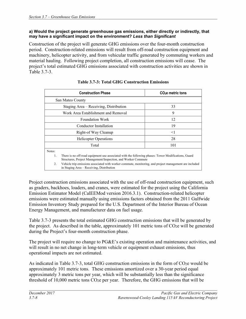
Section 3.7 – Greenhouse Gas Emissions
December 2017 Pacific Gas and Electric Company 3.7-8 Ravenswood-Cooley Landing 115 kV Reconductoring Project
a) Would the project generate greenhouse gas emissions, either directly or indirectly, that may have a significant impact on the environment? Less than Significant
Construction of the project will generate GHG emissions over the four-month construction period. Construction-related emissions will result from off-road construction equipment and machinery, helicopter activity, and from vehicular traffic generated by commuting workers and material hauling. Following project completion, all construction emissions will cease. The project’s total estimated GHG emissions associated with construction activities are shown in Table 3.7-3.
Table 3.7-3: Total GHG Construction Emissions
Construction Phase CO2e metric tons San Mateo County
Staging Area – Receiving, Distribution 33 Work Area Establishment and Removal 9
Foundation Work 12 Conductor Installation 19 Right-of Way Cleanup <1 Helicopter Operations 28
Total 101 Notes:
1. There is no off-road equipment use associated with the following phases: Tower Modifications, Guard Structures, Project Management/Inspection, and Worker Commute
2. Vehicle trip emissions associated with worker commute, monitoring, and project management are included in Staging Area – Receiving, Distribution
Project construction emissions associated with the use of off-road construction equipment, such as graders, backhoes, loaders, and cranes, were estimated for the project using the California Emission Estimator Model (CalEEMod version 2016.3.1). Construction-related helicopter emissions were estimated manually using emissions factors obtained from the 2011 Gulfwide Emission Inventory Study prepared for the U.S. Department of the Interior Bureau of Ocean Energy Management, and manufacturer data on fuel usage.
Table 3.7-3 presents the total estimated GHG construction emissions that will be generated by the project. As described in the table, approximately 101 metric tons of CO2e will be generated during the Project’s four-month construction phase.
The project will require no change to PG&E’s existing operation and maintenance activities, and will result in no net change in long-term vehicle or equipment exhaust emissions, thus operational impacts are not estimated.
As indicated in Table 3.7-3, total GHG construction emissions in the form of CO2e would be approximately 101 metric tons. These emissions amortized over a 30-year period equal approximately 3 metric tons per year, which will be substantially less than the significance threshold of 10,000 metric tons CO2e per year. Therefore, the GHG emissions that will be
Section 3.7 – Greenhouse Gas Emissions
Pacific Gas and Electric Company December 2017 Ravenswood-Cooley Landing 115 kV Reconductoring Project 3.7-9
generated by the project will not significantly contribute to global climate change. The impact will be less than significant.
b) Would the project conflict with any applicable plan, policy or regulation of an agency adopted for the purpose of reducing the emissions of greenhouse gases? No Impact
The project will not conflict with an applicable plan, policy, or regulation adopted to reduce GHG emissions. The minimal short-term construction GHG emissions will not interfere with the long-term goal of AB 32 to reduce GHG emissions to 1990 levels by 2020. Additionally, APM GHG-1 reduces vehicle idling time which is a control measure identified in the Bay Area 2017 CAP (BAAQMD 2017). Therefore, there will be no impact.
3.7.5 REFERENCES Bay Area Air Quality Management District. California Environmental Quality Act Air Quality
Guidelines. Updated May 2017. http://www.baaqmd.gov/~/media/files/planning-and-research/ceqa/ceqa_guidelines_may2017-pdf.pdf?la=en. Accessed August 2, 2017.
_____. 2017b. 2017 Bay Area Clean Air Plan. http://www.baaqmd.gov/~/media/files/planning-and-research/plans/2017-clean-air-plan/attachment-a_-proposed-final-cap-vol-1-pdf.pdf?la=en, Accessed June 19, 2017.
_____. 2015. Bay Area Emissions Inventory Summary Report: Greenhouse Gases Base Year 2011. Updated January 2015. http://www.baaqmd.gov/~/media/Files/Planning%20and%20Research/Emission%20Inventory/BY2011_GHGSummary.ashx?la=en. Accessed August 9, 2017.
California Energy Commission (CEC). 2006. Inventory of California Greenhouse Gas Emissions and Sinks: 1990 to 2004. December. Online: http://www.energy.ca.gov/2006publications/CEC-600-2006-013/CEC-600-2006-013-SF.PDF. Accessed June 19, 2017.
Intergovernmental Panel on Climate Change (IPCC). 2007. Climate Change 2007: The Physical Science Basis. Contribution of Working Group I to the Fourth Assessment Report of the Intergovernmental Panel on Climate Change [Solomon, S., D. Qin, M. Manning, Z. Chen, M. Marquis, K.B. Averyt, M. Tignor and H.L. Miller (eds.)]. Cambridge University Press, Cambridge, United Kingdom and New York, NY, USA, Online: http://www.ipcc.ch/publications_and_data/ar4/syr/en/contents.html. Accessed June 19, 2017.
South Coast Air Quality Management District (SCAQMD). 2008. Greenhouse Gases (GHG) CEQA Significance Thresholds. Online: http://www.aqmd.gov/home/regulations/ceqa/air-quality-analysis-handbook/ghg-significance-thresholds. Accessed June 19, 2017.
U.S. Department of the Interior – Bureau of Ocean Energy Management – Gulf of Mexico OCS Region. Offshore Petroleum and Natural Gas Production: Instructions for Calculating Emissions Using the Draft 2011 Gulfwide Emissions Inventory. 2011.
Section 3.7 – Greenhouse Gas Emissions
December 2017 Pacific Gas and Electric Company 3.7-10 Ravenswood-Cooley Landing 115 kV Reconductoring Project
United States Environmental Protection Agency (USEPA). 2013. Fact Sheet Greenhouse Gases Reporting Program Implementation. November. Online: http://www.epa.gov/sites/production/files/2014-09/documents/ghgrp-overviewfactsheet. pdf. Accessed: June 19, 2017.
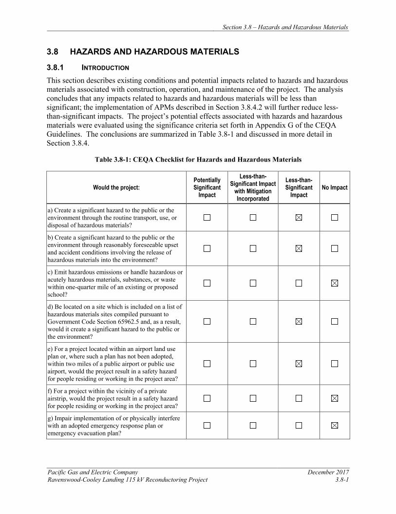
Section 3.8 – Hazards and Hazardous Materials
Pacific Gas and Electric Company December 2017 Ravenswood-Cooley Landing 115 kV Reconductoring Project 3.8-1
3.8 HAZARDS AND HAZARDOUS MATERIALS
3.8.1 INTRODUCTION This section describes existing conditions and potential impacts related to hazards and hazardous materials associated with construction, operation, and maintenance of the project. The analysis concludes that any impacts related to hazards and hazardous materials will be less than significant; the implementation of APMs described in Section 3.8.4.2 will further reduce less-than-significant impacts. The project’s potential effects associated with hazards and hazardous materials were evaluated using the significance criteria set forth in Appendix G of the CEQA Guidelines. The conclusions are summarized in Table 3.8-1 and discussed in more detail in Section 3.8.4.
Table 3.8-1: CEQA Checklist for Hazards and Hazardous Materials
Would the project: Potentially Significant
Impact
Less-than-Significant Impact
with Mitigation Incorporated
Less-than-Significant
Impact No Impact
a) Create a significant hazard to the public or the environment through the routine transport, use, or disposal of hazardous materials?
b) Create a significant hazard to the public or the environment through reasonably foreseeable upset and accident conditions involving the release of hazardous materials into the environment?
c) Emit hazardous emissions or handle hazardous or acutely hazardous materials, substances, or waste within one-quarter mile of an existing or proposed school?
d) Be located on a site which is included on a list of hazardous materials sites compiled pursuant to Government Code Section 65962.5 and, as a result, would it create a significant hazard to the public or the environment?
e) For a project located within an airport land use plan or, where such a plan has not been adopted, within two miles of a public airport or public use airport, would the project result in a safety hazard for people residing or working in the project area?
f) For a project within the vicinity of a private airstrip, would the project result in a safety hazard for people residing or working in the project area?
g) Impair implementation of or physically interfere with an adopted emergency response plan or emergency evacuation plan?
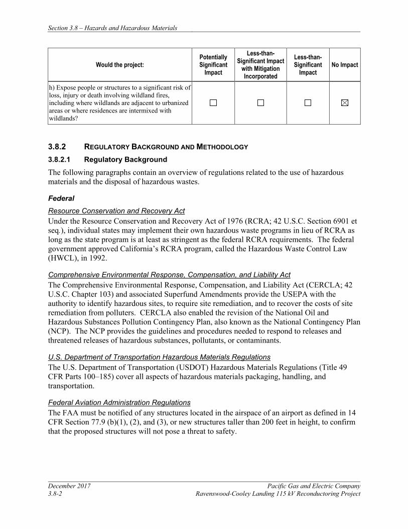
Section 3.8 – Hazards and Hazardous Materials
December 2017 Pacific Gas and Electric Company 3.8-2 Ravenswood-Cooley Landing 115 kV Reconductoring Project
Would the project: Potentially Significant
Impact
Less-than-Significant Impact
with Mitigation Incorporated
Less-than-Significant
Impact No Impact
h) Expose people or structures to a significant risk of loss, injury or death involving wildland fires, including where wildlands are adjacent to urbanized areas or where residences are intermixed with wildlands?
3.8.2 REGULATORY BACKGROUND AND METHODOLOGY 3.8.2.1 Regulatory Background
The following paragraphs contain an overview of regulations related to the use of hazardous materials and the disposal of hazardous wastes.
Federal Resource Conservation and Recovery Act Under the Resource Conservation and Recovery Act of 1976 (RCRA; 42 U.S.C. Section 6901 et seq.), individual states may implement their own hazardous waste programs in lieu of RCRA as long as the state program is at least as stringent as the federal RCRA requirements. The federal government approved California’s RCRA program, called the Hazardous Waste Control Law (HWCL), in 1992.
Comprehensive Environmental Response, Compensation, and Liability Act The Comprehensive Environmental Response, Compensation, and Liability Act (CERCLA; 42 U.S.C. Chapter 103) and associated Superfund Amendments provide the USEPA with the authority to identify hazardous sites, to require site remediation, and to recover the costs of site remediation from polluters. CERCLA also enabled the revision of the National Oil and Hazardous Substances Pollution Contingency Plan, also known as the National Contingency Plan (NCP). The NCP provides the guidelines and procedures needed to respond to releases and threatened releases of hazardous substances, pollutants, or contaminants.
U.S. Department of Transportation Hazardous Materials Regulations The U.S. Department of Transportation (USDOT) Hazardous Materials Regulations (Title 49 CFR Parts 100–185) cover all aspects of hazardous materials packaging, handling, and transportation.
Federal Aviation Administration Regulations The FAA must be notified of any structures located in the airspace of an airport as defined in 14 CFR Section 77.9 (b)(1), (2), and (3), or new structures taller than 200 feet in height, to confirm that the proposed structures will not pose a threat to safety.
Section 3.8 – Hazards and Hazardous Materials
Pacific Gas and Electric Company December 2017 Ravenswood-Cooley Landing 115 kV Reconductoring Project 3.8-3
State Hazardous Waste Control Law The HWCL (California Health and Safety Code [HSC] Chapter 6.5 Section 25100 et seq.) authorizes the Cal/EPA and the Department of Toxic Substances Control (DTSC), a department within Cal/EPA, to regulate the generation, transportation, treatment, storage, and disposal of hazardous wastes. DTSC can also delegate enforcement responsibilities to local jurisdictions that enter into agreements with DTSC for the generation, transport, and disposal of hazardous materials under the authority of HWCL.
Hazardous Substance Account Act The Hazardous Substance Account Act (HSAA) (California HSC Chapter 6.8 Section 25300 et seq.) is California’s equivalent to CERCLA. It addresses hazardous waste sites and apportions liability for them. The HSAA also provides that owners are responsible for the cleanup of such sites and the removal of toxic substances, where possible.
The two state agencies with primary responsibility for enforcing federal and state regulations related to hazardous material transport, and responding to hazardous materials transportation emergencies, are the California Highway Patrol and Caltrans, respectively.
Occupational Health and Safety The California Division of Occupational Safety and Health (Cal/OSHA) assumes primary responsibility for developing and enforcing workplace safety regulations within the state (CCR Title 8). Cal/OSHA standards are more stringent than federal Occupational Safety and Health Administration regulations and take precedence.
Hazardous Materials Management The California Office of Emergency Services is the state office responsible for establishing emergency response and spill notification plans related to hazardous materials accidents. Title 26 of the CCR is a compilation of the chapters or titles of the CCR that are applicable to hazardous materials management.
Porter-Cologne Water Quality Control Act As discussed in more detail in Section 3.9, Hydrology and Water Quality, the Porter-Cologne Water Quality Control Act (California Water Code, Division 7) is the provision of the California Water Code that regulates water quality in California and authorizes the SWRCB and nine RWQCBs to implement and enforce the regulations. The RWQCBs regulate discharges under Porter-Cologne primarily through the issuance of waste discharge requirements. Anyone discharging or proposing to discharge materials that could affect water quality must file a report of waste discharge. The SWRCB and the RWQCBs can make their own investigations or may require dischargers to carry out water quality investigations and report on water quality issues. Porter-Cologne provides several means of enforcement, including cease and desist orders, cleanup and abatement orders, administrative civil liability orders, civil court actions, and criminal prosecution. The project area is under the jurisdiction of the San Francisco Bay RWQCB.
Section 3.8 – Hazards and Hazardous Materials
December 2017 Pacific Gas and Electric Company 3.8-4 Ravenswood-Cooley Landing 115 kV Reconductoring Project
Unified Hazardous Waste and Hazardous Materials Management Regulatory Program The Unified Hazardous Waste and Hazardous Materials Management Regulatory Program (Unified Program) (CCR Title 27) was mandated by the State of California in 1993. The Unified Program was created to consolidate, coordinate, and make consistent the administrative requirements, permits, inspections, and enforcement activities for six hazardous materials programs. The program has six elements, including:
• Hazardous Waste Generators and Hazardous Waste On-site Treatment
• Underground Storage Tanks
• Aboveground Petroleum Storage Act
• Hazardous Materials Release Response Plans and Inventories
• California Accidental Release Prevention
• Uniform Fire Code Hazardous Materials Management Plans and Hazardous Materials Inventory Statements
At the local level, this is accomplished by identifying a Certified Unified Program Agency (CUPA) that coordinates all of these activities to streamline the process for local businesses. The San Mateo County Environmental Health Department is approved by Cal/EPA as the CUPA for San Mateo County.
Rules for Overhead Electric Line Construction Under Section 35 of General Order 95, the CPUC regulates all aspects of design, construction, operation, and maintenance of electrical power lines and fire safety hazards for utilities subject to their jurisdiction.
Fire Prevention Standards for Electric Utilities The Fire Prevention Standards for Electric Utilities (CCR Title 14, Sections 1250-1258) provide definitions, maps, specifications, and clearance standards for projects under the jurisdiction of PRC Sections 4292 and 4293 in SRAs.
Local
Because the CPUC has exclusive jurisdiction over the siting, design, and construction of the project, the project is not subject to local discretionary regulations. This section provides information on adopted airport land use plans and adopted emergency response plans or evacuation plans for informational purposes and to assist with CEQA review.
Airport Land Use Plans The southern end of the project area is located approximately 0.8 miles northwest of the Palo Alto Airport. The Comprehensive Land Use Plan (CLUP) for this airport was last updated November 16, 2016 (Santa Clara County Airport Land Use Commission 2016). The objectives of the CLUP are to protect the public from the adverse effects of aircraft noise, to ensure that people and facilities are not concentrated in areas susceptible to aircraft accidents, and to ensure
Section 3.8 – Hazards and Hazardous Materials
Pacific Gas and Electric Company December 2017 Ravenswood-Cooley Landing 115 kV Reconductoring Project 3.8-5
that no structures or activities adversely affect navigable airspace. The implementation of the CLUP is intended to prevent future incompatible development from encroaching on the airport and allow for its development in accordance with the current airport master plan.
The CLUP outlines airport area height restrictions necessary to ensure that objects will not impair flight safety or decrease the operational capability of the airport. The Palo Alto Airport CLUP has adopted Federal Aviation Regulations Part 77 imaginary surfaces to determine height restrictions for natural and artificial objects. Penetration of these imaginary surfaces by permanent structures will endanger pilots and passengers of aircraft operating at the airport and will pose a hazard to persons occupying those structures.
The CLUP also outlines Airport Safety Zones for the safety of people on the ground and in the air and the protection of property from airport-related hazards. These safety zones, in descending order of exposure to potential aircraft accidents, are the Runway Protection Zone (RPZ), the Inner Safety Zone (ISZ), the Turning Safety Zone (TSZ), Outer Safety Zone (OSZ), the Sideline Safety Zone (SSZ), and the Traffic Pattern Zone (TPZ) (Santa Clara County Airport Land Use Commission 2016).
Palo Alto Airport land use compatibility is discussed further with regard to noise and land use standards in Section 3.12, Noise, and Section 3.10, Land Use and Planning.
Adopted Emergency Response Plans/Evacuation Plans Emergency plans in effect in the project area are as follows:
The San Mateo County Hazard Mitigation Plan (Tetra Tech 2016) provides hazard mitigation and emergency response protocols in the project vicinity. This Hazard Mitigation Plan was prepared in 2016 as a joint effort of the San Mateo County Office of Emergency Services and San Mateo County jurisdictions to reduce or eliminate long-term risk to people and property throughout the county from natural hazards and their effects. The plan identifies hazards and provides a risk assessment for all the potential natural hazards that could impact San Mateo County, and also includes a review of the county’s current capabilities and recommended additional action items to reduce vulnerability to potential disasters. The multi-jurisdictional plan includes the County of San Mateo, the 20 incorporated municipalities within the county (including Menlo Park and East Palo Alto, where the project area is located), special districts, and unincorporated areas of the county.
The City of Menlo Park also has its own Emergency Operations Plan, which describes how the city will manage and coordinate resources and personnel responding to emergency situations in Menlo Park (Emergency Management Consultants 2011).
3.8.2.2 Methodology
The methodology for analyzing impacts from hazards and hazardous materials includes identifying general types of hazardous materials and activities used during project construction, operation, and maintenance. Potential impacts on the environment and public health from hazards and hazardous materials were further evaluated using information on the existing uses of
Section 3.8 – Hazards and Hazardous Materials
December 2017 Pacific Gas and Electric Company 3.8-6 Ravenswood-Cooley Landing 115 kV Reconductoring Project
the project area and adjacent properties, historical uses, and known contamination to determine the likelihood of encountering hazardous materials.
A report was obtained from Environmental Data Resources Inc. (EDR; EDR 2017) and reviewed to screen for hazardous waste sites in the proposed project area. The EDR report includes information on sites within one mile of the project area that were identified in federal, state, and local databases related to hazardous materials and wastes, and maps showing the locations of these sites. The database search process reviews multiple lists for historically contaminated properties and businesses that use, generate, or dispose of hazardous materials or petroleum products in their operation. In addition, the EDR search reviews lists of active contaminated sites that are currently undergoing monitoring and remediation.
As specified by CEQA significance criterion (d) (see Table 3.8-1), the EDR report was used to identify sites along the project area route that are included on a list of hazardous materials sites compiled pursuant to Government Code Section 65962.5 (“Cortese List”). Because the Cortese List is no longer specifically updated by the state, those requesting a copy of the Cortese List are now referred directly to the appropriate information resources contained on the Internet web sites of the boards or departments that are referenced in the statute. Therefore, the EDR report’s listing of Cortese List sites was supplemented by reviewing the following:
• Sites listed on DTSC’s Envirostor database (DTSC 2017)
• Sites listed on the SWRCB’s GeoTracker database (SWRCB 2017)
The EDR report was also used to screen for nearby hazardous waste sites that could potentially affect the project based on the significance criteria summarized in Table 3.8-1.
The potential for activities and equipment that could pose fire hazards was evaluated through review of state fire hazard maps (California Department of Forestry and Fire Protection [Cal Fire] 2008). Potential project-related public safety issues associated with the use of hazardous materials, risk of property damage by wildfires, and an increase in accidents were identified through review of City of East Palo Alto and City of Menlo Park land use maps (City of East Palo Alto 2013; City of Menlo Park 2015a and 2015b).
3.8.3 ENVIRONMENTAL SETTING The project area is in southeastern San Mateo County, located within an open space area bounded by San Francisco Bay to the north and east and urbanized areas of varying densities to the west and south. The northern half of the project is within the City of Menlo Park, and the southern half of the project is within the City of East Palo Alto. These municipal jurisdictional boundaries overlap with regional open space uses that encompass the project area. The portion of the project within the City of Menlo Park is also within the Don Edwards San Francisco Bay NWR. The southern half of the project traverses a portion of the Ravenswood Open Space Preserve. In addition, the southernmost tower east of Cooley Landing Substation is within the Palo Alto Baylands Nature Preserve. Both portions of these open space preserves crossed by the project are within the boundaries of the City of East Palo Alto.
Section 3.8 – Hazards and Hazardous Materials
Pacific Gas and Electric Company December 2017 Ravenswood-Cooley Landing 115 kV Reconductoring Project 3.8-7
The project area includes an east-west oriented segment of SR 84. Approximately 0.8 mile east of the project is the Dumbarton Bridge, by which SR 84 crosses the San Francisco Bay to Newark. Approximately 0.4 mile west of the project, SR 84 intersects with University Avenue, beyond which are the areas of Menlo Park’s easternmost development.
3.8.3.1 Airports
One airport—the Palo Alto Airport—is located within 2 miles of the project area. The airport, located in East Palo Alto approximately 0.8 miles southeast of the southern end of the project site, is open to the public and has one runway. The Federal Aviation Regulations Part 77 imaginary surfaces for height restrictions mapped in the Comprehensive Land Use Plan (CLUP) for this airport (Santa Clara County Airport Land Use Commission 2016) include portions of the project area. The Cooley Landing Substation and Towers 8 and 9 are within the area mapped for a height restriction of approximately 150 feet; moving north the restricted height increases and is approximately 200 feet at Tower 6, approximately 275 feet at Tower 5, and approximately 350 feet at Tower 4. No height restrictions are defined in the project area north of Tower 4. The proposed heights for all modified towers in the project area are less than these Federal Aviation Regulations Part 77 height restrictions.
The Cooley Landing Substation and Towers 8 and 9 are also just within the northern extent of the Traffic Pattern Zone (TPZ) shown on the Airport Safety Zones map in the CLUP for this airport (Santa Clara County Airport Land Use Commission 2016). The TPZ is that portion of the airport area routinely overflown by aircraft operating in the airport traffic pattern. The remainder of the project area is not within an Airport Safety Zone defined in the CLUP.
3.8.3.2 Schools
No public or private schools, or daycare facilities were identified within 0.25 mile of the project alignment, work areas, or staging areas.
3.8.3.3 Existing Hazardous Materials/Sites
The GeoTracker and Envirostor databases identified several active contamination sites located within 0.25 mile of the project alignment, as summarized in Table 3.8-2: Active Contamination Sites.
Table 3.8-2: Active Contamination Sites
Site Address Distance and Direction from Project
Primary Contaminants and Impacted Media Cleanup Status
1990 Bay Road Site (formerly Rhone-Poulenc) StarLink Logistics, Inc.
1990 Bay Road and surrounding areas, East Palo Alto
Within Tower 9 work area and staging area SA4
Arsenic and other metals in soil; arsenic in groundwater
Open – remediation, verification monitoring, and land use restrictions
Romic Environmental Technologies/Bay Road Holdings
2081 Bay Road, East Palo Alto
Approximately 0.1 mile north of Tower 9
Arsenic in soil; trichloroethene in groundwater
Open – remediation and verification monitoring; RCRA cleanup site
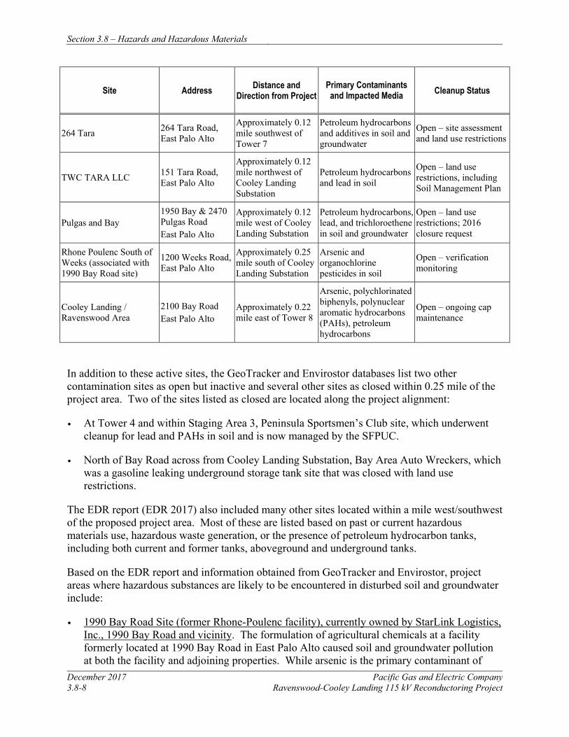
Section 3.8 – Hazards and Hazardous Materials
December 2017 Pacific Gas and Electric Company 3.8-8 Ravenswood-Cooley Landing 115 kV Reconductoring Project
Site Address Distance and Direction from Project
Primary Contaminants and Impacted Media Cleanup Status
264 Tara 264 Tara Road, East Palo Alto
Approximately 0.12 mile southwest of Tower 7
Petroleum hydrocarbons and additives in soil and groundwater
Open – site assessment and land use restrictions
TWC TARA LLC 151 Tara Road, East Palo Alto
Approximately 0.12 mile northwest of Cooley Landing Substation
Petroleum hydrocarbons and lead in soil
Open – land use restrictions, including Soil Management Plan
Pulgas and Bay 1950 Bay & 2470 Pulgas Road East Palo Alto
Approximately 0.12 mile west of Cooley Landing Substation
Petroleum hydrocarbons, lead, and trichloroethene in soil and groundwater
Open – land use restrictions; 2016 closure request
Rhone Poulenc South of Weeks (associated with 1990 Bay Road site)
1200 Weeks Road, East Palo Alto
Approximately 0.25 mile south of Cooley Landing Substation
Arsenic and organochlorine pesticides in soil
Open – verification monitoring
Cooley Landing / Ravenswood Area
2100 Bay Road East Palo Alto
Approximately 0.22 mile east of Tower 8
Arsenic, polychlorinated biphenyls, polynuclear aromatic hydrocarbons (PAHs), petroleum hydrocarbons
Open – ongoing cap maintenance
In addition to these active sites, the GeoTracker and Envirostor databases list two other contamination sites as open but inactive and several other sites as closed within 0.25 mile of the project area. Two of the sites listed as closed are located along the project alignment:
• At Tower 4 and within Staging Area 3, Peninsula Sportsmen’s Club site, which underwent cleanup for lead and PAHs in soil and is now managed by the SFPUC.
• North of Bay Road across from Cooley Landing Substation, Bay Area Auto Wreckers, which was a gasoline leaking underground storage tank site that was closed with land use restrictions.
The EDR report (EDR 2017) also included many other sites located within a mile west/southwest of the proposed project area. Most of these are listed based on past or current hazardous materials use, hazardous waste generation, or the presence of petroleum hydrocarbon tanks, including both current and former tanks, aboveground and underground tanks.
Based on the EDR report and information obtained from GeoTracker and Envirostor, project areas where hazardous substances are likely to be encountered in disturbed soil and groundwater include:
• 1990 Bay Road Site (former Rhone-Poulenc facility), currently owned by StarLink Logistics, Inc., 1990 Bay Road and vicinity. The formulation of agricultural chemicals at a facility formerly located at 1990 Bay Road in East Palo Alto caused soil and groundwater pollution at both the facility and adjoining properties. While arsenic is the primary contaminant of
Section 3.8 – Hazards and Hazardous Materials
Pacific Gas and Electric Company December 2017 Ravenswood-Cooley Landing 115 kV Reconductoring Project 3.8-9
concern, other metals, including cadmium, lead, zinc, mercury, and selenium, have been found at elevated concentrations as well. The site is approximately 23 acres and includes the 4.9-acre 1990 Bay Road property; partly-developed commercial properties to the north, south, and west; residential and mixed-use properties to the south; a portion of the PG&E pole yard west of Cooley Landing Substation (area proposed for Staging Area 4); the nontidal upland and marsh property east and south of Cooley Landing Substation (includes the Tower 9 work area), and a small portion of tidal wetland located beyond a levee east of the 1990 Bay Road property. Site investigation and cleanup activities have been ongoing since the early 1980s and are continuing pursuant to RWQCB Order No. R2-2016-0037 (RWQCB 2016). Following removal and treatment of arsenic-impacted soils, an asphalt cap was constructed on the PG&E pole yard property in 1993, and a geosynthetic clay liner cap was installed on the nontidal marsh property east and south of Cooley Landing Substation in 1999. The RWQCB Order requires implementation of a SMP for all soil disturbances within the site, and adherence to a Covenant and Environmental Restriction on Property deed restriction on record with the County of San Mateo (RWQCB 2016). The deed restriction applies to subsurface work within the specified property boundaries and requires notification of the RWQCB prior to any subsurface work within the site. The SMP requires that any contaminated soil brought to the surface be managed in accordance with the SMP, in addition to applicable local, state, and federal laws (RWQCB 2016). The SMP also includes requirements for notification of local agencies, implementation of dust control measures, sampling and analysis of soil and water removed from excavations, and provisions for reuse and disposal of excavation materials.
Given the urbanized nature of the project vicinity, soil and groundwater elsewhere in the project area also has the potential to contain hazardous substances and/or petroleum products.
3.8.3.4 Wildland Fire Hazards
All of the project area is within an incorporated Local Responsibility Area defined by CAL FIRE and is not within a mapped Fire Hazard Severity Zone (CAL FIRE 2008). Fire protection services and equipment near the project alignment are discussed in detail in Section 3.14, Public Services.
3.8.4 APPLICANT-PROPOSED MEASURES AND POTENTIAL IMPACTS The following sections describe significance criteria for impacts related to hazards and hazardous materials derived from Appendix G of the CEQA Guidelines, provide APMs, and assess potential project-related construction and operational impacts related to hazards and hazardous materials.
3.8.4.1 Significance Criteria
According to Section 15002(g) of the CEQA Guidelines, “a significant effect on the environment is defined as a substantial adverse change in the physical conditions which exist in the area affected by the proposed project.” As stated in Section 15064(b) of the CEQA Guidelines, the significance of an activity may vary with the setting. Per Appendix G of the CEQA Guidelines, the potential significance of project impacts related to hazards and hazardous materials were evaluated for each of the criteria listed in Table 3.8-1, as discussed in Section 3.8.4.3.
Section 3.8 – Hazards and Hazardous Materials
December 2017 Pacific Gas and Electric Company 3.8-10 Ravenswood-Cooley Landing 115 kV Reconductoring Project
3.8.4.2 Applicant-Proposed Measures
PG&E will implement the following APMs:
APM HAZ-1: Hazardous Substance Control and Emergency Response
PG&E will implement its hazardous substance control and emergency response procedures to ensure the safety of the public and site workers during construction. The procedures identify methods and techniques to minimize the exposure of the public and site workers to potentially hazardous materials during all phases of project construction through operation. They address worker training appropriate to the site worker’s role in hazardous substance control and emergency response. The procedures also require implementing appropriate control methods and approved containment and spill-control practices for construction and materials stored on-site. If it is necessary to store chemicals on-site, they will be managed in accordance with all applicable regulations. Safety Data Sheets will be maintained and kept available on-site, as applicable.
Potential soil and groundwater contamination was identified within the vicinity of project work areas. Soils or groundwater removed during drilling or other activities will be tested, and if contaminated above hazardous waste levels, will be contained and disposed of at a licensed waste facility. The presence of known or suspected contaminated soil will require testing and investigation procedures to be supervised by a qualified person, as appropriate, to meet state and federal regulations. All hazardous materials and hazardous wastes will be handled, stored, and disposed of in accordance with all applicable regulations, by personnel qualified to handle hazardous materials. The hazardous substance control and emergency response procedures include, but are not limited to, the following:
• Proper disposal of potentially contaminated soils
• Establishing site-specific buffers for construction vehicles and equipment located near sensitive resources
• Emergency response and reporting procedures to address hazardous material spills
• Stopping work at that location and contacting the Fire Department and Environmental Health Division immediately if visual contamination or chemical odors are detected. Work will be resumed at this location after any necessary consultation and approval by the agencies.
PG&E will complete a standard Emergency Action Plan Form as part of project tailboard meetings. The purpose of the form is to gather emergency contact numbers, first aid location, work site location, and tailboard information.
APM HAZ-2: Worker Environmental Awareness Program for Health, Safety, and Environment (WEAP-HSE)
PG&E will provide this environmental awareness program to staff prior to construction. This program will include the following components related to hazards and hazardous materials:
• PG&E Health, Safety, and Environmental expectations and management structure
Section 3.8 – Hazards and Hazardous Materials
Pacific Gas and Electric Company December 2017 Ravenswood-Cooley Landing 115 kV Reconductoring Project 3.8-11
• Applicable regulations
• Summary of the hazardous substances and materials that may be handled and/or to which workers may be exposed
• Summary of the primary workplace hazards to which workers may be exposed
• Overview of the measures identified in APM HAZ-1
• Overview of the controls identified in the SWPPP under APM HYD-1
APM HAZ-3: Adherence to Applicable Site-specific SMPs.
In addition to following its own project-specific procedures during the construction phase, PG&E will adhere to any applicable site-specific plans such as the SMP for the 1990 Bay Road Site (see Section 3.8.3.3).
APM HYD-1: Prepare and Implement a Storm Water Pollution Prevention Plan (SWPPP) (See Section 3.9, Hydrology and Water Quality, for full description).
3.8.4.3 Potential Impacts
Project impacts related to hazards and hazardous materials were evaluated against the CEQA significance criteria and are discussed below. The impact analysis evaluates potential project impacts during the construction phase and the operation and maintenance phase.
The project includes reconductoring the existing 115 kV power line between Ravenswood Substation and Cooley Landing Substation. Construction activities include installing new conductor, performing minor tower modifications, and establishing required access and work areas, as described in Chapter 2, Project Description. Operation and maintenance activities for the reconductored power line will not change from current practices.
a) Would the project create a significant hazard to the public or the environment through the routine transport, use, or disposal of hazardous materials? Less than Significant
The project will not create a significant hazard to the public or the environment through the routine transport, use, or disposal of hazardous materials. Other than substances associated with construction vehicles and equipment (e.g., fuels, oils, lubricants, and solvents), no hazardous materials will be associated with construction of the project. No bulk aboveground storage tanks or 55-gallon drums will be stored on site for fueling or maintenance purposes. Vehicles will be fueled at commercial or PG&E fueling stations; no vehicles will be refueled on site. Minor spills or releases of hazardous materials could occur due to improper materials handling, improperly maintained equipment, or from mechanical failure during construction activities. Should a spill occur, all hazardous materials and waste will be removed from the site for reuse, recycling, or disposal at a properly licensed facility in accordance with state and federal regulations and requirements.
Section 3.8 – Hazards and Hazardous Materials
December 2017 Pacific Gas and Electric Company 3.8-12 Ravenswood-Cooley Landing 115 kV Reconductoring Project
To minimize the likelihood of spills and assure a prompt, safe, and effective response if a spill were to occur, PG&E will implement APM HYD-1, Prepare and Implement a Storm Water Pollution Prevention Plan, APM HAZ-1, Hazardous Substance Control and Emergency Response, and APM HAZ-2, Worker Environmental Awareness Program for Health, Safety, and Environment. With implementation of these APMs, impacts associated with transport, use, and disposal of hazardous materials during construction or operation and maintenance of the project will be less than significant.
b) Would the project create a significant hazard to the public or the environment through reasonably foreseeable upset and accident conditions involving the release of hazardous materials into the environment? Less than Significant
Project construction will require the use of motorized heavy equipment, including trucks, heavy equipment, and helicopters. During construction activities, there will be an increased potential for an accidental release of fluids from a vehicle or motorized piece of equipment as discussed above. However, the potential effects will be limited due to the limited amounts and types of hazardous materials proposed for use during construction. With implementation of APMs HAZ-1 and HAZ-2, along with APM HYD-1, PG&E will further reduce the less-than-significant impact from accidental spills of hazardous materials during construction. If contaminated soil or sediment, or contaminated water are encountered during project construction, impacts from project construction will be less than significant with implementation of APMs HAZ-1 and HAZ-3
c) Would the project emit hazardous emissions or handle hazardous or acutely hazardous materials, substances, or waste within one-quarter mile of an existing or proposed school? No Impact
There are presently no schools located within 0.25 mile of the project alignment, work areas, helicopter landing zones, or staging areas. There are plans for construction of a school (The Primary School at 1200 Weeks Street, East Palo Alto) approximately 0.2 mile from the project; however, the school is not anticipated to be occupied until after the project has completed construction. While the project may handle hazardous materials during construction, operation and maintenance activities for the reconductored power line will not change from current practices. Therefore, there will be no impacts to schools from construction or operation and maintenance of the project.
d) Would the project be located on a site which is included on a list of hazardous materials sites compiled pursuant to Government Code Section 65962.5 and, as a result, would it create a significant hazard to the public or the environment? Less than Significant
Based on the environmental database search conducted by EDR and review of the state Envirostor and GeoTracker databases, Staging Area 4 and the Tower 9 work area are located on the StarLink Logistics, Inc 1990 Bay Road site, a site listed pursuant to Section 65962.5. Arsenic and other hazardous substances are present in soil and groundwater as a result of impacts from this site. This site is considered open by the RWQCB and is subject to a deed restriction and implementation of a SMP for activities that include disturbance of the subsurface soil. Construction of the project will have the potential to encounter contaminated soil and groundwater associated with the 1990 Bay Road site. However, the project will involve limited ground disturbance and subsurface work at Tower 9, and no ground disturbance or subsurface
Section 3.8 – Hazards and Hazardous Materials
Pacific Gas and Electric Company December 2017 Ravenswood-Cooley Landing 115 kV Reconductoring Project 3.8-13
work at Staging Area 4 which is within the paved PG&E pole yard. Foundation work consists of installing two 16-inch-diameter Tubex soil displacement piles 80 to 100 feet deep adjacent to each existing tower footing (a total of eight piles per tower). With this pile installation system, there are no spoils generated; the soil is displaced laterally and compacted as the drill bit is advanced. Utilizing this pile installation method will limit the potential for the project to encounter contaminated soil associated with the listed sites in the project vicinity. Installation of wood-pole guard structures and snub poles will require auguring to a depth of 5 to 7 feet and could encounter contaminated soil associated with the above listed site. As stated above, PG&E will implement APMs HAZ-1 which requires testing of soils or groundwater removed during drilling or other activities, HAZ-2, which will include information and procedures to identify and respond to any unexpected encounter of hazardous materials or contamination during construction activities, and HAZ-3 which requires adherence to the SMP for the 1990 Bay Road site. There is no other grading, excavation, or trenching planned as part of the project; potential exposure to contaminated materials is limited to the foundation work and temporary wood pole installation described above. Staging Area 4 has a paved asphalt surface, further minimizing the potential for encountering contaminated soil or groundwater. With implementation of APMs HAZ-1, HAZ-2, and HAZ-3, construction or operation and maintenance of the project will not create a significant hazard to the public or the environment; therefore, impacts will be less than significant.
e) For a project located within an airport land use plan or, where such a plan has not been adopted, within 2 miles of a public airport or public use airport, would the project result in a safety hazard for people residing or working in the project area? Less than Significant
The Palo Alto Airport is located in East Palo Alto approximately 0.8 miles southeast of the southern end of the project area. The Federal Aviation Regulations Part 77 imaginary surfaces for height restrictions mapped in the CLUP for this airport include portions of the project area. PG&E has submitted the required Notice of Proposed Construction and Alteration Application to the FAA for all nine project towers, and the FAA has confirmed the project will not cause any air navigation hazards and that marking and lighting are not required for any of the tower modifications.
During construction, helicopter flight paths generally will be limited to the existing power line right-of-way and landing zones within the designated project staging areas. Helicopter use will be in accordance with all applicable federal, State, and local aviation rules and regulations, and will not create any new hazards. In addition, PG&E will coordinate with local airports regarding helicopter operations and flight plans during project construction. Therefore, the project will not result in a safety hazard for people residing or working in the project area. Impacts from construction or operation and maintenance of the project will be less than significant.
f) For a project within the vicinity of a private airstrip, would the project result in a safety hazard for people residing or working in the project area? No Impact
No private airstrips are located in the project vicinity. Thus, no impact from construction or operation and maintenance of the project will occur.
Section 3.8 – Hazards and Hazardous Materials
December 2017 Pacific Gas and Electric Company 3.8-14 Ravenswood-Cooley Landing 115 kV Reconductoring Project
g) Would the project impair implementation of or physically interfere with an adopted emergency response plan or emergency evacuation plan? No Impact
If road closures are necessary, they will occur in accordance with regulations and will not impede emergency response. The project will not impair the implementation of or physically interfere with an adopted emergency response or evacuation plan; therefore, no impact from construction or operation and maintenance of the project will occur.
h) Would the project expose people or structures to a significant risk of loss, injury, or death involving wildland fires, including where wildlands are adjacent to urbanized areas or where residences are intermixed with wildlands? No Impact
The project is not adjacent to wildlands and will not expose people or structures to a significant risk involving wildland fires. The project area does not lie within a Fire Hazard Severity Zone as identified by CAL FIRE. No impact from construction or operation and maintenance of the project will occur.
3.8.5 REFERENCES California Department of Forestry and Fire Protection (CalFire). 2008. San Mateo County – Very
Fire Hazard Severity Zones in Local Responsibility Area. Department of Forestry and Fire Protection. Projection Albers, NAD 1927, Scale 1: 100,000 at 34" x 42".
California Regional Water Quality Control Board (RWQCB), San Francisco Bay Region. 2016. Order No. R2-2016-0037. Adoption of Final Site Cleanup Requirements and Rescission of Order Nos. 91-016, 91-095, 92-022, 92-127, 94-042, 96-162, 97-015, 97-095, and R2-2005-0033 for: Starlink Logistics, Inc. (Formerly, Rhone-Poulenc, Inc.) for: 1990 Bay Road Site, East Palo Alto, San Mateo County. July 18, 2016.
City of East Palo Alto. 2017. Zoning Map/Find My Zoning, Zoning Map 2017 - To be approved by the City Council. Online: http://www.ci.east-palo-alto.ca.us/index.aspx?NID=617. Accessed: June 12, 2017.
. 2013. Ravenswood / 4 Corners, TOD Specific Plan. February 22, 2013.
. 2012. Ravenswood / 4 Corners, TOD Specific Plan Final EIR. SCH # 2011052006. July 30, 2012.
City of Menlo Park. 2015a. City of Menlo Park Zoning Map and General Plan Land Use Diagram, Sheet Layout and Legend. Updated April 2015.
. 2015b. City of Menlo Park Zoning Map and General Plan Land Use Diagram, Sheet 7. Updated April 2015.
Department of Toxic Substances Control (DTSC). 2017. Envirostor Database. Online: http://www.envirostor.dtsc.ca.gov/public/. Accessed on June 5, 2017.
Emergency Management Consultants. 2011. City of Menlo Park Emergency Operation Plan, V2, Basic Plan. January 2011.
Section 3.8 – Hazards and Hazardous Materials
Pacific Gas and Electric Company December 2017 Ravenswood-Cooley Landing 115 kV Reconductoring Project 3.8-15
Environmental Data Resources (EDR). 2017. EDR DataMap™ - Corridor Study, Cooley Landing – Ravenswood. Inquiry Number: 4958074.5s. June 7, 2017.
Santa Clara County Airport Land Use Commission. 2016. Comprehensive Land Use Plan, Santa Clara County, Palo Alto Airport. Adopted November 19, 2008. Amended November 16, 2016.
State Water Resources Control Board (SWRCB). 2017. GeoTracker Database. Online: http://geotracker.waterboards.ca.gov/. Accessed on June 5, 2017.
Tetra Tech. 2016. San Mateo County Hazard Mitigation Plan. July 2016.

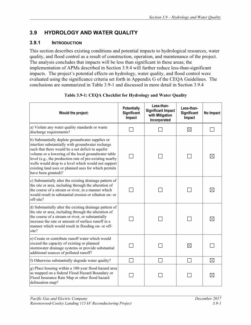
Section 3.9 – Hydrology and Water Quality
Pacific Gas and Electric Company December 2017 Ravenswood-Cooley Landing 115 kV Reconductoring Project 3.9-1
3.9 HYDROLOGY AND WATER QUALITY
3.9.1 INTRODUCTION This section describes existing conditions and potential impacts to hydrological resources, water quality, and flood control as a result of construction, operation, and maintenance of the project. The analysis concludes that impacts will be less than significant in these areas; the implementation of APMs described in Section 3.9.4 will further reduce less-than-significant impacts. The project’s potential effects on hydrology, water quality, and flood control were evaluated using the significance criteria set forth in Appendix G of the CEQA Guidelines. The conclusions are summarized in Table 3.9-1 and discussed in more detail in Section 3.9.4
Table 3.9-1: CEQA Checklist for Hydrology and Water Quality
Would the project: Potentially Significant
Impact
Less-than-Significant Impact
with Mitigation Incorporated
Less-than-Significant
Impact No Impact
a) Violate any water quality standards or waste discharge requirements?
b) Substantially deplete groundwater supplies or interfere substantially with groundwater recharge such that there would be a net deficit in aquifer volume or a lowering of the local groundwater table level (e.g., the production rate of pre-existing nearby wells would drop to a level which would not support existing land uses or planned uses for which permits have been granted)?
c) Substantially alter the existing drainage pattern of the site or area, including through the alteration of the course of a stream or river, in a manner which would result in substantial erosion or siltation on- or off-site?
d) Substantially alter the existing drainage pattern of the site or area, including through the alteration of the course of a stream or river, or substantially increase the rate or amount of surface runoff in a manner which would result in flooding on- or off-site?
e) Create or contribute runoff water which would exceed the capacity of existing or planned stormwater drainage systems or provide substantial additional sources of polluted runoff?
f) Otherwise substantially degrade water quality?
g) Place housing within a 100-year flood hazard area as mapped on a federal Flood Hazard Boundary or Flood Insurance Rate Map or other flood hazard delineation map?
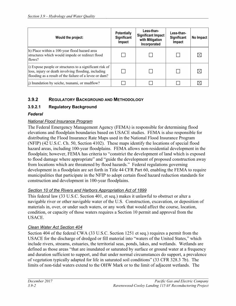
Section 3.9 – Hydrology and Water Quality
December 2017 Pacific Gas and Electric Company 3.9-2 Ravenswood-Cooley Landing 115 kV Reconductoring Project
Would the project: Potentially Significant
Impact
Less-than-Significant Impact
with Mitigation Incorporated
Less-than-Significant
Impact No Impact
h) Place within a 100-year flood hazard area structures which would impede or redirect flood flows?
i) Expose people or structures to a significant risk of loss, injury or death involving flooding, including flooding as a result of the failure of a levee or dam?
j) Inundation by seiche, tsunami, or mudflow?
3.9.2 REGULATORY BACKGROUND AND METHODOLOGY 3.9.2.1 Regulatory Background Federal National Flood Insurance Program The Federal Emergency Management Agency (FEMA) is responsible for determining flood elevations and floodplain boundaries based on USACE studies. FEMA is also responsible for distributing the Flood Insurance Rate Maps used in the National Flood Insurance Program (NFIP) (42 U.S.C. Ch. 50, Section 4102). These maps identify the locations of special flood hazard areas, including 100-year floodplains. FEMA allows non-residential development in the floodplain; however, FEMA has criteria to “constrict the development of land which is exposed to flood damage where appropriate” and “guide the development of proposed construction away from locations which are threatened by flood hazards.” Federal regulations governing development in a floodplain are set forth in Title 44 CFR Part 60, enabling the FEMA to require municipalities that participate in the NFIP to adopt certain flood hazard reduction standards for construction and development in 100-year floodplains.
Section 10 of the Rivers and Harbors Appropriation Act of 1899 This federal law (33 U.S.C. Section 401, et seq.) makes it unlawful to obstruct or alter a navigable river or other navigable water of the U.S. Construction, excavation, or deposition of materials in, over, or under such waters, or any work that would affect the course, location, condition, or capacity of those waters requires a Section 10 permit and approval from the USACE.
Clean Water Act Section 404 Section 404 of the federal CWA (33 U.S.C. Section 1251 et seq.) requires a permit from the USACE for the discharge of dredged or fill material into “waters of the United States,” which include rivers, streams, estuaries, the territorial seas, ponds, lakes, and wetlands. Wetlands are defined as those areas “that are inundated or saturated by surface or ground water at a frequency and duration sufficient to support, and that under normal circumstances do support, a prevalence of vegetation typically adapted for life in saturated soil conditions” (33 CFR 328.3 7b). The limits of non-tidal waters extend to the OHW Mark or to the limit of adjacent wetlands. The
Section 3.9 – Hydrology and Water Quality
Pacific Gas and Electric Company December 2017 Ravenswood-Cooley Landing 115 kV Reconductoring Project 3.9-3
USEPA) also has authority over wetlands and may veto a USACE permit under CWA Section 404(c).
Clean Water Act Section 303(d) CWA Section 303(d) (33 U.S.C. Section 1313) requires states, territories, and authorized Tribes to develop a list of waters within its boundaries that do not meet water quality standards, even after point sources of pollution have installed the minimum required levels of pollution control technology. The law further requires that these jurisdictions establish priority rankings for water on the lists and develop action plans, called Total Maximum Daily Loads, to improve water quality. The RWQCBs and the SWRCB implement this federal regulation in California.
State Clean Water Act Section 401 CWA Section 401 (33 U.S.C. Section 1251 et seq.) requires states to certify whether projects subject to federal permits meet state water quality standards. In California, the RWQCBs and SWRCB issue such certifications. The project is under the jurisdiction of the San Francisco Bay RWQCB. If the project requires a USACE permit, a Water Quality Certification will be required.
Clean Water Act Section 402 Under CWA Section 402 (33 U.S.C. Section 1251 et seq.), the National Pollutant Discharge Elimination System (NPDES) controls water pollution by regulating point sources of pollution to waters of the U.S. The SWRCB administers the NPDES permit program in California. Projects that disturb 1 or more acres of soil are required to obtain coverage under the state NPDES General Permit for Discharges of Storm Water Associated with Construction Activity. A SWPPP must be developed and implemented for each project covered by the general permit. The SWPPP must include BMPs that are designed to reduce potential impacts to surface water quality during project construction and operation.
Porter-Cologne Water Quality Control Act (California Water Code, Division 7) Under this state law, the SWRCB has authority over state waters and water quality. “Waters of the state” are defined as “any surface water or groundwater, including saline waters, within the boundaries of the state” (Water Code Section 13050[e]). Examples include, but are not limited to rivers, streams, lakes, bays, marshes, mudflats, unvegetated and seasonally ponded areas, drainage swales, sloughs, wet meadows, natural ponds, vernal pools, diked baylands, seasonal wetlands, and riparian woodlands. The RWQCBs have local and regional authority. The San Francisco Bay RWQCB has authority in the project area. The RWQCBs prepare and periodically update Basin Plans (water quality control plans), which establish:
• Beneficial uses of water designated for each protected water body;
• Water quality standards for both surface water and groundwater; and
• Actions necessary to maintain these water quality standards.
Section 3.9 – Hydrology and Water Quality
December 2017 Pacific Gas and Electric Company 3.9-4 Ravenswood-Cooley Landing 115 kV Reconductoring Project
Projects that will discharge waste to waters of the state must file a report of waste discharge with the appropriate RWQCB, if the discharge could affect the quality of waters of the state (Article 4, Section 13260). The RWQCB will issue waste discharge requirements or a waiver of the waste discharge requirements for the project. The requirements will implement any relevant water quality control plans that have been adopted, and must take into consideration the beneficial uses to be protected and the water quality objectives reasonably required for that purpose (Article 4, Section 13263).
Fish and Game Code Section 1602 This section of California law protects the natural flow, bed, channel, and bank of any river, stream, or lake under the jurisdiction of the CDFW. Project plans must be submitted to CDFW that are sufficient to indicate the nature of a project for construction if the project would:
• Substantially divert, or obstruct the natural flow of a jurisdictional river, stream, or lake;
• Substantially change or use material from the bed, channel, or bank; or
• Result in the disposal or deposition of debris, waste, or other material containing crumbled, flaked, or ground pavement where it can flow into a river, stream, or lake.
For projects substantially impacting the bed, bank, or flow of a water under CDFW jurisdiction, applicants must submit a Notification of Lake or Streambed Alteration to the CDFW so that the department may issue an agreement if staff determines that the activity may substantially adversely affect fish and wildlife resources.
Local
Because the CPUC has exclusive jurisdiction over project siting, design, and construction, the project is not subject to local discretionary regulations. PG&E will secure ministerial permits as required.
3.9.2.2 Methodology
Water resources and potential impacts to hydrology and water quality as a result of the project were evaluated by reviewing water quality studies, water management plans, and relevant information from federal, state, and local water resource agencies with jurisdiction in the project area. These included the San Mateo County (County) General Plan and County Municipal Code, as well as the San Francisco Bay RWQCB Basin Plan, the San Mateo Plain Groundwater Basin Assessment, the East Palo Alto Groundwater Management Plan, and the 2015 Urban Water Management Plan for the Menlo Park Municipal Water District. FEMA maps were referenced to identify flood zones in proximity to the project area. USGS 7.5-minute series quadrangle maps, aerial photography, and National Wetland Inventory maps of the project area were also examined to identify major water features, wetlands, and drainage patterns.
Potential impacts to surface water and groundwater were evaluated by considering the construction activities. PG&E will comply with all applicable federal, state, and local regulatory requirements that protect surface water and groundwater.
Section 3.9 – Hydrology and Water Quality
Pacific Gas and Electric Company December 2017 Ravenswood-Cooley Landing 115 kV Reconductoring Project 3.9-5
3.9.3 ENVIRONMENTAL SETTING 3.9.3.1 Regional Setting
The project area is located in the San Francisco Bay Hydrologic Region, which covers approximately 2.88 million acres (4,500 square miles) and includes all of San Francisco and portions of Marin, Sonoma, Napa, Solano, San Mateo, Santa Clara, Contra Costa, and Alameda counties. Groundwater basins underlie approximately 896,000 acres (1,400 square miles) or about 30 percent of the entire San Francisco Bay Hydrologic Region. A total of 28 named groundwater basins are present in the region. Two of these, the Napa-Sonoma Valley and the Santa Clara Valley groundwater basins, are further divided into three and four subbasins, respectively. The project area is located near the southeastern end of the San Mateo Plain subbasin, which is one of the four subbasins of the Santa Clara Valley groundwater basin and is designated by the California Department of Water Resources (DWR) as basin number 2-9.03 (DWR 2003). The San Mateo Plain subbasin consists of unconsolidated alluvial sediments underneath a coastal plain. A broad band of flat intertidal marshland is present along the San Francisco Bay shore, including the project vicinity. Along the inland edge of the coastal plain, bedrock hills ascend to the west. The width of the coastal plain varies, and is near its greatest (approximately five miles) in the project vicinity.
The project vicinity is flat with elevation ranging from approximately 5 to 10 feet above MSL. Most of the project vicinity consists of preserved bayside marshland, including the Palo Alto Baylands Nature Preserve adjacent to the south of Cooley Landing, the Ravenswood Open Space Preserve adjacent to the north of Cooley Landing, and the Don Edwards San Francisco Bay National Wildlife Refuge north of that and surrounding the Ravenswood substation. The project area crosses levees associated with these marshlands at Cooley Landing (Bay Road), at the northern boundary of Ravenswood Open Space (Bay Trail), at the southern boundary of Don Edwards San Francisco Bay National Wildlife Refuge, and at State Route 84 (Data Basin 2017). Despite the tremendous urban development in the San Francisco Bay Hydrologic Region, groundwater use accounts for only a small portion (less than 10%) of the region’s estimated average water supply for agricultural and urban uses. In the project area, potable water supply is exclusively surface water obtained through the SFPUC Regional Water System.
3.9.3.2 Climate
The project vicinity is located in a Mediterranean-type climate zone, characterized by cool, wet winters and warm, dry summers. Average annual precipitation at the project area is approximately 15 inches per year. Precipitation falls almost exclusively as rain, and on average 85 percent of annual rainfall occurs from November through March. Maximum air temperatures average 81°F in July and August and minimum temperatures average 40°F in December and January.
3.9.3.3 Surface Water
Although no rivers or streams currently flow through the project area, several small, unnamed sloughs and manmade channels connected to the San Francisco Bay are present in the project
Section 3.9 – Hydrology and Water Quality
December 2017 Pacific Gas and Electric Company 3.9-6 Ravenswood-Cooley Landing 115 kV Reconductoring Project
vicinity. The San Francisco Bay lies east of the project area, at distances ranging from approximately 250 feet at Tower 8 to over 2,500 feet at Tower 1 near Ravenswood Substation.
Historically, channels of the San Francisquito Creek discharged directly to the San Francisco Bay in the project vicinity. In the late 1920s, levees were constructed to re-route the creek through a new engineered channel, which is located approximately one mile south of the project area. The headwaters of the San Francisquito watershed are in the Santa Cruz Mountains above Menlo Park, approximately 2,000 feet above the Bay. After exiting the foothills, the creek runs in an incised channel in a broad alluvial fan before draining into the Bay through the engineered channel. The creek’s watershed is approximately 40 square miles and includes areas of San Mateo and Santa Clara counties west of the project area.
In 1857, the U.S. Coast Survey identified 1,142 acres of tidal marsh at the mouth of the creek. By 2004, filled areas such as the Palo Alto golf course and the Palo Alto Airport have reduced the tidal marsh to 352 acres (Hermstad et al. 2009). Most of the project area is mapped on National Wetland Inventory maps, either as estuarine and marine wetland, freshwater emergent wetland, freshwater pond, or lacustrine. For a description of wetlands in the project area, refer to Section 3.4, Biological Resources.
3.9.3.4 Groundwater
The project area is located near the southeastern end of the San Mateo Plain subbasin of the Santa Clara Valley groundwater basin. The San Mateo Plain subbasin encompasses approximately 38,000 acres along the eastern edge of the San Francisco Peninsula. The subbasin is bounded on the west by the Santa Cruz Mountains, on the east by the San Francisco Bay and Niles Cone subbasin, on the north by the Westside basin, and on the south by the Santa Clara subbasin. The western boundary is roughly defined by the contact between unconsolidated alluvial sediments and the bedrock of the Santa Cruz Mountains; the eastern boundary is defined as the San Francisco Bay margin; the northern boundary is defined by a bedrock high near Coyote Point on the border of the cities of Burlingame and San Mateo; the southern boundary is defined by San Francisquito Creek.
The bedrock formations within the Santa Cruz mountain watersheds that drain to the subbasin include several Cretaceous (around 65 to 140 million years old) to Tertiary (around 2.6 to 65 million years old) rock types, including mélange (predominantly greywacke sandstone, siltstone, and shale), greenstone including altered basaltic rocks, serpentinite, chert, and shale. These formations have been lithified and altered over geologic time to the degree that they have very little original or primary porosity of permeability. However, secondary fractures in these rocks contain limited amounts of groundwater (Erler and Kalinowski, Inc. [EKI] et al. 2017).
The subbasin itself occupies a structural trough that is filled with unconsolidated alluvial sediments of varying depths depending on the depth to underlying bedrock. At the northern end of the subbasin near the cities of Hillsborough and San Mateo, bedrock is present at shallow depths (less than 100 feet) between the Coast Ranges and Coyote Point, a bedrock hill at the San Francisco Bay shoreline. However, at the southern end near the project area, the unconsolidated deposits are several hundred to nearly a thousand feet thick. A broad band of flat intertidal marshland is present along the San Francisco Bay shore, including the project area.
Section 3.9 – Hydrology and Water Quality
Pacific Gas and Electric Company December 2017 Ravenswood-Cooley Landing 115 kV Reconductoring Project 3.9-7
The principal groundwater-bearing formations of the subbasin are the unconsolidated to semi-consolidated Quaternary (less than 2.6 million years old) alluvium composed of gravel, sand, silt, and clay. This alluvium originated primarily from erosion of the rocks in the Santa Cruz Mountains and transport and deposition via streams. In the southern and eastern portions of the subbasin, including the project vicinity, sediments from Santa Clara Valley streams to the south and East Bay streams (Niles Cone and Alameda Creek) may also be present. During the Pleistocene Epoch (between 1.8 million years and 11,700 years ago), rising and falling sea levels caused alternating periods of alluvial and bay mud sediments, resulting in layers of coarse- and fined-grained materials. Groundwater is also present in the older Santa Clara Formation underlying the Quaternary alluvium deposits; this formation is very similar in composition and appearance to the Quaternary alluvium (EKI et al. 2017).
Hydraulic conductivity, transmissivity, and storativity values measured on aquifer materials within the San Mateo Plain subbasin are within the expected ranges for alluvial aquifers. Values are highly variable due to the heterogeneous nature of the deposits. The geometric mean values reported for hydraulic conductivity (13 feet per day) and for transmissivity (330 feet-squared per day) are representative of clean sands (EKI et al. 2017).
Within the subbasin, groundwater flow is generally east toward the San Francisco Bay. Readily available water well data indicate that first groundwater along the project route is less than 5 feet below ground surface. From the early 1920s through the early 1960s, increased pumping and periodic drought reduced local groundwater levels by over 100 feet in many parts of the subbasin, which resulted in local subsidence and salt water intrusion. Groundwater extraction declined significantly with importation of surface water from the SFPUC in the 1960s. As a result, groundwater levels steadily increased over much of the area. Between 1962 and 1987, groundwater levels west of the project area in the City of Palo Alto rose more than 150 feet to levels comparable to those of the early 1900s and then stabilized (Todd Groundwater 2015).
3.9.3.5 Flood Potential
FEMA Flood Insurance Rate Maps (FIRMs) indicate that the project area lies within a Special Flood Hazard Area. These areas are subject to inundation by 1-percent-annual chance flood (i.e., 100-year floodplain). The project area is specified as Zone AE, which are Special Flood Hazard Areas where predicted flood water elevations above mean sea level have been established. Properties in Zone AE area considered to be at high risk of flooding under the National Flood Insurance Program. Construction in these areas must meet local floodplain zoning ordinance requirements, including evidence that principle structures are above the Base Flood Elevation as shown on the adopted FIRM map.
This risk of flooding at the project area is expected to increase in the future due to sea level rise. For the period from 1897 to 2013, sea level rise has been documented at San Francisco at a rate of 0.62 feet in 100 years (Todd Groundwater 2015).
The risk of flooding at the project area may also be enhanced by the potential for seiches and tsunamis that affect the adjacent San Francisco Bay. A seiche is defined as a surface water free or standing wave oscillation that is contained within a partially or completely enclosed basin. Seiches are initiated by some event occurring within the enclosed basin – commonly
Section 3.9 – Hydrology and Water Quality
December 2017 Pacific Gas and Electric Company 3.9-8 Ravenswood-Cooley Landing 115 kV Reconductoring Project
meteorological (e.g., wind or pressure changes), geologic (e.g., earthquake), or other mass movement such as a surface or subsurface landslide, which results in a sloshing of water within the basin as it reflects off the perimeter of the basin. San Francisco Bay is partially enclosed, with outlets to San Pablo Bay, as well as the Pacific Ocean via the Golden Gate, and is relatively shallow, so may be susceptible to seiches. However, geologic-induced seiche events have not been documented in San Francisco Bay and meteorological effects are quickly dissipated due to the connection with the Pacific Ocean.
A tsunami is a series of waves generated in a body of water by a rapid disturbance (e.g., submarine seismic, volcanic, or landslide event) that vertically displaces water. Tsunamis affecting the Bay Area can result from offshore earthquakes within the Bay Area or from distant events. While it is most common for tsunamis to be generated by subduction faults, which are not present in the Bay Area, local tsunamis can be generated from strike-slip faults (such as the small one that was triggered by the 1906 San Andreas earthquake). The 1964 Alaska earthquake generated a tsunami with wave heights of approximately 4 feet along the coast of San Francisco, Marin and Sonoma counties. The 2011 Honshu, Japan, earthquake caused tsunami damage in Berkeley (Bay Area News Group 2011), but no record of damage due to tsunamis was identified for the project area. However, portions of the project area (Towers 5, 6, 7, and 8) are within a tsunami inundation area mapped by the California Emergency Management Agency (CEMA 2009). These tsunami inundation areas are generated from the best currently available scientific information and represent the maximum considered inundation from a number of extreme, yet realistic, tsunami sources (CEMA 2009).
3.9.4 APPLICANT-PROPOSED MEASURES AND POTENTIAL IMPACTS The following sections describe significance criteria for hydrology and water quality impacts derived from Appendix G of the CEQA Guidelines, provide APMs, and assess potential project-related construction and operational hydrology and water quality impacts.
3.9.4.1 Significance Criteria
According to Section 15002(g) of the CEQA Guidelines, “a significant effect on the environment is defined as a substantial adverse change in the physical conditions which exist in the area affected by the proposed project.” As stated in Section 15064(b) of the CEQA Guidelines, the significance of an activity may vary with the setting. Per Appendix G of the CEQA Guidelines, the potential significance of project impacts related to hydrology and water quality were evaluated for each of the criteria listed in Table 3.9-1, as discussed in Section 3.9.4.3.
3.9.4.2 Applicant-Proposed Measures
PG&E will implement the following APMs:
APM HYD-1: Prepare and Implement a Storm Water Pollution Prevention Plan (SWPPP) PG&E will prepare and implement a SWPPP to prevent construction-related erosion, sediment runoff, and discharge of other pollutants into adjacent waterways and onto neighboring properties. Because project activities will result in ground disturbance of more than one acre, PG&E will obtain coverage under the SWRCB General Permit for Storm Water Discharges Associated with Construction Activity Order No. 2009-0009-DWQ (and as amended by 2010-0014-DWQ and 2012-006-DWQ). To obtain coverage under the permit, PG&E will develop and
Section 3.9 – Hydrology and Water Quality
Pacific Gas and Electric Company December 2017 Ravenswood-Cooley Landing 115 kV Reconductoring Project 3.9-9
submit permit registration documents—including a Notice of Intent, SWPPP, risk assessment, site map, construction drawings, certification by Legally Responsible Person (LRP), contractor contact information, and annual fee—to the State of California’s SMARTS database and obtain a WDID number prior to initiating construction activities.
PG&E will implement the SWPPP during construction to prevent the discharge of sediment and other pollutants resulting from project construction. The SWPPP will outline implementation of BMPs for each activity that has the potential to impact neighboring properties or degrade surrounding water quality through erosion, sediment runoff, dewatering, and discharge of other pollutants.
APM BIO-5, discussed in Chapter 3.4, Biological Resources, provides general protection measures for marshlands and other waters, which will also serve to reduce water quality impacts associated with the project.
3.9.4.3 Potential Impacts
Project impacts related to hydrological resources, water quality, and flood control were evaluated against the CEQA significance criteria, as discussed below. This section evaluates potential project impacts from the construction phase and the operation and maintenance phase. For impacts to federally protected wetlands and other sensitive natural communities, refer to Section 3.4, Biological Resources.
The project includes reconductoring the existing 115 kV power line between Ravenswood Substation and Cooley Landing Substation. Construction activities include installing new conductor, performing minor tower modifications, and establishing required access and work areas, as described in Chapter 2, Project Description. Operation and maintenance activities for the reconductored power line will not change from current practices.
a) Would the project violate any water quality standards or waste discharge requirements? Less than Significant
The project has the potential to temporarily adversely affect water quality as a result of erosion and subsequent sedimentation from off-road equipment use, vegetation clearing, and ground-disturbing construction activities, and from the inadvertent release of hazardous materials used during construction, such as diesel fuel, hydraulic fluid, or oils and grease. However, these potential impacts will be avoided or minimized to the extent possible, and to the extent they do occur, they will be temporary and limited by the scale of construction activities. There is no grading or trenching planned as part of the project; work areas will either be established by placing wood mats over the ground surface, or by mowing existing vegetation, reducing the potential for erosion and subsequent sedimentation.
PG&E will develop a SWPPP that addresses potential water quality concerns, as described in APM HYD-1. The SWPPP will specify measures for each activity that has the potential to degrade surrounding water quality through erosion, sediment runoff, non-stormwater discharges, dewatering, and the presence of other pollutants. With implementation of the SWPPP and the worker environmental awareness program as described in APM HAZ-2, potential impacts to water quality will be less than significant.
Section 3.9 – Hydrology and Water Quality
December 2017 Pacific Gas and Electric Company 3.9-10 Ravenswood-Cooley Landing 115 kV Reconductoring Project
If open water is present when foundation work is planned, if may be necessary to construct a temporary cofferdam around the perimeter of the work area to isolate foundation work. Cofferdams will consist of minimally invasive water control structures such as water-filled bladders (e.g., aqua dams), sandbags wrapped in plastic, or other similar means of controlling water from entering the work area. Once the cofferdam is in place, the area inside of the cofferdam will be dewatered in accordance with the SWPPP to create a dry work area and to isolate materials used during construction from entering adjacent open waters. During installation of the cofferdam, sediments may be temporarily dislodged from the pond bottom; however, any increase in turbidity will be minimal and temporary, and will not cause water quality degradation that could result in violation of water quality standards. With implementation of the SWPPP, potential impacts to water quality will be less than significant.
Construction-related impacts to water quality could result from the accidental release of fuels or other hazardous materials used to support construction activities, or from discharge of groundwater potentially containing contaminants discharged during foundation pile installation. Groundwater that accumulates within the foundation pile casings will be dewatered into a baker tank or equivalent for characterization, then handled in accordance with the project SWPPP. These potential impacts will be further minimized by implementing BMPs adopted to control non-stormwater discharges under APM HYD-1 and by APM HAZ-1, which is discussed in Section 3.8, Hazards and Hazardous Materials.
With implementation of these measures, potential construction-related impacts associated with water quality degradation that could result in violation of a water quality standard or waste discharge requirement will be less than significant. Operations and maintenance activities will not change from current conditions; therefore, no impact will occur.
b) Would the project substantially deplete groundwater supplies or interfere substantially with groundwater recharge such that there would be a net deficit in aquifer volume or a lowering of the local groundwater table level? No Impact
A water truck, typically with a capacity of 4,000 gallons, will be available to support project construction activities and dust suppression. The water is expected to be obtained from local municipal sources, which are typically supplied through surface water reservoirs, not groundwater. In addition, the project will not result in an increase in impervious surfaces or other areas that could substantially interfere with groundwater recharge. Accordingly, the project’s negligible water use during construction will not deplete groundwater supplies, nor will the project interfere with groundwater recharge. Therefore, no impact will occur during construction or operations and maintenance of the project.
c) Would the project substantially alter the existing drainage pattern of the site or area, including through the alteration of the course of a stream or river, in a manner which would result in substantial erosion or sedimentation on- or off-site)? No Impact
The project involves reconductoring an existing power line with minor modification to some tower footings. The project will not alter the drainage pattern of the site or the course of a stream or river. Therefore, no impact will occur during construction or operations and maintenance of the project.
Section 3.9 – Hydrology and Water Quality
Pacific Gas and Electric Company December 2017 Ravenswood-Cooley Landing 115 kV Reconductoring Project 3.9-11
d) Would the project substantially alter the existing drainage pattern of the site or area, including through the alteration of the course of a stream or river, or substantially increase the rate or amount of surface runoff in a manner which would result in flooding on- or off-site? No Impact
The project involves reconductoring an existing power line with minor modification to some tower footings. The project will not substantially alter existing drainage patterns, create impervious surfaces or otherwise cause increased surface water runoff rates, or require substantial modification of any upland sites that would increase the potential for any on- or off-site flooding. Therefore, no impact will occur during construction or operations and maintenance of the project.
e) Would the project create or contribute runoff water that would exceed the capacity of existing or planned stormwater drainage systems or provide substantial additional sources of polluted runoff? Less than Significant
Activities associated with project construction, including vegetation clearing and matting of access roads and work areas, will have a less-than-significant impact to stormwater drainage systems and will not provide substantial additional sources of polluted runoff. The project will not increase the amount of impervious surfaces, nor will it substantially modify the grade within the project area; therefore, the project will not create or contribute additional runoff that could exceed the capacity of existing stormwater systems. The implementation of APMs HYD-1, HAZ-1, and HAZ-2 will further reduce potential less-than-significant impacts during construction. Operations and maintenance activities will not change from current practices; therefore, no impact from these activities will occur.
f) Would the project otherwise substantially degrade water quality? No Impact
No additional impacts to water quality beyond those previously described are anticipated. Therefore, the project will not substantially degrade water quality and no impact will occur.
g) Would the project place housing within a 100-year flood hazard area as mapped on a federal Flood Hazard Boundary or Flood Insurance Rate Map or other flood hazard delineation map? No Impact
The project will not involve housing construction; therefore, no impact will occur.
h) Would the project place within a 100-year flood hazard area structures that would impede or redirect flood flows? No Impact
The project involves reconductoring an existing power line with minor modification to some tower footings. Although the project area is within a 100-year flood hazard area, the project does not generate any new impacts that do not currently exist because the only permanent modifications planned near ground level are subsurface foundation improvements at four of the existing towers. These foundation improvements and the use of temporary project features (e.g., work areas, guard structures, and snub poles) will not impede or redirect flood flows; therefore, no impacts will occur. Operations and maintenance activities will not change from current conditions; therefore, no impact will occur.
Section 3.9 – Hydrology and Water Quality
December 2017 Pacific Gas and Electric Company 3.9-12 Ravenswood-Cooley Landing 115 kV Reconductoring Project
i) Would the project expose people or structures to a significant risk of loss, injury, or death involving flooding, including flooding as a result of the failure of a levee or dam? No Impact
Although the project area is within a 100-year flood hazard area, existing access roads used during construction will not be modified, and temporary work and staging areas and helicopter landing pads will be restored after project completion. The project does not include construction of habitable structures in a flood or inundation hazard area. Towers will be modified as part of this project, but no new structures will be constructed. The project will not affect existing levees, dams, or other flood control mechanisms, nor will it affect the potential for significant risk of loss, injury, or death resulting from flooding. The project will not include work that could jeopardize the function or safety of existing dams, levees, or other flood control devices. Therefore, no impact will occur during construction or operations and maintenance of the project.
j) Would the project cause inundation by seiche, tsunami, or mudflow? No Impact
Although the project area is within a 100-year flood hazard area with the potential to be impacted by seiches and with a portion mapped as a tsunami inundation area, the project will have no impact on potential inundation due to seiche, tsunami, or mudflow. Existing access roads used during construction will not be modified, and temporary work and staging areas and helicopter landing pads will be restored after project completion. Towers will be modified as part of this project, but no new structures will be constructed and the tower modifications will not affect the potential for inundation. The project will not affect existing levees, dams, or other flood control mechanisms. The project will not include work that could jeopardize the function or safety of existing dams, levees, or other flood control devices. Therefore, no impact will occur during construction or operations and maintenance of the project.
3.9.5 REFERENCES Bay Area News Group. 2011. The Mercury News – Japan’s quake leads to damage on California
coast. Online: http://www.mercurynews.com/2011/03/11/japans-quake-leads-to-damage-on-california-coast/ . Published March 11, 2011, updated August 13, 2016. Accessed on June 5, 2017.
Brabb, E. E. and E. H. Pampeyan. 1983. Geologic Map of San Mateo County, California. United States Geological Survey Miscellaneous Investigations Series Map I-1257-A. Scale 1:62,500.
California Emergency Management Agency (CEMA). 2009. Tsunami Inundation Map for Emergency Planning Redwood Point Quadrangle / Palo Alto Quadrangle, State of California ~ County of San Mateo. Scale 1:24,000. June 15, 2009.
California Regional Water Quality Control Board (RWQCB). 2017. San Francisco Bay Basin (Region 2) Water Quality Control Plan (Basin Plan). Incorporating all amendments approved by the Office of Administrative Law as of May 4, 2017.
Data Basin 2017. San Francisco Bay Levees. Online: https://databasin.org/datasets/ed05b99c85e94df5befb6e619847e378. Accessed on June 12, 2017.
Section 3.9 – Hydrology and Water Quality
Pacific Gas and Electric Company December 2017 Ravenswood-Cooley Landing 115 kV Reconductoring Project 3.9-13
Department of Water Resources. 2003. California’s Groundwater, Chapter 7 – Inventory of California’s Groundwater Information, San Francisco Bay. Bulletin 118.
Erler & Kalinowski, Inc. (EKI), Todd Groundwater, and HydroFocus. 2017. San Mateo Plain Groundwater Basin Assessment. January.
Erler & Kalinowski, Inc. 2016. 2015 Urban Water Management Plan for the Menlo Park Municipal Water District. June.
Federal Emergency Management Agency (FEMA). 2015. Mapping Information Platform. Online: https://hazards.fema.gov/femaportal/wps/portal/NFHLWMSkmzdownload. Last edited August 15, 2015. Accessed on June 5, 2017.
Hermstad, D., Cayce, K. and Grossinger, R. 2009. Historical Ecology of Lower San Francisquito Creek, Phase 1, Technical memorandum accompanying project GIS Data, Contribution No. 579. Historical Ecology Program, San Francisco Estuary Institute, Oakland California. April.
San Mateo County Planning and Building Division, Environmental Services Agency. 1986. General Plan, Chapter 1: Vegetative, Water, Fish and Wildlife Resources. November 18, 1986.
Todd Groundwater. 2015. Groundwater Management Plan for East Palo Alto. August.
United States Fish and Wildlife Service (USFWS). 2017. National Wetlands Inventory, Wetlands Mapper. Online: https://www.fws.gov/wetlands/data/mapper.html. Accessed on June 11, 2017.

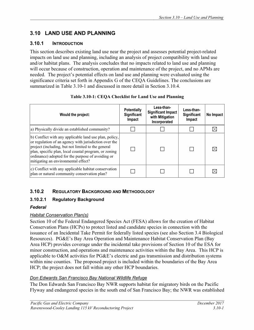
Section 3.10 – Land Use and Planning
Pacific Gas and Electric Company December 2017 Ravenswood-Cooley Landing 115 kV Reconductoring Project 3.10-1
3.10 LAND USE AND PLANNING
3.10.1 INTRODUCTION This section describes existing land use near the project and assesses potential project-related impacts on land use and planning, including an analysis of project compatibility with land use and/or habitat plans. The analysis concludes that no impacts related to land use and planning will occur because of construction, operation and maintenance of the project, and no APMs are needed. The project’s potential effects on land use and planning were evaluated using the significance criteria set forth in Appendix G of the CEQA Guidelines. The conclusions are summarized in Table 3.10-1 and discussed in more detail in Section 3.10.4.
Table 3.10-1: CEQA Checklist for Land Use and Planning
Would the project: Potentially Significant
Impact
Less-than-Significant Impact
with Mitigation Incorporated
Less-than-Significant
Impact No Impact
a) Physically divide an established community?
b) Conflict with any applicable land use plan, policy, or regulation of an agency with jurisdiction over the project (including, but not limited to the general plan, specific plan, local coastal program, or zoning ordinance) adopted for the purpose of avoiding or mitigating an environmental effect?
c) Conflict with any applicable habitat conservation plan or natural community conservation plan?
3.10.2 REGULATORY BACKGROUND AND METHODOLOGY 3.10.2.1 Regulatory Background Federal Habitat Conservation Plan(s) Section 10 of the Federal Endangered Species Act (FESA) allows for the creation of Habitat Conservation Plans (HCPs) to protect listed and candidate species in connection with the issuance of an Incidental Take Permit for federally listed species (see also Section 3.4 Biological Resources). PG&E’s Bay Area Operation and Maintenance Habitat Conservation Plan (Bay Area HCP) provides coverage under the incidental take provisions of Section 10 of the ESA for minor construction, and operations and maintenance activities within the Bay Area. This HCP is applicable to O&M activities for PG&E’s electric and gas transmission and distribution systems within nine counties. The proposed project is included within the boundaries of the Bay Area HCP; the project does not fall within any other HCP boundaries.
Don Edwards San Francisco Bay National Wildlife Refuge The Don Edwards San Francisco Bay NWR supports habitat for migratory birds on the Pacific Flyway and endangered species in the south end of San Francisco Bay; the NWR was established
Section 3.10 – Land Use and Planning
December 2017 Pacific Gas and Electric Company 3.10-2 Ravenswood-Cooley Landing 115 kV Reconductoring Project
in 1972 and its management by USFWS is guided by the NWR CCP (USFWS 2012). Goals, objectives and strategies in the CCP pertain to habitat conservation – including restoration and acquisition – as well as recreation and education, with a specific vision of aiding in the recovery of “a number of listed and sensitive species that depend on Refuge lands for their continued existence, including the California clapper rail, salt marsh harvest mouse, vernal pool tadpole shrimp, and Contra Costa goldfield” (p. 179). The project location is within the NWR’s West Bay Unit, which extends from Redwood City to the Faber Tract in East Palo Alto. Easements including PG&E facilities are included in the CCP description of the West Bay Unit. None of the CCP goals, objectives, or strategies refer to PG&E or any other utilities located within the NWR. Finally, the project crosses lands owned by the NWR in the north and, adjacent to Cooley Landing Substation, lands managed by NWR as part of an agreement between Cargill Salt and USFWS; no lands crossed by the project include those leased by the NWR from the California State Lands Commission.
The USFWS, which manages the NWR, can authorize certain activities on its lands via the issuance of Special Use Permits (SUPs). PG&E performs operation and maintenance of its infrastructure on the NWR under the conditions of a SUP issued by the USFWS. The SUP includes conditions pertaining to protection of NWR infrastructure, habitats, and species that must be implemented during operation and maintenance activities.
State California Public Utilities Commission The CPUC has exclusive jurisdiction over the design, siting, installation, operation, maintenance, and repair of electric transmission facilities, pursuant to Article XII, Section 8 of the California Constitution. The CPUC is the Lead Agency for CEQA review for this project and has authority over the discretionary project approval.
Natural Community and Conservation Plan(s) Similar to Section 10 of FESA, the NCCP Act (California Fish and Wildlife Code Section 2800 et seq.) allows for the creation of NCCPs to protect state-listed species, usually in connection with the issuance of a Section 2081 take permit under the CESA (Public Resources Code Section 2080 et seq.).
San Francisco Bay Conservation and Development Commission The San Francisco Bay Conservation Development Commission (BCDC) was established by the California legislature in 1965 as the management and regulatory agency for the San Francisco Bay and Delta. The limits of BCDC jurisdiction are defined in the Bay Plan (BCDC 2012), and include a 100-foot-wide band along the shoreline of the Bay. The Bay Shoreline includes the upper extent of marshlands lying between mean high tide and up to 5 feet above MSL, and at a minimum where marshlands are not present, the mean tide line elevation. Portions of the project are within BCDC jurisdiction and will require coordination with BCDC.
Regional Midpeninsula Regional Open Space District
The Midpeninsula Regional Open Space District (MPROSD) is a regional greenbelt system in the San Francisco Bay Area comprised of over 60,000 acres of land in 26 open space preserves.

Section 3.10 – Land Use and Planning
Pacific Gas and Electric Company December 2017 Ravenswood-Cooley Landing 115 kV Reconductoring Project 3.10-3
The MPROSD was initially created in 1972 through Ballot Measure R to preserve the regional greenbelt in northwestern Santa Clara County and was subsequently expanded in 1976 and 1992 to include southern San Mateo County and a small portion of Santa Cruz County. In 2004, through the Coastside Protection Program, the MPROSD boundary was extended to the Pacific Ocean in San Mateo County. The Ravenswood Open Space Preserve is managed by the MPRSOD.
Local
Because the CPUC has exclusive jurisdiction over project siting, design, and construction, the project is not subject to local land use and zoning regulations or discretionary permits. This section identifies local land use plans and regulations for informational purposes, and to assist with CEQA review.
The project area is located in San Mateo County within both the City of Menlo Park and the City of East Palo Alto. While the project is not subject to local land use and zoning regulations, the project is located within an area subject to the City of Menlo Park General Plan, the City of Menlo Park Zoning Ordinance (Chapter 16.76), the City of East Palo Alto General Plan (which implements the Ravenswood / 4 Corners TOD Specific Plan), and the City of East Palo Alto Zoning Ordinance. Land use designations for the project area and areas within 0.5 mile of the project area are shown in Figure 3.10-1, and zoning designations for the project area and areas within 0.5 mile of the project area shown in Figure 3.10-2. Although PG&E is not subject to local discretionary permitting, ministerial permits will be secured, as required. Table 2.9-1: Permits and Approvals That May Be Required (in Chapter 2, Project Description) lists the authorizations that may be required for project construction.
3.10.2.2 Methodology
In addition to the plans and policies listed in Section 3.10.2, aerial photographs, data, and maps developed by the City of East Palo Alto and the City of Menlo Park were reviewed.
3.10.3 ENVIRONMENTAL SETTING 3.10.3.1 Regional Setting
The project area is in southeastern San Mateo County, located within an open space area bounded by San Francisco Bay to the north and east, and urbanized areas of varying densities to the west and south (see Figure 2.3-1). The northern half of the project is within the City of Menlo Park, and the southern half of the project is within the City of East Palo Alto. These municipal jurisdictional boundaries overlap with regional open space uses that encompass the project area. The portion of the project within the City of Menlo Park is also within the Don Edwards San Francisco Bay NWR. The southern half of the project traverses a portion of the Ravenswood Open Space Preserve. In addition, the southernmost tower east of Cooley Landing Substation is within the Palo Alto Baylands Nature Preserve. Both portions of these open space preserves crossed by the project are within the boundaries of the City of East Palo Alto.
The project area includes an east-west oriented segment of SR 84. Approximately 0.8 mile east of the project is the Dumbarton Bridge, by which SR 84 crosses the San Francisco Bay to
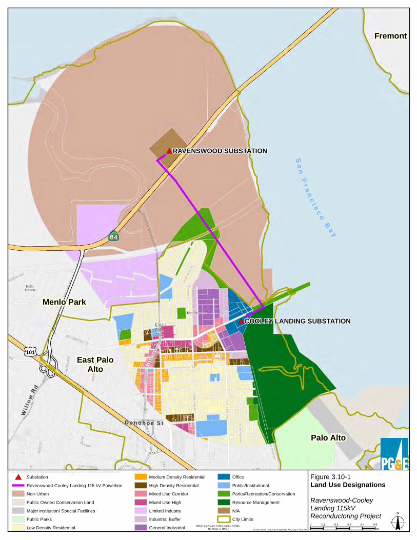
Menlo Park
Palo Alto
East PaloAlto
Fremont
D o n o h o e S tD o n o h o e S t
WWii ll ll
oo wwRR dd
101
COOLEY LANDING SUBSTATION
RAVENSWOOD SUBSTATION
Figure 3.10-1Land Use DesignationsRavenswood-CooleyLanding 115kVReconductoring Project
SubstationRavenswood-Cooley Landing 115 kV PowerlineNon-UrbanPublic Owned Conservation LandMajor Institution/ Special FacilitiesPublic ParksLow Density Residential
Medium Density ResidentialHigh Density ResidentialMixed Use CorridorMixed Use HighLimited IndustryIndustrial BufferGeneral Industrial
OfficePublic/InstitutionalParks/Recreation/ConservationResource ManagementN/ACity Limits
0 0.1 0.2 0.3 0.4 0.5Mi
bxo2: H:\work\Liddell\RavenswoodCooleyLanding\Figure 3.10-1 Land Use Designations.mxd
White areas are either public ROWs,No Data or Other Source: Menlo Park, City of East Palo Alto, City of Palo Alto
S a nF r a n c i s c o
B a y
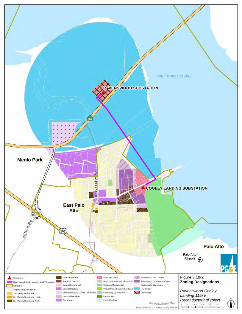
Palo AltoAirport
East PaloAlto
Palo Alto
Menlo Park
Univ
ersi
ty A
veUn
iver
sity
Ave
WWii ll ll
oo wwRR dd
101
COOLEY LANDING SUBSTATION
RAVENSWOOD SUBSTATION
Figure 3.10-2Zoning DesignationsRavenswood-CooleyLanding 115kVReconductoringProject0 0.1 0.2 0.3 0.4 0.5
Mi
bxo2: H:\work\Liddell\RavenswoodCooleyLanding\Figure 3.10-2 Zoning Designations.mxd
San Francisco Bay
Source: Menlo Park, City of East Palo Alto, City of Palo Alto
White areas are either public ROWs,No Data or Other
SubstationRavenswood-Cooley Landing 115 kV PowerlineCity LimitsSingle Family ResidentialTwo Family ResidentialMulti Family Residential (1000)Multi Family Residential (500)
Urban ResidentialBay Road CentralGeneral CommercialGeneral IndustrialGeneral Industrial District, ConditionalIndustrial TransitionFour Corners
Waterfront OfficeMajor Institution/ Special FacilitiesResource ManagementPublic Owned Conservation LandCommunity Open SpacePublic ParksPublic Facilities
Ravenswood Flex OverlayRavenswood Employment CenterRavenswood Open SpaceFlood PlainUnclassified

Section 3.10 – Land Use and Planning
December 2017 Pacific Gas and Electric Company 3.10-6 Ravenswood-Cooley Landing 115 kV Reconductoring Project
Newark. Approximately 0.4 mile west of the project, SR 84 intersects with University Avenue, beyond which are the areas of Menlo Park’s easternmost development. Approximately 2 miles west of the project is U.S. Highway 101, which, along with Interstate 280 (approximately 7 miles west of the project), form the primary north-south arterials of this portion of the South Bay Region, between which contains the region’s concentrated development.
3.10.3.2 Local Land Use Setting (Existing Land Use)
As noted in the Regional Setting, the existing Ravenswood-Cooley Landing Line is located within the Don Edwards San Francisco Bay NWR, the Ravenswood Open Space Preserve, and the Palo Alto Baylands Nature Preserve. Parks and open space designations complement the NWR and open space preserves, with recreation, open space, and infrastructure the primary land uses in the project area. Major recreation uses include the San Francisco Bay Trail, other trails, and Cooley Landing Park, which includes a new Education Center. Existing infrastructure includes a SFPUC pipeline ROW and Ravenswood Valve Lot near the southernmost portion of the NWR, as well as two additional PG&E 115 kV lines that cross through the area parallel to the project.
Land uses closest to the project area include large-footprint office developments (Facebook headquarters is located 0.6 miles to the west of the Ravenswood Substation), residential (a neighborhood in northeastern East Palo Alto is within 0.1 mile of the project), and an auto salvage yard is across Bay Street to the north of Cooley Landing Substation.
Along with light industrial, commercial, and office uses, there are three schools within 0.5 mile of the project area. These include Costano Elementary School, located 0.5 mile west of the project area on University Avenue, East Palo Alto Charter School, located approximately 0.3 mile south of the project area on Runnymede Street, and the Aspire East Palo Alto Phoenix Academy located approximately 0.4 mile southwest of the project area on Garden Street.
In accordance with CPUC filing requirements, a preliminary list of parcels within 300 feet of the project, including the APN number, mailing address, and parcel's physical address is provided in Appendix A.
Zoning and General Plan Land Use Designations
Figure 3.10-1 shows general plan land use designations in the project area and its vicinity for both the City of Menlo Park and City of East Palo Alto. Figure 3.10-2 shows zoning designations for each jurisdiction.
Public utility facilities regulated by the CPUC are not subject to local land use and zoning regulations. However, PG&E has considered General Plan and Zoning Ordinance designations in its design of the proposed project.
City of Menlo Park
The City of Menlo Park Zoning Map (City of Menlo Park 2015) indicates the project area is zoned as “Unclassified Utilities and Rail Rights-of-Way” (U) at Ravenswood Substation and as “Flood Plain” (FP) elsewhere. Section 16.76 (Public Utilities) of the Menlo Park Municipal
Section 3.10 – Land Use and Planning
Pacific Gas and Electric Company December 2017 Ravenswood-Cooley Landing 115 kV Reconductoring Project 3.10-7
Code, Title 16 – Zoning (City of Menlo Park 2014) indicates that utility transmission facilities shall be allowed in all zoning districts, without limitation as to height.
General Plan Land Use Designations correspond with zoning designations. The Menlo Park General Plan is currently being updated, and the Land Use Element was approved in 2016. Lands zoned “U” have no General Plan designation. Lands zoned FP are designated as “Baylands,” which provide for “the preservation and protection of wildlife habitat and ecological values associated with the marshlands and former salt ponds bordering San Francisco Bay and similar and compatible uses.” The maximum amount of development allowed under this designation (5,000 square feet of building floor area per parcel) does not apply to the project.
City of East Palo Alto
The current City of East Palo Alto Zoning Map (City of East Palo Alto 2014) designates Cooley Landing at “Ravenswood Open Space” (ROS) and the lands immediately south of Cooley Landing as “Resource Management” (RM).
The City of East Palo Alto General Plan designates Cooley Landing as “Parks / Recreation / Conservation” (PRC) and the lands immediately south of Cooley Landing as “Resource Management” (RM) (City of East Palo Alto 2016). The PRC designation allows public recreational uses, including public parkland, open space, and associated recreational activities (indoor and outdoor sports athletic facilities). Other uses that are determined to be compatible with the primary uses may also be allowed. Lands designated RM are intended for conservation and there are no allowed land uses except those required for the maintenance and security of the natural landscape.
The Ravenswood / 4 Corners TOD Specific Plan (City of East Palo Alto 2013) proposes to convert the lands adjacent to Cooley Landing Substation to office uses.
3.10.3.3 Local Plans and Policies
As previously stated, the project is not subject to local agency regulations. However, PG&E has considered local plans and policies in its design of the proposed project. Both the Menlo Park and East Palo Alto General Plans include guidance related to utility infrastructure.
City of Menlo Park The City of Menlo Park General Plan Open Space / Conservation, Noise and Safety Elements (City of Menlo Park 2013) includes the following goals policies related to the project area and /or utilities:
Goal OSC1 – Maintain, protect and enhance open space and natural resources
• Policy OSC1.1 – Natural Resources Integration with Other Uses. Protect Menlo Park’s natural environment and integrate creeks, utility corridors, and other significant natural and scenic features into development plans.
Goal S1 – Assure a safe community
Section 3.10 – Land Use and Planning
December 2017 Pacific Gas and Electric Company 3.10-8 Ravenswood-Cooley Landing 115 kV Reconductoring Project
• Policy S1.6 – Design and Location of Utilities. Monitor appropriate location, design, construction, maintenance and inspection standards for utility systems traversing hazard areas within the City limits. This would include evaluation and upgrading outdated systems and infrastructure, coordination with the State Public Utilities Commission and locating new utility systems away from potential hazard areas.
City of East Palo Alto The City of East Palo Alto General Plan (City of East Palo Alto 2017) includes the following goals and policies related to the project area and/or utilities:
Goal POC-1. Create new parks and open spaces throughout the City.
• Policy 1.12 – Opportunistic conversions. Work to convert unused utility rights-of-way (including the Hetch Hetchy ROW), railroad rights-of-way (including the UP Spur) and alleys into attractive open space corridors.
Palo Alto Airport Land Use Plan The southern end of the project area is located approximately 0.8 mile northwest of the Palo Alto Airport. The CLUP for this airport was last updated November 16, 2016 (Santa Clara County Airport Land Use Commission 2016). The objectives of the CLUP are to protect the public from the adverse effects of aircraft noise, to ensure that people and facilities are not concentrated in areas susceptible to aircraft accidents, and to ensure that no structures or activities adversely affect navigable airspace. The implementation of the CLUP is intended to prevent future incompatible development from encroaching on the airport and allow for its development in accordance with the current airport master plan.
3.10.4 APPLICANT-PROPOSED MEASURES AND POTENTIAL IMPACTS The following sections describe significance criteria for land use impacts derived from Appendix G of the CEQA Guidelines, provide APMs, and assess potential project-related construction and operational land use impacts. Because the project will have no impact on land use, APMs have not been included for this section.
3.10.4.1 Significance Criteria
According to Section 15002(g) of the CEQA Guidelines, “a significant effect on the environment is defined as a substantial adverse change in the physical conditions which exist in the area affected by the proposed project.” As stated in Section 15064(b) of the CEQA Guidelines, the significance of an activity may vary with the setting. Per Appendix G of the CEQA Guidelines, the potential significance of project impacts on land use and planning were evaluated for each of the criteria listed in Table 3.10-1, as discussed in Section 3.10.4.3.
3.10.4.2 Applicant-Proposed Measures
No APMs are suggested because project construction, operation, and maintenance will have no impact on land use.
Section 3.10 – Land Use and Planning
Pacific Gas and Electric Company December 2017 Ravenswood-Cooley Landing 115 kV Reconductoring Project 3.10-9
3.10.4.3 Potential Impacts
Project impacts related to land use were evaluated against the CEQA significance criteria and are discussed below. The impact analysis evaluates potential project impacts during the construction phase and the operation and maintenance phase. An analysis of impacts to adjacent land uses during construction and operation of the project is included in other sections of the PEA, including Aesthetics, Air Quality, Hazards and Hazardous Materials, Noise, Recreation, and Transportation and Traffic.
The project includes reconductoring the existing 115 kV power line between Ravenswood Substation and Cooley Landing Substation. Construction activities include installing new conductor, performing minor tower modifications, and establishing required access and work areas, as described in Chapter 2, Project Description. Operation and maintenance activities for the reconductored power line will not change from current practices.
a) Would the project physically divide an established community? No Impact
Implementation of this project will not physically divide an established community. The project will reconductor an existing power line extending approximately 1.6 miles from the Ravenswood Substation in Menlo Park to the Cooley Landing Substation in East Palo Alto. A limited number of existing towers will be raised slightly, but no new towers will be constructed and the footprint of existing facilities will not be permanently altered. No impact will occur.
b) Would the project conflict with applicable land use plan, policy, or regulation of an agency with jurisdiction over the project (including, but not limited to the general plan, specific plan, local coastal program, or zoning ordinance) adopted for the purpose of avoiding or mitigating an environmental effect? No Impact
Because local agencies do not have jurisdiction over the project, and no state or federal land use plans, policies, or regulations are applicable, the project will not conflict with any applicable land use policy, plan, or regulation. The project includes reconductoring an existing power line entirely within PG&E’s existing right-of-way. No changes in land use or zoning will be required as part of the project. No impact will occur.
c) Would the project conflict with any applicable habitat conservation plan or natural community conservation plan? No Impact
The project’s construction, and operation and maintenance activities will be conducted in compliance with the PG&E Bay Area Operation and Maintenance Habitat Conservation Plan,, which will ensure consistency with all applicable conservation plans. No impact will occur. 3.10.5 REFERENCES Bay Conservation and Development Commission (BCDC). 2012. San Francisco Bay Plan.
Online: http://www.bcdc.ca.gov/pdf/bayplan/bayplan.pdf
City of East Palo Alto Community and Economic Development Department. 2013. Ravenswood / 4 Corners TOD Specific Plan. February 22, 2013. Online: http://www.cityofepa.org/ArchiveCenter/ViewFile/Item/125
Section 3.10 – Land Use and Planning
December 2017 Pacific Gas and Electric Company 3.10-10 Ravenswood-Cooley Landing 115 kV Reconductoring Project
City of East Palo Alto Community and Economic Development Department. 2014. City of East Palo Alto Zoning Map 2014 (4.15.14). Online: http://www.ci.east-palo-alto.ca.us/DocumentCenter/View/6. Accessed July 5, 2017.
City of East Palo Alto Community and Economic Development Department. 2017. Vista 2035 East Palo Alto General Plan. Adopted October 4, 2016; Final Version March 2017. Online: http://www.ci.east-palo-alto.ca.us/index.aspx?NID=177
City of Menlo Park Community Development Department, Planning Division. 2013. City of Menlo Park General Plan Open Space / Conservation, Noise and Safety Elements. Adopted May 21, 2013. Online: http://menlopark.org/DocumentCenter/View/234
City of Menlo Park Community Development Department, Planning Division. 2014. Menlo Park Municipal Code Title 16- Zoning. Online: http://www.codepublishing.com/CA/MenloPark/. Accessed on May 15, 2017.
City of Menlo Park Community Development Department, Planning Division. 2015. Zoning Map and General Plan Land Use Diagram. Online: http://menlopark.org/145/General-Plan-land-use-and-zoning-map Accessed July 5, 2017.
City of Menlo Park Community Development Department, Planning Division. 2016. General Plan – Public Hearing Draft. Land Use Element, approved November 29, 2016. Online: https://www.menlopark.org/DocumentCenter/View/12613. Accessed on July 5, 2017.
Pacific Gas & Electric. 2016. Bay Area Habitat Conservation Plan: Operations and Maintenance. Online: https://www.federalregister.gov/documents/2017/03/24/2017-05856/habitat-conservation-plan-for-pacific-gas-and-electric-companys-san-francisco-bay-area-operations. Accessed on May 17, 2017.
Santa Clara County Airport Land Use Commission. 2016. Comprehensive Land Use Plan, Santa Clara County, Palo Alto Airport. Adopted November 19, 2008. Amended November 16, 2016.
United States Fish and Wildlife Service. 2012. Don Edwards San Francisco Bay National Wildlife Refuge Final Comprehensive Conservation Plan. Online: https://www.fws.gov/uploadedFiles/DESFBFinalCCP_sm.pdf.
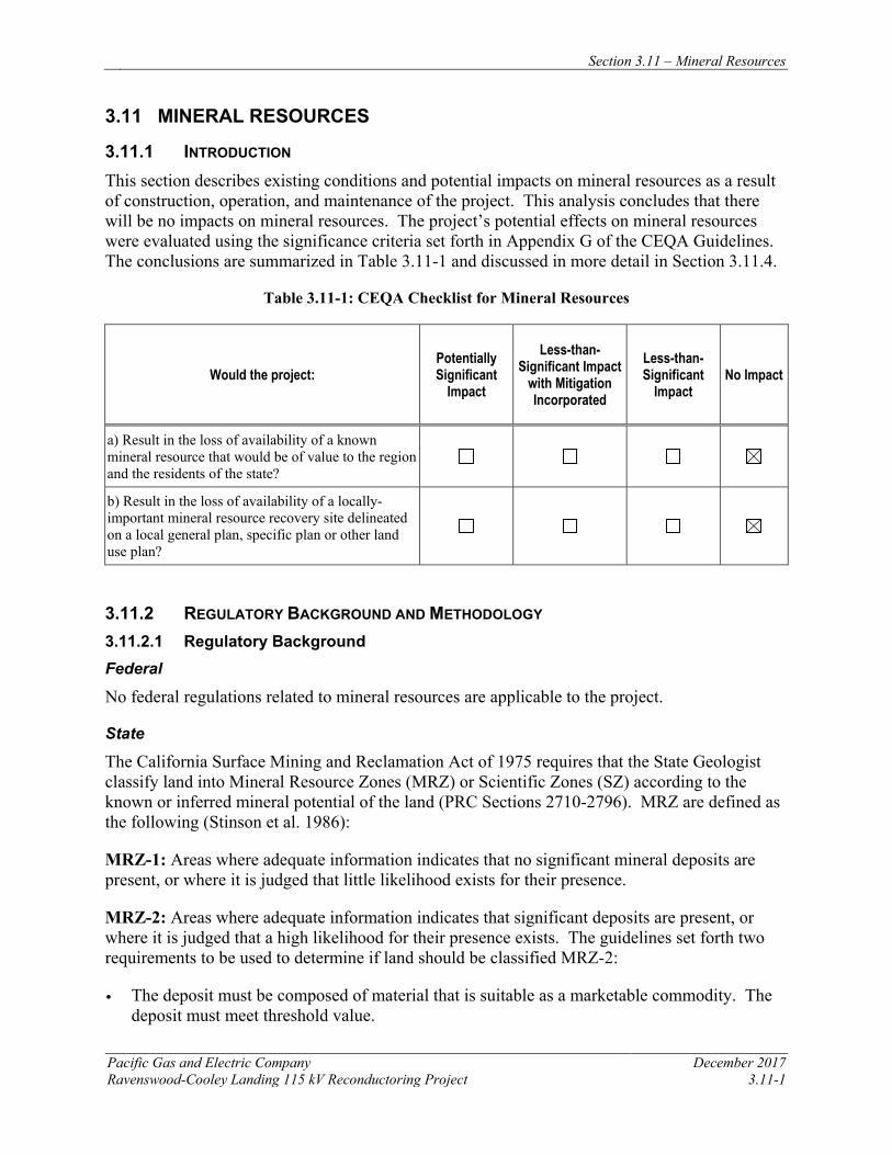
Section 3.11 – Mineral Resources
Pacific Gas and Electric Company December 2017 Ravenswood-Cooley Landing 115 kV Reconductoring Project 3.11-1
3.11 MINERAL RESOURCES
3.11.1 INTRODUCTION This section describes existing conditions and potential impacts on mineral resources as a result of construction, operation, and maintenance of the project. This analysis concludes that there will be no impacts on mineral resources. The project’s potential effects on mineral resources were evaluated using the significance criteria set forth in Appendix G of the CEQA Guidelines. The conclusions are summarized in Table 3.11-1 and discussed in more detail in Section 3.11.4.
Table 3.11-1: CEQA Checklist for Mineral Resources
Would the project: Potentially Significant
Impact
Less-than-Significant Impact
with Mitigation Incorporated
Less-than-Significant
Impact No Impact
a) Result in the loss of availability of a known mineral resource that would be of value to the region and the residents of the state?
b) Result in the loss of availability of a locally-important mineral resource recovery site delineated on a local general plan, specific plan or other land use plan?
3.11.2 REGULATORY BACKGROUND AND METHODOLOGY 3.11.2.1 Regulatory Background Federal
No federal regulations related to mineral resources are applicable to the project.
State
The California Surface Mining and Reclamation Act of 1975 requires that the State Geologist classify land into Mineral Resource Zones (MRZ) or Scientific Zones (SZ) according to the known or inferred mineral potential of the land (PRC Sections 2710-2796). MRZ are defined as the following (Stinson et al. 1986):
MRZ-1: Areas where adequate information indicates that no significant mineral deposits are present, or where it is judged that little likelihood exists for their presence.
MRZ-2: Areas where adequate information indicates that significant deposits are present, or where it is judged that a high likelihood for their presence exists. The guidelines set forth two requirements to be used to determine if land should be classified MRZ-2:
• The deposit must be composed of material that is suitable as a marketable commodity. The deposit must meet threshold value.
Section 3.11 – Mineral Resources
December 2017 Pacific Gas and Electric Company 3.11-2 Ravenswood-Cooley Landing 115 kV Reconductoring Project
• The projected value (gross selling price) of the deposit, based on the value of the first marketable product, must be at least $5 million (1978 dollars).
• Although not specified in the guidelines, the following criteria were applied to each deposit to test its suitability for inclusion in an MRZ-2 zone:
– The presence of an operating quarry within the deposit is considered proof that Condition 1 has been met.
– An average value of $2.00 per ton (all aggregate types) and a conversion factor of 2,500 tons per acre-foot of material (0.065 ton per cubic foot with 10 percent waste) require a minimum amount of 1,000 acre-feet of material within the deposit, exclusive of overburden and fill material, to meet suggested threshold value.
– A deposit of aggregate material must have an overburden-to-ore ratio of less than 1 to 1 in order for mining to become economic at the present time.
MRZ-3: Contain mineral deposits, but their significance cannot be evaluated from available data.
MRZ-4: Areas where available information is inadequate for assignment to any other MRZ category.
SZ: Areas containing unique or rare occurrence of rocks, minerals, or fossils that are of outstanding scientific significance shall be classified in this zone.
Local
Because the CPUC has exclusive jurisdiction over project siting, design, and construction, the project is not subject to local discretionary regulations. This section includes a summary local land use plans that delineate locally important mineral resource recovery sites for informational purposes and to assist with the CEQA review process.
San Mateo County regulates development within and adjacent to significant mineral resource areas by permitting land uses that are compatible with mineral resource extraction operations and within existing mineral resource areas. The project area does not cross any property where planned or active mineral extraction is occurring (San Mateo County General Plan 1986).
The City of East Palo Alto and City of Menlo Park General Plans do not designate any locally important mineral resources in the project area (City of East Palo Alto 2017; City of Menlo Park 1994).
3.11.2.2 Methodology
Information on mineral resources was compiled from published literature, maps, and review of aerial photographs, including information from the California DOC Division of Mines and Geology. Potential impacts to mineral resources from project construction and operational activities were evaluated qualitatively based on site conditions, expected construction practices,
Section 3.11 – Mineral Resources
Pacific Gas and Electric Company December 2017 Ravenswood-Cooley Landing 115 kV Reconductoring Project 3.11-3
anticipated materials used, and the locations and duration of project construction and operational activities.
3.11.3 ENVIRONMENTAL SETTING Mineral resources in San Mateo County include Cretaceous quartz diorite, rocks of the Franciscan Complex, Franciscan Complex sandstone, greenstone, and Calera Limestone. San Francisco and San Mateo Counties have approximately 1.6 billion tons of Cretaceous quartz diorite and Franciscan Complex sandstone, greenstone, and Calera Limestone. The Calera Limestone, which is associated with rocks of the Franciscan Complex, occurs as a discontinuous zone of limestone bodies extending southeasterly from Pacifica (California DOC Division of Mines and Geology 1987).
The project area, along with most of San Mateo County, is classified by the California Department of Conservation, Division of Mines and Geology as being within MRZ-1 (California DOC Division of Mines and Geology 1987). Areas classified as MRZ-1 are areas for which data sufficiently indicate that no significant mineral deposits are present. Therefore, the project will not be within areas that have active mining or proposed mining activities (California DOC Division of Mines and Geology 2000).
3.11.4 APPLICANT-PROPOSED MEASURES AND POTENTIAL IMPACTS The following sections describe significance criteria for impacts to mineral resources derived from Appendix G of the CEQA Guidelines, provide APMs, and assess potential project-related construction and operational impacts to mineral resources. Because the project will have no impact on mineral resources, APMs have not been included for this section.
3.11.4.1 Significance Criteria
According to Section 15002(g) of the CEQA Guidelines, “a significant effect on the environment is defined as a substantial adverse change in the physical conditions which exist in the area affected by the proposed project.” As stated in Section 15064(b) of the CEQA Guidelines, the significance of an activity may vary with the setting. Per Appendix G of the CEQA Guidelines, the potential significance of project impacts on mineral resources were evaluated for each of the criteria listed in Table 3.11-1, as discussed in Section 3.11.4.3.
3.11.4.2 Applicant-Proposed Measures
No APMs are suggested because project construction, operation, and maintenance will have no impact on mineral resources.
3.11.4.3 Potential Impacts
Project impacts related to mineral resources were evaluated against the CEQA significance criteria and are discussed below. The impact analysis evaluates potential project impacts during the construction phase and the operation and maintenance phase.
The project includes reconductoring the existing 115 kV power line between Ravenswood Substation and Cooley Landing Substation. Construction activities include installing new conductor, performing minor tower modifications, and establishing required access and work
Section 3.11 – Mineral Resources
December 2017 Pacific Gas and Electric Company 3.11-4 Ravenswood-Cooley Landing 115 kV Reconductoring Project
areas, as described in Chapter 2, Project Description. Operation and maintenance activities for the reconductored power line will not change from current practices.
a) Would the project result in the loss of availability of a known mineral resource that would be of value to the region and residents of the state? No Impact
The existing Ravenswood-Cooley Landing Line, and its associated substations, is not located in a mineral resource area; the project area is classified as MRZ-1, where no significant mineral deposits are present. Loss of availability of a known mineral resource of value to the region and state will not occur; therefore, no construction or operation and maintenance impacts will occur.
b) Would the project result in the loss of availability of a locally important mineral resource recovery site delineated on a local general plan, specific plan, or other land use plan? No Impact
Because the project area is designated MRZ-1, where no significant mineral deposits are present, construction or operation and maintenance of the project will not result in the loss of availability of a locally important mineral recovery site; therefore, no construction or operation and maintenance impacts will occur.
3.11.5 REFERENCES California Department of Conservation Division of Mines and Geology. 1987. Mineral Land
Classification: Aggregate Materials in the San Francisco- Monterey Bay Area (DMG Special Report 146 Part II).
California Department of Conservation Division of Mines and Geology. 2000. California Surface Mining and Reclamation Policies and Procedures: Guidelines for Classification and Designation of Mineral Lands. Online: http://www.conservation.ca.gov/smgb/Guidelines/Documents/ClassDesig.pdf. Accessed on May 17, 2017.
City of East Palo Alto Community and Economic Development Department. 2017. Vista 2035 East Palo Alto General Plan. Adopted October 4, 2016.
City of Menlo Park Community Development Department, Planning Division. 1994. City of Menlo Park General Plan. Adopted December 1, 1994.
San Mateo County Planning and Building Department. 1986. San Mateo County General Plan. Adopted November 18, 1986.
Stinson, M. C., M. W. Manson, and J. J. Plappert. 1986. Mineral Land Classification: Aggregate Materials in the San Francisco – Monterey Bay Area. California Division of Mines and Geology (CDMG) Special Report 146. State of California Department of Conservation.
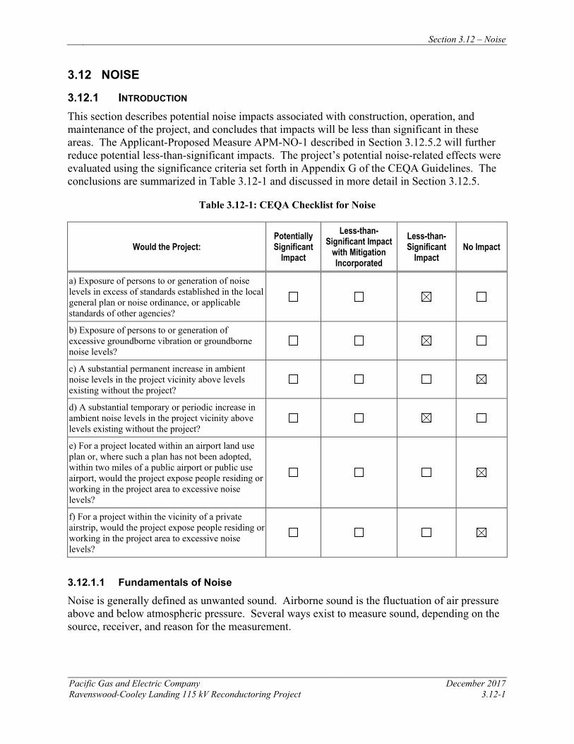
Section 3.12 – Noise
Pacific Gas and Electric Company December 2017 Ravenswood-Cooley Landing 115 kV Reconductoring Project 3.12-1
3.12 NOISE
3.12.1 INTRODUCTION This section describes potential noise impacts associated with construction, operation, and maintenance of the project, and concludes that impacts will be less than significant in these areas. The Applicant-Proposed Measure APM-NO-1 described in Section 3.12.5.2 will further reduce potential less-than-significant impacts. The project’s potential noise-related effects were evaluated using the significance criteria set forth in Appendix G of the CEQA Guidelines. The conclusions are summarized in Table 3.12-1 and discussed in more detail in Section 3.12.5.
Table 3.12-1: CEQA Checklist for Noise
Would the Project: Potentially Significant
Impact
Less-than-Significant Impact
with Mitigation Incorporated
Less-than-Significant
Impact No Impact
a) Exposure of persons to or generation of noise levels in excess of standards established in the local general plan or noise ordinance, or applicable standards of other agencies?
b) Exposure of persons to or generation of excessive groundborne vibration or groundborne noise levels?
c) A substantial permanent increase in ambient noise levels in the project vicinity above levels existing without the project?
d) A substantial temporary or periodic increase in ambient noise levels in the project vicinity above levels existing without the project?
e) For a project located within an airport land use plan or, where such a plan has not been adopted, within two miles of a public airport or public use airport, would the project expose people residing or working in the project area to excessive noise levels?
f) For a project within the vicinity of a private airstrip, would the project expose people residing or working in the project area to excessive noise levels?
3.12.1.1 Fundamentals of Noise
Noise is generally defined as unwanted sound. Airborne sound is the fluctuation of air pressure above and below atmospheric pressure. Several ways exist to measure sound, depending on the source, receiver, and reason for the measurement.
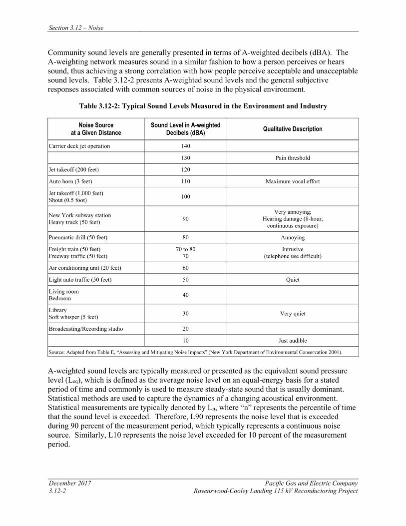
Section 3.12 – Noise
December 2017 Pacific Gas and Electric Company 3.12-2 Ravenswood-Cooley Landing 115 kV Reconductoring Project
Community sound levels are generally presented in terms of A-weighted decibels (dBA). The A-weighting network measures sound in a similar fashion to how a person perceives or hears sound, thus achieving a strong correlation with how people perceive acceptable and unacceptable sound levels. Table 3.12-2 presents A-weighted sound levels and the general subjective responses associated with common sources of noise in the physical environment.
Table 3.12-2: Typical Sound Levels Measured in the Environment and Industry
Noise Source at a Given Distance
Sound Level in A-weighted Decibels (dBA) Qualitative Description
Carrier deck jet operation 140
130 Pain threshold
Jet takeoff (200 feet) 120
Auto horn (3 feet) 110 Maximum vocal effort
Jet takeoff (1,000 feet) Shout (0.5 foot) 100
New York subway station Heavy truck (50 feet) 90
Very annoying; Hearing damage (8-hour,
continuous exposure)
Pneumatic drill (50 feet) 80 Annoying
Freight train (50 feet) Freeway traffic (50 feet)
70 to 80 70
Intrusive (telephone use difficult)
Air conditioning unit (20 feet) 60
Light auto traffic (50 feet) 50 Quiet
Living room Bedroom 40
Library Soft whisper (5 feet) 30 Very quiet
Broadcasting/Recording studio 20
10 Just audible
Source: Adapted from Table E, “Assessing and Mitigating Noise Impacts” (New York Department of Environmental Conservation 2001).
A-weighted sound levels are typically measured or presented as the equivalent sound pressure level (Leq), which is defined as the average noise level on an equal-energy basis for a stated period of time and commonly is used to measure steady-state sound that is usually dominant. Statistical methods are used to capture the dynamics of a changing acoustical environment. Statistical measurements are typically denoted by Ln, where “n” represents the percentile of time that the sound level is exceeded. Therefore, L90 represents the noise level that is exceeded during 90 percent of the measurement period, which typically represents a continuous noise source. Similarly, L10 represents the noise level exceeded for 10 percent of the measurement period.
Section 3.12 – Noise
Pacific Gas and Electric Company December 2017 Ravenswood-Cooley Landing 115 kV Reconductoring Project 3.12-3
Another metric used in determining the impact of environmental noise is the differences in response that people have to daytime and nighttime noise levels. During the evening and at night, exterior background noises generally are lower than daytime levels. However, most household noise also decreases at night, and exterior noise becomes more noticeable. Furthermore, most people sleep at night and are sensitive to intrusive noises. To account for human sensitivity to evening and nighttime noise levels, the day-night sound level (Ldn) (also referred to as DNL) and the community noise equivalent level (CNEL) were developed. The Ldn is a noise metric that accounts for the greater annoyance of noise during the nighttime hours (10:00 p.m. to 7:00 a.m.). The CNEL is a noise index that accounts for the greater annoyance of noise during both the evening hours (7:00 p.m. to 10:00 p.m.) and nighttime hours.
Ldn values are calculated by averaging hourly Leq sound levels for a continuous 24-hour period on an energy basis, applying a weighting factor of 10 decibels (dB) to the nighttime values. CNEL values are calculated similarly, except that a 5-dB weighting factor also is added to evening Leq values. The applicable adjustments, which reflect the increased sensitivity to noise during evening and nighttime hours, are applied to each hourly Leq sound level for the calculation of Ldn and CNEL. For the purposes of assessing noise, the 24-hour day is divided into three time periods, with the following adjustments:
• Daytime hours: 7:00 a.m. to 7:00 p.m. (12 hours)—adjustment of 0 dBA
• Evening hours (for CNEL only): 7:00 p.m. to 10:00 p.m. (3 hours)—adjustment of +5 dBA
• Nighttime hours (for both CNEL and Ldn): 10:00 p.m. to 7:00 a.m. (9 hours)—adjustment of +10 dBA
The hourly adjusted time-period noise levels are then averaged (on an energy basis) to compute the overall Ldn or CNEL value. For a continuous noise source, the Ldn value can be computed by adding 6.4 dBA to the overall 24-hour noise level (Leq). For example, if the expected continuous noise level from a noise source is 60.0 dBA, the resulting Ldn from the source will be 66.4 dBA. Similarly, the CNEL for a continuous noise source is computed by adding 6.7 dBA to the overall 24-hour Leq.
The general human response to changes in noise levels that are similar in frequency content (such as comparing increases in continuous [Leq] traffic noise levels) are summarized as follows:
• A 3-dB change in sound level is considered to be a barely noticeable difference.
• A 5-dB change in sound level typically is noticeable.
• A 10-dB increase is considered to be a doubling in loudness.
Corona Noise
Corona generates audible noise during operation of high-voltage transmission lines. Under certain conditions, the localized electric field near an energized conductor can be sufficiently concentrated to produce a tiny electric discharge that can ionize air close to the conductors. This
Section 3.12 – Noise
December 2017 Pacific Gas and Electric Company 3.12-4 Ravenswood-Cooley Landing 115 kV Reconductoring Project
partial discharge of electrical energy is called corona discharge, or corona. Several factors, including conductor voltage, shape and diameter, and surface irregularities such as scratches, nicks, dust, or water drops, can affect a conductor’s electrical surface gradient and its corona performance. Corona is the physical manifestation of energy loss, and can transform discharge energy into very small amounts of sound, radio noise, heat, and chemical reactions of the air components.
Transmission lines can generate a small amount of sound energy during corona activity. This audible noise from the line can barely be heard in fair weather conditions on higher voltage lines. During wet weather conditions (such as rain or fog), water drops collect on the conductor and increase corona activity so that a crackling or humming sound may be heard near the line. This noise is caused by small electrical discharges from the water drops. However, during heavy rain, the ambient noise generated by the falling raindrops will typically be greater than the noise generated by corona. Corona noise is generally more noticeable on high-voltage lines, and is usually not a design issue for transmission lines rated at 230 kV and lower.
Vibration
Generally speaking, vibration is energy transmitted in waves through the ground. Because energy is lost during the transfer of energy from one particle to another, vibratory energy is reduced with increasing distance from the source. Vibration attenuates at a rate of approximately 50 percent for each doubling of distance from the source. This approach only takes into consideration the attenuation from geometric spreading. Because additional factors reduce vibration over distance (e.g., damping from soil condition), this approach tends to provide for a conservative assessment of vibration level at the receiver.
3.12.2 REGULATORY BACKGROUND AND METHODOLOGY 3.12.2.1 Regulatory Background Federal
No federal regulations limit overall environmental noise levels; however, federal guidance documents exist that address environmental noise and regulations for specific noise sources. For example, the FHWA; USDOT; Federal Railroad Administration (FRA) and Federal Transit Administration (FTA); and FAA and Federal Interagency Committee on Urban Noise (FICUN) provide regulations and guidelines for noise impacts resulting from federal highways, aircraft usage, railroads, and other development, as described in the following paragraphs. While these standards are not directly applicable to utility construction projects, they provide some context for the impact analysis.
Federal Highway Administration The FHWA noise abatement criteria establish absolute exterior noise levels for varying land use categories where an impact is triggered. The noise abatement criteria require maintenance of Leq for noise levels emitted in lands classified categories “A” (lands for which serenity and quietness are significant), “B” (lands near sensitive receptors, defined as picnic areas, recreation areas, playgrounds, active sports areas, parks, residences, motels, hotels, schools, churches, libraries, and hospitals) as 67 dBA, and “C” (developed lands, properties, or activities not included in categories “A” or “B”) as 72 dBA.
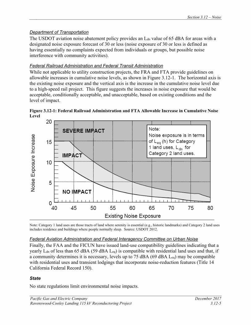
Section 3.12 – Noise
Pacific Gas and Electric Company December 2017 Ravenswood-Cooley Landing 115 kV Reconductoring Project 3.12-5
Department of Transportation The USDOT aviation noise abatement policy provides an Ldn value of 65 dBA for areas with a designated noise exposure forecast of 30 or less (noise exposure of 30 or less is defined as having essentially no complaints expected from individuals or groups, but possible noise interference with community activities).
Federal Railroad Administration and Federal Transit Administration While not applicable to utility construction projects, the FRA and FTA provide guidelines on allowable increases in cumulative noise levels, as shown in Figure 3.12-1. The horizontal axis is the existing noise exposure and the vertical axis is the increase in the cumulative noise level due to a high-speed rail project. This figure suggests the increases in noise exposure that would be acceptable, conditionally acceptable, and unacceptable, based on existing conditions and the level of impact.
Figure 3.12-1: Federal Railroad Administration and FTA Allowable Increase in Cumulative Noise Level
Note: Category 1 land uses are those tracts of land where serenity is essential (e.g., historic landmarks) and Category 2 land uses includes residence and buildings where people normally sleep. Source: USDOT 2012.
Federal Aviation Administration and Federal Interagency Committee on Urban Noise Finally, the FAA and the FICUN have issued land-use compatibility guidelines indicating that a yearly Ldn of less than 65 dBA (59 dBA Leq) is compatible with residential land uses and that, if a community determines it is necessary, levels up to 75 dBA (69 dBA Leq) may be compatible with residential uses and transient lodgings that incorporate noise-reduction features (Title 14 California Federal Record 150).
State
No state regulations limit environmental noise impacts.
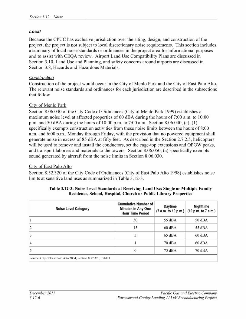
Section 3.12 – Noise
December 2017 Pacific Gas and Electric Company 3.12-6 Ravenswood-Cooley Landing 115 kV Reconductoring Project
Local
Because the CPUC has exclusive jurisdiction over the siting, design, and construction of the project, the project is not subject to local discretionary noise requirements. This section includes a summary of local noise standards or ordinances in the project area for informational purposes and to assist with CEQA review. Airport Land Use Compatibility Plans are discussed in Section 3.10, Land Use and Planning, and safety concerns around airports are discussed in Section 3.8, Hazards and Hazardous Materials.
Construction Construction of the project would occur in the City of Menlo Park and the City of East Palo Alto. The relevant noise standards and ordinances for each jurisdiction are described in the subsections that follow.
City of Menlo Park Section 8.06.030 of the City Code of Ordinances (City of Menlo Park 1999) establishes a maximum noise level at affected properties of 60 dBA during the hours of 7:00 a.m. to 10:00 p.m. and 50 dBA during the hours of 10:00 p.m. to 7:00 a.m. Section 8.06.040, (a), (1) specifically exempts construction activities from these noise limits between the hours of 8:00 a.m. and 6:00 p.m., Monday through Friday, with the provision that no powered equipment shall generate noise in excess of 85 dBA at fifty feet. As described in the Section 2.7.2.5, helicopters will be used to remove and install the conductors, set the cage-top extensions and OPGW peaks, and transport laborers and materials to the towers. Section 8.06.050, (a) specifically exempts sound generated by aircraft from the noise limits in Section 8.06.030.
City of East Palo Alto Section 8.52.320 of the City Code of Ordinances (City of East Palo Alto 1998) establishes noise limits at sensitive land uses as summarized in Table 3.12-3.
Table 3.12-3: Noise Level Standards at Receiving Land Use: Single or Multiple Family Residence, School, Hospital, Church or Public Library Properties
Noise Level Category Cumulative Number of
Minutes in Any One Hour Time Period
Daytime (7 a.m. to 10 p.m.)
Nighttime (10 p.m. to 7 a.m.)
1 30 55 dBA 50 dBA
2 15 60 dBA 55 dBA
3 5 65 dBA 60 dBA
4 1 70 dBA 60 dBA
5 0 75 dBA 70 dBA
Source: City of East Palo Alto 2004, Section 8.52.320, Table I
Section 3.12 – Noise
Pacific Gas and Electric Company December 2017 Ravenswood-Cooley Landing 115 kV Reconductoring Project 3.12-7
Section 8.52.350 specifically exempts noise sources associated with construction activities from these noise limits between the hours of 7:00 a.m. and 8:00 p.m. This exemption includes helicopters.
Operation and Maintenance The project would not add new operational or maintenance noise sources.
3.12.3 METHODOLOGY Evaluation of potential noise impacts from the project included reviewing community and city noise standards, characterizing the existing noise environment, and predicting noise levels and related impacts during construction.
3.12.3.1 Temporary Construction Noise
Construction equipment and helicopters will be the main sources of temporary construction noise for all project components. Anticipated construction noise levels at nearby sensitive receptors from all project components were estimated using the FHWA Roadway Construction Noise Model User’s Guide (FHWA 2006). The FHWA method uses the maximum noise levels of construction equipment at a reference distance in conjunction with a duty cycle to determine the Leq noise levels at the sensitive receptors. Helicopter noise was evaluated using source levels specified in Transportation Noise Reference Book (Nelson 1987) and standard acoustical modeling methods.
3.12.3.2 Operation and Maintenance Noise
Operation and maintenance activities for the reconductored power line will not change from current practices. The project will not create any new operations or maintenance noise sources.
3.12.4 ENVIRONMENTAL SETTING The project runs between the existing Ravenswood Substation, located in the City of Menlo Park, to the existing Cooley Landing Substation, located in the City of East Palo Alto. Reconductoring will occur along the existing Ravenswood-Cooley Landing Line to the east of residential, commercial, and industrial land uses in the cities of Menlo Park and East Palo Alto. Contributors to the noise environment primarily consist of continuous sounds of traffic along highways and city roads, railway noise, airplane noise, sounds emanating from neighborhoods, and naturally occurring sounds (e.g., wind).
Ambient noise from traffic and other transportation sources in the project area varies from less than 55 dBA CNEL to greater than 65 dBA CNEL (City of Menlo Park 2013; City of East Palo Alto 2016).
3.12.4.1 Sensitive Receptors
Noise-sensitive receptors generally are defined as locations where people reside or where the presence of unwanted sound may adversely affect the existing land use. Typically, noise-sensitive land uses include residences, hospitals, places of worship, libraries, performance spaces, offices, and schools, as well as nature and wildlife preserves, recreational areas, and
Section 3.12 – Noise
December 2017 Pacific Gas and Electric Company 3.12-8 Ravenswood-Cooley Landing 115 kV Reconductoring Project
parks. Sensitive receptors within 0.25 mile of the project alignment were analyzed for potential impacts as a result of project construction and operation.
The nearest noise-sensitive receptors to the project area are residences along Fordham and Illinois Streets in East Palo Alto, some of which are located approximately 500 feet from the existing power line. No schools or hospitals are located within 0.25 mile of the existing power line or designated work areas. Iglesia Pan De Vida church (2526 Pulgas Ave) and Union Star Missionary Baptist Church (1898 Bay Road) are located approximately 650 feet and 980 feet respectively from the helicopter landing zone at Staging Area 4 near Cooley Landing Substation. The closest park, Cooley Landing Park (2100 Bay Road) is located approximately 660 feet east of the project alignment. All of these noise-sensitive receptors occur within the City of East Palo Alto.
The project alignment traverses two nature preserves and one wildlife refuge. They include the Ravenswood Open Space Preserve and the Palo Alto Baylands Nature Preserve in City of East Palo Alto, and the Don Edwards San Francisco Bay NWR in the City of Menlo Park. These three recreational areas contain hiking and bicycle trails in close proximity to the alignment and project work areas.
With the exception of the Don Edwards San Francisco Bay NWR, there are no noise-sensitive receptors within 0.25 mile of the project in the City of Menlo Park; however, the Facebook campus (1 Hacker Way) is located approximately 2800 feet from the Ravenswood Substation.
Airports and Air Strips Noise
The project is located approximately 0.8 mile from Palo Alto Municipal Airport, within the 55 and 60 dB CNEL contours (Santa Clara County Airport Land Use Commission 2008). No other airports are located within five miles of the project.
3.12.5 APPLICANT-PROPOSED MEASURES AND POTENTIAL IMPACTS The following sections describe significance criteria for noise-related impacts derived from Appendix G of the CEQA Guidelines, provide APMs, and assess potential project-related construction and operational noise impacts.
3.12.5.1 Significance Criteria
According to Section 15002(g) of the CEQA Guidelines, “a significant effect on the environment is defined as a substantial adverse change in the physical conditions which exist in the area affected by the proposed project.” As stated in Section 15064(b) of the CEQA Guidelines, the significance of an activity may vary with the setting. Per Appendix G of the CEQA Guidelines, the potential significance of project impacts related to noise were evaluated for each of the criteria listed in Table 3.12-1, as discussed in Section 3.12.4.3.
3.12.5.2 Applicant-Proposed Measures
PG&E will implement the following APMs:
Section 3.12 – Noise
Pacific Gas and Electric Company December 2017 Ravenswood-Cooley Landing 115 kV Reconductoring Project 3.12-9
APM NO-1: Employ Noise-Reducing Practices during Construction
PG&E will employ standard noise-reducing construction practices such as the following:
• Ensure that all equipment is equipped with mufflers that meet or exceed factory new-equipment standards.
• Locate stationary equipment as far as practical from noise-sensitive receptors.
• Limit unnecessary engine idling.
• Limit all construction activity near noise-sensitive receptors to daytime hours unless required for safety or to comply with line clearance requirements. Minimize noise-related disruption by notifying residents. Should nighttime project construction be necessary because of planned clearance restrictions, affected residents will be notified at least 7 days in advance by mail, personal visit, or door hanger, and informed of the expected work schedule.
APM REC-1: Coordination with Park Management and Signage (See Section 3.15, Recreation, for full description.)
3.12.5.3 Potential Impacts
Project impacts related to noise were evaluated against the CEQA significance criteria and are discussed below. This section evaluates potential project impacts during the construction phase and the operation and maintenance phase.
The project includes reconductoring the existing 115 kV power line between Ravenswood Substation and Cooley Landing Substation. Construction activities include installing new conductor, performing minor tower modifications, and establishing required access and work areas, as described in Chapter 2, Project Description. Operation and maintenance activities for the reconductored power line will not change from current practices.
a) Would the project result in exposure of persons to or generation of noise levels in excess of standards established in the local general plan or noise ordinance, or applicable standards of other agencies? Less than Significant
Construction
Typical noise levels generated by the construction equipment listed in Table 2.7-3 in Chapter 2, Project Description have been calculated previously and published in various reference documents. The expected equipment noise levels listed in the FHWA Roadway Construction Noise Model User’s Guide (FHWA 2006) were used for this evaluation. The User’s Guide provides the most recent comprehensive assessment of noise levels from construction equipment. The equipment presented will not generally be operated continuously, nor will the equipment always operate simultaneously. Therefore, there will be times when no equipment is operating and noise will be at ambient levels. Typical usage factors for this type of construction equipment were obtained from the aforementioned FHWA user’s guide, and applied to the provided sound levels to arrive at the average sound level that may occur during a typical workday. These usage factors are applied irrespective of workday duration, and account for the fact that equipment is
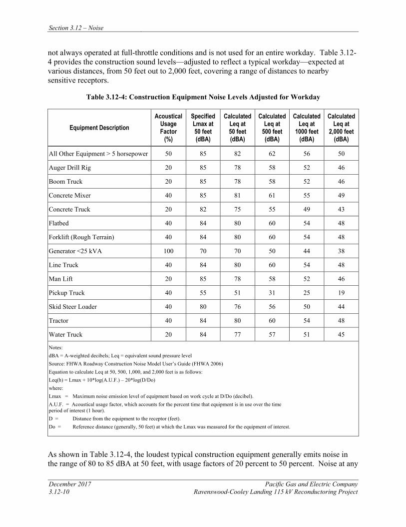
Section 3.12 – Noise
December 2017 Pacific Gas and Electric Company 3.12-10 Ravenswood-Cooley Landing 115 kV Reconductoring Project
not always operated at full-throttle conditions and is not used for an entire workday. Table 3.12-4 provides the construction sound levels—adjusted to reflect a typical workday—expected at various distances, from 50 feet out to 2,000 feet, covering a range of distances to nearby sensitive receptors.
Table 3.12-4: Construction Equipment Noise Levels Adjusted for Workday
Equipment Description Acoustical
Usage Factor
(%)
Specified Lmax at 50 feet (dBA)
Calculated Leq at 50 feet (dBA)
Calculated Leq at
500 feet (dBA)
Calculated Leq at
1000 feet (dBA)
Calculated Leq at
2,000 feet (dBA)
All Other Equipment > 5 horsepower 50 85 82 62 56 50
Auger Drill Rig 20 85 78 58 52 46
Boom Truck 20 85 78 58 52 46
Concrete Mixer 40 85 81 61 55 49
Concrete Truck 20 82 75 55 49 43
Flatbed 40 84 80 60 54 48
Forklift (Rough Terrain) 40 84 80 60 54 48
Generator <25 kVA 100 70 70 50 44 38
Line Truck 40 84 80 60 54 48
Man Lift 20 85 78 58 52 46
Pickup Truck 40 55 51 31 25 19
Skid Steer Loader 40 80 76 56 50 44
Tractor 40 84 80 60 54 48
Water Truck 20 84 77 57 51 45
Notes: dBA = A-weighted decibels; Leq = equivalent sound pressure level Source: FHWA Roadway Construction Noise Model User’s Guide (FHWA 2006) Equation to calculate Leq at 50, 500, 1,000, and 2,000 feet is as follows: Leq(h) = Lmax + 10*log(A.U.F.) – 20*log(D/Do) where: Lmax = Maximum noise emission level of equipment based on work cycle at D/Do (decibel). A.U.F. = Acoustical usage factor, which accounts for the percent time that equipment is in use over the time period of interest (1 hour). D = Distance from the equipment to the receptor (feet). Do = Reference distance (generally, 50 feet) at which the Lmax was measured for the equipment of interest.
As shown in Table 3.12-4, the loudest typical construction equipment generally emits noise in the range of 80 to 85 dBA at 50 feet, with usage factors of 20 percent to 50 percent. Noise at any
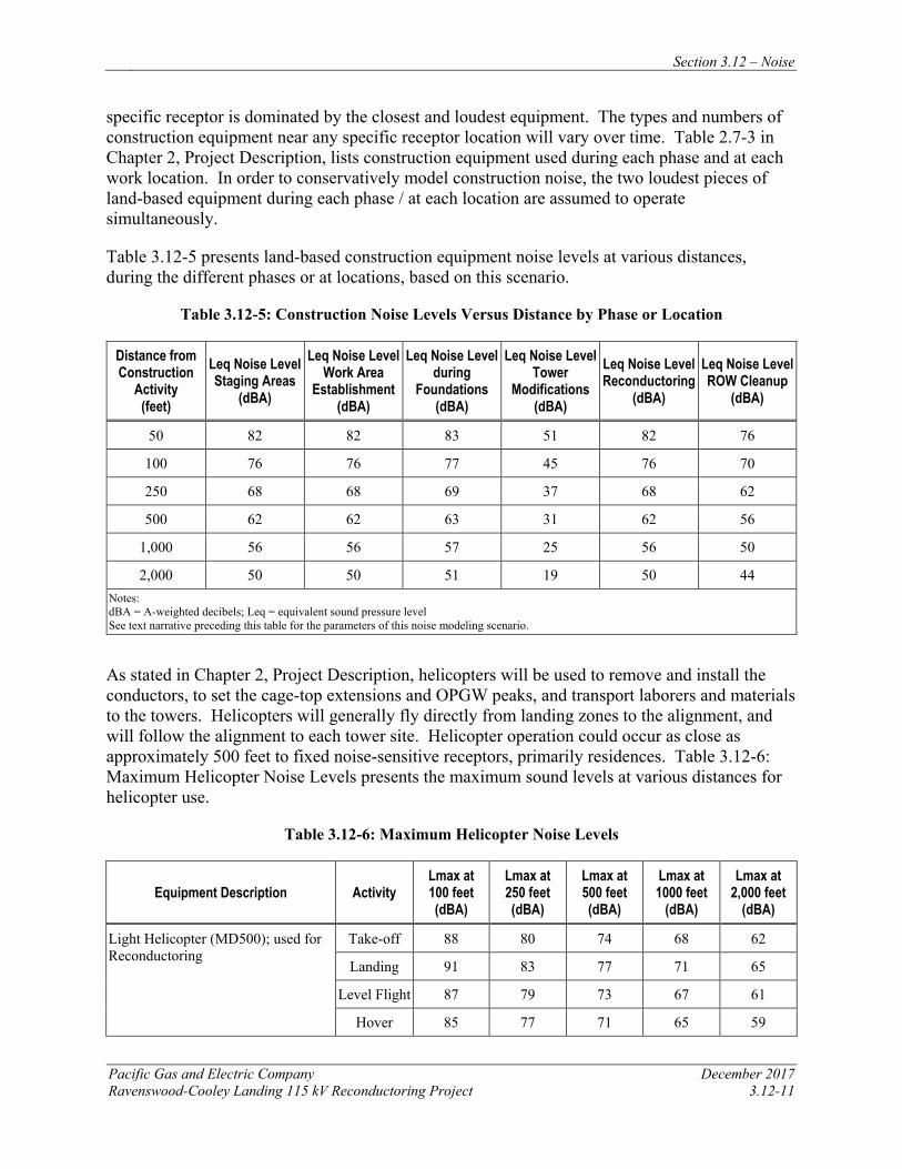
Section 3.12 – Noise
Pacific Gas and Electric Company December 2017 Ravenswood-Cooley Landing 115 kV Reconductoring Project 3.12-11
specific receptor is dominated by the closest and loudest equipment. The types and numbers of construction equipment near any specific receptor location will vary over time. Table 2.7-3 in Chapter 2, Project Description, lists construction equipment used during each phase and at each work location. In order to conservatively model construction noise, the two loudest pieces of land-based equipment during each phase / at each location are assumed to operate simultaneously.
Table 3.12-5 presents land-based construction equipment noise levels at various distances, during the different phases or at locations, based on this scenario.
Table 3.12-5: Construction Noise Levels Versus Distance by Phase or Location
Distance from Construction
Activity (feet)
Leq Noise Level Staging Areas
(dBA)
Leq Noise Level Work Area
Establishment (dBA)
Leq Noise Level during
Foundations (dBA)
Leq Noise Level Tower
Modifications (dBA)
Leq Noise Level Reconductoring
(dBA)
Leq Noise Level ROW Cleanup
(dBA)
50 82 82 83 51 82 76
100 76 76 77 45 76 70
250 68 68 69 37 68 62
500 62 62 63 31 62 56
1,000 56 56 57 25 56 50
2,000 50 50 51 19 50 44 Notes: dBA = A-weighted decibels; Leq = equivalent sound pressure level See text narrative preceding this table for the parameters of this noise modeling scenario.
As stated in Chapter 2, Project Description, helicopters will be used to remove and install the conductors, to set the cage-top extensions and OPGW peaks, and transport laborers and materials to the towers. Helicopters will generally fly directly from landing zones to the alignment, and will follow the alignment to each tower site. Helicopter operation could occur as close as approximately 500 feet to fixed noise-sensitive receptors, primarily residences. Table 3.12-6: Maximum Helicopter Noise Levels presents the maximum sound levels at various distances for helicopter use.
Table 3.12-6: Maximum Helicopter Noise Levels
Equipment Description Activity Lmax at 100 feet (dBA)
Lmax at 250 feet (dBA)
Lmax at 500 feet (dBA)
Lmax at 1000 feet
(dBA)
Lmax at 2,000 feet
(dBA)
Light Helicopter (MD500); used for Reconductoring
Take-off 88 80 74 68 62
Landing 91 83 77 71 65
Level Flight 87 79 73 67 61
Hover 85 77 71 65 59
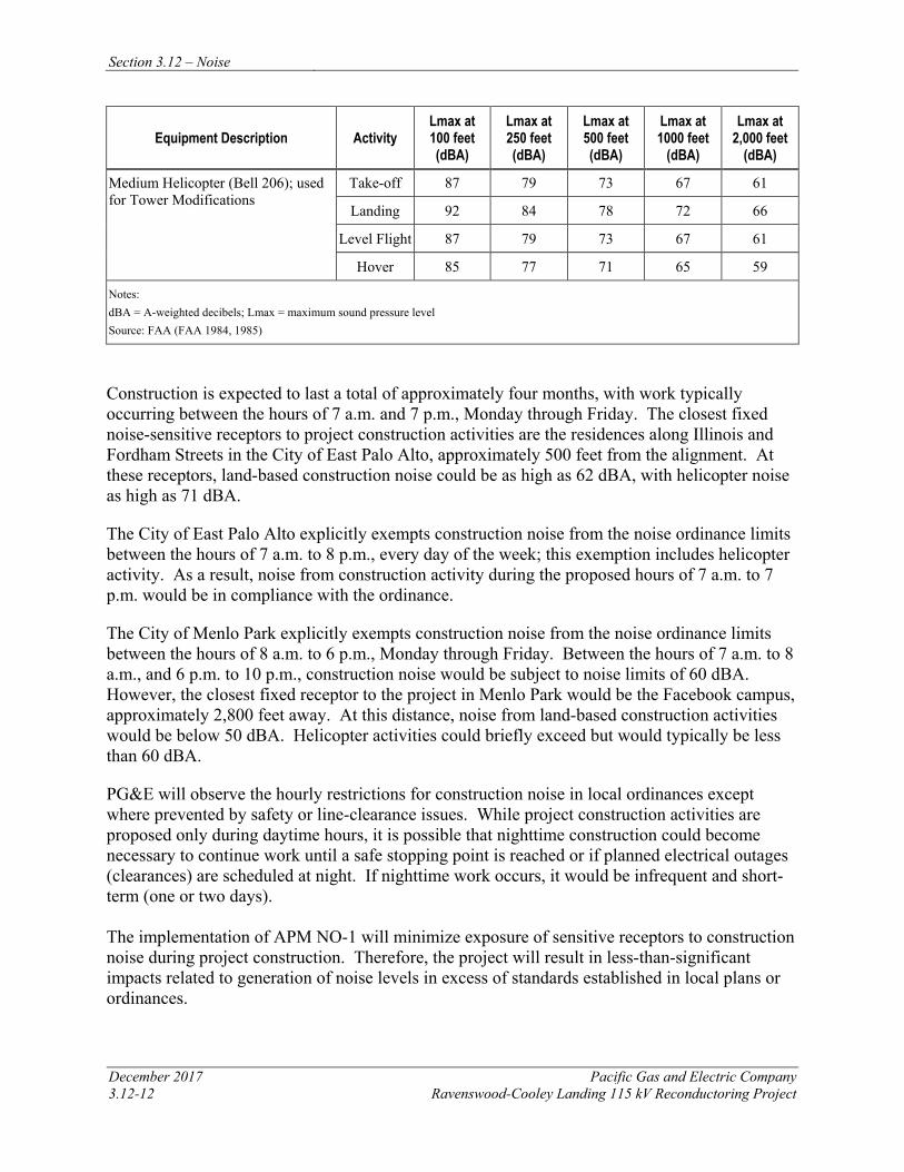
Section 3.12 – Noise
December 2017 Pacific Gas and Electric Company 3.12-12 Ravenswood-Cooley Landing 115 kV Reconductoring Project
Equipment Description Activity Lmax at 100 feet (dBA)
Lmax at 250 feet (dBA)
Lmax at 500 feet (dBA)
Lmax at 1000 feet
(dBA)
Lmax at 2,000 feet
(dBA)
Medium Helicopter (Bell 206); used for Tower Modifications
Take-off 87 79 73 67 61
Landing 92 84 78 72 66
Level Flight 87 79 73 67 61
Hover 85 77 71 65 59
Notes: dBA = A-weighted decibels; Lmax = maximum sound pressure level Source: FAA (FAA 1984, 1985)
Construction is expected to last a total of approximately four months, with work typically occurring between the hours of 7 a.m. and 7 p.m., Monday through Friday. The closest fixed noise-sensitive receptors to project construction activities are the residences along Illinois and Fordham Streets in the City of East Palo Alto, approximately 500 feet from the alignment. At these receptors, land-based construction noise could be as high as 62 dBA, with helicopter noise as high as 71 dBA.
The City of East Palo Alto explicitly exempts construction noise from the noise ordinance limits between the hours of 7 a.m. to 8 p.m., every day of the week; this exemption includes helicopter activity. As a result, noise from construction activity during the proposed hours of 7 a.m. to 7 p.m. would be in compliance with the ordinance.
The City of Menlo Park explicitly exempts construction noise from the noise ordinance limits between the hours of 8 a.m. to 6 p.m., Monday through Friday. Between the hours of 7 a.m. to 8 a.m., and 6 p.m. to 10 p.m., construction noise would be subject to noise limits of 60 dBA. However, the closest fixed receptor to the project in Menlo Park would be the Facebook campus, approximately 2,800 feet away. At this distance, noise from land-based construction activities would be below 50 dBA. Helicopter activities could briefly exceed but would typically be less than 60 dBA.
PG&E will observe the hourly restrictions for construction noise in local ordinances except where prevented by safety or line-clearance issues. While project construction activities are proposed only during daytime hours, it is possible that nighttime construction could become necessary to continue work until a safe stopping point is reached or if planned electrical outages (clearances) are scheduled at night. If nighttime work occurs, it would be infrequent and short-term (one or two days). The implementation of APM NO-1 will minimize exposure of sensitive receptors to construction noise during project construction. Therefore, the project will result in less-than-significant impacts related to generation of noise levels in excess of standards established in local plans or ordinances.
Section 3.12 – Noise
Pacific Gas and Electric Company December 2017 Ravenswood-Cooley Landing 115 kV Reconductoring Project 3.12-13
b) Would the project result in exposure of persons to or generation of excessive groundborne vibration or groundborne noise levels? Less than Significant
Construction activities (e.g., ground-disturbing activities, including drilling and movement of heavy construction equipment) may generate localized groundborne vibration and noise. Heavy equipment operation is not anticipated to result in excessive groundborne vibration. Groundborne vibration and noise will occur during daytime hours and will be of short-term duration. Therefore, construction of the project will result in a less-than-significant impact.
Equipment associated with operation and maintenance of the proposed project will not change from current practices; therefore, operation and maintenance of the project will result in no impact.
c) Would the project result in substantial permanent increase in ambient noise levels in the project vicinity above levels existing without the project? No Impact
Project construction will not result in a permanent increase in ambient noise levels.
Operation and maintenance activities for the reconductored power line will not change from current practices. The new conductor will not change the amount of noise generated by operation of the power line when compared to existing conditions. No permanent increase in ambient noise levels will occur in the project vicinity. Therefore, there will be no impact.
d) Would the project result in substantial temporary or periodic increase in ambient noise levels in the project vicinity above levels existing without the project? Less than Significant
Construction noise associated with establishing access and work areas, foundation work, reconductoring, tower modifications, and ROW cleanup will have a short-term impact on ambient noise levels. Proposed pieces of construction equipment and the typical dBA noise levels associated with their use (as measured at 50 feet) are presented in Table 3.12-4. Assuming a scenario under which multiple pieces of the loudest equipment (excluding helicopter operations) are used, reasonable maximum noise levels (based on distance to nearest receptor) due to construction activities were predicted using methods recommended by the FTA (FTA 2006). Table 3.12-5 summarizes the results of this analysis.
With land-based construction activities located as close as 500 feet to fixed noise-sensitive receptors, land-based construction noise levels could be as high as 62 dBA at these locations. Based on noise contours from the local roadways and Palo Alto Airport (City of East Palo Alto 2016; Santa Clara County 2008), the background noise levels at the closest noise-sensitive receptors are expected to be approximately 60 dBA CNEL. Helicopter activities will occur as close as 500 feet to fixed noise-sensitive receptors; helicopter noise levels could be as high as 71 dBA at these locations. While this represents an increase above existing background noise levels, these activities will only occur up to a few hours per day for only one to two days per location. Given the minor increase over existing background noise levels, the short duration of construction activities at any one location, and implementation of APM NO-1, increased noise levels from construction activity will be less than significant.
Section 3.12 – Noise
December 2017 Pacific Gas and Electric Company 3.12-14 Ravenswood-Cooley Landing 115 kV Reconductoring Project
In the Don Edwards San Francisco Bay NWR, Ravenswood Open Space Preserve, and Palo Alto Baylands Nature Preserve, recreational users could be exposed to construction and helicopter noise levels exceeding 80 dBA when using trails that cross beneath the existing line or that are within 100 feet of tower work areas. At Cooley Landing Park, construction noise could be as high as 62 dBA, with helicopter noise as high as 71 dBA. While this represents an increase above existing background noise levels, these activities will only occur up to a few days per location. In addition, hiking and bicycling uses are transitory, resulting in only brief exposure to construction or helicopter noise. To further reduce the potential exposure to construction noise, PG&E will implement APM REC-1, which requires coordination with parks and open space preserves, public signage, and flagmen to regulate recreational users at trail crossings. With implementation of APMs NOI-1 and REC-1, increased noise levels from construction and helicopter activity within the Don Edwards NWR, parks, and open space preserves will be less than significant.
e) For a project located within an airport land use plan or, where such a plan has not been adopted, within 2 miles of a public airport or public use airport, will the project expose people residing or working in the project area to excessive noise levels? No Impact
While the project does lie within the Palo Alto Airport Comprehensive Land Use Plan (located 0.8 mile southeast), the project alignment falls outside of the 65 dB noise contour at ground level. As a result, project construction workers will not be exposed to excessive noise levels from airport operations. Therefore, no impact will occur.
f) For a project within the vicinity of a private airstrip, will the project expose people residing or working in the project area to excessive noise levels? No Impact
No private airstrips are located within two miles of the project; therefore, no impact will occur.
3.12.6 REFERENCES Bracken, T. Dan. 2010. Bonneville Power Administration Big Eddy-Knight Transmission
Project Final Environmental Impact Statement, Appendix E Electrical Effects, March 2010.
City of East Palo Alto. 2016. East Palo Alto General Plan 2035. As amended through March 2017.
City of East Palo Alto. 1998. East Palo Alto Municipal Code. As amended through January 17, 2017.
City of Menlo Park. 2013. Menlo Park General Plan Open Space/Conservation, Noise and Safety Elements. May 21, 2013.
City of Menlo Park. 1999. City of Menlo Park General Plan Noise Element.
City of Menlo Park. 1972. Menlo Park Municipal Code. As amended through December 6, 2016.
Section 3.12 – Noise
Pacific Gas and Electric Company December 2017 Ravenswood-Cooley Landing 115 kV Reconductoring Project 3.12-15
Federal Aviation Administration (FAA). 1984. Noise Measurement Flight Test for Hughes 500D/E. May 1984. FAA-EE-84-3.
Federal Aviation Administration (FAA). 1985. Noise Measurement Flight Test for Bell 206L-1. September 1985. FAA-EE-85-6.
Federal Highway Administration (FHWA). 2006. FHWA Roadway Construction Noise Model User’s Guide. Washington, DC: U.S. Department of Transportation.
Federal Transit Administration (FTA). 2006. Transit Noise and Vibration Impact Assessment. FTA-VA-90-1003-06.
Miller, L.N. 1978. “Sound Levels of Rain and Wind in the Trees.” Noise Control Engineering. Vol. 11, No. 3, pp. 101-109. November/December 1978.
Nelson, P.M. 1987. Transportation Noise Reference Book. London. Butterworth-Heinemann, 1987
New York Department of Environmental Conservation. 2001. Assessing and Mitigating Noise Impacts. February 2001.
Santa Clara County Airport Land Use Commission. 2008. Comprehensive Land Use Plan Santa Clara County, Palo Alto Airport. As amended through November 16, 2016.
United States Department of Transportation (USDOT). 2012. High-Speed Ground Transportation Noise and Vibration Impact Assessment.
United States Environmental Protection Agency (USEPA). 1974. Information on Levels of Environmental Noise Requisite to Protect Public Health and Welfare with an Adequate Margin of Safety. March 1974. 550/9-74-004.

Section 3.13 – Population and Housing
Pacific Gas and Electric Company December 2017 Ravenswood-Cooley Landing 115 kV Reconductoring Project 3.13-1
3.13 POPULATION AND HOUSING
3.13.1 INTRODUCTION This section describes existing conditions and potential impacts on population and housing as a result of project construction, operation, and maintenance. The analysis concludes that the project will have no impact on population and housing. The project’s potential effects on population and housing were evaluated using the significance criteria set forth in Appendix G of the CEQA Guidelines. The conclusions are summarized in Table 3.13-1 and discussed in more detail in Section 3.13.4.
Table 3.13-1: CEQA Checklist for Population and Housing
Would the project: Potentially Significant
Impact
Less-than-Significant Impact
with Mitigation Incorporated
Less-than-Significant
Impact No Impact
a) Induce substantial population growth in an area, either directly (for example, by proposing new homes and businesses) or indirectly (for example, through extension of roads or other infrastructure)?
b) Displace substantial numbers of existing housing, necessitating the construction of replacement housing elsewhere?
c) Displace substantial numbers of people, necessitating the construction of replacement housing elsewhere?
3.13.2 REGULATORY BACKGROUND AND METHODOLOGY 3.13.2.1 Regulatory Background
No regulatory background information is relevant to addressing project-related impacts on population and housing.
3.13.2.2 Methodology
To evaluate potential effects on population and housing resources, the East Palo Alto General Plan, City of Menlo Park 2015 – 2023 Housing Element, San Mateo County data, Association of Bay Area Government (ABAG) data, and U.S. Census Bureau data were reviewed for the setting data provided in Section 3.13.3. These data and project information were evaluated to assess impacts according to the CEQA signification criteria in Table 3.13-1. The population and growth data, and the project purpose and need were reviewed for use in evaluating whether the project could indirectly cause growth inducement. Information on displacement of housing or people was evaluated considering the project description and hotel and housing vacancy rates. This section evaluates potential project impacts from the both construction phase and the operation and maintenance phase.
Section 3.13 – Population and Housing
December 2017 Pacific Gas and Electric Company 3.13-2 Ravenswood-Cooley Landing 115 kV Reconductoring Project
3.13.2.3 Environmental Setting Regional
The project is located along the eastern shoreline of San Mateo County, in the southeast portion of the City of Menlo Park and the northeastern portion of the City of East Palo Alto. The region is predominantly residential and commercial, though the project area is primarily within the Don Edwards San Francisco Bay National Wildlife Refuge and the Ravenswood Open Space Preserve. San Mateo County has an estimated land area of 554 square miles, with land accounting for about 448 square miles, and inland water and San Francisco Bay tidal areas accounting for 106 square miles. Approximately 55 miles of the County’s western border is Pacific shoreline and about 34 miles of the eastern border is Bay shoreline. The County is bounded on the north by the City and County of San Francisco, and on the south and southeast by Santa Cruz and Santa Clara Counties (San Mateo County General Plan 1986).
In 2013, San Mateo County population was 735,678, with a projected 2040 population of 904,400. The State of California has 58 Counties, and San Mateo County is the 14th most populous County (ABAG 2010c). The project area included 4,433 people at that time, approximately 0.6% of the County population (U.S. Census Bureau 2010b).
Topographic characteristics dictated early urban development in San Mateo County. The bayside was easily accessible by the San Francisco-San Jose Railroad, and offered buildable land. Varying land uses occurred at specific places throughout the County- manufacturing and warehouse uses occurred close to the bayside, commercial uses were built on flat and larger parcels, and the residential areas tended to occur on the eastern foothills of the Santa Cruz Mountains. Currently, over 95% of the County's developed land is on the bayside. Unincorporated communities are scattered throughout the County (San Mateo County General Plan 1986).
Based on 2010 data, the County had 257,837 households, compared to 254,104 households in 2000. In 2010, the household size was approximately 2.75 persons per household. In San Mateo County, vacant housing rates were 4.9% in 2010, compared to 2.5% in 2000 (ABAG 2010c).
Nineteen lodging options are available within 10 miles of the project area for crews during construction.
Local
The City of East Palo Alto has an estimated land area of 2.6 square miles (City of East Palo Alto General Plan 2017). As of 2010, the City of East Palo Alto had a population of approximately 28,155 people. From 2015 to 2020, the City of East Palo Alto’s population is expected to increase to approximately 43,400 (ABAG 2010a). As of 2010, the City of East Palo Alto had approximately 7,819 housing units with a vacancy rate of 11.2%. The average number of people living in each household is approximately 4.0 persons (ABAG 2010a).
The City of Menlo Park has an estimated land area of 18 square miles. As of 2010, the City of Menlo Park had a population of 32,026 people (ABAG 2010b). As of 2010, the City of Menlo Park had approximately 13,085 housing units, compared to 12,714 units in 2000. In 2010, there
Section 3.13 – Population and Housing
Pacific Gas and Electric Company December 2017 Ravenswood-Cooley Landing 115 kV Reconductoring Project 3.13-3
was a vacancy rate of 5.6%. The average number of people living in each household is 2.5 persons per household. The City of Menlo Park’s population is projected to increase to 38,100 by 2040, creating the need for 1,396 additional household units (City of Menlo Park 2014).
3.13.3 APPLICANT-PROPOSED MEASURES AND POTENTIAL IMPACTS The following sections describe significance criteria for impacts on population and housing derived from Appendix G of the CEQA Guidelines, and assesses potential project-related construction and operational impacts. Because the project will have no impact on population and housing, APMs have not been included for this section.
3.13.3.1 Significance Criteria
According to Section 15002(g) of the CEQA Guidelines, “a significant effect on the environment is defined as a substantial adverse change in the physical conditions which exist in the area affected by the proposed project.” As stated in Section 15064(b) of the CEQA Guidelines, the significance of an activity may vary with the setting. Per Appendix G of the CEQA Guidelines, the potential significance of project impacts on population and housing were evaluated for each of the criteria listed in Table 3.13-1, as discussed in Section 3.13.4.3.
3.13.3.2 Applicant-Proposed Measures
The project will have no impact on population and housing and no APMs are proposed.
3.13.3.3 Potential Impacts
Project impacts on population and housing were evaluated against the CEQA significance criteria, as discussed below. This section evaluates potential project impacts from both the construction phase and operation and maintenance phase.
The project includes reconductoring the existing 115 kV power line between Ravenswood Substation and Cooley Landing Substation. Construction activities include installing new conductor, performing minor tower modifications, and establishing required access and work areas, as described in Chapter 2, Project Description. Operation and maintenance activities for the reconductored power line will not change from current practices.
a) Would the project induce substantial population growth in area, either directly (for example, by proposing new homes and businesses) or indirectly (for example, through extension of roads or other infrastructure? No Impact
During peak construction times, PG&E will employ approximately 25 workers. It is anticipated that construction workers will be drawn from either existing PG&E staff in the local area or workers who commute from the neighboring cities. Because the construction duration will be short (approximately four months), it is not expected that the construction workforce will permanently relocate to the area. The project area has adequate hotels and motels available to provide accommodations to any workers that may temporarily relocate to the area during construction. Thus, project construction activities will not directly or indirectly induce substantial population growth. Operation and maintenance activities will not change from current practices and therefore will not directly or indirectly induce substantial population growth. No construction or operation and maintenance impacts will occur.
Section 3.13 – Population and Housing
December 2017 Pacific Gas and Electric Company 3.13-4 Ravenswood-Cooley Landing 115 kV Reconductoring Project
b) Would the project displace substantial numbers of existing housing, necessitating the construction of replacement housing elsewhere? No Impact
Project construction and operation and maintenance activities will not displace existing housing because the facilities being modified and associated construction activities are not located in an area where there is existing housing. Therefore, replacement housing will not need to be constructed. No construction or operation and maintenance impacts will occur.
c) Would the project displace substantial numbers of people, necessitating the construction of replacement housing elsewhere? No Impact
Project construction, operation, and maintenance will not displace any people because the facilities being modified and associated construction activities are not located in an area where people reside. Therefore, replacement housing will not need to be constructed. No construction or operation and maintenance impacts will occur.
3.13.4 REFERENCES Association of Bay Area Governments (ABAG). 2010a. Bay Area Census-City of East Palo Alto.
Online: http://www.bayareacensus.ca.gov/cities/EastPaloAlto.htm. Accessed on May 15, 2017.
Association of Bay Area Governments (ABAG). 2010b. Bay Area Census-City of Menlo Park. Online: http://www.bayareacensus.ca.gov/cities/MenloPark.htm. Accessed on May 15, 2017.
Association of Bay Area Governments (ABAG). 2010c. Bay Area Census-San Mateo County. Online: http://www.bayareacensus.ca.gov/counties/SanMateoCounty.htm. Accessed on May 15, 2017.
City of East Palo Alto Community and Economic Development Department. 2017. Vista 2035 East Palo Alto General Plan. Adopted October 4, 2016.
City of Menlo Park Community Development Department, Planning Division. 2014. City of Menlo Park 2015 – 2023 Housing Element. Adopted April 1, 2014.
San Mateo County Manager’s Office. 2015. County of San Mateo 2015-2017 Profile: FY 2015 – 2017 Recommended Budget. Online: https://www.smcgov.org/sites/smcgov.org/files/documents/files/County_Profile_2015_17.pdf. Accessed on May 15, 2017.
Travel Weekly. 2017. Travel Weekly’s Hotel Search. Online: http://www.travelweekly.com/Hotels. Accessed on May 15, 2017.
United States Census Bureau. 2010a. Community Facts San Mateo County. Online: https://factfinder.census.gov/faces/tableservices/jsf/pages/productview.xhtml?src=CF. Accessed on May 15, 2017.
Section 3.13 – Population and Housing
December 2017 Pacific Gas and Electric Company 3.13-2 Ravenswood-Cooley Landing 115 kV Reconductoring Project
United States Census Bureau. 2010b. Interactive Map. Online: https://www.census.gov/2010census/popmap/. Accessed on May 15, 2017.

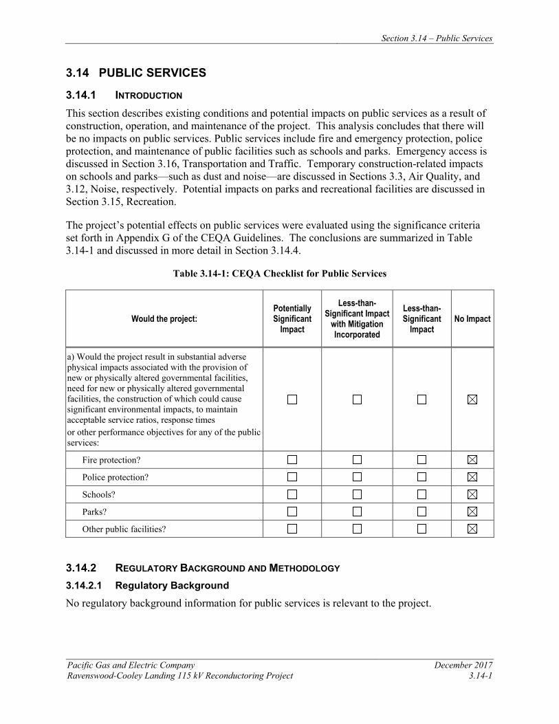
Section 3.14 – Public Services
Pacific Gas and Electric Company December 2017 Ravenswood-Cooley Landing 115 kV Reconductoring Project 3.14-1
3.14 PUBLIC SERVICES
3.14.1 INTRODUCTION This section describes existing conditions and potential impacts on public services as a result of construction, operation, and maintenance of the project. This analysis concludes that there will be no impacts on public services. Public services include fire and emergency protection, police protection, and maintenance of public facilities such as schools and parks. Emergency access is discussed in Section 3.16, Transportation and Traffic. Temporary construction-related impacts on schools and parks—such as dust and noise—are discussed in Sections 3.3, Air Quality, and 3.12, Noise, respectively. Potential impacts on parks and recreational facilities are discussed in Section 3.15, Recreation.
The project’s potential effects on public services were evaluated using the significance criteria set forth in Appendix G of the CEQA Guidelines. The conclusions are summarized in Table 3.14-1 and discussed in more detail in Section 3.14.4.
Table 3.14-1: CEQA Checklist for Public Services
Would the project: Potentially Significant
Impact
Less-than-Significant Impact
with Mitigation Incorporated
Less-than-Significant
Impact No Impact
a) Would the project result in substantial adverse physical impacts associated with the provision of new or physically altered governmental facilities, need for new or physically altered governmental facilities, the construction of which could cause significant environmental impacts, to maintain acceptable service ratios, response times or other performance objectives for any of the public services:
Fire protection?
Police protection?
Schools?
Parks?
Other public facilities?
3.14.2 REGULATORY BACKGROUND AND METHODOLOGY 3.14.2.1 Regulatory Background
No regulatory background information for public services is relevant to the project.
Section 3.14 – Public Services
December 2017 Pacific Gas and Electric Company 3.14-2 Ravenswood-Cooley Landing 115 kV Reconductoring Project
3.14.2.2 Methodology
Public services include fire and police protection, and maintenance of public facilities such as schools and parks. This section was prepared based on reviews of the general plan documents for the City of Menlo Park and the City of East Palo Alto, as well as applicable public service agency websites.
3.14.3 ENVIRONMENTAL SETTING The project is located on lands under the jurisdictions of the City of East Palo Alto, the City of Menlo Park, within San Mateo County. This section addresses public services and facilities within 0.25 mile of the project.
3.14.3.1 Fire Protection
The City of Menlo Park Fire District has seven fire stations and serves an area of approximately 30 square miles, including East Palo Alto. The District serves over 90,000 people and responds to about 8,500 emergencies a year, with about 60% of the calls being for emergency medical incidents (Menlo Park Fire District 2017).
The City of Menlo Park Fire District’s Station 2 provides fire protection and Emergency Medical Services (EMS) to the City of East Palo Alto, located in the southernmost part of the Menlo Park Fire District. Station 2 is the busiest station in the District. Three people are present per shift- one captain and two firefighters. Of the three personnel on duty, one of them must be a licensed paramedic (Menlo Park Fire District 2017).
3.14.3.2 Police Protection
The City of East Palo Alto Police Department is led by a Chief who manages a staff of 44 within 3 major units: Operations; Investigation; and Administration. The Operations Division has 29 employees to fulfill code enforcement and community service functions. The Investigations Division includes a commander and 7 police officers/detectives. In addition, the Administration Division, staffed by the Police Chief, a sergeant, and 6 non-sworn staff, oversee crime analysis and records (City of East Palo Alto General Plan 2017). The City of Menlo Park Police Department is led by a Chief who manages a staff of 70 within 3 major units: Patrol Operations, Investigation, and Administration. The Patrol Operations department has 48 members of the staff, all of whom are sworn in. The Investigation and Administrative departments have 22 non-sworn in employees (City of Menlo Park Police Department 2014).
3.14.3.3 Schools
The Menlo Park City School District serves parts of Menlo Park, Atherton, and unincorporated areas of San Mateo County. There are approximately 2,943 students, kindergarten through 8th grade, enrolled in the four district schools. For grades K-5, the student’s home address dictates which elementary school they will attend. The District created an online School Locater as a resource to advise which school is assigned to a home address. For high school, Menlo Park residents may either attend public school in the Sequoia Union High School District located in
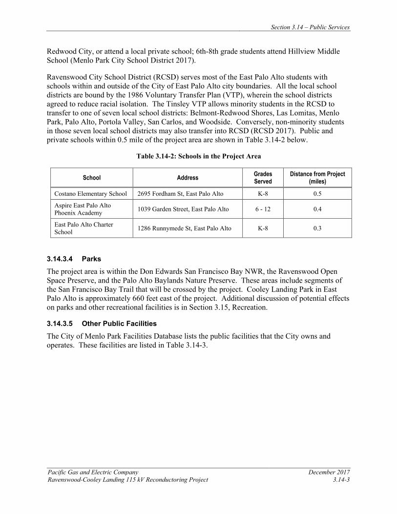
Section 3.14 – Public Services
Pacific Gas and Electric Company December 2017 Ravenswood-Cooley Landing 115 kV Reconductoring Project 3.14-3
Redwood City, or attend a local private school; 6th-8th grade students attend Hillview Middle School (Menlo Park City School District 2017).
Ravenswood City School District (RCSD) serves most of the East Palo Alto students with schools within and outside of the City of East Palo Alto city boundaries. All the local school districts are bound by the 1986 Voluntary Transfer Plan (VTP), wherein the school districts agreed to reduce racial isolation. The Tinsley VTP allows minority students in the RCSD to transfer to one of seven local school districts: Belmont-Redwood Shores, Las Lomitas, Menlo Park, Palo Alto, Portola Valley, San Carlos, and Woodside. Conversely, non-minority students in those seven local school districts may also transfer into RCSD (RCSD 2017). Public and private schools within 0.5 mile of the project area are shown in Table 3.14-2 below.
Table 3.14-2: Schools in the Project Area
School Address Grades Served
Distance from Project (miles)
Costano Elementary School 2695 Fordham St, East Palo Alto K-8 0.5
Aspire East Palo Alto Phoenix Academy 1039 Garden Street, East Palo Alto 6 - 12 0.4
East Palo Alto Charter School 1286 Runnymede St, East Palo Alto K-8 0.3
3.14.3.4 Parks
The project area is within the Don Edwards San Francisco Bay NWR, the Ravenswood Open Space Preserve, and the Palo Alto Baylands Nature Preserve. These areas include segments of the San Francisco Bay Trail that will be crossed by the project. Cooley Landing Park in East Palo Alto is approximately 660 feet east of the project. Additional discussion of potential effects on parks and other recreational facilities is in Section 3.15, Recreation.
3.14.3.5 Other Public Facilities
The City of Menlo Park Facilities Database lists the public facilities that the City owns and operates. These facilities are listed in Table 3.14-3.
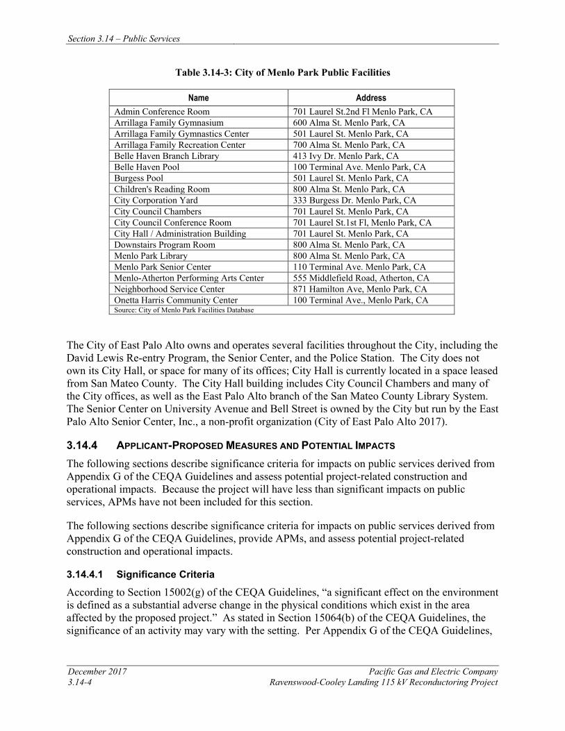
Section 3.14 – Public Services
December 2017 Pacific Gas and Electric Company 3.14-4 Ravenswood-Cooley Landing 115 kV Reconductoring Project
Table 3.14-3: City of Menlo Park Public Facilities
Name Address Admin Conference Room 701 Laurel St.2nd Fl Menlo Park, CA Arrillaga Family Gymnasium 600 Alma St. Menlo Park, CA Arrillaga Family Gymnastics Center 501 Laurel St. Menlo Park, CA Arrillaga Family Recreation Center 700 Alma St. Menlo Park, CA Belle Haven Branch Library 413 Ivy Dr. Menlo Park, CA Belle Haven Pool 100 Terminal Ave. Menlo Park, CA Burgess Pool 501 Laurel St. Menlo Park, CA Children's Reading Room 800 Alma St. Menlo Park, CA City Corporation Yard 333 Burgess Dr. Menlo Park, CA City Council Chambers 701 Laurel St. Menlo Park, CA City Council Conference Room 701 Laurel St.1st Fl, Menlo Park, CA City Hall / Administration Building 701 Laurel St. Menlo Park, CA Downstairs Program Room 800 Alma St. Menlo Park, CA Menlo Park Library 800 Alma St. Menlo Park, CA Menlo Park Senior Center 110 Terminal Ave. Menlo Park, CA Menlo-Atherton Performing Arts Center 555 Middlefield Road, Atherton, CA Neighborhood Service Center 871 Hamilton Ave, Menlo Park, CA Onetta Harris Community Center 100 Terminal Ave., Menlo Park, CA Source: City of Menlo Park Facilities Database
The City of East Palo Alto owns and operates several facilities throughout the City, including the David Lewis Re-entry Program, the Senior Center, and the Police Station. The City does not own its City Hall, or space for many of its offices; City Hall is currently located in a space leased from San Mateo County. The City Hall building includes City Council Chambers and many of the City offices, as well as the East Palo Alto branch of the San Mateo County Library System. The Senior Center on University Avenue and Bell Street is owned by the City but run by the East Palo Alto Senior Center, Inc., a non-profit organization (City of East Palo Alto 2017).
3.14.4 APPLICANT-PROPOSED MEASURES AND POTENTIAL IMPACTS The following sections describe significance criteria for impacts on public services derived from Appendix G of the CEQA Guidelines and assess potential project-related construction and operational impacts. Because the project will have less than significant impacts on public services, APMs have not been included for this section.
The following sections describe significance criteria for impacts on public services derived from Appendix G of the CEQA Guidelines, provide APMs, and assess potential project-related construction and operational impacts.
3.14.4.1 Significance Criteria
According to Section 15002(g) of the CEQA Guidelines, “a significant effect on the environment is defined as a substantial adverse change in the physical conditions which exist in the area affected by the proposed project.” As stated in Section 15064(b) of the CEQA Guidelines, the significance of an activity may vary with the setting. Per Appendix G of the CEQA Guidelines,
Section 3.14 – Public Services
Pacific Gas and Electric Company December 2017 Ravenswood-Cooley Landing 115 kV Reconductoring Project 3.14-5
the potential significance of project-related impacts on public services was evaluated for each of the criteria listed in Table 3.14-1, as discussed in Section 3.14.4.3.
3.14.4.2 Applicant-Proposed Measures
No APMs are suggested because project construction, operation, and maintenance will have no impact on public services.
3.14.4.3 Potential Impacts
Project impacts on public services were evaluated against the CEQA significance criteria and are discussed in further detail below. The impact analysis evaluates potential project impacts during the construction phase and the operation and maintenance phase.
The project includes reconductoring the existing 115 kV power line between Ravenswood Substation and Cooley Landing Substation. Construction activities include installing new conductor, performing minor tower modifications, and establishing required access and work areas, as described in Chapter 2, Project Description. Operation and maintenance activities for the reconductored power line will not change from current practices.
a) Would the project result in substantial adverse physical impacts associated with the provision of new or physically altered government facilities, need for new or physically altered governmental facilities, the construction of which could cause significant environmental impacts, in order to maintain acceptable service ratios, response times, or other performance objectives for any of the following public services: fire protection, police protection, schools, parks, other public facilities? No Impact
Project construction will require temporary, short-term work by a team of up to approximately 25 construction workers. Although construction workers traveling to the project area may use existing public services or amenities, this potential increase in demand for such services will be minimal and temporary, and will not require new or altered government facilities. The project will not include development of new residential units that will directly or indirectly increase population; therefore, no increase in the demand for public services in the area will occur. Furthermore, no new or altered public facilities are needed. Operation and maintenance activities for the reconductored line will not change from current practices. Therefore, no construction or operations and maintenance impacts will occur.
Discussions related to specific public services follow.
Fire and Police Protection
As described in Section 3.16, Transportation and Traffic, during project construction, PG&E will follow local jurisdictional encroachment permit requirements and traffic controls in the form of signs, cones, and flaggers to minimize impacts on traffic, transportation, and emergency access in the project area. No construction or operations and maintenance impacts will occur.
Schools
The project will not involve developing new residential units or services that will generate a new residential population in the area. Therefore, the project will not cause an increase in the demand
Section 3.14 – Public Services
December 2017 Pacific Gas and Electric Company 3.14-6 Ravenswood-Cooley Landing 115 kV Reconductoring Project
on existing schools that would affect school enrollment or performance objectives. No construction or operations and maintenance impacts will occur.
Parks
The project area is located within the Don Edwards San Francisco Bay NWR, Ravenswood Open Space Preserve, and the Palo Alto Baylands Nature Preserve, each of which includes a segment of the San Francisco Bay Trail. The project will not require the development of new residential units or services that will generate a new daytime or residential population in the area that will increase the demand on the trails, the preserves, or the refuge. Construction workers traveling to the area may use existing public services or amenities, but this potential increase in demand will be minimal and temporary and will not exacerbate the need for or deterioration of park facilities or result in the need for new facilities. No construction or operations and maintenance impacts will occur.
3.14.5 REFERENCES City of East Palo Alto Community and Economic Development Department. 2017. Vista 2035
East Palo Alto General Plan. Adopted October 4, 2016.
City of Menlo Park Facilities Database. Online: http://ca-menlopark.civicplus.com/facilities. Accessed on May 15, 2017.
City of Menlo Park Police Department. 2014. About the Police Department: Organizational Chart. Online: https://menlopark.org/DocumentCenter/View/1782. Accessed on May 15, 2017.
Don Edwards San Francisco Bay. 2017. About the Refuge Webpage. Online: https://www.fws.gov/refuge/Don_Edwards_San_Francisco_Bay/about.html. Accessed on May 15, 2017.
Menlo Park City School District. 2017. District Profile Webpage. Online: http://district.mpcsd.org/. Accessed on May 15, 2017.
Menlo Park Fire District. 2017. About Us Webpage. Online: https://www.menlofire.org/about-the-fire-district. Accessed on May 15, 2017.
Ravenswood City School District. 2017. About RCSD Webpage. Online: http://www.ravenswoodschools.org/about.html. Accessed on May 15, 2017.
Ravenswood Preserve. 2017. Homepage. Online: https://www.openspace.org/preserves/ravenswood. Accessed on May 15, 2017.
Regional OpenSpace. 2017. Ravenswood Bay Trail Fact Sheet. Online: https://www.openspace.org/sites/default/files/20160216_RavenswoodBayTrail_FactSheet.pdf. Accessed on May 15, 2017.
Section 3.14 – Public Services
Pacific Gas and Electric Company December 2017 Ravenswood-Cooley Landing 115 kV Reconductoring Project 3.14-7
San Francisco Bay Trail. 2017. About the Trail Webpage. Online: http://baytrail.org/about-the-trail/welcome-to-the-san-francisco-bay-trail/. Accessed on May 15, 2017.

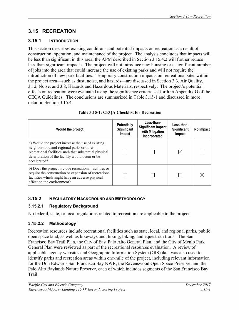
Section 3.15 – Recreation
Pacific Gas and Electric Company December 2017 Ravenswood-Cooley Landing 115 kV Reconductoring Project 3.15-1
3.15 RECREATION
3.15.1 INTRODUCTION This section describes existing conditions and potential impacts on recreation as a result of construction, operation, and maintenance of the project. The analysis concludes that impacts will be less than significant in this area; the APM described in Section 3.15.4.2 will further reduce less-than-significant impacts. The project will not introduce new housing or a significant number of jobs into the area that could increase the use of existing parks and will not require the introduction of new park facilities. Temporary construction impacts on recreational sites within the project area—such as dust, noise, and hazards—are discussed in Section 3.3, Air Quality, 3.12, Noise, and 3.8, Hazards and Hazardous Materials, respectively. The project’s potential effects on recreation were evaluated using the significance criteria set forth in Appendix G of the CEQA Guidelines. The conclusions are summarized in Table 3.15-1 and discussed in more detail in Section 3.15.4.
Table 3.15-1: CEQA Checklist for Recreation
Would the project: Potentially Significant
Impact
Less-than-Significant Impact
with Mitigation Incorporated
Less-than-Significant
Impact No Impact
a) Would the project increase the use of existing neighborhood and regional parks or other recreational facilities such that substantial physical deterioration of the facility would occur or be accelerated?
b) Does the project include recreational facilities or require the construction or expansion of recreational facilities which might have an adverse physical effect on the environment?
3.15.2 REGULATORY BACKGROUND AND METHODOLOGY 3.15.2.1 Regulatory Background
No federal, state, or local regulations related to recreation are applicable to the project.
3.15.2.2 Methodology
Recreation resources include recreational facilities such as state, local, and regional parks, public open space land, as well as bikeways and, hiking, biking, and equestrian trails. The San Francisco Bay Trail Plan, the City of East Palo Alto General Plan, and the City of Menlo Park General Plan were reviewed as part of the recreational resources evaluation. A review of applicable agency websites and Geographic Information System (GIS) data was also used to identify parks and recreation areas within one-mile of the project, including relevant information for the Don Edwards San Francisco Bay NWR, the Ravenswood Open Space Preserve, and the Palo Alto Baylands Nature Preserve, each of which includes segments of the San Francisco Bay Trail.
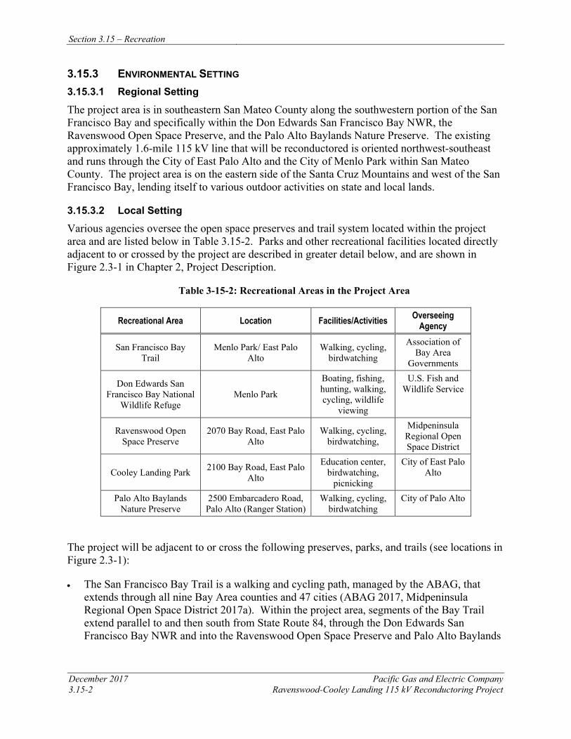
Section 3.15 – Recreation
December 2017 Pacific Gas and Electric Company 3.15-2 Ravenswood-Cooley Landing 115 kV Reconductoring Project
3.15.3 ENVIRONMENTAL SETTING 3.15.3.1 Regional Setting
The project area is in southeastern San Mateo County along the southwestern portion of the San Francisco Bay and specifically within the Don Edwards San Francisco Bay NWR, the Ravenswood Open Space Preserve, and the Palo Alto Baylands Nature Preserve. The existing approximately 1.6-mile 115 kV line that will be reconductored is oriented northwest-southeast and runs through the City of East Palo Alto and the City of Menlo Park within San Mateo County. The project area is on the eastern side of the Santa Cruz Mountains and west of the San Francisco Bay, lending itself to various outdoor activities on state and local lands.
3.15.3.2 Local Setting
Various agencies oversee the open space preserves and trail system located within the project area and are listed below in Table 3.15-2. Parks and other recreational facilities located directly adjacent to or crossed by the project are described in greater detail below, and are shown in Figure 2.3-1 in Chapter 2, Project Description.
Table 3-15-2: Recreational Areas in the Project Area
Recreational Area Location Facilities/Activities Overseeing Agency
San Francisco Bay Trail
Menlo Park/ East Palo Alto
Walking, cycling, birdwatching
Association of Bay Area
Governments
Don Edwards San Francisco Bay National
Wildlife Refuge Menlo Park
Boating, fishing, hunting, walking, cycling, wildlife
viewing
U.S. Fish and Wildlife Service
Ravenswood Open Space Preserve
2070 Bay Road, East Palo Alto
Walking, cycling, birdwatching,
Midpeninsula Regional Open Space District
Cooley Landing Park 2100 Bay Road, East Palo Alto
Education center, birdwatching,
picnicking
City of East Palo Alto
Palo Alto Baylands Nature Preserve
2500 Embarcadero Road, Palo Alto (Ranger Station)
Walking, cycling, birdwatching
City of Palo Alto
The project will be adjacent to or cross the following preserves, parks, and trails (see locations in Figure 2.3-1):
• The San Francisco Bay Trail is a walking and cycling path, managed by the ABAG, that extends through all nine Bay Area counties and 47 cities (ABAG 2017, Midpeninsula Regional Open Space District 2017a). Within the project area, segments of the Bay Trail extend parallel to and then south from State Route 84, through the Don Edwards San Francisco Bay NWR and into the Ravenswood Open Space Preserve and Palo Alto Baylands
Section 3.15 – Recreation
Pacific Gas and Electric Company December 2017 Ravenswood-Cooley Landing 115 kV Reconductoring Project 3.15-3
Nature Preserve. The approximately 1.6-mile existing power line crosses the Bay Trail at five locations (See Figures 2.7-1A and 2.7-1B).
• Don Edwards San Francisco Bay NWR is a 30,000-acre home to migratory birds and endangered species. The Refuge borders the Ravenswood substation on the north, east, and west sides. Approximately 0.5 mile of the existing power line is within the Refuge.
• Ravenswood Open Space Preserve is a 376-acre marshland preserve comprised of two noncontiguous areas located south of the Dumbarton Bridge, bordered on the east by the San Francisco Bay, on the west by single family residences, and on the south by Bay Road. The preserve has approximately 1.5 miles of wheelchair accessible trails on levees, which is part of the San Francisco Bay Trail. The preserve also has overlook platforms and benches (Midpeninsula Regional Open Space District 2017b). Approximately 0.7 mile of the existing power line is within the Ravenswood Open Space Preserve.
• Cooley Landing Park is located on a peninsula at the eastern end of Bay Road in the City of East Palo Alto. It is operated by the City of East Palo Alto and was created in partnership with Midpeninsula Regional Open Space, which owns portions of the peninsula as part of Ravenswood Open Space Preserve. The park includes picnic tables and the Cooley Landing Education Center, which contains exhibits on the area’s cultural heritage. The Education Center also serves as a place for community meetings. Cooley Landing Park is approximately 660 feet east of the existing power line.
• Palo Alto Baylands Nature Preserve covers 1,940 acres of land, and includes salt marsh/mudflat habitat (City of Palo Alto 2011). The San Francisco Bay Trail passes through this area. While the majority of the Baylands Nature Preserve is located within and managed by the City of Palo Alto, its northernmost portion, north of San Francisquito Creek, is within the East Palo Alto city boundary. Approximately 0.1 mile of the existing power line is within the Palo Alto Baylands Nature Preserve within East Palo Alto.
3.15.4 APPLICANT-PROPOSED MEASURES AND POTENTIAL IMPACTS The following sections describe significance criteria for recreation impacts derived from Appendix G of the CEQA Guidelines, provide APMs, and assess potential project-related construction and operational recreation impacts.
3.15.4.1 Significance Criteria
According to Section 15002(g) of the CEQA Guidelines, “a significant effect on the environment is defined as a substantial adverse change in the physical conditions which exist in the area affected by the proposed project.” As stated in Section 15064(b) of the CEQA Guidelines, the significance of an activity may vary with the setting. Per Appendix G of the CEQA Guidelines, the potential significance of project impacts on recreation were evaluated for each of the criteria listed in Table 3.15-1, as discussed in Section 3.15.4.3.
3.15.4.2 Applicant-Proposed Measures
PG&E will implement the following APM:

Section 3.15 – Recreation
December 2017 Pacific Gas and Electric Company 3.15-4 Ravenswood-Cooley Landing 115 kV Reconductoring Project
APM REC-1: Coordination with Park Management and Signage PG&E will coordinate closely with the ABAG, the Midpeninsula Regional Open Space District, cities of Palo Alto and East Palo Alto, and the USFWS to communicate potential park and trail disruptions during project construction activities. Signs advising recreational facility users of construction activities will be posted at entrances and parking areas associated with open space areas (including Don Edwards San Francisco Bay NWR, Ravenswood Open Space Preserve, and Palo Alto Baylands Nature Preserve), at the Cooley Landing Park Education Center, and at designated areas along the Bay Trail. During construction activities that could limit trail access, PG&E will provide a flagman at trail crossings to ensure public safety and safe passage through the project area.
3.15.4.3 Potential Impacts
Potential project impacts on recreation were evaluated against the CEQA significance criteria and are discussed below. The impact analysis evaluates potential project impacts during the construction phase and the operation and maintenance phase.
The project includes reconductoring the existing 115 kV power line between Ravenswood Substation and Cooley Landing Substation. Construction activities include installing new conductor, performing minor tower modifications, and establishing required access and work areas, as described in Chapter 2, Project Description. Operation and maintenance activities for the reconductored power line will not change from current practices.
a) Would the project increase the use of existing neighborhood and regional parks or otherrecreational facilities such that substantial physical deterioration of the facility would occur or be accelerated? Less than Significant
Increases in overall permanent demand for recreational facilities are typically associated with substantial increases in population, either by the construction of new residences or by the creation of a major job generator that will indirectly increase the number of residents in an area. As discussed in Section 3.13, Population and Housing, implementation of the project will not directly or indirectly increase the number of residences or residents in the area, and therefore will not result in a substantial increased demand for recreational facilities or adversely affect the existing recreational resources in a permanent manner. Construction workers may use local recreational facilities on a limited basis, but this use will not result in a substantial increase in demand on such facilities, and will not accelerate their physical deterioration.
Construction of the project will temporarily impact recreationists using the San Francisco Bay Trail, the Don Edwards San Francisco Bay NWR, the Ravenswood Open Space Preserve, Cooley Landing Park, and the Palo Alto Baylands Nature Preserve as a result of tower modifications, conductor replacement, helicopter use, and delivery and staging of construction materials. Although the project will not result in any permanent impacts to trails, parks, or preserves, construction activities may result in short-term disruptions (typically 2 to 3 minutes) to recreationists using the San Francisco Bay Trail where the trail crosses under the existing power line. Because the work will progress quickly over the four-month construction schedule, disruptions at any one location will be short-term in nature. Primary recreational facilities such as trails, wildlife viewing platforms, or open space educational exhibits will not be permanently encroached upon or otherwise permanently affected. In addition, implementation of APM REC-1
Section 3.15 – Recreation
Pacific Gas and Electric Company December 2017 Ravenswood-Cooley Landing 115 kV Reconductoring Project 3.15-5
will further reduce potential impacts on parks and recreational facilities. Therefore, because the project will not have any substantial effects on recreational facilities or uses during construction, and operations and maintenance, and because existing recreational facilities will not be permanently altered, impacts will be less than significant.
b) Does the project include recreational facilities or require the construction or expansion ofrecreational facilities which might have an adverse physical effect on the environment? No Impact
The project will not include recreational facilities or require the construction or expansion of recreational facilities. Therefore, no impact will occur.
3.15.5 REFERENCES Association of Bay Area Governments (ABAG). 1989. San Francisco Bay Trail Plan. Online:
http://baytrail.org/wp-content/uploads/2015/12/San-Francisco-Bay-Trail_-Bay-Trail-Plan-Summary.pdf. Accessed on May 17, 2017.
ABAG. 2017. The San Francisco Bay Trail. Online: http://baytrail.org/about-the-trail/. Accessed on May 17, 2017.
City of East Palo Alto Community and Economic Development Department. 2017. Vista 2035 East Palo Alto General Plan. Adopted October 4, 2016.
City of Menlo Park. 2013. City of Menlo Park General Plan: Open Space/ Conservation, Noise and Safety Elements. Adopted May 21, 2013.
City of Palo Alto. 2011. Palo Alto Open Space. Online: http://www.cityofpaloalto.org/civicax/filebank/documents/25817. Accessed on July 6, 2017.
Don Edwards San Francisco Bay National Wildlife Refuge. 2017. About the Refuge Webpage. Online: https://www.fws.gov/refuge/Don_Edwards_San_Francisco_Bay/about.html. Accessed on May 15, 2017.
Midpeninsula Regional Open Space District. . 2017a. Ravenswood Bay Trail Fact Sheet. Online: https://www.openspace.org/sites/default/files/20160216_RavenswoodBayTrail_FactSheet.pdf. Accessed on May 15, 2017.
Midpeninsula Regional Open Space District. 2017b. Ravenswood Preserve. Online: https://www.openspace.org/preserves/ravenswood. Accessed on May 15, 2017.
San Francisco Bay Trail. 2017. Homepage. Online: http://baytrail.org/about-the-trail/welcome-to-the-san-francisco-bay-trail/. Accessed on May 15, 2017.

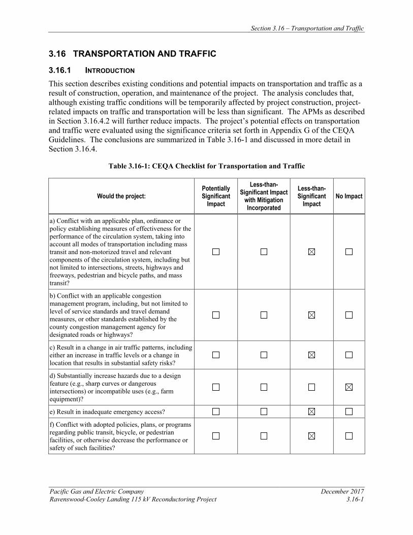
Section 3.16 – Transportation and Traffic
Pacific Gas and Electric Company December 2017 Ravenswood-Cooley Landing 115 kV Reconductoring Project 3.16-1
3.16 TRANSPORTATION AND TRAFFIC
3.16.1 INTRODUCTION This section describes existing conditions and potential impacts on transportation and traffic as a result of construction, operation, and maintenance of the project. The analysis concludes that, although existing traffic conditions will be temporarily affected by project construction, project-related impacts on traffic and transportation will be less than significant. The APMs as described in Section 3.16.4.2 will further reduce impacts. The project’s potential effects on transportation and traffic were evaluated using the significance criteria set forth in Appendix G of the CEQA Guidelines. The conclusions are summarized in Table 3.16-1 and discussed in more detail in Section 3.16.4.
Table 3.16-1: CEQA Checklist for Transportation and Traffic
Would the project: Potentially Significant
Impact
Less-than-Significant Impact
with Mitigation Incorporated
Less-than-Significant
Impact No Impact
a) Conflict with an applicable plan, ordinance or policy establishing measures of effectiveness for the performance of the circulation system, taking into account all modes of transportation including mass transit and non-motorized travel and relevant components of the circulation system, including but not limited to intersections, streets, highways and freeways, pedestrian and bicycle paths, and mass transit?
b) Conflict with an applicable congestion management program, including, but not limited to level of service standards and travel demand measures, or other standards established by the county congestion management agency for designated roads or highways?
c) Result in a change in air traffic patterns, including either an increase in traffic levels or a change in location that results in substantial safety risks?
d) Substantially increase hazards due to a design feature (e.g., sharp curves or dangerous intersections) or incompatible uses (e.g., farm equipment)?
e) Result in inadequate emergency access?
f) Conflict with adopted policies, plans, or programs regarding public transit, bicycle, or pedestrian facilities, or otherwise decrease the performance or safety of such facilities?
Section 3.16 – Transportation and Traffic
December 2017 Pacific Gas and Electric Company 3.16-2 Ravenswood-Cooley Landing 115 kV Reconductoring Project
3.16.2 REGULATORY BACKGROUND AND METHODOLOGY 3.16.2.1 Regulatory Background Federal Aviation Regulations The USDOT and the FAA are the administrating agencies for the following regulations:
• 14 CFR 77.13(2)(i) requires an applicant to notify the FAA of the construction of structures within 20,000 feet of the nearest point of the nearest runway of an airport with at least one runway longer than 3,200 feet.
• 14 CFR 77.17 requires an applicant to submit a Notice of Proposed Construction or
Alteration (FAA Form No. 7460-1) to the FAA for construction within 20,000 feet of the nearest runway of an airport with at least one runway longer than 3,200 feet.
• 14 CFR 77.21, 77.23, and 77.25 outline the criteria used by the FAA to determine whether an
obstruction would create an air navigation conflict.
State
Caltrans owns the rights-of-way for SRs, including any on- and off-ramps that provide access to the project area. Any project-related work within SR rights-of-way requires an encroachment permit from Caltrans.
Caltrans is also the administrating agency for regulations related to traffic safety, including the licensing of drivers, weight and load limitations, transportation of hazardous and combustible materials, and the safe operation of vehicles.
Local
Because the CPUC has exclusive jurisdiction over project siting, design, and construction, the project is not subject to local discretionary regulations. This section includes a summary of local transportation policies, plans or programs for informational purposes and to assist with CEQA review.
San Mateo County The San Mateo County Congestion Management Program (CMP) identifies level of service (LOS) standards for the CMP network. The typical level of service is LOS E or one letter worse than the LOS projected for the year 2000, except for facilities grandfathered in at LOS F.
The San Mateo County Comprehensive Bicycle and Pedestrian Plan seeks to establish a comprehensive countywide system of facilities for bicyclists and pedestrians, encourage more people riding and walking for transportation and recreation, improve safety for bicyclists and pedestrians, provide complete streets and routine accommodation of bicyclists and pedestrians, and strong local support for non-motorized transportation.
Section 3.16 – Transportation and Traffic
Pacific Gas and Electric Company December 2017 Ravenswood-Cooley Landing 115 kV Reconductoring Project 3.16-3
City of Menlo Park The City of Menlo Park identifies a goal of achieving at least an LOS D for evaluating the Menlo Park roadway system.
City of East Palo Alto The City of East Palo Alto General Plan identifies a goal of achieving at least an LOS D for evaluating the East Palo Alto roadway system.
3.16.2.2 Methodology
Traffic data and other transportation system information was obtained from maps, literature searches, and aerial photos (see Section 3.16.5, References). Traffic volumes for regional roadways in the study area were obtained from the City/County Association of Governments of San Mateo County (C/CAG) website. Transit data was obtained from various transit agency websites. The thresholds in the 2015 Santa Mateo County CMP were taken into consideration in the evaluation of impacts.
3.16.3 ENVIRONMENTAL SETTING This section includes a description of the roadways that will be used by workers and delivery trucks during construction. Access routes will vary depending on the origin of the worker or truck and the type of activity that day. Therefore, the roads that are most likely to be affected are described. The highest-volume roadways are described first.
3.16.3.1 Regional Roadways
The backbones of the regional transportation system in the project vicinity are U.S. 101 and SR 84.
U.S. 101 is a major north-south route of the U.S. Highway System that travels throughout the length of California, from the Oregon-California state border to Los Angeles, approximately 130 miles north of the U.S.-Mexican border. In the project vicinity, U.S. 101 is located west of the project area. This roadway could be used to access the project area during construction and operation. The project area is located approximately 1.5 miles east of U.S. 101 and is accessed via the University Avenue, Willow Road and/or Marsh Road U.S. 101 exits.
SR 84 is an east-west route that crosses over the San Francisco Bay and connects San Francisco Peninsula and the East Bay Area. In the project vicinity, SR 84 passes through the project area. This roadway will be used to access the project area during construction and operation. The Ravenswood-Cooley Landing Line crosses over SR 84.
3.16.3.2 Local Roadways
The local transportation network for the project is made up of city-maintained roads within Menlo Park and East Palo Alto. Menlo Park-maintained roads include University Avenue, Willow Road, Marsh Road, and Bay Road in the City of Menlo Park. East Palo Alto-maintained roads include Bay Road, University Avenue, Pulgas Avenue, and Donohoe Street in the City of East Palo Alto.
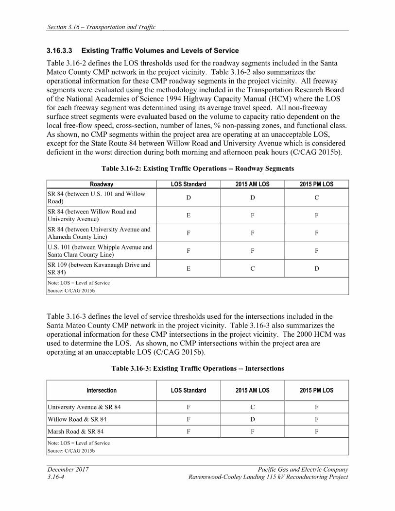
Section 3.16 – Transportation and Traffic
December 2017 Pacific Gas and Electric Company 3.16-4 Ravenswood-Cooley Landing 115 kV Reconductoring Project
3.16.3.3 Existing Traffic Volumes and Levels of Service
Table 3.16-2 defines the LOS thresholds used for the roadway segments included in the Santa Mateo County CMP network in the project vicinity. Table 3.16-2 also summarizes the operational information for these CMP roadway segments in the project vicinity. All freeway segments were evaluated using the methodology included in the Transportation Research Board of the National Academies of Science 1994 Highway Capacity Manual (HCM) where the LOS for each freeway segment was determined using its average travel speed. All non-freeway surface street segments were evaluated based on the volume to capacity ratio dependent on the local free-flow speed, cross-section, number of lanes, % non-passing zones, and functional class. As shown, no CMP segments within the project area are operating at an unacceptable LOS, except for the State Route 84 between Willow Road and University Avenue which is considered deficient in the worst direction during both morning and afternoon peak hours (C/CAG 2015b).
Table 3.16-2: Existing Traffic Operations -- Roadway Segments
Roadway LOS Standard 2015 AM LOS 2015 PM LOS SR 84 (between U.S. 101 and Willow Road) D D C
SR 84 (between Willow Road and University Avenue) E F F
SR 84 (between University Avenue and Alameda County Line) F F F
U.S. 101 (between Whipple Avenue and Santa Clara County Line) F F F
SR 109 (between Kavanaugh Drive and SR 84) E C D
Note: LOS = Level of Service Source: C/CAG 2015b
Table 3.16-3 defines the level of service thresholds used for the intersections included in the Santa Mateo County CMP network in the project vicinity. Table 3.16-3 also summarizes the operational information for these CMP intersections in the project vicinity. The 2000 HCM was used to determine the LOS. As shown, no CMP intersections within the project area are operating at an unacceptable LOS (C/CAG 2015b).
Table 3.16-3: Existing Traffic Operations -- Intersections
Intersection LOS Standard 2015 AM LOS 2015 PM LOS
University Avenue & SR 84 F C F
Willow Road & SR 84 F D F
Marsh Road & SR 84 F F F
Note: LOS = Level of Service Source: C/CAG 2015b
Section 3.16 – Transportation and Traffic
Pacific Gas and Electric Company December 2017 Ravenswood-Cooley Landing 115 kV Reconductoring Project 3.16-5
3.16.3.4 Bicycle Facilities
Bicycle facilities or bikeways are typically classified as Class I, Class II, or Class III facilities. Class I bikeways are bike paths with exclusive right-of-way for use by bicyclists. Class II bikeways are bike lanes striped within the paved areas of roadways and established for the preferential use of bicycles, while Class III bikeways are signed bike routes that allow bicycles to share travel lanes with vehicles.
San Mateo County The San Mateo County Comprehensive Bicycle and Pedestrian Plan (C/CAG 2011) describes the bikeways in the San Mateo County. The San Francisco Bay Trail is a Class I bikeway crossed by the project; there are Class II bikeways along Willow Road, University Avenue and Bay Road.
City of East Palo Alto The City of East Palo Alto Bicycle Transportation Plan (City of East Palo Alto 2011) describes the existing bikeways in the City of East Palo Alto. Several bikeways are in the project vicinity, which are consistent with what are shown in the San Mateo County Comprehensive Bicycle and Pedestrian Plan. The Bicycle Transportation Plan also indicates that bicycle lanes have been proposed along the portions of Bay Road and Pulgas Avenue that will be spanned by the project.
City of Menlo Park The City of Menlo Park Bicycle Development Plan (City of Menlo Park 2005) describes the existing bikeways in the City of Menlo Park. Several bikeways are in the project vicinity, which are consistent with what are shown in the San Mateo County Comprehensive Bicycle and Pedestrian Plan. The Bicycle Development Plan also indicates that bicycle lanes have been proposed along the portions of Willow Road that will be spanned by the project.
3.16.3.5 Air Traffic
Palo Alto Airport, a general aviation airport in the City of Palo Alto, is located in the project vicinity, approximately 0.8 mile southeast of the project area. In addition, San Carlos Airport, a reliever airport for San Francisco International Airport, is located approximately 6.6 miles northwest of the project area.
3.16.3.6 Transit and Rail Services
The project area is served by both local and regional public transit. San Mateo County Transit District (SamTrans) operates six local bus routes (Routes 81, 280, 281, 296, 297 and 397) in the project vicinity. Alameda-Contra Costa Transit District (AC Transit) operates three regional bus services (Lines DB, DB1 and U) in the project vicinity.
SamTrans Route 81 provides services between Menlo-Atherton High School in Menlo Park and Bay/University in East Palo Alto via University Avenue, Bay Road, and Pulgas Avenue. SamTrans Route 280 provides services between Stanford Shopping Center in Palo Alto and Bay/Pulgas in East Palo Alto via Bay Road and Pulgas Avenue. SamTrans Route 281 provides
Section 3.16 – Transportation and Traffic
December 2017 Pacific Gas and Electric Company 3.16-6 Ravenswood-Cooley Landing 115 kV Reconductoring Project
services between Stanford Shopping Center in Palo Alto, Bay/University in East Palo Alto and Onetta Harris Community Center in Menlo Park via Bay Road and University Avenues. SamTrans Route 296 provides services between Redwood City Caltrain Station and Bayshore/Donohoe in East Palo Alto via Willow Road, Bay Road and Donohoe Street. SamTrans Route 297 provides services between Redwood City Transit Center, Bay/University in East Palo Alto and Palo Alto Transit Center via Willow Road, Bay Road and University Avenue. SamTrans Route 397 provides services between Downtown San Francisco and Palo Alto. The closest SamTrans bus stop for the routes described above is located at the corner of Bay Road and University Avenue approximately 0.6 mile from the project area.
AC Transit Line U provides services between Fremont Bay Area Rapid Transit (BART) Station in Fremont and Stanford University in Palo Alto via the Dumbarton Bridge, SR 84, and Willow Road. Dumbarton Express DB and DB1 provide services between Union City BART Station and Palo Alto via the Dumbarton Bridge, SR 84, and Willow Road. The closest bus stop for the AC Transit routes is at the corner of Willow Road and Hamilton Avenue approximately one mile from the project area.
3.16.4 APPLICANT-PROPOSED MEASURES AND POTENTIAL IMPACTS The following sections describe significance criteria for transportation and traffic impacts derived from Appendix G of the CEQA Guidelines, provide APMs, and assess potential project-related construction and operation and maintenance impacts on transportation and traffic.
3.16.4.1 Significance Criteria
According to Section 15002(g) of the CEQA Guidelines, “a significant effect on the environment is defined as a substantial adverse change in the physical conditions which exist in the area affected by the proposed project.” As stated in Section 15064(b) of the CEQA Guidelines, the significance of an activity may vary with the setting. Per Appendix G of the CEQA Guidelines, the potential significance of project impacts related to transportation and traffic were evaluated for each of the criteria listed in Table 3.16-1, as discussed in Section 3.16.4.3.
3.16.4.2 Applicant-Proposed Measures
PG&E will implement the following APMs:
APM TRA-1: Traffic Management Implementation PG&E will obtain any necessary transportation and encroachment permits from Caltrans and the local jurisdictions, as required, including those related to the SR 84 crossing and the transport of oversized loads, and will implement temporary traffic controls as required to prevent excessive congestion or traffic hazards during construction. Construction activities that are along or that cross local roadways will follow local jurisdictional encroachment permit requirements and traffic controls in the form of signs, cones, and flaggers to minimize impacts on traffic, transportation, and emergency access in the project area. When working on state highways, PG&E will follow traffic control guidelines outlined in the California Manual on Uniform Traffic Control Devices, 2017 edition.
Section 3.16 – Transportation and Traffic
Pacific Gas and Electric Company December 2017 Ravenswood-Cooley Landing 115 kV Reconductoring Project 3.16-7
APM TRA-2: Air Transit Coordination PG&E will implement the following protocols related to helicopter use during construction and air traffic: • PG&E will comply with all applicable FAA regulations and helicopter flight plans will be
filed with the local FAA office regulating the local air traffic control plan within 14 days of helicopter activities.
• PG&E’s helicopter operator will coordinate all project helicopter operations with local airports before and during project construction.
3.16.4.3 Potential Impacts
Project impacts on transportation and traffic were evaluated against the CEQA significance criteria and are discussed below. The impact analysis evaluates potential project impacts during the construction phase and the operation and maintenance phase.
The project includes reconductoring the existing 115 kV power line between Ravenswood Substation and Cooley Landing Substation. Construction activities include installing new conductor, performing minor tower modifications, and establishing required access and work areas, as described in Chapter 2, Project Description. Operation and maintenance activities for the reconductored power line will not change from current practices.
a) Would the project conflict with an applicable plan, ordinance or policy establishing measures of effectiveness for the performance of the circulation system, taking into account all modes of transportation including mass transit and non-motorized travel and relevant components of the circulation system, including but not limited to intersections, streets, highways and freeways, pedestrian and bicycle paths, and mass transit? Less than Significant
Most construction activities will occur within PG&E’s existing power line right-of-way and will not be performed in regional or local roadways. Traffic-generating construction activities will consist of the daily arrival and departure of construction workers to staging areas; the transport of crews and materials from staging areas to work sites; and trucks hauling equipment and materials to the work site. However, the number of vehicle trips during peak construction will be only fractionally higher in comparison to typical traffic volumes in the vicinity. Section 2.7.7, Construction Workforce and Equipment, describes the typical construction crew size and required construction equipment during each phase of project construction. Large equipment will not be moved daily once it is staged in the project work areas, and much of the alignment will be accessed by helicopter, further reducing congestion on the road network in the project vicinity. Construction-related traffic will not conflict with any traffic plans, ordinances, or policies that establish measures of effectiveness for the performance of the circulation system; thus, the project will have a less-than-significant impact. Implementation of APM TRA-1 will further reduce the project’s less-than-significant impacts.
To ensure public safety, guard structures will be installed where the project alignment crosses over major roads, such as SR 84 and Bay Road, to safely maintain traffic flow and public safety
Section 3.16 – Transportation and Traffic
December 2017 Pacific Gas and Electric Company 3.16-8 Ravenswood-Cooley Landing 115 kV Reconductoring Project
while PG&E removes the existing conductor and pulls the new conductor into place. Operation of Class I and Class II bike routes and mass transit routes in the project area may be temporarily affected when sections of the line are being reconductored at road and Bay Trail overhead crossings. In accordance with APM REC-1, construction personnel will be stationed at trail crossings to temporarily hold recreationists to prevent contact with conductor during pulling operations and facilitate safe passage through the work area during construction. Impacts will be temporary and short term in nature; therefore, the project will have a less-than-significant construction-related impact on transportation in the project area. Operation and maintenance activities for the reconductored power line will not change from current practices; thus, there will be no operation and maintenance impacts.
b) Would the project conflict with an applicable congestion management program, including, but not limited to level of service standards and travel demand measures, or other standards established by the county congestion management agency for designated roads or highways? Less than Significant
Construction Project construction-generated traffic will be temporary and therefore will not result in any long-term degradation in operating conditions or LOS on any proposed project roadways. The primary off-site impacts from the movement of construction trucks will include short-term and intermittent effects on traffic operations due to slower movements and larger turning radii of the trucks compared to passenger vehicles. The majority of the proposed project route is located relatively close to major arterials and freeways.
Traffic-generating construction activities related to the project will consist of the daily arrival and departure of construction workers to each work site and trucks hauling equipment and materials to the work site. During peak construction, up to approximately 25 workers may be somewhere on the project site at any time. Based on these estimated crew sizes, construction worker trips traveling to and from each work site are not anticipated to exceed 25 round trips (50 one-way trips) per day.
Construction will typically occur between 7 a.m. and 7 p.m., 5-days days a week over a four-month period. Nighttime construction is not anticipated, except for certain construction procedures that cannot be interrupted because of safety considerations or to take advantage of line clearances during off-peak hours.
According to the 2015 San Mateo County CMP (C/CAG 2015a), SR 84 between Willow Road and Alameda County Line operates at LOS F during both the AM and PM peak hours. Temporary lane closures along this segment of SR 84 may cause the roadway to continue operating at LOS F conditions with worse delay. Nonetheless, the LOS standards for roadways that are part of the 2015 San Mateo County CMP network are intended to regulate long-term traffic increases generated by new developments, and do not apply to temporary construction projects. Accordingly, the proposed project will not generate additional trips that would cause roadways to exceed LOS standards in the 2015 San Mateo County CMP. Furthermore, implementation of APM TRA-1 will include recommendations for appropriately managing traffic during the construction period using measures such as construction schedule restrictions, signage, and flaggers. Therefore, construction-related impacts will be less than significant.
Section 3.16 – Transportation and Traffic
Pacific Gas and Electric Company December 2017 Ravenswood-Cooley Landing 115 kV Reconductoring Project 3.16-9
Operation and Maintenance No new staff will be required for maintenance or operations at the Ravenswood Substation or Cooley Landing Substation, and operation and maintenance activities for the reconductored power line will not change from current practices; therefore, no impacts will occur.
c) Would the project result in a change in air traffic patterns, including either an increase in traffic levels or a change in location that results in substantial safety risks? Less than Significant
Access to several of the towers is difficult due to marshland and open-water habitat. PG&E will use helicopter work methods to facilitate delivery of materials and crews without the need to access every tower from the ground. Helicopters will be used to remove and install the conductors, to set the cage-top extensions and OPGW peaks, and transport laborers and materials to the towers. Two light-duty helicopters (Hughes 500 or similar) will be used to transport crew members and materials, and to remove and install conductors. A medium-duty helicopter (Bell Ranger UE205 or similar) will be used to install the OPGW peaks and to install the cage-top extensions. Temporary landing zones will be established at staging areas with a designated area for helicopter take-offs and landings. In accordance with APM TRA-2, PG&E’s helicopter operator will follow protocols regarding air traffic and will coordinate with the local airport during all construction-related helicopter operations.
The majority of construction activities that will involve the use of a helicopter will be located within a PG&E right-of-way where no residences are located; therefore, the flight path of the helicopters from the landing zones poses relatively few safety risks outside of the project alignment. Helicopters that are carrying heavy loads (e.g., cage-extensions) will not pass over major highways or habitable structures. Implementation of APM TRA-2 will further reduce the project’s less-than-significant construction-related impacts. Operation and maintenance activities for the reconductored power line will not change from current practices; therefore, there will be no operation and maintenance impacts.
d) Would the project substantially increase hazards due to a design feature (e.g., sharp curves or dangerous intersections) or incompatible uses (e.g., farm equipment)? No Impact
Project construction will not alter any public roadways or intersections, including access roads to power lines, towers or poles, and substations, nor will it introduce incompatible uses to the project area. Any road closures that will occur on public roads will be temporary and short term, consistent with applicable regulations, and will be coordinated with Caltrans and/or local jurisdictions. The project will not increase hazards due to design features or incompatible uses; therefore, no construction or operation and maintenance related impacts will occur.
e) Would the project result in inadequate emergency access? Less than Significant
Emergency access routes will be maintained throughout project construction and operation. Construction vehicles and equipment are anticipated to access project construction areas by using existing paved, dirt, and/or gravel roads and overland travel routes. In addition, helicopters will be used to access several towers. Any road closures will be temporary and short term, and in accordance with APM TRA-1, these closures will be coordinated with Caltrans and/or local jurisdictions to maintain alternate emergency access routes; therefore, construction of the project
Section 3.16 – Transportation and Traffic
December 2017 Pacific Gas and Electric Company 3.16-10 Ravenswood-Cooley Landing 115 kV Reconductoring Project
will have a less-than-significant impact on emergency access routes. Operation and maintenance activities for the reconductored power line will not change from current practices; therefore, there will be no operation and maintenance impacts.
f) Would the project conflict with adopted policies, plans, or programs regarding public transit, bicycle, or pedestrian facilities, or otherwise decrease the performance or safety of such facilities? Less than Significant
To ensure public safety, guard structures will be installed where the project alignment crosses over major roads, such as SR 84 and Bay Road, to safely maintain traffic flow and public safety while PG&E removes the existing conductor and pulls the new conductor into place. Operation of Class I and Class II bike routes and mass transit routes in the project area may be temporarily affected when sections of the line are being reconductored at SR 84, Bay Road, and the San Francisco Bay Trail overhead crossings. In accordance with APM REC-1, construction personnel will be stationed at trail crossings to temporarily hold recreationists to prevent contact with conductor during pulling operations and facilitate safe passage through the work area during construction. Project construction will not conflict with any policies, plans, or programs that support alternative transportation (e.g., bus lines or bicycle routes) because the majority of construction-related activities will occur within PG&E’s existing easements and rights-of-way. Impacts to transit, bicycle, or pedestrian facilities will be temporary and short term in nature; therefore, construction impacts will be less than significant. Operation and maintenance activities for the reconductored power line will not change from current practices; therefore, there will be no operation and maintenance impacts.
3.16.5 REFERENCES C/CAG. 2011. San Mateo County Comprehensive Bicycle and Pedestrian Plan. Online:
http://ccag.ca.gov/wp-content/uploads/2014/07/CBPP_Main-Report__Sept2011_FINAL.pdf. Accessed on May 31, 2017.
C/CAG. 2015a. Final San Mateo County Congestion Management Program 2015. Online: http://ccag.ca.gov/wp-content/uploads/2016/02/2015-CMP_Final_rev.pdf. Accessed on May 31, 2017.
C/CAG. 2015b. Level of Service and Performance Measure Monitoring Report – 2015. Online: http://ccag.ca.gov/wp-content/uploads/2015/10/2015-San-Mateo-Monitoring-Report-091415.pdf. Accessed on May 31, 2017.
City of East Palo Alto. 2016. Vista 2035 East Palo Alto General Plan. Online: http://www.ci.east-palo-alto.ca.us/DocumentCenter/View/3187. Accessed on May 31, 2017.
City of East Palo Alto. 2011a. East Palo Alto Bicycle Transportation Plan. Online: http://www.ci.east-palo-alto.ca.us/DocumentCenter/View/827. Accessed on May 31, 2017.
Section 3.16 – Transportation and Traffic
Pacific Gas and Electric Company December 2017 Ravenswood-Cooley Landing 115 kV Reconductoring Project 3.16-11
City of East Palo Alto. 2011b. Existing and Proposed Bicycle Network. Online: http://www.ci.east-palo-alto.ca.us/DocumentCenter/View/3280. Accessed on May 31, 2017.
City of Menlo Park. Transportation Impact Analysis Guidelines. Online: http://menlopark.org/DocumentCenter/Home/View/302. Accessed on May 31, 2017.
City of Menlo Park. 2005. Menlo Park Comprehensive Bicycle Development Plan. Online: http://menlopark.org/DocumentCenter/Home/View/302. Accessed on May 31, 2017.

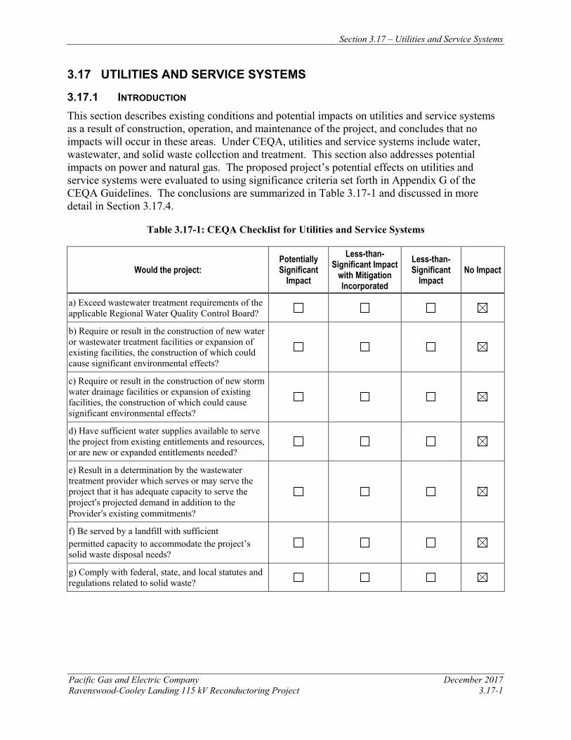
Section 3.17 – Utilities and Service Systems
Pacific Gas and Electric Company December 2017 Ravenswood-Cooley Landing 115 kV Reconductoring Project 3.17-1
3.17 UTILITIES AND SERVICE SYSTEMS
3.17.1 INTRODUCTION This section describes existing conditions and potential impacts on utilities and service systems as a result of construction, operation, and maintenance of the project, and concludes that no impacts will occur in these areas. Under CEQA, utilities and service systems include water, wastewater, and solid waste collection and treatment. This section also addresses potential impacts on power and natural gas. The proposed project’s potential effects on utilities and service systems were evaluated to using significance criteria set forth in Appendix G of the CEQA Guidelines. The conclusions are summarized in Table 3.17-1 and discussed in more detail in Section 3.17.4.
Table 3.17-1: CEQA Checklist for Utilities and Service Systems
Would the project: Potentially Significant
Impact
Less-than-Significant Impact
with Mitigation Incorporated
Less-than-Significant
Impact No Impact
a) Exceed wastewater treatment requirements of the applicable Regional Water Quality Control Board?
b) Require or result in the construction of new water or wastewater treatment facilities or expansion of existing facilities, the construction of which could cause significant environmental effects?
c) Require or result in the construction of new storm water drainage facilities or expansion of existing facilities, the construction of which could cause significant environmental effects?
d) Have sufficient water supplies available to serve the project from existing entitlements and resources, or are new or expanded entitlements needed?
e) Result in a determination by the wastewater treatment provider which serves or may serve the project that it has adequate capacity to serve the project’s projected demand in addition to the Provider’s existing commitments?
f) Be served by a landfill with sufficient permitted capacity to accommodate the project’s solid waste disposal needs?
g) Comply with federal, state, and local statutes and regulations related to solid waste?
Section 3.17 – Utilities and Service Systems
December 2017 Pacific Gas and Electric Company 3.17-2 Ravenswood-Cooley Landing 115 kV Reconductoring Project
3.17.2 REGULATORY BACKGROUND AND METHODOLOGY 3.17.2.1 Regulatory Background Federal
No federal regulations pertaining to utilities and service systems are applicable to the proposed project.
State California Government Code Section 4216 of the California Government Code protects underground structures during excavation. Under this law, excavators are required to contact a regional notification center at least 2 days prior to excavation of any subsurface installations. In the project area, Underground Service Alert (USA) is the regional notification center. USA notifies utility providers with buried lines within 1,000 feet of the excavation, and those providers are required to mark the specific location of their facilities prior to excavation. The code also requires excavators to probe and expose existing utilities, in accordance with state law, before using power equipment.
Executive Order B-29-15 / Water Conservation Landscape Act On April 1, 2015, Governor Jerry Brown issued Executive Order No. B-29-15 directing the California DWR to update the state’s model water efficient landscape ordinance. Local agencies, consistent with the Department’s regulations and the Water Conservation in Landscaping Act (California Government Code Section 65591), must, by December 1, 2015, adopt the model ordinance or a water efficient landscape ordinance that is, at least as effective in conserving water as the model ordinance. San Mateo County had an existing Landscape Ordinance that complied with the Water Conservation Act. The City of Menlo Park had an existing Landscape Ordinance that complied with the Water Conservation Act, adopted in 2010. The City of East Palo Alto amended their existing water conservation ordinance in July 2015 to add additional restrictions to comply with the Water Conservation Act.
Local
Because the CPUC has exclusive jurisdiction over the siting, design, and construction of the project, the project is not subject to local discretionary regulations. The following summary of local statutes and regulations relating to solid waste is provided for informational purposes and to assist with CEQA review.
A number of county and city ordinances and policies require the reduction or reuse of solid waste associated with construction activities. San Mateo County Ordinance No. 04099 requires construction and demolition debris to be recycled and reused. The San Mateo County General Plan includes strategies and policies intended to facilitate recycling of materials, including materials generated during construction projects. Policy 13.5, specifically, requires reduction “to a minimum the dependence on landfills by promoting recycling, resource recovery and reduction of residential and commercial wastes” (County of San Mateo Planning and Building 1986).
The City of Menlo Park and the City of East Palo Alto have adopted ordinances related to construction waste salvaging and recycling. The City of Menlo Park Municipal Code Chapter
Section 3.17 – Utilities and Service Systems
Pacific Gas and Electric Company December 2017 Ravenswood-Cooley Landing 115 kV Reconductoring Project 3.17-3
12.48 specifies landfill diversion requirements of construction and demolition debris. The City of Menlo Park Open Space / Conservation, Noise and Safety Elements includes Policy 4.4, which encourages all construction projects to divert 80 percent of their construction waste away from landfills, exceeding CalGreen requirements. The City of East Palo Alto Municipal Code Chapter 15.56 specifies diversion and recycling requirements.
3.17.2.2 Methodology
To evaluate potential impacts on public services, general plans, existing public documents, and official websites for service providers in the project area, including San Mateo County and the City of Menlo Park and the City of East Palo Alto, were reviewed for wastewater collection and treatment, water supply, stormwater drainage, solid waste disposal, electricity and natural gas, and communications facilities and service systems. Service providers in the project area include the County of San Mateo Sewer System Management Plan, East Palo Alto Sanitary District, West Bay Sanitary District (WBSD), SFPUC, American Water Services District, Menlo Park Municipal Water Department, San Mateo Countywide Water Pollution Prevention Program, Recology, and PG&E. Potential impacts on these service systems resulting from project-related effects and increased demand were analyzed according to the thresholds in Appendix G of the CEQA Guidelines.
3.17.3 ENVIRONMENTAL SETTING 3.17.3.1 Wastewater Collection and Treatment Services City of Menlo Park
The City of Menlo Park’s wastewater service is through the WBSD. WBSD provides wastewater collection and conveyance services to the City of Menlo Park, Atherton, and Portola Valley. WBSD maintains about 260 miles of gravity sewer pipelines and 11 lift stations (WBSD 2016). WBSD conveys raw wastewater, via the Menlo Park Pump Station and force main, to Silicon Valley Clean Water for treatment and discharge to the San Francisco Bay (City of Menlo Park 2017b).
City of East Palo Alto
The City of East Palo Alto is serviced by the East Palo Alto Sanitary District (EPASD). EPASD is run separately from the City and has its own Board of Directors elected by East Palo Alto residents. The collection system carries wastewater from the District's service area to the Palo Alto Regional Water Quality Control Plant where it is treated and disposed of in a manner that meets federal and state standards. The Plant is owned and operated by the City of Palo Alto, and it treats wastewater for the communities of Los Altos, Los Altos Hills, Mountain View, Palo Alto, Stanford University, and the EPASD (City of Palo Alto 2017).
EPASD provides wastewater collection and conveyance services for the City of East Palo Alto and parts of the City of Menlo Park (EPASD 2017, City of Palo Alto 2017).
Section 3.17 – Utilities and Service Systems
December 2017 Pacific Gas and Electric Company 3.17-4 Ravenswood-Cooley Landing 115 kV Reconductoring Project
3.17.3.2 Water Supply San Francisco Public Utilities Commission
Through contractual agreements through the Water Supply Agreement, the SFPUC provides up to 184 million gallons of water per day to 27 jurisdictions located in San Mateo, Alameda, and Santa Clara Counties. These entities receive over two-thirds of the SFPUC’s Regional Water System watershed supply. Of the 27 jurisdictions, 14 receive 100 percent of their water from the SFPUC, including the City of Menlo Park (SFPUC 2011).
City of Menlo Park
The Menlo Park Municipal Water District serves its customers primarily through purchasing water from the SFPUC, which delivers water from the San Francisco Regional Water System. In 2015, the Menlo Park Municipal Water District supplied an average of 2.32 million gallons of water per day to more than 16,000 residents through 4,300 service connections within two service areas: the upper zone (near Interstate 280 and includes the Sharon Heights area) and the lower zone (east of El Camino Real) (Menlo Park Municipal Water Department 2015).
The City has emergency interties with California Water Service, the Palo Alto Park Mutual Water Company, and the O’Connor Tract Cooperative Water District, City of East Palo Alto, and City of Redwood City. (Bay Area Water Supply and Conservation Agency 2017).
City of East Palo Alto
Approximately 80 percent of East Palo Alto’s water connections are provided by the City of East Palo Alto water system, which is operated by American Water Enterprises. The remaining connections are served by either Palo Alto Park Mutual Water Company or the O’Connor Tract Co-op Water Company. American Water Enterprises operates the City of East Palo Alto’s water system via an operating agreement with the City. The City of East Palo Alto serves approximately 30,000 people in the city and a small section in the City of Menlo Park (City of East Palo Alto 2010).
American Water Enterprises supplies the City’s water from the SFPUC. The water system is completely dependent on the Hetch Hetchy system for potable water. The City of East Palo Alto fluctuates around the 1.96 million gallons per day Supply Assurance from SFPUC (City of East Palo Alto 2010).
3.17.3.3 Stormwater Drainage San Mateo County
The San Mateo Countywide Water Pollution Prevention Program (SMCWPPP) is a partnership of the C/CAG, each incorporated city and town in the county, and the County of San Mateo. All entities within the SMCWPPP share a common NPDES permit (C/CAG of San Mateo County 2017).
The SMCWPPP is in the process of creating a Stormwater Resource Plan (SRP) for San Mateo County to outline watershed resource planning and stormwater runoff management. The SRP was developed by the C/CAG of San Mateo County through the Countywide Water Pollution
Section 3.17 – Utilities and Service Systems
Pacific Gas and Electric Company December 2017 Ravenswood-Cooley Landing 115 kV Reconductoring Project 3.17-5
Prevention Program. The main goals of the SRP are to identify and prioritize opportunities to better utilize stormwater as a resource in San Mateo County through a detailed analysis of watershed processes, surface and groundwater resources, input from stakeholders and the public, and analysis of multiple benefits that can be achieved through strategically planned stormwater management projects (SMCWPPP 2017).
City of Menlo Park
The City of Menlo Park utilizes the stormwater management provisions outlined by the SMCWPPP and San Francisco Bay Basin Water Quality Control Plan. The City’s storm drain system is maintained by the Menlo Park Public Works Department and consists of 17 individual systems that serve 17 drainage areas (City of Menlo Park 2003). The storm drain collection system discharges to two waterways. The area north of Middlefield Road drains to the Bay through either the Belle Haven Storm Drain system or through City of East Palo Alto storm drain lines. The collection system south of Middlefield Road drains to the two major storm water collection channels: Atherton Channel on the northwest and San Francisquito Creek on the southeast (City of Menlo Park 2003).
Chapter 7.42 of the City’s Municipal Code is intended to protect and enhance water quality by eliminating non‐stormwater discharges to the storm drain system, controlling the discharge from spills, dumping, or disposal of materials other than storm water into the storm drain system, and reducing pollutants in storm water discharges to the maximum extent practicable. To reduce pollutants in stormwater, the City requires that new development or redevelopment projects use BMPs to achieve these goals.
City of East Palo Alto
The City of East Palo Alto utilizes the stormwater management provisions outlined by the SMCWPPP. The City of East Palo Alto has created a Storm Drain Master Plan, adopted in 2015, to comprehensively guide storm drain facility development. The City’s storm drainage system is composed of networks of pipes, channels, storage ponds and pump stations which ultimately outlet to San Francisquito Creek and the San Francisco Bay. Stormwater in East Palo Alto drains into two major drainage systems: the Runnymede Storm Drain System and the O’Connor Storm Drain System. Due to its proximity to the San Francisco Bay, tide has significant influence on portions of the drainage system and over half of the City is reliant on pumping from the O’Connor pump station (City of East Palo Alto Community and Economic Development Department 2017).
3.17.3.4 Solid Waste Disposal City of Menlo Park
Recology San Mateo County provides solid waste and recycling services to the City of Menlo Park and much of San Mateo County. Other haulers are allowed if their services comply with the City’s Code Chapter 12.48. Waste is disposed of at the Ox Mountain in Half Moon Bay. Ox Mountain is a Class III Municipal Solid Waste Landfill which accepts solid waste and is prohibited from accepting hazardous waste. The landfill is located at 12310 San Mateo Rd (Hwy 92), Half Moon Bay, CA 94019. Ox Mountain is permitted to receive up to 3,598 tons of waste per day. As of 2011, the Landfill received an average of 2,260 tons per day (San Mateo County
Section 3.17 – Utilities and Service Systems
December 2017 Pacific Gas and Electric Company 3.17-6 Ravenswood-Cooley Landing 115 kV Reconductoring Project
Public Works Department 2010). The Ox Mountain Landfill has a maximum capacity of 48.3 million cubic yards, and is expected to reach capacity in 2028 (City of East Palo Alto Community and Economic Development Department 2017).
City of East Palo Alto
East Palo Alto’s solid waste and recycling services are operated by South Bay Waste Management Authority (SBWMA). Shoreway Environmental Center receives and handles solid waste and recyclables collected by SBWMA, and ultimately transfers the waste to the Ox Mountain Landfill. SBWMA has a capacity to process 3,000 tons per day of solid waste. The City is currently undertaking efforts to increase the amount of solid waste recycling and recycling capacity (City of East Palo Alto Community and Economic Development Department 2017).
3.17.3.5 Electricity and Natural Gas
PG&E provides electrical power and natural gas to San Mateo County, which includes the City of Menlo Park, City of East Palo Alto, and surrounding unincorporated San Mateo County (County of San Mateo Planning and Building 1986).
3.17.3.6 Communications
AT&T provides local and long-distance telephone service within San Mateo County. A variety of wireless companies, including AT&T, Comcast, Verizon, Sprint, and T-Mobile, provide wireless phone service in the county. Cable television and internet services are provided by Dish Network, DirecTV, Charter Communications, and other providers.
3.17.4 APPLICANT-PROPOSED MEASURES AND POTENTIAL IMPACTS The following sections describe significance criteria for impacts on utilities and service systems derived from Appendix G of the CEQA Guidelines and assess potential project-related construction and operational impacts. Because the project will have no impact on utilities and service systems, APMs have not been included for this section.
3.17.4.1 Significance Criteria
According to Section 15002(g) of the CEQA Guidelines, “a significant effect on the environment is defined as a substantial adverse change in the physical conditions which exist in the area affected by the proposed project.” As stated in Section 15064(b) of the CEQA Guidelines, the significance of an activity may vary with the setting. Per Appendix G of the CEQA Guidelines, the potential significance of project impacts on utilities and service systems was evaluated for each of the criteria listed in Table 3.17-1, as discussed in Section 3.17.4.3.
3.17.4.2 Applicant-Proposed Measures
The project will have no impact on utilities and service systems and no APMs are proposed.
Section 3.17 – Utilities and Service Systems
Pacific Gas and Electric Company December 2017 Ravenswood-Cooley Landing 115 kV Reconductoring Project 3.17-7
3.17.4.3 Potential Impacts
Project impacts on utilities and service systems were evaluated against the CEQA significance criteria as discussed below. This section evaluates potential project impacts from both the construction phase and the operation and maintenance phase.
The project includes reconductoring the existing 115 kV power line between Ravenswood Substation and Cooley Landing Substation. Construction activities include installing new conductor, performing minor tower modifications, and establishing required access and work areas, as described in Chapter 2, Project Description. Operation and maintenance activities for the reconductored power line will not change from current practices.
As required by state law, PG&E will notify other utility companies (via USA) to locate and mark existing underground structures at proposed work areas prior to any excavation or augering activities. In addition, PG&E will probe and expose existing utilities, in accordance with state law, before using power equipment. Prior to construction, PG&E will obtain emergency contact information for utilities that may be in close proximity or require monitoring during construction of the project. In case of accidental service interruption to another utility, PG&E will immediately contact the affected utility to coordinate actions to restore service in a safe and timely manner.
a) Would the project exceed wastewater treatment requirements of the applicable Regional Water Quality Control Board? No Impact
A minimal amount of effluent will be generated temporarily by up to approximately 25 workers during project construction. Temporary construction demands will be met by portable restroom and hand-washing facilities for construction workers. Wastewater will be handled in accordance with applicable regulations and permits, and waste will be disposed at appropriately licensed off-site facilities. Operation and maintenance activities for the reconductored power line will not change from current practices. Therefore, no wastewater treatment requirements of the RWQCB will be exceeded and no impacts will occur.
b) Would the project require or result in the construction of new water or wastewater treatment facilities or expansion of existing facilities, the construction of which could cause significant environmental effects? No Impact
Although project construction will require the use of water and wastewater facilities by construction workers, this use will be temporary and short-term. Furthermore, the construction workforce will be relatively small (up to approximately 25 workers), and minimal water use and wastewater generation will occur. Temporary construction demands will be met by portable restroom facilities, hand-washing stations, and bottled water (as necessary) for construction workers. Existing water supply and wastewater facilities in the area will be sufficient to serve additional temporary construction needs, including dust control and concrete mixing. Because operation and maintenance activities for the reconductored power line will not change from current practices, the operations phase of the project will not require new or expanded water or wastewater treatment facilities. As a result, no new or expanded water or wastewater treatment facilities will be required and no impacts on water or wastewater treatment facilities will occur.
Section 3.17 – Utilities and Service Systems
December 2017 Pacific Gas and Electric Company 3.17-8 Ravenswood-Cooley Landing 115 kV Reconductoring Project
c) Would the project require or result in the construction of new storm water drainage facilities or expansion of existing facilities, the construction of which could cause significant environmental effects? No Impact
The project will not require construction of new stormwater drainage facilities or expansion of existing facilities. The project will involve reconductoring of an existing power line, which will not require stormwater drainage facilities. The project will not result in changes to existing stormwater facilities or require the construction of new facilities. In addition, operation and maintenance activities for the reconductored power line will not change from current practices. Therefore, the operations phase of the project will not require new or expanded stormwater drainage facilities. No construction or operation and maintenance impacts will occur.
d) Would the project have sufficient water supplies available to serve the project from existing entitlements and resources, or are new or expanded entitlements needed? No Impact
Potable water will be supplied to construction workers for drinking and will be delivered to project work areas by construction vehicles and equipment. During construction, water will be used for dust control and worker needs, but the existing water supplies will be sufficient to serve the project’s needs. Existing off-site water entitlements and resources will be sufficient to accommodate the project’s minor temporary and short-term water needs and relatively small number of construction workers. Operation and maintenance activities for the reconductored power line will not change from current practices. Therefore, no construction or operation and maintenance impacts will occur.
e) Would the project result in a determination by the wastewater treatment provider which serves or may serve the project that it does not have adequate capacity to serve the project’s projected demand in addition to the provider’s existing commitments? No Impact
Portable toilets will be provided for construction workers during construction. Sanitary waste will be disposed at appropriately licensed facilities in the project area that have adequate capacity to accommodate project needs. Operation and maintenance activities for the reconductored power line will not change from current practices. Therefore, no construction or operation and maintenance impacts will occur.
f) Would the project be served by a landfill with sufficient permitted capacity to accommodate the project’s solid waste disposal needs? No Impact
Construction debris, including the removed conductor, will be taken on a line truck with a trailer to an area service center for recycling or disposal. PG&E will conduct a final survey to determine whether cleanup activities have been successfully completed as required.
The project will also generate minimal solid waste from the food, glass, paper, plastic, and packing materials consumed by the up to approximately 25 construction workers who will be on-site during periods of peak construction activity. Existing landfills in the project area have adequate capacity to accommodate this negligible amount of solid waste. Operation and maintenance activities for the reconductored power line will not change from current practices. No construction or operation and maintenance impacts will occur.
Section 3.17 – Utilities and Service Systems
Pacific Gas and Electric Company December 2017 Ravenswood-Cooley Landing 115 kV Reconductoring Project 3.17-9
g) Would the project comply with federal, state, and local statutes and regulations related to solid waste? No Impact
All construction debris will be collected and hauled off-site for recycling or disposal during construction. PG&E will comply with all federal, state, and local statutes and regulations related to solid waste. Operation and maintenance activities for the reconductored power line will not change from current practices. Therefore, no construction or operation and maintenance impacts will occur.
3.17.5 REFERENCES Bay Area Water Supply and Conservation Agency. 2017. Menlo Park Webpage. Online:
http://bawsca.org/members/profiles/menlo-park. Accessed on September 13, 2017.
City/County Association of Governments of San Mateo County. 2017. Stormwater Resource Plan for San Mateo County. Online: http://ccag.ca.gov/wp-content/uploads/2017/02/SMC-SRP-Report-FINAL-1.pdf. Accessed on May 17, 2017.
City of East Palo Alto. 2010. Water System Master Plan. Online: http://www.ci.east-palo-alto.ca.us/documentcenter/view/37. Accessed on May 17, 2017.
City of East Palo Alto Community and Economic Development Department. 2017. Vista 2035 East Palo Alto General Plan. Adopted October 4, 2016.
City of Menlo Park. 2003. City-wide Storm Drainage Study. Online: http://www.menlopark.org/DocumentCenter/View/1017. Accessed September 14, 2017.
City of Menlo Park. 2017a. Menlo Park Municipal Water Department Webpage. Online: http://www.menlopark.org/131/Water-Department. Accessed on May 17, 2017.
City of Menlo Park. 2017b. Sewer Webpage. Online: https://www.menlopark.org/1066/Sewer. Accessed on May 17, 2017.
City of Menlo Park. 2017c. Stormwater Management Webpage. Online: http://menlopark.org/215/Stormwater-management. Accessed on May 17, 2017.
City of Palo Alto. 2017. Regional Water Quality Control Plant Webpage. Online: http://cleanbay.org/regional-water-quality-control-plant/regional-water-quality-control-plant. Accessed on May 17, 2017.
County of San Mateo Planning and Building. 1986. General Plan. Online: http://planning.smcgov.org/general-plan. Accessed on May 17, 2017.
East Palo Alto Sanitary District. 2017. About EPASD Webpage. Online: http://www.epasd.com/about-epasd. Accessed on May 17, 2017.
Section 3.17 – Utilities and Service Systems
December 2017 Pacific Gas and Electric Company 3.17-10 Ravenswood-Cooley Landing 115 kV Reconductoring Project
Menlo Park Municipal Water District. 2015. Water Quality Report. Online: http://www.menlopark.org/ArchiveCenter/ViewFile/Item/4425. Accessed on May 17, 2017.
San Francisco Public Utilities Commission (SFPUC). 2011. 2010 Urban Water Management Plan. Online: http://sfwater.org/modules/showdocument.aspx?documentid=1055. Accessed on May 17, 2017.
San Mateo County. General Plan, Chapter 17: Energy and Climate Change Element. Online: http://planning.smcgov.org/sites/planning.smcgov.org/files/documents/files/Energy%20%26%20Climate%20Change%20Element.pdf. Accessed on May 17, 2017.
San Mateo County Public Works Department. 2014. Sewer System Management Plan. Online: http://publicworks.smcgov.org/sites/publicworks.smcgov.org/files/San%20Mateo%20Co%20SSMP%202014-07%20FINAL_0.pdf. Accessed on May 17, 2017.
San Mateo County Public Works Department. 2010. San Mateo County Countywide Integrated Waste Management Plan. Online: http://www.recycleworks.org/pdf/multi_jurisdictional_NDFE.pdf. Accessed on May 17, 2017.
San Mateo Countywide Water Pollution Prevention Program. 2017. Stormwater Resource Plan Webpage. Online: http://flowstobay.org/2016srp. Accessed on September 13, 2017.
West Bay Sanitary District. 2016. Wastewater Collection System of the Future. Online: https://westbaysanitary.org/wp-content/uploads/2016/10/Collection-System-of-the-Future-082416-FINAL.pdf. Accessed on May 17, 2017.
Section 3.18 – Mandatory Findings of Significance and Cumulative Impact Analysis
Pacific Gas and Electric Company December 2017 Ravenswood-Cooley Landing 115 kV Reconductoring Project 3.18-1
3.18 MANDATORY FINDINGS OF SIGNIFICANCE AND CUMULATIVE IMPACT ANALYSIS
This section discusses mandatory findings of significance as well as potential cumulative impacts related to the Ravenswood-Cooley Landing 115 kV Reconductoring Project. Cumulative impacts, as defined in Section 15355 of the CEQA Guidelines, refer to two or more individual impacts that, when considered together, are considerable or that compound or increase other environmental impacts. A cumulative impact is the change in the environment that results from the incremental impact of a project when added to other closely related past, present, or reasonably foreseeable future projects. Cumulative impacts can result from individually minor but collectively significant impacts occurring over time.
An analysis of potential cumulative impacts for each relevant resource topic is provided in Section 3.18.5, immediately following Table 3.18-2, Cumulative Projects in the Project Vicinity, which lists projects within approximately 1-mile radius of the project area. The projects listed in Table 3.18-2, developed from available information on websites and with input and review by the involved agencies, were included if they had potential environmental impacts, geographic scope and location, and/or timing and duration of implementation similar to those of the Ravenswood-Cooley Landing Reconductoring Project. The analysis considered the potential cumulative impacts that could result when impacts of the proposed project are considered in combination with impacts of other past, present, and reasonably foreseeable future projects. Some reasonably foreseeable future projects listed in Table 3.18-2 might not be approved or could be modified prior to approval; however, for the purpose of this analysis, approval and construction of identified projects was assumed.
3.18.1 MANDATORY FINDINGS OF SIGNIFICANCE The analysis presented in this section is based on consideration of the CEQA checklist questions presented in Table 3.18-1. The analysis indicates that there is no substantial evidence, in the light of the whole record, that any of the conditions set forth in Table 3.18-1 will occur.
Table 3.18-1: CEQA Checklist for Mandatory Findings of Significance
Would the project: Potentially Significant
Impact
Less-than-Significant Impact
with Mitigation Incorporated
Less-than-Significant
Impact No Impact
a) Have the potential to degrade the quality of the environment, substantially reduce the habitat of a fish or wildlife species, cause a fish or wildlife population to drop below self-sustaining levels, threaten to eliminate a plant or animal community, substantially reduce the number or restrict the range of a rare or endangered plant or animal or eliminate important examples of the major periods of California history or prehistory?
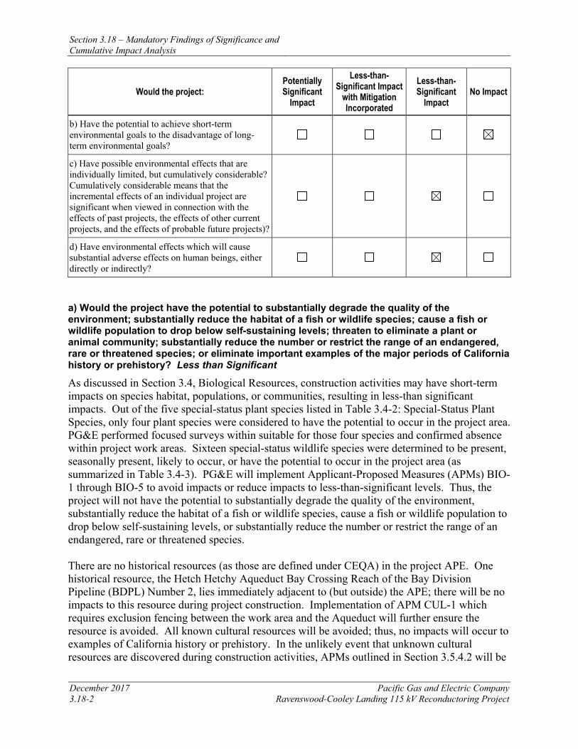
Section 3.18 – Mandatory Findings of Significance and Cumulative Impact Analysis
December 2017 Pacific Gas and Electric Company 3.18-2 Ravenswood-Cooley Landing 115 kV Reconductoring Project
Would the project: Potentially Significant
Impact
Less-than-Significant Impact
with Mitigation Incorporated
Less-than-Significant
Impact No Impact
b) Have the potential to achieve short-term environmental goals to the disadvantage of long-term environmental goals?
c) Have possible environmental effects that are individually limited, but cumulatively considerable? Cumulatively considerable means that the incremental effects of an individual project are significant when viewed in connection with the effects of past projects, the effects of other current projects, and the effects of probable future projects)?
d) Have environmental effects which will cause substantial adverse effects on human beings, either directly or indirectly?
a) Would the project have the potential to substantially degrade the quality of the environment; substantially reduce the habitat of a fish or wildlife species; cause a fish or wildlife population to drop below self-sustaining levels; threaten to eliminate a plant or animal community; substantially reduce the number or restrict the range of an endangered, rare or threatened species; or eliminate important examples of the major periods of California history or prehistory? Less than Significant
As discussed in Section 3.4, Biological Resources, construction activities may have short-term impacts on species habitat, populations, or communities, resulting in less-than significant impacts. Out of the five special-status plant species listed in Table 3.4-2: Special-Status Plant Species, only four plant species were considered to have the potential to occur in the project area. PG&E performed focused surveys within suitable for those four species and confirmed absence within project work areas. Sixteen special-status wildlife species were determined to be present, seasonally present, likely to occur, or have the potential to occur in the project area (as summarized in Table 3.4-3). PG&E will implement Applicant-Proposed Measures (APMs) BIO-1 through BIO-5 to avoid impacts or reduce impacts to less-than-significant levels. Thus, the project will not have the potential to substantially degrade the quality of the environment, substantially reduce the habitat of a fish or wildlife species, cause a fish or wildlife population to drop below self-sustaining levels, or substantially reduce the number or restrict the range of an endangered, rare or threatened species. There are no historical resources (as those are defined under CEQA) in the project APE. One historical resource, the Hetch Hetchy Aqueduct Bay Crossing Reach of the Bay Division Pipeline (BDPL) Number 2, lies immediately adjacent to (but outside) the APE; there will be no impacts to this resource during project construction. Implementation of APM CUL-1 which requires exclusion fencing between the work area and the Aqueduct will further ensure the resource is avoided. All known cultural resources will be avoided; thus, no impacts will occur to examples of California history or prehistory. In the unlikely event that unknown cultural resources are discovered during construction activities, APMs outlined in Section 3.5.4.2 will be
Section 3.18 – Mandatory Findings of Significance and Cumulative Impact Analysis
Pacific Gas and Electric Company December 2017 Ravenswood-Cooley Landing 115 kV Reconductoring Project 3.18-3
implemented to ensure that the project will not eliminate important examples of major periods of California history or prehistory. The impact will be less than significant. There are no paleontological resources known from within the project area. The project is near or on unique geologic features or formations that have paleontological sensitivity ratings ranging from PFYC 2 (low sensitivity) to PFYC 3 (moderate sensitivity). Only drilling activities affecting the moderate-sensitivity Quaternary Old Alluvial Deposits (Qoa) have the potential to affect paleontological resources. APMs outlined in Section 3.5.4.2 will be implemented to reduce potential impacts by managing unanticipated paleontological resources discoveries properly and monitoring project activities that may encounter paleontologically sensitive sediments. Impacts will be less than significant, and the project will not eliminate important examples of major periods of California paleontological prehistory. b) Would the project have the potential to achieve short-term environmental goals to the disadvantage of long-term environmental goals? No Impact
The Ravenswood-Cooley Landing 115 kV Reconductoring Project will not achieve short-term environmental goals to the disadvantage of long-term environmental goals, and will result in either no impact or less-than-significant impacts in both the short and long term. The project will be compatible with local environmental goals and will not conflict with federal or state environmental policies and regulations. Therefore, no impact will occur.
c) Would the project have possible environmental effects that are individually limited, but cumulatively considerable? Cumulatively considerable means that the incremental effects of an individual project are significant when viewed in connection with the effects of past projects, the effects of other current projects, and the effects of probable future projects)? Less than Significant
A cumulative impact analysis for each resource area is presented in Section 3.18.5. The Ravenswood-Cooley Landing 115 kV Reconductoring Project will contribute incrementally to cumulative impacts in the project area related to air quality; biological resources; cultural resources; geology, soils, and seismic potential; GHG emissions; hazards and hazardous materials; hydrology and water quality; recreation; and traffic; however, the project will not contribute substantially to those cumulative impacts. Thus, the Ravenswood-Cooley Landing Reconductoring Project will not have environmental effects that are individually limited but cumulatively considerable. Therefore, the impact will be less than significant. d) Would the project have environmental effects which will cause substantial adverse effects on human beings, either directly or indirectly? Less than Significant
The Ravenswood-Cooley Landing 115 kV Reconductoring Project will not adversely affect human beings, either directly or indirectly. Potential construction impacts associated with human health include the presence of hazards, hazardous materials use, and temporary air quality impacts. As discussed previously, construction impacts associated with air quality and with hazards and hazardous materials will be less than significant. APMs will further reduce the potential for adverse effects. The project will have a beneficial effect on human beings in the project area by increasing electrical service reliability. Therefore, the impact will be less than significant.
Section 3.18 – Mandatory Findings of Significance and Cumulative Impact Analysis
December 2017 Pacific Gas and Electric Company 3.18-4 Ravenswood-Cooley Landing 115 kV Reconductoring Project
3.18.2 CUMULATIVE IMPACTS Projects included in the cumulative impact assessment were identified by using a list approach (CEQA Guidelines Section 15130[b][1][A]), including all pending development projects within an approximately one-mile radius of the Ravenswood-Cooley Landing 115 kV Reconductoring Project area. This area includes the City of Menlo Park, City of Palo Alto, and the City of East Palo Alto. The proposed project is not expected to contribute cumulative impacts when considered along with projects located farther than 0.5 mile from the proposed project because only temporary and localized construction impacts have been identified for the proposed project. However, because the proposed project is bordered primarily by open space, PG&E extended consideration of development projects to approximately one mile from the proposed project to ensure all projects with the slightest potential to contribute to cumulative impacts were evaluated. Table 3.18-2: Cumulative Projects in the Project Vicinity summarizes these pending development projects.
Because the potential impacts related to the proposed project are construction phase related, the most relevant projects in Table 3.18-2 are either those that overlap geographically with the proposed work areas, or that occur in an overlapping time frame that could lead to potential cumulative effects on construction-related impacts such as traffic and transportation, air quality, or noise.
3.18.3 KEY PROJECTS IN THE PROJECT VICINITY Of the projects in Table 3.18-2: Cumulative Projects in the Project Vicinity, the following projects are located within the vicinity of the Ravenswood-Cooley Landing 115 kV Reconductoring Project and may overlap with its construction timeline. Therefore, additional information is provided on the timeline and status of these projects.
3.18.3.1 City of Menlo Park Facebook Campus Expansion Project
This phased project proposes two new office buildings totaling 962,400 square feet, publicly-accessible open space, retail and grocery space, a new pedestrian/bicycle bridge over Bayfront Expressway (SR-84), and a 200-room limited service hotel of approximately 174,800 square feet at the corner of Chilco Street and Bayfront Expressway. The site is located between Chilco Street and SR-84 west of the recently completed Building 20, formerly referred to as Facebook’s West Campus.
An Amended and Restated Conditional Development Permit was issued by the City of Menlo Park on December 14, 2016 to initiate construction of Phase 1. As part of Phase 1, construction of Building 21 was initiated in 2017; other components of Phase 1 will follow in 2018 and 2019 as development permits are obtained.
It is likely that the construction schedule of this project will coincide with the Ravenswood-Cooley Landing Reconductoring Project. The Facebook Campus Expansion Project is located approximately 1.13 miles from the Ravenswood-Cooley Landing Reconductoring Project area.
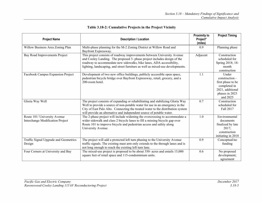
Section 3.18 – Mandatory Findings of Significance and Cumulative Impact Analysis
Pacific Gas and Electric Company December 2017 Ravenswood-Cooley Landing 115 kV Reconductoring Project 3.18-5
Table 3.18-2: Cumulative Projects in the Project Vicinity
Project Name Description / Location Proximity to
Project* (miles)
Project Timing
Willow Business Area Zoning Plan Multi-phase planning for the M-2 Zoning District at Willow Road and Bayfront Expressway.
0.9 Planning phase
Bay Road Improvements Project This project consists of roadway improvements between University Avenue and Cooley Landing. The proposed 3- phase project includes design of the roadway to accommodate new sidewalks, bike lanes, ADA accessibility, lighting, landscaping, and street furniture as well as mixed-use developments.
Adjacent Construction scheduled for
Spring 2018; 18-month
construction Facebook Campus Expansion Project Development of two new office buildings, publicly accessible open space,
pedestrian bicycle bridge over Bayfront Expressway, retail, grocery, and a 200-room hotel.
1.1 Under construction -
first phase to be completed in
2021, additional phases in 2023
and 2025 Gloria Way Well The project consists of expanding or rehabilitating and stabilizing Gloria Way
Well to provide a source of non-potable water for use in an emergency in the City of East Palo Alto. Connecting the treated water to the distribution system will provide an alternative and independent source of potable water.
0.7 Construction scheduled for
Fall 2017
Route 101/ University Avenue Interchange Modification Project
The 2-phase project will include widening the overcrossing to accommodate a wider sidewalk and class 2 bicycle lanes to fill a missing bicycle gap over Route 101 to improve bicycle and pedestrian access and safety along University Avenue.
1.0 Environmental documents
finalized by late 2017;
construction initiating in 2018
Traffic Signal Upgrade and Geometrics Design
The project will add a protected left turn phasing to the University Avenue traffic signals. The existing mast arm only extends to the through lanes and is not long enough to reach the existing left turn lane.
0.9 Conceptual/no funding
Four Corners at University and Bay The mixed-use project is proposed to be about 350- acres and entails 15,000 square feet of retail space and 115-condominium units.
0.6 No proposed development;
agreement
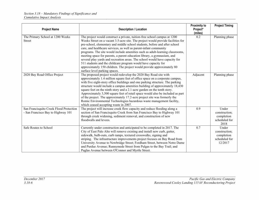
Section 3.18 – Mandatory Findings of Significance and Cumulative Impact Analysis
December 2017 Pacific Gas and Electric Company 3.18-6 Ravenswood-Cooley Landing 115 kV Reconductoring Project
Project Name Description / Location Proximity to
Project* (miles)
Project Timing
The Primary School at 1200 Weeks Street
The project would construct a private, tuition-free school campus at 1200 Weeks Street on a vacant 3.5-acre site. The project would provide facilities for pre-school, elementary and middle school students, before and after school care, and healthcare services, as well as parent-infant community programs. The site would include amenities such as adult-learning classrooms, meeting space for parents, a parent education library, a gymnasium, and several play yards and recreation areas. The school would have capacity for 511 students and the childcare program would have capacity for approximately 150 children. The project would provide approximately 80 surface level parking spaces.
0.2 Planning phase
2020 Bay Road Office Project The proposed project would redevelop the 2020 Bay Road site with approximately 1.4 million square feet of office space on a corporate campus, with five eight-story office buildings and one parking structure. The parking structure would include a campus amenities building of approximately 18,430 square feet on the ninth story and a 2.1-acre garden on the tenth story. Approximately 3,500 square feet of retail space would also be included as part of the project. The approximately 17.2-acre project site was formerly the Romic Environmental Technologies hazardous waste management facility, which ceased accepting waste in 2007.
Adjacent Planning phase
San Francisquito Creek Flood Protection - San Francisco Bay to Highway 101
The project will increase creek flow capacity and reduce flooding along a section of San Francisquito Creek from San Francisco Bay to Highway 101 through creek widening, sediment removal, and construction of new floodwalls and levees.
0.9 Under construction; completion
scheduled for 2018
Safe Routes to School Currently under construction and anticipated to be completed in 2017. The City of East Palo Alto will remove existing and install new curb, gutter, sidewalk, bulb-outs, curb ramps, textured crosswalks, signing and striping. The infrastructure improvements project focuses on Bay Road from University Avenue to Newbridge Street; Fordham Street, between Notre Dame and Purdue Avenue; Runnymede Street from Pulgas to the Bay Trail; and Puglas Avenue between O'Connor and Myrtle Street.
0.7 Under construction; completion
scheduled for 12/2017
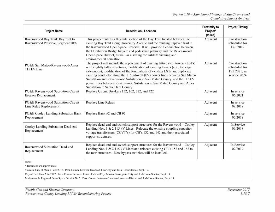
Section 3.18 – Mandatory Findings of Significance and Cumulative Impact Analysis
Pacific Gas and Electric Company December 2017 Ravenswood-Cooley Landing 115 kV Reconductoring Project 3.18-7
Project Name Description / Location Proximity to
Project* (miles)
Project Timing
Ravenswood Bay Trail: Bayfront to Ravenswood Preserve, Segment 2092
This project entails a 0.6-mile section of the Bay Trail located between the existing Bay Trail along University Avenue and the existing unpaved trail in the Ravenswood Open Space Preserve. It will provide a connection between the Dumbarton Bridge bicycle and pedestrian pathway and the Ravenswood Open Space District, as well as a setting for wildlife viewing and environmental education.
Adjacent Construction scheduled for
Fall 2019
PG&E San Mateo-Ravenswood-Ames 115 kV Line
The project will include the replacement of existing lattice steel towers (LSTs) with slightly taller structures, modification of existing towers (e.g., top cage extensions); modification of the foundations of existing LSTs and replacing existing conductor along the 115 kilovolt (kV) power lines between San Mateo Substation and Ravenswood Substation in San Mateo County, and the 115 kV power lines between Ravenswood Substation in San Mateo County and Ames Substation in Santa Clara County.
Adjacent Construction scheduled for Fall 2021; in service 2024
PG&E Ravenswood Substation Circuit Breaker Replacement
Replace Circuit Breakers 152, 162, 312, and 322. Adjacent In service 06/2021
PG&E Ravenswood Substation Circuit Line Relay Replacement
Replace Line Relays Adjacent In service 08/2019
PG&E Cooley Landing Substation Bank Replacement
Replace Bank #2 and CB 92 Adjacent In service 06/2018
Cooley Landing Substation Dead-end Replacement
Replace dead-end and switch support structures for the Ravenswood – Cooley Landing Nos. 1 & 2 115 kV Lines. Relocate the existing coupling capacitor voltage transformers (CCVT’s) for CB’s 132 and 142 and their associated support structures.
Adjacent In Service 06/2018
Ravenswood Substation Dead-end Replacement
Replace dead-end and switch support structures for the Ravenswood – Cooley Landing Nos. 1 & 2 115 kV Lines and relocate existing CB’s 152 and 162 to the new structures. New bypass switches will be installed.
Adjacent In Service 07/2019
Notes: * Distances are approximate Sources: City of Menlo Park 2017. Pers. Comm. between Deanna Chow/City and Josh Hohn/Stantec, Sept. 19. City of East Palo Alto 2017. Pers. Comm. between Kamal Fallaha/City, Maziar Bozorginia /City and Josh Hohn/Stantec, Sept. 19. Midpeninsula Regional Open Space District 2017. Pers. Comm. between Gretchen Laustsen/District and Josh Hohn/Stantec, Sept. 19.
Section 3.18 – Mandatory Findings of Significance and Cumulative Impact Analysis
December 2017 Pacific Gas and Electric Company 3.18-8 Ravenswood-Cooley Landing 115 kV Reconductoring Project
3.18.3.2 City of East Palo Alto Bay Road Improvement Plan: Phase II and III
The Bay Roads Improvement Project includes general improvements to enhance pedestrian and vehicular safety and to create a “gateway” into the Ravenswood Business District. The existing roads and infrastructure are inadequate to accommodate potential developments in the Ravenswood Business District. Much of the existing infrastructure does not meet the current minimum standards.
Phase II is between Illinois Street and Tara Road. Specific improvements include undergrounding existing local distribution overhead utilities, installing new infrastructure to serve the future needs of the Ravenswood Business District, constructing a new pavement structural section with raised medians, new curb, gutter, sidewalk, and street lighting. This project also includes tree planting, installation of irrigation systems, and improving pedestrian and bicycle access and enhancing safety.
Phase III will occur between Tara Road and the Bay Trail. The roadway in this segment will taper down from a 4-lane road at Tara Road to a 2-lane road at the Bay Trail.
It is likely that the construction schedule of this project will coincide with the Ravenswood-Cooley Landing Reconductoring Project. The Bay Road Improvement Plan Phases II and III are located adjacent to the Ravenswood-Cooley Landing 115 kV Reconductoring Project area.
Midpeninsula Regional Open Space District: Ravenswood Bay Trail
This 0.6-mile section of trail will connect the Dumbarton Bridge bicycle and pedestrian pathway to the Ravenswood Open Space District. The Ravenswood Bay Trail easement is a 0.6- mile gap in the San Francisco Bay Trail on the San Francisco Peninsula. The proposed trail will be located between the existing Bay Trail along University Avenue and the existing unpaved multi-purpose trail in the Ravenswood Open Space Preserve. The project site is adjacent to the Ravenswood-Cooley Landing Reconductoring project and spans the city limits of East Palo Alto and Menlo Park.
It is possible that the construction schedule of this project will overlap with the Ravenswood-Cooley Landing 115 kV Reconductoring Project.
3.18.4 ANALYSIS OF CUMULATIVE IMPACTS The intent of this project is to improve reliability for existing users, and no long-term impacts have been identified. Implementation of APMs will further minimize less-than-significant short-term construction impacts related to air quality, biology, cultural resources, greenhouse gases, hazards, hydrology and water quality, noise, recreation, and traffic. As shown in Chapter 3.0, for aesthetics, agricultural and forest resources, land use, minerals, population, public services, and utilities, either the project has no impacts or the impacts are so minor they would have no contribution to cumulative impacts in the area.
A discussion regarding each relevant resource area is provided below.
Section 3.18 – Mandatory Findings of Significance and Cumulative Impact Analysis
Pacific Gas and Electric Company December 2017 Ravenswood-Cooley Landing 115 kV Reconductoring Project 3.18-9
Air Quality: The air emissions from construction of the Ravenswood-Cooley Landing 115 kV Reconductoring Project, as well as the nearby projects, will contribute to the cumulative air quality issues in the SFBAAB, particularly by increasing the quantity of regional nonattainment air quality pollutants (ROG, NOx, PM10, and PM2.5). Because the air emissions will be temporary and will only occur during limited portions of the four-month construction period, the project will not have a substantial contribution to the region’s air quality. Additionally, the BAAQMD has established recommended guidelines for management of emissions during construction of projects within the region; the APMs listed in Section 3.3.4.2 that will be implemented follow those guidelines thereby further minimizing the significance of the project’s contribution to regional air quality.
Biological Resources. The project has the potential to affect biological resources, including California Ridgway’s rail, California black rail, western snowy plover, salt marsh harvest mouse, and salt marsh wandering shrew. With implementation of APMs BIO-1 through BIO-5, pre-construction surveys will be conducted, work footprints will be minimized, and construction will be scheduled outside of breeding/nesting windows, resulting in less-than-significant effects on terrestrial biological resources. In addition, the project has the potential to affect wetlands and other jurisdictional waters during construction. However, in accordance with APMs BIO-1 and BIO-5, measures will be implemented to ensure these potential effects are less than significant.
The Midpeninsula Regional Open Space District Ravenswood Bay Trail (MROSDRBT) project may also potentially affect biological resources through similar construction activities. However, the MROSDRBT project is expected to include pre-construction surveys, monitoring, habitat compensation, and other measures to minimize the potential for these effects. With implementation of the biological resources APMs presented in Section 3.4.4.2, the Ravenswood-Cooley Landing 115 kV Reconductoring Project’s less-than-significant effects will not contribute substantially to any cumulative effect on biological resources. Cultural and Paleontological Resources: Only one recorded cultural resource was identified during the records search as being located within the project APE: the Ravenswood Salt Works District; however, this resource was determined ineligible for listing on the NRHP or CRHR. One historic property listed on the NRHP, the Hetch Hetchy Aqueduct Bay Crossing Reach of the Bay Division Pipeline (BDPL) Number 2, lies outside and immediately adjacent to the APE. This resource will be avoided by PG&E during construction. Implementation of APMs CUL-1 through CUL-4 will ensure a less than significant impact to potential cultural resources during project construction, and no substantial contribution to any potential cumulative effects on unknown cultural resources from development of the other related projects.
Only drilling activities affecting the moderate-sensitivity Quaternary Old Alluvial Deposits (Qoa) have the potential to affect paleontological resources. APMs outlined in Section 3.5.4.2 will be implemented to reduce potential impacts by managing unanticipated paleontological resources discoveries properly and monitoring project activities that may encounter paleontologically sensitive sediments. However, given the moderate sensitivity of the Quaternary Old Alluvial Deposits and the limited effects of the 16-inch borings, no significant impacts to paleontological resources will occur.
Section 3.18 – Mandatory Findings of Significance and Cumulative Impact Analysis
December 2017 Pacific Gas and Electric Company 3.18-10 Ravenswood-Cooley Landing 115 kV Reconductoring Project
Other related development projects in the area, such as the Facebook Campus Expansion Project, may also potentially affect paleontological resources through excavation of foundations or pile driving; however, projects within sensitive areas do or would be expected to include monitoring and other measures to minimize the potential for these effects. With implementation of APMs, the project will have a negligible contribution to any potential cumulative effects.
Geology and Soils: The project is located in a seismically active area with underlying young geologic deposits. Geologic and seismic hazards with the greatest potential to impact the project include strong ground shaking and seismic-induced ground failure, and unconsolidated sediments with a high potential for liquefaction; however, the project will not exacerbate this potential. Rather, the proposed foundation modifications will strengthen the existing tower footings and decrease the potential effects of unstable soil. With implementation of the APMs presented in Section 3.6.4.2, which provide for appropriate engineering and construction measures, any potential impacts will be reduced to less-than-significant levels or eliminated entirely. The impacts of the project are not individually significant and will not contribute significantly to any potential hazard when considered in the context of each other and along with other related projects that have been identified for development in the area.
Greenhouse Gas Emissions: GHG emissions directly generated during construction will result in a less-than-significant, short-term impact to climate change. GHG emissions will be further reduced with implementation of APM GHG-1. As shown in Table 3.7-3, the GHG emissions from the construction phase of the project, with or without APM GHG-1, are expected to be well below South Coast Air Quality Management District’s recommended threshold of 10,000 metric tons of CO2e per year. As a result, the project will not contribute significantly to the emissions associated with the construction of other projects planned in the area, and thus it will not be cumulatively considerable.
Hazards and Hazardous Materials: All potential impacts related to hazards and hazardous materials are considered less than significant or nonexistent with implementation of the APMs described in Section 3.8.4.2. During construction activities, there is an increased potential for accidental release of fluids from a vehicle or motorized piece of equipment. Any impacts associated with such an accidental release will be reduced to a less-than-significant level by implementation of APMs. The implementation of PG&E’s standard hazardous substance control, emergency response, and health and safety procedures will further minimize less-than-significant impacts.
Additional characterization of both soils and sediments will occur to determine appropriate handling and disposal methods, as is expected for other excavation projects. Other projects in the vicinity would be expected to characterize soils and or sediments and follow applicable regulations for characterization, handling, and disposing of soils or work within areas of potentially contaminated sediments.
The impacts of the proposed project related to hazards or hazardous materials are not individually significant and cumulative effects of this and other related excavation projects will not be significant since each project must similarly follow the applicable federal and state rules and regulations required to ensure that no substantial impacts occur.
Section 3.18 – Mandatory Findings of Significance and Cumulative Impact Analysis
Pacific Gas and Electric Company December 2017 Ravenswood-Cooley Landing 115 kV Reconductoring Project 3.18-11
Hydrology and Water Quality: Project construction activities have the potential to affect water quality through the accidental release of fuels or other hazardous materials near waters, and though increased erosion potential which may lead to increased sedimentation in adjacent waters. The project would also have temporary and less than significant impacts on water quality through short term localized disturbance of sediments during cofferdam installation (see Section 3.9, Hydrology and Water Quality). The projects listed Table 3.18-2 also have the potential to affect water quality during project construction as they all include ground disturbing activities. These projects would be expected to implement similar measures to minimize erosion and prevent the discharge of hazardous materials to waters. Implementation of the APMs described in Section 3.9.4.2, including preparation of a Storm Water Pollution Prevention Plan and implementation of spill prevention and response measures, will further reduce less than significant impacts to hydrology and water quality; therefore, the project will not contribute substantially to any potential cumulative impacts on water quality.
Noise. The project will not have any long-term ambient noise level impacts. Short-term construction noise impacts may occur simultaneously at a few work locations along the overall length of the project, but will be primarily limited to daytime hours consistent with local noise ordinances. Unplanned nighttime work will be infrequent, will occur in limited locations, and will be short term. Therefore, the project will not contribute significantly to cumulative noise impacts.
Recreation. The project’s contribution to impacts on recreation will be limited to trail closures in construction work areas. This minor disruption of recreational uses would be temporary and managed through the implementation of APM REC-1. The project will not alter the demand for existing or planned recreational facilities. Therefore, the project will not contribute significantly to cumulative recreation impacts.
Transportation and Traffic. The project’s contribution to area traffic will be limited to a minor increase in vehicular traffic on roadways in the project vicinity during the construction period. This minor increase will be temporary and managed through the implementation of APMs TRA-1 and TRA-2. The minor increase will not represent a substantial increase in traffic volumes on local roads, or use of public transit, bicycle and pedestrian facilities, parking facilities, or emergency access and will not affect the overall level of service on regional roadways. Because the project involves modifications to existing facilities, it will not result in increased vehicle traffic after construction is completed. Implementation of the APMs described in Section 3.16.4 will further reduce less-than-significant impacts on transportation, and the project will not result in a cumulatively considerable contribution to any potential cumulative impacts on transportation. Although the construction schedules of some projects listed in Table 3.18-2 are unknown at this time, with proper coordination and development of traffic control plans coordinated through the municipalities, no significant cumulative construction impacts to traffic or transportation are expected to occur.
3.18.5 REFERENCES City of East Palo Alto. 2012. City Council Agenda Report: Bay Road Improvements Project,
Phase II & III. http://www.ci.east-palo-alto.ca.us/DocumentCenter/View/142. Accessed on August 18. 2017.
Section 3.18 – Mandatory Findings of Significance and Cumulative Impact Analysis
December 2017 Pacific Gas and Electric Company 3.18-12 Ravenswood-Cooley Landing 115 kV Reconductoring Project
City of East Palo Alto. 2016. Cooley Landing Park and Education Center Project Webpage. Online: http://www.ci.east-palo-alto.ca.us/index.aspx?NID=446. Accessed on August 18. 2017.
City of East Palo Alto. 2017. Gloria Way Well Webpage. Online: http://www.ci.east-palo-alto.ca.us/index.aspx?NID=449. Accessed on August 18, 2017.
City of East Palo Alto. 2017. “Issue an RFP for Gloria Way Well Water Production Alternatives Analysis and Water Security Feasibility Study.” City Council/ Redevelopment Agency. Online: http://www.ci.east-palo-alto.ca.us/DocumentCenter/View/40. Accessed on August 20, 2017.
City of East Palo Alto. 2017. Highway 101 Pedestrian/ Bicycle Overcrossing Project Webpage. Online: http://www.ci.east-palo-alto.ca.us/index.aspx?NID=182. Accessed on August 18, 2017.
City of East Palo Alto. 2017. Pad D New Municipal Water Well. Online: http://www.ci.east-palo-alto.ca.us/index.aspx?NID=611. Accessed on August 18, 2017.
City of East Palo Alto. 2017. Route 101/ University Avenue (state Route 109) Interchange Modification Project Webpage. Online: http://www.ci.east-palo-alto.ca.us/index.aspx?NID=183. Accessed on August 18, 2017.
City of East Palo Alto. 2017. Runnymeade Storm Drain Phase II. Online: http://www.ci.east-palo-alto.ca.us/index.aspx?NID=492. Accessed on August 19, 2017.
City of East Palo Alto. 2017. Traffic Signal Upgrade and Geometrics Design. Online: http://www.cityofepa.org/index.aspx?NID=487. Accessed on August 19, 2017.
City of East Palo Alto. 2017. Willow Road/ Highway 101 Interchange. Online: http://www.ci.east-palo-alto.ca.us/index.aspx?NID=486. Accessed on August 19, 2017.
City of East Palo Alto. May 2013. Ravenswood Family Health Center Bay/ Pulgas Facility Project Initial Study/ Draft Mitigated Negative Declaration. Online: http://www.ci.east-palo-alto.ca.us/DocumentCenter/View/481. Accessed on August 19, 2017.
City of East Palo Alto. 2017. San Francisquito Creek Flood Protection. Online: http://www.ci.east-palo-alto.ca.us/index.aspx?NID=486. Accessed on August 19, 2017.
City of East Palo Alto. May 2017. Notice of Preparation of Environmental Impact Report – The Primary School. Online: http://www.cityofepa.org/DocumentCenter/View/3359. Accessed on November 2, 2017.
City of East Palo Alto. May 2017. Notice of Preparation of Environmental Impact Report – 2020 Bay Road Office Project. Online: http://www.cityofepa.org/DocumentCenter/View/3361. Accessed on November 2, 2017.
Section 3.18 – Mandatory Findings of Significance and Cumulative Impact Analysis
Pacific Gas and Electric Company December 2017 Ravenswood-Cooley Landing 115 kV Reconductoring Project 3.18-13
City of East Palo Alto Community and Economic Development Department. 2013. Ravenswood / 4 Corners TOD Specific Plan. February 22, 2013. Online: http://www.cityofepa.org/ArchiveCenter/ViewFile/Item/125
________. 2017. Personal communication between Josh Hohn, Stantec Senior Planner, and Maziar Bozorginia, Senior Engineer. September 19, 2017.
________. 2017. Personal communication between Josh Hohn, Stantec Senior Planner, and Kamal Fallaha, City Engineer. September 19, 2017.
City of Menlo Park. 2017. Facebook Campus Expansion Project. Online: http://www.menlopark.org/995/Facebook-Campus-Expansion-Project. Accessed on August 18. 2017.
City of Menlo Park. 2017. MidPen Housing Webpage. Online: http://www.menlopark.org/963/MidPen-Housing. Accessed on August 18, 2017.
City of Menlo Park. 2017. Willow Business Area Zoning Plan. Online: https://menlopark.org/626/Willow-Business-Area-Zoning-Plan. Accessed on August 18, 2017.
________. 2017. Personal communication between Josh Hohn, Stantec Senior Planner, and Deanna Chow, Principal Planner. September 19, 2017.
MidPen Housing. 2017. “Much Needed Affordable Housing for Seniors Opens in Menlo Park.” Online: http://www.midpen-housing.org/news-and-media/press-releases/much-needed-affordable-housing-for-seniors-opens-in-menlo-park/. Accessed on August 20, 2017.
Midpeninsula Regional Open Space District. 2016. Bay Trail Connection at Ravenswood Open Space Preserve, Initial Study/Mitigated Negative Declaration. September 2016.
________. 2017. Personal communication between Josh Hohn, Stantec Senior Planner, and Gretchen Laustsen, Open Space Planner III. September 19, 2017.
Regional Open Space. 2017. “Fact Sheet, Ravenswood Bay Trail Project.”. Online: https://www.openspace.org/sites/default/files/20160216_RavenswoodBayTrail_FactSheet.pdf. Accessed on August 21, 2017.
Avalos, G. 2017. “Facebook campus expansion includes offices, retail, grocery store, housing.” The Mercury News. Online: http://www.mercurynews.com/2017/07/07/facebook-campus-expansion-includes-offices-retail-grocery-store-housing/. Accessed on August 20, 2017.
Mahbubani, R. “Menlo Park becomes sponsor of Highway 101 – Willow Road Interchange Project.” The Mercury News. Online: http://www.mercurynews.com/2015/06/10/menlo-park-becomes-sponsor-of-highway-101-willow-road-interchange-project/. Accessed on August 19, 2017.
Section 3.18 – Mandatory Findings of Significance and Cumulative Impact Analysis
December 2017 Pacific Gas and Electric Company 3.18-14 Ravenswood-Cooley Landing 115 kV Reconductoring Project
San Francisquito Creek Joint Powers Authority. 2017 S.F. Bay to Highway 101. Online: http://sfcjpa.org/web/projects/active/s.f.-bay-to-highway-101/. Accessed on November 2, 2017.
Tenanes, J. 2017. “Investing in Menlo Park and the Community.” Facebook. Online: https://newsroom.fb.com/news/2017/07/investing-in-menlo-park-and-our-community/.
http://www.mercurynews.com/2017/07/07/facebook-campus-expansion-includes-offices-retail-grocery-store-housing/


Appendix A Affected Properties Within 300 Feet

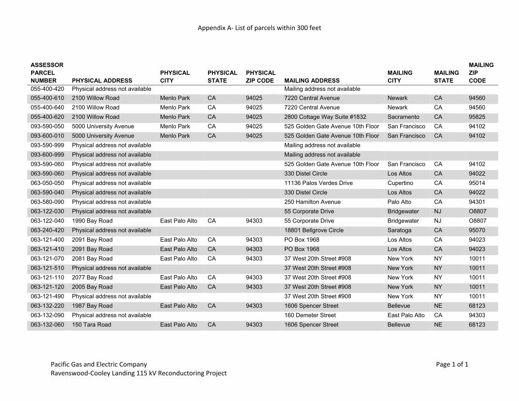
Appendix A- List of parcels within 300 feet
Pacific Gas and Electric Company Ravenswood-Cooley Landing 115 kV Reconductoring Project
Page 1 of 1
ASSESSOR PARCEL NUMBER PHYSICAL ADDRESS
PHYSICAL CITY
PHYSICAL STATE
PHYSICAL ZIP CODE MAILING ADDRESS
MAILING CITY
MAILING STATE
MAILING ZIP CODE
055-400-420 Physical address not available Mailing address not available
055-400-610 2100 Willow Road Menlo Park CA 94025 7220 Central Avenue Newark CA 94560 055-400-640 2100 Willow Road Menlo Park CA 94025 7220 Central Avenue Newark CA 94560 055-400-620 2100 Willow Road Menlo Park CA 94025 2800 Cottage Way Suite #1832 Sacramento CA 95825 093-590-050 5000 University Avenue Menlo Park CA 94025 525 Golden Gate Avenue 10th Floor San Francisco CA 94102 093-600-010 5000 University Avenue Menlo Park CA 94025 525 Golden Gate Avenue 10th Floor San Francisco CA 94102 093-590-999 Physical address not available Mailing address not available
093-600-999 Physical address not available Mailing address not available
093-590-060 Physical address not available 525 Golden Gate Avenue 10th Floor San Francisco CA 94102 063-590-060 Physical address not available 330 Distel Circle Los Altos CA 94022 063-050-050 Physical address not available 11136 Palos Verdes Drive Cupertino CA 95014 063-590-040 Physical address not available 330 Distel Circle Los Altos CA 94022 063-580-090 Physical address not available 250 Hamilton Avenue Palo Alto CA 94301 063-122-030 Physical address not available 55 Corporate Drive Bridgewater NJ O8807 063-122-040 1990 Bay Road East Palo Alto CA 94303 55 Corporate Drive Bridgewater NJ O8807 063-240-420 Physical address not available 18801 Bellgrove Circle Saratoga CA 95070 063-121-400 2091 Bay Road East Palo Alto CA 94303 PO Box 1968 Los Altos CA 94023 063-121-410 2091 Bay Road East Palo Alto CA 94303 PO Box 1968 Los Altos CA 94023 063-121-070 2081 Bay Road East Palo Alto CA 94303 37 West 20th Street #908 New York NY 10011 063-121-510 Physical address not available 37 West 20th Street #908 New York NY 10011 063-121-110 2077 Bay Road East Palo Alto CA 94303 37 West 20th Street #908 New York NY 10011 063-121-120 2005 Bay Road East Palo Alto CA 94303 37 West 20th Street #908 New York NY 10011 063-121-490 Physical address not available 37 West 20th Street #908 New York NY 10011 063-132-220 1987 Bay Road East Palo Alto CA 94303 1606 Spencer Street Bellevue NE 68123 063-132-090 Physical address not available 160 Demeter Street East Palo Alto CA 94303 063-132-060 150 Tara Road East Palo Alto CA 94303 1606 Spencer Street Bellevue NE 68123


Appendix B Native American Heritage Commission
Correspondence

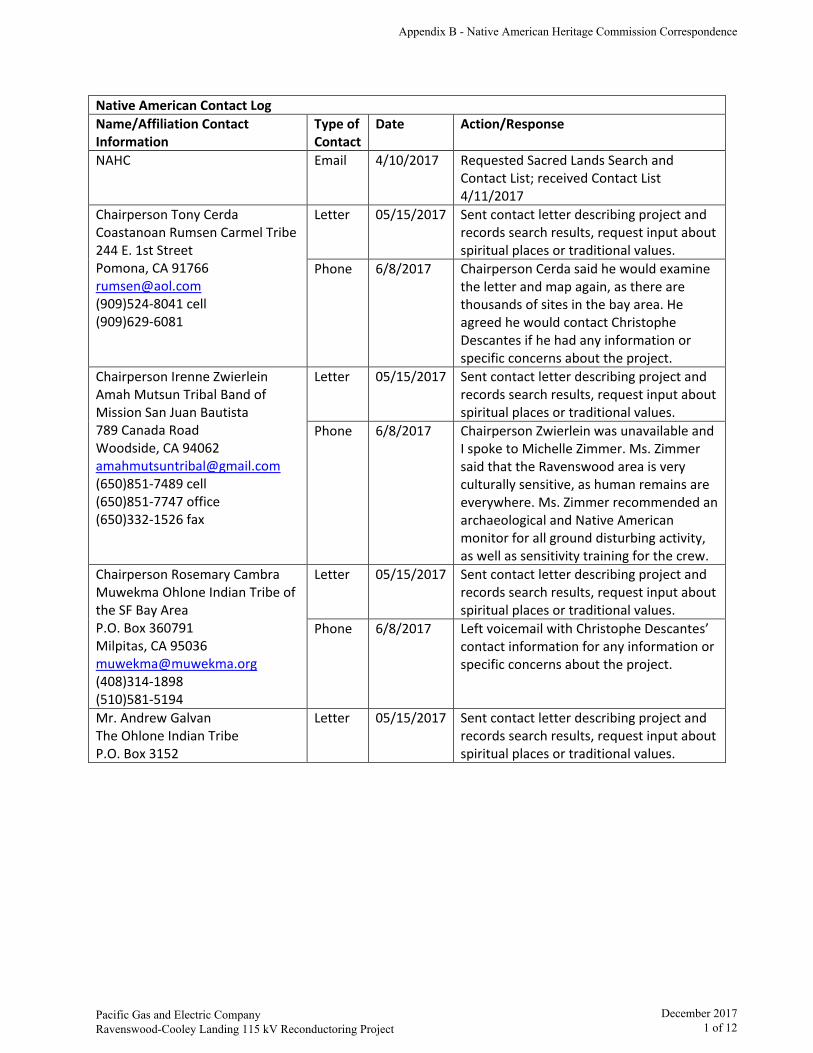
Native American Contact Log Name/Affiliation Contact Information
Type of Contact
Date Action/Response
NAHC Email 4/10/2017 Requested Sacred Lands Search and Contact List; received Contact List 4/11/2017
Chairperson Tony Cerda Coastanoan Rumsen Carmel Tribe 244 E. 1st Street Pomona, CA 91766 [email protected] (909)524-8041 cell(909)629-6081
Letter 05/15/2017 Sent contact letter describing project and records search results, request input about spiritual places or traditional values.
Phone 6/8/2017 Chairperson Cerda said he would examine the letter and map again, as there are thousands of sites in the bay area. He agreed he would contact Christophe Descantes if he had any information or specific concerns about the project.
Chairperson Irenne Zwierlein Amah Mutsun Tribal Band of Mission San Juan Bautista 789 Canada Road Woodside, CA 94062 [email protected] (650)851-7489 cell(650)851-7747 office(650)332-1526 fax
Letter 05/15/2017 Sent contact letter describing project and records search results, request input about spiritual places or traditional values.
Phone 6/8/2017 Chairperson Zwierlein was unavailable and I spoke to Michelle Zimmer. Ms. Zimmer said that the Ravenswood area is very culturally sensitive, as human remains are everywhere. Ms. Zimmer recommended an archaeological and Native American monitor for all ground disturbing activity, as well as sensitivity training for the crew.
Chairperson Rosemary Cambra Muwekma Ohlone Indian Tribe of the SF Bay Area P.O. Box 360791 Milpitas, CA 95036 [email protected] (408)314-1898(510)581-5194
Letter 05/15/2017 Sent contact letter describing project and records search results, request input about spiritual places or traditional values.
Phone 6/8/2017 Left voicemail with Christophe Descantes’ contact information for any information or specific concerns about the project.
Mr. Andrew Galvan The Ohlone Indian Tribe P.O. Box 3152
Letter 05/15/2017 Sent contact letter describing project and records search results, request input about spiritual places or traditional values.
Appendix B - Native American Heritage Commission Correspondence
Pacific Gas and Electric CompanyRavenswood-Cooley Landing 115 kV Reconductoring Project
December 20171 of 12
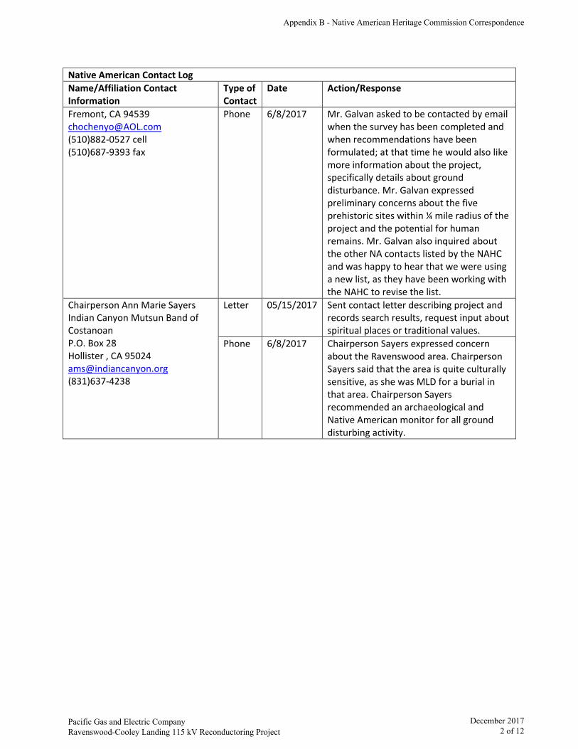
Native American Contact Log Name/Affiliation Contact Information
Type of Contact
Date Action/Response
Fremont, CA 94539 [email protected] (510)882-0527 cell(510)687-9393 fax
Phone 6/8/2017 Mr. Galvan asked to be contacted by email when the survey has been completed and when recommendations have been formulated; at that time he would also like more information about the project, specifically details about ground disturbance. Mr. Galvan expressed preliminary concerns about the five prehistoric sites within ¼ mile radius of the project and the potential for human remains. Mr. Galvan also inquired about the other NA contacts listed by the NAHC and was happy to hear that we were using a new list, as they have been working with the NAHC to revise the list.
Chairperson Ann Marie Sayers Indian Canyon Mutsun Band of Costanoan P.O. Box 28 Hollister , CA 95024 [email protected] (831)637-4238
Letter 05/15/2017 Sent contact letter describing project and records search results, request input about spiritual places or traditional values.
Phone 6/8/2017 Chairperson Sayers expressed concern about the Ravenswood area. Chairperson Sayers said that the area is quite culturally sensitive, as she was MLD for a burial in that area. Chairperson Sayers recommended an archaeological and Native American monitor for all ground disturbing activity.
Appendix B - Native American Heritage Commission Correspondence
Pacific Gas and Electric CompanyRavenswood-Cooley Landing 115 kV Reconductoring Project
December 20172 of 12
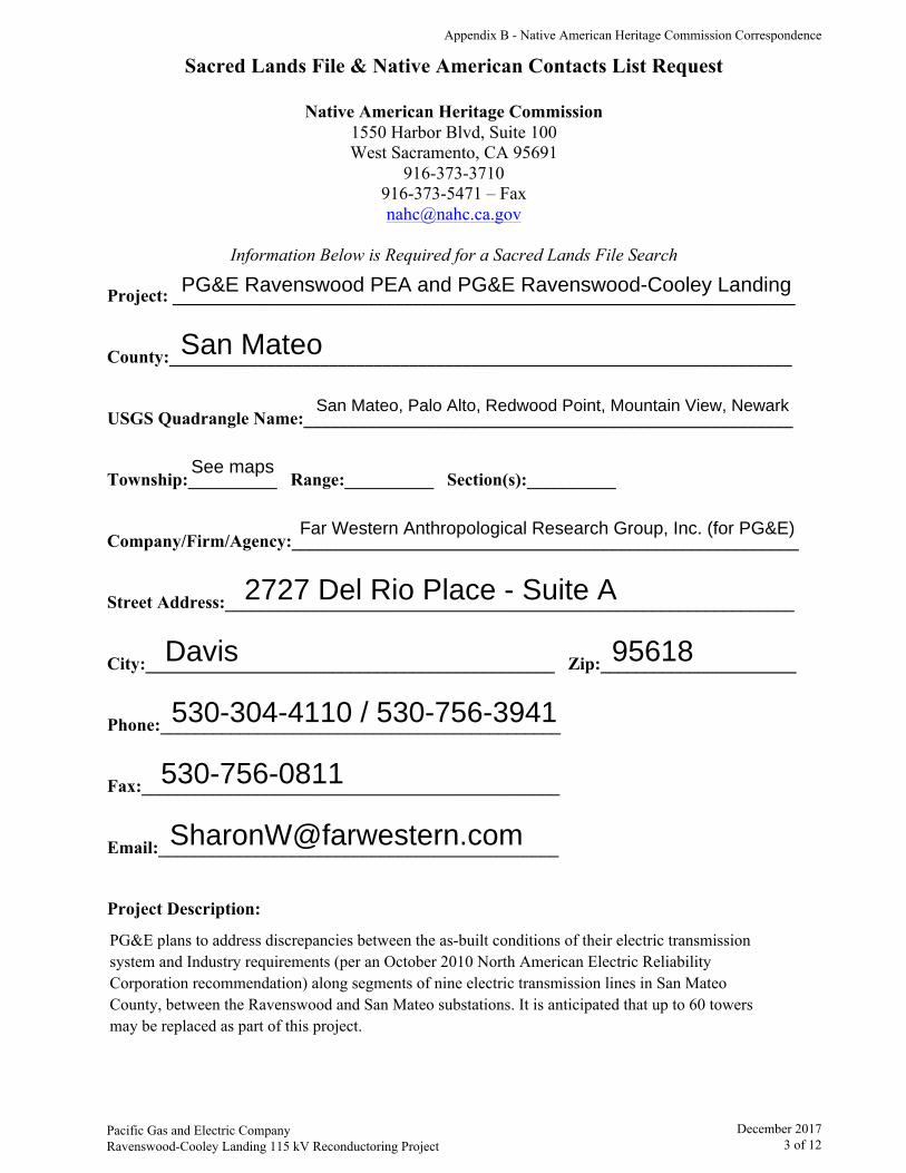
Sacred Lands File & Native American Contacts List Request
Native American Heritage Commission 1550 Harbor Blvd, Suite 100 West Sacramento, CA 95691
916-373-3710 916-373-5471 – Fax [email protected]
Information Below is Required for a Sacred Lands File Search
Project: ______________________________________________________________________
County:______________________________________________________________________
USGS Quadrangle Name:_______________________________________________________
Township:__________ Range:__________ Section(s):__________
Company/Firm/Agency:_________________________________________________________
Street Address:________________________________________________________________
City:______________________________________________ Zip:______________________
Phone:_____________________________________________
Fax:_______________________________________________
Email:_____________________________________________
Project Description:
PG&E Ravenswood PEA and PG&E Ravenswood-Cooley Landing
San Mateo
San Mateo, Palo Alto, Redwood Point, Mountain View, Newark
See maps
Far Western Anthropological Research Group, Inc. (for PG&E)
2727 Del Rio Place - Suite A
Davis 95618
530-304-4110 / 530-756-3941
530-756-0811
PG&E plans to address discrepancies between the as-built conditions of their electric transmission system and Industry requirements (per an October 2010 North American Electric Reliability Corporation recommendation) along segments of nine electric transmission lines in San Mateo County, between the Ravenswood and San Mateo substations. It is anticipated that up to 60 towersmay be replaced as part of this project.
Appendix B - Native American Heritage Commission Correspondence
Pacific Gas and Electric CompanyRavenswood-Cooley Landing 115 kV Reconductoring Project
December 20173 of 12
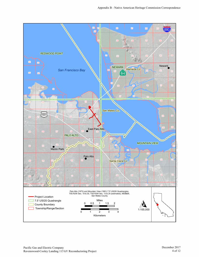
IÆ
?½
%&t(
San Francisco Bay
1111 07
06
32
23
02
29
31
02
33
09
28
08
1108
09
04
05
12
35
10
09
05
35
24
04
04
26
01
21
14
10
03
02
13
09
26
36
03
33
22
28
16
3234
34
27
25
08
05
10
03
20
27
30
08
15
32
29
05
17
23
30
14
20 21 23
19
10
2219
25
12
13
36
15
31
01
24
04
01
12
1617
32
26
18
24
141516
33
18 17
25
24
13141516
06
36
33
17 13
34
07
25
29
San Mateo Co.
Newark
Palo Alto
Menlo Park
NEWARK
PALO ALTO
MOUNTAIN VIEW
REDWOOD POINT
Alameda Co.
Santa Clara Co.
East Palo Alto
0 0.5 1 1.5 2Miles
0 1 2 3 4Kilometers
O1:100,000
Palo Alto (1973) and Mountain View (1991) 7.5' USGS Quadrangles, T5S R2W Sec. 19 & 30, T5S R3W Sec. 13 & 24 (estimated), MDB&M,
San Mateo County
H:\PG
E_Ra
vens
wood
Coole
y\NAH
C.mx
d 5
/9/20
17
Project Location7.5' USGS QuadrangleCounty Boundary Township/Range/Section
Appendix B - Native American Heritage Commission Correspondence
Pacific Gas and Electric CompanyRavenswood-Cooley Landing 115 kV Reconductoring Project
December 20174 of 12
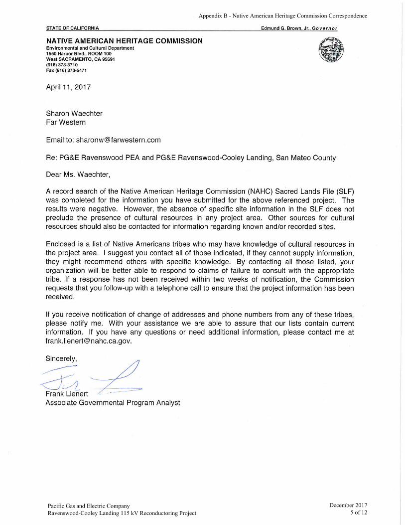
Appendix B - Native American Heritage Commission Correspondence
Pacific Gas and Electric CompanyRavenswood-Cooley Landing 115 kV Reconductoring Project
December 20175 of 12
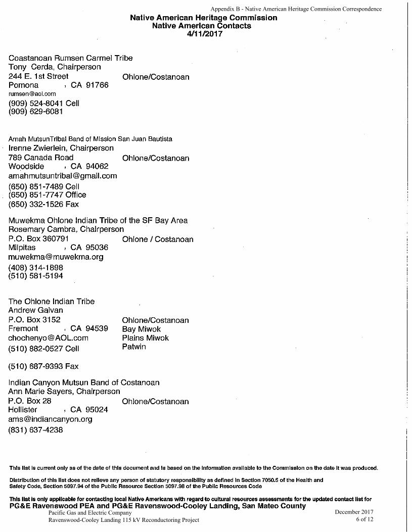
Appendix B - Native American Heritage Commission Correspondence
Pacific Gas and Electric CompanyRavenswood-Cooley Landing 115 kV Reconductoring Project
December 20176 of 12

Pacific Gas and Electric Company
Christophe Descantes, PhD Sr. Cultural Resources Specialist Environmental Management - Transmission
245 Market Street — N10A San Francisco, CA 94105 Tel: (415) 973.1177 Mobile: (925) 719.2740 Email: [email protected]
May 15, 2017
Chairperson Tony Cerda Coastanoan Rumsen Carmel Tribe 244 E. 1st Street Pomona, CA 91766
RE: Proposed PG&E Ravenswood-Cooley Landing Project, San Mateo County, California
Dear Chairperson Cerda,
Pacific Gas and Electric (PG&E) proposes to reinforce the electric transmission system in San Mateo County by replacing the conductors (a process referred to as reconductoring) on the two 1.62-mile Ravenswood – Cooley Landing 115 kV power lines (Ravenswood – Cooley Landing Lines) (see Enclosure 1).
A search of the Sacred Lands file by the Native American Heritage Commission did not indicate the presence of Native American cultural resources in the area. Two records searches were performed by the Northwest Information Center (NWIC) in Rohnert Park, California to cover the area. The first records search was conducted on March 27, 2017 and the second on May 1, 2017. The searches included the transmission lines, four towers, and a 1/4-mile radius record search area. The searches and literature reviews identified eight cultural resources within the search area, only one of which intersects the project area: an historic-era resource. Thirty previous studies have been performed within the records search area, 12 of which intersect the project area. While segments of the project area have been previously surveyed, a new survey is scheduled for this project.
At this time we are requesting information from the local Native American community on this proposed project. If you have information or specific concerns you would like to have considered during the course of PG&E’s planning, please contact me at (415) 973-1177, or by email at [email protected]. Thank you very much for your time and effort.
Best Regards,
Christophe Descantes Sr. Cultural Resources Specialist
Enclosure 1 – Project Location Map
Appendix B - Native American Heritage Commission Correspondence
Pacific Gas and Electric Company Ravenswood-Cooley Landing 115 kV Reconductoring Project
December 2017 7 of 12

IÆ
?½
%&t(
San Francisco Bay
1111 07
06
32
23
02
29
31
02
33
09
28
08
1108
09
04
05
12
35
10
09
05
35
24
04
04
26
01
21
14
10
03
02
13
09
26
36
03
33
22
28
16
3234
34
27
25
08
05
10
03
20
27
30
08
15
32
29
05
17
23
30
14
20 21 23
19
10
2219
25
12
13
36
15
31
01
24
04
01
12
1617
32
26
18
24
141516
33
18 17
25
24
13141516
06
36
33
17 13
34
07
25
29
San Mateo Co.
Newark
Palo Alto
Menlo Park
NEWARK
PALO ALTO
MOUNTAIN VIEW
REDWOOD POINT
Alameda Co.
Santa Clara Co.
East Palo Alto
0 0.5 1 1.5 2Miles
0 1 2 3 4Kilometers
O1:100,000
Palo Alto (1973) and Mountain View (1991) 7.5' USGS Quadrangles, T5S R2W Sec. 19 & 30, T5S R3W Sec. 13 & 24 (estimated), MDB&M,
San Mateo County
H:\PG
E_Ra
vens
wood
Coole
y\NAH
C.mx
d 5
/9/20
17
Project Location7.5' USGS QuadrangleCounty Boundary Township/Range/Section
Appendix B - Native American Heritage Commission Correspondence
Pacific Gas and Electric Company Ravenswood-Cooley Landing 115 kV Reconductoring Project
December 2017 8 of 12

Pacific Gas and Electric Company
Christophe Descantes, PhD Sr. Cultural Resources Specialist Environmental Management - Transmission
245 Market Street — N10A San Francisco, CA 94105 Tel: (415) 973.1177 Mobile: (925) 719.2740 Email: [email protected]
May 15, 2017
Chairperson Irenne Zwierlein Amah Mutsun Tribal Band of Mission San Juan Bautista 789 Canada Road Woodside, CA 94062
RE: Proposed PG&E Ravenswood-Cooley Landing Project, San Mateo County, California
Dear Chairperson Zwierlein,
Pacific Gas and Electric (PG&E) proposes to reinforce the electric transmission system in San Mateo County by replacing the conductors (a process referred to as reconductoring) on the two 1.62-mile Ravenswood – Cooley Landing 115 kV power lines (Ravenswood – Cooley Landing Lines) (see Enclosure 1).
A search of the Sacred Lands file by the Native American Heritage Commission did not indicate the presence of Native American cultural resources in the area. Two records searches were performed by the Northwest Information Center (NWIC) in Rohnert Park, California to cover the area. The first records search was conducted on March 27, 2017 and the second on May 1, 2017. The searches included the transmission lines, four towers, and a 1/4-mile radius record search area. The searches and literature reviews identified eight cultural resources within the search area, only one of which intersects the project area: an historic-era resource. Thirty previous studies have been performed within the records search area, 12 of which intersect the project area. While segments of the project area have been previously surveyed, a new survey is scheduled for this project.
At this time we are requesting information from the local Native American community on this proposed project. If you have information or specific concerns you would like to have considered during the course of PG&E’s planning, please contact me at (415) 973-1177, or by email at [email protected]. Thank you very much for your time and effort.
Best Regards,
Christophe Descantes Sr. Cultural Resources Specialist
Enclosure 1 – Project Location Map
Appendix B - Native American Heritage Commission Correspondence
Pacific Gas and Electric Company Ravenswood-Cooley Landing 115 kV Reconductoring Project
December 2017 9 of 12

Pacific Gas and Electric Company
Christophe Descantes, PhD Sr. Cultural Resources Specialist Environmental Management - Transmission
245 Market Street — N10A San Francisco, CA 94105 Tel: (415) 973.1177 Mobile: (925) 719.2740 Email: [email protected]
May 15, 2017
Chairperson Rosemary Cambra Muwekma Ohlone Indian Tribe of the SF Bay Area P.O. Box 360791 Milpitas, CA 95036
RE: Proposed PG&E Ravenswood-Cooley Landing Project, San Mateo County, California
Dear Chairperson Cambra,
Pacific Gas and Electric (PG&E) proposes to reinforce the electric transmission system in San Mateo County by replacing the conductors (a process referred to as reconductoring) on the two 1.62-mile Ravenswood – Cooley Landing 115 kV power lines (Ravenswood – Cooley Landing Lines) (see Enclosure 1).
A search of the Sacred Lands file by the Native American Heritage Commission did not indicate the presence of Native American cultural resources in the area. Two records searches were performed by the Northwest Information Center (NWIC) in Rohnert Park, California to cover the area. The first records search was conducted on March 27, 2017 and the second on May 1, 2017. The searches included the transmission lines, four towers, and a 1/4-mile radius record search area. The searches and literature reviews identified eight cultural resources within the search area, only one of which intersects the project area: an historic-era resource. Thirty previous studies have been performed within the records search area, 12 of which intersect the project area. While segments of the project area have been previously surveyed, a new survey is scheduled for this project.
At this time we are requesting information from the local Native American community on this proposed project. If you have information or specific concerns you would like to have considered during the course of PG&E’s planning, please contact me at (415) 973-1177, or by email at [email protected]. Thank you very much for your time and effort.
Best Regards,
Christophe Descantes Sr. Cultural Resources Specialist
Enclosure 1 – Project Location Map
Appendix B - Native American Heritage Commission Correspondence
Pacific Gas and Electric Company Ravenswood-Cooley Landing 115 kV Reconductoring Project
December 2017 10 of 12
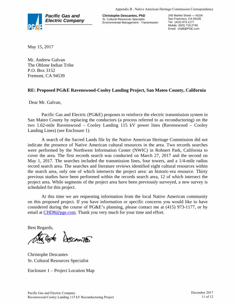
Pacific Gas and Electric Company
Christophe Descantes, PhD Sr. Cultural Resources Specialist Environmental Management - Transmission
245 Market Street — N10A San Francisco, CA 94105 Tel: (415) 973.1177 Mobile: (925) 719.2740 Email: [email protected]
May 15, 2017
Mr. Andrew Galvan The Ohlone Indian Tribe P.O. Box 3152 Fremont, CA 94539
RE: Proposed PG&E Ravenswood-Cooley Landing Project, San Mateo County, California
Dear Mr. Galvan,
Pacific Gas and Electric (PG&E) proposes to reinforce the electric transmission system in San Mateo County by replacing the conductors (a process referred to as reconductoring) on the two 1.62-mile Ravenswood – Cooley Landing 115 kV power lines (Ravenswood – Cooley Landing Lines) (see Enclosure 1).
A search of the Sacred Lands file by the Native American Heritage Commission did not indicate the presence of Native American cultural resources in the area. Two records searches were performed by the Northwest Information Center (NWIC) in Rohnert Park, California to cover the area. The first records search was conducted on March 27, 2017 and the second on May 1, 2017. The searches included the transmission lines, four towers, and a 1/4-mile radius record search area. The searches and literature reviews identified eight cultural resources within the search area, only one of which intersects the project area: an historic-era resource. Thirty previous studies have been performed within the records search area, 12 of which intersect the project area. While segments of the project area have been previously surveyed, a new survey is scheduled for this project.
At this time we are requesting information from the local Native American community on this proposed project. If you have information or specific concerns you would like to have considered during the course of PG&E’s planning, please contact me at (415) 973-1177, or by email at [email protected]. Thank you very much for your time and effort.
Best Regards,
Christophe Descantes Sr. Cultural Resources Specialist
Enclosure 1 – Project Location Map
Appendix B - Native American Heritage Commission Correspondence
Pacific Gas and Electric Company Ravenswood-Cooley Landing 115 kV Reconductoring Project
December 2017 11 of 12

Pacific Gas and Electric Company
Christophe Descantes, PhD Sr. Cultural Resources Specialist Environmental Management - Transmission
245 Market Street — N10A San Francisco, CA 94105 Tel: (415) 973.1177 Mobile: (925) 719.2740 Email: [email protected]
May 15, 2017
Chairperson Ann Marie Sayers Indian Canyon Mutsun Band of Costanoan P.O. Box 28 Hollister , CA 95024
RE: Proposed PG&E Ravenswood-Cooley Landing Project, San Mateo County, California
Dear Chairperson Sayers,
Pacific Gas and Electric (PG&E) proposes to reinforce the electric transmission system in San Mateo County by replacing the conductors (a process referred to as reconductoring) on the two 1.62-mile Ravenswood – Cooley Landing 115 kV power lines (Ravenswood – Cooley Landing Lines) (see Enclosure 1).
A search of the Sacred Lands file by the Native American Heritage Commission did not indicate the presence of Native American cultural resources in the area. Two records searches were performed by the Northwest Information Center (NWIC) in Rohnert Park, California to cover the area. The first records search was conducted on March 27, 2017 and the second on May 1, 2017. The searches included the transmission lines, four towers, and a 1/4-mile radius record search area. The searches and literature reviews identified eight cultural resources within the search area, only one of which intersects the project area: an historic-era resource. Thirty previous studies have been performed within the records search area, 12 of which intersect the project area. While segments of the project area have been previously surveyed, a new survey is scheduled for this project.
At this time we are requesting information from the local Native American community on this proposed project. If you have information or specific concerns you would like to have considered during the course of PG&E’s planning, please contact me at (415) 973-1177, or by email at [email protected]. Thank you very much for your time and effort.
Best Regards,
Christophe Descantes Sr. Cultural Resources Specialist
Enclosure 1 – Project Location Map
Appendix B - Native American Heritage Commission Correspondence
Pacific Gas and Electric Company Ravenswood-Cooley Landing 115 kV Reconductoring Project
December 2017 12 of 12

Appendix C List of Preparers

Appendix C - List of Preparers
Pacific Gas and Electric Company December 2017 Ravenswood-Cooley Landing 115 kV Reconductoring Project 1
LIST OF PREPARERS
The following PG&E staff and consultants participated in preparation of this Proponent’s Environmental Assessment:
PEA Project Management Tober Francom/PG&E Brandon Liddell/PG&E Scott Oppelt/Stantec
Project Description Scott Oppelt/Stantec
Aesthetics Josh Hohn/Stantec
Air Quality and Greenhouse Gas Emissions Elena Nuno/Stantec
Biological Resources Steve Rottenborn/H.T. Harvey & Associates Danielle Tannourji/H.T. Harvey & Associates
Cultural and Paleontological Resources Sharon Waechter/Far Western Kim Carpenter/Far Western Geraldine Aron/Paleo Solutions Inc. (paleontological resources)
Agriculture and Forest Resources, Land Use and Planning, Mineral Resources, Population and Housing, Public Services, Recreation, Utilities and System Services, and Mandatory Finds of Significance and Cumulative Impacts
Josh Hohn/Stantec Amanda Peterson Smith/Stantec Scott Oppelt/Stantec
Geology and Soils, Hazards and Hazardous Materials, and Hydrology and Water Quality Mary Stallard/Montclair Environmental Management
Noise Tyler Rynberg/Stantec
Transportation and Traffic Joanna Liu/Stantec