DRAFT ENVIRONMENTAL IMPACT ASSESSMENT REPORT ...
388
D R A F T E N V I R O N M E N T A L I M P A C T A S S E S S M E N T R E P O R T O F M s V I R G I N R O C K P V T L T D M i n i n g of C ol o u r G r an i t e R oad M e t al M i n e r al Was t e M a n ag i n g D i r e c t or D R a m M a n o h a r N ai d u P l ot N o s t F l o or S r i n i v as aN ag ar F e e t R oa d P S N M i l l Ju n c t i o n S r i k ak u l a m A n d h r aP r ad e s h S i t e A d d r e s s L e as e A r e a H a S yN o B o n t h u V i l l ag e S ar av ak o t aM a n d al S r i k a k u l a m A n d h r aP r ad e s h P r od u c t i o n C ap a c i t y C ol o u r G r an i t e – m A n n u m R oa d M e t al G r a n i t e Was t e – m A n n u m P r i m ar y B a s e l i n e D at a C ol l e c t e d D e c e m b e r ’ t o F e b r u ar y’ A p p r ove d T oR L r N o S E I A A A P S K L M M I N –D t S e c t o r – M i n i n gof M i n e r al s C a t e g o r y–B at p ar w i t h B P R E P A R E D B Y H O B l o c k B B I D A A ut o na g a r V i s a k ha pa t na m P h F a x E m a i l s v e nvi r o_ l a b s @ y a hooc oi n P h Q C I N A B E T N A B L A c c r e d i t e d R e c og ni z e dby M O E F C C N e w D e l h i JU L Y S V E L C V R P L D R A F T E I A
-
Upload
khangminh22 -
Category
Documents
-
view
2 -
download
0
Transcript of DRAFT ENVIRONMENTAL IMPACT ASSESSMENT REPORT ...

DRAFT ENVIRONMENTAL IMPACT ASSESSMENT REPORT
OF
M/s VIRGIN ROCK PVT. LTD. Mining of Colour Granite & Road Metal (Mineral Waste)
Managing Director: D. Ram Manohar Naidu Plot No: 32, 1st Floor,
Srinivasa Nagar, 80 Feet Road, PSN Mill Junction,
Srikakulam - 532002 Andhra Pradesh
Site Address Lease Area: 6.0 Ha.
Sy. No: 1, Bonthu Village, Saravakota Mandal, Srikakulam - 532428
Andhra Pradesh
Production Capacity Colour Granite – 10148.0544 m3/Annum
Road Metal (Granite Waste) – 40592.2176 m3/Annum Primary Baseline Data Collected: December’ 2020 to February’ 2021
Approved ToR Lr. No: SEIAA/AP/SKLM/MIN/10/2020/2205–149 Dt: 21.06.2021
Sector: 01 – Mining of Minerals, Category –B2 at par with B1
PREPARED BY
H.O:Block-B, B-1, IDA, Autonagar -12, Visakhapatnam
Ph: 0891-2755528, Fax: 0891-2755529, E-mail: [email protected] Ph: 9440338628
QCI NABET & NABL Accredited & Recognized by MOEF&CC, New Delhi.
JULY 2021
SVELC/VRPL-6.0/DRAFT/EIA


UNDERTAKING
(As per MoEF OM No. 11013/41/2006-IA.II (I) dt: 05.10.2011)
I, the undersigned Mr. D. Ram Manohar Naidu, Managing Director of proposed
Colour Granite and Road Metal (Granite waste) mine in the name of M/s Virgin Rock
Pvt. Ltd. over an extent of 6.0 Ha., located at Sy. No. 1 of Bonthu Village, Saravakota
Mandal, Srikakulam District, Andhra Pradesh do hereby solemnly affirm and declare
that SV Enviro Labs & Consultants located at Enviro House, Block –B, B-1, IDA,
Autonagar, Visakhapatnam -12 has obtained ToRs for our mine to obtain
Environmental Clearance under the EIA notification, 2006.
As a Project proponent, I undertake that the present Draft EIA study report of the
mining project of M/s Virgin Rock Pvt. Ltd.located at Sy. No: 1 of Bonthu Village,
Saravakota Mandal, Srikakulam District is entirely with the prescribed ToRs.
And further, I endorse all the data and information of the EIA report, as presented by
EIA consultant SV Enviro Labs & Consultants to be accurate, true and correct and I
own the responsibility for the same.
Thanks & Regards
For M/s Virgin Rock Pvt. Ltd.
Mr. D. Ram Manohar Naidu
Managing Director

DECLARATION BY EXPERTS CONTRIBUTING TO THE EIA
“Draft Environmental Impact Assessment for the
waste) mine with production capacity
respectively in an area of 6.0 Hectares
Srikakulam District, Andhra Pradesh by
Ram Manohar Naidu.
I hereby certify that I was a part of the EIA team in the following capacity that developed the
above EIA.
EIA Co-ordinator
Name :
Signature :
Functional Area Experts :
S.No Functional
Areas
Name of the
Expert
1. EIA
Coordinator
K. Anitha
2. AP * M. Murali Krishna
V. Hemalatha (TM)
K. Anitha (TM)
3. WP * V. Hemalatha
4. SHW * K. Anitha
5. SE * Dr. B. Vijay Bhaskara
Rao
6. EB * Dr. M. Tarakeswara
Naidu
7. HG * Dr. G.V.A
Ramakrishna
DECLARATION BY EXPERTS CONTRIBUTING TO THE EIA
Environmental Impact Assessment for the Colour Granite and Road Metal
production capacity 10148.0544 m3/Annum and 40592.2176
Hectares at Sy. No: 1 of Bonthu Village, Saravakota
, Andhra Pradesh by M/s Virgin Rock Pvt. Ltd. Managing Partner: D.
I hereby certify that I was a part of the EIA team in the following capacity that developed the
K. Anitha
Name of the Category as per NABET
Involvement (Period and task**)
A Mining
M. Murali Krishna
V. Hemalatha (TM)
Anitha (TM)
A Air Pollution monitoring, prevention & control
V. Hemalatha A Water Pollution monitoring, prevention & control
A Solid waste management
Dr. B. Vijay Bhaskara A Socioeconomic studies
Dr. M. Tarakeswara A Ecology and Bio-diversity
Dr. G.V.A
Ramakrishna
A Hydrology
DECLARATION BY EXPERTS CONTRIBUTING TO THE EIA
Road Metal (Granite
40592.2176 m3/Annum
Saravakota Mandal,
Managing Partner: D.
I hereby certify that I was a part of the EIA team in the following capacity that developed the
Signature and Date

8. GEO * Dr. G.V.A
Ramakrishna
9. SC * M.Tarakeswara Naidu
10. AQ * M. Murali Krishna
11. NV * M. Murali Krishna
12. LU * Dr. G.V.A Ramakrishna
13. RH * Shaik Kasim
*One TM against each FAE may be shown
** Please attach additional sheet if required
Dr. G.V.A
Ramakrishna
A
Geology
.Tarakeswara Naidu A Soil conservation
M. Murali Krishna A Air quality
modelling
M. Murali Krishna A Noise and
vibration
Dr. G.V.A Ramakrishna
A Land use studies
Shaik Kasim A Risk and hazard
study
*One TM against each FAE may be shown
additional sheet if required
Declaration by the Head of the accredited consultant organization/ authorized person
I, M. Murali Krishna, hereby, confirm that the above mentioned experts prepared the Draft
EIA for Colour Granite and Road Metal (Granite waste) mine with production capacity
10148.0544 m3/Annum and 40592.2176 m3/Annum respectively in an area of 6.0 Hectares at
Sy. No: 1 of Bonthu Village, Saravakota Mandal, Srikakulam District, Andhra Pradesh by
M/s Virgin Rock Pvt. Ltd. Managing Partner: D. Ram Manohar Naidu.
Signature:
Name: M. Murali Krishna
Designation: Managing Partner
Name of the EIA consultant organization: SV Enviro Labs & Consultants
NABET Certificate No & Issue Date: NABET/EIA/1821/SA 0118 Dt: 28.09.2020 and valid
up to 24.04.2021.
NABET Extension No & Issue Date: QCI/NABET/ENV/ACO/21/1716 Dt: 22.04.2021 and
valid up to 21.07.2021.

INDEX
S.No TITLE PAGE No.
Executive Summary
ToR Compliance
Chapter -I:- Introduction
1.0 Introduction 1-1
1.1 Purpose of the project 1-1
1.2 Details of the project & identification of project proponent 1-3
1.3 Legal status of the project 1-4
1.4 Brief description of the project 1-5
1.5 Project nature, size and location 1-5
1.5.1 Nature 1-5
1.5.2 Size 1-6
1.5.3 Location 1-6
1.5.4 Accessibility 1-6
1.6 Regulatory compliances & applicable laws/regulations 1-8
1.7 Objectives of EIA Study 1-8
1.8 Environmental parameters anticipated in the study area 1-8
1.9 Generic structure of EIA document 1-9
1.10 Post Environment clearance monitoring 1-10
Chapter -II :-Project Description
2.0 General 2-1
2.1 Description of the project 2-1
2.2 Location details 2-2
2.3 Geology and exploration 2-7
2.3.1 Physiography 2-7
2.3.2 Regional geology 2-8
2.3.3 Local geology 2-9
2.4 Reserves 2-10
2.5 Method of mining 2-12

2.6 Details of production 2-14
2.7 Wastedump management 2-17
2.8 Conceptual plan 2-17
2.8.1 Mine drainage 2-19
2.8.2 Land use 2-19
2.8.3 Mine Closure plan 2-20
2.8.4 Mining machinery 2-20
2.8.5 Site services 2-20
2.8.6 Water requirement 2-20
2.9 Employment potential 2-21
Chapter -III:-Description Of the Environment
3.0 Introduction 3-1
3.1 Study area 3-1
3.2 Study period 3-1
3.3 Methodology of EIA study 3-1
3.4 Collection of baseline data 3-2
3.4.1 Micro meteorological data 3-2
3.4.2 Winds 3-4
3.5 Air Environment 3-7
3.5.1 Selection of sampling locations 3-7
3.5.2 Methodology of sampling and analysis 3-7
3.5.3 Frequency of Sampling 3-7
3.5.4 Existing ambeint air quality 3-13
3.6 Water environment 3-13
3.6.1 Surface water and ground water quality assessment 3-14
3.6.2 Selection of sampling locations 3-14
3.6.3 Sampling techniques 3-14
3.6.4 Analytical techniques 3-15
3.6.5 Water sampling Stations 3-17
3.6.6 Ground water quality of the study area 3-19
3.6.7 Summary of groundwater quality 3-21
3.6.8 Surface water quality of the study area 3-22

3.6.9 Surface water quality results are summarized 3-23
3.7 Soil quality 3-23
3.7.1 Selection of sampling locations 3-23
3.7.2 Sampling and analytical techniques 3-24
3.7.3 Details of soil sampling locations 3-25
3.7.4 Soil analysis results in the study area 3-27
3.7.5 Summary of soil analysis data 3-27
3.7.6 Standard soil classification 3-28
3.8 Noise environment 3-29
3.8.1 Identification of sampling locations 3-29
3.8.2 Methodology 3-30
3.8.3 Noise monitoring locations 3-30
3.8.4 Description of locations 3-30
3.8.5 Noise levels in the study area 3-32
3.9 Geology and hydrogeology 3-34
3.9.1 Physiography 3-34
3.9.2 Drainage 3-34
3.9.3 Geomorphology 3-34
3.9.4 Geology 3-35
3.9.5 Hydrogeology 3-37
3.10 Land use/ land cover 3-42
3.10.1 Methodology 3-43
3.10.2 Digital Elevation Maps 3-50
3.10.3 Contour map 3-50
3.10.4 Drainage map 3-50
3.11 Biological Environment 3-54
3.12 Socio-economic environment 3-74
Chapter -IV:-Anticipated Environmental Impacts & Mitigation Measures
4.0 Introduction 4-1
4.1 Impacts on air quality 4-8
4.1.1 Quantities estimation of impacts on air environment 4-8
4.1.2 Source of dust emission 4-8

4.1.3 Emission details 4-9
4.1.4 Meteorological data 4-9
4.1.5 Assumption made in the prediction of air pollution impacts 4-9
4.1.6 Summary of predicted ground level concentrations of particular matter
4-10
4.1.7 Air quality mitigation measures 4-10
4.2 Water environment 4-11
4.2.1 Impacts on surface water bodies and control measures 4-11
4.2.2 Rain water harvesting 4-12
4.2.3 Impacts on ground water table 4-12
4.3 Land Environment 4-12
4.3.1 Solid waste generation 4-13
4.3.2 Soil Erosion 4-13
4.3.3 Reclamation of degraded areas 4-13
4.3.4 Program of Afforestation 4-14
4.3.5 Impact on land use and reclamation measures 4-14
4.4 Noise environment and vibrations 4-15
4.4.1 Impact due to noise and vibration 4-15
4.4.2 Noise control measures 4-16
4.5 Solid waste generation and stacking of wastes 4-16
4.6 Biological environment 4-17
4.6.1 Impacts on biological environment 4-17
4.6.2 Mitigation measures 4-17
4.6.3 Greenbelt development 4-18
4.7 Traffic analysis 4-19
4.7.1 Impact on road network 4-19
4.8 Socio-economic conditions 4-20
4.8.1 Impact on socio-economic conditions 4-20
4.8.2 Imapct on Human settlement 4-20
4.9 Impact on occupational health & safety 4-21
Chapter -V:- Analysis of Alternatives
5.0 General 5-1

5.1 Alternate technology 5-1
5.2 Alternative site 5-1
Chapter -VI:-Environmental Monitoring Programme
6.0 Environmental monitoring 6-1
6.1 Environment management 6-1
6.2 Monitoring around the mine site 6-2
6.3 Post project monitoring programme 6-2
6.3.1 Environmental monitoring 6-2
6.4 Monitoring schedule for environmental parameters 6-3
6.5 Implementation schedule 6-3
6.6 Monitoring equipment and consumables 6-4
Chapter -VII:-Additional Studies
7.0 Public consultation 7-1
7.1 Risk assessment 7-1
7.1.1 Drilling risks 7-2
7.1.2 Failure of slope in the pit 7-2
7.1.3 Filling up the mine pit due to excessive rains 7-3
7.1.4 Accidents of heavy machinery 7-3
7.2 Disaster management plan 7-3
7.3 Implementation of EMP and monitoring system 7-4
7.3.1 General 7-4
7.3.2 Implementation 7-5
7.4 Activites to be monitored/inspected by EMC 7-6
7.4.1 Land erosion 7-6
7.4.2 Drainage 7-6
7.4.3 Re-vegetation and green belt development 7-6
7.4.4 Occupational health 7-7
7.4.5 Operational and Maintenance 7-8
7.5 Compliance for additional Terms of Reference 7-8
7.5.1 Tree enumeration with vegetation 7-9
7.5.2 Plan for compensatory afforestation 7-27

Chapter –VIII:-Project Benefits
8.0 General 8-1
8.1 Employment 8-1
8.2 Occupational health 8-1
8.3 Improvements in physical and social infrastructure 8-1
8.3.1 Improvement in the physical infrastructure 8-2
8.3.2 Improvement in the social infrastructure 8-2
8.3.3 Prevention of illegal mining & contribution to the exchequer 8-2
8.3.4 Enhancement of green cover 8-3
8.4 Other tangible benefits 8-3
Chapter –IX:-Environmental Management Plan
9.0 Introduction 9-1
9.1 Corporate environment responsibility 9-4
9.2 Objectives of environmental management plan 9-5
9.3 Air quality management 9-5
9.3.1 Air pollution control measures 9-6
9.3.2 Controlling of other emissions 9-6
9.4 Water quality management 9-6
9.5 Noise level monitoring 9-7
9.5.1 Parameters 9-7
9.5.2 Methodology 9-7
9.5.3 Noise quality management 9-7
9.5.4 Noise pollution control 9-8
9.6 Water consumption and waste water generation 9-8
9.7 Biological management 9-9
9.7.1 Tree plantation program 9-10
9.7.2 Mine drainage 9-10
9.8 Soil management 9-10
9.9 Land environment 9-11
9.9.1 Land use 9-11
9.9.2 Mine roads 9-11

9.9.3 Proposed mitigation measures 9-11
9.10 Socio-economic environment & safety 9-12
9.11 Biological management plan 9-13
9.11.1 Greenbelt development/Afforestation plan 9-13
9.11.2 Criteria for selection of species 9-13
9.11.3 Design of grendevelopment 9-14
9.12 Occupational health and safety measures 9-15
9.12.1 Public health Implication, Occupational Health survey program and First aid
9-16
9.13 Project cost 9-17
Chapter –X:-Summary & Conclusion
10.0 Summary & conclusion 10-1
10.1 Need of the project 10-2
10.2 Salient features of the project 10-2
10.3 Reserves 10-4
10.4 Mining 10-5
10.5 Description of the Environment 10-5
10.5.1 Land use 10-5
10.5.2 Water quality 10-6
10.5.3 Ambient air quality 10-7
10.5.4 Noise quality 10-8
10.5.5 Biodiversity 10-8
10.5.6 Socio-Economic 10-9
10.6 Anticipated impact and mitigation measures 10-9
10.6.1 Land environment 10-9
10.6.2 Water environment 10-10
10.6.3 Air environment 10-10
10.6.4 Noise environment 10-10
10.6.5 Biological environment 10-10
10.6.6 Socio economic environment 10-10
10.6.7 Mine waste 10-11
10.6.8 Impacts due to transportation 10-11

10.7 Risk assessment & Disaster management plan 10-11
10.8 Project benefits 10-11
10.9 Environmental Management Plan 10-12
10.10 Recommendations 10-12
Chapter –XI:-Disclosure Of Consultants Engaged
11.0 Disclosure of consultants engaged 11-1
11.1 About SV Enviro Labs & Consultants 11-1
11.2 Services offered by SV Enviro 11-1
LIST OF TABLES
TABLE NO. TITLE PAGE NO.
Chapter –I:- Introduction
1.1 Description of project proponent 1-4
Chapter –II :-Project Description
2.1 Boundary Coordinates 2-2
2.2 Details about the project site 2-3
2.3 Details of mineable reserves 2-11
2.4 Year wise production for ensuing mining plan (2019-20 & 2023-24)
2-17
2.5 Land use details 2-19
2.6 List of machinery details 2-20
2.7 Fresh water requirement & wastewater generation 2-21
2.8 Employment details 2-21
Chapter –III:-Description of The Environment
3.1 Micro meteorological data at site 3-5
3.2 Techniques and detectable limits for ambient air quality monitoring
3-8
3.3 Location of ambient air quality monitoring stations 3-8
3.4 Summary of analysis of Ambient Air Quality in the Study area 3-10
3.5 Standard operating procedures (SOP) for water sampling 3-15

3.6 Analytical techniques for water analysis 3-16
3.7 Water sampling stations 3-17
3.8 Ground water quality results 3-19
3.9 Surface water quality of the study area 3-22
3.10 Analytical techniques for soil analysis 3-24
3.11 Soil sampling locations 3-25
3.12 Soil analysis results 3-27
3.13 Noise monitoring locations 3-30
3.14 Noise levels in the study area 3-32
3.15 Dynamic ground water resources – Saravakota 3-42
3.16 Details of the forest blocks in the study area 3-55
3.17 List of plant species observed in core area of the project 3-56
3.18 List of plant species observed in buffer area of the project 3-62
3.19 List of fauna found in the study area 3-71
3.20 List of aquatic / semi aquatic macrophytes found in the study area
3-73
3.21 Socio-Demographical details of the study area 3-77
3.22 Distribution of villages according to availability of different amenities, 2011
3-86
Chapter –IV:-Anticipated Environmental Impacts &Mitigation Measures
4.1 Expected nature of impacts 4-1
4.2 Identified/predicted environmental impacts with & without mitigation measures
4-2
4.3 Noise Impact 4-15
4.4 Selected list of plant species for greenbelt development 4-19
4.5 Surrounding villages with population 4-21
Chapter –VI:- Environmental Monitoring Programme
6.1 Monitoring schedule for environmental parameters 6-3
6.2 Implementation schedule 6-3
Chapter –VII:-Additional Studies
7.1 List of total trees enumerated in the proposed mine 7-14

7.2 List of dominant families with reference to species number 7-16
7.3 Biodiversity parameters of tree species enumerated in the mine 7-17
7.4 Tree species distribution in different quadrats 7-18
7.5 Importance Value Index (IVI) of tree species in the M/s Virgin Rocks Pvt. Ltd. mine
7-21
Chapter –IX:- Environmental Management Plan
9.1 EMP costing for the project 9-3
9.2 Ambient air quality standards 9-5
9.3 Air pollution control measures 9-6
9.4 Details of year wise tree plantation programme 9-13
LIST OF FIGURES
FIGURE No. TITLE PAGE NO.
Chapter –I :-Introduction
1.1 Location map of M/s Virgin Rock Pvt. Ltd. 1-7
Chapter –II: - Project Description
2.1 Google map of the mine area with 10 km radius buffer zone
2-5
2.2 Topomap of the mine area with 10 km radius buffer zone 2-6
2.3 Surface & Geological plan of the mine area 2-7
2.4 Production and development plan with sections 2-16
2.5 Conceptual plan with sections 2-18
Chapter –III:-Description of The Environment
3.1 Wind rose diagram of December’ 20-February’ 21 3-6
3.2 Location of ambient air quality stations 3-9
3.3 Water sampling locations 3-18
3.4 Soil sampling locations 3-26
3.5 Noise monitoring locations 3-31
3.6 Map of the geomorphology – Srikakulam district 3-35
3.7 Geology map of the Srikakulam district 3-37

3.8 Hydrogeology of the Srikakulam District 3-38
3.9 Depth of water level-Pre-Monsoon in Srikakulam District 3-41
3.10 Depth of water level-Post-Monsoon in Srikakulam District 3-41
3.11 Methodology 3-45
3.12 Satellite image within 10 km radius 3-46
3.13 False Colour Composite Satellite Image 3-47
3.14 Graphical representation of Land use/ land cover 3-48
3.15 Land use/ land cover map 3-49
3.16 Digital Elevation map 3-51
3.17 Contour map 3-52
3.18 Drainage map 3-53
Chapter –VII:-Additional Studies
7.1 Organizational setup of EMC 7-4
7.2 Floristic survey and quantitative assessment of plant resources of M/s Virgin Rock Pvt. Ltd. Mine
7-12
7.3 Girth class distribution of density and basal area in the study area
7-23
7.4 Raunkiaer’s frequency classes 7-24
7.5 Compensatory Afforestation Plan 7-27
Chapter -IX:-Environment Management Plan
9.1 Water balance flow diagram 9-9
Chapter -XI:-Disclosure Of Consultants Engaged
11.1 NABET Certificate 11-3
11.2 NABET Extension Certificate 11-4
ANNEXURES
Annexure –I ToR copy
Annexure –II Mining plan & Drawings
Annexure-III Forest NOC
Annexure-IV Cluster Letter & Map
Annexure -V Cluster EMP

Draft Environmental Impact Assessment Report for M/s Virgin Rock Pvt. Ltd. – 6.0 Ha.
TOR COMPLIANCE
APPROVED TERMS OF REFERENCE COMPLIANCE
ToR Lr. No: SEIAA/AP/SKLM/MIN/10/2020/2205-149 Dt: 21.06.2021
S. No Standard Terms of Reference TOR Compliance/Section No.
1 Year wise production details since 1994 should
be given, clearly stating the highest production
achieved in any one year prior to 1994. It may
also be categorically informed whether there
had been any increase in production after EIA
Notification 1994 came into force, w.r.t the
highest production achieved prior to 1994.
M/s Virgin Rock Pvt. Ltd., has
been granted in principle Quarry
Lease for Colour Granite mining
over an extent of 6.0 Ha, located in
Sy. No. 1 of Bonthu Village,
Saravakota Mandal, Srikakulam
District by the DM&G,
Ibrahimpatnam vide Notice No.
4097/R1-1/2019, dated:
26.11.2019 for a period of 20
years. Later it was granted for
inclusion of Mineral Road Metal
(Granite Waste) in addition to the
Colour Granite vide Notice No:
4097/D1-1/2019 dated:
10.02.2020.
The applied area is fresh for
mining, thus no earlier production
is done by the proponent.
Proposed production details are
given in Section 2.6 of Chapter II.
2 A copy of the document in support of the fact
that the Proponent is the rightful lessee of the
mine should be given.
The rightful lessee of the mine is
M/s Virgin Rock Pvt. Ltd. as per
the proceedings of the DM&G,
Ibrahimpatnam vide Notice No.
4097/R1-1/2019, dated:
26.11.2019; granted for inclusion

Draft Environmental Impact Assessment Report for M/s Virgin Rock Pvt. Ltd. – 6.0 Ha.
TOR COMPLIANCE
of Mineral Road Metal (Granite
Waste) in addition to the Colour
Granite vide Notice No: 4097/D1-
1/2019 dated: 10.02.2020 and
document is available in the
approved mining plan attached as
Annexure –II.
3 All documents including approved mine plan,
EIA and Public Hearing should be compatible
with one another in terms of the mine lease
area, production levels, waste generation and
its management, mining technology etc. and
should be in the name of the lessee.
While preparing EIA it has been
ensured that all the documents
including approved mine plan,
EIA are compatible with one
another in terms of the mine lease
area, production levels, waste
generation and its management,
mining technology etc and are in
the name of M/s Virgin Rock Pvt.
Ltd..
4 All corner coordinates of the mine lease area,
superimposed on a High Resolution Imagery/
Toposheet, topographic sheet, geomorphology
and geology of the area should be provided.
Such an Imagery of the proposed area should
clearly show the land use and other ecological
features of the study area (core and buffer
zone).
Topo map with 10 km radius of
the mining project location
in1:50,000 scale with all the corner
coordinates is given in Chapter II
under Fig. 2.2.
Corner co-ordinates are
superimposed on High resolution
Google earth imagery &
Toposheet is given in Chapter-II
under Fig. 2.1.
5 Information should be provided in Survey of
India Toposheet in 1:50,000 scale indicating
geological map of the area, geomorphology of
land forms of the area, existing minerals and
Required Toposheet is provided at
Fig. 2.2 in Chapter-II.
Important water bodies, streams,
Draft Environmental Impact Assessment Report for M/s Virgin Rock Pvt. Ltd. – 6.0 Ha.
TOR COMPLIANCE
mining history of the area, important water
bodies, streams and rivers and soil
characteristics.
rivers are shown in Toposheet
which is provided by Survey of
India.
6 Details about the land proposed for mining
activities should be given with information as
to whether mining conforms to the land use
policy of the State; land diversion for mining
should have approval from State land use board
or the concerned authority.
M/s Virgin Rock Pvt. Ltd.has been
granted in principle of Colour
Granite and use granite waste as
Road Metal quarry over an extent
of 6.0 Hectares in Sy.No.01 of
Bonthu Village, Saravakota
Mandal, Srikakulam District,
Andhra Pradesh vide Notice No:
4097/D1-1/2019 dated:
10.02.2020. Later it was granted
for inclusion of Mineral Road
Metal (Granite Waste) in addition
to the Colour Granite vide Notice
No: 4097/D1-1/2019 dated:
10.02.2020. The proposed area is
undisturbed and fresh for mining.
Land diversion is not applicable.
7 It should be clearly stated whether the
proponent Company has a well laid down
Environment Policy approved by its Board of
Directors? If so, it may be spelt out in the EIA
Report with description of the prescribed
operating process/procedures to bring into
focus any infringement/deviation/ violation of
the environmental or forest norms/ conditions?
The hierarchical system or administrative order
of the Company to deal with the environmental
issues and for ensuring compliance with the EC
conditions may also be given. The system of
The project proponent is
committed to environmental
safeguard and sustainable
development. Environmental
Monitoring Cell shall be
established for reporting
environmental issues. The
Environmental policy is as
follows:
Prevent Environmental
pollution by continual

Draft Environmental Impact Assessment Report for M/s Virgin Rock Pvt. Ltd. – 6.0 Ha.
TOR COMPLIANCE
reporting of non compliances / violations of
environmental norms to the Board of Directors
of the Company and/or shareholders or
stakeholders at large, may also be detailed in
the EIA Report.
improvement in environmental
performance of the
Environmental Management
Plan.
Comply with all the
environmental legislations,
regulations under the EIA
Notification 2006 &its
subsequent amendments.
Promote environmental
awareness amongst employees,
local communities and
interested parties through
proactive communication and
training.
Training to employees in terms
of Safety, Health &
Environment through Mining
association & Authorized
Agency.
8. Issues relating to Mine Safety, including
subsidence study in case of underground
mining and slope study in case of open cast
mining, blasting study etc. should be detailed.
The proposed safeguard measures in each case
should also be provided.
The method of mining is open cast
semi mechanised.
Subsidence study is not applicable
as the mine is not underground
mining.
Mining will be done during non-
rainy period. As the mine is
Colour and Road Metal (Granite
waste) the chance of failure of pit
slope does not exist.
Safety measures:
The working pits will be under
Draft Environmental Impact Assessment Report for M/s Virgin Rock Pvt. Ltd. – 6.0 Ha.
TOR COMPLIANCE
vigilance during the working
and non working hours.
Blasting will be avoided in this
mine.
Detailed occupational health and
safety is mentioned at Chapter -IV
under section: 4.9.
9. The study area will comprise of 10 km zone
around the mine lease from lease periphery and
the data contained in the EIA such as waste
generation etc. should be for the life of the
mine lease period.
The waste that will be generated in
this mining period is 200360.907
m3 which will be dumped
temporarily in the North-East side
of the quarry between Grid
intervals N2064800 m E 186450 m
to N 2064900 m E 186550 m
covering an area of 3562.479 m2
and shall be sloped at 1 in 20.
Below the foot of the slopes a
retaining wall of 1.20 m X 1.20 m
X 1.20m shall be constructed using
boulders in order to arrest the
spread of dump and arresting the
silt to adjoining land during
monsoon. Construction of garland
drains, check dams will be done
during the scheme period of
mining. The granite waste
generated will be utilized as Road
Metal and will be sold to local
stone crushers. Some quantity will
be used for laying internal and
approach roads and construction of

Draft Environmental Impact Assessment Report for M/s Virgin Rock Pvt. Ltd. – 6.0 Ha.
TOR COMPLIANCE
retaining wall & garland drains
10 Land use of the study area delineating forest
area, agricultural land, grazing land, wildlife
sanctuary, national park, migratory routes of
fauna, water bodies, human settlements and
other ecological features should be indicated.
Land use plan of the mine lease area should be
prepared to encompass preoperational,
operational and post operational phases and
submitted. Impact, if any, of change of land use
should be given.
Land use/Land cover is
exclusively detailed in section 3.10
of Chapter-III.
Impacts on Land Use are
mentioned in section 4.3 of
Chapter-IV.
11. Details of the land for any Over Burden Dumps
outside the mine lease, such as extent of land
area, distance from mine lease, its land use,
R&R issues, if any, should be given.
No waste dumps outside the mine
lease.
The waste that will be generated in
this mining period is 200360.907
m3 which will be dumped
temporarily in the North-East side
of the quarry covering an area of
3562.479 m2 The granite waste
generated will be utilized as Road
Metal and will be sold to local
stone crushers.
12 A Certificate from the Competent Authority in
the State Forest Department should be
provided, confirming the involvement of forest
land, if any, in the project area. In the event of
any contrary claim by the Project Proponent
regarding the status of forests, the site may be
inspected by the State Forest Department along
with the Regional Office of the Ministry to
No forest land is present within the
mine lease area.
Maluva Reserved Forest is present
at a distance of 0.34 km due West
to the mine area.
Forest NOC has been obtained
vide Rc.No. 725/2020/A4, dated

Draft Environmental Impact Assessment Report for M/s Virgin Rock Pvt. Ltd. – 6.0 Ha.
TOR COMPLIANCE
ascertain the status of forests, based on which,
the Certificate in this regard as mentioned
above be issued. In all such cases, it would be
desirable for representative of the State Forest
Department to assist the Expert Appraisal
Committees.
18.09.2020
13 Status of forestry clearance for the broken up
area and virgin forestland involved in the
Project including deposition of net present
value (NPV) and compensatory Afforestation
(CA) should be indicated. A copy of the
forestry clearance should also be furnished.
Not Applicable
14 Implementation status of recognition of forest
rights under the Scheduled Tribes and other
Traditional Forest Dwellers (Recognition of
Forest Rights) Act, 2006 should be indicated.
Not Applicable.
15 The vegetation in the RF / PF areas in the study
area, with necessary details, should be given.
Flora studies were conducted in
the core and buffer zones and are
covered in Chapter-III under
section – 3.11.
16 A study shall be got done to ascertain the
impact of the Mining Project on wildlife of the
study area and details furnished. Impact of the
project on the wildlife in the surrounding and
any other protected area and accordingly,
detailed mitigative measures required, should
be worked out with cost implications and
submitted.
Fauna studies conducted in the
core and buffer zone is covered in
Chapter-III under section-3.11.
Impacts on the biological
environment and mitigation
measures are covered in section-
4.6 in Chapter-IV.
17 Location of National Parks, Sanctuaries,
Biosphere Reserves, Wildlife Corridors,
No National Parks, Wildlife
Sanctuaries, Tiger/Elephant

Draft Environmental Impact Assessment Report for M/s Virgin Rock Pvt. Ltd. – 6.0 Ha.
TOR COMPLIANCE
Ramsar site Tiger/Elephant Reserves/(existing
as well as proposed), if any, within 10 km of
the mine lease should be clearly indicated,
supported by a location map duly authenticated
by Chief Wildlife Warden. Necessary
clearance, as may be applicable to such projects
due to proximity of the ecologically sensitive
areas as mentioned above, should be obtained
from the Standing Committee of National
Board of Wildlife and copy furnished.
reserves are existed in the core or
buffer zone of the lease area.
18 A detailed biological study of the study area
[core zone and buffer zone (10 km radius of the
periphery of the mine lease)] shall be carried
out. Details of flora and fauna, endangered,
endemic and RET Species duly authenticated,
separately for core and buffer zone should be
furnished based on such primary field survey,
clearly indicating the Schedule of the fauna
present. In case of any scheduled-I fauna found
in the study area, the necessary plan along with
budgetary provisions for their conservation
should be prepared in consultation with State
Forest and Wildlife Department and details
furnished. Necessary allocation of funds for
implementing the same should be made as part
of the project cost.
Detailed study on Biological
Environment in core and buffer
zone was carried out. Details of
flora and faunal species are listed
in Chapter-III under section-3.11.
There are no Schedule I species
present in core or buffer zone of
the mine lease area.
19 Proximity to Areas declared as 'Critically
Polluted' or the Project areas likely to come
under the 'Aravali Range', (attracting court
restrictions for mining operations), should also
be indicated and where so required, clearance
certifications from the prescribed Authorities,
No critically polluted areas come
under the core zone or buffer zone
of the lease area.

Draft Environmental Impact Assessment Report for M/s Virgin Rock Pvt. Ltd. – 6.0 Ha.
TOR COMPLIANCE
such as the SPCB or State Mining Department
should be secured and furnished to the effect
that the proposed mining activities could be
considered.
20 Similarly, for coastal Projects, A CRZ map
duly authenticated by one of the authorized
agencies demarcating LTL. HTL, CRZ area,
location of the mine lease w.r.t CRZ, coastal
features such as mangroves, if any, should be
furnished. (Note: The Mining Projects falling
under CRZ would also need to obtain approval
of the concerned Coastal Zone Management
Authority).
CRZ regulation is not applicable.
21 R&R Plan/compensation details for the Project
Affected People (PAP) should be furnished.
While preparing the R&R Plan, the relevant
State/National Rehabilitation & Resettlement
Policy should be kept in view. In respect of
SCs /STs and other weaker sections of the
society in the study area, a need based sample
survey, family-wise, should be undertaken to
assess their requirements, and action
programmes prepared and submitted
accordingly, integrating the sectoral
programmes of line departments of the State
Government. It may be clearly brought out
whether the village(s) located in the mine lease
area will be shifted or not. The issues relating
to shifting of village(s) including their R&R
and socio-economic aspects should be
discussed in the Report.
No habitation is observed within
the mine lease area. So R & R plan
is not applicable for this project.

Draft Environmental Impact Assessment Report for M/s Virgin Rock Pvt. Ltd. – 6.0 Ha.
TOR COMPLIANCE
22. One season (non-monsoon) [i.e. March-May
(Summer Season); October-December (post
monsoon season) ; December-February (winter
season)]primary baseline data on ambient air
quality as per CPCB Notification of 2009,
water quality, noise level, soil and flora and
fauna shall be collected and the AAQ and other
data so compiled presented date-wise in the
EIA and EMP Report. Site-specific
meteorological data should also be collected.
The location of the monitoring stations should
be such as to represent whole of the study area
and justified keeping in view the pre-dominant
downwind direction and location of sensitive
receptors. There should be at least one
monitoring station within 500 m of the mine
lease in the predominant downwind direction.
The mineralogical composition of PM10,
particularly for free silica, should be given.
Baseline data (Water quality, noise
level, soil, flora and fauna, AAQ,
Meteorological data) for the period
of December’ 2020 to February’
2021 is collected within the study
area and same is elaborated in
Chapter -III.
23. Air quality modelling should be carried out for
prediction of impact of the project on the air
quality of the area. It should also take into
account the impact of movement of vehicles for
transportation of mineral. The details of the
model used and input parameters used for
modelling should be provided. The air quality
contours may be shown on a location map
clearly indicating the location of the site,
location of sensitive receptors, if any, and the
habitation. The wind roses showing
predominant wind direction may also be
indicated on the map.
Detailed air quality for prediction
of impacts is elaborated in Chapter
– IV under section: 4.1.
As the mineral is Colour Granite
and Road Metal (Granite Waste).
Hence fugitive dust emissions
during operations are very
minimal.
Control measures such as water
sprinkling, wet drilling method
wire saw cutting and restricting
vehicular movement in terms of

Draft Environmental Impact Assessment Report for M/s Virgin Rock Pvt. Ltd. – 6.0 Ha.
TOR COMPLIANCE
speed will be practiced, hence the
fugitive emissions will be
localised.
The wind rose is shown in chapter
-III
24 The water requirement for the Project, its
availability and source should be furnished. A
detailed water balance should also be provided.
Fresh water requirement for the project should
be indicated.
The total water requirement is 8.7
KLD and will be met through
water tankers from surrounding
villages. Detailed water balance is
mentioned in Chapter - IX under
section 9.6
25. Necessary clearance from the Competent
Authority for drawl of requisite quantity of
water for the project should be provided.
As we are not drawing any ground
water, hence clearance from
ground water board is not
applicable.
26. Description of water conservation measures
proposed to be adopted in the project should be
given. Details of rainwater harvesting proposed
in the project, if any, should be provided.
Water conservation measures are
mentioned under section-9.6 in
Chapter-IX.
Rain water Harvesting is covered
under section 4.2.2 in Chapter-IV.
27. Impact of the Project on the water quality, both
surface and groundwater, should be assessed
and necessary safeguard measures, if any
required, should be provided.
Impacts on water quality are tabled
in Table-4.2 and safeguard
measures are covered in Chapter-
IV.
28. Based on actual monitored data, it may clearly
be shown whether working will intersect
groundwater. Necessary data and
documentation in this regard may be provided.
In case the working will intersect groundwater
There are no ground water bodies
such as open wells or bore wells in
this lease area. The ground water
table ranges from 30-35 m depth
from the ground level. Maximum

Draft Environmental Impact Assessment Report for M/s Virgin Rock Pvt. Ltd. – 6.0 Ha.
TOR COMPLIANCE
table, a detailed Hydro Geological Study
should be undertaken and Report furnished.
The Report inter-alia, shall include details of
the aquifers present and impact of mining
activities on these aquifers. Necessary
permission from Central Ground Water
Authority for working below ground water and
for pumping of ground water should also be
obtained and copy furnished.
depth of workings is up to RL 75
m and Minimum depth of
workings is RL 90 m., i.e,
maximum depth of workings in
this mining plan period is RL 75 m
from the top of the hill, which has
a highest contour of 99 m and
lowest contour of 88m. No chance
for accumulation of ground water
in working pit during this mining
plan period is anticipated and no
water will be discharged from the
pit.
29 Details of any stream, seasonal or otherwise,
passing through the lease area and modification
/ diversion proposed, if any, and the impact of
the same on the hydrology should be brought
out.
There no perennial or seasonal
water bodies within mine lease.
There is one first order Stream at a
distance of 0.05 km due West and
a pond at a distance of 0.19 km in
South. However, suitable storm
water garland drainage system will
be adopted to divert the rain water
into natural drainage. Benches and
haul roads will be sloped in such
away to allow the rain water into
garland drains.
30 Information on site elevation, working depth,
groundwater table etc. Should be provided both
in AMSL and bgl. A schematic diagram may
also be provided for the same.
The highest RL is 99 m and the
lowest is 88 m. Thus, the area is
having an altitudinal range of 100
m from the general ground level.
The ground water depth is more
than 30-35 m below the ground

Draft Environmental Impact Assessment Report for M/s Virgin Rock Pvt. Ltd. – 6.0 Ha.
TOR COMPLIANCE
level.
31 A time bound Progressive Greenbelt
Development Plan shall be prepared in a
tabular form (indicating the linear and
quantitative coverage, plant species and time
frame) and submitted, keeping in mind, the
same will have to be executed up front on
commencement of the Project. Phase-wise plan
of plantation and compensatory afforestation
should be charted clearly indicating the area to
be covered under plantation and the species to
be planted. The details of plantation already
done should be given. The plant species
selected for green belt should have greater
ecological value and should be of good utility
value to the local population with emphasis on
local and native species and the species which
are tolerant to pollution.
Year-wise Green belt development
schedule is depicted in section
4.6.3 in chapter-IV.
Schedule of species for plantation
is also tabled in table 4.4 under
same section in Chapter-IV.
32. Impact on local transport infrastructure due to
the Project should be indicated. Projected
increase in truck traffic as a result of the
Project in the present road network (including
those outside the Project area) should be
worked out, indicating whether it is capable of
handling the incremental load. Arrangement for
improving the infrastructure, if contemplated
(including action to be taken by other agencies
such as State Government) should be covered.
Project Proponent shall conduct Impact of
Transportation study as per Indian Road
Congress Guidelines.
Traffic analysis has been done in
section 4.7 in chapter-IV.

Draft Environmental Impact Assessment Report for M/s Virgin Rock Pvt. Ltd. – 6.0 Ha.
TOR COMPLIANCE
33. Details of the onsite shelter and facilities to be
provided to the mine workers should be
included in the EIA Report.
Temporary rest shelter will be
provided.
34 Conceptual post mining land use and
Reclamation and Restoration of mined out
areas (with plans and with adequate number of
sections) should be given in the EIA report.
Conceptual plan is explained in
section 2.8 in Chapter-II.
35 Occupational Health impacts of the Project
should be anticipated and the proposed
preventive measures spelt out in detail. Details
of pre-placement medical examination and
periodical medical examination schedules
should be incorporated in the EMP. The project
specific occupational health mitigation
measures with required facilities proposed in
the mining area may be detailed.
Occupational Health Impacts are
mentioned in Chapter-IV under
section 4.9.
Whereas the preventive measures
are embedded in Chapter-IX.
36 Public health implications of the Project and
related activities for the population in the
impact zone should be systematically evaluated
and the proposed remedial measures should be
detailed along with budgetary allocations.
Public Health Implications are
discussed in section 9.12.1 in
Chapter-IX and the budget
allocations are given in Table -9.1.
37 Measures of socio economic significance and
influence to the local community proposed to
be provided by the Project Proponent should be
indicated. As far as possible, quantitative
dimensions may be given with time frames for
implementation.
Measures on socio-economic
conditions are mentioned in
Chapter -IV under section 4.8.
38 Detailed environmental management plan
(EMP) to mitigate the environmental impacts
which, should inter-alia include the impacts of
Detailed Environmental
Management Plan and cost
implication for EMP is mentioned

Draft Environmental Impact Assessment Report for M/s Virgin Rock Pvt. Ltd. – 6.0 Ha.
TOR COMPLIANCE
change of land use, loss of agricultural and
grazing land, if any, occupational health
impacts besides other impacts specific to the
proposed Project.
in Chapter -IX.
39 Public Hearing points raised and commitment
of the Project Proponent on the same along
with time bound Action Plan with budgetary
provisions to implement the same should be
provided and also incorporated in the final
EIA/EMP Report of the Project.
Draft EIA is being submitted
for conducting Public hearing.
Final EIA with public hearing
minutes will be prepared after
completion of public hearing.
40 Details of litigation pending against the project,
if any, with direction /order passed by any
Court of Law against the Project should be
given.
No litigations against this project
41 The cost of the Project (capital cost and
recurring cost) as well as the cost towards
implementation of EMP should be clearly spelt
out.
Total project cost is Rs. 100.0
Lakhs and cost towards EMP i.e.
Capital Cost is Rs. 5.5 Lakhs and
Recurring Cost is 5.0
Lakhs/annum and detailed in
Chapter –IX.
42 A Disaster management Plan shall be prepared
and included in the EIA/EMP Report.
Disaster Management Plan is
explained in chapter – VII.
43 Benefits of the Project if the Project is
implemented should be spelt out. The benefits
of the Project shall clearly indicate
environmental, social, economic, employment
potential, etc.
Project Benefits is covered in
Chapter-VIII.

Draft Environmental Impact Assessment Report for M/s Virgin Rock Pvt. Ltd. – 6.0 Ha.
TOR COMPLIANCE
ADDITIONAL TERMS OF REFERENCE:
S. No Additional TOR TOR Compliance/Section No.
1 Tree enumeration with vegetation The detailed tree enumeration is
described under section 7.5.1 of
Chapter VII.
2 Plan for Compensatory afforestation It is proposed to develop
Compensatory afforestation in an
extent of 0.2 Ha., within mine
buffer area on Southern side and in
addition avenue plantation will be
carried out on either sides of the
approach road to a stretch of 0.5
km with 600 native plants.
Additionally, the existing natural
vegetation within the mine buffer
will not be disturbed due to this
mining activity. The proposed plan
is given in Section 7.5.2 of
Chapter VII.


M/s Virgin Rock Pvt. Ltd. –
Mining ofManaging Director: D. Ram Manohar Naidu,
Road Metal (
Primary Baseline D
Approved
Ph: 0891
QCI NABET & NABL Accredited
JULY 2021
6.0 Ha. EXECUTIVE SUMMARY
EXECUTIVE SUMMARY
FOR
M/s VIRGIN ROCK PVT. LTD.Mining of Colour Granite & Road Metal (
Managing Director: D. Ram Manohar Naidu,Plot No: 32, 1st Floor,
Srinivasa Nagar, 80 Feet Road, PSN Mill Junction,
Srikakulam - 532002 Andhra Pradesh
Site Address Lease Area: 6.0 Ha.
Sy. No. 1, Bonthu (V), SaravakotaSrikakulam - 532428
Andhra Pradesh
Production Capacity Colour Granite – 10148.0544 m3/Annum
Road Metal (Granite Waste) - 40592.2176
Primary Baseline Data Collected: December’ 2020 to February’ 2021
proved ToR Lr. No: SEIAA/AP/SKLM/MIN/10/2020/2205Sector: 01 – Mining of Minerals, Cat –B2 at par with
PREPARED BY
H.O: Block-B, B-1, IDA, Autonagar -12, Vishakapatnam Ph: 0891-2755528, Fax: 0891-2755529, E-mail: [email protected]
Ph: 9440338628 QCI NABET & NABL Accredited & Recognized by MOEF&CC, New Delhi
EXECUTIVE SUMMARY
1
EXECUTIVE SUMMARY
M/s VIRGIN ROCK PVT. LTD. Colour Granite & Road Metal (Granite Waste)
Managing Director: D. Ram Manohar Naidu,
80 Feet Road,
ravakota (M)
/Annum
40592.2176m3/Annum
December’ 2020 to February’ 2021
KLM/MIN/10/2020/2205-149 Dt: 21.06.2021 at par with B1
Vishakapatnam [email protected]
& Recognized by MOEF&CC, New Delhi.


M/s Virgin Rock Pvt. Ltd. – 6.0 Ha. EXECUTIVE SUMMARY
2
1.0 INTRODUCTION
M/s. Virgin Rock Pvt. Ltd. filed an application for grant of Quarry Lease for Colour
Granite over an extent of 6.0 Ha in Sy.No.1 of Bonthu Village, Saravakota Mandal,
Srikakulam District, Andhra Pradesh.
The Assistant Director of Mines & Geology, Srikakulam, submitted proposals on the
Quarry lease application filed by M/s. Virgin Rock Pvt. Ltd., recommending for grant of
quarry lease for Colour Granite over an extent of 6.0 Hectares in Sy.No.1 of Bonthu
Village, Saravakota Mandal, Srikakulam District, Andhra Pradesh for a period of 20
years.
After careful examination of the proposals of the Assistant Director of Mines & Geology,
Srikakulam, the DM&G, Ibrahimpatnam in principle, decided to grant of Quarry lease for
Colour Granite over an extent of 6.0 Hectares in Sy.No.1 of Bonthu Village,
SaravakotaMandal,, Srikakulam District, Andhra Pradesh, for a period of 20 years vide
Notice No. 4097/R1-1/2019, dated: 26.11.2019 subject to submission of Approved
Mining Plan along with Consent for Establishment from A.P. Pollution Control Board &
Environmental Clearance from Ministry of Environment & Forests as per Environmental
Impact Assessment Notification through S.O. 1533, dated: 14.09.2006.
Later, the proponent filed an application and was granted for inclusion of Mineral Road
Metal (Granite Waste) in addition to the Colour Granite vide Notice No: 4097/D1-1/2019
dated: 10.02.2020.
The Mining plan is approved by Deputy Director of Mines and Geology (FAC) vide
Letter No: 05/MP-SKLM/2020, Dated: 06.03.2020.
The present proposal is for obtaining EC for the proposed mine with a production
capacity of 10148.0544 m3/annum for Colour Granite and 40592.2176 m3/annum for
Road Metal (Granite Waste) and the mining activity will be carried out by opencast other
than fully mechanized mining method by developing benches with drilling and wire saw
cutting.

M/s Virgin Rock Pvt. Ltd. – 6.0 Ha. EXECUTIVE SUMMARY
3
Presentation of TOR has been made before the SEAC, Andhra Pradesh committee
meeting held on 01.12.2020-04.12.2020 and ToR has been issued by SEIAA, Govt. of
Andhra Pradesh vide Letter No. SEIAA/AP/SKLM/MIN/10/2020/2205-149 Dt:
21.06.2021.
In order to fulfill the further necessary requirements for obtaining the Environmental
Clearance for the proposed mining activity, the proponent has initiated steps to carryout
required Environmental Impact Assessment (EIA) study in and around the mine lease
area.
This assessment is performed to identify the likely Environmental Impacts and based on
the findings an effective Environmental Management Plan is in place as per the EIA
Notification 2006 general guidelines and the revised Model TOR outlined for Mining
projects and approved ToR’s. The standards set by the Central Pollution Control Board
(CPCB) and the State Pollution Control Board (SPCB) will be met and adhered to.
This study covers an area surrounding the mine area with a radial distance of 10 km from
the mine lease. The baseline monitoring was carried out during the Period of December’
2020 to February’ 2021.
1.1 SALIENT FEATURES OF THE PROJECT SITE
The mining area is located in Bonthu Village, Saravakota Mandal, Srikakulam District,
Andhra Pradesh. The mine area is located at a distance of 41.42 km from the district
headquarters, Srikakulam city.
The mine lease area falls under the Toposheet No. 74 B/2 bearing Topo sheet details.
Topo sheet No. : 74 B/2
Latitude : 18°39'8.39"N to 18°39'7.22"N
Longitude : 84° 1'36.16"E to 84° 1'36.27"E
The nearest railway station is Ganguwada Railway Station at 8.27from the mine location.
& nearest airport is Visakhapatnam International Airport at 132.82 km from the mine
lease area.

M/s Virgin Rock Pvt. Ltd. – 6.0 Ha. EXECUTIVE SUMMARY
4
Details about Project site:
Name of the project M/s. Virgin Rock Pvt. Ltd. Mining of Colour Granite and Road Metal (Granite Waste)
Extent 6.0 Ha
Production Capacity Maximum Production: Colour Granite – 10148.0544m3/Annum Road Metal (Granite Waste) – 40592.2176 m3/Annum
Location of the project
District & State Srikakulam & Andhra Pradesh
Mandal Saravakota
Village Bonthu
General climatic conditions
Maximum Temperature 45°C
Minimum Temperature 28°C
Annual average rain fall 1127 mm
General location details
Nearest Habitation Savara Bontu Village at a distance of 0.23 km
Nearest town Saravakota Mandal at a distance of 6.70 km
District headquarters Srikakulam City at 41.42 km
Nearest railway station Ganguwada Railway station at a distance of 8.27 km
Nearest Airport Visakhapatnam International Airport at 132.82 km
Archaeological/Historically
important site
None within 10 km radius
Inter State Boundary Andhra Pradesh - Odissa inter-state boundary at a distance of 11.68 kms. But as per S.O.141(E) dated 15.01.2016, the general condition shall not apply to this quarry as the lease area is less than 25 Ha.
Infrastructure Facilities Hospitals and schools are present in Palasa Town
Sanctuaries/National parks None within 10 km radius
Nearest RF/PF Maluva Reserved Forest – 0.34 km West
Forest NOC has been obtained vide Rc.No. 725/2020/A4, dated 18.09.2020
Raivada Reserved Forest – 1.92 km SW

M/s Virgin Rock Pvt. Ltd. – 6.0 Ha. EXECUTIVE SUMMARY
5
Asokam R.F – 4.47 km SW
Saravakota Reserved Forest – 5.2 km SE
Bejji Reserved Forest – 8.07 km SE
Sudirai Konda R.F – 2.23 km NE
Pedda Logidi R.F – 8.65 km NE
Nearest Water Bodies First order Stream – 0.05 km West
Pond – 0.19 km South
Ranga Sagaram – 2.64 km SE
Mahendratanaya River – 6.99 km North
Banshadhara Left Main Canal – 4.61 km SW
Banshadhara River – 7.53 km West
Asarla Sagaram – 8.82 km SE

M/s Virgin Rock Pvt. Ltd. – 6.0 Ha. EXECUTIVE SUMMARY
6
TOPO MAP AROUND 10 KM RADIUS

M/s Virgin Rock Pvt. Ltd. – 6.0 Ha. EXECUTIVE SUMMARY
7
1.2 DETAILS OF PRODUCTION
The firm envisages extracting the Colour Granite production with inclusion of
Road Metal from Granite waste to the tune of Colour Granite i.e. 10148.0544 m³
per annum and remaining waste of 40592.2176 m3 utilized as Road Metal during the
Plan period. During the mining period it is proposed to exploit the Colour Granite
with inclusion of Road Metal from the proposed lease area with an average bench
height of 5-6 m along the Cross Section. The workings will advance from South-East
to North-West direction.
A systematic, year wise production & development program has been planned for the
mine which is as follows:
Year Wise Production for ensuing mining plan (2019-20 & 2023-24)
Colour Granite:
Proposed Year
Sectional Area
(m2)
Section Influence
(M)
Volume
(m3)
Colour Granite recovery
@20% (m3)
Road Metal (Granite Waste)
@80% (m3)
I-Year
(2019-2020) 754.071 66 49768.686 9953.7372 39814.9488
II-Year
(2020-2021) 768.792 66 50740.272 10148.0544 40592.2176
III-Year
(2021-2022) 746.368 66 49260.288 9852.0576 39408.2304
IV-Year
(2022-2023) 759.41 66 50121.06 10024.212 40096.848
V-Year
(2023-2024)
480.488 66 31712.208 6342.4416 25369.7664
269.266 70 18848.62 3769.724 15078.896
Sub-Total 50560.828 10112.1656 40448.6624
TOTAL 250451.134 50090.2268 200360.907
AVERAGE 50090.2268 10018.04536 40072.1814
MINEABLE RESERVES
The deposit was estimated through cross sectional method. The reserves are estimated
through A-A’, B-B, C-C’, D-D’ cross sections with an interval of 66 mtrs, 70 mtrs, 30
mtrs, 38 mtrs. The proved reserves were taken upto a depth of RL 75 M from surface

M/s Virgin Rock Pvt. Ltd. – 6.0 Ha. EXECUTIVE SUMMARY
8
of the area i.e., from hill peak i.e., 98 M RL point to bottom. The probable reserves
were taken up to 10 mtrs below ground level i.e., 75 M to 65 M RL.
Life of Mine
Colour Granite (20%)
Total Proved Reserve of Colour Granite : 199373.738 m3
Colour Granite blocked under Safety Slopes : 3304.4024 m3
Colour Granite under 7.50 m Buffer Zone : 10094.06 m3
Available Colour Granite reserve after deducting
Blocked Reserves : 185975.2756 m3
Road Metal (80% Granite Waste)
Total Proved Reserves of Road Metal : 797494.95 m3
Road Metal blocked under Safety Slopes : 13217.6096 m3
Road Metal blocked under 7.50 m Buffer Zone : 40376.24 m3
Available Road Metal reserves after deducting
Blocked Reserves : 743901.10 m3
Total Mineral Reserves (Colour Granite + Road Metal): 929876.3756 m3
Average annual Production : 50090.22676 m3/annum
Life of mine = Mineable reserves/Avg. Production : 18.56 Say 19 years
1.3 MINING PROCESS
The mining operations are carried out by opencast method of mining. Colour Granite
by nature it is medium hard. The operations will involve drilling, rock breaking and
excavation by wire saw cutting and directly loads into the tippers/tractors. The
excavation will be carried with bench height 5 to 6 meters and width 3 to 4 meters
minimum.
The proposed method of working is by semi-mechanized method of opencast
quarrying. Considering mining parameters and the technical parameters like surface
topography, rock mechanism factors & quality variations, geo-technical aspects,
required rate of production & available resources etc. Small scale building quarrying
activity with jack hammers drilling & wire saw cutting.

M/s Virgin Rock Pvt. Ltd. – 6.0 Ha. EXECUTIVE SUMMARY
9
The mineral waste material is initially segregated with the help of an excavator. The
material in required dimensions is directly sent to the consumers. The slabs and
oversize boulders are separately shifted there and then. With this the finer material
remains in the zone of operation. The boulders and slabs thus shifted are broken into
sizes that can be handled and dumped into the truck. Later transported to the local
stone crushing units for required sized Road metal production.
1.4 EXTENT OF MECHANIZATION
The project is for mining of Colour Granite and Road Metal (mineral waste). For this
mine the following machinery will be installed or purchased by the proponent. The
excavated mineral waste will be transported directly to the crushing unit for further
processing. No crushing unit is processed within the mine lease area.
S. No. Machinery No. of Units
1 Excavator (hire) 2
2 Compressor 2
3 Jackhammers 4
4 Wire saw cutters 2
5 Tippers (Rental) 3
6 Water tanker 1
1.5 PROPOSED MANPOWER
The project will employ nearly 25 workers from nearby villages. The following
persons are employed to carryout/ supervise the day to day mining operations shown
below.
Employment Details
S. No. Category No’s.
1 Mines Manager 1
2 Mine Supervisor 1
3 Excavator Operator 2
4 Wire Saw Operator 2
5 Tipper/Tracker drivers 3
6 Skilled Workers 5
7 Unskilled Workers 10
8 Watchman 1
Total 25
M/s Virgin Rock Pvt. Ltd. – 6.0 Ha. EXECUTIVE SUMMARY
10
1.6 WATER SUPPLY
Around 8.7 KLD of water will be required for the proposed mining activity. Water
requirement will be met through water tankers. Water is required in the mine for
spraying on the roads and working faces to suppress the dust and for drilling by wet
drilling. Also a small quantity of drinking water is required.
1.7 BASELINE DATA
The study area covers an area of 10 km radius around the mining site. The study
includes detailed characterization of various Environmental components such as Air,
Water, noise, Land and Socio-Economic within the study area.
OBJECTIVES OF STUDY AREA
To assess the existing base line data of Air, Water, Noise, Land and Socio-
economic environment.
To evaluate the beneficial and adverse impacts of the mining activity.
To prepare an Environmental Management Plan (EMP) detailing control
technologies and measures to be adopted for minimizing the impacts and
improving the Environmental Quality.
To predict the incremental levels of pollutants in the study area due to the
mining activity.
To prepare post mining programme for monitoring and regulating
Environmental parameters.
1.7.1 ENVIRONMENTAL SETTINGS:
Air Environment:
To know the existing ambient air quality, Eight sampling stations with in Core and
buffer zone were identified and monitored for pollutants like, Particulate Matter – 10
(PM10), Particulate Matter – 2.5 (PM2.5), SO2, NOx and Free Silica. For this sampling
calibrated through samplers of PM2.5 & PM10 dust samplers.
The Ambient air quality measured at mine site and surrounding stations with in the
study zone showed the following maximum and minimum concentrations of the
pollutants-
It may be seen that all the parameters i.e., PM 10, PM 2.5, SO2 and NOx are well within
the range of 24 hr average of National Ambient Air Quality Standards.

M/s Virgin Rock Pvt. Ltd. – 6.0 Ha. EXECUTIVE SUMMARY
11
1.7.2 Noise Pollution:
The Leq day noise level at the mine site is 46.9 dB (A) which is within the standard
limit of Industrial area i.e. ~75 dB (A). During night the Leq night noise level is 36.7
dB (A) which is also within the night-time noise standard limit of 70.0 dB (A).
The noise levels in the buffer zone ranges between 45.3 – 55.1 dB (A) during day
time and 33.9 – 43.87 dB (A) during night time which is also within the standard limit
for residential area.
1.7.3 Water Environment:
Ground water samples are collected from eight locations and surface water from four
locations. All these samples are free from colour and pollutants.
Summary of Ground water:
The pH limit fixed for drinking water samples as per IS: 10500 is 6.5 to 8.5.
During the study period, the pH of the groundwater was found varying
between 7.1 and 7.4. The pH values for all the samples collected in the study
area during study period were found to be within the acceptable limits.
The desirable limit for total dissolved solids as per IS: 10500 is 500 milligrams
per liter (mg/l) where as the permissible limits in absence of alternate source is
2000 mg/l. In groundwater samples collected from the study area, the total
dissolved solids (TDS) were found to be varying between 426mg/l and 516
mg/l. The TDS of all the samples were below the permissible limit of 2000
mg/l.
The desirable limit for Chloride is 250mg/l as per IS:10500 where as the
permissible limit of the same is 1,000mg/l. The Chloride levels in the
groundwater samples collected in the study area were ranging from 83 – 122
mg/l
The desirable limit as per IS:10500 for hardness is 300 mg/l where as the
permissible limit for the same is 600mg/l. In the groundwater samples
collected from the study area, the hardness was found to be varying from 124
mg/l to 173 mg/l.
Fluoride is the other important parameter, which has the desirable limit of 1
mg/l and permissible limit of 1.5 mg/l. However, the optimum content of

M/s Virgin Rock Pvt. Ltd. – 6.0 Ha. EXECUTIVE SUMMARY
12
fluoride in the drinking water is 0.6 to 1.5 mg/l. In the groundwater samples of
study area the fluoride values were found to be within a range of 0.33 g/l to
0.72 mg/l.
All the heavy metals in all samples were found to be below the permissible
limits.
An overview of the results obtained reveals that none of parameters were found above
the permissible limits of IS: 10500 Drinking Water Standards.
Summary of surface water:
pH of the surface water collected was neutral with pH ranging from 7.2 -7.4
TDS was found to be 115mg/l to 134mg/l. The tolerance limit of 1,500 mg/l as
per IS:2296
Total hardness was found to be 67 mg/l to 84 mg/l
Presence of Nitrate was recorded as 0.24mg/l to 0.42mg/l
DO was observed as 6.2mg/l to 6.9 mg/l
Total coliform in water was 340 MPN/100ml to 560MPN/100ml The likely
source of bacteriological contamination was due to the proximity to residential
area
All the heavy metals were found to be within below detectable limits.
1.7.4 LAND ENVIRONMENT:
Soil survey was carried out at 5 locations to assess the soil characteristics which
include both physical and chemical details.
Land Use Pattern:
The project covers a total area of 6.0 hectares of Govt. waste land. During the ensuing
scheme period an area of 0.7 hectares of land will be mined out. The proponent will
maintain 7.5 m buffer zone.
The remaining area shall be put to use in the future basing on the demand for Colour
Granite and Road Metal.
1.7.5 FLORA & FAUNA:
No endangered species are found in the study area. No schedule – I species are found
within 10 km radius from the mining project site.

M/s Virgin Rock Pvt. Ltd. – 6.0 Ha. EXECUTIVE SUMMARY
13
1.7.6 SOCIO-ECONOMIC ENVIRONMENT:
The operation of the mining activity could result in elevation of living standards of the
people in nearby villages as it will generate work for the unemployed and further will
result in the upliftment of their socio-economic status. The Management of M/s.
Virgin Rock Pvt. Ltd. has proposed to give preference to local people for recruitment
of personal for mining operation. Therefore the impact on socio-economic
environment could be beneficial.
1.8 RECLAMATION & REHABILITATION
The total mine lease area is about 6.0 Ha. During the ensuing scheme period an area
of 0.7Ha of land will be brought under mining. After removal of mineral the benches
below the surface level the top benches will be applied top soil and develop grass and
plantation. The proponent will maintain 7.5 m buffer zone with the existing natural
vegetation. It is proposed to develop green belt will be developed in an extent of 0.2
Ha., within mine buffer area on Southern side and in addition avenue plantation will
be carried out on either sides of the approach road to a stretch of 0.5 km.
1.9 PROJECT SCHEDULE AND COST ESTIMATES
The project cost is about 100.0 Lakhs.
1.10 ENVIRONMENT MANAGEMENT PLAN
The Environment Management Plan envisaged for this mining activity is described
here under with a strong commitment to follow best environmental practices to reduce
the negative implication to make this project a sustainable development endeavor.
Environment Management Plan (EMP) is required to ensure sustainable development
in the study area of the Mine Lease Area.
Air Environment:
Mitigation measures proposed to maintain the air quality are as follows:
Regular water sprinkling to suppress the dust on haul roads, service roads and
mining face by truck mounted water tankers.
Grading of haul roads, service roads time to time, to remove the accumulated dusty
material will be done.
Development of Green belt all around the mine and along mining area boundary.
Periodical monitoring of air quality to take steps to control the pollutants.

M/s Virgin Rock Pvt. Ltd. – 6.0 Ha. EXECUTIVE SUMMARY
14
Noise Environment
There will be intermittent noise levels due to vehicular movement and trucks loading.
However the impact of noise on the surrounding area is likely to be minimal and
appropriate mitigation measures will be adopted accordingly.
Control Measures
The Management Plan for controlling noise pollution is envisaged as follows.
Selection of suitable machinery and equipment,
Proper mounting of equipment,
Providing noise insulation/padding wherever practicable and
Machinery will be fitted with properly designed noise acoustic silencers.
Proper maintenance and periodic lubrication of noise generating parts of the
machines.
Provision of thick plantation in and around the mine is planned in order to reduce
the noise and prevent it from reaching to surrounding habitation area.
Water Environment
There will not be any waste water generation except domestic waste water, therefore
no post waste water monitoring required.
Water Pollution Management
There are no perennial streams in the core zone except one first order stream at a
distance of 0.05 km due west to the mine. Channels and bunds would be constructed
and maintained to avoid any erosion and contamination.
The mine pit water collected due to rains will be utilized for water spraying on the
haul roads and for watering plantation.
This water will be harvested for utilization in plantation watering, spraying on the
haulage roads and mineral and waste dumps.
1.11 SOCIO-ECONOMIC ENVIRONMENT AND SAFETY
The company management shall give preference to local people through both direct
and indirect employment.
It will provide ample opportunity to the locals to up-lift their living standards by
organizing events that propagate mutual benefits to all, such as health camps,
awareness campaigns, donations to poorer sections of society and downtrodden.

M/s Virgin Rock Pvt. Ltd. – 6.0 Ha. EXECUTIVE SUMMARY
15
Educational needs of the region will be improved by encouraging the workers to
allow their children to attend schools.
Sufficient funds shall be allocated for these and other emergency needs.
Adequate supply of potable water to the workers will be made during the working
hrs.
The mines department will supervise the safe working of the contractor and their
employees. The working personnel will be provided with face masks, ear plugs,
safety helmets and goggles in order to reduce health hazards.
The proponent will provide all necessary provisions stipulated under the Mines Act.
In addition a Safety committee will be formed and manned by equal participants from
Management and Workers.
Personnel Protection Equipment (PPE) will be issued to each worker. Other safety
equipments shall be used according to the nature of job involved.
1.12 ENVIRONMENTAL MONITORING
Regular monitoring of various Environmental parameters shall be carried out to
ascertain the following points,
Status of air, noise, water, land pollution within the mining activity and in its
vicinity;
Generate data for predictive or corrective purpose in respect of environmental; and
To assess and monitor Environmental impacts periodically.
1.13 SAFETY AND ENVIRONMENT
The management firmly believes in the concept of safety and environmentally
sustainable growth. The authorities and staff are very much concern in
Environmental issues.
The management is going to develop scientifically designed green belt around the
premises to mitigate air and noise pollution impacts on the surroundings.
The management proposed to monitor ambient air as per APPCB guidelines.
All the employees will be provided with personnel protective equipment
The management will provide safety training to all employees periodically and
regularly.

M/s Virgin Rock Pvt. Ltd. – 6.0 Ha. EXECUTIVE SUMMARY
16
1.14 CONCLUSION
The management of M/s. Virgin Rock Pvt. Ltd. is committed to meet all stringent
norms and to safe guard environment.


CHAPTER – I
INTRODUCTION


Draft Environmental Impact Assessment Report for M/s Virgin Rock Pvt. Ltd. – 6.0 Ha.
CHAPTER-I INTRODUCTION
1 - 1
1.0 INTRODUCTION
Granite is an important structural and ornamental stone because of its high compressive
strength and durability, it is used extensively for massive structural work. The
Whitish/Bluish colour with an Augen Gneissic pattern is very pleasing in appearance,
takes good polish and has a well defined pattern. The Colour Granite from this mine is
useful for cutting and polishing purpose, Building stone, monuments, Interior projects,
Indoors and tiles, for foundation purpose, tombstones, panels and aggregates used as
extensively in civil engineering works.
Road Metal has huge importance in almost any type of construction activity. It is also the
most important input in road construction activity. Further they are also required by
railway projects for track laying and other construction activities. Thus in current times,
where the focus of the governments is on improvement of basic infrastructure like roads,
railways, dams and other social infrastructure - both in rural and urban areas, there is a
constant need for ensuring regular supply of Road Metal.
Colour Granite has good market within the country apart from export purpose. Hence, an
effort for increasing mineral production must be encouraged to ensure smooth supply of
resource to match the pace of industrial development in the country. Due to heavy
construction activity in the area, there is always a constant need of ensuring a regular
supply of this basic input. Hence, an effort for increasing minor mineral production in the
district must be encouraged to ensure smooth supply of aggregates to match the pace of
developmental activities in the area.
1.1 PURPOSE OF THE REPORT
M/s Virgin Rock Pvt. Ltd. has been granted in principle a Quarry Lease for Colour
Granite and Mineral Road Metal (Granite Waste) mining over an extent of 6.0 Ha,
located in Sy. No. 1 of Bonthu Village, Saravakota Mandal, Srikakulam District by the
DM&G, Ibrahimpatnam vide Notice No: 4097/D1-1/2019 dated: 10.02.2020 for a period
of 20 years.

Draft Environmental Impact Assessment Report for M/s Virgin Rock Pvt. Ltd. – 6.0 Ha.
CHAPTER-I INTRODUCTION
1 - 2
The proponent proposes to obtain Environmental Clearance for the above said mine from
SEIAA, AP. The project is categorized as Category –B2 as per Environmental Impact
Assessment (EIA) Notification S.O. 1533 (E) Dt: 14.09.2006 and amended Notification
S.O. 3977 (E) Dt: 14.08.2018. But, as per the latest National Green Tribunal (NGT) New
Delhi issued orders in O.A. 186 of 2016 Dt: 13.09.2018 & in E.A. No. 55/2018 of O.A.
No. 520/2015 Dt: 11.12.2018; OM F. No. L-11011/175/2018-IA-I (M) Dt: 12.12.2018
the projects with individual area or cluster area of mine leases from 5 to 25 Hectares falls
under Category B2 at par with Category B1 and necessitates Public Hearing for obtaining
the Environmental Clearance from State Environmental Impact Assessment Authority
(SEIAA) as the extent of mine is more than 5.0 Hectares.
In consideration with MoEF&CC notification, S.O. 141(E) Dt. 15th January, 2016 and
S.O.2269 (E) Dt. 1st July, 2016 there are 2 existing mines and two grant proposal mines
vide ADM&G, Srikakulam letter No. 6367/Q/2018; Dt: 16.04.2020. Thus, only two
existing mines will be counted for cluster consideration.
However, as per the NGT Orders individual lease area greater than 5 Hectares comes
under Category B2 at par with Category B1 and necessitates Public Hearing for obtaining
Environmental Clearance from State Environmental Impact Assessment Authority
(SEIAA). The mine management has initiated the process for obtaining EC from SEIAA,
Andhra Pradesh by presenting the project in SEAC, Andhra Pradesh meeting held on
01.12.2020-04.12.2020 and ToR has been issued by SEIAA, Govt. of Andhra Pradesh
vide Letter No. SEIAA/AP/SKLM/MIN/10/2020/2205-149 Dt: 21.06.2021 attached as
Annexure - I.
In order to ensure compliance for obtaining the Environmental Clearance for this mining
activity, the proponent has initiated steps to carryout required Environmental Impact
Assessment (EIA) studies in and around the mine lease area. The study was conducted
within 10 km radius from the mine boundary. The baseline data collection involves the
data of air quality, water status, land use, socio-economic structure of the study area,
existing flora, fauna, prevailing noise levels, along with the physiographical status and
meteorological conditions of the area.

Draft Environmental Impact Assessment Report for M/s Virgin Rock Pvt. Ltd. – 6.0 Ha.
CHAPTER-I INTRODUCTION
1 - 3
As per the TOR; baseline data has to be prepared for one season i.e., non-monsoon
season. The study area comprises of the core zone (lease area) and the buffer zone (10 km
around the core zone from the periphery). The baseline monitoring for which was carried
out in and around the mine area during the period of December 2020 to February 2021.
The current report is based on the mining techniques, air emissions, waste water
generation and discharge, and solid waste management. This assessment is performed as
per the EIA Notification 2006 general & revised guidelines and TOR outlined for Mining
projects and approved ToR's. Effective plans to mitigate the adverse impacts and
suggestive pollution control measures along with Environmental Management Plan have
been summarized. The standards set by the Central Pollution Control Board (CPCB) and
the State Pollution Control Board (SPCB) will be met and adhered to
Environmental Impact Assessment (EIA) is a process, used to identify the environmental,
social and economic impacts of a project prior to decision-making. It is a decision-
making tool, which guides the decision makers in taking appropriate decisions for
proposed projects. EIA systematically examines both beneficial and adverse
consequences of the proposed mine and ensure that these impacts are taken into account
during the operation.
The Environmental Impact Assessment report has been prepared in terms of EIA
notification of the MoEF&CC dated 14.09.2006, its subsequent amendments and the EIA
Guideline Manual for Mining of Minerals (Feb, 2010) of ASCI, Hyderabad, for seeking
Environmental Clearance for the proposed mine in the name of M/s. Virgin Rock Pvt.
Ltd. measuring 6.0 hectares falling under category “B2 at par with B1”.
1.2 DETAILS OF THE PROJECT & IDENTIFICATION OF PROJECT
PROPONENT
Mr. D. Ram Manohar Naidu Managing Director of M/s Virgin Rock Pvt. Ltd., is the
applicant for this Colour Granite and Road metal (Granite waste) mining project.

Draft Environmental Impact Assessment Report for M/s Virgin Rock Pvt. Ltd. – 6.0 Ha.
CHAPTER-I INTRODUCTION
1 - 4
Table: 1.1 Description of Project Proponent
ADDRESS OF THE LESSEE ADDRESS OF MINE
M/s. Virgin Rock Pvt. Ltd
Managing Director: D. Ram Manohar Naidu,
Plot No: 32, 1st Floor,
Srinivasa Nagar,
80 Feet Road, PSN Mill Junction,
Srikakulam - 532002
M/s. Virgin Rock Pvt. Ltd.,
Sy.No.1,
Bonthu Village,
SaravakotaMandal,
Srikakulam District,
Andhra Pradesh.–532428
1.3 LEGAL STATUS OF THE PROJECT
M/s. Virgin Rock Pvt. Ltd. filed an application for grant of Quarry Lease for Colour
Granite over an extent of 6.0 Ha in Sy.No.1 of Bonthu Village, Saravakota Mandal,
Srikakulam District, Andhra Pradesh.
The Assistant Director of Mines & Geology, Srikakulam, submitted proposals on the
Quarry lease application filed by M/s. Virgin Rock Pvt. Ltd., recommending for grant of
quarry lease for Colour Granite over an extent of 6.0 Hectares in Sy.No.1 of Bonthu
Village, Saravakota Mandal, Srikakulam District, Andhra Pradesh for a period of 20
years.
After careful examination of the proposals of the Assistant Director of Mines & Geology,
Srikakulam, the DM&G, Ibrahimpatnam in principle, decided to grant of Quarry lease for
Colour Granite over an extent of 6.0 Hectares in Sy.No.1 of Bonthu Village, Saravakota
Mandal,, Srikakulam District, Andhra Pradesh, for a period of 20 years vide Notice No.
4097/R1-1/2019, dated: 26.11.2019 subject to submission of Approved Mining Plan
along with Consent for Establishment from A.P. Pollution Control Board &
Environmental Clearance from Ministry of Environment & Forests as per Environmental
Impact Assessment Notification through S.O. 1533, dated: 14.09.2006.
Later, the proponent filed an application and was granted for inclusion of Mineral Road
Metal (Granite Waste) in addition to the Colour Granite vide Notice No: 4097/D1-1/2019
dated: 10.02.2020.

Draft Environmental Impact Assessment Report for M/s Virgin Rock Pvt. Ltd. – 6.0 Ha.
CHAPTER-I INTRODUCTION
1 - 5
The Mining plan is approved by Deputy Director of Mines and Geology (FAC) vide
Letter No: 05/MP-SKLM/2020, Dated: 06.03.2020.
In order to fulfil the further necessary requirements for obtaining the Environmental
Clearance for this mining activity, the proponent has initiated steps to carryout required
Environmental Impact Assessment (EIA) study in and around the proposed mine lease
area.
This assessment is performed to identify the likely Environmental Impacts and based on
the findings; an effective Environmental Management Plan is in place as per the EIA
Notification 2006 general guidelines and the revised Model TOR outlined for Mining
projects.
The standards set by the Central Pollution Control Board (CPCB) and the State Pollution
Control Board (SPCB) will be met and adhered to.
This study covers an area surrounding the project site with a radial distance of 10 km
from the proposed mine lease area. The baseline monitoring was carried out during the
Period of December’ 2020 to February’ 2021.
1.4 BRIEF DESCRIPTION OF THE PROJECT
As per the approved mining plan vide Lr. No: 05/MP-SKLM/2020, Dated: 06.03.2020;
M/s Virgin Rock has been granted in principle a mining lease for Colour Granite and
Road Metal (Granite Waste) over an extent of 6.0 Ha. located in Sy. No. 1 of Bonthu
Village, Saravakota Mandal, Srikakulam District, Andhra Pradesh. The mining plan was
granted for production capacity of 10148.0544 m3/annum for Colour Granite and
40592.2176 m3/annum for Road Metal (Granite Waste).
1.5 PROJECT NATURE, SIZE AND LOCATION
1.5.1 Nature
The project is mining of Colour Granite and Road Metal (Granite waste) in the lease area
of 6.0 Ha. of government land. The method of mining is conventional method of open

Draft Environmental Impact Assessment Report for M/s Virgin Rock Pvt. Ltd. – 6.0 Ha.
CHAPTER-I INTRODUCTION
1 - 6
cast mining for the production of 10148.0544 m3/annum for Colour Granite and
40592.2176 m3/annum for Road Metal (Granite Waste).
1.5.2 Size
The proposed production of mine for Colour Granite and Road Metal (Granite waste) is
10148.0544 m3/annum and 40592.2176 m3/annum respectively and the estimated project
cost is 100.0 Lakhs. The anticipated life of mine will be 19 years as per targeted
production and exploration during this mining plan period.
1.5.3 Location
The mining area is located in Sy. No. 1, Bonthu Village, Saravakota Mandal, Srikakulam
District, Andhra Pradesh. The mine area is located at a distance of 41.42 km from the
district headquarters, Srikakulam. The location map is provided in Fig 1.1
The mine lease area falls under the Toposheet No. 74B/2 bearing Topo sheet details.
Topo sheet No. : 74 B/2
Latitude : 18°39'8.39"N to 18°39'7.22"N
Longitude : 84° 1'36.16"E to 84° 1'36.27"E
1.5.4 Accessibility
Road Link
The quarry lease area is connected by Temburu- Hiramandalam Road (SH-101) which is
0.38 km away from the site.
Rail link
The nearest railway station is Ganguwada Railway Station at 8.27 km from the mine
location.
Air Link
The nearest airport is available at Visakhapatnam International Airport at 12.82 km from
the mine area.

Draft Environmental Impact Assessment Report for M/s Virgin Rock Pvt. Ltd. – 6.0 Ha.
CHAPTER-I INTRODUCTION
1 - 7
Fig 1.1 Location Map of M/s Virgin Rock Pvt. Ltd.


Draft Environmental Impact Assessment Report for M/s Virgin Rock Pvt. Ltd. – 6.0 Ha.
CHAPTER-I INTRODUCTION
1 - 8
1.6 REGULATORY COMPLIANCES & APPLICABLE LAWS/REGULATIONS
a. Latest mining plan was approved by Dy. Director of Mines and Geology (FAC),
Srikakulam vide Letter No. 05/MP-SKLM/2020, Dated: 06.03.2020.
b. Mine safety
c. To Obtain Environmental Clearance from SEIAA, AP.
d. NOC from Pollution control board for establishment and operation.
e. Labor license.
1.7 OBJECTIVE OF EIA STUDY:
The present EIA study is carried out to fulfill the listed objectives:
To establish the present environmental scenario.
To anticipate the impacts of mining operations on the environment.
To suggest preventive and mitigative measures to minimize adverse impact and to
maximize beneficial impacts.
To prepare a detailed action plan for implementation of mitigation measures.
To suggest a monitoring programmed to evaluate the effectiveness of mitigation
measures.
To suggest the formation of a core group responsible for implementation of
environmental control and protective measures and monitoring of such
implementation.
To suggest a feedback mechanism enabling to make mid - course corrections.
To prepare a capital cost estimate and annual recurring cost for Environmental
Management Plan.
1.8 ENVIRONMENTAL PARAMETERS ANTICIPATED IN THE STUDY AREA
Collection of base line data is an integral aspect of the preparation of Environmental
Impact Assessment report. Base line data reflects the present status of Environment
before the commencement of the mining project. The possible effects due to the mine
project are estimated and superimposed on the compiled baseline data subsequently to
asses Environmental impacts.

Draft Environmental Impact Assessment Report for M/s Virgin Rock Pvt. Ltd. – 6.0 Ha.
CHAPTER-I INTRODUCTION
1 - 9
Pre Project Environment assessment was conducted in the study area during December’
2020 to February’ 2021. Studies were under taken to generate base line data of the
following:-
1. MICROMETEOROLOGICAL DATA.
2. AIR QUALITY – EXISTING AMBIENT AIR QUALITY
3. WATER ANALYSIS - GROUND WATER, SURFACE WATER
4. NOISE LEVELS
5. GEOLOGY
6. HYDROGEOLOGY
7. FLORA AND FAUNA
8. LAND ENVIRONMENT
9. LAND USE / LAND COVER
10. SOIL CHARACTERISTICS and
11. SOCIO – ECONOMIC STATUS SURROUNDING THE PROJECT SITE.
1.9 GENERIC STRUCTURE OF EIA DOCUMENT
In terms of the EIA notification of the MoEF&CC dated 14th September 2006 as
amended in Dec 2009, the generic structure of the EIA document should be as under:
Executive Summary
1. Introduction
2. Project Description
3. Description of the Environment
4. Anticipated Environmental Impact & Mitigation Measures
5. Analysis of Alternatives (Technology and site)
6. Environmental Monitoring Programme
7. Additional Studies
8. Project Benefits
9. Environmental Management Plan
10. Summary & Conclusion
11. Disclosure of Consultants engaged

Draft Environmental Impact Assessment Report for M/s Virgin Rock Pvt. Ltd. – 6.0 Ha.
CHAPTER-I INTRODUCTION
1 - 10
1.10 POST ENVIRONMENT CLEARANCE MONITORING:
The project management will submit a half yearly compliance report in respect of
stipulated prior Environmental Clearance terms and conditions on 1st June and 1st
December of each calendar year.


CHAPTER – II
PROJECT DESCRIPTION


Draft Environmental Impact Assessment Report for M/s Virgin Rock Pvt. Ltd. – 6.0 Ha.
CHAPTER - II PROJECT DESCRIPTION
2 - 1
2.0 GENERAL
Environmental Impact Assessment systematically examines both beneficial and adverse
consequences of the project and ensures that these impacts are taken into account during
the project design. It is a decision making tool, which guides the decision makers in
taking appropriate decisions for the mining projects. It aims predicting environmental
impacts at an early stage of project planning and design, find ways and means to reduce
adverse impacts, shape projects to suit the local environment and present the predictions
and options to decision makers.
The Environmental Impact Assessment has been prepared in terms of EIA notification of
MoEF&CC dated 14.09.2006, as amended on 1st Dec 2009, 4th April 2011and the EIA
Guideline Manual for Mining of Minerals (Feb, 2010) of MoEF&CC, Govt. of India,
approved ToR’s for seeking Environmental Clearance for M/s Virgin Rock Pvt. Ltd. for
an extent of 6.0 Ha.
2.1 DESCRIPTION OF THE PROJECT
M/s. Virgin Rock Pvt. Ltd., Managing Director: D. Ram Manohar Naidu has been
granted in principle a Quarry Lease for Colour Granite mining and to convert Granite
waste into Road metal as additional mineral over an extent of 6.0 Ha, located in Sy. No. 1
of Bonthu Village, Saravakota Mandal, Srikakulam District by the DM&G,
Ibrahimpatnam vide Notice No: 4097/D1-1/2019 dated: 10.02.2020 for a period of 20
years.
As per Environmental Impact Assessment (EIA) Notification S.O. 1533 (E) Dt:
14.09.2006 and amended Notification S.O. 3977 (E) Dt: 14.08.2018, the project is
categorized as Category –B2. But, as per the latest National Green Tribunal (NGT) New
Delhi issued orders in O.A. 186 of 2016 Dt: 13.09.2018 & in E.A. No. 55/2018 of O.A.
No. 520/2015 Dt: 11.12.2018; OM F. No. L-11011/175/2018-IA-I (M) Dt: 12.12.2018
the projects with individual area or cluster area of mine leases from 5 to 25 Hectares falls
under Category B2 at par with Category B1 and necessitates Public Hearing for obtaining
the Environmental Clearance from State Environmental Impact Assessment Authority
(SEIAA) as the mine extent is more than 5.0 Hectares.

Draft Environmental Impact Assessment Report for M/s Virgin Rock Pvt. Ltd. – 6.0 Ha.
CHAPTER - II PROJECT DESCRIPTION
2 - 2
The project is for mining Colour Granite and Road Metal (Granite Waste) in the lease
area of 6.0 hectares of government land. The method of mining is conventional method of
open cast mining for the production of 10148.0544 m3/annum for Colour Granite and
40592.2176 m3/annum for Road Metal (Granite Waste).
2.2 LOCATION DETAILS
The mining area is located in Sy. No. 1, Bonthu Village, Saravakota Mandal, Srikakulam
District, Andhra Pradesh. The mine area is located at a distance of 41.42 km from the
district headquarters, Srikakulam city.
The nearest railway station is Ganguwada Railway station at a distance of 8.27 km and
nearest airport is Visakhapatnam International Airport at 132.82 km from the mine lease
area. The boundary coordinates of the mine area are provided in Table 2.1 and the details
of the mine lease area are provided in Table 2.2.
Table 2.1 Boundary Coordinates
Boundary Points Latitude Longitude
P1 18°39'8.39"N 84° 1'36.16"E
P2 18°39'4.97"N 84° 1'48.35"E
P3 18°39'3.23"N 84° 1'47.60"E
P4 18°39'4.60"N 84° 1'41.71"E
P5 18°39'5.15"N 84° 1'41.71"E
P6 18°39'5.24"N 84° 1'40.87"E
P7 18°39'4.74"N 84° 1'40.80"E
P8 18°39'3.57"N 84° 1'43.32"E
P9 18°39'2.04"N 84° 1'44.38"E
P10 18°39'0.79"N 84° 1'43.34"E
P11 18°38'58.81"N 84° 1'40.89"E
P12 18°39'2.38"N 84° 1'34.62"E
P13 18°39'3.19"N 84° 1'34.37"E
P14 18°39'3.91"N 84° 1'34.05"E
P15 18°39'4.64"N 84° 1'34.07"E

Draft Environmental Impact Assessment Report for M/s Virgin Rock Pvt. Ltd. – 6.0 Ha.
CHAPTER - II PROJECT DESCRIPTION
2 - 3
P16 18°39'5.89"N 84° 1'35.29"E
P17 18°39'5.81"N 84° 1'36.54"E
P18 18°39'6.30"N 84° 1'37.09"E
P19 18°39'7.22"N 84° 1'36.27"E
Table: 2.2 Details about the Project Site
Name of the project M/s. Virgin Rock Pvt. Ltd.
Mining of Colour Granite and Road Metal (Granite
Waste)
Extent 6.0 Ha
Production Capacity Maximum Production:
Colour Granite – 10148.0544m3/Annum
Road Metal (Granite Waste) – 40592.2176 m3/Annum
Location of the project
District & State Srikakulam & Andhra Pradesh
Mandal Saravakota
Village Bonthu
General climatic conditions
Maximum Temperature 45°C
Minimum Temperature 28°C
Annual average rain fall 1127 mm
General location details
Nearest Habitation Savara Bontu Village at a distance of 0.23 km
Nearest town Saravakota Mandal at a distance of 6.70 km
District headquarters Srikakulam City at 41.42 km
Nearest railway station Ganguwada Railway station at a distance of 8.27 km
Nearest Airport Visakhapatnam International Airport at 132.82 km
Archaeological/Historically
important site
None within 10 km radius
Inter State Boundary Andhra Pradesh - Odissa inter-state boundary at a distance of 11.68 kms. But as per S.O.141(E) dated 15.01.2016, the general condition shall not apply to this quarry as the

Draft Environmental Impact Assessment Report for M/s Virgin Rock Pvt. Ltd. – 6.0 Ha.
CHAPTER - II PROJECT DESCRIPTION
2 - 4
lease area is less than 25 Ha.
Infrastructure Facilities Hospitals and schools are present in Palasa Town
Sanctuaries/National parks None within 10 km radius
Nearest RF/PF Maluva Reserved Forest – 0.34 km West
Forest NOC has been obtained vide Rc.No. 725/2020/A4, dated 18.09.2020
Raivada Reserved Forest – 1.92 km SW
Asokam R.F – 4.47 km SW
Saravakota Reserved Forest – 5.2 km SE
Bejji Reserved Forest – 8.07 km SE
Sudirai Konda R.F – 2.23 km NE
Pedda Logidi R.F – 8.65 km NE
Nearest Water Bodies First order Stream – 0.05 km West
Pond – 0.19 km South
Ranga Sagaram – 2.64 km SE
Mahendratanaya River – 6.99 km North
Banshadhara Left Main Canal – 4.61 km SW
Banshadhara River – 7.53 km West
Asarla Sagaram – 8.82 km SE

Draft Environmental Impact Assessment Report for M/s Virgin Rock Pvt. Ltd. – 6.0 Ha.
CHAPTER - II PROJECT DESCRIPTION
2 - 5
Figure. 2.1 Google map of mine area with 10 Km radius buffer zone

Draft Environmental Impact Assessment Report for M/s Virgin Rock Pvt. Ltd. – 6.0 Ha.
CHAPTER - II PROJECT DESCRIPTION
2 - 6
Figure 2.2 Topomap of mine area with 10 Km radius buffer zone

Draft Environmental Impact Assessment Report for M/s Virgin Rock Pvt. Ltd. – 6.0 Ha.
CHAPTER - II PROJECT DESCRIPTION
2 - 7
2.3 GEOLOGY AND EXPLORATION:
2.3.1 Physiography
Topographically, the applied area is a steep sloping hill, sloping due SE and NE of the
Q.L applied area. The assumed bench mark of 75 m is taken towards SE of the quarry
lease. The highest RL is 99 m and the lowest RL is 88 m. Thus, the area is having an
altitudinal range of 11 m from the general ground level. There are no prominent streams
and cabals in the area. The surrounding lands on Eastern, Northern and Southern sides of
the area are rocky outcrops and western area being used for agriculture.
Fig 2.3 Surface & Geological Plan of mine area

Draft Environmental Impact Assessment Report for M/s Virgin Rock Pvt. Ltd. – 6.0 Ha.
CHAPTER - II PROJECT DESCRIPTION
2 - 8
2.3.2 Regional Geology:
In general, the area is plain with isolated hillocks. Sometimes they may rise gently as
continuous hills, presenting rugged topography.
Topographically the applied area is a steep sloping hill, sloping due South-East and
North-East of the Q.L. applied area. The assumed bench mark of 75 m is taken towards
North-East of the Quarry lease. The highest RL is 99 m and the lowest is 88 m. Thus, the
area is having an altitudinal range of 11 m from the general ground level. There are no
prominent streams and canals in the area. The surrounding lands on Eastern, Northern
and Southern side of the area are rocky outcrops and Western area being used for
agriculture.
Regionally, the area has Migmatite and Migmatized Charnockites suit of rocks which
forms the part of Eastern Ghat Granulite Belt (EGGB). Charnockite, Khondalite,
Pyroxene Granulites, Leptynite, Intrusive Charnockite and Granite are included in this
group. The regional strike is NE-SW wit dips ranging from 50o to 80o. The rock
formation belongs to Eastern Ghat Mobile Belt of Archean Age. The mobile belt is
divided in to 3 Longitudinal zones i.e. Western Charnockite Zone (WCZ), Central
Khondalite Zone (CKZ) and Eastern Migmatite Zone (EMZ). The EMZ is well
developed in the Northern parts of the Belt around Visakhapatnam, Vizianagaram and
Srikakulam.
A broad distribution of types of rocks in Srikakulam District are Granite Gnieses,
Khondalites, Charnockites, Leptynites, Rajahmundry Sand Stone, Alluvial Deposits and
Quartzites at certain places. The area is drained by two prominent rivers originating from
Orissa, namely Nagavali and Vamsadhara passing almost parallel to one another and
joins the Bay of Bengal. Statigraphically the area belongs to Archean Era.
Geological Era Geological Unit Rock Type
Meta Volcanoes and meta sedimentary rocks of green stone
belts
Peninsular Gneisses with older
Migmatites and Gneisses

Draft Environmental Impact Assessment Report for M/s Virgin Rock Pvt. Ltd. – 6.0 Ha.
CHAPTER - II PROJECT DESCRIPTION
2 - 9
Archaeans
granites and migmatites
Schistose rocks of Sargur Group and its equivalents
Migmatitic complex
Charnockite Group
Khondalite Group
-------
Leptynite, migmatised Charnockite and
Khondalite
Charnockite
Khondalite
Srikakulam Blue (Migmatite/ Migmatised Charnockite)
The migmatite and migmatised charnockite are the predominant rock types exposed in
Srikakulam District. Srikakulam Blue Granite is extensively quarried in Narasannapeta –
Polaki, are in the Kotabommali – Nandigam – Saravakota triangle. Active quarries are
located around Nandigam, Ravivalasa, Jarjangi, Pathupuram, Kurudu, Danta, Kottapalli
Sativada, Sidhi, Bonthu etc, the total area of operation is about 160 km2 spread over five
blocks viz Nandigam, Kotabommali, Saravakota, Narasannapeta and Bonthu –
Pedalamba.
Migmatite and Migmatised Charnockite mostly occurs as hill type deposit, it is quarried
locally as Srikakulam Blue – Dark Medium and light.
2.3.3 Local Geology
Migmatites and migmatised charnockites called in the trade circle as Srikakulam Blue
Granite are seen in the North Eastern part of Srikakulam District. They are mostly hill
type features. The hill boulders are covered by weathered soil (pure waste). It is a result
of weather denudation. The boulders are of irregular shape and widely in sizes. Colour
Granite consists essentially of blue Quartz and Bluish Grey to Light Grey feldspars and
accessory amounts of mafic like hypersthenes, hornblendes, biotite etc. It is being
basically a migratite, display way banding, ptygmatic folding of bands and conspicuous
mineral lineations, which import added beauty to the stone after cutting and polishing.
Numerous quarries of Srikakulam Blue Granite exists at Nandigam, Pathapatnam and
surrounding villages.

Draft Environmental Impact Assessment Report for M/s Virgin Rock Pvt. Ltd. – 6.0 Ha.
CHAPTER - II PROJECT DESCRIPTION
2 - 10
2.4 RESERVES:
The deposit was estimated through cross sectional method. The reserves are estimated
through A-A’, B-B, C-C’, D-D’ cross sections with an interval of 66 mtrs, 70 mtrs, 30
mtrs, 38 mtrs. The proved reserves were taken upto a depth of RL 75 M from surface of
the area i.e., from hill peak i.e., 98 M RL point to bottom. The probable reserves were
taken up to 10 mtrs below ground level i.e., 75 M to 65 M RL.
GEOLOGICAL RESERVES:
CROSS SECTION WISE CALCULATION CHART FOR GEOLOGICAL PROVED RESERVES
Cross Section
Nos.
Cross Section Area m2
Cross Section
interval m
Volume
m3
Recovered Colour Granite
(20%) m3
Road metal
(80% Granite waste) m3
AA' 3757.29 66 247981.14 49596.228 198384.912
BB' 5357.619 70 375033.33 75006.666 300026.664
CC' 2784.607 30 83538.21 16707.642 66830.568
DD' 7639.895 38 290316.01 58063.202 232252.808
Total Reserve In m3 996868.690 199373.738 797494.95
The reserves indicated are inclusive of material that will be locked up in 6 x 3
safety slopes & 7.50 m buffer zone
Proved Colour Granite mass arrived by taking cross sectional area from top of the
hill i.e., 174 M RL to RL 75 M, i.e., multiplied by perpendicular distance between
sections.
Proved Saleable Colour Granite reserves arrived by taking 20% Colour Granite
recovery from the proved rock mass.
Mineral reserves blocked under bench slopes and 7.5 m buffer zone are estimated and are
tabulated below
CROSS SECTION WISE CALCULATION CHART FOR BLOCKED UP PROVED RESERVES UNDER SAFETY SLOPES
Cross Section
Nos.
Cross Section Area m2
Cross Section interval m
Volume
m3
Recovered Colour Granite
(20%) m3
Road metal
(80% Granite waste) m3
AA' 30.832 66 2034.912 406.9824 1627.9296

Draft Environmental Impact Assessment Report for M/s Virgin Rock Pvt. Ltd. – 6.0 Ha.
CHAPTER - II PROJECT DESCRIPTION
2 - 11
BB' 48.171 70 3371.97 674.394 2697.576
CC' 175.064 30 5251.92 1050.384 4201.536
DD' 154.295 38 5863.21 1172.642 4690.568
Total Reserve in m3 16522.012 3304.4024 13217.6096
CROSS SECTION WISE CALCULATION CHART FOR BLOCKED UP PROVED RESERVES UNDER 7.50 M BUFFER ZONE
Cross Section
Nos.
Cross Section Area
m2
Cross Section interval m
Volume
m3
Recovered Colour Granite
(20%) m3
Road metal
(80% Granite waste) m3
AA' 210.726 66 13907.916 2781.5832 11126.3328
BB' 197.187 70 13803.09 2760.618 11042.472
CC' 353.268 30 10598.04 2119.608 8478.432
DD' 320.033 38 12161.254 2432.2508 9729.0032
Total Reserve in m3 50470.300 10094.06 40376.24
Table 2.3 Details of Mineable Reserves
CROSS SECTION WISE CALCULATION CHART FOR MINEABLE PROVED RESERVES
Cross Section Nos.
Cross Section Area
m2
Cross Section
interval m
Volume
m3
Recovered Colour Granite
(20%) m3
Road metal
(80% Granite waste) m3
AA' 193.8 66 12790.8 2558.16 10232.64
BB' 161.2 70 11284 2256.8 9027.2
CC' 164.8 30 4944 988.8 3955.2
DD' 155.9 38 5924.2 1184.84 4739.36
Total Reserve in m3 34943.00 6988.6 27954.40
Colour Granite (20%)
Total Proved Reserve of Colour Granite : 199373.738 m3
Colour Granite blocked under Safety Slopes : 3304.4024 m3
Colour Granite under 7.50 m Buffer Zone : 10094.06 m3
Available Colour Granite reserve after deducting
Blocked Reserves : 185975.2756 m3

Draft Environmental Impact Assessment Report for M/s Virgin Rock Pvt. Ltd. – 6.0 Ha.
CHAPTER - II PROJECT DESCRIPTION
2 - 12
Road Metal (80% Granite Waste)
Total Proved Reserves of Road Metal : 797494.95 m3
Road Metal blocked under Safety Slopes : 13217.6096 m3
Road Metal blocked under 7.50 m Buffer Zone : 40376.24 m3
Available Road Metal reserves after deducting
Blocked Reserves : 743901.10 m3
Total Mineral Reserves (Colour Granite + Road Metal): 929876.3756 m3
Average annual Production : 50090.22676 m3/annum
Life of mine = Mineable reserves/Avg. Production : 18.56 Say 19 years
2.5 METHOD OF MINING
The mining operations are carried out by opencast method of mining. Colour Granite by
nature it is medium hard. The operations will involve drilling, wire saw cutting and
excavation and directly loads into the tippers/tractors. The excavation will be carried with
bench height 5 to 6 meters and width 3 to 4 meters minimum.
The proposed method of working is by semi-mechanized method of opencast quarrying.
Considering mining parameters and the technical parameters like surface topography,
rock mechanism factors & quality variations, geo-technical aspects, required rate of
production & available resources etc. Small scale building quarrying activity with jack
hammers drilling & wire saw cutting.
The removal of side burden consisting of soil, weathered rocks and fractured rocks is the
general practice of the opening of the quarry. The fractured rock is having 5% of
recovery. The side burden of soil will be removed with the help of excavators. The
weathered material further loosened. During removal of overburden adequate care will be
taken to protect the dimensional granite. The loosed soil and weathered granite will be
loaded in tippers and lifted to mineral waste storage yard.

Draft Environmental Impact Assessment Report for M/s Virgin Rock Pvt. Ltd. – 6.0 Ha.
CHAPTER - II PROJECT DESCRIPTION
2 - 13
Separation of Primary rocks from Mother Rocks:-
The primary cuts i.e. the lateral and horizontal cuts by diamond wire saw cuts through
slaughter holes (A 50m wire saw run gets around 600 m2 Cut). 10 m in length and 8 m in
width and 6 m height sizes are produced. The wire for Granite is made of the steel wire.
Sintered beds with plastics injected on the steel wire and between diamond beds in order
to safe guard the steel wire from the abrasive components of granite.
The stationary diamond wire machines were born for three main purposes:-
Squaring and dressing of irregularly shaped blocks, preparing them for final
processing in slabs and tiles.
Making thickness of stone or certain width in order to utilize the best gangsaws and
blocks cutter having maximum productions and profit from the processing machines.
Perform automatic cuts of block into slabs of different thickness. The block can so be
programmed to have a certain number of slabs each of prescribed thickness.
Sub division of large (Primary) block into Secondary Block (Secondary cuts)
Once the primary blocks are dislodged from sheet rock, depending upon the
dislodged material secondary blocks are cut, fractures, black lines and penetrative
cracks are all carefully trimmed and penetrative cracks are all carefully trimmed and
removed by this way.
The commercial blocks will be trimmed so as that the sides from right angles to each
other.
Processing of Mineral Waste (Road Metal):
The mineral waste material is initially segregated with the help of an excavator. The
material in required dimensions is directly sent to the consumers. The slabs and oversize
boulders are separately shifted there and then. With this the finer material remains in the
zone of operation. The boulders and slabs thus shifted are broken into sizes that can be
handled and dumped into the truck. Later transported to the local stone crushing units for
required sized Road metal production.

Draft Environmental Impact Assessment Report for M/s Virgin Rock Pvt. Ltd. – 6.0 Ha.
CHAPTER - II PROJECT DESCRIPTION
2 - 14
2.6 DETAILS OF PRODUCTION
The firm envisages extracting the Colour Granite production with inclusion of Road
Metal from Granite waste to the tune of Colour Granite i.e. 10148.0544 m³ per annum
and remaining waste of 40592.2176 m3 utilized as Road Metal during the Plan period.
During the mining period it is proposed to exploit the Colour Granite with inclusion of
Road Metal from the proposed lease area with an average bench height of 5-6 m along
the Cross Section. The workings will advance from South-East to North-West direction.
First Year Production: The quarry workings for 1st year will advance from South East
to North West located between Grid intervals N2064650 m E 186500 m to N2064800 m
E186350 m falling under Section AA’, bench level RL 75 m to RL 90 m with Sectional
area of 754.071 m2 & sectional interval of 66 m. The bench will be developed as
described earlier and the anticipated quantity 49768.686 m3 of rock mass will be
extracted, with 20% recovery of 9953.7372 m3 of saleable granite be recovered from
granite reserves.
Second Year Production: The quarry workings for 2nd year will advance from South
East to North West located between Grid intervals N2064700 m E 186450 m to
N2064800 m E 186350 m falling under Section AA’, bench level RL 75 m to RL 93 m
with Sectional area of 768.792 m2 & sectional interval of 66 m. The bench will be
developed as described earlier and the anticipated quantity 50740.272 m3 of rock mass
will be extracted, with 20% recovery of 10148.0544 m3 of saleable granite be recovered
from granite reserves.
Third Year Production: The quarry workings for 3rd year will advance from South East
to North West located between Grid intervals N2064700 m E 186400 m to N2064800 m
E 186300 m falling under Section AA’, bench level RL 75 m to RL 93 m with Sectional
area of 746.368 m2 & sectional interval of 66 m. The bench will be developed as
described earlier and the anticipated quantity 49260.288 m3 of rock mass will be
extracted, with 20% recovery of 9852.0576 m3 of saleable granite be recovered from
granite reserves.

Draft Environmental Impact Assessment Report for M/s Virgin Rock Pvt. Ltd. – 6.0 Ha.
CHAPTER - II PROJECT DESCRIPTION
2 - 15
Fourth Year Production: The quarry workings for 4th year will advance from South
East to North West located between Grid intervals N2064750 m E 186350 m to
N2064850 m E186250 m falling under Section AA’, bench level RL 75 m to RL 92 m
with Sectional area of 759.41 m2 & sectional interval of 48 m. The bench will be
developed as described earlier and the anticipated quantity 50121.06 m3 of rock mass will
be extracted, with 20% recovery of 10024.212 m3 of saleable granite be recovered from
granite reserves.
Fifth Year Production: The quarry workings for 5th year will advance from South East
to North West located between Grid intervals N2064750 m E 186300 m to N2071850 m
E186250 m falling under Section AA’, bench level RL 75 m to RL 90 m with Sectional
area of 480.88 m2 & sectional interval of 66 m and between Grid intervals N 2064800 m
E 186300 m to N2071900 m E186250 m falling under Section BB’, bench level RL 75 m
to RL 92 m with Sectional area of 269.266 m2 & sectional interval of 70 m. The bench
will be developed as described earlier and the anticipated quantity 50560.828 m3 of rock
mass will be extracted, with 20% recovery of 10112.1656 m3 of saleable granite be
recovered from granite reserves.
This summarize it may be stated that during the next five years of operations. A total
quantity of 50090.2268 m3 saleable granite is expected will be recovery from the mine. A
stock yard is proposed in the South east side of the quarry between grid intervals of N
2064750 m E 186550 m to N 2064850 m E 186450 m covering an area of 0.135 Ha., in
order to store the stock before disposal to buyers. The Granite waste generated during
extraction of colour Granite is of economical value and will be sold to the Road Metal
crushing units.

Draft Environmental Impact Assessment Report for M/s Virgin Rock Pvt. Ltd. – 6.0 Ha.
CHAPTER - II PROJECT DESCRIPTION
2 - 16
Figure 2.4: Production and development plan with sections

Draft Environmental Impact Assessment Report for M/s Virgin Rock Pvt. Ltd. – 6.0 Ha.
CHAPTER - II PROJECT DESCRIPTION
2 - 17
Table 2.4 Year Wise Production for ensuing mining plan (2019-20 & 2023-24)
Proposed Year
Sectional Area
(m2)
Section Influence
(M)
Volume
(m3)
Colour Granite recovery
@20% (m3)
Road Metal (Granite Waste)
@80% (m3)
I-Year
(2019-2020) 754.071 66 49768.686 9953.7372 39814.9488
II-Year
(2020-2021) 768.792 66 50740.272 10148.0544 40592.2176
III-Year
(2021-2022) 746.368 66 49260.288 9852.0576 39408.2304
IV-Year
(2022-2023) 759.41 66 50121.06 10024.212 40096.848
V-Year
(2023-2024)
480.488 66 31712.208 6342.4416 25369.7664
269.266 70 18848.62 3769.724 15078.896
Sub-Total 50560.828 10112.1656 40448.6624
TOTAL 250451.134 50090.2268 200360.907
AVERAGE 50090.2268 10018.04536 40072.1814
2.7 WASTE DUMP MANAGEMENT
The waste that will be generated in this mining period is 200360.907 m3 which will be
dumped temporarily in the North-East side of the quarry between Grid intervals
N2064800 m E 186450 m to N 2064900 m E 186550 m covering an area of 3562.479 m2
and shall be sloped at 1 in 20. Below the foot of the slopes a retaining wall of 1.20 m X
1.20 m X 1.20m shall be constructed using boulders in order to arrest the spread of dump
and arresting the silt to adjoining land during monsoon. Construction of garland drains,
check dams will be done during the scheme period of mining. The granite waste
generated will be utilized as Road Metal and will be sold to local stone crushers. Some
quantity will be used for laying internal and approach roads and construction of retaining
wall & garland drains.
2.8 CONCEPTUAL PLAN
During the ensuing mining period about 50090.2268 m3 of Colour Granite and
200360.907 m3 of Road Metal (Granite waste) will be produced. Taking into

Draft Environmental Impact Assessment Report for M/s Virgin Rock Pvt. Ltd. – 6.0 Ha.
CHAPTER - II PROJECT DESCRIPTION
2 - 18
consideration of geology and its structural attitudes, opencast method of mining is
adopted where as the mode of working is by mechanized open cast mining with
Excavator. The workings will advance from South East to North West direction. The
roads will be extended to proposed working faces and gradient will be maintained.
Since it is envisaged that the quarry will operate for at least for 19 years (life of mine as
per reserves estimated and proposed average production), no back filling is proposed
during lease period. At the end of the lease period a large slice of bench will be formed in
the lease area up to RL 98 m – RL 75 m depth from the surface. After removal of mineral
the benches below the surface level the top benches will be filed with top soil and
develop grass and plantation. Mined out pits will be used as water reservoir.
Fig 2.5: Conceptual plan with sections

Draft Environmental Impact Assessment Report for M/s Virgin Rock Pvt. Ltd. – 6.0 Ha.
CHAPTER - II PROJECT DESCRIPTION
2 - 19
2.8.1 Mine Drainage:
The drainage pattern observed in this location is parallel and sub dendritic pattern.
Notable water bodies either seasonal or perennial are not present within mine area which
may cause the inundation of quarry
There is one first order stream at a distance of 0.05 km from the Western mine area and
another seasonal pond at a distance of 0.19 km due south to the mine area. However,
suitable storm water garland drainage system will be adopted to divert the rain water into
natural drainage. Benches and haul roads will be sloped in such away to allow the rain
water into garland drains.
There are no ground water bodies such as open wells or bore wells in this lease area. The
ground water table ranges from 30-35 m depth from the ground level. Maximum depth of
workings is up to RL 75 m and Minimum depth of workings is RL 90 m., i.e, maximum
depth of workings in this mining plan period is RL 75 m from the top of the hill, which
has a highest contour of 99 m and lowest contour of 88m. No chance for accumulation of
ground water in working pit during this mining plan period is anticipated and no water
will be discharged from the pit.
2.8.2 Land use
The land use of the mining area is given below:
Table 2.5 Land Use details
S.No Description Extent (Ha.)
1 Area proposed for Mining 0.7
2 7.5 Buffer area 1.033
3 Greenbelt (within 7.5m BZ) (0.2)
4 Dump 0.356
5 Mineral Storage 0.15
6 Future Use 3.761
TOTAL 6.0
*In addition avenue plantation will be done on either sides of the mine approach road.

Draft Environmental Impact Assessment Report for M/s Virgin Rock Pvt. Ltd. – 6.0 Ha.
CHAPTER - II PROJECT DESCRIPTION
2 - 20
2.8.3 Mine Closure Plan
Since it is envisaged that the quarry will be in operation for at least 19 years as per
proposed production in mining plan, no reclamation plan is proposed during the mining
plan period. However green belt will be developed in an extent of 0.2 Ha., within mine
buffer area and in addition avenue plantation will be carried out on either sides of the
approach road to a stretch of 0.5 km. After removal of mineral the benches below the
surface level the top benches will be applied top soil and develop grass and plantation.
Pits will be used as water reservoir.
2.8.4 Mining Machinery
The project is for mining of Colour Granite and Road Metal (Granite waste). For this
mine the following machinery will be installed or purchased by the proponent. The
excavated Granite waste will be transported to the crushing unit for further processing.
No crushing unit will be installed within the mine lease area.
Table 2.6 List of Machinery details
S. No. Machinery No. of Units Cost
1 Excavator (hire) 2 40.0 Lakhs
2 Compressor 2 10.0 Lakhs
3 Jackhammers 4 1.0 Lakhs
4 Wire saw cutters 2 4.0 Lakhs
5 Tippers (Rental) 3 30.0 Lakhs
6 Water tanker 1 10.0 Lakhs
7 Miscellaneous -- 5.0 Lakhs
TOTAL 100.0 Lakhs
2.8.5 Site Services
An office room, rest shelters, drinking water facility, public utilities and first aid services
will be provided.
2.8.6 Water Requirement
Around 8.7 KLD of water will be required for the project activity. Water requirement will
be met through water tankers. Water is required in the mine for spraying on the roads and

Draft Environmental Impact Assessment Report for M/s Virgin Rock Pvt. Ltd. – 6.0 Ha.
CHAPTER - II PROJECT DESCRIPTION
2 - 21
working faces to suppress the dust and for drilling by wet drilling. Also a small quantity
of drinking water is required.
Table 2.7 Fresh Water Requirement & Wastewater generation
S. No Description Fresh water Waste water Disposal
1. Domestic 1.2 KLD 1.0 KLD Septic tank followed by soak pit
2. Green belt 1.5 KLD -- --
3. Dust suppression 3.0 KLD -- --
4. Wet drilling and Wire saw cutting
3.0 KLD --
TOTAL 8.7 KLD 1.0 KLD
1.0 KLD of domestic effluent will be generated at the mine site. Domestic wastewater
generated will be treated through septic tank followed by soak pit.
2.9 EMPLOYMENT POTENTIAL
The project will employ nearly 25 workers from nearby villages. The following persons
are employed to carryout/ supervise the day to day mining operations shown below
Table 2.8 Employment details
S. No. Category No’s.
1 Mines Manager 1
2 Mine Supervisor 1
3 Excavator Operator 2
4 Wire Saw Operator 2
5 Tipper/Tracker drivers 3
6 Skilled Workers 5
7 Unskilled Workers 10
8 Watchman 1
Total 25


CHAPTER – III
DESCRIPTION OF ENVIRONMENT


Draft Environmental Impact Assessment Report for M/s Virgin Rock Pvt. Ltd. – 6.0 Ha.
CHAPTER – III DESCRIPTION OF THE ENVIRONMENT
3- 1
3.0 INTRODUCTION
Collection of base line data is an integral aspect of the preparation of Environmental
Impact Assessment report. Base line data reflects the present status of Environment
before the commencing of any activity. The possible effects due to the proposed mining
project are estimated and superimposed on the compiled baseline data subsequently to
asses Environmental Impacts.
3.1 STUDY AREA
Study area covers 10 kms radius from the proposed mine located at Sy. No. 1, of Bonthu
Village, Saravakota Mandal, Srikakulam District, Andhra Pradesh.
3.2 STUDY PERIOD
The baseline environmental quality represents the background scenario of various
environmental components in the study area.
As part of the Environmental Impact Assessment study, baseline environmental
monitoring was carried out for the month of December 2020 to February 2021. Studies
were undertaken to generate base line data of the following:-
3.3 METHODOLOGY OF EIA STUDY
The various steps involved in Environmental Impact Assessment Study of the mine site
are divided into following phases:
Identification of significant environmental parameters and assessing the existing
status within the impact zone with respect to air, water, noise, soil and socio-
economic components of environment. Following studies will be carried out
Micrometeorological data
Air quality – existing ambient air quality
Water analysis - ground water& surface water
Noise levels
Flora and fauna
Geology &Hydrogeology
Soil environment

Draft Environmental Impact Assessment Report for M/s Virgin Rock Pvt. Ltd. – 6.0 Ha.
CHAPTER – III DESCRIPTION OF THE ENVIRONMENT
3- 2
Land use / Land coverand
Socio – economic status surrounding the mine area
Study of various mining activities of the mine to identify the area leading to
impact/change in environmental quality.
Quantification/prediction of impacts for the identified activities and to study the
level of impacts on various environmental components.
Evaluation of impacts after superimposing the predicted/quantified scenario over
the baseline scenario.
Formulation of Environmental Management Plan for implementation in the mine.
3.4 COLLECTION OF BASELINE DATA
3.4.1 Micro meteorological data
Micrometeorological studies are simultaneously conducted with the ambient air quality
monitoring. Meteorology plays an important role in the dispersion of pollutants. The
meteorological data is very useful for interpretation of the base line information and for
model study of air quality impacts also.
A temporary meteorological station was installed at mine lease area. The station was
installed at a height of 4 m above the ground level in such a way that there are no
obstructions facilitating flow of wind, wind speed, wind direction, humidity and
temperature are recorded on hourly basis.
Climate
The tropical climate of the region is manifested as hot and humid summer, moderately
monsoon and mild winter seasons. The climate of the region is characterized as hot &
dry.
Regional Meteorology:
Climate:
The climate of the region is governed by its location in the tropics and by the monsoon.
The climate of the southeastern coast of the Bay of Bengal is characterized by the

Draft Environmental Impact Assessment Report for M/s Virgin Rock Pvt. Ltd. – 6.0 Ha.
CHAPTER – III DESCRIPTION OF THE ENVIRONMENT
3- 3
annually recurring seasonal monsoons, which divide the year in to four seasons as Indian
Meteorological Department.
The winter season of the year from December to February predominantly north
winds and recorded coolest season of the year.
The summer season (Pre monsoon period) from March to May predominantly W
and SW winds and is hottest part of the year.
The South-West monsoon tropical rainy season from June to September is
characterized by predominantly South-west winds.
The Post monsoon period (North-East monsoon) from October to November
when predominant winds are North-East and wind changes the direction from
North-east to North-west or west when, cyclones are active in Bay of Bengal.
IMD Climatological Data (History) of Kalingapatnam
Month
Temperature ºC Mean Relative Humidity % Rainfall
mm Maximum Minimum
8.30 Morning
17.30 Evening
January 30.4 14.3 81 72 7.6
February 33.2 16.6 80 74 16.2
March 35.0 19.5 78 77 11.5
April 35.7 21.6 77 81 18.2
May 37.5 23.1 78 81 46.9
June 38.1 23.0 80 81 124.7
July 35.4 23.2 85 84 153.8
August 34.9 23.4 84 83 160.5
September 35.0 23.2 84 82 167.5
October 34.5 20.7 82 77 219.6
November 32.1 16.4 79 70 96.4
December 29.9 14.3 77 68 4.5

Draft Environmental Impact Assessment Report for M/s Virgin Rock Pvt. Ltd. – 6.0 Ha.
CHAPTER – III DESCRIPTION OF THE ENVIRONMENT
3- 4
Temperature:
The maximum temperature recorded is 38.1ºC in June and the minimum is 14.3ºC in
December and January.
Relative Humidity:
The relative humidity is comparatively high and fairly uniform throughout the year. The
average relative humidity was maximum 85% in July and minimum 68% recorded in
December (winter).
Rainfall:
The region of Srikakulam District receives an annual rainfall of 1027.4mm. The region
also receives rain from the occasional low-pressure systems developing during the post
monsoon and pre-monsoon season.
3.4.2 Winds
A weather station was installed near the site for hourly monitoring of temperature,
humidity and wind velocity for the month of December’2020 to February’2021.
Summarized data is given in table 3.1. Wind rose diagram shown in Figure 3.1.

Draft Environmental Impact Assessment Report for M/s Virgin Rock Pvt. Ltd. – 6.0 Ha.
CHAPTER – III DESCRIPTION OF THE ENVIRONMENT
3- 5
Table 3.1 Micro meteorological data at site
S. No. Parameters Dec.20 Jan.21 Feb.21
1 Temperature (0C) Maximum 33.70 31.30 35.60
Minimum 12.30 17.20 19.70
Average 23.15 23.62 27.22
2 Relative Humidity (%) Maximum 96.90 95.10 92.70
Minimum 29.60 27.80 31.10
Average 68.90 67.09 68.07
3 Wind Speed (m/s) Maximum 5.53 5.55 5.64
Minimum 0.00 0.00 0.00
Average 1.60 1.63 2.04
4 Wind Direction (%) E 6.45 8.87 8.78
ENE 8.20 6.45 5.06
ESE 7.93 6.32 6.99
N 10.48 8.87 9.38
NE 8.60 11.42 11.76
NNE 8.47 8.60 6.70
NNW 6.18 5.38 5.95
NW 6.32 3.63 5.06
S 0.81 0.94 1.19
SE 2.69 6.18 6.10
SSE 0.94 2.28 2.38
SSW 1.88 0.54 1.19
SW 1.88 2.69 3.42
W 2.42 3.36 3.57
WNW 2.69 1.75 1.93
WSW 4.03 2.96 3.87
CALM 20.03 19.76 16.67

Draft Environmental Impact Assessment Report for M/s Virgin Rock Pvt. Ltd.
Fig.3.1 Wind rose
Impact Assessment M/s Virgin Rock Pvt. Ltd. – 6.0 Ha.
CHAPTER DESCRIPTION OF THE ENVIRONMENT
ose diagram of December 2020- February 2021
CHAPTER – III DESCRIPTION OF THE ENVIRONMENT
3- 6
21

Draft Environmental Impact Assessment Report for M/s Virgin Rock Pvt. Ltd. – 6.0 Ha.
CHAPTER – III DESCRIPTION OF THE ENVIRONMENT
3- 7
3.5 AIR ENVIRONMENT
3.5.1 Selection of Sampling Locations: To assess the baseline ambient air quality a
scientifically designed ambient air quality monitoring network was established. Air
quality monitoring study was carried out during post-monsoon season (i.e. December’20
to February’21) within 10km radius of the mine lease area. The ambient air quality
monitoring stations were selected after a brief study based on the following
considerations;
Meteorological conditions
Topography of the study area
Predominant wind direction
Emission sources
Receptors sensitivity
Ambient Air Quality monitoring stations were set up at eight locations with due
consideration to the above mentioned points. The locations of the sampling stations are
given in Table 3.3 and the same are also show in the Figure3.2.
3.5.2 Methodology of Sampling and Analysis
Air samples collected were tested for the following parameters
PM10
PM2.5
Sulphur Dioxide (SO2)
Oxides of Nitrogen ( NOx)
Free silica
The sampling and analysis of ambient air quality parameters was carried out as per the
procedures detailed in relevant parts of IS: 5182 (Indian Standards for Ambient Air Quality
Test Methods). The methods used for determining the above mentioned parameters and
furnished in the Table 3.2.
3.5.3 Frequency of Sampling: 24 hourly samples for PM10, PM2.5, SO2, NOx and free silica
were collected from each station, at a frequency of twice a week for Pre-Monsoon Season

Draft Environmental Impact Assessment Report for M/s Virgin Rock Pvt. Ltd. – 6.0 Ha.
CHAPTER – III DESCRIPTION OF THE ENVIRONMENT
3- 8
Table 3.2 Techniques and detectable limits for Ambient air quality monitoring
S. No.
Parameter Technique Technical Protocol Minimum Detectable Limit (g/m3)
1 PM10 Respirable Dust Sampler (Gravimetric method)
IS-5182 (Part-IV) 5.0
2 PM2.5 Fine Particulate Sampler (Gravimetric method)
40 CFR USEPA
Gravimetric 5.0
3 Sulphur dioxide
Modified West and Gaeke IS-5182 (Part-II) 4.0
4 Oxides of Nitrogen
Jacob & Hochheiser IS-5182 (Part-VI) 4.0
5 Free Silica Personal Respirable Dust Sampler
OSHA (0142)
(Occupational Safety and Health Administration)
3.5
Table 3.3 Locations of Ambient air quality monitoring stations
Sl. No
Location Statio
n Code
Direction from Project
Site
Distance w.r.t
Project Site km
Latitude and Longitude
Environmental Setting
1 Near Project Site (Savarabonthu)
A1 W 0.3 18°39'3.83"N 84° 1'24.14"E
Mine Area
2 Saithi A2 SW 1.7 18°38'18.33"N 84° 1'1.10"E
Residential Area
3 Sidhi A3 WSW 2.8 18°38'41.07"N 84° 0'8.21"E
Residential Area
4 Nimmalapadu A4 W 5.6 18°38'36.46"N 83°58'30.09"E
Residential Area
5 Kithalapadu A5 SW 5.5 18°37'14.73"N 83°59'10.95"E
Residential Area
6 Kurudingi A6 SE 2.4 18°37'55.84"N 84° 2'25.95"E
Residential Area
7 Dhanalakshmipuram A7 NNE 2.1 18°40'0.13"N 84° 2'16.94"E
Residential Area
8 Mahasingi A8 E 2.0 18°38'57.63"N 84° 2'50.27"E
Residential Area

Draft Environmental Impact Assessment Report for M/s Virgin Rock Pvt. Ltd. – 6.0 Ha.
`
Impact Assessment 6.0 Ha.
CHAPTER – III DESCRIPTION OF THE ENVIRONMENT
3- 9
Fig.3.2 Location of Ambient air quality stations

Draft Environmental Impact Assessment Report for M/s Virgin Rock Pvt. Ltd. – 6.0 Ha.
CHAPTER – III DESCRIPTION OF THE ENVIRONMENT
3- 10
Table 3.4 Summary of analysis of ambient air quality in the study area
Parameter PM10(µg/m3) PM2.5(µg/m3) SO2(µg/m3) NOx(µg/m3)
Monitoring Station
No.
of s
ampl
es
Max
imu
m
Min
imum
Mea
n
98th
per
cent
ile
No.
of s
ampl
es
Max
imu
m
Min
imum
Mea
n
98th
per
cent
ile
No.
of s
ampl
es
Max
imu
m
Min
imum
Mea
n
98th
per
cent
ile
No.
of s
ampl
es
Max
imu
m
Min
imum
Mea
n
98th
per
cent
ile
A1 26 48.6 21.5 35.7 45.6 26 27.6 13.0 19.4 25.1 26 8.2 4.4 6.1 7.9 26 9.3 5.9 7.9 9.3
A2 26 52.8 26.6 40.3 49.8 26 30.0 15.7 22.1 27.6 26 9.4 6.2 7.6 9.3 26 11.0 7.7 9.4 10.9
A3 26 51.4 24.9 39.8 48.4 26 29.2 14.8 21.2 26.8 26 9.0 5.6 7.1 8.8 26 10.5 7.1 8.9 10.4
A4 26 55.6 30.0 43.4 52.6 26 31.6 17.5 24.0 29.3 26 10.2 7.3 8.6 10.2 26 12.2 8.9 10.4 12.0
A5 26 50.0 23.2 37.2 47.0 26 28.4 13.9 20.3 25.9 26 8.6 5.0 6.6 8.4 26 10.0 6.5 8.4 9.9
A6 26 60.0 35.2 48.4 57.3 26 34.8 20.9 27.4 32.8 26 11.3 8.3 9.6 11.2 26 13.4 10.0 11.4 13.1
A7 26 54.2 28.3 41.8 51.2 26 25.7 13.5 19.7 24.6 26 9.8 6.8 8.1 9.7 26 11.6 8.3 9.9 11.5
A8 26
57.0 31.7 44.9 54.0 26 32.4 18.4 24.9 30.2 26 10.8 7.8 9.1 10.7 26 12.8 9.5 10.9 12.6
NAAQS 100(µg/m3) 60(µg/m3) 80(µg/m3) 80(µg/m3)
Note: Free Silica was also monitored at all locations during the study period and was found to be Below Detectable limit

Draft Environmental Impact Assessment Report for M/s Virgin Rock Pvt. Ltd. – 6.0 Ha.
CHAPTER – III DESCRIPTION OF THE ENVIRONMENT
3- 11
Graphical presentation of ambient air quality in the study area
45.6 49.8 48.4 52.647.0
57.351.2 54.0
0.0
20.0
40.0
60.0
80.0
100.0
120.0
A1 A2 A3 A4 A5 A6 A7 A8
PM10
Con
cent
ratio
ns
Sampling Locations
98 Percentile of PM10 (µg/m3)
PM10 (µg/m3) NAAQS
25.1 27.6 26.8 29.325.9
32.8
24.630.2
0.0
10.0
20.0
30.0
40.0
50.0
60.0
70.0
A1 A2 A3 A4 A5 A6 A7 A8
PM2.
5 Co
ncen
trat
ions
Sampling Locations
98 Percentile of PM2.5 (µg/m3)
PM2.5 (ug/m3) NAAQS
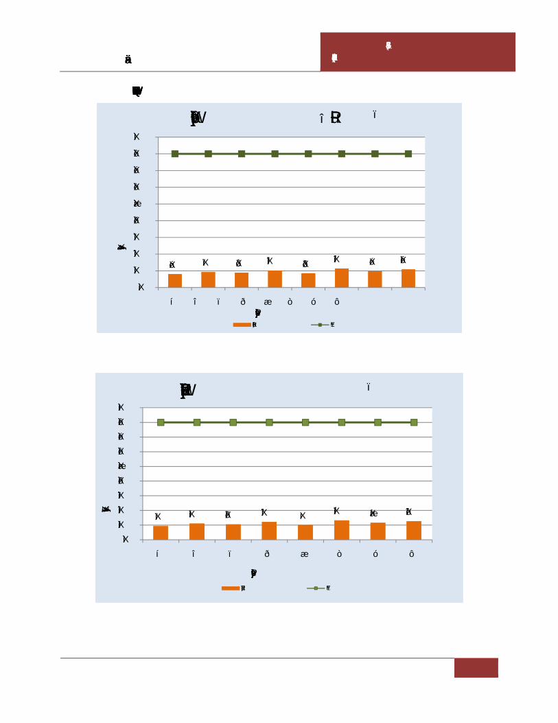
Draft Environmental Impact Assessment Report for M/s Virgin Rock Pvt. Ltd. – 6.0 Ha.
CHAPTER – III DESCRIPTION OF THE ENVIRONMENT
3- 12
Graphical presentation of ambient air quality in the study area
7.9 9.3 8.8 10.2 8.4 11.2 9.7 10.7
0.0
10.0
20.0
30.0
40.0
50.0
60.0
70.0
80.0
90.0
A1 A2 A3 A4 A5 A6 A7 A8
SO2
Conc
entr
atio
ns
Sampling Locations
98 Percentile of SO2 (µg/m3)
SO2 (ug/m3) NAAQS
9.3 10.9 10.4 12.0 9.9 13.1 11.5 12.6
0.0
10.0
20.0
30.0
40.0
50.0
60.0
70.0
80.0
90.0
A1 A2 A3 A4 A5 A6 A7 A8
NO
x Co
ncen
trat
ions
Sampling Locations
98 Percentile of NOx (µg/m3)
NOx (ug/m3) NAAQS

Draft Environmental Impact Assessment Report for M/s Virgin Rock Pvt. Ltd. – 6.0 Ha.
CHAPTER – III DESCRIPTION OF THE ENVIRONMENT
3- 13
3.5.4 Existing Ambient air quality
On the perusal of above summary of analysis of ambient air quality in the study are it is
evident that all monitored values in various locations are well within the specified limits
of CPCB. The results are summarized below:
PM10: The highest PM10 concentration 60.0 µg/m3 was observed in the ambient air was
recorded at station A6 while the lowest PM10 concentration was found to be 21.5µg/m3 at
A1. All the monitored values of PM10 are well below the specified limit of 100µg/m3.
PM2.5: The highest PM2.5 concentration 34.8 µg/m3 was observed in the ambient air was
recorded at station A6 while the lowest PM2.5concentration was found to be 13.0 µg/m3 at
A1. All the monitored values of PM2.5 are well below the specified limit of 60µg/m3.
SO2: The highest SO2 concentration 11.3 µg/m3 was observed in the ambient air was
recorded at station A6 while the lowest SO2 concentration was found to be 4.4µg/m3 at
A1. All the monitored values of SO2 are well below the specified limit of 80 µg/m3.
NOx: The highest NOx concentration 13.4µg/m3 was observed in the ambient air was
recorded at station A6 while the lowest NOx concentration was found to be 5.9 µg/m3 at
A1. All the monitored values of NOx are well below the specified limit of 80µg/m3.
Free Silica: Free Silica found to be <3.5 µg/m3which is Minimum Detectable Limit in all
AAQ locations as per the method of OSHA ID 0142.Permissible Exposure Limit as
OSHA (Occupational Safety and Health Administration) is 50 µg/m3.
Interpretation:
Ambient air quality monitoring locations were selected maximum locations on downwind
of project site as per predominant wind direction recorded in the site specific
meteorological data.
3.6 WATER ENVIRONMENT
The water resources, both surface and groundwater play an important role in the
development of the area. Likewise, the water resources of the area have been studied
to establish the current status of water quality in the area. The parameters of prime

Draft Environmental Impact Assessment Report for M/s Virgin Rock Pvt. Ltd. – 6.0 Ha.
CHAPTER – III DESCRIPTION OF THE ENVIRONMENT
3- 14
importance were selected under physical, chemical inorganic, chemical organic and
heavy metal groups. Water samples from ground and surface water sources were
collected. The water samples were collected in pretreated sampling cans and
transported to laboratory for analysis. Due care was taken during sampling &
transportation of these samples.
3.6.1 Surface water and ground water quality assessment
In order to assess water quality impacts surface water and ground water samples are
collected from the surrounding villages. The samples analyzed for various physical
and chemical parameters to know the contamination levels as per the IS Standards.
1. Ground water quality --- IS 10500-2012
2. Surface/canal/sea water quality --- IS 2296
3.6.2 Selection of sampling locations
Sampling locations were selected on basis of:
a) Drainage pattern
b) Location of residential areas respecting different activities
c) Likely areas those can represent baseline conditions
Samples for bacteriological analysis were collected in sterilized glass bottles. Selected
physico-chemical and bacteriological parameters have been analyzed for projecting
the existing water quality status in the study area.
The samples were analyzed in accordance with “Standard Methods for Examination
of Water and Wastewater Analysis” published by APHA.
3.6.3 Sampling techniques
Samples for chemical analysis were collected in polyethylene carboys. Samples collected
for metal content were acidified with 1 ml HNO3. Samples for bacteriological analysis were
collected in sterilized glass bottles. Selected physico-chemical and bacteriological
parameters have been analyzed for projecting the existing water quality status in the study
area. Parameters like temperature, Dissolved Oxygen (DO) and pH were analyzed at the
time of sample collection. The methodology for sample collection and preservation

Draft Environmental Impact Assessment Report for M/s Virgin Rock Pvt. Ltd. – 6.0 Ha.
CHAPTER – III DESCRIPTION OF THE ENVIRONMENT
3- 15
techniques was followed as per the Standard Operating Procedures (SOP) mentioned in
Table 3.5.
Table 3.5 Standard operating procedures (SOP) for water sampling
Parameter Sample Collection Sample Size Storage/ Preservation
pH Grab sampling
Plastic /glass container
50 ml On site analysis
Electrical Conductivity
Grab sampling
Plastic /glass container
50 ml On site parameter
Total suspended solids
Grab sampling
Plastic /glass container
100 ml Refrigeration,
can be stored for 7 days
Total Dissolved Solids
Grab sampling
Plastic /glass container
100 ml Refrigeration,
can be stored for 7 days
BOD Grab sampling
Plastic /glass container
500 ml Refrigeration, 48 hrs
Hardness Grab sampling
Plastic /glass container
100 ml Add HNO3 to pH<2, refrigeration; 6 months
Chlorides Grab sampling
Plastic /glass container
50 ml Not required; 28 days
Sulphates Grab sampling
Plastic /glass container
100 ml Refrigeration; 28 days
Nitrates Plastic containers 100 ml Refrigeration; 48 hrs
Fluorides Plastic containers only 100 ml Not required; 28 days
Alkalinity Plastic/ glass containers 100 ml Refrigeration; 14 days
Ammonia Plastic/ glass containers 100 ml Add H2SO4 to pH>2, refrigeration, 28 days
Heavy Metals (As, Cd, Mn, Cu, Fe, Zn, Pb etc.)
Plastic/ Glass rinse with 1+1 HNO3
500 ml Filter, add HNO3 to pH>2; Grab sample; 6 months
Source: Standard Methods for the Examination of Water and Wastewater, Published By APHA (American Public Health Association) 23rd Edition 2017.
3.6.4 Analytical techniques
The analytical techniques used for water analysis is given in theTable 3.6.

Draft Environmental Impact Assessment Report for M/s Virgin Rock Pvt. Ltd. – 6.0 Ha.
CHAPTER – III DESCRIPTION OF THE ENVIRONMENT
3- 16
Table 3.6 Analytical techniques forwater analysis
Parameter Method
pH APHA-4500-H+
Colour APHA-2120 C
Odour IS: 3025, Part-4
Temperature APHA-2550 B
Dissolved Oxygen APHA-4500 O
Electrical conductivity APHA-2510 B
Turbidity APHA-2130 B
Chlorides APHA-4500 Cl-
Fluorides APHA-4500 F-
Total dissolved solids APHA-2540 C
Total suspended solids APHA-2540 D
Total hardness APHA-2340 C
Sulphates APHA-4500 SO4-2
Arsenic APHA-3120 B/ APHA-3114 B/ APHA-3500 As
Calcium APHA-3120 B/ APHA-3500 Ca
Magnesium APHA-3120 B/ APHA-3500 Mg
Sodium APHA-3120 B/ APHA-3500 Na
Potassium APHA-3120 B/ APHA-3500 K
Manganese APHA-3120 B/ APHA-3500 Mn
Mercury APHA-3112 B/ APHA-3500 Hg
Lead APHA-3120 B/ APHA-3500 Pb
Copper APHA-3120 B/ APHA-3500 Cu
Cadmium APHA-3120 B/ APHA-3500 Cd
Iron APHA-3120 B/ APHA-3500 Fe
Zinc APHA-3120 B/ APHA-3500 Zn
Boron APHA-4500 B
Coliform organisms APHA-9215 D
Alkalinity APHA-2320 B
Source: Standard Methods for the Examination of Water and Wastewater, Published By APHA (American Public Health Association) 23rd Edition 2017

Draft Environmental Impact Assessment Report for M/s Virgin Rock Pvt. Ltd. – 6.0 Ha.
CHAPTER – III DESCRIPTION OF THE ENVIRONMENT
3- 17
3.6.5 Water sampling stations
The locations of the water samples collected in the study area are furnished hereunder
Table 3.7 Water sampling stations
Code Station Direction
bearing w.r.t Project Site
Distance from Project Site
(km)
Latitude & Longitude
Source of collection
GW1 Savarabonthu W 0.3 18°39'5.37"N
84° 1'25.94"E Ground water
GW2 Sidhi WSW 2.8 18°38'38.97"N
84° 0'4.41"E Ground water
GW3 Kithalapadu SW 5.7 18°37'5.92"N
83°59'7.30"E Ground water
GW4 Lokonda NW 5.3 18°40'50.66"N
83°59'11.53"E Ground water
GW5 Kopiriguda N 2.9 18°40'39.92"N
84° 1'48.65"E Ground water
GW6 Modilikothuru NE 2.1 18°39'38.92"N
84° 2'39.93"E Ground water
GW7 Mahasingi E 2.2 18°38'57.47"N
84° 2'53.80"E Ground water
GW8 Burujuvada SSE 4.3 18°36'51.14"N
84° 2'31.00"E Ground water
SW1 Poppangi Cheruvu SSE 3.7 18°37'15.67"N
84° 2'31.78"E Surface water
SW2 Gotta Barrage
Vamsadhara River NW 7.9
18°41'18.00"N
83°57'49.75"E Surface water
SW3 Vamsadhara left Canal SW 4.7 18°37'57.71"N
83°59'14.04"E Surface water
SW4 Dhanalakshmipuram
Cheruu NE 1.5
18°39'41.59"N
84° 2'11.47"E Surface water

Draft Environmental Impact Assessment Report for M/s Virgin Rock Pvt. Ltd. – 6.0 Ha.
Impact Assessment 6.0 Ha.
CHAPTER – III DESCRIPTION OF THE ENVIRONMENT
3- 18
Fig.3.3 Water sampling locations

Draft Environmental Impact Assessment Report for M/s Virgin Rock Pvt. Ltd. – 6.0 Ha.
CHAPTER – III DESCRIPTION OF THE ENVIRONMENT
3- 19
3.6.6 Ground water quality of the study area
The summarized analysis results of the ground water quality in the study area are given in the below table
Table 3.8 Ground water quality results
S.No. PARAMETER UNIT GW1 GW2 GW3 GW4 GW5 GW6 GW7 GW8 IS:10500-Standards
Acceptable Permissible
1. Color Hazen < 1 < 1 < 1 < 1 < 1 < 1 < 1 < 1 5 15
2. Temperature of Water 0C 24.8 25.2 25.5 24.9 25.3 25.2 25.1 25.3 - -
3. pH - 7.1 7.2 7.4 7.1 7.2 7.1 7.1 7.2 6.5-8.5 6.5-8.5
4. Turbidity NTU <1 <1 <1 <1 <1 <1 <1 <1 1 5
5. Total Dissolved Solids mg/l 469 454 439 504 479 493 516 426 500 2000
6. Total alkalinity (as CaCO3) mg/l 308 301 289 397 314 389 402 305 200 600
7. Total Hardness (as CaCO3) mg/l 150 139 130 169 159 164 173 124 300 600
8. Chlorides as Cl mg/l 101 94 88 116 105 111 122 83 250 1000
9. Calcium as Ca mg/l 15.9 15.2 14.6 18.1 16.6 17.3 19.4 12.9 75 200
10. Magnesium as Mg mg/l 22.7 20.8 19.9 26.2 24.1 25.4 27.1 18.7 30 100
11. Fluoride as F mg/l 0.56 0.63 0.72 0.68 0.60 0.54 0.59 0.53 1.0 1.5
12. Nitrates as NO3 mg/l 0.14 0.19 0.20 0.26 0.23 0.19 0.22 0.17 45 45
13. Sulphates as SO4 mg/l 30.9 29.7 28.8 33.1 31.6 32.5 33.7 26.5 200 400
14. Arsenic as As mg/l <0.001 <0.001 <0.001 <0.001 <0.001 <0.001 <0.001 <0.001 0.01 0.05
15. Cadmium as Cd mg/l <0.002 <0.002 <0.002 <0.002 <0.002 <0.002 <0.002 <0.002 0.003 0.003
16. Copper as Cu mg/l <0.05 <0.05 <0.05 <0.05 <0.05 <0.05 <0.05 <0.05 0.05 1.5
17. Lead as Pb mg/l <0.001 <0.001 <0.001 <0.001 <0.001 <0.001 <0.001 <0.001 0.01 0.01
18. Iron as Fe mg/l 0.07 0.07 0.06 0.08 0.08 0.09 0.11 0.05 0.3 0.3

Draft Environmental Impact Assessment Report for M/s Virgin Rock Pvt. Ltd. – 6.0 Ha.
CHAPTER – III DESCRIPTION OF THE ENVIRONMENT
3- 20
19. Manganese as Mn mg/l <0.05 <0.05 <0.05 <0.05 <0.05 <0.05 <0.05 <0.05 0.1 0.3
20. Zinc as Zn mg/l 0.13 0.16 0.14 0.15 0.12 0.16 0.15 0.18 5.0 15.0
21. Dissolved phosphates mg/l <0.01 <0.01 <0.01 <0.01 <0.01 <0.01 <0.01 <0.01 - -
22. Phenolic Compounds as C6H5OH mg/l <0.001 <0.001 <0.001 <0.001 <0.001 <0.001 <0.001 <0.001 0.001 0.002
23. Residual Chlorine mg/l <0.005 <0.005 <0.005 <0.005 <0.005 <0.005 <0.005 <0.005 - -
24. E. Coli MPN/100 ml Not Detected
Not Detected
Not Detected
Not Detected
Not Detected
Not Detected
Not Detecte
d
Not Detected
Shall not be detectable
Shall not be detectable
25. Total Coliforms MPN/100 ml 58 50 48 64 56 48 62 48
Shall not be detectable
Shall not be detectable
ND - Not Detected

Draft Environmental Impact Assessment Report for M/s Virgin Rock Pvt. Ltd. – 6.0 Ha.
CHAPTER – III DESCRIPTION OF THE ENVIRONMENT
3- 21
3.6.7 Summary of Groundwater Quality
The pH limit fixed for drinking water samples as per IS: 10500 is 6.5 to 8.5.
During the study period, the pH of the groundwater was found varying between
7.1 and 7.4. The pH values for all the samples collected in the study area during
study period were found to be within the acceptable limits.
The desirable limit for total dissolved solids as per IS: 10500 is 500 milligrams per
liter (mg/l) where as the permissible limits in absence of alternate source is 2000
mg/l. In groundwater samples collected from the study area, the total dissolved
solids (TDS) were found to be varying between 426 mg/l and 516 mg/l. The TDS
of all the samples were below the permissible limit of 2000 mg/l.
The desirable limit for Chloride is 250mg/l as per IS:10500 where as the
permissible limit of the same is 1,000mg/l. The Chloride levels in the groundwater
samples collected in the study area were ranging from 83 – 122 mg/l
The desirable limit as per IS:10500 for hardness is 300 mg/l where as the
permissible limit for the same is 600mg/l. In the groundwater samples collected
from the study area, the hardness was found to be varying from 124 mg/l to 173
mg/l.
Fluoride is the other important parameter, which has the desirable limit of 1 mg/l
and permissible limit of 1.5 mg/l. However, the optimum content of fluoride in the
drinking water is 0.6 to 1.5 mg/l. In the groundwater samples of study area the
fluoride values were found to be within a range of 0.53 mg/l to 0.72mg/l.
All the heavy metals in all samples were found to be below the permissible limits.
An overview of the results obtained reveals that none of parameters were found above
the permissible limits of IS: 10500 Drinking Water Standards.

Draft Environmental Impact Assessment Report for M/s Virgin Rock Pvt. Ltd. – 6.0 Ha.
CHAPTER – III DESCRIPTION OF THE ENVIRONMENT
3- 22
3.6.8. Surface water quality of the study area
The water in the region (surface water) has been compared with respect to the Drinking
water Quality Standards as IS: 10500 and IS: 2296. The summarized analysis of results of
the surface water quality in the study area are given in the below Table 3.9.
Table 3.9 Surface water quality of the study area
S.No PARAMETER UNIT SW1 SW2 SW3 SW4 IS:2296 -
Standards
1. Color Hazen <1 <1 <1 <1 -
2. Odour - Agreeable
Agreeable
Agreeable
Agreeable
-
3. Turbidity Ntu <1 <1 <1 <1 -
4. pH - 7.2 7.3 7.4 7.2 6.50 – 8.50
5. Temperature 0C 25.2 25.1 25.1 25.3 -
6. Electrical Conductivity mmhos/cm 326 282 306 374 -
7. Total Dissolved Solids mg/l 212 183 199 243 1500
8. Total Suspended Solids mg/l 19 12 17 20 -
9. Total Alkalinity as CaCO3
mg/l 113 98 108 121 -
10. Total Hardness as mg/l 78 67 75 84 -
11. Calcium as Ca mg/l 19.2 17.2 20.5 21.7 -
12. Magnesium as Mg mg/l 6.7 4.1 7.3 7.9 -
13. Chloride as Cl mg/l 16.2 14.8 16.2 18.3 -
14. Sulphate as SO4 mg/l 3.4 2.6 3.9 4.1 -
15. Nitrate as NO3 mg/l 0.30 0.22 0.39 0.42 -
16. Iron as Fe mg/l <0.01 <0.01 <0.01 <0.01 -
17. Hexavalent Chromium as Cr6+
mg/l <0.001 <0.001 <0.001 <0.001 0.05
18. Phenolic Compounds mg/l <0.001 <0.001 <0.001 <0.001 0.005
19. Cyanide as CN mg/l <0.002 <0.002 <0.002 <0.002 0.05
20. Zinc as Zn mg/l < 0.01 < 0.01 < 0.01 < 0.01 15
21. Lead as Pb mg/l <0.001 <0.001 <0.001 <0.001 0.01
22. Copper as Cu mg/l <0.05 <0.05 <0.05 <0.05 1.5
23. Aluminium as Al mg/l <0.005 <0.005 <0.005 <0.005 0.1
24. Manganese as Mn mg/l <0.05 <0.05 <0.05 <0.05 5.0
25. Mercury as Hg mg/l <0.001 <0.001 <0.001 <0.001 -

Draft Environmental Impact Assessment Report for M/s Virgin Rock Pvt. Ltd. – 6.0 Ha.
CHAPTER – III DESCRIPTION OF THE ENVIRONMENT
3- 23
26. Arsenic as As mg/l <0.001 <0.001 <0.001 <0.001 -
27. Cadmium as Cd mg/l <0.002 <0.002 <0.002 <0.002 -
28. Dissolved Oxygen mg/l 6.2 6.9 6.6 6.4 5.0 min
29. Chemical Oxygen Demand
mg/l 3.3 2.7 3.9 4.1 -
30. Biochemical Oxygen Demand
mg/l 1.1 1.0 1.0 1.2 3.0
31. Total Kjheldhal Nitrogen mg/l < 1.0 < 1.0 < 1.0 < 1.0 -
32. Free Ammonical Nitrogen
mg/l < 0.01 < 0.01 < 0.01 < 0.01 -
33. Oil & Grease mg/l < 0.1 < 0.1 < 0.1 < 0.1 -
34. E. Coli MPN/100 ml Absent Absent Absent Absent Absent
35. Total Coliforms MPN/100 ml 520 340 380 560 5000
3.6.9 Surface water quality results are summarized below:
pH of the surface water collected was neutral with pH ranging from 7.2 -7.4
TDS was found to be 115mg/l to 134mg/l. The tolerance limit of 1,500 mg/l as per
IS:2296
Total hardness was found to be 67 mg/l to 84 mg/l
Presence of Nitrate was recorded as 0.22 mg/l to 0.42 mg/l
DO was observed as 6.2 mg/l to 6.9 mg/l
Total coliform in water was 340 MPN/100ml to 560MPN/100ml The likely source
of bacteriological contamination was due to the proximity to residential area
All the heavy metals were found to be within below detectable limits.
3.7 SOIL QUALITY
3.7.1 Selection of sampling locations
For studying soil profile of the region, sampling locations were selected to assess the
existing overall soil conditions around the mine lease area. The study of the soil profile
establishes the baseline characteristics and this will help in future for identifying the
incremental concentrations if any, due to the proposed mine operations.

Draft Environmental Impact Assessment Report for M/s Virgin Rock Pvt. Ltd. – 6.0 Ha.
CHAPTER – III DESCRIPTION OF THE ENVIRONMENT
3- 24
The sampling locations have been identified with following objectives.
a) To determine the baseline soil characteristics ofthe study area
b) To determine the impact of the mining activities on soil characteristics
3.7.2 Sampling and analytical techniques
Five sampling locations were selected to assess the existing soil conditions representing
various land use conditions and geological features. At each location, soil samples were
collected from three different depths viz. 30 cm, 60 cm and 90 cm below the surface and
are homogenized. This is in line with IS: 2720 & Methods of Soil Analysis, Part-1, 2nd
edition, 1986 of (American Society for Agronomy and Soil Science Society of America).
The homogenized samples were analyzed for physical and chemical characteristics. The
soil samples were collected and analyzed once in pre-monsoon season.
The samples analyzed as per the established scientific methods for physico-chemical
parameters. The heavy metals analyzed by using Atomic Absorption Spectrophotometer.
The methodology adopted for each parameter is described in Table 3.10.
Table 3.10 Analytical techniques for soil analysis
Parameter Method (ASTM number)
Textural classification Chart developed by Public Roads Administration
pH pH meter (D 1293-84)
Electrical conductivity Conductivity meter (D 1125-82)
Nitrogen Kjeldahl distillation (D 3590-84)
Phosphorus Molybdenum blue, colorimetric (D 515-82)
Potassium Flame photometric (D 1428-82)
Sodium Flame photometric (D 1428-82)
Calcium IS:2720
Magnesium IS:2720
Chlorides Argentometric (D 512-81 Rev 85)

Draft Environmental Impact Assessment Report for M/s Virgin Rock Pvt. Ltd. – 6.0 Ha.
CHAPTER – III DESCRIPTION OF THE ENVIRONMENT
3- 25
3.7.3 Details of Soil sampling locations
The soil sampling locations and distance from mine lease are mentioned in the below
Table 3.11 Soil sampling locations
Code Location/Villages
Direction Bearing
w.r.t Project Site
Distance from Project
Site(km)
Latitude and Longitude
S1 Near Project site --- --- 18°39'3.81"N 84° 1'33.43"E
S2 Sidhi WSW 2.6 18°38'37.35"N 84° 0'14.22"E
S3 Kuridingi SE 2.3 18°37'58.81"N 84° 2'23.60"E
S4 Mamidijola NW 5.2 18°40'45.61"N 83°59'16.29"E
S5 Modilikothuru NE 2.3 18°39'45.91"N 84° 2'46.46"E

Draft Environmental Impact Assessment Report for M/s Virgin Rock Pvt. Ltd. – 6.0 Ha.
Impact Assessment 6.0 Ha.
CHAPTER – III DESCRIPTION OF THE ENVIRONMENT
3- 26
Fig 3.4 Soil sampling locations

Draft Environmental Impact Assessment Report for M/s Virgin Rock Pvt. Ltd. – 6.0Ha.
CHAPTER – III DESCRIPTION OF THE ENVIRONMENT
3 - 27
3.7.4. Soil analysis results in the study area
The summarized analysis results of the soil samples in the study area are presented in the
Table 3.12
Table 3.12 Soil Analysis Results
S.No Parameter Unit S1 S2 S3 S4 S5
1. pH (1:5) Aq Extract -- 7.0 6.8 6.9 7.1 7.4
2. Conductivity
(1:5 Aq Extract)
mhos /cm
186 191 171 174 188 3. Texture
(a) Sand
(b) Silt
(c) Clay
%
38.5
14.1
47.4
40.8
12.9
46.3
40.7
14.5
44.8
41.4
14.9
43.7
40.8
15.7
43.5
4. Bulk Density gm/cm3 1.6 1.5 1.3 1.6 1.7
5. Moisture Content % 5.3 5.1 4.6 4.9 4.5
6. Availabe Nitrogen as N kg/ha 110 107 101 105 118
7. Availabe Phosphorous as P kg/ha 48.2 43.1 42.5 45.1 45.5
8. Available Potassium as K kg/ha 198 190 185 190 202
9. Exchangeable Sodium as Na mg/kg 172 161 155 169 177
10. Exchangeable Calcium as Ca mg/kg 180 155 151 168 172
11. Exchangeable Magnesium as Mg mg/kg 36.4 31.7 25.9 33.4 37.2
12. Water Soluble Chlorides as Cl mg/kg 211 202 199 206 215
13. Water Soluble Sulphates as SO4 mg/kg 19.8 17.5 16.4 18.9 20.5
14. Organic matter % 0.72 0.60 0.55 0.63 0.75
15. Organic Carbon % 0.46 0.34 0.28 0.39 0.51
3.7.5 Summary of Soil Analysis Data
The analytical results of the soil samples collected during the study period are
summarized below.
The normal range of pH in the soils is 6.0 to 8.5. The pH values in the study area
are varying from 6.8 to 7.4 indicating that the soils are falling in neutral soil.

Draft Environmental Impact Assessment Report for M/s Virgin Rock Pvt. Ltd. – 6.0Ha.
CHAPTER – III DESCRIPTION OF THE ENVIRONMENT
3 - 28
Nitrogen encourages the vegetative development of plants by imparting a healthy
green color to the leaves. The available Nitrogen as N in the study area is varying
from 101 to 118 kg/ha. This is less for crops when compared with soil standards.
Phosphorus influences the vigour of plants and improves the quality of crops. In
the study area available, Phosphorus was found in varying quantities of 42.5 to
48.2 kg/ha. This is medium sufficient level when compared to soil standards.
Potassium enhances the ability of the plants to resist diseases, insect attacks, cold
and other adverse conditions. The available potassium in the study area varies
between 185 to 202 kg/ha. This is less level for crops.
Organic Carbon in the study area ranges from 0.28 to 0.51 %. This is less level for
crops.
Based on the above results, the soils in the region are average fertile enough for
cultivation of crops.
3.7.6 Standard Soil Classification
S.No Soil Test Classification
1. pH <4.5 Extremely acidic
4.51- 5.50 Very strongly acidic
5.51-6.00 moderately acidic
6.01-6.50 slightly acidic
6.51-7.30 Neutral
7.31-7.80 slightly alkaline
7.81-8.50 moderately alkaline
8.51-9.0 strongly alkaline
>9.00 very strongly alkaline
2. Electrical Conductivity (ppm) (1ppm = 640 µmhos)
Upto 1.00 Average
1.01-2.00 harmful to germination
2.01-3.00 harmful to crops (sensitive to salts)
3. Organic Carbon Upto 0.2: very less
0.21-0.4: less
0.41-0.5 medium,
0.51-0.8: on an average sufficient

Draft Environmental Impact Assessment Report for M/s Virgin Rock Pvt. Ltd. – 6.0Ha.
CHAPTER – III DESCRIPTION OF THE ENVIRONMENT
3 - 29
0.81-1.00: sufficient
>1.0 more than sufficient
4. Nitrogen (Kg/ha) Upto 50 very less
51-100 less
101-150 good
151-300 Better
>300 sufficient
5. Phosphorus (Kg/ha) Upto 15 very less
16-30 less
31-50 medium
51-65 on an average sufficient
66-80 sufficient
>80 more than sufficient
6. Potassium (Kg/ha) 0 -120 very less
120-180 less
181-240 medium
241-300 average
301-360 better
>360 more than sufficient
*Source: Hand Book of Agriculture, ICAR, New Delhi
3.8 NOISE ENVIRONMENT
3.8.1 Identification of sampling locations
Noise at different generating sources has identified based on the activities in the village
area and the noise at sensitive areas. A detailed survey on noise environment was carried
in and around the mine lease area to study the levels of noise, as the high dB (A) levels
may cause adverse effect on human beings and associated environment, including
structures, domestic animals and natural ecological systems. The locations were
identified keeping in view the land use pattern and environmental setting spot noise
levels were measured using a precision noise level meter at mine areaand residential
areas in all eight locations were covered with in study zone.

Draft Environmental Impact Assessment Report for M/s Virgin Rock Pvt. Ltd. – 6.0Ha.
CHAPTER – III DESCRIPTION OF THE ENVIRONMENT
3 - 30
3.8.2 Methodology
The monitoring was carried out at each location for a period of 24hrs, once in each
season. The locations were identified keeping in view the land use pattern and
environmental setting. The day levels of noise have been monitored during 6 am to 10 pm
and the night levels during 10 pm to 6 am. The Ld, Ln and Ldn were calculated based on
the hourly Leq values. Spot noise levels were measured using a precision noise level
meter at residential areas and the mine area, in all five locations which were covered with
in study zone. The noise levels include vehicular movement and local activities. Noise
levels were recorded for every 15minutes in a clock hour for a continuous 24-hour period
at all locations.
3.8.3 Noise Monitoring Locations -The noise monitoring locations along with their distance
from the mine area are mentioned in the below Table 3.13.
Table 3.13 Noise Monitoring Locations
S.No Location Station Code
Direction from
mine Site
Distance w.r.t
mine Site
Latitude and Longitude
Environmental Setting
1. Near Project Site (Savarabonthu)
N1 W 0.3 18°39'3.83"N 84° 1'24.14"E Industrial Area
2. Saithi N2 SW 1.7 18°38'18.33"N 84° 1'1.10"E Residential Area
3. Sidhi N3 WSW 2.8 18°38'41.07"N 84° 0'8.21"E Residential Area
4. Nimmalapadu N4 W 5.6 18°38'36.46"N 83°58'30.09"E Residential Area
5. Kithalapadu N5 SW 5.5 18°37'14.73"N 83°59'10.95"E Residential Area
6. Kurudingi N6 SE 2.4 18°37'55.84"N 84° 2'25.95"E Residential Area
7. Dhanalakshmipuram
N7 NNE 2.1 18°40'0.13"N 84° 2'16.94"E Residential Area
8. Mahasingi N8 E 2.0 18°38'57.63"N 84° 2'50.27"E Residential Area
3.8.4 Description of locations:
N1 – the location has been selected to assess noise levels in the mine area. N2, N3, N4,
N5, N6, N7 and N8 – the locations have been selected to assess noise levels near to the
mine in residential areas with light Vehicular Movement.

Draft Environmental Impact Assessment Report for M/s Virgin Rock Pvt. Ltd. – 6.0Ha.
Draft Environmental Impact Assessment 6.0Ha.
CHAPTER – III DESCRIPTION OF THE ENVIRONMENT
3 - 31
Fig.3.5 Noise Monitoring Locations

Draft Environmental Impact Assessment Report for M/s Virgin Rock Pvt. Ltd. – 6.0Ha.
CHAPTER – III DESCRIPTION OF THE ENVIRONMENT
3 - 32
3.8.5 Noise levels in the study area
The noise level monitored during the study period is given in Table 3.14 in the
form of Lday, Lnight and Ldn compared with CPCB Standards.
Table 3.14 Noise levels in the study area
Location Code Environmental
Setting Lday Lnight
N1 Project site 46.9 36.7
N2 Residential 49.4 39.2
N3 Residential 46.7 36.5
N4 Residential 46.6 36.6
N5 Residential 45.3 33.9
N6 Residential 55.1 43.8
N7 Residential 46.0 35.0
N8 Residential 47.8 36.4
CPCB norms for Noise levels:
Location Leq for Day Leq for Night
Industrial 75 70
Residential 55 45

Draft Environmental Impact Assessment Report for M/s Virgin Rock Pvt. Ltd. – 6.0Ha.
CHAPTER – III DESCRIPTION OF THE ENVIRONMENT
3 - 33
Graphical presentation of ambient noise levelsin the study area
46.9 49.4 46.7 46.6 45.3
55.1
46.0 47.8
0.0
10.0
20.0
30.0
40.0
50.0
60.0
70.0
80.0
N1 N2 N3 N4 N5 N6 N7 N8
Noi
se L
evel
s
Sampling Locations
Equivalent Noise Day Time Leq dB(A)
Leq Day Residential Industrial
36.7 39.2 36.5 36.6 33.9
43.8
35.0 36.4
0.0
10.0
20.0
30.0
40.0
50.0
60.0
70.0
80.0
N1 N2 N3 N4 N5 N6 N7 N8
Noi
se L
evel
s
Sampling Locations
Equivalent Noise NightTime Leq dB(A)
Leq Night Residential Industrial

Draft Environmental Impact Assessment Report for M/s Virgin Rock Pvt. Ltd. – 6.0Ha.
CHAPTER – III DESCRIPTION OF THE ENVIRONMENT
3 - 34
3.9 GEOLOGY AND HYDROGEOLOGY
3.9.1 Physiography
Topographically, the applied area is a steep sloping hill, sloping due SE and NE of the
Q.L applied area. The assumed bench mark of 75 m is taken towards SE of the quarry
lease. The highest RL is 99 m and the lowest RL is 88 m. Thus, the area is having an
altitudinal range of 11 m from the general ground level. There are no prominent
streams and cabals in the area. The surrounding lands on Eastern, Northern and
Southern sides of the area are rocky outcrops and western area being used for
agriculture.
3.9.2 Drainage
The drainage pattern observed in this location is parallel and sub dendritic pattern.
Notable water bodies either seasonal or perennial are not present nearby area which
may cause the inundation of quarry.
There is one first order stream at a distance of 0.05 km from the Western mine area
and another seasonal pond at a distance of 0.19 km due south to the mine area.
However, suitable storm water garland drainage system will be adopted to divert the
rain water into natural drainage. Benches and haul roads will be sloped in such away
to allow the rain water into garland drains.
3.9.3 Geomorphology
Using IRS satellite data and GIS detailed geological, geomorphological and structural
map of Srikakulam District was generated as per Rajiv Gandhi National Drinking
Water Mission (RGNDWM) guidelines on 1: 50,000 scale. The objective of this is to
map lithology, geomorphology and structural characteristics of an area on 1:50,000
scale and to integrate the same to locate potential ground water prospect zones and to
recommend suitable structures for ground water recharge. Various hydrogeomorphic
units are delineated and suitable recharge structures are proposed at drinking water
affected villages under this project. The description of geomorphic units of different
origins (Fig.3.6) mapped in Srikakulam District are described

Draft Environmental Impact Assessment Report for M/s Virgin Rock Pvt. Ltd.
Fig.3.6 Map of the Geomorphology
3.9.4 Geology
In general, the area is plain with isolated hillocks. Sometimes they may rise
continuous hills, presenting rugged topography.
Topographically the applied area is a steep sloping hill, sloping due South
North-East of the Q.L. applied area. The assumed bench mark of 70 m is taken
towards North-East of the Quarry lea
m. Thus, the area is having an altitudinal range of 93 m from the general ground level.
The quarry lease area is occupied by boulders and sheet rock forming ridges. Due to
rocky terrain of having granite rock
cover vegetation except small bushes and scrubs. There are no prominent streams and
canals in the area. The surrounding lands on Eastern, Northern and Southern side of
the area are rocky outcrops and Wes
Regionally, the area has Migmatite and Migmatized Charnockites suit of rocks which
forms the part of Eastern Ghat Granulite Belt (EGGB). Charnockite, Khondalite,
Draft Environmental Impact Assessment M/s Virgin Rock Pvt. Ltd. – 6.0Ha.
CHAPTER DESCRIPTION OF THE ENVIRONMENT
Map of the Geomorphology –Srikakulam district
In general, the area is plain with isolated hillocks. Sometimes they may rise
continuous hills, presenting rugged topography.
applied area is a steep sloping hill, sloping due South
East of the Q.L. applied area. The assumed bench mark of 70 m is taken
East of the Quarry lease. The highest RL is 174m and the lowest is 81
m. Thus, the area is having an altitudinal range of 93 m from the general ground level.
The quarry lease area is occupied by boulders and sheet rock forming ridges. Due to
rocky terrain of having granite rock with boulder formation in the entire area, does not
cover vegetation except small bushes and scrubs. There are no prominent streams and
canals in the area. The surrounding lands on Eastern, Northern and Southern side of
the area are rocky outcrops and Western area being used for agriculture.
Regionally, the area has Migmatite and Migmatized Charnockites suit of rocks which
forms the part of Eastern Ghat Granulite Belt (EGGB). Charnockite, Khondalite,
CHAPTER – III DESCRIPTION OF THE ENVIRONMENT
3 - 35
In general, the area is plain with isolated hillocks. Sometimes they may rise gently as
applied area is a steep sloping hill, sloping due South-East and
East of the Q.L. applied area. The assumed bench mark of 70 m is taken
se. The highest RL is 174m and the lowest is 81
m. Thus, the area is having an altitudinal range of 93 m from the general ground level.
The quarry lease area is occupied by boulders and sheet rock forming ridges. Due to
with boulder formation in the entire area, does not
cover vegetation except small bushes and scrubs. There are no prominent streams and
canals in the area. The surrounding lands on Eastern, Northern and Southern side of
tern area being used for agriculture.
Regionally, the area has Migmatite and Migmatized Charnockites suit of rocks which
forms the part of Eastern Ghat Granulite Belt (EGGB). Charnockite, Khondalite,

Draft Environmental Impact Assessment Report for M/s Virgin Rock Pvt. Ltd. – 6.0Ha.
CHAPTER – III DESCRIPTION OF THE ENVIRONMENT
3 - 36
Pyroxene Granulites, Leptynite, Intrusive Charnockite and Granite are included in this
group. The regional strike is NE-SW wit dips ranging from 50o to 80o. The rock
formation belongs to Eastern Ghat Mobile Belt of Archean Age. The mobile belt is
divided in to 3 Longitudinal zones i.e. Western Charnockite Zone (WCZ), Central
Khondalite Zone (CKZ) and Eastern Migmatite Zone (EMZ). The EMZ is well
developed in the Northern parts of the Belt around Visakhapatnam, Vizianagaram and
Srikakulam.
A broad distribution of types of rocks in Srikakulam District are Granite Gnieses,
Khondalites, Charnockites, Leptynites, Rajahmundry Sand Stone, Alluvial Deposits
and Quartzites at certain places. The area is drained by two prominent rivers
originating from Orissa, namely Nagavali and Vamsadhara passing almost parallel to
one another and joins the Bay of Bengal. Statigraphically the area belongs to Archean
Era.
Geological Era Geological Unit Rock Type
Archaeans
Meta Volcanoes and meta sedimentary rocks of green
stone belts
Peninsular Gneisses with older granites and migmatites
Schistose rocks of Sargur Group and its equivalents
Migmatitic complex
Charnockite Group
Khondalite Group
Migmatites and Gneisses
-------
Leptynite, migmatised Charnockite and
Khondalite
Charnockite
Khondalite

Draft Environmental Impact Assessment Report for M/s Virgin Rock Pvt. Ltd.
Fig 3.7
3.9.5 Hydrogeology
The district is underlain by variety of geological formations from the oldest
Archaeans to Recent Alluvium. The Archaean Group of rocks includes Khondalites
and Charnockites of Eastern Ghat Super Group and Granitic gneisses of Migmatite
Group. The Gondwana rocks which are represented by sandstones are of very limited
aerial extent. These sandstones occur as outlier in Ranastalam mandal on western part
of the district. The thickness of this formation is more than 220 m. The recent
sediments constitute coarse
is highly disturbed as evidenced by the structurally controlled rivers viz: Vamsadhara
and Nagavali which are observed to flow in the faulted zone trending NW
direction. Prominent lineaments
Draft Environmental Impact Assessment M/s Virgin Rock Pvt. Ltd. – 6.0Ha.
CHAPTER DESCRIPTION OF THE ENVIRONMENT
7 Geology map of the Srikakulam District
The district is underlain by variety of geological formations from the oldest
Archaeans to Recent Alluvium. The Archaean Group of rocks includes Khondalites
and Charnockites of Eastern Ghat Super Group and Granitic gneisses of Migmatite
rocks which are represented by sandstones are of very limited
aerial extent. These sandstones occur as outlier in Ranastalam mandal on western part
of the district. The thickness of this formation is more than 220 m. The recent
sediments constitute coarse to fine sands, gravels, silts and clays. Structurally the are
is highly disturbed as evidenced by the structurally controlled rivers viz: Vamsadhara
and Nagavali which are observed to flow in the faulted zone trending NW
direction. Prominent lineaments are trending in NE-SW, NW-SE and NNW
CHAPTER – III DESCRIPTION OF THE ENVIRONMENT
3 - 37
The district is underlain by variety of geological formations from the oldest
Archaeans to Recent Alluvium. The Archaean Group of rocks includes Khondalites
and Charnockites of Eastern Ghat Super Group and Granitic gneisses of Migmatite
rocks which are represented by sandstones are of very limited
aerial extent. These sandstones occur as outlier in Ranastalam mandal on western part
of the district. The thickness of this formation is more than 220 m. The recent
to fine sands, gravels, silts and clays. Structurally the are
is highly disturbed as evidenced by the structurally controlled rivers viz: Vamsadhara
and Nagavali which are observed to flow in the faulted zone trending NW-SE
SE and NNW-SSE.

Draft Environmental Impact Assessment Report for M/s Virgin Rock Pvt. Ltd. – 6.0Ha.
CHAPTER – III DESCRIPTION OF THE ENVIRONMENT
3 - 38
Fig 3.8 Hydrogeology of the Srikakulam District
Ground water occurs in almost all geological formations. From the ground water point
of view, the aquifers found in the district can be broadly classified into hard rocks
(khondalites, quartzites, charnockites, granitic gneisses etc.) and soft rocks (sand
stones, river alluvium, coastal alluvium etc.). Ground water occurs under unconfined
to semi-confined conditions in the hard rock formations, while it occurs under
unconfined to confined conditions in soft rock formations. The yields in the
weathered zones of khondalites and charnockites are very limited and are in the order
of 10 to 20 m3/d. In the weathered granitic gneisses the yields are in theranges from
10 to 40 m3/d. The bore wells constructed in the hard rocks generally tap the fractured
and fissured zones. The yields of the bore wells range between <1 lps to 3 lps. The
higher yields are limited to the available thickness of fractured, fissured and jointed
zones. The occurrence of fractures is limited down to 30 to 40 m bgl and occasionally

Draft Environmental Impact Assessment Report for M/s Virgin Rock Pvt. Ltd. – 6.0Ha.
CHAPTER – III DESCRIPTION OF THE ENVIRONMENT
3 - 39
extends down to 70- 100m bgl. The river alluvium being unconsolidated sediment and
having high porosity and permeability forms potential aquifer system. The yields
generally range in this aquifer between 3 and 5 lps. Occasionally 7 to 9 lps yields are
also observed in the sediments consisting of thick sand and gravel beds. Coastal
alluvium has good yield potential in the range of 2 to 4 lps depending upon the
availability of sand beds. The yields in sandstone formation range between 6 and 19
lps. Granularity of the sandstone bed is the deciding factor of yield potential as the
higher yields are recorded in the wells tapping coarse sand stone beds.
Ground water level
The depth to water level during pre monsoon season (May, 2012) in the district
generally ranges between 5 and 10 mbgl (Fig. 3.9). Shallow water levels less than 5 m
bgl occur in parts of Seetampeta, Veeraghattam, Vangara, Saravakota, Gara,
Meliaputti, Patapatnam, and Ichapuram mandals. Whereas water levels more than 10
m bgl are recorded at Palasa and Kotturu.
The depth to water level during post monsoon season (Nov, 2012) in the district
generally less than 2 mbgl (Fig. 3.10). Deeper water levels more than 2 mbgl occur in
Laveru, G.Sigadam, Ponduru, Rajam and Ranastalam mandals.
Ground water availability
Ground water levels fluctuate considerably in response to the recharge and draft
conditions of ground water reservoir. Rise in water levels from pre-monsoon to post-
monsoon is in the range of 1.31 m to 9.05 m exist in the district. Majority of the
district is below 4 m fluctuation. The minimum average fluctuation is in alluvium,
whereas maximum average fluctuation is in khondalites. Long-term trend of water
level (2001 to 2011) indicates during pre monsoon an overall raise in the district in
the range of 0.002 to 0.532 m/yr where as fall in the range of 0.007 to 0.228 m/yr
exist at Kanchili, Ponduru, Heeramandalam and Srikakulam. During post-monsoon
period overall raise exists in the district, it varies from 0.003 to 0.487 m/yr except at
Srikakulam and Kanchili, where fall recorded of 0.013 and 0.018 m/yr respectively.
The water table elevation ranges between <1 m amsl (Kalingapatnam) and 139
m.amsl (Sitampeta). The water table contours are almost parallel to the topographic

Draft Environmental Impact Assessment Report for M/s Virgin Rock Pvt. Ltd. – 6.0Ha.
CHAPTER – III DESCRIPTION OF THE ENVIRONMENT
3 - 40
contours with gentle slopes along higher order streams of Vamsadhara and Nagavali
and steep slopes in the hilly and intermontane upland areas. The general ground water
flow direction is towards south directing towards the sea. Pumping test data of
exploratory wells drilled by CGWB reveal that the transmissivity values in hard rocks
vary between 2 and 44 m2/day while the storativity ranges from 2.5x10⁻⁴ to 5.8x10⁻⁴.
The aquifer parameters will be very high in soft rock formations i.e. alluvium and
sandstone due to high yield potential.
Ground Water Resources
Ground water resources for each mandal are presented in Table-3.16. Net annual
ground water availability is 411.30 MCM in the command area and 515.86 MCM in
non-command area with a total of 927.16 MCM in the entire district. The gross
ground water draft for all uses in the command area is in the order of 80.75 MCM
whereas it is 191.42 MCM in non-command area and the total gross ground water
draft for all uses in the district is 272.17 MCM. Out of this Resource 23.41 MCM in
Command area and 68.29 MCM in non-command area with the total of 92.103 MCM
in the entire district allocated to cater the domestic and industrial needs of the
population in the district as on 2025. Net ground water availability for future
irrigation use is 318.49 MCM in the command, 287.26 MCM in non-command area
and 605.75 MCM in the entire district. All the mandals in the district are categorized
as safe except Ranasthalam (Over exploited) and Laveru (Semi Critical) mandals.
Ground water resources for each Mandal are presented as Table 3.15.

Draft Environmental Impact Assessment Report for M/s Virgin Rock Pvt. Ltd.
Fig 3.9 Depth of water level
Fig 3.10 Depth of water level
Draft Environmental Impact Assessment M/s Virgin Rock Pvt. Ltd. – 6.0Ha.
CHAPTER DESCRIPTION OF THE ENVIRONMENT
.9 Depth of water level-Pre-Monsoon in Srikakulam District
.10 Depth of water level-Post-Monsoon in Srikakulam District
CHAPTER – III DESCRIPTION OF THE ENVIRONMENT
3 - 41
Monsoon in Srikakulam District
Monsoon in Srikakulam District

Draft Environmental Impact Assessment Report for M/s Virgin Rock Pvt. Ltd. – 6.0Ha.
CHAPTER – III DESCRIPTION OF THE ENVIRONMENT
3 - 42
Table: 3.15 Dynamic Ground water Resources - Saravakota S.
No
Man
dal
Sub-
unit
Tot
al
annu
al
grou
nd
wat
er
Rec
harg
e
Prov
isio
n fo
r N
atur
al d
isch
arge
s
Net
A
uuna
l gr
ound
w
ater
av
aila
bilit
y
Exi
stin
g gr
oss
grou
nd
wat
er
draf
t for
all
uses
Prov
isio
n fo
r do
mes
tic
and
indu
stri
al r
equi
rem
ent
supp
ly t
o 20
25
Net
gr
ound
w
ater
av
aila
bilit
y fo
r fu
ture
ir
riga
tion
de
velo
pmen
t
Stag
e of
gr
ound
w
ater
de
velo
pmen
t %
Cat
egor
y
1 Saravako
ta
C 361 40 321 17 25 279 5 Safe
Non-C 2146 21 2125 652 140 1352 31 Safe
Total 2507 61 2446 669 165 1631 27 Safe
3.10 LAND USE/LAND COVER
The Land Use / Land Cover (LULC) pattern of any region is an outcome of various
physical and cultural factors and their utilization by a man in time and space. Land
use refers to the type of utilization to which man has put the land. It also refers to the
evaluation of the land with respect to various natural characteristics. But land cover
describes the vegetal attributes of land. Land use/land cover data is essential for
planners, decision makers and those concerned with land resources management. For
the proper understanding of the influence of the various human-induced land use
practices with regard to the environmental change, it is essential to help simulate the
land use changes. Remote sensing technology is considered the most effective as it
provides timely and authentic information about the spatial distribution of land
use/land cover, while Geographical Information System (GIS) provides a flexible
digital environment for collecting, storing, visualizing and analyzing the spatial data.
Remote sensing as a vital tool helps for rapid assessment and monitoring of a natural
resource. When combined with GIS, it makes it possible to map land use/cover
phenomena in detail for further planning, development, and decision-making, which
is essential for meeting the increasing demands and welfare of the ever-growing
population.

Draft Environmental Impact Assessment Report for M/s Virgin Rock Pvt. Ltd. – 6.0Ha.
CHAPTER – III DESCRIPTION OF THE ENVIRONMENT
3 - 43
Land use Land Cover map is prepared by adopting interpretation techniques of the
image classification. Image classification has been done by using supervised
classification of satellite images by running an training sample manage based on
colours, various activities has been included in the preparation of Land Use Land
Cover Maps such as Satellite Image/Data Acquisition, Preprocessing, Rectification,
Ground Truthing etc., Satellite Images are processed and producing LULC maps are
being done by using Arc GIS 10.6.
The basic purpose of land use pattern and classification in an EIA study is to identify
the manner in which different parts of land area is utilized or not utilized. Remote
sensing data provides reliable accurate baseline information for land use mapping as
it is a rapid method of acquiring up-to-date information of over a large geological
area.
Studies on land use aspects of eco-system play an imperative role in identifying
susceptible issues and to take appropriate action to uphold ecological equilibrium in
the region. The main objective of this section is to provide a baseline status of the
study area covering 10 km radius around the mining site so that temporal changes due
to the industrial activities on the surroundings can be assessed in future.
The objectives of Land use Pattern are to:
Determine the present Land use pattern
Analyze the impacts on Land use due to the mining site in the study area
Study area with mining project unit as epicentre 10 km radius from the core
area is considered for land use study.
3.10.1 Methodology:
The overall methodology (Fig 3.11) adopted and followed to achieve the objectives of
the present study involves the following:
Procurement of Satellite images.
Collection of source data of Survey of India (SOI) toposheets. These are the
main inputs for the preparation of essential layers.

Draft Environmental Impact Assessment Report for M/s Virgin Rock Pvt. Ltd. – 6.0Ha.
CHAPTER – III DESCRIPTION OF THE ENVIRONMENT
3 - 44
Atmospheric and Radiometric corrections of Satellite data by using nearest
neighborhood resampling technique
Preparation of basic themes like layout map, transport & settlement map and
contour map from the source data. Then updating of layout map, transport map
and drainage map from the satellite image by visual interpretation
Performing image analysis in ArcGIS and Extraction of whole satellite image
into study area, processing and producing various maps such as LULC, Contour
Maps, Digital Elevation Maps, Drainage Maps
Preliminary quality check and necessary corrections are carried out for all the
maps.

Draft Environmental Impact Assessment Report for M/s Virgin Rock Pvt. Ltd. – 6.0Ha.
CHAPTER – III DESCRIPTION OF THE ENVIRONMENT
3 - 45
Figure – 3.11: Methodology
LULC Study:
The LULC Study has been done for the 10km radius area from the project site by
using visual interpretation techniques in Arc GIS 10.6. Output of the map has been
provided in 1:50000 scale, along with LULC MAP 10KM Radius False Colour
Composite Map provided below.
Procurement of Satellite Data
SOI Toposheets
Processing of Satellite Images (Radiometric & Atmospheric Corrections )
Ground Truthing
Classification of Accuracy Assessment
Necessary Corrections and Finalizing maps
Image Analysis
Extraction of Study Area
Processing and Producing Various Maps

Draft Environmental Impact Assessment Report for M/s Virgin Rock Pvt. Ltd. – 6.0Ha.
CHAPTER – III DESCRIPTION OF THE ENVIRONMENT
3 - 46
Fig 3.12 Satellite Image within 10 km radius

Draft Environmental Impact Assessment Report for M/s Virgin Rock Pvt. Ltd. – 6.0Ha.
CHAPTER – III DESCRIPTION OF THE ENVIRONMENT
3 - 47
Fig 3.13 False Colour Composite Satellite Image

Draft Environmental Impact Assessment Report for M/s Virgin Rock Pvt. Ltd. – 6.0Ha.
CHAPTER – III DESCRIPTION OF THE ENVIRONMENT
3 - 48
3%
35%
13%20%
23%
6%
Land use and Land cover Statistics
Water Body
Fallow Land
Open scrub
Dense Vegetation
Cultivation Fields
Dry River Bed/Sandy area
Interpretation
The area distributions along with percentage of different land use classes are listed
below table and Figure 3.14.
Total study area for the mining project is 32565.59 Ha. Out of that major portion of
land use class covered with fallow land i.e., 11553.52 Ha (35.48%), followed by
Agricultural land and Dense vegetation of 7520.87 Ha and 6405.47 Ha respectively.
Open scrub occupied 4281.71 Ha (13.15%). Water bodies cover least percentage of
area that is 868.21 Ha (2.67%).
S.No. Land Use/Land Cover Area, Ha Percentage, %
1 Water Body 868.21 2.67
2 Fallow Land 11553.52 35.48
3 Open scrub 4281.71 13.15
4 Dense Vegetation 6405.47 19.67
5 Cultivation Fields 7520.87 23.09
6 Dry River Bed/Sandy area 1935.81 5.94
Total 32565.59 100.00
Figure 3.14: Graphical representation of Land Use and Land Cover

Draft Environmental Impact Assessment Report for M/s Virgin Rock Pvt. Ltd. – 6.0Ha.
CHAPTER – III DESCRIPTION OF THE ENVIRONMENT
3 - 49
Fig 3.15 Land use/Land cover map

Draft Environmental Impact Assessment Report for M/s Virgin Rock Pvt. Ltd. – 6.0Ha.
CHAPTER – III DESCRIPTION OF THE ENVIRONMENT
3 - 50
3.10.2 Digital Elevation Maps
A digital elevation model (DEM) is a digital representation of ground surface
topography or terrain. It is also widely known as a digital terrain model (DTM). A
DEM file can be downloaded from the ISRO Bhuvan (Cartosat Satellite) Digital
Elevation maps are a type of raster GIS Layer. In a DEM each cell having a value
corresponding to its elevation. By adding Hill shading tool a reader can see the
relationship between terrain and other things. Digital Elevation Model or Digital
Terrain Model map has been shown in the Fig – 3.16.
3.10.3 Contour Map
A contour line connects a series of equal elevation points, the contours have been
generated in the GIS environment with reference to the mean sea level by using the
DEM (Digital Elevation Model) data, the elevation values has been verified.
Thereafter final contour map has been prepared with combination of Toposheet and
DEM ith contour interval of 10 m. In the study area highest contour observed as 380
m of MSL that is situated towards North East direction of the project site and lowest
contour is 30 m of MSL that is situated towards South West direction of the project
site. Contour Map for the project study area has been shown in the below Figure 3.17.
3.10.4 Drainage Map
Drainage Map for the study area has been developed in the GIS Environment by using
Digital Elevation Model. Methodology involved for producing of Drainage maps has
been discussed below.
Strahler method of ordering is used for developing drainage map for the study area.
Based on the elevation profiles of the study area drains will be formed as First order,
Second Order, Third Order and so on. Some of the artificial water bodies (Aqueducts,
Man Made Canals) have been traced out by using google earth and Survey of India
Topomaps. Accuracy of the maps will be checked by using Ground Truthing
Technique. Drainage map for the project site and study area is as shown in the Fig
3.18.

Draft Environmental Impact Assessment Report for M/s Virgin Rock Pvt. Ltd. – 6.0Ha.
CHAPTER – III DESCRIPTION OF THE ENVIRONMENT
3 - 51
Fig 3.16 Digital Elevation map

Draft Environmental Impact Assessment Report for M/s Virgin Rock Pvt. Ltd. – 6.0Ha.
CHAPTER – III DESCRIPTION OF THE ENVIRONMENT
3 - 52
Fig 3.17 Contour map

Draft Environmental Impact Assessment Report for M/s Virgin Rock Pvt. Ltd. – 6.0Ha.
CHAPTER – III DESCRIPTION OF THE ENVIRONMENT
3 - 53
Fig 3.18 Drainage map

Draft Environmental Impact Assessment Report for M/s Virgin Rock Pvt. Ltd. – 6.0Ha.
CHAPTER – III DESCRIPTION OF THE ENVIRONMENT
3 - 54
3.11 BIOLOGICAL ENVIRONMENT
Introduction
Biological diversity comprises the variability of genes, species and ecosystems and is
very crucial for maintaining the basic processes on which the life depends. Broadly it
can be divided into two types i.e. the floral diversity and faunal diversity.
Conservation of the biodiversity is essential for the sustainable development as it not
only provides the food, fodder and medicine but also contribute in improvement of
essential environmental attributes like air, water, soil, etc.
Before starting any Environmental Impact Assessment study, it is necessary to
identify the baseline of relevant environmental parameters which are likely to be
affected as a result of operation of the proposed project. A similar approach has been
adopted for conducting the study on Biological Environment for this Project. Both
terrestrial and aquatic ecosystems have been studied to understand the biological
environment.
Objectives
(i) To study the present ecological and biodiversity of core and buffer zones of
project areas
(ii) To generate baseline data on flora and fauna of core and buffer zones with
assessment of possible impacts
(iii) To suggest a mitigation plan for biodiversity in core and buffer zones.
Study area
The study area is secondary dry deciduous forest in which all trees are growing with
less than 30cm girth. The primary forest completely degraded due to anthropogenic
activities. The tree begin to shed their leaves by about December and between
February and May the forest looks very open and at times eye-soaring, but no area is
completely leafless during the study period. Flowering and fruiting are generally far
advanced before the first flush of new leaves appears with the conventional showers
in April-May.
Diospyros sylvatica is perhaps the commonest tree in this area. Wrightia tinctoria,
Cochlospermum religiosum, Gardenia latifolia, Sterculia urens, Strychnos potatorum,

Draft Environmental Impact Assessment Report for M/s Virgin Rock Pvt. Ltd. – 6.0Ha.
CHAPTER – III DESCRIPTION OF THE ENVIRONMENT
3 - 55
Ziziphus xylopyrus, Terminalia spp., Chloroxylon swietenia, Pterospermum
xylocarpum, Albizia chinense, Cassia fistula, Diospyros melanoxylon etc. are some of
the typical trees; Flaucortia indica, Gmelina asiatica and Naringi crenulata are armed
trees present, at the edges of the mine. Holarrhena antidysenterica, Alangium
salvifolium, Bauhinia racemosa, Tarenna asiatica, Flacourtia indica, Helicteris isora,
Woodfordia fruticosa, Grewia rothii etc. are some of the common small trees found in
this area.
A number climbers and twiners are found in this type of forests. To mention, some of
them are Butea superba, Cansjera rheedii, Celastrus paniculatus, Combretum
ovalifolium, Dioscorea spp., Pueraria tuberosa, Ventilago denticulata, Mucuna spp.
etc.
The ground flora is mostly seasonal. Achyranthes aspera, Aerva sanguinolenta, Sida
glutinosa, Solanum indicum, Scilla hyacinthina, Habenaria roxburghii etc. are some
of the common examples.
Forest blocks in study area
The details of forest blocks in study area are presented below in the Table 3.16. Small
plantations agro forestry) could also be seen in the buffer zone of the project
(Anacardium occidentale, Tectona grandis and Mangifera indica).
Table 3.16. Details of the forest blocks in the study area
S.No Details of forest blocks Distance (KM) Direction 1 Maluva Reserved Forest 0.39 W
2 Raivada Reserved Forest 1.92 SW
3 Asokam Reserved Forest 4.47 SW
4 Saravakota Reserved Forest 5.2 SE
5 Bejji Reserved Forest 8.08 SE
6 Sudirai Konda 2.23 NE
7 Pedda Logidi 8.65 NE
Methodology
Flora
Vegetation and plant species composition observed and documented during field visit
in and around the mining site during study period. Besides primary surveys in the

Draft Environmental Impact Assessment Report for M/s Virgin Rock Pvt. Ltd. – 6.0Ha.
CHAPTER – III DESCRIPTION OF THE ENVIRONMENT
3 - 56
mining site, published literature and various floras were consulted to prepare an
inventory of plant species growing at project sites. The vegetation of the study area is
highly degraded. The plant diversity is classified into various plant groups such as
tree, shrubs, herbs, climbers, sedges and grasses. The plant diversity survey in the
project area was undertaken during the summer season with the objectives of
preparing a checklist of flora in the study area.
Fauna
Information pertaining to the existence of migratory corridors and breeding habitats of
endangered and threatened fauna were assessed based on the information provided
by the local inhabitants and forest department personnel. The conservation status of
each faunal species recorded from the project areas were ascertained as per schedules
of Indian wildlife (protection) Act, 1972 and IUCN -Red Data Book (RDB).The
survey of faunal elements of core and buffer zone were assessed as per the following
sampling techniques:
TAXA SAMPLING TECHNIQUES Butterflies Random walk, Opportunistic observations Amphibians Visual encounter survey (Search) Reptiles Visual encounter survey (Search) Birds Random walk, Opportunistic observations Mammals Tracks and Signs, and Fishes Landings
Flora of the Core zone
The core zone comprises of hill, where mining operation is being carried out. This
area consists of secondary forest in which Diospyros sylvatica, Pterospermum
xylocarpum, Lannea coromandelica and Garuga pinnata are common trees. No
ecologically sensitive and threatened plant species has been reported from this area.
The checklist of plants given in the Table 3.17.
Table 3.17. List of plant species observed in core area of the project
S.No Botanical name Family Local name Hibit 1 Abrus precatorius Fabaceae Gurivinja Climber 2 Abutilon indicum Malvaceae Tuthurabenda Shrub 3 Acacia catechu Mimosaceae Sandra Tree 4 Acacia leucophloea Mimosaceae Tella thumma Tree

Draft Environmental Impact Assessment Report for M/s Virgin Rock Pvt. Ltd. – 6.0Ha.
CHAPTER – III DESCRIPTION OF THE ENVIRONMENT
3 - 57
5 Acalypha indica Euphorbiaceae Muripindi Herb 6 Achyranthes aspera Amaranthaceae Duchena Herb 7 Aerva lanata Amaranthaceae Pindikura Herb 8 Aganosma caryophyllata Apocynaceae Mogari Climber 9 Alangium salvifolium Alangiaceae Udugu Tree
10 Albizia chinensis Mimosaceae Nalla regi Tree 11 Albizia odoratissima Mimosaceae Ganara Tree 12 Alloteropsis cimicina Poaceae - Grass 13 Alysicarpus monilifera Fabaceae Amera Herb 14 Andrographis paniculata Acanthaceae Nela vemu Herb 15 Antidesma acidum Stilaginaceae Pulleru Tree 16 Apluda mutica Poaceae - Grass 17 Argyreia nervosa Convolvulaceae Samudra pala Climber 18 Aristida funiculata Poaceae Cheepurugaddi Grass 19 Aristolochia indica Aristolochiaceae Nall eswari Herb 20 Asparagus racemosus Liliaceae Pilli tigalu Herb 21 Asystasia gangetica Acanthaceae - Herb 22 Atalantia monophylla Rutaceae Karu nimma Tree 23 Atylosia scaraboides Fabaceae - Herb 24 Azadirachta indica Meliaceae Vepa Tree 25 Bauhinia racemosa Caesalpiniaceae Are Tree 26 Biophytum sensitivum Oxalidaceae Jala puspa Herb 27 Boerhavia diffusa Nyctaginaceae Atikamamidi Herb 28 Borreria hispida Rubiaceae Nadana Herb 29 Brachiaria ramosa Poaceae - Grass 30 Breynia vitis-idea Euphorbiaceae Tella pulcheri Shrub 31 Bridelia montana Euphorbiaceae Balli chettu Tree 32 Bridelia retusa Euphorbiaceae Anemu Tree 33 Buchanania lanzan Anacardiaceae Jarumamidi Tree 34 Bulbostylis barbata Cyperaceae - Sedge 35 Butea superba Fabaceae Tiga moduga Climber 36 Calotropis gigantean Asclepiadaceae Jilledu Shrub 37 Canthium dicoccum Rubiaceae Alli Tree 38 Canthium parviflorum Rubiaceae Balusu Shrub 39 Capparis zeylanica Capparidaceae Uppi Shrub 40 Careya arborea Lecythidaceae Kumbi Tree 41 Carissa carandas Apocynaceae Vaka Shrub 42 Casaeria elliptica Flacourtiaceae Chilakaya Shrub 43 Casearia tomentosa Flacourtiaceae Gidiguru Tree 44 Cassia auriculata Caesalpiniaceae Tangedu Shrub 45 Cassia fistula Caesalpiniaceae Rela Tree

Draft Environmental Impact Assessment Report for M/s Virgin Rock Pvt. Ltd. – 6.0Ha.
CHAPTER – III DESCRIPTION OF THE ENVIRONMENT
3 - 58
46 Cassia occidentalis Caesalpiniaceae Kasinda Herb 47 Cassia tora Caesalpiniaceae Tantemu Herb 48 Cayratia auriculata Vitaceae Mura palleru Climber 49 Chloris barbata Poaceae - Grass 50 Chloroxylon swietenia Flindersiaceae Billa Tree 51 Chromolaena odorata Asteraceae Kampu rodda Shrub 52 Cipadessa baccifera Meliaceae Ranaberi Tree 53 Cleistanhus collinus Euphorbiaceae Vadisa Tree 54 Cleome gynandra Cleomaceae Vaminta Herb 55 Cleome viscosa Cleomaceae Kukka vaminta Herb 56 Clerodendrum serratum Verbenaceae Bharangi Shrub 57 Cliestanthus collinus Euphorbiaceae Vadisa Tree 58 Clitorea ternatea Fabaceae Sanku puspamu Climber 59 Cocculus hirsutus Menispermaceae Dusarituga Climber 60 Cochlospermum
religiosum Cochlospermaceae Konda gogu Tree
61 Commelina benghalensis Commelinaceae - Herb 62 Corchorus acutangulus Tiliaceae Nela bera Herb 63 Costus speciosus Costaceae Bogachika dumpa Herb 64 Crotalaria laburnifolia Fabaceae Pedda giligicha Herb 65 Crotalaria verrucosa Fabaceae Giligicha Herb 66 Croton bonplandianum Euphorbiaceae Galivana Herb 67 Cynodon dactylon Poaceae Gariki Grass 68 Dactyloctenium
aegyptium Poaceae - Grass
69 Dalbergia paniculata Fabaceae Saibothu Tree 70 Datura metal Solanaceae Ummetha Herb 71 Denrophthoe falcata Loranthaceae - Tree 72 Desmodium gangeticum Fabaceae Kola panna Herb 73 Desmodium triflorum Fabaceae Munta mandhu Herb 74 Dichrostachys cinerea Mimosaceae Veluthuru Tree 75 Digera muricata Amaranthaceae Chenchalikura Herb 76 Dioscorea bulbifera Dioscoreaceae Karukanda Climber 77 Dioscorea pentaphylla Dioscoreaceae Tella gadda Climber 78 Dioscorea tomentosa Dioscoreaceae Tiga dumpa Climber 79 Diospyros chloroxylon Ebenaceae Thorika Tree 80 Diospyros melanoxylon Ebenaceae Thummika Tree 81 Diospyros sylvatica Ebenaceae Gatha Tree 82 Diptrocanthus prostratus Acanthaceae - Herb 83 Eclipta prostrata Asteraceae Guntagalagara Herb 84 Emilia sonchifolia Asteraceae - Herb 85 Euphorbia antiquorum Euphorbiaceae Benta jemudu Tree
Draft Environmental Impact Assessment Report for M/s Virgin Rock Pvt. Ltd. – 6.0Ha.
CHAPTER – III DESCRIPTION OF THE ENVIRONMENT
3 - 59
86 Euphorbia hirta Euphorbiaceae Reddi vari nanubalu Herb 87 Evovlulus alsinoides Convolvulaceae Vishnukrantha Herb 88 Evovlulus nummularius Convolvulaceae - Herb 89 Ficus racemosa Moraceae Medi Tree 90 Ficus semicordata Moraceae Bommala marri Tree 91 Flacourtia indica Flacourtiaceae Kanaregu Tree 92 Gardeinia latifolia Rubiaceae Bikki Tree 93 Garuga pinnata Burseraceae Garugu Tree 94 Gisekia pharnaceodis Aizoaceae Isaka dintikura Herb 95 Glycosmis mauritiana Rutaceae Golugu Shrub 96 Gmelina arborea Verbenaceae Gummidi Tree 97 Gmelina asiatica Verbenaceae Salla gummidi Tree 98 Grewia rothii Tiliaceae Pedda chipuru Tree 99 Grewia tilifolia Tiliaceae Tada Tree
100 Gynura lycopersifolia Asteraceae - Herb 101 Hedyotis corymbosa Rubiaceae - Herb 102 Helicteris isora Sterculiaceae Chemali-Nara Shrub 103 Holarrhena pubescens Apocynaceae Tedla pala Tree 104 Hybanthus ennaespermus Violaceae Ratna purusa Herb 105 Hyptis suaveolens Lamiaceae Simathulasi Herb 106 Ipomoea hederifolia Convolvulaceae Kasirathnam Herb 107 Ipomoea obscura Convolvulaceae Nalla kokita Herb 108 Ixora pavetta Rubiaceae Kolimi Tree 109 Jatropha gossypifolia Euphorbiaceae Seema nepalamu Herb 110 Justisia betonica Acanthaceae Tellarantu Herb 111 Justisia glauca Acanthaceae Konda pindi Herb 112 Lagerstroemia parviflora Lythraceae Chennangi Tree 113 Lannea coromandelica Anacardiaceae Gumpena Tree 114 Lantana camara Verbenaceae Gajukampa Shrub 115 Leucas cephalotes Lamiaceae Thummi Herb 116 Lindernia anagallis Scrophulariaceae - Herb 117 Lindernia crustacea Scrophulariaceae - Herb 118 Ludwigia perennis Onagraceae - Herb 119 Maba buxifolia Ebenaceae Pisini Tree 120 Mallotus philippensis Euphorbiaceae Sindhuaram Tree 121 Mangifera indica Anacardiaceae Mamidi Tree 122 Manilkara hexandra Sapotaceae Palachettu Tree 123 Martynia annua Pedlaiaceae Geddagoru Shrub 124 Maytenus emarginata Celastraceae Danti Shrub 125 Memecylon edule Melastomataceae Alli Tree 126 Merremia tridentata Convolvulaceae Suraputiga Herb

Draft Environmental Impact Assessment Report for M/s Virgin Rock Pvt. Ltd. – 6.0Ha.
CHAPTER – III DESCRIPTION OF THE ENVIRONMENT
3 - 60
127 Mimosa pudica Mimosaceae Attipatti Herb 128 Mimosa rubicaulis Mimosaceae Korendum Shrub 129 Mimusops elengi Sapotaceae Pogada Tree 130 Mitragyna parvifolia Rubiaceae Nirkadamba Tree 131 Momordica charantia Cucurbitaceae Kakara Climber 132 Morinda pubescens Rubiaceae Togaru Tree 133 Mucuna pruriens Fabaceae Dulagondi Climber 134 Mullogo nudicaulis Aizoaceae Pedda paripata Herb 135 Mullogo pentaphylla Aizoaceae Verri chatarasi Herb 136 Naringi crenulata Rutaceae Torru velaga Tree 137 Ochna obtusata Ochnaceae Tammi Tree 138 Opismenus burmanii Poaceae - Grass 139 Oxalis corniculata Oxalidaceae Puli chinta Herb 140 Pavetta tomentosa Rubiaceae Tella papidi Shrub 141 Pavonia zeylanica Malvaceae Karu benda Herb 142 Pedaluim murex Pedlaiaceae Enugu palleru Herb 143 Pergularia daemia Asclepiadaceae uriti tiga Climber 144 Perotis indica Poaceae Nakka thoka Grass 145 Phyllanthus niruri Euphorbiaceae Nela usiri Herb 146 Phyllanthus reticulatus Euphorbiaceae Nalla pulugudu Shrub 147 Plumbago zeylanica Plumbaginaceae Chitra mulamu Herb 148 Polyalthia cerasoides Annonaceae Chilka dudduga Tree 149 Polycarpea corymbosa Caryophyllaceae Rajuma Herb 150 Premna latifolia Verbenaceae Nelli Tree 151 Premna tomentosa Verbenaceae Kokkitha Tree 152 Protium serratum Burseraceae Chitrek chettu Tree 153 Pseudarthria viscida Fabaceae Muyak Herb 154 Pterospermum
xylocarpum Sterculiaceae Lolugu Tree
155 Rhynchosia minima Fabaceae - Herb 156 Rothia indica Fabaceae - Herb 157 Sapindus emarginatus Sapindaceae Kunkudu Tree 158 Schleichera oleosa Sapindaceae Busi chettu Tree 159 Securinega virosa Euphorbiaceae Tella puplcheri Shrub 160 Semecarpus anacardium Anacardiaceae Nalla jeedi Tree 161 Sida acuta Malvaceae Gayapaku Herb 162 Sida cordifolia Malvaceae Chiru benda Herb 163 Solanum torvum Solanaceae Vusti Shrub 164 Sphaeranthus indicus Asteraceae Kukka pogaku Herb 165 Stachytarpeta
jamaicensis Verbenaceae - Herb
166 Sterculia urens Sterculiaceae Kondathamara Tree

Draft Environmental Impact Assessment Report for M/s Virgin Rock Pvt. Ltd. – 6.0Ha.
CHAPTER – III DESCRIPTION OF THE ENVIRONMENT
3 - 61
167 Streblus asper Moraceae Barnika Tree 168 Strychnos nuxvomica Loganiaceae Mushidi Tree 169 Strychnos potatorum Loganiaceae Indupu Tree 170 Syzygium cumini Myrtaceae Neredu Tree 171 Tamarindus indica Caesalpiniaceae Chinta Tree 172 Tephrosia purpurea Fabaceae Vempali Herb 173 Teramnus labialis Fabaceae Masha parni Herb 174 Terminalia alata Combretaceae Nallamaddi Tree 175 Terminalia bellirica Combretaceae Thadi chettu Tree 176 Terminalia chebula Combretaceae Karaka Tree 177 Thysanolaena maxima Poaceae Konda cheepuru
gaddi G
178 Tiliocora acuminata Menispermaceae Kappa teega Cl 179 Tragia involucrata Euphorbiaceae Duradagondi Herb 180 Tridax procumbens Asteraceae Gaddi chamanti Herb 181 Triumfetta rhomboidea Tiliaceae Chiru sitrika Herb 182 Tylophora indica Asclepiadaceae Gori pala Herb 183 Urena lobeta Malvaceae Nalla benda Herb 184 Vernonia cinerea Asteraceae - Herb 185 Woodfordia fruiticosa Lythraceae Jeguru Shrub 186 Wrightia tinctoria Apocynaceae Ankudu Tree 187 Xylia xylocarpa Mimosaceae Konda tangini Tree 188 Ziziphus mauritiana Rhamnaceae Regu Tree 189 Ziziphus oenoplia Rhamnaceae Parimi Climber 190 Ziziphus xylopyrus Rhamnaceae Gotti chettu Tree
Flora of the buffer zone
Buffer zone of the proposed project is mainly forest and agricultural land. The flora of
buffer zone comprises of Wrightia tinctoria, Hollarhena pubescens, Diospyros
sylvatica, Pterospermum xylocarpum, Lannea coromandelica, Cassia fistula, Gmelina
arborea and Garuga pinnata trees are growing. Many tree species are planted in the
area because of their usefulness, economic and aesthetic values. The tree species
observed in the area are, Mangifera indica, Albizia lebbeck, Bombax ceiba, Dalbergia
sissoo, Sapindus emarginatus, and Tamarindus indica etc. Flora of the buffer zone
provided in the Table 3.18.

Draft Environmental Impact Assessment Report for M/s Virgin Rock Pvt. Ltd. – 6.0Ha.
CHAPTER – III DESCRIPTION OF THE ENVIRONMENT
3 - 62
Table 3.18. List of plant species observed in buffer area of the project
S.No. Botanical name Family Local name Habit 1 Abelmoschus moschatus Malvaceae Kasturi benda Herb 2 Abrus precatorius Fabaceae Gurivinja Climber 3 Abutilon crispum Malvaceae Shrub 4 Abutilon indicum Malvaceae Tutturabenda Shrub 5 Acacia auriculiformis Mimosaceae Australian Wattle Tree 6 Acacia caesia Mimosaceae Konda korintha Climber 7 Acacia catechu Mimosaceae Nalla sundra Tree 8 Acacia chundra Mimosaceae Sundra Tree 9 Acacia leucophloea Mimosaceae Tella thumma Tree
10 Acacia nilotica Mimosaceae Nalla thumma Tree 11 Acacia sinuata Mimosaceae Sikayi Climber 12 Acacia torta Mimosaceae Konda Korinta Climber 13 Acalypha indica Euphorbiaceae Muripindi Herb 14 Acanthospermum hispidum Asteraceae Palleru Herb 15 Achyranthes aspera Amaranthaceae Uttareni Herb 16 Acorus calamus Araceae Vasa Herb 17 Adenanthera pavonia Mimosaceae Bandi Guruvinda Tree 18 Adhatoda vasica Acanthaceae Vasa Shrub 19 Aegle marmelos Rutaceae Velaga Tree 20 Aerva lanata Amaranthaceae Kondapindi Herb 21 Aganosma caryophyllata Apocynaceae Mogari Climber 22 Ageratum conyzoides Asteraceae Osavi Herb 23 Ailanthus excelsa Simaroubaceae Peddamaanu Tree 24 Alangium salvifolium Alangiaceae Vuduga Tree 25 Albizia amara Mimosaceae Narlinga Tree 26 Albizia lebbeck Mimosaceae Dirisena Tree 27 Albizia odoratissima Mimosaceae Ganara Tree 28 Albizia procera Mimosaceae Tella dirisana Tree 29 Allmania longepedunculata Amaranthaceae Herb
30 Alloteropsis cimicina Poaceae Grass 31 Aloe vera Asparagaceae Kalabanda Herb 32 Alstonia schloaris Apocynaceae Yedaakula paala Tree 33 Alstonia venenata Apocynaceae Shrub 34 Alternanthera pungens Amaranthaceae Mullu-ponnaganti Herb 35 Alternanthera sessilis Amaranthaceae Ponnagantikura Herb 36 Alternanthera traindra Amaranthaceae Ponnaganti-kura Herb 37 Alysicarpus monilifera Fabaceae Amera Herb 38 Amaranthus spinosus Amaranthaceae Nalladoggali Herb

Draft Environmental Impact Assessment Report for M/s Virgin Rock Pvt. Ltd. – 6.0Ha.
CHAPTER – III DESCRIPTION OF THE ENVIRONMENT
3 - 63
39 Amaranthus viridis Amaranthaceae Mulla thotakura Herb 40 Ammania baccifera Lythraceae Agnivendrapaaku Herb 41 Amorphophallus
paeoniifolius Araceae Kondakandha Herb
42 Ampelocissus latifolia Vitaceae Adaviodraksha Climber 43 Anacardium occidentale Anacardiaceae Cashew nut Tree 44 Andrographis echioides Acanthaceae Herb 45 Andrographis paniculata Acanthaceae Nelavemu Herb 46 Anisochilus carnosus Lamiaceae Ritchu-rodda Herb 47 Anisomeles indica Lamiaceae Dabeera Herb 48 Annona reticulata Annonaceae Ramaphal Tree 49 Annona squamosa Annonaceae Seethaphal Tree 50 Anogeissus acuminata Combretaceae Pasi chettu Tree 51 Anogeissus latifolia Combretaceae Sirimanu Tree 52 Anthocephalus cadamba Rubiaceae Kadambam Tree 53 Apluda mutica Poaceae Grass 54 Argemone mexicana Papaveraceae Balurakshasi Herb 55 Argyreia nervosa Convolvulaceae Samudra pala Climber 56 Arisaema tortuosum Araceae Herb 57 Aristida depressa Poaceae Grass 58 Aristida funiculata Poaceae Cheepurugaddi Grass 59 Aristida setacea Poaceae Parakagaddi Grass 60 Aristolochia bracteolata Aristolochiaceae Gadidagadapa Herb 61 Aristolochia indica Aristolochiaceae Nall eswari Herb 62 Artocarpus heterophyllus Moraceae Panasa chettu Tree 63 Arundinella setosa Poaceae Grass 64 Arundo donax Poaceae Peepalu Grass 65 Aschynomene indica Fabaceae Tellajeelugu Herb 66 Asparagus racemosus Liliaceae Pilli tigalu Herb 67 Asystasia gangetica Acanthaceae Herb 68 Atalantia monophylla Rutaceae Karu nimma Tree 69 Atylosia scaraboides Fabaceae Herb 70 Azadirachta indica Meliaceae Vepa or Neem Tree 71 Azima tetracantha Salvadoraceae Uppu kampa Shrub 72 Bambusa arundinacea Poaceae Veduru Shrub 73 Barringtonia acutangula Barringtoniaceae Kanapa Tree 74 Bauhinia purpurea Caesalpiniaceae Pedddari Tree 75 Bauhinia racemosa Caesalpiniaceae Aare Tree 76 Bauhinia variegata Caesalpiniaceae Kanchar Tree 77 Biophytum sensitivum Geraniaceae Jala puspa Herb 78 Blepharis molluginifolia Acanthaceae Herb 79 Blepharis repens Acanthaceae Herb

Draft Environmental Impact Assessment Report for M/s Virgin Rock Pvt. Ltd. – 6.0Ha.
CHAPTER – III DESCRIPTION OF THE ENVIRONMENT
3 - 64
80 Blumea bifoliata Asteraceae Herb 81 Blumea virens Asteraceae Herb 82 Boerhaavia diffusa Nyctaginaceae Atikamamidi Herb 83 Bombax ceiba Bomabacaceae Buruga Tree 84 Borassus flabellifer Arecaeae Taadi / Taaati Tree 85 Borreria hispida Rubiaceae Madanaku Herb 86 Brachiaria ramosa Poaceae Grass 87 Brachiaria reptans Poaceae Grass 88 Breynia vitis-idaea Euphorbiaceae Purugudu Shrub 89 Bridelia crenulata Euphorbiaceae Alli Tree 90 Bridelia retusa Euphorbiaceae Anemu Tree 91 Bulbostylis barbata Cyperaceae Sedge 92 Butea superba Fabaceae Tiga moduga Climber 93 Caesalpinia pulcherrima Caesalpiniaceae Ratnagandhi Shrub 94 Calotropis gigantea Asclepiadaceae Tella jilledu Shrub 95 Calotropis procera Asclepiadaceae Jilledu Shrub 96 Calycopteris floribunda Combretaceae Bontha teega Climber 97 Canthium parviflorum Rubiaceae Balusu Shrub 98 Capparis zeylanica Capparidaceae Uppi Shrub 99 Cardiospermum
halicacabum Sapindaceae Budda kakara Climber
100 Carissa carandas Apocynaceae Vaka Shrub 101 Caryota urens Arecaceae Geelugu Tree 102 Casaeria elliptica Flacourtiaceae Chilakaya Shrub 103 Cassia auriculata Caesalpiniaceae Tangedu Shrub 104 Cassia fistula Caesalpiniaceae Rela Tree 105 Cassia occidentalis Caesalpinaceae Kasinta Herb 106 Cassia tora Caesalpinaceae Tantemu Herb 107 Cassytha filiformis Lauraceae Akashavalli Climber 108 Cayratia auriculata Vitaceae Mura palleru Climber 109 Ceiba pentandra Bombacaeae Silk cotton Tree 110 Ceiba pentandra Bomabacaceae Tella buruga Tree 111 Celosia cristata Amaranthaceae Cocke's comb Herb 112 Cenchrus ciliaris Poaceae Bunch grass Grass 113 Chloris barbata Poaceae Uppu gaddi Grass 114 Chloroxylon swietenia Flindersiaceae Billudu Tree 115 Chromolaena odorata Asteraceae Kampa chettu Herb 116 Chrysopogon fulvus Poaceae Peddapal Grass 117 Cipadessa baccifera Meliaceae Ranaberi Shrub 118 Cissus quadrangularis Vitaceae Nalleru Herb 119 Citrullus colocynthis Cucurbitaceae Putsakaya Climber 120 Cleistanhus collinus Euphorbiaceae Vadisa Tree

Draft Environmental Impact Assessment Report for M/s Virgin Rock Pvt. Ltd. – 6.0Ha.
CHAPTER – III DESCRIPTION OF THE ENVIRONMENT
3 - 65
121 Cleome gynandra Capparidaceae Vaminta Herb 122 Cleome viscosa Capparidaceae Kukka vaminta Herb 123 Clerodendrum phlomides Verbenaceae Jaya Chettu Shrub 124 Clerodendrum serratum Verbenaceae Bharangi Shrub 125 Clitorea ternatea Fabaceae Sanku puspamu Climber 126 Coccinia grandis Cucurbitaceae Kaki donda Climber 127 Cocculus hirsutus Menispermaceae Broom creeper Climber 128 Cochlospermum religiosum Cochlospermaceae Konda gogu Tree 129 Cocos nucifera Arecaeae Coconut Tree 130 Commelina benghalensis Commelinaceae Kodikaalu Sedge 131 Commelina undulata Commelinaceae Sedge 132 Conyza stricta Asteraceae Herb 133 Corchorus acutangulus Tiliaceae Nela bera Herb 134 Corchorus aestuaans Tiliaceae Nelabera Herb 135 Corchorus tridens Tiliaceae Herb 136 Corchorus trilocularis Tiliaceae Bankitutturu Herb 137 Cordia dichotoma Cordiaceae Nakiri Tree 138 Costus speciosus Costaceae Bogachika dumpa Herb 139 Cressa cretica Convolvulaceae Uppu senaga Shrub 140 Crotalaria laburnifolia Fabaceae Pedda giligicha Herb 141 Crotalaria medicaginea Fabaceae Herb 142 Crotalaria paniculta Fabaceae Herb 143 Crotalaria prostrata Fabaceae Herb 144 Crotalaria verrucosa Fabaceae Giligicha Herb 145 Croton bonplandianum Euphorbiaceae Galivana mokka Herb 146 Cuscuta reflexa Lythraceae Paasi teega Herb 147 Cyanotis axillare Commelinaceae Golla gundi Sedge 148 Cyanotis cristata Commelinaceae Netha kina Sedge 149 Cymbopogon citratus Poaceae Chippa gaddi Grass 150 Cynodon dactylon Poaceae Gariki Grass 151 Cyperus aristatus Cyperaceae Sedge 152 Cyperus compressus Cyperaceae Sedge 153 Cyperus iria Cyperaceae Sedge 154 Cyperus rotandus Cyperaceae Thunga Sedge 155 Cyperus rotundus Cyperaceae Thunga Sedge 156 Dactyloctenium aegyptium Poaceae Crowfoot Grass 157 Dalbergia paniculata Fabaceae Saibothu chettu Tree 158 Dalbergia sissoo Fabaceae Sissoo Tree 159 Dalergia paniculata Fabaceae Saibothu chettu Tree 160 Datura innoxia Solanaceae Nalla ummetha Shrub 161 Datura metel Solanaceae Ummetha Shrub

Draft Environmental Impact Assessment Report for M/s Virgin Rock Pvt. Ltd. – 6.0Ha.
CHAPTER – III DESCRIPTION OF THE ENVIRONMENT
3 - 66
162 Delonix regia Caesalpiniaceae Chitikesra Tree 163 Dendrocalamus strictus Poaceae Veduru Shrub 164 Dendronbium aphyllum Orchidaceae Herb 165 Denrophthoe falcata Loranthaceae Badanika Tree 166 Desmodium gangeticum Fabaceae Kola panna Herb 167 Desmodium triflorum Fabaceae Munta mandu Herb 168 Digera muricata Amaranthaceae Chenchalikura Herb 169 Digitaria adscendens Poaceae Grass 170 Dinebra retroflexa Poaceae Grass 171 Dioscorea bulbifera Dioscoreaceae Karukanda Climber 172 Dioscorea pentaphylla Dioscoreaceae Tella gadda Climber 173 Dioscorea tomentosa Dioscoreaceae Tiga dumpa Climber 174 Diospyros chloroxylon Ebenaceae Thorika Tree 175 Diospyros ferrea Ebenaceae Pisini Tree 176 Diospyros sylvatica Ebenaceae Gatha Tree 177 Diptrocanthus prostratus Acanthaceae Herb 178 Echinochloa colona Poaceae Bontha chamalu Grass 179 Eclipta alba Asteraceae Guntagalagara Herb 180 Emilia sonchifolia Asteraceae Herb 181 Enicostemma hyssopifolium Gentianaceae Gulvidi Herb
182 Eragrostis tenella Poaceae Chinna gariki Grass 183 Euphorbia antiquorum Euphorbiaceae Benta jemudu Shrub 184 Euphorbia hirta Euphorbiaceae Nanubalu Herb 185 Euphorbia nerifolia Euphorbiaceae Jemudu Herb 186 Euphorbia prostrata Euphorbiaceae Herb 187 Euphorbia pulcherrima Euphorbiaceae Herb 188 Euphorbia rosea Euphorbiaceae Herb 189 Euphorbia thymifolia Euphorbiaceae Reddivari
nanubalu Herb
190 Evolvulus alsinoides Convolvulaceae Vishnukrantha Herb 191 Evolvulus nummularis Convolvulaceae Herb 192 Ficus benghalensis Moraceae Marri / Banyan Tree 193 Ficus hispida Moraceae Bomma medi Tree 194 Ficus racemosa Moraceae Tree 195 Ficus religiosa Moraceae Raavi Tree 196 Fimbristylis barbata Cyperaceae Sedge 197 Fimbristylis cymosa Cyperaceae Sedge 198 Fimbristylis dichotoma Cyperaceae Sedge 199 Flacourtia indica Flacourtiaceae Kanaregu Shrub 200 Gardenia latifolia Rubiaceae Bikki Tree 201 Garuga pinnata Burseraceae Garugu Tree

Draft Environmental Impact Assessment Report for M/s Virgin Rock Pvt. Ltd. – 6.0Ha.
CHAPTER – III DESCRIPTION OF THE ENVIRONMENT
3 - 67
202 Gisekia pharnaceodis Aizoaceae Isaka dintikura Herb 203 Glycosmis mauritiana Rutaceae Golugu Shrub 204 Gmelina arborea Verbenaceae Gummadi teku Tree 205 Gmelina asiatica Verbenaceae Gumadi Tree 206 Gomphrena decumbens Amaranthaceae Neeru bogada
banthi Herb
207 Grewia rothii Tiliaceae Pedda chipuru Shrub 208 Grewia tilifolia Tiliaceae Tada Tree 209 Gynura lycopersifolia Asteraceae Herb 210 Hedyotis corymbosa Rubiaceae Herb 211 Helicteris isora Sterculiaceae Chemali-Nara Shrub 212 Heliotropium indicum Boraginaceae Nagadanti Herb 213 Heliotropium ovalifolium Boraginaceae Herb 214 Hemidesmus indicus Asclipiadaceae Sugnadha paala Herb 215 Heteropogon contortus Poaceae Eddi gaddi Grass 216 Hibiscus micranthus Malvaceae Nityamalli Herb 217 Holarrhena pubescens Apocynaceae Tedla pala Shrub 218 Holoptelia integrifolia Ulmaceae Nemalinaara Tree 219 Hugonia mystax Linaceae Kakibira Shrub 220 Hybanthus ennaespermus Violaceae Ratna purusa Herb 221 Hyptis suaveolens Lamiaceae Siamtulasi Herb 222 Imperata arundinaceae Poaceae Darba gaddi Grass 223 Indigofera enneaphylla Fabaceae Cheragadam Herb 224 Indigofera linifolia Fabaceae Herb 225 Indigofera prostrata Fabaceae Herb 226 Indigofera pulchella Fabaceae Sirali Herb 227 Indigofera viscosa Fabaceae Nakkenaru Herb 228 Ipomea purpurea Convolvulaceae Kaarukolli Herb 229 Ipomoea carnea Convlovulaceae Rubber mokka Herb 230 Ipomoea hederifolia Convolvulaceae Kasirathnam Herb 231 Ipomoea obscura Convolvulaceae Nalla kokita Herb 232 Iseilema laxum Poaceae Errachengali
gaddi Grass
233 Ixora pavetta Rubiaceae Korivi Cheetu Tree 234 Jatropha curcas Euphorbaceae Adavi Aamudam Shrub 235 Jatropha gossypifolia Euphorbiaceae Seema nepalamu Herb 236 Justica glauca Acanthaceae Kondapindi Herb 237 Justica prostrata Acanthaceae Herb 238 Justisia betonica Acanthaceae Tellarantu Herb 239 Justisia glauca Acanthaceae Konda pindi Herb 240 Kyllinga nemoralis Cyperaceae Herb 241 Lagerstroemia parviflora Lythraceae Pride of India Tree

Draft Environmental Impact Assessment Report for M/s Virgin Rock Pvt. Ltd. – 6.0Ha.
CHAPTER – III DESCRIPTION OF THE ENVIRONMENT
3 - 68
242 Lannea coromandelica Anacardiaceae Gumpena Tree 243 Lantana camara Verbenaceae Lantana Shrub 244 Leptochloa chinensis Poaceae Grass 245 Leucas aspera Lamiaceae Tella tummi Herb 246 Leucas cephalotes Lamiaceae Thummi Herb 247 Leucas hirta Lamiaceae Herb 248 Limonia acidissima Rutaceae Thorruvelaga Tree 249 Lindernia anagallis Scrophulariaceae Herb 250 Lindernia crustacea Scrophulariaceae Herb 251 Ludwigia perennis Onagraceae Herb 252 Malvastrum
coromandelianum Malvaceae Herb
253 Mangifera indica Anacardiaceae Mango Tree 254 Marselia quadrifolia Marseliaceae Herb 255 Martynia annua Pedlaiaceae Geddagoru Shrub 256 Maytenus emarginata Celastraceae Danti Shrub 257 Melia azedarach Meliaceae White cedar Tree 258 Merremia emarginata Convolvulaceae Elikajemudu Herb 259 Merremia tridentata Convolvulaceae Suraputiga Herb 260 Michelia champaca Magnoliaceae Champaka Tree 261 Mimosa pudica Mimosaceae Attipatti Herb 262 Mimosa rubicaulis Mimosaceae Korundam Climber 263 Mimusops elengi Sapotaceae Pogada Tree 264 Mollugo nudicaulis Aizoaceae Pedda paripata Herb 265 Mollugo pentaphylla Aizoaceae Verri chitarasi Herb 266 Momordica charantia Cucurbitaceae Kakara Climber 267 Morinda pubescens Rubiaceae Togaru Tree 268 Moringa oleifera Moringaceae Munaga Tree 269 Mucuna pruriens Fabaceae Dulagondi Climber 270 Mullogo nudicaulis Aizoaceae Pedda paripata Herb 271 Mullogo pentaphylla Aizoaceae Verri chatarasi Herb 272 Murraya koenigii Rutaceae Karivepa Tree 273 Nyctanthes arbor-tristis Nyctanthaceae Paarijaatham Tree 274 Ochna obtusata Ochnaceae Tammi Shrub 275 Ocimum gratissimum Lamiaceae Rama tulasi Herb 276 Ocimum sanctum Lamiaceae Tulasi Herb 277 Oldenlandia corymbosa Rubiaceae Herb 278 Oldenlandia herbaceae Rubiaceae Herb 279 Opismenus burmanii Poaceae Grass 280 Oxalis corniculata Oxalidaceae Puli chinta Herb 281 Panicum psilopodium Poaceae Grass

Draft Environmental Impact Assessment Report for M/s Virgin Rock Pvt. Ltd. – 6.0Ha.
CHAPTER – III DESCRIPTION OF THE ENVIRONMENT
3 - 69
282 Panicum repens Poaceae Ladda gaddi Grass 283 Parthenium hysterophorus Asteraceae Congress weed Herb 284 Pavetta tomentosa Rubiaceae Tella papidi Shrub 285 Pavonia zeylanica Malvaceae Karu benda Herb 286 Pedaluim murex Pedlaiaceae Enugu palleru Herb 287 Pergularia daemia Asclepiadaceae Guriti aku Climber 288 Peristrophe bicalyculata Acanthaceae Chebura Herb 289 Perotis indica Poaceae Nakkatoka Grass 290 Phaseolus trilobatus Fabaceae Pillipesara Herb 291 Phoenix sylvestris Arecaeae Eetha chettu Tree 292 Phoenix sylvestris Arecaceae Eetha Tree 293 Phyllanthus amarus Euphorbiaceae Nela usiri Herb 294 Phyllanthus emblica Euphorbiaceae Usiri Tree 295 Phyllanthus emblica Euphorbiaceae Usiri Tree 296 Phyllanthus niruri Euphorbiaceae Nela usiri Herb 297 Phyllanthus reticulates Euphorbiaceae Nalla pulugudu Shrub 298 Phyllathus maderaspatensis Euphorbiaceae Nalla usirika Herb
299 Physalis minima Solanaceae Budama Herb 300 Pithecellobium dulce Mimosaceae Seema chinta Tree 301 Plumbago zeylanica Plumbaginaceae Chitra mulamu Herb 302 Polycarpaea corymbosa Caryophyllaceae Bommasari Herb 303 Polygala chinensis Polygalaceae Herb 304 Pongamia pinnata Papilionaceae Gaanuga /
Gaanuga Tree
305 Portulaca oleracea Portulacaceae Pappukura Herb 306 Portulaca quadrifida Portulacaceae Chinna
pavalikura Herb
307 Premna tomentosa Verbenaceae Kokkitha Tree 308 Prosopis cineria Mimosaceae Jammi Tree 309 Prosopis juliflora Mimosaceae English Thumma Tree 310 Pseudarthria viscida Fabaceae Muyak Herb 311 Psidium guajava Myrtaceae Jaama Tree 312 Pterospermum xylocarpum Sterculiaceae Lolugu Tree 313 Rhynchosia mimima Fabaceae Nela alumu Herb 314 Rhynchosia minima Fabaceae Herb 315 Rothia indica Fabaceae Herb 316 Ruellia tuberosa Acanthaceae Bodagiri Herb 317 Rungia repens Acanthaceae Herb 318 Sapindus emerginatus Sapindaceae Kunkudu Tree 319 Scilla indica Liliaceae Adavi ulli Herb 320 Securinega virosa Euphorbiaceae Tella puplcheri Shrub

Draft Environmental Impact Assessment Report for M/s Virgin Rock Pvt. Ltd. – 6.0Ha.
CHAPTER – III DESCRIPTION OF THE ENVIRONMENT
3 - 70
321 Semecarpus anacardium Anacardiaceae Nalla jeedi Tree 322 Senna uniflora Caesalpiniaceae Herb 323 Sida acuta Malvaceae Chittemu Herb 324 Sida cordifolia Malvaceae Chirubenda Herb 325 Solanum indicum Solanaceae Adavi uchinta Herb 326 Solanum torvum Solanaceae Vusti Shrub 327 Sonchus oleraceus Asteraceae Herb 328 Sphaeranthus indicus Asteraceae Kukka pogaku Herb 329 Stachytarpeta jamaicensis Verbenaceae Herb 330 Sterculia urens Sterculiaceae Konda thamara Tree 331 Streblus asper Moraceae Baranika Tree 332 Syzygium cumini Myrtaceae Neredu Tree 333 Tamarindus indicus Caesalpiniaceae Chinta Tree 334 Tectona grandis Verbenaceae Teku Tree 335 Tephrosia hirta Fabaceae Nugu vempali Herb 336 Tephrosia procumbens Fabaceae Vempali Herb 337 Tephrosia purpurea Fabaceae Vempali Herb 338 Teramnus labialis Fabaceae Masha parni Herb 339 Terminalia arjuna Combretaceae Tella maddi Tree 340 Terminalia bellirica Combretaceae Thadi chettu Tree 341 Terminalia catappa Combretaceae Baadam Tree 342 Thespecia populnea Malvaceae Ganga raavi Tree 343 Thysanolaena maxima Poaceae Konda cheepuru Grass 344 Tiliocora acuminata Menispermaceae Kappa teega Climber 345 Tinospora cordifolia Menispermaceae Tippa Teega Climber 346 Tragia involucrata Euphorbiaceae Duradagondi Herb 347 Trainthema portulacastrum Ficoidaceae Galijeru Herb
348 Trianthema triquetra Ficoidaceae Kukka palakoora Herb 349 Tribulus terrestris Zygophyllaceae Palleru Herb 350 Trichodesma indicum Boraginaceae Guvva gutti Herb 351 Tridax procumbens Asteraceae Gaddi chamanti Herb 352 Triumfetta rhomboidea Euphorbiaceae Dekki Herb 353 Tylophora indica Asclepiadaceae Kakapala Climber 354 Tylophora indica Asclepiadaceae Gori pala Herb 355 Typha angustata Typhaceae Jammu Herb 356 Urena lobeta Malvaceae Nalla benda Herb 357 Urginea coromandeliana Liliaceae Herb 358 Urochloa panicoides Poaceae Salla wudu Grass 359 Vanda tesellata Orchidaceae Herb 360 Vernonia cinerea Asteraceae Herb

Draft Environmental Impact Assessment Report for M/s Virgin Rock Pvt. Ltd. – 6.0Ha.
CHAPTER – III DESCRIPTION OF THE ENVIRONMENT
3 - 71
361 Vitex negundo Verbenaceae Nirgundi Tree 362 Waltheria indica Sterculiaceae Nalla benda Herb 363 Withania somnifera Solanaceae Aswagandha Herb 364 Woodfordia fruiticosa Lythraceae Jeguru Shrub 365 Wrightia tinctoria Apocynaceae Reppala Tree 366 Xanthium strumarium Asteraceae Marula matangi Herb 367 Xylia xylocarpa Mimosaceae Konda tangini Tree 368 Ziziphus marutiana Rhamnaceae Regu Tree 369 Ziziphus nummularia Rhamnaceae Nela regu Shrub 370 Ziziphus oenoplea Rhamnaceae Parimi Climber 371 Zizyphus oenoplia Rhamnaceae Parimi Climber 372 Zizyphus xylopyrus Rhamnaceae Gotti chettu Tree 373 Zornia gibbosa Fabaceae Herb
Fauna
Field surveys were undertaken in study area to document the available fauna of the
area. During primary survey three species of mammals i.e. Squirrel, Mongoose and
Rat and Garden lizards were commonly observed. The presence of wild mammals
based on the secondary data and the information provided by the local people and
forest officials. Only Crows, parrots, Doves, Weaver birds and Mynas were more
common among birds. However, a total of 12 species of mammals, 4 species of
Amphibians, 9 species of Reptiles, 12 species of Mammals, 18 species of Avian fauna
and 5 species of Butterflies and 7 species of Dragonflies have been recorded in the
study area. The list of fauna observed during the survey is given below in Table 3.19.
Table 3.19. List of fauna found in the study area S.No. Scientific name Common name Vernacular
name Schedule
Mammals 1 Petaurista philippensis Brown flying squirrel Chettu udutha IV 2 Varanus indicus Common Mongoose Mungisa IV 3 Vulpes bengalensis Bengalk fox Guntanakka IV 4 Bandikota indica Bandicoot Rat Pandikokku IV 5 Rattus rattus House rat Yeluka IV 6 Rattus nitidus Indian field rat Yeluka IV 7 Pteropus giganteus Indian flying fox Gabbilamu IV 8 Lepus nigricollis Indian hare Kundelu IV 9 Canis aureus Jackal Nakka IV
10 Hystix indica Poprcupine Mullapandi IV

Draft Environmental Impact Assessment Report for M/s Virgin Rock Pvt. Ltd. – 6.0Ha.
CHAPTER – III DESCRIPTION OF THE ENVIRONMENT
3 - 72
11 Funambulus pennant Northern palm squirrel Udutha IV 12 Sus scrofa Wild boar Adavipandi III
Reptiles 13 Bangarus caeruleus Common Krait Katlapamu IV 14 Daboia russelli Russell's viper Ralthapinajri Not listed 15 Ptyas mucosa Ratsnake Jerripothu IV 16 Ahaetulla nasuta Tree snake Pachari pamu IV 17 Typhlops porrectus Blind snake Guddipamu IV 18 Varanus monitor Monitor Liazard Udumu I 19 Hemidactylus frenatus Wall Lizard Balli IV 20 Calotes versicolor Garden lizard Thonda IV
Aves 21 Corvus splendens Crow Kaki Not listed 22 Corvus macrorhynchos Jungle crow Adavikaki Not listed 23 Cuculus canorus Cuckoo Kokila IV 24 Streptopelia decactao Ring Dove Kapothamu IV 25 Bubulcus ibis Cattle Egret Konga Not listed 26 Egretta garzetta Little Egret Konga Not listed 27 Eudynamus scolopaceus Koel Kokila IV 28 Lonchura striata White rumped munia Gorapitta IV 29 Sturnus pagodarum Brahminy starling Goruvanka Not listed 30 Acridotheres tristis Common myna Myna Not listed 31 Glaucidium radiatum Jungle Owlet Adavigudlaguba IV 32 Athene brama Spotted Owlet Gudlaguba IV 33 Psittacula eupatria Parakeet Chiluka Not listed 34 Francolinus pondicerianus Grey partridge Chakoramu Not listed 35 Columba livia Rock Dove Pavuramu IV 36 Saxocoloides fulicata Indian Robin Kalchuri IV 37 Apus affinis Little Swift Babila Not listed 38 Hirundo rustica Barn Swallow Vanakovela Not listed
Amphibians 39 Rana hexadactyla Ordinary frog Kappa Not listed 40 Bufo melanosticatus South Indian Toad Boduru Kappa Not listed 41 Hyla arborea Tree frog Not listed 42 Rana tigrina Tiger frog Kappa Not listed
Butterflies 43 Neptis hylas Common Sailor IV 44 Junonia rithya Blue pansy IV 45 Preais iphita Chocolate pansy IV 46 Junonia hierta Yellow pansy IV 47 Aethriamanta brevipennis

Draft Environmental Impact Assessment Report for M/s Virgin Rock Pvt. Ltd. – 6.0Ha.
CHAPTER – III DESCRIPTION OF THE ENVIRONMENT
3 - 73
Dragon flies 48 Brachythemis contaminata 49 Bradenopyga geminate 50 Diplacodes trivialis 51 Orhtetrum sabina 52 Pantala flavescens 53 Ryothemis variegata 54 Trithemis aurora
Based on the data collected and the survey conducted on endangered/threatened/
endemic plant/animal species were found in the study area (core and buffer zones).
During faunal survey no Schedule-I species have reported from the study area as per
the Indian Wildlife (protection) Act 1972 notified list of fauna coming under the
Schedule-I.
Aquatic Flora
There are several small village tanks and rivers such as Mahendratanaya and
Vamsadhara on all sides within the 10 Km buffer zone. Most tanks were either totally
or partially dry during the period of survey. Apart from the streams and tanks, the
aquatic environment is also represented by paddy fields and a few stagnant water
ponds. In addition to these village tanks, drains, and paddy fields provide the
aquatic habitat for a variety of very common aquatic plants and animals. All
the species listed in Table 3.20 is found in the study area only.
Table 3.20. List of aquatic / semi aquatic macrophytes found in the study area
Scientific name Family Status Ammania baccifera Lythraceae Very common medicinal plant
Brachiaria mutica Poaceae Sporadic
Centella asiatica Apiaceae In localized patches
Chrysopogon aciculatus Poaceae Occasional
Cyperus pangorei Cyperaceae Scattered
Echinochloa colona Poaceae Occasional
Echinochloa stagnina Poaceae Occasional
Eichhornia crassipes Pontederiaceae Extensive and widespread
Ipomoea aquatica Convolvulaceae Extensive and widespread
Ludwigia perennis Onagraceae Occasional
Marsilia quadrifoliata Marsiliaceae Very common Pteridophyte
Nelumbo nucifera Nelumbiaceae Very common

Draft Environmental Impact Assessment Report for M/s Virgin Rock Pvt. Ltd. – 6.0Ha.
CHAPTER – III DESCRIPTION OF THE ENVIRONMENT
3 - 74
Nymphaea nauchali Nympheaceae Widely scattered
Sacharum spontaneum Poaceae Common
Pistia stratoides Araceae Widespread
Typha angustata Typhaceae Extensive and widespread
3.12 SOCIO ECONOMIC ENVIRONMENT
Overview
This report presents the socio-economic impact assessment (SIA), as part of the EIA
for the proposed Project. The socio-economic baseline focuses on demographic
patterns of socio economic conditions and livelihood profile and infrastructure
facilities in the study area. Based on the data that is collected in this section, the socio
economic impact assessment will envisage and evaluate any potential impacts of the
proposed project on the local community, livelihoods and other social systems.
Methodology
Aim and Objective:
The study area presented in the socio-economic baseline comprises of the following:
Proposed project location – within the limits of Sri M/s. VIRGIN ROCK PVT.
LTD., over An Extent: 6.0 Ha., Bonthu (V), Saravakota (M), Srikakulam District,
Andhra Pradesh, India
Profile of settlements within a radius of 10 km around the proposed project
location.
To identify the impact of socioeconomic factors and mitigating measure within the
study areas.
Procedure and data collection
The socio-economic baseline has been prepared in two folds of secondary and
primary methods.
The secondary data were adopted for the study is mainly includes review of
published secondary data (District Census Statistical Handbooks- 2011 and
Primary Census Abstract of Census-2011), and other govt related govt office and
web sources of available secondary sources of informationas well as select
primary consultations in the vicinity of the project area with respect to

Draft Environmental Impact Assessment Report for M/s Virgin Rock Pvt. Ltd. – 6.0Ha.
CHAPTER – III DESCRIPTION OF THE ENVIRONMENT
3 - 75
population, density, household size, sex ratio, social stratification, literacy rate and
occupational structure for 10 km radius study area.
The primary data have been collected from 54 participants from various
communities through socio economic survey sheet and Focused Group
Discussions. The collected data analyzed by using SPSS. This will measure the
impacts of proposed project in various aspects. It also studies the awareness on
project and community perceptions about the proposed project and other related
information.
Brief Profile of Srikakulam District
The District is skirted to a distance by Vamsadhara, Nagavali, and Bahuda rivers at
certain stretches of their courses white a line of heights of the great Eastern Ghats run
from North East. Vizianagaram District flanks in the south and west while Orissa
bounds it on the north and Bay of Bengal on the East .The total area of the District is
5837 Sq. Kms. The District derived its name from Srikakulam its headquarters town.
Srikakulam District was carved out in 1950 by bifurcating it from Visakhapatnam
District; it remained unaffected in its territorial jurisdiction for quite some time. But in
November, 1969 the District lost 63 Villages from Saluru Taluk and 44 Villages from
Bobbili Taluk on account of their transfer to the then newly constituted
Gajapathinagaram Taluk of Visakhapatnam District. Again in May, 1979, the District
had undergone major territorial changes on account of the formation of new District
with head quarters at Vizianagaram which involved transfer of Saluru, Bobbili,
Parvathipuram and Cheepurupalli Taluks to the new District. The total area of the
District is 5837 Sq Km. The district has a long coastal lieu of about 193 Km.
Administrative set up
Administratively, the district is divided into three Revenue Divisions viz.,
Srikakulam, Palakonda and Tekkali with 38 Revenue Mandals and equal number of
Mandal Parishads comprising of 1870 villages of which 1757 are inhabited. There are
11 semi-Urban areas which 5 Municipalities and 1101 are gram panchayats. Revenue
divisions are headed by RDOs whereas Mandal and Mandal Parishads are lead by
MROs and MDOs respectively. The district collector is overall administrative head of
the district.

Draft Environmental Impact Assessment Report for M/s Virgin Rock Pvt. Ltd. – 6.0Ha.
CHAPTER – III DESCRIPTION OF THE ENVIRONMENT
3 - 76
The study area is located in the limits of Saravakota, Jalumuru, Lakshminarsupeta,
Hiramandalam and Pathapatnam mandals of Srikakulam district
District Highlights
Srikakulam district stands 22nd position in terms of area with 5,837 Sq.Kms,
The district ranks 19th in terms of households with 6,81,330
The district ranks 2nd in terms of total number of villages with 1,802.
The district ranks 3rd position in terms of sex-ratio with 1,015 as against 1,014 in 2001.
The district ranks 6th in terms of Density with 463 people per Sq.
The district ranks 20th in terms of literates with 14,95,381
The district is with 12,90,288 workers and 14,12,826 non-workers.
Khadi weaving at Ponduru is famous among Khadi lovers of the entire country.
Naupada is a village of Santhabommali Mandal is famous for salt fields and
called as “Salt Bowl” of Andhra Pradesh.
Demographical details of the study area
The study area is surrounded with 145 villages in five Mandals. As per 2011 Census,
the population of in this area is 2,55,606 population with 66474 households. The
gender wise population are found that male 1,26,785 and female are 1,28,821.
Children population of 0-6 year age group is 26112. The total Schedule Caste (SC)
and Schedule Tribes (ST) are 8133 and 9376 respectively in the study area. With
regard to literacy and non literacy in this area population is 1,35,845 and 1, 19,761.

Draft Environmental Impact Assessment Report for M/s Virgin Rock Pvt. Ltd. – 6.0Ha.
CHAPTER – III DESCRIPTION OF THE ENVIRONMENT
3 - 77
Table 3.21 Socio-Demographical details of the study area
S.No Name No_HH TOT_P TOT_M TOT_F P_06 P_SC P_ST P_LIT P_ILL 1 Pathapatnam 16074 64639 31896 32743 6518 8133 9376 36178 28461 2 Savarasiddamadugu 101 566 370 196 42 6 500 350 216 3 Soda 210 763 371 392 73 19 285 339 424 4 Nallakotturu 134 539 266 273 68 102 197 199 340 5 Routhupuram 428 1680 793 887 183 313 127 775 905 6 Atisurikaviti 212 792 402 390 66 11 202 440 352 7 Gopalapuram 288 1150 554 596 127 347 235 502 648 8 Pathapatnam 3797 15954 7919 8035 1468 1480 748 11382 4572 9 Antharaba 250 947 464 483 103 315 12 559 388 10 Changudi 291 1245 641 604 152 110 0 550 695 11 Praharajapalem 291 1613 614 999 142 571 539 1073 540 12 Buragam 342 1432 718 714 157 28 0 704 728 13 Rompivalasa 517 1795 907 888 168 398 0 944 851 14 Phasigangupeta 268 1000 477 523 100 243 88 535 465 15 Sobha 110 352 155 197 57 11 311 60 292 16 Thamara 342 1243 634 609 118 176 0 714 529 17 Seedi 955 3636 1773 1863 372 629 10 1851 1785 18 Korasavada 1953 7720 3851 3869 817 828 19 4036 3684 19 Gurandi 268 1008 503 505 104 179 407 453 555 20 Borubhadra 1078 4347 2199 2148 449 195 191 2109 2238 21 Labara 498 2201 1166 1035 220 188 814 1213 988 22 Chinnamallipuram 293 1143 569 574 91 192 354 613 530 23 Peddamallipuram 143 503 238 265 48 3 33 273 230 24 Ganguvada 558 2176 1055 1121 258 102 929 1068 1108

Draft Environmental Impact Assessment Report for M/s Virgin Rock Pvt. Ltd. – 6.0Ha.
CHAPTER – III DESCRIPTION OF THE ENVIRONMENT
3 - 78
25 Haridwaram 360 1524 675 849 146 226 670 766 758 26 Themburu 891 3299 1576 1723 300 352 310 1888 1411 27 Hiramandalam 13719 50018 24967 25051 5237 7049 5386 26767 23251 28 Komanapalle 629 2275 1085 1190 264 387 159 1088 1187 29 Gulumuru 301 1194 610 584 144 204 0 671 523 30 Jagannadhapuram 167 642 331 311 68 0 301 320 322 31 Kondaragolu 462 1787 900 887 223 153 0 651 1136 32 Peddasankili 453 1488 747 741 162 249 304 791 697 33 Duggupuram 674 2207 1109 1098 231 652 233 1172 1035 34 Durbalapuram 134 457 238 219 41 0 0 244 213 35 Tungatampara 318 1142 574 568 114 99 72 498 644 36 Chorlangi 206 841 416 425 85 91 176 444 397 37 Mokhasa Avalangi 209 917 453 464 107 0 93 457 460 38 Kallata 377 1376 656 720 138 215 6 748 628 39 Tampa 616 2298 1170 1128 203 236 35 1203 1095 40 Gotta 315 1342 661 681 158 119 191 475 867 41 Godiapadu 420 1429 708 721 141 231 247 773 656 42 Korada 1704 6379 3205 3174 627 733 518 3696 2683 43 Garlapadu 551 1868 967 901 221 387 0 1001 867 44 Chinnakollivalasa 312 949 468 481 86 279 2 500 449 45 Tulagam 623 2166 1049 1117 224 582 0 1239 927 46 Pindruvada 223 885 432 453 96 299 0 412 473 47 Ambavalli 298 1067 520 547 131 195 0 539 528 48 Majjigudem 356 1282 621 661 125 169 311 593 689 49 Seedhi 119 476 249 227 51 18 205 302 174 50 Kittalapadu 452 1710 836 874 155 207 258 991 719 51 Rellivalasa 144 588 317 271 43 207 0 354 234

Draft Environmental Impact Assessment Report for M/s Virgin Rock Pvt. Ltd. – 6.0Ha.
CHAPTER – III DESCRIPTION OF THE ENVIRONMENT
3 - 79
52 Hiramandalam (CT) 1790 6603 3305 3298 650 1024 5 4244 2359 53 Lakshminarsupeta 7537 29107 14638 14469 3081 2853 1052 14998 14109 54 Gottipalle 275 1036 526 510 115 179 0 526 510 55 Kommuvalasa 250 920 456 464 88 145 0 418 502 56 Scotpeta 149 565 267 298 66 22 0 344 221 57 Peddakollivalasa 276 889 465 424 89 67 0 423 466 58 Jagannadhapuram 189 712 349 363 63 132 0 354 358 59 Moduguvalasa 163 618 311 307 55 13 0 371 247 60 Borramambapuram 118 470 227 243 54 75 0 250 220 61 Boddavalasa 111 432 219 213 44 42 0 250 182 62 Chorlangi 156 576 305 271 69 0 79 331 245 63 Bottadasingi 142 670 327 343 102 65 18 271 399 64 Yembaram 308 1266 658 608 131 31 0 565 701 65 Jadapeta 135 516 257 259 49 64 0 265 251 66 Pusam 146 549 279 270 42 109 0 306 243 67 Chinthalabadavanja 230 828 404 424 76 71 7 448 380 68 Donkalabadavanja 161 704 362 342 61 0 0 414 290 69 Karkavalasa 362 1498 749 749 158 300 31 757 741 70 Syamalambapuram 123 517 255 262 49 0 0 302 215 71 Turakapeta 166 651 320 331 65 0 0 405 246 72 Dabbapadu 230 980 463 517 105 100 0 439 541 73 Krishnapuram 180 777 390 387 91 61 5 378 399 74 Valasapadu 118 429 221 208 49 135 2 163 266 75 Munganna Agraharam 200 808 419 389 85 15 0 374 434 76 Sidhantham 95 342 178 164 27 81 0 170 172 77 Saravakota 13425 52243 25871 26372 5323 5872 6757 27449 24794 78 Nowthala 608 2245 1117 1128 217 87 478 1094 1151

Draft Environmental Impact Assessment Report for M/s Virgin Rock Pvt. Ltd. – 6.0Ha.
CHAPTER – III DESCRIPTION OF THE ENVIRONMENT
3 - 80
79 Savaramaluva 66 230 114 116 20 0 222 121 109 80 Dasupuram 78 277 142 135 20 0 191 177 100 81 Dharmalakshmipuram 317 1106 568 538 122 28 308 559 547 82 Savarabonthu 85 601 124 477 35 1 586 474 127 83 Bonthu 244 841 410 431 88 7 236 446 395 84 Mahasingi 445 1645 803 842 161 2 363 828 817 85 Kuridingi 108 426 215 211 48 22 113 253 173 86 Pedalamba 533 2029 1017 1012 202 246 196 981 1048 87 Gujjuvada 120 472 234 238 40 6 0 229 243 88 Kommusariapalle 111 401 215 186 26 70 0 204 197 89 Marripadu 121 501 248 253 51 0 262 260 241 90 Kurmanadhapuram 130 488 224 264 50 18 27 300 188 91 Charanadasupuram 96 328 160 168 30 103 10 182 146 92 Ramakrishnapuram 134 569 289 280 47 37 122 271 298 93 Vandra 348 1413 712 701 159 98 291 651 762 94 Bejji 234 874 441 433 86 45 250 373 501 95 Annupuram 159 715 359 356 79 0 93 302 413 96 Govardhanapuram 549 2230 1089 1141 282 267 394 1222 1008 97 Gorribanda 526 1830 879 951 171 119 728 1013 817 98 Agadala 39 165 83 82 22 0 0 79 86 99 Bydalapuram 101 408 195 213 35 0 202 250 158 100 Bhadri 428 1675 839 836 218 402 13 768 907 101 Akkivalasa 151 527 256 271 34 7 0 253 274 102 Gummapadu 163 528 259 269 80 101 47 251 277 103 Gopalapuram 162 550 281 269 47 31 64 315 235 104 Kotturu 334 1282 638 644 170 218 0 591 691 105 Saravakota 898 3471 1824 1647 260 938 117 2171 1300

Draft Environmental Impact Assessment Report for M/s Virgin Rock Pvt. Ltd. – 6.0Ha.
CHAPTER – III DESCRIPTION OF THE ENVIRONMENT
3 - 81
106 Kinneravada 334 1360 669 691 172 97 4 584 776 107 Avalangi 632 2575 1272 1303 297 184 0 1541 1034 108 Budithi 830 3245 1653 1592 298 354 51 1815 1430 109 Cheedipudi 458 1767 852 915 191 124 25 976 791 110 Thogiri 1298 5236 2641 2595 545 730 516 2716 2520 111 Anguru 503 1866 907 959 171 249 7 991 875 112 Sivarampuram 165 558 275 283 45 49 176 276 282 113 Kummarigunta 906 3663 1810 1853 353 432 82 1872 1791 114 Chodasamudram 239 957 467 490 96 305 285 381 576 115 Jamachakram 206 896 441 455 98 51 36 468 428 116 Jarali 518 2114 1063 1051 233 433 232 1113 1001 117 Jalumuru 15719 59599 29413 30186 5953 4589 391 30453 29146 118 Karakavalasa 305 1128 573 555 114 87 0 585 543 119 Mukhalingam 837 3022 1504 1518 265 202 4 1753 1269 120 Marrivalasa 152 682 340 342 58 8 0 366 316 121 Nagarikatakam 441 1518 754 764 138 217 0 753 765 122 Atchutapuram 297 1125 566 559 124 67 0 605 520 123 Komanapalle 407 1518 752 766 163 205 0 817 701 124 Boddapadu 176 720 356 364 84 22 0 355 365 125 Kondapolavalasa 207 768 378 390 65 8 0 312 456 126 Suravaram 142 472 224 248 56 19 0 249 223 127 Timadam 346 1254 590 664 82 4 0 627 627 128 Akkurada 457 1800 901 899 208 219 0 806 994 129 Yelamanchili 513 2132 1065 1067 226 59 37 1091 1041 130 Chennayavalasa 261 989 500 489 103 48 0 394 595 131 Jalumuru 1037 3951 1857 2094 305 740 18 2624 1327 132 Subrahamanya Puram 251 985 488 497 99 0 0 473 512

Draft Environmental Impact Assessment Report for M/s Virgin Rock Pvt. Ltd. – 6.0Ha.
CHAPTER – III DESCRIPTION OF THE ENVIRONMENT
3 - 82
133 Venkatapuram 344 1467 751 716 165 62 0 617 850 134 Jonanki 424 1595 767 828 187 26 0 874 721 135 Talatariya 607 2325 1166 1159 239 97 0 1039 1286 136 Darivada 244 929 466 463 88 49 1 562 367 137 Lingalavalasa 1171 4553 2252 2301 437 241 19 2466 2087 138 Rana 382 1431 703 728 155 147 0 732 699 139 Goliyaputti 151 531 263 268 39 0 0 269 262 140 Karavanja 352 1331 673 658 132 74 4 662 669 141 Pagodu 310 1257 620 637 128 56 16 604 653 142 Syrigam 449 1740 854 886 172 97 19 803 937 143 Makivalasa 258 888 424 464 104 98 0 492 396 144 Parlam 323 1102 571 531 120 209 0 543 559 145 Andhavaram 504 1868 906 962 210 233 0 925 943 146 Allada 649 2208 1079 1129 179 330 0 1249 959 147 Alladapeta 181 632 288 344 46 0 5 278 354 148 Gotivada 392 1495 767 728 178 231 0 691 804 149 Tekkalipadu 348 1462 714 748 195 28 0 617 845 150 Ravipadu 499 1835 911 924 209 65 17 936 899 Source: http://censusindia.gov.in/pca/cdb_pca_census/Houselisting-housing-AP.html

Draft Environmental Impact Assessment Report for M/s Virgin Rock Pvt. Ltd. – 6.0Ha.
CHAPTER – III DESCRIPTION OF THE ENVIRONMENT
3 - 83
ECONOMY AND LAND BASED LIVELIHOOD
Agriculture:
The role of Agricultural Sector in District Economy is very significant. However, out
of 34.64% of Main Workers in the District Population comes under this category,
32.04% Cultivators and Agricultural Labours are still dependent on Agriculture. The
study area is mostly Rainfall dependent; Monsoon and Seasonal conditions play a
major role in the Agriculture Production. During the year 2017-18, the South-West
Monsoon Period and North-East Monsoon period the district received sufficient
rainfall against Normal. As compared to Normal, the overall Rainfall for the year was
793.00 mm as against the District Normal of 1161.5 mm there by showing Excess.
The Net area sown in the District during 2017-18 is 3,05,788 hectares as against
3,00,382 hectares in 2016-17 an increase of 1.76%.
Paddy based Industry:
The district and study area was around 850 small and big rice mills, both in the
organized and unorganized sectors. These mills do not have the capacity to cater to
the entire paddy produce. Yet, the byproducts of rice milling activity, namely paddy
husk, can be put to alternative sues, such as extraction of rice bran oil, activated
carbon from paddy husk, cattle feed, particle boars, straw boards etc. These units can
be established near major towns which have good rail and road facilities.
Cashew nut processing complex
There are more than 150 units engaged in this activity, yet a large share of cashew
produced in the district is sent to other states for processing. Cashew complexes
which include cashew nut processing and cashew nut shell liquid extraction can be
established in the areas of Seethampeta, Itchapuram, Kaviti, Sompeta and Rajam
Cashew nut processing unit would require an investment of about Rs. 25 lakhs for 30
MT capacity. Cashew shell apple can also be used as raw materials for extraction of
oil.

Draft Environmental Impact Assessment Report for M/s Virgin Rock Pvt. Ltd.
Education:
The District is Backward and the infrastructure is very poor. There are 2,503 Primary
Education Schools in various Management Enrolled 1.13 Lakhs students, under Upper
Primary Schools are 644 covered 0.71 Lakhs students, High Schools are
accounted for 1.93 Lakhs, Junior Colleges are 177 in various Managements, 100
Degree Colleges and one Dr. B.R.Ambe
Schools, under the School Education Department of the state.
information report for the academic year 2015
include, 55 government, 2,833 mandal and zilla parishads, 1 residential, 573 private,
14 model, 32 Kasturba Gandhi Balika Vidyalaya (KGBV), 85 municipal and 282
other types of schools. The num
high schools of the district is 371,472.
Most of the villages in the study area have primary, secondary schools and colleges
are available in both Govt. and Private schools.
Transport and communications:
The district spread with NH5 around 194 Kms from Kandivalasagedda at Ransthalam
Mandal to Ichchapuram Mandal.
is 959 km (596 mi). Andhra Pradesh State Road Transport Corporation
runs bus services to all majo
the district include Amudalavalasa
station ( major station) Naupada, Ichchapuram and Sompeta etc.
0
50000
100000
150000
Main and marginal workers
Draft Environmental Impact Assessment M/s Virgin Rock Pvt. Ltd. – 6.0Ha.
CHAPTER DESCRIPTION OF THE ENVIRONMENT
The District is Backward and the infrastructure is very poor. There are 2,503 Primary
Education Schools in various Management Enrolled 1.13 Lakhs students, under Upper
Primary Schools are 644 covered 0.71 Lakhs students, High Schools are
accounted for 1.93 Lakhs, Junior Colleges are 177 in various Managements, 100
Degree Colleges and one Dr. B.R.Ambedkar University and 15 B.Ed. Colleges,
Schools, under the School Education Department of the state. As per the school
rt for the academic year 2015–16, there are 3,875 schools. They
include, 55 government, 2,833 mandal and zilla parishads, 1 residential, 573 private,
14 model, 32 Kasturba Gandhi Balika Vidyalaya (KGBV), 85 municipal and 282
The number of students enrolled in primary, upper primary and
high schools of the district is 371,472.
Most of the villages in the study area have primary, secondary schools and colleges
are available in both Govt. and Private schools.
communications:
The district spread with NH5 around 194 Kms from Kandivalasagedda at Ransthalam
Mandal to Ichchapuram Mandal. The total road length of state highways
Andhra Pradesh State Road Transport Corporation
major in and around the study areas. Major railway
Amudalavalasa, Srikakulam Road railway station, Palasa railway
( major station) Naupada, Ichchapuram and Sompeta etc.
Main Workers Marginal Workers
Main and marginal workers
CHAPTER – III DESCRIPTION OF THE ENVIRONMENT
3 - 84
The District is Backward and the infrastructure is very poor. There are 2,503 Primary
Education Schools in various Management Enrolled 1.13 Lakhs students, under Upper
Primary Schools are 644 covered 0.71 Lakhs students, High Schools are 709 and
accounted for 1.93 Lakhs, Junior Colleges are 177 in various Managements, 100
dkar University and 15 B.Ed. Colleges,
As per the school
16, there are 3,875 schools. They
include, 55 government, 2,833 mandal and zilla parishads, 1 residential, 573 private,
14 model, 32 Kasturba Gandhi Balika Vidyalaya (KGBV), 85 municipal and 282
ber of students enrolled in primary, upper primary and
Most of the villages in the study area have primary, secondary schools and colleges
The district spread with NH5 around 194 Kms from Kandivalasagedda at Ransthalam
in the district
Andhra Pradesh State Road Transport Corporation (APSRTC)
railway stations in
Palasa railway

Draft Environmental Impact Assessment Report for M/s Virgin Rock Pvt. Ltd. – 6.0Ha.
CHAPTER – III DESCRIPTION OF THE ENVIRONMENT
3 - 85
Ganguwada Railway Station at 8.27 km from the proposed site location and
Visakhapatnam International Airport at a distance of 132.82 km to this site. Most of
the villages in and around the villages have well connectivity with metal roads.
APSRTC and private transportation have inter connectivity transpiration facilities for
villagers

Draft Environmental Impact Assessment Report for M/s Virgin Rock Pvt. Ltd. – 6.0Ha.
CHAPTER – III DESCRIPTION OF THE ENVIRONMENT
3 - 86
Table- 3.22: Distribution of villages according to availability of different amenities, 2011
Sr. No.
Name of CD Block
Number of inhabited villages
Type of amenity available Education*
Medical^
Drinking water
Post office #
Telephone **
Transport communications $
Banks@
Agricultural credit societies
Approach by pucca road
Power supply
1 2 3 4 5 6 7 8 9 10 11 12 13
1 0448-Pathapatnam
41 39 (95.12)
19 (46.34)
41 (100) 11 (26.83)
41 (100) 21 (51.22) 3 (7.32)
2 (4.88) 28 (68.29)
41 (100)
2 0458-Hiramandalam
35 31 (88.57)
23 (65.71)
35 (100) 12 (34.29)
35 (100) 19 (54.29) 1 (2.86)
3 (8.57) 24 (68.57)
35 (100)
3
0462-Lakshminarsupeta
40 39 (97.5) 40 (100) 40 (100) 6 (15) 40 (100) 14 (35) 1 (2.5) 1 (2.5) 26 (65) 40 (100)
4 0463-Saravakota
41 40 (97.56)
41 (100) 41 (100) 12 (29.27)
41 (100) 27 (65.85) 4 (9.76)
3 (7.32) 31 (75.61)
41 (100)
5 0467-Jalumuru 53 51 (96.23)
41 (77.36)
53 (100) 16 (30.19)
53 (100) 38 (71.7) 4 (7.55)
6 (11.32)
40 (75.47)
53 (100)
Source: https://censusindia.gov.in/2011census/dchb/DCHB.html

Draft Environmental Impact Assessment Report for M/s Virgin Rock Pvt. Ltd. – 6.0Ha.
CHAPTER – III DESCRIPTION OF THE ENVIRONMENT
3 - 87
PRIMARY STUDY
Community perception
The primary data collection was subsequently undertaken during process. This
included Individual and group assessments. The Individual assessment was done by
using standard questionnaire in non probability sampling method. This survey
focusing on household composition, education levels, general health status, livelihood
strategies, employment, This survey was also focused on various dimensions of
economical, social & cultural, health & wellbeing, economical, personal &
psychological and heath & public infrastructure aspects to assess that significant
impact differences about this mining project. Apart from this expert done focused
group discussion for community and collective opinions of the mining project. This
study was carried on population living in the 10 villages. The hamlets covered
within10 KM of core and buffer areas
A primary survey was conducted on data of 54 participants among the local
communities within the study area villages of Bonthu , savarabonthu, dasupuram
pedalamba, vandra, marripadu valasapadu, sivaramapuram boddapadu. This survey
was conducted to identify the community perception. In this connection, filed experts
used the technique of sampling was used to administer a questionnaire on the existing
awareness among the community on the project and its potential impacts.
Overall Outcome of the primary survey
The data is process to bring out the positive as well as negative impacts due to this
mining project as we discussed.
This domain focuses on socio economical changes with this proposed project. It can
be observed from the nature of the proposed mining project may create economy in
direct and indirect way. It can be said that during the mining activity it may require
employment opportunity in various levels on contract and regular bases in technical
and non technical areas. Once the mining work stared, It is approximately estimated a
total of 25 workers might be required for the proposed project. The proposed project
is surrounded with different villages, hence, most of these workers are likely to be
from the project area. This will be done based in various levels and skills such as
skilled, semi skilled people and unskilled. Technical people will be recruited as

Draft Environmental Impact Assessment Report for M/s Virgin Rock Pvt. Ltd. – 6.0Ha.
CHAPTER – III DESCRIPTION OF THE ENVIRONMENT
3 - 88
technical back ground like; technicians, service providers, tipper driver, machine
operators, supervisors in this project. The uneducated persons might be useful as labor
and helpers. Another phase, These villages might be developed by ESR funds and
other taxes Hence, there would be more economical flow and the people who are in
the middle and low poverty line can be come out through employability due to this
project. It was observed from the primary survey that local people looking for
enhance their technical skills, if the management takes the initiative steps towards
skill development programs to the local community might be useful to generate the
number direct and indirect opportunities to the local community. As a result, both
management and local people might be benefited. The management can be benefited
in the form of hire the local people with reasonable salaries, more support from local
communities and this training program can be included as part of CSR activity
Social & Cultural impacts
Social and culture aspects are the most essential elements for every community and
social development. This domain focused on various social and cultural impacts of the
proposed mining project. It is also observed (73%) from the survey; Proposed project
does not create any migration However, a very less people might be stayed due to
employability form outside study area during the operation and production. Other than
there is no rehabilitation plan. In the context of cultural aspect, Most of the villagers
are well connected with this mining and related work. They accepted it is a part of life
style. Hence, people may not be have break ups with cohesion, may not have any
differences in social and cultural norms due to this project Respondents also have
positive perception towards this project.
Health & wellbeing impacts
In general, the mining site loaded with tipper, and drilling machines any other
vehicles may temporarily generate ambient noise and fugitive, dust from roads. Noise
and air quality studies are included in the full EIA and associated impacts need to
refer to the social environment. But, the proposed site is situated far away to the
community livings. Hence, it can be concluded there would be any negative impact on
communities with this project. Another side, the wellbeing of the local people will be
developed in the form of direct and indirect employment. 89% participants accepted

Draft Environmental Impact Assessment Report for M/s Virgin Rock Pvt. Ltd. – 6.0Ha.
CHAPTER – III DESCRIPTION OF THE ENVIRONMENT
3 - 89
that the proposed project may not have any health related aspect. With regard to
wellbeing, people might have better wellbeing with this proposed project.
Public infrastructure & Services
This domain related to know the impact of public infrastructure and related services.
It is observed from local communities that the proposed project would be caused for
Improvement in communication, transport, education, community development and
medical facilities to the local villagers. The infrastructure development, extension of
new roads for smooth transportation of vehicle, increase of private services due to the
activity, frequent health camps will be campaigned for local people. By increasing of
connectivity, people have more opportunities to enrich their business in various
sectors.
Personal and psychological Impact
It is observed from personal and psychological context, most of the respondents
(89%) have positive attitude towards this project. Participants felt that have more
economical and infrastructure benefits due to this project. And another words, it come
to known people have thought of expression towards encouraging new industries.
Hence, this could be more helpful to the coming generations, in context of education,
business and employment aspect.
Need Assessment:
Primary consultations identified certain key expectations that are also indicative of the
local community’s attitude towards industrial development in the study area:

Draft Environmental Impact Assessment Report for M/s Virgin Rock Pvt. Ltd.
28% of respondents looking for working
during operations on regular or daily based
23% required basic civic amenities in to the local villages.
20% people from the local communities expressed
frequent health camps;
Expected on education and basic amenities to the village people;
14% respondent are asking for education and related facilities to the Govt.
schools.
CONCLUSION
The present Social Impact Assessment study was conducted to
within the limits of Sri M/s.
Saravakota (M),Srikakulam (Dt.), Andhra Pradesh,
has been collected from various sources to identify
assess the community’s perception and
activities with regional and community planning objectives, and meaningful participation of
community in decision ma
can be concluded that most the respondents have positive
project.
Job Opportunities
Draft Environmental Impact Assessment M/s Virgin Rock Pvt. Ltd. – 6.0Ha.
CHAPTER DESCRIPTION OF THE ENVIRONMENT
Primary Survey
28% of respondents looking for working opportunities to the local community
operations on regular or daily based
23% required basic civic amenities in to the local villages.
people from the local communities expressed on health facilities or
frequent health camps; specifically poor and women in various communities
Expected on education and basic amenities to the village people;
respondent are asking for education and related facilities to the Govt.
The present Social Impact Assessment study was conducted to Proposed project location
M/s. Virgin Rock Pvt. Ltd., Over An Extent: 6.0 Ha.,Bonthu (V),
Saravakota (M),Srikakulam (Dt.), Andhra Pradesh, India. The secondary and primary data
has been collected from various sources to identify the quality of life of the local villages and
assess the community’s perception and early consideration of social impacts, the alignment of
activities with regional and community planning objectives, and meaningful participation of
community in decision making are key features. Apart from the SIA process and findings it
can be concluded that most the respondents have positive perception with this proposed
28%
23%20%
17%
12%
Need AssessmentJob Opportunities Civic amenities Health Education Development
CHAPTER – III DESCRIPTION OF THE ENVIRONMENT
3 - 90
opportunities to the local community
on health facilities or
and women in various communities
respondent are asking for education and related facilities to the Govt.
Proposed project location –
Over An Extent: 6.0 Ha.,Bonthu (V),
India. The secondary and primary data
the quality of life of the local villages and
early consideration of social impacts, the alignment of
activities with regional and community planning objectives, and meaningful participation of
king are key features. Apart from the SIA process and findings it
perception with this proposed
Development

CHAPTER –IV
ANTICIPATED ENVIRONMENTAL IMPACTS
& MITIGATION MEASURES


Draft Environmental Impact Assessment Report for M/s Virgin Rock Pvt. Ltd. – 6.0 Ha.
CHAPTER- IV ANTICIPATED ENVIRONMENTAL
IMPACTS & MITIGATION MEASURES
4 - 1
4.0 INTRODUCTION
The mining activity especially opencast mining is likely to make significant changes in land
use pattern. This activity may adversely alter existing Environmental conditions, biological
attributes, existing ecosystem and associated biodiversity unless proper environmental
management plan is adopted. This mining project has both positive as well as negative
impacts on Environment. Keeping in mind the Environmental baseline scenario as detailed
in Chapter III and the mine activity described in Chapter II, it is attempted to predict the
likely impacts, their extent on various parameters and likely mitigation measures to be
adopted.
Impact prediction is a very important phenomenon in evaluating the environmentally
potential adverse impacts for mining project. The impact prediction is always carried out
under worst possible conditions so as to mitigate or to eliminate the Environmental hazards.
These predictions thus calculated are superimposed over the baseline data (the quality of
Environment in the vicinity of the project site) so as to calculate the net impact on the
Environment after the project comes into production.
Table: 4.1 Expected Nature of Impacts
ASPECT IMPACT
Fugitive dust,
Air emissions.
Effects on air quality, ecology due to increase in PM10 & PM2.5, SO2, NOX and free silica levels depending up on the type of process involved in mining.
Noise emissions &
Vibrations.
Effects on community noise environment of the region due to increase in day and night equivalent noise levels.
Transportation Impact on existing infrastructure.

Draft Environmental Impact Assessment Report for M/s Virgin Rock Pvt. Ltd. – 6.0 Ha.
CHAPTER- IV ANTICIPATED ENVIRONMENTAL
IMPACTS & MITIGATION MEASURES
4 - 2
Table: 4.2 Identified/Predicted Environmental Impacts with & without Mitigation Measures
S. No Description Activity Effect
Impact without
mitigation measure
Mitigation measure proposed Impact after mitigation
Remarks
1 Impact on
Topography
& Drainage
Excavation Changes in land
use pattern
High It is proposed to develop
avenue plantation on either
side of the approach road in
addition to green belt within
some extent of buffer.
After removal of mineral the
benches are formed below the
surface level and the top
benches will be applied with
top soil and developed with
grasses and plantation
The pits formed will be used
as water storage structures.
The mining activity will not
intersect with ground water.
Medium The topographical
changes caused due
to mining activity
can be transformed
into social benefit
by adopting and
implementing
proper reclamation
plan

Draft Environmental Impact Assessment Report for M/s Virgin Rock Pvt. Ltd. – 6.0 Ha.
CHAPTER- IV ANTICIPATED ENVIRONMENTAL
IMPACTS & MITIGATION MEASURES
4 - 3
2 Air Pollution Excavation
operation
Fugitive dust
emissions
effecting
ambient air
quality &
workers health
High Covered aprons with nose
masks will be provided to the
work force.
Regular inspection and
maintenance of machinery will
be practiced.
Low Localized effect
which can be
mitigated with
controlled mining
practices
Loading &
Dispatch.
Fugitive dust
effecting air
quality & health
effect
High Vehicles will be covered with
tarpaulin.
Water will be sprinkled
regularly along the haulage
roads
Vehicular speed will be
limited to 25KMPH.
Haul road compaction and
grading at periodic intervals
will be practiced.
Green belt development on
either side of the haulage
roads.
Low Localized effect
which can be
mitigated

Draft Environmental Impact Assessment Report for M/s Virgin Rock Pvt. Ltd. – 6.0 Ha.
CHAPTER- IV ANTICIPATED ENVIRONMENTAL
IMPACTS & MITIGATION MEASURES
4 - 4
Vehicular
movement and
machinery
operation
Release of SO2
and NOx due to
combustion of
fossil fuels
Low Regular maintenance of
vehicles and machineries will
be practiced to improve their
efficiency
Negligible
3 Water
Pollution
Run off from
surrounding
area into ML
area
Siltation of mine
pits.
High
During mining activities
desiltation works will be carried
out regularly
Low Negligible effect
which can be
mitigated
Domestic
sewage from
mine area
Increases BOD
levels of the
water bodies if
released directly
High Domestic waste water generated
is disposed through septic tank
followed by soak pit
Low Negligible effect
which can be
mitigated
Seepage of
mine water to
aquifers
Contaminates
Ground water
High No effluents will be released
from this mine
Mining activity will not
intersect with aquifer.
Low Negligible effect
which can be
mitigated
4 Soil Erosion Exposure of
soil results in
Loss of soil and
accreditation of
deposits in other
High Regular water sprinkling is
carried out during mining
activities.
Low Effect can be
mitigated by
practicing control

Draft Environmental Impact Assessment Report for M/s Virgin Rock Pvt. Ltd. – 6.0 Ha.
CHAPTER- IV ANTICIPATED ENVIRONMENTAL
IMPACTS & MITIGATION MEASURES
4 - 5
soil erosion area After removal of mineral the
top benches will be applied
with top soil and grasses and
plantation will be developed
Plantation development
(plants with soil binding
capacity) on plain area is
encouraged.
measures.
5 Noise
Pollution &
Vibrations
Excavation
activities &
transportation
of vehicles
Increase of
Ambient noise
levels resulting
health effects
High Excavation is through semi
mechanized operations.
Proper maintenance and
periodic lubrication of noise
generating parts of the
machinery & vehicle
machines.
PPE such as ear plug will be
supplied for the workers.
Vehicle speed is controlled to
a maximum of 25KMPH
Green belt development
Low Localized effect
which can be
mitigated.

Draft Environmental Impact Assessment Report for M/s Virgin Rock Pvt. Ltd. – 6.0 Ha.
CHAPTER- IV ANTICIPATED ENVIRONMENTAL
IMPACTS & MITIGATION MEASURES
4 - 6
Blasting will be avoided.
6 Biological &
Socio-
economic
aspect
Operational
activities of
mine
The mine area
comprised
thorny-scrub
vegetation with
very few tree
species
High It is proposed to develop green
belt in an extent of 0.2 Ha.,
within mine buffer area and in
addition avenue plantation will
be carried out on either sides of
the approach road to a stretch
of 0.5 km.
After complete exploration of
the mineral the land on top
benches will be applied top
soil and developed with
grasses and plantation.
Medium No notable
biodiversity
resources are
present within the
mine site
Positive socio
economic effect.
-- Medical/first aid facilities,
Employment opportunities.,
Water supply, communication
will be enhanced due to the
mine activity
It is proposed to develop
green belt in an extent of 0.2
Positive --

Draft Environmental Impact Assessment Report for M/s Virgin Rock Pvt. Ltd. – 6.0 Ha.
CHAPTER- IV ANTICIPATED ENVIRONMENTAL
IMPACTS & MITIGATION MEASURES
4 - 7
Ha., within mine buffer area
and in addition avenue
plantation will be carried out
on either sides of the approach
road to a stretch of 0.5 km.
Plain areas after mining will
be developed with native
plant species which act as
animal grazing land.
Mined out pits will be used
for water harvesting and act as
water source for local
villagers
7 Occupational
Health &
Safety
Operational
activities of
mine like
excavation,
loading etc.
Pulmonary
health effects
predicted and
other minor
injuries.
High Provision of appropriate PPE viz.,
nose masks, hand gloves, shoes
and aprons
First aid/Medical check facilities
will be provided
Low Medical/ Life
insurance &
Workman
compensation
procedures will be
followed.

Draft Environmental Impact Assessment Report for M/s Virgin Rock Pvt. Ltd. – 6.0 Ha.
CHAPTER- IV ANTICIPATED ENVIRONMENTAL
IMPACTS & MITIGATION MEASURES
4 - 8
4.1 IMPACTS ON AIR QUALITY
The impact on air quality due to production of Colour Granite and Road Metal (Granite
Waste) with maximum production of about 10148.0544 m3/annum and 40592.2176
m3/annum respectively is limited to the mining lease area. The Colour Granite and Road
Metal by nature is medium hard so drilling and rock breaking is mandatory. The operations
involve drilling, wire saw cutting, excavation by excavators. The major source for dust
emissions are from excavation operations and transportation of the material. The mine rated
capacity and the baseline ambient air quality values were monitored during non-monsoon
season reflects the emissions in the area. The impact due to mining activities and transport
of material has been considered to estimate the contribution of dust levels to the existing
ambient air quality by the mine.
4.1.1 Quantitative estimation of impacts on air environment
The following options have been employed to predict the ground level concentrations due to
emissions from the mine.
1. Area being rural, rural dispersion parameters is considered.
2. Predictions have been carried out to estimate concentration values over radial distance
of 10 km around the sources.
3. Polar receptor network has been considered.
4. Emission rates from the point sources and area sources were considered as constant
during the entire period.
5. The ground level concentrations computed were as is basis without any consideration of
decay coefficient.
6. Calm winds recorded during the study period were also taken into consideration.
7. Site specific meteorological data to estimate ground level concentrations for period of
December 2020 to February 2021.
4.1.2 Sources of dust emission
Based on the various operations involved in the production, the various emission sources at
each stage have been identified as given below.
a. Area sources

Draft Environmental Impact Assessment Report for M/s Virgin Rock Pvt. Ltd. – 6.0 Ha.
CHAPTER- IV ANTICIPATED ENVIRONMENTAL
IMPACTS & MITIGATION MEASURES
4 - 9
b. Line sources
Area Sources: Drilling, wire saw cutting & excavation by excavators and directly load into
the tippers/tractors operations of the mine are considered as area sources.
Line Sources: Transportation from mining pit to stock pile area and stockpile to end users is
considered as line sources.
The impacts of emission from above sources on air environment are discussed below:
4.1.3 Emission details
All the emissions discussed above are quantified for material handling for Colour Granite
and Road metal (Granite Waste) of 10148.0544 m3/annum and 40592.2176 m3/annum
respectively. The existing baseline concentrations are already covered in the baseline
scenario (Chapter - III). Operational hours and activity rate have been considered for
estimation of emissions from point and area sources. For line source, apart from operational
hours and activity rate, moisture and silt content of the haulage road have been considered.
4.1.4 Meteorological data
The meteorological data recorded continuously during the months of December 2020 to
February 2021 on hourly basis on wind speed, wind direction and temperature has been
processed to extract the 24 – hourly meteorological data.
4.1.5 Assumptions made in the prediction of air pollution impacts
For the purpose of computation of rise in the ground level concentrations due to mining
operations, the following assumptions have been considered.
Mining operations are carried out for a period of 8-10 hours a day and hence it is not a
continuous source of emission and other operations may not be simultaneous and
continuous. However, for the prediction of worst case concentration, the sources mentioned
in the above are assumed to be under simultaneous and continuous operation for 8-hours.

Draft Environmental Impact Assessment Report for M/s Virgin Rock Pvt. Ltd. – 6.0 Ha.
CHAPTER- IV ANTICIPATED ENVIRONMENTAL
IMPACTS & MITIGATION MEASURES
4 - 10
4.1.6 Summary of predicted ground level concentrations of particulate matter
By using the above-mentioned inputs, ground level concentrations due to the mining
activities have been estimated to know the incremental rise and distance of impact in the
study area.
The major source of dust pollution is from mining operations and transportation. This raises
suspended particulate matter concentrations in the mine area. Another major activity being
transport from the working pit to the stock pile and stock pile to end users, the dust levels
are distributed all along the transport route from the mine.
4.1.7 Air Quality Mitigation Measures
Preventing dispersal of air borne dust
The main constitute of air pollutants from this mine will be suspended particulate matter.
The following mitigation measures will be brought into practice for maintaining emissions
within permissible limits.
1. Avoiding blasting in this mine activity instead latest technologies like rock breaker
powder, wire saw cutting will be involved.
2. Wet drilling and wire saw cutting will be implemented.
3. Effective water sprinkling at the time of mining operation i.e., excavation and
loading.
4. Development of green belt within the buffer zone area.
5. Material should be transported by truck which will be covered by tarpaulin.
6. Haul roads and approach roads should be graded to minimize dust suspension.
7. Regular air monitoring will be taken so that necessary steps can be practiced to
control emissions
Controlling gaseous emissions
Since the mining activities are not expected to generate considerable quantities of gaseous
emissions such as NOx and SO2, hence there is no need of any special measures. However,
the following measures shall be implemented during operation as precautionary measures.

Draft Environmental Impact Assessment Report for M/s Virgin Rock Pvt. Ltd. – 6.0 Ha.
CHAPTER- IV ANTICIPATED ENVIRONMENTAL
IMPACTS & MITIGATION MEASURES
4 - 11
Water sprinkling arrangements such as specially fabricated tankers mounted on
tipper are deployed at mine site to control the fugitive dust generation from the
haulage roads.
The vehicles and machinery will be maintained in good condition so that emission
of gaseous constituents will be minimized.
Periodical monitoring of air quality will be done to take steps for controlling the
pollutant emissions.
4.2 WATER ENVIRONMENT
4.2.1 Impacts on surface water bodies and control measures
The operation of Colour Granite and Road Metal (Granite Waste) mining activity will
require water for drilling and the water will be used for drinking/domestic purpose and dust
suppression/plantation purpose. There will be no effluent discharge expected from this
mine, except domestic effluent which is treated in septic tank followed by soak pit. Hence,
no impact on the quality of surface and ground water is expected. Whereas the core zone
will ultimately fall in safe zone, there is no possibility of any changes in the water quality.
The chemical analysis of water samples collected reveal that there is no significant change
in the constituents and surface water and ground water in the nearby mining areas have
remained suitable for all purposes and all constituents within the water standards of IS-
10500-2012.
There are no perennial/seasonal water bodies within mine area. One seasonal first order
Stream is flowing at a distance of 0.05 km due West and another seasonal pond is located at
a distance of 0.19 km due South to the mine. Garland drains will be constructed within the
mine area to collect rain water into the siltation pond. Thus collected rain water will be used
for green belt development and dust suppression by regular water sprinkling.
The total water requirement is about 8.7 KLD for various activities such as,
Green-belt watering
Dust suppression
Domestic use
Wet drilling and wire saw cutting method

Draft Environmental Impact Assessment Report for M/s Virgin Rock Pvt. Ltd. – 6.0 Ha.
CHAPTER- IV ANTICIPATED ENVIRONMENTAL
IMPACTS & MITIGATION MEASURES
4 - 12
The processes of mining do not generate any hazardous liquid effluent except domestic
sewage. About 1.0 KLD of domestic sewage will be generated during mine operations; the
same will be disposed through septic tank followed by soak pit.
The water requirement will be met from water supply through tankers from nearest village
and no bore well is proposed.
The mining operations will be carried out throughout the year avoiding rainy days. Rain
water collected in mine pits are withdrawn and will be used for water plants and sprinkling
on haul roads.
4.2.2 Rain water harvesting
During mining operations the rain water stored in the pit area is pumped out to carry out
excavation operations without hindrance. At the end of mine life, rain water collected in pit
will be allowed to soak into the ground for recharging the ground water table.
4.2.3 Impacts on ground water table
There are no ground water bodies such as open wells or bore wells in this lease area. The
ground water table ranges from 30-35 m depth from the ground level. Maximum depth of
workings is up to RL 75 m and Minimum depth of workings is RL 90 m., i.e, maximum
depth of workings in this mining plan period is RL 75 m from the top of the hill, which has a
highest contour of 99 m and lowest contour of 88m. No chance for accumulation of ground
water in working pit during this mining plan period is anticipated and no water will be
discharged from the pit.
4.3 LAND ENVIRONMENT
Land environment is divided into the following three components
Solid waste management
Soil Erosion
Reclamation of degraded areas
Afforestation /Plantation/ Greenbelt development

Draft Environmental Impact Assessment Report for M/s Virgin Rock Pvt. Ltd. – 6.0 Ha.
CHAPTER- IV ANTICIPATED ENVIRONMENTAL
IMPACTS & MITIGATION MEASURES
4 - 13
4.3.1 Solid waste generation
The waste that will be generated in this mining period is 200360.907 m3 which will be
dumped temporarily in the North-East side of the quarry between Grid intervals N2064800
m E 186450 m to N 2064900 m E 186550 m covering an area of 3562.479 m2 and shall be
sloped at 1 in 20. Below the foot of the slopes a retaining wall of 1.20 m X 1.20 m X 1.20m
shall be constructed using boulders in order to arrest the spread of dump and arresting the
silt to adjoining land during monsoon. Construction of garland drains, check dams will be
done during the scheme period of mining. The granite waste generated will be utilized as
Road Metal and will be sold to local stone crushers. Some quantity will be used for laying
internal and approach roads and construction of retaining wall & garland drains.
4.3.2 Soil Erosion
The mine activity will expose out the loose earthy material which leads to soil erosion
through runoff or wind action. This may cause in deposition of silt in low-lying water
bodies.
This effects can be controlled by following the below suggested conservation practices.
Regular water sprinkling is carried out during mining activities.
After removal of mineral the top benches will be applied with top soil and grasses and
plantation will be developed
Plantation development (plants with soil binding capacity) on plain area is encouraged
Construction of garland drains should be done to avoid siltation of nearby water
sources
4.3.3 Reclamation of degraded areas
i) Impact due to land degradation
The mine lease area of 6.0 hectares is a hill. The lease area covers on hill top and its slope.
During this ensuing mining period an area of 0.7 hectares will be brought under mining
activity. The proponent will maintain 7.5 m buffer zone with the existing natural vegetation.
It is proposed to develop green belt will be developed in an extent of 0.2 Ha., within mine
buffer area on Southern side and in addition avenue plantation will be carried out on either
sides of the approach road to a stretch of 0.5 km.

Draft Environmental Impact Assessment Report for M/s Virgin Rock Pvt. Ltd. – 6.0 Ha.
CHAPTER- IV ANTICIPATED ENVIRONMENTAL
IMPACTS & MITIGATION MEASURES
4 - 14
ii) Land reclamation Control Measures
Opencast mining activity will change land use pattern of the present mine area. The top soil
generated during this mine operation will be stored and will be used for plantation works.
The land degradation is minimal and restricted only to the mining area and the facilities
within the mine lease boundary.
iii) Reclamation of land affected due to mining activities.
The Proponent must take steps to keep the granted lease area under disturbance at any stage
to the minimum. This can be achieved by ensuring reclamation practices.
Since it is envisaged that the quarry will be operate for at least for 19 years, no back filling
is proposed during the lease period. After removal of mineral the benches below the surface
level the top benches will be applied with top soil and developed with grass and plantation.
The pits created due to mining will be used as rain water harvesting structures.
iv) Soil conservation measures and Top soil management
The generated top soil will be preserved and used for green belt development.
v) Maintenance of road
The road for movement of trucks to the mine will be kept in good condition during the
reclamation/afforestation period till the mine is fully reclaimed and afforested. The material
required for planting and growth of plants and trees, measures, water etc. can be transported
to the site by trucks.
4.3.4 Program of Afforestation
It is proposed to develop green belt in an extent of 0.2 Ha., within mine buffer area on
Southern side and in addition avenue plantation will be carried out on either sides of the
approach road to a stretch of 0.5 km with 600 native plants. Additionally, the existing
natural vegetation within the mine buffer will not be disturbed due to this mining activity.
4.3.5 Impact on land use and reclamation measures
Open cast semi mechanized mining activities may alter the landscape of the lease area and
also some disturbance to the surface features of the surrounding areas. The total mine lease

Draft Environmental Impact Assessment Report for M/s Virgin Rock Pvt. Ltd. – 6.0 Ha.
CHAPTER- IV ANTICIPATED ENVIRONMENTAL
IMPACTS & MITIGATION MEASURES
4 - 15
area is about 6.0 Ha. During the ensuing plan period an area of 0.7 Ha of land will be
brought under mining.
It is proposed to develop green belt in Southern part of mine buffer area and avenue
plantation will be carried out on either sides of the approach road. It can be used for native
species plantation at the end of the mining activity.
4.4 NOISE ENVIRONMENT AND VIBRATIONS:
4.4.1 Impact due to Noise and Vibration
At mines, noise is generated by movement of machinery & transportation by vehicles, etc.
The noise level in the working environment are compared with the standards prescribed by
Occupational Safety and Health Administration (OSHA-USA) which has been adopted and
enforced by the Govt. of India through model rules framed under Factories Act, 1980 and
CPCB 2000 norms. The summary of the permissible exposures in case of continuous noise
as per above rules is given below:
Table 4.3: Noise impact
Total time of exposure
per day in hour
Sound pressure
dB(A)
Remarks
1 2 ----
8.0 90 No exposure in excess of 115 dB(A) is permissible
6.0 92 --
4.0 95 For any period of exposure falling in between any figure and lower figure as indicated in column (1), the permissible sound is to be determined by extrapolation or proportionate scale.
3.0 97
2.0 100
1 ½ 102
1 105
¾ 107
½ 110
¼ 115
Noise at lower levels (sound pressure) is quite acceptable and does not have any bad effect
on human beings, but when it is abnormally high- it incurs some maleficent effects. For the

Draft Environmental Impact Assessment Report for M/s Virgin Rock Pvt. Ltd. – 6.0 Ha.
CHAPTER- IV ANTICIPATED ENVIRONMENTAL
IMPACTS & MITIGATION MEASURES
4 - 16
mining operations, the noise is expected to be generated from machineries used for this
project. During the mining the noise pollution can take place due to external transport
machinery as dumper/tractor etc.
No vibrations are expected from this mining activity as blasting is avoided.
4.4.2 Noise Control Measures
The ambient noise level monitoring carried out has revealed that the ambient noise levels
are well within the prescribed limits. However, the following measures will further tend to
abate the noise levels:
Excavation of Colour Granite and Road metal (Granite waste) is through semi
mechanized operations by drilling, wire saw cutting and excavating by excavator.
Proper maintenance and periodic lubrication of noise generating parts of the
machinery & vehicle machines.
Vehicle speed will be restricted to a maximum of 25KMPH.
A thick tree plantation will be developed.
Provision of silencers, to module the noise generated by the machines, where ever
required.
Equipments with permissible noise level will be procured.
Provision of Protective Devices like ear muffs/ear plugs will be provided to
workmen.
4.5 SOLID WASTE GENERATION AND STACKING OF WASTES
The waste that will be generated in this mining period is 200360.907 m3 which will be
dumped temporarily in the North-East side of the quarry between Grid intervals N2064800
m E 186450 m to N 2064900 m E 186550 m covering an area of 3562.479 m2 and shall be
sloped at 1 in 20. Below the foot of the slopes a retaining wall of 1.20 m X 1.20 m X 1.20m
shall be constructed using boulders in order to arrest the spread of dump and arresting the
silt to adjoining land during monsoon. Construction of garland drains, check dams will be
done during the scheme period of mining. The granite waste generated will be utilized as
Road Metal and will be sold to local stone crushers. Some quantity will be used for laying
internal and approach roads and construction of retaining wall & garland drains.

Draft Environmental Impact Assessment Report for M/s Virgin Rock Pvt. Ltd. – 6.0 Ha.
CHAPTER- IV ANTICIPATED ENVIRONMENTAL
IMPACTS & MITIGATION MEASURES
4 - 17
4.6 BIOLOGICAL ENVIRONMENT
4.6.1 Impacts on Biological Environment
Mining activities generally result in the deforestation, land degradation, water, air and noise
pollution which directly or indirectly affect the faunal and floral status of the project area.
However, occurrence and magnitude of these impacts are entirely dependent upon the
project location, mode of operation and technology involved. Impact prediction is the main
footstep in impact evaluation and identifies project actions that are likely to bring significant
changes in the project environment. The present study was carried out to predict the likely
impacts of the proposed Colour Granite and Road Metal (Granite waste) Mine of M/s Virgin
Rock Pvt. Ltd. at Bonthu Village surrounding environment with special reference to
biological attributes covering habitats/ecosystems and associated biodiversity. Although
impacts on key habitat elements will occur on a local scale, but on a regional scale they
would not be critical for the life cycle needs of the species observed or expected. Moreover
the successive reclamation of mined out areas, following completion of mining activities,
will replace habitat resources for fauna species in this locality over a longer time.
The lease area consists of Dry deciduous vegetation in which Diospyros sylvatica,
Pterospermum xylocarpum, Lannea coromandelica and Garuga pinnata are common trees.
No ecologically sensitive and threatened plant species has been reported from this area.
Wild life is not commonly found in the lease area and its immediate environs because of
lack of vegetal cover and surface water.
4.6.2 Mitigation Measures
Keeping all in mind the mitigations have been suggested under environmental management
plan. With the understanding of the role of plant species as bio-filter to control air pollution,
appropriate plant species (mainly tree species) have been suggested conceding the area/site
requirements and needed performance of specific species.
In order to improve the fodder availability some of the grass species suggested growing
within the plantation area proposed by the proponent as silvopastural adaptation in the initial
phase. Wherever mining is completed, area of top benches will be grown with some grass

Draft Environmental Impact Assessment Report for M/s Virgin Rock Pvt. Ltd. – 6.0 Ha.
CHAPTER- IV ANTICIPATED ENVIRONMENTAL
IMPACTS & MITIGATION MEASURES
4 - 18
species by applying some fertile top soil before the onset of monsoon season. This can
provide fodder for the local livestock and also act as protective measure for soil erosion.
4.6.3 Greenbelt Development
Development of the green belt is one of the most sensitive issues and shall be done with due
care. Selection of proper locally grown species in addition to checking of their growth rate,
quality, thickness of canopy cover, etc. shall be duly done as it helps in abatement of
fugitive noise, reduce the pollution level, thus making the place worth dwelling for the
diversified species flora. The plant species suitable for green belt development need to be
selected based on the flowing criteria.
Native plant species will be preferred
Fast growing plants will be planted
Plants having thick canopy cover will be used
Preferably perennial and evergreen species will be selected
Plants having large leaf area index will be considered
Road sides will be planted with local vegetation
While making choice of plant species for cultivation in green belts, weightage has to be
given to the natural factor of bio-climate. It is also presumed that the selected plants will be
grown as per normal horticultural or forestry practices.
Trees are important sinks for air pollutants. Trees absorb noise and by enhancing the green
cover, improve the ecology and aesthetics and affect the local micrometeorology. Trees also
have major long-term impacts on soil quality and the ground water table. By using suitable
plant species, green belts can be developed in strategic zones to provide protection from
emitted and noise.
In view of this, the list of species to be planted in the green belt area is illustrated below.
The suitable variety/species shall be finalized in consultation with local forest officer and
horticultural experts. Mixed plantation shall be done keeping optimum spacing between the
saplings.
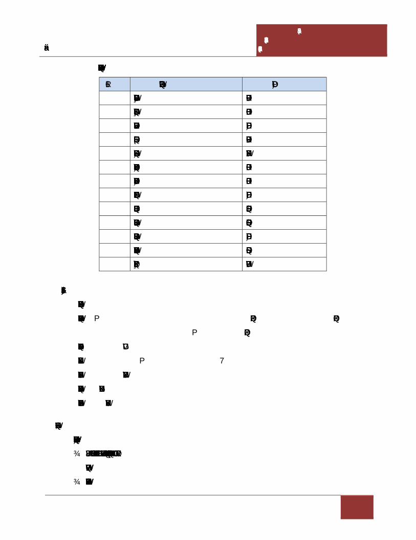
Draft Environmental Impact Assessment Report for M/s Virgin Rock Pvt. Ltd. – 6.0 Ha.
CHAPTER- IV ANTICIPATED ENVIRONMENTAL
IMPACTS & MITIGATION MEASURES
4 - 19
Table 4.4 Selected Lists of Plant Species for Greenbelt Development
S.No. Botanical name Family
1 Albizia odoratissima Mimosaceae
2 Azadirachta indica Meliaceae
3 Dalbergia sissoo Fabaceae
4 Delonix regia Mimosaceae
5 Feronia elephanta Rutaceae
6 Ficus benghalensis Moraceae
7 Ficus religiosa Moraceae
8 Hardwickia binata Fabaceae
9 Mangifera indica Anacariaceae
10 Polyalthia longifolia Annonaceae
11 Pongamia pinnata Fabaceae
12 Sapindus emarginatus Sapindaceae
13 Syzygium cumini Myrtaceae
4.7 TRAFFIC ANALYSIS
During mine operation
Colour Granite & Road Metal : 10148.0544 m3/annum + 40592.2176 m3/annum
: 50740.272m3/annum
No. of working days : 250 days
Truck Capacity : 10 m3 (25 T)
No of trucks per day : 20 trucks/day
Total working hours per day : 8 hours/day
No. of trips deployed/hour : 3 trips/hour
4.7.1 Impact on road network
Following control measures will implemented for traffic management.
Usage of project vehicles will be restricted near sensitive zones such as schools,
settlements etc.
Speed of the vehicles will be restricted to 25 KMPH.

Draft Environmental Impact Assessment Report for M/s Virgin Rock Pvt. Ltd. – 6.0 Ha.
CHAPTER- IV ANTICIPATED ENVIRONMENTAL
IMPACTS & MITIGATION MEASURES
4 - 20
Vehicular movement will be restricted to specific routes.
Adequate training on traffic and road safety operations will be provided to the drivers.
Routine maintenance vehicles will be ensured to prevent any abnormal emissions and
high noise generation.
Road network within site and nearby site will be graded.
The entry and exit points carefully designed to avoid any disturbance to traffic and will
have enough buffer before merging into the main roads.
Signal for speed limit will be placed and are maintained.
4.8 SOCIO-ECONOMIC CONDITIONS
4.8.1 Impact on socio-economic conditions
No displacement of people is envisaged from the ML area. The acquired mine lease area
involves 6.0 Ha of hill and slope of hillock. The lease area is unfit for agriculture as it is
strewed with small stones/boulders. The surrounding inhabitants are mainly agricultural
oriented & mine workers. Unemployment and under-employment are the main problems of
inhabitants.
Communication facilities are already present in the village and first aid facility, rest shelters
and other facilities will be provided by the proponent as Corporate Environment
Responsibility which will be positively benefited the local population.
Other beneficial impacts can be
Increase in employment opportunities.
Enhance the capabilities of education.
Growth in service sectors.
Improvement in socio-cultural Environment of the study area.
Improvement in transport, communication, health and educational services.
The overall impact on the Socio economic Environment will be beneficial.
4.8.2 Impact on Human Settlement
The main occupation of the local people is cultivation and sheep rearing. The details of the
villages, location, distance and population are given in the following table.

Draft Environmental Impact Assessment Report for M/s Virgin Rock Pvt. Ltd. – 6.0 Ha.
CHAPTER- IV ANTICIPATED ENVIRONMENTAL
IMPACTS & MITIGATION MEASURES
4 - 21
Table 4.5 Surrounding villages with their population
S.No Village Direction Distance
(Kms)
Population
(Nos)
1 Bonthu South-East 1.47 841
2 Mahasingi South-East 0.53 1645
3 Poppangi South-East 3.21 58
4 Tallapadu West 2.73 56
5 Dharmalakshmipuram North-East 2.80 1106
6 Savarabonthu North 1.25 601
Source: Approved Mining Plan
4.9 IMPACT ON OCCUPATIONAL HEALTH AND SAFETY
During the high windy days in summer the Colour Granite and Road Metal (Granite waste)
could be the problems for eyes like itching and watering of eyes. Dust in air can be a health
hazard leading to respiratory issues such as asthma and irritating the lungs and bronchial
passages. Air Blast and fly rock may pose problem during blasting, thus blasting will be
avoided.
For mitigating the aspects following measures will be implemented:
Regular water sprinkling on haul roads.
Periodical medical examinations will be carried out for the workers as per norms,
Medical records will be maintained,
Medical facilities to the workers,
Any early symptom of diseases, if observed, such workers will be taken off in the
dusty atmosphere and suitably employed elsewhere,
Personal Protective Equipments such as helmets, safety shoes and aprons with nose
masks will be provided to the workers,
Good quality water will be provided to the workers and proper test for water quality
to be carried out regularly.
A well equipped first aid facility will be available in mine lease area,

Draft Environmental Impact Assessment Report for M/s Virgin Rock Pvt. Ltd. – 6.0 Ha.
CHAPTER- IV ANTICIPATED ENVIRONMENTAL
IMPACTS & MITIGATION MEASURES
4 - 22
Safety of the employee during operations, maintenance of mining equipments will be
taken care as per Mine Regulations 1961.
Effective communication system like mobile phones, land line phones, e-mail etc.
facilities will be available at the mine site.
Uniforms will be provided to the workers and they will be allowed to go home after
changing clothes.
Trespassers are not allowed.

CHAPTER –V
ANALYSIS OF ALTERNATIVES


Draft Environmental Impact Assessment Report for M/s Virgin Rock Pvt. Ltd. – 6.0 Ha.
CHAPTER-V ANALYSIS OF ALTERNATIVES
5- 1
5.0 GENERAL
The analysis of alternative is the process of comparing potential impacts and mitigation
options of a series of alternative location, technologies, operation to identify optimal
alternatives.
5.1 ALTERNATE TECHNOLOGY
M/s Virgin Rock Pvt. Ltd., Managing Director: D. Ram Manohar Naidu has been
granted in principle a Quarry lease for Colour Granite and Road Metal (Granite waste)
over an extent of 6.0 Ha., in Sy. No. 1 of Bonthu Village, Saravakota Mandal,
Srikakulam District, Andhra Pradesh. The method of mining is conventional method of
open cast mining for the production of 10148.0544 m3/annum for Colour Granite and
40592.2176 m3/annum for Road Metal (Granite Waste).
The production technology for excavation of Colour Granite and Road Metal is open cast
semi mechanized method of mining with the help of drilling, wire saw cutting and
excavation by excavators. Colour Granite/Road Metal is medium hard mineral, so drilling
and rock breaking is unavoidable activities for this mine. The technology suggested is
best suited for Colour Granite and Road Metal production. The present technology will
be implemented in safe and environmental friendly manner.
5.2 ALTERNATIVE SITE
Mining activities are carried out based on local geology and availability of the mineral.
As the proposed mine is with proved deposits of the mineral, no alternate site selection
are applicable.


CHAPTER –VI
ENVIRONMENTAL MONITORING
PROGRAMME


Draft Environmental Impact Assessment Report for M/s Virgin Rock Pvt. Ltd. – 6.0 Ha.
CHAPTER-VI ENVIRONMENTAL MONITORING
PROGRAMME.
6 - 1
6.0 ENVIRONMENTAL MONITORING
Success of any environmental management programme depends upon the efficiency of
the organizational set up responsible for Implementation of the programme. Post project
monitoring is an essential part to check the impact of any project activity. Hence
monitoring of various environmental parameters will be carried out a regular basis to
ascertain the following:
State of pollution within the mine and in its vicinity.
Generate data for predictive or corrective purpose in respect of pollution.
Examine the efficiency of pollution control systems installed in the ML area.
To assess and monitor environmental impacts.
Environmental monitoring will be taken up for various environmental components
as per conditions stipulated in Environmental Clearance Letter issued by SEIAA
Committee & Consent to operate issued by the State Pollution Control Board.
Compliance of same will be submitted to respective authorities on regular basis. The
Management will assign the third party which is recognized by MoEF&CC /NABL to
monitor the environmental parameters in the mine site and the surroundings as per the
schedule and will maintain the log books.
6.1 ENVIRONMENT MANAGEMENT
In order to maintain the environmental quality within the stipulated standard, regular
monitoring of various environmental components is necessary which will be complied as
per condition.
An environmental management cell will be implemented. The structure of the team
proposed for environmental management is a simple one; this is due to the limited size of
the organization. As the employees are mostly unskilled labourers and the operating size
of the management is small, it is better that a member of senior management or a
manager level employee assumes the responsibility of complying with environmental
measures.

Draft Environmental Impact Assessment Report for M/s Virgin Rock Pvt. Ltd. – 6.0 Ha.
CHAPTER-VI ENVIRONMENTAL MONITORING
PROGRAMME.
6 - 2
6.2 MONITORING AROUND THE MINE SITE
a. Meteorology
The Management will assign the third party which is recognized by MoEF&CC to
monitor the weather conditions in the mine site and the surroundings as per the schedule
and will maintain the log books.
b. Ambient air quality monitoring
Ambient air quality will be monitored in the mine site and in the surrounding villages
through a third party as per the guidelines.
c. Ground water monitoring
Ground water levels for physical and chemical parameters will be monitored in and
around the mine site premises during the pre and post monsoon seasons.
d. Wastewater sampling
The wastewater sample will be collected regularly for analysis.
6.3 POST PROJECT MONITORING PROGRAMME
In order to maintain the environmental quality within the standards, regular monitoring of
various environmental components is necessary.
The proponent will allocate Capital Cost Rs. 5.5 Lakhs and recurring cost is 5.0 Lakhs
per annum budget towards environmental protection initiatives. The annual budget
allocated for Environmental monitoring is 0.5 Lakhs/annum
6.3.1 Environmental Monitoring
Regular monitoring of various Environmental parameters shall be carried out to ascertain
the following points
Status of air, noise, water, land pollution within the mining activity and in its vicinity;
Generate data for predictive or corrective purpose in respect of pollution; and
To assess and monitor Environmental impacts periodically.

Draft Environmental Impact Assessment Report for M/s Virgin Rock Pvt. Ltd. – 6.0 Ha.
CHAPTER-VI ENVIRONMENTAL MONITORING
PROGRAMME.
6 - 3
6.4 MONITORING SCHEDULE FOR ENVIRONMENTAL PARAMETERS
Table: 6.1 Monitoring Schedule for Environmental Parameters
S.No. Particulars Monitoring
Frequency
IMP. Monitoring
Parameters
1. Water and Wastewater Quality
a. Domestic Sewage
b. Ground Water Quality
Once in a month
Pre monsoon and
Post monsoon season
pH,TDS,BOD,COD
pH,TDS,BOD,COD
2. Air Quality
a. Ambient Air Quality
Monitoring at mine site &
other sampling locations
given in the report
Quarterly
PM10, PM2.5,SO2, NOX
and Free Silica
3. Noise levels in and around
Mine site
Quarterly Noise levels -
Day and Night in dB(A)
6.5 IMPLEMENTATION SCHEDULE
The mitigation measures suggested above should be implemented so as to reduce the
impact on environment due to the operation of the mining activities. In order to facilitate
easy implementation, the mitigation measures are phased as per the priority of
implementation. The implementation schedule is given as below (Table - 6.2)
Table - 6.2 Implementation Schedule
S.No Recommendations Time
Requirement Immediate Progressive
Discretion of the
Management
1 Air pollution
control measures
Being
implemented
* -- --
2 Water pollution
control measures
Being
implemented
* -- --
3 Noise control Being * -- --

Draft Environmental Impact Assessment Report for M/s Virgin Rock Pvt. Ltd. – 6.0 Ha.
CHAPTER-VI ENVIRONMENTAL MONITORING
PROGRAMME.
6 - 4
measures implemented
4 Ecological
preservation and
Up gradation
Stage wise
implementation
* * --
5 Land
reclamation/Soil
waste management
Stage wise
implementation
* * --
6 Socio-economic
measures
As per the CER
activities
proposed by the
company and
the need of the
local residents
-- * *
Note (*) indicates implementation of recommendations
6.6 MONITORING EQUIPMENT AND CONSUMABLES
1. Handy samplers
2. Respirable Dust Sampler / Fine Particulate Sampler
3. Meteorological station

CHAPTER –VII
ADDITIONAL STUDIES


Draft Environmental Impact Assessment Report for M/s Virgin Rock Pvt. Ltd. – 6.0 Ha.
CHAPTER-VII ADDITIONAL STUDIES
7 - 1
7.0 PUBLIC CONSULTATION:
The project is categorized as Category –B2 as per Environmental Impact Assessment
(EIA) Notification S.O. 1533 (E) Dt: 14.09.2006 and amended Notification S.O. 3977 (E)
Dt: 14.08.2018. But, as per the latest National Green Tribunal (NGT) New Delhi issued
orders in O.A. 186 of 2016 Dt: 13.09.2018 & in E.A. No. 55/2018 of O.A. No. 520/2015
Dt: 11.12.2018; OM F. No. L-11011/175/2018-IA-I (M) Dt: 12.12.2018 the projects with
individual area or cluster area of mine leases from 5 to 25 Hectares falls under Category
B2 at par with Category B1, necessitates Public Hearing for obtaining the Environmental
Clearance from State Environmental Impact Assessment Authority (SEIAA).
The present Draft EIA is being submitted for conducting Public Hearing. The issues
posed during the public hearing, the response of the proponent along with action plan and
budgetary allocation will be given in the Final EIA report and will be submitted to
MoEF&CC for obtaining Environmental Clearance.
7.1 RISK ASSESSMENT
Risk analysis provides identification of the risks/accidents and to take necessary steps to
prevent it happening. The main objective of risk assessment includes;
To identify the potential hazardous areas so that necessary design safety measures
can be adopted to minimize the probability of accidents.
To identify the potential areas of Environmental disaster, this can be prevented by
proper design of the installations and their control operations.
To manage emergency situations or a disastrous event, if any, from the mining
operations.
It begins with the identification of probable hazardous events at an operational area and
categorization as per the predetermined criteria. Risk assessment should be done on the
basis of past accident analysis at similar projects, previous judgments and expertise in the
field of risk analysis especially in accident analysis.

Draft Environmental Impact Assessment Report for M/s Virgin Rock Pvt. Ltd. – 6.0 Ha.
CHAPTER-VII ADDITIONAL STUDIES
7 - 2
7.1.1 Drilling Risks
Drilling is common operation for mining Colour Granite and Road Metal (Granite waste),
which is medium hard mineral. The main hazards involved are as follows:
Drill falling from the edge of a bench
Dust created during the drilling operations
Noise produced during drilling
The risk will occur during the drilling of the first line of holes parallel with the working
edge of the bench. Measures that can be taken to reduce the risk of falling off the edge of
the bench is to provide suitable portable rail fencing which can be erected between the
drill and the edge of the bench and direction by the supervisor from guidance of the
driller. Control measures for Dust and Noise produced during drilling are discussed in
detail in Chapter IV.
7.1.2 Failure of Slope in the Pit
In open pit mining, mineral deposits are mined from the ground surface and downward.
Consequently, pit slopes are formed as the mineral is being extracted. The issues
concerned with slope stability in the open cast mines have come to forefront in the
mining operations due to increasing pit depth.
The pit slopes must thus be inclined at some angle to prevent failure of the rock mass.
This angle is governed by the geo-mechanical conditions at the specific mine and
represent an upper bound to the overall slope angle. The actual slope angles used in the
mine depend upon (i) the presence of haulage roads, or ramps, necessary for the
transportation of the ore from the pit (ii) mineral grades, and (iii) economical constraints.
Besides determining factor of safety, the slopes shall be monitored at regular intervals by
using real time slope stability radar system to monitor for any possible failure. The well
developed drainage system over the lease area should ensure that storm water does not
accumulate in the lease area and therefore hydrostatic pressure remains at a low level.

Draft Environmental Impact Assessment Report for M/s Virgin Rock Pvt. Ltd. – 6.0 Ha.
CHAPTER-VII ADDITIONAL STUDIES
7 - 3
7.1.3 Filling up the mine pit due to excessive rains
Filling up the mine pit due to excessive rains in the worked out area is a remote
possibility. Normally there will be sufficient warning time before such an incident takes
place, harming equipment and human life. However, as a precautionary measure,
interceptor ditches along the outer boundary of the pit area constructed to control inflow
of runoff into the mine pits. Water that collects in the mine pit from rainfall will be
coursed out from the pits, through garland drains.
7.1.4 Accidents of heavy machinery
Most of the accidents during transfer of product, trucks and other vehicles are often
attributed to mechanical failures, in which the factor of human errors cannot be ruled out.
Regular maintenance and testing of all mine equipment as per manufacturer’s guidelines
can largely eliminate accidents of heavy machinery. Competent drivers will be employed
to minimize accidents during transportation.
7.2 DISASTER MANAGEMENT PLAN
A disaster is a catastrophic event in which personnel working in the affected area are
immediately planed into a chaotic situation, which demands their immediate rescue,
medical and social case to restore normalcy. It creates a major emergency in mining area
requiring an Emergency response in accordance with a Mine Disaster Management Plan
formulated by the management.
A detailed DMP for handling emergencies includes;
Identification and assessment of major credible risk scenarios anticipated at a
particular workplace/activity (Slope failure, fires, etc.)
Setting up an Emergency response organization identified key personnel at the mine
with assigned duties and responsibilities for incident response and emergency
response.
Emergency action plan with implementation procedures by emergency response
personnel for each scenario after emergency warning.
Details of safety measures to prevent accident and disaster.

Draft Environmental Impact Assessment Report for M/s Virgin Rock Pvt. Ltd. – 6.0 Ha.
CHAPTER-VII ADDITIONAL STUDIES
7 - 4
Emergency notification by sending warning messages to identified agencies for
liaison and stake holders.
Setting up a permanent organization for completion of emergency and restoration of
normalcy by complying with health, safety, and environmental laws and regulations
Supplementary response plans under mutual aid
Any other stipulations made by regulatory agencies for handling emergency
situations that may arise either from natural or manmade.
7.3 IMPLEMENTATION OF EMP AND MONITORING SYSTEM
7.3.1 General
Various measures have been proposed to implement for mitigating the adverse impacts
due to mining on the environment in the area. A separate wing “Environmental
Management Cell (EMC)” will be formed to look after the inspection / monitoring
requirements. The mine management will undertake the control measures in coordination
with the State Forest Department, Regional APPCB and Environmental consultant. The
management of EMC shall be made an integral part of the major activities of mining.
Mines Manager
Geologist (Incharge of Supervisor
Mine monitoring and
Supervision& APPCB/ MoEF works)
Dust Suppression Mate
Helpers
Fig.7.1 Organizational setup of EMC

Draft Environmental Impact Assessment Report for M/s Virgin Rock Pvt. Ltd. – 6.0 Ha.
CHAPTER-VII ADDITIONAL STUDIES
7 - 5
Important records to be maintained by EMC are:
Field monitoring results for air, water, meteorology
Inspection records of slope failure, land erosion, drainage, Socio-economic
development.
Format to record / monitor plantation measures.
Nursery records
Environmental and related standards / norms
Records pertaining to statutory consents, approvals
Periodic medical examination (PME) records.
Records pertaining to laboratory equipment maintenance and calibration.
Complaints register (environmental pollution).
Records on water and electricity consumption.
Periodic progress records
Environmental audit records
Records of annual budgetary requirement and allocation for pollution control.
7.3.2 Implementation
The following system shall be followed to see that the environmental scheme is
implemented as per schedule.
a. A separate wing will be created to see that the engineering measures such as
construction of garland drains and retention walls are taken up, wherever necessary.
b. A crew attends for afforestation measures on a regular basis for culturing, manuring
and watering.
c. On an annual/quarterly basis, the quality of air, water, noise and soil will be
monitored to understand the status vis-à-vis the baseline data. This will enable the
management for taking up any corrective measures, if required. The frequency of
sampling will be as prescribed by the MoEF&CC guidelines issued in this regard.
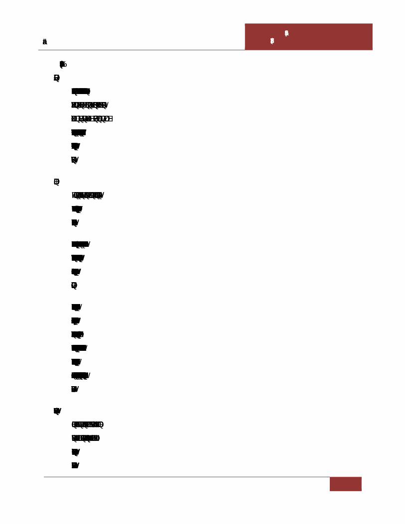
Draft Environmental Impact Assessment Report for M/s Virgin Rock Pvt. Ltd. – 6.0 Ha.
CHAPTER-VII ADDITIONAL STUDIES
7 - 6
7.4 ACTIVITIES TO BE MONITORED / INSPECTED BY EMC
7.4.1 Land erosion
The mine activity will expose out the loose earthy material which leads to soil erosion
through rain water runoff or wind action. This phenomenon should be monitored
regularly and necessary actions should be implemented. Garland drains will be
constructed around the mine area to avoid siltation of nearby lands/water bodies. These
constructed drains should be regularly inspected and desiltation works should be taken up
by the proponent.
7.4.2 Drainage
The drainage pattern observed in this location is parallel and sub dendritic pattern.
Notable water bodies either seasonal or perennial are not present nearby area which may
cause the inundation of quarry.
There are no perennial/seasonal water courses within the mine area. However, suitable
storm water garland drainage system will be adopted to divert the rain water into natural
drainage. Benches and haul roads will be sloped in such away to allow the rain water into
garland drains.
There are no ground water bodies such as open wells or bore wells in this lease area. The
ground water table ranges from 30-35 m depth from the ground level. Maximum depth of
workings is up to RL 75 m and Minimum depth of workings is RL 90 m., i.e, maximum
depth of workings in this mining plan period is RL 75 m from the top of the hill, which
has a highest contour of 99 m and lowest contour of 88m. No chance for accumulation of
ground water in working pit during this mining plan period is anticipated and no water
will be discharged from the pit.
7.4.3 Re-vegetation and green belt development
Planned schedule for green belt development will be checked after every year and
improvement required will be implemented. Post plantation status will be regularly
checked in every season. Phase wise development in the areas of plantation including rate
of growth, survival rate etc. will be recorded systematically.

Draft Environmental Impact Assessment Report for M/s Virgin Rock Pvt. Ltd. – 6.0 Ha.
CHAPTER-VII ADDITIONAL STUDIES
7 - 7
7.4.4 Occupational Health
Since it is opencast mining, health problems due to dust may be expected at various
locations (excavation & loading) during mining of Colour Granite and Road Metal
(Granite waste). No blasting will be done to minimize the impact on surroundings.
Monitoring:
The efficiency of installed dust controlling equipments and water sprinkling system
should be monitored on regular basis. Measurements to determine employee ceiling
exposure can be taken during period of maximum expected air borne concentrations of
Colour Granite and Road Metal (Granite waste). Safety measures followed by the work
force during mineral production (like usage of PPE) should be monitored by the mine
supervisor/management.
Control Measures:
Location of dust generation:
1. Mining area
2. Loading & Transportation
It is advisable to use water sprinkling on haul roads to suppress the dust generated, so that
the work men will not get expose to the dust.
Precautions:
By using various PPEs, the chances of occupational health disease will be
lowered.
Periodical medical checkups for lungs functioning and breathing.
First aid will be given for in case of emergency.
Each group of mine worker will undergo regular medical checkup at regular
intervals by specialist doctors.
Persons not wearing protective equipment and clothing should be restricted from
areas of spills until clean up has been completed.

Draft Environmental Impact Assessment Report for M/s Virgin Rock Pvt. Ltd. – 6.0 Ha.
CHAPTER-VII ADDITIONAL STUDIES
7 - 8
The workmen especially who are literate should be sent for first aid training
conducted by the group vocational training centre to maintain by the DGMS
(Director General of Mine Safety).
7.4.5 Operation and Maintenance:
The problem of occupational health in the operation and maintenance phase is primarily
due to dust and noise which could affect the workers from respiratory and hearing
problems. The necessary personal protective equipments will be provided to all the
workers. The working personnel will be given the following appropriate personnel
protective equipments.
Safety helmets
Face shield
Plain goggles with cut type filters on both ends.
Goggles with cut type filters on both sides and blue color glasses
Cylindrical type earplug
Ear muffs
Dust mask
Self contained breathing apparatus
Leather apron
Safety belt
Leather hand gloves
Safety shoes with steel toe
Full-fledged hospital facilities will be available round the clock for attending emergency
arising out of accidents, if any. All working personnel will be medically examined at least
once in every year.
7.5 COMPLIANCE FOR ADDITIONAL TERMS OF REFERENCE:
TOR has been issued and the following points were added as additional conditions along
with terms of standard TOR vide Lr. No. SEIAA/AP/SKLM/MIN/10/2020/2205-149
Dated: 21.06.2021. Additional TOR points issued and the compliance to the same are
discussed below:

Draft Environmental Impact Assessment Report for M/s Virgin Rock Pvt. Ltd. – 6.0 Ha.
CHAPTER-VII ADDITIONAL STUDIES
7 - 9
7.5.1 Tree enumeration with vegetation
Introduction
Trees are significant due to their rich species diversity, composition and structure over
small geographic scales often has been correlated with changes in topography and soil
characteristics (Naidu et al 2018). Trees form the major structural and functional basis of
forest ecosystems and can serve as robust indicators of changes and stresses at the
landscape scale (Suthari et al 2018). Trees are useful for analysis of species-area and
species-individual relationships because they are easy to locate precisely and to count
(Naidu and Kumar 2015). Trees are dominant plant growth form with considerable
economic uses and substantial base of information stand out as a good choice for one of
the taxa to be sampled in the monitoring programme.
The close bonding of humans with trees may be traced back to their arboreal ancestry.
Reposing under a tree is like being cuddled by a mother-comfortable and secured. Trees
are major constituents of forests, which are considered as the most valuable natural
resource and are of immense importance both to man and the nation (Pragasan and
Parthasarathy 2010). By sequestering carbon, releasing oxygen and losing a large amount
of water vapour, trees profoundly influence the environment. Trees bind the soil, recycle
minerals and regulate the course of rain water. Unparalleled in the variety of useful
products they give and the wide range of organisms they feed and shelter (Naidu and
Kumar 2016). Trees are essential for maintaining the health of ecosystems. They are the
largest and longest-lived immobile organisms and often an amazing diversity of forms
(Panda et al 2013; Premavani et al 2017).
Quantitative inventory in forests have been concentrated on tree species than the other
life forms, since tree species diversity is an important aspect of forest ecosystem. The
present study focused on species composition and diversity help informing appropriate
management and conservation plan. Conservation management also requires data on tree
species diversity and the forest community structure in order to maintain necessary action
(Suthari 2018; Gopalkrishna et al. 2018). In view of these conditions, we enumerated
trees and their diversity and distribution in proposed mine, as part of Srikakulam district,

Draft Environmental Impact Assessment Report for M/s Virgin Rock Pvt. Ltd. – 6.0 Ha.
CHAPTER-VII ADDITIONAL STUDIES
7 - 10
aiming to provide fundamental data for appropriate management strategies that will
improve the ecosystem conservation status.
Objectives
To enumerate the trees, their population levels and structure in the study area
To assess the existing status of the trees quantitatively and qualitatively
To know the diversity, density and dominance of the species in the study area
Study area
The study area is secondary dry deciduous forest in which all trees are growing with less
than 100cm girth. The primary forest completely degraded due to anthropogenic
activities. The tree begin to shed their leaves by about December and between February
and May the forest looks very open and at times eye-soaring, but some of the area is no
vegetation observed during the study period. Flowering and fruiting are generally far
advanced before the first flush of new leaves appears with the conventional showers in
April-May.
In the study area, some commonest tree species are Wrightia tinctoria, Cochlospermum
religiosum, Aegle marmelos, Strychnos potatorum, Buchanania lanzan, Ziziphus
xylopyrus, Xylia xylocarpa spp., Chloroxylon swietenia, Pterospermum xylocarpum,
Albizia chinense, Cassia fistula, Diospyros melanoxylon etc. are some of the typical trees;
Gmelina asiatica and Ziziphus mauritiana are armed trees present, at the edges of the
mine. Holarrhena antidysenterica, Alangium salvifolium, Bauhinia racemosa, Tarenna
asiatica, Flacourtia indica, Helicteris isora, Woodfordia fruticosa, Grewia rothii etc. are
some of the common small trees found in this area.
A number of climbers and twiners are found in this type of forests. To mention, some of
them are Butea superba, Cansjera rheedii, Celastrus paniculatus, Combretum
ovalifolium, Dioscorea spp., Pueraria tuberosa, Ventilago denticulata, Mucuna spp. etc.
Herbaceous plants and some sub-shrubby or bushy plants are found in this zone are
Borreria articularis, Allmania nodiflora, Tephrosia purpurea, Opuntia stricta and

Draft Environmental Impact Assessment Report for M/s Virgin Rock Pvt. Ltd. – 6.0 Ha.
CHAPTER-VII ADDITIONAL STUDIES
7 - 11
Calotropis procera and Carissa spinarum. Aristida adscensionis and Heteropogon
contortus are common grasses.
Methodology
The field work on quantitative inventory was carried out by ground sampling, analysis of
dominant species and their common associates and interaction with forest officials. The
entire study area was divided into 20 quadrats, which formed the sampling plots for
quantitative assessment of plant biodiversity (Fig 1). In the study area, forty quadrats
with a size of 50m × 50m i.e. 5 Ha were laid and remaining area is covered with shrubs
and herbs only.. All the live individual trees of >30 cm Girth at breast height (GBH) were
measured using a diameter tape and documented all the individuals of various species.
The representative plant taxa were collected and identified with the help of regional
floras (Rao and Sreeramulu 1986; Rao and Kumari 2002; Venkaiah 2004), AP state flora
(Pullaiah et al 1997), e-floras and also with the online herbarium catalogue of Royal
Botanic Garden, Kew.

Draft Environmental Impact Assessment Report for M/s Virgin Rock Pvt. Ltd. – 6.0 Ha.
CHAPTER-VII ADDITIONAL STUDIES
7 - 12
Fig 7.2. Floristic survey and quantitative assessment of plant resources of M/s Virgin Rock
Pvt. Ltd. Mine
Data analysis
The collected data were quantitatively analyzed for basal area, relative density, relative
frequency, relative dominance, importance value index (IVI) of tree species (Curtis & Mc
Intosh, 1950). The density and basal area (BA) of each species was calculated on the
basis of data recorded from all quadrats of the particular mine and the values were
expressed per hectare basis for comparison. The GBH was converted into basal area (BA)
as BA=GBH2/4π (Naidu et al 2016; Gopalkrishna et al. 2018).

Draft Environmental Impact Assessment Report for M/s Virgin Rock Pvt. Ltd. – 6.0 Ha.
CHAPTER-VII ADDITIONAL STUDIES
7 - 13
Total number of quadrats in which a species occur Frequency = --------------------------------------------------------------------- × 100
Total number of quadrats studied
Total number of individuals of a species Density = -----------------------------------------------------------
Total number of quadrats studied
Total number of individuals of the species occurring Abundance = ---------------------------------------------------------------------
Total number of quadrats in which the species occur
Frequency of one species Relative frequency (RF) = --------------------------------------------------- × 100
Sum of all frequencies
Number of individuals of a species Relative density (RD) = ----------------------------------------------------- × 100
Total number of individuals of all species
Combined basal area of a single species Relative dominance (RDom) = --------------------------------------------------- × 100
Total basal area of all species
Importance Value Index (IVI) = RF + RD + RDom
The diversity indices were calculated by using PAST software in core zone of the project
areas to know variation among the plant species. The data collected were also used to
compute community indices like species diversity (H') of different tree species was
calculated by using the Shannon- Weiner Index (Shannon and Weiner, 1963), as such:
H' = -Σ (ni/N)/ n (ni/N),
Where, ni/N, which denotes the importance probability of each species in a population,
ni= Importance of value of species and N is the total number of individuals of all species
in that vegetation type. Species dominance (Cd) was calculated following Simpson
(Simpson, 1949): Such that
Cd = Σ (ni/N)2,

Draft Environmental Impact Assessment Report for M/s Virgin Rock Pvt. Ltd. – 6.0 Ha.
CHAPTER-VII ADDITIONAL STUDIES
7 - 14
Where, ni and N are the same as those for Shannon-Weiner information function.
Equitability of evenness refers to the degree of relative dominance of each species in that
area. It was calculated according to Pielou (Pielou, 1966) as:
Evenness (e) = H'/log S, where, H'= Shannon index, S = number of species
Distributions of tree species were calculated using ration of abundance to frequency
(Whitford 1949). If the values lies below 0.025: regular, 0.025 – 0.05: random, and if
>0.05 contagious (Curtis and Cottam 1956).
Results
Floristic composition
A total of 41 species of trees > 30 cm GBH belonging to 35 genera and 26 families were
recorded in the entire mine site (Table 1). The twenty inventory quadrats in mine site
yielded a total of 991 stem individuals > 30 cm GBH (Girth at Breast Height), 41 species
encountered in the study area is given in Table 7.1. An obvious variation in presentation
of tree species and proportion of dominant species in the mine site can directly be
attributed to rain fall distribution and favourable topographic conditions. With regard to
the number of species found within families, Mimosaceae, Anacardiaceae, Rubiaceae,
Ebenaceae and Verbenaceae are most diverse tree families in samples, being represented
by 3 species each, followed by Annonaceae, Caesalpiniaceae, Fabaceae, Flacourtiaceae,
Rubiaceae and Moraceae (2 species each) and remaining families represented by single
species (Table 7.2). Within the family Ebenaceae, Diopyros and Moraceae Ficus are the
most common genus, being represented by 3 species respectively.
Table 7.1. List of total trees enumerated in the proposed mine
S.No. Plant name Family No of individuals
1 Acacia leucophloea Mimosaceae 14 2 Aegle marmelos Rutaceae 21 3 Alangium salvifolium Alangiaceae 14 4 Albizia chinensis Mimosaceae 20 5 Azadirachta indica Meliaceae 12 6 Bauhinia racemosa Caesalpiniaceae 17

Draft Environmental Impact Assessment Report for M/s Virgin Rock Pvt. Ltd. – 6.0 Ha.
CHAPTER-VII ADDITIONAL STUDIES
7 - 15
7 Bridelia crenulata Euphorbiaceae 20 8 Buchanania lanzan Anacardiaceae 28 9 Butea superba Fabaceae 26
10 Casearia tomentosa Flacourtiaceae 16 11 Cassia fistula Caesalpiniaceae 29 12 Chloroxylon swietenia Flindersiaceae 13 13 Cleistanthus collinus Euphorbiaceae 39 14 Dalbergia paniculata Fabaceae 35 15 Diospyros chloroxylon Ebenaceae 37 16 Diospyros melanoxylon Ebenaceae 18 17 Diospyros sylvatica Ebenaceae 75 18 Ficus hispida Moraceae 22 19 Ficus racemosa Moraceae 19 20 Flacourtia indica Flacourtiaceae 19 21 Gmelina asiatica Verbenaceae 15 22 Ixora pavetta Rubiaceae 34 23 Lagerstroemia parviflora Lythraceae 20 24 Lannea coromandelica Anacardiaceae 26 25 Litsea glutinosa Lauraceae 14 26 Memecylon edule Melastomataceae 29 27 Morinda pubescens Rubiaceae 27 28 Ochna obtusata Ochnaceae 13 29 Polyalthia cerasoides Annonaceae 15 30 Polyalthia suberosa Annonaceae 34 31 Premna tomentoa Verbenaceae 38 32 Protium serratum Burseraceae 16 33 Pterospermum xylocarpum Sterculiaceae 26 34 Semecarpus anacardium Anacardiaceae 20 35 Sterculia urens Sterculiaceae 12 36 Strychnos potatorum Loganiaceae 16 37 Syzygium cumini Myrtaceae 18 38 Tectona grandis Verbenaceae 25 39 Wrightia tinctoria Apocynaceae 31 40 Xylia xylocarpa Mimosaceae 45 41 Ziziphus xylopyrus Rhamnaceae 23

Draft Environmental Impact Assessment Report for M/s Virgin Rock Pvt. Ltd. – 6.0 Ha.
CHAPTER-VII ADDITIONAL STUDIES
7 - 16
Table 7.2. List of dominant families with reference to species number
S.No Family Genera Species 1 Alangiaceae 1 1 2 Anacardiaceae 3 3 3 Annonaceae 1 2 4 Apocynaceae 1 1 5 Burseraceae 1 1 6 Caesalpiniaceae 2 2 7 Ebenaceae 1 3 8 Euphorbiaceae 2 2 9 Fabaceae 2 2
10 Flacourtiaceae 2 2 11 Flindersiaceae 1 1 12 Lauraceae 1 1 13 Loganiaceae 1 1 14 Lythraceae 1 1 15 Melastomataceae 1 1 16 Meliaceae 1 1 17 Mimosaceae 3 3 18 Moraceae 1 2 19 Myrtaceae 1 1 20 Ochnaceae 1 1 21 Rhamnaceae 1 1 22 Rubiaceae 2 3 23 Rutaceae 1 1 25 Sterculiaceae 1 1 26 Verbenaceae 3 3
Total 35 41
Quantitative ecological study of tree species
Floristic composition and species richness
A total number of 991 individuals of tree species with >30 cm GBH were recorded from
40 sample quadrates (5.0 Ha) of M/s Virgin Rocks Pvt. Ltd. mine. They represent 41
species belonging to 35 genera under 26 families. The values of diversity indices such as
Shannon-Weiner Index, Simpson Index and Evenness Index were calculated as 3.89, 0.97

Draft Environmental Impact Assessment Report for M/s Virgin Rock Pvt. Ltd. – 6.0 Ha.
CHAPTER-VII ADDITIONAL STUDIES
7 - 17
and 0.74 respectively (Table 7.3). Tree species enumeration and distribution species in
different quadrats are given in Table 7.4.
Table 7.3. Biodiversity parameters of tree species enumerated in the mine
No. of tree species 41 No. of Genera 35 No. of Families 26 Stand density (No of stems/Ha) 198.2 Total Basal Area 12.38 Simpson index 0.97 Shannon Weiner Index 3.617 Evenness Index 0.908

Draft Environmental Impact Assessment Report for M/s Virgin Rock Pvt. Ltd. – 6.0 Ha.
CHAPTER-VII ADDITIONAL STUDIES
7 - 18
Table 7.4. Tree species distribution in different quadrats
S.No. Plant name Q1 Q2 Q3 Q4 Q5 Q6 Q7 Q8 Q9 Q10 Q11 Q12 Q13 Q14 Q15 Q16 Q17 Q18 Q19 Q20
1 Acacia leucophloea 0 1 1 0 1 0 1 1 0 0 2 1 1 1 1 1 0 0 1 1
2 Aegle marmelos 0 1 0 0 1 1 0 2 4 1 1 1 1 0 1 2 1 1 2 1
3 Alangium salvifolium 1 1 1 1 0 0 1 1 0 1 0 1 1 1 1 1 2 0 0 0
4 Albizia chinensis 0 1 1 1 1 2 2 0 1 2 1 1 1 0 1 1 1 1 1 1
5 Azadirachta indica 1 1 1 0 1 0 0 1 0 1 1 0 1 1 0 0 1 1 0 1
6 Bauhinia racemosa 0 2 0 1 0 1 1 2 1 0 1 1 1 0 2 1 0 1 1 1
7 Bridelia crenulata 2 0 2 0 2 1 0 0 1 1 1 0 2 2 0 1 1 2 0 2
8 Buchanania lanzan 2 1 0 2 1 2 2 1 1 2 2 3 0 2 1 1 1 2 2 0
9 Butea superba 1 3 0 3 2 3 2 0 1 2 1 0 0 1 3 1 2 1 0 0
10 Casearia tomentosa 0 1 1 2 0 0 1 2 1 1 1 0 0 1 1 1 1 1 0 1
11 Cassia fistula 2 1 0 3 2 0 2 3 1 1 3 1 0 2 1 1 1 3 2 0
12 Chloroxylon swietenia 1 0 1 1 0 2 1 0 1 0 0 1 1 1 0 1 0 0 1 1
13 Cleistanthus collinus 3 2 1 1 3 1 3 3 1 4 0 2 1 3 2 2 4 0 1 2
14 Dalbergia paniculata 3 2 2 0 1 0 3 2 1 4 0 1 3 3 2 1 4 0 1 2
15 Diospyros chloroxylon 2 2 1 3 0 3 2 0 2 3 2 1 2 2 1 2 3 2 1 3
16 Diospyros melanoxylon 0 3 0 2 2 0 0 0 0 1 2 0 1 0 3 0 1 2 0 1
17 Diospyros sylvatica 7 5 3 2 2 4 6 3 5 5 0 2 5 8 4 5 4 0 2 3
18 Ficus hispida 0 1 2 2 0 1 3 0 3 1 1 1 0 0 1 2 1 2 1 0
19 Ficus racemosa 1 0 1 0 2 1 0 0 2 0 0 2 2 1 0 3 0 0 2 2
20 Flacourtia indica 1 1 0 0 1 0 2 2 1 0 2 1 1 2 1 1 0 2 1 0
21 Gmelina asiatica 0 1 0 1 0 0 2 1 0 1 0 1 2 0 2 0 2 0 1 1
22 Ixora pavetta 1 0 0 0 1 3 4 1 2 5 3 0 1 1 0 2 6 3 0 1
23 Lagerstroemia parviflora
0 3 2 3 0 1 0 1 0 1 1 1 2 0 1 0 1 0 1 2

Draft Environmental Impact Assessment Report for M/s Virgin Rock Pvt. Ltd. – 6.0 Ha.
CHAPTER-VII ADDITIONAL STUDIES
7 - 19
24 Lannea coromandelica 2 1 5 2 1 1 0 2 1 0 0 3 0 2 1 1 0 1 3 0
25 Litsea glutinosa 1 1 1 0 0 1 0 1 1 0 0 0 1 2 2 2 0 0 0 1
26 Memecylon edule 0 4 4 4 2 1 1 1 0 1 0 1 2 0 4 0 1 0 1 2
27 Morinda pubescens 2 0 2 3 2 0 2 0 1 0 2 0 3 3 1 1 0 2 0 3
28 Ochna obtusata 0 0 1 0 1 2 0 1 1 1 1 0 0 0 0 1 1 1 0 2
29 Polyalthia cerasoides 0 0 1 1 1 1 1 0 2 1 0 0 1 0 0 2 1 1 1 1
30 Polyalthia suberosa 2 3 0 1 0 1 2 0 3 3 1 1 2 2 1 3 4 2 2 1
31 Premna tomentoa 3 2 1 0 2 2 1 4 3 3 1 1 1 3 2 3 3 1 1 1
32 Protium serratum 1 1 0 0 1 0 1 0 0 1 0 2 2 1 1 0 1 0 2 2
33 Pterospermum xylocarpum
0 2 0 0 2 0 3 1 0 2 3 2 1 0 1 0 2 3 1 3
34 Semecarpus anacardium
1 1 2 0 3 1 0 0 2 0 0 1 2 1 1 2 0 0 1 2
35 Strychnos potatorum 0 4 1 1 0 1 1 1 2 0 1 0 0 0 1 1 0 1 0 1
36 Sterculia urens 0 0 1 1 1 0 1 0 2 1 0 1 0 0 0 2 1 0 1 0
37 Syzygium cumini 0 1 0 0 1 1 0 2 0 0 2 1 2 0 1 1 2 1 1 2
38 Tectona grandis 2 1 0 1 2 1 1 1 0 2 3 1 1 1 1 0 2 2 2 1
39 Wrightia tinctoria 4 1 0 3 0 3 2 1 1 0 1 2 0 5 5 1 0 1 1 0
40 Xylia xylocarpa 0 7 4 2 2 2 0 2 1 4 1 0 4 0 7 1 3 1 0 4
41 Ziziphus xylopyrus 1 2 3 1 0 0 1 3 0 1 1 0 1 2 2 3 1 1 0 0

Draft Environmental Impact Assessment Report for M/s Virgin Rock Pvt. Ltd. – 6.0 Ha.
CHAPTER-VII ADDITIONAL STUDIES
7 - 20
Importance Value Index (IVI)
Species dominance is calculated based on the Importance Value Index (IVI) and was
calculated every species found in each study sites. It is usually practiced in ecological
scrutinizes; IVI indicates the ecological importance of a species in a specific ecosystem
which can be used for computing species conservation and management through which
species having low IVI value require soar protection preference. The IVI for a species
was calculated as the sum of its relative basal area, relative frequency, and relative
density and often to describe and compare the species dominance of the sites.
The IVI depict the sociological structure of a species in its totality in community. The
important value index (IVI) of the 41 species varied considerably (Table 5). The IVI
value of the top ten predominant species in each plot with their IVI values is more for
Diospyros sylvatica (17.9), Xylia xylocarpa (12.11), Diospyros chloroxylon (11.88),
Cleistanthus collinus(11.52) and Premna tomentosa (10.84) are predominant tree species
with greater values in the study area. Quantitative values encountered in study area are
given in Table 7.5.
The population density of the 41 tree species varied considerably across the studied
quadrats. Based on the population density, the top ten species were Diospyros sylvatica
(75 individuals) was the most abundant species in the study plots, followed by Xylia
xylocarpa (45), Cleistanthus collinus (39), Premna tomentosa (38), Diospyros cloroxylon
(37), Dalbergia paniculata (35), Polyalthia suberosa and Ixora pavetta (34 each), and
remaining species represented by different individuals showed in Table 7.5.
The present study on distribution pattern of tree species indicated that maximum number
of tree species i.e. 27 had regular, 13 random whereas one species showed contiguous in
the present study. In natural conditions, contagious distribution is most common type of
distribution due to significant variation in environmental conditions (Odum, 1971).
Distribution pattern of species in the study area is identified as regular distribution as the
value of A/F ratio is >0.025. This distribution of species is contagious because of several
ecosystems contagiously distributed in the study area.
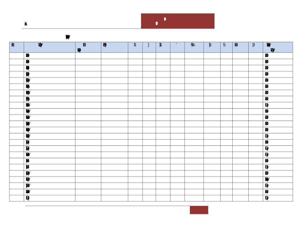
Draft Environmental Impact Assessment Report for M/s Virgin Rock Pvt. Ltd. – 6.0 Ha.
CHAPTER-VII ADDITIONAL STUDIES
7 - 21
Table 7.5. Importance Value Index (IVI) of tree species in the M/s Virgin Rocks Pvt. Ltd. mine
S.No. Plant name No of individuals
Occurrence A F A/F D BA RF RD Rdom IVI Distribuion pattern
1 Acacia leucophloea 14 13 1.077 65 0.017 0.7 0.16497 2.2688 1.41 1.332 5.014 Regular 2 Aegle marmelos 21 15 1.4 75 0.019 1.05 0.24999 2.6178 2.12 2.019 6.755 Regular 3 Alangium salvifolium 14 13 1.077 65 0.017 0.7 0.16308 2.2688 1.41 1.317 4.998 Regular 4 Albizia chinensis 20 17 1.176 85 0.014 1 0.26285 2.9668 2.02 2.122 7.107 Regular 5 Azadirachta indica 12 12 1 60 0.017 0.6 0.13839 2.0942 1.21 1.117 4.423 Regular 6 Bauhinia racemosa 17 14 1.214 70 0.017 0.85 0.17606 2.4433 1.72 1.422 5.58 Regular 7 Bridelia crenulata 20 13 1.538 65 0.024 1 0.24652 2.2688 2.02 1.991 6.277 Regular 8 Buchanania lanzan 28 17 1.647 85 0.019 1.4 0.2988 2.9668 2.83 2.413 8.205 Regular 9 Butea superba 26 14 1.857 70 0.027 1.3 0.26073 2.4433 2.62 2.105 7.172 Random
10 Casearia tomentosa 16 14 1.143 70 0.016 0.8 0.13408 2.4433 1.61 1.083 5.14 Regular 11 Cassia fistula 29 16 1.813 80 0.023 1.45 0.4035 2.7923 2.93 3.258 8.977 Regular 12 Chloroxylon swietenia 13 12 1.083 60 0.018 0.65 0.19631 2.0942 1.31 1.585 4.991 Regular 13 Cleistanthus collinus 39 18 2.167 90 0.024 1.95 0.5508 3.1414 3.94 4.447 11.52 Regular 14 Dalbergia paniculata 35 16 2.188 80 0.027 1.75 0.43535 2.7923 3.53 3.515 9.839 Random 15 Diospyros chloroxylon 37 18 2.056 90 0.023 1.85 0.62001 3.1414 3.73 5.006 11.88 Regular 16 Diospyros melanoxylon 18 10 1.8 50 0.036 0.9 0.18074 1.7452 1.82 1.459 5.021 Random 17 Diospyros sylvatica 75 18 4.167 90 0.046 3.75 0.89519 3.1414 7.57 7.228 17.94 Random 18 Ficus hispida 22 14 1.571 70 0.022 1.1 0.27882 2.4433 2.22 2.251 6.915 Regular 19 Ficus racemosa 19 11 1.727 55 0.031 0.95 0.47407 1.9197 1.92 3.828 7.665 Random 20 Flacourtia indica 19 14 1.357 70 0.019 0.95 0.19414 2.4433 1.92 1.568 5.928 Regular 21 Gmelina asiatica 15 11 1.364 55 0.025 0.75 0.15965 1.9197 1.51 1.289 4.722 Contagious 22 Ixora pavetta 34 14 2.429 70 0.035 1.7 0.47844 2.4433 3.43 3.863 9.737 Random 23 Lagerstroemia parviflora 20 13 1.538 65 0.024 1 0.19758 2.2688 2.02 1.595 5.882 Regular 24 Lannea coromandelica 26 14 1.857 70 0.027 1.3 0.32564 2.4433 2.62 2.629 7.696 Random

Draft Environmental Impact Assessment Report for M/s Virgin Rock Pvt. Ltd. – 6.0 Ha.
CHAPTER-VII ADDITIONAL STUDIES
7 - 22
25 Litsea glutinosa 14 11 1.273 55 0.023 0.7 0.18661 1.9197 1.41 1.507 4.839 Regular 26 Memecylon edule 29 14 2.071 70 0.03 1.45 0.28147 2.4433 2.93 2.273 7.642 Random 27 Morinda pubescens 27 13 2.077 65 0.032 1.35 0.37927 2.2688 2.72 3.062 8.056 Random 28 Ochna obtusata 13 11 1.182 55 0.021 0.65 0.17835 1.9197 1.31 1.44 4.672 Random 29 Polyalthia cerasoides 15 13 1.154 65 0.018 0.75 0.13573 2.2688 1.51 1.096 4.878 Regular 30 Polyalthia suberosa 34 18 1.889 90 0.021 1.7 0.44526 3.1414 3.43 3.595 10.17 Regular 31 Premna tomentoa 38 19 2 95 0.021 1.9 0.45652 3.3159 3.83 3.686 10.84 Regular 32 Protium serratum 16 12 1.333 60 0.022 0.8 0.23913 2.0942 1.61 1.931 5.64 Regular 33 Pterospermum
xylocarpum 26 13 2 65 0.031 1.3 0.32348 2.2688 2.62 2.612 7.504 Random
34 Semecarpus anacardium 20 13 1.538 65 0.024 1 0.30275 2.2688 2.02 2.444 6.731 Regular 35 Sterculia urens 12 10 1.2 50 0.024 0.6 0.16767 1.7452 1.21 1.354 4.31 Regular 36 Strychnos potatorum 16 12 1.333 60 0.022 0.8 0.15229 2.0942 1.61 1.23 4.938 Regular 37 Syzygium cumini 18 13 1.385 65 0.021 0.9 0.21854 2.2688 1.82 1.765 5.85 Regular 38 Tectona grandis 25 17 1.471 85 0.017 1.25 0.28274 2.9668 2.52 2.283 7.772 Regular 39 Wrightia tinctoria 31 14 2.214 70 0.032 1.55 0.33509 2.4433 3.13 2.706 8.277 Random 40 Xylia xylocarpa 45 15 3 75 0.04 2.25 0.61265 2.6178 4.54 4.947 12.11 Random 41 Ziziphus xylopyrus 23 14 1.643 70 0.023 1.15 0.2017 2.4433 2.32 1.629 6.393 Regular
Total 991 2865 49.55 12.3849 100 100 100 300

Draft Environmental Impact Assessment Report for M/s Virgin Rock Pvt. Ltd. – 6.0 Ha.
CHAPTER-VII ADDITIONAL STUDIES
7 - 23
The distribution of girth classes suggests that tree species richness as well as density
decreased with increasing girth class and it shows reverse J pattern which is conformity
with many tropical trees in India. Girth class distribution showed that 31-40 cm class
having the greatest individuals with 689 (69.5%), followed by 41-50 cm with 208
(20.9%), 51-60 cm with 75 (7.5%), and greater than less abundance with 19 individuals.
Low tree density in higher girth class could be attributed to firewood collection, timber
collection, grazing activity, invasive weeds and forest fires (Fig. 7.3).
Fig 7.3. Girth class distribution of density and basal area in the study area
Present study showed the majority of species were observed in the frequency class D=
61-80% (23 spp.), followed by C=41-60% (10), E=81-100% (8) and remaining two
classes such A and B showed nil (Fig 4), this trend of frequency classes have been
representing the heterogeneous nature of the forest community. The frequency of
Raunkiaer’s classes was followed the pattern of D>C>E. As per Raunkiaer, when classes
D,C,E are high, the community is considered to be heterogenous; on the other hand, if the
class E is greater than another, it is a uniform or homogeneous community (Fig 7.4).
0100200300400500600700800
0
1
2
3
4
5
6
7
31-40 41-50 51-60 >60
No
of in
divi
dual
s
basa
l Are
a
Girth class
No of individuals Basal area

Draft Environmental Impact Assessment Report for M/s Virgin Rock Pvt. Ltd. – 6.0 Ha.
CHAPTER-VII ADDITIONAL STUDIES
7 - 24
Fig 7.4. Raunkiaer’s frequency classes
Conclusion
Vegetation is an essential element of all major ecosystems. The present study indicated
that the proposed mine area is consisting secondary forest because more than 60% trees
are below 50cm girth. The results of our study can help the status of dominant tree
species including their diversity indices that will also help for monitoring and sustaining
the diversity of tree species to plan further on plantation and conservation of selected tree
species. Stand density of 991 individuals will not clear in the proposed mine wherever is
necessary those trees will be cleared. After removing buffer zones in the mine area there
will be approx. 400-450 tree cutting envisaged. The management should develop
greenbelt around the mine area with more than 2000 saplings.
Sterculia urens Semecarpus anacardium
0
5
10
15
20
25
A (0-20) B (21-40) C (41-60) D (61-80) E (81-100)
Series1

Draft Environmental Impact Assessment Report for M/s Virgin Rock Pvt. Ltd. – 6.0 Ha.
CHAPTER-VII ADDITIONAL STUDIES
7 - 25
Ixora pavetta Strychnos potatorum
Butea superba Litsea glutinosa
References
Curtis JT, G. Cottom (1962) Plant Ecology Workbook. Burgers Publishing Co.,
Minnesota. PP: 163.
Curtis JT, McIntosh RP (1950) The interrelations of certain analytic and synthetic
phytosociological characters. Ecology. 31: 434-455.
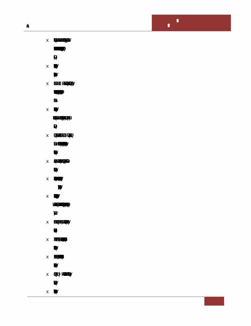
Draft Environmental Impact Assessment Report for M/s Virgin Rock Pvt. Ltd. – 6.0 Ha.
CHAPTER-VII ADDITIONAL STUDIES
7 - 26
Gopalkrishna P, Suthari S, Raju VS (2018) Natural regeneration in the tropical
deciduous forest ecosystem of Godavari valley in Warangal region of Telangana,
India. Ind For 144(7):616–625.
Naidu MT, Kumar OA (2015) Tree species diversity in the Eastern Ghats of northern
Andhra Pradesh, India. J Threat Taxa 7(8):7443-7459.
Naidu MT, Kumar OA (2016) Tree diversity, stand structure and community
composition of tropical forests in Eastern Ghats of Andhra Pradesh, India. J Asia-
Pac Biod 9:328-334.
Naidu MT, Premavani D, Suthari S, Venkaiah M (2018) Assessment of tree diversity
in tropical deciduous forests of North-central Eastern Ghats, India. Geol Ecol
Landscapes 2(3):216-227.
Panda PC, Mahapatra AK, Acharya PK, Debata AK (2013) Plant diversity in
tropical deciduous forests of Eastern Ghats, India: a landscape level assessment.
Int J Biod Cons 5(10):625-639.
Pielou EC (1966) The measurement of diversity in different types of biological
collections. J Theo Biol 13: 131-144.
Pragasan AL, Parthasarathy N (2010) Landscape-level tree diversity assessment in
tropical forests of Eastern Ghats, India. Flora 205:728-737.
Premavani D, Naidu MT, Kumar OA, Venkaiah M (2017) Diversity and distribution
of tree species in tropical forests of northcentral Eastern Ghats, India. Asian J
Forestry 1(1): 27-32.
Pullaiah T, Chennaiah E, PSP Babu (1997) Flora of Andhra Pradesh. Scientific
Publishers, Jodhpur, India.
Rao GVS, Kumari GR (2002) Flora of Visakhapatnam district, Andhra Pradesh.
Botanical Survey of India, Kolkata, India.
Rao RS, Hara Sreeramulu H (1986) Flora of Srikakulam district, Andhra Pradesh.
Indian Botanical Society, Meerut, India.
Shannon CE, Weiner W (1963) The Mathematical Theory of Communication.
University of Illinois Press. Urbana, pp: 117.
Simpson EH (1949) Measurement of Diversity. Nature163:688.

Draft Environmental Impact Assessment Report for M/s Virgin Rock Pvt. Ltd. – 6.0 Ha.
CHAPTER-VII ADDITIONAL STUDIES
7 - 27
Suthari S, Raju VS (2018) Tree species composition and forest stratification along
the gradients in the dry deciduous forests of Godavari valley, Telangana, India. Eur J
Ecol 4(1):1–12.
Venkaia M (2004) Studies on the vegetation and flora of Vizianagaram district,
Andhra Pradesh. Andhra University, Visakhapatnam.
Witford PB (1988) Distribution of woodland plants in relation to succession and
clonal growth. Ecology. 36: 117-127.
7.5.2 Plan for Compensatory afforestation:
It is proposed to develop Compensatory afforestation in an extent of 0.2 Ha., within mine
buffer area on Southern side and in addition avenue plantation will be carried out on
either sides of the approach road to a stretch of 0.5 km with 600 native plants.
Additionally, the existing natural vegetation within the mine buffer will not be disturbed
due to this mining activity. The proposed plan is depicted in the following figure
Fig 7.5: Compensatory Afforestation Plan


CHAPTER –VIII
PROJECT BENEFITS


Draft Environmental Impact Assessment Report for M/s Virgin Rock Pvt. Ltd. – 6.0 Ha.
CHAPTER-VIII PROJECT BENEFITS
8 - 1
8.0 GENERAL
The surrounding inhabitants depends mainly agriculture for their livelihood.
Unemployment and under employment are the main problems of the inhabitants. No
displacement or evacuation of human settlement has been anticipated during mining
operation. Commencement the mining operations will help in improving the socio-
economic status in the area like employment, infrastructure development etc. It improves
the living standard of the people, supports for education and increase the ability of people
to understand the changes.
The following paragraphs will discuss the benefits that are obtained from this mining
activity.
8.1 EMPLOYMENT
The commencement of the proposed project will generate direct and indirect employment
opportunities for the local people. The mine will create employment for a total of
approximately 25 persons including skilled as well as semi-skilled staff directly.
Additionally, certain works like security, housekeepers will be outsourced on contract.
The secondary employment is in the form of providing services to the employed
manpower will also be developed in the neighbouring villages. This will enhance their
income and lead to overall economic growth of the area.
8.2 OCCUPATIONAL HEALTH
Each group of mine workers undergo regular medical checkup at regular intervals by
specialist doctors as per Mines Act/ Rules and other social development and promotional
activities will be undertaken. All this will lift the general health status of the residents of
the area around the mine.
8.3 IMPROVEMENTS IN PHYSICAL AND SOCIAL INFRASTRUCTURE
The commenced operations of the mine will enhance the socio-economic activities in the
adjoining areas. This will result in following benefits:-
Improvements in physical infrastructure.
Improvements in social infrastructure.
Prevention of illegal mining.

Draft Environmental Impact Assessment Report for M/s Virgin Rock Pvt. Ltd. – 6.0 Ha.
CHAPTER-VIII PROJECT BENEFITS
8 - 2
During and post-mining enhancement of green cover.
8.3.1 Improvements in Physical Infrastructure
Although the mining area is well connected with important places in the vicinity
however, the commencement operations of the mine will improve the physical
infrastructure of the adjoining areas. This will include the following.
Improved road communication due to operation of the mine.
Strengthening of existing community facilities through the Community Development
Program.
Creation of community assets (infrastructure) like provision for drinking water,
village roads/ linked roads, dispensary & health centre, community centre, market
place etc.
Awareness program and community activities, like health camps, medical aids,
family welfare programs, cultural activities, plantation etc.
8.3.2 Improvements in Social Infrastructure
The mining activity shall create awareness with the local people for preferring permanent
services than seasonal agricultural activities. The activities will help them to analyze the
importance of education. With the increased amount of income, people can send their
children for higher education/professional courses. There will be some obvious changes
in various environmental parameters due to mining activity. There will also be positive
impact in socio-economic area due to increased economic activities, creation of new
employment opportunities, infrastructural development and better educational and health
facilities. Lessee will also undertake awareness program and community activities like
health camps, medical aids, family welfare camps, and awareness program etc.
8.3.3 Prevention of Illegal Mining & Contribution to the Exchequer
Since the mine lease areas will be leased out to successful allottees, mining operation in
the state will get legalized and it will fetch income to the state exchequer. The proponent
will take due care to avoid illegal mining within the mine lease area. The production will
be as per approved mining plan after obtaining statutory clearances from respective
authorities.

Draft Environmental Impact Assessment Report for M/s Virgin Rock Pvt. Ltd. – 6.0 Ha.
CHAPTER-VIII PROJECT BENEFITS
8 - 3
8.3.4 Enhancement of Green Cover
Plantation/Afforestation will be done as per program i.e. along the road sides and near
civic amenities. Post plantation, the area will be regularly monitored in every season for
evaluation of success rate. For selection of plant species local people will also be
involved. The management will provide free saplings of fruit and other trees, etc. to local
people during monsoon.
8.4 OTHER TANGIBLE BENEFITS
The commencement operations of mining activity are likely to have other tangible
benefits as given below.
Indirect employment opportunities to local people in contractual works like
transportation, sanitation, for supply of goods and services to the project and other
community services.
Market and business establishment facilities will also increase.
Improvement in communication, transport, education, community development and
medical facilities.
Overall change in employment and income opportunity.
The State Government will also be benefited directly from the project, through
increased revenue from royalties, excise duty.


CHAPTER –IX
ENVIRONMENTAL MANAGEMENT PLAN


Draft Environmental Impact Assessment Report for M/s Virgin Rock Pvt. Ltd. – 6.0 Ha.
CHAPTER-IX ENVIRONMENTAL MANAGEMENT
PLAN
9 - 1
9.0 INTRODUCTION
Any types of development project exert certain benefits and adverse impacts on the
surroundings. The major objective and benefit of utilizing Environmental impact
Assessment in project planning stage itself, is to prevent avoidable losses of
Environmental resources and values as a result of Environmental Management Plan.
Environmental Management Plan includes protection/mitigation/enhancement measures
as well as suggesting post project monitoring program. Environmental Management Plan
may often suggest additional project operations that have to be incorporated in the
conventional operation.
Any development in the study area needs to be with judicious utilization of non-
renewable resources of the study area and within the limits of permissible assimilative
capacity. The assimilative capacity of the study area is the maximum amount of pollution
load that can be discharged in the environment without affecting the designated use and is
governed by dilution, dispersion, and removal due to physico-chemical and biological
processes. The Environment Management Plan (EMP) is required to ensure sustainable
development in the study area of the Mine Lease Area.
It has been evaluated that the study area has not been affected adversely as there are no
major polluting industries in the study area and likely to get economical fillip.
Environmental Management Plan aims at the preservation of ecosystem by considering
the pollution abatement facilities at the site inception.
Fully conscious towards environmental responsibility the proponent mainly focuses, apart
from other relevant concerns, on the following important aspects,
a) Dust suppression measures by water sprinkling
b) Proper maintenance of vehicles and equipment.
The different Environmental components that are identified in the assessment chapter are
dealt hereunder with necessary Environmental Management Plan.

Draft Environmental Impact Assessment Report for M/s Virgin Rock Pvt. Ltd. – 6.0 Ha.
CHAPTER-IX ENVIRONMENTAL MANAGEMENT
PLAN
9 - 2
Applicable Regulations
Following Regulations & policies with the amendments thereof need to be taken into
consideration under comprehensive environmental management systems (EMS)
programme as an integral part of the mine operation:
The Mines Act, 1952
The Mines and Mineral (regulation and Development) Act, 1957.
Mineral conservation and Development Rules (MCDR), 1988.
Mines Rules, 1955 for Health and Safety of Mining workers.
Section 21 of Air (Prevention and Control of Pollution) Act, 1981.
Section 25 and 26 of Water (Prevention and Control of Pollution) Act, 1974.
Gazette Notifications of Central Pollution Control Board (CPCB) as and when
notified for pollution prevention and control.
Applicable State Acts and Rules for Mining.
Directives of Andhra Pradesh Pollution Control Board (APPCB) in their Consent
Letters and Notifications.
EP Act 2006

Draft Environmental Impact Assessment Report for M/s Virgin Rock Pvt. Ltd. – 6.0 Ha.
CHAPTER-IX ENVIRONMENTAL MANAGEMENT
PLAN
9 - 3
Table: 9.1 EMP costing for the project
S. No Details Capital Cost (in Lakhs)
Recurring Cost
(Lakhs) Remarks
1 Air Pollution Nose masks (Rs. 25/- each)
- 0.2 Replaceable once in a week
Sprinkling system 3.0 KLD (Rs. 1000/- for 1 tank of capacity 10KL)
0.5 0.75 Required daily on 270 working days
Wet Drilling & wire saw cutting 3.0 KLD
-- 0.75 Required daily on 270 working days
Graded road Construction
0.2 0.05
2 Water Pollution Garland drains (approx top width 2m, bottom width 1m & height 1m) Rs. 250/- per sq. m & RWH
0.7 0.2 Drains construction around the mine site
Construction of Septic tank
-- 0.1 Cleaning twice in a year
3 Noise Pollution Regular maintenance of machinery (2000/- per month)
- 0.2
Ear muffs (Rs. 75/- each)
- 0.06 Thrice in a year
4 Occupational Safety and Health
First aid kits 0.1 0.04 Replaceable twice for every year
Fire extinguishers 0.1 0.05
PPE for all workers (hand gloves Rs. 30 /- each, helmets 500/- and Safety shoes 1500/- each)
-- 0.5
Regular health checkups
0.3 Carried out once in a year

Draft Environmental Impact Assessment Report for M/s Virgin Rock Pvt. Ltd. – 6.0 Ha.
CHAPTER-IX ENVIRONMENTAL MANAGEMENT
PLAN
9 - 4
Training and awareness programs on risk factors during emergencies
0.3 0.1
5 Environmental Monitoring
Ambient air, water quality, Noise studies and Vibration studies
-- 0.5
6 Green belt development
Development of Green belt in mine buffer and avenue plantation along the approach road.
3.6 1.2 600 plants will be developed.
TOTAL 5.5 5
EMP BUDGET
Capital Cost : 5.5 Lakhs
Recurring cost per annum : 5.0 Lakhs
Recurring cost for this plan period i.e., 5 years: 25.0 Lakhs
Total EMP Cost for this ensuing plan period : 30.5 Lakhs
9.1 CORPORATE ENVIRONMENT RESPONSIBILITY
M/s Virgin Rock Pvt. Ltd. will follow Corporate Environmental Responsibility (CER) as
per O.M. File No. 22-65/2017-IA.III dated: 01.05.2018.
The following measures will be taken to maintain a clean and sustainable environment in
and around the plant:
Integrate sound environmental practices in all its activities.
Promote development of innovate environment friendly processes
Improve employee commitment and responsibility towards environment
protection
Promote environmentally responsible behaviour amongst contractual workforce
and suppliers.
Development of greenbelt in surrounding areas and along the approach road.

Draft Environmental Impact Assessment Report for M/s Virgin Rock Pvt. Ltd. – 6.0 Ha.
CHAPTER-IX ENVIRONMENTAL MANAGEMENT
PLAN
9 - 5
CER activities by the proponent
Development of Infrastructure facilities in nearby schools
Health camps
Providing public toilets in nearby villages
Development of greenbelt in surrounding areas
9.2 OBJECTIVES OF ENVIRONMENTAL MANAGEMENT PLAN
Overall objectives of EMP are:
Prevention: Measures aimed at impeding the occurrence of negative environmental
impact and/or preventing such as occurrence having harmful environmental impacts.
Preservation: Preventing any future actions that might adversely affect as environmental
resource or attribute.
Minimization: Limiting or reducing the degree, extent, magnitude or duration of adverse
impacts.
9.3 AIR QUALITY MANAGEMENT
The mining activity would result in the increase of PM concentrations due to fugitive
dust. Frequent water sprinkling in the vicinity would be undertaken and will be continued
as there is possibility for dust generation due to truck mobility. It will be ensured that
vehicles are properly maintained to comply with exhaust emission requirements.
Table: 9.2 Ambient Air Quality Standards
Concentration Microgram's per Meter Cube
PM10 PM2.5 SO2 NOX
100 60 80 80
Mitigation measures suggested for air pollution control are based on the baseline ambient
air quality monitoring data. From the point of view of maintenance of an acceptable
ambient air quality in the region, it is desirable that air quality should be monitored on a
regular basis to check it vis-à-vis the standards prescribed by CPCB and in case of non-
compliance, appropriate mitigation measures shall be adopted.

Draft Environmental Impact Assessment Report for M/s Virgin Rock Pvt. Ltd. – 6.0 Ha.
CHAPTER-IX ENVIRONMENTAL MANAGEMENT
PLAN
9 - 6
As per the results of ambient air quality monitoring data, the background concentrations
of PM10, PM2.5, SO2, NOX and Free Silica are within the stipulated CPCB standards.
9.3.1 Air Pollution Control Measures
Dust is the major pollutant generated from the mining operations. Dust would be
generated during mining, handling and transportation of the material. The Environmental
control measures proposed to control the fugitive dust releases during the Colour Granite
and Road Metal production are given in the below table.
Table: 9.3 Air Pollution Control Measures
S.No Dust Source Control measure
1 Haul Road Compaction, gradation and drainage on both sides.
Proper maintenance.
Regular water spraying.
2 Truck Movement
No overloading of trucks.
Trucks to be covered with tarpaulin while transporting Colour Granite and Road Metal.
Enforcing speed limit.
In addition the following measures will be undertaken
Development of Green belt
Periodical monitoring of air quality to take steps to control the pollutants.
Regular water sprinkling to suppress the dust on haul roads, service roads and mining
face by truck mounted water tankers.
9.3.2 Controlling of other emissions
The other emissions are mainly SO2, NOx and the source would be from vehicles. But,
these emissions are very minimal. This will be controlled by proper maintenance and
servicing of vehicles.
9.4 WATER QUALITY MANAGEMENT
There will not be any waste water generation except domestic waste water, therefore no
post waste water monitoring required.

Draft Environmental Impact Assessment Report for M/s Virgin Rock Pvt. Ltd. – 6.0 Ha.
CHAPTER-IX ENVIRONMENTAL MANAGEMENT
PLAN
9 - 7
Water Pollution Management
Channels and bunds would be constructed and maintained to avoid any erosion and
contamination.
The mine pit water collected due to rains will be utilized for water spraying on the
haul/approach roads and for watering plantation.
9.5 NOISE LEVEL MONITORING
There will be intermittent noise levels due to vehicular movement and mining activities.
The Management Plan for controlling noise pollution is envisaged as follows.
No mining activities are planned during night time.
A thick greenbelt will be developed and in addition existing plantation within
mine buffer will be preserved.
Selection of suitable machinery and equipment,
Proper mounting of equipment,
Providing noise insulation/padding wherever practicable and
Machinery will be fitted with properly designed noise acoustic silencers.
Proper maintenance and periodic lubrication of noise generating parts of the
machines.
9.5.1 Parameters
The noise level recordings are measured in dB (A) Leq values, where dB (A) denotes the
time weighted average of the level of sound in decibels on scale A, which is relatable to
human hearing.
9.5.2 Methodology
Precision integrated sound level meters are being used for monitoring of Leq noise levels
in dB (A) scale at the work place and also in the surrounding villages.
9.5.3 Noise Quality Management
The following measures shall be implemented
Proper lubrication, fitting of effective silencers and good maintenance.

Draft Environmental Impact Assessment Report for M/s Virgin Rock Pvt. Ltd. – 6.0 Ha.
CHAPTER-IX ENVIRONMENTAL MANAGEMENT
PLAN
9 - 8
Provision of personnel hearing protective equipment to all workers likely to be
exposed to noise.
Restricting duty hours of operators likely to be exposed to higher noise levels.
The maintenance of natural vegetation as well as afforestation in the lease shall
serve as acoustic barriers.
9.5.4 Noise Pollution Control
The ambient noise level monitoring carried out in and around the mine shows that
ambient noise levels are well within the stipulated limits of CPCB.
Noise generation may be for an instant, intermittent or for continuous periods, with low
to high decibels. Periodic inspection and checks of the risk prone areas and equipments
have to be conducted.
To control noise pollution during the proposed mining operations following steps will be
practiced.
Proper selection of machinery
Proper and timely maintenance of mining and plant machinery
Limiting of speed of haulage vehicles/tippers.
9.6 WATER CONSUMPTION AND WASTE WATER GENERATION
A total of approximately 8.7 KLD of fresh water is required for the mining activity which
will be met through water tankers. Out of the total quantity, 1.2 KLD will be utilized for
domestic purpose, 3.0 KLD will be used for wet drilling & wire saw cutting and 1.5 KLD
for Green belt development. Remaining 3.0 KLD of water is required for dust
suppression.
1.0 KLD of domestic effluent will be generated at the mine site. Domestic wastewater
generated will be treated through septic tank followed by soak pit. Water requirement for
this mine is detailed as follows.

Draft Environmental Impact Assessment Report for M/s Virgin Rock Pvt. Ltd. – 6.0 Ha.
CHAPTER-IX ENVIRONMENTAL MANAGEMENT
PLAN
9 - 9
Fig 9.1 Water balance flow diagram
9.7 BIOLOGICAL MANAGEMENT
Trees are very suitable for detecting, recognizing and monitoring air pollution effects.
Monitoring of biological effects of air pollutant by the use of plants as indicators has
been applied on local, regional and national scale. Trees function as sinks of air
pollutants, besides their bio esthetical values, owing to its large surface area. Annual need
of oxygen for one person is met by 150 sq.m of leaf surface. So it is necessary to develop
green belt in and around the polluted site with suitable species to combat the air pollution
effectively. The plantation scheme covers the following areas.
Plantation around peripheral portion of mine and other structures.
Gardens, parks and haul road plantation.
Plantation by way of reclamation/rehabilitation of mined out blocks.
8.7 KLD (Water tankers)
8.7 KLD
Domestic purpose (1.2 KLD)
Green Belt (1.5 KLD)
Dust Suppression (3.0 KLD)
Septic Tank (Soak pit) 1.0KLD
No outflow No outflow No outflow
Wet drilling & wire saw cutting (3.0 KLD)

Draft Environmental Impact Assessment Report for M/s Virgin Rock Pvt. Ltd. – 6.0 Ha.
CHAPTER-IX ENVIRONMENTAL MANAGEMENT
PLAN
9 - 10
9.7.1 Tree Plantation Program
The main aim of plantation of mined out areas is to stabilize the land, to protect it from
erosion and provide an aesthetic landscape. As the mine area is a hill slope complete
buffer area is not suitable for plantation, thus, it is proposed to develop green belt in an
extent of 0.2 Ha., within mine buffer area on Southern side and in addition avenue
plantation will be carried out on either sides of the approach road to a stretch of 0.5 km
with 600 native plants. Additionally, the existing natural vegetation within the mine
buffer will not be disturbed due to this mining activity.
9.7.2 Mine Drainage:
Water table: There are no ground water bodies such as open wells or bore wells in this
lease area. The ground water table ranges from 30-35 m depth from the ground level.
Maximum depth of workings is up to RL 75 m and Minimum depth of workings is RL 90
m., i.e, maximum depth of workings in this mining plan period is RL 75 m from the top
of the hill, which has a highest contour of 99 m and lowest contour of 88m. No chance
for accumulation of ground water in working pit during this mining plan period is
anticipated and no water will be discharged from the pit.
Encounter and discharge of mine water: There is no chance of groundwater likely to
be encountered in the mine. But the rainwater will accumulate at pit bottom in rainy
seasons and this may be dried up slowly by percolating to ground or will be pumped out
to carryout mine workings after the end of rainy season.
9.8 SOIL MANAGEMENT
Top Soil Management
The top soil preserved will be used for plantation, filling ditches and reclamation
wherever necessary.
Waste Management
The waste that will be generated in this mining period is 200360.907 m3 which will be
dumped temporarily in the North-East side of the quarry between Grid intervals
N2064800 m E 186450 m to N 2064900 m E 186550 m covering an area of 3562.479 m2

Draft Environmental Impact Assessment Report for M/s Virgin Rock Pvt. Ltd. – 6.0 Ha.
CHAPTER-IX ENVIRONMENTAL MANAGEMENT
PLAN
9 - 11
and shall be sloped at 1 in 20. Below the foot of the slopes a retaining wall of 1.20 m X
1.20 m X 1.20m shall be constructed using boulders in order to arrest the spread of dump
and arresting the silt to adjoining land during monsoon. Construction of garland drains,
check dams will be done during the scheme period of mining. The granite waste
generated will be utilized as Road Metal and will be sold to local stone crushers. Some
quantity will be used for laying internal and approach roads and construction of retaining
wall & garland drains.
9.9 LAND ENVIRONMENT
9.9.1 Land use
The project covers a total ML area of 6.0 hectares of Govt. waste land. During the
ensuing plan period an area of 0.7 Ha of land will be brought under mining. The core
zone landscape can be improved by tree plantation, shrub growth etc., which are outlined
separately under eco-restoration.
9.9.2 Mine roads
Roads for haulage and access to different locations would be laid as per the statutory
regulations stipulated in the Metalliferrous Mines Regulations, 1961. Some of the basic
features of laying the haul roads at the Mine Lease Area as required from environmental
and safety angle cover the following:
The road layout would be generally followed as per scheme shown in mine
general layout. The main haul road and feeder roads would be generally of 6 m
wide keeping provisions for road side plantation.
The corners and bends would be made in such a way as to offer the vehicle
operator, a clear visibility of at least 30m along the road.
The alignment of haul roads and feeder roads may require alteration with the progress of
mining work.
9.9.3 Proposed Mitigating Measures
The land management plays an important role in reducing the adverse impacts caused by
surface mining operation. Land management is required in the key areas like land use

Draft Environmental Impact Assessment Report for M/s Virgin Rock Pvt. Ltd. – 6.0 Ha.
CHAPTER-IX ENVIRONMENTAL MANAGEMENT
PLAN
9 - 12
scheme with the ML area, calendar plan, mine bench advancement to arrest
indiscriminate degradation of landform, top soil preservation, soil erosion control and the
restoration of the mine pit.
Land restoration:
Since it is envisaged that the quarry will be in operation for at least 19 years, so, no back
filling is proposed during the lease period. After removal of mineral, benches will be
formed below the surface level and the top of the benches will be applied with top soil
and developed with grasses and plantation. Fast growing trees and other native shrubs
would be planted to stabilize the reclaimed land and prevent wind erosion of solid
particles.
The pits formed will be used as rain water harvesting structures. While reclaiming the
mined out area, the original land form cannot be fully restored. This would be beneficial
in two aspects, namely (i) it may recharge the spring table by seepage of water through
cracks and joints and (ii) the impounded water reservoir can be utilized for development
of afforestation and irrigation source to nearby agricultural fields.
9.10 SOCIO-ECONOMIC ENVIRONMENT & SAFETY
The company management shall give preference to local people through both direct and
indirect employment.
It will provide ample opportunity to the locals to up-lift their living standards by
organizing events that propagate mutual benefits to all, such as health camps,
awareness campaigns, donations to poorer sections of society and downtrodden.
Educational needs of the region will be improved by encouraging the workers to
allow their children to attend schools.
Adequate supply of potable water to the workers will be made during the working
hours. Sufficient funds shall be allocated for these and other emergency needs.
The mines management will supervise the safe working of the contractor and their
employees. The working personnel will be provided with face masks, ear plugs,
safety helmets and goggles in order to reduce health hazards.

Draft Environmental Impact Assessment Report for M/s Virgin Rock Pvt. Ltd. – 6.0 Ha.
CHAPTER-IX ENVIRONMENTAL MANAGEMENT
PLAN
9 - 13
The proponent will provide all necessary provisions stipulated under the Mines Act. In
addition a Safety committee will be formed and manned by equal participants from
Management and Workers. Personnel Protection Equipment (PPE) will be issued to each
worker. Other safety equipments shall be used according to the nature of job involved.
9.11 BIOLOGICAL MANAGEMENT PLAN
The mining activity will have impact on vegetation existing in the mine lease area and in
order to minimize the impacts, it is proposed to reclaim the entire plain land available in
mined out area with indigenous plant species as early as possible. Plantation programme
is proposed to be carried out in and around the mine lease area so that the natural habitat
is restored.
9.11.1 Green Belt Development/Afforestation Plan
The proponent will develop green belt in an extent of 0.2 Ha., within mine buffer area on
Southern side and in addition avenue plantation will be carried out on either sides of the
approach road to a stretch of 0.5 km with 600 native plants. Additionally, the existing
natural vegetation within the mine buffer will not be disturbed due to this mining activity.
Plantation will be done in vacant road side area without disturbing natural vegetation.
The year wise program of tree plantation is being given in below table:
Table 9.4 Details of Year Wise Tree Plantation Program
9.11.2 Criteria for Selection of Species
Species to be selected should fulfill the following specific requirements of the area
- Availability of seed material
Year No. of Saplings
I 100
II 100
III 100
IV 100
V 200
Total 600

Draft Environmental Impact Assessment Report for M/s Virgin Rock Pvt. Ltd. – 6.0 Ha.
CHAPTER-IX ENVIRONMENTAL MANAGEMENT
PLAN
9 - 14
- Tolerance to specific conditions or alternatively wide adapts ability to eco-
physiological conditions.
- Rapid growth
- Capacity to endure water stress and climatic extremes after initial establishment
- Differences in height, growth habits
- Pleasing appearance
- Providing shade
- Ability of fixing atmospheric Nitrogen
- Improving waste lands.
9.11.3 Design of green development
The greenbelt shall be developed around the mine to act as a sink for pollutants,
attenuation of noise levels and improvement in aesthetic quality of the plant. The
following criteria shall be adopted in the design of greenbelt:
1. Generally fast growing trees should be planted as otherwise it will take many years
for other types of trees to attain their full height.
2. Trees will be planted along the road side in such a way that there is no direct line of
sight when viewed from a point outside the foliage perimeter.
3. Trees growing up to 10 m or more in height with thick perennial foliage should be
planted around the plant.
4. Trees shall be planted staggered in each row (minimum three rows encircling the
perimeter of the plant).
5. Tree trunk being free foliage up to a height of 2 to 3 m, it is advisable to grow shrubs
in front of trees to give coverage to the open portion.
6. It is proposed to develop green belt in an extent of 0.2 Ha., within mine buffer area
on Southern side and avenue plantation will be carried out on either sides of the
approach road to a stretch of 0.5 km.

Draft Environmental Impact Assessment Report for M/s Virgin Rock Pvt. Ltd. – 6.0 Ha.
CHAPTER-IX ENVIRONMENTAL MANAGEMENT
PLAN
9 - 15
9.12 OCCUPATIONAL HEALTH AND SAFETY MEASURES
Mining profession involves exposure of workers to open area & dusty environment
requiring assessment of likely impacts on the health aspects. Workers are prone to be
affected by respiratory and pulmonary diseases, apart from health hazards related to
water pollution, noise and vibrations. Health impact assessment will be undertaken by
studying the nature of the mining activities and its impact. The proponent will appoint a
doctor periodically, well versed with occupational health surveillance to meet the medical
needs of the employees. The employees will be subjected to medical examination on an
annual basis. The medical histories of all the employees shall be maintained in a standard
format. These medical histories over a period will show if there is occupation related
deterioration in the employees’ health. The recurring budget allocated for occupational
health & safety measures is Rs. 0.99 Lakhs/Annum during ensuing mining plan period.
Fugitive dust, noise and fines, may affect the health of workers, safety of employees
during operation will be taken care of as per Mine Regulations Act, 1961. To avoid any
adverse effects on the health of workers due to dust and noise sufficient measures have
been provided in the mining project. These may include:
It should be ensured that all employees are adequately trained & qualified to perform
their duties. Visitors must be familiarized with the safety precautions of the mine.
One occupational health and safety officer will be employed by the mine.
Provision of rest shelters for mine workers with amenities like drinking water, fans,
toilets etc.
Provision of personal protection devices to the workers.
Dust suppression of haul road.
First aid facilities within lease area.
Height, slope shall be developed as per the approved mining plan.
Regular medical examination shall be conducted for the employees.
Working benches shall be developed as per approved mining plan.

Draft Environmental Impact Assessment Report for M/s Virgin Rock Pvt. Ltd. – 6.0 Ha.
CHAPTER-IX ENVIRONMENTAL MANAGEMENT
PLAN
9 - 16
9.12.1 Public Health Implication, Occupational Health Survey Program and First Aid:
According to ILO and WHO, occupational health should aim at the promotion and
maintenance of the highest degree of physical, mental and social well being of workers in
all occupations; the prevention amongst workers of departures from health caused by
their working conditions; the protection of workers in their employment from risks
resulting from factors adverse to health. In brief, as applicable for M/s Virgin Rock Pvt.
Ltd., any employee should not have any health risk due to its assigned occupation and
should not lose the productivity of the employee on health ground. The health checkups,
other occupational ailments and medical treatment as well as counseling will be provided
to all employees periodically.
An occupational health survey program includes:
Preliminary screening of all the employees for their baseline health condition.
Medical evaluation of workers condition before joining to the duty.
Educating the workers w.r.t. the safety conditions & occupational health diseases.
Refresher Training will be provided on malaria eradication, health effects on
exposure to mineral dust.
Regular health checkups for all the workers will be conducted.
Data base will be created for individual worker and will be updated regularly to
compare the health status.
Ergonomic Program Manager will take care of all the needs of OH & S.
Doctor specialized in Occupational Health will be appointed for special needs.
Mine Safety
Mine Safety is a statutory requirement which M/s Virgin Rock Pvt. Ltd. fully complies.
Mining area will be fenced off to prevent falling down of man and animals.
Proposed security will be providing to prevent pilferage or theft.
Fuels:
No fuel is required for minerals processing. Only diesel oil is required for operation of
mining machineries and mine vehicles.
Draft Environmental Impact Assessment Report for M/s Virgin Rock Pvt. Ltd. – 6.0 Ha.
CHAPTER-IX ENVIRONMENTAL MANAGEMENT
PLAN
9 - 17
9.13 PROJECT COST
Cost Estimates of the Project
The Total cost of the project would be around Rs. 100.0 Lakhs
EMP Budget
Capital Cost : 5.5 Lakhs
Recurring cost per annum : 5.0 Lakhs/annum
Recurring cost for this plan period i.e., 3 years: 25.0 Lakhs/ 5 years
Total EMP Cost for this ensuing plan period : 30.5 Lakhs


CHAPTER –X
SUMMARY AND CONCLUSIONS


Draft Environmental Impact Assessment Report for M/s Virgin Rock Pvt. Ltd. – 6.0 Ha.
CHAPTER-X SUMMARY & CONCLUSIONS
10 - 1
10.0 SUMMARY & CONCLUSION
M/s. Virgin Rock Pvt. Ltd. filed an application for grant of Quarry Lease for Colour
Granite over an extent of 6.0 Ha in Sy.No.1 of Bonthu Village, Saravakota Mandal,
Srikakulam District, Andhra Pradesh.
The Assistant Director of Mines & Geology, Srikakulam, submitted proposals on the
Quarry lease application filed by M/s. Virgin Rock Pvt. Ltd., recommending for grant of
quarry lease for Colour Granite over an extent of 6.0 Hectares in Sy.No.1 of Bonthu
Village, Saravakota Mandal, Srikakulam District, Andhra Pradesh for a period of 20
years.
After careful examination of the proposals of the Assistant Director of Mines & Geology,
Srikakulam, the DM&G, Ibrahimpatnam in principle, decided to grant of Quarry lease for
Colour Granite over an extent of 6.0 Hectares in Sy.No.1 of Bonthu Village,
SaravakotaMandal,, Srikakulam District, Andhra Pradesh, for a period of 20 years vide
Notice No. 4097/R1-1/2019, dated: 26.11.2019 subject to submission of Approved
Mining Plan along with Consent for Establishment from A.P. Pollution Control
Board & Environmental Clearance from Ministry of Environment & Forests as per
Environmental Impact Assessment Notification through S.O. 1533, dated:
14.09.2006.
Later, the proponent filed an application and was granted for inclusion of Mineral Road
Metal (Granite Waste) in addition to the Colour Granite vide Notice No: 4097/D1-1/2019
dated: 10.02.2020.
The Mining plan is approved by Deputy Director of Mines and Geology (FAC) vide
Letter No: 05/MP-SKLM/2020, Dated: 06.03.2020.
The present proposal is for obtaining EC for proposed mine with production capacity of
10148.0544 m3/annum for Colour Granite and 40592.2176 m3/annum for Road Metal
(Granite Waste) and the mining activity will be carried out by opencast other than fully
mechanized mining method by developing benches with drilling and wire saw cutting.

Draft Environmental Impact Assessment Report for M/s Virgin Rock Pvt. Ltd. – 6.0 Ha.
CHAPTER-X SUMMARY & CONCLUSIONS
10 - 2
Presentation of TOR has been made before the SEAC, Andhra Pradesh committee
meeting held on 01.12.2020-04.12.2020 and ToR has been issued by SEIAA, Govt. of
Andhra Pradesh vide Letter No. SEIAA/AP/SKLM/MIN/10/2020/2205-149 Dt:
21.06.2021.
The lease area is located in Survey of India, Topo sheet No: 74 B/2 at Latitude of
18°39'8.39"N to 18°39'7.22"N and Longitude of 84° 1'36.16"E to 84° 1'36.27"E in
Bonthu Village, Saravakota Mandal, Srikakulam District, Andhra Pradesh.
10.1 NEED FOR THE PROJECT:
Colour Granite and Road metal (Granite waste) has huge importance in almost any type
of construction activity. Further they are also required by railway projects for track laying
and other construction activities. Thus in current times, where the focus of the
governments is on improvement of basic infrastructure like roads, railways, dams and
other social infrastructure - both in rural and urban areas, there is a constant need for
ensuring regular supply of these Colour Granite and Road metal (Granite waste).
Considering the growing demand of the mineral, it necessitates the operation of this
mining project. In addition, this project will also generate direct and indirect employment
to the local villagers.
10.2 SALIENT FEATURES OF THE PROJECT:
The salient features of the project are provided in the following table
Name of the project M/s. Virgin Rock Pvt. Ltd.
Mining of Colour Granite and Road Metal (Granite
Waste)
Extent 6.0 Ha
Production Capacity Maximum Production:
Colour Granite – 10148.0544m3/Annum
Road Metal (Granite Waste) – 40592.2176 m3/Annum
Location of the project
District & State Srikakulam & Andhra Pradesh

Draft Environmental Impact Assessment Report for M/s Virgin Rock Pvt. Ltd. – 6.0 Ha.
CHAPTER-X SUMMARY & CONCLUSIONS
10 - 3
Mandal Saravakota
Village Bonthu
General climatic conditions
Maximum Temperature 45°C
Minimum Temperature 28°C
Annual average rain fall 1127 mm
General location details
Nearest Habitation Savara Bontu Village at a distance of 0.23 km
Nearest town Saravakota Mandal at a distance of 6.70 km
District headquarters Srikakulam City at 41.42 km
Nearest railway station Ganguwada Railway station at a distance of 8.27 km
Nearest Airport Visakhapatnam International Airport at 132.82 km
Archaeological/Historically
important site
None within 10 km radius
Inter State Boundary Andhra Pradesh - Odissa inter-state boundary at a distance of 11.68 kms. But as per S.O.141(E) dated 15.01.2016, the general condition shall not apply to this quarry as the lease area is less than 25 Ha.
Infrastructure Facilities Hospitals and schools are present in Palasa Town
Sanctuaries/National parks None within 10 km radius
Nearest RF/PF Maluva Reserved Forest – 0.34 km West
Forest NOC has been obtained vide Rc.No. 725/2020/A4, dated 18.09.2020
Raivada Reserved Forest – 1.92 km SW
Asokam R.F – 4.47 km SW
Saravakota Reserved Forest – 5.2 km SE
Bejji Reserved Forest – 8.07 km SE
Sudirai Konda R.F – 2.23 km NE
Pedda Logidi R.F – 8.65 km NE
Nearest Water Bodies First order Stream – 0.05 km West
Pond – 0.19 km South
Ranga Sagaram – 2.64 km SE

Draft Environmental Impact Assessment Report for M/s Virgin Rock Pvt. Ltd. – 6.0 Ha.
CHAPTER-X SUMMARY & CONCLUSIONS
10 - 4
Mahendratanaya River – 6.99 km North
Banshadhara Left Main Canal – 4.61 km SW
Banshadhara River – 7.53 km West
Asarla Sagaram – 8.82 km SE
10.3 RESERVES
The deposit was estimated through cross sectional method. The reserves are estimated
through A-A’, B-B, C-C’, D-D’ cross sections with an interval of 66 mtrs, 70 mtrs, 30
mtrs, 38 mtrs. The proved reserves were taken upto a depth of RL 75 M from surface of
the area i.e., from hill peak i.e., 98 M RL point to bottom. The probable reserves were
taken up to 10 mtrs below ground level i.e., 75 M to 65 M RL.
Life of Mine
Colour Granite (20%)
Total Proved Reserve of Colour Granite : 199373.738 m3
Colour Granite blocked under Safety Slopes : 3304.4024 m3
Colour Granite under 7.50 m Buffer Zone : 10094.06 m3
Available Colour Granite reserve after deducting
Blocked Reserves : 185975.2756 m3
Road Metal (80% Granite Waste)
Total Proved Reserves of Road Metal : 797494.95 m3
Road Metal blocked under Safety Slopes : 13217.6096 m3
Road Metal blocked under 7.50 m Buffer Zone : 40376.24 m3
Available Road Metal reserves after deducting
Blocked Reserves : 743901.10 m3
Total Mineral Reserves (Colour Granite + Road Metal): 929876.3756 m3
Average annual Production : 50090.22676 m3/annum
Life of mine = Mineable reserves/Avg. Production : 18.56 Say 19 years

Draft Environmental Impact Assessment Report for M/s Virgin Rock Pvt. Ltd. – 6.0 Ha.
CHAPTER-X SUMMARY & CONCLUSIONS
10 - 5
10.4 MINING
The mining operations are carried out by opencast method of mining. Colour Granite by
nature it is medium hard. The operations will involve drilling, wire saw cutting and
excavation by wire saw cutting and directly loads into the tippers/tractors. The excavation
will be carried with bench height 5 to 6 meters and width 3 to 4 meters minimum.
The proposed method of working is by semi-mechanized method of opencast quarrying.
Considering mining parameters and the technical parameters like surface topography,
rock mechanism factors & quality variations, geo-technical aspects, required rate of
production & available resources etc. Small scale building quarrying activity with jack
hammers drilling & wire saw cutting.
The mineral waste material is initially segregated with the help of an excavator. The
material in required dimensions is directly sent to the consumers. The slabs and oversize
boulders are separately shifted there and then. With this the finer material remains in the
zone of operation. The boulders and slabs thus shifted are broken into sizes that can be
handled and dumped into the truck. Later transported to the local stone crushing units for
required sized Road metal production.
10.5 DESCRIPTION OF THE ENVIRONMENT
10.5.1 Land Use:
The total mining area of 6.0 Hectares is Government land. The land is no fit for
agriculture activities as it is a hill.
Soil Quality
The analytical results of the soil samples collected during the study period are
summarized below.
The normal range of pH in the soils is 6.0 to 8.5. The pH values in the study area
are varying from 6.8 to 7.4 indicating that the soils are falling in neutral soil.
Nitrogen encourages the vegetative development of plants by imparting a healthy
green color to the leaves. The available Nitrogen as N in the study area is varying
from 101 to 118 kg/ha. This is less for crops when compared with soil standards.

Draft Environmental Impact Assessment Report for M/s Virgin Rock Pvt. Ltd. – 6.0 Ha.
CHAPTER-X SUMMARY & CONCLUSIONS
10 - 6
Phosphorus influences the vigour of plants and improves the quality of crops. In
the study area available, Phosphorus was found in varying quantities of 42.5 to
48.2 kg/ha. This is medium sufficient level when compared to soil standards.
Potassium enhances the ability of the plants to resist diseases, insect attacks, cold
and other adverse conditions. The available potassium in the study area varies
between 185 to 202kg/ha. This is less level for crops.
Organic Carbon in the study area ranges from 0.28 to 0.51%. This is less level for
crops.
Based on the above results, the soils in the region are average fertile enough for
cultivation of crops.
10.5.2 Water Quality
Ground water Quality:
The pH limit fixed for drinking water samples as per IS: 10500 is 6.5 to 8.5.
During the study period, the pH of the groundwater was found varying between
7.1 and 7.4. The pH values for all the samples collected in the study area during
study period were found to be within the acceptable limits.
The desirable limit for total dissolved solids as per IS: 10500 is 500 milligrams per
liter (mg/l) where as the permissible limits in absence of alternate source is 2000
mg/l. In groundwater samples collected from the study area, the total dissolved
solids (TDS) were found to be varying between 426mg/l and 516 mg/l. The TDS
of all the samples were below the permissible limit of 2000 mg/l.
The desirable limit for Chloride is 250mg/l as per IS:10500 where as the
permissible limit of the same is 1,000mg/l. The Chloride levels in the groundwater
samples collected in the study area were ranging from 83 – 122 mg/l
The desirable limit as per IS:10500 for hardness is 300 mg/l where as the
permissible limit for the same is 600mg/l. In the groundwater samples collected
from the study area, the hardness was found to be varying from 124 mg/l to 173
mg/l.

Draft Environmental Impact Assessment Report for M/s Virgin Rock Pvt. Ltd. – 6.0 Ha.
CHAPTER-X SUMMARY & CONCLUSIONS
10 - 7
Fluoride is the other important parameter, which has the desirable limit of 1 mg/l
and permissible limit of 1.5 mg/l. However, the optimum content of fluoride in the
drinking water is 0.6 to 1.5 mg/l. In the groundwater samples of study area the
fluoride values were found to be within a range of 0.33 g/l to 0.72 mg/l.
All the heavy metals in all samples were found to be below the permissible limits.
An overview of the results obtained reveals that none of parameters were found above the
permissible limits of IS: 10500 Drinking Water Standards.
Surface water Quality:
pH of the surface water collected was neutral with pH ranging from 7.2 -7.4
TDS was found to be 115mg/l to 134mg/l. The tolerance limit of 1,500 mg/l as per
IS:2296
Total hardness was found to be 67 mg/l to 84 mg/l
Presence of Nitrate was recorded as 0.24mg/l to 0.42mg/l
DO was observed as 6.2mg/l to 6.9 mg/l
Total coliform in water was 340 MPN/100ml to 560MPN/100ml The likely source
of bacteriological contamination was due to the proximity to residential area
All the heavy metals were found to be within below detectable limits.
10.5.3 Ambient Air Quality:
On the perusal of above summary of analysis of ambient air quality in the study area it is
evident that all monitored values in various locations are well within the specified limits
of CPCB. The results are summarized below:
PM10: The highest PM10 concentration 60.0 µg/m3 was observed in the ambient air was
recorded at station A6 (Kurudingi) while the lowest PM10 concentration was found to be
21.5µg/m3 at A1 (Project site). All the monitored values of PM10 are well below the
specified limit of 100µg/m3.
PM2.5: The highest PM2.5 concentration 34.8 µg/m3 was observed in the ambient air was
recorded at station A6 (Kurudingi) while the lowest PM2.5concentration was found to be

Draft Environmental Impact Assessment Report for M/s Virgin Rock Pvt. Ltd. – 6.0 Ha.
CHAPTER-X SUMMARY & CONCLUSIONS
10 - 8
13.0 µg/m3 at A1(Project site). All the monitored values of PM2.5 are well below the
specified limit of 60µg/m3.
SO2: The highest SO2 concentration 11.3 µg/m3 was observed in the ambient air was
recorded at station A6 (Kurudingi) while the lowest SO2 concentration was found to be
4.4µg/m3 at A1(Project site). All the monitored values of SO2 are well below the
specified limit of 80 µg/m3.
NOx: The highest NOx concentration 13.4µg/m3 was observed in the ambient air was
recorded at station A6 (Kurudingi) while the lowest NOx concentration was found to be
5.9 µg/m3 at A1(Project site). All the monitored values of NOx are well below the
specified limit of 80µg/m3.
Free Silica: Free Silica found to be <3.5 µg/m3which is Minimum Detectable Limit in all
AAQ locations as per the method of OSHA ID 0142.Permissible Exposure Limit as
OSHA (Occupational Safety and Health Administration) is 50 µg/m3.
10.5.4 Noise Quality:
The Leq day noise level at the mine site is 46.9 dB (A) which is within the standard limit
of Industrial area i.e. ~75 dB (A). During night the Leq night noise level is 36.7 dB (A)
which is also within the night-time noise standard limit of 70.0 dB (A).
The noise levels in the buffer zone ranges between 45.3 – 55.1 dB (A) during day time
and 33.9 – 43.87 dB (A) during night time which is also within the standard limit for
residential area.
10.5.5 Biodiversity:
The study area is secondary dry deciduous forest in which all trees are growing with less
than 30cm girth. The primary forest completely degraded due to anthropogenic activities.
The tree begin to shed their leaves by about December and between February and May
the forest looks very open and at times eye-soaring, but no area is completely leafless
during the study period. Flowering and fruiting are generally far advanced before the first
flush of new leaves appears with the conventional showers in April-May.

Draft Environmental Impact Assessment Report for M/s Virgin Rock Pvt. Ltd. – 6.0 Ha.
CHAPTER-X SUMMARY & CONCLUSIONS
10 - 9
Diospyros sylvatica is perhaps the commonest tree in this area. Wrightia tinctoria,
Cochlospermum religiosum, Gardenia latifolia, Sterculia urens, Strychnos potatorum,
Ziziphus xylopyrus, Terminalia spp., Chloroxylon swietenia, Pterospermum xylocarpum,
Albizia chinense, Cassia fistula, Diospyros melanoxylon etc. are some of the typical trees;
Flaucortia indica, Gmelina asiatica and Naringi crenulata are armed trees present, at the
edges of the mine. Holarrhena antidysenterica, Alangium salvifolium, Bauhinia
racemosa, Tarenna asiatica, Flacourtia indica, Helicteris isora, Woodfordia fruticosa,
Grewia rothii etc. are some of the common small trees found in this area.
A number climbers and twiners are found in this type of forests. To mention, some of
them are Butea superba, Cansjera rheedii, Celastrus paniculatus, Combretum
ovalifolium, Dioscorea spp., Pueraria tuberosa, Ventilago denticulata, Mucuna spp. etc.
The ground flora is mostly seasonal. Achyranthes aspera, Aerva sanguinolenta, Sida
glutinosa, Solanum indicum, Scilla hyacinthina, Habenaria roxburghii etc. are some of
the common examples.
Many terrestrial birds such as Indian Ring dove, Minnows, Finches, Crows, Sparrows,
Parrots, Mynas, Swifts, Doves, Pigeons, Egrets and Weaver birds etc were common.
10.5.6 Socio-Economic:
The study area is located in the limits of Saravakota, Jalumuru, Lakshminarsupeta,
Hiramandalam and Pathapatnam mandals of Srikakulam district. The primary data have
been collected from 54 participants from various communities through socio economic
survey sheet and Focused Group Discussions. The collected data analyzed by using
SPSS. This will measure the impacts of proposed project in various aspects. It also
studies the awareness on project and community perceptions about the proposed project
and other related information.
10.6 ANTICIPATED IMPACT AND MITIGATION MEASURES:
10.6.1 Land Environment:
The mine lease area of 6.0 hectares is a hill. The lease area covers on hill top and its
slope. During this ensuing mining period an area of 0.7 hectares will be brought under

Draft Environmental Impact Assessment Report for M/s Virgin Rock Pvt. Ltd. – 6.0 Ha.
CHAPTER-X SUMMARY & CONCLUSIONS
10 - 10
mining activity. The proponent will maintain 7.5 m buffer zone with the existing natural
vegetation. It is proposed to develop green belt will be developed in an extent of 0.2 Ha.,
within mine buffer area on Southern side and in addition avenue plantation will be carried
out on either sides of the approach road to a stretch of 0.5 km.
10.6.2 Water Environment:
Total water requirement of the mining project is 8.7 KLD. This requirement will be met
by water tankers from nearby villages. There will be no wastewater generation. The
domestic waste water of 1.0 KLD generated will be treated through septic tank followed
by soak pit.
10.6.3 Air Environment:
The air borne particulate matter comprising of particulate matter is the main air pollutant
contributed by opencast mining. During the mining operations mitigation measures like
regular water sprinkling, plantation, maintenance of equipments, and vehicles etc will be
carried out.
10.6.4 Noise Environment:
Mining will be open cast semi mechanized involves drilling and wire saw cutting. Still
preventive measures like regular maintenance of vehicles and equipments will be done
and protective gears like ear muffs etc will be provided to the workers.
10.6.5 Biological Environment
No forest area diversion is required in the mining area and the land is non-agriculture
sandy vacant with insignificant vegetation. The fauna in the vicinity of the mine is
restricted to few common species. There will be no impact on flora and fauna due to the
project. Green belt development will not only increase the ambience of the area but will
also be helpful in the survival of core zone fauna especially avian fauna.
10.6.6 Socio-Economic Environment:
The project will enhance chance of direct and indirect employment in the area. Therefore
overall economic development is much likely after commencing mine operations. The

Draft Environmental Impact Assessment Report for M/s Virgin Rock Pvt. Ltd. – 6.0 Ha.
CHAPTER-X SUMMARY & CONCLUSIONS
10 - 11
budget for district mineral fund that will be given by the lessee will also increase the
living standard of the local community.
10.6.7 Mine Waste:
As per ensuing mining plan a total of 200360.907 m3 of mineral rejects are estimated to
be generated, which is proposed for converting it as Road Metal. The granite waste is
including as additional mineral to be used as Road Metal. The waste generated during this
scheme will be stored temporarily in dump yard until dispatch to local crushers for using
the waste as Road Metal.
10.6.8 Impacts due to Transportation:
Transportation of mined out mineral from the pit head will be transported by hired
/consumer’s trucks. Due to operations of the mine increase in traffic density will be very
less as number of vehicle deployed and the road is capable of bearing the increased traffic
due to the project.
10.7 RISK ASSESSMENT & DISASTER MANGEMENT PLAN
Mining will be carried out by semi-mechanized opencast mining, with mining
equipments such as excavator, dumpers etc. Drilling and wire saw activities are proposed.
Operational risks such as drilling risks, failure of bench stability, accidents by heavy
machinery/vehicles and surface fires can be anticipated.
These risks can be minimized by taking care during mining operations, Providing PPE for
all work force and hiring competent personnel for handling the mine operations.
10.8 PROJECT BENEFITS:
The mining project has a significant positive impact on the socio-economic environment
and it will help sustain the overall development of the area. The project significantly
contributes the economic development by providing direct employment to 25 and indirect
employment to many more people in the area. By organizing health checkup camps,
awareness programs about rural development of the locals in the field of education,
personal health care and skill development campaigns to improve standards of living in
the area.

Draft Environmental Impact Assessment Report for M/s Virgin Rock Pvt. Ltd. – 6.0 Ha.
CHAPTER-X SUMMARY & CONCLUSIONS
10 - 12
10.9 ENVIRONMENTAL MANAGEMENT PLAN:
Preparation of Environmental Management Plan (EMP) is required for formulation,
implementation and monitoring of environmental protection measures during and after
commencement of the mining project. The project cost is 100.0 Lakhs and EMP capital
cost Rs. 5.5 Lakhs and recurring cost as Rs 5.0 Lakhs per annum.
Among other environmental protection, following measures are listed below:
• Applying water for dust suppression on mine haul roads, loading and unloading
areas.
• Regular Compaction & grading of haul roads and service roads to clear accumulation
of loose material.
• Avoid overloading of dumpers and consequent spillage on the roads.
• Good maintenance of vehicles & machinery.
• Implementation of wet drilling and wire saw cutting
10.10 RECOMMENDATIONS
The regular medical check-up of workers is to be carried out. Green belt development is
to be stressed and workers must be motivated for plantation care. The general
environmental awareness is given to the local workers. Regular maintenance of vehicle is
carried out. Slogans of Environment, health & safety are recommended for display in
local language. Hence significantly there is no likely impact is envisaged due to mining
activity. The management must keenly celebrate the importance of World Environment
Day to create awareness amongst the workers. Conservation of soil and water must be
emphasized not only at works but also at their own place. With implementation of
Environment management plan and providing continual improvement the mine may be
accorded Environmental Clearance.
Adequate measures will be taken for control of noise at source.
Intensive green belt will be developed.
Control of dust emissions.

Draft Environmental Impact Assessment Report for M/s Virgin Rock Pvt. Ltd. – 6.0 Ha.
CHAPTER-X SUMMARY & CONCLUSIONS
10 - 13
Consequently,
This project aims at keeping the key industries within the country well supplied
with an essential raw material
Does not give rise to any adverse biophysical or socio-economic impacts
No rehabilitation required
The project has significant positive aspects such generation of employment
Acceptable impact on environmental parameters


CHAPTER –XI
DISCLOSURE OF CONSULTANTS


Draft Environmental Impact Assessment Report for M/s Virgin Rock Pvt. Ltd. – 6.0 Ha.
CHAPTER-XI DISCLOSURE OF CONSULTANTS
11 -1
11.0 DISCLOSURE OF CONSULTANT ENGAGED
This chapter provides the overview of the consultants engaged in EIA studies.
11.1 ABOUT SV ENVIRO LABS & CONSULTANTS (SVELC):
Pioneered its way in the mid 90’s in Yanam, the Evergreen Union Territory of
Puducherry, to cater quality service in the area of environmental pollution. The laboratory
serves have been set up in an extent of 7500 sft in the city of destiny Visakhapatnam. To
provide Analytical expertise in the field of Environmental Engineering. Our technical
expertise is one among the best in the country, providing economical & sound
environmental and safety solutions.
SVELC is an ISO 9001:2015 company and is accredited by:
ISO 9001:2015
ISO 14001: 2004
Ministry of Environment, Forests & Climate Change (MoEF&CC), Govt. of
India, New Delhi
National Accreditation Board for Education & Training (NABET) registered
Environmental consultants by Quality Council of India (QCI).
National Accreditation Board for Testing and Calibration Laboratories (NABL) in
the field of testing
OSHAS 18001: 2007
11.2 SERVICES OFFERED BY SV ENVIRO
Environmental:
Environmental Impact Assessments
Environmental Management Plan
Environmental Audits preparation
Solid and hazardous waste management
Risk assessment and Disaster Management Plans
Occupational health and safety studies
Socio-economic studies
Marine impact assessment

Draft Environmental Impact Assessment Report for M/s Virgin Rock Pvt. Ltd. – 6.0 Ha.
CHAPTER-XI DISCLOSURE OF CONSULTANTS
11 -2
Rehabilitation and resettlement studies
Analysis:
Environmental monitoring for air, water, soil, noise, ecology, hazardous waste, etc
Industrial emission source monitoring
Offshore sampling and analysis of marine water and sediments
Analysis of water, wastewater, soil, solid waste, hazardous waste, lube oils, etc
Noise quality monitoring
Work zone source emission analysis
The firm has been engaged in the work of Environmental Impact Assessment studies for
category –A & B projects, preparation of Environmental management plans (EMP) for
the last 10 years for the purpose of obtaining clearance from Ministry of Environment,
Forests & Climate Change.

Draft Environmental Impact Assessment Report for M/s Virgin Rock Pvt. Ltd. – 6.0 Ha.
CHAPTER-XI DISCLOSURE OF CONSULTANTS
11 -3
Fig: 11.1 – NABET Certificate

Draft Environmental Impact Assessment Report for M/s Virgin Rock Pvt. Ltd. – 6.0 Ha.
CHAPTER-XI DISCLOSURE OF CONSULTANTS
11 -4
Fig: 11.2 NABET Extension Certificate

ANNEXURES


ANNEXURE –I
TOR COPY


ANNEXURE –II
LATEST MINING
PLAN & DRAWINGS


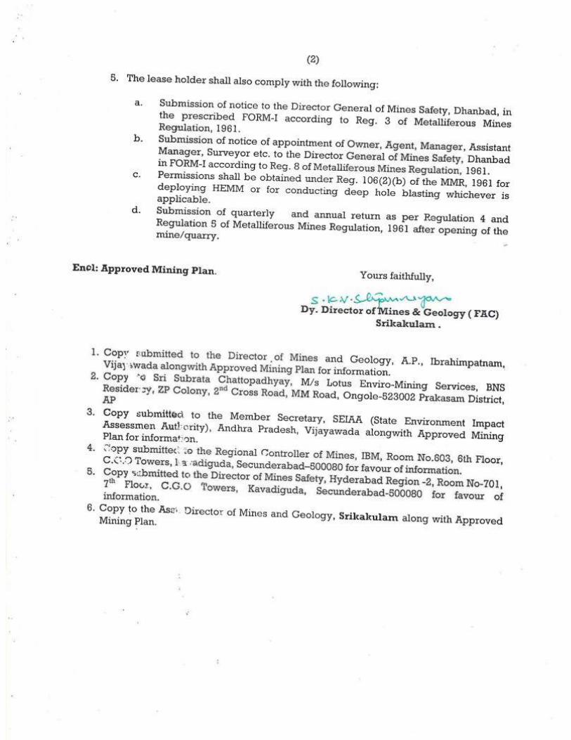
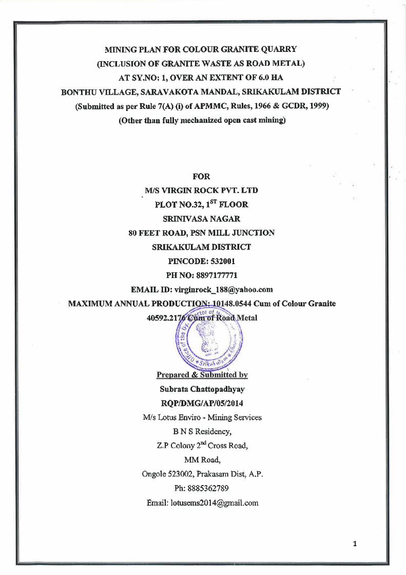


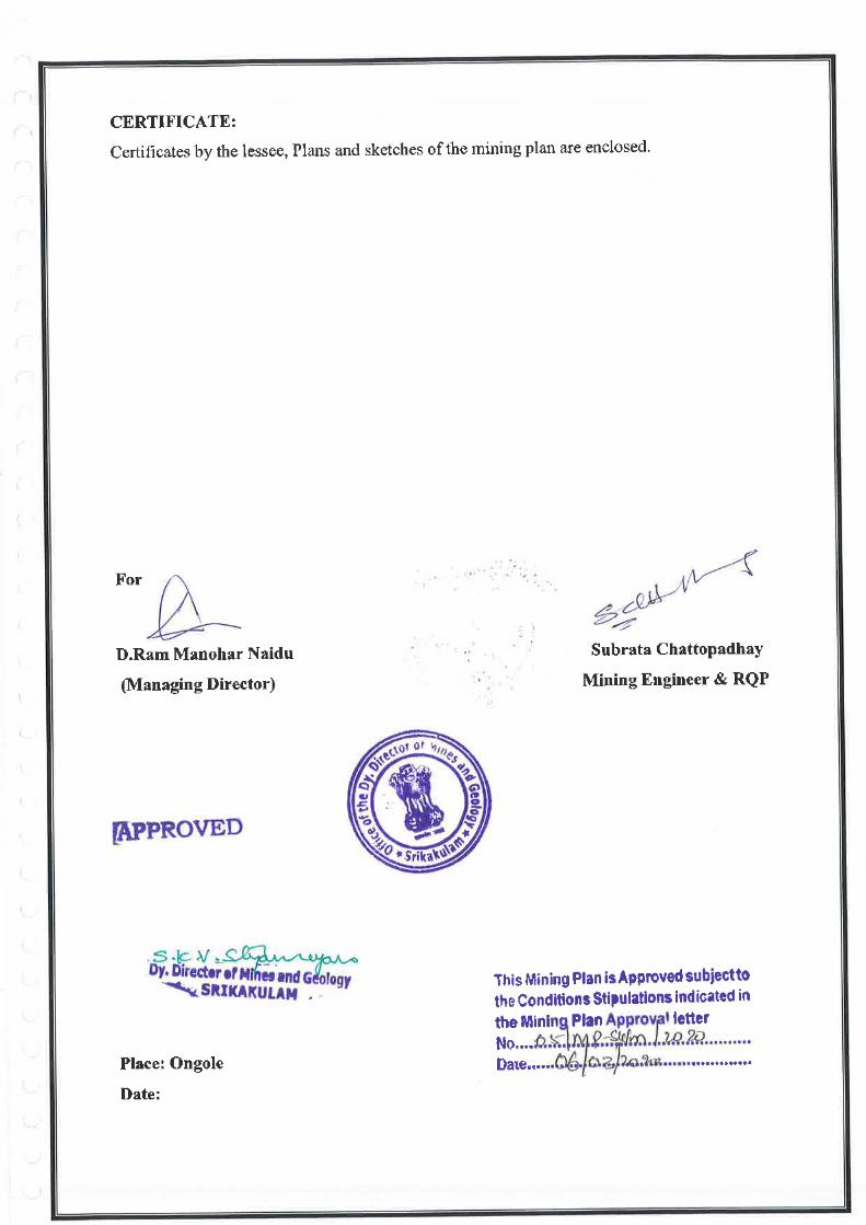


ANNEXURE –III
FOREST NOC


ANNEXURE –IV
CLUSTER LETTER
& MAP


ANNEXURE –V
CLUSTER EMP


CLUSTER ENVIRONMENTAL
MANAGEMENT PLAN
Submission to
The State Environmental Impact Assessment Authority (SEIAA) &
State Environmental Appraisal Committee (SEAC), A.P.
For
M/s VIRGIN ROCK PVT. LTD.
MINING OF COLOUR GRANITE & ROAD METAL (GRANITE WASTE) OVER AN EXTENT: 6.0 HA.,
Mine Address: Sy.No. 1
Bonthu (V), Saravakota (M)
Srikakulam (Dt.), Andhra Pradesh
PREPARED BY
SV ENVIRO LABS & CONSULTANTS Environment Engineers & Consultants in Pollution Control
H.O: Block-B, B-1, IDA, Autonagar, Visakhapatnam – 530 012 Ph: 0891-2755528, 9440338628; Tel/Fax: 0891-2755529,
E-mail: [email protected] QCI NABET Accredited & Recognized by MOE&F, New Delhi


M/s Virgin Rock Pvt. Ltd. (Extent – 6.0 Ha) Cluster EMP
Page 1 of 19
1.0 INTRODUCTION:
M/s. Virgin Rock Pvt. Ltd. filed an application for grant of Quarry Lease for
Colour Granite over an extent of 6.0 Ha in Sy.No.1 of Bonthu Village, Saravakota
Mandal, Srikakulam District, Andhra Pradesh.
The Assistant Director of Mines & Geology, Srikakulam, submitted proposals on
the Quarry lease application filed by M/s. Virgin Rock Pvt. Ltd., recommending
for grant of quarry lease for Colour Granite over an extent of 6.0 Hectares in
Sy.No.1 of Bonthu Village, Saravakota Mandal, Srikakulam District, Andhra
Pradesh for a period of 20 years.
After careful examination of the proposals of the Assistant Director of Mines &
Geology, Srikakulam, the DM&G, Ibrahimpatnam in principle, decided to grant of
Quarry lease for Colour Granite over an extent of 6.0 Hectares in Sy.No.1 of
Bonthu Village, Saravakota Mandal,, Srikakulam District, Andhra Pradesh, for a
period of 20 years vide Notice No. 4097/R1-1/2019, dated: 26.11.2019 subject to
submission of Approved Mining Plan along with Consent for Establishment from
A.P. Pollution Control Board & Environmental Clearance from Ministry of
Environment & Forests as per Environmental Impact Assessment Notification
through S.O. 1533, dated: 14.09.2006.
Later, the proponent filed an application and was granted for inclusion of Mineral
Road Metal (Granite Waste) in addition to the Colour Granite vide Notice No:
4097/D1-1/2019 dated: 10.02.2020.
The Mining plan is approved by Deputy Director of Mines and Geology (FAC)
vide Letter No: 05/MP-SKLM/2020, Dated: 06.03.2020.
The present proposal is for obtaining EC for the propsed mine to excavate colour
Granite and use Granite waste as Road Metal with a production capacity of
10148.0544 m3/annum and 40592.2176 m3/annum under violation and the mining
activity will be carried out by opencast other than fully mechanized mining method
by developing benches with wet drilling and wire saw cutting.
Presentation of TOR under violation has been made before the SEAC, Andhra
Pradesh committee during 01.12.2020-04.12.2020 and the TOR has been issued

M/s Virgin Rock Pvt. Ltd. (Extent – 6.0 Ha) Cluster EMP
Page 2 of 19
by SEIAA, AP vide order no: SEIAA/AP/SKLM/MIN/10/2020/2205-149 Dt:
21.06.2021 for conducting public hearing.
1.1 CLUSTER FORMATION:
The mine area is a fresh mine, cluster EMP has to be submitted to get
Environmental Clearance (EC) under Category B2 at par with B1 as the mine
extent is above 5 hectares.
As per MoEF & CC notification S.O. 141(E) dt: 15th January, 2016 “A cluster shall
be formed when the distance between the peripheries of one lease is less than 500
m from the periphery of other lease in a homogeneous mineral area” and this mine
is having 2 other existing mines and 2 grant proposed mines within 500 m radius of
the subjected mine area covering in Bothu Village, Saravakota Mandal,
Srikakulam District.
As per the notification, the status of the 5 (one EC proposed mine, two existing
mines and two grant proposed mines) quarrying projects is to be examined for a
cluster situation.
As per S.O.2269 (E) dt 1st July, 2016 “(6) A cluster shall be formed when the
distance between the peripheries of one lease is less than 500 meters from the
periphery of other lease in a homogeneous mineral area which shall be applicable
to the mine leases or quarry licenses granted on and after 9th September 2013” and
mine leases not operative for three years or more and leases which got
environmental clearance as on 15th January 2016 shall not be counted for
calculating of cluster, but shall be included in the Environmental Management Plan
for cluster.
1.2 LOCATION OF THE MINE:
The mining area is located in Sy. No. 1, Bonthu Village, Saravakota Mandal,
Srikakulam District, Andhra Pradesh. The mine area is located at a distance of
41.42 km from the district headquarters, Srikakulam. The mine lease area falls
under
Topo sheet No. : 74 B/2
Latitude : 18°39'8.39"N to 18°39'7.22"N
Longitude : 84° 1'36.16"E to 84° 1'36.27"E

M/s Virgin Rock Pvt. Ltd. (Extent – 6.0 Ha) Cluster EMP
Page 3 of 19
1.3 CLUSTER CLASSIFICATION AND LOCATION DETIALS:
A certificate about the existing/proposed quarries within 500 M radius range
around the periphery of the EC proposed quarry has been obtained from the
Assistant Director, Mines & Geology, Srikakulam, Government of Andhra
Pradesh. The Assistant Director, Mines & Geology, Srikakulam to ascertain
whether the existing/proposed quarries in the said range from a cluster situation
and to prepare the EMP accordingly the certificate & cluster map.
As per cluster notification by MoEF&CC mines which not executed lease or
Environmental Clearance before 9th September 2013 were considered and
were included in preparation of cluster EMP. As per records of the Asst.
Director of Mines and Geology, Srikakulam vide Lr. No. 6367/Q/2018
Dt:16.04.2020 there are two areas for which grant proposals for mine lease
are submitted by ADM&G, Srikakulam, however L.O.I are yet to be granted
and there are 2 existing mines present within 500 m distance which were
granted after 09.09.2013. Thus the existing mines will be counted for cluster
consideration with the present EC proposed mine. The cluster details are
given below.
There are two (2) working mines and two (2) grant proposal mines falling under
cluster area over a total extent of 18.42 Ha, including M/s Virgin Rock Pvt. Ltd.
mine area and two (2) existing mines over an extent of 6.0 Ha. and and two (2)
grant proposal mines of extent 6.42 Ha.,, which are forming cluster with the EC
proposed mine. List of mines were shown as below. However Environment
Management Plan (EMP) is prepared for cluster of mines by considering two
existing mines.

M/s Virgin Rock Pvt. Ltd. (Extent – 6.0 Ha) Cluster EMP
Page 4 of 19
Cluster Mine Details:
*The total considered area for cluster is 12.0 Ha
S.No Name of the
applicant Location
Extent
(Ha)
Lease Work Order Remarks
From To
1. M/s Virgin Rock Pvt. Ltd. Sy. No. 1, Bonthu
Village, Saravakota Mandal, Srikakulam
District, Andhra Pradesh
6.0 20 years LoI Notice No:
4097/D1-1/2019 dated: 10.02.2020
ToR Letter No. SEIAA/AP/SKLM/MIN/10/2020/2205-149 Dt:
21.06.2021
2. Sri K. Jagannadh
3.0 16.10.2018 15.10.2038 Details not found
3. Sri K. Jagannadh
3.0 20.10.2018 19.10.2038 Details not found
4 M/s S.R.N Enterprises
Sy. No. 1, Bonthu Village, Saravakota Mandal, Srikakulam
District, Andhra Pradesh
4.09 -- Grant proposals submitted to Director of
Mines and Geology, Ibrahimpatnam
5 M/s Veeje Mines and Minerals
2.33 --
18.42

M/s Virgin Rock Pvt. Ltd. (Extent – 6.0 Ha) Cluster EMP
Page 5 of 19
Boundary Coordinates of Individual Mines:
2.0 Geology:
In general, the area is plain with isolated hillocks. Sometimes they may rise gently
as continuous hills, presenting rugged topography.
SI. No.
Name of the applicant
Extent
(Ha.)
Points North Latitude East Longitude
1 M/s Virgin Rock Pvt. Ltd.
6.0
P1
P2
P3
P4
P5
P6
P7
P8
P9
P10
P11
P12
P13
P14
P15
P16
P17
P18
P19
18°39'8.39"N
18°39'4.97"N
18°39'3.23"N
18°39'4.60"N
18°39'5.15"N
18°39'5.24"N
18°39'4.74"N
18°39'3.57"N
18°39'2.04"N
18°39'0.79"N
18°38'58.81"N
18°39'2.38"N
18°39'3.19"N
18°39'3.91"N
18°39'4.64"N
18°39'5.89"N
18°39'5.81"N
18°39'6.30"N
18°39'7.22"N
84° 1'36.16"E
84° 1'48.35"E
84° 1'47.60"E
84° 1'41.71"E
84° 1'41.71"E
84° 1'40.87"E
84° 1'40.80"E
84° 1'43.32"E
84° 1'44.38"E
84° 1'43.34"E
84° 1'40.89"E
84° 1'34.62"E
84° 1'34.37"E
84° 1'34.05"E
84° 1'34.07"E
84° 1'35.29"E
84° 1'36.54"E
84° 1'37.09"E
84° 1'36.27"E
2 Sri K. Jagannadh 3.0 -- -- --
3 Sri K. Jagannadh 3.0 -- -- --
4 M/s S.R.N Enterprises 4.09 -- -- --
5 M/s Veeje Mines and Minerals
2.33 -- -- --
TOTAL 18.42

M/s Virgin Rock Pvt. Ltd. (Extent – 6.0 Ha) Cluster EMP
Page 6 of 19
Topographically the applied area is a steep sloping hill, sloping due South-East and
North-East of the Q.L. applied area. The assumed bench mark of 75 m is taken
towards North-East of the Quarry lease. The highest RL is 99 m and the lowest is
88 m. Thus, the area is having an altitudinal range of 11 m from the general ground
level. There are no prominent streams and canals in the area. The surrounding
lands on Eastern, Northern and Southern side of the area are rocky outcrops and
Western area being used for agriculture.
Regionally, the area has Migmatite and Migmatized Charnockites suit of rocks
which forms the part of Eastern Ghat Granulite Belt (EGGB). Charnockite,
Khondalite, Pyroxene Granulites, Leptynite, Intrusive Charnockite and Granite are
included in this group. The regional strike is NE-SW wit dips ranging from 50o to
80o. The rock formation belongs to Eastern Ghat Mobile Belt of Archean Age. The
mobile belt is divided in to 3 Longitudinal zones i.e. Western Charnockite Zone
(WCZ), Central Khondalite Zone (CKZ) and Eastern Migmatite Zone (EMZ). The
EMZ is well developed in the Northern parts of the Belt around Visakhapatnam,
Vizianagaram and Srikakulam.
A broad distribution of types of rocks in Srikakulam District are Granite Gnieses,
Khondalites, Charnockites, Leptynites, Rajahmundry Sand Stone, Alluvial
Deposits and Quartzites at certain places. The area is drained by two prominent
rivers originating from Orissa, namely Nagavali and Vamsadhara passing almost
parallel to one another and joins the Bay of Bengal. Statigraphically the area
belongs to Archean Era.
Geological Era Geological Unit Rock Type
Archaeans
Meta Volcanoes and meta sedimentary rocks of green
stone belts
Peninsular Gneisses with older granites and migmatites
Schistose rocks of Sargur Group and its equivalents
Migmatitic complex
Migmatites and Gneisses
-------
Leptynite, migmatised

M/s Virgin Rock Pvt. Ltd. (Extent – 6.0 Ha) Cluster EMP
Page 7 of 19
Charnockite Group
Khondalite Group
Charnockite and Khondalite
Charnockite
Khondalite
Srikakulam Blue (Migmatite/ Migmatised Charnockite)
The migmatite and migmatised charnockite are the predominant rock types
exposed in Srikakulam District. Srikakulam Blue Granite is extensively quarried in
Narasannapeta – Polaki, are in the Kotabommali – Nandigam – Saravakota
triangle. Active quarries are located around Nandigam, Ravivalasa, Jarjangi,
Pathupuram, Kurudu, Danta, Kottapalli Sativada, Sidhi, Bonthu etc, the total area
of operation is about 160 km2 spread over five blocks viz Nandigam,
Kotabommali, Saravakota, Narasannapeta and Bonthu – Pedalamba.
Migmatite and Migmatised Charnockite mostly occurs as hill type deposit, it is
quarried locally as Srikakulam Blue – Dark Medium and light
2.1 Mineable Reserves
The deposit was estimated through cross sectional method. The reserves are
estimated through A-A’, B-B, C-C’, D-D’ cross sections with an interval of 66
mtrs, 70 mtrs, 30 mtrs, 38 mtrs. The proved reserves were taken upto a depth of RL
75 M from surface of the area i.e., from hill peak i.e., 98 M RL point to bottom.
The probable reserves were taken up to 10 mtrs below ground level i.e., 75 M to 65
M RL..
Colour Granite (20%)
Total Proved Reserve of Colour Granite : 199373.738 m3
Colour Granite blocked under Safety Slopes : 3304.4024 m3
Colour Granite under 7.50 m Buffer Zone : 10094.06 m3
Available Colour Granite reserve after deducting
Blocked Reserves : 185975.2756 m3
Road Metal (80% Granite Waste)
Total Proved Reserves of Road Metal : 797494.95 m3
Road Metal blocked under Safety Slopes : 13217.6096 m3

M/s Virgin Rock Pvt. Ltd. (Extent – 6.0 Ha) Cluster EMP
Page 8 of 19
Road Metal blocked under 7.50 m Buffer Zone : 40376.24 m3
Available Road Metal reserves after deducting
Blocked Reserves : 743901.10 m3
Total Mineral Reserves (Colour Granite + Road Metal): 929876.3756 m3
Average annual Production : 50090.22676 m3/annum
Life of mine = Mineable reserves/Avg. Production : 18.56 Say 19 years
MINERAL RESERVES IN CLUSTER OF MINES
2.2 PROJECT DESCRIPTION
MINING PROCESS
The mining operations are carried out by opencast method of mining. Colour
Granite by nature it is medium hard. The operations will involve drilling, wire saw
cutting and excavation and directly loads into the tippers/tractors. The excavation
will be carried with bench height 5 to 6 meters and width 3 to 4 meters minimum.
The proposed method of working is by semi-mechanized method of opencast
quarrying. Considering mining parameters and the technical parameters like
surface topography, rock mechanism factors & quality variations, geo-technical
aspects, required rate of production & available resources etc. Small scale building
quarrying activity with jack hammers drilling & wire saw cutting.
The removal of side burden consisting of soil, weathered rocks and fractured rocks
is the general practice of the opening of the quarry. The fractured rock is having
5% of recovery. The side burden of soil will be removed with the help of
S.No. Name of the applicant
Geological Reserves (m3)
Mineable Reserves (m3)
Mine Life (Years)
1. M/s Virgin Rock Pvt. Ltd.
996868.690 929876.3756 19.0 years
2. Sri K. Jagannadh Details not traceable
3 Sri K. Jagannadh Details not traceable
4 M/s S.R.N Enterprises Details not traceable
5 M/s Veeje Mines and Minerals
Details not traceable

M/s Virgin Rock Pvt. Ltd. (Extent – 6.0 Ha) Cluster EMP
Page 9 of 19
excavators. The weathered material further loosened. During removal of
overburden adequate care will be taken to protect the dimensional granite. The
loosed soil and weathered granite will be loaded in tippers and lifted to mineral
waste storage yard.
Separation of Primary rocks from Mother Rocks:-
The primary cuts i.e. the lateral and horizontal cuts by diamond wire saw cuts
through slaughter holes (A 50m wire saw run gets around 600 m2 Cut). 10 m in
length and 8 m in width and 6 m height sizes are produced. The wire for Granite is
made of the steel wire. Sintered beds with plastics injected on the steel wire and
between diamond beds in order to safe guard the steel wire from the abrasive
components of granite.
The stationary diamond wire machines were born for three main purposes:-
Squaring and dressing of irregularly shaped blocks, preparing them for final
processing in slabs and tiles.
Making thickness of stone or certain width in order to utilize the best
gangsaws and blocks cutter having maximum productions and profit from the
processing machines.
Perform automatic cuts of block into slabs of different thickness. The block
can so be programmed to have a certain number of slabs each of prescribed
thickness.
Sub division of large (Primary) block into Secondary Block (Secondary cuts)
Once the primary blocks are dislodged from sheet rock, depending upon the
dislodged material secondary blocks are cut, fractures, black lines and
penetrative cracks are all carefully trimmed and penetrative cracks are all
carefully trimmed and removed by this way.
The commercial blocks will be trimmed so as that the sides from right angles
to each other.
Processing of Mineral Waste (Road Metal):
The mineral waste material is initially segregated with the help of an excavator.
The material in required dimensions is directly sent to the consumers. The slabs
M/s Virgin Rock Pvt. Ltd. (Extent – 6.0 Ha) Cluster EMP
Page 10 of 19
and oversize boulders are separately shifted there and then. With this the finer
material remains in the zone of operation. The boulders and slabs thus shifted are
broken into sizes that can be handled and dumped into the truck. Later transported
to the local stone crushing units for required sized Road metal production.
Production Details of Cluster within 500 m:
Baseline Environment, Impact assessment and Mitigation:
The EC proposed mine is for production of Colour Granite and usage of mineral
waste as Road Metal and another two existing mines & two grant proposed mines
are for production of colour Granite. As per mining plan and obtained TOR, it is
proposed to produce Colour Granite and Road Metal from the existing mine with
production capacity 10148.0544m3/annum and 40592.2176 m3/annum.
respectively.
Water Environment:
M/s Virgin Rock Pvt. Ltd. (Extent – 6.0 Ha)
There is no remarkable water streams flowing through the mine area. Hence impact on
surface runoff is not envisaged. During mining operation runoff will be collected in pit and
used for mining operations like wetting of haul roads and watering of plants etc. During
S.No. Name of the
applicant
Maximum Production
(m3/annum)
Road Metal (Granite
Waste) (m3/annum) Land
1. M/s Virgin Rock Pvt. Ltd.
10148.0544 40592.2176 Govt. Land
2. Sri K. Jagannadh Details not traceable
3 Sri K. Jagannadh Details not traceable
4 M/s S.R.N Enterprises
Details not traceable
5 M/s Veeje Mines and Minerals
Details not traceable

M/s Virgin Rock Pvt. Ltd. (Extent – 6.0 Ha) Cluster EMP
Page 11 of 19
operation of mine total water requirement for this mine is estimated to be 8.7 KLD. Out of
which 1.2 KLD is for domestic purposes, 3.0 KLD is for water sprinkling for dust
suppression, 3.0 KLD for wet drilling & wire saw cutting and 1.5 KLD for Green belt
development. The source of water is through water tankers from nearby village.
3.0 ENVIRONMENTAL MANAGEMENT PLAN (EMP)
3.1 ENVIRONMENTAL IMPACTS AND MITIGATION MEASURES
Open cast method of Colour Granite and Road Metal (Granite waste) mining will
result in some adverse impacts on the surrounding environment and the magnitude
and impact of the Environmental pollution depends on method of mining, scale
and concentration of mining activity.
The following are the possible impacts while carrying out the quarrying activities.
Change in land use pattern
Waste generation
Impact on flora & fauna around quarry site.
Dust generation during mining, screening and transportation
Silting of local water bodies due to soil erosion
Vibrations and impact on surroundings
Noise from quarrying operations.
However the above impacts can be mitigated with proper Environmental
Management Plan supported by adequate financial allocation.
3.2 WASTE GENERATION
Solid waste
The waste that will be generated in this mining period is 200360.907 m3 which will
be dumped temporarily in the North-East side of the quarry between Grid intervals
N2064800 m E 186450 m to N 2064900 m E 186550 m covering an area of
3562.479 m2 and shall be sloped at 1 in 20. Below the foot of the slopes a retaining
wall of 1.20 m X 1.20 m X 1.20m shall be constructed using boulders in order to
arrest the spread of dump and arresting the silt to adjoining land during monsoon.
Construction of garland drains, check dams will be done during the scheme period

M/s Virgin Rock Pvt. Ltd. (Extent – 6.0 Ha) Cluster EMP
Page 12 of 19
of mining. The granite waste generated will be utilized as Road Metal and will be
sold to local stone crushers. Some quantity will be used for laying internal and
approach roads and construction of retaining wall & garland drains.
Liquid Waste:
The liquid waste will be mainly run of rain water during monsoon months from the
mine face. The rain water draining the exposed rocks, fragment and dust in the
quarry is susceptible for incorporating the above as suspended solids into the
runoff. Seepage of such water down to the water table may cause pollution to the
ground water.
However there is no scope for seepage of mine liquid waste, as the mining is above
the ground level. The rain water is collected in the low elevation portion of the
mine through garland drains and the same will be used for greenbelt development,
Dust depression.
Very small quantity of waste water will be generated from domestic consumption
which is treated through septic tank followed by soak pit.
3.3 WASTE MANAGEMENT:
Solid waste:
The waste that will be generated in this mining period is 200360.907 m3 which will
be dumped temporarily in the North-East side of the quarry between Grid intervals
N2064800 m E 186450 m to N 2064900 m E 186550 m covering an area of
3562.479 m2 and shall be sloped at 1 in 20. Below the foot of the slopes a retaining
wall of 1.20 m X 1.20 m X 1.20m shall be constructed using boulders in order to
arrest the spread of dump and arresting the silt to adjoining land during monsoon.
Construction of garland drains, check dams will be done during the scheme period
of mining. The granite waste generated will be utilized as Road Metal and will be
sold to local stone crushers. Some quantity will be used for laying internal and
approach roads and construction of retaining wall & garland drains.

M/s Virgin Rock Pvt. Ltd. (Extent – 6.0 Ha) Cluster EMP
Page 13 of 19
Liquid Waste:
Since the stone is free toxic minerals, there will not be any toxicity in the collected
rain water. As no chemical activity is involved in the quarry operations, treatment
of waste water is not required.
The rain water is collected in the mine area at lowest elevated portion and the same
will be used for sprinkling on roads for wetting and mitigate the dust pollution,
wetting and also some quantity will be used in watering of plants.
The small quantity of waste water generated from domestic consumption will be
sent to septic followed by a soak pit.
3.4 AIR POLLUTION
Dust Generation during quarrying operation and transportation
Dust will be generated during the mine operations, handling of extracted mineral
and transportation of the material which needs to be controlled to mitigate the
pollution.
The following measures are proposed to mitigate pollution due to dust emissions.
Developing tree cover all along the periphery of the cluster of mines to reduce
dust impact
Sprinkling water at frequent intervals on the haul road to reduce dust
generation during plying of dumpers.
Periodic maintenance of haulage roads.
Wetting of road from quarry site to village road.
Spraying water over the ROM to be loaded to reduce dust generation during
loading operation.
Developing plantation along the mining leases cluster boundary and outside
roads to reduce spread of dust.
Green Belt Development Plan
Green belt is proposed to be developed within the buffer area and along approach
road of the mine during the mining for mitigating the air pollution due to fugitive
dust emissions and the noise generated.

M/s Virgin Rock Pvt. Ltd. (Extent – 6.0 Ha) Cluster EMP
Page 14 of 19
3.5 IMPACT ON FLORA AND FAUNA
Vegetation in the area is sparse and is mainly in the form of patches comprising
thorny bushes, small shrubs and some trees.
On the other hand green belt is proposed to be developed within mine area.
Plant species like Neem, Mango & Eucalyptus will be used to develop green
belt.
Sapling consisting of Neem, Teak will be planted along the cluster buffer zone
and the top soil bunds, and on foot of the hill.
3.6 VIBRATIONS AND IMPACT
Vibrations are determined by three factors for its intensity is Vibration Amplitude
(Peak Particle Velocity), duration and frequency. Studies show found that delay
interval of 17 to 43 milli seconds results into generation of lower level of ground
vibration. Blasting is avoided in this mine.
3.7 NOISE SOURCES AND CONTROL MEASURES
The main sources of noise in mining activity are drilling, wire saw cutiing, material
handling machinery, and loading equipment, etc. The noise generated by the
machinery and vehicles as well as drilling operations will be minimal in the range
of maximum 100dB.
Following mitigation measures would control noise pollution:
Maintaining the machinery in good condition by properly lubricating all
moving parts.
Providing earmuffs, ear plugs etc. to workers.
Using hydraulic drills for drilling.
Conventional mining methods will be implemented instead of blasting, line
drilling for splitting or chemical powder, hydraulic drilling etc.
Developing thick greenbelt around the cluster and along the approach roads
along the haulage roads.
Limiting the use of horns by the drivers of the vehicles.
3.8 RISK ASSESSMENT AND DISASTER MANAGEMENT PLAN
The major risks associated with quarrying are drilling risks, slope failure etc.

M/s Virgin Rock Pvt. Ltd. (Extent – 6.0 Ha) Cluster EMP
Page 15 of 19
Risk analysis involves systematic identification and assessment of major damage
potential credible risk scenario to help management to make objective decisions on
hazards reduction or avoidance measures meeting regulatory requirements and
develop a structured management framework for an effective Disaster
Management Plan including emergency preparedness and contingency plans.
The planning for mitigating the emergency involves the reorganization of the
accident or possible assessing the consequences of such possible accident and
deciding on emergency planning/procedures in advance.
Both on site & off site that would be necessary to be implemented in the event of
emergency without any delay and confusion.
Proper bench design in mines and observing safety measures for transportation
storage, handling of explosives & fuels, etc, good maintenance of vehicles, roads,
and fire prevention measures shall go in preventing disaster/accidents.
Mining shall be carried out as per Regulation of the MMR 1961 & rules and
Regulations made there under applicable. The project in charge is having a
mobile/alternative communication for quick intimation of information if need
arises.
As the quarry operation is open cast, only possible risk is collapse of quarry/ pit
sides when people are working. For this proper bench slope will be maintained as
per the mining plan.
Mining operation will not be conducted during rainy days to avoid any collapse of
the overburden into mine pit.
All precautions would be taken to control fly rock during the mining operations.
The quarry area is to be provided with good communication facilities like
telephone & mobile phone or wireless walky talks.
In case of any minor/major accidents within the mine, the same will be
communicated to the DGMS officials, the District Magistrate and Mines &
Geology officials concern and local authorities concern.
A vehicle is kept all the time at the quarry site for conveyance.

M/s Virgin Rock Pvt. Ltd. (Extent – 6.0 Ha) Cluster EMP
Page 16 of 19
The workmen in the project are periodically trained at group vocational training
center for proper safety training as per the DGMS circulars.
At quarry level first aid facility is provided and person(s) will be shifted to nearest
major hospital.
A key person will be assigned duties and responsibilities for incident response and
emergency response at the quarry. At mine level first aid will provide and person
shall be shifted to nearby government hospital, having all basic facilities and
qualified medical officer who is capable of handling normal accidents.
Mine manager is the person responsible of the disaster management and he need to
be contacted in case of any disaster.
3.9 OCCUPATIONAL HEALTH & SAFETY
As a measure of occupational safety & health, the following facilities will be
provided to the workmen;
Providing Dust masks to prevent exposure to dust
Providing ear muffs/ear plugs for protecting from adverse affects of noise
Monitoring the health of the workers on regular basis Periodical Medical
Examination (PME) as per Mines Rules 1956.
Providing First Aid Facility at the work site.
Providing basic amenities to the quarry workmen.
3.10 BUDGETS FOR IMPELEMENTATION OF EMP
The Environmental Management plan involves:
Dust Suppression measures
Green Belt Development,
Undertaking periodical Environmental monitoring
Providing personal protective equipments
3.11 ENVIRONMENTAL MONITORING PLAN
Monitoring Strategy
The monitoring of various environmental parameters is necessary and is a part of
the environmental protection measures. Monitoring is as important as that of

M/s Virgin Rock Pvt. Ltd. (Extent – 6.0 Ha) Cluster EMP
Page 17 of 19
controlling, since the efficiency of control measures can only be determined by
monitoring.
A well-defined environmental monitoring program would be taken up to monitor
the ambient air to check whether the quality of air is maintained within the
permissible limits.
The following environmental attributes should be monitored:
Air pollution.
Noise pollution
Workers Health
Locations and frequency of monitoring should be as per the guide lines of APPCB
and MOEF.
AMBIENT AIR MONITORING
As per MoEF, there is a need to identify 3 ambient air stations at 1200 angle
keeping the main source in the center.
The ground level concentrations of suspended particulate (PM10 &PM2.5,), sulphur
dioxide SO2 and Nitrogen Oxide (NOX) in the ambient air outside the quarry
boundaries shall be monitored at regular intervals.
Any deviation from predicted /expected values shall be investigated and necessary
action be taken.
NOISE MONITORING
Noise levels in the work space environment will be monitored periodically. If any
deviation is observed necessary corruptive measures will be taken.
Monitoring noise levels is essential to assess the efficacy of maintenance of
schedules undertaken to reduce noise levels and noise protection measures.
A good quality sound pressure level meter is essential for this purpose.
This work can be handled by out sourcing the surveillance is for the benefit of the
workers will being and to keep track of machine wear.

M/s Virgin Rock Pvt. Ltd. (Extent – 6.0 Ha) Cluster EMP
Page 18 of 19
WORKERS HEALTH
Regular health check up of workers will be carried out at the nearest hospital at
least once in an year as per the Rule 29 of Mines Rules 1955.
3.12 POST CLOSURE PLAN
Based on the estimation of mineable reserves in the mining plan, the quarrying
operations will be continued further reserves may be proved within the Mining
Plan period. At the end of the lease period after completion of the quarrying, the
quarry pits would be developed as reservoirs for rain water collection, which act as
sources for recharging the ground water levels in the area. Green belt will be
developed on the bunds of the quarry and along the benches and approach road,
haulage roads, etc.
4.0 CONCLUSION:
The production of Colour Granite and usage of mineral waste as Road Metal
project held by M/s Virgin Rock Pvt. Ltd. proposed to obtain a EC under
violation an Extent of 6.0 Ha which is located in Sy. No. 1 of Bonthu Village,
Saravakota Mandal, Srikakulam District, Andhra Pradesh will be environmental
compatible to the surrounding and there will be no long term environmental impact
based on the existing environmental scenario. The particulate matter getting
airborne from the quarrying activity gets dispersed in close proximity itself and
settles down early. The noise levels due to the proposed quarry activity are also not
of a higher order that calls for immediate corrective measures. There will be
positive socio-economic front in the surrounding region due to the proposed
quarrying activity. The green belt development would help in achieving ecological
balance.
Environmental Management Plan (EMP) will help mitigate adverse impacts on the
environment. Where impacts occur, immediate action would be taken to reduce the
escalation of effects associated with these impacts.
Hence, it is requested that Environmental Clearance be accorded for the production
of 10148.0544 m3/annum for Colour Granite and 40592.2176 m3/annum for Road
Metal (Granite Waste).