Final draft 3000 MW Tranche 1 Draft Guidelines State Specific Bundling Scheme 2015 05012015
Upload
khangminh22Category
view
1download
0
DRAFT ENVIRONMENTAL IMPACT REPORTSpecific Plan for the Development of State Surplus Property
and Amendment to the Redevelopment Plan for the MergedChino Redevelopment Project Area, Chino, California
VOLUME IDRAFT ENVIRONMENTAL IMPACT REPORT
CLEARINGHOUSE NUMBER 2002071120
PREPARED FOR:City of Chino
Community Development Department13220 Central Avenue
Chino, CA 91710
PREPARED BY:Sapphos Environmental, Inc.
133 Martin AlleyPasadena, CA 91105
July 2003
Specific Plan for the Development of State Surplus Property and Amendment to the Redevelopment Plan for the Merged ChinoRedevelopment Project Area, Chino, CaliforniaJune 2003 Sapphos Environmental, Inc.S:\1218-001\Final Draft\TOC.wpd Page i
TABLE OF CONTENTS
VOLUME I
SECTIONS PAGE
ES EXECUTIVE SUMMARY . . . . . . . . . . . . . . . . . . . . . . . . . . . . . . . . . . . . . . . . . . . . . . . . ES-1
ES.1 Existing Facilities . . . . . . . . . . . . . . . . . . . . . . . . . . . . . . . . . . . . . . . . . . . . . . . . ES-1ES.2 Proposed Project . . . . . . . . . . . . . . . . . . . . . . . . . . . . . . . . . . . . . . . . . . . . . . . . ES-2ES.3 Alternatives . . . . . . . . . . . . . . . . . . . . . . . . . . . . . . . . . . . . . . . . . . . . . . . . . . . . ES-4ES.4 Areas of Controversy Known to the City of Chino . . . . . . . . . . . . . . . . . . . . . . . ES-5ES.5 Issues to Be Resolved . . . . . . . . . . . . . . . . . . . . . . . . . . . . . . . . . . . . . . . . . . . . ES-6ES.6 Summary of Impacts . . . . . . . . . . . . . . . . . . . . . . . . . . . . . . . . . . . . . . . . . . . . . ES-6
1.0 INTRODUCTION . . . . . . . . . . . . . . . . . . . . . . . . . . . . . . . . . . . . . . . . . . . . . . . . . . . . . . 1-1
1.1 Purpose and Scope of EIR . . . . . . . . . . . . . . . . . . . . . . . . . . . . . . . . . . . . . . . . . . 1-11.2 Organization and Content . . . . . . . . . . . . . . . . . . . . . . . . . . . . . . . . . . . . . . . . . 1-4
2.0 PROJECT DESCRIPTION . . . . . . . . . . . . . . . . . . . . . . . . . . . . . . . . . . . . . . . . . . . . . . . . . 2-1
2.1 Proposed Project Location . . . . . . . . . . . . . . . . . . . . . . . . . . . . . . . . . . . . . . . . . 2-12.2 Existing Conditions . . . . . . . . . . . . . . . . . . . . . . . . . . . . . . . . . . . . . . . . . . . . . . . 2-22.3 Statement of Objectives . . . . . . . . . . . . . . . . . . . . . . . . . . . . . . . . . . . . . . . . . . . 2-32.4 Proposed Improvements . . . . . . . . . . . . . . . . . . . . . . . . . . . . . . . . . . . . . . . . . . . 2-62.5 Construction Scenario . . . . . . . . . . . . . . . . . . . . . . . . . . . . . . . . . . . . . . . . . . . . 2-102.6 Intended Uses of the EIR . . . . . . . . . . . . . . . . . . . . . . . . . . . . . . . . . . . . . . . . . . 2-172.7 Related Projects . . . . . . . . . . . . . . . . . . . . . . . . . . . . . . . . . . . . . . . . . . . . . . . . 2-172.8 Alternatives . . . . . . . . . . . . . . . . . . . . . . . . . . . . . . . . . . . . . . . . . . . . . . . . . . . . 2-18
3.0 REGULATORY FRAMEWORK, EXISTING CONDITIONS, IMPACTS, MITIGATION, AND LEVEL OF SIGNIFICANCE AFTER MITIGATION . . . . . . . . . . . . . . . . . . . . . . . . . . 3-1
3.1 Aesthetics . . . . . . . . . . . . . . . . . . . . . . . . . . . . . . . . . . . . . . . . . . . . . . . . . . . . 3.1-13.2 Agricultural Resources . . . . . . . . . . . . . . . . . . . . . . . . . . . . . . . . . . . . . . . . . . 3.2-13.3 Air Quality . . . . . . . . . . . . . . . . . . . . . . . . . . . . . . . . . . . . . . . . . . . . . . . . . . . 3.3-13.4 Biological Resources . . . . . . . . . . . . . . . . . . . . . . . . . . . . . . . . . . . . . . . . . . . 3.4-13.5 Cultural Resources . . . . . . . . . . . . . . . . . . . . . . . . . . . . . . . . . . . . . . . . . . . . . 3.5-13.6 Geology and Soils . . . . . . . . . . . . . . . . . . . . . . . . . . . . . . . . . . . . . . . . . . . . . . 3.6-13.7 Hazards and Hazardous Materials . . . . . . . . . . . . . . . . . . . . . . . . . . . . . . . . . 3.7-13.8 Hydrology and Water Quality . . . . . . . . . . . . . . . . . . . . . . . . . . . . . . . . . . . . . 3.8-13.9 Noise . . . . . . . . . . . . . . . . . . . . . . . . . . . . . . . . . . . . . . . . . . . . . . . . . . . . . . . 3.9-13.10 Population and Housing . . . . . . . . . . . . . . . . . . . . . . . . . . . . . . . . . . . . . . . . 3.10-13.11 Public Services . . . . . . . . . . . . . . . . . . . . . . . . . . . . . . . . . . . . . . . . . . . . . . . 3.11-1
SECTIONS PAGE
Specific Plan for the Development of State Surplus Property and Amendment to the Redevelopment Plan for the Merged ChinoRedevelopment Project Area, Chino, CaliforniaJune 2003 Sapphos Environmental, Inc.S:\1218-001\Final Draft\TOC.wpd Page ii
3.12 Recreation . . . . . . . . . . . . . . . . . . . . . . . . . . . . . . . . . . . . . . . . . . . . . . . . . . 3.12-13.13 Transportation/Traffic . . . . . . . . . . . . . . . . . . . . . . . . . . . . . . . . . . . . . . . . . . 3.13-13.14 Utilities and Service Systems . . . . . . . . . . . . . . . . . . . . . . . . . . . . . . . . . . . . . 3.14-1
4.0 ALTERNATIVES TO THE PROPOSED PROJECT . . . . . . . . . . . . . . . . . . . . . . . . . . . . . . . 4-1
4.1 Alternative 1: No Project . . . . . . . . . . . . . . . . . . . . . . . . . . . . . . . . . . . . . . . . . . . 4-84.2 Alternative 2: No College/Increased Open Space . . . . . . . . . . . . . . . . . . . . . . . 4-114.3 Alternative 3: Compact Project/Increased Open Space . . . . . . . . . . . . . . . . . . . 4-174.4 Alternative 4: Detention Pond Relocation . . . . . . . . . . . . . . . . . . . . . . . . . . . . . 4-224.5 Alternative 5: Flood Control Channel Configuration . . . . . . . . . . . . . . . . . . . . . 4-27
5.0 SIGNIFICANT ENVIRONMENTAL EFFECTS THAT CANNOT BE AVOIDED IF THEPROPOSED PROJECT IS IMPLEMENTED . . . . . . . . . . . . . . . . . . . . . . . . . . . . . . . . . . . . 5-1
6.0 SIGNIFICANT IRREVERSIBLE ENVIRONMENTAL CHANGES RELATED TOIMPLEMENTATION OF THE PROPOSED PROJECT . . . . . . . . . . . . . . . . . . . . . . . . . . . . 6-1
7.0 GROWTH-INDUCING IMPACTS . . . . . . . . . . . . . . . . . . . . . . . . . . . . . . . . . . . . . . . . . . 7-1
8.0 ORGANIZATIONS AND PERSONS CONSULTED . . . . . . . . . . . . . . . . . . . . . . . . . . . . . 8-1
9.0 REPORT PREPARATION PERSONNEL . . . . . . . . . . . . . . . . . . . . . . . . . . . . . . . . . . . . . . 9-1
9.1 City of Chino . . . . . . . . . . . . . . . . . . . . . . . . . . . . . . . . . . . . . . . . . . . . . . . . . . . . 9-19.2 Goodell Brackenbush . . . . . . . . . . . . . . . . . . . . . . . . . . . . . . . . . . . . . . . . . . . . . 9-19.3 Forma . . . . . . . . . . . . . . . . . . . . . . . . . . . . . . . . . . . . . . . . . . . . . . . . . . . . . . . . . 9-19.4 Chaffey College . . . . . . . . . . . . . . . . . . . . . . . . . . . . . . . . . . . . . . . . . . . . . . . . . . 9-19.5 State of California Department of General Services, Real Estate
Services Division . . . . . . . . . . . . . . . . . . . . . . . . . . . . . . . . . . . . . . . . . . . . . . . . . 9-19.6 Associated Engineers . . . . . . . . . . . . . . . . . . . . . . . . . . . . . . . . . . . . . . . . . . . . . . 9-19.7 Kaku Associates . . . . . . . . . . . . . . . . . . . . . . . . . . . . . . . . . . . . . . . . . . . . . . . . . 9-19.8 Sapphos Environmental, Inc. . . . . . . . . . . . . . . . . . . . . . . . . . . . . . . . . . . . . . . . . 9-29.9 Subconsultants to Sapphos Environmental, Inc. . . . . . . . . . . . . . . . . . . . . . . . . . 9-3
10.0 REFERENCES . . . . . . . . . . . . . . . . . . . . . . . . . . . . . . . . . . . . . . . . . . . . . . . . . . . . . . . . 10-1
11.0 DISTRIBUTION LIST . . . . . . . . . . . . . . . . . . . . . . . . . . . . . . . . . . . . . . . . . . . . . . . . . . . 11-1
TABLES PAGE
ES.6-1 Summary of Impacts . . . . . . . . . . . . . . . . . . . . . . . . . . . . . . . . . . . . . . . . . . . . . ES-72.4-1 Land Uses for the Proposed Project . . . . . . . . . . . . . . . . . . . . . . . . . . . . . . . . . . 2-72.4.2-1 Chaffey College, Chino, Population, and Space Forecasts . . . . . . . . . . . . . . . . . . 2-8

TABLES PAGE
Specific Plan for the Development of State Surplus Property and Amendment to the Redevelopment Plan for the Merged ChinoRedevelopment Project Area, Chino, CaliforniaJune 2003 Sapphos Environmental, Inc.S:\1218-001\Final Draft\TOC.wpd Page iii
2.5.1-1 Anticipated Equipment for Construction of the Ruben S. Ayala Community Park Expansion . . . . . . . . . . . . . . . . . . . . . . . . . . . . . . . . . . . . . . . . . . . . . . . . . 2-11
2.5.2-1 Anticipated Equipment for Construction of the Chaffey Community CollegeCampus . . . . . . . . . . . . . . . . . . . . . . . . . . . . . . . . . . . . . . . . . . . . . . . . . . . . . . . 2-12
2.5.3-1 Anticipated Equipment for Construction of the Residential Land Use . . . . . . . . 2-122.5.3-2a Anticipated Equipment for Construction of the Village Center Mixed Use,
Phase 1 . . . . . . . . . . . . . . . . . . . . . . . . . . . . . . . . . . . . . . . . . . . . . . . . . . . . . . . 2-132.5.3-2b Anticipated Equipment for Construction of the Village Center Mixed Use,
Phase 2 . . . . . . . . . . . . . . . . . . . . . . . . . . . . . . . . . . . . . . . . . . . . . . . . . . . . . . . 2-132.5.3-3a Anticipated Equipment for Construction of the Elementary School
and Neighborhood Parks, Phase 1 . . . . . . . . . . . . . . . . . . . . . . . . . . . . . . . . . . 2-142.5.3-3b Anticipated Equipment for Construction of the Elementary School
and Neighborhood Parks, Phase 2 . . . . . . . . . . . . . . . . . . . . . . . . . . . . . . . . . . 2-142.5.3-3c Anticipated Equipment for Construction of the Elementary School
and Neighborhood Parks, Phase 3 . . . . . . . . . . . . . . . . . . . . . . . . . . . . . . . . . . 2-142.5.3-3d Anticipated Equipment for Construction of the Elementary School
and Neighborhood Parks, Phase 4 . . . . . . . . . . . . . . . . . . . . . . . . . . . . . . . . . . 2-152.5.3-4a Anticipated Equipment for Construction of Infrastructure, Phase 1 . . . . . . . . . . 2-152.5.3-4b Anticipated Equipment for Construction of Infrastructure, Phase 2 . . . . . . . . . . 2-162.5.3-4c Anticipated Equipment for Construction of Infrastructure, Phase 3 . . . . . . . . . . 2-162.5.3-4d Anticipated Equipment for Construction of Infrastructure, Phase 4 . . . . . . . . . . 2-162.7.1 Related Proposed and Approved Projects . . . . . . . . . . . . . . . . . . . . . . . . . . . . . 2-173.2.3-1 California LESA Scoring Thresholds . . . . . . . . . . . . . . . . . . . . . . . . . . . . . . . . 3.2-63.3.1-1 Ambient Air Quality Standards . . . . . . . . . . . . . . . . . . . . . . . . . . . . . . . . . . . . 3.3-33.3.2-1 Summary of Air Quality Data Pomona-Walnut Valley (SRA 10) Southwest
San Bernardino Valley (SRA 33) Air Monitoring Stations . . . . . . . . . . . . . . . . . 3.3-63.3.3-1 Emission Thresholds of Significance . . . . . . . . . . . . . . . . . . . . . . . . . . . . . . . . 3.3-83.3.4-1 Maximum Daily Construction Emissions . . . . . . . . . . . . . . . . . . . . . . . . . . . . 3.3-123.3.4-2 Peak Quarter Construction Emissions . . . . . . . . . . . . . . . . . . . . . . . . . . . . . . 3.3-133.3.4-3 Peak Quarter Construction Emissions After Mitigation . . . . . . . . . . . . . . . . . 3.3-153.3.4-4 Operational Emissions Year 2012 . . . . . . . . . . . . . . . . . . . . . . . . . . . . . . . . . 3.3-163.3.4-5 Operational Emissions Year 2025 . . . . . . . . . . . . . . . . . . . . . . . . . . . . . . . . . 3.3-173.4.2-1 Listed Wildlife with the Potential to Occur in the Region of the Proposed
Project Site . . . . . . . . . . . . . . . . . . . . . . . . . . . . . . . . . . . . . . . . . . . . . . . . . . 3.4-113.4.2-2 Sensitive Wildlife Species with the Potential to Occur in the Region of
the Proposed Project Site . . . . . . . . . . . . . . . . . . . . . . . . . . . . . . . . . . . . . . . 3.4-163.6.2-1 Significant Faults with Potential to Cause Earthquakes at Proposed
Project Site . . . . . . . . . . . . . . . . . . . . . . . . . . . . . . . . . . . . . . . . . . . . . . . . . . . 3.6-93.7.2-1 Airport Compatibility Matrix for Proposed Project Land Uses . . . . . . . . . . . . . 3.7-93.8.4-1 City of Chino Water Demand and Supply through 2022 . . . . . . . . . . . . . . . . 3.8-103.9.1-1 Land Use Compatibility for Community Noise Environments . . . . . . . . . . . . . 3.9-43.9.1-2 City of Chino Noise Standards . . . . . . . . . . . . . . . . . . . . . . . . . . . . . . . . . . . . 3.9-53.9.3-1 Noise Significance Thresholds . . . . . . . . . . . . . . . . . . . . . . . . . . . . . . . . . . . . 3.9-7
TABLES PAGE
Specific Plan for the Development of State Surplus Property and Amendment to the Redevelopment Plan for the Merged ChinoRedevelopment Project Area, Chino, CaliforniaJune 2003 Sapphos Environmental, Inc.S:\1218-001\Final Draft\TOC.wpd Page iv
3.9.4-1 Calculated Soccer Field Noise Levels in dB at Various ResidentialReceptor Sites . . . . . . . . . . . . . . . . . . . . . . . . . . . . . . . . . . . . . . . . . . . . . . . . . 3.9-9
3.9.4-2 Calculated Championship Soccer Field Noise Levels in dB at Various Residential Receptor Sites . . . . . . . . . . . . . . . . . . . . . . . . . . . . . . . . . . . . . . . . 3.9-9
3.9.4-3 Calculated State Park Noise Levels in dB at Various ResidentialReceptor Sites . . . . . . . . . . . . . . . . . . . . . . . . . . . . . . . . . . . . . . . . . . . . . . . . . 3.9-9
3.9.4-4 Calculated Tot Lot Noise Levels in dB at Various ResidentialReceptor Sites . . . . . . . . . . . . . . . . . . . . . . . . . . . . . . . . . . . . . . . . . . . . . . . . 3.9-10
3.9.4-5 A-Weighted Noise Levels in dB at 50 Feet for Various Types of Construction Equipment . . . . . . . . . . . . . . . . . . . . . . . . . . . . . . . . . . . . . . . . 3.9-11
3.9.4-6 Calculated CNEL Increase in dB for Future Traffic Volumes with andwithout Proposed Project . . . . . . . . . . . . . . . . . . . . . . . . . . . . . . . . . . . . . . . 3.9-12
3.10.2-1 SCAG Regional Growth Forecasts . . . . . . . . . . . . . . . . . . . . . . . . . . . . . . . . . 3.10-63.10.2-2 Chino Future Housing Needs . . . . . . . . . . . . . . . . . . . . . . . . . . . . . . . . . . . . 3.10-83.10.2-3 Employment Projections: Riverside-San Bernardino PMSA . . . . . . . . . . . . . . 3.10-93.11.2-1 Existing Fire Stations Serving the Proposed Project Site . . . . . . . . . . . . . . . . . 3.11-43.11.2-2 Student-to-Teacher Ratios . . . . . . . . . . . . . . . . . . . . . . . . . . . . . . . . . . . . . . . 3.11-63.11.4-1 Student Generation . . . . . . . . . . . . . . . . . . . . . . . . . . . . . . . . . . . . . . . . . . . 3.11-103.13.1-1 Level of Service Overview . . . . . . . . . . . . . . . . . . . . . . . . . . . . . . . . . . . . . . 3.13-43.13.2-1 Summary of Intersection Delay and Level of Service Existing
Conditions–Year 2002 . . . . . . . . . . . . . . . . . . . . . . . . . . . . . . . . . . . . . . . . . 3.13-73.13.4-1 Year 2025 Trip Generation Estimate by Traffic Analysis Zone . . . . . . . . . . . 3.13-113.13.4-2 Trip Generation Rates . . . . . . . . . . . . . . . . . . . . . . . . . . . . . . . . . . . . . . . . . 3.13-123.13.4-3 Year 2012 Trip Generation Estimate by Traffic Analysis Zone . . . . . . . . . . . 3.13-133.13.4-4 Intersection Delay and Level of Service Cumulative Base
Conditions for Interim Year 2012 . . . . . . . . . . . . . . . . . . . . . . . . . . . . . . . . 3.13-173.13.4-5 Intersection Delay and Level of Service Cumulative Base Plus Project
Conditions for Interim Year 2012 . . . . . . . . . . . . . . . . . . . . . . . . . . . . . . . . 3.13-203.13.4-6 Intersection Delay and Level of Service Cumulative Base
Conditions for Year 2025 . . . . . . . . . . . . . . . . . . . . . . . . . . . . . . . . . . . . . . 3.13-233.13.4-7 Intersection Delay and Level of Service Cumulative Base Plus Project
Conditions for Year 2025 . . . . . . . . . . . . . . . . . . . . . . . . . . . . . . . . . . . . . . 3.13-273.14.2-1 City of Chino Water Demand and Supply through 2022 . . . . . . . . . . . . . . . . 3.14-44-1 Summary of Adequacy of Proposed Project and Alternatives to
Attain Project Objectives . . . . . . . . . . . . . . . . . . . . . . . . . . . . . . . . . . . . . . . . . . . 4-34.2.1-1 Land Uses: No College/Increased Open Space Alternative . . . . . . . . . . . . . . . . 4-124.3.1-1 Land Uses: Compact Project/Increased Open Space Alternative . . . . . . . . . . . . 4-174.4.1-1 Land Uses: Detention Pond Relocation Alternative . . . . . . . . . . . . . . . . . . . . . . 4-224.5.1-1 Land Uses: Flood Control Channel Configuration Alternative . . . . . . . . . . . . . . 4-27
FIGURES FOLLOWS PAGE
2.1-1 Regional Vicinity . . . . . . . . . . . . . . . . . . . . . . . . . . . . . . . . . . . . . . . . . . . . . . . . . 2-12.1-2 Topographic Map . . . . . . . . . . . . . . . . . . . . . . . . . . . . . . . . . . . . . . . . . . . . . . . . 2-1
FIGURES FOLLOWS PAGE
Specific Plan for the Development of State Surplus Property and Amendment to the Redevelopment Plan for the Merged ChinoRedevelopment Project Area, Chino, CaliforniaJune 2003 Sapphos Environmental, Inc.S:\1218-001\Final Draft\TOC.wpd Page v
2.1-3 Project Location . . . . . . . . . . . . . . . . . . . . . . . . . . . . . . . . . . . . . . . . . . . . . . . . . 2-12.2-1 Existing Conditions . . . . . . . . . . . . . . . . . . . . . . . . . . . . . . . . . . . . . . . . . . . . . . . 2-22.4-1 Conceptual Site Plan . . . . . . . . . . . . . . . . . . . . . . . . . . . . . . . . . . . . . . . . . . . . . . 2-63.1.2-1 Eligible and Officially Designated State Scenic Highways . . . . . . . . . . . . . . . . 3.1-23.1.2-2 Existing Visual Character . . . . . . . . . . . . . . . . . . . . . . . . . . . . . . . . . . . . . . . . . 3.1-33.2.2-1 Important Farmland Map . . . . . . . . . . . . . . . . . . . . . . . . . . . . . . . . . . . . . . . . . 3.2-43.4.2-1 Proposed Project Survey Area . . . . . . . . . . . . . . . . . . . . . . . . . . . . . . . . . . . . . 3.4-93.4.2-2 Plant Communities in Proposed Project Site . . . . . . . . . . . . . . . . . . . . . . . . . 3.4-283.4.2-3 Sensitive Wildlife Locations in the Proposed Project Site . . . . . . . . . . . . . . . 3.4-333.4.6-1 Conceptual Burrowing Owl Mitigation Plan . . . . . . . . . . . . . . . . . . . . . . . . . 3.4-403.5.2-1 Regional Geologic Map . . . . . . . . . . . . . . . . . . . . . . . . . . . . . . . . . . . . . . . . . 3.5-33.5.2-2 Cultural Resources Survey Area . . . . . . . . . . . . . . . . . . . . . . . . . . . . . . . . . . . 3.5-43.6.2-1 Geologic Map . . . . . . . . . . . . . . . . . . . . . . . . . . . . . . . . . . . . . . . . . . . . . . . . . 3.6-53.6.2-2 Subsidence and Ground Fissures in the City of Chino . . . . . . . . . . . . . . . . . 3.6-123.7.2-1 Proposed Project Site Hazards and Hazardous Materials . . . . . . . . . . . . . . . . 3.7-63.8.2-1 Existing Drainage . . . . . . . . . . . . . . . . . . . . . . . . . . . . . . . . . . . . . . . . . . . . . . 3.8-73.8.4-1 Proposed Drainage . . . . . . . . . . . . . . . . . . . . . . . . . . . . . . . . . . . . . . . . . . . . 3.8-113.9.4-1 Chino Airport CNEL Noise Contour . . . . . . . . . . . . . . . . . . . . . . . . . . . . . . . 3.9-123.10.2-1 Map of Census Tract 7 . . . . . . . . . . . . . . . . . . . . . . . . . . . . . . . . . . . . . . . . . 3.10-63.11.2-1 Public Services in the Proposed Project Vicinity . . . . . . . . . . . . . . . . . . . . . . 3.11-43.12.2-1 Existing Conditions: Ruben S. Ayala Community Park . . . . . . . . . . . . . . . . . 3.12-33.12.4.1-1 Proposed Ruben S. Ayala Community Park Expansion . . . . . . . . . . . . . . . . . 3.12-43.13.2-1 Local Roadway System and Study Intersection Locations . . . . . . . . . . . . . . . 3.13-43.13.2-2 Existing (2002) Lane Configurations . . . . . . . . . . . . . . . . . . . . . . . . . . . . . . . 3.13-43.13.2-3a Existing A.M. Peak-Hour Turning Movement Volumes . . . . . . . . . . . . . . . . . 3.13-53.13.2-3b Existing P.M. Peak-Hour Turning Movement Volumes . . . . . . . . . . . . . . . . . 3.13-53.13.2-4 Existing Average Daily Traffic Volumes . . . . . . . . . . . . . . . . . . . . . . . . . . . . . 3.13-63.14.2-1 Existing Sewer System . . . . . . . . . . . . . . . . . . . . . . . . . . . . . . . . . . . . . . . . . . 3.14-53.14.2-2 Existing and Proposed Storm Drain System . . . . . . . . . . . . . . . . . . . . . . . . . . 3.14-53.14.4-1 Proposed Recycled-Water System . . . . . . . . . . . . . . . . . . . . . . . . . . . . . . . . . 3.14-73.14.4-2 Proposed Potable Water System . . . . . . . . . . . . . . . . . . . . . . . . . . . . . . . . . . 3.14-73.14.4-3 Proposed Sewer System . . . . . . . . . . . . . . . . . . . . . . . . . . . . . . . . . . . . . . . . 3.14-73.14.4-4 Proposed Underground Joint Trench Dry Utility Distribution System . . . . . . 3.14-84.2.1-1 No College/Increased Open Space Alternative . . . . . . . . . . . . . . . . . . . . . . . . . 4-114.3.1-1 Compact Project/Increased Open Space Alternative . . . . . . . . . . . . . . . . . . . . . 4-174.4.1-1 Detention Pond Relocation Alternative . . . . . . . . . . . . . . . . . . . . . . . . . . . . . . . 4-214.5.1-1 Flood Control Channel Configuration Alternative . . . . . . . . . . . . . . . . . . . . . . . 4-26
Specific Plan for the Development of State Surplus Property and Amendment to the Redevelopment Plan for the Merged ChinoRedevelopment Project Area, Chino, CaliforniaJune 2003 Sapphos Environmental, Inc.S:\1218-001\Final Draft\TOC.wpd Page vi
VOLUME II
TECHNICAL APPENDICES PAGE
A NOP AND COMMENT LETTERS . . . . . . . . . . . . . . . . . . . . . . . . . . . . . . . . . . . . . . . . . . A-1B CALIFORNIA INSTITUTION FOR MEN AT CHINO AIR QUALITY REPORT . . . . . . . . . B-1C BIOLOGICAL RESOURCES REPORT . . . . . . . . . . . . . . . . . . . . . . . . . . . . . . . . . . . . . . . C-1D CULTURAL RESOURCE INVESTIGATION, CALIFORNIA INSTITUTE FOR MEN,
CHINO, CALIFORNIA . . . . . . . . . . . . . . . . . . . . . . . . . . . . . . . . . . . . . . . . . . . . . . . . . . D-1E PALEONTOLOGICAL RESOURCE ASSESSMENT, SURPLUS STATE PROPERTY,
CHINO INSTITUTE FOR MEN, CHINO, SAN BERNARDINO COUNTY, CALIFORNIA . . . . . . . . . . . . . . . . . . . . . . . . . . . . . . . . . . . . . . . . . . . . . . . . . . . . . . . . . E-1
F GEOTECHNICAL INVESTIGATION . . . . . . . . . . . . . . . . . . . . . . . . . . . . . . . . . . . . . . . . F-1G PHASE I ENVIRONMENTAL SITE ASSESSMENT OF LAND LOCATED AT THE
CALIFORNIA INSTITUTION FOR MEN 14901 SOUTH CENTRAL AVENUE, CHINO, CALIFORNIA 91710 . . . . . . . . . . . . . . . . . . . . . . . . . . . . . . . . . . . . . . . . . . . . . G-1
H ACOUSTICAL ANALYSIS MASTER LAND USE PLAN, STATE CORRECTIONAL SITE CHINO, CALIFORNIA . . . . . . . . . . . . . . . . . . . . . . . . . . . . . . . . . . . . . . . . . . . . . . . . . . H-1
I TRAFFIC IMPACT ANALYSIS FOR THE SPECIFIC PLAN FOR THE DEVELOPMENT OFSTATE SURPLUS PROPERTY FROM THE CALIFORNIA INSTITUTE FOR MEN, CHINO, CALIFORNIA . . . . . . . . . . . . . . . . . . . . . . . . . . . . . . . . . . . . . . . . . . . . . . . . . . I-1
J TRAFFIC IMPACT ANALYSIS OF A NO COLLEGE ALTERNATIVECOLLEGE PARK PROJECT, CHINO . . . . . . . . . . . . . . . . . . . . . . . . . . . . . . . . . . . . . . . . J-1
K CITY OF CHINO WATER SUPPLY ASSESSMENT . . . . . . . . . . . . . . . . . . . . . . . . . . . . . . K-1L VEHICULAR TRAFFIC STUDY FOR CONSTRUCTION OF THE CHINO COLLEGE
PARK PROJECT . . . . . . . . . . . . . . . . . . . . . . . . . . . . . . . . . . . . . . . . . . . . . . . . . . . . . . . . L-1
Specific Plan for the Development of State Surplus Property and Amendment to the Redevelopment Plan for the MergedChino Redevelopment Project Area, Chino, CaliforniaJuly 8, 2003 Sapphos Environmental, Inc.S:\1218-001\Final Draft\1218-001_SOS.wpd Page ES-1
SECTION ESEXECUTIVE SUMMARY
This Environmental Impact Report (EIR) analyzes the potential for significant environmental impactsin association with the proposed Specific Plan for the Development of State Surplus Property andAmendment to the Redevelopment Plan for Chino, California (proposed project). The proposed projectwould occur within the corporate boundaries of the City of Chino (City) (see Figure 2.1-1, RegionalVicinity, in Section 2.0).
ES.1 EXISTING FACILITIES
The approximately 710-acre State of California (State) land identified as surplus from the CaliforniaInstitution for Men (CIM), Chino, is currently improved with the following land uses: agriculture,recreation, infrastructure (including utilities, flood control, and roads), water treatment and storage, aheliport, and a former nursery (see Figure 2.2-1, Existing Conditions, in Section 2.0).
The primary existing land use consists of approximately 571 acres used for agricultural purposes as partof the Prison Industries training and rehabilitation program. Appurtenant facilities within this areainclude an approximately 20,000-square-foot storage and barn building used to store tractor andmaintenance equipment, and an approximately 1,540-square-foot wood-frame barn used to store seedand agricultural supplies.
Approximately 170 acres of the proposed project site are currently leased to the City for recreationalpurposes. Within the leased area, the City operates the approximately 40-acre Ruben S. AyalaCommunity Park, which contains four lighted softball/soccer fields, two combination baseball/soccerfields, one volleyball court, two picnic shelters, two tot lots, one concession/restroom building, amultiuse trail, a small storage building, and an asphalt-paved parking lot for 374 cars. Additionalrecreational facilities include a golf driving range, a batting cage, and a Young Men’s ChristianAssociation (YMCA) facility, which have been developed on the land leased to the City pursuant toconcession lease agreements.
Approximately 19 acres of the 710 acres of State land identified as surplus from CIM, also know as theproposed project area, are currently occupied by infrastructure (including utilities, flood control, androads). Two Southern California Edison and Gas Company utility easements overlay approximately 49acres of other existing land uses: recreation, agriculture, and existing roads (there are approximately14 acres of existing roads within the surplus property).
Additional facilities include the following:
• The California Department of Corrections currently operates a water treatment facilityon approximately 8 acres located south of Edison Avenue.
• The California Department of Forestry and Fire Protection operates a heliport onapproximately 4 acres, including two 1,000-square-foot landing pads, on the north sideof the Prado Conservation Camp.
Specific Plan for the Development of State Surplus Property and Amendment to the Redevelopment Plan for the MergedChino Redevelopment Project Area, Chino, CaliforniaJuly 8, 2003 Sapphos Environmental, Inc.S:\1218-001\Final Draft\1218-001_SOS.wpd Page ES-2
• The California Department of General Services (CDGS) leased 3 acres of unimprovedland to a commercial nursery in conjunction with a joint venture contract awarded bythe California Department of Corrections. A small trailer office is located on theproperty as a remaining part of that operation.
ES.2 PROPOSED PROJECT
The California Department of General Services (CDGS) has identified 710 acres of the CIM facility assurplus property. The CDGS proposes to convey, sell, or otherwise transfer the surplus property fromState ownership to three parties: City of Chino, Chaffey College, and a private developer. The City andits Community Development Department, Chaffey College, and the CDGS signed a Memorandum ofUnderstanding to carry forth the planning, entitlement, and, ultimately, the development of the surplusproperty. The land use development of the surplus property would be controlled by a Specific Planadopted by the City (see Table 2.4-1, Land Uses for the Proposed Project, in Section 2.0). Theproposed project consists of a Specific Plan, including proposed land use designations for the surplusproperty (see Figure 2.4-1, Conceptual Site Plan, in Section 2.0), and an Amendment to theRedevelopment Plan for the Merged Chino Redevelopment Project Area to conform the land usespermitted in the project area to the land uses permitted by the City’s General Plan. It is anticipated thatan 8-foot-high concrete masonry wall would be constructed along the southern boundary of the surplusproperty (also known as the disposition property). Some of the agricultural land within the proposedproject area would be abandoned, including existing Domestic Well No. 2. Existing Agricultural WellsNo. 4 and 12 would not be abandoned and may be utilized by the watermaster for research purposes.A new pipeline would be constructed to serve the CIM.
The proposed project consists of three distinct components: (1) the expansion of the existing RubenS. Ayala Community Park facilities and the relocation of the California Department of Forestry and FireProtection heliport facility; (2) the development of the Chaffey Community College Campus; and (3)the development of a master-planned community, which contains residential use, mixed-use,elementary school and neighborhood parks, trails and walkways, and other infrastructure.
ES.2.1 Recreation
As part of the proposed project, the State would convey approximately140 acres to the City of Chino.These 140 acres would include the existing 112 acres leased to the City of Chino for development andoperation of recreation, approximately 13 acres of existing and proposed road easements, andapproximately 15 acres of utility easements that would overlay other land uses within the Specific PlanArea. Ruben S. Ayala Community Park would be expanded up to approximately 140 acres. Newrecreational facilities would include nine lighted soccer fields, one lighted championship soccer fieldwith seating for approximately 1,000 spectators (may be provided on the Chaffey Community Collegecampus), one 25,000-square-foot skate park with associated playground and tot lot areas, twoconcession stands/restroom buildings, one free-standing restroom building, three picnic shelters, andon-site parking for 482 vehicles, with overflow for 144 additional vehicles. Ingress and egress wouldbe available from Edison and Central Avenues.
Specific Plan for the Development of State Surplus Property and Amendment to the Redevelopment Plan for the MergedChino Redevelopment Project Area, Chino, CaliforniaJuly 8, 2003 Sapphos Environmental, Inc.S:\1218-001\Final Draft\1218-001_SOS.wpd Page ES-3
California Department of Forestry and Fire Protection Helicopter Facility
The California Department of Forestry and Fire Protection operates an approximately 4-acre heliportthat includes two 1,000-square-foot landing pads on the north side of the Prado Conservation Camp.This heliport would be relocated from the proposed project area to the south side of the PradoConservation Camp prior to the development of the proposed project. It is anticipated that therelocated heliport would continue to require approximately 4 acres of open space with two concretelanding pads of approximately 1,000 square feet each.
ES.2.2 Chaffey Community College Campus
The State would transfer approximately 100 acres to Chaffey College to develop a community collegecampus and related facilities that would ultimately serve 15,000 students. The conveyance of theproperty would be contingent on obtaining necessary legislative and governmental agency approvalsrelated to all elements of the proposed project. The improvement would be designed, financed,constructed, and operated by Chaffey College. Chaffey College would be adjacent to the proposed newmaster-planned community development described below. The development of the college campuswould be phased and designed in a way that is consistent with the development of the State surplusproperty land and the City’s regional expanded recreational facilities. Public and private improvementswould include athletic, library, meeting, banquet, and administrative facilities, as well as classrooms.Chaffey College has made forecasts regarding college campus population and space requirements.
ES.2.3 Master-Planned Community
Residential Use Land
The residential component of the proposed project would be a master-planned residential communityof approximately 2,500 dwelling units, retail space, commercial space, community facilities, andrelated infrastructure to be developed on approximately 470 gross acres. Fifteen percent of the totalnumber of dwelling units would be provided as “affordable housing,” including 9 percent formoderate-income households and 6 percent for the very-low-income household category. Theaffordable housing dwelling units may be provided on site within the residential component of theproposed project or off site elsewhere in the City as may be found appropriate. Public funds tosupplement the development of the affordable housing may come from the City’s 20-percent Low- andModerate-Income Housing Set-Aside Funds. Residential land uses would account for approximately320 acres.
Retail and Mixed Use
A village center is planned near the geographic center of the proposed project. The approximately 4-acre village center site allows a mix of retail, office, and service uses, as well as pedestrian amenities.It is intended that the village center design be integrated with the college, both aesthetically andfunctionally. The adjacent 10-acre, mixed-use planning area includes up to 70,000 square feet of retail,office, and service uses, including a possible supermarket. Should it be determined that a portion ofthe commercial program in this planning area be infeasible, the plan provides for the development ofup to 200 dwelling units.
Specific Plan for the Development of State Surplus Property and Amendment to the Redevelopment Plan for the MergedChino Redevelopment Project Area, Chino, CaliforniaJuly 8, 2003 Sapphos Environmental, Inc.S:\1218-001\Final Draft\1218-001_SOS.wpd Page ES-4
The Elementary School and Neighborhood Parks
The master-planned community would include a total of 27.5 acres dedicated to a school and to parks.A 10-acre elementary school and adjoining 5-acre neighborhood park facility would be developed incollaboration with the Chino Valley Unified School District (CVUSD) and the City. Approximately 14.5acres of additional parks, including a 5-acre public park, a 3.5-acre community park, six 1-acre parks,a 1-acre village green, and a 2-acre campus green would be developed throughout the residentialcommunity.
Trails and Walkways
The master-planned community would include approximately 6 acres of pedestrian trails, bike paths,and equestrian trails to be developed in an exclusive right-of-way separate from the collector and localstreet system.
Infrastructure
The master-planned community’s related infrastructure requirements, including existing and proposedroads (approximately 47 acres) and transit (approximately 3 acres) would be undertaken onapproximately 50 acres within the master-planned community. Approximately 33 acres of SouthernCalifornia Edison and Gas Company easements would be located within the master-plannedcommunity. It is anticipated that a new road would be constructed from Euclid Avenue within the CIMproperty. A storm water impoundment, in the form of three detention ponds, would be required to beconstructed within the southern portion of the disposition area to provide storm water treatment andflood control consistent with the requirements of the City, County, and Regional Water Quality ControlBoard.
The existing Magnolia Channel, an open earth ditch aligned to the west of the north-south SouthernCalifornia Edison easement would be improved to a 35-foot-wide rip-rap lined channel. The newalignment would be moved to the east to be immediately adjacent to the west boundary of theSouthern California Edison easement.
ES.3 ALTERNATIVES
Alternatives to the proposed project addressed in this EIR were derived from work undertaken by theproject proponent and the City, and from comments that were received in response to the Notice ofAvailability and the comments provided by interested parties that attended the public scoping meeting.The resulting range of alternatives considered in this EIR consists of the following:
1. No Project Alternative2. No College/Increased Open Space Alternative3. Compact Project/Increased Open Space Alternative4. Detention Pond Relocation Alternative5. Flood Control Channel Configuration Alternative
Specific Plan for the Development of State Surplus Property and Amendment to the Redevelopment Plan for the MergedChino Redevelopment Project Area, Chino, CaliforniaJuly 8, 2003 Sapphos Environmental, Inc.S:\1218-001\Final Draft\1218-001_SOS.wpd Page ES-5
The effectiveness of each of the alternatives to achieve the basic objectives of the project has beenevaluated in relation to the statement of objectives described in Section 2.3 of this EIR. A summary ofthe ability of the proposed project and alternatives under consideration to meet the objectives of theproject is presented in table format in Section 4. In addition, each alternative has been compared tothe proposed project by environmental issue in Section 4. Although the No Project Alternative is notcapable of meeting most of the basic objectives of the proposed project, it has been analyzed, asrequired by the California Environmental Quality Act (CEQA).
ES.4 AREAS OF CONTROVERSY KNOWN TO THE CITY OF CHINO
This Draft EIR addresses the areas of environmental sensitivity known to the City, raised by agenciesand the public during the scoping process for the proposed project. There are four primary areas ofcontroversy that have been raised in relation to the proposed project.
• There are concerns related to the impacts associated with increased traffic that wouldbe generated due to implementation of the proposed project. Section 3.13,Transportation/Traffic, discusses the impacts associated with the implementation of theproposed project and mitigation measures that, when implemented, would reduceimpacts to below the level of significance.
• There is a concern over cumulative water quality impacts from the development of themaster-planned community, the increase in impervious surfaces, impacts todownstream habitats, and potential impacts on the Cypress Channel through the siteand downstream of the proposed project area. The proposed project includes theapproval of a National Pollution Discharge Elimination System permit that, whenimplemented, would decrease potentially significant impacts to water quality.
• The proposed master-planned community area and the Ruben S. Ayala Park Expansionarea contain burrowing owls, which are considered to be a sensitive species by theCDFG. The project proposes to impact a total of six burrows, potentially resulting inimpacts to the burrowing owls. As a result, the CDFG recommends that the impactedburrows be mitigated by implementing 6.5 acres of owl mitigation per burrowimpacted. Therefore, the proposed project consists of approximately 39 acres of owlmitigation that would be incorporated into the proposed project area within the openspace and detention pond areas.
• There were issues raised concerning the impacts on schools from the implementationof the proposed project.
1 City of Chino, 19 July 2002. Initial Study: Specific Plan for the Development of 717 Acres of State Surplus Property fromthe California Institution for Men (CIM), Chino, California. Contact: Community Development Department, 13220Central Avenue, Chino, CA 91710. Prepared by: Sapphos Environmental, Inc., 133 Martin Alley, Pasadena, CA 91105.
Specific Plan for the Development of State Surplus Property and Amendment to the Redevelopment Plan for the MergedChino Redevelopment Project Area, Chino, CaliforniaJuly 8, 2003 Sapphos Environmental, Inc.S:\1218-001\Final Draft\1218-001_SOS.wpd Page ES-6
ES.5 ISSUES TO BE RESOLVED
The analysis undertaken in support of the Initial Study1 determined that there are several environmentalissue areas that are not expected to have significant impacts resulting from implementation of theproposed project. These issue areas are land use and planning, and mineral resources. These issuesareas, therefore, were not carried forward for detailed analysis in support of the EIR. The environmentalissues identified in the Initial Study that need to be resolved in this EIR are aesthetics, air quality,agricultural resources, biological resources, cultural resources, geology and soils, hazards andhazardous materials, hydrology and water quality, noise, public services, population and housing,recreation, transportation/traffic, and utilities and service systems.
ES.6 SUMMARY OF IMPACTS
The analysis undertaken in support of this EIR has determined that impacts to aesthetics, agriculturalresources, hyrdology and water quality, cultural resources, geology and soils, hazards and hazardousmaterials, noise, public services, recreation, transportation/traffic, and utilities and service systems canbe mitigated to below the level of significance. However, impacts to air quality and biologicalresources are expected to remain significant after mitigation. Table ES.6-1, Summary of Impacts,presents potentially significant impacts related to each issue area analyzed that may, or are expectedto, result from implementation of the proposed project. Table ES.6-1 also presents for each issue areaanalyzed in the EIR the measures available to mitigate the significant impacts and the level ofsignificance after mitigation.

Specific Plan for the Development of State Surplus Property and Amendment to the Redevelopment Plan for the Merged Chino Redevelopment Project Area, Chino,CaliforniaJuly 8, 2003 Sapphos Environmental, Inc.S:\1218-001\Final Draft\1218-001_SOS.wpd Page ES-7
TABLE ES.6-1SUMMARY OF IMPACTS
Impacts
Proposed Project
Mitigation MeasuresLevel of Significance After
Mitigation
Aesthetics
Implementation of theproposed project hasthe potential to resultin significant impactsrelated to thedisruption of scenicvistas within theproposed project area.
Measure Aesthetics-1
The Chaffey Community College and the private developer shall require that new facilitiesconstructed as a result of the proposed Chaffey Community College component and theretail/mixed-use element of the master-planned community components of the proposedproject adhere to the City’s municipal Code Title 20, zoning code for commercial zoningdistricts as a means of reducing the disruption of scenic vistas. Prior to completion of final plansand specifications, the City of Chino Community Development Department shall review theplans and specifications to ensure that new facilities adhere to the zoning code and any otherapplicable City regulations pertaining to the disruption of scenic vistas. Completion of thismeasure shall be monitored and enforced by the Chaffey Community College for the Collegecomponent of the proposed project and the private developer for the retail/mixed-use elementof the master-planned comm unity component of the proposed project.
Implementation of measureAesthetics-1 would reduceimpacts related to thedisruption of scenic vistaswithin the proposed projectarea to below the level ofsignificance.
Implementation of theproposed project hasthe potential to resultin significant impactsrelated to the visualcharacter within theproposed project area.
Measure Aesthetics-2
The City of Chino Community Development Department, Chaffey Community College, and theprivate developer shall require that new facilities constructed as a result of the proposedrecreational, educational, residential, retail/mixed-use and infrastructure components of theproposed project adhere to the City’s municipal Code Title 20, zoning code for commercialzoning districts and residential zoning districts, as a means of reducing adverse effects to visualcharacter and the associated impacts to aesthetics. The City of Chino Community DevelopmentDepartment shall review the plans and specifications to ensure that new facilities adhere to thezoning code and any other applicable City regulations pertaining to the integration of newconstruction into the existing visual character of the surrounding area, or a comparablemeasure that meets the standard or equivalent. Completion of this measure shall be monitoredand enforced by the City of Chino Community Development Department for the residentialcomponent of the proposed project, Chaffey Community College for the College component ofthe proposed project, and the private developer for the master-planned community componentof the proposed project.
Implementation of measureAesthetics-2 would reduceimpacts related to thedegradation of visualcharacter within theproposed project area tobelow the level ofsignificance.

TABLE ES.6-1SUMMARY OF IMPACTS, Continued
Impacts
Proposed Project
Mitigation MeasuresLevel of Significance After
Mitigation
Specific Plan for the Development of State Surplus Property and Amendment to the Redevelopment Plan for the Merged Chino Redevelopment Project Area, Chino,CaliforniaJuly 8, 2003 Sapphos Environmental, Inc.S:\1218-001\Final Draft\1218-001_SOS.wpd Page ES-8
Implementation of theproposed project hasthe potential to resultin significant impactsrelated to the increasein light and glaregreater than 10percent.
Measure Aesthetics-3
The potential increase in the amount of light and glare produced due to implementation of therecreation component of the proposed project, the Chaffey College component of the proposedproject, and the master-planned community component of the proposed project shall bereduced to below the threshold for significance by mandating the design type of the lightfixtures, light standard height, and light fixture and standard orientation. Prior to completion offinal plans and specifications, the City of Chino Community Development Department, ChaffeyComm unity College, and the private developer of the master-planned community shall submitthe lighting plans and specifications to the City of Chino Public Works Department for reviewto ensure that all light fixtures shall use glare-control visors, arc tube suppression caps, and aphotometric design that maintains 70 percent of the light intensity in the lower half of the lightbeam , or comparable design or technology, to achieve those criteria. Completion of thismeasure shall be monitored and enforced by the Chino Community Development Departmentfor the recreational component of the proposed project, Chaffey Community College for theCollege component of the proposed project, and the private developer for the master-plannedcommunity component of the proposed project.
Implementation of measureAesthetics-3 would reduceimpacts related to theincrease in light and glaregreater than 10 percent tobelow the level ofsignificance.
Agricultural Resources
Implementation of theproposed project hasthe potential to resultin significant impactsto agriculturalresources related tothe conversion ofFarmland.
There are no feasible mitigation measures available to partially or wholly mitigate thesignificant impacts related to the conversion of Farm land.
Because there are nofeasible mitigation measuresavailable, the impacts toagriculture resources relatedto the conversion ofFarmland would remainsignificant.
Air Quality
Implementation of theproposed project hasthe potential to resultin significant impacts
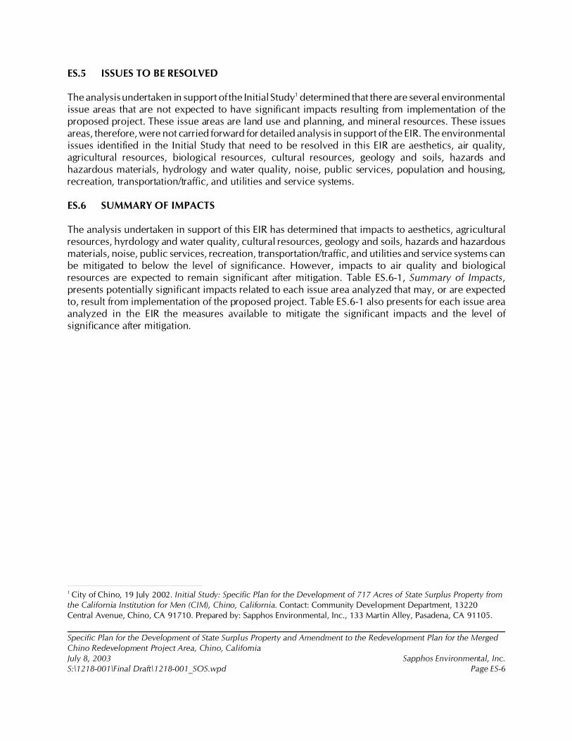
Measure Air-1
To reduce PM10 emissions generated from construction by at least 60 percent as part of theCity’s site plan review prior to soliciting bids for construction for each of the three respective
Implementation of measureAir-1 through Air-6 wouldsubstantially reduceparticulate emissions, but
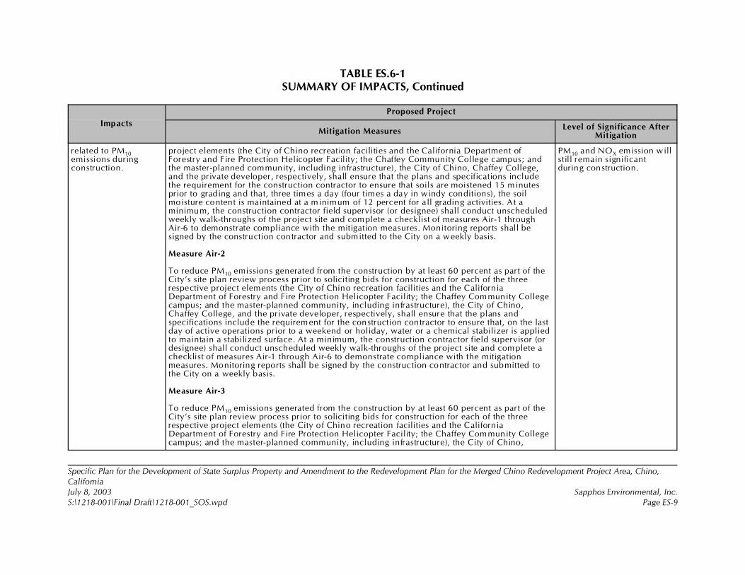
TABLE ES.6-1SUMMARY OF IMPACTS, Continued
Impacts
Proposed Project
Mitigation MeasuresLevel of Significance After
Mitigation
Specific Plan for the Development of State Surplus Property and Amendment to the Redevelopment Plan for the Merged Chino Redevelopment Project Area, Chino,CaliforniaJuly 8, 2003 Sapphos Environmental, Inc.S:\1218-001\Final Draft\1218-001_SOS.wpd Page ES-9
related to PM10emissions duringconstruction.
project elements (the City of Chino recreation facilities and the California Department ofForestry and Fire Protection Helicopter Facility; the Chaffey Community College campus; andthe master-planned community, including infrastructure), the City of Chino, Chaffey College,and the private developer, respectively, shall ensure that the plans and specifications includethe requirement for the construction contractor to ensure that soils are moistened 15 minutesprior to grading and that, three times a day (four times a day in windy conditions), the soilmoisture content is maintained at a m inimum of 12 percent for a ll grading activities. At aminimum, the construction contractor field supervisor (or designee) shall conduct unscheduledweekly walk-throughs of the project site and complete a checklist of measures Air-1 throughAir-6 to demonstrate compliance with the mitigation measures. Monitoring reports shall besigned by the construction contractor and submitted to the City on a weekly basis.
Measure Air-2
To reduce PM10 emissions generated from the construction by at least 60 percent as part of theCity’s site plan review process prior to soliciting bids for construction for each of the threerespective project elements (the City of Chino recreation facilities and the CaliforniaDepartment of Forestry and Fire Protection Helicopter Facility; the Chaffey Community Collegecampus; and the master-planned community, including infrastructure), the City of Chino,Chaffey College, and the private developer, respectively, shall ensure that the plans andspecifications include the requirement for the construction contractor to ensure that, on the lastday of active operations prior to a weekend or holiday, water or a chemical stabilizer is appliedto maintain a stabilized surface. At a minimum, the construction contractor field supervisor (ordesignee) shall conduct unscheduled weekly walk-throughs of the project site and complete achecklist of measures Air-1 through Air-6 to demonstrate compliance with the mitigationmeasures. Monitoring reports shall be signed by the construction contractor and submitted tothe City on a weekly basis.
Measure Air-3
To reduce PM10 emissions generated from the construction by at least 60 percent as part of theCity’s site plan review process prior to soliciting bids for construction for each of the threerespective project elements (the City of Chino recreation facilities and the CaliforniaDepartment of Forestry and Fire Protection Helicopter Facility; the Chaffey Community Collegecampus; and the master-planned community, including infrastructure), the City of Chino,
PM10 and NOX emission willstill remain significantduring construction.
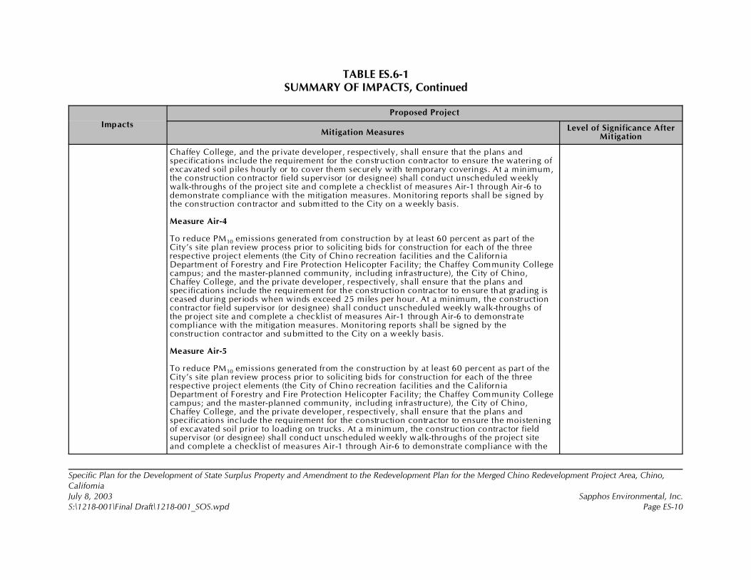
TABLE ES.6-1SUMMARY OF IMPACTS, Continued
Impacts
Proposed Project
Mitigation MeasuresLevel of Significance After
Mitigation
Specific Plan for the Development of State Surplus Property and Amendment to the Redevelopment Plan for the Merged Chino Redevelopment Project Area, Chino,CaliforniaJuly 8, 2003 Sapphos Environmental, Inc.S:\1218-001\Final Draft\1218-001_SOS.wpd Page ES-10
Chaffey College, and the private developer, respectively, shall ensure that the plans andspecifications include the requirement for the construction contractor to ensure the watering ofexcavated soil piles hourly or to cover them securely with temporary coverings. At a minimum,the construction contractor field supervisor (or designee) shall conduct unscheduled weeklywalk-throughs of the project site and complete a checklist of measures Air-1 through Air-6 todemonstrate compliance with the mitigation measures. Monitoring reports shall be signed bythe construction contractor and submitted to the City on a weekly basis.
Measure Air-4
To reduce PM10 emissions generated from construction by at least 60 percent as part of theCity’s site plan review process prior to soliciting bids for construction for each of the threerespective project elements (the City of Chino recreation facilities and the CaliforniaDepartment of Forestry and Fire Protection Helicopter Facility; the Chaffey Community Collegecampus; and the master-planned community, including infrastructure), the City of Chino,Chaffey College, and the private developer, respectively, shall ensure that the plans andspecifications include the requirement for the construction contractor to ensure that grading isceased during periods when winds exceed 25 miles per hour. At a minimum, the constructioncontractor field supervisor (or designee) shall conduct unscheduled weekly walk-throughs ofthe project site and complete a checklist of measures Air-1 through Air-6 to demonstra tecompliance with the mitigation measures. Monitoring reports shall be signed by theconstruction contractor and submitted to the City on a weekly basis.
Measure Air-5
To reduce PM10 emissions generated from the construction by at least 60 percent as part of theCity’s site plan review process prior to soliciting bids for construction for each of the threerespective project elements (the City of Chino recreation facilities and the CaliforniaDepartment of Forestry and Fire Protection Helicopter Facility; the Chaffey Community Collegecampus; and the master-planned community, including infrastructure), the City of Chino,Chaffey College, and the private developer, respectively, shall ensure that the plans andspecifications include the requirement for the construction contractor to ensure the moisteningof excavated soil prior to loading on trucks. At a minimum, the construction contractor fieldsupervisor (or designee) shall conduct unscheduled weekly walk-throughs of the project siteand complete a checklist of measures Air-1 through Air-6 to demonstrate compliance with the
TABLE ES.6-1SUMMARY OF IMPACTS, Continued
Impacts
Proposed Project
Mitigation MeasuresLevel of Significance After
Mitigation
Specific Plan for the Development of State Surplus Property and Amendment to the Redevelopment Plan for the Merged Chino Redevelopment Project Area, Chino,CaliforniaJuly 8, 2003 Sapphos Environmental, Inc.S:\1218-001\Final Draft\1218-001_SOS.wpd Page ES-11
mitigation measures. Monitoring reports shall be signed by the construction contractor andsubmitted to the City on a weekly basis.
Measure Air-6
To reduce PM10 emissions generated from construction by at least 60 percent as part of theCity’s site plan review process prior to soliciting bids for construction for each of the threerespective project elements (the City of Chino recreation facilities and the CaliforniaDepartment of Forestry and Fire Protection Helicopter Facility; the Chaffey Community Collegecampus; and the master-planned community, including infrastructure), the City of Chino,Chaffey College, and the private developer, respectively, shall ensure that the plans andspecifications include the requirement for the construction contractor to ensure that loads ofdirt are securely covered with a tight-fitting tarp on any truck leaving or entering theconstruction sites to bring fill dirt to the site or to dispose of excavated soil or leave sufficientfreeboard capacity in the truck to prevent fugitive dust emissions en route to the disposal site.At a minimum, the construction contractor field supervisor (or designee) shall conduct weeklyunscheduled walkthroughs of the project site and complete a checklist of measures Air-1through Air-6 to demonstra te compliance with the mitigation measures. Monitoring reportsshall be signed by the construction contractor and submitted to the City on a weekly basis.
Biological Resources
Implementation of theproposed project hasthe potential to resultin significant impactsto five sensitivespecies, includingburrowing owl,golden eagle,Cooper’s hawk, sharp-shinned hawk, andCalifornia horned lark.
Measure Burrowing Owl-1
As a means of minimizing impacts on burrowing owls, the private developer responsible fordevelopment of the disposition area shall incorporate into final plans and specifications awildlife movement corridor along Cypress Channel and within the existing Southern CaliforniaEdison easement to maintain connectivity of burrowing owl metapopulations within andoutside of the proposed project area and to maintain a movement corridor for other wildlifespecies outside of the proposed project area. Burrowing owls are also known to nest on theedges of Cypress Channel, so this mitigation measure will help to preserve existing nestinghabitat. At a minimum, the movement corridor would be established by maintaining theexisting Cypress Channel and Southern California Edison easement within the proposed projectarea and implementing a buffer of 100 feet to each side of the centerline of the corridors withinthe project area to facilitate wildlife movement and provide nesting habitat for burrowing owls
Implementation of measuresBurrowing Owl-1 throughBurrowing Owl-6 andSensitive Species-1 throughSensitive Species-8 areexpected to reducepotentially significantimpacts of the proposedproject to burrowing owl,golden eagle, Cooper’shawk, sharp-shinned hawk,and California horned lark to
TABLE ES.6-1SUMMARY OF IMPACTS, Continued
Impacts
Proposed Project
Mitigation MeasuresLevel of Significance After
Mitigation
Specific Plan for the Development of State Surplus Property and Amendment to the Redevelopment Plan for the Merged Chino Redevelopment Project Area, Chino,CaliforniaJuly 8, 2003 Sapphos Environmental, Inc.S:\1218-001\Final Draft\1218-001_SOS.wpd Page ES-12
(Figure 3.4.6-1, Conceptual Burrowing Owl Mitigation Plan). The corridor designs wouldincorporate a landscaping plan that incorporates native vegetation communities that occur inthe vicinity of the project area and are conducive to use by burrowing owls. The landscapingplan would also allow spacing of vegetation so that line of sight for burrowing owls ismaintained for predator avoidance. A final plan for the wildlife movement corridors,establishment of the two corridors, landscape treatments, construction of the artificial burrows,and final approval of the mitigation corridors would be obtained from the City, and a copy willbe provided to CDFG prior to the issuance of a grading permit. Monitoring and maintenance ofthese m itigation areas shall be provided for under mitigation measure Burrowing Owl-7 of thisdocument. Proof of compliance with this mitigation measure shall be submitted to the City andCDFG prior to the issuance of a grading permit.
Measure Burrowing Owl-2
As a mean of minimizing public impacts on the open space corridors, the private developerresponsible for development of the disposition area shall fence the Cypress Channel easementand the Southern California Edison easement area within the boundaries of the proposedproject area to maintain public safety during flood events and to separate the channel from theexisting CIM facilities. The fencing along Cypress Channel would incorporate a setback of 100feet from the centerline of the channel on both sides within the disposition property and wouldconform to CDFG guidelines regarding appropriate construction of fencing for compatible useby burrowing owls. The fencing would contain a decorative element as well so as to not detractfrom the surrounding project elements. Compliance with this mitigation measure shall beverified by a qualified biologist. Proof of compliance with this mitigation measure shall besubmitted to the City, and a copy will be provided to CDFG prior to the issuance of a gradingpermit.
Measure Burrowing Owl-3
Burrowing Owl-3: As a means of minimizing impacts on burrowing owls, the private developerresponsible for development of the disposition area shall incorporate into final plans andspecification, designs for the detention pond areas that are proposed along the southernboundary of the proposed project area, with the native landscape treatment as described inmitigation measure Burrowing Owl-1, so that these detention basins can be suitable burrowingowl habitat (Figure 3.4.6-1). All detention pond slopes shall be manufactured so as to be
below the level ofsignificance.
TABLE ES.6-1SUMMARY OF IMPACTS, Continued
Impacts
Proposed Project
Mitigation MeasuresLevel of Significance After
Mitigation
Specific Plan for the Development of State Surplus Property and Amendment to the Redevelopment Plan for the Merged Chino Redevelopment Project Area, Chino,CaliforniaJuly 8, 2003 Sapphos Environmental, Inc.S:\1218-001\Final Draft\1218-001_SOS.wpd Page ES-13
compatible with use by burrowing owls. Artificial nesting burrows would be constructed toincrease nesting habitat for burrowing owls on the slopes of the detention pond areas above thearea of potential water inundation. The six known active burrows as of 2002 surveys wouldrequire a total of 39 acres of mitigation between the corridors described in Burrowing Owl-1and the detention basins described in Burrowing Owl-3. Approval of the final plans for thedetention pond areas shall be obtained by the project applicant from the City prior to initiationof construction. Proof of compliance with this mitigation measure shall be submitted to the Cityand CDFG prior to the issuance of a grading permit.
Measure Burrowing Owl-4
As a means of minimizing impacts on burrowing owls, the private developer responsible fordevelopment of the disposition area shall construct artificial nesting burrows within designatedmitigation areas. The City and Chaffey College shall pay fair-share costs for constructingburrows for impacts from Ayala Park and Chaffey College construction, respectively. Artificialburrows would be constructed at a 2:1 ratio for all occupied burrows that are located duringpreconstruction surveys and for those burrows found during 2001 and 2002 protocol surveysthat would be impacted by the proposed project. Where possible, the artificial burrows shall beplaced no more than 100 feet from known occupied burrows so that individual owls can bepassively relocated. Construction of the artificial burrows shall be performed or directlysupervised by a biologist familiar with the biology of the burrowing owl and with theconstruction of artificial burrows. Upon completion of artificial burrow construction, proof ofcompliance with this mitigation measure shall be submitted to the City and CDFG prior toconstruction of any project elements . Known occupied burrows will be closed, and individualswill be passively relocated. Passive relocation will occur outside of the breeding season(February 15 to September 15). Passive relocation shall be performed by attaching one-wayentrances to any active burrowing owl burrows as prescribed in CDFG burrowing owlmitigation guidelines. This will allow exit of owls from active burrows but will not allow owlsto reenter the burrows once they have exited. It is anticipated that owls will relocate to themitigation areas or to the remaining open space to the south of the proposed project on CIMproperty. The burrows shall be monitored by a qualified biologist for at least seven days afterinitiation of passive relocation to confirm that the burrow is no longer active. Once it has beendetermined that the burrow is no longer active, the burrow will be removed. Passive relocationof the burrowing owls shall be performed by a qualified biologist who holds valid state permitsand a Memorandum of Understanding with the CDFG for such relocation efforts.

TABLE ES.6-1SUMMARY OF IMPACTS, Continued
Impacts
Proposed Project
Mitigation MeasuresLevel of Significance After
Mitigation
Specific Plan for the Development of State Surplus Property and Amendment to the Redevelopment Plan for the Merged Chino Redevelopment Project Area, Chino,CaliforniaJuly 8, 2003 Sapphos Environmental, Inc.S:\1218-001\Final Draft\1218-001_SOS.wpd Page ES-14
Measure Burrowing Owl-5
As a means of minimizing impacts on burrowing owls, the developer, Chaffey College, and theCity shall write a biological resources education program to be implemented as part of acommunity plan. The biological resources education program would be created to educatefuture residents of the proposed project about sensitive biological resources that may occur intheir neighborhoods. The education program would stress awareness of biological resources inthe area, including burrowing owls, potential impacts to biological resources that may resultfrom everyday activities, and methods to reduce impacts to biological resources and improvehabitats for wildlife. The education program will also provide opportunities for students tobecome involved directly with wildlife resource management issues. The education programwould be created by a qualified biologist familiar with the ecology of burrowing owls and otherspecial status wildlife that currently utilize the proposed project area as described in the EIR.Funds for this measure will be acquired through a joint agreement between the developer or itsdesignated successor, Chaffey College, and the City of Chino. Proof of compliance with thismitigation measure shall be submitted to the City and CDFG prior to occupancy of theresidential element of the proposed project.
Construction Avoidance Measures
Measure Burrowing Owl-6
As a means of minimizing impacts to burrowing owls, the private developer responsible fordevelopment of the disposition area, Chaffey College for college construction, and the City ofChino for Ayala Park construction, shall implement preconstruction surveys for burrowing owlsat least 30 days prior to the initiation of construction within the proposed project area. This willbe in addition to the passive relocation specified in Burrowing Owl-4 and shall be performed inconjunction with preconstruction surveys as specified in Sensitive Species-2. Thesepreconstruction surveys will be performed to ensure that no active owl burrows were missedduring previous surveys. Passive relocation procedures for any burrowing owls found withinthe proposed construction area during preconstruction surveys will occur as described inmitigation measure Burrowing Owl-4. Passive relocation will not be conducted during thebreeding season (between February 15 to September 15), except where fledging of all juvenileowls from the burrow has been completed. Compliance with this mitigation measure shall be
TABLE ES.6-1SUMMARY OF IMPACTS, Continued
Impacts
Proposed Project
Mitigation MeasuresLevel of Significance After
Mitigation
Specific Plan for the Development of State Surplus Property and Amendment to the Redevelopment Plan for the Merged Chino Redevelopment Project Area, Chino,CaliforniaJuly 8, 2003 Sapphos Environmental, Inc.S:\1218-001\Final Draft\1218-001_SOS.wpd Page ES-15
confirmed by the City, and a copy of the proof of compliance provided to CDFG prior to theinitiation of construction activities.
Measure Sensitive Species-1
As a means of minimizing impacts to potentially occurring sensitive wildlife species describedin Table 3.4.2-2, at least 45 days prior to the initiation of construction activities within theproposed project area, the project applicant shall stake all proposed impact areas, staging areas,storage areas, parking areas, or other project elements to be potentially impacted byconstruction so as to allow a qualified biologist familiar with the sensitive biological resourcesthat may occur within the proposed project area to perform preconstruction surveys forsensitive wildlife species. Based on previous surveys, these species may include burrowing owl,California horned lark, Cooper’s hawk, sharp-shinned hawk, and golden eagle. Compliancewith this mitigation measure shall be verified by the City prior to the initiation of constructionactivities.
Measure Sensitive Species-2
As a means of minimizing impacts to sensitive wildlife species described in Table 3.4.2-2, atleast 30 days prior to the initiation of construction within the proposed project area, the projectapplicant shall initiate preconstruction surveys for sensitive wildlife species. Preconstructionsurveys shall be conducted by a qualified biologist familiar with the sensitive biologicalresources that may occur within the proposed project area. Preconstruction surveys shall betimed to allow detection of sensitive biological resources that may occur within the proposedproject site. If sensitive wildlife species are found, to the greatest extent practical, the biologistshall relocate the individual(s) to a designated area outside of the construction zone, unless thespecies is state listed or federally listed. If any listed species are found on site, all activities shallcease until the project applicant obtains the appropriate state and/or federal incidental takepermits. No threatened, endangered, or fully protected species shall be handled withoutappropriate permits. Compliance with this mitigation measure shall be confirmed by the City,and a copy of the proof of compliance provided to CDFG prior to the initiation of constructionactivities.
TABLE ES.6-1SUMMARY OF IMPACTS, Continued
Impacts
Proposed Project
Mitigation MeasuresLevel of Significance After
Mitigation
Specific Plan for the Development of State Surplus Property and Amendment to the Redevelopment Plan for the Merged Chino Redevelopment Project Area, Chino,CaliforniaJuly 8, 2003 Sapphos Environmental, Inc.S:\1218-001\Final Draft\1218-001_SOS.wpd Page ES-16
Measure Sensitive Species-3
As a means of minimizing impacts to sensitive wildlife species mentioned in Sensitive Species-1, the private developer responsible for development of the disposition area, Chaffey Collegefor college construction, and the City of Chino for Ayala Park construction, shall implement adust control program consistent with the air quality mitigation measures of the EIR for theproposed project. This program shall be in place during all construction activities that couldpotentially generate dust emissions that may subsequently disturb wildlife species that may benesting or foraging within the proposed project area. A copy of the completed dust controlprogram shall be submitted to the City prior to the initiation of construction activities.Compliance with this mitigation measure shall be confirmed by the City prior to the initiationof construction activities.
Measure Sensitive Species-4
As a means of minimizing impacts to sensitive bird species listed in Sensitive Species-1 or theirnests, the private developer responsible for development of the disposition area, ChaffeyCollege for college construction, and the City of Chino for Ayala Park construction shallconduct all grubbing and brushing activities outside of the breeding season (February 15 toSeptember 15) for burrowing owls and nesting birds subject to the MBTA . If any grubbing orbrush removal is required within this time window, a preconstruction wildlife survey shall beconducted by a qualified biologist familiar with the sensitive avian species that may occur inthe vicinity of the proposed project area prior to the initiation of brushing activities. If an activenest is found during ground disturbance activities, the biologist shall mark a 100-foot areaaround the nest. No disturbance can take place within the 100-foot area until such time that thenest is determined to be no longer active as confirmed by the project biologist. A monitoringreport for any biological resource found shall be submitted to the City and CDFG by the projectbiologist. Compliance with this mitigation measure shall be confirmed by the City.
Measure Sensitive Species-5
Sensitive Species-5: As a means of minimizing impacts to sensitive wildlife species listed inSensitive Species-1, the private developer responsible for development of the disposition area,Chaffey College for college construction, and the City of Chino for Ayala Park constructionshall have a qualified biological construction monitor oversee brush removal activities to
TABLE ES.6-1SUMMARY OF IMPACTS, Continued
Impacts
Proposed Project
Mitigation MeasuresLevel of Significance After
Mitigation
Specific Plan for the Development of State Surplus Property and Amendment to the Redevelopment Plan for the Merged Chino Redevelopment Project Area, Chino,CaliforniaJuly 8, 2003 Sapphos Environmental, Inc.S:\1218-001\Final Draft\1218-001_SOS.wpd Page ES-17
monitor potential impacts to sensitive wildlife species. Upon completion of all brush removalor ground disturbance activity for the proposed project elements, the biological constructionmonitoring activity shall be discontinued. The construction monitor shall be familiar with thesensitive biological resources that may occur in the vicinity of the proposed project area. Theconstruction monitor shall have the authority to temporarily stop construction activity ifsensitive biological resources are in eminent danger of being impacted. The constructionmonitor shall keep a log of construction activities and submit log reports to the City and CDFG.Compliance with this mitigation measure shall be confirmed by the City.
Measure Sensitive Species-6
As a means of minimizing impacts to sensitive wildlife species mentioned in Sensitive Species-1, the private developer responsible for development of the disposition area, Chaffey Collegefor college construction, and the City of Chino for Ayala Park construction shall implement acontractor education program. The contractor education program shall be written andconducted by a qualified biologist familiar with the sensitive biological resources that mayoccur in the vicinity of the proposed project area. The contractor education program shallinclude field identification of sensitive wildlife species, potential impacts that may result fromconstruction activities, all compliance measures required by the EIR, consequences of notcomplying with mitigation measures, and contact information for the project biologist and/orbiological monitor. A copy of the mitigation and monitoring plan shall be kept on site for workcrews to consult. A list of all personnel that have completed the training shall be kept on site,and a copy shall be submitted to the City. Workers shall also be required to have a sticker orother visual marker showing that they have completed the program so that biological monitorsand other supervisory personnel can ensure that all construction personnel are in compliancewith the mitigation measure. Compliance with this mitigation measure shall be confirmed bythe City prior to the initiation of construction activities.
Measure Sensitive Species-7
As a means of minimizing impacts to sensitive wildlife species mentioned in Sensitive Species-1, the private developer responsible for development of the disposition area, Chaffey Collegefor college construction, and the City of Chino for Ayala Park construction shall implement andenforce a 25 mph speed limit within the construction area. This speed limit will help to reducepotential collisions between construction traffic and wildlife. These speed limits shall be posted
TABLE ES.6-1SUMMARY OF IMPACTS, Continued
Impacts
Proposed Project
Mitigation MeasuresLevel of Significance After
Mitigation
Specific Plan for the Development of State Surplus Property and Amendment to the Redevelopment Plan for the Merged Chino Redevelopment Project Area, Chino,CaliforniaJuly 8, 2003 Sapphos Environmental, Inc.S:\1218-001\Final Draft\1218-001_SOS.wpd Page ES-18
within the areas of enforcement. The speed limit requirements shall be part of the contractoreducation program, along with consequences that may result from noncompliance with thismitigation measure. Compliance with this mitigation measure shall be confirmed by the City.
Measure Sensitive Species-8
As a means of minimizing impacts to nesting raptor species, the private developer responsiblefor development of the disposition area, Chaffey College for college construction, and the Cityof Chino for Ayala Park construction shall conduct nesting raptor surveys prior to anydisturbance within 100 feet of large trees (more than 6 inches in diameter at breast height)suitable for nesting raptors in the breeding season (February 15 to September 15). The raptornesting survey shall be conducted by a biologist qualified to perform such surveys and familiarwith nesting raptor species in the vicinity of the proposed project area. If an active nest is foundwithin 100 feet of any proposed construction areas, the area shall be flagged with a 100-footbuffer and no construction may take place within this buffer until the nest is no longer active asdetermined by the wildlife biologist. CDFG has agreed to this buffer for this particular projectonly because of the remaining foraging habitat available adjacent to the proposed project area.This buffer is not to be used as a guideline for other projects, and appropriate buffers will bedetermined by governing wildlife agencies. A summary report of all raptor nest monitoringshall be generated by the wildlife biologist, and a copy of the report shall be provided to theCity and the CDFG. Compliance with this mitigation measure shall be confirmed by the City.
Implementation of theproposed project hasthe potential to resultin significant impactsto wildlife movementcorridors.
Measure Burrowing Owl-7
As a means of minimizing impacts to burrowing owls, the private developer responsible fordevelopment of the disposition area shall create a long-term burrowing owl monitoring andmanagement plan. The plan shall be created by a qualified biologist familiar with the ecologyof burrowing owls. The monitoring plan shall include long-term monitoring of the mitigationareas managed for burrowing owl habitat, utilization of artificial burrows, reproductive andfledgling success, and utilization of adjacent open space areas by burrowing owls within theproposed project area. A long-term maintenance plan will also be incorporated into the plan toensure that appropriate burrowing owl habitat is maintained within the mitigation areas and tocontrol the spread of invasive plant species. The goal of the monitoring plan is to ascertain thelong-term stability of the burrowing owl population within the proposed project area. Themonitoring plan shall incorporate adaptive management procedures for adjusting management
Implementation of measuresBurrowing Owl-7 andBurrowing Owl-8 areexpected to reducepotentially significantimpacts to wildlifemovement corridors tobelow the level ofsignificance.
TABLE ES.6-1SUMMARY OF IMPACTS, Continued
Impacts
Proposed Project
Mitigation MeasuresLevel of Significance After
Mitigation
Specific Plan for the Development of State Surplus Property and Amendment to the Redevelopment Plan for the Merged Chino Redevelopment Project Area, Chino,CaliforniaJuly 8, 2003 Sapphos Environmental, Inc.S:\1218-001\Final Draft\1218-001_SOS.wpd Page ES-19
and maintenance procedures for the designated owl mitigation areas if it is determined thatunanticipated impacts are occurring to burrowing owls. Yearly monitoring reports shall besubmitted to the City and CDFG, starting with the calendar year when the mitigation area wasconstructed and continuing for five consecutive years thereafter. Funds for this measure will beacquired through a joint agreement between the private developer or its successor, ChaffeyCollege, and the City of Chino. Compliance with this mitigation measure shall be confirmed bythe City, and a copy of the yearly monitoring reports shall be provided to CDFG.
Measure Burrowing Owl-8
As a means of minimizing impacts to burrowing owls and other sensitive biological resourcesmentioned in Sensitive Species-1, the private developer responsible for development of thedisposition area shall create a maintenance plan for Cypress Channel and the detention basins.The maintenance plan shall incorporate measures to minimize impacts to burrowing owlsalong the proposed wildlife movement corridor. The plan shall require the presence of abiological monitor during all maintenance activities and that a qualified biologist survey theareas proposed for maintenance prior to the initiation of maintenance activities. Funds for thismeasure will be acquired through a joint agreement between the private developer or itssuccessor, Chaffey College, and the City of Chino. Any required maintenance activities for theCypress Channel and the detention basins shall be conducted so as to minimize impacts toburrowing owls to the greatest extent practical, including conducting maintenance outside ofthe breeding season (February 15 to September 15), except as required to be in compliancewith public safety and fire control regulations. Maintenance to ensure compliance with publicsafety and fire control regulations may be required during the breeding season and will beperformed in accordance with a premaintenance survey and with a biological monitor presentas specified earlier in this mitigation measure. The maintenance plan shall also includemeasures to minimize impacts to owls from required maintenance of landscaping elementswithin the Cypress Channel corridor, the Edison easement corridor, and the detention basins.The plan shall be created by a qualified biologist familiar with the ecology of burrowing owlsand other sensitive biological resources associated with the project. The maintenance plan shallbe approved by the City, and a copy shall be provided to CDFG prior to the issuance of agrading permit. Compliance with this mitigation measure shall be confirmed by the City.
TABLE ES.6-1SUMMARY OF IMPACTS, Continued
Impacts
Proposed Project
Mitigation MeasuresLevel of Significance After
Mitigation
Specific Plan for the Development of State Surplus Property and Amendment to the Redevelopment Plan for the Merged Chino Redevelopment Project Area, Chino,CaliforniaJuly 8, 2003 Sapphos Environmental, Inc.S:\1218-001\Final Draft\1218-001_SOS.wpd Page ES-20
Implementation of theproposed project hasthe potential to resultin significant impactsto waters of theUnited States.
Measure Waters-1
As a means of minimizing potential indirect impacts to Cypress Channel during constructionactivities, the private developer responsible for development of the disposition area shallincorporate into final plans and specifications a storm water pollution prevention plan for theportion of proposed project for which the developer is responsible. The storm water pollutionprevention plan will be created by a qualified registered civil engineer familiar with thecreation of such plans. The erosion control plan shall incorporate all BMPs to prevent erosionduring construction that may indirectly impact Cypress Channel. The erosion control plan shallbe submitted to and approved by the City prior to the issuance of a grading permit. Compliancewith this mitigation measure shall be confirmed by the City.
Measure Waters-2
As specified in mitigation measure Burrowing Owl-1 as a means of minimizing potentialimpacts to Cypress Channel after project completion, the private developer responsible fordevelopment of the disposition area shall incorporate a 100-foot-wide corridor to each side ofthe centerline along the Cypress Channel within the proposed project area. The wildlifemovement corridor shall include elements to minimize urban runoff from entering CypressChannel, including any combination of vegetation treatments, catchments, and berms asneeded. Any flood control measures implemented for Cypress Channel shall not precludeburrowing owls from utilizing the 100-foot-wide buffer area to each side of Cypress Channel.Water flow across this area shall not be to such an extent as to flood natural or artificialburrows within the Cypress Channel mitigation area. All catchment and berm slopes shall be ofa slope suitable for use by burrowing owls as determined by CDFG. This corridor shall be partof the setback from Cypress Channel as required in mitigation measure Burrowing Owl-1. Thecorridor shall maintain line of sight as required for use by burrowing owls. The planting palettefor the corridor would be created by a landscape architect or botanist familiar with nativevegetation in the vicinity of the proposed project area. The planting palette shall be submittedto and approved by the City, and a copy shall be provided to CDFG prior to the issuance of agrading permit. Compliance with this mitigation measure shall be confirmed by the City priorto the issuance of a grading perm it.
Implementation of measuresWaters-1 and W aters-2 areexpected to reducepotentially significantimpacts to waters of theUnited States to below thelevel of significance.
TABLE ES.6-1SUMMARY OF IMPACTS, Continued
Impacts
Proposed Project
Mitigation MeasuresLevel of Significance After
Mitigation
Specific Plan for the Development of State Surplus Property and Amendment to the Redevelopment Plan for the Merged Chino Redevelopment Project Area, Chino,CaliforniaJuly 8, 2003 Sapphos Environmental, Inc.S:\1218-001\Final Draft\1218-001_SOS.wpd Page ES-21
Cultural Resources
Implementation of theproposed project hasthe potential to resultin significant impactsrelated to thedestruction of auniquepaleontologicalresource.
Measure Cultural-1
The impact to cultural resources related directly or indirectly to the destruction of a uniquepaleontological resource from the proposed project shall be reduced to below the level ofsignificance through the disposition of paleontological resources recovered from ground-disturbing activities in Quaternary medium-grained Holocene alluvium and Quaternary fine-grained Holocene alluvium at a depth of greater than 5 feet below the existing surfaceundertaken during the construction of City of Chino recreation facilities; the ChaffeyCommunity College campus; the master-planned community, including infrastructure; and theCalifornia Department of Forestry and Fire Protection Helicopter Facility.
Prior to final plans and specifications, for each of the three respective project elements: the Cityof Chino recreation facilities and the California Department of Forestry and Fire ProtectionHelicopter Facility; the Chaffey Community College campus; and the master-plannedcommunity, including infrastructure, the City of Chino shall review the plans to determine ifthere are any anticipated ground-disturbing activities at depths of greater than 5 feet below theexisting surface within the Specific Plan Area. Ground-disturbing activities include, but are notlimited to, drilling, excavation, trenching, and grading. Where any such activity is anticipatedin conjunction with the proposed construction, the City shall require that the followingprogram be implemented and that the requirement be duly noted in the plans andspecifications:
• Retain a Qualified Paleontologist. A qualified paleontologist shall be retained toimplement the monitoring and recovery program.
• Agreement for Disposition of Recovered Fossils. The selected paleontologist shall berequired to secure a written agreement with a recognized museum repository, such asthe San Bernardino County Museum or Los Angeles County Museum of VertebratePaleontology, regarding the final disposition and permanent storage and maintenanceof any significant fossil remains and associated specimen data and correspondinggeologic and geographic site data that might be recovered as a result of the specifiedmonitoring program. The written agreement shall specify the level of treatment
Implementation of measureCultural-1 is expected toreduce potentially significantimpacts related to thedestruction of a uniquepaleontological resource tobelow the level ofsignificance.
TABLE ES.6-1SUMMARY OF IMPACTS, Continued
Impacts
Proposed Project
Mitigation MeasuresLevel of Significance After
Mitigation
Specific Plan for the Development of State Surplus Property and Amendment to the Redevelopment Plan for the Merged Chino Redevelopment Project Area, Chino,CaliforniaJuly 8, 2003 Sapphos Environmental, Inc.S:\1218-001\Final Draft\1218-001_SOS.wpd Page ES-22
(preparation, identification, curation, cataloging) required before the fossil collectionwould be accepted for storage.
• Preconstruction Briefing. The selected paleontologist, or an equally qualified designee,will attend a preconstruction briefing to provide information regarding regulatoryrequirements for the protection of paleontologic resources. Construction personnelshall be briefed on procedures to be followed in the event that a fossil site or fossiloccurrence is encountered during construction. An information package shall beprovided for construction personnel not present at the initial preconstruction briefing.The paleontologist shall be required to provide a telephone number where they can bereached by the City Inspector or construction contractor, as necessary.
• Construction Monitoring. Excavation in areas likely to contain paleontologic resourcesshall be monitored by a qualified vertebrate paleontologic monitor. The monitorshould be equipped to salvage fossils as they are unearthed to avoid constructiondelays and to remove samples of sediments that are likely to contain the remains ofsmall fossil vertebrates:
Monitoring shall consist of visually inspecting debris piles and freshly exposed stratafor larger fossil remains. As soon as practicable, the monitor will recover all vertebratefossil specimens, a representative sample of invertebrate or plant fossils, or anyfossilferous rock sample that can be recovered easily. If recovery of a large orunusually productive fossil occurrence is warranted, earthmoving activities will bediverted temporarily around the fossil site and a recovery crew shall be mobilized toremove the material as quickly as possible. The proper geologic context of any fossiloccurrence shall be documented as appropriate.
Recovered specimens shall be prepared to a point of identification, including washingof sediments to recover smaller fossil remains. Due to the fine-grained nature of thesetypes of bedrock, it is noted that on-site washing of sediments may not be able torecover the appropriate small vertebrate fossil remains. Where field efforts to recoverthese resources prove infeasible, recovered bedrock samples shall be submitted to acommercial laboratory for processing for marine fossils.
TABLE ES.6-1SUMMARY OF IMPACTS, Continued
Impacts
Proposed Project
Mitigation MeasuresLevel of Significance After
Mitigation
Specific Plan for the Development of State Surplus Property and Amendment to the Redevelopment Plan for the Merged Chino Redevelopment Project Area, Chino,CaliforniaJuly 8, 2003 Sapphos Environmental, Inc.S:\1218-001\Final Draft\1218-001_SOS.wpd Page ES-23
Specimens shall be identified and curated into a museum repository with retrievablestorage.
• Laboratory Analysis. All significant fossil specimens recovered from the project site as aresult of the paleontological monitoring program will be treated (prepared, identified,curated, cataloged) in accordance with designated museum repository requirements.Samples shall be submitted to a laboratory, acceptable to the selected museum, formicrofossil, pollen, or carbon-14 dating analysis.
• Monitoring Report. The monitor shall maintain daily monitoring logs that shall besubmitted weekly to the City of Chino. A complete set of the daily monitoring logsshall be kept on site throughout the earthmoving activities and be available forinspection. The daily monitoring log shall be keyed to a location map to indicate thearea monitored, the date, assigned personnel, and the results of monitoring, includingrock unit encountered, fossil specimens recovered, and associated specimen data, aswell as corresponding geologic and geographic site data. Within 90 days of thecompletion of the paleontologic monitoring, the monitoring report shall be submittedto the City of Chino with an appended, itemized inventory of the specimens. Thereport and inventory, when submitted to the City of Chino, signify the completion ofthe program to m itigate impacts to paleontologic resources.
Implementation of theproposed project hasthe potential to resultin significant impactsrelated to thedestruction ofarcheologicalresources.
Measure Cultural-2
The impact to cultural resources related directly or indirectly to the destruction of archeologicalresources from the proposed project shall be reduced to below the level of significance throughthe recovery or treatment of any archeological resources encountered during Phase IIarcheological site investigations or monitoring of ground-disturbing activities in areas with thepotential to contain archeological resources during the construction of City of Chino recreationfacilities; the Chaffey Community College campus; the master-planned community, includinginfrastructure; and the California Department of Forestry and Fire Protection Helicopter Facility.
Prior to final plans and specifications, for each of the three respective project elements: the Cityof Chino recreation facilities and the California Department of Forestry and Fire ProtectionHelicopter Facility; the Chaffey Community College campus; and the master-plannedcommunity, including infrastructure, the City of Chino shall require the construction contractor
Implementation of measureCultural-2 is expected toreduce potentially significantimpacts related to thedestruction of archeologicalresources to below the levelof significance.
TABLE ES.6-1SUMMARY OF IMPACTS, Continued
Impacts
Proposed Project
Mitigation MeasuresLevel of Significance After
Mitigation
Specific Plan for the Development of State Surplus Property and Amendment to the Redevelopment Plan for the Merged Chino Redevelopment Project Area, Chino,CaliforniaJuly 8, 2003 Sapphos Environmental, Inc.S:\1218-001\Final Draft\1218-001_SOS.wpd Page ES-24
to complete Phase II investigations in the areas characterized by dense vegetation in CulturalResources Investigation, California Institution for Men, Chino, California. Where Phase IIinvestigations identify unique archeological resources as defined in Section 21083.2 of thePublic Resources Code, the site shall be subject to specified requirements for treatment. Anyarea where unique archeological resources are not identified, but the materials recovered fromshovel test pits indicate the potential presence of unique archeological resources, shall bereported to the City of Chino. Where one of the respective elements of the project is expectedto require earthmoving in soils at depths of greater than 5 feet below the existing surface, theCity shall require that the following program be implemented and that the requirement be dulynoted in the plans and specifications:
• Retain a Qualified Archeologist. A qualified archeologist shall be retained toimplement a monitoring and recovery program in any area identified as having thepotential to contain unique archeological resources.
• Agreement for Disposition of Recovered Artifact. The selected archeologist shall berequired to secure a written agreement with a recognized museum repository, such asthe San Bernardino County Museum, Los Angeles County Museum of Natural History,or the California State University, regarding the final disposition and permanent storageand maintenance of any unique archeological resources recovered as a result of thearcheological monitoring, as well as corresponding geographic site data that might berecovered as a result of the specified monitoring program. The written agreement shallspecify the level of treatment (preparation, identification, curation, cataloging) requiredbefore the collection would be accepted for storage.
• Preconstruction Briefing. The selected archeologist, or an equally qualified designee,shall attend a preconstruction briefing to provide information regarding regulatoryrequirements for the protection of unique archeological resources. Constructionpersonnel shall be briefed on procedures to be followed in the event that a uniquearcheological resource is encountered during construction. In addition, thearcheologists shall ensure that the participants in the preconstruction briefing shall beinformed of the requirement to notify the coroner of the County within 24 hours of thediscovery of human remains. Upon discovery of human remains, there shall be nofurther excavation or disturbance of the site or any nearby or reasonably nearby area
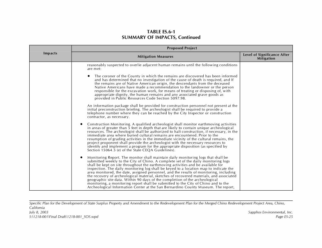
TABLE ES.6-1SUMMARY OF IMPACTS, Continued
Impacts
Proposed Project
Mitigation MeasuresLevel of Significance After
Mitigation
Specific Plan for the Development of State Surplus Property and Amendment to the Redevelopment Plan for the Merged Chino Redevelopment Project Area, Chino,CaliforniaJuly 8, 2003 Sapphos Environmental, Inc.S:\1218-001\Final Draft\1218-001_SOS.wpd Page ES-25
reasonably suspected to overlie adjacent human remains until the following conditionsare met:
• The coroner of the County in which the remains are discovered has been informedand has determined that no investigation of the cause of death is required, and Ifthe remains are of Native American origin, the descendants from the deceasedNative Americans have made a recommendation to the landowner or the personresponsible for the excavation work, for means of treating or disposing of, withappropriate dignity, the human remains and any associated grave goods asprovided in Public Resources Code Section 5097.98.
An information package shall be provided for construction personnel not present at theinitial preconstruction briefing. The archeologist shall be required to provide atelephone number where they can be reached by the City Inspector or constructioncontractor, as necessary.
• Construction Monitoring. A qualified archeologist shall monitor earthmoving activitiesin areas of greater than 5 feet in depth that are likely to contain unique archeologicalresources. The archeologist shall be authorized to halt construction, if necessary, in theimmediate area where buried cultural remains are encountered. Prior to theresumption of grading activities in the immediate vicinity of the cultural remains, theproject proponent shall provide the archeologist with the necessary resources toidentify and implement a program for the appropriate disposition (as specified bySection 15064.5 (e) of the State CEQA Guidelines).
• Monitoring Report. The monitor shall maintain daily monitoring logs that shall besubmitted weekly to the City of Chino. A complete set of the daily monitoring logsshall be kept on site throughout the earthmoving activities and be available forinspection. The daily monitoring log shall be keyed to a location map to indicate thearea monitored, the date, assigned personnel, and the results of monitoring, includingthe recovery of archeological material, sketches of recovered materials, and associatedgeographic site data. Within 90 days of the completion of the archeologicalmonitoring, a monitoring report shall be submitted to the City of Chino and to theArcheological Information Center at the San Bernardino County Museum. The report,
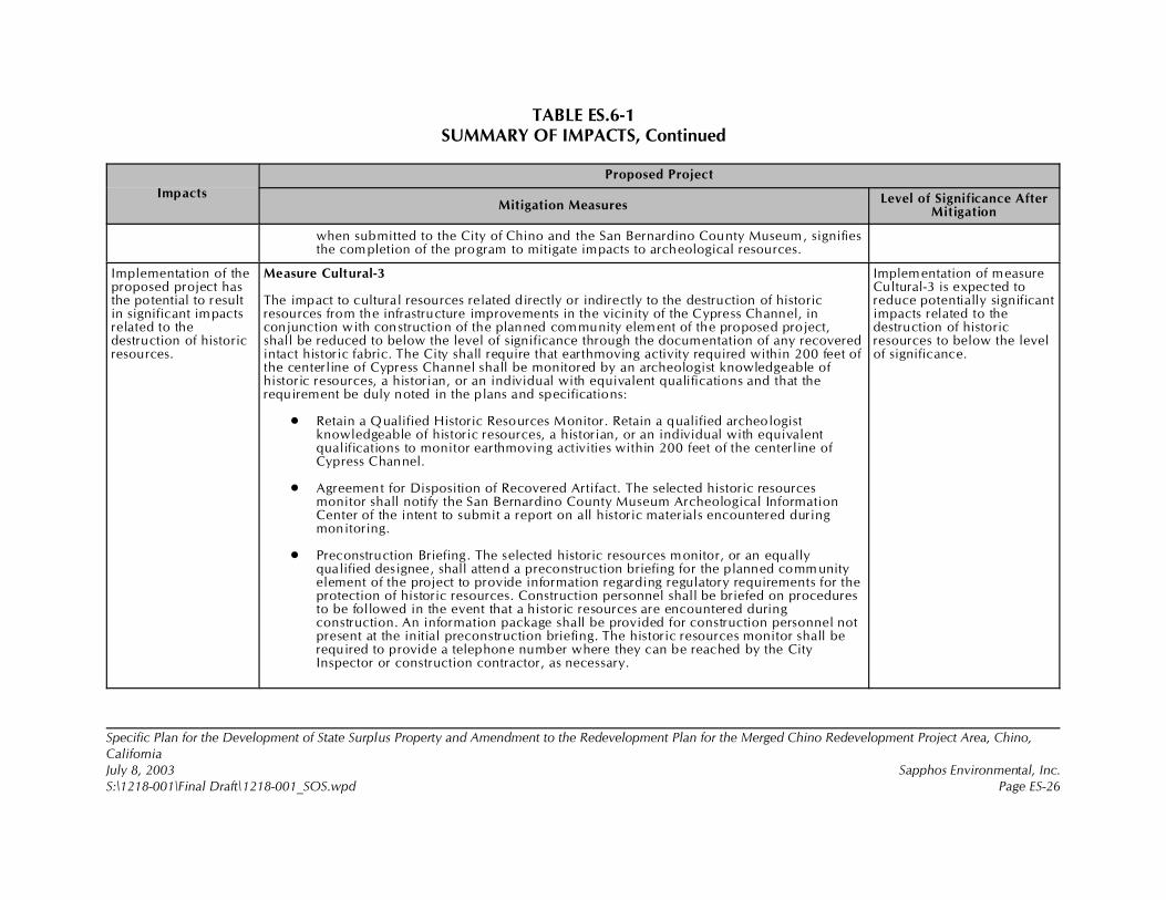
TABLE ES.6-1SUMMARY OF IMPACTS, Continued
Impacts
Proposed Project
Mitigation MeasuresLevel of Significance After
Mitigation
Specific Plan for the Development of State Surplus Property and Amendment to the Redevelopment Plan for the Merged Chino Redevelopment Project Area, Chino,CaliforniaJuly 8, 2003 Sapphos Environmental, Inc.S:\1218-001\Final Draft\1218-001_SOS.wpd Page ES-26
when submitted to the City of Chino and the San Bernardino County Museum, signifiesthe completion of the program to mitigate impacts to archeological resources.
Implementation of theproposed project hasthe potential to resultin significant impactsrelated to thedestruction of historicresources.
Measure Cultural-3
The impact to cultural resources related directly or indirectly to the destruction of historicresources from the infrastructure improvements in the vicinity of the Cypress Channel, inconjunction with construction of the planned community element of the proposed project,shall be reduced to below the level of significance through the documentation of any recoveredintact historic fabric. The City shall require that earthmoving activity required within 200 feet ofthe centerline of Cypress Channel shall be monitored by an archeologist knowledgeable ofhistoric resources, a historian, or an individual with equivalent qualifications and that therequirement be duly noted in the plans and specifications:
• Retain a Qualified Historic Resources Monitor. Retain a qualified archeologistknowledgeable of historic resources, a historian, or an individual with equivalentqualifications to monitor earthmoving activities within 200 feet of the centerline ofCypress Channel.
• Agreement for Disposition of Recovered Artifact. The selected historic resourcesmonitor shall notify the San Bernardino County Museum Archeological InformationCenter of the intent to submit a report on all historic materials encountered duringmonitoring.
• Preconstruction Briefing. The selected historic resources monitor, or an equallyqualified designee, shall attend a preconstruction briefing for the planned comm unityelement of the project to provide information regarding regulatory requirements for theprotection of historic resources. Construction personnel shall be briefed on proceduresto be followed in the event that a historic resources are encountered duringconstruction. An information package shall be provided for construction personnel notpresent at the initial preconstruction briefing. The historic resources monitor shall berequired to provide a telephone number where they can be reached by the CityInspector or construction contractor, as necessary.
Implementation of measureCultural-3 is expected toreduce potentially significantimpacts related to thedestruction of historicresources to below the levelof significance.
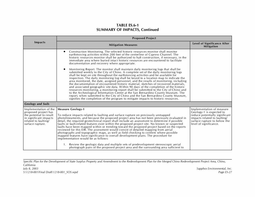
TABLE ES.6-1SUMMARY OF IMPACTS, Continued
Impacts
Proposed Project
Mitigation MeasuresLevel of Significance After
Mitigation
Specific Plan for the Development of State Surplus Property and Amendment to the Redevelopment Plan for the Merged Chino Redevelopment Project Area, Chino,CaliforniaJuly 8, 2003 Sapphos Environmental, Inc.S:\1218-001\Final Draft\1218-001_SOS.wpd Page ES-27
• Construction Monitoring. The selected historic resources monitor shall monitorearthmoving activities within 200 feet of the centerline of Cypress Channel. Thehistoric resources monitor shall be authorized to halt construction, if necessary, in theimmediate area where buried intact historic resources are encountered to facilitatedocumentation and recovery where appropriate.
• Monitoring Report. The monitor shall maintain daily monitoring logs that shall besubmitted weekly to the City of Chino. A complete set of the daily monitoring logsshall be kept on site throughout the earthmoving activities and be available forinspection. The daily monitoring log shall be keyed to a location map to indicate thearea monitored, the date, assigned personnel, and the results of monitoring, includingthe documentation of encountered historic material, sketches of recovered materials,and associated geographic site data. Within 90 days of the completion of the historicresources monitoring, a monitoring report shall be submitted to the City of Chino andto the Archeological Information Center at the San Bernardino County Museum. Thereport, when submitted to the City of Chino and the San Bernardino County Museum,signifies the completion of the program to mitigate impacts to historic resources.
Geology and Soils
Implementation of theproposed project hasthe potential to resultin significant impactsrelated to faulting/surface rupture.
Measure Geology-1
To reduce impacts related to faulting and surface rupture on previously unmappedphotolineaments, and because the proposed project area has not been previously evaluated indetail, the required geotechnical report shall include an assessment to determine if possiblefaults or fault-related features exist within the proposed project site. No known or suspectedfaults have been mapped within or trending toward the proposed project based on the reportsreviewed for this EIR. The assessment would consist of detailed mapping from aerialphotographs and topographic maps, as well as field checking to confirm where possiblemapped features have significance to overall development plans. The procedure forimplementation would be as follows:
1. Review the geologic data and multiple sets of predevelopment stereoscopic aerialphotograph pairs of the proposed project area and the surrounding area sufficient to
Implementation of measureGeology-1 is expected toreduce potentially significantimpacts related to faulting/surface rupture to below thelevel of significance.
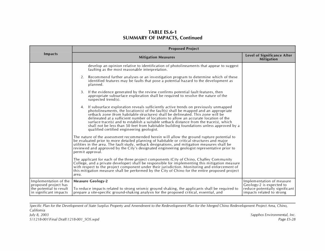
TABLE ES.6-1SUMMARY OF IMPACTS, Continued
Impacts
Proposed Project
Mitigation MeasuresLevel of Significance After
Mitigation
Specific Plan for the Development of State Surplus Property and Amendment to the Redevelopment Plan for the Merged Chino Redevelopment Project Area, Chino,CaliforniaJuly 8, 2003 Sapphos Environmental, Inc.S:\1218-001\Final Draft\1218-001_SOS.wpd Page ES-28
develop an opinion relative to identification of photolineaments that appear to suggestfaulting as the most reasonable interpretation.
2. Recommend further analyses or an investigation program to determine which of theseidentified features may be faults that pose a potential hazard to the development asplanned.
3. If the evidence generated by the review confirms potential fault features, thenappropriate subsurface exploration shall be required to resolve the nature of thesuspected trend(s).
4. If subsurface exploration reveals sufficiently active trends on previously unmappedphotolineaments, the location(s) of the fault(s) shall be m apped and an appropriatesetback zone (from habitable structures) shall be delineated. This zone will bedelineated at a sufficient number of locations to allow an accurate location of thesurface trace(s) and to establish a suitable setback distance from the trace(s), whichshall not be less than 50 feet from habitable building foundations unless approved by aqualified certified engineering geologist.
The nature of the assessment recommended herein will allow the ground rupture potential tobe evaluated prior to more detailed planning of habitable or critical structures and majorutilities in the area. The fault study, setback designations, and mitigation measures shall bereviewed and approved by the City’s designated engineering geologist representative prior topermit approval.
The applicant for each of the three project components (City of Chino, Chaffey Com munityCollege, and a private developer) shall be responsible for implementing this mitigation measurewith respect to the project component under their jurisdiction. Monitoring and enforcement ofthis mitigation measure shall be performed by the City of Chino for the entire proposed projectarea.
Implementation of theproposed project hasthe potential to resultin significant impacts
Measure Geology-2
To reduce impacts related to strong seismic ground shaking, the applicants shall be required toprepare a site-specific ground-shaking analysis for the proposed critical, essential, and
Implementation of measureGeology-2 is expected toreduce potentially significantimpacts related to strong
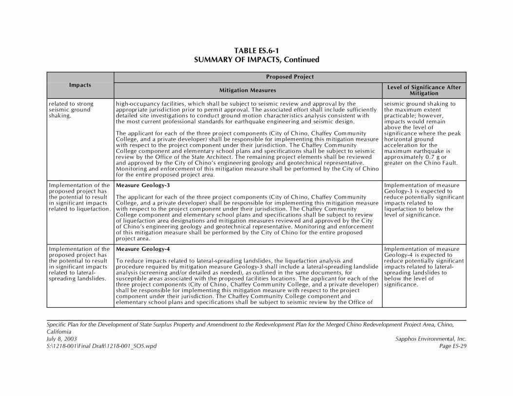
TABLE ES.6-1SUMMARY OF IMPACTS, Continued
Impacts
Proposed Project
Mitigation MeasuresLevel of Significance After
Mitigation
Specific Plan for the Development of State Surplus Property and Amendment to the Redevelopment Plan for the Merged Chino Redevelopment Project Area, Chino,CaliforniaJuly 8, 2003 Sapphos Environmental, Inc.S:\1218-001\Final Draft\1218-001_SOS.wpd Page ES-29
related to strongseismic groundshaking.
high-occupancy facilities, which shall be subject to seismic review and approval by theappropriate jurisdiction prior to permit approval. The associated effort shall include sufficientlydetailed site investigations to conduct ground motion characteristics analysis consistent withthe most current professional standards for earthquake engineering and seismic design.
The applicant for each of the three project components (City of Chino, Chaffey Com munityCollege, and a private developer) shall be responsible for implementing this mitigation measurewith respect to the project com ponent under their jurisdiction. The Chaffey Com munityCollege component and elementary school plans and specifications shall be subject to seism icreview by the Office of the State Architect. The remaining project elements shall be reviewedand approved by the City of Chino’s engineering geology and geotechnical representative.Monitoring and enforcement of this mitigation measure shall be performed by the City of Chinofor the entire proposed project area.
seismic ground shaking tothe maximum extentpracticable; however,impacts would remainabove the level ofsignificance where the peakhorizontal groundacceleration for themaximum earthquake isapproximately 0.7 g orgreater on the Chino Fault.
Implementation of theproposed project hasthe potential to resultin significant impactsrelated to liquefaction.
Measure Geology-3
The applicant for each of the three project components (City of Chino, Chaffey Com munityCollege, and a private developer) shall be responsible for implementing this mitigation measurewith respect to the project com ponent under their jurisdiction. The Chaffey Com munityCollege component and elementary school plans and specifications shall be subject to reviewof liquefaction area designations and mitigation measures reviewed and approved by the Cityof Chino’s engineering geology and geotechnical representative. Monitoring and enforcementof this mitigation measure shall be performed by the City of Chino for the entire proposedproject area.
Implementation of measureGeology-3 is expected toreduce potentially significantimpacts related toliquefaction to below thelevel of significance.
Implementation of theproposed project hasthe potential to resultin significant impactsrelated to lateral-spreading landslides.
Measure Geology-4
To reduce impacts related to lateral-spreading landslides, the liquefaction analysis andprocedure required by mitigation measure Geology-3 shall include a lateral-spreading landslideanalysis (screening and/or detailed as needed), as outlined in the same documents, forsusceptible areas associated with the proposed facilities locations. The applicant for each of thethree project components (City of Chino, Chaffey Community College, and a private developer)shall be responsible for implementing this mitigation measure with respect to the projectcomponent under their jurisdiction. The Chaffey Community College component andelementary school plans and specifications shall be subject to seismic review by the Office of
Implementation of measureGeology-4 is expected toreduce potentially significantimpacts related to lateral-spreading landslides tobelow the level ofsignificance.
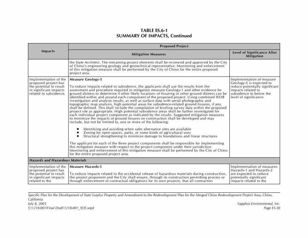
TABLE ES.6-1SUMMARY OF IMPACTS, Continued
Impacts
Proposed Project
Mitigation MeasuresLevel of Significance After
Mitigation
Specific Plan for the Development of State Surplus Property and Amendment to the Redevelopment Plan for the Merged Chino Redevelopment Project Area, Chino,CaliforniaJuly 8, 2003 Sapphos Environmental, Inc.S:\1218-001\Final Draft\1218-001_SOS.wpd Page ES-30
the State Architect. The rem aining project elements shall be reviewed and approved by the Cityof Chino’s engineering geology and geotechnical representative. Monitoring and enforcementof this mitigation measure shall be performed by the City of Chino for the entire proposedproject area.
Implementation of theproposed project hasthe potential to resultin significant impactsrelated to subsidence.
Measure Geology-5
To reduce impacts related to subsidence, the applicants shall use the results from theassessment and procedure required in mitigation measure Geology-1 and other evidence forground distress to determine if other likely locations of fissuring or other ground distress can beidentified within and around each component of the proposed project. Using combined ISOBinvestigation and analysis results, as well as surface data with aerial photographic andtopographic map analysis, high potential areas for subsidence-related ground fissures, if any,shall be defined. This shall include the compilation of leveling survey data within the proposedproject site as appropriate. High potential subsidence areas shall be further investigated foreach individual project component as indicated by the results. Suggested mitigation measuresto minimize the impacts of ground fissures on construction shall be developed and mayinclude, but not be limited to, one or more of the following:
• Identifying and avoiding when safer alternative sites are available• Zoning for open spaces, parks, or some kinds of agricultural uses• Structural strengthening to minimize damage to foundations and linear structures
The applicant for each of the three project components shall be responsible for implementingthis mitigation measure with respect to the project component under their jurisdiction.Monitoring and enforcement of this mitigation measure shall be performed by the City of Chinofor the entire proposed project area.
Implementation of measureGeology-5 is expected toreduce potentially significantimpacts related tosubsidence to below thelevel of significance.
Hazards and Hazardous Materials
Implementation of theproposed project hasthe potential to resultin significant impactsrelated to the
Measure Hazards-1
To reduce impacts related to the accidental release of hazardous materials during construction,the project proponent and the City shall ensure, through its construction permitting process orthrough enforcement of contractual obligations for its own projects, that all contractors
Implementation of measuresHazards-1 and Hazards-2are expected to reducepotentially significantimpacts related to the
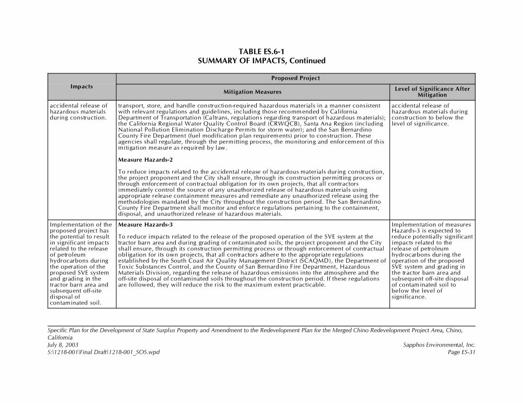
TABLE ES.6-1SUMMARY OF IMPACTS, Continued
Impacts
Proposed Project
Mitigation MeasuresLevel of Significance After
Mitigation
Specific Plan for the Development of State Surplus Property and Amendment to the Redevelopment Plan for the Merged Chino Redevelopment Project Area, Chino,CaliforniaJuly 8, 2003 Sapphos Environmental, Inc.S:\1218-001\Final Draft\1218-001_SOS.wpd Page ES-31
accidental release ofhazardous materialsduring construction.
transport, store, and handle construction-required hazardous materials in a manner consistentwith relevant regulations and guidelines, including those recomm ended by CaliforniaDepartment of Transportation (Caltrans, regulations regarding transport of hazardous materials);the California Regional Water Quality Control Board (CRWQCB), Santa Ana Region (includingNational Pollution Elimination Discharge Permits for storm water); and the San BernardinoCounty Fire Department (fuel modification plan requirements) prior to construction. Theseagencies shall regulate, through the permitting process, the monitoring and enforcement of thismitigation measure as required by law.
Measure Hazards-2
To reduce impacts related to the accidental release of hazardous materials during construction,the project proponent and the City shall ensure, through its construction permitting process orthrough enforcement of contractual obligation for its own projects, that all contractorsimmediately control the source of any unauthorized release of hazardous materials usingappropriate release containment measures and remediate any unauthorized release using themethodologies mandated by the City throughout the construction period. The San BernardinoCounty Fire Department shall monitor and enforce regulations pertaining to the containment,disposal, and unauthorized release of hazardous materials.
accidental release ofhazardous materials duringconstruction to below thelevel of significance.
Implementation of theproposed project hasthe potential to resultin significant impactsrelated to the releaseof petroleumhydrocarbons duringthe operation of theproposed SVE systemand grading in thetractor barn area andsubsequent off-sitedisposal ofcontaminated soil.
Measure Hazards-3
To reduce impacts related to the release of the proposed operation of the SVE system at thetractor barn area and during grading of contaminated soils, the project proponent and the Cityshall ensure, through its construction permitting process or through enforcement of contractualobligation for its own projects, that all contractors adhere to the appropriate regulationsestablished by the South Coast Air Quality Management District (SCAQMD), the Department ofToxic Substances Control, and the County of San Bernardino Fire Department, HazardousMaterials Division, regarding the release of hazardous emissions into the atmosphere and theoff-site disposal of contaminated soils throughout the construction period. If these regulationsare followed, they will reduce the risk to the maximum extent practicable.
Implementation of measuresHazards-3 is expected toreduce potentially significantimpacts related to therelease of petroleumhydrocarbons during theoperation of the proposedSVE system and grading inthe tractor barn area andsubsequent off-site disposalof contaminated soil tobelow the level ofsignificance.
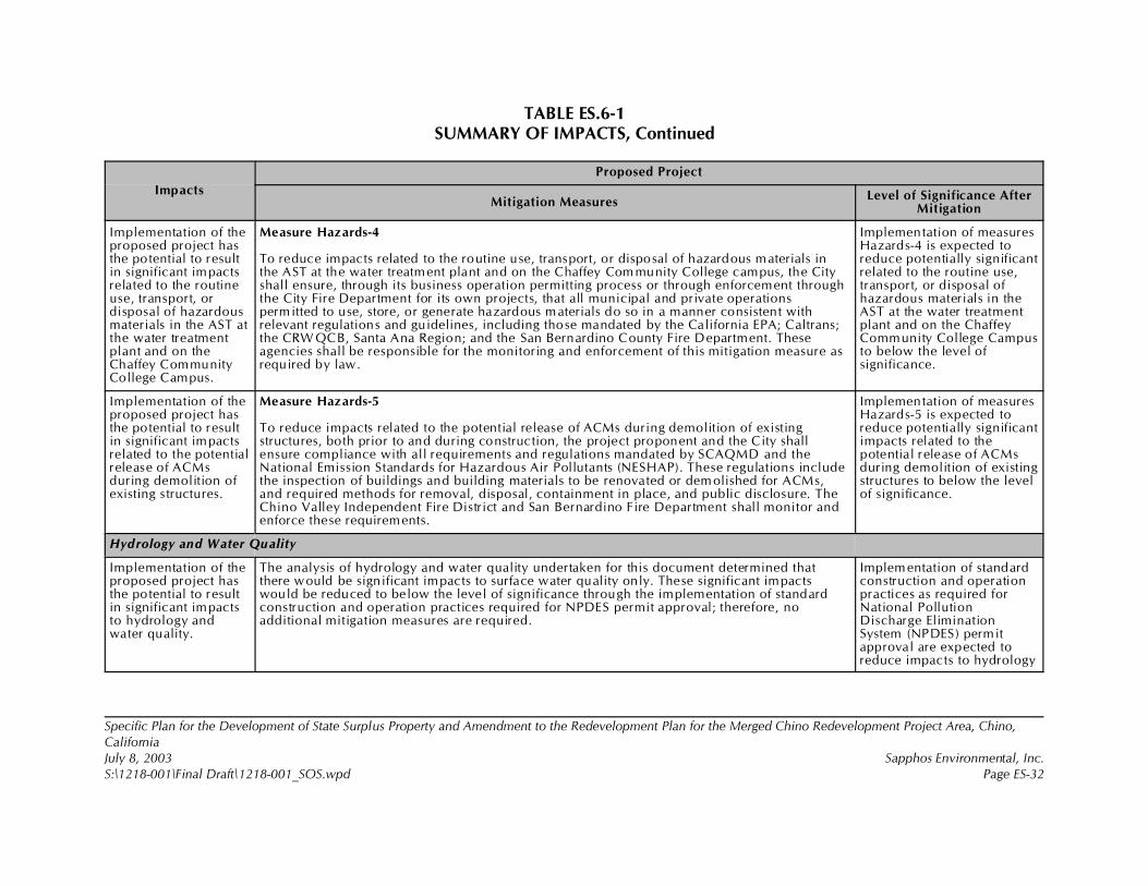
TABLE ES.6-1SUMMARY OF IMPACTS, Continued
Impacts
Proposed Project
Mitigation MeasuresLevel of Significance After
Mitigation
Specific Plan for the Development of State Surplus Property and Amendment to the Redevelopment Plan for the Merged Chino Redevelopment Project Area, Chino,CaliforniaJuly 8, 2003 Sapphos Environmental, Inc.S:\1218-001\Final Draft\1218-001_SOS.wpd Page ES-32
Implementation of theproposed project hasthe potential to resultin significant impactsrelated to the routineuse, transport, ordisposal of hazardousmaterials in the AST atthe water treatmentplant and on theChaffey CommunityCollege Campus.
Measure Hazards-4
To reduce impacts related to the routine use, transport, or disposal of hazardous materials inthe AST at the water treatment plant and on the Chaffey Com munity College campus, the Cityshall ensure, through its business operation permitting process or through enforcement throughthe City Fire Department for its own projects, that all municipal and private operationspermitted to use, store, or generate hazardous materials do so in a manner consistent withrelevant regulations and guidelines, including those mandated by the California EPA; Caltrans;the CRW QCB, Santa Ana Region; and the San Bernardino County Fire Department. Theseagencies shall be responsible for the monitoring and enforcement of this mitigation measure asrequired by law.
Implementation of measuresHazards-4 is expected toreduce potentially significantrelated to the routine use,transport, or disposal ofhazardous materials in theAST at the water treatmentplant and on the ChaffeyCommunity College Campusto below the level ofsignificance.
Implementation of theproposed project hasthe potential to resultin significant impactsrelated to the potentialrelease of ACMsduring demolition ofexisting structures.
Measure Hazards-5
To reduce impacts related to the potential release of ACMs during demolition of existingstructures, both prior to and during construction, the project proponent and the City shallensure compliance with all requirements and regulations mandated by SCAQMD and theNational Emission Standards for Hazardous Air Pollutants (NESHAP). These regulations includethe inspection of buildings and building materials to be renovated or demolished for ACMs,and required methods for removal, disposal, containment in place, and public disclosure. TheChino Valley Independent Fire District and San Bernardino Fire Department shall monitor andenforce these requirements.
Implementation of measuresHazards-5 is expected toreduce potentially significantimpacts related to thepotential release of ACMsduring demolition of existingstructures to below the levelof significance.
Hydrology and Water Quality
Implementation of theproposed project hasthe potential to resultin significant impactsto hydrology andwater quality.
The analysis of hydrology and water quality undertaken for this document determined thatthere would be significant impacts to surface water quality only. These significant impactswould be reduced to below the level of significance through the implementation of standardconstruction and operation practices required for NPDES permit approval; therefore, noadditional mitigation measures are required.
Implementation of standardconstruction and operationpractices as required forNational PollutionDischarge EliminationSystem (NPDES) permitapproval are expected toreduce impacts to hydrology

TABLE ES.6-1SUMMARY OF IMPACTS, Continued
Impacts
Proposed Project
Mitigation MeasuresLevel of Significance After
Mitigation
Specific Plan for the Development of State Surplus Property and Amendment to the Redevelopment Plan for the Merged Chino Redevelopment Project Area, Chino,CaliforniaJuly 8, 2003 Sapphos Environmental, Inc.S:\1218-001\Final Draft\1218-001_SOS.wpd Page ES-33
and water quality to belowthe level of significance.
Noise
Implementation of theproposed project hasthe potential to resultin significant impactsassociated with theexceedance of Citynoise standards.
Measure Noise-1
The City shall minimize the potential for construction noise levels to exceed City noisestandards by restricting grading and construction activities to daily operation between 7:00 a.m.and 7:00 p.m. from Monday through Friday and 8:00 a.m. to 5:00 p.m. on Saturdays. Thereshall be no work on Sundays or federal holidays.
Implementation of measuresNoise-1 and Noise-2 areexpected to reducepotentially significantimpacts associated with theexceedance of City noisestandards to below the levelof significance.
Implementation of theproposed project hasthe potential to resultin significant impactsto schools from noiseassociated withconstruction activities.
Measure Noise-2
Prior to the completion of final plans and specifications, the City shall ensure that the plans andspecifications include a requirement that all construction and grading equipment shall beproperly maintained. All vehicles and compressors shall utilize exhaust mufflers. Engineenclosure covers as designed by the manufacture shall be in place at all times. The City shallmonitor the use of heavy equipment during all construction to ensure conformance with therequirements of properly maintained heavy equipment.
Implementation of measuresNoise-2 is expected toreduce potentially significantimpacts to schools fromnoise associated withconstruction activities tobelow the level ofsignificance.
Implementation of theproposed project hasthe potential to resultin significant impactsfrom noise associatedwith the ChinoAirport.
Measure Noise-3
As a m itigation measure for the residential uses south of Edison Avenue between MagnoliaAvenue and Euclid Avenue, and to ensure compliance with building code requirements, theCity shall require the private developer to utilize windows and glass doors that are glazed withsound transmission class (STC) 32 glazing. Options for meeting this requirement include: STC32 dual glazing with a 0.5-inch airspace and 0.25-inch laminated glass, or another method orproduct that meets the standard or equivalent. The State Building Code (Part 2, Title 24, CCR)requires residential structures to provide sound insulation to limit the interior CNEL to amaximum of 45 dBA. Regardless of the option used, the glazing supplier shall be required tosubmit test reports documenting compliance with the minimum STC 32 rating. The test report
Implementation of measuresNoise-3 is expected toreduce potentially significantimpacts from noiseassociated with the ChinoAirport and thechampionship soccer field tobelow the level ofsignificance.
TABLE ES.6-1SUMMARY OF IMPACTS, Continued
Impacts
Proposed Project
Mitigation MeasuresLevel of Significance After
Mitigation
Specific Plan for the Development of State Surplus Property and Amendment to the Redevelopment Plan for the Merged Chino Redevelopment Project Area, Chino,CaliforniaJuly 8, 2003 Sapphos Environmental, Inc.S:\1218-001\Final Draft\1218-001_SOS.wpd Page ES-34
shall be done in an independent, accredited testing laboratory in accordance to AmericanSociety for Testing and Materials (ASTM) E-90.
Population and Housing
The analysis undertaken for this document determined that no significant impacts to population and housing would arise from the proposed project;therefore, no mitigation measures are required.
Public Services
Implementation of theproposed project hasthe potential to resultin significant impactsto fire protection.
Measure Public Services-1
To reduce potential environmental impacts from the construction and operation of one or morenew fire protection facilities required to maintain service objectives to the proposed project atall phases, including build-out, the CVIFD, and/or the Lead Agency for the implementation ofthe CVIFD Master Plan as determined pursuant to State CEQA Guidelines, Article 4(§15050!15053), “Lead Agency,” shall comply with the requirements of CEQA, as applicable.If significant environmental impacts are identified, the Lead Agency must implement mitigationmeasures that reduce the impact to below the level of significance or adopt overridingconsiderations pursuant to §15093 of the State CEQA Guidelines. This mitigation measure shallbe monitored and enforced by the City of Chino for all fire station facilities proposed forconstruction to serve the proposed project within the City of Chino corporate boundaries.
Implementation ofMitigation Public Services-1is expected to reducepotentially significantimpacts to fire protection tobelow the level ofsignificance.
Implementation of theproposed project hasthe potential to resultin significant impactsto police protection.
Measure Public Services-2
To reduce impacts to police protection and fire protection services, the applicant for each ofthe three elements of the proposed project, City of Chino, Chaffey Community College, and theprivate developer, shall pay development impact fees (DIFs) in accordance with the City ofChino Municipal Code, where necessary to maintain service objectives to each proposedproject element. Chapter 3.4.0 of the City of Chino Municipal Code establishes appropriateDIFs to ensure the necessary funding for the construction of the public improvement needsresulting form the implementation of the proposed project. Monitoring and enforcement ofmitigation measure Public Services-2 shall be performed by the City of Chino.
Implementation ofMitigation Public Services-2is expected to reducepotentially significantimpacts to police protectionto below the level ofsignificance.
TABLE ES.6-1SUMMARY OF IMPACTS, Continued
Impacts
Proposed Project
Mitigation MeasuresLevel of Significance After
Mitigation
Specific Plan for the Development of State Surplus Property and Amendment to the Redevelopment Plan for the Merged Chino Redevelopment Project Area, Chino,CaliforniaJuly 8, 2003 Sapphos Environmental, Inc.S:\1218-001\Final Draft\1218-001_SOS.wpd Page ES-35
Implementation of theproposed project hasthe potential to resultin significant impactsto schools.
Measure Public Services-3
To reduce impacts to schools, the private developer shall pay statutory developer fees and/orprovide land to the CVUSD in accordance with SB50 and any other state or local regulationsthat meet the standard or equivalent. The specific form of mitigation and amount of fees, if any,shall be determined through cooperation between the private developer, the City, and theCVUSD prior to the issuance of a building permit. Monitoring and enforcement of mitigationmeasure Public Services-3 shall be performed by the City of Chino.
Implementation ofMitigation Public Services-3is expected to reducepotentially significantimpacts to schools to belowthe level of significance.
Implementation of theproposed project hasthe potential to resultin significant impactsto other publicservices, specificallylibraries.
Measure Public Services-4
To reduce direct impacts to libraries, the private developer shall provide a form of financing forthe San Bernardino County Library that meets the standard or equivalent to construct or expandlibrary facilities in the City of Chino such that the San Bernardino County Library would meetthe Division of Library Development Services of the State of California standards for theincrease in population associated with the proposed project only. The specific form ofmitigation shall be determined through cooperation between the developer, the City, and theSan Bernardino County Library prior to the issuance of a building permit. Monitoring andenforcement of mitigation measure Public Services-4 shall be performed by the City of Chino.
Implementation ofMitigation Public Services-4is expected to reducepotentially significantimpacts to public services tobelow the level ofsignificance.
Recreation
Implementation of theproposed project hasthe potential to resultin significant impactsto recreation as aresult of temporaryclosure of designatedparking spaces.
Measure Recreation-1
Construction impacts to recreation resulting from temporary closure of designated parkingspaces shall be minimized through advance communication and redirection to the nearestcomparable facility within the proposed project service area. Prior to completion of final plansand specifications, the City of Chino shall review the plans and specifications to ensure thatthey contain language requiring that signs be posted at every parking facility that is temporarilyunavailable at least one month in advance of construction; the signs must indicate the proposedconstruction schedule and alternative parking facilities that can be used during the constructionperiod. This measure will be monitored and enforced by the City of Chino Community ServicesDepartment.
Implementation of measureRecreation-1 is expected toreduce potentially significantimpacts to recreationresulting from temporaryclosure of designatedparking spaces to below thelevel of significance.
TABLE ES.6-1SUMMARY OF IMPACTS, Continued
Impacts
Proposed Project
Mitigation MeasuresLevel of Significance After
Mitigation
Specific Plan for the Development of State Surplus Property and Amendment to the Redevelopment Plan for the Merged Chino Redevelopment Project Area, Chino,CaliforniaJuly 8, 2003 Sapphos Environmental, Inc.S:\1218-001\Final Draft\1218-001_SOS.wpd Page ES-36
Implementation of theproposed project hasthe potential to resultin significant impactsto recreation as aresult of temporaryclosure of existingrecreational facilitiesduring constructionand expansion ofadditional recreationalfacilities.
Measure Recreation-2
Construction impacts to recreation resulting from temporary closure of existing recreationalfacilities during construction and expansion of recreational facilities shall be minimizedthrough advance communication and redirection to the nearest comparable facility within theproposed project service area. Prior to completion of final plans and specifications, the City ofChino shall review the plans and specifications to ensure that they contain language requiringthe construction contractor to ensure that signs be posted at every entrance to the Ruben S.Ayala Comm unity Park at least one month in advance of construction; the signs must indicatethe proposed construction schedule and alternative recreation facilities (including location andhours of operation) located in the service area that can be used during the construction period.This measure will be monitored and enforced by the City of Chino Community ServicesDepartment.
Implementation of measureRecreation-2 is expected toreduce potentially significantimpacts to recreationresulting from temporaryclosure of existingrecreational facilities duringconstruction and expansionof additional recreationalfacilities to below the levelof significance.
Implementation of theproposed project hasthe potential to resultin significant impactsto recreation as aresult of temporaryclosure of play fieldsduring construction ofadditional recreationalfacilities.
Measure Recreation-3
Construction impacts to recreation resulting from temporary closure of play fields shall beminimized through advance com munication and redirection to the nearest comparable facilitywithin the proposed project service area. Prior to completion of final plans and specifications,the City of Chino shall review the plans and specifications to ensure that they contain languagerequiring that signs be posted at every play field that is temporarily unavailable at least onemonth in advance of construction; the signs must indicate the proposed construction scheduleand alternative fields that can be used during the construction period. This measure will bemonitored and enforced by the City of Chino Community Services Department.
Implementation of measureRecreation-3 is expected toreduce potentially significantimpacts to recreationresulting from temporaryclosure of play fields duringconstruction of additionalrecreational facilities tobelow the level ofsignificance.
Transportation/Traffic
Implementation of theproposed project hasthe potential to resultin significant impactto transportation andtraffic.
Measure Transportation-1
It should be noted that the interim year 2012 with project conditions and 2025 with projectconditions assumed that the improvements listed below would be made at threeproject-adjacent intersections that would be modified or created as part of the project itself(Intersection 22, Oaks Street and Edison Avenue; Intersection 24, Mountain Avenue and EdisonAvenue; and Intersection 29, Central Avenue and A Street). Improvements that arerecommended include both funded improvements and any additional improvements necessary
Implementation ofmitigation measuresTransportation-1 andTransportation-2 wouldreduce significant impactsrelated to transportation/traffic to below the level ofsignificance. The study area
TABLE ES.6-1SUMMARY OF IMPACTS, Continued
Impacts
Proposed Project
Mitigation MeasuresLevel of Significance After
Mitigation
Specific Plan for the Development of State Surplus Property and Amendment to the Redevelopment Plan for the Merged Chino Redevelopment Project Area, Chino,CaliforniaJuly 8, 2003 Sapphos Environmental, Inc.S:\1218-001\Final Draft\1218-001_SOS.wpd Page ES-37
to achieve acceptable LOS during peak hours. The following intersection improvements areneeded for the year 2012 with project conditions. 1. Mountain Avenue and Mission Boulevard
• Second northbound left-turn lane• Northbound right-turn lane• Second southbound left-turn lane• Third southbound through lane• Second westbound left-turn lane• Eastbound right-turn lane• Provide overlapping right-turn phasing E-W and N-S
2. Mountain Avenue and Philadelphia Street• Second northbound left-turn lane• Third northbound through lane• Northbound right-turn lane• Second southbound left-turn lane• Third southbound through lane• Southbound right-turn lane• Provide overlapping right-turn phasing E-W and N-S• Second eastbound left-turn lane• Second westbound left-turn lane• Westbound right-turn lane
5. Mountain Avenue and State Route 60 westbound ramps• Southbound right-turn Lane • Second northbound left-turn lane
6. Mountain Avenue and State Route 60 eastbound ramps• Northbound right-turn lane• Shared left-turn and right-turn lane eastbound• Second southbound left-turn lane
intersections are projected tooperate at LOS D or betterwith a v/c ratio of less than1.00 during the peak hoursif all of the recommendedoff-site improvements for theinterim year 2012 and year2025 are accomplished.
TABLE ES.6-1SUMMARY OF IMPACTS, Continued
Impacts
Proposed Project
Mitigation MeasuresLevel of Significance After
Mitigation
Specific Plan for the Development of State Surplus Property and Amendment to the Redevelopment Plan for the Merged Chino Redevelopment Project Area, Chino,CaliforniaJuly 8, 2003 Sapphos Environmental, Inc.S:\1218-001\Final Draft\1218-001_SOS.wpd Page ES-38
10. Mountain Avenue and Walnut Avenue• Northbound Right-turn lane• Second southbound left-turn lane• Additional eastbound through lane• Additional westbound through lane
12. Central Avenue and Riverside Drive• Second southbound left-turn lane
13. Mountain Avenue and Riverside Drive• Northbound right-turn lane• Southbound right-turn lane• Provide overlapping right-turn phasing southbound• Second eastbound left-turn lane
14. Euclid Avenue and Riverside Drive• Northbound right-turn lane• Southbound right-turn lane• Second southbound left-turn lane• Eastbound left-turn lane• Second eastbound left-turn lane• Westbound left-turn lane
18. State Route 71 Northbound Ramps and Grand Avenue• Upgrade existing signal to provide overlapping right-turn phasing westbound• Southbound right-turn lane• Southbound left-turn lane• Westbound right-turn lane• Eastbound right-turn lane
20. Central Avenue and Edison Avenue• Second eastbound left-turn lane• Second westbound left-turn lane

TABLE ES.6-1SUMMARY OF IMPACTS, Continued
Impacts
Proposed Project
Mitigation MeasuresLevel of Significance After
Mitigation
Specific Plan for the Development of State Surplus Property and Amendment to the Redevelopment Plan for the Merged Chino Redevelopment Project Area, Chino,CaliforniaJuly 8, 2003 Sapphos Environmental, Inc.S:\1218-001\Final Draft\1218-001_SOS.wpd Page ES-39
22. Oaks Street and Edison Avenue• First and second northbound left-turn lanes• Northbound right-turn lane• First and second northbound through lanes• First and second southbound left-turn lanes• First and second southbound left-turn lanes• Southbound shared through-right-turn lane• Second eastbound left-turn lane• Third eastbound through lane• Eastbound right-turn lane• Westbound dual left-turn lanes• Third westbound through lane• Install new traffic signal
24. Mountain Avenue and Edison Avenue• Northbound left-turn lane• First and second northbound through lanes• Northbound right-turn lane• Southbound left-turn lane• Northbound left-turn lane• Third eastbound through lane• Third westbound through lane• Upgrade existing intersection signalization
28. Euclid Avenue and Edison Avenue• Third eastbound through lane• Third westbound through lane• Northbound right-turn lane
29. Central Avenue and A Street (new intersection)• Install new traffic signal• Westbound right-turn lane• Westbound left-turn lane• Northbound right-turn lane• Southbound left-turn lane
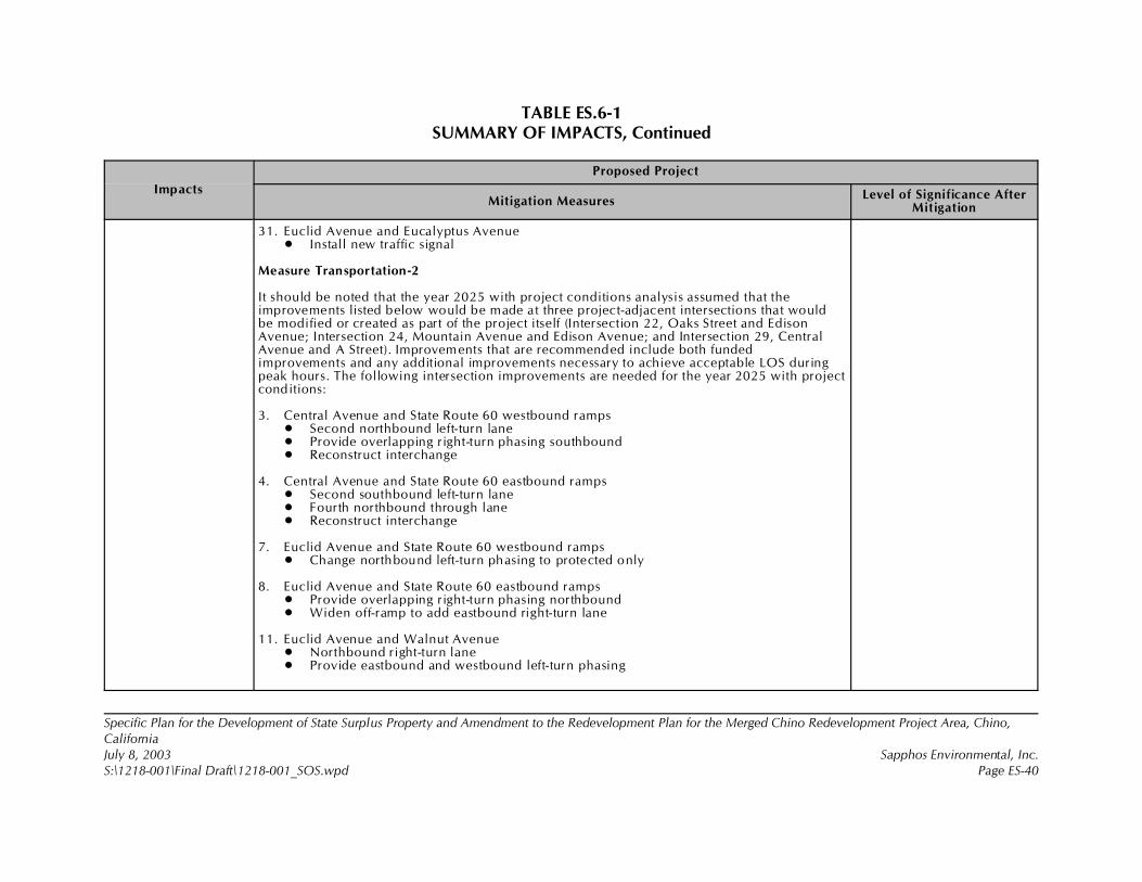
TABLE ES.6-1SUMMARY OF IMPACTS, Continued
Impacts
Proposed Project
Mitigation MeasuresLevel of Significance After
Mitigation
Specific Plan for the Development of State Surplus Property and Amendment to the Redevelopment Plan for the Merged Chino Redevelopment Project Area, Chino,CaliforniaJuly 8, 2003 Sapphos Environmental, Inc.S:\1218-001\Final Draft\1218-001_SOS.wpd Page ES-40
31. Euclid Avenue and Eucalyptus Avenue• Install new traffic signal
Measure Transportation-2
It should be noted that the year 2025 with project conditions analysis assumed that theimprovements listed below would be made at three project-adjacent intersections that wouldbe modified or created as part of the project itself (Intersection 22, Oaks Street and EdisonAvenue; Intersection 24, Mountain Avenue and Edison Avenue; and Intersection 29, CentralAvenue and A Street). Improvements that are recommended include both fundedimprovements and any additional improvements necessary to achieve acceptable LOS duringpeak hours. The following intersection improvements are needed for the year 2025 with projectconditions:
3. Central Avenue and State Route 60 westbound ramps• Second northbound left-turn lane• Provide overlapping right-turn phasing southbound• Reconstruct interchange
4. Central Avenue and State Route 60 eastbound ramps• Second southbound left-turn lane• Fourth northbound through lane• Reconstruct interchange
7. Euclid Avenue and State Route 60 westbound ramps• Change northbound left-turn phasing to protected only
8. Euclid Avenue and State Route 60 eastbound ramps• Provide overlapping right-turn phasing northbound• Widen off-ramp to add eastbound right-turn lane
11. Euclid Avenue and Walnut Avenue• Northbound right-turn lane• Provide eastbound and westbound left-turn phasing
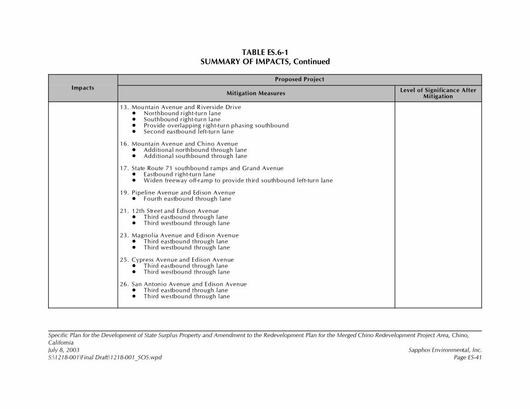
TABLE ES.6-1SUMMARY OF IMPACTS, Continued
Impacts
Proposed Project
Mitigation MeasuresLevel of Significance After
Mitigation
Specific Plan for the Development of State Surplus Property and Amendment to the Redevelopment Plan for the Merged Chino Redevelopment Project Area, Chino,CaliforniaJuly 8, 2003 Sapphos Environmental, Inc.S:\1218-001\Final Draft\1218-001_SOS.wpd Page ES-41
13. Mountain Avenue and Riverside Drive• Northbound right-turn lane• Southbound right-turn lane• Provide overlapping right-turn phasing southbound• Second eastbound left-turn lane
16. Mountain Avenue and Chino Avenue• Additional northbound through lane• Additional southbound through lane
17. State Route 71 southbound ramps and Grand Avenue• Eastbound right-turn lane• Widen freeway off-ramp to provide third southbound left-turn lane
19. Pipeline Avenue and Edison Avenue• Fourth eastbound through lane
21. 12th Street and Edison Avenue• Third eastbound through lane• Third westbound through lane
23. Magnolia Avenue and Edison Avenue• Third eastbound through lane• Third westbound through lane
25. Cypress Avenue and Edison Avenue• Third eastbound through lane• Third westbound through lane
26. San Antonio Avenue and Edison Avenue• Third eastbound through lane• Third westbound through lane
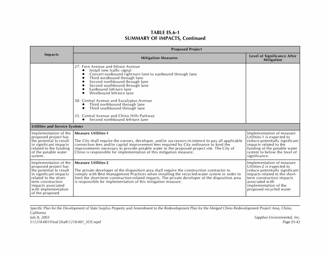
TABLE ES.6-1SUMMARY OF IMPACTS, Continued
Impacts
Proposed Project
Mitigation MeasuresLevel of Significance After
Mitigation
Specific Plan for the Development of State Surplus Property and Amendment to the Redevelopment Plan for the Merged Chino Redevelopment Project Area, Chino,CaliforniaJuly 8, 2003 Sapphos Environmental, Inc.S:\1218-001\Final Draft\1218-001_SOS.wpd Page ES-42
27. Fern Avenue and Edison Avenue• Install new traffic signal• Convert eastbound right-turn lane to eastbound through lane• Third westbound through lane• Second northbound through lane• Second southbound through lane• Eastbound left-turn lane• Westbound left-turn lane
30. Central Avenue and Eucalyptus Avenue• Third northbound through lane• Third southbound through lane
35. Central Avenue and Chino Hills Parkway• Second northbound left-turn lane
Utilities and Service Systems
Implementation of theproposed project hasthe potential to resultin significant impactsrelated to the fundingof the potable watersystem.
Measure Utilities-1
The City shall require the owners, developer, and/or successors-in-interest to pay all applicableconnection fees and/or capital improvement fees required by City ordinance to fund theimprovements necessary to provide potable water to the proposed project site. The City ofChino is responsible for implementation of this mitigation measure.
Implementation of measureUtilities-1 is expected toreduce potentially significantimpacts related to thefunding of the potable watersystem to below the level ofsignificance.
Implementation of theproposed project hasthe potential to resultin significant impactsrelated to the short-term constructionimpacts associatedwith implementationof the proposed
Measure Utilities-2
The private developer of the disposition area shall require the construction contractor tocomply with Best Management Practices when installing the recycled-water system in order tolimit the short-term construction-related impacts. The private developer of the disposition areais responsible for implementation of this mitigation measure.
Implementation of measureUtilities-2 is expected toreduce potentially significantimpacts related to the short-term construction impactsassociated withimplementation of theproposed recycled water
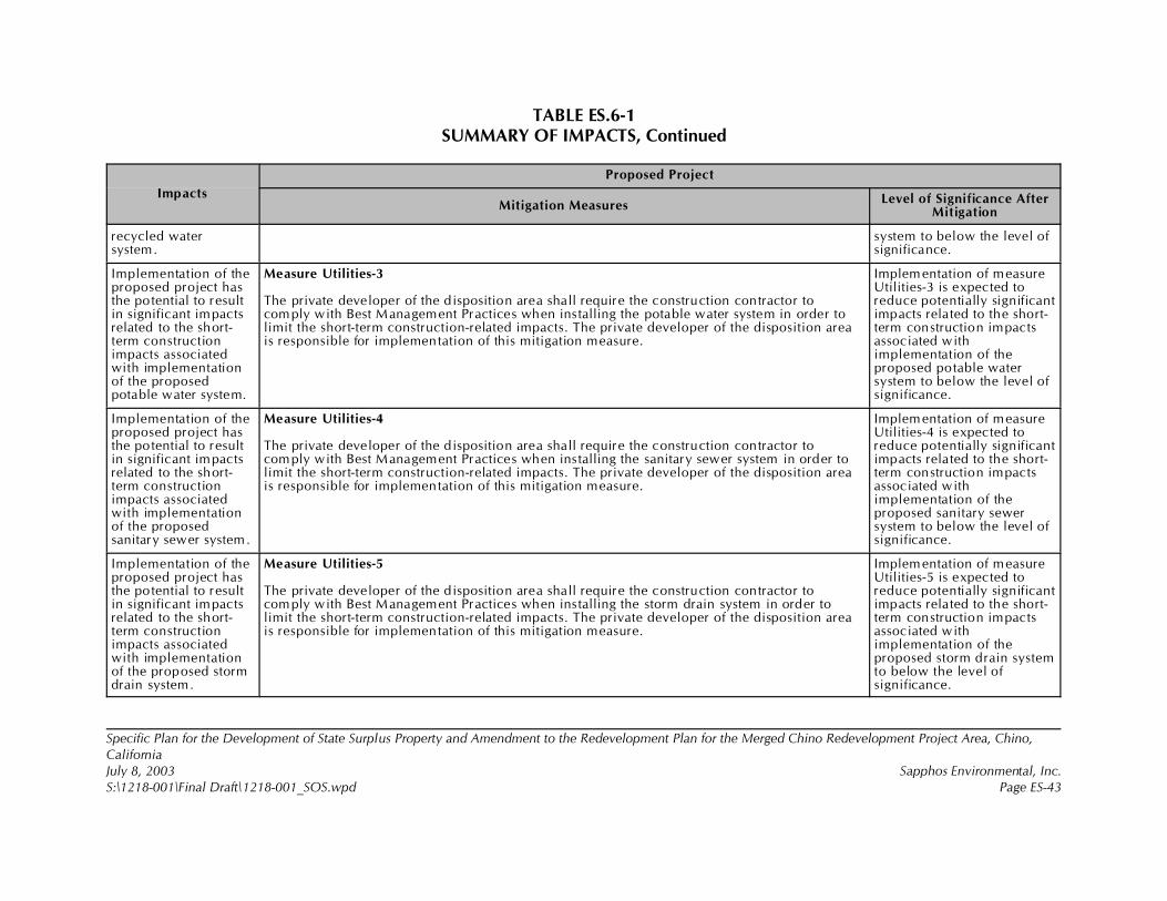
TABLE ES.6-1SUMMARY OF IMPACTS, Continued
Impacts
Proposed Project
Mitigation MeasuresLevel of Significance After
Mitigation
Specific Plan for the Development of State Surplus Property and Amendment to the Redevelopment Plan for the Merged Chino Redevelopment Project Area, Chino,CaliforniaJuly 8, 2003 Sapphos Environmental, Inc.S:\1218-001\Final Draft\1218-001_SOS.wpd Page ES-43
recycled watersystem.
system to below the level ofsignificance.
Implementation of theproposed project hasthe potential to resultin significant impactsrelated to the short-term constructionimpacts associatedwith implementationof the proposedpotable water system.
Measure Utilities-3
The private developer of the disposition area shall require the construction contractor tocomply with Best Management Practices when installing the potable water system in order tolimit the short-term construction-related impacts. The private developer of the disposition areais responsible for implementation of this mitigation measure.
Implementation of measureUtilities-3 is expected toreduce potentially significantimpacts related to the short-term construction impactsassociated withimplementation of theproposed potable watersystem to below the level ofsignificance.
Implementation of theproposed project hasthe potential to resultin significant impactsrelated to the short-term constructionimpacts associatedwith implementationof the proposedsanitary sewer system.
Measure Utilities-4
The private developer of the disposition area shall require the construction contractor tocomply with Best Management Practices when installing the sanitary sewer system in order tolimit the short-term construction-related impacts. The private developer of the disposition areais responsible for implementation of this mitigation measure.
Implementation of measureUtilities-4 is expected toreduce potentially significantimpacts related to the short-term construction impactsassociated withimplementation of theproposed sanitary sewersystem to below the level ofsignificance.
Implementation of theproposed project hasthe potential to resultin significant impactsrelated to the short-term constructionimpacts associatedwith implementationof the proposed stormdrain system.
Measure Utilities-5
The private developer of the disposition area shall require the construction contractor tocomply with Best Management Practices when installing the storm drain system in order tolimit the short-term construction-related impacts. The private developer of the disposition areais responsible for implementation of this mitigation measure.
Implementation of measureUtilities-5 is expected toreduce potentially significantimpacts related to the short-term construction impactsassociated withimplementation of theproposed storm drain systemto below the level ofsignificance.
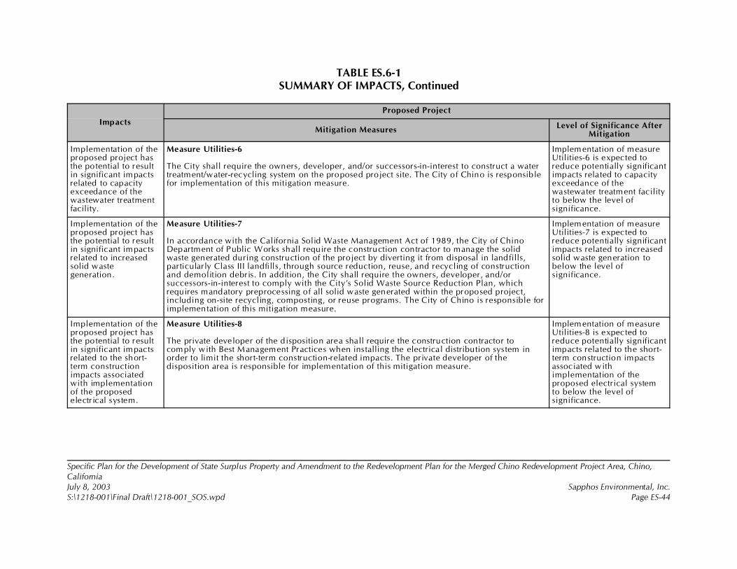
TABLE ES.6-1SUMMARY OF IMPACTS, Continued
Impacts
Proposed Project
Mitigation MeasuresLevel of Significance After
Mitigation
Specific Plan for the Development of State Surplus Property and Amendment to the Redevelopment Plan for the Merged Chino Redevelopment Project Area, Chino,CaliforniaJuly 8, 2003 Sapphos Environmental, Inc.S:\1218-001\Final Draft\1218-001_SOS.wpd Page ES-44
Implementation of theproposed project hasthe potential to resultin significant impactsrelated to capacityexceedance of thewastewater treatmentfacility.
Measure Utilities-6
The City shall require the owners, developer, and/or successors-in-interest to construct a watertreatment/water-recycling system on the proposed project site. The City of Chino is responsiblefor implementation of this mitigation measure.
Implementation of measureUtilities-6 is expected toreduce potentially significantimpacts related to capacityexceedance of thewastewater treatment facilityto below the level ofsignificance.
Implementation of theproposed project hasthe potential to resultin significant impactsrelated to increasedsolid wastegeneration.
Measure Utilities-7
In accordance with the California Solid Waste Management Act of 1989, the City of ChinoDepartment of Public Works shall require the construction contractor to manage the solidwaste generated during construction of the project by diverting it from disposal in landfills,particularly Class III landfills, through source reduction, reuse, and recycling of constructionand demolition debris. In addition, the City shall require the owners, developer, and/orsuccessors-in-interest to comply with the City’s Solid Waste Source Reduction Plan, whichrequires mandatory preprocessing of all solid waste generated within the proposed project,including on-site recycling, composting, or reuse programs. The City of Chino is responsible forimplementation of this mitigation measure.
Implementation of measureUtilities-7 is expected toreduce potentially significantimpacts related to increasedsolid waste generation tobelow the level ofsignificance.
Implementation of theproposed project hasthe potential to resultin significant impactsrelated to the short-term constructionimpacts associatedwith implementationof the proposedelectrical system.
Measure Utilities-8
The private developer of the disposition area shall require the construction contractor tocomply with Best Management Practices when installing the electrical distribution system inorder to limit the short-term construction-related impacts. The private developer of thedisposition area is responsible for implementation of this mitigation measure.
Implementation of measureUtilities-8 is expected toreduce potentially significantimpacts related to the short-term construction impactsassociated withimplementation of theproposed electrical systemto below the level ofsignificance.
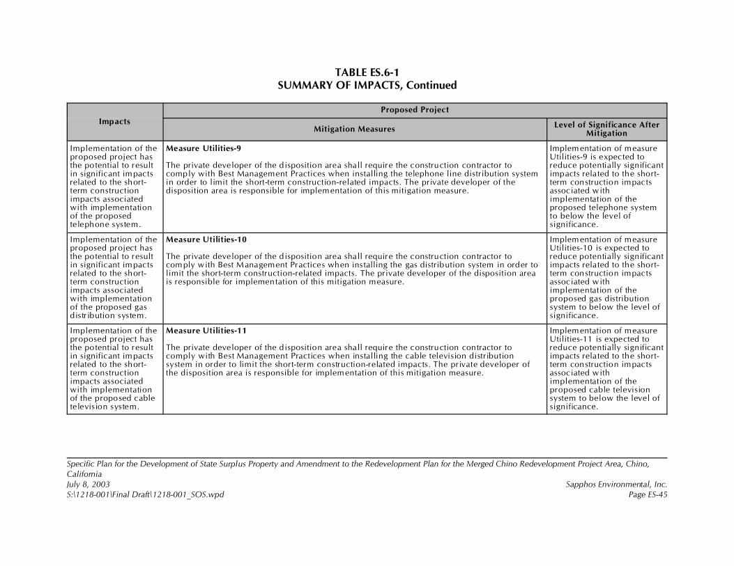
TABLE ES.6-1SUMMARY OF IMPACTS, Continued
Impacts
Proposed Project
Mitigation MeasuresLevel of Significance After
Mitigation
Specific Plan for the Development of State Surplus Property and Amendment to the Redevelopment Plan for the Merged Chino Redevelopment Project Area, Chino,CaliforniaJuly 8, 2003 Sapphos Environmental, Inc.S:\1218-001\Final Draft\1218-001_SOS.wpd Page ES-45
Implementation of theproposed project hasthe potential to resultin significant impactsrelated to the short-term constructionimpacts associatedwith implementationof the proposedtelephone system.
Measure Utilities-9
The private developer of the disposition area shall require the construction contractor tocomply with Best Management Practices when installing the telephone line distribution systemin order to limit the short-term construction-related impacts. The private developer of thedisposition area is responsible for implementation of this mitigation measure.
Implementation of measureUtilities-9 is expected toreduce potentially significantimpacts related to the short-term construction impactsassociated withimplementation of theproposed telephone systemto below the level ofsignificance.
Implementation of theproposed project hasthe potential to resultin significant impactsrelated to the short-term constructionimpacts associatedwith implementationof the proposed gasdistribution system.
Measure Utilities-10
The private developer of the disposition area shall require the construction contractor tocomply with Best Management Practices when installing the gas distribution system in order tolimit the short-term construction-related impacts. The private developer of the disposition areais responsible for implementation of this mitigation measure.
Implementation of measureUtilities-10 is expected toreduce potentially significantimpacts related to the short-term construction impactsassociated withimplementation of theproposed gas distributionsystem to below the level ofsignificance.
Implementation of theproposed project hasthe potential to resultin significant impactsrelated to the short-term constructionimpacts associatedwith implementationof the proposed cabletelevision system.
Measure Utilities-11
The private developer of the disposition area shall require the construction contractor tocomply with Best Management Practices when installing the cable television distributionsystem in order to limit the short-term construction-related impacts. The private developer ofthe disposition area is responsible for implementation of this mitigation measure.
Implementation of measureUtilities-11 is expected toreduce potentially significantimpacts related to the short-term construction impactsassociated withimplementation of theproposed cable televisionsystem to below the level ofsignificance.
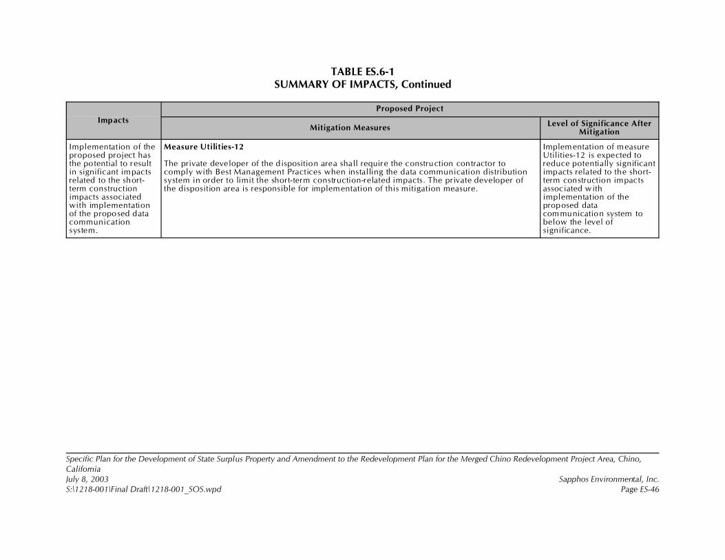
TABLE ES.6-1SUMMARY OF IMPACTS, Continued
Impacts
Proposed Project
Mitigation MeasuresLevel of Significance After
Mitigation
Specific Plan for the Development of State Surplus Property and Amendment to the Redevelopment Plan for the Merged Chino Redevelopment Project Area, Chino,CaliforniaJuly 8, 2003 Sapphos Environmental, Inc.S:\1218-001\Final Draft\1218-001_SOS.wpd Page ES-46
Implementation of theproposed project hasthe potential to resultin significant impactsrelated to the short-term constructionimpacts associatedwith implementationof the proposed datacommunicationsystem.
Measure Utilities-12
The private developer of the disposition area shall require the construction contractor tocomply with Best Management Practices when installing the data communication distributionsystem in order to limit the short-term construction-related impacts. The private developer ofthe disposition area is responsible for implementation of this mitigation measure.
Implementation of measureUtilities-12 is expected toreduce potentially significantimpacts related to the short-term construction impactsassociated withimplementation of theproposed datacommunication system tobelow the level ofsignificance.
Specific Plan for the Development of State Surplus Property and Amendment to the Redevelopment Plan for the MergedChino Redevelopment Project Area, Chino, CaliforniaJuly 8, 2003 Sapphos Environmental, Inc.S:\1218-001\Final Draft\1218-001_S01.wpd Page 1-1
SECTION 1.0INTRODUCTION
This Environmental Impact Report (EIR) has been prepared by the City of Chino CommunityDevelopment Department (City) to assess the environmental consequences of the proposed SpecificPlan for the Development of State Surplus Property and Amendment to the Redevelopment Plan forthe Merged Chino Redevelopment Project Area, Chino, California (proposed project). The City is thelead agency for the proposed project pursuant to the California Environmental Quality Act (CEQA). Forthe purposes of CEQA, the California Department of General Services (DGS) and Chaffey CollegeDistrict (Chaffey) have been identified as responsible agencies.
1.1 PURPOSE AND SCOPE OF EIR
The City has prepared this EIR to support the fulfillment of the six major goals of CEQA:
• To disclose to the decision makers and the public significant environmental effects ofthe proposed activities
• To identify ways to avoid or reduce environmental damage
• To prevent environmental damage by requiring implementation of feasible alternativesor mitigation measures
• To disclose to the public reasons for agency approvals of projects with significantenvironmental effects
• To foster interagency coordination in the review of projects
• To enhance public participation in the planning process
Although the EIR neither controls nor anticipates the ultimate decision on the proposed project, theCity (and other agencies that rely on this EIR) must consider the information in the EIR and makefindings concerning each potentially significant impact identified.
1.1.1 Intent of CEQA
As provided in the State CEQA Guidelines (California Code of Regulations, Section 15000 et seq.),public agencies are charged with the duty to avoid or minimize environmental damage where feasible.In discharging this duty, the City has an obligation to balance a variety of public objectives, includingeconomic, environmental, and social issues (Section 15021 of the State CEQA Guidelines). Thefindings and conclusions of the EIR regarding environmental impacts do not control the City’sdiscretion to approve, deny, or modify the project but instead are presented as information intendedto aid the decision-making process. Sections 15122 through 15132 of the State CEQA Guidelinesdescribe the required content of an EIR, which includes a description of the project and theenvironmental setting (existing conditions), an environmental impact analysis, mitigation measures,
Specific Plan for the Development of State Surplus Property and Amendment to the Redevelopment Plan for the MergedChino Redevelopment Project Area, Chino, CaliforniaJuly 8, 2003 Sapphos Environmental, Inc.S:\1218-001\Final Draft\1218-001_S01.wpd Page 1-2
alternatives, significant irreversible environmental changes, growth-inducing impacts, and cumulativeimpacts. As an EIR, this portion of the document primarily focuses on the changes in the environmentthat would result from the construction and operation of the proposed project and is required toconsider the information in the EIR, along with any other relevant information, in making finaldecisions on the proposed project (Section 15121 of the State CEQA Guidelines).
1.1.2 Environmental Review Process
A Notice of Preparation (NOP) concerning the EIR for the proposed project was circulated for a 30-dayreview period that began on July 19, 2002, and closed on August 22, 2002. An Initial Study wasprepared to focus the environmental topic areas to be analyzed in the EIR. Copies of the NOP and thecomment letters submitted in response to the Initial Study are included in this document (AppendixA, Notice of Preparation and Letters of Comment). The Initial Study prepared for the proposed projectidentified the contents of the EIR on environmental issue areas potentially subject to significant impacts.
The NOP and Initial Study were sent to the state clearinghouse on July 19, 2002, and distributed tovarious federal, state, regional, and local government agencies. A public Notice of Availability (NOA)of the NOP was provided in the Chino Champion and The Daily Bulletin. The NOP and Initial Studywere mailed directly to more than 1,260 agencies and interested parties, posted at the Chino BranchLibrary and the City of Chino Community Development Department, and posted at five locations onthe property on 4-foot by 8-foot billboards. The NOP advertised a public scoping meeting for interestedparties to receive information on the proposed project and the CEQA process, as well as provided anopportunity for the submittal of comments. The scoping meeting facilitated early consultation withinterested parties in compliance with Section 15082 of the State CEQA Guidelines. The meeting washeld on Wednesday, August 7, 2002, from 6:00 p.m. to 8:00 p.m., at the City of Chino City CouncilChambers. A total of 27 individuals attended the scoping meeting. The City requested information fromthe public related to the range of actions under consideration, alternatives, mitigation measures, andsignificant effects to be analyzed in depth in the EIR. All verbal and written comments related toenvironmental issues that were provided during public review of the NOP and at scoping meetingshave been taken into consideration in the preparation of this EIR. This EIR considers alternatives thatare capable of avoiding or reducing significant effects of the project. The comment period on the NOPand Initial Study closed on August 22, 2002 at 5:00 p.m. A total of 29 comment letters were receivedin response to the NOP and Initial Study (Appendix A).
Based on the analysis undertaken in the Initial Study, the City determined that the proposed projectmay have a significant effect on the environment and that the preparation of an EIR would be required.As a result of the analysis undertaken in the Initial Study, it was determined that the proposed projectwould not be expected to result in impacts to land use, planning, and mineral resources. Those issueareas will receive no further analysis. However, the analysis in the Initial Study concluded that theproposed project would have the potential to result in significant impacts related to 14 environmentaltopics that are the subject of the detailed evaluation undertaken in this EIR:
• Aesthetics• Agricultural resources• Air quality• Biological resources
Specific Plan for the Development of State Surplus Property and Amendment to the Redevelopment Plan for the MergedChino Redevelopment Project Area, Chino, CaliforniaJuly 8, 2003 Sapphos Environmental, Inc.S:\1218-001\Final Draft\1218-001_S01.wpd Page 1-3
• Cultural resources• Geology and soils• Hazards and hazardous materials• Hydrology and water quality• Noise• Population and housing• Public services• Recreation• Transportation and traffic• Utilities
This Draft EIR has been distributed to various federal, state, regional, and local government agenciesand interested organizations and individuals for a 45-day public review period. This Draft EIR wasprovided to the state clearinghouse on July 8, 2003, for additional distribution to agencies. In addition,a public NOA of the EIR will appear in the Chino Champion and The Daily Bulletin and will be maileddirectly to interested parties requesting the document. The dates of the public review period arespecified on the transmittal memo accompanying this Draft EIR. In addition, copies of this Draft EIR areavailable during the public review period at the following library:
Chino Branch Library, 13180 Central Avenue, Chino, California 91710
Telephone number: (909) 465-5280Hours of operation: Monday and Thursday (10:00 a.m.!8:00 p.m.)
Friday (10:00 a.m.!6:00 p.m.)Saturday (9:00 a.m.!5:00 p.m.)Sunday (closed)
The Draft EIR will also be available for review at the following location:
City of Chino Community Development Department, 13220 Central Avenue, Chino, California91710
Telephone number: (909) 464-8324Hours of operation: Monday through Friday (7:30 a.m.!5:30 p.m.)Contact: Sal Salazar, AICP, Principal Planner
Written comments on this Draft EIR should be transmitted during the public review period to SalSalazar, Principal Planner, City of Chino Community Development Department, 13220 CentralAvenue, Chino, California 91710.
Written comments provided by the general public and public agencies will be evaluated, and writtenresponses will be prepared for all comments received during the designated comment period. Uponcompletion of the evaluation, a Final EIR will be prepared and provided to the City PlanningCommission and City Council for certification of compliance with CEQA and for review andconsideration as part of the decision-making process for the proposed project.
Specific Plan for the Development of State Surplus Property and Amendment to the Redevelopment Plan for the MergedChino Redevelopment Project Area, Chino, CaliforniaJuly 8, 2003 Sapphos Environmental, Inc.S:\1218-001\Final Draft\1218-001_S01.wpd Page 1-4
1.2 ORGANIZATION AND CONTENT
This Draft EIR consists of the following sections:
• Section ES, Executive Summary provides a summary of the existing setting, proposedproject, identified significant impacts of the proposed project, and mitigation measures.Those alternatives that were considered to avoid significant effects of the project areidentified in the Executive Summary. In addition, the Executive Summary identifiesareas of controversy known to the City, including issues raised by agencies and thepublic. The Executive Summary includes a list of the issues to be resolved, includingthe choice among alternatives and whether or how to mitigate significant effects of theproject.
• Section 1, Introduction provides information related to the purpose and scope of theEIR, environmental review process, and the organization and content of the EIR.
• Section 2, Project Description provides the location and boundaries of the proposedproject area, a statement of the goals and objectives of the proposed project, and adescription of the technical, economic, and environmental characteristics of theproposed project.
The project description also identifies the intended uses of the EIR, including the listof agencies that are expected to use the EIR in their respective decision-makingprocesses, a list of the related discretionary actions (permits and approvals) requiredto implement the proposed project, and a list of any related environmental review andconsultation requirements required by federal, state, or local laws, regulations, orpolicies. The project description also lists the related projects that were considered inthe evaluation of the proposed project and the alternatives to the proposed project thatwere analyzed.
• Section 3, Regulatory Framework, Existing Conditions, Impacts, Mitigation, and Levelof Significance after Mitigation describes existing conditions found at the project siteand the surrounding area; lists the thresholds used to assess the potential for theproposed project to result in significant impacts; evaluates the potential impacts onenvironmental resources that may be generated by the proposed project, including thecumulative impacts of the proposed project in conjunction with other related projectsin the area; identifies available mitigation measures to reduce significant impacts; andassesses the effectiveness of proposed measures to reduce identified impacts to belowthe level of significance. This portion of the EIR is organized by the applicableenvironmental topics resulting from the analysis undertaken in the Initial Study.
• Section 4, Alternatives to the Proposed Project describes a range of reasonablealternatives to the proposed project or to the location of the proposed project. CEQArequires that the EIR explore feasible alternatives that would avoid or substantiallylessen any of the significant effects of the proposed project. To be feasible, analternative must be capable of attaining most of the basic objectives of the proposed
Specific Plan for the Development of State Surplus Property and Amendment to the Redevelopment Plan for the MergedChino Redevelopment Project Area, Chino, CaliforniaJuly 8, 2003 Sapphos Environmental, Inc.S:\1218-001\Final Draft\1218-001_S01.wpd Page 1-5
project. CEQA requires an evaluation of the comparative impacts of the proposedproject, the No Project Alternative, as well as action alternatives (i.e., alternatives thatrequire a physical change to the environment) to the proposed project.
• Section 5, Significant Environmental Effects That Cannot Be Avoided if the ProposedProject is Implemented summarizes the significant effects of the proposed project.
• Section 6, Significant Irreversible Environmental Changes Related to Implementationof the Proposed Project evaluates potential uses of nonrenewable resources andpotential irreversible changes that may occur during the course of the proposedproject.
• Section 7, Growth-Inducing Impacts evaluates the potential for the proposed projectto foster economic growth or population growth, either directly or indirectly, in thesurrounding environment.
• Section 8, Organizations and Persons Consulted provides a list of all governmentalagencies, community groups, and other organizations consulted during the preparationof this EIR.
• Section 9, Report Preparation Personnel provides a list of all personnel that providedtechnical input to this EIR.
• Section 10, References lists all sources, communications, and correspondence usedin the preparation of this EIR.
• Section 11, Draft Environmental Impact Report Distribution List provides adistribution list of agencies and libraries receiving this Draft EIR that was madeavailable during the 45-day public review period.

1 U.S. Geological Survey, 1981 (Photorevised from 1967). Prado Dam 7.5-Minute Series Topographic Quadrangle. (Scale= 1:24,000.)
Specific Plan for the Development of State Surplus Property and Amendment to the Redevelopment Plan for the MergedChino Redevelopment Project Area, Chino, CaliforniaJuly 8, 2003 Sapphos Environmental, Inc.S:\1218-001\Final Draft\1218-001_S02.wpd Page 2-1
SECTION 2.0
PROJECT DESCRIPTION
Consistent with the requirements of §15124 of the California Environmental Quality Act (CEQA)
Guidelines, the description of the Specific Plan for the Development of State Surplus Property and
Amendment to the Redevelopment Plan for the Merged Chino Redevelopment Project Area, Chino,
California (proposed project) includes the following:
• The precise location and boundaries of the proposed project
• A brief characterization of the existing conditions at the proposed project location
• A statement of objectives sought by the proposed project
• A general delineation of the project’s technical, economic, and environmental
characteristics
• A statement describing the intended uses of the Environmental Impact Report (EIR)
• These requirements of the State CEQA Guidelines are included in the following project
description.
2.1 PROPOSED PROJECT LOCATION
The proposed project addresses 710 acres located in the northern portion of the 2,460-acre California
Institution for Men (CIM), located in the City of Chino (City), County of San Bernardino (County),
California (Figure 2.1-1, Regional Vicinity). The proposed project is located on the U.S. Geological
Survey (USGS) 7.5-minute series Prado Dam topographic quadrangle1 within the Santa Ana Del Chino
Land Grant Boundary (Figure 2.1-2, Topographic Map). The elevation of the project site ranges from
the highest on-site elevation of 680 feet above MSL (mean sea level) to lowest on-site elevation of 650
MSL. The proposed project area is located approximately 2 miles south of State Route 60 (Pomona
Freeway). State Route 83 (Euclid Avenue) is located east of the proposed project, and State Route 71
(Chino Valley Freeway) is located west of the proposed project site. Additionally, State Route 142
(Chino Hills Parkway) is located west of the proposed project site and terminates at the CIM main gate
(Figure 2.1-1). The proposed project is bound on the north by Edison Avenue, on the east by Euclid
Avenue, on the south by the main CIM facilities, and on the west by Central Avenue (Figure 2.1-3,
Project Location). The proposed project site is also located within the boundaries of the redevelopment
project area delineated in the City’s Redevelopment Plan for the Merged Chino Redevelopment Project
Area. The boundaries of the redevelopment area are beyond the boundaries of the proposed project
area.

Specific Plan for the Development of State Surplus Property and Amendment to the Redevelopment Plan for the MergedChino Redevelopment Project Area, Chino, CaliforniaJuly 8, 2003 Sapphos Environmental, Inc.S:\1218-001\Final Draft\1218-001_S02.wpd Page 2-2
2.2 EXISTING CONDITIONS
The approximately 710 acres of State of California (State) land identified as surplus from the CIM is
currently improved with the following land uses: agriculture, recreation, infrastructure (including
utilities, flood control, and roads), water treatment and storage, a heliport, and a former nursery (Figure
2.2-1, Existing Conditions).
The primary existing land use consists of approximately 571 acres previously used for agricultural
purposes as part of the Prison Industries training and rehabilitation program. Appurtenant facilities
within this area include an approximately 20,000-square-foot storage and barn building previously
used to store tractor and maintenance equipment, and an approximately 1,540-square-foot wood-frame
barn previously used to store seed and agricultural supplies.
Approximately 170 acres of the proposed project site are currently leased to the City for recreational
purposes. Within the leased area, the City operates the approximately 40-acre Ruben S. Ayala
Community Park, which contains four lighted softball/soccer fields, two combination baseball/soccer
fields, one volleyball court, two picnic shelters, two tot lots, one concession restroom building, a
multiuse trail, a small storage building, and an asphalt-paved parking for 374 cars. Additional
recreational facilities include a golf driving range, a batting cage, and a Young Men’s Christian
Association (YMCA) facility, which have been developed on the land leased to the City pursuant to
concession lease agreements.
Approximately 19 acres of the 710 acres of State land identified as surplus from the CIM, also known
as the proposed project area, are currently occupied by infrastructure (including utilities, flood control,
and roads). Two Southern California Edison (SCE) and Gas Company utility easements overlay
approximately 49 acres of other existing land uses: recreation, agriculture, and existing roads (there
are approximately 14 acres of existing roads within the proposed project area). In addition,
approximately 5 acres of the Cypress Channel are located within the proposed project area. A public
storm drain easement 20 feet in length, made up of a 60-inch reinforced-concrete pipe runs along the
southern wall of the preexisting residential development.
Additional facilities include the following:
• The California Department of Corrections currently operates a water treatment facility
on approximately 8 acres located south of Edison Avenue.
• The California Department of Forestry and Fire Protection operates a heliport on
approximately 4 acres, including two 1,000-square-foot landing pads, on the north side
of the Prado Conservation Camp.
• The California Department of General Services (CDGS) leased 3 acres of unimproved
land to a commercial nursery in conjunction with a joint venture contract awarded by
the California Department of Corrections. A small trailer office is located on the
property as a remaining part of that operation.
Specific Plan for the Development of State Surplus Property and Amendment to the Redevelopment Plan for the MergedChino Redevelopment Project Area, Chino, CaliforniaJuly 8, 2003 Sapphos Environmental, Inc.S:\1218-001\Final Draft\1218-001_S02.wpd Page 2-3
2.3 STATEMENT OF OBJECTIVES
The goal of the proposed project is to convey, sell, or otherwise transfer surplus property from State
ownership to three parties: the City of Chino for expansion of recreational facilities, Chaffey
Community College District (Chaffey College) for the development of the Chaffey College, and a
private developer for the master-planned community that would be controlled by a Specific Plan
adopted by the City of Chino.
The City of Chino, State of California, and Chaffey College have established goals and objectives for
their respective project elements.
2.3.1 City of Chino
Objectives
• Adopt a Specific Plan that both meets the requirements of California state law and the
Urban Reserve Area section of the Chino General Plan and implements the provisions
of the Memorandum of Understanding between the City of Chino, the California
Department of General Services, and Chaffey College.
• Amend the Redevelopment Plan for the Merged Chino Redevelopment Project Area
to conform permitted land uses to the City’s General Plan.
• Develop a premier living environment designed on the principles of “smart”
development, including efficient use of land resources, full use of urban services, and
a mix of uses, transportation options, and detailed human-scale design that is unique
because of its accessibility to regional educational and recreational opportunities.
• Develop the proposed project area in a way that is consistent with the provisions of the
adopted Community Redevelopment Plan.
• Provide an integrated mix of residential densities and product types, including estate
lot residences, single-family residences on a variety of smaller lots, and multifamily
residences such as townhouses, duplexes, clustered products, flats, and
condominiums.
• Contribute to regional housing needs as projected by the Southern California
Association of Governments.
• Identify and adopt a land use plan that will be fiscally efficient and capable of
financing the construction and maintenance of required public improvements.
• Design residential projects to complement the character of adjacent neighborhoods.
Specific Plan for the Development of State Surplus Property and Amendment to the Redevelopment Plan for the MergedChino Redevelopment Project Area, Chino, CaliforniaJuly 8, 2003 Sapphos Environmental, Inc.S:\1218-001\Final Draft\1218-001_S02.wpd Page 2-4
• Comply with all requirements of the City and the Redevelopment Plan for inclusionary
housing; specifically, set aside at least 15 percent of all new residences as affordable
to low- and moderate-income households (40 percent of the 15 percent must be
affordable to very-low-income households), which may be provided for either inside
or outside the proposed project area.
• Develop recreational amenities that conveniently serve the diverse interests and needs
of the Specific Plan residents, as well as connect residential areas and provide access
to Ayala Park.
• Coordinate with Chaffey College to promote joint-use facilities such as parking and
sports facilities.
• Provide a safe, efficient circulation and transportation system that also addresses
potential transit connection opportunities.
• Design a village center that provides a focal point for neighborhood activities and
includes a mix of multifamily residential, local commercial, recreational, and
appropriate college uses.
2.3.2 State of California
Objectives
• Implement the provisions of the Memorandum of Understanding between the
California Department of General Services, the City of Chino and its Community
Development Agency, and Chaffey College for the development of the 710 acres of
State surplus property land.
• Facilitate the infrastructure improvements required to maintain the integrity of the
California Department of Corrections’s existing operations that are required as a result
of the disposition of the approximately 710 acres of State surplus property land through
the sale of that property.
• Provide for appropriate covenants and mutual agreements to control uses in conformity
with the adopted master development plan.
• Secure the highest achievable value from the sale of the State surplus property land.
Specific Plan for the Development of State Surplus Property and Amendment to the Redevelopment Plan for the MergedChino Redevelopment Project Area, Chino, CaliforniaJuly 8, 2003 Sapphos Environmental, Inc.S:\1218-001\Final Draft\1218-001_S02.wpd Page 2-5
2.3.3 Chaffey College
Objectives
Academic
• Develop a curriculum in cooperation with the City residents for a campus that is both
consistent with the Educational/Facilities Master Plan and responsive to the student
enrollment projected for the site.
• Phase the implementation of the academic program in a manner that is consistent with
the facilities development plan for the campus.
Facilities
• Develop a phased facilities development plan for the college campus that is consistent
with the enrollment projections as outlined in the Educational/Facilities Master Plan.
• Develop a master site plan for the campus that is compatible with the overall
development plan for the total project and facilitates the joint use of the facilities for
the City and the campus.
• Develop a parking plan for the campus that will support the parking needs of the
institution with adequate on-site parking.
• Develop a master architectural theme for the campus that is consistent with the theme
for the overall project.
• Provide ingress and egress to the campus that is consistent with the guidelines listed
in the traffic study for the project.
• Establish a well-defined “front door” for the campus.
• Provide adequate outdoor recreational and activity space on the campus to
accommodate the physical education and community activities of the college.
Planning
• Establish a master plan for the build-out of the campus and a phasing plan to support
the enrollment projections.
• Work cooperatively with affected agencies to establish a plan for off-site
improvements.
• Secure all State approvals.
Specific Plan for the Development of State Surplus Property and Amendment to the Redevelopment Plan for the MergedChino Redevelopment Project Area, Chino, CaliforniaJuly 8, 2003 Sapphos Environmental, Inc.S:\1218-001\Final Draft\1218-001_S02.wpd Page 2-6
2.4 PROPOSED IMPROVEMENTS
The CDGS has identified 710 acres of the CIM facility as surplus property. The CDGS proposes to
convey, sell, or otherwise transfer the surplus property from State ownership to the three parties: City
of Chino, Chaffey College, and a private developer. The City and its Community Development
Department, Chaffey College, and the CDGS signed a Memorandum of Understanding to carry forth
the planning, entitlement, and, ultimately, the development of the surplus property. The land use
development of the surplus property would be controlled by a Specific Plan adopted by the City (Table
2.4-1, Land Uses for the Proposed Project). The proposed project is made up of a Specific Plan,
including proposed land use designations for the surplus property (Figure 2.4-1, Conceptual Site Plan),
an Amendment to the Redevelopment Plan for the Merged Chino Redevelopment Project Area to
conform the land uses permitted in the project area to the land uses permitted by the City’s General
Plan. It is anticipated that an 8-foot-high masonry wall would be constructed along the southern
boundary of the surplus property. Some of the agricultural wells within the proposed project area
would be abandoned, including existing Domestic Well No. 2. Existing, Agricultural Wells No. 4 and
12 would not be abandoned and may be utilized by the watermaster for research purposes. A new
pipeline would be constructed to serve the CIM from the existing CIM wastewater treatment plant.
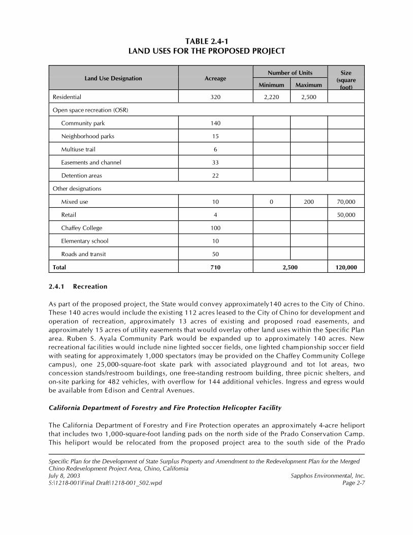
Specific Plan for the Development of State Surplus Property and Amendment to the Redevelopment Plan for the MergedChino Redevelopment Project Area, Chino, CaliforniaJuly 8, 2003 Sapphos Environmental, Inc.S:\1218-001\Final Draft\1218-001_S02.wpd Page 2-7
TABLE 2.4-1LAND USES FOR THE PROPOSED PROJECT
Land Use Designation AcreageNumber of Units Size
(squarefoot)Minimum Maximum
Residential 320 2,220 2,500
Open space recreation (OSR)
Community park 140
Neighborhood parks 15
Multiuse trail 6
Easements and channel 33
Detention areas 22
Other designations
Mixed use 10 0 200 70,000
Retail 4 50,000
Chaffey College 100
Elementary school 10
Roads and transit 50
Total 710 2,500 120,000
2.4.1 Recreation
As part of the proposed project, the State would convey approximately140 acres to the City of Chino.
These 140 acres would include the existing 112 acres leased to the City of Chino for development and
operation of recreation, approximately 13 acres of existing and proposed road easements, and
approximately 15 acres of utility easements that would overlay other land uses within the Specific Plan
area. Ruben S. Ayala Community Park would be expanded up to approximately 140 acres. New
recreational facilities would include nine lighted soccer fields, one lighted championship soccer field
with seating for approximately 1,000 spectators (may be provided on the Chaffey Community College
campus), one 25,000-square-foot skate park with associated playground and tot lot areas, two
concession stands/restroom buildings, one free-standing restroom building, three picnic shelters, and
on-site parking for 482 vehicles, with overflow for 144 additional vehicles. Ingress and egress would
be available from Edison and Central Avenues.
California Department of Forestry and Fire Protection Helicopter Facility
The California Department of Forestry and Fire Protection operates an approximately 4-acre heliport
that includes two 1,000-square-foot landing pads on the north side of the Prado Conservation Camp.
This heliport would be relocated from the proposed project area to the south side of the Prado
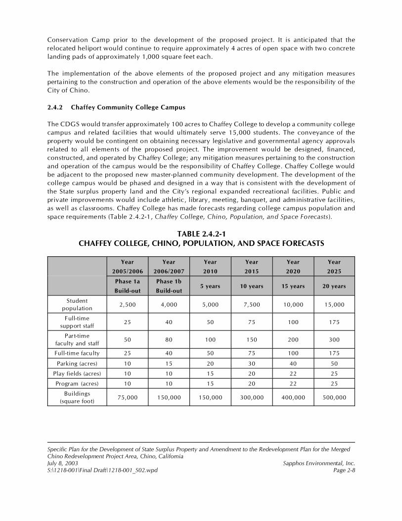
Specific Plan for the Development of State Surplus Property and Amendment to the Redevelopment Plan for the MergedChino Redevelopment Project Area, Chino, CaliforniaJuly 8, 2003 Sapphos Environmental, Inc.S:\1218-001\Final Draft\1218-001_S02.wpd Page 2-8
Conservation Camp prior to the development of the proposed project. It is anticipated that the
relocated heliport would continue to require approximately 4 acres of open space with two concrete
landing pads of approximately 1,000 square feet each.
The implementation of the above elements of the proposed project and any mitigation measures
pertaining to the construction and operation of the above elements would be the responsibility of the
City of Chino.
2.4.2 Chaffey Community College Campus
The CDGS would transfer approximately 100 acres to Chaffey College to develop a community college
campus and related facilities that would ultimately serve 15,000 students. The conveyance of the
property would be contingent on obtaining necessary legislative and governmental agency approvals
related to all elements of the proposed project. The improvement would be designed, financed,
constructed, and operated by Chaffey College; any mitigation measures pertaining to the construction
and operation of the campus would be the responsibility of Chaffey College. Chaffey College would
be adjacent to the proposed new master-planned community development. The development of the
college campus would be phased and designed in a way that is consistent with the development of
the State surplus property land and the City’s regional expanded recreational facilities. Public and
private improvements would include athletic, library, meeting, banquet, and administrative facilities,
as well as classrooms. Chaffey College has made forecasts regarding college campus population and
space requirements (Table 2.4.2-1, Chaffey College, Chino, Population, and Space Forecasts).
TABLE 2.4.2-1CHAFFEY COLLEGE, CHINO, POPULATION, AND SPACE FORECASTS
Year
2005/2006
Year
2006/2007
Year
2010
Year
2015
Year
2020
Year
2025
Phase 1a
Build-out
Phase 1b
Build-out5 years 10 years 15 years 20 years
Student
population2,500 4,000 5,000 7,500 10,000 15,000
Full-time
support staff25 40 50 75 100 175
Part-time
faculty and staff50 80 100 150 200 300
Full-time faculty 25 40 50 75 100 175
Parking (acres) 10 15 20 30 40 50
Play fields (acres) 10 10 15 20 22 25
Program (acres) 10 10 15 20 22 25
Buildings
(square foot)75,000 150,000 150,000 300,000 400,000 500,000
2 City of Chino, July 2002d. Personal communication to Goodell Brackenbush, 36 West Colorado Boulevard, Suite 208,Pasadena, CA 91105, pertaining to use of 3.0, not 2.5, acres per population of 1,000.
Specific Plan for the Development of State Surplus Property and Amendment to the Redevelopment Plan for the MergedChino Redevelopment Project Area, Chino, CaliforniaJuly 8, 2003 Sapphos Environmental, Inc.S:\1218-001\Final Draft\1218-001_S02.wpd Page 2-9
2.4.3 Master-Planned Community
Residential Land Use
The residential component of the proposed project would be a master-planned residential community
of approximately 2,500 dwelling units, retail space, commercial space, community facilities, and
related infrastructure to be developed on approximately 470 gross acres. Fifteen percent of the total
number of dwelling units would be provided as “affordable housing,” including 9 percent for
moderate-income households and 6 percent for the very-low-income household category. The
affordable housing dwelling units may be provided on site within the residential component of the
proposed project or off site elsewhere in the City as may be found appropriate. Public funds to
supplement the development of the affordable housing may come from the City’s 20-percent Low- and
Moderate-Income Housing Set-Aside Funds. Residential land uses would account for approximately
320 acres.
Retail and Mixed Use
A village center is planned near the geographic center of the proposed project area. The approximately
50,000-square-foot village center site allows a mix of retail, office, and service uses, as well as
pedestrian amenities. It is intended that the village center design be integrated with the college, both
aesthetically and functionally. The adjacent 10-acre, mixed-use planning area allows up to 70,000
square feet of retail, office, and service uses, including a possible supermarket. Should it be
determined that a portion of the commercial program in this planning area be infeasible, the plan
provides for the development of up to 200 dwelling units.
The Elementary School and Neighborhood Parks
The master-planned community would include a total of 27.5 acres dedicated to a school and parks.
A 10-acre elementary school and adjoining 5-acre neighborhood park facility would be developed in
collaboration with the Chino Valley Unified School District (CVUSD) and the City. Approximately 14.5
acres, including 5 acres of additional public parks, would be developed throughout the residential
community, including a 3.5-acre community park and six 1-acre parks. In addition, a 1-acre village
green and a 2-acre campus green are planned in the village center. The City standards requiring that
developments provide a minimum of 3.0 acres of neighborhood parks for every 1,000 residents of the
new community, given that the overall acreage of open space associated with the regional park
development and Chaffey College component of the proposed project more than meets this
requirement.2
Trails and Walkways
The master-planned community would include approximately 6 acres of pedestrian trail, bike path,
and equestrian trail to be developed in an exclusive right-of-way separate from the collector and local
street system.
Specific Plan for the Development of State Surplus Property and Amendment to the Redevelopment Plan for the MergedChino Redevelopment Project Area, Chino, CaliforniaJuly 8, 2003 Sapphos Environmental, Inc.S:\1218-001\Final Draft\1218-001_S02.wpd Page 2-10
Infrastructure
The master-planned community’s related infrastructure requirements, including existing and proposed
roads (approximately 47 acres), transit (approximately 3 acres) would be undertaken on approximately
50 acres within the master-planned community project area. Approximately 33 acres of SCE and Gas
Company easements would be located within the master-planned community. It is anticipated that a
new road would be constructed from Euclid Avenue within the CIM property. The construction of a
storm water impoundment, in the form of three detention ponds to prevent impacts to drainage, would
be required within the southern portion of the master-planned community to provide storm water
treatment and flood control consistent with the requirements of the City, County of San Bernardino
Flood Control District, and Regional Water Quality Control Board.
The existing Magnolia Channel, an open earth ditch aligned to the west of the north-south SCE
easement would be improved to a soft-bottom channel. The new alignment would be moved to the
east to be immediately adjacent to the west boundary of the SCE easement.
The implementation of the above master-planned community elements of the proposed project and
any mitigation measures pertaining to the construction and operation of the above elements would be
the responsibility of the private developer.
2.4.4 Owl Mitigation
Burrowing owls are considered to be a sensitive species by the California Department of Fish and
Game (CDFG). There are burrowing owls found within the total proposed project area, including areas
within the proposed master-planned community and the Ruben S. Ayala Park Expansion area. The
project proposes to impact a total of six burrows. As a result, the CDFG recommends that the impacted
burrows be mitigated by implementing 6.5 acres of owl mitigation per burrow impacted. Therefore,
the proposed project consists of approximately 39 acres of owl mitigation that would be incorporated
into the Specific Plan within the open space and detention pond areas.
2.5 CONSTRUCTION SCENARIO
Site preparation and construction of the proposed project elements would be undertaken in
accordance with all federal, State, and City of Chino building codes. Daily construction activities were
analyzed in the document as being undertaken Monday through Friday between the hours of 7:00 a.m.
and 7:00 p.m. and Saturday between the hours of 8:00 a.m. and 5:00 p.m. City standards, however,
allow daily construction activities to be undertaken Monday through Friday between the hours of 7:00
a.m. and 3:30 p.m. and no work on Saturdays, Sundays, and federal holidays unless approved by the
City Engineer. All grading and earthwork would be performed under the observation of a geotechnical
engineer to ensure proper subgrade preparation, selection of satisfactory materials, and placement and
compaction of structural fills. Any anticipated adverse conditions encountered would be evaluated by
the project engineering geologist and the soils engineer, and the appropriate recommendations would
be made and followed.
Whenever possible, grading activities would be undertaken outside the normal rainy season of
October 15 to April 15, thus minimizing the potential for increased surface runoff and the associated
potential for soil erosion. The construction for the proposed project would include the requirement
for construction equipment of the type specified in the tables found below. The construction tables

Specific Plan for the Development of State Surplus Property and Amendment to the Redevelopment Plan for the MergedChino Redevelopment Project Area, Chino, CaliforniaJuly 8, 2003 Sapphos Environmental, Inc.S:\1218-001\Final Draft\1218-001_S02.wpd Page 2-11
also list the number of trips to and from the construction site and the total number of days of operation
by equipment type.
It is anticipated that the residential element of the master-planned community component of the
proposed project would start in the first quarter of the year 2004, with construction averaging about
320 units per year. Full build-out for residential neighborhoods, the elementary school, neighborhood
parks, and commercial space would be anticipated to occur by the year 2012. However, full build-out
for the Chaffey College component would not be anticipated until the year 2025.
Many of the proposed project elements would be constructed in phases. For example, the recreational
component of the proposed project would be constructed in two 65-week phases. The first phase
would take place in the third quarter of 2006 lasting for 65 weeks, and the second phase would take
place in the third quarter of 2009 lasting 65 weeks. Please see Appendix L, Vehicular Traffic Study for
Construction of the Chino College Park Project, for a detailed breakdown of phases for the
construction of the proposed project elements.
2.5.1 Recreation Facilities
A conceptual list of the type and quantity of equipment that would potentially be used in the
construction of the Recreation component of the proposed project has been identified by the project
management consultant and was used in the assessment of potential construction impacts to air
quality, ambient noise levels, as well as traffic and circulation (Table 2.5.1-1, Anticipated Equipment
for Construction of the Ruben S. Ayala Community Park Expansion). Development of this element
would require utilities (power and phone), sewer facilities, storm drain facilities, paving, building
construction, landscaping, and fencing.
TABLE 2.5.1-1ANTICIPATED EQUIPMENT FOR CONSTRUCTION
OF THE RUBEN S. AYALA COMMUNITY PARK EXPANSION1
Type Approximate Number of Trips to and from Site During Construction
Grader/dozer 65 weeks, 8 trips/week per phase
Pick-up truck 65 weeks, 225 trips/week per phase
Dump truck 65 weeks, 17 trips/week per phase
Concrete mix truck 65 weeks, 37 trips/week per phase
Materials delivery 65 weeks, 120 trips/week per phase
NOTE:1 Construction of the Ruben S. Ayala Park expansion would be done in two 65-week phases. See Appendix L, VehicularTraffic Study for Construction of the Chino College Park Project for breakdown of phases.
2.5.2 Chaffey Community College Campus
The development of a 100-acre community college campus and related facilities would require
approximately 5 to 22 years to complete at a rate of approximately 75,000 square feet of building area
by the year 2005 to 500,000 square feet of building area in the year 2025. A conceptual list of the type
and quantity of equipment that would potentially be used in the construction of the Chaffey
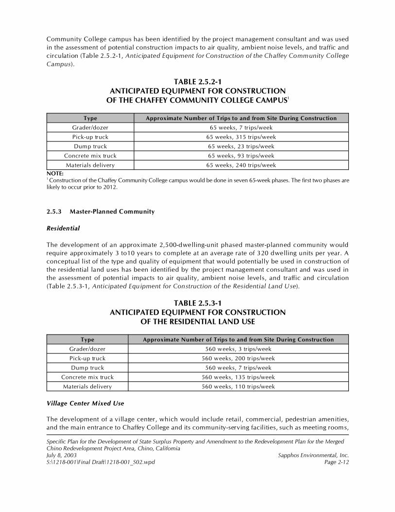
Specific Plan for the Development of State Surplus Property and Amendment to the Redevelopment Plan for the MergedChino Redevelopment Project Area, Chino, CaliforniaJuly 8, 2003 Sapphos Environmental, Inc.S:\1218-001\Final Draft\1218-001_S02.wpd Page 2-12
Community College campus has been identified by the project management consultant and was used
in the assessment of potential construction impacts to air quality, ambient noise levels, and traffic and
circulation (Table 2.5.2-1, Anticipated Equipment for Construction of the Chaffey Community College
Campus).
TABLE 2.5.2-1ANTICIPATED EQUIPMENT FOR CONSTRUCTION
OF THE CHAFFEY COMMUNITY COLLEGE CAMPUS1
Type Approximate Number of Trips to and from Site During Construction
Grader/dozer 65 weeks, 7 trips/week
Pick-up truck 65 weeks, 315 trips/week
Dump truck 65 weeks, 23 trips/week
Concrete mix truck 65 weeks, 93 trips/week
Materials delivery 65 weeks, 240 trips/week
NOTE:1 Construction of the Chaffey Community College campus would be done in seven 65-week phases. The first two phases arelikely to occur prior to 2012.
2.5.3 Master-Planned Community
Residential
The development of an approximate 2,500-dwelling-unit phased master-planned community would
require approximately 3 to10 years to complete at an average rate of 320 dwelling units per year. A
conceptual list of the type and quality of equipment that would potentially be used in construction of
the residential land uses has been identified by the project management consultant and was used in
the assessment of potential impacts to air quality, ambient noise levels, and traffic and circulation
(Table 2.5.3-1, Anticipated Equipment for Construction of the Residential Land Use).
TABLE 2.5.3-1ANTICIPATED EQUIPMENT FOR CONSTRUCTION
OF THE RESIDENTIAL LAND USE
Type Approximate Number of Trips to and from Site During Construction
Grader/dozer 560 weeks, 3 trips/week
Pick-up truck 560 weeks, 200 trips/week
Dump truck 560 weeks, 7 trips/week
Concrete mix truck 560 weeks, 135 trips/week
Materials delivery 560 weeks, 110 trips/week
Village Center Mixed Use
The development of a village center, which would include retail, commercial, pedestrian amenities,
and the main entrance to Chaffey College and its community-serving facilities, such as meeting rooms,
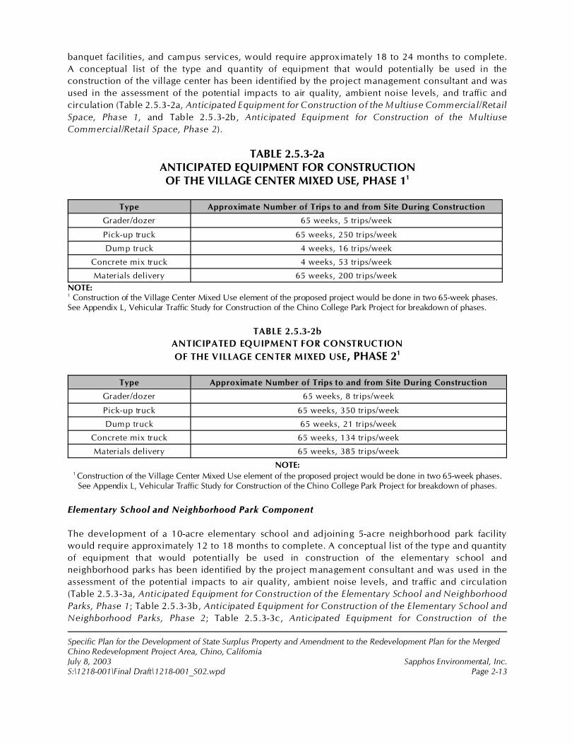
Specific Plan for the Development of State Surplus Property and Amendment to the Redevelopment Plan for the MergedChino Redevelopment Project Area, Chino, CaliforniaJuly 8, 2003 Sapphos Environmental, Inc.S:\1218-001\Final Draft\1218-001_S02.wpd Page 2-13
banquet facilities, and campus services, would require approximately 18 to 24 months to complete.
A conceptual list of the type and quantity of equipment that would potentially be used in the
construction of the village center has been identified by the project management consultant and was
used in the assessment of the potential impacts to air quality, ambient noise levels, and traffic and
circulation (Table 2.5.3-2a, Anticipated Equipment for Construction of the Multiuse Commercial/Retail
Space, Phase 1, and Table 2.5.3-2b, Anticipated Equipment for Construction of the Multiuse
Commercial/Retail Space, Phase 2).
TABLE 2.5.3-2aANTICIPATED EQUIPMENT FOR CONSTRUCTIONOF THE VILLAGE CENTER MIXED USE, PHASE 11
Type Approximate Number of Trips to and from Site During Construction
Grader/dozer 65 weeks, 5 trips/week
Pick-up truck 65 weeks, 250 trips/week
Dump truck 4 weeks, 16 trips/week
Concrete mix truck 4 weeks, 53 trips/week
Materials delivery 65 weeks, 200 trips/week
NOTE:1 Construction of the Village Center Mixed Use element of the proposed project would be done in two 65-week phases.See Appendix L, Vehicular Traffic Study for Construction of the Chino College Park Project for breakdown of phases.
TABLE 2.5.3-2b
ANTICIPATED EQUIPMENT FOR CONSTRUCTION
OF THE VILLAGE CENTER MIXED USE, PHASE 21
Type Approximate Number of Trips to and from Site During Construction
Grader/dozer 65 weeks, 8 trips/week
Pick-up truck 65 weeks, 350 trips/week
Dump truck 65 weeks, 21 trips/week
Concrete mix truck 65 weeks, 134 trips/week
Materials delivery 65 weeks, 385 trips/week
NOTE:1 Construction of the Village Center Mixed Use element of the proposed project would be done in two 65-week phases.
See Appendix L, Vehicular Traffic Study for Construction of the Chino College Park Project for breakdown of phases.
Elementary School and Neighborhood Park Component
The development of a 10-acre elementary school and adjoining 5-acre neighborhood park facility
would require approximately 12 to 18 months to complete. A conceptual list of the type and quantity
of equipment that would potentially be used in construction of the elementary school and
neighborhood parks has been identified by the project management consultant and was used in the
assessment of the potential impacts to air quality, ambient noise levels, and traffic and circulation
(Table 2.5.3-3a, Anticipated Equipment for Construction of the Elementary School and Neighborhood
Parks, Phase 1; Table 2.5.3-3b, Anticipated Equipment for Construction of the Elementary School and
Neighborhood Parks, Phase 2; Table 2.5.3-3c, Anticipated Equipment for Construction of the
Specific Plan for the Development of State Surplus Property and Amendment to the Redevelopment Plan for the MergedChino Redevelopment Project Area, Chino, CaliforniaJuly 8, 2003 Sapphos Environmental, Inc.S:\1218-001\Final Draft\1218-001_S02.wpd Page 2-14
Elementary School and the Neighborhood Parks, Phase 3; and Table 2.5.3-3d, Anticipated Equipment
for Construction of the Elementary School and Neighborhood Parks, Phase 4).
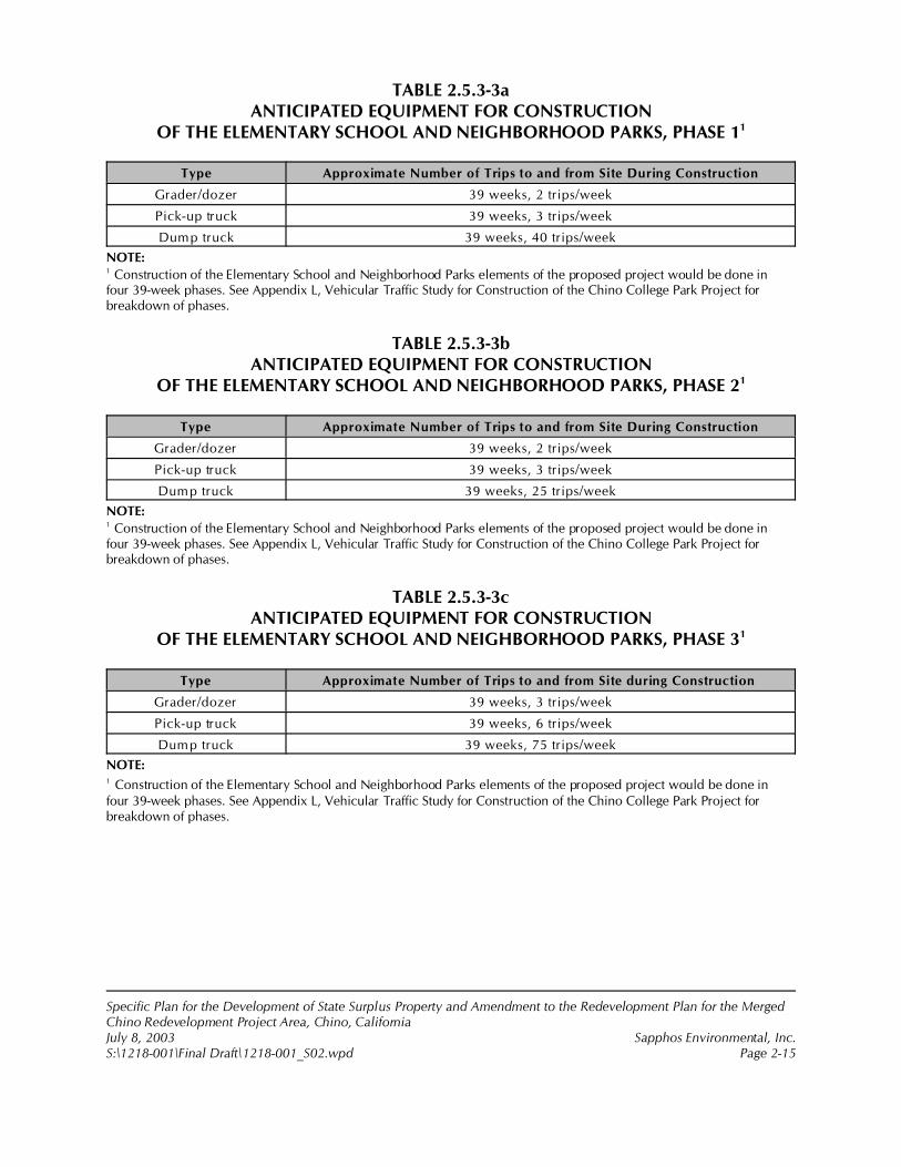
Specific Plan for the Development of State Surplus Property and Amendment to the Redevelopment Plan for the MergedChino Redevelopment Project Area, Chino, CaliforniaJuly 8, 2003 Sapphos Environmental, Inc.S:\1218-001\Final Draft\1218-001_S02.wpd Page 2-15
TABLE 2.5.3-3aANTICIPATED EQUIPMENT FOR CONSTRUCTION
OF THE ELEMENTARY SCHOOL AND NEIGHBORHOOD PARKS, PHASE 11
Type Approximate Number of Trips to and from Site During Construction
Grader/dozer 39 weeks, 2 trips/week
Pick-up truck 39 weeks, 3 trips/week
Dump truck 39 weeks, 40 trips/week
NOTE:1 Construction of the Elementary School and Neighborhood Parks elements of the proposed project would be done infour 39-week phases. See Appendix L, Vehicular Traffic Study for Construction of the Chino College Park Project forbreakdown of phases.
TABLE 2.5.3-3bANTICIPATED EQUIPMENT FOR CONSTRUCTION
OF THE ELEMENTARY SCHOOL AND NEIGHBORHOOD PARKS, PHASE 21
Type Approximate Number of Trips to and from Site During Construction
Grader/dozer 39 weeks, 2 trips/week
Pick-up truck 39 weeks, 3 trips/week
Dump truck 39 weeks, 25 trips/week
NOTE:1 Construction of the Elementary School and Neighborhood Parks elements of the proposed project would be done infour 39-week phases. See Appendix L, Vehicular Traffic Study for Construction of the Chino College Park Project forbreakdown of phases.
TABLE 2.5.3-3cANTICIPATED EQUIPMENT FOR CONSTRUCTION
OF THE ELEMENTARY SCHOOL AND NEIGHBORHOOD PARKS, PHASE 31
Type Approximate Number of Trips to and from Site during Construction
Grader/dozer 39 weeks, 3 trips/week
Pick-up truck 39 weeks, 6 trips/week
Dump truck 39 weeks, 75 trips/week
NOTE:1 Construction of the Elementary School and Neighborhood Parks elements of the proposed project would be done infour 39-week phases. See Appendix L, Vehicular Traffic Study for Construction of the Chino College Park Project forbreakdown of phases.

Specific Plan for the Development of State Surplus Property and Amendment to the Redevelopment Plan for the MergedChino Redevelopment Project Area, Chino, CaliforniaJuly 8, 2003 Sapphos Environmental, Inc.S:\1218-001\Final Draft\1218-001_S02.wpd Page 2-16
TABLE 2.5.3-3dANTICIPATED EQUIPMENT FOR CONSTRUCTION
OF THE ELEMENTARY SCHOOL AND NEIGHBORHOOD PARKS, PHASE 41
Type Approximate Number of Trips to and from Site During Construction
Grader/dozer 39 weeks, 2 trips/week
Pick-up truck 39 weeks, 3 trips/week
Dump truck 39 weeks, 25 trips/week
NOTE:1 Construction of the Elementary School and Neighborhood Parks elements of the proposed project would be done infour 39-week phases. See Appendix L, Vehicular Traffic Study for Construction of the Chino College Park Project forbreakdown of phases.
Infrastructure
The development of the 44-acre internal traffic circulation system and the 3-acre transit corridor would
require approximately 12 to 18 months to complete. A conceptual list of the type and quantity of
equipment that would potentially be used in the construction of the infrastructure has been identified
by the project management consultant and was used in the assessment of the potential impacts to air
quality, ambient noise levels, and traffic and circulation (Table 2.5.3-4a, Anticipated Equipment for
Construction of Infrastructure, Phase 1; Table 2.5.3-4b, Anticipated Equipment for Construction of
Infrastructure, Phase 2; Table 2.5.3-4c, Anticipated Equipment for Construction of Infrastructure, Phase
3; and Table 2.5.3-4d, Anticipated Equipment for Construction of Infrastructure, Phase 4).
TABLE 2.5.3-4aANTICIPATED EQUIPMENT FOR CONSTRUCTION
OF INFRASTRUCTURE, PHASE 11
Type Approximate Number of Trips to and from Site During Construction
Grader/dozer 39 weeks, 5 trips/week
Pick-up truck 39 weeks, 80 trips/week
Dump truck 39 weeks, 12 trips/week
Concrete mix truck 39 weeks, 208 trips/week
NOTE:1 Construction of the Infrastructure elements of the proposed project would be done in four 39-week phases. SeeAppendix L, Vehicular Traffic Study for Construction of the Chino College Park Project for breakdown of phases.
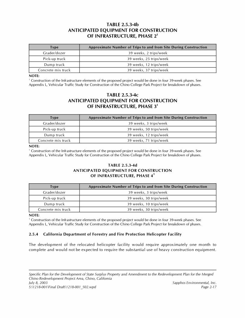
Specific Plan for the Development of State Surplus Property and Amendment to the Redevelopment Plan for the MergedChino Redevelopment Project Area, Chino, CaliforniaJuly 8, 2003 Sapphos Environmental, Inc.S:\1218-001\Final Draft\1218-001_S02.wpd Page 2-17
TABLE 2.5.3-4bANTICIPATED EQUIPMENT FOR CONSTRUCTION
OF INFRASTRUCTURE, PHASE 21
Type Approximate Number of Trips to and from Site During Construction
Grader/dozer 39 weeks, 2 trips/week
Pick-up truck 39 weeks, 25 trips/week
Dump truck 39 weeks, 12 trips/week
Concrete mix truck 39 weeks, 37 trips/week
NOTE:1 Construction of the Infrastructure elements of the proposed project would be done in four 39-week phases. SeeAppendix L, Vehicular Traffic Study for Construction of the Chino College Park Project for breakdown of phases.
TABLE 2.5.3-4cANTICIPATED EQUIPMENT FOR CONSTRUCTION
OF INFRASTRUCTURE, PHASE 31
Type Approximate Number of Trips to and from Site During Construction
Grader/dozer 39 weeks, 3 trips/week
Pick-up truck 39 weeks, 50 trips/week
Dump truck 39 weeks, 12 trips/week
Concrete mix truck 39 weeks, 71 trips/week
NOTE:1 Construction of the Infrastructure elements of the proposed project would be done in four 39-week phases. SeeAppendix L, Vehicular Traffic Study for Construction of the Chino College Park Project for breakdown of phases.
TABLE 2.5.3-4d
ANTICIPATED EQUIPMENT FOR CONSTRUCTION
OF INFRASTRUCTURE, PHASE 41
Type Approximate Number of Trips to and from Site During Construction
Grader/dozer 39 weeks, 3 trips/week
Pick-up truck 39 weeks, 30 trips/week
Dump truck 39 weeks, 10 trips/week
Concrete mix truck 39 weeks, 30 trips/week
NOTE:1 Construction of the Infrastructure elements of the proposed project would be done in four 39-week phases. SeeAppendix L, Vehicular Traffic Study for Construction of the Chino College Park Project for breakdown of phases.
2.5.4 California Department of Forestry and Fire Protection Helicopter Facility
The development of the relocated helicopter facility would require approximately one month to
complete and would not be expected to require the substantial use of heavy construction equipment.
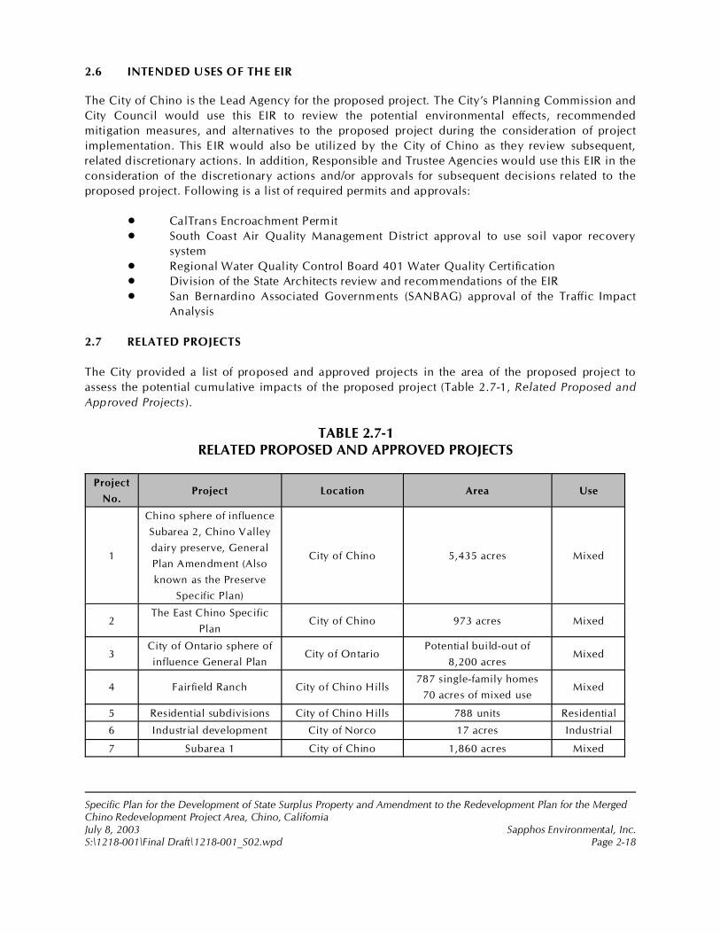
Specific Plan for the Development of State Surplus Property and Amendment to the Redevelopment Plan for the MergedChino Redevelopment Project Area, Chino, CaliforniaJuly 8, 2003 Sapphos Environmental, Inc.S:\1218-001\Final Draft\1218-001_S02.wpd Page 2-18
2.6 INTENDED USES OF THE EIR
The City of Chino is the Lead Agency for the proposed project. The City’s Planning Commission and
City Council would use this EIR to review the potential environmental effects, recommended
mitigation measures, and alternatives to the proposed project during the consideration of project
implementation. This EIR would also be utilized by the City of Chino as they review subsequent,
related discretionary actions. In addition, Responsible and Trustee Agencies would use this EIR in the
consideration of the discretionary actions and/or approvals for subsequent decisions related to the
proposed project. Following is a list of required permits and approvals:
• CalTrans Encroachment Permit
• South Coast Air Quality Management District approval to use soil vapor recovery
system
• Regional Water Quality Control Board 401 Water Quality Certification
• Division of the State Architects review and recommendations of the EIR
• San Bernardino Associated Governments (SANBAG) approval of the Traffic Impact
Analysis
2.7 RELATED PROJECTS
The City provided a list of proposed and approved projects in the area of the proposed project to
assess the potential cumulative impacts of the proposed project (Table 2.7-1, Related Proposed and
Approved Projects).
TABLE 2.7-1RELATED PROPOSED AND APPROVED PROJECTS
Project
No.Project Location Area Use
1
Chino sphere of influence
Subarea 2, Chino Valley
dairy preserve, General
Plan Amendment (Also
known as the Preserve
Specific Plan)
City of Chino 5,435 acres Mixed
2The East Chino Specific
PlanCity of Chino 973 acres Mixed
3City of Ontario sphere of
influence General PlanCity of Ontario
Potential build-out of
8,200 acresMixed
4 Fairfield Ranch City of Chino Hills787 single-family homes
70 acres of mixed useMixed
5 Residential subdivisions City of Chino Hills 788 units Residential
6 Industrial development City of Norco 17 acres Industrial
7 Subarea 1 City of Chino 1,860 acres Mixed
Specific Plan for the Development of State Surplus Property and Amendment to the Redevelopment Plan for the MergedChino Redevelopment Project Area, Chino, CaliforniaJuly 8, 2003 Sapphos Environmental, Inc.S:\1218-001\Final Draft\1218-001_S02.wpd Page 2-19
2.8 ALTERNATIVES
Section 15126(d) of the State CEQA Guidelines requires that an EIR ”describe a range of reasonable
alternatives to the project, or to the location of the project, which would feasibly attain most of the
basic objectives of the project, but would avoid or substantially lessen any of the significant effects of
the project, and evaluate the comparative merits of the alternatives.” As a result of the project
formulation process, the City, the CDGS, and Chaffey College explored alternatives to the proposed
project to assess their ability to meet most of the objectives of the project and reduce significant effects
of the project. Alternative projects recommended by the scoping process were evaluated in light of
the project objectives and their ability to reduce significant impacts as described in Section 4.0 of this
EIR. Three project alternatives required under CEQA have been carried forward for detailed analysis
in this EIR. The alternatives that were carried forward for detailed analysis included the following:
1. No Project Alternative
2. No College/Increased Open Space Alternative
3. Compact Project/Increased Open Space Alternative
4. Detention Pond Relocation Alternative
5. Flood Control Channel Configuration Alternative
These alternatives are described and analyzed in Section 4.0 of this EIR.
Specific Plan for the Development of State Surplus Property and Amendment to the Redevelopment Plan for the MergedChino Redevelopment Project Area, Chino, CaliforniaJuly 8, 2003 Sapphos Environmental, Inc.S:\1218-001\Final Draft\Intro_S00.wpd Page 3-1
SECTION 3.0REGULATORY FRAMEWORK, EXISTING CONDITIONS, IMPACTS,
MITIGATION, AND LEVEL OF SIGNIFICANCE AFTER MITIGATION
This section of the Environmental Impact Report (EIR) evaluates the potential for the Specific Plan forthe Development of State Surplus Property and Amendment to the Redevelopment Plan for the MergedChino Redevelopment Project Area, Chino, California (proposed project) to result in significant impactsto the environment as a result of the construction, operation, and maintenance of components of theproposed project. This section of the EIR provides a full scope of environmental analysis inconformance with the California Environmental Quality Act (CEQA).
As a result of preparation, circulation, and public review of the Initial Study, the City of Chino (City)determined that there was no substantial evidence that the proposed project would cause significantenvironmental impacts to land use and planning and mineral resources. These topics have receivedno further analysis. The analysis undertaken in the Initial Study identified the potential for the proposedproject to result in significant impacts to 14 environmental resource areas of the environment, requiringthe preparation of an EIR and the consideration of mitigation measures to avoid or minimize potentialadverse effects of the project. This EIR evaluates the potential for significant effects to occur to these14 environmental resources:
• Aesthetics• Agricultural Resources• Air Quality• Biological Resources• Cultural Resources• Geology and Soils• Hazards and Hazardous Materials• Hydrology and Water Quality• Noise• Population and Housing• Public Services• Recreation• Transportation/Traffic• Utilities and Service Systems
The scope of the environmental analysis undertaken in this EIR was defined by the questions listed inAppendix G of the State CEQA Guidelines. The applicable federal, state, and local statutes andregulations that govern individual environmental resources are discussed and will be considered bythe City in the decision-making process. The existing conditions portion of the analysis has beenprepared in accordance with the State CEQA Guidelines and includes a description of the environmentin the vicinity of the project as it currently exists, from both a regional and local perspective.
The analysis of environmental impacts includes significance thresholds (as defined in Appendix G ofthe State CEQA Guidelines), qualitative and quantitative evaluations of impacts, measures to avoid orminimize significant impacts, and the level of significance after mitigation. Mitigation measures werederived from public and agency input and state-of-the-practice engineering methods. The level ofsignificance after mitigation was evaluated in accordance with the thresholds of significance.
1 City of Chino, 19 July 2002c. Initial Study: Specific Plan for the Development of 717 Acres of State Surplus Propertyfrom the California Institution for Men (CIM), Chino, California. Contact: Community Development Department, 13220Central Avenue, Chino, CA 91710. Prepared by: Sapphos Environmental, Inc., 133 Martin Alley, Pasadena, CA 91105.
2 City of Chino, December 1990. General Plan: Conservation/Open Space Element. Contact: Community DevelopmentDepartment, 13220 Central Avenue, Chino, CA 91710.
Specific Plan for the Development of State Surplus Property and Amendment to the Redevelopment Plan for the MergedChino Redevelopment Project Area, Chino, CaliforniaJuly 8, 2003 Sapphos Environmental, Inc.S:\1218-001\Final Draft\Aesthetics_S01.wpd Page 3.1-1
3.1 AESTHETICS
As a result of the Initial Study,1 the City of Chino Community Development Department (City)determined that the Specific Plan for the Development of State Surplus Property and Amendment tothe Redevelopment Plan for the Merged Chino Redevelopment Project Area, Chino, California(proposed project) had the potential to result in impacts to aesthetics. Therefore, this issue has beencarried forward for detailed analysis in this Environmental Impact Report (EIR). This analysis wasundertaken to identify opportunities to avoid, reduce, or otherwise mitigate potential significantimpacts to aesthetics and identify potential alternatives.
The analysis of aesthetics includes a description of the regulatory framework that guides the decision-making process, existing conditions of the proposed project area, thresholds for determining if theproposed project would result in significant impacts, anticipated impacts, mitigation measures, and thelevel of significance after mitigation. The potential impacts to aesthetics have been analyzed inaccordance with the methodologies and information provided by the City of Chino General Plan2; sitereconnaissance undertaken on July 23, 2002, by Sapphos Environmental staff; and the characterizationof aesthetic resources contained in the California Department of Transportation (Caltrans) designationof scenic highways.
3.1.1 Regulatory Framework
Federal
Section 4(f) of the U.S. Department of Transportation Act of 1966
Section 4(f)–Protection of Publicly Owned Park, Recreation Area, Wildlife or Waterfowl Refuge, orLand from Historic Sites–was established in the U.S. Department of Transportation Act of 1966 to givecertain protection to publicly owned parks, recreation areas, wildlife and waterfowl refuges, and landfrom historic sites of national, state, or local significance. Section 4(f) requires that the federal agencymust show that there are no feasible or prudent alternatives to the uses of these areas. The proposedproject would not be expected to result in the conversion of existing publicly owned park or recreationareas, wildlife or waterfowl refuges, or lands from historic sites.
State
California Scenic Highway Program
California’s Scenic Highway Program preserves and protects scenic highway corridors from changesthat would diminish their aesthetic value. Caltrans designates scenic highway corridors. The nearest
3 California Department of Transportation, 28 March 2002. “The California Scenic Highway System: A List of Eligible (E)and Officially Designated (OD) Routes (By Route).” Available at: http://www.dot.ca.gov/hq/LandArch/scenic/schwy1.html.
4 City of Chino, December 1990.
5 Ibid
6 Ibid.
7 Ibid.
Specific Plan for the Development of State Surplus Property and Amendment to the Redevelopment Plan for the MergedChino Redevelopment Project Area, Chino, CaliforniaJuly 8, 2003 Sapphos Environmental, Inc.S:\1218-001\Final Draft\Aesthetics_S01.wpd Page 3.1-2
eligible state-designated scenic highways and routes to the proposed project site are State Highway 71(Chino Valley Freeway), State Highway 91 (Riverside Freeway), State Highway 142 (Chino HillsParkway), and State Highway 57 (Orange Freeway).3
Local
City of Chino General Plan
The proposed project would be under the jurisdiction of the City of Chino General Plan.4 TheConservation/Open Space element of the General Plan5 includes the policies “to maintain vistas toensure that vista of the San Bernardino and San Gabriel Mountains and the Chino Hills are maintainedfor aesthetic enjoyment by City residents“ and “to encourage the designation of State Highway 71(Corona Expressway) and State Route 83 (Euclid Avenue) from north to south city limits, respectively,as scenic highway corridors.”
3.1.2 Existing Conditions
Scenic Vistas
The proposed project area lies within the City of Chino in the Chino Valley. Chino is located insouthwestern San Bernardino County and is surrounded by the San Gabriel and San BernardinoMountains to the north, the San Jacinto Mountains to the east, the Santa Ana Mountains to the south,and the Chino Hills to the west. Elevations of the mountain ranges are from 4,000 to 11,000 feet abovemean sea level (MSL). Because Chino is relatively flat (600!900 feet in elevation) and is void of specialwater features, including lakes and rivers, the major scenic beauty are the local mountains.6
State-Designated Scenic Highways
The nearest state-designated scenic highway is State Highway 91 (Riverside Freeway),7 locatedapproximately 11 miles southwest of the proposed project site (see Section 3.1, Figure 3.1.2-1, Eligibleand Officially Designated State Scenic Highways). The proposed project site is not visible from a statescenic highway.
Specific Plan for the Development of State Surplus Property and Amendment to the Redevelopment Plan for the MergedChino Redevelopment Project Area, Chino, CaliforniaJuly 8, 2003 Sapphos Environmental, Inc.S:\1218-001\Final Draft\Aesthetics_S01.wpd Page 3.1-3
The nearest eligible state-designated scenic highways and routes from the proposed project site areState Highway 71 (Chino Valley Freeway), State Highway 91(Riverside Freeway), State Highway 142(Chino Hills Parkway), and State Highway 57 (Orange Freeway) (Figure 3.1.2-1). The portion of ChinoValley Freeway that is eligible for designation is located approximately 6 miles south of the proposedproject site. The portion of Riverside Freeway that is eligible for designation is located approximately10 miles south of the proposed project site. The portion of Chino Hills Parkway that is eligible fordesignation is located approximately 3 miles southwest of the proposed project site. The portion ofOrange Freeway that is eligible for designation is located approximately 8 miles west of the proposedproject site. The proposed project site is not visible from any of these eligible state-designated scenichighway (Figure 3.1.2-1).
Visual Character
The proposed project site is predominantly open agricultural fields, except for the northwestern corner,which is developed as a regional park, a golf driving range, and a Young Men's Christian Association(YMCA) facility (Figure 3.1.2-2, Existing Visual Character). These uses occupy about 70 acres, including40 acres of regional park fields and parking and 30 acres occupied by the YMCA building and a golfdriving range and their associated parking. In addition, there is a helicopter pad serving the CaliforniaDepartment of Forestry operations. There are appurtenant farm buildings, including a tractor barn andhorse barn toward the center of the proposed project area.
Two drain facilities cross the site from north to south. Cypress channel is a concrete lined structureoccupying about 15 acres in the eastern area, and the Magnolia ditch (also known as the Sand Ranchditch), an earth ditch of about 3 acres, is located near the center of the proposed project area.
A 200-foot-wide Southern California Edison Easement (of approximately 42 acres) with associatedpower poles and structures is located along Edison Avenue between Central and Magnolia Avenuewhere it turns south and extends across the southern property boundary. In the Southern CaliforniaEdison corridor along Edison Avenue from Central Avenue to the east of Ayala Park, there are two 66-kV and two 22-kV pole lines. On the north side of Edison Avenue at the same location is a 66-kVpower line. The facility running north and south through the property is an easement with a 22-kVtower facility and a 66-kV line on wood poles just to the west side of the tower line. A potable watertreatment plant is located in the north central portion of the proposed project site. Due to its height incomparison to the relatively flat surrounding land uses, this structure visually dominates the area.
Immediately adjacent to the southern project boundary are the California Institution for Men (CIM)facilities. The area is composed of the correctional buildings and associated infrastructure, facilitiesrelated to the dairy and farm operations, and agricultural land. The CIM correctional facility issurrounded by elevated watch towers and fencing used for security purposes. In general, the CIMfacilities can be characterized as utilitarian in nature and design. The developed area is devoid oflandscaping or other aesthetic enhancements creating significant visual impacts.
Light and Glare
Existing sources of light and glare in the proposed project area are residential lighting in thesurrounding neighborhoods; light sources from the CIM site; light sources from the existing ball fields
8 Ibid.
9 Ibid.
Specific Plan for the Development of State Surplus Property and Amendment to the Redevelopment Plan for the MergedChino Redevelopment Project Area, Chino, CaliforniaJuly 8, 2003 Sapphos Environmental, Inc.S:\1218-001\Final Draft\Aesthetics_S01.wpd Page 3.1-4
at the park; street lighting at intersections; and vehicular traffic along Edison Avenue to the north,Euclid Avenue to the east, and Central Avenue to the West.
3.1.3 Significance Thresholds
The California Environmental Quality Act (CEQA) Guidelines recommend that impacts to aestheticsnormally are considered to be significant when the proposed project exceeds one of four thresholds:
• Results in a substantial adverse effect on a scenic vista• Substantially damages scenic resources, including but not limited to trees, rock
outcrops, and historic buildings within a state scenic highway• Substantially degrades the existing visual character or quality of the site and its
surroundings• Creates a new source of light or glare that would adversely affect daytime or nighttime
views in the area
3.1.4 Impacts
As a result of the Initial Study, the City determined that the proposed project would be expected toresult in potentially significant impacts to aesthetics related to scenic vistas, visual character, and anincrease in light and glare greater than 10 percent. The proposed project would not be expected toresult in significant impacts to state-designated scenic highways.
Scenic Vistas
Direct Impacts
The proposed project would potentially result in significant direct impacts to aesthetics related to thedegradation of scenic vistas and, therefore, would require the consideration of mitigation measures.The Conservation/Open Space element of the Chino General Plan,8 Policy P5-16.1, is designed toensure that vistas of the San Bernardino and San Gabriel Mountains to the north of the proposedproject site and the Chino Hills to the east of the proposed project site are maintained for aestheticenjoyment by City of Chino residents. The major scenic beauty within the City of Chino are the localmountains.9 There is a potential for impacts to aesthetics related to the development of the proposedChaffey Community College Campus and the retail/mixed-use component of the master-plannedcommunity by structures within this area that may disrupt the view of scenic vistas, including viewsof the San Bernardino and San Gabriel Mountains and the Chino Hills as shown in Figure 2.4-1,Conceptual Site Plan, residential communities would be located just east and southeast of theretail/mixed-use area of the master-planned community and Chaffey College components of theproposed project. Development of the retail/mixed use area and Chaffey College would thereforepotentially disrupt the scenic vistas of the Chino Hills to the west of the proposed project site of the
10 Ibid.
Specific Plan for the Development of State Surplus Property and Amendment to the Redevelopment Plan for the MergedChino Redevelopment Project Area, Chino, CaliforniaJuly 8, 2003 Sapphos Environmental, Inc.S:\1218-001\Final Draft\Aesthetics_S01.wpd Page 3.1-5
residential communities proposed as well as the existing residential communities located east of theproposed project site. City design standards of the proposed structures must be established to protectthe views of the scenic vistas. Implementation of the proposed project would potentially result insignificant impacts to aesthetics related to the degradation of scenic vistas, therefore requiring theconsideration of mitigation measures.
Indirect Impacts
Implementation of the proposed project would not result in significant indirect impacts to aestheticsrelated to the degradation of scenic vistas. Implementation of the proposed project would not beexpected to contribute to additional construction of new facilities having the potential to degradescenic vistas, but rather potentially improve the scenic vistas. The proposed project would improve andexpand the Ruben Ayala Park. Furthermore, the implementation of the proposed project would resultin a significant increase in landscaped areas, which would provide a buffer between the dull utilitarianarchitecture of the CIM facilities and the surrounding areas.
State-Designated Scenic Highways
Direct and Indirect Impacts
The proposed project would not be expected to result in significant direct or indirect impacts toaesthetics related to state-designated scenic highways because the nearest state-designated highwayis State Highway 91 (Riverside Freeway),10 located approximately 11 miles southwest of the proposedproject site. The proposed project site is not visible from the Riverside Freeway. The nearest eligiblestate-designated scenic highway from the proposed project site is State Highway 142 (Chino HillsParkway). The portion of Chino Hills Parkway that is eligible for designation is located approximately3 miles southwest of the proposed project site. The proposed project site is not visible from the ChinoHills Parkway.
Visual Character
Direct Impacts
The proposed project would be expected to result in potentially significant direct impacts to aestheticsrelated to visual character requiring the consideration of mitigation measures. The conversion of vacantland would be an alteration of the existing visual character. The proposed project site currentlycontains a 70-acre recreational area, an 8.4-acre water treatment plant, a 1.5-acre Southern CaliforniaEdison Company easement, a 1.9-acre Gas Company easement, a 4.7-acre Cypress Flood Controleasement, and open fields used for agriculture. The proposed project would convert the predominantlyrural landscape character to a small-town character. The proposed project site is located at an elevationof 575 to 685 feet above MSL. The topography of the proposed project site can be described asrelatively flat, with a gentle overall slope of 2 percent from the north-northeast to the south-southwest.This topography does not create any natural berms within the proposed project site, which would
Specific Plan for the Development of State Surplus Property and Amendment to the Redevelopment Plan for the MergedChino Redevelopment Project Area, Chino, CaliforniaJuly 8, 2003 Sapphos Environmental, Inc.S:\1218-001\Final Draft\Aesthetics_S01.wpd Page 3.1-6
effectively reduce visibility from any of the adjacent publicly accessible vantage points, includingEdison Avenue to the north and Euclid Avenue to the east. Implementation of the proposed project hasthe potential to result in significant impacts to aesthetics through the substantial degradation of theexisting visual character of the site and its surroundings, therefore requiring the consideration ofmitigation measures related to construction specifications, landscaping, and operations to reduce theimpacts to below the level of significance.
Indirect Impacts
The proposed project would not be expected to result in significant indirect impacts to aestheticsrelated to visual character. Implementation of the proposed project would not contribute to theadditional conversion of vacant land outside the project boundaries.
Light and Glare
Direct Impacts
The proposed project would be expected to result in potentially significant direct impacts to aestheticsrelated to the increase of light and glare greater than 10 percent. Implementation of the proposedproject would potentially have a significant impact on day and night views in the area due to a newsource of substantial light or glare. The proposed project would create new sources of substantial lightfrom the operation of nine additional lighted soccer fields and one lighted championship soccer field,as well as any other additional lighting required for construction and maintenance of the additionalcomponents associated with the proposed Ruben S. Ayala Community Park expansion. New sourcesof light would also be created by the commercial, educational, residential, and recreationaldevelopment within existing vacant lands.
The proposed project site is located at an elevation of 575 to 685 feet above MSL. The topography ofthe proposed project site can be described as relatively flat, with a gentle overall slope of 2 percentfrom the north-northeast to the south-southwest. This topography does not create any natural bermswithin the proposed project site, which would effectively reduce visibility from any of the adjacentpublicly accessible vantage points, including Edison Avenue to the north and Euclid Avenue to theeast. Therefore, the new light and glare sources would be visible for 24 hours a day. Additionalmitigation measures related to location, construction specifications, and operations of the proposedlight sources would be necessary to reduce the impacts to below the level of significance.
Indirect Impacts
Implementation of the proposed project would not result in significant indirect impacts to aestheticsrelated to light and glare. Implementation of the proposed project would not be expected to contributeto additional construction of new facilities utilizing new sources of light and glare.
Specific Plan for the Development of State Surplus Property and Amendment to the Redevelopment Plan for the MergedChino Redevelopment Project Area, Chino, CaliforniaJuly 8, 2003 Sapphos Environmental, Inc.S:\1218-001\Final Draft\Aesthetics_S01.wpd Page 3.1-7
3.1.5 Cumulative Impacts
The potential for cumulative impacts to aesthetics was evaluated in relation to the closely related past,present, or reasonable foreseeable and probable future projects described in Table 2.7-1, RelatedProposed and Approved Projects, in Section 2.7 of this EIR.
The proposed project would not result in cumulative impacts to aesthetics when considered inconjunction with related projects. As with the proposed project, the City of Chino, City of Ontario, Cityof Chino Hills, and City of Norco projects involve development that would potentially result in impactsto aesthetics; however, due to the vicinity of the other development projects to the proposed projectarea, the proposed project will result in cumulative impacts when considered in conjunction with theother projects.
3.1.6 Mitigation Measures
Aesthetics-1
The Chaffey Community College and the private developer shall require that new facilities constructedas a result of the proposed Chaffey Community College component and the retail/mixed-use elementof the master-planned community components of the proposed project adhere to the City’s municipalCode Title 20, zoning code for commercial zoning districts as a means of reducing the disruption ofscenic vistas. Prior to completion of final plans and specifications, the City of Chino CommunityDevelopment Department shall review the plans and specifications to ensure that new facilities adhereto the zoning code and any other applicable City regulations pertaining to the disruption of scenicvistas. Completion of this measure shall be monitored and enforced by the Chaffey Community Collegefor the College component of the proposed project and the private developer for the retail/mixed-useelement of the master-planned community component of the proposed project.
Aesthetics-2
The City of Chino Community Development Department, Chaffey Community College, and the privatedeveloper shall require that new facilities constructed as a result of the proposed recreational,educational, residential, retail/mixed-use and infrastructure components of the proposed project adhereto the City’s municipal Code Title 20, zoning code for commercial zoning districts and residentialzoning districts, as a means of reducing adverse effects to visual character and the associated impactsto aesthetics. The City of Chino Community Development Department shall review the plans andspecifications to ensure that new facilities adhere to the zoning code and any other applicable Cityregulations pertaining to the integration of new construction into the existing visual character of thesurrounding area, or a comparable measure that meets the standard or equivalent. Completion of thismeasure shall be monitored and enforced by the City of Chino Community Development Departmentfor the residential component of the proposed project, Chaffey Community College for the Collegecomponent of the proposed project, and the private developer for the master-planned communitycomponent of the proposed project.
Specific Plan for the Development of State Surplus Property and Amendment to the Redevelopment Plan for the MergedChino Redevelopment Project Area, Chino, CaliforniaJuly 8, 2003 Sapphos Environmental, Inc.S:\1218-001\Final Draft\Aesthetics_S01.wpd Page 3.1-8
Aesthetics-3
The potential increase in the amount of light and glare produced due to implementation of therecreation component of the proposed project, the Chaffey College component of the proposedproject, and the master-planned community component of the proposed project shall be reduced tobelow the threshold for significance by mandating the design type of the light fixtures, light standardheight, and light fixture and standard orientation. Prior to completion of final plans and specifications,the City of Chino Community Development Department, Chaffey Community College, and the privatedeveloper of the master-planned community shall submit the lighting plans and specifications to theCity of Chino Public Works Department for review to ensure that all light fixtures shall use glare-control visors, arc tube suppression caps, and a photometric design that maintains 70 percent of thelight intensity in the lower half of the light beam, or comparable design or technology, to achieve thosecriteria. Completion of this measure shall be monitored and enforced by the Chino CommunityDevelopment Department for the recreational component of the proposed project, Chaffey CommunityCollege for the College component of the proposed project, and the private developer for the master-planned community component of the proposed project.
3.1.7 Level of Significance after Mitigation
After the implementation of proposed mitigation measures, impacts in regards to aesthetics would bereduced to less than significant levels.

1 City of Chino, 19 July 2002c. Initial Study: Specific Plan for the Development of 717 Acres of State Surplus Property fromthe California Institution for Men (CIM), Chino, California. Contact: Community Development Department, 13220 CentralAvenue, Chino, CA 91710. Prepared by: Sapphos Environmental, Inc., 133 Martin Alley, Pasadena, CA 91105.
2 City of Chino, 6 October 1981. General Plan: Land Use Element. Contact: Community Development Department, 13220Central Avenue, Chino, CA 91710.
3 City of Chino, December 1990. General Plan: Conservation/Open Space Element. Contact: Community DevelopmentDepartment, 13220 Central Avenue, Chino, CA 91710.
4 California Department of Conservation, Farmland Mapping and Monitoring Program, December 2001. “San BernardinoCounty Important Farmland Map 2000 (Sheet 2 of 2),” Important Farmland Maps. Contact: 801 K Street, MS13-71,Sacramento, CA 95814.
5 California Department of Conservation, Farmland Mapping and Monitoring Program, 1 August 1995. Soil Candidate Listingfor Prime Farmland and Farmland of Statewide Importance, San Bernardino County. Contact: Natural Resources ConservationService. Available at: http://www.consrv.ca.gov/dlrp/fmmp/pubs/soils/sanberna.pdf.
6 California Department of Conservation, 1997. California Agricultural Land Evaluation and Site Assessment Model, InstructionManual. Contact: California Department of Conservation, Division of Land Resource Protection, 801 K Street, MS 13-71,Sacramento, CA 95814-3528.
7 U.S. Department of Agriculture, Natural Resources Conservation Service, January 1980. Soil Survey of San BernardinoCounty, Southwestern Part, California. Contact: State Conservationist, U.S. Natural Resources Conservation Service, 430 GStreet #4164, Davis, CA 95616-4164.
Specific Plan for the Development of State Surplus Property and Amendment to the Redevelopment Plan for the MergedChino Redevelopment Project Area, Chino, CaliforniaJuly 8, 2003 Sapphos Environmental, Inc.S:\1218-001\Final Draft\Agriculture_S02.wpd Page 3.2-1
3.2 AGRICULTURAL RESOURCES
As a result of the Initial Study,1 the City of Chino Community Development Department (City)determined that the Specific Plan for the Development of State Surplus Property and Amendment tothe Redevelopment Plan for the Merged Chino Redevelopment Project Area, Chino, California(proposed project) had the potential to result in impacts to agricultural resources. Therefore, this issuehas been carried forward for detailed analysis in this Environmental Impact Report (EIR). This analysiswas undertaken to identify opportunities to avoid, reduce, or otherwise mitigate potential significantimpacts to agricultural resources and identify potential alternatives.
The analysis of agricultural resources consists of a summary of the regulatory framework that guidesthe decision-making process, existing conditions of the proposed project site, thresholds fordetermining if the proposed project would result in significant impacts, anticipated impacts (direct,indirect, and cumulative), mitigation measures, and the level of significance after mitigation. Thepotential impacts to agricultural resources have been analyzed in accordance with the methodologiesand information provided by the City of Chino General Plan;2,3 the California Department ofConservation, Farmland Mapping and Monitoring Program;4,5 the California Agricultural LandEvaluation and Site Assessment Model;6 the U.S. Geological Survey, Natural Resources ConservationService;7 and other relevant documents.
Specific Plan for the Development of State Surplus Property and Amendment to the Redevelopment Plan for the MergedChino Redevelopment Project Area, Chino, CaliforniaJuly 8, 2003 Sapphos Environmental, Inc.S:\1218-001\Final Draft\Agriculture_S02.wpd Page 3.2-2
3.2.1 Regulatory Framework
Federal
Farmland Protection Policy Act
The Farmland Protection Policy Act (FPPA) of 1980 and 1995 requires identification of proposedactions that would affect any lands classified as Prime and Unique Farmlands. The U.S. Departmentof Agriculture Natural Resources Conservation Service (NRCS; formerly Soil Conservation Service)administers this act to preserve these Farmlands. Prime Farmland, Farmland of Statewide Importance,Unique Farmland, and Farmland of Local Importance are collectively referred to as Farmland, with acapital letter F, and only includes farmland that meets certain criteria, which are described below inSection 3.2.2, Existing Conditions.
State
Farmland Monitoring and Mapping Program
The Farmland Monitoring and Mapping Program (FMMP) was established in 1982 by the CaliforniaDepartment of Conservation as a non-regulatory program to provide consistent and impartial analysisof agricultural land use and land use changes throughout the State of California (State). Prime Farmland,Farmland of Statewide Importance, Unique Farmland, and Farmland of Local Importance aregraphically presented on Important Farmland Maps, published biannually by the California Departmentof Conservation. Important Farmland Maps combine analysis of resource quality (soils) and land useinformation. They cover areas where there are existing U.S. Department of Agriculture NRCS modernsoil surveys. Important Farmland Maps show categories of Prime Farmland, Farmland of StatewideImportance, Unique Farmland, Farmland of Local Importance (if adopted by the County), GrazingLand, Urban and Built-Up Land, Other Land, and Water. Prime Farmland and Farmland of StatewideImportance map categories are based on qualifying soil types, as determined by NRCS, as well ascurrent land use (irrigated agriculture). Soil units qualifying for these two categories, Prime Farmlandand Farmland of Statewide Importance, are provided by the U.S. Department of Agriculture NRCS. Theproposed project site contains both Prime Farmland and Farmland of Statewide Importance.
California Land Conservation Act of 1965
The California Land Conservation Act of 1965 (also known as the Williamson Act) allows localgovernments to enter into contracts with private landowners to restrict certain parcels of land toagricultural or related open space use for 10 years or more. The landowners will subsequently receivea tax break by having property tax assessments be set lower than normal because they would be basedon agricultural and related land uses as opposed to full market value. Under the Open SpaceSubvention Act of 1971, local governments receive an annual subvention of forgone property taxrevenues. Therefore, a parcel of land under a Williamson Act contract cannot be converted to non-agricultural use for a minimum of 10 years. To be eligible, the land must be designated by a city orcounty as an agricultural preserve, scenic highway corridor, or wildlife habitat area, or it must beactively used for the 3 years immediately preceding the beginning of the contract as a salt pond,managed wetland, or recreational or open space area.

8 Southern California Association of Governments, 1998. Regional Comprehensive Plan and Guide. Contact: SouthernCalifornia Association of Governments, 818 West Seventh Street, 12th Floor (Main Office), Los Angeles, CA 90017.
9 City of Chino, 6 October 1981.
10 City of Chino, December 1990.
11 Ibid.
12 Ibid.
Specific Plan for the Development of State Surplus Property and Amendment to the Redevelopment Plan for the MergedChino Redevelopment Project Area, Chino, CaliforniaJuly 8, 2003 Sapphos Environmental, Inc.S:\1218-001\Final Draft\Agriculture_S02.wpd Page 3.2-3
Regional
Regional Comprehensive Plan and Guide
The Southern California Association of Governments (SCAG) provides goals for open spaceconservation that include the protection of agricultural resources. The Regional Comprehensive Planand Guide8 focuses on four major types of open space areas, one being Resource Production. Theseare areas within an open space area that are designed for the production of crops, fisheries, timber, andmineral resources. To support and ensure a high quality of life and equity for Southern Californiaresidents, goals have been established for each of the open space areas. The goal of ResourceProduction is to maintain adequate viable resource production lands, particularly lands devoted tocommercial, agricultural, and mining operations.
Local
City of Chino General Plan
The Land Use element9 of the City General Plan provides policies to maintain and foster the City’s ruralagricultural heritage, and the Conservation/Open Space element10 identifies the policy to encouragebuffer zones that minimize conflict between agricultural and non-agricultural areas. In addition, theConservation/Open Space element11 addresses the policy of continued agricultural production withan action to support California Institution for Men (CIM) activities that encourage continued agriculturalpractices on CIM property. However, the City recognizes that much of the land used for intenseagricultural production will probably transition to urban uses12 in response to the need for housing andother development with continued population growth in the City of Chino.
City of Chino Redevelopment Plan
The City of Chino Redevelopment Plan (Redevelopment Plan) includes the Central City RedevelopmentProject Area and the City of Chino Redevelopment Project Area No. 2. The proposed project area isincluded in the City of Chino Redevelopment Project Area No. 2, and the Redevelopment Plan hasbeen prepared to eliminate and prevent the spread of blight and deterioration in the redevelopmentarea. The primary blighting condition in Project Area No. 2 is “underutilization of land to the extentthe City (of Chino) faced a serious physical and economic burden that private enterprise alone couldnot reasonably reverse or alleviate.” The primary goals of the Redevelopment Plan most relevant to the
13 City of Chino Redevelopment Agency, February 2000. Report to Council; Merger Amendment, Chino RedevelopmentAgency. Prepared by: The Davis Company, 11150 Santa Monica Blvd., Suite 200, Los Angeles, CA 90025. Prepared for: Cityof Chino Redevelopment Agency, 13220 Central Avenue, Chino, CA 91710.
14 City of Chino Redevelopment Agency, Amended 20 December 1994. Redevelopment Plan for Chino RedevelopmentProject Area No. 2, City of Chino, California. Contact: City of Chino Redevelopment Agency, 13220 Central Avenue, Chino,CA 91710.
15 California Department of Conservation, Farmland Mapping and Monitoring Program, December 2001.
16 Ibid.
17 California Department of Conservation, Farmland Mapping and Monitoring Program, 1 August 1995.
18 Jay Madsen, Personal Communication, 21 October 2002. Prison Industry Authority, 560 East Natoma Street, Folsom, CA95630-2200.
19 California Department of Conservation, Farmland Mapping and Monitoring Program, December 2001.
Specific Plan for the Development of State Surplus Property and Amendment to the Redevelopment Plan for the MergedChino Redevelopment Project Area, Chino, CaliforniaJuly 8, 2003 Sapphos Environmental, Inc.S:\1218-001\Final Draft\Agriculture_S02.wpd Page 3.2-4
proposed project, particularly the analysis of agricultural resources, are to improve the quality of lifein existing and future developments and to develop and enhance affordable housing.13,14
3.2.2 Existing Conditions
Important Farmland
The most recent San Bernardino County Important Farmland Map15 indicates that the proposed projectarea supports a total of approximately 607 acres of Farmland, including both Prime Farmland andFarmland of Statewide Importance (Figure 3.2.2-1, Important Farmland Map).16 These designations arebased, in part, on the soil types present; Chino silt loam (Cb) and Merrill silt loam (Me) meet the criteriafor Prime Farmland and Farmland of Statewide Importance, respectively.17 In addition, approximately60 acres are designated Urban and Built-Up Land, and approximately 50 acres are designated OtherLand, which includes land that does not meet the criteria of any other category. Of the 607 acres ofFarmland present, the proposed project area contains approximately 571 acres of Farmland previouslyused for agricultural purposes as part of the Prison Industries training and rehabilitation program. Theremaining approximately 36 acres is included in Southern California Edison easements and othernonagricultural uses. The proposed project area was declared as surplus property in 2002. Since thattime, agricultural activities performed by CIM have been restricted to planting of Sudan grass inselected fields for dust control and weed abatement through discing, or turning of the soil.18
The CIM property to the south of the proposed project area is partially composed of Farmland, andthere are three areas designated as Farmland adjacent to the northern and eastern boundaries of theproposed project. The majority of the surrounding lands are designated as Urban and Built-Up Landor Other Land (Figure 3.2.2-1).19 It should be noted that the designation of Farmland on an ImportantFarmland Map does not always correspond to actual land use designations or city zoning ordinancesdue to changes in local land uses that are not reflected in the biannual updates of the ImportantFarmland Maps. Therefore, based on a comparison of actual land uses in the City and the Important
20 Ibid.
21 City of Chino, December 1990.
22 Sal Salazar, Personal Communication, October 2002. Principal Planner, City of Chino, P.O. Box 667, Chino, CA 91708-0667.
23 Tiffany Williams, Personal Communication, 30 October 2002. City of Ontario Planning Department, 303 East “B” Street,Ontario, CA 91764.
24 City of Chino, December 2000. Official Zoning Map. Contact: Community Development Department, 13220 CentralAvenue, Chino, CA 91710.
Specific Plan for the Development of State Surplus Property and Amendment to the Redevelopment Plan for the MergedChino Redevelopment Project Area, Chino, CaliforniaJuly 8, 2003 Sapphos Environmental, Inc.S:\1218-001\Final Draft\Agriculture_S02.wpd Page 3.2-5
Farmland Map,20 the only parcels of adjacent Farmland that are used for agricultural production arethose located within the CIM property.
Williamson Act Contracts and Zoning
There are no Williamson Act contracts within the proposed project area.21 In addition, there are noactive contracts within the proposed project vicinity.22
The proposed project site is zoned Open Space as part of an Agriculture, Open Space, and GreenSpace Zoning District. The proposed project site is surrounded to the north and west by Residentialand Industrial Zoning Districts. The proposed project area is bounded on the east by the City ofOntario. The City of Ontario lands adjacent to the proposed project contain residential and commercialland use designations as part of the New Model Colony project.23 The remaining CIM property,bounding the proposed project site on the south, is also zoned Open Space. The nearest parcel zonedfor general agricultural use is located at the southeast corner of Kimball Avenue and Magnolia Avenueapproximately 1.25 miles south of the proposed project site adjacent to the southern boundary of theCIM property.24
3.2.3 Significance Thresholds
The potential for the proposed project to result in impacts related to agricultural resources wasanalyzed in relation to the questions contained in Appendix G of the State CEQA Guidelines:
The proposed project is normally considered to have a significant impact to agricultural resourceswhen any one of three thresholds occurs:
• The conversion of Prime Farmland, Unique Farmland, or Farmland of StatewideImportance (Farmland) to non-agricultural use that meets or exceeds the CaliforniaAgricultural Land Evaluation and Site Assessment (LESA) Model Scoring Thresholds forsignificant impacts
• A conflict with existing zoning for agricultural use, or a Williamson Act contract

25 California Department of Conservation, 1997.
Specific Plan for the Development of State Surplus Property and Amendment to the Redevelopment Plan for the MergedChino Redevelopment Project Area, Chino, CaliforniaJuly 8, 2003 Sapphos Environmental, Inc.S:\1218-001\Final Draft\Agriculture_S02.wpd Page 3.2-6
• An involvement with other changes in the existing environment that, due to theirlocation or nature, could result in conversion of Farmland to non-agricultural use
California Agricultural Land Evaluation and Site Assessment Model
The California LESA Model,25 developed in 1997 by the California Department of Conservation, is astatistical model for rating the relative importance of agricultural land resources based on specificmeasurable features of Farmland, such as soil classification, project size, and water availability. TheCalifornia LESA Model was created to provide lead agencies in the State with a methodology to ensureany impacts to agricultural resources are quantitatively and consistently analyzed, and is divided intotwo major subsections: Land Evaluation and Site Assessment. It is cited in Appendix G of the StateCEQA Guidelines as the preferred tool for lead agency decision making. The California LESA Modelproduces a single numerical score that is compared with scoring thresholds to make a determinationof significance (Table 3.2.3-1, California LESA Model Scoring Thresholds).
TABLE 3.2.3-1CALIFORNIA LESA MODEL SCORING THRESHOLDS
Total LESA Score Scoring Decision
0 to 39 points Not considered significant
40 to 59 points Considered significant only if Land Evaluation and Site Assessment
subscores are each greater than or equal to 20 points
60 to 79 points Considered significant unless either Land Evaluation or Site Assessment
subscore is less than 20 points
80 to 100 points Considered significant
SOURCE: California Department of Conservation, 1997. California Agricultural Land Evaluation and Site Assessment Model,Instruction Manual. Contact: California Department of Conservation, Division of Land Resource Protection, 801 K Street, MS13-71, Sacramento, CA 95814-3528.
3.2.4 Impacts
Important Farmland
Direct
The proposed project would be expected to result in significant direct impacts to approximately 607acres of Farmland, requiring the consideration of mitigation measures and alternatives. The CaliforniaLESA Model yielded a score of 63.25 (Land Evaluation subscore: 41.0; Site Assessment subscore:22.25), which is considered a significant impact based on the above listed criteria. The proposedproject includes the construction of an 8-foot-high block wall along the southern boundary of the
Specific Plan for the Development of State Surplus Property and Amendment to the Redevelopment Plan for the MergedChino Redevelopment Project Area, Chino, CaliforniaJuly 8, 2003 Sapphos Environmental, Inc.S:\1218-001\Final Draft\Agriculture_S02.wpd Page 3.2-7
proposed project site. This wall would act as a buffer from the adverse effects of an agricultural-urbanland use interface; however, the impacts to agricultural resources related to conversion of Farmlandwould remain significant.
Indirect
The proposed project would not result in indirect impacts to Farmland. Indirect impacts would resultfrom the additional conversion of Farmland later in time or at a distance from the proposed project site.Indirect impacts to Farmland generally result from land use changes that can reduce the economicviability of continued agricultural production, thereby encouraging the premature conversion ofFarmland, and primarily include either the installation of new or expanded infrastructure and/or thecreation of an agricultural-urban interface. The proposed project site is surrounded by urban land useswith the exception of the remaining CIM property to the south, which is composed of Prime andUnique Farmland currently in agricultural production. Therefore, the analysis of indirect impacts toagricultural resources from implementation of the proposed project will concentrate on these lands.
The proposed project would include the development of further infrastructure, such as interior roads,sanitary sewer and storm water systems, and water supply lines. However, the proposed project siteand remaining CIM property are already developed for residential, commercial, and industrial landuses on almost all sides, contributing to the presence of considerable existing infrastructure, includinga Southern California Edison Company easement that transects the whole of the CIM facility. There areextensive roadways present in the vicinity of the proposed project site and remaining CIM property,including primary thoroughfares along the boundaries. Therefore, further infrastructure developmentwould not result in significant indirect impacts to Farmland.
An agricultural-urban interface zone would be present at the southern boundary of the proposedproject site. However, this does not constitute a significant impact as an agricultural-urban interfaceis currently present on all sides of the existing CIM facility. Implementation of the proposed projectwould move, rather than create, an interface between these two land uses. The movement of theinterface to the south would not indirectly enhance the suitability of the Farmland within the CIMfacility for future development; therefore, there is no impact.
Due to widespread urban development in the proposed project vicinity, land use changes related tothe implementation of the proposed project would not appreciably contribute to the conversion ofFarmland in the remaining CIM property. Therefore, there would be no indirect impacts to agriculturalresources.
Williamson Act Contracts and Zoning
Direct and Indirect
The proposed project would not be expected to result in significant impacts to land resources zonedfor agricultural use or protected under a Williamson Act contract. As discussed above, the proposedproject area is neither zoned for agricultural use nor protected by the Williamson Act contract. Thenearest agricultural zoning is more than 1 mile to the south. Therefore, the proposed project would
26 California Department of Conservation, Farmland Mapping and Monitoring Program, 21 February 2003. “County, Regional,& Statewide Farmland Conversion Tables.” Contact: 801 K Street, MS 13-71, Sacramento, CA 95814. Available at:http://www.consrv.ca.gov/DLRP/fmmp/stats_reports/ county_conversion_table.htm. Last viewed 10 March 2003.
Specific Plan for the Development of State Surplus Property and Amendment to the Redevelopment Plan for the MergedChino Redevelopment Project Area, Chino, CaliforniaJuly 8, 2003 Sapphos Environmental, Inc.S:\1218-001\Final Draft\Agriculture_S02.wpd Page 3.2-8
not be expected to impact agricultural or protected resources within, or in the vicinity of, the proposedproject site.
3.2.5 Cumulative Impacts
The incremental impact of the proposed project, when added to the related past, present, or reasonablyforeseeable, probable future projects listed in Section 2, Project Description, would result incumulative impacts related to the conversion of Farmland in the area.
Farmland Conversion Tables,26 produced biannually as part of the FMMP, provide tabular data on therate of conversion of Important Farmland and other land uses by the County. Analysis of this data forthe County of San Bernardino from 1992 through 2000 to determine the rate of conversion ofImportant Farmland to Urban and Built-up Land and Other Land shows a relatively static rate ofconversion at between 3 and 4 percent, corresponding to an average of 1,900 acres of conversionevery two years.
The list of related projects used in consideration of cumulative impacts includes a number of majordevelopment projects within the City of Chino and neighboring jurisdictions that would also beexpected to convert significant portions of Farmland when compared to the Countywide average overthe past 10 years. Therefore, with the approval of related annexations and developments, the ChinoBasin would experience an increase in the rate of Farmland conversion, and the proposed project’sincremental effect to this regional condition, 571 acres, would be cumulatively considerable.
3.2.6 Mitigation Measures
There are no feasible mitigation measures available to partially or wholly mitigate the significantimpacts related to the conversion of Farmland.
3.2.7 Level of Significance after Mitigation
Because there are no feasible mitigation measures available, the impacts to agricultural resourcesrelated to the conversion of Farmland would remain significant.
1 City of Chino, 19 July 2002c. Initial Study: Specific Plan for the Development of 717 Acres of State Surplus Propertyfrom the California Institution for Men (CIM), Chino, California. Contact: Community Development Department, 13220Central Avenue, Chino, CA 91710. Prepared by: Sapphos Environmental, Inc., 133 Martin Alley, Pasadena, CA 91105.
2 South Coast Air Quality Management District, January 1993. CEQA Air Quality Handbook. Contact: South Coast AirQuality Management District, 21865 East Copley Drive, Diamond Bar, CA 91765.
Specific Plan for the Development of State Surplus Property and Amendment to the Redevelopment Plan for the MergedChino Redevelopment Project Area, Chino, CaliforniaJuly 8, 2003 Sapphos Environmental, Inc.S:\1218-001\Final Draft\Air_S03.wpd Page 3.3-1
3.3 AIR QUALITY
As a result of the Initial Study,1 the City of Chino Community Development Department (City)determined that the Specific Plan for the Development of State Surplus Property and Amendment tothe Redevelopment Plan for the Merged Chino Redevelopment Project Area, Chino, California(proposed project) had the potential to result in impacts to air quality. Therefore, this issue has beencarried forward for detailed analysis in this Environmental Impact Report (EIR). This analysis wasundertaken to identify opportunities to avoid, reduce, or otherwise mitigate potential significantimpacts to air quality and identify potential alternatives.
The analysis of air quality includes a description of the regulatory framework that guides the decision-making process, existing conditions of the proposed project area, thresholds for determining if theproposed project would result in significant impacts, anticipated impacts, mitigation measures, and thelevel of significance after mitigation. The potential impacts to air quality has been analyzed inaccordance with the methodologies provided by the South Coast Air Quality Management District(SCAQMD) in the California Environmental Quality Act (CEQA) Air Quality Handbook.2
3.3.1 Regulatory Framework
This regulatory framework identifies the federal and state laws that govern the protection of air qualityand must be considered by the City of Chino when making decisions on projects that involveconstruction, operation, or maintenance activities that would result in air emissions.
Responsibility for attaining and maintaining ambient air quality standards in California is dividedbetween the California Air Resources Board (CARB) and regional air pollution control or air qualitymanagement districts. Areas of control for the regional districts are set by CARB, which divides the stateinto air basins, based largely on topography that facilitates or limits airflow across or within countyboundaries. The City of Chino lies within San Bernardino County and is located in the South Coast AirBasin (Basin), which is a 6,600-square-mile area composed of Orange County and the non-desertportions of Los Angeles, Riverside, and San Bernardino Counties.
Federal
Federal Clean Air Act
The U.S. Environmental Protection Agency (EPA) sets National Ambient Air Quality Standards(NAAQS). Existing national standards are shown in Table 3.3.1-1, Ambient Air Quality Standards,together with state standards set by CARB. There are six federal criteria pollutants for which ambientstandards have been established: ozone (O3), carbon monoxide (CO), nitrogen dioxide (NO2), sulfur
3 The subscript number associated with the acronym “PM” indicates the minimum diameter, in microns, of the particlesthat compose the particulate matter.
4 Ibid.
Specific Plan for the Development of State Surplus Property and Amendment to the Redevelopment Plan for the MergedChino Redevelopment Project Area, Chino, CaliforniaJuly 8, 2003 Sapphos Environmental, Inc.S:\1218-001\Final Draft\Air_S03.wpd Page 3.3-2
dioxide (SO2), particulate matter (PM10),3 and lead (Pb). In July 1997, the EPA promulgated stricter
standards for ozone and fine particulate matter (PM2.5).4 However, deadlines for attaining the standards
were extended over original proposals, with up to 15 years allowed for attaining the PM2.5 standard.The PM10 standard was revised, but the existing PM10 standard remains in effect until attainment isachieved. Until there has been sufficient monitoring for the EPA to designate the PM2.5 attainment statusfor each region, the PM10 standard will remain the particulate standard of reference. However, federalenforcement of the new standards is currently on hold, pending the outcome of an appeal by EPA ofa 2-to-1 decision by a three-judge panel of the U.S. Court of Appeals for the District of Columbia onMay 14, 1999. This decision removed the revised federal PM10 standard, put a hold on implementingthe eight-hour ozone standard, and asked for further comments on the PM2.5 standard.
The 1990 amendments to the federal Clean Air Act (CAA) divided the nation into five categories ofplanning regions, depending on the severity of each region’s pollution, and set new timetables forattaining the national ambient air quality standards. The categories range from “marginal” to “extreme.”Attainment deadlines are from 3 to 20 years, depending on the category. The South Coast Air Basin
is a nonattainment area for the national ozone, CO, and PM10 standards. As the nation’s only “extreme”
O3 nonattainment area, the Basin has until 2010 to achieve the national one-hour ozone standard. The
Clean Air Act deadlines for CO and PM10 attainment in the Basin are 2000 and 2005, respectively. The
national NO2 standard was regularly exceeded in Los Angeles County until 1992, and the Basin was
the only area in the nation still designated an NO2 nonattainment area in 1998 when it was
redesignated attainment by the EPA.
In July 1997, the EPA promulgated a new eight-hour standard for ozone and a new standard for smaller
particulates (PM2.5). The EPA is currently developing an implementation policy for the eight-hour ozone
standard, with adoption of the policy anticipated sometime in 2003 and designation of nonattainment
areas now scheduled for late 2003 or early 2004. Designation of PM2.5 nonattainment areas is expected
in late 2004 or sometime in 2005. Until these designations are made and the clock for meeting these
new standards starts running, the existing federal one-hour ozone and PM10 standards are the only
ozone and PM10 standards of reference.
There have been no exceedances of any national CO standard in San Bernardino County for at least10 years. However, the EPA still designates the entire Basin a nonattainment area for CO, based on LosAngeles County readings. EPA regulations specify that the CO standard is attained when there are twoyears of data with no more than one exceedance at any one station. Although there were noexceedances anywhere in the Basin in 2001, there were two exceedances of the national eight-hourstandard at the South Central Los Angeles County station in 2000.
Section 182(e)(5) of the CAA allows the EPA administrator to approve provisions of an attainmentstrategy in an “extreme” area that anticipates development of new control techniques or improvementof existing control technologies if such provisions are not needed to achieve required incremental
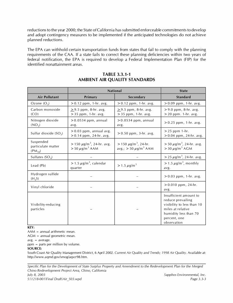
Specific Plan for the Development of State Surplus Property and Amendment to the Redevelopment Plan for the MergedChino Redevelopment Project Area, Chino, CaliforniaJuly 8, 2003 Sapphos Environmental, Inc.S:\1218-001\Final Draft\Air_S03.wpd Page 3.3-3
reductions to the year 2000; the State of California has submitted enforceable commitments to developand adopt contingency measures to be implemented if the anticipated technologies do not achieveplanned reductions.
The EPA can withhold certain transportation funds from states that fail to comply with the planningrequirements of the CAA. If a state fails to correct these planning deficiencies within two years offederal notification, the EPA is required to develop a Federal Implementation Plan (FIP) for theidentified nonattainment areas.
TABLE 3.3.1-1AMBIENT AIR QUALITY STANDARDS
National State
Air Pollutant Primary Secondary Standard
Ozone (O3) >0.12 ppm, 1-hr. avg. >0.12 ppm, 1-hr. avg. >0.09 ppm, 1-hr. avg.
Carbon monoxide
(CO)
>9.5 ppm, 8-hr. avg.
>35 ppm, 1-hr. avg.
>9.5 ppm, 8-hr. avg.
>35 ppm, 1-hr. avg.
>9.0 ppm, 8-hr. avg.
>20 ppm. 1-hr. avg.
Nitrogen dioxide
(NO2)
>0.0534 ppm, annual
avg.
>0.0534 ppm, annual
avg.>0.25 ppm, 1-hr. avg.
Sulfur dioxide (SO2)>0.03 ppm, annual avg.
>0.14 ppm, 24-hr. avg.>0.50 ppm, 3-hr. avg.
>25 ppm 1-hr.
>0.04 ppm, 24-hr. avg.
Suspended
particulate matter
(PM10)
>150 µg/m 3, 24-hr. avg.
>50 µg/m3 AAM
>150 µg/m 3, 24-hr.
avg.; > 50 µg/m3 AAM
>50 µg/m3, 24-hr. avg.
>30 µg/m3 AGM
Sulfates (SO4) – – >25 µg/m3, 24-hr. avg.
Lead (Pb)>1.5 µg/m3, calendar
quarter>1.5 µg/m3 >1.5 µg/m3, monthly
avg.
Hydrogen sulfide
(H2S)– – >0.03 ppm, 1-hr. avg.
Vinyl chloride – –>0.010 ppm, 24-hr.
avg.
Visibility-reducing
particles – –
Insufficient amount to
reduce prevailing
visibility to less than 10
miles at relative
humidity less than 70
percent, one
observation
KEY:AAM = annual arithmetic mean.AGM = annual geometric mean.avg. = average.ppm = parts per million by volume.SOURCE: South Coast Air Quality Management District, 6 April 2002. Current Air Quality and Trends; 1998 Air Quality. Available at:http://www.aqmd.gov/smog/aqscr98.htm.
Specific Plan for the Development of State Surplus Property and Amendment to the Redevelopment Plan for the MergedChino Redevelopment Project Area, Chino, CaliforniaJuly 8, 2003 Sapphos Environmental, Inc.S:\1218-001\Final Draft\Air_S03.wpd Page 3.3-4
State
California Clean Air Act
The California CAA of 1988 requires all air pollution control districts in the state to endeavor toachieve and maintain state ambient air quality standards for O3, CO, and NO2 by the earliestpracticable date and to develop plans and regulations specifying how they will meet this goal. Thereare no planning requirements for the state PM10 standard. California’s ambient air standards aregenerally stricter than national standards for the same pollutants; however, there are no penalties fornonattainment. California has also established state standards for sulfates, hydrogen sulfide, vinylchloride, and visibility-reducing particles, for which there are no national standards (Table 3.3.1-1).
Regional
Regionally, the SCAQMD and the Southern California Association of Governments (SCAG) prepare
the Air Quality Management Plan (AQMP), which contains measures to meet state and federal
requirements. When approved by CARB and the federal EPA, the AQMP becomes part of the State
Implementation Plan (SIP).
The agencies adopted new plans in 1989 to meet national standards and in 1991 to meet state
standards. The SCAQMD revised these attainment plans in 1994 and 1997. The EPA approved the
1994 AQMP in 1996 as part of the SIP. The SCAQMD revised the 1997 AQMP in 1999 to address EPA
concerns. The revised plan, now known as the 1999 AQMP, was approved by the EPA on May 10,
2000, and replaced the 1994 AQMP as the federally enforceable SIP for the air basin. The SCAQMD
and SCAG have revised the 1999 AQMP and are expected to adopt the new revision in 2003.
3.3.2 Existing Conditions
SCAQMD is responsible for monitoring air quality in the South Coast Air Basin and for adopting
controls, in conjunction with CARB, to improve air quality. Although the SCAQMD maintains a
monitoring station in SRA 33, the Southwest San Bernardino Valley, the station only monitors
particulates. Therefore, the monitoring station in SRA 10, the Pomona-Walnut Valley, is used to
determine baseline air quality for all pollutants except PM10 and PM2.5. Overall air quality has improved
considerably throughout the Basin since 1990. In that year, the peak ozone concentration in the
Pomona-Walnut Valley was 0.24 ppm and the state ozone standard was exceeded 104 times. In 2001,
the peak reading at that same station was 0.14 ppm and the state standard was exceeded 12 times.
These improvements have occurred despite extensive population growth in the Basin during the past
decade.
The EPA has adopted new standards for eight-hour ozone and fine particulates (PM2.5). Neither standard
is operational in the South Coast Air Basin until the one-hour ozone standard is completed and the EPA
completes its database on existing PM2.5 concentrations. The EPA expects to finalize the eight-hour
Specific Plan for the Development of State Surplus Property and Amendment to the Redevelopment Plan for the MergedChino Redevelopment Project Area, Chino, CaliforniaJuly 8, 2003 Sapphos Environmental, Inc.S:\1218-001\Final Draft\Air_S03.wpd Page 3.3-5
ozone implementation procedures in 2003 and to designate nonattainment areas in late 2003 or early
2004. The agency expects to designate PM2.5 nonattainment areas in 2004 or 2005.
In the interim, the SCAQMD is monitoring levels of both eight-hour concentrations of ozone and of
PM2.5. Where readings are available, the eight-hour ozone and the PM2.5 concentrations are shown inTable 3.3.2-1, Summary of Air Quality Data Pomona-Walnut Valley (SRA 10) Southwest SanBernardino Valley (SRA 33) Air Monitoring Stations, for information purposes. Data for 2002 were not
available at the time this report was prepared.
Ozone and carbon monoxide readings for SRA 10 and PM10 and PM2.5 readings for SRA 33 for the past
five years, together with the applicable state and national standards, are shown in Table 3.3.2-1.
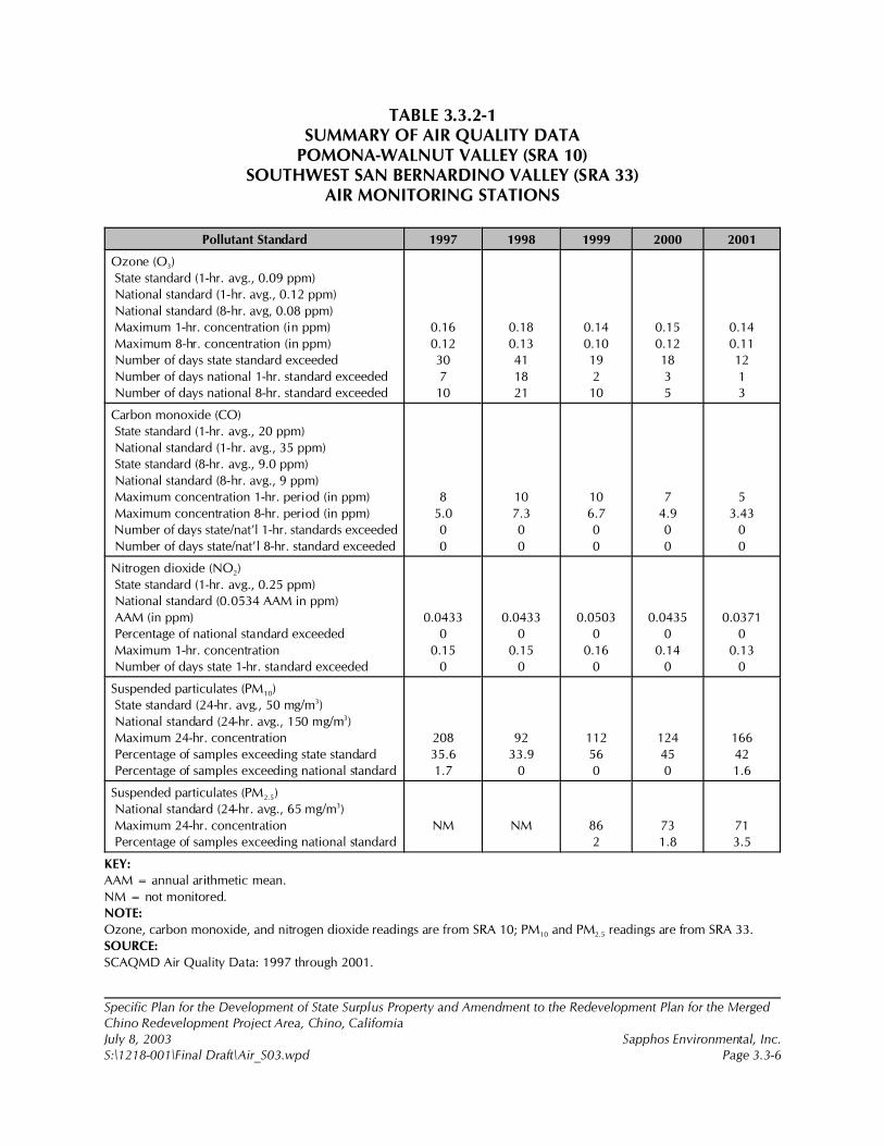
Specific Plan for the Development of State Surplus Property and Amendment to the Redevelopment Plan for the MergedChino Redevelopment Project Area, Chino, CaliforniaJuly 8, 2003 Sapphos Environmental, Inc.S:\1218-001\Final Draft\Air_S03.wpd Page 3.3-6
TABLE 3.3.2-1SUMMARY OF AIR QUALITY DATA
POMONA-WALNUT VALLEY (SRA 10)SOUTHWEST SAN BERNARDINO VALLEY (SRA 33)
AIR MONITORING STATIONS
Pollutant Standard 1997 1998 1999 2000 2001
Ozone (O3)
State standard (1-hr. avg., 0.09 ppm)
National standard (1-hr. avg., 0.12 ppm)
National standard (8-hr. avg, 0.08 ppm)
Maximum 1-hr. concentration (in ppm)
Maximum 8-hr. concentration (in ppm)
Number of days state standard exceeded
Number of days national 1-hr. standard exceeded
Number of days national 8-hr. standard exceeded
0.16
0.12
30
7
10
0.18
0.13
41
18
21
0.14
0.10
19
2
10
0.15
0.12
18
3
5
0.14
0.11
12
1
3
Carbon monoxide (CO)
State standard (1-hr. avg., 20 ppm)
National standard (1-hr. avg., 35 ppm)
State standard (8-hr. avg., 9.0 ppm)
National standard (8-hr. avg., 9 ppm)
Maximum concentration 1-hr. period (in ppm)
Maximum concentration 8-hr. period (in ppm)
Number of days state/nat’l 1-hr. standards exceeded
Number of days state/nat’l 8-hr. standard exceeded
8
5.0
0
0
10
7.3
0
0
10
6.7
0
0
7
4.9
0
0
5
3.43
0
0
Nitrogen dioxide (NO2)
State standard (1-hr. avg., 0.25 ppm)
National standard (0.0534 AAM in ppm)
AAM (in ppm)
Percentage of national standard exceeded
Maximum 1-hr. concentration
Number of days state 1-hr. standard exceeded
0.0433
0
0.15
0
0.0433
0
0.15
0
0.0503
0
0.16
0
0.0435
0
0.14
0
0.0371
0
0.13
0
Suspended particulates (PM10)
State standard (24-hr. avg., 50 mg/m3)
National standard (24-hr. avg., 150 mg/m3)
Maximum 24-hr. concentration
Percentage of samples exceeding state standard
Percentage of samples exceeding national standard
208
35.6
1.7
92
33.9
0
112
56
0
124
45
0
166
42
1.6
Suspended particulates (PM2.5)
National standard (24-hr. avg., 65 mg/m3)
Maximum 24-hr. concentration
Percentage of samples exceeding national standard
NM NM 86
2
73
1.8
71
3.5
KEY:
AAM = annual arithmetic mean.
NM = not monitored.
NOTE:
Ozone, carbon monoxide, and nitrogen dioxide readings are from SRA 10; PM10 and PM2.5 readings are from SRA 33.
SOURCE:
SCAQMD Air Quality Data: 1997 through 2001.
5 South Coast Air Quality Management District, January 1993.
Specific Plan for the Development of State Surplus Property and Amendment to the Redevelopment Plan for the MergedChino Redevelopment Project Area, Chino, CaliforniaJuly 8, 2003 Sapphos Environmental, Inc.S:\1218-001\Final Draft\Air_S03.wpd Page 3.3-7
Summary of Existing Air Quality
Ozone concentrations in the project vicinity are approximately average for the Basin. They vary
somewhat from year to year but have remained relatively constant over the past five years, even though
the number of days that the standard was exceeded has decreased. Carbon monoxide concentrations
are low and have decreased slightly. PM10 and PM2.5 concentrations are affected by meteorology. The
state 24-hour PM10 standard was exceeded up to 2 percent of the time during two of the five years, but
the national standard was not exceeded any time in the period.
3.3.3 Significance Thresholds
A project’s air quality impacts can be separated into short-term impacts due to construction and long-
term permanent impacts from project operations. Determination of significant impact is the
responsibility of the Lead Agency, which in this case is the City.
Both agencies rely on significance thresholds recommended by the SCAQMD in the CEQA Air Quality
Handbook,5 as revised in November 1993 and approved by the SCAQMD’s Board of Directors. The
SCAQMD is currently in the process of preparing a new air quality handbook to be titled AQMD Air
Quality Analysis Guidance Handbook. Chapters 2, 3, and 4 related to air quality background
information and the roles of regulatory agencies are available on the SCAQMD Web page at
www.aqmd.gov. Other chapters will be posted on the Web page as they become available. Revisions
at the time when this analysis was prepared do not include new significance thresholds or analysis
methodologies.
The SCAQMD emission thresholds apply to all federally regulated air pollutants except lead, which
is not exceeded in the Basin. Construction and operational emissions are considered by the SCAQMD
to be significant if they exceed the thresholds as indicated in Table 3.3.3-1, Emission Thresholds of
Significance.
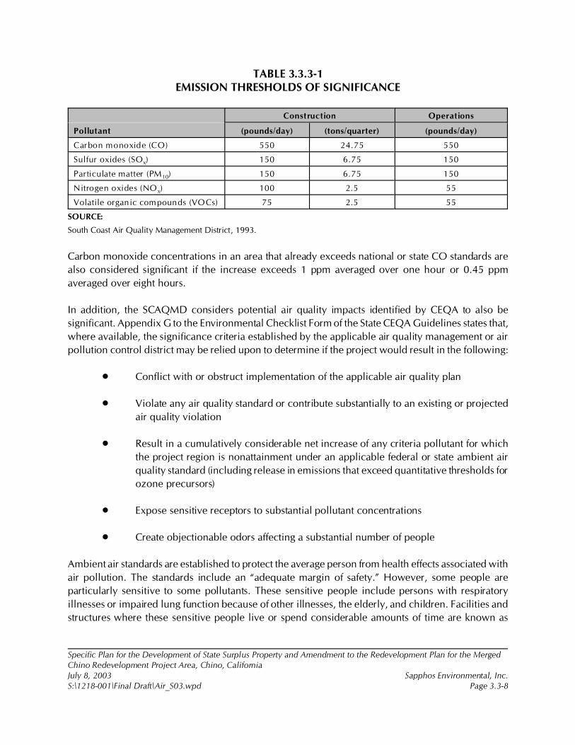
Specific Plan for the Development of State Surplus Property and Amendment to the Redevelopment Plan for the MergedChino Redevelopment Project Area, Chino, CaliforniaJuly 8, 2003 Sapphos Environmental, Inc.S:\1218-001\Final Draft\Air_S03.wpd Page 3.3-8
TABLE 3.3.3-1EMISSION THRESHOLDS OF SIGNIFICANCE
Pollutant
Construction Operations
(pounds/day) (tons/quarter) (pounds/day)
Carbon monoxide (CO) 550 24.75 550
Sulfur oxides (SOx) 150 6.75 150
Particulate matter (PM10) 150 6.75 150
Nitrogen oxides (NOx) 100 2.5 55
Volatile organic compounds (VOCs) 75 2.5 55
SOURCE:
South Coast Air Quality Management District, 1993.
Carbon monoxide concentrations in an area that already exceeds national or state CO standards are
also considered significant if the increase exceeds 1 ppm averaged over one hour or 0.45 ppm
averaged over eight hours.
In addition, the SCAQMD considers potential air quality impacts identified by CEQA to also be
significant. Appendix G to the Environmental Checklist Form of the State CEQA Guidelines states that,
where available, the significance criteria established by the applicable air quality management or air
pollution control district may be relied upon to determine if the project would result in the following:
• Conflict with or obstruct implementation of the applicable air quality plan
• Violate any air quality standard or contribute substantially to an existing or projected
air quality violation
• Result in a cumulatively considerable net increase of any criteria pollutant for which
the project region is nonattainment under an applicable federal or state ambient air
quality standard (including release in emissions that exceed quantitative thresholds for
ozone precursors)
• Expose sensitive receptors to substantial pollutant concentrations
• Create objectionable odors affecting a substantial number of people
Ambient air standards are established to protect the average person from health effects associated with
air pollution. The standards include an “adequate margin of safety.” However, some people are
particularly sensitive to some pollutants. These sensitive people include persons with respiratory
illnesses or impaired lung function because of other illnesses, the elderly, and children. Facilities and
structures where these sensitive people live or spend considerable amounts of time are known as
Specific Plan for the Development of State Surplus Property and Amendment to the Redevelopment Plan for the MergedChino Redevelopment Project Area, Chino, CaliforniaJuly 8, 2003 Sapphos Environmental, Inc.S:\1218-001\Final Draft\Air_S03.wpd Page 3.3-9
sensitive receptors. Chapter 4 of SCAQMD’s new Air Quality Analysis Guidance Handbook defines
land uses considered to be sensitive receptors as long-term health care facilities, rehabilitation centers,
convalescent centers, retirement homes, residences, schools, playgrounds, child care centers, and
athletic facilities.
3.3.4 Impacts
This section analyzes the potential for significant impacts to air quality that would occur from
implementation of the proposed project. Air quality impacts of a project generally fall into four major
categories:
(1) Construction Impacts: temporary impacts, including airborne dust from grading,
demolition, and dirt hauling, and gaseous emissions from heavy equipment, delivery
and dirt hauling trucks, employee vehicles, and paints and coatings; construction
emissions vary substantially from day to day, depending on the level of construction
phase and weather conditions
(2) Operational Regional Impacts: primarily gaseous emissions from natural gas and
electricity usage and vehicles traveling to and from a project site
(3) Operational Local Impacts: increases in pollutant concentrations, primarily carbon
monoxide, resulting from traffic increases in the immediate vicinity of a project, as well
as any toxic and odor emissions generated on site
(4) Cumulative Impacts: air quality changes resulting from the incremental impact of the
project when added to other projects in the vicinity
According to the State CEQA Guidelines, an impact is considered significant if the project violates any
air quality standard or contributes substantially to an existing or projected air quality violation. Since
the project site is located in the South Coast Air Basin, which is a nonattainment area for ozone, CO,
and PM10 standards, impacts would only be considered significant if emissions substantially contribute
to the existing violation.
Direct and Indirect Impacts
Construction Impacts
Air quality impacts of a project may occur during construction on both a regional and local scale.
Construction impacts include airborne dust from demolition, grading, excavation, and dirt hauling, and
gaseous emissions from the use of heavy equipment, delivery and dirt-hauling trucks, employee
vehicles, and paints and coatings. These impacts may affect regional pollutants, such as ozone, or
6 Ibid.
7 California Department of General Services, August 2001c. Phase I Environmental Site Assessment for Land Located atthe California Institute for Men. Contact: California Department of General Services, 707 Third Street, Suite 6-130, WestSacramento, CA 95605. Prepared by: Sapphos Environmental, Inc., 133 Martin Alley, Pasadena, CA 91105.
8 Ibid.
Specific Plan for the Development of State Surplus Property and Amendment to the Redevelopment Plan for the MergedChino Redevelopment Project Area, Chino, CaliforniaJuly 8, 2003 Sapphos Environmental, Inc.S:\1218-001\Final Draft\Air_S03.wpd Page 3.3-10
pollutants where the impacts occur very close to the source, such as carbon monoxide or particulate
matter (fugitive dust).
Construction would begin in 2004 and continue into 2011. Residential construction would occur every
quarter. Other construction is phased, with several peak periods estimated by the contractor. For
purposes of worst-case analysis, the third quarter of 2006 was selected over later periods because
vehicle emissions would be higher than the same amount of vehicular traffic would generate in later
years. In that quarter, construction would occur on residential, college, and retail components, as well
as on neighborhood parks and additions to Ayala Park.
Construction impacts were assessed in accordance with procedures contained in the SCAQMD in the
CEQA Air Quality Handbook,6 updated with current CARB emission factors.
Demolition
The project site is currently used for agriculture, as well as recreation in the existing Ayala Park. No
demolition is required except for a 20,000-square-foot barn and a 1,500-square-foot wood-frame barn.
Due to the age of construction of the structures in the proposed project area, it is reasonable to assume
that asbestos-containing materials (ACMs) and lead-based paints (LBPs) were used during original
construction activities.7 Therefore, demolition would be subject to SCAQMD Rule 1403. Compliance
with this rule would reduce impacts resulting from exposure to asbestos. Emissions of PM10 from this
demolition are very low. Demolition is assumed to have occurred before the peak quarter and are
therefore not included in the construction totals.
Grading and Excavation
The project site totals 710 acres. All but approximately 22.5 acres, which are either to be retained by
the Department of Corrections or already dedicated as streets, would be transferred for development.
Approximately 140 acres would be transferred to the City of Chino for parks and road and utility
easements, about 100 acres would be deeded to Chaffey College, and some 470 acres would be sold
to the developer. The development land also includes land for utility and street easements.
Soil may be disturbed during grading and excavation or while storing project-related equipment. Table
A9-9 of the CEQA Air Quality Handbook8 states that there would be 26.4 pounds of PM10 for each acre
of graded surface. The analysis assumes that on the peak day and quarter there could be as many as
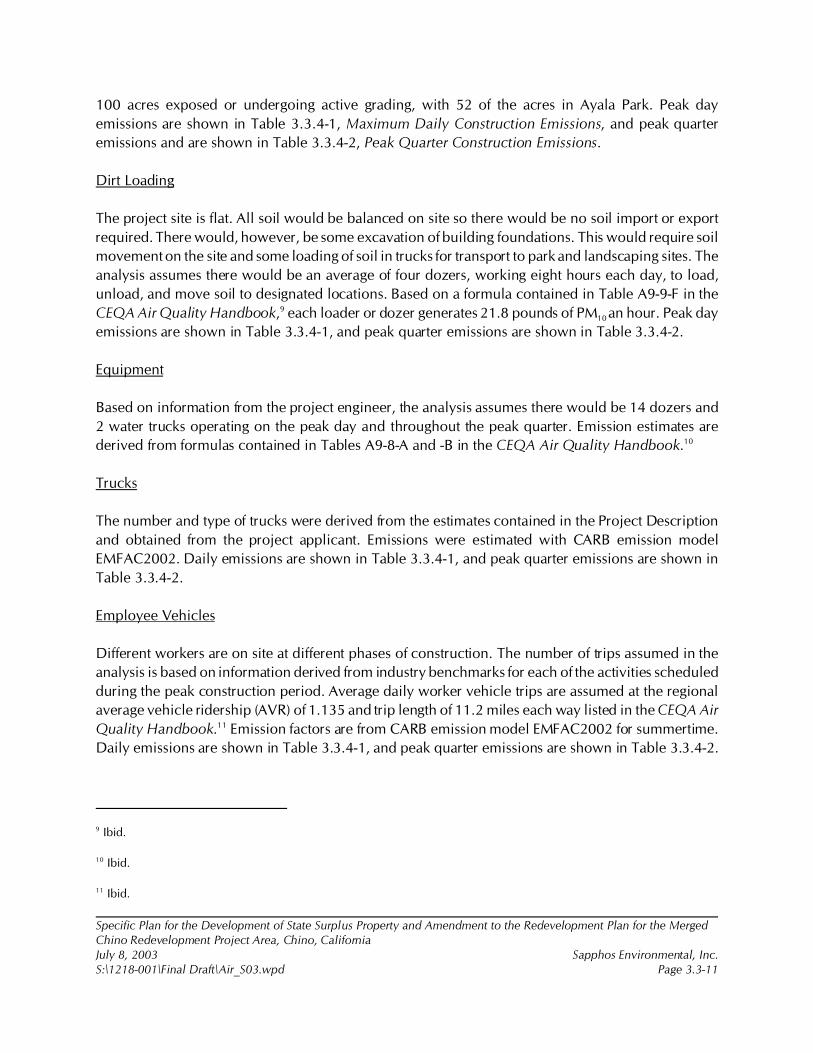
9 Ibid.
10 Ibid.
11 Ibid.
Specific Plan for the Development of State Surplus Property and Amendment to the Redevelopment Plan for the MergedChino Redevelopment Project Area, Chino, CaliforniaJuly 8, 2003 Sapphos Environmental, Inc.S:\1218-001\Final Draft\Air_S03.wpd Page 3.3-11
100 acres exposed or undergoing active grading, with 52 of the acres in Ayala Park. Peak day
emissions are shown in Table 3.3.4-1, Maximum Daily Construction Emissions, and peak quarter
emissions and are shown in Table 3.3.4-2, Peak Quarter Construction Emissions.
Dirt Loading
The project site is flat. All soil would be balanced on site so there would be no soil import or export
required. There would, however, be some excavation of building foundations. This would require soil
movement on the site and some loading of soil in trucks for transport to park and landscaping sites. The
analysis assumes there would be an average of four dozers, working eight hours each day, to load,
unload, and move soil to designated locations. Based on a formula contained in Table A9-9-F in the
CEQA Air Quality Handbook,9 each loader or dozer generates 21.8 pounds of PM10 an hour. Peak day
emissions are shown in Table 3.3.4-1, and peak quarter emissions are shown in Table 3.3.4-2.
Equipment
Based on information from the project engineer, the analysis assumes there would be 14 dozers and
2 water trucks operating on the peak day and throughout the peak quarter. Emission estimates are
derived from formulas contained in Tables A9-8-A and -B in the CEQA Air Quality Handbook.10
Trucks
The number and type of trucks were derived from the estimates contained in the Project Description
and obtained from the project applicant. Emissions were estimated with CARB emission model
EMFAC2002. Daily emissions are shown in Table 3.3.4-1, and peak quarter emissions are shown in
Table 3.3.4-2.
Employee Vehicles
Different workers are on site at different phases of construction. The number of trips assumed in the
analysis is based on information derived from industry benchmarks for each of the activities scheduled
during the peak construction period. Average daily worker vehicle trips are assumed at the regional
average vehicle ridership (AVR) of 1.135 and trip length of 11.2 miles each way listed in the CEQA Air
Quality Handbook.11 Emission factors are from CARB emission model EMFAC2002 for summertime.
Daily emissions are shown in Table 3.3.4-1, and peak quarter emissions are shown in Table 3.3.4-2.
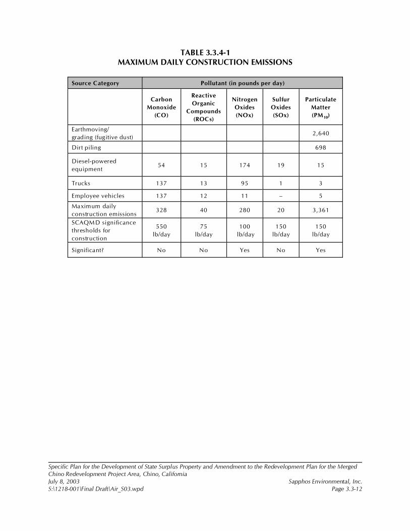
Specific Plan for the Development of State Surplus Property and Amendment to the Redevelopment Plan for the MergedChino Redevelopment Project Area, Chino, CaliforniaJuly 8, 2003 Sapphos Environmental, Inc.S:\1218-001\Final Draft\Air_S03.wpd Page 3.3-12
TABLE 3.3.4-1MAXIMUM DAILY CONSTRUCTION EMISSIONS
Source Category Pollutant (in pounds per day)
Carbon
Monoxide
(CO)
Reactive
Organic
Compounds
(ROCs)
Nitrogen
Oxides
(NOx)
Sulfur
Oxides
(SOx)
Particulate
Matter
(PM10)
Earthmoving/
grading (fugitive dust)2,640
Dirt piling 698
Diesel-powered
equipment54 15 174 19 15
Trucks 137 13 95 1 3
Employee vehicles 137 12 11 – 5
Maximum daily
construction emissions328 40 280 20 3,361
SCAQMD significance
thresholds for
construction
550
lb/day
75
lb/day
100
lb/day
150
lb/day
150
lb/day
Significant? No No Yes No Yes
Specific Plan for the Development of State Surplus Property and Amendment to the Redevelopment Plan for the MergedChino Redevelopment Project Area, Chino, CaliforniaJuly 8, 2003 Sapphos Environmental, Inc.S:\1218-001\Final Draft\Air_S03.wpd Page 3.3-13
TABLE 3.3.4-2PEAK QUARTER CONSTRUCTION EMISSIONS
Source Category Pollutant (in tons per quarter)
Carbon
Monoxide
(CO)
Reactive
Organic
Compounds
(ROCs)
Nitrogen
Oxides
(NOx)
Sulfur
Oxides
(SOx)
Particulate Matter
(PM10)
Earthmoving/
grading85.80
Dirt piling 22.67
Diesel-powered
Equipment1.74 0.49 5.67 0.63 0.48
Trucks 4.24 0.41 2.81 0.04 0.09
Employee vehicles 4.45 0.40 0.37 0 0.16
Maximum quarter
construction
emissions
10.43 1.3 8.85 0.67 109.2
SCAQMD
significance
thresholds for
construction
24.75
tons/qtr
2.5
tons/qtr
2.5
tons/qtr
6.75
tons/qtr
6.75
tons/qtr
Significant? No No Yes No Yes
12 Ibid.
Specific Plan for the Development of State Surplus Property and Amendment to the Redevelopment Plan for the MergedChino Redevelopment Project Area, Chino, CaliforniaJuly 8, 2003 Sapphos Environmental, Inc.S:\1218-001\Final Draft\Air_S03.wpd Page 3.3-14
Summary of Impacts
Without mitigation, PM10 and NOx emissions would be significant on the peak day and in the peak
quarter. There are no known sources of significant odors on the site that would be released during
construction.
Operational Impacts
Regional
When completed, the project would consist of a new Chaffey Community College campus enrolling
15,000 students at build-out in 2025, up to 2,500 dwelling units, up to 120,000 square feet of retail
space, an elementary school, and 157.5 acres of parks. Based on the Traffic Report, there would be
approximately 42,300 total daily weekday trips generated by the proposed project in 2012 and
approximately 53,900 daily weekday trips in 2025. A small amount of gaseous emissions would occur
from natural gas and electricity usage. Vehicle emissions were calculated with the CARB model,
URBEMIS, adjusted with total trips for the project in 2025 supplied by the traffic consultant. Emissions
were calculated for summertime conditions. The numbers shown in Table 3.3.4-3, Peak Quarter
Construction Emissions After Mitigation, and Table 3.3.4-4, Operational Emissions Year 2012, appear
to be counterintuitive, since all emissions except PM10 are considerably lower in 2025, Table 3.3.4-5,
Operational Emissions Year 2025, despite the increase of 7,500 more community college students
resulting in 11,625 more daily trips. However, the two tables clearly illustrate the ongoing decline in
per-vehicle emissions resulting from new controls and fleet turnover.
Utility emissions were calculated using Tables A9-11 and A9-12 in the CEQA Air Quality Handbook.12
Operational emissions are shown in Table 3.3.4-3.
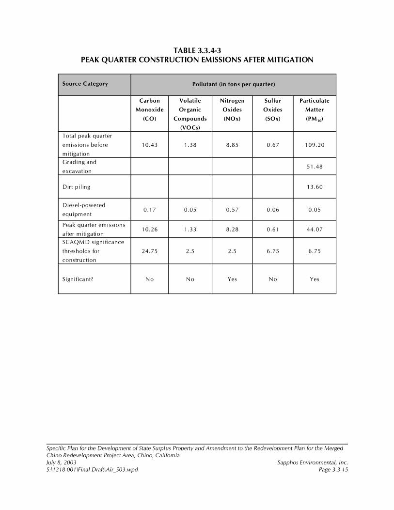
Specific Plan for the Development of State Surplus Property and Amendment to the Redevelopment Plan for the MergedChino Redevelopment Project Area, Chino, CaliforniaJuly 8, 2003 Sapphos Environmental, Inc.S:\1218-001\Final Draft\Air_S03.wpd Page 3.3-15
TABLE 3.3.4-3PEAK QUARTER CONSTRUCTION EMISSIONS AFTER MITIGATION
Source Category Pollutant (in tons per quarter)
Carbon
Monoxide
(CO)
Volatile
Organic
Compounds
(VOCs)
Nitrogen
Oxides
(NOx)
Sulfur
Oxides
(SOx)
Particulate
Matter
(PM10)
Total peak quarter
emissions before
mitigation
10.43 1.38 8.85 0.67 109.20
Grading and
excavation51.48
Dirt piling 13.60
Diesel-powered
equipment 0.17 0.05 0.57 0.06 0.05
Peak quarter emissions
after mitigation10.26 1.33 8.28 0.61 44.07
SCAQMD significance
thresholds for
construction
24.75 2.5 2.5 6.75 6.75
Significant? No No Yes No Yes
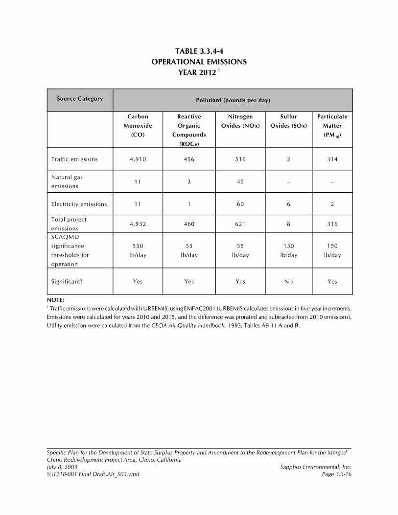
Specific Plan for the Development of State Surplus Property and Amendment to the Redevelopment Plan for the MergedChino Redevelopment Project Area, Chino, CaliforniaJuly 8, 2003 Sapphos Environmental, Inc.S:\1218-001\Final Draft\Air_S03.wpd Page 3.3-16
TABLE 3.3.4-4
OPERATIONAL EMISSIONS
YEAR 2012 1
Source Category Pollutant (pounds per day)
Carbon
Monoxide
(CO)
Reactive
Organic
Compounds
(ROCs)
Nitrogen
Oxides (NOx)
Sulfur
Oxides (SOx)
Particulate
Matter
(PM10)
Traffic emissions 4,910 456 516 2 314
Natural gas
emissions11 3 45 – –
Electricity emissions 11 1 60 6 2
Total project
emissions4,932 460 621 8 316
SCAQMD
significance
thresholds for
operation
550
lb/day
55
lb/day
55
lb/day
150
lb/day
150
lb/day
Significant? Yes Yes Yes No Yes
NOTE:1 Traffic emissions were calculated with URBEMIS, using EMFAC2001 (URBEMIS calculates emissions in five-year increments.
Emissions were calculated for years 2010 and 2015, and the difference was prorated and subtracted from 2010 emissions).
Utility emission were calculated from the CEQA Air Quality Handbook, 1993, Tables A9-11 A and B.
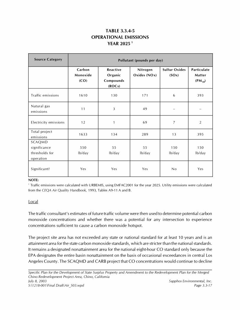
Specific Plan for the Development of State Surplus Property and Amendment to the Redevelopment Plan for the MergedChino Redevelopment Project Area, Chino, CaliforniaJuly 8, 2003 Sapphos Environmental, Inc.S:\1218-001\Final Draft\Air_S03.wpd Page 3.3-17
TABLE 3.3.4-5
OPERATIONAL EMISSIONS
YEAR 2025 1
Source Category Pollutant (pounds per day)
Carbon
Monoxide
(CO)
Reactive
Organic
Compounds
(ROCs)
Nitrogen
Oxides (NOx)
Sulfur Oxides
(SOx)
Particulate
Matter
(PM10)
Traffic emissions 1610 130 171 6 393
Natural gas
emissions11 3 49 – –
Electricity emissions 12 1 69 7 2
Total project
emissions1633 134 289 13 395
SCAQMD
significance
thresholds for
operation
550
lb/day
55
lb/day
55
lb/day
150
lb/day
150
lb/day
Significant? Yes Yes Yes No Yes
NOTE:1 Traffic emissions were calculated with URBEMIS, using EMFAC2001 for the year 2025. Utility emissions were calculated
from the CEQA Air Quality Handbook, 1993, Tables A9-11 A and B.
Local
The traffic consultant’s estimates of future traffic volume were then used to determine potential carbon
monoxide concentrations and whether there was a potential for any intersection to experience
concentrations sufficient to cause a carbon monoxide hotspot.
The project site area has not exceeded any state or national standard for at least 10 years and is an
attainment area for the state carbon monoxide standards, which are stricter than the national standards.
It remains a designated nonattainment area for the national eight-hour CO standard only because the
EPA designates the entire basin nonattainment on the basis of occasional exceedances in central Los
Angeles County. The SCAQMD and CARB project that CO concentrations would continue to decline
Specific Plan for the Development of State Surplus Property and Amendment to the Redevelopment Plan for the MergedChino Redevelopment Project Area, Chino, CaliforniaJuly 8, 2003 Sapphos Environmental, Inc.S:\1218-001\Final Draft\Air_S03.wpd Page 3.3-18
in the future, despite continued growth, because of fleet turnover with cars with already adopted
controls, as well as improvements in fuels. Consequently, adding background concentrations to low
modeled concentrations would not be enough to project a carbon monoxide hotspot unless conditions
are extremely adverse after a project is operative. The SCAQMD considers an increase in carbon
monoxide concentrations to be significant if the increase with the project is 0.45 ppm greater than the
conditions without the project and where the existing plus background concentrations already exceed
the standard.
3.3.5 Cumulative Impacts
The incremental impact of the proposed project, when added to the related past, present, or reasonably
foreseeable future projects listed in Section 2, Project Description, would not result in cumulative
impacts related to air quality.
The list of related projects used in consideration of cumulative impacts includes a number of major
development projects within the City of Chino and neighboring jurisdictions that would have the
potential to contribute on a cumulative basis to carbon monoxide standards from traffic congestion.
Although the project in both 2012 and at build-out in 2025 would contribute large amounts of traffic,
the increase in traffic over conditions without the project would not be sufficient to cause the eight-
hour carbon monoxide standard to be exceeded. The traffic consultant’s report (Appendix I, Traffic
Impact Analysis for the Specific Plan for the Development of State Surplus Property from the California
Institution for Men, Chino, California) identifies 19 roadway intersections and 10 freeway segments
where the project would contribute on a cumulative basis to unacceptable levels of congestion in
2025, most of which would be unacceptable even without the proposed project. The report also
identifies mitigation that can improve these segments to acceptable levels and identifies the “fair share”
amount that the project sponsors would contribute to mitigate the project’s contribution to
unacceptable traffic conditions; therefore, the proposed project‘s incremental effect on cumulative air
quality issues would not be cumulatively considerable.
3.3.6 Mitigation Measures
The following construction mitigation measures are recommended by the SCAQMD to control fugitive
dust emissions. It is recommended by the SCAQMD that emissions from construction be reduced by
at least 60 percent.
Air-1
To reduce PM10 emissions generated from construction by at least 60 percent as part of the City’s site
plan review prior to soliciting bids for construction for each of the three respective project elements
Specific Plan for the Development of State Surplus Property and Amendment to the Redevelopment Plan for the MergedChino Redevelopment Project Area, Chino, CaliforniaJuly 8, 2003 Sapphos Environmental, Inc.S:\1218-001\Final Draft\Air_S03.wpd Page 3.3-19
(the City of Chino recreation facilities and the California Department of Forestry and Fire Protection
Helicopter Facility; the Chaffey Community College campus; and the master-planned community,
including infrastructure), the City of Chino, Chaffey College, and the private developer, respectively,
shall ensure that the plans and specifications include the requirement for the construction contractor
to ensure that soils are moistened 15 minutes prior to grading and that, three times a day (four times
a day in windy conditions), the soil moisture content is maintained at a minimum of 12 percent for all
grading activities. At a minimum, the construction contractor field supervisor (or designee) shall
conduct unscheduled weekly walk-throughs of the project site and complete a checklist of Measures
Air-1 through Air-6 to demonstrate compliance with the mitigation measures. Monitoring reports shall
be signed by the construction contractor and submitted to the City on a weekly basis.
Air-2
To reduce PM10 emissions generated from the construction by at least 60 percent as part of the City’s
site plan review process prior to soliciting bids for construction for each of the three respective project
elements (the City of Chino recreation facilities and the California Department of Forestry and Fire
Protection Helicopter Facility; the Chaffey Community College campus; and the master-planned
community, including infrastructure), the City of Chino, Chaffey College, and the private developer,
respectively, shall ensure that the plans and specifications include the requirement for the construction
contractor to ensure that, on the last day of active operations prior to a weekend or holiday, water or
a chemical stabilizer is applied to maintain a stabilized surface. At a minimum, the construction
contractor field supervisor (or designee) shall conduct unscheduled weekly walk-throughs of the
project site and complete a checklist of Measures Air-1 through Air-6 to demonstrate compliance with
the mitigation measures. Monitoring reports shall be signed by the construction contractor and
submitted to the City on a weekly basis.
Air-3
To reduce PM10 emissions generated from the construction by at least 60 percent as part of the City’s
site plan review process prior to soliciting bids for construction for each of the three respective project
elements (the City of Chino recreation facilities and the California Department of Forestry and Fire
Protection Helicopter Facility; the Chaffey Community College campus; and the master-planned
community, including infrastructure), the City of Chino, Chaffey College, and the private developer,
respectively, shall ensure that the plans and specifications include the requirement for the construction
contractor to ensure the watering of excavated soil piles hourly or to cover them securely with
temporary coverings. At a minimum, the construction contractor field supervisor (or designee) shall
conduct unscheduled weekly walk-throughs of the project site and complete a checklist of Measures
Air-1 through Air-6 to demonstrate compliance with the mitigation measures. Monitoring reports shall
be signed by the construction contractor and submitted to the City on a weekly basis.
Specific Plan for the Development of State Surplus Property and Amendment to the Redevelopment Plan for the MergedChino Redevelopment Project Area, Chino, CaliforniaJuly 8, 2003 Sapphos Environmental, Inc.S:\1218-001\Final Draft\Air_S03.wpd Page 3.3-20
Air-4
To reduce PM10 emissions generated from construction by at least 60 percent as part of the City’s site
plan review process prior to soliciting bids for construction for each of the three respective project
elements (the City of Chino recreation facilities and the California Department of Forestry and Fire
Protection Helicopter Facility; the Chaffey Community College campus; and the master-planned
community, including infrastructure), the City of Chino, Chaffey College, and the private developer,
respectively, shall ensure that the plans and specifications include the requirement for the construction
contractor to ensure that grading is ceased during periods when winds exceed 25 miles per hour. At
a minimum, the construction contractor field supervisor (or designee) shall conduct unscheduled
weekly walk-throughs of the project site and complete a checklist of Measures Air-1 through Air-6 to
demonstrate compliance with the mitigation measures. Monitoring reports shall be signed by the
construction contractor and submitted to the City on a weekly basis.
Air-5
To reduce PM10 emissions generated from the construction by at least 60 percent as part of the City’s
site plan review process prior to soliciting bids for construction for each of the three respective project
elements (the City of Chino recreation facilities and the California Department of Forestry and Fire
Protection Helicopter Facility; the Chaffey Community College campus; and the master-planned
community, including infrastructure), the City of Chino, Chaffey College, and the private developer,
respectively, shall ensure that the plans and specifications include the requirement for the construction
contractor to ensure the moistening of excavated soil prior to loading on trucks. At a minimum, the
construction contractor field supervisor (or designee) shall conduct unscheduled weekly walk-throughs
of the project site and complete a checklist of Measures Air-1 through Air-6 to demonstrate compliance
with the mitigation measures. Monitoring reports shall be signed by the construction contractor and
submitted to the City on a weekly basis.
Air-6
To reduce PM10 emissions generated from construction by at least 60 percent as part of the City’s site
plan review process prior to soliciting bids for construction for each of the three respective project
elements (the City of Chino recreation facilities and the California Department of Forestry and Fire
Protection Helicopter Facility; the Chaffey Community College campus; and the master-planned
community, including infrastructure), the City of Chino, Chaffey College, and the private developer,
respectively, shall ensure that the plans and specifications include the requirement for the construction
contractor to ensure that loads of dirt are securely covered with a tight-fitting tarp on any truck leaving
or entering the construction sites to bring fill dirt to the site or to dispose of excavated soil or leave
sufficient freeboard capacity in the truck to prevent fugitive dust emissions en route to the disposal site.
Specific Plan for the Development of State Surplus Property and Amendment to the Redevelopment Plan for the MergedChino Redevelopment Project Area, Chino, CaliforniaJuly 8, 2003 Sapphos Environmental, Inc.S:\1218-001\Final Draft\Air_S03.wpd Page 3.3-21
At a minimum, the construction contractor field supervisor (or designee) shall conduct weekly
unscheduled walkthroughs of the project site and complete a checklist of Measures Air-1 through Air-6
to demonstrate compliance with the mitigation measures. Monitoring reports shall be signed by the
construction contractor and submitted to the City on a weekly basis.
3.3.7 Level of Significance after Mitigation
Although mitigation would substantially reduce particulate emissions after construction mitigation
measure Air-1 through -6 are implemented, PM10 and NOx emissions would remain significant (Table
3.3.4-3).
Operation of the project would result in significant long-term emissions of ROCs, NOx, and PM10 on
a regional scale. There are no feasible mitigation measures available to wholly mitigate the significant
impacts related to operational impacts to air quality, and these impacts would therefore remain
significant.
There are some odors, such as from cooking and gardening, associated with residential uses, but these
are not considered significant on a regional or local scale.
After required traffic mitigation, the project would not have an adverse impact on either traffic or air
quality, and there would be no local carbon monoxide hot spots.
1 City of Chino, 19 July 2002. Initial Study: Specific Plan for the Development of 717 Acres of State Surplus Property fromthe California Institution for Men (CIM), Chino, California. Contact: Community Development Department, 13220 CentralAvenue, Chino, CA 91710. Prepared by: Sapphos Environmental, Inc., 133 Martin Alley, Pasadena, CA 91105.
2 County of San Bernardino, 1 July 1989 (Revised 21 December 2000). San Bernardino County General Plan. Contact:Economic Development and Public Services Group/Land Use Services Department, 385 North Arrowhead Avenue, 1st Floor,San Bernardino, CA 92415-0182.
3 City of Chino, 6 October 1981. General Plan: Land Use Element. Contact: Community Development Department, 13220Central Avenue, Chino, CA 91710.
4 California Department of Fish and Game, 2002. Rarefind 2: A Database Application for the Use of the California NaturalDiversity Data Base. Sacramento, CA: California Department of Fish and Game.
5 California Department of General Services, August 2001a. Biological Resources Report: California Institution for Men, Cityof Chino, San Bernardino County, California. Contact: California Department of General Services, 707 Third Street, Suite 6-130, West Sacramento, CA 95605. Prepared by Sapphos Environmental, Inc., 133 Martin Alley, Pasadena, CA 91105.
6 California Department of General Services, August 2001b. Jurisdictional Delineation of Areas Subject to the U.S. Army Corpsof Engineers and California Department of Fish and Game: California Institution for Men, City of Chino, San BernardinoCounty, California. Contact: California Department of General Services, 707 Third Street, Suite 6-130, West Sacramento, CA95605. Prepared by Sapphos Environmental, Inc., 133 Martin Alley, Pasadena, CA 91105.
Specific Plan for the Development of State Surplus Property and Amendment to the Redevelopment Plan for the Merged ChinoRedevelopment Project Area, Chino, CaliforniaJuly 8, 2003 Sapphos Environmental, Inc.S:\1218-001\Final Draft\Biology_S04.wpd Page 3.4-1
3.4 BIOLOGICAL RESOURCES
As a result of the Initial Study,1 the City of Chino Community Development Department (City)determined that the Specific Plan for the Development of State Surplus Property and Amendment tothe Redevelopment Plan for the Merged Chino Redevelopment Project Area, Chino, California(proposed project) had the potential to result in impacts to biological resources. Therefore, this issuehas been carried forward for detailed analysis in this project-level Environmental Impact Report (EIR).This analysis was undertaken to identify opportunities to avoid, reduce, or otherwise mitigate potentialsignificant impacts to biological resources.
The analysis of biological resources consists of a summary of the regulatory framework that guides thedecision-making process, existing conditions at the proposed project site, thresholds for determiningif the proposed project would result in significant impacts (direct, indirect, and cumulative), mitigationmeasures, and the level of significance after mitigation. The potential for impacts to biologicalresources has been analyzed based on information obtained from the County of San BernardinoGeneral Plan,2 City of Chino General Plan,3 a review of the California Natural Diversity Data Base(CNDDB),4 published literature, National Wetland Inventory Maps, other technical reports,5,6 anddirected surveys for biological resources undertaken during September 17!20 and September 25!26,2002, for listed and sensitive plant and wildlife species.
3.4.1 Regulatory Framework
This regulatory framework identifies the federal, state, and local statutes, ordinances, or policies thatgovern the conservation and protection of biological resources that must be considered by the City
Specific Plan for the Development of State Surplus Property and Amendment to the Redevelopment Plan for the Merged ChinoRedevelopment Project Area, Chino, CaliforniaJuly 8, 2003 Sapphos Environmental, Inc.S:\1218-001\Final Draft\Biology_S04.wpd Page 3.4-2
during the decision-making process for projects that have the potential to affect biological resources.For the purposes of the California Environmental Quality Act (CEQA), biological resources are definedto include the following:
• Any species identified as a candidate, sensitive, or special status species in local orregional plans, policies, or regulations, or by the California Department of Fish andGame (CDFG) or U.S. Fish and Wildlife Service (USFWS)
• Habitat designated as State Sensitive Habitat by the CDFG Natural Heritage Program• Wetlands or other “waters of the United States” afforded protection pursuant to Section
404 of the Clean Water Act• Riparian or wetland habitats afforded protection pursuant to Section 1600 of the State
Fish and Game Code• Native resident or migratory wildlife corridors• Native wildlife nursery sites• Occupied nesting habitat for birds afforded protection pursuant to the Migratory Bird
Treaty Act (MBTA)• Trees protected pursuant to City Ordinance• Plant and wildlife habitats afforded protection pursuant to adopted Habitat
Conservation Plans and Natural Community Conservation Plans
Federal
Endangered Species Act
The purpose of the Endangered Species Act (ESA) is to provide a means to conserve the ecosystemson which listed endangered and threatened species depend and to provide a program for conservationof these species. The federal ESA requires that the federal lead agency for a project (in consultationwith, and with the assistance of, the USFWS and the National Marine Fisheries Service [NMFS]) ensurethat actions approved or funded by the lead agency are neither likely to jeopardize the continuedexistence of endangered or threatened species nor result in the destruction or adverse modification ofthe critical habitat of such species. The USFWS and the NMFS are the designated federal agenciesresponsible for administering the federal ESA. The federal ESA defines species as “endangered” and“threatened” and provides regulatory protection for any species thus designated. Section 9 of thefederal ESA prohibits the “take” of species listed by the USFWS as endangered or threatened. Asdefined in the federal ESA, take means “to harass, harm, pursue, hunt, shoot, wound, kill, trap, capture,or collect or attempt to engage in such conduct.” In recognition that take cannot always be avoided,Section 10(a) of the federal ESA includes provisions for take that are incidental to, but not the purposeof, otherwise lawful activities. Specifically, Section 10(a)(1)(A) permits (authorized take permits) maybe issued for scientific research purposes. Section 10(a)(1)(B) permits (incidental take permits) may beissued if taking is incidental and does not jeopardize the species. Section 7(a)(2) of the federal ESArequires all federal agencies, including the USFWS, to evaluate the proposed project with respect toany species listed as endangered and its critical habitat, if any such habitat is proposed or designated.Federal agencies must undertake programs for the conservation of endangered and threatened speciesand are prohibited from authorizing, funding, or carrying out any action that will jeopardize a listedspecies or destroy or modify its “critical habitat.”
7 California Department of General Services, August 2001b.
Specific Plan for the Development of State Surplus Property and Amendment to the Redevelopment Plan for the Merged ChinoRedevelopment Project Area, Chino, CaliforniaJuly 8, 2003 Sapphos Environmental, Inc.S:\1218-001\Final Draft\Biology_S04.wpd Page 3.4-3
As defined in the federal ESA, “individuals, organizations, states, local governments, and other non-federal entities are affected by the designation of critical habitat only if their actions occur on federallands, require a federal permit, license, or other authorization, or involve federal funding.”
The proposed project site does not support any known federal listed species or candidates for listing,or species proposed for listing.
Migratory Bird Treaty Act
The MBTA makes it unlawful to pursue, capture, kill, or possess or attempt to do the same to anymigratory bird or part, nest, or egg of any such bird listed in wildlife protection treaties between theUnited States, Great Britain, Mexico, Japan, and the countries of the former Soviet Union. The MBTAauthorizes the Secretary of the Interior to issue permits for incidental take. This regulation is relevantbecause the analysis provided in this Draft EIR documents that a variety of native bird species subjectto MBTA utilize the proposed project site and may periodically nest on the proposed project site.
Section 404 of the Federal Clean Water Act
Section 404 of the federal Clean Water Act, which is administered by the U.S. Army Corps of Engineers(Corps), regulates the discharge of dredged and fill material into “waters of the United States.” TheCorps has established a series of nationwide permits that authorize certain activities in “waters of theUnited States,” provided that a proposed activity can demonstrate compliance with standardconditions. Normally, the Corps requires an individual permit for an activity that will affect an areaequal to or in excess of 0.1 acre of “waters of the United States.” Projects that result in impacts to lessthan 0.1 acre of “waters of the United States” can normally be conducted pursuant to one of thenationwide permits, if consistent with the standard permit conditions. The Corps also has discretionaryauthority to require an Environmental Impact Statement for projects that result in impacts to an areabetween 0.1 and 0.3 acre. Use of any nationwide permit is contingent on the activities having noimpacts to endangered species. There are no Corps jurisdictional wetlands within the proposed projectsite. However, this section of the Cypress Channel does contain 5.06 acres of “waters of the UnitedStates.”7
State
California Endangered Species Act
The California Endangered Species Act (state ESA) prohibits the take of listed species except asotherwise provided in state law. Unlike the federal ESA, the state ESA applies the take prohibitions tospecies petitioned for listing (state candidates). State lead agencies are required to consult with theCDFG to ensure that any actions undertaken by that lead agency are not likely to jeopardize thecontinued existence of any state-listed species or result in destruction or degradation of requiredhabitat. CDFG is authorized to enter into memoranda of understanding with individuals, public
Specific Plan for the Development of State Surplus Property and Amendment to the Redevelopment Plan for the Merged ChinoRedevelopment Project Area, Chino, CaliforniaJuly 8, 2003 Sapphos Environmental, Inc.S:\1218-001\Final Draft\Biology_S04.wpd Page 3.4-4
agencies, universities, zoological gardens, and scientific or educational institutions to import, export,take, or possess listed species for scientific, educational, or management purposes.
There are no state-designated threatened or endangered species known to occur within the proposedproject site. However, the burrowing owl, which is known from the proposed project site, is beingproposed for listing under the state ESA.
Sections 2080 and 2081 of the State Fish and Game Code
Section 2080 of the State Fish and Game Code states, “No person shall import into this state, exportout of this state, or take, possess, purchase, or sell within this state, any species, or any part or productthereof, that the commission determines to be an endangered species or a threatened species, orattempt any of those acts, except as otherwise provided in this chapter, the Native Plant Protection Act(Chapter 10 (commencing with Section 1900) of this code), or the California Desert Native Plans Act(Division 23 (commencing with Section 80001) of the Food and Agriculture Code.”
Under Section 2081 of the State Fish and Game Code, the CDFG may authorize individuals or publicagencies to import, export, take, or possess, any state-listed endangered, threatened, or candidatespecies. These otherwise prohibited acts may be authorized through permits or memoranda ofunderstanding if the following conditions are met: (1) the take is incidental to an otherwise lawfulactivity, (2) impacts of the authorized take are minimized and fully mitigated, (3) the permit isconsistent with any regulations adopted pursuant to any recovery plan for the species, and (4) theapplicant ensures adequate funding to implement the measures required by the CDFG. The CDFGshall make this determination based on the best scientific and other information that is reasonablyavailable and shall include consideration of the species’ capability to survive and reproduce.
There are no state-designated rare, threatened, or endangered species known to occur within theproposed project site. However, the burrowing owl is currently being proposed for listing under thestate ESA, which would make it subject to Sections 2080 and 2081 of the State Fish and Game Code.
Sections 3800 and 3503 of the State Fish and Came Code
Section 3800 states that it is unlawful to take any non-game bird except as provided in the State Fishand Game Code.
Section 3503 of the State Fish and Game Code states that it is unlawful to take, posses, or needlesslydestroy the nest or eggs of any bird, except as otherwise provided by the State Fish and Game Codeor any regulation make pursuant thereto. The proposed project will incorporate all feasible mitigationmeasures and procedures to eliminate any needless take of bird nests or eggs.
The Native Plant Protection Act
The Native Plant Protection Act includes measures to preserve, protect, and enhance rare, threatened,and endangered native plants. The definitions of rare and endangered differ from those contained inthe state ESA. However, the list of native plants afforded protection pursuant to this act includes thoselisted as rare and endangered under the state ESA. This act provides limitations on take as follows:
8 City of Chino, 6 October 1981.
9 City of Chino, December 1990. General Plan: Conservation/Open Space Element. Contact: Community DevelopmentDepartment, 13220 Central Avenue, Chino, CA 91710.
Specific Plan for the Development of State Surplus Property and Amendment to the Redevelopment Plan for the Merged ChinoRedevelopment Project Area, Chino, CaliforniaJuly 8, 2003 Sapphos Environmental, Inc.S:\1218-001\Final Draft\Biology_S04.wpd Page 3.4-5
“...no person will import into this State, or take, possess, or sell within this State” any rare orendangered native plant, except in compliance with provisions of the Native Plant Protection Act.Individual landowners are required to notify the CDFG at least 10 days in advance of changing landuses to allow the CDFG to salvage any rare or endangered native plant material.
There are no rare or endangered native plant species that occur within the proposed project site.
Section 1600 of the State Fish and Game Code
All diversions, obstructions, or changes to the natural flow or bed, channel, or bank of any river,stream, or lake in California are subject to the regulatory authority of the CDFG pursuant to Sections1600 through 1603 of the State Fish and Game Code, requiring preparation of a Streambed AlterationAgreement. Under the State Fish and Game Code, a stream is defined as a body of water that flows atleast periodically, or intermittently, through a bed or channel having banks and supporting fish or otheraquatic life. Included are watercourses with surface or subsurface flows that support or have supportedriparian vegetation. CDFG has jurisdiction within altered or artificial waterways based on the value ofthose waterways to fish and wildlife, as well as jurisdiction over dry washes that carry waterephemerally during storm events. The proposed project contains Cypress Channel, which is subjectto Section 1600 of the State Fish and Game Code. Within the proposed project area, Cypress Channelis a concrete box channel. Areas of Cypress Channel downstream of the proposed area support naturalstreambanks.
City
City of Chino General Plan
The proposed project lies within a proposed Specific Plan Area–the Urban Reserve Area. Thisencompasses the area south of Edison Avenue and east of Central Avenue, designated as UrbanReserve on the Land Use Element Map, which shall be subject to a specific plan if and when it changesto a non-institutional use.8
The City of Chino is committed to balancing the need of a property owner desiring to develop his orher property, with the City’s desire to protect plants and wildlife. The following goals, policies, andactions will aid the City in making decisions regarding its biological resources and provide directionfor future decisions.9 The proposed project shall be in compliance with all applicable goals and actionsas designated within the City General Plan.
• Goal G5-3: Preserve plant and wildlife resources to encourage the preservation andconservation of plant and wildlife resources in the City.
Specific Plan for the Development of State Surplus Property and Amendment to the Redevelopment Plan for the Merged ChinoRedevelopment Project Area, Chino, CaliforniaJuly 8, 2003 Sapphos Environmental, Inc.S:\1218-001\Final Draft\Biology_S04.wpd Page 3.4-6
# Policy P5-3.1: Retain plant and animal habitats along flood control channelsto encourage any improvements to, and along, flood control channels to bedesigned so that any significant plant and animal habitats can be retained.
• Action A5-3.1.1: Review all County plans for flood control expansion.The City shall review and comment on all plans to expand existingflood control channels proposed by the Corps or the San BernardinoCounty Flood Control District to ensure, through design techniques,the retention of plant and animal life and their habitats located alongchannels.
# Policy P5-3.2: Minimize impacts on existing plant and animal habitats.
• Action A5-3.2.1: Buffer Zone Ordinance: The City shall adopt anordinance that requires new development and expansion of existingdevelopment to provide natural buffer zones (i.e., landscaping)adequate in size to minimize adverse impacts to plant and wildlifespecies. In addition, the City shall work with Southern CaliforniaEdison to determine the feasibility of utilizing their easements forpotential wildlife preserves.
• Action A5-3.2.2: Alternative sources to pesticides: The City shallencourage property owners to utilize alternative sources to pesticides,weed killers, and other chemicals that can harm or destroy plants andwildlife or their food sources.
• Action A5-3.2.3: Public awareness: The City shall, through the use ofutility statements, brochures, and public information handouts,promote the awareness and protecting benefits of environmentallysensitive plants.
• Action A5-3.2.4: Require a biological survey: The City shall require abiological survey prior to the issuance of any grading permit for allproperty being developed or excavated (as outlined in Chapter 70 ofthe Uniform Building Code) to determine if any sensitive plants orspecies exist on the site. The report shall indicate type of species,location, quantity, and proposed measures to mitigate any adverseimpacts created from the proposed development.
# Policy P5-3.4: Preserve mature native trees and shrubs in the City.
• Action A5-3.4.1: Tree preservation ordinance: The City shall pursue thepreparation of a tree preservation ordinance that will identify matureand significant trees and offer measures to protect them fromeradication.
10 Ibid.
Specific Plan for the Development of State Surplus Property and Amendment to the Redevelopment Plan for the Merged ChinoRedevelopment Project Area, Chino, CaliforniaJuly 8, 2003 Sapphos Environmental, Inc.S:\1218-001\Final Draft\Biology_S04.wpd Page 3.4-7
# Policy P5-3.5: Encourage the planting of native trees, and encourage thereplacement of damaged trees to help improve the aesthetic environment of theCity.
• Action A5-3.5.1: Promote national tree programs: The City shall takepart in and promote Arbor Day, the Urban Gardens Program, theUrban Forestation Program, and Tree City U.S.A.
• Action A5-3.5.2: Update street tree program: The City shall, inconjunction with a landscape architect, update the Street Tree MasterPlan and make the plan more readily available to the general public.
The following goals, policies and actions will aid the City in making decisions regarding its open spaceresources and provide direction for future decisions:10
• Goal G5-15: Open space for natural resources preservation: To encourage thedevelopment of open space for preservation of the City’s natural resources
# Policy P5-15.1: Protect existing natural plant and animal habitats throughoutthe City.
• Action A5-15.1.1: Amend zoning and general plan maps: The Cityshall amend the zoning and general plan maps to designate LittleChino Creek and all flood control channels as open space for thepurpose of protecting existing plant and animal habitats.
• Goal G5-16: Open space for outdoor recreation: Maintain and encourage thedevelopment of open space for outdoor recreation.
# Policy P5-16.10: Preserve the California Institution for Men (CIM) as openspace: To encourage the preservation of CIM as an open space resource
• Action A5-16.10.1: Maintain open space zoning for CIM property: TheCity shall continue to maintain open space zoning on the CIM site. Inthe future, if this property becomes available for development, the Cityshall prepare a specific plan consistent with state requirement, with aspecial emphasis on preserving 25 percent of the total land area foropen space uses. The proposed project complies with this action basedon open space elements described in the project description.
11 California Department of General Services, August 2001a.
12 California Department of Fish and Game, 2002.
13 U.S. Geological Survey, 1982g. Prado Dam, California, Topographic Quadrangle Map. Contact: U.S. Geological Survey,509 National Center, Reston, VA 20192.
14 U.S. Geological Survey, 1982a. Black Star Canyon, California, Topographic Quadrangle Map. Contact: U.S. GeologicalSurvey, 509 National Center, Reston, VA 20192.
15 U.S. Geological Survey, 1982c. Corona South, California, Topographic Quadrangle Map. Contact: U.S. Geological Survey,509 National Center, Reston, VA 20192.
16 U.S. Geological Survey, 1982b. Corona North, California, Topographic Quadrangle Map. Contact: U.S. Geological Survey,509 National Center, Reston, VA 20192.
17 U.S. Geological Survey, 1982d. Guasti, California, Topographic Quadrangle Map. Contact: U.S. Geological Survey, 509National Center, Reston, VA 20192.
18 U.S. Geological Survey, 1982e. Ontario, California, Topographic Quadrangle Map. Contact: U.S. Geological Survey, 509National Center, Reston, VA 20192.
19 U.S. Geological Survey, 1982i. San Dimas, California, Topographic Quadrangle Map. Contact: U.S. Geological Survey,509 National Center, Reston, VA 20192.
20 U.S. Geological Survey, 1982j. Yorba Linda, California, Topographic Quadrangle Map. Contact: U.S. Geological Survey,509 National Center, Reston, VA 20192.
21 U.S. Geological Survey, 1982f. Orange, California, Topographic Quadrangle Map. Contact: U.S. Geological Survey, 509National Center, Reston, VA 20192.
Specific Plan for the Development of State Surplus Property and Amendment to the Redevelopment Plan for the Merged ChinoRedevelopment Project Area, Chino, CaliforniaJuly 8, 2003 Sapphos Environmental, Inc.S:\1218-001\Final Draft\Biology_S04.wpd Page 3.4-8
3.4.2 Existing Conditions
This description of biological resources is based on a review of published and unpublished literature,11
field surveys, and consultation with persons knowledgeable about the biology of the area. A BiologicalResources Technical Report documenting the results of year 2002 field surveys is provided asAppendix A of the EIR. Listed or sensitive biological resources with reported occurrences within thevicinity of the proposed project site were identified through a search of the CNDDB12 for the U.S.Geological Survey (USGS) 7.5-minute series topographic quadrangle for the proposed project area(Prado Dam quadrangle)13 and all adjacent 7.5-minute topographic quadrangles (Black Star Canyon,Corona South, Corona North, Guasti, Ontario, San Dimas, Yorba Linda, and Orange).14,15,16,17,18,19,20,21
The potential for any identified listed or sensitive species to occur within the proposed project site wasevaluated by comparing each species habitat and natural history requirements to the habitats andresources available at the proposed project site. The National Wetland Inventory Map for the Prado

22 U.S. Geological Survey, 1982h. Prado Dam, California, Topographic Quadrangle, Wetland Inventory Map. Contact: U.S.Geological Survey, 509 National Center, Reston, VA 20192.
23 California Department of General Services, August 2001a.
24 Ibid.
Specific Plan for the Development of State Surplus Property and Amendment to the Redevelopment Plan for the Merged ChinoRedevelopment Project Area, Chino, CaliforniaJuly 8, 2003 Sapphos Environmental, Inc.S:\1218-001\Final Draft\Biology_S04.wpd Page 3.4-9
Dam quadrangle22 was reviewed for the potential presence of jurisdictional waters within the proposedproject study area.
Listed species are those provided special legal protection pursuant to the federal ESA, the state ESA,or both. Listed species pursuant to either the federal or state ESA have been evaluated by the USFWSor CDFG and designated as “endangered” when the species is in danger of becoming extinctthroughout all or a portion of its range, “threatened” when the species is likely to become endangeredwithin the foreseeable future, and “rare” when the species is not presently threatened with extinctionbut is present in such small numbers throughout its range that it may become endangered if its presentenvironment worsens. Sensitive species are those that the CDFG is currently monitoring. The CDFGhas designated certain plant and wildlife species as “Species of Special Concern” because decliningpopulation levels, limited ranges, or continuing threats make these species vulnerable to extinction.Species of Special Concern are not afforded special regulatory protection except as otherwise providedby the State Fish and Game Code for non-listed non-game species and by CEQA. Locally importantspecies are those monitored or of concern to private organizations or local municipal government.Locally important plants are designated by the California Native Plant Society (CNPS) as a List 1, List2, List 3, or List 4 species.
Survey Methods
Directed field surveys were undertaken to document the existing biological resources within theproposed project study area, including plant communities; endangered, threatened, rare, and sensitiveplant and wildlife species; and wetland or stream course areas potentially subject to the jurisdictionof the Corps or CDFG. All directed surveys were performed according to United States Departmentof the Interior USFWS, CDFG, or CNPS protocols, as applicable. Directed surveys were conducted forburrowing owl based on previous surveys conducted in the area.23
Field surveys were conducted by Sapphos Environmental, Inc. biologists on September 16, 17, 18, 25,and 26, and October 10, 2002. During this period, the entire proposed project site was surveyed(Figure 3.4.2-1, Proposed Project Survey Area). In addition, special status plant surveys were conductedon April 9-11, May 2, May 23, May 25, June 5, and June 12-13, 2001.
Habitat assessments were performed for potentially occurring listed and sensitive plant and wildlifespecies to determined if focused surveys would be required. Because burrowing owls had previouslybeen identified as present on the CIM property,24 surveys for burrowing owl were performed accordingto the Burrowing Owl Survey Protocol and Mitigation Guidelines prepared by the California Burrowing
25 California Burrowing Owl Consortium, 1997. “Burrowing Owl Survey Protocol and Mitigation Guidelines.” J. Raptor Res.Rep. 9: 171!177.
26 California Department of General Services, August 2001a.
27 Ibid.
Specific Plan for the Development of State Surplus Property and Amendment to the Redevelopment Plan for the Merged ChinoRedevelopment Project Area, Chino, CaliforniaJuly 8, 2003 Sapphos Environmental, Inc.S:\1218-001\Final Draft\Biology_S04.wpd Page 3.4-10
Owl Consortium (CBOC).25 The protocol describes the surveys in three phases: Phase I, HabitatAssessment; Phase II, Burrow Survey; and Phase III, Burrowing Owl Surveys, Census, and Mapping.Sapphos Environmental, Inc. conducted a Phase I assessment during previous surveys,26 anddetermined that potential habitat was present in the project area. The Phase II Burrow Survey was thenconducted by Sapphos Environmental, Inc. for the entire survey area (Figure 3.4.2-1). The survey teamwalked the area in transects approximately 10 meters apart to ensure 100-percent visual coverage ofthe area, and all burrows and owls were recorded and mapped for Phase III. The same process wasused for burrowing owl surveys conducted in 2001.27
Surveys were conducted during daylight hours and under good weather conditions, with little windand with temperatures ranging from 65°F to 85°F. For general surveys, teams walked linear transectsspaced at 30- to 100-foot intervals in areas where suitable habitat was present for those species listedin Tables 3.4.2-1, Listed Wildlife with the Potential to Occur in the Region of the Proposed Site, and3.4.2-2, Sensitive Wildlife Species with the Potential to Occur in the Region of the Proposed Site.Areas not walked in transects included alfalfa fields, fields that had been recently disced or mowed,and inaccessible areas of the CIM property. These areas were surveyed with binoculars while walkingthe perimeter of the area. Plants were identified in the field to the lowest possible taxonomic levelusing a dichotomous key, and wildlife species were identified in the field by sight or diagnostic sign.
All survey personnel were either experienced in or directly supervised by persons experienced in theundertaking of field surveys for listed and sensitive plant and wildlife species and were knowledgeableabout the identification and ecology of all species. All survey personnel were familiar with both federaland state statutes related to listed and sensitive plants and wildlife, in addition to being experiencedwith analyzing impacts of development on listed and sensitive plant and wildlife species.
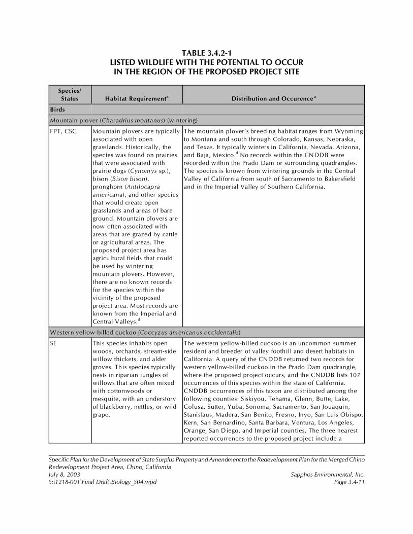
Specific Plan for the Development of State Surplus Property and Amendment to the Redevelopment Plan for the Merged ChinoRedevelopment Project Area, Chino, CaliforniaJuly 8, 2003 Sapphos Environmental, Inc.S:\1218-001\Final Draft\Biology_S04.wpd Page 3.4-11
TABLE 3.4.2-1LISTED WILDLIFE WITH THE POTENTIAL TO OCCURIN THE REGION OF THE PROPOSED PROJECT SITE
Species/
Status Habitat Requirementa Distribution and Occurencea
Birds
Mountain plover (Charadrius montanus) (wintering)
FPT, CSC Mountain plovers are typically
associated with open
grasslands. Historically, the
species was found on prairies
that were associated with
prairie dogs (Cynomys sp.),
bison (Bison bison),
pronghorn (Antilocapra
americana), and other species
that would create open
grasslands and areas of bare
ground. Mountain plovers are
now often associated with
areas that are grazed by cattle
or agricultural areas. The
proposed project area has
agricultural fields that could
be used by wintering
mountain plovers. However,
there are no known records
for the species within the
vicinity of the proposed
project area. Most records are
known from the Imperial and
Central Valleys.d
The mountain plover’s breeding habitat ranges from Wyoming
to Montana and south through Colorado, Kansas, Nebraska,
and Texas. It typically winters in California, Nevada, Arizona,
and Baja, Mexico.d No records within the CNDDB were
recorded within the Prado Dam or surrounding quadrangles.
The species is known from wintering grounds in the Central
Valley of California from south of Sacramento to Bakersfield
and in the Imperial Valley of Southern California.
Western yellow-billed cuckoo (Coccyzus americanus occidentalis)
SE This species inhabits open
woods, orchards, stream-side
willow thickets, and alder
groves. This species typically
nests in riparian jungles of
willows that are often mixed
with cottonwoods or
mesquite, with an understory
of blackberry, nettles, or wild
grape.
The western yellow-billed cuckoo is an uncommon summer
resident and breeder of valley foothill and desert habitats in
California. A query of the CNDDB returned two records for
western yellow-billed cuckoo in the Prado Dam quadrangle,
where the proposed project occurs, and the CNDDB lists 107
occurrences of this species within the state of California.
CNDDB occurrences of this taxon are distributed among the
following counties: Siskiyou, Tehama, Glenn, Butte, Lake,
Colusa, Sutter, Yuba, Sonoma, Sacramento, San Jouaquin,
Stanislaus, Madera, San Benito, Fresno, Inyo, San Luis Obispo,
Kern, San Bernardino, Santa Barbara, Ventura, Los Angeles,
Orange, San Diego, and Imperial counties. The three nearest
reported occurrences to the proposed project include a
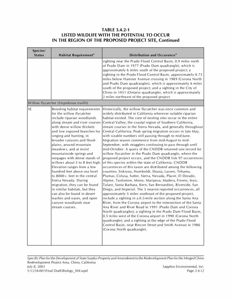
TABLE 3.4.2-1LISTED WILDLIFE WITH THE POTENTIAL TO OCCUR
IN THE REGION OF THE PROPOSED PROJECT SITE, Continued
Species/
Status Habitat Requirementa Distribution and Occurencea
Specific Plan for the Development of State Surplus Property and Amendment to the Redevelopment Plan for the Merged ChinoRedevelopment Project Area, Chino, CaliforniaJuly 8, 2003 Sapphos Environmental, Inc.S:\1218-001\Final Draft\Biology_S04.wpd Page 3.4-12
sighting near the Prado Flood Control Basin, 0.9 miles north
of Prado Dam in 1977 (Prado Dam quadrangle), which is
approximately 6 miles south of the proposed project; a
sighting in the Prado Flood Control Basin, approximately 0.75
miles below Hamner Avenue crossing in 1989 (Corona North
and Prado Dam quadrangles), which is approximately 6 miles
south of the proposed project; and a sighting in the City of
Chino in 1931 (Ontario quadrangle), which is approximately
2 miles northwest of the proposed project.
Willow flycatcher (Empidonax traillii)
SE Breeding habitat requirements
for the willow flycatcher
include riparian woodlands
along stream and river courses
with dense willow thickets
and low exposed branches for
singing and hunting, in
broader canyons and flood-
plains, around mountain
meadows, and at moist
mountainside springs and
seepages with dense stands of
willows about 3 to 8 feet high.
Elevation ranges from a few
hundred feet above sea level
to 8000+ feet in the central
Sierra Nevada. During
migration, they can be found
in similar habitats, but they
can also be found in desert
washes and oases, and open
canyon woodlands near
stream courses.
Historically, the willow flycatcher was once common and
widely distributed in California wherever suitable riparian
habitat existed. The core of nesting sites occur in the entire
Central Valley, the coastal region of Southern California,
stream courses in the Sierra Nevada, and generally throughout
Central California. Peak spring migration occurs in late May,
with sizable numbers still passing through to mid-June.
Migration season commence from mid-August to mid-
September, with stragglers continuing to pass through until
mid-October. A query of the CNDDB returned one record for
willow flycatcher in the Prado Dam quadrangle, where the
proposed project occurs, and the CNDDB lists 97 occurrences
of this species within the state of California. CNDDB
occurrences of this taxon are distributed among the following
counties: Siskiyou, Humboldt, Shasta, Lassen, Tehama,
Plumas, Colusa, Sutter, Sierra, Nevada, Placer, El Dorado,
Alpine, Tuolumne, Mono, Mariposa, Madera, Fresno, Inyo,
Tulare, Santa Barbara, Kern, San Bernardino, Riverside, San
Diego, and Imperial. The 3 nearest reported occurrences, all
approximately 5 miles southeast of the proposed project,
include a sighting in a 0.5-mile section along the Santa Ana
River, from the Corona airport to the intersection of the Santa
Ana River and River Road in 1991 (Prado Dam and Corona
North quadrangles); a sighting in the Prado Dam Flood Basin,
0.5 miles west of the Corona airport in 1990 (Corona North
quadrangle); and a sighting at the edge of the Prado Flood
Control Basin, near Rincon Street and Smith Avenue in 1986
(Corona North quadrangle).
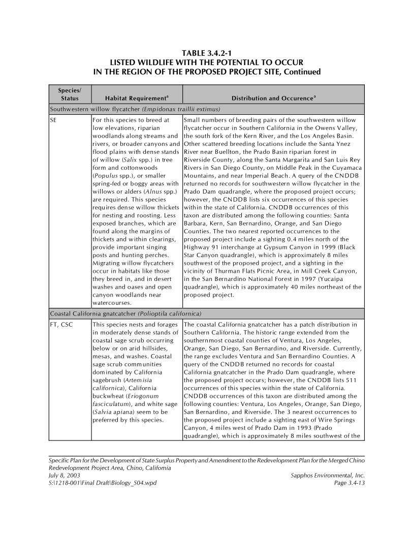
TABLE 3.4.2-1LISTED WILDLIFE WITH THE POTENTIAL TO OCCUR
IN THE REGION OF THE PROPOSED PROJECT SITE, Continued
Species/
Status Habitat Requirementa Distribution and Occurencea
Specific Plan for the Development of State Surplus Property and Amendment to the Redevelopment Plan for the Merged ChinoRedevelopment Project Area, Chino, CaliforniaJuly 8, 2003 Sapphos Environmental, Inc.S:\1218-001\Final Draft\Biology_S04.wpd Page 3.4-13
Southwestern willow flycatcher (Empidonax traillii extimus)
SE For this species to breed at
low elevations, riparian
woodlands along streams and
rivers, or broader canyons and
flood plains with dense stands
of willow (Salix spp.) in tree
form and cottonwoods
(Populus spp.), or smaller
spring-fed or boggy areas with
willows or alders (Alnus spp.)
are required. This species
requires dense willow thickets
for nesting and roosting. Less
exposed branches, which are
found along the margins of
thickets and within clearings,
provide important singing
posts and hunting perches.
Migrating willow flycatchers
occur in habitats like those
they breed in, and in desert
washes and oases and open
canyon woodlands near
watercourses.
Small numbers of breeding pairs of the southwestern willow
flycatcher occur in Southern California in the Owens Valley,
the south fork of the Kern River, and the Los Angeles Basin.
Other scattered breeding locations include the Santa Ynez
River near Buellton, the Prado Basin riparian forest in
Riverside County, along the Santa Margarita and San Luis Rey
Rivers in San Diego County, on Middle Peak in the Cuyamaca
Mountains, and near Imperial Beach. A query of the CNDDB
returned no records for southwestern willow flycatcher in the
Prado Dam quadrangle, where the proposed project occurs;
however, the CNDDB lists six occurrences of this species
within the state of California. CNDDB occurrences of this
taxon are distributed among the following counties: Santa
Barbara, Kern, San Bernardino, Orange, and San Diego
Counties. The two nearest reported occurrences to the
proposed project include a sighting 0.4 miles north of the
Highway 91 interchange at Gypsum Canyon in 1999 (Black
Star Canyon quadrangle), which is approximately 8 miles
southwest of the proposed project, and a sighting in the
vicinity of Thurman Flats Picnic Area, in Mill Creek Canyon,
in the San Bernardino National Forest in 1997 (Yucaipa
quadrangle), which is approximately 40 miles northeast of the
proposed project.
Coastal California gnatcatcher (Polioptila californica)
FT, CSC This species nests and forages
in moderately dense stands of
coastal sage scrub occurring
below or on arid hillsides,
mesas, and washes. Coastal
sage scrub comm unities
dominated by California
sagebrush (Artemisia
californica), Californ ia
buckwheat (Eriogonum
fasciculatum), and white sage
(Salvia apiana) seem to be
preferred by this species.
The coastal California gnatcatcher has a patch distribution in
Southern California. The historic range extended from the
southernmost coastal counties of Ventura, Los Angeles,
Orange, San Diego, San Bernardino, and Riverside. Currently,
the range excludes Ventura and San Bernardino Counties. A
query of the CNDDB returned no records for coastal
California gnatcatcher in the Prado Dam quadrangle, where
the proposed project occurs; however, the CNDDB lists 511
occurrences of this species within the state of California.
CNDDB occurrences of this taxon are distributed among the
following counties: Ventura, Los Angeles, Orange, San Diego,
San Bernardino, and Riverside. The 3 nearest occurrences to
the proposed project include a sighting east of Wire Springs
Canyon, 4 miles west of Prado Dam in 1993 (Prado
quadrangle), which is approximately 8 miles southwest of the
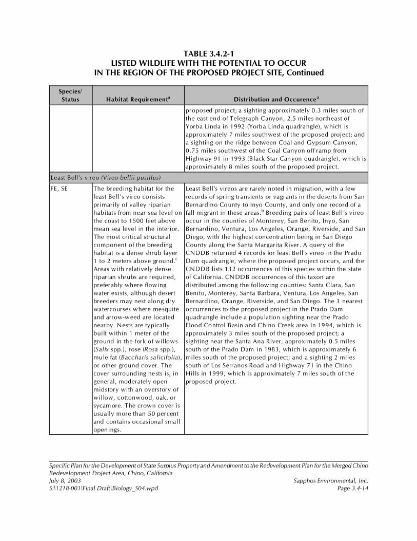
TABLE 3.4.2-1LISTED WILDLIFE WITH THE POTENTIAL TO OCCUR
IN THE REGION OF THE PROPOSED PROJECT SITE, Continued
Species/
Status Habitat Requirementa Distribution and Occurencea
Specific Plan for the Development of State Surplus Property and Amendment to the Redevelopment Plan for the Merged ChinoRedevelopment Project Area, Chino, CaliforniaJuly 8, 2003 Sapphos Environmental, Inc.S:\1218-001\Final Draft\Biology_S04.wpd Page 3.4-14
proposed project; a sighting approximately 0.3 miles south of
the east end of Telegraph Canyon, 2.5 miles northeast of
Yorba Linda in 1992 (Yorba Linda quadrangle), which is
approximately 7 miles southwest of the proposed project; and
a sighting on the ridge between Coal and Gypsum Canyon,
0.75 miles southwest of the Coal Canyon off ramp from
Highway 91 in 1993 (Black Star Canyon quadrangle), which is
approximately 8 miles south of the proposed project.
Least Bell’s vireo (Vireo bellii pusillus)
FE, SE The breeding habitat for the
least Bell’s vireo consists
primarily of valley riparian
habitats from near sea level on
the coast to 1500 feet above
mean sea level in the interior.
The most critical structural
component of the breeding
habitat is a dense shrub layer
1 to 2 meters above ground.c
Areas with relatively dense
riparian shrubs are required,
preferably where flowing
water exists, although desert
breeders may nest along dry
watercourses where mesquite
and arrow-weed are located
nearby. Nests are typically
built within 1 meter of the
ground in the fork of willows
(Salix spp.), rose (Rosa spp.),
mule fat (Baccharis salicifolia),
or other ground cover. The
cover surrounding nests is, in
general, moderately open
midstory with an overstory of
willow, cottonwood, oak, or
sycam ore. The crown cover is
usually more than 50 percent
and contains occasional small
openings.
Least Bell’s vireos are rarely noted in migration, with a few
records of spring transients or vagrants in the deserts from San
Bernardino County to Inyo County, and only one record of a
fall migrant in these areas.b Breeding pairs of least Bell’s vireo
occur in the counties of Monterey, San Benito, Inyo, San
Bernardino, Ventura, Los Angeles, Orange, Riverside, and San
Diego, with the highest concentration being in San Diego
County along the Santa Margarita River. A query of the
CNDDB returned 4 records for least Bell’s vireo in the Prado
Dam quadrangle, where the proposed project occurs, and the
CNDDB lists 132 occurrences of this species within the state
of California. CNDDB occurrences of this taxon are
distributed among the following counties: Santa Clara, San
Benito, Monterey, Santa Barbara, Ventura, Los Angeles, San
Bernardino, Orange, Riverside, and San Diego. The 3 nearest
occurrences to the proposed project in the Prado Dam
quadrangle include a population sighting near the Prado
Flood Control Basin and Chino Creek area in 1994, which is
approximately 3 miles south of the proposed project; a
sighting near the Santa Ana River, approximately 0.5 miles
south of the Prado Dam in 1983, which is approximately 6
miles south of the proposed project; and a sighting 2 miles
south of Los Serranos Road and Highway 71 in the Chino
Hills in 1999, which is approximately 7 miles south of the
proposed project.
TABLE 3.4.2-1LISTED WILDLIFE WITH THE POTENTIAL TO OCCUR
IN THE REGION OF THE PROPOSED PROJECT SITE, Continued
Specific Plan for the Development of State Surplus Property and Amendment to the Redevelopment Plan for the Merged ChinoRedevelopment Project Area, Chino, CaliforniaJuly 8, 2003 Sapphos Environmental, Inc.S:\1218-001\Final Draft\Biology_S04.wpd Page 3.4-15
KEY:CSC = California Department of Fish and Game Species of Special Concern.FE = Listed as endangered under the federal ESA.FPT = Federally proposed as threatened under the federal ESA.FT = Listed as threatened under the federal ESA.SE = Listed as endangered by the State of California.SOURCES:a Information on distribution, description, habitat association, space use, reproduction, and food habits of the listed wildlifespecies was gathered from the following sources unless otherwise noted:
1. Bent, A.C. 1950. “Life Histories of North American Wagtails, Shrikes, Vireos, and Their Allies.” U.S. NationalMuseum Bulletin 197.
2. California Department of Fish and Game. 2002. Rarefind 2: A Database Application for the Use of the CaliforniaDepartment of Fish and Game Natural Diversity Database. Sacramento, CA: California Department of Fish andGame.
3. Small, Arnold. 1994. California Birds: Their Status and Distribution. Vista, CA: Ibis Publishing Company.4. Sibley, D.A., 2001. National Audubon Society: The Sibley Guide to Bird Life and Behavior. New York, NY:
Alfred A. Knopf, Inc.5. Zeiner, D.C., W.F. Laudenslayer, Jr., K.E. Mayer, and M. White (eds.). 1990a. California’s Wildlife, Volume
II: Birds. Sacramento, CA: California Department of Fish and Game.b B.T. Brown. 1993. “Bell’s Vireo.” In The Birds of North America, No. 35. Edited by A. Poole, P. Stettenheim, and F. Gill.Philadelphia, PA: The Academy of Natural Sciences.c U.S. Fish and Wildlife Service. 1998. “Draft Recovery Plan for the Least Bell’s Vireo.” Portland, OR: U.S. Fish and WildlifeService. (p. 139.)d U.S. Fish and Wildlife Service. 1999. “Endangered and Threatened Wildlife and Plants: Proposed Threatened Status for theMountain Plover.” Federal Register, 64(30): 7587!7601.
Specific Plan for the Development of State Surplus Property and Amendment to the Redevelopment Plan for the Merged ChinoRedevelopment Project Area, Chino, CaliforniaJuly 8, 2003 Sapphos Environmental, Inc.S:\1218-001\Final Draft\Biology_S04.wpd Page 3.4-16
TABLE 3.4.2-2SENSITIVE WILDLIFE SPECIES WITH THE POTENTIAL TO OCCUR
IN THE REGION OF THE PROPOSED PROJECT SITE
Species/
Status
Habitat Requirementa Distribution and Occurrencea
Herpetofauna
Southwestern pond turtle (Clemmys marmorata pallida)
CSC This species is found in a variety of
freshwater and brackish water
habitats, including the edges of salt
marsh and estuarine habitat. They
are most common in coastal
streams and lagoons, and interior
streams, but can also be found in
reservoirs, stock ponds, sewage
treatment ponds, and intermittently
in vernal pools and other
ephemeral habitats.g In streams,
pools are preferred over shallow
reaches. Habitats can be rocky or
mud-bottomed, but they usually
contain a basking site and some
aquatic vegetation. They overwinter
in upland areas of coastal sage
scrub, chaparral, oak woodland,
and grassland. Hatchlings require
shallow-water habitat with
relatively dense submergent
vegetation in which to forage.
The southwestern pond turtle (Clemm ys marmorata
pallida) is a Federal Species of Concern and a California
Species of Special Concern. The southwestern pond
turtle is found from San Francisco Bay south into
northern Baja California. It is the only aquatic, native
turtle over its range. The CNDDB lists 265 occurrences
of this species throughout the state of California, and
the majority are presumed extant, whereas a few are
possibly extirpated. Occurrences of this species are
recorded in the following counties: Alameda, Santa
Cruz, Santa Clara, Monterey, San Luis Obispo, Kern,
San Bernardino, Santa Barbara, Ventura, Los Angeles,
Orange, Riverside, and San Diego. A query of the
CNDDB returned no records for southwestern pond
turtle in the Prado Dam quadrangle, where the
proposed project occurs. However, it did return records
in the quadrangles adjacent to the Prado Dam
quadrangle focused in Yorba Linda, Black Star Canyon,
and El Toro quadrangles. The specific location
information of each record was suppressed, but
occurrences were all noted in 1987.
San Diego horned lizard (Phrynosoma coronatum blainvillei)
CSC The San Diego horned lizard is
terrestrial and found in valleys,
mesas, and foothills.h They are
found in a variety of habitats,
including coastal sage, annual
grassland, chaparral, oak
woodland, riparian woodland,
valley foothill hardwood,
coniferous forests, pine cypress,
and juniper habitats. In the foothill
and mountain habitats covered
with dense brush or other
vegetation, San Diego horned
lizards are largely restricted to areas
with pockets of open microhabitat,
a habitat structure that can be
The San Diego horned lizard was historically
distributed from the Transverse Range in Kern, Santa
Barbara, Ventura, and Los Angeles counties southward
throughout the Peninsular Ranges of Southern
California to Baja California, Mexico, and as far south
as San Vicente. In California, this taxon ranges from the
Transverse Ranges to the Mexican border west of the
deserts, and it occurs at scattered sites along the
extreme western desert slope of the Peninsular Ranges.
There is also an isolated population in Siskiyou County.
A query of the CNDDB returned no records for San
Diego horned lizard in the Prado Dam quadrangle,
where the proposed project occurs; however, the
CNDDB lists 342 occurrences of this species within the
state of California. CNDDB occurrences of this taxon
are distributed among the following counties: Kern,
TABLE 3.4.2-2SENSITIVE WILDLIFE SPECIES WITH THE POTENTIAL TO OCCUR
IN THE REGION OF THE PROPOSED PROJECT SITE, Continued
Species/
Status
Habitat Requirementa Distribution and Occurrencea
Specific Plan for the Development of State Surplus Property and Amendment to the Redevelopment Plan for the Merged ChinoRedevelopment Project Area, Chino, CaliforniaJuly 8, 2003 Sapphos Environmental, Inc.S:\1218-001\Final Draft\Biology_S04.wpd Page 3.4-17
created by natural events such as
fire and floods or human-created
disturbances such as livestock
grazing, fire breaks, and roads.
They are chiefly found below 2000
feet in Northern California and
3000 feet in Southern California.
Ventura, Los Angeles, San Bernardino, Orange,
Riverside, and San Diego. The 3 nearest reported
occurrences to the proposed project include a sighting
on the ridge between Carbon Canyon and Soquel
Canyon in 1985 (Yorba Linda quadrangle),
approximately 7 miles southwest of the proposed
project, and two sightings south of Highway 91 near
Coal Canyon, one on the ridge between Coal and
Gypsum Canyons and one on the west side of Coal
Canyon, both in 1986 (Black Star Canyon quadrangle),
which are both approximately 8 miles south of the
proposed project.
Orange-throated whiptail (Cnemidophorus hyperythrus)
CSC, FP The orange-throated whiptail
prefers washes and other sandy
areas with patches of brush and
rocks. They forage actively on the
surface and scratch through surface
debris, consuming a variety of
small arthropods, especially
termites, which are taken in large
numbers when available. This
species is extremely active.
Individuals take cover in dense
vegetation when pursued. During
periods of inactivity, individuals
seek cover under surface objects
such as rocks, logs, decaying
vegetation, and boards, or in rock
crevices.
The orange-throated whiptail is uncomm on to fairly
common over much of its range, occurring coastally in
extreme southern Los Angeles County and in
southwestern San Bernardino County near Colton. The
orange-throated whiptail occurs also in Orange,
Riverside, and San Diego Counties, west of the crest of
the Peninsular Ranges, especially in areas with summer
morning fog and elevation ranging from sea level to
3000 feet above mean sea level. The orange-throated
whiptail inhabits low-elevation coastal scrub,
chamise-redshank chaparral, mixed chaparral, and
valley foothill hardwood habitats. A query of the
CNDDB returned 1 record for orange-throated whiptail
(Cnemidophorus hyperythrus) in the Prado Dam
quadrangle, where the proposed project occurs, and the
CNDDB lists 229 occurrences of this species within the
State of California. CNDDB occurrences of this taxon
are distributed among the following counties: Los
Angeles, San Bernardino, Orange, Riverside, and San
Diego. The 3 nearest reported occurrences to the
proposed project include the sighting in the Prado Dam
quadrangle in Chino Hills, west of Prado Flood Control
Basin and south of Abacherli Canyon at a suppressed
time, which is approximately 4 miles south of the
proposed project; a sighting in Coal Canyon, south of
Highway 91 in 1990 (Black Star Canyon quadrangle),
which is approximately 8 miles south of the proposed
project; and a sighting 0.75 miles south of Highway 91
and 0.5 miles west of Gypsum Canyon Road in 1988
TABLE 3.4.2-2SENSITIVE WILDLIFE SPECIES WITH THE POTENTIAL TO OCCUR
IN THE REGION OF THE PROPOSED PROJECT SITE, Continued
Species/
Status
Habitat Requirementa Distribution and Occurrencea
Specific Plan for the Development of State Surplus Property and Amendment to the Redevelopment Plan for the Merged ChinoRedevelopment Project Area, Chino, CaliforniaJuly 8, 2003 Sapphos Environmental, Inc.S:\1218-001\Final Draft\Biology_S04.wpd Page 3.4-18
(Black Star Canyon quadrangle), which is approximately
8 miles south of the proposed project.
San Diego mountain kingsnake (Lampropeltis zonata pulchra )
CSC The San Diego mountain kingsnake
inhabits a variety of habitats,
including coniferous forests,
chaparral, riparian, wet meadows,
and woodlands. It is most common
in the vicinity of rocks or boulders
near streams or lake shores, and it
may also use rotting logs.
The San Diego mountain kingsnake, a California
endemic, occurs in the Santa Monica Mountains (Los
Angeles County); Santa Ana Mountains (Orange and
Riverside Counties); Santa Rosa Mountains (Riverside
County); and Corte Madera, Cuyamaca, Hot Springs,
Laguna, and Palomar Mountains (San Diego County). A
query of the CNDDB returned no records for San Diego
mountain kingsnake in the Prado Dam quadrangle,
where the proposed project occurs; however, the
CNDDB lists 16 occurrences of this species within the
state of California. CNDDB occurrences of this taxon
are distributed among the following counties: Los
Angeles, Orange, and San Diego. The two nearest
reported occurrences to the El Prado Dam quadrangle
include a sighting along Maple Springs Road, 0.65
miles southwest of Bald Peak in 1993 (Corona South
quadrangle), approximately 17 miles southeast of the
proposed project, and a sighting in 1970 in the Santiago
Peak and Corona South quadrangles; however, the
location information has been suppressed.
Coast patch-nosed snake (Salvadora hexalepis virgultea)
CSC This species can be found in
coastal chaparral, brush, or shrubby
vegetation, such as chaparral and
sagebrush. It appears to be
associated with the preferred
habitat of its prey, the whiptail
lizard, requiring at least a low
shrub component of minimum
density as it is not found in habitats
lacking this structural component.
They take refuge and may
overwinter in small mammal
burrows or woodrat nests.
This species is thought to occur along the Transverse
Ranges and coastal plains of Cental and Southern
California, from the Los Padres National Forest in San
Luis Obispo County, southward to Santa Barbara and
Ventura counties, as well as the Angeles National Forest
in Los Angeles County; San Bernardino National Forest
in San Bernardino and Riverside counties; Cleveland
National Forest in Riverside and Orange Counties to the
coast in Orange County; and Cleveland National Forest
and Anza-Borrego Desert State Park to the coast in San
Diego County, southward into Baja California. Its
known elevation range extends from sea level to around
7000 feet. A query of the CNDDB returned no records
for coast patch-nosed snake in the Prado Dam
quadrangle, where the proposed project occurs;
however, the CNDDB lists six occurrences of this
species within the state of California. CNDDB
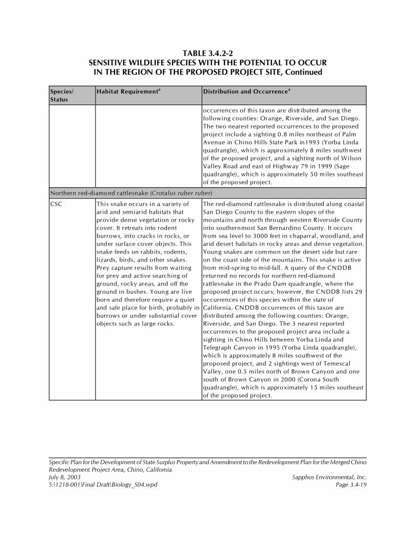
TABLE 3.4.2-2SENSITIVE WILDLIFE SPECIES WITH THE POTENTIAL TO OCCUR
IN THE REGION OF THE PROPOSED PROJECT SITE, Continued
Species/
Status
Habitat Requirementa Distribution and Occurrencea
Specific Plan for the Development of State Surplus Property and Amendment to the Redevelopment Plan for the Merged ChinoRedevelopment Project Area, Chino, CaliforniaJuly 8, 2003 Sapphos Environmental, Inc.S:\1218-001\Final Draft\Biology_S04.wpd Page 3.4-19
occurrences of this taxon are distributed among the
following counties: Orange, Riverside, and San Diego.
The two nearest reported occurrences to the proposed
project include a sighting 0.8 miles northeast of Palm
Avenue in Chino Hills State Park in1993 (Yorba Linda
quadrangle), which is approximately 8 miles southwest
of the proposed project, and a sighting north of Wilson
Valley Road and east of Highway 79 in 1999 (Sage
quadrangle), which is approximately 50 miles southeast
of the proposed project.
Northern red-diamond rattlesnake (Crotalus ruber ruber)
CSC This snake occurs in a variety of
arid and semiarid habitats that
provide dense vegetation or rocky
cover. It retreats into rodent
burrows, into cracks in rocks, or
under surface cover objects. This
snake feeds on rabbits, rodents,
lizards, birds, and other snakes.
Prey capture results from waiting
for prey and active searching of
ground, rocky areas, and off the
ground in bushes. Young are live
born and therefore require a quiet
and safe place for b irth, probably in
burrows or under substantial cover
objects such as large rocks.
The red-diamond rattlesnake is distributed along coastal
San Diego County to the eastern slopes of the
mountains and north through western Riverside County
into southernmost San Bernardino County. It occurs
from sea level to 3000 feet in chaparral, woodland, and
arid desert habitats in rocky areas and dense vegetation.
Young snakes are common on the desert side but rare
on the coast side of the mountains. This snake is active
from mid-spring to mid-fall. A query of the CNDDB
returned no records for northern red-diamond
rattlesnake in the Prado Dam quadrangle, where the
proposed project occurs; however, the CNDDB lists 29
occurrences of this species within the state of
California. CNDDB occurrences of this taxon are
distributed among the following counties: Orange,
Riverside, and San Diego. The 3 nearest reported
occurrences to the proposed project area include a
sighting in Chino Hills between Yorba Linda and
Telegraph Canyon in 1995 (Yorba Linda quadrangle),
which is approximately 8 miles southwest of the
proposed project, and 2 sightings west of Temescal
Valley, one 0.5 miles north of Brown Canyon and one
south of Brown Canyon in 2000 (Corona South
quadrangle), which is approximately 15 miles southeast
of the proposed project.

TABLE 3.4.2-2SENSITIVE WILDLIFE SPECIES WITH THE POTENTIAL TO OCCUR
IN THE REGION OF THE PROPOSED PROJECT SITE, Continued
Species/
Status
Habitat Requirementa Distribution and Occurrencea
Specific Plan for the Development of State Surplus Property and Amendment to the Redevelopment Plan for the Merged ChinoRedevelopment Project Area, Chino, CaliforniaJuly 8, 2003 Sapphos Environmental, Inc.S:\1218-001\Final Draft\Biology_S04.wpd Page 3.4-20
Birds
Cooper’s hawk (Accipiter cooperi)
CSC Cooper’s hawk occupies deciduous
and mixed forests and open
woodland habitats such as
woodlots, riparian woodlands,
semiarid woodlands of the
southwest, and other areas where
woodlands occur in patches and
groves or as spaced trees. A variety
of habitats are utilized for wintering
and migrating.
The Cooper’s hawk ranges the length of the state and is
widespread; however, they are uncommon in the
northwest coastal region and southeastern deserts. They
range from sea level to above approximately 8,800 feet
in elevation. Cooper’s hawks nest throughout much of
the state, including Southern California in appropriate
habitat.
Golden eagle (Aquila chrysaetos)
CSC, FP The golden eagle typically inhabits
areas of grasslands, woodlands,
savannahs, farms, ranches,
chaparral, sagebrush flats, desert
edge, montane valleys, and alpine
tundra. The species tends to avoid
dense coastal and montane
coniferous forests. For breeding,
they utilize steep cliffs or medium-
to-tall trees in open woodland that
borders on more open areas.
The golden eagle ranges throughout California, except
for the center of Central Valley, the immediate coast,
urbanized areas, the Salton Sea, and the Colorado
River. They range from sea level up to 3833 feet. The
golden eagle is perhaps more common in Southern
California than in the north. A query of the CNDDB
returned 2 records for golden eagle in the Prado Dam
quadrangle, where the proposed project occurs, and the
CNDDB lists 66 occurrences of this species within the
state of California. CNDDB occurrences of this taxon
are distributed among the following counties: Siskiyou,
Modoc, Humboldt, Trinity, Lassen, Colusa, Napa, El
Dorado, Solano, Sacramento, Contra Costa, Mono,
Alameda, Santa Clara, Madera, Fresno, Monterey, Kern,
San Bernardino, Orange, Riverside, and San Diego. The
2 reported occurrences in the Prado Dam quadrangle
include a sighting in Brush Canyon in Chino State Park
in 1996, approximately 8 miles southwest of the
proposed project, and a sighting north of Aliso Canyon
in the Chino Hills in 1998, approximately 3 miles
southwest of the proposed project. One golden eagle
was sighted over the project area during surveys in
2001.
Northern harrier (Circus cyaneus)
CSC The northern harrier forages over
grasslands, meadows, shrub, desert
sinks, and marsh habitats. Northern
This species is a year-round resident in Southern
California. The range of the northern harrier extends the
length of California and is widespread. During winter, it
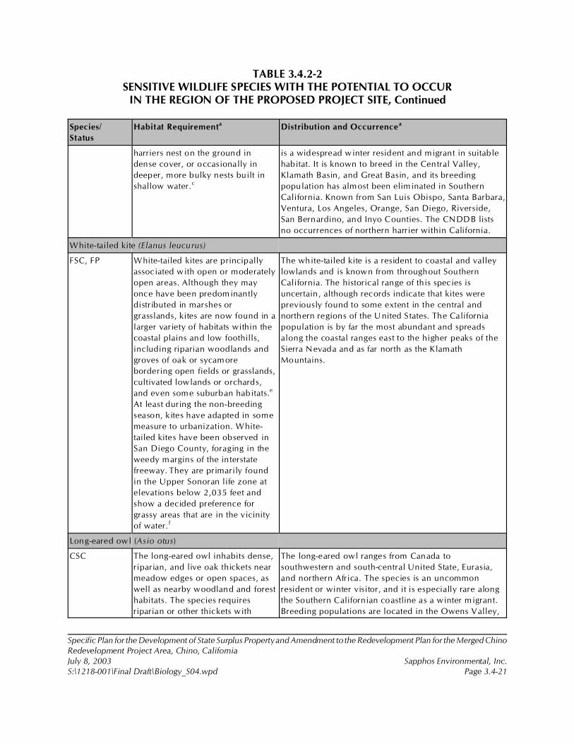
TABLE 3.4.2-2SENSITIVE WILDLIFE SPECIES WITH THE POTENTIAL TO OCCUR
IN THE REGION OF THE PROPOSED PROJECT SITE, Continued
Species/
Status
Habitat Requirementa Distribution and Occurrencea
Specific Plan for the Development of State Surplus Property and Amendment to the Redevelopment Plan for the Merged ChinoRedevelopment Project Area, Chino, CaliforniaJuly 8, 2003 Sapphos Environmental, Inc.S:\1218-001\Final Draft\Biology_S04.wpd Page 3.4-21
harriers nest on the ground in
dense cover, or occasionally in
deeper, more bulky nests built in
shallow water.c
is a widespread winter resident and migrant in suitable
habitat. It is known to breed in the Central Valley,
Klamath Basin, and Great Basin, and its breeding
population has almost been eliminated in Southern
California. Known from San Luis Obispo, Santa Barbara,
Ventura, Los Angeles, Orange, San Diego, Riverside,
San Bernardino, and Inyo Counties. The CNDDB lists
no occurrences of northern harrier within California.
White-tailed kite (Elanus leucurus)
FSC, FP White-tailed kites are principally
associated with open or moderately
open areas. Although they may
once have been predominantly
distributed in marshes or
grasslands, kites are now found in a
larger variety of habitats within the
coastal plains and low foothills,
including riparian woodlands and
groves of oak or sycamore
bordering open fields or grasslands,
cultivated lowlands or orchards,
and even some suburban habitats.e
At least during the non-breeding
season, kites have adapted in some
measure to urbanization. White-
tailed kites have been observed in
San Diego County, foraging in the
weedy margins of the interstate
freeway. They are primarily found
in the Upper Sonoran life zone at
elevations below 2,035 feet and
show a decided preference for
grassy areas that are in the vicinity
of water. f
The white-tailed kite is a resident to coastal and valley
lowlands and is known from throughout Southern
California. The historical range of this species is
uncertain, although records indicate that kites were
previously found to some extent in the central and
northern regions of the United States. The California
population is by far the most abundant and spreads
along the coastal ranges east to the higher peaks of the
Sierra Nevada and as far north as the Klamath
Mountains.
Long-eared owl (Asio otus)
CSC The long-eared owl inhabits dense,
riparian, and live oak thickets near
meadow edges or open spaces, as
well as nearby woodland and forest
habitats. The species requires
riparian or other thickets with
The long-eared owl ranges from Canada to
southwestern and south-central United State, Eurasia,
and northern Africa. The species is an uncommon
resident or winter visitor, and it is especially rare along
the Southern Californian coastline as a winter migrant.
Breeding populations are located in the Owens Valley,
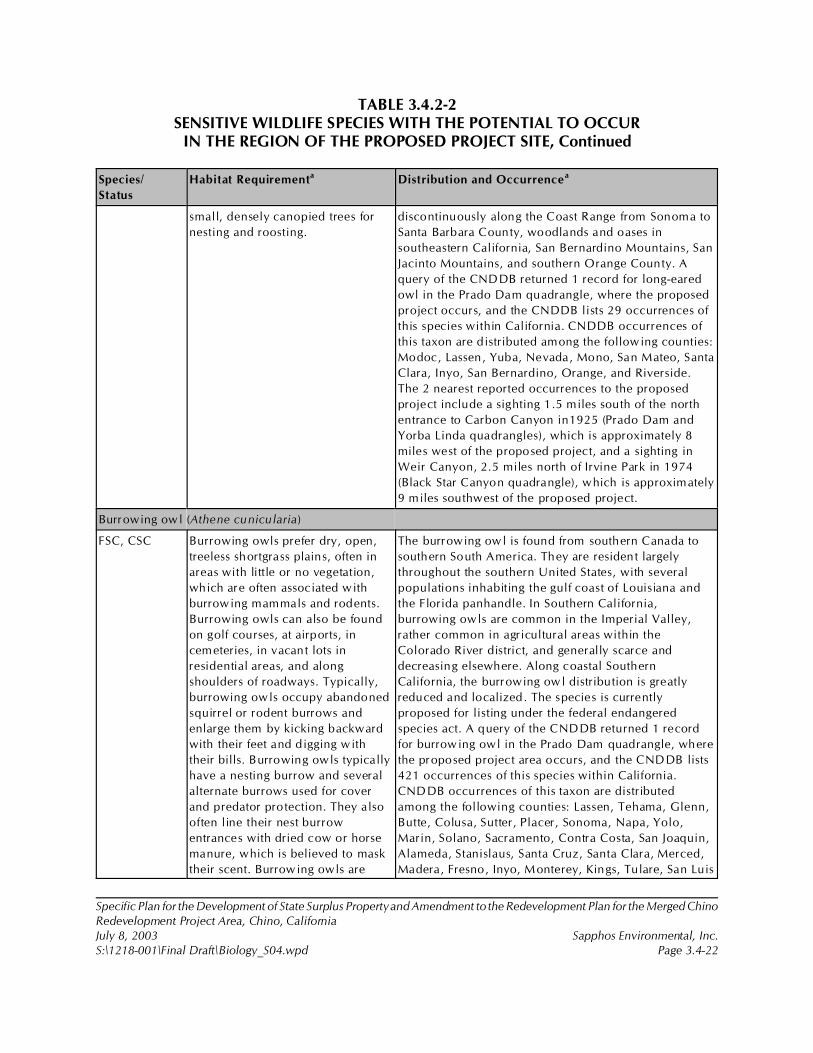
TABLE 3.4.2-2SENSITIVE WILDLIFE SPECIES WITH THE POTENTIAL TO OCCUR
IN THE REGION OF THE PROPOSED PROJECT SITE, Continued
Species/
Status
Habitat Requirementa Distribution and Occurrencea
Specific Plan for the Development of State Surplus Property and Amendment to the Redevelopment Plan for the Merged ChinoRedevelopment Project Area, Chino, CaliforniaJuly 8, 2003 Sapphos Environmental, Inc.S:\1218-001\Final Draft\Biology_S04.wpd Page 3.4-22
small, densely canopied trees for
nesting and roosting.
discontinuously along the Coast Range from Sonoma to
Santa Barbara County, woodlands and oases in
southeastern California, San Bernardino Mountains, San
Jacinto Mountains, and southern Orange County. A
query of the CNDDB returned 1 record for long-eared
owl in the Prado Dam quadrangle, where the proposed
project occurs, and the CNDDB lists 29 occurrences of
this species within California. CNDDB occurrences of
this taxon are distributed among the following counties:
Modoc, Lassen, Yuba, Nevada, Mono, San Mateo, Santa
Clara, Inyo, San Bernardino, Orange, and Riverside.
The 2 nearest reported occurrences to the proposed
project include a sighting 1.5 miles south of the north
entrance to Carbon Canyon in1925 (Prado Dam and
Yorba Linda quadrangles), which is approximately 8
miles west of the proposed project, and a sighting in
Weir Canyon, 2.5 miles north of Irvine Park in 1974
(Black Star Canyon quadrangle), which is approximately
9 miles southwest of the proposed project.
Burrowing owl (Athene cunicularia)
FSC, CSC Burrowing owls prefer dry, open,
treeless shortgrass plains, often in
areas with little or no vegetation,
which are often associated with
burrowing mammals and rodents.
Burrowing owls can also be found
on golf courses, at airports, in
cemeteries, in vacant lots in
residential areas, and along
shoulders of roadways. Typically,
burrowing owls occupy abandoned
squirrel or rodent burrows and
enlarge them by kicking backward
with their feet and digging with
their bills. Burrowing owls typically
have a nesting burrow and several
alternate burrows used for cover
and predator protection. They also
often line their nest burrow
entrances with dried cow or horse
manure, which is believed to mask
their scent. Burrowing owls are
The burrowing owl is found from southern Canada to
southern South America. They are resident largely
throughout the southern United States, with several
populations inhabiting the gulf coast of Louisiana and
the Florida panhandle. In Southern California,
burrowing owls are common in the Imperial Valley,
rather common in agricultural areas within the
Colorado River district, and generally scarce and
decreasing elsewhere. Along coastal Southern
California, the burrowing owl distribution is greatly
reduced and localized. The species is currently
proposed for listing under the federal endangered
species act. A query of the CNDDB returned 1 record
for burrowing owl in the Prado Dam quadrangle, where
the proposed project area occurs, and the CNDDB lists
421 occurrences of this species within California.
CNDDB occurrences of this taxon are distributed
among the following counties: Lassen, Tehama, Glenn,
Butte, Colusa, Sutter, Placer, Sonoma, Napa, Yolo,
Marin, Solano, Sacramento, Contra Costa, San Joaquin,
Alameda, Stanislaus, Santa Cruz, Santa Clara, Merced,
Madera, Fresno, Inyo, Monterey, Kings, Tulare, San Luis
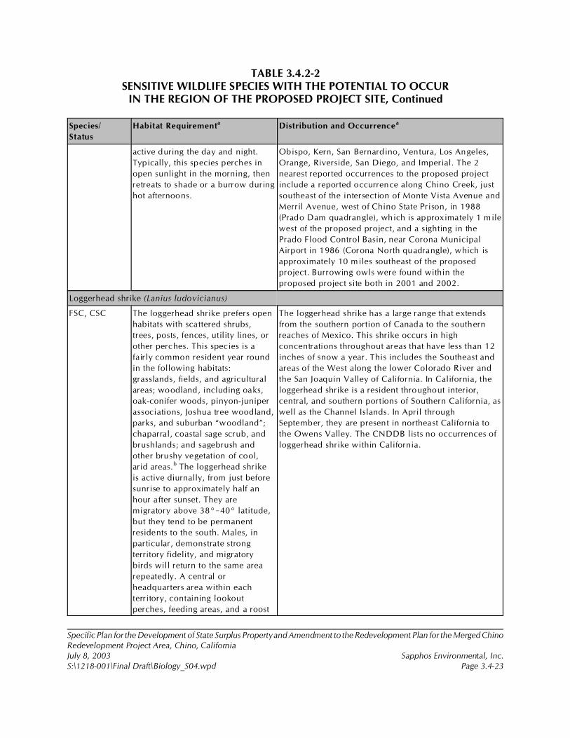
TABLE 3.4.2-2SENSITIVE WILDLIFE SPECIES WITH THE POTENTIAL TO OCCUR
IN THE REGION OF THE PROPOSED PROJECT SITE, Continued
Species/
Status
Habitat Requirementa Distribution and Occurrencea
Specific Plan for the Development of State Surplus Property and Amendment to the Redevelopment Plan for the Merged ChinoRedevelopment Project Area, Chino, CaliforniaJuly 8, 2003 Sapphos Environmental, Inc.S:\1218-001\Final Draft\Biology_S04.wpd Page 3.4-23
active during the day and night.
Typically, this species perches in
open sunlight in the morning, then
retreats to shade or a burrow during
hot afternoons.
Obispo, Kern, San Bernardino, Ventura, Los Angeles,
Orange, Riverside, San Diego, and Imperial. The 2
nearest reported occurrences to the proposed project
include a reported occurrence along Chino Creek, just
southeast of the intersection of Monte Vista Avenue and
Merril Avenue, west of Chino State Prison, in 1988
(Prado Dam quadrangle), which is approximately 1 mile
west of the proposed project, and a sighting in the
Prado Flood Control Basin, near Corona Municipal
Airport in 1986 (Corona North quadrangle), which is
approximately 10 miles southeast of the proposed
project. Burrowing owls were found within the
proposed project site both in 2001 and 2002.
Loggerhead shrike (Lanius ludovicianus)
FSC, CSC The loggerhead shrike prefers open
habitats with scattered shrubs,
trees, posts, fences, utility lines, or
other perches. This species is a
fairly common resident year round
in the following habitats:
grasslands, fields, and agricultural
areas; woodland, including oaks,
oak-conifer woods, pinyon-juniper
associations, Joshua tree woodland,
parks, and suburban “woodland”;
chaparral, coastal sage scrub, and
brushlands; and sagebrush and
other brushy vegetation of cool,
arid areas.b The loggerhead shrike
is active diurnally, from just before
sunrise to approximately half an
hour after sunset. They are
migratory above 38°!40° latitude,
but they tend to be permanent
residents to the south. Males, in
particular, demonstrate strong
territory fidelity, and migratory
birds will return to the same area
repeatedly. A central or
headquarters area within each
territory, containing lookout
perches, feeding areas, and a roost
The loggerhead shrike has a large range that extends
from the southern portion of Canada to the southern
reaches of Mexico. This shrike occurs in high
concentrations throughout areas that have less than 12
inches of snow a year. This includes the Southeast and
areas of the West along the lower Colorado River and
the San Joaquin Valley of California. In California, the
loggerhead shrike is a resident throughout interior,
central, and southern portions of Southern California, as
well as the Channel Islands. In April through
September, they are present in northeast California to
the Owens Valley. The CNDDB lists no occurrences of
loggerhead shrike within California.
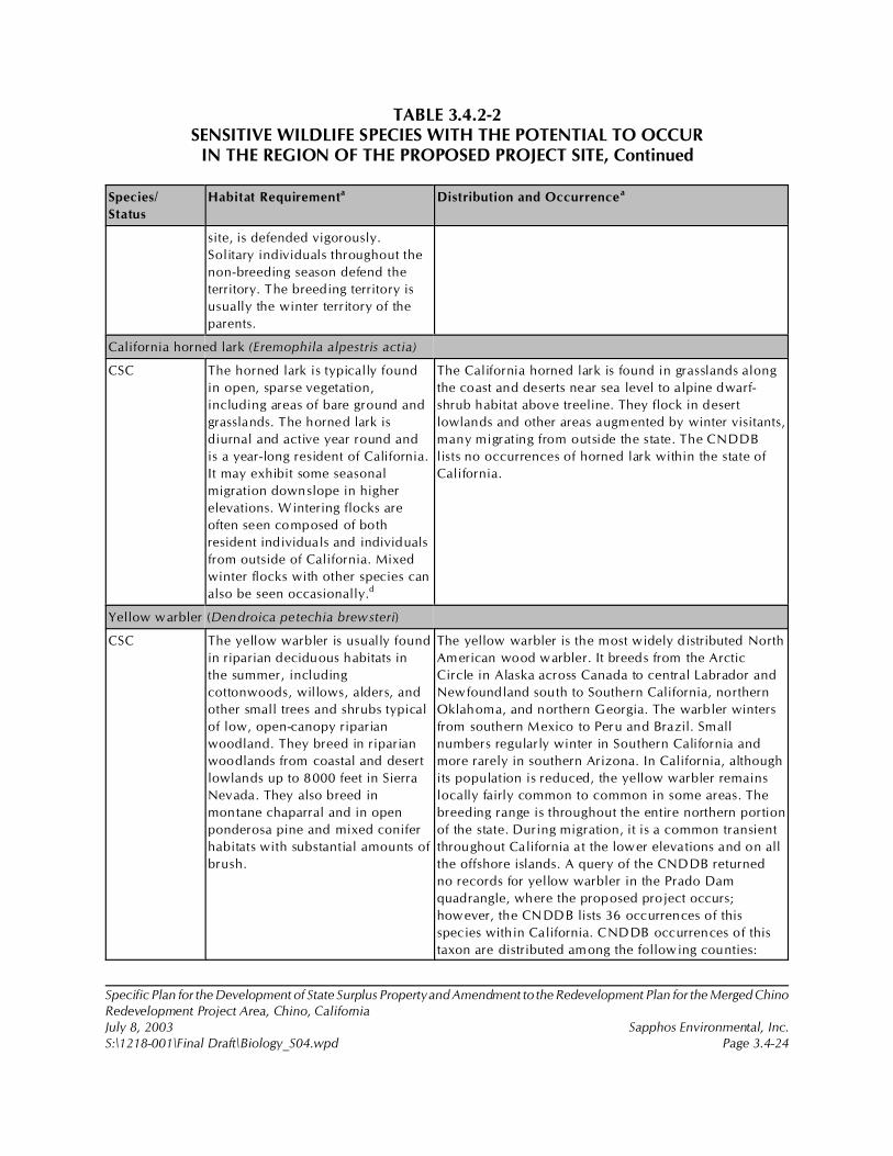
TABLE 3.4.2-2SENSITIVE WILDLIFE SPECIES WITH THE POTENTIAL TO OCCUR
IN THE REGION OF THE PROPOSED PROJECT SITE, Continued
Species/
Status
Habitat Requirementa Distribution and Occurrencea
Specific Plan for the Development of State Surplus Property and Amendment to the Redevelopment Plan for the Merged ChinoRedevelopment Project Area, Chino, CaliforniaJuly 8, 2003 Sapphos Environmental, Inc.S:\1218-001\Final Draft\Biology_S04.wpd Page 3.4-24
site, is defended vigorously.
Solitary individuals throughout the
non-breeding season defend the
territory. The breeding territory is
usually the winter territory of the
parents.
California horned lark (Eremophila alpestris actia)
CSC The horned lark is typically found
in open, sparse vegetation,
including areas of bare ground and
grasslands. The horned lark is
diurnal and active year round and
is a year-long resident of California.
It may exhibit some seasonal
migration downslope in higher
elevations. Wintering flocks are
often seen composed of both
resident individuals and individuals
from outside of California. Mixed
winter flocks with other species can
also be seen occasionally.d
The California horned lark is found in grasslands along
the coast and deserts near sea level to alpine dwarf-
shrub habitat above treeline. They flock in desert
lowlands and other areas augmented by winter visitants,
many migrating from outside the state. The CNDDB
lists no occurrences of horned lark within the state of
California.
Yellow warbler (Dendroica petechia brewsteri)
CSC The yellow warbler is usually found
in riparian deciduous habitats in
the summer, including
cottonwoods, willows, alders, and
other small trees and shrubs typical
of low, open-canopy riparian
woodland. They breed in riparian
woodlands from coastal and desert
lowlands up to 8000 feet in Sierra
Nevada. They also breed in
montane chaparral and in open
ponderosa pine and mixed conifer
habitats with substantial amounts of
brush.
The yellow warbler is the most widely distributed North
American wood warbler. It breeds from the Arctic
Circle in Alaska across Canada to central Labrador and
Newfoundland south to Southern California, northern
Oklahoma, and northern Georgia. The warbler winters
from southern Mexico to Peru and Brazil. Small
numbers regularly winter in Southern California and
more rarely in southern Arizona. In California, although
its population is reduced, the yellow warbler remains
locally fairly common to common in some areas. The
breeding range is throughout the entire northern portion
of the state. During migration, it is a common transient
throughout California at the lower elevations and on all
the offshore islands. A query of the CNDDB returned
no records for yellow warbler in the Prado Dam
quadrangle, where the proposed project occurs;
however, the CNDDB lists 36 occurrences of this
species within California. CNDDB occurrences of this
taxon are distributed among the following counties:
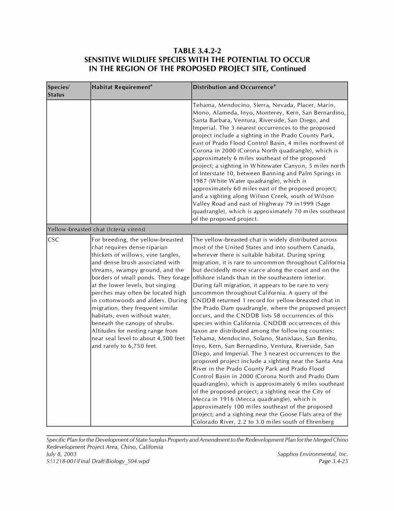
TABLE 3.4.2-2SENSITIVE WILDLIFE SPECIES WITH THE POTENTIAL TO OCCUR
IN THE REGION OF THE PROPOSED PROJECT SITE, Continued
Species/
Status
Habitat Requirementa Distribution and Occurrencea
Specific Plan for the Development of State Surplus Property and Amendment to the Redevelopment Plan for the Merged ChinoRedevelopment Project Area, Chino, CaliforniaJuly 8, 2003 Sapphos Environmental, Inc.S:\1218-001\Final Draft\Biology_S04.wpd Page 3.4-25
Tehama, Mendocino, Sierra, Nevada, Placer, Marin,
Mono, Alameda, Inyo, Monterey, Kern, San Bernardino,
Santa Barbara, Ventura, Riverside, San Diego, and
Imperial. The 3 nearest occurrences to the proposed
project include a sighting in the Prado County Park,
east of Prado Flood Control Basin, 4 miles northwest of
Corona in 2000 (Corona North quadrangle), which is
approximately 6 miles southeast of the proposed
project; a sighting in W hitewater Canyon, 5 miles north
of Interstate 10, between Banning and Palm Springs in
1987 (White Water quadrangle), which is
approximately 60 miles east of the proposed project;
and a sighting along Wilson Creek, south of Wilson
Valley Road and east of Highway 79 in1999 (Sage
quadrangle), which is approximately 70 miles southeast
of the proposed project.
Yellow-breasted chat (Icteria virens)
CSC For breeding, the yellow-breasted
chat requires dense riparian
thickets of willows, vine tangles,
and dense brush associated with
streams, swampy ground, and the
borders of small ponds. They forage
at the lower levels, but singing
perches may often be located high
in cottonwoods and alders. During
migration, they frequent similar
habitats, even without water,
beneath the canopy of shrubs.
Altitudes for nesting range from
near seal level to about 4,500 feet
and rarely to 6,750 feet.
The yellow-breasted chat is widely distributed across
most of the United States and into southern Canada,
wherever there is suitable habitat. During spring
migration, it is rare to uncommon throughout California
but decidedly more scarce along the coast and on the
offshore islands than in the southeastern interior.
During fall migration, it appears to be rare to very
uncommon throughout California. A query of the
CNDDB returned 1 record for yellow-breasted chat in
the Prado Dam quadrangle, where the proposed project
occurs, and the CNDDB lists 58 occurrences of this
species within California. CNDDB occurrences of this
taxon are distributed among the following counties:
Tehama, Mendocino, Solano, Stanislaus, San Benito,
Inyo, Kern, San Bernardino, Ventura, Riverside, San
Diego, and Imperial. The 3 nearest occurrences to the
proposed project include a sighting near the Santa Ana
River in the Prado County Park and Prado Flood
Control Basin in 2000 (Corona North and Prado Dam
quadrangles), which is approximately 6 miles southeast
of the proposed project; a sighting near the City of
Mecca in 1916 (Mecca quadrangle), which is
approximately 100 miles southeast of the proposed
project; and a sighting near the Goose Flats area of the
Colorado River, 2.2 to 3.0 miles south of Ehrenberg
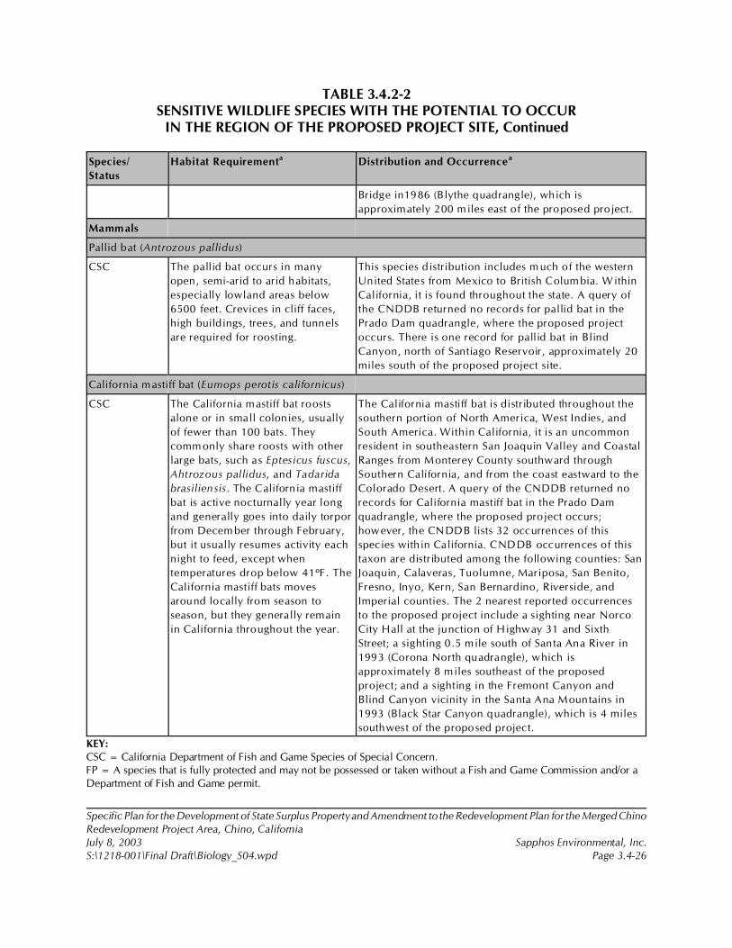
TABLE 3.4.2-2SENSITIVE WILDLIFE SPECIES WITH THE POTENTIAL TO OCCUR
IN THE REGION OF THE PROPOSED PROJECT SITE, Continued
Species/
Status
Habitat Requirementa Distribution and Occurrencea
Specific Plan for the Development of State Surplus Property and Amendment to the Redevelopment Plan for the Merged ChinoRedevelopment Project Area, Chino, CaliforniaJuly 8, 2003 Sapphos Environmental, Inc.S:\1218-001\Final Draft\Biology_S04.wpd Page 3.4-26
Bridge in1986 (Blythe quadrangle), which is
approximately 200 miles east of the proposed project.
Mamm als
Pallid bat (Antrozous pallidus)
CSC The pallid bat occurs in many
open, semi-arid to arid habitats,
especially lowland areas below
6500 feet. Crevices in cliff faces,
high buildings, trees, and tunnels
are required for roosting.
This species distribution includes much of the western
United States from Mexico to British Columbia. Within
California, it is found throughout the state. A query of
the CNDDB returned no records for pallid bat in the
Prado Dam quadrangle, where the proposed project
occurs. There is one record for pallid bat in Blind
Canyon, north of Santiago Reservoir, approximately 20
miles south of the proposed project site.
California mastiff bat (Eumops perotis californicus)
CSC The California mastiff bat roosts
alone or in small colonies, usually
of fewer than 100 bats. They
comm only share roosts with other
large bats, such as Eptesicus fuscus,
Ahtrozous pallidus, and Tadarida
brasiliensis. The California mastiff
bat is active nocturnally year long
and generally goes into daily torpor
from Decem ber through February,
but it usually resumes activity each
night to feed, except when
temperatures drop below 41ºF. The
California mastiff bats moves
around locally from season to
season, but they generally remain
in California throughout the year.
The California mastiff bat is distributed throughout the
southern portion of North America, West Indies, and
South America. Within California, it is an uncommon
resident in southeastern San Joaquin Valley and Coastal
Ranges from Monterey County southward through
Southern California, and from the coast eastward to the
Colorado Desert. A query of the CNDDB returned no
records for California mastiff bat in the Prado Dam
quadrangle, where the proposed project occurs;
however, the CNDDB lists 32 occurrences of this
species within California. CNDDB occurrences of this
taxon are distributed among the following counties: San
Joaquin, Calaveras, Tuolumne, Mariposa, San Benito,
Fresno, Inyo, Kern, San Bernardino, Riverside, and
Imperial counties. The 2 nearest reported occurrences
to the proposed project include a sighting near Norco
City Hall at the junction of Highway 31 and Sixth
Street; a sighting 0.5 mile south of Santa Ana River in
1993 (Corona North quadrangle), which is
approximately 8 miles southeast of the proposed
project; and a sighting in the Fremont Canyon and
Blind Canyon vicinity in the Santa Ana Mountains in
1993 (Black Star Canyon quadrangle), which is 4 miles
southwest of the proposed project.
KEY:CSC = California Department of Fish and Game Species of Special Concern.FP = A species that is fully protected and may not be possessed or taken without a Fish and Game Commission and/or aDepartment of Fish and Game permit.
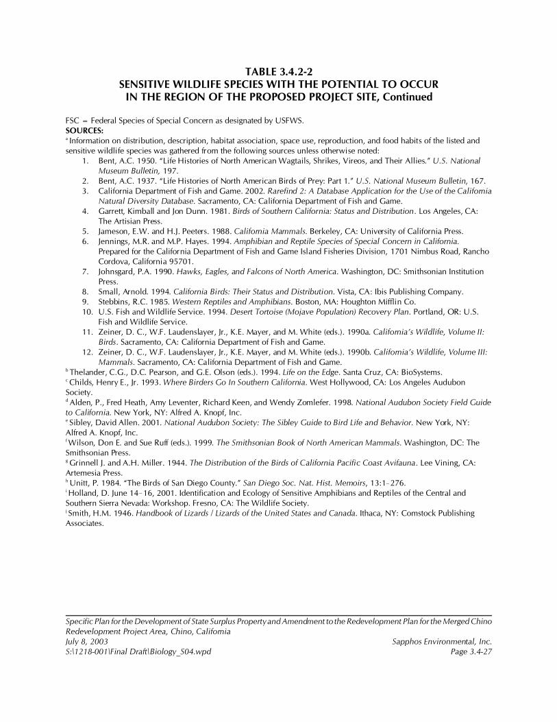
TABLE 3.4.2-2SENSITIVE WILDLIFE SPECIES WITH THE POTENTIAL TO OCCUR
IN THE REGION OF THE PROPOSED PROJECT SITE, Continued
Specific Plan for the Development of State Surplus Property and Amendment to the Redevelopment Plan for the Merged ChinoRedevelopment Project Area, Chino, CaliforniaJuly 8, 2003 Sapphos Environmental, Inc.S:\1218-001\Final Draft\Biology_S04.wpd Page 3.4-27
FSC = Federal Species of Special Concern as designated by USFWS.SOURCES:a Information on distribution, description, habitat association, space use, reproduction, and food habits of the listed andsensitive wildlife species was gathered from the following sources unless otherwise noted:
1. Bent, A.C. 1950. “Life Histories of North American Wagtails, Shrikes, Vireos, and Their Allies.” U.S. National Museum Bulletin, 197.
2. Bent, A.C. 1937. “Life Histories of North American Birds of Prey: Part 1.” U.S. National Museum Bulletin, 167.3. California Department of Fish and Game. 2002. Rarefind 2: A Database Application for the Use of the California
Natural Diversity Database. Sacramento, CA: California Department of Fish and Game.4. Garrett, Kimball and Jon Dunn. 1981. Birds of Southern California: Status and Distribution. Los Angeles, CA:
The Artisian Press.5. Jameson, E.W. and H.J. Peeters. 1988. California Mammals. Berkeley, CA: University of California Press.6. Jennings, M.R. and M.P. Hayes. 1994. Amphibian and Reptile Species of Special Concern in California.
Prepared for the California Department of Fish and Game Island Fisheries Division, 1701 Nimbus Road, Rancho Cordova, California 95701.
7. Johnsgard, P.A. 1990. Hawks, Eagles, and Falcons of North America. Washington, DC: Smithsonian Institution Press.
8. Small, Arnold. 1994. California Birds: Their Status and Distribution. Vista, CA: Ibis Publishing Company.9. Stebbins, R.C. 1985. Western Reptiles and Amphibians. Boston, MA: Houghton Mifflin Co.10. U.S. Fish and Wildlife Service. 1994. Desert Tortoise (Mojave Population) Recovery Plan. Portland, OR: U.S.
Fish and Wildlife Service.11. Zeiner, D. C., W.F. Laudenslayer, Jr., K.E. Mayer, and M. White (eds.). 1990a. California’s Wildlife, Volume II:
Birds. Sacramento, CA: California Department of Fish and Game.12. Zeiner, D. C., W.F. Laudenslayer, Jr., K.E. Mayer, and M. White (eds.). 1990b. California’s Wildlife, Volume III:
Mammals. Sacramento, CA: California Department of Fish and Game.b Thelander, C.G., D.C. Pearson, and G.E. Olson (eds.). 1994. Life on the Edge. Santa Cruz, CA: BioSystems.c Childs, Henry E., Jr. 1993. Where Birders Go In Southern California. West Hollywood, CA: Los Angeles AudubonSociety.d Alden, P., Fred Heath, Amy Leventer, Richard Keen, and Wendy Zomlefer. 1998. National Audubon Society Field Guideto California. New York, NY: Alfred A. Knopf, Inc.e Sibley, David Allen. 2001. National Audubon Society: The Sibley Guide to Bird Life and Behavior. New York, NY:Alfred A. Knopf, Inc.f Wilson, Don E. and Sue Ruff (eds.). 1999. The Smithsonian Book of North American Mammals. Washington, DC: TheSmithsonian Press.g Grinnell J. and A.H. Miller. 1944. The Distribution of the Birds of California Pacific Coast Avifauna. Lee Vining, CA:Artemesia Press.h Unitt, P. 1984. “The Birds of San Diego County.” San Diego Soc. Nat. Hist. Memoirs, 13:1!276.i Holland, D. June 14!16, 2001. Identification and Ecology of Sensitive Amphibians and Reptiles of the Central andSouthern Sierra Nevada: Workshop. Fresno, CA: The Wildlife Society.j Smith, H.M. 1946. Handbook of Lizards / Lizards of the United States and Canada. Ithaca, NY: Comstock PublishingAssociates.
28 Philip A. Munz and D.D. Keck, 1949. “California Plant Communities.” El Aliso 2(1): 87!105.
29 R.F. Holland, 1986. Preliminary Descriptions of the Terrestrial Natural Communities of California. Sacramento, CA:California Department of Fish and Game.
30 J.O Sawyer and T. Keeler-Wolf, 1995. A Manual of California Vegetation. Sacramento, CA: California Native Plant Society.
Specific Plan for the Development of State Surplus Property and Amendment to the Redevelopment Plan for the Merged ChinoRedevelopment Project Area, Chino, CaliforniaJuly 8, 2003 Sapphos Environmental, Inc.S:\1218-001\Final Draft\Biology_S04.wpd Page 3.4-28
Plant Communities
A plant community is defined as a regional element of vegetation characterized by the presence ofcertain dominant species.28 The plant communities present within the proposed project site aredescribed in accordance with the definitions provided in Preliminary Descriptions of the TerrestrialNatural Communities of California29 and cross-referenced to the vegetation series described in AManual of California Vegetation.30
Plant communities were mapped in the field onto a 1-inch-equals-2,640-feet aerial photograph of theproposed project site during field surveys conducted in the spring and summer of 2001 by SapphosEnvironmental, Inc. The resulting 2001 plant community map was ground-truthed in the field bySapphos Environmental, Inc. on September 16, 17, and 18, 2002. Plant communities and land usewithin the proposed project site was then mapped onto a 1-inch-equals-2,640-feet map (Figure 3.4.2-2,Plant Communities in Proposed Project Site).
Nonnative Grassland
Nonnative grassland (Element Code 42200) is characterized by a dense to sparse cover of annualgrasses often associated with numerous species of native annual forbs (wildflowers), especially in yearswith plentiful rain. Seed germination occurs with the onset of winter rains. Some plant growth occursin winter, but most growth and flowering occurs in the spring. Plants then die in the summer andpersist as seeds in the uppermost layers of soil until the next rainy season. Site factors associated withthis community include fine-textured soils, usually clay, that are moist or even waterlogged during thewinter rains and very dry during summer and fall.
As a result of surveys conducted during 2001 and 2002, nonnative grassland was identified as thedominant plant community. This plant community occurs intermittently as fallow agriculture fields andalong the margins of adjacent compacted roads. Nonnative grassland within the proposed project areais characterized by a sparse cover of nonnative annual grasses, such as amaranth and foxtail species,associated with abundant Russian thistle (Salsola tragus), a nonnative shrub-like annual. Thenortheastern portion of the project area along Cypress Channel also supports a small grove ofEucalyptus trees (Eucalyptus sp.) (approximately 10 trees) that were planted as a windrow.
A complete list of plant species encountered during field surveys is included in the floral compendiumof Appendix A. Agricultural fields support or have supported alfalfa (Medicago sativa) and corn (Zeasp.)
31 California Department of General Services, August 2001a.
32 California Department of Fish and Game, 2002.
Specific Plan for the Development of State Surplus Property and Amendment to the Redevelopment Plan for the Merged ChinoRedevelopment Project Area, Chino, CaliforniaJuly 8, 2003 Sapphos Environmental, Inc.S:\1218-001\Final Draft\Biology_S04.wpd Page 3.4-29
The proposed project site is composed of approximately 710 total acres. The one plant communitypresent within the project area is nonnative grassland covering approximately 323 acres. Agriculturallands cover approximately 314 acres.
Rare, Threatened, and Endangered Species
As a result of a review of the previously conducted biological survey31 and a query of the CNDDB,32
four plant and nine wildlife species designated as rare, threatened, or endangered were identified ashaving the potential to occur in western San Bernardino County, eastern Los Angeles County, andnorthwestern Orange County, including Braunton’s milk-vetch (Astragalus brauntonii), San Diego Mesamint (Pogogyne abramsii), Santa Ana River woolly star (Eriastrum desifolium ssp sanctorum), as wellas San Fernando Valley spineflower (Chorizanthe parryi var. fernandina), Delhi sands flower-lovingfly (Rhaphiomidas terminatus abdominalis), Santa Ana sucker (Catostomus santaanae), arroyo toad(Bufo californicus), western yellow-billed cuckoo (Coccyzus americanus occidentalis), willowflycatcher, (Empidonax traillii), southwestern willow flycatcher (Epidonax tralii extimus), coastalCalifornia gnatcatcher (Polioptila californica), least Bell’s vireo (Vireo bellii pusillus), and Stephens’kangaroo rat (Dipodomys stephensi).
Plants
There were four plant species listed as rare, threatened, or endangered identified as having thepotential to occur within the region of the proposed project. Of these, all four were determined notlikely to be present due to lack of suitable habitat. Braunton’s milk-vetch is found in brushy places andin openings such as firebreaks and trails below 1,500 feet in elevation in chaparral, coastal sage scrub,and grassland communities surrounding the Los Angeles plain. It is usually associated with carbonatesoils derived from scattered limestone lenses. In addition, fire plays a key role in the life cycle of thespecies. Plants typically appear following a chaparral fire and live for only a few years before beingoverrun by developing vegetation. Soil specificity undoubtedly contributes to this plant’s limiteddistribution. As a result of plant community mapping, open habitat was found to be present; however,native scrub plant communities and limestone outcrops were found to absent. San Diego mesa mint,a vernal pool!associated species, was determined not likely to be present as a result of plantcommunity mapping and a wetland delineation that showed no evidence of vernal pools. The SanFernando Valley spineflower and the Santa Ana River woolly star are associated with disturbed sandysoils or open habitat among native scrub plant communities. Disturbed sandy soils or open habitat areconditions present on the site; however, native scrub is not present within the proposed project area.These were the subject of directed surveys conducted during spring 2001, in accordance with the

33 California Department of Fish and Game, 2000. “Guidelines for Assessing the Effects of Proposed Projects on Rare,Threatened, and Endangered Plants and Natural Communities,” In July 2001 Special Vascular Plants, Bryophyes, and LichensList, California Natural Diversity Database. Sacramento, CA: California Department of Fish and Game. The U.S. Fish andWildlife Service has not established protocols for undertaking directed surveys for listed plant species and accepts thoseprotocols established by California Department of Fish and Game.
34 U.S. Fish and Wildlife Service and California Department of Fish and Game, 27 August 2002. (Letter to Mr. Charles Coe,City of Chino Community Development Department, 13220 Central Avenue, Chino, CA 91710.) Subject: Notice ofPreparation of a Master Environmental Impact Report of the Specific Plan for the Development of 717 Acres of State SurplusProperty from the California Institution for Men, Chino, San Bernardino County, CA.
Specific Plan for the Development of State Surplus Property and Amendment to the Redevelopment Plan for the Merged ChinoRedevelopment Project Area, Chino, CaliforniaJuly 8, 2003 Sapphos Environmental, Inc.S:\1218-001\Final Draft\Biology_S04.wpd Page 3.4-30
guidelines established by the CDFG and the USFWS.33 Surveys were conducted because of suitablesoil conditions; however, following surveys, it was determined that suitable habitat criteria, includingnative scrub plant communities, were not met by the site. Because of the presence of highly disturbednonnative plant communities combined with the absence of native scrub communities, it wasdetermined that the proposed project site lacked suitable habitat for the San Fernando Valley spineflower and the Santa Ana River woolly star.
Wildlife
Listed Wildlife Species
Nine wildlife species listed as endangered or threatened were identified as having the potential tooccur within the region of the proposed project. Of these, four wildlife species were determined notlikely to be present due to lack of suitable habitat: Delhi Sands flower-loving fly, Santa Ana sucker,arroyo toad, and Stephens’ kangaroo rat. Delhi Sands flower-loving fly occurs only on sand dunes insouthwestern San Bernardino and northwestern Riverside Counties. Santa Ana sucker requires naturalstream channels with sand or rubble bottoms that do not occur within the proposed project area.Arroyo toad requires sandy bottom, natural channel streams, and associated uplands that do not occurwithin the proposed project area. Stephens’ kangaroo rat occurs in open native and nonnativegrasslands or open sage scrub communities. The active agriculture practices within the proposedproject area preclude the persistence of Stephens’ kangaroo rat within the proposed project area.
As a result of plant community mapping, five listed wildlife species were determined to have thepotential to occur within the proposed project area if suitable habitat existed (see Table 3.4.2-1):western yellow-billed cuckoo, willow flycatcher, southwestern willow flycatcher, coastal Californiagnatcatcher, and least Bell’s vireo. Subsequent correspondence with the USFWS34 identified themountain plover (Charadrius montanus) as a potentially occurring federally proposed threatenedspecies that may occur in the vicinity of the proposed project area (see Table 3.4.2-1). Therefore, ahabitat assessment was conducted to determine if the proposed project site supports potentiallysuitable habitat for these five species. Habitat assessments for the five listed wildlife species wereconducted on September 16, 17, 18, 25, and 26, 2002, and October 10, 2002. Habitat assessmentswere guided by information on the distribution, description, habitat requirements, and reproductionof listed wildlife species gathered from the following sources: listing packages prepared by the USFWS
35 U.S. Fish and Wildlife Service, 2000. Survey Protocol: Southwestern Willow Flycatcher Protocol Revision. Contact: U.S.Fish and Wildlife Service, 2730 Loker Avenue West, Carlsbad, CA, 92008-6603. Available at: http://ventura.fws.gov/bird.html.
36 U.S. Fish and Wildlife Service, 28 February 1997a. Coastal California Gnatcatcher (Polioptila californica californica)Presence/Absence Survey Guidelines. Contact: U.S. Fish and Wildlife Service, 2730 Loker Avenue West, Carlsbad, California,92008-6603.
37 U.S. Fish and Wildlife Service, 28 February 1997b. Survey Guidelines: Least Bell’s Vireo. (Unpublished letter by the U.S.Fish and Wildlife Service, 2730 Loker Avenue West, Carlsbad, California, 92008-6603.)
38 California Department of Fish and Game, March1990. “1989 Annual Report on the Status of California’s State ListedThreatened and Endangered Plants and Animals.” Sacramento, CA: California Department of Fish and Game.
39 California Department of Fish and Game, 2002.
40 Arnold Small,1994. California Birds: Their Status and Distribution. Vista, CA: Ibis Publishing Company.
41 Kimball Garrett and Jon Dunn, 1981. Birds of Southern California: Status and Distribution. Los Angeles, CA: AudubonSociety.
42 David Allen Sibley, 2000. National Audubon Society: The Sibley Guide to Birds. New York, NY: Alfred A. Knopf, Inc.
43 D.C. Zeiner, W.F. Laudenslayer, Jr., K.E. Mayer, and M. White (eds.), 1990a. California’s Wildlife, Volume II: Birds.Sacramento, CA: California Department of Fish and Game.
44 California Department of Fish and Game, 2002.
Specific Plan for the Development of State Surplus Property and Amendment to the Redevelopment Plan for the Merged ChinoRedevelopment Project Area, Chino, CaliforniaJuly 8, 2003 Sapphos Environmental, Inc.S:\1218-001\Final Draft\Biology_S04.wpd Page 3.4-31
for each of the listed wildlife species,35,36,37,38 the CNDDB,39 Small,40 Garrett, Kimball, Dunn,41 Sibley,42
and Zeiner.43
A habitat assessment was performed for the six listed wildlife species with the potential to occur in theregion of the proposed project site (see Table 3.4.2-1). No federally listed or state-listed endangeredor threatened wildlife species were observed during the 2002 surveys. No coastal sage scrub, wetlandhabitat, riparian forests, or coastal scrub chaparrals are present within the proposed project study area.Therefore, there is no potential for western yellow-billed cuckoo, willow flycatcher, southwesternwillow flycatcher, coastal California gnatcatcher, or least Bell’s vireo to occur within the proposedproject site. Within the proposed project area, Cypress Channel is a concrete box channel with someweedy species growing from cracks in the concrete structure. No vegetation exists in this channel tosupport riparian wildlife species. There is potential wintering habitat for mountain plover within someof the fallow agricultural areas.
Sensitive Species
As a result of the query of the CNDDB,44 no sensitive plant species and 18 sensitive wildlife specieswere identified as having the potential to occur in the region of western San Bernardino County,eastern Los Angeles County, and northwestern Orange County. The 18 sensitive wildlife speciesidentified include arroyo chub (Gila orcutti), coast range newt (Taricha torosa torosa), westernspadefoot (Scaphiopus hammondii), southwestern pond turtle (Clemmys marmorata pallida), San
45 California Species of Special Concern
46 California Species of Special Concern
47 Federal Species of Special Concern and California Species of Special Concern
48 California Species of Special Concern
49 U.S. Fish and Wildlife Service and California Department of Fish and Game, 27 August 2002.
50 Federal Species of Concern and California Department of Fish and Game Fully Protected Species
Specific Plan for the Development of State Surplus Property and Amendment to the Redevelopment Plan for the Merged ChinoRedevelopment Project Area, Chino, CaliforniaJuly 8, 2003 Sapphos Environmental, Inc.S:\1218-001\Final Draft\Biology_S04.wpd Page 3.4-32
Diego horned lizard (Phrynosoma coronatum blainvillei), orange-throated whiptail (Cnemidophorushyperythrus), San Diego mountain kingsnake (Lampropeltis zonata pulchra), coast patch-nosed snake(Salvadora hexalepis virgultea), two-striped garter snake (Thamnophis hammondii), northern red-diamond rattlesnake (Crotalus ruber ruber), golden eagle (Aquila chrysaetos), long-eared owl (Asiootus), burrowing owl (Athene cunicularia), coastal cactus wren (Campylorhynchus brunneicapilluscouesi), yellow warbler (Dendroica petechia brewsteri), yellow-breasted chat (Icteria virens), pallid bat(Antrozous pallidus), and California mastiff bat (Eumops perotis californicus).
Wildlife Species
There were 18 sensitive wildlife species identified as having the potential to occur within the regionof the proposed project. Of these, 5 wildlife species were determined not likely to be present due tolack of suitable habitat: arroyo chub, coast range newt, western spadefoot, two-striped garter snake,and coastal cactus wren. The arroyo chub requires natural stream channels with sand or mud bottomsthat do not occur within the proposed project site. The coast range newt requires ponds, reservoirs,or slow-moving streams that do not occur within the proposed project site. The western spadefootrequires vernal pools or other wet meadows for breeding that do not occur within the proposed projectsite. The two-striped garter snake requires permanent fresh water and riparian vegetation that do notoccur within the proposed project site. The coastal cactus wren requires Opuntia cactus for nestingsites that do not occur within the proposed project site.
As a result of plant community mapping, 13 sensitive wildlife species were determined to have thepotential to occur within the proposed project area (see Table 3.4.2-2): southwestern pond turtle, SanDiego horned lizard, orange-throated whiptail, San Diego mountain kingsnake, coast patch-nosedsnake, northern red-diamond rattlesnake, golden eagle, long-eared owl, burrowing owl, yellowwarbler, yellow-breasted chat, pallid bat, and California mastiff bat. In addition, Cooper’s hawk(Accipiter cooperi),45 northern harrier (Circus cyaneus),46 loggerhead shrike (Lanius ludovicianus),47 andCalifornia horned lark (Eremophila alpestris actia)48 are all sensitive wildlife species known from thearea, and although they did not have reported occurrences in the CNDDB, they do have the potentialto occur in the proposed project study area (Table 3.4.2-2). Subsequent correspondence with theUSFWS49 resulted in the white-tailed kite (Elanus leucurus)50 being added to the list of potentiallyoccurring sensitive wildlife species within the proposed project area for a total of 18 (see Table 3.4.2-2).
51 California Burrowing Owl Consortium, 1997.
52 California Department of General Services, August 2001a.
Specific Plan for the Development of State Surplus Property and Amendment to the Redevelopment Plan for the Merged ChinoRedevelopment Project Area, Chino, CaliforniaJuly 8, 2003 Sapphos Environmental, Inc.S:\1218-001\Final Draft\Biology_S04.wpd Page 3.4-33
A habitat assessment was performed for all sensitive wildlife species identified as having the potentialto occur in the region of the proposed project site (Table 3.4.2-2). A formal CDFG protocol survey forburrowing owl was performed according to the Burrowing Owl Survey Protocol and MitigationGuidelines prepared by the CBOC.51
As a result of habitat assessments, it was determined that there is no suitable habitat for the followingeight sensitive wildlife species, including southwestern pond turtle, San Diego horned lizard, orange-throated whiptail, San Diego mountain kingsnake, coast patch-nosed snake, northern red-diamondrattlesnake, yellow warbler, and yellow-breasted chat. None of the aforementioned eight sensitivewildlife species were observed during the habitat assessments or during surveys conducted in 2001.52
Southwestern pond turtles require permanent water sources and natural bottom stream beds that donot exist within the proposed project area. San Diego horned lizard, orange-throated whiptail, SanDiego mountain kingsnake, coast patch-nosed snake, and northern red-diamond rattlesnake requirenative scrub or grassland communities that do not occur within the proposed project area. Yellowwarbler and yellow-breasted chat require riparian vegetation communities with structured vegetationthat do not occur within the proposed project area.
As a result of habitat assessments, it was determined that the proposed project site supports potentialforaging habitat for long-eared owl, golden eagle, pallid bat, and California mastiff bat.
The following sensitive wildlife species were observed within the proposed project site during year2001 and 2002 surveys: Cooper’s Hawk, northern harrier, golden eagle, burrowing owl, loggerheadshrike, and California horned lark. Although it is not a sensitive species, the red-tailed hawk (Buteojamaicensis) was observed within the proposed project site. Red-tailed hawks are afforded protectionunder Section 3503.5 of the State Fish and Game Code.
Burrowing Owl
Year 2002 surveys observed a total of five burrowing owls associated with two active burrows withinthe proposed project site (Figure 3.4.2-3, Sensitive Wildlife Locations in the Proposed Project Site).Directed surveys in 2001 confirmed the presence of six pairs of nesting burrowing owls within the 710-acre proposed project site. All pairs showed signs of nesting behavior. During April surveys, only onebird was typically observed near the burrow; the female was presumably incubating during this time.Later surveys observed both the male and female sitting at the burrow entrance. When surveyorsapproached the burrows, one bird would fly into the burrow and the other bird would flyapproximately 20 to 30 feet away and begin vocalizing with a series of chatters indicating nest defense.Mr. Peter Bloom, a recognized raptor expert, confirmed the nesting status of these birds. As of June 12,2001, two pairs were observed with fledglings near the burrow entrances.
53 Ibid.
54 Ibid.
55 U.S. Fish and Wildlife Service, November 1974. National Wetlands Inventory: Prado Dam, California. Prepared by: Officeof Biological Resources, Lloyd 500 Building, Suite 1692, 500 N.E. Multnomah Street, Portland, OR 97232.
Specific Plan for the Development of State Surplus Property and Amendment to the Redevelopment Plan for the Merged ChinoRedevelopment Project Area, Chino, CaliforniaJuly 8, 2003 Sapphos Environmental, Inc.S:\1218-001\Final Draft\Biology_S04.wpd Page 3.4-34
Loggerhead Shrike
Loggerhead shrikes were observed utilizing the fence rows and pastures within the proposed projectarea during year 2002 surveys. It is assumed that loggerhead shrikes utilize all areas within theproposed project area.
California Horned Lark
California horned larks were observed foraging within the agricultural fields within the proposedproject area during year 2002 surveys. California horned larks are typically found in open areas on theground, and it is assumed that the species utilizes all of the proposed project area.
Golden Eagle
During previous surveys in 2001, a golden eagle was observed on April 2 and10, 2001, foraging inrecently disced agricultural fields (Figure 3.4.2-3).53
Cooper’s Hawk
One active Cooper’s hawk nest (two adults and three juveniles) was observed during previous surveyson the property conducted in 2001 (Figure 3.4.2-3).54
Red-Tailed Hawk
During the 2002 survey, historic evidence of red-tailed hawk nesting was found in the eucalyptusgrove in the northeastern portion of the proposed project area adjacent to Cypress Channel. A pair ofred-tailed hawk adults was seen nearby a nest that was probably constructed during the previousbreeding season. During previous surveys in 2001, an active red-tailed hawk nest (two adults and threeto four juveniles) was observed. Observations made on June 12, 2001, confirmed that three to fourjuvenile red-tailed hawks had fledged and left the nest (Figure 3.4.2-3).
Wetlands
As a result of review of the National Wetland Inventory Map for the Prado Dam topographicquadrangle,55 one blue-line stream, Cypress Channel, was identified on the proposed project site.Cypress Channel is supplied by a seasonal flow from rains and maintains a perennial flow supplied bynuisance irrigation water. Other open water features in the vicinity of the CIM site include
56 California Department of General Services, August 2001b.
57 Ibid.
Specific Plan for the Development of State Surplus Property and Amendment to the Redevelopment Plan for the Merged ChinoRedevelopment Project Area, Chino, CaliforniaJuly 8, 2003 Sapphos Environmental, Inc.S:\1218-001\Final Draft\Biology_S04.wpd Page 3.4-35
Cucamonga Creek Flood Control Channel to the east; Prado Lake to the south; and San AntoniaChannel, the Lower Los Serranos Channel, and Lake Los Serranos to the west.56
The portion of the Cypress Channel within the proposed project site is approximately 3,600 feet long.There are no jurisdictional wetlands present within the area delineated (approximately 3,000 linearfeet). As a result of surveys to determine the extent of jurisdictional areas on site, it was found that theexisting conditions do not support the vegetation, soil, and hydrology necessary to be classified aswetlands pursuant to Section 404 of the Clean Water Act. As a result of the surveys conducted on June12 and 13, 2001, approximately 5.06 acres of the property were observed to support “waters of theUnited States,”57 and approximately 5.06 acres of the property were observed to support characteristicsthat could be considered to fall within the jurisdiction of the CDFG.
3.4.3 Significance Thresholds
The potential for the proposed project to result in impacts related to biological resources was analyzedin relation to the questions contained in Appendix G of the State CEQA Guidelines.
The proposed project would result in significant impacts to biological resources if one or more of thefollowing thresholds is met:
• The proposed project is determined to have a substantial adverse effect, eitherindirectly or through habitat modifications, on any species identified as a candidate,sensitive, or special status species in local or regional plans, policies, or regulations,or by the CDFG or the USFWS
• The proposed project is determined to have a substantial adverse effect on any riparianhabitat or other sensitive natural community identified in local or regional plans,policies, regulations, or by the CDFG or the USFWS
• The proposed project is determined to have a substantial adverse effect on federallyprotected wetlands as defined by Section 404 of the Clean Water Act (including, butnot limited to, marsh, vernal pool, coastal, etc.) through direct removal, filling,hydrological interruption, or other means
• The proposed project is determined to interfere substantially with the movement of anynative resident or migratory fish or wildlife species or with established native residentor migratory wildlife corridors, or impede the use of native wildlife nursery sites
• The proposed project is determined to conflict with any local policies or ordinancesprotecting biological resources, such as a tree preservation or ordinance
Specific Plan for the Development of State Surplus Property and Amendment to the Redevelopment Plan for the Merged ChinoRedevelopment Project Area, Chino, CaliforniaJuly 8, 2003 Sapphos Environmental, Inc.S:\1218-001\Final Draft\Biology_S04.wpd Page 3.4-36
• The proposed project is determined to conflict with the provisions of an adoptedhabitat conservation plan, natural community conservation plan, or other approvedlocal, regional, or state habitat conservation plan.
3.4.4 Impact Analysis
Impact analysis is performed in relation to the significance analysis items mentioned previously. Thatis, any potential impacts to special status plant and wildlife species, riparian habitat, federally protectedwetlands, native resident or migratory fish or wildlife species, movement corridors, local ordinances,or adopted conservation plans would be considered significant and require the consideration ofappropriate mitigation measures to reduce the impacts to less than significant if feasible.
Project impacts are typically divided into direct and indirect impacts. Direct impacts are those impactsthat directly alter, disturb, destroy, or remove biological resources. Examples of direct impacts resultingfrom project activities are brushing, grading or removal of vegetation, channelizing or filling streamcourses, or altering or severing wildlife corridors. Direct impacts may result in removal of wildlifespecies through direct mortality, habitat loss, or habitat alteration.
Indirect impacts are secondary effects of a project that may affect biological resources. The magnitudeof impact for indirect impacts may be the same as direct impacts. However, indirect impacts typicallydo not manifest their effects on biological resources as quickly as direct impacts. Examples of potentialindirect impacts are increased lighting, traffic, noise levels; increased erosion, runoff, andsedimentation; reduction in groundwater quality; and increase in meso-predator levels. Indirect effectstypically do not remove biological resources but may reduce the ability of the project area to supportcertain biological resources.
Both direct and indirect impacts can be classified as permanent or temporary. Temporary impacts areconsidered to have reversible impacts on biological resources. Permanent impacts are considered tobe those impacts that result in the permanent removal or reduction of fitness in the affected area forbiological resources.
Special Status Species
Listed Plant Species
No listed plant species were observed during surveys conducted in 2001 and 2002 and are thereforenot expected to occur within the proposed project site due to lack of suitable habitat. Therefore, nosignificant impacts to listed plant species are expected.
Locally Important Plant Species
No locally important plant species were observed during 2001 and 2002 surveys and habitatassessments and are therefore not expected to occur within the proposed project site. Therefore, nosignificant impacts to locally important plant species are expected.
58 California Department of General Services, August 2001a.
59 Ibid.
Specific Plan for the Development of State Surplus Property and Amendment to the Redevelopment Plan for the Merged ChinoRedevelopment Project Area, Chino, CaliforniaJuly 8, 2003 Sapphos Environmental, Inc.S:\1218-001\Final Draft\Biology_S04.wpd Page 3.4-37
Listed Wildlife Species
No listed wildlife species are expected to occur within the boundaries of the proposed project site. Theproposed project area contains suitable wintering habitat for the proposed federally threatenedmountain plover. However, there are no known records for this species in the vicinity of the proposedproject area, and the species has not been seen during wildlife surveys on the proposed projectarea.58,59
Sensitive Wildlife Species
Direct Impacts
Direct impacts to sensitive wildlife species would potentially occur from implementation of theproposed project. Significant direct impacts would include, loss of nesting burrows for burrowing owlsand potential loss of raptor nesting sites. Loss of foraging habitat for raptors and other sensitive birdspecies would occur but is not anticipated to be significant based on the remaining foraging habitatdirectly adjacent to the proposed project on CIM property.
Based on the proposed project element locations and the locations of known burrowing owl burrowsas of the 2001 and 2002 surveys, up to six burrowing owl burrow sites could potentially be impactedas a result of implementation of the proposed project. In addition, up to three additional knownburrowing owl burrow sites are located in areas that would not be expected to be impacted by theproposed project. Impacts to burrowing owl are given additional consideration under CEQA as specialstatus species (CDFG guidelines describe specific mitigation measures for impacts to burrowing owls)and because the species is currently proposed for listing under the state ESA. Based on migitationguidelines for the burrowing owl, 6.5 acres of habitat would be set aside for each impacted burrow fora total of 39 acres.
Additional sensitive species known to occur in the area include golden eagles, Copper’s hawk, andCalifornia horned larks. Golden eagles are historically known to forage in the area. Cooper’s hawksare known to nest in the immediate vicinity of the proposed project area (Figure 3.4.2-3). Californiahorned larks have been observed foraging within the proposed project area during wildlife surveys.
Indirect Impacts
Indirect impacts to sensitive wildlife species would potentially occur from implementation of theproposed project. Indirect impacts would include increased lighting, noise, and traffic that couldpotentially interfere with nesting cycles of sensitive wildlife species in the area. Dust from constructionactivity could potentially interfere with normal activities of sensitive wildlife species in the area of theproposed project.
Specific Plan for the Development of State Surplus Property and Amendment to the Redevelopment Plan for the Merged ChinoRedevelopment Project Area, Chino, CaliforniaJuly 8, 2003 Sapphos Environmental, Inc.S:\1218-001\Final Draft\Biology_S04.wpd Page 3.4-38
Indirect impacts to burrowing owls may occur through isolation of owl populations to the north andsouth of the proposed project area through loss of contiguous habitat and prevention of interactionsbetween metapopulations from occurring.
Riparian Habitat
No riparian vegetation exists within the proposed project area. Therefore, no significant impacts toriparian habitat is expected.
Federally Protected Wetlands
No federally protected wetlands exist within the proposed project area. Therefore, no significantimpacts to federally protected wetlands are expected.
Wildlife Movement Corridors
Direct Impacts
Cypress Channel is located within the proposed project boundary and is utilized as a north-southwildlife movement corridor by the wildlife species in the project area surrounding upland downstreamareas. The proposed project includes roadway crossings of Cypress Channel that could potentiallyimpact wildlife movement through Cypress Channel.
Indirect Impacts
Indirect impacts to the corridor may occur from increased lighting, which may reduce wildlife species’willingness to utilize the corridor; introduction of meso-predators such as domestic cats associated withhousing developments, which may increase predation within the corridor; increased traffic associatedwith construction, build-out, and utilization of the proposed project elements; and increased noiseassociated with traffic and housing elements.
Waters
The portion of the Cypress Channel in the proposed project area has been determined to be subjectto CDFG jurisdiction under Section 1600 of the Fish and Game Code and subject to jurisdiction by theCorps pursuant to Section 404 of the Clear Water Act as a waters of the United States.
Direct Impacts
The proposed project includes roadway crossing of Cypress Channel that could potentially impactCypress Channel by altering the existing structure of the channel.
Indirect impacts
Indirect impacts to the channel could result from erosion during construction of proposed projectelements and urban runoff from streets and other proposed project elements.
Specific Plan for the Development of State Surplus Property and Amendment to the Redevelopment Plan for the Merged ChinoRedevelopment Project Area, Chino, CaliforniaJuly 8, 2003 Sapphos Environmental, Inc.S:\1218-001\Final Draft\Biology_S04.wpd Page 3.4-39
Local Ordinances
The proposed project would be in compliance with all City of Chino environmental ordinances.Therefore, no significant impacts with regard to local ordinances are expected.
Habitat Conservation Plans and Natural Community Conservation Plans
No habitat conservation plans or natural community conservation plans are in place or underconsideration in the immediate vicinity of the proposed project area. Therefore, no significant impactswith regard to habitat conservation plans or natural community conservation plans are expected.
3.4.5 Cumulative Impacts
The incremental impact of the proposed project, when added to the related past, present, or reasonablyforeseeable, probable future projects listed in Section 2, Project Description, would result incumulative impacts related to biological resources in the area.
The list of related projects used in consideration of cumulative impacts includes a number of majordevelopment projects within the City of Chino and neighboring jurisdictions that would also beexpected to convert significant portions of open space to developed areas if those projects areapproved and built. Therefore, with the approval of related annexations and developments, the ChinoBasin would experience a loss of open space and native habitats for plant and wildlife species thatwould be cumulatively considerable. The loss of foraging habitat for native wildlife species would bean unavoidable adverse impact.
3.4.6 Mitigation Measures
Plant Communities
No impacts to sensitive plant communities are expected from the proposed project. Therefore, nomitigation measures for plant communities are proposed.
Listed Plant Species
No impacts to listed plant species are expected from the proposed project. Therefore, no mitigationmeasures for listed plant species are proposed.
Sensitive Plant Species
No impacts to sensitive plant species are expected from the proposed project. Therefore, no mitigationmeasures for sensitive plant species are proposed.
Locally Important Plant Species
No impacts to locally important plant species are expected from the proposed project. Therefore, nomitigation measures for locally important plant species are proposed.
60 Jack Bath, Personal Communication, 8 November 2002. California State Polytechnic University Pomona, 3801 West TempleAvenue, Pomona, CA 91768.
Specific Plan for the Development of State Surplus Property and Amendment to the Redevelopment Plan for the Merged ChinoRedevelopment Project Area, Chino, CaliforniaJuly 8, 2003 Sapphos Environmental, Inc.S:\1218-001\Final Draft\Biology_S04.wpd Page 3.4-40
Listed Wildlife Species
No impacts to listed wildlife species are expected from the proposed project. Therefore, no mitigationmeasures for listed wildlife species are proposed.
Sensitive Wildlife Species
Impacts to five sensitive wildlife species, including burrowing owl, golden eagle, Cooper’s hawk,sharp-shinned hawk, and California horned lark, may potentially occur from implementation of theproposed project through the loss of nesting habitat for these species or direct mortality that may occurdue to construction activity. Therefore, the following mitigation measures are proposed to avoid orreduce impacts to sensitive wildlife species that may be present within the proposed project area.Mitigation measures for potential impacts to burrowing owls are in conformance with CDFG guidelinesconcerning impacts to burrowing owls from construction projects.
Planning Measures
• Burrowing Owl-1: As a means of minimizing impacts on burrowing owls, the privatedeveloper responsible for development of the disposition area shall incorporate intofinal plans and specifications a wildlife movement corridor along Cypress Channel andwithin the existing Southern California Edison easement to maintain connectivity ofburrowing owl metapopulations within and outside of the proposed project area andto maintain a movement corridor for other wildlife species outside of the proposedproject area. Burrowing owls are also known to nest on the edges of Cypress Channel,so this mitigation measure will help to preserve existing nesting habitat. At a minimum,the movement corridor would be established by maintaining the existing CypressChannel and Southern California Edison easement within the proposed project areaand implementing a buffer of 100 feet to each side of the centerline of the corridorswithin the project area to facilitate wildlife movement and provide nesting habitat forburrowing owls (Figure 3.4.6-1, Conceptual Burrowing Owl Mitigation Plan). Thecorridor designs would incorporate a landscaping plan that incorporates nativevegetation communities that occur in the vicinity of the project area and are conduciveto use by burrowing owls. The landscaping plan would also allow spacing ofvegetation so that line of sight for burrowing owls is maintained for predatoravoidance.60 A final plan for the wildlife movement corridors, establishment of the twocorridors, landscape treatments, construction of the artificial burrows, and finalapproval of the mitigation corridors would be obtained from the City, and a copy willbe provided to CDFG prior to the issuance of a grading permit. Monitoring andmaintenance of these mitigation areas shall be provided for under mitigation measureBurrowing Owl-7 of this document. Proof of compliance with this mitigation measureshall be submitted to the City and CDFG prior to the issuance of a grading permit.
Specific Plan for the Development of State Surplus Property and Amendment to the Redevelopment Plan for the Merged ChinoRedevelopment Project Area, Chino, CaliforniaJuly 8, 2003 Sapphos Environmental, Inc.S:\1218-001\Final Draft\Biology_S04.wpd Page 3.4-41
• Burrowing Owl-2: As a mean of minimizing public impacts on the open spacecorridors, the private developer responsible for development of the disposition areashall fence the Cypress Channel easement and the Southern California Edison easementarea within the boundaries of the proposed project area to maintain public safetyduring flood events and to separate the channel from the existing CIM facilities. Thefencing along Cypress Channel would incorporate a setback of 100 feet from thecenterline of the channel on both sides within the disposition property and wouldconform to CDFG guidelines regarding appropriate construction of fencing forcompatible use by burrowing owls. The fencing would contain a decorative elementas well so as to not detract from the surrounding project elements. Compliance withthis mitigation measure shall be verified by a qualified biologist. Proof of compliancewith this mitigation measure shall be submitted to the City, and a copy will be providedto CDFG prior to the issuance of a grading permit.
• Burrowing Owl-3: As a means of minimizing impacts on burrowing owls, the privatedeveloper responsible for development of the disposition area shall incorporate intofinal plans and specification, designs for the detention pond areas that are proposedalong the southern boundary of the proposed project area, with the native landscapetreatment as described in mitigation measure Burrowing Owl-1, so that these detentionbasins can be suitable burrowing owl habitat (Figure 3.4.6-1). All detention pondslopes shall be manufactured so as to be compatible with use by burrowing owls.Artificial nesting burrows would be constructed to increase nesting habitat forburrowing owls on the slopes of the detention pond areas above the area of potentialwater inundation. The six known active burrows as of 2002 surveys would require atotal of 39 acres of mitigation between the corridors described in Burrowing Owl-1 andthe detention basins described in Burrowing Owl-3. Approval of the final plans for thedetention pond areas shall be obtained by the project applicant from the City prior toinitiation of construction. Proof of compliance with this mitigation measure shall besubmitted to the City and CDFG prior to the issuance of a grading permit.
• Burrowing Owl-4: As a means of minimizing impacts on burrowing owls, the privatedeveloper responsible for development of the disposition area shall construct artificialnesting burrows within designated mitigation areas. The City and Chaffey College shallpay fair-share costs for constructing burrows for impacts from Ayala Park and ChaffeyCollege construction, respectively. Artificial burrows would be constructed at a 2:1ratio for all occupied burrows that are located during preconstruction surveys and forthose burrows found during 2001 and 2002 protocol surveys that would be impactedby the proposed project. Where possible, the artificial burrows shall be placed no morethan 100 feet from known occupied burrows so that individual owls can be passivelyrelocated. Construction of the artificial burrows shall be performed or directlysupervised by a biologist familiar with the biology of the burrowing owl and with theconstruction of artificial burrows. Upon completion of artificial burrow construction,proof of compliance with this mitigation measure shall be submitted to the City andCDFG prior to construction of any project elements . Known occupied burrows willbe closed, and individuals will be passively relocated. Passive relocation will occuroutside of the breeding season (February 15 to September 15). Passive relocation shall
Specific Plan for the Development of State Surplus Property and Amendment to the Redevelopment Plan for the Merged ChinoRedevelopment Project Area, Chino, CaliforniaJuly 8, 2003 Sapphos Environmental, Inc.S:\1218-001\Final Draft\Biology_S04.wpd Page 3.4-42
be performed by attaching one-way entrances to any active burrowing owl burrows asprescribed in CDFG burrowing owl mitigation guidelines. This will allow exit of owlsfrom active burrows but will not allow owls to reenter the burrows once they haveexited. It is anticipated that owls will relocate to the mitigation areas or to theremaining open space to the south of the proposed project on CIM property. Theburrows shall be monitored by a qualified biologist for at least seven days afterinitiation of passive relocation to confirm that the burrow is no longer active. Once ithas been determined that the burrow is no longer active, the burrow will be removed.Passive relocation of the burrowing owls shall be performed by a qualified biologistwho holds valid state permits and a Memorandum of Understanding with the CDFGfor such relocation efforts.
• Burrowing Owl-5: As a means of minimizing impacts on burrowing owls, thedeveloper, Chaffey College, and the City shall write a biological resources educationprogram to be implemented as part of a community plan. The biological resourceseducation program would be created to educate future residents of the proposedproject about sensitive biological resources that may occur in their neighborhoods. Theeducation program would stress awareness of biological resources in the area,including burrowing owls, potential impacts to biological resources that may resultfrom everyday activities, and methods to reduce impacts to biological resources andimprove habitats for wildlife. The education program will also provide opportunitiesfor students to become involved directly with wildlife resource management issues.The education program would be created by a qualified biologist familiar with theecology of burrowing owls and other special status wildlife that currently utilize theproposed project area as described in the EIR. Funds for this measure will be acquiredthrough a joint agreement between the developer or its designated successor, ChaffeyCollege, and the City of Chino. Proof of compliance with this mitigation measure shallbe submitted to the City and CDFG prior to occupancy of the residential element of theproposed project.
Construction Avoidance Measures
• Sensitive Species-1: As a means of minimizing impacts to potentially occurringsensitive wildlife species described in Table 3.4.2-2, at least 45 days prior to theinitiation of construction activities within the proposed project area, the projectapplicant shall stake all proposed impact areas, staging areas, storage areas, parkingareas, or other project elements to be potentially impacted by construction so as toallow a qualified biologist familiar with the sensitive biological resources that mayoccur within the proposed project area to perform preconstruction surveys for sensitivewildlife species. Based on previous surveys, these species may include burrowing owl,California horned lark, Cooper’s hawk, sharp-shinned hawk, and golden eagle.Compliance with this mitigation measure shall be verified by the City prior to theinitiation of construction activities.
• Sensitive Species-2: As a means of minimizing impacts to sensitive wildlife speciesdescribed in Table 3.4.2-2, at least 30 days prior to the initiation of construction within
Specific Plan for the Development of State Surplus Property and Amendment to the Redevelopment Plan for the Merged ChinoRedevelopment Project Area, Chino, CaliforniaJuly 8, 2003 Sapphos Environmental, Inc.S:\1218-001\Final Draft\Biology_S04.wpd Page 3.4-43
the proposed project area, the project applicant shall initiate preconstruction surveysfor sensitive wildlife species. Preconstruction surveys shall be conducted by a qualifiedbiologist familiar with the sensitive biological resources that may occur within theproposed project area. Preconstruction surveys shall be timed to allow detection ofsensitive biological resources that may occur within the proposed project site. Ifsensitive wildlife species are found, to the greatest extent practical, the biologist shallrelocate the individual(s) to a designated area outside of the construction zone, unlessthe species is state listed or federally listed. If any listed species are found on site, allactivities shall cease until the project applicant obtains the appropriate state and/orfederal incidental take permits. No threatened, endangered, or fully protected speciesshall be handled without appropriate permits. Compliance with this mitigation measureshall be confirmed by the City, and a copy of the proof of compliance provided toCDFG prior to the initiation of construction activities.
• Sensitive Species-3: As a means of minimizing impacts to sensitive wildlife speciesmentioned in Sensitive Species-1, the private developer responsible for developmentof the disposition area, Chaffey College for college construction, and the City of Chinofor Ayala Park construction, shall implement a dust control program consistent with theair quality mitigation measures of the EIR for the proposed project. This program shallbe in place during all construction activities that could potentially generate dustemissions that may subsequently disturb wildlife species that may be nesting orforaging within the proposed project area. A copy of the completed dust controlprogram shall be submitted to the City prior to the initiation of construction activities.Compliance with this mitigation measure shall be confirmed by the City prior to theinitiation of construction activities.
• Sensitive Species-4: As a means of minimizing impacts to sensitive bird species listedin Sensitive Species-1 or their nests, the private developer responsible for developmentof the disposition area, Chaffey College for college construction, and the City of Chinofor Ayala Park construction shall conduct all grubbing and brushing activities outsideof the breeding season (February 15 to September 15) for burrowing owls and nestingbirds subject to the MBTA . If any grubbing or brush removal is required within thistime window, a preconstruction wildlife survey shall be conducted by a qualifiedbiologist familiar with the sensitive avian species that may occur in the vicinity of theproposed project area prior to the initiation of brushing activities. If an active nest isfound during ground disturbance activities, the biologist shall mark a 100-foot areaaround the nest. No disturbance can take place within the 100-foot area until such timethat the nest is determined to be no longer active as confirmed by the project biologist.A monitoring report for any biological resource found shall be submitted to the Cityand CDFG by the project biologist. Compliance with this mitigation measure shall beconfirmed by the City.
• Sensitive Species-5: As a means of minimizing impacts to sensitive wildlife specieslisted in Sensitive Species-1, the private developer responsible for development of thedisposition area, Chaffey College for college construction, and the City of Chino forAyala Park construction shall have a qualified biological construction monitor oversee
Specific Plan for the Development of State Surplus Property and Amendment to the Redevelopment Plan for the Merged ChinoRedevelopment Project Area, Chino, CaliforniaJuly 8, 2003 Sapphos Environmental, Inc.S:\1218-001\Final Draft\Biology_S04.wpd Page 3.4-44
brush removal activities to monitor potential impacts to sensitive wildlife species. Uponcompletion of all brush removal or ground disturbance activity for the proposed projectelements, the biological construction monitoring activity shall be discontinued. Theconstruction monitor shall be familiar with the sensitive biological resources that mayoccur in the vicinity of the proposed project area. The construction monitor shall havethe authority to temporarily stop construction activity if sensitive biological resourcesare in eminent danger of being impacted. The construction monitor shall keep a log ofconstruction activities and submit log reports to the City and CDFG. Compliance withthis mitigation measure shall be confirmed by the City.
• Sensitive Species-6: As a means of minimizing impacts to sensitive wildlife speciesmentioned in Sensitive Species-1, the private developer responsible for developmentof the disposition area, Chaffey College for college construction, and the City of Chinofor Ayala Park construction shall implement a contractor education program. Thecontractor education program shall be written and conducted by a qualified biologistfamiliar with the sensitive biological resources that may occur in the vicinity of theproposed project area. The contractor education program shall include fieldidentification of sensitive wildlife species, potential impacts that may result fromconstruction activities, all compliance measures required by the EIR, consequences ofnot complying with mitigation measures, and contact information for the projectbiologist and/or biological monitor. A copy of the mitigation and monitoring plan shallbe kept on site for work crews to consult. A list of all personnel that have completedthe training shall be kept on site, and a copy shall be submitted to the City. Workersshall also be required to have a sticker or other visual marker showing that they havecompleted the program so that biological monitors and other supervisory personnelcan ensure that all construction personnel are in compliance with the mitigationmeasure. Compliance with this mitigation measure shall be confirmed by the City priorto the initiation of construction activities.
• Sensitive Species-7: As a means of minimizing impacts to sensitive wildlife speciesmentioned in Sensitive Species-1, the private developer responsible for developmentof the disposition area, Chaffey College for college construction, and the City of Chinofor Ayala Park construction shall implement and enforce a 25 mph speed limit withinthe construction area. This speed limit will help to reduce potential collisions betweenconstruction traffic and wildlife. These speed limits shall be posted within the areas ofenforcement. The speed limit requirements shall be part of the contractor educationprogram, along with consequences that may result from noncompliance with thismitigation measure. Compliance with this mitigation measure shall be confirmed bythe City.
• Sensitive Species-8: As a means of minimizing impacts to nesting raptor species, theprivate developer responsible for development of the disposition area, Chaffey Collegefor college construction, and the City of Chino for Ayala Park construction shallconduct nesting raptor surveys prior to any disturbance within 100 feet of large trees(more than 6 inches in diameter at breast height) suitable for nesting raptors in thebreeding season (February 15 to September 15). The raptor nesting survey shall be
Specific Plan for the Development of State Surplus Property and Amendment to the Redevelopment Plan for the Merged ChinoRedevelopment Project Area, Chino, CaliforniaJuly 8, 2003 Sapphos Environmental, Inc.S:\1218-001\Final Draft\Biology_S04.wpd Page 3.4-45
conducted by a biologist qualified to perform such surveys and familiar with nestingraptor species in the vicinity of the proposed project area. If an active nest is foundwithin 100 feet of any proposed construction areas, the area shall be flagged with a100-foot buffer and no construction may take place within this buffer until the nest isno longer active as determined by the wildlife biologist. CDFG has agreed to this bufferfor this particular project only because of the remaining foraging habitat availableadjacent to the proposed project area. This buffer is not to be used as a guideline forother projects, and appropriate buffers will be determined by governing wildlifeagencies. A summary report of all raptor nest monitoring shall be generated by thewildlife biologist, and a copy of the report shall be provided to the City and the CDFG.Compliance with this mitigation measure shall be confirmed by the City.
• Burrowing Owl-6: As a means of minimizing impacts to burrowing owls, the privatedeveloper responsible for development of the disposition area, Chaffey College forcollege construction, and the City of Chino for Ayala Park construction, shallimplement preconstruction surveys for burrowing owls at least 30 days prior to theinitiation of construction within the proposed project area. This will be in addition tothe passive relocation specified in Burrowing Owl-4 and shall be performed inconjunction with preconstruction surveys as specified in Sensitive Species-2. Thesepreconstruction surveys will be performed to ensure that no active owl burrows weremissed during previous surveys. Passive relocation procedures for any burrowing owlsfound within the proposed construction area during preconstruction surveys will occuras described in mitigation measure Burrowing Owl-4. Passive relocation will not beconducted during the breeding season (between February 15 to September 15), exceptwhere fledging of all juvenile owls from the burrow has been completed. Compliancewith this mitigation measure shall be confirmed by the City, and a copy of the proof ofcompliance provided to CDFG prior to the initiation of construction activities.
Monitoring and Management
• Burrowing Owl-7: As a means of minimizing impacts to burrowing owls, the privatedeveloper responsible for development of the disposition area shall create a long-termburrowing owl monitoring and management plan. The plan shall be created by aqualified biologist familiar with the ecology of burrowing owls. The monitoring planshall include long-term monitoring of the mitigation areas managed for burrowing owlhabitat, utilization of artificial burrows, reproductive and fledgling success, andutilization of adjacent open space areas by burrowing owls within the proposed projectarea. A long-term maintenance plan will also be incorporated into the plan to ensurethat appropriate burrowing owl habitat is maintained within the mitigation areas andto control the spread of invasive plant species. The goal of the monitoring plan is toascertain the long-term stability of the burrowing owl population within the proposedproject area. The monitoring plan shall incorporate adaptive management proceduresfor adjusting management and maintenance procedures for the designated owlmitigation areas if it is determined that unanticipated impacts are occurring toburrowing owls. Yearly monitoring reports shall be submitted to the City and CDFG,starting with the calendar year when the mitigation area was constructed and
Specific Plan for the Development of State Surplus Property and Amendment to the Redevelopment Plan for the Merged ChinoRedevelopment Project Area, Chino, CaliforniaJuly 8, 2003 Sapphos Environmental, Inc.S:\1218-001\Final Draft\Biology_S04.wpd Page 3.4-46
continuing for five consecutive years thereafter. Funds for this measure will be acquiredthrough a joint agreement between the private developer or its successor, ChaffeyCollege, and the City of Chino. Compliance with this mitigation measure shall beconfirmed by the City, and a copy of the yearly monitoring reports shall be providedto CDFG.
• Burrowing Owl-8: As a means of minimizing impacts to burrowing owls and othersensitive biological resources mentioned in Sensitive Species-1, the private developerresponsible for development of the disposition area shall create a maintenance plan forCypress Channel and the detention basins. The maintenance plan shall incorporatemeasures to minimize impacts to burrowing owls along the proposed wildlifemovement corridor. The plan shall require the presence of a biological monitor duringall maintenance activities and that a qualified biologist survey the areas proposed formaintenance prior to the initiation of maintenance activities. Funds for this measurewill be acquired through a joint agreement between the private developer or itssuccessor, Chaffey College, and the City of Chino. Any required maintenance activitiesfor the Cypress Channel and the detention basins shall be conducted so as to minimizeimpacts to burrowing owls to the greatest extent practical, including conductingmaintenance outside of the breeding season (February 15 to September 15), except asrequired to be in compliance with public safety and fire control regulations.Maintenance to ensure compliance with public safety and fire control regulations maybe required during the breeding season and will be performed in accordance with apremaintenance survey and with a biological monitor present as specified earlier in thismitigation measure. The maintenance plan shall also include measures to minimizeimpacts to owls from required maintenance of landscaping elements within the CypressChannel corridor, the Edison easement corridor, and the detention basins. The planshall be created by a qualified biologist familiar with the ecology of burrowing owlsand other sensitive biological resources associated with the project. The maintenanceplan shall be approved by the City, and a copy shall be provided to CDFG prior to theissuance of a grading permit. Compliance with this mitigation measure shall beconfirmed by the City.
Riparian Habitat
No riparian vegetation exists within the proposed project area. Therefore, no mitigation measures forimpacts to riparian habitat are proposed.
Federally Protected Wetlands
No federally protected wetlands exist within the proposed project area. Therefore, no mitigationmeasures for impacts to federally protected wetlands are proposed.
Specific Plan for the Development of State Surplus Property and Amendment to the Redevelopment Plan for the Merged ChinoRedevelopment Project Area, Chino, CaliforniaJuly 8, 2003 Sapphos Environmental, Inc.S:\1218-001\Final Draft\Biology_S04.wpd Page 3.4-47
Wildlife Movement Corridors
Direct impacts to Cypress Channel may occur as a result of proposed road crossings. Design of roadcrossings will use all best management practices (BMPs) to allow Cypress Channel to continue tofunction as a wildlife movement corridor. Indirect impacts to Cypress Channel would be mitigated bymitigation measures Burrowing Owl-1 and Burrowing Owl-7.
Waters of the State and United States
Impacts to waters may potentially occur from implementation of the proposed project. Therefore, thefollowing mitigation measures are proposed to avoid or reduce impacts to waters that may be presentwithin the proposed project area:
• Waters-1: As a means of minimizing potential indirect impacts to Cypress Channelduring construction activities, the private developer responsible for development of thedisposition area shall incorporate into final plans and specifications a storm waterpollution prevention plan for the portion of proposed project for which the developeris responsible. The storm water pollution prevention plan will be created by a qualifiedregistered civil engineer familiar with the creation of such plans. The erosion controlplan shall incorporate all BMPs to prevent erosion during construction that mayindirectly impact Cypress Channel. The erosion control plan shall be submitted to andapproved by the City prior to the issuance of a grading permit. Compliance with thismitigation measure shall be confirmed by the City.
• Waters-2: As specified in mitigation measure Burrowing Owl-1 as a means ofminimizing potential impacts to Cypress Channel after project completion, the privatedeveloper responsible for development of the disposition area shall incorporate a 100-foot-wide corridor to each side of the centerline along the Cypress Channel within theproposed project area. The wildlife movement corridor shall include elements tominimize urban runoff from entering Cypress Channel, including any combination ofvegetation treatments, catchments, and berms as needed. Any flood control measuresimplemented for Cypress Channel shall not preclude burrowing owls from utilizing the100-foot-wide buffer area to each side of Cypress Channel. Water flow across this areashall not be to such an extent as to flood natural or artificial burrows within the CypressChannel mitigation area. All catchment and berm slopes shall be of a slope suitable foruse by burrowing owls as determined by CDFG. This corridor shall be part of thesetback from Cypress Channel as required in mitigation measure Burrowing Owl-1.The corridor shall maintain line of sight as required for use by burrowing owls. Theplanting palette for the corridor would be created by a landscape architect or botanistfamiliar with native vegetation in the vicinity of the proposed project area. The plantingpalette shall be submitted to and approved by the City, and a copy shall be providedto CDFG prior to the issuance of a grading permit. Compliance with this mitigationmeasure shall be confirmed by the City prior to the issuance of a grading permit.
Specific Plan for the Development of State Surplus Property and Amendment to the Redevelopment Plan for the Merged ChinoRedevelopment Project Area, Chino, CaliforniaJuly 8, 2003 Sapphos Environmental, Inc.S:\1218-001\Final Draft\Biology_S04.wpd Page 3.4-48
Local Ordinances
The proposed project would be in compliance with all City of Chino environmental ordinances.Therefore, no mitigation measures are proposed for conflicts with local ordinances.
Habitat Conservation Plans and Natural Community Conservation Plans
No habitat conservation plans or natural community conservation plans are in place or underconsideration in the immediate vicinity of the proposed project area. Therefore, no mitigation measuresare proposed for conflicts with habitat conservation plans or natural community conservation plans.
3.4.7 Level of Significance after Mitigation
Sensitive Plant Communities
No impacts to sensitive plant communities from the proposed project are expected.
Listed Plant Species
No impacts to listed plant species from the proposed project are expected.
Locally Important Plant Species
No impacts to locally important plant species from the proposed project are expected.
Listed Wildlife Species
No impacts to listed wildlife species are expected.
Sensitive Wildlife Species
Implementation of the aforementioned mitigation measures for impacts to sensitive wildlife species areexpected to reduce the impact of the proposed project to sensitive wildlife species to below the levelof significance.
Riparian Habitat
No impacts to riparian habitat are expected.
Federally Protected Wetlands
No impacts to federally protected wetlands are expected.
Specific Plan for the Development of State Surplus Property and Amendment to the Redevelopment Plan for the Merged ChinoRedevelopment Project Area, Chino, CaliforniaJuly 8, 2003 Sapphos Environmental, Inc.S:\1218-001\Final Draft\Biology_S04.wpd Page 3.4-49
Wildlife Movement Corridors
Implementation of the aforementioned mitigation measures for impacts to wildlife movement corridorsare expected to reduce the impact of the proposed project to wildlife movement corridors to belowthe level of significance.
Waters
Implementation of the aforementioned mitigation measures for impacts to waters are expected toreduce the impact of the proposed project to waters to below the level of significance.
Local Ordinances
No impacts resulting from conflicts of the proposed project with local ordinances are expected.
Habitat Conservation Plans and Natural Community Conservation Plans
No impacts resulting from conflicts of the proposed project with proposed or implemented habitatconservation plans or natural community conservation plans are expected.
1 City of Chino, 19 July 2002c. Initial Study: Specific Plan for the Development of 717 Acres of State Surplus Propertyfrom the California Institution for Men (CIM), Chino, California. Contact: Community Development Department, 13220Central Avenue, Chino, CA 91710. Prepared by: Sapphos Environmental, Inc., 133 Martin Alley, Pasadena, CA 91105.
2 San Bernardino County Museum, Archeological Information Center, 20 February 2001. “Historic Records Search forU.S.G.S. 7.5 Minute Series Ontario, CA and Prado, CA Topographic Quadrangles.” Contact: 2024 Orange Tree Lane,Redlands, CA 92374.
3 San Bernardino County Museum, 20 February 2001. “Paleontology Literature and Records Review for U.S.G.S. 7.5Minute Series Ontario, CA and Prado, CA Topographic Quadrangles.” Contact: 2024 Orange Tree Lane, Redlands, CA92374.
4 Greenwood and Associates, 23 April 2001. Cultural Resources Investigation, California Institution for Men, Chino,California. Contact: Alice Hale, MA, Principal Scientist, 725 Jacon Way, Pacific Palisades, CA 90272.
5 Society of Vertebrate Paleontology, 1995. “Assessment and Mitigation of Adverse Impacts to Nonnewable PaleontologicResources: Standard Guidelines,” Society of Vertebrate Paleontology New Bulletin, 163:22!27.
Specific Plan for the Development of State Surplus Property and Amendment to the Redevelopment Plan for the MergedChino Redevelopment Project Area, Chino, CaliforniaJuly 8, 2003 Sapphos Environmental, Inc.S:\1218-001\Final Draft\Cultural_S05.wpd Page 3.5-1
3.5 CULTURAL RESOURCES
As a result of the Initial Study,1 the City of Chino Community Development Department (City)determined that the Specific Plan for the Development of State Surplus Property and Amendment tothe Redevelopment Plan for the Merged Chino Redevelopment Project Area, Chino, California(proposed project) had the potential to result in impacts to cultural resources. Therefore, this issue hasbeen carried forward for detailed analysis in this Environmental Impact Report (EIR). This analysis wasundertaken to identify opportunities to avoid, reduce, or otherwise mitigate potential significantimpacts to cultural resources.
The analysis of cultural resources consists of a summary of the regulatory framework that guides thedecision-making process, a description of the existing conditions at the proposed project area,thresholds for determining if the proposed project would result in significant impacts, anticipatedimpacts (direct, indirect, and cumulative), mitigation measures, and level of significance aftermitigation. The cultural resources at the proposed project site were evaluated with regard to a queryof the Archeological Information Center at the San Bernardino County Museum for historic andprehistoric site records,2 the San Bernardino County Museum for paleontologic site records,3 and theNative American Heritage Commission for the U.S. Geological Survey (USGS) 7.5-minute seriesOntario, California, and Prado Dam, California, topographic quadrangles. Published and unpublishedliterature were reviewed. The potential for impacts to historic and archeological cultural resources,Native American sacred sites, and cemeteries have been analyzed in accordance with the datacompiled by Greenwood and Associates,4 which included archival and record search, visual inspectionof the USGS 7.5-minute series Prado Dam topographic quadrangle, and directed pedestrian transectsconducted between April 16 and19, 2001. The potential for impacts to paleontologic resources hasbeen analyzed in accordance with the data compiled by Paleo Environmental Associates, inaccordance with the guidelines established by the Society of Vertebrate Paleontology.5 The assessment
6 D.L. Durham and R.F. Yerkes, 1964. “Geology and Oil Resources of the Eastern Puente Hills Area, Southern California.”In Geology of the Eastern Los Angeles Basin, Southern California. (U.S. Geological Survey Professional Paper 420-B:B1!B62.) Reston, VA: U.S. Geological Survey.
7 B.F. Cox and D.M. Morton, 1978. Preliminary Map of Surficial Materials in the Northwestern Riverside andSouthwestern San Bernardino Counties, California. (USGS Open File Report 78-977.) (Scale = 1:48,000.) Contact: U.S.Geological Survey, 509 National Center, Reston, VA 20192.
Specific Plan for the Development of State Surplus Property and Amendment to the Redevelopment Plan for the MergedChino Redevelopment Project Area, Chino, CaliforniaJuly 8, 2003 Sapphos Environmental, Inc.S:\1218-001\Final Draft\Cultural_S05.wpd Page 3.5-2
of paleontological resources included a literature and records search, visual inspection of the USGS7.5-minute series Prado Dam topographic quadrangle, and review of the surficial geology.6,7
3.5.1 Regulatory Framework
Federal
National Historic Preservation Act
Section 106 of the National Historic Preservation Act (NHPA) of 1966, as amended, declares a nationalpolicy of historic preservation and encourages such preservation. It established an Advisory Councilon Historic Preservation (ACHP) and provided procedures for the federal agency to follow if a proposalcould affect a property that is included or eligible for inclusion in the National Register of HistoricPlaces (NRHP). The NRHP is the official list of properties recognized for their significance and deemedworthy of preservation. To be eligible, qualities of integrity must also be evident in the resource,measured by the degree to which it retains its historic location, design, setting, materials, workmanship,feeling, and association. In general, the resource must be at least 50 years of age to be considered forthe NRHP, but there are exceptions and overriding considerations to the criterion.
Listing in the NRHP does not in and of itself provide for the protection of a historic resource. Theprimary effect of NRHP listing for the owners of historic buildings is the availability of financial andtax incentives.
There are no properties listed or eligible for listing in the NRHP within the proposed project area.
State
Section 15064.5 of the California Environmental Quality Act Guidelines
In the California Environmental Quality Act (CEQA) Guidelines, §15064.5 states that projects with aneffect that may cause a substantial adverse change in the significance of an historical resource is aproject that may have a significant effect on the environment. The State CEQA Guidelines defineshistorical resources to include those listed, or determined to be eligible for listing by the StateHistorical Resources Commission, in the California Register of Historical Resources (CRHR) (PublicResources Code SS5024.1, Title 14 CCR, Section 4852). In addition, those resources listed in a localregister of historical resources as defined in Section 5020.1(k) of the Public Resources Code and thoseresources identified as significant in a historical resource survey meeting the requirements of Section5024.1(g) of the Public Resources Code shall be presumed to be historically or culturally significant.

8 City of Chino, December 1990. General Plan: Conservation/Open Space Element. Contact: Community DevelopmentDepartment, 13220 Central Avenue, Chino, CA 91710.
9 D.L. Durham and R.F. Yerkes, 1964.
10 B.F. Cox and D.M. Morton, 1978.
Specific Plan for the Development of State Surplus Property and Amendment to the Redevelopment Plan for the MergedChino Redevelopment Project Area, Chino, CaliforniaJuly 8, 2003 Sapphos Environmental, Inc.S:\1218-001\Final Draft\Cultural_S05.wpd Page 3.5-3
Those resources determined to be eligible for listing in the National Register of Historic Places shallbe treated as significant cultural resources.
The CRHR follows the lead of the National Register in utilizing the 50-year threshold. A resource isusually considered for its historical significance after it reaches the age of 50 years. This threshold isnot absolute, but it was chosen as a reasonable span of time after which a professional evaluation ofhistorical value/importance can be made. It has yet to be determined if all previously recorded historicresources found on site are eligible for inclusion under CRHR.
There are no properties listed or eligible for listing in the CRHR within the proposed project area.
City
City of Chino General Plan
The Conservation/Open Space element of the Chino General Plan8 establishes Goal G5-4 to preservethe City’s cultural and historical resources for the enjoyment and education of Chino residents. Thereare two related policies that are relevant to the consideration of the proposed project:
• Policy P54-4.2: Preserve Historical Structures and NeighborhoodsTo encourage the City to make efforts at preserving historically significant structuresand neighborhoods
• Policy P54-4.3: Preserve Existing Architectural StylesTo encourage the preservation of existing architectural styles and themes in the City’sneighborhoods to ensure that architectural continuity is maintained
3.5.2 Existing Conditions
Paleontological Resources
The proposed project area is characterized by geologic formations that have a low potential to containfossils: Quarternary medium-grained Holocene alluvium (Qhm) and Quaternary fine-grained Holocenealluvium (Qhf) (Figure 3.5.2-1, Regional Geologic Map).9,10 Although there are no paleontologic siterecords for the project site, similar geologic strata within the region have yielded scientificallyimportant identifiable remains of land mammals at depths of 6 to 10 feet below the surface. Two typesof information were obtained to characterize the existing conditions related to paleontologicalresources: (1) searches for existing records for paleontological resources within 1 mile of the boundary
11 Ibid.
12 D.M. Morton, R.M. Hauser, and K.R. Rupert, 1999. “Preliminary Digital Geologic Map of the Santa Ana 30' by 60'Quadrangle, Southern California.” (USGS Open File Report 99-172, Version 1.0.) Available at: http://wrgis.wr.usgs.gov.
Specific Plan for the Development of State Surplus Property and Amendment to the Redevelopment Plan for the MergedChino Redevelopment Project Area, Chino, CaliforniaJuly 8, 2003 Sapphos Environmental, Inc.S:\1218-001\Final Draft\Cultural_S05.wpd Page 3.5-4
of the proposed project area, and (2) searches for known fossils from the geologic formations and rockunits mapped within the proposed project area. Records were searched by a qualified paleontologistat the Natural History Museum of Los Angeles County’s Vertebrate Paleontology Department and theSan Bernardino County Museum Division of Geological Sciences. No field survey of the project sitewas undertaken because the surface of the entire project site has been previously disturbed to aminimum depth of 5 feet below the surface.
As indicated in the most detailed geologic mapping, the project site is entirely underlain by Holocene(recent, less than 12,000 years old) alluvial deposits.11 Geologic mapping indicates that the project sitelies near the northwestern corner of the Perris Block of the northern Peninsular Ranges Province. Inthis province, major linear geologic structures (faults, folds) and the resulting geographic features(mountains and valleys) trend in a northwesterly direction.12 The near surface deposits within 5 feetof the surface have been disturbed as a result of previous earth-moving activities, particularly thoseassociated with agricultural development; therefore, the uppermost 5 feet of the proposed project areais considered to have low sensitivity for yielding scientifically viable paleontological resources. IntactHolocene and late Pleistocene deposits at depths of more than 5 feet below the surface are consideredto have a low potential for yielding fossils of high scientific importance based on data for similargeologic deposits within the region. Fossils have been recovered from Holocene and late Pleistocenedeposits located between South Central Avenue and Chino Creek, approximately 1 to 2 miles southof the project site. Important fossil land mammals have been recovered from similar strata in nearbyOrange County (Appendix D, Cultural Resource Investigation, California Institute for Men, Chino,California).
Archeological Resources
The archive and records search conducted in February, 2001, at the San Bernardino ArchaeologicalInformation Center, San Bernardino County Museum, Riverside, California, for the proposed projectsite and in a 0.5-mile radius around the survey area boundary yielded no known records ofarcheological sites or ethnic sites for the proposed project site or immediately adjacent area.
Prehistoric archaeological resources:
• Prehistoric archaeological sites: 0• Pending prehistoric archaeological sites: 0• Prehistoric isolates: 0
Two archeological artifacts were encountered as a result of directed surveys conducted between April16 and 19, 2002 (Figure 3.5.2-2, Cultural Resources Survey Area): a single chert flake, an unmodifiedchunk of chert, and a possibly utilized fragment of a Chione californiensis shell. The shell is from anestuarine species not native to the Chino region. This species is commonly found in prehistoric coastal
13 Native American Heritage Commission, 23 August 2002. (Letter to California Department of General Services.) Subject:SCH #2002071120–Specific Plan for the Development of State Surplus Chino, San Bernardino County, CA. Contact: RobWood, 915 Capitol Mall, Room 364, Sacramento, CA 95814.
14 Native American Heritage Commission, 25 October 2002. (Letter to Sapphos Environmental, Inc., 133 Martin Alley,Pasadena, CA 91105.) Subject: Proposed California Institution for Men, Chino, San Bernardino County, CA. Contact: RobWood, 915 Capitol Mall, Room 364, Sacramento, CA 95814.
15 Office of Historic Preservation, 1992. California Points of Historical Interest. Sacramento, CA: Department of Parks andRecreation.
Specific Plan for the Development of State Surplus Property and Amendment to the Redevelopment Plan for the MergedChino Redevelopment Project Area, Chino, CaliforniaJuly 8, 2003 Sapphos Environmental, Inc.S:\1218-001\Final Draft\Cultural_S05.wpd Page 3.5-5
sites. Visibility was obscured by vegetation or hardscape in approximately 50 percent of the surveyarea.
Coordination undertaken with the Native American Heritage Commission during the preparation ofthis analysis determined that there are no known Native American cultural resources or sacred siteson the project site or immediately adjacent lands.13,14 The Native American Heritage Commissionprovided a list of Native American individuals and organizations that might have knowledge of theproposed project site. A letter requesting information regarding the potential presence of sacred siteswithin the proposed project site was sent to each of the individuals and organizations identified by theNative American Heritage Commission.
Historic Resources
The archive and records search conducted in February 2001 at the San Bernardino ArchaeologicalInformation Center, San Bernardino County Museum, Riverside, California, for the proposed projectsite and in a 0.5-mile radius around the survey area boundary yielded no known records of historicresources for the proposed project site. There are no sites recorded as historic in any federal, state, andlocal registers, and the Office of Historic Preservation and the Department of Parks and Recreationwere also examined to determine if any listed sites are located in the project area.15 Although there areno records for historic resources within the project site, a total of 1 pending historic archeological siteand 11 pending historic structures were identified from historic maps within a 0.5-mile radius aroundthe project site.
Historic archaeological resources (sites older than 50 years of age):
• Historic archaeological sites: 0• Pending historic archaeological sites: 1, located off site within 0.5 mile• Historic isolates: 0• Pending historic structures: 11, located off site within 0.5 mile• Possible historic structures: 10+, located off site within 0.5 mile• National Register eligible properties: 0• California Register of Historic Properties: 0• California Register of Historic Resources: 0• California Historic Landmarks: 0• California Points of Historic Interest: 0
16 Ibid.
17 Lois Lehner, 1988. Lehner’s Encyclopedia of U.S. Marks on Pottery, Porcelain & Clay. Paducah, KY: Collector Books.
18 Olive Jones and Catherine Sullivan, 1985. The Parks Canada Glass Glossary: Studies in Archaeology, Architecture andHistory. Ottawa, ON, Canada: National Parks and Sites Branch, Parks Canada, Environmental Canada.
19 Ibid.
20 Karl Gurcke, 1987. Bricks and Brickmaking. A Handbook for Historical Archeology. Moscow, ID: University of IdahoPress.
Specific Plan for the Development of State Surplus Property and Amendment to the Redevelopment Plan for the MergedChino Redevelopment Project Area, Chino, CaliforniaJuly 8, 2003 Sapphos Environmental, Inc.S:\1218-001\Final Draft\Cultural_S05.wpd Page 3.5-6
Historic artifacts were encountered as a result of directed surveys conducted between April 16 and 19,2002 (Figure 3.5.2-2): whiteware and fence fragment and tan bricks. A thin scatter of whiteware andtwo fence fragments, one with cut nails in situ were observed. The USGS 15-minute series Coronatopographic quadrangle originally printed in 1894 and reprinted in 1889 indicated the presence ofthree structures, which were determined from directed surveys to have been demolished. The thinscatter of whiteware shards consisted of decorated earthenware, yellowware, stoneware, porcelain,and glass fragments throughout the field. Only two partial ceramic marks were found: “SA../C..” and“...aughlin.”16 These are attributed to the Saxon China Co., Sebring, Ohio, (1911!1932) and the HomerLaughlin China Co., Newell, West Virginia, (1912!).17 None of the glass fragments was dateable, butmany were of aqua glass, which was in common use in the early 20th century, and there were severalfragments of sun-colored amethyst glass, the result of manganese added to the glass batch to counterthe tint of iron oxide.18 This technology was most commonly used from ca. 1875!1918.19 Thesematerials lack context but may be associated with the structure indicated on the 1894/1899 historicalmap. A structure fragment consisting of four courses of tan bricks cemented in a curved alignment,some marked “LACLEDE/St. Louis,” were found. These bricks were produced between 1921 and 1942by Laclede-Christy Clay Products Co., St. Louis, Missouri.20 The bricks were accompanied by severalfragments of an approximately 16-inch-diameter cement pipe. Visibility was obscured by vegetationor hardscape in approximately 50 percent of the survey area.
Human Remains
The archive and records search conducted in February 2001 at the San Bernardino ArchaeologicalInformation Center, San Bernardino County Museum, Riverside, California, for the proposed projectsite and in a 0.5-mile radius around the survey area boundary yielded no known records of prehistoricor historic cemeteries for the proposed project site. This review included a visual search for cemeterieson historic and current USGS topographic quadrangles. No evidence of cemeteries or human remainswas encountered as a result of directed surveys conducted between April16 and 19, 2002 (Figure3.5.2-2). Visibility was obscured by vegetation or hardscape in approximately 50 percent of the surveyarea.
21 Kay D. Weeks and Anne E. Grimmer, 1995. The Secretary of the Interior’s Standards for the Treatment of HistoricProperties with Guidelines for Preserving, Rehabilitating, Restoring & Reconstructing Historic Buildings. Washington, DC:U.S. Department of the Interior, Cultural Resource Stewardship and Partnerships.
22 Kay D. Weeks and Anne E. Grimmer, 1997. The Secretary of the Interior’s Standards for Rehabilitation and IllustratedGuidelines for Rehabilitating Historic Buildings. Washington, DC: U.S. Department of the Interior, National Park Service,Heritage Preservation Services.
Specific Plan for the Development of State Surplus Property and Amendment to the Redevelopment Plan for the MergedChino Redevelopment Project Area, Chino, CaliforniaJuly 8, 2003 Sapphos Environmental, Inc.S:\1218-001\Final Draft\Cultural_S05.wpd Page 3.5-7
3.5.3 Significance Threshold
Appendix G of the State CEQA Guidelines recommends that impacts to cultural resources bedetermined to be significant in four situations:
• Requires ground-disturbing activities in a geologic unit known to have a moderate tohigh probability of containing unique paleontological resources
• Causes a substantial adverse change in the significance of an archaeological resourceas defined in Section 15064.5 of the State CEQA Guidelines, which would includedirect impacts (e.g., great disturbance, increased exposure to water, etc.) or indirectimpacts (e.g., increased exposure to vandalism by increasing site accessibility)
• Causes a substantial adverse change in the significance of a historical resource asdefined in Section 15064.5 of the State CEQA Guidelines; specifically, a substantialadverse change is any change that is inconsistent with the following:
# The Secretary of Interior’s Standards for the Treatment of Historic Propertieswith Guidelines for Preserving, Rehabilitating, Restoring & ReconstructingHistoric Buildings21
# The Secretary of Interior’s Standards for Rehabilitation and IllustratedGuidelines for Rehabilitating Historic Buildings22
• Conducts excavations in areas known or expected to have a moderate to highprobability of containing human remains
3.5.4 Impact Analysis
The proposed project has the potential to result in impacts to paleontological, prehistoric, and historicresources that, although not known to be present, may be located at depths of greater than 5 feet belowthe surface. The grading, trenching, and remediation of geotechnical conditions that are inherent tothe site are expected to result in excavation to depths of greater than 5 feet below the surface. Soillocated within 5 feet of the surface is expected to have been largely disturbed by agricultural practicesand have a low potential to yield intact paleontological or archeological resources.
Specific Plan for the Development of State Surplus Property and Amendment to the Redevelopment Plan for the MergedChino Redevelopment Project Area, Chino, CaliforniaJuly 8, 2003 Sapphos Environmental, Inc.S:\1218-001\Final Draft\Cultural_S05.wpd Page 3.5-8
Paleontological Resources
The proposed project would be expected to result in a significant impact to cultural resources relateddirectly to the destruction of fossils of high scientific value. Construction of the proposed project isexpected to require ground-disturbing activities at depths of greater than 5 feet below the existingsurface. The soil and deposits located within the 5 feet immediately below the surface have beenlargely disturbed by agricultural practices and trenching and backfill in association with existinginfrastructure and utilities. However, grading at depths of greater than 5 feet would affect Qhm and Qhfgeologic units, which have a low probability to contain paleontologic resources. However, thesegeologic units are known to yield fossils of high scientific value, thus constituting a significant impactthat requires the consideration of mitigation measures.
Archaeological Resources
The proposed project would have the potential to result in impacts to cultural resources related to thepotential for substantial adverse change to archeological resources that may be present in thoseportions of the survey area where visibility was obscured during directed surveys. Approximately 50percent of the site was determined to be free of archeological resources as a result of directed surveys.However, visibility was obscured by vegetation or hardscape in the remaining 50 percent of the site.Ground-disturbing activities within those portions of the proposed project area where visibility wasobscured have the potential to result in adverse change to currently unknown archeological resources,thus constituting a significant impact that requires the consideration of mitigation measures.
The proposed project would not result in significant impacts to cultural resources related directly orindirectly to Native American sacred sites. The proposed project contains no sites recorded as NativeAmerican cultural resources in the Native American Heritage Commission sacred lands file.
Historical Resources
The proposed project is not expected to result in impacts to cultural resources related to a substantialchange in the significance of a historical resource. The archives and records search indicates that thereare no recorded historic sites or sites determined to be eligible for listing as historic resources.Construction and operation of development projects within the proposed project area would have thepotential to result in significant impacts to historical resources, requiring the consideration of mitigationmeasures.
Human Remains
Construction and operation of development projects within the proposed project area would not beexpected to result in significant impacts to cultural resources related to human remains, including thoseinterred outside of formal cemeteries, due to the low probability of the proposed project areacontaining either formal or informal cemeteries.
Specific Plan for the Development of State Surplus Property and Amendment to the Redevelopment Plan for the MergedChino Redevelopment Project Area, Chino, CaliforniaJuly 8, 2003 Sapphos Environmental, Inc.S:\1218-001\Final Draft\Cultural_S05.wpd Page 3.5-9
3.5.5 Cumulative Impacts
The potential for cumulative impacts to cultural resources was evaluated in relation to the closelyrelated past, present, or reasonable foreseeable, probable future projects described in Table 2.7-1,Related Proposed and Approved Projects, in Section 2.7 of this EIR.
The proposed project would not result in cumulative impacts to paleontological resources whenconsidered in conjunction with related projects. As with the proposed project, the two projects in theCity of Chino and the City of Ontario involve the development of areas with alluvial substrates thathave a low probability to contain paleontological resources of high scientific value. Like the proposedprojects, these areas have a high probability of having been previously disturbed within 5 feet of thesoil surface. The two projects in the City of Chino Hills and the City of Norco are underlain by geologythat is different from that of the proposed project site. The proposed project would not contribute toground-disturbing impacts in conjunction with related projects and would therefore not be expectedto contribute to cumulative regional impacts to paleontological resources.
The proposed project would not impact any known archeological or historic site; therefore, theproposed project would not result in cumulative impacts to archeological or historic resources.
The proposed project would not impact any known Native American sacred sites; therefore, theproposed project would not result in cumulative impacts to Native American sacred sites.
The proposed project would not impact any known or expected cemetery site; therefore, the proposedproject would not result in cumulative impacts to human remains.
3.5.6 Mitigation Measures
Cultural-1
The impact to cultural resources related directly or indirectly to the destruction of a uniquepaleontological resource from the proposed project shall be reduced to below the level of significancethrough the disposition of paleontological resources recovered from ground-disturbing activities inQuaternary medium-grained Holocene alluvium and Quaternary fine-grained Holocene alluvium ata depth of greater than 5 feet below the existing surface undertaken during the construction of City ofChino recreation facilities; the Chaffey Community College campus; the master-planned community,including infrastructure; and the California Department of Forestry and Fire Protection HelicopterFacility.
Prior to final plans and specifications, for each of the three respective project elements: the City ofChino recreation facilities and the California Department of Forestry and Fire Protection HelicopterFacility; the Chaffey Community College campus; and the master-planned community, includinginfrastructure, the City of Chino shall review the plans to determine if there are any anticipated ground-disturbing activities at depths of greater than 5 feet below the existing surface within the Specific PlanArea. Ground-disturbing activities include, but are not limited to, drilling, excavation, trenching, andgrading. Where any such activity is anticipated in conjunction with the proposed construction, the City
Specific Plan for the Development of State Surplus Property and Amendment to the Redevelopment Plan for the MergedChino Redevelopment Project Area, Chino, CaliforniaJuly 8, 2003 Sapphos Environmental, Inc.S:\1218-001\Final Draft\Cultural_S05.wpd Page 3.5-10
shall require that the following program be implemented and that the requirement be duly noted inthe plans and specifications:
• Retain a Qualified Paleontologist. A qualified paleontologist shall be retained toimplement the monitoring and recovery program.
• Agreement for Disposition of Recovered Fossils. The selected paleontologist shall berequired to secure a written agreement with a recognized museum repository, such asthe San Bernardino County Museum or Los Angeles County Museum of VertebratePaleontology, regarding the final disposition and permanent storage and maintenanceof any significant fossil remains and associated specimen data and correspondinggeologic and geographic site data that might be recovered as a result of the specifiedmonitoring program. The written agreement shall specify the level of treatment(preparation, identification, curation, cataloging) required before the fossil collectionwould be accepted for storage.
• Preconstruction Briefing. The selected paleontologist, or an equally qualifieddesignee, will attend a preconstruction briefing to provide information regardingregulatory requirements for the protection of paleontologic resources. Constructionpersonnel shall be briefed on procedures to be followed in the event that a fossil siteor fossil occurrence is encountered during construction. An information package shallbe provided for construction personnel not present at the initial preconstructionbriefing. The paleontologist shall be required to provide a telephone number wherethey can be reached by the City Inspector or construction contractor, as necessary.
• Construction Monitoring. Excavation in areas likely to contain paleontologic resourcesshall be monitored by a qualified vertebrate paleontologic monitor. The monitor shouldbe equipped to salvage fossils as they are unearthed to avoid construction delays andto remove samples of sediments that are likely to contain the remains of small fossilvertebrates:
Monitoring shall consist of visually inspecting debris piles and freshly exposed stratafor larger fossil remains. As soon as practicable, the monitor will recover all vertebratefossil specimens, a representative sample of invertebrate or plant fossils, or anyfossilferous rock sample that can be recovered easily. If recovery of a large or unusuallyproductive fossil occurrence is warranted, earthmoving activities will be divertedtemporarily around the fossil site and a recovery crew shall be mobilized to removethe material as quickly as possible. The proper geologic context of any fossiloccurrence shall be documented as appropriate.
Recovered specimens shall be prepared to a point of identification, including washingof sediments to recover smaller fossil remains. Due to the fine-grained nature of thesetypes of bedrock, it is noted that on-site washing of sediments may not be able torecover the appropriate small vertebrate fossil remains. Where field efforts to recoverthese resources prove infeasible, recovered bedrock samples shall be submitted to acommercial laboratory for processing for marine fossils.
Specific Plan for the Development of State Surplus Property and Amendment to the Redevelopment Plan for the MergedChino Redevelopment Project Area, Chino, CaliforniaJuly 8, 2003 Sapphos Environmental, Inc.S:\1218-001\Final Draft\Cultural_S05.wpd Page 3.5-11
Specimens shall be identified and curated into a museum repository with retrievablestorage.
• Laboratory Analysis. All significant fossil specimens recovered from the project site asa result of the paleontological monitoring program will be treated (prepared, identified,curated, cataloged) in accordance with designated museum repository requirements.Samples shall be submitted to a laboratory, acceptable to the selected museum, formicrofossil, pollen, or carbon-14 dating analysis.
• Monitoring Report. The monitor shall maintain daily monitoring logs that shall besubmitted weekly to the City of Chino. A complete set of the daily monitoring logs shallbe kept on site throughout the earthmoving activities and be available for inspection.The daily monitoring log shall be keyed to a location map to indicate the areamonitored, the date, assigned personnel, and the results of monitoring, including rockunit encountered, fossil specimens recovered, and associated specimen data, as wellas corresponding geologic and geographic site data. Within 90 days of the completionof the paleontologic monitoring, the monitoring report shall be submitted to the Cityof Chino with an appended, itemized inventory of the specimens. The report andinventory, when submitted to the City of Chino, signify the completion of the programto mitigate impacts to paleontologic resources.
Cultural-2
The impact to cultural resources related directly or indirectly to the destruction of archeologicalresources from the proposed project shall be reduced to below the level of significance through therecovery or treatment of any archeological resources encountered during Phase II archeological siteinvestigations or monitoring of ground-disturbing activities in areas with the potential to containarcheological resources during the construction of City of Chino recreation facilities; the ChaffeyCommunity College campus; the master-planned community, including infrastructure; and theCalifornia Department of Forestry and Fire Protection Helicopter Facility.
Prior to final plans and specifications, for each of the three respective project elements: the City ofChino recreation facilities and the California Department of Forestry and Fire Protection HelicopterFacility; the Chaffey Community College campus; and the master-planned community, includinginfrastructure, the City of Chino shall require the construction contractor to complete Phase IIinvestigations in the areas characterized by dense vegetation in Cultural Resources Investigation,California Institution for Men, Chino, California. Where Phase II investigations identify uniquearcheological resources as defined in Section 21083.2 of the Public Resources Code, the site shall besubject to specified requirements for treatment. Any area where unique archeological resources arenot identified, but the materials recovered from shovel test pits indicate the potential presence ofunique archeological resources, shall be reported to the City of Chino. Where one of the respectiveelements of the project is expected to require earthmoving in soils at depths of greater than 5 feetbelow the existing surface, the City shall require that the following program be implemented and thatthe requirement be duly noted in the plans and specifications:
Specific Plan for the Development of State Surplus Property and Amendment to the Redevelopment Plan for the MergedChino Redevelopment Project Area, Chino, CaliforniaJuly 8, 2003 Sapphos Environmental, Inc.S:\1218-001\Final Draft\Cultural_S05.wpd Page 3.5-12
• Retain a Qualified Archeologist. A qualified archeologist shall be retained toimplement a monitoring and recovery program in any area identified as having thepotential to contain unique archeological resources.
• Agreement for Disposition of Recovered Artifact. The selected archeologist shall berequired to secure a written agreement with a recognized museum repository, such asthe San Bernardino County Museum, Los Angeles County Museum of Natural History,or the California State University, regarding the final disposition and permanent storageand maintenance of any unique archeological resources recovered as a result of thearcheological monitoring, as well as corresponding geographic site data that might berecovered as a result of the specified monitoring program. The written agreement shallspecify the level of treatment (preparation, identification, curation, cataloging) requiredbefore the collection would be accepted for storage.
• Preconstruction Briefing. The selected archeologist, or an equally qualified designee,shall attend a preconstruction briefing to provide information regarding regulatoryrequirements for the protection of unique archeological resources. Constructionpersonnel shall be briefed on procedures to be followed in the event that a uniquearcheological resource is encountered during construction. In addition, thearcheologists shall ensure that the participants in the preconstruction briefing shall beinformed of the requirement to notify the coroner of the County within 24 hours of thediscovery of human remains. Upon discovery of human remains, there shall be nofurther excavation or disturbance of the site or any nearby or reasonably nearby areareasonably suspected to overlie adjacent human remains until the following conditionsare met:
# The coroner of the County in which the remains are discovered has beeninformed and has determined that no investigation of the cause of death isrequired, and If the remains are of Native American origin, the descendantsfrom the deceased Native Americans have made a recommendation to thelandowner or the person responsible for the excavation work, for means oftreating or disposing of, with appropriate dignity, the human remains and anyassociated grave goods as provided in Public Resources Code Section 5097.98.
An information package shall be provided for construction personnel not present at theinitial preconstruction briefing. The archeologist shall be required to provide atelephone number where they can be reached by the City Inspector or constructioncontractor, as necessary.
• Construction Monitoring. A qualified archeologist shall monitor earthmoving activitiesin areas of greater than 5 feet in depth that are likely to contain unique archeologicalresources. The archeologist shall be authorized to halt construction, if necessary, in theimmediate area where buried cultural remains are encountered. Prior to the resumptionof grading activities in the immediate vicinity of the cultural remains, the projectproponent shall provide the archeologist with the necessary resources to identify and

Specific Plan for the Development of State Surplus Property and Amendment to the Redevelopment Plan for the MergedChino Redevelopment Project Area, Chino, CaliforniaJuly 8, 2003 Sapphos Environmental, Inc.S:\1218-001\Final Draft\Cultural_S05.wpd Page 3.5-13
implement a program for the appropriate disposition (as specified by Section 15064.5(e) of the State CEQA Guidelines).
• Monitoring Report. The monitor shall maintain daily monitoring logs that shall besubmitted weekly to the City of Chino. A complete set of the daily monitoring logs shallbe kept on site throughout the earthmoving activities and be available for inspection.The daily monitoring log shall be keyed to a location map to indicate the areamonitored, the date, assigned personnel, and the results of monitoring, including therecovery of archeological material, sketches of recovered materials, and associatedgeographic site data. Within 90 days of the completion of the archeologicalmonitoring, a monitoring report shall be submitted to the City of Chino and to theArcheological Information Center at the San Bernardino County Museum. The report,when submitted to the City of Chino and the San Bernardino County Museum, signifiesthe completion of the program to mitigate impacts to archeological resources.
Cultural-3
The impact to cultural resources related directly or indirectly to the destruction of historic resourcesfrom the infrastructure improvements in the vicinity of the Cypress Channel, in conjunction withconstruction of the planned community element of the proposed project, shall be reduced to belowthe level of significance through the documentation of any recovered intact historic fabric. The Cityshall require that earthmoving activity required within 200 feet of the centerline of Cypress Channelshall be monitored by an archeologist knowledgeable of historic resources, a historian, or an individualwith equivalent qualifications and that the requirement be duly noted in the plans and specifications:
• Retain a Qualified Historic Resources Monitor. Retain a qualified archeologistknowledgeable of historic resources, a historian, or an individual with equivalentqualifications to monitor earthmoving activities within 200 feet of the centerline ofCypress Channel.
• Agreement for Disposition of Recovered Artifact. The selected historic resourcesmonitor shall notify the San Bernardino County Museum Archeological InformationCenter of the intent to submit a report on all historic materials encountered duringmonitoring.
• Preconstruction Briefing. The selected historic resources monitor, or an equallyqualified designee, shall attend a preconstruction briefing for the planned communityelement of the project to provide information regarding regulatory requirements for theprotection of historic resources. Construction personnel shall be briefed on proceduresto be followed in the event that a historic resources are encountered duringconstruction. An information package shall be provided for construction personnel notpresent at the initial preconstruction briefing. The historic resources monitor shall berequired to provide a telephone number where they can be reached by the CityInspector or construction contractor, as necessary.
Specific Plan for the Development of State Surplus Property and Amendment to the Redevelopment Plan for the MergedChino Redevelopment Project Area, Chino, CaliforniaJuly 8, 2003 Sapphos Environmental, Inc.S:\1218-001\Final Draft\Cultural_S05.wpd Page 3.5-14
• Construction Monitoring. The selected historic resources monitor shall monitorearthmoving activities within 200 feet of the centerline of Cypress Channel. Thehistoric resources monitor shall be authorized to halt construction, if necessary, in theimmediate area where buried intact historic resources are encountered to facilitatedocumentation and recovery where appropriate.
• Monitoring Report. The monitor shall maintain daily monitoring logs that shall besubmitted weekly to the City of Chino. A complete set of the daily monitoring logs shallbe kept on site throughout the earthmoving activities and be available for inspection.The daily monitoring log shall be keyed to a location map to indicate the areamonitored, the date, assigned personnel, and the results of monitoring, including thedocumentation of encountered historic material, sketches of recovered materials, andassociated geographic site data. Within 90 days of the completion of the historicresources monitoring, a monitoring report shall be submitted to the City of Chino andto the Archeological Information Center at the San Bernardino County Museum. Thereport, when submitted to the City of Chino and the San Bernardino County Museum,signifies the completion of the program to mitigate impacts to historic resources.
3.5.7 Level of Significance after Mitigation
After the implementation of proposed mitigation measures, impacts in regards to cultural resourceswould be reduced to less than significant levels.
1 City of Chino, 19 July 2002. Initial Study: Specific Plan for the Development of 717 Acres of State Surplus Property from
the California Institution for Men (CIM), Chino, California. Contact: Community Development Department, 13220 Central
Avenue, Chino, CA 91710. Prepared by: Sapphos Environmental, Inc., 133 Martin Alley, Pasadena, CA 91105.
2 City of Chino, September 1974a. General Plan: Seismic & Public Safety Element. Contact: Community Development
Department, 13220 Central Avenue, Chino, CA 91710.
3 City of Chino, January 2002a. City of Chino Subsidence Study. Contact: Public Works Department, Engineering Division,
13220 Central Avenue, Chino, CA 91710. Prepared by: GeoPentech, 601 North Parkcenter Drive, Suite 110, Santa Ana, CA
92705.
4 California Department of General Services, August 2000a. Strategic Master Land Use Plan and Implementation Approach,
CIM Chino: Volume I. Contact: California Department of General Services, 707 Third Street, Suite 6-130, West Sacramento,
CA 95605. Prepared by: EDAW, Inc. et al.
5 California Department of General Services, October 1997. Land Use Analysis, CIM Site, Chino, California. Contact:
California Department of General Services, 707 Third Street, Suite 6-130, West Sacramento, CA 95605. Prepared by: WPM
Planning Team, Inc.
Specific Plan for the Development of State Surplus Property and Amendment to the Redevelopment Plan for the MergedChino Redevelopment Project Area, Chino, CaliforniaJuly 8, 2003 Sapphos Environmental, Inc.S:\1218-001\Final Draft\Geology_S06.wpd Page 3.6-1
3.6 GEOLOGY AND SOILS
As a result of the Initial Study,1 the City of Chino Community Development Department (City)determined that the Specific Plan for the Development of State Surplus Property and Amendment tothe Redevelopment Plan for the Merged Chino Redevelopment Project Area, Chino, California(proposed project) had the potential to result in impacts from geology and soils. Therefore, this issuehas been carried forward for detailed analysis in this Environmental Impact Report (EIR). This analysiswas undertaken to identify opportunities to avoid, reduce, or otherwise mitigate potential significantimpacts to the proposed project that could result from site geologic and soil conditions and identifypotential alternatives.
The analysis of geology and soils consists of a summary of the regulatory framework that guides thedecision-making process, existing conditions at the proposed project site, thresholds for determiningif the proposed project would result in significant impacts, anticipated impacts (direct, indirect, andcumulative), mitigation measures, and the level of significance after mitigation. The potential impactsfrom geology and soils have been analyzed in accordance with the methodologies and informationprovided by the Geology and Soils EIR Analysis (Appendix F), City of Chino General Plan,2
geotechnical analysis,3 land use analyses,4,5 and published maps.
3.6.1 Regulatory Framework
This regulatory framework identifies the state and local statues and policies that relate to geology andsoils and must be considered by the City during the decision-making process for projects that involvegrading (excavation or fill), modification of existing structures, or construction of new structures.
6 California Department of Conservation, Division of Mines and Geology,1997 (Revised). Fault-Rupture Hazard Zones in
California. Special Publication 42. (Supplements 1 and 2 added in 1999.) Contact: 655 South Hope Street, No. 700, Los
Angeles, CA 90017.
7 California Department of Conservation, Division of Mines and Geology, 1986. Guidelines for Geologic/Seismic
Considerations in Environmental Impact Reports. Special Publication No. 46. Contact: 801 K Street, MS 14-33, Sacramento,
CA 95814-3531.
8 California Department of Conservation, Division of Mines and Geology, 1998. Guidelines for Evaluating the Hazard of
Surface Fault Rupture. Special Publication No. 49. Contact: 801 K Street, MS 14-33, Sacramento, CA 95814-3531. Available
at: http://www.consrv.ca.gov/dmg/pubs/notes/49/index.htm. (Last viewed April 8, 2002.)
Specific Plan for the Development of State Surplus Property and Amendment to the Redevelopment Plan for the MergedChino Redevelopment Project Area, Chino, CaliforniaJuly 8, 2003 Sapphos Environmental, Inc.S:\1218-001\Final Draft\Geology_S06.wpd Page 3.6-2
State
California Geological Survey
The California Geological Survey (CGS; formerly, California Division of Mines and Geology, CDMG)identifies several earth resource issues that should be taken into consideration in evaluating whetherthe proposed project would likely be subject to geologic hazards, particularly hazards related toearthquake damage. These considerations include both the potential for existing geologic and soilconditions to pose a risk to the project and the potential for the proposed project to result in an impactto the existing geologic and soil conditions by creating or exacerbating a geologic hazard.
The CGS establishes regulations related to geologic hazards (e.g., faulting, liquefaction, seismicallyinduced landslides, and ground shaking) as they affect people and structures. These regulations includethe Alquist-Priolo Earthquake Fault Zone (APEFZ) Act and Seismic Hazards Mapping Program (SHMP),described below. The CGS also issues guidelines for the evaluation of geologic and seismic factors thatmay impact a project, or that a project may affect. The guidelines that are most applicable are asfollows:
• CDMG Note 42, Guidelines to Geologic/Seismic Reports6
• CDMG Note 46, Guidelines for Geologic/Seismic Considerations in EnvironmentalImpact Reports7
• CDMG Note 49, Guidelines for Evaluating the Hazard of Surface Fault Rupture8
Each guideline provides checklists and outlines to help ensure a comprehensive report ofgeologic/seismic conditions. Although not mandatory in all their detail, these guidelines provideassistance in ensuring the completeness of geologic/seismic studies conducted for a project.
9 California Public Resources Code, 1972. § 2621 et seq.: Alquist-Priolo Earthquake Fault Zoning Act.
10 California Department of Conservation, Division of Mines and Geology, 1980. Alquist-Priolo Earthquake Fault Zones: Prado
Dam Quadrangle Official Map. Contact: 655 South Hope Street, No. 700, Los Angeles, CA 90017. Preliminary Prado Dam
Quadrangle update available at: http://www.consrv.ca.gov/dmg.
11 California Public Resources Code, 1990. § 2690 et seq.: Seismic Hazards Mapping Act.
12 California Department of Conservation, Division of Mines and Geology, 17 January 2001. State of California Seismic Hazard
Zones: Prado Dam Quadrangle Official Map. Contact: 655 South Hope Street, No. 700, Los Angeles, CA 90017.
13 California Code of Regulations, 2001. Title 24: California Building Code. Sacramento, CA: California Building Standards
Commission.
Specific Plan for the Development of State Surplus Property and Amendment to the Redevelopment Plan for the MergedChino Redevelopment Project Area, Chino, CaliforniaJuly 8, 2003 Sapphos Environmental, Inc.S:\1218-001\Final Draft\Geology_S06.wpd Page 3.6-3
Alquist-Priolo Earthquake Fault Zone Act of 1972
The CGS has delineated special study zones along known active or potentially active faults inCalifornia pursuant to the APEFZ Act of 1972.9 The State of California (State) delegates the authorityto local government to regulate development within APEFZ. Construction of habitable structures is notpermitted over potential rupture zones. The proposed project site is within the area analyzed on thePrado Dam APEFZ Map.10 A newly recommended APEFZ was added to the Prado Dam APEFZ Mapfor the Chino Fault, southwest of the proposed project site, on November 1, 2002.
Seismic Hazards Mapping Act of 1990
The CGS has also identified Seismic Hazard Zones that are delineated in accordance with the SHMPof the Seismic Hazards Mapping Act of 1990.11 The Act is “to provide for a statewide seismic hazardmapping and technical advisory program to assist cities and counties in fulfilling their responsibilitiesfor protecting the public health and safety from the effects of strong ground shaking, liquefaction,landslides, or other ground failure, and other seismic hazards caused by earthquakes.” The Prado DamQuadrangle Official Seismic Hazard Zones Map12 does not include the evaluation of either the Countyof San Bernardino or the County of Riverside portions of the mapping area under the SHMP. Theproposed project is located in the County of San Bernardino (County).
California Building Code
The California Building Code13 sets standards for the investigation and mitigation of the site conditionsrelated to fault movement, liquefaction, landslides, differential compaction/seismic settlement, groundrupture, ground shaking, tsunami, seiche, and seismically induced flooding. Mitigation of geological(including earthquake) and soil (geotechnical) issues must be undertaken in compliance with theCalifornia Building Code. The California Building Code augments and supercedes the UniformBuilding Code (UBC) with stricter requirements to reduce the risks associated with building in SeismicZone 4 to the maximum extent practicable. The majority of the State of California, including theproposed project site, lies within Seismic Zone 4, the highest level hazard zone designated by thecurrent UBC.

14 Superior Court of the State of California, County of San Bernardino, Rancho Cucamonga Division, Court Filing, 18
September 2002. Chino Basin Municipal Water District v. City of Chino; Special Referee’s Report on Interim Plan Workshop
and Recommendation Concerning Subsidence Issues. Available at: http://www.cbwm.org/.
15 Chino Basin Watermaster, October 2002a. Chino Basin Optimum Basin Management Program, Initial State of the Basin
Report. Prepared by: Wildurmuth Environmental, Inc., 415 North El Camino Real, Suite A, San Clemente, CA 92672.
Available at: http://www.cbwm.org/wmasterweb/obmp_status.htm.
Specific Plan for the Development of State Surplus Property and Amendment to the Redevelopment Plan for the MergedChino Redevelopment Project Area, Chino, CaliforniaJuly 8, 2003 Sapphos Environmental, Inc.S:\1218-001\Final Draft\Geology_S06.wpd Page 3.6-4
California Division of the State Architect
The California Division of the State Architect (CDSA) sets policy for building design and construction,and provides design and construction oversight for K-12 schools and community colleges in the Stateof California. CDSA’s office in the County of Los Angeles would be responsible for the schools that arepart of the proposed project. The CGS provides recommendations and information in support of safeschool sites and building design, with respect to earthquake and geologic hazards. The CGS typicallyis involved with the process when asked by another State agency, generally triggered by State reviewof the project EIR.
County
County of San Bernardino Superior Court
The Chino Basin Watermaster (CBWM) developed an Optimum Basin Management Program (OBMP)for the Chino Basin based on a judgment entered in the Superior Court of the State of California for theCounty of San Bernardino.14 As one of several actions required in the OBMP, the CBWM staff preparedthe Initial State of the Basin (ISOB) Report. The report described the numerous investigations andinitiatives undertaken, and the progress made with respect to the “initial state” or baseline conditionsof the Chino Basin as of July 1, 2000, the date marking the implementation of the OBMP.15 Ground-surface-level monitoring related to ground fissuring and land subsidence is one initiative of the OBMP.
Local
City of Chino General Plan
The primary goal of the Seismic and Public Safety element of the City of Chino General Plan is toreduce loss of life, injuries, damage to property, and socioeconomic dislocation resulting from seismicand geologic hazards. Seven specific objectives support this goal. Twenty policies were designated toimplement these objectives. Those policies most relevant to the proposed project include thefollowing:
• Identify geologic conditions, particularly seismic conditions, within the County needingspecial management
16 B.F. Cox and D.M. Morton, 1978. Preliminary Map of Surficial Materials in the Northwestern Riverside and Southwestern
San Bernardino Counties, California. (USGS Open File Report 78-977.) (Scale 1:48,000.) Contact: U.S. Geological Survey,
509 National Center, Reston, VA 20192.
Specific Plan for the Development of State Surplus Property and Amendment to the Redevelopment Plan for the MergedChino Redevelopment Project Area, Chino, CaliforniaJuly 8, 2003 Sapphos Environmental, Inc.S:\1218-001\Final Draft\Geology_S06.wpd Page 3.6-5
• Request geologic studies for proposed development for human occupancy,emphasizing all critical facilities and structures of high or involuntary occupancy,within areas needing special management
• Stress compatibility between structural design and local geologic hazard
• Request that public safety facilities be located, designed, and managed in a manner thatwould maximize their ability to remain functional during and after an earthquake
• Require that all new developments comply with established seismic safety standards
Building Codes
The City has adopted the California Building Code, described above, as the means of evaluating theadequacy of geotechnical and engineering geology studies needed for design and construction in theCity.
3.6.2 Existing Conditions
The analysis of existing conditions related to geology and soils includes a description of the following:
• Seismic-related hazards from surface fault rupture, strong ground motion, groundfailure (including liquefaction), and landslides
• Geological hazards from soil erosion, soil instability (including subsidence), andexpansive soils
Surficial Geologic Units
Four distinct surficial geologic units (alluvium) have been identified within the region of the proposedproject site. Alluvial deposits, or alluvium, are unconsolidated sediments delivered by running water,and these deposits generally overlie bedrock formations. Two of these surficial units are Holocene (lessthan 12,000 years old), and two are late Pleistocene (more than 12,000 years old). Only the twoHolocene units are mapped within and immediately surrounding the proposed project site: medium-grained Holocene alluvium and fine-grained Holocene alluvium (Figure 3.6.2-1, Geologic Map).16
Medium-grained Holocene alluvium (map symbol Qhm) is present in the alluvial fan surface borderingthe far northeast corner of the proposed project and in stream valleys south of the proposed project(Figure 3.6.2-1).
17 Donald L. Fife et al., 1976. Geologic Hazards in Southwestern San Bernardino County, California. California Division of
Mines and Geology Special Report 113 with Geologic, Fault, and Major Landslide and Slope Stability Maps by Douglas
Morton, U.S. Geological Survey, 1974. (Scale 1:48,000.)
18 City of Chino, January 2002a.
19 Donald L. Fife et al., 1976.
20 C.W. Jennings, 1994. Fault Activity Map of California. California Division of Mines and Geology. (Scale 1:750,000.)
Specific Plan for the Development of State Surplus Property and Amendment to the Redevelopment Plan for the MergedChino Redevelopment Project Area, Chino, CaliforniaJuly 8, 2003 Sapphos Environmental, Inc.S:\1218-001\Final Draft\Geology_S06.wpd Page 3.6-6
The southerly edges of the Qhm deposits merge with and overlie the older, fine-grained Holocenealluvium (Qhf). Qhf is the only surficial geologic unit mapped within the proposed project boundaries(Figure 3.6.2-1). The fine-grained Holocene alluvium consists of clay and silty clay materials thatcontain interbeds of sand and variable quantities of organic material. This lithology makes the alluviummoderately permeable to impermeable, and moderately to slightly erodible.
Bedrock Formations
Bedrock is not exposed in the proposed project area, but it is found southwest of the proposed projectsite at the lower portion of the Chino Hills. This Miocene (between 5 and 24million years old) bedrockformation has been estimated to be 700 to 900 feet deep (map symbol Mu, Figure 3.6.2-1).17 Thebedrock is believed to be sedimentary in nature. Water well data indicate that the bedrock is about 850to 1,000 feet deep along the southern boundary of the proposed project site.18
Faulting/Surface Rupture
Faults are the planes along which earthquakes occur. In cases where earthquakes are large enough,or shallow enough, surface rupture can occur along the fault plane where it intersects the earth’ssurface. Active (Holocene movement) and potentially active (Pleistocene movement) faults must beconsidered as potential sources for surface rupture where they intercept the proposed project site. Ingeneral, the more recent the last movement on a fault, the higher the potential for future movementon that fault. Numerous faults exist in the vicinity of the City that can cause severe seismic groundshaking. The nearest and most relevant fault to the proposed project site is the potentially active Chino-Central Avenue Fault, also referred to separately as the Chino and the Central Avenue Faults.
Chino-Central Avenue Fault
The Chino-Central Avenue Fault19,20 trends northwest to southeast and is mapped about 4,000 feetsouth and west, not projecting toward the proposed project site. It trends from Pomona (InterstateHighway 10) northwest to southeast on the east side of, and generally parallel to, Central Avenue,terminating just south of Kimball Avenue (Figure 3.6.2-1).
21 Donald L. Fife et al., 1976.
22 Montgomery Watson, 1993. Reclaimed Water Master Plan, Final Report Submittal. Contact: Chino Basin Watermaster, 8632
Archibald Avenue, Suite 109, Rancho Cucamonga, CA 91730.
23 C.W. Jennings, 1994.
24 Harold F. Weber, Jr., 1977. Seismic Hazards Related to Geologic Factors, Elsinore and Chino Fault Zones, Northwestern
Riverside County, California. California Division of Mines and Geology, Open File Report 77-4, pp. 41!50, 71!77. (Scale
= 1:24,000.)
25 Wilson Geosciences, Inc., 1995. Subarea 1 Technical Study Report in Support of the Opportunities and Constraints Analysis
for the City of Chino Sphere of Influence General Plan Study. Prepared for: The Keith Companies, Environmental Services
Group, 2955 Red Hill Avenue, Costa Mesa, CA 92626. Prepared by: Wilson Geosciences, Inc., 1910 Pinecrest Drive,
Altadena, CA 91001.
Specific Plan for the Development of State Surplus Property and Amendment to the Redevelopment Plan for the MergedChino Redevelopment Project Area, Chino, CaliforniaJuly 8, 2003 Sapphos Environmental, Inc.S:\1218-001\Final Draft\Geology_S06.wpd Page 3.6-7
The Central Avenue Fault is identified on published maps as concealed, meaning that it is not exposedat the surface.21 The Central Avenue Fault was originally recognized because it forms a groundwaterbarrier due to the apparent offset of water-bearing alluvium of late Pleistocene-Holocene age nearJohnson Avenue and Chino-Corona Road to near where Mill Creek intersects the SanBernardino!Riverside County line.22 The Central Avenue Fault is roughly parallel to the Chino Fault,which lies to the west within and near the base of the Chino Hills and has been preliminarilydesignated as an APEFZ. Both faults are interpreted to extend from the area at the north end of theElsinore Fault Zone at the point where the Whittier Fault branches to the west-northwest towardWhittier Narrows. There is evidence of Holocene faulting on both the North Elsinore and Whittier FaultZones.23,24
The trace of the Central Avenue Fault was trenched to a depth of 13 feet at the Majestic Spectrum westof the proposed project site, and no evidence of Holocene activity was found. No scientific ordevelopment-related studies near the proposed project area are known to have defined Holoceneactivity on the Central Avenue Fault. Wilson Geosciences, Inc. identified several factors during a 1995investigation that suggest at least a possibility that the Central Avenue Fault may have offset nearsurface deposits.25 The linearity of Chino Creek is still evident southwest of the proposed project. Theunusual morphology of the drainages entering Chino Creek from the north and east suggests possiblelocal tectonic, or seismic, influences. Therefore, although there is conflicting evidence of recent activityon the Central Avenue Fault in the immediate vicinity of the proposed project site, the history ofregional activity and the recent preliminary designation of the nearby Chino Fault as an APEFZ indicatea potential risk from surface rupture.
Other Possible Late Quaternary or Younger Faults
A photolineament is a linear topographic feature viewed in an aerial photograph that reveals adistinguishing characteristic, such as a fault. Several photolineaments were mapped during previous
26 Ibid.
27 C.W. Jennings, 1994.
28 Kleinfelder, 4 October 2002. Preliminary Geotechnical Investigation Proposed Chaffey Community College Campus 100-
Acre Site, Chino, California. Contact: 1370 Valley Vista Drive, Suite 150, Diamond Bar, CA 91765.
29 Thomas F. Blake, 2000. EQSEARCH: A Computer Program for the Estimation of Peak Horizontal Acceleration from Southern
California Historical Earthquake Catalogues, Users Manual. (Earthquake catalogue updated through 1994). Available at:
http://www.thomasfblake.com.
Specific Plan for the Development of State Surplus Property and Amendment to the Redevelopment Plan for the MergedChino Redevelopment Project Area, Chino, CaliforniaJuly 8, 2003 Sapphos Environmental, Inc.S:\1218-001\Final Draft\Geology_S06.wpd Page 3.6-8
studies in the area south of the proposed project site.26 Some were associated with, and trend roughlyparallel to, the active or potentially active Chino-Central Avenue Faults. Other photolineamentstrending northeast and generally east to west follow trends more evident in the bedrock hills west ofthe Chino Basin. The northeast-trending lineaments trend subparallel to the reach of the adjacent SantaAna River and to buried faults in the northern San Gabriel!Pomona Valley and western San BernardinoValley, namely, the San Jose, Walnut Creek, Red Hill!Etiwanda, an inferred fault near Fontana, andthe so-called groundwater Barrier “J.” All of the above-named faults are considered to be potentiallyactive.27
Seismicity
Numerous regional and local faults are capable of producing severe earthquakes, those of RichterMagnitude (M) of 6.0 or greater. The Richter Magnitude Scale (Richter Scale) was developed as amathematical device to compare the size of earthquakes. The Richter Scale does not measure damage.The Richter Scale is computed based on information gathered on seismographs. Because the RichterScale is based on a logarithmic, or base 10, scale, each whole number increase in magnituderepresents a tenfold increase in measured amplitude, or height, of the earthquake wave. As an estimateof energy, each whole number step in the magnitude scale corresponds to the release of about 10 timesmore energy that the amount associated with the preceding whole number value. Kleinfelderperformed an analysis of significant potential earthquake-producing faults for the proposed project(Table 3.6.2-1, Significant Faults with Potential to Cause Earthquakes at Proposed Project Site).28,29
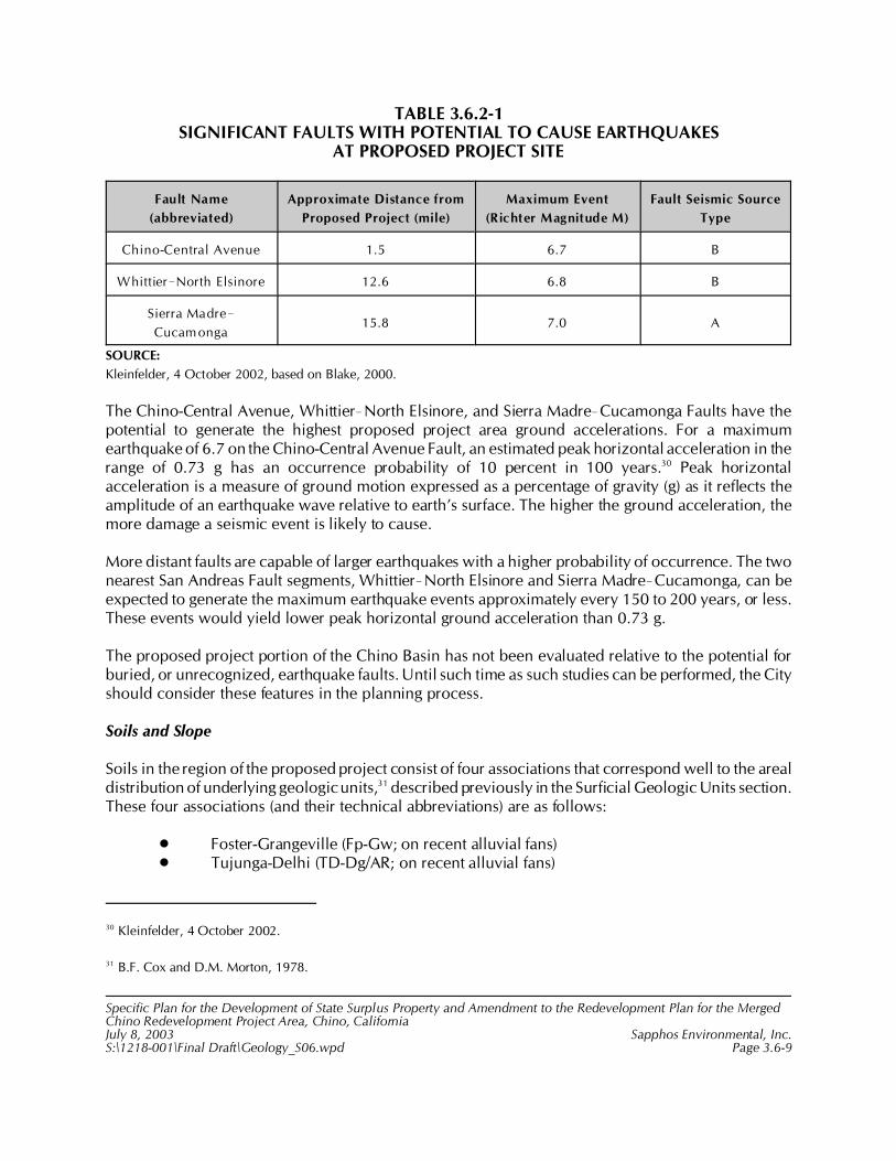
30 Kleinfelder, 4 October 2002.
31 B.F. Cox and D.M. Morton, 1978.
Specific Plan for the Development of State Surplus Property and Amendment to the Redevelopment Plan for the MergedChino Redevelopment Project Area, Chino, CaliforniaJuly 8, 2003 Sapphos Environmental, Inc.S:\1218-001\Final Draft\Geology_S06.wpd Page 3.6-9
TABLE 3.6.2-1SIGNIFICANT FAULTS WITH POTENTIAL TO CAUSE EARTHQUAKES
AT PROPOSED PROJECT SITE
Fault Name
(abbreviated)
Approximate Distance from
Proposed Project (mile)
Maximum Event
(Richter Magnitude M)
Fault Seismic Source
Type
Chino-Central Avenue 1.5 6.7 B
Whittier!North Elsinore 12.6 6.8 B
Sierra Madre!
Cucamonga15.8 7.0 A
SOURCE:
Kleinfelder, 4 October 2002, based on Blake, 2000.
The Chino-Central Avenue, Whittier!North Elsinore, and Sierra Madre!Cucamonga Faults have thepotential to generate the highest proposed project area ground accelerations. For a maximumearthquake of 6.7 on the Chino-Central Avenue Fault, an estimated peak horizontal acceleration in therange of 0.73 g has an occurrence probability of 10 percent in 100 years.30 Peak horizontalacceleration is a measure of ground motion expressed as a percentage of gravity (g) as it reflects theamplitude of an earthquake wave relative to earth’s surface. The higher the ground acceleration, themore damage a seismic event is likely to cause.
More distant faults are capable of larger earthquakes with a higher probability of occurrence. The twonearest San Andreas Fault segments, Whittier!North Elsinore and Sierra Madre!Cucamonga, can beexpected to generate the maximum earthquake events approximately every 150 to 200 years, or less.These events would yield lower peak horizontal ground acceleration than 0.73 g.
The proposed project portion of the Chino Basin has not been evaluated relative to the potential forburied, or unrecognized, earthquake faults. Until such time as such studies can be performed, the Cityshould consider these features in the planning process.
Soils and Slope
Soils in the region of the proposed project consist of four associations that correspond well to the arealdistribution of underlying geologic units,31 described previously in the Surficial Geologic Units section.These four associations (and their technical abbreviations) are as follows:
• Foster-Grangeville (Fp-Gw; on recent alluvial fans)• Tujunga-Delhi (TD-Dg/AR; on recent alluvial fans)

32 Kleinfelder, 4 October 2002.
33 Donald L. Fife et al., 1976.
Specific Plan for the Development of State Surplus Property and Amendment to the Redevelopment Plan for the MergedChino Redevelopment Project Area, Chino, CaliforniaJuly 8, 2003 Sapphos Environmental, Inc.S:\1218-001\Final Draft\Geology_S06.wpd Page 3.6-10
• Merrill-Chino (MB-CE); on older alluvial fans and terraces)• Placentia (Py/BC; on older alluvial fans)
The soils overlying the proposed project site alluvial deposits are of the Merrill-Chino association.Merrill-Chino soils are silty and sandy loam overlying clay loam with slopes of 0 to 9 percent, anddepths of more than 60 inches. These soils are moderately erodible, well drained, have a low tomoderate permeability, and are associated with the surficial geologic unit Qhf, described previouslyin the Surficial Geologic Units section.
The geotechnical engineering properties of the soils in the proposed project area are somewhat knownfrom specific geotechnical studies. Encountered soils were classified as expansive, having a uniformpermeability and moderate erosion potential. Expansive soils expand with the addition of water andshrink when the soils dries, which is due to a high clay content that absorbs water. This can causedamage to overlying structures.
Kleinfelder classified the upper 4 to 7 feet of native materials as sandy silt and sandy clay with organiccontents of 2.8 to 7.9 percent by weight.32 The soils are loose to medium dense, compressible, andgenerally unsuitable for support of foundations. Expansion potential for the near surface soils isconsidered low, although blending with deeper alluvium could increase the expansion potential.Expansion potential is the likelihood of a soil to expand, that is, exhibit soil expansion. Based onpreliminary tests, soils are defined as mildly corrosive to concrete, and moderately to severelycorrosive to buried metals.
Proposed project site elevations range from approximately 625 feet above mean sea level (MSL) on thesouthwest to about 685 feet above MSL on the northeast. Average surface slope is approximately 1.0percent on the primary geomorphic surface from north to south. This otherwise evenly sloping surfaceis crossed by a few north-northeast trending broad swales and ridges. Fife et al. analyzed the slopestability and found that the areas between the drainages and the flat valley surface to be of low reliefand generally devoid of landslides.33
Groundwater
The Chino Basin has both water-bearing and non-water-bearing subsurface rock units. Thewater-bearing units are the Holocene and Pleistocene deposits described above in the SurficialGeologic Units section. These sediments vary in thickness from less than 900 feet to slightly more than600 feet within the proposed project, with the sediments being thicker on the north and thinner on thesouth. The greater thickness (800 to 900 feet) occurs along an east-west axis along Edison Avenue. Thelesser thickness (600 to 650 feet) is found along the southern edge north of Merrill Avenue.
34 Chino Basin Watermaster, 1997. Groundwater Elevation Map, Fall 1997 Levels. (Scale 1inch=6,000 feet.)
35 Donald L. Fife et al., 1976.
36 Kleinfelder, 4 October 2002.
37 Wilson Geosciences, Inc., 1995.
38 Kleinfelder, 1993. Report- Geotechnical Investigation Regional Subsidence and Related Ground Fissuring, City of Chino,
California, Project No, 58-3101-01. (23 pages text, Figures 1-8, and Plates 1-4.) Contact: 1370 Valley Vista Drive, Suite 150,
Diamond Bar, CA 91765.
Specific Plan for the Development of State Surplus Property and Amendment to the Redevelopment Plan for the MergedChino Redevelopment Project Area, Chino, CaliforniaJuly 8, 2003 Sapphos Environmental, Inc.S:\1218-001\Final Draft\Geology_S06.wpd Page 3.6-11
Regional groundwater elevations at the northeast corner of the proposed project vary from about 540to 555 feet.34 The southern portion of the proposed project has the lower water elevations. Theseelevations represent depths of approximately 130 feet in the northeast and less than 85 feet in thesouth. Fife et al. indicates that the proposed project site lies within what was an important zone ofartesian groundwater in the early 1900s.35 Recharge from the north replenished the aquifer under thelower permeability confining layer(s). The confining layer is not entirely impermeable, allowingupward flow into shallower zones.
In the late 1800s, there was surface water (marshes and bogs) present south of the proposed projectsite, which is now occupied by alluvial drainages (Chino and Mill Creeks). This indicates that thegroundwater was at the surface, or at zero depth. It is very unlikely that the water levels in the late1800s would recur on a broad scale. It is possible that, in local areas, water may be encountered atlevels much shallower than 85 feet. Kleinfelder encountered perched water beneath the proposedproject site at a depth of 45 feet in 2002.36
Subsidence
Background and Past Investigations
Subsidence is the gradual downward settling of the land surface with little or no horizontal movement.A principal cause can be the removal of large volumes of water from subsurface formations that areconfined groundwater aquifers.
Groundwater withdrawal has been going on in the Chino Basin for approximately 100 years. Thepresence of thick, poorly consolidated sediments, as exist in the Chino-Prado Basin area, increases thepossibility of subsidence. Documentation of subsidence exists for the proposed project site. There areseveral reports identifying and analyzing north-south trending sets of ground fissures on and north ofthe proposed project site. These reports document subsidence within the proposed project site.Previous studies have also concluded that subsidence has occurred over a much broader area and wasnot localized at the ground fissures.37,38 Large regional earthquakes and/or prolonged heavy rainfallmay accelerate subsidence, surface material settlement, and fissure propagation.

39 Donald L. Fife et al., 1976.
40 City of Chino, January 2002a.
41 Ibid.
42 Chino Basin Watermaster, October 2002a.
Specific Plan for the Development of State Surplus Property and Amendment to the Redevelopment Plan for the MergedChino Redevelopment Project Area, Chino, CaliforniaJuly 8, 2003 Sapphos Environmental, Inc.S:\1218-001\Final Draft\Geology_S06.wpd Page 3.6-12
Subsidence has been associated with the San Jacinto Fault near San Jacinto, causing surfacedisplacements along preexisting fault planes.39 It is not known if Chino Basin subsidence features areassociated with faults. Some of the topographic map and aerial photographic lineaments discussed inthe Faulting/Surface Rupture section may be a result of subsidence and may represent zones whereground fissure should be expected. These features are roughly parallel to the alluvial thicknesscontours and shallow groundwater contours, each of which would be expected to control subsidencefissure location and orientation to some degree.
GeoPentech Investigation
The City of Chino Subsidence Study40 dated January 2002 was prepared by GeoPentech and providesan evaluation of the probable causes and mechanisms of observed subsidence effects within thesouthern City of Chino. The report considers past studies referenced above. Subsidence effects notedare (a) the lowering of the ground surface, as measured by repeated leveling (elevation) surveys, and(b) ground fissures observed in surface exposures and trenches within the City.
The GeoPentech study area touches on the northwest corner of the proposed project site, andsubsidence contour data terminate at the proposed project site’s north and west boundaries. Figure3.6.2-2, Subsidence and Ground Fissures in the City of Chino,41 shows the locations of previouslyobserved or documented fissures. It appears that past maximum subsidence levels (approximately 2.2feet from 1987 to 1999) have occurred generally west of Mountain Avenue and north of Chino HillsParkway. On this basis, the primary effects of subsidence and ground fissures in the proposed projectarea would be in the Ruben S. Ayala Regional Park and the western edge of the Chaffey CommunityCollege campus component of the proposed project (west of Benson Avenue).
CBWM Investigations
The CBWM Initial State of the Basin (ISOB) Report describes monitoring programs and results of thefirst two years of studies designed to better understand the distribution, magnitude, and rate of groundfissure and land subsidence occurrence. The current state of knowledge is described in detail in theISOB Report, specifically, Chapter 5.1. The methods employed to gather and analyze informationinclude historical land survey benchmark data, synthetic aperture radar imagery (InSAR), and ground-level surveys (recommended but not performed).42
Analysis of historical land survey data has concluded that the data are not adequate to accuratelyidentify the quantity of subsidence in the basin. This is due, according to the ISOB Report, to the lack

43 Ibid.
44 Chino Basin Watermaster, 2002b. Chino Basin Watermaster Status Report Number 4. Available at:
http://www.cbwm.org/wmasterweb/StatusReportFour.htm.
45 Ibid.
46 Ibid.
Specific Plan for the Development of State Surplus Property and Amendment to the Redevelopment Plan for the MergedChino Redevelopment Project Area, Chino, CaliforniaJuly 8, 2003 Sapphos Environmental, Inc.S:\1218-001\Final Draft\Geology_S06.wpd Page 3.6-13
of stable benchmarks, the extended periods over which the surveys were performed, and the gapsbetween some survey line segments.
Analysis of InSAR data for the Chino Basin has determined that the proposed project site and theremaining California Institution for Men (CIM) property are within the area of consistent, concentrateddifferential subsidence associated with the ground fissures near Central and Edison Avenues. Thegeneral location and shape of this area is very similar to the area shown by the subsidence contourlines in Figure 3.6.2-2.
Current Investigations
The ISOB Report43 and the CBWM Status Report No. 444 outline a number of studies and analyses thatwill continue over the next several years. Proposed studies (some in Ayala Park at the northwest cornerof the proposed project site) include piezometers (to measure water-level changes), extensometers (tomeasure vertical deformation in the alluvium with depth), land-level surveys, and additional InSARanalysis. These Interim Plan studies are designed to lead to specific recommendations to manage thegroundwater basin in a manner that will (1) minimize subsidence and fissuring in the short term, (2)collect information necessary to understand the extent and causes of subsidence and fissuring, and (3)formulate a long-tern basin management plan. The methods defined to minimize subsidence andfissuring are (1) groundwater recharge and (2) storage management, and storage and recovery programs(SRP). These two programs are underway according to the published schedules.45 The rechargeprogram has numerous facilities designs in the 30 to 90 percent complete range, with anticipatedcompletion of the recharge facilities by December 31, 2003. SRP efforts are stated to be underway,with facilities to be in place from mid-2003 to early 2004.46
3.6.3 Significance Thresholds
The potential for the proposed project to result in impacts related to geology and soils was analyzedin relation to the questions contained in Appendix G of the State CEQA Guidelines:
• Exposure of people or structures to potential substantial adverse effects, including therisk for loss, injury, or death involving the following:
# Rupture of a known earthquake fault, as delineated on the most recent Alquist-Priolo Earthquake Fault Zoning Map issued by the State geologist for the area,or based on other substantial evidence of a known fault
Specific Plan for the Development of State Surplus Property and Amendment to the Redevelopment Plan for the MergedChino Redevelopment Project Area, Chino, CaliforniaJuly 8, 2003 Sapphos Environmental, Inc.S:\1218-001\Final Draft\Geology_S06.wpd Page 3.6-14
# Strong seismic ground shaking# Seismic-related ground failure, including liquefaction
# Landslides
• Substantial soil erosion (greater than 10 percent) or the loss of topsoil
• Location on a geologic unit or soil that is unstable, or that would become unstable asa result of the project, and potentially result in on- or off-site landslide, lateralspreading, subsidence, liquefaction, or collapse
• Location on expansive soil, as defined in Table 18-1-B of the Uniform Building Code(1994), creating substantial risks to life or property
3.6.4 Impact Analysis
Faulting/Surface Rupture
The proposed project has the potential to result in significant impacts related to surface rupture onpreviously unmapped photolineaments. As described above, the main surface trace, or location, of theChino-Central Avenue Fault is about 4000 feet west and south of the proposed project area. This faulttrace is not a factor that needs to be considered relative to surface rupture. Other possible fault- or fold-related features represented by photolineaments were observed during previous studies in the areasouth of the proposed project site, but no similar studies have been performed within the proposedproject area. Therefore, these photolineaments indicate a level of potential impact considering thatthese features may:
• Serve as locations for ground rupture in a severe local earthquake on the Chino-CentralAvenue Fault Zone
• Be locations where severe ground shaking is more focused should a local moderate tosevere earthquake occur under the basin
Seismicity
Severe Ground Shaking
Due to the proximity to the potentially active Chino-Central Avenue Fault, the proposed project wouldresult in significant impacts to geology and soils related to severe seismic ground shaking. The UBCsets a threshold for horizontal ground acceleration for design of noncritical residential structures andsome commercial and industrial facilities. This threshold is the maximum ground acceleration forwhich the implementation of standard building codes is sufficient to reduce the risk from strong seismicground shaking to the maximum extent practicable; therefore, no further mitigation would benecessary. Where this threshold has a high likelihood of being exceeded during the design life ofplanned structures, a potentially significant impact can be said to exist. Therefore, a potentially
47 California Code of Regulations, 2001.
Specific Plan for the Development of State Surplus Property and Amendment to the Redevelopment Plan for the MergedChino Redevelopment Project Area, Chino, CaliforniaJuly 8, 2003 Sapphos Environmental, Inc.S:\1218-001\Final Draft\Geology_S06.wpd Page 3.6-15
significant impact would be present within the proposed project site where the peak horizontal groundacceleration for the maximum earthquake is estimated to be approximately 0.7 g on the nearby ChinoFault, as this exceeds the UBC threshold.47
In addition, the presence of thick layers of alluvium and possible perched groundwater contributes toearthquake amplification versus sites underlain with bedrock. With alluvial thickness in the range of600 to 900 feet, the relative amplification and attenuation effects of nearby and distant earthquakesmust be considered for major and important construction projects.
Liquefaction
Portions of the proposed project area are susceptible to significant impacts related to seismicallyinduced liquefaction; however, standard engineering practices are appropriate to reduce or eliminatethe significant impacts related to liquefaction and possible subsequent lateral-spreading landslides tobelow the level of significance. Liquefaction occurs when saturated, cohesionless (low relative density)materials (usually sand or silty sand) are transformed from a solid to a near-liquid state due to theincrease in porewater pressure that can be caused by moderate to severe seismic ground shaking. Theexpected maximum level of ground shaking in the proposed project area is above 0.5 g, high enoughto initiate liquefaction. Due to the unpredictability of shallow or perched groundwater conditions, andthe location of low-density sand and silt layers, the areas of highest liquefaction potential are coincidentwith the Holocene deposits (Qhf) in the lowest lying areas where surface water has been observed inthe late 1880s, where water has been reported to be less than 30 feet deep, and in the major drainages.Liquefaction can cause overlying structures (e.g., bridges, buildings, storage tanks) to settle in anonuniform manner and cause buried structures (e.g., fuel tanks, pipelines) to float. In either situation,severe damage to the structure is highly likely. Estimates of liquefaction potential require specific datafrom geotechnical borings and groundwater-level monitoring.
Lateral-spreading landslides can occur on relatively shallow slopes due to liquefaction of shallow layerscausing a loss of shear strength. Within the proposed project, this is most likely adjacent to thedrainages where slopes are steepest and water may be more likely to accumulate, such as along theCypress Channel, which provides a “free-face” where movement could theoretically occur. The areasat the base of these slopes are the most susceptible.
Groundwater
There are no known groundwater conditions (except as associated with liquefaction discussed above)that would be classed as potentially significant impacts requiring additional mitigation measuresbeyond the application of the California Building Code and other standard engineering practices. Twopotential concerns exist for the presence of shallow groundwater. These relate to (1) water seepage thatmay collect within, around, or on a structure (e.g., foundations, slabs, cut/fill slopes, and utilitytrenches), and (2) water that may be intercepted in a deep excavation causing potential dewatering andsafety problems. The first instance could cause damage and/or nuisance with regard to the long-term
Specific Plan for the Development of State Surplus Property and Amendment to the Redevelopment Plan for the MergedChino Redevelopment Project Area, Chino, CaliforniaJuly 8, 2003 Sapphos Environmental, Inc.S:\1218-001\Final Draft\Geology_S06.wpd Page 3.6-16
care and maintenance of facilities. The second instance could cause safety problems for workers, aswell as the aforementioned problems.
As described above, these would be investigated in a site-specific soils engineering/geotechnicalanalysis, and standard design measures are adequate to reduce the potential risk to people andstructures to the maximum extent practicable.
Surficial Geologic Unit Stability
There are no known physical geologic characteristics of mapped surficial geologic units that rise to thelevel of significance that require proposed project-specific mitigation measures. These properties areconsidered to be within the range of conditions dealt with in comprehensive soils engineering orgeotechnical engineering investigation recommendations for construction of habitable or otherimportant facilities. There are several geologic conditions related to the mapped geologic units thatmust be further evaluated and resolved during the proposed project-specific siting and design studies,including slope instability and unsuitable engineering characteristics.
Stability of Soils and Slope
There are no known soils engineering conditions that are severe enough to qualify as significantimpacts. The surface soils in the proposed project are susceptible to expansion and consolidation.Moderate- to high-expansion indices indicate that there is a substantial amount of clay in the soils, andrepeated episodes of wetting and drying would cause distress to structures in contact with such soils.Consolidation (and long-term settlement) is most prominent in clay-rich and silt-rich soils due to theloading pressure of man-made structures, including buildings or artificial fill. The added weight cancollapse the internal void spaces in the soils, causing the overlying structures to settle, and possiblybe damaged. This consolidation and settlement can be much more dramatic under severe seismicshaking (dynamic settlement). Hydroconsolidation will also lead to settlement, but it includes theaddition of water into the soils structure, causing more rapid and more substantial settlements.
The potential impacts due to expansion and consolidation/settlement can be addressed throughstandard, comprehensive geotechnical and soils engineering investigation and analysis.Recommendations that are made in conjunction with such investigations would specify all necessarysteps to be taken to mitigate the potential effects of these soils concerns. No other mitigation measuresare required.
Subsidence
Based on data within and adjacent to the proposed project area and its adjacent areas, the potentialdoes exist for subsidence and subsidence-induced ground fissures. This is considered to be apotentially significant impact and a site-specific planning constraint. However, insufficient informationexists to more fully define the potential for the hazard and degree of constraint throughout theproposed project area. It is possible that unknown ground fissures, with size and depth similar to thosedocumented near the proposed project, including within Ayala Park, or other subsidence-relatedfeatures or ground distress, could be present in other portions of the proposed project area.
48 Chino Basin Watermaster, 29 April 2003a. “About Watermaster.” Available at: http://www.cbwm.org/wmasterweb/
about_watermaster.htm.
Specific Plan for the Development of State Surplus Property and Amendment to the Redevelopment Plan for the MergedChino Redevelopment Project Area, Chino, CaliforniaJuly 8, 2003 Sapphos Environmental, Inc.S:\1218-001\Final Draft\Geology_S06.wpd Page 3.6-17
Fissures, which may pose a geologic hazard, vary in length from a few tens of feet to as much asseveral miles, but they generally range from less than one hundred to several thousand feet in length.The central parts of fissures generally are widened into fissure gullies by erosion and collapse of theopposing walls. Farming may further bury these features. Fissures may intercept storm runoff andredirect much or all of the flow downward into the crack, causing further fissure growth. Near LasVegas, these features were represented by a small crack in the surface soil, but they are enlarged atdepth (by piping and underground erosion), concealed by “soil bridges,” and only exposed when wallscollapse into wide subsurface fissures.
Subsidence that is regional in nature (over several square miles) may have little or no effect on smallerstructures. Effects to the ground surface (e.g., cracking, noticeable differential movement) and on larger,more continuous structures anchored to the ground may be much more noticeable depending on themagnitude of the subsidence. Subsidence-induced earth fissures that may have occurred in the Chinoarea may not have been noticed in the past due to the largely agricultural nature of the area. Ongoingland modification (plowing, irrigation, dairying, grazing) may have effectively prevented fissure growthfrom being seen. In other areas of California (Antelope Valley, Temecula, Santa Clara), Arizona(Tucson, Yuma), and Nevada (Las Vegas), fissures have caused damage to man-made structures, poseadditional future hazards, and are studied as a part of a formal process to understand and predict futurehazards. Structures damaged by fissures include highways, railroads, sewers, canals, buildings, andflood-control dikes.
The CBWM is the entity charged with administering adjudicated water rights and managinggroundwater resources within the watershed and groundwater basin known as the Chino GroundwaterBasin. The CBWM's mission is “to manage the Chino Groundwater Basin in the most beneficialmanner and to equitable administer and enforce the provisions of the Chino Basin WatermasterJudgement.”48 An aspect related to basin management, and an issue that will be affected byenforcement of management provisions, is ground surface subsidence. A mandatory goal of effectivebasin management is minimizing future ground subsidence and fissure formation or activation. Thiswill have the effect of minimizing future impacts to structures placed in or adjacent to areas with a pasthistory of subsidence and ground fissures. Such areas and fissures have been documented immediatelywest of the proposed project area. Rather than prescribe a mitigation measure for future potentiallysignificant impacts that must already be minimized based on judicial findings, the following isconsidered to be part of the proposed project objectives and plans to reduce subsidence-relatedimpacts to a less than significant level. If the proposed project is implemented, the project’s applicantsand developers shall follow the relevant recommendations or requirements of existing and futurereports prepared by the CBWM pursuant to the Optimum Basin Management Program as they relateto subsidence issues within the proposed project area (e.g., determining fissure locations, determiningthe magnitude of potential ground movement, fissure detection methods, ground movementmonitoring, mitigation of fissure impacts to overlying structures), including any future settlementagreement and studies or reports emanating therefrom.
Specific Plan for the Development of State Surplus Property and Amendment to the Redevelopment Plan for the MergedChino Redevelopment Project Area, Chino, CaliforniaJuly 8, 2003 Sapphos Environmental, Inc.S:\1218-001\Final Draft\Geology_S06.wpd Page 3.6-18
3.6.5 Cumulative Impacts
The incremental impact of the proposed project, when added to the related past, present, or reasonablyforeseeable, probable future projects listed in Section 2, Project Description, would not result incumulative impacts related to geology and soils. Because the geology and soils impacts expected fromthe implementation of the proposed project do not affect lands outside the boundaries of the proposedproject site, these impacts do not create any cumulative impacts on the environment outside of theproposed project boundaries.
3.6.6 Mitigation Measures
Implementation of the following mitigation measures would avoid, reduce, or eliminate the potentialimpacts from geology and soils expected to result from the implementation of the proposed project.
Geology-1
To reduce impacts related to faulting and surface rupture on previously unmapped photolineaments,and because the proposed project area has not been previously evaluated in detail, the requiredgeotechnical report shall include an assessment to determine if possible faults or fault-related featuresexist within the proposed project site. No known or suspected faults have been mapped within ortrending toward the proposed project based on the reports reviewed for this EIR. The assessment wouldconsist of detailed mapping from aerial photographs and topographic maps, as well as field checkingto confirm where possible mapped features have significance to overall development plans. Theprocedure for implementation would be as follows:
1. Review the geologic data and multiple sets of predevelopment stereoscopic aerialphotograph pairs of the proposed project area and the surrounding area sufficient todevelop an opinion relative to identification of photolineaments that appear to suggestfaulting as the most reasonable interpretation.
2. Recommend further analyses or an investigation program to determine which of theseidentified features may be faults that pose a potential hazard to the development asplanned.
3. If the evidence generated by the review confirms potential fault features, thenappropriate subsurface exploration shall be required to resolve the nature of thesuspected trend(s).
4. If subsurface exploration reveals sufficiently active trends on previously unmappedphotolineaments, the location(s) of the fault(s) shall be mapped and an appropriatesetback zone (from habitable structures) shall be delineated. This zone will bedelineated at a sufficient number of locations to allow an accurate location of thesurface trace(s) and to establish a suitable setback distance from the trace(s), whichshall not be less than 50 feet from habitable building foundations unless approved bya qualified certified engineering geologist.
Specific Plan for the Development of State Surplus Property and Amendment to the Redevelopment Plan for the MergedChino Redevelopment Project Area, Chino, CaliforniaJuly 8, 2003 Sapphos Environmental, Inc.S:\1218-001\Final Draft\Geology_S06.wpd Page 3.6-19
The nature of the assessment recommended herein will allow the ground rupture potential to beevaluated prior to more detailed planning of habitable or critical structures and major utilities in thearea. The fault study, setback designations, and mitigation measures shall be reviewed and approvedby the City’s designated engineering geologist representative prior to permit approval.
The applicant for each of the three project components (City of Chino, Chaffey Community College,and a private developer) shall be responsible for implementing this mitigation measure with respectto the project component under their jurisdiction. Monitoring and enforcement of this mitigationmeasure shall be performed by the City of Chino for the entire proposed project area.
Geology-2
To reduce impacts related to strong seismic ground shaking, the applicants shall be required to preparea site-specific ground-shaking analysis for the proposed critical, essential, and high-occupancy facilities,which shall be subject to seismic review and approval by the appropriate jurisdiction prior to permitapproval. The associated effort shall include sufficiently detailed site investigations to conduct groundmotion characteristics analysis consistent with the most current professional standards for earthquakeengineering and seismic design.
The applicant for each of the three project components (City of Chino, Chaffey Community College,and a private developer) shall be responsible for implementing this mitigation measure with respectto the project component under their jurisdiction. The Chaffey Community College component andelementary school plans and specifications shall be subject to seismic review by the Office of the StateArchitect. The remaining project elements shall be reviewed and approved by the City of Chino’sengineering geology and geotechnical representative. Monitoring and enforcement of this mitigationmeasure shall be performed by the City of Chino for the entire proposed project area.
Geology-3
The applicant for each of the three project components (City of Chino, Chaffey Community College,and a private developer) shall be responsible for implementing this mitigation measure with respectto the project component under their jurisdiction. The Chaffey Community College component andelementary school plans and specifications shall be subject to review of liquefaction area designationsand mitigation measures reviewed and approved by the City of Chino’s engineering geology andgeotechnical representative. Monitoring and enforcement of this mitigation measure shall be performedby the City of Chino for the entire proposed project area.
Specific Plan for the Development of State Surplus Property and Amendment to the Redevelopment Plan for the MergedChino Redevelopment Project Area, Chino, CaliforniaJuly 8, 2003 Sapphos Environmental, Inc.S:\1218-001\Final Draft\Geology_S06.wpd Page 3.6-20
Geology-4
To reduce impacts related to lateral-spreading landslides, the liquefaction analysis and procedurerequired by mitigation measure Geology-3 shall include a lateral-spreading landslide analysis(screening and/or detailed as needed), as outlined in the same documents, for susceptible areasassociated with the proposed facilities locations. The applicant for each of the three projectcomponents (City of Chino, Chaffey Community College, and a private developer) shall be responsiblefor implementing this mitigation measure with respect to the project component under theirjurisdiction. The Chaffey Community College component and elementary school plans andspecifications shall be subject to seismic review by the Office of the State Architect. The remainingproject elements shall be reviewed and approved by the City of Chino’s engineering geology andgeotechnical representative. Monitoring and enforcement of this mitigation measure shall be performedby the City of Chino for the entire proposed project area.
Geology-5
To reduce impacts related to subsidence, the applicants shall use the results from the assessment andprocedure required in mitigation measure Geology-1 and other evidence for ground distress todetermine if other likely locations of fissuring or other ground distress can be identified within andaround each component of the proposed project. Using combined ISOB investigation and analysisresults, as well as surface data with aerial photographic and topographic map analysis, high potentialareas for subsidence-related ground fissures, if any, shall be defined. This shall include the compilationof leveling survey data within the proposed project site as appropriate. High potential subsidence areasshall be further investigated for each individual project component as indicated by the results.Suggested mitigation measures to minimize the impacts of ground fissures on construction shall bedeveloped and may include, but not be limited to, one or more of the following:
• Identifying and avoiding when safer alternative sites are available• Zoning for open spaces, parks, or some kinds of agricultural uses• Structural strengthening to minimize damage to foundations and linear structures
The applicant for each of the three project components shall be responsible for implementing thismitigation measure with respect to the project component under their jurisdiction. Monitoring andenforcement of this mitigation measure shall be performed by the City of Chino for the entire proposedproject area.
3.6.7 Level of Significance after Mitigation
Implementation of mitigation measure Geology-1 would reduce potentially significant impacts togeology and soils related to faulting/surface rupture to below the level of significance.
Implementation of mitigation measure Geology-2 would reduce potentially significant impacts togeology and soils related to strong seismic ground shaking to the maximum extent practicable;however, impacts would remain above the level of significance where the peak horizontal groundacceleration for the maximum earthquake is approximately 0.7 g or greater on the Chino Fault.

Specific Plan for the Development of State Surplus Property and Amendment to the Redevelopment Plan for the MergedChino Redevelopment Project Area, Chino, CaliforniaJuly 8, 2003 Sapphos Environmental, Inc.S:\1218-001\Final Draft\Geology_S06.wpd Page 3.6-21
Implementation of mitigation measure Geology-3 would reduce potentially significant impacts togeology and soils related to liquefaction to below the level of significance.
Implementation of mitigation measure Geology-4 would reduce potentially significant impacts togeology and soils related to lateral-spreading landslides to below the level of significance.
Implementation of mitigation measure Geology-5 would reduce potentially significant impacts togeology and soils related to subsidence to below the level of significance.
1 City of Chino, 19 July 2002c. Initial Study: Specific Plan for the Development of 717 Acres of State Surplus Propertyfrom the California Institution for Men (CIM), Chino, California. Contact: Community Development Department, 13220Central Avenue, Chino, CA 91710. Prepared by: Sapphos Environmental, Inc., 133 Martin Alley, Pasadena, CA 91105.
2 City of Chino, 6 October 1981. General Plan: Land Use Element. Contact: Community Development Department,13220 Central Avenue, Chino, CA 91710.
3 California Department of General Services, August 2001c. Phase I Environmental Site Assessment of Land Located at theCalifornia Institution for Men. Contact: California Department of General Services, 707 Third Street, Suite 6-130, WestSacramento, CA 95605. Prepared by: Sapphos Environmental, Inc., 133 Martin Alley, Pasadena, CA 91105.
4 California Department of General Services, 4 October 1994a. Phase II Assessment of VOCs in Soil and Groundwater,California Institution for Men, Chino, California. Contact: California Department of General Services, 707 Third Street,Suite 6-130, West Sacramento, CA 95605. Prepared by: Geomatrix Consultants, Inc., 250 East Rincon Street, Suite 204,Corona, CA 92879-1363.
5 California Department of General Services, 14 November 1994b. Report of Additional Assessment of Tractor Barn,Power House, and State Garage Underground Fuel Tanks Areas, California Institution for Men, Chino, California.Contact: California Department of General Services, 707 Third Street, Suite 6-130, West Sacramento, CA 95605. Preparedby: Geomatrix Consultants, Inc., 250 East Rincon Street, Suite 204, Corona, CA 92879-1363.
Specific Plan for the Development of State Surplus Property and Amendment to the Redevelopment Plan for the MergedChino Redevelopment Project Area, Chino, CaliforniaJuly 8, 2003 Sapphos Environmental, Inc.S:\1218-001\Final Draft\Hazards_S07.wpd Page 3.7-1
3.7 HAZARDS AND HAZARDOUS MATERIALS
As a result of the Initial Study,1 the City of Chino (City) Community Development Departmentdetermined that the Specific Plan for the Development of State Surplus Property and Amendment tothe Redevelopment Plan for the Merged Chino Redevelopment Project Area, Chino, California(proposed project) had the potential to result in impacts to hazards and hazardous materials.
Therefore, this issue has been carried forward for detailed analysis in this Project Environmental ImpactReport (EIR). This analysis was undertaken to identify opportunities to avoid, reduce, or otherwisemitigate potential significant impacts that could result from hazards and hazardous materials.
The analysis of hazards and hazardous materials consists of a summary of the regulatory frameworkthat guides the decision-making process, existing conditions at the proposed project site, thresholdsfor determining if the proposed project would result in significant impacts, anticipated impacts (direct,indirect, and cumulative), mitigation measures, and the level of significance after mitigation.
The potential impacts of hazards and hazardous materials have been analyzed in accordance with themethodologies provided by the American Society of Testing and Materials (ASTM) Standard E 1527-00,Standard Practice for Environmental Site Assessments: Phase I Environmental Site Assessment Process.Other relevant documents provided guidelines to assess potential impacts resulting from the proposedproject.2,3,4,5
3.7.1 Regulatory Framework
Provided below is a description of the federal, state and local laws and regulations that the proposedproject must comply with in order for the project to be completed.
6 42 U.S. Code, Chapter 116 et seq.: “Community Planning and Emergency Right-To-Know Act.” Washington, DC: U.S.House of Representatives, Office of the Law Revision Counsel.
7 42 U.S. Code, §§ 6901-6987: “Solid Waste Disposal Act, Resource Conservation and Recovery Act of 1986.”Washington, DC: U.S. House of Representatives, Office of the Law Revision Counsel.
Specific Plan for the Development of State Surplus Property and Amendment to the Redevelopment Plan for the MergedChino Redevelopment Project Area, Chino, CaliforniaJuly 8, 2003 Sapphos Environmental, Inc.S:\1218-001\Final Draft\Hazards_S07.wpd Page 3.7-2
Federal
Comprehensive Environmental Response, Compensation, and Liability Act (CERCLA)
CERCLA, also known as the Superfund, outlines the potential liability related to the cleanup ofhazardous substances, available defenses to such liability, appropriate inquiry into site status under theSuperfund, statutory definitions of hazardous substances and petroleum products, and the petroleumproduct exclusion under CERCLA. The proposed project would be subject to CERCLA for the cleanupof any hazardous substances.
Superfund Amendment and Reauthorization Act Title III (SARA)
SARA of 1986 is the Emergency Planning and Community Right-to-Know Act.6 Facilities are requiredto report the following items on U.S. Environmental Protection Agency (EPA) Form R, the ToxicChemical Release Inventory Reporting Form: facility identification, off-site locations to which toxicchemicals are transferred in wastes, chemical specific information, and supplemental information.
Form R requires a facility to list the hazardous substances that are handled on site and to account forthe total aggregate releases of listed toxic chemicals for the calendar year. Releases to the environmentinclude emissions to the air, discharges to surface water, and on-site releases to land and undergroundinjection wells. The proposed project would be subject to SARA for the use, storage, transport,disposal, or release of toxic chemicals.
Resource Conservation and Recovery Act (RCRA)
RCRA7 regulates the potential health and environmental problems associated with hazardous andnonhazardous solid waste. RCRA, and the implementation regulations developed by the U.S. EPA,provide the general framework for the national hazardous and nonhazardous waste managementsystems. This framework includes the determination of whether hazardous wastes are being generated,techniques for tracking wastes to eventual disposal, and the design and permitting of hazardous wastemanagement facilities.
RCRA amendments enacted in 1986 began the process of eliminating land disposal as the principalhazardous waste disposal method. Hazardous waste regulations promulgated in 1991 address siting,design, construction, operation, monitoring, corrective action, and closure of disposal facilities.Additional regulations addressing solid waste issues are contained in 40 CFR Part 258. The proposedproject would be subject to requirements of RCRA in regards to the generation, storage, or disposalof hazardous and nonhazardous solid wastes.
8 County of San Bernardino, Airport Land Use Commission, November 2001. Chino Airport Comprehensive Land UsePlan. Contact: Land Use Services Department, 385 North Arrowhead Avenue, 1st Floor, San Bernardino, CA 92415-0182.
Specific Plan for the Development of State Surplus Property and Amendment to the Redevelopment Plan for the MergedChino Redevelopment Project Area, Chino, CaliforniaJuly 8, 2003 Sapphos Environmental, Inc.S:\1218-001\Final Draft\Hazards_S07.wpd Page 3.7-3
Federal Aviation Administration (FAA)
The FAA requires review of any construction plans and specifications for development proximate toairports that exceed certain height criteria. These minimum height requirements include anyconstruction or alteration more than 200 feet in height above ground level and/or a greater height thanan imaginary surface extending outward and upward at a slope of 100 to 1 for a horizontal distanceof 20,000 feet from the nearest point of the nearest runway.8
This review is initiated using FAA Form 7460, Notice of Proposed Construction or Alteration, ifnecessary. The FAA determines whether there is an obstruction to the safe and efficient use of airspaceover part or all of a proposed land use change under Federal Aviation Regulation Part 77, ObjectsAffecting Navigable Airspace (Part 77), during this review.
State
Hazardous Waste Control Law of 1972
The Hazardous Waste Control Law of 1972 is the original hazardous waste control law in California.This law initiated programs that track hazardous waste generators, their hazardous waste streams, andtheir hazardous waste handling practices. The proposed project would be subject to requirements ofthis law in regards to the generation, storage, and disposal of hazardous wastes.
Title 22 and Title 23 of the California Code of Regulations (CCR)
In California, Titles 22 and 23 of the California Code of Regulations address hazardous materials andwastes. Title 22 defines, categorizes, and lists hazardous materials and wastes. Title 23 addressespublic health and safety issues related to hazardous materials and wastes and specifies disposaloptions. Title 54, CCR, addresses landfill closure standards and landfill-related public health and safetyissues.The proposed project would be subject to requirements of this law in regards to the use,generation, storage, and disposal of hazardous wastes.
Hazardous Materials Release Response Plans and Inventory Law of 1986
The Hazardous Materials Release Response Plans and Inventory Law of 1986 (Business Plan Act)governs hazardous materials handling, reporting requirements, and local agency surveillanceprograms. The proposed project would be subject to requirements of this law in regards to maintaininghazardous material inventories, business plans, and emergency response plans.
Hazardous Waste and Substances Site List (Cortese List)
Section 65962.5 of the California Government Code requires the California EPA to provide a listupdated at least annually to provide information about the location of hazardous materials releases.
9 California Department of Transportation, Division of Aeronautics, January 2002. California Airport Land Use PlanningHandbook. Prepared by: Shutt Moen Associates, Santa Rosa, CA. Available at: http://www.dot.ca.gov/aeronautics.
10 U.S. Geological Survey, 1981 (Photorevised from 1967). Prado Dam 7.5-Minute Quadrangle. (Scale = 1:24,000.)Contact: U.S. Geological Survey, 509 National Center, Reston, VA 20192.
Specific Plan for the Development of State Surplus Property and Amendment to the Redevelopment Plan for the MergedChino Redevelopment Project Area, Chino, CaliforniaJuly 8, 2003 Sapphos Environmental, Inc.S:\1218-001\Final Draft\Hazards_S07.wpd Page 3.7-4
This list, which is maintained by the Department of Toxic Substances Control (DTSC), is known as theHazardous Waste and Substances Site List, or the Cortese List. The proposed project is not identifiedon this database.
California Education Code
Section 17215 of the California Education Code requires that before acquiring title to property for anew school site within 2 miles of an airport runway, the school district must notify the Department ofEducation. The Department of Education is required to request a written school site evaluation fromthe Caltrans Division of Aeronautics.9 The elementary school site is located approximately 10,250 feetnorthwest of the westernmost edge of the Chino Airport runways, just slightly less than 2 miles.10
Therefore, a request from the Department of Education for written site evaluation will be required fromCaltrans.
Section 17213 of the California Education Code states that the governing board of a school district shallnot approve a project involving the acquisition of a school site by a school district unless all of thefollowing occur:
(a) The lead agency determines that the property purchased or to be built upon is not any ofthe following:
(1) The site of a current or former hazardous waste disposal site or solid waste disposal siteunless, if the site was a former solid waste disposal site, the governing board of theschool district concludes that the wastes have been removed.
(2) A hazardous substance release site identified by the State Department of HealthServices for removal or remedial action pursuant to Chapter 6.8 (commencing withSection 25300) of Division 20 of the Health and Safety Code.
(3) A site which contains one or more pipelines, situated underground or aboveground,which carries hazardous substances, acutely hazardous materials, or hazardous wastes,unless the pipeline is a natural gas line which is used only to supply natural gas to thatschool or neighborhood.
The school that is planned for the proposed project will not be affected by this section of the CaliforniaEducation Code as its proposed location is not a current or former hazardous waste site, a site that isidentified for any type of remedial action, or situated upon a site that contains pipelines that carryhazardous substances.
11 Ibid.
12 California Department of General Services, August 2001c.
13 California Health and Safety Code, Division 20, Chapter 6.95. Avaliable at: http://www.dtsc.ca.gov/LawsRegulationsPolicies/hs_code.html.
Specific Plan for the Development of State Surplus Property and Amendment to the Redevelopment Plan for the MergedChino Redevelopment Project Area, Chino, CaliforniaJuly 8, 2003 Sapphos Environmental, Inc.S:\1218-001\Final Draft\Hazards_S07.wpd Page 3.7-5
Section 81033 of the California Education Code establishes similar requirements for communitycollege sites; however, the proposed Chaffey Community College site is more than 2 miles northwestof the Chino Airport runways.11 A request for a written site evaluation from the Department ofEducation to Caltrans will not be required.
Department of Toxic Substances Control
The Department of Toxic Substances Control (DTSC) Schools Property Evaluation and CleanupDivision is responsible for assessing, investigating, and cleaning up proposed school property sites thatwill receive state funding for acquisition or construction. As a condition of receiving state funding fora proposed school site, Section 17213.1 of the California Education Code requires the governing boardof the school district to conduct a Phase I Environmental Site Assessment (ESA) to determine if therehas been a release of hazardous materials at the site, or if there may be present at the site a naturallyoccurring hazardous material that presents a risk to human health or the environment. Pursuant to theCalifornia Education Code, DTSC is required to review the Phase I ESA and to make a determinationabout the need for further action or remediation. The proposed project site has undergone a Phase IESA12 by a Registered Environmental Assessor. If the proposed school site will require state funding foracquisition or construction, DTSC would review the Phase I ESA. Furthermore, the California EducationCode requires compliance with only Section 17213.1, described here, and not Section 17213, above,if the proposed school site requires state funding.
Local
City of Chino General Plan
The Safety element of the City of Chino General Plan outlines objectives such as minimizing personalinjury, loss of life, and the potential for property damage, and protecting the City and its residents fromavoidable loss resulting from improper development in hazardous areas.
3.7.2 Existing Conditions
Hazardous Materials
The California Institution for Men (CIM) is permitted to store, use, and generate hazardous materials.Material safety data sheets (MSDS) and hazardous materials inventory forms are on file at the CIM, andall hazardous materials storage areas are inspected every three years by the San Bernardino CountyFire Department (SBCFD), Hazardous Materials Division.13 The CIM facility, including the proposedproject site, routinely transports and/or uses hazardous materials in aboveground storage tanks (ASTs)
14 Jay Madsen, Personal Communication, 21 October 2002. Prison Industry Authority, 560 East Natoma Street, Folsom,CA 95630-2200.
15 California Department of General Services, August 2001c.
16 Ibid.
17 Betti MacGregor, Personal Communication, 7 January 2003. San Bernardino County Fire Department, HazardousMaterials Division, 620 South "E" Street, San Bernardino, CA 92415-0153.
Specific Plan for the Development of State Surplus Property and Amendment to the Redevelopment Plan for the MergedChino Redevelopment Project Area, Chino, CaliforniaJuly 8, 2003 Sapphos Environmental, Inc.S:\1218-001\Final Draft\Hazards_S07.wpd Page 3.7-6
and underground storage tanks (USTs), former landfills, and other sources as part of the dairyoperation. The hazardous material sources within and adjacent to the proposed project site aredescribed in detail below.
California Department of General Services (CDGS) declared the proposed project site as surplusproperty authorized by Section 14672.14 of the Government Code, as added by Chapter 974, Statutesof 2002 (SB1607). Since that time, agricultural activities performed by the CIM have been restrictedto planting of Sudan grass in selected fields for dust control and weed abatement through discing, orturning of the soil.14 Agricultural operations prior to the proposed project area being declared surplusproperty included the use of authorized pesticides. In addition, due to the age of construction of thestructures in the proposed project area, it is reasonable to assume that asbestos-containing materials(ACMs) and lead-based paints (LBPs) were used during original construction activities.15
Within the proposed project area, the most relevant presence of hazardous materials is the leakingunderground storage tank (LUST) site in the tractor barn area (Figure 3.7.2-1, Proposed Project SiteHazards and Hazardous Materials). The tractor barn area contained two 1,000-gallon gasoline USTs,one 2,500-gallon diesel UST, one 1,000-gallon diesel UST, and one 1,000-gallon waste oil AST. Thesetanks were removed in November 1998.
Subsurface investigations in the tractor barn area conducted in 1989, 1992, 1994, and 2000 indicatesoil contamination by petroleum hydrocarbons. Groundwater was not encountered during theseinvestigations and was not determined to be impacted by leakage from these USTs. The results of themost recent subsurface investigation revealed elevated concentrations of petroleum hydrocarboncompounds at depths between 6 and 30 feet below ground surface.16
The SBCFD, Hazardous Materials Division, Local Oversight, Site Remediation (SBCFD) has jurisdictionover the remediation efforts for the LUST site in the tractor barn area. According to the SBCFD,remediation of this LUST case will likely be performed by means of a soil vapor extraction (SVE) systemor soil removal. However, a remediation plan has not been formalized.17 An SVE system is a commonmeans of removing petroleum hydrocarbon contamination from soil by using high-pressure vacuumto dislodge volatile contaminants from the soil particles and transport these contaminants to a treatmentsystem at the surface. The tractor barn area also currently stores 55-gallon drums of waste oil from CIMoperations.
18 Jack Hagerman, Personal Communication, 6 January 2003. California Institution for Men, 14901 Central Avenue,Chino, CA 91710..
19 California Department of General Services, August 2001c.
20 State Water Resources Control Board. Geotracker. Available at: http://geotracker.swrcb.ca.gov. (Last viewed December16, 2002.)
21 Thomas Bros. Maps, 2001. The Thomas Guide: San Bernardino/Riverside Counties. Contact: Thomas Bros. Maps, 603West 7th Street, Los Angeles, CA 90017.
Specific Plan for the Development of State Surplus Property and Amendment to the Redevelopment Plan for the MergedChino Redevelopment Project Area, Chino, CaliforniaJuly 8, 2003 Sapphos Environmental, Inc.S:\1218-001\Final Draft\Hazards_S07.wpd Page 3.7-7
One 1,000-gallon diesel AST is located at the CIM water treatment plant in the north central portionof the proposed project site. This AST operates with code-compliant secondary containment facilities,which require the capture of 110 percent of the volume of the AST in case of tank compromise.18
The nearest off-site source of hazardous materials in the vicinity of the proposed project site wasidentified as the heliport operating immediately outside the southwest corner of the proposed projectsite within the Prado Conservation Camp (Figure 3.7.2-1). The heliport facility utilizes two 150-gallonmobile ASTs containing Jet A fuel. The Prado Conservation Camp utilizes two 2000-gallon gasolineASTs and two 2,000-gallon diesel ASTs.
The nearest hazardous material release in the proposed project area include the LUST incidents at thepower house and state garage areas. These facilities are located approximately 900 feet and 1,600 feet,respectively, from the southern boundary within the CIM minimum-security facility.
Subsurface investigations at this facility indicate that soil and groundwater had been contaminated bypetroleum hydrocarbons. The soil and groundwater in these areas are undergoing remediation andquarterly monitoring under the direction of state and local agencies. The state garage area currentlycontains one 5,000-gallon diesel AST and one 10,000-gallon gasoline AST.19
The CIM stores hazardous materials from dairy operations, including pesticides and some asbestosdebris, in the piggery area. The piggery area consists of six wood-framed buildings approximately2,000 feet south of the proposed project site. Other hazardous material sources within 0.5 mile of theproposed project site include 4 ongoing LUST sites and 10 registered UST sites outside of those withinthe CIM facility.20
There are no schools currently located within 0.25 mile of the proposed project boundary. The nearestschool is Howard Cattle Elementary approximately 0.75 mile from the northeastern site boundary.21
The proposed project includes a 10-acre elementary school that would be located in the east-centralportion of the proposed project site. This would be the nearest proposed school site potentially at riskfrom hazardous emissions. However, pursuant to Section 21151.4 of the California EnvironmentalQuality Act (CEQA), the proposed school will not be located within 0.25 mile of a facility that currentlyor might reasonably be anticipated to emit hazardous materials or acutely hazardous materials in aquantity that is equal to or greater than the quantity specified in Subdivision (a) of Section 25536 ofthe Health and Safety Code.

22 California Department of Toxic Substances Control, 16 December 2002. Hazardous Waste and Substances Site List(Cortese List). Sacramento, CA: California Department of Toxic Substances Control.
23 County of San Bernardino, Airport Land Use Commission, November 2001.
Specific Plan for the Development of State Surplus Property and Amendment to the Redevelopment Plan for the MergedChino Redevelopment Project Area, Chino, CaliforniaJuly 8, 2003 Sapphos Environmental, Inc.S:\1218-001\Final Draft\Hazards_S07.wpd Page 3.7-8
The most recent Cortese List for the County of San Bernardino was consulted to determine the presenceof hazardous materials releases within the proposed project site and surrounding areas. This recordssearch indicated there are no listed hazardous waste sites within the City of Chino.22
Airport Comprehensive Land Use Plan
The Chino Airport, occupying approximately 1,600 acres, is located due east of the southeasternproposed project boundary. This facility is owned and operated by the County of San BernardinoDepartment of Airports. The airport operates three runways: two oriented east-west and one orientednortheast-southwest. These runways are located approximately 0.5 mile east of the proposed projectboundary.
A Comprehensive Land Use Plan (CLUP) was prepared for the Chino Airport in 1991, establishingthree types of land use constraints for land proximate to the airport. These land use constraints areidentified as Referral Area A/Safety Zone I, Referral Area B/Safety Zone II, and Referral Area C/SafetyZone III. In addition to these areas delineated at ground level, there are imaginary surfaces that extend upwardand outward from the airport runways that are used as obstruction planning criteria to limit hazardsto both aircraft and land use activities while aircraft are in flight.
Referral Area A/Safety Zone I is the Runway Protection Zone, where no development is allowed.Referral Area B/Safety Zone II, a northeast-southwest!oriented zone, places restrictions on density (nomore than 25 persons per acre for uses in structures and no more than 50 persons per acre for uses notin structures) and land use (limited light industrial and manufacturing development recommended).The proposed project area is approximately 0.66 mile north of these zones.
The proposed project area is partially included in Referral Area C/Safety Zone III, which is shaped asan oval arc extending approximately 10,000 feet from the airport (Figure 3.7.2-1). Assembly uses suchas hospitals, stadiums, and shopping centers and any land use or structure that generates smoke orglare are not permitted in Referral Area C/Safety Zone III.
Land use activities that present visual, electronic, or physical hazards to aircraft in flight are to beavoided in all Referral Areas.23 ASTs containing hazardous materials are not permissible in this area;however, USTs are acceptable.
There are two obstruction planning criteria that apply to the proposed project area, the horizontalsurface and the conical surface. The horizontal surface is a plane existing 150 feet above theestablished airport elevation, with a perimeter at Chino Airport that coincides with the boundaries ofReferral Area C/Safety Zone III. The conical surface extends for a distance of 4,000 feet from the
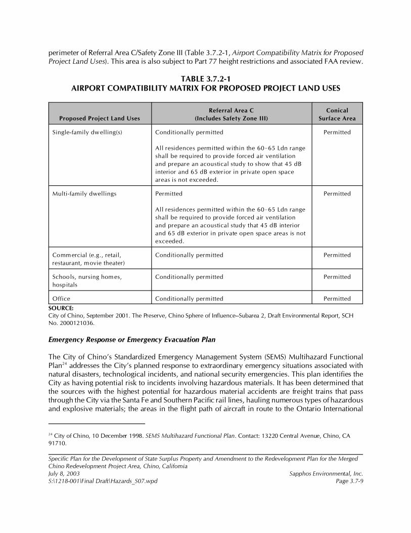
24 City of Chino, 10 December 1998. SEMS Multihazard Functional Plan. Contact: 13220 Central Avenue, Chino, CA91710.
Specific Plan for the Development of State Surplus Property and Amendment to the Redevelopment Plan for the MergedChino Redevelopment Project Area, Chino, CaliforniaJuly 8, 2003 Sapphos Environmental, Inc.S:\1218-001\Final Draft\Hazards_S07.wpd Page 3.7-9
perimeter of Referral Area C/Safety Zone III (Table 3.7.2-1, Airport Compatibility Matrix for ProposedProject Land Uses). This area is also subject to Part 77 height restrictions and associated FAA review.
TABLE 3.7.2-1AIRPORT COMPATIBILITY MATRIX FOR PROPOSED PROJECT LAND USES
Proposed Project Land Uses
Referral Area C
(Includes Safety Zone III)
Conical
Surface Area
Single-family dwelling(s) Conditionally permitted
All residences permitted within the 60!65 Ldn range
shall be required to provide forced air ventilation
and prepare an acoustical study to show that 45 dB
interior and 65 dB exterior in private open space
areas is not exceeded.
Permitted
Multi-family dwellings Permitted
All residences permitted within the 60!65 Ldn range
shall be required to provide forced air ventilation
and prepare an acoustical study that 45 dB interior
and 65 dB exterior in private open space areas is not
exceeded.
Permitted
Comm ercial (e.g., retail,
restaurant, movie theater)
Conditionally permitted Permitted
Schools, nursing homes,
hospitals
Conditionally permitted Permitted
Office Conditionally permitted Permitted
SOURCE: City of Chino, September 2001. The Preserve, Chino Sphere of Influence--Subarea 2, Draft Environmental Report, SCHNo. 2000121036.
Emergency Response or Emergency Evacuation Plan
The City of Chino’s Standardized Emergency Management System (SEMS) Multihazard FunctionalPlan24 addresses the City’s planned response to extraordinary emergency situations associated withnatural disasters, technological incidents, and national security emergencies. This plan identifies theCity as having potential risk to incidents involving hazardous materials. It has been determined thatthe sources with the highest potential for hazardous material accidents are freight trains that passthrough the City via the Santa Fe and Southern Pacific rail lines, hauling numerous types of hazardousand explosive materials; the areas in the flight path of aircraft in route to the Ontario International
25 U.S. Geological Survey, 1981 (Photorevised from 1967).
26 Chino Valley Independent Fire District, 10 April 2002. Project Plan 2002. Available at: http://www.chinovalleyfire.org/pdf/ projectplan.pdf.
Specific Plan for the Development of State Surplus Property and Amendment to the Redevelopment Plan for the MergedChino Redevelopment Project Area, Chino, CaliforniaJuly 8, 2003 Sapphos Environmental, Inc.S:\1218-001\Final Draft\Hazards_S07.wpd Page 3.7-10
Airport; and industrial areas. The Southern Pacific rail line, nearest to the proposed project site, islocated approximately 6,000 feet to the north.25
The most likely hazardous material incidents occur along transportation routes to and from industrialareas, or where hazardous materials are used or stored. The transportation routes of most concern tothe City of Chino are Highway 60, which divides the City of Chino in an east to west directionapproximately 2.25 miles to the north, and Highway 71, which transverses the western city boundaryapproximately 1.5 miles to the west of the proposed project boundaries.
Other roadways of note include Central Avenue and Euclid Avenue, two surface street truck routes,which correspond to the west and east borders of the proposed project site. It is for this reason that theSEMS generally recommends that residential and commercial areas be located to the north and eastof the city and industrial areas to the south and west.
To minimize health risks related to a hazardous materials incident, population density closest to theseareas of concern should be low or have an open space land use designation. Roadways that could beused for emergency evacuation (i.e., that have reasonable access to both highways) should be able tohandle a heavy flow of traffic in order to minimize congestion if evacuation was determined to benecessary.
Wildfires
The proposed project site and surrounding areas are developed for urban and agricultural uses that donot pose a risk of wildfires. According to the Chino Valley Independent Fire District Project Plan 2002,the nearest area with the potential for wildfires is located in Chino Hills, approximately, 1.75 miles tothe west of the proposed project.
The Chino Valley Independent Fire District describes the wildland area of Chino Hills as presentinga severe magnitude fire concern due to over 14,000 acres of grass, brush, and oak trees that pose aseasonal fire threat to the residential interface.26
27 Ronald E. Bass et al., 2002. CEQA Deskbook, A Step-by-Step Guide on How to Comply with the CaliforniaEnvironmental Quality Act. Point Arena, CA: Solano Press Books.
Specific Plan for the Development of State Surplus Property and Amendment to the Redevelopment Plan for the MergedChino Redevelopment Project Area, Chino, CaliforniaJuly 8, 2003 Sapphos Environmental, Inc.S:\1218-001\Final Draft\Hazards_S07.wpd Page 3.7-11
3.7.3 Significance Thresholds
As stated in the California Environmental Quality Act (CEQA) Guidelines, Appendix G,27 the proposedproject would be considered to have a significant impact on hazards and hazardous materials if theproject would result in one or more of the following:
• Create a significant hazard to the public or the environment through the routinetransport, use, or disposal of hazardous materials
• Create a significant hazard to the public or the environment through reasonablyforeseeable upset and accident conditions involving the release of hazardous materialsinto the environment
• Emit hazardous emissions or handle hazardous or acutely hazardous materials,substances, or waste within 0.25 mile of an existing or proposed school
• Be located on a site that is included on a list of hazardous materials sites compiledpursuant to Government Code Section 65962.5 and, as a result, would create asignificant hazard to the public or the environment
• For a project located within an airport land use plan or, where such a plan has notbeen adopted, within 2 miles of a public airport or public use airport, would result ina safety hazard for people residing or working in the project area
• For a project within the vicinity of a private airstrip, would result in a safety hazard forpeople residing in the project area
• Impair implementation of or physically interfere with an adopted emergency responseplan or emergency evacuation plan
• Expose people or structures to a significant risk of loss, injury, or death involvingwildland fires, including where wildlands are adjacent to urbanized areas or whereresidences are intermixed with wildlands
3.7.4 Impact Analysis
Hazardous Materials
Routine Transport, Use, or Disposal of Hazardous Materials
The proposed project would result in a significant impact from the routine transport and use ofpetroleum hydrocarbons due to the possibility of upset or accident within the proposed project site.

28 Jack Hagerman, Personal Communication, 6 January 2003.
Specific Plan for the Development of State Surplus Property and Amendment to the Redevelopment Plan for the MergedChino Redevelopment Project Area, Chino, CaliforniaJuly 8, 2003 Sapphos Environmental, Inc.S:\1218-001\Final Draft\Hazards_S07.wpd Page 3.7-12
The presence of the 1,000-gallon diesel AST at the water treatment plant within the proposed projectarea pose a threat to the environment should leakage or spillage occur (Figure 3.7.2-1). Additional ASTslocated south-southwest of the proposed project area within the Prado Conservation Camp would notbe expected to create a significant hazard due to their location and distance. The ASTs aredowngradient of the groundwater flow direction and would be located adjacent to an area with anopen space land use designation (Ruben L. Ayala Regional Park).
The tractor barn area will no longer be used to store 55-gallon drums after June 2003 as a result of thesurplus designation by CDGS28; therefore, the tractor barn would not create a significant impact relatedto the routine disposal of hazardous materials.
The proposed Chaffey College campus that is part of the proposed project would routinely transport,use, or dispose of hazardous materials. The college would likely utilize USTs and/or ASTs for refuelingof campus vehicles and to store fuel for emergency backup generators. Numerous hazardous chemicalswould normally be stored, used, generated, and/or disposed within laboratories and for maintenancepurposes.
Release of Hazardous Materials into the Environment
Construction activities have the potential to create a significant impact related to the accidental releaseof hazardous materials (e.g., fuel) in case of emergency or upset conditions.
A significant impact would result during grading activities in the tractor barn area. Grading below adepth of approximately 6 feet below surface has the potential to encounter soils contaminated withpetroleum hydrocarbons. Excavation and movement of these soils would release volatile organiccompounds into the air. These soils may be transported off site for final disposal at a permitted landfillduring construction activities. This would result in reasonably foreseeable accident conditions duringtransport.
In addition, the proposed SVE system at the tractor barn location has the potential to release hazardousmaterials into the environment. However, hazardous levels of emissions would not be expected froma properly monitored and maintained SVE system. It shall be necessary to adhere to the appropriateregulations established by the South Coast Air Quality Management District; the Department of ToxicSubstances Control; and the County of San Bernardino Fire Department, Hazardous Materials Division,regarding the release of hazardous emissions into the atmosphere and the off-site disposal ofcontaminated soils throughout the construction period. If these regulations are followed, they willreduce the risk to the maximum extent practicable.
The proposed project would be expected to result in significant impacts related to the release ofhazardous materials into the environment through reasonably foreseeable upset or accident conditions.The proposed Chaffey College campus could be a source of potential releases of hazardous materialsfrom the various sources listed above.
29 County of San Bernardino, Airport Land Use Commission, November 2001.
30 Ibid.
Specific Plan for the Development of State Surplus Property and Amendment to the Redevelopment Plan for the MergedChino Redevelopment Project Area, Chino, CaliforniaJuly 8, 2003 Sapphos Environmental, Inc.S:\1218-001\Final Draft\Hazards_S07.wpd Page 3.7-13
An earthquake or other severe accident condition would have the potential to compromise the ASTand its secondary containment system at the water treatment plant, resulting in the subsequent releaseof petroleum hydrocarbons. However, the presence of the secondary containment system reduces therisk from the presence of the AST at the water treatment plant to the maximum extent practicable.Therefore, there would be no feasible additional mitigation measures required. The LUST incidents to the south of the proposed project site would not be expected to pose a hazardas the direction of groundwater movement is generally to the south-southeast. The LUST incidents tothe north, east, and west of the proposed project area would also not be expected to result in asignificant impact as private groundwater wells would not be utilized as part of the proposed project.There are no other proposed land uses that would be expected to lead to the release of hazardousmaterials into the environment.
Hazardous Materials in Proximity to School Sites
The proposed project would not result in a significant impact to the proposed elementary school sitein the central portion of the proposed project site. The AST at the water treatment plant, approximately2,500 feet or 0.5 mile, northwest of the proposed school site would be the nearest source of hazardousmaterials. Because the proposed school site is more than 0.25 mile from this AST and the area betweenis proposed for development of low- to medium-density residential land uses, there is no impact to theproposed elementary school.
Hazardous Materials Site
The proposed project area is not identified as a hazardous waste and substances site in the most recentHazardous Wastes and Substances Site List (Cortese List) that identifies hazardous materials releases.
Airport Comprehensive Land Use Plan
The proposed project would not result in a significant impact related to a safety hazard for peopleresiding or working in the proposed project area due to the proximity to the Chino Airport. Noiseimpacts from airport operations are described in Section 3.9, Noise.
As described above, the proposed project is partially included in Referral Area C/Safety Zone III andthe conical surface obstruction planning criteria area. Referral Area C/Safety Zone III defines an areawhere the threat of aircraft accidents is minimal. However, land use restrictions are imposed withinthis area to reduce the risk to the maximum extent possible.29
All proposed land uses in these areas are consistent with the land use regulations in the Chino AirportComprehensive Land Use Plan (CLUP), including a consideration of both height and populationdensity.30 These land uses include single- and multi-family residential, neighborhood parks, a regional
Specific Plan for the Development of State Surplus Property and Amendment to the Redevelopment Plan for the MergedChino Redevelopment Project Area, Chino, CaliforniaJuly 8, 2003 Sapphos Environmental, Inc.S:\1218-001\Final Draft\Hazards_S07.wpd Page 3.7-14
park (Ruben S. Ayala park), an elementary school, a community college (Chaffey Community College),and retail uses. As described in the regulatory framework, only the school district would be requiredto respond to the California Education Code due to its proximity to the airport runways, based on thefinal location of the school, which may or may not be located within the area. However, the triggeringof this code does not constitute a significant impact under CEQA.
Private Airstrip Use
The proposed project is not located in the vicinity of a private airstrip and therefore would not resultin a significant impact resulting from a safety hazard for people residing or working in the proposedproject area.
Emergency Response or Emergency Evacuation Plan
The implementation of the proposed project would have a less than significant impact on theemergency response and emergency evacuation plan. he proposed project would be developed incompliance with the City Standardized Emergency System Multihazard Functional Plan regarding theprovision of, and accessibility to, emergency response personnel and vehicles. In addition, theproposed project areas adjacent to Central and Euclid Avenues are designated OpenSpace/Recreational and Low-Medium Density Residential, respectively. These land uses are consistentwith the plan for areas near surface street truck routes.
Wildland Fires
The proposed project would not be expected to result in a significant impact related to the exposureof people or structures to a significant risk involving wildfires due to the distance to the nearest definedwildlfire hazard in the City of Chino Hills and the presence of urbanized areas surrounding theproposed project site.
3.7.5 Cumulative Impacts
The incremental impact of the proposed project, when added to the related past, present, or reasonablyforeseeable future projects listed in Section 2, Project Description, would not result in cumulativeimpacts related to hazards and hazardous materials.
The list of related projects used in consideration of cumulative impacts includes a number of majordevelopment projects within the City of Chino and neighboring jurisdictions that would have thepotential to impact Emergency Response or Emergency Evacuation plans, wildland fires, and releaseof hazardous materials into the environment. Implementation of mandatory federal, state, and localregulations that control the release of hazardous materials, the implementation of a City StandardizedEmergency System Multihazard Functional Plan, and the proposed project’s distance from nearestdefined wildland fire hazards regarding the provision of, and accessibility to, emergency responsepersonnel and vehicles would reduce impacts from the proposed project’s incremental effect oncumulative hazards and hazardous materials issues.
Specific Plan for the Development of State Surplus Property and Amendment to the Redevelopment Plan for the MergedChino Redevelopment Project Area, Chino, CaliforniaJuly 8, 2003 Sapphos Environmental, Inc.S:\1218-001\Final Draft\Hazards_S07.wpd Page 3.7-15
3.7.6 Mitigation Measures
The following mitigation measures are recommended for implementation in order to avoid, reduce,or eliminate the impacts related to hazards and hazardous materials expected to result fromimplementation of the proposed project.
Hazards-1
To reduce impacts related to the accidental release of hazardous materials during construction, theproject proponent and the City shall ensure, through its construction permitting process or throughenforcement of contractual obligations for its own projects, that all contractors transport, store, andhandle construction-required hazardous materials in a manner consistent with relevant regulations andguidelines, including those recommended by California Department of Transportation (Caltrans,regulations regarding transport of hazardous materials); the California Regional Water Quality ControlBoard (CRWQCB), Santa Ana Region (including National Pollution Elimination Discharge Permits forstorm water); and the San Bernardino County Fire Department (fuel modification plan requirements)prior to construction. These agencies shall regulate, through the permitting process, the monitoring andenforcement of this mitigation measure as required by law.
Hazards-2
To reduce impacts related to the accidental release of hazardous materials during construction, theproject proponent and the City shall ensure, through its construction permitting process or throughenforcement of contractual obligation for its own projects, that all contractors immediately control thesource of any unauthorized release of hazardous materials using appropriate release containmentmeasures and remediate any unauthorized release using the methodologies mandated by the Citythroughout the construction period. The San Bernardino County Fire Department shall monitor andenforce regulations pertaining to the containment, disposal, and unauthorized release of hazardousmaterials.
Hazards-3
To reduce impacts related to the release of the proposed operation of the SVE system at the tractor barnarea and during grading of contaminated soils, the project proponent and the City shall ensure, throughits construction permitting process or through enforcement of contractual obligation for its ownprojects, that all contractors adhere to the appropriate regulations established by the South Coast AirQuality Management District (SCAQMD), the Department of Toxic Substances Control, and the Countyof San Bernardino Fire Department, Hazardous Materials Division, regarding the release of hazardousemissions into the atmosphere and the off-site disposal of contaminated soils throughout theconstruction period. If these regulations are followed, they will reduce the risk to the maximum extentpracticable.
Hazards-4
To reduce impacts related to the routine use, transport, or disposal of hazardous materials in the ASTat the water treatment plant and on the Chaffey Community College campus, the City shall ensure,
Specific Plan for the Development of State Surplus Property and Amendment to the Redevelopment Plan for the MergedChino Redevelopment Project Area, Chino, CaliforniaJuly 8, 2003 Sapphos Environmental, Inc.S:\1218-001\Final Draft\Hazards_S07.wpd Page 3.7-16
through its business operation permitting process or through enforcement through the City FireDepartment for its own projects, that all municipal and private operations permitted to use, store, orgenerate hazardous materials do so in a manner consistent with relevant regulations and guidelines,including those mandated by the California EPA; Caltrans; the CRWQCB, Santa Ana Region; and theSan Bernardino County Fire Department. These agencies shall be responsible for the monitoring andenforcement of this mitigation measure as required by law.
Hazards-5
To reduce impacts related to the potential release of ACMs during demolition of existing structures,both prior to and during construction, the project proponent and the City shall ensure compliance withall requirements and regulations mandated by SCAQMD and the National Emission Standards forHazardous Air Pollutants (NESHAP). These regulations include the inspection of buildings and buildingmaterials to be renovated or demolished for ACMs, and required methods for removal, disposal,containment in place, and public disclosure. The Chino Valley Independent Fire District and SanBernardino Fire Department shall monitor and enforce these requirements.
3.7.7 Level of Significance after Mitigation
Implementation of the following mitigation measures would avoid, reduce, or eliminate the impactsrelated to hazards and hazardous materials expected to result from implementation of the proposedproject.
Hazards-1 and -2
Incorporation of these mitigation measures would reduce the impacts related to the accidental releaseof hazardous materials during construction to below the level of significance.
Hazards-3
Incorporation of this mitigation measure would reduce the impacts related to the release of petroleumhydrocarbons during the operation of the proposed SVE system and grading in the tractor barn areaand subsequent off-site disposal of contaminated soil to below the level of significance.
Hazards-4
Incorporation of this mitigation measure would reduce the impacts related to the routine use, transport,or disposal of hazardous materials in the AST at the water treatment plant and on the ChaffeyCommunity College campus to below the level of significance.
Hazards-5
Incorporation of this mitigation measure would reduce the impacts related to the potential release ofACMs during demolition of existing structures to below the level of significance.
1 City of Chino, 19 July 2002c. Initial Study: Specific Plan for the Development of 717 Acres of State Surplus Propertyfrom the California Institution for Men (CIM), Chino, California. Contact: Community Development Department, 13220Central Avenue, Chino, CA 91710. Prepared by: Sapphos Environmental, Inc., 133 Martin Alley, Pasadena, CA 91105.
2 City of Chino, December 1990. General Plan: Conservation/Open Space Element. Contact: Community DevelopmentDepartment, 13220 Central Avenue, Chino, CA 91710.
3 California Department of General Services, January 2003. Technical Studies, State Disposition Property–Chino.Contact: California Department of General Services, 707 Third Street, Suite 6-130, West Sacramento, CA 95605.Prepared by: Associated Engineers, Inc., 3311 East Shelby Street, Ontario, CA 91764.
4 California Regional Water Quality Control Board, Santa Ana River Region, 1995. Water Quality Control Plan for theSanta Ana River Basin. Contact: California Regional Water Quality Control Board, 1001 I Street, Sacramento, CA 95814.
5 California Department of General Services, October 1997. Land Use Analysis, CIM Site, Chino, California. Contact:California Department of General Services, 707 Third Street, Suite 6-130, West Sacramento, CA 95605. Prepared byWPM Planning Team, Inc.
6 California Department of General Services, August 2000b. Strategic Master Land Use Plan and ImplementationApproach, CIM Chino: Volume II. Contact: California Department of General Services, 707 Third Street, Suite 6-130,West Sacramento, CA 95605. Prepared by EDAW, Inc. et al., 150 Chestnut Street, San Francisco, CA 94111.
Specific Plan for the Development of State Surplus Property and Amendment to the Redevelopment Plan for the MergedChino Redevelopment Project Area, Chino, CaliforniaJuly 8, 2003 Sapphos Environmental, Inc.S:\1218-001\Final Draft\Hydrology_S08.wpd Page 3.8-1
3.8 HYDROLOGY AND WATER QUALITY
As a result of the Initial Study,1 the City of Chino Community Development Department (City)
determined that the Specific Plan for the Development of State Surplus Property and Amendment to
the Redevelopment Plan for the Merged Chino Redevelopment Project Area, Chino, California
(proposed project) had the potential to result in impacts to hydrology and water quality. Therefore, this
issue has been carried forward for detailed analysis in this Environmental Impact Report (EIR). This
analysis was undertaken to identify opportunities to avoid, reduce, or otherwise mitigate potential
significant impacts to hydrology and water quality and identify potential alternatives.
The analysis of hydrology and water quality consists of a summary of the regulatory framework that
guides the decision-making process, existing conditions of the proposed project site, thresholds for
determining if the proposed project would result in significant impacts, anticipated impacts (direct,
indirect, and cumulative), mitigation measures, and the level of significance after mitigation. The
potential impacts to hydrology and water quality have been analyzed in accordance with the
methodologies and information provided by the City of Chino General Plan,2 engineering technical
reports,3 the City of Chino Water Supply Assessment (Appendix J), the State of California Regional
Water Quality Control Plan, Santa Ana River Basin,4 and other relevant documents.5,6
3.8.1 Regulatory Framework
This regulatory framework identifies the federal, state, and local statutes and policies that relate to
hydrology and water quality and that must be considered by the City during the decision-making
process for projects that involve the potential to result in significant impacts related to hydrology and
water quality.
7 33 U.S. Code, § 1341: “Certification.” Washington, DC: U.S. House of Representatives, Office of the Law
Revision Counsel.
8 33 U.S. Code, § 1288: “Areawide Waste Treatment Management.” Washington, DC: U.S. House of Representatives, Officeof the Law Revision Counsel.
9 California Storm Water Quality Association, 2003. California Storm Water Best Management Practice Handbook.Contact: California Storm Water Quality Association, P.O. Box 2313, Livermore, CA 94551.
Specific Plan for the Development of State Surplus Property and Amendment to the Redevelopment Plan for the MergedChino Redevelopment Project Area, Chino, CaliforniaJuly 8, 2003 Sapphos Environmental, Inc.S:\1218-001\Final Draft\Hydrology_S08.wpd Page 3.8-2
Federal
Section 401 of the Clean Water Act of 1972
The federal Clean Water Act (CWA)7 of 1972 sets national goals and policies to eliminate discharge
of water pollutants into navigable waters and to achieve a water-quality level that will protect fish,
shellfish, and wildlife while providing for recreation in and on the water whenever possible. The CWA
regulates point-source and non-point-source discharges to receiving waters with the National Pollutant
Discharge Elimination System (NPDES) program. The CWA provides for delegating certain
responsibilities for water-quality control and planning to the states. The State of California (State) has
been authorized by the U.S. Environmental Protection Agency (EPA) to administer and enforce
portions of the CWA, including the NPDES program. The State issues NPDES permits through the State
Water Quality Control Board (SWQCB) and the nine Regional Water Quality Control Boards
(RWQCBs). The proposed project is regulated by the Santa Ana River Basin RWQCB.
In 1987, the CWA was amended to state that the discharge of pollutants to waters of the United States
from storm water is effectively prohibited, unless the discharge is in compliance with an NPDES
permit. The 1987 amendments to the CWA added Section 402(p) and established a framework for
regulating industrial, municipal, and construction storm water discharges under the NPDES program.
The 1987 amendment developed from the awareness that storm water runoff, a non-point-source
discharge, is a significant source of water pollution. In 1990, the U.S. EPA published final regulations
that established application requirements to determine when industrial, municipal, and construction
activities qualify for an NPDES permit.
To streamline the permit process, the SWQCB has issued statewide general permits that apply to all
storm water discharges from qualifying industrial and construction activities. Of these, the proposed
project would be subject to adherence with the requirements of the NPDES construction general
permit as described below.
Municipal Urban (Areawide) Storm Water Discharges
Municipalities must obtain an individual NPDES permit for their entire storm drain system.8 City or
county municipal sewer system officials must submit an NPDES permit application and supporting
information to the respective RWQCB for storm water discharges into a municipal separate storm
sewer system serving a population greater than 100,000.9 In the State, countywide municipal NPDES
permits have been issued that include most of the State’s urbanized areas. San Bernardino County
10 Ibid.
Specific Plan for the Development of State Surplus Property and Amendment to the Redevelopment Plan for the MergedChino Redevelopment Project Area, Chino, CaliforniaJuly 8, 2003 Sapphos Environmental, Inc.S:\1218-001\Final Draft\Hydrology_S08.wpd Page 3.8-3
(County) has been issued a municipal NPDES storm water permit, and the City of Chino is included
as a co-permitee under this permit.10
General Construction Activity Storm Water Discharges
Storm water discharges that are composed entirely of runoff from qualifying construction activities may
be eligible to be regulated under the General Construction Activity Storm Water Permit issued by the
SWQCB rather than an individual NPDES permit issued by the appropriate RWQCB. Construction
activities that qualify include clearing, grading, excavation, reconstruction, and dredge-and-fill
activities that result in the disturbance of at least 5 acres of total land area. The proposed project would
be required to conform to the Storm Water Pollution Prevention Plan (SWPPP) as part of compliance
with the NPDES General Construction Activity Storm Water Permit to reduce water quality impacts
to the maximum extent practicable. An SWPPP is a report that includes site map(s), an identification
of construction activities that could cause pollutants in the storm water, and a description of measures
or best management practices (BMPs) to control these pollutants to the maximum extent practicable.
A BMP is defined by the Stormwater Quality Task Force as any program, technology, process, siting
criteria, operating method, measure, or device that controls, prevents, removes, or reduces storm water
pollution.
Executive Order 11988
The objective of Executive Order 11988, dated May 24, 1977, is the avoidance of, to the extent
possible, long- and short-term adverse impacts associated with the occupancy and modification of the
base floodplain (100-year floodplain) and the avoidance of direct and indirect support of development
in the base floodplain wherever there is a practicable alternative. Under the executive order, the U.S.
Army Corps of Engineers (Corps) must provide leadership and take action to enact the following:
• Avoid development in the base floodplain unless it is the only practicable alternative
• Reduce the hazard and risk associated with floods
• Minimize the impact of floods to human safety, health, and welfare
• Restore and preserve the natural and beneficial values of the base floodplain
The proposed project would be subject to Executive Order 11988 if it would result in adverse impacts
from development in the 100-year floodplain.
Regional
Water Quality Control Plan for the Santa Ana Region
The CWA is administered and enforced by the SW RCB, which develops regulations to execute water-
quality control programs mandated at the federal and state levels. As stated above, the State has nine
RWQCBs that implement these water quality programs. The Santa Ana RWQCB has prepared a Water
Quality Control Plan (Basin Plan) that includes 2,800 square miles of the inland watersheds of San
11 California Regional Water Quality Control Board, Santa Ana River Region, 1995.
12 Superior Court of the State of California, County of San Bernardino, Rancho Cucamonga Division, Court Filing, 18September 2002. Chino Basin Municipal Water District v. City of Chino; Special Referee’s Report on Interim PlanWorkshop and Recommendation Concerning Subsidence Issues. Available at: http://www.cbwm.org/.
13 Chino Basin Watermaster, 29 April 2003a. “About Watermaster.” Available at: http://www.cbwm.org/wmasterweb/about_ watermaster.htm.
14 Chino Basin Watermaster, October 2002a. Chino Basin Optimum Basin Management Program, Initial State of theBasin Report. Prepared by: Wildurmuth Environmental, Inc., 415 North El Camino Real, Suite A, San Clemente, CA92672. Available at: http://www.cbwm.org/wmasterweb/obmp_status.htm.
Specific Plan for the Development of State Surplus Property and Amendment to the Redevelopment Plan for the MergedChino Redevelopment Project Area, Chino, CaliforniaJuly 8, 2003 Sapphos Environmental, Inc.S:\1218-001\Final Draft\Hydrology_S08.wpd Page 3.8-4
Bernardino, Riverside, and Orange Counties. The Basin Plan, which was established under the
requirements of California’s 1969 Porter-Cologne Water Quality Control Act (Section 13000 [Water
Quality] et seq. of the California Water Code), was adopted in 1975 and revised in 1983. The latest
version was adopted in 1995.11
The Basin Plan assigns beneficial uses to surface and groundwater, such as municipal water supply and
water-contact recreation, to all waters in the basin. It also sets water-quality objectives (subject to
approval by the U.S. EPA) intended to protect designated beneficial uses. These objectives apply to
specific parameters (numeric objectives) and general characteristics of the water body (narrative
objectives). An example of a narrative objective is the requirement that all waters must remain free of
toxic substances in concentrations producing detrimental effects on aquatic organisms. Numeric
objectives specify concentrations of pollutants that are not to be exceeded in ambient waters of the
basin.
County
County of San Bernardino Superior Court
The Chino Basin Watermaster (CBWM) was created in 1978 pursuant to a judgment entered in the
Superior Court of the State of California for the County of San Bernardino.12 The CBWM is the entity
charged with administering adjudicated water rights and managing groundwater resources within the
watershed and groundwater basin known as the Chino Groundwater Basin. The CBWM’s mission is
“to manage the Chino Groundwater Basin in the most beneficial manner and to equitable administer
and enforce the provisions of the Chino Basin Watermaster Judgment.”13
As required by the judgment, the CBWM has developed an Optimum Basin Management Program
(OBMP) for the Chino Basin. As one of several actions required in the OBMP, the CBWM staff
prepared the Initial State of the Basin (ISOB) Report. The report described the numerous investigations
and initiatives undertaken, and the progress made with respect to the “initial state” or baseline
conditions of the Chino Basin as of July 1, 2000, the date marking the implementation of the OBMP.14
15 City of Chino, December 1990.
16 California Storm Water Quality Association, 2003.
17 Chino Basin Watermaster, 30 April 2003b. “OBMP Status.” Available at: http://www.cbwm.org/wmasterweb/obmp_status.htm.
Specific Plan for the Development of State Surplus Property and Amendment to the Redevelopment Plan for the MergedChino Redevelopment Project Area, Chino, CaliforniaJuly 8, 2003 Sapphos Environmental, Inc.S:\1218-001\Final Draft\Hydrology_S08.wpd Page 3.8-5
Local
City of Chino General Plan
The City of Chino adopted the Conservation and Open Space element in 1990 as a component of the
City of Chino General Plan.15 The Conservation and Open Space element identified a series of goals
and policies relating to the City’s water resources, including conservation of its water resources along
with prudent use through sound resource management practices. Goal G5-15 is the primary goal that
is relevant to the project:
Goal G5-15: Maintain Federal, State and Local water quality standards to ensure that
the City’s water supply maintains federal, state and local water quality standards by
avoiding contamination of water supply through enforcement of a pre-treatment
program, implementation of cross-connection control program, promoting proper
disposal of household hazardous waste and utilizing County hazardous waste disposal
program.
3.8.2 Existing Conditions
Surface Water Quality
Surface water quality in the proposed project area has been affected in a way that is consistent with
the history of agricultural and dairy activities. The Stormwater Quality Task Force has concluded that
agriculture is the number one source of water pollution in the State, accounting for 50 percent of all
sources of polluted runoff.16 The application of fertilizers and insecticides, in addition to the presence
of animal waste products, are non-point sources of contaminated stormwater runoff. These activities
contribute to impacts to several RWQCB water quality objectives, particularly total dissolved solids
(TDS) and nitrates.
Groundwater
The proposed project is located in the western Chino Groundwater Basin (Chino Basin), which is
managed by the CBWM through implementation of the OBMP.17 The Chino Basin stores
approximately 5 million acre-feet (AF) (~1.63 trillion gallons) of groundwater and has the capacity to
store an additional 1 million AF (~893 billion gallons). The legally designated safe yield from the
basin is 140,000 AF (~45.6 billion gallons), which is the amount of groundwater that can be pumped
from the Chino Basin per year without depleting adequate groundwater levels (Appendix J). Please
refer to Section 3.6, Geology and Soils, for a detailed discussion of ground fissures and regional
management of subsidence issues.
18 California Department of General Services, January 2003.
19 Santa Ana Regional Water Quality Control Board, 30 April 2003. “Santa Ana Regional Overview.” Available at:http://www.swrcb.ca.gov/rwqcb8/html/region_overview.html.
20 California Department of General Services, August 2000b.
21 California Department of General Services, October 1997.
22 California Department of General Services, January 2003.
23 City of Chino, 1998. Master Plan of Drainage. Prepared by: BSI Consultants, Inc., 2001 East First Street, Santa Ana, CA92705.
Specific Plan for the Development of State Surplus Property and Amendment to the Redevelopment Plan for the MergedChino Redevelopment Project Area, Chino, CaliforniaJuly 8, 2003 Sapphos Environmental, Inc.S:\1218-001\Final Draft\Hydrology_S08.wpd Page 3.8-6
The City of Chino currently serves water to an area of approximately 16.5 square miles and 14,395
customers (Appendix J). The City receives approximately 38 percent of its water supply from
groundwater wells accessing the Chino Basin, 40 percent of its water imported from the Metropolitan
Water District of Southern California, 20 percent of its water from desalted water via the Chino I
Desalter, and 2 percent of its water from recycled water via the Carbon Canyon Wastewater
Reclamation Plant. The City’s current average daily demand is approximately 15,345 AF per year
(AFY), or approximately 13.7 million gallons per day (MGD) from all sources of water, but primarily
from groundwater and imported water.
Because the California Institution for Men (CIM) is a State-operated and -owned facility, potable water
supplies are delivered to the CIM primarily via on-site groundwater wells. There are currently four
groundwater wells in production for agricultural use in the proposed project area.18
Groundwater depths in the proposed project area range from approximately 130 feet below ground
surface (BGS) in the northeast to less than 85 feet BGS in the south. The principal industry within the
Chino Basin watershed is dairy production.19 Accordingly, groundwater within the proposed project
area contains high concentrations of nitrate and TDS20 from historical agricultural activities. In addition,
there is contamination from volatile organic compounds (VOCs), evidenced by a narrow VOC plume
underneath the CIM, as a result of a leaking underground storage tank. Plans to mitigate the VOC
plume are underway.21
Drainage
The drainage area tributary to the proposed project site totals approximately 918 acres, of which 570
acres are within the proposed project site boundaries, and the remaining 348 acres lie north of Edison
Avenue and outside the planning area.22 The site slopes from the north and northwest to the south and
southeast at approximately 2 percent.
The proposed project area lies within the City of Chino Drainage Master Plan Area23 (Figure 3.8.2-1,
Existing Drainage). The primary conveyance of this district is an unimproved earthen open-channel,
known as the Magnolia Channel. Magnolia Channel is fed upstream by a 72-inch reinforced-concrete

24 California Department of General Services, January 2003.
25 Federal Emergency Management Agency, 1996. Flood Insurance Rate Map, San Bernardino, County; Map Number060719335F. (Effective 18 March 1986).
26 California Department of General Services, October 1997.
Specific Plan for the Development of State Surplus Property and Amendment to the Redevelopment Plan for the MergedChino Redevelopment Project Area, Chino, CaliforniaJuly 8, 2003 Sapphos Environmental, Inc.S:\1218-001\Final Draft\Hydrology_S08.wpd Page 3.8-7
pipe (RCP) storm drain, running parallel to Magnolia Avenue terminating just south of Edison Avenue.
Magnolia Channel then flows to its confluence with Chino Creek to the south.24
Floodways and 100-Year Flood Zone
The Federal Emergency Management Agency (FEMA) produces Flood Insurance Rate Maps (FIRM) for
homeowners to determine the level of risk to their home from a 100-year storm. The proposed project
is designated Zone “D” as it is in the unincorporated area of the County. Zone D represents areas for
which the flood hazards are undetermined.25 However, land use analyses have determined that
Cypress Channel and other flood control facilities in the vicinity of the site are considered to be
adequate for controlling a 100-year storm within the proposed project area.26 A Letter of Map
Amendment or a Letter of Map Revision is required by FEMA to establish the flood map for this area.
General Location from Pacific Ocean
The proposed project site is located approximately 33 miles from the Pacific Ocean at elevations
between approximately 575 to 685 feet above mean sea level. The topography of the proposed project
area is relatively flat with a gentle overall slope of 2 percent, generally to the south.
3.8.3 Significance Thresholds
The potential for the proposed project to result in impacts to hydrology and water quality was analyzed
in relation to the questions contained in Appendix G of the State California Environmental Quality Act
(CEQA) Guidelines. Impacts to hydrology and water quality that would occur from implementation
of the proposed project would be considered significant if the project causes the following:
• Violation of any water quality standards or waste discharge requirements
• Substantial depletion of groundwater supplies or interference with groundwater
recharge, leading to a net deficit in aquifer volume or a lowering of the local
groundwater table level (i.e., the production rate of preexisting nearby wells would
drop to a level that would not support existing land uses or planned uses for which
permits have been granted)
• Substantial alteration of the existing drainage pattern of the site or area, including the
alteration of the course of a stream or river, in a manner that would result in substantial
erosion or siltation either on site or off site
• Substantial alteration of the existing drainage pattern of the site or area, including the
alteration of the course of a stream or river, or substantial increase in the rate or
27 California Storm Water Quality Association, 2003.
Specific Plan for the Development of State Surplus Property and Amendment to the Redevelopment Plan for the MergedChino Redevelopment Project Area, Chino, CaliforniaJuly 8, 2003 Sapphos Environmental, Inc.S:\1218-001\Final Draft\Hydrology_S08.wpd Page 3.8-8
amount of surface runoff in a manner that would result in flooding either on site or off
site
• Creation or contribution of runoff water that would exceed the capacity of existing or
planned storm water drainage systems, or provide substantial additional sources of
polluted runoff
• Substantial degradation of water quality
• Placement of housing within a 100-year flood hazard area as mapped on a federal
Flood Hazard Boundary or Flood Insurance Rate Map, or other flood hazard
delineation map
• Placement of structures within a 100-year flood hazard area that would impede or
redirect flood flows
• Exposure of people or structures to a significant risk of loss, injury, or death involving
flooding, including flooding as a result of the failure of a levee or dam
• Inundation by seiche, tsunami, or mudflow
3.8.4 Impacts
Surface Water Quality
Direct and Indirect Impacts
Implementation of the proposed project would require grading that would have the potential to violate
water quality standards, constituting significant direct and indirect impacts, that require the
incorporation of BMPs, as described above in the Regulatory Framework section. Direct impacts would
result from the degradation of surface water quality within the proposed project area, and indirect
impacts would result from the influence of polluted storm water runoff flowing off site. Grading would
have the potential to transport pollutants of concern from the construction site, including work areas
and construction staging areas, to the storm drainage system. The potential for erosion from the
construction would be increased and exacerbated during the normal Southern California rain season
(October 15 through April 15). Compliance with the BMPs outlined in the California Storm Water Best
Management Practice Handbook27 for construction activity and with the requirements of the SWPPP
would be required by the NPDES permit and, therefore, would also be required for project approval.
Strict enforcement of the SWPPP would reduce adverse water quality impacts. No additional
mitigation measures are required.
Groundwater
Specific Plan for the Development of State Surplus Property and Amendment to the Redevelopment Plan for the MergedChino Redevelopment Project Area, Chino, CaliforniaJuly 8, 2003 Sapphos Environmental, Inc.S:\1218-001\Final Draft\Hydrology_S08.wpd Page 3.8-9
Direct and Indirect Impacts
The proposed project would not be expected to deplete groundwater supplies, interfere substantially
with groundwater recharge, or otherwise substantially degrade water quality for the proposed project
or the City as a whole; therefore, there are no significant direct or indirect impacts.
The City has prepared a water supply assessment to document the sufficiency of water supply for the
City, including the proposed project. The water supply assessment includes the analysis of multiple
sources of water, including groundwater. The water supply assessment was prepared pursuant to
Senate Bill (SB) 221 and SB 610 such that, when taken together, it would require a municipality to
identify both a water supply and the reliability of that supply. Therefore, the water supply assessment
documents the availability of a sufficient water supply for a city both now and in the future, including
existing and future, planned development. Sufficient water supply is defined as the total water supply
available during normal, single-dry, and multiple-dry years within a 20-year projection that will meet
the projected demand associated with a proposed project, as well as all other existing and planned
uses in a city.
The water supply assessment, which includes population growth associated with the proposed project,
concluded that supply will exceed demand for the entire City through the year 2022 (Appendix J). The
planned build-out of the proposed project is the year 2012; therefore, there would be adequate water
supply to the project at the time of completion and into the future, without depleting groundwater
supplies or interfering with groundwater recharge. Table 3.8.4-1, City of Chino Water Demand and
Supply through 2022, indicates the current and projected water supply, including groundwater.
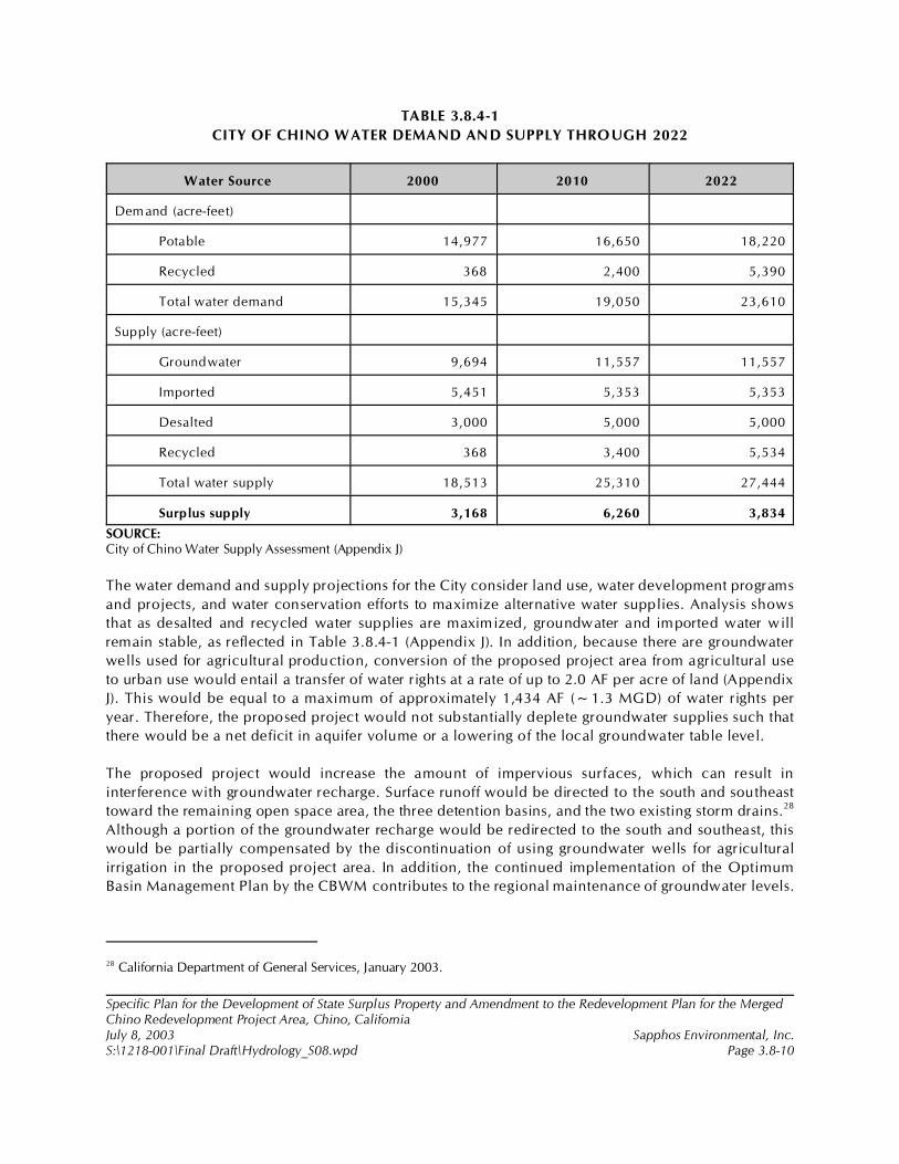
28 California Department of General Services, January 2003.
Specific Plan for the Development of State Surplus Property and Amendment to the Redevelopment Plan for the MergedChino Redevelopment Project Area, Chino, CaliforniaJuly 8, 2003 Sapphos Environmental, Inc.S:\1218-001\Final Draft\Hydrology_S08.wpd Page 3.8-10
TABLE 3.8.4-1
CITY OF CHINO WATER DEMAND AND SUPPLY THROUGH 2022
Water Source 2000 2010 2022
Dem and (acre-feet)
Potable 14,977 16,650 18,220
Recycled 368 2,400 5,390
Total water demand 15,345 19,050 23,610
Supply (acre-feet)
Groundwater 9,694 11,557 11,557
Imported 5,451 5,353 5,353
Desalted 3,000 5,000 5,000
Recycled 368 3,400 5,534
Total water supply 18,513 25,310 27,444
Surplus supply 3,168 6,260 3,834
SOURCE:City of Chino Water Supply Assessment (Appendix J)
The water demand and supply projections for the City consider land use, water development programs
and projects, and water conservation efforts to maximize alternative water supplies. Analysis shows
that as desalted and recycled water supplies are maximized, groundwater and imported water will
remain stable, as reflected in Table 3.8.4-1 (Appendix J). In addition, because there are groundwater
wells used for agricultural production, conversion of the proposed project area from agricultural use
to urban use would entail a transfer of water rights at a rate of up to 2.0 AF per acre of land (Appendix
J). This would be equal to a maximum of approximately 1,434 AF (~1.3 MGD) of water rights per
year. Therefore, the proposed project would not substantially deplete groundwater supplies such that
there would be a net deficit in aquifer volume or a lowering of the local groundwater table level.
The proposed project would increase the amount of impervious surfaces, which can result in
interference with groundwater recharge. Surface runoff would be directed to the south and southeast
toward the remaining open space area, the three detention basins, and the two existing storm drains.28
Although a portion of the groundwater recharge would be redirected to the south and southeast, this
would be partially compensated by the discontinuation of using groundwater wells for agricultural
irrigation in the proposed project area. In addition, the continued implementation of the Optimum
Basin Management Plan by the CBWM contributes to the regional maintenance of groundwater levels.
29 Ibid.
30 Ibid.
31 Ibid.
32 California Department of General Services, October 1997.
Specific Plan for the Development of State Surplus Property and Amendment to the Redevelopment Plan for the MergedChino Redevelopment Project Area, Chino, CaliforniaJuly 8, 2003 Sapphos Environmental, Inc.S:\1218-001\Final Draft\Hydrology_S08.wpd Page 3.8-11
Groundwater quality would not be adversely affected by implementation of the proposed project. As
discussed above, there is an existing groundwater quality issue consistent with agricultural operations.
The discontinuation of agricultural activities within the proposed project area would be expected to
lead to a relative improvement in groundwater quality.
Drainage
Direct and Indirect Impacts
Implementation of the proposed project would not substantially alter the existing drainage pattern in
a manner that would create substantial erosion or siltation either on site or off site, substantially
increase the rate or amount of surface runoff in a manner that would result in flooding either on site
or off site, or create or contribute runoff water that would exceed the capacity of existing or planned
storm water drainage systems or provide substantial additional sources of polluted runoff. The
proposed drainage system (Figure 3.8.4-1, Proposed Drainage) neither directs runoff into an adjacent
drainage district nor increases the runoff flow rate for postdevelopment when compared with existing
conditions.29
The proposed project includes the installation of three detention ponds (A, B, and C) whose purpose
would be to reduce stormwater flows to the same level as predevelopment runoff.30 All off-site runoff
would be directed to these three detention ponds for ultimate outlet into the two existing drainage
channels: Cypress Channel and the storm drain along Magnolia Avenue. The calculated
postdevelopment runoff flow rate for the Cypress Channel District is 167 cubic feet per second (CFS),
compared with an existing flow rate of 160 CFS leaving the southern boundary of the proposed project
site; the calculated postdevelopment runoff flow rate for the Western District is 470 CFS versus 746
CFS.31 These runoff flow rates are based on preliminary studies and consider the effect of the detention
ponds to compensate for an increase in impervious services. A variety of drainage solutions could
achieve the goal of no net impacts, and final studies would be completed prior to construction.
Therefore, there would be no direct or indirect impacts related to drainage.
100-Year Flood Zone
Direct and Indirect Impacts
As discussed in the existing conditions, Cypress Channel and other flood control facilities are
considered adequate to control a 100-year storm.32 Therefore, implementation of the proposed project
would neither result in direct or indirect impacts related to placing housing or other structures within
Specific Plan for the Development of State Surplus Property and Amendment to the Redevelopment Plan for the MergedChino Redevelopment Project Area, Chino, CaliforniaJuly 8, 2003 Sapphos Environmental, Inc.S:\1218-001\Final Draft\Hydrology_S08.wpd Page 3.8-12
the 100-year flood hazard area nor expose people or structures to a significant risk of loss, injury, or
death involving flooding, including flooding as a result of the failure of a levee or dam.
Seiche, Tsunamis, and Mudflows
Direct and Indirect Impacts
Implementation of the proposed project would not result in inundation by a seiche, tsunami, or
mudflow. Seiche and tsunami are the result of tectonic activity, such as an earthquake. A seiche is an
oscillation of the surface of a landlocked body of water that can create a hazard to persons and
structures on and in the vicinity of the water. A tsunami, also known as a tidal wave, is an oceanic
wave that can break inland, creating a hazard up to several miles from the coast, depending on the
severity of the wave. A mudflow is a moving mass of soil made fluid by rain or melting snow.
Due to the sufficiently high elevation of the proposed project area and the distance from the ocean and
other bodies of water, there would be no direct or indirect impacts related to seiche or tsunami. The
low relief of the proposed project area does not contribute to the risk for earthquake-related landslides
that would result in mudflows; therefore, there would be no direct or indirect impacts.
3.8.5 Cumulative Impacts
The incremental impact of the proposed project, when added to the related past, present, or
reasonably foreseeable future projects listed in Section 2, Project Description, would not result in
cumulative impacts related to hydrology and water quality.
The list of related projects used in consideration of cumulative impacts includes a number of major
development projects within the City of Chino and neighboring jurisdictions that would have the
potential to impact regional hydrological conditions through an increase in the amount of
impermeable surfaces, use of groundwater, and alterations to existing drainage patterns. However,
implementation of mandatory federal, state, and local regulations to conserve and protect both
groundwater and surface water resources would significantly reduce these potential impacts. In
addition, the City of Chino and surrounding jurisdictions that have historical dairy operations and other
agricultural use would experience a relative improvement in surface and groundwater quality because
of the cessation of agricultural activities. Therefore, the proposed project’s incremental effect on
cumulative hydrology and water quality conditions would not be cumulatively considerable.
3.8.6 Mitigation Measures
The analysis of hydrology and water quality undertaken for this document determined that there would
be significant impacts to surface water quality only. These significant impacts would be reduced to
below the level of significance through the implementation of standard construction and operation
practices required for NPDES permit approval; therefore, no additional mitigation measures are
required.

Specific Plan for the Development of State Surplus Property and Amendment to the Redevelopment Plan for the MergedChino Redevelopment Project Area, Chino, CaliforniaJuly 8, 2003 Sapphos Environmental, Inc.S:\1218-001\Final Draft\Hydrology_S08.wpd Page 3.8-13
3.8.7 Level of Significance after Mitigation
As discussed above, strict compliance with all standard NPDES permit requirements would reduce
impacts to surface water quality to below the level of significance.
1 City of Chino, 19 July 2002c. Initial Study: Specific Plan for the Development of 717 Acres of State Surplus Propertyfrom the California Institution for Men (CIM), Chino, California. Contact: Community Development Department, 13220Central Avenue, Chino, CA 91710. Prepared by: Sapphos Environmental, Inc., 133 Martin Alley, Pasadena, CA 91105.
2 County of San Bernardino, 1 July 1989 (Revised 21 December 2000). San Bernardino County General Plan. Contact:Economic Development and Public Services Group/Land Use Services Department, 385 North Arrowhead Avenue, 1stFloor, San Bernardino, CA 92415-0182.
3 City of Chino, September 1995. General Plan: Noise Element. Contact: Community Development Department, 13220Central Avenue, Chino, CA 91710.
4 California Department of General Services, August 2001a. Biological Resources Report: California Institution for Men,City of Chino, San Bernardino County, California. Contact: California Department of General Services, 707 Third Street,Suite 6-130, West Sacramento, CA 95605. Prepared by: Sapphos Environmental, Inc., 133 Martin Alley, Pasadena, CA91105.
Specific Plan for the Development of State Surplus Property and Amendment to the Redevelopment Plan for the MergedChino Redevelopment Project Area, Chino, CaliforniaJuly 8, 2003 Sapphos Environmental, Inc.S:\1218-001\Final Draft\Noise_S09.wpd Page 3.9-1
3.9 NOISE
As a result of the Initial Study,1 the City of Chino Community Development Department (City)determined that the Specific Plan for the Development of State Surplus Property and Amendment tothe Redevelopment Plan for the Merged Chino Redevelopment Project Area, Chino, California(proposed project) had the potential to result in impacts from noise. Therefore, this issue has beencarried forward for detailed analysis in this Environmental Impact Report (EIR). This analysis wasundertaken to identify opportunities to avoid, reduce, or otherwise mitigate potential significantimpacts from noise and identify potential alternatives.
The analysis of noise includes a summary of the regulatory framework that guides the decision-makingprocess, existing conditions of the proposed project area, thresholds for determining if the proposedproject would result in significant impacts, anticipated impacts, mitigation measures, and the level ofsignificance after mitigation. The potential impacts from noise have been analyzed in accordance withthe methodologies provided by the County of San Bernardino General Plan,2 the City of Chino GeneralPlan,3 the Strategic Master Land Use Plan and Implementation Approach CIM Chino,4 as well as theAcoustical Analysis (Appendix H).
3.9.1 Regulatory Framework
Noise Definition
Noise is defined as unwanted sound. The method commonly used to quantify environmental noiseinvolves an evaluation of all frequencies of sound, with an adjustment to reflect the fact that humanhearing is less sensitive to low and high frequencies than it is to midrange frequencies. Thismeasurement adjustment is called “A-weighting.” A noise level so measured is called the A-weightedsound level measured in A-weighted decibels (dBA). In practice, environmental noise is convenientlymeasured using a sound-level meter that includes an electronic filter corresponding to the A-weightedcurve.
Specific Plan for the Development of State Surplus Property and Amendment to the Redevelopment Plan for the MergedChino Redevelopment Project Area, Chino, CaliforniaJuly 8, 2003 Sapphos Environmental, Inc.S:\1218-001\Final Draft\Noise_S09.wpd Page 3.9-2
To account for the fluctuation in noise levels over time, noise impacts are commonly evaluated usingtime-averaged noise levels. Time averages are typically expressed in terms of the equivalent level (Leq),a steady-state energy level equal to the energy content of the time-varying period. Because communityreceptors are more sensitive to unwanted noise intrusion during the evening and at night, an artificialdecibel increment is added to quiet time noise levels in a 24-hour noise descriptor called thecommunity noise equivalent level (CNEL) or the day-night level (Ldn). Another measure used tocharacterize noise exposure is the variations in sound levels over time, or percentage exceedancelevel.
The human response to environmental noise is subjective and varies considerably from individual toindividual. The effects of noise can range from interference with sleep, concentration, andcommunication, to the point of physiological and psychological stress and, at the highest intensitylevels, hearing loss. Noise is further discussed in Appendix H.
Ground-Borne Vibration Definition
Vibration is an oscillatory motion, which can be described in terms of displacement, velocity, andacceleration. Because motion is oscillatory, there is no net movement of the vibrating element, and theaverage of any of the motion descriptors is zero. Displacement is the easiest descriptor to understand.For a vibrating floor, the displacement is simply the distance that a point on the floor moves away fromits static position. The velocity represents the instantaneous speed of the movement, and theacceleration represents the rate of change of speed.
Although displacement is easier to understand than velocity and acceleration, it is rarely used fordescribing ground-borne vibration. This is because most transducers used for ground-borne vibrationuse either velocity or acceleration, and even more important, the response of humans, buildings, andequipment to vibration is more accurately described using velocity or acceleration.
The effects of ground-borne vibration include fellable movements of the building floors, rattling ofwindows, and shaking of items on shelves or hangings on walls. The rumble is the noise radiated fromthe motion of the room surfaces. In essence, the room surfaces act like a loudspeaker, amplifying thenoise. This is called ground-borne noise. In extreme cases, vibrations can cause damage to buildings.Ground-borne vibration is further discussed in Appendix H.
State and local governments have established noise standards and guidelines to protect citizens frompotential hearing damage and various other adverse physiological and social effects associated withnoise. The applicable standards and guidelines for the proposed project are discussed below.
State
In the State of California, Senate Bill 860 (effective January 1, 1976) directed the California Office ofNoise Control within the California Department of Health Services to prepare the Guidelines for the
5 California Department of Health, Office of Noise Control, February 1976. Guidelines for the Preparation and Content ofNoise Elements of the General Plan. Berkeley, CA: California Department of Health.
Specific Plan for the Development of State Surplus Property and Amendment to the Redevelopment Plan for the MergedChino Redevelopment Project Area, Chino, CaliforniaJuly 8, 2003 Sapphos Environmental, Inc.S:\1218-001\Final Draft\Noise_S09.wpd Page 3.9-3
Preparation and Content of Noise Elements of the General Plan.5 Part of the purpose of theseguidelines was to provide sufficient information concerning the noise environment in the communityso that noise could be considered in the land use planning process. As part of this publication, LandUse Compatibility Standards were developed in four categories. These categories included NormallyAcceptable, Conditionally Acceptable, Normally Unacceptable, and Clearly Unacceptable. Thesecategories were based on earlier work done by the U.S. Department of Housing and UrbanDevelopment (HUD). The interpretation of the four categories is as follows:
• Normally Acceptable: Specified land use is satisfactory without specialinsulation.
• Conditionally Acceptable: New development requires detailed analysis of noiseinsulation requirements.
• Normally Unacceptable: New development is discouraged and requires adetailed analysis of insulation features.
• Clearly Unacceptable: New development should not be undertaken.
The Land Use Compatibility Matrix for Community Noise Environments, as established by the State,uses the same four categories of acceptance and assigns CNEL values to them (Table 3.9.1-1, Land UseCompatibility for Community Noise Environments).
The State Building Code (Part 2, Title 24, CCR) establishes uniform minimum noise insulationperformance standards to protect persons within new hotels, motels, dormitories, long-term carefacilities, apartment houses, and residential units other than detached single-family residences from theeffects of excessive noise, including but not limited to hearing loss or impairment and interference withspeech and sleep. Residential structures to be located where the CNEL or Ldn is 60 dBA or greater arerequired to provide sound insulation to limit the interior CNEL to a maximum of 45 dBA. An acousticalanalysis report prepared by a person experienced in the field of acoustical engineering is required forthe issuance of a building permit for these structures. Conversely, land use changes that result inincreased noise levels at residences of 60 dBA or greater must be considered in the evaluation ofimpacts on ambient noise levels.
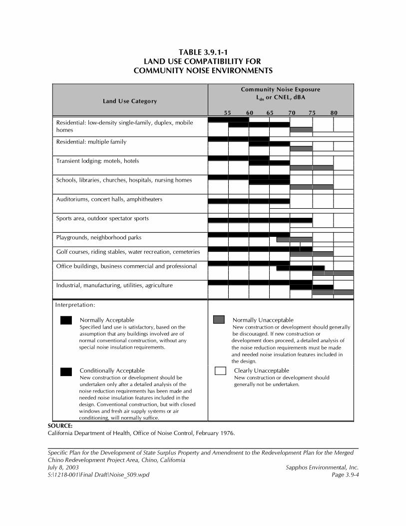
Specific Plan for the Development of State Surplus Property and Amendment to the Redevelopment Plan for the MergedChino Redevelopment Project Area, Chino, CaliforniaJuly 8, 2003 Sapphos Environmental, Inc.S:\1218-001\Final Draft\Noise_S09.wpd Page 3.9-4
TABLE 3.9.1-1LAND USE COMPATIBILITY FOR
COMMUNITY NOISE ENVIRONMENTS
Land Use Category
Community Noise Exposure
Ldn or CNEL, dBA
55 60 65 70 75 80
Residential: low-density single-family, duplex, mobilehomes
Residential: multiple family
Transient lodging: motels, hotels
Schools, libraries, churches, hospitals, nursing homes
Auditoriums, concert halls, amphitheaters
Sports area, outdoor spectator sports
Playgrounds, neighborhood parks
Golf courses, riding stables, water recreation, cemeteries
Office buildings, business commercial and professional
Industrial, manufacturing, utilities, agriculture
Interpretation:
Normally AcceptableSpecified land use is satisfactory, based on the
assumption that any buildings involved are of
normal conventional construction, without any
special noise insulation requirements.
Normally UnacceptableNew construction or development should generally
be discouraged. If new construction or
development does proceed, a detailed analysis of
the noise reduction requirements must be made
and needed noise insulation features included in
the design.
Conditionally AcceptableNew construction or development should be
undertaken only after a detailed analysis of the
noise reduction requirements has been made and
needed noise insulation features included in the
design. Conventional construction, but with closed
windows and fresh air supply systems or air
conditioning, will normally suffice.
Clearly UnacceptableNew construction or development should
generally not be undertaken.
SOURCE:California Department of Health, Office of Noise Control, February 1976.

6 County of San Bernardino, Airport Land Use Commission, November 2001. Chino Airport Comprehensive Land UsePlan. Contact: Land Use Services Department, 385 North Arrowhead Avenue, 1st Floor, San Bernardino, CA 92415-0182.
Specific Plan for the Development of State Surplus Property and Amendment to the Redevelopment Plan for the MergedChino Redevelopment Project Area, Chino, CaliforniaJuly 8, 2003 Sapphos Environmental, Inc.S:\1218-001\Final Draft\Noise_S09.wpd Page 3.9-5
Local
Chino Airport Comprehensive Land Use Plan
Most of the CIM site is impacted by airport land use restrictions outlined in the Chino AirportComprehensive Land Use Plan.6 On the CIM site, Referral Area A comprises the same area as theRunway Protection Zone (RPZ). Referral Area A is located along Euclid Avenue in the southeast partof the site. This is the most critical safety impact area associated with the Chino Airport. The area ismade up of the Federal Aviation Administration (FAA)-classified primary surface of the airport, the RPZ,and a portion of approach and departure surface.
The Land Use Plan designates various noise impact zones surrounding the Chino Airport. The Stateof California has adopted a standard (PUC Section 21669) for the acceptable level of aircraft noise inresidential areas near airports. This standard is CNEL 65. For the Chino Airport, there is a potentialnoise impact anywhere aircrafts fly below 500 feet. Land use restrictions within the CNEL 60 zone mayinclude prohibiting residential development or limiting development to low-density uses.
City of Chino Noise Ordinance
Section 9.40.040, Exterior Noise Standards, of the City of Chino Noise Ordinance contains thefollowing allowable levels for daytime (7:00 a.m. to 10:00 p.m.) and nighttime (10:00 p.m. to 7:00a.m.) periods for residential properties (Table 3.9.1-2, City of Chino Noise Standards).
TABLE 3.9.1-2CITY OF CHINO NOISE STANDARDS
Time L50 (dBA) L25 (dBA) L8 (dBA) L2 (dBA) LMAX (dBA)
7:00 a.m.!10:00 p.m. 55 60 65 70 75
10:00 p.m.!7:00 a.m. 50 55 60 65 70
The L50, L25, L8, and L2 noise levels are those exceeded 50, 25, 8, and 2 percent of the time,respectively, during a measurement hour. These correspond to noise levels lasting for a cumulativetime of 30 minutes, 15 minutes, 5 minutes, and 1 minute in each hour, respectively. The LMAX is themaximum noise level occurring during the same measurement hour.
The noise ordinance is structured to allow higher noise levels for those events that last for a shortertime. For example, a continuous noise source would be regulated by the L50 standard, whereas a noisesource that lasts less than 1 minute over the course of 1 hour would be regulated under the L2 standard.
Specific Plan for the Development of State Surplus Property and Amendment to the Redevelopment Plan for the MergedChino Redevelopment Project Area, Chino, CaliforniaJuly 8, 2003 Sapphos Environmental, Inc.S:\1218-001\Final Draft\Noise_S09.wpd Page 3.9-6
The noise ordinance also states that if the ambient noise level exceeds any of the noise limit categoriesabove, the allowable level should be increased to the value of the ambient level in the appropriatecategory. If the measurement location is on a boundary between two different noise zones, the lowernoise level standard of the adjacent zones shall apply.
If an intruding noise source is continuous and cannot be reasonably discontinued or stopped for a timeperiod whereby the ambient noise level can be determined, the measured noise level obtained whilethe source is in operation shall be compared directly to the allowable noise level standards as specifiedrespective to the designated land use measurement location and for the time of day when the noiselevel is measured.
3.9.2 Existing Conditions
Ambient noise data were collected over a 24-hour period at a location 230 feet south of Edison Avenuefrom 12:00 p.m. on August 14, 2002, to 12:00 p.m. on August 15, 2002. Noise levels at the site aredominated by traffic on Edison Avenue to the north of the site. No other significant sources of noisewere noted during the site visit. The data collected were analyzed to determine the CNEL value at themeasurement location. The technical protocol for how these data were collected, tabular data for the24-hour data, and a plot of the 24-hour Leq values is contained in Appendix H. The CNEL value at themonitoring location 230 feet south of Edison Avenue is 63.9 dB.
The proposed project area is also susceptible to alarms and outdoor speakers used within the CIMproperty adjacent to the proposed project site.
3.9.3 Significance Thresholds
Appendix G of the California Environmental Quality Act (CEQA) Guidelines recommends that impactsfrom noise be determined to be significant in four situations:
• Exposes persons to or generates noise levels in excess of standards established in thelocal General Plan or noise ordinance, or applicable standards of other agencies
• Exposes persons to or generates excessive ground-borne vibration
• Causes a substantial permanent increase in ambient noise levels in the project vicinityabove levels existing without the project
• Causes a substantial temporary or periodic increase in ambient noise levels in theproject vicinity above levels existing without the project
For the purposes of this analysis, the exposure of persons to, or generation of, noise level in excess ofstandards established in the local General Plan or noise ordinance was based on the City of ChinoNoise Ordinance, as shown in Table 3.9.1-2.
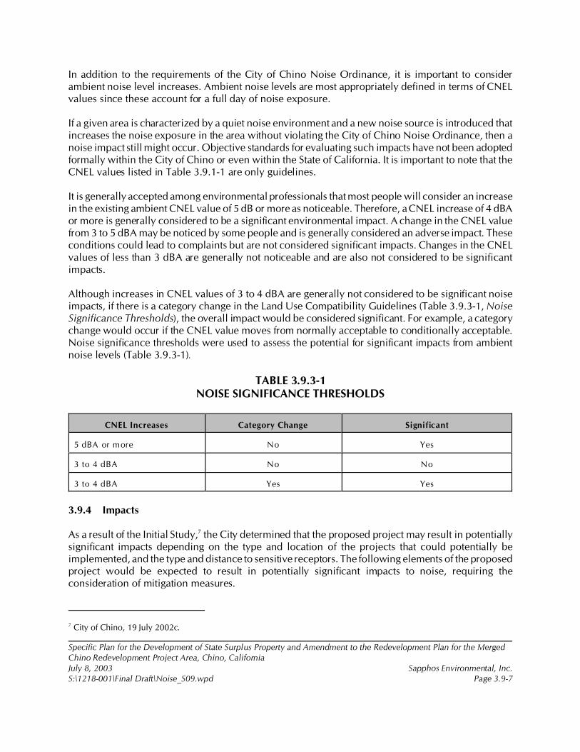
7 City of Chino, 19 July 2002c.
Specific Plan for the Development of State Surplus Property and Amendment to the Redevelopment Plan for the MergedChino Redevelopment Project Area, Chino, CaliforniaJuly 8, 2003 Sapphos Environmental, Inc.S:\1218-001\Final Draft\Noise_S09.wpd Page 3.9-7
In addition to the requirements of the City of Chino Noise Ordinance, it is important to considerambient noise level increases. Ambient noise levels are most appropriately defined in terms of CNELvalues since these account for a full day of noise exposure.
If a given area is characterized by a quiet noise environment and a new noise source is introduced thatincreases the noise exposure in the area without violating the City of Chino Noise Ordinance, then anoise impact still might occur. Objective standards for evaluating such impacts have not been adoptedformally within the City of Chino or even within the State of California. It is important to note that theCNEL values listed in Table 3.9.1-1 are only guidelines.
It is generally accepted among environmental professionals that most people will consider an increasein the existing ambient CNEL value of 5 dB or more as noticeable. Therefore, a CNEL increase of 4 dBAor more is generally considered to be a significant environmental impact. A change in the CNEL valuefrom 3 to 5 dBA may be noticed by some people and is generally considered an adverse impact. Theseconditions could lead to complaints but are not considered significant impacts. Changes in the CNELvalues of less than 3 dBA are generally not noticeable and are also not considered to be significantimpacts.
Although increases in CNEL values of 3 to 4 dBA are generally not considered to be significant noiseimpacts, if there is a category change in the Land Use Compatibility Guidelines (Table 3.9.3-1, NoiseSignificance Thresholds), the overall impact would be considered significant. For example, a categorychange would occur if the CNEL value moves from normally acceptable to conditionally acceptable.Noise significance thresholds were used to assess the potential for significant impacts from ambientnoise levels (Table 3.9.3-1).
TABLE 3.9.3-1NOISE SIGNIFICANCE THRESHOLDS
CNEL Increases Category Change Significant
5 dBA or more No Yes
3 to 4 dBA No No
3 to 4 dBA Yes Yes
3.9.4 Impacts
As a result of the Initial Study,7 the City determined that the proposed project may result in potentiallysignificant impacts depending on the type and location of the projects that could potentially beimplemented, and the type and distance to sensitive receptors. The following elements of the proposedproject would be expected to result in potentially significant impacts to noise, requiring theconsideration of mitigation measures.

Specific Plan for the Development of State Surplus Property and Amendment to the Redevelopment Plan for the MergedChino Redevelopment Project Area, Chino, CaliforniaJuly 8, 2003 Sapphos Environmental, Inc.S:\1218-001\Final Draft\Noise_S09.wpd Page 3.9-8
Practice Soccer Fields
To determine noise impact from the proposed nine soccer fields, calculations were made at the threeresidential receptor locations closest to the recreation area based on measured octave-band sourcelevels. These three areas included the residential locations on the east side of Cypress Channel,residences on Chipola Court to the northeast, and on Freedom Drive to the northeast. It was assumedthat the recreation activities would be located near the center of the community/regional park (OSR)area at the northwest corner of Central Avenue and Edison Avenue. The OSR area is shown in theConceptual Specific Plan.
Noise levels were measured at a youth soccer field complex utilizing an IVIE PC40 Real Time Analyzerin octave-band format. During the measurements, there were six fields being used in close proximity.The data were extrapolated to reflect nine fields in use at the same time.
An in-house computer program, Outdoor, was utilized to calculate noise levels at the three measuredreceptor locations. This computer program, which has been corroborated extensively with fieldmeasurements over the past 15 years, includes the effects of shielding from walls and/or berms,atmospheric absorption effects based on temperature and relative humidity conditions, directionalityeffects, ground absorption effects, distance effects for user selectable noise source types, and octave-band source noise levels.
The most conservative assumption was made for atmospheric effects. A 50-percent relative humiditywas assumed, which would result in minimum atmospheric absorption.
The results of the analyses for the nine soccer field areas are summarized in Table 3.9.4-1, CalculatedSoccer Field Noise Levels in dB at Various Residential Receptor Sites. Computer printouts for thecalculations are in Appendix H.
TABLE 3.9.4-1CALCULATED SOCCER FIELD NOISE LEVELS IN dB
AT VARIOUS RESIDENTIAL RECEPTOR SITES
Receptor Site Noise Level (dBA)
Cypress Channel Not audible
Chipola Court Not audible
Freedom Drive 2
For the proposed nine soccer fields, noise levels would not be audible at the Cypress Channelresidences and the Chipola Court residences. At the residences on Freedom Drive, noise levels wouldbe in the 2-dBA range. These noise levels are less than ambient nosie levels in the area and would notbe noticeable.
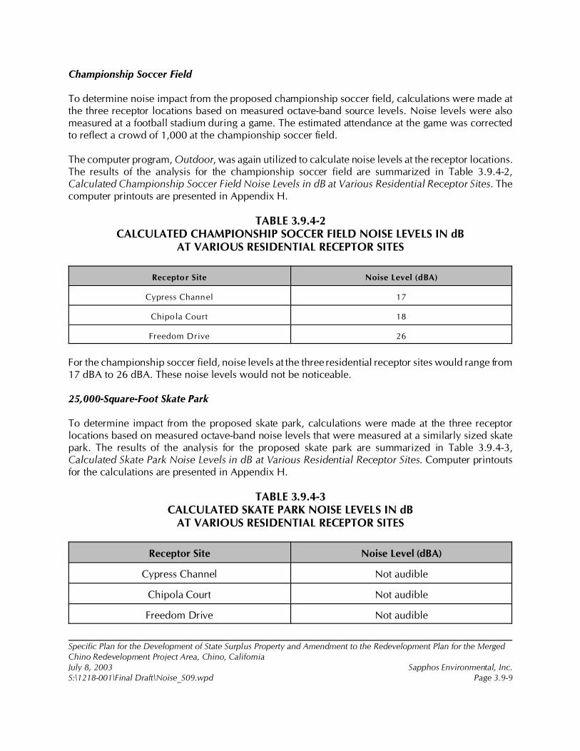
Specific Plan for the Development of State Surplus Property and Amendment to the Redevelopment Plan for the MergedChino Redevelopment Project Area, Chino, CaliforniaJuly 8, 2003 Sapphos Environmental, Inc.S:\1218-001\Final Draft\Noise_S09.wpd Page 3.9-9
Championship Soccer Field
To determine noise impact from the proposed championship soccer field, calculations were made atthe three receptor locations based on measured octave-band source levels. Noise levels were alsomeasured at a football stadium during a game. The estimated attendance at the game was correctedto reflect a crowd of 1,000 at the championship soccer field.
The computer program, Outdoor, was again utilized to calculate noise levels at the receptor locations.The results of the analysis for the championship soccer field are summarized in Table 3.9.4-2,Calculated Championship Soccer Field Noise Levels in dB at Various Residential Receptor Sites. Thecomputer printouts are presented in Appendix H.
TABLE 3.9.4-2CALCULATED CHAMPIONSHIP SOCCER FIELD NOISE LEVELS IN dB
AT VARIOUS RESIDENTIAL RECEPTOR SITES
Receptor Site Noise Level (dBA)
Cypress Channel 17
Chipola Court 18
Freedom Drive 26
For the championship soccer field, noise levels at the three residential receptor sites would range from17 dBA to 26 dBA. These noise levels would not be noticeable.
25,000-Square-Foot Skate Park
To determine impact from the proposed skate park, calculations were made at the three receptorlocations based on measured octave-band noise levels that were measured at a similarly sized skatepark. The results of the analysis for the proposed skate park are summarized in Table 3.9.4-3,Calculated Skate Park Noise Levels in dB at Various Residential Receptor Sites. Computer printoutsfor the calculations are presented in Appendix H.
TABLE 3.9.4-3CALCULATED SKATE PARK NOISE LEVELS IN dB
AT VARIOUS RESIDENTIAL RECEPTOR SITES
Receptor Site Noise Level (dBA)
Cypress Channel Not audible
Chipola Court Not audible
Freedom Drive Not audible
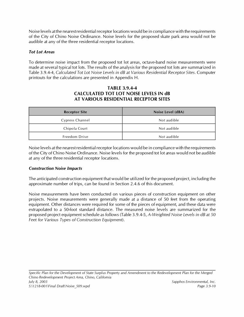
Specific Plan for the Development of State Surplus Property and Amendment to the Redevelopment Plan for the MergedChino Redevelopment Project Area, Chino, CaliforniaJuly 8, 2003 Sapphos Environmental, Inc.S:\1218-001\Final Draft\Noise_S09.wpd Page 3.9-10
Noise levels at the nearest residential receptor locations would be in compliance with the requirementsof the City of Chino Noise Ordinance. Noise levels for the proposed skate park area would not beaudible at any of the three residential receptor locations.
Tot Lot Areas
To determine noise impact from the proposed tot lot areas, octave-band noise measurements weremade at several typical tot lots. The results of the analysis for the proposed tot lots are summarized inTable 3.9.4-4, Calculated Tot Lot Noise Levels in dB at Various Residential Receptor Sites. Computerprintouts for the calculations are presented in Appendix H.
TABLE 3.9.4-4CALCULATED TOT LOT NOISE LEVELS IN dBAT VARIOUS RESIDENTIAL RECEPTOR SITES
Receptor Site Noise Level (dBA)
Cypress Channel Not audible
Chipola Court Not audible
Freedom Drive Not audible
Noise levels at the nearest residential receptor locations would be in compliance with the requirementsof the City of Chino Noise Ordinance. Noise levels for the proposed tot lot areas would not be audibleat any of the three residential receptor locations.
Construction Noise Impacts
The anticipated construction equipment that would be utilized for the proposed project, including theapproximate number of trips, can be found in Section 2.4.6 of this document.
Noise measurements have been conducted on various pieces of construction equipment on otherprojects. Noise measurements were generally made at a distance of 50 feet from the operatingequipment. Other distances were required for some of the pieces of equipment, and these data wereextrapolated to a 50-foot standard distance. The measured noise levels are summarized for theproposed project equipment schedule as follows (Table 3.9.4-5, A-Weighted Noise Levels in dB at 50Feet for Various Types of Construction Equipment).
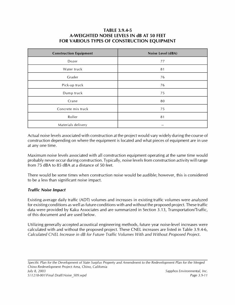
Specific Plan for the Development of State Surplus Property and Amendment to the Redevelopment Plan for the MergedChino Redevelopment Project Area, Chino, CaliforniaJuly 8, 2003 Sapphos Environmental, Inc.S:\1218-001\Final Draft\Noise_S09.wpd Page 3.9-11
TABLE 3.9.4-5A-WEIGHTED NOISE LEVELS IN dB AT 50 FEET
FOR VARIOUS TYPES OF CONSTRUCTION EQUIPMENT
Construction Equipment Noise Level (dBA)
Dozer 77
Water truck 81
Grader 76
Pick-up truck 76
Dump truck 75
Crane 80
Concrete mix truck 75
Roller 81
Materials delivery --
Actual noise levels associated with construction at the project would vary widely during the course ofconstruction depending on where the equipment is located and what pieces of equipment are in useat any one time.
Maximum noise levels associated with all construction equipment operating at the same time wouldprobably never occur during construction. Typically, noise levels from construction activity will rangefrom 75 dBA to 85 dBA at a distance of 50 feet.
There would be some times when construction noise would be audible; however, this is consideredto be a less than significant noise impact.
Traffic Noise Impact
Existing average daily traffic (ADT) volumes and increases in existing traffic volumes were analyzedfor existing conditions as well as future conditions with and without the proposed project. These trafficdata were provided by Kaku Associates and are summarized in Section 3.13, Transportation/Traffic,of this document and are used below.
Utilizing generally accepted acoustical engineering methods, future year noise-level increases werecalculated with and without the proposed project. These CNEL increases are listed in Table 3.9.4-6,Calculated CNEL Increase in dB for Future Traffic Volumes With and Without Proposed Project.
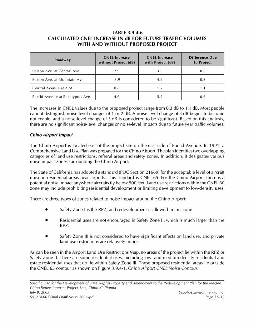
Specific Plan for the Development of State Surplus Property and Amendment to the Redevelopment Plan for the MergedChino Redevelopment Project Area, Chino, CaliforniaJuly 8, 2003 Sapphos Environmental, Inc.S:\1218-001\Final Draft\Noise_S09.wpd Page 3.9-12
TABLE 3.9.4-6CALCULATED CNEL INCREASE IN dB FOR FUTURE TRAFFIC VOLUMES
WITH AND WITHOUT PROPOSED PROJECT
RoadwayCNEL Increase
without Project (dB)
CNEL Increase
with Project (dB)
Difference Due
to Project
Edison Ave. at Central Ave. 2.9 3.5 0.6
Edison Ave. at Mountain Ave. 3.9 4.2 0.3
Central Avenue at A St. 0.6 1.7 1.1
Euclid Avenue at Eucalyptus Ave. 4.6 5.2 0.6
The increases in CNEL values due to the proposed project range from 0.3 dB to 1.1 dB. Most peoplecannot distinguish noise-level changes of 1 or 2 dB. A noise-level change of 3 dB begins to becomenoticeable, and a noise-level change of 5 dB is considered to be significant. Based on this analysis,there are no significant noise-level changes or noise-level impacts due to future year traffic volumes.
Chino Airport Impact
The Chino Airport is located east of the project site on the east side of Euclid Avenue. In 1991, aComprehensive Land Use Plan was prepared for the Chino Airport. The plan identifies two overlappingcategories of land use restrictions: referral areas and safety zones. In addition, it designates variousnoise impact zones surrounding the Chino Airport.
The State of California has adopted a standard (PUC Section 21669) for the acceptable level of aircraftnoise in residential areas near airports. This standard is CNEL 65. For the Chino Airport, there is apotential noise impact anywhere aircrafts fly below 500 feet. Land use restrictions within the CNEL 60zone may include prohibiting residential development or limiting development to low-density uses.
There are three types of zones related to noise impact around the Chino Airport:
• Safety Zone I is the RPZ, and redevelopment is allowed in this zone.
• Residential uses are not encouraged in Safety Zone II, which is much larger than theRPZ.
• Safety Zone III is not considered to have significant effects on land use, and privateland use restrictions are relatively minor.
As can be seen in the Airport Land Use Restrictions Map, no areas of the project lie within the RPZ orSafety Zone II. There are some residential uses, including low- and medium-density residential andestate residential uses that do lie within Safety Zone III. These proposed residential areas lie outsidethe CNEL 65 contour as shown on Figure 3.9.4-1, Chino Airport CNEL Noise Contour.
8 Paul Andersen, Personal Communication, 21 April 2003. Assistant Superintendent of Facilities and Planning, ChinoValley Unified School District, 5130 Riverside Drive, Chino, CA 91710.
Specific Plan for the Development of State Surplus Property and Amendment to the Redevelopment Plan for the MergedChino Redevelopment Project Area, Chino, CaliforniaJuly 8, 2003 Sapphos Environmental, Inc.S:\1218-001\Final Draft\Noise_S09.wpd Page 3.9-13
Normal construction consisting of exterior stucco, interior gypsum board (drywall), batting insulation,and standard glazing normally provides an A-weighted noise reduction of at least 20 dB. Therefore,these residential areas should not be exposed to interior noise levels that exceed CNEL 45, which isthe requirement of the State Building Code.
School Impacts
Depending on the final construction schedule for the master-planned community (which has not beendeveloped), there may be construction-related noise impacts to the planned 10-acre elementary school,a sensitive noise receptor. However, even if the school and surrounding houses were built on aschedule that caused the school to be exposed to construction noise, the impacts of such noise wouldnot be considered significant. This is because the maximum construction equipment noise levelsidentified in Table 3.9.4-5, above, would be intermittent and short term in nature; they would not beaverage construction noise levels that would occur over the course of the entire day and would,therefore, be less than significant. In addition, schools are usually set back from property lines due tothe presence of fields, parking lots, and playgrounds. Each doubling of distance beyond the 50 feetidentified in Table 3.9.4-5 would lower noise levels by 5 dB. In addition, the proposed new schoolwould include air conditioning8 and would have closed windows, which would lower noise levels bya further 25 dB. Thus, if construction were to take place 100 feet away from a classroom with closedwindows, the loudest types of equipment, the water truck and the roller, would create a maximum of51 dB of intermittent noise. This falls well within the range of “normally acceptable” noise levels forschools as identified in Table 3.9.1-1. With the incorporation of the below listed mitigation measures,any noise impacts to schools would be less than significant.
The existing alarms and outdoor speakers used within the CIM property would not create significantinputs to schools if the mitigation measures are incorporated.
3.9.5 Cumulative Impacts
The incremental impact of the proposed project, when added to the related past, present, or reasonablyforeseeable future projects listed in Section 2, Project Description, would not result in cumulativeimpacts related to noise.
The list of related projects used in consideration of cumulative impacts includes a number of majordevelopment projects within the City of Chino and neighboring jurisdictions that would have thepotential to impact noise and vibration levels. The incremental impact of the combined componentsof the proposed project, when added to the related past, present, or reasonably foreseeable, probablefuture projects, would not result in significant impacts from noise because the projects identified arenot large enough or closely enough related to the proposed project for the proposed project to resultin cumulative impacts when considered in conjunction with the other projects.
Specific Plan for the Development of State Surplus Property and Amendment to the Redevelopment Plan for the MergedChino Redevelopment Project Area, Chino, CaliforniaJuly 8, 2003 Sapphos Environmental, Inc.S:\1218-001\Final Draft\Noise_S09.wpd Page 3.9-14
3.9.6 Mitigation Measures
Construction noise would be potentially annoying to residents to the east and the northeast of theproposed project. Although there is no mitigation that would completely eliminate this potentialannoyance, it is recommended that the following measures be adopted to reduce noise impacts to lessthan significant levels.
Noise-1
The City shall minimize the potential for construction noise levels to exceed City noise standards byrestricting grading and construction activities to daily operation between 7:00 a.m. and 7:00 p.m. fromMonday through Friday and 8:00 a.m. to 5:00 p.m. on Saturdays. There shall be no work on Sundaysor federal holidays.
Noise-2
Prior to the completion of final plans and specifications, the City shall ensure that the plans andspecifications include a requirement that all construction and grading equipment shall be properlymaintained. All vehicles and compressors shall utilize exhaust mufflers. Engine enclosure covers asdesigned by the manufacture shall be in place at all times. The City shall monitor the use of heavyequipment during all construction to ensure conformance with the requirements of properlymaintained heavy equipment.
Noise-3
As a mitigation measure for the residential uses south of Edison Avenue between Magnolia Avenue andEuclid Avenue, and to ensure compliance with building code requirements, the City shall require theprivate developer to utilize windows and glass doors that are glazed with sound transmission class(STC) 32 glazing. Options for meeting this requirement include: STC 32 dual glazing with a 0.5-inchairspace and 0.25-inch laminated glass, or another method or product that meets the standard orequivalent. The State Building Code (Part 2, Title 24, CCR) requires residential structures to providesound insulation to limit the interior CNEL to a maximum of 45 dBA. Regardless of the option used,the glazing supplier shall be required to submit test reports documenting compliance with theminimum STC 32 rating. The test report shall be done in an independent, accredited testing laboratoryin accordance to American Society for Testing and Materials (ASTM) E-90.
3.9.7 Level of Significance after Mitigation
Implementation of mitigation measures Noise-1 and Noise-2 would minimize significant constructionnoise impacts on people’s exposure to noise to below levels specified by the City Noise Ordinance.Mitigation measure Noise-2 would also ensure that potential impacts to schools would be below thelevel of significance. Mitigation measure Noise-3 would reduce potential impacts from the ChinoAirport to less than significant levels.
1 City of Chino, 19 July 2002c. Initial Study: Specific Plan for the Development of 717 Acres of State Surplus Property fromthe California Institution for Men (CIM), Chino, California. Contact: Community Development Department, 13220 CentralAvenue, Chino, CA 91710. Prepared by: Sapphos Environmental, Inc., 133 Martin Alley, Pasadena, CA 91105.
2 City of Chino, September 1989. General Plan: Housing Element. Contact: Community Development Department, 13220Central Avenue, Chino, CA 91710.
3 Southern California Association of Governments, 1998. Regional Comprehensive Plan and Guide. Contact: 818 WestSeventh Street, 12th Floor (Main Office), Los Angeles, CA 90017.
Specific Plan for the Development of State Surplus Property and Amendment to the Redevelopment Plan for the Merged ChinoRedevelopment Project Area, Chino, CaliforniaJuly 8, 2003 Sapphos Environmental, Inc.S:\1218-001\Final Draft\Pop Housing_S10.wpd Page 3.10-1
3.10 POPULATION AND HOUSING
As a result of the Initial Study,1 the City of Chino Community Development Department (City)determined that the Specific Plan for the Development of State Surplus Property and Amendment tothe Redevelopment Plan for the Merged Chino Redevelopment Project Area, Chino, California(proposed project) had the potential to result in impacts to population and housing. Therefore, thisissue has been carried forward for detailed analysis in this Environmental Impact Report (EIR). Thisanalysis was undertaken to identify opportunities to avoid, reduce, or otherwise mitigate potentialsignificant impacts to population and housing and identify potential alternatives. For the purposes ofthe California Environmental Quality Act (CEQA), the California Department of General Services(CDGS) and Chaffey College District (Chaffey) have been identified as responsible agencies.
The analysis of population and housing includes a description of the regulatory framework that guidesthe decision-making process, existing conditions of the proposed project area, thresholds fordetermining if the proposed project would result in significant impacts, anticipated impacts, mitigationmeasures, and the level of significance after mitigation. The potential impacts to population andhousing have been analyzed in accordance with the methodologies and information provided by theHousing element of the City of Chino General Plan,2 Land Use Analysis California Institution for Men(CIM) Site, and the Strategic Master Land Use Plan and Implementation Approach CIM Chino.
3.10.1 Regulatory Framework
This regulatory framework identifies the local statutes and policies that relate to population andhousing and must be considered by the City during the decision-making process for the proposedproject.
Regional
Southern California Association of Governments
Regional Comprehensive Plan and Guide
The Southern California Association of Governments (SCAG) Regional Comprehensive Plan and Guide(RCPG)3 states the region’s forecasts and policies for dealing with anticipated growth, includingpopulation, housing, and employment throughout Southern California. Growth projections containedin the RCPG are based on a compilation of county and local projections. RCPG forecasts are then used

Specific Plan for the Development of State Surplus Property and Amendment to the Redevelopment Plan for the Merged ChinoRedevelopment Project Area, Chino, CaliforniaJuly 8, 2003 Sapphos Environmental, Inc.S:\1218-001\Final Draft\Pop Housing_S10.wpd Page 3.10-2
in the formulation of regional plans dealing with regional air quality, housing, transportation/traffic, andother infrastructure issues.
The concept of a job-to-housing balance is found in the growth management chapter (GMC) of theRCPG. This concept is directed at minimizing commute distances, reducing new infrastructure needsand costs, minimizing traffic congestion, conserving energy, and improving air quality. The primaryobjective has been to promote balanced development at the regional and subregional levels. Balanceddevelopment represents a mix of housing and employment opportunities expressed in the form of aratio of jobs to housing available in a given area. A subregion is theoretically considered to be inbalance if it provides sufficient employment opportunities for the population residing within areasonable commute distance, which is generally considered to be the same subregion. Subregionswith employment-to-housing rations that reflect the SCAG regional average are generally consideredto be balanced. Areas with ratios that significantly exceed the regional average are considered to bejob rich, whereas areas with ratios significantly below the regional average are considered housingrich. The GMC contains the following policies:
3.1 The population, housing, and job forecast, which are adopted by SCAG’s RegionalCouncil and that reflect local plans and policies, shall be used by SCAG in all phasesof implementation and review.
3.3 The timing, financing, and location of public facilities, utility systems, andtransportation systems shall be used by SCAG to implement the region’s growthpolicies.
The goal of the GMC is to develop urban forms that enable individuals to spend less income onhousing cost, that minimize public and private development costs, and that enable firms to be morecompetitive and strengthen the regional strategic goal to stimulate the regional economy. Theevaluation of the proposed project in relation to the following policies would be intended to guideefforts toward achievement of such goals and does not infer regional interference with local land usepowers.
3.5 Encourage patterns of urban development and land use, which reduce costs oninfrastructure construction and make better use of existing facilities.
3.9 Support local jurisdictions’ efforts to minimize the cost of infrastructure and publicservice delivery, and efforts to seek new sources of funding for development and theprovision of services.
3.10 Support local jurisdictions’ actions to minimize red tape and expedite the permittingprocess to maintain economic vitality and competitiveness.
The goal of the GMC to attain mobility and clean air and to develop urban forms that enhance qualityof life, that accommodate a diversity of lifestyles, that preserve open space and natural resources, andthat are aesthetically pleasing and preserve the character of communities enhance the regional strategicgoal of maintaining the regional quality of life. The evaluation of the proposed project in relation tothe following policies would be intended to provide direction for plan implementation and does notallude to regional mandates.
Specific Plan for the Development of State Surplus Property and Amendment to the Redevelopment Plan for the Merged ChinoRedevelopment Project Area, Chino, CaliforniaJuly 8, 2003 Sapphos Environmental, Inc.S:\1218-001\Final Draft\Pop Housing_S10.wpd Page 3.10-3
3.12 Encourage existing or proposed local jurisdictions’ programs aimed at designing landuses which encourage the use of transit and thus reduce the need for roadwayexpansion, reduce the number of auto trips and vehicle miles traveled, and createopportunities for residents to walk and bike.
3.13 Encourage local jurisdictions’ plans that maximize the use of existing urbanized areasaccessible to transit through infill and redevelopment.
3.15 Support local jurisdictions’ strategies to establish mixed-use clusters and other transit-oriented developments around transit station and along transit corridors.
3.16 Encourage developments in and around activity centers, transportation corridors,underutilized infrastructure systems, and areas needing recycling and redevelopment.
3.17 Support and encourage settlement pattern, which contain a range of urban densities.
3.18 Encourage planned development in locations least likely to cause environmentalimpact.
3.20 Support the protection of vital resources such as wetlands, groundwater recharge areas,woodlands, production lands, and land containing unique and endangered plants andanimals.
3.21 Encourage the implementation of measures aimed at the preservation and protectionof recorded and unrecorded cultural resources and archaeological sites.
3.22 Discourage development, or encourage the use of special design requirements, in areaswith steep slopes, high fire, flood, and seismic hazards.
3.23 Encourage mitigation measures that reduce noise in certain locations, measures aimedat preservation of biological and ecological resources, measures that would reduceexposure to seismic hazards, minimize earthquake damage, and to develop emergencyresponse and recovery plans.
The goal of the GMC to develop urban forms that avoid economic and social polarization promotesthe regional strategic goal of minimizing social and geographic disparities and of reaching equityamong all segments of society. The evaluation of the proposed project in relation to the policy statedbelow is intended to guide the accomplishment of this goal and does not infer regional mandates andinterference with local land use powers.
3.24 Encourage efforts of local jurisdictions in the implementation of programs that increasethe supply and quality of housing and provide affordable housing as evaluate in theRegional Housing Needs Assessment.
3.27 Support local jurisdictions and other service providers in their efforts to developsustainable communities and provide, equally to all members of society, accessible and
4 City of Chino, September 1989.
5 Ibid.
Specific Plan for the Development of State Surplus Property and Amendment to the Redevelopment Plan for the Merged ChinoRedevelopment Project Area, Chino, CaliforniaJuly 8, 2003 Sapphos Environmental, Inc.S:\1218-001\Final Draft\Pop Housing_S10.wpd Page 3.10-4
effective services such as: public education, housing, health care, social services,recreational facilities, law enforcement, and fire protection.
Regional Housing Needs Assessment
The Regional Housing Needs Assessment (RHNA) is a key tool for SCAG and its member governmentsto plan for this growth. The RHNA quantifies the need for housing within each jurisdiction from 1998to 2005. Communities will then plan, consider, and decide how they will address this need throughthe process of completing the Housing elements of their General Plans. The RHNA does notnecessarily encourage or promote growth but allows communities to anticipate growth so that they cangrow in ways that enhance quality of life, improve access to jobs, transportation, and housing, and notadversely impact the environment.
Local
City of Chino General Plan
Land Use Element
The goal of the City of Chino General Plan4 Land Use element is to provide a long-range guide to thedevelopment and redevelopment of all lands, both public and private, within the City and its planningarea. The City of Chino has established policies that are relevant to the proposed project:
• Policy A Growth and Identity: The City of Chino has set no maximum populationlimits. Growth shall be in a phased and orderly manner consistent with the availabilityof adequate public and private services, utilities, and public facilities.
• Policy B Residential Land Uses: To ensure the quality of the residential environmentand the quality of life in the City of Chino by establishing maximum densities forresidential lands and to prevent the increase of land designated for residential useswithin the City.
Housing Element
The goal of the City of Chino General Plan5 Housing element is to identify and analyze existing andprojected housing needs and a statement of goals, policies, and quantified objectives and scheduledprograms for the preservation, improvement, and development of housing. The City of Chino hasestablished goals, policies, and actions that are relevant to the proposed project:
• Goal G4-2 Housing Production: Encourage the construction of a range of new housingappropriate to the needs of Chino residents and the neighborhood where it will belocated.
6 California Department of General Services, August 2000b. Strategic Master Land Use Plan and Implementation Approach,CIM Chino: Volume II. Contact: California Department of General Services, 707 Third Street, Suite 6-130, West Sacramento,CA 95605. Prepared by EDAW, Inc. et al., 150 Chestnut Street, San Francisco, CA 94111.
Specific Plan for the Development of State Surplus Property and Amendment to the Redevelopment Plan for the Merged ChinoRedevelopment Project Area, Chino, CaliforniaJuly 8, 2003 Sapphos Environmental, Inc.S:\1218-001\Final Draft\Pop Housing_S10.wpd Page 3.10-5
• Policy P4-2.2 Flexible Development Standards: Continue to use the specific planprocess and planned development overlay zone to permit flexible housing designwhere such projects result in attractive, affordable housing. Housing is considered tobe affordable to all households if it costs no more than 30 percent of gross monthlyincome for rents and up to three times the annual income for purchasing a home.
• Policy P4-2.5 Disperse Affordable Housing: Disperse affordable housing in small (fouror fewer units) projects throughout the community so that residents do not suffer thestigma attached to public housing.
• Action A4-2.5.2 Density Bonuses: Provide the state-mandated density bonus of up to25 percent for housing developments with five or more units of which either 10percent of the units are set aside for very low income households or 25 percent are setaside for low income households. Affordable units created in this way should besubject to resale control or rent restrictions.
• Action A4-3.4.2 Publicly Owned Land: Use the land use information system to identifyvacant publicly owned land. Evaluate each parcel’s suitability for housing and pursueappropriate development.
• Goal G4-4 Housing Accessibility: Ensure equal access to both sale and rental housingregardless of race, creed, color, gender, marital status, physical handicaps, age, ornational origin.
• Goal G4-5 Community Participation: Encourage public participation in establishinghousing policy and designing housing programs for the City.
3.10.2 Existing Conditions
The approximately 710-acre proposed project site is currently owned by the State of California and islocated entirely within the City of Chino and San Bernardino County. It is surrounded by an urbanizingregion composed of the cities of Ontario, Norco, Corona, Chino Hills, Pomona, Upland, RanchoCucamonga, and Montclair. The proposed project area is also located in close proximity to majortransportation corridors, with State Route 60 to the north, State Route 91 to the south, Interstate 15 tothe east, and State Rout 71 to the west.
Population Trends and Forecasts
The proposed project site is located in San Bernardino County. During the 1990!1999 period, SanBernardino was the second fastest growing county in the four county region including Riverside, SanBernardino, Los Angeles, and Orange.6 Experiencing an average annual growth rate of more than 1.7percent during the 1990!1999 period, it was exceeded only by Riverside, making the Riverside-SanBernardino Primary Metropolitan Statistical Area (PMSA) the fastest growing in Southern California.
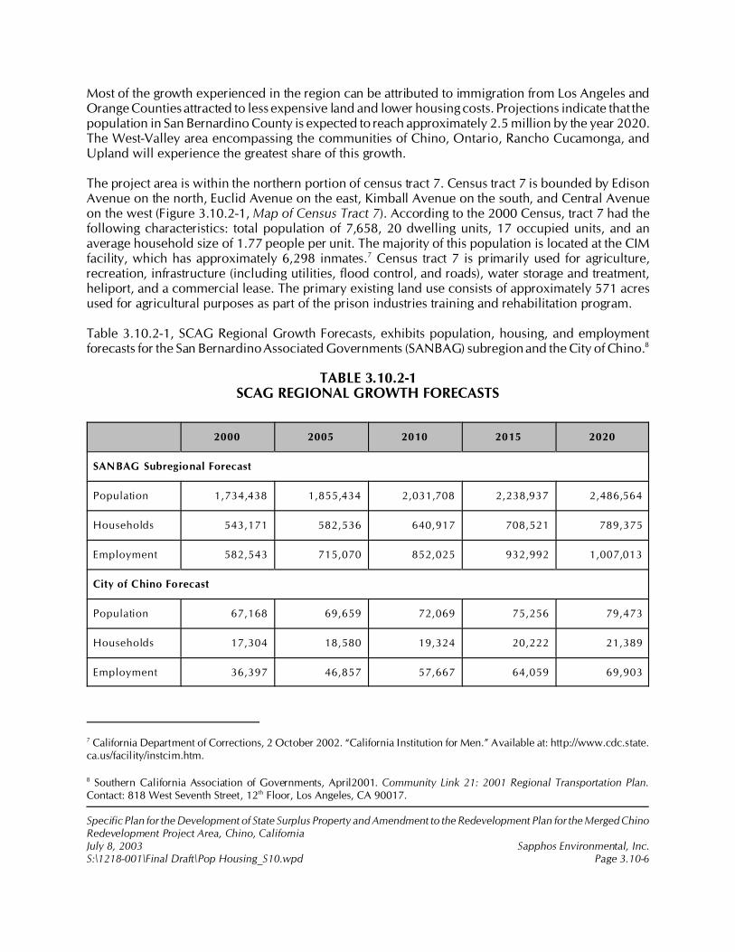
7 California Department of Corrections, 2 October 2002. “California Institution for Men.” Available at: http://www.cdc.state.ca.us/facility/instcim.htm.
8 Southern California Association of Governments, April2001. Community Link 21: 2001 Regional Transportation Plan.Contact: 818 West Seventh Street, 12th Floor, Los Angeles, CA 90017.
Specific Plan for the Development of State Surplus Property and Amendment to the Redevelopment Plan for the Merged ChinoRedevelopment Project Area, Chino, CaliforniaJuly 8, 2003 Sapphos Environmental, Inc.S:\1218-001\Final Draft\Pop Housing_S10.wpd Page 3.10-6
Most of the growth experienced in the region can be attributed to immigration from Los Angeles andOrange Counties attracted to less expensive land and lower housing costs. Projections indicate that thepopulation in San Bernardino County is expected to reach approximately 2.5 million by the year 2020.The West-Valley area encompassing the communities of Chino, Ontario, Rancho Cucamonga, andUpland will experience the greatest share of this growth.
The project area is within the northern portion of census tract 7. Census tract 7 is bounded by EdisonAvenue on the north, Euclid Avenue on the east, Kimball Avenue on the south, and Central Avenueon the west (Figure 3.10.2-1, Map of Census Tract 7). According to the 2000 Census, tract 7 had thefollowing characteristics: total population of 7,658, 20 dwelling units, 17 occupied units, and anaverage household size of 1.77 people per unit. The majority of this population is located at the CIMfacility, which has approximately 6,298 inmates.7 Census tract 7 is primarily used for agriculture,recreation, infrastructure (including utilities, flood control, and roads), water storage and treatment,heliport, and a commercial lease. The primary existing land use consists of approximately 571 acresused for agricultural purposes as part of the prison industries training and rehabilitation program.
Table 3.10.2-1, SCAG Regional Growth Forecasts, exhibits population, housing, and employmentforecasts for the San Bernardino Associated Governments (SANBAG) subregion and the City of Chino.8
TABLE 3.10.2-1SCAG REGIONAL GROWTH FORECASTS
2000 2005 2010 2015 2020
SANBAG Subregional Forecast
Population 1,734,438 1,855,434 2,031,708 2,238,937 2,486,564
Households 543,171 582,536 640,917 708,521 789,375
Employment 582,543 715,070 852,025 932,992 1,007,013
City of Chino Forecast
Population 67,168 69,659 72,069 75,256 79,473
Households 17,304 18,580 19,324 20,222 21,389
Employment 36,397 46,857 57,667 64,059 69,903
9 California Department of General Services, August 2000b.
10 Ibid.
Specific Plan for the Development of State Surplus Property and Amendment to the Redevelopment Plan for the Merged ChinoRedevelopment Project Area, Chino, CaliforniaJuly 8, 2003 Sapphos Environmental, Inc.S:\1218-001\Final Draft\Pop Housing_S10.wpd Page 3.10-7
The City of Chino grew from a population of 59,682 in 1990 to 67,168 in 2000 (approximately 12.5percent). According to the SCAG 2001 Regional Transportation Plan (RTP), it is projected that the Citywill increase its population by about 2,500 between the years of 2000 and 2005. In the long term,SCAG projects that the City population will increase to 80,400 by the year 2020.
The City of Chino’s share of countywide population has remained at approximately 4 percent duringthe 1990!1999 period and is currently estimated to be approximately 67,168. During the 1990!1999period, Chino experienced a lower growth rate than San Bernardino County did as a whole, but thisseems to have picked up since 1997, with the city growing almost at par with San Bernardino County.
Housing Trends and Forecasts
New single-family detached (SFD) housing units in the City of Chino has grown at a rate ofapproximately 1.07 percent during the 1990!1999 period, which is about the same rate as thepopulation. The share of SFD housing units in Chino has remained at an average of a little more than2 percent of countywide new units in the 1990!1999 period. An average of 120 units have beenadded annually to the City’s SFD housing unit inventory during this period.
Recent new SFD unit sales in Chino and other competing markets such as Ontario, Chino Hills, MiraLoma, and Corona show that average sale prices in the region are about $245,000 for a 2,500-square-foot home on a 6,500- to 7,500-square-foot lot.9 Home values in Chino are marginally less than theaverage values in the region, but it should be noted that the averages are bolstered by significantlyhigher sale prices in adjoining Chino Hills.
Annual absorption of new residential units in Chino is approximately 125 units annually. This has beenaccelerated in the past two years with more than 300 units being absorbed during 1998 and 1999.Most of the competing residential supply exists in Ontario, Mira Loma, and Corona.10 Although theaverage residential product type in Chino Hills caters to the higher end of the market in comparisonwith Chino, available land and new subdivisions in Chino Hills to the southwest of the CIM facility willput competitive pressure on any new residential development in Chino. Table 3.10.2-2, Chino FutureHousing Needs, shows the SCAG estimate of future housing needs to accommodate regional growth.These numbers reflect the net projected household growth for the jurisdiction during the 7.5-yearplanning period.
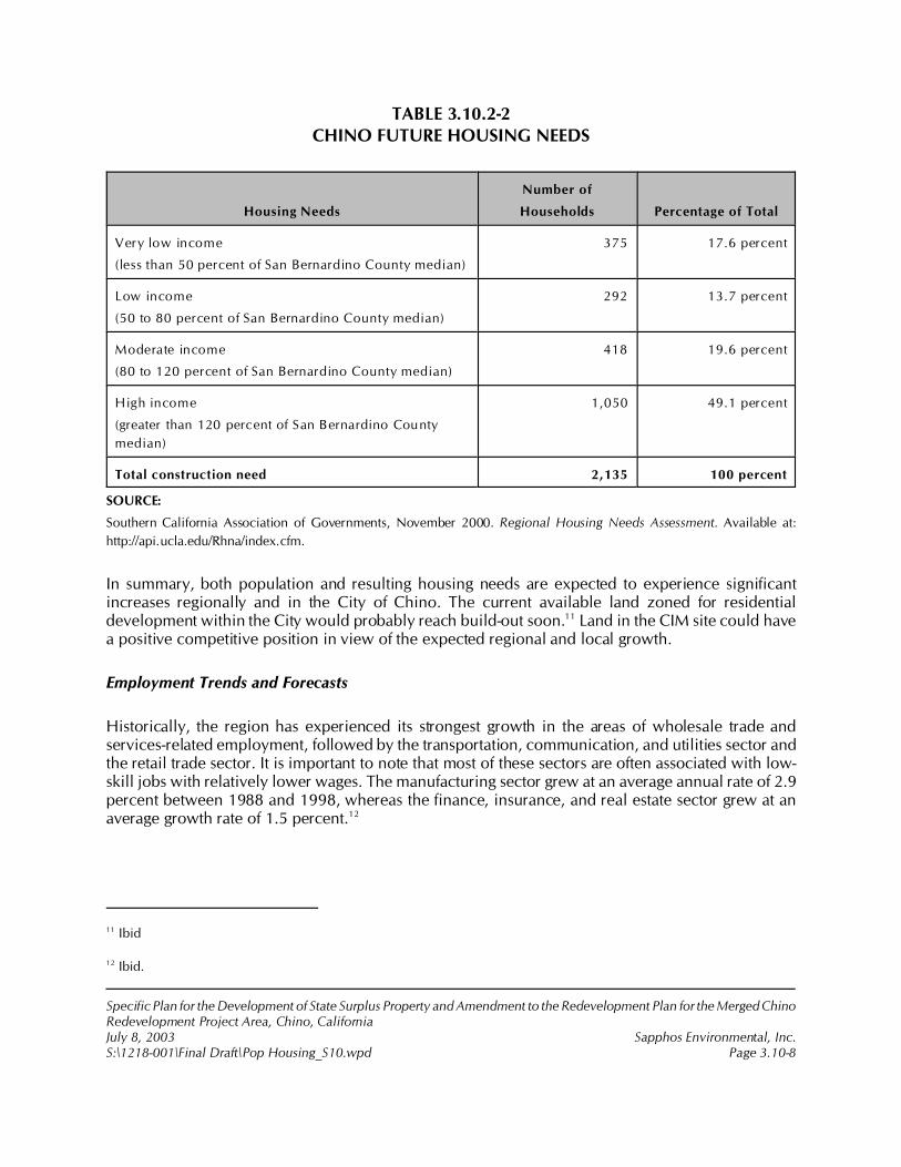
11 Ibid
12 Ibid.
Specific Plan for the Development of State Surplus Property and Amendment to the Redevelopment Plan for the Merged ChinoRedevelopment Project Area, Chino, CaliforniaJuly 8, 2003 Sapphos Environmental, Inc.S:\1218-001\Final Draft\Pop Housing_S10.wpd Page 3.10-8
TABLE 3.10.2-2CHINO FUTURE HOUSING NEEDS
Housing Needs
Number of
Households Percentage of Total
Very low income
(less than 50 percent of San Bernardino County median)
375 17.6 percent
Low income
(50 to 80 percent of San Bernardino County median)
292 13.7 percent
Moderate income
(80 to 120 percent of San Bernardino County median)
418 19.6 percent
High income
(greater than 120 percent of San Bernardino County
median)
1,050 49.1 percent
Total construction need 2,135 100 percent
SOURCE:
Southern California Association of Governments, November 2000. Regional Housing Needs Assessment. Available at:
http://api.ucla.edu/Rhna/index.cfm.
In summary, both population and resulting housing needs are expected to experience significantincreases regionally and in the City of Chino. The current available land zoned for residentialdevelopment within the City would probably reach build-out soon.11 Land in the CIM site could havea positive competitive position in view of the expected regional and local growth.
Employment Trends and Forecasts
Historically, the region has experienced its strongest growth in the areas of wholesale trade andservices-related employment, followed by the transportation, communication, and utilities sector andthe retail trade sector. It is important to note that most of these sectors are often associated with low-skill jobs with relatively lower wages. The manufacturing sector grew at an average annual rate of 2.9percent between 1988 and 1998, whereas the finance, insurance, and real estate sector grew at anaverage growth rate of 1.5 percent.12
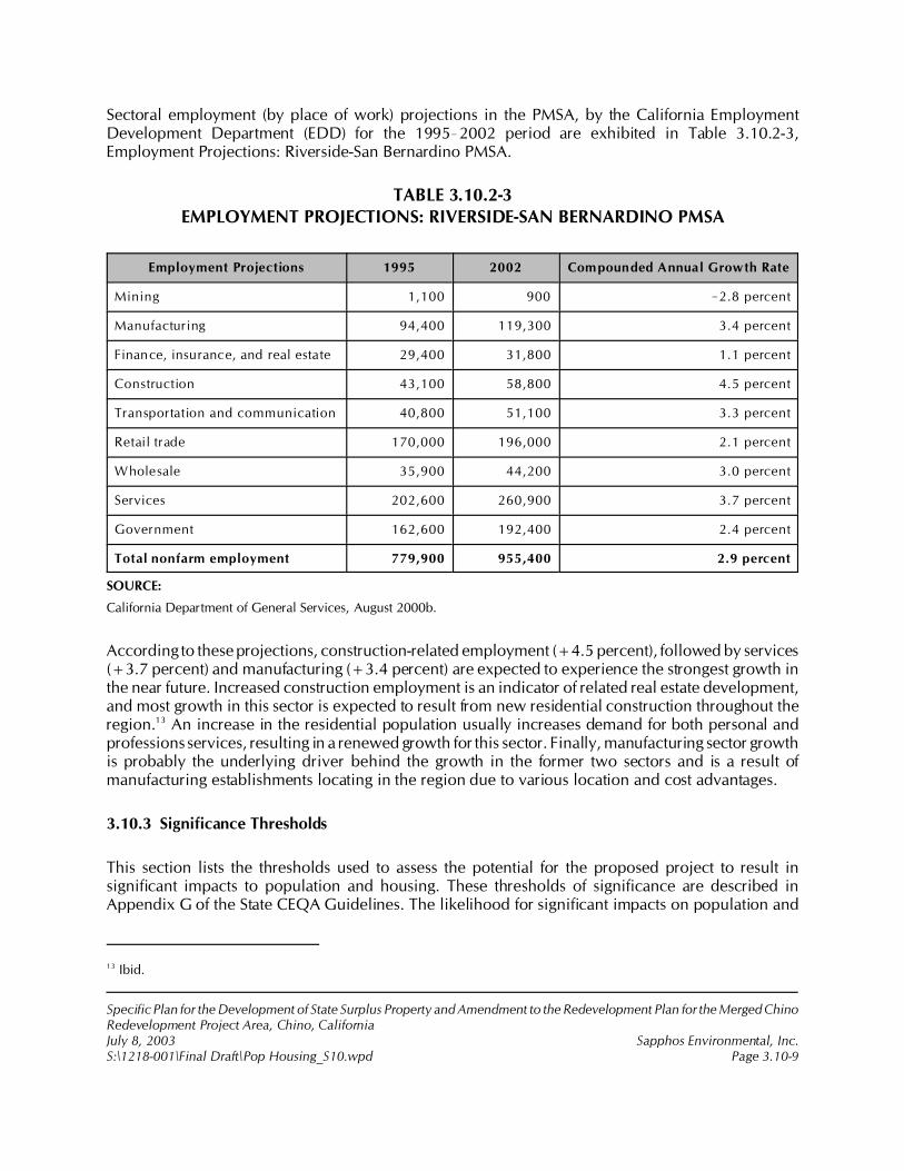
13 Ibid.
Specific Plan for the Development of State Surplus Property and Amendment to the Redevelopment Plan for the Merged ChinoRedevelopment Project Area, Chino, CaliforniaJuly 8, 2003 Sapphos Environmental, Inc.S:\1218-001\Final Draft\Pop Housing_S10.wpd Page 3.10-9
Sectoral employment (by place of work) projections in the PMSA, by the California EmploymentDevelopment Department (EDD) for the 1995!2002 period are exhibited in Table 3.10.2-3,Employment Projections: Riverside-San Bernardino PMSA.
TABLE 3.10.2-3EMPLOYMENT PROJECTIONS: RIVERSIDE-SAN BERNARDINO PMSA
Employment Projections 1995 2002 Compounded Annual Growth Rate
Mining 1,100 900 !2.8 percent
Manufacturing 94,400 119,300 3.4 percent
Finance, insurance, and real estate 29,400 31,800 1.1 percent
Construction 43,100 58,800 4.5 percent
Transportation and communication 40,800 51,100 3.3 percent
Retail trade 170,000 196,000 2.1 percent
Wholesale 35,900 44,200 3.0 percent
Services 202,600 260,900 3.7 percent
Government 162,600 192,400 2.4 percent
Total nonfarm employment 779,900 955,400 2.9 percent
SOURCE:
California Department of General Services, August 2000b.
According to these projections, construction-related employment (+4.5 percent), followed by services(+3.7 percent) and manufacturing (+3.4 percent) are expected to experience the strongest growth inthe near future. Increased construction employment is an indicator of related real estate development,and most growth in this sector is expected to result from new residential construction throughout theregion.13 An increase in the residential population usually increases demand for both personal andprofessions services, resulting in a renewed growth for this sector. Finally, manufacturing sector growthis probably the underlying driver behind the growth in the former two sectors and is a result ofmanufacturing establishments locating in the region due to various location and cost advantages.
3.10.3 Significance Thresholds
This section lists the thresholds used to assess the potential for the proposed project to result insignificant impacts to population and housing. These thresholds of significance are described inAppendix G of the State CEQA Guidelines. The likelihood for significant impacts on population and

14 Ibid.
15 City of Chino, 6 October 1981. General Plan: Land Use Element. Contact: Community Development Department, 13220Central Avenue, Chino, CA 91710.
Specific Plan for the Development of State Surplus Property and Amendment to the Redevelopment Plan for the Merged ChinoRedevelopment Project Area, Chino, CaliforniaJuly 8, 2003 Sapphos Environmental, Inc.S:\1218-001\Final Draft\Pop Housing_S10.wpd Page 3.10-10
housing to occur was evaluated based on the potential for the proposed project to result in any of thefollowing:
• Induce substantial population growth in an area, either directly or indirectly
• Displace substantial amounts of existing housing, necessitating the construction ofreplacement housing elsewhere
• Displace substantial numbers of people, necessitating the construction of replacementhousing elsewhere
The State CEQA Guidelines (Section 15131) states the following:
Economic or social effects of the project shall not be treated as significant effects on theenvironment. An EIR may trace a chain of cause and effect from a proposed decisionon a project through anticipated economic or social changes resulting from the projectto physical changes caused in turn by the economic or social changes.
In additions, SCAG views significant impacts as those that would “result in population, housing andemployment growth inconsistent with the regional level of growth projected under the SouthernCalifornia Association of Government’s Regional Comprehensive Plan.”
3.10.4 Impact Analysis
Implementation of the proposed project would be expected to have an impact to population andhousing due to a direct increase in population that would occur as a result of the proposed project.However, this growth would be consistent with the City of Chino General Plan and the SCAG RegionalComprehensive Plan and therefore would not constitute a significant impact. The residential elementof the proposed project includes a master-planned residential community of approximately2,200!2,500 dwelling units of various sizes to be developed on approximately 450 gross (329 net)residential acres. The proposed project would accommodate population growth consistent withregional and local demand forecasts for population growth and housing, therefore resulting in directand indirect impacts on growth. The demand for housing in the Riverside-San Bernardino MetropolitanStatistical Area is projected at 564,860 dwelling units between the years of 1996 and 2010.14 Theproposed project would be capable of addressing 3.2 to 4.8 percent of the subregion demand. Theproposed project would result in development of recreational, educational, and residential land useconsistent with the adopted Redevelopment Plan and the land use designations specified in the Cityof Chino General Plan15 for the proposed project area. The proposed development would not displacesubstantial numbers of people or housing, and therefore it would not necessitating the construction ofreplacement housing elsewhere.
16 Ibid.
17 California Department of General Services, October 1997. Land Use Analysis, CIM Site, Chino, California. Contact:California Department of General Services, 707 Third Street, Suite 6-130, West Sacramento, CA 95605. Prepared by: WPMPlanning Team, Inc.
18 California Department of General Services, August 2000b.
Specific Plan for the Development of State Surplus Property and Amendment to the Redevelopment Plan for the Merged ChinoRedevelopment Project Area, Chino, CaliforniaJuly 8, 2003 Sapphos Environmental, Inc.S:\1218-001\Final Draft\Pop Housing_S10.wpd Page 3.10-11
Job-to-Housing Balance
The Inland Empire industrial market has substantial competitive advantages over other areas of the LosAngeles basin. It is within easy access of an expanding international airport (Ontario InternationalAirport), an interstate freeway system, and an excellent rail freight infrastructure. The availability ofrelatively cheaper industrially zoned land and access to a growing labor force has made this region anideal location for manufacturing and distribution establishments. Within this market, the West Endprobably has the highest advantage due to its strategic location in relation to the greater four countyarea.16 Key industry growth sectors pertaining to the CIM property include manufacturing (expansionof 52,740 jobs by 2010); transportation, communication, and utilities (expansion of 13,430 jobs by2010); and wholesale trade (expansion of 23,930 jobs by 2010). Job growth is projected to beaccompanied by an expansion of housing units to 1,698,414 in 2010, and of population to 4,415,877in 2010. This pattern of development is projected to continue the Inland Empire’s role as an area ofnet outcommuting, as the ration of population to jobs is projected to increase from 3.6 in 1996 toabout 3.7 in 2010.17
As the last few vacant parcels and remaining dairy properties to the west of the CIM facility (east of the71 freeway) get absorbed by speculative developers and as the last phase of the Spectrum businesspark is completed, industrial land will become scarce in Chino.18 Although the available land will stilltake a few years to be fully absorbed, demand for land to the south and east of the CIM facility isexpected to increase.
3.10.5 Cumulative Impacts
The incremental impact of the proposed project, when added to the related past, present, or reasonablyforeseeable future projects listed in Section 2, Project Description, would not result in cumulativeimpacts related to population and housing.
The list of related projects used in consideration of cumulative impacts includes a number of majordevelopment projects within the City of Chino and neighboring jurisdictions that would have thepotential to impact housing demand and population. As demonstrated in the preceding analysis, theproposed project will have no significant adverse impacts to population, housing, or employment.Similarly, the project’s incremental contributions to cumulative population, housing, and employmentimpacts within the SCAG region are seen as less than significant.
Specific Plan for the Development of State Surplus Property and Amendment to the Redevelopment Plan for the Merged ChinoRedevelopment Project Area, Chino, CaliforniaJuly 8, 2003 Sapphos Environmental, Inc.S:\1218-001\Final Draft\Pop Housing_S10.wpd Page 3.10-12
3.10.6 Mitigation Measures
The analysis undertaken for this document determined that no significant impacts to population andhousing would arise from the proposed project; therefore, no mitigation measures are required.
3.10.7 Level of Significance after Mitigation
The analysis undertaken for this document determined that no significant impacts to population andhousing would arise from the proposed project; therefore, no mitigation measures are required.
1 City of Chino, 19 July 2002c. Initial Study: Specific Plan for the Development of 717 Acres of State Surplus Propertyfrom the California Institution for Men (CIM), Chino, California. Contact: Community Development Department, 13220Central Avenue, Chino, CA 91710. Prepared by: Sapphos Environmental, Inc., 133 Martin Alley, Pasadena, CA 91105.
2 City of Chino, 6 October 1981. General Plan: Land Use Element. Contact: Community Development Department,13220 Central Avenue, Chino, CA 91710.
3 City of Chino, December 1990. General Plan: Conservation/Open Space Element. Contact: Community DevelopmentDepartment, 13220 Central Avenue, Chino, CA 91710.
4 City of Chino, September 2001c. The Preserve, Chino Sphere of Influence–Subarea 2: Draft Environmental ImpactReport, Section 5.7 through Section 10. Contact: 13220 Central Avenue, Chino, CA 91710. Prepared by: MichaelBrandman Associates, 15901 Red Hill Avenue, Suite 200, Tustin, CA 92780.
5 Automobile Club of Southern California,1998. San Bernardino County Map. Contact: Travel Publications Department,2601 South Figueroa Street, Los Angeles, CA 90007.
6 Thomas Bros. Maps, 2001. The Thomas Guide: San Bernardino/Riverside Counties. Contact: Thomas Bros. Maps, 603West 7th Street, Los Angeles, CA 90017.
Specific Plan for the Development of State Surplus Property and Amendment to the Redevelopment Plan for the MergedChino Redevelopment Project Area, Chino, CaliforniaJuly 8, 2003 Sapphos Environmental, Inc.S:\1218-001\Final Draft\Public_S11.wpd Page 3.11-1
3.11 PUBLIC SERVICES
As a result of the Initial Study,1 the City of Chino Community Development Department (City)determined that the Specific Plan for the Development of State Surplus Property and Amendment tothe Redevelopment Plan for the Merged Chino Redevelopment Project Area, Chino, California(proposed project) had the potential to result in impacts to public services. Therefore, this issue hasbeen carried forward for detailed analysis in this Environmental Impact Report (EIR). This analysis wasundertaken to identify opportunities to avoid, reduce, or otherwise mitigate potential significantimpacts to these public services: fire protection, police protection, schools, parks, and other services.
The analysis of public services consists of a summary of the regulatory framework that guides thedecision-making process, existing conditions at the proposed project site, thresholds for determiningif the proposed project would result in significant impacts, anticipated impacts (direct, indirect, andcumulative), mitigation measures, and the level of significance after mitigation. The potential impactsto public services has been analyzed in accordance with the methodologies provided by the City ofChino General Plan,2,3 technical analyses,4 published maps,5,6 and communications with City andservice provider officials.
3.11.1 Regulatory Framework
State
Mello-Roos Community District Act of 1982
A Mello-Roos Community District is a financing district that provides designated public agencies withthe authority to finance public facilities such as fire and police protection, schools, parks, and libraries

7 City of Chino, September 2001c.
8 CASH Facility Resource Center, 24 October 2002. “Senate Bill 50 and School Facility Fees.” Available at:http://www.cashnet.org.
9 City of Chino, 6 October 1981.
10 Ibid.
Specific Plan for the Development of State Surplus Property and Amendment to the Redevelopment Plan for the MergedChino Redevelopment Project Area, Chino, CaliforniaJuly 8, 2003 Sapphos Environmental, Inc.S:\1218-001\Final Draft\Public_S11.wpd Page 3.11-2
through the imposition of taxes approved by a two-thirds majority of the qualified electorate of thedistrict.
Senate Bill 50
Senate Bill 50 (SB50), the Leroy F. Greene School Facilities Act of 1998, signed into law in August1998, became fully effective with the approval of Proposition 1A on November 3, 1998. SB50describes three levels of fees that can be statutorily levied against a project for mitigation of schoolfacilities, Level 1, Level 2, and Level 3. Level 1 fees are calculated based on the square footage ofstructures included in a project. Level 1 fees currently have a statutory cap of $2.65 per square foot forresidences, and $0.33 per square foot for commercial/industrial and senior-only housing. Level 2 andLevel 3 fees are additional fees that can be levied at 50 or 100 percent, respectively, of the cost ofconstructing school facilities and for land acquisition and site development. Level 2 and Level 3 feescan only be levied if the school district serving the project has met certain conditions, including, butnot limited to, conducting a school facilities needs analysis and being deemed eligible to participatein the State Funding Program by the State Allocation Board. SB50 declares that payment of thespecified development fees, where necessary, is full and complete mitigation for impacts to schoolfacilities, and prohibits a public agency from denying a legislative or adjudicative act on the basis ofrefusal to provide school facilities mitigation that exceeds the amounts authorized by SB50. SB50 alsoforbids requiring the use of the Mello-Roos Communities District Act of 1982 as a condition ofapproval of any legislative or adjudicative act.7,8
Local
City of Chino General Plan
The Land Use element9 of the City of Chino General Plan includes a policy that growth shall be in aphased and orderly manner consistent with the availability of adequate public and private services, andwithout setting maximum population limits. It also provides minimum service availability criteria fordevelopment projects for several public services, including fire protection, police protection, andschool and park facilities. In addition, this element10 states that the Specific Plan for the Urban ReserveArea, which is the proposed project, shall include provisions for “commercial facilities, schools, parks,and other public facilities” accompanying residential development.
11 City of Chino, December 1990.
12 Ibid.
13 City of Chino, 6 October 1981.
14 Ibid.
15 Chino Valley Independent Fire District, 11 April 2001. Master Plan. Available at: http://www.cvifd.org/pdf/masterplan.pdf. (Last viewed 28 May 2002.)
16 Ibid.
Specific Plan for the Development of State Surplus Property and Amendment to the Redevelopment Plan for the MergedChino Redevelopment Project Area, Chino, CaliforniaJuly 8, 2003 Sapphos Environmental, Inc.S:\1218-001\Final Draft\Public_S11.wpd Page 3.11-3
The Conservation/Open Space element11 of the City of Chino General Plan provides the action tomaintain open space zoning for the CIM property, and if the CIM site is developed, the Specific Planshall emphasize preservation of at least 25 percent of the total land area for open space uses. Inaddition, this element12 provides several policies relevant to the proposed project:
• Encourage the expansion and further development of Ruben S. Ayala Regional Park• Ensure that Service Area 4, which includes the proposed project area, has adequate
park space to meet existing and future demands• Encourage the development and utilization of equestrian and bicycle trails• Encourage the use of school sites within the Chino Valley Unified School District for
recreational opportunities• Encourage the development and utilization of open space within multiple family
development projects
3.11.2 Existing Conditions
Fire Protection
The City of Chino receives fire protection services from the Chino Valley Independent Fire District(CVIFD). The City of Chino General Plan13 contains the goal to attempt to maintain a first-alarmresponse time of 5 minutes for any development within the city.14 The CVIFD uses a more specificservice criterion based on travel time. This criterion includes the time from departure from a stationto arrival at the emergency rather than the time from the receipt of the 911 call. The goal of the CVIFDis a 4-minute travel (response) time. The CVIFD average response time to structure fires in the year2000 was 6 minutes, 1 second.15
There are six fire response stations in the Chino Valley, Fire Station Nos. 61, 62, 63, 64, 65, and 66,plus the CVIFD Headquarters in the office of the City of Chino Hills serving approximately 80 squaremiles.16 The fire response units maintain a fleet of five medic engines, one basic life support (BLS)engine, and one ladder truck along with a shift battalion chief. The complement of 28 personneloperate on three shifts to provide 24-hour emergency and nonemergency services. The primary fireresponse units and their locations are described in Table 3.11.2-1, Existing Fire Stations Serving theProposed Project Site. The locations of these fire stations are depicted as shown on Figure 3.11.2-1,
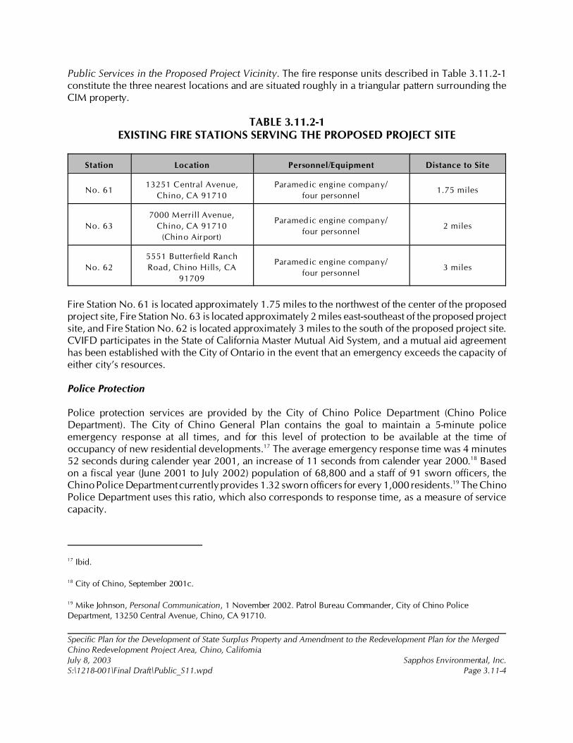
17 Ibid.
18 City of Chino, September 2001c.
19 Mike Johnson, Personal Communication, 1 November 2002. Patrol Bureau Commander, City of Chino PoliceDepartment, 13250 Central Avenue, Chino, CA 91710.
Specific Plan for the Development of State Surplus Property and Amendment to the Redevelopment Plan for the MergedChino Redevelopment Project Area, Chino, CaliforniaJuly 8, 2003 Sapphos Environmental, Inc.S:\1218-001\Final Draft\Public_S11.wpd Page 3.11-4
Public Services in the Proposed Project Vicinity. The fire response units described in Table 3.11.2-1constitute the three nearest locations and are situated roughly in a triangular pattern surrounding theCIM property.
TABLE 3.11.2-1EXISTING FIRE STATIONS SERVING THE PROPOSED PROJECT SITE
Station Location Personnel/Equipment Distance to Site
No. 6113251 Central Avenue,
Chino, CA 91710
Paramedic engine company/
four personnel1.75 miles
No. 63
7000 Merrill Avenue,
Chino, CA 91710
(Chino Airport)
Paramedic engine company/
four personnel2 miles
No. 62
5551 Butterfield Ranch
Road, Chino Hills, CA
91709
Paramedic engine company/
four personnel3 miles
Fire Station No. 61 is located approximately 1.75 miles to the northwest of the center of the proposedproject site, Fire Station No. 63 is located approximately 2 miles east-southeast of the proposed projectsite, and Fire Station No. 62 is located approximately 3 miles to the south of the proposed project site.CVIFD participates in the State of California Master Mutual Aid System, and a mutual aid agreementhas been established with the City of Ontario in the event that an emergency exceeds the capacity ofeither city’s resources.
Police Protection
Police protection services are provided by the City of Chino Police Department (Chino PoliceDepartment). The City of Chino General Plan contains the goal to maintain a 5-minute policeemergency response at all times, and for this level of protection to be available at the time ofoccupancy of new residential developments.17 The average emergency response time was 4 minutes52 seconds during calender year 2001, an increase of 11 seconds from calender year 2000.18 Basedon a fiscal year (June 2001 to July 2002) population of 68,800 and a staff of 91 sworn officers, theChino Police Department currently provides 1.32 sworn officers for every 1,000 residents.19 The ChinoPolice Department uses this ratio, which also corresponds to response time, as a measure of servicecapacity.
20 City of Chino, September 2001c.
21 Chino Valley Unified School District, 8 November 2002c. (Letter to Ms. Jillian Neary, Sapphos Environmental, Inc., 133Martin Alley, Pasadena, CA 91105.) Subject: Response to Request of September 20th Regarding Specific Plan, CIMProject.
22 Thomas Bros. Maps, 2001.
23 Chino Valley Unified School District, 8 November 2002c.
24 Chino Valley Unified School District, 2000-01. “School Accountability Report Cards.” Available at:http://ww.chino.k12.ca.us.
25 Chino Valley Unified School District, 8 November 2002c.
Specific Plan for the Development of State Surplus Property and Amendment to the Redevelopment Plan for the MergedChino Redevelopment Project Area, Chino, CaliforniaJuly 8, 2003 Sapphos Environmental, Inc.S:\1218-001\Final Draft\Public_S11.wpd Page 3.11-5
The headquarters, located at 13250 Central Avenue, Chino, California, was built in 1976 andencompasses 39,432 square feet. Two substations provide part-time office space for officers and staffat the Spectrum Mall and the Chino Airport. The space in the primary facility is currently maximized.
Schools
Chino Valley Unified School District (CVUSD) provides K-12 public education for most of the City ofChino, a small part of Ontario, and a portion of the unincorporated area in the County of SanBernardino.20 CVUSD operates a total of 30 public school sites, with a 2002!2003 enrollment of32,928 students (Figure 3.11.2-1).21 However, some of these school sites consist entirely of portables,such as Chino Hills High School. One public school site is located within a 1-mile radius of theproposed project boundary, Howard Cattle Elementary. One private school site is located in thevicinity of the proposed project; New Hope Christian Elementary is located approximately 2.5 milesnorthwest of the center of the proposed project.22 CVUSD is currently constructing three elementaryschool sites. Of these three, the proposed project is within the Rhodes Elementary attendance area,which will be operational for the 2003!2004 school year with a capacity of 700 seats.23 CVUSD hasdeveloped a preliminary project development schedule based on current projections that includesanother elementary school, two junior high schools, and a fourth high school. When combined withthe three elementary schools under construction, these facilities will increase CVUSD’s capacity by7,300 seats.
Student-to-teacher ratios are one measure of service levels for schools. A ratio of 20:1 correlates to 20students per teacher in one classroom. Maximum student-to-teacher ratios per classroom areestablished by state law and by the terms of the Associated Chino Teachers contract.24 These maximumratios and the average25 student-to-teacher ratios for CVUSD are shown in Table 3.11.2-2, Student-to-Teacher Ratios.
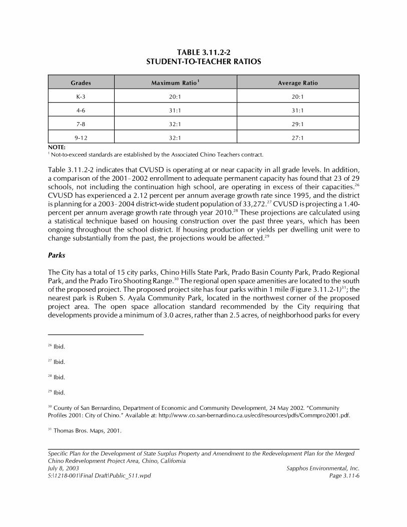
26 Ibid.
27 Ibid.
28 Ibid.
29 Ibid.
30 County of San Bernardino, Department of Economic and Community Development, 24 May 2002. “CommunityProfiles 2001: City of Chino.” Available at: http://www.co.san-bernardino.ca.us/ecd/resources/pdfs/Commpro2001.pdf.
31 Thomas Bros. Maps, 2001.
Specific Plan for the Development of State Surplus Property and Amendment to the Redevelopment Plan for the MergedChino Redevelopment Project Area, Chino, CaliforniaJuly 8, 2003 Sapphos Environmental, Inc.S:\1218-001\Final Draft\Public_S11.wpd Page 3.11-6
TABLE 3.11.2-2STUDENT-TO-TEACHER RATIOS
Grades Maximum Ratio1 Average Ratio
K-3 20:1 20:1
4-6 31:1 31:1
7-8 32:1 29:1
9-12 32:1 27:1
NOTE:1 Not-to-exceed standards are established by the Associated Chino Teachers contract.
Table 3.11.2-2 indicates that CVUSD is operating at or near capacity in all grade levels. In addition,a comparison of the 2001!2002 enrollment to adequate permanent capacity has found that 23 of 29schools, not including the continuation high school, are operating in excess of their capacities.26
CVUSD has experienced a 2.12 percent per annum average growth rate since 1995, and the districtis planning for a 2003!2004 district-wide student population of 33,272.27 CVUSD is projecting a 1.40-percent per annum average growth rate through year 2010.28 These projections are calculated usinga statistical technique based on housing construction over the past three years, which has beenongoing throughout the school district. If housing production or yields per dwelling unit were tochange substantially from the past, the projections would be affected.29
Parks
The City has a total of 15 city parks, Chino Hills State Park, Prado Basin County Park, Prado RegionalPark, and the Prado Tiro Shooting Range.30 The regional open space amenities are located to the southof the proposed project. The proposed project site has four parks within 1 mile (Figure 3.11.2-1)31; thenearest park is Ruben S. Ayala Community Park, located in the northwest corner of the proposedproject area. The open space allocation standard recommended by the City requiring thatdevelopments provide a minimum of 3.0 acres, rather than 2.5 acres, of neighborhood parks for every
32 Goodell Brackenbush, 25 March 2003. Letter to City of Chino, 13220 Central Avenue, Chino, CA 91710 from GoodellBrackenbush, 36 W. Colorado, Suite 208, Pasadena, CA 91105. Subject: CIM Specific Plan Language.
33 County of San Bernardino, Department of Economic and Community Development, 24 May 2002.
34 U.S. Census Bureau, 15 July 2002. “Census 2000 Summary File (SF1) 100-percent Data: Chino City, California.”Available at: http://factfinder.census.gov.
Specific Plan for the Development of State Surplus Property and Amendment to the Redevelopment Plan for the MergedChino Redevelopment Project Area, Chino, CaliforniaJuly 8, 2003 Sapphos Environmental, Inc.S:\1218-001\Final Draft\Public_S11.wpd Page 3.11-7
1,000 residents of the new community given that the overall acreage of open space associated withthe Chaffey College element more than meets this requirement.32
Other Public Facilities
The primary medical facility in the City is the Chino Valley Medical Center, with a 126-bed capacity.33
Cultural and recreational facilities include 48 churches, the Youth Museum, the Old School HouseMuseum, the Planes of Fame Museum, and the Yorba Slaughter Adobe House. The Chino Airport, ageneral aviation facility, is located near the eastern boundary of the proposed project; OntarioInternational Airport is less than 10 miles to the east. The nearest post office is approximately 3 milesto the north of the proposed project site. The City of Chino is served by one library, the Chino BranchLibrary, with library services provided by the San Bernardino County Library.
3.11.3 Significance Thresholds
The potential for the proposed project to result in impacts to public services was analyzed in relationto the questions contained in Appendix G of the California Environmental Quality Act (CEQA)Guidelines.
Significant environmental impacts are those resulting from the construction of new or physically alteredgovernmental facilities that are provided or needed in order to maintain acceptable service ratios,response times, or other performance objectives established for any of the public services for theproposed project as described in Section 3.11.2, Existing Conditions:
• Fire protection: 4-minute response time• Police protection: 1.32 sworn officers per 1,000 population• Schools: Maximum student-to-teacher ratios (Table 3.11.2-2)• Parks: 3.0 acres per 1,000 population• Other public services
Significant environmental impacts would result where the existing environmental conditions of the siteof the new or physically altered facility are unknown, or where the site is known but has not beenanalyzed pursuant to CEQA.
3.11.4 Impact Analysis
The proposed 2,200- to 2,500-dwelling-unit master-planned residential community would houseapproximately 9,425 people, assuming a rate of 3.43 individuals34 in each of the maximum 2,500
35 Chino Valley Independent Fire District, 11 April 2001.
36 Chino Valley Independent Fire District, 8 August 2002. (Letter to Mr. Chuck Coe, City of Chino CommunityDevelopment Department.) Subject: Master EIR of the Specific Plan (July 2002) 717 Acres of Surplus Property-CIM.
37 Tom J. Maxham, Personal Communication, 13 August 2002. Division Chief/Fire Marshall, Chino Valley IndependentFire District, 2005 North Grand, Chino Hills, CA 91709.
38 Sal Salazar, Personal Communication, 29 January 2003. Principal Planner, City of Chino, P.O. Box 667, Chino, CA91708-0667.
Specific Plan for the Development of State Surplus Property and Amendment to the Redevelopment Plan for the MergedChino Redevelopment Project Area, Chino, CaliforniaJuly 8, 2003 Sapphos Environmental, Inc.S:\1218-001\Final Draft\Public_S11.wpd Page 3.11-8
units. In addition, a portion of the students, teachers, and employees of the commercial center andChaffey Community College campus would find housing outside of the residential component of theproposed project.
Fire Protection
Direct and Indirect Impacts
Implementation of the proposed project would be expected to result in significant direct and indirectimpacts related to fire protection services. The CVIFD is currently exceeding their service level goal,and construction of new facilities would be necessary to serve the proposed project. In response torecent and planned population growth and to facilitate optimum response times, CVIFD implementeda Master Plan35 that includes improved dispatch services, new facilities and many facility locations, andsupport of a transportation corridor expansion. The Master Plan included current planning efforts atthe time of its adoption throughout the CVIFD’s jurisdiction, including the City. The proposed projectwas included in those planning efforts. Based on coordination with the CVIFD,36,37 it was determinedthat no construction of new or expanded facilities, beyond those already planned, are necessary tomaintain fire emergency response objectives.
Because the City of Chino is experiencing citywide growth, all of the proposed fire station(s) in theMaster Plan, including those locations that would ultimately serve the proposed project, would beconstructed to maintain current and project population levels even if the proposed project were notconstructed.
However, because the CVIFD is currently exceeding their current service level goal, implementationof the proposed project would require construction of additional fire protection facilities. Because thelocation of the fire station to be built to maintain service objectives to the proposed project andsurrounding area has not been finalized, the potential environmental impacts from the constructionand operation from this facility are unknown, constituting a significant direct and indirect impact.38 Itwould be considered a direct impact because the need for new facilities to be constructed that havethe potential to cause significant environmental impacts would be a result of the implementation of theproposed project; it would also be an indirect impact because the potential environmental impactsfrom the new facility would occur at a distance away from the proposed project site.
39 City of Chino, 6 October 1981.
40 Ibid.
41 Mike Johnson, Personal Communication, 1 November 2002.
Specific Plan for the Development of State Surplus Property and Amendment to the Redevelopment Plan for the MergedChino Redevelopment Project Area, Chino, CaliforniaJuly 8, 2003 Sapphos Environmental, Inc.S:\1218-001\Final Draft\Public_S11.wpd Page 3.11-9
In addition, a portion of the students, teachers, and employees of the commercial center and ChaffeyCommunity College campus would find housing outside of the residential component of the proposedproject, thereby indirectly increasing the population of the City and the need for additional fireprotection services. The proposed project would not result in significant indirect impacts related topopulation growth outside of the proposed project boundary because this population growth isincluded in the City of Chino General Plan. The General Plan does not set maximum population limitsas long as development proceeds in an orderly and phased manner.39 The proposed project meets theCity’s definition of phased and orderly development. In addition, the proposed project objectives forthe Lead Agency include the identification and adoption of a land use plan that will be fiscally efficientand capable of financing the construction and maintenance of required public improvements. Theproposed project includes a balance of land uses that would provide an economially viableenvironment for the City to support the expansion of public services. In addition, another City of Chinoobjective for the proposed project is to develop a premier living environment designed on theprinciples of “smart” development. Smart development fulfills the goals for an orderly system of growthin the City.
Police Protection
Direct and Indirect Impacts
The proposed project would be expected to have significant direct and indirect impacts on publicservices related to police protection. At current staffing levels, the average response time of 4 minutes52 seconds is nearly exceeding the 5-minute service objective of the City General Plan.40 An increasein population would dilute the current service ratio of 1.32, which would correlate to a longerresponse time. The Chino Police Department would consider any reduction in the service ratio to bea significant impact, requiring the hiring of personnel to maintain service objectives. Because theprimary facility of the Chino Police Department is currently maximized, the addition of personnelwould require the expansion or construction of new facilities, the construction of which have thepotential to result in significant environmental impacts, constituting a significant direct and indirectimpact.41 It would be considered a direct impact because the need for new facilities to be constructedwith the potential to cause significant environmental impacts would be a result of the implementationof the proposed project; it would also be an indirect impact because the potential environmentalimpacts from the new facilities would occur at a distance away from the proposed project site.
Based on a facilities needs assessment being completed for the Chino Police Department, each swornofficer requires 501.01 square feet of space and 0.90 vehicles. Therefore, the proposed project wouldrequire the construction of approximately 3,757.50 square feet of facilities and the purchase of sevenvehicles to accommodate the 7.5 sworn officers to serve the expected residential population of 9,425

42 Ibid.
43 Ibid.
44 Chino Valley Unified School District, 8 November 2002c.
45 Ibid.
Specific Plan for the Development of State Surplus Property and Amendment to the Redevelopment Plan for the MergedChino Redevelopment Project Area, Chino, CaliforniaJuly 8, 2003 Sapphos Environmental, Inc.S:\1218-001\Final Draft\Public_S11.wpd Page 3.11-10
persons.42 There would be additional direct impacts from the educational component of the proposedproject if the Chaffey Community College Campus requires patrol from the Chino Police Departmentrather than, or in addition to, on-campus security services.43 The Chaffey College Rancho Cucamongacampus utilizes its own Safety and Security Department, with sworn officers as full-time staff. Inaddition, the Rancho Cucamonga campus contracts some of its police work through the County of SanBernardino Sheriff’s Department. Therefore, if the Chaffey College element of the proposed projectresulted in a need for services from the Chino Police Department, this would constitute a direct impactbecause police protection services are currently operating at maximum service objectives.
As described in the analysis of fire protection services, the proposed project would not result in indirectimpacts to police protection services as indirect population growth, and the correspondingmaintenance of public service objectives, is already included in the City of Chino General Plan andthe Lead Agency objectives for the proposed project.
Schools
Direct Impacts
The proposed project would be expected to result in significant direct impacts to schools. As discussedabove, CVUSD is currently operating at or near capacity throughout the school district. The proposedproject would result in approximately 1,775 students based on the CVUSD student generation factor(SGF) of 0.70 students on average per dwelling unit44 (Table 3.11.4-1, Student Generation).
TABLE 3.11.4-1STUDENT GENERATION
GradesMaximum Proposed
Dwelling UnitsNum ber of Students SGF
K!6 2,500 1,050 0.42
7!8 2,500 300 0.12
9!12 2,500 425 0.17
Total 2,500 1,775 0.70
The proposed project would include construction of a 10-acre elementary school with an adjacent 5-acre park that would accommodate grade K-6 students.45 This elementary school meets the
46 Ibid.
47 Goodell Brackenbush, 25 March 2003.
Specific Plan for the Development of State Surplus Property and Amendment to the Redevelopment Plan for the MergedChino Redevelopment Project Area, Chino, CaliforniaJuly 8, 2003 Sapphos Environmental, Inc.S:\1218-001\Final Draft\Public_S11.wpd Page 3.11-11
requirements of CVUSD with 10 net usable acres with a less than 1-percent grade, adjacent to a 5-acrepark with access on two adjacent streets.46 The remaining increase in the grade 7-12 student populationwould need to be accommodated by the existing or planned school facilities, constituting a significantdirect impact to public services related to the need for the construction or expansion of schools torelieve overcrowding and lack of resources. It should be noted that overcrowding, in and of itself, isnot considered to be a significant environmental impact but a socioeconomic impact (Goleta UnionSchool District v. Regents of the University of California). However, the current plans for expansionto relieve the exceedance of permanent capacity based on existing enrollment and projections doesnot include the proposed project; therefore, additional construction or expansion would be requiredto permanently house the 725 grade 7-12 students expected from the proposed project.
Indirect Impacts
As described in the analysis of police protection services, the proposed project would not result inindirect impacts to schools as indirect population growth, and the maintenance of public serviceobjectives, is already included the City of Chino General Plan and the Lead Agency objectives for theproposed project.
Parks
Direct and Indirect Impacts
The proposed project would not be expected to result in significant impacts to public services relatedto parks. The proposed project includes the expansion of the existing 70-acre Ruben S. Ayala regionalpark facility (including the Young Men’s Christian Association [YMCA] and driving range) up to amaximum of 140 acres. In addition, the proposed project includes approximately 15 acres ofneighborhood parks, 6 acres of multi-use trails, and 3 acres of village and campus green open spacethat would be expected to accommodate the increase in population and meet the City General Planopen space allocation standard of 3.0 acres per 1,000 population for neighborhood, community, andcity parks.47 Because the addition of these park lands to accommodate open space allocation standardsare included in the environmental analysis for the proposed project, there would not be a significantdirect or indirect impact to public services related to the construction or expansion of parks or otheropen space amenities.
Other Public Facilities
Direct Impacts
The proposed project would be expected to result in significant direct impacts to other public services.In particular, library facilities would require expansion to maintain service objectives. The Division ofLibrary Development Services of the State of California uses the state average of 0.35 square feet of
48 City of Chino, September 2001c.
49 Ibid.
Specific Plan for the Development of State Surplus Property and Amendment to the Redevelopment Plan for the MergedChino Redevelopment Project Area, Chino, CaliforniaJuly 8, 2003 Sapphos Environmental, Inc.S:\1218-001\Final Draft\Public_S11.wpd Page 3.11-12
library facility per capita and 1.5 volumes per capita as standards. The Chino Branch Libraryencompasses 10,600 square feet with approximately 60,000 volumes of varying media.48 Serving apopulation of 67,168, the Chino Branch Library currently operates with 0.16 square feet49 and 0.90volumes per capita. Therefore, the library does not currently meet service objectives, and additionalpopulation growth would further decrease the ratio of services per capita. Based on the State ofCalifornia standard, a population of 9,425 would require approximately 3,300 square feet of libraryspace and 14,138 volumes. Other public facilities would be expected to accommodate the populationincrease associated with the proposed project.
Indirect Impacts
As described above, the proposed project would not result in indirect impacts to schools as indirectpopulation growth and the maintenance of public service objectives are already included in the Cityof Chino General Plan and in the Lead Agency objectives for the proposed project.
3.11.5 Cumulative Impacts
The incremental impact of the proposed project, when added to the related past, present, or reasonablyforeseeable future projects listed in Section 2, Project Description, would not result in cumulativeimpacts related to public services.
The list of related projects used in consideration of cumulative impacts includes a number of majordevelopment projects within the City of Chino and neighboring jurisdictions that would have thepotential to impact fire protection, police protection, schools, and library services. These publicservices are currently operating at or near capacity, and the proposed project’s incremental impact tothis cumulative condition would be considerable.
3.11.6 Mitigation Measures
Implementation of the following mitigation measures is recommended to avoid, reduce, or eliminatethe significant direct impacts to police protection, schools, and libraries expected to result from theimplementation of the proposed project.
Public Services-1
To reduce potential environmental impacts from the construction and operation of one or more newfire protection facilities required to maintain service objectives to the proposed project at all phases,including build-out, the CVIFD, and/or the Lead Agency for the implementation of the CVIFD MasterPlan as determined pursuant to State CEQA Guidelines, Article 4 (§15050!15053), “Lead Agency,”shall comply with the requirements of CEQA, as applicable. If significant environmental impacts areidentified, the Lead Agency must implement mitigation measures that reduce the impact to below thelevel of significance or adopt overriding considerations pursuant to §15093 of the State CEQA
Specific Plan for the Development of State Surplus Property and Amendment to the Redevelopment Plan for the MergedChino Redevelopment Project Area, Chino, CaliforniaJuly 8, 2003 Sapphos Environmental, Inc.S:\1218-001\Final Draft\Public_S11.wpd Page 3.11-13
Guidelines. This mitigation measure shall be monitored and enforced by the City of Chino for all firestation facilities proposed for construction to serve the proposed project within the City of Chinocorporate boundaries.
Public Services-2
To reduce impacts to police protection and fire protection services, the applicant for each of the threeelements of the proposed project, City of Chino, Chaffey Community College, and the privatedeveloper, shall pay development impact fees (DIFs) in accordance with the City of Chino MunicipalCode, where necessary to maintain service objectives to each proposed project element. Chapter 3.4.0of the City of Chino Municipal Code establishes appropriate DIFs to ensure the necessary funding forthe construction of the public improvement needs resulting form the implementation of the proposedproject. Monitoring and enforcement of mitigation measure Public Services-2 shall be performed bythe City of Chino.
Public Services–3
To reduce impacts to schools, the private developer shall pay statutory developer fees and/or provideland to the CVUSD in accordance with SB50 and any other state or local regulations that meet thestandard or equivalent. The specific form of mitigation and amount of fees, if any, shall be determinedthrough cooperation between the private developer, the City, and the CVUSD prior to the issuance ofa building permit. Monitoring and enforcement of mitigation measure Public Services-3 shall beperformed by the City of Chino.
Public Services-4
To reduce direct impacts to libraries, the private developer shall provide a form of financing for the SanBernardino County Library that meets the standard or equivalent to construct or expand library facilitiesin the City of Chino such that the San Bernardino County Library would meet the Division of LibraryDevelopment Services of the State of California standards for the increase in population associated withthe proposed project only. The specific form of mitigation shall be determined through cooperationbetween the developer, the City, and the San Bernardino County Library prior to the issuance of abuilding permit. Monitoring and enforcement of mitigation measure Public Services-4 shall beperformed by the City of Chino.
3.11.7 Level of Significance after Mitigation
After the implementation of proposed mitigation measures, impacts in regards to public services wouldbe reduced to less than significant levels.
1 City of Chino, 19 July 2002c. Initial Study: Specific Plan for the Development of 717 Acres of State Surplus Propertyfrom the California Institution for Men (CIM), Chino, California. Contact: Community Development Department, 13220Central Avenue, Chino, CA 91710. Prepared by: Sapphos Environmental, Inc., 133 Martin Alley, Pasadena, CA 91105.
2 City of Chino, December 1990. General Plan: Conservation/Open Space Element. Contact: Community DevelopmentDepartment, 13220 Central Avenue, Chino, CA 91710.
3 Southern California Association of Governments, 1998. Regional Comprehensive Plan and Guide. Contact: 818 W.Seventh Street, 12th Floor (Main Office), Los Angeles, CA 90017.
Specific Plan for the Development of State Surplus Property and Amendment to the Redevelopment Plan for the MergedChino Redevelopment Project Area, Chino, CaliforniaJuly 8, 2003 Sapphos Environmental, Inc.S:\1218-001\Final Draft\Recreation_S12.wpd Page 3.12-1
3.12 RECREATION
As a result of the Initial Study,1 the City of Chino Community Development Department (City)
determined that the Specific Plan for the Development of State Surplus Property and Amendment to
the Redevelopment Plan for the Merged Chino Redevelopment Project Area, Chino, California
(proposed project) had the potential to result in impacts to recreation. Therefore, this issue has been
carried forward for detailed analysis in this Environmental Impact Report (EIR). This analysis was
undertaken to identify opportunities to avoid, reduce, or otherwise mitigate potential significant
impacts that could occur as a result of the Recreation element of the proposed project and identify
alternatives.
The analysis of recreation resources consists of a summary of the regulatory framework that guides the
decision-making process, existing conditions at the proposed project site, thresholds for determining
if the proposed project would result in significant impacts, anticipated impacts (direct, indirect, and
cumulative), mitigation measures, and the level of significance after mitigation. The potential impacts
to recreation have been analyzed in accordance with the methodologies and information provided by
the City of Chino General Plan.2
3.12.1 Regulatory Framework
This regulatory framework identifies the local statutes and policies that relate to recreation and must
be considered by the City during the decision-making process for the proposed project.
Regional
Regional Comprehensive Plan and Guide
The Open Space and Conservation element of the Regional Comprehensive Plan and Guide3 states that
urban-type land uses and facilities need to support future additional population growth, which will
consume a large portion of the remaining privately held land in the region. The plan emphasizes the
conservation of open space areas that provide opportunities for outdoor recreation, considered
important for providing a good quality of life for residents who live in highly urbanized areas of the
region.
4 City of Chino, December 1990.
Specific Plan for the Development of State Surplus Property and Amendment to the Redevelopment Plan for the MergedChino Redevelopment Project Area, Chino, CaliforniaJuly 8, 2003 Sapphos Environmental, Inc.S:\1218-001\Final Draft\Recreation_S12.wpd Page 3.12-2
Local
City of Chino General Plan
The goal of the City of Chino General Plan4 Open Space and Conservation element includes the
maintenance and encouragement of the development of open space for outdoor recreation. The City
of Chino has established 13 policies that are relevant to the proposed project:
• Policy P5-16.3 Encourage Use of SCE Easements and Flood Control Channels: To
encourage and promote the use of Southern California Edison Company (SCE)
easements and County of San Bernardino (County) flood control channels for the
development of equestrian, bicycle, jogging, and walking trails as a means of providing
recreational opportunities for Chino residents and its labor force
• Policy P5-16.4 Adequate Park Space per Service Area: To ensure that each of the
City’s four service areas have adequate park space to meet existing and future demands
• Policy P5-16.5 Develop Equestrian and Biking Trails: To encourage the development
and utilization of equestrian and bicycle trails throughout the City while striving to link
neighborhoods with one another
• Policy P5-16.6 Link City Trails and County Trails: To encourage the connection of the
equestrian and bicycle trails system with County trail systems to ultimately provide
access to Prado Regional Park and Chino Hills State Park
• Policy P5-16.7 Encourage Development of Mini-Parks: To encourage the development
of mini-parks throughout the City
• Policy P5-16.8 Encourage Development of Special Use Facilities: To encourage the
development of special use facilities within the City’s neighborhoods and community
parks
• Policy P5-16.9 Encourage Use of Private Recreational Facilities: To encourage the
development and use of private and quasi-public facilities for recreational enjoyment
• Policy P5-16.10 Preserve CIM as Open Space: To encourage the preservation of CIM
as an open space resource
• Policy P5-16.11 Expansion of Ayala Park: To encourage the expansion and further
development of Ruben S. Ayala Community Park
5 County of San Bernardino, Department of Economic and Community Development, 24 May 2002. Community Profiles2001: City of Chino. Available at: www.co.san-bernardino.ca.us/ecd/resources/pdfs/Commpro2001.pdf.
6 Thomas Bros. Maps, 2001. The Thomas Guide: San Bernardino/Riverside Counties. Contact: Thomas Bros. Maps, 603West 7th Street, Los Angeles, CA 90017.
Specific Plan for the Development of State Surplus Property and Amendment to the Redevelopment Plan for the MergedChino Redevelopment Project Area, Chino, CaliforniaJuly 8, 2003 Sapphos Environmental, Inc.S:\1218-001\Final Draft\Recreation_S12.wpd Page 3.12-3
• Policy P5-16.12 Use of Chino Unified School District (CUSD) Sites: To encourage the
use of school sites within the CUSD for recreational opportunities
• Policy P5-16.13 Open Space for Multi-Family Projects: To encourage the
development and utilization of open space within multiple family development
projects
• Policy P5-16.14 Comprehensive Park and Recreational Opportunities: To encourage
the comprehensive and orderly development of parks and recreational opportunities
for existing and future generations of Chino residents
• Policy P5-16.16 Maintain Parks for Park Uses: To ensure that existing and future park
sites remain as parks and open spaces so that their long-term preservation is
maintained
3.12.2 Existing Conditions
Approximately 170 acres of the proposed project site are currently being leased from the State of
California to the City for recreational purposes. Although the total leased area is 170 acres, 5.5 acres
of this area is a street right of way. Within the leased area, the City operates the approximately 70-acre
Ruben S. Ayala Community Park, which contains four lighted softball/soccer fields, two combination
baseball/soccer fields, one volleyball court, two picnic shelters, two tot lots, one concession restroom
building, a multi-use trail, a small storage building, and asphalt-paved parking for 374 cars. Additional
recreational facilities, including a golf driving range, a batting cage, and a Young Mens Christian
Association (YMCA) facility, have been developed on the land leased to the City pursuant to
concession lease agreements and operated as private-public partnerships (see Figure 3.12.2-1, Existing
Conditions: Ruben S. Ayala Community Park ).
The City of Chino has a total of 15 city parks, as well as Chino Hills State Park, Prado Basin County
Park, Prado Regional Park, and the Prado Tiro Shooting Range.5 The regional open space amenities
are located to the south of the proposed project. The proposed project has 4 parks within 1 mile (see
Section 3.11, Figure 3.11.2-1, Public Services in the Proposed Project Vicinity)6; the nearest park is
Ruben S. Ayala Community Park, located in the northwest corner of the proposed project area.
3.12.3 Significance Thresholds
This section lists the thresholds used to assess the potential for the proposed project to result in
significant impacts to recreation. These thresholds of significance are described in Appendix G of the
California Environmental Quality Act (CEQA) Guidelines. The likelihood for significant impacts to

Specific Plan for the Development of State Surplus Property and Amendment to the Redevelopment Plan for the MergedChino Redevelopment Project Area, Chino, CaliforniaJuly 8, 2003 Sapphos Environmental, Inc.S:\1218-001\Final Draft\Recreation_S12.wpd Page 3.12-4
occur to recreation was evaluated based on the potential for the proposed project to result in either
of the two following possibilities:
• The increased use of existing neighborhood and regional parks or other recreational
facilities such that substantial physical deterioration of the facility would occur or be
accelerated
• Recreational facilities or the construction or expansion of recreational facilities that
might produce an adverse physical effect on the environment through construction or
maintenance of the recreational facility
3.12.4 Impact Analysis
The proposed project is intended to improve and expand facilities within an existing recreational area
(known as Ruben S. Ayala Community Park), as well as increase the number of parks in the area to
serve the additional demand associated with the development of a community college campus, mixed-
use area, and residential dwelling units, thereby avoiding substantial physical deterioration of the
Ruben S. Ayala Community Park or surrounding parks. The proposed project may incur a short-term
construction impact to recreational facilities, requiring the implementation of mitigation measures.
There would be no long-term adverse impacts associated with the implementation of the proposed
project.
3.12.4.1 Ruben S. Ayala Community Park Expansion
The proposed project includes the expansion of the existing 70-acre Ruben S. Ayala Community Park
(including the YMCA and driving range) up to 140 acres. The expansion elements would include nine
additional lighted soccer fields, one lighted championship soccer field with seating for approximately
1,000 spectators, one 25,000-square-foot skate park with associated playground and tot lot areas, two
concession stand/restroom buildings, one free-standing restroom building, three picnic shelters, and
on-site parking for 482 vehicles with overflow parking for 144 vehicles (Figure 3.12.4.1-1, Proposed
Ruben S. Ayala Community Park Expansion).
Construction of the new parking areas may temporarily decrease available parking spaces or block
park access, which would be expected to result in significant short-term impacts to recreation,
requiring the consideration of mitigation measures.
The expansion of the park to include the additional play fields, picnic shelters, and restrooms may
result in portions of the park being closed during construction (including the existing play fields),
resulting in significant short-term impacts to recreation and requiring the consideration of mitigation
measures.
3.12.4.2 Additional Neighborhood and City Parks
In addition to the expansion of the Ruben S. Ayala Community Park, neighborhood and city parks
would be developed within the master-planned community. The master-planned community would
include a total of 27.5 acres dedicated to schools and parks. A 10-acre elementary school and
7 City of Chino, July 2002d. Personal communication to Goodell Brackenbush, 36 West Colorado Boulevard, Suite 208,Pasadena, CA 91105. Subject: Use of 3.0, not 2.5, acres per population of 1,000.
Specific Plan for the Development of State Surplus Property and Amendment to the Redevelopment Plan for the MergedChino Redevelopment Project Area, Chino, CaliforniaJuly 8, 2003 Sapphos Environmental, Inc.S:\1218-001\Final Draft\Recreation_S12.wpd Page 3.12-5
adjoining 5-acre neighborhood park facility would be developed in collaboration with the Chino
Valley Unified School District (CVUSD) and the City. Approximately 14.5 acres, including 5 acres of
additional public parks, would be developed throughout the residential community, including a 3.5-
acre community park and six 1-acre parks. In addition, a 1-acre village green and a 2-acre campus
green are planned in the Village Center. The City standards requiring that developments provide a
minimum of 3.0 acres of neighborhood parks for every 1,000 residents of the new community, given
that the overall acreage of open space associated with the Chaffey College element more than meets
this requirement.7 The additional parks that would be developed would serve the additional demand
associated with the development of a community college campus, mixed-use area, and residential
dwelling units, thereby avoiding substantial physical deterioration of the Ruben S. Ayala Community
Park or surrounding parks. Therefore, no significant adverse impacts would occur as a result of the
addition of new parks in the area.
3.12.4.3 Trails and Walkways
Approximately 6 acres of pedestrian trails, bike paths, and equestrian trails would be developed in an
exclusive right-of-way separate from the collector and local street system. The trails would link the
community with the parks within the proposed project area, including the Ruben S. Ayala Community
Park. Development of the trail and walkway system would not result in significant impacts.
3.12.5 Cumulative Impacts
The potential for cumulative impacts to recreation was evaluated in relation to the closely related past,
present, or reasonable foreseeable and probable future projects described in Table 2.7-1, Related
Proposed and Approved Projects, in Section 2.7 of this EIR.
The proposed project would not result in cumulative impacts to recreation when considered in
conjunction with related projects. As with the proposed project, the City of Chino, City of Ontario,
City of Chino Hills, and City of Norco projects involve development that would potentially result in
impacts to recreation; however, the proposed project is intended to improve facilities within an
existing recreational area, as well as increase the recreational facilities in the proposed project area.
The proposed project elements may incur a short-term construction/rehabilitation impact to
recreational facilities requiring the implementation of mitigation measures. There will be no long-term
impacts as a result of the proposed project.
3.12.6 Mitigation Measures
Recreation-1
Construction impacts to recreation resulting from temporary closure of designated parking spaces shall
be minimized through advance communication and redirection to the nearest comparable facility
within the proposed project service area. Prior to completion of final plans and specifications, the City
Specific Plan for the Development of State Surplus Property and Amendment to the Redevelopment Plan for the MergedChino Redevelopment Project Area, Chino, CaliforniaJuly 8, 2003 Sapphos Environmental, Inc.S:\1218-001\Final Draft\Recreation_S12.wpd Page 3.12-6
of Chino shall review the plans and specifications to ensure that they contain language requiring that
signs be posted at every parking facility that is temporarily unavailable at least one month in advance
of construction; the signs must indicate the proposed construction schedule and alternative parking
facilities that can be used during the construction period. This measure will be monitored and enforced
by the City of Chino Community Services Department.
Recreation-2
Construction impacts to recreation resulting from temporary closure of existing recreational facilities
during construction and expansion of recreational facilities shall be minimized through advance
communication and redirection to the nearest comparable facility within the proposed project service
area. Prior to completion of final plans and specifications, the City of Chino shall review the plans and
specifications to ensure that they contain language requiring the construction contractor to ensure that
signs be posted at every entrance to the Ruben S. Ayala Community Park at least one month in
advance of construction; the signs must indicate the proposed construction schedule and alternative
recreation facilities (including location and hours of operation) located in the service area that can be
used during the construction period. This measure will be monitored and enforced by the City of
Chino Community Services Department.
Recreation-3
Construction impacts to recreation resulting from temporary closure of play fields shall be minimized
through advance communication and redirection to the nearest comparable facility within the
proposed project service area. Prior to completion of final plans and specifications, the City of Chino
shall review the plans and specifications to ensure that they contain language requiring that signs be
posted at every play field that is temporarily unavailable at least one month in advance of construction;
the signs must indicate the proposed construction schedule and alternative fields that can be used
during the construction period. This measure will be monitored and enforced by the City of Chino
Community Services Department.
3.12.7 Level of Significance after Mitigation
Implementation of measure Recreation-1 through Recreation-3 would be expected to reduce
anticipated significant impacts to recreation resulting from construction of the proposed project to
below the level of significance.
1 City of Chino, 19 July 2002c. Initial Study: Specific Plan for the Development of 717 Acres of State Surplus Propertyfrom the California Institution for Men (CIM), Chino, California. Contact: Community Development Department, 13220Central Avenue, Chino, CA 91710. Prepared by: Sapphos Environmental, Inc., 133 Martin Alley, Pasadena, CA 91105.
2 City of Chino, February 1992. General Plan: Circulation Element. Contact: Community Development Department,13220 Central Avenue, Chino, CA 91710.
3 California Department of General Services, October 1997. Land Use Analysis, CIM Site, Chino, California. Contact: 707Third Street, Suite 6-130, West Sacramento, CA 95605.
4 California Department of General Services, August 2000a. Strategic Master Land Use Plan and ImplementationApproach, CIM Chino: Volume I. Contact: 707 Third Street, Suite 6-130, West Sacramento, CA 95605. Prepared byEDAW, Inc. et al.
5 Goodell Brackenbush, April 2003. Draft Traffic Impact Analysis for the Specific Plan for the Development of StateSurplus Property from the California Institution for Men, Chino, California. Prepared by Kaku Associates, 1453 ThirdStreet, Suite 400, Santa Monica, CA 90401.
Specific Plan for the Development of State Surplus Property and Amendment to the Redevelopment Plan for the MergedChino Redevelopment Project Area, Chino, CaliforniaJuly 8, 2003 Sapphos Environmental, Inc.S:\1218-001\Final Draft\Traffic_S13.wpd Page 3.13-1
3.13 TRANSPORTATION/TRAFFIC
As a result of the Initial Study,1 the City of Chino Community Development Department (City)determined that the Specific Plan for the Development of State Surplus Property and Amendment tothe Redevelopment Plan for the Merged Chino Redevelopment Project Area, Chino, California(proposed project) had the potential to result in impacts to transportation/traffic. Therefore, this issuehas been carried forward for detailed analysis in this Environmental Impact Report (EIR). This analysiswas undertaken to identify opportunities to avoid, reduce, or otherwise mitigate potential significantimpacts to transportation/traffic and identify potential alternatives.
The analysis of transportation/traffic includes a description of the regulatory framework that guides thedecision-making process, existing conditions of the proposed project area, thresholds for determiningif the proposed project would result in significant impacts, anticipated impacts, mitigation measures,and the level of significance after mitigation. The potential impacts to transportation/traffic have beenanalyzed in accordance with the methodologies provided by the Circulation element of the City ofChino General Plan,2 the Land Use Analysis of the California Institution for Men (CIM) site,3 theStrategic Master Land Use Plan and Implementation Approach for CIM Chino,4 and the Traffic ImpactAnalysis.5
6 West’s Annotated California Codes, 1984b. Water Code Sections 30000 to 38999. Official California Water CodeClassification. Vol. 69. St. Paul, MN: West Publishing Company.
7 San Bernardino Associated Governments, 5 December 2001. Congestion Management Program for San BernardinoCounty. Contact: San Bernardino Associated Governments, 472 North Arrowhead Avenue, San Bernardino, CA92401-1421.
Specific Plan for the Development of State Surplus Property and Amendment to the Redevelopment Plan for the MergedChino Redevelopment Project Area, Chino, CaliforniaJuly 8, 2003 Sapphos Environmental, Inc.S:\1218-001\Final Draft\Traffic_S13.wpd Page 3.13-2
3.13.1 Regulatory Framework
State
California Water Code
The proposed project is subject to the State of California Water Code, Division 12, Part 5, Chapter 1,Article 4, Section 31060, Construction of Rights of Way.6 Any mitigation measure required to beimplemented in a state right-of-way would require a California Department of Transportation (Caltrans)Encroachment Permit.
Regional
San Bernardino Associated Governments (SANBAG)
The Congestion Management Program (CMP) for San Bernardino County7 is a program that SANBAGadopted to analyze traffic impacts attributable to local land use decisions. The CMP requires noanalysis of roadways farther than 5 miles from the perimeter of the project site. The roadway elementsthat must be analyzed in accordance with CMP guidelines are dependent both on the project analysisyear (project opening year or CMP horizon year) and the project-generated traffic volumes. Theidentification of the study area and the study locations was based on an estimate of the two-way trafficvolumes on CMP roadway segments in the vicinity of the project site. The CMP intersections andhighway segments selected for analysis are dependent on the amount of project-generated trips forecastto be added to the network within the defined project area, with the threshold being 80 peak-hour two-way trips on the arterial street system and 100 peak-hour two-way trip on the freeway system.
The proposed project contributes traffic greater than the CMP freeway threshold volume of 100 peak-hour two-way trips to the Pomona Freeway (State Route 60) and the Chino Valley Freeway (State Route71), and the project contribution test has indicated that the project will contribute more than 80 trips(CMP roadway threshold volume) along roadway segments serving CMP intersections within the Cityof Chino, the City of Chino Hills, and the City of Ontario. This means that the City of Chino must notifythe congestion management agency (in this case, SANBAG), Caltrans, the City of Chino Hills, and theCity of Ontario in accordance with CMP requirements. Each of these agencies must also be providedwith a copy of the CMP traffic impact analysis, once the document is accepted by the City of Chino.
8 County of San Bernardino, 21 December 2000 (Revised from 1 July 1989). San Bernardino County General Plan.Contact: Economic Development and Public Services Group, Land Use Services Department, 385 North ArrowheadAvenue, 1st Floor, San Bernardino, CA 92415-0182.
9 City of Chino, February 1992.
10 Ibid.
Specific Plan for the Development of State Surplus Property and Amendment to the Redevelopment Plan for the MergedChino Redevelopment Project Area, Chino, CaliforniaJuly 8, 2003 Sapphos Environmental, Inc.S:\1218-001\Final Draft\Traffic_S13.wpd Page 3.13-3
Local
County of San Bernardino General Plan
Transportation/Circulation Element
The Transportation/Circulation element of the County of San Bernardino General Plan8 includespertinent policies related to traffic and circulation, issues related to land use, and various trafficanalyses of traffic conditions within San Bernardino County.City of Chino General Plan
Circulation Element
The Circulation element of the City of Chino General Plan9 includes a description of the street andhighway system within the City limits, objectives and policies related to traffic and circulation, andsummarizes the City’s bikeway system and the local public transit plan. The acceptable level of service(LOS) for the City of Chino is outlined in the Circulation element of the City of Chino General Plan.10
Table 3.13.1-1, Level of Service Overview, provides a description of types of LOS, which could bepresent in any municipality.
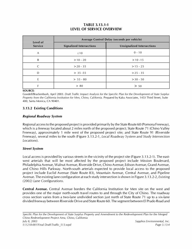
Specific Plan for the Development of State Surplus Property and Amendment to the Redevelopment Plan for the MergedChino Redevelopment Project Area, Chino, CaliforniaJuly 8, 2003 Sapphos Environmental, Inc.S:\1218-001\Final Draft\Traffic_S13.wpd Page 3.13-4
TABLE 3.13.1-1LEVEL OF SERVICE OVERVIEW
Level of
Service
Average Control Delay (seconds per vehicle)
Signalized Intersections Unsignalized Intersections
A #10 0 - 10
B >10 - 20 >10 -15
C >20 - 35 >15 - 25
D > 35 -55 >25 - 35
E > 55 - 80 >30 - 50
F > 80 > 50
SOURCE: Goodell/Brackenbush, April 2003. Draft Traffic Impact Analysis for the Specific Plan for the Development of State SurplusProperty from the California Institution for Men, Chino, California. Prepared by Kaku Associates, 1453 Third Street, Suite400, Santa Monica, CA 90401.
3.13.2 Existing Conditions
Regional Roadway System
Regional access to the proposed project is provided primarily by the State Route 60 (Pomona Freeway),which is a freeway located about 2 miles north of the proposed project; State Route 71 (Chino ValleyFreeway), approximately 1 mile west of the proposed project site; and State Route 91 (RiversideFreeway), several miles to the south (Figure 3.13.2-1, Local Roadway System and Study IntersectionLocations).
Street System
Local access is provided by various streets in the vicinity of the project site (Figure 3.13.2-1). The east-west arterials that will be most affected by the proposed project include Mission Boulevard,Philadelphia Avenue, Walnut Avenue, Riverside Drive, Chino Avenue, Edison Avenue, Grand Avenue,and Chino Hills Parkway. North-south arterials expected to provide local access to the proposedproject include Euclid Avenue (State Route 83), Mountain Avenue, Central Avenue, and PipelineAvenue. The existing lane configuration at each study intersection is shown in Figure 3.13.2-2, Existing(2002) Lane Configurations.
Central Avenue. Central Avenue borders the California Institution for Men site on the west andprovides one of the major north-south travel routes to and through the City of Chino. The roadwaycross section varies from a two-lane undivided section just north of State Route 71 up to a six-lanedivided freeway between Riverside Drive and State Route 60. The segment between El Prado Road and
11 Goodell Brackenbush, April 2003.
Specific Plan for the Development of State Surplus Property and Amendment to the Redevelopment Plan for the MergedChino Redevelopment Project Area, Chino, CaliforniaJuly 8, 2003 Sapphos Environmental, Inc.S:\1218-001\Final Draft\Traffic_S13.wpd Page 3.13-5
Edison Avenue, bordering the CIM site on the west, is a four-lane roadway, with a continuous left-turncenter lane.
Euclid Avenue (State Route 83). Euclid Avenue is one of the primary north-south roadways in the area.Euclid Avenue is a state route and controlled by Caltrans. Euclid Avenue is a two-lane undividedhighway south of Merrill Avenue. North of Merrill Avenue, Euclid Avenue is a four-lane dividedhighway with limited local access.
Edison Avenue. Edison Avenue is an east-west roadway that borders the CIM site on the north. Thetraveled way of Edison Avenue is improved to four lanes between Central and Euclid Avenues.
El Prado Road. El Prado Road borders the CIM site on the southwest. El Prado Road is a two-laneundivided roadway with unpaved shoulders.
Kimball Avenue. Kimball Avenue forms the southern boundary of the CIM site. Kimball Avenue is alocal, four-lane undivided roadway with two-way left-turn lanes adjacent to the CIM site, with no pavedshoulders. Power poles are located near the traveled way along part of the CIM property boundary.This street is also referred to as Robles Avenue on older legal documents.
Chino Hills Parkway. Chino Hills Parkway is an east-west arterial that acts as a significant access routefrom the regional freeway network to the CIM site. Chino Hills Parkway is a four-lane divided roadwaywest of State Route 71. Chino Hills Parkway’s eastern terminus is at Central Avenue, where the CIMmain access driveway aligns with Central Avenue to form a four-way intersection.
Merrill Avenue. Merrill Avenue is an east-west street that intersects Euclid Avenue on the east side ofthe CIM property, just north of the Youth Training School. Merrill Avenue is currently a two-laneroadway that provides access to the Chino Airport. Portions of this street also exist as a restrictedroadway on the CIM site. Merrill Avenue on the CIM site is maintained and controlled by theDepartment of Corrections. This street serves as the main entrance drive to the CIM Facility.
San Antonio Avenue. San Antonio Avenue is a north-south street. It is a two-lane roadway with a trafficlight. San Antonio Avenue forms part of the northeast CIM property boundary.
Existing Traffic Volumes
The existing traffic volumes at intersections that were analyzed in the Traffic Impact Analysis11 for theproposed project are shown in Figure 3.13.2-3a, Existing A.M. Peak-Hour Turning Movement Volumes,and Figure 3.13.2-3b, Existing P.M. Peak-Hour Turning Movement Volumes. A total of 37 intersectionswere analyzed for existing traffic volumes. The locations of the analyzed intersections with existinglane configurations are shown in Figure 3.13.2-1. Intersection 29 is a future intersection and isincluded as one of the 37 intersections.

12 Ibid.
13 Transportation Research Board, 31 October 1996. Highway Capacity Manual for the Year 2000. Contact:Transportation Research Board, 500 Fifth Street, NW, Washington, DC 20001.
14 Ibid
Specific Plan for the Development of State Surplus Property and Amendment to the Redevelopment Plan for the MergedChino Redevelopment Project Area, Chino, CaliforniaJuly 8, 2003 Sapphos Environmental, Inc.S:\1218-001\Final Draft\Traffic_S13.wpd Page 3.13-6
The estimated existing average daily traffic (ADT) volumes within the study area are based on historicaldata. The analysis of existing ADT concludes that the p.m. peak-hour roadway volumes are an averageof 9.2 percent of the daily volumes (Figure 3.13.2-4, Existing Average Daily Traffic Volumes). Newtraffic counts conducted in the a.m. peak period (7:00 a.m. to 9:00 a.m.) and p.m. peak period (4:00a.m. to 6:00 p.m.) conducted in mid-2002 and available traffic counts less than two years old wereused to identify the peak-hour volumes found in the Traffic Impact Analysis (Appendix I).12
New traffic counts conducted in the a.m. peak period (7:00 a.m. to 9:00 a.m.) and p.m. peak period(4:00 a.m. to 6:00 p.m.) conducted in mid-2002 and available traffic counts less than two years oldwere used to identify the peak-hour volumes found in the Traffic Impact Analysis (Appendix I).
Existing Levels of Service
The existing a.m. and p.m. peak-hour volumes at each of the 36 study intersections were analyzed inaccordance with the Highway Capacity Manual for the Year 200013 operations methodology todetermine the LOS (Table 3.13.1-1). A summary of the intersection volume to capacity (v/c) ratios,delay, and corresponding LOS values is presented in Table 3.13.2-1, Summary of Intersection Delayand Level of Service Existing Conditions–Year 2002. Detailed LOS worksheets are provided in theTraffic Impact Analysis (Appendix I).14 Of the intersections that were studied, 34 out of 36 currentlyoperate at an acceptable LOS (D or better) during the a.m. and p.m. peak hours. The 3 intersectionscurrently operating at LOS E or LOS F (based either on delay or on a v/c ratio in excess of 1.00) ineither the a.m. or p.m. peak hour include the following:
Intersection 1: Mountain Avenue and Mission BoulevardIntersection 6: Mountain Avenue and State Route 60 Eastbound RampsIntersection 10: Mountain Avenue and Walnut Avenue
TABLE 3.13.2-1SUMMARY OF INTERSECTION DELAY AND LEVEL OF SERVICE
EXISTING CONDITIONS–YEAR 2002
Specific Plan for the Development of State Surplus Property and Amendment to the Redevelopment Plan for the MergedChino Redevelopment Project Area, Chino, CaliforniaJuly 8, 2003 Sapphos Environmental, Inc.S:\1218-001\Final Draft\Traffic_S13.wpd Page 3.13-7
Number Intersection
Monitoring
Agency
Jurisdiction
(City or County)
Traffic
Control
Peak-Hour Delay and LOS1
A.M. P.M.
Delay LOS Delay LOS
1Mountain Ave. and
Mission Blvd.TS 54.3 F 73.0 F
2Mountain Ave. and
Philadelphia Ave.Ontario Ontario TS 24.9 C 29.7 C
3Central Ave. and
SR 60 WB rampsTS 23.9 C 28.2 C
4Central Ave. and
SR 60 EB rampsCaltrans Chino TS 15.3 B 31.9 C
5Mountain Ave. and
SR 60 WB rampsTS 43.6 F 43.0 D
6Mountain Ave. and
SR 60 EB rampsCaltrans Chino TS 35.2 D 74.1 F
7Euclid Ave. and
SR 60 WB rampsCaltrans Ontario TS 22.8 C 22.5 C
8Euclid Ave. and
SR 60 EB rampsCaltrans Ontario TS 19.5 B 33.3 C
9Central Ave. and
Walnut Ave.TS 16.5 B 20.7 C
10Mountain Ave. and
Walnut Ave.Chino Chino TS 89.8 F 35.7 D
11Euclid Ave and
Walnut Ave.Caltrans Ontario TS 22.0 C 19.1 B
12Central Ave. and
Riverside Dr.Chino Chino TS 21.3 C 29.3 C
13Mountain Ave. and
Riverside Dr.TS 26.9 C 30.1 C
14Euclid Ave. and
Riverside Dr.Caltrans Chino TS 17.8 B 25.1 C
15Central Ave. and
Chino Ave.Chino Chino TS 16.3 B 20.3 C
16Mountain Ave. and
Chino Ave.Chino Chino TS 15.9 B 17.4 B
17SR 71 SB ramps and
Grand Ave.TS 18.1 B 21.5 C
18SR 71 NB Off-ramps
Roswell and GrandCaltrans Chino TS 22.3 C 23.8 C
19Pipeline Ave. and
Grand Ave.Chino Chino TS 26.5 C 34.0 C
20Central Ave.
and Edison Ave.Chino Chino TS 23.3 C 26.2 C
2112th St. and
Edison Ave.TS 21.9 C 21.9 C
22Oaks St. and
Edison Ave.CSS 16.9 C 14.2 B
TABLE 3.13.2-1SUMMARY OF INTERSECTION DELAY AND LEVEL OF SERVICE
EXISTING CONDITIONS–YEAR 2002, Continued
TABLE 3.13.2-1SUMMARY OF INTERSECTION DELAY AND LEVEL OF SERVICE
EXISTING CONDITIONS–YEAR 2002, Continued
Number Intersection
Monitoring
Agency
Jurisdiction
(City or County)
Traffic
Control
Peak-Hour Delay and LOS1
A.M. P.M.
Delay LOS Delay LOS
Specific Plan for the Development of State Surplus Property and Amendment to the Redevelopment Plan for the MergedChino Redevelopment Project Area, Chino, CaliforniaJuly 8, 2003 Sapphos Environmental, Inc.S:\1218-001\Final Draft\Traffic_S13.wpd Page 3.13-8
23Magnolia Ave. and
Edison Ave.TS 19.1 B 20.3 C
24Mountain Ave.
and Edison Ave.TS 17.3 B 8.6 A
25Cypress Ave.
and Edison Ave.TS 14.7 B 7.2 A
26San Antonio Ave.
and Edison Ave.TS 18.6 B 16.9 B
27Fern Ave. and
Edison Ave.CSS 16.7 C 17.2 C
28Euclid Ave. and
Edison Ave.TS 21.3 C 21.4 C
29Central Ave.
and A St.Chino Chino Future intersection
30Central Ave. and
Eucalyptus Ave.TS 5.5 A 10.6 B
31Euclid Ave. and
Eucalyptus Ave.CSS 14.5 B 14.2 B
32Pipeline Ave. and
Chino Hills Pkwy.TS 28.4 C 35.5 C
33SR 71 SB ramps and
Chino Hills Pkwy.Caltrans Chino Hills TS 12.1 B 13.2 B
34SR 71 NB ramps and
Chino Hills Pkwy.TS 21.4 C 19.6 B
35Central Ave. and
Chino Hills Pkwy.TS 22.2 C 30.2 C
36SR 71 NB ramps and
Soquel Canyon Pkwy.TS 16.5 B 12.7 B
37SR 71 SB ramps and
Soquel Canyon Pkwy.TS 14.1 B 14.7 B
KEY: CSS = Cross-street stop; EB = eastbound; NB = northbound; SB = southbound; SR = State Route; TS = Traffic signal;WB = westbound.NOTE:1 Delay and LOS were calculated using Highway Capacity Software, Version 4.1c. Per the 2000 Highway CapacityManual (HCM), overall average intersection delay and LOS are shown for intersections with traffic signal or all-way stopcontrol. For intersections with cross-street stop control, the delay and LOS for the worst individual movement (ormovements sharing a single lane) are shown.
15 City of Chino, February 1992.
16 City of Chino Hills, 13 September 1994. General Plan: Circulation Element. Contact: 2001 Grand Avenue, Chino Hills,CA 91709.
17 City of Ontario, 1991. General Plan: Circulation Element. Contact: 303 East B Street, Ontario, CA 91764.
18 San Bernardino Associated Governments, 5 December 2001.
Specific Plan for the Development of State Surplus Property and Amendment to the Redevelopment Plan for the MergedChino Redevelopment Project Area, Chino, CaliforniaJuly 8, 2003 Sapphos Environmental, Inc.S:\1218-001\Final Draft\Traffic_S13.wpd Page 3.13-9
3.13.3 Significance Thresholds
The threshold for determining if significant impacts on transportation and circulation would occur isbased on Appendix G of the California Environment Quality Act (CEQA) Guidelines. The likelihoodfor significant impacts on transportation and circulation to occur was evaluated based on the potentialfor the proposed project to cause the following:
• Cause an increase in traffic that is substantial in relation to the existing traffic load andcapacity of the street system
• Exceed, either individually or cumulatively, an LOS standard established by the Countycongestion management agency for designated roads or highways
• Result in a change in air traffic patterns, including either an increase in traffic levels ora change in location that results in substantial safety risks
• Substantially increase hazards due to a design feature (e.g., sharp curves or dangerousintersections) or incompatible uses (e.g., farm equipment)
• Result in inadequate emergency access
• Result in inadequate parking capacity
• Conflict with adopted policies, plans, or programs supporting alternative transportation(e.g., bus turnouts, bicycle racks)
Thresholds of significance for traffic levels are separated into areas deemed deficient and thoseidentified as significant. The term deficiency relates to the operational level below which trafficmovement is no longer considered acceptable. Although the CMP states that LOS E or better isacceptable, the respective General Plans of the Cities of Chino,15 Chino Hills,16 and Ontario17 state thatLOS D is the lowest acceptable LOS at intersections. Thus, any intersections operating at LOS E or Fis considered deficient.
For freeway facilities, the San Bernardino CMP’s18 definition of deficiency is applied for the purposesof this EIR. Thus, a freeway segment is considered deficient if it operates or is projected to operate atLOS F unless it is among those freeway segments currently operating at LOS F and is specified as suchin the 2001 CMP document.

19 Goodell Brackenbush, April 2003.
Specific Plan for the Development of State Surplus Property and Amendment to the Redevelopment Plan for the MergedChino Redevelopment Project Area, Chino, CaliforniaJuly 8, 2003 Sapphos Environmental, Inc.S:\1218-001\Final Draft\Traffic_S13.wpd Page 3.13-10
3.13.4 Impacts
This section analyzes the potential for significant impacts on transportation and circulation that wouldoccur from the implementation of the proposed project. A project’s transportation and circulationimpacts can be separated into long-term permanent impacts from project operations and short-termimpacts due to construction.
Implementation of the proposed project would be expected to have a potentially significant effect onthe v/c ratio of existing streets and intersections in the vicinity of the project. The LOS of thesurrounding streets and freeways would degrade to below an acceptable level with the implementationof the proposed project. In addition, the implementation of the proposed project may have a significantimpact on LOS standards established by the County for the CMP roadway system.
Direct and Indirect Impacts
Project Trip Generation
The proposed project would lead to a physical change in the environment, the development ofcurrently undeveloped land; therefore, it would result in impacts to the LOS of the surrounding localroadways and the CMP roadway system. Where a CMP deficiency has been projected, necessarymitigation measures have been identified to restore traffic operation, the project share of new trafficon the impacted CMP facility has been calculated, and the cost of improvements necessary to restoretraffic operations to an acceptable LOS has been estimated.
The relative impact of the added project traffic volumes expected to be generated by the proposedproject was evaluated based on analysis of the interim year 2012 and year 2025. The interim year 2012traffic projections were interpolated between the year 2025 traffic volumes and the existing trafficvolumes, utilizing a portion of the growth increment as described in detail in the Analysis Methodologysection of the Traffic Impact Analysis.19
The proposed project would develop 710 acres of land with residential, retail, community college,park, and open space uses. Full build-out of the residential, retail, and park uses is anticipated by 2012,when the community college would serve 7,500 students. To quantify the land uses proposed by thesite, the proposed project has been divided into 10 traffic analysis zones (TAZs), which are summarizedin Table 3.13.4-1, Year 2025 Trip Generation Estimate by Traffic Analysis Zone.

Specific Plan for the Development of State Surplus Property and Amendment to the Redevelopment Plan for the MergedChino Redevelopment Project Area, Chino, CaliforniaJuly 8, 2003 Sapphos Environmental, Inc.S:\1218-001\Final Draft\Traffic_S13.wpd Page 3.13-11
TABLE 3.13.4-1YEAR 2025 TRIP GENERATION ESTIMATE BY TRAFFIC ANALYSIS ZONE1
Zone Land Use Size2 UnitsDaily
Trips
A.M. Peak P.M. Peak
In Out Total In Out Total
A Chaffee College 15,000 Students 23,100 1,911 189 2,100 1,734 816 2,550
B Regional park 119.2 AC 2,384 48 48 95 95 95 191
C Apartments 332 DU 2,201 27 142 169 138 68 206
Retail 70 KSF 3,004 44 28 72 126 136 262
Minus 30-percent pass-by trips !901 !13 !8 !22 !38 !41 !79
Supermarket 50 KSF 5,576 99 63 163 294 282 576
Minus 30-percent pass-by trips !1,673 !30 !19 !49 !88 !85 !173
Subtotal Zone C 8,207 127 206 334 431 361 792
D Single family 203 DU 1,943 38 114 152 131 74 205
E Single family 270 DU 2,584 51 152 203 175 98 273
City Park 5.0 AC 100 2 2 4 4 4 8
Elementary school 55 Employees 132 41 6 47 Nominal Nominal Nominal
Subtotal Zone E 2,816 94 159 253 179 102 281
F Single family 256 DU 2,450 48 144 192 165 93 259
City park 4.0 AC 81 2 2 3 3 3 6
Subtotal Zone F 2,531 50 146 195 169 96 265
G Single family 102 DU 976 19 57 77 66 37 103
H Single family 270 DU 2,584 51 152 203 175 98 273
I Single family 272 DU 2,603 51 153 204 176 99 275
City park 8.6 AC 172 3 3 7 7 7 14
2,775 54 156 211 183 106 289
J Single family 666 DU 6,374 125 375 500 431 242 673
City park 10.1 AC 202 4 4 8 8 8 16
Subtotal Zone J 6,576 129 379 508 439 250 689
All zones Gross total 56,465 2,563 1,634 4,197 3,727 2,161 5,888
Minus pass-by trips !2,574 !43 !27 !70 !126 !125 !251
Net total 53,891 2,520 1,607 4,127 3,601 2,036 5,636
KEY:AC = acres; DU = dwelling units; KSF = thousand square feet.NOTE:1 Daily employee trips are assumed to be 2.4 times the number of employees. Trips during a.m. peak hours are assumed to be0.85 times the number of employees with the same inbound-outbound split as shown is for Institute of Transportation Engineers(ITE) land use “General Office Building.”2 The acreages shown above may not correspnd precisely with the proposed project land use areas. However, the trafficgenerating portions of the porject (dwelling units, commercial square footage, and student population) meet or overstate theproject program.
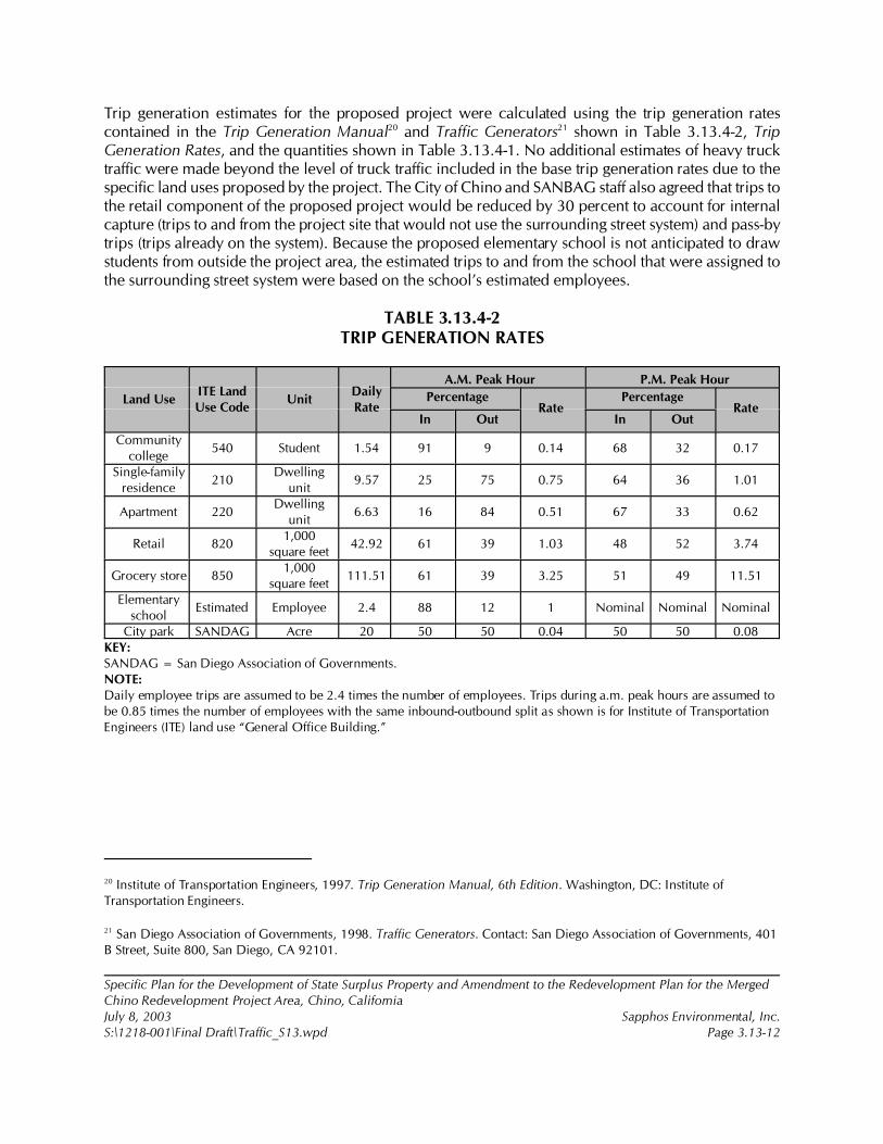
20 Institute of Transportation Engineers, 1997. Trip Generation Manual, 6th Edition. Washington, DC: Institute ofTransportation Engineers.
21 San Diego Association of Governments, 1998. Traffic Generators. Contact: San Diego Association of Governments, 401B Street, Suite 800, San Diego, CA 92101.
Specific Plan for the Development of State Surplus Property and Amendment to the Redevelopment Plan for the MergedChino Redevelopment Project Area, Chino, CaliforniaJuly 8, 2003 Sapphos Environmental, Inc.S:\1218-001\Final Draft\Traffic_S13.wpd Page 3.13-12
Trip generation estimates for the proposed project were calculated using the trip generation ratescontained in the Trip Generation Manual20 and Traffic Generators21 shown in Table 3.13.4-2, TripGeneration Rates, and the quantities shown in Table 3.13.4-1. No additional estimates of heavy trucktraffic were made beyond the level of truck traffic included in the base trip generation rates due to thespecific land uses proposed by the project. The City of Chino and SANBAG staff also agreed that trips tothe retail component of the proposed project would be reduced by 30 percent to account for internalcapture (trips to and from the project site that would not use the surrounding street system) and pass-bytrips (trips already on the system). Because the proposed elementary school is not anticipated to drawstudents from outside the project area, the estimated trips to and from the school that were assigned tothe surrounding street system were based on the school’s estimated employees.
TABLE 3.13.4-2TRIP GENERATION RATES
Land UseITE LandUse Code
UnitDailyRate
A.M. Peak Hour P.M. Peak Hour
PercentageRate
PercentageRate
In Out In Out
Communitycollege
540 Student 1.54 91 9 0.14 68 32 0.17
Single-familyresidence
210Dwelling
unit9.57 25 75 0.75 64 36 1.01
Apartment 220Dwelling
unit6.63 16 84 0.51 67 33 0.62
Retail 8201,000
square feet42.92 61 39 1.03 48 52 3.74
Grocery store 8501,000
square feet111.51 61 39 3.25 51 49 11.51
Elementaryschool
Estimated Employee 2.4 88 12 1 Nominal Nominal Nominal
City park SANDAG Acre 20 50 50 0.04 50 50 0.08KEY:SANDAG = San Diego Association of Governments.NOTE:Daily employee trips are assumed to be 2.4 times the number of employees. Trips during a.m. peak hours are assumed tobe 0.85 times the number of employees with the same inbound-outbound split as shown is for Institute of TransportationEngineers (ITE) land use “General Office Building.”
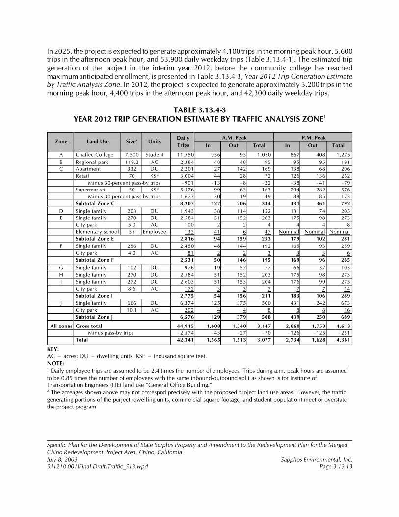
Specific Plan for the Development of State Surplus Property and Amendment to the Redevelopment Plan for the MergedChino Redevelopment Project Area, Chino, CaliforniaJuly 8, 2003 Sapphos Environmental, Inc.S:\1218-001\Final Draft\Traffic_S13.wpd Page 3.13-13
In 2025, the project is expected to generate approximately 4,100 trips in the morning peak hour, 5,600trips in the afternoon peak hour, and 53,900 daily weekday trips (Table 3.13.4-1). The estimated tripgeneration of the project in the interim year 2012, before the community college has reachedmaximum anticipated enrollment, is presented in Table 3.13.4-3, Year 2012 Trip Generation Estimateby Traffic Analysis Zone. In 2012, the project is expected to generate approximately 3,200 trips in themorning peak hour, 4,400 trips in the afternoon peak hour, and 42,300 daily weekday trips.
TABLE 3.13.4-3YEAR 2012 TRIP GENERATION ESTIMATE BY TRAFFIC ANALYSIS ZONE1
Zone Land Use Size2 UnitsDaily
Trips
A.M. Peak P.M. Peak
In Out Total In Out Total
A Chaffee College 7,500 Student 11,550 956 95 1,050 867 408 1,275
B Regional park 119.2 AC 2,384 48 48 95 95 95 191
C Apartment 332 DU 2,201 27 142 169 138 68 206
Retail 70 KSF 3,004 44 28 72 126 136 262
Minus 30-percent pass-by trips !901 !13 !8 !22 !38 !41 !79
Supermarket 50 KSF 5,576 99 63 163 294 282 576
Minus 30-percent pass-by trips !1,673 !30 !19 !49 !88 !85 !173
Subtotal Zone C 8,207 127 206 334 431 361 792
D Single family 203 DU 1,943 38 114 152 131 74 205
E Single family 270 DU 2,584 51 152 203 175 98 273
City park 5.0 AC 100 2 2 4 4 4 8
Elementary school 55 Employee 132 41 6 47 Nominal Nominal Nominal
Subtotal Zone E 2,816 94 159 253 179 102 281
F Single family 256 DU 2,450 48 144 192 165 93 259
City park 4.0 AC 81 2 2 3 3 3 6
Subtotal Zone F 2,531 50 146 195 169 96 265
G Single family 102 DU 976 19 57 77 66 37 103
H Single family 270 DU 2,584 51 152 203 175 98 273
I Single family 272 DU 2,603 51 153 204 176 99 275
City park 8.6 AC 172 3 3 7 7 7 14
Subtotal Zone I 2,775 54 156 211 183 106 289
J Single family 666 DU 6,374 125 375 500 431 242 673
City park 10.1 AC 202 4 4 8 8 8 16
Subtotal Zone J 6,576 129 379 508 439 250 689
All zones Gross total 44,915 1,608 1,540 3,147 2,860 1,753 4,613
Minus pass-by trips !2,574 !43 !27 !70 !126 !125 !251
Total 42,341 1,565 1,513 3,077 2,734 1,628 4,361
KEY:AC = acres; DU = dwelling units; KSF = thousand square feet.NOTE:1 Daily employee trips are assumed to be 2.4 times the number of employees. Trips during a.m. peak hours are assumedto be 0.85 times the number of employees with the same inbound-outbound split as shown is for Institute ofTransportation Engineers (ITE) land use “General Office Building.”2 The acreages shown above may not correspnd precisely with the proposed project land use areas. However, the trafficgenerating portions of the porject (dwelling units, commercial square footage, and student population) meet or overstatethe project program.
Specific Plan for the Development of State Surplus Property and Amendment to the Redevelopment Plan for the MergedChino Redevelopment Project Area, Chino, CaliforniaJuly 8, 2003 Sapphos Environmental, Inc.S:\1218-001\Final Draft\Traffic_S13.wpd Page 3.13-14
Air Traffic Impact
The Chino Airport is located approximately 2 miles southeast of the site of the proposed project andserves general aviation. The proposed project would not be expected to result in changes in safety risksassociated with changes in air traffic patterns, increased levels of air traffic, or altered rates or locationsof air travel. These parameters would not be affected by the implementation of the proposed project.Therefore, no significant impact to air traffic is expected to result from the project.
Hazards Due to Design Feature Impacts
Implementation of the proposed project would not be expected to substantially increase hazards dueto design features. The project would lead to the construction of new streets within a currentlyundeveloped area that would connect to the surrounding street system at its perimeter. The design ofthese connections and of the internal street system would be undertaken in a manner that would avoidthe introduction of hazardous design features.
Emergency Vehicle Access Impact
Implementation of the proposed project would not be expected to result in inadequate emergencyaccess. It would neither alter any existing emergency access routes nor change existing patterns ofemergency access. The new streets to be developed within the project site would be designed to allowadequate emergency access and would be reviewed by appropriate City of Chino and Chino ValleyFire District staff for safety and adequacy.
Parking Impact
Implementation of the proposed project would not be expected to result in inadequate parking capacityas it includes the construction of parking adequate to meet the city code and the anticipated demand.It is expected that the project would have no impact on parking capacity.
Alternative Transportation Impact
Implementation of the proposed project would not conflict with adopted policies, plans, or programssupporting alternative transportation. The proposed project would include a mixed-use Village Centerand residential densities that are compatible with and supportive of the provision of bus transit service.It would also include a provision for a future transit system along portions of the internal street system.These design features would support rather than conflict with the use of alternative modes oftransportation.
Cumulative Impacts
Future Traffic Operations
For the interim year 2012 and 2025, the project, if implemented, would significantly impact the LOSof local intersections. The following summarizes the future traffic operations for interim year 2012 and2025 with scenarios for both with and without the proposed project. The objective of the future traffic
22 San Bernardino Associated Governments, 12 March 2003. Comprehensive Transportation Plan Model. Available at:http://www.sanbag.ca.gov/planning/subr_ctp-details.html.
23 Goodell Brackenbush, April 2003.
Specific Plan for the Development of State Surplus Property and Amendment to the Redevelopment Plan for the MergedChino Redevelopment Project Area, Chino, CaliforniaJuly 8, 2003 Sapphos Environmental, Inc.S:\1218-001\Final Draft\Traffic_S13.wpd Page 3.13-15
operations analysis is to project future traffic growth and the operating conditions that would beexpected to result from regional growth in the vicinity of the project site, with and withoutconsideration of the proposed project. Regional growth for this analysis used the ComprehensiveTransportation Plan (CTP) model22 from the Southern California Association of Governments. The CTPmodel is a multiple-county travel demand forecast model that accounts for regional future growth andthe subsequent impact on traffic.
Funded Roadway Improvements
The 2012 and 2025 anticipated roadway improvements have been identified through a review of theCities of Chino, Chino Hills, and Ontario current Capital Improvement Programs (CIPs), the 2002Regional Transportation Improvement Program (RTIP), and the CTP model.23
The Fiscal Year (FY) 2002-2003 Chino CIP indicates that the existing traffic signals at the intersectionof Mountain Avenue and Walnut Avenue (Intersection 10) will be modified to provide eastbound andwestbound protected-permitted left-turn phasing. The existing traffic signals at the intersection ofCentral Avenue and Chino Hills Parkway (Intersection 35) will be modified to provide northbound andsouthbound protected-permitted left-turn phasing. A traffic signal will be installed at the intersectionof Edison Avenue and Fern Avenue (Intersection 27) prior to 2012, when development of the adjacentproperty occurs and necessary right-of-way is obtained. Edison Avenue will be widened at EuclidAvenue (Intersection 28) to provide a four-lane cross-section. The last of these improvements is alsoidentified in the FY 2002/2003 – 2007/2008 Regional Transportation Improvement Program (RTIP).
The FY 2002-2003 Ontario CIP indicates that Mission Boulevard will be widened at Mountain Avenue(Intersection 1) to provide a six-lane cross-section. This improvement is identified in the RTIP as well.The RTIP also indicates that the intersection of Central Avenue & Riverside Drive (Intersection 12) willbe improved with eastbound and westbound dual left-turn lanes.
In addition, the proposed project would add northbound legs to the intersections of Oaks Street &Edison Avenue (Intersection 22) and Mountain Avenue and Edison Avenue (Intersection 24). It wouldalso improve the intersection of Eucalyptus Avenue and Euclid Avenue (Intersection 31) and constructA Street, creating a new intersection at Central Avenue and A Street (Intersection 29). Althoughimprovements at these locations were assumed to be in place at these intersections in the analysis of2012 and 2025 with project conditions, it should be noted that the estimated costs for improvementsat these three intersections, which would be modified or created to provide access to the project site,are assumed to be wholly borne by the proposed project.
24 Goodell Brackenbush, April 2003.
25 City of Chino, February 1992.
Specific Plan for the Development of State Surplus Property and Amendment to the Redevelopment Plan for the MergedChino Redevelopment Project Area, Chino, CaliforniaJuly 8, 2003 Sapphos Environmental, Inc.S:\1218-001\Final Draft\Traffic_S13.wpd Page 3.13-16
The improvements listed above are anticipated to be complete by the year 2012 and were assumedin the analysis of traffic operating conditions in the Interim Year scenario. In the Year 2025 analysis,additional network changes in the number of through travel lanes on Edison Avenue and on EuclidAvenue (at Intersections 14, 20, 27, 28, and 31) was obtained from the CTP model.
No other committed sources of funding for additional improvements necessary to serve the increasesin traffic are in place. The analysis contained in this report, therefore, assumed minimal additionalimprovements beyond those anticipated in the local jurisdictions’ CIPs, the RTIP, and the CTP model.
Interim Year 2012 without Project
The interim year 2012 without project traffic volumes were analyzed, and the v/c ratio, delay, and LOScalculations for the study area roadway network are shown in Table 3.13.4-4, Intersection Delay andLevel of Service Cumulative Base Conditions for Interim Year 2012. Delay values shown are based onthe existing intersection geometry, except as noted in the Funded Roadway Improvements section inthe Traffic Impact Analysis.24
In the interim year 2012 without project conditions, the following seven study area intersections areprojected to operate at LOS E or LOS F or have a v/c ratio greater than 1.00 during one or both peakhours and are therefore deficient according to City of Chino criteria:25
1. Mountain Avenue and Mission Boulevard6. Mountain Avenue and State Route 60 eastbound ramps10. Mountain Avenue and Walnut Avenue13. Mountain Avenue and Riverside Drive14. Euclid Avenue and Riverside Drive
22. Oaks Street and Edison Avenue31. Euclid Avenue and Eucalyptus Avenue
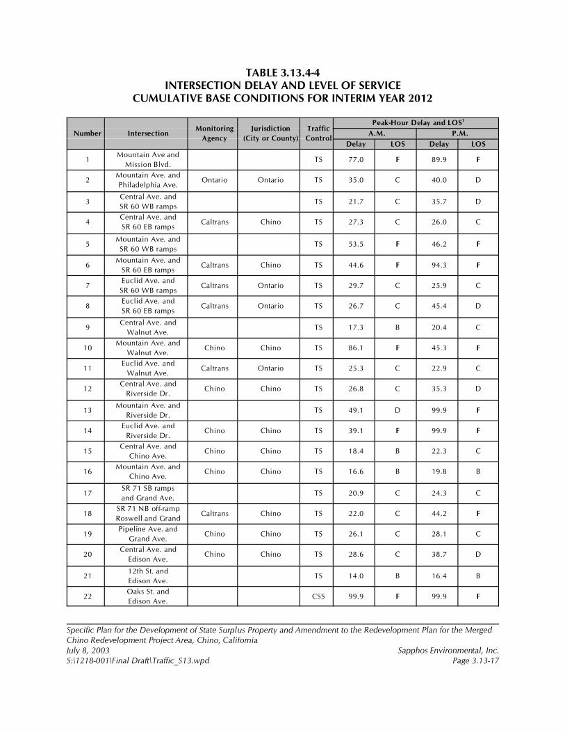
Specific Plan for the Development of State Surplus Property and Amendment to the Redevelopment Plan for the MergedChino Redevelopment Project Area, Chino, CaliforniaJuly 8, 2003 Sapphos Environmental, Inc.S:\1218-001\Final Draft\Traffic_S13.wpd Page 3.13-17
TABLE 3.13.4-4INTERSECTION DELAY AND LEVEL OF SERVICE
CUMULATIVE BASE CONDITIONS FOR INTERIM YEAR 2012
Number IntersectionMonitoring
Agency
Jurisdiction
(City or County)
Traffic
Control
Peak-Hour Delay and LOS1
A.M. P.M.
Delay LOS Delay LOS
1Mountain Ave and
Mission Blvd.TS 77.0 F 89.9 F
2Mountain Ave. and
Philadelphia Ave.Ontario Ontario TS 35.0 C 40.0 D
3Central Ave. and
SR 60 WB rampsTS 21.7 C 35.7 D
4Central Ave. and
SR 60 EB rampsCaltrans Chino TS 27.3 C 26.0 C
5Mountain Ave. and
SR 60 WB rampsTS 53.5 F 46.2 F
6Mountain Ave. and
SR 60 EB rampsCaltrans Chino TS 44.6 F 94.3 F
7Euclid Ave. and
SR 60 WB rampsCaltrans Ontario TS 29.7 C 25.9 C
8Euclid Ave. and
SR 60 EB rampsCaltrans Ontario TS 26.7 C 45.4 D
9Central Ave. and
Walnut Ave.TS 17.3 B 20.4 C
10Mountain Ave. and
Walnut Ave.Chino Chino TS 86.1 F 45.3 F
11Euclid Ave. and
Walnut Ave.Caltrans Ontario TS 25.3 C 22.9 C
12Central Ave. and
Riverside Dr.Chino Chino TS 26.8 C 35.3 D
13Mountain Ave. and
Riverside Dr.TS 49.1 D 99.9 F
14Euclid Ave. and
Riverside Dr.Chino Chino TS 39.1 F 99.9 F
15Central Ave. and
Chino Ave.Chino Chino TS 18.4 B 22.3 C
16Mountain Ave. and
Chino Ave.Chino Chino TS 16.6 B 19.8 B
17SR 71 SB ramps
and Grand Ave.TS 20.9 C 24.3 C
18SR 71 NB off-ramp
Roswell and GrandCaltrans Chino TS 22.0 C 44.2 F
19Pipeline Ave. and
Grand Ave.Chino Chino TS 26.1 C 28.1 C
20Central Ave. and
Edison Ave.Chino Chino TS 28.6 C 38.7 D
2112th St. and
Edison Ave.TS 14.0 B 16.4 B
22Oaks St. and
Edison Ave.CSS 99.9 F 99.9 F
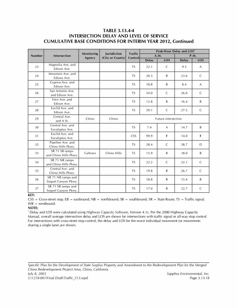
TABLE 3.13.4-4INTERSECTION DELAY AND LEVEL OF SERVICE
CUMULATIVE BASE CONDITIONS FOR INTERIM YEAR 2012, Continued
Number IntersectionMonitoring
Agency
Jurisdiction
(City or County)
Traffic
Control
Peak-Hour Delay and LOS1
A.M. P.M.
Delay LOS Delay LOS
Specific Plan for the Development of State Surplus Property and Amendment to the Redevelopment Plan for the MergedChino Redevelopment Project Area, Chino, CaliforniaJuly 8, 2003 Sapphos Environmental, Inc.S:\1218-001\Final Draft\Traffic_S13.wpd Page 3.13-18
23Magnolia Ave. and
Edison Ave.TS 22.1 C 9.5 A
24Mountain Ave. and
Edison Ave.TS 20.3 B 23.6 C
25Cypress Ave. and
Edison Ave.TS 18.8 B 8.4 A
26San Antonio Ave.
and Edison Ave.TS 24.0 C 26.0 C
27Fern Ave. and
Edison Ave.TS 12.8 B 16.4 B
28Euclid Ave. and
Edison Ave.TS 29.1 C 27.5 C
29Central Ave.
and A St.Chino Chino Future intersection
30Central Ave. and
Eucalyptus Ave.TS 7.4 A 14.7 B
31Euclid Ave. and
Eucalyptus Ave.CSS 99.9 F 14.0 F
32Pipeline Ave. and
Chino Hills Pkwy.TS 28.4 C 38.7 D
33SR 71 SB ramps
and Chino Hills Pkwy.Caltrans Chino Hills TS 15.9 B 18.0 B
34SR 71 NB ramps
and Chino Hills Pkwy.TS 22.2 C 22.1 C
35Central Ave. and
Chino Hills Pkwy.TS 19.8 B 26.7 C
36SR 71 NB ramps and
Soquel Canyon Pkwy.TS 18.8 B 15.4 B
37SR 71 SB ramps and
Soquel Canyon Pkwy.TS 17.0 B 22.7 C
KEY:CSS = Cross-street stop; EB = eastbound; NB = northbound; SB = southbound; SR = State Route; TS = Traffic signal;WB = westbound.NOTE:1 Delay and LOS were calculated using Highway Capacity Software, Version 4.1c. Per the 2000 Highway CapacityManual, overall average intersection delay and LOS are shown for intersections with traffic signal or all-way stop control.For intersections with cross-street stop control, the delay and LOS for the worst individual movement (or movementssharing a single lane) are shown.
26 Goodell Brackenbush, April 2003.
27 City of Chino, February 1992.
Specific Plan for the Development of State Surplus Property and Amendment to the Redevelopment Plan for the MergedChino Redevelopment Project Area, Chino, CaliforniaJuly 8, 2003 Sapphos Environmental, Inc.S:\1218-001\Final Draft\Traffic_S13.wpd Page 3.13-19
Interim Year 2012 with Project
The interim year 2012 with project traffic volumes were analyzed, and the v/c ratio, delay, and LOScalculations for the study area roadway network are shown in Table 3.13.4-5, Intersection Delay andLevel of Service Cumulative Base Plus Project Conditions for Interim Year 2012. Delay values shownare based on the existing intersection geometry, except as in the Funded Roadway Improvementssection in the Traffic Impact Analysis.26
At full build-out in 2012, the proposed project is expected to generate approximately 3,000 trips in themorning peak hour, 4,400 trips in the afternoon peak hour, and 42,300 daily weekday trips (Table3.13.4-3). In the interim year 2012 with project conditions, the 15 study area intersections listed beloware projected to operate at LOS E or LOS F or have a v/c ratio greater than 1.00 during one or bothpeak hours and are therefore deficient according to City of Chino criteria:27
1. Mountain Avenue and Mission Boulevard2. Mountain Avenue and Philadelphia Street5. Mountain Avenue and State Route 60 westbound ramps6. Mountain Avenue and State Route 60 eastbound ramps10. Mountain Avenue and Walnut Avenue12. Central Avenue and Riverside Drive13. Mountain Avenue and Riverside Drive14. Euclid Avenue and Riverside Drive18. State Route 71 northbound ramps and Grand Avenue20. Central Avenue and Edison Avenue22. Oaks Street and Edison Avenue24. Mountain Avenue and Edison Avenue28. Euclid Avenue and Edison Avenue29. Central Avenue and A Street (future intersection)31. Euclid Avenue and Eucalyptus Avenue
The interim year 2012 with project conditions analysis assumed that the improvements listed belowwould be made at three project-adjacent intersections that would be modified or created as part of theproject itself, resulting in acceptable operations (Intersection 22 Oaks Street and Edison Avenue,Intersection 24 Mountain Avenue and Edison Avenue, and Intersection 29 Central Avenue and AStreet; refer to Funded Roadway Improvements section).

Specific Plan for the Development of State Surplus Property and Amendment to the Redevelopment Plan for the MergedChino Redevelopment Project Area, Chino, CaliforniaJuly 8, 2003 Sapphos Environmental, Inc.S:\1218-001\Final Draft\Traffic_S13.wpd Page 3.13-20
TABLE 3.13.4-5INTERSECTION DELAY AND LEVEL OF SERVICE
CUMULATIVE BASE PLUS PROJECT CONDITIONS FOR INTERIM YEAR 2012
Number IntersectionMonitoring
Agency
Jurisdiction
(City or County)
Traffic
Control
Peak-Hour Delay and LOS1
A.M. P.M.
Delay LOS Delay LOS
1Mountain Ave.
and Mission Blvd.TS 65.3 F 91.7 F
2Mountain Ave. and
Philadelphia Ave.Ontario Ontario TS 32.3 C 56.8 F
3Central Ave. and
SR 60 WB rampsTS 21.8 C 36.9 F
4Central Ave. and
SR 60 EB rampsCaltrans Chino TS 18.7 B 30.6 C
5Mountain Ave. and
SR 60 WB rampsTS 54.6 F 53.4 F
6Mountain Ave. and
SR 60 EB rampsCaltrans Chino TS 53.0 F 99.9 F
7Euclid Ave. and
SR 60 WB rampsCaltrans Ontario TS 30.0 C 29.3 C
8Euclid Ave. and
SR 60 EB rampsCaltrans Ontario TS 22.6 C 46.5 F
9Central Ave. and
Walnut Ave.TS 16.3 B 21.0 C
10Mountain Ave.
and Walnut Ave.Chino Chino TS 94.6 F 53.2 F
11Euclid Ave. and
Walnut Ave.Caltrans Ontario TS 26.0 C 25.2 C
12Central Ave. and
Riverside Dr.Chino Chino TS 26.3 C 37.9 F
13Mountain Ave. and
Riverside Dr.TS 71.3 E 51.2 D
14Euclid Ave. and
Riverside Dr.Caltrans Chino TS 38.3 F 99.9 F
15Central Ave.
and Chino Ave.Chino Chino TS 17.9 B 28.8 C
16Mountain Ave.
and Chino AvChino Chino TS 17.5 B 32.9 C
17SR 71 SB ramps
and Grand Ave.TS 23.8 C 35.3 D
18SR 71 NB off-ramp
Roswell and GrandCaltrans Chino TS 23.7 C 57.8 F
19Pipeline Ave.
and Grand Ave.Chino Chino TS 26.7 C 28.3 C
20 Central Ave.
and Edison Ave.
Chino Chino TS 29.7 C 41.2 F
21 12th St. and
Edison Ave.
TS 17.8 B 23.0 C
22 Oaks St. and
Edison Ave.
TS 18.9 B 23.5 C

TABLE 3.13.4-5INTERSECTION DELAY AND LEVEL OF SERVICE
CUMULATIVE BASE PLUS PROJECT CONDITIONS FOR INTERIM YEAR 2012,Continued
Number IntersectionMonitoring
Agency
Jurisdiction
(City or County)
Traffic
Control
Peak-Hour Delay and LOS1
A.M. P.M.
Delay LOS Delay LOS
Specific Plan for the Development of State Surplus Property and Amendment to the Redevelopment Plan for the MergedChino Redevelopment Project Area, Chino, CaliforniaJuly 8, 2003 Sapphos Environmental, Inc.S:\1218-001\Final Draft\Traffic_S13.wpd Page 3.13-21
23 Magnolia Ave.
and Edison Ave.
TS 27.7 C 11.7 C
24 Mountain Ave.
and Edison Ave.
TS 23.0 C 25.2 C
25 Cypress Ave.
and Edison Ave.
TS 19.1 B 10.0 A
26 San Antonio Ave.
and Edison Ave.
TS 26.5 C 28.2 C
27 Fern Ave. and
Edison Ave.
TS 19.2 B 13.6 B
28 Euclid Ave. and
Edison Ave.
TS 47.7 F 49.6 F
29 Central Ave.
and A St.
Chino Chino TS 19.1 B 15.1 B
30 Central Ave. and
Eucalyptus Ave.
TS 7.1 A 38.2 D
31 Euclid Ave. and
Eucalyptus Ave.
CSS 99.9 F 99.9 F
32 Pipeline Ave. and
Chino Hills Pkwy.
TS 28.7 C 36.8 D
33 SR 71 SB ramps and
Chino Hills Pkwy.
Caltrans Chino Hills TS 18.7 B 15.7 B
34 SR 71 NB ramps and
Chino Hills Pkwy.
TS 21.9 C 24.2 C
35 Central Ave. and
Chino Hills Pkwy.
TS 25.8 C 29.5 C
36 SR 71 NB ramps and
Soquel Canyon Pkwy.
TS 18.7 B 15.7 B
37 SR 71 SB ramps and
Soquel Canyon Pkwy.
TS 17.3 B 22.9 C
KEY:CSS = Cross-street stop; EB = eastbound; NB = northbound; SB = southbound; SR = State Route; TS = Traffic signal; WB= westbound.NOTE:1 Delay and LOS were calculated using Highway Capacity Software, Version 4.1c. Per the 2000 Highway CapacityManual, overall average intersection delay and LOS are shown for intersections with traffic signal or all-way stop control.For intersections with cross-street stop control, the delay and LOS for the worst individual movement (or movementssharing a single lane) are shown.
28 Goodell Brackenbush, April 2003.
29 City of Chino, February 1992.
Specific Plan for the Development of State Surplus Property and Amendment to the Redevelopment Plan for the MergedChino Redevelopment Project Area, Chino, CaliforniaJuly 8, 2003 Sapphos Environmental, Inc.S:\1218-001\Final Draft\Traffic_S13.wpd Page 3.13-22
Year 2025 without Project
The year 2025 without project traffic volumes were analyzed, and the v/c ratio, delay, and LOScalculations for the study area roadway network are shown in Table 3.13.4-6, Intersection Delay andLevel of Service Cumulative Base Conditions for Year 2025. Delay values shown are based on theexisting intersection geometry, except as noted above in the Funded Roadway Improvements section inthe Traffic Impact Analysis.28
In the year 2025 without project conditions, the 22 study area intersections listed below are projectedto operate at LOS E or LOS F or have a v/c ratio greater than 1.00 during one or both eak hours and aretherefore deficient according to City of Chino criteria.29
1. Mountain Avenue and Mission Boulevard2. Mountain Avenue and Philadelphia Street3. Central Avenue and State Route 60 westbound ramps4. Central Avenue and State Route 60 eastbound ramps5. Mountain Avenue and State Route 60 westbound ramps6. Mountain Avenue and State Route 60 eastbound ramps7. Euclid Avenue and State Route 60 westbound ramps8. Euclid Avenue and State Route 60 eastbound ramps10. Mountain Avenue and Walnut Avenue11. Euclid Avenue and Walnut Avenue12. Central Avenue and Riverside Drive13. Mountain Avenue and Riverside Drive14. Euclid Avenue and Riverside Drive17. State Route 71 southbound ramps and Grand Avenue18. State Route 71 northbound ramps and Grand Avenue20. Central Avenue and Edison Avenue22. Oaks Street and Edison Avenue24. Mountain Avenue and Edison Avenue26. San Antonio Avenue and Edison Avenue28. Euclid Avenue and Edison Avenue31. Euclid Avenue and Eucalyptus Avenue 35. Central Avenue and Chino Hills Parkway

Specific Plan for the Development of State Surplus Property and Amendment to the Redevelopment Plan for the MergedChino Redevelopment Project Area, Chino, CaliforniaJuly 8, 2003 Sapphos Environmental, Inc.S:\1218-001\Final Draft\Traffic_S13.wpd Page 3.13-23
TABLE 3.13.4-6INTERSECTION DELAY AND LEVEL OF SERVICE
CUMULATIVE BASE CONDITIONS FOR YEAR 2025
Number IntersectionMonitoring
Agency
Jurisdiction
(City or County)
Traffic
Control
Peak-Hour Delay and LOS1
A.M. P.M.
Delay LOS Delay LOS
1Mountain Ave.
and Mission Blvd.TS 99.9 F 99.9 F
2Mountain Ave. and
Philadelphia Ave.Ontario Ontario TS 62.6 F 99.9 F
3Central Ave. and
SR 60 WB rampsTS 51.8 F 54.9 F
4Central Ave. and
SR 60 EB rampsCaltrans Chino TS 30.7 C 53.1 F
5Mountain Ave. and
SR 60 WB rampsTS 74.3 F 80.6 F
6Mountain Ave. and
SR 60 EB rampsCaltrans Chino TS 68.1 F 99.9 F
7Euclid Ave. and
SR 60 WB rampsCaltrans Ontario TS 42.2 F 36.3 F
8Euclid Ave. and
SR 60 EB rampsCaltrans Ontario TS 76.7 F 89.6 F
9Central Ave. and
Walnut Ave.TS 19.2 B 24.2 C
10Mountain Ave.
and Walnut Ave.Chino Chino TS 99.9 F 85.6 F
11Euclid Ave. and
Walnut Ave.Caltrans Ontario TS 44.8 D 47.2 D
12Central Ave. and
Riverside Dr.Chino Chino TS 31.1 C 48.1 F
13Mountain Ave. and
Riverside Dr.TS 99.9 F 88.1 F
14Euclid Ave. and
Riverside Dr.Caltrans Chino TS 99.2 F 99.9 F
15Central Ave.
and Chino Ave.Chino Chino TS 16.5 B 28.1 C
16Mountain Ave.
and Chino AvChino Chino TS 18.6 B 30.3 C
17SR 71 SB ramps
and Grand Ave.TS 25.3 C 51.4 D
18SR 71 NB off-ramp
Roswell and GrandCaltrans Chino TS 25.2 C 99.9 F
19Pipeline Ave.
and Edison Ave.Chino Chino TS 28.3 C 32.0 C
20Central Ave.
and Edison Ave.Chino Chino TS 40.2 F 54.9 F
2112th St. and
Edison Ave.TS 26.9 C 51.8 D
22Oaks St. and
Edison Ave.CSS 99.9 F 99.9 F
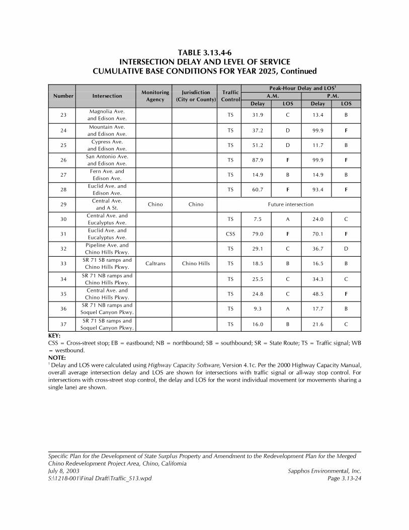
TABLE 3.13.4-6INTERSECTION DELAY AND LEVEL OF SERVICE
CUMULATIVE BASE CONDITIONS FOR YEAR 2025, Continued
Number IntersectionMonitoring
Agency
Jurisdiction
(City or County)
Traffic
Control
Peak-Hour Delay and LOS1
A.M. P.M.
Delay LOS Delay LOS
Specific Plan for the Development of State Surplus Property and Amendment to the Redevelopment Plan for the MergedChino Redevelopment Project Area, Chino, CaliforniaJuly 8, 2003 Sapphos Environmental, Inc.S:\1218-001\Final Draft\Traffic_S13.wpd Page 3.13-24
23Magnolia Ave.
and Edison Ave.TS 31.9 C 13.4 B
24Mountain Ave.
and Edison Ave.TS 37.2 D 99.9 F
25Cypress Ave.
and Edison Ave.TS 51.2 D 11.7 B
26San Antonio Ave.
and Edison Ave.TS 87.9 F 99.9 F
27Fern Ave. and
Edison Ave.TS 14.9 B 14.9 B
28Euclid Ave. and
Edison Ave.TS 60.7 F 93.4 F
29Central Ave.
and A St.Chino Chino Future intersection
30Central Ave. and
Eucalyptus Ave.TS 7.5 A 24.0 C
31Euclid Ave. and
Eucalyptus Ave.CSS 79.0 F 70.1 F
32Pipeline Ave. and
Chino Hills Pkwy.TS 29.1 C 36.7 D
33SR 71 SB ramps and
Chino Hills Pkwy.Caltrans Chino Hills TS 18.5 B 16.5 B
34SR 71 NB ramps and
Chino Hills Pkwy.TS 25.5 C 34.3 C
35Central Ave. and
Chino Hills Pkwy.TS 24.8 C 48.5 F
36SR 71 NB ramps and
Soquel Canyon Pkwy.TS 9.3 A 17.7 B
37SR 71 SB ramps and
Soquel Canyon Pkwy.TS 16.0 B 21.6 C
KEY:CSS = Cross-street stop; EB = eastbound; NB = northbound; SB = southbound; SR = State Route; TS = Traffic signal; WB= westbound.NOTE:1 Delay and LOS were calculated using Highway Capacity Software, Version 4.1c. Per the 2000 Highway Capacity Manual,overall average intersection delay and LOS are shown for intersections with traffic signal or all-way stop control. Forintersections with cross-street stop control, the delay and LOS for the worst individual movement (or movements sharing asingle lane) are shown.
30 Goodell Brackenbush, April 2003.
31 City of Chino, February 1992.
Specific Plan for the Development of State Surplus Property and Amendment to the Redevelopment Plan for the MergedChino Redevelopment Project Area, Chino, CaliforniaJuly 8, 2003 Sapphos Environmental, Inc.S:\1218-001\Final Draft\Traffic_S13.wpd Page 3.13-25
Year 2025 with Project
The interim year 2025 with project traffic volumes presented above were analyzed, and the v/c ratio,delay, and LOS calculations for the study area roadway network are shown in Table 3.13.4-7,Intersection Delay and Level of Service Cumulative Base Plus Project Conditions for Year 2025. Delayvalues shown are based on the existing intersection geometry, except as in the Funded RoadwayImprovements section in the Traffic Impact Analysis.30
At full build-out in 2025, the proposed project is expected to generate approximately 4,100 trips at themorning peak hour and 5,600 trips in the afternoon peak hour. Weekday daily trips are estimated atapproximately 53,900 trips (Table 3.13.4-1). In the year 2025 with project conditions, the 27 studyarea intersections listed below are projected to operate at LOS E or LOS F or have a v/c ratio greaterthan 1.00 during one or both peak hours and are therefore deficient according to City of Chinocriteria.31
1. Mountain Avenue and Mission Boulevard2. Mountain Avenue and Philadelphia Street3. Central Avenue and State Route 60 westbound ramps4. Central Avenue and State Route 60 eastbound ramps5. Mountain Avenue and State Route 60 westbound ramps6. Mountain Avenue and State Route 60 eastbound ramps7. Euclid Avenue and State Route 60 westbound ramps8. Euclid Avenue and State Route 60 eastbound ramps10. Mountain Avenue and Walnut Avenue11. Euclid Avenue and Walnut Avenue12. Central Avenue and Riverside Drive13. Mountain Avenue and Riverside Drive14. Euclid Avenue and Riverside Drive16. Mountain Avenue and Chino Avenue17. State Route 71 southbound ramps and Grand Avenue18. State Route 71 northbound ramps and Grand Avenue19. Pipeline Avenue and Edison Avenue20. Central Avenue and Edison Avenue21. 12th Street and Edison Avenue23. Magnolia Avenue and Edison Avenue25. Cypress Avenue and Edison Avenue26. San Antonio Avenue and Edison Avenue27. Fern Avenue and Edison Avenue28. Euclid Avenue and Edison Avenue
Specific Plan for the Development of State Surplus Property and Amendment to the Redevelopment Plan for the MergedChino Redevelopment Project Area, Chino, CaliforniaJuly 8, 2003 Sapphos Environmental, Inc.S:\1218-001\Final Draft\Traffic_S13.wpd Page 3.13-26
30. Central Avenue and Eucalyptus Avenue31. Euclid Avenue and Eucalyptus Avenue 35. Central Avenue & Chino Hills Parkway
The interim year 2025 with project conditions analysis assumed that the improvements listed belowwould be made at three project-adjacent intersections that would be modified or created as part of theproject itself, resulting in acceptable operations (Intersection 22 Oaks Street and Edison Avenue,Intersection 24 Mountain Avenue and Edison Avenue, and Intersection 29 Central Avenue and AStreet).
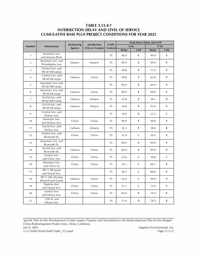
Specific Plan for the Development of State Surplus Property and Amendment to the Redevelopment Plan for the MergedChino Redevelopment Project Area, Chino, CaliforniaJuly 8, 2003 Sapphos Environmental, Inc.S:\1218-001\Final Draft\Traffic_S13.wpd Page 3.13-27
TABLE 3.13.4-7INTERSECTION DELAY AND LEVEL OF SERVICE
CUMULATIVE BASE PLUS PROJECT CONDITIONS FOR YEAR 2025
Number IntersectionMonitoring
Agency
Jurisdiction
(City or County)
Traffic
Control
Peak-Hour Delay and LOS1
A.M. P.M.
Delay LOS Delay LOS
1Mountain Ave.
and Mission Blvd.TS 99.9 F 99.9 F
2Mountain Ave. and
Philadelphia Ave.Ontario Ontario TS 99.9 F 99.9 F
3Central Ave. and
SR 60 WB rampsTS 38.0 F 71.9 F
4Central Ave. and
SR 60 EB rampsCaltrans Chino TS 49.0 F 62.8 F
5Mountain Ave. and
SR 60 WB rampsTS 99.9 F 99.9 F
6Mountain Ave. and
SR 60 EB rampsCaltrans Chino TS 99.9 F 99.9 F
7Euclid Ave. and
SR 60 WB rampsCaltrans Ontario TS 32.8 F 38.1 D
8Euclid Ave. and
SR 60 EB rampsCaltrans Ontario TS 34.8 F 93.0 F
9Central Ave. and
Walnut Ave.TS 18.9 B 25.2 C
10Mountain Ave.
and Walnut Ave.Chino Chino TS 99.9 F 99.9 F
11Euclid Ave. and
Walnut Ave.Caltrans Ontario TS 35.5 F 58.6 E
12Central Ave. and
Riverside Dr.Chino Chino TS 31.9 C 50.5 F
13Mountain Ave. and
Riverside Dr.TS 99.9 F 99.9 F
14Euclid Ave. and
Riverside Dr.Caltrans Chino TS 99.9 F 99.9 F
15Central Ave.
and Chino Ave.Chino Chino TS 22.6 C 30.8 C
16Mountain Ave.
and Chino AvChino Chino TS 24.1 C 66.1 E
17SR 71 SB ramps
and Grand Ave.TS 30.3 C 86.6 F
18SR 71 NB off-ramp
Roswell and GrandCaltrans Chino TS 25.4 C 99.9 F
19Pipeline Ave.
and Grand Ave.Chino Chino TS 31.1 C 75.9 F
20Central Ave.
and Edison Ave.Chino Chino TS 83.6 F 79.4 F
2112th St. and
Edison Ave.TS 51.4 D 78.3 E
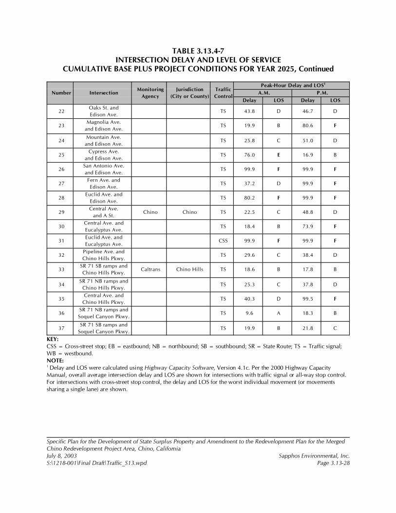
TABLE 3.13.4-7INTERSECTION DELAY AND LEVEL OF SERVICE
CUMULATIVE BASE PLUS PROJECT CONDITIONS FOR YEAR 2025, Continued
Number IntersectionMonitoring
Agency
Jurisdiction
(City or County)
Traffic
Control
Peak-Hour Delay and LOS1
A.M. P.M.
Delay LOS Delay LOS
Specific Plan for the Development of State Surplus Property and Amendment to the Redevelopment Plan for the MergedChino Redevelopment Project Area, Chino, CaliforniaJuly 8, 2003 Sapphos Environmental, Inc.S:\1218-001\Final Draft\Traffic_S13.wpd Page 3.13-28
22Oaks St. and
Edison Ave.TS 43.8 D 46.7 D
23Magnolia Ave.
and Edison Ave.TS 19.9 B 80.6 F
24Mountain Ave.
and Edison Ave.TS 25.8 C 51.0 D
25Cypress Ave.
and Edison Ave.TS 76.0 E 16.9 B
26San Antonio Ave.
and Edison Ave.TS 99.9 F 99.9 F
27Fern Ave. and
Edison Ave.TS 37.2 D 99.9 F
28Euclid Ave. and
Edison Ave.TS 80.2 F 99.9 F
29Central Ave.
and A St.Chino Chino TS 22.5 C 48.8 D
30Central Ave. and
Eucalyptus Ave.TS 18.4 B 73.9 F
31Euclid Ave. and
Eucalyptus Ave.CSS 99.9 F 99.9 F
32Pipeline Ave. and
Chino Hills Pkwy.TS 29.6 C 38.4 D
33SR 71 SB ramps and
Chino Hills Pkwy.Caltrans Chino Hills TS 18.6 B 17.8 B
34SR 71 NB ramps and
Chino Hills Pkwy.TS 25.3 C 37.8 D
35Central Ave. and
Chino Hills Pkwy.TS 40.3 D 99.5 F
36SR 71 NB ramps and
Soquel Canyon Pkwy.TS 9.6 A 18.3 B
37SR 71 SB ramps and
Soquel Canyon Pkwy.TS 19.9 B 21.8 C
KEY:CSS = Cross-street stop; EB = eastbound; NB = northbound; SB = southbound; SR = State Route; TS = Traffic signal;WB = westbound.NOTE:1 Delay and LOS were calculated using Highway Capacity Software, Version 4.1c. Per the 2000 Highway CapacityManual, overall average intersection delay and LOS are shown for intersections with traffic signal or all-way stop control.For intersections with cross-street stop control, the delay and LOS for the worst individual movement (or movementssharing a single lane) are shown.
32 San Bernardino Associated Governments, 5 December 2001.
Specific Plan for the Development of State Surplus Property and Amendment to the Redevelopment Plan for the MergedChino Redevelopment Project Area, Chino, CaliforniaJuly 8, 2003 Sapphos Environmental, Inc.S:\1218-001\Final Draft\Traffic_S13.wpd Page 3.13-29
Incorporation of the following mitigation measures will improve the COS as shown in Appendix I,Traffic Impact Analysis, Table 11, Intersection Delay and Level of Service (LOS) Cumulative BasePlus Project Conditions with Improvements for Year 2025.
3.13.5 Mitigation Measures
The two mitigation measures described below are recommended to reduce significant traffic impactsthat were summarized for the interim year 2012 and year 2025 of the project. The proposed projectshould comply with all requirements of the CMP for the County of San Bernardino.32 This shall include,but is not limited to, trip reduction, deficiency plans, traffic and public transportation improvementrequirements, and impact fees as required. Both Transportation-1 and Transportation-2, if implemented,would address all of the direct, indirect, and cumulative impacts discussed in Section 3.13.4, Impacts.
The project should contribute to the cost of necessary study area improvements on a proportional fair-share basis. Additionally, the project should pay applicable impact fees and/or construct arterialroadway improvements adjacent to the project. The mitigation fees are further discussed in AppendixI, Traffic Impact Analysis.
Transportation-1
It should be noted that the interim year 2012 with project conditions and 2025 with project conditionsassumed that the improvements listed below would be made at three project-adjacent intersections thatwould be modified or created as part of the project itself (Intersection 22, Oaks Street and EdisonAvenue; Intersection 24, Mountain Avenue and Edison Avenue; and Intersection 29, Central Avenueand A Street). Improvements that are recommended include both funded improvements and anyadditional improvements necessary to achieve acceptable LOS during peak hours. The followingintersection improvements are needed for the year 2012 with project conditions. 1. Mountain Avenue and Mission Boulevard
• Second northbound left-turn lane• Northbound right-turn lane• Second southbound left-turn lane• Third southbound through lane• Second westbound left-turn lane• Eastbound right-turn lane• Provide overlapping right-turn phasing E-W and N-S
2. Mountain Avenue and Philadelphia Street• Second northbound left-turn lane• Third northbound through lane• Northbound right-turn lane• Second southbound left-turn lane• Third southbound through lane
Specific Plan for the Development of State Surplus Property and Amendment to the Redevelopment Plan for the MergedChino Redevelopment Project Area, Chino, CaliforniaJuly 8, 2003 Sapphos Environmental, Inc.S:\1218-001\Final Draft\Traffic_S13.wpd Page 3.13-30
• Southbound right-turn lane• Provide overlapping right-turn phasing E-W and N-S• Second eastbound left-turn lane• Second westbound left-turn lane• Westbound right-turn lane
5. Mountain Avenue and State Route 60 westbound ramps• Southbound right-turn Lane • Second northbound left-turn lane
6. Mountain Avenue and State Route 60 eastbound ramps• Northbound right-turn lane• Shared left-turn and right-turn lane eastbound• Second southbound left-turn lane
10. Mountain Avenue and Walnut Avenue• Northbound Right-turn lane• Second southbound left-turn lane• Additional eastbound through lane• Additional westbound through lane
12. Central Avenue and Riverside Drive• Second southbound left-turn lane
13. Mountain Avenue and Riverside Drive• Northbound right-turn lane• Southbound right-turn lane• Provide overlapping right-turn phasing southbound• Second eastbound left-turn lane
14. Euclid Avenue and Riverside Drive• Northbound right-turn lane• Southbound right-turn lane• Second southbound left-turn lane• Eastbound left-turn lane• Second eastbound left-turn lane• Westbound left-turn lane
18. State Route 71 Northbound Ramps and Grand Avenue• Upgrade existing signal to provide overlapping right-turn phasing westbound• Southbound right-turn lane• Southbound left-turn lane• Westbound right-turn lane• Eastbound right-turn lane

Specific Plan for the Development of State Surplus Property and Amendment to the Redevelopment Plan for the MergedChino Redevelopment Project Area, Chino, CaliforniaJuly 8, 2003 Sapphos Environmental, Inc.S:\1218-001\Final Draft\Traffic_S13.wpd Page 3.13-31
20. Central Avenue and Edison Avenue• Second eastbound left-turn lane• Second westbound left-turn lane
22. Oaks Street and Edison Avenue• First and second northbound left-turn lanes• Northbound right-turn lane• First and second northbound through lanes• First and second southbound left-turn lanes• First and second southbound left-turn lanes• Southbound shared through-right-turn lane• Second eastbound left-turn lane• Third eastbound through lane• Eastbound right-turn lane• Westbound dual left-turn lanes• Third westbound through lane• Install new traffic signal
24. Mountain Avenue and Edison Avenue• Northbound left-turn lane• First and second northbound through lanes• Northbound right-turn lane• Southbound left-turn lane• Northbound left-turn lane• Third eastbound through lane• Third westbound through lane• Upgrade existing intersection signalization
28. Euclid Avenue and Edison Avenue• Third eastbound through lane• Third westbound through lane• Northbound right-turn lane
29. Central Avenue and A Street (new intersection)• Install new traffic signal• Westbound right-turn lane• Westbound left-turn lane• Northbound right-turn lane• Southbound left-turn lane
31. Euclid Avenue and Eucalyptus Avenue• Install new traffic signal
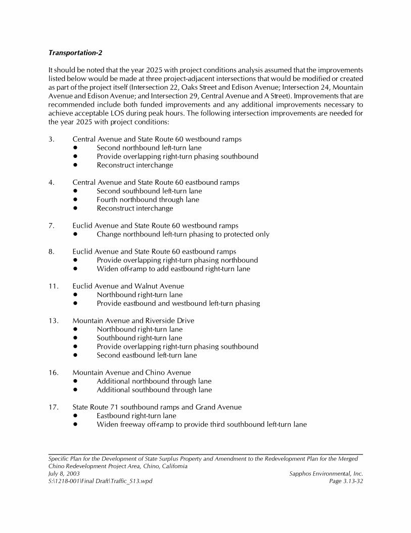
Specific Plan for the Development of State Surplus Property and Amendment to the Redevelopment Plan for the MergedChino Redevelopment Project Area, Chino, CaliforniaJuly 8, 2003 Sapphos Environmental, Inc.S:\1218-001\Final Draft\Traffic_S13.wpd Page 3.13-32
Transportation-2
It should be noted that the year 2025 with project conditions analysis assumed that the improvementslisted below would be made at three project-adjacent intersections that would be modified or createdas part of the project itself (Intersection 22, Oaks Street and Edison Avenue; Intersection 24, MountainAvenue and Edison Avenue; and Intersection 29, Central Avenue and A Street). Improvements that arerecommended include both funded improvements and any additional improvements necessary toachieve acceptable LOS during peak hours. The following intersection improvements are needed forthe year 2025 with project conditions:
3. Central Avenue and State Route 60 westbound ramps• Second northbound left-turn lane• Provide overlapping right-turn phasing southbound• Reconstruct interchange
4. Central Avenue and State Route 60 eastbound ramps• Second southbound left-turn lane• Fourth northbound through lane• Reconstruct interchange
7. Euclid Avenue and State Route 60 westbound ramps• Change northbound left-turn phasing to protected only
8. Euclid Avenue and State Route 60 eastbound ramps• Provide overlapping right-turn phasing northbound• Widen off-ramp to add eastbound right-turn lane
11. Euclid Avenue and Walnut Avenue• Northbound right-turn lane• Provide eastbound and westbound left-turn phasing
13. Mountain Avenue and Riverside Drive• Northbound right-turn lane• Southbound right-turn lane• Provide overlapping right-turn phasing southbound• Second eastbound left-turn lane
16. Mountain Avenue and Chino Avenue• Additional northbound through lane• Additional southbound through lane
17. State Route 71 southbound ramps and Grand Avenue• Eastbound right-turn lane• Widen freeway off-ramp to provide third southbound left-turn lane
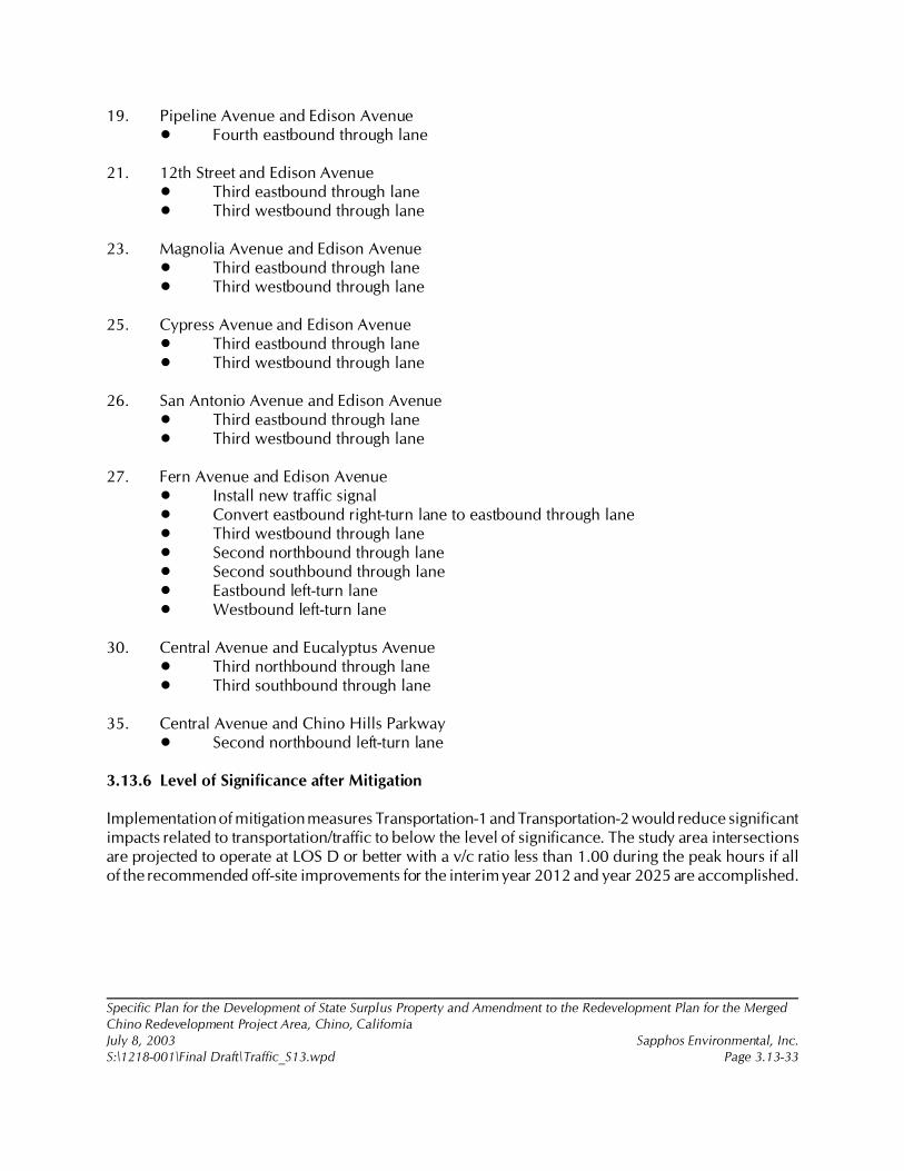
Specific Plan for the Development of State Surplus Property and Amendment to the Redevelopment Plan for the MergedChino Redevelopment Project Area, Chino, CaliforniaJuly 8, 2003 Sapphos Environmental, Inc.S:\1218-001\Final Draft\Traffic_S13.wpd Page 3.13-33
19. Pipeline Avenue and Edison Avenue• Fourth eastbound through lane
21. 12th Street and Edison Avenue• Third eastbound through lane• Third westbound through lane
23. Magnolia Avenue and Edison Avenue• Third eastbound through lane• Third westbound through lane
25. Cypress Avenue and Edison Avenue• Third eastbound through lane• Third westbound through lane
26. San Antonio Avenue and Edison Avenue• Third eastbound through lane• Third westbound through lane
27. Fern Avenue and Edison Avenue• Install new traffic signal• Convert eastbound right-turn lane to eastbound through lane• Third westbound through lane• Second northbound through lane• Second southbound through lane• Eastbound left-turn lane• Westbound left-turn lane
30. Central Avenue and Eucalyptus Avenue• Third northbound through lane• Third southbound through lane
35. Central Avenue and Chino Hills Parkway• Second northbound left-turn lane
3.13.6 Level of Significance after Mitigation
Implementation of mitigation measures Transportation-1 and Transportation-2 would reduce significantimpacts related to transportation/traffic to below the level of significance. The study area intersectionsare projected to operate at LOS D or better with a v/c ratio less than 1.00 during the peak hours if allof the recommended off-site improvements for the interim year 2012 and year 2025 are accomplished.
1 City of Chino, 19 July 2002c. Initial Study: Specific Plan for the Development of 717 Acres of State Surplus Propertyfrom the California Institution for Men (CIM), Chino, California. Contact: Community Development Department, 13220Central Avenue, Chino, CA 91710. Prepared by: Sapphos Environmental, Inc., 133 Martin Alley, Pasadena, CA 91105.
2 County of San Bernardino, 21 December 2000 (Revised from 1 July 1989). San Bernardino County General Plan.Contact: Economic Development and Public Services Group, Land Use Services Department, 385 North ArrowheadAvenue, 1st Floor, San Bernardino, CA 92415-0182.
3 City of Chino, 6 October 1981. General Plan: Land Use Element. Contact: Community Development Department,13220 Central Avenue, Chino, CA 91710.
4 Associated Engineers, Inc., 2002. Specific Plans State Disposition Property–Chino. Contact: California Department ofGeneral Services, Real Estate Services Division, Asset Planning and Management Branch, 707 3rd Street, 6th Floor, WestSacramento, CA 95605.
5 West's Annotated California Codes, 1984a. Urban Water Management Planning Act, California Water Code, § 10610 etseq. St. Paul, MN: West Publishing Company.
Specific Plan for the Development of State Surplus Property and Amendment to the Redevelopment Plan for the MergedChino Redevelopment Project Area, Chino, CaliforniaJuly 8, 2003 Sapphos Environmental, Inc.S:\1218-001\Final Draft\Utilities_S14.wpd Page 3.14-1
3.14 UTILITIES AND SERVICE SYSTEMS
As a result of the Initial Study,1 the City of Chino Community Development Department (City)determined that the Specific Plan for the Development of State Surplus Property and Amendment tothe Redevelopment Plan for the Merged Chino Redevelopment Project Area, Chino, California(proposed project) had the potential to result in impacts to utilities and service systems. Therefore, thisissue has been carried forward for detailed analysis in this Environmental Impact Report (EIR). Thisanalysis was undertaken to identify opportunities to avoid, reduce, or otherwise mitigate potentialsignificant impacts that could affect utilities and service systems and to identify potential alternatives.
The analysis of utilities and service systems consists of a summary of the regulatory framework thatguides the decision-making process, existing conditions at the proposed project site, thresholds fordetermining if the proposed project would result in significant impacts, anticipated impacts (direct,indirect, and cumulative), mitigation measures, and the level of significance after mitigation. Thepotential impacts to utilities and service systems have been analyzed in accordance with themethodologies provided by the San Bernardino County General Plan,2 City of Chino General Plan,3
and the Specific Plan for the State Disposition Property–Chino.4
3.14.1 Regulatory Framework
State
California Urban Water Management Act
The California Urban Water Management Planning Act5 requires urban water suppliers to initiateplanning strategies that make every effort to ensure the appropriate level of reliability in its waterservice sufficient to meet the needs of its various categories of customers during normal, single-dry, andmultiple-dry water years.
6 City of Chino, 1981.
7 City of Chino, February 1992. General Plan: Circulation Element. Contact: Community Development Department,13220 Central Avenue, Chino, CA 91710.
Specific Plan for the Development of State Surplus Property and Amendment to the Redevelopment Plan for the MergedChino Redevelopment Project Area, Chino, CaliforniaJuly 8, 2003 Sapphos Environmental, Inc.S:\1218-001\Final Draft\Utilities_S14.wpd Page 3.14-2
Land Use and Water Supply (Senate Bill 221)
Senate Bill (SB) 221 required builders of large subdivisions (500+ dwelling units) to verify that watersupplies exist to support the population who will inhabit their new housing developments. The buildermust request assurance from the retail water supplier that will serve the development that a watersupply is available. If the water supplier deems existing supplies to be insufficient, SB 221 requires thewater supplier to submit a plan to acquire and develop additional supplies.
California Solid Waste Reuse and Recycling Access Act
The California Solid Waste Reuse and Recycling Access Act of 1991 requires each jurisdiction to adoptan ordinance by September 1, 1994, requiring each development project to provide an adequatestorage area for collection and removal of recyclable materials.
California Integrated Waste Management Plan
The California Integrated Waste Management Act of 1989 (Assemble Bill 939) requires that theresponsibility for solid waste management is shared between state and local governments.
Local
City of Chino General Plan
The City of Chino has set no maximum population limits. Growth shall be in a phased and orderlymanner consistent with the availability of adequate public and private services, utilities, and publicfacilities.6 The following policies will assist the City in achieving the goal of providing complete, safe,and efficient public utility systems that will serve future land use needs7:
• Policy P3-8.1 Define Needs and Develop Capacity: Annually define needs anddeficiencies within the City’s limits and sphere of service. Introduce all projects intothe City’s capital improvements process with the most urgent receiving priority.Annually evaluate capacity needs and develop programs to increase capacity andprovide service.
• Policy P3-8.2 Facility Construction: Construct, rehabilitate, and upgrade public utilitiesas appropriate to the needs of the residents and businesses.
• Policy P3-8.3 Interagency Coordination: Continue to coordinate and collaborate withother city, county, and state agencies providing public utility services to Chino in orderto define area-wide and regional needs, projects, and responsibilities.
8 City of Chino, 1981.
9 Associated Engineers, Inc., 2002.
Specific Plan for the Development of State Surplus Property and Amendment to the Redevelopment Plan for the MergedChino Redevelopment Project Area, Chino, CaliforniaJuly 8, 2003 Sapphos Environmental, Inc.S:\1218-001\Final Draft\Utilities_S14.wpd Page 3.14-3
• Policy P3-8.4 New Development: Continue to require and encourage newdevelopment areas and annexation areas to tie into existing infrastructure, or to pay in-lieu fees to the City for development of infrastructure facilities.
In addition to utilities infrastructure planning, the City has incorporated a resource conservation facetto the Land Use element of the General Plan, which states the following:
Only recently, General Plans have begun to consider energy conservation in particularand resource conservation in general. Since the conservation and Open Space Elementtreats conservation in general, this section [land use: resource conservation] will focuson energy conservation and water conservation. While neither of these subjects canbe addressed solely at the local level, many local initiatives can be taken as follows8:
General Policy
The City shall take positive steps to ensure that newly constructed facilities are asenergy efficient as possible:
1. The City Building Department shall ensure that all buildings built in the future atleast meet the minimum State insulation standards.
2. The design of any construction shall take full advantage of potential passive andactive solar power resources including but not limited to building orientation, windowopenings, building materials, and landscaping.
3. All developments approved by the City shall at a minimum be required to provideenergy, water and fuel efficient appliances.
3.14.2 Existing Conditions
Information relating to existing utility systems discussed in this section was obtained from the SpecificPlans: State Disposition Property–Chino.9 Each of the utility systems is described below.
Water Supply
The City of Chino currently receives its water supply from four sources: 38 percent from naturallyrecharged groundwater from the Chino basin, 40 percent from imported water, 20 percent fromdesalted water, and 2 percent from recycled water. The City’s current average daily demand is
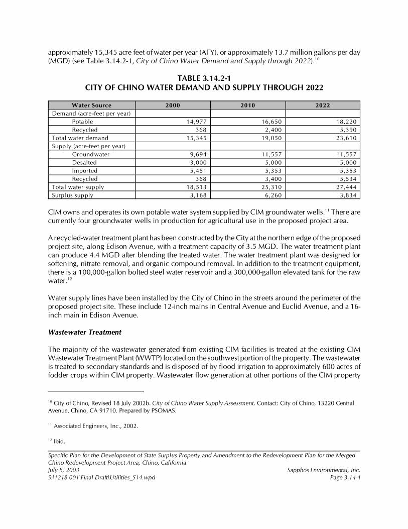
10 City of Chino, Revised 18 July 2002b. City of Chino Water Supply Assessment. Contact: City of Chino, 13220 CentralAvenue, Chino, CA 91710. Prepared by PSOMAS.
11 Associated Engineers, Inc., 2002.
12 Ibid.
Specific Plan for the Development of State Surplus Property and Amendment to the Redevelopment Plan for the MergedChino Redevelopment Project Area, Chino, CaliforniaJuly 8, 2003 Sapphos Environmental, Inc.S:\1218-001\Final Draft\Utilities_S14.wpd Page 3.14-4
approximately 15,345 acre feet of water per year (AFY), or approximately 13.7 million gallons per day(MGD) (see Table 3.14.2-1, City of Chino Water Demand and Supply through 2022).10
TABLE 3.14.2-1CITY OF CHINO WATER DEMAND AND SUPPLY THROUGH 2022
Water Source 2000 2010 2022
Demand (acre-feet per year)
Potable 14,977 16,650 18,220
Recycled 368 2,400 5,390
Total water demand 15,345 19,050 23,610
Supply (acre-feet per year)
Groundwater 9,694 11,557 11,557
Desalted 3,000 5,000 5,000
Imported 5,451 5,353 5,353
Recycled 368 3,400 5,534
Total water supply 18,513 25,310 27,444
Surplus supply 3,168 6,260 3,834
CIM owns and operates its own potable water system supplied by CIM groundwater wells.11 There arecurrently four groundwater wells in production for agricultural use in the proposed project area.
A recycled-water treatment plant has been constructed by the City at the northern edge of the proposedproject site, along Edison Avenue, with a treatment capacity of 3.5 MGD. The water treatment plantcan produce 4.4 MGD after blending the treated water. The water treatment plant was designed forsoftening, nitrate removal, and organic compound removal. In addition to the treatment equipment,there is a 100,000-gallon bolted steel water reservoir and a 300,000-gallon elevated tank for the rawwater.12
Water supply lines have been installed by the City of Chino in the streets around the perimeter of theproposed project site. These include 12-inch mains in Central Avenue and Euclid Avenue, and a 16-inch main in Edison Avenue.
Wastewater Treatment
The majority of the wastewater generated from existing CIM facilities is treated at the existing CIMWastewater Treatment Plant (WWTP) located on the southwest portion of the property. The wastewateris treated to secondary standards and is disposed of by flood irrigation to approximately 600 acres offodder crops within CIM property. Wastewater flow generation at other portions of the CIM property
Specific Plan for the Development of State Surplus Property and Amendment to the Redevelopment Plan for the MergedChino Redevelopment Project Area, Chino, CaliforniaJuly 8, 2003 Sapphos Environmental, Inc.S:\1218-001\Final Draft\Utilities_S14.wpd Page 3.14-5
(CIM East and the Heman G. Stark Youth Correctional Facilities) are currently being conveyed to theInland Empire Utility Agency.
Sanitary Sewer
Major sewer lines have been installed along the perimeter of the proposed project site (Figure 3.14.2-1,Existing Sewer System). The sewer lines convey raw sewage to the CIM WWTP. CIM pays a sewerservice fee for existing sewer lines on site and connection to the system.
Storm Drain System
The proposed project site lies within the City of Chino Drainage Master Plan area (Figure 3.14.2-2,Existing and Proposed Storm Drain System).
The site slopes from the north and northwest to the south and southeast at approximately 2 percent.The Cypress Channel, running north to south, is the primary flood control facility in the CypressChannel District. A 72-inch reinforced-concrete pipe (RCP) storm drain, running parallel to MagnoliaAvenue, carries runoff from 348 acres of the total drainage area north of Edison Avenue. This drainpipe terminates in an unimproved earthen open channel immediately south of Edison Avenue on thedisposition area, flows through CIM to the south and continues flowing in the open channel to itsconfluence with Chino Creek to the south.
Solid Waste
San Bernardino County primarily handles the solid waste facilities for the CIM site. A private haulertakes the solid waste generated by the CIM facilities to area facilities owned by San Bernardino Countyand the County Sanitation District of Los Angeles County. The landfills located on the CIM site are notin use. An on-site recycling and salvage program (RASP) facility is located northwest of the CIMMinimum Security Facility. This facility provides a substantial reduction of CIM solid waste disposalvolume. A facility that processes vegetation waste (a green facility) is also located in the east-centralpart of the CIM site.
Dry Utilities
There is an existing buried joint trench system, holding electric, telephone, gas, cable TV, and fiber-optic communication lines that runs along Central Avenue, Edison Avenue, and Euclid Avenue.
3.14.3 Significance Thresholds
The City considers a project to have a significant impact on utilities and service systems if the projectwould result in the following conditions:
• Exceeds wastewater treatment requirements of the applicable Regional Water QualityControl Board

13 Ibid.
14 City of Chino, Revised 18 July 2002b.
Specific Plan for the Development of State Surplus Property and Amendment to the Redevelopment Plan for the MergedChino Redevelopment Project Area, Chino, CaliforniaJuly 8, 2003 Sapphos Environmental, Inc.S:\1218-001\Final Draft\Utilities_S14.wpd Page 3.14-6
• Requires or results in the construction of new water or wastewater treatment facilitiesor expansion of existing facilities in which the construction could cause significantenvironmental effects
• Requires or results in the construction of new storm water drainage facilities orexpansion of existing facilities in which the construction could cause significantenvironmental effects
• Lacks sufficient water supplies available to serve the project from existing entitlementsand resources or would require new or expanded entitlements
• Results in a determination by the wastewater treatment provider that would serve theproject that it would not have adequate capacity to serve the project’s projecteddemand in addition to the provider’s existing commitments
• Is not served by a landfill with sufficient permitted capacity to accommodate theproject’s solid waste disposal needs
• Does not comply with federal, state, and local statutes and regulations related to solidwaste
3.14.4 Impact Analysis
Direct and Indirect Impacts
Water Supply
The calculated total potable water demand for the proposed project would be 2 MGD.13 The City hasprepared a water supply assessment14 to document the sufficiency of the City water supply, includingthe proposed project. The water supply assessment includes the analysis of multiple sources of water.The water supply assessment was prepared pursuant to SB 221 and SB 610 such that, when takentogether, it would require a municipality to identify both a water supply and water reliability.Therefore, the water supply assessment documents the availability of a sufficient water supply for a cityboth now and in the future, including existing and future planned development. Sufficient water supplyis defined as the total water supply available during normal, single-dry, and multiple-dry years withina 20-year projection that will meet the projected demand associated with a proposed project, as wellas all other existing and planned uses in a city.
15 Ibid.
16 Ibid.
17 Associated Engineers, Inc., 2002.
18 City of Chino, Revised 18 July 2002b.
19 Associated Engineers, Inc., 2002.
Specific Plan for the Development of State Surplus Property and Amendment to the Redevelopment Plan for the MergedChino Redevelopment Project Area, Chino, CaliforniaJuly 8, 2003 Sapphos Environmental, Inc.S:\1218-001\Final Draft\Utilities_S14.wpd Page 3.14-7
The water supply assessment concluded that supply would exceed demand for the entire City throughthe year 2022.15 The planned build-out of the proposed project is the year 2012; therefore, there wouldbe adequate water supply to the project at the time of completion and into the future. Table 3.14.2-1indicates the current and projected water supply. Therefore, there would be no impacts associated withlack of sufficient water supplies available to serve the project from existing entitlements and resources,and no new or expanded entitlements would be required.
A recycled-water system would be constructed to provide tertiary treated effluent for turf and landscapeirrigation. The neighborhood parks, schools, medians, and greenbelts would be irrigated with recycledwater, whereas local irrigation in single-family dwelling areas would use potable water. Calculationsfor ultimate recycled-water demand for the proposed project showed that the total recycled-waterdemand would be 572,779 gallons per day (GPD). The City of Chino has indicated that adequatesupplies of recycled water is available from the existing 12-inch recycled-water main in Edison Avenue.The ultimate recycled-water distribution system for the proposed project would contain a total ofapproximately 20,000 feet of piping (Figure 3.14.4-1, Proposed Recycled-Water System). Impactsrelated to implementation of the proposed recycled-water system would result in short-termconstruction-related impacts that would be mitigated to below the level of significance.
Computer runs were made simulating the average day demand, maximum day demand with fire flow,and peak-hour demands, using the peaking factors provided by the City of Chino.16 The resultsestimated a total potable water demand for the proposed project of 2,013,196 GPD.17 The water supplyassessment identified water supply and reliability to the City into the future, including a sufficient watersupply for Chino Subarea 2.18 The proposed potable water distribution system for the proposed projectwould consist of approximately 29,100 feet of pipelines (Figure 3.14.4-2, Proposed Potable WaterSystem). Impacts related to implementation of the proposed potable water system would result in short-term construction-related impacts that would be mitigated to below the level of significance.
Sanitary Sewer
The construction and operation of the sanitary sewer system improvements (Figure 3.14.4-3, ProposedSewer System) would result in beneficial impacts on the City’s wastewater treatment and sewageconveyance systems, including the up sizing of existing sewer lines to accommodate future sewageflows from outside of the proposed project area.19 However, these projects would result in short-term,significant impacts during construction, requiring the consideration of mitigation measures to reducethe impacts to below the level of significance.
20 Ibid.
Specific Plan for the Development of State Surplus Property and Amendment to the Redevelopment Plan for the MergedChino Redevelopment Project Area, Chino, CaliforniaJuly 8, 2003 Sapphos Environmental, Inc.S:\1218-001\Final Draft\Utilities_S14.wpd Page 3.14-8
Storm Drain System
Implementation of plans to improve and repair storm drains would result in beneficial impacts to theCity’s storm drain capacity.20 However, construction of new storm drains (Figure 3.14.2-2) could resultin short-term, potentially significant impacts during construction that would require the considerationof mitigation measures to reduce the impacts to below the level of significance.
Solid Waste
Implementation of the proposed project would generate solid waste during both construction andoperation. However, mitigation measures that ensure compliance with the California Solid WasteManagement Act of 1989 during construction and operation of the proposed project will reduce thepotential impacts to below the level of significance.
Dry Utilities
Construction of a joint trench distribution system holding lines for electrical, telephone, gas, cabletelevision, and fiber-optic communications (Figure 3.14.4-4, Proposed Underground Joint Trench DryUtility Distribution System) to meet the demands of the proposed project would increase the City’sability to provide dry utilities to its residents. However, the construction of these improvements mayresult in short-term significant impacts during construction, thereby requiring the consideration ofmitigation measures to reduce the impacts to below the level of significance.
3.14.5 Cumulative Impacts
The potential for cumulative impacts to utilities and service systems was evaluated in relation to theclosely related past, present, or reasonable foreseeable and probable future projects described in Table2.7-1, Related Proposed and Approved Projects, in Section 2.7 of this EIR.
The proposed project would not result in cumulative impacts to utilities and service systems whenconsidered in conjunction with related projects. As with the proposed project, the City of Chino, Cityof Ontario, City of Chino Hills, and City of Norco projects involve development that would includedevelopment of utilities and the supply of water capable of meeting the needs to the proposeddevelopment.
3.14.6 Mitigation Measures
Utilities-1
The City shall require the owners, developer, and/or successors-in-interest to pay all applicableconnection fees and/or capital improvement fees required by City ordinance to fund the improvementsnecessary to provide potable water to the proposed project site. The City of Chino is responsible forimplementation of this mitigation measure.
Specific Plan for the Development of State Surplus Property and Amendment to the Redevelopment Plan for the MergedChino Redevelopment Project Area, Chino, CaliforniaJuly 8, 2003 Sapphos Environmental, Inc.S:\1218-001\Final Draft\Utilities_S14.wpd Page 3.14-9
Utilities-2
The private developer of the disposition area shall require the construction contractor to comply withBest Management Practices when installing the recycled-water system in order to limit the short-termconstruction-related impacts. The private developer of the disposition area is responsible forimplementation of this mitigation measure.
Utilities-3
The private developer of the disposition area shall require the construction contractor to comply withBest Management Practices when installing the potable water system in order to limit the short-termconstruction-related impacts. The private developer of the disposition area is responsible forimplementation of this mitigation measure.
Utilities-4
The private developer of the disposition area shall require the construction contractor to comply withBest Management Practices when installing the sanitary sewer system in order to limit the short-termconstruction-related impacts. The private developer of the disposition area is responsible forimplementation of this mitigation measure.
Utilities-5
The private developer of the disposition area shall require the construction contractor to comply withBest Management Practices when installing the storm drain system in order to limit the short-termconstruction-related impacts. The private developer of the disposition area is responsible forimplementation of this mitigation measure.
Utilities-6
The City shall require the owners, developer, and/or successors-in-interest to construct a watertreatment/water-recycling system on the proposed project site. The City of Chino is responsible forimplementation of this mitigation measure.
Utilities-7
In accordance with the California Solid Waste Management Act of 1989, the City of Chino Departmentof Public Works shall require the construction contractor to manage the solid waste generated duringconstruction of the project by diverting it from disposal in landfills, particularly Class III landfills,through source reduction, reuse, and recycling of construction and demolition debris. In addition, theCity shall require the owners, developer, and/or successors-in-interest to comply with the City’s SolidWaste Source Reduction Plan, which requires mandatory preprocessing of all solid waste generatedwithin the proposed project, including on-site recycling, composting, or reuse programs. The City ofChino is responsible for implementation of this mitigation measure.
Specific Plan for the Development of State Surplus Property and Amendment to the Redevelopment Plan for the MergedChino Redevelopment Project Area, Chino, CaliforniaJuly 8, 2003 Sapphos Environmental, Inc.S:\1218-001\Final Draft\Utilities_S14.wpd Page 3.14-10
Utilities-8
The private developer of the disposition area shall require the construction contractor to comply withBest Management Practices when installing the electrical distribution system in order to limit the short-term construction-related impacts. The private developer of the disposition area is responsible forimplementation of this mitigation measure.
Utilities-9
The private developer of the disposition area shall require the construction contractor to comply withBest Management Practices when installing the telephone line distribution system in order to limit theshort-term construction-related impacts. The private developer of the disposition area is responsiblefor implementation of this mitigation measure.
Utilities-10
The private developer of the disposition area shall require the construction contractor to comply withBest Management Practices when installing the gas distribution system in order to limit the short-termconstruction-related impacts. The private developer of the disposition area is responsible forimplementation of this mitigation measure.
Utilities-11
The private developer of the disposition area shall require the construction contractor to comply withBest Management Practices when installing the cable television distribution system in order to limit theshort-term construction-related impacts. The private developer of the disposition area is responsiblefor implementation of this mitigation measure.
Utilities-12
The private developer of the disposition area shall require the construction contractor to comply withBest Management Practices when installing the data communication distribution system in order tolimit the short-term construction-related impacts. The private developer of the disposition area isresponsible for implementation of this mitigation measure.
3.14.7 Level of Significance after Mitigation
After the implementation of recommended mitigation measures, impacts in regards to utilities andservice systems would be reduced to less than significant levels.
Specific Plan for the Development of State Surplus Property and Amendment to the Redevelopment Plan for the MergedChino Redevelopment Project Area, Chino, CaliforniaJuly 8, 2003 Sapphos Environmental, Inc.S:\1218-001\Final Draft\1218-001_S04.wpd Page 4-1
SECTION 4.0ALTERNATIVES TO THE PROPOSED PROJECT
This section of the Environmental Impact Report (EIR) describes alternatives to the Specific Plan for theDevelopment of State Surplus Property and Amendment to the Redevelopment Plan for the MergedChino Redevelopment Project Area, Chino, California (proposed project). Alternatives have beenanalyzed consistent with the recommendations of Section 15126.6 of the California EnvironmentalQuality Act (CEQA) Guidelines, which require evaluation of a range of reasonable alternatives to theproposed project, or to the location of the project, which would feasibly attain most of the basicobjectives of the project but would avoid or substantially lessen any of the significant project effects,and evaluate the comparative merits of the alternatives. The discussion of alternatives is intended tofocus on the following:
• Alternatives to the project or its location that may be capable of avoiding orsubstantially lessening any significant effects that a project may have on theenvironment
• Alternatives capable of accomplishing most of the basic purposes of the project andthat could avoid or substantially lessen one or more of the significant effects
• The provision of sufficient information about each alternative to allow meaningfulevaluation, analysis, and comparison with the proposed project
• The no-project analysis of what would be reasonably expected to occur in theforeseeable future if the project were not approved
The EIR must identify the environmentally superior alternative other then the No Project Alternative.The analysis of alternatives should be limited to those that the City of Chino determines could feasiblyattain most of the basic objectives of the project. The State CEQA Guidelines describe feasibility asbeing dependent on site suitability, economic viability, availability of infrastructure, General Planconsistency, other plans or regulatory limitations, and jurisdictional boundaries.
Alternatives addressed in this EIR were derived from work undertaken by the State of California (State),Chaffey Community College (Chaffey), and the City of Chino (City), as well as from comments thatwere received in response to the Notice of Availability and the comments provided by interestedparties that attended the public scoping meeting. The resulting range of alternatives considered in thisEIR consists of the following:
• No Project Alternative• No College/Increased Open Space Alternative • Compact Project/Increased Open Space Alternative • Detention Pond Relocation Alternative • Flood Control Channel Configuration Alternative
Specific Plan for the Development of State Surplus Property and Amendment to the Redevelopment Plan for the MergedChino Redevelopment Project Area, Chino, CaliforniaJuly 8, 2003 Sapphos Environmental, Inc.S:\1218-001\Final Draft\1218-001_S04.wpd Page 4-2
The effectiveness of each of the alternatives to achieve the basic objectives of the project has beenevaluated in relation to the statement of objectives described in Section 2.2 of this EIR. A summary ofthe ability of the proposed project and alternatives under consideration to meet the objectives of theproject is presented in Table 4.0-1, Summary of Adequacy of Proposed Project and Alternatives toAttain Project Objectives. As shown in Table 4.0-1, the proposed project would meet all of the basicobjectives of the City, State, and Chaffey. Although the No Project Alternative is not capable of meetingmost of the basic objectives of the proposed project, it has been analyzed as required by CEQA.
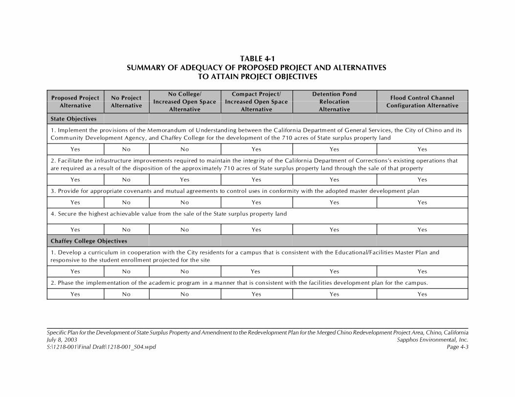
Specific Plan for the Development of State Surplus Property and Amendment to the Redevelopment Plan for the Merged Chino Redevelopment Project Area, Chino, CaliforniaJuly 8, 2003 Sapphos Environmental, Inc.S:\1218-001\Final Draft\1218-001_S04.wpd Page 4-3
TABLE 4-1SUMMARY OF ADEQUACY OF PROPOSED PROJECT AND ALTERNATIVES
TO ATTAIN PROJECT OBJECTIVES
Proposed Project
Alternative
No Project
Alternative
No College/
Increased Open Space
Alternative
Compact Project/
Increased Open Space
Alternative
Detention Pond
Relocation
Alternative
Flood Control Channel
Configuration Alternative
State Objectives
1. Implement the provisions of the Memorandum of Understanding between the California Department of General Services, the City of Chino and its
Community Development Agency, and Chaffey College for the development of the 710 acres of State surplus property land
Yes No No Yes Yes Yes
2. Facilitate the infrastructure improvements required to maintain the integrity of the California Department of Corrections’s existing operations that
are required as a result of the disposition of the approximately 710 acres of State surplus property land through the sale of that property
Yes No Yes Yes Yes Yes
3. Provide for appropriate covenants and mutual agreements to control uses in conformity with the adopted master development plan
Yes No No Yes Yes Yes
4. Secure the highest achievable value from the sale of the State surplus property land
Yes No No Yes Yes Yes
Chaffey College Objectives
1. Develop a curriculum in cooperation with the City residents for a campus that is consistent with the Educational/Facilities Master Plan and
responsive to the student enrollment projected for the site
Yes No No Yes Yes Yes
2. Phase the implementation of the academic program in a manner that is consistent with the facilities development plan for the campus.
Yes No No Yes Yes Yes
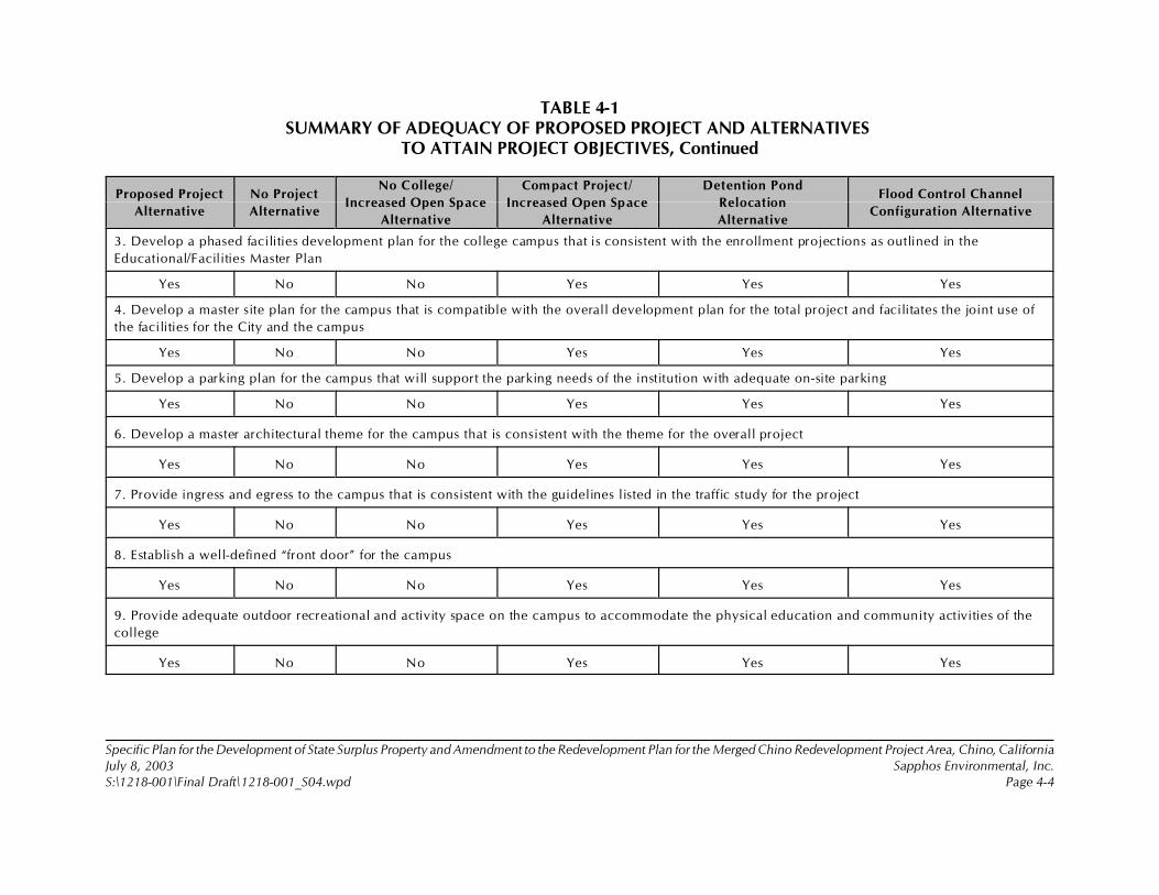
TABLE 4-1SUMMARY OF ADEQUACY OF PROPOSED PROJECT AND ALTERNATIVES
TO ATTAIN PROJECT OBJECTIVES, Continued
Proposed Project
Alternative
No Project
Alternative
No College/
Increased Open Space
Alternative
Compact Project/
Increased Open Space
Alternative
Detention Pond
Relocation
Alternative
Flood Control Channel
Configuration Alternative
Specific Plan for the Development of State Surplus Property and Amendment to the Redevelopment Plan for the Merged Chino Redevelopment Project Area, Chino, CaliforniaJuly 8, 2003 Sapphos Environmental, Inc.S:\1218-001\Final Draft\1218-001_S04.wpd Page 4-4
3. Develop a phased facilities development plan for the college campus that is consistent with the enrollment projections as outlined in the
Educational/Facilities Master Plan
Yes No No Yes Yes Yes
4. Develop a master site plan for the campus that is compatible with the overall development plan for the total project and facilitates the joint use of
the facilities for the City and the campus
Yes No No Yes Yes Yes
5. Develop a parking plan for the campus that will support the parking needs of the institution with adequate on-site parking
Yes No No Yes Yes Yes
6. Develop a master architectural theme for the campus that is consistent with the theme for the overall project
Yes No No Yes Yes Yes
7. Provide ingress and egress to the campus that is consistent with the guidelines listed in the traffic study for the project
Yes No No Yes Yes Yes
8. Establish a well-defined “front door” for the campus
Yes No No Yes Yes Yes
9. Provide adequate outdoor recreational and activity space on the campus to accommodate the physical education and community activities of the
college
Yes No No Yes Yes Yes

TABLE 4-1SUMMARY OF ADEQUACY OF PROPOSED PROJECT AND ALTERNATIVES
TO ATTAIN PROJECT OBJECTIVES, Continued
Proposed Project
Alternative
No Project
Alternative
No College/
Increased Open Space
Alternative
Compact Project/
Increased Open Space
Alternative
Detention Pond
Relocation
Alternative
Flood Control Channel
Configuration Alternative
Specific Plan for the Development of State Surplus Property and Amendment to the Redevelopment Plan for the Merged Chino Redevelopment Project Area, Chino, CaliforniaJuly 8, 2003 Sapphos Environmental, Inc.S:\1218-001\Final Draft\1218-001_S04.wpd Page 4-5
10. Establish a master plan for the build-out of the campus and a phasing plan to support the enrollment projections
Yes No No Yes Yes Yes
11. W ork cooperatively with affected agencies to establish a plan for off-site improvements
Yes No No Yes Yes Yes
12. Secure all state approvals
Yes No No Yes Yes Yes
City of Chino Objectives
1. To develop a premier living environment designed on the principles of “smart” development, including efficient use of land resources, full use of
urban services, and a mix of uses, transportation options, and detailed human-scale design that is unique because of its accessibility to regional
educational and recreational opportunities
Yes No No Yes Yes Yes
2. Adopt a specific plan that both meets the requirements of California State law and the Urban Reserve Area section of the Chino General Plan and
implements the provisions of the Memorandum of Understanding between the City of Chino, the State Department of General Services, and Chaffey
College
Yes No No Yes Yes Yes
3. Amend the Redevelopment Plan for the Merged Chino Redevelopment Project Area to conform permitted land uses to the City’s General Plan
Yes No Yes Yes Yes Yes
4. Develop the proposed project area consistent with the provisions of the adopted Community Redevelopment Plan
Yes No No Yes Yes Yes
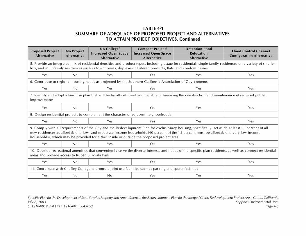
TABLE 4-1SUMMARY OF ADEQUACY OF PROPOSED PROJECT AND ALTERNATIVES
TO ATTAIN PROJECT OBJECTIVES, Continued
Proposed Project
Alternative
No Project
Alternative
No College/
Increased Open Space
Alternative
Compact Project/
Increased Open Space
Alternative
Detention Pond
Relocation
Alternative
Flood Control Channel
Configuration Alternative
Specific Plan for the Development of State Surplus Property and Amendment to the Redevelopment Plan for the Merged Chino Redevelopment Project Area, Chino, CaliforniaJuly 8, 2003 Sapphos Environmental, Inc.S:\1218-001\Final Draft\1218-001_S04.wpd Page 4-6
5. Provide an integrated mix of residential densities and product types, including estate lot residential, single-family residences on a variety of smaller
lots, and multifamily residences such as townhouses, duplexes, clustered products, flats, and condominiums
Yes No Yes Yes Yes Yes
6. Contribute to regional housing needs as projected by the Southern California Association of Governments
Yes No Yes Yes Yes Yes
7. Identify and adopt a land use plan that will be fiscally efficient and capable of financing the construction and maintenance of required public
improvements
Yes No Yes Yes Yes Yes
8. Design residential projects to complement the character of adjacent neighborhoods
Yes No Yes Yes Yes Yes
9. Comply with all requirements of the City and the Redevelopment Plan for exclusionary housing, specifically, set aside at least 15 percent of all
new residences as affordable to low- and moderate-income households (40 percent of the 15 percent must be affordable to very-low-income
households), which may be provided for either inside or outside the proposed project area
Yes No Yes Yes Yes Yes
10. Develop recreational amenities that conveniently serve the diverse interests and needs of the specific plan residents, as well as connect residential
areas and provide access to Ruben S. Ayala Park
Yes No Yes Yes Yes Yes
11. Coordinate with Chaffey College to promote joint-use facilities such as parking and sports facilities
Yes No No Yes Yes Yes
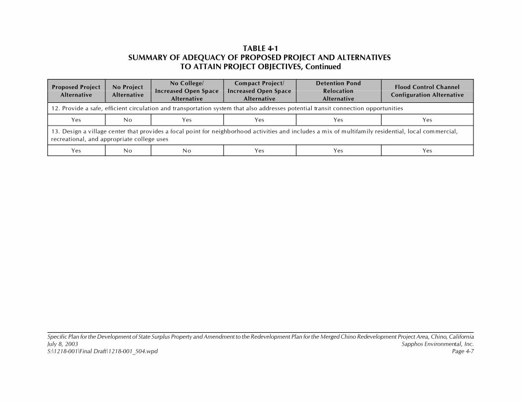
TABLE 4-1SUMMARY OF ADEQUACY OF PROPOSED PROJECT AND ALTERNATIVES
TO ATTAIN PROJECT OBJECTIVES, Continued
Proposed Project
Alternative
No Project
Alternative
No College/
Increased Open Space
Alternative
Compact Project/
Increased Open Space
Alternative
Detention Pond
Relocation
Alternative
Flood Control Channel
Configuration Alternative
Specific Plan for the Development of State Surplus Property and Amendment to the Redevelopment Plan for the Merged Chino Redevelopment Project Area, Chino, CaliforniaJuly 8, 2003 Sapphos Environmental, Inc.S:\1218-001\Final Draft\1218-001_S04.wpd Page 4-7
12. Provide a safe, efficient circulation and transportation system that also addresses potential transit connection opportunities
Yes No Yes Yes Yes Yes
13. Design a village center that provides a focal point for neighborhood activities and includes a mix of multifamily residential, local com mercial,
recreational, and appropriate college uses
Yes No No Yes Yes Yes
Specific Plan for the Development of State Surplus Property and Amendment to the Redevelopment Plan for the MergedChino Redevelopment Project Area, Chino, CaliforniaJuly 8, 2003 Sapphos Environmental, Inc.S:\1218-001\Final Draft\1218-001_S04.wpd Page 4-8
4.1 ALTERNATIVE 1: NO PROJECT
Under the No Project Alternative, the existing conditions described in this EIR would remainunchanged. Although it does not meet many of the basic objectives of the proposed project, the NoProject Alternative has been carried forward for detailed analysis as required by CEQA.
4.1.1 Alternative Components
There are no components to the No Project Alternative. Chaffey College would not be constructed, andthe Ruben S. Ayala Park would remain unchanged. There would not be residential, retail, orcommercial space; neighborhood parks; or a trail system. There would not be flood control facilities,such as detention ponds or widening of channels.
4.1.2 Objectives
Under the No Project Alternative, the objectives of the project would not be met.
4.1.3 Construction Scenario
Under the No Project Alternative, no construction would occur. Therefore, no environmental impactswould occur.
4.1.4 Comparative Impacts
Aesthetics
The No Project Alternative avoids potential impacts to aesthetics that could result from theimplementation of the proposed project. Section 3.1, Aesthetics, of this EIR provides mitigation fordesign-related impacts that would occur as a result of the proposed project. Unlike the proposedproject, this alternative would entail no conversion of vacant land, including grading, paving,construction, and operation, and implementation of the mitigation measures would not be required.The No Project Alternative would be preferable to the proposed project when considering potentialimpacts to aesthetics.
Agricultural Resources
The No Project Alternative avoids potential impacts to agricultural resources that could result from theimplementation of the proposed project. Section 3.2, Agricultural Resources, describes the directimpacts associated with the implementation of the proposed project, however it has been determinedthat there are no feasible mitigation measures available to partially or wholly mitigate the significantimpacts related to the conversion of Farmland. Unlike the proposed project, this alternative wouldentail no conversion of farmland, including grading, paving, construction, and operation. The NoProject Alternative would be preferable to the proposed project when considering potential impactsto agricultural resources.
Specific Plan for the Development of State Surplus Property and Amendment to the Redevelopment Plan for the MergedChino Redevelopment Project Area, Chino, CaliforniaJuly 8, 2003 Sapphos Environmental, Inc.S:\1218-001\Final Draft\1218-001_S04.wpd Page 4-9
Air Quality
The No Project Alternative avoids potential short-term construction-related significant impacts to airquality. Therefore, the proposed project would not require implementation of air quality mitigationmeasures required for the proposed project. The No Project Alternative would not require any gradingor the use of construction equipment, and it would not result in the operation of mobile or stationaryfacilities or equipment, thus avoiding any potentially significant impacts to air quality from PM10
emissions. The No Project Alternative would be preferable to the proposed project when consideringpotential impacts to air quality.
Biological Resources
The No Project Alternative avoids potential impacts to biological resources that could result from theimplementation of the proposed project. Section 3.4, Biological Resources, of this EIR providesmitigation for short- and long-term construction and operation impacts that would occur as a result ofthe proposed project. Unlike the proposed project, the No Project Alternative would entail noconversion of vacant land, including grading, paving, and construction, and implementation of themitigation measures would not be required. The No Project Alternative would not result in short- orlong-term impacts to biological resources. The No Project Alternative would be preferable to theproposed project when considering potential impacts to biological resources.
Cultural Resources
The No Project Alternative avoids potential impacts to cultural resources that could result from theimplementation of the proposed project. Section 3.5, Cultural Resources, of this EIR provides mitigationfor short- and long-term construction and operation impacts that would occur as a result of theproposed project. Unlike the proposed project, the No Project Alternative would entail no conversionof vacant land, including grading, paving, and construction, and implementation of the mitigationmeasures would not be required. The No Project Alternative would not result in short- or long-termimpacts to cultural resources. The No Project Alternative would be preferable to the proposed projectwhen considering potential impacts to cultural resources.
Geology and Soils
The No Project Alternative avoids potential impacts to geology and soils that could result from theimplementation of the proposed project. Section 3.6, Geology and Soils, of this EIR provides mitigationfor short- and long-term construction and operation impacts that would occur as a result of theproposed project. Unlike the proposed project, this alternative would entail no grading (excavation andfill), modification of existing structures, or construction of new structures, and implementation of themitigation measures would not be required. The No Project Alternative would be preferable to theproposed project when considering potential impacts to geology and soils.
Hazards and Hazardous Materials
The No Project Alternative avoids potential impacts to hazards and hazardous materials that couldresult from the implementation of the proposed project. Section 3.7, Hazards and Hazardous Materials,

Specific Plan for the Development of State Surplus Property and Amendment to the Redevelopment Plan for the MergedChino Redevelopment Project Area, Chino, CaliforniaJuly 8, 2003 Sapphos Environmental, Inc.S:\1218-001\Final Draft\1218-001_S04.wpd Page 4-10
of this EIR provides mitigation for short- and long-term construction and operation impacts that wouldoccur as a result of the proposed project. Unlike the proposed project, this alternative would entail nograding (excavation and fill), modification of existing structures, or construction of new structures, andimplementation of the mitigation measures would not be required. Potential operational impacts fromhazards or hazardous materials would not occur. The No Project Alternative would not result in short-or long-term impacts from hazards and hazardous materials. The No Project Alternative would bepreferable to the proposed project when considering potential impacts to hazards and hazardousmaterials.
Hydrology and Water Quality
Because the proposed project would not result in significant impacts, the No Project Alternative wouldnot be preferable when considering only impacts to hydrology and water quality that could result fromthe implementation of the proposed project. Unlike the proposed project, the No Project Alternativewould entail no conversion of vacant land, including grading, paving, and construction.
Noise
The No Project Alternative avoids potential construction- and operation-related significant impacts fromnoise. Therefore, the proposed project would not require implementation of noise mitigation measuresrequired for the proposed project. The No Project Alternative would not result in short- or long-termimpacts to noise. The No Project Alternative would be preferable to the proposed project whenconsidering potential impacts to noise.
Population and Housing
The No Project Alternative avoids impacts to population and housing that could result from theimplementation of the proposed project. Section 3.10, Population and Housing, concludes that nosignificant impacts to population and housing would occur from implementation of the proposedproject; therefore, no mitigation measures would be required. Similar to the proposed project,implementation of No Project Alternative would not result in impacts to population and housing.
Public Services
The No Project Alternative avoids potential impacts to public services that could result from theimplementation of the proposed project. Section 3.11, Public Services, of this EIR provides mitigationfor public services impacts that would occur as a result of the proposed project. Unlike the proposedproject, this alternative would create no net increase in population, and implementation of themitigation measures would not be required. The No Project Alternative would be preferable to theproposed project when considering potential impacts to public services.
Recreation
The No Project Alternative avoids potential impacts to public services that could result from theimplementation of the proposed project. Section 3.12, Recreation, of this EIR provides mitigation forrecreation impacts that would occur as a result of the proposed project. Unlike the proposed project,
Specific Plan for the Development of State Surplus Property and Amendment to the Redevelopment Plan for the MergedChino Redevelopment Project Area, Chino, CaliforniaJuly 8, 2003 Sapphos Environmental, Inc.S:\1218-001\Final Draft\1218-001_S04.wpd Page 4-11
this alternative would create no construction impacts that would result in closures of park facilities andparking lots, and implementation of the mitigation measures would not be required. The No ProjectAlternative would be preferable to the proposed project when considering potential impacts torecreation.
Transportation/Traffic
The No Project Alternative avoids potential impacts to transportation and circulation that could resultfrom the implementation of the proposed project. Section 3.13, Transportation/Traffic, of this EIRprovides mitigation for short- and long-term construction and operation impacts that would occur asa result of the proposed project. Unlike the proposed project, this alternative would create noadditional transportation or circulation components, and implementation of the mitigation measureswould not be required. The No Project Alternative would be preferable to the proposed project whenconsidering potential impacts to transportation and circulation.
Utilities and Service Systems
The No Project Alternative avoids potential impacts to utilities and service systems that could resultfrom the implementation of the proposed project. Section 3.14, Utilities and Service Systems, of thisEIR provides mitigation for short- and long-term construction and operation impacts that would occuras a result of the proposed project. Unlike the proposed project, this alternative would entail nograding (excavation and fill), modification of existing structures, or construction of new structures, andimplementation of the mitigation measures would not be required The No Project Alternative wouldbe preferable to the proposed project when considering potential impacts to utilities and servicesystems.
4.2 ALTERNATIVE 2: NO COLLEGE/INCREASED OPEN SPACE
4.2.1 Alternative Components
The No College/Increased Open Space Alternative (Figure 4.2.1-1, No College/Increased Open SpaceAlternative) contains all of the proposed project elements except for the Chaffey College element. Thisalternative assumes that the area within the proposed project that was to include the Chaffey Collegesite and related facilities would remain in its existing condition and left as open space (Table 4.2.1-1,Land Uses: No College/Increased Open Space Alternative).

Specific Plan for the Development of State Surplus Property and Amendment to the Redevelopment Plan for the MergedChino Redevelopment Project Area, Chino, CaliforniaJuly 8, 2003 Sapphos Environmental, Inc.S:\1218-001\Final Draft\1218-001_S04.wpd Page 4-12
TABLE 4.2.1-1LAND USES: NO COLLEGE/INCREASED OPEN SPACE ALTERNATIVE
Land Use Designation Acres
Number
of Units
Size
(square foot)
Residential designations
Estate residential (ER)
0 to 3 dwelling units (DU)/acre (AC)
38 75
Low- and medium-density residential (L/MDR)
3 to 12 DU/AC
242 1,905
High-density residential (HDR)
12 to 20 DU/AC
20 320
Subtotal 320 2,300
Open space recreation (OSR)
Community park 140
Neighborhood parks 15
Multiuse trail 6
Easements and flood control channel 33
Detention areas 22
Open space 100
Other designations
Mixed use 10 200 70,000
Retail 4 50,000
Chaffey College 0
Elementary school 10
Roads and transit 50
Total 710 2,500 120,000
4.2.2 Objectives
The No College/Increased Open Space Alternative does not meet most of the objectives of the project.It does not meet any of the Chaffey College objectives, and it only meets 50 percent of the State ofCalifornia and the City of Chino objectives.
Specific Plan for the Development of State Surplus Property and Amendment to the Redevelopment Plan for the MergedChino Redevelopment Project Area, Chino, CaliforniaJuly 8, 2003 Sapphos Environmental, Inc.S:\1218-001\Final Draft\1218-001_S04.wpd Page 4-13
4.2.3 Construction Scenario
The construction scenario described for all the elements of the proposed project, not including theChaffey College component, would occur under the No College/Increased Open Space Alternative.The Chaffey College construction would not occur; therefore, the short-term impacts related toconstruction of Chaffey College would not occur.
4.2.4 Comparative Impacts
Aesthetics
The No College/Increased Open Space Alternative would result in the same design-related impacts toaesthetics as the proposed project. However, in this alternative, the design-related impacts would beavoided for the Chaffey College element of the proposed project.
The No College/Increased Open Space Alternative would also avoid potential impacts associated withthe increase in light and glare that would result from the implementation of the Chaffey Collegeelement. As with the proposed project, this alternative would result in a permanent improvement tothe visual character and quality of the site and its surroundings.
The No College/Increased Open Space Alternative would result in the same potentially significantimpacts to aesthetics from increased lighting as the proposed project would from the elements of theproject that would remain the same in this alternative. Therefore, It would require the considerationof the same mitigation measures as for the proposed project.
Agricultural Resources
The No College/Increased Open Space Alternative would result in the same permanent impacts relatedto the conversion of farmland as the proposed project. It has been determined that there are no feasiblemitigation measures available to partially or wholly mitigate the significant impacts related to theconversion of farmland. By designating the 710 acres of land within the proposed project area assurplus, the farmland would be converted from agricultural production regardless of the specific landuse designation for any portion of the Specific Plan area, constituting a significant impact. In addition,the LESA model, described in Section 3.2, Agriculture Resources, used to quantify impacts to farmlandwould not be affected by changes in land use designations within the proposed project area.
Air Quality
The No College/Increased Open Space Alternative would result in substantially fewer impacts to airquality than the proposed project because it would result in 23,100 fewer daily vehicle trips associatedwith the college at build-out. The college is the largest single contributor to vehicle emissions duringoperation; therefore, elimination of the college would result in reduced project emissions of allpollutants. Increasing the amount of open space would result in a small increase in recreational tripsto the project site, but this would be insufficient to significantly offset the decrease in trips from thecollege. Elimination of the college would also result in substantially fewer total construction emissions.
Specific Plan for the Development of State Surplus Property and Amendment to the Redevelopment Plan for the MergedChino Redevelopment Project Area, Chino, CaliforniaJuly 8, 2003 Sapphos Environmental, Inc.S:\1218-001\Final Draft\1218-001_S04.wpd Page 4-14
Biological Resources
The No College/Increased Open Space Alternative would result in less development of existing openspace within the proposed project area than the proposed project. The greater open space would makeavailable additional foraging areas for raptors and other wildlife species, including burrowing owls.However, it would not necessarily provide additional breeding areas and would depend on thelocation of the open space. The No College/Increased Open Space Alternative would be preferable tothe proposed project when considering only potential impacts to biological resources.
Cultural Resources
The No College/Increased Open Space Alternative would result in less development of existing openspace within the proposed project area than the proposed project. However, there would still be thepotential for impacts to paleontological, prehistoric, and historic resources that are potentially located5 feet below the surface of the No College/Increased Open Space Alternative project area. Therefore,the No College/Increased Open Space Alternative would potentially result in significant impacts tocultural resources and would require the consideration of the same mitigation measures as for theproposed project for the remaining elements.
Geology and Soils
The No College/Increased Open Space Alternative would avoid risks to people and structures relatedto geologic and soil conditions from the implementation of the Chaffey College element. Thisalternative would result in the same impacts as the proposed project would from the elements of theproject that would remain the same in this alternative. The geologic and soil conditions that wouldpotentially result in significant impacts to the proposed project are present across the entire proposedproject site, and would require the consideration of the same mitigation measures as for the proposedproject for the remaining elements. The No College/Increased Open Space Alternative would bepreferable to the proposed project when considering only potential impacts from geology and soils. Hazards and Hazardous Materials
The No College/Increased Open Space Alternative would avoid temporary construction-related impactsfrom hazards and hazardous materials for the Chaffey College element of the proposed project. Inaddition, the No College/Increased Open Space Alternative would avoid potential impacts associatedwith the transport, use, or disposal of hazardous materials that would result from implementation ofthe Chaffey College element.
This alternative would result in the same impacts from hazards and hazardous materials as theproposed project, requiring the same mitigation measures, for the remaining elements of the proposedproject. The No College/Increased Open Space Alternative would be preferable to the proposedproject when considering only potential impacts from hazards and hazardous materials.
Specific Plan for the Development of State Surplus Property and Amendment to the Redevelopment Plan for the MergedChino Redevelopment Project Area, Chino, CaliforniaJuly 8, 2003 Sapphos Environmental, Inc.S:\1218-001\Final Draft\1218-001_S04.wpd Page 4-15
Hydrology and Water Quality
As with the proposed project, the No College/Increased Open Space Alternative would also result inno significant impacts to hydrology and water quality. Unlike the proposed project, the NoCollege/Increased Open Space Alternative would not entail conversion of vacant land within theChaffey College element that would be converted from the implementation of the proposed project.This would decrease the amount of impervious ground surface relative to the proposed project. TheNo College/Increased Open Space Alternative would be the same as the proposed project whenconsidering only potential impacts to hydrology and water quality.
Noise
The No College/Increased Open Space Alternative would result in less development of existing openspace within the proposed project area than the proposed project. The reduction in developmentwould reduce impacts from noise generated by the construction and operation of the Chaffey Collegecampus. The No College/Increased Open Space Alternative would be preferable to the proposedproject when considering only potential impacts to noise.
Population and Housing
The No College/Increased Open Space Alternative would result in less development of existing openspace within the proposed project area than the proposed project. However, the No College/IncreasedOpen Space Alternative would still include the same amount of housing as the proposed project.Section 3.10, Population and Housing, concludes that no significant impacts to population and housingwould occur from the implementation of the proposed project; therefore, no mitigation measureswould be required. Similar to the proposed project, implementation of the No College/Increased OpenSpace Alternative would not result in impacts to population and housing.
Public Services
The No College/Increased Open Space Alternative would result in the same significant, direct impactsto public services as the proposed project, requiring the consideration of the same mitigation measuresast that required for the proposed project. The Chaffey College element does not contribute to apermanent net increase in population within the proposed project boundaries, which is the basis foranalysis of direct impacts. Indirect impacts were determined to be less than significant for the proposedproject; therefore, the No College/Increased Open Space Alternative would be the same as theproposed project when considering only potential impacts to public services.
Recreation
The No College/Increased Open Space Alternative includes all the elements of the proposed project,except for the college, which is removed and left in its existing condition. Therefore, the NoCollege/Increased Open Space Alternative would result in the same potentially significant short-termconstruction-related impacts to recreation resulting from the expansion of the Ruben S. AyalaCommunity Park as the proposed project, requiring the consideration of the same mitigation measuresas that required for the proposed project.
Specific Plan for the Development of State Surplus Property and Amendment to the Redevelopment Plan for the MergedChino Redevelopment Project Area, Chino, CaliforniaJuly 8, 2003 Sapphos Environmental, Inc.S:\1218-001\Final Draft\1218-001_S04.wpd Page 4-16
Transportation/Traffic
The No College/Increased Open Space Alternative includes all the elements of the proposed projectexcept for the college, which is removed and left in its existing condition. The No College/IncreasedOpen Space Alternative is anticipated to generate approximately 30,800 daily trips, including 2,030trips in the a.m. peak hour and 3,090 trips in the p.m. peak hour. The proposed project was anticipatedto generate 53,900 daily trips, including 4,130 a.m. peak-hour and 5,640 p.m. peak-hour trips. TheNo College/Increased Open Space Alternative reduces the trip generation of the project by 43 percentto 51 percent.
Future Traffic Operations
Analysis of the No College/Increased Open Space Alternative for the year 2025 showed that thealternative would contribute to forecast operating deficiencies at 24 study intersections and 10 freewaysegments on State Route 60 and State Route 71. When compared to the proposed project, the NoCollege/Increased Open Space Alternative would result in 3 fewer intersections that would operate atlevel of service (LOS) E or LOS F during peak hours (deficient according to City of Chino criteria).However, improvements have been identified at each location that would result in acceptableoperating conditions (LOS D or better at intersections, and LOS E or better on freeway segments).These marginally lower numbers would not lead to appreciably different or worse construction impactsthan those identified for the proposed project. It is therefore concluded that this project alternativewould have the same impacts as the proposed project.
Congestion Management Program (CMP) Freeway Analysis
The No College/Increased Open Space Alternative would result in 10 freeway segments projected tooperated at an unacceptable level of service (LOS F) in 2025 with No College/Increased Open SpaceAlternative conditions during one or both peak hours. When compared to the proposed project, theNo College/Increased Open Space Alternative would result in the same number of unacceptablefreeway segments. These marginally lower numbers would not lead to appreciably differentconstruction impacts than those identified for the proposed project. It is therefore concluded that thisproject alternative would have the same impacts as the proposed project.
Utilities and Service Systems
The No College/Increased Open Space Alternative would result in the same potentially significantshort-term construction related impacts to utilities and service systems as the proposed project.However, the Chaffey College element would not be constructed; therefore, only the development ofthe master-planned community would result in impacts to utilities and service systems. Constructionand placement of the utility systems, such as a potable water system and sewer system, would still berequired for the No College/Increased Open Space Alternative, thus requiring the consideration of thesame mitigation measures required for the proposed project.
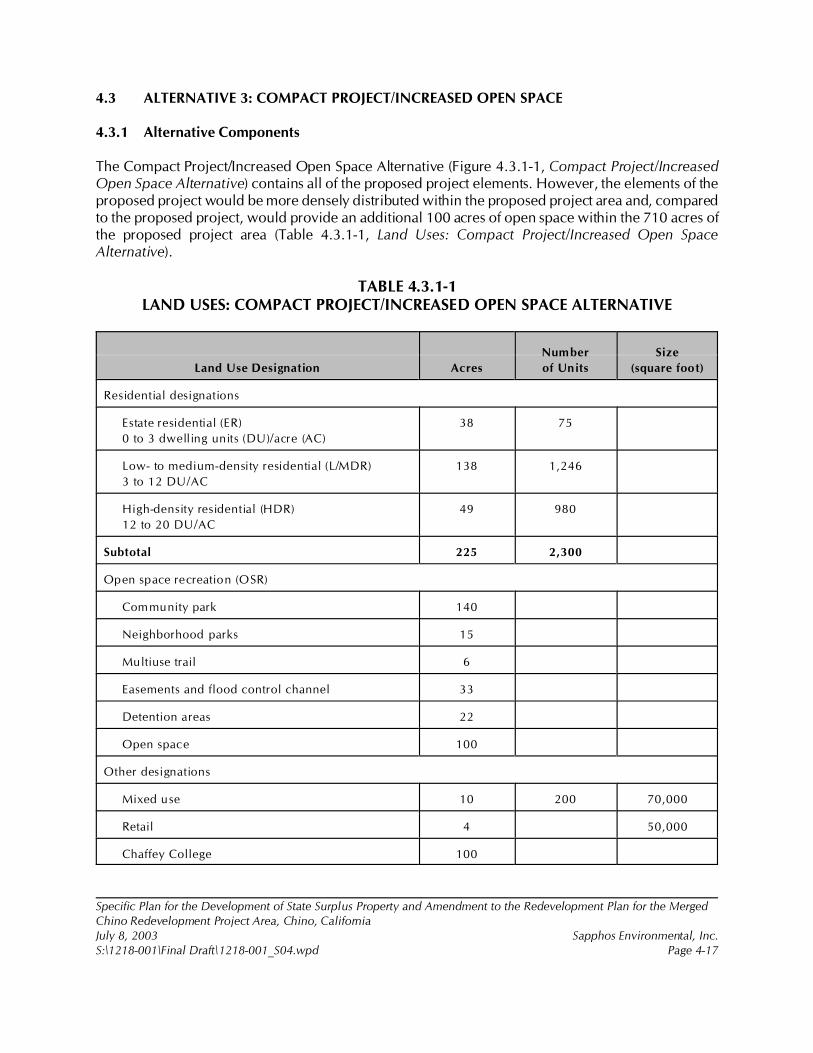
Specific Plan for the Development of State Surplus Property and Amendment to the Redevelopment Plan for the MergedChino Redevelopment Project Area, Chino, CaliforniaJuly 8, 2003 Sapphos Environmental, Inc.S:\1218-001\Final Draft\1218-001_S04.wpd Page 4-17
4.3 ALTERNATIVE 3: COMPACT PROJECT/INCREASED OPEN SPACE
4.3.1 Alternative Components
The Compact Project/Increased Open Space Alternative (Figure 4.3.1-1, Compact Project/IncreasedOpen Space Alternative) contains all of the proposed project elements. However, the elements of theproposed project would be more densely distributed within the proposed project area and, comparedto the proposed project, would provide an additional 100 acres of open space within the 710 acres ofthe proposed project area (Table 4.3.1-1, Land Uses: Compact Project/Increased Open SpaceAlternative).
TABLE 4.3.1-1LAND USES: COMPACT PROJECT/INCREASED OPEN SPACE ALTERNATIVE
Land Use Designation Acres
Number
of Units
Size
(square foot)
Residential designations
Estate residential (ER)
0 to 3 dwelling units (DU)/acre (AC)
38 75
Low- to medium-density residential (L/MDR)
3 to 12 DU/AC
138 1,246
High-density residential (HDR)
12 to 20 DU/AC
49 980
Subtotal 225 2,300
Open space recreation (OSR)
Community park 140
Neighborhood parks 15
Multiuse trail 6
Easements and flood control channel 33
Detention areas 22
Open space 100
Other designations
Mixed use 10 200 70,000
Retail 4 50,000
Chaffey College 100
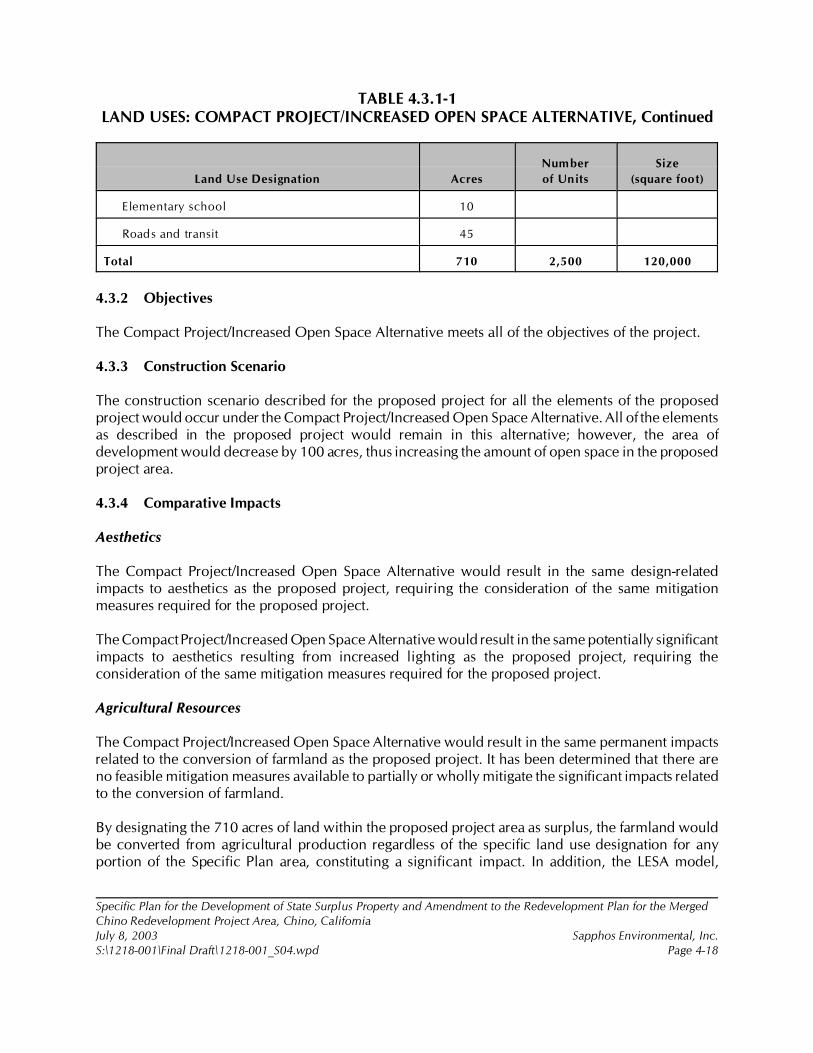
TABLE 4.3.1-1LAND USES: COMPACT PROJECT/INCREASED OPEN SPACE ALTERNATIVE, Continued
Specific Plan for the Development of State Surplus Property and Amendment to the Redevelopment Plan for the MergedChino Redevelopment Project Area, Chino, CaliforniaJuly 8, 2003 Sapphos Environmental, Inc.S:\1218-001\Final Draft\1218-001_S04.wpd Page 4-18
Land Use Designation Acres
Number
of Units
Size
(square foot)
Elementary school 10
Roads and transit 45
Total 710 2,500 120,000
4.3.2 Objectives
The Compact Project/Increased Open Space Alternative meets all of the objectives of the project.
4.3.3 Construction Scenario
The construction scenario described for the proposed project for all the elements of the proposedproject would occur under the Compact Project/Increased Open Space Alternative. All of the elementsas described in the proposed project would remain in this alternative; however, the area ofdevelopment would decrease by 100 acres, thus increasing the amount of open space in the proposedproject area.
4.3.4 Comparative Impacts
Aesthetics
The Compact Project/Increased Open Space Alternative would result in the same design-relatedimpacts to aesthetics as the proposed project, requiring the consideration of the same mitigationmeasures required for the proposed project.
The Compact Project/Increased Open Space Alternative would result in the same potentially significantimpacts to aesthetics resulting from increased lighting as the proposed project, requiring theconsideration of the same mitigation measures required for the proposed project.
Agricultural Resources
The Compact Project/Increased Open Space Alternative would result in the same permanent impactsrelated to the conversion of farmland as the proposed project. It has been determined that there areno feasible mitigation measures available to partially or wholly mitigate the significant impacts relatedto the conversion of farmland.
By designating the 710 acres of land within the proposed project area as surplus, the farmland wouldbe converted from agricultural production regardless of the specific land use designation for anyportion of the Specific Plan area, constituting a significant impact. In addition, the LESA model,
Specific Plan for the Development of State Surplus Property and Amendment to the Redevelopment Plan for the MergedChino Redevelopment Project Area, Chino, CaliforniaJuly 8, 2003 Sapphos Environmental, Inc.S:\1218-001\Final Draft\1218-001_S04.wpd Page 4-19
described in Section 3.2, Agriculture Resources, used to quantify impacts to farmland would not beaffected by changes in land use designations within the proposed project area.
Air Quality
The Compact Project/Increased Open Space Alternative would result in less development of existingopen space within the proposed project area than the proposed project. This reduction in the areabeing graded would reduce short-term impacts to air quality related to construction. However, theoperational impacts would remain the same, requiring the consideration of the same mitigationmeasures as those required for the proposed project.
Biological Resources
The Compact Project/Increased Open Space Alternative would result in less development of existingopen space within the proposed project area than the proposed project. The greater open space wouldmake available additional foraging areas for raptors and other wildlife species, including burrowingowls. However, it would not necessarily provide additional breeding areas and would depend on thelocation of the open space. The Compact Project/Increased Open Space Alternative would bepreferable to the proposed project when considering only potential impacts to biological resources.
Cultural Resources
The Compact Project/Increased Open Space Alternative would result in less development of existingopen space within the proposed project area than the proposed project. However, there would stillbe the potential for impacts to paleontological, prehistoric, and historic resources potentially located5 feet below the surface of the Compact Project/Increased Open Space Alternative project area.Therefore, the Compact Project/Increased Open Space Alternative would potentially result insignificant impacts to cultural resources and would require the consideration of the same mitigationmeasures as for the proposed project for the remaining elements.
Geology and Soils
The Compact Project/Increased Open Space Alternative would result in the same impacts from geologyand soils as the proposed project because the geologic and soil conditions that would potentially resultin significant impacts are present across the entire proposed project site. This alternative would requirethe consideration of the same mitigation measures required for the proposed project. The CompactProject/Increased Open Space Alternative would be the same as the proposed project whenconsidering only potential impacts from geology and soils.
Hazards and Hazardous Materials
The Compact Project/Increased Open Space Alternative would result in the same impacts from hazardsand hazardous materials as the proposed project, requiring the implementation of the same mitigationmeasures. This alternative would still involve the development of the tractor barn area, resulting in thepotential release of hydrocarbons that may be present in contaminated soil.
Specific Plan for the Development of State Surplus Property and Amendment to the Redevelopment Plan for the MergedChino Redevelopment Project Area, Chino, CaliforniaJuly 8, 2003 Sapphos Environmental, Inc.S:\1218-001\Final Draft\1218-001_S04.wpd Page 4-20
The Compact Project/Increased Open Space Alternative would expose a smaller area to the risk of anunauthorized release of hazardous materials during operation of the Chaffey College element. TheCompact Project/Increased Open Space Alternative would be preferable to the proposed project whenconsidering only potential impacts from hazards and hazardous materials.
Hydrology and Water Quality
As with the proposed project, the Compact Project/Increased Open Space Alternative would also resultin no significant impacts to hydrology and water quality. Unlike the proposed project, the CompactProject/Increased Open Space Alternative would not entail the conversion of 100 acres of vacant landthat would be converted from the implementation of the proposed project. This would decrease theamount of impervious surface relative to the proposed project. The Compact Project/Increased OpenSpace Alternative would be the same as the proposed project when considering only potential impactsto hydrology and water quality.
Noise
The Compact Project/Increased Open Space Alternative would result in less development of existingopen space within the proposed project area than the proposed project. This reduction in the areabeing graded would reduce short-term impacts from noise related to construction. However, theoperational impacts would remain the same, requiring the consideration of the same mitigationmeasures as required for the proposed project.
Population and Housing
The Compact Project/Increased Open Space Alternative would result in less development of existingopen space within the proposed project area than the proposed project. However, this alternativewould result in the same impacts to population and housing as the proposed project. Section 3.10,Population and Housing, concludes that no significant impacts to population and housing would occurfrom the implementation of the proposed project; therefore, no mitigation measures would be required.Similar to the proposed project, implementation of the Compact Project/Increased Open SpaceAlternative would not result in impacts to population and housing.
Public Services
The Compact Project/Increased Open Space Alternative would result in the same impacts to publicservices as the proposed project, requiring the consideration of the same mitigation measures. Thisalternative would not result in a decrease in the net population increase from the Master-PlannedCommunity element of the proposed project. The Compact Project/Increased Open Space Alternativewould be the same as the proposed project when considering only impacts to public services.
Recreation
The Compact Project/Increased Open Space Alternative includes all the elements of the proposedproject; however, it compacts the project to increase open space by 100 acres. The CompactProject/Increased Open Space Alternative would result in the same potentially significant short-term
Specific Plan for the Development of State Surplus Property and Amendment to the Redevelopment Plan for the MergedChino Redevelopment Project Area, Chino, CaliforniaJuly 8, 2003 Sapphos Environmental, Inc.S:\1218-001\Final Draft\1218-001_S04.wpd Page 4-21
construction-related impacts to recreation resulting from the expansion of the Ruben S. AyalaCommunity Park as the proposed project, requiring the consideration of the same mitigation measuresrequired for the proposed project.
Transportation/Traffic
The Compact Project/Increased Open Space Alternative would result in less development of existingopen space within the proposed project. By decreasing the amount of area needing to be graded, thisalternative would result in a marginally lower number of construction-related truck trips. However, thisalternative would not result in a decrease in the number of trips generated from the operation of theMaster-Planned Community element of the proposed project, requiring the consideration of the samemitigation measures required for the proposed project.
Utilities and Service Systems
The Compact Project/Increased Open Space Alternative would result in the same potentially significantshort-term construction-related impacts to utilities and service systems resulting from the developmentof the Master-Planned Community and Chaffey College elements of the proposed project as would theproposed project. Construction and placement of the utility systems, such as a potable water systemand sewer system, would still be required for the Compact Project/Increased Open Space Alternative,thus requiring the consideration of the same mitigation measures required for the proposed project.
4.4 ALTERNATIVE 4: DETENTION POND RELOCATION
4.4.1 Alternative Components
The Detention Pond Relocation Alternative (Figure 4.4.1-1, Detention Pond Relocation Alternative)contains all of the proposed project elements; however, it relocates the detention ponds on theCalifornia Institution for Men (CIM) property to the northern area just south of the master-plannedcommunity. Since burrowing owl mitigation would occur within the detention ponds, the OwlMitigation element of the proposed project would still be satisfied with this alternative (Table 4.4.1-1,Land Uses: Detention Pond Relocation Alternative).
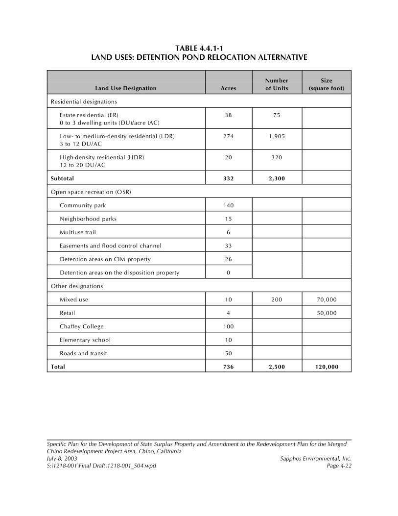
Specific Plan for the Development of State Surplus Property and Amendment to the Redevelopment Plan for the MergedChino Redevelopment Project Area, Chino, CaliforniaJuly 8, 2003 Sapphos Environmental, Inc.S:\1218-001\Final Draft\1218-001_S04.wpd Page 4-22
TABLE 4.4.1-1LAND USES: DETENTION POND RELOCATION ALTERNATIVE
Land Use Designation Acres
Number
of Units
Size
(square foot)
Residential designations
Estate residential (ER)
0 to 3 dwelling units (DU)/acre (AC)
38 75
Low- to medium-density residential (LDR)
3 to 12 DU/AC
274 1,905
High-density residential (HDR)
12 to 20 DU/AC
20 320
Subtotal 332 2,300
Open space recreation (OSR)
Community park 140
Neighborhood parks 15
Multiuse trail 6
Easements and flood control channel 33
Detention areas on CIM property 26
Detention areas on the disposition property 0
Other designations
Mixed use 10 200 70,000
Retail 4 50,000
Chaffey College 100
Elementary school 10
Roads and transit 50
Total 736 2,500 120,000
Specific Plan for the Development of State Surplus Property and Amendment to the Redevelopment Plan for the MergedChino Redevelopment Project Area, Chino, CaliforniaJuly 8, 2003 Sapphos Environmental, Inc.S:\1218-001\Final Draft\1218-001_S04.wpd Page 4-23
4.4.2 Objectives
The Detention Pond Relocation Alternative meets all the objectives of the proposed project andincludes all the elements of the proposed project.
4.4.3 Construction Scenario
The construction scenario for the Detention Pond Relocation Alternative would be the same as thatdescribed for the proposed project.
4.4.4 Comparative Impacts
Aesthetics
The Detention Pond Relocation Alternative includes all the elements of the proposed project; however,it relocates the detention ponds to the north end of the CIM property just south of the dispositionproperty. Therefore, the Detention Pond Relocation Alternative would result in the same design-relatedimpacts to aesthetics as the proposed project, requiring the consideration of the same mitigationmeasures required for the proposed project.
The Detention Pond Relocation Alternative would result in the same potentially significant impacts toaesthetics resulting from increased lighting as the proposed project, requiring the consideration of thesame mitigation measures required for the proposed project.
Agricultural Resources
The Detention Pond Relocation Alternative would result in the same permanent impacts related to theconversion of farmland as the proposed project. It has been determined that there are no feasiblemitigation measures available to partially or wholly mitigate the significant impacts related to theconversion of farmland. By designating the 710 acres of land within the proposed project area assurplus, the farmland would be converted from agricultural production regardless of the specific landuse designation for any portion of the Specific Plan area, constituting a significant impact. In addition,the LESA model, described in Section 3.2, Agriculture Resources, used to quantify impacts to farmland,would not be affected by changes in land use designations within the proposed project area.
Air Quality
The Detention Pond Relocation Alternative includes all the elements of the proposed project; however,it relocates the detention ponds to the north end of the CIM property, just south of the dispositionproperty. Therefore, the Detention Pond Relocation Alternative would result in the same constructionand operational impacts to air quality as the proposed project, requiring the consideration of the samemitigation measures required for the proposed project.
Specific Plan for the Development of State Surplus Property and Amendment to the Redevelopment Plan for the MergedChino Redevelopment Project Area, Chino, CaliforniaJuly 8, 2003 Sapphos Environmental, Inc.S:\1218-001\Final Draft\1218-001_S04.wpd Page 4-24
Biological Resources
The Detention Pond Relocation Alternative includes the same acreage for the relocation ponds andburrowing owl mitigation as the proposed project. Open space areas would be the same as thosewithin the proposed project. Therefore, impacts to biological resources under the Detention PondRelocation Alternative would be the same as those impacts from the proposed project.
Cultural Resources
The Detention Pond Relocation Alternative would result in the same impacts to paleontological,prehistoric, and historic resources potentially located 5 feet below the surface of the project area as theproposed project. Therefore, the Detention Pond Relocation Alternative would potentially result insignificant impacts to cultural resources and would require the consideration of the same mitigationmeasures as for the proposed project for the remaining elements.
Geology and Soils
The Detention Pond Relocation Alternative would result in the same impacts from geology and soilsas the proposed project, requiring the consideration of the same mitigation measures required for theproposed project. The Detention Pond Relocation Alternative would be the same as the proposedproject when considering only potential impacts from geology and soils.
Hazards and Hazardous Materials
The Detention Pond Relocation Alternative would result in the same impacts from hazards andhazardous materials as the proposed project, requiring the consideration of the same mitigationmeasures.
The relocation of the detention ponds does not alter the temporary construction impacts from thepotential release of hazardous materials during an accident or upset when compared to theimplementation of the proposed project. The Detention Pond Relocation Alternative would be thesame as the proposed project when considering only impacts from hazards and hazardous materials.
Hydrology and Water Quality
As with the proposed project, the Detention Pond Relocation Alternative would also result in nosignificant impacts to hydrology and water quality. The relocation of the detention ponds onto thenorthern portion of the CIM property, just south of the disposition property would not effectively alterthe runoff flow rates as provided for the proposed project. The Detention Pond Relocation Alternativewould be the same as the proposed project when considering only potential impacts to hydrology andwater quality.
Noise
The Detention Pond Relocation Alternative includes all the elements of the proposed project; however,it relocates the detention ponds to the north end of the CIM property, just south of the disposition
Specific Plan for the Development of State Surplus Property and Amendment to the Redevelopment Plan for the MergedChino Redevelopment Project Area, Chino, CaliforniaJuly 8, 2003 Sapphos Environmental, Inc.S:\1218-001\Final Draft\1218-001_S04.wpd Page 4-25
property. Therefore, the Detention Pond Relocation Alternative would result in the same constructionand operation impacts from noise as the proposed project, requiring the consideration of the samemitigation measures required for the proposed project.
Population and Housing
The Detention Pond Relocation Alternative includes all the elements of the proposed project; however,it relocates the detention ponds to the north end of the CIM property, just south of the dispositionproperty. Therefore, this alternative would result in the same impacts to population and housing as theproposed project. Section 3.10, Population and Housing, concludes that no significant impacts topopulation and housing would occur from the implementation of the proposed project; therefore, nomitigation measures would be required. Similar to the proposed project, implementation of theDetention Pond Relocation Alternative would not result in impacts to population and housing.
Public Services
The Detention Pond Relocation Alternative would result in the same impacts to public services as theproposed project, requiring the consideration of the same mitigation measures as the proposed project.This alternative would not result in a decrease in the net population increase from the master-plannedcommunity element of the proposed project. The Detention Pond Relocation Alternative would be thesame as the proposed project when considering only impacts to public services.
Recreation
The Detention Pond Relocation Alternative includes all the elements of the proposed project; however,it relocates the detention ponds to the north end of the CIM property, just south of the dispositionproperty. Therefore, the Detention Pond Relocation Alternative would result in the same potentiallysignificant short-term construction-related impacts to recreation resulting from the expansion of theRuben S. Ayala Community Park as the proposed project, requiring the consideration of the samemitigation measures required for the proposed project.
Transportation/Traffic
The Detention Pond Relocation Alternative includes all the elements of the proposed project; howeverit relocates the detention ponds to the north end of the CIM property, just south of the dispositionproperty. This alternative would not result in a decrease in the number of trips generated from themaster-planned community element of the proposed project, requiring the consideration of the samemitigation measures required for the proposed project.
Utilities and Service Systems
The Detention Pond Relocation Alternative would result in the same potentially significant short-termconstruction-related impacts to utilities and service systems as the proposed project resulting from thedevelopment of the master-planned community and Chaffey College elements of the proposed project.Construction and placement of the utility systems, such as a potable water system and sewer system,
Specific Plan for the Development of State Surplus Property and Amendment to the Redevelopment Plan for the MergedChino Redevelopment Project Area, Chino, CaliforniaJuly 8, 2003 Sapphos Environmental, Inc.S:\1218-001\Final Draft\1218-001_S04.wpd Page 4-26
would still be required for the Detention Pond Relocation Alternative, thus requiring the considerationof the same mitigation measures required for the proposed project.
4.5 ALTERNATIVE 5: FLOOD CONTROL CHANNEL CONFIGURATION
4.5.1 Alternative Components
The Flood Control Channel Configuration Alternative as shown in Figure 4.5.1-1, Flood ControlChannel Configuration Alternative, removes the detention ponds included in the proposed project andwidens the Magnolia Channel south of the project boundary to Kimball Avenue. This alternativeassumes that the detention ponds would be removed (and related burrowing owl mitigation associatedwith these ponds would be removed). The mitigation for impacts to the burrowing owls on the Cityproperty was to be satisfied within the area of the detention ponds; therefore, only the mitigation forimpacts to burrowing owls on State property would be satisfied with this alternative. Mitigation for theburrowing owls located on City property that would be impacted from the expansion of Ruben S. AyalaCommunity Park would not be included in this alternative (Table 4.5.1-1, Land Uses: Flood ControlChannel Configuration Alternative).

Specific Plan for the Development of State Surplus Property and Amendment to the Redevelopment Plan for the MergedChino Redevelopment Project Area, Chino, CaliforniaJuly 8, 2003 Sapphos Environmental, Inc.S:\1218-001\Final Draft\1218-001_S04.wpd Page 4-27
TABLE 4.5.1-1LAND USES: FLOOD CONTROL CHANNEL CONFIGURATION ALTERNATIVE
Land Use Designation Acres
Num ber
of Units
Size
(square foot)
Residential designations
Estate residential (ER)
0 to 3 dwelling units (DU)/acre (AC)
38 75
Low- to medium-density residential (L/MDR)
3 to 12 DU/AC
300 1,905
High-density residential (HDR)
12 to 20 DU/AC
20 320
Subtotal 358 2,300
Open space recreation (OSR)
Community park 140
Neighborhood parks 15
Multiuse trail 6
Easements and flood control channel 17
Detention areas 0
Other designations
Mixed use 10 200 70,000
Retail 4 50,000
Chaffey College 100
Elementary school 10
Roads and transit 50
Total 710 2,500 120,000
4.5.2 Objectives
The Flood Control Channel Configuration Alternative meets all the objectives of the proposed project.
4.5.3 Construction Scenario
The construction scenario for the Flood Control Channel Configuration alternative would be almostthe same as that described for the proposed project. The only difference would be that instead of
Specific Plan for the Development of State Surplus Property and Amendment to the Redevelopment Plan for the MergedChino Redevelopment Project Area, Chino, CaliforniaJuly 8, 2003 Sapphos Environmental, Inc.S:\1218-001\Final Draft\1218-001_S04.wpd Page 4-28
constructing the detention ponds, the channel would be widened to accommodate the flood flows.Therefore, all construction related impacts associated with the Flood Control Channel ConfigurationAlternative would be similar to those of the proposed project.
4.5.4 Comparative Impacts
Aesthetics
The Flood Control Channel Configuration Alternative includes all the elements of the proposed project;however, it removes the detention ponds and instead widens the Magnolia Channel through the CIMproperty. Therefore, the Flood Control Channel Configuration Alternative would result in the samedesign-related impacts to aesthetics as the proposed project, requiring the consideration of the samemitigation measures required for the proposed project.
The Flood Control Channel Configuration Alternative would result in the same potentially significantimpacts to aesthetics resulting from increased lighting as the proposed project, requiring theconsideration of the same mitigation measures required for the proposed project.
Agricultural Resources
The Flood Control Channel Configuration Alternative would result in the same permanent impactsrelated to the conversion of farmland as the proposed project. It has been determined that there areno feasible mitigation measures available to partially or wholly mitigate the significant impacts relatedto the conversion of farmland. By designating the 710 acres of land within the proposed project areaas surplus, the farmland would be converted from agricultural production regardless of the specificland use designation for any portion of the Specific Plan area, constituting a significant impact. Inaddition, the LESA model, described in Section 3.2, Agriculture Resources, used to quantify impactsto farmland, would not be affected by changes in land use designations within the proposed projectarea.
Air Quality
The Flood Control Channel Configuration Alternative includes all the elements of the proposed project;however, it removes the detention ponds and instead widens the Magnolia Channel through CIMproperty. Therefore, the Flood Control Channel Configuration Alternative would result in the sameconstruction and operational impacts to air quality as the proposed project, requiring the considerationof the same mitigation measures required for the proposed project
Biological Resources
The Flood Control Channel Configuration Alternative removes burrowing owl mitigation for those owlspotentially impacted on the Ruben S. Ayala Park expansion property by the proposed project. Onlyburrowing owls located on the Chaffey College and master-planned community property would havemitigation areas. The proposed project would be preferable to the Flood Control ChannelConfiguration Alternative when considering only potential impacts to biological resources.
Specific Plan for the Development of State Surplus Property and Amendment to the Redevelopment Plan for the MergedChino Redevelopment Project Area, Chino, CaliforniaJuly 8, 2003 Sapphos Environmental, Inc.S:\1218-001\Final Draft\1218-001_S04.wpd Page 4-29
Cultural Resources
The Flood Control Channel Configuration Alternative would result in the same impacts topaleontological, prehistoric, and historic resources potentially located 5 feet below the surface of theproject area as the proposed project. Therefore, the Flood Control Channel Configuration Alternativewould potentially result in significant impacts to cultural resources and would require the considerationof the same mitigation measures as for the proposed project for the remaining elements.
Geology and Soils
The Flood Control Channel Configuration Alternative would result in the same impacts from geologyand soils as the proposed project, requiring the consideration of the same mitigation measures as theproposed project. The Flood Control Channel Configuration Alternative would be the same as theproposed project when considering only potential impacts from geology and soils.
Hazards and Hazardous Materials
The Flood Control Channel Configuration Alternative would result in the same impacts from hazardsand hazardous materials as the proposed project, requiring consideration of the same mitigationmeasures as the proposed project.
Because this alternative implements a widening of the existing flood control channel instead ofconstruction of the detention ponds, there would be a different construction scenario. However, thelikelihood of impacts due to an accident or upset during the construction activities related to thereconfiguration of the existing flood control channel would not be substantially different from that ofthe proposed project. The Flood Control Channel Configuration Alternative would be the same as theproposed project when considering only impacts from hazards and hazardous materials.
Hydrology and Water Quality
As with the proposed project, the Flood Control Channel Configuration Alternative would result in nosignificant impacts to hydrology and water quality. This Alternative, which results in changes todrainage relative to the proposed project, has been analyzed for conformity with the significancethresholds pertaining to drainage in Appendix G of the State CEQA Guidelines in the EngineeringReport. The Flood Control Channel Configuration Alternative would be the same as the proposedproject when considering only potential impacts to hydrology and water quality.
Noise
The Flood Control Channel Configuration Alternative includes all the elements of the proposed project;however, it removes the detention ponds and instead widens the Magnolia Channel through CIMproperty. Therefore, the Flood Control Channel Configuration Alternative would result in the sameconstruction and operation impacts to noise as the proposed project, requiring the consideration of thesame mitigation measures required for the proposed project.
Specific Plan for the Development of State Surplus Property and Amendment to the Redevelopment Plan for the MergedChino Redevelopment Project Area, Chino, CaliforniaJuly 8, 2003 Sapphos Environmental, Inc.S:\1218-001\Final Draft\1218-001_S04.wpd Page 4-30
Population and Housing
The Flood Control Channel Configuration Alternative includes all the elements of the proposed project;however, it removes the detention ponds and instead widens the Magnolia Channel through CIMproperty. Therefore, this alternative would result in the same impacts to population and housing as theproposed project. Section 3.10, Population and Housing, concludes that no significant impacts topopulation and housing would occur from the implementation of the proposed project; therefore, nomitigation measures would be required. Similar to the proposed project, the implementation of theFlood Control Channel Configuration Alternative would not result in impacts to population andhousing.
Public Services
The Flood Control Channel Configuration Alternative would result in the same impacts to publicservices as the proposed project, requiring the consideration of the same mitigation measures. Thisalternative would not result in a decrease in the net population increase from the Master-PlannedCommunity element of the proposed project. The Flood Control Channel Configuration Alternativewould be the same as the proposed project when considering only impacts to public services.
Recreation
The Flood Control Channel Configuration Alternative includes all the elements of the proposed project;however, it removes the detention ponds and instead widens the Magnolia Channel through CIMproperty. Therefore, the Flood Control Channel Configuration Alternative would result in the samepotentially significant short-term construction-related impacts to recreation resulting from the expansionof the Ruben S. Ayala Community Park as the proposed project, requiring the consideration of thesame mitigation measures required for the proposed project.
Transportation/Traffic
The Flood Control Channel Configuration Alternative includes all the elements of the proposed project;however, it removes the detention ponds and instead widens the Magnolia Channel through CIMproperty. This alternative would not result in a decrease in the number of trips generated from theMaster-Planned Community element of the proposed project, requiring the consideration of the samemitigation measures required for the proposed project.
Utilities and Service Systems
The Flood Control Channel Configuration Alternative would result in the same potentially significantshort-term construction-related impacts to utilities and service systems resulting from the developmentof the master-planned community and the Chaffey College elements of the proposed project.Construction and placement of the utility systems, such as a potable water system and sewer system,would still be required for the Flood Control Channel Configuration Alternative, thus requiring theconsideration of the same mitigation measures required for the proposed project.
Specific Plan for the Development of State Surplus Property and Amendment to the Redevelopment Plan for the MergedChino Redevelopment Project Area, Chino, CaliforniaJuly 8, 2003 Sapphos Environmental, Inc.S:\1218-001\Final Draft\1218-001_S04.wpd Page 4-31
4.6 ENVIRONMENTALLY SUPERIOR PROJECT
4.6.1 No Project
The range of alternatives to the proposed project includes those alternatives that could feasiblyaccomplish most of the basic objectives of the proposed project and could avoid or substantially lessenone or more of the significant effects. While the No Project Alternative does not accomplish most ofthe basic objectives of the proposed project, it would avoid significant impacts related to aesthetics,agricultural resources, air quality, biological resources, cultural resources, geology and soils, hazardsand hazardous materials, hydrology and water quality, noise, population and housing, public services,recreation, transportation and circulation, and utilities and service systems resulting from the proposedproject. Although not capable of meeting most of the basic objectives of the proposed project, the NoProject Alternative would be identified as the Environmentally Superior Alternative due to its abilityto avoid significant impacts associated with the proposed project.
4.6.2 Compact Project/Increased Open Space Alternative
In the event that the No Project Alternative is identified as the Environmentally Superior Alternative,CEQA stipulates that the EIR must also identify an Environmentally Superior Alterative among theaction alternatives that are capable of meeting most of the basic objectives of the proposed project.The Compact Project/Increased Open Space Alternative has been identified as the EnvironmentallySuperior Alternative that is capable of meeting most of the basic objectives of the proposed project.
The No College/Increased Open Space Alternative would accomplish most of the basic objectives ofthe project. However, it would not implement the Chaffey College element of the proposed project,therefore reducing impacts associated with the development of the college. These include thereduction in aesthetics, air quality, biological resources, cultural resources, geology and soils, hazardsand hazardous materials, noise, public services, transportation and traffic, and utilities and servicesystems. However, this alternative would not meet the objectives of the Chaffey College.
Specific Plan for the Development of State Surplus Property and Amendment to the Redevelopment Plan for the MergedChino Redevelopment Project Area, Chino, CaliforniaJuly 8, 2003 Sapphos Environmental, Inc.S:\1218-001\Final Draft\1218-001_S05.wpd Page 5-1
SECTION 5.0SIGNIFICANT ENVIRONMENTAL EFFECTS THAT
CANNOT BE AVOIDED IF THE PROPOSED PROJECT IS IMPLEMENTED
The potential for the implementation of the Specific Plan for the Development of State Surplus Propertyand Amendment to the Redevelopment Plan for the Merged Chino Redevelopment Project Area,Chino, California (proposed project) to result in environmental effects has been analyzed in light of theanticipated direct, indirect, and cumulative impacts of the proposed project. The analysis of direct,indirect, and cumulative impacts resulting from the proposed project is presented in Section 3 of thisEnvironmental Impact Report (EIR). A list of closely related past, present, or reasonably foreseeable,probable future projects was compiled to include those anticipated by the County of San Bernardinoand the City of Chino (Section 2.7, Related Projects).
Aesthetics
The proposed project would not be expected to result in significant environmental effects related toaesthetics that cannot be avoided. Impacts related to the disruption of scenic vistas, visual characterof the proposed project site, and increase in light and glare would be mitigated to below the level ofsignificance.
Agricultural Resources
The proposed project would be expected to result in significant environmental effects related toagricultural resources that cannot be avoided, requiring an overriding consideration from the LeadAgency. The conversion of Farmland to non-agricultural uses is considered a significant impact underthe California Environmental Quality Act (CEQA). There are no feasible mitigation measures availableto partially or wholly mitigate the significant impacts related to the conversion of Farmland. Therefore,impacts to agriculture resources related to the conversion of Farmland would remain significant.
Air Quality
The proposed project would be expected to result in significant impacts to air quality, requiring anoverriding consideration from the Lead Agency. Construction activities of the project would result inshort-term air quality violations of nitrogen oxides (NOx) and particulate matter greater than or equalto 10 microns in diameter (PM10). Operational impacts would result in long-term air quality violationsof reactive organic carbon (ROC), NOx, and PM10 on a regional scale. There are no feasible mitigationmeasures available to wholly mitigate the significant impacts related to air quality. Therefore, impactsto air quality would remain significant.
Although the project in both 2012 and at build-out in 2025 would contribute large amounts of traffic,the increase in traffic over conditions without the project would not be sufficient to cause the eight-hour CO standard to be exceeded. After the required traffic mitigation (see Transportation/Trafficsection below), the project would not have an adverse impact on air quality and there would be nolocal CO hot spots.
Specific Plan for the Development of State Surplus Property and Amendment to the Redevelopment Plan for the MergedChino Redevelopment Project Area, Chino, CaliforniaJuly 8, 2003 Sapphos Environmental, Inc.S:\1218-001\Final Draft\1218-001_S05.wpd Page 5-2
Biological Resources
The proposed project would be expected to result in significant effects related to biological resources.There are no feasible mitigation measures available to mitigate the impacts to loss of foraging habitatfor native wildlife species due to loss of open space. Therefore, impacts would remain significant.
Cultural Resources
After implementation of proposed mitigation measures, impacts with regard to cultural resources wouldbe reduced to less than significant levels.
A testing program is required to evaluate cultural resources sites in the proposed project area; the levelof significance of impacts cannot be evaluated without these data. Avoidance of direct and indirectimpacts through project redesign would reduce the level of significance of impacts to prehistoric andhistoric archaeological sites within these areas. If avoidance is not possible, preservation in place ordata recovery would reduce significant impacts to a less than significant level.
Geology and Soils
The proposed project would not be expected to result in significant environmental effects related togeology and soils that cannot be avoided. The proposed project would conform to all building codesand design standards to avoid significant impacts to geology and soils. Any potential impacts relatedto seismic ground shaking, soil erosion, or unstable soils are expected to be mitigated to below thelevel of significance.
Hazards and Hazardous Materials
The proposed project would not be expected to result in significant environmental effects related tohazards and hazardous materials that cannot be avoided. The proposed project would conform to allstandards and regulations to avoid significant impacts related to hazards and hazardous materials.Incorporation of mitigation measures would reduce impacts related to the release of petroleumhydrocarbons during the operation of the proposed soil vapor extraction (SVE) system, grading in thetractor barn area, and the subsequent off-site disposal of contaminated soil. Impacts related to theroutine use, transport, or disposal of hazardous materials in the above-ground storage tanks (AST) atthe water treatment plant and on the Chaffey Community College campus would also be mitigated tobelow the level of significance.
Hydrology and Water Quality
The proposed project would not be expected to result in significant environmental effects related tohydrology and water quality that cannot be avoided. The proposed project would conform to allstandards and regulations to avoid significant impacts to water quality. As discussed in Section 3.8,strict compliance with all standard National Pollutant Discharge Elimination System (NPDES) permitrequirements would reduce impacts to surface water quality to below the level of significance.Furthermore, the proposed project requires no alteration of existing wetlands or other waters of theUnited States.
Specific Plan for the Development of State Surplus Property and Amendment to the Redevelopment Plan for the MergedChino Redevelopment Project Area, Chino, CaliforniaJuly 8, 2003 Sapphos Environmental, Inc.S:\1218-001\Final Draft\1218-001_S05.wpd Page 5-3
Noise
The proposed project would not be expected to result in significant environmental effects related tonoise that cannot be avoided. Short-term noise levels from construction activities may be audible andannoying in some areas. However, with the recommended mitigation measures, construction noisewould be less than significant.
Projected noise levels from the proposed soccer field, skate park, and tot lots are inaudible at two ofthe three residential receptors and are well below ambient levels at the closest sensitive receptor.Therefore, noise levels are considered to be an insignificant impact.
Population and Housing
The proposed project would not be expected to result in significant environmental effects related topopulation and housing that cannot be avoided. The growth induced by the proposed project iscompatible with local and regional growth forecasts and policies for population, housing, andemployment.
Public Services
After implementation of the proposed mitigation measures, impacts to public services related to fireprotection, police protection, schools, and libraries would be reduced to less than significant levels.
To reduce potential environmental impacts from the construction and operation of one or more newfire protection facilities required to maintain service objectives to the proposed project at all phases,including build-out, the Chino Valley Independent Fire District (CVIFD), and/or the Lead Agency forthe implementation of the CVIFD Master Plan as determined pursuant to State CEQA Guidelines,Article 4 (§15050!15053), “Lead Agency,” shall comply with the requirements of CEQA, as applicable.If significant environmental impacts are identified, the Lead Agency must implement mitigationmeasures that reduce the impact to below the level of significance or adopt overriding considerationspursuant to §15093 of the State CEQA Guidelines.
To reduce impacts to police protection services, the applicant for each of the three elements of theproposed project, City of Chino, Chaffey Community College, and the Developer, shall payDevelopment Impact Fees (DIFs) in accordance with the City of Chino Municipal Code, wherenecessary to maintain service objectives to each proposed project element. Chapter 3.4.0 of the Cityof Chino Municipal Code establishes appropriate DIFs to ensure the necessary funding for theconstruction of the public improvement needs resulting form the implementation of the proposedproject.
To reduce impacts to schools, the Developer shall pay statutory developer fees and/or provide landto the Chino Valley Unified School District (CVUSD) in accordance with SB50 and any other state orlocal regulations that meet the standard or equivalent. The specific form of mitigation and amount offees, if any, shall be determined through cooperation between the Developer, the City, and the CVUSDprior to the issuance of a building permit.
Specific Plan for the Development of State Surplus Property and Amendment to the Redevelopment Plan for the MergedChino Redevelopment Project Area, Chino, CaliforniaJuly 8, 2003 Sapphos Environmental, Inc.S:\1218-001\Final Draft\1218-001_S05.wpd Page 5-4
To reduce direct impacts to libraries, the Developer shall provide a form of financing for the SanBernardino County Library that meets the standard or equivalent to construct or expand library facilitiesin the City of Chino such that the San Bernardino County Library would meet the Division of LibraryDevelopment Services of the State of California standards for the increase in population associated withthe proposed project only. The specific form of mitigation shall be determined through cooperationbetween the Developer, the City, and the San Bernardino County Library prior to the issuance of abuilding permit. Therefore, with implementation of mitigation measures, significant impacts to policeprotection, schools, and libraries would be reduced to less than significant levels.
Recreation
The proposed project would not be expected to result in significant environmental effects related torecreation that cannot be avoided. The proposed project would only result in short-term impactsrelated to the temporary closure of recreation facilities during construction. Implementation ofmitigation measures would reduce impacts to below the level of significance.
Transportation/Traffic
The proposed project would not be expected to result in significant environmental effects related totransportation/traffic that cannot be avoided. Implementation of mitigation measures would reducesignificant impacts related to transportation/traffic to below the level of significance. The study areaintersections are projected to operate at level of service (LOS) D or better at full build-out during peakhours if all of the recommended off-site improvements for the interim year 2012 and year2025 areaccomplished.
Utilities and Service Systems
The proposed project would not be expected to result in significant environmental effects related toutilities and service systems that cannot be avoided. The City is responsible for ensuring that thecontractor complies with Best Management Practices (BMPs) when all utilities are installed orconstructed. Implementation of BMPs would reduce impacts to below the level of significance.

Specific Plan for the Development of State Surplus Property and Amendment to the Redevelopment Plan for the MergedChino Redevelopment Project Area, Chino, CaliforniaJuly 8, 2003 Sapphos Environmental, Inc.S:\1218-001\Final Draft\1218-001_S06.wpd Page 6-1
SECTION 6.0SIGNIFICANT IRREVERSIBLE ENVIRONMENTAL CHANGES
RELATED TO IMPLEMENTATION OF THE PROPOSED PROJECT
This section of the Environmental Impact Report (EIR) summarizes the potential for the Specific Planfor the Development of State Surplus Property and Amendment to the Redevelopment Plan for theMerged Chino Redevelopment Project Area, Chino, California (proposed project) to result in asignificant irreversible environmental change. Such a change considers the current or futureconsumption of nonrenewable resources, as well as secondary or growth-inducing impacts that commitfuture generations to similar uses. It also considers the potential for accidents associated with theimplementation of the proposed project to occur.
The grading and cut-and-fill activities required for implementation of the proposed project wouldconstitute a significant irreversible change to the topography of the existing proposed project site. Theenvironmental effects of the proposed project have been analyzed in Section 3, Regulatory Framework,Existing Conditions, Impacts, Mitigation, and Level of Significance after Mitigation. As indicated inSection 3, short-term construction-related impacts to aesthetics, air quality, biological resources,cultural resources, hazards and hazardous materials, hydrology and water quality, noise, publicservices, recreation, transportation/traffic, and utilities and service systems would cease with thecompletion of construction. Potential long-term impacts related to the aesthetics, agricultural resources,cultural resources, geology and soils, hazards and hazardous materials, hydrology and water quality,noise, public services, recreation, transportation/traffic, and utilities and service systems would bereduced through the implementation of mitigation measures and compliance with the applicablefederal, state, and local requirements for conformance with the Uniform Building Code, CountyBuilding Code, National Pollutant Discharge Elimination System, and the Standard Urban Storm WaterMitigation Plan.
1 California Department of General Services, August 2000b. Strategic Master Land Use Plan and ImplementationApproach, CIM Chino: Volume II. Contact: 707 Third Street, Suite 6-130, West Sacramento, CA 95605. Prepared by:EDAW, Inc. et al., 150 Chestnut Street, San Francisco, CA 94111.
2 City of Chino, 6 October 1981. General Plan: Land Use Element. Contact: Community Development Department, 13220Central Avenue, Chino, CA 91710.
3 Ibid.
Specific Plan for the Development of State Surplus Property and Amendment to the Redevelopment Plan for the MergedChino Redevelopment Project Area, Chino, CaliforniaJuly 8, 2003 Sapphos Environmental, Inc.S:\1218-001\Final Draft\1218-001_S07.wpd Page 7-1
SECTION 7.0GROWTH-INDUCING IMPACTS
This section of the Environmental Impact Report (EIR) analyzes the potential for the Specific Plan forthe Development of State Surplus Property and Amendment to the Redevelopment Plan for the MergedChino Redevelopment Project Area, Chino, California (proposed project) to result in growth-inducingimpacts. Such impacts normally occur when the proposed project fosters economic or populationgrowth, or the construction of additional housing, either directly or indirectly, in the surroundingenvironment. The type of projects that are normally considered to result in growth-inducing impactsare those that provide infrastructure that would support additional growth or remove an existing barrierto growth.
The primary growth-inducing element of the proposed project would be the increase in housing. Theresidential element of the proposed project includes a master-planned residential community ofapproximately 2,200–2,500 dwelling units of various sizes to be developed on approximately 470gross (320 net) residential acres. The proposed project would accommodate population growthconsistent with regional and local demand forecasts for population growth and housing, thus resultingin direct and indirect impacts on growth. The demand for housing in the Riverside-San BernardinoMetropolitan Statistical Area is projected at 564,860 dwelling units between years 1996 and 2010.1
The proposed project would be capable of addressing 3.2 to 4.8 percent of the subregion demand. Theproposed project would result in development of recreational, educational, and residential land useconsistent with the adopted Redevelopment Plan and the land use designations specified in the Cityof Chino General Plan2 for the proposed project area. The City of Chino General Plan3 states that thegeneral policy for growth and identity is that the City of Chino (City) has no set maximum populationlimits.
In addition, the State of California would transfer approximately 100 acres to Chaffey College todevelop a community college campus and related facilities that would ultimately serve 15,000students. Chaffey Community College District would be adjacent to the proposed residentialdevelopment. The development of the college campus would be phased and designed in accordancewith the development of the state surplus property land and the City’s regional expanded recreationalfacilities. Public and private improvements would include athletic, library, meeting, and banquetfacilities.
4 Mike Johnson, Personal Communication, 1 November 2002. Patrol Bureau Commander, City of Chino PoliceDepartment, 13250 Central Avenue, Chino, CA 91710.
5 Ibid.
Specific Plan for the Development of State Surplus Property and Amendment to the Redevelopment Plan for the MergedChino Redevelopment Project Area, Chino, CaliforniaJuly 8, 2003 Sapphos Environmental, Inc.S:\1218-001\Final Draft\1218-001_S07.wpd Page 7-2
Infrastructure and Utilities
Elements of the proposed project would require various infrastructure and improvement policies toimplement the proposed project, including roadways, storm drains, water, solid waste, dry utilities, andsanitary sewer systems. These improvements would be completed incrementally, phased with planneddevelopment, and sized to serve the planned development.
Public Services
A variety of public services exist within the region due to the proximity of surrounding cities orproposed urban development. Development of the proposed project would require the extension ofservices and facilities to provide for new area residents and businesses. The impact on fire protection,schools, parks, and other public services is expected to be insignificant, or otherwise mitigated byelements of the proposed project to maintain current service ratios. However, implementation of theproposed project would be expected to have a significant direct impact on public services related topolice protection. An increase in population would dilute the current service ratio of 1.32 swornofficers for every 1,000 residents, which would correlate to a longer response time.4 The Chino PoliceDepartment would consider any reduction in the service ratio a significant impact requiring the hiringof personnel to maintain service objectives. Because the primary facility of the Chino PoliceDepartment is currently maximized, the addition of personnel would require the expansion orconstruction of new facilities, constituting a significant direct impact.5 It would be considered a directimpact because the need for new facilities to be constructed with the potential to cause significantenvironmental impacts would be a result of implementation of the proposed project; it would also bean indirect impact because the potential environmental impacts from the new facilities would occurat a distance away from the proposed project site.
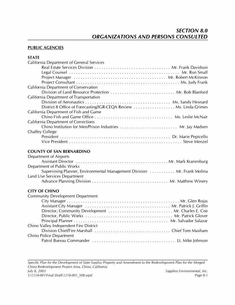
Specific Plan for the Development of State Surplus Property and Amendment to the Redevelopment Plan for the MergedChino Redevelopment Project Area, Chino, CaliforniaJuly 8, 2003 Sapphos Environmental, Inc.S:\1218-001\Final Draft\1218-001_S08.wpd Page 8-1
SECTION 8.0ORGANIZATIONS AND PERSONS CONSULTED
PUBLIC AGENCIES
STATECalifornia Department of General Services
Real Estate Services Division . . . . . . . . . . . . . . . . . . . . . . . . . . . . . . . . . Mr. Frank DavidsonLegal Counsel . . . . . . . . . . . . . . . . . . . . . . . . . . . . . . . . . . . . . . . . . . . . . . . . Mr. Ron SmallProject Manager . . . . . . . . . . . . . . . . . . . . . . . . . . . . . . . . . . . . . . . . Mr. Robert McKinnonProject Consultant . . . . . . . . . . . . . . . . . . . . . . . . . . . . . . . . . . . . . . . . . . . . . Ms. Judy Frank
California Department of ConservationDivision of Land Resource Protection . . . . . . . . . . . . . . . . . . . . . . . . . . . . Mr. Bob Blanford
California Department of TransportationDivision of Aeronautics . . . . . . . . . . . . . . . . . . . . . . . . . . . . . . . . . . . . . Ms. Sandy HesnardDistrict 8 Office of Forecasting/IGR-CEQA Review . . . . . . . . . . . . . . . . . . Ms. Linda Grimes
California Department of Fish and GameChino Fish and Game Office . . . . . . . . . . . . . . . . . . . . . . . . . . . . . . . . . . Ms. Leslie McNair
California Department of CorrectionsChino Institution for Men/Prison Industries . . . . . . . . . . . . . . . . . . . . . . . . . Mr. Jay Madsen
Chaffey CollegePresident . . . . . . . . . . . . . . . . . . . . . . . . . . . . . . . . . . . . . . . . . . . . . . . . Dr. Marie PepicelloVice President . . . . . . . . . . . . . . . . . . . . . . . . . . . . . . . . . . . . . . . . . . . . . . . . . Steve Menzel
COUNTY OF SAN BERNARDINODepartment of Airports
Assistant Director . . . . . . . . . . . . . . . . . . . . . . . . . . . . . . . . . . . . . . . . Mr. Mark KranenburgDepartment of Public Works
Supervising Planner, Environmental Management Division . . . . . . . . . . . Mr. Frank MolinaLand Use Services Department
Advance Planning Division . . . . . . . . . . . . . . . . . . . . . . . . . . . . . . . . . Mr. Matthew Winery
CITY OF CHINOCommunity Development Department
City Manager . . . . . . . . . . . . . . . . . . . . . . . . . . . . . . . . . . . . . . . . . . . . . . . . . Mr. Glen RojasAssistant City Manager . . . . . . . . . . . . . . . . . . . . . . . . . . . . . . . . . . . . . Mr. Patrick J. GriffinDirector, Community Development . . . . . . . . . . . . . . . . . . . . . . . . . . . . Mr. Charles E. CoeDirector, Public Works . . . . . . . . . . . . . . . . . . . . . . . . . . . . . . . . . . . . . . Mr. Patrick GloverPrincipal Planner . . . . . . . . . . . . . . . . . . . . . . . . . . . . . . . . . . . . . . . . . Mr. Salvador Salazar
Chino Valley Independent Fire DistrictDivision Chief/Fire Marshall . . . . . . . . . . . . . . . . . . . . . . . . . . . . . . . . . Chief Tom Maxham
Chino Police DepartmentPatrol Bureau Commander . . . . . . . . . . . . . . . . . . . . . . . . . . . . . . . . . . . . Lt. Mike Johnson
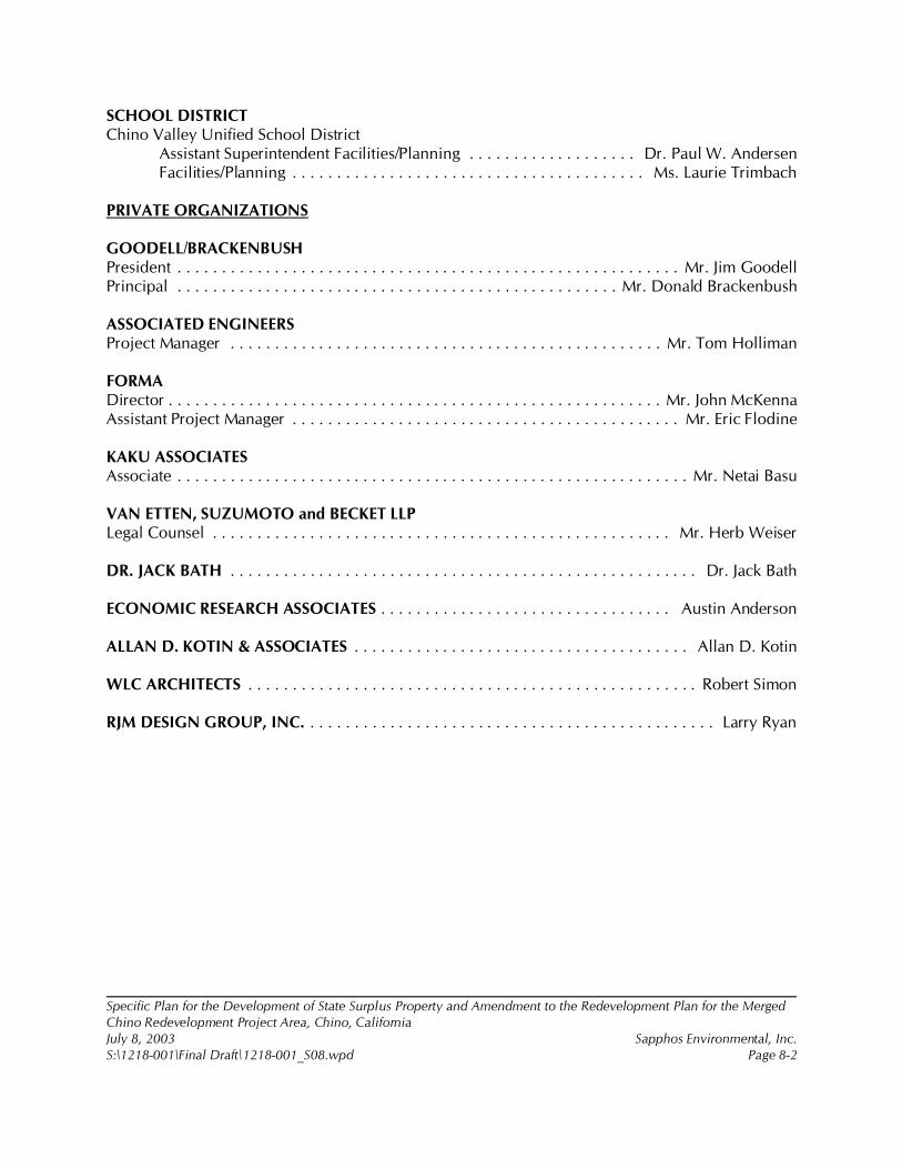
Specific Plan for the Development of State Surplus Property and Amendment to the Redevelopment Plan for the MergedChino Redevelopment Project Area, Chino, CaliforniaJuly 8, 2003 Sapphos Environmental, Inc.S:\1218-001\Final Draft\1218-001_S08.wpd Page 8-2
SCHOOL DISTRICTChino Valley Unified School District
Assistant Superintendent Facilities/Planning . . . . . . . . . . . . . . . . . . . Dr. Paul W. AndersenFacilities/Planning . . . . . . . . . . . . . . . . . . . . . . . . . . . . . . . . . . . . . . . . Ms. Laurie Trimbach
PRIVATE ORGANIZATIONS
GOODELL/BRACKENBUSHPresident . . . . . . . . . . . . . . . . . . . . . . . . . . . . . . . . . . . . . . . . . . . . . . . . . . . . . . . . . Mr. Jim GoodellPrincipal . . . . . . . . . . . . . . . . . . . . . . . . . . . . . . . . . . . . . . . . . . . . . . . . . . Mr. Donald Brackenbush
ASSOCIATED ENGINEERSProject Manager . . . . . . . . . . . . . . . . . . . . . . . . . . . . . . . . . . . . . . . . . . . . . . . . . Mr. Tom Holliman
FORMADirector . . . . . . . . . . . . . . . . . . . . . . . . . . . . . . . . . . . . . . . . . . . . . . . . . . . . . . . . Mr. John McKennaAssistant Project Manager . . . . . . . . . . . . . . . . . . . . . . . . . . . . . . . . . . . . . . . . . . . . Mr. Eric Flodine
KAKU ASSOCIATESAssociate . . . . . . . . . . . . . . . . . . . . . . . . . . . . . . . . . . . . . . . . . . . . . . . . . . . . . . . . . . Mr. Netai Basu
VAN ETTEN, SUZUMOTO and BECKET LLPLegal Counsel . . . . . . . . . . . . . . . . . . . . . . . . . . . . . . . . . . . . . . . . . . . . . . . . . . . . Mr. Herb Weiser
DR. JACK BATH . . . . . . . . . . . . . . . . . . . . . . . . . . . . . . . . . . . . . . . . . . . . . . . . . . . . . Dr. Jack Bath
ECONOMIC RESEARCH ASSOCIATES . . . . . . . . . . . . . . . . . . . . . . . . . . . . . . . . . Austin Anderson
ALLAN D. KOTIN & ASSOCIATES . . . . . . . . . . . . . . . . . . . . . . . . . . . . . . . . . . . . . . Allan D. Kotin
WLC ARCHITECTS . . . . . . . . . . . . . . . . . . . . . . . . . . . . . . . . . . . . . . . . . . . . . . . . . . . Robert Simon
RJM DESIGN GROUP, INC. . . . . . . . . . . . . . . . . . . . . . . . . . . . . . . . . . . . . . . . . . . . . . . Larry Ryan
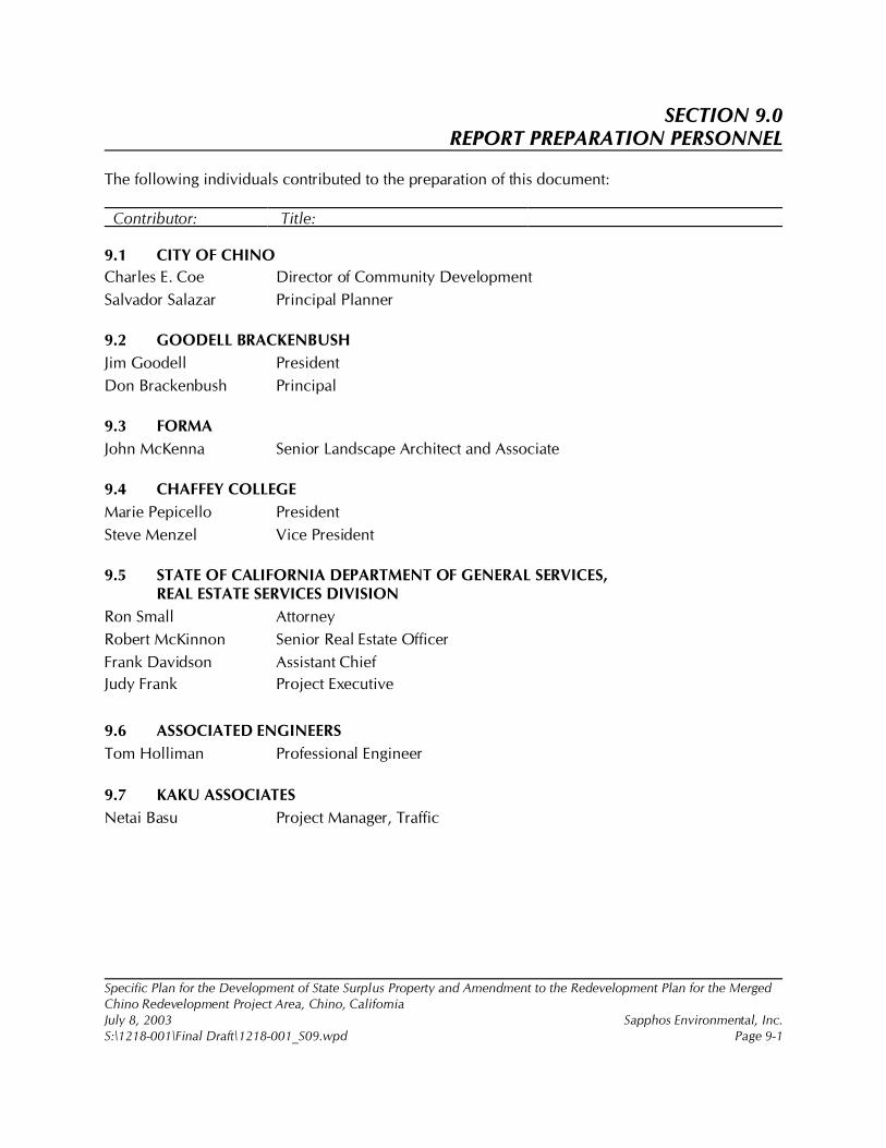
Specific Plan for the Development of State Surplus Property and Amendment to the Redevelopment Plan for the MergedChino Redevelopment Project Area, Chino, CaliforniaJuly 8, 2003 Sapphos Environmental, Inc.S:\1218-001\Final Draft\1218-001_S09.wpd Page 9-1
SECTION 9.0REPORT PREPARATION PERSONNEL
The following individuals contributed to the preparation of this document:
Contributor: Title:
9.1 CITY OF CHINO
Charles E. Coe Director of Community Development
Salvador Salazar Principal Planner
9.2 GOODELL BRACKENBUSH
Jim Goodell President
Don Brackenbush Principal
9.3 FORMA
John McKenna Senior Landscape Architect and Associate
9.4 CHAFFEY COLLEGE
Marie Pepicello President
Steve Menzel Vice President
9.5 STATE OF CALIFORNIA DEPARTMENT OF GENERAL SERVICES,REAL ESTATE SERVICES DIVISION
Ron Small Attorney
Robert McKinnon Senior Real Estate Officer
Frank Davidson Assistant Chief
Judy Frank Project Executive
9.6 ASSOCIATED ENGINEERS
Tom Holliman Professional Engineer
9.7 KAKU ASSOCIATES
Netai Basu Project Manager, Traffic
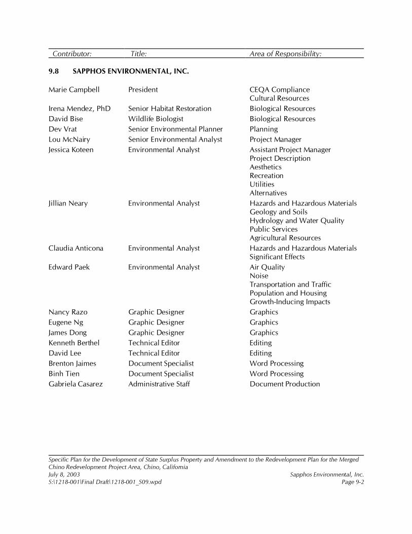
Specific Plan for the Development of State Surplus Property and Amendment to the Redevelopment Plan for the MergedChino Redevelopment Project Area, Chino, CaliforniaJuly 8, 2003 Sapphos Environmental, Inc.S:\1218-001\Final Draft\1218-001_S09.wpd Page 9-2
Contributor: Title: Area of Responsibility:
9.8 SAPPHOS ENVIRONMENTAL, INC.
Marie Campbell President CEQA ComplianceCultural Resources
Irena Mendez, PhD Senior Habitat Restoration Biological Resources
David Bise Wildlife Biologist Biological Resources
Dev Vrat Senior Environmental Planner Planning
Lou McNairy Senior Environmental Analyst Project Manager
Jessica Koteen Environmental Analyst Assistant Project ManagerProject DescriptionAestheticsRecreationUtilitiesAlternatives
Jillian Neary Environmental Analyst Hazards and Hazardous MaterialsGeology and SoilsHydrology and Water QualityPublic ServicesAgricultural Resources
Claudia Anticona Environmental Analyst Hazards and Hazardous MaterialsSignificant Effects
Edward Paek Environmental Analyst Air QualityNoiseTransportation and TrafficPopulation and HousingGrowth-Inducing Impacts
Nancy Razo Graphic Designer Graphics
Eugene Ng Graphic Designer Graphics
James Dong Graphic Designer Graphics
Kenneth Berthel Technical Editor Editing
David Lee Technical Editor Editing
Brenton Jaimes Document Specialist Word Processing
Binh Tien Document Specialist Word Processing
Gabriela Casarez Administrative Staff Document Production
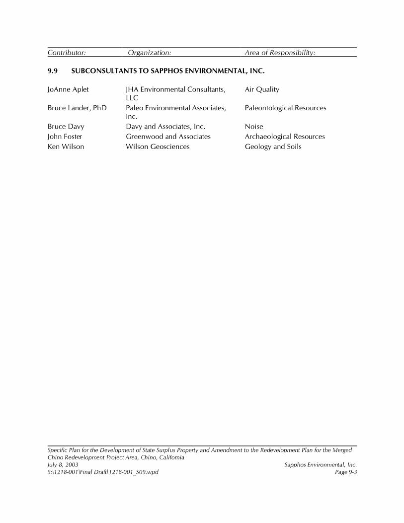
Specific Plan for the Development of State Surplus Property and Amendment to the Redevelopment Plan for the MergedChino Redevelopment Project Area, Chino, CaliforniaJuly 8, 2003 Sapphos Environmental, Inc.S:\1218-001\Final Draft\1218-001_S09.wpd Page 9-3
Contributor: Organization: Area of Responsibility:
9.9 SUBCONSULTANTS TO SAPPHOS ENVIRONMENTAL, INC.
JoAnne Aplet JHA Environmental Consultants,LLC
Air Quality
Bruce Lander, PhD Paleo Environmental Associates,Inc.
Paleontological Resources
Bruce Davy Davy and Associates, Inc. Noise
John Foster Greenwood and Associates Archaeological Resources
Ken Wilson Wilson Geosciences Geology and Soils
Specific Plan for the Development of State Surplus Property and Amendment to the Redevelopment Plan for the Merged ChinoRedevelopment Project Area, Chino, CaliforniaJuly 8, 2003 Sapphos Environmental, Inc.S:\1218-001\Final Draft\1218-001_S10.wpd Page 10-1
SECTION 10.0REFERENCES
Alden, P., Fred Heath, Amy Leventer, Richard Keen, and Wendy Zomlefer. 1998. National AudubonSociety Field Guide to California. New York, NY: Alfred A. Knopf, Inc.
Andersen, Paul, Personal Communication, 21 April 2003. Assistant Superintendent of Facilities andPlanning, Chino Valley Unified School District, 5130 Riverside Drive, Chino, CA 91710.
Associated Engineers, Inc. 2002. Specific Plans State Disposition Property-Chino. Contact: CaliforniaDepartment of General Services, Real Estate Services Division, Asset Planning andManagement Branch, 707 3rd Street, 6th Floor, West Sacramento, CA 95605.
Automobile Club of Southern California. 1998. San Bernardino County Map. Contact: TravelPublications Department, 2601 South Figueroa Street, Los Angeles, CA 90007.
Bass, Ronald E., et al. 2002. CEQA Deskbook, A Step-by-Step Guide on How to Comply with theCalifornia Environmental Quality Act. Point Arena, CA: Solano Press Books.
Bath, Jack, Personal Communication, 8 November 2002. California State Polytechnic UniversityPomona, 3801 West Temple Avenue, Pomona, CA 91768.
Bell et al. August 2002. “Land Subsidence in Las Vegas, Nevada, 1995--2000: New Geodetic DataShow Evolution, Revised Spatial Patterns, and Reduced Rates,” Environmental and EngineeringGeoscience, 8(3): 155!174.
Bent, A.C. 1937. “Life Histories of North American Birds of Prey” (Part 1). U.S. National MuseumBulletin, 167: 409.
Bent, A.C. 1950. “Life Histories of North American Wagtails, Shrikes, Vireos, and Their Allies.” U.S.National Museum Bulletin, 197.
Blake, Thomas F. 2000. EQSEARCH: A computer Program for the Estimation of Peak HorizontalAcceleration from Southern California Historical Earthquake Catalogues, Users Manual.(Earthquake catalogue updated through 1994.) Available at: http://www.thomasfblake.com.
Brown, B.T. 1993. “Bell’s Vireo.” In The Birds of North America, No. 35. Edited by A. Poole, P.Stettenheim, and F. Gill. Philadelphia, PA: The Academy of Natural Sciences.
California Burrowing Owl Consortium. 1997. “Burrowing Owl Survey Protocol and MitigationGuidelines.” J. Raptor Res. Rep. 9: 171!177.
California Code of Regulations. 2001. Title 24: California Building Code. Sacramento, CA: CaliforniaBuilding Standards Commission.
California Department of Conservation. 1997. California Agricultural Land Evaluation and SiteAssessment Model, Instruction Manual. Contact: California Department of Conservation, 801K Street, MS 13-71, Sacramento, CA 95814-3528.
California Department of Conservation, Division of Mines and Geology. 1966. Minerals of California,Centennial Volume (1866!1966). Bulletin 189. Contact: 655 South Hope Street, No. 700, LosAngeles, CA 90017.
California Department of Conservation, Division of Mines and Geology. 1969. Geologic Map of theSan Gabriel Mountains, California. (Scale = 1:250,000.)

Specific Plan for the Development of State Surplus Property and Amendment to the Redevelopment Plan for the Merged ChinoRedevelopment Project Area, Chino, CaliforniaJuly 8, 2003 Sapphos Environmental, Inc.S:\1218-001\Final Draft\1218-001_S10.wpd Page 10-2
California Department of Conservation, Division of Mines and Geology. 1980. Alquist-PrioloEarthquake Fault Zones: Prado Dam Quadrangle Official Map. Contact: 655 South HopeStreet, No. 700, Los Angeles, CA 90017. Preliminary Prado Dam Quadrangle update availableat: http://www. consrv.ca.gov/dmg.
California Department of Conservation, Division of Mines and Geology. 1986a (Originally publishedin 1966). Geologic Map of California: Santa Ana Sheet. (Scale = 1:250,000.)
California Department of Conservation, Division of Mines and Geology. 1986b. Guidelines forGeologic/Seismic Considerations in Environmental Impact Reports. Special Publication No.46. Contact: 801 K Street, MS 14-33, Sacramento, CA 95814-3531.
California Department of Conservation, Division of Mines and Geology. 1990. Mines and MineralProducers Active in California (1988!89). Special Publication 103. Contact: 655 South HopeStreet, No. 700, Los Angeles, CA 90017.
California Department of Conservation, Division of Mines and Geology. 1997 (Revised). Fault-RuptureHazard Zones in California. Special Publication 42 (Supplements 1 and 2 added in 1999).Contact: 655 South Hope Street, No. 700, Los Angeles, CA 90017.
California Department of Conservation, Division of Mines and Geology. 1998. Guidelines forEvaluating the Hazard of Surface Fault Rupture. Special Publication No. 49. Contact: 801 KStreet, MS 14-33, Sacramento, CA 95814-3531. Available at: http://www.consrv.ca.gov/dmg/pubs/ notes/49/index.htm. (Last viewed April 8, 2002)
California Department of Conservation, Division of Mines and Geology. 17 January 2001. State ofCalifornia Seismic Hazard Zones: Prado Dam Quadrangle Official Map. Contact: 655 SouthHope Street, No. 700, Los Angeles, CA 90017.
California Department of Conservation, Farmland Mapping and Monitoring Program. 1 August 1995.Soil Candidate Listing for Prime Farmland and Farmland of Statewide Importance SanBernardino County. Contact: Natural Resources Conservation Service. Available at: http://www.consrv.ca.gov/dlrp/fmmp/pubs/soils/sanberna.pdf.
California Department of Conservation, Farmland Mapping and Monitoring Program. December 2001.“San Bernardino County Important Farmland Map 2000, Sheet 2 of 2,” Important FarmlandMaps. Contact: 801 K Street, MS 13-71, Sacramento, CA 95814.
California Department of Conservation, Farmland Mapping and Monitoring Program. 21 February2003. “County, Regional, & Statewide Farmland Conversion Tables.” Contact: 801 K Street,MS 13-71, Sacramento, CA 95814. Available at: http://www.consrv.ca.gov/DLRP/fmmp/stats_reports/county_conversion_table.htm. (Last viewed 10 March 2003.)
California Department of Corrections. August 1995. Environmental Impact Report: Emergency BedProject, California Institution for Men. Prepared by: Dudek and Associates, 605 Third Street,Encinitas, CA 92024.
California Department of Corrections. 2 October 2002. “California Institution for Men.” Available at:http://www.cdc.state.ca.us/facility/instcim.htm.
California Department of Fish and Game. March 1990. “1989 Annual Report on the Status ofCalifornia’s State Listed Threatened and Endangered Plants and Animals.” Sacramento, CA:California Department of Fish and Game.
Specific Plan for the Development of State Surplus Property and Amendment to the Redevelopment Plan for the Merged ChinoRedevelopment Project Area, Chino, CaliforniaJuly 8, 2003 Sapphos Environmental, Inc.S:\1218-001\Final Draft\1218-001_S10.wpd Page 10-3
California Department of Fish and Game. 2000. “Guidelines for Assessing the Effects of ProposedProjects on Rare, Threatened, and Endangered Plants and Natural Communities,” In July 2001Special Vascular Plants, Bryophyes, and Lichens List, California Natural Diversity Database.Sacramento, CA: California Department of Fish and Game.
California Department of Fish and Game. 2002. Rarefind 2: A Database Application for the Use of theCalifornia Natural Diversity Database. Sacramento, CA: California Department of Fish andGame.
California Department of General Services. 4 October 1994a. Phase II Assessment of VOCs in Soil andGroundwater, California Institution for Men, Chino, California. Contact: California Departmentof General Services, 707 Third Street, Suite 6-130, West Sacramento, CA 95605. Prepared by:Geomatrix Consultants, Inc., 250 East Rincon Street, Suite 204, Corona, CA 92879-1363.
California Department of General Services. 14 November 1994b. Report of Additional Assessment ofTractor Barn, Power House, and State Garage Underground Fuel tanks Areas, CaliforniaInstitution for Men, Chino, California. Contact: California Department of General Services, 707Third Street, Suite 6-130, West Sacramento, CA 95605. Prepared by: Geomatrix Consultants,Inc., 250 East Rincon Street, Suite 204, Corona, CA 92879-1363.
California Department of General Services. October 1997. Land Use Analysis, CIM Site, Chino,California. Contact: California Department of General Services, 707 Third Street, Suite 6-130,West Sacramento, CA 95605. Prepared by: WPM Planning Team, Inc.
California Department of General Services. 27 October 1999. California Institution for Men at Chino,East Facility and Youth Training School Agricultural Feasibility Study. Contact: CaliforniaDepartment of General Services, 707 Third Street, Suite 6-130, West Sacramento, CA 95605.
California Department of General Services. August 2000a. Strategic Master Land Use Plan andImplementation Approach, CIM Chino: Volume I. Contact: California Department of GeneralServices, 707 Third Street, Suite 6-130, West Sacramento, CA 95605. Prepared by: EDAW, Inc.et al., 150 Chestnut Street, San Francisco, CA 94111.
California Department of General Services. August 2000b. Strategic Master Land Use Plan andImplementation Approach, CIM Chino: Volume II. Contact: California Department of GeneralServices, 707 Third Street, Suite 6-130, West Sacramento, CA 95605. Prepared by: EDAW, Inc.et al., 150 Chestnut Street, San Francisco, CA 94111.
California Department of General Services. August 2001a. Biological Resources Report: CaliforniaInstitution for Men, City of Chino, San Bernardino County, California. Contact: CaliforniaDepartment of General Services, 707 Third Street, Suite 6-130, West Sacramento, CA 95605.Prepared by: Sapphos Environmental, Inc., 133 Martin Alley, Pasadena, CA 91105.
California Department of General Services. August 2001b. Jurisdictional Delineation of Areas Subjectto the U.S. Army Corps of Engineers and California Department of Fish and Game: CaliforniaInstitution for Men, City of Chino, San Bernardino County, California. Contact: CaliforniaDepartment of General Services, 707 Third Street, Suite 6-130, West Sacramento, CA 95605.Prepared by: Sapphos Environmental, Inc., 133 Martin Alley, Pasadena, CA 91105.
Specific Plan for the Development of State Surplus Property and Amendment to the Redevelopment Plan for the Merged ChinoRedevelopment Project Area, Chino, CaliforniaJuly 8, 2003 Sapphos Environmental, Inc.S:\1218-001\Final Draft\1218-001_S10.wpd Page 10-4
California Department of General Services. August 2001c. Phase I Environmental Site Assessment forLand Located at the California Institution for Men. Contact: California Department of GeneralServices, 707 Third Street, Suite 6-130, West Sacramento, CA 95605. Prepared by: SapphosEnvironmental, Inc., 133 Martin Alley, Pasadena, CA 91105.
California Department of General Services. January 2003. Technical Studies, State DispositionProperty–Chino. Contact: California Department of General Services, 707 Third Street, Suite6-130, West Sacramento, CA 95605. Prepared by: Associated Engineers, Inc., 3311 East ShelbyStreet, Ontario, CA 91764.
California Department of Health, Office of Noise Control. February 1976. Guidelines for thePreparation and Content of Noise Elements of the General Plan. Berkeley, CA: CaliforniaDepartment of Health.
California Department of Parks and Recreation. 1996. California Historical Landmarks. Sacramento,CA: California Department of Parks and Recreation.
California Department of Toxic Substances Control. 16 December 2002. Hazardous Waste andSubstances Site List (Cortese List). Sacramento, CA: California Department of Toxic SubstancesControl.
California Department of Transportation. 28 March 2002. “The California Scenic Highway System: AList of Eligible (E) and Officially Designated (OD) Routes (By Route).” Available at:http://www.dot.ca.gov/hq/LandArch/scenic/schwy1.html.
California Department of Transportation, Division of Aeronautics. January 2002. California AirportLand Use Planning Handbook. Prepared by: Shutt Moen Associates, Santa Rosa, CA. Availableat: http://www.dot.ca.gov/aeronautics.
California Division of Mines and Geology. 1978. Summary Report: Fault Evaluation Program, 1997Area–Los Angeles Basin Region: Los Angeles, Orange, Riverside, San Bernardino, and VenturaCounties, California, Open File Report 78-10SF, page 17. Sacramento, CA: California Divisionof Mines and Geology.
California Division of Mines and Geology. 1997. Guidelines for Evaluating and Mitigating SeismicHazards (Special Publication 117). Sacramento, CA: California Division of Mines and Geology.
California Health and Safety Code, Division 20, Chapter 6.95. Avaliable at: http://www.dtsc.ca.gov/LawsRegulationsPolicies/hs_code.html.
California Public Resources Code. 1972. § 2621 et seq.: Alquist-Priolo Earthquake Fault Zoning Act.
California Public Resources Code. 1990. § 2690 et seq.: Seismic Hazards Mapping Act.
California Regional Water Quality Control Board, Santa Ana River Region. 1995. Water QualityControl Plan for the Santa Ana River Basin. Contact: California Regional Water Quality ControlBoard, 1001 I Street, Sacramento, CA 95814.
California Storm Water Quality Association. 2003. California Storm Water Best Management PracticeHandbook. Contact: California Storm Water Quality Association, P.O. Box 2313, Livermore,CA 94551.
Carson, S.E., and J.C. Matti. 1982. Contour Map Showing Minimum Depth to Water in the UpperSanta Ana River Valley 1973!1979. (USGS Open File Report 82-1128.) Contact: U.S.Geological Survey, 509 National Center, Reston, VA 20192.
Specific Plan for the Development of State Surplus Property and Amendment to the Redevelopment Plan for the Merged ChinoRedevelopment Project Area, Chino, CaliforniaJuly 8, 2003 Sapphos Environmental, Inc.S:\1218-001\Final Draft\1218-001_S10.wpd Page 10-5
CASH Facility Resource Center. 24 October 2002. “Senate Bill 50 and School Facility Fees.” Availableat: http://www.cashnet.org.
40 CFR, Subchapter N et seq.: “Effluent Guidelines and Standards.” Washington, DC: Office of theFederal Register, National Archives and Records Administration.
Childs, Henry E., Jr. 1993. Where Birders Go In Southern California. West Hollywood, CA: LosAngeles Audubon Society.
Chino Basin Watermaster. 1997. Groundwater Elevation Map, Fall 1997 Levels. (Scale 1 inch = 6,000feet.) Contact: Chino Basin Watermaster, 8632 Archibald Avenue, Suite 109, RanchoCucamonga, CA 91730.
Chino Basin Watermaster. October 2002a. Chino Basin Optimum Basin Management Program, InitialState of the Basin Report. Prepared by: Wildurmuth Environmental, Inc., 415 North El CaminoReal, Suite A, San Clemente, CA 92672. Available at: http://www.cbwm.org/wmasterweb/obmp_status.htm.
Chino Basin Watermaster. 2002b. Chino Basin Watermaster Status Report Number 4. Available at:http://www.cbwm.org/wmasterweb/StatusReportFour.htm.
Chino Basin Watermaster. 29 April 2003a. “About Watermaster.” Available at: http://www.cbwm.org/wmasterweb/about_watermaster.htm.
Chino Basin Watermaster. 30 April 2003b. “OBMP Status.” Available at: http://www.cbwm.org/wmasterweb/obmp_status.htm.
Chino Valley Independent Fire District. 11 April 2001. Master Plan. Available at: http://www.cvifd.org/pdf/masterplan.pdf. (Last viewed 28 May 2002.)
Chino Valley Independent Fire District. 10 April 2002. Project Plan 2002. Available at: http://www.chinovalleyfire.org/pdf/ projectplan.pdf.
Chino Valley Independent Fire District. 8 August 2002. (Letter to Mr. Chuck Coe, City of ChinoCommunity Development Department.) Subject: Master EIR of the Specific Plan (July 2002)717 Acres of Surplus Property–CIM.
Chino Valley Unified School District. 2000-01. “School Accountability Report Cards.” Available at:http://www.chino.k12.ca.us.
Chino Valley Unified School District. 29 May 2002a. “2000/01 Fiscal Facts.” Available at:http://www.chino.k12.ca.us/business/index.htm.
Chino Valley Unified School District. September 2002b. Developer Fee Justification and ImpactAnalysis. Prepared by: School Planning Services, 30211 Avenue de las Banderas, Suite 110,Rancho Santa Margarita, CA 92688. Prepared for: Chino Valley Unified School District, 51300Riverside Drive, Chino, CA 91710-4130.
Chino Valley Unified School District. 8 November 2002c. (Letter to Ms. Jillian Neary, SapphosEnvironmental, Inc., 133 Martin Alley, Pasadena, CA 91105.) Subject: Response to Request ofSeptember 20th Regarding Specific Plan, CIM Project.
City of Chino. September 1974a. General Plan: Seismic & Public Safety Element. Contact: CommunityDevelopment Department, 13220 Central Avenue, Chino, CA 91710.
City of Chino. Adopted 17 September 1974b. Seismic & Public Safety Element. Contact: CommunityDevelopment Department, 13220 Central Avenue, Chino, CA 91710.
Specific Plan for the Development of State Surplus Property and Amendment to the Redevelopment Plan for the Merged ChinoRedevelopment Project Area, Chino, CaliforniaJuly 8, 2003 Sapphos Environmental, Inc.S:\1218-001\Final Draft\1218-001_S10.wpd Page 10-6
City of Chino. 6 October 1981. General Plan: Land Use Element. Contact: Community DevelopmentDepartment, 13220 Central Avenue, Chino, CA 91710.
City of Chino. 20 January 1987. General Plan: Conservation/Open Space Element Appendix A; Cityof Chino Parks Master Plan. Contact: Community Development Department, 13220 CentralAvenue, Chino, CA 91710.
City of Chino. September 1989. General Plan: Housing Element. Contact: Community DevelopmentDepartment, 13220 Central Avenue, Chino, CA 91710.
City of Chino. December 1990. General Plan: Conservation/Open Space Element. Contact:Community Development Department, 13220 Central Avenue, Chino, CA 91710.
City of Chino. February 1992. General Plan: Circulation Element. Contact: Community DevelopmentDepartment, 13220 Central Avenue, Chino, CA 91710.
City of Chino. September 1995. General Plan: Noise Element. Contact: Community DevelopmentDepartment, 13220 Central Avenue, Chino, CA 91710.
City of Chino. 10 December 1998. SEMS Multihazard Functional Plan. Contact: 13220 CentralAvenue, Chino, CA 91710.
City of Chino. 1998. Master Plan of Drainage. Prepared by: BSI Consultants, Inc., 2001 East FirstStreet, Santa Ana, CA 92705.
City of Chino. December 1999. Zoning Ordinance of the City of Chino: Title 20–City of ChinoMunicipal Code. Contact: Community Development Department, 13220 Central Avenue,Chino, CA 91710.
City of Chino. December 2000. Official Zoning Map. Contact: Community Development Department,13220 Central Avenue, Chino, CA 91710.
City of Chino. August 2001a. The Preserve, Chino Sphere of Influence–Subarea 2: Appendices toPartial Recirculation of Draft Environmental Impact Report Sections. Contact: 13220 CentralAvenue, Chino, CA 91710. Prepared by: Michael Brandman Associates, 15901 Red HillAvenue, Suite 200, Tustin, CA 92780.
City of Chino. September 2001b. The Preserve, Chino Sphere of Influence–Subarea 2: DraftEnvironmental Impact Report, Section 1 through Section 5.6. Contact: 13220 Central Avenue,Chino, CA 91710. Prepared by: Michael Brandman Associates, 15901 Red Hill Avenue, Suite200, Tustin, CA 92780.
City of Chino. September 2001c. The Preserve, Chino Sphere of Influence–Subarea 2: DraftEnvironmental Impact Report, Section 5.7 through Section 10. Contact: 13220 Central Avenue,Chino, CA 91710. Prepared by: Michael Brandman Associates, 15901 Red Hill Avenue, Suite200, Tustin, CA 92780.
City of Chino. January 2002a. City of Chino Subsidence Study. Contact: Public Works Department,Engineering Division, 13220 Central Avenue, Chino, CA 91710. Prepared by: GeoPentech,601 North Parkcenter Drive, Suite 110, Santa Ana, CA 92705.
City of Chino. Revised 18 July 2002b. City of Chino Water Supply Assessment. Contact: City of Chino,13220 Central Avenue, Chino, CA 91710. Prepared by: PSOMAS.
Specific Plan for the Development of State Surplus Property and Amendment to the Redevelopment Plan for the Merged ChinoRedevelopment Project Area, Chino, CaliforniaJuly 8, 2003 Sapphos Environmental, Inc.S:\1218-001\Final Draft\1218-001_S10.wpd Page 10-7
City of Chino. 19 July 2002c. Initial Study: Specific Plan for the Development of 717 Acres of StateSurplus Property from the California Institution for Men (CIM), Chino, California. Contact:Community Development Department, 13220 Central Avenue, Chino, CA 91710. Preparedby: Sapphos Environmental, Inc., 133 Martin Alley, Pasadena, CA 91105.
City of Chino. July 2002d. Personal communication to Goodell Brackenbush, 36 West ColoradoBoulevard, Suite 208, Pasadena, CA 91105.
City of Chino Redevelopment Agency, Amended 20 December 1994. Redevelopment Plan for ChinoRedevelopment Project Area No. 2, City of Chino, California. Contact: City of ChinoRedevelopment Agency, 13220 Central Avenue, Chino, CA 91710.
City of Chino Redevelopment Agency, February 2000. Report to Council; Merger Amendment, ChinoRedevelopment Agency. Prepared by: The Davis Company, 11150 Santa Monica Blvd., Suite200, Los Angeles, CA 90025. Prepared for: City of Chino Redevelopment Agency, 13220Central Avenue, Chino, CA 91710.
City of Chino Hills. 13 September 1994. General Plan: Circulation Element. Contact: 2001 GrandAvenue, Chino Hills, CA 91709.
City of Ontario. 1991. General Plan: Circulation Element. Contact: 303 East B Street, Ontario, CA91764.
County of San Bernardino. 21 December 2000 (Revised from 1 July 1989). San Bernardino CountyGeneral Plan. Contact: Economic Development and Public Services Group/Land Use ServicesDepartment, 385 North Arrowhead Avenue, 1st Floor, San Bernardino, CA 92415-0182.
County of San Bernardino, Airport Land Use Commission. November 2001. Chino AirportComprehensive Land Use Plan. Contact: Land Use Services Department, 385 North ArrowheadAvenue, 1st Floor, San Bernardino, CA 92415-0182.
County of San Bernardino, Department of Economic and Community Development. 24 May 2002.“Community Profiles 2001: City of Chino.” Available at: http://www.co.san-bernardino.ca.us/ecd/resources/pdfs/Commpro2001.pdf.
Cox, B.F., and D.M. Morton. 1978. Preliminary Map of Surficial Materials in the NorthwesternRiverside and Southwestern San Bernardino Counties, California. (USGS Open File Report 78-977.) (Scale = 1:48,000.) Contact: U.S. Geological Survey, 509 National Center, Reston, VA20192.
Davy and Associates.10 June 2002. CEQA Checklist for Noise, City of Chino, California. Contact:Davy and Associates, 2627 Manhattan Beach Boulevard, Suite 212, Redondo Beach, CA90278-1604. Prepared for: Sapphos Environmental, Inc., 133 Martin Alley, Pasadena, CA91105.
DKS Associates, Technical Consultants. January 1980. “Interim Materials on Highway Capacity.”Circular No. 212. Washington, DC: Transportation Research Board.
Durham, D.L., and R.F. Yerkes. 1964. “Geology and Oil Resources of the Eastern Puente Hills Area,Southern California.” In Geology of the Eastern Los Angeles Basin, Southern California. (U.S.Geological Survey Professional Paper 420-B:B1!B62.) Contact: U.S. Geological Survey, 509National Center, Reston, VA 20192.
Federal Emergency Management Agency. 1996. Flood Insurance Rate Map, San Bernardino, County;Map Number 060719335F. (Effective 18 March 1986.)
Specific Plan for the Development of State Surplus Property and Amendment to the Redevelopment Plan for the Merged ChinoRedevelopment Project Area, Chino, CaliforniaJuly 8, 2003 Sapphos Environmental, Inc.S:\1218-001\Final Draft\1218-001_S10.wpd Page 10-8
Fife, Donald L., et al. 1976. Geologic Hazards in Southwestern San Bernardino County, California.California Division of Mines and Geology Special Report 113 with Geologic, Fault, and MajorLandslide and Slope Stability Maps by Douglas Morton, U.S. Geological Survey, 1974. (Scale= 1:48,000.) Contact: U.S. Geological Survey, 509 National Center, Reston, VA 20192.
Garrett, Kimball, and Jon Dunn. 1981. Birds of Southern California: Status and Distribution. LosAngeles, CA: Audubon Society.
Geomatrix Consultants. August 1994. Final Report Ground Fissure Study–California Department ofCorrections, California Institution for Men, Chino, California. Contact: Geomatrix Consultants,250 East Rincon Street, Suite 204, Corona, CA 92879-1363.
GeoPentech. January 2002. Chino Basin Subsidence Study. Contact: GeoPentech, 601 NorthParkcenter Drive, Suite 110, Santa Ana, CA 92705.
Goodell Brackenbush. 25 March 2003. (Letter to City of Chino, 13220 Central Avenue, Chino, CA91710 from Goodell Brackenbush, 36 West Colorado, Suite 208, Pasadena, CA 91105.)Subject: CIM Specific Plan Language.
Goodell Brackenbush. April 2003. Draft Traffic Impact Analysis for the Specific Plan for theDevelopment of State Surplus Property from the California Institution for Men, Chino,California. Prepared by: Kaku Associates, 1453 Third Street, Suite 400, Santa Monica, CA90401.
Greenwood and Associates. 23 April 2001. Cultural Resources Investigation, California Institution forMen, Chino, California. Contact: Alice Hale, MA, Principal Scientist, 725 Jacon Way, PacificPalisades, CA 90272.
Grinnell, J., and A.H. Miller. 1944. “The Distribution of the Birds of California Pacific Coast Avifauna.”Lee Vining, CA: Artemesia Press.
Gurcke, Karl. 1987. Bricks and Brickmaking. A Handbook for Historical Archaeology. Moscow, ID:University of Idaho Press.
Hagerman, Jack, Personal Communication, 6 January 2003. California Institution for Men, 14901Central Avenue, Chino, CA 91710.
Harding Lawson Associates. November 1991. Draft: Phase I–Geological Investigation–GroundFissures, California Institution for Men, Chino, California, Project No. 00919,072.11 (37 pagestext and Plates 1, 3a, 3b, 4 through 10). Contact: 2171 Campus Drive, Suite 100, Irvine, CA92612.
Hayes Associates. 1992. FEIR, Majestic Spectrum Specific Plan Amendment No. 7/General PlanAmendment No. 124 (pages 5-135 through 5-145, and pages 6-1 through 7-7). Contact: 6083Bristol Parkway, Suite 200, Culver City, CA 90230
Hickman, J.C. (ed.). 1993. The Jepson Manual: Higher Plants of California. Berkeley, CA: Universityof California Press.
Highway Research Board. 1965. “Highway Capacity Manual.” Special Report No. 87. Washington,DC: Highway Research Board.
Holland, D. 16 June 2001. Identification and Ecology of Sensitive Amphibians and Reptiles of theCentral and Southern Sierra Nevada: Workshop. Fresno, CA: The Wildlife Society.
Specific Plan for the Development of State Surplus Property and Amendment to the Redevelopment Plan for the Merged ChinoRedevelopment Project Area, Chino, CaliforniaJuly 8, 2003 Sapphos Environmental, Inc.S:\1218-001\Final Draft\1218-001_S10.wpd Page 10-9
Holland, R.F. 1986. Preliminary Descriptions of the Terrestrial Natural Communities of California.Sacramento, CA: California Department of Fish and Game.
Institute of Transportation Engineers. 1997. Trip Generation Manual, 6th Edition. Washington, DC:Institute of Transportation Engineers.
Jameson, E.W., and H.J. Peeters. 1988. California Mammals. Berkeley, CA: University of California Press.
Jennings, C.W. 1994. Fault Activity Map of California. California Division of Mines and Geology. (Scale= 1:750,000.) Contact: 801 K Street, MS 12-30, Sacramento, CA 95814.
Jennings, M.R., and M.P. Hayes. 1994. Amphibian and Reptile Species of Special Concern in California.Prepared for: California Department of Fish and Game, Island Fisheries Division, 1701 NimbusRoad, Rancho Cordova, CA 95701.
Johnsgard, P.A. 1990. Hawks, Eagles, and Falcons of North America. Washington, DC: SmithsonianInstitution Press.
Johnson, Mike, Personal Communication, 1 November 2002. Patrol Bureau Commander, City of ChinoPolice Department, 13250 Central Avenue, Chino, CA 91710.
Jones, Olive, and Catherine Sullivan. 1985. The Parks Canada Glass Glossary: Studies in Archaeology,Architecture and History. Ottawa, ON, Canada: National Parks and Sites Branch, Parks Canada,Environmental Canada.
Kaku Associates. 10 June 2002. CEQA Checklist for Transportation/Traffic, City of Chino, California.Contact: 1453 Third Street, Suite 400, Santa Monica, CA 90401. Prepared for: SapphosEnvironmental, Inc., 133 Martin Alley, Pasadena, CA 91105.
Kleinfelder. 1993. Report–Geotechnical Investigation Regional Subsidence and Related GroundFissuring City of Chino, California, Project No. 58-3101-01 (23 pages text, Figures 1!8, andPlates 1!4). Contact: 1370 Valley Vista Drive, Suite 150, Diamond Bar, CA 91765.
Kleinfelder. March 1996. Chino Basin Subsidence and Fissuring Study, Chino, California, Project No. 58-5264-02 (24 pages text and Plates 1-6). Contact: 1370 Valley Vista Drive, Suite 150, DiamondBar, CA 91765.
Kleinfelder. 4 October 2002. Preliminary Geotechnical Investigation Proposed Chaffey CommunityCollege Campus 100-Acre Site, Chino, California. Contact: 1370 Valley Vista Drive, Suite 150,Diamond Bar, CA 91765.
Lehner, Lois. 1988. Lehner’s Encyclopedia of U.S. Marks on Pottery, Porcelain & Clay. Paducah, KY:Collector Books.
MacGregor, Betti, Personal Communication, 7 January 2003. San Bernardino County Fire Department,Hazardous Materials Division, 620 South "E" Street, San Bernardino, CA 92415-0153.
Madsen, Jay, Personal Communication, 21 October 2002. Prison Industry Authority, 560 East NatomaStreet, Folsom, CA 95630-2200.
Maxham, Tom J., Personal Communication, 13 August 2002. Division Chief/Fire Marshall, Chino ValleyIndependent Fire District, 2005 North Grand, Chino Hills, CA 91709.
Morton, D.M., R.M. Hauser, and K.R. Rupert. 1999. “Preliminary Digital Geologic Map of the Santa Ana30' by 60' Quadrangle, Southern California.” (USGS Open File Report 99-172, Version 1.0.)Available at: http://wrgis.wr.usgs.gov.
Specific Plan for the Development of State Surplus Property and Amendment to the Redevelopment Plan for the Merged ChinoRedevelopment Project Area, Chino, CaliforniaJuly 8, 2003 Sapphos Environmental, Inc.S:\1218-001\Final Draft\1218-001_S10.wpd Page 10-10
Munz, Philip A. 1974. A Flora of Southern California. Berkeley, CA: University of California Press.
Munz, Philip A., and D.D. Keck. 1949. “California Plant Communities.” El Aliso 2(1): 87!105.
National Park Service. 1998. National Register Bulletin, 15: How to Apply the National Register Criteriafor Evaluation. Washington, DC: National Park Service.
Native American Heritage Commission. 23 August 2002. (Letter to California Department of GeneralServices.) Subject: SCH #2002071120–Specific Plan for the Development of State Surplus Chino,San Bernardino County, CA. Contact: Rob Wood, 915 Capitol Mall, Room 364, Sacramento, CA95814.
Native American Heritage Commission. 25 October 2002. (Letter to Sapphos Environmental, Inc., 133Martin Alley, Pasadena, CA 91105.) Subject: Proposed California Institution for Men, Chino, SanBernardino County, CA. Contact: Rob Wood, 915 Capitol Mall, Room 364, Sacramento, CA95814.
Office of Historic Preservation. 1992. California Points of Historical Interest. Sacramento, CA:Department of Parks and Recreation.
Office of Historic Preservation. 12 June 2002. “About OHP.” Available at: http://ohp.parks.ca.gov/default.asp?page_id.
Prison Industry Authority. 13 November 2002. (Letter to Sapphos Environmental, Inc., 133 Martin Alley,Pasadena, CA 91105, from Prison Industry Authority, Mr. Jay Madsen, Prison IndustriesSuperintendent II (Agriculture), 14901 Central Avenue, Chino, CA 95630-2200.) Subject: Landand Water Usage within Targeted Areas.
Salazar, Sal, Personal Communication, October 2002. Principal Planner, City of Chino, P.O. Box 667,Chino, CA 91708-0667.
Sal Salazar, Personal Communication, 29 January 2003. Principal Planner, City of Chino, P.O. Box 667,Chino, CA 91708-0667.
San Bernardino Associated Governments. 5 December 2001. Congestion Management Program for SanBernardino County. Contact: San Bernardino Associated Governments, 472 North ArrowheadAvenue, San Bernardino, CA 92401-1421.
San Bernardino Associated Governments. 12 March 2003. Comprehensive Transportation Plan Model.Available at: http://www.sanbag.ca.gov/planning/subr_ctp-details.html.
San Bernardino County Museum. 20 February 2001. “Paleontology Literature and Records Review forU.S.G.S. 7.5 Minute Series Ontario, CA and Prado, CA Topographic Quadrangles.” Contact:2024 Orange Tree Lane, Redlands, CA 92374.
San Bernardino County Museum, Archeological Information Center. 20 February 2001. “Historic RecordsSearch for U.S.G.S. 7.5 Minute Series Ontario, CA and Prado, CA Topographic Quadrangles.”Contact: 2024 Orange Tree Lane, Redlands, CA 92374.
San Diego Association of Governments. 1998. Traffic Generators. Contact: San Diego Association ofGovernments, 401 B Street, Suite 800, San Diego, California 92101.
Santa Ana Regional Water Quality Control Board. 30 April 2003. “Santa Ana Regional Overview.”Available at: http://www.swrcb.ca.gov/rwqcb8/html/region_overview.html.
Sawyer, J.O., and T. Keeler-Wolf. 1995. A Manual of California Vegetation. Sacramento, CA: CaliforniaNative Plant Society.
Specific Plan for the Development of State Surplus Property and Amendment to the Redevelopment Plan for the Merged ChinoRedevelopment Project Area, Chino, CaliforniaJuly 8, 2003 Sapphos Environmental, Inc.S:\1218-001\Final Draft\1218-001_S10.wpd Page 10-11
Sibley, David Allen. 2000. National Audubon Society: The Sibley Guide to Birds. New York, NY: AlfredA. Knopf, Inc.
Sibley, David Allen. 2001. National Audubon Society: The Sibley Guide to Bird Life and Behavior. NewYork, NY : Alfred A. Knopf, Inc.
Skinner, M.W., and B.M. Pavlik (eds.). 1994. California Native Plant Society’s Inventory of Rare andEndangered Vascular Plants of California. Sacramento, CA: California Native Plant Society.
Small, Arnold.1994. California Birds: Their Status and Distribution. Vista, CA: Ibis Publishing Company.
Smith, H.M. 1946. Handbook of Lizards/Lizards of the United States and Canada. Ithaca, NY: ComstockPublishing Associates.
Society of Vertebrate Paleontology. 1995. “Assessment and Mitigation of Adverse Impacts to NonnewablePaleontologic Resources: Standard Guidelines,” Society of Vertebrate Paleontology New Bulletin,163:22!27.
South Coast Air Quality Management District. January 1993. CEQA Air Quality Handbook. Contact:South Coast Air Quality Management District, 21865 East Copley Drive, Diamond Bar, CA91765.
South Coast Air Quality Management District. 6 April 2002. Current Air Quality and Trends: 1998 AirQuality. Available at: http://www.aqmd.gov/smog/aqscr98.htm.
Southern California Association of Governments. 1998. Regional Comprehensive Plan and Guide.Contact: Southern California Association of Governments, 818 West Seventh Street, 12th Floor(Main Office), Los Angeles, CA 90017.
Southern California Association of Governments. April2001. Community Link 21: 2001 RegionalTransportation Plan. Contact: 818 West Seventh Street, 12th Floor, Los Angeles, CA 90017.
State Water Resources Control Board. Geotracker. Available at: http://geotracker.swrcb.ca.gov. (Lastviewed December 16, 2002.)
Stebbins, R.C. 1985. Western Reptiles and Amphibians. Boston, MA: Houghton Mifflin Co.
Superior Court of the State of California, County of San Bernardino, Rancho Cucamonga Division, CourtFiling. 18 September 2002. Chino Basin Municipal Water District v. City of Chino; SpecialReferee’s Report on Interim Plan Workshop and Recommendation Concerning SubsidenceIssues. Available at: http://www.cbwm.org/.
Technology, Trade & Commerce Agency. 12 April 2002. “National Permit Discharge Elimination System(NPDES).” Available at: http://commerce.ca.gov/state/ttca/ttca.
Thelander, C.G., D.C. Pearson, and G.E. Olson (eds.). 1994. Life on the Edge. Santa Cruz, CA:BioSystems.
Thomas Bros. Maps. 2001. The Thomas Guide: San Bernardino/Riverside Counties. Contact: ThomasBros. Maps, 603 West 7th Street, Los Angeles, CA 90017.
Transportation Research Board. 31 October 1996. Highway Capacity Manual for the Year 2000. Contact:Transportation Research Board, 500 Fifth Street, NW, Washington, DC 20001.
Unitt, P. 1984. “The Birds of San Diego County.” San Diego Soc. Nat. Hist. Memoirs, 13:1!276.
U.S. Census Bureau. 15 July 2002. “Census 2000 Summary File (SF1) 100-Percent Data: Chino City,California.” Available at: http://factfinder.census.gov.
Specific Plan for the Development of State Surplus Property and Amendment to the Redevelopment Plan for the Merged ChinoRedevelopment Project Area, Chino, CaliforniaJuly 8, 2003 Sapphos Environmental, Inc.S:\1218-001\Final Draft\1218-001_S10.wpd Page 10-12
33 U.S. Code, §1288: “Areawide Waste Treatment Management.” Washington, DC: U.S. House ofRepresentatives, Office of the Law Revision Counsel.
33 U.S. Code, §1341: “Certification.” Washington, DC: U.S. House of Representatives, Office of the LawRevision Counsel.
42 U.S. Code, Chapter 116 et seq.: “ Community Planning and Emergency Right-To-Know Act.”Washington, DC: U.S. House of Representatives, Office of the Law Revision Counsel.
42 U.S. Code, §§ 6901-6987: “Solid Waste Disposal Act, Resource Conservation and Recovery Act of1986.” Washington, DC: U.S. House of Representatives, Office of the Law Revision Counsel.
U.S. Department of Agriculture, Natural Resources Conservation Service. January 1980. Soil Survey ofSan Bernardino County, Southwestern Part, California. Contact: State Conservationist, 430 GStreet, No. 4164, Davis, CA 95616-4164.
U.S. Fish and Wildlife Service. November 1974. National Wetlands Inventory: Prado Dam, California.Prepared by: Office of Biological Resources, Lloyd 500 Building, Suite 1692, 500 N.E.Multnomah Street, Portland, OR 97232.
U.S. Fish and Wildlife Service. 28 February 1997a. Coastal California Gnatcatcher (Polioptila californicacalifornica) Presence/Absence Survey Guidelines. Contact: U.S. Fish and Wildlife Service, 2730Loker Avenue West, Carlsbad, CA 92008-6603.
U.S. Fish and Wildlife Service. 28 February 1997b. Survey Guidelines: Least Bell’s Vireo. (Unpublishedletter by the U.S. Fish and Wildlife Service, 2730 Loker Avenue West, Carlsbad, CA 92008-6603).
U.S. Fish and Wildlife Service. 1998. “Draft Recovery Plan for the Least Bell’s Vireo.” Portland, OR: U.S.Fish and Wildlife Service.
U.S. Fish and Wildlife Service. 1999. “Endangered and Threatened Wildlife and Plants: ProposedThreatened Status for the Mountain Plover.” Federal Register 64(30):7587!7601.
U.S. Fish and Wildlife Service. 2000. Survey Protocol: Southwestern Willow Flycatcher ProtocolRevision. Contact: U.S. Fish and Wildlife Service, 2730 Loker Avenue West, Carlsbad, CA 92008-6603. Available at: http://ventura.fws.gov/bird.html.
U.S. Fish and Wildlife Service and California Department of Fish and Game. 27 August 2002. (Letter toMr. Charles Coe, City of Chino Community Development Department, 13220 Central Avenue,Chino, CA 91710.) Subject: Notice of Preparation of a Master Environmental Impact Report ofthe Specific Plan for the Development of 717 Acres of State Surplus Property from the CaliforniaInstitution for Men, Chino, San Bernardino County, CA.
U.S. Geological Survey. 1981 (Photorevised from 1967). Prado Dam 7.5-Minute Series TopographicQuadrangle. (Scale = 1:24,000.) Contact: U.S. Geological Survey, 509 National Center, Reston,VA 20192.
U.S. Geological Survey. 1982a. Black Star Canyon, California, Topographic Quadrangle Map. Contact:U.S. Geological Survey, 509 National Center, Reston, VA 20192.
U.S. Geological Survey. 1982b. Corona North, California, Topographic Quadrangle Map. Contact: U.S.Geological Survey, 509 National Center, Reston, VA 20192.
U.S. Geological Survey, 1982c. Corona South, California, Topographic Quadrangle Map. Contact: U.S.Geological Survey, 509 National Center, Reston, VA 20192.
U.S. Geological Survey, 1982d. Guasti, California, Topographic Quadrangle Map. Contact: U.S.
Specific Plan for the Development of State Surplus Property and Amendment to the Redevelopment Plan for the Merged ChinoRedevelopment Project Area, Chino, CaliforniaJuly 8, 2003 Sapphos Environmental, Inc.S:\1218-001\Final Draft\1218-001_S10.wpd Page 10-13
Geological Survey, 509 National Center, Reston, VA 20192.
U.S. Geological Survey, 1982e. Ontario, California, Topographic Quadrangle Map. Contact: U.S.Geological Survey, 509 National Center, Reston, VA 20192.
U.S. Geological Survey, 1982f. Orange, California, Topographic Quadrangle Map. Contact: U.S.Geological Survey, 509 National Center, Reston, VA 20192.
U.S. Geological Survey, 1982g. Prado Dam, California, Topographic Quadrangle Map. Contact: U.S.Geological Survey, 509 National Center, Reston, VA 20192.
U.S. Geological Survey, 1982h. Prado Dam, California, Topographic Quadrangle, Wetland InventoryMap. Contact: U.S. Geological Survey, 509 National Center, Reston, VA 20192.
U.S. Geological Survey, 1982i. San Dimas, California, Topographic Quadrangle Map. Contact: U.S.Geological Survey, 509 National Center, Reston, VA 20192.
U.S. Geological Survey, 1982j. Yorba Linda, California, Topographic Quadrangle Map. Contact: U.S.Geological Survey, 509 National Center, Reston, VA 20192.
Watson, Montgomery. 1993. Reclaimed Water Master Plan, Final Report Submittal. Contact: Chino BasinWatermaster, 8632 Archibald Avenue, Suite 109, Rancho Cucamonga, CA 91730.
Weber, Harold F., Jr. 1977. Seismic Hazards Related to Geologic Factors, Elsinore and Chino FaultZones, Northwestern Riverside County, California. California Division of Mines and Geology,Open-File Report 77-4, pp. 41-50, 71-77. (Scale = 1:24,000.) Contact: 801 K Street, MS 12-30,Sacramento, CA 95814.
Weeks, Kay D., and Anne E. Grimmer. 1995. The Secretary of the Interior’s Standards for the Treatmentof Historic Properties with Guidelines for Preserving, Rehabilitating, Restoring & ReconstructingHistoric Buildings. Washington, DC: U.S. Department of the Interior, Cultural ResourceStewardship and Partnerships.
Weeks, Kay D., and Anne E. Grimmer. 1997. The Secretary of the Interior’s Standards for Rehabilitationand Illustrated Guidelines for Rehabilitating Historic Buildings. Washington, DC: U.S.Department of the Interior, National Park Service, Heritage Preservation Services.
West’s Annotated California Codes. 1984a. Urban Water Management Planning Act, California WaterCode, § 10610 et seq. St. Paul, MN: West Publishing Company.
West’s Annotated California Codes. 1984b. Water Code Sections 30000 to 38999. Official CaliforniaWater Code Classification. Vol. 69. St. Paul, MN: West Publishing Company.
Williams, Tiffany, Personal Communication, 30 October 2002. City of Ontario Planning Department,303 East "B" Street, Ontario, CA 91764.
Wilson, Don E., and Sue Ruff (eds.). 1999. The Smithsonian Book of North American Mammals.Washington, DC: The Smithsonian Press.
Wilson Geosciences, Inc. 1995. Subarea 1 Technical Study Report in Support of the Opportunities andConstraints Analysis for the City of Chino Sphere of Influence General Plan Study. Prepared for:The Keith Companies, Environmental Services Group, 2955 Red Hill Avenue, Costa Mesa, CA92626. Prepared by: Wilson Geosciences, Inc., 1910 Pinecrest Drive, Altadena, CA 91001.
Zeiner, D.C., W.F. Laudenslayer, Jr., K.E. Mayer, and M. White (eds.). 1990a. California’s Wildlife,Volume II: Birds. Sacramento, CA: California Department of Fish and Game.
Specific Plan for the Development of State Surplus Property and Amendment to the Redevelopment Plan for the Merged ChinoRedevelopment Project Area, Chino, CaliforniaJuly 8, 2003 Sapphos Environmental, Inc.S:\1218-001\Final Draft\1218-001_S10.wpd Page 10-14
Zeiner, D.C., W.F. Laudenslayer, Jr., K.E. Mayer, and M. White (eds.). 1990b. California’s Wildlife,Volume III: Mammals. Sacramento, CA: California Department of Fish and Game.

6SHFLILF�3ODQ�IRU�WKH�'HYHORSPHQW�RI�6WDWH�6XUSOXV�3URSHUW\�DQG�$PHQGPHQW�WR�WKH�5HGHYHORSPHQW�3ODQ�IRU�WKH�0HUJHG�&KLQR�5HGHYHORSPHQW�3URMHFW�$UHD��&KLQR��&DOLIRUQLD�-XO\��������� 6DSSKRV�(QYLURQPHQWDO��,QF��6�?��������?)LQDO�'UDIW?��������B6���GRF� 3DJH������
6(&7,21������',675,%87,21�/,67�
�)('(5$/���� 0U��$DURQ�$OOHQ ��� � � �� 8�6��$UP\�&RUSV�RI�(QJLQHHUV�� 5HJXODWRU\�%UDQFK�� �����$OHVVDQGUR�'ULYH��6XLWH������ 9HQWXUD��&$�������� 7HO��� ���������������� � ��� 0U��-DPHV�$��%DUWHO ��� � �� F�R�1DQF\�)HUJXVRQ��� 0U��'RXJ�0F3KHUVRQ�� 8�6��)LVK�DQG�:LOGOLIH�6HUYLFH�� �����/RNHU�$YHQXH�� &DUOVEDG��&$�������� 7HO�� ���������������� ��� 0U��*HRUJH�/��%HDPV��3(��� 0U��7HG�0DVLJDW��� 0U��'DYLG�0��9DQ'RUSH��� 0U��$OH[�&��:DWW�� 8�6��$UP\�&RUSV�RI�(QJLQHHUV�� ����:LOVKLUH�%RXOHYDUG�� /RV�$QJHOHV��&$�������� 7HO��� ������������������ 0U��0DUN�'XUKDP�� 8�6��$UP\�&RUSV�RI�(QJLQHHUV�� ����:LOVKLUH�%RXOHYDUG�� /RV�$QJHOHV��&$������������� 7HO�� ������������������ 0V��)HOLFLD�0DUFXV ��� � �
8�6��(QYLURQPHQWDO�3URWHFWLRQ�$JHQF\�
� 5HJLRQ���� ���+DZWKRUQH�6WUHHW�� 6DQ�)UDQFLVFR��&$�������� 7HO�� �������������������
67$7(�� ��� 0U��-RKQVRQ�3��$EUDKDP ��� � �
'HSDUWPHQW�RI�7R[LF�6XEVWDQFHV�&RQWURO�
� �����&RUSRUDWH�$YHQXH�� &\SUHVV��&$�������� 7HO���� ���������������� ��� 0U��7DG�%HOO�� 6WDWH�RI�&DOLIRUQLD��� 'HSDUWPHQW�RI�)RRG�DQG�$JULFXOWXUH�� �����1�6WUHHW���WK�)ORRU�� 6DFUDPHQWR��&$�������� 7HO�� ������������������� 0U��*DU\�&RKRH��� 0U��'RXJODV�+RJXH���� 0U��0LNH�6LP�� &DOWUDQV�'LVWULFW����� &DOLIRUQLD�'HSDUWPHQW�RI�� 7UDQVSRUWDWLRQ�� ����:HVW��WK�6WUHHW���WK�)ORRU�� 6DQ�%HUQDUGLQR��&$������������� 7HO�� ��������������� � ���� 0V��&DWK\�&UHVZHOO ��� � �� +RXVLQJ�3ROLF\�'LYLVLRQ�� �����7KLUG�6WUHHW��5RRP������ 6DFUDPHQWR��&$�������� 7HO��� ���������������� ��� 0U��)UDQN�'DYLGVRQ ��� � ��� 0U��%RE�0F.LQQRQ��� 0U��5RQ�6PDOO�� 'HSDUWPHQW�RI�*HQHUDO�6HUYLFHV�� 5HDO�(VWDWH�6HUYLFHV�'LYLVLRQ�� �����UG�6WUHHW�� :HVW�6DFUDPHQWR��&$�������� 7HO�� ��������������

6SHFLILF�3ODQ�IRU�WKH�'HYHORSPHQW�RI�6WDWH�6XUSOXV�3URSHUW\�DQG�$PHQGPHQW�WR�WKH�5HGHYHORSPHQW�3ODQ�IRU�WKH�0HUJHG�&KLQR�5HGHYHORSPHQW�3URMHFW�$UHD��&KLQR��&DOLIRUQLD�-XO\��������� 6DSSKRV�(QYLURQPHQWDO��,QF��6�?��������?)LQDO�'UDIW?��������B6���GRF� 3DJH������
�� 0V��&KDQHOOH�'DYLV ��� � ��� &DOLIRUQLD�'HSDUWPHQW�RI��
)LVK�DQG�*DPH�� 5HJLRQ����+DELWDW�&RQVHUYDWLRQ�� 3URJUDP�� (DVWHUQ�6LHUUD�%�,QODQG�'HVHUWV�5HJLRQ�� �����%LUG�)DUP�5RDG�� &KLQR�+LOOV��&$�������� 7HO�� ������������������ 0V��/RUL�'L&DUOR ��� � ���� 0U��-DFN�/��+DJHUPDQ�� 6WDWH�RI�&DOLIRUQLD�'HSDUWPHQW�RI�� &RUUHFWLRQV�� &KLQR�,QVWLWXWLRQ�IRU�0HQ�� ������6RXWK�&HQWUDO�$YHQXH�� &KLQR��&$�������� 7HO�� ������������������ 0V��-XG\�)UDQN ��� � �� 6WDWH�RI�&DOLIRUQLD�'HSDUWPHQW�RI�� *HQHUDO�6HUYLFHV�� �����%URDGZD\���UG�)ORRU�� 6DQWD�0RQLFD��&$�������� 7HO�� ��������������� )D[�� ����������������� 0U��*UHJ�)UDQW]�� 6WDWH�:DWHU�5HVRXUFHV�&RQWURO�%RDUG�� 'LYLVLRQ�RI�:DWHU�4XDOLW\�� �����,�6WUHHW�� 6DFUDPHQWR��&$�������� 7HO��� ����������������
)D[��� ���������������� ��� 0U��%RE�+DXVVOHU�
6WDWH�RI�&DOLIRUQLD�(QHUJ\�&RPPLVVLRQ�
� �����1LQWK�6WUHHW��06����� 6DFUDPHQWR��&$�������� 7HO��� ���������������������
�� 0V��6DQG\�+HVQDUG�� 'HSDUWPHQW�RI�7UDQVSRUWDWLRQ�� $HURQDXWLFV�3URJUDP�0�6������� �������WK�6WUHHW�� 6DFUDPHQWR��&$�������� 7HO��� ����������������� )D[�� ������������������ 0V��6KDU�-R\FH ��� � �� 'HSDUWPHQW�RI�&RUUHFWLRQV�� /HJDO�$IIDLUV�� �����6�6WUHHW�� 6DFUDPHQWR��&$�������� 7HO�� ������������������ 'U��0DULH�.DQH ��� � �� 0U��6WHYH�0HQ]HO��� -RKQ�0RUUHOO ��� � ��� 'DYLG�:ROOHQEHUJ�� &KDIIH\�&ROOHJH�� �����+DYHQ�$YHQXH�� 5DQFKR�&XFDPRQJQD��&$������� 7HO�� ���������������� )D[�� ��������������� � � � ��� 0V��0DUJDUHW�.LP�� 5HVRXUFHV�$JHQF\�� 2IILFH�RI�WKH�6HFUHWDU\�� �����1LQWK�6W��5RRP������� 6DFUDPHQWR��&$�������� 7HO�� ���������������� )D[�� ������������������ 0U��&KXFN�.LQJ�� &DOLIRUQLD�'HSDUWPHQW�RI�:DWHU�� 5HVRXUFHV�� ����)DLUPRQW�$YHQXH�� *OHQGDOH��&$�������� 7HO��� ���������������� )D[���� ������������������ 0V��/HVOLH�0DF1DLU ��� � �� &DOLIRUQLD�'HSWDUWPHQW�RI��
)LVK�DQG�*DPH�� �����%LUG�)DUP�5RDG�� &KLQR�+LOOV��&$�������� 7HO�� ���������������
6SHFLILF�3ODQ�IRU�WKH�'HYHORSPHQW�RI�6WDWH�6XUSOXV�3URSHUW\�DQG�$PHQGPHQW�WR�WKH�5HGHYHORSPHQW�3ODQ�IRU�WKH�0HUJHG�&KLQR�5HGHYHORSPHQW�3URMHFW�$UHD��&KLQR��&DOLIRUQLD�-XO\��������� 6DSSKRV�(QYLURQPHQWDO��,QF��6�?��������?)LQDO�'UDIW?��������B6���GRF� 3DJH������
�� 0U��0DKHQGUD�0HQWD ��� � �� 'LYLVLRQ�RI�WKH�6WDWH�$UFKLWHFW�� 6DQ�'LHJR�5HJLRQDO�2IILFH�� ������:HVW�%HUQDUGR�'ULYH�� 6DQ�'LHJR��&$�������� 7HO�� ���������������� )D[�� ������������������� ��� 0U��6FRWW�0RUJDQ ��� ������� �� 6WDWH�RI�&DOLIRUQLD�*RYHUQRU·V��
2IILFH�RI�3ODQQLQJ�DQG�5HVHDUFK�� 6WDWH�&OHDULQJKRXVH�� �����7HQWK�6WUHHW��6XLWH������ 6DFUDPHQWR��&$�������� 7HO���� ���������������� )D[�� ������������������ 0V��6XH�2·/HDU\�� &DOLIRUQLD�,QWHJUDWHG�:DVWH�� 0DQDJHPHQW�%RDUG�� �����,�6WUHHW�� 6DFUDPHQWR��&$�������� 7HO��� ���������������� )D[�� ���������������� ��� 0U��5REHUW�3LOH�� &KDIIH\�&ROOHJH�� ����:HVW�(PSRULD�6WUHHW�� 2QWDULR��&$�������� 7HO�� ���������������� )D[�� ������������������ 0U��:LOOLDP�%��5LFH��� &DOLIRUQLD�5HJLRQDO�:DWHU�4XDOLW\�� &RQWURO�%RDUG�� 6DQWD�$QD�5HJLRQ�� �����0DLQ�6WUHHW��6XLWH������ 5LYHUVLGH��&$������������� 7HO���� ���������������� )D[�� ��������������� � ���� 0U��-RKQ�5RZGHQ�� &DOLIRUQLD�2IILFH�RI�(PHUJHQF\�� 6HUYLFHV�� �����6FKULYHU�$YHQXH�� 0DWKHU��&$�������� 7HO��� ��������������� � �
�� &DSWDLQ�6DO�6HJXUD�� 2IILFH�RI�6SHFLDO�3URMHFWV�� &DOLIRUQLD�+LJKZD\�3DWURO�� ������VW�$YHQXH�� 6DFUDPHQWR��&$�������� 7HO��� ������������������ 0U��*HRUJH�6LIXHQWHV ��� � �� 'HSDUWPHQW�RI�&RUUHFWLRQV�� ����-�6WUHHW��6XLWH������ 6DFUDPHQWR��&$�������� 7HO�� ������������������ 0U��*HRII�6LPFRH ��� � �� 'HSDUWPHQW�RI�<RXWK�$XWKRULW\�� )DFLOLWLHV�3ODQQLQJ�'LYLVLRQ�� �����:LOOLDPVERXUJK�'ULYH���
6XLWH�2���� 6DFUDPHQWR��&$�������� 7HO�� ������������������ 0U��(ULN�9LQN�� 6WDWH�RI�&DOLIRUQLD��
'HSDUWPHQW�RI�&RQVHUYDWLRQ��2*(5��� ����.�6WUHHW�� 6DFUDPHQWR��&$�������� 7HO���� ���������������� )D[�� ������������������ 0U��5RE�:RRG�
1DWLYH�$PHULFDQ�+HULWDJH�&RPPLVVLRQ�
� ����&DSLWRO�0DOO��5RRP������ 6DFUDPHQWR��&$������� �� 7HO���� ���������������� )D[�� ��������������� � ���� 'HSDUWPHQW�RI�7R[LF�6XEVWDQFHV�� &RQWURO�� &(4$�7UDFNLQJ�&HQWHU�� �������WK�6WUHHW��5RRP������ 6DFUDPHQWR��&$�������� 7HO�� ���������������� )D[�� ���������������� �

6SHFLILF�3ODQ�IRU�WKH�'HYHORSPHQW�RI�6WDWH�6XUSOXV�3URSHUW\�DQG�$PHQGPHQW�WR�WKH�5HGHYHORSPHQW�3ODQ�IRU�WKH�0HUJHG�&KLQR�5HGHYHORSPHQW�3URMHFW�$UHD��&KLQR��&DOLIRUQLD�-XO\��������� 6DSSKRV�(QYLURQPHQWDO��,QF��6�?��������?)LQDO�'UDIW?��������B6���GRF� 3DJH������
�� 6WDWH�RI�&DOLIRUQLD��� 'HSDUWPHQW�RI�3DUNV�DQG�5HFUHDWLRQ�� &RPPXQLFDWLRQV�2IILFH��� ������WK�6WUHHW�� 6DFUDPHQWR��&$�������� 7HO�� ���������������� )D[�� ��������������� � ��5(*,21$/� ���� 'U��3DXO�$QGHUVHQ ��� � �� &KLQR�9DOOH\�8QLILHG�6FKRRO�'LVWULFW�� �����5LYHUVLGH�'ULYH�� &KLQR��&$������������� 7HO��� ����������������H[W��������� )D[�� ���������������� � � � ��� 0V��0LQ�/HH�&KHQJ�� :HVW�9DOOH\�0RVTXLWR��9HFWRU�� &RQWURO�� ������(OOLRW�$YHQXH�� &KLQR��&$������������� 7HO�� ���������������� )D[�� ������������������ 0V��0DFLH�&OHDU\�0LODQ�� 7UDQVSRUWDWLRQ�&RUULGRU�$JHQFLHV�� ����3DFLILFD��6XLWH������ ,UYLQH��&$�������� 7HO�� ���������������� )D[�� ��������������� ���� 0U��6WHYH�)R[�� 6RXWKHUQ�&DOLIRUQLD�07$�� ��*DWHZD\�3OD]D�� /RV�$QJHOHV��&$�������� 7HO�� ���������������� )D[�� ������������������ 0U��7KRPDV�*DUUHWW�� &KLQR�9DOOH\�)XHO��,QF��� ������7HOHSKRQH�$YHQXH�� &KLQR��&$�������� 7HO�� ������������������
�� 0U��7RQ\�*XWLHUUH]�� 6DQWD�$QD�:DWHUVKHG�� ������6WHUOLQJ�$YHQXH�� 5LYHUVLGH��&$�������� 7HO�� ���������������� )D[�� ��������������� ���� 0U��3DXO�+RJDQ�� ,QODQG�(PSLUH�:DWHU�5HVRXUFHV�� &RQVHUYDWLRQ�'LVWULFW�� �����6RXWK�*URYH�$YHQXH��6XLWH������ 2QWDULR��&$�������� 7HO��� ������������������ 0U��%DUUHWW�.HKO�� &KLQR�%DVLQ�:DWHU�&RQVHUYDWLRQ�� 'LVWULFW�� �����6DQ�%HUQDUGLQR�6WUHHW�� 0RQWFODLU��&$���������� 7HO���� ���������������� )D[�� ������������������ 0U��1RUPDQ�.LQJ ��� � ���� 0U��7\�6FKXOLQJ�� 6$1%$*�� ����1RUWK�$UURZKHDG�$YHQXH�� 6DQ�%HUQDUGLQR��&$�������� 7HO�� ���������������� )D[�� ������������������ 0U��0DUN�.LQVH\�� 0RQWH�9LVWD�:DWHU�'LVWULFW�� ������&HQWUDO�$YHQXH�� 0RQWFODLU��&$�������� 7HO�� ���������������� )D[�� ��������������� ���� 0U��7RP�0D[KDP ��� � �
&KLQR�9DOOH\�,QGHSHQGHQW�)LUH�'LVWULFW�
� �����*UDQG�$YHQXH�� &KLQR�+LOOV��&$�������� 7HO���� ��������������� � �� )D[�� ������������������
6SHFLILF�3ODQ�IRU�WKH�'HYHORSPHQW�RI�6WDWH�6XUSOXV�3URSHUW\�DQG�$PHQGPHQW�WR�WKH�5HGHYHORSPHQW�3ODQ�IRU�WKH�0HUJHG�&KLQR�5HGHYHORSPHQW�3URMHFW�$UHD��&KLQR��&DOLIRUQLD�-XO\��������� 6DSSKRV�(QYLURQPHQWDO��,QF��6�?��������?)LQDO�'UDIW?��������B6���GRF� 3DJH������
�� 0U��0DWWKHZ�$��3RHVNH�� ,QODQG�(PSLUH�8WLOLWLHV�$JHQF\�� �����&KHUU\�$YHQXH��%XLOGLQJ�$�� )RQWDQD��&$������������� 7HO�� ���������������� )D[�� ������������������ 0U��-DPHV�5RGG\ ��� � ��� 0V��.DWKOHHQ�5ROOLQJV�0F'RQDOG�� /$)&2�� ����:HVW��WK�6WUHHW���QG�)ORRU�� 6DQ�%HUQDUGLQR��&$�������� 7HO�� ���������������� )D[�� ������������������ 0U��-RKQ�5RVVL��&(2 ��� � �� &KLQR�%DVLQ�:DWHUPDVWHU�� �����$UFKLEDOG�$YHQXH��6XLWH������ 5DQFKR�&XFDPRQJD��&$�������� 7HO�� ���������������� )D[�� ������������������ 0U��-HIIUH\�0��6PLWK��$,&3 ��� � �� 6RXWKHUQ�&DOLIRUQLD�$VVRFLDWLRQ�RI�� *RYHUQPHQWV�� ����:HVW�6HYHQWK�6WUHHW����WK�)ORRU�� /RV�$QJHOHV��&$������������� 7HO�� ������������������ 0U��6WHYH�6PLWK ��� � �� 6RXWK�&RDVW�$LU�4XDOLW\�� 0DQDJHPHQW�'LVWULFW�� ������(DVW�&RSOH\�'ULYH�� 'LDPRQG�%DU��&$������������� 7HO�� ����������������H[W�������� � � � � ��� 6RXWKHUQ�&DOLIRUQLD�$JULFXOWXUDO�/DQG�� )RXQGDWLRQ�� ������%RQ�9LHZ�$YHQXH��� &KLQR��&$�������� 7HO�� ���������������������
&2817<���� 0U��&KDUOHV�$GDPV��-U��� &RPPXQLW\�6HUYLFHV�'HSDUWPHQW�� ����(DVW�0LOOV�6WUHHW�� 6DQ�%HUQDUGLQR��&$������������� 7HO�� ���������������� )D[�� ��������������� ���� 0V��-DFTXHO\Q�$GDPV�� 'HSDUWPHQW�RI�3XEOLF�+HDOWK�� ����1RUWK�$UURZKHDG�$YHQXH��
�QG�)ORRU�� 6DQ�%HUQDUGLQR��&$������������� 7HO���� ���������������� )D[�� ������������������ 0U��.DUO�'��%XXV�� &RXQW\�RI�6DQ�%HUQDUGLQR�� 2IILFH�RI�$VVHVVRU�� ����:HVW�7KLUG�6WUHHW�� 6DQ�%HUQDUGLQR��&$������������� 7HO�� ���������������� )D[�� ������������������ 0U��5RQDOG�*ROGPDQ ��� � ��� 0U��-HUU\�-ROOLIIH�� &RXQW\�RI�5LYHUVLGH�� 3ODQQLQJ�'HSDUWPHQW�� �����/HPRQ�6WUHHW���WK�)ORRU�� 5LYHUVLGH��&$�������� 7HO�� ���������������� )D[�� ��������������� � ���� 0V��9LUJLQLD�*UHEELHQ��3(�� 2UDQJH�&RXQW\�:DWHU�'LVWULFW�� ������(OOLV�$YHQXH�� )RXQWDLQ�9DOOH\��&$�������� 7HO�� ���������������� )D[�� ��������������� ��������
6SHFLILF�3ODQ�IRU�WKH�'HYHORSPHQW�RI�6WDWH�6XUSOXV�3URSHUW\�DQG�$PHQGPHQW�WR�WKH�5HGHYHORSPHQW�3ODQ�IRU�WKH�0HUJHG�&KLQR�5HGHYHORSPHQW�3URMHFW�$UHD��&KLQR��&DOLIRUQLD�-XO\��������� 6DSSKRV�(QYLURQPHQWDO��,QF��6�?��������?)LQDO�'UDIW?��������B6���GRF� 3DJH������
�� 0U��(ULF�+DOH\��([HFXWLYH�� 5LYHUVLGH�&R��7UDQVSRUWDWLRQ�� &RPPLVVLRQ�� �����8QLYHUVLW\�$YHQXH��6XLWH������ 5LYHUVLGH��&$�������� 7HO�� ���������������� )D[�� ������������������ 0U��$QQHVOH\�,JQDWLXV ��� � � �
&KLHI��)ORRG�&RQWURO�3ODQQLQJ�'LYLVLRQ�
� 6DQ�%HUQDUGLQR�&RXQW\�� 'HSDUWPHQW�RI�3XEOLF�:RUNV�� ����(DVW�7KLUG�6WUHHW�� 6DQ�%HUQDUGLQR��&$������������ �� 7HO�� ������������������ 0U��-��:LOOLDP�,QJUDKDP ��� � �� 'LUHFWRU�RI�$LUSRUWV�� ����(DVW�7KLUG�6WUHHW��5RRP������ 6DQ�%HUQDUGLQR��&$�������� 7HO��� ���������������� )D[�� ������������������ 0V��5LWD�.XUWK�� &XFDPRQJD�&RXQW\�:DWHU�'LVWULFW�� ������$VKIRUG�6WUHHW�� 5DQFKR�&XFDPRQJD��&$�������� 7HO�� ���������������� )D[�� ������������������ 0U��(GRXDUG�3��/D\D\H�� &RXQW\�RI�6DQ�%HUQDUGLQR�� $JULFXOWXUH�&RPPLVVLRQHU�� ����(DVW�5LDOWR�$YHQXH�� 6DQ�%HUQDUGLQR��&$������������� 7HO�� ���������������� )D[�� ������������������ 0U��.HQQHWK�0LOOHU ��� � �� 3XEOLF�:RUNV�'LUHFWRU�� &RXQW\�RI�6DQ�%HUQDUGLQR�� ����(DVW�7KLUG�6WUHHW�� 6DQ�%HUQDUGLQR��&$�������� 7HO�� ���������������� )D[�� ��������������� � ��
�� 0U��)UDQN�0ROLQD�� &RXQW\�RI�6DQ�%HUQDUGLQR�� 'HSDUWPHQW�RI�3XEOLF�:RUNV�� ����(DVW�7KLUG�6WUHHW�� 6DQ�%HUQDUGLQR��&$������������� 7HO���� ���������������� )D[�� ������������������ 0U��+HUE�1DNVRQH�� 2UDQJH�&RXQW\�)ORRG�&RQWURO�'LVWULFW�� ����1RUWK�)ORZHU�6WUHHW���WK�)ORRU�� 6DQWD�$QD��&$������������� 7HO�� ���������������� )D[�� ������������������ 0U��7LPRWK\�1HHO\ ��� � �� &RXQW\�RI�2UDQJH�� 3ODQQLQJ�DQG�'HYHORSPHQW�6HUYLFHV�� 'HSDUWPHQW�
����1RUWK�)ORZHU�6WUHHW���UG�)ORRU�� 6DQWD�$QD��&$�������� 7HO���� ��������������� ���� 0V��(OD\QH�5DLO�� 3XEOLF�)DFLOLWLHV��5HVRXUFH�$JHQF\�� ����1RUWK�)ORZHU�6WUHHW�� 6DQWD�$QD��&$�������� 7HO�� ���������������� )D[�� ������������������ 0U��+LGHR�6XJXLWD�� 5LYHUVLGH�&RXQW\�7UDQVSRUWDWLRQ�� &RPPLVVLRQ�� �����8QLYHUVLW\�$YHQXH��6XLWH������ 5LYHUVLGH��&$�������� 7HO�� ���������������� )D[�� ������������������� 0U��0LFKDHO�:HOOERUQ�� 3XEOLF�)DFLOLWLHV��5HVRXUFH�$JHQF\�� ����1RUWK�)ORZHU�� 6DQWD�$QD��&$�������� 7HO�� ���������������� )D[�� ����������������
6SHFLILF�3ODQ�IRU�WKH�'HYHORSPHQW�RI�6WDWH�6XUSOXV�3URSHUW\�DQG�$PHQGPHQW�WR�WKH�5HGHYHORSPHQW�3ODQ�IRU�WKH�0HUJHG�&KLQR�5HGHYHORSPHQW�3URMHFW�$UHD��&KLQR��&DOLIRUQLD�-XO\��������� 6DSSKRV�(QYLURQPHQWDO��,QF��6�?��������?)LQDO�'UDIW?��������B6���GRF� 3DJH������
�� 0U��0DWWKHZ�:KLQHU\ ��� � �� &RXQW\�RI�6DQ�%HUQDUGLQR�/DQG�8VH�� 6HUYLFHV�'HSDUWPHQW�� ����1RUWK�$UURZKHDG�$YHQXH��
�VW�)ORRU�� 6DQ�%HUQDUGLQR��&$������������� 7HO��� ����������������� )D[�� ������������������ 0U��6WHYH�:LOVRQ�� 6ROLG�:DVWH�0DQDJHPHQW�'LYLVLRQ�� ����:HVW�+RVSLWDOLW\�/DQH���QG�)ORRU�� 6DQ�%HUQDUGLQR��&$������������� 7HO�� ���������������� )D[�� ������������������ &OHUN�RI�WKH�%RDUG�RI�6XSHUYLVRUV ��� � �� 6DQ�%HUQDUGLQR�&RXQW\�� ����1RUWK�$UURZKHDG���QG�)ORRU�� 6DQ�%HUQDUGLQR��&$�������� 7HO��� ���������������� )D[�� ��������������� � ���� &RXQW\�RI�6DQ�%HUQDUGLQR�� F�R�5HDO�(VWDWH�6HUYLFHV� �� ����(DVW�7KLUG�6WUHHW�� 6DQ�%HUQDUGLQR��&$������������� 7HO�� ���������������� )D[�� ����������������/2&$/���� 0V��'HE�$QGHUVRQ�� <0&$�RI�&KLQR�� �����(GLVRQ�$YHQXH�� &KLQR��&$�������� 7HO�� ���������������� )D[��� ������������������ 0U��-HDQQH�%DWLVWD�� &KLQR�9DOOH\�&KDPEHU�RI�&RPPHUFH�� ������6HYHQWK�6WUHHW�� &KLQR��&$�������� 7HO�� ���������������� )D[�� ���������������� ��
�� 0U��-HUU\�%OXP�� 2QWDULR�3ODQQLQJ�'HSDUWPHQW�� ����(DVW�%�6WUHHW�� 2QWDULR��&$�������� 7HO�� ���������������� )D[�� ������������������ 0U��&KDUOHV�(��&RH ��� � �� &LW\�RI�&KLQR�� ������&HQWUDO�$YHQXH�� &KLQR��&$�������� 7HO�� ���������������� )D[�� ������������������ 0U��-HIIUH\�:��&ROOLHU ��� � �� &RPPXQLW\�'HYHORSPHQW�'LUHFWRU�� &LW\�RI�&KLQR�+LOOV�� �����*UDQG�$YHQXH�� &KLQR�+LOOV��&$������������� 7HO��� ����������������� )D[�� ������������������ 0U��3DWULFN�*ORYHU ��� � �� &LW\�RI�&KLQR�� ������&HQWUDO�$YHQXH�� &KLQR��&$�������� 7HO�� ��������������� )D[�� ����������������� 0U��3DW�*ULIILQ ��� � �� $VVLVWDQW�&LW\�0DQDJHU�� &LW\�RI�&KLQR�� ������&HQWUDO�$YHQXH�� &KLQR��&$�������� 7HO�� ���������������� )D[�� ��������������� ���� 0U��*HQH�+HUQDQGH]�� &LW\�RI�&KLQR�3ROLFH�'HSDUWPHQW�� ������&HQWUDO�$YHQXH�� &KLQR��&$�������� 7HO�� ���������������� )D[�� �������������������
6SHFLILF�3ODQ�IRU�WKH�'HYHORSPHQW�RI�6WDWH�6XUSOXV�3URSHUW\�DQG�$PHQGPHQW�WR�WKH�5HGHYHORSPHQW�3ODQ�IRU�WKH�0HUJHG�&KLQR�5HGHYHORSPHQW�3URMHFW�$UHD��&KLQR��&DOLIRUQLD�-XO\��������� 6DSSKRV�(QYLURQPHQWDO��,QF��6�?��������?)LQDO�'UDIW?��������B6���GRF� 3DJH������
�� 0U��'RXJODV�1��/D%HOOH�� &LW\�RI�&KLQR�+LOOV�� �����*UDQG�$YHQXH�� &KLQR�+LOOV��&$�������� 7HO���� ���������������� )D[�� ��������������� � ���� 0U��-LP�0DQQLQJ�� &LW\�RI�&RURQD�� 'HSDUWPHQW�RI�3DUNV�� ����:HVW�6L[WK�6WUHHW�� &RURQD��&$�������� 7HO�� ���������������� )D[�� ��������������� � �� � � � ��� 6JW��%UXFH�0F3KLO�� 6DQ�%HUQDUGLQR�6KHULII�'HSDUWPHQW�� ������3H\WRQ�'ULYH�� &KLQR�+LOOV��&$�������� 7HO�� ���������������� )D[�� ������������������ 0U��(DUO�1HOVRQ ��� � �� &LW\�RI�&KLQR��� 5HGHYHORSPHQW�$JHQF\� �� ������&HQWUDO�$YHQXH�� &KLQR��&$�������� 7HO�� ��������������� )D[�� ����������������� 0U��-DPHV�$��5DJVGDOH��$,&3�� &LW\�RI�2QWDULR�� ����(DVW�%�6WUHHW��� 2QWDULR��&$������������� 7HO�� ������������������ 0U��6DO�6DOD]DU ��� � �� &LW\�RI�&KLQR�� ������&HQWUDO�$YHQXH�� &KLQR��&$�������� 7HO�� ���������������������
35,9$7(�25*$1,=$7,21���� &ROHPDQ�$QGHUVRQ�� )DUP�&UHGLW�6HUYLFHV�RI�6RXWKHUQ�� &DOLIRUQLD��� �����6RXWK�$UFKLEDOG��6XLWH�8������ 2QWDULR��&$�������� 7HO�� ���������������� )D[�� ������������������ 0U��*UHJ�%DOOPHU�� 7UL�&RXQW\�&RQVHUYDWLRQ�/HDJXH�� 3�2��%R[�������� 5LYHUVLGH��&$������� ���� 0U��1HWDL�%DVX ��� � �� .DNX�$VVRFLDWHV�� ������UG�6WUHHW��6XLWH������ 6DQWD�0RQLFD��&$�������� 7HO�� ���������������� )D[�� ������������������ 0U��'RQ�%UDFNHQEXVK ��� � ��� 0U��-LP�*RRGHOO��� *RRGHOO�%UDFNHQEXVK�� ���:HVW�&RORUDGR��6XLWH������ 3DVDGHQD��&$�������� 7HO�� ���������������� )D[�� ���������������� � ��� 0V��.HOO\�%XIID ��� � �� 0U��/DUU\�/D]DU�
6XQFDO�&RUSRUDWLRQ������(DVW�/D�3DOPD��6XLWH�'�$QDKHLP��&$�������
��� 0U��5REHUW�0RQWJRPHU\�%XLH�� &RPPXQLWLHV�//&�� ������&URZQ�9DOOH\�3DUNZD\���
6XLWH������ /DJXQD�1LJXHO��&$������������� 7HO�� ���������������� )D[�� ��������������� � ��
6SHFLILF�3ODQ�IRU�WKH�'HYHORSPHQW�RI�6WDWH�6XUSOXV�3URSHUW\�DQG�$PHQGPHQW�WR�WKH�5HGHYHORSPHQW�3ODQ�IRU�WKH�0HUJHG�&KLQR�5HGHYHORSPHQW�3URMHFW�$UHD��&KLQR��&DOLIRUQLD�-XO\��������� 6DSSKRV�(QYLURQPHQWDO��,QF��6�?��������?)LQDO�'UDIW?��������B6���GRF� 3DJH������
�� 0U��-HDQ�&LKLJR\HQHWFKH�� &LKLJR\HQHWFKH��*URVVEHUJ���*URXVH�� 9LUJLQLD�'�� �����+DYHQ�$YHQXH��6XLWH�(�� 5DQFKR�&XFDPRQJD��&$�������� 7HO�� ����������������� -HDQQH�&RFNUHOO�
/HZLV�2SHUDWLQJ�&R�������1RUWK�0RXQWDLQ�$YHQXH�8SODQG��&$�������7HO�� ���������������
�� 0V��7ULVK�'HPSVH\�� &KLQR�9DOOH\�0HGLFDO�� ����:DOQXW�$YHQXH�� &KLQR��&$�������� 7HO�� ���������������� )D[�� ��������������� ���� 0U��7RP�'RGVRQ�� 7RP�'RGVRQ��$VVRFLDWHV�� �����1RUWK�$UURZKHDG�$YHQXH�� 6DQ�%HUQDUGLQR��&$�������� 7HO��� ����������������� )D[�� ��������������� ���� 0U��*OHQQ�'XUULQJWRQ�� 'XUULQJWRQ�)DUPV�� �����)UDQFHV�� &KLQR��&$�������� 7HO�� ��������������� � ���� 0U��5REHUW�)HHQVWUD�� 0LON�3URGXFHUV�&RXQFLO�� ������(XFOLG�$YHQXH�� 2QWDULR��&$�������� 7HO�� ���������������� )D[�� ������������������ 0U��)UHG�)UDQFLD ��� � �� 6RXWKHUQ�&DOLIRUQLD�(GLVRQ�&RPSDQ\�� �����(DVW�)UDQFLV�6WUHHW�� 2QWDULR��&$�������� 7HO�� ���������������� )D[�� ����������������
�� 0V��/RXLVD�)UHQFK�� /RV�6HUUDQRV�*URXS�� 6DQ�*RUJRQLR�&KDSWHU�� �����6HFRQG�6WUHHW�� 8SODQG��&$������������ ���� 0U��*DU\�*HRUJH�� *7(�� �����(DVW�3KLOOLSV�5RDG�� 3RPRQD��&$������������ ���� 0U��6FRWW�*ROGPDQ��� :DWHU���(QJLQHHULQJ��,QF���� 'HSDUWPHQW�RI�&RUUHFWLRQV�� ����-�6WUHHW�� 6DFUDPHQWR��&$�������� 7HO�� ����������������� 0U��'DQ�*XWKULH ��� � �� 1DWLRQDO�$XGXERQ�6RFLHW\�� .HFN�6FLHQFH�&HQWHU�� ����$PKHUVW�$YHQXH�� &ODUHPRQW��&$�������� 7HO��� ������������������ 0U��'DYLG�+HUPDQ�� /RV�$QJHOHV�7LPHV�� ����1RUWK�9LQH\DUG�$YHQXH�� 2QWDULR��&$��������� 0U��3HWHU�.LULDNRV�� 6LHUUD�&OXE�� ������6XQ�+DUERU�&RXUW�� /DNH�(OVLQRUH��&$�������� 7HO�� ������������������ 0V��/LQGHOO�/��0DUVK�� 6LHPRQ�/DUVHQ�DQG�0DUVK�
������0DF$UWKXU�%RXOHYDUG���6XLWH�����
� ,UYLQH��&$�������� 7HO�� ���������������� )D[�� ����������������
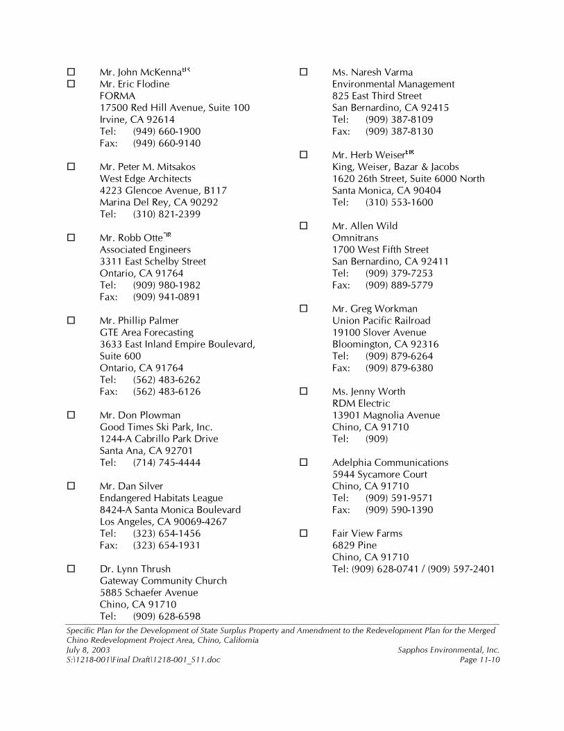
6SHFLILF�3ODQ�IRU�WKH�'HYHORSPHQW�RI�6WDWH�6XUSOXV�3URSHUW\�DQG�$PHQGPHQW�WR�WKH�5HGHYHORSPHQW�3ODQ�IRU�WKH�0HUJHG�&KLQR�5HGHYHORSPHQW�3URMHFW�$UHD��&KLQR��&DOLIRUQLD�-XO\��������� 6DSSKRV�(QYLURQPHQWDO��,QF��6�?��������?)LQDO�'UDIW?��������B6���GRF� 3DJH�������
�� 0U��-RKQ�0F.HQQD ��� � ��� 0U��(ULF�)ORGLQH�� )250$�� ������5HG�+LOO�$YHQXH��6XLWH������ ,UYLQH��&$�������� 7HO�� ���������������� )D[�� ������������������ 0U��3HWHU�0��0LWVDNRV�� :HVW�(GJH�$UFKLWHFWV��� �����*OHQFRH�$YHQXH��%����� 0DULQD�'HO�5H\��&$�������� 7HO��� ������������������ 0U��5REE�2WWH ��� � �� $VVRFLDWHG�(QJLQHHUV�� �����(DVW�6FKHOE\�6WUHHW�� 2QWDULR��&$�������� 7HO�� ���������������� )D[�� ������������������ 0U��3KLOOLS�3DOPHU�� *7(�$UHD�)RUHFDVWLQJ�� �����(DVW�,QODQG�(PSLUH�%RXOHYDUG���
6XLWH������ 2QWDULR��&$�������� 7HO��� ���������������� )D[�� ��������������� � ���� 0U��'RQ�3ORZPDQ�� *RRG�7LPHV�6NL�3DUN��,QF��� �����$�&DEULOOR�3DUN�'ULYH�� 6DQWD�$QD��&$�������� 7HO�� ��������������� � �� � � � ��� 0U��'DQ�6LOYHU�� (QGDQJHUHG�+DELWDWV�/HDJXH�� �����$�6DQWD�0RQLFD�%RXOHYDUG�� /RV�$QJHOHV��&$������������� 7HO���� ���������������� )D[�� ������������������ 'U��/\QQ�7KUXVK�� *DWHZD\�&RPPXQLW\�&KXUFK�� �����6FKDHIHU�$YHQXH�� &KLQR��&$�������� 7HO�� ���������������
�� 0V��1DUHVK�9DUPD�� (QYLURQPHQWDO�0DQDJHPHQW�� ����(DVW�7KLUG�6WUHHW�� 6DQ�%HUQDUGLQR��&$�������� 7HO�� ���������������� )D[�� ������������������ 0U��+HUE�:HLVHU ��� � �� .LQJ��:HLVHU��%D]DU��-DFREV�� �������WK�6WUHHW��6XLWH������1RUWK�� 6DQWD�0RQLFD��&$�������� 7HO�� ������������������ 0U��$OOHQ�:LOG�� 2PQLWUDQV�� �����:HVW�)LIWK�6WUHHW�� 6DQ�%HUQDUGLQR��&$�������� 7HO���� ���������������� )D[�� ������������������ 0U��*UHJ�:RUNPDQ�� 8QLRQ�3DFLILF�5DLOURDG�� ������6ORYHU�$YHQXH�� %ORRPLQJWRQ��&$�������� 7HO�� ���������������� )D[�� ������������������ 0V��-HQQ\�:RUWK�� 5'0�(OHFWULF�� ������0DJQROLD�$YHQXH�� &KLQR��&$�������� 7HO�� ��������� $GHOSKLD�&RPPXQLFDWLRQV�� �����6\FDPRUH�&RXUW�� &KLQR��&$�������� 7HO�� ���������������� )D[�� ��������������� � ���� )DLU�9LHZ�)DUPV�� �����3LQH�� &KLQR��&$�������� 7HO��������������������������������������
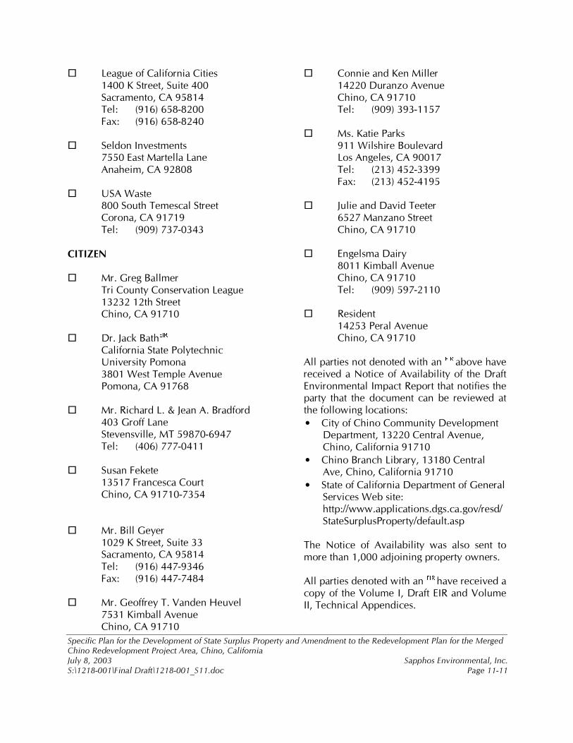
6SHFLILF�3ODQ�IRU�WKH�'HYHORSPHQW�RI�6WDWH�6XUSOXV�3URSHUW\�DQG�$PHQGPHQW�WR�WKH�5HGHYHORSPHQW�3ODQ�IRU�WKH�0HUJHG�&KLQR�5HGHYHORSPHQW�3URMHFW�$UHD��&KLQR��&DOLIRUQLD�-XO\��������� 6DSSKRV�(QYLURQPHQWDO��,QF��6�?��������?)LQDO�'UDIW?��������B6���GRF� 3DJH�������
�� /HDJXH�RI�&DOLIRUQLD�&LWLHV�� �����.�6WUHHW��6XLWH������ 6DFUDPHQWR��&$�������� 7HO�� ���������������� )D[�� ��������������� ���� 6HOGRQ�,QYHVWPHQWV�� �����(DVW�0DUWHOOD�/DQH�� $QDKHLP��&$���������� 86$�:DVWH�� ����6RXWK�7HPHVFDO�6WUHHW��� &RURQD��&$�������� 7HO�� ����������������&,7,=(1���� 0U��*UHJ�%DOOPHU�� 7UL�&RXQW\�&RQVHUYDWLRQ�/HDJXH�� ��������WK�6WUHHW�� &KLQR��&$���������� 'U��-DFN�%DWK ��� � ��
&DOLIRUQLD�6WDWH�3RO\WHFKQLF�8QLYHUVLW\�3RPRQD�
� �����:HVW�7HPSOH�$YHQXH�� 3RPRQD��&$���������� 0U��5LFKDUG�/���-HDQ�$��%UDGIRUG�� ����*URII�/DQH�� 6WHYHQVYLOOH��07������������� 7HO�� ������������������ 6XVDQ�)HNHWH�� ������)UDQFHVFD�&RXUW�� &KLQR��&$���������������� 0U��%LOO�*H\HU�� �����.�6WUHHW��6XLWH����� 6DFUDPHQWR��&$�������� 7HO�� ���������������� )D[�� ��������������� � ���� 0U��*HRIIUH\�7��9DQGHQ�+HXYHO�� �����.LPEDOO�$YHQXH�� &KLQR��&$�������
�� &RQQLH�DQG�.HQ�0LOOHU�� ������'XUDQ]R�$YHQXH�� &KLQR��&$�������� 7HO�� ������������������ 0V��.DWLH�3DUNV�� ����:LOVKLUH�%RXOHYDUG�� /RV�$QJHOHV��&$�������� 7HO�� ���������������� )D[�� ������������������ -XOLH�DQG�'DYLG�7HHWHU�� �����0DQ]DQR�6WUHHW�� &KLQR��&$���������� (QJHOVPD�'DLU\�� �����.LPEDOO�$YHQXH�� &KLQR��&$�������� 7HO�� ������������������ 5HVLGHQW�� ������3HUDO�$YHQXH�� &KLQR��&$��������$OO�SDUWLHV�QRW�GHQRWHG�ZLWK�DQ� ��� � DERYH�KDYH�UHFHLYHG�D�1RWLFH�RI�$YDLODELOLW\�RI� WKH�'UDIW�(QYLURQPHQWDO�,PSDFW�5HSRUW�WKDW�QRWLILHV�WKH�SDUW\� WKDW� WKH� GRFXPHQW� FDQ� EH� UHYLHZHG� DW�WKH�IROORZLQJ�ORFDWLRQV��• &LW\�RI�&KLQR�&RPPXQLW\�'HYHORSPHQW�
'HSDUWPHQW��������&HQWUDO�$YHQXH��&KLQR��&DOLIRUQLD�������
• &KLQR�%UDQFK�/LEUDU\��������&HQWUDO�$YH��&KLQR��&DOLIRUQLD�������
• 6WDWH�RI�&DOLIRUQLD�'HSDUWPHQW�RI�*HQHUDO�6HUYLFHV�:HE�VLWH��KWWS���ZZZ�DSSOLFDWLRQV�GJV�FD�JRY�UHVG�6WDWH6XUSOXV3URSHUW\�GHIDXOW�DVS�
�7KH� 1RWLFH� RI� $YDLODELOLW\� ZDV� DOVR� VHQW� WR�PRUH�WKDQ�������DGMRLQLQJ�SURSHUW\�RZQHUV���$OO�SDUWLHV�GHQRWHG�ZLWK�DQ� ��� � KDYH�UHFHLYHG�D�FRS\�RI�WKH�9ROXPH�,��'UDIW�(,5�DQG�9ROXPH�,,��7HFKQLFDO�$SSHQGLFHV��
Copyright © 2022 FDOKUMEN