Sales Maximization through Service Tier Introduction Utilizing ...
Upload
khangminh22Category
view
0download
0
ATLANTA BELTLINE
C i t y o f A t l a n t a , F u l t o n C o u n t y, G A
TIER 1 DRAFT ENVIRONMENTAL IMPACT STATEMENT/
SECTION 4 ( f ) EVALUATION APPENDIX
U.S. Department of Transportation Federal Transit Administration
and Metropolitan Atlanta Rapid Transit Authority
Submitted Pursuant to 42 U.S.C. 4332(2)(c),
16 U.S.C. 470(f), and 49 U.S.C. 303
June 2011

Atlanta BeltLine Corridor Environmental Study June 2011
Page Left Intentionally Blank

Atlanta BeltLine Corridor Environmental Study June 2011
ATLANTA BELTLINE CORRIDOR ENVIRONMENTAL STUDY
TIER 1 DRAFT ENVIRONMENTAL IMPACT STATEMENT APPENDIX
Prepared for: Atlanta BeltLine, Inc.
and Metropolitan Atlanta Rapid Transit Authority
Prepared by: AECOM/JJG Joint Venture
Atlanta, GA
Version (1.0): June 2011
General Planning Consultant Services RFP P5413 Contract No. 200703566 Work Order No. 2008-07

Atlanta BeltLine Corridor Environmental Study June 2011
Page Left Intentionally Blank
Atlanta BeltLine Corridor Environmental Study June 2011
Appendix A - Notice of Intent Appendix B - Agency Coordination Appendix C - Correspondence Appendix D - Data Tables and Figures Appendix E - Public Involvement Appendix F - Distribution List Appendix G - Acronyms and Glossary Appendix H - List of Preparers Appendix I - References

Atlanta BeltLine Corridor Environmental Study June 2011
Page Left Intentionally Blank

Atlanta BeltLine Corridor Environmental Study A June 2011
Appendix A - Notice of Intent

43278 Federal Register / Vol. 73, No. 143 / Thursday, July 24, 2008 / Notices
the result of combining AC 20–27F and AC 20–139, Commercial Assistance During Construction of Amateur-Built Aircraft), as well as for comments on the percentage of fabrication and assembly that must be completed by an amateur builder to obtain an experimental airworthiness certificate for an amateur- built aircraft. These and other related documents are located on the FAA main Web page. The Web link is: http:// www.faa.gov/aircraft/draft_docs/ display_docs/ index.cfm?Doc_Type=Pubs.
DATES: Please submit your comments on or before September 30, 2008.
ADDRESSES: You may submit your comments via e-mail to [email protected], via fax to (202) 267–8850 (ATTN: Miguel Vasconcelos, AIR–230) or via mail or hand delivery to: Production and Airworthiness Division (AIR–200), Federal Aviation Administration (Room 815), 800 Independence Ave, SW., Washington, DC 20591, ATTN: Miguel Vasconcelos.
FOR FURTHER INFORMATION CONTACT: Frank Paskiewicz, Manager, Production and Airworthiness Division, AIR–200, Federal Aviation Administration, 800 Independence Ave., SW., Washington, DC 20591; telephone number: (202) 267–8361.
SUPPLEMENTARY INFORMATION:
Background
On July 15, 2008 (73 FR 40652), the FAA published a notice requesting comments on proposed changes to FAA Order 8130.2F and Advisory Circular (AC) 20–27G, as well as comments on the percentage of fabrication and assembly that must be completed by an amateur builder to obtain an experimental airworthiness certificate for an amateur-built aircraft. The comment close date of August 15, 2008 was not specifically posted in that notice and was only available on the FAA Web site. Because some interested parties may not have web access and, therefore, may not have been aware of the original comment deadline, the FAA has decided to extend the comment period by 45 days to September 30, 2008, and to publish this announcement in the Federal Register. This extension will also allow more time for the public to participate and provide the FAA with more in-depth comments on the proposed changes.
Issued in Washington, DC on July 21, 2008. Frank Paskiewicz, Manager, Production and Airworthiness Division. [FR Doc. E8–16989 Filed 7–23–08; 8:45 am] BILLING CODE 4910–13–P
DEPARTMENT OF TRANSPORTATION
Federal Aviation Administration
[Summary Notice No. PE–2008–29]
Petition for Exemption; Summary of Petition Received
AGENCY: Federal Aviation Administration (FAA), DOT. ACTION: Notice of petition for exemption received.
SUMMARY: This notice contains a summary of a petition seeking relief from specified requirements of 14 CFR. The purpose of this notice is to improve the public’s awareness of, and participation in, this aspect of FAA’s regulatory activities. Neither publication of this notice nor the inclusion or omission of information in the summary is intended to affect the legal status of the petition or its final disposition. DATES: Comments on this petition must identify the petition docket number involved and must be received on or before August 13, 2008. ADDRESSES: You may send comments identified by Docket Number FAA– 2008–0741, using any of the following methods:
• Government-wide rulemaking Web site: Go to http://www.regulations.gov and follow the instructions for sending your comments electronically.
• Mail: Send comments to the Docket Management Facility; U.S. Department of Transportation, 1200 New Jersey Avenue, SE., West Building Ground Floor, Room W12–140, Washington, DC 20590.
• Fax: Fax comments to the Docket Management Facility at 202–493–2251.
• Hand Delivery: Bring comments to the Docket Management Facility in Room W12–140 of the West Building Ground Floor at 1200 New Jersey Avenue, SE., Washington, DC, between 9 a.m. and 5 p.m., Monday through Friday, except Federal holidays.
Privacy: We will post all comments we receive, without change, to http:// www.regulations.gov, including any personal information you provide. Using the search function of our docket Web site, anyone can find and read the comments received into any of our dockets, including the name of the individual sending the comment (or signing the comment for an association,
business, labor union, etc.). You may review DOT’s complete Privacy Act Statement in the Federal Register published on April 11, 2000 (65 FR 19477–78).
Docket: To read background documents or comments received, go to http://www.regulations.gov at any time or to the Docket Management Facility in Room W12–140 of the West Building Ground Floor at 1200 New Jersey Avenue, SE., Washington, DC, between 9 a.m. and 5 p.m., Monday through Friday, except Federal holidays. FOR FURTHER INFORMATION CONTACT: Katrina Holiday (202) 267–3603, Program Analyst, or Frances Shaver (202) 267–9681, Office of Rulemaking, Federal Aviation Administration, 800 Independence Avenue, SW., Washington, DC 20591.
This notice is published pursuant to 14 CFR 11.85.
Pamela Hamilton-Powell, Director, Office of Rulemaking.
Petition for Exemption Docket No.: FAA–2008–0741. Petitioner: Cessna Aircraft Company. Section of 14 CFR Affected: 21.190(d). Description of Relief Sought: Cessna
Aircraft Company requests relief from the requirements of 14 CFR part 21.190(d) for aircraft manufactured outside the United States to be eligible for a special airworthiness certificate in the light-sport category.
[FR Doc. E8–16860 Filed 7–23–08; 8:45 am] BILLING CODE 4910–13–P
DEPARTMENT OF TRANSPORTATION
Federal Transit Administration
Preparation of a Tier 1 Environmental Impact Statement for Transit Improvements in the BeltLine Corridor in the City of Atlanta, GA
AGENCY: Federal Transit Administration (FTA), Department of Transportation (DOT). ACTION: Notice of Intent to prepare an Environmental Impact Statement and 4(f) Evaluation.
SUMMARY: The Federal Transit Administration and the Metropolitan Atlanta Rapid Transit Authority (MARTA) are planning to prepare a Tier 1 Environmental Impact Statement (Tier 1 EIS) and 4(f) Evaluation for an approximately 22-mile loop of proposed transit and trail improvements within the City of Atlanta. The Tier 1 EIS will be prepared in accordance with regulations implementing the National Environmental Policy Act (NEPA), as
VerDate Aug<31>2005 15:14 Jul 23, 2008 Jkt 214001 PO 00000 Frm 00078 Fmt 4703 Sfmt 4703 E:\FR\FM\24JYN1.SGM 24JYN1eben
thal
l on
PR
OD
PC
60 w
ith N
OT
ICE
S
43279 Federal Register / Vol. 73, No. 143 / Thursday, July 24, 2008 / Notices
well as provisions of the Safe, Accountable, Flexible, Efficient Transportation Equity Act: A Legacy for Users (SAFETEA–LU), enacted in 2005. The purpose of this Notice of Intent (NOI) is to alert interested parties regarding the plan to prepare the Tier 1 EIS; to provide information on the nature of the proposed project; to invite participation in the Tier 1 EIS process, including comments on the scope of the Tier 1 EIS proposed in this notice; and to announce that public scoping meetings will be conducted. Tiering reflects FTA and MARTA’s belief that it is necessary to focus on the actual issues ripe for decision at each level of environmental review (40 CFR 1508.28). It is the intent of this preliminary environmental documentation to determine and environmentally evaluate transit mode and general alignment for both the transit and trails in this corridor.
DATES: Comment Due Date: Written comments on the scope of the Tier 1 EIS should be sent to Don Williams, Project Manager, MARTA, by September 22, 2008.
Scoping Meetings: Eight public scoping meetings will be held between August 19 and August 21, 2008, at locations indicated under ADDRESSES below. An interagency pre-scoping meeting will be held on August 12, 2008, and an interagency post-scoping meeting will be held on August 22, 2008, at MARTA Headquarters. ADDRESSES: Written comments on the scope of the Tier 1 EIS should be sent to Don Williams, Project Manager, Metropolitan Atlanta Rapid Transit Authority, 2424 Piedmont Road, NE., Atlanta, GA 30324–3330. Comments may also be offered at the public scoping meetings and via e-mail at [email protected].
The dates, times, and locations for the public scoping meetings are as follow: Meetings 1&2: Tuesday, August 19,
2008, 1 p.m.–3 p.m. and 6 p.m.–8 p.m., Trinity Presbyterian Church, 3003 Howell Mill Road, Room B, Atlanta, GA 30327.
Meetings 3&4: Tuesday, August 19, 2008, 1 p.m.–3 p.m. and 6 p.m.–8 p.m., The Trolley Barn, 963 Edgewood Avenue, NE., Atlanta, GA 30307.
Meetings 5&6: Thursday, August 21, 2008, 1 p.m.–3 p.m. and 6 p.m.–8 p.m., Georgia Hill Neighborhood Center, 250 Georgia Avenue, SE., Atlanta, GA 30312.
Meetings 7&8: Thursday, August 21, 2008, 1 p.m.–3 p.m. and 6 p.m.–8 p.m., Central United Methodist
Church, 503 Mitchell Street, SW., Atlanta, GA 30314. The appropriate federal, state, and
local agency offices will be notified individually about the time and location of the interagency scoping meeting.
The locations of the scoping meetings are accessible to persons with disabilities. If translation, signing services, or other special accommodations are needed, please contact Project Hotline at (404) 524– 2070 or for hearing impaired TTY (404) 848–4931 at least 48 hours before the meeting. A scoping information packet is available on the project Web site at: http://www.itsmarta.com/newsroom/ beltline.html or by calling the Project Hotline at (404) 524–2070. Copies will also be available at the scoping meetings. FOR FURTHER INFORMATION CONTACT: David Schilling, Community Planner, Federal Transit Administration, 230 Peachtree, NW., Suite 800, Atlanta, Georgia 30303, Telephone: (404) 865– 5600, Facsimile (404) 865–5605; Don Williams, Manager Regional Planning and Analysis, Metropolitan Atlanta Rapid Transit Authority, 2424 Piedmont Road, NE., Atlanta, GA 30324–3330, Telephone: (404) 848–4422, Facsimile (404) 848–5132; or Nate Conable, Senior Project Manager, Atlanta BeltLine, Inc., 86 Pryor Street, Suite 200, Atlanta, Georgia 30303, Telephone: (404) 880– 4100, Facsimile: (404) 880–0616. SUPPLEMENTARY INFORMATION:
Description of Study Area and Proposed Project: The BeltLine Corridor contains many of Atlanta’s residential neighborhoods, a majority of the parks in the central city area, as well as a significant number of major attractions and points of interest. Transit improvements in the Atlanta BeltLine Corridor would create a new 22-mile transit loop, including potential new stations on an existing rail right-of-way. The BeltLine Corridor would connect to the MARTA heavy rail system at or near four locations: Lindbergh Center, Inman Park/Reynoldstown, West End, and Ashby Stations. Improvements in the BeltLine Corridor would support the MARTA bus network, other regional bus services, future High Capacity Transit projects along I–75, I–285, Memorial Drive and Buford Highway, the pending commuter rail service between Lovejoy and downtown Atlanta, and the proposed Peachtree Streetcar. The Atlanta BeltLine Corridor also includes approximately 33 miles of new multi- use trails in a linear park located primarily along the corridor, with extensions connecting to parks and other trails.
Purpose of and Need for the Proposed Project: The purpose of the BeltLine Corridor transit and trails improvements are to improve local and regional mobility, address accessibility and connectivity, and support the City of Atlanta’s redevelopment plans. The need for the proposed project stems from population and employment growth that is related to the occurring and planned redevelopment within the City and the City’s desire to provide better linkages to parks throughout the area and to increase overall availability of accessible greenspace.
Alternatives: Through a process of technical evaluation and public input during the previous MARTA BeltLine study, the Inner Core Alternatives Analysis (January 2007), a large number of alternatives was examined, leading to the agency selection of a Locally Preferred Alternative (PA). This decision was based on the PA being the best performing alternative and preferred by the public and major stakeholders. The preliminary list of alternatives to be considered in the Tier 1 Draft EIS will include the No Build Alternative and the PA (henceforth referred to as the Build Alternative):
• No Build Alternative: The No Build Alternative assumes that no transportation infrastructure improvements would be made in the project area apart from improvements that have already been committed to by the Georgia Department of Transportation, the City of Atlanta, and MARTA and are included in the regional Transportation Improvement Program. The No Build Alternative would also assume that no trail improvements would be made other than what is currently committed to by the City of Atlanta and Atlanta BeltLine Inc.
• Build Alternatives: The Build Alternatives are to be based on the PA established in the Alternatives Analysis and would evaluate variations in the alignment based on feasibility and potential for impacts. In addition to any alternatives uncovered during public scoping, the Build Alternatives would include a new 23-mile transit service, primarily on existing rail corridor and identify locations for new stations on the alignment, with connections to MARTA’s heavy rail system at its Lindbergh Center, Inman Park/ Reynoldstown, West End, and Ashby Stations. The Build Alternatives would also incorporate a system of connecting trails that would run adjacent to the transit line and provide vital connections to existing and proposed recreational facilities around the Atlanta BeltLine Corridor.
VerDate Aug<31>2005 15:14 Jul 23, 2008 Jkt 214001 PO 00000 Frm 00079 Fmt 4703 Sfmt 4703 E:\FR\FM\24JYN1.SGM 24JYN1eben
thal
l on
PR
OD
PC
60 w
ith N
OT
ICE
S
43280 Federal Register / Vol. 73, No. 143 / Thursday, July 24, 2008 / Notices
This preliminary range of alternatives may be supplemented during the public scoping process and development of the Tier 1 Draft EIS.
The Tiered EIS Process and the Role of the Participating Agencies and the Public: The purpose of the Tier 1 EIS process is to serve as the basis for the decision regarding the project design concept and scope and will support the acquisition of the right-of-way for corridor preservation. The Tier 1 DEIS will preliminarily screen and evaluate a range of social, environmental, and economic impacts resulting from the mode choice, general alignment, and approximate location of stations. Impacts to the affected environment will be screened and evaluated based upon information uncovered during public scoping and interagency coordination efforts. MARTA will prepare an Annotated Outline for the DEIS following this scoping. This gives assurances that the Tier 1 document will focus on the issues ripe for consideration and that scoping has accomplished its intended purpose.
The Tier 1 EIS will build upon the extensive screening, environmental and technical studies and public comments and outreach conducted to date. Tiering will allow the FTA and MARTA to conduct planning and NEPA activities for this large project and focus on those decisions that are ready to be made at this level of analysis. The Tier 1 analysis will serve as a basis for establishing the general alignment of the proposed transit and trail corridor along the entire 23-mile loop. Conceptual locations of stations, trail connections, and other facilities will be determined, as will the choice of transit technology. The scope of analysis in the Tier 1 EIS will be appropriate to the level of detail necessary to make informed decisions and will receive input from the public and the reviewing agencies.
A goal of the Tier 1 EIS and these decisions is to support future ROW preservation along the entire 22-mile loop. FTA allows the advance acquisition of a limited amount of real property for hardship or protective purposes as defined in the NEPA regulation at 23 CFR 771.117(d)(12). Also, in accordance with 49 U.S.C. 5324(c), the acquisition of pre-existing railroad ROW may be evaluated for NEPA purposes separately from the future transit and trails project that will ultimately be built on that ROW under certain conditions and with certain understandings. With these exceptions, all corridor parcels cleared for ROW preservation and purchase in the Tier 1 document will be individually identified and documented.
This Tier 1 EIS will also meet the requirements of the Georgia Environmental Policy Act (GEPA). GEPA requires the assessment of any state-level action to determine whether or not the action may significantly adversely affect the quality of the environment. A project that is subject to NEPA review has met the requirements of GEPA and does not require separate documentation.
The Build Alternative would be finalized after the circulation of the Tier 1 DEIS to the public and then included in the Tier 1 Final EIS. After completion the FEIS, the Federal Transit Administration (FTA) will issue a Record of Decision (ROD) on the Preferred Alternative which will include selection of transit mode and general alignment. The Tier 1 EIS will serve as the point of departure for future project refinement and subsequent, in depth environmental analysis required for Tier 2 analysis when the project advances further through the project development process. NEPA regulations and SAFETEA–LU provisions call for public involvement in the EIS process. Section 6002 of SAFETEA–LU requires that FTA and MARTA do the following: (1) Extend an invitation to other Federal and non-Federal agencies and Indian tribes that may have an interest in the proposed project to become ‘‘participating agencies,’’ (2) provide an opportunity for involvement by participating agencies and the public in helping to define the purpose and need for the proposed project, as well as the range of alternatives for consideration in the impact statement, and (3) establish a plan for coordinating public and agency participation in and comment on the scoping information packet. It is possible that we may not be able to identify all Federal and non-Federal agencies and Indian tribes that may have such an interest. Any Federal or non-Federal agency or Indian tribe interested in the proposed project that does not receive an invitation to become a participating agency should notify at the earliest opportunity the Project Manager identified above under ADDRESSES.
A comprehensive public involvement program has been developed and a public and agency involvement Coordination Plan will be created. The program includes a project Web site: http://www.itsmarta.com/newsroom/ beltline.html; outreach to local and county officials and community and civic groups; a public scoping process to define the issues of concern among all parties interested in the project; establishment of a technical advisory committee and stakeholder advisory
committee; a public hearing on the release of the Tier I DEIS; and development and distribution of project newsletters. The Coordination Plan will be posted to this Web site.
The purpose and need for the proposed project have been preliminarily identified in this notice. We invite the public and participating agencies to consider the preliminary statement of purpose and need for the proposed project, as well as the alternatives proposed for consideration. Suggestions for modifications to the statement of purpose and need for the proposed project and any other alternatives that meet the purpose and need for the proposed project are welcome and will be given serious consideration. Comments on potentially significant environmental impacts that may be associated with the proposed project and alternatives are also welcome. There will be additional opportunities to participate in the scoping process at the public meetings announced in this notice.
In accordance with 23 CFR 771.105 (a) and 771.133, FTA will comply with all Federal environmental laws, regulations, and executive orders applicable to the proposed project during the environmental review process to the maximum extent practicable. These requirements include, but are not limited to, the regulations of the Council on Environmental Quality and FTA implementing NEPA (40 CFR parts 1500–1508, and 23 CFR Part 771), the project-level air quality conformity regulation of the U.S. Environmental Protection Agency (EPA) (40 CFR part 93), and Section 404(b)(1) guidelines of EPA (40 CFR part 230), the regulation implementing Section 106 of the National Historic Preservation Act (36 CFR Part 800), the regulation implementing section 7 of the Endangered Species Act (50 CFR part 402), Section 4(f) of the Department of Transportation Act (23 CFR 771.135), and Executive Orders 12898 on environmental justice, 11988 on floodplain management, and 11990 on wetlands.
Issued on: July 17, 2008.
Yvette G. Taylor, Regional Administrator, FTA Region 4. [FR Doc. E8–16990 Filed 7–23–08; 8:45 am]
BILLING CODE 4910–57–P
VerDate Aug<31>2005 15:14 Jul 23, 2008 Jkt 214001 PO 00000 Frm 00080 Fmt 4703 Sfmt 4703 E:\FR\FM\24JYN1.SGM 24JYN1eben
thal
l on
PR
OD
PC
60 w
ith N
OT
ICE
S

Atlanta BeltLine Corridor Environmental Study B June 2011
Appendix B - Agency Coordination
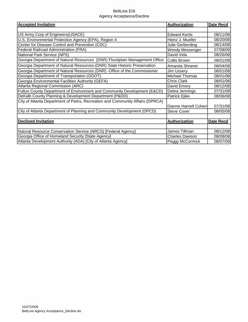
BeltLine EISAgency Acceptance/Decline
Accepted Invitation Authorization Date Recd
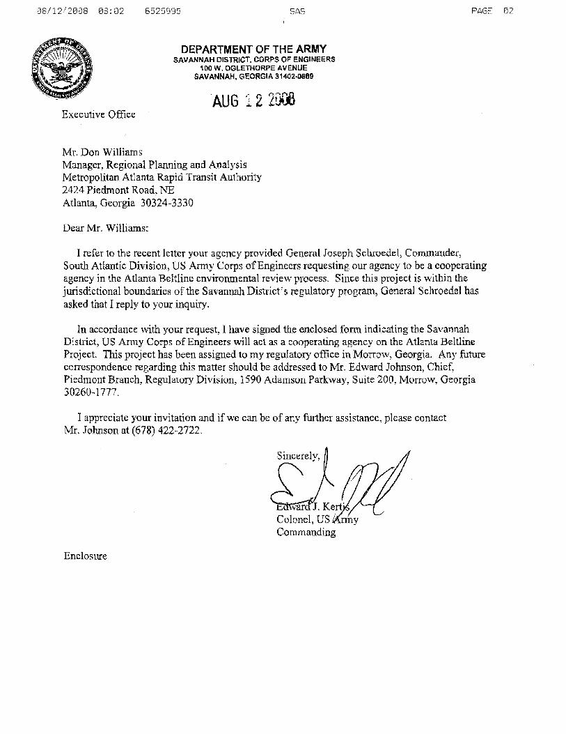
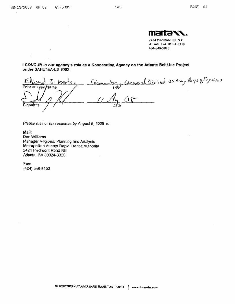
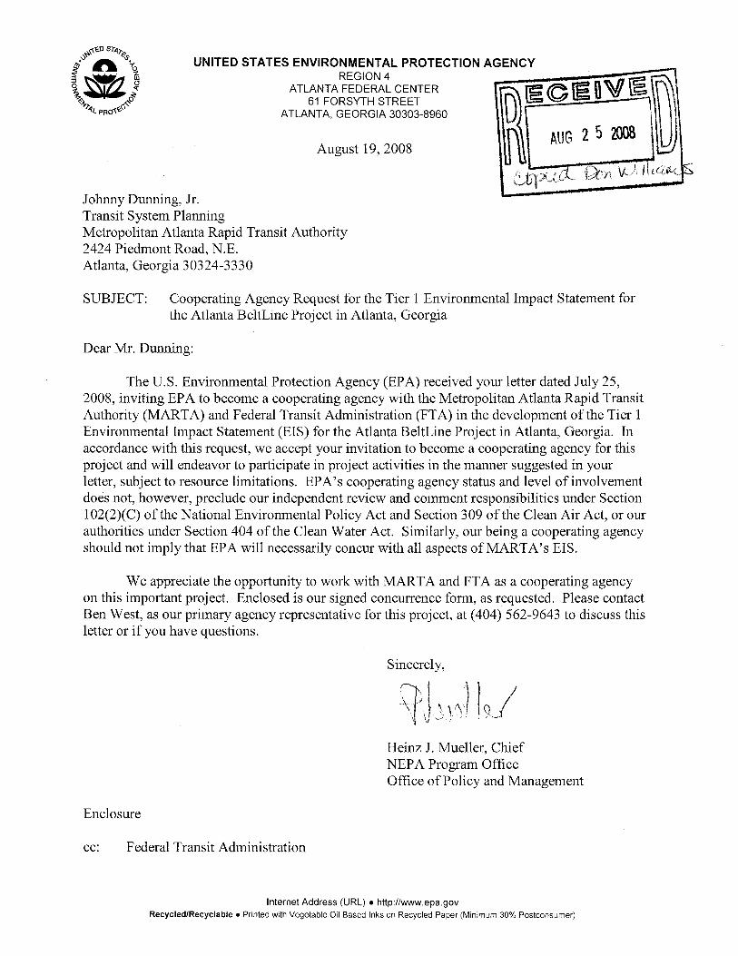
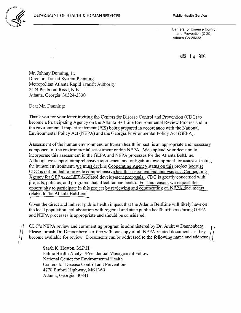
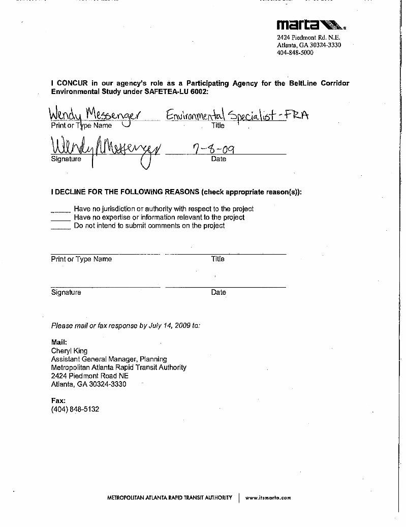
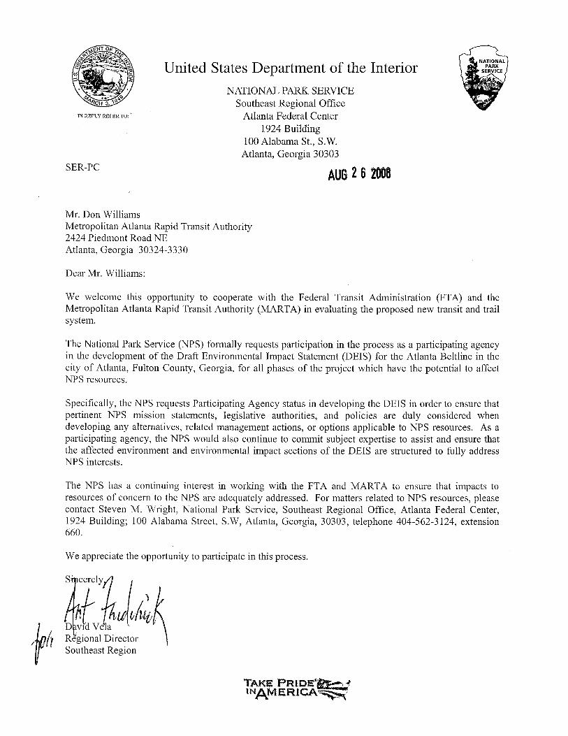
US Army Corp of Engineers(USACE) Edward Kertis 08/11/08U.S. Environmental Protection Agency (EPA), Region 4 Heinz J. Mueller 08/20/08Center for Disease Control and Prevention (CDC) Julie Gerberding 08/14/08Federal Railroad Administration (FRA) Wendy Messenger 07/08/09National Park Service (NPS) David Vela 08/26/08Georgia Department of Natural Resources (DNR) Floodplain Management Office Collis Brown 08/01/08Georgia Department of Natural Resources-(DNR) State Historic PreservationDivision (SHPO)
Amanda Shraner 08/04/08Georgia Department of Natural Resources (DNR) -Office of the Commissioner Jim Ussery 08/01/08Georgia Department of Transportaton (GDOT) Michael Thomas 08/01/08Georgia Environmental Facilities Authority (GEFA) Chris Clark 08/01/08Atlanta Regional Commission (ARC) David Emory 08/12/08Fulton County Department of Environment and Community Development (E&CD) Debra Jennings 07/31/08DeKalb County Planning & Development Department (P&DD) Patrick Ejike 08/06/08City of Atlanta Department of Parks, Recreation and Community Affairs (DPRCA)
Dianne Harnell Cohen 07/31/08City of Atlanta Department of Planning and Community Development (DPCD) Steve Cover 08/05/08
Declined Invitation Authorization Date Recd
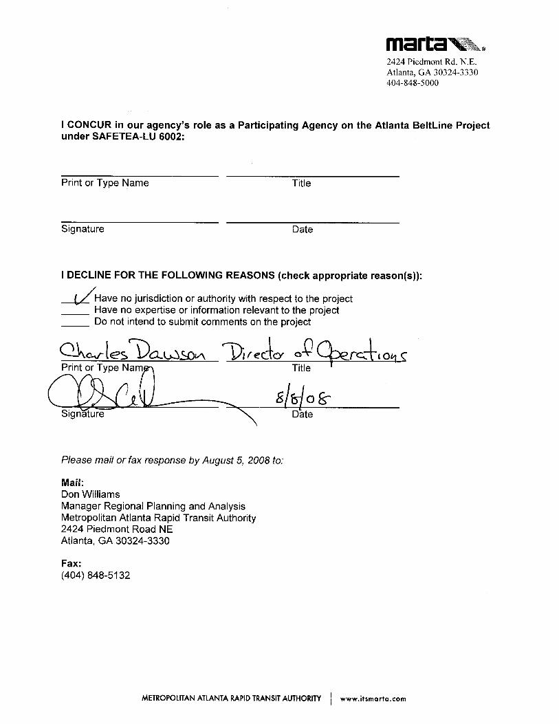
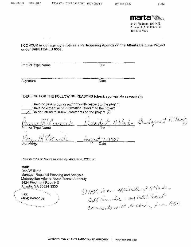
Natural Resource Conservation Service (NRCS) [Federal Agency] James Tillman 08/12/08Georgia Office of Homeland Security [State Agency] Charles Dawson 08/08/08Atlanta Development Authority (ADA) [City of Atlanta Agency] Peggy McCormick 08/07/08
10/27/2009BeltLine Agency Acceptance_Decline.xls
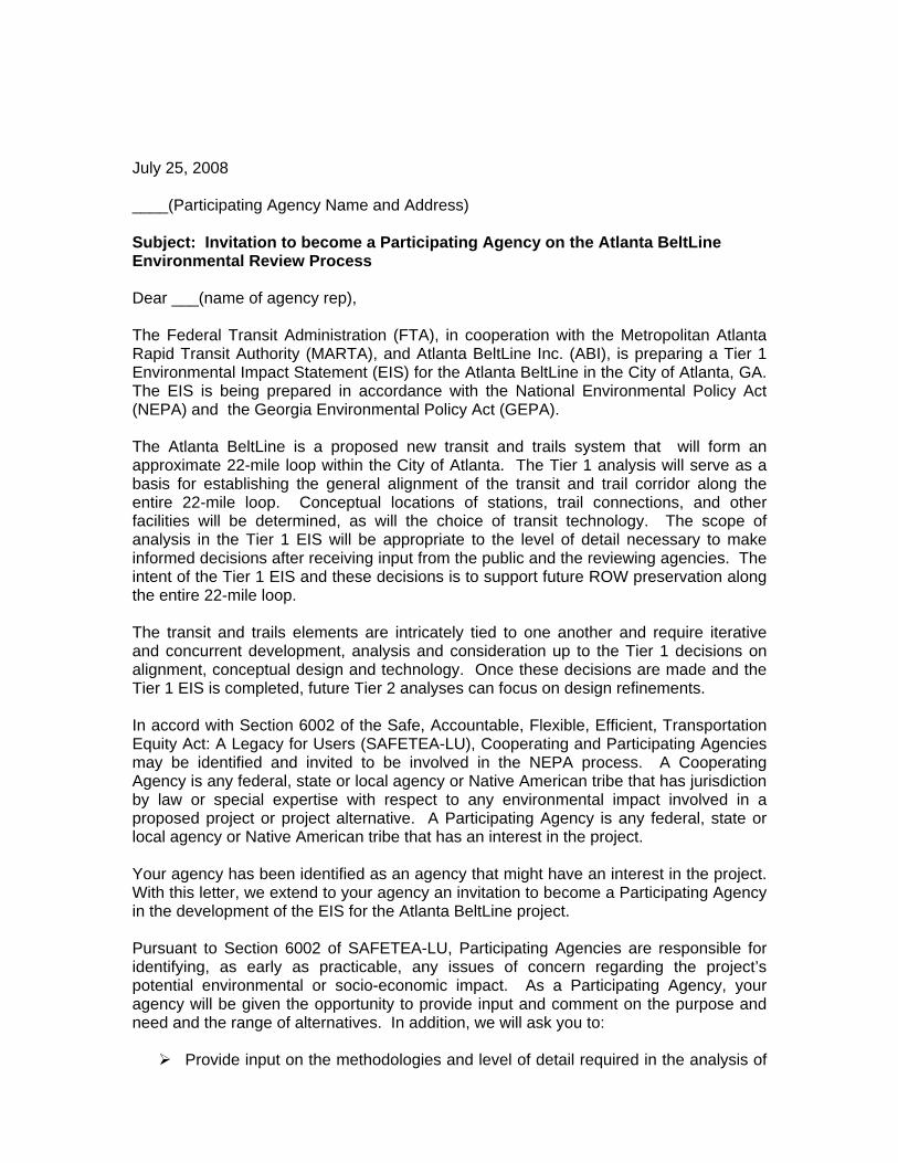
July 25, 2008 ____(Participating Agency Name and Address) Subject: Invitation to become a Participating Agency on the Atlanta BeltLine Environmental Review Process Dear ___(name of agency rep), The Federal Transit Administration (FTA), in cooperation with the Metropolitan Atlanta Rapid Transit Authority (MARTA), and Atlanta BeltLine Inc. (ABI), is preparing a Tier 1 Environmental Impact Statement (EIS) for the Atlanta BeltLine in the City of Atlanta, GA. The EIS is being prepared in accordance with the National Environmental Policy Act (NEPA) and the Georgia Environmental Policy Act (GEPA). The Atlanta BeltLine is a proposed new transit and trails system that will form an approximate 22-mile loop within the City of Atlanta. The Tier 1 analysis will serve as a basis for establishing the general alignment of the transit and trail corridor along the entire 22-mile loop. Conceptual locations of stations, trail connections, and other facilities will be determined, as will the choice of transit technology. The scope of analysis in the Tier 1 EIS will be appropriate to the level of detail necessary to make informed decisions after receiving input from the public and the reviewing agencies. The intent of the Tier 1 EIS and these decisions is to support future ROW preservation along the entire 22-mile loop. The transit and trails elements are intricately tied to one another and require iterative and concurrent development, analysis and consideration up to the Tier 1 decisions on alignment, conceptual design and technology. Once these decisions are made and the Tier 1 EIS is completed, future Tier 2 analyses can focus on design refinements. In accord with Section 6002 of the Safe, Accountable, Flexible, Efficient, Transportation Equity Act: A Legacy for Users (SAFETEA-LU), Cooperating and Participating Agencies may be identified and invited to be involved in the NEPA process. A Cooperating Agency is any federal, state or local agency or Native American tribe that has jurisdiction by law or special expertise with respect to any environmental impact involved in a proposed project or project alternative. A Participating Agency is any federal, state or local agency or Native American tribe that has an interest in the project. Your agency has been identified as an agency that might have an interest in the project. With this letter, we extend to your agency an invitation to become a Participating Agency in the development of the EIS for the Atlanta BeltLine project. Pursuant to Section 6002 of SAFETEA-LU, Participating Agencies are responsible for identifying, as early as practicable, any issues of concern regarding the project’s potential environmental or socio-economic impact. As a Participating Agency, your agency will be given the opportunity to provide input and comment on the purpose and need and the range of alternatives. In addition, we will ask you to: Provide input on the methodologies and level of detail required in the analysis of
alternatives. Participate in coordination meetings and joint field reviews as appropriate. Provide timely review and comment on the pre-draft or pre-final environmental
documents to reflect the views and concerns of your agency on the adequacy of the document, alternatives considered, and the anticipated impacts and mitigation.
Please sign in the appropriate location on the attachment accepting this invitation to become a Participating Agency prior to August 5, 2008. Please return the response form by fax (404) 848-5132 or by mail to Don Williams, Manager Regional Planning and Analysis, Metropolitan Atlanta Rapid Transit Authority, 2424 Piedmont Road, NE Atlanta, GA 30324-3330. If your agency should decline, please state your reason for declining. According to SAFETEA-LU Section 6002, agencies electing to decline the invitation must also indicate the reason: Have no jurisdiction or authority with respect to the project; Have no expertise or information relevant to the project; and Do not intend to submit comments on the project.
A NEPA Scoping Meeting will be held for agencies on August 12, 2008 from 9:00 am –11:00 am at MARTA’s Headquarters located at the above address. We invite you to participate. Please take the MARTA North-South line to the Lindbergh Station. The building is located just north of the station. If you drive, you may park at no cost in the garage located west of the building. We also ask that you reserve space on your calendar for a follow up meeting on August 22, 2008 from 9:00 am – 11:00 am. The Scoping Document will be forwarded to you prior to the August 12 meeting. If you have any questions or would like to discuss the project in more detail or your agency’s role and responsibilities, please contact Don Williams, Manager Regional Planning and Analysis (404) 848-4422. Thank you for cooperation and interest in this project. Sincerely, Johnny Dunning Director Transit System Planning Metropolitan Atlanta Rapid Transit Authority
I CONCUR in our agency’s role as a Participating Agency on the Atlanta BeltLine Project under SAFETEA-LU 6002: ____________________________ _______________________________ Print or Type Name Title ____________________________ _______________________________ Signature Date I DECLINE FOR THE FOLLOWING REASONS (check appropriate reason(s)): _____ Have no jurisdiction or authority with respect to the project _____ Have no expertise or information relevant to the project _____ Do not intend to submit comments on the project ____________________________ _______________________________ Print or Type Name Title ____________________________ _______________________________ Signature Date Please mail or fax response by August 5, 2008 to: Mail: Don Williams Manager Regional Planning and Analysis Metropolitan Atlanta Rapid Transit Authority 2424 Piedmont Road NE Atlanta, GA 30324-3330 Fax: (404) 848-5132
July 25, 2008 ____(Cooperating Agency Name and Address) Subject: Invitation to become a Cooperating Agency on the Atlanta BeltLine Environmental Review Process Dear ___(name of agency rep), The Federal Transit Administration (FTA), in cooperation with the Metropolitan Atlanta Rapid Transit Authority (MARTA), and Atlanta BeltLine Inc. (ABI), is preparing a Tier 1 Environmental Impact Statement (EIS) for the Atlanta BeltLine in the City of Atlanta, GA. The EIS is being prepared in accordance with the National Environmental Policy Act (NEPA) and will also satisfy the requirements of the Georgia Environmental Policy Act (GEPA). The Atlanta BeltLine is a proposed new transit and trails system that would form an approximate 22-mile loop within the City of Atlanta. The Tier 1 analysis will serve as a basis for establishing the general alignment of the transit and trail corridor along the entire 22-mile loop. Conceptual locations of stations, trail connections, and other facilities will be determined, as will the choice of transit technology. The scope of analysis in the Tier 1 EIS will be appropriate to the level of detail necessary to make informed decisions and will receive input from the public and the reviewing agencies. The intent of the Tier 1 EIS and these decisions is to support future ROW preservation along the entire 22-mile loop. The transit and trails elements are intricately tied to one another and require iterative and concurrent development, analysis and consideration up to the Tier 1 decisions on alignment, conceptual design and technology. Once these decisions are made and the Tier 1 EIS is completed, future Tier 2 analyses can focus on design refinements. In accord with Section 6002 of the Safe, Accountable, Flexible, Efficient Transportation Equity Act: A Legacy for Users (SAFETEA-LU), Cooperating and Participating Agencies may be identified and invited to be involved in the NEPA process. A Cooperating Agency is any federal, state or local agency or Native American tribe that has jurisdiction by law or special expertise with respect to any environmental impact involved in a proposed project or project alternative. A Participating Agency is any federal, state or local agency or Native American tribe that has an interest in the project. Because the Atlanta BeltLine may require a permit or approval from your agency or otherwise implicate your agency’s jurisdiction, we request your agency to be a Cooperating Agency. Pursuant to Section 6002 of SAFETEA-LU Cooperating agencies are also Participating agencies. Cooperating Agencies are responsible to identify, as early as practicable, any issues of concern regarding the project’s potential environmental or socioeconomic impact that could substantially delay or prevent an agency from granting a permit or other approval. As a Cooperating Agency, we will request your comments on the range of alternatives to be assessed in the EIS, the criteria and methodology for evaluating the
alternatives, the scope of issues to be addressed as well as any other issues you identify as important. We expect your agency’s involvement to entail only those areas under its jurisdiction. In addition we ask you to: Provide input on the methodologies and level of detail required in the analysis of
alternatives. Participate in coordination meetings and joint field reviews as appropriate. Provide timely review and comment on the pre-draft or pre-final environmental
documents to reflect the views and concerns of your agency on the adequacy of the document, alternatives considered, and the anticipated impacts and mitigation.
Please sign in the appropriate location on the attachment accepting this invitation to become a Cooperating Agency prior to August 5, 2008. Please return the response form by fax (404) 848-5132 or by mail to Don Williams, Manager, Regional Planning and Analysis, Metropolitan Atlanta Rapid Transit Authority, 2424 Piedmont Road, NE Atlanta, GA 30324-3330. If you do not accept this invitation, your Agency may become a Participating Agency as defined by Section 6002 of SAFETEA-LU. A NEPA Scoping Meeting will be held for agencies on August 12, 2008 from 9:00 am – 11:00 am at MARTA’s Headquarters located at the above address. We invite you to participate. Please take MARTA’s North-South line to the Lindbergh Station. The building is located just north of the station. If you drive, you may park at no cost in the garage located to the west of the building. We also ask that you reserve space on your calendar for a follow up meeting on August 22, 2008 from 9:00 am – 11:00 am. The Scoping Document will be forwarded to you prior to the meeting on the 12th. If you have any questions or would like to discuss the project in more detail or your agency’s role and responsibilities, please contact Don Williams at (404) 848-4422. Thank you for your cooperation and interest in this project. Sincerely, Johnny Dunning Director Transit System Planning Metropolitan Atlanta Rapid Transit Authority
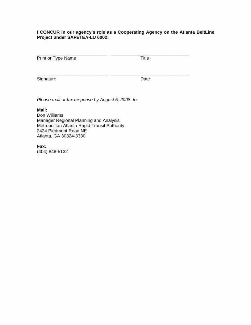
I CONCUR in our agency’s role as a Cooperating Agency on the Atlanta BeltLine Project under SAFETEA-LU 6002: ____________________________ _______________________________ Print or Type Name Title ____________________________ _______________________________ Signature Date Please mail or fax response by August 5, 2008 to: Mail: Don Williams Manager Regional Planning and Analysis Metropolitan Atlanta Rapid Transit Authority 2424 Piedmont Road NE Atlanta, GA 30324-3330 Fax: (404) 848-5132


Atlanta BeltLine Corridor Environmental Study June 2011
Page Left Intentionally Blank

Atlanta BeltLine Corridor Environmental Study C June 2011
Appendix C - Correspondence


500 Water Street - J275 Jacksonville, Florida 32202-4422 Keith A. Brinker (904) 359-2228
Manager Environmental Remediation Fax (904) 245-2825 [email protected]
October 8, 2010 Nathan R. Conable Director of Transit and Transportation Atlanta BeltLine 86 Pryor Street, SW, Suite 200 Atlanta, GA 30303 Re: CSXT Comments on the Atlanta BeltLine Tier 1 Draft Environmental Impact Statement Dear Mr. Conable, CSX Transportation, Inc. (CSXT) appreciates the opportunity to be a part of the Atlanta Beltline Tier 1 Draft Environmental Impact Statement (DEIS) review process. CSXT applauds the efforts of the Atlanta BeltLine to enhance quality of life, sustain growth and create economic opportunities combining greenspace, trails, transit, freight railroads, and new development encircling central Atlanta. As with any project potentially involving passenger rail or trails in CSXT right-of-way (ROW), CSXT’s “four pillars” (Uncompromised Safety, Capacity for Current and Future Needs, No Subsidization by CSXT, and Liability Protection) are critical elements to be considered in the National Environmental Policy Act (NEPA) process. CSXT identified several areas of concern regarding the Tier 1 DEIS, which are summarized below and presented in more detail in Attachment A.
1) Concerns for Use of CSXT Right-of-Way. CSXT has serious concerns about the use of its ROW – active or inactive - for trails, commuter rail, or other non-freight activities. CSXT’s policy regarding trail use of its operating rights of way can be found on page 20 of the Public Project Information: For Construction and Improvement Projects that May Involve the Railroad which is in Attachment B. .
2) Limited CSXT Involvement in Process. To date, CSXT has had minimal involvement in the NEPA process. CSXT was not actively engaged by Atlanta Beltline, Inc. and MARTA in the development and assessment of project alternatives, specifically as they relate to the impact of freight rail operations and the use of active and inactive freight ROW. The DEIS communicates a project vision that will significantly impact CSXT’s rail network and indicates that in-depth discussions with CSXT regarding such an impact are not planned until the Tier 2 NEPA process. In addition, CSXT has not been invited to participate as a consulting party in the Section 106 process even though the DEIS identifies CSXT railroad resources as eligible for the National Register of Historic Places.

3) Tier 1 DEIS does not Comply with NEPA Guidelines and Process. The Tier 1 DEIS leaves the assessment of secondary and cumulative impacts until the Tier 2 stage and does not consider freight rail as a “potentially sensitive resource.” It is paramount that such impacts be considered as part of the Tier 1 process. As such, CSXT requests that the Tier 1 DEIS more fully consider the potential direct, indirect, and cumulative impacts of the Atlanta BeltLine on freight railroad infrastructure and operations.
4) Underestimates Freight Rail Growth and Congestion Challenges. Atlanta’s ability to efficiently and productively handle existing and future transportation demands is significant to the region’s economic development. A study by Cambridge Systematics indicates demand for freight rail transportation will increase 88 percent by 2035. In order for CSXT to handle the anticipated growth in freight transportation, it is paramount that CSXT maintains the ability to provide efficient and safe transportation solutions to its customers, the community, and the nation. The alternatives presented in the DEIS impair CSXT’s ability to satisfy the demands of tomorrow.
Again, CSXT appreciates this opportunity to provide comments on the Tier 1 DEIS document, and looks forward to being an interested joint stakeholder for the Atlanta BeltLine project and the NEPA review process as it continues forward. If you have any question, please feel free to contact me at (904) 359-2228 or Craig Camuso at (404) 350-5227. Sincerely, Keith A. Brinker Manager Environmental Remediation cc Craig Camuso, CSXT
Page i
Attachment A Detailed CSXT Comments
CSXT State, Regional and Local Operations CSXT operates more than 1,650 miles of railroad in Georgia including the rail system in the proposed Atlanta Beltline corridor. Internal freight volume tracking identified that the CSXT-system handled more than 1,474,300 carloads of freight in Georgia during 2009. Products shipped include consumer goods, coal, rock, and feed grain. CSXT employs approximately 2,750 people in the state, paying competitive wages. CSXT made significant investment in the railroad network in Georgia in 2009. In partnership with state and local economic development agencies in Georgia, business invested nearly $152 million in new or expanded rail-serviced facilities on CSXT or its connecting regional and short lines in 2009. These investments generated hundreds of new jobs at those businesses. Atlanta serves as a gateway for CSXT freight trains, entering the city from five “spokes”. It is also home to CSXT’s Tilford Yard, a major classification yard in the northwest part of the city that processes 1,200 rail cars a day for freight rail transportation both to and from cities such as New Orleans, Charlotte, Cincinnati, Birmingham, Nashville and points beyond. In addition, CSXT operates two intermodal facilities that receive and distribute goods to such vital destinations throughout the Southeast and other points in the nation, including one of the fastest growing ports in the Nation – Savannah. This vast network of lines, however, still faces crucial challenges in the years ahead as freight rail is anticipated to increase by 88 percent by 2035, according to a study performed by Cambridge Systematics. This increase will lead to even more congestion than is already experienced by the rail network today. Atlanta BeltLine Project and CSXT Interaction Up to this point in the National Environmental Policy Act (NEPA) process, Atlanta BeltLine, Inc. and MARTA have had limited contact with CSXT concerning freight operations and CSXT right-of-way. Per the DEIS, in-depth discussions with CSXT concerning the Atlanta BeltLine project appear to be planned for Tier 2 of the NEPA process. For CSXT, it is vitally important that its concerns be considered now in the preliminary stage. These considerations should occur not just at the Tier 2 stage but during the Tier 1 EIS process since potential use of CSXT ROW could have significant adverse impacts on CSXT freight movement and future expansion plans for its rail corridors throughout the CSXT rail system. Property acquisition from within the CSXT ROW is a critical component of the Atlanta BeltLine project and could be affected particularly in the Northwest and Southeast Zones. With this in mind, CSXT reached out to Atlanta BeltLine, Inc. while the Tier 1 DEIS was being developed to initiate these discussions. CSXT was not involved during the alternatives development stage even though many of the alternatives have the potential to significantly affect CSXT operations and ROW. The Atlanta BeltLine public involvement plan only identified CSXT Intermodal as being contacted. The public involvement plan should be CSXT and not limited to CSXT Intermodal.

Page ii
It is critical that CSX be invited and involved with the selection of alternatives for the Atlanta Beltline Project as part of the NEPA process. Selection of an alternative needs to consider freight rail operations and safety. Section 5.0 of the Tier 1 DEIS briefly discusses secondary and cumulative effects but does not identify freight rail as a “potentially sensitive resource.” ROW is a potentially sensitive resource but its meaning is unclear. The Tier 1 DEIS leaves the assessment of secondary and cumulative impacts until the Tier 2 stage. For example, the Tier 1 DEIS discussion of cumulative impacts identifies that both the No-Build and Build Alternatives have the potential for cumulative effects but there is not even a qualitative analysis of whether the cumulative effects will be beneficial or adverse. CSXT operations and ROW have the potential to be significantly affected by secondary and cumulative impacts and an initial impact assessment should be addressed in the Tier 1 DEIS. Because of the potential impact to our rail network, CSXT requests that we continue to be included in the forgoing discussions concerning the potential use and preliminary engineering design that includes CSXT ROW for trails and transit lines during the NEPA process. Existing Freight Operations Section 3.1.5 in the Tier 1 DEIS identified that total freight rail volumes in the region will increase 37 percent in terms of tonnage and 53 percent in terms of carloads from 2005 to 2030. CSX agrees Figure 3-5 of the Tier 1 DEIS illustrates average rail traffic volumes on the various rail lines in the project area. Currently, CSXT operates 40 to 50 trains per day through the corridor. Due to projected increases of freight rail volumes and carloads through the area, CSXT will have to make future plans to expand rail capacity in its corridors. CSXT freight rail operations have an important role in the local and regional economy. Intermodal freight rail facilities also help reduce traffic congestion by reducing the number of long-haul trucks on the area roadway and interstate system. Accounting for Future Track, Sidings, and Traffic Needs The Atlanta Beltway Tier I feasibility analysis does not appear to have taken into account the potential for future track or siding expansion. The potential loss of ROW for trail, transit, or park use could negatively impact our ability to efficiently move freight or expand our business. With projected increases in freight rail volumes and carloads passing through the Atlanta region, CSXT has concerns about its existing capacity to manage future freight needs. CSXT plans to reserve its existing ROW for future rail track or siding expansions and to better address future customer service needs. SAFETY AND SECURITY CONCERNS Railroad operations must be carefully planned and engineered to minimize potential hazards and maintain safe operations. Separation “Separation” refers to the treatment of the space between the railroad tracks and a trail. CSXT requires a physical barrier/separation between the track and the trail (e.g., fence, wall,
Page iii
vegetation, ditches, and grade separation). A physical barrier increases safety by preventing trail users from crossing track bed and rail except at designated crossings. It helps to prevent trespass and vandalizing of railroad property. Railroad maintenance vehicles and/or emergency vehicles may need fence gates in certain areas to facilitate access to the track and/or trail. In the Tier1 DEIS, Figure 2-8 identifies a typical transit and trail cross section requiring a 57-foot wide corridor. This cross section consists of a 37-foot wide transit corridor including 5 feet of buffer space adjacent to a 20-foot trail corridor that includes 4 feet of buffer space. The typical cross section figures do not reference any requirements by CSXT for physical separation between freight and passenger rails or freight rails and trails. CSXT is concerned that access to their tracks for routine and emergency maintenance and other activities will be unacceptably constrained. Routine railroad activities include tie and track replacement; drainage culvert cleaning; inspection and repairs; switching and communication equipment access and maintenance; and crossing equipment servicing and repairs. CSXT needs a separation distance to allow for maintenance vehicle access to the tracks. In the Atlanta BeltLine corridor, certain constrained areas or pinch points exist. Safety cannot be compromised in these locations. CSXT requests that designers maximize the separation between a trail and railroad track. Crossings At grade crossings present the greatest safety concern for potential rail-with-trail projects. At-grade crossings need to consider: 1) location of crossing; 2) specific geometrics of the site (angle of the crossing, sight distance); 3) crossing surface; and 4) types of warning devices (passive and/or active). Even when a rail/trail crossing is in place, safety issues can occur. For example, in Greenville, South Carolina, users of a trail network adjacent to a CSX line were dangerously climbing across slow moving freight trains rather than waiting at a crossing until a train had moved past. Due to safety concerns, this section of trail has been temporarily closed. Two things to consider are the total number of trail/track crossings and whether or not a crossing is new or can be combined with an existing roadway/track crossing. CSXT recommends that ABI and MARTA minimize the number of at-grade crossings, examine all alternatives to new at-grade track crossings, and seek to close existing at-grade crossings as part of the project. CSXT recommends that where feasible any planned at-grade trail/track crossing modify an existing roadway/track crossing. The at-grade crossing configuration where parallel freight and transit tracks cross streets, highways and trails at-grade can present safety concerns for motorists and pedestrians, and for passengers and employees on trains and transit vehicles (in the event of a collision). The rail industry has seen situations in which highway vehicles waiting for freight or transit trains moving on one track have been queued across adjacent parallel tracks in front of other oncoming freight or transit trains. Also, the coexistence of parallel freight and transit tracks with the potential for simultaneous freight and transit train movements can cause confusion to pedestrians crossing tracks at-grade
Page iv
Liability CSXT has concerns about potential liability risk and exposure from individuals or groups using trails adjacent to an active freight line. In addition, trespassers on private railroad property have been injured while crossing the tracks or thrill seeking. Trespassers have been struck by on-track equipment, caught or pinched, and slipped and fell. In 2009, according to the Federal Railroad Administration, 10 trespassers on railroad ROW in Georgia were fatally injured. Therefore, you can ascertain that CSXT is very apprehensive about injuries and property damage from potential trespassers on CSXT property. Trespassers have caused vandalism such as fence cutting, dumping, and graffiti. Aside from the injuries or fatalities, the trespassers also have direct negative impact due to the legal defense costs from potential claims. The Atlanta Beltway Tier 1 DEIS has not considered what types of actions and techniques can be employed to enhance safety for a freight railroad, transit and pedestrian consolidated corridor. Section 106 of the National Historic Preservation Act The Tier 1 DEIS identifies Historic Railroad Resources of the Atlanta BeltLine as being eligible for the National Register of Historic Places (NRHP). The Historic Railroad Resources occur in all four zones. Has the Georgia State Historic Preservation Office (SHPO) concurred with the findings of the Cultural Resources Reconnaissance Technical Memorandum (AECOM 2009) concerning the eligibility of the Historic Railroad Resources? CSXT requests a copy of this Technical Memorandum due to the potential impacts on current and future CSXT operations, maintenance and future plans not only within the Atlanta BeltLine Corridor but also within the entire CSXT rail system in Georgia. What evidence exists of the identification and determination of NRHP eligibility? CSXT has not been invited to participate as a consulting party in the Section 106 process. CSXT has a demonstrated legal and economic interest in the potential historic eligibility of railroad resources in the Atlanta BeltLine as a property owner and operator of freight rail services and therefore, should be a consulting party (see 36 CFR 800.2 and 800.3), Section 4(f) Concerns Section 4(f) of the Department of Transportation Act of 1966 (49 U.S.C. 303(c ) and 23 CFR Part 774 stipulates that the US Department of Transportation (USDOT) cannot approve use of land from publicly owned parks, recreation areas, wildlife and waterfowl refuges and publicly or privately owned historic sites unless certain conditions are met. These conditions are:
There is no feasible and prudent alternative to the use of land. The action includes all possible planning to minimize harm to the property resulting from
use.
As discussed above, CSXT would like further information on the eligibility of the Historic Railroad Resources of the Atlanta BeltLine. If the eligibility of the Historic Railroad Resources has been determined, a Section 4(f) evaluation could be required for potential direct and indirect impacts to historic resources from future expansions or changes. CSXT could trigger future Section 4(f) evaluations and be subject to its requirements if planned rail expansions require

Page v
addition ROW from parks and recreation areas being developed and there is federal funding involved. Therefore, CSXT requests to participate in the 4(f) evaluation. If parks are being proposed adjacent to existing railroad ROW, the Section 4(f) issue can be minimized if potential ROW expansion needs are identified or incorporated when the park boundaries are developed. CSXT should be consulted when potential park locations will be proposed.

Attachment B
Public Project Information: For Construction and Improvement Project that May
Involve the Railroad
Public ProjectInformation
For Construction and Improvement Projects
That May Involve the Railroad
Prepared by the Public Projects Group CSX Transportation Inc. Jacksonville, Florida
Last revised 05-08-09
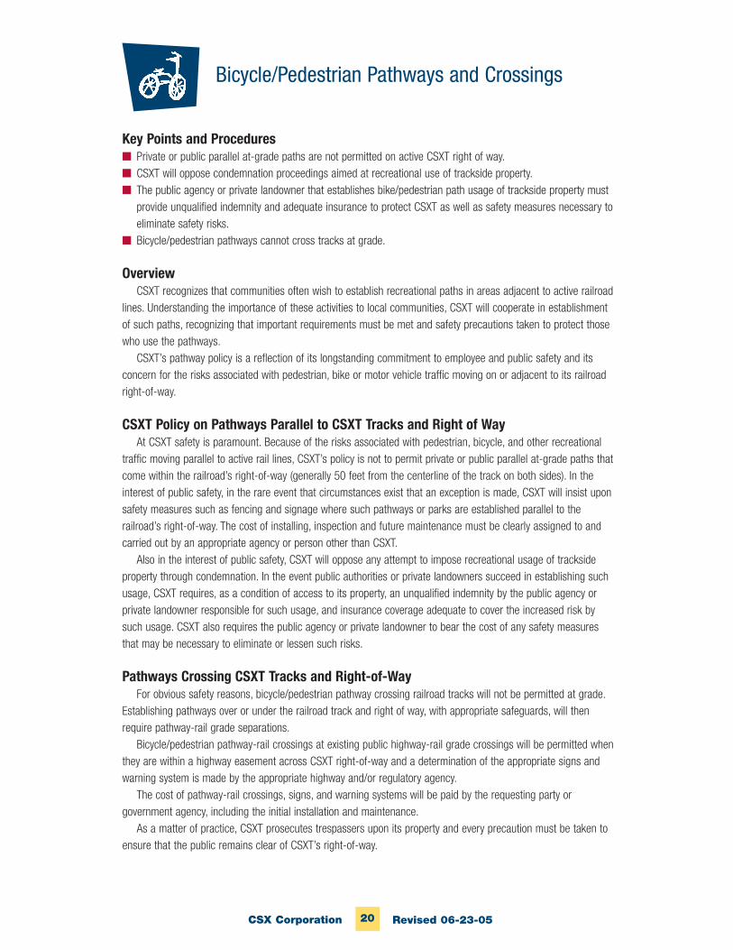
20CSX Corporation Revised 06-23-05
Key Points and Procedures■ Private or public parallel at-grade paths are not permitted on active CSXT right of way.■ CSXT will oppose condemnation proceedings aimed at recreational use of trackside property.■ The public agency or private landowner that establishes bike/pedestrian path usage of trackside property must
provide unqualified indemnity and adequate insurance to protect CSXT as well as safety measures necessary toeliminate safety risks.
■ Bicycle/pedestrian pathways cannot cross tracks at grade.
OverviewCSXT recognizes that communities often wish to establish recreational paths in areas adjacent to active railroad
lines. Understanding the importance of these activities to local communities, CSXT will cooperate in establishmentof such paths, recognizing that important requirements must be met and safety precautions taken to protect thosewho use the pathways.
CSXT’s pathway policy is a reflection of its longstanding commitment to employee and public safety and itsconcern for the risks associated with pedestrian, bike or motor vehicle traffic moving on or adjacent to its railroadright-of-way.
CSXT Policy on Pathways Parallel to CSXT Tracks and Right of WayAt CSXT safety is paramount. Because of the risks associated with pedestrian, bicycle, and other recreational
traffic moving parallel to active rail lines, CSXT’s policy is not to permit private or public parallel at-grade paths thatcome within the railroad’s right-of-way (generally 50 feet from the centerline of the track on both sides). In theinterest of public safety, in the rare event that circumstances exist that an exception is made, CSXT will insist uponsafety measures such as fencing and signage where such pathways or parks are established parallel to therailroad’s right-of-way. The cost of installing, inspection and future maintenance must be clearly assigned to andcarried out by an appropriate agency or person other than CSXT.
Also in the interest of public safety, CSXT will oppose any attempt to impose recreational usage of tracksideproperty through condemnation. In the event public authorities or private landowners succeed in establishing suchusage, CSXT requires, as a condition of access to its property, an unqualified indemnity by the public agency orprivate landowner responsible for such usage, and insurance coverage adequate to cover the increased risk bysuch usage. CSXT also requires the public agency or private landowner to bear the cost of any safety measuresthat may be necessary to eliminate or lessen such risks.
Pathways Crossing CSXT Tracks and Right-of-WayFor obvious safety reasons, bicycle/pedestrian pathway crossing railroad tracks will not be permitted at grade.
Establishing pathways over or under the railroad track and right of way, with appropriate safeguards, will thenrequire pathway-rail grade separations.
Bicycle/pedestrian pathway-rail crossings at existing public highway-rail grade crossings will be permitted whenthey are within a highway easement across CSXT right-of-way and a determination of the appropriate signs andwarning system is made by the appropriate highway and/or regulatory agency.
The cost of pathway-rail crossings, signs, and warning systems will be paid by the requesting party orgovernment agency, including the initial installation and maintenance.
As a matter of practice, CSXT prosecutes trespassers upon its property and every precaution must be taken toensure that the public remains clear of CSXT’s right-of-way.
Bicycle/Pedestrian Pathways and Crossings
RFP P5413 / Contract No. 200703566 Rev.1.050508 Page 1 of 8
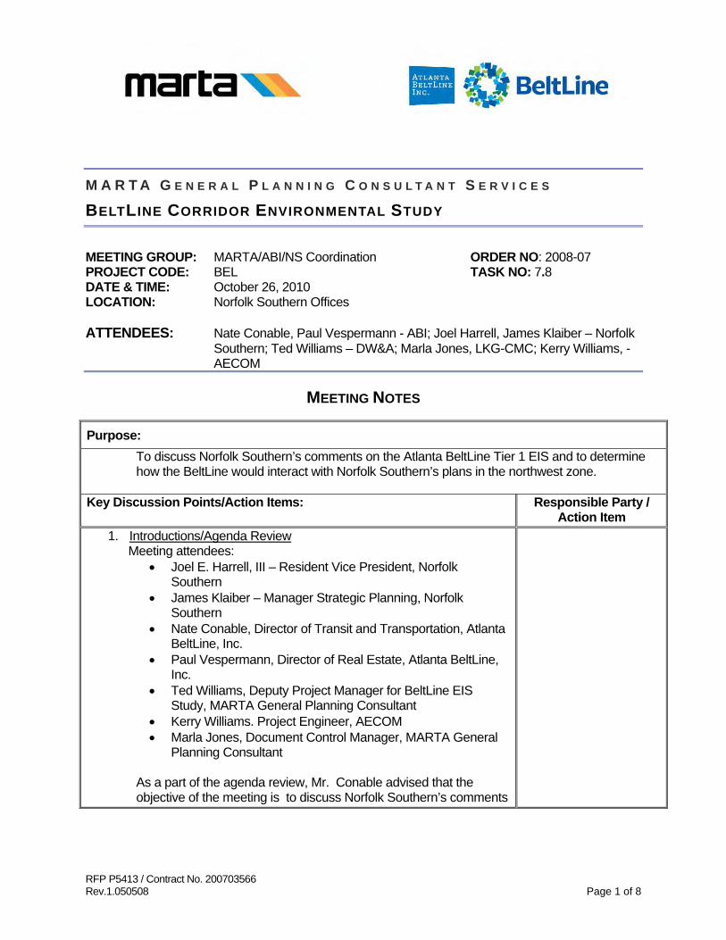
M A R T A G E N E R A L P L A N N I N G C O N S U L T A N T S E R V I C E S
BELTLINE CORRIDOR ENVIRONMENTAL STUDY
MEETING GROUP: MARTA/ABI/NS Coordination ORDER NO: 2008-07 PROJECT CODE: BEL TASK NO: 7.8 DATE & TIME: October 26, 2010 LOCATION: Norfolk Southern Offices ATTENDEES: Nate Conable, Paul Vespermann - ABI; Joel Harrell, James Klaiber – Norfolk
Southern; Ted Williams – DW&A; Marla Jones, LKG-CMC; Kerry Williams, - AECOM
MEETING NOTES
Purpose: To discuss Norfolk Southern’s comments on the Atlanta BeltLine Tier 1 EIS and to determine how the BeltLine would interact with Norfolk Southern’s plans in the northwest zone.
Key Discussion Points/Action Items: Responsible Party /
Action Item 1. Introductions/Agenda Review
Meeting attendees: • Joel E. Harrell, III – Resident Vice President, Norfolk
Southern • James Klaiber – Manager Strategic Planning, Norfolk
Southern • Nate Conable, Director of Transit and Transportation, Atlanta
BeltLine, Inc. • Paul Vespermann, Director of Real Estate, Atlanta BeltLine,
Inc. • Ted Williams, Deputy Project Manager for BeltLine EIS
Study, MARTA General Planning Consultant • Kerry Williams. Project Engineer, AECOM • Marla Jones, Document Control Manager, MARTA General
Planning Consultant As a part of the agenda review, Mr. Conable advised that the objective of the meeting is to discuss Norfolk Southern’s comments
Purpose: To discuss Norfolk Southern’s comments on the Atlanta BeltLine Tier 1 EIS and to determine how the BeltLine would interact with Norfolk Southern’s plans in the northwest zone.
Key Discussion Points/Action Items: Responsible Party /
Action Item on the Atlanta BeltLine Tier 1 EIS and to determine how the BeltLine would interact with Norfolk Southern’s plans in the northwest zone.
2. Project Overview
• Mr. Conable began the discussion with a quick overview of the
BeltLine Project. Mr. Conable noted that: o The project is an economic development initiative
designed to help the City of Atlanta accommodate its population growth over the next 20-30 years.
o The corridor is about 22 miles, roughly made up of 4 freight railroad corridors (Decatur Belt in the northeast, Atlanta West Point in the southeast, the old L&N in the southwest, and NS, CSX and Amtrak in the northwest).
o The corridor will consist of transit, multi-use trails and linear greenway.
o The goal is to create substantial economic development and mixed-use housing around the corridor thereby making it a livability and amenity corridor which impacts public health, mobility and quality of life in the City of Atlanta.
o The full project is expected to be built out within the next 20-25 years which includes transit, trails, parks and affordable housing. The transit portion will be implemented over time and in segments and a schedule for transit implementation should be available next summer.
3. NS Corridor Plans in BeltLine Study Area
• Ted Williams reviewed the plan views showing the proposed BeltLine alignments in the Norfolk Southern corridor and advised that the original Norfolk Southern alignment assumes running inside the right-of-way and was included in the draft EIS. The other option shows the alignment outside of the Norfolk Southern right-of-way to the south. This option crosses Northside Drive, and then detours via an in-street running operation to provide access to the Atlantic Station, then crosses NS to access Deering Road and continues north across Peachtree to the Armour industrial area.
Page 2 of 8
Purpose: To discuss Norfolk Southern’s comments on the Atlanta BeltLine Tier 1 EIS and to determine how the BeltLine would interact with Norfolk Southern’s plans in the northwest zone.
Key Discussion Points/Action Items: Responsible Party /
Action Item Mr. Joel Harrell asked what the team means when using the term transit in their discussion. Ted Williams advised that it refers to streetcar and light rail technologies. Bus ways are not a part of the discussion at this point. Mr. James Klaiber asked if the alignments discussed include the trails. Mr. Conable stated no. The trails have been kept with the CSX alignment.
Another question posed by Mr. Harrell was how the alignment interfaces with the Decatur Belt and reminded the attendees that Norfolk Southern retained a section of the track for utilizing the railroad wye at I-85 to turn their equipment or use it for storage. Mr. Harrell noted that this is a critical section for NS and they plan to hold on to it. Mr. Conable advised that there are several connectivity options to address crossing I-85 at this point that the team is considering for this area, but this decision will not be made in the Tier 1 EIS. Mr. Harrell asked if the alignment was at-grade when it gets to the Howell Junction area. Mr. Conable responded that the alignment is not at-grade in that area and is proposed to be on an elevated structure. Mr. Harrell advised that this would be another area of concern for NS because there has been extensive discussion over the years regarding separating Howell Junction for purposes suiting both of the railroads (CSX and NS). Mr. Harrell noted that Howell Junction is considered the new “Mile Post Zero” (i.e., the center for all rail activity in Atlanta). In this corridor there are over 100 train movements per day. Mr. Harrell stated that at this point NS will not be able to say “yes” or “no” to the BeltLine’s plans for this area because there has not been enough detailed study at this point. However, Mr. Klaiber noted that it would be highly unlikely that NS would allow a structure to be built in the Howell Junction area because it might preclude grade separation.
Mr. Conable asked if Norfolk Southern intended to impact the Marietta Blvd. Bridge when they separate Howell Junction. Mr. Harrell replied that there has not been enough study to determine how the bridge will be handled.
Mr. Harrell informed the team that Norfolk Southern’s policy in regard to transit (streetcar) operation is that they will not allow a light rail system adjacent to their heavy rail system. Mr. Klaiber
Page 3 of 8

Purpose: To discuss Norfolk Southern’s comments on the Atlanta BeltLine Tier 1 EIS and to determine how the BeltLine would interact with Norfolk Southern’s plans in the northwest zone.
Key Discussion Points/Action Items: Responsible Party /
Action Item noted that this is in agreement with FRA’s policy which deals with crash worthiness. In certain places it is time separated which would not work in this situation. Another requirement has to do with the length of separation (space). Right now the track centers are 14-15 feet apart. To allow the BeltLine project in the right-of-way would mean that the track centers would have to be at least 30 feet apart, which would result in a right-of-way that would be in the middle and useless to both BeltLine and Norfolk Southern because neither entity would be able to build closer to the other. Mr. Klaiber further noted that the only place where NS would allow light rail is in corridors where train operation is minimal or non-existent and stated that light rail vehicles are not FRA compliant. Mr. Klaiber noted that in the Atlanta area NS has a highly-used mainline and if there is additional right-of-way, NS will want to add to its infrastructure. Mr. Klaiber stated that rail is now becoming the preferred alternative and over the past 4-5 years NS has grown their traffic. Consequently, they are trying to preserve as much future capacity as possible for anticipated growth. Mr. Conable asked if Mr. Klaiber could quantify the future capacity (i.e., one or two tracks). Mr. Klaiber said that it is an incremental phase process but it’s also based on opportunity. If the railroad has right-of-way, a second track will be added in where possible. The railroad will probably start off with 5-10,000 feet siding and proceed in increments into a third main line. If the railroad does not own the property, they will probably work long term to acquire additional property. Mr. Harrell advised that this corridor has been designated by the Federal government as a high-speed passenger rail corridor and that he foresees this corridor eventually being as full of rail as possible. Consequently, he does not see any additional capacity being available.
Page 4 of 8
Purpose: To discuss Norfolk Southern’s comments on the Atlanta BeltLine Tier 1 EIS and to determine how the BeltLine would interact with Norfolk Southern’s plans in the northwest zone.
Key Discussion Points/Action Items: Responsible Party /
Action Item Mr. Harrell stated that Norfolk Southern will be willing to work with BeltLine on the off-railroad alternatives. Mr. Klaiber said NS does not have a restriction prohibiting an elevated structure next to their right-of-way. The only restriction is the vehicle type (light rail). Crash walls or detection devices can be used but are not preferable options for NS. Mr. Harrell asked what the advantage would be for a fixed rail street-car operation in lieu of a rubber-tire transit operation. Mr. Conable replied streetcar is preferred because redevelopment tends to follow rail projects. These types of projects have been pretty successful in the northwest part of the country. Further, Ted Williams advised that previous studies looked at the possibility of a rubber-tire option and presented it to the public. However, it was not compatible with the City’s plans and did not fare well with public preference so it was not advanced to this phase of study. Mr. Conable asked if the Norfolk Southern representatives could share information on expansion plans. Mr. Klaiber stated that he will check with the engineers to see if there is anything specific but cautioned that if there is any information it will probably be very conceptual at this point. Mr. Harrell said that he knows there will not be anything in writing on Howell Junction, just discussions over the years. Mr. Conable asked if he could submit the information in the next two weeks to meet the Study’s timeline for resubmission of the EIS to FTA and he agreed. Mr. Conable asked if there were other entities beside those mentioned already that had plans to use the railroad corridors. Mr. Harrell said not that they were aware of. Mr. Conable then asked if NS had agreements in place with any of the entities who planned to use the corridor and Mr. Harrell advised that they have an agreement with Amtrak whereby they can add certain kinds of service. Mr. Conable asked if NS would be willing to continue discussing proposed alignment options in their corridor once the Tier 1 is completed and the BeltLine moves into the next phase of study. Mr. Harrell and Mr. Klaiber felt that NS would be willing to continue the dialog with Atlanta BeltLine and stated that they would inform them if an agreement were ever reached with CSX regarding Howell Junction or if a task force was developed to study the area.
Page 5 of 8
Purpose: To discuss Norfolk Southern’s comments on the Atlanta BeltLine Tier 1 EIS and to determine how the BeltLine would interact with Norfolk Southern’s plans in the northwest zone.
Key Discussion Points/Action Items: Responsible Party /
Action Item Mr. Harrell advised that they received the TIGER 1 grant for the Crescent Corridor which is Norfolk Southern’s growth plan. The Crescent Corridor includes the NS track segment being considered by the Atlanta BeltLine. It is basically an intermodal rail interstate, which will hopefully get some of the truck traffic off the interstate. This is a capacity and speed improvement project. Mr. Conable asked if the NS “pillars” for shared-use negotiations (uncompromised safety, capacity for current and future needs, no subsidization by NS, and liability protection) remained the same. Mr. Harrell said yes; however crossings are not really an issue it is just a matter of clearance, design, and if there is a future expansion need that may be impacted like at Howell Junction. Mr. Conable asked if there are any plans to expand Inman Yard. Mr. Klaiber explained that it depends on the traffic flow and how they develop. Inman yard has turned into an intermodal operation. Mr. Harrell said for the most part it is operating as a “piggy-back” yard and there are no immediate plans to expand. Mr. Conable asked if NS has an idea of how much passenger rail traffic can be accommodated in the Western Truck without impacting Norfolk Southern’s operations. Mr. Harrell said that in order to run passenger service through the area, the state would have to look at adding an additional track (4th mainline). Mr. Conable asked what the physical separation requirement is for light rail. Mr. Klaiber replied that it is a FRA policy. Norfolk Southern starts at 25 feet and FRA adds additional footage. Mr. Klaiber advised that NS does not like censors, crash walls or passenger stations inside of their right-of-way. Mr. Harrell asked if the BeltLine Tier 1 EIS could proceed if the CSX & NS alignments were taken out of the Northwest zone. Mr. Conable responded that one of FTA’s comments was that discussion was needed with the railroads, because if the Project cannot be in their corridors we may not have a project with logical termini. So FTA views the project’s logical termini as inclusive of the NW part of the loop.
Page 6 of 8
Purpose: To discuss Norfolk Southern’s comments on the Atlanta BeltLine Tier 1 EIS and to determine how the BeltLine would interact with Norfolk Southern’s plans in the northwest zone.
Key Discussion Points/Action Items: Responsible Party /
Action Item Mr. Conable asked if NS is looking at freight bypasses. Mr. Harrell advised that at the present time there are two routes, one on the east side and one on the west side that has been preserved for possible bypasses around Atlanta. Each bypass currently contains portions that are out of service right now and both of them would require a fair amount of upgrading to put them into service. NS is not currently looking at putting them into service right now because demand does not warrant it. NS looks at the bypasses as additional capacity too in addition to running through the middle of Atlanta. Mr. Harrell noted that there are no plans to rationalize (short line) any additional tracks or take tracks out of the system. Tracks may be taken out of service but NS will retain them. Ted Williams asked if NS had any comments on the typical cross sections noted in the draft EIS and mentioned in the letter sent to Mr. Harrell. Mr. Klaiber advised that at this stage, NS typically doesn’t get into the details in terms of cross section design parameters because there is no project being moved forward and the NS design engineers are inundated with other efforts. Ted Williams asked if there has been any study of the grade separation at Howell Junction. Mr. Klaiber replied that to his knowledge there is nothing on paper. Mr. Harrell then stated that if there is a joint task force developed to look at the Howell Junction area, NS would be willing to participate.
Next Steps • Mr. Harrell asked the team to draft a letter for NS signature that
states that the railroad met with us and that they are willing to continue to dialog with us in the future.
• Jim Klaiber will check with the engineering team to see if there are any plans for expansion and provide these within two weeks.
• Mr. Conable will forward the meeting minutes from today to Mr. Harrell and Mr. Klaiber for review and comment.
C: Document Control
Next Meeting Date: TB D
Page 7 of 8
M A R T A G E N E R A L P L A N N I N G C O N S U L T A N T S E R V I C E S
BELTLINE CORRIDOR ENVIRONMENTAL STUDY
MEETING GROUP: MARTA/ABI/CSX Coordination ORDER NO: 2008-07 PROJECT CODE: BEL TASK NO: 7.8 DATE & TIME: November 10, 2010 LOCATION: Conference Call ATTENDEES: See List Below
MEETING NOTES
Purpose: To discuss CSX comments on the Atlanta BeltLine Tier 1 EIS and to determine how the BeltLine would interact with CSX’s plans in the northwest zone.
Key Discussion Points/Action Items: Responsible Party /
Action Item 1. Introductions/Agenda Review
Meeting attendees: • Craig Camuso, Regional Vice President, State Government
Relations, CSX • Keith Brinker, Manager, Environmental Remediation, CSX • Chris Maffett, Director, Networkology, CSX • Mark Holder, Director, Public Agency Services, CSX • Marty Marchaterre, Consultant, CSX • Nate Conable, Director of Transit and Transportation, Atlanta
BeltLine, Inc. • Paul Vespermann, Director of Real Estate, Atlanta BeltLine,
Inc. • Leslie Roche, Environmental Task Leader for BeltLine EIS,
AECOM • Scott Johnson, Project Engineer for BeltLine EIS, AECOM • Marla Jones, Document Control Manager, MARTA General
Planning Consultant As a part of the agenda review, Nate Conable advised that the objective of the meeting is to discuss CSX’s comments
RFP P5413 / Contract No. 200703566 Rev.1.050508 Page 1 of 8
Purpose: To discuss CSX comments on the Atlanta BeltLine Tier 1 EIS and to determine how the BeltLine would interact with CSX’s plans in the northwest zone.
Key Discussion Points/Action Items: Responsible Party /
Action Item on the Atlanta BeltLine Tier 1 DEIS and to determine how the BeltLine would interact with CSX’s plans in the northwest zone.
Northwest Zone Alignment Overview The discussion began with a description of the proposed CSX transit alignment in the northwest zone of the BeltLine by Nate Conable. Nate advised that one of the key issues to be addressed is the section of the alignment that runs from Howell Junction north to the Lindbergh Center area. The project has a couple of alternatives in this area. One alternative is inside of the CSX corridor and the other is outside of the CSX corridor (parallel alignment). Both alignments have variations associated with them. For the trail alignments the project has both the inside and outside alignments with an option associated with the outside alignment. Following are questions, answers, and comments relative to the proposed alignment: Question: When you talk about the activity at Howell Junction, is the plan to run along the right-of-way in that area? (Craig Camuso) Response: One option is to go over Howell Junction and other option is to use the existing Marietta Blvd. Bridge. (Nate Conable) Question: Are you aware that one of the initiatives that GDOT is undertaking is to study grade separation at Howell Junction? (Craig Camuso) Response: We know there has been some discussion but are not aware of any preliminary work towards that end. (Nate Conable) Question: Do you know how the grade separation would conceptually be designed? (Nate Conable)
Page 2 of 8

Purpose: To discuss CSX comments on the Atlanta BeltLine Tier 1 EIS and to determine how the BeltLine would interact with CSX’s plans in the northwest zone.
Key Discussion Points/Action Items: Responsible Party /
Action Item Response: No. There has been a lot of discussion but no written documentation as of yet. (Craig Camuso)
Question: Do any of your plans involve running on existing CSX tracks? (Craig Camuso) Response: No. Our plans involve running parallel incorporating enough distance to promote safety. (Nate Conable) Question: Does parallel mean within the right-of-way? (Craig Camuso) Response: We have both options on the table right now (inside and outside of right-of-way). Our preferred option is to work out an arrangement with CSX whereby we can operate within your right-of-way, particularly where it is key to mitigating property impacts. Question: About four years ago CSX tried to reconstruct the wooden trestle to a steel structure in the Tanyard Creek area to incorporate some designs that we felt would be beneficial to the BeltLine. In doing so, we went through a great deal of public involvement to discuss our plans. There was a lot of opposition from the community and we were not allowed to reconstruct that bridge. What has been the response from the residents in that area in regard to possible property impacts due to your proposed alignments? (Craig Camuso) Response: We haven’t highlighted this discussion with the residents yet because we wanted to get a sense of what the concerns, needs, and issues were for CSX first before speaking to the public. We understand that this community has been problematic in the past but we believe that there has been some good will created due the construction of the trail in that area. The community loves the trail and makes good use of it. We are hoping to build upon that good will in the future. Question: Where is the study in the NEPA process and what will the next
Page 3 of 8
Purpose: To discuss CSX comments on the Atlanta BeltLine Tier 1 EIS and to determine how the BeltLine would interact with CSX’s plans in the northwest zone.
Key Discussion Points/Action Items: Responsible Party /
Action Item steps will be? (Keith Brinker).
Response: We are currently in the process of responding to FTA’s comments on the Administrative Draft EIS. One of their comments dealt specifically with the need for coordination between the project team and the railroads to ensure that we have received feedback on how the proposed alignments might impact the railroads’ operations. Once all comments have been addressed, the Administrative Draft EIS will be resubmitted to FTA. We anticipate resubmitting the document in the middle of December. Assuming things go well, we will publish our Notice of Availability in late January, hold the public hearing in February, then obtain a ROD (record of decision) by late summer or fall. (Nate Conable) Comment Given the concept of utilizing either the NS or CSX right-of-way, the timeframe needed to get the coordination and possible concurrence needed from either railroad seems to be aggressive for obtaining an approved EIS. (Keith Brinker)
Question What issues are giving you the sense that our schedule does not allot enough time? (Nate Conable) Response There needs to be additional discussions with the CSX operating group. I don’t think you want to go through your EIS process without the two affected railroads in agreement with your options. (Keith Brinker) Comment I fully agree. The more we can accomplish in terms of coordination and buy-in on the alternatives that we have in the EIS by CSX, the better it is for us. However, from a business perspective for ABI, one of the issues that we are facing is that this is a 22-mile project but it will be built in phases over time. We took a Tier 1 approach to clear some of the high level issues. If the Tier 1 doesn’t get completed in a timely manner, it prevents
Page 4 of 8
Purpose: To discuss CSX comments on the Atlanta BeltLine Tier 1 EIS and to determine how the BeltLine would interact with CSX’s plans in the northwest zone.
Key Discussion Points/Action Items: Responsible Party /
Action Item ABI from going to a Tier 2 on any particular segment that we may want to move toward implementation soon rather than later. Consequently, ABI is trying to be very sensitive from a schedule perspective that the clearance of the overall 22-mile corridor does not prevent ABI from going for federal funds for individual segments of the corridor. That is why we are trying to get this wrapped up as quickly as possible, realizing that coordination with the railroads is essential. With that said, I would ask that we try to do everything possible to accelerate the coordination needed to ensure that CSX is comfortable with the alternatives currently in the study. If that involves extending the schedule a little then that is feasible. If it involves a much longer period of time then I request that we come up with an interim solution where we can get agreement to continue our discussions and keep options on the table that will be resolved at a Tier 2 level. (Nate Conable) Response I believe that it’s possible. However, I work on the environmental side. The CSX staff that works in real estate and operations would be the people that would need to be involved in further discussions with the BeltLine team. (Keith Brinker) CSX Corridor Plans in the BeltLine Study Area The next topic of discussion centered on the railroad’s future plans for the corridor. Following are highlights from that discussion provided by Chris Maffett and Craig Camuso:
• Freight needs are expected to increase significantly in the next 10-20 years. Atlanta is a fairly big hub for CSX so additional capacity will be needed.
• Over the long-term, the Abbeville sub and W&A Lines (Howell Junction area) will need to be double tracked.
• There will need to be some capacity improvements to allow for commuter rail (specific information available in GDOT’s capacity study).
• CSX will be somewhat hesitant to give up right-of-way that impacts their long-term ability to provide capital to meet their freight needs.
Page 5 of 8
Purpose: To discuss CSX comments on the Atlanta BeltLine Tier 1 EIS and to determine how the BeltLine would interact with CSX’s plans in the northwest zone.
Key Discussion Points/Action Items: Responsible Party /
Action Item • There may be a possibility of using some of the CSX
right-of-way as long as the railroad’s needs for capacity are met and efficiency and safety are not compromised.
• CSX may be able to work with the BeltLine project on touchdown points for the proposed bridge alignment going through the Howell Junction area. Consideration would be based on where the touchdown points are and if they impacted in future realignments that would be needed to facilitate freight movements. Also, the touchdown points would have to be in concert with Norfolk Southern.
NW Zone Alternatives Nate Conable began this portion of the meeting by reiterating to CSX that it has always been the intention of the BeltLine Study to involve CSX in the development of alignments. This was initially done by inviting CSX to participate on the Stakeholder Advisory Committee. Nate then asked what documents were needed now to facilitate the railroad’s review and comment on the alternative alignments in the northwest zone. In response Craig Camuso noted that there has been open dialog about the BeltLine project through the years but until this point there has not been a route to comment on. Craig stated that there is not a lot of right-of-way in the northwest area of the CSX corridor so it will be interesting to see the proposed alignments. Craig said he believes it would be good to see any type of basic engineering; however the Assistant Chief Engineer would be the one to determine what should be provided. Other highlights of this discussion include: • CSX would like to be included on any further discussion with
SHPO as it pertains to the Section 106 Evaluation of the corridor as a potential historic resource.
• Nate Conable will provide the Cultural Resources document to CSX to review so that they can provide feedback to ensure that is it appropriately set in the railroad’s context.
• CSX noted that they have a huge safety concern with at- grade pedestrian trails crossing over active freight lines and advised that the BeltLine project team may want to consider pedestrian bridges in areas where there is active freight lines.
Page 6 of 8

Purpose: To discuss CSX comments on the Atlanta BeltLine Tier 1 EIS and to determine how the BeltLine would interact with CSX’s plans in the northwest zone.
Key Discussion Points/Action Items: Responsible Party /
Action Item Railroad Questionnaire Discussion This portion of the meeting was used to discuss/clarify the answers previously provided by CSX in response to the railroad questionnaire given to them on behalf of the BeltLine EIS management team. Following are key issues from that discussion:
• CSX does not have any concrete plans as of yet for double tracking in the northwest corridor and will probably not share that information when it is available.
• If in the future, if it is determined that CSX’s needs for capacity are met and efficiency and safety are not compromised, they will be willing to continue discussing the possibility of the BeltLine project operating in their right-of-way but they cannot guarantee or commit to anything.
• For planning purposes, the BeltLine EIS team should assume that CSX will be double tracking through their northwest corridor.
• There is currently no commitment or agreement in place for another entity to use the CSX right-of-way in the northwest corridor.
• There are restrictions of modes with freight operations in the corridor but the specifics would have to be answered by Chuck Washington.
• CSX will review the BeltLine EIS team’s responses to FTA’s comments regarding railroad coordination to ensure that they accurately reflect the position taken by CSX.
• The four pillars have remained the same • CSX is not aware of any projects with LRT or Streetcar
operating within their right-of-way. • There are currently no plans to expand any of the CSX yards
in the northwest corridor but they reserve the right to do so in the future.
• The BeltLine EIS team will need to speak with the CSX Real Estate Department to determine if there are any plans to expand the A&WP in the southeast area.
• CSX chose not to answer the question regarding whether or not they are actively pursuing bypass lines.
Page 7 of 8
Page 8 of 8
Purpose: To discuss CSX comments on the Atlanta BeltLine Tier 1 EIS and to determine how the BeltLine would interact with CSX’s plans in the northwest zone.
Key Discussion Points/Action Items: Responsible Party /
Action Item Next Steps • The CSX team will meet internally to determine how they wish to
move forward with coordination activities. In the meantime, Nate Conable advised that the BeltLine EIS team will provide CSX with conceptual engineering work, a draft operation plan, and typical sections that represent where the alignment parallels the CSX facilities. Nate asked that the CSX team be mindful as they consider coordination activities that the BeltLine EIS team is under time constraints to get the EIS document back to FTA.
C: Document Control
Next Meeting Date: TB D
RFP P5413 / Contract No. 200703566 Rev.1.050508 Page 1 of 3
M A R T A G E N E R A L P L A N N I N G C O N S U L T A N T S E R V I C E S
BELTLINE CORRIDOR ENVIRONMENTAL STUDY
MEETING GROUP: MARTA/ABI/GDOT Coordination ORDER NO: 2008-07 PROJECT CODE: BEL TASK NO: 7.8 DATE & TIME: November 1, 2010 LOCATION: GDOT Offices ATTENDEES: Erik Steavens – GDOT; Adelee Le Grand – AECOM; Marla Jones, LKG-
CMC; Johnny Dunning - MARTA MEETING NOTES
Purpose: To discuss Norfolk Southern’s comments on the Atlanta BeltLine Tier 1 EIS and to
Key Discussion Points/Action Items: Responsible Party / Action Item
1. Project Update Adelee Le Grand began the meeting with an explanation of the process for resubmittal of the DEIS to FTA. She also discussed the project’s remaining tasks and associated timeline to reach a Record of Decision. Adelee noted that in addition to the alignments proposed to run inside of the railroads’ right-of-way, the team is also considering two off-railroad alignments so that the project will still have logical termini in the event that that the railroads won’t allow the project to operate in their right-of-way. Adelee advised that there will be a series of public meetings to present the off-railroad alternatives and noted that there is a possibility that the DEIS may only contain the off-railroad alternatives when it is resubmitted to FTA. Johnny Dunning stated that even if the off-railroad alternatives are selected, it will still require extensive coordination with the railroads, including the issue of crossing Howell Junction. Eric Steavens replied that when dealing with the Howell Junction area the team should speak with Steve Stancil of the Building Authority because

Purpose: To discuss Norfolk Southern’s comments on the Atlanta BeltLine Tier 1 EIS and to
Key Discussion Points/Action Items: Responsible Party / Action Item
the state owns some of the right-of-way in that area (the western Atlantic portion). Consequently, the solution may not be as difficult as it appears. Eric noted that the state leased the right-of-way to CSX which he believes will expire in 2017 or 2019. If this section of the BeltLine is timed to move forward around the time the lease with CSX expires, the project may be able to negotiate its plans so that they are incorporated into the state’s next lease agreement for the land in the Howell Junction area.
In reference to the NS option, Eric Steavens recommended that the project team contact Siemens, SRTA Jacoby, and Amtrak because:
• At Northside Drive there is a Siemens building that is for sale that has some rail frontage
• SRTA has some property in the area • There is a strip along a fence that Jacoby has vacant • Amtrak has looked at the possibility of placing its station over
in the Atlantic Station area to get off the mains Adelee Le Grand advised that there are three options for getting out of the NE alignment and in to Lindbergh that will not be resolved in this study. Eric Steavens noted that if a flyover is not involved in any of the options there will need to be some discussion with GDOT and the City about doing signal pre-emption. Eric recommended that the team follow-up with Todd Long, Glenn Bowman, and Keith Golden of GDOT to discuss program, planning, signalization, permitting and overall environmental issues. The team continued discussing various aspects of the alignment around the BeltLine loop. Adelee Le Grand asked Eric Steavens if there are other projects or studies (besides the Atlanta to Chattanooga study) relative to GDOT’s intermodal plans within the BeltLine study area that the team should be aware of. In response Eric noted the NS corridor, Howell Junction, MMPT and discussions concerning improvements to Inman and Tilford yards. Adelee then asked if the state was to do a lease agreement for the BeltLine project how long would the agreement be?
Page 2 of 3

Page 3 of 3
Purpose: To discuss Norfolk Southern’s comments on the Atlanta BeltLine Tier 1 EIS and to
Key Discussion Points/Action Items: Responsible Party / Action Item
Eric Steavens responded that it legally depends on who the lease agreement is with. If it is with a non-profit then the length of the agreement would be significantly less than if the lease were government to government. For FTA, you have to secure the lease for 40 years in order for FTA to feel comfortable. Adelee then asked about the status of the property owned by GDOT on the SE side near Glenwood. Eric advised that the property has been rendered useless so GDOT would be willing to abandon it.
Next Steps • Adelee Le Grand will forward draft meeting minutes to Eric
Steavens for review and comment so that they can be incorporated into the DEIS
• The BeltLine EIS project team will set up a meeting with Todd Long, Glenn Bowman and Keith Golden to discuss other coordination issues.
C: Document Control
Next Meeting Date: TB D
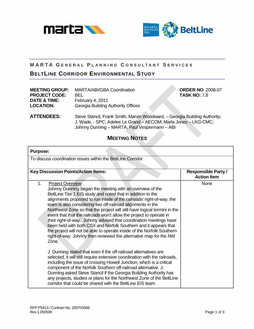
RFP P5413 / Contract No. 200703566 Rev.1.050508 Page 1 of 3
M A R T A G E N E R A L P L A N N I N G C O N S U L T A N T S E R V I C E S
BELTLINE CORRIDOR ENVIRONMENTAL STUDY
MEETING GROUP: MARTA/ABI/GBA Coordination ORDER NO: 2008-07 PROJECT CODE: BEL TASK NO: 7.8 DATE & TIME: February 4, 2011 LOCATION: Georgia Building Authority Offices ATTENDEES: Steve Stancil, Frank Smith, Marvin Woodward, – Georgia Building Authority;
J. Wade, - SPC; Adelee Le Grand – AECOM; Marla Jones – LKG-CMC; Johnny Dunning – MARTA; Paul Vespermann – ABI
MEETING NOTES
Purpose: To discuss coordination issues within the BeltLine Corridor
Key Discussion Points/Action Items: Responsible Party / Action Item
1. Johnny Dunning began the meeting with an overview of the BeltLine Tier 1 EIS study and noted that in addition to the alignments proposed to run inside of the railroads’ right-of-way, the team is also considering two off-railroad alignments in the Northwest Zone so that the project will still have logical termini in the event that that the railroads won’t allow the project to operate in their right-of-way. Johnny advised that coordination meetings have been held with both CSX and Norfolk Southern and it appears that the project will not be able to operate inside of the Norfolk Southern right-of-way. Johnny then reviewed the alternative map for the NW Zone.
Project Overview
J. Dunning stated that even if the off-railroad alternatives are selected, it will still require extensive coordination with the railroads, including the issue of crossing Howell Junction, which is a critical component of the Norfolk Southern off-railroad alternative. J. Dunning asked Steve Stancil if the Georgia Building Authority has any projects, studies or plans for the Northwest Zone of the BeltLine corridor that could be shared with the BeltLine EIS team.
None
Page 2 of 3
Purpose: To discuss coordination issues within the BeltLine Corridor
Key Discussion Points/Action Items: Responsible Party / Action Item
The following highlights were derived from information provided by Steve Stancil: • There has been a lot of discussion about commuter rail in the
Western Atlantic Corridor but no specific plans as of yet. In reference to Howell Junction, Steve noted that any fly-over 20 feet above the rail would have to be approved by the General Assembly because the State of Georgia owns the air rights.
• The State leases right-of-way to CSX in the Howell Junction area and this lease expires in 2019.
• The State has property for sale around Murphy Avenue (old
State Farmers Market) that may be of some interest to the BeltLine. If interested, BeltLine should contact Frank Smith after the General Assembly (around May or June).
None
The following highlights were derived from information provided by the BeltLine Project Team members in response to questions that were asked:
• The team anticipates receiving a Tier 1 Record of Decision
(ROD) by the end of this year. • Station locations are very conceptual at this point • The transit and trail alignment width is 57 feet except in portions
of the Northwest Zone where the transit and trail may be separated in accordance with the alternative.
• The CSX alternative connects to Piedmont Hospital and the
new Westside Park. • The Norfolk Southern alternative is adjacent to the railroad’s
right-of-way and will be more in-street running. At the end of the discussion Adelee Le Grand advised that FTA has expressed the need for coordination between the project team, the railroads and other appropriate parties and asked if the Georgia
None

Page 3 of 3
Purpose: To discuss coordination issues within the BeltLine Corridor
Key Discussion Points/Action Items: Responsible Party / Action Item
Building Authority will be willing to continue discussions. In response, Marvin Woodward stated that GBA would be willing to participate in future discussions. Next Steps • Adelee Le Grand advised that meeting notes would be
developed from today’s discussions and forwarded to Steve Stancil for review and comment before finalizing them.
J. Dunning will forward draft meeting notes to
Steve Stancil for review and comment
C: Document Control
Next Meeting Date: TB D

Atlanta BeltLine Corridor Environmental Study June 2011
Page Left Intentionally Blank

Atlanta BeltLine Corridor Environmental Study D June 2011
Appendix D - Data Tables and Figures
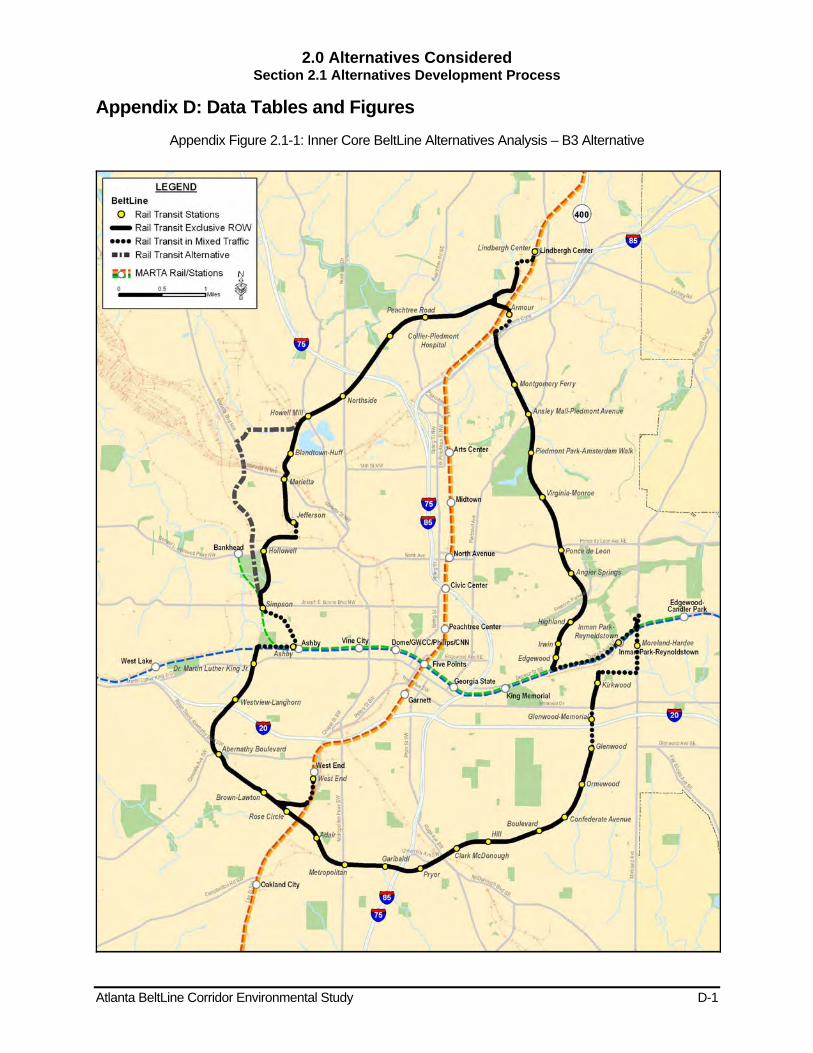
2.0 Alternatives Considered Section 2.1 Alternatives Development Process
Atlanta BeltLine Corridor Environmental Study D-1
Appendix D: Data Tables and Figures Appendix Figure 2.1-1: Inner Core BeltLine Alternatives Analysis – B3 Alternative

2.0 Alternatives Considered Section 2.1 Alternatives Development Process
Atlanta BeltLine Corridor Environmental Study D-2
Appendix Figure 2.1-2a: Transit and Trails Alternatives Identified During Scoping (Northeast Zone)
Source: AECOM/JJG Joint Venture
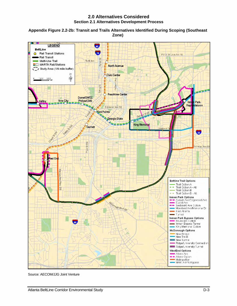
2.0 Alternatives Considered Section 2.1 Alternatives Development Process
Atlanta BeltLine Corridor Environmental Study D-3
Appendix Figure 2.2-2b: Transit and Trails Alternatives Identified During Scoping (Southeast Zone)
Source: AECOM/JJG Joint Venture
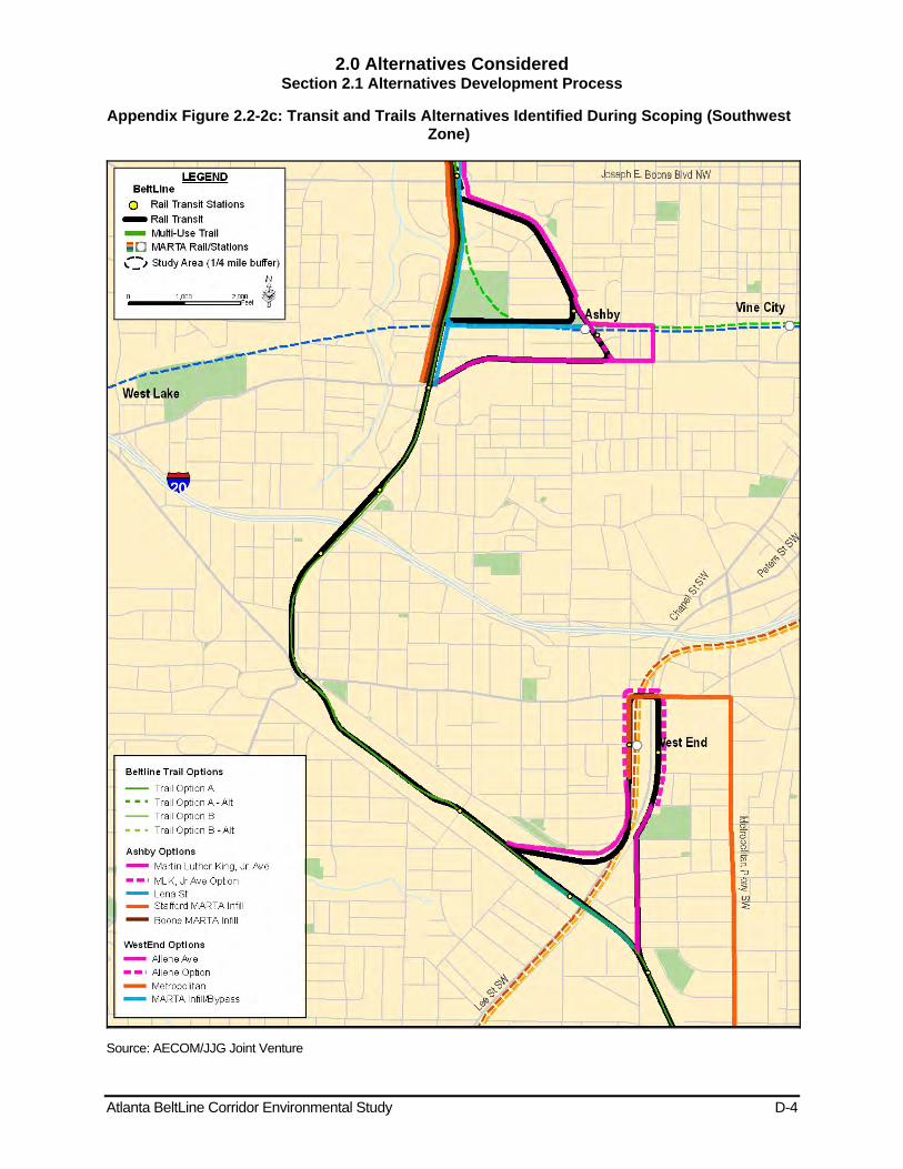
2.0 Alternatives Considered Section 2.1 Alternatives Development Process
Atlanta BeltLine Corridor Environmental Study D-4
Appendix Figure 2.2-2c: Transit and Trails Alternatives Identified During Scoping (Southwest Zone)
Source: AECOM/JJG Joint Venture
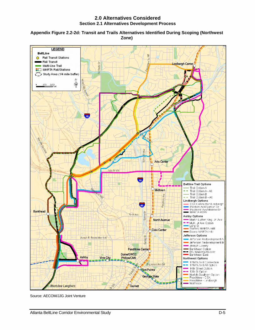
2.0 Alternatives Considered Section 2.1 Alternatives Development Process
Atlanta BeltLine Corridor Environmental Study D-5
Appendix Figure 2.2-2d: Transit and Trails Alternatives Identified During Scoping (Northwest Zone)
Source: AECOM/JJG Joint Venture

2.0 Alternatives Considered Section 2.2 No-Build Alternative
Atlanta BeltLine Corridor Environmental Study D-6
Appendix Table 2.2-1: Other Envision6 RTP/TIP Projects that Interface with the Atlanta BeltLine
Project Type Location Status Project Description Roadway Maintenance / Operations Multi-Jurisdictional Programmed I-75 / I-85 (downtown connector) resurfacing and
guardrail upgrade
Fixed Guideway Transit Capital
Multi-Jurisdictional Programmed
Commuter rail service – Atlanta / Griffin / Macon (stations and park-and-ride lots for Lovejoy section) Lindbergh Center / Emory bus high-speed premium transit service
Long Range I-20 east BRT
City of Atlanta Long Range Atlanta Streetcar - phase 2 north Atlanta Streetcar - phase 2 south
Arterial BRT Multi-Jurisdictional Programmed SR 13 (Buford Highway) arterial BRT
Multi-Jurisdictional Long Range Memorial Drive BRT
Studies Multi-Jurisdictional Programmed
I-75 / I-575 Northwest Corridor - general obligation bond funds for preliminary engineering I-75/I-575 Northwest Corridor - GRV bond funds for preliminary engineering I-75 / I-575 Northwest Corridor - bond funds (backed by anticipated toll revenue) for preliminary engineering I-75 / I-575 Northwest Corridor - bond funds (backed by anticipated 5309 New Starts allocations) for preliminary engineering
Transit Facilities Multi-Jurisdictional Programmed
I-75 / I-575 Northwest Corridor - general obligation bond funds for I-75 BRT I-75 / I-575 Northwest Corridor - GRV bond funds for I-75 BRT I-75 / I-575 Northwest Corridor - 5309 New Starts Funds for I-75 BRT
Roadway Operational Upgrades City of Atlanta Programmed US 78 / 278 (Donald Lee Hollowell Parkway)
Roadway Capacity City of Atlanta Long Range University Avenue
Pedestrian Facility City of Atlanta Programmed Ralph David Abernathy Boulevard pedestrian and intersection improvements
Multi-Use Bike / Pedestrian Facility City of Atlanta Programmed Marietta Boulevard pedestrian improvements
Bridge Upgrade City of Atlanta Programmed US 19 / SR 9 (Peachtree Rd, CSX RR)
Source: ARC, 2007, Envision6 RTP and TIP
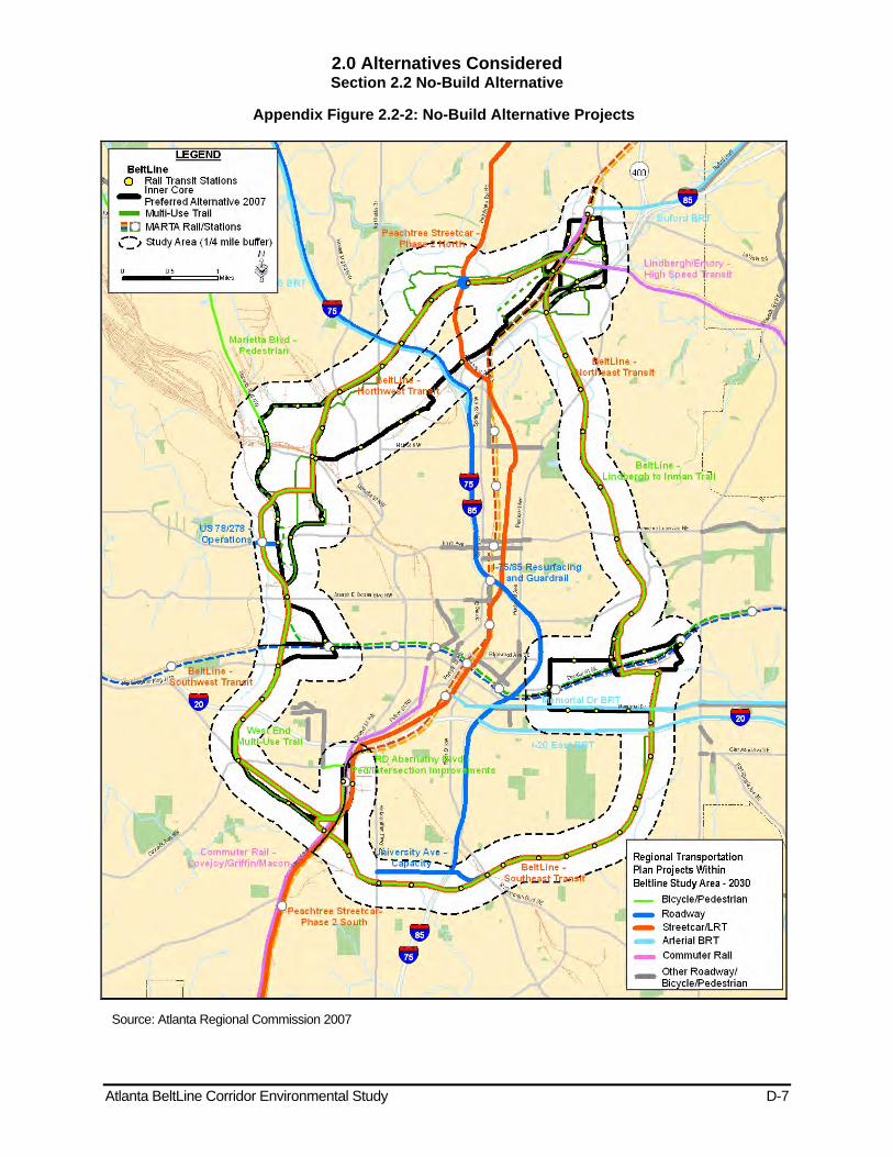
2.0 Alternatives Considered Section 2.2 No-Build Alternative
Atlanta BeltLine Corridor Environmental Study D-7
Appendix Figure 2.2-2: No-Build Alternative Projects
Source: Atlanta Regional Commission 2007

3.0 Affected Environment Section 3.3 Neighborhoods and Community Facilities
Atlanta BeltLine Corridor Environmental Study D-8
Figure 3.3-1: Community Facilities
Source: ARC and USGS
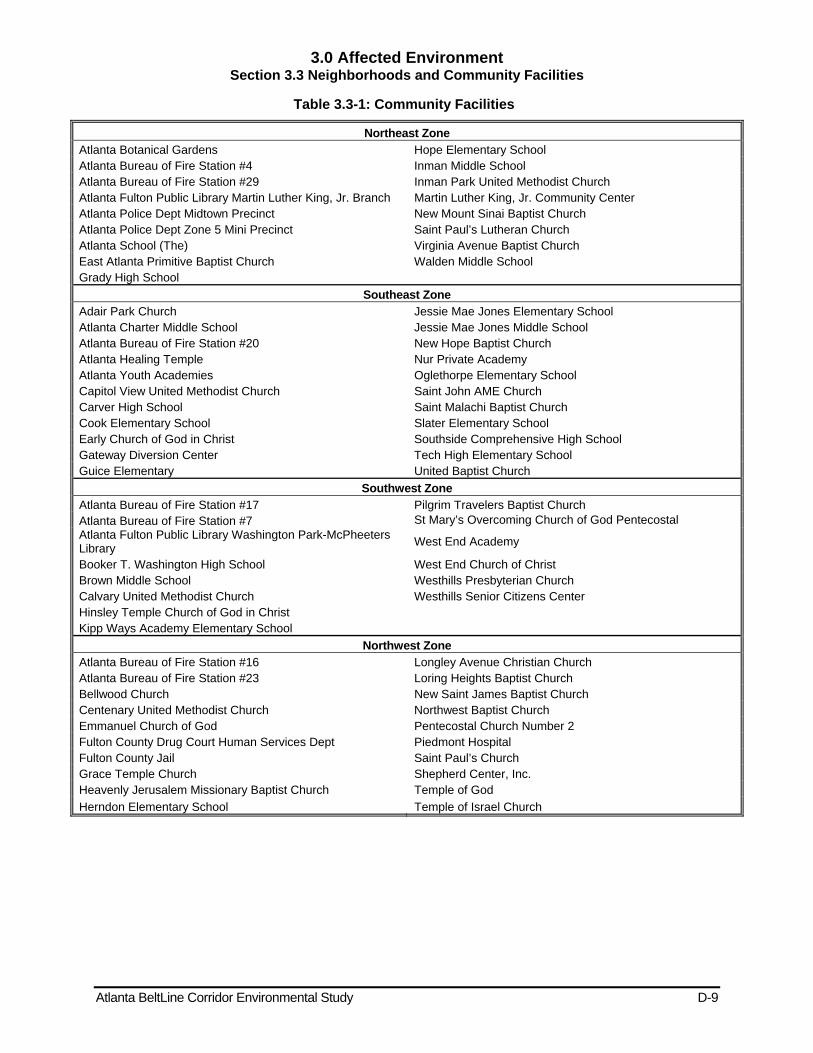
3.0 Affected Environment Section 3.3 Neighborhoods and Community Facilities
Atlanta BeltLine Corridor Environmental Study D-9
Table 3.3-1: Community Facilities
Northeast Zone Atlanta Botanical Gardens Hope Elementary School Atlanta Bureau of Fire Station #4 Inman Middle School Atlanta Bureau of Fire Station #29 Inman Park United Methodist Church Atlanta Fulton Public Library Martin Luther King, Jr. Branch Martin Luther King, Jr. Community Center Atlanta Police Dept Midtown Precinct New Mount Sinai Baptist Church Atlanta Police Dept Zone 5 Mini Precinct Saint Paul’s Lutheran Church Atlanta School (The) Virginia Avenue Baptist Church East Atlanta Primitive Baptist Church Walden Middle School Grady High School
Southeast Zone Adair Park Church Jessie Mae Jones Elementary School Atlanta Charter Middle School Jessie Mae Jones Middle School Atlanta Bureau of Fire Station #20 New Hope Baptist Church Atlanta Healing Temple Nur Private Academy Atlanta Youth Academies Oglethorpe Elementary School Capitol View United Methodist Church Saint John AME Church Carver High School Saint Malachi Baptist Church Cook Elementary School Slater Elementary School Early Church of God in Christ Southside Comprehensive High School Gateway Diversion Center Tech High Elementary School Guice Elementary United Baptist Church
Southwest Zone Atlanta Bureau of Fire Station #17 Pilgrim Travelers Baptist Church Atlanta Bureau of Fire Station #7 St Mary’s Overcoming Church of God Pentecostal Atlanta Fulton Public Library Washington Park-McPheeters Library West End Academy
Booker T. Washington High School West End Church of Christ Brown Middle School Westhills Presbyterian Church Calvary United Methodist Church Westhills Senior Citizens Center Hinsley Temple Church of God in Christ Kipp Ways Academy Elementary School
Northwest Zone Atlanta Bureau of Fire Station #16 Longley Avenue Christian Church Atlanta Bureau of Fire Station #23 Loring Heights Baptist Church Bellwood Church New Saint James Baptist Church Centenary United Methodist Church Northwest Baptist Church Emmanuel Church of God Pentecostal Church Number 2 Fulton County Drug Court Human Services Dept Piedmont Hospital Fulton County Jail Saint Paul’s Church Grace Temple Church Shepherd Center, Inc. Heavenly Jerusalem Missionary Baptist Church Temple of God Herndon Elementary School Temple of Israel Church
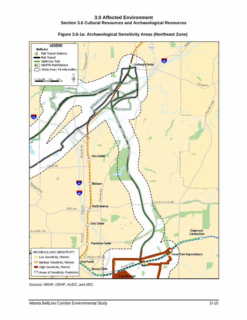
3.0 Affected Environment Section 3.6 Cultural Resources and Archaeological Resources
Atlanta BeltLine Corridor Environmental Study D-10
Figure 3.6-1a: Archaeological Sensitivity Areas (Northeast Zone)
Sources: NRHP, GRHP, AUDC, and ARC.
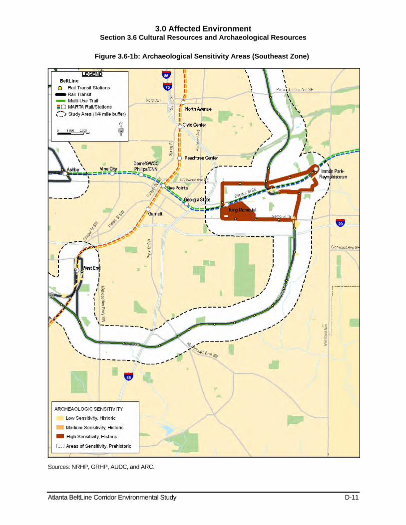
3.0 Affected Environment Section 3.6 Cultural Resources and Archaeological Resources
Atlanta BeltLine Corridor Environmental Study D-11
Figure 3.6-1b: Archaeological Sensitivity Areas (Southeast Zone)
Sources: NRHP, GRHP, AUDC, and ARC.
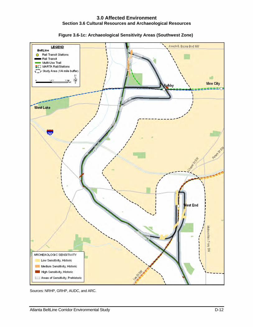
3.0 Affected Environment Section 3.6 Cultural Resources and Archaeological Resources
Atlanta BeltLine Corridor Environmental Study D-12
Figure 3.6-1c: Archaeological Sensitivity Areas (Southwest Zone)
Sources: NRHP, GRHP, AUDC, and ARC.
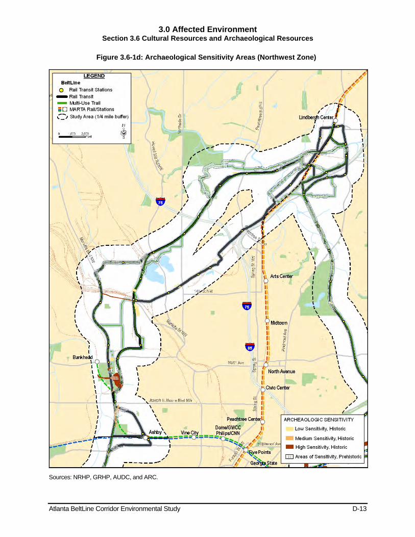
3.0 Affected Environment Section 3.6 Cultural Resources and Archaeological Resources
Atlanta BeltLine Corridor Environmental Study D-13
Figure 3.6-1d: Archaeological Sensitivity Areas (Northwest Zone)
Sources: NRHP, GRHP, AUDC, and ARC.
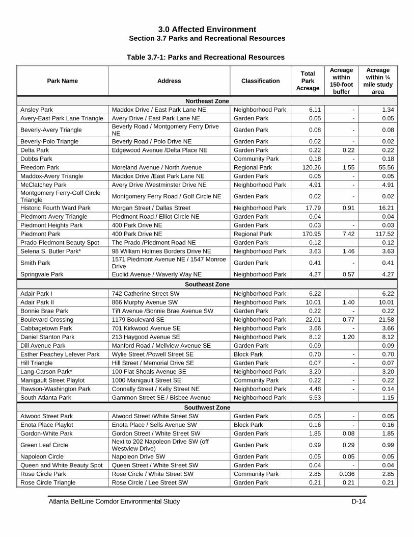
3.0 Affected Environment Section 3.7 Parks and Recreational Resources
Atlanta BeltLine Corridor Environmental Study D-14
Table 3.7-1: Parks and Recreational Resources
Park Name Address Classification Total Park
Acreage
Acreage within
150-foot buffer
Acreage within ¼
mile study area
Northeast Zone Ansley Park Maddox Drive / East Park Lane NE Neighborhood Park 6.11 - 1.34Avery-East Park Lane Triangle Avery Drive / East Park Lane NE Garden Park 0.05 - 0.05
Beverly-Avery Triangle Beverly Road / Montgomery Ferry Drive NE Garden Park 0.08 - 0.08
Beverly-Polo Triangle Beverly Road / Polo Drive NE Garden Park 0.02 - 0.02Delta Park Edgewood Avenue /Delta Place NE Garden Park 0.22 0.22 0.22Dobbs Park Community Park 0.18 - 0.18Freedom Park Moreland Avenue / North Avenue Regional Park 120.26 1.55 55.56Maddox-Avery Triangle Maddox Drive /East Park Lane NE Garden Park 0.05 - 0.05McClatchey Park Avery Drive /Westminster Drive NE Neighborhood Park 4.91 - 4.91Montgomery Ferry-Golf Circle Triangle Montgomery Ferry Road / Golf Circle NE Garden Park 0.02 - 0.02
Historic Fourth Ward Park Morgan Street / Dallas Street Neighborhood Park 17.79 0.91 16.21Piedmont-Avery Triangle Piedmont Road / Elliot Circle NE Garden Park 0.04 - 0.04Piedmont Heights Park 400 Park Drive NE Garden Park 0.03 - 0.03Piedmont Park 400 Park Drive NE Regional Park 170.95 7.42 117.52Prado-Piedmont Beauty Spot The Prado /Piedmont Road NE Garden Park 0.12 - 0.12Selena S. Butler Park* 98 William Holmes Borders Drive NE Neighborhood Park 3.63 1.46 3.63
Smith Park 1571 Piedmont Avenue NE / 1547 Monroe Drive Garden Park 0.41 - 0.41
Springvale Park Euclid Avenue / Waverly Way NE Neighborhood Park 4.27 0.57 4.27Southeast Zone
Adair Park I 742 Catherine Street SW Neighborhood Park 6.22 - 6.22Adair Park II 866 Murphy Avenue SW Neighborhood Park 10.01 1.40 10.01Bonnie Brae Park Tift Avenue /Bonnie Brae Avenue SW Garden Park 0.22 - 0.22Boulevard Crossing 1179 Boulevard SE Neighborhood Park 22.01 0.77 21.58Cabbagetown Park 701 Kirkwood Avenue SE Neighborhood Park 3.66 - 3.66Daniel Stanton Park 213 Haygood Avenue SE Neighborhood Park 8.12 1.20 8.12Dill Avenue Park Manford Road / Mellview Avenue SE Garden Park 0.09 - 0.09Esther Peachey Lefever Park Wylie Street /Powell Street SE Block Park 0.70 - 0.70Hill Triangle Hill Street / Memorial Drive SE Garden Park 0.07 - 0.07Lang-Carson Park* 100 Flat Shoals Avenue SE Neighborhood Park 3.20 - 3.20Manigault Street Playlot 1000 Manigault Street SE Community Park 0.22 - 0.22Rawson-Washington Park Connally Street / Kelly Street NE Neighborhood Park 4.48 - 0.14South Atlanta Park Gammon Street SE / Bisbee Avenue Neighborhood Park 5.53 - 1.15
Southwest Zone Atwood Street Park Atwood Street /White Street SW Garden Park 0.05 - 0.05Enota Place Playlot Enota Place / Sells Avenue SW Block Park 0.16 - 0.16Gordon-White Park Gordon Street / White Street SW Garden Park 1.85 0.08 1.85
Green Leaf Circle Next to 202 Napoleon Drive SW (off Westview Drive) Garden Park 0.99 0.29 0.99
Napoleon Circle Napoleon Drive SW Garden Park 0.05 0.05 0.05Queen and White Beauty Spot Queen Street / White Street SW Garden Park 0.04 - 0.04Rose Circle Park Rose Circle / White Street SW Community Park 2.85 0.036 2.85Rose Circle Triangle Rose Circle / Lee Street SW Garden Park 0.21 0.21 0.21
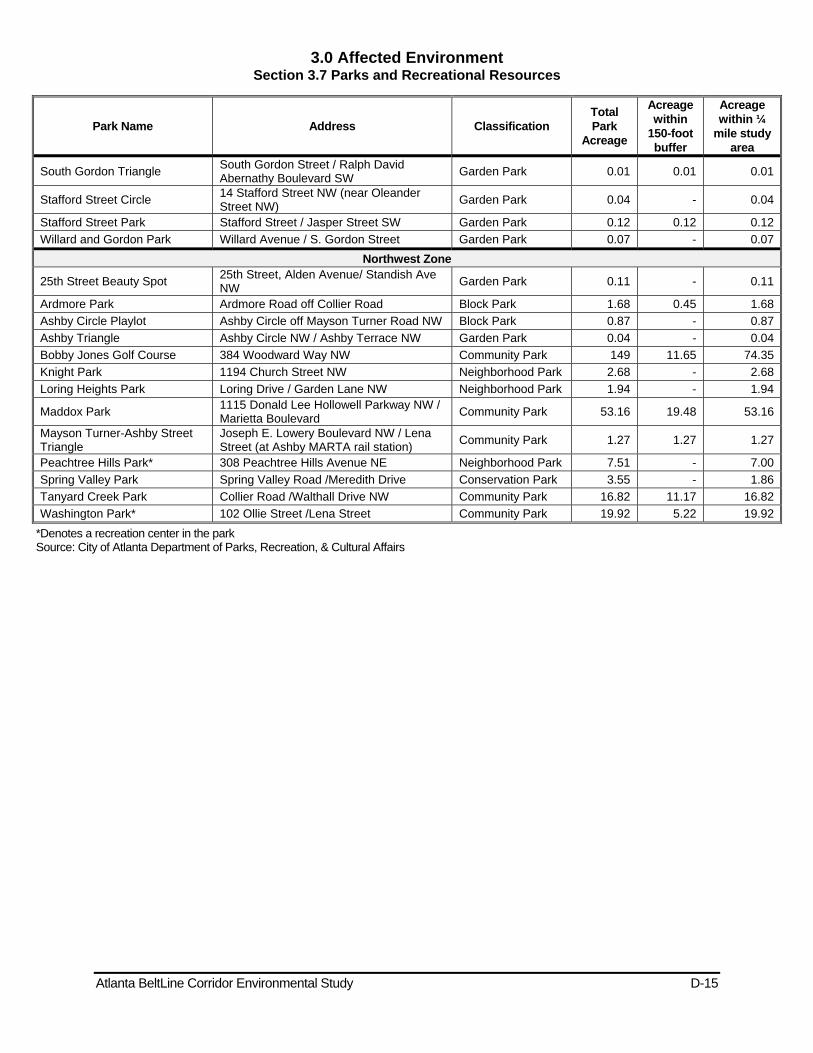
3.0 Affected Environment Section 3.7 Parks and Recreational Resources
Atlanta BeltLine Corridor Environmental Study D-15
Park Name Address Classification Total Park
Acreage
Acreage within
150-foot buffer
Acreage within ¼
mile study area
South Gordon Triangle South Gordon Street / Ralph David Abernathy Boulevard SW Garden Park 0.01 0.01 0.01
Stafford Street Circle 14 Stafford Street NW (near Oleander Street NW) Garden Park 0.04 - 0.04
Stafford Street Park Stafford Street / Jasper Street SW Garden Park 0.12 0.12 0.12Willard and Gordon Park Willard Avenue / S. Gordon Street Garden Park 0.07 - 0.07
Northwest Zone
25th Street Beauty Spot 25th Street, Alden Avenue/ Standish Ave NW Garden Park 0.11 - 0.11
Ardmore Park Ardmore Road off Collier Road Block Park 1.68 0.45 1.68Ashby Circle Playlot Ashby Circle off Mayson Turner Road NW Block Park 0.87 - 0.87Ashby Triangle Ashby Circle NW / Ashby Terrace NW Garden Park 0.04 - 0.04Bobby Jones Golf Course 384 Woodward Way NW Community Park 149 11.65 74.35Knight Park 1194 Church Street NW Neighborhood Park 2.68 - 2.68Loring Heights Park Loring Drive / Garden Lane NW Neighborhood Park 1.94 - 1.94
Maddox Park 1115 Donald Lee Hollowell Parkway NW / Marietta Boulevard Community Park 53.16 19.48 53.16
Mayson Turner-Ashby Street Triangle
Joseph E. Lowery Boulevard NW / Lena Street (at Ashby MARTA rail station) Community Park 1.27 1.27 1.27
Peachtree Hills Park* 308 Peachtree Hills Avenue NE Neighborhood Park 7.51 - 7.00Spring Valley Park Spring Valley Road /Meredith Drive Conservation Park 3.55 - 1.86Tanyard Creek Park Collier Road /Walthall Drive NW Community Park 16.82 11.17 16.82Washington Park* 102 Ollie Street /Lena Street Community Park 19.92 5.22 19.92
*Denotes a recreation center in the park Source: City of Atlanta Department of Parks, Recreation, & Cultural Affairs

3.0 Affected Environment Section 3.7 Parks and Recreational Resources
Atlanta BeltLine Corridor Environmental Study D-16
Figure 3.7-1a: Parks (Northeast Zone)
Source: City of Atlanta, Office of Parks, Recreation & Cultural Affairs
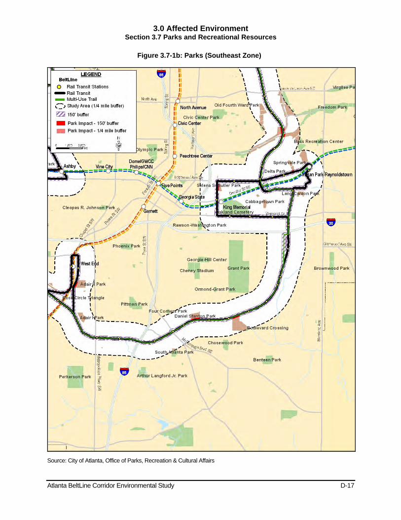
3.0 Affected Environment Section 3.7 Parks and Recreational Resources
Atlanta BeltLine Corridor Environmental Study D-17
Figure 3.7-1b: Parks (Southeast Zone)
Source: City of Atlanta, Office of Parks, Recreation & Cultural Affairs

3.0 Affected Environment Section 3.7 Parks and Recreational Resources
Atlanta BeltLine Corridor Environmental Study D-18
Figure 3.7-1c: Parks (Southwest Zone)
Source: City of Atlanta, Office of Parks, Recreation & Cultural Affairs
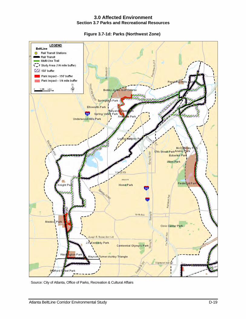
3.0 Affected Environment Section 3.7 Parks and Recreational Resources
Atlanta BeltLine Corridor Environmental Study D-19
Figure 3.7-1d: Parks (Northwest Zone)
Source: City of Atlanta, Office of Parks, Recreation & Cultural Affairs
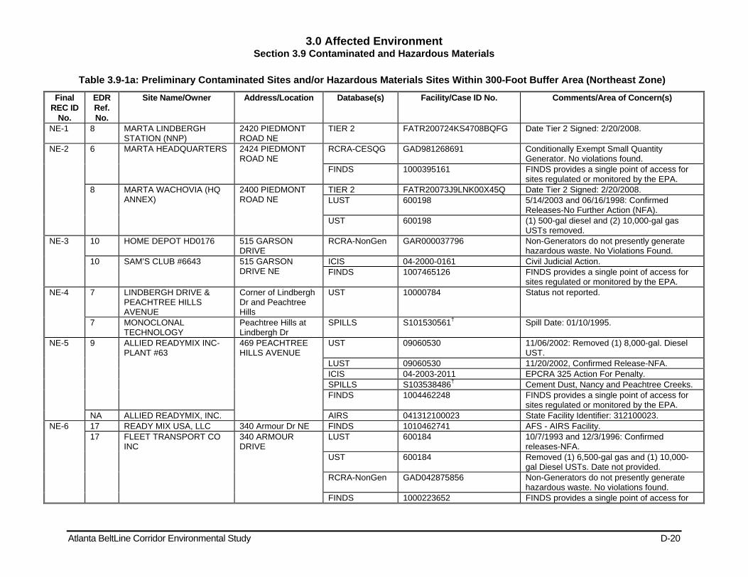
3.0 Affected Environment Section 3.9 Contaminated and Hazardous Materials
Atlanta BeltLine Corridor Environmental Study D-20
Table 3.9-1a: Preliminary Contaminated Sites and/or Hazardous Materials Sites Within 300-Foot Buffer Area (Northeast Zone)
Final REC ID
No.
EDR Ref. No.
Site Name/Owner Address/Location Database(s) Facility/Case ID No. Comments/Area of Concern(s)
NE-1 8 MARTA LINDBERGH STATION (NNP)
2420 PIEDMONT ROAD NE
TIER 2 FATR200724KS4708BQFG Date Tier 2 Signed: 2/20/2008.
NE-2 6 MARTA HEADQUARTERS 2424 PIEDMONT ROAD NE
RCRA-CESQG GAD981268691 Conditionally Exempt Small Quantity Generator. No violations found.
FINDS 1000395161 FINDS provides a single point of access for sites regulated or monitored by the EPA.
8 MARTA WACHOVIA (HQ ANNEX)
2400 PIEDMONT ROAD NE
TIER 2 FATR20073J9LNK00X45Q Date Tier 2 Signed: 2/20/2008. LUST 600198 5/14/2003 and 06/16/1998: Confirmed
Releases-No Further Action (NFA). UST 600198 (1) 500-gal diesel and (2) 10,000-gal gas
USTs removed. NE-3 10 HOME DEPOT HD0176 515 GARSON
DRIVE RCRA-NonGen GAR000037796 Non-Generators do not presently generate
hazardous waste. No Violations Found. 10 SAM’S CLUB #6643 515 GARSON
DRIVE NE ICIS 04-2000-0161 Civil Judicial Action. FINDS 1007465126 FINDS provides a single point of access for
sites regulated or monitored by the EPA. NE-4 7 LINDBERGH DRIVE &
PEACHTREE HILLS AVENUE
Corner of Lindbergh Dr and Peachtree Hills
UST 10000784 Status not reported.
7 MONOCLONAL TECHNOLOGY
Peachtree Hills at Lindbergh Dr
SPILLS S101530561† Spill Date: 01/10/1995.
NE-5 9 ALLIED READYMIX INC-PLANT #63
469 PEACHTREE HILLS AVENUE
UST 09060530 11/06/2002: Removed (1) 8,000-gal. Diesel UST.
LUST 09060530 11/20/2002, Confirmed Release-NFA. ICIS 04-2003-2011 EPCRA 325 Action For Penalty. SPILLS S103538486† Cement Dust, Nancy and Peachtree Creeks. FINDS 1004462248 FINDS provides a single point of access for
sites regulated or monitored by the EPA. NA ALLIED READYMIX, INC. AIRS 041312100023 State Facility Identifier: 312100023.
NE-6 17 READY MIX USA, LLC 340 Armour Dr NE FINDS 1010462741 AFS - AIRS Facility. 17 FLEET TRANSPORT CO
INC 340 ARMOUR DRIVE
LUST 600184 10/7/1993 and 12/3/1996: Confirmed releases-NFA.
UST 600184 Removed (1) 6,500-gal gas and (1) 10,000-gal Diesel USTs. Date not provided.
RCRA-NonGen GAD042875856 Non-Generators do not presently generate hazardous waste. No violations found.
FINDS 1000223652 FINDS provides a single point of access for
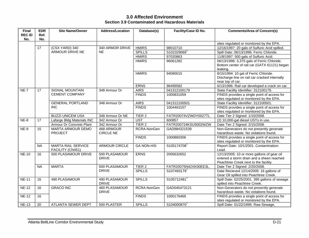
3.0 Affected Environment Section 3.9 Contaminated and Hazardous Materials
Atlanta BeltLine Corridor Environmental Study D-21
Final REC ID
No.
EDR Ref. No.
Site Name/Owner Address/Location Database(s) Facility/Case ID No. Comments/Area of Concern(s)
sites regulated or monitored by the EPA. 17 (CSX YARD) 340
ARMOUR DRIVE NE 340 ARMOR DRIVE NE
HMIRS 98010710 12/16/1997: 20 gals of Sulfuric Acid spilled. SPILLS S102329069† Spill Date: 06/13/1996. Ferric Chloride. HMIRS 97020863 11/8/1997: 500 gals of Sulfuric Acid. HMIRS 96061282 06/13/1996: 3,375 gals of Ferric Chloride.
Bottom center of rail car (GATX 61121) began leaking.
HMIRS 94090015 8/15/1994: 10 gal of Ferric Chloride. Discharge line on rail car cracked internally near top of car.
ERNS 96495582 6/13/1996: Rail car developed a crack on car. NE-7 17 SIGNAL MOUNTAIN
CEMENT COMPANY 348 Armour Dr AIRS 041312100179 State Facility Identifier: 312100179.
FINDS 1005831059 FINDS provides a single point of access for sites regulated or monitored by the EPA.
GENERAL PORTLAND INC
348 Armour Dr AIRS 041312100501 State Facility Identifier: 312100501. FINDS 1004463157 FINDS provides a single point of access for
sites regulated or monitored by the EPA. BUZZI UNICEM USA 348 Armour Dr NE TIER 2 FATR20074VZWDY0027TL Date Tier 2 Signed: 1/10/2008.
NE-8 17 Lafarge Bldg Materials INC 342 Armour Dr UST 600857 (2) 10,000-gal diesel USTs in use. Armour Dr Concrete Plant 342 Armour Dr TIER 2 FATR200724KSU5002WZW Date Tier 2 Signed: 2/15/2008.
NE-9 15 MARTA ARMOUR DEMO PROJECT
468 ARMOUR CIRCLE NE
RCRA-NonGen GAD984321539 Non-Generators do not presently generate hazardous waste. No violations found.
FINDS 1000860306 FINDS provides a single point of access for sites regulated or monitored by the EPA.
NA MARTA RAIL SERVICE FACILITY (CN451)
ARMOUR CIRCLE GA NON-HSI S105174708† Report Date: 10/1/2001. Contamination: Lead.
NE-10 16 500 PLASAMOUR DRIVE 500 PLASAMOUR DRIVE
ERNS 2005632652 12/13/2005: 10 or more gallons of gear oil entered a storm drain and a sheen reached Peachtree Creek next to the facility.
NA MARTA 500 PLASAMOUR DRIVE
TIER 2 FATR20075N42XK00EE3L. Date Tier 2 Signed: 2/20/2008. SPILLS S107493179† Date Recieved 12/14/2005: 16 gallons of
Gear Oil spilled into Peachtree Creek. NE-11 16 490 PLASAMOUR 490 PLASAMOUR
DRIVE SPILLS S105712481† Spill Date: 02/25/2001. 395 gallons of sewage
spilled into Peachtree Creek. NE-12 16 GRACO INC 460 PLASAMOUR
DRIVE RCRA-NonGen GAD045473121 Non-Generators do not presently generate
hazardous waste. No violations found. NE-12 16 FINDS 1000176469 FINDS provides a single point of access for
sites regulated or monitored by the EPA. NE-13 20 ATLANTA SEWER DEPT 500 PLASTER SPILLS S104000870† Spill Date: 01/22/1999. Raw Sewage,
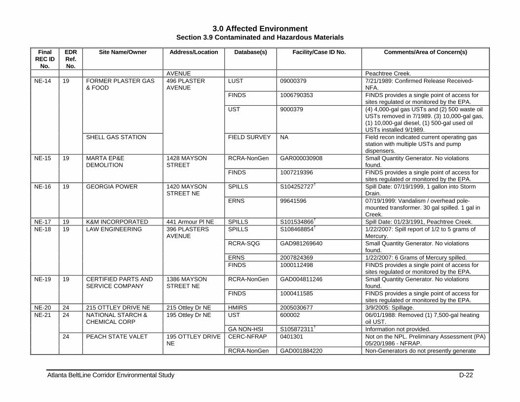
3.0 Affected Environment Section 3.9 Contaminated and Hazardous Materials
Atlanta BeltLine Corridor Environmental Study D-22
Final REC ID
No.
EDR Ref. No.
Site Name/Owner Address/Location Database(s) Facility/Case ID No. Comments/Area of Concern(s)
AVENUE Peachtree Creek. NE-14 19 FORMER PLASTER GAS
& FOOD 496 PLASTER AVENUE
LUST 09000379 7/21/1989: Confirmed Release Received-NFA.
FINDS 1006790353 FINDS provides a single point of access for sites regulated or monitored by the EPA.
UST 9000379 (4) 4,000-gal gas USTs and (2) 500 waste oil USTs removed in 7/1989. (3) 10,000-gal gas, (1) 10,000-gal diesel, (1) 500-gal used oil USTs installed 9/1989.
SHELL GAS STATION FIELD SURVEY NA Field recon indicated current operating gas station with multiple USTs and pump dispensers.
NE-15 19 MARTA EP&E DEMOLITION
1428 MAYSON STREET
RCRA-NonGen GAR000030908 Small Quantity Generator. No violations found.
FINDS 1007219396 FINDS provides a single point of access for sites regulated or monitored by the EPA.
NE-16 19 GEORGIA POWER 1420 MAYSON STREET NE
SPILLS S104252727† Spill Date: 07/19/1999, 1 gallon into Storm Drain.
ERNS 99641596 07/19/1999: Vandalism / overhead pole-mounted transformer. 30 gal spilled. 1 gal in Creek.
NE-17 19 K&M INCORPORATED 441 Armour Pl NE SPILLS S101534866† Spill Date: 01/23/1991, Peachtree Creek. NE-18 19 LAW ENGINEERING 396 PLASTERS
AVENUE SPILLS S108468854† 1/22/2007: Spill report of 1/2 to 5 grams of
Mercury. RCRA-SQG GAD981269640 Small Quantity Generator. No violations
found. ERNS 2007824369 1/22/2007: 6 Grams of Mercury spilled. FINDS 1000112498 FINDS provides a single point of access for
sites regulated or monitored by the EPA. NE-19 19 CERTIFIED PARTS AND
SERVICE COMPANY 1386 MAYSON STREET NE
RCRA-NonGen GAD004811246 Small Quantity Generator. No violations found.
FINDS 1000411585 FINDS provides a single point of access for sites regulated or monitored by the EPA.
NE-20 24 215 OTTLEY DRIVE NE 215 Ottley Dr NE HMIRS 2005030677 3/9/2005: Spillage. NE-21 24 NATIONAL STARCH &
CHEMICAL CORP 195 Ottley Dr NE UST 600002 06/01/1988: Removed (1) 7,500-gal heating
oil UST. GA NON-HSI S105872311† Information not provided.
24 PEACH STATE VALET 195 OTTLEY DRIVE NE
CERC-NFRAP 0401301 Not on the NPL. Preliminary Assessment (PA) 05/20/1986 - NFRAP.
RCRA-NonGen GAD001884220 Non-Generators do not presently generate
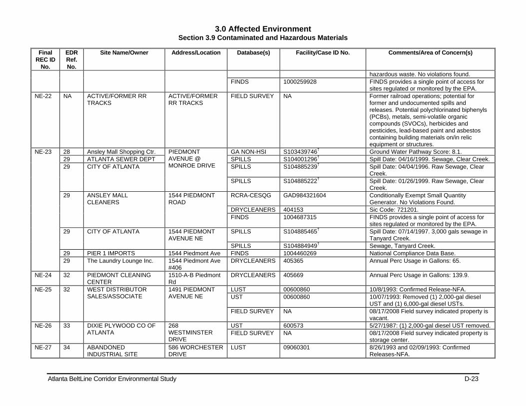
3.0 Affected Environment Section 3.9 Contaminated and Hazardous Materials
Atlanta BeltLine Corridor Environmental Study D-23
Final REC ID
No.
EDR Ref. No.
Site Name/Owner Address/Location Database(s) Facility/Case ID No. Comments/Area of Concern(s)
hazardous waste. No violations found. FINDS 1000259928 FINDS provides a single point of access for
sites regulated or monitored by the EPA. NE-22 NA ACTIVE/FORMER RR
TRACKS ACTIVE/FORMER RR TRACKS
FIELD SURVEY NA Former railroad operations; potential for former and undocumented spills and releases. Potential polychlorinated biphenyls (PCBs), metals, semi-volatile organic compounds (SVOCs), herbicides and pesticides, lead-based paint and asbestos containing building materials on/in relic equipment or structures.
NE-23 28 Ansley Mall Shopping Ctr. PIEDMONT AVENUE @ MONROE DRIVE
GA NON-HSI S103439746† Ground Water Pathway Score: 8.1. 29 ATLANTA SEWER DEPT SPILLS S104001296† Spill Date: 04/16/1999. Sewage, Clear Creek. 29 CITY OF ATLANTA SPILLS S104885239† Spill Date: 04/04/1996. Raw Sewage, Clear
Creek. SPILLS S104885222† Spill Date: 01/26/1999. Raw Sewage, Clear
Creek. 29 ANSLEY MALL
CLEANERS 1544 PIEDMONT ROAD
RCRA-CESQG GAD984321604 Conditionally Exempt Small Quantity Generator. No Violations Found.
DRYCLEANERS 404153 Sic Code: 721201. FINDS 1004687315 FINDS provides a single point of access for
sites regulated or monitored by the EPA. 29 CITY OF ATLANTA 1544 PIEDMONT
AVENUE NE SPILLS S104885465† Spill Date: 07/14/1997. 3,000 gals sewage in
Tanyard Creek. SPILLS S104884949† Sewage, Tanyard Creek.
29 PIER 1 IMPORTS 1544 Piedmont Ave FINDS 1004460269 National Compliance Data Base. 29 The Laundry Lounge Inc. 1544 Piedmont Ave
#406 DRYCLEANERS 405365 Annual Perc Usage in Gallons: 65.
NE-24 32 PIEDMONT CLEANING CENTER
1510-A-B Piedmont Rd
DRYCLEANERS 405669 Annual Perc Usage in Gallons: 139.9.
NE-25 32 WEST DISTRIBUTOR SALES/ASSOCIATE
1491 PIEDMONT AVENUE NE
LUST 00600860 10/8/1993: Confirmed Release-NFA. UST 00600860 10/07/1993: Removed (1) 2,000-gal diesel
UST and (1) 6,000-gal diesel USTs. FIELD SURVEY NA 08/17/2008 Field survey indicated property is
vacant. NE-26 33 DIXIE PLYWOOD CO OF
ATLANTA 268 WESTMINSTER DRIVE
UST 600573 5/27/1987: (1) 2,000-gal diesel UST removed. FIELD SURVEY NA 08/17/2008 Field survey indicated property is
storage center. NE-27 34 ABANDONED
INDUSTRIAL SITE 586 WORCHESTER DRIVE
LUST 09060301 8/26/1993 and 02/09/1993: Confirmed Releases-NFA.

3.0 Affected Environment Section 3.9 Contaminated and Hazardous Materials
Atlanta BeltLine Corridor Environmental Study D-24
Final REC ID
No.
EDR Ref. No.
Site Name/Owner Address/Location Database(s) Facility/Case ID No. Comments/Area of Concern(s)
UST 09060301 3/2/1994: Gas UST Removed. FIELD SURVEY NA 08/17/2008 Field survey indicated
redevelopment started. NE-28 38 1024 MONROE DRIVE 1024 Monroe Dr. GA NON-HSI S108782039† Contamination: Carbon disulfide. NE-29 NA Corridor BeltLine Property Monroe Dr – 10th St. BROWNFIELDS S107780974† Response Actions Planned (Non-HSI). NE-30 40 E L THOMPSON & SON
INC 600 VIRGINIA AVENUE NE
LUST 00600691 1/22/1996: Confirmed Release-NFA UST 00600691 11/22/1995: (1) 2,000-gal gas UST removed.
NE-31 40 Virginia Highlands Community
609 VIRGINIA AVENUE
GA NON-HSI S109016322† Report Date: 2/15/2008.
NE-32 41 GA POWER CO METRO TMC
930 PONCE DE LEON PLACE NE
LUST 00600736 7/8/1994: Confirmed Release-NFA. UST 00600736 Removed (1) 10,000-gal diesel and (1)
10,000-gal gas USTs. Date not provided. GA NON-HSI 1000349226 Contamination: Benzo(b)fluoranthene. RCRA-NonGen GAD000612515 Handler: Non-Generators do not presently
generate hazardous waste. No violations found.
FINDS 1000349226 FINDS provides a single point of access for sites regulated or monitored by the EPA.
43 GA POWER CO CENTRAL DISTRICT HQTRS
890 PONCE DE LEON PLACE
LUST 00600728 1/4/1996: Confirmed Release-NFA. UST 00600728 5/23/1990: (1) 6,000-gal gas UST removed.
08/14/1992, (1) 550-gal used oil UST removed. 02/08/1994, (1) 10,000-gal gas UST removed. 05/23/1990, (1) 10,000-gal diesel UST removed. 01/15/1996, (1) 6,000-gal gas UST closed in place.
CERC-NFRAP 0401247 Not on the NPL. Preliminary Assessment Completed: 09/01/1982. NFRAP.
GA NON-HSI 1000349209 Report Date: Not reported. RCRA-NonGen GAD000612507 Handler: Non-Generators do not presently
generate hazardous waste. No violations found.
FINDS 1000349209 FINDS provides a single point of access for sites regulated or monitored by the EPA.
NE-33 45 DIVERSIFIED METAL FABRICATORS
665 PYLANT STREET NE
FINDS 1007213420 FINDS provides a single point of access for sites regulated or monitored by the EPA.
RCRA-NonGen GAR000017400 Handler: Non-Generators do not presently generate hazardous waste. No violations found.
NE-34 48 LITHOPLATES INC 742 PONCE DE LEON PLACE
RCRA-NonGen GAD003272275 Handler: Non-Generators do not presently generate hazardous waste. No violations
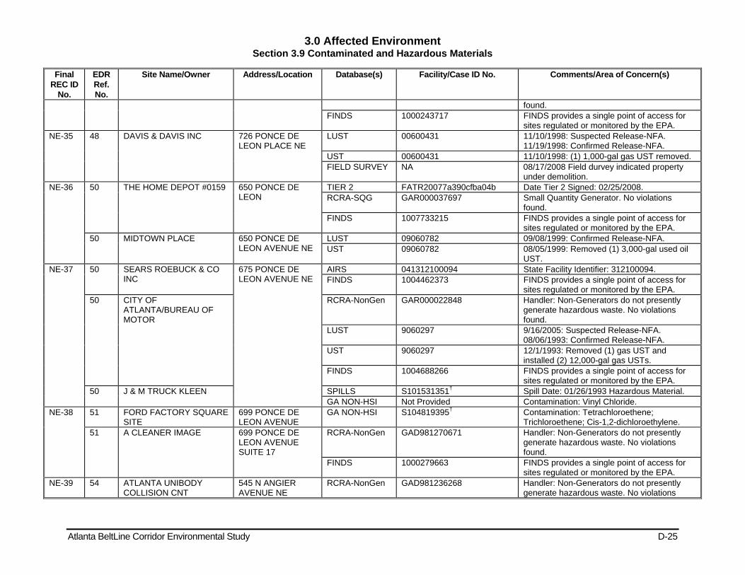
3.0 Affected Environment Section 3.9 Contaminated and Hazardous Materials
Atlanta BeltLine Corridor Environmental Study D-25
Final REC ID
No.
EDR Ref. No.
Site Name/Owner Address/Location Database(s) Facility/Case ID No. Comments/Area of Concern(s)
found. FINDS 1000243717 FINDS provides a single point of access for
sites regulated or monitored by the EPA. NE-35 48 DAVIS & DAVIS INC 726 PONCE DE
LEON PLACE NE LUST 00600431 11/10/1998: Suspected Release-NFA.
11/19/1998: Confirmed Release-NFA. UST 00600431 11/10/1998: (1) 1,000-gal gas UST removed. FIELD SURVEY NA 08/17/2008 Field durvey indicated property
under demolition. NE-36 50 THE HOME DEPOT #0159 650 PONCE DE
LEON TIER 2 FATR20077a390cfba04b Date Tier 2 Signed: 02/25/2008. RCRA-SQG GAR000037697 Small Quantity Generator. No violations
found. FINDS 1007733215 FINDS provides a single point of access for
sites regulated or monitored by the EPA. 50 MIDTOWN PLACE 650 PONCE DE
LEON AVENUE NE LUST 09060782 09/08/1999: Confirmed Release-NFA. UST 09060782 08/05/1999: Removed (1) 3,000-gal used oil
UST. NE-37 50 SEARS ROEBUCK & CO
INC 675 PONCE DE LEON AVENUE NE
AIRS 041312100094 State Facility Identifier: 312100094. FINDS 1004462373 FINDS provides a single point of access for
sites regulated or monitored by the EPA. 50 CITY OF
ATLANTA/BUREAU OF MOTOR
RCRA-NonGen GAR000022848 Handler: Non-Generators do not presently generate hazardous waste. No violations found.
LUST 9060297 9/16/2005: Suspected Release-NFA. 08/06/1993: Confirmed Release-NFA.
UST 9060297 12/1/1993: Removed (1) gas UST and installed (2) 12,000-gal gas USTs.
FINDS 1004688266 FINDS provides a single point of access for sites regulated or monitored by the EPA.
50 J & M TRUCK KLEEN SPILLS S101531351† Spill Date: 01/26/1993 Hazardous Material. GA NON-HSI Not Provided Contamination: Vinyl Chloride.
NE-38 51 FORD FACTORY SQUARE SITE
699 PONCE DE LEON AVENUE
GA NON-HSI S104819395† Contamination: Tetrachloroethene; Trichloroethene; Cis-1,2-dichloroethylene.
51 A CLEANER IMAGE 699 PONCE DE LEON AVENUE SUITE 17
RCRA-NonGen GAD981270671 Handler: Non-Generators do not presently generate hazardous waste. No violations found.
FINDS 1000279663 FINDS provides a single point of access for sites regulated or monitored by the EPA.
NE-39 54 ATLANTA UNIBODY COLLISION CNT
545 N ANGIER AVENUE NE
RCRA-NonGen GAD981236268 Handler: Non-Generators do not presently generate hazardous waste. No violations
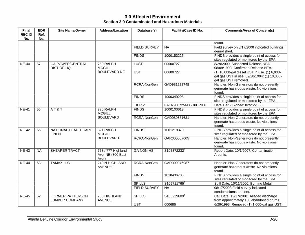
3.0 Affected Environment Section 3.9 Contaminated and Hazardous Materials
Atlanta BeltLine Corridor Environmental Study D-26
Final REC ID
No.
EDR Ref. No.
Site Name/Owner Address/Location Database(s) Facility/Case ID No. Comments/Area of Concern(s)
found. FIELD SURVEY NA Field survey on 8/17/2008 indicated buildings
demolished. FINDS 1000153225 FINDS provides a single point of access for
sites regulated or monitored by the EPA. NE-40 57 GA POWER/CENTRAL
DIST OP HQ 760 RALPH MCGILL BOULEVARD NE
LUST 00600727 8/29/2000: Suspected Release-NFA. 08/09/1993, Confirmed Release-NFA.
UST 00600727 (1) 10,000-gal diesel UST in use. (1) 6,000-gal gas UST in use. 02/28/1994: (1) 10,000-gal gas UST removed.
RCRA-NonGen GAD981222748 Handler: Non-Generators do not presently generate hazardous waste. No violations found.
FINDS 1000349295 FINDS provides a single point of access for sites regulated or monitored by the EPA.
TIER 2 FATR200725M35D0CP931 Date Tier 2 Signed: 02/25/2008. NE-41 55 A T & T 820 RALPH
MCGILL BOULEVARD
FINDS 1000100619 FINDS provides a single point of access for sites regulated or monitored by the EPA.
RCRA-NonGen GAD980581631 Handler: Non-Generators do not presently generate hazardous waste. No violations found.
NE-42 55 NATIONAL HEALTHCARE LINEN
821 RALPH MCGILL BOULEVARD
FINDS 1001218370 FINDS provides a single point of access for sites regulated or monitored by the EPA.
RCRA-NonGen GAR000007005 Handler: Non-Generators do not presently generate hazardous waste. No violations found.
NE-43 NA SHEARER TRACT 768 / 777 Highland Ave. NE (800 East Ave.)
GA NON-HSI S105872232† Report Date: 10/1/2007. Contamination: Arsenic.
NE-44 63 TAMAX LLC 240 N HIGHLAND AVENUE
RCRA-NonGen GAR000046987 Handler: Non-Generators do not presently generate hazardous waste. No violations found.
FINDS 1010436700 FINDS provides a single point of access for sites regulated or monitored by the EPA.
SPILLS S105711765† Spill Date: 10/11/2000, Burning Metal. FIELD SURVEY NA 08/17/2008 Field survey indicated
condominiums present. NE-45 62 FORMER PATTERSON
LUMBER COMPANY 768 HIGHLAND AVENUE
SPILLS S105229689† Call Date: 12/17/2001. Alleged discharge from approximately 150 abandoned drums.
UST 600686 6/29/1993: Removed (1) 1,000-gal gas UST.

3.0 Affected Environment Section 3.9 Contaminated and Hazardous Materials
Atlanta BeltLine Corridor Environmental Study D-27
Final REC ID
No.
EDR Ref. No.
Site Name/Owner Address/Location Database(s) Facility/Case ID No. Comments/Area of Concern(s)
NE-46 65 BLACKBOX 154 KROG STREET GA NON-HSI S106678167† Report Date: 4/4/2004. Contamination: Tetrachloroethene and Lead.
FIELD SURVEY NA 08/17/2008 field visit indicate property has been converted to residences/commerical.
NE-47 69 200 KROG STREET SITE 200 KROG STREET LUST 09060859 2/1/2002: Confirmed Release-NFA. UST 9060859 8/10/2001:(1) 2,000-gal gas UST removed. FIELD SURVEY NA 08/17/2008 Field survey indicated property
has been converted to residential. NE-48 69 AUTOMATIC ICEMAKING
CO 700 LAKE AVENUE NE
LUST 09060766 4/21/1999: Confirmed Release-NFA. UST 9060766 3/30/1999: Removed (1) 1,000-gal gas UST.
NE-49 69 FORMER ATLANTA STOVE WORKS
112 KROG STREET GA NON-HSI S104819397† Report Date: 11/1/1998. Contamination: Cis-1,2-dichloroethylene.
NE-50 72 AUBURN AVENUE WAREHOUSE
659 AUBURN AVENUE
GA NON-HSI S103439756† Report Date: 7/1/1998. Contamination: vinyl chloride.
NE-51 75 AC WHITE TRANSFER 628-666 Edgewood Ave.
GA NON-HSI S108630940† Report Date: 5/7/2007. Contamination: Tetrachloroethylene.
75 A C WHITE TRANSFER/STRG CO INC
20 AIRLINE STREET NE
UST 600493 12/12/1988: (1) 3,000-gal diesel UST and (1) 3,000-gal gas UST removed. 04/01/2007: (1) 560-gal used oil UST removed.
UST 00600493 4/16/2007: Confirmed Release-NFA. NE-52 75 ATLANTA METAL AND
BATTERY 75 AIRLINE STREET SE
BROWNFIELDS S108891726† Response Actions Planned (Non-HSI). SPILLS 1002870534 2/2/2000: Material not known. FINDS GAD042101428 FINDS provides a single point of access for
sites regulated or monitored by the EPA. AIRS 041312100090 State Facility Identifier: 312100090. CERC-NFRAP 406645 Not on the NPL. Preliminary Assessment
Completed: 04/14/1998, NFRAP. FIELD SURVEY NA 08/17/2008 Field Visit indicated property is
vacant. NE-53 75 ARAMARK UNIFORM
SERVICES 670 DEKALB AVENUE
RCRA-SQG GAD078118494 Small Quantity Generator. No violations found.
LUST 00600608 1/8/1991, 01/29/1991: Confirmed Releases-NFA.
UST 600608 09/01/1989: Removed (1) 8,000-gal gas UST and (1) 14,000-gal diesel UST. (2) other USTs closed in place.
FINDS 1000404037 FINDS provides a single point of access for sites regulated or monitored by the EPA.
GA NON-HSI Not Provided Ground Water Pathway Score: 9.1.
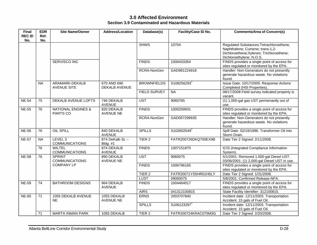
3.0 Affected Environment Section 3.9 Contaminated and Hazardous Materials
Atlanta BeltLine Corridor Environmental Study D-28
Final REC ID
No.
EDR Ref. No.
Site Name/Owner Address/Location Database(s) Facility/Case ID No. Comments/Area of Concern(s)
SHWS 10704 Regulated Substances:Tetrachloroethene, Naphthalene; Cumene; trans-1,2-Dichloroethene;Xylenes; Trichloroethene; Dichloroethylene, N.O.S.
SERVISCO INC FINDS 1000433354 FINDS provides a single point of access for sites regulated or monitored by the EPA.
RCRA-NonGen GAD981224918 Handler: Non-Generators do not presently generate hazardous waste. No violations found.
NA ARAMARK-DEKALB AVENUE SITE
670 AND 690 DEKALB AVENUE
BROWNFIELDS S108256293† Issue Date: 10/17/2005. Response Actions Completed (HSI Properties).
FIELD SURVEY NA 08/17/2008 Field survey indicated property is vacant.
NE-54 75 DEKALB AVENUE LOFTS 746 DEKALB AVENUE
UST 9060765 (1) 1,000-gal gas UST permenantly out of use.
NE-55 76 NATIONAL ENGINES & PARTS CO
820 DEKALB AVENUE NE
FINDS 1000259931 FINDS provides a single point of access for sites regulated or monitored by the EPA.
RCRA-NonGen GAD057299935 Handler: Non-Generators do not presently generate hazardous waste. No violations found.
NE-56 76 OIL SPILL 840 DEKALB AVENUE
SPILLS S102602549† Spill Date: 02/19/1996. Transformer Oil into Storm Drain.
NE-57 NA LEVEL 3 COMMUNICATIONS
874 DeKalb St. – Bldg. #1
TIER 2 FATR200726DKQ700EX9B Date Tier 2 Signed: 2/11/2008.
76 WILTEL COMMUNICATIONS
874 DEKALB AVENUE
FINDS 1007151870 ICIS (Integrated Compliance Information System).
NE-58 76 SPRINT COMMUNICATIONS COMPANY LP
890 DEKALB AVENUE NE
UST 9060075 5/1/2001: Removed 1,000-gal Diesel UST. 03/06/2001: (1) 2,000-gal Diesel UST in use.
FINDS 1006796165 FINDS provides a single point of access for sites regulated or monitored by the EPA.
TIER 2 FATR20071YS5HR01H5LY Date Tier 2 Signed: 1/31/2008. LUST 09060075 5/8/2001: Confirmed Release-NFA.
NE-59 74 BATHROOM DESIGNS 964 DEKALB AVENUE
FINDS 1004464017 FINDS provides a single point of access for sites regulated or monitored by the EPA.
AIRS 041312100815 State Facility Identifier: 312100815. NE-60 71 1055 DEKALB AVENUE
NE 1055 DEKALB AVENUE NE
ERNS 2003707840 Incident date: 12/11/2003. Transportation Accident. 15 gals of Fuel Oil.
SPILLS S106123297† Incident date: 12/11/2003. Transportation Accident. 15 gals of Fuel Oil.
71 MARTA INMAN PARK 1055 DEKALB TIER 2 FATR200724KRAC075M3G Date Tier 2 Signed: 2/20/2008.
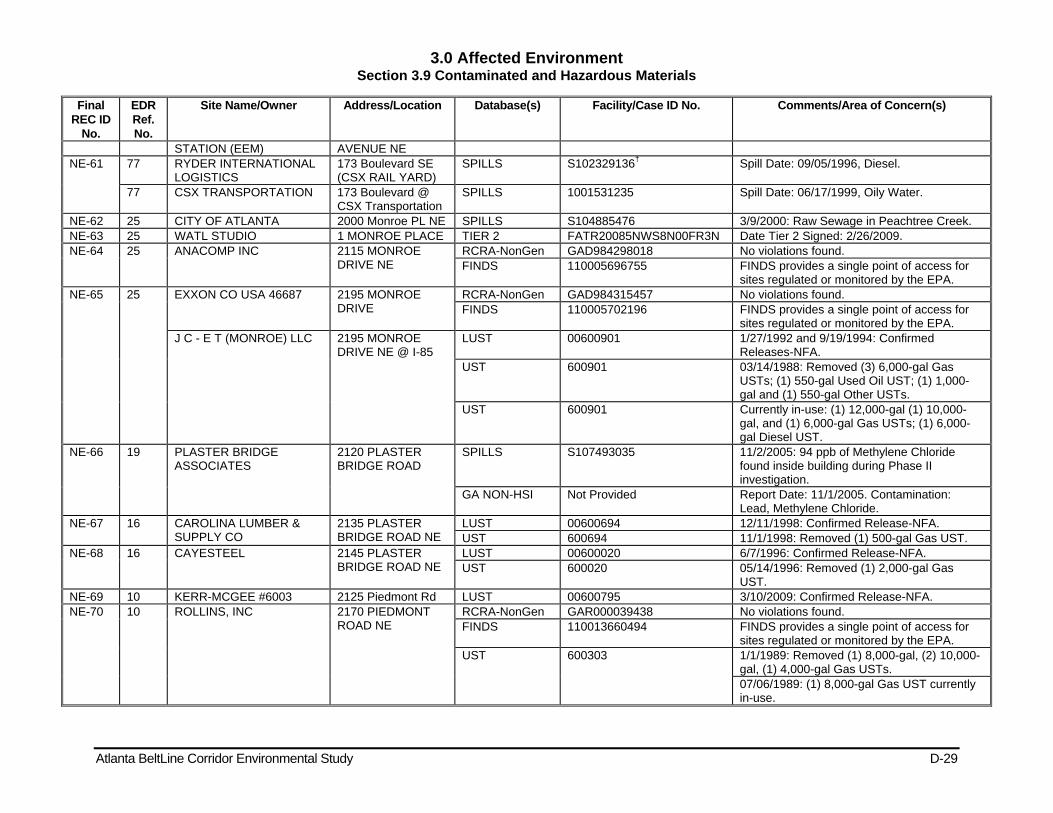
3.0 Affected Environment Section 3.9 Contaminated and Hazardous Materials
Atlanta BeltLine Corridor Environmental Study D-29
Final REC ID
No.
EDR Ref. No.
Site Name/Owner Address/Location Database(s) Facility/Case ID No. Comments/Area of Concern(s)
STATION (EEM) AVENUE NE NE-61 77 RYDER INTERNATIONAL
LOGISTICS 173 Boulevard SE (CSX RAIL YARD)
SPILLS S102329136† Spill Date: 09/05/1996, Diesel.
77 CSX TRANSPORTATION 173 Boulevard @ CSX Transportation
SPILLS 1001531235 Spill Date: 06/17/1999, Oily Water.
NE-62 25 CITY OF ATLANTA 2000 Monroe PL NE SPILLS S104885476 3/9/2000: Raw Sewage in Peachtree Creek. NE-63 25 WATL STUDIO 1 MONROE PLACE TIER 2 FATR20085NWS8N00FR3N Date Tier 2 Signed: 2/26/2009. NE-64 25 ANACOMP INC 2115 MONROE
DRIVE NE RCRA-NonGen GAD984298018 No violations found. FINDS 110005696755 FINDS provides a single point of access for
sites regulated or monitored by the EPA. NE-65 25 EXXON CO USA 46687 2195 MONROE
DRIVE RCRA-NonGen GAD984315457 No violations found. FINDS 110005702196 FINDS provides a single point of access for
sites regulated or monitored by the EPA. J C - E T (MONROE) LLC 2195 MONROE
DRIVE NE @ I-85 LUST 00600901 1/27/1992 and 9/19/1994: Confirmed
Releases-NFA. UST 600901 03/14/1988: Removed (3) 6,000-gal Gas
USTs; (1) 550-gal Used Oil UST; (1) 1,000-gal and (1) 550-gal Other USTs.
UST 600901 Currently in-use: (1) 12,000-gal (1) 10,000-gal, and (1) 6,000-gal Gas USTs; (1) 6,000-gal Diesel UST.
NE-66 19 PLASTER BRIDGE ASSOCIATES
2120 PLASTER BRIDGE ROAD
SPILLS S107493035 11/2/2005: 94 ppb of Methylene Chloride found inside building during Phase II investigation.
GA NON-HSI Not Provided Report Date: 11/1/2005. Contamination: Lead, Methylene Chloride.
NE-67 16 CAROLINA LUMBER & SUPPLY CO
2135 PLASTER BRIDGE ROAD NE
LUST 00600694 12/11/1998: Confirmed Release-NFA. UST 600694 11/1/1998: Removed (1) 500-gal Gas UST.
NE-68 16 CAYESTEEL 2145 PLASTER BRIDGE ROAD NE
LUST 00600020 6/7/1996: Confirmed Release-NFA. UST 600020 05/14/1996: Removed (1) 2,000-gal Gas
UST. NE-69 10 KERR-MCGEE #6003 2125 Piedmont Rd LUST 00600795 3/10/2009: Confirmed Release-NFA. NE-70 10 ROLLINS, INC 2170 PIEDMONT
ROAD NE RCRA-NonGen GAR000039438 No violations found. FINDS 110013660494 FINDS provides a single point of access for
sites regulated or monitored by the EPA. UST 600303 1/1/1989: Removed (1) 8,000-gal, (2) 10,000-
gal, (1) 4,000-gal Gas USTs. 07/06/1989: (1) 8,000-gal Gas UST currently in-use.
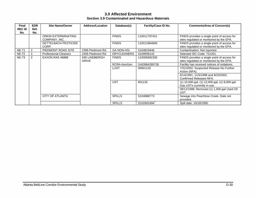
3.0 Affected Environment Section 3.9 Contaminated and Hazardous Materials
Atlanta BeltLine Corridor Environmental Study D-30
Final REC ID
No.
EDR Ref. No.
Site Name/Owner Address/Location Database(s) Facility/Case ID No. Comments/Area of Concern(s)
ORKIN EXTERMINATING COMPANY, INC.
FINDS 110011797421 FINDS provides a single point of access for sites regulated or monitored by the EPA.
DETTELBACH PESTICIDE CORP.
FINDS 110011864606 FINDS provides a single point of access for sites regulated or monitored by the EPA.
NE-71 2 PIEDMONT ROAD SITE 2399 Piedmont Rd. GA NON-HSI S104819446 Contamination: Not reported. NE-72 2 Professional Cleaners 2405 Piedmont Rd. DRYCLEANERS S109506142 Selected SIC Code: 721201. NE-73 2 EXXON RAS 46888 635 LINDBERGH
DRIVE FINDS 110005692330 FINDS provides a single point of access for
sites regulated or monitored by the EPA. RCRA-NonGen GAD984289728 Facility has received notices of violations. LUST 00601132 7/31/2002: Suspected Release-No Further
Action (NFA). 6/14/1991, 11/5/1998 and 8/23/2002: Confirmed Releases-NFA.
UST 601132 (1) 10,000-gal, (1) 12,000-gal, (1) 8,000-gal Gas USTs currently in-use. 08/12/1998: Removed (1) 1,000-gal Used Oil UST.
CITY OF ATLANTA SPILLS S104888773 Sewage into Peachtree Creek. Date not provided.
SPILLS S102602494† Spill date: 10/18/1995.
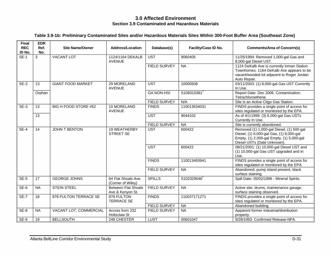
3.0 Affected Environment Section 3.9 Contaminated and Hazardous Materials
Atlanta BeltLine Corridor Environmental Study D-31
Table 3.9-1b: Preliminary Contaminated Sites and/or Hazardous Materials Sites Within 300-Foot Buffer Area (Southeast Zone)
Final REC
ID No.
EDR Ref. No.
Site Name/Owner Address/Location Database(s) Facility/Case ID No. Comments/Area of Concern(s)
SE-1 3 VACANT LOT 1124/1164 DEKALB AVENUE
UST 9060405 11/25/1994: Removed 1,000-gal Gas and 8,000-gal Diesel UST.
FIELD SURVEY NA 1124 DeKalb Ave is currently Inman Station Townhomes. 1164 DeKalb Ave appears to be vacant/wooded lot adjacent to Roger Jordan Auto Repair.
SE-2 13 GIANT FOOD MARKET 29 MORELAND AVENUE
UST 10000508 03/11/2003: (1) 8,000-gal Gas UST Currently In Use.
Orphan GA NON-HSI S108310381† Report Date: Dec 2006. Contamination: Tetrachloroethene.
FIELD SURVEY N/A Site is an Active Citgo Gas Station. SE-3 13 BIG H FOOD STORE #52 10 MORELAND
AVENUE FINDS 110013634031 FINDS provides a single point of access for
sites regulated or monitored by the EPA. 13 UST 9044102 As of 4/1/1999: (3) 6,000-gal Gas USTs
Currently In Use. FIELD SURVEY NA Site is currently abandoned.
SE-4 14 JOHN T BENTON 19 WEATHERBY STREET SE
UST 600422 Removed (1) 1,000-gal Diesel, (1) 500-gal Diesel, (1) 6,000-gal Gas, (1) 8,000-gal Empty, (1) 2,000-gal Empty, (1) 5,000-gal Diesel USTs (Date Unknown).
UST 600422 08/21/2001: (1) 10,000-gal Diesel UST and (1) 10,000-gal Gas UST upgraded and In Use.
FINDS 110013493941 FINDS provides a single point of access for sites regulated or monitored by the EPA.
FIELD SURVEY NA Abandoned; pump island present, black surface staining.
SE-5 17 GEORGE JOHNS 64 Flat Shoals Ave. (Corner of Wiley)
SPILLS S102329046† Spill Date: 05/02/1996 - Mineral Spirits.
SE-6 NA STEIN STEEL Between Flat Shoals Ave & Kenyon St.
FIELD SURVEY NA Active site; drums, maintenance garage, surface staining observed.
SE-7 18 878 FULTON TERRACE SE 878 FULTON TERRACE SE
FINDS 110037171271 FINDS provides a single point of access for sites regulated or monitored by the EPA.
FIELD SURVEY NA Abandoned building. SE-8 NA VACANT LOT; COMMERCIAL Across from 232
Holtzclaw St FIELD SURVEY NA Apparent former industrial/distribution
property. SE-9 19 BELLSOUTH 248 CHESTER LUST 00601047 9/28/1993: Confirmed Release-NFA.

3.0 Affected Environment Section 3.9 Contaminated and Hazardous Materials
Atlanta BeltLine Corridor Environmental Study D-32
Final REC
ID No.
EDR Ref. No.
Site Name/Owner Address/Location Database(s) Facility/Case ID No. Comments/Area of Concern(s)
TELECOMMUNICATIONS/ CHESTER AVE SOC F1169 /CENTRAL OFFICE
AVENUE SE UST 601047 9/23/1993: Removed (1) 12,000-gal Gas UST. 02/07/2002: Removed (1) 7,500-gal Diesel UST.
UST 9060352 3/19/1992: Removed (1) 7,500-gal Diesel UST.
BST ATLNGACA F1169 FINDS 110032747598 FINDS provides a single point of access for sites regulated or monitored by the EPA.
RCRA-NonGen GAR000001529 Historic activities include LQG and SQG at Site.
SE-10 19 LEGGETT & PLATT INCORPORATED - MAST
905 MEMORIAL DRIVE, SE
TIER 2 FATR20082SJSZ9002J45 Date Tier 2 Signed: 01/14/2009. Showcase, Partition, Shelving, and Locker Manufacturing.
FINDS 110001420506 FINDS provides a single point of access for sites regulated or monitored by the EPA.
RCRA-CESQG GAD061422507 Conditionally Exempt Small Quantity Generator.
UST 9000626 7/5/1990: Removed (4) 4,000-gal Gas, (2) 8,000-gal Hazardous Substance, (1) 500-gal Used Oil, (2) 8,000-gal Other, (2) 2,000-gal Empty USTs. 01/04/1991: (1) 1,000-gal Diesel, (2) 1,000-gal Gas USTs Currently In-Use.
MASTERACK AIRS 041312100546 State Facility Identifier: 312100546. SE-11 27 Sterling Engine Products
Pioneer Plastics 915 GLENWOOD AVENUE SE
HIST FTTS Not Reported Final Order Date: 03/31/1988. Violations(s): PCB Use, Labelling, Records Maintenance.
PIONEER PLASTICS CORP FINDS 110001764653 FINDS provides a single point of access for sites regulated or monitored by the EPA.
LUST 00600239 3/18/1992: Confirmed Release NFA-Remediation.
UST 600239 3/1/1998: Removed (1) 1,000-gal Gas UST. RCRA-NonGen GAD984273490 Non-Generators do not presently generate
hazardous waste. FIELD SURVEY NA Currently operated as US Electric.
SE-12 25 Glenwood Concrete Plant 885 GLENWOOD AVENUE SE
TIER 2 FATR20085N3YU205CBJP Date Tier 2 Signed: 2/20/2009. WILLIAMS BROS/CONCRETE PLANT #2
UST 600158 11/1/1993: Removed (1) 10,000-gal Diesel UST.
LAFARGE GLENWOOD AVE CONCRETE PLANT
FINDS 110022447716 FINDS provides a single point of access for sites regulated or monitored by the EPA.
AIRS 041312100522 State Facility Identifier: 312100522. LAFARGE GENERAL FINDS 110009356268 FINDS provides a single point of access for

3.0 Affected Environment Section 3.9 Contaminated and Hazardous Materials
Atlanta BeltLine Corridor Environmental Study D-33
Final REC
ID No.
EDR Ref. No.
Site Name/Owner Address/Location Database(s) Facility/Case ID No. Comments/Area of Concern(s)
MAINTENANCE SHOP sites regulated or monitored by the EPA. LUST 09060087 5/5/2000: Confirmed Release-NFA. UST 9060087 11/22/1999: Removed (1) 3,000-gal Other, (3)
1,000-gal Other, (1) 750-gal Used Oil, (1) 150-gal Used Oil USTs.
TIER 2 FATR20085NJ43L00SL7N Date Tier 2 Signed: 2/24/2009. RCRA-CESQG GAD981230436 Conditionally Exempt Small Quantity
Generator. BLUE CIRCLE WILLIAMS BROTHERS
AIRS 041312100073 State Facility Identifier: 312100073. FINDS 110001751015 FINDS provides a single point of access for
sites regulated or monitored by the EPA. SE-13 25 BLUE CIRCLE WILLIAMS
BROTHERS 864 GLENWOOD AVENUE, I-20
FINDS 110001424968 FINDS provides a single point of access for sites regulated or monitored by the EPA.
AIRS 041312100708 State Facility Identifier: 312100708. FIELD SURVEY NA Currently operated as Lafarge Corporation.
SE-14 NA FORMER RAILROAD ALIGNMENT
FORMER RAILROAD ALIGNMENT
FIELD SURVEY NA Former railroad operations; potential for former & undocumented spills and releases. Potential polychlorinated biphenyls (PCBs), metals, semi-volatile organic compounds (SVOCs), herbicides and pesticides, lead-based paint and asbestos containing building materials on/in relic equipment or structures.
SE-15 57 Helig Meyers Furniture/Sterchi 650 Hamilton Ave. UST 601280 5/15/1996: Removed (1) 550-gal Gas UST. SE-16 54 BOULEVARD COLD
STORAGE 1015 BOULEVARD SE
FINDS 110018917341 FINDS provides a single point of access for sites regulated or monitored by the EPA.
TIER 2 FATR20086CY1YF004WAY Date Tier 2 Signed: 1/30/2009. SE-17 74 CITY OF ATLANTA 360 ENGLEWOOD
AVENUE SE SPILLS S102272915† 7/21/1992: Quanity and location not reported. SPILLS S102272951† 12/15/1992: Quanity and location not
reported. SPILLS S102272952† 12/17/1992 Sewage into South River. SPILLS S102272874† 4/7/1992: Sewage into Proctor Creek. SPILLS S102272995† 03/20/1995: Sewage into Peachtree Creek. SPILLS S103538479† Sewage into Nancy Creek. Date not provided.
64 T.W. OWENS TRUCKING CO. 1100 HILL STREET SPILLS S101538552† Spill Date: 10/22/92. Gasoline/Fuel Oil into Storm Drain.
71 BMTS HILL ST/SATELLITE STATION
1146 HILL STREET LUST 00600285 6/17/1999: Confirmed Release-NFA. FINDS 110013488742 FINDS provides a single point of access for
sites regulated or monitored by the EPA. UST 600285 12/1/1998: Removed (2) 6,000-gal Gas, (1)
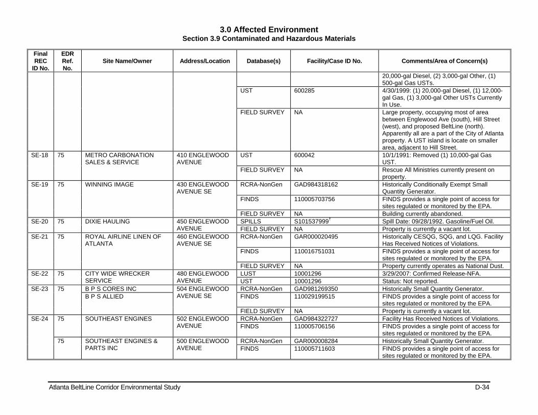
3.0 Affected Environment Section 3.9 Contaminated and Hazardous Materials
Atlanta BeltLine Corridor Environmental Study D-34
Final REC
ID No.
EDR Ref. No.
Site Name/Owner Address/Location Database(s) Facility/Case ID No. Comments/Area of Concern(s)
20,000-gal Diesel, (2) 3,000-gal Other, (1) 500-gal Gas USTs.
UST 600285 4/30/1999: (1) 20,000-gal Diesel, (1) 12,000-gal Gas, (1) 3,000-gal Other USTs Currently In Use.
FIELD SURVEY NA Large property, occupying most of area between Englewood Ave (south), Hill Street (west), and proposed BeltLine (north). Apparently all are a part of the City of Atlanta property. A UST island is locate on smaller area, adjacent to Hill Street.
SE-18 75 METRO CARBONATION SALES & SERVICE
410 ENGLEWOOD AVENUE
UST 600042 10/1/1991: Removed (1) 10,000-gal Gas UST.
FIELD SURVEY NA Rescue All Ministries currently present on property.
SE-19 75 WINNING IMAGE 430 ENGLEWOOD AVENUE SE
RCRA-NonGen GAD984318162 Historically Conditionally Exempt Small Quantity Generator.
FINDS 110005703756 FINDS provides a single point of access for sites regulated or monitored by the EPA.
FIELD SURVEY NA Building currently abandoned. SE-20 75 DIXIE HAULING 450 ENGLEWOOD
AVENUE SPILLS S101537999† Spill Date: 09/28/1992. Gasoline/Fuel Oil. FIELD SURVEY NA Property is currently a vacant lot.
SE-21 75 ROYAL AIRLINE LINEN OF ATLANTA
460 ENGLEWOOD AVENUE SE
RCRA-NonGen GAR000020495 Historically CESQG, SQG, and LQG. Facility Has Received Notices of Violations.
FINDS 110016751031 FINDS provides a single point of access for sites regulated or monitored by the EPA.
FIELD SURVEY NA Property currently operates as National Dust. SE-22 75 CITY WIDE WRECKER
SERVICE 480 ENGLEWOOD AVENUE
LUST 10001296 3/29/2007: Confirmed Release-NFA. UST 10001296 Status: Not reported.
SE-23 75 B P S CORES INC 504 ENGLEWOOD AVENUE SE
RCRA-NonGen GAD981269350 Historically Small Quantity Generator. B P S ALLIED FINDS 110029199515 FINDS provides a single point of access for
sites regulated or monitored by the EPA. FIELD SURVEY NA Property is currently a vacant lot.
SE-24 75 SOUTHEAST ENGINES 502 ENGLEWOOD AVENUE
RCRA-NonGen GAD984322727 Facility Has Received Notices of Violations. FINDS 110005706156 FINDS provides a single point of access for
sites regulated or monitored by the EPA. 75 SOUTHEAST ENGINES &
PARTS INC 500 ENGLEWOOD AVENUE
RCRA-NonGen GAR000008284 Historically Small Quantity Generator. FINDS 110005711603 FINDS provides a single point of access for
sites regulated or monitored by the EPA.
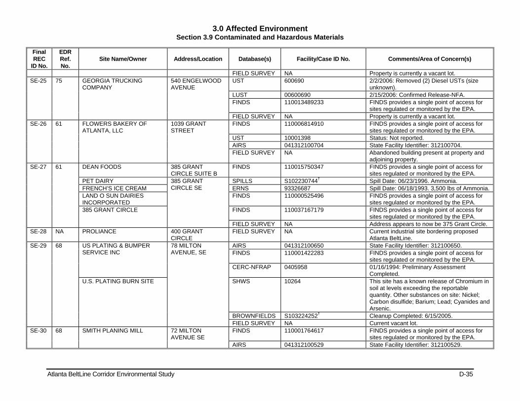
3.0 Affected Environment Section 3.9 Contaminated and Hazardous Materials
Atlanta BeltLine Corridor Environmental Study D-35
Final REC
ID No.
EDR Ref. No.
Site Name/Owner Address/Location Database(s) Facility/Case ID No. Comments/Area of Concern(s)
FIELD SURVEY NA Property is currently a vacant lot. SE-25 75 GEORGIA TRUCKING
COMPANY 540 ENGELWOOD AVENUE
UST 600690 2/2/2006: Removed (2) Diesel USTs (size unknown).
LUST 00600690 2/15/2006: Confirmed Release-NFA. FINDS 110013489233 FINDS provides a single point of access for
sites regulated or monitored by the EPA. FIELD SURVEY NA Property is currently a vacant lot.
SE-26 61 FLOWERS BAKERY OF ATLANTA, LLC
1039 GRANT STREET
FINDS 110006814910 FINDS provides a single point of access for sites regulated or monitored by the EPA.
UST 10001398 Status: Not reported. AIRS 041312100704 State Facility Identifier: 312100704. FIELD SURVEY NA Abandoned building present at property and
adjoining property. SE-27 61 DEAN FOODS 385 GRANT
CIRCLE SUITE B FINDS 110015750347 FINDS provides a single point of access for
sites regulated or monitored by the EPA. PET DAIRY 385 GRANT
CIRCLE SE SPILLS S102230744† Spill Date: 06/23/1996. Ammonia.
FRENCH’S ICE CREAM ERNS 93326687 Spill Date: 06/18/1993. 3,500 lbs of Ammonia. LAND O SUN DAIRIES INCORPORATED
FINDS 110000525496 FINDS provides a single point of access for sites regulated or monitored by the EPA.
385 GRANT CIRCLE FINDS 110037167179 FINDS provides a single point of access for sites regulated or monitored by the EPA.
FIELD SURVEY NA Address appears to now be 375 Grant Circle. SE-28 NA PROLIANCE 400 GRANT
CIRCLE FIELD SURVEY NA Current industrial site bordering proposed
Atlanta BeltLine. SE-29 68 US PLATING & BUMPER
SERVICE INC 78 MILTON AVENUE, SE
AIRS 041312100650 State Facility Identifier: 312100650. FINDS 110001422283 FINDS provides a single point of access for
sites regulated or monitored by the EPA. CERC-NFRAP 0405958 01/16/1994: Preliminary Assessment
Completed. U.S. PLATING BURN SITE SHWS 10264 This site has a known release of Chromium in
soil at levels exceeding the reportable quantity. Other substances on site: Nickel; Carbon disulfide; Barium; Lead; Cyanides and Arsenic.
BROWNFIELDS S103224252† Cleanup Completed: 6/15/2005. FIELD SURVEY NA Current vacant lot.
SE-30 68 SMITH PLANING MILL 72 MILTON AVENUE SE
FINDS 110001764617 FINDS provides a single point of access for sites regulated or monitored by the EPA.
AIRS 041312100529 State Facility Identifier: 312100529.

3.0 Affected Environment Section 3.9 Contaminated and Hazardous Materials
Atlanta BeltLine Corridor Environmental Study D-36
Final REC
ID No.
EDR Ref. No.
Site Name/Owner Address/Location Database(s) Facility/Case ID No. Comments/Area of Concern(s)
LAWRENCE SMITH PLY MILL INC
FINDS 110013568914 FINDS provides a single point of access for sites regulated or monitored by the EPA.
UST 9060466 (1) Diesel UST currently in use. Date and size not reported.
FIELD SURVEY NA Current vacant lot. SE-31 68 UNKNOWN LUST 79 MILTON
AVENUE SE SPILLS S102444143† Spill Date: 12/17/1996. Gasoline. FIELD SURVEY NA Property identified as City of Atlanta Dept. of
General Services Transportion/Logistics SE-32 NA JB DISTRIBUTION
COMPANY 95 Milton Ave. FIELD SURVEY NA Apparent automotive/truck repair facility.
SE-33 72 STANDARD TRUCKING CO 125 MILTON AVENUE SE
RCRA-NonGen GAD981275241 No violations found. FINDS 110005688522 FINDS provides a single point of access for
sites regulated or monitored by the EPA. RCRA-NonGen GAD981276165 Historically Small Quantity Generator. LUST 00600904 10/7/1991: Confirmed Release-Cleanup
Initiated. 6/14/2005: Confirmed Release-Cleanup Initiated.
UST 600904 Removed (1) 8,000-gal Diesel, (1) 8,000-gal Other, (1) 11,000-gal Gas USTs (Date Unknown). 06/02/2005: Removed (1) 12,000-gal Diesel UST.
113 MILTON AVENUE SE 113 MILTON AVENUE SE
FINDS 110037166009 FINDS provides a single point of access for sites regulated or monitored by the EPA.
118 MILTON AVENUE SE 118 MILTON AVENUE SE
FINDS 110037166107 FINDS provides a single point of access for sites regulated or monitored by the EPA.
108 MILTON AVENUE SE 108 MILTON AVENUE SE
FINDS 110037165901 FINDS provides a single point of access for sites regulated or monitored by the EPA.
FIELD SURVEY NA Abandoned building. Monitoring wells present. Apparent all one contiguous property.
SE-34 NA ABANDONED BUILDING 140 MILTON AVENUE
FIELD SURVEY NA Former apparent tractor trailer storage facility.
SE-35 73 MIDTOWN BAKERS 1155 Hank Aaron Dr US Brownfields 1006882115 Completed date: 6/30/1998. SE-36 73 TEXACO FOOD MART 1169 HANK AARON
DRIVE LUST 10000669 6/16/2004: Confirmed Release-NFA. UST 10000669 07/25/2007: Removed (1) 12,000-gal Gas, (1)
8,000-gal Gas, (1) 4,000-gal Diesel USTs. FIELD SURVEY NA Site currently vacant. Ridge Avenue is now a
cul de sac. SE-37 NA VACANT LOT Across from Ridge FIELD SURVEY NA Apparent former industrial/distribution
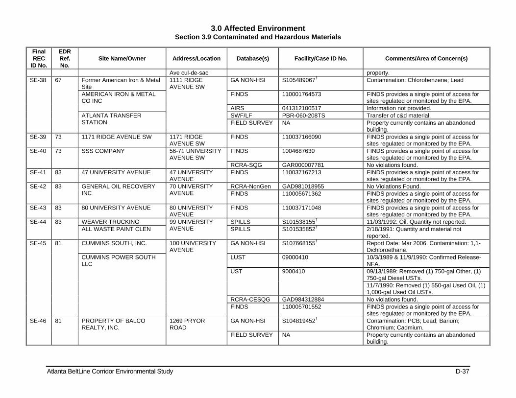
3.0 Affected Environment Section 3.9 Contaminated and Hazardous Materials
Atlanta BeltLine Corridor Environmental Study D-37
Final REC
ID No.
EDR Ref. No.
Site Name/Owner Address/Location Database(s) Facility/Case ID No. Comments/Area of Concern(s)
Ave cul-de-sac property. SE-38 67 Former American Iron & Metal
Site 1111 RIDGE AVENUE SW
GA NON-HSI S105489067† Contamination: Chlorobenzene; Lead
AMERICAN IRON & METAL CO INC
FINDS 110001764573 FINDS provides a single point of access for sites regulated or monitored by the EPA.
AIRS 041312100517 Information not provided. ATLANTA TRANSFER STATION
SWF/LF PBR-060-208TS Transfer of c&d material. FIELD SURVEY NA Property currently contains an abandoned
building. SE-39 73 1171 RIDGE AVENUE SW 1171 RIDGE
AVENUE SW FINDS 110037166090 FINDS provides a single point of access for
sites regulated or monitored by the EPA. SE-40 73 SSS COMPANY 56-71 UNIVERSITY
AVENUE SW FINDS 1004687630 FINDS provides a single point of access for
sites regulated or monitored by the EPA. RCRA-SQG GAR000007781 No violations found.
SE-41 83 47 UNIVERSITY AVENUE 47 UNIVERSITY AVENUE
FINDS 110037167213 FINDS provides a single point of access for sites regulated or monitored by the EPA.
SE-42 83 GENERAL OIL RECOVERY INC
70 UNIVERSITY AVENUE
RCRA-NonGen GAD981018955 No Violations Found. FINDS 110005671362 FINDS provides a single point of access for
sites regulated or monitored by the EPA. SE-43 83 80 UNIVERSITY AVENUE 80 UNIVERSITY
AVENUE FINDS 110037171048 FINDS provides a single point of access for
sites regulated or monitored by the EPA. SE-44 83 WEAVER TRUCKING 99 UNIVERSITY
AVENUE SPILLS S101538155† 11/03/1992: Oil. Quantity not reported.
ALL WASTE PAINT CLEN SPILLS S101535852† 2/18/1991: Quantity and material not reported.
SE-45 81 CUMMINS SOUTH, INC. 100 UNIVERSITY AVENUE
GA NON-HSI S107668155† Report Date: Mar 2006. Contamination: 1,1-Dichloroethane.
CUMMINS POWER SOUTH LLC
LUST 09000410 10/3/1989 & 11/9/1990: Confirmed Release-NFA.
UST 9000410 09/13/1989: Removed (1) 750-gal Other, (1) 750-gal Diesel USTs. 11/7/1990: Removed (1) 550-gal Used Oil, (1) 1,000-gal Used Oil USTs.
RCRA-CESQG GAD984312884 No violations found. FINDS 110005701552 FINDS provides a single point of access for
sites regulated or monitored by the EPA. SE-46 81 PROPERTY OF BALCO
REALTY, INC. 1269 PRYOR ROAD
GA NON-HSI S104819452† Contamination: PCB; Lead; Barium; Chromium; Cadmium.
FIELD SURVEY NA Property currently contains an abandoned building.
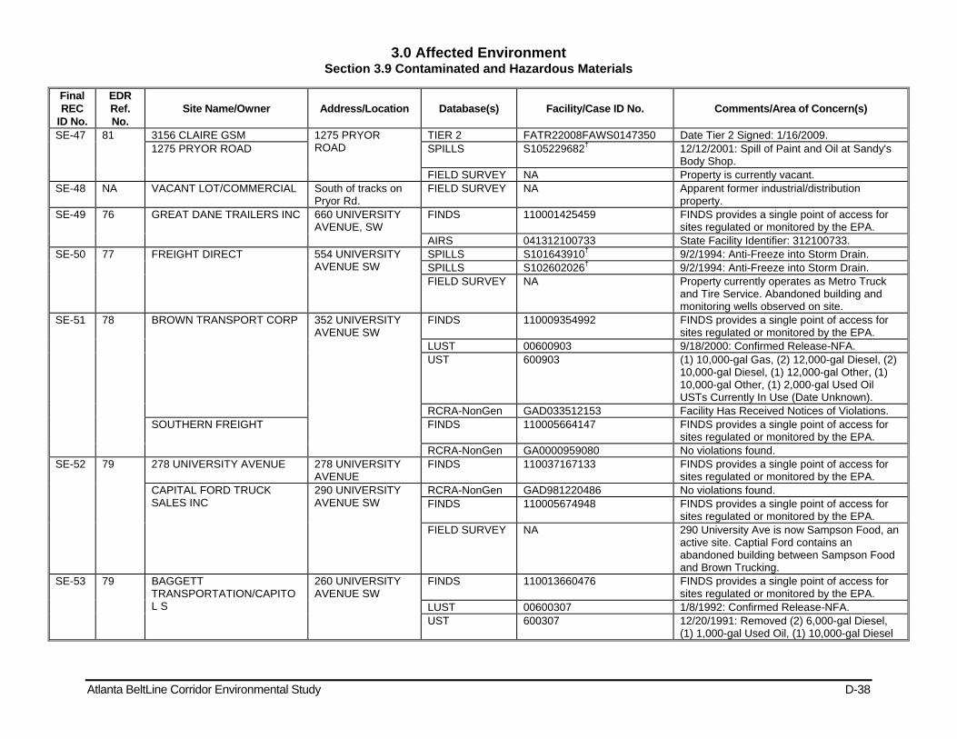
3.0 Affected Environment Section 3.9 Contaminated and Hazardous Materials
Atlanta BeltLine Corridor Environmental Study D-38
Final REC
ID No.
EDR Ref. No.
Site Name/Owner Address/Location Database(s) Facility/Case ID No. Comments/Area of Concern(s)
SE-47 81 3156 CLAIRE GSM 1275 PRYOR ROAD
TIER 2 FATR22008FAWS0147350 Date Tier 2 Signed: 1/16/2009. 1275 PRYOR ROAD SPILLS S105229682† 12/12/2001: Spill of Paint and Oil at Sandy's
Body Shop. FIELD SURVEY NA Property is currently vacant.
SE-48 NA VACANT LOT/COMMERCIAL South of tracks on Pryor Rd.
FIELD SURVEY NA Apparent former industrial/distribution property.
SE-49 76 GREAT DANE TRAILERS INC 660 UNIVERSITY AVENUE, SW
FINDS 110001425459 FINDS provides a single point of access for sites regulated or monitored by the EPA.
AIRS 041312100733 State Facility Identifier: 312100733. SE-50 77 FREIGHT DIRECT 554 UNIVERSITY
AVENUE SW SPILLS S101643910† 9/2/1994: Anti-Freeze into Storm Drain. SPILLS S102602026† 9/2/1994: Anti-Freeze into Storm Drain. FIELD SURVEY NA Property currently operates as Metro Truck
and Tire Service. Abandoned building and monitoring wells observed on site.
SE-51 78 BROWN TRANSPORT CORP 352 UNIVERSITY AVENUE SW
FINDS 110009354992 FINDS provides a single point of access for sites regulated or monitored by the EPA.
LUST 00600903 9/18/2000: Confirmed Release-NFA. UST 600903 (1) 10,000-gal Gas, (2) 12,000-gal Diesel, (2)
10,000-gal Diesel, (1) 12,000-gal Other, (1) 10,000-gal Other, (1) 2,000-gal Used Oil USTs Currently In Use (Date Unknown).
RCRA-NonGen GAD033512153 Facility Has Received Notices of Violations. SOUTHERN FREIGHT FINDS 110005664147 FINDS provides a single point of access for
sites regulated or monitored by the EPA. RCRA-NonGen GA0000959080 No violations found.
SE-52 79 278 UNIVERSITY AVENUE 278 UNIVERSITY AVENUE
FINDS 110037167133 FINDS provides a single point of access for sites regulated or monitored by the EPA.
CAPITAL FORD TRUCK SALES INC
290 UNIVERSITY AVENUE SW
RCRA-NonGen GAD981220486 No violations found. FINDS 110005674948 FINDS provides a single point of access for
sites regulated or monitored by the EPA. FIELD SURVEY NA 290 University Ave is now Sampson Food, an
active site. Captial Ford contains an abandoned building between Sampson Food and Brown Trucking.
SE-53 79 BAGGETT TRANSPORTATION/CAPITOL S
260 UNIVERSITY AVENUE SW
FINDS 110013660476 FINDS provides a single point of access for sites regulated or monitored by the EPA.
LUST 00600307 1/8/1992: Confirmed Release-NFA. UST 600307 12/20/1991: Removed (2) 6,000-gal Diesel,
(1) 1,000-gal Used Oil, (1) 10,000-gal Diesel
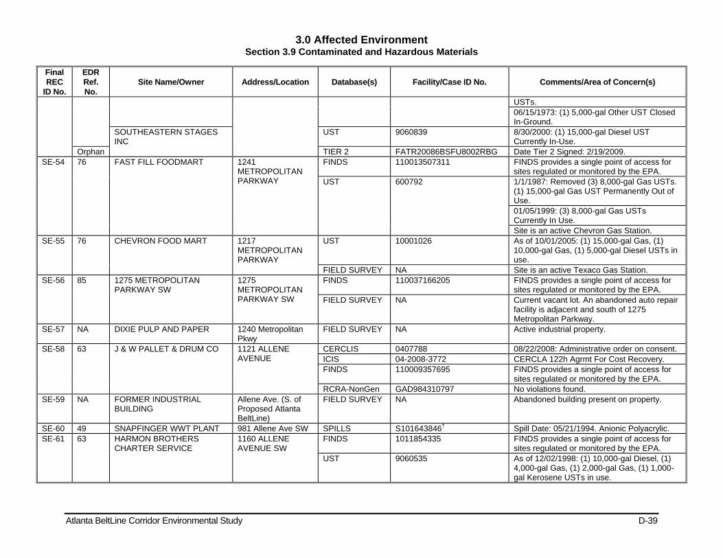
3.0 Affected Environment Section 3.9 Contaminated and Hazardous Materials
Atlanta BeltLine Corridor Environmental Study D-39
Final REC
ID No.
EDR Ref. No.
Site Name/Owner Address/Location Database(s) Facility/Case ID No. Comments/Area of Concern(s)
USTs. 06/15/1973: (1) 5,000-gal Other UST Closed In-Ground.
SOUTHEASTERN STAGES INC
UST 9060839 8/30/2000: (1) 15,000-gal Diesel UST Currently In-Use.
Orphan TIER 2 FATR20086BSFU8002RBG Date Tier 2 Signed: 2/19/2009. SE-54 76 FAST FILL FOODMART 1241
METROPOLITAN PARKWAY
FINDS 110013507311 FINDS provides a single point of access for sites regulated or monitored by the EPA.
UST 600792 1/1/1987: Removed (3) 8,000-gal Gas USTs. (1) 15,000-gal Gas UST Permanently Out of Use. 01/05/1999: (3) 8,000-gal Gas USTs Currently In Use. Site is an active Chevron Gas Station.
SE-55 76 CHEVRON FOOD MART 1217 METROPOLITAN PARKWAY
UST 10001026 As of 10/01/2005: (1) 15,000-gal Gas, (1) 10,000-gal Gas, (1) 5,000-gal Diesel USTs in use.
FIELD SURVEY NA Site is an active Texaco Gas Station. SE-56 85 1275 METROPOLITAN
PARKWAY SW 1275 METROPOLITAN PARKWAY SW
FINDS 110037166205 FINDS provides a single point of access for sites regulated or monitored by the EPA.
FIELD SURVEY NA Current vacant lot. An abandoned auto repair facility is adjacent and south of 1275 Metropolitan Parkway.
SE-57 NA DIXIE PULP AND PAPER 1240 Metropolitan Pkwy
FIELD SURVEY NA Active industrial property.
SE-58 63 J & W PALLET & DRUM CO 1121 ALLENE AVENUE
CERCLIS 0407788 08/22/2008: Administrative order on consent. ICIS 04-2008-3772 CERCLA 122h Agrmt For Cost Recovery. FINDS 110009357695 FINDS provides a single point of access for
sites regulated or monitored by the EPA. RCRA-NonGen GAD984310797 No violations found.
SE-59 NA FORMER INDUSTRIAL BUILDING
Allene Ave. (S. of Proposed Atlanta BeltLine)
FIELD SURVEY NA Abandoned building present on property.
SE-60 49 SNAPFINGER WWT PLANT 981 Allene Ave SW SPILLS S101643846† Spill Date: 05/21/1994. Anionic Polyacrylic. SE-61 63 HARMON BROTHERS
CHARTER SERVICE 1160 ALLENE AVENUE SW
FINDS 1011854335 FINDS provides a single point of access for sites regulated or monitored by the EPA.
UST 9060535 As of 12/02/1998: (1) 10,000-gal Diesel, (1) 4,000-gal Gas, (1) 2,000-gal Gas, (1) 1,000-gal Kerosene USTs in use.
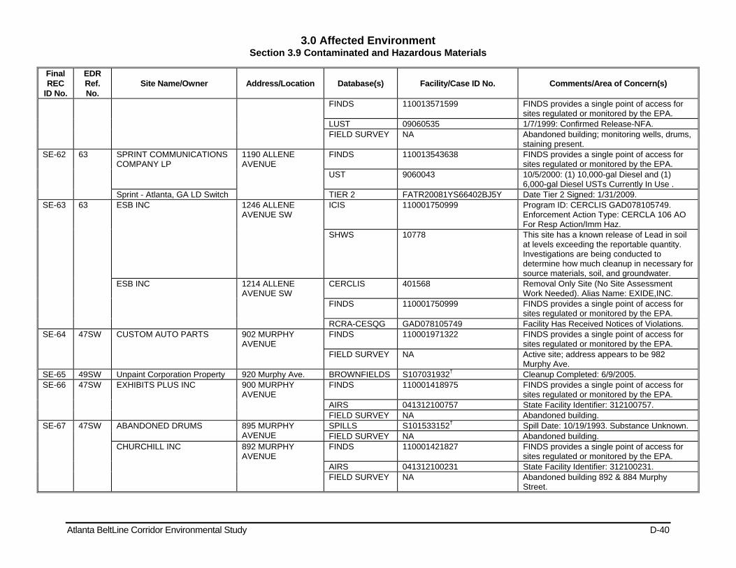
3.0 Affected Environment Section 3.9 Contaminated and Hazardous Materials
Atlanta BeltLine Corridor Environmental Study D-40
Final REC
ID No.
EDR Ref. No.
Site Name/Owner Address/Location Database(s) Facility/Case ID No. Comments/Area of Concern(s)
FINDS 110013571599 FINDS provides a single point of access for sites regulated or monitored by the EPA.
LUST 09060535 1/7/1999: Confirmed Release-NFA. FIELD SURVEY NA Abandoned building; monitoring wells, drums,
staining present. SE-62 63 SPRINT COMMUNICATIONS
COMPANY LP 1190 ALLENE AVENUE
FINDS 110013543638 FINDS provides a single point of access for sites regulated or monitored by the EPA.
UST 9060043 10/5/2000: (1) 10,000-gal Diesel and (1) 6,000-gal Diesel USTs Currently In Use .
Sprint - Atlanta, GA LD Switch TIER 2 FATR20081YS66402BJ5Y Date Tier 2 Signed: 1/31/2009. SE-63 63 ESB INC 1246 ALLENE
AVENUE SW ICIS 110001750999 Program ID: CERCLIS GAD078105749.
Enforcement Action Type: CERCLA 106 AO For Resp Action/Imm Haz.
SHWS 10778 This site has a known release of Lead in soil at levels exceeding the reportable quantity. Investigations are being conducted to determine how much cleanup in necessary for source materials, soil, and groundwater.
ESB INC 1214 ALLENE AVENUE SW
CERCLIS 401568 Removal Only Site (No Site Assessment Work Needed). Alias Name: EXIDE,INC.
FINDS 110001750999 FINDS provides a single point of access for sites regulated or monitored by the EPA.
RCRA-CESQG GAD078105749 Facility Has Received Notices of Violations. SE-64 47SW CUSTOM AUTO PARTS 902 MURPHY
AVENUE FINDS 110001971322 FINDS provides a single point of access for
sites regulated or monitored by the EPA. FIELD SURVEY NA Active site; address appears to be 982
Murphy Ave. SE-65 49SW Unpaint Corporation Property 920 Murphy Ave. BROWNFIELDS S107031932† Cleanup Completed: 6/9/2005. SE-66 47SW EXHIBITS PLUS INC 900 MURPHY
AVENUE FINDS 110001418975 FINDS provides a single point of access for
sites regulated or monitored by the EPA. AIRS 041312100757 State Facility Identifier: 312100757. FIELD SURVEY NA Abandoned building.
SE-67 47SW ABANDONED DRUMS 895 MURPHY AVENUE
SPILLS S101533152† Spill Date: 10/19/1993. Substance Unknown. FIELD SURVEY NA Abandoned building.
CHURCHILL INC 892 MURPHY AVENUE
FINDS 110001421827 FINDS provides a single point of access for sites regulated or monitored by the EPA.
AIRS 041312100231 State Facility Identifier: 312100231. FIELD SURVEY NA Abandoned building 892 & 884 Murphy
Street.

3.0 Affected Environment Section 3.9 Contaminated and Hazardous Materials
Atlanta BeltLine Corridor Environmental Study D-41
Final REC
ID No.
EDR Ref. No.
Site Name/Owner Address/Location Database(s) Facility/Case ID No. Comments/Area of Concern(s)
43SW 878 MURPHY AVENUE 878 MURPHY AVENUE
LUST 10000846 3/10/2005: Confirmed Release-NFA. UST 10000846 UST size and contents not reported. FIELD SURVEY NA Apparent one facility.
SE-68 34 791 LOWNDES STREET SW 791 LOWNDES STREET SW
FINDS 110037171020 FINDS provides a single point of access for sites regulated or monitored by the EPA.
SE-69 31 UNPAINT CORPORATION 690 MURPHY AVENUE SW
FINDS 110005670121 FINDS provides a single point of access for sites regulated or monitored by the EPA.
RCRA-NonGen GAD097393243 Violation Status: No violations found. SE-70 139 DYNAMIC METALS 584 EDGEWOOD
AVENUE FINDS 110011737923 FINDS provides a single point of access for
sites regulated or monitored by the EPA. HIST FTTS 198902221726 1 Investigation Type: Section 6 PCB Federal
Conducted. LUST 10000228 1/23/2003: Confirmed Release - Cleanup
Status: Transferred. GA NON-HSI S105872217 Report Date: 4/3/2003. Contamination: vinyl
chloride; 1,2-dichloropropane. FTTS 199206245281 1 Inspection Date: 06/24/92. Investigation Type:
Section 6 PCB Federal Conducted. HIST FTTS 199206245281 2 Investigation Type: Section 6 PCB Federal
Conducted. SE-71 139 Mccullough Electric Services 521 Edgewood Ave. SPILLS 19177 Air release of smelly odor. SE-72 139 EDGEWOOD COLLISION 494 EDGEWOOD
AVENUE NE SPILLS 52900 6/23/2008: Dumping open paint into
dumpster. BILLY’S BODY & FENDER REPAIR
FINDS 110005669945 FINDS provides a single point of access for sites regulated or monitored by the EPA.
RCRA-NonGen GAD092647791 Violation Status: No violations found. SE-73 139 FORMER SERVICE STATION 479 EDGEWOOD
AVENUE LUST 09060750 11/13/1998: Confirmed Release - No Further
Action (NFA). UST 9060750 8/5/1998: Removed (2) 4,000-gal Gas and (1)
150-gal Used Oil USTs. SE-74 141 EASEWAY FOOD 400 EDGEWOOD
AVENUE NE FINDS 110013511146 FINDS provides a single point of access for
sites regulated or monitored by the EPA. LUST 00600843 6/7/1990, 7/17/1990 & 10/8/2003: Confirmed
Release - NFA. 144 UST 600843 6/7/2007: (2) 5,000-gal and (1) 8,000-gal Gas
Temporary Out-of-Use. 01/01/93: (1) 6,000-gal Gas Permanently Out-of-Use.
QUICKIE PICKIE SRVC SPILLS 2136 7/17/1990: Gasoline/Fuel Oil. 141 Edgewood / Jackson SPILLS 0230 2/28/1991: Gasoline/Fuel Oil.
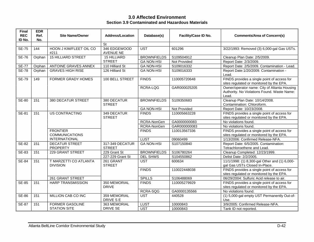
3.0 Affected Environment Section 3.9 Contaminated and Hazardous Materials
Atlanta BeltLine Corridor Environmental Study D-42
Final REC
ID No.
EDR Ref. No.
Site Name/Owner Address/Location Database(s) Facility/Case ID No. Comments/Area of Concern(s)
St SE-75 144 HOON J KIM/FLEET OIL CO
#211 346 EDGEWOOD AVENUE NE
UST 601296 3/22/1993: Removed (3) 6,000-gal Gas USTs.
SE-76 Orphan 15 HILLIARD STREET 15 HILLIARD STREET
BROWNFIELDS S109504912 Cleanup Plan Date: 2/5/2009. GA NON-HSI Not Provided Report Date: 2/3/2009.
SE-77 Orphan ANTOINE GRAVES ANNEX 110 Hilliard St GA NON-HSI S109016332 Report Date: 2/5/2009. Contamination - Lead. SE-78 Orphan GRAVES HIGH RISE 126 Hilliard St GA NON-HSI S109016333 Report Date:1/20/2009. Contamination -
Lead. SE-79 149 FORMER GRADY HOMES 100 BELL STREET FINDS 110005720648 FINDS provides a single point of access for
sites regulated or monitored by the EPA. RCRA-LQG GAR000025205 Owner/operator name: City of Altanta Housing
Authority. No Violations Found. Waste Name: Lead.
SE-80 151 380 DECATUR STREET 380 DECATUR STREET
BROWNFIELDS S109350683 Cleanup Plan Date: 10/14/2008. Contamination: Chloroform.
GA NON-HSI Not Provided Report Date: 10/23/2008. SE-81 151 US CONTRACTING 349 DECATUR
STREET FINDS 110005663228 FINDS provides a single point of access for
sites regulated or monitored by the EPA. RCRA-NonGen GA0000000083 No violations found. RCRA-NonGen GAR000000083 No violations found.
FRONTIER COMMUNICATIONS INTERNATIONAL
FINDS 110013567336 FINDS provides a single point of access for sites regulated or monitored by the EPA.
LUST 09060499 1/13/2006: Confirmed Release-NFA. SE-82 151 DECATUR STREET
PROPERTY 317-349 DECATUR STREET
GA NON-HSI S107150840 Report Date: 6/5/2005. Contamination: Tetrachloroethene and Lead.
SE-83 151 229 GRANT STREET 229 Grant St BROWNFIELDS S106780264 Cleanup Completed: 12/23/1999. 227-229 Grant St DEL SHWS S104550862 Delist Date: 2/2/2005.
SE-84 151 T MARZETTI CO ATLANTA DIVISION
261 GRANT STREET
UST 600634 11/1/1998: (1) 8,300-gal Other and (1) 6,000-gal Gas USTs Closed In-Place.
FINDS 110022448038 FINDS provides a single point of access for sites regulated or monitored by the EPA.
261 GRANT STREET SPILLS S106488069 06/29/2004: Sulfuric Acid release to air. SE-85 151 HARP TRANSMISSION 350 MEMORIAL
DRIVE FINDS 110005279929 FINDS provides a single point of access for
sites regulated or monitored by the EPA. RCRA-SQG GA0000135566 No violations found.
SE-86 151 MILLION CAB CO INC 359 MEMORIAL DRIVE S E
UST 440528 (1) 5,000-gal empty UST Permanently Out-of-Use.
SE-87 151 FORMER GASOLINE STATION SITE
363 MEMORIAL DRIVE SE
LUST 10000843 3/9/2005: Confirmed Release-NFA. UST 10000843 Tank ID not reported.
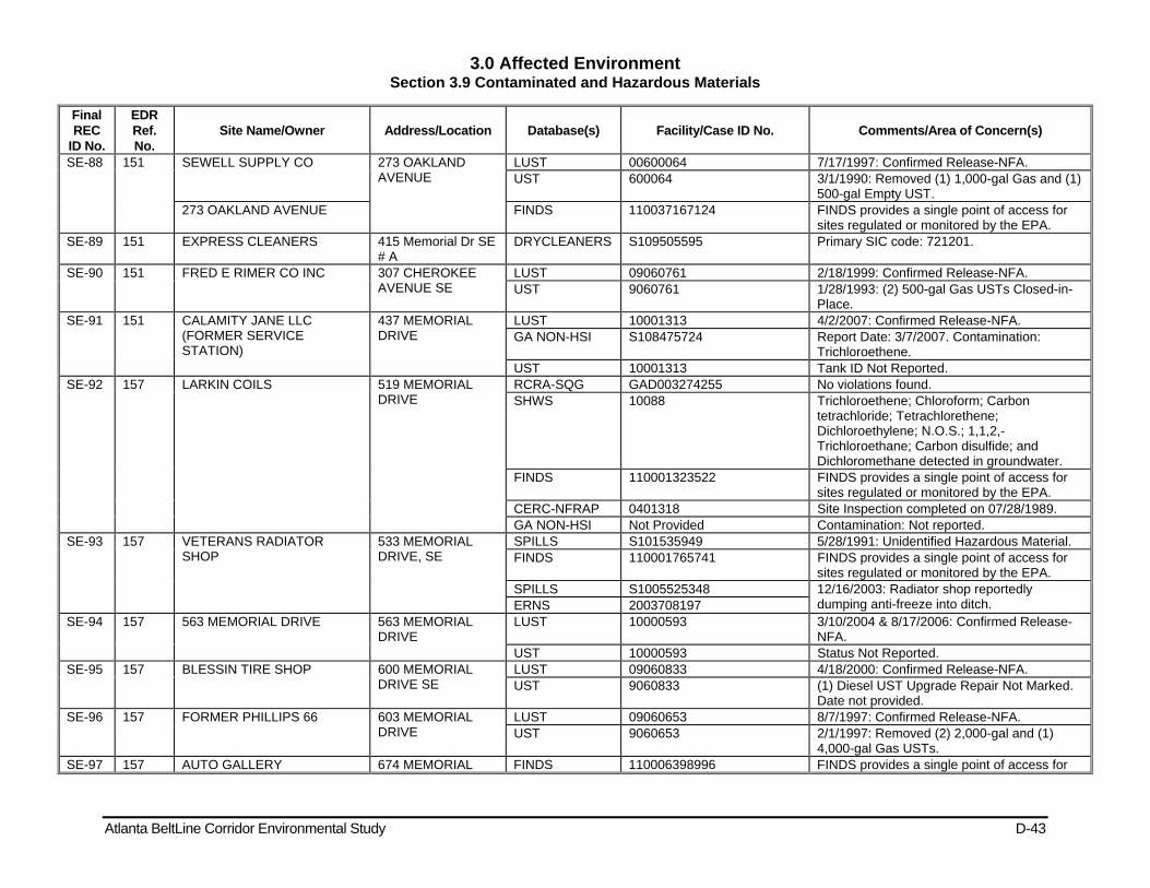
3.0 Affected Environment Section 3.9 Contaminated and Hazardous Materials
Atlanta BeltLine Corridor Environmental Study D-43
Final REC
ID No.
EDR Ref. No.
Site Name/Owner Address/Location Database(s) Facility/Case ID No. Comments/Area of Concern(s)
SE-88 151 SEWELL SUPPLY CO 273 OAKLAND AVENUE
LUST 00600064 7/17/1997: Confirmed Release-NFA. UST 600064 3/1/1990: Removed (1) 1,000-gal Gas and (1)
500-gal Empty UST. 273 OAKLAND AVENUE FINDS 110037167124 FINDS provides a single point of access for
sites regulated or monitored by the EPA. SE-89 151 EXPRESS CLEANERS 415 Memorial Dr SE
# A DRYCLEANERS S109505595 Primary SIC code: 721201.
SE-90 151 FRED E RIMER CO INC 307 CHEROKEE AVENUE SE
LUST 09060761 2/18/1999: Confirmed Release-NFA. UST 9060761 1/28/1993: (2) 500-gal Gas USTs Closed-in-
Place. SE-91 151 CALAMITY JANE LLC
(FORMER SERVICE STATION)
437 MEMORIAL DRIVE
LUST 10001313 4/2/2007: Confirmed Release-NFA. GA NON-HSI S108475724 Report Date: 3/7/2007. Contamination:
Trichloroethene. UST 10001313 Tank ID Not Reported.
SE-92 157 LARKIN COILS 519 MEMORIAL DRIVE
RCRA-SQG GAD003274255 No violations found. SHWS 10088 Trichloroethene; Chloroform; Carbon
tetrachloride; Tetrachlorethene; Dichloroethylene; N.O.S.; 1,1,2,-Trichloroethane; Carbon disulfide; and Dichloromethane detected in groundwater.
FINDS 110001323522 FINDS provides a single point of access for sites regulated or monitored by the EPA.
CERC-NFRAP 0401318 Site Inspection completed on 07/28/1989. GA NON-HSI Not Provided Contamination: Not reported.
SE-93 157 VETERANS RADIATOR SHOP
533 MEMORIAL DRIVE, SE
SPILLS S101535949 5/28/1991: Unidentified Hazardous Material. FINDS 110001765741 FINDS provides a single point of access for
sites regulated or monitored by the EPA. SPILLS S1005525348 12/16/2003: Radiator shop reportedly
dumping anti-freeze into ditch. ERNS 2003708197 SE-94 157 563 MEMORIAL DRIVE 563 MEMORIAL
DRIVE LUST 10000593 3/10/2004 & 8/17/2006: Confirmed Release-
NFA. UST 10000593 Status Not Reported.
SE-95 157 BLESSIN TIRE SHOP 600 MEMORIAL DRIVE SE
LUST 09060833 4/18/2000: Confirmed Release-NFA. UST 9060833 (1) Diesel UST Upgrade Repair Not Marked.
Date not provided. SE-96 157 FORMER PHILLIPS 66 603 MEMORIAL
DRIVE LUST 09060653 8/7/1997: Confirmed Release-NFA. UST 9060653 2/1/1997: Removed (2) 2,000-gal and (1)
4,000-gal Gas USTs. SE-97 157 AUTO GALLERY 674 MEMORIAL FINDS 110006398996 FINDS provides a single point of access for
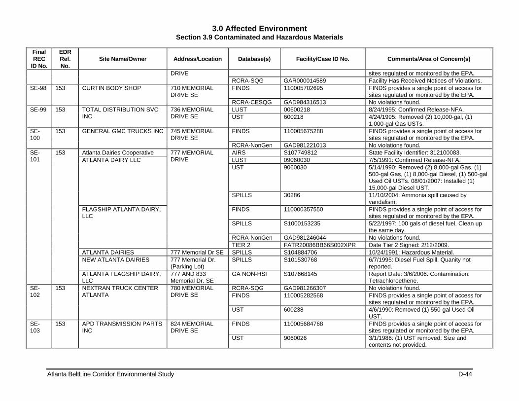
3.0 Affected Environment Section 3.9 Contaminated and Hazardous Materials
Atlanta BeltLine Corridor Environmental Study D-44
Final REC
ID No.
EDR Ref. No.
Site Name/Owner Address/Location Database(s) Facility/Case ID No. Comments/Area of Concern(s)
DRIVE sites regulated or monitored by the EPA. RCRA-SQG GAR000014589 Facility Has Received Notices of Violations.
SE-98 153 CURTIN BODY SHOP 710 MEMORIAL DRIVE SE
FINDS 110005702695 FINDS provides a single point of access for sites regulated or monitored by the EPA.
RCRA-CESQG GAD984316513 No violations found. SE-99 153 TOTAL DISTRIBUTION SVC
INC 736 MEMORIAL DRIVE SE
LUST 00600218 8/24/1995: Confirmed Release-NFA. UST 600218 4/24/1995: Removed (2) 10,000-gal, (1)
1,000-gal Gas USTs. SE-100
153 GENERAL GMC TRUCKS INC 745 MEMORIAL DRIVE SE
FINDS 110005675288 FINDS provides a single point of access for sites regulated or monitored by the EPA.
RCRA-NonGen GAD981221013 No violations found. SE-101
153 Atlanta Dairies Cooperative 777 MEMORIAL DRIVE
AIRS S107749812 State Facility Identifier: 312100083. ATLANTA DAIRY LLC LUST 09060030 7/5/1991: Confirmed Release-NFA.
UST 9060030 5/14/1990: Removed (2) 8,000-gal Gas, (1) 500-gal Gas, (1) 8,000-gal Diesel, (1) 500-gal Used Oil USTs. 08/01/2007: Installed (1) 15,000-gal Diesel UST.
SPILLS 30286 11/10/2004: Ammonia spill caused by vandalism.
FLAGSHIP ATLANTA DAIRY, LLC
FINDS 110000357550 FINDS provides a single point of access for sites regulated or monitored by the EPA.
SPILLS S1000153235 5/22/1997: 100 gals of diesel fuel. Clean up the same day.
RCRA-NonGen GAD981246044 No violations found. TIER 2 FATR20086BB66S002XPR Date Tier 2 Signed: 2/12/2009.
ATLANTA DAIRIES 777 Memorial Dr SE SPILLS S104884706 10/24/1991: Hazardous Material. NEW ATLANTA DAIRIES 777 Memorial Dr.
(Parking Lot) SPILLS S101530768 6/7/1995: Diesel Fuel Spill. Quanity not
reported. ATLANTA FLAGSHIP DAIRY, LLC
777 AND 833 Memorial Dr. SE
GA NON-HSI S107668145 Report Date: 3/6/2006. Contamination: Tetrachloroethene.
SE-102
153 NEXTRAN TRUCK CENTER ATLANTA
780 MEMORIAL DRIVE SE
RCRA-SQG GAD981266307 No violations found. FINDS 110005282568 FINDS provides a single point of access for
sites regulated or monitored by the EPA. UST 600238 4/6/1990: Removed (1) 550-gal Used Oil
UST. SE-103
153 APD TRANSMISSION PARTS INC
824 MEMORIAL DRIVE SE
FINDS 110005684768 FINDS provides a single point of access for sites regulated or monitored by the EPA.
UST 9060026 3/1/1986: (1) UST removed. Size and contents not provided.
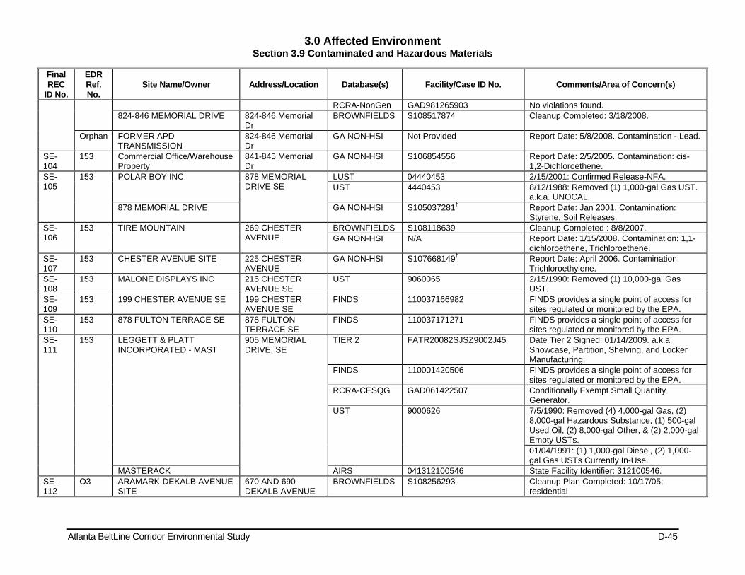
3.0 Affected Environment Section 3.9 Contaminated and Hazardous Materials
Atlanta BeltLine Corridor Environmental Study D-45
Final REC
ID No.
EDR Ref. No.
Site Name/Owner Address/Location Database(s) Facility/Case ID No. Comments/Area of Concern(s)
RCRA-NonGen GAD981265903 No violations found. 824-846 MEMORIAL DRIVE 824-846 Memorial
Dr BROWNFIELDS S108517874 Cleanup Completed: 3/18/2008.
Orphan FORMER APD TRANSMISSION
824-846 Memorial Dr
GA NON-HSI Not Provided Report Date: 5/8/2008. Contamination - Lead.
SE-104
153 Commercial Office/Warehouse Property
841-845 Memorial Dr
GA NON-HSI S106854556 Report Date: 2/5/2005. Contamination: cis-1,2-Dichloroethene.
SE-105
153 POLAR BOY INC 878 MEMORIAL DRIVE SE
LUST 04440453 2/15/2001: Confirmed Release-NFA. UST 4440453 8/12/1988: Removed (1) 1,000-gal Gas UST.
a.k.a. UNOCAL. 878 MEMORIAL DRIVE GA NON-HSI S105037281† Report Date: Jan 2001. Contamination:
Styrene, Soil Releases. SE-106
153 TIRE MOUNTAIN 269 CHESTER AVENUE
BROWNFIELDS S108118639 Cleanup Completed : 8/8/2007. GA NON-HSI N/A Report Date: 1/15/2008. Contamination: 1,1-
dichloroethene, Trichloroethene. SE-107
153 CHESTER AVENUE SITE 225 CHESTER AVENUE
GA NON-HSI S107668149† Report Date: April 2006. Contamination: Trichloroethylene.
SE-108
153 MALONE DISPLAYS INC 215 CHESTER AVENUE SE
UST 9060065 2/15/1990: Removed (1) 10,000-gal Gas UST.
SE-109
153 199 CHESTER AVENUE SE 199 CHESTER AVENUE SE
FINDS 110037166982 FINDS provides a single point of access for sites regulated or monitored by the EPA.
SE-110
153 878 FULTON TERRACE SE 878 FULTON TERRACE SE
FINDS 110037171271 FINDS provides a single point of access for sites regulated or monitored by the EPA.
SE-111
153 LEGGETT & PLATT INCORPORATED - MAST
905 MEMORIAL DRIVE, SE
TIER 2 FATR20082SJSZ9002J45 Date Tier 2 Signed: 01/14/2009. a.k.a. Showcase, Partition, Shelving, and Locker Manufacturing.
FINDS 110001420506 FINDS provides a single point of access for sites regulated or monitored by the EPA.
RCRA-CESQG GAD061422507 Conditionally Exempt Small Quantity Generator.
UST 9000626 7/5/1990: Removed (4) 4,000-gal Gas, (2) 8,000-gal Hazardous Substance, (1) 500-gal Used Oil, (2) 8,000-gal Other, & (2) 2,000-gal Empty USTs. 01/04/1991: (1) 1,000-gal Diesel, (2) 1,000-gal Gas USTs Currently In-Use.
MASTERACK AIRS 041312100546 State Facility Identifier: 312100546. SE-112
O3 ARAMARK-DEKALB AVENUE SITE
670 AND 690 DEKALB AVENUE
BROWNFIELDS S108256293 Cleanup Plan Completed: 10/17/05; residential
3.0 Affected Environment Section 3.9 Contaminated and Hazardous Materials
Atlanta BeltLine Corridor Environmental Study D-46
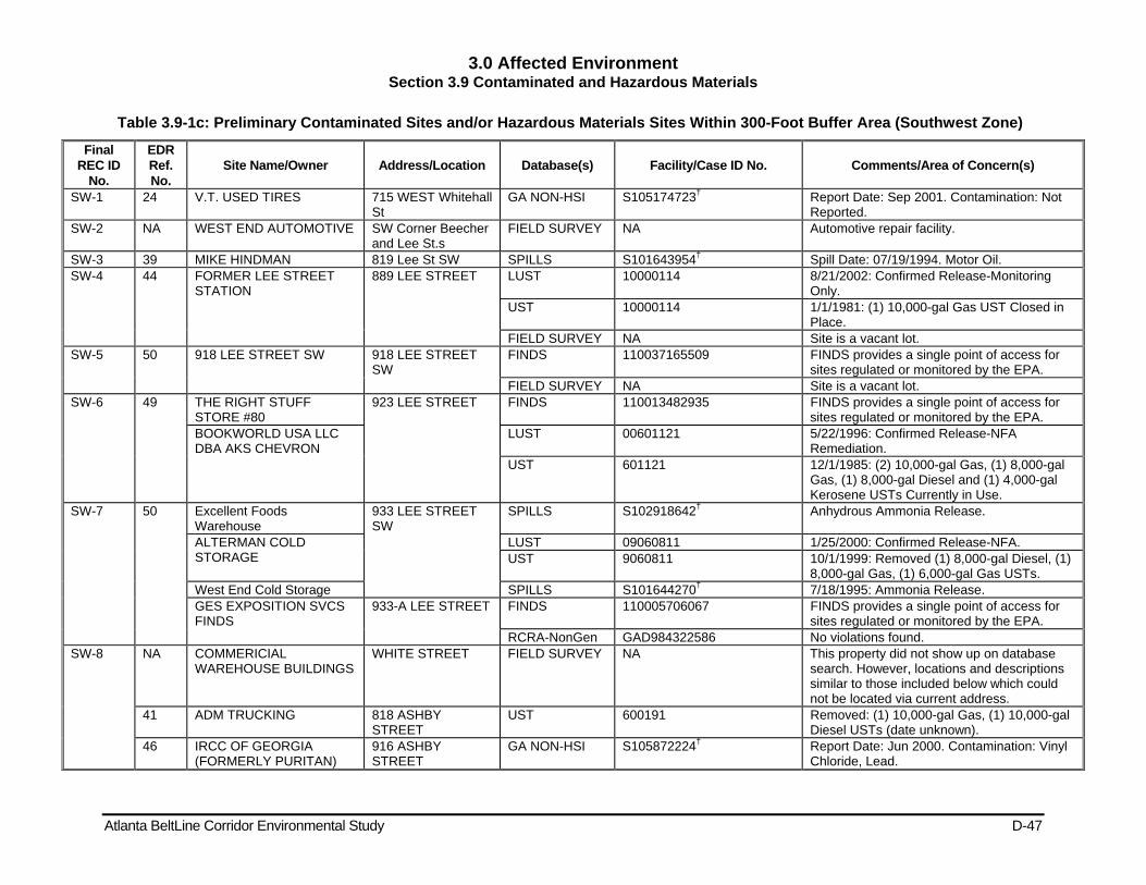
3.0 Affected Environment Section 3.9 Contaminated and Hazardous Materials
Atlanta BeltLine Corridor Environmental Study D-47
Table 3.9-1c: Preliminary Contaminated Sites and/or Hazardous Materials Sites Within 300-Foot Buffer Area (Southwest Zone)
Final REC ID
No.
EDR Ref. No.
Site Name/Owner Address/Location Database(s) Facility/Case ID No. Comments/Area of Concern(s)
SW-1 24 V.T. USED TIRES 715 WEST Whitehall St
GA NON-HSI S105174723† Report Date: Sep 2001. Contamination: Not Reported.
SW-2 NA WEST END AUTOMOTIVE SW Corner Beecher and Lee St.s
FIELD SURVEY NA Automotive repair facility.
SW-3 39 MIKE HINDMAN 819 Lee St SW SPILLS S101643954† Spill Date: 07/19/1994. Motor Oil. SW-4 44 FORMER LEE STREET
STATION 889 LEE STREET LUST 10000114 8/21/2002: Confirmed Release-Monitoring
Only. UST 10000114 1/1/1981: (1) 10,000-gal Gas UST Closed in
Place. FIELD SURVEY NA Site is a vacant lot.
SW-5 50 918 LEE STREET SW 918 LEE STREET SW
FINDS 110037165509 FINDS provides a single point of access for sites regulated or monitored by the EPA.
FIELD SURVEY NA Site is a vacant lot. SW-6 49 THE RIGHT STUFF
STORE #80 923 LEE STREET FINDS 110013482935 FINDS provides a single point of access for
sites regulated or monitored by the EPA. BOOKWORLD USA LLC DBA AKS CHEVRON
LUST 00601121 5/22/1996: Confirmed Release-NFA Remediation.
UST 601121 12/1/1985: (2) 10,000-gal Gas, (1) 8,000-gal Gas, (1) 8,000-gal Diesel and (1) 4,000-gal Kerosene USTs Currently in Use.
SW-7 50 Excellent Foods Warehouse
933 LEE STREET SW
SPILLS S102918642† Anhydrous Ammonia Release.
ALTERMAN COLD STORAGE
LUST 09060811 1/25/2000: Confirmed Release-NFA. UST 9060811 10/1/1999: Removed (1) 8,000-gal Diesel, (1)
8,000-gal Gas, (1) 6,000-gal Gas USTs. West End Cold Storage SPILLS S101644270† 7/18/1995: Ammonia Release. GES EXPOSITION SVCS FINDS
933-A LEE STREET FINDS 110005706067 FINDS provides a single point of access for sites regulated or monitored by the EPA.
RCRA-NonGen GAD984322586 No violations found. SW-8 NA COMMERICIAL
WAREHOUSE BUILDINGS WHITE STREET FIELD SURVEY NA This property did not show up on database
search. However, locations and descriptions similar to those included below which could not be located via current address.
41 ADM TRUCKING 818 ASHBY STREET
UST 600191 Removed: (1) 10,000-gal Gas, (1) 10,000-gal Diesel USTs (date unknown).
46 IRCC OF GEORGIA (FORMERLY PURITAN)
916 ASHBY STREET
GA NON-HSI S105872224† Report Date: Jun 2000. Contamination: Vinyl Chloride, Lead.
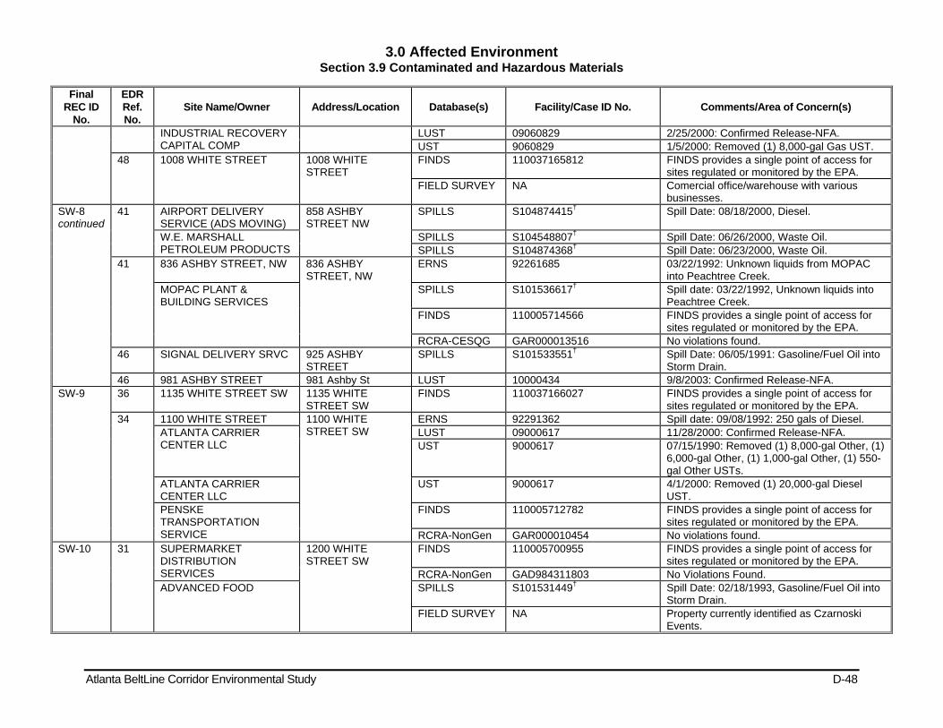
3.0 Affected Environment Section 3.9 Contaminated and Hazardous Materials
Atlanta BeltLine Corridor Environmental Study D-48
Final REC ID
No.
EDR Ref. No.
Site Name/Owner Address/Location Database(s) Facility/Case ID No. Comments/Area of Concern(s)
INDUSTRIAL RECOVERY CAPITAL COMP
LUST 09060829 2/25/2000: Confirmed Release-NFA. UST 9060829 1/5/2000: Removed (1) 8,000-gal Gas UST.
48 1008 WHITE STREET 1008 WHITE STREET
FINDS 110037165812 FINDS provides a single point of access for sites regulated or monitored by the EPA.
FIELD SURVEY NA Comercial office/warehouse with various businesses.
SW-8 continued
41 AIRPORT DELIVERY SERVICE (ADS MOVING)
858 ASHBY STREET NW
SPILLS S104874415† Spill Date: 08/18/2000, Diesel.
W.E. MARSHALL PETROLEUM PRODUCTS
SPILLS S104548807† Spill Date: 06/26/2000, Waste Oil. SPILLS S104874368† Spill Date: 06/23/2000, Waste Oil.
41 836 ASHBY STREET, NW 836 ASHBY STREET, NW
ERNS 92261685 03/22/1992: Unknown liquids from MOPAC into Peachtree Creek.
MOPAC PLANT & BUILDING SERVICES
SPILLS S101536617† Spill date: 03/22/1992, Unknown liquids into Peachtree Creek.
FINDS 110005714566 FINDS provides a single point of access for sites regulated or monitored by the EPA.
RCRA-CESQG GAR000013516 No violations found. 46 SIGNAL DELIVERY SRVC 925 ASHBY
STREET SPILLS S101533551† Spill Date: 06/05/1991: Gasoline/Fuel Oil into
Storm Drain. 46 981 ASHBY STREET 981 Ashby St LUST 10000434 9/8/2003: Confirmed Release-NFA.
SW-9 36 1135 WHITE STREET SW 1135 WHITE STREET SW
FINDS 110037166027 FINDS provides a single point of access for sites regulated or monitored by the EPA.
34 1100 WHITE STREET 1100 WHITE STREET SW
ERNS 92291362 Spill date: 09/08/1992: 250 gals of Diesel. ATLANTA CARRIER CENTER LLC
LUST 09000617 11/28/2000: Confirmed Release-NFA. UST 9000617 07/15/1990: Removed (1) 8,000-gal Other, (1)
6,000-gal Other, (1) 1,000-gal Other, (1) 550-gal Other USTs.
ATLANTA CARRIER CENTER LLC
UST 9000617 4/1/2000: Removed (1) 20,000-gal Diesel UST.
PENSKE TRANSPORTATION SERVICE
FINDS 110005712782 FINDS provides a single point of access for sites regulated or monitored by the EPA.
RCRA-NonGen GAR000010454 No violations found. SW-10 31 SUPERMARKET
DISTRIBUTION SERVICES
1200 WHITE STREET SW
FINDS 110005700955 FINDS provides a single point of access for sites regulated or monitored by the EPA.
RCRA-NonGen GAD984311803 No Violations Found. ADVANCED FOOD SPILLS S101531449† Spill Date: 02/18/1993, Gasoline/Fuel Oil into
Storm Drain. FIELD SURVEY NA Property currently identified as Czarnoski
Events.

3.0 Affected Environment Section 3.9 Contaminated and Hazardous Materials
Atlanta BeltLine Corridor Environmental Study D-49
Final REC ID
No.
EDR Ref. No.
Site Name/Owner Address/Location Database(s) Facility/Case ID No. Comments/Area of Concern(s)
SW-11 54 952 DONNELLY AVENUE SW
952 DONNELLY AVENUE SW
FINDS 110037165554 FINDS provides a single point of access for sites regulated or monitored by the EPA.
SW-12 54 Level 3 Communications LLC
953 DONNELLY AVENUE
TIER 2 FATR20084X5AY002TFLX Date Tier 2 Signed: 1/9/2009.
SW-13 58 MCI - ATGXGA 999 LEE STREET TIER 2 FATR200823VS8605WMBT Date Tier 2 Signed: 01/13/2009. WORLDCOM FINDS 110005720452 FINDS provides a single point of access for
sites regulated or monitored by the EPA. RCRA-NonGen GAR000023259 No violations found.
SW-14 54 CONSTRUCTION HAULING INC
948 DONNELLY AVENUE
FINDS 110005683778 FINDS provides a single point of access for sites regulated or monitored by the EPA.
RCRA-NonGen GAD981261662 No violations found. J&L ASSOCIATES INC LUST 09060560 12/3/1998: Confirmed Release-NFA.
UST 9060560 10/01/1998: Removed (1) 10,000-gal Diesel and (1) 2,500-gal Gas USTs.
SW-15 52 988 DONNELLY AVENUE SW
988 DONNELLY AVENUE SW
FINDS 110037165581 FINDS provides a single point of access for sites regulated or monitored by the EPA.
SW-16 42 BELCA FOOD SERVICES 1101 DONNELLY AVENUE SW
SPILLS S104884791† Spill Date: 08/18/1994. Anhydrous Ammonia. SPILLS S101527557† Spill Date: 08/18/1994. Anhydrous Ammonia.
1101 DONNELLY AVENUE SW
FINDS 110037165974 FINDS provides a single point of access for sites regulated or monitored by the EPA.
FIELD SURVEY NA Abandoned building. SW-17 51 1035 DONNELLY AVENUE
PARTNERSHIP 1035 DONNELLY AVENUE
UST 7060001 3/11/1993: Removed (1) 8,000-gal Diesel UST.
TERRY ENTERPRISES INC
FINDS 110005720755 FINDS provides a single point of access for sites regulated or monitored by the EPA.
RCRA-NonGen GAR000025312 No violations found. SW-18 NA FORMER RAILROAD
ALIGNMENT FORMER RAILROAD ALIGNMENT
FIELD SURVEY NA Former railroad operations; potential for former and undocumented spills and releases. Potential polychlorinated biphenyls (PCBs), metals, semi-volatile organic compounds (SVOCs), herbicides and pesticides, lead-based paint and asbestos containing building materials on/in relic equipment or structures.
SW-19 18 GEORGIA FOOD MART 1355 R D ABERNATHY BOULEVARD
FINDS 110013527344 FINDS provides a single point of access for sites regulated or monitored by the EPA.
LUST 00601184 4/16/1992: Confirmed Release-NFA Remediation.
UST 601184 4/17/1985: (3) 12,000-gal Gas USTs.
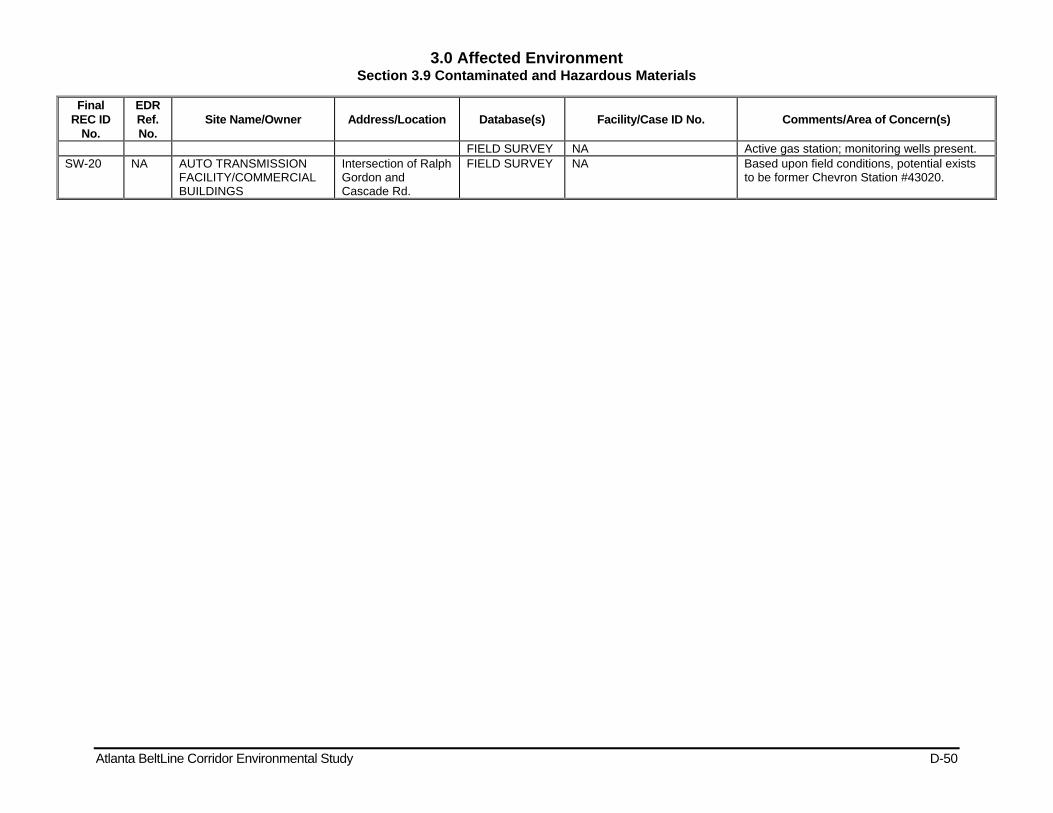
3.0 Affected Environment Section 3.9 Contaminated and Hazardous Materials
Atlanta BeltLine Corridor Environmental Study D-50
Final REC ID
No.
EDR Ref. No.
Site Name/Owner Address/Location Database(s) Facility/Case ID No. Comments/Area of Concern(s)
FIELD SURVEY NA Active gas station; monitoring wells present. SW-20 NA AUTO TRANSMISSION
FACILITY/COMMERCIAL BUILDINGS
Intersection of Ralph Gordon and Cascade Rd.
FIELD SURVEY NA Based upon field conditions, potential exists to be former Chevron Station #43020.
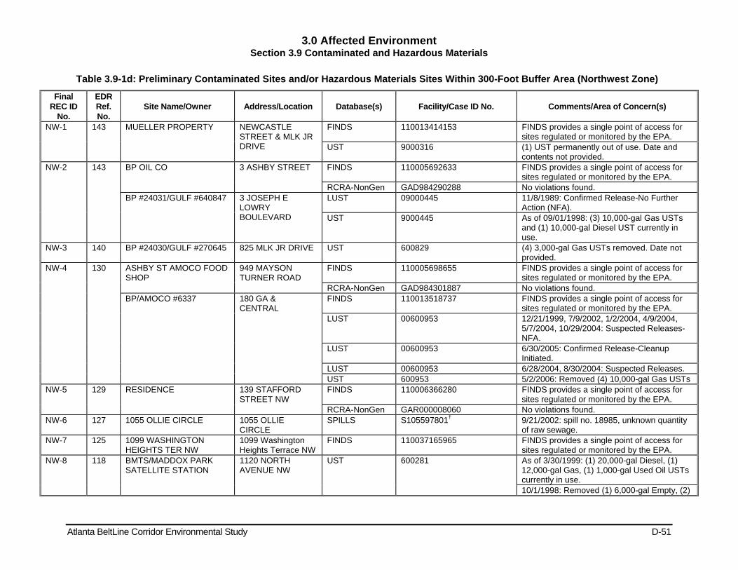
3.0 Affected Environment Section 3.9 Contaminated and Hazardous Materials
Atlanta BeltLine Corridor Environmental Study D-51
Table 3.9-1d: Preliminary Contaminated Sites and/or Hazardous Materials Sites Within 300-Foot Buffer Area (Northwest Zone)
Final REC ID
No.
EDR Ref. No.
Site Name/Owner Address/Location Database(s) Facility/Case ID No. Comments/Area of Concern(s)
NW-1 143 MUELLER PROPERTY NEWCASTLE STREET & MLK JR DRIVE
FINDS 110013414153 FINDS provides a single point of access for sites regulated or monitored by the EPA.
UST 9000316 (1) UST permanently out of use. Date and contents not provided.
NW-2 143 BP OIL CO 3 ASHBY STREET FINDS 110005692633 FINDS provides a single point of access for sites regulated or monitored by the EPA.
RCRA-NonGen GAD984290288 No violations found. BP #24031/GULF #640847 3 JOSEPH E
LOWRY BOULEVARD
LUST 09000445 11/8/1989: Confirmed Release-No Further Action (NFA).
UST 9000445 As of 09/01/1998: (3) 10,000-gal Gas USTs and (1) 10,000-gal Diesel UST currently in use.
NW-3 140 BP #24030/GULF #270645 825 MLK JR DRIVE UST 600829 (4) 3,000-gal Gas USTs removed. Date not provided.
NW-4 130 ASHBY ST AMOCO FOOD SHOP
949 MAYSON TURNER ROAD
FINDS 110005698655 FINDS provides a single point of access for sites regulated or monitored by the EPA.
RCRA-NonGen GAD984301887 No violations found. BP/AMOCO #6337 180 GA &
CENTRAL FINDS 110013518737 FINDS provides a single point of access for
sites regulated or monitored by the EPA. LUST 00600953 12/21/1999, 7/9/2002, 1/2/2004, 4/9/2004,
5/7/2004, 10/29/2004: Suspected Releases-NFA.
LUST 00600953 6/30/2005: Confirmed Release-Cleanup Initiated.
LUST 00600953 6/28/2004, 8/30/2004: Suspected Releases. UST 600953 5/2/2006: Removed (4) 10,000-gal Gas USTs
NW-5 129 RESIDENCE 139 STAFFORD STREET NW
FINDS 110006366280 FINDS provides a single point of access for sites regulated or monitored by the EPA.
RCRA-NonGen GAR000008060 No violations found. NW-6 127 1055 OLLIE CIRCLE 1055 OLLIE
CIRCLE SPILLS S105597801† 9/21/2002: spill no. 18985, unknown quantity
of raw sewage. NW-7 125 1099 WASHINGTON
HEIGHTS TER NW 1099 Washington Heights Terrace NW
FINDS 110037165965 FINDS provides a single point of access for sites regulated or monitored by the EPA.
NW-8 118 BMTS/MADDOX PARK SATELLITE STATION
1120 NORTH AVENUE NW
UST 600281 As of 3/30/1999: (1) 20,000-gal Diesel, (1) 12,000-gal Gas, (1) 1,000-gal Used Oil USTs currently in use. 10/1/1998: Removed (1) 6,000-gal Empty, (2)

3.0 Affected Environment Section 3.9 Contaminated and Hazardous Materials
Atlanta BeltLine Corridor Environmental Study D-52
Final REC ID
No.
EDR Ref. No.
Site Name/Owner Address/Location Database(s) Facility/Case ID No. Comments/Area of Concern(s)
6,000-gal Gas, (1) 20,000-gal Diesel, (1) 3,000-gal Oil, (1) 500-gal Used Oil USTs.
FINDS 110013488804 FINDS provides a single point of access for sites regulated or monitored by the EPA.
LUST 600281 7/29/1993: Confirmed Release-Monitoring Only NFA. 6/8/1993: Confirmed Release-Monitoring Only NFA.
118 NORTH AVENUE CSO 1150 North Ave. TIER 2 FATR2008252V5302DJV4 Date Tier 2 Signed: 2/25/2009. 118 1151 NORTH AVENUE NW 1151 NORTH
AVENUE NW FINDS 110037166054 FINDS provides a single point of access for
sites regulated or monitored by the EPA. NW-9 115 DRUM FIND Bankhead / Marietta
Blvd. SPILLS S101532832† 12/23/1993: Contents, type and size not
provided. NW-10 115 CSX RAILROAD 860 Marietta Blvd.
(between Bankhead) SPILLS S101528317† 7/19/1994: Gravel mixed with oil. Amount not
provided. 103 860 Marietta Blvd.
NW in front of Bldg. ERNS 94382498 7/19/1994: Caller states that the material was
dumped from the rail car. NW-11 114 MARTA: BANKHEAD
PARCEL No. 05000 GA NON-HSI S103439826† Contamination: Tetrachloroethylene; Acetone;
Chloroform; Methylene Chloride; cis-1,2-Dichloroethene
NW-12 109 Britt Carpet Laying Co Inc. 673 Rice St. NW UST 600672 4/9/1989: Removed (1) 3,000-gal Gas UST. NW-13 109 SMITH EQUIPMENT CO 751 RICE STREET
NW FINDS 110005685507 FINDS provides a single point of access for
sites regulated or monitored by the EPA. RCRA-NonGen GAD981268212 No violations found.
NW-14 109 1210 LOVELESS AVENUE 1210 LOVELESS AVENUE
FINDS 110037166161 FINDS provides a single point of access for sites regulated or monitored by the EPA.
NW-15 101 FULTON COUNTY CENTRAL MAINTENANCE
895 MARIETTA BOULEVARD
RCRA-SQG GAD984313932 No violations found. FINDS 110009357784 FINDS provides a single point of access for
sites regulated or monitored by the EPA. UST 9060122 As of 12/01/1998: (2) 12,000-gal Gas, (1)
12,000-gal Diesel, (1) 2,000-gal Kerosene, (3) 2,000-gal Other, (1) 4,000-gal Other USTs in use. 3/11/2003: (1) 6,000-gal Used Oil UST temporarily out of use. 3/1/1999: Removed (1) 2,000-gal Other UST.
LUST 09060122 4/1/1999: Confirmed Release-NFA. NW-15 continued
101 FULTON COUNTY JAIL 901 RICE STREET AST A100331007 (1) 30,000-gal above ground storage tank in use.
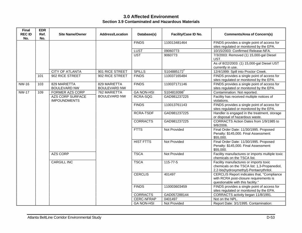
3.0 Affected Environment Section 3.9 Contaminated and Hazardous Materials
Atlanta BeltLine Corridor Environmental Study D-53
Final REC ID
No.
EDR Ref. No.
Site Name/Owner Address/Location Database(s) Facility/Case ID No. Comments/Area of Concern(s)
FINDS 110013481464 FINDS provides a single point of access for sites regulated or monitored by the EPA.
LUST 09060773 10/15/2003: Confirmed Release-NFA. UST 9060773 7/3/2003: Removed (1) 15,000-gal Diesel
UST. As of 8/22/2003: (1) 15,000-gal Diesel UST currently in use.
CITY OF ATLANTA 901 RICE STREET SPILLS S104885172† 12/4/1999: Spill into Proctor Creek. 101 902 RICE STREET 902 RICE STREET FINDS 110037165484 FINDS provides a single point of access for
sites regulated or monitored by the EPA. NW-16 103 829 MARIETTA
BOULEVARD NW 829 MARIETTA BOULEVARD NW
FINDS 110037171146 FINDS provides a single point of access for sites regulated or monitored by the EPA.
NW-17 109 FORMER AZS CORP 762 MARIETTA BOULEVARD NW
GA NON-HSI S104819398† Contamination: Not reported. AZS CORP SURFACE IMPOUNDMENTS
RCRA-SQG GAD981237225 Facility has received multiple notices of violations.
FINDS 110013761143 FINDS provides a single point of access for sites regulated or monitored by the EPA.
RCRA-TSDF GAD981237225 Handler is engaged in the treatment, storage or disposal of hazardous waste.
CORRACTS GAD981237225 CORRACTS Action Dates from 1/9/1985 to 9/8/2006.
FTTS Not Provided Final Order Date: 11/30/1995. Proposed Penalty: $145,000. Final Assessment: $55,000.
HIST FTTS Not Provided Final Order Date: 11/30/1995. Proposed Penalty: $145,000. Final Assessment: $55,000.
AZS CORP TSCA Not Provided Facility manufactures or imports multiple toxic chemicals on the TSCA list.
CARGILL INC TSCA 115-77-5 Facility manufactures or imports toxic chemicals on the TSCA list: 1,3-Propanediol, 2,2-bis(hydroxymethyl)-Pentaerythritol.
CERCLIS 401497 CERCLIS Report indicates that, "Compliance with RCRA post-closure requirements is questionable with this facility."
FINDS 110003603459 FINDS provides a single point of access for sites regulated or monitored by the EPA.
CORRACTS GAD057288144 CORRACTS activity began 11/8/1991. CERC-NFRAP 0401497 Not on the NPL. GA NON-HSI Not Provided Report Date: 3/1/1995. Contamination:
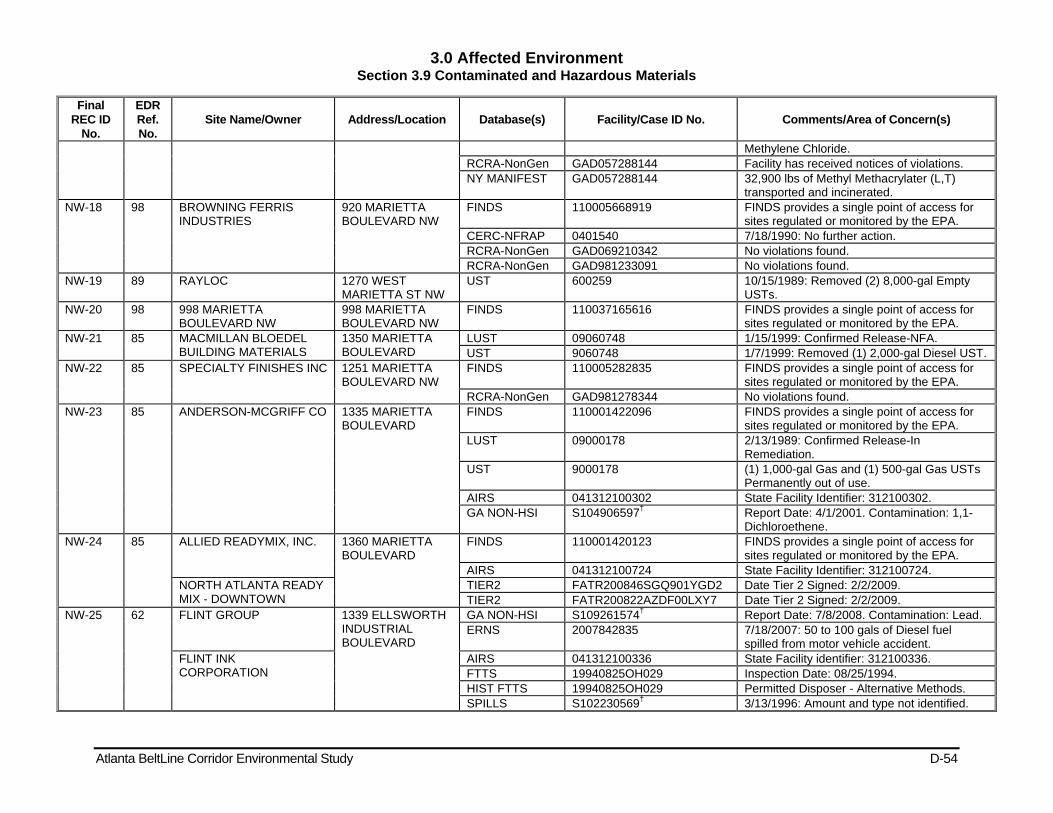
3.0 Affected Environment Section 3.9 Contaminated and Hazardous Materials
Atlanta BeltLine Corridor Environmental Study D-54
Final REC ID
No.
EDR Ref. No.
Site Name/Owner Address/Location Database(s) Facility/Case ID No. Comments/Area of Concern(s)
Methylene Chloride. RCRA-NonGen GAD057288144 Facility has received notices of violations. NY MANIFEST GAD057288144 32,900 lbs of Methyl Methacrylater (L,T)
transported and incinerated. NW-18 98 BROWNING FERRIS
INDUSTRIES 920 MARIETTA BOULEVARD NW
FINDS 110005668919 FINDS provides a single point of access for sites regulated or monitored by the EPA.
CERC-NFRAP 0401540 7/18/1990: No further action. RCRA-NonGen GAD069210342 No violations found. RCRA-NonGen GAD981233091 No violations found.
NW-19 89 RAYLOC 1270 WEST MARIETTA ST NW
UST 600259 10/15/1989: Removed (2) 8,000-gal Empty USTs.
NW-20 98 998 MARIETTA BOULEVARD NW
998 MARIETTA BOULEVARD NW
FINDS 110037165616 FINDS provides a single point of access for sites regulated or monitored by the EPA.
NW-21 85 MACMILLAN BLOEDEL BUILDING MATERIALS
1350 MARIETTA BOULEVARD
LUST 09060748 1/15/1999: Confirmed Release-NFA. UST 9060748 1/7/1999: Removed (1) 2,000-gal Diesel UST.
NW-22 85 SPECIALTY FINISHES INC 1251 MARIETTA BOULEVARD NW
FINDS 110005282835 FINDS provides a single point of access for sites regulated or monitored by the EPA.
RCRA-NonGen GAD981278344 No violations found. NW-23 85 ANDERSON-MCGRIFF CO 1335 MARIETTA
BOULEVARD FINDS 110001422096 FINDS provides a single point of access for
sites regulated or monitored by the EPA. LUST 09000178 2/13/1989: Confirmed Release-In
Remediation. UST 9000178 (1) 1,000-gal Gas and (1) 500-gal Gas USTs
Permanently out of use. AIRS 041312100302 State Facility Identifier: 312100302. GA NON-HSI S104906597† Report Date: 4/1/2001. Contamination: 1,1-
Dichloroethene. NW-24 85 ALLIED READYMIX, INC. 1360 MARIETTA
BOULEVARD FINDS 110001420123 FINDS provides a single point of access for
sites regulated or monitored by the EPA. AIRS 041312100724 State Facility Identifier: 312100724.
NORTH ATLANTA READY MIX - DOWNTOWN
TIER2 FATR200846SGQ901YGD2 Date Tier 2 Signed: 2/2/2009. TIER2 FATR200822AZDF00LXY7 Date Tier 2 Signed: 2/2/2009.
NW-25 62 FLINT GROUP 1339 ELLSWORTH INDUSTRIAL BOULEVARD
GA NON-HSI S109261574† Report Date: 7/8/2008. Contamination: Lead. ERNS 2007842835 7/18/2007: 50 to 100 gals of Diesel fuel
spilled from motor vehicle accident. FLINT INK CORPORATION
AIRS 041312100336 State Facility identifier: 312100336. FTTS 19940825OH029 Inspection Date: 08/25/1994. HIST FTTS 19940825OH029 Permitted Disposer - Alternative Methods. SPILLS S102230569† 3/13/1996: Amount and type not identified.
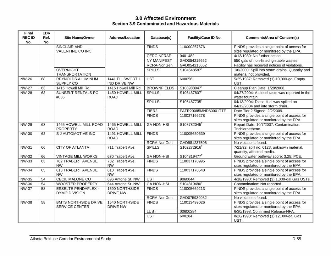
3.0 Affected Environment Section 3.9 Contaminated and Hazardous Materials
Atlanta BeltLine Corridor Environmental Study D-55
Final REC ID
No.
EDR Ref. No.
Site Name/Owner Address/Location Database(s) Facility/Case ID No. Comments/Area of Concern(s)
SINCLAIR AND VALENTINE CO INC
FINDS 110000357676 FINDS provides a single point of access for sites regulated or monitored by the EPA.
CERC-NFRAP 0401482 4/13/1989: No further action. NY MANIFEST GAD054215652 550 gals of non-listed ignitable wastes. RCRA-NonGen GAD054215652 Facility has received notices of violations.
OVERNIGHT TRANSPORTATION
SPILLS S104548587† 1/6/2000: Spill into storm drains. Quantity and material not provided.
NW-26 68 REYNOLDS ALUMINUM SUPPLY CO
1441 ELLSWORTH IND DRIVE NW
UST 600056 5/25/1987: Removed (1) 10,000-gal Empty UST.
NW-27 63 1415 Howell Mill Rd. 1415 Howell Mill Rd. BROWNFIELDS S108988947† Cleanup Plan Date: 1/28/2008. NW-28 63 SUNBELT RENTALS PC
#055 1450 HOWELL MILL ROAD
SPILLS S106487807† 04/27/2004: A diesel taste was reported in the water fountain.
SPILLS S106487735† 04/13/2004: Diesel fuel was spilled on 04/12/2004 and into storm drain.
TIER2 FATR20085MND60001TTF Date Tier 2 Signed: 2/2/2009. FINDS 110037166278 FINDS provides a single point of access for
sites regulated or monitored by the EPA. NW-29 63 1465 HOWELL MILL ROAD
PROPERTY 1465 HOWELL MILL ROAD
GA NON-HSI S108782045† Report Date: 10/7/2007. Contamination: Trichloroethene.
NW-30 63 S J AUTOMOTIVE INC 1491 HOWELL MILL ROAD
FINDS 110005680539 FINDS provides a single point of access for sites regulated or monitored by the EPA.
RCRA-NonGen GAD981237506 No violations found. NW-31 66 CITY OF ATLANTA 711 Trabert Ave. SPILLS S102272916† 7/21/92: spill no. 0123, unknown material,
quantity, affected media. NW-32 66 VINTAGE MILL WORKS 670 Trabert Ave. GA NON-HSI S104819477† Ground water pathway score: 3.25; PCE. NW-33 63 782 TRABERT AVENUE
NW 782 Trabert Ave. NW
FINDS 110037170995 FINDS provides a single point of access for sites regulated or monitored by the EPA.
NW-34 65 613 TRABERT AVENUE NW
613 Trabert Ave. NW
FINDS 110037170548 FINDS provides a single point of access for sites regulated or monitored by the EPA.
NW-35 54 CECIL MALONE CO 696 Antone St. NW UST 9060044 4/18/1990: Removed (3) 1,000-gal Gas USTs. NW-36 54 WOOSTER PROPERTY 644 Antone St. NW GA NON-HSI S104819480† Contamination: Not reported. NW-37 58 ESSELTE PENDAFLEX -
DYMO DIVISION 1590 NORTHSIDE DRIVE NW
FINDS 110005669213 FINDS provides a single point of access for sites regulated or monitored by the EPA.
RCRA-NonGen GAD075939082 No violations found. NW-38 58 BMTS NORTHSIDE DRIVE
SERVICE CENTER 1540 NORTHSIDE DRIVE NW
FINDS 110013499026 FINDS provides a single point of access for sites regulated or monitored by the EPA.
LUST 00600284 6/30/1998: Confirmed Release-NFA. UST 600284 8/26/1998: Removed (1) 12,000-gal Gas
UST.
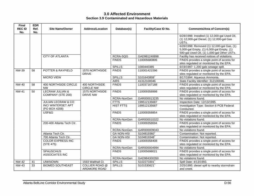
3.0 Affected Environment Section 3.9 Contaminated and Hazardous Materials
Atlanta BeltLine Corridor Environmental Study D-56
Final REC ID
No.
EDR Ref. No.
Site Name/Owner Address/Location Database(s) Facility/Case ID No. Comments/Area of Concern(s)
6/28/1998: Installed (1) 12,000-gal Used Oil, (1) 12,000-gal Diesel, (1) 12,000-gal Gas USTs. 6/28/1998: Removed (1) 12,000-gal Gas, (1) 5,000-gal Empty, (1) 6,000-gal Empty, (1) 500-gal Used Oil, (1) 1,000-gal Other USTs.
CITY OF ATLANTA RCRA-SQG GAD981240898 Facility has received notices of violations. FINDS 110005680806 FINDS provides a single point of access for
sites regulated or monitored by the EPA. SPILLS 1000440385 6/19/1997: 1,200 gals sewage spill.
NW-39 58 POTTER & RAYFIELD 1570 NORTHSIDE DRIVE
FINDS 110001421596 FINDS provides a single point of access for sites regulated or monitored by the EPA.
MICRO VIEW SPILLS S101643808† 8/17/1994: Aqueous Ammonia. AIRS 41312100046 State Facility Identifier: 312100046.
NW-40 58 400 NORTHSIDE CIRCLE NW
400 NORTHSIDE CIRCLE NW
FINDS 110037167188 FINDS provides a single point of access for sites regulated or monitored by the EPA.
NW-41 50 LECRAW JULIAN & COMPANY (STE 200)
1575 NORTHSIDE DRIVE NW
FINDS 110009358998 FINDS provides a single point of access for sites regulated or monitored by the EPA.
RCRA-NonGen GAR000013235 No violations found. JULIAN LECRAW & CO INC/ WINTERSET APT (PO BOX 4208)
FTTS 199512135687 Inspection Date: 12/13/1995. HIST FTTS 199512135687 Investigation Type: Section 6 PCB Federal
Conducted. USF&G FINDS 110009358854 FINDS provides a single point of access for
sites regulated or monitored by the EPA. RCRA-NonGen GAR000010322 No violations found.
200-400 Atlanta Tech Ctr. FINDS 110009358694 FINDS provides a single point of access for sites regulated or monitored by the EPA.
RCRA-NonGen GAR000009043 No violations found. Atlanta Tech Ctr. GA NON-HSI S104819360† Contamination: Not reported. 700 Atlanta Tech Ctr. GA NON-HSI S104819348† Contamination: Not reported. COLOR EXPRESS INC (STE 475)
FINDS 110009358408 FINDS provides a single point of access for sites regulated or monitored by the EPA.
RCRA-NonGen GAR000004994 No violations found. SPAUSCHUS ASSOCIATES INC
FINDS 110005698021 FINDS provides a single point of access for sites regulated or monitored by the EPA.
RCRA-NonGen GAD984300350 No violations found. NW-42 41 UNKNOWN 1593 Walthall Ct. SPILLS S102273301† Spill Date: 4/13/1993. NW-43 33 BIOMED SOUTHEAST COLLIER ROAD @
ARDMORE ROAD SPILLS S101530621† 2/25/1995: diesel spill to nearby stormdrain
and creek.
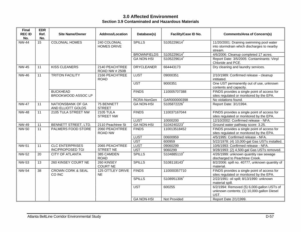
3.0 Affected Environment Section 3.9 Contaminated and Hazardous Materials
Atlanta BeltLine Corridor Environmental Study D-57
Final REC ID
No.
EDR Ref. No.
Site Name/Owner Address/Location Database(s) Facility/Case ID No. Comments/Area of Concern(s)
NW-44 15 COLONIAL HOMES 240 COLONIAL HOMES DRIVE
SPILLS S105229614† 11/20/2001: Draining swimming pool water into stormdrain which discharges to nearby stream.
BROWNFIELDS S105229614† 4/6/2006: Cleanup completed 17 acres. GA NON-HSI S105229614† Report Date: 3/5/2005: Contaminants: Vinyl
Chloride and PCE. NW-45 11 KISS CLEANERS 2140 PEACHTREE
ROAD NW # 250B DRYCLEANER 664443173 Dry cleaning and laundry services.
NW-46 11 TRITON FACILITY 2166 PEACHTREE ROAD
LUST 09000351 2/10/1989: Confirmed release - cleanup intitiated.
UST 9000351 One UST permanently out of use, unknown contents and capacity.
BUCKHEAD BROOKWOOD ASSOC LP
FINDS 110005707388 FINDS provides a single point of access for sites regulated or monitored by the EPA.
RCRA-NonGen GAR000000398 No violations found. NW-47 11 NATIONSBANK OF GA
AND ELLIOTT GOLDS 75 BENNETT STREET
GA NON-HSI S105872226† Report Date: 3/1/1994.
NW-48 11 2105 TULA STREET NW 2105 TULA STREET NW
FINDS 110037167044 FINDS provides a single point of access for sites regulated or monitored by the EPA.
LUST 10000200 12/10/2002: Confirmed release - NFA. NW-49 11 BENNETT STREET, LTD. 2110 Peachtree St GA NON-HSI S104240223† Ground water pathway score: 3.25. NW-50 11 PALMERS FOOD STORE 2060 PEACHTREE
ROAD NW FINDS 110013518452 FINDS provides a single point of access for
sites regulated or monitored by the EPA. LUST 00600959 4/5/1995: Confirmed release - NFA. UST 600959 5/22/1978: (4) 10,000-gal Gas USTs installed.
NW-51 11 CLC ENTERPRISES INC/PROPOSED TGI
2065 PEACHTREE STREET NE
LUST 09060299 10/6/1993: Confirmed release - NFA. UST 9060299 9/28/1993: (2) 4,500-gal Gas USTs removed.
NW-52 20 CITY OF ATLANTA 385 CAMDEN ROAD
SPILLS S104885110† 4/26/1999: unknown quantity raw sewage discharged to Peachtree Creek.
NW-53 13 260 KINSEY COURT NE 260 KINSEY COURT NE
SPILLS S108118143† 8/2/2006: spill no. 40777, unknown quantity of material.
NW-54 38 CROWN CORK & SEAL CO INC
125 OTTLEY DRIVE NE
FINDS 110000357710 FINDS provides a single point of access for sites regulated or monitored by the EPA.
SPILLS S108951306† 2/22/1991: oil spill; 8/13/1990: unknown material spill.
UST 600255 6/2/1994: Removed (5) 6,000-gallon USTs of unknown contents; (1) 10,000-gallon Diesel UST.
GA NON-HSI Not Provided Report Date 2/1/1999.

3.0 Affected Environment Section 3.9 Contaminated and Hazardous Materials
Atlanta BeltLine Corridor Environmental Study D-58
Final REC ID
No.
EDR Ref. No.
Site Name/Owner Address/Location Database(s) Facility/Case ID No. Comments/Area of Concern(s)
RCRA-NonGen GAD003289808 9/12/1990: General violation, 2/5/1991: achieved compliance.
NW-55 35 COMPASS COLLECTIVE 165 OTTLEY DRIVE FINDS 110005718697 FINDS provides a single point of access for sites regulated or monitored by the EPA.
RCRA-CESQG GAR000020479 No violations found. NW-56 30 215 OTTLEY DRIVE NE 215 OTTLEY DRIVE
NE HMIRS 2005030677 3/9/2005: spill, unknown quanity and material.
NW-57 30 NATIONAL STARCH & CHEMICAL CORP
195 OTTLEY DRIVE NE
UST 600002 6/1/1988: Removed (1) 7,500-gal Heating Oil UST.
FINDS 110002101546 FINDS provides a single point of access for sites regulated or monitored by the EPA.
CERC-NFRAP 401301 8/1/1980: Discovery; 5/20/1986: PA. RCRA-NonGen GAD001884220 No violations found.
NW-58 O 5 LAFARGE BUILDING MATERIALS, INC.
842 ARMOUR DRIVE
AIRS 041312100607 State Facility ID: 312100607.
NW-59 31 HOME DEPOT HD WC0201
171 ARMOUR DRIVE NE
RCRA-NonGen GAR000038463 No violations found. FINDS 110018903668 FINDS provides a single point of access for
sites regulated or monitored by the EPA. 26 HD Supply Construction,
LTD. TIER 2 FATR20085MR3Y900D3F3 Date Tier 2 was signed: 2/28/2009.
NW-60 26 ATLANTEL 199 Armour Dr. NE RCRA-NonGen GAR000004382 No violations found. NW-61 26 SOUTHERN SIGNATURES
INC 201 ARMOUR DRIVE
FINDS 110001752096 FINDS provides a single point of access for sites regulated or monitored by the EPA.
RCRA-NonGen GAD984307298 No violations found. AIRS 041312100718 State Facility ID: 312100718.
NW-62 21 ATLANTA SEWER DEPT 269 ARMOUR DRIVE
SPILLS S104548744† 4/13/2000: spill no. 5, unknown quantity of raw sewage into north fork of Peachtree Creek.
NW-63 107 FULTON CO FIRE/BELLWOOD GARAGE
1101 JEFFERSON STREET NW
UST 600534 (1) 2,500-gal Gas UST permanently out of use unknown date; (1) 3,000-gal Gas UST permamently out of use unknown date; 1/1/1981: (1) 12,000-gal Gas UST permanently out of use; (1) 300-gal kerosene UST permanently out of use unknown date.
9060102 2/25/1997: Removed (2) 10,000-gal Diesel USTs and (2) 550-gal Used Oil USTs. 9/25/1990: Removed (1) 8,000-gal Diesel UST, (1) 6,000-gal Diesel UST, abd (1) 6,000-gal Gas UST. 1/1/1990: Removed (1) 550-gal used oil UST.
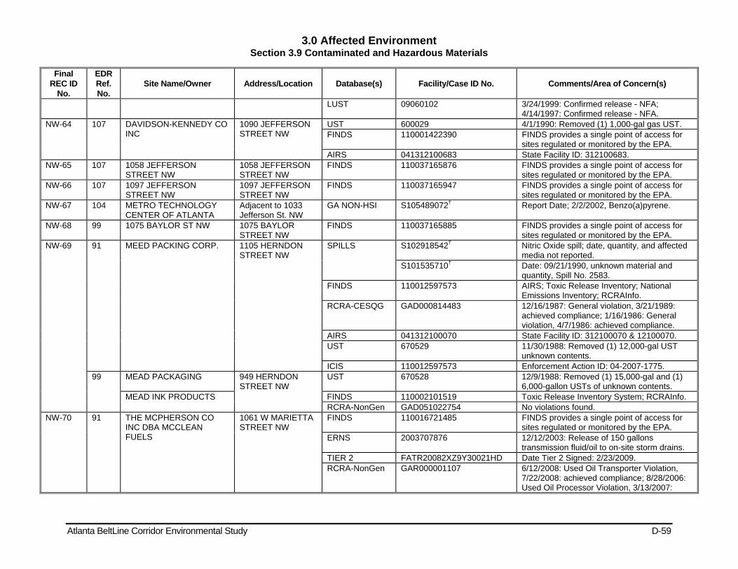
3.0 Affected Environment Section 3.9 Contaminated and Hazardous Materials
Atlanta BeltLine Corridor Environmental Study D-59
Final REC ID
No.
EDR Ref. No.
Site Name/Owner Address/Location Database(s) Facility/Case ID No. Comments/Area of Concern(s)
LUST 09060102 3/24/1999: Confirmed release - NFA; 4/14/1997: Confirmed release - NFA.
NW-64 107 DAVIDSON-KENNEDY CO INC
1090 JEFFERSON STREET NW
UST 600029 4/1/1990: Removed (1) 1,000-gal gas UST. FINDS 110001422390 FINDS provides a single point of access for
sites regulated or monitored by the EPA. AIRS 041312100683 State Facility ID: 312100683.
NW-65 107 1058 JEFFERSON STREET NW
1058 JEFFERSON STREET NW
FINDS 110037165876 FINDS provides a single point of access for sites regulated or monitored by the EPA.
NW-66 107 1097 JEFFERSON STREET NW
1097 JEFFERSON STREET NW
FINDS 110037165947 FINDS provides a single point of access for sites regulated or monitored by the EPA.
NW-67 104 METRO TECHNOLOGY CENTER OF ATLANTA
Adjacent to 1033 Jefferson St. NW
GA NON-HSI S105489072† Report Date; 2/2/2002, Benzo(a)pyrene.
NW-68 99 1075 BAYLOR ST NW 1075 BAYLOR STREET NW
FINDS 110037165885 FINDS provides a single point of access for sites regulated or monitored by the EPA.
NW-69 91 MEED PACKING CORP. 1105 HERNDON STREET NW
SPILLS S102918542† Nitric Oxide spill; date, quantity, and affected media not reported.
S101535710† Date: 09/21/1990, unknown material and quantity, Spill No. 2583.
FINDS 110012597573 AIRS; Toxic Release Inventory; National Emissions Inventory; RCRAInfo.
RCRA-CESQG GAD000814483 12/16/1987: General violation, 3/21/1989: achieved compliance; 1/16/1986: General violation, 4/7/1986: achieved compliance.
AIRS 041312100070 State Facility ID: 312100070 & 12100070. UST 670529 11/30/1988: Removed (1) 12,000-gal UST
unknown contents. ICIS 110012597573 Enforcement Action ID: 04-2007-1775.
99 MEAD PACKAGING 949 HERNDON STREET NW
UST 670528 12/9/1988: Removed (1) 15,000-gal and (1) 6,000-gallon USTs of unknown contents.
MEAD INK PRODUCTS FINDS 110002101519 Toxic Release Inventory System; RCRAInfo. RCRA-NonGen GAD051022754 No violations found.
NW-70 91 THE MCPHERSON CO INC DBA MCCLEAN FUELS
1061 W MARIETTA STREET NW
FINDS 110016721485 FINDS provides a single point of access for sites regulated or monitored by the EPA.
ERNS 2003707876 12/12/2003: Release of 150 gallons transmission fluid/oil to on-site storm drains.
TIER 2 FATR20082XZ9Y30021HD Date Tier 2 Signed: 2/23/2009. RCRA-NonGen GAR000001107 6/12/2008: Used Oil Transporter Violation,
7/22/2008: achieved compliance; 8/28/2006: Used Oil Processor Violation, 3/13/2007:
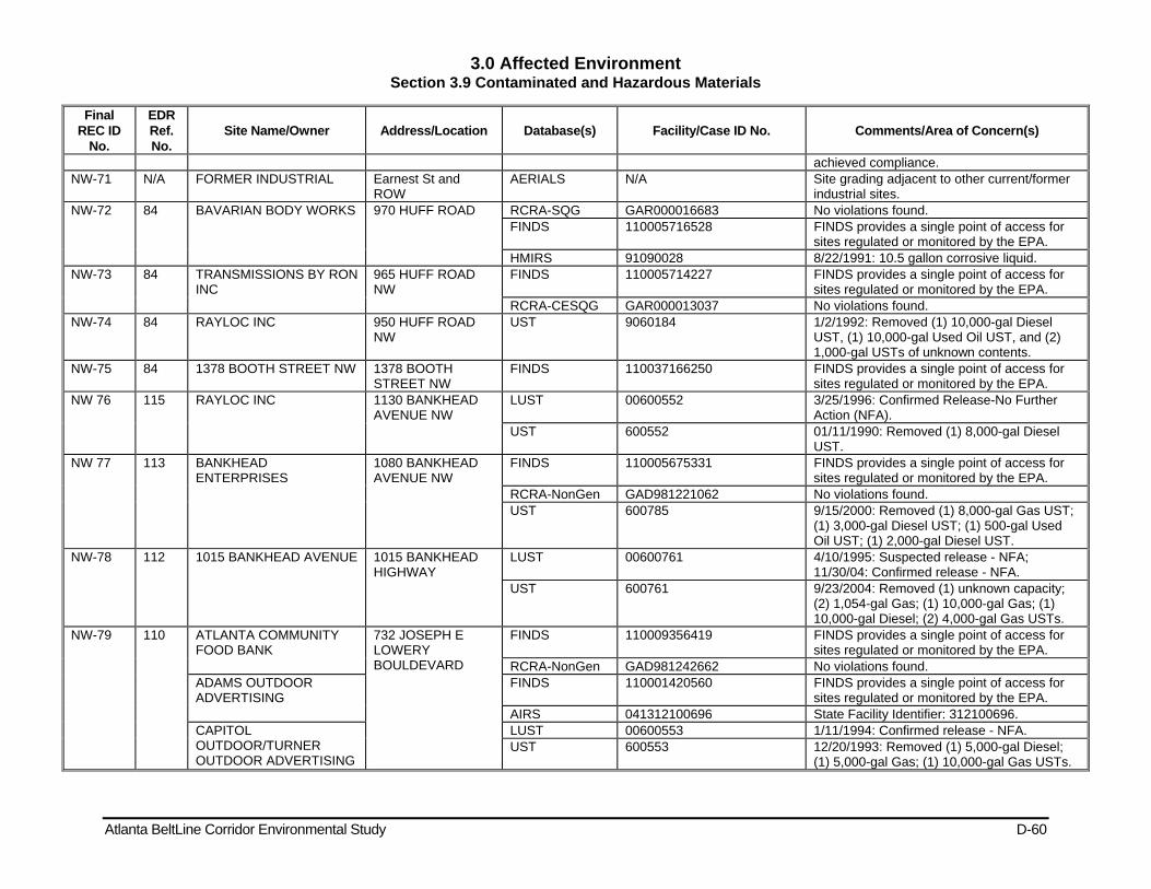
3.0 Affected Environment Section 3.9 Contaminated and Hazardous Materials
Atlanta BeltLine Corridor Environmental Study D-60
Final REC ID
No.
EDR Ref. No.
Site Name/Owner Address/Location Database(s) Facility/Case ID No. Comments/Area of Concern(s)
achieved compliance. NW-71 N/A FORMER INDUSTRIAL Earnest St and
ROW AERIALS N/A Site grading adjacent to other current/former
industrial sites. NW-72 84 BAVARIAN BODY WORKS 970 HUFF ROAD RCRA-SQG GAR000016683 No violations found.
FINDS 110005716528 FINDS provides a single point of access for sites regulated or monitored by the EPA.
HMIRS 91090028 8/22/1991: 10.5 gallon corrosive liquid. NW-73 84 TRANSMISSIONS BY RON
INC 965 HUFF ROAD NW
FINDS 110005714227 FINDS provides a single point of access for sites regulated or monitored by the EPA.
RCRA-CESQG GAR000013037 No violations found. NW-74 84 RAYLOC INC 950 HUFF ROAD
NW UST 9060184 1/2/1992: Removed (1) 10,000-gal Diesel
UST, (1) 10,000-gal Used Oil UST, and (2) 1,000-gal USTs of unknown contents.
NW-75 84 1378 BOOTH STREET NW 1378 BOOTH STREET NW
FINDS 110037166250 FINDS provides a single point of access for sites regulated or monitored by the EPA.
NW 76 115 RAYLOC INC 1130 BANKHEAD AVENUE NW
LUST 00600552 3/25/1996: Confirmed Release-No Further Action (NFA).
UST 600552 01/11/1990: Removed (1) 8,000-gal Diesel UST.
NW 77 113 BANKHEAD ENTERPRISES
1080 BANKHEAD AVENUE NW
FINDS 110005675331 FINDS provides a single point of access for sites regulated or monitored by the EPA.
RCRA-NonGen GAD981221062 No violations found. UST 600785 9/15/2000: Removed (1) 8,000-gal Gas UST;
(1) 3,000-gal Diesel UST; (1) 500-gal Used Oil UST; (1) 2,000-gal Diesel UST.
NW-78 112 1015 BANKHEAD AVENUE 1015 BANKHEAD HIGHWAY
LUST 00600761 4/10/1995: Suspected release - NFA; 11/30/04: Confirmed release - NFA.
UST 600761 9/23/2004: Removed (1) unknown capacity; (2) 1,054-gal Gas; (1) 10,000-gal Gas; (1) 10,000-gal Diesel; (2) 4,000-gal Gas USTs.
NW-79 110 ATLANTA COMMUNITY FOOD BANK
732 JOSEPH E LOWERY BOULDEVARD
FINDS 110009356419 FINDS provides a single point of access for sites regulated or monitored by the EPA.
RCRA-NonGen GAD981242662 No violations found. ADAMS OUTDOOR ADVERTISING
FINDS 110001420560 FINDS provides a single point of access for sites regulated or monitored by the EPA.
AIRS 041312100696 State Facility Identifier: 312100696. CAPITOL OUTDOOR/TURNER OUTDOOR ADVERTISING
LUST 00600553 1/11/1994: Confirmed release - NFA. UST 600553 12/20/1993: Removed (1) 5,000-gal Diesel;
(1) 5,000-gal Gas; (1) 10,000-gal Gas USTs.
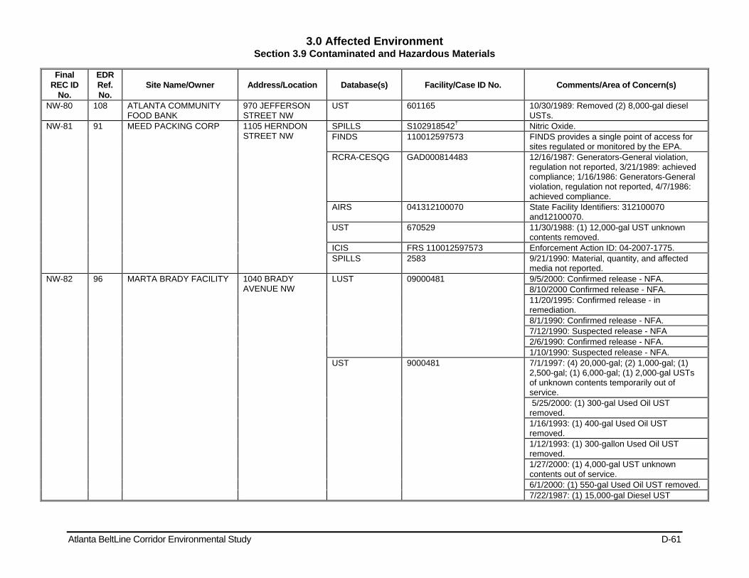
3.0 Affected Environment Section 3.9 Contaminated and Hazardous Materials
Atlanta BeltLine Corridor Environmental Study D-61
Final REC ID
No.
EDR Ref. No.
Site Name/Owner Address/Location Database(s) Facility/Case ID No. Comments/Area of Concern(s)
NW-80 108 ATLANTA COMMUNITY FOOD BANK
970 JEFFERSON STREET NW
UST 601165 10/30/1989: Removed (2) 8,000-gal diesel USTs.
NW-81 91 MEED PACKING CORP 1105 HERNDON STREET NW
SPILLS S102918542† Nitric Oxide. FINDS 110012597573 FINDS provides a single point of access for
sites regulated or monitored by the EPA. RCRA-CESQG GAD000814483 12/16/1987: Generators-General violation,
regulation not reported, 3/21/1989: achieved compliance; 1/16/1986: Generators-General violation, regulation not reported, 4/7/1986: achieved compliance.
AIRS 041312100070 State Facility Identifiers: 312100070 and12100070.
UST 670529 11/30/1988: (1) 12,000-gal UST unknown contents removed.
ICIS FRS 110012597573 Enforcement Action ID: 04-2007-1775. SPILLS 2583 9/21/1990: Material, quantity, and affected
media not reported. NW-82 96 MARTA BRADY FACILITY 1040 BRADY
AVENUE NW LUST 09000481 9/5/2000: Confirmed release - NFA.
8/10/2000 Confirmed release - NFA. 11/20/1995: Confirmed release - in remediation. 8/1/1990: Confirmed release - NFA. 7/12/1990: Suspected release - NFA 2/6/1990: Confirmed release - NFA. 1/10/1990: Suspected release - NFA.
UST 9000481 7/1/1997: (4) 20,000-gal; (2) 1,000-gal; (1) 2,500-gal; (1) 6,000-gal; (1) 2,000-gal USTs of unknown contents temporarily out of service. 5/25/2000: (1) 300-gal Used Oil UST removed. 1/16/1993: (1) 400-gal Used Oil UST removed. 1/12/1993: (1) 300-gallon Used Oil UST removed. 1/27/2000: (1) 4,000-gal UST unknown contents out of service. 6/1/2000: (1) 550-gal Used Oil UST removed. 7/22/1987: (1) 15,000-gal Diesel UST
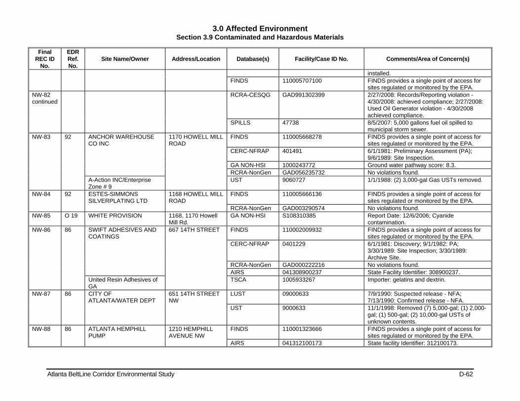
3.0 Affected Environment Section 3.9 Contaminated and Hazardous Materials
Atlanta BeltLine Corridor Environmental Study D-62
Final REC ID
No.
EDR Ref. No.
Site Name/Owner Address/Location Database(s) Facility/Case ID No. Comments/Area of Concern(s)
installed. FINDS 110005707100 FINDS provides a single point of access for
sites regulated or monitored by the EPA. NW-82 continued
RCRA-CESQG GAD991302399 2/27/2008: Records/Reporting violation - 4/30/2008: achieved compliance; 2/27/2008: Used Oil Generator violation - 4/30/2008 achieved compliance.
SPILLS 47738 8/5/2007: 5,000 gallons fuel oil spilled to municipal storm sewer.
NW-83 92 ANCHOR WAREHOUSE CO INC
1170 HOWELL MILL ROAD
FINDS 110005668278 FINDS provides a single point of access for sites regulated or monitored by the EPA.
CERC-NFRAP 401491 6/1/1981: Preliminary Assessment (PA); 9/6/1989: Site Inspection.
GA NON-HSI 1000243772 Ground water pathway score: 8.3. RCRA-NonGen GAD056235732 No violations found.
A-Action INC/Enterprise Zone # 9
UST 9060727 1/1/1988: (2) 3,000-gal Gas USTs removed.
NW-84 92 ESTES-SIMMONS SILVERPLATING LTD
1168 HOWELL MILL ROAD
FINDS 110005666136 FINDS provides a single point of access for sites regulated or monitored by the EPA.
RCRA-NonGen GAD003290574 No violations found. NW-85 O 19 WHITE PROVISION 1168, 1170 Howell
Mill Rd. GA NON-HSI S108310385 Report Date: 12/6/2006; Cyanide
contamination. NW-86 86 SWIFT ADHESIVES AND
COATINGS 667 14TH STREET FINDS 110002009932 FINDS provides a single point of access for
sites regulated or monitored by the EPA. CERC-NFRAP 0401229 6/1/1981: Discovery; 9/1/1982: PA;
3/30/1989: Site Inspection; 3/30/1989: Archive Site.
RCRA-NonGen GAD000222216 No violations found. AIRS 041308900237 State Facility Identifier: 308900237.
United Resin Adhesives of GA
TSCA 1005933267 Importer: gelatins and dextrin.
NW-87 86 CITY OF ATLANTA/WATER DEPT
651 14TH STREET NW
LUST 09000633 7/9/1990: Suspected release - NFA; 7/13/1990: Confirmed release - NFA.
UST 9000633 11/1/1998: Removed (7) 5,000-gal; (1) 2,000-gal; (1) 500-gal; (2) 10,000-gal USTs of unknown contents.
NW-88 86 ATLANTA HEMPHILL PUMP
1210 HEMPHILL AVENUE NW
FINDS 110001323666 FINDS provides a single point of access for sites regulated or monitored by the EPA.
AIRS 041312100173 State facility Identifier: 312100173.
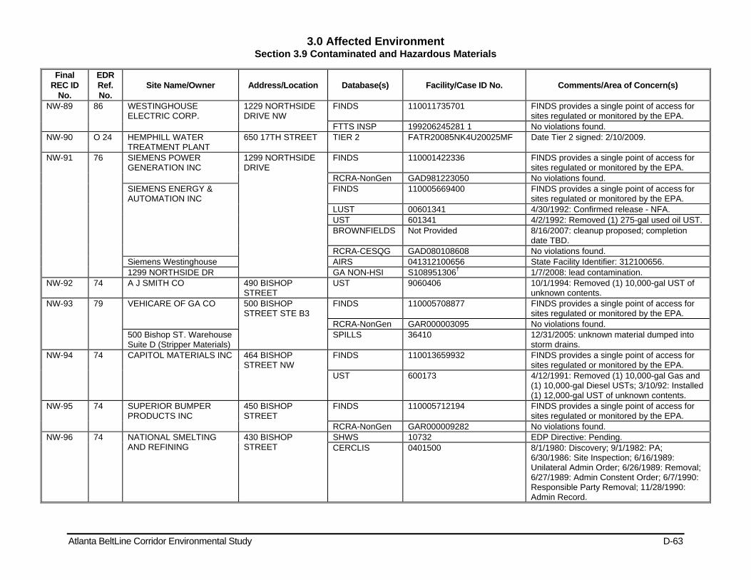
3.0 Affected Environment Section 3.9 Contaminated and Hazardous Materials
Atlanta BeltLine Corridor Environmental Study D-63
Final REC ID
No.
EDR Ref. No.
Site Name/Owner Address/Location Database(s) Facility/Case ID No. Comments/Area of Concern(s)
NW-89 86 WESTINGHOUSE ELECTRIC CORP.
1229 NORTHSIDE DRIVE NW
FINDS 110011735701 FINDS provides a single point of access for sites regulated or monitored by the EPA.
FTTS INSP 199206245281 1 No violations found. NW-90 O 24 HEMPHILL WATER
TREATMENT PLANT 650 17TH STREET TIER 2 FATR20085NK4U20025MF Date Tier 2 signed: 2/10/2009.
NW-91 76 SIEMENS POWER GENERATION INC
1299 NORTHSIDE DRIVE
FINDS 110001422336 FINDS provides a single point of access for sites regulated or monitored by the EPA.
RCRA-NonGen GAD981223050 No violations found. SIEMENS ENERGY & AUTOMATION INC
FINDS 110005669400 FINDS provides a single point of access for sites regulated or monitored by the EPA.
LUST 00601341 4/30/1992: Confirmed release - NFA. UST 601341 4/2/1992: Removed (1) 275-gal used oil UST. BROWNFIELDS Not Provided 8/16/2007: cleanup proposed; completion
date TBD. RCRA-CESQG GAD080108608 No violations found.
Siemens Westinghouse AIRS 041312100656 State Facility Identifier: 312100656. 1299 NORTHSIDE DR GA NON-HSI S108951306† 1/7/2008: lead contamination.
NW-92 74 A J SMITH CO 490 BISHOP STREET
UST 9060406 10/1/1994: Removed (1) 10,000-gal UST of unknown contents.
NW-93 79 VEHICARE OF GA CO 500 BISHOP STREET STE B3
FINDS 110005708877 FINDS provides a single point of access for sites regulated or monitored by the EPA.
RCRA-NonGen GAR000003095 No violations found. 500 Bishop ST. Warehouse Suite D (Stripper Materials)
SPILLS 36410 12/31/2005: unknown material dumped into storm drains.
NW-94 74 CAPITOL MATERIALS INC 464 BISHOP STREET NW
FINDS 110013659932 FINDS provides a single point of access for sites regulated or monitored by the EPA.
UST 600173 4/12/1991: Removed (1) 10,000-gal Gas and (1) 10,000-gal Diesel USTs; 3/10/92: Installed (1) 12,000-gal UST of unknown contents.
NW-95 74 SUPERIOR BUMPER PRODUCTS INC
450 BISHOP STREET
FINDS 110005712194 FINDS provides a single point of access for sites regulated or monitored by the EPA.
RCRA-NonGen GAR000009282 No violations found. NW-96 74 NATIONAL SMELTING
AND REFINING 430 BISHOP STREET
SHWS 10732 EDP Directive: Pending. CERCLIS 0401500 8/1/1980: Discovery; 9/1/1982: PA;
6/30/1986: Site Inspection; 6/16/1989: Unilateral Admin Order; 6/26/1989: Removal; 6/27/1989: Admin Constent Order; 6/7/1990: Responsible Party Removal; 11/28/1990: Admin Record.
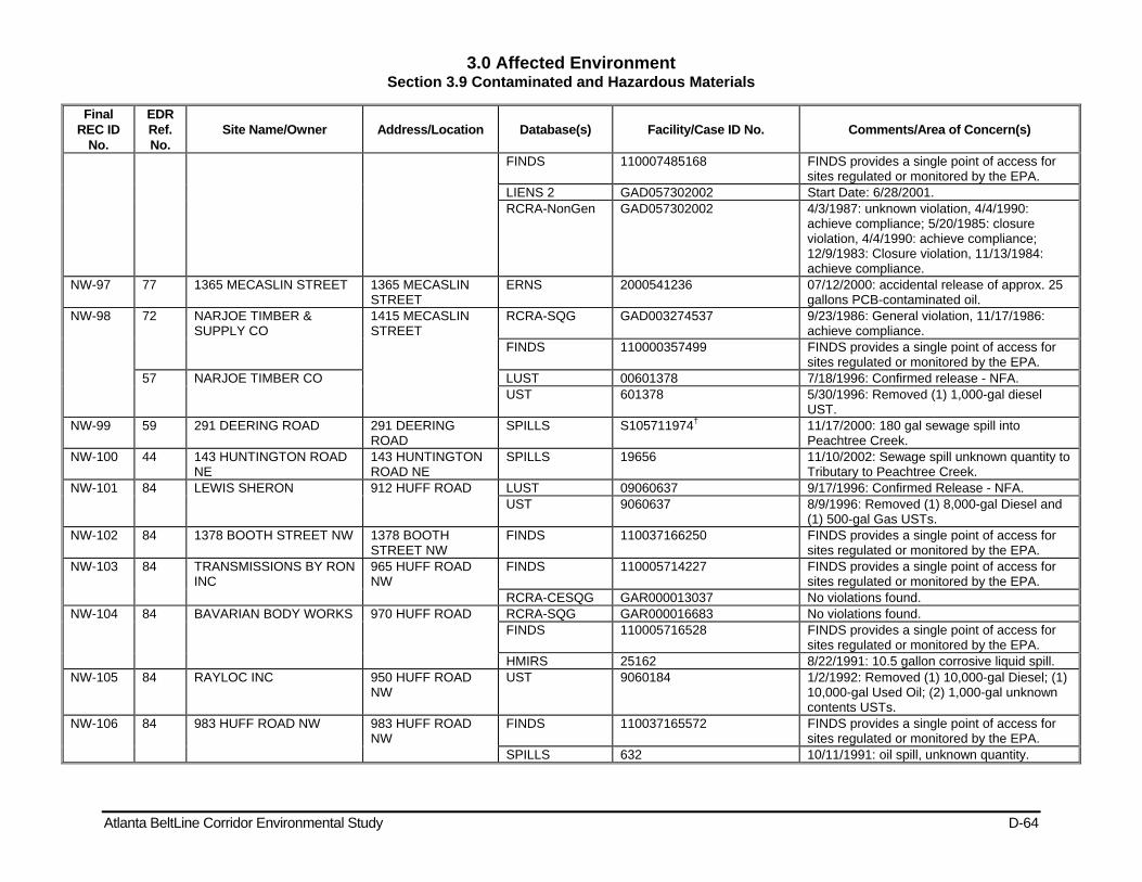
3.0 Affected Environment Section 3.9 Contaminated and Hazardous Materials
Atlanta BeltLine Corridor Environmental Study D-64
Final REC ID
No.
EDR Ref. No.
Site Name/Owner Address/Location Database(s) Facility/Case ID No. Comments/Area of Concern(s)
FINDS 110007485168 FINDS provides a single point of access for sites regulated or monitored by the EPA.
LIENS 2 GAD057302002 Start Date: 6/28/2001. RCRA-NonGen GAD057302002 4/3/1987: unknown violation, 4/4/1990:
achieve compliance; 5/20/1985: closure violation, 4/4/1990: achieve compliance; 12/9/1983: Closure violation, 11/13/1984: achieve compliance.
NW-97 77 1365 MECASLIN STREET 1365 MECASLIN STREET
ERNS 2000541236 07/12/2000: accidental release of approx. 25 gallons PCB-contaminated oil.
NW-98 72 NARJOE TIMBER & SUPPLY CO
1415 MECASLIN STREET
RCRA-SQG GAD003274537 9/23/1986: General violation, 11/17/1986: achieve compliance.
FINDS 110000357499 FINDS provides a single point of access for sites regulated or monitored by the EPA.
57 NARJOE TIMBER CO LUST 00601378 7/18/1996: Confirmed release - NFA. UST 601378 5/30/1996: Removed (1) 1,000-gal diesel
UST. NW-99 59 291 DEERING ROAD 291 DEERING
ROAD SPILLS S105711974† 11/17/2000: 180 gal sewage spill into
Peachtree Creek. NW-100 44 143 HUNTINGTON ROAD
NE 143 HUNTINGTON ROAD NE
SPILLS 19656 11/10/2002: Sewage spill unknown quantity to Tributary to Peachtree Creek.
NW-101 84 LEWIS SHERON 912 HUFF ROAD LUST 09060637 9/17/1996: Confirmed Release - NFA. UST 9060637 8/9/1996: Removed (1) 8,000-gal Diesel and
(1) 500-gal Gas USTs. NW-102 84 1378 BOOTH STREET NW 1378 BOOTH
STREET NW FINDS 110037166250 FINDS provides a single point of access for
sites regulated or monitored by the EPA. NW-103 84 TRANSMISSIONS BY RON
INC 965 HUFF ROAD NW
FINDS 110005714227 FINDS provides a single point of access for sites regulated or monitored by the EPA.
RCRA-CESQG GAR000013037 No violations found. NW-104 84 BAVARIAN BODY WORKS 970 HUFF ROAD RCRA-SQG GAR000016683 No violations found.
FINDS 110005716528 FINDS provides a single point of access for sites regulated or monitored by the EPA.
HMIRS 25162 8/22/1991: 10.5 gallon corrosive liquid spill. NW-105 84 RAYLOC INC 950 HUFF ROAD
NW UST 9060184 1/2/1992: Removed (1) 10,000-gal Diesel; (1)
10,000-gal Used Oil; (2) 1,000-gal unknown contents USTs.
NW-106 84 983 HUFF ROAD NW 983 HUFF ROAD NW
FINDS 110037165572 FINDS provides a single point of access for sites regulated or monitored by the EPA.
SPILLS 632 10/11/1991: oil spill, unknown quantity.
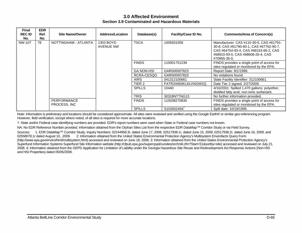
3.0 Affected Environment Section 3.9 Contaminated and Hazardous Materials
Atlanta BeltLine Corridor Environmental Study D-65
Final REC ID
No.
EDR Ref. No.
Site Name/Owner Address/Location Database(s) Facility/Case ID No. Comments/Area of Concern(s)
NW-107 78 NOTTINGHAM - ATLANTA 1303 BOYD AVENUE NW
TSCA 1005931059 Manufacturer: CAS #110-30-5, CAS #61791-30-8, CAS #61790-60-1, CAS #67762-90-7, CAS #64754-93-4, CAS #68153-66-2, CAS #68910-93-0, CAS #68608-26-4, CAS #70955-35-0.
FINDS 110001751239 FINDS provides a single point of access for sites regulated or monitored by the EPA.
GA NON-HSI GAR000007823 Report Date: 8/1/1999. RCRA-CESQG GAR000007823 No violations found. AIRS 041312100661 State Facility Identifier: 312100661. TIER 2 FATR20083KL81V002W2Q Date Tier 2 signed: 2/27/2009. SPILLS 10440 4/16/2001: Spilled 1,470 gallons: polyether,
distilled fatty acid, non-ionic surfactant. TRIS 30318NTTNG13 No further information provided.
PERFORMANCE PROCESS, INC
FINDS 110038270830 FINDS provides a single point of access for sites regulated or monitored by the EPA.
SPILLS S102602494† Spill date: 10/18/1995. Note: Information is preliminary and locations should be considered approximate. All sites were reviewed and verified using the Google Earth® or similar geo-referencing program. However, field verification, except where noted, of all sites is required for more accurate locations. †: State and/or Federal case identifying numbers are provided. EDR's report numbers were used when State or Federal case numbers not known. NA: No EDR Reference Number provided. Information obtained from the Orphan Sites List from the respective EDR DataMap™ Corridor Study or via Field Survey. Sources: 1. EDR DataMap™ Corridor Study, Inquiry Numbers: 02244958.3r, dated June 17, 2008, 02517938.1r, dated June 15, 2009, 02517938.2r, dated June 16, 2009, and 02558078.1r dated August 10, .2009. 2: Information obtained from the United States Environmental Protection Agency’s Multisystem Envirofacts Query Form (http://www.epa.gov/enviro/html/multisystem.html) accessed and reviewed on June 18, 2008. 3: Information obtained from the United States Environmental Protection Agency’s Superfund Information Systems Superfund Site Information website (http://cfpub.epa.gov/supercpad/cursites/srchrslt.cfm?Start=51&sortby=site) accessed and reviewed on July 21, 2008. 4: Information obtained from the GEPD Application for Limitation of Liability under the Georgia Hazardous Site Reuse and Redevelopment Act Response Actions (Non-HIS and HSI Properties) dated 05/05/2008.
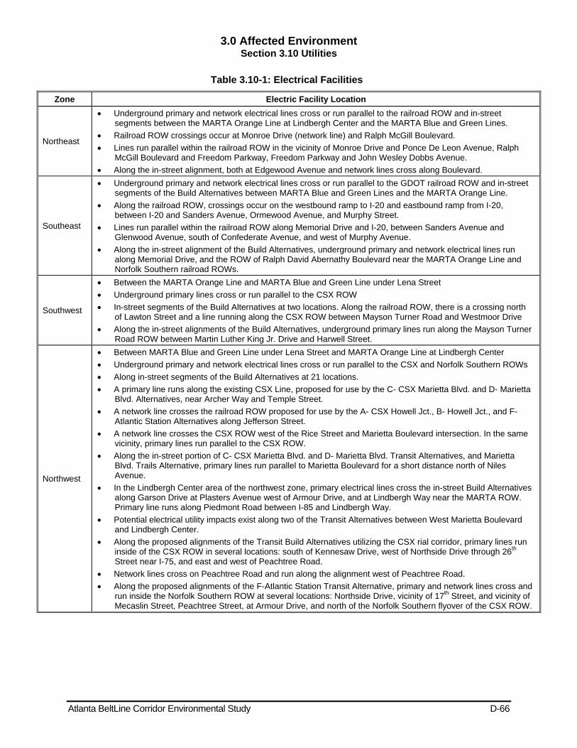
3.0 Affected Environment Section 3.10 Utilities
Atlanta BeltLine Corridor Environmental Study D-66
Table 3.10-1: Electrical Facilities
Zone Electric Facility Location
Northeast
Underground primary and network electrical lines cross or run parallel to the railroad ROW and in-street segments between the MARTA Orange Line at Lindbergh Center and the MARTA Blue and Green Lines.
Railroad ROW crossings occur at Monroe Drive (network line) and Ralph McGill Boulevard. Lines run parallel within the railroad ROW in the vicinity of Monroe Drive and Ponce De Leon Avenue, Ralph
McGill Boulevard and Freedom Parkway, Freedom Parkway and John Wesley Dobbs Avenue. Along the in-street alignment, both at Edgewood Avenue and network lines cross along Boulevard.
Southeast
Underground primary and network electrical lines cross or run parallel to the GDOT railroad ROW and in-street segments of the Build Alternatives between MARTA Blue and Green Lines and the MARTA Orange Line.
Along the railroad ROW, crossings occur on the westbound ramp to I-20 and eastbound ramp from I-20, between I-20 and Sanders Avenue, Ormewood Avenue, and Murphy Street.
Lines run parallel within the railroad ROW along Memorial Drive and I-20, between Sanders Avenue and Glenwood Avenue, south of Confederate Avenue, and west of Murphy Avenue.
Along the in-street alignment of the Build Alternatives, underground primary and network electrical lines run along Memorial Drive, and the ROW of Ralph David Abernathy Boulevard near the MARTA Orange Line and Norfolk Southern railroad ROWs.
Southwest
Between the MARTA Orange Line and MARTA Blue and Green Line under Lena Street Underground primary lines cross or run parallel to the CSX ROW In-street segments of the Build Alternatives at two locations. Along the railroad ROW, there is a crossing north
of Lawton Street and a line running along the CSX ROW between Mayson Turner Road and Westmoor Drive Along the in-street alignments of the Build Alternatives, underground primary lines run along the Mayson Turner
Road ROW between Martin Luther King Jr. Drive and Harwell Street.
Northwest
Between MARTA Blue and Green Line under Lena Street and MARTA Orange Line at Lindbergh Center Underground primary and network electrical lines cross or run parallel to the CSX and Norfolk Southern ROWs Along in-street segments of the Build Alternatives at 21 locations. A primary line runs along the existing CSX Line, proposed for use by the C- CSX Marietta Blvd. and D- Marietta
Blvd. Alternatives, near Archer Way and Temple Street. A network line crosses the railroad ROW proposed for use by the A- CSX Howell Jct., B- Howell Jct., and F-
Atlantic Station Alternatives along Jefferson Street. A network line crosses the CSX ROW west of the Rice Street and Marietta Boulevard intersection. In the same
vicinity, primary lines run parallel to the CSX ROW. Along the in-street portion of C- CSX Marietta Blvd. and D- Marietta Blvd. Transit Alternatives, and Marietta
Blvd. Trails Alternative, primary lines run parallel to Marietta Boulevard for a short distance north of Niles Avenue.
In the Lindbergh Center area of the northwest zone, primary electrical lines cross the in-street Build Alternatives along Garson Drive at Plasters Avenue west of Armour Drive, and at Lindbergh Way near the MARTA ROW. Primary line runs along Piedmont Road between I-85 and Lindbergh Way.
Potential electrical utility impacts exist along two of the Transit Alternatives between West Marietta Boulevard and Lindbergh Center.
Along the proposed alignments of the Transit Build Alternatives utilizing the CSX rial corridor, primary lines run inside of the CSX ROW in several locations: south of Kennesaw Drive, west of Northside Drive through 26th Street near I-75, and east and west of Peachtree Road.
Network lines cross on Peachtree Road and run along the alignment west of Peachtree Road. Along the proposed alignments of the F-Atlantic Station Transit Alternative, primary and network lines cross and
run inside the Norfolk Southern ROW at several locations: Northside Drive, vicinity of 17th Street, and vicinity of Mecaslin Street, Peachtree Street, at Armour Drive, and north of the Norfolk Southern flyover of the CSX ROW.
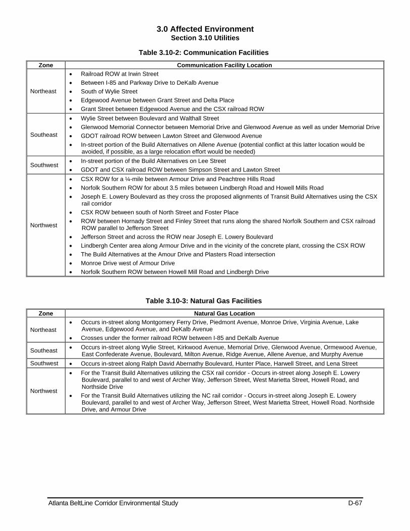
3.0 Affected Environment Section 3.10 Utilities
Atlanta BeltLine Corridor Environmental Study D-67
Table 3.10-2: Communication Facilities
Zone Communication Facility Location
Northeast
Railroad ROW at Irwin Street Between I-85 and Parkway Drive to DeKalb Avenue South of Wylie Street Edgewood Avenue between Grant Street and Delta Place Grant Street between Edgewood Avenue and the CSX railroad ROW
Southeast
Wylie Street between Boulevard and Walthall Street Glenwood Memorial Connector between Memorial Drive and Glenwood Avenue as well as under Memorial Drive GDOT railroad ROW between Lawton Street and Glenwood Avenue In-street portion of the Build Alternatives on Allene Avenue (potential conflict at this latter location would be
avoided, if possible, as a large relocation effort would be needed)
Southwest In-street portion of the Build Alternatives on Lee Street GDOT and CSX railroad ROW between Simpson Street and Lawton Street
Northwest
CSX ROW for a ¼-mile between Armour Drive and Peachtree Hills Road Norfolk Southern ROW for about 3.5 miles between Lindbergh Road and Howell Mills Road Joseph E. Lowery Boulevard as they cross the proposed alignments of Transit Build Alternatives using the CSX
rail corridor CSX ROW between south of North Street and Foster Place ROW between Hornady Street and Finley Street that runs along the shared Norfolk Southern and CSX railroad
ROW parallel to Jefferson Street Jefferson Street and across the ROW near Joseph E. Lowery Boulevard Lindbergh Center area along Armour Drive and in the vicinity of the concrete plant, crossing the CSX ROW The Build Alternatives at the Amour Drive and Plasters Road intersection Monroe Drive west of Armour Drive Norfolk Southern ROW between Howell Mill Road and Lindbergh Drive
Table 3.10-3: Natural Gas Facilities
Zone Natural Gas Location
Northeast Occurs in-street along Montgomery Ferry Drive, Piedmont Avenue, Monroe Drive, Virginia Avenue, Lake
Avenue, Edgewood Avenue, and DeKalb Avenue Crosses under the former railroad ROW between I-85 and DeKalb Avenue
Southeast Occurs in-street along Wylie Street, Kirkwood Avenue, Memorial Drive, Glenwood Avenue, Ormewood Avenue, East Confederate Avenue, Boulevard, Milton Avenue, Ridge Avenue, Allene Avenue, and Murphy Avenue
Southwest Occurs in-street along Ralph David Abernathy Boulevard, Hunter Place, Harwell Street, and Lena Street
Northwest
For the Transit Build Alternatives utilizing the CSX rail corridor - Occurs in-street along Joseph E. Lowery Boulevard, parallel to and west of Archer Way, Jefferson Street, West Marietta Street, Howell Road, and Northside Drive
For the Transit Build Alternatives utilizing the NC rail corridor - Occurs in-street along Joseph E. Lowery Boulevard, parallel to and west of Archer Way, Jefferson Street, West Marietta Street, Howell Road. Northside Drive, and Armour Drive
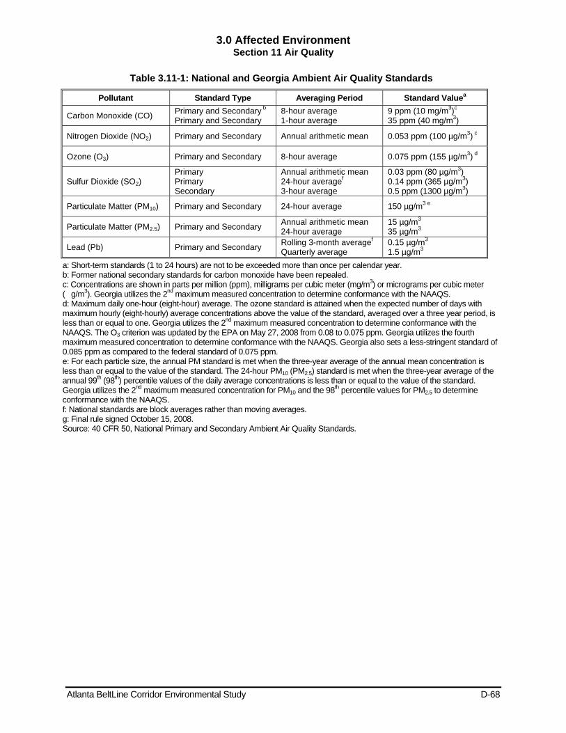
3.0 Affected Environment Section 11 Air Quality
Atlanta BeltLine Corridor Environmental Study D-68
Table 3.11-1: National and Georgia Ambient Air Quality Standards
Pollutant Standard Type Averaging Period Standard Valuea
Carbon Monoxide (CO) Primary and Secondary b Primary and Secondary
8-hour average 1-hour average
9 ppm (10 mg/m3)c 35 ppm (40 mg/m3)
Nitrogen Dioxide (NO2) Primary and Secondary Annual arithmetic mean 0.053 ppm (100 µg/m3) c
Ozone (O3) Primary and Secondary 8-hour average 0.075 ppm (155 µg/m3) d
Sulfur Dioxide (SO2) Primary Primary Secondary
Annual arithmetic mean 24-hour averagef 3-hour average
0.03 ppm (80 µg/m3) 0.14 ppm (365 µg/m3) 0.5 ppm (1300 µg/m3)
Particulate Matter (PM10) Primary and Secondary 24-hour average 150 µg/m3 e
Particulate Matter (PM2.5) Primary and Secondary Annual arithmetic mean 24-hour average
15 µg/m3 35 µg/m3
Lead (Pb) Primary and Secondary Rolling 3-month averagef Quarterly average
0.15 µg/m3 1.5 µg/m3
a: Short-term standards (1 to 24 hours) are not to be exceeded more than once per calendar year. b: Former national secondary standards for carbon monoxide have been repealed. c: Concentrations are shown in parts per million (ppm), milligrams per cubic meter (mg/m3) or micrograms per cubic meter (�g/m3). Georgia utilizes the 2nd maximum measured concentration to determine conformance with the NAAQS. d: Maximum daily one-hour (eight-hour) average. The ozone standard is attained when the expected number of days with maximum hourly (eight-hourly) average concentrations above the value of the standard, averaged over a three year period, is less than or equal to one. Georgia utilizes the 2nd maximum measured concentration to determine conformance with the NAAQS. The O3 criterion was updated by the EPA on May 27, 2008 from 0.08 to 0.075 ppm. Georgia utilizes the fourth maximum measured concentration to determine conformance with the NAAQS. Georgia also sets a less-stringent standard of 0.085 ppm as compared to the federal standard of 0.075 ppm. e: For each particle size, the annual PM standard is met when the three-year average of the annual mean concentration is less than or equal to the value of the standard. The 24-hour PM10 (PM2.5) standard is met when the three-year average of the annual 99th (98th) percentile values of the daily average concentrations is less than or equal to the value of the standard. Georgia utilizes the 2nd maximum measured concentration for PM10 and the 98th percentile values for PM2.5 to determine conformance with the NAAQS. f: National standards are block averages rather than moving averages. g: Final rule signed October 15, 2008. Source: 40 CFR 50, National Primary and Secondary Ambient Air Quality Standards.
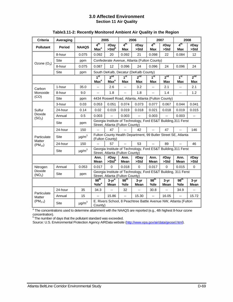
3.0 Affected Environment Section 11 Air Quality
Atlanta BeltLine Corridor Environmental Study D-69
Table3.11-2: Recently Monitored Ambient Air Quality in the Region
Criteria Averaging 2005 2006 2007 2008
Pollutant Period NAAQS 4th
Maxa #Day >Stdb
4th
Max #Day >Std
4th
Max #Day >Std
4th
Max #Day >Std
Ozone (O3)
8-hour 0.075 0.092 20 0.092 21 0.098 22 0.084 12
Site ppm Confederate Avenue, Atlanta (Fulton County)
8-hour 0.075 0.087 12 0.096 24 0.096 24 0.096 24
Site ppm South DeKalb, Decatur (DeKalb County)
1st Maxa
2nd Maxa
1st Max
2nd Max
1st Max
2nd Max
1st Max
2nd Max
Carbon Monoxide (CO)
1-hour 35.0 -- 2.6 -- 3.2 -- 2.1 -- 2.1
8-hour 9.0 -- 1.8 -- 1.8 -- 1.4 -- 1.2
Site ppm 4434 Roswell Road, Atlanta, Atlanta (Fulton County)
Sulfur Dioxide (SO2)
3-hour 0.03 0.053 0.051 0.074 0.073 0.077 0.067 0.044 0.041
24-hour 0.14 0.02 0.019 0.019 0.018 0.021 0.018 0.019 0.015
Annual 0.5 0.003 -- 0.003 -- 0.003 -- 0.003 --
Site ppm Georgia Institute of Technology, Ford ES&T Building,311 Ferst Street, Atlanta (Fulton County)
Particulate Matter (PM10)
24-hour 150 -- 47 -- 42 -- 47 -- 146
Site µg/m3 Fulton County Health Department, 99 Butler Street SE, Atlanta (Fulton County)
24-hour 150 -- 57 -- 53 -- 89 -- 46
Site µg/m3 Georgia Institute of Technology, Ford ES&T Building,311 Ferst Street, Atlanta (Fulton County)
Ann. Mean
#Day >Stdb
Ann. Mean
#Day >Std
Ann. Mean
#Day >Std
Ann. Mean
#Day >Std
Nitrogen Dioxide (NO2)
Annual 0.053 0.017 0 0.018 0 0.017 0 0.015 0
Site ppm Georgia Institute of Technology, Ford ES&T Building, 311 Ferst Street, Atlanta (Fulton County)
98th
%ilea 3-yra Mean
98th
%ile 3-yr
Mean 98th
%ile 3-yr
Mean 98th
%ile 3-yr
Mean
Particulate Matter (PM2.5)
24-hour 35 34.3 -- 32 -- 30.8 -- 34.9 --
Annual 15 -- 15.86 -- 15.30 -- 16.05 -- 15.72
Site µg/m3 E. Rivers School, 8 Peachtree Battle Avenue NW, Atlanta (Fulton County)
a The concentrations used to determine attainment with the NAAQS are reported (e.g., 4th highest 8-hour ozone concentration). b The number of days that the pollutant standard was exceeded. Source: U.S. Environmental Protection Agency AIRData website (http://www.epa.gov/air/data/geosel.html).
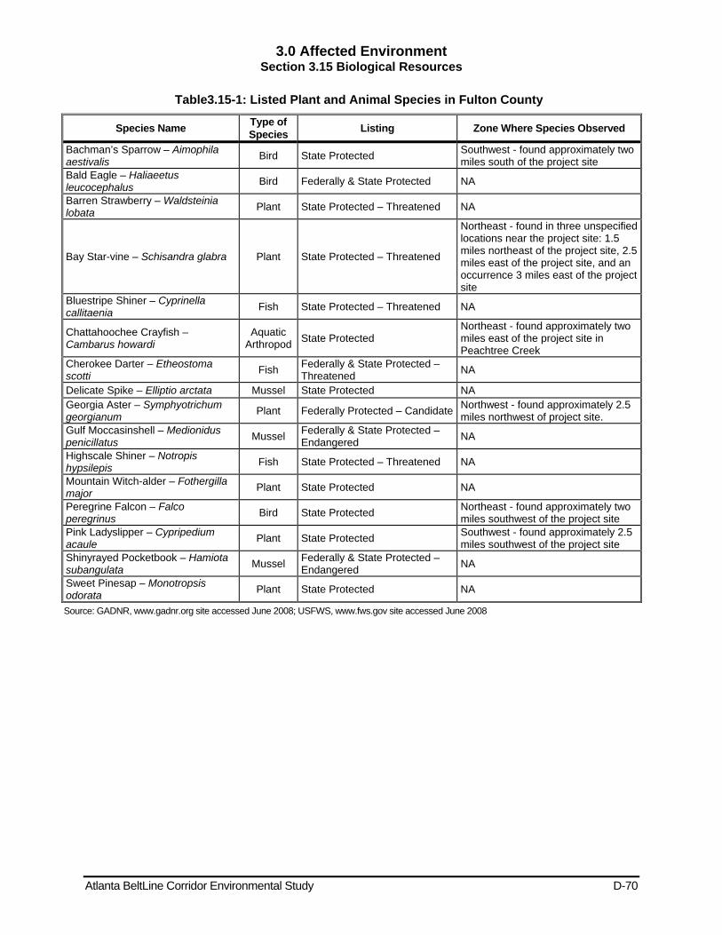
3.0 Affected Environment Section 3.15 Biological Resources
Atlanta BeltLine Corridor Environmental Study D-70
Table3.15-1: Listed Plant and Animal Species in Fulton County
Species Name Type of Species Listing Zone Where Species Observed
Bachman’s Sparrow – Aimophila aestivalis Bird State Protected Southwest - found approximately two
miles south of the project site Bald Eagle – Haliaeetus leucocephalus Bird Federally & State Protected NA
Barren Strawberry – Waldsteinia lobata Plant State Protected – Threatened NA
Bay Star-vine – Schisandra glabra Plant State Protected – Threatened
Northeast - found in three unspecified locations near the project site: 1.5 miles northeast of the project site, 2.5 miles east of the project site, and an occurrence 3 miles east of the project site
Bluestripe Shiner – Cyprinella callitaenia Fish State Protected – Threatened NA
Chattahoochee Crayfish – Cambarus howardi
Aquatic Arthropod State Protected
Northeast - found approximately two miles east of the project site in Peachtree Creek
Cherokee Darter – Etheostoma scotti Fish Federally & State Protected –
Threatened NA
Delicate Spike – Elliptio arctata Mussel State Protected NA Georgia Aster – Symphyotrichum georgianum Plant Federally Protected – Candidate Northwest - found approximately 2.5
miles northwest of project site. Gulf Moccasinshell – Medionidus penicillatus Mussel Federally & State Protected –
Endangered NA
Highscale Shiner – Notropis hypsilepis Fish State Protected – Threatened NA
Mountain Witch-alder – Fothergilla major Plant State Protected NA
Peregrine Falcon – Falco peregrinus Bird State Protected Northeast - found approximately two
miles southwest of the project site Pink Ladyslipper – Cypripedium acaule Plant State Protected Southwest - found approximately 2.5
miles southwest of the project site Shinyrayed Pocketbook – Hamiota subangulata Mussel Federally & State Protected –
Endangered NA
Sweet Pinesap – Monotropsis odorata Plant State Protected NA
Source: GADNR, www.gadnr.org site accessed June 2008; USFWS, www.fws.gov site accessed June 2008

3.0 Affected Environment Section 3.16 Geologic Resources
Atlanta BeltLine Corridor Environmental Study D-71
Table 3.16-1: Soil Types
Soil Series Soil Characteristics Cecil Deep, well-drained, moderately permeable, red soils formed in residuum weathered from
granite, gneiss, and schist. Found on ridgetops and side slopes. Cartecay-Toccoa
The Cartecay Series is somewhat poorly drained, moderately rapidly permeable soils that formed in thick loamy alluvial sediments. Found on nearly level flood plains in narrow valleys of streams in the Piedmont Plateau and adjoining Major Land Resource Area (MLRA) where streams flow from the Piedmont. Toccoa is moderately well drained to well-drained, moderately rapidly permeable soils formed in loamy and sandy alluvium from igneous and metamorphic rocks in the Piedmont and Upper Coastal Plain valleys. Found on flood plains and natural levees.
Congaree Deep, well- to moderately well drained, moderately permeable loamy soils that formed in fluvial sediments. Found on flood plains or at the base of slopes.
Congaree- Cartecay
The Congaree Series is deep, well- to moderately well drained, moderately permeable loamy soils that formed in fluvial sediments. Found on flood plains or at the base of slopes. The Cartecay is somewhat poorly drained, moderately rapidly permeable soils that formed in thick loamy alluvial sediments. Found on nearly level flood plains in narrow valleys of streams in the Piedmont Plateau and adjoining MLRAs where streams flow from Piedmont.
Rion Very deep, well drained, moderately permeable soils that formed in material mostly weathered from acid crystalline rocks of the Piedmont Uplands. Found on gently sloping to very steep Piedmont uplands.
Wickham Very deep, well drained, moderately permeable soils on stream terraces in the Piedmont and Coastal Plain and marine terraces in the Lower Coastal Plain terraces. The soil formed in fluvial and marine sediments. These soils are found on stream terraces in the Piedmont and Coastal Plain and marine terraces in the Lower Coastal Plain.
Source: (http://ortho.ftw.nrcs.usda.gov/cgi-bin/osd/osdname.cgi 2009).
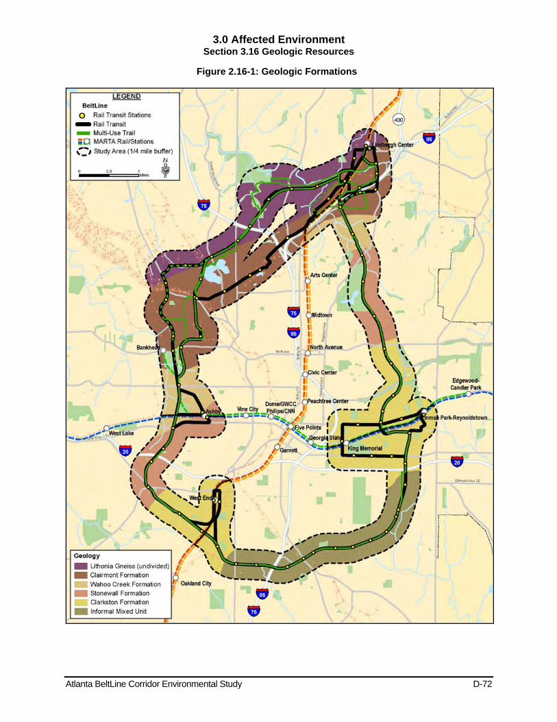
3.0 Affected Environment Section 3.16 Geologic Resources
Atlanta BeltLine Corridor Environmental Study D-72
Figure 2.16-1: Geologic Formations
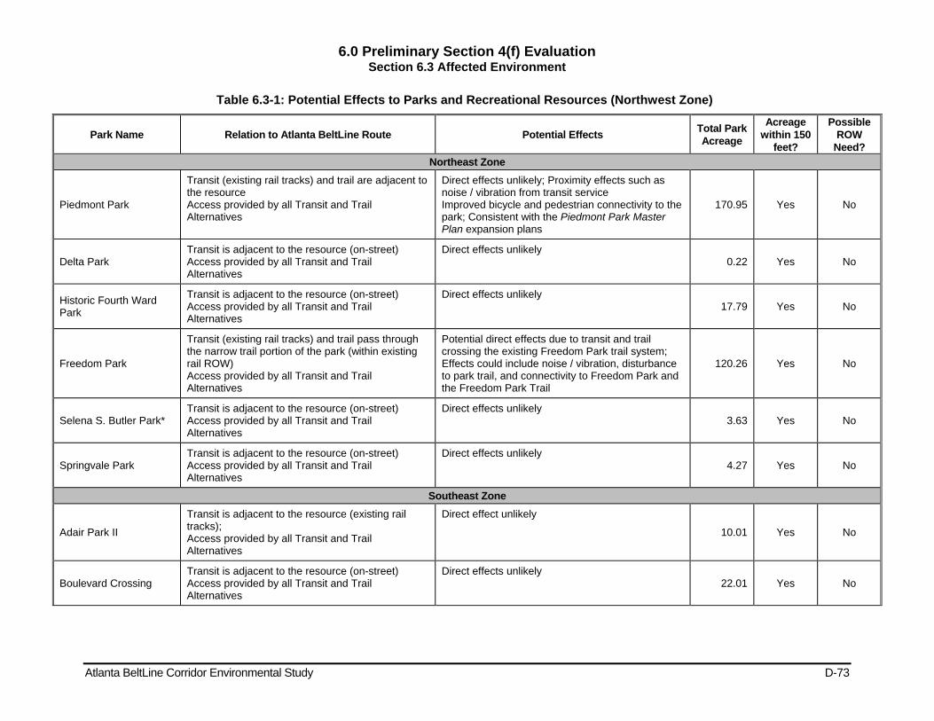
6.0 Preliminary Section 4(f) Evaluation Section 6.3 Affected Environment
Atlanta BeltLine Corridor Environmental Study D-73
Table 6.3-1: Potential Effects to Parks and Recreational Resources (Northwest Zone)
Park Name Relation to Atlanta BeltLine Route Potential Effects Total Park Acreage
Acreage within 150
feet?
Possible ROW
Need? Northeast Zone
Piedmont Park
Transit (existing rail tracks) and trail are adjacent to the resource Access provided by all Transit and Trail Alternatives
Direct effects unlikely; Proximity effects such as noise / vibration from transit service Improved bicycle and pedestrian connectivity to the park; Consistent with the Piedmont Park Master Plan expansion plans
170.95 Yes No
Delta Park Transit is adjacent to the resource (on-street) Access provided by all Transit and Trail Alternatives
Direct effects unlikely 0.22 Yes No
Historic Fourth Ward Park
Transit is adjacent to the resource (on-street) Access provided by all Transit and Trail Alternatives
Direct effects unlikely 17.79 Yes No
Freedom Park
Transit (existing rail tracks) and trail pass through the narrow trail portion of the park (within existing rail ROW) Access provided by all Transit and Trail Alternatives
Potential direct effects due to transit and trail crossing the existing Freedom Park trail system; Effects could include noise / vibration, disturbance to park trail, and connectivity to Freedom Park and the Freedom Park Trail
120.26 Yes No
Selena S. Butler Park* Transit is adjacent to the resource (on-street) Access provided by all Transit and Trail Alternatives
Direct effects unlikely 3.63 Yes No
Springvale Park Transit is adjacent to the resource (on-street) Access provided by all Transit and Trail Alternatives
Direct effects unlikely 4.27 Yes No
Southeast Zone
Adair Park II
Transit is adjacent to the resource (existing rail tracks); Access provided by all Transit and Trail Alternatives
Direct effect unlikely
10.01 Yes No
Boulevard Crossing Transit is adjacent to the resource (on-street) Access provided by all Transit and Trail Alternatives
Direct effects unlikely 22.01 Yes No
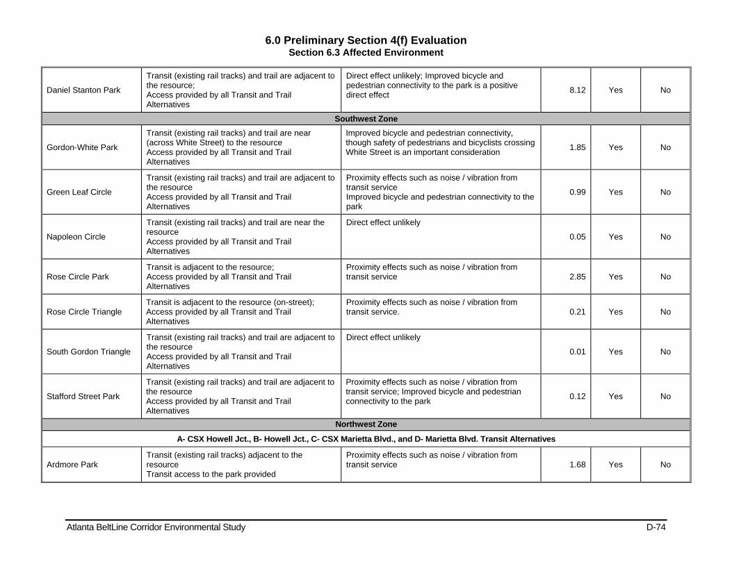
6.0 Preliminary Section 4(f) Evaluation Section 6.3 Affected Environment
Atlanta BeltLine Corridor Environmental Study D-74
Daniel Stanton Park
Transit (existing rail tracks) and trail are adjacent to the resource; Access provided by all Transit and Trail Alternatives
Direct effect unlikely; Improved bicycle and pedestrian connectivity to the park is a positive direct effect 8.12 Yes No
Southwest Zone
Gordon-White Park
Transit (existing rail tracks) and trail are near (across White Street) to the resource Access provided by all Transit and Trail Alternatives
Improved bicycle and pedestrian connectivity, though safety of pedestrians and bicyclists crossing White Street is an important consideration 1.85 Yes No
Green Leaf Circle
Transit (existing rail tracks) and trail are adjacent to the resource Access provided by all Transit and Trail Alternatives
Proximity effects such as noise / vibration from transit service Improved bicycle and pedestrian connectivity to the park
0.99 Yes No
Napoleon Circle
Transit (existing rail tracks) and trail are near the resource Access provided by all Transit and Trail Alternatives
Direct effect unlikely
0.05 Yes No
Rose Circle Park Transit is adjacent to the resource; Access provided by all Transit and Trail Alternatives
Proximity effects such as noise / vibration from transit service 2.85 Yes No
Rose Circle Triangle Transit is adjacent to the resource (on-street); Access provided by all Transit and Trail Alternatives
Proximity effects such as noise / vibration from transit service. 0.21 Yes No
South Gordon Triangle
Transit (existing rail tracks) and trail are adjacent to the resource Access provided by all Transit and Trail Alternatives
Direct effect unlikely
0.01 Yes No
Stafford Street Park
Transit (existing rail tracks) and trail are adjacent to the resource Access provided by all Transit and Trail Alternatives
Proximity effects such as noise / vibration from transit service; Improved bicycle and pedestrian connectivity to the park 0.12 Yes No
Northwest Zone
A- CSX Howell Jct., B- Howell Jct., C- CSX Marietta Blvd., and D- Marietta Blvd. Transit Alternatives
Ardmore Park Transit (existing rail tracks) adjacent to the resource Transit access to the park provided
Proximity effects such as noise / vibration from transit service 1.68 Yes No
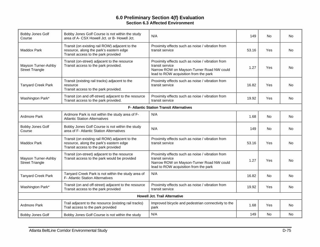
6.0 Preliminary Section 4(f) Evaluation Section 6.3 Affected Environment
Atlanta BeltLine Corridor Environmental Study D-75
Bobby Jones Golf Course
Bobby Jones Golf Course is not within the study area of A- CSX Howell Jct. or B- Howell Jct. N/A 149 No No
Maddox Park Transit (on existing rail ROW) adjacent to the resource, along the park’s eastern edge Transit access to the park provided
Proximity effects such as noise / vibration from transit service 53.16 Yes No
Mayson Turner-Ashby Street Triangle
Transit (on-street) adjacent to the resource Transit access to the park provided.
Proximity effects such as noise / vibration from transit service Narrow ROW on Mayson-Turner Road NW could lead to ROW acquisition from the park
1.27 Yes No
Tanyard Creek Park Transit (existing rail tracks) adjacent to the resource Transit access to the park provided.
Proximity effects such as noise / vibration from transit service 16.82 Yes No
Washington Park* Transit (on and off-street) adjacent to the resource Transit access to the park provided.
Proximity effects such as noise / vibration from transit service 19.92 Yes No
F- Atlantic Station Transit Alternatives
Ardmore Park Ardmore Park is not within the study area of F- Atlantic Station Alternatives
N/A 1.68 No No
Bobby Jones Golf Course
Bobby Jones Golf Course is not within the study area of F- Atlantic Station Alternatives N/A 149 No No
Maddox Park Transit (on existing rail ROW) adjacent to the resource, along the park’s eastern edge Transit access to the park provided
Proximity effects such as noise / vibration from transit service 53.16 Yes No
Mayson Turner-Ashby Street Triangle
Transit (on-street) adjacent to the resource Transit access to the park would be provided
Proximity effects such as noise / vibration from transit service Narrow ROW on Mayson-Turner Road NW could lead to ROW acquisition from the park
1.27 Yes No
Tanyard Creek Park Tanyard Creek Park is not within the study area of F- Atlantic Station Alternatives
N/A 16.82 No No
Washington Park* Transit (on and off-street) adjacent to the resource Transit access to the park provided
Proximity effects such as noise / vibration from transit service 19.92 Yes No
Howell Jct. Trail Alternative
Ardmore Park Trail adjacent to the resource (existing rail tracks) Trail access to the park provided
Improved bicycle and pedestrian connectivity to the park 1.68 Yes No
Bobby Jones Golf Bobby Jones Golf Course is not within the study N/A 149 No No

6.0 Preliminary Section 4(f) Evaluation Section 6.3 Affected Environment
Atlanta BeltLine Corridor Environmental Study D-76
Course area of Howell Jct. Trail Alternative
Maddox Park Trail adjacent to the resource (existing rail ROW) Trail access to the park provided
Improved bicycle and pedestrian connectivity to the park 53.16 Yes No
Mayson Turner-Ashby Street Triangle
Mayson Turner-Ashby Street Triangle is not within the study area of Howell Jct. Trail Alternative
N/A 1.27 No No
Tanyard Creek Park Trail adjacent to the resource (existing rail tracks) Trail access to the park provided
Improved bicycle and pedestrian connectivity to the park 16.82 Yes No
Washington Park* Trail adjacent to the resource (existing rail tracks) Trail access to the park provided
Improved bicycle and pedestrian connectivity to the park 19.92 Yes No
Marietta Blvd. Trail Alternative
Ardmore Park Trail adjacent to the resource (existing rail tracks) Trail access to the park provided
Improved bicycle and pedestrian connectivity to the park 1.68 Yes No
Bobby Jones Golf Course
Bobby Jones Golf Course is not within the study area of the Marietta Blvd. Trail Alternative N/A 149 No No
Maddox Park
Trail extends through the middle of the resource (on existing rail tracks) Trail access to the park provided
Improved bicycle and pedestrian connectivity to the park 53.16
Yes(both sides of existing tracks)
No
Mayson Turner-Ashby Street Triangle
Mayson Turner-Ashby Street Triangle is not within the study area of Multi-Use Trail Alternative A
N/A 1.27 No No
Tanyard Creek Park Trail adjacent to the resource (existing rail tracks) Trail access to the park provided
Improved bicycle and pedestrian connectivity to the park 16.82 Yes No
Washington Park* Trail adjacent to the resource (existing rail tracks) Trail access to the park provided
Improved bicycle and pedestrian connectivity to the park 19.92 Yes No
On-Street Trail Alternative
Ardmore Park Trail adjacent to the resource (existing rail tracks) Trail access to the park provided
Improved bicycle and pedestrian connectivity to the park 1.68 Yes No
Bobby Jones Golf Course
Trail adjacent to the resource Trail access to the park provided
Improved bicycle and pedestrian connectivity to the park 149 Yes No
Maddox Park Trail adjacent to the resource (on existing rail ROW) Trail access to the park provided
Improved bicycle and pedestrian connectivity to the park 53.16 Yes No
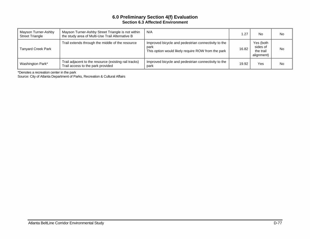
6.0 Preliminary Section 4(f) Evaluation Section 6.3 Affected Environment
Atlanta BeltLine Corridor Environmental Study D-77
Mayson Turner-Ashby Street Triangle
Mayson Turner-Ashby Street Triangle is not within the study area of Multi-Use Trail Alternative B
N/A 1.27 No No
Tanyard Creek Park
Trail extends through the middle of the resource Improved bicycle and pedestrian connectivity to the park This option would likely require ROW from the park 16.82
Yes (both sides of the trail
alignment)
No
Washington Park* Trail adjacent to the resource (existing rail tracks) Trail access to the park provided
Improved bicycle and pedestrian connectivity to the park 19.92 Yes No
*Denotes a recreation center in the park Source: City of Atlanta Department of Parks, Recreation & Cultural Affairs
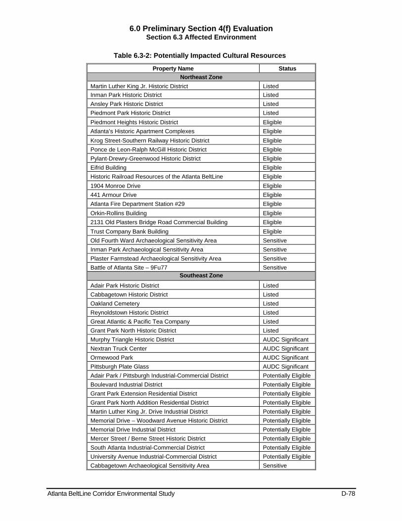
6.0 Preliminary Section 4(f) Evaluation Section 6.3 Affected Environment
Atlanta BeltLine Corridor Environmental Study D-78
Table 6.3-2: Potentially Impacted Cultural Resources
Property Name Status Northeast Zone
Martin Luther King Jr. Historic District Listed Inman Park Historic District Listed Ansley Park Historic District Listed Piedmont Park Historic District Listed Piedmont Heights Historic District Eligible Atlanta’s Historic Apartment Complexes Eligible Krog Street-Southern Railway Historic District Eligible Ponce de Leon-Ralph McGill Historic District Eligible Pylant-Drewry-Greenwood Historic District Eligible Eifrid Building Eligible Historic Railroad Resources of the Atlanta BeltLine Eligible 1904 Monroe Drive Eligible 441 Armour Drive Eligible Atlanta Fire Department Station #29 Eligible Orkin-Rollins Building Eligible 2131 Old Plasters Bridge Road Commercial Building Eligible Trust Company Bank Building Eligible Old Fourth Ward Archaeological Sensitivity Area Sensitive Inman Park Archaeological Sensitivity Area Sensitive Plaster Farmstead Archaeological Sensitivity Area Sensitive Battle of Atlanta Site – 9Fu77 Sensitive
Southeast Zone Adair Park Historic District Listed Cabbagetown Historic District Listed Oakland Cemetery Listed Reynoldstown Historic District Listed Great Atlantic & Pacific Tea Company Listed Grant Park North Historic District Listed Murphy Triangle Historic District AUDC Significant Nextran Truck Center AUDC Significant Ormewood Park AUDC Significant Pittsburgh Plate Glass AUDC Significant Adair Park / Pittsburgh Industrial-Commercial District Potentially Eligible Boulevard Industrial District Potentially Eligible Grant Park Extension Residential District Potentially Eligible Grant Park North Addition Residential District Potentially Eligible Martin Luther King Jr. Drive Industrial District Potentially Eligible Memorial Drive – Woodward Avenue Historic District Potentially Eligible Memorial Drive Industrial District Potentially Eligible Mercer Street / Berne Street Historic District Potentially Eligible South Atlanta Industrial-Commercial District Potentially Eligible University Avenue Industrial-Commercial District Potentially Eligible Cabbagetown Archaeological Sensitivity Area Sensitive
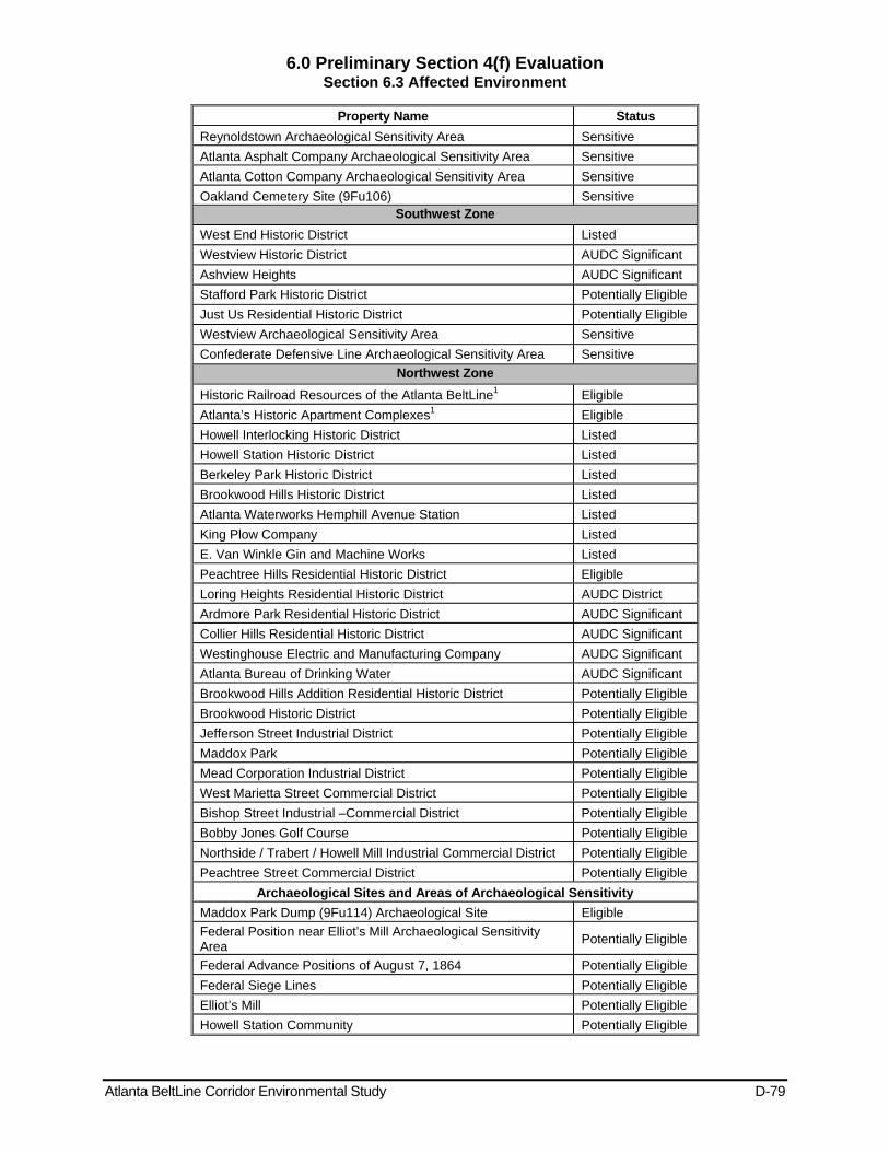
6.0 Preliminary Section 4(f) Evaluation Section 6.3 Affected Environment
Atlanta BeltLine Corridor Environmental Study D-79
Property Name Status Reynoldstown Archaeological Sensitivity Area Sensitive Atlanta Asphalt Company Archaeological Sensitivity Area Sensitive Atlanta Cotton Company Archaeological Sensitivity Area Sensitive Oakland Cemetery Site (9Fu106) Sensitive
Southwest Zone West End Historic District Listed Westview Historic District AUDC Significant Ashview Heights AUDC Significant Stafford Park Historic District Potentially Eligible Just Us Residential Historic District Potentially Eligible Westview Archaeological Sensitivity Area Sensitive Confederate Defensive Line Archaeological Sensitivity Area Sensitive
Northwest Zone Historic Railroad Resources of the Atlanta BeltLine1 Eligible Atlanta’s Historic Apartment Complexes1 Eligible Howell Interlocking Historic District Listed Howell Station Historic District Listed Berkeley Park Historic District Listed Brookwood Hills Historic District Listed Atlanta Waterworks Hemphill Avenue Station Listed King Plow Company Listed E. Van Winkle Gin and Machine Works Listed Peachtree Hills Residential Historic District Eligible Loring Heights Residential Historic District AUDC District Ardmore Park Residential Historic District AUDC Significant Collier Hills Residential Historic District AUDC Significant Westinghouse Electric and Manufacturing Company AUDC Significant Atlanta Bureau of Drinking Water AUDC Significant Brookwood Hills Addition Residential Historic District Potentially Eligible Brookwood Historic District Potentially Eligible Jefferson Street Industrial District Potentially Eligible Maddox Park Potentially Eligible Mead Corporation Industrial District Potentially Eligible West Marietta Street Commercial District Potentially Eligible Bishop Street Industrial –Commercial District Potentially Eligible Bobby Jones Golf Course Potentially Eligible Northside / Trabert / Howell Mill Industrial Commercial District Potentially Eligible Peachtree Street Commercial District Potentially Eligible
Archaeological Sites and Areas of Archaeological Sensitivity Maddox Park Dump (9Fu114) Archaeological Site Eligible Federal Position near Elliot’s Mill Archaeological Sensitivity Area Potentially Eligible
Federal Advance Positions of August 7, 1864 Potentially Eligible Federal Siege Lines Potentially Eligible Elliot’s Mill Potentially Eligible Howell Station Community Potentially Eligible

6.0 Preliminary Section 4(f) Evaluation Section 6.3 Affected Environment
Atlanta BeltLine Corridor Environmental Study D-80
Property Name Status Colliers Mill Archaeological Site (9Fu548) Potentially Eligible Prehistoric Sensitivity Areas Potentially Eligible Metal Works Manufacturing Potentially Eligible Atlanta Paper Company Potentially Eligible Western and Atlantic Railroad Potentially Eligible Deavenport Antebellum Farmstead Potentially Eligible Thrasher Antebellum Farmstead Potentially Eligible Atlanta Water Works Potentially Eligible Foundry Potentially Eligible Narjo Timber Company site Potentially Eligible
1Resource occurs in more than one zone.

Atlanta BeltLine Corridor Environmental Study June 2011
Page Left Intentionally Blank
Atlanta BeltLine Corridor Environmental Study E June 2011
Appendix E - Public Involvement
Atlanta BeltLine Corridor Environmental Study E-1
Appendix E – Public Participation 1.1 Public Participation Plan Summary
The objective of the public participation program is to invite and encourage the public to learn about and become involved in the BeltLine Corridor Environmental Study. The development of the Public Involvement and Agency Coordination Plan (PIAC) ensured ongoing public involvement throughout the course of the project using a variety of tools and techniques. The PIAC Plan describes how the public, local and state agencies, and decision-makers will take part in the identification, development, and implementation of the proposed transit and multi-use trails system in the BeltLine Corridor.
Key objectives of the public involvement efforts are to facilitate public understanding, to solicit input on the BeltLine Corridor transit and trails alternatives, and to identify potential consequences of alternative courses of action relative to the transportation, social, environmental and economic context. Use of the varying public involvement techniques outlined in the PIAC Plan invited and encouraged the public, federal, state, and local agencies the opportunity to review and comment on key project milestone decisions and to provide MARTA and ABI with the benefit of public insight throughout the project planning and development process.
The PIAC Plan was developed in accordance with Section 6002 of Public Law 104-59 “Safe, Accountable, Flexible, Efficient Transportation Equity Act: A Legacy for Users” (SAFETEA-LU), which mandates the development of a coordination plan for all projects for which an EIS is prepared under NEPA. It stipulates opportunity be provided for involvement by the public and agencies.
Public involvement activities are ongoing throughout the Tier 1 EIS process. To date, there were three major decision points in this EIS process where significant involvement from the public and agencies was crucial. Those decision points came during the Fall 2008 Scoping process to develop the Goals and Objectives for the Tier 1 EIS; Spring 2009 public workshops series to determine the conceptual right-of-way for transit and trails and identify possible station locations, transit stops, and trail locations and during the Fall of 2009 to present progress-to-date and solicit feedback from the public on the analysis of potential transit and trails routes.
Sections 1.2 and 1.3 provide a detailed summary of the involvement of the public, concerned agencies, and specially formed committees for the Tier 1 EIS. A full report of comments received during Scoping is included in the Scoping Summary Report, a full report of the public workshops is available through the Public and Committee Workshops April-June 2009 report and a full report of the public meetings is available through the Public and Committee Meetings November 2009 report.
The public, committees, and agencies are engaged on an ongoing basis during the Tier 1 EIS to provide timely and current feedback, and to ensure that the EIS process is consistent with federal policy, as well as, ABI’s Community Engagement Framework (CEF) and MARTA’s Public Participation Plan regarding public participation. A copy of public involvement outreach activities, including public, committee, and agency meetings is included in the PIAC Plan (shown in Section 1.2 Public Involvement: Scoping, Workshops, and Meetings and Section 1.2.2.8 Fall 2009 Public Meetings.
Section 3.4 describes the handling of Environmental Justice (EJ) throughout the Tier 1 EIS process. The guidance defines an EJ population as low-income or minority. Focused
Atlanta BeltLine Corridor Environmental Study E-2
outreach to EJ communities allowed equal voice to community members around the BeltLine. An asterisk in the following sections marks designated EJ communities.
This section is organized to describe the key elements of the Public Participation Plan:
Public Involvement: Scoping, Workshops, and Meetings
Future Meetings
Future public participation activities during the Tier 1 EIS that include:
Winter 2011 Public Hearing and comment period for the Tier 1 Draft EIS
Target audience briefings will also be conducted to communicate the results of the public meetings and public hearings
Agency Involvement: Coordination, Committee, and Meetings
Communication Tools
1.2 Public Involvement: Scoping, Workshops, and Meetings Public involvement activities consist of organizing and working with the public, using ABI’s Community Engagement Framework (CEF) created by City of Atlanta Resolution 06-R-1576 and MARTA’s public participation plan to promote the Tier 1 EIS and to provide progress updates and presentations to a variety of target audiences.
The CEF includes a 5-part community engagement framework designed to keep the public informed and actively engaged in the BeltLine’s creation so that it reflects the aspirations of its many neighborhoods and communities. The CEF consists of:
Tax Allocation District Advisory Committee (TADAC) – This committee makes recommendations on projects funded from tax allocation proceeds.
BeltLine Affordable Housing Advisory Board (BAHAB) – The Board receives 15% of TAD monies to ensure that available and affordable housing is planned for the BeltLine corridor.
Quarterly Updates for the public – ABI provides these two-hour sessions to update the public and respond to inquiries on recent BeltLine developments.
Community Engagement Advocate Office – This office is responsible for informing the community on current BeltLine issues and to ensure the active and meaningful engagement of the community in matters related to the BeltLine through the Community Engagement Framework (CEF).
Atlanta BeltLine Study Groups – These monthly groups are open to everyone in each of the five geographic zones in the BeltLine project area. The goal is to engage each community in discussions about how the BeltLine can embody the aspirations of its residents for parks, transportation, trails, green space, and other amenities.
MARTA’s public participation plan and resources are also critical to the success of the PIAC plan. This includes its extensive contact database, transit advocacy groups with which it works on a continuous basis, and special advisory committees.
1.2.1 Public Scoping Meetings MARTA, in partnership with ABI, conducted a number of Public Scoping meetings during the Scoping process, which began on July 25, 2008 and ended on September 22, 2008.
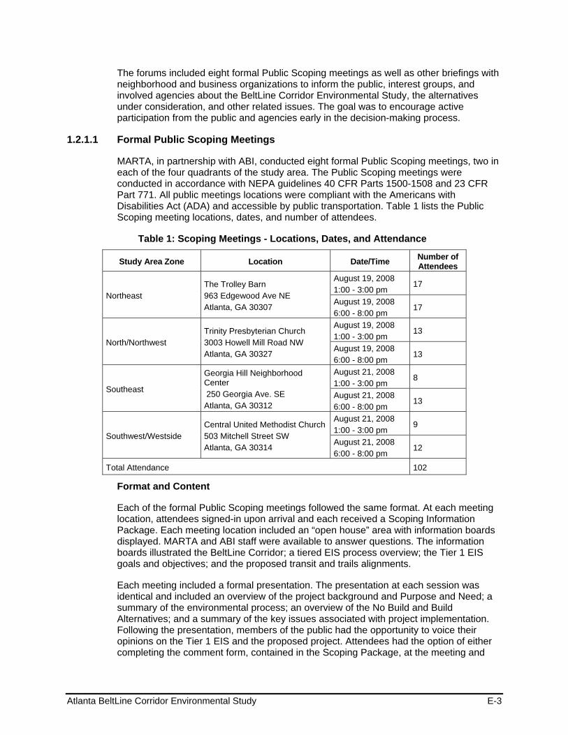
Atlanta BeltLine Corridor Environmental Study E-3
The forums included eight formal Public Scoping meetings as well as other briefings with neighborhood and business organizations to inform the public, interest groups, and involved agencies about the BeltLine Corridor Environmental Study, the alternatives under consideration, and other related issues. The goal was to encourage active participation from the public and agencies early in the decision-making process.
1.2.1.1 Formal Public Scoping Meetings
MARTA, in partnership with ABI, conducted eight formal Public Scoping meetings, two in each of the four quadrants of the study area. The Public Scoping meetings were conducted in accordance with NEPA guidelines 40 CFR Parts 1500-1508 and 23 CFR Part 771. All public meetings locations were compliant with the Americans with Disabilities Act (ADA) and accessible by public transportation. Table 1 lists the Public Scoping meeting locations, dates, and number of attendees.
Table 1: Scoping Meetings - Locations, Dates, and Attendance
Study Area Zone Location Date/Time Number of Attendees
Northeast The Trolley Barn 963 Edgewood Ave NE Atlanta, GA 30307
August 19, 2008 1:00 - 3:00 pm
17
August 19, 2008 6:00 - 8:00 pm
17
North/Northwest Trinity Presbyterian Church 3003 Howell Mill Road NW Atlanta, GA 30327
August 19, 2008 1:00 - 3:00 pm
13
August 19, 2008 6:00 - 8:00 pm
13
Southeast
Georgia Hill Neighborhood Center 250 Georgia Ave. SE Atlanta, GA 30312
August 21, 2008 1:00 - 3:00 pm
8
August 21, 2008 6:00 - 8:00 pm
13
Southwest/Westside Central United Methodist Church 503 Mitchell Street SW Atlanta, GA 30314
August 21, 2008 1:00 - 3:00 pm
9
August 21, 2008 6:00 - 8:00 pm
12
Total Attendance 102
Format and Content
Each of the formal Public Scoping meetings followed the same format. At each meeting location, attendees signed-in upon arrival and each received a Scoping Information Package. Each meeting location included an “open house” area with information boards displayed. MARTA and ABI staff were available to answer questions. The information boards illustrated the BeltLine Corridor; a tiered EIS process overview; the Tier 1 EIS goals and objectives; and the proposed transit and trails alignments.
Each meeting included a formal presentation. The presentation at each session was identical and included an overview of the project background and Purpose and Need; a summary of the environmental process; an overview of the No Build and Build Alternatives; and a summary of the key issues associated with project implementation. Following the presentation, members of the public had the opportunity to voice their opinions on the Tier 1 EIS and the proposed project. Attendees had the option of either completing the comment form, contained in the Scoping Package, at the meeting and
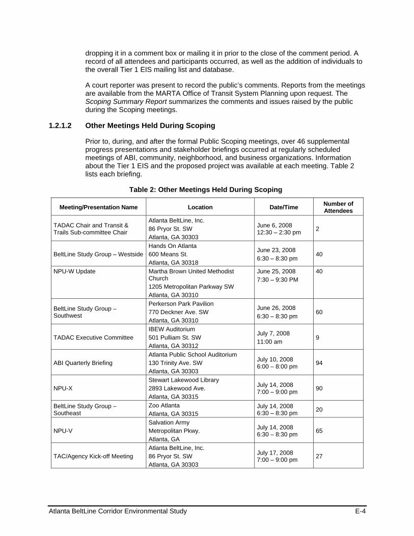
Atlanta BeltLine Corridor Environmental Study E-4
dropping it in a comment box or mailing it in prior to the close of the comment period. A record of all attendees and participants occurred, as well as the addition of individuals to the overall Tier 1 EIS mailing list and database.
A court reporter was present to record the public’s comments. Reports from the meetings are available from the MARTA Office of Transit System Planning upon request. The Scoping Summary Report summarizes the comments and issues raised by the public during the Scoping meetings.
1.2.1.2 Other Meetings Held During Scoping
Prior to, during, and after the formal Public Scoping meetings, over 46 supplemental progress presentations and stakeholder briefings occurred at regularly scheduled meetings of ABI, community, neighborhood, and business organizations. Information about the Tier 1 EIS and the proposed project was available at each meeting. Table 2 lists each briefing.
Table 2: Other Meetings Held During Scoping
Meeting/Presentation Name Location Date/Time Number of Attendees
TADAC Chair and Transit & Trails Sub-committee Chair
Atlanta BeltLine, Inc. 86 Pryor St. SW Atlanta, GA 30303
June 6, 2008 12:30 – 2:30 pm 2
BeltLine Study Group – Westside Hands On Atlanta 600 Means St. Atlanta, GA 30318
June 23, 2008 6:30 – 8:30 pm
40
NPU-W Update Martha Brown United Methodist Church 1205 Metropolitan Parkway SW Atlanta, GA 30310
June 25, 2008 7:30 – 9:30 PM
40
BeltLine Study Group – Southwest
Perkerson Park Pavilion 770 Deckner Ave. SW Atlanta, GA 30310
June 26, 2008 6:30 – 8:30 pm
60
TADAC Executive Committee IBEW Auditorium 501 Pulliam St. SW Atlanta, GA 30312
July 7, 2008 11:00 am
9
ABI Quarterly Briefing Atlanta Public School Auditorium 130 Trinity Ave. SW Atlanta, GA 30303
July 10, 2008 6:00 – 8:00 pm 94
NPU-X Stewart Lakewood Library 2893 Lakewood Ave. Atlanta, GA 30315
July 14, 2008 7:00 – 9:00 pm 90
BeltLine Study Group – Southeast
Zoo Atlanta Atlanta, GA 30315
July 14, 2008 6:30 – 8:30 pm 20
NPU-V Salvation Army Metropolitan Pkwy. Atlanta, GA
July 14, 2008 6:30 – 8:30 pm 65
TAC/Agency Kick-off Meeting Atlanta BeltLine, Inc. 86 Pryor St. SW Atlanta, GA 30303
July 17, 2008 7:00 – 9:00 pm 27
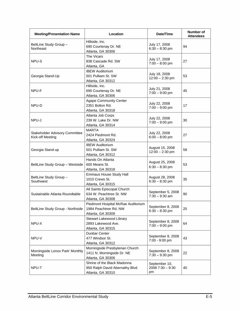
Atlanta BeltLine Corridor Environmental Study E-5
Meeting/Presentation Name Location Date/Time Number of Attendees
BeltLine Study Group – Northeast
Hillside, Inc. 690 Courtenay Dr. NE Atlanta, GA 30306
July 17, 2008 6:30 – 8:30 pm 94
NPU-S The Vicars 838 Cascade Rd. SW Atlanta, GA
July 17, 2008 7:00 – 8:00 pm 27
Georgia Stand-Up IBEW Auditorium 501 Pulliam St. SW Atlanta, GA 30312
July 18, 2008 12:00 – 2:30 pm 53
NPU-F Hillside, Inc. 690 Courtenay Dr. NE Atlanta, GA 30306
July 21, 2008 7:00 – 9:00 pm 45
NPU-D Agape Community Center 2351 Bolton Rd. Atlanta, GA 30318
July 22, 2008 7:00 – 9:00 pm 17
NPU-J Atlanta Job Corps 239 W. Lake Dr. NW Atlanta, GA 30314
July 22, 2008 7:00 – 9:00 pm 30
Stakeholder Advisory Committee Kick-off Meeting
MARTA 2424 Piedmont Rd. Atlanta, GA 30324
July 22, 2008 6:00 – 8:00 pm 27
Georgia Stand-up IBEW Auditorium 501 Pulliam St. SW Atlanta, GA 30312
August 15, 2008 12:00 – 2:30 pm 58
BeltLine Study Group – Westside Hands On Atlanta 600 Means St. Atlanta, GA 30318
August 25, 2008 6:30 – 8:30 pm
53
BeltLine Study Group – Southwest
Emmaus House Study Hall 1010 Crews St. Atlanta, GA 30315
August 28, 2008 6:30 – 8:30 pm 35
Sustainable Atlanta Roundtable All Saints Episcopal Church 634 W. Peachtree St. NW Atlanta, GA 30308
September 5, 2008 7:30 – 9:30 am 90
BeltLine Study Group - Northside Piedmont Hospital McRae Auditorium 1984 Peachtree Rd. NW Atlanta, GA 30309
September 8, 2008 6:30 – 8:30 pm 25
NPU-X Stewart Lakewood Library 2893 Lakewood Ave. Atlanta, GA 30315
September 8, 2008 7:00 – 9:00 pm 64
NPU-V Dunbar Center 477 Windsor St. Atlanta, GA 30312
September 8, 2008 7:00 - 9:00 pm 43
Morningside Lenox Park' Monthly Meeting
Morningside Presbyterian Church 1411 N. Morningside Dr. NE Atlanta, GA 30306
September 8, 2008 7:30 – 9:30 pm 22
NPU-T Shrine of the Black Madonna 950 Ralph David Abernathy Blvd. Atlanta, GA 30310
September 10, 2008 7:30 – 9:30 pm
40
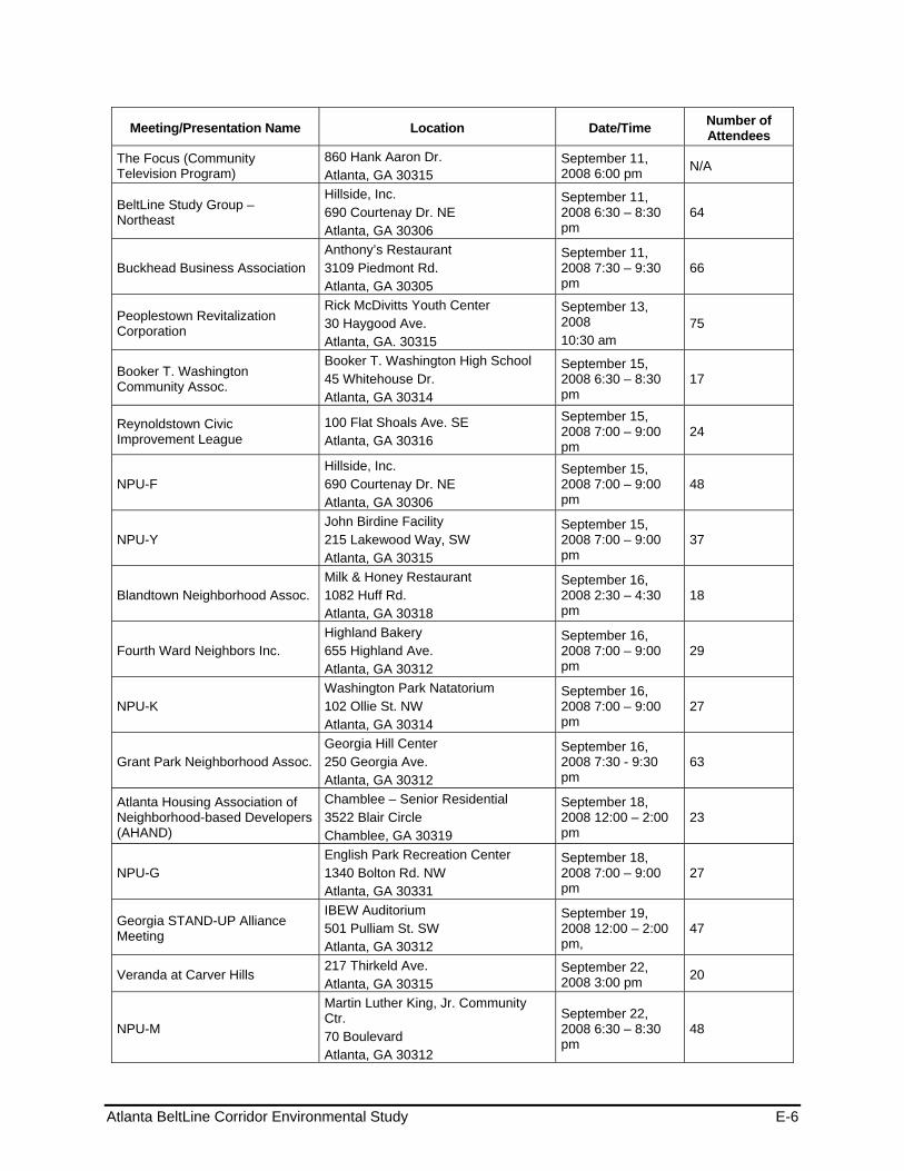
Atlanta BeltLine Corridor Environmental Study E-6
Meeting/Presentation Name Location Date/Time Number of Attendees
The Focus (Community Television Program)
860 Hank Aaron Dr. Atlanta, GA 30315
September 11, 2008 6:00 pm N/A
BeltLine Study Group – Northeast
Hillside, Inc. 690 Courtenay Dr. NE Atlanta, GA 30306
September 11, 2008 6:30 – 8:30 pm
64
Buckhead Business Association Anthony’s Restaurant 3109 Piedmont Rd. Atlanta, GA 30305
September 11, 2008 7:30 – 9:30 pm
66
Peoplestown Revitalization Corporation
Rick McDivitts Youth Center 30 Haygood Ave. Atlanta, GA. 30315
September 13, 2008 10:30 am
75
Booker T. Washington Community Assoc.
Booker T. Washington High School 45 Whitehouse Dr. Atlanta, GA 30314
September 15, 2008 6:30 – 8:30 pm
17
Reynoldstown Civic Improvement League
100 Flat Shoals Ave. SE Atlanta, GA 30316
September 15, 2008 7:00 – 9:00 pm
24
NPU-F Hillside, Inc. 690 Courtenay Dr. NE Atlanta, GA 30306
September 15, 2008 7:00 – 9:00 pm
48
NPU-Y John Birdine Facility 215 Lakewood Way, SW Atlanta, GA 30315
September 15, 2008 7:00 – 9:00 pm
37
Blandtown Neighborhood Assoc. Milk & Honey Restaurant 1082 Huff Rd. Atlanta, GA 30318
September 16, 2008 2:30 – 4:30 pm
18
Fourth Ward Neighbors Inc. Highland Bakery 655 Highland Ave. Atlanta, GA 30312
September 16, 2008 7:00 – 9:00 pm
29
NPU-K Washington Park Natatorium 102 Ollie St. NW Atlanta, GA 30314
September 16, 2008 7:00 – 9:00 pm
27
Grant Park Neighborhood Assoc. Georgia Hill Center 250 Georgia Ave. Atlanta, GA 30312
September 16, 2008 7:30 - 9:30 pm
63
Atlanta Housing Association of Neighborhood-based Developers (AHAND)
Chamblee – Senior Residential 3522 Blair Circle Chamblee, GA 30319
September 18, 2008 12:00 – 2:00 pm
23
NPU-G English Park Recreation Center 1340 Bolton Rd. NW Atlanta, GA 30331
September 18, 2008 7:00 – 9:00 pm
27
Georgia STAND-UP Alliance Meeting
IBEW Auditorium 501 Pulliam St. SW Atlanta, GA 30312
September 19, 2008 12:00 – 2:00 pm,
47
Veranda at Carver Hills 217 Thirkeld Ave. Atlanta, GA 30315
September 22, 2008 3:00 pm 20
NPU-M
Martin Luther King, Jr. Community Ctr. 70 Boulevard Atlanta, GA 30312
September 22, 2008 6:30 – 8:30 pm
48
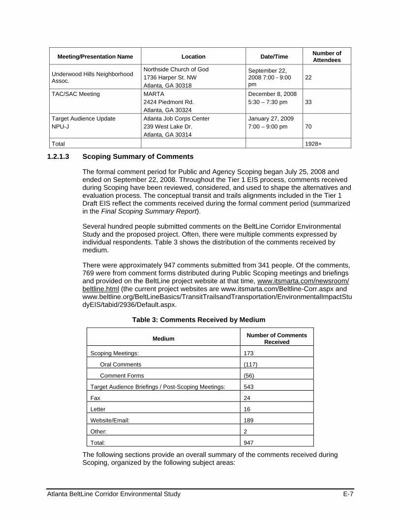
Atlanta BeltLine Corridor Environmental Study E-7
Meeting/Presentation Name Location Date/Time Number of Attendees
Underwood Hills Neighborhood Assoc.
Northside Church of God 1736 Harper St. NW Atlanta, GA 30318
September 22, 2008 7:00 - 9:00 pm
22
TAC/SAC Meeting MARTA 2424 Piedmont Rd. Atlanta, GA 30324
December 8, 2008 5:30 – 7:30 pm
33
Target Audience Update NPU-J
Atlanta Job Corps Center 239 West Lake Dr. Atlanta, GA 30314
January 27, 2009 7:00 – 9:00 pm
70
Total 1928+
1.2.1.3 Scoping Summary of Comments
The formal comment period for Public and Agency Scoping began July 25, 2008 and ended on September 22, 2008. Throughout the Tier 1 EIS process, comments received during Scoping have been reviewed, considered, and used to shape the alternatives and evaluation process. The conceptual transit and trails alignments included in the Tier 1 Draft EIS reflect the comments received during the formal comment period (summarized in the Final Scoping Summary Report).
Several hundred people submitted comments on the BeltLine Corridor Environmental Study and the proposed project. Often, there were multiple comments expressed by individual respondents. Table 3 shows the distribution of the comments received by medium.
There were approximately 947 comments submitted from 341 people. Of the comments, 769 were from comment forms distributed during Public Scoping meetings and briefings and provided on the BeltLine project website at that time, www.itsmarta.com/newsroom/ beltline.html (the current project websites are www.itsmarta.com/Beltline-Corr.aspx and www.beltline.org/BeltLineBasics/TransitTrailsandTransportation/EnvironmentalImpactStudyEIS/tabid/2936/Default.aspx.
Table 3: Comments Received by Medium
Medium Number of Comments Received
Scoping Meetings: 173
Oral Comments (117)
Comment Forms (56)
Target Audience Briefings / Post-Scoping Meetings: 543
Fax 24
Letter 16
Website/Email: 189
Other: 2
Total: 947
The following sections provide an overall summary of the comments received during Scoping, organized by the following subject areas:
Atlanta BeltLine Corridor Environmental Study E-8
Purpose and Need and Goals and Objectives
Several comments supported the purpose of and need for the BeltLine and the goals and objectives contained within the Purpose and Need statement. Those commenting felt that the proposed project would be beneficial to Atlanta residents for several reasons, including:
Enhanced mobility, accessibility and community connectivity
Improved quality of life and health
Improved livability within the city
Preservation of the historical neighborhoods, parks and significant activity centers encircling Atlanta
Reduced energy dependence and reliance on automobiles
Improved air quality due to reduced emissions
Economic development and neighborhood revitalization
Improved pedestrian and bicycling environment
Alternatives
Comments received during Scoping that related to the project alternatives are summarized below.
Mode - The majority of those that commented expressed the need to get residents out of their cars and on transit. Most of those that commented expressed interest in either streetcar or light rail. However, some recommend bus as the preferred mode.
Alignment - Comments relating to the proposed alignment expressed concern for the alignment configuration and positioning of proposed stations. Comments regarding the alignment are summarized below:
- The proposed loop configuration of the eastern end of the proposed alignment is inefficient. The time on the train to go from Grant Park to City Hall East on Ponce de Leon Avenue would increase by 15 to 20 minutes. The loop seems short-sighted and ill-conceived.
- The proposed BeltLine alignment and MARTA East-West heavy rail line would intersect with a perfectly designed rail station and rail-oriented development creating a seamless integration of the two lines.
- The proposed 2.25 miles of new on-street rail would be difficult to design.
- The proposed rail line would be out of context in terms of both land use and transportation south along Moreland Avenue and along Wylie Street.
- The entirety of the Mason/Northeast BeltLine right-of-way acquisition should be reserved for public purposes and any excess space in the section between Piedmont Avenue and the I-85 corridor should be reserved for public purposes such as park space, a library branch, or other public use.
- The BeltLine transit service would do little to augment ridership or the Atlanta regional network in the Edgewood Retail District due the two existing MARTA stations and the myriad of bus connections.
Atlanta BeltLine Corridor Environmental Study E-9
Transit Stops - The following recommendations were provided concerning transit stops for the BeltLine:
- Provide stops at Piedmont Avenue and Garson Drive and Turner Field.
- Create a station west of Krog Tunnel to be a transit hub for a new transit-oriented development near Hulsey Yard redevelopment.
- Connect the BeltLine to a new MARTA station between the King Memorial and Inman Park/Reynoldstown MARTA Stations rather than routing the alignment to the Inman Park/Reynoldstown MARTA Station.
- Transit stop locations should provide BeltLine access from the north, center, and south sections of the Piedmont Heights neighborhood.
- A transit station opposite Monroe Place Apartments on Monroe Drive seems appropriate.
- An additional station should be located in the vicinity of Wimbledon Drive or Rock Springs Road to facilitate access from the core of the neighborhood. This solution would complement the proposed station at Ansley Mall and negate the need for a station at Montgomery Ferry Road.
Trails - Comments regarding the proposed BeltLine trails related to connectivity to existing parks and recreation areas and the health and safety of trail users. The comments are summarized below:
- Since transit would be implemented in stages, construct trail segments first in areas scheduled for later phases of transit.
- Public recreation trails absent hazardous traffic are desperately needed.
- Putting the trail system next to the rail lines is smart as far as land use, but unless the transit mode has low-to-zero emissions, it could have an impact on the health of those using the trail system.
- Use BeltLine space as opportunities for environmental education (station posters, planted signs, etc.) Use BeltLine to educate folks on the history, landmarks, places of interest in different communities.
- Prefer the trail not be paved.
- Promote healthy choices for transportation via transit/trails and the ability to walk with help to decrease obesity.
- We must streamline rail paths allowing bikes, feet, and buses to be secondary modes to feed people outward.
- Include Waterworks Park at Huff Road and Howell Mill Road as part of the first phase of implementation.
- Trail access should be available opposite Monroe Place Apartments on Monroe Drive along with an access point in the vicinity of Wimbledon (Road) or Rock Springs (Road) to facilitate access from the core of the neighborhood. On the south on Piedmont Heights, trail access should be available from the Ansley Mall.
- The trail should be located on the predominantly residential side of the highway to take advantage of the high number of existing residences, which will not have access to the trail if it is located on the northern/industrial side of the highway. This proposed location would insure highest use from the outset of construction.
Atlanta BeltLine Corridor Environmental Study E-10
- Would like to see the BeltLine trail options remain adjacent as they come south from Lindbergh Center station on Piedmont Road (under I-85) and then turn westerly along Monroe Circle and Monroe Drive to connect with the BeltLine right-of-way at the northern end of the Ansley Golf Course.
- Put the trail system south of I-85 where people live.
- Construction of a bicycle and pedestrian trail system in the proposed BeltLine right-of-way from I-85 through the entire Subarea 6 BeltLine right-of-way will help ensure the most expedient and highest use of the public component of the proposed BeltLine right-of-way and help mitigate access issues due to potential development.
Mobility
Some of the key issues regarding mobility concerned the potential for impacts to traffic and pedestrian circulation. It was suggested that congestion and pedestrian traffic at major points along the BeltLine be considered because the proposed project may cause additional traffic problems. Further, it was recommended that during design of the proposed project, MARTA must minimize at-grade motor vehicle crossings on the transit route.
Environmental Quality
Many residents that submitted comments were concerned about the potential effects of the proposed BeltLine Corridor project on environmental resources. It was recommended that consideration of environmental impacts contain a very specific scope of studies that identify and measure current baseline conditions for air quality, noise, vibration, hazardous material location, animal habitat, visual impacts, historic resources, archaeological resources and water resource quality. More detail on the specific topics is presented below:
Air Quality - Many residents see the proposed BeltLine project as a potential improvement to Atlanta’s current air quality conditions.
Brownfields and Hazardous Materials - Some comments questioned whether there were sufficient funding mechanisms in place to remediate the volume of old industrial sites on the south side of the BeltLine Corridor.
Cultural Resources - Many comments expressed concern that the proposed alignment could have detrimental effects on historic structures and archaeological resources located along the alignment and requested that an assessment of the potential impacts on historic sites and buildings should be done before project initiation.
Cumulative Impacts - The potential impacts of the proposed BeltLine Corridor project need to be considered in the context of their cumulative impacts over both time and space.
Environmental Justice - Many comments suggested evaluating how the proposed BeltLine Corridor project would affect environmental justice (low-income and minority) communities.
Land Use - Some comments questioned whether the city has sufficient development controls in place through its zoning and subdivision power to assure control of the right-of-way for both development and transit purposes within the BeltLine Corridor. It was recommended that development should occur where a viable and appropriate
Atlanta BeltLine Corridor Environmental Study E-11
public/private framework is the basis of design and the public domain is clearly designed and defined in such a way that reinforces those elements of the city that create a safe, walkable, transit-oriented community. Further, it was recommended that the outcomes of the Tier 1 EIS should be consistent with local plans.
Other comments suggested that the proposed transit and trail elements of the proposed BeltLine Corridor project are out of context in terms of both land use and transportation. Further, it was felt that certain areas would be allowed to be developed so densely that they would in turn create a traffic problem rather than alleviate it. The Tier 1 EIS should provide a timeline for when and how much development is likely to occur that might be served by the BeltLine and address impacts in the context of development trends.
Natural Resources - Some residents requested that an evaluation of the potential effects of the proposed project on animals, including threatened and endangered species, which live along the proposed alignment; animal habitat; and vegetation be conducted. Some were concerned that the construction of the proposed project could cause the destruction of trees and vegetation along the right-of-way.
Noise and Vibration - Many of the comments received related to the noise and vibration impacts of the proposed project on property located within the BeltLine Corridor. People were interested in noise reduction strategies, as well as how the proposed project would be constructed to minimize noise and vibration during the construction phase, as well as after completion.
Parks and Recreation - Several comments stated that the proposed BeltLine Corridor project would improve existing greenspace. However, some felt that the proposed project would show no regard for Piedmont Park and its expansion and that the proposed project would heighten development at the expense of greenspace.
Utilities - Some citizens expressed concern that planning for a new park and associated high-density mixed-use development in the BeltLine Corridor would only increase the conflicts between the public and nuisances caused by the City’s antiquated way of dealing with sewage. Several parks and trail areas along the BeltLine Corridor intersect or could potentially be negatively impacted by combined sewer outflow (CSO) facilities.
Visual and Aesthetics - Several citizens noted the uniquely beautiful characteristics of neighborhoods along the BeltLine Corridor and expressed concern about the general impacts the proposed project would have on the visual and aesthetic appeal of the area. These included landscaping along the alignment and lighting at the proposed transit stations.
Water Resources - There were many comments received regarding area water resources, which includes stormwater, ground water, and surface waters. Some residents requested information on how stormwater runoff will be managed once the proposed project is completed. Others wanted to know how the proposed project would impact the water supply.
Ridership
In some of the comments received, inquiries were made into whether any ridership forecasts and timeline projections would be developed for the whole of the proposed BeltLine Corridor project so that citizens can gain a clearer understanding about what is likely to happen and when.
Atlanta BeltLine Corridor Environmental Study E-12
Safety and Security
Several comments were concerned that the proposed BeltLine Corridor project would attract additional crime and vagrants, especially along the proposed trail system. Many also noted that preventing accidents and injuries at crossing locations and during construction is an important issue.
Construction Impacts
Citizens submitted comments regarding the construction activities associated with the proposed project and their potential effects on the following:
Project phasing and duration of construction
Management of dust and debris
Stormwater runoff
Access and parking
Commute time and traffic congestion
Public transportation
Pedestrian circulation and safety
Contaminated soils
Noise and vibration
Visual and aesthetics
Parklands and recreation areas
Safety and security, including emergency management
Costs and Financial Plan
There were general concerns expressed about insufficient funding options for the proposed BeltLine Corridor project that would limit future progress of the project or the ability to operate and maintain the system. Others felt existing funding sources would compete with other needed projects.
The comments below summarize those received regarding funding sources for the proposed transit and trail system being evaluated in the BeltLine Corridor Environmental Study:
Consider the financing strategy as part of its analysis and findings of the Tier 1 EIS
Consider DERA (Diesel Emissions Reduction Act) and CMAQ (Congestion Mitigation and Air Quality) funds that are currently held by the Georgia Environmental Protection Division
Restrict TAD Bonds proceeds to transit, trails, or greenspace not private sector assistance
Consider local, state, and federal funds
Consider a sales tax or a gasoline tax
Consider a minimal or no Atlanta subsidy
Atlanta BeltLine Corridor Environmental Study E-13
Consider funding from the private sector, through mechanisms such as station sponsorship
Consider anything except property taxes
Consider a small tax that will be added to the tax bill and a small fee to ride, such as 50 or 75 cents
General Project Opposition or Support
There were many comments that expressed support for the proposed project and the effort to ease traffic congestion and improve access throughout the BeltLine Corridor. They expressed support for both the proposed transit and trail elements and the benefits they would provide to those living along the alignment, including:
Increasing mobility reducing congestion by getting people out of their cars
Helping to save gas
Connecting parks and neighborhoods
Stimulating investment and increasing property values for those who live or work around the stations
Improving general public health by increasing walkability that comes with public transit and improving air quality
Providing the city an opportunity to take advantage of all of the unused rail lines that need to be used
There were several comments that expressed opposition to the proposed project. The respondents were skeptical of the benefits of the BeltLine Corridor and questioned whether the proposed project was worth the cost. The comments opposing the proposed project included the following reasons for their lack of support:
Property impacts for those adjacent to the alignment
Impacts of development on parks and affordable housing
Traffic delays and flow
The project would not be cost-effective
A number of attendees at Public Scoping meetings and others offering comments indicated their awareness of planning and project development activity for only one modal concept (either transit or the trail system), as a result of participation in distinct planning activities by MARTA, ABI and community partners over the past several years.
Project Administration and Process
Many respondents requested specific information about the Study and the proposed project including:
Who is serving as the lead agency for the project and who are the cooperating agencies; are the NEPA and GEPA processes being followed?
Who approves the Tier 1 EIS?
What are the roles of MARTA and ABI?
Atlanta BeltLine Corridor Environmental Study E-14
Who will be the operator of the BeltLine?
Has the existing rail line been formally decommissioned by the Federal Railroad Administration?
Who will be making the final decisions?
There were several comments regarding insufficient information in the Scoping Document provided and frustration over the planning process for the proposed project. It was suggested that communities should be given the opportunity to review and comment on the design of development projects in their area.
Comments also recommended that planning for infrastructure improvements be implemented concurrently (i.e., at the time of or before) with significant development. Individuals suggested that when considering possible transportation investments, MARTA and ABI should rely on the emerging Connect Atlanta plan and the Transit Planning Board (TPB) Concept 3 plan and place the BeltLine Corridor Environmental Study in the context of the city-wide vision. The comments further noted that there should be greater emphasis on transit and parks rather than on auto-oriented developments.
Still others wanted to know how the purchase process of any right-of-way acquisition would comply with federal standards.
1.2.1.4 Scoping Meeting Advertisement and Notice
Advertisement of the Public Scoping meetings appeared in the following venues:
Newspapers
Atlanta Journal-Constitution (August 9, 2008; August 17, 2008)
Atlanta Daily World (August 14-20, 2008)
Project Website
The BeltLine project website at www.itsmarta.com/Beltline-Corr.aspx advertised the meetings. ABI also provided a link to the project website at: www.beltline.org/BeltLineBasics/TransitTrailsandTransportation/EnvironmentalImpactStudyEIS/tabid/2936/Default.aspx
Other Announcements
A Study Update/Flyer printed in English and Spanish and distributed through the contact database, hand-distributed at neighborhood meetings, and placed on the BeltLine project websites (www.itsmarta.com/Beltline-Corr.aspx; and www.beltline.org/BeltLineBasics/TransitTrailsandTransportation/EnvironmentalImpactStudyEIS/tabid/2936/Default.aspx) advertised the meetings.
1.2.2 Public Workshops 1.2.2.1 Citywide Conversation on Transit and Trails
MARTA and ABI conducted a Citywide Conversation on Transit and Trails on April 2, 2009, from 6:00-8:00 PM at the All Saints Episcopal Church (634 West Peachtree Street NW, Atlanta, GA 30308), inviting members of the SAC, and open to the public at large.
Atlanta BeltLine Corridor Environmental Study E-15
The purpose of the meetings was to inform the community of the status of the BeltLine Corridor Environmental Study and to prepare them for the upcoming Public Workshops.
Format and Content
The Citywide Conversation on Transit and Trails included a discussion of the overall BeltLine project, the BeltLine Corridor Environmental Study, and the environmental study interface with Subarea Master Planning efforts. However, the presentation and subsequent conversation focused on the Evaluation Criteria and upcoming public workshops.
Following the presentation, the attendees (61 in total) divided into groups to review the Preliminary Evaluation Criteria and associated Performance Measures. The purpose of this exercise was to get a consensus that the right evaluation criteria and performance measures were in use and to insure that there was not an omission of important information. Breakout discussion topics included:
Study purpose and need
Goals and objectives of the project
Existing conditions in the corridor
Study update
Evaluation criteria and outcomes
Provided below are the list of questions asked during the meeting, as well as the feedback received from the breakout session.
Questions Received
The following highlights the questions received from participants:
What is the definition of a stakeholder?
Are you doing a conceptual design for the entire corridor?
Whether or not the BeltLine has the population density to support transit in terms of projected population and employment numbers?
What is the study area width?
What is the projected timeline of implementation for various segments of the BeltLine?
The conceptual level of planning raises issues of discontinuity of BeltLine transit with MARTA rail. Will this be addressed in the EIS?
How are citywide transit projects prioritized in terms of meeting competing transit service needs?
Will issues of noise be addressed?
What is the process of public engagement in this study. How are the communities going to address the conceptual matters and how are you going to resolve those issues through this process so that the community and your plan work well together?
Atlanta BeltLine Corridor Environmental Study E-16
Breakout Group Feedback
The following is a combined list in order of preference voted on by the groups. Each Evaluation Criteria was prioritized by the Performance Measures that ranked highest among the community.
Accessibility and Connectivity
Local services and infill stations could be joined for connectivity with pedestrians and bicyclists
How do you get people to leave their cars at home?
The trail will help serve the need to ‘meander’ while the transit would help get to destinations more directly
How do we deal with where the other sub areas join?
Neighborhood/shorter trips to destinations
Connection points with existing versus future activity
Have nodes for regional connectivity -- # of nodes at employment centers
Have places where system connects to streets
Connections to destinations for employment, retail, grocery shopping
Consider multi-modal connectivity
Ensure accessibility to jobs
Must be a connection between people living and working along the BeltLine
Address trips to work and other places, i.e. there is a lack of grocery stores in the Southwest corridor
As much as we want people to use public transportation, not having large associated parking lots is still very important
Disabled population – include in considerations
Comprehensive sidewalk development needed, designed and implemented
Trail Access Points - how ordinary people will get on the trail
Pedestrians and bicycles should be incorporated in this criteria, versus having two separate criteria
Put transit and trails where people live
ROW Pres.: PATH, TPL, Georgia Conservancy, Zoning
Extent of future connectivity brought by transit
What are the recreational aspects of the trail
Community Fit
Focus on quality of life – the rest will follow
Consider compatibility, benefits to community
Define impacts – displacements versus benefits, attract future businesses/residents
Atlanta BeltLine Corridor Environmental Study E-17
Ensure community cohesion
To be compatible with the community, what are the benefits to the people
Concern with security, lighting, site specificity, fit of stations
Security in using transit and trails
Must get public input for community fit
Neighborhood Connection (performance measure)
We should be mapping as to where people are going
Security of adjacent properties
Accessibility to 1st responders
Prevention of catastrophic incident/impact to adjacent properties
Pedestrian and Bicycle Compatibility
Experience – get input from people who know about this
At-grade access for bikes
Safety and lighting need to be considered
This category is a duplicate of Connectivity and Mobility
Bike-friendly
Combine first 4 measures with Accessibility/Connectivity; move last 2 measures to Community
Equity
Displacement from Right of Way needs or development
Geographic equity with socio-economic equity
Prioritize the need of the people versus looking at how they would ‘benefit’
Look at cost effectiveness in a different way – connecting people to jobs, grocery stores
Serve seniors and disabled – make sure ADA compliant
Must be able to accommodate ADA requirements
Make sure transit and trails are safe enough to use
See how BRT connection by MARTA would work
Can Equity be combined with other headings
Equity – connections covered under other criteria
Mobility
Consider speed of mobility
Combine mobility with accessibility and connectivity
Consider frequency of service

Atlanta BeltLine Corridor Environmental Study E-18
Should be able to be both a local access and express service
Reduction needed in Vehicle Miles Traveled and Vehicle Trips
Cost Efficiency and Effectiveness
Consider funding and where it will come from
How economically sustainable is the project
Should economics be the driving factor; or serving a population – what are the priorities?
Consider cost of maintenance
Add Preservation of Single Family Neighborhoods and other transit connections
Environmental Quality
What is the impact of the certain kinds of transit technology on the environment?
Consider noise, visual impact, pollution, vibration
Land Use and Economic Development
Should have a different feel and quality than the rest of MARTA
Reminder -- BeltLine was originally about connecting neighborhoods rather than spurring development.
Public Input
Let the neighborhoods speak for themselves
Think of what they need, not how we think they can benefit
Need to aggressively involve the public.
Support of Other Planning Initiatives
Should be coordination with other planning initiatives
Support planned land use.
Use previous models for comparison
Additional Comments Evaluation Criteria categories could be reduced or combined; There is duplicate
measure in numerous criteria, i.e. collapse criteria
Add Ridership as category – what is the feasibility for people riding public transit as defined in the redevelopment study. if people don’t ride public transit the whole concept disintegrates
Add Timeframe to criteria – when can we have funding and have the BeltLine accessible to the neighborhoods we are connecting
Add Options Available for Changing Conditions to criteria
Focus of study area should take into account the TAD, not just the ½-mile buffer.
Atlanta BeltLine Corridor Environmental Study E-19
Do not minimize the importance of safety – if people feel intimidated they won’t walk, bicycle, or ride public transit
Consolidate the existing 10 Evaluation Criteria into the 4:
- Connectivity: Mobility, Accessibility and Connectivity, Pedestrian/Bike Compatibility
- Community Support: Equity, Planning Initiatives, Community Fit, and Public Involvement
- Cost Efficiency: Cost effectiveness and Economic Development/Land Use
- Environmental Quality: As is
Consolidate the Performance Measures – These could also be consolidated and weighted accordingly. Add a measure of the costs to acquire land or easements for competing alternatives. Also, provide separate measures for acres of wetlands impacted and number of stream crossings. These have different environmental effects.
1.2.2.2 Spring 2009 Public Workshop Series
MARTA and ABI conducted five formal public workshops, one in each of the study group areas: southeast, northeast, southwest, and two geographic areas forming the northwest zone (westside, and northside). Public workshops were held between April 13, 2009 and May 4, 2009 to engage the public in identifying potential transit and trails alternatives considered for the project. Promotion of the workshops took place throughout the study area to involve the public, some of whom were previously involved in BeltLine planning efforts, through MARTA and ABI outreach methods. Others participated because of a host of outreach strategies designed to reach community, transit and trail users, and stakeholders of the future transit and trails project. These activities resulted in small group hands-on workshops attended by approximately 105 individuals.
The formal Public Workshops were conducted in accordance with NEPA guidelines. All public meetings locations were compliant with the Americans with Disabilities Act (ADA) and accessible by public transportation. Table 4 lists the Public Workshops locations, dates, and number of attendees.
Format and Content
The first portion of each of the public workshops provided an opportunity for the participants to view a series of display boards and a continuous video that described the various transit and trails improvement options identified in previous studies for the BeltLine. A short presentation followed that described the overall Tier 1 EIS process, results of previous studies, and the purpose of the workshop. After the presentation, participants formed smaller discussion groups for an interactive exercise focused on identifying potential modifications or additions to the alternative service types, alignments, and station locations previously identified for the BeltLine project. Each breakout group included a staff facilitator to lead the discussion, access to an interactive video screen that displayed maps of the proposed project alignment and stations, and a staff person to document the comments and suggestions offered by the group.
Following the breakout session, a representative for each group presented a short summary regarding the key points raised by their group.

Atlanta BeltLine Corridor Environmental Study E-20
Table 4: Public Workshops – Locations, Dates, and Attendance
Study Area Quadrant Location Date/Time Number of Attendees
Southeast Study Group Trees Atlanta, Inc. 225 Chester Ave. SE Atlanta, GA 30316
April 13, 2009 6:30 pm – 8:30 pm 22
Northeast Study Group Morningside Baptist Church 1700 Piedmont Ave. NE Atlanta, GA 30324
April 16, 2009 6:30 pm – 8:30 pm 29
Southwest Study Group
West Hunter Baptist Church 1040 Ralph David Abernathy Boulevard SW Atlanta, GA 30310
April 23, 2009 6:30 pm – 8:30 pm 20
Westside Study Group Atlanta Humane Society 981 Howell Mill Road NW Atlanta, GA 30318
April 27, 2009 6:30 pm – 8:30 pm 15
Northside Study Group
Piedmont Hospital – McRae Auditorium 1984 Peachtree Rd. NE Atlanta, GA 30309
May 4, 2009 6:30 pm – 8:30 pm 19
Total Attendance 105
1.2.2.3 Public Workshop Advertisement
Advertisement for the Public Workshop meetings appeared in the following venues:
Project Website
The ABI website advertised the meetings at www.beltline.org/BeltLineBasics/TransitTrailsandTransportation/EnvironmentalImpactStudyEIS/tabid/2936/Default.aspx
Other Announcements
A Study Update/Flyer and distributed through the contact database, hand-distributed at neighborhood meetings, churches, community centers, grocery stores, libraries, businesses and other high traffic locations, and placed on the BeltLine project website (www.itsmarta.com/Beltline-Corr.aspx; and www.beltline.org/BeltLineBasics/TransitTrailsandTransportation/EnvironmentalImpactStudyEIS/tabid/2936/Default.aspx) advertised the meetings.
1.2.2.4 Spring 2009 Public Workshop Extension
To gain additional feedback from the public, there was an extension on the public workshop comment period to June 12, 2009. Additional opportunities to engage the public in identifying potential transit and trail alternatives occurred during twelve public and community organization presentations (see Table 5 below). Through intensified efforts to engage the public in identifying opportunities and impacts for the transit and trails design, community forums already in place, such as libraries, and office complex and mall food courts received an abbreviated version of the presentation. These activities resulted in attendance of approximately 502 individuals.
At the presentations and one-on-one engagements, individuals had an opportunity to view a series of display boards that described the Tier 1 EIS process, the types of
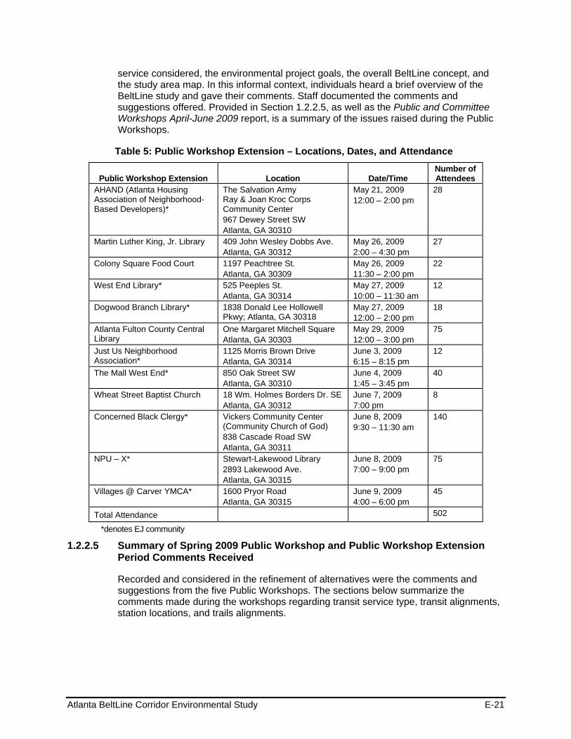
Atlanta BeltLine Corridor Environmental Study E-21
service considered, the environmental project goals, the overall BeltLine concept, and the study area map. In this informal context, individuals heard a brief overview of the BeltLine study and gave their comments. Staff documented the comments and suggestions offered. Provided in Section 1.2.2.5, as well as the Public and Committee Workshops April-June 2009 report, is a summary of the issues raised during the Public Workshops.
Table 5: Public Workshop Extension – Locations, Dates, and Attendance
Public Workshop Extension Location Date/Time Number of Attendees
AHAND (Atlanta Housing Association of Neighborhood-Based Developers)*
The Salvation Army Ray & Joan Kroc Corps Community Center 967 Dewey Street SW Atlanta, GA 30310
May 21, 2009 12:00 – 2:00 pm
28
Martin Luther King, Jr. Library 409 John Wesley Dobbs Ave. Atlanta, GA 30312
May 26, 2009 2:00 – 4:30 pm
27
Colony Square Food Court 1197 Peachtree St. Atlanta, GA 30309
May 26, 2009 11:30 – 2:00 pm
22
West End Library* 525 Peeples St. Atlanta, GA 30314
May 27, 2009 10:00 – 11:30 am
12
Dogwood Branch Library* 1838 Donald Lee Hollowell Pkwy; Atlanta, GA 30318
May 27, 2009 12:00 – 2:00 pm
18
Atlanta Fulton County Central Library
One Margaret Mitchell Square Atlanta, GA 30303
May 29, 2009 12:00 – 3:00 pm
75
Just Us Neighborhood Association*
1125 Morris Brown Drive Atlanta, GA 30314
June 3, 2009 6:15 – 8:15 pm
12
The Mall West End* 850 Oak Street SW Atlanta, GA 30310
June 4, 2009 1:45 – 3:45 pm
40
Wheat Street Baptist Church 18 Wm. Holmes Borders Dr. SE Atlanta, GA 30312
June 7, 2009 7:00 pm
8
Concerned Black Clergy* Vickers Community Center (Community Church of God) 838 Cascade Road SW Atlanta, GA 30311
June 8, 2009 9:30 – 11:30 am
140
NPU – X* Stewart-Lakewood Library 2893 Lakewood Ave. Atlanta, GA 30315
June 8, 2009 7:00 – 9:00 pm
75
Villages @ Carver YMCA* 1600 Pryor Road Atlanta, GA 30315
June 9, 2009 4:00 – 6:00 pm
45
Total Attendance 502
*denotes EJ community
1.2.2.5 Summary of Spring 2009 Public Workshop and Public Workshop Extension Period Comments Received
Recorded and considered in the refinement of alternatives were the comments and suggestions from the five Public Workshops. The sections below summarize the comments made during the workshops regarding transit service type, transit alignments, station locations, and trails alignments.
Atlanta BeltLine Corridor Environmental Study E-22
Transit Service Type
Participants gave their feedback on what type of service they would like to see for their community, which included:
Designing for greater connectivity along the BeltLine
Promoting economic development at stations and maximizing access to service by providing more frequent stations
Connecting efficiently to MARTA rail and planned new transit services
Allowing for mixed traffic and exclusive right-of-way operations
Using a streetcar, light rail, or rubber tire (neighborhood connector service) type vehicles
Providing more locally oriented service over existing heavy rail (speed, station spacing, transfers, etc.)
Using intelligent technology, such as ”next-bus” signage
Considering impacts of lighting and noise on adjacent properties
Transit Alignment
After reviewing a series of maps showing potential transit alignments community members had the following to say:
Use natural turf along/in between the tracks
Avoid impacts to existing trees; plant trees along right-of-way
Connect density centers and recreation opportunities
Consider redevelopment benefits in selecting alignment
Provide direct access to major trip destinations (activity centers, employment, density, etc.) and origins
Provide neighborhood-oriented pedestrian access
Apply cost-effectiveness criteria, but don‘t sacrifice quality design due to right-of-way or impact constraints
Use auto travel times as a means to determine the most important alignments for transit service
Transit Station
Placement of potential transit stations also elicited the following input:
Provide better connections to schools
Locate at major intersections to provide access to MARTA bus
Design small stations proportionate in scale to neighborhoods
Assess need for parking at BeltLine stations
Restrict smoking at stations
Atlanta BeltLine Corridor Environmental Study E-23
Consider MARTA infill stations at Armour Yard, Miami Circle, south of West End MARTA station, and Joseph E. Boone Boulevard
Provide connections to all MARTA stations near the BeltLine
Trails
Potential alignment of trails brought about a selection of comments:
Locate main transit and trails within the same corridor as much as possible
Provide more connector trails to adjacent neighborhoods
Connect schools, universities, and parks
Ensure a safe environment along trails; alignments should go through active and visible areas
Provide amenities (restrooms, benches, lockers, etc.), wayfinding, and security features
Provide some soft surface trail segments
Separate bicycle and pedestrian traffic
Consider 24-hour access
Include opportunities for art display
The Public and Committee Workshops April-June 2009 presents a fully summary of issues raised by the public during the Public Workshops.

Atlanta BeltLine Corridor Environmental Study E-24
Figure 1: Public Workshops – Comments Received
Source: MARTA and Atlanta BeltLine, Inc.
Atlanta BeltLine Corridor Environmental Study E-25
1.2.2.6 Spring 2009 Post Public Workshop Meetings
The project sponsors continued to introduce the Tier 1 EIS to new audiences and to update audiences that were formerly briefed. During regularly scheduled meetings of community groups and organizations, the project sponsors provided updates to the community to create awareness of the study and to help promote future public meetings. Public comments and input were included in the project record and considered based on the impact to the project.
Table 6 provides a list of post workshop briefings.
1.2.2.7 Summary of Post Public Workshop Comments Received
Recorded and considered in the refinement of alternatives were the comments and suggestions from post Public Workshop meetings. The sections below highlight a summary of the comments made during the public meetings and presentations regarding transit service type, transit alignments, station locations, and trails alignments.
Transit Service Type
Slower train speed inside communities
Regional and service on main streets travel at faster speeds
Service at all stops need not be the same; variations within communities
Hop on/off trolley at some points
Efficient cars that are clean and environmentally friendly
Multiple entry/exits
Transit Alignment
Have easy access to more densely populated neighborhoods
Transit Station
Closely spaced stations in walking distance
More stations to avoid taking the bus
Available parking at stations
Trails
Should run parallel to transportation element
Accommodate foot and bicycle traffic
Do not spend money on the trails for only a few people
Attracts crime
Separate bicycle and pedestrian traffic
Safety
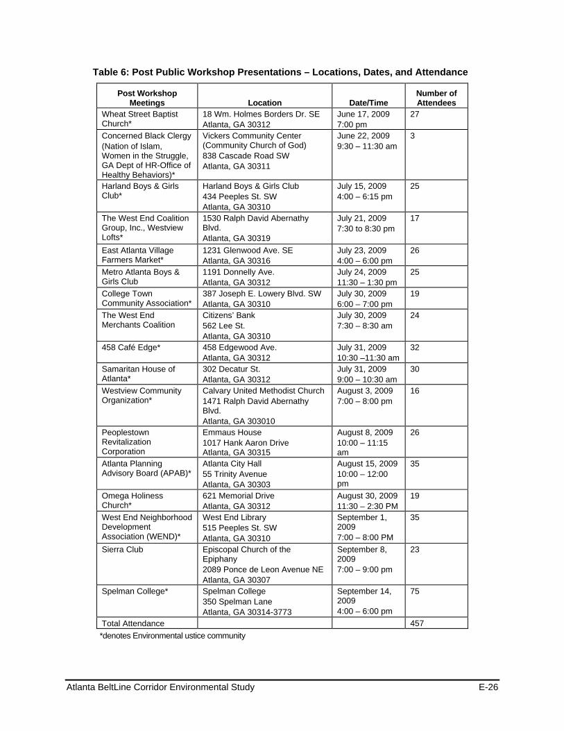
Atlanta BeltLine Corridor Environmental Study E-26
Table 6: Post Public Workshop Presentations – Locations, Dates, and Attendance
Post Workshop Meetings Location Date/Time
Number of Attendees
Wheat Street Baptist Church*
18 Wm. Holmes Borders Dr. SE Atlanta, GA 30312
June 17, 2009 7:00 pm
27
Concerned Black Clergy (Nation of Islam, Women in the Struggle, GA Dept of HR-Office of Healthy Behaviors)*
Vickers Community Center (Community Church of God) 838 Cascade Road SW Atlanta, GA 30311
June 22, 2009 9:30 – 11:30 am
3
Harland Boys & Girls Club*
Harland Boys & Girls Club 434 Peeples St. SW Atlanta, GA 30310
July 15, 2009 4:00 – 6:15 pm
25
The West End Coalition Group, Inc., Westview Lofts*
1530 Ralph David Abernathy Blvd. Atlanta, GA 30319
July 21, 2009 7:30 to 8:30 pm
17
East Atlanta Village Farmers Market*
1231 Glenwood Ave. SE Atlanta, GA 30316
July 23, 2009 4:00 – 6:00 pm
26
Metro Atlanta Boys & Girls Club
1191 Donnelly Ave. Atlanta, GA 30312
July 24, 2009 11:30 – 1:30 pm
25
College Town Community Association*
387 Joseph E. Lowery Blvd. SW Atlanta, GA 30310
July 30, 2009 6:00 – 7:00 pm
19
The West End Merchants Coalition
Citizens’ Bank 562 Lee St. Atlanta, GA 30310
July 30, 2009 7:30 – 8:30 am
24
458 Café Edge* 458 Edgewood Ave. Atlanta, GA 30312
July 31, 2009 10:30 –11:30 am
32
Samaritan House of Atlanta*
302 Decatur St. Atlanta, GA 30312
July 31, 2009 9:00 – 10:30 am
30
Westview Community Organization*
Calvary United Methodist Church 1471 Ralph David Abernathy Blvd. Atlanta, GA 303010
August 3, 2009 7:00 – 8:00 pm
16
Peoplestown Revitalization Corporation
Emmaus House 1017 Hank Aaron Drive Atlanta, GA 30315
August 8, 2009 10:00 – 11:15 am
26
Atlanta Planning Advisory Board (APAB)*
Atlanta City Hall 55 Trinity Avenue Atlanta, GA 30303
August 15, 2009 10:00 – 12:00 pm
35
Omega Holiness Church*
621 Memorial Drive Atlanta, GA 30312
August 30, 2009 11:30 – 2:30 PM
19
West End Neighborhood Development Association (WEND)*
West End Library 515 Peeples St. SW Atlanta, GA 30310
September 1, 2009 7:00 – 8:00 PM
35
Sierra Club Episcopal Church of the Epiphany 2089 Ponce de Leon Avenue NE Atlanta, GA 30307
September 8, 2009 7:00 – 9:00 pm
23
Spelman College* Spelman College 350 Spelman Lane Atlanta, GA 30314-3773
September 14, 2009 4:00 – 6:00 pm
75
Total Attendance 457 *denotes Environmental ustice community
Atlanta BeltLine Corridor Environmental Study E-27
1.2.2.8 Fall 2009 Public Meetings
MARTA, in partnership with ABI, conducted five formal Public Meetings, one in each study area. The Public Scoping meetings were conducted in accordance with NEPA guidelines 40 CFR Parts 1500-1508 and 23 CFR Part 771. All public meetings locations were compliant with the Americans with Disabilities Act (ADA) and accessible by public transportation. A list of the Public Meeting locations, dates, and number of attendees are listed in Table 7.
In addition, ABI, in conjunction with MARTA, held a Quarterly Briefing on November 23, 2009. The BeltLine Corridor Environmental Study was one of the agenda items. The project boards were on display during the Open House segment of the briefing, with staff available t discuss the project. The display boards highlighted the alternatives evaluated and findings. ABI Staff presented an abbreviated version of the Fall Meeting Series presentation. Approximately 74 individuals attended the meeting.
1.2.2.9 Format and Content
The first portion of each of the public meetings provided an opportunity for the participants to view a series of display boards and videos that described and demonstrated the various transit and trail improvement options. Given below is list of boards that were on display during the open house:
Purpose of Workshop
Trails Alternatives
Transit Alternatives
Constraints to Transit Alternatives
Performance Measures – BeltLine Activity Center
Underutilized Industrial Land
Development Capacity of Underutilized/Undeveloped Land
Potential Impacts to Water Resources for Trails
Potential Impacts to Water Resources for Transit
Alternative Evaluation by Goal – Trails
Alternative Evaluation by Goal – Transit
Performance Measures – Best Performing Alternatives
BeltLine Transit and Trail Elements – Transit Feature
Regional Transit Vision
The video presentation highlighted potential transit and trail features and provided a “birds-eye view” of the corridor. Also included was the evaluation of alternatives and the resulting recommended alternatives for the BeltLine. A presentation followed describing the meeting purpose, overall study process and results of the evaluation process. After the presentation, the participants broke into smaller discussion groups for an interactive exercise to obtain feedback on the evaluation results for the BeltLine. Each breakout group included two consultant team members: one to facilitate the discussion and the
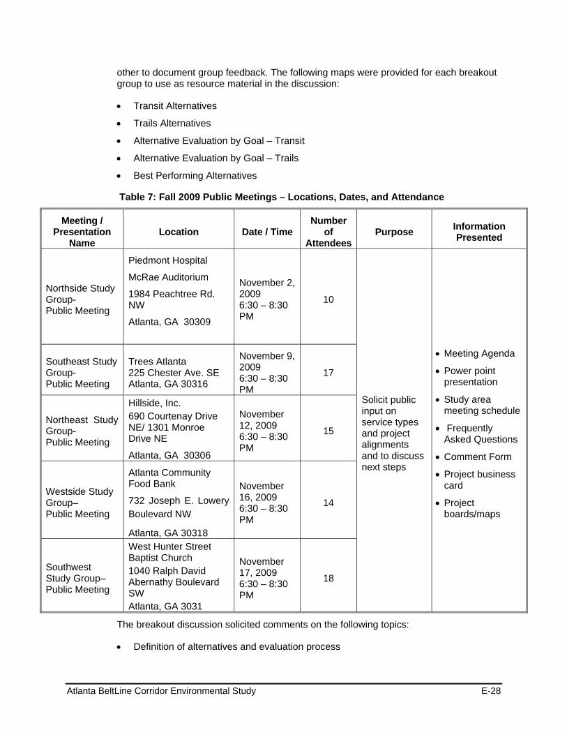
Atlanta BeltLine Corridor Environmental Study E-28
other to document group feedback. The following maps were provided for each breakout group to use as resource material in the discussion:
Transit Alternatives
Trails Alternatives
Alternative Evaluation by Goal – Transit
Alternative Evaluation by Goal – Trails
Best Performing Alternatives
Table 7: Fall 2009 Public Meetings – Locations, Dates, and Attendance
Meeting / Presentation
Name Location Date / Time
Number of
AttendeesPurpose Information
Presented
Northside Study Group- Public Meeting
Piedmont Hospital
McRae Auditorium
1984 Peachtree Rd. NW
Atlanta, GA 30309
November 2, 2009 6:30 – 8:30 PM
10
Solicit public input on service types and project alignments and to discuss next steps
Meeting Agenda
Power point presentation
Study area meeting schedule
Frequently Asked Questions
Comment Form
Project business card
Project boards/maps
Southeast Study Group- Public Meeting
Trees Atlanta 225 Chester Ave. SE Atlanta, GA 30316
November 9, 2009 6:30 – 8:30 PM
17
Northeast Study Group- Public Meeting
Hillside, Inc. 690 Courtenay Drive NE/ 1301 Monroe Drive NE
Atlanta, GA 30306
November 12, 2009 6:30 – 8:30 PM
15
Westside Study Group– Public Meeting
Atlanta Community Food Bank
732 Joseph E. Lowery Boulevard NW
Atlanta, GA 30318
November 16, 2009 6:30 – 8:30 PM
14
Southwest Study Group– Public Meeting
West Hunter Street Baptist Church 1040 Ralph David Abernathy Boulevard SW Atlanta, GA 3031
November 17, 2009 6:30 – 8:30 PM
18
The breakout discussion solicited comments on the following topics:
Definition of alternatives and evaluation process

Atlanta BeltLine Corridor Environmental Study E-29
Overall reaction to the scoring of the alternatives
Input on the evaluation of those performance measures that most distinguish between alternatives
Consistency of alternatives with project goals
Following the breakout session, each group’s facilitator presented a short summary of the key points raised by their group.
1.2.2.10 Fall 2009 Public Comments and Issues Received
The comments received from the public were recorded and are used by the project team to further refine options and to consider each comment during the relative to the goal and performance measures. The sections below summarize the comments made during the public meetings regarding alternatives evaluated, performance measures, and other project related comments.
Alternatives Evaluated
Implementation
Freight-Related Issues
Evaluate the ability to implement the project based on challenges relative to CSX and NS
Consider daily freight activity in the evaluation of the CSX and NS corridors
Consider what happens if there is no compromise with the freight railroads
Determine if sharing the tracks will create on-time issues for the BeltLine when the freight operations result in delay problems, as is often the case with SEPTA (commuter rail) in Philadelphia
Environmental Issues
Consider the creation of possible water storage locations along the BeltLine
Determine if any prehistoric impacts exist within the corridor (including Peachtree Creek)
Quantify other environmental impacts
Property Related Issues
Determine locations for affordable housing
Determine property impacts
Operation
LRT versus Modern Streetcar
Consider a need for flexibility and integration with other systems for both modern streetcar and LRT
Determine the cost difference between modern streetcar and LRT
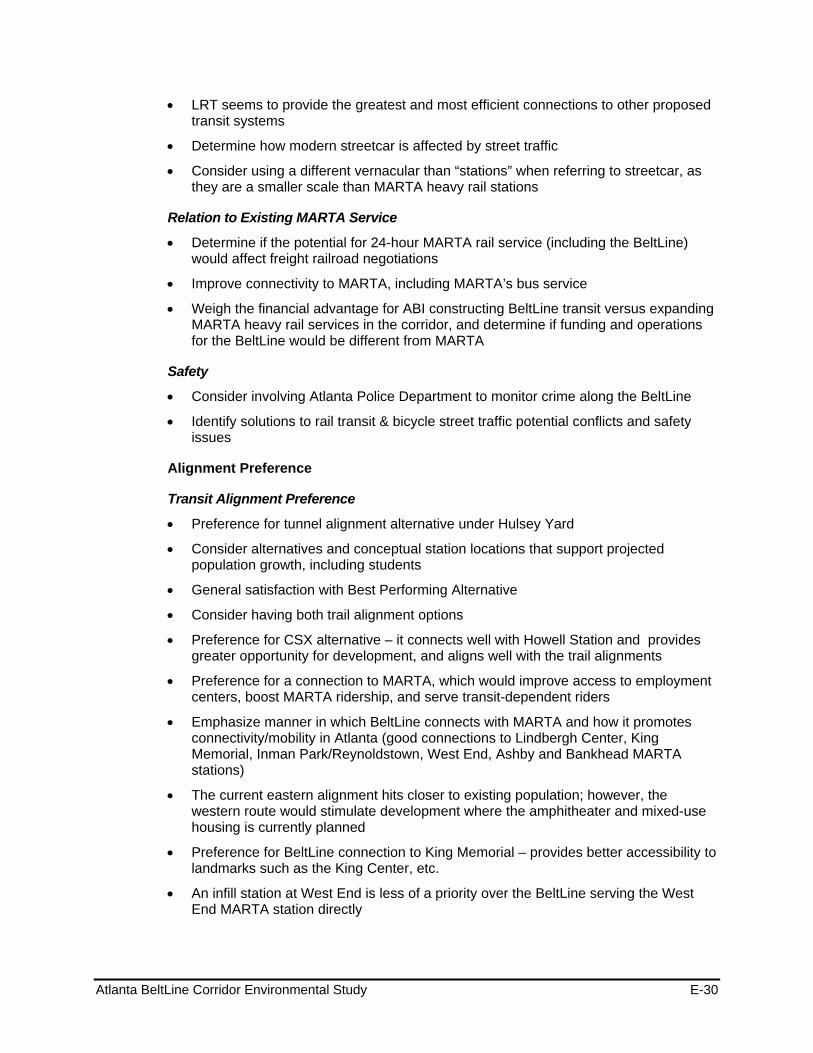
Atlanta BeltLine Corridor Environmental Study E-30
LRT seems to provide the greatest and most efficient connections to other proposed transit systems
Determine how modern streetcar is affected by street traffic
Consider using a different vernacular than “stations” when referring to streetcar, as they are a smaller scale than MARTA heavy rail stations
Relation to Existing MARTA Service
Determine if the potential for 24-hour MARTA rail service (including the BeltLine) would affect freight railroad negotiations
Improve connectivity to MARTA, including MARTA’s bus service
Weigh the financial advantage for ABI constructing BeltLine transit versus expanding MARTA heavy rail services in the corridor, and determine if funding and operations for the BeltLine would be different from MARTA
Safety
Consider involving Atlanta Police Department to monitor crime along the BeltLine
Identify solutions to rail transit & bicycle street traffic potential conflicts and safety issues
Alignment Preference
Transit Alignment Preference
Preference for tunnel alignment alternative under Hulsey Yard
Consider alternatives and conceptual station locations that support projected population growth, including students
General satisfaction with Best Performing Alternative
Consider having both trail alignment options
Preference for CSX alternative – it connects well with Howell Station and provides greater opportunity for development, and aligns well with the trail alignments
Preference for a connection to MARTA, which would improve access to employment centers, boost MARTA ridership, and serve transit-dependent riders
Emphasize manner in which BeltLine connects with MARTA and how it promotes connectivity/mobility in Atlanta (good connections to Lindbergh Center, King Memorial, Inman Park/Reynoldstown, West End, Ashby and Bankhead MARTA stations)
The current eastern alignment hits closer to existing population; however, the western route would stimulate development where the amphitheater and mixed-use housing is currently planned
Preference for BeltLine connection to King Memorial – provides better accessibility to landmarks such as the King Center, etc.
An infill station at West End is less of a priority over the BeltLine serving the West End MARTA station directly
Atlanta BeltLine Corridor Environmental Study E-31
The Marietta alignment provides better access to Westside Park (consider parking issues) than Howell Junction alignment
The NS alignment has fewer environmental impacts than the CSX alignment
Consider a second BeltLine or another transit service in the other corridor (NS or CSX, whichever is not picked)
Trail Alignment Preference
Consider advancing both Trail Alternatives A and B
Build Trail A first, but follow up with Trail B to provide multiple levels of connectivity
The alignment on the Westside along Lena Street would improve visibility in the area in comparison to the existing wooded area along the former railroad corridor
Trails align better with CSX alignment
Trail A appears to have issues in utilizing the active freight corridor, while Trail B has better neighborhood connectivity
Consider mixing and matching trail alternatives
Determine if trails are designed for recreational purposes or work trips
Performance Measures
General Scoring/Methodology
Consider use of a 10-point scale rather than a 25-point scale
Goals/Objectives
Goal 1: Contribute to an integrated regional multi-modal transportation network that promotes seamless intermodal connectivity, increases community access to the existing transit and trail networks and improves reliability of personal travel
Need to link parks (emphasize access to Westside Park)
Improve connectivity among neighborhoods
NS alignment’s proximity to Atlantic Station should be valued and scored higher under Goal 1
Consider Infill MARTA stations versus MARTA station connectivity alternatives
Consider trip purposes as a performance measure (i.e. work/tourist/recreation)”
Goal 2: Manage and encourage the growth and economic development of the City, region and state by providing transit and transportation improvements to areas designated for growth
CSX alignment presents more land redevelopment potential than NS alignment
Goal 3: Preserve and revitalize neighborhoods and business districts through context sensitive design of transit and trails, increased accessibility to mobility options and provision of affordable housing and transportation, and other community benefits
No Comments Received
Atlanta BeltLine Corridor Environmental Study E-32
Goal 4: Provide a cost-effective and efficient transportation investment
Ensure that cost effectiveness takes into consideration existing and planned transit services
Goal 5: Provide a transit, bicycle and pedestrian friendly environment
Separating the trails from auto traffic is not as important as getting people to where they are going
Goal 6: Provide transit, bicycle and pedestrian connectivity among communities, and between communities and existing and planned recreational opportunities.
Provide access to schools and libraries
Goal 7: Minimize adverse impacts to the environment and foster positive environmental impacts
Why are there factors minimizing effects to parks when part of the BeltLine concept is to improve access to existing and planned parks?
Consider the impact of vibration and noise with the addition of BeltLine transit along with CSX
Goal 8: Ensure consideration of public input throughout project planning and development
No Comments Received
Other Project Considerations
Transit Alignment
Address concerns raised in northwest (Tanyard Creek/Bobby Jones Golf Course area) and southwest zone
Needs easy connectivity to transfer from one system to another
Transit Stations
Consider MARTA Infill station along East/West Line at Krog Street
Consider church as possible station site along the Southside overpass at Metropolitan Parkway
Consider station at the Atlanta University Center (a major trip generator)
Consider station at Lucille Street and Adena Park
Consider station at the Bankhead MARTA station
Trails
Avoid trails that are secluded and may present safety and security concerns, specifically trails that diverge from transit
Connect BeltLine to other trails such as Washington Park trail and Freedom Parkway
Atlanta BeltLine Corridor Environmental Study E-33
Take into account that trail connections are safer running alongside transit and not crossing over roadways and driveways
Concern with pedestrian safety at transit crossings
Consider pedestrian access at multiple points
Minimize curb cuts when traveling near or on-street
Consider flattest bicycle trail possible
1.2.2.11 Public Meeting Advertisement
Promotion of the workshops took place throughout the study area to involve the public, some of whom were previously involved in BeltLine planning efforts, through MARTA and ABI outreach methods. Others participated because of a host of outreach strategies designed to reach community, Advertisement for the Public Meeting meetings appeared in the on the project website and through a Study Update/ Flyer distributed through the contact database, and hand-distributed at neighborhood meetings, churches, community centers, grocery stores, libraries, businesses and other high traffic locations.
1.2.2.12 Future Meetings
Future public participation activities during the Tier 1 EIS process include:
Final Public Meeting on December 6, 2010 to review refinements in the alternatives alignment
Public Hearings and comment period for the Tier 1 Draft EIS in February 2011
1.3 Agency Involvement: Coordination, Committees, and Meetings There was an identification and invitation to participate in the Tier 1 EIS to any Federal, state, and local agencies that may have jurisdiction by law, special expertise, or other interest in the environmental review process and its outcomes. SAFETEA-LU requires the identification of Lead, Cooperating, and Participating agencies in the development of an EIS. The Lead agencies for the BeltLine Tier 1 EIS include FTA, MARTA, and the Atlanta BeltLine Inc. Under SAFETEA-LU, Lead Agencies must perform the functions that they have traditionally performed in preparing an EIS in accord with 23 CFR 771 and 40 CFR parts 1500-1508.
According to CEQ regulations, 40 CFR 1508.5, a Cooperating Agency is any federal agency, other than a Lead Agency, that has jurisdiction by law or special expertise with respect to any environmental impact involved in a proposed project or project alternative. Participating Agencies are those with an interest in the project, invited to comment on the environmental documentation produced as part of the project. Section 9.3.1 shows a list of agencies by category designation of Lead, Cooperating, or Participating.
Formation of three committees supported the development of the Tier 1 EIS: the Stakeholder Advisory Committee, the Technical Advisory Committee, and Agency Coordination. Descriptions of the agency coordination, committees, and meetings are provided below.
Atlanta BeltLine Corridor Environmental Study E-34
1.3.1 Agency Coordination Federal, state, and local agencies received invitations to provide comments regarding possible concerns or considerations for the resource areas under their authority. Below is a list of the agencies. Resource agencies received letters requesting their participation in the process.
Agency Membership
Co-Lead Agency - Atlanta BeltLine, Inc. (ABI) - Metropolitan Atlanta Rapid Transit Authority (MARTA) - Federal Highway Administration (FHWA) - Federal Transit Administration (FTA)
Cooperating Agency - U.S. Army Corps of Engineers (USACE) - U.S. Environmental Protection Agency (EPA) - U.S. Fish and Wildlife Service (USFWS)
Participating Agency
Participating Agency – Federal
- Centers for Disease Control and Prevention (CDC) - Federal Emergency Management Agency (FEMA) (Regulatory Floodways) - Federal Railroad Administration (FRA) - National Park Service (NPS) - U.S. Department of Housing and Urban Development (HUD) - U.S. Department of the Interior (USDO) Office of Environmental Policy & Compliance - U.S. Geological Survey (USGS), Environmental Affairs Program
Participating Agency – Interstate
- National Railroad Passenger Corp. (AMTRAK)
Participating Agency – State
- Georgia Department of Natural Resources (DNR) - Non-Game Conservation - Georgia Department of Natural Resources (DNR) Environmental Protection Division - Georgia Department of Natural Resources (DNR) Floodplain Management Office - Georgia Department of Natural Resources (DNR) Historic Preservation Division - Georgia Department of Natural Resources (DNR) Office of the Commissioner - Georgia Department of Transportation (GDOT) - Georgia Emergency Management Agency (GEMA)
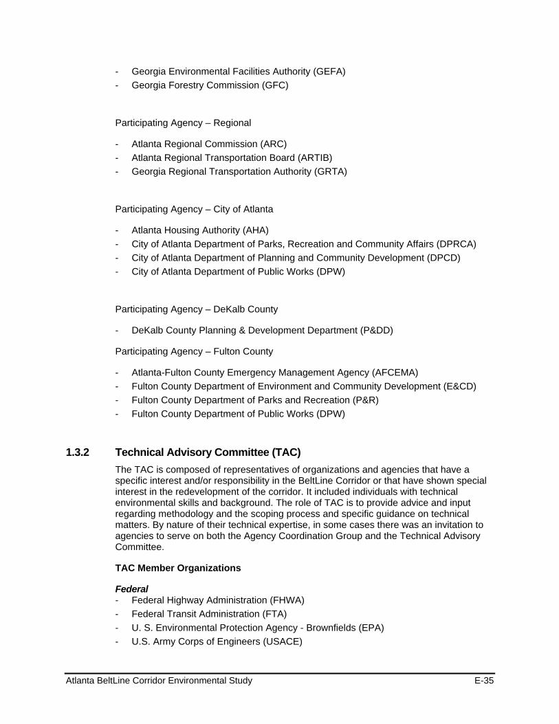
Atlanta BeltLine Corridor Environmental Study E-35
- Georgia Environmental Facilities Authority (GEFA) - Georgia Forestry Commission (GFC)
Participating Agency – Regional
- Atlanta Regional Commission (ARC) - Atlanta Regional Transportation Board (ARTIB) - Georgia Regional Transportation Authority (GRTA)
Participating Agency – City of Atlanta
- Atlanta Housing Authority (AHA) - City of Atlanta Department of Parks, Recreation and Community Affairs (DPRCA) - City of Atlanta Department of Planning and Community Development (DPCD) - City of Atlanta Department of Public Works (DPW)
Participating Agency – DeKalb County
- DeKalb County Planning & Development Department (P&DD)
Participating Agency – Fulton County
- Atlanta-Fulton County Emergency Management Agency (AFCEMA) - Fulton County Department of Environment and Community Development (E&CD) - Fulton County Department of Parks and Recreation (P&R) - Fulton County Department of Public Works (DPW)
1.3.2 Technical Advisory Committee (TAC) The TAC is composed of representatives of organizations and agencies that have a specific interest and/or responsibility in the BeltLine Corridor or that have shown special interest in the redevelopment of the corridor. It included individuals with technical environmental skills and background. The role of TAC is to provide advice and input regarding methodology and the scoping process and specific guidance on technical matters. By nature of their technical expertise, in some cases there was an invitation to agencies to serve on both the Agency Coordination Group and the Technical Advisory Committee.
TAC Member Organizations
Federal - Federal Highway Administration (FHWA) - Federal Transit Administration (FTA) - U. S. Environmental Protection Agency - Brownfields (EPA) - U.S. Army Corps of Engineers (USACE)
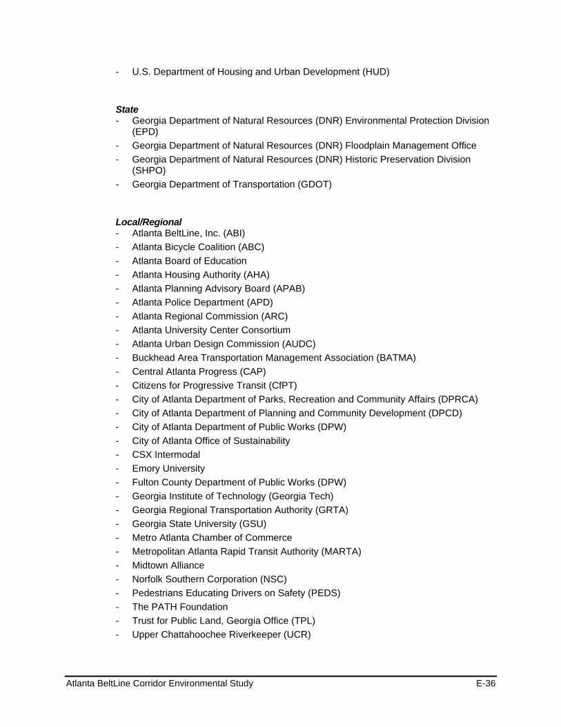
Atlanta BeltLine Corridor Environmental Study E-36
- U.S. Department of Housing and Urban Development (HUD)
State - Georgia Department of Natural Resources (DNR) Environmental Protection Division
(EPD) - Georgia Department of Natural Resources (DNR) Floodplain Management Office - Georgia Department of Natural Resources (DNR) Historic Preservation Division
(SHPO) - Georgia Department of Transportation (GDOT)
Local/Regional - Atlanta BeltLine, Inc. (ABI) - Atlanta Bicycle Coalition (ABC) - Atlanta Board of Education - Atlanta Housing Authority (AHA) - Atlanta Planning Advisory Board (APAB) - Atlanta Police Department (APD) - Atlanta Regional Commission (ARC) - Atlanta University Center Consortium - Atlanta Urban Design Commission (AUDC) - Buckhead Area Transportation Management Association (BATMA) - Central Atlanta Progress (CAP) - Citizens for Progressive Transit (CfPT) - City of Atlanta Department of Parks, Recreation and Community Affairs (DPRCA) - City of Atlanta Department of Planning and Community Development (DPCD) - City of Atlanta Department of Public Works (DPW) - City of Atlanta Office of Sustainability - CSX Intermodal - Emory University - Fulton County Department of Public Works (DPW) - Georgia Institute of Technology (Georgia Tech) - Georgia Regional Transportation Authority (GRTA) - Georgia State University (GSU) - Metro Atlanta Chamber of Commerce - Metropolitan Atlanta Rapid Transit Authority (MARTA) - Midtown Alliance - Norfolk Southern Corporation (NSC) - Pedestrians Educating Drivers on Safety (PEDS) - The PATH Foundation - Trust for Public Land, Georgia Office (TPL) - Upper Chattahoochee Riverkeeper (UCR)

Atlanta BeltLine Corridor Environmental Study E-37
1.3.3 Stakeholder Advisory Committee (SAC) The Stakeholder Advisory Committee (SAC), composed of representatives from a variety of area organizations, serves a key role in encouraging public participation. A Stakeholder Advisory Committee provided ongoing assistance to the project, especially in the outreach component. Representatives from a variety of area organizations, such as the TADAC, MARTA’s network of citizen and business organizations, faith-based organizations, community-based organizations, and advocacy groups composed the SAC. The SAC provided input and comments on the project findings, and played a key role in generating participation from the public at large. Below is a list of SAC members:
SAC Member Organizations
- Atlanta BeltLine Inc. (ABI) - Atlanta Planning Advisory Board - Atlanta Transit Riders' Union - BeltLine Network - Clean Air Campaign - Coalition for the Peoples' Agenda - Environmental Justice Resource Center @ CAU - Georgia Conservancy - Georgia Power Company - Georgia Stand Up - Georgians for Better Transportation - Governor's Council on Developmental Disabilities - MARTA Elderly & Disabled Advisory Committee – Chair - MARTA Elderly & Disabled Advisory Committee – Vice Chair - MARTA Elderly & Disabled Advisory Committee – Accessibility - MARTA Elderly & Disabled Advisory Committee – Customer Focus - MARTA Elderly & Disabled Advisory Committee-Membership and Resource - Metropolitan Atlanta Rapid Transit Authority (MARTA) - Neighborhood Planning Unit – B - Neighborhood Planning Unit – C - Neighborhood Planning Unit – D - Neighborhood Planning Unit – E - Neighborhood Planning Unit – F & TADAC Committee Environmental Task Force - Neighborhood Planning Unit – G - Neighborhood Planning Unit – J - Neighborhood Planning Unit – K - Neighborhood Planning Unit – L - Neighborhood Planning Unit – M - Neighborhood Planning Unit – N - Neighborhood Planning Unit – S - Neighborhood Planning Unit – T - Neighborhood Planning Unit – V - Neighborhood Planning Unit – W
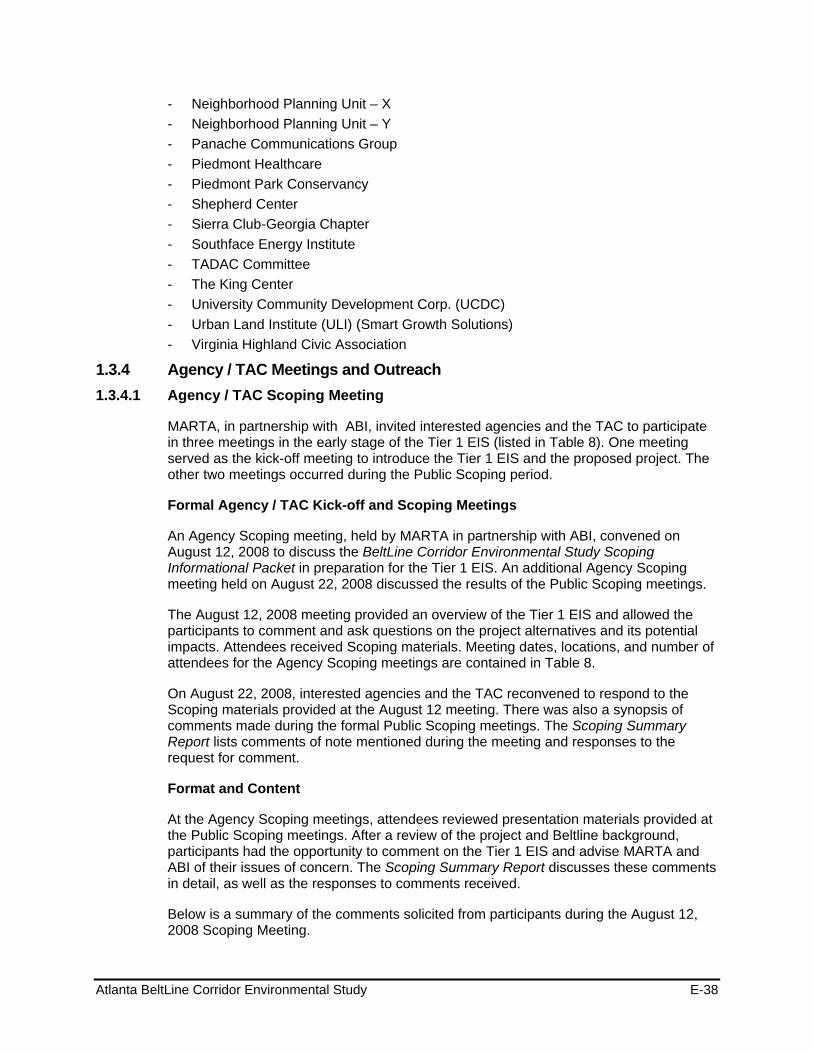
Atlanta BeltLine Corridor Environmental Study E-38
- Neighborhood Planning Unit – X - Neighborhood Planning Unit – Y - Panache Communications Group - Piedmont Healthcare - Piedmont Park Conservancy - Shepherd Center - Sierra Club-Georgia Chapter - Southface Energy Institute - TADAC Committee - The King Center - University Community Development Corp. (UCDC) - Urban Land Institute (ULI) (Smart Growth Solutions) - Virginia Highland Civic Association
1.3.4 Agency / TAC Meetings and Outreach 1.3.4.1 Agency / TAC Scoping Meeting
MARTA, in partnership with ABI, invited interested agencies and the TAC to participate in three meetings in the early stage of the Tier 1 EIS (listed in Table 8). One meeting served as the kick-off meeting to introduce the Tier 1 EIS and the proposed project. The other two meetings occurred during the Public Scoping period.
Formal Agency / TAC Kick-off and Scoping Meetings
An Agency Scoping meeting, held by MARTA in partnership with ABI, convened on August 12, 2008 to discuss the BeltLine Corridor Environmental Study Scoping Informational Packet in preparation for the Tier 1 EIS. An additional Agency Scoping meeting held on August 22, 2008 discussed the results of the Public Scoping meetings.
The August 12, 2008 meeting provided an overview of the Tier 1 EIS and allowed the participants to comment and ask questions on the project alternatives and its potential impacts. Attendees received Scoping materials. Meeting dates, locations, and number of attendees for the Agency Scoping meetings are contained in Table 8.
On August 22, 2008, interested agencies and the TAC reconvened to respond to the Scoping materials provided at the August 12 meeting. There was also a synopsis of comments made during the formal Public Scoping meetings. The Scoping Summary Report lists comments of note mentioned during the meeting and responses to the request for comment.
Format and Content
At the Agency Scoping meetings, attendees reviewed presentation materials provided at the Public Scoping meetings. After a review of the project and Beltline background, participants had the opportunity to comment on the Tier 1 EIS and advise MARTA and ABI of their issues of concern. The Scoping Summary Report discusses these comments in detail, as well as the responses to comments received.
Below is a summary of the comments solicited from participants during the August 12, 2008 Scoping Meeting.
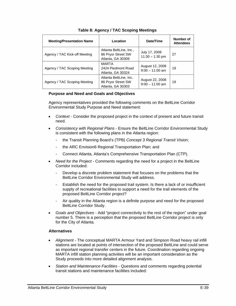
Atlanta BeltLine Corridor Environmental Study E-39
Table 8: Agency / TAC Scoping Meetings
Meeting/Presentation Name Location Date/Time Number of Attendees
Agency / TAC Kick-off Meeting Atlanta BeltLine, Inc., 86 Pryor Street SW Atlanta, GA 30309
July 17, 2008 11:30 – 1:30 pm 27
Agency / TAC Scoping Meeting MARTA 2424 Piedmont Road Atlanta, GA 30324
August 12, 2008 9:00 – 11:00 am 19
Agency / TAC Scoping Meeting Atlanta BeltLine, Inc. 86 Pryor Street SW Atlanta, GA 30303
August 22, 2008 9:00 – 11:00 am 19
Purpose and Need and Goals and Objectives
Agency representatives provided the following comments on the BeltLine Corridor Environmental Study Purpose and Need statement:
Context - Consider the proposed project in the context of present and future transit need.
Consistency with Regional Plans - Ensure the BeltLine Corridor Environmental Study is consistent with the following plans in the Atlanta region:
- the Transit Planning Board’s (TPB) Concept 3 Regional Transit Vision;
- the ARC Envision6 Regional Transportation Plan; and
- Connect Atlanta, Atlanta’s Comprehensive Transportation Plan (CTP).
Need for the Project - Comments regarding the need for a project in the BeltLine Corridor included:
- Develop a discrete problem statement that focuses on the problems that the BeltLine Corridor Environmental Study will address.
- Establish the need for the proposed trail system. Is there a lack of or insufficient supply of recreational facilities to support a need for the trail elements of the proposed BeltLine Corridor project?
- Air quality in the Atlanta region is a definite purpose and need for the proposed BeltLine Corridor Study.
Goals and Objectives - Add “project connectivity to the rest of the region” under goal number 5. There is a perception that the proposed BeltLine Corridor project is only for the City of Atlanta.
Alternatives
Alignment - The conceptual MARTA Armour Yard and Simpson Road heavy rail infill stations are located at points of intersection of the proposed BeltLine and could serve as important regional transfer centers in the future. Coordination regarding ongoing MARTA infill station planning activities will be an important consideration as the Study proceeds into more detailed alignment analysis.
Station and Maintenance Facilities - Questions and comments regarding potential transit stations and maintenance facilities included:
Atlanta BeltLine Corridor Environmental Study E-40
- Will station locations and maintenance facilities be considered in the Tier 1 EIS?
- The Tier 1 EIS should address access to and from the proposed station to connecting bicycle facilities.
- It is important to ensure that multi-use facilities are designed to accommodate safe travel by cyclists and pedestrians and that they safely interface with existing and proposed transit and roadway facilities.
Mode - Consider treating bicycle and pedestrian travel as separate modes in order to reflect the different needs of the two groups.
Trails - Provide additional detail regarding the characteristics of the proposed multi-use trail (width, amenities, etc.). Similar detail should be provided for the sections that will not be in the existing ROW (e.g., on-street facilities).
Connectivity
It is important to think about both positive and negative impacts of connectivity.
Environmental Quality
Air Quality - The air quality analysis should compare a build versus no build scenario and show presumable air quality benefits, mitigation of potential releases of air toxins after project completion and compliance with air quality standards.
Brownfields and Hazardous Materials - Provide a methodology of how Brownfields and hazardous materials/wastes located within the Study area will be treated. The methodology should include: the identification and characterization of hazardous/contaminated sites; safety plans and procedures, including use of pesticides/herbicides; worker training; spill prevention; and a containment and countermeasures plan.
Community and Neighborhood Impacts - The Tier 1 EIS should provide special consideration and planning for the following:
- Pedestrian infrastructure, including sidewalks that are continuous, accessible, safe and aesthetically pleasing; adequate pedestrian crossings that are convenient and easily identified by motorists.
- Sufficiently marked, continuous lanes and infrastructure needs for bicyclists.
- Americans with Disabilities Act (ADA) accessibility compliance for all project areas.
- Consideration of beneficial and adverse long-term land use impacts, including the potential influx of people into the area as a result of a proposed project and associated impacts.
- Special demographic considerations - e.g., hospitals, nursing homes, day care centers, schools.
- Special consideration and appropriate mitigation for necessary relocation and other potential adverse impacts to residential areas, community cohesion and community services.
Environmental Justice - Describe the potential impacts of the proposed BeltLine Corridor project on minority groups and low-income groups residing within the Study area.

Atlanta BeltLine Corridor Environmental Study E-41
Historic and Cultural Resources - Historic and cultural resources located within the Study area should be considered.
Land Use - The proposed BeltLine Corridor project is depicted on the ARC Urban Growth Policy Map (UGPM). The UGPM and an associated Development Matrix provide guidance for the appropriate design and scale of development that should occur with infrastructure availability to efficiently meet the forecasted population and growth of the Atlanta region. The UGPM envisions that the station areas of the BeltLine will become “transit villages” on a scale with other fixed guideway transit areas, which would be a mixed-use, walkable area with transit-supportive residential density.
Noise - Identify projected elevated noise levels at sensitive receptors - i.e., residential, schools, hospitals - and appropriate mitigation plans during and after construction.
Parks and Recreation - The following comments/questions were made regarding parks and recreation facilities located within the BeltLine Study area:
- Does a representative from either the National Park Service or the USDOI need to be consulted as part of the BeltLine Corridor Environmental Study?
- Outside of the recreational aspects identified, impacts to National Parks that exist in the BeltLine Study area are of concern.
- There needs to be a distinct definition of greenspace and trail.
Utilities - Solid waste generation, reduction and disposal should be considered in the Tier 1 EIS.
Water Resources - Special consideration should be made to the water quality/quantity, including private and public potable water supply; ground and surface water resources; ground and surface water contamination; compliance with water quality and wastewater treatment standards; potential contamination of underlying aquifers; and contamination of the food chain.
Mitigation - Mitigation plans that protect the environment and promote public health should be described in the Tier 1 EIS wherever warranted.
Construction Impacts
Some agency representatives recommended that the Study would need to comply with appropriate criteria and guidelines to ensure worker safety and health during construction. It was further recommended that during construction, proper mitigation measures should be implemented to control runoff and dust.
Costs and Financial Plan
Regarding project costs and potential funding sources for the proposed BeltLine Corridor project, the following agency comments were received:
If a new regional sales tax or some kind of new funding resource were to be pursued in the Tier 1 phase establishing the BeltLine as a locally funded project, how would the NEPA process be impacted?
BeltLine planning activities should anticipate a variety of possible funding scenarios, and preserving funding flexibility should be a key objective throughout the EIS process.
Atlanta BeltLine Corridor Environmental Study E-42
Project Administration and Process
More certainty will be needed with regard to the transit right-of-way to ensure that private development can move forward and plan effectively for transit service or bike/pedestrian facilities when they become available.
During the BeltLine Corridor Environmental Study, coordination and collaboration with public health professionals in the Fulton County Department of Health and Wellness and the Georgia Department of Human Resources (Division of Public Health), and with local academic institutions including Emory University (Rollins School of Public Health), Georgia State University (Institute of Public Health), Georgia Institute of Technology (Center for Quality Growth and Regional Development), and Morehouse College (Public Health Sciences Institute) should be made to accomplish adequate health analysis and development of appropriate mitigation measures.
Recommendations from the Health Impact Assessment (HIA) that was conducted on the proposed BeltLine Corridor project by the Center for Quality Growth and Regional Development at the Georgia Institute of Technology should be considered in the EIS process.
1.3.4.2 Agency / TAC and Client Group Meeting on the EER and the Evaluation Criteria
MARTA, in partnership with ABI, held a meeting on March 23, 2009 with interested agencies and the TAC to review and discuss the results of the analysis of existing conditions, recap the Environmental Effects Report, review and discuss the proposed Evaluation Criteria, and to prepare for upcoming public workshop.
Format and Content
The Agency / TAC meeting began with a viewing of project display boards. There was a discussion on the purpose of the meeting followed by a presentation on key project milestones, highlights of the Environmental Effects Report and Evaluation Criteria, and discussion on the upcoming public workshops, and the next steps in the study process.
Following the presentation, the attendees formed two groups to review the Evaluation Criteria, specifically the Performance Measures. The purpose of this exercise was to get a consensus that the Performance Measures aligned with the Goals and Objectives of the project, and any revisions or additions to the Evaluation Criteria.
1.3.4.3 Additional TAC / Agency Meetings on Alternative Alignments
Atlanta Development Authority (ADA) Workshop
A project workshop, held on May 28, 2009, provided an opportunity for the Atlanta Development Authority (ADA) staff and Atlanta’s Economic Development Sub-Cabinet to review and comment on the alternatives considered for the BeltLine project.
Agency / TAC Workshop
A TAC workshop took place on June 2, 2009 to review and comment on the alternatives considered.
Atlanta BeltLine Corridor Environmental Study E-43
MARTA Workshop
MARTA staff participated in a workshop on July 9, 2009 to review and comment on the alternatives considered.
Format and Content
Workshops with ADA, TAC, and MARTA followed a format that was similar to the public workshops including a brief presentation and interactive breakout group exercise focused on soliciting comments and suggestions relative to the project alignments, station locations, and service types considered for the BeltLine project. The Public and Committee Workshops April-June 2009 report includes the meeting notes for the Agency / TACand ADA meetings. The MARTA Workshop was documented separately. Table 10 shows the meetings held with the Agency and TAC in Phases 2 and 3.
Section 0 provides a summary of the input received following the Public Workshops.
1.3.4.4 Additional Agency / TAC Meetings on Alternatives Evaluation
Agency / TAC
An Agency / TAC meeting was held on November 2, 2009 to review the results of the analysis of the transit and trails alternatives, how committee and public comments were incorporated into the analysis and to solicit comments and issues from attendees.
ADA Economic Development Sub-Cabinet
A project meeting held on November 12, 2009 provided an opportunity for the Sub-Cabinet to review and comment on the alternatives considered and the evaluation process for the BeltLine project. The Sub-Cabinet includes representatives from various City of Atlanta departments, including Department of Public Works, Planning and Community Development , Police, Fire, Watershed Management, Parks, etc.
Format and Content
The meetings with Agency / TAC and ADA followed a format that was similar to the public meetings including an open house section with a series of project display boards and video that described and demonstrated the various transit and trails options.
1.3.4.5 Notification and Advertisements for Technical Advisory and Agency Committee Workshops
Committee members received email notices two weeks prior to the meetings. Within two days of the meetings, committee members were telephoned to confirm attendance.
1.3.5 SAC Meetings and Outreach 1.3.5.1 Formal Stakeholder Advisory Committee Kick-off Meeting
The kick-off meeting for the Stakeholder Advisory Committee, held by ABI in partnership with MARTA on July 22, 2008, introduced the project, the environmental process, and project milestones, and discussed the role of the SAC. There was also encouragement of the SAC to solicit community participation throughout the Tier 1 EIS.
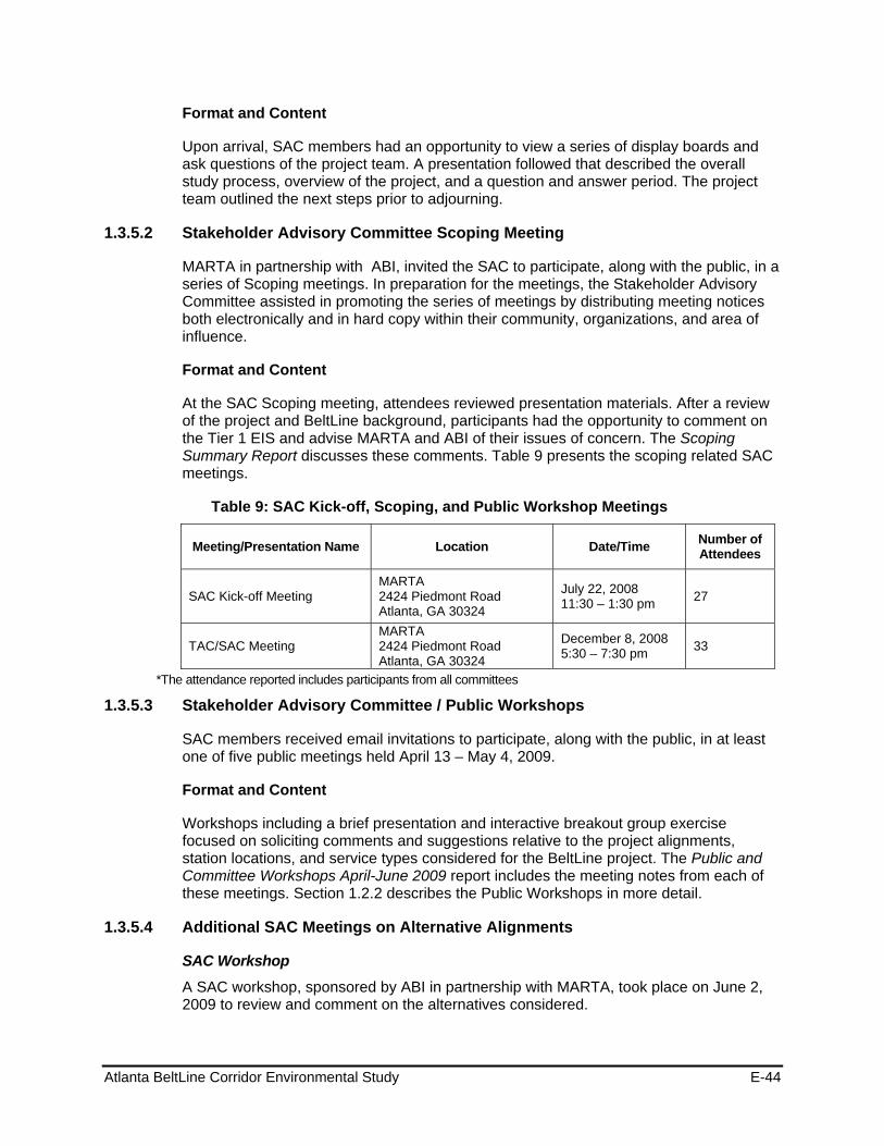
Atlanta BeltLine Corridor Environmental Study E-44
Format and Content
Upon arrival, SAC members had an opportunity to view a series of display boards and ask questions of the project team. A presentation followed that described the overall study process, overview of the project, and a question and answer period. The project team outlined the next steps prior to adjourning.
1.3.5.2 Stakeholder Advisory Committee Scoping Meeting
MARTA in partnership with ABI, invited the SAC to participate, along with the public, in a series of Scoping meetings. In preparation for the meetings, the Stakeholder Advisory Committee assisted in promoting the series of meetings by distributing meeting notices both electronically and in hard copy within their community, organizations, and area of influence.
Format and Content
At the SAC Scoping meeting, attendees reviewed presentation materials. After a review of the project and BeltLine background, participants had the opportunity to comment on the Tier 1 EIS and advise MARTA and ABI of their issues of concern. The Scoping Summary Report discusses these comments. Table 9 presents the scoping related SAC meetings.
Table 9: SAC Kick-off, Scoping, and Public Workshop Meetings
Meeting/Presentation Name Location Date/Time Number of Attendees
SAC Kick-off Meeting MARTA 2424 Piedmont Road Atlanta, GA 30324
July 22, 2008 11:30 – 1:30 pm 27
TAC/SAC Meeting MARTA 2424 Piedmont Road Atlanta, GA 30324
December 8, 2008 5:30 – 7:30 pm 33
*The attendance reported includes participants from all committees
1.3.5.3 Stakeholder Advisory Committee / Public Workshops
SAC members received email invitations to participate, along with the public, in at least one of five public meetings held April 13 – May 4, 2009.
Format and Content
Workshops including a brief presentation and interactive breakout group exercise focused on soliciting comments and suggestions relative to the project alignments, station locations, and service types considered for the BeltLine project. The Public and Committee Workshops April-June 2009 report includes the meeting notes from each of these meetings. Section 1.2.2 describes the Public Workshops in more detail.
1.3.5.4 Additional SAC Meetings on Alternative Alignments
SAC Workshop
A SAC workshop, sponsored by ABI in partnership with MARTA, took place on June 2, 2009 to review and comment on the alternatives considered.
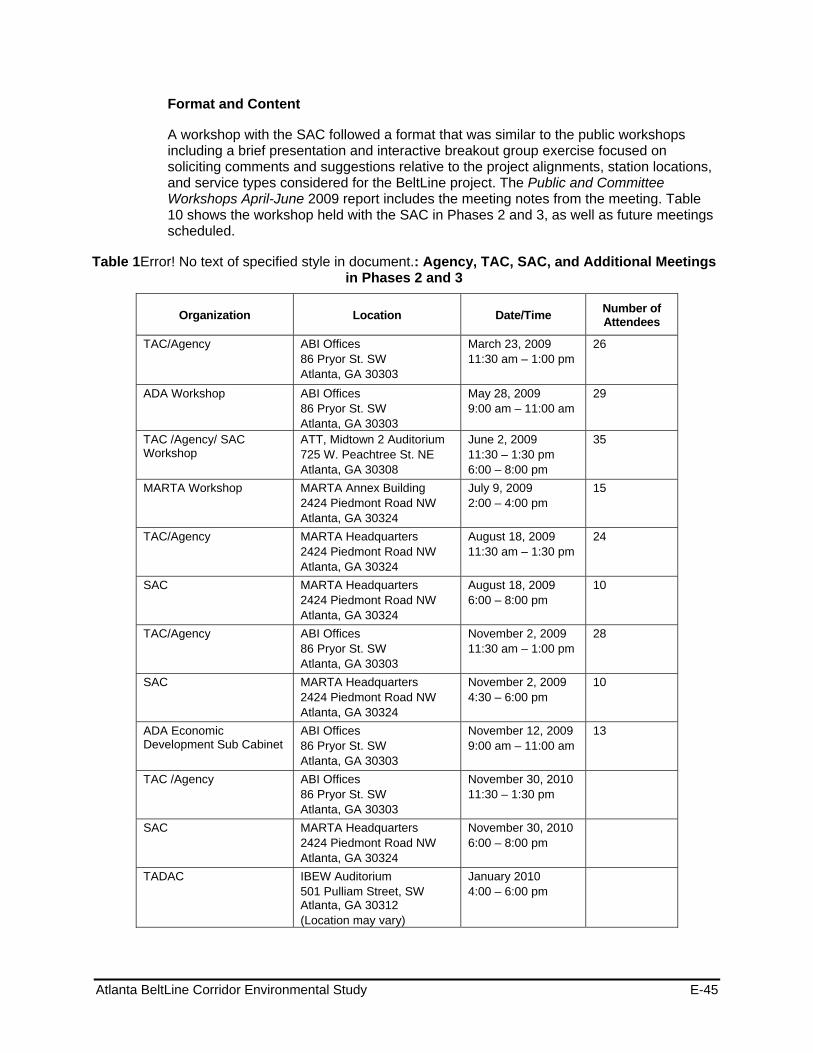
Atlanta BeltLine Corridor Environmental Study E-45
Format and Content
A workshop with the SAC followed a format that was similar to the public workshops including a brief presentation and interactive breakout group exercise focused on soliciting comments and suggestions relative to the project alignments, station locations, and service types considered for the BeltLine project. The Public and Committee Workshops April-June 2009 report includes the meeting notes from the meeting. Table 10 shows the workshop held with the SAC in Phases 2 and 3, as well as future meetings scheduled.
Table 1Error! No text of specified style in document.: Agency, TAC, SAC, and Additional Meetings in Phases 2 and 3
Organization Location Date/Time Number of Attendees
TAC/Agency ABI Offices 86 Pryor St. SW Atlanta, GA 30303
March 23, 2009 11:30 am – 1:00 pm
26
ADA Workshop ABI Offices 86 Pryor St. SW Atlanta, GA 30303
May 28, 2009 9:00 am – 11:00 am
29
TAC /Agency/ SAC Workshop
ATT, Midtown 2 Auditorium 725 W. Peachtree St. NE Atlanta, GA 30308
June 2, 2009 11:30 – 1:30 pm 6:00 – 8:00 pm
35
MARTA Workshop MARTA Annex Building 2424 Piedmont Road NW Atlanta, GA 30324
July 9, 2009 2:00 – 4:00 pm
15
TAC/Agency MARTA Headquarters 2424 Piedmont Road NW Atlanta, GA 30324
August 18, 2009 11:30 am – 1:30 pm
24
SAC MARTA Headquarters 2424 Piedmont Road NW Atlanta, GA 30324
August 18, 2009 6:00 – 8:00 pm
10
TAC/Agency ABI Offices 86 Pryor St. SW Atlanta, GA 30303
November 2, 2009 11:30 am – 1:00 pm
28
SAC MARTA Headquarters 2424 Piedmont Road NW Atlanta, GA 30324
November 2, 2009 4:30 – 6:00 pm
10
ADA Economic Development Sub Cabinet
ABI Offices 86 Pryor St. SW Atlanta, GA 30303
November 12, 2009 9:00 am – 11:00 am
13
TAC /Agency ABI Offices 86 Pryor St. SW Atlanta, GA 30303
November 30, 2010 11:30 – 1:30 pm
SAC MARTA Headquarters 2424 Piedmont Road NW Atlanta, GA 30324
November 30, 2010 6:00 – 8:00 pm
TADAC IBEW Auditorium 501 Pulliam Street, SW Atlanta, GA 30312 (Location may vary)
January 2010 4:00 – 6:00 pm
Atlanta BeltLine Corridor Environmental Study E-46
Organization Location Date/Time Number of Attendees
TAC / Agency ABI Offices 86 Pryor St. SW Atlanta, GA 30303
February 2010 11:30 – 1:00
SAC MARTA Headquarters 2424 Piedmont Road NW Atlanta, GA 30324
February 2010 6:00 – 8:00 pm
TADAC IBEW Auditorium 501 Pulliam Street SW Atlanta, GA 30312
February 2010 4:00 – 6:00 pm
Section 0 provides a summary of the input received following the Public Workshops.
1.3.5.5 Additional SAC Meetings on Alternatives Evaluated
A SAC meeting, held by ABI in partnership with MARTA, was held on November 2, 2009 to review the results of the analysis of the transit and trails alternatives, how committee and public comments were incorporated into the analysis and to solicit comments and issues from attendees.
1.3.5.6 Notification for Stakeholder Advisory Committee Meetings
Stakeholder Advisory Committee members are notified of meetings by way of email notices and telephone notification two weeks prior to the meetings. Within two days of the meetings, phone call reminders encouraged members to attend the meeting.
1.3.6 Spring 2009 Post Public Workshop Agency / TAC and SAC Meetings Comments Received Described below is a broad summary of comments and input received from TAC, SAC, and Agency meetings and workshops following the Public Workshops.
SERVICE
Service Type and Characteristics – Participants were asked to provide feedback on the basic types of transit service, local service or regional service desired. The group was also asked about preferences regarding the type of service vehicle, access to the system and travel time once on the vehicle. Following is the list of the comments and questions received:
Development drives the types of destinations travelers wish to access; local service best drives economic development
Travelers are time-sensitive, and timeliness and availability are key factors in attracting and retaining ridership:
- Frequency of service
- Periods of operation – 24-hour or late-night service
- Travel time through the corridor
Regardless of service type, the system should be designed to maximize ridership potential
Local service type is more in line with the original intent of the project
Atlanta BeltLine Corridor Environmental Study E-47
Shuttle system would not be convenient for users
Transit design should provide for a user-friendly system
Transit design should provide for multiple community connections
Transit design should maximize opportunities for access
Transit system should place users closer to destinations and activity areas
More stations versus fewer stations is preferable
Do not use the term ―regional to describe transit system; Beltline is a local service to complement the existing MARTA system
Fare collection system should be determined
Local service type is preferable for the entire corridor; do not mix local service with regional service; a hybrid system should not be considered
Transit system design analysis should weigh options against time saved when compared to driving a car
Limit the number of station locations in undeveloped sections of the corridor; instead use stations to encourage redevelopment
Strong preference for local service; regional is bad term and not desired
No parking at BeltLine stations
Some parking at those MARTA stations that connect to BeltLine
Access to MARTA and other regional transit is important
Include express transit service with skip stops
Wants more stops, less like MARTA heavy rail
Tie service frequency to centers, density, jobs and activities
Some stations serve major centers while others serve smaller more local
Wants the ability to bypass stations
Maximize ridership
Use feeder services to support faster regional travel
Consider skip-stop operations during peak periods, or other hybrid local/regional operations
Apply cost-effectiveness criteria
One-half (½) mile station spacing seems appropriate for the Beltline
Consider a mix of service types depending on time of day and peak hours
Consider bypassing some stations during peak hours to provide faster service
Consider different types of transit technologies in the corridor (i.e., Portland, Organ provides an example of streetcar and light rail sharing tracks
Character of the Beltline transit system should be different from the existing MARTA heavy rail transit system in terms of speed, station spacing, and transfers

Atlanta BeltLine Corridor Environmental Study E-48
Vehicle speed should respond to the surrounding neighborhood conditions
Seamless transitions from Beltline to MARTA heavy rail stations
Minimize impacts to the community
Provide service for other than work trips
Concern about frequency of service based on type of vehicles, location of stations
Create the stations, but activate as needed – not all active right away
Prefers streetcar; its more adaptable and cost-effective to operate
Provide neighborhood-oriented access, part of original BeltLine transit concept
Consider impact to DeKalb Avenue-Moreland Avenue interchange
Travel time important for travelers going through/across zones in BeltLine Corridor
Consider ―skip-stops and other hybrid local-regional options
Minimize pedestrian access time
Neighborhoods/Areas of Interest – After describing the general alignment, participants were asked to describe service that would compliment/fit specific neighborhoods/areas.
Connect to recreation opportunities
Areas of Interest – The group was also asked to identify specific areas of interest/concern.
Atlanta University Center
Fort McPherson
Piedmont Hospital
Midtown
Ansley Park/Monroe Drive area
Little 5 Points
Miami Circle (north of Lindbergh Center)
Westside Park
Retail and medical centers
o Ansley Mall
o Piedmont Park area at Virginia/Monroe
o Amsterdam Walk
o Howell Mill near I-75
Northside Drive
Monroe Drive near I-85/Buford Highway Connector
Corridor-wide
Right-of-way impacts
Atlanta BeltLine Corridor Environmental Study E-49
Need for better east-west connectivity
Accessibility to both major trip destinations (activity centers, employment) and trip origins
More direct access to major activity centers along BeltLine Corridor (ex. Piedmont Hospital)
Connections needed to all MARTA heavy rail stations near BeltLine (ex. Bankhead Station)
Connect to existing and planned transit services
Integration with surrounding land use
Quality design (do not sacrifice in the interest of minimizing right-of-way or avoiding impacts)
West End Station
Consider an in-fill MARTA heavy rail station between West End Station and Oakland City Station versus a spur connection to West End Station
Compare cost of infill station versus cost of spur connection
A through loop may be better than a spur in and out
Accessibility for students in the Atlanta University Center
Consider an alignment option using Metropolitan Avenue and across Ralph David Abernathy Boulevard to West End Station
Backing in and out of West End MARTA Station creates safety and operational concerns
Bankhead Station
Provide a direct connection or walkable connection Bankhead Station
Enhance sidewalks along Donald Lee Hollowell Parkway to provide a pedestrian connection from the Beltline corridor to Bankhead Station. This is approximately 1,500 linear feet and would be about a five to six minute walk
Westside Park
Consider an alternate transit alignment to provide closer access to Westside Park
Consider an alternate transit alignment to provide access into the center of Westside Park
Consider using the existing Georgia Power right-of-way as a route to provide access to Westside Park
Inman Park/Reynoldstown Station
Consider locating the transit alignment along Edgewood Avenue versus DeKalb Avenue
Transit alignment should provide better access to the Inman Park neighborhood and Little Five Points commercial district
Atlanta BeltLine Corridor Environmental Study E-50
Transit alignment should continue south along Moreland Avenue to Memorial Drive versus the alignment using Wylie Street
BeltLine Corridor Environmental Study A-1.2-31 June 2009
The transit alignment should not extend to provide service to East Atlanta
Consider an east bound alignment from Inman Park/Reynoldstown MARTA Station using the northbound Moreland Avenue ramp to turn southbound onto Moreland Avenue with an in-creased turning radii
Could have a tunnel transit alignment connecting the north and south Inman Park/ Reynolds- town MARTA Station parking lots
Consider an alignment along Moreland Ave via Euclid Avenue with access to Little 5 Points
Ashby Station
Lena Street has a limited right-of-way width so consider using Martin Luther King, Jr. Drive to connect Beltline to Ashby Station
Inman Park/Reynoldstown Station
The BeltLine alignment and connection to MARTA should consider the possibility of an infill heavy rail station as part of redevelopment at Hulsey Yard
Consider Edgewood Avenue as a possible BeltlLine Alignment
Northeast
Lindbergh area, Emory
Frequency of Service
Trail connections, between Lindbergh Center area and nearby neighborhoods (Piedmont Heights, Peachtree Hills)
Connection along Piedmont Road in Armour area may be the best for operations and development
Connection along Piedmont Road in Armour area may be the best for operations and development
Northwest
The Marietta Boulevard alignment does not have much residential planned, so it might not be the best for transit
Direct connections to Atlantic Station are desirable
Crossing railroad right-of-way between Marietta and Blandtown Huff BeltLine stations Southeast
Bus connection to Grant Park and Zoo may be needed
TRANSIT
The facilitator asked about the features of the proposed transit that are of interest to the group. A video clip was used to facilitate the discussion and to highlight key aspects of
Atlanta BeltLine Corridor Environmental Study E-51
transit features. Features of transit include areas such as vehicle type, attractiveness, size, exclusive and in-street operations, stations, and station locations. Other features included passenger boarding, pedestrian, and automobile crossing. The following sections list the comments, questions, and suggestions that regarding the proposed transit features, alignment and stations.
Transit Features and Alignment
Could the trail spur west of Westside Park from Donald L. Hollowell Parkway be an alternative transit line
How to connect with northwest alignment to the north
Consider redevelopment benefits in choosing among alternative alignments
How does the transit alignment fit in active freight right-of-way
How does the transit alignment function in active street right-of-way
DeKalb Avenue area is a challenge
Lindbergh/Armour area; why have Armour service? Considered to not have too many trip destinations
Need connection to Bellwood Quarry and Bankhead MARTA station – recent LCI for area would support, and be supported by BeltLine transit
Transit could travel on Donald Lee Hollowell between currently proposed BeltLine alignment and Bankhead station
Corridor widths – ROW preservation important – identify pockets of ROW preservation
Prioritized
Use BeltLine as a feeder service to MARTA heavy rail stations, other regional services
Consider smaller vehicles
Consider rubber-tired vehicles
Consider a digital kiosk to inform patrons of wait times at BeltLine station platforms
Fare collection system should allow a seamless transfer to minimize commute times Take advantage of intelligent technology features such as ―next-bus advance notification
Off-board fare collection:
Can support ―skip stop operations
Consider – honor system
Level boarding
Consider turning radii
Consider more in-street operations as alignment alternatives
Pocket tracks will be needed for local trains to switch out of the way of express trains
Atlanta BeltLine Corridor Environmental Study E-52
Transit Stations
Consider multiple stops at major destinations (ex. Westside Park – similar number of stops as Piedmont Park)
If Armour area proceeds as a multimodal, heavy rail infill station, is the BeltLine stop at Lindbergh Center still necessary
Consider connections with other transit modes (ex. Peachtree Streetcar) in identifying stops
Consider infill stations:
- Armour, or Miami Circle
- South of West End MARTA Station
Use trail to support community connections to BeltLine stops
Minimize need for long travel distances from stations
Near development
Near activity centers
Walking access versus park-ride
BeltLine station location planning should be coordinated with BeltLine sub-area planning and existing MARTA patron data
Consider infill stations at Armour, Murphy Triangle (south of West End)
TRAILS
Participants were asked about plans to use the trail and trail features and its functions. Possible functions and features included walking, running, or biking trail, amenities along the trail, street crossings, ramps, pedestrian bridges, tunnels, and alignment. The following sections list the comments, questions, and suggestions made regarding the proposed trail connections and alignment.
Trail Features and Alignment
Provide proper amenities for bicyclists (ex. lockers, storage) throughout corridor
Provide stopping areas for pedestrians including benches, restrooms
How does the trail alignment fit along active street right-of-way
Width – preserve existing open spaces and not focus solely on developing new
Separate bicycle and pedestrian traffic
Establish measures and features for safety and security
Adequate lighting
Provide restrooms
Proper maintenance of trail and amenities
Atlanta BeltLine Corridor Environmental Study E-53
Provide opportunities for artists; apply revenue from art commissions to support operations
Consider funding options
Stream crossings/flood zones
Appropriate signage and way-finding features
Identify multiple-trail options, including more visible trails near streets and neighborhoods
Provide 24-hour access
Consider existing closing times for transit services and public parks
Provide dirt-trail options for runners
Avoid tunnels
Maintain ADA compliant paths along trail to/from MARTA bus stops
Trails too close to transit may be undesirable
GENERAL COMMENTS/QUESTIONS Transit alignment should connect density centers to capture as many riders as
possible
Name stations after each of 45 neighborhoods
Transit alignment should connect density centers to capture as many riders as possible
MARTA infill – greater connectivity between BeltLine and heavy rail
Concern about expense
Service is good for Emory, SW of Lindbergh
MARTA modeled this from previous study—relying on that for this process
Need input from the users
Public outreach in the northeast
1.3.7 Fall 2009 Agency / TAC and SAC Comments Received Described below is a summary of comments and input received from Agency / TAC and SAC meetings:
Alternatives Evaluated
Implementation
Freight-Related Issues
Evaluate the ability to implement the project based on challenges relative to CSX and NS
Consider that CSX interest will wane between now and 2019 in Howell Junction area
Consider the use of three tracks
Atlanta BeltLine Corridor Environmental Study E-54
Property Related Issues
Determine property impacts
Consider the feasibility of requiring residents and businesses in the NW zone that might be selling their properties to provide full disclosure to the buyer so that the buyer would be obligated to allow future easements, etc
Operation
LRT versus Modern Streetcar
Decide between dedicated lanes or shared lanes (along Marietta Blvd)
Relation to Existing MARTA Service
Think about the projected customer of the BeltLine
Think about the client (FTA) and its funding sources
Performance Measures
General Scoring/Methodology
Consider weighting performance measures
Goals/Objectives
Goal 1: Contribute to an integrated regional multi-modal transportation network that promotes seamless intermodal connectivity, increases community access to the existing transit and trail networks and improves reliability of personal travel
Consider using ¼ mile versus ½ mile buffer when assessing activity center connectivity
Be mindful not to mask employment or job centers as “economic development”
Goal 2: Manage and encourage the growth and economic development of the City, region and state by providing transit and transportation improvements to areas designated for growth
Since the TAD boundaries are somewhat based along the CSX alignment, determine if the measure necessarily favors CSX versus the NS alignment
Provide actual data for “underutilized areas”
Goal 3: Preserve and revitalize neighborhoods and business districts through context sensitive design of transit and trails, increased accessibility to mobility options and provision of affordable housing and transportation, and other community benefits
No Comments Received
Goal 4: Provide a cost-effective and efficient transportation investment
No Comments Received
Goal 5: Provide a transit, bicycle and pedestrian friendly environment
Atlanta BeltLine Corridor Environmental Study E-55
No Comments Received
Goal 6: Provide transit, bicycle and pedestrian connectivity among communities, and between communities and existing and planned recreational opportunities.
No Comments Received
Goal 7: Minimize adverse impacts to the environment and foster positive environmental impacts
Lessen impact to those areas identified on water resources maps
Revise “minimizing acres of existing park land…” to make it more affirmative, i.e. “maximize use of BeltLine trails or new trails…” or “maximize use of new park land as well as connectivity to existing park land…”
Goal 8: Ensure consideration of public input throughout project planning and development
No Comments Received
Other Project Considerations
Transit Stations
Define decision for station locations
Trails
Take into account that trail connections are safer running alongside transit and not crossing over roadways and driveways
Concern with pedestrian safety at transit crossings
Consider how current and recent construction of trails fit into EIS process
Gain input from PATH and bicycle community
1.4 Communication Tools Utilization of a variety of collateral materials and communication tools helped to inform and solicit input from the public and agencies. The communication tools complimented and supplemented the outreach effort. These tools include:
Stakeholder Contact Database
Project Website and Email
Newsletter
Study Update
Telephone Hotline and Business Card
Media Relations
Comment Form
Atlanta BeltLine Corridor Environmental Study E-56
1.4.1 Stakeholder Contact Database The project team developed a master database, which expanded over the course of the project. The database listed interested individuals and groups who desired to keep informed of the progress of the study. The database aided in promoting participation at public meetings and to notifying the public of key updates to the project website.
The database includes over 700 entries of individuals representing the public, property owners adjacent to the proposed transit and trails alignments, neighborhood planning units, committees, agencies, elected and public officials, civic and community groups, public interest groups, faith-based organizations, and the business community.
Updates to the stakeholder contact database were ongoing throughout the term of the Tier 1 EIS.
1.4.2 Project Website and Email MARTA hosted a website for the BeltLine Corridor Environmental Study at www.itsmarta.com/Beltline-Corr.aspx.
The ABI/BeltLine Partnership website also links to the project website at http://www.beltline.org/BeltLineBasics/TransitTrailsandTransportation/EnvironmentalImpactStudyEIS/tabid/2936/Default.aspx. ABI also issues blast emails regarding meetings and other events.
The intent of the MARTA website is to provide information and solicit input on the project. It contains a synopsis of the project, frequently asked questions, the Tier 1 EIS schedule, newsletters, and study updates. It also contains Tier 1 EIS reports, links to previous relevant studies, as well as contact information and how citizens can get involved. A comment form is available on the project website. During the project, recording and responding to emailed comments occurred when appropriate. Update of the Comment Summary Database for the project happened as new comments arrived.
The BeltLine Corridor Environmental Study website contained up-to-date information to enable interested parties to electronically access the same information and updates provided in displays at public meetings, in brochures, and through mailers.
1.4.3 Newsletter The team produced and distributed seven newsletters during the project. These publications address major accomplishments in the Tier 1 EIS as well as upcoming events. Distribution both electronically and in hard copy made the publications easily accessible to a greater range of people. The newsletters are available on the BeltLine project website (www.itsmarta.com/Beltline-Corr.aspx; and www.beltline.org/BeltLine Basics/TransitTrailsandTransportation/EnvironmentalImpactStudyEIS/tabid/2936/Default.aspx). Table 11 provides a summary of the Tier 1 EIS Newsletters.
Atlanta BeltLine Corridor Environmental Study E-57
Table 11: Tier 1 EIS Newsletters
Publication Date Lead Story
Newsletter August 2008 Continuing to Lay the Groundwork for Transit & Trails
Newsletter April 2009 BeltLine Corridor Environmental Study Completes its First Milestone
Newsletter August 2009 Public Workshops Bring More Options to the Table
Newsletter (web only) October 2009 Environmental Effects Report Wrap-Up
Newsletter March 2010 Fall 2009 Public Meetings Wrap-Up & Where We Go From Here
Newsletter January 2011 Fact Sheet - Wrapping Up the BeltLine EIS Study
Newsletter April 2011 Results from DEIS Public Hearings
1.4.4 Study Update Six study updates are scheduled during the course of the Tier 1 EIS. These are brief summaries of specific developments, primarily of a technical nature, that have been completed. These updates will be written in easy to understand language and will be suitable for distribution in hard copy and electronically. Table 12 provides a summary of the Tier 1 EIS Study Updates.
Table 12: Tier 1 EIS Study Updates
Publication Date Lead Story
Study Update August 2008 Public Meetings Scheduled
Study Update October 2008 Initial Public Involvement Phase Nearing Completion
Study Update June 2009 Spring Activities
Study Update September 2009 Evaluation Criteria
Study Update (web only) October 2009 Trails
Executive Summary of Environmental Study
May 2011 Tier 1 EIS Wrap-up
1.4.5 Telephone Hotline and Business Card A telephone hotline number allowed interested individuals to contact the Tier 1 EIS team with questions and/or comments regarding the BeltLine Corridor Environmental Study. The number, (404) 524-2070, links to a recorded message in English and Spanish and remained accessible throughout the course of the Tier 1 EIS. The Hotline number appears in all printed information materials and on the project website (www.itsmarta.com/Beltline-Corr.aspx; and www.beltline.org/BeltLineBasics/ TransitTrailsandTransportation/EnvironmentalImpactStudyEIS/tabid/2936/Default.aspx). A business card created specifically for the project contains all the contact information, including the website addresses, and hotline number.
Atlanta BeltLine Corridor Environmental Study E-58
The procedure for collecting and responding to messages left on the Hotline is contained in the PIAC Plan. The Tier 1 EIS team logs and responds to all telephone inquiries. There was encouragement to make formal comments and send written comments via letters, emails, or by using comment cards. There is a complete copy of the telephone logs.
1.4.6 Media Relations Media coverage aided in advertising the study and as a tool to encourage public participation in the development of the Tier 1 EIS. The PIAC Plan contains more than 50 media outlets covered including:
Printed media
Radio
Television
Colleges and universities
Community outlets
1.4.7 Comment Form Comment forms, in English and Spanish, are part of the BeltLine Corridor Environmental Study public outreach program. The comment forms solicit responses that pertain to a variety of specific issues as well as general input on the Tier 1 EIS.
Availability of the comment forms occurred at all meetings and on the project webpage.
Distribution of the first comment forms took place at the Public Scoping meetings, while the second was made available through the BeltLine project website (www.itsmarta.com/newsroom/beltline.html).

Atlanta BeltLine Corridor Environmental Study June 2011
Page Left Intentionally Blank
Atlanta BeltLine Corridor Environmental Study F June 2011
Appendix F - Distribution List
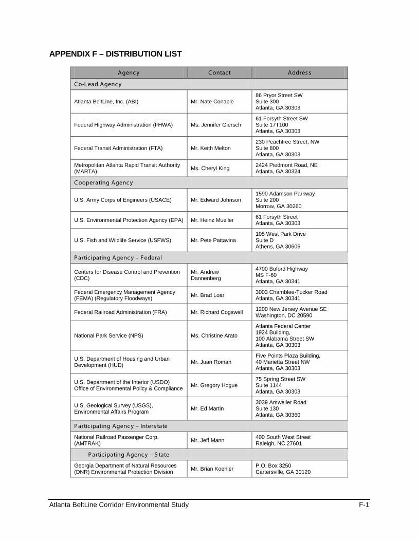
Atlanta BeltLine Corridor Environmental Study F-1
APPENDIX F – DISTRIBUTION LIST
Agenc y C ontact Addres s
C o-L ead Agenc y
Atlanta BeltLine, Inc. (ABI) Mr. Nate Conable 86 Pryor Street SW Suite 300 Atlanta, GA 30303
Federal Highway Administration (FHWA) Ms. Jennifer Giersch 61 Forsyth Street SW Suite 17T100 Atlanta, GA 30303
Federal Transit Administration (FTA) Mr. Keith Melton 230 Peachtree Street, NW Suite 800 Atlanta, GA 30303
Metropolitan Atlanta Rapid Transit Authority (MARTA) Ms. Cheryl King 2424 Piedmont Road, NE
Atlanta, GA 30324
C ooperating Agenc y
U.S. Army Corps of Engineers (USACE) Mr. Edward Johnson 1590 Adamson Parkway Suite 200 Morrow, GA 30260
U.S. Environmental Protection Agency (EPA) Mr. Heinz Mueller 61 Forsyth Street Atlanta, GA 30303
U.S. Fish and Wildlife Service (USFWS) Mr. Pete Pattavina 105 West Park Drive Suite D Athens, GA 30606
P artic ipating Agenc y – F ederal
Centers for Disease Control and Prevention (CDC)
Mr. Andrew Dannenberg
4700 Buford Highway MS F-60 Atlanta, GA 30341
Federal Emergency Management Agency (FEMA) (Regulatory Floodways) Mr. Brad Loar 3003 Chamblee-Tucker Road
Atlanta, GA 30341
Federal Railroad Administration (FRA) Mr. Richard Cogswell 1200 New Jersey Avenue SE Washington, DC 20590
National Park Service (NPS) Ms. Christine Arato
Atlanta Federal Center 1924 Building, 100 Alabama Street SW Atlanta, GA 30303
U.S. Department of Housing and Urban Development (HUD) Mr. Juan Roman
Five Points Plaza Building, 40 Marietta Street NW Atlanta, GA 30303
U.S. Department of the Interior (USDO) Office of Environmental Policy & Compliance Mr. Gregory Hogue
75 Spring Street SW Suite 1144 Atlanta, GA 30303
U.S. Geological Survey (USGS), Environmental Affairs Program Mr. Ed Martin
3039 Amweiler Road Suite 130 Atlanta, GA 30360
P artic ipating Agenc y – Inters tate
National Railroad Passenger Corp. (AMTRAK) Mr. Jeff Mann 400 South West Street
Raleigh, NC 27601
P artic ipating Agenc y – S tate
Georgia Department of Natural Resources (DNR) Environmental Protection Division Mr. Brian Koehler P.O. Box 3250
Cartersville, GA 30120
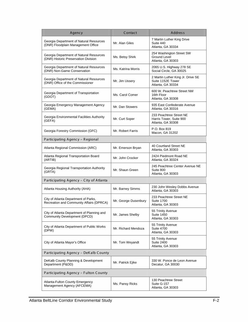
Atlanta BeltLine Corridor Environmental Study F-2
Agenc y C ontact Addres s
Georgia Department of Natural Resources (DNR) Floodplain Management Office Mr. Alan Giles
7 Martin Luther King Drive Suite 440 Atlanta, GA 30334
Georgia Department of Natural Resources (DNR) Historic Preservation Division Ms. Betsy Shirk
254 Washington Street SW Ground Level Atlanta, GA 30303
Georgia Department of Natural Resources (DNR) Non-Game Conservation Ms. Katrina Morris 2065 U.S. Highway 278 SE
Social Circle, GA 30025
Georgia Department of Natural Resources (DNR) Office of the Commissioner Mr. Jim Ussery
2 Martin Luther King Jr. Drive SE Suite 1152E Tower Atlanta, GA 30334
Georgia Department of Transportation (GDOT) Ms. Carol Comer
600 W. Peachtree Street NW 16th Floor Atlanta, GA 30308
Georgia Emergency Management Agency (GEMA) Mr. Dan Stowers 935 East Confederate Avenue
Atlanta, GA 30316
Georgia Environmental Facilities Authority (GEFA) Mr. Curt Soper
233 Peachtree Street NE Harris Tower, Suite 900 Atlanta, GA 30308
Georgia Forestry Commission (GFC) Mr. Robert Farris P.O. Box 819 Macon, GA 31202
P artic ipating Agenc y – R egional
Atlanta Regional Commission (ARC) Mr. Emerson Bryan 40 Courtland Street NE Atlanta, GA 30303
Atlanta Regional Transportation Board (ARTIB) Mr. John Crocker 2424 Piedmont Road NE
Atlanta, GA 30324
Georgia Regional Transportation Authority (GRTA) Mr. Shaun Green
245 Peachtree Center Avenue NE Suite 800 Atlanta, GA 30303
P artic ipating Agenc y – C ity of Atlanta
Atlanta Housing Authority (AHA) Mr. Barney Simms 230 John Wesley Dobbs Avenue Atlanta, GA 30303
City of Atlanta Department of Parks, Recreation and Community Affairs (DPRCA) Mr. George Dusenbury
233 Peachtree Street NE Suite 1700 Atlanta, GA 30303
City of Atlanta Department of Planning and Community Development (DPCD) Mr. James Shelby
55 Trinity Avenue Suite 1450 Atlanta, GA 30303
City of Atlanta Department of Public Works (DPW) Mr. Richard Mendoza
55 Trinity Avenue Suite 4700 Atlanta, GA 30303
City of Atlanta Mayor’s Office Mr. Tom Weyandt 55 Trinity Avenue Suite 2400 Atlanta, GA 30303
P artic ipating Agenc y – DeK alb C ounty
DeKalb County Planning & Development Department (P&DD) Mr. Patrick Ejike 330 W. Ponce de Leon Avenue
Decatur, GA 30030
P artic ipating Agenc y – F ulton C ounty
Atlanta-Fulton County Emergency Management Agency (AFCEMA) Ms. Pansy Ricks
130 Peachtree Street Suite G-157 Atlanta, GA 30303
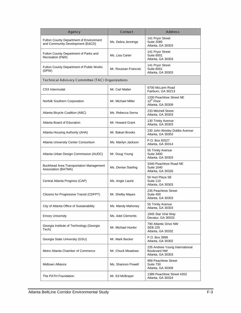
Atlanta BeltLine Corridor Environmental Study F-3
Agenc y C ontact Addres s
Fulton County Department of Environment and Community Development (E&CD) Ms. Debra Jennings
141 Pryor Street Suite 2085 Atlanta, GA 30303
Fulton County Department of Parks and Recreation (P&R) Ms. Lisa Carter
141 Pryor Street Suite 6001 Atlanta, GA 30303
Fulton County Department of Public Works (DPW) Mr. Roussan Francois
141 Pryor Street Suite 6001 Atlanta, GA 30303
Technical Advis ory C ommittee (TAC ) Organizations
CSX Intermodal Mr. Carl Matter 6700 McLarin Road Fairburn, GA 30213
Norfolk Southern Corporation Mr. Michael Miller 1200 Peachtree Street NE 12th Floor Atlanta, GA 30309
Atlanta Bicycle Coalition (ABC) Ms. Rebecca Serna 233 Mitchell Street Atlanta, GA 30303
Atlanta Board of Education Mr. Howard Grant 130 Trinity Avenue Atlanta, GA 30303
Atlanta Housing Authority (AHA) Mr. Bakari Brooks 230 John Wesley Dobbs Avenue Atlanta, GA 30303
Atlanta University Center Consortium Ms. Marilyn Jackson P.O. Box 92527 Atlanta, GA 30314
Atlanta Urban Design Commission (AUDC) Mr. Doug Young 55 Trinity Avenue Suite 3400 Atlanta, GA 30303
Buckhead Area Transportation Management Association (BATMA) Ms. Denise Starling
3340 Peachtree Road NE Suite 1640 Atlanta, GA 30326
Central Atlanta Progress (CAP) Ms. Angie Laurie 50 Hurt Plaza SE Suite 110 Atlanta, GA 30303
Citizens for Progressive Transit (CDFPT) Mr. Shelby Mayes 235 Peachtree Street Suite 400 Atlanta, GA 30303
City of Atlanta Office of Sustainability Ms. Mandy Mahoney 55 Trinity Avenue Atlanta, GA 30303
Emory University Ms. Adel Clements 1945 Star Vine Way Decatur, GA 30033
Georgia Institute of Technology (Georgia Tech) Mr. Michael Hunter
790 Atlantic Drive NW SEB 225 Atlanta, GA 30332
Georgia State University (GSU) Mr. Mark Becker P.O. Box 3999 Atlanta, GA 30302
Metro Atlanta Chamber of Commerce Mr. Chuck Meadows 235 Andrew Young International Boulevard NW Atlanta, GA 30303
Midtown Alliance Ms. Shannon Powell 999 Peachtree Street Suite 730 Atlanta, GA 30309
The PATH Foundation Mr. Ed McBrayer 1389 Peachtree Street #202 Atlanta, GA 30324
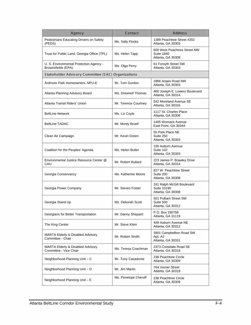
Atlanta BeltLine Corridor Environmental Study F-4
Agenc y C ontact Addres s
Pedestrians Educating Drivers on Safety (PEDS) Ms. Sally Flocks 1389 Peachtree Street #202
Atlanta, GA 30303
Trust for Public Land, Georgia Office (TPL) Ms. Helen Tapp 600 West Peachtree Street NW Suite 1840 Atlanta, GA 30308
U. S. Environmental Protection Agency - Brownsfields (EPA) Ms. Olga Perry 61 Forsyth Street SW
Atlanta, GA 30303
S takeholder Advis ory C ommittee (S AC ) Organizations
Ardmore Park Homeowners, NPU-E Mr. Tom Gordon 1866 Anjaio Road NW Atlanta, GA 30303
Atlanta Planning Advisory Board Ms. Drewnell Thomas 460 Joseph E. Lowery Boulevard Atlanta, GA 30314
Atlanta Transit Riders' Union Mr. Terence Courtney 542 Moreland Avenue SE Atlanta, GA 30316
BeltLine Network Ms. Liz Coyle 1117 St. Charles Place Atlanta, GA 30306
BeltLine TADAC Mr. Monty Bruell 1405 Womack Avenue East Point, GA 30344
Clean Air Campaign Mr. Kevin Green 55 Park Place NE Suite 250 Atlanta, GA 30303
Coalition for the Peoples' Agenda Ms. Helen Butler 100 Auburn Avenue Suite 102 Atlanta, GA 30303
Environmental Justice Resource Center @ CAU Mr. Robert Bullard 223 James P. Brawley Drive
Atlanta, GA 30314
Georgia Conservancy Ms. Katherine Moore 817 W. Peachtree Street Suite 200 Atlanta, GA 30308
Georgia Power Company Mr. Steven Foster 241 Ralph McGill Boulevard Suite 10190 Atlanta, GA 30308
Georgia Stand Up Ms. Deborah Scott 501 Pulliam Street SW Suite 500 Atlanta, GA 30312
Georgians for Better Transportation Mr. Danny Shepard P.O. Box 190758 Atlanta, GA 31119
The King Center Mr. Steve Klein 449 Auburn Avenue NE Atlanta, GA 30312
MARTA Elderly & Disabled Advisory Committee - Chair Mr. Robert Smith
3901 Campbellton Road SW Apt. A2 Atlanta, GA 30331
MARTA Elderly & Disabled Advisory Committee - Vice Chair Ms. Teresa Coachman 2373 Crestdale Road SE
Atlanta, GA 30316
Neighborhood Planning Unit – C Mr. Tony Casadonte 238 Peachtree Circle Atlanta, GA 30309
Neighborhood Planning Unit – D Mr. Jim Martin 764 Verner Street Atlanta, GA 30318
Neighborhood Planning Unit – E Ms. Penelope Cheroff
238 Peachtree Circle Atlanta, GA 30309
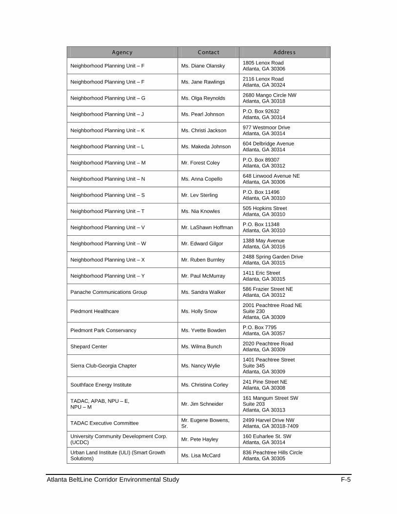
Atlanta BeltLine Corridor Environmental Study F-5
Agenc y C ontact Addres s
Neighborhood Planning Unit – F Ms. Diane Olansky 1805 Lenox Road Atlanta, GA 30306
Neighborhood Planning Unit – F Ms. Jane Rawlings 2116 Lenox Road Atlanta, GA 30324
Neighborhood Planning Unit – G Ms. Olga Reynolds 2680 Mango Circle NW Atlanta, GA 30318
Neighborhood Planning Unit – J Ms. Pearl Johnson P.O. Box 92632 Atlanta, GA 30314
Neighborhood Planning Unit – K Ms. Christi Jackson 977 Westmoor Drive Atlanta, GA 30314
Neighborhood Planning Unit – L Ms. Makeda Johnson 604 Delbridge Avenue Atlanta, GA 30314
Neighborhood Planning Unit – M Mr. Forest Coley P.O. Box 89307 Atlanta, GA 30312
Neighborhood Planning Unit – N Ms. Anna Copello 648 Linwood Avenue NE Atlanta, GA 30306
Neighborhood Planning Unit – S Mr. Lev Sterling P.O. Box 11496 Atlanta, GA 30310
Neighborhood Planning Unit – T Ms. Nia Knowles 505 Hopkins Street Atlanta, GA 30310
Neighborhood Planning Unit – V Mr. LaShawn Hoffman P.O. Box 11348 Atlanta, GA 30310
Neighborhood Planning Unit – W Mr. Edward Gilgor 1388 May Avenue Atlanta, GA 30316
Neighborhood Planning Unit – X Mr. Ruben Burnley 2488 Spring Garden Drive Atlanta, GA 30315
Neighborhood Planning Unit – Y Mr. Paul McMurray 1411 Eric Street Atlanta, GA 30315
Panache Communications Group Ms. Sandra Walker 586 Frazier Street NE Atlanta, GA 30312
Piedmont Healthcare Ms. Holly Snow 2001 Peachtree Road NE Suite 230 Atlanta, GA 30309
Piedmont Park Conservancy Ms. Yvette Bowden P.O. Box 7795 Atlanta, GA 30357
Shepard Center Ms. Wilma Bunch 2020 Peachtree Road Atlanta, GA 30309
Sierra Club-Georgia Chapter Ms. Nancy Wylie 1401 Peachtree Street Suite 345 Atlanta, GA 30309
Southface Energy Institute Ms. Christina Corley 241 Pine Street NE Atlanta, GA 30308
TADAC, APAB, NPU – E, NPU – M Mr. Jim Schneider
161 Mangum Street SW Suite 203 Atlanta, GA 30313
TADAC Executive Committee Mr. Eugene Bowens, Sr.
2499 Harvel Drive NW Atlanta, GA 30318-7409
University Community Development Corp. (UCDC) Mr. Pete Hayley 160 Euharlee St. SW
Atlanta, GA 30314
Urban Land Institute (ULI) (Smart Growth Solutions) Ms. Lisa McCard 836 Peachtree Hills Circle
Atlanta, GA 30305

Atlanta BeltLine Corridor Environmental Study F-6
Agenc y C ontact Addres s
Virginia Highland Civic Association Ms. Pamela Papner 854 Highland Terrace Atlanta, GA 30306
Other Organizations /Agencies
U.S. Congressman John Lewis Mr. Benjamin Spears 100 Peachtree Street NW Suite 1920 Atlanta, GA 30303
U.S. Senator Johnny Isakson Mr. Trey Kilpatrick
One Overton Park 3625 Cumberland Boulevard Suite 970 Atlanta, GA 30339
U.S. Senator Saxby Chambliss Ms. Sara Baska 100 Galleria Parkway Suite 1340 Atlanta, GA 30339
Georgia State Clearinghouse Ms. Barbara Jackson 270 Washington Street, SW 8th Floor Atlanta, Georgia 30334
Georgia State Properties Commission Mr. Steve Stancil 1 Martin Luther King, Jr. Drive Atlanta, GA 30334
State Road and Tollway Authority Ms. Gina Evans 47 Trinity Ave SW # 4 Atlanta, GA 30334-9006
City of Atlanta Mayor Kasim Reed 55 Trinity Avenue SW Atlanta, Georgia 30303
City of Atlanta President Ceasar C. Mitchell
55 Trinity Avenue SW Suite 2900 Atlanta, GA 30303-3584
City of Atlanta Ms.Carla Smith 55 Trinity Avenue SW Suite 2900 Atlanta, GA 30303-3584
City of Atlanta – District 2 Councilmember Kwanza Hall
55 Trinity Avenue SW Suite 2900 Atlanta, GA 30303-3584
City of Atlanta – District 3 Councilmember Ivory Lee Young Jr.
55 Trinity Avenue SW Suite 2900 Atlanta, GA 30303-3584
City of Atlanta – District 4 Councilmember Cleta Winslow
55 Trinity Avenue SW Suite 2900 Atlanta, GA 30303-3584
City of Atlanta – District 5 Councilmember Natalyn Mosby Archibong
55 Trinity Avenue SW Suite 2900 Atlanta, GA 30303-3584
City of Atlanta – District 6 Councilmember Alex Wan
55 Trinity Avenue SW Suite 2900 Atlanta, GA 30303-3584
City of Atlanta – District 7 Councilmember Howard Shook
55 Trinity Avenue SW Suite 2900 Atlanta, GA 30303-3584
City of Atlanta – District 8 Councilmember Yolanda Adrean
55 Trinity Avenue SW Suite 2900 Atlanta, GA 30303-3584
City of Atlanta – District 9 Councilmember Felicia A. Moore
55 Trinity Avenue SW Suite 2900 Atlanta, GA 30303-3584
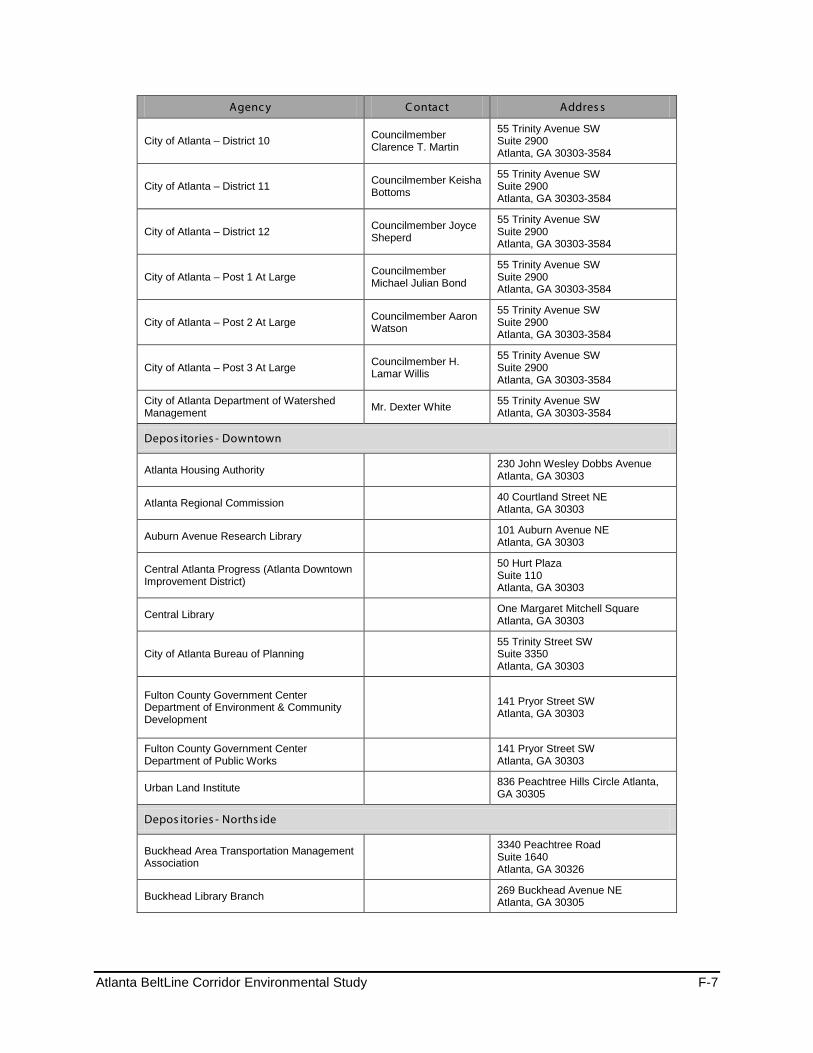
Atlanta BeltLine Corridor Environmental Study F-7
Agenc y C ontact Addres s
City of Atlanta – District 10 Councilmember Clarence T. Martin
55 Trinity Avenue SW Suite 2900 Atlanta, GA 30303-3584
City of Atlanta – District 11 Councilmember Keisha Bottoms
55 Trinity Avenue SW Suite 2900 Atlanta, GA 30303-3584
City of Atlanta – District 12 Councilmember Joyce Sheperd
55 Trinity Avenue SW Suite 2900 Atlanta, GA 30303-3584
City of Atlanta – Post 1 At Large Councilmember Michael Julian Bond
55 Trinity Avenue SW Suite 2900 Atlanta, GA 30303-3584
City of Atlanta – Post 2 At Large Councilmember Aaron Watson
55 Trinity Avenue SW Suite 2900 Atlanta, GA 30303-3584
City of Atlanta – Post 3 At Large Councilmember H. Lamar Willis
55 Trinity Avenue SW Suite 2900 Atlanta, GA 30303-3584
City of Atlanta Department of Watershed Management Mr. Dexter White 55 Trinity Avenue SW
Atlanta, GA 30303-3584
Depos itories - Downtown
Atlanta Housing Authority 230 John Wesley Dobbs Avenue Atlanta, GA 30303
Atlanta Regional Commission 40 Courtland Street NE Atlanta, GA 30303
Auburn Avenue Research Library 101 Auburn Avenue NE Atlanta, GA 30303
Central Atlanta Progress (Atlanta Downtown Improvement District)
50 Hurt Plaza Suite 110 Atlanta, GA 30303
Central Library One Margaret Mitchell Square Atlanta, GA 30303
City of Atlanta Bureau of Planning 55 Trinity Street SW Suite 3350 Atlanta, GA 30303
Fulton County Government Center Department of Environment & Community Development
141 Pryor Street SW Atlanta, GA 30303
Fulton County Government Center Department of Public Works 141 Pryor Street SW
Atlanta, GA 30303
Urban Land Institute 836 Peachtree Hills Circle Atlanta, GA 30305
Depos itories - Norths ide
Buckhead Area Transportation Management Association
3340 Peachtree Road Suite 1640 Atlanta, GA 30326
Buckhead Library Branch 269 Buckhead Avenue NE Atlanta, GA 30305
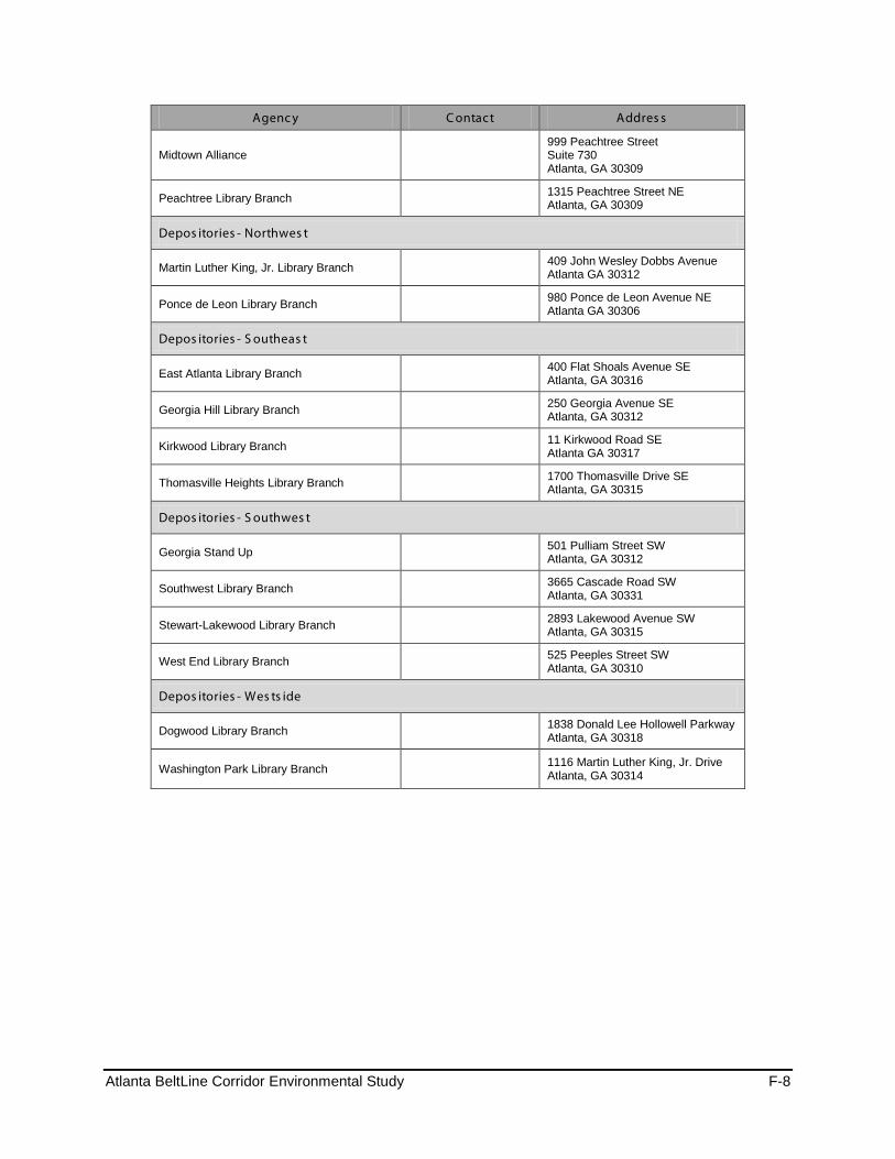
Atlanta BeltLine Corridor Environmental Study F-8
Agenc y C ontact Addres s
Midtown Alliance 999 Peachtree Street Suite 730 Atlanta, GA 30309
Peachtree Library Branch 1315 Peachtree Street NE Atlanta, GA 30309
Depos itories - Northwes t
Martin Luther King, Jr. Library Branch 409 John Wesley Dobbs Avenue Atlanta GA 30312
Ponce de Leon Library Branch 980 Ponce de Leon Avenue NE Atlanta GA 30306
Depos itories - S outheas t
East Atlanta Library Branch 400 Flat Shoals Avenue SE Atlanta, GA 30316
Georgia Hill Library Branch 250 Georgia Avenue SE Atlanta, GA 30312
Kirkwood Library Branch 11 Kirkwood Road SE Atlanta GA 30317
Thomasville Heights Library Branch 1700 Thomasville Drive SE Atlanta, GA 30315
Depos itories - S outhwes t
Georgia Stand Up 501 Pulliam Street SW Atlanta, GA 30312
Southwest Library Branch 3665 Cascade Road SW Atlanta, GA 30331
Stewart-Lakewood Library Branch 2893 Lakewood Avenue SW Atlanta, GA 30315
West End Library Branch 525 Peeples Street SW Atlanta, GA 30310
Depos itories - Wes ts ide
Dogwood Library Branch 1838 Donald Lee Hollowell Parkway Atlanta, GA 30318
Washington Park Library Branch 1116 Martin Luther King, Jr. Drive Atlanta, GA 30314

Atlanta BeltLine Corridor Environmental Study June 2011
Page Left Intentionally Blank
Atlanta BeltLine Corridor Environmental Study G June 2011
Appendix G - Acronyms and Glossary
Atlanta BeltLine Corridor Environmental Study G-1
APPENDIX G – ACROYNMS AND GLOSSARY OF TERMS
Acronyms µg Microgram AASHTO American Association of State Highway and Transportation Officials ABI Atlanta BeltLine, Inc. ACM Asbestos Containing Materials ADA Americans with Disabilities Act ADA Atlanta Development Authority ADAC Atlanta Decorative Arts Center AECOM AECOM (name of project consultant, not an acronym) AHERA Asbestos Hazard Emergency Response Act AIRS Permitted Facility & Emissions Listing ARC Atlanta Regional Commission ASAP Atlanta Strategic Action Plan – (City of Atlanta’s Comprehensive Plan) ASTM American Society for Testing and Materials AUDC Atlanta Urban Design Commission BACT Best Available Control Technologies BAHAB BeltLine Affordable Housing Advisory Board BOCA Building Officials and Code Administrators International, Inc. BRT Bus Rapid Transit BTU British Thermal Unit CAAA Clean Air Act Amendments of 1990 CBD Central Business District CCTV Closed Circuit Television CDP Comprehensive Development Plan CEF Community Engagement Framework CEQ Council on Environmental Quality CERCLA Comprehensive Environmental Response, Compensation, and Liability Act CERCLIS Comprehensive Environmental Response, Compensation, and Liability Information
System CESQG Conditionally Exempt Small Quantity Generator CFR Code of Federal Regulations CO Carbon monoxide CMAQ Congestion Mitigation and Air Quality Improvement Program CORRACTS Corrective Action Report CSO Combined Sewer Overflow CTP Comprehensive Transportation Plan CSX CSX railroad CSXT CSX Transportation dBA A-weighted decibel
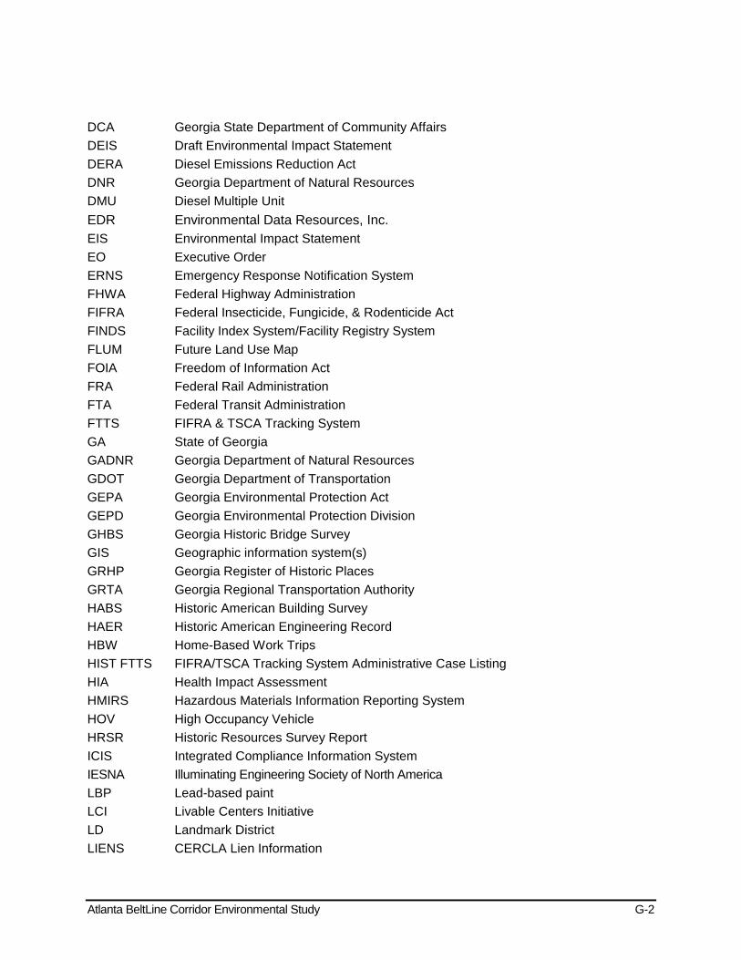
Atlanta BeltLine Corridor Environmental Study G-2
DCA Georgia State Department of Community Affairs DEIS Draft Environmental Impact Statement DERA Diesel Emissions Reduction Act DNR Georgia Department of Natural Resources DMU Diesel Multiple Unit EDR Environmental Data Resources, Inc. EIS Environmental Impact Statement EO Executive Order ERNS Emergency Response Notification System FHWA Federal Highway Administration FIFRA Federal Insecticide, Fungicide, & Rodenticide Act FINDS Facility Index System/Facility Registry System FLUM Future Land Use Map FOIA Freedom of Information Act FRA Federal Rail Administration FTA Federal Transit Administration FTTS FIFRA & TSCA Tracking System GA State of Georgia GADNR Georgia Department of Natural Resources GDOT Georgia Department of Transportation GEPA Georgia Environmental Protection Act GEPD Georgia Environmental Protection Division GHBS Georgia Historic Bridge Survey GIS Geographic information system(s) GRHP Georgia Register of Historic Places GRTA Georgia Regional Transportation Authority HABS Historic American Building Survey HAER Historic American Engineering Record HBW Home-Based Work Trips HIST FTTS FIFRA/TSCA Tracking System Administrative Case Listing HIA Health Impact Assessment HMIRS Hazardous Materials Information Reporting System HOV High Occupancy Vehicle HRSR Historic Resources Survey Report ICIS Integrated Compliance Information System IESNA Illuminating Engineering Society of North America LBP Lead-based paint LCI Livable Centers Initiative LD Landmark District LIENS CERCLA Lien Information
Atlanta BeltLine Corridor Environmental Study G-3
LOS Level of Service LQG Large Quantity Generator LRT Light Rail Transit LUST Leaking Underground Storage Tank MARTA Metropolitan Atlanta Rapid Transit Authority MLRA Major Land Resource Area MMPT Multi-Modal Passenger Terminal N/A Not applicable NAAQS National Ambient Air Quality Standards NAHRGIS Natural, Archaeological and Historic Resources Geographical Information System NE Northeast NEPA National Environmental Policy Act NESHAPS National Emission Standards for Hazardous Air Pollutants NFPA National Fire Protection Association NFRAP No Further Remedial Action Planned NHPA National Historic Preservation Act NonGen Non Generator NOx Nitrogen oxides NO2 Nitrogen dioxide NOI Notice of Intent NRCS Natural Resources Conservation Service NRHP National Register of Historic Places NS Norfolk Southern Corporation NW Northwest O3 Ozone PA Preferred Alternative PADS PCB Activity Database System Pb Lead PCBs Poly-Chlorinated Biphenyls PIAC Public Involvement and Agency Coordination PM10 Particulate matter with a diameter of 10 micrometers and smaller PM2.5 Particulate matter with a diameter of 2.5 micrometers and smaller ppm Parts per million RCRA Resource Conservation Recovery Act RDP Regional Development Plan REC Recognized Environmental Condition ROW Right-of-Way RMS Root mean square RTD Regional Transportation District (Denver, CO) RTP Regional Transportation Plan
Atlanta BeltLine Corridor Environmental Study G-4
SAC Stakeholder Advisory Committee SAC Steering Agency Committee SAFETEA-LU Safe, Accountable, Flexible, Efficient Transportation Equity Act: A Legacy for Users SC Streetcar SE Southeast SHPO State Historic Preservation Officer SHWS State Hazardous Site Inventory SIP State Implementation Plan SOX Sulfur oxides SO2 Sulfur dioxide SPI Special Public Interest District SPILLS Spills Information Oil or Hazardous Material Spills or Releases SQG Small Quantity Generator SR State Route SSMP Safety and Security Management Plan SSTS Section 7 Tracking System SW Southwest SWF/LF Solid Waste Disposal Facilities/Landfill TAC Technical Advisory Committee TAD Tax Allocation District TADAC Tax Allocation District Advisory Committee TIP Transportation Improvement Plan TIB Transit Implementation Board TIER 2 A listing of facilities which store or manufacture hazardous materials and submit a
chemical inventory report TMDL Total Maximum Daily Load TPB Transit Planning Board TRIS Toxic Release Inventory System TSCA Toxic Substances Control Act TSDF Transporters, Storage and Disposal Facility TSM Transportation Systems Management UGPM Urban Growth Policy Map UP Union Pacific Railroad USACE United States Army Corps of Engineers USC United States Code USDA United States Department of Agriculture USDOT U.S. Department of Transportation USEPA United States Environmental Protection Agency USFWS United States Fish and Wildlife Service USGS United States Geological Survey
Atlanta BeltLine Corridor Environmental Study G-5
UST Underground Storage Tank V/C Volume-to-Capacity Ratio VdB Vibration decibel VOC Volatile organic compounds VHT Vehicle Hours Traveled VMT Vehicle Miles Traveled

BeltLine Corridor Environmental Study G-6
Glossary of Commonly Used Terms 100-year floodplain – The area that will be inundated by the flood event having a 1-percent chance of being equaled or exceeded in any given year. In this document the 100-year floodplain refers to designated areas established by Flood Insurance Rate Maps produced by the National Flood Insurance Program.
303(d) List – See Section 303(d).
abandoned right-of-way – Railroad right-of-way that is no longer used by a railroad operator. The Federal Surface Transportation Board reviews and approves requests for railroad right-of-way abandonment.
accessibility – A measure of the degree of difficulty in reaching other locations, goods, services or activities from a given site. It is influenced by changes in travel time, safety, vehicle operating costs, transportation mode, and local and regional land use conditions.
adverse effect – In the context of cultural resources reviewed in this report, the term is defined in Section 106 of the National Historic Preservation Act (36 CFR 800.5(a)(1)). An adverse effect to a historic property occurs when the project under consideration would potentially alter any characteristic that qualifies the property for inclusion in the National Register of Historic Places in a manner that would diminish the integrity of the property.
affected environment – Ambient conditions of the relevant study area at the time an Environmental Effects Report is prepared.
alignment – The ground plan of a railway, trail, roadway or other fixed route.
ambient air – A physical and chemical measure of the concentration of various chemicals in the outside air, usually determined over a specific time period (e.g., one hour, eight hours).
at-grade – Occurring at the same ground-level elevation, especially in reference to a crossing point or intersection of two separate transportation facilities (e.g. road, sidewalk, bicycle path, railroad, etc.).
attainment area – An area where the quality of air is as good as or better than the National Ambient Air Quality Standards that are defined in the Federal Clean Air Act. An area may be an attainment area for one pollutant and a non-attainment area for others.
BeltLine Tax Allocation District (TAD) – A special tax district created in 2005 by the Atlanta City Council, the Atlanta Public School Board, and the Fulton County Commission. It comprises a 6,500-acre area along the BeltLine corridor. Subsequent growth in property tax revenue above the 2005 revenue from the area will be used to fund public improvements within the TAD. The majority of the BeltLine TAD funds will be used to invest in land acquisition, multi-use trails, greenspace, transit, transportation improvements, and affordable workforce housing and Atlanta Public Schools projects. Some BeltLine TAD funds will be used for developer infrastructure, primarily for environmental brownfield cleanup, or to jump-start development in underdeveloped areas. The TAD will expire in 2031.
boardings, passenger – The count of passengers embarking onto a transit vehicle or route for the purposes of measuring ridership or fare revenue.
BeltLine Corridor Environmental Study G-7
British Thermal Unit (BTU) – The amount of heat energy required to raise the temperature of one pound of liquid water by one degree from 60° to 61°Fahrenheit at a constant pressure of one atmosphere
brownfield – Real property, of which the expansion, redevelopment, or reuse may be complicated by the presence or potential presence of a hazardous substance, pollutant, or contaminant.
bus rapid transit (BRT) – A local or regional bus transit line that operates on a fully or partially exclusive lane from other traffic. It may also utilize other measures such as priority traffic signals to avoid delays from traffic lights and congestion. BRT systems typically have stops that are more widely spaced than local bus routes and that may incorporate more amenities such as covered stations, boarding platforms and off-board payment.
carbon monoxide (CO) – A colorless and odorless gas that is a product of incomplete combustion. In most areas, motor vehicles are responsible for the major portion of ambient CO levels. CO is absorbed by the lungs and reacts with hemoglobin to reduce the oxygen carrying capacity of the blood. At low concentrations, CO has been shown to aggravate the symptoms of cardiovascular disease. It can cause headaches and nausea, and at sustained high concentration levels, can lead to coma and death.
centerline – The line corresponding to the central geometric axis of a railroad track, road, trail or other transportation corridor. It is typically used as the reference point for measurements of track dimensions and location.
channel, stream – An open conduit either naturally or artificially created which periodically or continuously contains moving water.
Civil Rights Act of 1964 – Title VI of this federal act provides that that no person shall, on the grounds of race, color, national origin and sex, be discriminated against in federally funded programs or activities. Environmental impact statements are required to demonstrate consideration of project compliance with Title VI.
Clean Air Act Amendments of 1990 (CAAA) – A strategy by the Federal government to address the problem of urban smog. It requires states and the Federal government to reduce emissions from automobiles, trucks, buses, ships, barges, and consumer products, and to meet air quality standards. It particularly addresses the urban problems of ozone, carbon monoxide (CO), and particulate matter (PM-10). It established a process for the designation of “attainment” and “nonattainment” areas by the U.S. Environmental Protection Agency. The CAAA also required that official regional transportation plans “conform” to the State Implementation Plan (see definition below) for federal air quality standards. The USDOT reviews regional transportation plans and makes a conformity determination.
clear-span – A bridge span that does not have any physical obstructions such as support columns underneath.
community facility – Public or publicly-funded facilities, such as police and fire protection facilities, emergency medical response facilities, hospitals, schools, and libraries, as well as private facilities such as hospitals and schools.
conformity determination – See Clean Air Act Amendments of 1990.
BeltLine Corridor Environmental Study G-8
Connectivity Alternative – An alignment option considered in the Tier 1 EIS in a location identified as having critical design options. In these locations, the Tier 1 EIS Build Alternative includes multiple connectivity alternatives. These are different from the Transit Concepts (see below), which are alignment alternatives for the overall BeltLine loop.
contributing property/structure – A property or structure which contributes to the historical integrity of a designated historic district or property.
Council on Environmental Quality (CEQ) – The federal office that oversees implementation of the Federal National Environmental Policy Act of 1969 (see below) and coordinates other federal environmental efforts.
critical habitat – Defined under the Federal Endangered Species Act of 1973 as areas within a listed species’ current range (at the time of listing) that contain the physical or biological features that are essential to that species’ conservation or that for some reason require special management and areas outside the species’ current range that the Secretary of the Interior determines to be essential to its conservation.
cross-section – The cross-sectional configuration of a transportation corridor (railway, trail, roadway, etc.) that specifies typical widths for tracks/travel lanes, related facilities, buffer areas and total right-of-way.
cultural resource – Defined as both architectural and archaeological resources and typically including resources such as buildings, structures, religious properties, cemeteries, and Native American tribal areas. The historic significance of these types of resources is determined by applying the criteria set forth in the National Register of Historic Places Evaluation Criteria.
cumulative impacts – Changes to the environment that are caused by an action in combination with other past, present and future human actions. In simplest terms, analyzing cumulative effects means considering and accounting for the impacts of a proposed action in the context of the existing transportation system and improvements to it that are reasonably foreseeable in the vicinity. Also referred to as incremental effects.
de minimis – See Section 4(f).
determination of eligibility – Decision made by the State Historic Preservation Office (SHPO) regarding whether a historic building or district is eligible for listing in the National Register of Historic Places.
designated use (waterway) – In accordance with the Federal Clean Water Act, the State of Georgia classifies all waters into categories of intended use, which accordingly have different water quality standards. Examples of designated uses include drinking water supply, fishing, and recreation.
effects – Synonymous with impacts of a proposed action; includes both beneficial and detrimental outcomes.
endangered – A species whose prospects for survival within the state are in immediate danger based on a loss of habitat, over-exploitation, predation, competition, or disease. An endangered species requires immediate attention or extinction will likely follow. The Federal government
BeltLine Corridor Environmental Study G-9
maintains a list of designated endangered species in accordance with the Endangered Species Act of 1973.
environmental impact statement – A document required by the National Environmental Policy Act of 1969 (see below) for any proposed major federal action that may significantly affect the environment (defined as a Class III action). The purpose of the EIS is to provide full and open evaluation of environmental issues and alternatives, and to inform decision-makers and the public of reasonable alternatives that could avoid or minimize adverse impacts and enhance the quality of the environment.
environmental justice – Executive Order (EO) 12898, “Federal Actions to Address Environmental Justice in Minority Populations and Low-Income Populations,” provides for equal protection from environmental hazards and fair treatment for all people regardless of race, ethnicity, or economic status, with respect to the development, implementation, and enforcement of environmental laws, regulations, and policies. Fair treatment implies that no population of people bear an unequal share of negative environmental impacts of pollution or environmental hazard resulting from industrial, municipal, and commercial operations or the execution of federal, state, or local policies.
ephemeral stream – A stream that has flowing water only during, and for a short duration after, precipitation events in a typical year. Ephemeral stream beds are located above the water table year-round. Groundwater is not a source of water for the stream. Runoff from rainfall is the primary source of water for stream flow.
fixed guideway transit – An exclusive travel way used by a particular mode of public transportation.
floodplain – A nearly flat plain along the course of a stream or river that is naturally subject to flooding. In this document, the term floodplain generally refers to one of the Flood Hazard Areas defined by the National Flood Insurance Program and mapped in a Flood Insurance Rate Map.
fugitive dust – Dust that leaves a property during construction, demolition, or other induced activity and that can alter the air quality at a given location.
geographic information system(s) (GIS) – A computerized mapping system that includes database and analytical capabilities.
Georgia Ambient Air Quality Standards – See Georgia Air Quality Control Act of 1967.
Georgia Air Quality Control Act of 1967 – An act of the Georgia General Assembly that together with the Federal Clean Air Act, provides the basis for state air quality programs as implemented by the Environmental Protection Division of the Georgia Department of Natural Resources. It established the Georgia Ambient Air Quality Standards.
Georgia Environmental Policy Act of 1991 – An act of the Georgia General Assembly that establishes a process for environmental review and disclosure of potential environmental impacts by proposed state actions.
Georgia Register of Historic Places – The Georgia Register is the state's official list of historic buildings, structures, sites, objects, and districts that provides recognition of a property's architectural, historical, or archaeological significance to the state. The Georgia Register program is administered by the Historic Preservation Division (HPD) of the Department of Natural Resources. It
BeltLine Corridor Environmental Study G-10
identifies properties for planning purposes and ensures that these properties will be taken into account in the planning of state assisted projects and preservation efforts.
grade crossing – An intersection where a roadway crosses a railway at the same elevation.
greenway – A linear corridor of parkland, open space or other type of natural or vegetated land that usually contains a trail or pathway. Greenways can have different functions, including open space, recreational corridor, wildlife corridor or natural buffer.
groundwater recharge area – An area with a critical replenishing effect on groundwater aquifers, especially those used for drinking water.
habitat – The area or environment where an organism or ecological community normally lives or occurs.
hazardous material – Any toxic substance or explosive, corrosive, combustible, poisonous, or radioactive material that poses a risk to the public’s health, safety or property.
headway – The scheduled time between transit vehicle runs operating on a particular transit route.
heavy rail – An electric railway with capacity for a heavy volume of traffic and characterized by exclusive rights-of-way, high speed and rapid acceleration. The existing MARTA rail system comprises heavy rail lines. Heavy rail is different from commuter rail and light rail systems.
Historic District – A concentration of sites, buildings, structures, or objects that are listed or eligible for listing on the National and Georgia Register of Historic Places.
hydric – Having high water content.
hydrocarbon (HC) – A type of chemicals that belongs to a larger group of chemicals known as volatile organic compounds (VOC), which include a wide variety of organic compounds emitted principally from the storage, handling and use of fossil fuels. HC are compounds of hydrogen and carbon only, while VOC may contain other elements. Hydrocarbons contribute to the formation of ground-level ozone. See also Volatile Organic Compounds.
hydrophytic vegetation – Plant life growing in water or in earth that is at least periodically deficient in oxygen as a result of excessive water content.
impaired stream – A stream with water quality that does not support its designated use as defined by the State of Georgia in accordance with Section 303(d) of the Federal Clean Water Act.
indirect effects – Effects that would be caused by a Proposed State Action but that would occur later in time or farther removed in distance but that are still reasonably foreseeable.
interlocking – An arrangement of railroad signals and switches with special operating procedures, typically located at critical sites such as a crossing of two railroads, drawbridge, junction, or entrance/exit to a terminal or yard.
intermittent stream – A stream that has flowing water during certain times of the year, when groundwater provides water for stream flow. During dry periods, intermittent streams may not have flowing water. Runoff from rainfall is a supplemental source of water for stream flow.
BeltLine Corridor Environmental Study G-11
intermodal – Referring to connections between or integration of two or more transportation modes (e.g., bus, train, automobile, etc.).
invasive species – A species that is non-native to the ecosystem under consideration and whose introduction causes or is likely to cause economic harm, environmental harm, or harm to human health.
jurisdictional wetland – A wetland that is regulated by Section 404 of the federal Clean Water Act.
jurisdictional stream – A stream that is regulated by Section 404 of the federal Clean Water Act.
land use – Classification providing information on land cover and the types of human activity occurring on a parcel of land, such as “commercial,” “industrial,” “residential,” or “open space.”
level of service (LOS) – A letter grade designation used to describe given roadway conditions with “A” being at or close to free-flow conditions and “F” being at or close to over-saturation of the roadway; usually based on the progression of vehicles through the green phase of a signal, driver discomfort/frustration, lost travel time, and fuel consumption.
Light Rail Transit (LRT) – An electric-powered rail system characterized by its ability to operate single- or multiple-car trains along exclusive rights-of-way, in subways, on aerial structures, or on streets with mixed traffic. It is able to board and discharge passengers at station platforms or at street, track, or car floor level. Some types of light rail transit systems may be referred to as streetcar, trolley, or tramway systems.
Limits of Disturbance (LOD) – The likely “footprint” or physical extent of the proposed project.
Locally Preferred Alternative - A transit alternative that is technically feasible and supported by local residents, stakeholders, and elected officials. It is determined through a detailed technical study and comments received through the associated public involvement process.
low-income – Any household with income at or below the U.S. Bureau of the Census poverty thresholds.
Major Land Resource Area (MLRA) – A classification of a geographic area of the United States based on its physiographic geologic, climatic, water, soil, and land use characteristics. The MLRA geographic database is maintained by the Natural Resources Conservation Service of the U.S. Department of Agriculture.
migratory birds – bird species that embark on regular seasonal journeys on an annual basis for purposes such as breeding or feeding or in response to weather conditions. Migratory birds are protected under the federal Migratory Bird Treaty Act.
minority – As recognized by Federal law, a member of one of the following races: (1) Black or African American, (2) American Indian or Alaska Native, (3) Asian, (4) Native Hawaiian or other Pacific Islander, (5) Hispanic or Latino Origin.
mitigation – Action necessary to reduce, minimize or eliminate an impact to the affected environment by the proposed project.

BeltLine Corridor Environmental Study G-12
mixed-use – Combination of land uses, such as residential uses combined with office, retail, public, entertainment, or even manufacturing uses.
mobility – The degree to which a person is able to move about; it is determined by a person’s economic situation in addition to any physical disabilities she or he may possess.
multi-use trail – A trail designed for a variety of non-motorized transportation modes and recreational uses, including walking, jogging, bicycling, and in-line skating as permitted by the facility’s design and regulations.
National Ambient Air Quality Standards (NAAQS) – Nationwide air quality standards established by the U.S. Environmental Protection Agency (EPA) in accordance with the federal Clean Air Act Amendments of 1990 that apply to six principal types of pollutants.
National Flood Insurance Program – A program of the Federal Emergency Management Agency (FEMA) that provides flood insurance to participating communities, issues floodplain management regulations, and identifies and maps floodplains
National Historic Landmark – A place that is designated by the US Department of the Interior as possessing exceptional value or quality in illustrating and interpreting the heritage of the United States. The National Park Service administers the National Historic Landmarks program for the Secretary of the Interior. Only 3% of properties listed in the National Register of Historic Places are designated as National Historic Landmarks.
National Environmental Policy Act of 1969 (NEPA) – Federal legislation that establishes an umbrella process for coordinating compliance with each law through the preparation of an Environmental Impact Statement (EIS) for all major federal actions significantly affecting the environment. Other special purpose statutes and procedures may apply as well, depending on specific circumstances, e.g., protective measures for historic properties, wetlands, floodplains, etc. If related environmental review requirements apply, they are to be undertaken as part of the NEPA compliance process. NEPA is the primary law governing the environmental protection process undertaken by the sub-agencies of the US Department of Transportation in reviewing federally funded transportation projects.
National Register of Historic Places (NRHP or National Register) – A federal list of buildings, sites, districts or other properties that have a historic significance. The National Register of Historic Places is maintained by the Keeper of the National Register.
National Wetlands Inventory (NWI) – A geospatial database of wetlands maintained by the Division of Habitat and Resource Conservation of the U.S. Fish and Wildlife Service.
neighborhood – A contiguous residential area with distinct characteristics or boundaries.
nitrogen oxides (NOx) – When combustion temperatures are extremely high, as in motor vehicle engines, atmospheric nitrogen may combine with oxygen to form various oxides of nitrogen. These pollutants, generally referred to as NOx, are inorganic gases formed by combination of oxygen with nitrogen from the air. Of these, nitric oxide (NO) and nitrogen dioxide (NO2) are the most significant compounds. Nitric oxide is a colorless and odorless gas. It is relatively harmless to humans and quickly converts to NO2. NO2, like VOCs, is of concern primarily because of its role in the formation of ozone. NO is produced in much greater quantities than NO2, but oxidizes to NO2 in the atmosphere. NO2 causes detrimental effects to the bronchial system.
BeltLine Corridor Environmental Study G-13
No Build Alternative – The future condition of the study area in the absence of the proposed project. The No Build Alternative serves as a benchmark against which the potential impacts of other alternatives can be compared. It assumes that no improvements will be made with the exception of other committed projects and periodic maintenance and minor enhancements needed to maintain safe operation.
non-contributing – See “contributing resource.”
ozone (O3) – A gas found in two different layers of earth's atmosphere: in the stratosphere (beginning seven to ten miles above earth's surface) and the troposphere (beginning at earth's surface and extending up to the stratosphere). In the stratosphere, ozone occurs naturally and provides a protective layer shielding earth from harmful ultraviolet radiation. In the troposphere, ozone is a major component of photochemical smog and can harm the respiratory systems of humans and other animals. It is a prevalent and widespread criteria pollutant that is regulated by the U.S. Environmental Protection Agency in accordance with the Clean Air Act. Ozone in the troposphere is produced by complex chemical reactions involving nitrogen oxides, which are among the primary pollutants emitted by combustion sources; hydrocarbons, released into the air through the combustion, handling and processing of petroleum products; and sunlight. This report is concerned with potential effects of the proposed state action on tropospheric ozone emissions and ambient levels.
palustrine – Relating to a system of inland, nontidal wetlands characterized by the presence of trees, shrubs, and emergent vegetation (vegetation that is rooted below water but grows above the surface). Palustrine wetlands range from permanently saturated or flooded land (as in marshes, swamps, and lake shores) to land that is wet only seasonally (as in vernal pools).
particulate matter (PM10 and PM2.5) – Particle pollution is a complex mixture of extremely small particles and liquid droplets. Particle pollution is made up of a number of components, including acids (such as nitrates and sulfates), organic chemicals, metals, and soil or dust particles. The US Environmental Protection Agency regulates two categories of particle pollution: fine particles (PM2.5), which are 2.5 micrometers in diameter and smaller; and inhalable coarse particles (PM10) which are smaller than 10 micrometers. (A micrometer is 1/1000th of a millimeter; there are 25,400 micrometers in an inch.)
peak period – The primary morning and afternoon/evening commute periods, the hours of which are defined differently according to the agency or study purpose.
perennial stream – A stream that has flowing water year-round during a typical year. The water table is located above the stream bed for most of the year. Groundwater is the primary source of water for stream flow. Runoff from rainfall is a supplemental source of water for stream flow.
Phase I Archaeological Survey – The first step in a cultural resource archaeology investigation. The Phase I Survey assesses the potential presence and locations of potential archaeological sites within a study area using background research and field reconnaissance.
Phase I Environmental Site Assessment (ESA) – Generally considered the first step in the process of environmental due diligence to identify potential or existing environmental contamination. The Phase I ESA typically addresses both the underlying land as well as physical improvements to the property and primarily examines potential uses, activities, and/or structures that can generate soil and groundwater contamination. Standards for performing a Phase I ESA have been
BeltLine Corridor Environmental Study G-14
promulgated by the USEPA and are based in part on ASTM Standard E1527-05. Actual sampling of soil, air, groundwater and/or building materials is typically not conducted during a Phase I ESA.
Phase II Environmental Site Assessment – The collection of soil, air, groundwater and/or building material samples to further identify site conditions and to better quantify the potential contamination that may exist at a site, right-of-way, or area of concern based upon the findings of a Phase I Environmental Site Assessment or other sources of suspected or known contamination. Work would be completed in conjunction with local, State of Georgia, and USEPA regulatory requirements and agencies.
Piedmont Physiographic Province – The physiographic province in which the study area is located. A physiographic province is a region in which the landforms are similar in geologic structure and differ significantly from the landform patterns in adjacent regions. The Georgia Piedmont is characterized by a rolling surface with slopes of minimal relief and stream valleys of greater depth and steeper slopes.
project sponsors – The Metropolitan Atlanta Rapid Transit Authority (MARTA) and the Atlanta BeltLine, Inc. (ABI) are the project sponsors for the BeltLine project environmental study being conducted in compliance with the National Environmental Policy Act.
protected species – An organism that is legally protected because it is considered endangered or threatened to become endangered, or one of special concern. Protection may be granted at the federal, state or local levels.
Public Involvement and Agency Coordination (PIAC) Plan – Section 6002 of Public Law 104-59, the Safe, Accountable, Flexible, Efficient Transportation Equity Act: A Legacy for Users, mandates the development of a coordination plan for all projects for which an Environmental Impact Statement is prepared under National Environmental Policy Act. It stipulates that the planning process provide opportunities for involvement by the public and agencies. For the BeltLine project, the PIAC plan describes how the public, local and state government agencies, and decision-makers will take part in the identification, development, and implementation of the proposed transit and multi-use trails system.
Recognized Environmental Conditions (RECs) – A term defined by ASTM International, originally known as the American Society for Testing and Materials (ASTM). It is defined under ASTM E1527 - 05 Standard Practice for Environmental Site Assessments: Phase I Environmental Site Assessment Process. “The presence or likely presence of any hazardous substances or petroleum products on a property under conditions that indicate an existing release, a past release, or a material threat of a release of any hazardous substances or petroleum products into structures on the property or into the ground, ground water, or surface water of the property. The term includes hazardous substances or petroleum products even under conditions in compliance with laws. The term is not intended to include de minimis conditions that generally do not present a material risk of harm to public health or the environment and that generally would not be the subject of an enforcement action if brought to the attention of appropriate governmental agencies. Conditions determined to be de minimis are not recognized environmental conditions.”
ridership – The number of people using a public transportation system during a given time period.
right-of-way (ROW) – A public or private area that allows for passage of people or goods, including, but not limited to, railways, freeways, streets, bicycle paths, alleys, trails and walkways. A public right-of-way is dedicated or deeded to the public entity for use under the control of a public agency.
BeltLine Corridor Environmental Study G-15
riparian buffer – A strip of naturally vegetated land along a stream. The vegetation along the banks and in the adjacent floodplain area is characterized by plants that associate with waterways and nearby moist soils. Riparian buffers protect water quality and other natural functions of the stream by filtering storm water runoff, stabilizing stream banks, moderating water temperatures, and providing habitat for wildlife.
runoff – The part of precipitation, snow melt, or irrigation water that runs off the land into streams and lakes. It can carry pollutants from the air and land into receiving waters.
Safety and Security Management Plan (SSMP) – A plan required by the Federal Transit Administration (FTA) for major capital transit projects as a condition for Federal financial assistance. The SSMP explains how the funding recipient will perform safety and management activities defined in FTA guidelines.
Scoping Process – Scoping is the first step in the environmental review process and involves using public and agency participation to develop possible solutions and identify issues regarding a proposed project. Scoping also helps determine needs, objectives, resources and constraints within the study area. The formal Public Scoping Process for the BeltLine Corridor Environmental Study began with the publication in the Federal Register of a Notice of Intent (NOI) to prepare a Tier 1 Environmental Impact Statement (EIS) on July 24, 2008 (Volume 73, No. 143). The Scoping Summary Report summarized the initial public and agency input that was gathered during the project scoping period from July 24, 2008 through September 22, 2008.
secondary effects – Effects which are caused by the action and are later in time or farther removed in distance, but are still reasonably foreseeable. Secondary effects may include growth-inducing effects and other effects related to changes in the pattern of land use, population density or growth rate, and related effects on air and water and on other natural systems, including ecosystems. Also referred to as indirect effects.
Section 4(f) –A provision of the Department of Transportation Act (DOT Act) of 1966 which stipulates that DOT agencies cannot approve the use of land from publicly owned parks, recreational areas, wildlife and waterfowl refuges, or public and private historical sites unless the following conditions apply: there is no feasible and prudent alternative to the use of land, and the action includes all possible planning to minimize harm to the property resulting from use. In 2005, the provision was modified so that the U.S. Department of Transportation (DOT) may determine that certain uses of Section 4(f) land would have de minimis impacts and would have no adverse effect on the protected resource. When this is the case, and the responsible official(s) with jurisdiction over the resource agrees in writing, compliance with Section 4(f) is greatly simplified.
Section 106 – A provision of the National Historic Preservation Act of 1966 that requires consideration of historic and archaeological properties and resources in Federal actions. Section 106 requires Federal agencies to assess potential effects of proposed actions on historic resources and provide opportunity for comment by the Advisory Council on Historic Preservation.
Section 303(d) – A provision of the federal Clean Water Act of 1977 that requires states to assess the conditions of their waters to determine where water quality is impaired (does not fully meet standards) or threatened (is likely to violate standards in the near future). The result of this review is the 303(d) list of impaired waters within the state, which must be submitted to the EPA every other year. Section 303(d) also requires states to prioritize and target water bodies on their list for development of water quality improvement strategies.
BeltLine Corridor Environmental Study G-16
Section 404 – A provision of the federal Clean Water Act of 1977 which establishes a program to regulate the discharge of dredged or fill material into waters of the United States. Proposed impacts to waters of the U.S., including wetlands, streams and other open water bodies, are regulated by this provision.
Section 404 Permit – A permit issued in accordance with Section 404 of the Clean Water Act of 1977. The permitting program is administered by the U.S. Army Corps of Engineers.
sensitive receiver / receptor – A land use that would receive noise or vibration caused by a project. The type of the land use in question (e.g., residences, schools, libraries, laboratories, etc.) is generally sensitive to noise and vibration effects.
sensitive view – An outdoor area that is visible by sensitive viewers (see below).
sensitive viewer – A person who may be impacted by a change in the local outdoor visual and aesthetic environment at a given location.
siding – A length of railroad track parallel to the main track that has a switch at both ends to allow trains to enter at one end and exit at the other. Sidings function to allow trains to pass one another or to access adjacent facilities such as industrial operations.
significant – Term used regarding the magnitude of potential effects or impacts of projects regulated by the Georgia Environmental Policy Act. A proposed action is considered in both context and intensity to determine whether or not the action would likely significantly impact a habitat, neighborhood, species or other resource in the study area.
sole source aquifer – An underground water supply designated by the Environmental Protection Agency (EPA) as the "sole or principal” source of drinking water for an area.
station platform – The area where passengers board and disembark from a train or subway vehicle.
State Historic Preservation Office (SHPO) – A state administrative agency responsible for carrying out consultation in accordance with the National Historic Preservation Act of 1966, as amended, and other state historic preservation regulations.
State Implementation Plan (SIP) – A state plan for the establishment, regulation, and enforcement of Federal air pollution standards. It is reviewed and approved by the US Environmental Protection Agency in accordance with the Clean Air Act Amendments of 1990.
storm water – Runoff water that is generated by a rain event. Storm water discharges include runoff from land, pavements, building rooftops and other surfaces. Storm water runoff can accumulate a variety of pollutants such as oil and grease, chemicals, nutrients, metals, and bacteria as it travels across land before discharging into surface and other receiving waters. Heavy surges in storm water runoff can cause other negative effects, including flooding and erosion, to streams and adjacent low-lying areas, especially in urbanized watersheds.
Stream Buffer Variance – A variance granted to the stream buffer requirements of the Georgia Erosion and Sedimentation Act of 1975. In certain circumstances, when encroachment on a required stream buffer cannot be avoided, the Georgia Environmental Protection Division (EPD) may grant a variance permitting construction to encroach into the stream buffer. Provisions of the
BeltLine Corridor Environmental Study G-17
variance require documentation of erosion control measures and mitigation practices to minimize buffer impacts.
streetcar – A streetcar is a form of rail transit that generally refers to a type of light rail transit which uses smaller vehicles than typical light rail transit systems and generally operates as single-car trains. Modern Streetcars are capable of operating in mixed traffic and along exclusive fixed-rail guideways.
sulfur oxides (SOx) – A class of compounds of which sulfur dioxide (SO2) and sulfur trioxide (SO3) are of great importance. The health effects of SOX include respiratory illness, damage to the respiratory tract, and aggravation of respiratory diseases such as asthma, bronchitis and emphysema. Additionally, atmospheric reactions of SO2 generate sulfuric acid, which is the main constituent of acid rain. Motor fuels, particularly diesel fuel, contain small amounts of sulfur that are oxidized and emitted in vehicle exhaust.
Tax Allocation District (TAD) – See BeltLine Tax Allocation District.
terminus/termini – The end points of a transportation line or the districts/towns in which they are located.
Tier 1 Environmental Impact Statement (EIS) - A written statement, required by Section 102 (2) (C) of the NEPA for projects that involve a federal action such as funding. The Tier 1 EIS serves to provide information about significant environmental impacts and informs decision-makers and the public of practical alternatives that would prevent or minimize adverse impacts or improve the quality of the human environment.
Title VI – See Civil Rights Act of 1964.
transit-dependent population – Defined by the Federal Transit Administration as persons in one or more of the following categories: 1) without private transportation, 2) elderly (over age 65), 3) youths (under age 18), or 4) persons below poverty or median income levels defined by the U.S. Census Bureau.
Transit Concept –One of the two overall transit alignment alternatives being studied as part of the Build Alternative of the BeltLine project. These are different from Connectivity Alternatives (see above), which are alternative transit alignment segments in specific locations.
Transportation Improvement Program (TIP) – A prioritized list of regional transportation projects and proposed funding to be implemented in stages over several (3 to 5) years. The projects are selected from those proposed in the systems management element and the long-range element of the regional transportation planning process. This program is required as a condition for the region to receive federal transit and highway grants.
transportation systems management (TSM) – Different actions and activities designed to make an existing transportation system more efficient.
turbidity – A cloudy water quality condition due to suspended silt or organic matter.
underground storage tank (UST) – A tank located at least partially underground and designed to hold gasoline, other petroleum products or chemicals.
BeltLine Corridor Environmental Study G-18
uplands – Land that is well-drained and rarely, if ever, inundated.
vegetated buffer/vegetative buffer – A vegetated upland or wetland area next to rivers, streams, lakes, or other open waters which separates the open water from developed areas and agricultural land. Vegetated buffers provide a variety of aquatic habitat functions and help improve or maintain local water quality. A vegetated buffer can be established by maintaining an existing vegetated area or by restoring a cleared or degraded area. See also riparian buffer.
vehicle miles traveled (VMT) – The number of miles traveled by an automobile per individual within a given area.
visual resource – A local resource, such as a structure or outdoor setting, valued for its visual or aesthetic qualities.
volatile organic compound (VOC) – A wide variety of organic compounds emitted principally from the storage, handling and use of fossil fuels. They are produced by incomplete combustion of hydrocarbon fuels and also by their evaporation. Because there are many hundreds of different compounds, VOC display a wide range of properties. Some, such as benzene, are carcinogenic while others are harmless to health. VOC contribute to the formation of ground-level ozone.
volume-to-capacity ratio (V/C) – A conventional measure for comparing roadway demand (traffic volumes) with roadway carrying capacity, which is based on the number of lanes, road speed and other aspects of the roadway’s design.
waste water – The water and wastes from homes, businesses, institutions and infrastructure facilities that enter pipes and are transported to treatment plants for treatment and disposal.
Waters of the United States – All waters defined under the Clean Water Act 40 CFR 230.3(s) and subject to US Army Corps of Engineers jurisdiction. Waters of the United States include those which are currently used, or were used in the past, or may be susceptible to use in interstate or foreign commerce, including all waters which are subject to the ebb and flow of the tide. The definition includes all impoundments, tributaries of and wetlands adjacent to such waters.
wetland – Tidal area or swamp with water saturated soil characteristics and associated vegetation that meets certain criteria. Filling and development of such areas are regulated by federal and state agencies. The Clean Water Act defines the term wetlands as "those areas that are inundated or saturated by surface or groundwater at a frequency and duration sufficient to support, and that under normal circumstances do support, a prevalence of vegetation typically adapted for life in saturated soil conditions. Wetlands generally include swamps, marshes, bogs and similar areas."
wye – A”y”-shaped segment of railroad track that allows trains to turn around.
zone – A division of the study area used for analysis purposes in the BeltLine environmental study. The study area is divided into four zones in this report: southwest, southeast, northeast and northwest.

Atlanta BeltLine Corridor Environmental Study June 2011
Page Left Intentionally Blank
Atlanta BeltLine Corridor Environmental Study H June 2011
Appendix H - List of Preparers

Atlanta BeltLine Corridor Environmental Study H-1
Appendix H - List of Preparers
Federal Transit Administration Name: B. Keith Melton Title: Community Planner Name: Jamie Pfister Title: Director of Planning and Program Development
MARTA Name: Johnny Dunning, Jr. Title: Senior Director, Transit System Planning
ABI Name: Nate Conable Title: Senior Project Manager
AECOM Name: Ravi Amin Title: Transportation Planner Role: Utility Analysis and ROW Evaluation Years of Experience: 6 Name: Susan T. Anderson, AICP Title: Senior Environmental Planner Role: Section 4(f) Evaluation Years of Experience: 15 Name: Harry Boxler, AICP Title: Senior Transportation Planner Role: Alternatives Considered Years of Experience: 16 Name: Samantha Castro, LEED Green Associate Title: Planner Role: Public Involvement Years of Experience: 6 Name: David Cheeney Title: Senior Transportation Planner Role: Transportation, Systems and Facilities, Construction Effects, Safety and Security Years of Experience: 30 Name: Lance Comas Title: Senior Environmental Scientist Role: Hazardous/Contaminated Materials Years of Experience: 20 Name: Lou Costa Title: Senior Transportation Planner Role: Secondary and Cumulative Effects Years of Experience: 38
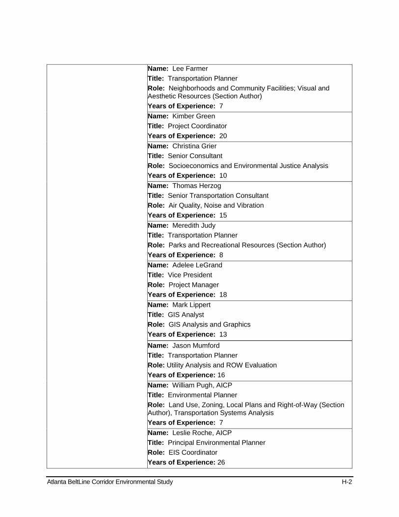
Atlanta BeltLine Corridor Environmental Study H-2
Name: Lee Farmer Title: Transportation Planner Role: Neighborhoods and Community Facilities; Visual and Aesthetic Resources (Section Author) Years of Experience: 7 Name: Kimber Green Title: Project Coordinator Years of Experience: 20 Name: Christina Grier Title: Senior Consultant Role: Socioeconomics and Environmental Justice Analysis Years of Experience: 10 Name: Thomas Herzog Title: Senior Transportation Consultant Role: Air Quality, Noise and Vibration Years of Experience: 15 Name: Meredith Judy Title: Transportation Planner Role: Parks and Recreational Resources (Section Author) Years of Experience: 8 Name: Adelee LeGrand Title: Vice President Role: Project Manager Years of Experience: 18 Name: Mark Lippert Title: GIS Analyst Role: GIS Analysis and Graphics Years of Experience: 13 Name: Jason Mumford Title: Transportation Planner Role: Utility Analysis and ROW Evaluation Years of Experience: 16 Name: William Pugh, AICP Title: Environmental Planner Role: Land Use, Zoning, Local Plans and Right-of-Way (Section Author), Transportation Systems Analysis Years of Experience: 7 Name: Leslie Roche, AICP Title: Principal Environmental Planner Role: EIS Coordinator Years of Experience: 26
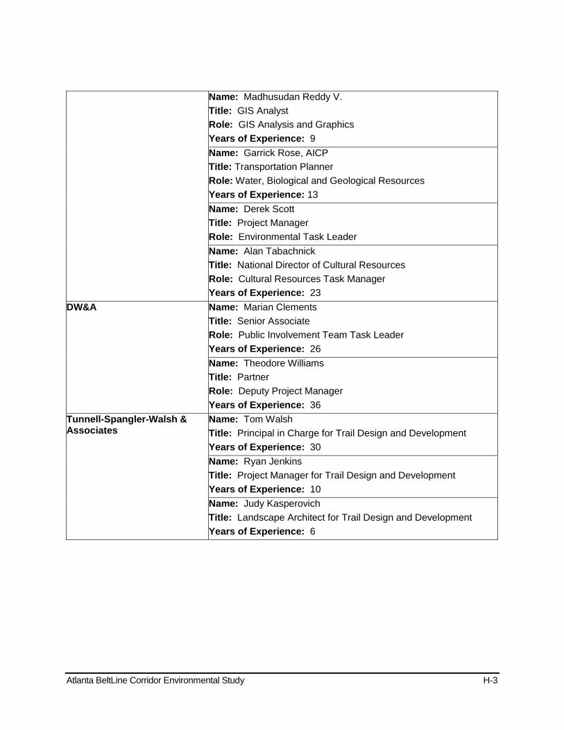
Atlanta BeltLine Corridor Environmental Study H-3
Name: Madhusudan Reddy V. Title: GIS Analyst Role: GIS Analysis and Graphics Years of Experience: 9 Name: Garrick Rose, AICP Title: Transportation Planner Role: Water, Biological and Geological Resources Years of Experience: 13 Name: Derek Scott Title: Project Manager Role: Environmental Task Leader Name: Alan Tabachnick Title: National Director of Cultural Resources Role: Cultural Resources Task Manager Years of Experience: 23
DW&A Name: Marian Clements Title: Senior Associate Role: Public Involvement Team Task Leader Years of Experience: 26 Name: Theodore Williams Title: Partner Role: Deputy Project Manager Years of Experience: 36
Tunnell-Spangler-Walsh & Associates
Name: Tom Walsh Title: Principal in Charge for Trail Design and Development Years of Experience: 30 Name: Ryan Jenkins Title: Project Manager for Trail Design and Development Years of Experience: 10 Name: Judy Kasperovich Title: Landscape Architect for Trail Design and Development Years of Experience: 6
Atlanta BeltLine Corridor Environmental Study I June 2011
Appendix I - References
Atlanta BeltLine Corridor Environmental Study I-1
Appendix I - List of Reference Material
Adair, David et. Al. 2008. Historic Resources Survey Report. Atlanta Beltline Northeast Quadrant, Atlanta, Fulton County, Georgia. Report prepared for the Metropolitan Atlanta Rapid Transit Authority.
Albright, Brian, John Lawrence, Paul Schopp, Alan Tabachnick. 2009. Cultural Resources Reconnaissance Technical Memorandum, Atlanta BeltLine Corridor, Fulton County, Georgia. Report prepared for the Metropolitan Atlanta Rapid Transit Authority.
Alex Garvin & Associates, Inc. December 2004. BeltLine Emerald Necklace: Atlanta’s New Public Realm. Prepared for the Trust for Public Land. Available at: http://www.tpl.org/tier3_cd.cfm?content_item_id=22739&folder_id=249
Anderson, David, R. Ledbetter and L. O’Steen. 1990 Paleoindian Period Archaeology of Georgia. Georgia Archaeological Research Design Paper No. 6. University of Georgia Laboratory of Archaeology Series Report Number 28. University of Georgia, Athens.
Anonymous. 1875. Map illustrating the military operations in front of Atlanta, Ga. From the passage of Peach Tree Creek, July 19th 1864, to the commencement of the movement upon the enemy's lines of communication, south of Atlanta, August 26th 1864 Compiled by authority of the Hon. the Secretary of War in the Office of the Chief of Engineers, U.S.A., 1875. Julius Bien & Company, New York City, New York.
Atlanta Regional Commission. GIS Regional Data. Available at: http://www.atlantaregional.com/html/4716.aspx
Atlanta BeltLine, Inc., (ongoing). Atlanta BeltLine Subarea Master Plans. Atlanta Region Transit Planning Board, August 2008. Concept 3.
ABI, 2008. BeltLine Affordable Housing Trust Fund Policy. Available online at: http://beltline.org/AffordableHousing/AffordableHousing/tabid/3716/Default.aspx#policy
Atlanta Regional Commission, (ongoing). Livable Centers Initiative, various plans.
Atlanta Regional Commission, June 2007. Atlanta Region Bicycle Transportation and Pedestrian Walkways Plan.
Atlanta Regional Commission, September 26, 2007. Envision6, 2030 Regional Transportation Plan and FY 2008-2013 Transportation Improvement Program.
Atlanta Regional Commission, 2007. Regional Development Plan.
Atlanta Regional Commission, February 2008. Atlanta Regional Freight Mobility Plan.
BeltLine Transit Panel. 2005. The Atlanta Beltline: Transit Feasibility White Paper. Prepared for the Atlanta Development Authority. Available at:: http://www.cqgrd.gatech.edu/PDFs/FINAL_panel_paper_9.29.05.pdf
BeltLine Steering Committee. Atlanta BeltLine Tax Allocation District Feasibility Study. Available at: http://www.atlantaga.gov/client_resources/government/development%20authority/beltlinefeasibilitystudy_final.pdf

Atlanta BeltLine Corridor Environmental Study I-2
Center for Transportation Analysis. 2008. Transportation Energy Data Book, 28th Edition. Oak Ridge National Laboratory.
City of Atlanta, 1992. City of Atlanta Greenway Trail Corridor Plan.
City of Atlanta, September 2004. The Plan for a Walkable Atlanta.
City of Atlanta, December 2008. Connect Atlanta Plan.
City of Atlanta, April 2008, Atlanta Strategic Action Plan.
City of Atlanta, Department of Planning and Community Development, August 2009. Future Land Use Map.
City of Atlanta, Department of Planning and Community Development, August 2009. Zoning Ordinance and Zoning Map.
City of Atlanta, Department of Planning and Community Development; Fulton County, Tax Assessor; and Atlanta Regional Commission, August 2009. Existing Land Use data.
Clinton, B. 1994. Executive Order 12898 of February 11, 1994. Federal Actions to Address Environmental Justice in Minority Populations and Low-Income Populations. Federal Register 59, No. 32 (14 February). Available at: http://www.epa.gov/fedrgstr/eo/eo12898.pdf
Council on Environmental Quality. 1997. Environmental Justice Guidance under the National Environmental Policy Act. Available at: http://ceq.hss.doe.gov/nepa/regs/ej/ej.pdf
Council on Environmental Quality. Regulations for Implementing NEPA. 40 CFR 1500-1508. Available at: http://www.nepa.gov/nepa/regs/ceq/toc_ceq.htm
EDAW, Urban Collage, Grice & Associates, Huntley Partners, Troutman Sanders LLP, Gravel, Inc... 2005. Atlanta BeltLine Redevelopment Plan. Prepared for the Atlanta Development Authority. Available at: http://www.atlantada.com/adaInitiatives/BeltLineRedevelopPlan.jsp
Environmental Data Resources, Inc., June 17, 2008. DataMap™ Corridor Study, Inquiry Number: 02244958.3r.
Environmental Data Resources, Inc., June 15, 2009. DataMap™ Corridor Study, Inquiry Number: 02517938.1r.
Environmental Data Resources, Inc., June 16, 2009. DataMap™ Corridor Study, Inquiry Number: 02517938.2r.
Environmental Data Resources, Inc., August 10, 2009. DataMap™ Corridor Study, Inquiry Number: 02558078.1r.
Federal Railroad Administration. May 26, 1999. Procedures for Considering Environmental Impacts (FRA Docket No EP-1, Notice 5.
Federal Transit Administration. 1999. Technical Guidance on Section 5309 New Starts Criteria.
Federal Transit Administration. May 2006. Transit Noise and Vibration Impact Assessment, FTA-VA-90-1003-06, U.S. Department of Transportation, Office of Planning and Environment, Washington, DC.
Atlanta BeltLine Corridor Environmental Study I-3
Georgia Power website: www.georgiapower.com
Georgia Department of Natural Resources, Environmental Protection Division, July 1, 1991. Georgia Environmental Policy Act Guidelines.
Georgia Department of Transportation (GDOT), June 12, 2003. Commuter Rail [Online]. http://wwwb.dot.ga.gov/dot/plan-prog/intermodal/rail/reports/rpt/commuterrail.shtml (accessed September 4, 2009)
Georgia Department of Transportation (GDOT), June 26, 2006. Freight Rail in Georgia [Online]. http://wwwb.dot.ga.gov/dot/plan-prog/intermodal/rail/freight.shtml (accessed September 8, 2009)
Georgia Department of Transportation (GDOT), September 4, 2002, Intercity Rail Program [Online]. http://wwwb.dot.ga.gov/dot/plan-prog/intermodal/rail/reports/rpt/intercityrail.shtml (accessed September 4, 2009)
Georgia Environmental Protection Division, May 5, 2008. Application for Limitation of Liability Under the Georgia Hazardous Site Reuse and Redevelopment Act Response Actions (Non-HSI and HSI Properties).
Georgia Environmental Protection Division, April 9, 2009. Application for Limitation of Liability Under the Georgia Hazardous Site Reuse and Redevelopment Act Response Actions (Non-HSI and HSI Properties).
Gravel, R.A. 1999. Belt Line – Atlanta Design of Infrastructure as a Reflection of Public Policy. Master’s Thesis, Georgia Institute of Technology. Available at: http://smartech.gatech.edu/handle/1853/7400
Higgins et al 2003, Rock formations of the southwest zone are of the Wahoo Creek, Stonewall Gneiss and the Clarkston Formation
Immergluck, D. 2007. The BeltLine and Rising Home Prices: Residential Appreciation Near the Beltline Tax Allocation District and Policy Recommendations to Minimize Displacement. Prepared for Georgia Stand Up. Available at: www.communitybenefits.org/downloads/The%20Beltline%20and%20Rising%20Home%20Prices.pdf
Immergluck. D. 2007. Large-Scale Redevelopment Initiatives and Home Values: The Case of the Atlanta Beltline Project. Available at: http://mpra.ub.uni-muenchen.de/8613/
Institute on Race and Poverty. 2006. Determining Equity in Access to Recent Dramatic Job Growth in the Atlanta Region. A report to the Rockefeller Foundation from the Institute on Race & Poverty. Available at: www.irpumn.org.
Joseph, J.W., T.M. Hamby, and C.S. Long. 2004. Historical Archaeology in Georgia. Georgia Archaeology Research Design Paper No. 14. University of Georgia Laboratory of Archaeology Series, Report Number 39. University of Georgia, Athens.
Kah, S. and Allen, D. 2006. “Strategies for Urban Regeneration The Atlanta BeltLine: A Public Discussion” in Georgia Tech College of Architecture. Fall 2006 Newsletter. Available at: http://www.coa.gatech.edu/news/symposiaarchives/DeansSymposium2006.pdf
Atlanta BeltLine Corridor Environmental Study I-4
Lewis, Greg. 2002. The Geography of the Household Type in Atlanta Region. Census Issue 3. Prepared by the Georgia State University, Andrew Young School of Policy Studies, Fiscal Research Program.
Metropolitan Atlanta Rapid Transit Authority, March 2004. BeltLine Baseline Conditions Assessment Report.
Metropolitan Atlanta Rapid Transit Authority. March 2005. Inner Core Feasibility Wrap-Up Report, Inner Core BeltLine/C-Loop Transit Feasibility Study
Metropolitan Atlanta Rapid Transit Authority, August 2006. Rail Freight Analysis Report, Inner Core BeltLine/C-Loop Alternatives Analysis. Poe, Orlando Metcalfe. c. 1864 Map illustrating the siege of Atlanta, Ga., by the U.S. forces under command of Maj. Gen. W.T. Sherman, from the passage of Peach Tree Creek, July 19th 1864, to the commencement of the movement upon the enemy's lines of communication south of Atlanta, August 26, 1864. United States War Department, Engineer Bureau, [Washington, D.C.]
Metropolitan Atlanta Rapid Transit Authority. 2007. BeltLine Inner Core Alternatives Analysis: Detailed Screening Results. Available at: http://www.itsmarta.com/
Minority Soil Series 2009. Available at:: http://ortho.ftw.nrcs.usda.gov/cgi-bin/osd/osdname.cgi
NEPA guidelines 40 CFR Parts 1500-1508 and 23 CFR Part 771
Public Law 104-59 “Safe, Accountable, Flexible, Efficient Transportation Equity Act: A Legacy for Users” (SAFETEA-LU)
Reshwan, J.S. 2007. Crossing the Threshold of Urban Mobility and Redevelopment: Using Tax Allocation Districts to Develop the Atlanta Beltline, 23 Ga. St. U. L. Rev. 681 (2007). Available at: http://dspace.gsu.edu/handle/2197/620
Ross, C. L. and West, H. 2007. Atlanta BeltLine Health Impact Study. Available at: http://www.cqgrd.gatech.edu/PDFs/BLHIA_report2007updated.pdf
Sanborn Map Company. 1911-1925. Insurance Maps of Atlanta, Georgia, Published in Four Volumes. Sanborn Map Company, New York City, New York.
Sanborn Map Company. 1931-1932. Insurance Maps of Atlanta, Georgia. Sanborn Map Company, New York City, New York.
Sanborn Map Company. 1924-1962. Insurance Maps of Atlanta, Georgia. Sanborn Map Company, New York City, New York
Seaman, B.A. 2005. An Analysis of the Fiscal Impacts of the Atlanta Beltline Tax Allocation District (TAD). Prepared for Atlanta Development Authority. Available at: http://www.beltline.org/ResourceLibrary/ReportsandStudies/tabid/1820/Default.aspx
Silliman, Garrett. 2008. Phase I Archaeological Survey of the Proposed Atlanta BeltLine Corridor Northeast Quadrant, Fulton County, Georgia. Reported prepared for the Metropolitan Atlanta Rapid Transit Authority, by AECOM and Edwards-Pitman Environmental, Inc.
Sole Source Aquifer, Section 1424(e) of the Safe Drinking Water Act of 1974

Atlanta BeltLine Corridor Environmental Study I-5
Stanyard, William F. 2003. Archaic Period Archaeology of Northern Georgia. Georgia Archaeology Research Design Paper No. 13. University of Georgia Laboratory of Archaeology Series Report No. 38. University of Georgia, Athens.
U.S. Census Bureau. 2000. Census 2000. Available at: http://www.census.gov/
U.S. Department of Justice. 1964. Title VI of the Civil Rights Act of 1964 42 U.S.C. § 2000d et seq. Available at:
United States Environmental Protection Agency (USEPA), November 15, 1990. Clean Air Act Amendments of 1990. 40 CFR 50.
http://www.usdoj.gov/crt/cor/coord/titlevistat.php
United States Environmental Protection Agency (USEPA), June 18, 2008. Multisystem Envirofacts Query Form. (http://www.epa.gov/enviro/html/multisystem.html
United States Environmental Protection Agency (USEPA), July 21, 2008. Superfund Information Systems Superfund Site Information. (
)
http://cfpub.epa.gov/supercpad/cursites/srchrslt.cfm?Start=51&sortby=site)
United States Environmental Protection Agency (USEPA), October 15, 2008. National Primary and Secondary Ambient Air Quality Standards. 40 CFR 50.
United States Environmental Protection Agency (USEPA), June 22, 2009. Superfund Information Systems Superfund Site Information. (http://cfpub.epa.gov/supercpad/cursites/srchrslt.cfm?Start=51&sortby=site
Wallace Roberts & Todd, LLC. September 2009. Draft Project Greenspace Technical Report. Prepared for Atlanta’s Project Greenspace
)
Water Quality, Section 303(d) of the Clean Water Act
Wetlands, USEPA and USACE, 40 Federal Register, 37, 125-126, 37128-29. July 19, 1977
Copyright © 2022 FDOKUMEN