draft environmental impact report suscol mountain vineyards ...
432
MARCH 2012 LEAD AGENCY: Napa County Conservation, Development and Planning 1195 Third Street, Suite 210 Napa, CA 94559 DRAFT ENVIRONMENTAL IMPACT REPORT SUSCOL MOUNTAIN VINEYARDS EROSION CONTROL PLAN APPLICATION NO. P09-00176-ECPA
-
Upload
khangminh22 -
Category
Documents
-
view
0 -
download
0
Transcript of draft environmental impact report suscol mountain vineyards ...

MARCH 2012
LEAD AGENCY:
Napa County Conservation,Development and Planning
1195 Third Street, Suite 210Napa, CA 94559
DRAFT ENVIRONMENTAL IMPACT REPORT
SUSCOL MOUNTAIN VINEYARDS
EROSION CONTROL PLANAPPLICATION NO. P09-00176-ECPA

MARCH 2012
LEAD AGENCY:
Napa County Conservation,Development and Planning
1195 Third Street, Suite 210Napa, CA 94559
PREPARED BY:
Analytical Environmental Services1801 7th Street, Suite 100
Sacramento, CA 95811(916) 447-3479
www.analyticalcorp.com
DRAFT ENVIRONMENTAL IMPACT REPORT
SUSCOL MOUNTAIN VINEYARDS
EROSION CONTROL PLANAPPLICATION NO. P09-00176-ECPA

Analytical Environmental Services i Suscol Mountain Vineyards P09-00176-ECPA March 2012 Draft Environmental Impact Report
TABLE OF CONTENTS SUSCOL MOUNTAIN VINEYARDS EROSION CONTROL PLAN APPLICATION NO. P09-00176-ECPA
1.0 INTRODUCTION ......................................................................................................... 1-1 1.1 Purpose of the Environmental Impact Report (EIR) .......................................... 1-1 1.2 Background ....................................................................................................... 1-2 1.2.1 Introduction and Overview of Agricultural Activities ................................ 1-2 1.3 Public Outreach ................................................................................................ 1-5
1.3.1 Initial Study and Notice of Preparation ................................................... 1-5 1.3.2 Comments on the Notice of Preparation ................................................. 1-5 1.3.3 Consultation ............................................................................................ 1-6
1.4 CEQA EIR Process ........................................................................................... 1-7 1.4.1 Public Review ......................................................................................... 1-7 1.4.2 Final EIR Publication .............................................................................. 1-7 1.4.3 Mitigation Monitoring and Reporting ....................................................... 1-8
1.5 Terminology Used in the EIR ............................................................................ 1-8 1.6 EIR Organization ............................................................................................... 1-9 1.7 Intended Uses of the EIR ................................................................................ 1-10 1.8 Effects Not Found to Be Significant ................................................................ 1-10
2.0 SUMMARY .................................................................................................................. 2-1
2.1 Introduction ....................................................................................................... 2-1 2.2 Project Description ............................................................................................ 2-1
2.2.1 Erosion Control Measures ...................................................................... 2-1 2.3 Alternatives to the Proposed Project ................................................................. 2-3 2.4 Summary of Environmental Impacts ................................................................. 2-3
3.0 PROJECT DESCRIPTION .......................................................................................... 3-1
3.1 Project Location ................................................................................................ 3-1 3.2 Project Site and Vicinity .................................................................................... 3-1 3.3 Project Objectives ............................................................................................. 3-5 3.4 Description of the Proposed Project ................................................................. 3-6
3.4.1 #P09-00176-ECPA Features ............................................................... 3-9 3.4.1-1 Erosion Control Measures ................................................. 3-17 3.4.1-2 Drainage Pipelines ............................................................ 3-19 3.4.1-3 Drop Inlet Installation ......................................................... 3-20 3.4.1-4 Diversion Features ............................................................ 3-20 3.4.1-5 Long Term Vineyard Road Management Plan .................. 3-21
3.4.2 Vineyard Layout and Installation ........................................................ 3-23 3.4.3 Water Supply ..................................................................................... 3-24 3.4.4 Primary Irrigation System .................................................................. 3-27 3.4.5 Vineyard Operation and Maintenance ............................................... 3-28 3.4.6 Vineyard Development: Workers, Equipment, and Duration ............. 3-28

TABLE OF CONTENTS
Analytical Environmental Services ii Suscol Mountain Vineyards P09-00176-ECPA March 2012 Draft Environmental Impact Report
4.0 ENVIRONMENTAL SETTING, IMPACTS AND MITIGATION MEASURES 4.1 Air Quality ...................................................................................................... 4.1-1
4.1.1 Setting ............................................................................................... 4.1-1 4.1.1-1 Sensitive Receptors .......................................................... 4.1-1 4.1.2 Regulatory Framework ..................................................................... 4.1-2 4.1.2-1 Plans, Policies and Standards .......................................... 4.1-2 4.1.2-2 Pollutants of Concern ....................................................... 4.1-4 4.1.2-3 Air Quality Data ................................................................ 4.1-4 4.1.2-4 Climate Change ............................................................... 4.1-5 4.1.3 Impacts and Mitigation Measures ................................................... 4.1-10 4.1.3-1 Significance Criteria ........................................................ 4.1-10 4.1.3-2 Impacts and Mitigation Measures ................................... 4.1-11
4.2 Biological Resources ..................................................................................... 4.2-1 4.2.1 Setting ............................................................................................... 4.2-4 4.2.1-1 Regional Setting ............................................................... 4.2-4 4.2.1-2 Project Site ....................................................................... 4.2-5 4.2.2 Biotic Communities and Alliances ..................................................... 4.2-7 4.2.2-1 Non-Native and Native Grasslands ................................ 4.2-13 4.2.2-2 Woodlands ...................................................................... 4.2-16 4.2.2-3 Wetlands, Drainages and Waters of the U.S. ................. 4.2-18 4.2.2-4 Shrublands ..................................................................... 4.2-21 4.2.2-5 Riparian Woodland ......................................................... 4.2-23 4.2.2-6 Rock Outcrop .................................................................. 4.2-24 4.2.2-7 Wildlife Movement .......................................................... 4.2-25 4.2.3 Wildlife ............................................................................................ 4.2-28 4.2.4 Special Status Species ................................................................... 4.2-28 4.2.4-1 Special Status Plants ...................................................... 4.2-44 4.2.4-2 Special Status Invertebrates ........................................... 4.2-65 4.2.4-3 Special Status Amphibians and Reptiles ........................ 4.2-67 4.2.4-4 Special Status Birds ....................................................... 4.2-73 4.2.4-5 Special Status Fish ......................................................... 4.2-83 4.2-4-6 Special Status Bats and Other Mammals ....................... 4.2-84 4.2.5 Regulatory Framework ................................................................... 4.2-87 4.2.5-1 Special Status Species ................................................... 4.2-87 4.2.5-2 Wetlands and Other Waters of the U.S. ......................... 4.2-90 4.2.5-3 Local Regulations, Goals and Policies ........................... 4.2-90 4.2.6 Impacts and Mitigation Measures ................................................... 4.2-97 4.2.6-1 Significance Criteria ........................................................ 4.2-97 4.2.6-2 Impacts and Mitigation Measures ................................... 4.2-98
4.3 Cultural and Paleontological Resources ........................................................ 4.3-1 4.3.1 Cultural Setting ................................................................................. 4.3-1 4.3.1-1 Regional Setting ............................................................... 4.3-1 4.3.1-2 Historical Setting ............................................................... 4.3-5 4.3.1-3 Existing Environment ........................................................ 4.3-7 4.3.2 Regulatory Framework ................................................................... 4.3-12 4.3.2-1 Cultural Resources ......................................................... 4.3-12 4.3.3 Impacts and Mitigation Measures ................................................... 4.3-14 4.3.3-1 Significance Criteria ........................................................ 4.3-14 4.3.3-2 Impacts and Mitigation Measures ................................... 4.3-15

TABLE OF CONTENTS
Analytical Environmental Services iii Suscol Mountain Vineyards P09-00176-ECPA March 2012 Draft Environmental Impact Report
4.4 Geology and Soils .......................................................................................... 4.4-1 4.4.1 Setting ............................................................................................... 4.4-1 4.4.1-1 Geology and Topography ................................................. 4.4-1 4.4.1-2 Soils .................................................................................. 4.4-3 4.4.1-3 Sediment Erosion and Yield ............................................. 4.4-6 4.4.1-4 Geologic Stability .............................................................. 4.4-7 4.4.2 Regulatory Framework ................................................................... 4.4-13 4.4.2-1 Napa County ................................................................... 4.4-13 4.4.2-2 Napa County Resource Conservation District ................ 4.4-14 4.4.3 Impacts and Mitigation Measures ................................................... 4.4-15 4.4.3-1 Significance Criteria ........................................................ 4.4-15 4.4.3-2 Impacts and Mitigation Measures ................................... 4.4-16
4.5 Hazardous Materials ...................................................................................... 4.5-1 4.5.1 Setting ............................................................................................... 4.5-1 4.5.1-1 Current Site Conditions .................................................... 4.5-1 4.5.1-2 Current and Proposed Vineyard Operations .................... 4.5-2 4.5.2 Regulatory Framework ..................................................................... 4.5-4 4.5.2-1 Federal ............................................................................. 4.5-4 4.5.2-2 State ................................................................................. 4.5-5 4.5.2-3 Local ................................................................................. 4.5-6 4.5.3 Impacts and Mitigation Measures ..................................................... 4.5-8 4.5.3-1 Significance Criteria .......................................................... 4.5-8 4.5.3-2 Impacts and Mitigation Measures ..................................... 4.5-8
4.6 Hydrology and Water Quality ......................................................................... 4.6-1 4.6.1 Setting ............................................................................................... 4.6-1 4.6.1-1 Climate ............................................................................. 4.6-1 4.6.1-2 Surface Waters ................................................................. 4.6-1 4.6.1-3 Groundwater ..................................................................... 4.6-8 4.6.1-4 Water Supply .................................................................. 4.6-13 4.6.2 Regulatory Framework ................................................................... 4.6-18 4.6.2-1 Federal ........................................................................... 4.6-18 4.6.2-2 State ............................................................................... 4.6-18 4.6.2-3 Local ............................................................................... 4.6-19 4.6.3 Impacts and Mitigation Measures ................................................... 4.6-24 4.6.3-1 Erosion Control Plan Features and Surface Runoff........ 4.6-24 4.6.3-2 Significance Criteria ........................................................ 4.6-28 4.6.3-3 Impacts and Mitigation Measures ................................... 4.6-28
4.7 Transportation and Traffic .............................................................................. 4.7-1 4.7.1 Setting…. .......................................................................................... 4.7-1 4.7.1-1 Regional Roadway Network ............................................. 4.7-1 4.7.1-2 Local Roadway Network ................................................... 4.7-1 4.7.1-3 Existing Traffic Conditions ................................................ 4.7-2 4.7.2 Regulatory Framework ..................................................................... 4.7-5 4.7.3 Impacts and Mitigation Measures ..................................................... 4.7-6 4.7.3-1 Significance Criteria .......................................................... 4.7-6 4.7.3-2 Impacts and Mitigation Measures ..................................... 4.7-7
5.0 ALTERNATIVES TO THE PROPOSED PROJECT .................................................... 5-1
5.1 Introduction ....................................................................................................... 5-1 5.1.1 CEQA Requirements for Alternatives Analysis .................................... 5-1 5.1.2 Project Objectives ................................................................................ 5-2 5.1.3 Key Impacts of the Proposed Project .................................................. 5-2

TABLE OF CONTENTS
Analytical Environmental Services iv Suscol Mountain Vineyards P09-00176-ECPA March 2012 Draft Environmental Impact Report
5.2 Alternatives to the Project ................................................................................. 5-3 5.2.1 No Project Alternative .......................................................................... 5-3 5.2.2 Reduced Intensity Alternative .............................................................. 5-3 5.2.3 Reduced Intensity with Recycled Water Supply Alternative ................ 5-8 5.3 Full Development Alternative ............................................................................ 5-9
6.0 OTHER CEQA-RELATED SECTIONS ....................................................................... 6-1
6.1 Cumulative Impacts .......................................................................................... 6-1 6.1.1 Geographic Scope ............................................................................... 6-3 6.1.2 Project Timing ...................................................................................... 6-3 6.1.3 Cumulative Environment ...................................................................... 6-4 6.1.4 Cumulative Effects ............................................................................. 6-10 6.1.4-1 Air Quality .......................................................................... 6-10 6.1.4-2 Biological Resources ......................................................... 6-18 6.1.4-3 Cultural Resources ............................................................ 6-27 6.1.4-4 Geology and Soils ............................................................. 6-27 6.1.4-5 Hazardous Materials .......................................................... 6-28 6.1.4-6 Hydrology and Water Quality ............................................. 6-29 6.1.4-7 Transportation and Traffic ................................................. 6-32 6.2 Growth Inducement ......................................................................................... 6-34 6.3 Significant, Unavoidable Environmental Impacts............................................ 6-35
7.0 REPORT PREPARATION ........................................................................................... 7-1
7.1 Lead Agency ..................................................................................................... 7-1 7.2 EIR Consultants ................................................................................................ 7-1 7.3 Federal Agencies Consulted ............................................................................. 7-2 7.4 State Agencies Consulted ................................................................................. 7-2 7.5 Local Government Agencies Consulted ............................................................ 7-2
LIST OF FIGURES
3-1 Regional Location Map .............................................................................................. 3-2 3-2 Project Site and Vicinity ............................................................................................. 3-3 3-3 Aerial Photograph ...................................................................................................... 3-4 3-4 Phasing Plan .......................................................................................................... 3-10 3-5 ECPA Site Plan Reference Sheet ............................................................................ 3-11 3-6 ECPA Site Plan - Sheet 1 ........................................................................................ 3-12 3-7 ECPA Site Plan - Sheet 2 ........................................................................................ 3-13 3-8 Detail Sheet ............................................................................................................. 3-14 3-9 Detail Sheet ............................................................................................................. 3-15 3-10 Detail Sheet ............................................................................................................. 3-16 3-11 Road Maintenance Plan........................................................................................... 3-22 3-12 Proposed Deer Fencing ........................................................................................... 3-25 3-13 Existing and Proposed Well Locations and Primary Irrigation Supply Lines ............ 3-26 4.2-1 Habitat Map ............................................................................................................ 4.2-3 4.2-2 Oak Woodland Areas ............................................................................................ 4.2-10 4.2-3 Site Photographs .................................................................................................. 4.2-11 4.2-4 Special Status Species Within a 5-Mile Radius .................................................... 4.2-30 4.2-5 CRLF Critical Habitat ............................................................................................ 4.2-71 4.2-6 Proposed Biological Resources Mitigation Including Wildlife Movement Areas . 4.2-118

TABLE OF CONTENTS
Analytical Environmental Services v Suscol Mountain Vineyards P09-00176-ECPA March 2012 Draft Environmental Impact Report
4.4-1 Regional Geology ................................................................................................... 4.4-2 4.4-2 Soils Map ................................................................................................................ 4.4-5 4.4-3 Site Geologic Map .................................................................................................. 4.4-9 4.4-4 Napa County Faults .............................................................................................. 4.4-10 4.6-1 Project Site Hydrology ............................................................................................ 4.6-3 4.6-2 Water Supply Resources ........................................................................................ 4.6-9 4.6-3 Existing Geology ................................................................................................... 4.6-11 4.7-1 Roadway Network ................................................................................................... 4.7-3 5-1 Reduced Intensity Alternative .................................................................................... 5-5 6-1 Mitigated Project ........................................................................................................ 6-2 6-2 Napa River Watershed 1993 Aerial Photograph ........................................................ 6-5 6-3 Current Cumulative Environment ............................................................................... 6-6 6-4 Agricultural Soils Within 3-Miles of the Project Site ................................................... 6-7 6-5 Cumulative Groundwater Setting ............................................................................. 6-31 LIST OF TABLES
2-1 Summary Impacts and Mitigation Measures .............................................................. 2-4 3-1 Proposed Vineyard Blocks ......................................................................................... 3-8 3-2 Proposed Project Goals ............................................................................................. 3-9 3-3 #P09-00176-ECPA Erosion Control Measures ........................................................ 3-17 3-4 Typical Construction Equipment ............................................................................. 3-29 4.1-1 State and National Ambient Air Quality Standards ................................................. 4.1-3 4.1-2 Air Quality Data Summary for Napa Valley 2007-2009 ........................................... 4.1-5 4.1-3 Construction Emissions from Vineyard Development ........................................... 4.1-13 4.1-4 Operational Increase in Emissions from Vineyard Operations ............................. 4.1-14 4.2-1 Summary of Biological Field Surveys ..................................................................... 4.2-2 4.2-2 Biotic Communities in Napa County and on the Project Site ................................ 4.2-12 4.2-3 Target Special Status Species with Potential to Occur on the Project Site .......... 4.2-31 4.2-4 Proposed Development and Mitigated Proposed Development in
Unavoided Biotic Community Types ................................................................... 4.2-100 4.2-5 Wildlife Movement Corridors Within Property Boundaries .................................. 4.2-119 4.3-1 Previously Recorded Sites Within a Quarter Mile of the Project Site ...................... 4.3-9 4.3-2 Previously Conducted Studies Within a Quarter Mile of the Project Area ............ 4.3-10 4.3-3 Resources Identified Within the Project Site ......................................................... 4.3-16 4.4-1 Characteristics of Soils Found at Suscol Mountain Vineyards ................................ 4.4-4 4.4-2 Pre- and Post-Project USLE Calculations by Vineyard Block ............................... 4.4-16 4.5-1 Suscol Mountain Vineyards Proposed Chemical Use ............................................. 4.5-3 4.6-1 Groundwater Sample Concentrations ................................................................... 4.6-13 4.6-2 Changes in Peak Flow in Suscol, Sheehy, and Fagan Creek Watersheds
(2-Year, 5-Year, and 10-Year Storm Events) ........................................................ 4.6-32 4.6-3 Changes in Peak Flow in Suscol, Sheehy, and Fagan Creek Watersheds
(25-Year, 50-Year, and 100-Year Storm Events) .................................................. 4.6-32 4.7-1 Level of Service Descriptions .................................................................................. 4.7-2 4.7-2 Roadway Segments Near the Project Site .............................................................. 4.7-4 4.7-3 Intersections Near the Project Site ......................................................................... 4.7-5 5-1 Vineyard Block Acreage
(Proposed Project, Mitigated Project, and Reduced Intensity Alternative) ................ 5-6 6-1 Cumulative ECP Projects List for the Suscol Creek,
Sheehy Creek and Fagan Creek Watersheds (1993-2011) ....................................... 6-8
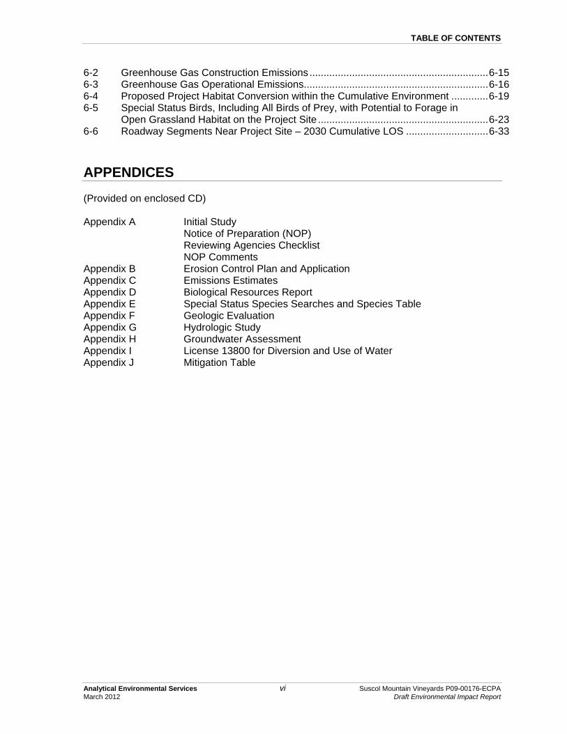
TABLE OF CONTENTS
Analytical Environmental Services vi Suscol Mountain Vineyards P09-00176-ECPA March 2012 Draft Environmental Impact Report
6-2 Greenhouse Gas Construction Emissions ............................................................... 6-15 6-3 Greenhouse Gas Operational Emissions................................................................. 6-16 6-4 Proposed Project Habitat Conversion within the Cumulative Environment ............. 6-19 6-5 Special Status Birds, Including All Birds of Prey, with Potential to Forage in
Open Grassland Habitat on the Project Site ............................................................ 6-23 6-6 Roadway Segments Near Project Site – 2030 Cumulative LOS ............................. 6-33
APPENDICES
(Provided on enclosed CD) Appendix A Initial Study Notice of Preparation (NOP) Reviewing Agencies Checklist NOP Comments Appendix B Erosion Control Plan and Application Appendix C Emissions Estimates Appendix D Biological Resources Report Appendix E Special Status Species Searches and Species Table Appendix F Geologic Evaluation Appendix G Hydrologic Study Appendix H Groundwater Assessment Appendix I License 13800 for Diversion and Use of Water Appendix J Mitigation Table

Analytical Environmental Services 1-1 Suscol Mountain Vineyards P09-00176-ECPA March 2012 Draft Environmental Impact Report
CHAPTER 1.0 INTRODUCTION
1.1 PURPOSE OF THE ENVIRONMENTAL IMPACT REPORT (EIR)
The Napa County Conservation, Development and Planning Department (Napa County), as the lead agency, has prepared this EIR to provide the public and responsible and trustee agencies with information about the potential effects, both beneficial and adverse, of the implementation of the Suscol Mountain Vineyards Agricultural Erosion Control Plan Application (ECPA) #P09-00176-ECPA (proposed project) on the local and regional (natural and human) environment. This EIR was prepared in compliance with the California Environmental Quality Act (CEQA) of 1970 (as amended), the CEQA Guidelines (CEQA, 2010), and Napa County’s local CEQA Guidelines (Napa County, 2010). As described in CEQA Guidelines Section 15121(a), an EIR is a public information document that assesses potential environmental impacts of the proposed project, as well as identifies mitigation measures and alternatives to the proposed project that could reduce or avoid adverse environmental impacts. CEQA requires that state and local government agencies consider the environmental consequences of projects over which they have discretionary authority. The EIR is an informational document used in the planning and decision-making process. It is not the intent of an EIR to recommend either approval or denial of a project. CEQA requires that a lead agency neither approve nor carry out a project as proposed unless the significant environmental effects have been reduced to an acceptable level, or unless specific findings are made attesting to the infeasibility of altering the project to reduce or avoid environmental impacts (CEQA Guidelines, Sections 15091 and 15092). An acceptable level is defined as eliminating, avoiding, or substantially lessening the significant effects. CEQA also requires that decision-makers balance the benefits of a proposed project against its unavoidable environmental risks. If environmental impacts are identified as significant and unavoidable, the project may still be approved if it is demonstrated that social, economic, or other benefits outweigh the unavoidable impacts. The lead agency would then be required to state in writing the specific reasons for approving the project based on information presented in the EIR, as well as other information in the record. This process is defined as a “Statement of Overriding Considerations” by the CEQA Guidelines, Section 15093.

1.0 INTRODUCTION
Analytical Environmental Services 1-2 Suscol Mountain Vineyards P09-00176-ECPA March 2012 Draft Environmental Impact Report
This EIR describes the environmental impacts of the various components of the project, and suggests mitigation measures to avoid or reduce impacts to less than significant levels. The impact analyses in this report are based on a variety of sources, including agency consultation, various reports prepared by others, and reports and field surveys completed by Analytical Environmental Services (AES) staff. The property as it existed at the time of the Notice of Preparation (October 26, 2009) is considered the baseline for analyzing the effects of the project. The EIR considers the entirety of the proposed project. In addition, the EIR analyzes the effectiveness of the erosion control measures as designed in #P09-00176-ECPA to control short and long term erosion and attenuate runoff. The proposed project is designed with the goal of being self-mitigating and the review and analysis determines whether this goal is met or whether additional mitigation measures or erosion control measures are required. In general, agriculture activities are not subject to County discretionary approval; however, projects involving grading, earthmoving, vegetation removal, or land disturbance activities of any kind on slopes greater than five percent require preparation and approval of an ECPA, which is subject to review under CEQA. The property is zoned for agricultural use and the establishment of a vineyard is consistent with the Napa County General Plan (2008) designation of Agriculture, Watershed, and Open Space (AW-OS) and zoning designation of Agricultural Watershed District (AW). Portions of parcels within the project site are within an Airport Compatibility (AC) Combination District Zone E, and a small portion of one parcel is also within Zone D. Upon the County’s approval of #P09-00176-ECPA, new vineyard on slopes greater than five percent could be developed on the property. Proposed vineyard development, along with subsequent vineyard activities such as vineyard maintenance and operation (including harvest) are considered indirect physical changes. Potential cumulative effects of the project when combined with other past, present, or probable future projects are also considered.
1.2 BACKGROUND
1.2.1 INTRODUCTION AND OVERVIEW OF AGRICULTURAL ACTIVITIES
In accordance with the County Code Section 18.108.080 (Napa County, 2009), Suscol Mountain Vineyards filed an agricultural ECPA (#P09-00176-ECPA) for development on the 2,123-acre property of approximately 438 acres of new vineyard within 561 gross acres of total land disturbance. For consistency, references to the property include the entire 2,123 acres; references to the project area, study area, or gross acres of disturbance refer to the 561 acres subject to alteration and the erosion control features that are located outside the clearing limits; and references to the net acres of vineyard describe the 438-acres of new vineyard proposed
1.0 INTRODUCTION
Analytical Environmental Services 1-3 Suscol Mountain Vineyards P09-00176-ECPA March 2012 Draft Environmental Impact Report
for development. An Erosion Control Plan (ECP) was originally filed for the project in April 2009, and a revised ECP was filed August 2010. A total of 45 proposed vineyard blocks would be developed within areas with slopes greater than five percent. The Suscol Mountain Vineyards property’s Assessor Parcel Numbers (APNs) and their acreages include: 045-360-008 (163.3 acres); 045-360-010 and 011 (167.6 acres); 057-020-076 (161.8 acres); 045-360-009, 057-020-077 and 057-030-012 (1,630.7 acres). Refer to Section 3.1 (Project Location) for a more detailed discussion of the subject parcels. Agricultural preservation and land use planning goals and policies were adopted in the Napa County General Plan (Napa County, 2008). Some of the goals and policies applicable to this project include:
• Goal AG/LU-1: Preserve existing agricultural land uses and plan for agriculture and related activities as the primary land uses in Napa County.
• Goal AG/LU-3: Support the economic viability of agriculture, including grape growing, winemaking, other types of agriculture, and supporting industries to ensure the preservation of agricultural lands.
• Policy AG/LU-1: Agriculture and related activities are the primary land uses in Napa County.
• Policy AG/LU-4: The County will reserve agricultural lands for agricultural use including lands used for grazing and watershed/open space, except for those lands which are shown on the Land Use Map as planned for urban development.
• Policy AG/LU-15: The County affirms and shall protect the right of agricultural operators in designated agricultural areas to commence and continue their agricultural practices (a “right to farm”), even though established urban uses in the general area may foster complaints against those agricultural practices. The “right to farm” shall encompass the processing of agricultural products and other activities inherent in the definition of agriculture provided in Policy AG/LU-2, above. The existence of this “Right to Farm” policy shall be indicated on all parcel maps approved for locations in or adjacent to designated agricultural areas and shall be a required disclosure to buyers of property in Napa County.
• Policy AG/LU-20: The following standards shall apply to lands designated as Agriculture, Watershed, and Open Space on the Land Use Map of this General Plan. Intent: To provide areas where the predominant use is agriculturally oriented; where watersheds are protected and enhanced; where reservoirs, floodplain tributaries, geologic hazards, soil conditions, and other constraints make the land relatively unsuitable for urban development; where urban development would adversely impact all such uses; and where the protection of agriculture, watersheds, and floodplain tributaries from fire, pollution, and erosion is essential to the general health, safety, and welfare.

1.0 INTRODUCTION
Analytical Environmental Services 1-4 Suscol Mountain Vineyards P09-00176-ECPA March 2012 Draft Environmental Impact Report
In the Conservation Element of the General Plan, the maintenance and enhancement of the agricultural environment is included as a planning policy (Policy CON-2). The policy expresses the intent of Napa County to provide a permanent means of preserving open space land for agricultural production by using various methods including zoning (Napa County Code Section 18.12.010). The above goals and policies comprise a set of development guidelines from which land use designations were developed. The AWOS General Plan designation for the subject property is an example. The respective goals of these designations are to provide areas where the predominant use is agriculturally oriented and where the protection of agriculture is essential to the general health, safety, and welfare, and to continue agricultural use of identified fertile valley and foothill areas. There are several related sections from the Napa County Code of relevance to the project. In Napa County Code Chapter 2.94 – Agriculture and Right to Farm, the County affirms and protects the right of agriculture operators in designated agricultural areas, even though established urban uses in the general area may foster complaints against those agricultural practices. Napa County Code Chapter 18.04 recognizes the role of agriculture in the County’s economic vitality. Napa County Code Chapter 18.108 pertains to hillside agriculture and the need to establish standards on slopes over five percent. In addition, Napa County Code Chapter 18.20 – Agricultural Watershed District, concerns the protection of the public interest in drainage systems and water impoundments from sedimentation, siltation, and contamination by ensuring agricultural projects use sound short and long term erosion control measures. The County has discretion over earthmoving activities on slopes greater than five percent (Napa County Code 18.108.070 (B)). Napa County Code 18.108.070 (B) requires the preparation of an ECP for earthmoving and grading activities on slopes greater than five percent. The ECP is subject to the exercise of judgment or deliberation when the County approves the ECP; thus, the approval of an ECP is a discretionary action and subject to CEQA. Subsequent agricultural activities, such as vineyard planting and operations, are not subject to CEQA; however, they are considered indirect physical changes likely to result from approval of the proposed project.
Napa County Code and Resolution 94-19 (as amended) specify the contents of an ECP and all elements that are required before the ECP application is accepted. These contents are described in the County’s ECP Review Application Packet for Structure/Road/Driveway, General Land Clearing, and Agricultural Projects. A qualified professional as described in Section 18.108.080 of the County Code must prepare the ECP. Appendix B contains a copy of the ECP Application and the ECP which was revised in August of 2010.

1.0 INTRODUCTION
Analytical Environmental Services 1-5 Suscol Mountain Vineyards P09-00176-ECPA March 2012 Draft Environmental Impact Report
1.3 PUBLIC OUTREACH
Early coordination with the general public, appropriate public agencies and local jurisdictions is encouraged in the environmental review process to determine the scope of the environmental document, the level of analysis, and related environmental requirements.
1.3.1 INITIAL STUDY AND NOTICE OF PREPARATION
An Initial Study was prepared for the proposed project in accordance with CEQA Guidelines Section 15063 (Appendix A). Based on the Initial Study, it was determined that an EIR should be prepared. In accordance with Section 15082 of the CEQA Guidelines, Napa County, as lead agency, prepared a Notice of Preparation (NOP) for this Draft EIR. The NOP is also presented in Appendix A. The Governor’s Office of Planning and Research, State Clearinghouse (SCH) circulated the NOP to local, state, and federal agencies on October 26, 2009, for a 30-day review period that ended on November 24, 2009. The SCH assigned the NOP SCH #2009102079. Napa County also distributed the NOP and Initial Study to local, state, and federal agencies, and other interested parties during the review period. The NOP was circulated to inform responsible agencies and the public that the proposed project could have significant effects on the environment and to solicit their comments. The issues discussed within this EIR are those that have been identified within the Initial Study as having potentially significant impacts. The following environmental issue areas were found to have the potential to be significantly affected by the proposed project and are addressed in greater detail in this Draft EIR.
• Air Quality • Biological Resources • Cultural Resources • Geology and Soils • Hazardous Materials • Hydrology and Water Quality • Land Use and Planning • Transportation and Traffic • Cumulative Impacts
1.3.2 COMMENTS ON THE NOTICE OF PREPARATION
Napa County received nine comment letters on the NOP. These comment letters were considered during preparation of the Draft EIR and are presented in Appendix A. The following is a list of commenting agencies and organizations, and a summary of concerns:

1.0 INTRODUCTION
Analytical Environmental Services 1-6 Suscol Mountain Vineyards P09-00176-ECPA March 2012 Draft Environmental Impact Report
• Bay Area Ridge Trail Council (Ridge Trail Council) – potential impacts to a possible future Ridge Trail segment on the property (discussed in the Initial Study);
• California Department of Fish and Game (DFG) – project related impacts to special status species and habitats, and plant survey methodology (see Chapter 4.2 Biological Resources);
• Department of Transportation – potential impacts to transportation and traffic from construction and vehicles (see Chapter 4.7 Transportation and Traffic);
• Earth Defense for the Environment Now (E.D.E.N.) – project related hydrologic changes, biological impacts, wildlife corridors and fencing plans, vegetation cover and cumulative impacts of vineyard conversion, global warming, (see Chapters 4.1 Air Quality, 4.2 Biological Resources, 4.3 Cultural Resources, 4.4 Geology and Soils, 4.6 Hydrology and Water Quality, and 6.0 Other CEQA-Required Sections).
• Friends of the Napa River – project related sustainable farming practices, potential impacts to biological resources, and cumulative impacts to aesthetics, erosion, and water quality (see Chapter 4.2 Biological Resources, and 6.0 Other CEQA-Required Sections);
• Groundwater Under Local Protection (GULP) – potential impacts to groundwater resources (see Chapter 4.6 Hydrology and Water Quality);
• Native American Heritage Commission – potential impacts to cultural resources (see Chapter 4.3 Cultural Resources);
• Napa-Solano Audubon Society – potential impacts to birds, wildlife and habitat (see Chapter 4.2 Biological Resources); and
• Napa County Sierra Club – potential impacts to global warming and groundwater resources (see Chapter 4.1 Air Quality, and 4.6 Hydrology and Water Quality);
1.3.3 CONSULTATION
In addition to the comments received on the NOP, the following agencies were contacted for consultation on the project:
• U.S. Army Corps of Engineers (USACE) – Laurie Monarres, North Branch Chief was contacted on August 25 and 28, 2009, and September 8 and 9, 2009.
• U.S. Fish and Wildlife Service (USFWS) – Ben Solvesky participated in a meeting at the project site on December 8, 2009.
• California Department of Fish and Game (CDFG) – Corinne Gray participated in a meeting at the project site on September 10, 2009.
• Regional Water Quality Control Board, San Francisco Bay District (SFRWQCB) – Fred Hetzel participated in a meeting at the project site on September 10, 2009.
• Napa County Resource Conservation District (RCD) – David Steiner participated in a meeting at the project site on September 10, 2009. Mr. Steiner also conducted five site
1.0 INTRODUCTION
Analytical Environmental Services 1-7 Suscol Mountain Vineyards P09-00176-ECPA March 2012 Draft Environmental Impact Report
inspections from June 2009 through August 2009 with the project engineer to review the proposed ECP.
• California Department of Transportation (Caltrans) – Sandy Finegan was contacted via telephone on August 25, 2009.
• State Water Resources Control Board, Division of Water Rights – Rebecca Walther and Angela Nguyen-Tan participated in a meeting at the project site on September 10, 2009.
1.4 CEQA EIR PROCESS
1.4.1 PUBLIC REVIEW
This document is being circulated to local, state and federal agencies and to interested organizations and individuals who wish to review and comment on the report. Publication of this EIR marks the beginning of a 45-day public review period, during which written comments may be submitted to Napa County at the following address (including e-mail): Napa County Conservation, Development and Planning Department Attn: Brian Bordona 1195 Third Street, Suite 210 Napa, CA 94599-3092 Email: [email protected] Although Napa County will accept e-mail comments, pursuant to CEQA Section 20191 (d)(3)(A), reviewers are encouraged to follow up any e-mail with letters. In accordance with CEQA Guidelines Section 15204 (a), the focus of review should be on the sufficiency of this EIR in identifying and analyzing the possible impacts on the environment and ways in which the significant effects of the project might be avoided or mitigated.
1.4.2 FINAL EIR PUBLICATION
Written comments received in response to the Draft EIR will be addressed in a Response to Comments document, which together with any revisions to the Draft EIR text will constitute the Final EIR. Napa County will then review the proposed project, the EIR, and public testimony to decide whether to certify the EIR and approve the project (CEQA, 2006: Section 15090). Before approving the project, Napa County must make written findings with respect to each significant environmental effect identified in the EIR in accordance with Section 15091 of CEQA Guidelines. Within five working days following project approval, Napa County shall file a Notice of Determination (NOD) with the SCH and the county clerk in accordance with CEQA Guidelines Section 15094.

1.0 INTRODUCTION
Analytical Environmental Services 1-8 Suscol Mountain Vineyards P09-00176-ECPA March 2012 Draft Environmental Impact Report
1.4.3 MITIGATION MONITORING AND REPORTING
Section 21081.6 of the State Public Resources Code requires lead agencies to adopt a Mitigation Monitoring and Reporting Program (MMRP) for the changes to the project which it has adopted or made a condition of project approval in order to mitigate or avoid significant effects on the environment. The MMRP is not required to be included in the Draft EIR; however, mitigation measures have been clearly identified and presented in language that will facilitate the establishment of the MMRP. Any mitigation measures adopted by Napa County as conditions of approval for the project will be included in a MMRP to verify compliance. The MMRP will also identify the responsible parties for implementing and for monitoring each mitigation measure.
1.5 TERMINOLOGY USED IN THE EIR
This Draft EIR uses the following terminology to describe environmental effects of the proposed project and alternatives:
• Significance Criteria: A set of criteria used by the lead agency to determine at what level or “threshold” an impact would be considered significant. Significance criteria used in this EIR include factual or scientific information; regulatory standards of local, state, and federal agencies; and/or guiding and implementing goals and policies identified in local plans.
• Less-Than-Significant Impact: A less-than-significant impact would cause no substantial change in the environment (no mitigation required).
• Potentially Significant Impact: A potentially significant impact may cause a substantial change in the environment; however, additional information is needed regarding the extent of the impact. For CEQA purposes, a potentially significant impact is treated as if it were a significant impact.
• Significant Impact: A significant impact would cause a substantial adverse change in the physical conditions of the environment. Significant impacts are identified by the evaluation of project effects using specified significance criteria. Mitigation measures and/or project alternatives are identified to reduce project effects to the environment.
• Significant and Unavoidable Impact: A significant and unavoidable impact would result in a substantial change in the environment that cannot be avoided or mitigated to a less than significant level if the project is implemented.
• Cumulative Significant Impact: A cumulative significant impact would result in a substantial change in the environment if two or more individual effects are considerable when considered together, or if the effects compound or increase other environmental impacts. From the California Code of Regulations Section 15355 “(a) The individual effects may be changes resulting from a single project or a number of

1.0 INTRODUCTION
Analytical Environmental Services 1-9 Suscol Mountain Vineyards P09-00176-ECPA March 2012 Draft Environmental Impact Report
separate projects. (b) The cumulative impact from several projects is the change in the environment which results from the incremental impact of the project when added to other closely related past, present, and reasonably foreseeable probable future projects. Cumulative impacts can result from individually minor but collectively significant projects taking place over a period of time.”
The Draft EIR also identifies mitigation measures. Where significant or potentially significant impacts of the proposed project have been identified, mitigation measures have been proposed.
1.6 EIR ORGANIZATION
This Draft EIR is organized into eight chapters as described below.
1. Chapter 1.0 Introduction describes the purpose and organization of the EIR and the EIR preparation, review and certification processes. This chapter also describes subsequent development and approvals for which this EIR may be used.
2. Chapter 2.0 Executive Summary provides a summary of the proposed project, unavoidable environmental impacts that would result from project implementation, a summary of project alternatives, and the potential areas of controversy. This chapter also includes a table summarizing the impacts of the proposed project and mitigation measures that have been identified.
3. Chapter 3.0 Project Description describes the project location and vicinity, outlines project objectives, and summarizes components of the proposed project, pursuant to CEQA Guidelines Section 15124.
4. Environmental Setting, Impacts and Mitigation Measures: For each environmental issue area in Chapter 4.0, the existing environmental setting is described, the environmental impacts associated with project construction and operation are discussed, and mitigation measures for the impacts of the proposed project are identified, pursuant to CEQA Guidelines Sections 15125, and 15126.
5. Chapter 5.0 Alternatives to the Proposed Project describes alternatives to #P09-00176-ECPA that were considered, including the No Project Alternative, which is required by CEQA for all EIRs.
6. Chapter 6.0 Other CEQA-Required Sections discusses the following:
• Growth-inducing impacts (i.e. the potential for the proposed project to induce urban growth and development, pursuant to CEQA Guidelines Section 15126(d));
• Cumulative impacts (i.e. the potential for the proposed project to result in cumulative impacts, pursuant to CEQA Guidelines Section 15130);
• Significant unavoidable adverse impacts of the proposed project and project alternatives, pursuant to CEQA Guidelines 15126(b);

1.0 INTRODUCTION
Analytical Environmental Services 1-10 Suscol Mountain Vineyards P09-00176-ECPA March 2012 Draft Environmental Impact Report
• Potential indirect impacts that may result from the proposed project, pursuant to CEQA Guidelines 15126.4 (a)(1)(D), 15358 (a)(2) and 15064 (d); and
• Significant irreversible environmental changes related to the implementation of the proposed project and project alternatives, pursuant to CEQA Guidelines Sections 15126.2 (c) and 15127.
7. Report Preparation: Chapter 7.0 provides the names of the EIR authors and consultants, pursuant to CEQA Guidelines 15129.
8. Appendices: Chapter 8.0 contains the appendices referenced in the EIR.
1.7 INTENDED USES OF THE EIR
The Napa County Conservation, Development and Planning Department has the primary authority for approval of #P09-00176-ECPA. In addition, activities associated with the installation of the project may also affect the following responsible and trustee agencies, subsequently requiring consultation, approval, and permits from the agencies.
• USACE – Section 404 of the Clean Water Act requires the issuance of a permit before discharging fill into the waters of the U.S., including wetlands.
• USFWS – Pursuant to the requirements of the Federal Endangered Species Act (FESA) of 1973 (16 USC Section 1531 et seq.), an agency reviewing a proposed project within its jurisdiction must determine whether any federally listed species may be present in the project area and determine whether the proposed project will have a potentially significant impact upon such species.
• CDFG – Sections 1601-1603 of the Fish and Game Code require a Streambed Alteration Agreement before any action is taken that would obstruct or divert the flow or alter the channel of designated drainages, rivers, streams, and lakes. Also, pursuant to requirements of the California Endangered Species Act (CESA) of 1970 (Fish and Game Code Section 2050 et seq., and CCR Title 14, Subsection 670.2, 670.51), an agency reviewing a proposed project within its jurisdiction must determine whether any state listed species may be present in the project area and determine whether the proposed project will have a potentially significant impact upon such species. An environmental filing fee required pursuant to Fish and Game Code Section 711.4(d) must be paid to the Napa County Clerk on or before the filing of the NOD for the project.
1.8 EFFECTS NOT FOUND TO BE SIGNIFICANT
CEQA Guidelines Section 15128 states that an “EIR shall contain a statement briefly indicating the reasons that various possible significant effects of a project were determined not to be

1.0 INTRODUCTION
Analytical Environmental Services 1-11 Suscol Mountain Vineyards P09-00176-ECPA March 2012 Draft Environmental Impact Report
significant and were therefore not discussed in detail in the EIR.” The following environmental issues were identified in the Initial Study as being less than significant and therefore are not evaluated in this EIR: Aesthetics, Agricultural Resources, Mineral Resources, Noise, Population and Housing, Public Services, Recreation, and Utilities and Service Systems (Appendix A; AES, 2009). The proposed project would result in either no impact or a less-than-significant impact to these issue areas for the following reasons:
• Aesthetics: The proposed project is located in rural Napa County with surrounding areas consisting of moderate to steep hills, ridges, and valleys supporting open space, agricultural lands (including vineyards), and industrial uses (including a quarry). The proposed project is considered agricultural in nature and is compatible with surrounding land uses. Impacts to aesthetics are considered less than significant.
• Agricultural Resources: The proposed project would not convert agricultural land to non-agricultural use. No impact would occur.
• Mineral Resources: Mineral resources have not been identified within the project site, according to Napa County Resource Maps and implementation of the project would not interfere with the on-going operation of the Syar Quarry located contiguous to the northern boundary of the project site. No impact would occur.
• Noise: The proposed project would result in seasonal and temporary noise generation related to construction and maintenance activities of the vineyard. At the project site, construction activities would require the use of heavy equipment. No blasting would occur for construction. During operation, work would typically be conducted within the hours of 7 A.M. and 4 P.M., but would also include occasional nighttime activities including nighttime harvest (typically from 9 P.M. to 5 A.M.) about 20 days per year, sulfur/pesticide/herbicide application (typically from 9 P.M. to 5 A.M.) about 25 days per year, and frost protection with wind machines (typically from 12 A.M. to 7 A.M.) about 15 days out of the year. The closest offsite residence is located approximately 900 feet southeast of the project site. Numerous other residences are located 1,500 feet and further from the western property boundary. Residences are also located approximately two miles to the north of the project site. Syar Quarry is located contiguous to the northern boundary of the project site and generates noise from the use of heavy construction equipment, a rock crusher, blasting, and general grading activities. Given the scale of the proposed project and the existing conditions in the vicinity of the project area, the proposed project would not expose sensitive receptors to excessive or substantial noise. Noise impacts are considered less than significant.
• Population and Housing: The proposed project does not involve the construction of new homes or businesses. Existing roads will be used during construction for project operation activities and fire equipment access to the project site. The proposed project would not induce substantial population growth either directly or indirectly or create a significant need for additional housing. No residences or people would be displaced by

1.0 INTRODUCTION
Analytical Environmental Services 1-12 Suscol Mountain Vineyards P09-00176-ECPA March 2012 Draft Environmental Impact Report
the proposed project. Impacts to population and housing are considered less than significant.
• Public Services: The proposed project would not result in substantial growth that would require additional public services. The proposed project would not adversely impact the County’s ability to provide fire and police protection, or impact the maintenance of schools, parks, or other public facilities. No impact would occur.
• Recreation: The proposed project would not result in substantial population growth or the associated increased use of recreational facilities, and does not include the construction or expansion of recreational facilities. The proposed project would also not adversely impact recreational opportunities or prohibit the maintenance of existing recreational opportunities. No impact would occur. Further, development of the proposed project would not preclude trail use on the property.
• Utilities and Service Systems: The proposed project would not exceed water treatment requirements or result in the construction of new water or wastewater treatment facilities. The proposed project would rely on groundwater to irrigate the proposed vineyard areas. Groundwater would originate from an existing well on the property and additional proposed wells that would be developed throughout the project site. Aside from additional wells, the proposed project would not require additional water supplies, such as connection to public water supply. Onsite workers would generate a minimum amount of construction waste and solid waste, however, a less than significant impact is expected to the landfill capacity in the area. The proposed project would not conflict with any statutes or regulations related to solid waste. Impacts to utilities and service systems are considered less than significant.

1.0 INTRODUCTION
Analytical Environmental Services 1-13 Suscol Mountain Vineyards P09-00176-ECPA March 2012 Draft Environmental Impact Report
REFERENCES AES, 2009. Suscol Mountain Vineyards Erosion Control Plan Application No. P09-00176-ECPA
Initial Study. Prepared by Analytical Environmental Services for Napa County Conservation, Development and Planning Department. October 2009.
CEQA, 2010. California Environmental Quality Act (CEQA) Guidelines. Public Resources
Code, Sections 21000-21178 (as amended January 1, 2010) and California Code of Regulations, Sections 15000-15387.
Napa County, 2008. Napa County General Plan. June 2008. Available online at:
http://www.countyofnapa.org/GeneralPlan/. Napa County, 2009. Napa County Code 2009. Available online at:
http://library.municode.com/index.aspx?clientId=16513&stateId=5&stateName= California.
Napa County, 2010. Napa County’s Local Procedures for Implementing the California
Environmental Quality Act. Napa County Conservation, Development and Planning Department. September 2010.

Analytical Environmental Services 2-1 Suscol Mountain Vineyards P09-00176-ECPA March 2012 Draft Environmental Impact Report
CHAPTER 2.0 EXECUTIVE SUMMARY
2.1 INTRODUCTION
This Environmental Impact Report (EIR) assesses the potential environmental impacts of the Suscol Mountain Vineyards #P09-00176-Erosion Control Plan Application (ECPA) project. This document has been prepared in accordance with the California Environmental Quality Act (CEQA) statutes and Guidelines. Napa County Conservation, Development and Planning Department (Napa County) is the lead agency for this CEQA process. Inquiries about the project and the CEQA process should be directed to: Napa County Conservation Development and Planning Department Attn: Brian Bordona 1195 Third Street, Suite 210 Napa, CA 94599-3092 Email: [email protected]
2.2 PROJECT DESCRIPTION
The purpose of #P09-00176-ECPA is to develop approximately 438 to 561 acres of vineyard. This includes vegetation removal and earthmoving and grading activities associated with soil cultivation, installation and maintenance of drainage and erosion control features, and vineyard planting.
2.2.1 EROSION CONTROL MEASURES
Temporary and permanent erosion control measures are proposed as a part of #P09-00176-ECPA for the proposed vineyard areas. These measures would be maintained regularly to function as intended. They are summarized below and are described in more detail in Chapter 3.0 Project Description.
• Surface drainage pipelines to collect surface runoff at low points throughout the project area and transport it to protected outlets;
• Standard drop inlets and concrete drop inlets; • Concrete outlet structures;

2.0 EXECUTIVE SUMMARY
Analytical Environmental Services 2-2 Suscol Mountain Vineyards P09-00176-ECPA March 2012 Draft Environmental Impact Report
• Gravity outlets to act as energy dissipaters and minimize erosion; • Pipe and rock level spreaders at the ends of proposed pipelines to return concentrated
flows within the pipe to sheet flow; • Infield diversion ditches; • Outsloped infield spreaders; • Subsurface drainage pipeline; • Rock repositories/outsloped turnarounds; • Rock berms; • Cutoff collars on all solid pipelines with slopes greater than five percent; • Maintenance of approximately 25 miles of existing roads through the implementation of a
Long Term Vineyard Road Management Plan (as described in more detail in Section 3.4.1-5);
• Utilization of rock brought up by ripping for road surfacing; the remaining rock would be stockpiled in designated areas adjacent to vineyard areas for future use;
• All disturbed areas and avenues would be seeded with a permanent no-till cover crop with minimum vegetative cover requirements between 70 to 80 percent depending on the cover crop management specifications (see Table 3-3 for specific densities per vineyard block), all vineyard avenues would be maintained with a minimum 70 percent cover; and
• Straw wattles, waterbars, and other temporary erosion control measures, as specified in the erosion control plan application.
All disturbed areas would be seeded with a permanent no-till cover crop and straw mulch, which would be applied to all disturbed areas. The permanent, no-till cover crop would be managed each year with areas being reseeded and mulched until adequate coverage is achieved. Seventy percent cover would be maintained in the vineyard avenues and in proposed Blocks 1 through 6, 8, 10A, 10B, 11, 12, 13, 14, 15A, 15E, 16, 17, 18, 19B, 21A, 21B, 21D, 22, 23, 24C, 25, 26, 27A, 27B, 27D, 27E, 28, 29, 31A, 34C, 36 through 39A, and 42 through 46. Seventy five percent cover would be maintained in proposed Blocks 7, 9, 10C, 15B through 15D, 19A, 20, 21C, 24A, 24B, 27C, 30, 31B, 34A, 34B, 34D, 40 and 41. Cover crop for proposed Blocks 32, 33 and 39B would be managed each year to 80 percent vegetative cover to control erosion. These blocks were identified as requiring a slightly greater vegetation cover to control erosion, based on the Universal Soil Loss Equation (USLE) calculations. Temporary erosion control measures shall include straw wattles, waterbars, rolling dips, straw mulch and other practices as needed. The measures shall be maintained in a functional condition throughout the rainy season. Waterbars shall not be constructed such that they direct water onto adjacent properties. Maintenance of the erosion control measures so they function as intended, and maintenance of the measures throughout the rainy season from October 15 through April 1.

2.0 EXECUTIVE SUMMARY
Analytical Environmental Services 2-3 Suscol Mountain Vineyards P09-00176-ECPA March 2012 Draft Environmental Impact Report
2.3 ALTERNATIVES TO THE PROPOSED PROJECT
CEQA Guidelines require EIRs to describe and evaluate a range of reasonable alternatives to a project, or to the location of a project, which would feasibly attain most of the basic project objectives and avoid or substantially lessen significant project impacts. Although there are no significant unmitigable project impacts identified, Chapter 5.0 Alternatives to the Proposed Project evaluates the potential alternatives to the proposed project. This chapter also includes a description of alternatives withdrawn from further consideration. Potential alternatives examined for the proposed project in this EIR include the No Project Alternative, Reduced Intensity Alternative, and a Reduced Intensity with Recycled Water Supply Alternative. With the No Project Alternative, the project site would continue to operate as a cattle grazing area, and the approximately 2,123 acres of rangeland on the project site would continue to be grazed and maintained. With Reduced Intensity Alternative, proposed vineyard acreage would be reduced from approximately 561 gross acres to approximately 451 gross acres. These avoided areas would remain in their current state, thereby preserving vegetation in these areas. The Reduced Intensity with Recycled Water Supply Alternative is similar to the Reduced Intensity Alternative (with the development of approximately 359 acres of vineyard within 451 gross acres), with the exception that groundwater would be utilized only for the initial phase of project development; Phases II and III would make use of recycled water from the Napa Sanitation District’s Soscol Water Recycling Facility.
2.4 SUMMARY OF ENVIRONMENTAL IMPACTS
Table 2-1 presents a summary of project impacts and proposed mitigation measures that would further avoid or minimize potential project-related impacts. In the table, the level of significance of each environmental impact is indicated both before and after the application of the recommended mitigation measure(s). Refer to the environmental analysis sections in Chapter 4.0 for detailed discussions of all project impacts and mitigation measures.
2.0 EXECUTIVE SUMMARY
Analytical Environmental Services 2-4 Suscol Mountain Vineyards P09-00176-ECPA March 2012 Draft Environmental Impact Report
TABLE 2-1 SUMMARY OF IMPACTS AND MITIGATION MEASURES
Environmental Impact
Level of Significance
Before Mitigation
Mitigation Measure
Level of Significance
After Mitigation
4.1 Air Quality
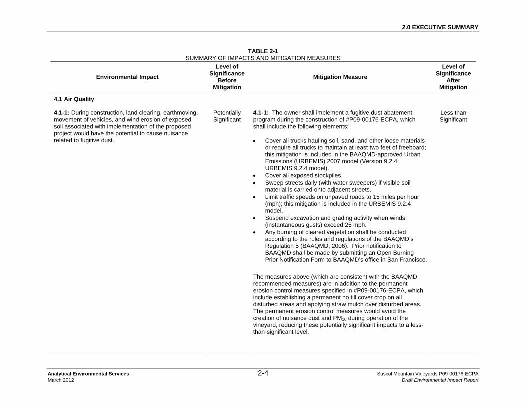
4.1-1: During construction, land clearing, earthmoving, movement of vehicles, and wind erosion of exposed soil associated with implementation of the proposed project would have the potential to cause nuisance related to fugitive dust.
Potentially Significant
4.1-1: The owner shall implement a fugitive dust abatement program during the construction of #P09-00176-ECPA, which shall include the following elements: • Cover all trucks hauling soil, sand, and other loose materials
or require all trucks to maintain at least two feet of freeboard; this mitigation is included in the BAAQMD-approved Urban Emissions (URBEMIS) 2007 model (Version 9.2.4; URBEMIS 9.2.4 model).
• Cover all exposed stockpiles. • Sweep streets daily (with water sweepers) if visible soil
material is carried onto adjacent streets. • Limit traffic speeds on unpaved roads to 15 miles per hour
(mph); this mitigation is included in the URBEMIS 9.2.4 model.
• Suspend excavation and grading activity when winds (instantaneous gusts) exceed 25 mph.
• Any burning of cleared vegetation shall be conducted according to the rules and regulations of the BAAQMD’s Regulation 5 (BAAQMD, 2006). Prior notification to BAAQMD shall be made by submitting an Open Burning Prior Notification Form to BAAQMD’s office in San Francisco.
The measures above (which are consistent with the BAAQMD recommended measures) are in addition to the permanent erosion control measures specified in #P09-00176-ECPA, which include establishing a permanent no till cover crop on all disturbed areas and applying straw mulch over disturbed areas. The permanent erosion control measures would avoid the creation of nuisance dust and PM10 during operation of the vineyard, reducing these potentially significant impacts to a less-than-significant level.
Less than Significant
2.0 EXECUTIVE SUMMARY
Analytical Environmental Services 2-5 Suscol Mountain Vineyards P09-00176-ECPA March 2012 Draft Environmental Impact Report
Environmental Impact
Level of Significance
Before Mitigation
Mitigation Measure
Level of Significance
After Mitigation
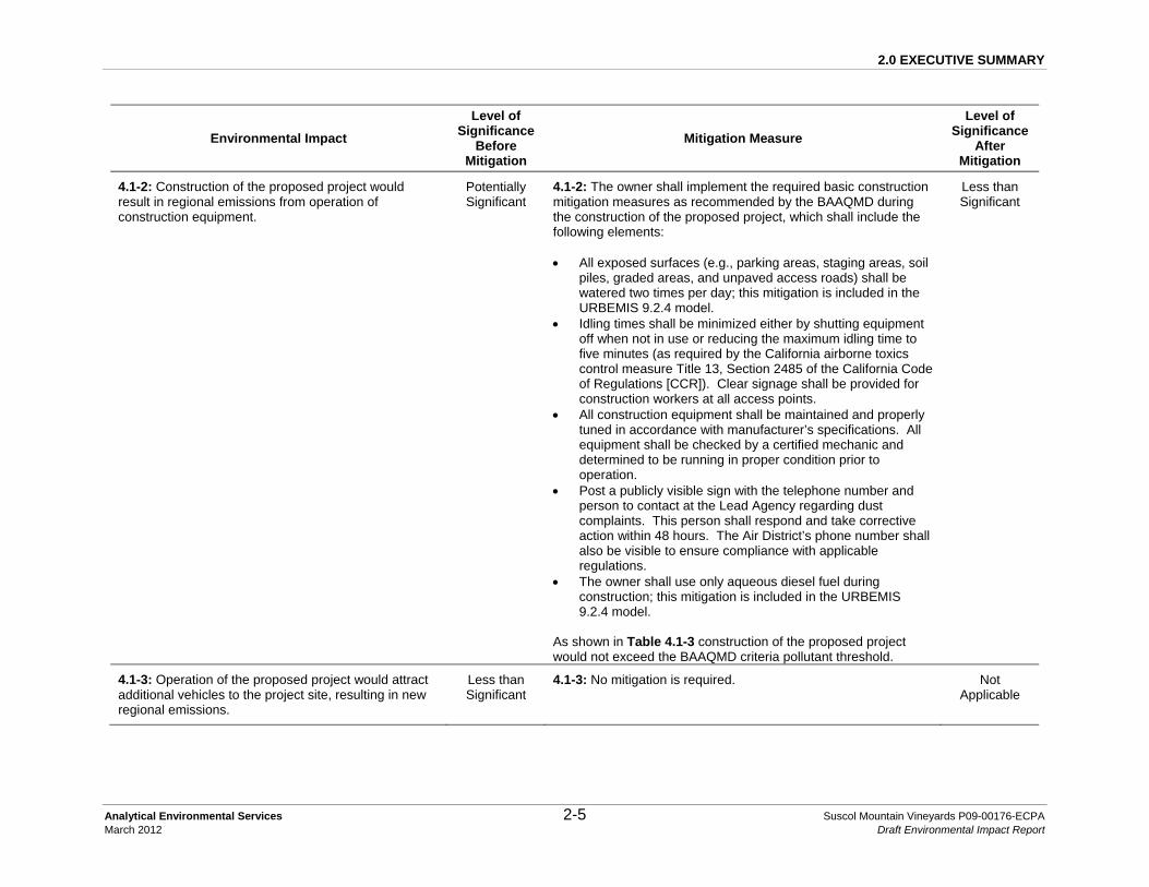
4.1-2: Construction of the proposed project would result in regional emissions from operation of construction equipment.
Potentially Significant
4.1-2: The owner shall implement the required basic construction mitigation measures as recommended by the BAAQMD during the construction of the proposed project, which shall include the following elements: • All exposed surfaces (e.g., parking areas, staging areas, soil
piles, graded areas, and unpaved access roads) shall be watered two times per day; this mitigation is included in the URBEMIS 9.2.4 model.
• Idling times shall be minimized either by shutting equipment off when not in use or reducing the maximum idling time to five minutes (as required by the California airborne toxics control measure Title 13, Section 2485 of the California Code of Regulations [CCR]). Clear signage shall be provided for construction workers at all access points.
• All construction equipment shall be maintained and properly tuned in accordance with manufacturer’s specifications. All equipment shall be checked by a certified mechanic and determined to be running in proper condition prior to operation.
• Post a publicly visible sign with the telephone number and person to contact at the Lead Agency regarding dust complaints. This person shall respond and take corrective action within 48 hours. The Air District’s phone number shall also be visible to ensure compliance with applicable regulations.
• The owner shall use only aqueous diesel fuel during construction; this mitigation is included in the URBEMIS 9.2.4 model.
As shown in Table 4.1-3 construction of the proposed project would not exceed the BAAQMD criteria pollutant threshold.
Less than Significant
4.1-3: Operation of the proposed project would attract additional vehicles to the project site, resulting in new regional emissions.
Less than Significant
4.1-3: No mitigation is required. Not Applicable

2.0 EXECUTIVE SUMMARY
Analytical Environmental Services 2-6 Suscol Mountain Vineyards P09-00176-ECPA March 2012 Draft Environmental Impact Report
Environmental Impact
Level of Significance
Before Mitigation
Mitigation Measure
Level of Significance
After Mitigation
4.1-4: Construction of the proposed project would slightly increase traffic volumes and congestion levels on local roadways.
Less than Significant
4.1-4: No mitigation is required. Not Applicable
4.1-5: Project emissions have the potential to cause distress to sensitive receptors.
Less than Significant
4.1-5: No mitigation is required. Not Applicable
4.1-6: Project operation could result in operational odors.
Less than Significant
4.1-6: No mitigation is required. Not Applicable
4.2 Biological Resources
4.2-1: Development of the proposed project would convert native grassland vegetation to vineyard, changing management of these grasslands, and potentially conflict with Napa County Policy CON-17 that preserves and protects native grasslands.
Potentially Significant
4.2-1: Indirect impacts would be reduced to less-than-significant levels by a combination of avoidance of all Purple Needle Grass Grassland and Creeping Rye Grass Turf (as proposed and mapped in Figure 4.2-1), and grassland management. These Sensitive Biotic Communities shall be managed to maintain native species and control highly invasive species using light grazing guided through a Resource Management Plan (RMP). This RMP shall be prepared by a qualified biologist, ecologist or State-licensed Certified Rangeland Manager (CRM), in consultation with the Napa County Resource Conservation Director (RCD). This would be consistent with Napa County Policies CON-2 and CON-17. The RMP shall be submitted to Napa County prior to any vegetation removal, grading and earthmoving activities. In addition to the avoidance and management of all mapped Purple Needle Grass Grassland and Creeping Rye Grass Turf discussed above, the following are other objectives that shall be included in the RMP: the management of onsite Wild Oat Grasslands not proposed for development (Mitigation Measure 4.2-2) to prevent further invasion of Wild Oats Grasslands by highly invasive plant species; management of the Oak Woodland Avoidance and Management Areas (Mitigation Measure 4.2-4); and aquatic habitat enhancement in the vicinity of the proposed Suscol Creek crossing (Mitigation Measure 4.2-17); standard adaptive management erosion control and fire management practices within onsite wildlife corridors (Mitigation Measure 4.2-8). Implementation of the RMP would protect wetland
Less than Significant

2.0 EXECUTIVE SUMMARY
Analytical Environmental Services 2-7 Suscol Mountain Vineyards P09-00176-ECPA March 2012 Draft Environmental Impact Report
Environmental Impact
Level of Significance
Before Mitigation
Mitigation Measure
Level of Significance
After Mitigation
habitats from potential water quality related impacts (Mitigation Measure 4.2-7), and continue to provide habitat for grasshopper sparrow nesting and foraging (Mitigation Measure 4.2-14), as well as Swainson’s hawk (Impact 4.2-15) and raptor and loggerhead shrike foraging habitat (Impact 4.2-16). Required performance standards for the RMP are as follows. Performance criteria for enhancement of grassland resource values are shown in parentheses (LSA, 2010; Appendix D): • Management goals. (Goals shall include habitat
enhancement criteria such as increased native grass cover, native plant diversity, and wildlife values).
• Range improvements such as existing and proposed fences and water sources. (Additional water sources and fencing shall be installed for more even distribution of grazing use and to lessen impacts on wetlands and riparian habitats).
• Kind and class of livestock. • Livestock carrying capacity and stocking rate. (A stocking
rate that results in light to moderate use levels shall be specified to promote habitat values).
Residual dry matter levels (RDM) related to slope. (Minimum RDM levels consistent with light to moderate use levels shall be attained. This equates to an average of about 700 pounds per acre on gentle slopes to 1,000 pounds per acre on steeper slopes in an average rainfall year).
4.2-2: Development of the proposed project would reduce the acreage of all non-sensitive grassland vegetation types, which provide cover for erosion control, important forage and nesting habitat for invertebrates, birds and mammals, appropriate vegetative structure for many native plant species, and contribute to overall biodiversity in the region.
Potentially Significant
4.2-2: Impacts to non-sensitive grasslands would be reduced to less-than-significant levels through the development and execution of a RMP (refer to Mitigation Measure 4.2-1). Management under the RMP of Wild Oat Grasslands not proposed for development would prevent further invasion of Wild Oats Grasslands by highly invasive plant species. This would have the added effect of enhancing forage for cattle and habitat quality for native species. The majority of Wild Oats Grassland containing minor components of purple needle grass, creeping wild rye, and meadow barley would also be avoided and managed to preserve nesting habitat for grasshopper sparrows
Less than Significant

2.0 EXECUTIVE SUMMARY
Analytical Environmental Services 2-8 Suscol Mountain Vineyards P09-00176-ECPA March 2012 Draft Environmental Impact Report
Environmental Impact
Level of Significance
Before Mitigation
Mitigation Measure
Level of Significance
After Mitigation
(Impact and Mitigation Measure 4.2-14). An important component of the RMP would be to provide measurable benchmarks for livestock grazing for fire prevention and weed management. When livestock are grazed outside of vineyard areas, temporary fencing shall be utilized as needed to prevent livestock access to wetlands, Suscol Creek and its tributaries, and tributaries to Sheehy and Fagan Creeks. The initial temporary fencing design shall be field verified by a qualified biologist prior to commencement of grazing activities. The Applicant/Owner shall use criteria established in the RMP (discussed in Mitigation Measure 4.2-1) to ensure the property is not overgrazed outside the vineyard blocks.
4.2-3: Development of the proposed project would convert to vineyard approximately 0.26 acre (1.6 percent) of the almost 16 acres of the Chamise Alliance known to occur within the project site.
Less than Significant
4.2-3: No mitigation is required. Not Applicable
4.2-4: Development of the proposed project would convert Coast Live Oak Woodland and scattered valley oaks to vineyard, which could result in adverse impacts to biological resources. In addition, the proposed development may conflict with Napa County General Plan Goals CON-2 and CON-6 and Policies CON-17 and CON-24.
Potentially Significant
4.2-4: Impacts to oak woodland shall be reduced to a less-than-significant level and result in the greatest quality of oak woodland mitigation through a combination of 1) avoidance of oak woodlands to the maximum extent feasible; 2) preservation and conservation of oak woodlands having the highest habitat values and qualities at minimum 2:1 preservation-to-vineyard ratio on a per acre basis; and 3) through the restoration and enhancement of existing oak woodlands implemented by an oak woodland restoration plan. Prior to approval of the ECP, the plan shall be modified to include the following measures. Avoidance Avoidance measures would preserve areas identified as high value oak woodlands that occur within or in close proximity to riparian galleries, on the fringe of vineyard blocks, species that are of limited distribution in the vicinity of the project site (e.g., valley oak), and woodlands on or near ridge tops. Appendix J discussed in Chapter 6.0 identifies constraints by vineyard block; thereby showing the reason(s) for mitigation. As seen in Appendix J, some trees are preserved primarily for slope stability purposes and are preserved for biological resources as a secondary consideration. The following proposed blocks shall be
Less than Significant
2.0 EXECUTIVE SUMMARY
Analytical Environmental Services 2-9 Suscol Mountain Vineyards P09-00176-ECPA March 2012 Draft Environmental Impact Report
Environmental Impact
Level of Significance
Before Mitigation
Mitigation Measure
Level of Significance
After Mitigation
modified to avoid oak woodland areas, illustrated in Figure 4.2-6 as Oak Woodland Avoidance and Management Areas (includes the oak woodlands identified as management areas by LSA (2010), see Appendix D): Blocks 1, 7, 9, 19, 21, 24, 26, 27, 29, 30, 31, and 32. The required Oak Woodland Avoidance and Management Areas total approximately 12.2 acres, including ridge top woodlands in proposed Blocks 21, 24, 26, 27, 29, 30, and 31, and the retention of several large specimen trees within vineyard blocks, including two coast live oaks with trunk diameters at breast height (dbh) of 40 inches and four valley oaks. All avoided trees within 50 feet of ground-disturbing activities shall be protected with visible plastic fencing during all phases of construction activities. Visible fencing shall be placed ten feet outside the edge of the dripline (edge of the tree canopy) to protect above- and below-ground tissues of these trees and shall be field verified by Napa County prior to the commencement of any grading or vegetation removal. The following shall not occur within the buffers of any retained tree(s): parking or storage of vehicles, machinery or other equipment; stockpiling of excavated soils, rocks or construction materials; or dumping of oils or other chemicals. A certified arborist shall perform any pruning deemed necessary. Protective fencing shall be maintained in place until the vineyard area adjacent to the subject woodlands has been planted and all grading and earthwork necessary for the project has been completed. Preservation and Enhancement Direct impacts to approximately four percent of oak woodlands would be mitigated through the avoidance of the remaining onsite oak woodlands, in excess of the 2:1 preservation ratio, on a per-acre basis. As shown in Table 4.2-4, at least 40 acres (or 20 acres times two) of onsite oak woodland should be preserved for the 20 acres of oak woodland developed into vineyard, with mitigation incorporated as described above. Over 500 acres of oak woodland would remain on the project site with the mitigated project, in excess of the 40 acres required to meet the 2:1 preservation ratio.

2.0 EXECUTIVE SUMMARY
Analytical Environmental Services 2-10 Suscol Mountain Vineyards P09-00176-ECPA March 2012 Draft Environmental Impact Report
Environmental Impact
Level of Significance
Before Mitigation
Mitigation Measure
Level of Significance
After Mitigation
Management of the Oak Woodland Avoidance and Management Areas (Figure 4.2-6), including planting and other enhancement activities, shall be detailed by a qualified professional with knowledge of California oak woodland resource management concepts (including Registered Professional Foresters or Certified Rangeland Managers) and shall be included in the RMP.
4.2-5: Development of the proposed project would convert some very small rock outcrops on slopes of less than 30 percent that contribute to the overall biological diversity of the project site.
Less than Significant
4.2-5: No mitigation is required. Not Applicable
4.2-6: Development of the proposed project could result in indirect and direct impacts to wetlands and waters of the U.S. and therefore may be inconsistent with Policies CON-26 and CON-30.
Potentially Significant
4.2-6: Prior to County approval of the ECP, the plan shall be modified to include the following:
To ensure that all wetlands and waters of the U.S that could be directly or indirectly impacted by the project have been identified, a formal delineation of waters of the U.S. within all areas proposed for disturbance and surrounding buffers shall be prepared and submitted to the USACE for verification. The width of the buffers shall be a minimum of 50-feet measured from the outer edge of each vineyard block, and may be wider in specific locations where potential wetlands are subject to downhill runoff from vineyards. Otherwise, the delineation need not extend to parts of the property that are not proposed for disturbance with the project and have no potential to be affected by vineyard related runoff. A Section 404 Nationwide Permit shall be obtained from the USACE prior to the discharge of any dredged or fill material within jurisdictional wetlands or other waters of the U.S. A Section 1602 Lake and Streambed Alteration Agreement (LSAA) shall be obtained from CDFG prior to construction
Less than Significant

2.0 EXECUTIVE SUMMARY
Analytical Environmental Services 2-11 Suscol Mountain Vineyards P09-00176-ECPA March 2012 Draft Environmental Impact Report
Environmental Impact
Level of Significance
Before Mitigation
Mitigation Measure
Level of Significance
After Mitigation
activities that alter the bed or bank of streams or ponds. Pursuant to General Plan Policy CON-30, impacts to wetlands and waters of the U.S. shall be mitigated through avoidance to the extent feasible. In the event avoidance is infeasible, as determined by the County, the compensatory mitigation shall be implemented onsite or at an agency approved offsite location at a minimum of 1:1 ratio and shall be approved by the USACE prior to any discharge into jurisdictional features and by CDFG prior to altering the bed or bank of a stream or pond. To avoid indirect impacts to waters of the U.S. and wetlands (in addition to Mitigation Measure 4.2-7 protecting seeps and springs), minimum avoidance buffers of 50-feet shall be maintained around each of the wetlands. Temporary orange construction fencing shall be installed around wetlands and any drainage features in the vicinity of and outside of the construction area. Fencing shall be located a minimum of 50 feet from the edges of wetlands and waters of the U.S. as identified in the formal wetland delineation report and located on the ground by a qualified professional acceptable to Napa County. All fencing shall be installed prior to the commencement of any earthmoving activities and shall be field verified by a qualified biologist; documentation from the biologist verifying that protective fencing has been installed in accordance with this measure shall also be provided to the County prior to the commencement of earthmoving activities. The fencing shall remain in place until all construction activities in the vicinity have been completed. Staging areas shall also be located a minimum of 50 feet from the areas of wetland habitats (including seeps and springs). Temporary stockpiling of excavated or imported material shall occur only in approved construction staging areas within the project area (i.e., vineyard blocks as modified through mitigation). Excess excavated soil shall be used on site or disposed of at a regional landfill or other appropriate facility. Stockpiles that are to remain on the site through the wet season (October 1 through March 31) shall be protected to prevent erosion through the implementation of BMPs such as seeding and mulching, cover with tarps, and/or installing silt fences, straw wattles or straw bales.

2.0 EXECUTIVE SUMMARY
Analytical Environmental Services 2-12 Suscol Mountain Vineyards P09-00176-ECPA March 2012 Draft Environmental Impact Report
Environmental Impact
Level of Significance
Before Mitigation
Mitigation Measure
Level of Significance
After Mitigation
Standard precautions shall be employed by the construction contractor to prevent the accidental release of fuel, oil, lubricant, or other hazardous materials associated with construction activities into jurisdictional features. A contaminant program shall be developed and implemented in the event of release of hazardous materials (as detailed in Mitigation Measure 4.5-1).
4.2-7: Development of the proposed project could result in the loss or degradation of seeps and springs (collectively referred to as wetland habitats).
Potentially Significant
4.2-7: Prior to County approval of the ECP, the plan shall be modified to include the following components. Any associated project features that become unnecessary as a result of implementation of this measure shall also be eliminated in the revised in the plan. The Applicant shall permanently avoid all of the wetland habitats throughout the project site. Prior to construction, a formal wetland delineation (Mitigation Measure 4.2-6) shall be completed to establish 50-foot setbacks from all springs and seeps. Vineyard blocks shall be adjusted as necessary to accommodate the setbacks. Highly visible construction fencing shall be located a minimum of 50 feet from the edges of the wetland features as identified by a qualified biologist. All fencing shall be installed prior to the commencement of any earthmoving activities, documentation from the biologist confirming protection fencing has been installed in accordance with the measure shall be provided to the County and fencing locations shall be field verified by Napa County. The fencing shall remain in place until all earthmoving activities in the vicinity of the resource have been completed. Implementation of Mitigation Measure 4.2-7 and the implementation of the RMP (see Mitigation Measure 4.2-1) would reduce the potential impacts to seeps and springs to a less-than-significant level.
Less than Significant
4.2-8: Development of the proposed project could interfere with existing wildlife movement corridors and conflict with General Plan Policy CON-18 which requires vineyard development to be designed to minimize the reduction of wildlife movement to the maximum extent feasible.
Potentially Significant
4.2-8: Prior to approval of the ECP, the plan shall be modified to include the following:
Wildlife movement corridors, including those recommended by LSA, are needed to address significant impediments to movement to adjacent properties (Table 4.2-5) and maintain consistency with General Plan Policy CON-18, particularly to undeveloped protected lands northeast of the project site. Movement areas described below shall be effectively open at
Less than Significant

2.0 EXECUTIVE SUMMARY
Analytical Environmental Services 2-13 Suscol Mountain Vineyards P09-00176-ECPA March 2012 Draft Environmental Impact Report
Environmental Impact
Level of Significance
Before Mitigation
Mitigation Measure
Level of Significance
After Mitigation
both ends with no fencing as shown in Figure 4.2-6.
TABLE 4.2-5 MITIGATED WILDLIFE MOVEMENT AREAS WITHIN
PROPERTY BOUNDARIES Location of Added
Wildlife Movement Area Within Property
Boundaries Purpose
Block 6 To connect with offsite movement corridors.
Between proposed Blocks 10 and 11
To connect existing movement corridor from riparian to upland habitat.
Between proposed Blocks 13, 14 and 15
To continue riparian movement corridor.
Between proposed Blocks 17, 18 and 19
To connect with offsite movement corridors.
Between proposed Blocks 25 and 26
To continue riparian movement corridor down through southern half of project site.
Between proposed Blocks 26A, B and C
To continue riparian movement corridor down through southern half of project site.
Between proposed Blocks 27, 28 and 29
To connect upland movement to riparian corridor along Suscol Creek. A portion of Block 27D and all of Blocks 28 and 29A shall be removed. Additional constraints avoided: a cluster of at least three seeps and an oak woodland management area.
Between proposed Blocks 30 and 31, 32
To extend existing riparian corridor. Additional constraints avoided: wetlands and an oak woodland management area.
Proposed Block 34 A portion of Block 34 shall be removed to provide unhindered movement between the Suscol Creek watershed and Fagan

2.0 EXECUTIVE SUMMARY
Analytical Environmental Services 2-14 Suscol Mountain Vineyards P09-00176-ECPA March 2012 Draft Environmental Impact Report
Environmental Impact
Level of Significance
Before Mitigation
Mitigation Measure
Level of Significance
After Mitigation
Creek. Other constraints avoided include at least four large seeps, other wetlands, Wild Oats Grassland containing over five percent of a mix of three native grasses, and known grasshopper sparrow nesting habitat.
Between proposed Blocks 36 and 37
To permit wildlife movement through a fenced set of blocks that restrict movement across the lower approximately 5/6 of the project site, in addition to the removal of proposed Block 38 and a portion of proposed Blocks 36 and 39 that are in active slide areas (discussed in Mitigation Measure 4.4-3).
Between proposed Blocks 43, 44, and 45
To provide unhindered access to a permanent water source that has extremely high value to wildlife, particularly during the dry season. This pond is verified WPT aquatic habitat. All of Block 44 shall be removed and Blocks 43 and 45shall receive 100-foot buffers to the east/west, respectively.
Source: LSA, 2010; Napa County, 2012; PPI, 2012; AES, 2012.
Fencing with larger ground-level openings should include no less than six inches square for unrestricted movement of small animals. As shown in Figure 4.2-6, key wildlife movement locations shall receive “17/96” vineyard fencing with six-inch square openings at ground level rather than the standard “20/96” fencing that has three-inch high openings at ground level. This would reduce potential restrictions on small animals while excluding deer, wild pigs and cattle from the vineyards. Fencing locations shall be modified in the ECP as described in Table 4.2-5 and Figure 4.2-6. Fencing shall not be located within the

2.0 EXECUTIVE SUMMARY
Analytical Environmental Services 2-15 Suscol Mountain Vineyards P09-00176-ECPA March 2012 Draft Environmental Impact Report
Environmental Impact
Level of Significance
Before Mitigation
Mitigation Measure
Level of Significance
After Mitigation
boundaries of sensitive resources and fencing locations are approximate until final County approval of the ECP. Streams and drainages with minimum 100-foot corridors (total width) shall be preserved as wildlife movement corridors. All drainages and immediately adjacent vegetation buffers shall be left unfenced and open to wildlife use and movement. Corridors should be restricted from development and other uses that would degrade the quality of the habitat (including, but not limited to conversion to other land uses such as agriculture or urban development, and excessive off-road vehicle use that increases erosion and habitat degradation) and should be otherwise restricted by the existing Goals and Policies of Napa County. Standard adaptive management erosion control and fire management practices consistent with the RMP and State and local regulations shall be observed in these areas.
4.2-9: Development of the proposed project would result in the removal of several populations of streamside daisy (CNPS List 3 plant). The removal of this sensitive species may conflict with Napa County General Plan Policies CON-3, -4, -13, and -17.
Potentially Significant
4.2-9: Prior to County approval of the ECP, the plan shall be modified to include the following: Mitigation for the removal of the estimated 0.6 acre of streamside daisy populations would be accomplished by avoiding populations in close proximity to vineyard boundaries and preserving the following areas containing suitable habitat and populations of streamside daisy, along with minimum 20-foot buffers around the populations. The boundaries of the vineyard blocks shall be redesigned to avoid portions of proposed Blocks 6, 7, and 32 that support stands of streamside daisy (refer to Figure 4.2-6, or the Mitigated Project figure (Figure 6-1) in Chapter 6.0 Other CEQA-Required Sections) for these locations). Avoidance of the remaining populations of streamside daisy within proposed Blocks 8, 18, 27 and 32 would result in gaps in the vineyards which would be difficult to manage, and would have low ecological value because of isolation from natural habitat. Instead, these patches shall be replaced at a 2:1 ratio by cultivating streamside daisy from seed and divisions, and planting in suitable habitat in areas on the site to be preserved, to achieve a no net loss of streamside daisy acreage. A qualified professional shall include appropriate restoration provisions within the RMP.
Less than Significant

2.0 EXECUTIVE SUMMARY
Analytical Environmental Services 2-16 Suscol Mountain Vineyards P09-00176-ECPA March 2012 Draft Environmental Impact Report
Environmental Impact
Level of Significance
Before Mitigation
Mitigation Measure
Level of Significance
After Mitigation
The most suitable locations for planting would be adjacent to existing occurrences of streamside daisy where environmental conditions would be similar. These areas shall be maintained to ensure establishment and remove competing non-native vegetation. Monitoring of these mitigation areas shall be conducted for a period of five years to ensure successful attainment of no net loss criteria. The RMP shall specify these criteria, and provide for corrective actions if they are not attained.
4.2-10: of the proposed project would have the potential to affect habitat for special status plant species on the project site and could result in conflicts with Goal CON-2 that requires the maintenance and enhancement of existing levels of biodiversity.
Less than Significant
4.2-10: No mitigation is required. Not Applicable
4.2-11: Portions of the proposed project would have the potential to affect special status amphibian species, specifically CRLF (federal threatened) and FYLF (California species of concern) through the direct conversion of habitat and subsequent vineyard operations.
Potentially Significant
4.2-11: To further prevent potential impact to CRLF, a qualified biologist shall conduct a pre-construction survey for CRLF within proposed Blocks 30B, 30C, 31A, 31B, 32, 33, 34B, 41, and 46. This survey shall be conducted within two weeks prior to initiation of any grading or other construction activities. If the species is observed during the pre-construction surveys, USFWS shall be contacted and construction activities shall be delayed until an appropriate course of action can be established and approved by USFWS. If no CRLF are observed during the pre-construction surveys construction activities may begin. If construction is delayed or halted for more than two weeks, another pre-construction survey for CRLF shall be conducted. Due to the CRLF’s ability to travel somewhat long distances, all construction and vineyard personnel onsite shall be educated by a qualified biologist prior to commencement of development activities to identify and avoid CRLF. CRLF typically lay eggs between December and early April. Eggs are attached to vegetation in shallow water. Tadpoles develop into terrestrial frogs between July and September. Breeding ponds must retain water until this time. In drier inland areas they aestivate in upland habitat from late summer to early winter (USFWS, 2002 and USFWS, 2006). Thus, during active construction phases (April 1 through October 1), USFWS-approved exclusionary fencing shall be installed around all grading and construction areas within or immediately bordering aquatic features within designated CRLF
Less than Significant
2.0 EXECUTIVE SUMMARY
Analytical Environmental Services 2-17 Suscol Mountain Vineyards P09-00176-ECPA March 2012 Draft Environmental Impact Report
Environmental Impact
Level of Significance
Before Mitigation
Mitigation Measure
Level of Significance
After Mitigation
critical habitat areas onsite.
4.2-12: Development of the project would have the potential to affect western pond turtle (WPT).
Potentially Significant
4.2-12: Prior to approval of the ECP, the plan shall be modified to include the following: To protect prime upland nesting habitat a 100-foot buffer (30.5 meters) shall be maintained along water habitats surrounded by open grassland and agricultural areas. These areas include the pond and portions of Suscol and Fagan Creeks (Figure 4.2-6). A minimum 275-foot buffer (84 meters), placed along the portions of Suscol and Fagan Creeks that are surrounded by oak woodland shall be maintained to provide ample protection of overwintering habitats. Furthermore, open areas interspersed within this overwintering buffer would provide additional nesting habitat. As discussed in Mitigation Measure 4.2-8 above, proposed Blocks 43 and 45 shall be modified to reflect the 100-foot buffers from the high water line of the pond. All of proposed Block 44 shall be removed and fencing shall be modified to ensure access to upland nesting and overwintering sites (see Impact and Mitigation Measure 4.2-8). The buffers and avoidance areas shall be staked and flagged in the field by a qualified professional prior to construction. The buffer areas shall be verified in the field by Napa County prior to the initiation of any grading or earthmoving activities. Two weeks prior to the commencement of ground disturbing activities near aquatic habitats, a qualified biologist shall perform WPT surveys within suitable aquatic habitat on the project site. If a pond turtle is located in an aquatic habitat during the nesting season (May to July), a subsequent survey of the surrounding upland habitats shall be conducted to determine the suitability of the upland habitats for nesting and to examine the area for any evidence of turtle nesting activity. Ground disturbance within suitable nesting habitat would not proceed until the work area is surveyed and a recommendation made by a qualified biologist. Due to the WPT’s tendency to travel long distances and cross disturbed habitats, all construction and vineyard personnel onsite shall be educated by a qualified biologist prior to commencement of development activities to identify and avoid WPT. From May through July, a temporary turtle exclusion fence shall be installed around all grading and construction activities within or bordering
Less than Significant

2.0 EXECUTIVE SUMMARY
Analytical Environmental Services 2-18 Suscol Mountain Vineyards P09-00176-ECPA March 2012 Draft Environmental Impact Report
Environmental Impact
Level of Significance
Before Mitigation
Mitigation Measure
Level of Significance
After Mitigation
nesting habitat to prevent impacts. From October through March a temporary turtle exclusion fence shall be installed around all activities within or bordering overwintering habitat to prevent impacts and the fencing shall be field verified by Napa County. The fence shall be constructed from silt fencing to avoid turtle injury and entrapment. A qualified biologist shall also be present during development activities to relocate any turtles that are found in proximity to or within construction areas.
4.2-13: Development of the proposed project has the potential to affect valley elderberry longhorn beetles (VELB).
Less than Significant
4.2-13: No mitigation is required. Not Applicable
4.2-14: Development of the proposed project has the potential to impact grasshopper sparrow nesting habitat.
Potentially Significant
4.2-14: The retention of approximately 1,100 acres of total Wild Oats Grassland (Table 4.2-4), including large areas in the eastern portion of the site where the grasshopper sparrow was observed would preserve grassland habitat utilized by the grasshopper sparrow. Areas of low vegetative cover between bunch grasses provide habitat for grasshopper sparrows to forage on ground-dwelling insects (CDFG, 2010b). Proposed Blocks 34A, C, and D shall also be avoided (discussed in Mitigation Measure 4.2-8 related to wildlife corridors) to preserve grasshopper sparrow nesting habitat (Figure 4.2-6). Varied intensities and timing of livestock grazing would similarly benefit grasshopper sparrow nesting habitat (Shuford and Gardali, 2008). The RMP shall require measures that will maintain and enhance the quality of large expanses of grassland in the eastern portion of the project site, ensuring continued presence of high quality grasshopper sparrow nesting and foraging habitat on the project site.
Less than Significant
4.2-15: Development of the proposed project has the potential to impact Swainson’s hawk foraging habitat.
Potentially Significant
4.2-15: Avoidance of most of the grassland habitat, and management and enhancement of the avoided habitat under the RMP discussed in Mitigation Measure 4.2-1 would reduce impacts to Swainson’s hawk foraging habitat to a less-than-significant level. No additional mitigation is required.
Less than Significant
4.2-16: Development of the proposed project has the potential to impact raptor and loggerhead shrike foraging habitat.
Potentially Significant
4.2-16: Avoidance of most of the grassland habitat, and management and enhancement of the avoided habitat under the RMP discussed in Mitigation Measure 4.2-1 would reduce impacts to Swainson’s hawk foraging habitat to a less-than-
Less than Significant

2.0 EXECUTIVE SUMMARY
Analytical Environmental Services 2-19 Suscol Mountain Vineyards P09-00176-ECPA March 2012 Draft Environmental Impact Report
Environmental Impact
Level of Significance
Before Mitigation
Mitigation Measure
Level of Significance
After Mitigation
significant level. No additional mitigation is required.
4.2-17: Development of the proposed project would have the potential to affect California Central Coast ESU Steelhead and its associated critical habitat within Suscol Creek, as well as other special status aquatic species within Suscol Creek and other onsite creeks.
Potentially Significant
4.2-17: One Suscol Creek crossing that would be used for primary access requires a new bridge construction; this crossing shall not be used for vineyard construction or operations until it has been replaced with a bridge that spans the creek a minimum of two feet above the 100-year flood level. Prior to bridge construction, the Applicant shall obtain all required authorizations and permits from agencies with jurisdiction over the creek habitat, bridge construction, pollution control, and special status species protection those agencies oversee. Such agencies include but are not limited to the USACE, CDFG, USFWS, NOAA, County of Napa, and the San Francisco Bay RWQCB. As part of the bridge construction to protect aquatic resources in Suscol Creek, riparian and aquatic habitat along Suscol Creek shall be enhanced by implementing a riparian restoration plan. This plan shall include measures to repair existing erosion at the proposed bridge crossing in combination with bio-engineering using native riparian plant species. Stream enhancement shall include replacement of exotic Himalayan blackberry with red willow and other native riparian species, and realignment of Suscol Creek into its original stream channel. Aquatic habitat shall be enhanced through the implementation of the RMP developed for the project site (see Mitigation Measure 4.2-1), which shall exclude livestock from access to Suscol Creek and its tributaries. Maintenance, replacement or modification to existing road crossings retained for vineyard operations shall occur depending on the road type, crossing type (instream or culverted) and physical condition of each crossing as part of the overall Long Term Vineyard Road Management Plan. Prior to construction, stream crossings shall be inventoried to assess structural condition, appropriate flow capacity, and erosion or hazard potential, as well as to assess sedimentation potential from continued use based on the road type with a primary goal of reducing the long term potential for sediment loading into the stream channel. The following methods shall be used to evaluate all retained stream crossings on the property:
Less than Significant

2.0 EXECUTIVE SUMMARY
Analytical Environmental Services 2-20 Suscol Mountain Vineyards P09-00176-ECPA March 2012 Draft Environmental Impact Report
Environmental Impact
Level of Significance
Before Mitigation
Mitigation Measure
Level of Significance
After Mitigation
Crossings on Type 1 Roads Based on the heavy rate of use for these designated routes, all Type 1 Road instream crossings shall be required to span the stream channel by bridge. All Type 1 Road culverted crossings shall be maintained based on the results of an annual inventory, which shall be conducted as follows. If a Type 1 Road culverted crossing is deemed inadequate based on flow capacity, structural integrity and/or erosion or hazard potential it shall be replaced by a spanning structure. If a culvert crossing is deemed to be adequate during initial inventory based on flow capacity, structural integrity and/or erosion or hazard potential it shall be maintained as a culverted crossing and be inspected on an annual basis. During subsequent annual inspections, if any culverted Type 1 Road crossing is deemed to be inadequate, based on the aforementioned criteria, it shall be replaced by a spanning bridge structure. Any modification to these crossings would likely require a CDFG Section 1600 Streambed Alteration Agreement; the Applicant shall obtain all required authorizations and permits from agencies with jurisdiction over the creek prior to construction. Crossings on Type 2 Roads Based on the heavy rate of use for these designated routes and the high topsoil composition, all Type 2 Road instream crossings shall be required to span the stream channel by bridge. All Type 2 Road culverted crossings shall be maintained based on the results of an annual inventory, which shall be conducted as follows. If a Type 2 Road culvert crossing is deemed inadequate based on flow capacity, structural integrity and/or erosion or hazard potential it shall be replaced by a spanning structure. If a culvert crossing is deemed to be adequate during the initial inventory based on flow capacity, structural integrity and/or erosion or hazard potential it shall be maintained as a culverted crossing and be inspected on an annual basis. During subsequent annual inspections, if any culverted Type 2 Road crossing is deemed to be inadequate, based on the aforementioned criteria, it shall be replaced by a spanning bridge structure. Any modification to these crossings would likely require a CDFG Section 1600 Streambed Alteration Agreement; the Applicant shall obtain all required authorizations and permits
2.0 EXECUTIVE SUMMARY
Analytical Environmental Services 2-21 Suscol Mountain Vineyards P09-00176-ECPA March 2012 Draft Environmental Impact Report
Environmental Impact
Level of Significance
Before Mitigation
Mitigation Measure
Level of Significance
After Mitigation
from agencies with jurisdiction over the creek prior to construction. Crossings on Type 3 Roads Based on the incidental rate of use for irrigation maintenance and emergency access, these designated Type 3 Road routes will have a low potential for sediment loading from vehicular use. All Type 3 Road instream crossings shall be maintained to reduce sediment loading into the stream channels by adding coarse (greater than three inches) crushed and washed rock. In addition, water check bars shall be established along the slopes leading into these stream crossings to reduce erosion into the stream channels and redirect concentrated flows. All Type 3 Road culverted crossings shall be maintained based on the low frequency of use. All Type 3 Road culverted crossings shall be maintained as culverted crossings to maintain capacity, structural integrity and to reduce erosion or hazard potential. Any physical modification to culverted Type 3 Road crossings or addition of crushed rock to stabilize instream crossings would likely require a CDFG Section 1600 Streambed Alteration Agreement; the Applicant shall obtain all required authorizations and permits from agencies with jurisdiction over the creek prior to construction. The extraction of groundwater within the vicinity of Suscol Creek has the potential to affect instream flows during periods of heavy pumping. Under certain unique conditions this could potentially result in egg desiccation and stranding of juvenile steelhead or could restrict migratory movements of adults. Mitigation Measure 4.6-4 includes a groundwater monitoring plan with a detailed surface water monitoring component that would suitably monitor and record any apparent changes to stage and/or discharge during times of heavy groundwater pumping demand. If significant changes to stage and/or discharge are attributed to groundwater extraction, this measure includes alternative water use approaches to ensure that impacts to steelhead in Suscol Creek are less than significant. In addition, no impacts to wetlands, seeps, or springs would occur within the Suscol Creek drainage through the implementation of Mitigation Measures 4.2-6 and 4.2-7. These

2.0 EXECUTIVE SUMMARY
Analytical Environmental Services 2-22 Suscol Mountain Vineyards P09-00176-ECPA March 2012 Draft Environmental Impact Report
Environmental Impact
Level of Significance
Before Mitigation
Mitigation Measure
Level of Significance
After Mitigation
measures ensure that no loss of upslope surface water sources would occur and impacts to steelhead would be less than significant.
4.2-18: Development of the proposed project would have the potential to affect special status bird species.
Potentially Significant
4.2-18: The Applicant shall implement the following measures to avoid disturbing any special status species nesting above ground. Vegetation removal conducted during the nesting period shall require a pre-construction survey for active bird nests, conducted by a qualified biologist. No known active nests shall be disturbed without a permit or other authorization from USFWS and/or CDFG. 1. For earth-disturbing activities occurring during the breeding
season (as early as February 1 for raptors through September 1), a qualified biologist shall conduct pre-construction surveys of all potential nesting habitat for all birds within 500 feet of earthmoving activities.
2. If active special status bird nests are found during pre-construction surveys 1) a 500-foot no-disturbance buffer shall be created around active raptor nests during the breeding season or until it is determined that all young have fledged, and 2) a 250-foot buffer zone shall be created around the nests of other special status birds and all other birds that are protected by California Fish and Game Code 3503. These buffer zones are consistent with CDFG avoidance guidelines and CDFG buffers required on other similar ECPA projects; however, they may be modified in coordination with CDFG based on existing conditions at the project site.
3. If pre-construction surveys indicate that nests are inactive or potential habitat is unoccupied during the construction period, no further mitigation is required. Shrubs and trees that have been determined to be unoccupied by special status birds or that are located 500 feet from active nests may be removed.
4. If vegetation removal activities are delayed or suspended for more than two weeks after the pre-construction survey, the areas shall be resurveyed.
The Applicant shall implement the following measures to avoid disturbing any burrowing owls. No more than two weeks before
Less than Significant

2.0 EXECUTIVE SUMMARY
Analytical Environmental Services 2-23 Suscol Mountain Vineyards P09-00176-ECPA March 2012 Draft Environmental Impact Report
Environmental Impact
Level of Significance
Before Mitigation
Mitigation Measure
Level of Significance
After Mitigation
earthmoving activities begin, a survey for burrows and burrowing owls shall be conducted by a qualified biologist within the project area containing grasslands suitable for burrows and within 500 feet of construction activities. The survey shall conform to protocol described by the California Burrowing Owl Consortium (1997), which includes up to four surveys on different dates if there are suitable burrows present. If occupied owl burrows are found during pre-construction surveys, CDFG shall be consulted. Mitigation measures may include one or more of the following: 1. A qualified biologist shall determine whether the construction
activities will adversely disrupt breeding behaviors of the owl (within 500 feet of construction activities). If it is determined that construction activities would not disrupt breeding behaviors, construction may proceed without further restrictions.
2. If it is determined that the project could adversely affect occupied burrows during the September 1 to February 1 non-breeding season, a qualified biologist may relocate the owl(s) from the occupied burrow(s) using one-way doors. There shall be at least two burrows suitable for the owls within 300 feet of the occupied burrow before one-way doors are installed. The unoccupied burrows shall be at least 160 feet away from construction activities and can be natural or artificially created according to current design specifications. Artificial burrows shall be installed at least one week before one-way doors are installed on occupied burrows. One-way doors shall be in place at least 48 hours before burrows are excavated.
If it is determined that construction activities would disrupt breeding behaviors during the nesting season (February 1 through September 1), then avoidance is the only mitigation available (California Burrowing Owl Consortium 1997; CDFG 1995). Implementation of the project within 250 feet of occupied burrows during this time would be delayed until a qualified biologist can determine that the owls are no longer nesting or that juvenile owls are self-sufficient enough to move from their natal burrow.

2.0 EXECUTIVE SUMMARY
Analytical Environmental Services 2-24 Suscol Mountain Vineyards P09-00176-ECPA March 2012 Draft Environmental Impact Report
Environmental Impact
Level of Significance
Before Mitigation
Mitigation Measure
Level of Significance
After Mitigation
4.2-19: Development of the proposed project would have the potential to affect special status bat species.
Potentially Significant
4.2-19: Construction activities conducted between April 1 and September 15 shall require a pre-construction survey for active bat roosts, conducted by a qualified biologist. No known active bat roosts shall be disturbed without a permit or other authorization from USFWS and/or CDFG. Implementation of the following mitigation measures would reduce the potential impact to a less-than-significant level. 1. For earth-disturbing activities occurring during the grading
season (April 1 through September 15), a qualified wildlife biologist shall conduct pre-construction surveys of all potential bat-roosting habitat for special status bats within 200 feet of earthmoving activities. Roosting habitat surveys shall focus on a) trees slated for removal that have loose bark, or holes/crevices in the trunk and b) rock piles slated for removal that contain crevices.
2. If active special status bat roosts are found during pre-construction surveys, CDFG shall be consulted. A no-disturbance buffer (acceptable in size to CDFG) will be created around active bat roosts during the breeding season or until it is determined that all young have fledged.
3. If pre-construction surveys indicate that roosts are inactive or potential habitat is unoccupied during the construction period, no further mitigation is required. Trees that have been determined to be unoccupied by special status bats may be removed.
4. If vegetation removal activities are delayed or suspended for more than two weeks after the pre-construction survey, the areas shall be resurveyed.
Less than Significant
4.2-20: Development of the proposed project would have the potential to affect American badger, a CDFG Species of Special Concern.
Potentially Significant
4.2-20: Pre-construction surveys for American badger shall be performed by a qualified biologist prior to development of the vineyard blocks that occur in potential badger habitat. The Applicant shall implement the following measures to avoid disturbing any American badger: 1. No more than two weeks before earthmoving activities
begin, a survey for burrows and American badgers shall be conducted by a qualified biologist within 500 feet of construction activities.
Less than Significant

2.0 EXECUTIVE SUMMARY
Analytical Environmental Services 2-25 Suscol Mountain Vineyards P09-00176-ECPA March 2012 Draft Environmental Impact Report
Environmental Impact
Level of Significance
Before Mitigation
Mitigation Measure
Level of Significance
After Mitigation
2. If occupied burrows are found during pre-construction surveys, the biologist would consult with CDFG to determine whether the construction activities would adversely disrupt breeding behaviors of the badger.
3. If it is determined that construction activities would disrupt breeding behaviors, then avoidance between March through August may be the only mitigation available. Implementation of the project within 500 feet of occupied burrows during this time would be delayed until a qualified biologist can determine that juvenile badgers are self-sufficient enough to move from their natal burrow.
4.2-21: Development of the proposed project could result in conflicts with Napa County Code Section 18.108.025 (General provisions – Intermittent/perennial streams).
Less than Significant
4.2-21: No mitigation is required. Not Applicable
4.3 Cultural Resources
4.3-1: Grading activities and planting of new vineyard within the boundaries of the seven identified resources would negatively impact these cultural resources.
Potentially Significant
4.3-1: The two archaeological sites CA-NAP-24 and CA-NAP-783 shown in the figure on file with Napa County shall be avoided by all ground disturbing activities during project implementation and operation with a permanent five-meter (16-foot) buffer around the perimeter. If avoidance is infeasible, prior to any land clearing in Blocks 1 and 2, the Applicant shall complete a boundary determination, conducted by a qualified archaeologist, and evaluate CA-NAP-24 for eligibility for inclusion in the California Register of Historic Resources. The Applicant may enter into a California Archaeological Resource Identification and Data Acquisition Program (CARIDAP) for CA-NAP-783 if avoidance is infeasible. Documentation on the evaluation for CA-NAP-24 and documentation that CA-NAP-783 has been accepted into the program should be provided to the Napa County Conservation, Development and Planning Division prior to land clearing in Blocks 1 and 2. The rock walls (SUS-01, -02, -04, CA-NAP-856H, and P-28-968) shall be avoided by all ground disturbing activities during project implementation and operation with a permanent ten-foot buffer around the perimeter (including vineyard avenues). Erosion Control Plan P09-00176-ECPA shall be revised to avoid all
Less than Significant
2.0 EXECUTIVE SUMMARY
Analytical Environmental Services 2-26 Suscol Mountain Vineyards P09-00176-ECPA March 2012 Draft Environmental Impact Report
Environmental Impact
Level of Significance
Before Mitigation
Mitigation Measure
Level of Significance
After Mitigation
resources prior to County approval. The Applicant shall install and maintain protective fencing along the outside of the buffer to ensure protection during construction. The precise locations of protective fencing shall be inspected and approved by the Planning Division prior to the commencement of any earthmoving activities and shall be maintained and remain in place until all grading, earthmoving, and vineyard development activities are completed.
4.3-2: Planting of new vineyard has the potential to negatively impact previously unknown cultural resources within the project site.
Potentially Significant
4.3-2: There is a possibility that subsurface archaeological deposits may exist within proposed vineyard areas, as archaeological sites may be buried with no surface manifestation, or may be obscured by vegetation. In accordance with CEQA Guidelines Section 15064.5 (f), should any previously unknown prehistoric or historic resources, such as, but not limited to, obsidian and chert flaked-stone tools or toolmaking debris; shellfish remains, stone milling equipment, concrete, or adobe footings, walls, filled wells or privies, deposits of metal, glass, and/or ceramic refuse be encountered during onsite construction activities, earthwork within 100 feet of these materials shall be stopped and the owner shall consult with a professional archaeologist. Once the archaeologist has had the opportunity to evaluate the significance of the find and suggest appropriate mitigation measures, as necessary, said measures shall be carried out prior to any resumption of related ceased earthwork. All significant cultural resource materials recovered shall be subject to scientific analysis, professional museum curation, and a report prepared by the qualified archaeologist according to current professional standards.
Less than Significant
4.3-3: Planting of new vineyard blocks could result in the discovery and disturbance of unknown human remains.
Potentially Significant
4.3-3: In the event that human remains are discovered, the provisions of the California Health and Safety Code Section 7050.5 (b) shall be followed. The Napa County Coroner shall be contacted within 24 hours of the find. Upon recognizing the remains as being Native American in origin, the Coroner shall be responsible for contacting the Native American Heritage Commission (NAHC) within 24 hours. The NAHC has various powers and duties to provide for the ultimate disposition of any Native American remains, as does the assigned Most Likely Descendant (MLD).
Less than Significant

2.0 EXECUTIVE SUMMARY
Analytical Environmental Services 2-27 Suscol Mountain Vineyards P09-00176-ECPA March 2012 Draft Environmental Impact Report
Environmental Impact
Level of Significance
Before Mitigation
Mitigation Measure
Level of Significance
After Mitigation
4.4 Geology and Soils
4.4-1: Development of the proposed project would alter the rate of sediment erosion and yield onsite.
Less than Significant
4.4-1: No mitigation is required.
Not Applicable
4.4-2: Development of the proposed project would involve earthmoving and grading activities that would alter the existing topographic and geologic conditions at the project site.
Less than Significant
4.4-2: No mitigation is required. Not Applicable
4.4-3: As discussed in Section 4.4.1-4, the development of the proposed project would occur on some areas prone to slope failure.
Potentially Significant
4.4-3: Prior to approval of #P09-00176-ECPA, the plan shall be modified to include the following specifically for Blocks 33 through 46 to avoid potential slope stability and associated sedimentation impacts: 1. Revise the proposed vineyard layout of #P09-00176-ECPA
prior to County approval to avoid and provide a 50-foot buffer from all active landslides mapped by Gilpin Geosciences (August 2010): active landslides shall include those designated as active and recently active (i.e., 1 and 1r) of Figure 3 of said report.
2. The limits of all identified active landslides including the 50-foot buffers shall be field verified by the project’s engineering geologist prior to implementation of earthmoving activities. Prior to any vegetation removal and earthmoving activities associated with #P09-00176-ECPA the limits of all identified active landslides including the 50-foot buffers shall be demarcated (i.e., flagged) in the field and temporary fencing shall be placed at the edge of the 50-foot buffer. The precise locations of said fences shall be inspected and approved by the Planning Division prior to the commencement of any vegetation or earthmoving activities. No disturbance, including grading, placement of fill material, storage of equipment, etc. shall occur within the designated buffer areas for the duration of erosion control plan installation, vineyard installation and ongoing vineyard operation.
3. Rock repositories shall be prepared by grubbing and excavating a keyway at the toe of the proposed storage area. The keyway should extend two feet into firm soil or
Less than Significant

2.0 EXECUTIVE SUMMARY
Analytical Environmental Services 2-28 Suscol Mountain Vineyards P09-00176-ECPA March 2012 Draft Environmental Impact Report
Environmental Impact
Level of Significance
Before Mitigation
Mitigation Measure
Level of Significance
After Mitigation
bedrock at the downslope edge of the keyway. The limits of the rock storage area proposed for Block 42 shall be constrained so that the downslope limit of storage is excavated where the older colluviums was encountered at depth with the test pits.
4. Should unstable landslide deposits be encountered and/or localized slope failures occur during construction, the slope shall be restored to a stable configuration using specifications provided by the project’s engineering geologist. The specifications shall be reviewed and approved by the County prior to commencement of slope re-stabilization.
4.5 Hazardous Materials
4.5-1: The proposed project would include the storage of hazardous materials, including common vineyard-related chemicals (Table 4.5-1). There is potential for incidental AST leakage, rupture and spillage when fueling agricultural equipment, which could result in hazards to the public or environment. If substantial quantities of diesel or unleaded gasoline reach soil or drainage areas, surface and/or groundwater quality may be degraded.
Potentially Significant
4.5-1: Prior to the development of the proposed project, the owner of Suscol Mountain Vineyards would prepare a HMBP for all proposed hazardous materials to be used onsite. If storage amount or use of hazardous materials change during project operation, the project owner should update, as necessary, the HMBP. The HMBP should include: • An inventory of the type and quantity of hazardous materials
stored onsite; • A site map; • Risks of using the hazardous materials; • Spill prevention methods; • Emergency response plan; • Employee training; and • Emergency contacts. The plan should also include a review of each chemical used onsite and a determination on whether any substitution for the chemicals (less toxic, flammable, more stable, etc.) can be made; changes should be made as appropriate. The hazardous materials inventory, site map, emergency response plan, business owner form, and business activities form must be submitted to the DEM. If there is any change in storage of a hazardous material or 100 percent increase in quantity of a hazardous material, the DEM must be notified within 30 days. An
Less than Significant

2.0 EXECUTIVE SUMMARY
Analytical Environmental Services 2-29 Suscol Mountain Vineyards P09-00176-ECPA March 2012 Draft Environmental Impact Report
Environmental Impact
Level of Significance
Before Mitigation
Mitigation Measure
Level of Significance
After Mitigation
employee training record must be filed onsite and would be inspected by the DEM once every three years.
4.5-2: The proposed project has the potential to release hazardous materials into the environment during construction through the use of equipment.
Potentially Significant
4.5-2: In addition to the erosion control measures that are outlined in Table 3-3, personnel shall follow written SOPs for filling and servicing construction equipment and vehicles. The SOPs, which are designed to reduce the potential for incidents involving hazardous materials, include: • Refueling shall be conducted only with approved pumps,
hoses, and nozzles. • Catch-pans shall be placed under equipment to catch
potential spills during servicing. • All disconnected hoses shall be placed in containers to
collect residual fuel from the hose. • Vehicle engines shall be shut down during refueling. • No smoking, open flames, or welding shall be allowed in
refueling or service areas. • Refueling and all construction work shall be performed
outside of the stream buffer zones to prevent contamination of water in the event of a leak or spill.
• Service trucks shall be provided with fire extinguishers and spill containment equipment, such as absorbents.
• A spill containment kit that is recommended by the DEM or local fire department will be onsite and available to staff if a spill occurs.
In the event that contaminated soil and/or groundwater or other hazardous materials are generated or encountered during construction, all work shall be halted in the affected area and the type and extent of the contamination shall be determined. Should a spill contaminate soil, the soil shall be put into containers and disposed of in accordance with federal, state, and local regulations. If the size of the spill and containment is beyond the scope of the contractor, proper authorities shall be notified.
Less than Significant
4.5-3: The proposed project has the potential to release hazardous materials into the environment during operation and maintenance of the vineyard.
Potentially Significant
4.5-3: In addition to Mitigation Measures 4.5-1, 4.5-2, and 4.5-4, chemical mixing and loading areas should be established outside the proposed setbacks and away from any areas that could potentially drain off site or potentially affect surface and groundwater quality. When farm equipment is cleaned at the
Less than Significant

2.0 EXECUTIVE SUMMARY
Analytical Environmental Services 2-30 Suscol Mountain Vineyards P09-00176-ECPA March 2012 Draft Environmental Impact Report
Environmental Impact
Level of Significance
Before Mitigation
Mitigation Measure
Level of Significance
After Mitigation
existing facility, only rinse water that is free of gasoline residues, pesticides and other chemicals, and waste oils should be allowed to diffuse back into vineyard areas. All other rinse water from farm equipment and rinse water from equipment used to apply chemicals such as pesticides, herbicides and fungicides should be collected and stored in containers that are of sufficient size to contain the water until a hazardous materials transporter can remove the rinse water. No rinse water shall be drained to a septic system or discharged to ground or surface water to prevent the release of hazardous materials into the environment during operation and maintenance of the proposed project.
4.5-4: The proposed project may include the use of pesticides for vineyard maintenance.
Potentially Significant
4.5-4: Personnel shall follow SOPs when applying pesticides to the vineyard. SOPs for pesticide use include the following: • Purchase only enough pesticide that would be used per
season. • Utilize IPM techniques where feasible, such as for
fungicides, the use of a permanent cover crop, beneficial insects, and minimal to no use of pesticides except when found necessary from monitoring.
• Store all pesticides in their original containers. Do not remove labels on the containers.
• Keep pesticides in a well-ventilated locked area. • Maintain pesticide storage areas 100 feet from any drainage
area, stream, or groundwater well. • The best way to dispose of a small amount of pesticide is to
use it. If a pesticide must be disposed of, contact the Napa County Agricultural Commissioner to locate a hazardous waste facility for proper disposal.
• Never pour pesticides down the sink, toilet, or stream. • Utilize proper personal protection equipment when working
with pesticides.
Less than Significant
4.6: Hydrology and Water Quality
4.6-1: Development of the proposed project would alter the existing drainage pattern of the project site.
Less than Significant
4.6-1: No mitigation is required.
Not Applicable

2.0 EXECUTIVE SUMMARY
Analytical Environmental Services 2-31 Suscol Mountain Vineyards P09-00176-ECPA March 2012 Draft Environmental Impact Report
Environmental Impact
Level of Significance
Before Mitigation
Mitigation Measure
Level of Significance
After Mitigation
4.6-2: Development of the proposed project would alter the existing drainage pattern of the project site.
Less than Significant
4.6-2: No mitigation is required. Not Applicable
4.6-3: The proposed project would not be located in a FEMA flood zone. Development of the proposed project would not exacerbate flooding or expose people or structures to a risk of loss.
Less than Significant
4.6-3: No mitigation is required. Not Applicable
4.6-4: The proposed project would require the use of local groundwater resources for irrigation purposes, which might alter local groundwater levels and local groundwater flow directions.
Potentially Significant
4.6-4: In order to mitigate potential impacts to adjacent property owners or stream flows in Suscol Creek, the following performance standard has been added as a mitigation measure, and shall be implemented as set forth below. Specifically, this measure is intended to help ensure that any affected property owner will have access to water of similar quality and quantity as existed before new pumping for the project. This intent assumes that each offsite well owner properly maintains and rehabilitates his/her own well and pump on a regular basis in the future. Monitoring Wells To assess potential project impacts from groundwater pumping on neighboring offsite wells in areas west of the project site, two monitoring wells shall be constructed into the Sonoma Volcanics on the project site, and in a manner that is generally similar to the construction of Well 1; these monitoring wells are to be located along the western property boundary and north of Suscol Creek adjacent to these offsite areas. Placement of these wells will be modified, if necessary, to avoid any sensitive resources (Chapters 4.2 Biological Resources and 4.3 Cultural Resources) in consultation with a qualified biologist/archaeologist. Pre-Irrigation Baseline Monitoring The Applicant shall measure the groundwater levels in the two new monitoring wells and in Well 1 on a regular basis using pressure transducers, which can be programmed to automatically record water levels on a basis of approximately one reading every 15 minutes. This monitoring should occur for six months prior to the first irrigation season of the proposed project. Currently, the Applicant is measuring water levels in Well 1 via an automatically-recording pressure transducer. In addition, property
Less than Significant

2.0 EXECUTIVE SUMMARY
Analytical Environmental Services 2-32 Suscol Mountain Vineyards P09-00176-ECPA March 2012 Draft Environmental Impact Report
Environmental Impact
Level of Significance
Before Mitigation
Mitigation Measure
Level of Significance
After Mitigation
owners with existing water wells located west of the project site and east of Highway 29 that extract groundwater from the Sonoma Volcanics (Figure 4.6-2) shall be asked and given the opportunity to participate in groundwater level monitoring contingent upon the owner granting the Applicant a right of access in a form approved by County Counsel. The offsite property owners will be contacted in advance to request their participation in groundwater monitoring with adequate assurances provided by the Applicant to address groundwater-related liability, water supply interruption, or other related concerns regarding participation in the groundwater monitoring. The monitoring of the new onsite monitoring wells and participating offsite wells will include collection of groundwater level data, well location and well construction information, and pump setting depth, as applicable. Groundwater levels in participating offsite wells shall also be obtained with pressure transducers for a six-month period (assuming the Applicant received permission to install the transducer in the well) prior to the first irrigation season of the proposed project to provide additional baseline data. The Applicant shall submit a report at the three-month and the six-month period to the County and property owners to the west of the project site and east of Highway 29, as prepared by a hydrogeologist acceptable to the County, with the results of the pre-baseline water level monitoring; each report shall also include rainfall data from a nearby raingage. Criteria for Future Well Pumping Tests The above monitoring shall be completed prior to initiation of irrigation of the initial phase of the project. Subsequent phases of vineyard development would require the construction of additional onsite water-supply wells. Provided that no significant impacts created solely by the pumping effects are determined during the monitoring conducted during irrigation of the initial phase, the development of future wells shall be subject to the pumping test recommendations provided below. Borehole locations for several future wells are shown in Figure 4.6-2. Criteria for the evaluation of construction of all future wells at the project site should focus on the possible water level drawdown impacts on nearby offsite wells that could be caused when pumping the newly-constructed

2.0 EXECUTIVE SUMMARY
Analytical Environmental Services 2-33 Suscol Mountain Vineyards P09-00176-ECPA March 2012 Draft Environmental Impact Report
Environmental Impact
Level of Significance
Before Mitigation
Mitigation Measure
Level of Significance
After Mitigation
wells in the future. Existing onsite Well 1 is located on the west side of the subject property, and roughly 1,370 feet from the closest known offsite well owned by others. Hence, existing onsite Well 1 could be used as an additional monitoring well in addition to the two proposed monitoring wells described above during the pumping test for each future well constructed at the project site. As many as two offsite wells that have been volunteered to be included in the pre-irrigation baseline monitoring shall also be monitored during the pumping test for subsequent onsite wells. Recommendations Placement of each well for the project shall avoid any sensitive resources (Chapters 4.2 Biological Resources and 4.3 Cultural Resources). After each new well is constructed at the project site, it should be subjected to a maximum 72-hour constant rate pumping test. The pumping rate for each new test will be determined by a qualified, licensed geologist, and will be based on the results of the initial three-point step-drawdown test of each new well. During each 72-hour constant rate pumping test, water levels shall be collected in existing Well 1, the two new onsite monitoring wells, in as many as two offsite wells that have agreed to allow monitoring, and in the new pumping well using automatically recording water level pressure transducers. A manual, electric tape sounding device should also be used on an occasional basis during each test to help corroborate the automatically-recorded transducer data (depending on down-well access, it may not be possible to collect manual readings in any offsite wells). Based on the data that will be collected from both the newly constructed well (the new pumping well), existing onsite Well 1, the two monitoring wells and any participating offsite wells, the following criteria for the evaluation of each new well constructed at the subject property are recommended: • The final water level in the pumping well at/near the end of
the pumping portion of the aquifer test should be relatively stable. That is, the water level decline rate should be on the order of one-foot per hour, or less, at the average pumping rate determined from the pumping well using totalizer flow dial readings.

2.0 EXECUTIVE SUMMARY
Analytical Environmental Services 2-34 Suscol Mountain Vineyards P09-00176-ECPA March 2012 Draft Environmental Impact Report
Environmental Impact
Level of Significance
Before Mitigation
Mitigation Measure
Level of Significance
After Mitigation
• The amount of water level decline in Well 1 and the other two onsite monitoring wells that can be attributed solely to water level drawdown interference induced by the pumping of the new onsite wells should not exceed a total of ten feet at the end of the 72-hour constant rate pumping test.
Ongoing water level monitoring in all onsite monitoring wells and water wells, and monitoring of pumping rates and pumping volumes in each pumping well are essential to assessing the ongoing status of the aquifer system(s) beneath the property. The property owner has already begun monitoring water levels at the subject property by installing an automatically recording water level pressure transducer into existing onsite Well 1. This monitoring effort will help to identify changes in the aquifer that are occurring at this time, prior to the commencement of onsite pumping. On-Going Monitoring Following the baseline monitoring period, the Applicant shall continue monitoring of both onsite and participating offsite wells with automatically-recording pressure transducers when groundwater pumping is not occurring and also during the groundwater irrigation season. During this ongoing monitoring, the Applicant shall have his consultant submit a report on a semi-annual basis to the County to present findings and conclusions regarding groundwater levels, rainfall and ongoing groundwater extractions. Specifically, the Applicant shall submit a semi-annual report prepared by a qualified hydrogeologist to Napa County and property owners to the west of the project site (volunteer participants) and east of Highway 29 with the results of the monitoring program, including a summary of data collection and necessary recommendations regarding possible project operational modifications and/or physical improvements necessary to meet the stated performance standard, if needed. The groundwater monitoring plan shall include phasing of the project over at least three years with development of three phases (discussed in Chapter 3.0 Project Description) and intervening monitoring periods between phases; this is described in more detail below.
2.0 EXECUTIVE SUMMARY
Analytical Environmental Services 2-35 Suscol Mountain Vineyards P09-00176-ECPA March 2012 Draft Environmental Impact Report
Environmental Impact
Level of Significance
Before Mitigation
Mitigation Measure
Level of Significance
After Mitigation
Development Phasing In order to monitor potential changes in the groundwater table and its potential impact on adjacent property owners, the proposed vineyard development shall be developed in no less than three phases over three years. Proposed phasing is shown on Figure 3-4 in Chapter 3.0 Project Description. The project area would be irrigated with groundwater pumped from existing Well 1 and future wells as previously described. Boreholes for several future wells are as shown in Figure 4.6-2. The project would be completed in three phases and the initial phase (Phase I) would include no more than 130 net acres of vineyard. The initial phase would be irrigated using existing Well 1, which has been fully tested and evaluated using the well development and monitoring requirements described above. Well development for the next phase (Phase II) shall be completed using the well testing and monitoring as described above. A maximum of 195 net acres of vineyard would be developed in Phase II. Proposed wells needed to serve the final phase (Phase III) shall be tested and monitored as described above. The final 113 net acres of vineyard would be developed in Phase III. A hydrogeologist, whose qualifications are acceptable to the County, shall review the water level, rainfall and pumping data monitored and/or collected on a regular basis prior to and during each phase. A map of existing nearby offsite wells is presented in Figure 4.6-2. Additionally, see Figure 1 in Appendix A of Appendix H for the location of recommended well monitoring stations. If there is substantial evidence that groundwater extractions strictly by project wells are causing the production rate of pre-existing nearby offsite wells to drop to a level which would not support existing land uses or planned uses for which permits have been granted at the time of the project approval, the County shall implement one or more, but not limited to, the following mitigation measures to the extent necessary to meet the performance standard: i. Redistribute onsite pumping operations to reduce pumping
stress in the area of impact. ii. Reduce the pumping rate from selected project wells. iii. Consider use of recycled water expected to be available to
the project site from the Suscol Water Recycling Facility in

2.0 EXECUTIVE SUMMARY
Analytical Environmental Services 2-36 Suscol Mountain Vineyards P09-00176-ECPA March 2012 Draft Environmental Impact Report
Environmental Impact
Level of Significance
Before Mitigation
Mitigation Measure
Level of Significance
After Mitigation
the future to supplement onsite groundwater supplies iv. Repair, service or replace the existing well, at no expense to
the affected property owner, such that the affected property owner will have access to water of similar quality and quantity as existed before new pumping began on project.
v. Construct additional onsite wells to reduce potential impacts.
The decision of the hydrogeologist shall be based upon substantial evidence. The Applicant shall complete the required mitigation measures before development of subsequent phases. Stream Monitoring of Suscol Creek Flows in Suscol Creek shall be monitored during the pre-irrigation baseline monitoring period to establish baseline flow conditions. The pre-irrigation baseline data shall be used to evaluate natural, diurnal variability in stream stage and discharge attributed to evapotranspiration and infiltration which are completely dependent on climactic conditions such as annual precipitation and temperature. The baseline data will help establish the correlative relationships between stream stage and discharge, annual precipitation and temperature so that a study design can be formulated to determine whether direct effects to stage and discharge occur during groundwater pumping. After the baseline data are collected and analyzed, an adaptive stream monitoring and management plan shall be implemented to determine whether groundwater pumping effects stream stage and discharge using established significant criterion for northern California coastal steelhead streams. The specific and detailed stream monitoring parameters used to determine significance will be developed by a professional hydrologist and/or fisheries biologist whose qualifications are acceptable to Napa County. This established criteria will take into account the minimum stage discharge standards for steelhead trout based on the timing (seasonal irrigation demand) of groundwater pumping relative to steelhead life stage requirements. The significance criteria may be developed using all or a combination of passage, spawning and/or rearing standards based on the timeframe when groundwater pumping demand is highest. If during the operation of the onsite wells it is determined that there is a direct,

2.0 EXECUTIVE SUMMARY
Analytical Environmental Services 2-37 Suscol Mountain Vineyards P09-00176-ECPA March 2012 Draft Environmental Impact Report
Environmental Impact
Level of Significance
Before Mitigation
Mitigation Measure
Level of Significance
After Mitigation
measurable and significant impact to stream stage and discharge in Suscol Creek, using the established significance criteria for stage reductions in northern California coastal steelhead streams, the Applicant shall implement an adaptive management strategy using one or a combination of the performance standards listed above to eliminate direct impacts to stream stage and discharge in Suscol Creek
4.6-5: The proposed project would require the construction of pipelines to transport water onsite, the construction of which could create potentially significant impacts to water quality and stream conditions. Additionally, two Suscol Creek crossings would be required to transport water from the wells to points south of Suscol Creek.
Potentially Significant
4.6-5: In order to ensure preservation of regional water quality and local stream conditions, the Irrigation Plans for the project shall include following measures: • Any proposed pipeline crossings over Suscol Creek shall be
attached to the main Suscol Creek bridge or constructed at current creek crossings in accordance with Department of Fish and Game design criteria for pipeline crossings (described in Impact and Mitigation Measure 4.2-17).
• Any proposed underground or aboveground pipelines shall span be constructed in such a manner that there is no disturbance the bed and bank of any onsite drainages or streams.
Less than Significant
4.7: Transportation and Traffic
4.7-1: Construction of the proposed project would temporarily increase traffic volumes on roadways in the area.
Less than Significant
4.7-1: No mitigation is required.
Not Applicable
4.7-2: Operation of the proposed project would increase traffic volumes on roadways in the area.
Less than Significant
4.7-2: No mitigation is required. Not Applicable
4.7-3: Installation of the proposed project, and to a lesser extent subsequent vineyard activities, could increase potential conflicts between vehicles on area roads.
Less than Significant
4.7-3: No mitigation is required. Not Applicable
4.7-4: Development and subsequent operation of the proposed project would increase wear-and-tear of area roads.
Less than Significant
4.7-4: No mitigation is required. Not Applicable

2.0 EXECUTIVE SUMMARY
Analytical Environmental Services 2-38 Suscol Mountain Vineyards P09-00176-ECPA March 2012 Draft Environmental Impact Report
Environmental Impact
Level of Significance
Before Mitigation
Mitigation Measure
Level of Significance
After Mitigation
6.0: Other CEQA-Required Sections
6-1: Construction of the proposed project would emit GHGs and would have the potential to exacerbate global climate change.
Less than Significant
6-1: No mitigation is required.
Not Applicable
6-2: Operation of the proposed project would emit GHGs and would have the potential to exacerbate global climate change.
Less than Significant
6-2: No mitigation is required. Not Applicable
Analytical Environmental Services 3-1 Suscol Mountain Vineyards P09-00176-ECPA March 2012 Draft Environmental Impact Report
CHAPTER 3.0 PROJECT DESCRIPTION
3.1 PROJECT LOCATION
The 2,123-acre Suscol Mountain Vineyards property (or project site) is located approximately 2.5 miles southeast of the City of Napa in Napa County, California. Primary access for the property is provided by Anderson Road, a low-volume road located off of State Route 221. The project site is situated within portions of Sections 29, 30, 31, and 32, Township 5 North, Range 3 West, and Sections 25 and 26, Township 5 North, Range 4 West, Mount Diablo Base and Meridian (MDBM) of the “Cordelia, California” and “Mt. George, California” U.S. Geological Survey (USGS) 7.5-minute topographic quadrangles. The property includes four parcels with the following Assessor’s Parcel Numbers (APNs): 045-360-008 (163.3 acres); 045-360-010 and 011 (167.6 acres); 057-020-076 (161.8 acres); and 045-360-009, 057-020-077 and 057-030-012 (1,630.7 acres). Figure 3-1 shows a regional location map of the area, and Figure 3-2 identifies the site and vicinity around the Suscol Mountain Vineyards property. A recent aerial photograph of the property with Napa County parcels lines is shown in Figure 3-3. The property is made up of four parcels; however, due to its size the parcels that make up the property cover different County Assessor’s parcel map pages, thus the reason for seven APNs.
3.2 PROJECT SITE AND VICINITY
The property roughly borders Skyline Wilderness Park to the north, State Route 221 to the west, State Highway 12 to the south and the Napa County border with Solano County to the east. Land uses in the vicinity of the project site include vineyards to the west, the Skyline Wilderness Park and Syar Quarry to the north, and Napa Sanitation District spray fields and vineyards to the south. The project site is part of the hilly to steep mountains located in the interior Northern California Coast Range. A number of moderate west and northeastern facing slopes characterize the area. Elevations onsite range from approximately 150 to 1,400 feet above mean sea level (msl). Soils on the property include Bale Clay Loam, 0 to 2 percent slopes; Clear Lake Clay, drained; Fagan Clay Loam, 5 to 15, 15 to 30 and 30 to 50 percent slopes; Hambright-Rock Outcrop Complex, 2 to 30 and 30 to 75 percent slopes; Rock Outcrop; and Sobrante Loam, 30 to 50 percent slopes.

San Francisco--Oakland
SonomaSonoma
St. HelenaSt. Helena
Fairfield SouthwestFairfield Southwest
YountvilleYountville
WintersWinters
Vallejo
Napa
Fairfield
Vacaville
San Rafael--Novato Antioch
NapaCounty
SolanoCounty
SonomaCounty
YoloCounty
MarinCounty
Contra CostaCounty
Joice Island St Game RefugeJoice Island St Game Refuge
Sugarloaf Ridge State ParkSugarloaf Ridge State Park
Lake Hennessy Rec AreaLake Hennessy Rec Area
SOURCE: ESRI Data, 2006; AES 2010 Figure 3-1Regional Location Map
SCALE
0 2 4
Miles
Napa County_̂ Project Site
PROJECTSITE
_̂
¬«29 ¬«12§̈¦80
¬«221
Suscol Mountain Vineyards #P09-00176-ECPA Draft EIR / 209538

PROPERTY BOUNDARY
N o r t h e r n R i d g e
S u s c o l R i d g e
T h e K n o b
Figure 3-2Site and Vicinity
SOURCE:Sections 6, 25, 29, 30, 31, 32, and 36, Township 5 North, Range 3 West, Mount Diablo Base and Meridian of the “Cordelia, California” and “Mt. George, California” U.S. Geological Survey (USGS) 7.5-minute topographic quadrangles; AES 2010
SCALE
0 1,500 3,000
Feet
!¢ÐNORTH
Suscol Mountain Vineyards #P09-00176-ECPA Draft EIR / 209538

SUSCOL CREEK
POLS
ON R
D
STATE HIGHWAY 12
N KE
LLY R
D
STATE HIGHWAY 29
DEVL IN R D
KIRKLAND RANCH RD
S KEL
LY R
D
EXECUTIVE CTS TA TE H IG HW
AY 29
1
30B
41
32
27C
2
5A
25
15B
26B26A31B
18
15C
42
6
3D
24B
10C
7
36E
15A
34B
16A
27D
36B 43
38B 39B
4537
30A
27E
15D
13
38A
34D
8A
34A
36A
8B
21B
36C
40
9A
33
2023
10B
19A
36D46
4
9B
11B
30C
17
38C
5C
14
24A
29B
3B
5B
28
16B
22
12C
21C
39A
44B
27B
3A 12B
31A27A
12A
10A
44A
3C
19B15E
24C
11A
12D
34C29A
21A
26C
21D
11C
Figure 3-3Aerial Photograph
SOURCE: PPI Engineering, 2010; LandVoyage Aerial Photograph, 6/15/2005; Napa County, 2008; AES, 2010 Suscol Mountain Vineyards #P09-00176-ECPA Draft EIR / 209538
LEGENDApproximate Easement LocationProposed Vineyard Clearing LimitsProperty BoundaryProposed Vineyard Block BoundaryNapa County Parcels
0 1,200 2,400
Feet

3.0 PROJECT DESCRIPTION
Analytical Environmental Services 3-5 Suscol Mountain Vineyards P09-00176-ECPA March 2012 Draft Environmental Impact Report
The property has historically been used as a cattle ranch and contains approximately 25 miles of existing dirt roads associated with that use. A man-made reservoir is located in the south-central portion of the property. One well and four water tanks currently exist on the property. The General Plan designation for the property is Agriculture, Watershed, and Open Space (AW-OS). Additionally, portions of parcels within the project site, including APNs 045-360-008, -010, -011 and 057-020-077, are within an Airport Compatibility (AC) Combination District Zone E, and a small portion of 057-020-077 is also within Zone D. Characteristic vegetation communities and associated wildlife habitats occurring within the project region are dominated by grasslands and oak woodland with smaller areas of riparian woodland, freshwater marsh, seeps and springs. Rock outcrops and a man-made pond also provide habitat onsite. Suscol Creek, the primary drainage feature of the property, is a perennial stream that originates in the eastern portion of the property and flows westward across the middle of the property and continues approximately two miles offsite until eventually discharging into the Napa River. Suscol Creek collects flows from surface runoff from the surrounding area and several small tributaries extending into the northern portions of the property. Numerous seeps and springs are located throughout the property and project site and are the primary permanent water source for Suscol Creek. Portions of several other watersheds are located onsite, including Arroyo Creek, Cayetano Creek, Central Creek, Fagan Creek, and Sheehy Creek watersheds. The majority of drainages on the project site eventually discharge to the Napa River, and a small portion of onsite drainages eventually discharge to Suisun Bay. Additional information about the project site and vicinity is provided in Chapter 4.0 (Environmental Setting, Impacts and Mitigation Measures) of this Environmental Impact Report (EIR).
3.3 PROJECT OBJECTIVES
Specific project objectives associated with the installation and operation of the proposed vineyard are to:
• Develop approximately 438 of vineyard within approximately a 561 cleared area; • Minimize soil erosion of vineyard development and operation through vineyard design
that avoids erosion-prone areas and controls erosion within the vineyard rather than capturing soil after it has been displaced;
• Protect water quality by protecting wetlands, seeps, springs, and streams to the maximum extent feasible through avoidance and the implementation of various drainage features;
• Provide opportunities for vineyard employment and economic development in Napa County;

3.0 PROJECT DESCRIPTION
Analytical Environmental Services 3-6 Suscol Mountain Vineyards P09-00176-ECPA March 2012 Draft Environmental Impact Report
• Farm vineyards in a sustainable manner; • Make efficient use of water from existing and proposed water resources; • Preparation of an Oak Management Plan and the preservation of existing Oak Woodland
habitat to the greatest extent feasible; • Preserve a majority of the holding in woodlands, riparian, and open space which has the
greatest value as wildlife habitat; and • Use recycled water to supplement water demands if it becomes available in the region
and is commercially feasible to do so.
3.4 DESCRIPTION OF THE PROPOSED PROJECT
The Suscol Mountain Vineyards Agricultural Erosion Control Plan Application (ECPA) #P09-00176-ECPA proposes vegetation removal and earthmoving activities on slopes greater than five percent in connection with the development of 438 net acres of vineyard within 561 gross acres of disturbed area (or project area). A total of 45 vineyard blocks are proposed for development. The majority of the proposed clearing areas are located on moderate to steep terrain with slopes ranging from six to 30 percent. There are small pockets of areas with slopes over 30 percent in or near proposed Blocks 2, 7-10, 15, 20, 23, 24, 30, 32, 34, 36, 37, 39, 41-43, and the avenue between Blocks 23 and 24. Pursuant to Chapter 18.108 of the Napa County Code (Conservation Regulations; Napa County, 2009), Agricultural Erosion Control Plans (ECPs) are required for agricultural projects involving grading and earthmoving activities on slopes over five percent.1 Napa County is responsible for approval of the ECPA pursuant to Chapter 18.108 of the Napa County Code. The ECP (Appendix B) was prepared in accordance with Chapter 18.108 of the Napa County Code by PPI Engineering on behalf of Suscol Mountain Vineyards. For the purposes of the California Environmental Quality Act (CEQA), the project as proposed includes:
• Earthmoving and grading activities on slopes greater than five percent associated with soil cultivation, installation and maintenance of drainage, irrigation and erosion control features, and vineyard plantings on approximately 438 net acres within 561 gross acres of cleared and disturbed land;
• Implementation of a Long Term Vineyard Road Management Plan to maintain approximately 25 miles of existing roads: see Section 3.4.1-5; and
• Development of vineyard water supply and irrigation systems: see Sections 3.4.4 and 3.4.5.
The proposed erosion control measures associated with the project include the following:
1 County Code 18.108.070 (B) states that no otherwise permitted earthmoving activity, grading, improvement, or construction of a structure shall commence within any erosion
hazard area for an agricultural project on slopes over five percent. Erosion hazard area means those portions of parcels of land having slopes over five percent.

3.0 PROJECT DESCRIPTION
Analytical Environmental Services 3-7 Suscol Mountain Vineyards P09-00176-ECPA March 2012 Draft Environmental Impact Report
• Surface drainage pipelines to collect surface runoff at low points throughout the project area and transport it to protected outlets;
• Standard drop inlets and concrete drop inlets; • Concrete outlet structures; • Gravity outlets to act as energy dissipaters and minimize erosion; • Pipe and rock level spreaders at the ends of proposed pipelines to return concentrated
flows within the pipe to sheet flow; • Infield diversion ditches; • Outsloped infield spreaders; • Subsurface drainage pipeline; • Rock repositories/outsloped turnarounds; • Rock berms; • Cutoff collars on all solid pipelines with slopes greater than five percent; • Maintenance of approximately 25 miles of existing roads through the implementation of a
Long Term Vineyard Road Management Plan (as described in more detail in Section 3.4.1-5);
• Utilization of rock brought up by ripping for road surfacing; the remaining rock would be stockpiled in designated areas adjacent to vineyard areas for future use;
• All disturbed areas and avenues would be seeded with a permanent no-till cover crop with minimum vegetative cover requirements between 70 to 80 percent depending on the cover crop management specifications (see Table 3-3 for specific densities per vineyard block), all vineyard avenues would be maintained with a minimum 70 percent cover; and
• Straw wattles, waterbars, and other temporary erosion control measures, as specified in the erosion control plan application.
The acreage of the proposed vineyard blocks is described in Table 3-1 below.

3.0 PROJECT DESCRIPTION
Analytical Environmental Services 3-8 Suscol Mountain Vineyards P09-00176-ECPA March 2012 Draft Environmental Impact Report
TABLE 3-1 PROPOSED VINEYARD BLOCKS1
Block Gross Acreage Net Acreage Block Gross Acreage Net Acreage
1 10.6 8.8 24 17.4 12.5 2 7.3 5.9 25 15.7 13.7 3 13.7 9.9 26 38.2 30.5 4 1.7 1.1 27 42.1 35.0 5 15.5 12.0 28 1.3 1.0 6 5.3 4.1 29 3.2 2.0 7 5.0 3.4 30 38.6 33.3 8 10.2 7.3 31 18.8 14.7 9 7.1 5.3 32 14.7 12.4
10 17.3 14.0 33 3.7 2.7 11 4.6 3.2 34 24.4 19.6 12 4.9 3.2 36 39.3 30.9 13 5.1 3.8 37 6.7 4.4 14 1.7 1.2 38 18.7 15.3 15 55.0 44.9 39 11.3 8.6 16 12.1 9.4 40 4.5 3.0 17 2.4 1.6 41 15.2 12.2 18 11.6 8.6 42 11.8 7.7 19 6.2 4.2 43 6.4 5.1 20 3.7 2.6 44 2.6 1.5 21 9.5 6.7 45 6.2 4.6 22 1.4 0.9 46 3.1 2.2
23 4.0 2.6 Avenues
Connecting Blocks2
0.8 --
Total 560.6 437.6 1. Note: Block 35 was removed from consideration by the Applicant and was intentionally omitted
from this table. 2. Avenues occur between proposed Blocks 1-2, 3-4, 23-24, 28-29, 33-34 and 43-44. Sources: PPI Engineering, 2010; AES, 2010
The Owner/Applicant has designed the project to minimize impacts to water quality, biological resources, slope instability and other associated environmental effects in accordance with Chapter 18.108.070
2 of the County Code.
2 County Code 18.108.070 specifically notes that ECPs shall create the least potential for erosion; avoid leaving any portion of a disturbed site unprotected from erosion
between October 15 and April 1; vegetation removal shall be limited to the minimum amount necessary to accommodate the project and, the project shall not adversely affect sensitive, rare, threatened, or endangered plants or animals, or their habitats; temporary erosion control measures shall be sufficient to stabilize the soil; and all erosion control facilities shall be maintained in accordance with the approved ECP.

3.0 PROJECT DESCRIPTION
Analytical Environmental Services 3-9 Suscol Mountain Vineyards P09-00176-ECPA March 2012 Draft Environmental Impact Report
The Applicant proposes to complete the project in three distinct phases of vineyard development, occurring in the three separate phases described below and shown on Figure 3-4; the development schedule may be subject to change:
Phase I: Includes proposed Blocks 1, 2 and 25-30 (130 net acres; 157 gross acres) Phase II: Includes proposed Blocks 3-16 and 36-39, 42 and 43 (195 net acres; 254
gross acres) Phase III: Includes proposed Blocks 17-24, 31-34, 40, 41 and 44-46 (113 net acres; 150
gross acres) Table 3-2 describes the clearing, earthmoving, and implementation goals proposed for each phase of the project.
TABLE 3-2 PROPOSED PROJECT GOALS
Schedule Description April 1 Commence clearing and tillage operations. October 1 Erosion control measures installed. October 15 Seed and mulch all disturbed areas. Source: PPI Engineering, 2010
The proposed vineyards would be managed using the latest agricultural methods, including engineered erosion control measures, cover crop management strategies, and engineered irrigation system.
3.4.1 #P09-00176-ECPA FEATURES
Figures 3-5 through 3-7 illustrate the site plans for the proposed project and the locations of proposed erosion control measures. Figures 3-8 through 3-10 detail the construction elements of the measures. Note that the figures, text and details provided below were extracted from the ECP that was prepared by PPI Engineering and a memo submitted by the Applicant on April 5, 2011 and do not necessarily represent the complete ECP (Appendix B).

Polso
n Rd
12
15
2726 30
5
34
3
31
38
1
10
8
41
2532
2
16
9
42
18
39
45
24
36A-D
21
67
36E
37
43
19
13
12
11
40
2320
33
29
46
4
44
17
14
22
28
Figure 3-4Project Phasing
SOURCE: PPI Engineering, 2010; USGS DOQQ, 6/2009; AES, 2011
LEGEND
Suscol Mountain Vineyards #P09-00176-ECPA Draft EIR / 209538
Approximate Property BoundaryProposed Vineyard Area and Number
VINEYARD DEVELOPMENT PHASING PLANPhase I 130 ac (NET) /157 ac (GROSS)Phase II 195 ac (NET)/254 ac (GROSS)Phase III 113 ac (NET)/150 ac (GROSS)
0 1,000 2,000
Feet

#*#*
#*
#*
#*
#*
#*
#*
#*
#*
#*
#*
#*#*#*#*#*#*#*#*
#*#*#*
#*#*#*#*#*
#*#*
#*#*#*
#*#*
#*#*
#*#*#*#*#*#*#*#*#*
#*
UV12
UV29
UV12
SHEET 1
SHEET 2
STATE HIGHWAY 12
STAT
E HIG
HWAY
29
POLS
ON R
D
S KEL
LY R
D
N KELLY RD
DEVL
IN R
D
KIRKLAND RANCH RD
TOWER RD
AIRPORT BLVD
AIRPARK RD
BRONCO RD
CAFE CT
EXECUTIVE WAY
CAMINO ORUGA
GREE
NW
OOD RD
S KELLY RD
STATE HIGHWAY 29
DEVLIN RD
1
30B
41
25
32
27C
15B2
26B
26A
5A
18
42
10C
7
34B
16A
36B
38B 39B
45
30A
27E
34D
31B
15C
6
3D
24B
36E
15A
27D
4337
15D
13
38A
8A
34A
36A
8B
21B
36C
40
9A
33
2023
10B
19A
36D
46
4
9B
11B
30C
17
38C
5C
14
24A
29B
3B
5B
28
16B
22
12C
21C
39A
44B
27B
3A12B
31A27A
12A
10A
44A
3C
19B
24C
11A
12D
34C29A
21A
26C
21D
11C
Figure 3-5Proposed Project Reference Sheet
SOURCE: PPI Engineering, 2010; LandVoyage Aerial Photograph, 6/15/2005; Napa County, 2008; AES, 2010 Suscol Mountain Vineyards #P09-00176-ECPA Draft EIR / 209538
LEGEND
Property BoundaryProposed Clearing LimitsProposed Vineyard Block BoundaryExisting Roads
Existing Deer FenceProposed Deer Fence
Primary Access Road to Vineyards
#* Proposed Erosion Control Feature
Proposed Erosion Control Feature
Proposed Rock Stockpiles
0 900 1,800
Feet
!¢Ð
NORTH

#*#*
#*
#*
#*
#*#*#* #* #*
#*#*#*#*
#*#*
#*
1
15B2
5A
18
15C
6
3D
24B
10C
7
15A
16A
15D
13
8A
8B
21B
9A
20
23
10B
19A
32
4
9B
17
5C
14
24A
5B
2221C
11B
3B
16B
12C
3A
12B
25
12A
10A
3C
19B
15E
24C
11A
12D
21A
21D
11C
31B
Figure 3-6Proposed Project - Sheet 1
SOURCE: PPI Engineering, 2010; LandVoyage Aerial Photograph, 6/15/2005; Napa County, 2008; AES, 2011 Suscol Mountain Vineyards #P09-00176-ECPA Draft EIR / 209538
LEGEND
0 400 800
Feet
!¢Ð
NORTH
Property BoundaryProposed Clearing LimitsProposed Vineyard Block BoundaryExisting Roads
Existing Deer FenceProposed Deer Fence
Primary Access Road to Vineyards
#* Proposed Erosion Control Feature
Proposed Erosion Control Feature
Proposed Rock Stockpiles

#*#*
#*
#*
#*
#*
#*
#*
#*
#*
#*
#*#*
#*
#*#*
#*#*
#*
#*
#*
#*
#*
#*
#*
#*#*#*
#*#*#*
#*#*#*
#*
30B
41
25
27C26B
32
26A
31B
42
36E
34B
36B
27D
43
38B 39B
45
37
30A
27E
38A
34D
34A
36A
36C
40
33
36D
46
38C
28
30C
29B
39A
44B
27B 31A
27A
44A
34C
29A
26C
Polso
n Rd
Figure 3-7Proposed Project - Sheet 2
SOURCE: PPI Engineering, 2010; LandVoyage Aerial Photograph, 6/15/2005; Napa County, 2008; AES, 2011 Suscol Mountain Vineyards #P09-00176-ECPA Draft EIR / 209538
LEGEND
Property BoundaryProposed Clearing LimitsProposed Vineyard Block BoundaryExisting Roads
Existing Deer FenceProposed Deer Fence
Primary Access Road to Vineyards
#* Proposed Erosion Control Feature
Proposed Erosion Control Feature
Proposed Rock Stockpiles
0 400 800
Feet
!¢Ð
NORTH

Suscol Mountain Vineyards #P09-00176-ECPA Draft EIR / 209538Figure 3-8
Detail Sheet
SOURCE: PPI Engineering, 2010; AES, 2011

Suscol Mountain Vineyards #P09-00176-ECPA Draft EIR / 209538Figure 3-9
Detail Sheet
SOURCE: PPI Engineering, 2010; AES, 2011
NOT TO SCALE

NOT TO SCALE
Suscol Mountain Vineyards #P09-00176-ECPA Draft EIR / 209538Figure 3-10Detail Sheet
SOURCE: PPI Engineering, 2010; AES, 2011
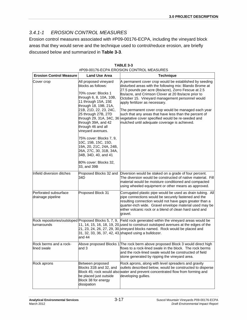
3.0 PROJECT DESCRIPTION
Analytical Environmental Services 3-17 Suscol Mountain Vineyards P09-00176-ECPA March 2012 Draft Environmental Impact Report
3.4.1-1 EROSION CONTROL MEASURES Erosion control measures associated with #P09-00176-ECPA, including the vineyard block areas that they would serve and the technique used to control/reduce erosion, are briefly discussed below and summarized in Table 3-3.
TABLE 3-3 #P09-00176-ECPA EROSION CONTROL MEASURES
Erosion Control Measure Land Use Area Technique Cover crop All proposed vineyard
blocks as follows:
70% cover: Blocks 1 through 6, 8, 10A, 10B, 11 through 15A, 15E through 18, 19B, 21A, 21B, 21D, 22, 23, 24C, 25 through 27B, 27D through 29, 31A, 34C, 36through 39A, and 42 through 46 and all vineyard avenues.
75% cover: Blocks 7, 9, 10C, 15B, 15C, 15D, 19A, 20, 21C, 24A, 24B, 26A, 27C, 30, 31B, 34A, 34B, 34D, 40, and 41
80% cover: Blocks 32, 33, and 39B
A permanent cover crop would be established by seeding disturbed areas with the following mix: Blando Brome at 27.5 pounds per acre (lbs/acre), Zorro Fescue at 2.5 lbs/acre, and Crimson Clover at 20 lbs/acre prior to October 15. Vineyard management personnel would apply fertilizer as necessary.
The permanent cover crop would be managed each year such that any areas that have less than the percent of vegetative cover specified would be re-seeded and mulched until adequate coverage is achieved.
Infield diversion ditches Proposed Blocks 32 and 34D
Diversion would be staked on a grade of four percent. The diversion would be constructed of native material. Fill material would be moisture conditioned and compacted using wheeled equipment or other means as approved.
Perforated subsurface drainage pipeline
Proposed Block 31 Corrugated plastic pipe would be used as drain tubing. All pipe connections would be securely fastened and the resulting connection would not have gaps greater than a quarter-inch wide. Gravel envelope material used may be either volcanic rock or a blend of clean hard sand and gravel.
Rock repositories/outsloped turnarounds
Proposed Blocks 5, 7, 9, 11, 14, 15, 16, 18, 19, 20, 21, 23, 24, 26, 27, 29, 30, 31, 32, 33, 36, 37, 42, 43, and 44
Field rock generated within the vineyard areas would be used to construct outsloped avenues at the edges of the vineyard blocks named. Rock would be placed and shaped using a bulldozer.
Rock berms and a rock-lined swale
Above proposed Blocks 1 and 3
The rock berm above proposed Block 3 would direct high flows to a rock-lined swale in the block. The rock berms and the rock-lined swale would be constructed of field stone generated by ripping the vineyard area.
Rock aprons Between proposed Blocks 31B and 32, and Block 45; rock would also be placed just outside Block 38 for energy dissipation
Rock aprons, along with level spreaders and gravity outlets described below, would be constructed to disperse water and prevent concentrated flow from forming and developing gullies.
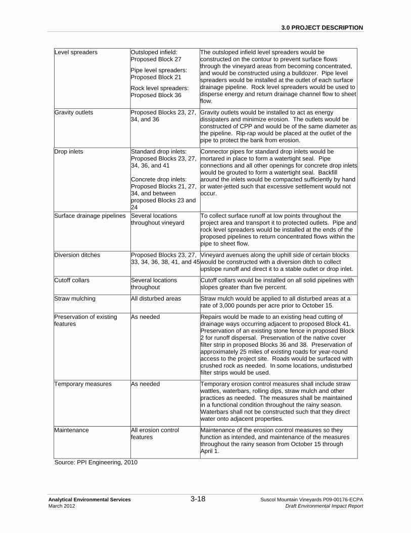
3.0 PROJECT DESCRIPTION
Analytical Environmental Services 3-18 Suscol Mountain Vineyards P09-00176-ECPA March 2012 Draft Environmental Impact Report
Level spreaders Outsloped infield: Proposed Block 27
Pipe level spreaders: Proposed Block 21
Rock level spreaders: Proposed Block 36
The outsloped infield level spreaders would be constructed on the contour to prevent surface flows through the vineyard areas from becoming concentrated, and would be constructed using a bulldozer. Pipe level spreaders would be installed at the outlet of each surface drainage pipeline. Rock level spreaders would be used to disperse energy and return drainage channel flow to sheet flow.
Gravity outlets Proposed Blocks 23, 27, 34, and 36
Gravity outlets would be installed to act as energy dissipaters and minimize erosion. The outlets would be constructed of CPP and would be of the same diameter as the pipeline. Rip-rap would be placed at the outlet of the pipe to protect the bank from erosion.
Drop inlets Standard drop inlets: Proposed Blocks 23, 27, 34, 36, and 41 Concrete drop inlets: Proposed Blocks 21, 27, 34, and between proposed Blocks 23 and 24
Connector pipes for standard drop inlets would be mortared in place to form a watertight seal. Pipe connections and all other openings for concrete drop inlets would be grouted to form a watertight seal. Backfill around the inlets would be compacted sufficiently by hand or water-jetted such that excessive settlement would not occur.
Surface drainage pipelines Several locations throughout vineyard
To collect surface runoff at low points throughout the project area and transport it to protected outlets. Pipe and rock level spreaders would be installed at the ends of the proposed pipelines to return concentrated flows within the pipe to sheet flow.
Diversion ditches Proposed Blocks 23, 27, 33, 34, 36, 38, 41, and 45
Vineyard avenues along the uphill side of certain blocks would be constructed with a diversion ditch to collect upslope runoff and direct it to a stable outlet or drop inlet.
Cutoff collars Several locations throughout
Cutoff collars would be installed on all solid pipelines with slopes greater than five percent.
Straw mulching All disturbed areas Straw mulch would be applied to all disturbed areas at a rate of 3,000 pounds per acre prior to October 15.
Preservation of existing features
As needed Repairs would be made to an existing head cutting of drainage ways occurring adjacent to proposed Block 41. Preservation of an existing stone fence in proposed Block 2 for runoff dispersal. Preservation of the native cover filter strip in proposed Blocks 36 and 38. Preservation of approximately 25 miles of existing roads for year-round access to the project site. Roads would be surfaced with crushed rock as needed. In some locations, undisturbed filter strips would be used.
Temporary measures As needed Temporary erosion control measures shall include straw wattles, waterbars, rolling dips, straw mulch and other practices as needed. The measures shall be maintained in a functional condition throughout the rainy season. Waterbars shall not be constructed such that they direct water onto adjacent properties.
Maintenance All erosion control features
Maintenance of the erosion control measures so they function as intended, and maintenance of the measures throughout the rainy season from October 15 through April 1.
Source: PPI Engineering, 2010

3.0 PROJECT DESCRIPTION
Analytical Environmental Services 3-19 Suscol Mountain Vineyards P09-00176-ECPA March 2012 Draft Environmental Impact Report
Vineyard erosion control involves both vegetative measures and physical measures that are designed to reduce overland flows and erosive power of runoff, in addition to, trapping eroded soil onsite. The primary vegetative measure involves establishing a permanent no-till cover crop throughout the proposed vineyard areas with a plant residue density (i.e., cover) of between 70 and 80 percent; all vineyard avenues would have a vegetative cover density of 70 percent (see Table 3-3 for specific densities per vineyard block). Straw mulch would be applied to all disturbed areas at 3,000 pounds per acre. A variety of drainage systems would be utilized for erosion control. Rock berms would be used to ensure offsite water remains dispersed and flows across proposed vineyards are/remain/stay in sheet flow. At one location, an existing rock fence would be maintained to continue its function of runoff dispersal. In other locations, drainage ditches would direct runoff to standard and concrete drop inlets. Drainage pipelines and a rock-lined swale would be used to direct runoff to desired locations. Level spreaders, gravity outlets, and rock aprons would be used at pipe outlets to disperse water and prevent concentrated flow from forming and developing gullies. In some locations, undisturbed filter strips would be used. Straw wattles would also be installed. Rock would be generated from the proposed project. Some of the rock generated would be used to construct erosion control features such as rock berms, gravity outlets and a rock-lined swale. No additional roads are proposed with the project; however, some roads may require improvement in order to facilitate access by construction vehicles and vineyard maintenance vehicles; primary access roads are depicted on Figures 3-5 through 3-7. The existing roads would be maintained and surfaced with crushed rock as needed (Figure 3-11). Rock not used immediately would be stockpiled for future use in areas indicated on the site plan figures (Figures 3-5 through 3-7). These locations were selected for their proximity to vineyard areas and because they would minimize visual impacts. All stockpiles are expected to be less than 20 feet in height and would not be located in a viewshed. Refer to Section 3.4.2-5 for a further discussion regarding the Long Term Vineyard Road Management Plan. 3.4.1-2 DRAINAGE PIPELINES Surface drainage pipelines would be installed to collect surface runoff at low points throughout the project area and transport it to protected outlets. The pipelines would run along trenches that would be excavated by the contractor. The trenches would be lined with gravel envelope bedding material as described in the ECP (Appendix B). The pipelines would be constructed of solid corrugated polyethylene pipe (CPP). Bent or damaged pipe would not be used in the drainage system, and would be removed from the job site. In some locations, pipeline would be installed under existing roads. In this case, the road surface would be regraded as necessary, to match original conditions. Pipe or rock level spreaders would be installed at the ends of the proposed pipelines in order to return concentrated water flows within the pipe to sheet flow (Figure 3-8).

3.0 PROJECT DESCRIPTION
Analytical Environmental Services 3-20 Suscol Mountain Vineyards P09-00176-ECPA March 2012 Draft Environmental Impact Report
A perforated subsurface drainage pipeline would be installed in proposed Block 31. All pipe connections would be securely fastened and the resulting connection would not have gaps greater than a quarter-inch wide. Gravel envelope material used may be either volcanic rock, or a blend of clean hard sand and gravel. The contractor may use a trencher, drainage plow with vertical soil displacement, or a backhoe/excavator for the placement of the tubing as dictated by soil conditions. Rocks or clods would not be allowed to fall upon or otherwise strike the tubing during any phase of construction. 3.4.1-3 DROP INLET INSTALLATION Standard and concrete drop inlets would be installed at various locations throughout the project site (Table 3-3). The dimensions of the risers and connector pipelines are depicted in Figure 3-10. Connector pipes for standard drop inlets would be mortared in place to form a watertight seal. Connector pipes for concrete drop inlets would be grouted to form a watertight seal. Backfill would be compacted around each inlet by hand or water-jetted such that excessive settlement would not occur. A trash grate would be installed over the top of each drop inlet. Debris would be removed from the trash grates after each storm event, or as necessary to assure a clear flow path for water entering the drop inlets. Damaged trash grates would be repaired immediately in order to assure that unacceptable quantities of debris do not enter the storm drain piping system. 3.4.1-4 DIVERSION FEATURES Diversion features would be constructed in various locations throughout the project site in order to prevent erosion through the concentration of surface flows. These features include outsloped infield level spreaders, infield diversion, gravity outlets, diversion ditches, and a concrete outlet structure (Table 3-3). Outsloped infield level spreaders would be constructed in Blocks 27C and 27D as shown in Figure 3-9. The level spreaders would be constructed on the contour using a bulldozer. Soil for fill material would be moisture conditioned and compacted as necessary. An infield diversion would be constructed in Blocks 32 and 34D as shown in Figure 3-9. The diversion would be staked on a grade of four percent. Material for construction of the fill portion of the diversion would be generated by removing a thin wedge of soil on both the uphill and downhill sides of the diversion and compacting it in place. The typical dimensions of the wedge may need to be adjusted to ensure proper amount of fill is available for construction, or to ensure safe passage of farming equipment over the diversion. Gravity outlets would be constructed as detailed in Figure 3-8 of CPP as described in the ECP specifications. The outlet would be of the same diameter as the pipe. Rip-rap would be made of field stone conforming to preset size specifications. Rodent guards would be installed over the outlets. Vineyard avenues along the uphill side of certain blocks would be constructed with an infield diversion ditch to collect

3.0 PROJECT DESCRIPTION
Analytical Environmental Services 3-21 Suscol Mountain Vineyards P09-00176-ECPA March 2012 Draft Environmental Impact Report
upslope runoff and direct it to a drop inlet or rock energy dissipater. Ditches would be cut into native material, and have side slopes of 2:1 (horizontal:vertical) as shown in Figure 3-9. 3.4.1-5 LONG TERM VINEYARD ROAD MANAGEMENT PLAN All primary vineyard roads would be on the existing road network and no new vineyard roads would be required. However, all existing roads are not necessary for vineyard operation. Figure 3-11 identifies the maintenance and management plan for all roads, both primary vineyard roads and all remaining roads that are a part of the existing cattle grazing operations. The primary roads would capture the majority of the vineyard traffic. Secondary roads would serve as fire and emergency access routes and would be inspected and managed annually. The majority of the existing roads do not currently require improvement; however, some specific sections of the primary year-round vineyard access road would be resurfaced with gravel during Phase I and prior to all Phase II and III development activities. The gravel would be harvested onsite by crushing rocks from vineyard block areas into ¾-inch minus and 3-inch minus materials. All gravel would be generated from early ground preparation of vineyard blocks. The following schedule describes the coordination of phasing and road maintenance activities. On the north side of Suscol Creek, the crushed rock materials generated from Blocks 1 and 2 would be adequate for all road maintenance for Phase I and II blocks. Blocks 8 and 9 (Phase III) would generate adequate rock for all road maintenance for Phase III blocks north of Suscol Creek. On the south side of Suscol Creek, rock would be generated within Blocks 26 and 27 for Phase I and II blocks. Rock would be generated within Block 30 for all Phase III blocks south of Suscol Creek. This schedule ensures that rock necessary for road management would be generated in advance of all vineyard development activities and that rock would not need to be transported from the north side to the south side of the property. Crushed rock would be stockpiled within vineyard footprints and rock disposal sites as designated in the ECP (Appendix B) and depicted in Figures 3-6 and 3-7. A description of the road maintenance requirements for each road type shown in Figure 3-11 is provided below. Also identified in Figure 3-11 are numerous stream crossings on the existing access roads that would be retained for the operation of the vineyard.

#*
#*#*
#* #*
#*
#*#*
#*
#*
#*#*
#*
#*
#*
#*#*
#*
#*#*
#*
#*#*
#*
#*
#*
#*
#*
#*
#*
#*#*
UV12
Po lson Rd
15
2726 30
5
34
3
31
38
1
10
24
8
41
2532
2
16
9
42
18
39
7
434536A-D
21
6
36E
37
19
13
12
11
40
2320
33
29
46
4
44
17
14
22
28
Suscol Creek
Faga
n Cree
k
Sheeh
y Cree
kFigure 3-11
Road Maintenance PlanSOURCE: PPI Engineering, 2010; USGS DOQQ, 6/2009; AES, 2011
LEGEND
Suscol Mountain Vineyards #P09-00176-ECPA Draft EIR / 209538
Approximate Property BoundaryProposed Roads to be Abandoned When Vineyard is DevelopedType 1 RoadsType 2 RoadsType 3 RoadsProposed Vineyard Area and Number
#* Approximate Stream Crossing Location - TYPE 1#* Approximate Stream Crossing Location - TYPE 2#* Approximate Stream Crossing Location - TYPE 3
0 900 1,800
Feet
!¢ÐNORTH

3.0 PROJECT DESCRIPTION
Analytical Environmental Services 3-23 Suscol Mountain Vineyards P09-00176-ECPA March 2012 Draft Environmental Impact Report
Type 1 Road: These roads are primary year round vineyard access roads where existing road base is native rock and contains less than six inches of top soil. For this road type, ¾-inch minus material would be applied to a depth that keeps the road bed at grade with the surrounding natural grade. This material would be applied prior to vineyard development. No concentration of water by crowning or ditching would be used. Roads would be maintained to retain the current and/or improve the native grade and sheet flow conditions. Type 2 Road: These roads are primary year round vineyard access roads where the existing roads traverse top soil with depths greater than six inches. For this road type, a course crushed rock material (3-inch minus) would be used on the first application prior to vineyard development. Future applications of crushed rock for maintenance would use ¾-inch crushed rock material. The same practices of retaining native grade and avoiding water concentration would be continued throughout these sections of the existing road system as described in the Type 1 Road. Type 3 Road: Existing roads that are not a part of the primary year round vineyard access plan are considered secondary roads. This road class would be restricted to two uses. The first use would be for vineyard block access by the irrigation operator. The irrigation operator would only use a low-ground pressure ATV vehicle. The second use would be for fire suppression and access by emergency and fire professionals. These limited use roads would be inspected each year prior to the rainy season. Annual management would include the removal of large debris, such as fallen trees or large limbs and seeding (mix: 50 percent creeping red fescue, 30 percent perennial rye, and 20 percent hard fescue, at a rate of three pounds per 1,000 square feet), as well as the application of straw on all road sections with top soil depths greater than six inches. In addition, crushed rock and straw wattles would be installed in areas where seed and straw alone do not provide adequate cover. Culverts: The current road system has numerous existing culverts. The vineyard development would not generate the need for changes in the current culvert system. All culverts would be inspected annually prior to the rainy season and maintained to assure the continuance of their current operational state. Maintenance would include removal of large debris that could cause blockage, and placement of additional rock as needed. Periodic inspections would continue throughout the winter storm season.
3.4.2 VINEYARD LAYOUT AND INSTALLATION
The proposed vineyard areas would consist of 45 vineyard blocks ranging in size from 0.9 to 44.9 net acres. Vineyard avenues would be constructed around each block, resulting in gross acreages for each of the 45 blocks ranging from 1.3 to 55.0 gross acres. Vine rows would be planted approximately six to seven feet apart. In areas where the cross-slope exceeds 15

3.0 PROJECT DESCRIPTION
Analytical Environmental Services 3-24 Suscol Mountain Vineyards P09-00176-ECPA March 2012 Draft Environmental Impact Report
percent, vine row spacing would be increased to nine feet to ensure adequate room for equipment passage. All disturbed areas would be planted with a no-till vegetative cover crop, with a plant residue density (i.e., cover) of between 70 and 80 percent: all vineyard avenues would have a vegetative cover density of 70 percent (see Table 3-3 for specific densities per vineyard block). Existing vegetation would be removed with the implementation of #P09-00176-ECPA. Development of the project would result in the removal of 1,182 trees, which includes 272 bay, nine buckeye, eight hollyleaf cherry, two eucalyptus, 887 live oak, and four valley oak. Any vegetation that would require burning onsite would be conducted in accordance with Bay Area Air Quality Management District (BAAQMD) guidelines. The soil would be cultivated to prepare it for planting (ripping would be in the range of two to six feet), trenches would be dug and irrigation pipelines would be installed, a trellis and drip irrigation system would be installed, the vine rows would be laid out, and temporary erosion control measures would be installed. Additionally, deer fencing would be installed, typically to encompass groups of nearby vineyard blocks with exit doors at the corners for safe removal of trapped wildlife, as detailed in Figure 3-12 (corridors are discussed in Chapter 4.2 Biological Resources). Grazing, which historically and currently occurs unrestricted on the property, would be almost entirely excluded from areas enclosed by deer fencing (grazing management is discussed in Chapter 4.2 Biological Resources).
3.4.3 WATER SUPPLY
It is anticipated that a maximum of 263 acre feet (af) of water per annum (afa) would be required for the project (or approximately 0.6 af per acre of planted vineyard per year). The proposed water source for the vineyard is groundwater; one well (Well 1) and four water tanks currently exist on the property; the tanks are grouped in one location and are shown in Figure 3-13. It is estimated that an additional two to three wells (Wells A, B and C) and three to six water tanks may be developed as part of the project. Future number of wells is dependent upon the final flow from each well. The total volume of water per annum for irrigation however, would not change. The four existing water tanks each have a capacity of 10,000 gallons, and are located on a deeded easement along the southern property boundary. This water is currently used for domestic purposes for an adjacent property south of the subject property. The proposed water tanks would be seven to 15 feet in diameter, 21 to 33 feet high, and store about 30,000 to 50,000 gallons of water each.

30B
32
27C
21
41
25
15B
26B26A31B
5A
18
15C
42
6
3D
24B
10C
7
36E
15A
34B
16A
36B
27D
43
38B 39B
4537
30A27E
15D
13
38A
34D
8A
34A
36A
8B
21B
36C
40
9A
33
2023
10B
19A
36D46
4
9B
11B
30C
17
38C
5C
14
24A
29B
3B
5B
28
16B
22
12C
21C
39A
44B
27B
3A 12B
31A27A
12A
10A
44A
3C
19B15E
24C
11A
12D
34C
21A
26C
21D
11C
STATE HIGHWAY 12
STAT
E HIG
HWAY
29
STATE HIGHWAY 221
4TH A
VE
IMOLA AVE
POLSON RD
DEVLIN RD
GREEN V ALLEY RD
COOMBSVILLE RD
S KEL
LY R
DN
KELL
Y RD
AIRPORT RD
AIRPARK RD
KREUZER LN
WILD HORSE VALLEY RD
AIRPORT BLVD
MADRONE DR
CEDA
R DR
SHUR
TLEF
F AVE
TOWER RD
KANSAS AVE
KIRKLAND RANCH RD
C AYE TANO DR
SEVIL
LE D
R
S TER
RACE
DR
PENN
Y LN
SPRU
CE D
R
CURR
Y LN
TERR
ACE D
R
BERR
Y LN
SO
SCOL CREEK RD
RUSS
ELL S
T
CORO
NADO
AVE
MAGNOLIA DR
WYATT AVE
ELDE
R DR
AIRPORT TOWER RD
MARI
A DR
PONY LN
BRONCO RD
KREU
SE C
ANYO
N DR
CAFE CT
LINDEN ST
GATEWAY RD W
SHEHEY CT
LOS ROBLES DR
JUNIPER CIR
BIRKD
ALE D
R
CAMI
NO DO
RADO
LUGO
LN
HARDING AVE
SKYW
AY C
T
KANS
AS C
T
GREE
NWOOD RD
MAYF
AIR D
R
EXECUTIVE CT
HARLOW CT
CAPIT
OLA D
R
STATE HIGHWAY 29
STATE HIGHWAY 221
DE V LIN RD
221
12
2929
12
12
A irport Rd
Co ombsvil le Rd
Figure 3-12Proposed Deer Fencing
SOURCE: EDAW, May 2004 (Robert Mondavi Properties Vineyard Draft EIR); PPI Engineering, 2010; LandVoyage Aerial Photograph, 6/15/2005; Napa County, 2008; AES, 2010
Suscol Mountain Vineyards #P09-00176-ECPA Draft EIR / 209538
LEGEND
Property Boundary
Existing Roads
Proposed Vineyard Block Boundary
Primary Access Road to Vineyards
Proposed Rock Stockpiles
Wildlife Movement Areas
Conservation Easement, Land Trust
Skyline Wilderness Park, State of California Protected Lands
City of Napa Protected Lands
0 1,250 2,500
Feet
Existing Deer Fence
Proposed Deer Fence

")")
")
&M&M&M&M
UV12
Polson Rd
Existing Well 1
Well C
Well B
Well A
Figure 3-13Existing and Proposed Well Locations and Primary Irrigation Supply Lines
SOURCE: PPI Engineering, 2010; USGS DOQQ, 6/2009; AES, 2011
LEGEND
Suscol Mountain Vineyards #P09-00176-ECPA Draft EIR / 209538
Approximate Property BoundaryProposed Clearing Limits
") Pump StationApproximate Proposed Irrigation Supply LineExisting WellProposed WellExisting Roads
&M Water Tank Location
0 1,000 2,000
Feet
!¢ÐNORTH

3.0 PROJECT DESCRIPTION
Analytical Environmental Services 3-27 Suscol Mountain Vineyards P09-00176-ECPA March 2012 Draft Environmental Impact Report
The Hydrogeologic Assessment prepared for the project (RCS, 2010, Appendix H) recommends that a minimum of three additional irrigation supply water wells be constructed to serve the entire project site. The locations of the existing well and the three currently proposed wells are shown on Figure 3-13. The Hydrogeologic Assessment includes a description of the pump test conducted on the existing well and explains the theoretical water level draw-down interference based on the data collected and analytical modeling. Under the proposed project, the following phasing schedule for well development and operation would occur: Phase I, as shown on Figure 3-4, would include development of 130 net acres of vineyard. The current water supply from the existing well would be used to meet the water demand for the 130 acres developed under Phase I. The existing well was pump tested at a rate of approximately 250 gallons per minute (gpm). The Hydrogeologic Assessment concluded that the 130 acres developed during Phase I can be supported by pumping the existing well at 200 gpm at 50 percent operational use. Phase II, as shown on Figure 3-4, would include development of 195 net acres of vineyard. Proposed Wells B and C, as shown on Figure 3-13, shows the current estimated locations for the initial boreholes to develop wells that would be constructed to provide the water supply for vineyard developed in this phase. The Hydrogeologic Assessment describes the theoretical water level draw-down that could result from proposed Wells B and C (Appendix H). All future wells would be constructed and tested prior to vineyard development under Phase II. Phase III, as shown on Figure 3-4, would include development of 113 net acres of vineyard. Proposed Well A, as shown on Figure 3-13, shows the current estimated location for the initial borehole to develop wells that would be constructed to provide the water supply for vineyard development in this phase. Similar to Phase II, all future wells would be constructed and tested prior to vineyard development under Phase III. Minor amendments may shift blocks from one phase to another, however, the total development per phase would not exceed the acreage outlined above.
3.4.4 PRIMARY IRRIGATION SYSTEM
Irrigation pipelines would be installed to transport water from the wells and tanks to the vineyard areas. All primary irrigation lines and pump stations would be located within vineyard blocks or along the year-round vineyard road system and would not result in additional ground clearing. The preliminary design of the primary irrigation supply network was based off of the estimated total water demand to irrigate the total 438 net acres of vineyard. Well 1 (existing) and all future wells (proposed) would be linked with the primary irrigation lines as shown on Figure 3-13. Three booster pumps would be located within the proposed vineyard footprint areas. Two creek

3.0 PROJECT DESCRIPTION
Analytical Environmental Services 3-28 Suscol Mountain Vineyards P09-00176-ECPA March 2012 Draft Environmental Impact Report
crossings would be required to transport water from the wells to points south of Suscol Creek; water line crossings would be constructed without any construction or impact within the bed and bank of the creek. Pipe sizing for the project would not exceed ten inches in diameter, and size would be graduated downward as needed.
3.4.5 VINEYARD OPERATION AND MAINTENANCE
Operation and maintenance of the vineyard would include: pruning; pest, disease and weed control; mowing; vine management; irrigation; fertilization; and harvesting activities. Once developed, the Applicant intends to certify the vineyard through the Fish Friendly Farming program. Other operational activities include the operation and maintenance of the irrigation system, soil and plant testing, fruit testing, maintenance and management of all roads and inspection and maintenance of the erosion control measures. Operation of the proposed project would include nighttime harvest (typically from 9 P.M. to 5 A.M.) about 20 days per year, sulfur/pesticide/herbicide application (typically from 9 P.M. to 5 A.M.) about 25 days per year, and frost protection with wind machines (typically from 12 A.M. to 7 A.M.) about 15 days out of the year. Primary vineyard operations would be carried out over two distinct seasons. The pruning season would generally begin in December and end in March. The proposed project would require approximately 45 workers during the pruning season. The most labor-intensive period for the vineyard would occur during the harvest/crush season. Harvest would generally begin in August and end in October. Approximately 80 workers would be needed at the project site during the harvest season. The project would utilize track-laying equipment 50 percent of the time during vineyard operations, rubber-tired equipment 35 percent of the time, ATVs ten percent of the time, and hand/manual equipment five percent of the time.
3.4.6 VINEYARD DEVELOPMENT: WORKERS, EQUIPMENT, AND DURATION
As described above, implementation of the project is proposed to occur over three years, with construction occurring over five months out of the year. The typical construction hours would be 7 A.M. to 5 P.M. Monday through Saturday. Sufficient equipment, labor, and materials would be committed and transported to the project site prior to the commencement of construction to complete construction during each season by October 1. Once equipment is transported to the project site it would remain there until implementation during that season is completed. Construction activities would require approximately 30 workers between April 1 and October 15; the allowable grading period for projects located outside domestic water supply drainages (Section 18.108.070 NCC). Typical construction equipment is described in Table 3-4; quantity

3.0 PROJECT DESCRIPTION
Analytical Environmental Services 3-29 Suscol Mountain Vineyards P09-00176-ECPA March 2012 Draft Environmental Impact Report
estimates of construction equipment typically used is provided, but not all construction equipment would be used simultaneously.
TABLE 3-4 TYPICAL CONSTRUCTION EQUIPMENT
Equipment Estimated Quantity
Fill tanks 2
965 loaders 8
350 excavators 4
320 excavators 2
D10/11 bulldozers (ripping) 4
D9 Bulldozers (clearing) 4
Off road dump trucks 12
Drum grinders 2
4,000 gallon water trucks 4
Tractors 10
ATVs 10
Source: AES, 2010

3.0 PROJECT DESCRIPTION
Analytical Environmental Services 3-30 Suscol Mountain Vineyards P09-00176-ECPA March 2012 Draft Environmental Impact Report
REFERENCES Napa County, 2009. Napa County Code 2009. Available online at:
http://library.municode.com/index.aspx?clientId=16513&stateId=5&stateName= California.
Napa County, 2008. Napa County General Plan. June 2008. Available online at:
http://www.countyofnapa.org/GeneralPlan/. PPI Engineering, 2010. SPP Napa Vineyards, LLC. Suscol Mountain Vineyards Erosion
Control Plan. Revised August 2010. Original Submitted April 2009. Prepared by PPI Engineering.
Suscol Mountain Vineyards, LLC, April 5, 2011, Supplemental Information on Suscol Mountain
ECP.

CHAPTER 4.0 ENVIRONMENTAL SETTING, IMPACTS AND MITIGATION MEASURES

4.0 ENVIRONMENTAL SETTING, IMPACTS AND MITIGATION MEASURES Air Quality
Analytical Environmental Services 4.1-1 Suscol Mountain Vineyards P09-00176-ECPA March 2012 Draft Environmental Impact Report
4.1 AIR QUALITY
4.1.1 SETTING
The primary factors that determine air quality are the locations of air pollutant sources and the amounts of pollutants emitted. Meteorological and topographical conditions, however, also are important. Atmospheric conditions such as wind speed, wind direction, and air temperature gradients interact with the physical features of the landscape to determine the movement and dispersal of air pollutants. The proposed project is located approximately 2.5 miles southeast of the City of Napa in Napa County, California. The project site is situated within the southeastern end of the Napa Valley. Napa Valley is a long, narrow valley running north to south between two ridges formed within the coastal mountains that have an average ridgeline height of about 2,000 feet. Some peaks approach 3,000 to 4,000 feet in height. Up-valley winds (from the south during the day) and down-valley winds (from the north during the night) result because of the surrounding terrain. The property roughly borders Skyline Wilderness Park to the north, State Highway 221 to the west, State Highway 12 to the south and the Napa County border with Solano County to the east. Onsite elevations range from approximately 150 to 1,400 feet above mean sea level (msl). Topography in the County is defined by the Napa Valley and surrounding upland areas, which contain smaller valley areas. Napa Valley has a high potential for natural air pollution due to diminished ventilation caused by the terrain. Locally and regionally generated pollutants can be transported by the prevailing winds northward into the Napa Valley, often trapping and concentrating the pollutants under stable conditions. The local up-valley and down-valley flows set up by the surrounding mountains may also recirculate pollutants, contributing to a buildup of pollutants. Napa Valley has generally good air quality due to the relatively light development of much of the valley, despite this high natural potential for air pollution.
4.1.1-1 SENSITIVE RECEPTORS
In general, some receptors are considered more sensitive than others to air pollutants. The reasons for greater than average sensitivity include pre-existing health problems, proximity to the emissions source, or duration of exposure to air pollutants. Land uses such as schools, hospitals, and convalescent homes are considered to be sensitive to poor air quality. This is because infants and children, the elderly, and people with health afflictions, especially respiratory ailments, are more susceptible to respiratory infections and other air quality-related health problems than the general public. Residential areas are also considered to be sensitive

4.0 ENVIRONMENTAL SETTING, IMPACTS AND MITIGATION MEASURES Air Quality
Analytical Environmental Services 4.1-2 Suscol Mountain Vineyards P09-00176-ECPA March 2012 Draft Environmental Impact Report
to air pollution, because residents (including children and the elderly) tend to be at home for extended periods of time, resulting in sustained exposure to any pollutants present. There are no residences located on the Suscol Mountain Vineyards property but there are scattered residences and commercial and industrial facilities located within the vicinity of the property. The nearest residence is located approximately 900 feet from the southeast corner of the project site. There are several residences to the west of the site and east of Highway 29 between approximately 1,500 feet and a half-mile (2,640 feet) from the property boundary. Two major industrial office complexes are located west of the site, including the North Bay Regional Center approximately a half-mile to the southwest and the Napa Corporate Center approximately one mile to the west. The Kirkland Ranch vineyard and winery is located just south of the property boundary. Several schools are located in the vicinity of the Suscol Mountain Vineyards property, including: the Phillips Elementary School and the Napa Valley College located approximately two miles northwest of the property, the Mt. George and Silverado Middle Schools located approximately three miles north of the property, and the Carquinez Middle School located approximately eight miles to the west of the property. Napa State Hospital is located approximately 1.5 miles northwest of the project site.
4.1.2 REGULATORY FRAMEWORK
4.1.2-1 PLANS, POLICIES, AND STANDARDS
Regulation of air pollution is achieved through both national and state ambient air quality standards and emission limits for individual sources of air pollutants. As required by the Federal Clean Air Act (FCAA), the U.S. Environmental Protection Agency (USEPA) has identified “criteria pollutants” and established National Ambient Air Quality Standards (NAAQS) to protect public health and welfare. NAAQS have been established for ozone (O3), carbon monoxide (CO), nitrogen oxide (NOx), sulfur dioxide (SO2), suspended particulate matter less than or equal to 10 microns (PM10), suspended particulate matter less than or equal to 2.5 microns (PM2.5), and lead (Pb). California has adopted more stringent ambient air quality standards for most of the criteria air pollutants (referred to as California Ambient Air Quality Standards or CAAQS). Because of the unique meteorological conditions in California, there is considerable diversity between the CAAQS and NAAQS currently in effect in California. Table 4.1-1 presents both state and national standards. Under amendments to the FCAA, the USEPA has classified air basins, or portions thereof, as either “attainment” or “non-attainment” for each criteria air pollutant, based on whether or not the NAAQS have been achieved. In 1988, the State legislature passed the California Clean Air Act (CCAA), which is patterned after the FCAA to the extent that it also requires areas to be

4.0 ENVIRONMENTAL SETTING, IMPACTS AND MITIGATION MEASURES Air Quality
Analytical Environmental Services 4.1-3 Suscol Mountain Vineyards P09-00176-ECPA March 2012 Draft Environmental Impact Report
designated as “attainment” or “non-attainment”, but with respect to the SAAQS rather than the NAAQS. Thus, areas in California have two sets of attainment/non-attainment designations for each criteria pollutant: one set with respect to the national standards and one set with respect to the State standards.
TABLE 4.1-1 STATE AND NATIONAL AMBIENT AIR QUALITY STANDARDS
Pollutant Averaging Time SAAQS NAAQSb
Ozone (O3) 1 hour 0.09 ppm N/A
8 hour 0.070 ppm 0.075 ppm Carbon Monoxide (CO) 1 hour 20 ppm 35 ppm 8 hour 9.0 ppm 9 ppm Nitrogen Dioxide (NO2) 1 hour 0.25 ppm N/A Annual Mean N/A 0.053 ppm Sulfur Dioxide (SO2) 1 hour 0.25 ppm N/A 3 hour N/A 0.5 ppm1 24 hour 0.04 ppm 0.14 ppm Annual Mean N/A 0.030 ppm Respirable Particulate Matter (PM10)
24 hour 50 µg/m3c 150 µg/m3
Annual Mean 20 µg/m3 N/A Fine Particulate Matter (PM2.5) 24 hour N/A 35 µg/m3 Annual Mean 12 µg/m3 15 µg/m3 Sulfates 24 hour 25 µg/m3 N/A Lead (Pb) 30 day 1.5 µg/m3 N/A Calendar Quarter N/A 1.5 µg/m3 Hydrogen Sulfide 1 hour 0.03 ppm N/A
Notes: ppm = parts per million by volume; µg/m3= micrograms per cubic meter. N/A=Not Applicable 1 Secondary Standard. Source: CARB, 2010a
The FCAA also requires non-attainment areas to prepare air quality plans that include strategies for achieving attainment. Air quality plans developed to meet the NAAQS are referred to as State Implementation Plans (SIPs). The CCAA also requires plans for non-attainment areas (except for PM10) with respect to the State standards. Thus, just as areas in California have two sets of designations, many also have two sets of planning requirements; one to meet federal requirements relative to the NAAQS and one to meet requirements relative to the CAAQS. The USEPA is responsible for implementing the myriad programs established under the FCAA, such as establishing and reviewing the national ambient air quality standards and judging the adequacy of SIPs, but has delegated the authority to implement many of the federal programs to the states while retaining an oversight role to ensure that the programs continue to be implemented.

4.0 ENVIRONMENTAL SETTING, IMPACTS AND MITIGATION MEASURES Air Quality
Analytical Environmental Services 4.1-4 Suscol Mountain Vineyards P09-00176-ECPA March 2012 Draft Environmental Impact Report
The California Air Resources Board (CARB), California’s state air quality management agency, regulates mobile emissions sources and oversees the activities of regional/county air districts. CARB is responsible for establishing emissions standards for on-road motor vehicles sold in California. The Bay Area Air Quality Management District (BAAQMD) is the regional agency empowered to regulate air pollutant emissions from stationary sources in the Bay Area. Both agencies regulate air quality though their permit authority and through their planning and review activities.
4.1.2-2 POLLUTANTS OF CONCERN
Pollutants of concern are criteria pollutants that have been identified as being potentially detrimental to human health and are considered indicators of regional air quality. These pollutants are designated as nonattainment or maintenance in an air basin. The pollutants of concern for the proposed project in the BAAQMD are as follows: Ozone (O3)
Photochemical reactions involving reactive organic gases (ROG) and oxides of nitrogen (NOX) resulting from the incomplete combustion of fossil fuels are the largest source of ground-level O3. Because photochemical reaction rates depend on the intensity of ultraviolet light and air temperature, O3 is primarily a summer air pollution problem. As a photochemical pollutant, O3 is formed only during daylight hours under appropriate conditions, but is destroyed throughout the day and night. O3 is considered a regional pollutant, as the forming reaction occurs over time downwind from the sources of the emissions. Particulate Matter (PM10 and PM2.5)
Particle pollution is a mixture of microscopic solids and liquid droplets suspended in air. This pollution, also known as particulate matter, is made up of a number of components, including acids (such as nitrates and sulfates), organic chemicals, metals, soil or dust particles, and allergens (such as fragments of pollen or mold spores). The size of particles is directly linked to their potential for causing health problems. Small particles less than 10 micrometers (µm) in diameter pose the greatest problems, because they can travel deep into lungs (PM10) and the bloodstream (PM2.5). Exposure to such particles can affect the lungs and heart. Larger particles are of less concern, although they can irritate the eyes, nose, and throat.
4.1.2-3 AIR QUALITY DATA
Under the NAAQS, the Bay Area is currently designated as a non-attainment area for 8-hour O3 and is designated maintenance for CO. Under the CAAQS, the Bay Area is designated as a non-attainment area for O3, PM10, and PM2.5 (CARB, 2010b).

4.0 ENVIRONMENTAL SETTING, IMPACTS AND MITIGATION MEASURES Air Quality
Analytical Environmental Services 4.1-5 Suscol Mountain Vineyards P09-00176-ECPA March 2012 Draft Environmental Impact Report
CARB maintains several ambient air quality monitoring stations within the BAAQMD that provide information on the average concentrations of criteria air pollutants in the region. Monitored ambient air pollutant concentrations reflect the number and strength of emissions sources and the influence of topographical and meteorological factors. The closest monitoring station to the project site is located in the City of Napa, at Jefferson Street near Central Avenue, about five miles northwest of the project site. It should be noted that the monitoring station is located in an urban area while the project site is located in a relatively rural area. Table 4.1-2 presents a three-year summary of ambient air quality monitoring data from the Napa station and compares ambient air pollutant concentrations of O3, PM2.5, and PM10 to CAAQS and NAAQS.
TABLE 4.1-2 AIR QUALITY DATA SUMMARY FOR NAPA VALLEY 2007-2009
Pollutant/Standard Standard Days Standard Exceeded1 in: 2007 2008 2009
O3 Federal 8-Hour 0 2 1 O3 State 8-Hour 0 2 3 O3 State 1-Hour 0 1 1
PM10 State 24-Hour 0 0 1 PM2.5 State 24-Hour * * *
1 An exceedance is not necessarily a violation. * Insufficient Data. Source: CARB, 2010c
The ambient air quality standards were not met at the monitoring location according to the NAAQS for 8-hour O3 in 2008 and 2009, the SAAQS for 1- and 8-hour O3 in 2008 and 2009, or the SAAQS for 24-hour PM10 in 2009 as shown in Table 4.1-2.
4.1.2-4 CLIMATE CHANGE
It is anticipated that the average global temperature could rise 0.6 to 4.0 degrees Celsius (°C) (33.0 to 39.2 degrees Fahrenheit (°F)) between the years 2000 and 2100 (IPCC, 2007). The extent to which human activities affect global climate change is a subject of considerable scientific debate. While many in the scientific community contend that global climate variation is a normal cyclical process that is not necessarily related to human activities, the Intergovernmental Panel on Climate Change (IPCC) report identifies anthropogenic greenhouse gases (GHGs) as a contributing factor to changes in the Earth’s climate (IPCC, 2007). The IPCC modeling estimates that anthropogenic carbon dioxide (CO2) in the lower atmosphere has increased by approximately 31 percent since 1750. At the same time, average temperature in the lower atmosphere has increased approximately 0.6 to 0.8 °C (33.0 to 33.4 °F). Due to the challenges inherent in modeling the complexities of the Earth’s climate, the proportional importance of anthropogenic activities as opposed to natural feedback systems is exceptionally difficult to establish. Nonetheless, the IPCC concludes that “Most of the observed increase in

4.0 ENVIRONMENTAL SETTING, IMPACTS AND MITIGATION MEASURES Air Quality
Analytical Environmental Services 4.1-6 Suscol Mountain Vineyards P09-00176-ECPA March 2012 Draft Environmental Impact Report
globally-averaged temperatures since the mid-20th century is very likely due to the observed increase in anthropogenic GHG concentrations.” This Environmental Impact Report (EIR) assumes that an increase in anthropogenic GHG concentration is in fact contributing to global warming. IPCC theorizes that a continuation of this warming trend could have profound implications, including flooding, erratic weather patterns, and reduced arctic ice. The IPCC projects a number of future GHG emissions scenarios leading to a varying severity of impacts on the environment and the global economy. According to the 2007 IPCC report, if anthropogenic GHG continue to increase in the atmosphere there will be a point at which the above impacts would become irreversible, this point is commonly referred to as the “tipping point.” Although the 2007 IPCC report states the tipping point may be as far off as 20 years, some experts contend the tipping point has already been reached. The following regulatory background gives context to the issues of climate change and the importance of reducing GHG emissions in California: Assembly Bill 32 (AB 32)
Signed by the California State Governor on September 27, 2006, AB 32 codifies a key requirement of Executive Order (EO) S-3-05, specifically the requirement to reduce statewide GHG emissions to year 1990 levels by the year 2020. AB 32 required that CARB prepare a comprehensive “scoping plan” that identifies all strategies necessary to fully achieve the required 2020 emissions reductions. In early December 2008, CARB released its scoping plan to the public and on December 12, 2008, the CARB Board approved the scoping plan. The scoping plan calls for an achievable reduction in California’s carbon footprint. Reduction of GHG emissions to 1990 levels are proposed, which equates to cutting approximately 30 percent from estimated GHG emission levels projected in 2020, or about 15 percent from today’s levels. The scoping plan relies on existing technologies and improving energy efficiency to achieve the 30 percent reduction in GHG emission levels by 2020. The scoping plan provides the following key recommendations to reduce GHG emissions:
• Expand and strengthen existing energy efficiency programs as well as building and appliance standards;
• Achieve a statewide renewable energy mix of 33 percent; • Develop a California cap-and-trade program that links with other Western Climate
Initiative partner programs to create a regional market system;

4.0 ENVIRONMENTAL SETTING, IMPACTS AND MITIGATION MEASURES Air Quality
Analytical Environmental Services 4.1-7 Suscol Mountain Vineyards P09-00176-ECPA March 2012 Draft Environmental Impact Report
• Establish targets for transportation-related GHG emissions for regions throughout California, and pursue policies and incentives to achieve those targets; and
• Adopt and implement measures pursuant to existing State laws and policies, including California’s clean car standards, goods movement measures, and the Low Carbon Fuel Standard.
Senate Bill 97 (SB 97) Signed by the Governor on August 24, 2007, SB 97 required the Governor’s Office of Planning and Research (OPR) prepare California Environmental Quality Act (CEQA) guidelines for evaluating the effects of GHG emissions and for mitigating such effects. In accordance with SB 97, the Natural Resources Agency adopted Amendments to the CEQA Guidelines for GHGs on December 31, 2009. On February 16, 2010, the Office of Administrative Law approved the Amendments, and filed them with the Secretary of State for inclusion in the California Code of Regulations. The Amendments became effective and binding regulations on March 18, 2010. The amendments to the CEQA Guidelines provide the following direction for evaluation of climate change impacts in a CEQA document:
• The determination of the significance of GHG emissions calls for a careful judgment by the lead agency consistent with the provisions in section 15064. A lead agency should make a good-faith effort, based to the extent possible on scientific and factual data, to describe, calculate or estimate the amount of GHG emissions resulting from a project. A lead agency shall have discretion to determine, in the context of a particular project, whether to:
o Use a model or methodology to quantify GHG emissions resulting from a project,
and which model or methodology to use. The lead agency has discretion to select the model or methodology it considers most appropriate provided it supports its decision with substantial evidence. The lead agency should explain the limitations of the particular model or methodology selected for use; and/or
o Rely on a qualitative analysis or performance based standards.
• A lead agency should consider the following factors, among others, when assessing the significance of impacts from GHG emissions on the environment:
o The extent to which the project may increase or reduce GHG emissions as
compared to the existing environmental setting.

4.0 ENVIRONMENTAL SETTING, IMPACTS AND MITIGATION MEASURES Air Quality
Analytical Environmental Services 4.1-8 Suscol Mountain Vineyards P09-00176-ECPA March 2012 Draft Environmental Impact Report
o Whether the project emissions exceed a threshold of significance that the lead agency determines applies to the project.
o The extent to which the project complies with regulations or requirements adopted to implement a statewide, regional, or local plan for the reduction or mitigation of GHG emissions. Such requirements must be adopted by the relevant public agency through a public review process and must reduce or mitigate the project’s incremental contribution of GHG emissions. If there is substantial evidence that the possible effects of a particular project are still cumulatively considerable notwithstanding compliance with the adopted regulations or requirements, an EIR must be prepared for the project.
• When adopting thresholds of significance, a lead agency may consider thresholds of
significance previously adopted or recommended by other public agencies or recommended by experts, provided the decision of the lead agency to adopt such thresholds is supported by substantial evidence.
• A lead agency may determine that a project’s incremental contribution to a cumulative effect is not cumulatively considerable if the project will comply with the requirements in a previously approved plan or mitigation program (including, but not limited to, water quality control plan, air quality attainment or maintenance plan, integrated waste management plan, habitat conservation plan, natural community conservation plan, plans or regulations for the reduction of GHG emissions) that provides specific requirements that will avoid or substantially lessen the cumulative problem within the geographic area in which the project is located. Such plans or programs must be specified in law or adopted by public agency with jurisdiction over the affected resources through a public review process to implement , interpret, or make specific the enforced or administered by the public agency. When relying on a plan, regulation or program, the lead agency should explain how implementing the particular requirements in the plan, regulation or program ensure that the project’s incremental contribution to the cumulative effect is not cumulatively considerable. If there is substantial evidence that the possible effects of a particular project are still cumulatively considerable notwithstanding that the project complies with the specified plan or mitigation program addressing the cumulative problem, an EIR must be prepared for the project.
• The mere existence of significant cumulative impacts caused by other projects alone shall not constitute substantial evidence that the proposed project’s incremental effects are cumulatively considerable.

4.0 ENVIRONMENTAL SETTING, IMPACTS AND MITIGATION MEASURES Air Quality
Analytical Environmental Services 4.1-9 Suscol Mountain Vineyards P09-00176-ECPA March 2012 Draft Environmental Impact Report
BAAQMD Climate Change Guidelines
In June 2010, the BAAQMD’s Governing Board adopted new CEQA Guidelines (BAAQMD CEQA Guidelines), which provide guidance for analyzing project-level climate change impacts (BAAQMD, 2010). The BAAQMD CEQA Guidelines were updated in June 2011. The BAAQMD CEQA Guidelines provide GHG emissions thresholds for project operation; however, the BAAQMD CEQA Guidelines do not provide project construction GHG emission thresholds. In January 2012, the Alameda County Superior Court ruled that the BAAQMD failed to adequately study the potential impacts of the BAAQMD CEQA Guidelines.1 At this time, the scope of the Superior Court’s decision is unclear, and the decision could be appealed, which would stay the ruling. While the status of the BAAQMD CEQA Guidelines is unclear for projects for which BAAQMD is the lead agency, the substantial evidence supporting the development of the thresholds of significance in the BAAQMD CEQA Guidelines remains valid.2 Nevertheless, the BAAQMD CEQA Guidelines’ thresholds of significance for vehicle/equipment related GHG emissions remain to be a tool that provides an appropriate significance criteria for this project based on the substantial evidence underlying the development of those thresholds.3 County of Napa
Since the certification of the County of Napa’s Final General Plan EIR and adoption of the General Plan (June 2008), the County has undertaken numerous efforts aimed at reducing GHG emissions. The County participated in a multi-jurisdictional effort lead by the Napa County Transportation and Planning Agency (NCTPA) to quantify community-wide emissions for all jurisdictions within the County and to develop a non-binding emission reduction framework (2009) that each jurisdiction can use to guide their decision making and planning. The County has also prepared and adopted an emission reduction plan aimed at reducing emissions from County operations. Napa County has also prepared a draft Climate Action Plan (CAP), which is currently under public review. The draft CAP quantifies and provides a baseline inventory of GHG emissions from all sources in unincorporated Napa County as of 2005 and proposes emission reduction measures designed to reduce emissions to 1990 levels by 2020, which is consistent with the goal of California Assembly Bill (AB) 32. Although the plan is not required by State law, the BAAQMD has concluded that development projects that are consistent with a qualified CAP would not result in significant GHG emissions under CEQA. Additional information on the draft CAP can be obtained at the County Administrative Offices or the County website: http://www.countyofnapa.org/CAP/. 1 California Building Industry v. BAAQMD, Alameda Superior Court Case No. RG10548693. 2 See BAAQMD report titled California Environmental Quality Act Guidelines Update – Proposed Thresholds of Significance dated December 7, 2009 and available online at:
www.baaqmd.gov/~/media/Files/ Planning%20and%20Research/CEQA/Proposed%20Thresholds%20of%20Significance%20Dec%207%2009.ashx. 3 CEQA Guidelines §15064.7(c); National Parks and Conservation Assn. v. County of Riverside (1999) 77 Cal.App.4th 1341, 1356-57.

4.0 ENVIRONMENTAL SETTING, IMPACTS AND MITIGATION MEASURES Air Quality
Analytical Environmental Services 4.1-10 Suscol Mountain Vineyards P09-00176-ECPA March 2012 Draft Environmental Impact Report
The draft CAP as revised provides that discretionary development projects must reduce or offset emissions by 39 percent. The draft CAP would require new vineyard development projects needing an erosion control plan to: a) calculate the GHG emissions associated with their project; b) implement best management practices such as mulching rather than burning debris, using cover crops, etc.; and c) implement one or more other measures to reduce or offset emissions by 39 percent. Measures that could be selected for implementation by project applicants include on- or offsite habitat restoration, on- or offsite reforestation, on- or offsite avoided deforestation, or participation in a program demonstrated to offset project emissions. Climate change is a global phenomenon attributable to the sum of all human activities and natural processes. OPR provides guidance on integrating analysis of GHGs in CEQA documents (OPR, 2008). The BAAQMD CEQA Guidelines recommends quantification of GHG emissions, assessment of the significance of any impact on climate change (provided in Chapter 6.0 Other CEQA-Required Sections), and identification of mitigation or alternatives that would reduce the GHG emissions. The analysis presented in Chapter 6.0 is consistent with the BAAQMD CEQA Guidelines. This analysis considers whether project emissions are individually or cumulatively significant. Based on the proposed project’s GHG emissions (refer to Chapter 6.0), it was determined that specific climate change impacts could not be attributed to the proposed development. As such, project impacts are most appropriately addressed in terms of the incremental contribution to a global cumulative impact.
4.1.3 IMPACTS AND MITIGATION MEASURES
4.1.3-1 SIGNIFICANCE CRITERIA
For the purposes of this analysis, the proposed project would have a significant impact if it would:
• Conflict with or obstruct implementation of the applicable air quality plan; • Violate any ambient air quality standard or contribute substantially to an existing or
projected air quality violation; • Result in a cumulatively considerable net increase of any criteria pollutant for which the
project region is in non-attainment; • Expose sensitive receptors to substantial pollutant concentrations; or • Create objectionable odors affecting a substantial number of people.
For construction and operational related emissions of criteria air pollutants, the 2010 BAAQMD CEQA Guidelines provide a 54-pounds-per-day threshold for nitrogen oxide (NOx), PM2.5, and

4.0 ENVIRONMENTAL SETTING, IMPACTS AND MITIGATION MEASURES Air Quality
Analytical Environmental Services 4.1-11 Suscol Mountain Vineyards P09-00176-ECPA March 2012 Draft Environmental Impact Report
reactive organic gases (ROG) and an 82-pounds-per-day threshold for PM10. The BAAQMD CEQA Guidelines also require that basic construction mitigation measures, which are outlined in the guidance document, be implemented (BAAQMD, 2010).
4.1.3-2 IMPACTS AND MITIGATION MEASURES
Impact 4.1-1: During construction, land clearing, earthmoving, movement of vehicles, and wind erosion of exposed soil associated with implementation of the proposed project would have the potential to cause nuisance related to fugitive dust. This is a potentially significant impact. Conversion of the existing landscape to vineyard requires clearing of vegetation and earthmoving activities, which would expose bare soil to wind erosion, thereby potentially generating fugitive dust. The project site is located in a rural area with few receptors; nevertheless, site preparation activities would have the potential to cause air quality impacts to the area. Any vegetation that would require burning onsite would be conducted in accordance with Bay Area Air Quality Management District (BAAQMD) guidelines. Mitigation Measure 4.1-1: The owner shall implement a fugitive dust abatement program during the construction of #P09-00176-ECPA, which shall include the following elements:
• Cover all trucks hauling soil, sand, and other loose materials or require all trucks to maintain at least two feet of freeboard; this mitigation is included in the BAAQMD-approved Urban Emissions (URBEMIS) 2007 model (Version 9.2.4; URBEMIS 9.2.4 model).
• Cover all exposed stockpiles. • Sweep streets daily (with water sweepers) if visible soil material is carried onto adjacent
streets. • Limit traffic speeds on unpaved roads to 15 miles per hour (mph); this mitigation is
included in the URBEMIS 9.2.4 model. • Suspend excavation and grading activity when winds (instantaneous gusts) exceed 25
mph. • Any burning of cleared vegetation shall be conducted according to the rules and
regulations of the BAAQMD’s Regulation 5 (BAAQMD, 2006). Prior notification to BAAQMD shall be made by submitting an Open Burning Prior Notification Form to BAAQMD’s office in San Francisco.
The measures above (which are consistent with the BAAQMD recommended measures) are in addition to the permanent erosion control measures specified in #P09-00176-ECPA, which

4.0 ENVIRONMENTAL SETTING, IMPACTS AND MITIGATION MEASURES Air Quality
Analytical Environmental Services 4.1-12 Suscol Mountain Vineyards P09-00176-ECPA March 2012 Draft Environmental Impact Report
include establishing a permanent no till cover crop on all disturbed areas and applying straw mulch over disturbed areas. The permanent erosion control measures would avoid the creation of nuisance dust and PM10 during operation of the vineyard, reducing these potentially significant impacts to a less-than-significant level. Impact 4.1-2: Construction of the proposed project would result in regional emissions from operation of construction equipment. This is a potentially significant impact. It is anticipated that construction would begin in 2012 (contingent on receipt of County-approval of the project). The URBEMIS 9.2.4 model, which estimates air pollution emissions from a wide variety of land use projects, was used to estimate the projected emissions from the proposed project during construction. The following project-specific assumptions were used to determine the project’s emissions:
• Construction equipment would use aqueous diesel fuel on equipment larger than 50 horsepower.
• Watering of exposed surfaces (e.g., parking areas, staging areas, soil piles, graded areas, and unpaved access roads) would occur at least twice a day.
• Soil stabilizing measures would be implemented. • Construction equipment is based on estimated construction equipment hours for phased
development of the proposed 561 gross acres of vineyard that were provided by the Applicant.
• Construction would occur over three consecutive years. • Construction worker trips are captured in the building construction phase of the
URBEMIS model. Worker trips generate 0.05 percent of total emissions. For the purposes of the URBEMIS model, it was assumed that most construction would only occur during the six-month dry season of each year (April 1 through October 15 grading period per Section 18.108.070L of the Napa County Code), and that construction would be completed over the course of three phases. Site specific construction equipment was used, and the total gross area of disturbed land was assumed to be 561 acres, 438 of which would be planted. In 2013, site grading would consist of 157 gross disturbed acres of land; in 2014, site grading would consist of 254 gross disturbed acres of land; and in 2015, site grading would consist of 150 gross disturbed acres of land. Construction equipment and time of use assumed for this analysis is provided in Appendix C. Projected emissions from construction of the proposed project are presented in Table 4.1-3 and the URBEMIS output files are provided in Appendix C.

4.0 ENVIRONMENTAL SETTING, IMPACTS AND MITIGATION MEASURES Air Quality
Analytical Environmental Services 4.1-13 Suscol Mountain Vineyards P09-00176-ECPA March 2012 Draft Environmental Impact Report
TABLE 4.1-3 CONSTRUCTION EMISSIONS FROM VINEYARD DEVELOPMENT
Construction Year ROG NOx
PM10 Dust
PM10 Exhaust PM10
PM2.5 Dust
PM2.5 Exhaust PM2.5
Pounds per Day 2013 11.03 53.16 11.29 1.58 12.87 2.49 1.42 3.91 2014 10.19 48.82 14.56 1.47 16.04 3.17 1.32 4.49 2015 9.43 43.85 15.75 1.34 17.09 3.42 1.20 4.62
Maximum Emission 11.03 53.16 15.75 1.47 17.09 3.42 1.32 4.62 BAAQMD Significance Thresholds 54 54 – – 82 – – 54
Threshold Exceeded No No – – No – – No PM10 and PM2.5 emission estimates include dust and exhaust emissions. Sources: URBEMIS, 2007; AES, 2012
As seen in Table 4.1-3, the proposed project would not exceed any BAAQMD threshold. Mitigation Measure 4.1-2: The owner shall implement the required basic construction mitigation measures as recommended by the BAAQMD during the construction of the proposed project, which shall include the following elements:
• All exposed surfaces (e.g., parking areas, staging areas, soil piles, graded areas, and unpaved access roads) shall be watered two times per day; this mitigation is included in the URBEMIS 9.2.4 model.
• Idling times shall be minimized either by shutting equipment off when not in use or reducing the maximum idling time to five minutes (as required by the California airborne toxics control measure Title 13, Section 2485 of the California Code of Regulations [CCR]). Clear signage shall be provided for construction workers at all access points.
• All construction equipment shall be maintained and properly tuned in accordance with manufacturer’s specifications. All equipment shall be checked by a certified mechanic and determined to be running in proper condition prior to operation.
• Post a publicly visible sign with the telephone number and person to contact at the Lead Agency regarding dust complaints. This person shall respond and take corrective action within 48 hours. The Air District’s phone number shall also be visible to ensure compliance with applicable regulations.
• The owner shall use only aqueous diesel fuel during construction; this mitigation is included in the URBEMIS 9.2.4 model.
As shown in Table 4.1-3 construction of the proposed project would not exceed the BAAQMD criteria pollutant threshold. With the implementation of Mitigation Measure 4.1-2, construction-related impacts to air quality would be reduced to a less-than-significant level.
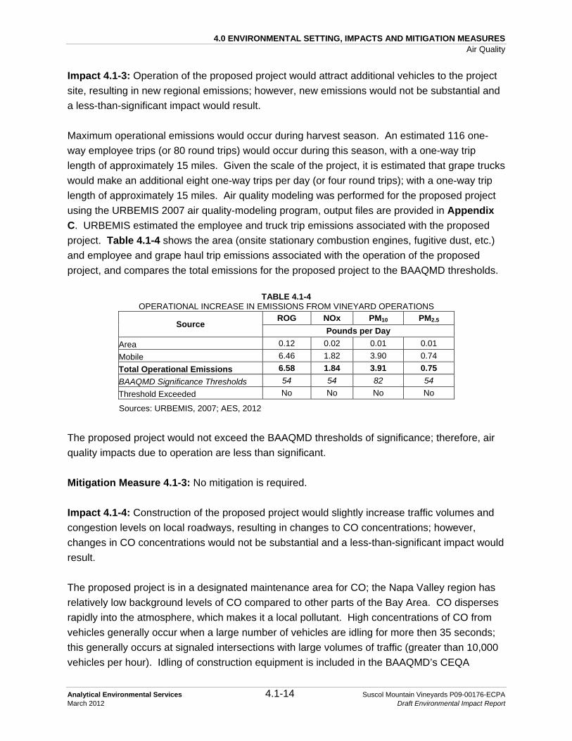
4.0 ENVIRONMENTAL SETTING, IMPACTS AND MITIGATION MEASURES Air Quality
Analytical Environmental Services 4.1-14 Suscol Mountain Vineyards P09-00176-ECPA March 2012 Draft Environmental Impact Report
Impact 4.1-3: Operation of the proposed project would attract additional vehicles to the project site, resulting in new regional emissions; however, new emissions would not be substantial and a less-than-significant impact would result. Maximum operational emissions would occur during harvest season. An estimated 116 one-way employee trips (or 80 round trips) would occur during this season, with a one-way trip length of approximately 15 miles. Given the scale of the project, it is estimated that grape trucks would make an additional eight one-way trips per day (or four round trips); with a one-way trip length of approximately 15 miles. Air quality modeling was performed for the proposed project using the URBEMIS 2007 air quality-modeling program, output files are provided in Appendix C. URBEMIS estimated the employee and truck trip emissions associated with the proposed project. Table 4.1-4 shows the area (onsite stationary combustion engines, fugitive dust, etc.) and employee and grape haul trip emissions associated with the operation of the proposed project, and compares the total emissions for the proposed project to the BAAQMD thresholds.
TABLE 4.1-4 OPERATIONAL INCREASE IN EMISSIONS FROM VINEYARD OPERATIONS
Source ROG NOx PM10 PM2.5
Pounds per Day Area 0.12 0.02 0.01 0.01 Mobile 6.46 1.82 3.90 0.74 Total Operational Emissions 6.58 1.84 3.91 0.75 BAAQMD Significance Thresholds 54 54 82 54 Threshold Exceeded No No No No
Sources: URBEMIS, 2007; AES, 2012
The proposed project would not exceed the BAAQMD thresholds of significance; therefore, air quality impacts due to operation are less than significant. Mitigation Measure 4.1-3: No mitigation is required. Impact 4.1-4: Construction of the proposed project would slightly increase traffic volumes and congestion levels on local roadways, resulting in changes to CO concentrations; however, changes in CO concentrations would not be substantial and a less-than-significant impact would result. The proposed project is in a designated maintenance area for CO; the Napa Valley region has relatively low background levels of CO compared to other parts of the Bay Area. CO disperses rapidly into the atmosphere, which makes it a local pollutant. High concentrations of CO from vehicles generally occur when a large number of vehicles are idling for more then 35 seconds; this generally occurs at signaled intersections with large volumes of traffic (greater than 10,000 vehicles per hour). Idling of construction equipment is included in the BAAQMD’s CEQA

4.0 ENVIRONMENTAL SETTING, IMPACTS AND MITIGATION MEASURES Air Quality
Analytical Environmental Services 4.1-15 Suscol Mountain Vineyards P09-00176-ECPA March 2012 Draft Environmental Impact Report
criteria, discussed in Section 4.1.3-1 above. Therefore, the proposed project’s effect on CO concentrations during construction is considered less than significant. Mitigation Measure 4.1-4: No mitigation is required. Impact 4.1-5: Project emissions have the potential to cause distress to sensitive receptors. However, project-related emissions would not be substantial and a less-than-significant impact would result. Some receptors are considered more sensitive than others to air pollutants as discussed in Section 4.1.1-1 above. Construction emissions are temporary and the BAAQMD states that if PM10 is mitigated, no NAAQS or CAAQS would be violated (see also Impact and Mitigation Measure 4.1-1 above). The proposed project includes development of approximately 561 gross acres of vineyard and disturbed areas; the area is designated as Agriculture, Watershed, and Open Space (AWOS) under the Napa County General Plan. The surrounding area consists mainly of open space and agricultural lands. Operational emissions would not increase significantly with the proposed project and would not exceed BAAQMD significance thresholds (see Table 4.1-3 and Impact 4.1-1 above). There are also no schools, hospitals or convalescent homes located close enough to the project site that would result in them being affected by construction or operational emissions from the proposed project; the closest offsite residence is located approximately 900 feet southeast of the project site. Other residences are located 1,500 feet and further from the western property boundary. Potential distress to sensitive receptors is considered less than significant. Mitigation Measure 4.1-5: No mitigation is required. Impact 4.1-6: Project operation could result in operational odors. However, odors from operation would not be substantial and a less-than-significant impact would result. During installation of #P09-00176-ECPA and subsequent vineyard operations, various diesel-powered vehicles and equipment used on the project site would create odors. However, these sources are mobile and transient in nature, and the distance of approximately 900 to 1,500 feet to the nearest offsite residences would provide for dilution of odor-producing constituent emissions. These odors would dissipate rapidly and are temporary. Because of this, and the distance between the project site and the nearest sensitive receptor, odors from vehicles and equipment are unlikely to be noticeable beyond the area of operation. Other odors that may be generated during project operation include the potential application of wettable sulfur and sulfur dust to control mildew. These would be sprayed in the early morning hours as opposed to evening hours in order to minimize drift, and any odors would be temporary and would occur at

4.0 ENVIRONMENTAL SETTING, IMPACTS AND MITIGATION MEASURES Air Quality
Analytical Environmental Services 4.1-16 Suscol Mountain Vineyards P09-00176-ECPA March 2012 Draft Environmental Impact Report
a substantial distance from rural receptors (greater than 900 to 1,500 feet from the nearest offsite receptors). This is considered a less-than-significant impact. Mitigation Measure 4.1-6: No mitigation is required.

4.0 ENVIRONMENTAL SETTING, IMPACTS AND MITIGATION MEASURES Air Quality
Analytical Environmental Services 4.1-17 Suscol Mountain Vineyards P09-00176-ECPA March 2012 Draft Environmental Impact Report
REFERENCES Analytical Environmental Services (AES), 2012. URBEMIS 2007 Detail Report. March 15,
2012. BAAQMD, 2010. California Environmental Quality Act: Air Quality Guidelines. Prepared by the
Bay Area Air Quality Management District. Available online at: http://www.baaqmd.gov/~/media/Files/Planning%20and%20Research/CEQA/BAAQMD%20CEQA%20Guidelines_June%202010.ashx. June 2010. Accessed October 15, 2010.
BAAQMD, 2006. Open Burn Status and Regulation 5. Available online at: http://www.baaqmd.gov/tec/openburn.htm. Accessed September 30, 2010. CARB, 2010a. Ambient Air Quality Standards. Prepared by the California Air Resources
Board. Available online at: http://www.arb.ca.gov/research/aaqs/aaqs2.pdf. Updated September 8, 2010. Accessed September 30, 2010.
CARB, 2010b. State and National Area Designation Maps of California. California Air
Resources Board. Available online at: http://www.arb.ca.gov/desig/adm/adm.htm. Updated September 7, 2010. Accessed September 30, 2010.
CARB, 2010c. California Air Resources Board Aerometric Data Analysis and Management
(ADAM), Top 4 Summary. Available online at: http://arb.ca.gov/adam/topfour/topfour1.php. Accessed September 30, 2010.
CARB, 2007a. The Proposed Early Action to Mitigate Climate Change in California. Available
online at: http://www.climatechange.ca.gov/publications/arb/2007-04-20_ARB_early_action_report.pdf. April 20, 2007. Accessed September 30, 2010.
CARB, 2007b. Expanded List of Early Action Measures to Reduce Greenhouse Gas Emissions
in California Recommended for Board Consideration, September 2007. Available online at: http://www.arb.ca.gov/cc/ccea/meetings/091707workshop/ea_ii_report.pdf. Accessed September 30, 2010.
Intergovernmental Panel on Climate Change (IPCC), 2007. Fourth Assessment Report: Climate
Change 2007. Available online at: http://www.ipcc.ch/publications_and_data/ar4/syr/en/contents.html. Accessed September 30, 2010.

4.0 ENVIRONMENTAL SETTING, IMPACTS AND MITIGATION MEASURES Air Quality
Analytical Environmental Services 4.1-18 Suscol Mountain Vineyards P09-00176-ECPA March 2012 Draft Environmental Impact Report
Urban Emissions (URBEMIS), 2007. Air quality emissions modeling program. Available online at: http://www.urbemis.com/.

4.0 ENVIRONMENTAL SETTING, IMPACTS AND MITIGATION MEASURES Biological Resources
Analytical Environmental Services 4.2-1 Suscol Mountain Vineyards P09-00176-ECPA March 2012 Draft Environmental Impact Report
4.2 BIOLOGICAL RESOURCES
References used in the preparation of this section include information from the following resources, most of which are on file at Napa County’s Conservation, Development and Planning Department office:
• Scientific texts: Plant Identification – Baldwin et al., 2003; Brodo et al., 2001; Doyle and Stotler, 2006; Esslinger, 2009; Hickman, 1993a and 1993b; Norris and Shevock, 2004a and 2004b; California Department of Fish and Game (CDFG), 2003; and Vegetation Classification – Sawyer et al., 2009; Thorne et al., 2004; Bird Identification – American Ornithologist’s Union, 1998, 2010; (bird sub-species follow Shuford and Gardali, 2008); Fish Identification – Nelson et al, 2004; Amphibian and Reptile Identification – Crother, 2008; Pauly et al., 2009; Kingsnake Identification – Pyron and Burbrink, 2009; Mammal Identification – Baker et al., 2003; Reid, 2006; for animals, subspecies names are used only when a specific subspecies is considered to have special status by the CDFG or the United States Fish and Wildlife Service (USFWS);
• Aerial photographs (1993, 2002, 2005 and 2007); • Napa County Baseline Data Report (NCBDR) (NCCDPD, 2005); Napa County General
Plan (Napa County, 2008); • National Wetland Inventory (NWI) map for “Cordelia, California” and “Mount George,
California” U.S. Geological Survey (USGS) 7.5-minute topographic quadrangles (USFWS, 2007a);
• Records that are updated monthly from the California Natural Diversity Database (CDFG, 2003) and California Native Plant Society’s (CNPS) Electronic Inventory (CNPS, 2010) centered around the “Cordelia, California” and “Mount George, California” USGS 7.5-minute topographic quadrangles and the ten surrounding quadrangles, including and “Benicia, California”, “Capell, California”, “Cuttings Wharf, California”, “Fairfield North, California”, “Fairfield South, California”, “Mare Island, California”, “Mount Vaca, California”, “Napa, California”, “Vine Hill, California”, and “Yountville, California”.
• A list of special status plant and animal species with potential to occur in the above USGS 7.5-minute topographic quadrangles provided by the USFWS (USFWS, 2010); and
• Biological studies performed on the project site (LSA, 2010). The Biological Survey Report by LSA Associates (LSA, 2010) is provided for reference as Appendix D.
Field surveys performed by LSA in support of the biological studies are summarized in Table 4.2-1. Surveys of the property were conducted on foot and representative areas of all the vegetation communities and wildlife habitats were examined. Vegetation communities on the project site were characterized by the dominant species present and amount of cover of the uppermost canopy layer, according to Sawyer et al. (2009). Vegetation communities in the field

4.0 ENVIRONMENTAL SETTING, IMPACTS AND MITIGATION MEASURES Biological Resources
Analytical Environmental Services 4.2-2 Suscol Mountain Vineyards P09-00176-ECPA March 2012 Draft Environmental Impact Report
were mapped on an aerial photograph of the project site (see Figure 4.2-1 discussed below). Areas where native grasses were observed and mapped in 2008 were visually inspected in 2009 to estimate their areal extent. Grasslands exceeding approximately five percent absolute cover of native grasses were mapped as native grasslands (bare ground was extremely uncommon except on rock outcrops, therefore absolute cover also was equivalent to relative cover): see Section 4.2.2-1 (Non-Native and Native Grasslands) for a detailed discussion. Because the purpose of the floristic surveys was to determine impacts, the field surveys focused most intently on areas within vineyard block clearing limits (i.e., vineyard development areas as shown in the erosion control plan (ECP)), access roads, rock disposal areas, and proposed erosion control features located outside of vineyard development areas. The scientific and vernacular nomenclature for the plant species used in this report is from the above listed standard sources.
TABLE 4.2-1 SUMMARY OF BIOLOGICAL FIELD SURVEYS
Survey Date Personnel Focus
June 27, 2007 Nichols and Lichtwardt
Preliminary biological reconnaissance, recorded wildlife species, tree species, vegetation communities, and associated wildlife habitats.
May 14 and 15, 2008 Nichols, Lichtwardt, Milliken and Akulova-Barlow
Botany, rare plants, wildlife, and vegetation and habitat mapping.
July 18, 2008 Lichtwardt and Akulova-Barlow Botany, rare plants, and wildlife.
July 31, 2008 Lichtwardt and Gilbert Dusk and night wildlife surveys focusing on California red-legged frogs along Suscol Creek and the pond.
August 7, 2008 Lichtwardt and Gilbert Dusk and night wildlife surveys focusing on California red-legged frogs along Suscol Creek and the pond.
March 10, 2009 Lichtwardt Wildlife, nesting birds, and foraging raptors. March 17 and 31, 2009 Lichtwardt, Milliken, and Lee Wildlife, botany, nesting birds, and foraging raptors. April 17 and 20, 2009 Milliken and Lee Botany and rare plants. May 7, 2009 Nichols and Lichtwardt Wildlife, nesting birds, and foraging raptors.
May 12, 2009 Lichtwardt and Akulova-Barlow Botany, rare plants, wildlife, nesting birds, and raptor foraging.
May 12, 2009 Nichols, Lichtwardt, and Milliken Botany, rare plants, wildlife, and nesting and foraging raptors.
June 10, 2009 Lichtwardt Wildlife and well test creek monitoring. July 8, 2009 Lichtwardt and Milliken Wildlife and well test creek monitoring. July 23, 2009 Nichols and Milliken Botany, rare plants, and wildlife. September 15, 2009 Nichols and Milliken Botany and rare plants. October 8, 2009 Lichtwardt Wetlands and wildlife.
Source: LSA, 2010 (Appendix D)

Marie LakeCayetano Creek
N o r t h e r n R i d g e
S u s c o l R i d g e
T h e K n o b
N o r t h e r n R i d g e
POLSO N RD
1
30B
41
25
32
27C
15B2
26B26A
31B
5A
18
15C
42
6
3D
24B
10C
7
36E
15A
34B
16A
36B43
38B 39B
4537
30A
27E
13
38A
34D
8A
34A
36A
8B
36C
9A
33
20
10B
46
9B
38C
27D
15D
21B
40
23
19A
36D
4
11B
30C
17
5C
14
24A
29B
3B
5B
28
16B
22
12C
21C
39A
44B
27B
3A12B
31A
27A
12A
10A
44A
3C
19B
15E
24C
11A
12D
34C
29A
21A
26C
21D
11C
Suscol CreekFa
gan C
reek
Shee
hy Cr
eek
Kreuse Creek
Polson
Rd
Figure 4.2-1Habitat Map
SOURCE: PPI Engineering, 2010; LSA, 2010; LandVoyage Aerial Photograph, 6/15/2005; Napa County, 2008; U.S. Fish and Wildlife, 3/17/2010; AES, 2011 Suscol Mountain Vineyards #P09-00176-ECPA Draft EIR / 209538
LEGEND
Proposed Clearing Limits
Proposed Vineyard Block Boundary
USGS Blueline StreamsCoast Live Oak Woodland /California Bay Forest
Wild Oats GrasslandWild Oats Grasslandwith 3% Purple Needle Grassand less than 5% Creeping Rye Grass
Purple Needle Grass Grassland
Creeping Rye Grass Turf
Creeping Rye Grass (10-15% Cover)
California Sagebrush Scrub
Chamise Chaparral
Barberry
White Alder Grove
Arroyo Willow Thicket
Pond
Seep / Spring (Potential Wetland)
0 400 800 1,200
Feet
!¢Ð
NORTH

4.0 ENVIRONMENTAL SETTING, IMPACTS AND MITIGATION MEASURES Biological Resources
Analytical Environmental Services 4.2-4 Suscol Mountain Vineyards P09-00176-ECPA March 2012 Draft Environmental Impact Report
4.2.1 SETTING
4.2.1-1 REGIONAL SETTING
Napa County is located within the Inner North Coast Range Mountains, a geographic subdivision of the larger California Floristic Province (Hickman, 1993a), which is strongly influenced by the Pacific Ocean. The region is in climate Zone 14 “Ocean Influenced Northern and Central California,” characterized as an inland area with ocean or cold air influence. The climate of the region is characterized by hot, dry summers and cool, wet winters; average precipitation ranges from approximately 20 to 40 inches per year (World Climate, 2005). The average annual temperature for the region ranges from 45 to 90 degrees Fahrenheit. Napa County extends from an elevation of zero feet above sea level on the west side to approximately 4,200 feet above sea level on the east side. Because of its dramatic variation in climate and topographic diversity, Napa County has a high natural level of biodiversity compared to the rest of California. The dominant natural land cover types in the vicinity of the project site are grasslands, oak woodlands, chaparral/scrub and some riparian woodland. Agricultural cropland is also a common land cover type in the area. Oak woodlands are the dominant natural land cover type in Napa County, covering over 167,000 acres (33 percent of the land cover in Napa County) and they are characterized by several oak species, including coast live oak (Quercus agrifolia), interior live oak (Quercus wislizenii), and Valley oak (Quercus lobata). Chaparral/scrub is the second most common land cover type in Napa County at approximately 107,000 acres (21 percent of the land cover in Napa County). Chaparral/scrub is dominated by woody shrubs such as manzanita (Arctostaphylos spp.), chamise (Adenostoma fasciculatum), Ceanothus spp., and coffeeberry (Rhamnus spp.), and contains less than ten percent cover of trees, including several different species of oak (Quercus spp.) (Napa County Baseline Data Report, 2005). Grassland is a relatively common land cover in the County, covering over 53,700 acres or nearly 11 percent of the County. The dominant grasses in Napa County, and across California, are non-native, including wild oats (Avena spp.), brome grasses (Bromus spp.), wild barley (Hordeum spp.), Italian ryegrass (Lolium multiflorum), blue grasses (Poa spp.), medusa head (Taeniantherum caput-medusae), and annual fescue (Vulpia) species. Riparian woodland is less common in Napa County and covers only 11,000 acres (two percent of land cover in Napa County). Riparian woodland occurs along stream corridors and is dominated by several different species of conifers and broad-leaved trees depending on the specific microclimate where it occurs. Agricultural cropland in the vicinity of the project site is dominated by vineyards, which occupy over 40,000 acres in Napa County. The project site is located near the southern end of the foothills on the eastern edge of the Napa Valley. Land to the east and south of the property is relatively undeveloped and supports a mix
4.0 ENVIRONMENTAL SETTING, IMPACTS AND MITIGATION MEASURES Biological Resources
Analytical Environmental Services 4.2-5 Suscol Mountain Vineyards P09-00176-ECPA March 2012 Draft Environmental Impact Report
of ranchlands, grasslands, woodlands, and chaparral. Rock outcrops and cliffs are also relatively common in the area. Land immediately to the west of the project site has been largely converted to vineyards, but also includes patches of oak woodlands and the riparian corridor along Suscol Creek. Syar Quarry and Skyline Wilderness Park border the northern boundary of the project site. Numerous constructed ponds (including Lake Marie in Skyline Wilderness Park) are located offsite in the region. The Napa Valley floor is approximately one mile west of the property. Green Valley, in Solano County, is approximately two miles to the east (see Figure 3-1). Two of the 13 evaluation areas established in the NCBDR (NCCDPD, 2005) occur on the project site. Evaluation areas are subdivisions of the County used in the NCBDR that are characterized by buffering biotic communities and are used to facilitate analysis of biological resources and regional planning. The northern two-thirds of the project site are within the Eastern Mountains Evaluation Area and the southern third is within the Jameson and American Canyons Evaluation Area. The boundary between these two evaluation areas on the project site is a prominent ridge (Suscol Ridge; see Section 4.2.1-2).
4.2.1-2 PROJECT SITE
The project site is surrounded by rolling to steep hills, rocky cliff faces and drainages. Elevations on the property range from approximately 150 feet (45.7 meters) above mean sea level (msl) in the southwest corner to over 1,400 feet (426.7 meters) above msl in its northeastern corner. Thus, the project site is varied topographically, ranging from gently rolling to very steep hills with rocky cliff faces. Rock outcrops are present in the northern two-thirds of the site. LSA (2010) describes and references three distinctive physiographic features on the project site. First, there is a prominent ridge line (referred to in this report as the “Northern Ridge”) that runs along the northern and northeastern boundary of the site (see Figure 3-2). This ridge drops steeply to the north into an unnamed drainage into Marie Creek, outside the property. Second, there are very steep slopes that rim portions of upper Suscol Creek watershed; another ridge (referred to as Suscol Ridge) with a very steep southern slope traverses the south central portion of the property. This ridge marks the southern edge of intact Sonoma Volcanics (discussed in the following paragraph). Third, there is a steep rocky hill or knob with a rocky south-facing cliff face in the center of the property (north of Suscol Creek), that is referred to as “The Knob.” The prominent geological features on the property include Holocene landslide deposits along portions of the Suscol Creek drainage, and extensive outcrops of Pliocene Sonoma Volcanics in the northern and central portion of the property. Eocene marine Markley Sandstone is the dominant formation in the southern portion of the property; this formation also outcrops along portions of the Suscol Creek bed (Wagner and Bortugno, 1982; Slone 2006). The southern,

4.0 ENVIRONMENTAL SETTING, IMPACTS AND MITIGATION MEASURES Biological Resources
Analytical Environmental Services 4.2-6 Suscol Mountain Vineyards P09-00176-ECPA March 2012 Draft Environmental Impact Report
approximately one third of the property is underlain by large blocks of Sonoma Volcanic bedrock that have detached from the southern ridgeline of the site and moved to the south and now form prominent benches on the south-facing slopes. Common examples of Sonoma Volcanic landscapes include rocky cliff faces, rock outcrops, exposed bedrock and scattered rocks and boulders. The soils on the project site include Bale clay loam 0 to 2 percent slopes; Clear Lake clay, drained; Fagan clay loam 5 to 15 percent slopes; Fagan clay loam 15 to 30 percent slopes; Fagan clay loam 30 to 50 percent slopes; Hambright-Rock outcrop complex 2 to 30 percent slopes; Hambright-Rock outcrop complex 30 to 75 percent slopes; Rock outcrop; and Sobrante loam 30 to 50 percent slopes (Lambert and Kashiwagi, 1978). See Figure 4.4-2 for a soils map of the property. Most of the drainages on the project site drain into the Napa River. The project site contains the entire upper watershed of Suscol Creek. In addition, the northern edge of the property drains to Marie Creek and the area south of Suscol Ridge drains to Fagan and Sheehy Creeks. All of these creeks are tributaries of the Napa River. The small portion of the property within Solano County drains to Green Valley Creek, which is tributary to Suisun Bay. However, no development is proposed in the Suisun Bay watershed. There are numerous springs and seeps on the project site as well. According to LSA (2010), most of the springs contained clear flowing water and the seeps were evidenced by the presence of moist soil. Most of the springs and seeps contained surface water or moist soil throughout the year. A constructed water storage pond is located in the south central portion of the property. This pond is a perennial water body fed by springs located just up slope of the pond. The pond is not connected directly to any of the watersheds or their tributaries listed above. The water in the pond is generally very clear and there is an abundance of submerged aquatic vegetation. The project site has a long history of cattle grazing, and is still being used for that purpose. There are no buildings on the site. Man-made features include several dry stone walls, a water storage pond adjacent to proposed Blocks 43, 44, and 45, a network of dirt and paved roads providing access for ranching activities, four water tanks within proposed Block 40, and the towers of a power transmission line that crosses the project site. Dirt roads cross Suscol Creek without culverts or bridges in the open area near the western boundary of the property and just upstream of the confluence of the two upper-most forks in the creek. The vegetation and associated wildlife habitats (biotic communities) on the project site are dominated by grasslands and oak woodlands, with smaller areas of riparian woodland, willows, and seeps and springs. Figure 4.2-1 shows the 11 vegetation types, or biotic communities,

4.0 ENVIRONMENTAL SETTING, IMPACTS AND MITIGATION MEASURES Biological Resources
Analytical Environmental Services 4.2-7 Suscol Mountain Vineyards P09-00176-ECPA March 2012 Draft Environmental Impact Report
mapped within the project site, as well as water features such as streams, ponds, and spring and seeps. Biotic communities are the characteristic assemblage of plants and animals that are found in a given range of soil, climatologic and topographic conditions across a region. Habitats that are not defined on the basis of dominant plant species such as ponds or rock outcrops are also present. The preliminary vegetation mapping for the project site was based on Thorne et al. (2004). LSA (2010) further characterized and refined the mapping on the project site according to the second edition of the Manual of California Vegetation (MCV; Sawyer et al., 2009). The primary purpose of the MCV classification is to assist in identifying rare biotic communities. Each biotic community described in the MCV is characterized using quantitative vegetation assessments and peer-reviewed scientific analyses to develop quantitative, defensible definitions of rare and threatened plant communities. These quantitative data provide the standard to invoke the California Environmental Quality Act (CEQA) to support conservation of rare communities that meet criteria defined in the MCV; CEQA specifically calls for the preservation of plant and animal communities within California. LSA identified vegetation types to the lowest taxonomic level possible, including alliances, associations, and semi-natural stands of vegetation dominated by non-native species that have become naturalized in California. Some habitats discussed below are not based on vegetation cover, though they may support vegetation, including rock outcrops and ponds. Based on the vegetation mapping, the project site contains approximately 1,560 acres of grassland, approximately 523 acres of woodland, approximately six acres of riparian habitat, and approximately 18 acres of shrubland habitats (see Figure 4.2-1) All acreages are approximate and the total property acreage including water onsite (2,111.22 acres as described in Table 4.2-2) differs slightly from the property acreage noted in Chapter 3.0 Project Description (2,123 acres) due to differences in GIS calculations. Detailed descriptions of the biotic communities and wildlife within the property are described in Section 4.2.2 (Biotic Communities and Alliances) and Section 4.2.3 (Wildlife) below.
4.2.2 BIOTIC COMMUNITIES AND ALLIANCES
Biotic communities are the characteristic assemblages of plants and animals that are found in a given range of soil, climate, and topographic conditions across a region. Biotic communities across Napa County were originally mapped by Thorne et al. (1994). On the project site, the vegetation mapping was modified by LSA, based on site specific studies, to better describe existing conditions, to capture finer-scale vegetation differences, as well as to use updated classifications of biotic communities in the revised MCV (Sawyer et al., 2009). Some provisional biotic community descriptions were created when a given community was not sufficiently described by an existing biotic community type. The primary purpose of the MCV classification

4.0 ENVIRONMENTAL SETTING, IMPACTS AND MITIGATION MEASURES Biological Resources
Analytical Environmental Services 4.2-8 Suscol Mountain Vineyards P09-00176-ECPA March 2012 Draft Environmental Impact Report
is to assist in the location and determination of significance and rarity of various vegetation types (biotic communities). Using the MCV (part of the National Vegetation Classification System), biotic communities are defined using a series of hierarchies. To the extent possible (since the process of classifying vegetation is ongoing), biotic communities on the project site were classified to the closest possible Alliance, Association, or Semi-Natural Stand. Each of these hierarchy levels are defined by “membership rules”, based on the percent absolute or relative cover of the dominant species. Membership in a particular Alliance, Association, or Semi-Natural Stand requires minimum percent cover as indicated in the MCV for that particular hierarchy. An Alliance is a vegetation classification unit that may contain one or more Associations, and is characterized by diagnostic species from the primary growth form layer (e.g. tree canopy layer), which are defined by the diagnostic species. An Association is a vegetation classification unit defined by diagnostic species from multiple growth forms or layers (e.g., tree canopy and herb layer). A Semi-Natural Stand is vegetation in which past or present human activities significantly influence plant composition or structure but do not eliminate or dominate spontaneous ecological processes. Further discussion of these vegetation terms can be found in Sawyer et al. (2009). The CDFG considers Sensitive Biotic Communities to be those which are listed in the CNDDB (e.g., native grasslands; 2003). Sensitive Biotic Communities are designated by CDFG, considered by local experts to be communities of limited distribution, and/or considered to be waters of the U.S. or the state (Napa County, 2008). Sensitive biotic communities in Napa County were identified using a two-step process (NCBDR, 2005):
1. An existing list of Sensitive Biotic Communities prepared by the CDFG (2003) was first reviewed by qualified biologists, and those communities that may occur in the County were identified. Because the community names in the CDFG list (2003) did not correspond directly with the names used in the County’s Land Cover Layer, a determination was made as to which land cover types on the Land Cover Layer correspond to the communities on the CDFG list.
2. The aerial extent of each land cover type mapped in the County was generated from the
land cover layer. Those biotic communities with an aerial extent of less than 500 acres in the County (approximately 0.1 percent of the County) were identified. These communities were discussed with local experts and their conservation importance established. Those that were not already on the original CDFG list and that were determined to be worthy of conservation were added to the list.

4.0 ENVIRONMENTAL SETTING, IMPACTS AND MITIGATION MEASURES Biological Resources
Analytical Environmental Services 4.2-9 Suscol Mountain Vineyards P09-00176-ECPA March 2012 Draft Environmental Impact Report
Other natural communities in the County are considered sensitive simply due to their limited local distribution. These Biotic Communities of Limited Distribution encompass less than 500 acres of cover within the County and are considered by local biological experts to be worthy of conservation (e.g., native grasslands; Napa County, 2008). Two types of native grassland which are considered sensitive by CDFG are located within the project site: Creeping Rye Grass Turfs (Leymus triticoides (also known as creeping wild rye) Herbaceous Alliance) and Purple Needle Grass Grassland (Nassella pulchra Herbaceous Alliance). These native grasslands are also extremely limited in Napa County, and therefore considered both Sensitive Biotic Communities and Biotic Communities of Limited Distribution. Curly Bluegrass Grassland (Poa secunda (also known as one-sided bluegrass Herbaceous Alliance) is known to occur in the vicinity, however, it is not known to occur within the project site. For simplicity the Creeping Rye Grass and Purple Needle Grass shall be referred to as a Sensitive Biotic Community (Figure 4.2-1). Rock outcrops are not treated specifically as biotic communities, because species composition varies depending on the surrounding biological community; however, they are recognized as significant because they provide important habitat features for special status plant and wildlife species, and must be assessed in the context in which they occur (NCCDPD, 2005). Vineyard development has been known to significantly impact rock outcrop areas in relatively level terrain. The project site contains mostly vertical rock outcrops (discussed below) that provide important habitat features for some special status species. These rock outcrops also provide added habitat diversity, promoting biodiversity across the project site. Figure 4.2-1 shows the 11 vegetation types, or biotic communities mapped within the project site. Representative photographs of each vegetation type are provided from the biological study completed for the project (LSA, 2010; Appendix D). Wetlands and other sensitive habitats on the property are also shown in Figure 4.2-1. Oak woodland areas are shown in Figure 4.2-2. Site photographs are included Figure 4.2-3. Plant species observed on the property and animal species that were observed, heard or for which there were evident signs of presence during the 2007 to 2009 field surveys are listed in Appendix D. Table 4.2-2 reports the gross acreage of each vegetation type in Napa County (when those estimates were available in the NCBDR, 2005), on the project site, and summed across the proposed vineyard blocks. The biotic communities present on the project site are described briefly below (Sections 4.2.2-1 through 4.2.2-7).

Marie LakeCayetano Creek
N o r t h e r n R i d g e
S u s c o l R i d g e
T h e K n o b
N o r t h e r n R i d g e
POLSO N RD
1
30B
41
25
32
27C
15B2
26B26A
31B
5A
18
15C
42
6
3D
24B
10C
7
36E
15A
34B
16A
36B43
38B 39B
4537
30A
27E
13
38A
34D
8A
34A
36A
8B
36C
9A
33
20
10B
46
9B
38C
27D
15D
21B
40
23
19A
36D
4
11B
30C
17
5C
14
24A
29B
3B
5B
28
16B
22
12C
21C
39A
44B
27B
3A12B
31A
27A
12A
10A
44A
3C
19B
15E
24C
11A
12D
34C
29A
21A
26C
21D
11C
Suscol CreekFa
gan C
reek
Shee
hy Cr
eek
Kreuse Creek
Polson
Rd
Figure 4.2-2Oak Woodland Areas
SOURCE: PPI Engineering, 2010; LSA, 2010; LandVoyage Aerial Photograph, 6/15/2005; Napa County, 2008; U.S. Fish and Wildlife, 3/17/2010; AES, 2011 Suscol Mountain Vineyards #P09-00176-ECPA Draft EIR / 209538
LEGEND
Property Boundary
Oak Woodland On Slopes Greater Than 30%
Proposed Clearing Limits
Proposed Vineyard Block Boundary
USGS Blueline Streams
Coast Live Oak Woodland
0 400 800 1,200
Feet
!¢Ð
NORTH

Suscol Mountain Vineyards #P09-00176-ECPA Draft EIR / 209538Figure 4.2-3
Site Photographs
SOURCE: AES, 2010
PHOTO 1: Wild oats grassland showing extensive star and purple thistle infestation.
PHOTO 3: Emergent wetland vegetation adjacent to pond.
PHOTO 5: Seep.
PHOTO 2: Grassland covered hills surrounding pond.
PHOTO 4: Rock outcrop adjacent to rock wall; grassland and riparian woodland in background.
PHOTO 6: Stream habitat.

4.0 ENVIRONMENTAL SETTING, IMPACTS AND MITIGATION MEASURES Biological Resources
Analytical Environmental Services 4.2-12 Suscol Mountain Vineyards P09-00176-ECPA March 2012 Draft Environmental Impact Report
TABLE 4.2-2 BIOTIC COMMUNITIES IN NAPA COUNTY AND ON THE PROJECT SITE
Biotic Community
Napa County Project Site Proposed Blocks
Estimated Acreage in
Napa County1
Percent of Total Acreage in
Napa County Total Acreage
on Site
Percent of Vegetation
Type in Napa County
Acreage for Proposed
Development (Project Area)
Percent of Biotic
Community on Project
Site
Percent of Vegetation
Type in Napa County
Barberry NA NA 0.38 NA 0 0 NACalifornia Annual Grassland (Wild Oats Grassland)2 39,175.33 7.77% 1,558.38 3.98% 530.26 34.03% < 1.36%
Wild Oats Grassland with 3% Purple Needle Grass and Less Than 5% Creeping Wild Rye
NA4 NA 12.375 NA 9.335See Wild Oats
Grassland above
NA
Wild Oats Grassland with 10-15% Creeping Wild Rye NA4 NA 2.595 NA 0.145
See Wild Oats Grassland
above NA
Wild Rye Turf (at least 50% cover) NA4 NA 0.25 NA 0 0 NAPurple Needle Grass Grassland (at least 5% cover) NA4 NA 1.63 NA 0 0 NA
California Sagebrush Scrub NA4 1.72 NA 0 0 NA
Chamise Chaparral 30,914 6.09% 15.82 0.05% 0.26 1.64% < 0.01%
Coast Live Oak Woodland3 13,139 2.59% 522.58 3.98% 29.77 5.70% 0.23%
Seep NA 2.12 NA 0.07 3.30% NA
Water NA 2.59 NA 0 0 NA
White Alder Forest 967 0.19% 4.78 0.49% 0 0 0
Willow Woodland 542 0.11% 0.97 0.18% 0 0 0Notes: All acreages are approximate and total property acreage calculated above (2,111.22 acres) differs slightly from the property acreage noted in the Chapter 3.0 Project Description (2,123 acres) due to differences in GIS calculations. NA = data not available. 1Based on Thorne et al., 2004. 2Wild Oats Grasslands are a common subset of California Annual Grassland. 3Coast Live Oak Woodland was intermixed with California Bay forest on the project site. 4This biotic community is unmapped and no data is available on it in Table 4-5 (Distribution of Sensitive Biotic Communities Across Napa County’s Thirteen Evaluation Areas) of the Baseline Data Report (NCCDPD, 2005). 5 The two biotic communities Wild Oats Grassland with 3% Purple Needle Grass and Less Than 5% Creeping Wild Rye, and Wild Oats Grassland with 10-15% Creeping Wild Rye are subsets of the Wild Oats Grassland community and are not sensitive resources; their acreages are included in the Wild Oats Grassland acreages in Table 4.2-2. Source: AES, 2011; PPI, 2011; LSA, 2010

4.0 ENVIRONMENTAL SETTING, IMPACTS AND MITIGATION MEASURES Biological Resources
Analytical Environmental Services 4.2-13 Suscol Mountain Vineyards P09-00176-ECPA March 2012 Draft Environmental Impact Report
4.2.2-1 NON-NATIVE AND NATIVE GRASSLANDS
There are three types of grasslands on the project site: Wild Oats Grasslands (Avena [barbata, fatua] Semi-Natural Stands), Creeping Rye Grass Turf, and Purple Needle Grass Grassland. All of these grassland types were formerly grouped into the broader California Annual Grasslands Series, the former because grasslands were not well defined, and the latter because native grasslands (and their characteristic native perennial grasses) tend to be very small in area. The less descriptive “California Annual Grasslands Series” was recently split into several other more specific grassland alliances and semi-natural stands dominated by annual species (Sawyer et al., 2009). The total combined acreage of California Annual Grasslands Alliance estimated in Napa County in 2004 was approximately 39,175 acres (7.8 percent of the total land cover). California Annual Grasslands Alliance, specifically manifested as Wild Oats Grasslands on the project site, total approximately 1,543 acres (which equals 3.9 percent of all grasslands mapped in Napa County; Table 4.2-2; Thorne et al., 2004). Wild Oats Grasslands are common throughout California (except in the Sonoran Desert) especially in areas with a history of grazing management. Creeping Rye Grass Turf and Purple Needle Grass Grassland were not mapped in the original County-wide vegetation mapping (Thorne et al., 2004), primarily because known areas were smaller than the minimum map unit (two hectares) used; therefore an estimate of their County-wide acreages is not available. These two grassland types are considered Sensitive Biotic Communities as described in Section 4.2.2 (Biotic Communities and Alliances) above. NON-NATIVE GRASSLANDS Wild Oats Grasslands (Avena [barbata, fatua] Semi-Natural Stands)
This vegetation type is dominated by non-native annual grasses and occupies many areas that were historically dominated by native grasses and/or forbs. Wild Oats Grassland covers approximately 1,543 acres of the project site (Table 4.2-2, Figure 4.2-1 and a representative photograph is shown in Figure 4.2-3). The dominant plant species observed in this semi-natural stand include slender wild oats (Avena barbata), ripgut brome (Bromus diandrus), Italian ryegrass (Lolium multiflorum), and soft chess (Bromus hordeaceus). Other grass species such as (hare) barley (Hordeum murinum ssp. leporinum) are also locally abundant on the project site. Scattered individuals or patches of native grasses (purple needle grass and creeping wild rye) are also present, but in general these are very degraded grasslands. Non-native forbs include filaree (Erodium botrys), rose clover (Trifolium hirtum), Italian thistle (Carduus pycnocephalus), yellow star thistle (Centaurea solstitialis), and milk thistle (Silybum marianum). Non-native forbs such as black mustard (Brassica nigra) also form large monotypic patches in some areas. Native forbs such as Menzies’ fiddleneck (Amsinckia menziesii var. menziesii), harvest brodiaea (Brodiaea

4.0 ENVIRONMENTAL SETTING, IMPACTS AND MITIGATION MEASURES Biological Resources
Analytical Environmental Services 4.2-14 Suscol Mountain Vineyards P09-00176-ECPA March 2012 Draft Environmental Impact Report
elegans), sky lupine (Lupinus nanus), mule’s ears (Wyethia glabra), gold nuggets (Calochortus luteus), common popcorn flower (Plagiobothrys nothofulvus), and others grow sparsely among non-native grasses.
A few areas of Wild Oats Grasslands, shown in Figure 4.2-1 contain less than five percent absolute cover of native grasses, insufficient to qualify for membership as Sensitive Biotic Communities according to the MCV (Sawyer et al., 2009). Native grasses found at low cover quantities include purple needle grass (Nassella pulchra), creeping wild rye (or creeping rye grass; Leymus triticoides), and meadow barley (Hordeum brachyantherum).
Although this Wild Oats Grassland is dominated by non-native species, relatively undisturbed expanses of this vegetation (such as those present on the project site) can support a diversity of wildlife species that were historically associated with native California grassland alliances. The only small mammals typical of grasslands that were detected during the surveys were the Botta’s pocket gopher (Thomomys bottae) and deer mouse (Peromyscus maniculatus). Other species of small mammals known from the area and likely to occur include the ornate shrew (Sorex ornatus), California vole (Microtus californicus), and western harvest mouse (Reithrodontomys megalotis). Larger mammals that use grasslands include the black-tailed jackrabbit (Lepus californicus) and mule deer (Odocoileus hemionus), both observed on the project site. The rolling hills and grassland on the site appear to provide suitable habitat for the California ground squirrel (Spermophilus beecheyi), but only one individual was observed along the dry stonewall in the western portion of the site. Perhaps the shallow soils and bedrock close to the surface limit their ability to dig burrows. The burrow systems of this mammal provide important retreats for a wide variety of native wildlife including such special status species as the California red-legged frog (Rana draytonii) and burrowing owl (Athene cunicularia), (although no evidence of either species has been found on the project site). The pallid bat (Antrozous pallidus), which feeds primarily on large terrestrial arthropods (insects) in open habitats, is likely to be present on the site and forage in the grassland (see Impact and Mitigation Measure 4.2-19). Predators that forage for small mammals in grasslands and have been observed on the project site include the white-tailed kite (Elanus leucurus), northern harrier (Circus cyaneus), red-tailed hawk (Buteo jamaicensis), Swainson’s hawk (Buteo swainsoni), barn owl (Tyto alba), and coyote (Canis latrans). The golden eagle (Aquila chrysaetos) nests in southeast Napa County, both north and south of the project site (Berner et al., 2003). This large raptor was been observed soaring over the site during several field surveys.
Approximately 34 percent (521 acres) of the 1,543 acres of Wild Oats Grasslands on the project site would be developed into vineyard under the proposed project (Figure 4.2-1). Some of the areas not proposed for development could be improved for native species by encouraging native plant species growth and controlling highly invasive exotic species such as star thistle and medusa-head grass (see Impact and Mitigation Measure 4.2-1).
4.0 ENVIRONMENTAL SETTING, IMPACTS AND MITIGATION MEASURES Biological Resources
Analytical Environmental Services 4.2-15 Suscol Mountain Vineyards P09-00176-ECPA March 2012 Draft Environmental Impact Report
NATIVE GRASSLANDS
Non-native annual grasses have gradually displaced native grasses and forbs in California beginning with European settlement in the early 19th century. Most of these grasses are of Mediterranean origin and were introduced to improve forage for cattle. The combination of heavy livestock grazing, prolonged periods of drought, and tillage for dry farming resulted in a type conversion from native perennial grasslands to non-native semi-natural grasslands throughout California and including the hills in Napa County (Burcham, 1956; Heady et al., 1992; Stromberg and Griffin, 1996). In addition, in the absence of fire and grazing, grasslands in the Bay area tend to succeed to coyote brush scrub (Edwards, 1990; McBride and Heady, 1968). On some sites succession proceeds without disturbance from native grasslands to coyote brush scrub to coastal scrub and eventually (after 50 years or more) to oak-bay forest (McBride, 1974). As a consequence, grasslands tend to be more common in areas with active livestock operations. It is can be difficult to separate the existing remnants of native grasslands from semi-natural grassland because of the patchiness and small size of some native grass stands. Furthermore, even the most intact stands of native grassland contain non-native grasses; the recent MCV (Sawyer et al., 2009) provides the first set of membership rules for native grassland. Accordingly, LSA mapped as native grasslands only the largest and most distinct grassland areas that supported more than five percent cover of native grasses, as described below. Percent cover was based on the absolute percent of ground covered by a plant at ground level, and thus does not include canopy spread of the grasses, which would reflect a higher percent. Native grass coverage was easily discernable in the field. Because grasslands containing a recognizable component of native grassland species generally occur in very small areas and are rare in California, they were not specifically mapped for Napa County in Thorne et al. (2004). Native grassland alliances are considered sensitive by the CDFG (CDFG, 2003) and are afforded protection under Napa County General Plan policies. Wildlife associated with native grassland would include the same species discussed above under Wild Oats Grasslands.
Creeping Rye Grass Turfs (Leymus triticoides Herbaceous Alliance)
Any area containing at least 50 percent relative cover1 of creeping wild rye was mapped as Creeping Rye Grass Turf (Sawyer, et al., 2009; Figure 4.2-1). Creeping wild rye is a native, cool-season, sod-forming, long-lived perennial grass. Seeds are generally sterile; the plant reproduces by underground stolons, which bind the soil into strong, erosion-resistant turf. This widespread species is a component of many other alliances and is often found in the understory of riparian forests. It should be noted that this species hybridizes with Eurasion L. multicaulis, which is sometimes planted as forage and forms hybrid plants that can 1 The 50 percent relative cover for Creeping Rye Grass Turfs and five percent absolute cover for Purple Needle Grass Grassland discussed in the following paragraph
represent the membership rules outlined in MCV (Sawyer, et al., 2009). These numbers differ due to the growth habit of the grass species and the natural community’s response to non-native invasion and disturbance.

4.0 ENVIRONMENTAL SETTING, IMPACTS AND MITIGATION MEASURES Biological Resources
Analytical Environmental Services 4.2-16 Suscol Mountain Vineyards P09-00176-ECPA March 2012 Draft Environmental Impact Report
produce fertile seeds. However, LSA (2010) did not observe the Eurasion species or hybrids on the project site. Approximately 0.25 acre of Creeping Rye Grass Turf with 50 percent absolute cover was mapped on the project site, in a single patch. A few other patches containing ten to 15 percent creeping wild rye cover were mapped within Wild Oats Grassland (discussed above; see Figure 4.2-1), but they do not qualify for membership as Creeping Rye Grass Turfs, a sensitive biotic community type. This community is a remnant of the original native perennial grasslands that were often associated with wetland and riparian areas throughout the central coast, Bay Area, and north coast of California. Purple Needle Grass Grassland (Nassella pulchra Herbaceous Alliance)
A single patch of grassland containing at least five percent absolute cover of purple needle grass was mapped as Purple Needle Grass Grassland (Sawyer, et al., 2009; Figure 4.2-1; Appendix D). Purple Needle Grass Grassland on the project site also included scattered individuals of native meadow barley and creeping wild rye. Approximately 1.63 acres of Purple Needle Grass Grassland was mapped on the project site (Figure 4.2-1). This community is a remnant of the original native perennial grasslands that covered the hills and valleys throughout the central coast, Bay Area, and north coast of California.
4.2.2-2 WOODLANDS
Coast Live Oak Woodland (Quercus agrifolia Woodland Alliance) and California Bay Forest (Umbellularia californica Forest Alliance)
Coast Live Oak Woodland and California Bay Forest are discussed together because, according to LSA (2010), on the project site these two alliances form a complex mosaic and they intergrade in many areas along the Suscol Creek drainage. Coast Live Oak Woodland on the project site varies from dense closed canopy stands on north-facing slopes and along drainages to open stands with no overlap in individual tree canopies on south-facing slopes. Isolated oaks are also scattered in open grassland. Approximately 523 acres of Coast Live Oak Woodland/California Bay Forest is present on the project site (Figure 4.2-1). The dominant tree of the Coast Live Oak Woodland is coast live oak (Quercus agrifolia), but in areas along Suscol Creek, this alliance forms an association with California bay (Umbellularia californica). California bay is particularly common on north-facing slopes and in some areas form almost monotypic stands of California bay forest. California buckeye (Aesculus californica) occurs as scattered individuals on the edges of the coast live oak woodland along the drainages. Valley oak (Quercus lobata), black oak (Quercus kelloggii), and Oregon oak (Quercus garryana) occur in small numbers in coast live oak woodland in the canyon bottom along Suscol Creek. Scattered individual valley oaks are present in other areas as well. A small stand of California scrub oak (Quercus berberidifolia) forms an association with coast live oaks on the north slope of the prominent rocky knob in the north central portion of the property (north of Suscol Creek). There is also a small cluster of

4.0 ENVIRONMENTAL SETTING, IMPACTS AND MITIGATION MEASURES Biological Resources
Analytical Environmental Services 4.2-17 Suscol Mountain Vineyards P09-00176-ECPA March 2012 Draft Environmental Impact Report
unusual oaks in this area that appear to be hybrids of coast live oak and black oak (Figure 4.2-6). Understory shrubs include: snowberry (Symphoricarpos albus var. laevigatus), creeping snowberry (Symphoricarpos mollis), California coffeeberry (Frangula (Rhamnus) californica), honeysuckle (Lonicera hispidula), thimbleberry (Rubus parviflorum), and wood rose (Rosa gymnocarpa). A stand of western azalea (Rhododendron occidentale) is also present within the coast live oak woodland along Suscol Creek in the central portion of the project site. Also present in this same area is a stand of American dogwood (Cornus sericea). Western azalea and American dogwood are considered locally rare in Napa County (Figure 4.2-6). Herbaceous species present in the understory include bugle hedge nettle (Stachys ajugoides), broad leaf aster (Aster radulinus), Robert’s geranium (Geranium robertianum), and others. Bryophytes such as redshank moss (Ceratodon purpureus) and feather moss (Kindbergia praelonga) grow on tree trunks and shaded soils in the oak woodland. Lace lichen (Ramalina menziesii), often mistaken for Spanish moss, hangs from the branches of some of the oak trees. Coast Live Oak Woodland provides habitat for many wildlife species, and the intergrading California bay forest would host similar wildlife species while increasing overall plant species diversity. Examples include: red-shouldered hawk (Buteo lineatus), acorn woodpecker (Melanerpes formicivorus), Nuttall’s woodpecker (Picoides nuttallii), Hutton’s vireo (Vireo huttoni), western scrub jay (Aphelocoma californica), oak titmouse (Baeolophus inornatus), white-breasted nuthatch (Sitta carolinensis), and dusky-footed woodrat (Neotoma fuscipes). Mid-sized to large mammals such as mule deer and coyote use this habitat for shelter and foraging. Areas of ground disturbance from foraging feral pigs (wild boar) (Sus scrofa) were evident in several areas in the oak woodland and in grassland adjacent to oak woodland. California slender salamanders (Batrachoseps attenuatus) were common under fallen logs and bark during the March 10, 2009 field surveys. Species of amphibians and reptiles that were not found during the field surveys due to dry surface conditions or cool temperatures, but that commonly occur in oak woodlands and are expected on the project site include the arboreal salamander (Aneides lugubris), ensatina (Ensatina eschscholtzii), and ring-neck snake (Diadophis punctatus). Coast Live Oak Woodland in Napa County covers approximately 13,139 acres, or roughly 2.6 percent of the total vegetative cover in the County. Approximately 30 acres (5.7 percent) of the approximately 523 acres of this alliance within the project site would be developed into vineyard (Table 4.2-2).

4.0 ENVIRONMENTAL SETTING, IMPACTS AND MITIGATION MEASURES Biological Resources
Analytical Environmental Services 4.2-18 Suscol Mountain Vineyards P09-00176-ECPA March 2012 Draft Environmental Impact Report
Eucalyptus and Other Non-Native Trees
Several large isolated blue gum (Eucalyptus globulus) trees occur in the southeastern corner of the project site and a single Lombardy poplar (Populus nigra ‘Italica’) is present at a seep in the same area. A hedgerow of horsetail trees (Casuarina equisetifolia) fringes the southern boundary of the project site, just south of the fence line. These isolated individuals and patches are not mapped in Figure 4.2-1. Although these trees are non-native they provide habitat for some species of birds. Various species of raptors likely use the blue gum as a perch site and loggerhead shrikes could use the horsetail trees as nest sites.
4.2.2-3 WETLANDS, DRAINAGES AND WATERS OF THE U.S.
A formal delineation of wetlands and waters of the U.S. has not been conducted on the project site, but wetlands and waters under the jurisdiction of the U.S. Army Corps of Engineers (USACE), Regional Water Quality Control Board (RWQCB), and CDFG are present. The aquatic features on the project site are Suscol, Fagan, and Sheehy Creeks and their tributaries, and various seeps and springs (Figure 4.2-1). These areas support high-quality wetlands and aquatic habitat as indicated by the presence of good populations of native fish. Nevertheless, portions of Suscol and Fagan Creeks in particular have areas that have been degraded by cattle grazing and trampling. These areas present opportunities for habitat restoration and enhancement. Several of the proposed vineyard blocks are adjacent to wetlands (including seeps and springs), County designated streams or non-County designated streams. Corridors for County designated streams have been preserved throughout the project site, and minimum stream setbacks range in width from 65 to 150 feet on either side of streams, measured from top of bank. Wetland setbacks of 50 feet or greater have been proposed (discussed in Impact and Mitigation Measure 4.2-6, and discussed further in relation to wildlife corridors in Mitigation Measure 4.2-7). Seeps and Springs
Seeps and springs, collectively referred to as wetlands, are present in many areas of the property in association with Sonoma Volcanics (Figure 4.2-1), and are a permanent water source for Suscol Creek. The springs and seeps on the project site total approximately 0.8 acre in area (Figure 4.2-1 and a representative photograph is shown in Figure 4.2-3). In addition to those mapped on Figure 4.2-1, a number of seeps and springs (not mapped) are located along cliff faces under the dense tree canopy along Suscol Creek. Seeps tend to exhibit little surface flow, but contain saturated soil and often support plants typical of wetlands. Springs tend to have flowing surface water. The vegetation of seeps and springs is dominated by common rush (Juncus effusus), Baltic rush (Juncus balticus), pennyroyal (Mentha pulegium), and Mediterranean barley (Hordeum marinum ssp. gussoneanum). Other plant species include water speedwell (Veronica

4.0 ENVIRONMENTAL SETTING, IMPACTS AND MITIGATION MEASURES Biological Resources
Analytical Environmental Services 4.2-19 Suscol Mountain Vineyards P09-00176-ECPA March 2012 Draft Environmental Impact Report
anagallis-aquatica), mannagrass (Glyceria leptostachya), water cress (Rorippa nasturtium-aquaticum), common monkey flower (Mimulus guttatus), tinker’s penny (Hypericum anagalloides), nutsedge (Cyperus eragrostis), and bentgrasses (Agrostis exarata and A. viridis). The cliff face seeps and springs in the heavily shaded areas along Suscol Creek support thick growths of liverworts, mosses, and ferns, and flowering plants such as scarlet monkey flower (Mimulus cardinalis). Patches of arroyo willow are also associated with some springs and seeps. Mosses such as fissidens (Fissidens limbatus) and funaria (Funaria sp.) grow on moist soils and rocks in seeps and springs along with the liverwort (Aneuria pinguis) and hornworts (Anthoceros sp.). Seeps and springs are a water source for a wide variety of wildlife species during the dry season. California red-legged frogs (Rana draytonii) and various other aquatic species may use seeps and springs as refugia during the non-breeding season. Ponds
The man-made pond (approximately 2.6 acres) located adjacent to proposed Blocks 43, 44, and 45 supports several aquatic plant species including coontail (Ceratophyllum demersum) and duckweed (Lemna minor). The edges of the pond are dominated by California bulrush (Scirpus californicus), narrowleaf cattail (Typha angustifolia), broadleaf cattail (Typha latifolia), and common rush. This pond is likely used by a variety of wildlife species. Red-winged blackbirds (Agelaius phoeniceus) were observed here during the 2006 survey and are likely to nest in the bulrush and cattail stands. Water birds observed at the pond include gadwall (Anus strepera), mallard (Anus platyrhynchos), double-crested cormorant (Phalacrocorax auritus), great blue heron (Ardea herodias), great egret (Ardea alba), and American coot (Fulica americana). The pond also provides potential breeding and foraging habitat for the California red-legged frog, Sierran treefrog (Pseudacris sierra) and other native amphibians. However, the presence of American bullfrog (Rana catesbeiana), western mosquitofish (Gambusia affinis), and largemouth bass (Micropterus salmoides) - all non-native predatory species - greatly reduces the suitability of this pond for native aquatic species. A single western pond turtle (Actinemys marmorata) was observed at the pond during the October 8, 2009 field survey. The air space above the pond provides foraging habitat for birds such as barn swallow (Hirundo rustica), cliff swallow (Petrochelidon pyrrhonota), and myotis bats (all observed foraging over the pond during the surveys).

4.0 ENVIRONMENTAL SETTING, IMPACTS AND MITIGATION MEASURES Biological Resources
Analytical Environmental Services 4.2-20 Suscol Mountain Vineyards P09-00176-ECPA March 2012 Draft Environmental Impact Report
Streams Suscol Creek is the primary stream draining the property. The creek flows in an east to west direction directly into the Napa River approximately 4.2 miles from the point of initiation of Suscol Creek. The mainstem of Suscol Creek, as well as the tributary of Fagan Creek in the southeast corner of the site, sustain perennial base flows even in dry years (Balance Hydrologics, 2010; Appendix G) (Figures 4.2-1 and 4.2-3). The stream bed in Suscol Creek is characterized by pools interspersed with low gradient riffles and interrupted pool habitat (Rich, 2007). The creek predominantly contains coarse gravels and rock rubble, and a substantial amount of bedrock in the lower reaches. Undercut banks are present in some areas and canopy coverage is good throughout most of the property. Flow habitats vary from relatively high velocity riffles and runs to pools, some of which are over 1.5 feet deep. In average water years, peak winter flows can range between 80 to 100 cubic feet per second (cfs) in the upper reaches and 180 to 200 cfs at the property boundary (Balance Hydrologics, 2010; Appendix G). Relatively little aquatic vegetation is present in the creek, but during late summer several of the pools were almost completely covered with duckweed (Lemna minor). Suscol Creek provides high quality aquatic habitat for native fish and amphibians; steelhead/rainbow trout, California roach (Lavinia symmetricus), and rough-skinned newts (Taricha granulosa) were observed in pool habitats. Steelhead/rainbow trout occur in the deeper pools and runs from the western edge of the property upstream to the second road crossing and they are present in the larger perennial branches of the creek as well. Western toads (Bufo boreas) were observed breeding in the pool just upstream of the first road crossing in the spring of 2009. California newt (Taricha torosa) larvae were observed in pools in Fagan Creek during October 2008, but no fish were seen in this drainage. Sheehy Creek on the project site does not provide suitable habitat for fish. The downstream reaches of Suscol Creek, below the project site, contain five partial barriers to anadromy which were evaluated by Napa County Resource Conservation District (NCRCD) during a 2007 inventory of the creek (CDFG, 2011). Three out of the five partial barriers present are attributed to natural bedrock falls and slides and are likely impassable during lower stream flows. During the higher winter flows noted above, steelhead can access the upper reaches of the creek within the project site. This creates a limited window where steelhead can access the project reaches of the creek. Fagan Creek initiates from two distinct tributary branches just east of the project site; one of these headwater channels flows across the southeastern corner of the project site in an area supporting coast live oak and California bay forest. From this location, Fagan Creek flows in a westerly direction directly into the Napa River tidal slough approximately seven miles west of the project site. The upper reaches of Fagan Creek support a moderately steep channel sustaining a slope of 12 percent or greater over the first half mile segment of

4.0 ENVIRONMENTAL SETTING, IMPACTS AND MITIGATION MEASURES Biological Resources
Analytical Environmental Services 4.2-21 Suscol Mountain Vineyards P09-00176-ECPA March 2012 Draft Environmental Impact Report
stream channel. Fagan Creek is perennial and fed mainly by springs and is similar to Suscol Creek in its physical characteristics, but appears to be more intermittent with areas of under gravel flow in the dry season (LSA, 2010). California newt (T. torosa) larvae were observed in pools in Fagan Creek during October 2008, but no fish were seen in this drainage (Ibid.). These observations support other literature sources for Fagan Creek indicating that that the stream does not support a fish population (Leidy et. al., 2005). A 15-foot drop on the south side of the Highway 12 crossing may serve as a barrier to anadromous fish migration. In September 1981, two Fagan Creek sites were sampled by dip net as part of a fin distribution study; no Central California coastal steelhead were found. In addition, Ecotrust and Friends of the Napa River (FONR) surveyed Fagan Creek between May and September of 2002 and Central California coastal steelhead were not observed in the sampled Fagan Creek reaches (Leidy et. al., 2005). Further, the National Marine Fisheries Services (NMFS) distribution table for Napa County (NMFS, 2000) and the CDFG Calfish database (DFG, 2011) for fisheries resources both indicate that salmonids do not use Fagan Creek. While Fagan Creek does not have the potential to support special status fish species it does contain habitat suitable to support common aquatic vertebrate and invertebrate species and riparian habitats that are crucial for many common, local mammalian and avian species. The tributary to Fagan Creek onsite is fed mainly by springs and supports a deep and narrow channel which is prone to bank slumping and channel widening, especially where banks have been trampled by cattle activity (Balance Hydrologics, 2010; Appendix G). The portion of Sheehy Creek that is on the project site has similar characteristics as Fagan Creek. Fagan and Sheehy Creeks have intermittent flows that would provide only temporary aquatic habitat when water is present, but could provide corridors for dispersal to other more permanent aquatic habitats.
4.2.2-4 SHRUBLANDS
This vegetation type is dominated by woody shrubs, with less than ten percent cover of trees, and it generally occurs in settings that are too hot, dry, rocky, and steep to support tree-dominated habitats (Holland, 1986). It tends to be found on south and southwest-facing slopes. Two types of shrublands were mapped on the project site: Chamise Chaparral and California Sagebrush Scrub. A small but distinctive patch of western azalea was also mapped.
4.0 ENVIRONMENTAL SETTING, IMPACTS AND MITIGATION MEASURES Biological Resources
Analytical Environmental Services 4.2-22 Suscol Mountain Vineyards P09-00176-ECPA March 2012 Draft Environmental Impact Report
Chamise Chaparral (Adenostoma fasciculatum Scrubland Alliance)
Chamise (Adenostoma fasciculatum) is a widely distributed non-serpentine shrub in chaparral communities in California. Associated species in the chaparral on the project site include spiny redberry (Rhamnus crocea), coffee fern (Pellaea truncata), climbing bedstraw (Galium porrigens), and others. A patch (approximately 15.8 acres) of chaparral occurs on the south-facing slope of the knob (Figure 4.2-1); other small and scattered patches of chamise (too small to be mapped) are also present on the project site (Appendix D, Photos B2, B5, and B6). Wildlife associated with chamise chaparral includes a diversity of reptiles, birds, and mammals that favor dry shrub dominated habitats. Few of these species are restricted to chamise chaparral. Examples observed on the project site include western fence lizard, common poorwill (Phalaenoptilus nuttalli), ash-throated flycatcher (Myiarchus cinerascens), bushtit (Psaltriparus minimus), Bewick’s wren (Thryomanes bewickii), wrentit (Chamaea fasciata), spotted towhee (Pipilo maculatus), Lazuli bunting (Passerina amoena), and lesser goldfinch (Carduelis psaltria). Various species of small mammals occur in this habitat, but are generally more difficult to observe than diurnal reptiles and birds. Species likely to occur include desert cottontail (Sylvilagus audubonii) and piñyon mouse (Peromyscus truei). Mid-sized to large mammals such as coyote, bobcat (Lynx rufus), cougar (Puma concolor), and mule deer, all known from the project site, also forage in this habitat. Chaparral/scrub vegetation in Napa County covers approximately 30,914 acres, or roughly six percent of the total vegetative cover in the County. Chamise Chaparral is a common type of scrub in the County. Approximately 0.3 acre (1.6 percent) of the almost 16 acres of this alliance within the project site would be developed into vineyard (Table 4.2-2). California Sagebrush Scrub (Artemisia californica Scrubland Alliance) and Barberry (Not in Sawyer et al., 2009)
Scattered patches (approximately 1.7 acres total) of California sagebrush scrub occur on dry south-facing slopes and in association with chamise in some areas (Figure 4.2-1). Bush monkey flower (Mimulus aurantiacus) and deerweed (Lotus scoparius) are also associated with patches of California sagebrush in the project area (Appendix D, Photos B3, and B9). Other small patches of California sagebrush, too small to be mapped, are scattered on rocky south-facing slopes on the project site. Isolated patches (approximately 0.3 acre total) of scrub dominated by California barberry (Berberis pinnata) occur in the northern portion of the site (Figure 4.2-1); another isolated patch of barberry is present just east of the eastern property boundary on the hill slope above Fagan Creek. Poison oak (Toxicodendron diversilobum), morning glory (Calystegia occidentalis ssp. occidentalis) and a single large blue elderberry (Sambucus nigra) also are present in the stand of barberry in the northeast portion of the site.

4.0 ENVIRONMENTAL SETTING, IMPACTS AND MITIGATION MEASURES Biological Resources
Analytical Environmental Services 4.2-23 Suscol Mountain Vineyards P09-00176-ECPA March 2012 Draft Environmental Impact Report
Many of the same wildlife species that occur in chaparral and grassland were observed in or are expected to occur in stands of California sagebrush and barberry. None of the areas containing California Sagebrush Scrub are proposed for development (see Figure 4.2-1). Western Azalea Patches (Rhododendron occidentale Provisional Shrubland Alliance)
This provisional alliance occurs as a small stand at a seep on the south side of the knob and at one location in the Suscol Creek drainage. The stand at the seep on the knob is associated with shrubby arroyo willows on a rocky cliff face. Western azalea is a deciduous shrub noted for its large showy flowers. Wildlife associated with this vegetation includes many of the same species found in arroyo willow thickets, the chamise chaparral, and California sagebrush scrub. Western azalea is considered locally rare in Napa County. The small patches of western azalea on the project site would be avoided (see Figure 4.2-2).
4.2.2-5 RIPARIAN WOODLAND
White Alder Groves (Alnus rhombifolia Forest Alliance)
A narrow grove (approximately 4.8 acres) of white alder occurs along the middle to lower portion of Suscol Creek (Figure 4.2-1). According to LSA (2010), most of the trees are restricted to the immediate vicinity of the creek with some growing in the water and others forming overhanging root tangles. Many of the alders in this woodland are large trees (approximately 50 to 60 feet high) that form a closed canopy over the creek in many places; however, along one stretch of the creek almost all the trees are dead. White alder woodland blends with coast live oak woodland along its upland edge. Arroyo willow (Salix lasiolepis) and red willow (S. laevigatus) are also sparse components of the white alder woodland on the project site. The understory in this habitat is relatively open, but in some areas where the canopy is broken there are dense stands of non-native Himalayan blackberry (Rubus armeniacus) and stinging nettle (Urtica dioica). White alder woodland provides nesting habitat for a wide variety of birds associated with riparian woodlands such as Pacific-slope flycatcher (Empidonax difficilis), warbling vireo (Vireo gilvus), and black-headed grosbeak (Pheucticus melanocephalus), all of which are expected to nest on the property. The closed canopy provides deep shade over the creek during the hot summer months and increases the aquatic habitat value for native fish, such as steelhead/rainbow trout (Oncorhynchus mykiss), and amphibians. The White Alder Groves would be completely avoided with the proposed project (see Figure 4.2-1). Arroyo Willow Thickets (Salix lasiolepis Scrubland Alliance)
A small patch (approximately 1.0 acre) of arroyo willow thicket dominated by arroyo willow is present on the bench north of Fagan Creek, approximately 25 feet above the creek channel

4.0 ENVIRONMENTAL SETTING, IMPACTS AND MITIGATION MEASURES Biological Resources
Analytical Environmental Services 4.2-24 Suscol Mountain Vineyards P09-00176-ECPA March 2012 Draft Environmental Impact Report
(Figure 4.2-1). This willow woodland contains trees 25 to 30 feet high and forms a dense canopy with little understory. This patch of willow woodland appears to be associated with an area of high groundwater or a seep, but surface water was not observed. There are also several shrubby arroyo willows that occur with the western azalea patches at seeps on the south slope of the knob (see Section 4.2.2-4, Western Azalea Patches section). Willow dominated woodlands provide nesting habitat for a variety of bird species associated with riparian habitats such as the song sparrow (Melospiza melodia), but the patch present on the bench above Fagan Creek appears to be too small in area to support nesting of special status species such as the yellow warbler (Dendroica petechia) or yellow-breasted chat (Icteria virens) which are closely associated with willow woodland as nesting habitat. The Arroyo Willow Thickets on the project site would be completely avoided as part of development of this project (see Figure 4.2-1).
4.2.2-6 ROCK OUTCROP
Rock outcrops are mapped where herbaceous or woody vegetation generally is less than five to ten percent absolute cover. Because they provide relatively harsh growing conditions (i.e., greater nutrient and moisture stress), rock outcrops often harbor higher percentages of native plant species than non-outcrop areas, albeit in sparse overall vegetative cover (discussed in Impacts and Mitigation Measures 4.2-5 and 4.2-9). The rock outcrops on the property support some non-native vegetation, but numerous native plant species are present as well (Figure 4.2-3; Photo 4). Native species observed in rock outcrops include sand pygmy weed (Crassula connata), canyon dudleya (Dudleya cymosa), winecup fairyfan (Clarkia purpurea ssp. quadrivulnera), soap plant (Chlorogalum pomeridianum), California poppy (Eschscholzia californica), goldback fern (Pentagramma triangularis), California goldfields (Lasthenia californica), and others. During the July surveys, California fuchsia (Epilobium canum), streamside daisy (Erigeron biolettii), and rosin weed (Calycadenia truncata) were found blooming in this habitat. Mosses such as grimmia (Grimmia spp.) and lichens such as cladonia (Cladonia sp.), scale lichen (Psora sp.), and petaled rock tripe (Umbellicaris polyphylla) grow on rocks in the outcrops. Rocky cliff faces and large outcrops on the south-facing slopes also support shrubs such as California sagebrush, bush monkey flower, and poison oak. Seeps associated with the cliff face of the prominent knob in the central portion of the project site support patches of willows and western azaleas. Rocky cliffs and outcrops provide foraging habitat and shelter for many species of wildlife. Deeper crevices provide potential roosts for bats, such as the pallid bat. Various species of

4.0 ENVIRONMENTAL SETTING, IMPACTS AND MITIGATION MEASURES Biological Resources
Analytical Environmental Services 4.2-25 Suscol Mountain Vineyards P09-00176-ECPA March 2012 Draft Environmental Impact Report
snakes, including the North American racer (Coluber constrictor) and western rattlesnake (Crotalus oreganus) forage around rocky areas and shelter in crevices. The dry stone walls that are located along the northern boundary and western portion of the project site, although human constructed, provide valuable habitat for many animals, including many species of lizards and snakes and rodents. Most outcrops in Napa County were generally too small to map in Thorne et al. (2004), so data are not available on their general abundance in the County. On the project site, estimates of rock outcrop coverage would be underestimates, because most of them are vertical or on very steep slopes. None of the steep hillside rock outcrops on the project site are proposed for development. Some very small rock outcrops (less than two meters square) may be removed within some vineyard blocks. No special status species were found on these small outcrops during surveys conducted by LSA (2010). There do not appear to be any large rock outcrops in the project area. Larger outcrops are more likely to create unique habitat on the project site and increase habitat diversity (i.e., seeps associated with vertical outcrops permit western azalea to persist).
4.2.2-7 WILDLIFE MOVEMENT
The project site has a long history of nearly continuous agricultural use for cattle grazing, but the existing barbed-wire cattle fencing does not appear to restrict wildlife movement. The project site is large and undeveloped enough to support full home ranges and transient movement of at least some individual mid-sized and large mammal species such as northern raccoons (Procyon lotor), gray fox (Urocyon cinereoargenteus), bobcat, coyote, and mule deer. The project site is also known to be used by cougars for movement and foraging (LSA communication with Eddie Goymerac, October 22, 2009; LSA, 2010). In addition, the aquatic habitats and associated riparian vegetation along Suscol Creek provide an important movement corridor for steelhead to move upstream during winter spawning runs and for smolt dispersing downstream to marine habitats. The project site is dominated by open grassland habitat and patches of coast live oak woodland/California bay forest with natural corridors along the drainages. This presents extensive edge habitat between grassland and woodland. The interface between habitats creates edge habitat, combining habitat characteristics of the adjacent habitats, and this can increase overall biodiversity across a landscape. However, the ratio between habitat edge to interior habitat area increases with increasing habitat fragmentation. When habitat fragmentation creates narrow areas with lots of edge, interior habitat quality erodes, often indicated by increased numbers and densities of invasive species (see additional discussion below). Vineyard development is proposed primarily within the grasslands and a few woodland areas; existing grassland edges would remain largely intact. Such development could result in fragmentation of the existing grassland thereby potentially reducing diversity

4.0 ENVIRONMENTAL SETTING, IMPACTS AND MITIGATION MEASURES Biological Resources
Analytical Environmental Services 4.2-26 Suscol Mountain Vineyards P09-00176-ECPA March 2012 Draft Environmental Impact Report
in species that require large tracts of open grassland habitat, such as the grasshopper sparrow, loggerhead shrike and some raptors. Habitat fragmentation restricts wildlife movement, and therefore can reduce biodiversity across a landscape. Habitat fragmentation is caused by urban sprawl, roads, conversion of grazing land to vineyard, installation of fences that restrict wildlife movement (e.g., deer fences), and other human and natural influences. Assuring adequate wildlife movement areas can somewhat mitigate the adverse effect of habitat fragmentation by 1) allowing animals to move between remaining habitats; 2) providing escape routes from fire, predators, and human disturbances, thereby reducing the risk of catastrophic effects on populations; and 3) serving as travel paths for individual animals moving throughout their home ranges in search of food, water, mates and other needs, or for dispersing juveniles in search of new home ranges. Wildlife movement areas provide habitat connections for wildlife. Habitat connections are important to enable periodic migrations, to assure access to food and water and to breeding areas, to maintain genetic diversity, to allow recolonization of habitat where populations have declined or been extirpated, to provide for dispersal of seeds, and to allow for long-term distribution changes that may be necessary as a result of changes in environmental conditions. Wildlife movement areas interspersed with developed areas are important to increase plant and animal movement, increase genetic variation and reduce population fluctuations (Tewksbury et al., 2002). Wide riparian corridors, naturally used as movement corridors by wildlife in general, provide for a greater diversity and number of mammalian predators as well as habitat and cover for various wildlife species (Hilty and Merenlender, 2002). Wildlife corridors have been demonstrated to not only increase the exchange of animals between patches, but also facilitate two key plant–animal interactions: pollination and seed dispersal (Tewksbury et al., 2002). Tewksbury et al. (2002) demonstrated that the beneficial effects of wildlife corridors extend beyond the area they serve, because increased plant and animal movement through corridors have positive impacts on plant populations and community interactions in fragmented landscapes. Wildlife corridors in riparian areas facilitate wildlife movement and preserve watershed connectivity simultaneously. Corridor users can be grouped into two general types: passage species and corridor dwellers. Passage species include large herbivores and medium to large carnivores (e.g., mule deer, wild turkey, striped skunk, coyote, bobcat, mountain lion and black bear) that need corridors to allow individuals to pass directly between two areas in discrete events of brief duration. For these species, corridors facilitate juvenile dispersal, seasonal migration and home range connectivity. Corridor dwellers include species with limited dispersal ability that take several days to several generations to pass through a corridor. These species

4.0 ENVIRONMENTAL SETTING, IMPACTS AND MITIGATION MEASURES Biological Resources
Analytical Environmental Services 4.2-27 Suscol Mountain Vineyards P09-00176-ECPA March 2012 Draft Environmental Impact Report
must be able to live in the corridor for extended periods. Therefore, the corridor must provide most or all of the species' life-history requirements. Corridor dwellers include most plants, and some reptiles, amphibians, insects, small mammals, and birds with limited dispersal ability. It is important to have patches connected by “high-quality” habitat that provides for both species survival and reproduction. Henein and Merriam (1990) observed that for two isolated patches, increasing the number of high quality corridors increased metapopulation size (collections of populations), while adding low-quality habitat corridors actually decreased metapopulation size. They also observed that the addition to a metapopulation of a patch connected by a low quality corridor had a negative effect on the metapopulation size, indicating increased mortality during movement. It is also important to align corridors with other habitats that are suitable to the target species. Corridors may have an optimum width determined by edge effect and the tendency of dispersing animals to wander. Minimum widths of corridors may be estimated from data on target species home range sizes and shapes as well as considering widths necessary to maintain desired habitat against penetration of other vegetation types from edges (e.g., invasive weeds; Harrison, 1992). Very few data exist on home ranges of wildlife, but there are data for a few species in central California that can be used to determine the minimum corridor widths on the project site. The home ranges of coyotes and bobcats have been estimated as exceeding 125 hectares (618 acres), so any length corridor on the site would be sufficiently short for passage (Tigas, 2000). However, corridors that are too narrow may cause “meso-predator” release, where the loss of larger predators leads to an outbreak of smaller and often non-native predators that can lead to heavy predation on native birds and rodents. Recent data from riparian corridors and vineyards in Sonoma County indicate that most native predators are more likely to use wide riparian corridors (greater than 100 feet wide and preferably at least 1,000 feet wide), and smaller native and non-native mammalian predators are more active in narrow (33 to 98 feet, or 10 to 30 meters on each side of the creek) riparian corridors and denuded riparian corridors (Hilty and Merenlender, 2002 and 2004). Except for the recent study by Hilty and Merenlender (2004) of riparian corridors along the western foothills of the Mayacamas Mountains in Sonoma County, wildlife movement has not been well studied in Napa County or in other analogous landscapes (Napa County, 2007). Data on terrestrial nesting habitat use by Pacific or western pond turtles (Clemmys marmorata) averaged 28 meters (92 feet) on either side of creeks (Rathbun et al., 2002). In sum, data on large predators, medium-sized predators and pond turtles in central California suggest that corridor widths should be at least 100 feet wide to
4.0 ENVIRONMENTAL SETTING, IMPACTS AND MITIGATION MEASURES Biological Resources
Analytical Environmental Services 4.2-28 Suscol Mountain Vineyards P09-00176-ECPA March 2012 Draft Environmental Impact Report
provide adequate movement areas for some of the passage species and corridor dwellers present in the landscape. Wildlife corridors are discussed further in Impact and Mitigation Measure 4.2-8. Additionally, while the CDFG does not have established standards for wildlife corridors, the widths of the corridors exceed the minimum width of 100 feet recommended by the CDFG as a starting point for corridor establishment (D. Acomb CDFG, 2006: Gallo Vineyard – Sun Lake Ranch #P04-0446-ECPA)
4.2.3 WILDLIFE
Calls, scat, remains, skulls or direct sight were used to identify wildlife during the site surveys (LSA, 2010). Animals with potential to occur on the project site and to which special regulatory status applies are discussed in the following section. Vegetation on the site represents potential nesting habitat for migratory bird species and raptors (discussed in Impacts and Mitigation Measures 4.2-15, 4.2-16 and 4.2-18) as well as bats (discussed in Impact and Mitigation Measure 4.2-19). Several special status birds were observed onsite during the surveys (discussed in Section 4.2.4). At least one western pond turtle was observed in the existing constructed pond; this California Species of Special Concern is discussed in greater detail below and in Impact and Mitigation Measure 4.2-12. For a complete list of animal species observed onsite, see LSA, 2010 (Appendix D).
4.2.4 SPECIAL STATUS SPECIES
Special status species are those considered to be of management concern to state and/or federal resource agencies, including species:
• Listed as endangered, threatened or candidate for listing under the Federal Endangered Species Act;
• Listed as endangered, threatened, rare or proposed for listing under the California Endangered Species Act of 1970;
• Designated as endangered or rare, pursuant to California Fish and Game Code (§ 1901);
• Designated as fully protected, pursuant to California Fish and Game Code (§§ 3511, 4700 or 5050);
• Designated as species of special concern by the CDFG; • Meeting the definitions of rare or endangered under CEQA, including plants ranked
by the CNPS to be “rare, threatened or endangered in California” (Lists 1A, 1B and 2); and
• Listed as “locally rare” special status plant species in the NCBDR (NCCDPD, 2005).

4.0 ENVIRONMENTAL SETTING, IMPACTS AND MITIGATION MEASURES Biological Resources
Analytical Environmental Services 4.2-29 Suscol Mountain Vineyards P09-00176-ECPA March 2012 Draft Environmental Impact Report
Special status surveys targeted species that were identified as having the potential to occur, that have been recorded within a five-mile radius (Figure 4.2-4), or that are known from specific habitat types on the project site. Special status species were targeted based on records obtained from the CNDDB, CNPS and USFWS, and by verbal communication with CDFG personnel. The results of these surveys are discussed further in the Biological Survey Report (LSA, 2010), which is included in Appendix D. Thirty-nine plant species, three invertebrate species, one fish species, three herpetofaunal species (i.e. reptiles and amphibians), thirteen bird species, and four mammal species have the potential to occur within the project site due to distribution, soils, habitat suitability and recorded occurrences. These species are discussed further in the target species summary list (Table 4.2-3) and listed in Appendix E. Species were dismissed from further consideration (Appendix E) and analysis from this report if:
• Their distributions fall outside the project site; • The species has been recently delisted or has no state or federal status (but may be
tracked by the CNDDB); and • The project site does not provide suitable habitat and/or soils for the species.
Critical habitat for two federally listed species occurs within the project site: the central California coast steelhead ESU (Evolutionarily Significant Unit) and California red-legged frog, located along the southeastern corner of the project site (Fagan Creek and adjacent upper slopes of the southeastern corner of the Suscol Creek drainage). Critical habitat for Contra Costa goldfields (Lasthenia conjugens) was dismissed from further consideration, as this critical habitat occurs outside the project site to the west.

§̈¦680
§̈¦80
UV221
UV12
UV121
UV12
UV29
UV29
02
04
0232
03
24
1732
3625
37
13
09
11
10
26
08
19
32
28 06
18
0627
07
28
07
27
09
40
35
30
30
11
11
42
33
12
24
42
27
33
1016
35
19
15
19
1111
29
08 39
43
22
42
31
42
24
0408
19
15
28
15
1515
27
15
34
29
42
15
08
11
08
34
42
08
21 08
41
3808
24 24
05
38
14
23
24
20
42
40
12
40
0842
42
01
04
11
1111
43
1135
38
28
38
38
0112
17
Figure 4.2-4Special Status Species Within a 5-Mile Radius
SOURCE: California Natural Diversity Database, 9/2010; USFWS Critical Habitat Survey for Napa County, 2005; “Cordelia, California” & “Mt. George, California” USGS 7.5-minute topographic quadrangles T5N, R3W, Sections 6, 25, 29, 30, 31, 32, and 36, Mount Diablo Base and Meridian; AES 2011
Suscol Mountain Vineyards #P09-00176-ECPA Draft EIR / 209538
CNDDB OccurrencesSPECIAL STATUS SPECIES
Property Boundary5-Mile Radius
CNDDBCNDDB Occurrence
Critical HabitatsCalifornia Red-legged FrogContra Costa GoldfieldsVernal Pool Fairy ShrimpCCC Steelhead
0 1 2
Miles
!¢ÐNORTH
01 - alkali milk-vetch02 - American badger03 - An isopod04 - big-scale balsamroot05 - burrow ing ow l06 - California black rail07 - California clapper rail08 - California red-legged frog09 - Coastal Brackish Marsh10 - Contra Costa goldfields11 - Delta tule pea12 - dw arf dow ningia13 - ferruginous haw k14 - golden eagle15 - holly-leaved ceanothus16 - legenere17 - Marin knotw eed18 - Mason's lilaeopsis19 - Napa bluecurls20 - Northern California black w alnut21 - northern harrier22 - Northern Vernal Pool23 - oval-leaved viburnum24 - pallid bat25 - pappose tarplant26 - saline clover27 - salt-marsh harvest mouse28 - saltmarsh common yellow throat29 - San Joaquin spearscale30 - San Pablo song sparrow31 - Serpentine Bunchgrass32 - show y rancheria clover33 - soft bird's-beak34 - steelhead -central California coast DPS35 - Suisun Marsh aster36 - Suisun shrew37 - Suisun song sparrow38 - Sw ainson's haw k39 - Tiburon paintbrush40 - tricolored blackbird41 - vernal pool fairy shrimp42 - w estern pond turtle43 - w estern snow y plover

4.0 ENVIRONMENTAL SETTING, IMPACTS AND MITIGATION MEASURES Biological Resources
Analytical Environmental Services 4.2-31 Suscol Mountain Vineyards P09-00176-ECPA March 2012 Draft Environmental Impact Report
TABLE 4.2-3 TARGET SPECIAL STATUS SPECIES WITH POTENTIAL TO OCCUR ON THE PROJECT SITE
Scientific Name Common Name
Federal/State/ Other Status Distribution Habitat Requirements Habitat
Present Species
Observed Period of
Identification PLANTS Amorpha californica var. napensis Napa false indigo
-/-/1B.2 Monterey, Marin, Napa, and Sonoma counties.
Broad-leaf upland forest (openings), chaparral, and cismontane woodland. Elevations from 120-2,000 meters.
Yes No April - July
Astragalus claranus Clara Hunt’s milk-vetch
FE/ST/1B.1 Napa and Sonoma counties.
Openings in chaparral, Cismontane woodland, valley and foot hill grassland in serpentine or rocky clay or volcanic soils. Elevations from 75-275 meters.
Yes No March - May
Balsamorhiza macrolepis var. macrolepis Big-scale balsamroot
-/-/1B.2 Alameda, Butte, Colusa, Lake, Mariposa, Napa, Placer, Santa Clara, Solano, Sonoma, and Tehama counties.
Chaparral, cismontane woodland, valley and foothill grassland/ sometimes serpentinite. Elevations from 90-1,555 meters.
Yes No March - June
Brodiaea californica var. leptandra Narrow-anthered California brodiaea
-/-/1B.2 Lake, Napa and Sonoma counties.
Broadleaf upland forest, chaparral valley and foothill grassland, and lower montane coniferous forest; rocky volcanic soil. Elevations from 110-915 meters.
Yes No May - July
California macrophylla Round-leaved filaree
-/-/1B Alameda, Butte, Contra Costa, Colusa, Fresno, Glenn, Kings, Lake, Lassen, Merced, Monterey, Napa, San Benito, Santa Clara, San Joaquin, San Luis Obispo, San Mateo, Solano, Sonoma, Stanislaus, Tehama, Yolo counties and counties in southern California.
Cismontane woodland and valley and foothill grassland/clay soils. Elevations from 15-1,200 meters.
Yes No March - May
Calochortus pulchellus Mt. Diablo fairy lantern
-/-/1B.1 Extant in Alameda, Contra Costa and Solano counties, but historically was also found in Napa, Lake, Humboldt, Santa Clara and Yolo counties.
Cismontane woodland, riparian woodland, valley and foothill grassland, and chaparral. Elevations from 30-840 meters.
Yes No April - June

4.0 ENVIRONMENTAL SETTING, IMPACTS AND MITIGATION MEASURES Biological Resources
Analytical Environmental Services 4.2-32 Suscol Mountain Vineyards P09-00176-ECPA March 2012 Draft Environmental Impact Report
Scientific Name Common Name
Federal/State/ Other Status Distribution Habitat Requirements Habitat
Present Species
Observed Period of
Identification Calycadenia micrantha Small-flowered calycadenia
-/-/1B.2 Colusa, Lake, Monterey, Napa, and Trinity counties.
Chaparral, meadows and seeps, valley and foothill grassland/ roadsides, rocky talus scree, sometimes serpentine and sparsely vegetated areas. Elevations from 5-1,500 meters.
Yes No June - September
Ceanothus purpureus Holly-leaved ceanothus
-/-/1B.2 Napa, Solano and Sonoma counties.
Chaparral and cismontane woodlands often with volcanic or rocky soils. Elevations from 120-640 meters.
Yes No February - June
Centromadia parryi ssp. parryi Pappose tarplant
-/-/1B.2 Butte, Colusa, Glenn, Lake, Napa, San Mateo, Solano, and Sonoma counties.
Vernally mesic areas in grasslands, meadows and seeps, coastal salt marsh; often on alkaline sites. Elevations from 2-420 meters.
Yes No May - November
Cornus sericea American dogwood
-/-/ Locally Rare in Napa County
California Floristic Province; western and eastern North America.
Wetland edges and riparian areas. Yes Yes Year round
Downingia pusilla Dwarf downingia
-/-/2.2 Fresno, Merced, Napa, Placer, Sacramento, San Joaquin, Solano, Sonoma, Stanislaus, Tehama, and Yuba counties. Also occurs in South America.
Valley and foothill grassland (mesic) and vernal pools. Elevations from 1-445 meters.
Marginal; suitable vernal pool or swale habitat is lacking.
No March - May
Erigeron biolettii Biolett’s erigeron; streamside daisy
-/-/3* Humboldt, Mendocino, Marin, Napa, Solano and Sonoma.
Broadleaf upland forest, cismontane woodland, and North Coast coniferous forest in rocky, mesic areas. Elevations from 30-1,100 meters.
Yes Yes June - September
Erigeron greenei (syn: E. angustatus) Narrow-leaved daisy
-/-/1B.2 Napa, Sonoma, and Lake counties.
Chaparral or open woodlands (serpentinite or volcanic). Elevations from 75-1,060 meters.
Yes No May - September
Eriogonum truncatum Mt. Diablo buckwheat
-/-/1B.1 Alameda, Contra Costa, and Solano counties.
Dry, exposed clay or sandy substrates in chaparral, coastal scrub, and grassland. Elevations from 100-600 meters.
Yes, marginal
No April - September (November - December)

4.0 ENVIRONMENTAL SETTING, IMPACTS AND MITIGATION MEASURES Biological Resources
Analytical Environmental Services 4.2-33 Suscol Mountain Vineyards P09-00176-ECPA March 2012 Draft Environmental Impact Report
Scientific Name Common Name
Federal/State/ Other Status Distribution Habitat Requirements Habitat
Present Species
Observed Period of
Identification Fritillaria liliacea Fragrant fritallary
-/-/1B.2 Alameda, Contra Costa, Monterey, Marin, San Benito, Santa Clara, San Francisco, San Mateo, Solano, and Sonoma counties.
Grassland, coastal scrub, and coastal prairie, often onserpentine and usually in clay soils but various soil types are reported. Elevations from 3-410 meters.
Yes No February - April
Harmonia nutans Nodding harmonia
-/-/4 Lake, Napa, Sonoma, and Yolo counties.
Chaparral, cismontane woodland, rocky soils, and volcanic substrates. Elevations from 75-975 meters.
Yes No March - May
Hesperolinon breweri Brewer’s western flax
-/-/1B.2 Contra Costa, Napa and Solano counties.
Chaparral, cismontane woodland, valley and foothill grassland, usually serpentinite. Elevations from 30-900 meters.
Yes No May - July
Hesperolinon serpentinum Napa western flax
-/-/1B.1 Alameda, Lake, Napa, and Stanislaus counties.
Serpentine soils within chaparral habitats. Elevations from 50-800 meters.
Marginal; may be no serpentine soils
No May - July
Juglans hindsii Northern California black walnut
-/-/1B.1 Alameda, Butte, Contra Costa, Lake (questionable), Napa, Sacramento (extirpated), Solano (extirpated), Sonoma and Yolo (extirpated) counties.
Riparian forest and riparian woodland. Elevations from 0-440 meters.
Yes No April - May
Lasthenia conjugens Contra Costa goldfields
FE/-/1B.1 Alameda, Contra Costa, Mendocino (though may be extirpated), Monterey, Marin, Napa, Santa Barbara (though may be extirpated), Santa Clara (though may be extirpated), and Sonoma counties.
Cismontane woodland, playas (alkaline), valley and foothill grassland and vernal pools/mesic. Elevations from 0-470 meters.
Yes No March - June
Leptosiphon acicularis Bristly leptosiphon
-/-/4.2* Alameda, Butte, Contra Costa?, Fresno, Humboldt, Lake, Mendocino, Marin, Napa, Santa Clara, San Mateo, and Sonoma counties.
Chaparral, cismontane woodland, coastal prairie, and valley and foothill grassland. Elevations from 55-1,500 meters.
Yes No April - July

4.0 ENVIRONMENTAL SETTING, IMPACTS AND MITIGATION MEASURES Biological Resources
Analytical Environmental Services 4.2-34 Suscol Mountain Vineyards P09-00176-ECPA March 2012 Draft Environmental Impact Report
Scientific Name Common Name
Federal/State/ Other Status Distribution Habitat Requirements Habitat
Present Species
Observed Period of
Identification Leptosiphon jepsonii Jepson’s leptosiphon
-/-/1B.2 Lake, Napa and Sonoma counties.
Chaparral and cismontane woodland, usually volcanic. Elevations from 100-500 meters.
Yes No March - May
Leptosiphon latisectus Broad-lobed leptosiphon
-/-/4.2* Colusa, Lake, Napa, and Sonoma counties.
Chaparral, cismontane woodland, coastal prairie, valley and foothill grassland, grassy areas in woodlands and chaparral. Elevations from 170-1,500 meters.
Yes No April - June
Lilium rubescens Redwood (chaparral) lily
--/--/4.2* Del Norte, Glenn, Humboldt, Lake, Mendocino, Napa, Santa Cruz, Shasta, Siskiyou, Sonoma, and Trinity counties.
Broad-leafed upland forest, chaparral, lower montane coniferous forest, North Coast coniferous forest, and upper montane coniferous forest; sometimes serpentinite, sometimes roadsides. Elevations from 30-1,715 meters.
Yes No April - August (September)
Limnanthes vinculans Sebastopol meadowfoam
FE/CE/1B.1 Napa (unverified) and Sonoma counties.
Occurs in meadows and seeps, valley and foothill grassland, and vernal pools (vernally mesic). Elevations from15-305 meters.
Yes No April - May
Lomatium repostum Napa lomatium
--/--/4.3* Lake, Napa, Solano, and Sonoma counties.
Favors serpentine soils in chaparral and cismontane pine/oak woodland. Elevations from 90-830 meters.
Marginal No March - June
Micropus amphibolus Mount Diablo cottonweed
-/-/3.2* Alameda, Contra Costa, Colusa, Lake, Monterey, Marin, Napa, Santa Barbara, Santa Clara, Santa Cruz, San Joaquin, San Luis Obispo, Solano, and Sonoma counties.
Broad-leaved upland forest (openings), Chaparral, Cismontane woodland, and Valley and foothill grassland, in rocky soils. Elevations from 45-825 meters.
Yes No March - May
Monardella villosa ssp. globosa Robust monardella
-/-/1B.2 Alameda, Contra Costa, Humboldt, Lake, Mendocino, Napa, Santa Clara, Santa Cruz, San Mateo, and Sonoma counties.
Broad-leaved upland forest (openings), Chaparral, Cismontane woodland, Coastal scrub, and Valley and foothill grassland. Elevations from 100-915 meters.
Yes No June - July (August)
Monardella viridis ssp. viridis Green monardella
-/-/4.3* Lake, Mendocino, Napa, Solano, Sonoma, Tehama and Yolo counties.
Broad-leaved upland forest (openings), chaparral, cismontane woodland. Elevations from 300-1,000 meters.
Yes No June - September
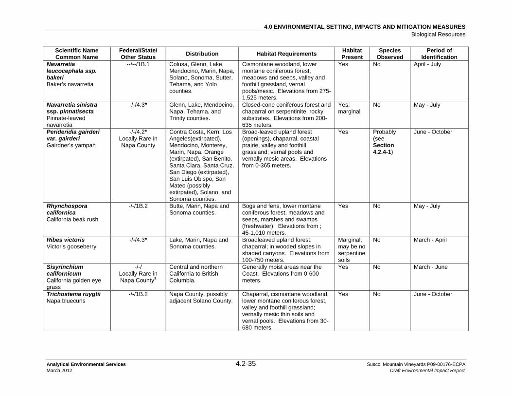
4.0 ENVIRONMENTAL SETTING, IMPACTS AND MITIGATION MEASURES Biological Resources
Analytical Environmental Services 4.2-35 Suscol Mountain Vineyards P09-00176-ECPA March 2012 Draft Environmental Impact Report
Scientific Name Common Name
Federal/State/ Other Status Distribution Habitat Requirements Habitat
Present Species
Observed Period of
Identification Navarretia leucocephala ssp. bakeri Baker’s navarretia
--/--/1B.1 Colusa, Glenn, Lake, Mendocino, Marin, Napa, Solano, Sonoma, Sutter, Tehama, and Yolo counties.
Cismontane woodland, lower montane coniferous forest, meadows and seeps, valley and foothill grassland, vernal pools/mesic. Elevations from 275-1,525 meters.
Yes No April - July
Navarretia sinistra ssp. pinnatisecta Pinnate-leaved navarretia
-/-/4.3* Glenn, Lake, Mendocino, Napa, Tehama, and Trinity counties.
Closed-cone coniferous forest and chaparral on serpentinite, rocky substrates. Elevations from 200-635 meters.
Yes, marginal
No May - July
Perideridia gairderi var. gairderi Gairdner’s yampah
-/-/4.2* Locally Rare in Napa County
Contra Costa, Kern, Los Angeles(extirpated), Mendocino, Monterey, Marin, Napa, Orange (extirpated), San Benito, Santa Clara, Santa Cruz, San Diego (extirpated), San Luis Obispo, San Mateo (possibly extirpated), Solano, and Sonoma counties.
Broad-leaved upland forest (openings), chaparral, coastal prairie, valley and foothill grassland; vernal pools and vernally mesic areas. Elevations from 0-365 meters.
Yes Probably (see Section 4.2.4-1)
June - October
Rhynchospora californica California beak rush
-/-/1B.2 Butte, Marin, Napa and Sonoma counties.
Bogs and fens, lower montane coniferous forest, meadows and seeps, marshes and swamps (freshwater). Elevations from ; 45-1,010 meters.
Yes No May - July
Ribes victoris Victor’s gooseberry
-/-/4.3* Lake, Marin, Napa and Sonoma counties.
Broadleaved upland forest, chaparral; in wooded slopes in shaded canyons. Elevations from 100-750 meters.
Marginal; may be no serpentine soils
No March - April
Sisyrinchium californicum California golden eye grass
-/-/ Locally Rare in Napa County1
Central and northern California to British Columbia.
Generally moist areas near the Coast. Elevations from 0-600 meters.
Yes No March - June
Trichostema ruygtii Napa bluecurls
-/-/1B.2 Napa County, possibly adjacent Solano County.
Chaparral, cismontane woodland, lower montane coniferous forest, valley and foothill grassland; vernally mesic thin soils and vernal pools. Elevations from 30-680 meters.
Yes No June - October

4.0 ENVIRONMENTAL SETTING, IMPACTS AND MITIGATION MEASURES Biological Resources
Analytical Environmental Services 4.2-36 Suscol Mountain Vineyards P09-00176-ECPA March 2012 Draft Environmental Impact Report
Scientific Name Common Name
Federal/State/ Other Status Distribution Habitat Requirements Habitat
Present Species
Observed Period of
Identification Trifolium amoenum Showy Indian clover; Showy Rancheria clover; Two-fork clover
FE/-/1B.1 Alameda (extirpated), Marin, Napa (extirpated), Santa Clara (extirpated), Solano (extirpated), and Sonoma (extirpated) counties.
Coastal bluff scrub, valley and foothill grassland (sometimes serpentinite). Elevations from 5-415 meters.
Yes No April - June
Triteleia lugens Dark-mouthed triteleia
-/-/4.3* Lake, Monterey, Napa, San Benito, Solano, and Sonoma counties.
Broad-leaved upland forest, chaparral, and lower montane coniferous forest. Elevations from 10-100 meters.
Yes No April - June
Viburnum ellipticum Oval-leaved viburnum
-/-/2.3 Contra Costa, El Dorado, Fresno, Glenn, Humboldt, Mendocino, Napa, Placer, Shasta, and Sonoma counties. Also occurs in Oregon and Washington.
Chaparral, cismontane woodland and lower montane coniferous forest. Elevations from 215-1,400 meters.
Yes No May - June
ANIMALS Invertebrates Desmocerus californicus dimorphus Valley elderberry longhorn beetle (VELB)
FT/-/- Restricted to the Central Valley from Redding to Bakersfield. Counties include Amador, Butte, Calaveras, Colusa, El Dorado, Fresno, Glenn, Kern, Madera, Mariposa, Merced, Napa, Placer, Sacramento, San Joaquin, Shasta, Solano, Stanislaus, Sutter, Tehama, Tulare, Yolo, and Yuba counties.
Riparian forest communities. Exclusive host plant is elderberry (Sambucus species), which must have stems ≥ 1-inch diameter for the beetle. Elevations typically range from 0-762 meters.
Yes, marginal, near outside limits of range
No Year-round for exit holes; May - June for adults.
Speyeria callippe callippe Callippe silverspot
FT/-/- Solano County. Depends on extensive patches of its host plant, Johnny jump-up (Viola pedunculata); typically in grasslands, along ridgelines.
Yes No; the host plant is present but uncommon.
April - May
Syncaris pacifica California freshwater shrimp
FE/SE/- 17 stream segments in Napa, Sonoma and Solano counties.
Creeks with pools 12-36 inches deep and undercut banks with exposed live root tangles.
Yes No All Year

4.0 ENVIRONMENTAL SETTING, IMPACTS AND MITIGATION MEASURES Biological Resources
Analytical Environmental Services 4.2-37 Suscol Mountain Vineyards P09-00176-ECPA March 2012 Draft Environmental Impact Report
Scientific Name Common Name
Federal/State/ Other Status Distribution Habitat Requirements Habitat
Present Species
Observed Period of
Identification Fishes Oncorhynchus mykiss irideus Steelhead; Central California coast ESU
FT/-/-
Russian River south to Soquel Creek, but not including Pajaro River; also San Francisco and San Pablo Bay basins.
For spawning and rearing headwater streams with cold water, deep pools and runs, gravel (1-13 cm) beds for spawning.
Yes Yes All year
Amphibians Rana boylii foothill yellow-legged frog
-/CSC/- Coast Ranges from the Oregon border south to the Transverse Mountains in Los Angeles County, throughout most of Northern California west of the Cascade crest, and along the western portion of the Sierra south to Kern County, with a few isolated populations in the Central Valley.
Occurs in shallow flowing streams with some cobble in a variety of habitats including woodlands, riparian forest, coastal scrub, chaparral, and wet meadows. Rarely encountered far from permanent water sources. Elevations typically range from 0-1,940 meters.
Yes No March - June
Rana draytonii (Rana aurora draytonii) California red-legged frog
FT/CSC/- Coastal Mendocino Co. to Baja, inland through northern Sacramento Valley into the foothills of the Sierra Nevada, south to east Tulare County, and possibly eastern Kern County. Range excludes the Central Valley.
Occurs in permanent and temporary pools of streams, marshes, and ponds with dense grassy and/or shrubby vegetation. Elevations typically range from ; 10-1,160 meters.
Yes No March - June

4.0 ENVIRONMENTAL SETTING, IMPACTS AND MITIGATION MEASURES Biological Resources
Analytical Environmental Services 4.2-38 Suscol Mountain Vineyards P09-00176-ECPA March 2012 Draft Environmental Impact Report
Scientific Name Common Name
Federal/State/ Other Status Distribution Habitat Requirements Habitat
Present Species
Observed Period of
Identification Reptiles Actinemys marmorata western pond turtle
-/CSC/- West coast of North America from southern Washington, USA to northern Baja California, Mexico. Many populations have been extirpated and others continue to decline throughout the range, especially in southern California.
Requires aquatic habitats with suitable basking sites. Nest sites most often characterized as having gentle slopes (<15 percent) with little vegetation or sandy banks.
Yes Yes March - October
Birds Agelaius tricolor tricolored blackbird
-/CSC/- Primarily California’s Central Valley and major river valleys, as well as adjacent Mexico, with smaller populations as far north as British Columbia and into western Nevada.
Nests in freshwater marsh; forages in grasslands and croplands.
Yes No Year-round
Ammodramus savannarum Grasshopper sparrow
-/CSC/- In California, primarily in the Central Valley; appropriate habitat throughout the Americas.
Extensive areas of native and non-native grasslands, often with scattered shrubs.
Yes Yes; possible nesting
Year-round

4.0 ENVIRONMENTAL SETTING, IMPACTS AND MITIGATION MEASURES Biological Resources
Analytical Environmental Services 4.2-39 Suscol Mountain Vineyards P09-00176-ECPA March 2012 Draft Environmental Impact Report
Scientific Name Common Name
Federal/State/ Other Status Distribution Habitat Requirements Habitat
Present Species
Observed Period of
Identification Asio otus long-eared owl
-/CSC/- Southeastern Yukon, northeastern British Columbia, and northern Alberta across central Canada to Maritime Provinces and south to northern Baja California, southern Arizona, southern New Mexico, east to Pennsylvania, New York and New England; also Europe and Asia. In Southern California, there is substantial area of extirpation with small remnant populations in interior areas.
Open woodlands and coniferous forests, often near riparian areas.
Yes No March - August
Athene cunicularia Western burrowing owl
-/CSC/- Formerly common within the described habitats throughout the State, except the northwestern coastal forests and high mountains.
Yearlong resident of open, dry grassland and desert habitats, as well as in grass, forb and open shrub stages of pinyon-juniper and ponderosa pine habitats.
Marginal nesting, foraging and wintering habitat.
No April - July (nesting); September - February (wintering)
Buteo swainsoni Swainson’s hawk (nesting)
--/ST In California, breeds in the Central Valley, Klamath Basin, Northeastern Plateau, Lassen County, and Mojave Desert. Very limited breeding reported from Lanfair Valley, Owens Valley, Fish Lake Valley, Antelope Valley, and in eastern San Luis Obispo County.
Occurs in open habitats with scattered large trees for nesting, as in riparian areas and oak savannah. Forages primarily over flat agricultural lands, pastures, and ranch country.
Yes Yes April - September (October)

4.0 ENVIRONMENTAL SETTING, IMPACTS AND MITIGATION MEASURES Biological Resources
Analytical Environmental Services 4.2-40 Suscol Mountain Vineyards P09-00176-ECPA March 2012 Draft Environmental Impact Report
Scientific Name Common Name
Federal/State/ Other Status Distribution Habitat Requirements Habitat
Present Species
Observed Period of
Identification Circus cyaneus northern harrier (nesting)
-/CSC/- Permanent residents of the northeastern plateau and coastal areas; less common resident of the Central Valley.
Coastal scrub, Great Basin grassland, marsh and swamp (coastal and fresh water), riparian scrubs, valley and foothill grassland, and wetlands. Nests on the ground, usually in tall, dense clumps of vegetation, either alone or in loose colonies. Occurs from annual grassland up to lodgepole pine and alpine meadow habitats, as high as 3,000 meters.
Yes Yes; possible nesting
Year-round
Contopus cooperi Olive-sided flycatcher
-/CSC/- Coniferous woods across Canada, Alaska and the northeastern and western United States, and other types of wooded areas in California.
Prefers tall coniferous trees for nesting and foraging, but will also use tall blue gum trees. Forages for aerial insects from tall perches. Neotropical migrant.
Foraging habitat only
No March - August
Dendroica petechia brewsteri yellow warbler
-/CSC/- Throughout northern half of continental U.S. plus Canada and Alaska; winters in Central America.
Nests in riparian woodlands dominated by willows and/or cottonwoods; also, in northern California, Oregon ash/willow woodland provide good nesting habitat. This species occurs in a variety of other vegetation communities during migration.
Marginal nesting habitat.
Yes; migrant.
March - August
Elanus leucurus white-tailed kite (nesting)
-/CFP/- Permanent resident of coastal and valley lowlands.
Nests in dense oak, willow, or other tree stands near open foraging areas. Hunts in herbaceous lowlands with variable tree growth.
Yes Yes, but nests were not observed
Year-round Peak nesting is from May - August
Geothlypis trichas sinuosa San Francisco (saltmarsh) common yellowthroat
-/CSC/- San Francisco Bay Area. Nests in freshwater marshes and riparian thickets around the San Francisco Bay Area.
Yes No Year-round

4.0 ENVIRONMENTAL SETTING, IMPACTS AND MITIGATION MEASURES Biological Resources
Analytical Environmental Services 4.2-41 Suscol Mountain Vineyards P09-00176-ECPA March 2012 Draft Environmental Impact Report
Scientific Name Common Name
Federal/State/ Other Status Distribution Habitat Requirements Habitat
Present Species
Observed Period of
Identification Icteria virens yellow-breasted chat
-/CSC/- Erratic and localized in occurrence. Common along western edge of southern deserts, in Santa Clara Co. and on coastal slope from Monterey Co. south; uncommon in foothills surrounding Central Valley. Winters in southern coastal lowlands, Colorado River Valley; and in Northern California in small numbers.
Nests in dense riparian habitats. Typical nesting habitats include valley foothill riparian and valley foothill hardwood-conifer with dense understory.
No nesting habitat and marginal foraging habitat.
No March - August
Lanius ludovicianus loggerhead shrike
BCC/CSC/- Year-round resident of southern half of the U.S. from California to the Carolinas, and south across the Pacific slope and interior highlands of Mexico. Resident and winter visitor in lowlands and foothills throughout California.
Nests in variety of open habitats. Prefers open habitats with scattered shrubs, trees, posts, fences, utility lines, or other perches. Highest density in open-canopy valley foothill hardwood, valley foothill hardwood-conifer, valley foothill riparian, pinyon-juniper, juniper, desert riparian, and Joshua tree habitats.
Yes Yes Year-round
Progne subis purple martin
-/CSC/- Local summer resident in wooded low-elevation habitats throughout California; rare migrant in spring and fall, absent in winter. In the south, now only a rare and local breeder on the coast and in interior mountain ranges.
Inhabits open forests, woodlands, and riparian areas in breeding season. Found in a variety of open habitats during migration, including grassland, wet meadow, and fresh emergent wetland, usually near water. Nests in conifer stands, often in woodpecker holes. Uses valley foothill and montane hardwood and conifer, and riparian habitats.
Yes, marginal nesting habitat; lack of tall trees.
No March - August

4.0 ENVIRONMENTAL SETTING, IMPACTS AND MITIGATION MEASURES Biological Resources
Analytical Environmental Services 4.2-42 Suscol Mountain Vineyards P09-00176-ECPA March 2012 Draft Environmental Impact Report
Scientific Name Common Name
Federal/State/ Other Status Distribution Habitat Requirements Habitat
Present Species
Observed Period of
Identification Mammals Antrozous pallidus pallid bat
-/CSC/- Locally common species at low elevations. Throughout California except for the high Sierra Nevada from Shasta to Kern counties, and the northwestern corner of the state from Del Norte and western Siskiyou counties to northern Mendocino County.
Habitats occupied include grasslands, shrublands, woodlands and forests from sea level through mixed conifer forests below 2,000 meters. The species is most common in open, dry habitats with rocky areas for roosting. Roosts also include cliffs, abandoned buildings, bird boxes, and under bridges.
Roosting and foraging habitats
No March - September
Corynorhinus townsendii Townsend’s big-eared bat
-/CSC/Red Throughout California, excluding subalpine and alpine habitats. Through Mexico to British Columbia and the Rocky Mountain states. Also occurs in several regions of the central Appalachians.
Requires caves, mines, tunnels, buildings, or other human-made structures for roosting. Hibernation sites must be cool and cold, but above freezing.
Foraging habitat only
No March - September
Lasiurus blossevillii Western red bat
SSC/CSC/Red Central Valley in broadleaf tree communities and is less abundant above low and middle elevations in mixed conifer forests.
Generally occurs in arid regions along riparian corridors and in wooded canyons. This species is solitary (i.e., does not form roosting or maternity colonies) and roosts among the foliage of trees.
Yes in trees and riparian corridors
No Not well documented; highly migratory, but likely in northern California April through September
Taxidea taxus American badger
-/CSC/- Found throughout most of California in suitable habitat except North Coast.
Suitable habitat occurs in the drier open stages of most shrub, forest, and herbaceous habitats with friable soils. Badgers are generally associated with treeless regions, prairies, parklands, and cold desert areas.
Marginal habitat; soils not ideal and prey species are scarce.
No Year-round

4.0 ENVIRONMENTAL SETTING, IMPACTS AND MITIGATION MEASURES Biological Resources
Analytical Environmental Services 4.2-43 Suscol Mountain Vineyards P09-00176-ECPA March 2012 Draft Environmental Impact Report
STATUS CODES FEDERAL: U.S. Fish and Wildlife Service and National Marine Fisheries Service FE Listed as Endangered by the Federal Government FT Listed as Threatened by the Federal Government BCC Fish and Wildlife Service Birds of Conservation Concern SSC Fish and Wildlife Service Species of Special Concern STATE: California Department of Fish and Game CE Listed as Endangered by the State of California CT Listed as Threatened by the State of California CSC California Species of Special Concern CFP California Fully Protected Species OTHER: CNPS: California Native Plant Society List 1B Plants rare or endangered in California and elsewhere List 2 Plants rare or endangered in California, but more common elsewhere List 3 Plants for which more information is needed List 4 Plants of limited distribution Threat Ranks
0.1-Seriously threatened in California (high degree/immediacy of threat) 0.2-Fairly threatened in California (moderate degree/immediacy of threat) 0.3-Not very threatened in California (low degree/immediacy of threats or no current threats known)
Months in parenthesis are uncommon. Western Bat Working Group Red Bats imperiled or are at high risk of imperilment. Yellow Bats whose status warrants closer evaluation and are threatened with imperilment. Note: *This species is not documented within the CNDDB because it is not listed pursuant through the CEQA review process. The DFG requires that all CNPS List 1B and 2 plant species be addressed for CEQA projects. Though it is not required for the CEQA review process, CNPS recommends that List 3 and List 4 plant species also be considered. AES considered CNPS List 3 and 4 species as well as species that are considered Locally Rare in Napa County. Source: USFWS, 2011b; CDFG, 2003; CNDDB, 2010a; CDFG 2010b; CNPS, 2010; LSA, 2010; Western Bat Working Group, 2007; Berner, et. al., 2003

4.0 ENVIRONMENTAL SETTING, IMPACTS AND MITIGATION MEASURES Biological Resources
Analytical Environmental Services 4.2-44 Suscol Mountain Vineyards P09-00176-ECPA March 2012 Draft Environmental Impact Report
In addition to the target species list (Table 4.2-3), the CNDDB (CDFG, 2003) was queried and occurrences of special status species plotted in relation to the property boundary using Graphics Information System (GIS) software (Figure 4.2-4). The CNNDB reported 40 special status species documented occurrences and three sensitive habitats within a five-mile radius of the project area. Of these species, 19 have the potential to occur within the project site and are discussed in detail in Table 4.2-3 and in Appendix D. The other 21 species and three sensitive habitats recorded within five miles of the project site were dismissed from further consideration for potential to occur onsite, as discussed above and in Appendix E. These species include: alkali milk-vetch (Astragalus tener var. tener), a non-special status isopod (Calasellus californicus), California black rail (Laterallus jamaicensis coturniculus), California clapper rail (Rallus longirostris obsoletus), delta tule pea (Lathyrus jepsonii var. jepsonii), ferruginous hawk (Buteo regalis; see Section 4.2.4-4); golden eagle (Aquila chrysaetos; see Section 4.2.4-4); legenere (Legenere limosa), Marin knotweed (Polygonum marinense), Mason’s lilaeopsis (Lilaeopsis masonii), saline clover (Trifolium hydrophilum), salt-marsh harvest mouse (Reithrodontomys raviventris), San Joaquin spearscale (Atriplex joaquiniana), San Pablo song sparrow (Melospiza melodia samuelis), soft bird’s beak (Cordylanthus mollis ssp. mollis), Suisun marsh aster (Symphyotrichum lentum), Suisun shrew (Sorex ornatus sinuosus), Suisun song sparrow (Melospiza melodia maxillaris), Tiburon paintbrush (Castilleja affinis ssp. neglecta), vernal pool fairy shrimp (Branchinecta lynchi), and western snowy plover (Charadrius alexandrinus nivosus). Northern Vernal Pool, Coastal Brackish Marsh and Serpentine Bunchgrass were the only sensitive habitat types recorded in the CNDDB within a five-mile radius of the project site. No vernal pools, brackish waters or serpentine soils occur in or immediately adjacent to the property.
Target species and species identified within the five-mile radius of the project site and that have a potential to occur onsite that are summarized in Table 4.2-3 are discussed below.
4.2.4-1 SPECIAL STATUS PLANTS
All of the special status plant species, excluding those for which no suitable habitat or soils were found on the project site are described briefly below. The CDFG requires that all CNPS List 1B and 2 plant species be addressed for CEQA projects. In addition, several biotic communities (or components of biotic communities) in Napa County are considered sensitive. These communities are:
• Designated by DFG as sensitive; • Considered by local experts to be biotic communities of limited distribution in Napa
County; and/or • Considered to be waters of the U.S. or of the State.

4.0 ENVIRONMENTAL SETTING, IMPACTS AND MITIGATION MEASURES Biological Resources
Analytical Environmental Services 4.2-45 Suscol Mountain Vineyards P09-00176-ECPA March 2012 Draft Environmental Impact Report
Although not required for the CEQA review process, CNPS recommends that List 3 and List 4 plant species also be considered because their status may change and other local and/or regional regulations may require evaluation. Several CNPS List 3 and 4 plants identified to have potential to occur on the project site in Table 4.2-3 above are discussed in further detail below. Bryophytes
Bryophytes (more generally known as moss and liverworts) could occur with most habitats present within the project site. Although distributions are not well known for special status bryophytes, the CNDDB and CNPS searches for plants did not reveal any extant occurrence of bryophytes within a ten-mile radius of the project site, one record for slender silver moss (Anomobryum julaceum, CNPS List 1.B) occurs approximately 28 air miles northwest in the “Mark West Springs, California” quadrangle in Sonoma County. The habitat associations of slender silver moss (seasonally exposed moist soil of road banks in grasslands and woodlands) are present on the site, so LSA conducted surveys and collections for bryophytes (Appendix D). During the surveys, suitable habitat for bryophytes such as moist banks of road cuts, drainages and seeps, grasslands, rock outcrops and trees were examined. Identification of bryophytes collected from the site was verified by Dan Norris of U.C. Jepson Herbarium. No special status bryophytes were found on the site during the two years of plant surveys (Appendix D). Lichens
Lichens grow in association with most habitat and substrate types present within the project site. Although the CNDDB and CNPS searches for plants did not reveal any occurrence of special status lichens within a ten-mile radius of the site, further search shows two special status lichen species occur in coastal Sonoma County: whiteworm lichen (Thamnolia vermicularis) and Methusela’s beard lichen (Usnea longissima). The physiographic and climatic requirements of these two species do not occur on the project site: Sonoma County populations of whiteworm lichen only occur on windswept slopes close to sea level and Methusela’s beard lichen is generally known from coastal coniferous rain forests (Brodo, et al., 2001). Plant surveys conducted by LSA (2010) (Appendix D) included observations and collection of voucher specimens from moist banks of road cuts and drainages, seeps, grasslands, rock outcrops, and trees. No special status lichens were found during the two years of plant surveys (Appendix D).

4.0 ENVIRONMENTAL SETTING, IMPACTS AND MITIGATION MEASURES Biological Resources
Analytical Environmental Services 4.2-46 Suscol Mountain Vineyards P09-00176-ECPA March 2012 Draft Environmental Impact Report
Napa false indigo (Amorpha californica var. napensis) Pea Family (Fabaceae) Federal Status – None State Status – None Other – CNPS 1B.2 Napa false indigo is a nearly glabrous deciduous shrub distinguished by prickle-like glands on the main axis of compound leaves and a sessile gland terminating leaflet midribs; the raceme of small purple flowers have showy exerted yellow stamens. The period of identification is April through July. This plant is found in cismontane woodland, chaparral, and openings of broadleaved upland forest from 120 to 2,000 meters above msl. Napa false indigo is known from Monterey, Marin, Napa and Sonoma counties. The nearest occurrence is on the east slope of Arrowhead Mountain (Occurrence Number 5), more than 15 miles northwest of the project site. The project site provides potential habitat for Napa false indigo within chaparral and oak woodland habitats on site. Napa false indigo was not observed during years of focused biological surveys of the project area, which were conducted within the appropriate period of identification for this species. Clara Hunt’s milkvetch (Astragalus claranus) Pea Family (Fabaceae) Federal Status – Endangered State Status – Threatened Other – CNPS 1B.1 Clara Hunt's milkvetch is a slender, sparse-leaved annual with up to nine leaflets per leaf and 2-14 white purple-tipped flowers. This species is reported from Napa and Sonoma counties on rocky, clay, or serpentine soils in sparsely vegetated openings within blue oak woodland, chaparral, and grassland communities, at elevations of 320 to 700 meters above msl. The period of identification is March through May. Known from only five occurrences, Clara Hunt’s milkvetch was proposed for Federal listing in August of 1995 and was listed as Endangered in October 1997 (U.S. Federal Register, 1997). Currently, this species does not have a recovery plan or designated critical habitat (USFWS, 2009). CDFG listed this species as Threatened in 1990, and its status was determined to be “Stable to Declining” by a CDFG assessment in 1999 (CDFG, 2003). It is threatened by urbanization, recreational development, grazing, and non-native plants. The closest occurrences of this species are documented east of St. Helena around Lake Hennessey, greater than 15 miles northwest of the project site (CNDDB Occurrence Numbers 1, 11, and 13). The grasslands within the project area are suitable habitat for this species. Clara

4.0 ENVIRONMENTAL SETTING, IMPACTS AND MITIGATION MEASURES Biological Resources
Analytical Environmental Services 4.2-47 Suscol Mountain Vineyards P09-00176-ECPA March 2012 Draft Environmental Impact Report
Hunt's milkvetch was not observed during years of focused biological surveys of the project area, which were conducted within the appropriate period of identification for this species. Big-Scale Balsamroot (Balsamorhiza macrolepis var. macrolepis) Sunflower Family (Asteraceae) Federal Status – None State Status – None Other – CNPS 1B.2 Big-scale balsamroot is a perennial with basal, pinnately divided leaves that produces one head per inflorescence. The flower head consists of yellow ray and disk flowers. Suitable habitat includes chaparral, woodland, and open grassland, and is generally found in grassy slopes and valleys. This species can occur on both serpentine and non-serpentine soils. Its range includes the Sierra Nevada Foothills, Sacramento Valley, and San Francisco Valley regions of the California Floristic Province. The big-scale balsamroot blooms from March through June. The big-scale balsamroot blooms from March through June. The nearest record is from 1933, eight miles west of Fairfield on Mt. George, within one mile east of the project site (Occurrence Number 15). The annual grassland within the project area is suitable habitat for this species. Big-scale balsamroot was not observed during years of focused biological surveys of the project area, which were conducted within the appropriate period of identification for this species. Narrow-anthered California brodiaea (Brodiaea californica var. leptandra) Lily Family (Liliaceae) Federal Status – None State Status – None Other – CNPS 1B.2 Narrow-anthered California brodiaea can be distinguished from the more common harvest brodiaea (Brodiaea elegans ssp. elegans) by checking the staminode character traits. Narrow-anthered California brodiaea has pale lilac to white flowers, and with a stem greater than 50 centimeters tall. Narrow-anthered California brodiaea typically occurs from 110 to 915 meters elevation in broadleaf upland forest, chaparral, cismontane woodland, lower montane coniferous forest, and valley and foothill grassland on generally thin rocky soils, of volcanic serpentinite origin, often along drainages. The ideal period of identification is from May through July. It is found in Lake, Napa and Sonoma counties. The nearest records of this species are on the western to southern slopes of Mt. George (Occurrence Numbers 22-24), within one mile of the project site. The project site provides potential habitat for narrow-anthered California brodiaea within the chaparral, annual grassland, oak woodland, and leather oak-white leaf manzanita-chamise xeric serpentine habitats. Narrow-anthered California brodiaea was not observed

4.0 ENVIRONMENTAL SETTING, IMPACTS AND MITIGATION MEASURES Biological Resources
Analytical Environmental Services 4.2-48 Suscol Mountain Vineyards P09-00176-ECPA March 2012 Draft Environmental Impact Report
during years of focused biological surveys of the project area, which were conducted within the appropriate period of identification for this species. Round-leaved filaree (California macrophylla) Geranium Family (Geraniaceae) Federal Status – None State Status – None Other – CNPS 1B.1 Round-leaved filaree can behave as an annual or biennial herb with simple puberulent, reniform leaves and white flowers tinged with red to purple. It occurs on clay soils in cismontane woodland and valley and foothill grasslands at elevations from 15 to 1,200 meters above msl. It often occurs on clay-soil substrates. This species blooms from March through May. The known range of round-leaved filaree includes Alameda, Contra Costa, Colusa, Fresno, Glenn, Kings, Kern, Lake, Lassen, Los Angeles, Merced, Monterey, Napa, Riverside, Santa Barbara, San Benito, Santa Clara, San Diego, San Joaquin, San Luis Obispo, San Mateo, Solano, Sonoma, Stanislaus, Tehama, Ventura, and Yolo counties. It is thought to be extirpated in Butte and Santa Cruz Island counties. It also occurs in Baja California and Washington. There is a single CNDDB record in Napa County (approximately 1.3 mile north of Devil’s Head Peak; Occurrence Number 60) greater than ten miles from the project site. There are no CNDDB records for Solano County. It is listed under the old synonym of Erodium macrophyllum in Hickman et al. (1993a). Round-leaved filaree was not observed during years of focused biological surveys of the project area, which were conducted within the appropriate period of identification for this species. Mt. Diablo fairy lantern (Calochortus pulchellus) Lily family (Liliaceae) Federal Status – None State Status – None Other – CNPS 1B.2 The Mt. Diablo fairy lantern occurs on wooded slopes (cismontane woodland, riparian woodland, and valley and foothill grassland) and chaparral, from 30 to 840 meters above msl. It is extant in Alameda, Contra Costa and Solano counties, but historically was also found in Napa, Lake, Humboldt, Santa Clara and Yolo counties. Mt. Diablo fairy lantern bloom season is from April to June. There are no CNDDB records of this species from Napa County, but there is a record less than 3.5 miles east of the project site in Solano County. This record (Occurrence Number 32) is near the border between Solano and Napa counties. It occurs in oak woodland on a north-facing slope just east of Green Valley and southwest of Mt. George. This record occurs on Hambright loam soils. LSA (2010) (Appendix D) notes that the dominant soils in the

4.0 ENVIRONMENTAL SETTING, IMPACTS AND MITIGATION MEASURES Biological Resources
Analytical Environmental Services 4.2-49 Suscol Mountain Vineyards P09-00176-ECPA March 2012 Draft Environmental Impact Report
project area are mapped as Hambright-Rock outcrop complex (from which Hambright loam soils are derived), but there are likely to be pockets of Hambright loam present as well. Some records for this plant are geographically disjunct from well documented populations and are generally thought to be misidentified specimens of Diogenes’ Lantern (Calochortus amabilis). The project site provides potential habitat for Mt. Diablo fairy lantern within the annual grassland, chaparral, oak woodland, and riparian forest habitats. Mt. Diablo fairy lantern was not observed during years of focused biological surveys of the project area, which were conducted within the appropriate period of identification for this species. Small-flowered calycadenia (Calycadenia micrantha) Sunflower Family (Asteraceae) Federal Status – None State Status – None Other – CNPS 1B.2 Small-flowered calycadenia is closely related to common rosinweed (C. truncata), sharing the characteristics of having yellow corollas, and tack-like glands on the peduncles but not on the chaff scales. Small-flowered calycadenia is found within chaparral communities, meadows and seeps with volcanic soils, and in valley and foothill grasslands along roadsides, on rocky, talus, scree, sometimes serpentinite, and generally sparsely vegetated areas. Small-flowered calycadenia blooms from June to September. The nearest known occurrence of this species is a couple miles southwest in Soda Canyon, the only record for Napa County (Occurrence Number 3). Remaining records have been found only in Colusa, Lake, Monterey, and Trinity counties. The project site provides potential habitat for small-flowered calycadenia within the chaparral and grassland habitats. Small-flowered calycadenia was not observed during years of focused biological surveys of the project area, which were conducted within the appropriate period of identification for this species. Holly-leaved ceanothus (Ceanothus purpureus) Buckthorn family (Rhamnaceae) Federal Status – None State Status – None Other – CNPS 1B.2 Holly-leaved ceanothus is an evergreen shrub with opposite, holly-like leaves. It is distinguished from other holly-leaved species in the genus by having teeth all the way to the base of the peduncled leaf, which is not deflexed. It also has an affinity for volcanic soils, on slopes in chaparral and cismontane woodland habitats. Found at elevations from 120 to 640 meters above msl, populations are often the densest near drainages. It is endemic to Napa, Solano and Sonoma counties, and can be quite abundant locally in Napa County. It is

4.0 ENVIRONMENTAL SETTING, IMPACTS AND MITIGATION MEASURES Biological Resources
Analytical Environmental Services 4.2-50 Suscol Mountain Vineyards P09-00176-ECPA March 2012 Draft Environmental Impact Report
identifiable from February to June. There is a CNDDB record within one mile north of the project site, and many more within a ten-mile radius. The project site provides potential habitat for holly-leaved ceanothus within the chaparral and oak woodland habitats. Holly-leaved ceanothus was not observed during years of focused biological surveys of the project area, which were conducted within the appropriate period of identification for this species.
Pappose tarplant (Centromadia parryi ssp. parryi) Sunflower Family (Asteraceae) Federal Status – None State Status – None Other – CNPS 1B.2 Pappose tarplant is an annual with radiate heads, phyllaries in one series subtending the ray flowers and the yellow ray and disc flowers have yellow anthers. It generally occurs in alkaline or clay soils in chaparral, coastal prairie, meadows and seeps, marshes and swamps (coastal salt), and valley and foothill grassland habitats (vernally mesic) and blooms from May to October at elevations from two to 420 meters above msl. Extant records exist in Butte, Colusa, Glenn, Lake, Napa, San Mateo, Solano, and Sonoma counties. It is considered extirpated in Santa Cruz and Solano counties. There are several records in the vicinity of Cordlia and Interstate 680, within about five miles southeast of the project site. This species has recently been upgraded from a CNPS List 2 species because it may not be as abundant as previously thought. Appropriate habitat exists on the project site for this plant in chaparral and grassland habitats. It is referred to as Hemizonia parryi ssp. parryi in the Jepson Manual of the Higher Plants of California (1993). Pappose tarplant was not observed during years of focused biological surveys of the project area, which were conducted within the appropriate period of identification for this species. American dogwood (Cornus sericea) Dogwood Family (Cornaceae) Federal Status – None State Status – None Other – Napa County Locally Rare American dogwood is a small shrub with cymose inflorescences and large leaves, five to 10 centimeters long. It is restricted to the edges of wetlands and riparian areas, where water is available year-round. It occurs in the California Floristic Province up to Alaska, in eastern North America and Mexico. This species is not documented within the CNDDB, but is considered locally rare in Napa County with protections afforded through the General Plan. This species is associated with wetlands along Suscol Creek (Figure 4.2-2) that would be avoided.

4.0 ENVIRONMENTAL SETTING, IMPACTS AND MITIGATION MEASURES Biological Resources
Analytical Environmental Services 4.2-51 Suscol Mountain Vineyards P09-00176-ECPA March 2012 Draft Environmental Impact Report
Dwarf downingia (Downingia pusilla) Bellflower Family (Campanulaceae) Federal Status – None State Status – None Other – CNPS 2.2 Endemic to vernal pools, dwarf downingia is an obligate wetland plant. The species can grow up to six inches in height and is slightly succulent with small white to blue flowers. The small corolla and untwisted ovary distinguish the species from other Downingia species. Blooming periods range from March to May when vernal pools enter the dry out phase. There are several records in the vicinity of Mt. George in both Napa and Solano counties, within five miles of the project site. The project site provides marginally suitable habitat for dwarf downingia within the wetland features. Dwarf downingia was not observed during years of focused biological surveys of the project area, which were conducted within the appropriate period of identification for this species. Biolett’s erigeron/streamside daisy (Erigeron bioletti) Sunflower Family (Asteraceae) Federal Status – None State Status – None Other – CNPS 3 Biolett’s erigeron is a perennial herb noted for having densely glandular phyllaries and herbage, narrowly oblanceolate leaves, and flat-topped discoid heads that are approximately 12 to 15 millimeters in diameter. The ideal period for identification of this species is June through September. Biolett’s erigeron typically occurs 30 to 1,100 meters above msl in broadleaf upland, cismontane woodland and north coast coniferous forests in rocky or mesic substrates. The range of Biolett’s erigeron includes Humboldt, Mendocino, Marin, Napa, Solano and Sonoma counties. The project site provides potential habitat for Biolett’s erigeron within the oak woodland habitat. This species was found on the project site in small scattered patches along dry rocky ridgelines and slopes where the soil is shallow and non-native grass cover sparse. Individual plants were not counted because the plant is clonal and it is difficult to distinguish individuals. The total area of the delineated polygons is approximately 1.6 acres (Figure 4.2-2).

4.0 ENVIRONMENTAL SETTING, IMPACTS AND MITIGATION MEASURES Biological Resources
Analytical Environmental Services 4.2-52 Suscol Mountain Vineyards P09-00176-ECPA March 2012 Draft Environmental Impact Report
Narrow-leaved daisy (Erigeron greenei; syn: Erigeron angustatus) Sunflower Family (Asteraceae) Federal Status – None State Status – None Other – CNPS 1B.2 The narrow-leaved daisy is distinguished by discoid heads that lack pistillate flowers, with non-glandular linear leaves evenly sized and spaced along a stem that is 30 to 90 centimeters tall from a woody base. It is found within chaparral communities on serpentine or volcanic soils. The plant occurs in Napa, Sonoma, and Lake counties. The nearest CNDDB record is from 1938 in Soda Creek Canyon (Occurrence Number 1), within ten miles of the project site. The project site provides potential habitat for narrow-leaved daisy within the chaparral habitats on site. This species is referred to as Erigeron angustatus in Hickman et al. (1993a). Narrow-leaved daisy was not observed during years of focused biological surveys of the project area, which were conducted within the appropriate period of identification for this species. Mount Diablo buckwheat (Eriogonum truncatum) Buckwheat Family (Polygonaceae) Federal Status – None State Status – None Other – CNPS 1B.1 Mount Diablo buckwheat is an annual herb found within dry, exposed clay or sandy substrates in chaparral, coastal scrub, and grassland; 100 to 600 meters elevation. This species is identifiable from April through September (sometimes November to December). This species was presumed extinct until it was re-discovered on Mount Diablo in 2005. It is known only from only one extant location and seven historical collections, most made in the Marsh Creek and Mt. Diablo areas of Contra Costa County. Although chaparral habitat is on the site, Mount Diablo buckwheat was not observed during years of focused biological surveys of the project area, which were conducted within the appropriate period of identification for this species. Fragrant Fritillary (Fritillaria liliacea) Lily Family (Liliaceae) Federal Status – None State Status – None Other – CNPS 1B.2 Fragrant fritillary is a bulbous perennial herb noted for having generally more than four alternate, linear to ovate (not sickle-shaped) leaves and obscure nectaries. The petals are characteristically white with faint green stripes. It occurs in cismontane woodland, coastal

4.0 ENVIRONMENTAL SETTING, IMPACTS AND MITIGATION MEASURES Biological Resources
Analytical Environmental Services 4.2-53 Suscol Mountain Vineyards P09-00176-ECPA March 2012 Draft Environmental Impact Report
prairie, coastal scrub, and Valley and foothill grassland (often serpentinite) habitats at elevations that range from three to 400 meters above msl. This species blooms from February through April. The known range of fragrant fritillary includes Alameda, Contra Costa, Monterey, Marin, San Benito, Santa Clara, San Francisco, San Mateo, Solano, and Sonoma counties. The nearest documented occurrences of fragrant fritillary are in Sonoma County, roughly 30 miles northwest of the project site. The annual grassland within the project site is suitable habitat for this species. Fragrant fritillary was not observed during years of focused biological surveys of the project area, which were conducted within the appropriate period of identification for this species. Nodding harmonia (Harmonia nutans) Sunflower Family (Asteraceae) Federal Status – None State Status – None Other – CNPS 4.3 Nodding harmonia is an annual distinguished by having nodding heads in bud and in fruit. It is found in the southern North Coast Ranges and northern San Francisco Bay area. It occurs in chaparral and cismontane woodland, with a preference for thin rocky or gravelly volcanic soils at elevations of 75 to 975 meters above msl. The period of identification for this species is March through May. It is listed under the synonym Madia nutans in Hickman et al. (1993a). Nodding harmonia was not observed during years of focused biological surveys of the project area, which were conducted within the appropriate period of identification for this species.
Brewer’s western flax (Hesperolinon breweri) Flax Family (Linaceae) Federal Status – None State Status – None Other – CNPS 1B.2 Brewer’s western flax is an annual with linear leaves and short dense inflorescences with three-styled yellow flowers. Restricted in range to Napa, Solano and Contra Costa counties, it occurs in chaparral, grassland, and oak woodland habitats, sometimes in serpentine soils at elevations from 30 to 900 meters above msl. The species blooms from May to July. The nearest reported occurrence is in upper Suisun Valley in Napa County, but the record is from Jepson in 1891 on private land, less than ten miles northeast of the project site (Occurrence Number 20). Several additional records are in Solano County in the Mt. Vaca area, roughly 11 miles northeast of the project site. The project site provides potential habitat for this species within the chaparral, grassland and oak woodland habitats. Brewer’s western flax was not observed during years of

4.0 ENVIRONMENTAL SETTING, IMPACTS AND MITIGATION MEASURES Biological Resources
Analytical Environmental Services 4.2-54 Suscol Mountain Vineyards P09-00176-ECPA March 2012 Draft Environmental Impact Report
focused biological surveys of the project area, which were conducted within the appropriate period of identification for this species. Napa western flax (Hesperolinon serpentinum) Flax Family (Linaceae) Federal Status – None State Status – None Other – CNPS 1B.1 Napa western flax is ten to 30 centimeters tall with linear leaves one to three millimeters long and relatively open inflorescences of three-styled, six-carpellate yellow flowers. The flower petals are three to six millimeters long and the anthers are yellow. It is found on serpentine soils in chaparral communities in Alameda, Lake, Napa, and Stanislaus Counties at an elevation range of 50 to 800 meters above msl. The nearest documented populations are in the Soda Canyon area, less than ten miles north of the project site. The project site lacks the serpentine soils this species is generally associated with but perhaps marginal habitat for Napa western flax is within the chaparral habitats. Napa western flax was not observed during years of focused biological surveys of the project area, which were conducted within the appropriate period of identification for this species. Northern California black walnut (Juglans hindsii) Walnut Family (Juglandaeceae) Federal Status – None State Status – None Other – CNPS 4.3 Northern California black walnut has lanceolate to ovate leaves with 11 to 19 leaflets, distinguishing it from the commonly planted English walnut (Juglans regia), which has fewer, more rounded leaflets. Although northern California black walnut has become naturalized along riparian corridors in the Great Central Valley, natural populations were only known from a few locations prior to European settlement (Kirk, 2003). Northern California black walnut also has smaller fruits and was used as rootstock for cultivated English walnut. The two species hybridize readily, contributing to the decline of the native species. The native northern California black walnut is found in riparian habitat. Once documented in Alameda, Butte, Contra Costa, Lake, Napa, Sacramento, Solano, Sonoma and Yolo counties, today only three out of the five CNDDB occurrences survive. The nearest extant CNDDB record within ten miles north of the project site near the community of Circle Oaks (Occurrence Number 1). Northern California black walnut was not observed during years of focused biological surveys of the project area, which were conducted within the appropriate period of identification for this species.

4.0 ENVIRONMENTAL SETTING, IMPACTS AND MITIGATION MEASURES Biological Resources
Analytical Environmental Services 4.2-55 Suscol Mountain Vineyards P09-00176-ECPA March 2012 Draft Environmental Impact Report
Contra Costa goldfields (Lasthenia conjugens) Sunflower Family (Asteraceae) Federal Status – Endangered State Status – None Other – CNPS 1B.1 This annual goldfields is distinguished from other species in this genus by its entire to pinnately cut leaves and phyllaries that are fused less than one-half their length. Contra Costa goldfields is an annual herb found in vernal pools, woodland, grassland, and alkaline playas, up to about 500 meters elevation. Contra Costa goldfields are distributed along the North (Marin, Mendocino and Sonoma Counties), Central (Monterey County), and South (Santa Barbara County) Coasts; San Francisco Bay Area (Alameda, Contra Costa, Napa and Santa Clara counties); and southern Sacramento Valley (Solano County) near the Delta. Its blooming period extends from March to June. Known from only five occurrences, Contra Costa goldfields was proposed for Federal listing in August of 1995, was listed as Endangered in 1997 and designated critical habitat in 2005 (U.S. Federal Register, 2005). The USFWS designated a recovery plan as well (USFWS, 2004). CDFG listed this species as Threatened in 1990, and its status was determined to be “Stable to Declining” by a CDFG assessment in 1999 (CDFG, 2003). It is threatened by urbanization, recreational development, grazing, and non-native plants. A population of this endangered plant is about 0.75 mile west of the project site. Another record is about 2.2 miles to the west of the project site on the west side of the Napa River, but this site has been converted to agricultural uses and is thought to be extirpated. The project site provides potential habitat for Contra Costa goldfields within the wetland features, oak woodland, and grassland habitats. The common California goldfields (Lasthenia californica) was observed on the project site (LSA, 2010: Appendix D). Contra Costa goldfields was not observed during years of focused biological surveys by LSA of the project area, which were conducted within the appropriate period of identification for this species. Bristly leptosiphon (Leptosiphon acicularis) Phlox Family (Polemoniaceae) Federal Status – None State Status – None Other – CNPS 4.2 Bristly leptosiphon is an annual herb Alameda, Butte, Contra Costa?, Fresno, Humboldt, Lake, Mendocino, Marin, Napa, Santa Clara, San Mateo, and Sonoma counties; 55 to 1,500 meters above msl. It is found in Chaparral, cismontane woodland, coastal prairie, and valley and

4.0 ENVIRONMENTAL SETTING, IMPACTS AND MITIGATION MEASURES Biological Resources
Analytical Environmental Services 4.2-56 Suscol Mountain Vineyards P09-00176-ECPA March 2012 Draft Environmental Impact Report
foothill grassland. The blooming period ranges from April to July. The project site provides potential habitat for Bristly leptosiphon within the annual grassland habitat. Bristly leptosiphon was not observed during years of focused biological surveys of the project area, which were conducted within the appropriate period of identification for this species. Jepson’s leptosiphon (Leptosiphon jepsonii) Phlox Family (Polemoniaceae) Federal Status – None State Status – None Other – CNPS 1B.2 Jepson’s leptosiphon is an annual herb found in grassland habitat without volcanic soils. The blooming period ranges from March to May. Jepson’s leptosiphon is known to occur in Lake, Napa and Sonoma counties. There are several occurrences within ten miles north of the project site. The project site provides potential habitat for Jepson’s leptosiphon within the annual grassland habitat. Jepson’s leptosiphon was not observed during years of focused biological surveys of the project area, which were conducted within the appropriate period of identification for this species. Broad-lobed leptosiphon (Leptosiphon latisectus) Phlox Family (Polemoniaceae) Federal Status – None State Status – None Other – CNPS 4.3 Broad-lobed leptosiphon is an annual herb found in grassland habitat without volcanic soils, at elevations of 170 to 1,500 meters above msl. The period of identification is from April to June. Broad-lobed leptosiphon is known to occur in Lake, Napa and Sonoma counties. The project site provides potential habitat for Broad-lobed leptosiphon within the annual grassland habitat, although the soils are only marginally suitable. Broad-lobed leptosiphon was not observed during years of focused biological surveys of the project area, which were conducted within the appropriate period of identification for this species.

4.0 ENVIRONMENTAL SETTING, IMPACTS AND MITIGATION MEASURES Biological Resources
Analytical Environmental Services 4.2-57 Suscol Mountain Vineyards P09-00176-ECPA March 2012 Draft Environmental Impact Report
Redwood (Chaparral) lily (Lilium rubescens) Lily Family (Liliaceae) Federal Status – None State Status – None Other – CNPS 4.2 This species is a perennial lily with horizontal to erect white flowers. It can occur in broadleaf upland forest, chaparral, lower montane coniferous forest, North Coast coniferous forest, and upper montane coniferous forest, in volcanic or serpentinite soils, sometimes roadsides. It is generally identifiable from April to August, and sometimes September. Redwood lily is known to occur in Del Norte, Glenn, Humboldt, Lake, Mendocino, Napa, Santa Cruz (may be extirpated), Shasta, Siskiyou, Sonoma, and Trinity counties at elevations from 30 to 1,750 meters. Redwood lily was not observed during years of focused biological surveys of the project area, which were conducted within the appropriate period of identification for this species.
Sebastopol meadowfoam (Limnanthes vinculans) Meadowfoam Family (Limnanthaceae) Federal Status – Endangered State Status – Endangered Other – CNPS List 1B.1 Sebastopol meadowfoam is an annual herb differentiated from other species in the genus by its stamens, petals, and leaflets. The stamens of this species are approximately five to eight millimeters long and the petals are approximately ten to 18 millimeters long. The petals reflex (i.e., curve outward) as the fruit matures. Sebastopol meadowfoam also tends to have between three to five leaflets that are entire (as opposed to toothed or lobed). It can occur in meadows and seeps, valley and foothill grassland, vernal pools, and other mesic areas at elevations that range from 30 to 305 meters above msl. This species blooms from April through May. The known range of Sebastopol meadowfoam includes Napa and Sonoma counties. However, the occurrence and status of this species within Napa County is considered uncertain. The nearest documented occurrence of this species is that only record for Napa County (Occurrence Number 39), in the Yountville Ecological Reserve, at the confluence of Conn Creek and the Napa River, approximately ten miles north of the project site. Sebastopol meadowfoam was listed as endangered in December 1991 (U.S. Federal Register, 1991). There is no designated critical habitat for this species, but it is covered under a draft recovery plan (USFWS, 2004). The majority of the records are in the Sebastopol-Santa Rosa area in Sonoma County. The aquatic features and the annual grassland within the project site are considered suitable habitats for this species. The majority of populations are also protected under the Santa Rosa Plain Conservation Strategy. Sebastopol meadowfoam was not observed by LSA (2009) during

4.0 ENVIRONMENTAL SETTING, IMPACTS AND MITIGATION MEASURES Biological Resources
Analytical Environmental Services 4.2-58 Suscol Mountain Vineyards P09-00176-ECPA March 2012 Draft Environmental Impact Report
three years of focused biological surveys of the project site, which were conducted within the appropriate period of identification for this species. Napa lomatium (Lomatium repostum) Carrot Family (Apiaceae) Federal Status – None State Status – None Other – CNPS 4.3 Napa lomatium is distinguished from other species in the genus by notched fruits, large dentate leaflets, and low stature. It is found primarily on serpentinite soils in chaparral and cismontane pine/oak woodland. It occurs in Lake, Napa, Solano, and Sonoma counties at elevations of 90 to 830 meters above msl. It blooms March through June. The project site provides potential habitat for Napa lomatium within the chaparral, grassland, and oak woodland habitats. Napa lomatium was not observed during years of focused biological surveys of the project area, which were conducted within the appropriate period of identification for this species. Mt. Diablo cottonweed (Micropus amphibolus) Sunflower Family (Asteraceae) Federal Status – None State Status – None Other – CNPS 3.2 Mt. Diablo cottonweed is an annual with ray and disc flowers in disciform heads; the pistillate chaff scales are thick and hard only near the midvein with a prominent ovate wing. This species may be of hybrid origin with another genus in the sunflower family (Stylocline sp.). Mt. Diablo cottonweed is an annual herb found in broad-leaved upland forest, chaparral, cismontane woodland, and valley and foothill grassland in rocky substrates. It occurs in Alameda, Contra Costa, Colusa, Lake, Monterey, Marin, Napa, Santa Barbara, Santa Clara, Santa Cruz, San Joaquin, San Luis Obispo, Solano and Sonoma counties. It blooms March through May. The project site provides potential habitat for Mt. Diablo cottonweed within the chaparral, annual grassland, and oak woodland habitats. Mt. Diablo cottonweed was not observed during years of focused biological surveys of the project area, which were conducted within the appropriate period of identification for this species.
4.0 ENVIRONMENTAL SETTING, IMPACTS AND MITIGATION MEASURES Biological Resources
Analytical Environmental Services 4.2-59 Suscol Mountain Vineyards P09-00176-ECPA March 2012 Draft Environmental Impact Report
Robust monardella/robust-leaved coyote mint (Monardella villosa ssp. globosa) Mint Family (Lamiaceae) Federal Status – None State Status – None Other – CNPS 1B.2 Robust monardella is a rhizomatous, unbranched perennial with large, narrowly ovate leaves. The inflorescence has long reflexed bracts bearing purple flowers. It differs from related species in part by geographical distribution (M. villosa ssp. obispoensis), pubescence and/or larger overall stature (M. villosa ssp. franciscana, M. villosa ssp. villosa). It blooms from June to July (occasionally in August). Robust monardella inhabits oak woodland, chaparral, openings in woodland and chaparral, and valley and foothill grassland. This species was once found throughout the outer North Coast Ranges and San Francisco Bay Area, from Humboldt County to Santa Clara County, including Alameda, Contra Costa, Lake, Mendocino, Napa, Santa Cruz, San Mateo, and Sonoma counties. However, almost all of the records for this species are from before 1980. The nearest record is two miles south of the tip of Lake Berryessa (Occurrence Number 12), approximately 13 miles northeast of the project site. The project site provides potential habitat for robust monardella within the chaparral, annual grassland, and oak woodland habitats. Robust monardella was not observed during years of focused biological surveys of the project area, which were conducted within the appropriate period of identification for this species. Green monardella/green coyote mint (Monardella viridis ssp. viridis) Mint Family (Lamiaceae) Federal Status – None State Status – None Other – CNPS 4.3 Green monardella is a perennial, rhizomatous herb with narrower leaves and of smaller stature than the robust-leaved monardella described above. Green monardella is found in broadleaved upland forest, chaparral, and cismontane woodland from 100 to 1,010 meters above msl. The blooming period is from June through September. Green monardella is known to occur in Lake, Napa, Solano and Sonoma counties. It is considered a “locally rare” species in Napa County (NCCDPD, 2005). The project site provides potential habitat for green monardella within the chaparral and oak woodland habitats on site. Green monardella was not observed during years of focused biological surveys of the project area, which were conducted within the appropriate period of identification for this species.
4.0 ENVIRONMENTAL SETTING, IMPACTS AND MITIGATION MEASURES Biological Resources
Analytical Environmental Services 4.2-60 Suscol Mountain Vineyards P09-00176-ECPA March 2012 Draft Environmental Impact Report
Baker’s navarretia (Navarretia leucocephala ssp. bakeri) Phlox Family (Polemoniaceae) Federal Status – None State Status – None Other – CNPS 1B.1 Baker’s navarretia is an annual herb differentiated from the other subspecies because it has white corollas that are greater than or equal to the calyx, calyx lobes that are generally entire, ascending branches, and generally erect stems. It is found in cismontane woodland, lower montane coniferous forest, meadows and seeps, Valley and foothill grassland, and mesic vernal pools from 275 to 1,525 meters above msl. Blooming period is from April through July. Baker’s navarretia is known from Colusa, Glenn, Lake, Mendocino, Marin, Napa, Solano, Sonoma, Sutter, Tehama, and Yolo counties. The nearest occurrence is in Sonoma County and is over 15 miles northeast of the project site (Occurrence Number 1). The project site provides potential habitat for Baker’s navarretia within the wetland features and the annual grassland and oak woodland habitats. Baker’s navarretia was not observed during years of focused biological surveys of the project area, which were conducted within the appropriate period of identification for this species. Pinnate-leaved navarretia (Navarretia sinistra ssp. pinnatisecta) Phlox Family (Polemoniaceae) Federal Status – None State Status – Threatened Other – CNPS 4.3 Pinnate-leaved navarretia is found in chaparral and lower montane coniferous forest in either serpentinite or volcanic soils. This species is known from Glenn, Humboldt, Lake, Mendocino, Napa, Tehama, and Trinity counties at elevations of 300 to 2,200 meters above msl. The project site provides potential habitat for pinnate-leaved navarretia within chaparral habitat. This species is listed under the synonym of Gilia sinistra ssp. pinnatisecta in Hickman et al. (1993a). Pinnate-leaved navarretia was not observed during years of focused biological surveys of the project area, which were conducted within the appropriate period of identification for this species.

4.0 ENVIRONMENTAL SETTING, IMPACTS AND MITIGATION MEASURES Biological Resources
Analytical Environmental Services 4.2-61 Suscol Mountain Vineyards P09-00176-ECPA March 2012 Draft Environmental Impact Report
Gairdner’s yampah (Perideridia gairdneri ssp. gairdneri) Carrot Family (Apiaceae) Federal Status – None State Status – None Other – CNPS List 4.3; Napa County Locally Rare Gairdner’s yampah is characterized by tuberous fusiform roots, cauline leaves that are linear and once- to twice-pinnate or ternate, and whitish flowers borne on umbels lacking bracts. This species is identifiable from June through October. It is found in moist soil of flats, meadows, streamsides, grasslands, and pine groves, including broadleaved upland forest, chaparral, coastal prairie, valley and foothill grassland and vernal pools. It can be found at elevations of up to 365 meters above mean sea level. The range of Gairdner’s yampah includes Contra Costa, Kern, Marin, Mendocino, Monterey, Napa, San Benito, Santa Clara, Santa Cruz, San Luis Obispo, Solano and Sonoma counties. It may be locally abundant in some northern California counties. It may be extirpated in Los Angeles, Orange, San Diego and San Mateo counties. Gairdner’s yampah is a CNPS List 4 plant species, and is considered “Locally Rare” in Napa County (NCCDPD, 2005). The drainages in relatively open vegetation on the project site provide suitable habitat for this species. Gairdner’s yampah appears to be quite common in the local Atlas Peak area (A. Edwards, personal observation). According to LSA (2010) (Appendix D), the closest occurrence is attributed to a Jepson Herbarium collection (#JEPS104486) from approximately seven miles north of site in the Leoma Lakes area of Wild Horse Valley Ranch at 418 meters elevation above msl. The location is on rhyolite soils and the plants were found at the edge of woods in a flat opening that is wet in winter. A specimen of Perideridia lacking flowers was collected on the project site in a wet area along Suscol Creek. Based on habitat similarities and that this species is relatively common in local areas of southeastern Napa County, it is presumed to be Gairdner’s yampah. Therefore this species is presumed to occur within the property. The wetland habitats in which this species is found on the project site are not proposed for development. California beakrush (Rhynchospora californica) Sedge Family (Cyperaceae) Federal Status – None State Status – None Other – CNPS 1B.1 California beakrush is a perennial distinguished by ascending perianth barbs with bristles equal to or greater in length than the fruit, which has a chalky white tubercle. California beakrush is a rhizomatous herb found in bogs and fens, lower montane coniferous forest, meadows and seeps, and freshwater marshes and swamps. This species is found in Butte, Marin, Napa and Sonoma counties at elevations of 45 to 1,010 meters above msl. It blooms from May to July.

4.0 ENVIRONMENTAL SETTING, IMPACTS AND MITIGATION MEASURES Biological Resources
Analytical Environmental Services 4.2-62 Suscol Mountain Vineyards P09-00176-ECPA March 2012 Draft Environmental Impact Report
The nearest CNDDB record is on the western slope of Mount George (Occurrence Number 10), approximately five miles north of the project site. The project site provides potential habitat for California beakrush within the wetland features. California beakrush was not observed during years of focused biological surveys of the project area, which were conducted within the appropriate period of identification for this species. Victor’s gooseberry (Ribes victoris) Gooseberry Family (Grosulariaceae) Federal Status – None State Status – None Other – CNPS 4.3 Victor’s gooseberry is a perennial deciduous shrub with nodal spines, greenish white sepals and yellow fruit. It is found in broadleaved upland forest and chaparral, within wooded slopes in shaded canyons. This species is known to occur in Lake, Marin, Napa and Sonoma counties at elevations of 100 to 750 meters above msl. This species blooms March through April. The project site provides potential habitat for Victor’s gooseberry within the chaparral and oak woodlands on the project site. Victor’s gooseberry was not observed during years of focused biological surveys of the project area, which were conducted within the appropriate period of identification for this species. California golden eye grass (Sisyrinchium californicum) Iris Family (Iridaceae) Federal Status – None State Status – None Other – Napa County Locally Rare California golden eye grass is one of only two yellow-flowered sisyrinchiums in California, and is distinguished by its larger stature and flowers. This species ranges along the northern California Coast Ranges to British Columbia. Although not required for the CEQA review process, this species is covered under the Napa County General Plan as a Locally Rare Species. California golden-eyed grass was not observed during years of focused biological surveys of the project area, which were conducted within the appropriate period of identification for this species.

4.0 ENVIRONMENTAL SETTING, IMPACTS AND MITIGATION MEASURES Biological Resources
Analytical Environmental Services 4.2-63 Suscol Mountain Vineyards P09-00176-ECPA March 2012 Draft Environmental Impact Report
Napa bluecurls (Trichostema ruygtii) Mint Family (Lamiaceae) Federal Status – None State Status – None Other – CNPS 1B.2 Napa bluecurls was described as a new species very recently (Lewis, 2006). It is distinguished from other species in the genus by an indistinct petiole and a flower with a bent corolla tube having stamens that are less than 10 millimeters long (Lewis, 2006). Napa bluecurls is “scarcely distinguishable in habit and vegetative characteristics from T. lanceolatum” (vinegar weed), the most widely occurring species of Trichostemma in western North America. Both species have sharply bent corollas, but the flowers of Napa bluecurls are smaller and do not have exerted stamens, suggesting that this species is a self-pollinating derivative of vinegar weed. It occurs at elevations of 30 to 600 meters in chaparral, cismontane woodland, lower montane coniferous forest, valley and foothill grassland, and vernal pools. It can be identified in flowering state from late June through early October. Napa bluecurls was upgraded from a CNPS List 4 to a CNPS List 1B species on July 1, 2009 (CNPS, 2009). Based on Lewis (2006), the known distribution of this species is in the Napa Range and eastern interface with Napa Valley, with herbarium records from Angwin to the Napa-Solano County line. Endemic generally to thin soils of Sonoma Volcanics, it seems likely that there may be some in adjacent Green Valley of Solano County as well. Fewer than 20 populations have been documented. The nearest occurrence is near the Solano County line off Green Valley Road (Occurrence Number 2). Napa bluecurls has the potential to occur in chaparral, cismontane woodland, and valley and foothill grassland on the project site. Napa bluecurls was not observed during years of focused biological surveys of the project area, which were conducted within the appropriate period of identification for this species. Showy Indian clover/ two-fork clover (Trifolium amoenum) Pea Family (Fabaceae) Federal Status – None State Status – None CNPS – List 1B.1 Previously thought extinct, the two-fork clover (also known as showy Rancheria clover or showy Indian clover) was rediscovered in 1993 and 1996. Two-fork clover is a robust annual herb that occurs in coastal bluff and valley and foothill grassland habitats at elevations that range from five to 415 meters above msl. This species blooms from April through June. The known range of two-fork clover includes Marin, Napa, Santa Clara, Solano, and Sonoma counties. However, the only extant occurrence is in Marin County near Valley Ford (Occurrence Number 26;

4.0 ENVIRONMENTAL SETTING, IMPACTS AND MITIGATION MEASURES Biological Resources
Analytical Environmental Services 4.2-64 Suscol Mountain Vineyards P09-00176-ECPA March 2012 Draft Environmental Impact Report
location information suppressed), all others perhaps extirpated. There are additional issues surrounding the identity and/or distribution of the reported occurrences within Sonoma County. Two-fork clover is known because its flowers are generally spheric and two-toned; purple with white tips. The corollas are approximately 12 to 16 millimeters long and the calyces are between ten and 12 millimeters long. The nearest documented occurrence of this species is greater than ten miles from the project site (CDFG, 2003). The grasslands within the project site would provide suitable habitat for this species. However, the two-fork clover was not observed during years of focused biological surveys of the project area, which were conducted within the appropriate period of identification for this species. Dark-mouthed triteleia (Triteleia lugens) Lily Family (Liliaceae) Federal Status – None State Status – None Other – CNPS 4.3 Dark-mouthed triteleia is a corm-forming perennial with yellow, dark-striped flowers. It has been found in broad-leaved upland forest, chaparral, and lower montane coniferous forest. The known range includes Lake, Monterey, Napa, San Benito, Solano, and Sonoma counties at elevations of ten to 100 meters above msl. The period of identification is from April to June. Dark-mouthed triteleia was not observed during years of focused biological surveys of the project area, which were conducted within the appropriate period of identification for this species. Oval-leaved viburnum (Viburnum ellipticum) Muskroot Family (Adoxaceae [formerly Caprifoliaceae]) Federal Status – None State Status – None Other – CNPS 2 Oval-leaved viburnum, like its relative the elderberry, has a flat-topped inflorescence of white flowers, but is distinguished by its simple leaves. It is a deciduous shrub found in chaparral, woodland, and lower montane coniferous forest, though it occurs most often in chaparral or yellow-pine forest habitats. The known range extends from the North Coast and Klamath Ranges regions to the North Coast Ranges, Sierra Nevada Foothills, and San Francisco Bay Area regions of the California Floristic Province. This species blooms from May to June. The nearest CNDDB record is in Skyline Park northwest of Lake Marie (Occurrence Number 7), approximately 0.25 mile northeast of the project site. Oval-leaved viburnum was not observed during years of focused biological surveys of the project area, which were conducted within the appropriate period of identification for this species.

4.0 ENVIRONMENTAL SETTING, IMPACTS AND MITIGATION MEASURES Biological Resources
Analytical Environmental Services 4.2-65 Suscol Mountain Vineyards P09-00176-ECPA March 2012 Draft Environmental Impact Report
4.2.4-2 SPECIAL STATUS INVERTEBRATES
Valley Elderberry Longhorn Beetle (Desmocercus californicus dimorphus) Longhorn Beetle Family – (Cerambycidae) Federal Status – Threatened State Status – None Other – None The valley elderberry longhorn beetle (VELB) is about two centimeters long. This beetle is dimorphic: the forewings of the female are dark metallic green with red margins, whereas those of the male are primarily red with dark green spots. The VELB is associated with elderberry shrubs (Sambucus spp.) during its entire life cycle. The adults emerge from pupation inside the wood of these shrubs in the spring as their flowers begin to open. The wood of Sambucus can be examined for exit holes made by the emerging adults in the spring. The adults eat the elderberry foliage until about June when they mate. The females lay eggs in crevices in the bark. Upon hatching the larvae then begin to tunnel into the tree where they will spend one to two years eating the interior wood, which is their sole food source. They are found almost exclusively on wood that is one to three inches in diameter, less than three feet above ground, primarily in riparian habitats. The VELB was listed as threatened under the Federal Endangered Species Act in 1980. Guidelines for conservation are listed on the USFWS website (1999). Agricultural, urban and suburban development, grazing and pesticides are the known threats to this species. The VELB is found only in California’s Central Valley, at elevations of 30 to 2,220 feet. The project site is near the western extent of the geographical range for this beetle. The nearest recorded incidence of the VELB to the project site occurs along Putah Creek from Lake Berryessa to Lake Solano and in the Suisan-Fairfield basin, in both cases associated with riparian habitat. Two blue elderberry shrubs with stems larger than 2.5 centimeters in diameter occur on the project site (Figure 4.2-2). Although no exit holes were found in either of these shrubs, they would still be considered as suitable habitat for the VELB. Callippe silverspot (Speyeria callippe callippe) Family Nymphalidae Federal Status – Endangered State Status – Endangered Other – None The callippe silverspot historically surrounded the eastern, southern, and western sides of San Francisco Bay; it is now limited to just seven sites. It is found in native grassland and adjacent habitats, where females lay their eggs on the larval food plant, Johnny-jump-up (Viola pendunculata). The majority of potential butterfly habitat lies under the cities of San Francisco,
4.0 ENVIRONMENTAL SETTING, IMPACTS AND MITIGATION MEASURES Biological Resources
Analytical Environmental Services 4.2-66 Suscol Mountain Vineyards P09-00176-ECPA March 2012 Draft Environmental Impact Report
Oakland, and Berkeley: open areas that remain within this butterfly’s range are dominated by introduced plant species. Many of these areas are also grazed by cattle, mined, or subject to heavy recreational use. The host plant is present on property, however, only scattered individuals of Johnny jump-up were observed in the non-native grassland (Wild Oats Grasslands). There are no CNDDB records of this butterfly from Napa County, but the Callippe silverspot is known from the Cordelia Hills in Solano County, approximately six or seven miles southeast of the project site. Because it host plant is relatively uncommon and does not form large patches on the project site, it is unlikely that sufficient host food is present to support the Callippe silverspot on the project site. California freshwater shrimp (Syncaris pacifica) Family Atydiae Federal Status – Endangered State Status – Endangered Other – None The California freshwater shrimp is a 10-legged crustacean that feeds on detritus. It typically occurs in low-gradient, small, lower elevation (less than 116 meters), perennial coastal streams. Ideal habitat for this species includes streams with depths between 30 and 92 centimeters, exposed live roots of riparian trees such as alder (Alnus spp.) and willow, undercut banks greater than 15 centimeters, and abundant overhanging vegetation. During summer, shrimp may be restricted to deeper pools. Adults typically reach sexual maturity within the second year and they breed annually in the fall. Females produce approximately 50 to 120 eggs, which remain attached throughout the winter. The range of California freshwater shrimp is limited to perennial freshwater streams within Marin, Napa, and Sonoma counties. Critical habitat has not yet been designated for this species, but it does have a recovery plan (USFWS, 1998). The California freshwater shrimp is currently known from sixteen to seventeen stream segments in Sonoma, Marin, and Napa counties (Martin and Wicksten, 2004; USFWS, 1998). In Napa County, freshwater shrimp are known to occur in segments of the upper Napa River and its tributary, Garnett Creek, north of the town of Calistoga and in Huichica Creek, west of the Napa River drainage. There are no known records from Sheehy, Fagan, or Suscol Creeks, and the drainages on the property are generally above the elevation where this species has been found. With the exception of Garnet Creek (about 30 miles north of the property), there are no records of freshwater shrimp from areas east of the Napa River. The closest known locality to the subject property is along lower Huichica Creek, approximately six miles due east of the western property boundary (Serpa, 1992; CDFG, 2010a, USFWS; 1998). Based on the biological surveys (LSA, 2010; Appendix D), “clear pools with undercut banks and live root tangles are present, but the substrate is largely rock rubble or bedrock. Even

4.0 ENVIRONMENTAL SETTING, IMPACTS AND MITIGATION MEASURES Biological Resources
Analytical Environmental Services 4.2-67 Suscol Mountain Vineyards P09-00176-ECPA March 2012 Draft Environmental Impact Report
though some habitat elements for California freshwater shrimp are present in the reach of Suscol Creek on the property, the occurrence of robust populations of native predators (e.g., California roach and steelhead/rainbow trout), a rocky stream substrate and elevation appear to limit the possibility of California freshwater shrimp being present.”
4.2.4-3 SPECIAL STATUS AMPHIBIANS AND REPTILES
Several special status amphibians and reptiles occur or have the potential to occur on the project site either seasonally or year round (Table 4.2-3). These animal species are discussed briefly below. No amphibians were found, but one special status reptile was found on the project site: the western pond turtle. California red-legged frog (Rana draytonii; syn: Rana aurora draytonii) Family Ranidae Federal Status – Threatened State Status – California Species of Special Concern Other – None California red-legged frog (CRLF) occurs from Baja California, Mexico, north to the vicinity of Redding and inland at least to Point Reyes, California, along the coast (Jennings and Hayes, 1994). Traditionally a wide intergrade zone was thought to exist, spanning most of Sonoma, Mendocino and Humboldt counties, between the CRLF and the northern red-legged frog (Rana aurora aurora). The California red-legged frog is a state Species of Special Concern and is a federal threatened species. A recent study by Shaffer et al. (2004) found that the intergrade zone between California and northern red-legged frogs is narrower than previously thought. The study proposed that the intergrade zone is located near Point Arena in Mendocino County, north of the project site. Their research suggests that it is unlikely that northern red-legged frogs could occur as far south as the proposed project. Therefore, any red-legged frogs encountered in the vicinity of the proposed project should be considered CRLF, unless proven otherwise through genetic analyses. CRLF is primarily an aquatic species, though it may use some upland habitat during the non-breeding season. Aquatic habitat consists of low-gradient freshwater bodies, including ponds, marshes, lagoons, seeps, springs, and backwaters within streams and creeks. While CRLF can occur in either ephemeral or perennial streams or ponds, populations generally cannot be maintained in ephemeral streams in which surface water disappears before metamorphosis (July to September) during most years. Adults seek waters with dense shoreline vegetation such as willows (Salix spp.) and cattails (Typha spp.). During the non-breeding season, frogs may use upland habitat that provides shade, moisture, and cooler temperatures, such as spaces under boulders and organic debris. CRLF may use these upland habitats up to

4.0 ENVIRONMENTAL SETTING, IMPACTS AND MITIGATION MEASURES Biological Resources
Analytical Environmental Services 4.2-68 Suscol Mountain Vineyards P09-00176-ECPA March 2012 Draft Environmental Impact Report
approximately 200 feet from suitable aquatic habitat (USFWS, 2002 and U.S. Federal Register, 2006). Most of these overland movements occur at night. CRLF may move distances up to 2.8 kilometers (Fellers, 2007). CRLF typically lay eggs between December and early April. Eggs are attached to vegetation in shallow water. Tadpoles develop into terrestrial frogs between July and September. Breeding ponds must retain water until this time. CRLF may remain active throughout the year along the coast. In drier inland areas they aestivate in upland habitat from late summer to early winter (USFWS, 2002 and USFWS, 2006). CRLF was listed as a threatened species under FESA effective June 24, 1996. USFWS published the Recovery Plan for the California Red-legged Frog (Rana aurora draytonii) (USFWS, 2002) with the objective of de-listing the species by halting or reversing declines in CRLF populations. The Recovery Plan designated eight recovery units throughout California, one of which encompasses the watershed of the North San Francisco Bay (including a portion of the San Pablo Bay watershed). Within this North Bay recovery unit, five “core areas” were designated where recovery actions would be focused. These core areas were selected either because they represent viable populations, or because their locations will contribute to connectivity of CRLF habitat even if currently unoccupied by viable populations. One of the North Bay Core Areas, the Jameson Canyon-Lower Napa River encompasses much of southeastern Napa County (including the project site) and southwestern Solano County. It was selected because portions of it are currently occupied, contain a source population and provide connectivity of habitat between known populations. Unlike critical habitat (see below), core recovery areas have no legal mandate for protection under the FESA and solely rely on voluntary implementation (USFWS and NMFS, 1998). In March 2010, the USFWS revised the 2006 CRLF critical habitat designation and redesignated a total of 1,636,609 acres of critical habitat in 48 different units in California in a revised Final Rule (U.S. Federal Register 2006, 2010). The role of critical habitat and its relationship to the Federal Endangered Species Act is discussed below on page 4.2-89 under Regulatory Framework. The CRLF critical habitat units and core recovery units were defined based on similar criteria including occurrences of viable populations and connectivity. However, critical habitat designation, unlike the selection of core recovery areas, also requires definition of primary constituent elements. The Final Rule (U.S. Federal Register 2010) defines primary constituent elements as the “physical or biological features essential for the conservation of the species.” The four primary constituent elements (PCE) comprising California red-legged frog critical habitat as stated in the Final Rule (U.S. Federal Register, 2010) are: 1) Aquatic breeding habitat: standing bodies of fresh water, including natural and human constructed ponds, slow-flowing streams or pools within streams, and other ephemeral or

4.0 ENVIRONMENTAL SETTING, IMPACTS AND MITIGATION MEASURES Biological Resources
Analytical Environmental Services 4.2-69 Suscol Mountain Vineyards P09-00176-ECPA March 2012 Draft Environmental Impact Report
permanent water bodies that become inundated during winter rains and hold water for a minimum of 20 weeks in all but the driest years. 2) Non-breeding aquatic habitat: freshwater and wetted riparian habitats, as described above, that may not hold water long enough for California red-legged frogs eggs to hatch and complete their aquatic life cycle, but that do provide for shelter, foraging, predator avoidance, and aquatic dispersal for juvenile and adult frogs. Other wetland habitats that would be considered to meet these elements include, but are not limited to, pools in intermittent streams and seeps and springs of sufficient flow to withstand the summer dry period. 3) Upland habitat: habitat adjacent to breeding and non-breeding aquatic habitat up to a distance of one mile away in most cases (depending on surrounding landscape and dispersal barriers) and comprised of various vegetation types such as grassland, scrublands, woodlands, and riparian areas. These upland features contribute to California red-legged frog shelter, foraging, and predator avoidance habitat. To provide these functions, upland habitat should include structural features such as boulders, rocks, organic debris such as logs and/or moist leaf litter, and small mammal burrows. 4) Dispersal habitat: Accessible upland or riparian dispersal habitat within designated units and between occupied locations within a minimum of one mile of each other and allows for movement between such sites. Dispersal habitat includes various natural and altered habitats such as agricultural fields and vineyards which do not contain barriers (such as heavily traveled roads without bridges or culverts). The presence of one or more of these primary constituent elements is necessary to have critical habitat, even within the boundaries of designated units (U.S. Federal Register, 2010). A portion of the southeastern corner of the project site lies within The Jameson Canyon Critical Habitat Unit SOL-2. This unit comprises a total of 3,360 acres, (USFWS, 2011b; Figure 4.2-5) and is located in Napa and Solano counties north of Jameson Canyon Road west of its intersection of Highway 80. In total, there are nine recorded occurrences of CRLF within a five-mile radius of the project site (refer to Figure 4.2-4). The closest known record of CRLF to the project site is approximately 3.5 miles to the south, where one adult frog was observed associated with a side pool of North Slough Creek in August 2008, approximately 0.68 miles northeast of the Napa Junction (Occurrence No. 1062, CDFG, 2003). The next closest records are located within critical habitat unit SOL-2, approximately 3.6 miles to the southeast, where one adult frog was observed May 2003 in plunge pools associated with a drainage approximately 0.4 miles northwest of the intersection of Highways 12 and 80 (Occurrence No. 660, CDFG, 2003). Nearby, another record from May 2004 documented seven larvae in a freshwater marsh/pond approximately 0.3 miles northwest of the intersection of Highways 12

4.0 ENVIRONMENTAL SETTING, IMPACTS AND MITIGATION MEASURES Biological Resources
Analytical Environmental Services 4.2-70 Suscol Mountain Vineyards P09-00176-ECPA March 2012 Draft Environmental Impact Report
and 80 (Occurrence No. 820, CDFG, 2003). These three records fall within the SOL-2 critical habitat unit, but are located at its extreme southeast end, opposite from the project site (Figure 4.2-5). No other records of CRLF located within unit SOL-2 were found (CDFG, 2003). LSA biologists conducted nighttime visual encounter surveys for CRLF in suitable habitat along Suscol Creek and the pond within the project site on July 31 and August 7, 2008 (Appendix D). While the surveys were non-protocol level surveys, they were conducted during the period of optimal detection, when frogs may be metamorphosing or tadpoles may still be present in aquatic habitat. No CRLF were observed during the surveys. Many of the pools along Suscol Creek are less than 20 inches deep and do not provide optimal breeding habitat for CRLF, but there are several pools that provide suitable breeding habitat. LSA (2010) (Appendix D) reported that several American bullfrogs were observed along Suscol Creek near the western road crossing, and that the pond in the south central portion of the project site also supports a population of bullfrogs, reducing the likelihood of CRLF. Additional predators of CRLF tadpoles that are present include western mosquito fish and largemouth bass (reported to occur by the land owners). Largemouth bass also eat adult and juvenile CRLF. LSA conducted focused, night surveys for CRLF on July 31 and August 7, 2008 along Suscol Creek and at the pond, but no CRLF were observed or heard calling (Appendix D).

§̈¦80
UV12
Rockville
§̈¦80
§̈¦680
UV29
Rockville Rd
Lope
s Rd
Green Valley Rd
Red Top Rd
Centra l Way Cordelia Rd
Green Valley Rd
Jameson CanyonCritical Habitat Unit
SOL-2
SOL-3
STATE HIGHWAY 12
STAT
E HIG
HWAY
29
POLSON RD
S KEL
LY R
DN
KELL
Y RD
KIRKLAND RANCH RD
TOWER RD
CAFE CT
CAMI
NO DO
RADO
GREE
NWOOD RD
EXECUTIVE CTST ATE H IGHWAY 29
1
30B
41
32
27C
2
5A
25
15B
26B26A31B
18
15C
42
6
3D
24B
10C
7
36E
15A
34B
16A
27D
36B 43
38B 39B
4537
30A
27E
15D
13
38A
34D
8A
34A
36A
8B
21B
36C
40
9A
33
2023
10B
19A
36D
46
4
9B
11B
30C
17
38C
5C
14
24A
29B
3B
5B
28
16B
22
12C
21C
39A
44B
27B
3A12B
31A27A
12A
10A
44A
3C
19B15E
24C
11A
12D
34C29A
21A
26C
21D
11C
Figure 4.2-5California Red-Legged Frog (CRLF) Critical Habitat
SOURCE: U.S. Fish and Wildlife, 3/17/2010; PPI Engineering, 2010; LandVoyage Aerial Photograph, 6/15/2005; Napa County, 2008; AES, 2012
LEGENDProperty Boundary
Roads
Proposed Vineyard Block Boundary
USGS Blueline StreamsWater Bodies
USFWS CRLF Critical HabitatCRLF Occurrence
Suscol Mountain Vineyards #P09-00176-ECPA Draft EIR / 209538
!¢ÐNORTH
0 1,200 2,400
Feet

4.0 ENVIRONMENTAL SETTING, IMPACTS AND MITIGATION MEASURES Biological Resources
Analytical Environmental Services 4.2-72 Suscol Mountain Vineyards P09-00176-ECPA March 2012 Draft Environmental Impact Report
Foothill Yellow-legged Frog (Rana boylii) Family Ranidae Federal Status – None State Status – California Species of Special Concern Other – None The foothill yellow-legged frog (FYLF) ranges from Oregon south through the Coast Ranges to the Transverse Mountains in Los Angeles County, California, and through the western slope of the Sierra Nevada from Oregon south to Kern County, California. The majority of healthy populations in California are in the coastal counties of northern California (CalHerps, 2010; CDFG, 2010b; NatureServe, 2007). This species requires shallow, flowing water and appears to prefer small- to moderate-sized streams that have at least some cobble-sized substrate. Egg-laying occurs between late March and early June, after the high flows of winter and spring (Jennings and Hayes, 1994). FYLF are active year-round in warmer locations, and may hibernate in colder areas. Unlike the CRLF, the FYLF is rarely found far from permanent water. It spends most of its time in or near streams year-round. Tadpoles require water for at least three or four months before developing into terrestrial frogs. During periods of inactivity, FYLF seek cover under rocks in streams or within a few meters of water. Significant migrations or other seasonal movements from breeding areas have not been reported (CDFG, 2000). Habitat for FYLF occurs along Suscol Creek, although much of it may be too shady for this species, and there are no records of FYLF within the Suscol Creek drainage. There are no records of FYLF from within five miles of the project site; the closest records are greater than ten miles north, northwest and northeast of the project site (CDFG, 2003). LSA focused attention on Suscol Creek for amphibians, conducting several day and nighttime surveys, but did not find FYLF (Appendix D). Western pond turtle (Actinemys marmorata) Family Emydidae Federal Status – None State Status – California Species of Special Concern Other – None The western pond turtle (Actinemys marmorata) (WPT) (sometimes referred to as Emys marmoata) occurs throughout California and in parts of Oregon and southwestern Washington state. Suitable habitat consists of any permanent or nearly permanent water body or stream with suitable refuges, basking sites, and nesting sites. Refuge sites can be submerged logs or rocks or mats of floating vegetation. Basking sites can be partially submerged rocks or logs, as

4.0 ENVIRONMENTAL SETTING, IMPACTS AND MITIGATION MEASURES Biological Resources
Analytical Environmental Services 4.2-73 Suscol Mountain Vineyards P09-00176-ECPA March 2012 Draft Environmental Impact Report
well as shallow-sloping banks with little or no cover. This species constructs nests in sandy banks if present, or in soils up to 100 meters away from aquatic habitat that are at least ten centimeters deep. Nesting has been reported to occur up to 402 meters (1,391 feet) from water (Jennings and Hayes, 1994), but is usually closer, averaging 28 meters (92 feet) from aquatic habitat (Rathbun et al., 2002). Nests must have relatively high humidity in order for the hatchlings to avoid desiccation. Nesting in upland habitats takes place in sand or hard, compact soils, in open, sunny areas with little vegetation cover (Rathbun et al., 1992; Rathbun et al., 2002). Turtles spend considerable time and effort covering their nests with soil and plant debris. This species eats a variety of organisms, including aquatic plants, beetles, fish, and frogs (CDFG, 2010b). This species was observed in the spring-fed pond within the project site, adjacent to proposed Blocks 43, 44A, 44B, and 45. The pools in Suscol Creek are generally too shallow to provide optimal habitat, and none were observed in the creek during years of biological surveys (LSA 2010; Appendix D). Nonetheless, dispersing individuals could use the creek corridor for travel. Fagan and Sheehy Creeks have intermittent flows that would provide only temporary aquatic habitat when water is present as well, but could provide excellent corridors for dispersal to other more permanent aquatic habitats. The nearest offsite record of the northwestern pond turtle is an agricultural pond approximately 0.8 mile south from the southeast corner of the property. Sheehy Creek may provide a conduit for movement of turtles between between the offsite pond and the pond on the project site, despite the fact that there are no drainages directly connected to the spring-fed pond on the project site. Fagan Creek could also provide a movement corridor to the spring-fed pond on the project site. The hills separating Sheehy Creek from Suscol Creek may provide a more substantial barrier to turtle movement, although such movement cannot be ruled out entirely.
4.2.4-4 SPECIAL STATUS BIRDS
The grasshopper sparrow, Swainson’s hawk, northern harrier, white-tailed kite, and the loggerhead shrike are the only special status bird species that have been observed on the project site to date. Bird species from Table 4.2-3 are discussed briefly below.
Tricolored blackbird (Agelaius tricolor) Family Icteridae – Blackbirds Federal Status – Bird of Conservation Concern State Status – California Species of Special Concern Other – None This species is predominantly found in the Central and San Joaquin Valley and in coastal counties south of Sonoma County. Populations have also been documented from the

4.0 ENVIRONMENTAL SETTING, IMPACTS AND MITIGATION MEASURES Biological Resources
Analytical Environmental Services 4.2-74 Suscol Mountain Vineyards P09-00176-ECPA March 2012 Draft Environmental Impact Report
Peninsular Range near San Diego county and extreme northern California. It eats insects and seeds, particularly from grain crops. Suitable foraging habitat consists of grassland, flooded fields, and on the edges of ponds where emergent vegetation is present (e.g. cattails or tules [Scirpus spp.]). This species usually nests in large flocks (at least 50 breeding pairs) in dense vegetation near fresh water or by emergent wetlands. Nesting sites are typically associated with cattails, tules, willows, blackberry, and wild rose. Nesting occurs from April to July (CDFG, 2010b). Recorded observations in Napa County have centered on Pope Valley, approximately 20 miles north of the project site, and Cuttings Wharf, approximately three miles southwest of the project site. Although the marsh habitat within the project site is appropriate for nesting of a few pairs of birds, it is not large enough to support a nesting colony of tri-colored blackbirds.
Grasshopper sparrow (Ammodramus savannarum) Family Emberizidae - Sparrows Federal Status – None State Status – California Species of Special Concern Other – None The grasshopper sparrow nests in the dense, dry, grasslands of rolling hills, lowland plains, and in valleys and hillsides, on lower mountain slopes. Microhabitat is short to middle-height, moderately open grasslands with scattered shrubs for song perches. The species is loosely colonial when nesting, which occurs in open depressions filled with grass and forbs on the ground. Their diet consists of insects, and grass and forb seeds. Arrival to the breeding grounds in the Central Valley occurs in March and April and departure starts in August and continues through September. Breeding can begin as early as April and can go as late as July, with some pairs raising up to three broods each year. In California, grasshopper sparrows can be found west of the Cascade-Sierra Nevada crest, from Mendocino and Trinity Counties, south along the coast to San Diego County, and on the western slopes of the Sierra Nevada. They have been found at elevations up to 1,500 meters above msl (CDFG, 2010b). Grasshopper sparrows have rarely been documented breeding in Napa County. Four singing males, observed in Jamison Canyon in 1998, were the first record of this species in the County and the one confirmed nesting record was in the hills in the southwestern portion of the County (Berner et al., 2003). LSA (2010) (Appendix D) observed several individuals on the project site during biological surveys. A single singing male was observed in the eastern portion of the project site during the initial field survey on June 27, 2007, a date suggestive of local breeding. Grasshopper sparrows were not observed during the 2008 field surveys, but a minimum of four singing males were observed during the spring of 2009 (near proposed Blocks 31A and 34C; Figure 4.2-2). Breeding was not confirmed, but the grassland where the birds were observed appears to be suitable nesting habitat. There are few shrubs in the area where the birds were
4.0 ENVIRONMENTAL SETTING, IMPACTS AND MITIGATION MEASURES Biological Resources
Analytical Environmental Services 4.2-75 Suscol Mountain Vineyards P09-00176-ECPA March 2012 Draft Environmental Impact Report
seen, but scattered small rock outcrops, just higher than the grass cover, provide suitable singing perches. Grasshopper sparrow populations are well known to fluctuate between years and the species may be present in a given area one year and absent the next (Shuford and Gardali, 2008).
Long-eared owl (Asio otus) Family Strigidae - Owls Federal Status – None State Status – California Species of Special Concern Other – None Breeding and roosting sites require dense stands of trees adjacent to open country. These areas allow vantage points to hunt small mammals, particularly rodents. Common breeding areas include riparian bottomlands grown to tall willows and cottonwoods, and belts of live oak paralleling stream courses. Dense stands of tamarisk, orchards, and trees planted as windbreaks also may be used. Abandoned nests of hawks, crows and magpies are used as nest sites. Breeding occurs between February and July. There are no CNDDB records in Napa or adjacent counties for this species. However, there is a single confirmed nesting record in Napa County in Berner et al. (2003). Suitable nesting and/or wintering habitat, consisting of dense, closed canopy oak woodland adjacent to open grasslands, is present on the project site within the woodlands and riparian woodlands. This species is secretive and not easily detected, and it was not observed during years of biological surveys of the project site (Appendix D). Western burrowing owl (Athene cunicularia hypugaea) Family Strigidae - Owls Federal Status – None State Status – California Species of Special Concern Other – None Burrowing owls occur in open grasslands, especially prairie, plains, and savanna, sometimes in open areas such as vacant lots near human habitation or airports, nesting and roosting in burrows dug by mammals. They are found in suitable habitats throughout California. Burrowing owls spend much time on the ground or on low perches such as fence posts or dirt mounds in search of prey that consists of insects, small mammals, birds, and carrion. Nesting is often in abandoned burrows (e.g., prairie dog, ground squirrel, fox, woodchuck, and tortoise) and can be identified by the lining of feathers, pellets, debris, and grass. This species maintains a circadian rhythm and hunts day or night. They often take cover during the warmest part of the day. A single, poor quality occurrence was recorded in Napa County, about 1.5 miles southwest of the site. The closest sighting known to AES personnel is in Rector Canyon, over ten miles north of the project site (personal communication, Stephen Stringer, 2007). The property supports

4.0 ENVIRONMENTAL SETTING, IMPACTS AND MITIGATION MEASURES Biological Resources
Analytical Environmental Services 4.2-76 Suscol Mountain Vineyards P09-00176-ECPA March 2012 Draft Environmental Impact Report
extensive areas of suitable breeding habitat (dense, closed canopy oak woodland adjacent to open grasslands). The burrowing owl could occur as a transient species, but the apparent lack or rarity of underground retreats such as California ground squirrel burrows limit the quality of the project site as breeding or wintering habitat for this species. Swainson’s hawk (Buteo swainsoni) Family Accipitridae – Hawks and raptors Federal Status – None State Status – Threatened Other – None Swainson’s hawk is a Neotropical migrant, leaving California in September and October for Mexico and South America, returning in the spring (March-May). Breeding activities commence in mid- to late-April through July with an average clutch size of three. Young remain near the nest and depend on the adults for approximately four weeks after fledging until they permanently leave the breeding territory. Nesting occurs from March 1 to August 15. Valley oak, Fremont cottonwood, walnut, and large willow trees, ranging in height from 41 to 82 feet, are the most commonly used nest trees in the Central Valley (CDFG, 2003). Nesting sites are primarily composed of sticks, leaves, and bark. Usually located near water, the nests can be at elevations of 4 to 100 feet above the ground. They typically forage from high to low elevations in search of small mammals, fish, reptiles, and amphibians. Swainson’s hawks feed primarily on small mammals, birds, and insects. Young are fed rodents, rabbits, and reptiles. When not breeding, however, this hawk is atypical because it is almost exclusively insectivorous (England et al., 1997). Typical foraging habitat includes annual grasslands, alfalfa, and other dry farm crops that provide suitable habitat for small mammals. Suitable foraging habitat nearby nesting sites is critical for fledgling success. The summer breeding range is along the Pacific Coast, extending to central Washington and Oregon into the extreme northeast of California, with disjunct populations in the Sacramento and San Joaquin Valleys and valleys of the Sierra Nevada in Inyo and Mono counties. A portion of their winter range includes the Sacramento-San Joaquin River delta in the north central part of California. Historical breeding populations in California have been extirpated from Southern California along the coast, the central Coast Ranges, the Mojave Desert in southern California. Transient birds formerly common in northern Baja California are now rarely observed. The bulk of the remaining population of nesting Swainson’s hawks in California occur in the Central Valley region, but these hawks have recently been recorded nesting in the lower Napa Valley along Suscol Creek approximately one and a half miles west of the project site (Rogers et al., 2008).

4.0 ENVIRONMENTAL SETTING, IMPACTS AND MITIGATION MEASURES Biological Resources
Analytical Environmental Services 4.2-77 Suscol Mountain Vineyards P09-00176-ECPA March 2012 Draft Environmental Impact Report
According to LSA (2010) (Appendix D), an adult Swainson’s hawk was observed near the pond along the access road (approximately 0.25 mile west the project site) on July 31, 2008. Soaring individuals were observed over the southern portion of the project site (south of Suscol Ridge) in 2009 on May 5 (two light morph adults), July 8 (two adults, one juvenile), and on September 10 (one adult). A pair of Swainson’s hawk adults (a light and a dark morph) and a juvenile were frequently observed perched in trees in the riparian woodland along Suscol Creek, approximately one mile west of the project site, and perched on telephone poles along east side of the Napa-Vallejo Highway. These observations are reflected by three records in the CNDDB database (CDFG, 2003). Based on these observations, LSA speculates that it is likely a nest site is located in this offsite area in the riparian woodland along the creek. The closest suitable nesting habitat for this pair would likely be large trees in the area west of Highway 12/29, a little over a mile from the project site. Clearly Swainson’s hawks use the site for foraging, but no nests were observed by LSA (2010). Large trees on the project site provide potential nesting habitat for this species. Northern harrier (Circus cyaneus) Family Accipitridae – Hawks and raptors Federal Status – None State Status – California Species of Special Concern Other – None The northern harrier is most common in coastal salt and fresh-water marsh. It nests and forages in grasslands, from salt grass in desert sink to mountain cienegas. Nests are built on the ground in shrubby vegetation, usually at marsh edge. The closest known documented nesting area is near the Napa County Airport (Berner et al., 2003). According to LSA (2010) (Appendix D), both male and female northern harriers were observed on the property during the field surveys, May 7 and July 8, 2009 respectively. These observations were not mapped because the birds were soaring over a wide area; the male was seen flying over the grasslands in the eastern portion of the project site and the female was seen soaring over the southwest corner of the site. These observations coincide with the breeding season of this species (the male observation could have also been a migrating individual). Northern harriers could nest on the project site, although most grasslands on the site are relatively sparse or occur on steep terrain that does not provide enough cover for suitable nesting habitat. Olive-sided flycatcher (Contopus cooperi) Family Tyrannidae - Flycatchers Federal Status – None State Status – California Species of Special Concern Other – None

4.0 ENVIRONMENTAL SETTING, IMPACTS AND MITIGATION MEASURES Biological Resources
Analytical Environmental Services 4.2-78 Suscol Mountain Vineyards P09-00176-ECPA March 2012 Draft Environmental Impact Report
The olive-sided flycatcher (Contopus cooperi) is one of the larger flycatchers found in California. They are a stout, short-tailed bird with dark olive-gray-brown back coloring. White tufts behind the folded wings can be a key to identification. The olive-sided flycatcher is more predominantly found throughout Canada and up to Alaska, yet their range drops down into the Costal California, Sierra Nevada and Rocky Mountains. Their breeding habitat is specific to montane and coniferous forests at mid to high elevations where they typically nest within conifers or in cavities of dead or felled trees. In Napa County they prefer Douglas Firs and in the Bay area tend to breed in eucalyptus groves (Berner et al., 2003). They are a summer resident and migrant from April through October and breed in California from May through August while they are most commonly found to occur at elevations ranging from 3,000 to 7,000 feet above msl. In Napa County they are typically seen after April 20 and regularly detected through the first half of May (Berner, et al., 2003). They are passive foragers that remained perched near the edges of large openings or clearings until enticed to engage large flying insects such as bees, dragonflies, and grasshoppers. They have a naturally low reproductive rate. In California their densities are low and their populations are potentially threatened by historic logging practices and fire suppression activities which have functionally reduced the preferred fringe foraging and snag habitats that they prefer. In general, they are more common in the southern and western localities of Napa County. The project site does not provide suitable nesting habitat for these neo-tropical migrants, but they may occur as transients during migration. This species was not observed during years of biological surveys (Appendix D). Yellow warbler (Dendroica petechia) Family Parulidae – Warblers Federal Status – None State Status – California Species of Special Concern Other – None The yellow warbler is a strikingly yellow bird, with chestnut streaking that shows most prominently in adult males. It breeds primarily in wet, deciduous thickets, especially willow (Salix spp.) thickets. In California, such thickets primarily occur in riparian woodlands. To a lesser extent, the yellow warbler also breeds in dry montane chaparral with scattered trees and abundant wild California lilac (Ceanothus) and Manzanita (Arctostaphylos). The bird’s breeding range in California extends across nearly all of northern California except the Sacramento Valley; and south along the Sierra Nevada Range and the Central and South Coast Ranges. It is an uncommon to very rare breeder in the Sacramento and San Joaquin Valleys. Breeding season extends from May to August. Yellow warblers migrate south from California for the winter, with only a very few overwintering in various counties of southern California (CDFG, 2010b). There are no occurrences recorded in the CNDDB for this species in Napa County. However, Berner et al. (2003) have documented several sites within Napa County where this species has been observed nesting. Good nesting habitat with nesting birds has been observed

4.0 ENVIRONMENTAL SETTING, IMPACTS AND MITIGATION MEASURES Biological Resources
Analytical Environmental Services 4.2-79 Suscol Mountain Vineyards P09-00176-ECPA March 2012 Draft Environmental Impact Report
in Conn Valley and Chiles Valley. Berner et al. (2003) states that the habitat at many locations is restricted to isolated patches of willows, including the feeder streams of Lake Hennessey, Dry Creek Canyon and Napa Creek in the City of Napa. The sites within the City of Napa are within a few miles to the northeast of the property. Nesting habitat on the project site is limited, and although the species was not observed nesting during years of biological surveys, a single migrant female was observed on the site on October 8, 2009 (LSA, 2010; Appendix D). This species may occur onsite in small numbers. White-tailed kite (Elanus leucurus) Family Accipitridae – Hawks and raptors Federal Status – None State Status – California Fully Protected Other – None White-tailed kites are yearlong residents in coastal and valley lowlands. They inhabit herbaceous and open stages of most habitats and can often be found in agricultural areas. Foraging occurs in open grasslands, meadows, farmland, and emergent wetlands. Prey includes small mammals, small bird species, voles, amphibians, reptiles, and insects. Nesting takes place from February to October with a peak season ranging from May to August. Nests are placed near the top of (usually 20 to 100 feet above ground) dense canopy trees in isolated stands of oaks, willow, or other deciduous trees next to suitable foraging habitat. A combination of suitable foraging habitat and adjacent suitable nesting habitat is essential for this species. There are three CNDDB records in Napa County: in the Napa River Ecological Reserve, due west of the site about four miles, south of Rector Canyon, approximately three miles northwest of the project site, and near Haystack Mountain, about two miles southwest of the project site. White-tailed kites were observed during the biological surveys and could potentially nest on the site in the trees along the drainages or in adjacent areas.
San Francisco/saltmarsh common yellowthroat (Geothlypis trichas sinuosa) Family Parulidae – Warblers Federal Status – California Species of Special Concern State Status – Endangered Other – None This warbler species is endemic to California. It prefers salt marsh habitat for nesting, and builds nests just above ground or over water in thick herbaceous vegetation, often at base of shrub or sapling, and sometimes higher in weeds or shrubs up to about one meter. It is rarely observed in freshwater marsh, habitat that is present on the project site. There are multiple records for this species within three miles west of the project site, around Cuttings Wharf in salt

4.0 ENVIRONMENTAL SETTING, IMPACTS AND MITIGATION MEASURES Biological Resources
Analytical Environmental Services 4.2-80 Suscol Mountain Vineyards P09-00176-ECPA March 2012 Draft Environmental Impact Report
marsh habitat. Although the freshwater marsh around the pond on site provides potential nesting habitat for this species, this habitat is marginal. This species was not observed within the project site during years of biological surveys. Yellow-breasted chat (Icteria virens) Family Parulidae – Warblers Federal Status – None State Status – California Species of Special Concern Other – None Yellow-breasted chat is a large warbler with a distribution that spans from West Coast to East Coast. Within California, yellow-breasted chats breed in the Klamath and North Coast Ranges, the Central Valley, and locally through the Peninsular and South Coast Ranges and Sierra Foothills. In arid areas, such as much of the western U.S., the species generally occupies riparian habitat; it may, however, be found in some non-riparian shrubby habitats. Yellow-breasted chats begin arriving on California breeding grounds in April, and generally depart for Mexican and Central American wintering grounds by September (Eckerle and Thompson, 2001). There are no CNDDB records in Napa County. The nearest record is near Mt. Vaca in Solano County (Occurrence Number 70), about ten miles from the project site. This species was not observed during biological surveys, but has potential to nest in the denser riparian woodlands on the project site. Loggerhead shrike (Lanius ludovicianus) Family Laniidae – Shrikes Federal Status – None State Status – California Species of Special Concern Other – USFWS Bird of Conservation Concern The loggerhead shrike is a resident and winter visitor in lowlands and foothills throughout California. This species prefers open habitats with scattered shrubs, trees, posts, fences, utility lines, or other perches. They are a year-round resident and breed from March to August. Nest sites are usually well concealed and can be up to 50 feet above ground. Perches are used to hunt insects, reptiles, and amphibians; although they will hunt small mammals and birds. A unique characteristic of the shrike’s hunting technique is the skewering of prey on a sharp object. Loggerhead shrikes are not well documented in the CNDDB. There are no records for Napa or adjacent counties. The nearest record is in Contra Costa County, near Oakley. However, nesting has been documented in the vicinity of the project site (Berner et al., 2003). The trees and shrubs along the edges of the drainages are potential nesting areas for this species and the adjacent grasslands provide foraging habitat. The best nesting areas on the

4.0 ENVIRONMENTAL SETTING, IMPACTS AND MITIGATION MEASURES Biological Resources
Analytical Environmental Services 4.2-81 Suscol Mountain Vineyards P09-00176-ECPA March 2012 Draft Environmental Impact Report
project site are isolated shrubs and trees in the area south of Suscol Ridge. Potential nesting habitat is also provided by the narrow hedgerow of horsetail trees that fringe the southern boundary of the project site just east of the southwestern corner. The loggerhead shrike is a widespread breeder in California although there has been a statewide decline in numbers. Four to five individuals were observed in the south western portion of the site during the 2009 nesting season (LSA, 2010: Appendix D). Nests were not found during the field surveys, but local nesting pairs apparently forage in the grasslands on the project site.
Purple martin (Progne subis) Family Hirundinidae – Swallows and martins Federal Status – None State Status – California Species of Special Concern Other – None One of the world’s most studied birds, the purple martin breeds in North America and winters in South America. It is widely distributed throughout the eastern United States, and patchily distributed throughout the western U.S. In California, the species is locally distributed, with the highest concentration of populations occurring along the western Cascade and Sierra Nevada Ranges; North Coast and northern Central Coast Ranges; and in extreme southwest California. The purple martin is a cavity-nester. In California, it is generally restricted to areas with dead trees containing woodpecker holes. Breeding season extends from April to August (Brown, 1997; Sibley, 2003). Two occurrences have been recorded in Napa County within 20 miles northwest of the project site, one south of Angwin and the second near Calistoga at the north end of Napa Valley. The project site does not provide suitable nesting habitat for this species, but they may occur as transients during migration. This species was not observed during years of biological surveys (Appendix D). Former California Bird Species of Special Concern A few raptors formerly considered California species of special concern have been downgraded in recent years to species to watch, since their populations are thought to have stabilized (Shuford and Gardali, 2008). Some of these raptors were observed or have potential to occur on the project site, including sharp-shinned hawk (Accipiter striatus), Cooper’s hawk (Accipiter cooperii), ferruginous hawk, and golden eagle. All these species are known to nest in southern Napa County; golden eagles were observed on the property during the October 2, 2008 and March 10, 2009 field surveys, and a Cooper’s hawk was also seen on March 10, 2009. The sharp-shinned hawk and ferruginous hawk are likely to occur as well, but primarily as a migrants and/or winter visitors.

4.0 ENVIRONMENTAL SETTING, IMPACTS AND MITIGATION MEASURES Biological Resources
Analytical Environmental Services 4.2-82 Suscol Mountain Vineyards P09-00176-ECPA March 2012 Draft Environmental Impact Report
Sharp-shinned hawk occurs in a wide range of woodland and forest types dominated by conifers and broad-leaved trees (especially oaks). These birds surprise and capture all their prey from cover or while flying quickly through dense vegetation. They are adept at navigating dense thickets. The great majority of this hawk's prey is small birds. They often pluck the feathers off their prey on a post or other perch. Sharp-shinned hawks will construct a stick nest in a large conifer or dense group of deciduous trees. The incubation period for eggs is thought to average at about 30 days. After hatching, the young are brooded for 16 to 23 days by the female, while the male defends the territory and catches food. The young fledge at about a month old and rely on their parents for feeding and protection another four weeks. The nesting sites and breeding behavior of sharp-shinned hawks are generally secretive, in order to avoid the predation of larger raptors, such as the northern goshawk and the Cooper's hawk. The Cooper’s hawk is adapted for hunting prey in flight through woodlands. Small birds make up the majority of its diet and an assortment of small mammals, reptiles and amphibians make up the balance. Prey is often chased in flight through dense forests or run down in dense thickets. The Cooper’s hawk is rarely found outside of patchy to dense woodland habitat. They are most frequently found near dense stands of live oak, riparian deciduous or other forest habitats near water. Nesting usually occurs near streams in second-growth conifer stands or deciduous riparian areas. Breeding takes place March through August. With an elevation range from sea level to 2,700 meters above msl, this species occurs throughout California (CDFG, 2010b). The ferruginous hawk inhabits open country, breeding in trees near streams or on steep slopes, sometimes on mounds in open desert. During the breeding season, the preference is for grasslands, sage, and other arid shrub country. Ferruginous hawks may breed in the high-elevation desert regions of northeastern California, but not in the vicinity of the project site. Ferruginous hawks may only be present at the project site as winter visitors. They prey on small mammals such as rabbits and ground squirrels. The density of ferruginous hawks in grasslands declines in an inverse relationship to the degree of cultivation of the grasslands. However, high densities have been reported in areas where nearly 80 percent of the grassland was under cultivation. The winter habitat is similar to that used during the summer. However, cultivated areas are not necessarily avoided, particularly when the crops are not plowed under after harvest. The standing stubble provides habitat for the small-mammal prey base. Perches such as poles, lone trees, knolls, rocky outcrops or large boulders are required. The Golden eagle is a year-round resident in most of California, wintering in the Central Valley and in the Colorado Desert. In general, they occur in rolling foothills, montane regions, sage-juniper flats, and deserts from zero to 3,833 meters above msl. Suitable foraging habitat is open grassland, desert or savannah, and occasionally early successional stages of forest or shrub habitats. Common prey includes lagomorphs (e.g. rabbits and hares) and rodents, but they will also eat other mammals, birds, and reptiles of similar size. Roosting habitat consists of

4.0 ENVIRONMENTAL SETTING, IMPACTS AND MITIGATION MEASURES Biological Resources
Analytical Environmental Services 4.2-83 Suscol Mountain Vineyards P09-00176-ECPA March 2012 Draft Environmental Impact Report
cliffs and large trees, while nesting habitat consists of cliffs and large trees in open areas. Due to its preference for nesting in cliffs, this species is generally found nesting in canyons and other similar topographic features. Breeding season starts in late January and peaks in March. Eggs are laid February to mid-May, with nesting season continuing through August.
4.2.4-5 SPECIAL STATUS FISH
Suscol Creek on the project site provides habitat for the Central California Coast ESU (Evolutionarily Significant Unit) of coastal steelhead, an andromodous fish listed as threatened by the federal government. There were no other special status fish species or habitats on the project site. This species is discussed in greater detail below. Central California Coastal Steelhead (Oncorhynchus mykiss irideus) Central California Coast ESU Family Salmonidae Federal Status – Threatened State Status – None Other – None Steelhead are the anadromous form of rainbow trout. As such, steelhead spawn and hatch in freshwater streams in which they were born. Juveniles remain in the freshwater environment for one to two years prior to their out-migration into the ocean. Once they mature, they migrate to the marine environment. Upon sexual maturity, they migrate back to their natal streams to spawn. Unlike other types of salmonoids, steelhead are capable of spawning multiple times throughout their life and do not typically die immediately after spawning. The steelhead in the Central California Coast ESU are a winter-run species. Winter-run steelhead typically migrate from November through April and spawn shortly after they arrive to their natal spawning habitat. Although steelhead in this ESU is classified as a winter-run species, hydro-modification has fundamentally changed the life history strategies of these fish over time. As cold waters persist at predictable flow patterns from dams on an annual basis, the occurrence of this species can be outside the November to April migratory window. This species has an average lifespan of six to seven years. The range of the steelhead in the Central California Coast ESU includes all naturally spawned populations of steelhead in coastal streams from the Russian River to Aptos Creek, and the drainages of San Francisco, San Pablo, and Suisun Bays eastward to Chipps Island at the confluence of the Sacramento and San Joaquin Rivers; and tributary streams to Suisun Marsh including Suisun Creek, Green Valley Creek, and an unnamed tributary to Cordelia Slough (often referred to as Red Top Creek), exclusive of the Sacramento-San Joaquin River Basin of the California Central Valley, and two additional artificial propagation programs. The range

4.0 ENVIRONMENTAL SETTING, IMPACTS AND MITIGATION MEASURES Biological Resources
Analytical Environmental Services 4.2-84 Suscol Mountain Vineyards P09-00176-ECPA March 2012 Draft Environmental Impact Report
includes portions of Alameda, Contra Costa, Marin, Mendocino, Napa, San Francisco, San Mateo, Santa Clara, Santa Cruz, Solano, and Sonoma counties. National Marine Fisheries Service (NMFS) critical habitat has been designated for the Central California Coast steelhead ESU (NOAA, 2005). A recovery plan has not yet been completed for this species. Steelhead/rainbow trout are common in Suscol Creek within the project site and occur in pools and runs from the western edge of the property upstream to above the road crossing in the upper watershed. Young fish are expected to move downstream during peak winter and spring flows, but resident individuals may also be present for up to two years. Suscol Creek has been designated as Critical Habitat for steelhead-Central Coast ESU (NOAA, 2005). A quantitative survey of Suscol Creek conducted in 2002 by A.A. Rich & Associates (Rich, 2003) demonstrated that there was a self-sustaining steelhead population. Portions of the creek below Highway 29 were dry during the summer months and, therefore, there were fish that were stranded, including rainbow/steelhead. Upstream of Highway 29, the creek was characterized by pools interspersed with low gradient riffles and interrupted pool habitat; higher than optimal water temperatures in some areas; apparent presence of underground seeps that appeared to cool the water in pools in other areas; rearing habitat that resulted in four age classes of rainbow/steelhead; and, the creek contained some spawning habitat. The known limiting factors within Suscol Creek are lack of stream flows, high water temperatures in the downstream reaches, and known barriers to anadromy (Rich, 2007).
4.2.4-6 SPECIAL STATUS BATS AND OTHER MAMMALS
Several bat species and American badger have potential to occur on the property. Several bat species likely forage along the drainages and pond found on the project site. Three bat species of special conservation status have the potential to occur on the project site: Townsend’s big-eared bat (Corynorhinus townsendii), pallid bat (Antrozous pallidus), and western red bat (Lasiurus blossevillii). Unidentified species of Myotis bats were observed foraging along Suscol Creek and over the pond during night surveys by LSA (2010) (Appendix D). The American badger also has some potential to occur on site. These species are briefly discussed below.

4.0 ENVIRONMENTAL SETTING, IMPACTS AND MITIGATION MEASURES Biological Resources
Analytical Environmental Services 4.2-85 Suscol Mountain Vineyards P09-00176-ECPA March 2012 Draft Environmental Impact Report
Pallid Bat (Antrozous pallidus) Family Vespertilionidae Federal Status – None State Status – California Species of Special Concern Other – Western Bat Working Group High Priority Pallid bat occurs from British Columbia to Texas south to Baja California and central Mexico (Smithsonian National Museum of Natural History, 2007). In California, the pallid bat occurs throughout the state except in the high Sierra Nevada Range from Shasta County to Kern County. The pallid bat is most commonly found in dry, open habitats with rocky areas for roosting. Pallid bats roost alone or in small groups (two to 20 bats). This species has three different roosts: the day roost is usually in a warm horizontal opening such as in attics or rock cracks; the night roost is usually in the open, near foliage; and the hibernation roost, which is often in buildings, caves, or cracks in rocks (CDFG, 2010b). Roosts generally have unobstructed entrances/exits and are high above the ground. The species is an opportunistic feeder and forages primarily over open habitats. Winter habitats are not well understood but the species does not appear to migrate long distances between summer and winter sites. The nearest records of pallid bat near the project site are in the City of Napa (about 3.5 miles northwest of the project site) and south of Lake Hennessy (about 15 miles northwest of the project site). The open grasslands and woodlands on the project site provide suitable foraging habitat for the pallid bat. Townsend’s Big-eared Bat (Corynorhinus townsendii) Family Vespertilionidae Federal Status – None State Status – California Species of Special Concern Other – Western Bat Working Group High Priority Townsend’s big-eared bat is found throughout California in habitats other than alpine and subalpine. This species prefers habitats near water and forages at night on small moths and beetles. The species is a moth specialist with over 90 percent of its diet composed of Lepidopterans, and often travels large distances while foraging (over 90 miles). Seasonal movement patterns are not well understood and may be localized. Distribution is strongly correlated with availability of caves and cave-like roosting habitat (e.g., abandoned mines, bridges and culverts). However, the species has also been reported roosting in buildings, bridges, rock crevices, and hollow trees. These bats roost during the day and from October to April when hibernating. Maternity colonies are comprised of groups of females and their young, which roost in relatively warm sites in caves, tunnels, mines, and occasionally in abandoned buildings. These colonies form in May or June when the young are born and remain in the roost until August, by which time the young have been weaned and fledged (CDFG, 2010b). This

4.0 ENVIRONMENTAL SETTING, IMPACTS AND MITIGATION MEASURES Biological Resources
Analytical Environmental Services 4.2-86 Suscol Mountain Vineyards P09-00176-ECPA March 2012 Draft Environmental Impact Report
species has begun to decline due to loss of roosting habitat, and is extremely sensitive to human disturbance. All of the CNDDB occurrences in Napa County for this species occur at the northern end, in Angwin, Pope Valley and Knoxville, over 20 miles from the project site. Due to the general lack of roosting sites on the project site, LSA (2010) states that it is unlikely that maternity, day or winter roosts are present (Appendix D). However this bat may forage around woodland edges and along riparian corridors on the project site if suitable roosting habitats are available nearby. Western Red Bat (Lasiurus blossevillii) Family Vespertilionidae Federal Status – None State Status – California Species of Special Concern Other – None The western red bat is found throughout California, west of the Sierra Nevada and Cascade crest and deserts, from Shasta County south to Mexico. This species roosts in forests and woodlands from sea level to mixed conifer forests. Roosts are commonly solitary in trees near streams, fields, or urban areas. Edges or habitat mosaics with water are the most suitable habitats, and foraging areas along riparian corridors are preferred. This species is migratory. In California, the western red bat will migrate short distances between summer and winter ranges and can be found in unusual habitats during this time. Hibernation takes place during the coolest months when temperatures drop below 68 degrees Fahrenheit. Young are born from late May through early July. This species could be difficult to detect due to its solitary roosting patterns, but foraging habitat is suitable on the project site for this species. American Badger (Taxidea taxus) Family Mustelidae Federal Status – None State Status – Species of Special Concern Other – None Badgers are solitary, foraging at night and remaining underground during the day. They dig burrows with an eight- to 12-inch elliptical (wider than tall) entrance in friable soils for cover. This animal frequently reuses burrows, although some have been known to dig a new den each night, especially in summer. Soil excavated during formation of the den is piled at the entrance. Often when a den is occupied in cold weather, the tunnel is partially plugged. One to five young are born in an extensive burrow system. Mating occurs in late summer or early autumn and the young are born in March or April. Badger cubs/pups become independent within four to five months of birth. Badgers feed mainly on small mammals, especially ground squirrels, pocket

4.0 ENVIRONMENTAL SETTING, IMPACTS AND MITIGATION MEASURES Biological Resources
Analytical Environmental Services 4.2-87 Suscol Mountain Vineyards P09-00176-ECPA March 2012 Draft Environmental Impact Report
gophers, rats, mice and chipmunks. They also forage on birds, eggs, reptiles, invertebrates, and carrion. American badgers occur from northern Alberta, Canada, southward to central Mexico. They range from the Pacific Coast eastward through Ohio. They are absent from the humid coastal forests and from other regions with dense forests. The badger was once fairly widespread throughout the open grassland habitats of California. Badgers are now an uncommon, permanent resident found throughout most of the state, with the exception of the northern North coast area. They are most abundant in the drier open areas of most shrub, forest, and herbaceous habitats with friable soils. Badgers are generally associated with treeless regions, prairies, park lands, and cold desert areas. On the project site, appropriate habitat exists in the grasslands and low density woodland areas (no more than a few trees per acre). Cultivated lands have been reported to provide little usable habitat for this species. The nearest documented element occurrence (#203) was three miles southwest of the City of Napa, within about five miles of the site. Only one other element occurrence (#301) is documented for Napa County in the CNDDB, but no location data are given. Both occurrences are presumed extant in the CNDDB. Badgers are a major predator of ground squirrels and other ground dwelling animals, such as, burrowing owls. Badgers excavate holes to find prey and leave noticeable dirt mounds on the landscape (Eldridge, 2004). The grasslands on the project site are extensive, but LSA (2010) reports that relatively few burrows or ground squirrels were observed, important indicators of habitat and food base for badgers. This species is highly mobile, and it is unlikely to be resident if the prey base is insufficient. This species was not observed during years of biological surveys of the site (Appendix D).
4.2.5 REGULATORY FRAMEWORK
4.2.5-1 SPECIAL STATUS SPECIES
Federal Endangered Species Act
The USFWS and NMFS implement the Federal Endangered Species Act (FESA) of 1973 (16 USC Section 1531 et seq.). Threatened and endangered species on the federal list (50 CFR Subsection 17.11, 17.12) are protected from “take” (direct or indirect harm), unless a Section 10 Permit is granted to an individual or a Section 7 consultation and a Biological Opinion with incidental take provisions are rendered to a lead federal agency. Pursuant to the requirements of FESA, an agency reviewing a proposed project within its jurisdiction must determine whether any federally listed species may be present in the project area and determine whether the proposed project would have a potentially significant impact upon such species.
4.0 ENVIRONMENTAL SETTING, IMPACTS AND MITIGATION MEASURES Biological Resources
Analytical Environmental Services 4.2-88 Suscol Mountain Vineyards P09-00176-ECPA March 2012 Draft Environmental Impact Report
Critical habitat
Critical habitat is defined under the FESA as specific geographic areas within a listed species range that contain features considered essential for the conservation of the listed species. Designated critical habitat for a given species may not necessarily be currently occupied by that species if it is within the historic range of the species and supports habitat deemed by the USFWS to be important for the recovery of the species. Critical habitat designation applies only to federal actions or actions funded or permitted by federal agencies. If a federal action or an action allowed by federal funding or a federal permit has the potential to adversely affect critical habitat for a listed species, the responsible federal agency is required to consult with the USFWS or NMFS. Under FESA, habitat loss is considered to be an impact to the species. In addition, the agency is required to determine whether the project is likely to jeopardize the continued existence of any species proposed to be listed under FESA or result in the destruction or adverse modification of critical habitat proposed to be designated for such species (16 USC Section 1536 (3), (4)). Therefore, project-related impacts to these species, or their habitats, would be considered significant and require mitigation. The USFWS also designates species of concern. Species of concern receive attention from federal agencies during environmental review, although they are not otherwise protected under FESA. Project-related impacts to such species would also be considered significant and require mitigation. California Endangered Species Act
The CDFG implements state regulations pertaining to fish and wildlife and their habitat. The California Endangered Species Act (CESA) of 1970 (California Fish and Game (CFG) Code Section 2050 et seq., and CCR Title 14, Subsection 670.2, 670.51) prohibits the take (interpreted to mean the direct killing of a species) of species listed under CESA (14 CCR Subsection 670.2, 670.5). A CESA permit must be obtained if a proposed project would result in the take of listed species, either during construction or over the life of the project. Under CESA, CDFG is responsible for maintaining a list of threatened and endangered species designated under state law (CDFG Code Section 2070). The CDFG also maintains lists of species of special concern, which serve as “watch lists.” Pursuant to requirements of CESA, an agency reviewing a proposed project within its jurisdiction must determine whether any state listed species may be present in the project area and determine whether the proposed project would have a potentially significant impact upon such species. Project-related impacts to species on the CESA list would be considered significant and require mitigation. California Environmental Quality Act (CEQA) Guidelines Section 15380
Although threatened and endangered species are protected by specific federal and state statutes, CEQA Guidelines Section 15380(b) and (d) provides that a species not listed on the federal or state list of protected species may be considered rare or endangered if the species can be shown to meet certain specified criteria. These criteria have been modeled after the definition of FESA and the section of the CFG Code dealing with rare or endangered plants or

4.0 ENVIRONMENTAL SETTING, IMPACTS AND MITIGATION MEASURES Biological Resources
Analytical Environmental Services 4.2-89 Suscol Mountain Vineyards P09-00176-ECPA March 2012 Draft Environmental Impact Report
animals. This section was included in the guidelines primarily to deal with situations in which a public agency is reviewing a project that may have a significant effect on, for example, a candidate species that has not yet been listed by either the USFWS or CDFG. Thus, CEQA provides the ability to protect a species from potential impacts until the respective government agencies have an opportunity to designate the species as protected, if warranted. Other
Birds Most bird species, especially those that are breeding, migrating, or of limited distribution, are protected under federal and state regulations. Under the Migratory Bird Treaty Act of 1918 (16 USC Subsection 703-712), migratory bird species and their nests and eggs are protected from injury or death. Project-related disturbances must be reduced or eliminated during the nesting cycle. CDFG Code Subsections 3503, 3503.5, and 3800 prohibit the possession, incidental take, or needless destruction of birds, their nests, and eggs. CDFG Code Section 3511 list birds that are “fully protected”, which identifies those species that may not be taken or possessed except under specific permit. Bald and golden eagles are protected by the Migratory Bird Treaty Act and the Bald and Golden Eagle Protection Act. These Acts require some measures to continue to prevent bald eagle “take” resulting from human activities. Plants The California Native Plant Protection (CNPP) Act of 1977 (CFG Code Section 1900 et seq.) requires CDFG to establish criteria for determining if a species or variety of native plant is endangered or rare. The CNPS inventories the native flora of California and ranks species according to rarity (CNPS, 2010); plants on Lists 1A, 1B, and 2 are considered special status species. List 1 plants are presumed extinct in California, List 1B plants rare or endangered in California and elsewhere, and List 2 plants rare or endangered in California, but more common elsewhere. Oak Woodlands Conservation Act The Oak Woodlands Conservation Act (California State Senate Bill 1334) became law on January 1, 2005 and was added to the CEQA statutes as 21083.4. This act requires that a county must determine whether or not a project would result in a significant impact on oak woodlands. If it is determined that a project may result in a significant impact on oak woodlands, then one or more of the following mitigation measures are required:
1. Conserve oak woodlands through the use of conservation easements; 2. Plant an appropriate number of trees, including maintenance of plantings and
replacement of failed plantings; 3. Contribute funds to the Oak Woodlands Conservation Fund for the purpose of
purchasing oak woodlands conservation easements; and

4.0 ENVIRONMENTAL SETTING, IMPACTS AND MITIGATION MEASURES Biological Resources
Analytical Environmental Services 4.2-90 Suscol Mountain Vineyards P09-00176-ECPA March 2012 Draft Environmental Impact Report
4. Other mitigation measures developed by the county. The conversion of oak woodlands on agricultural land used to produce or process plant and animal products for commercial purposes is exempt from mitigation.
4.2.5-2 WETLANDS AND OTHER WATERS OF THE U.S.
Any project that involves working in navigable waters of the U.S., including the discharge of dredged or fill material, must first obtain authorization from the USACE, under Section 404 of the Clean Water Act. The CDFG requires notification prior to commencement, and possibly a Lake or Streambed Alteration Agreement pursuant to CDFG Code Subsection 1601-1616, 5650, if a proposed project would result in the alteration or degradation of a stream, river, or lake in California. The RWQCB may require State Water Quality Certification (Clean Water Act Section 401 permit) before other permits are issued, which may involve implementation of a storm water pollution prevention plan.
4.2.5-3 LOCAL REGULATIONS, GOALS AND POLICIES
Napa County General Plan
Natural resource use in Napa County is regulated by the Napa County General Plan (Napa County, 2008). Below are relevant goals and policies from the General Plan pertaining to wetlands and biological resources in the project area: Open Space Conservation Policies Policy CON-1: The County will preserve land for greenbelts, forest, recreation, flood control, adequate water supply, air quality improvement, habitat for fish, wildlife and wildlife movement, native vegetation, and natural beauty. The County will encourage management of these areas in ways that promote wildlife habitat renewal, diversification, and protection. Policy CON-2: The County shall identify, improve, and conserve Napa County’s agricultural land by:
Requiring existing significant vegetation be retained and incorporated into agricultural projects to reduce soil erosion and to retain wildlife habitat. When retention is found to be infeasible, replanting of native or non-invasive vegetation shall be required, and Minimizing pesticide and herbicide use and encourage research and use of Integrated pest control methods such as cultural practices, biological control, host resistance, and other factors.

4.0 ENVIRONMENTAL SETTING, IMPACTS AND MITIGATION MEASURES Biological Resources
Analytical Environmental Services 4.2-91 Suscol Mountain Vineyards P09-00176-ECPA March 2012 Draft Environmental Impact Report
Natural Resource Goals and Policies Goal CON 2: Maintain and enhance the existing level of biodiversity. Goal CON-3: Protect the continued presence of special status species, including special status plants, special status wildlife, and their habitats, and comply with all applicable state, federal, or local laws or regulations. Goal CON-4: Conserve, protect, and improve plant, wildlife, and fishery habitats for all native species in Napa County. Goal CON-5: Protect connectivity and continuous habitat areas for wildlife movement. Policy CON-10: The County shall conserve and improve fisheries and wildlife habitat in cooperation with governmental agencies, private associations and individuals in Napa County. Policy CON-11: The County shall maintain and improve fisheries habitat through a variety of appropriate measures, including:
m) Control sediment production from mines, roads, development projects, agricultural activities, and other potential sediment sources. n) Implement road construction and maintenance practices to minimize bank failure and sediment delivery to streams.
Policy CON-13: The County shall require that all discretionary residential, commercial, industrial, recreational, agricultural, and water development projects consider and address impacts to wildlife habitat and avoid impacts to fisheries and habitat supporting special status species to the extent feasible. Where impacts to wildlife and special status species cannot be avoided, projects shall include effective mitigation measures and management plans including provisions to:
a) Maintain the following essentials for fish and wildlife resources: 3) Adequate amounts of feeding, escape, and nesting habitat. 4) Proper temperature through maintenance and enhancement of streamside vegetation, volume of flows, and velocity of water.
c) Employ supplemental planting and maintenance of grasses, shrubs and trees of like quality and quantity to provide adequate vegetation cover to enhance water quality, minimize sedimentation and soil transport, and provide adequate shelter and food for wildlife and special status species and maintain the watersheds, especially stream side areas, in good condition. d) Provide protection for habitat supporting special status species through buffering or other means.

4.0 ENVIRONMENTAL SETTING, IMPACTS AND MITIGATION MEASURES Biological Resources
Analytical Environmental Services 4.2-92 Suscol Mountain Vineyards P09-00176-ECPA March 2012 Draft Environmental Impact Report
e) Provide replacement habitat of like quantity and quality on- or offsite for special status species to mitigate impacts to special status species. f) Enhance existing habitat values, particularly for special status species, through restoration and replanting of native plant species as part of discretionary permit review and approval. g) Require temporary or permanent buffers of adequate size (based on the requirements of the subject special status species) to avoid nest abandonment by birds and raptors associated with construction and site development activities.
Policy CON-14: To offset possible losses of fishery and riparian habitat due to discretionary development projects, developers shall be responsible for mitigation when avoidance of impacts is determined to be infeasible. Such mitigation measures may include providing and permanently maintaining similar quality and quantity habitat within Napa County, enhancing existing riparian habitat, or paying in-kind funds to an approved fishery and riparian habitat improvement and acquisition fund. Replacement habitat may occur either on- site or at approved offsite locations, but preference shall be given to onsite replacement. Policy CON-16: The County shall require a biological resources evaluation for discretionary projects in areas identified to contain or potentially contain special status species based upon data provided in the NCBDR (NCCDPD, 2005), CNDDB, or other technical materials. This evaluation shall be conducted prior to the approval of any earthmoving activities. The County shall also encourage the development of programs to protect special status species and disseminate updated information to state and federal resource agencies. Policy CON-17: Preserve and protect native grasslands, serpentine grasslands, mixed serpentine chaparral, and other sensitive biotic communities and habitats of limited distribution. The County, in its discretion, shall require mitigation that results in the following standards:
a) Prevent removal or disturbance of sensitive natural plant communities that contain special status plant species or provide critical habitat to special status animal species. b) In other areas, avoid disturbances to or removal of sensitive natural plant communities and mitigate potentially significant impacts where avoidance is infeasible. c) Promote protection from overgrazing and other destructive activities. d) Encourage scientific study and require monitoring and active management where biotic communities and habitats of limited distribution or sensitive natural plant communities are threatened by the spread of invasive non-native species. e) Require no net loss of sensitive biotic communities and habitats of limited distribution through avoidance, restoration, or replacement where feasible. Where avoidance, restoration, or replacement is not feasible, preserve like habitat at a 2:1 ratio or greater within Napa County to avoid significant cumulative loss of valuable habitats.

4.0 ENVIRONMENTAL SETTING, IMPACTS AND MITIGATION MEASURES Biological Resources
Analytical Environmental Services 4.2-93 Suscol Mountain Vineyards P09-00176-ECPA March 2012 Draft Environmental Impact Report
Policy CON-18: To reduce impacts on habitat conservation and connectivity: c) Preservation of habitat and connectivity of adequate size, quality, and configuration to support special status species should be required within the project area. The size of habitat and connectivity to be preserved shall be determined based on the specifics needs of the species. d) The County shall require discretionary projects to retain movement corridors of adequate size and habitat quality to allow for continued wildlife use based on the needs of the species occupying the habitat. e) The County shall require new vineyard development to be designed to minimize the reduction of wildlife movement to the maximum extent feasible. In the event the County concludes that such development will have a significant impact on wildlife movement, the County may require the applicant to relocate or remove existing perimeter fencing installed on or after February 16, 2007 to offset the impact caused by the new vineyard development. h) Support public acquisition, conservation easements, in-lieu fees where onsite mitigation is infeasible, and/or other measures to ensure long-term protection of wildlife movement areas.
Policy CON-19: The County shall encourage the preservation of critical habitat areas and habitat connectivity through the use of conservation easements or other methods as well as through continued implementation of the Napa County Conservation Regulations associated with vegetation retention and setbacks from waterways. Policy CON-22: The County shall encourage the protection and enhancement of natural habitats which provide ecological and other scientific purposes. As areas are identified, they should be delineated on environmental constraints maps so that appropriate steps can be taken to appropriately manage and protect them. Policy CON-26: Consistent with Napa County’s Conservation Regulations, natural vegetation retention areas along perennial and intermittent streams shall vary in width with steepness of the terrain, the nature of the undercover, and type of soil. The design and management of natural vegetation areas shall consider habitat and water quality needs, including the needs of native fish and special status species and flood protection where appropriate. Site-specific setbacks shall be established in coordination with Regional Water Quality Control Boards, California Department of Fish and Game, U.S. Fish and Wildlife Service, National Oceanic and Atmospheric Administration National Marine Fisheries Service, and other coordinating resource agencies that identify essential stream and stream reaches necessary for the health of populations of native fisheries and other sensitive aquatic organisms within the County’s watersheds. Where avoidance of impacts to riparian habitat is infeasible along stream reaches, appropriate measures will be undertaken to ensure that protection, restoration, and enhancement activities will occur within these identified stream reaches that support or could

4.0 ENVIRONMENTAL SETTING, IMPACTS AND MITIGATION MEASURES Biological Resources
Analytical Environmental Services 4.2-94 Suscol Mountain Vineyards P09-00176-ECPA March 2012 Draft Environmental Impact Report
support native fisheries and other sensitive aquatic organisms to ensure a no net loss of aquatic habitat functions and values within the County’s watersheds. Policy CON-27: The County shall enforce compliance and continued implementation of the intermittent and perennial stream setback requirements set forth in existing stream setback regulations, provide education and information regarding the importance of stream setbacks and the active management and enhancement/restoration of native vegetation within setbacks, and develop incentives to encourage greater stream setbacks where appropriate. Incentives shall include streamlined permitting for certain vineyard proposals on slopes between 5 and 30 percent and flexibility regarding yard and road setbacks for other proposals. Oak Woodlands Goals and Policies Goal CON-6: Preserve, sustain, and restore forests, woodlands, and commercial timberland for their economic, environmental, recreation, and open space values. Policy CON-24: Maintain and improve oak woodland habitat to provide for slope stabilization, soil protection, species diversity, and wildlife habitat through appropriate measures including one or more of the following:
a) Preserve, to the extent feasible, oak trees and other significant vegetation that occur near the heads of drainages or depressions to maintain diversity of vegetation type and wildlife habitat as part of agricultural projects. b) Comply with the Oak Woodlands Preservation Act (PRC Section 21083.4) regarding oak woodland preservation to conserve the integrity and diversity of oak woodlands, and retain, to the maximum extent feasible, existing oak woodland and chaparral communities and other significant vegetation as part of residential, commercial, and industrial approvals. c) Provide replacement of lost oak woodlands or preservation of like habitat at a 2:1 ratio when retention of existing vegetation is found to be infeasible. Removal of oak species limited in distribution shall be avoided to the maximum extent feasible. d) Support hardwood cutting criteria that require retention of adequate stands of oak trees sufficient for wildlife, slope stabilization, soil protection, and soil production be left standing. e) Maintain, to the extent feasible, a mixture of oak species which is needed to ensure acorn production. Black, canyon, live, and brewer oaks as well as blue, white, scrub, and live oaks are common associations. f) Encourage and support the County Agricultural Commission’s enforcement of state and federal regulations concerning Sudden Oak Death and similar future threats to woodlands.
Policy CON-28: To offset possible additional losses of riparian woodland due to discretionary development projects and conversions, developers shall provide and maintain similar quality and quantity of replacement habitat or in-kind funds to an approved riparian woodland habitat

4.0 ENVIRONMENTAL SETTING, IMPACTS AND MITIGATION MEASURES Biological Resources
Analytical Environmental Services 4.2-95 Suscol Mountain Vineyards P09-00176-ECPA March 2012 Draft Environmental Impact Report
improvement and acquisition fund in Napa County. While onsite replacement is preferred where feasible, replacement habitat may be either onsite or offsite as approved by the County. Policy CON-30: All public and private projects shall avoid impacts to wetlands to the extent feasible. If avoidance is not feasible, projects shall mitigate impacts to wetlands consistent with state and federal policies providing for no net loss of wetland function. Napa County Voluntary Oak Woodland Management Plan On October 26, 2010, the Napa County Board of Supervisors adopted the Voluntary Oak Woodland Management Plan aimed at protecting oak woodlands and encouraging long term stewardship through voluntary protection and conservation, including landowner incentives. This action item was precipitated by the California Oak Woodlands Conservation Act (AB 242) of 2001, which established the Oak Woodlands Conservation Fund and authorized expenditures from the fund – upon appropriation by the State legislature -- to land owners and others within local jurisdictions which adopt oak woodlands management plans. While State grant funds may periodically have limited availability, the Plan still provides a conservation framework for the preservation of oak woodland resources in Napa County. The focus of the Plan is on achieving oak woodlands conservation through voluntary collaborative action by private and public landowners, public agencies, non-profit and other community organizations, and community volunteers. The Plan establishes the foundation for communication and collaboration among those interested in the long-term health and viability of Napa County’s oak woodlands, from which agencies, conservation groups and non-profits can take the lead in working with willing landowners, seeking grants, preparing and holding conservation easements, and designing and implementing stewardship plans to preserve and restore Napa County’s oak woodlands. The Plan provides an overview of the location, condition and value of Napa County’s oak woodlands; identifies potential threats; outlines conservation strategies and best management practices(BMPs); and mitigations for compliance with CEQA. Water Resources Policies Policy CON-6: The County shall impose conditions on discretionary projects which limit development in environmentally sensitive areas such as those adjacent to rivers or streamside areas and physically hazardous areas such as floodplains, steep slopes, high fire risk areas and geologically hazardous areas. Policy CON-41: The County will work to protect Napa County’s watersheds and public and private water reservoirs to provide for the following purposes:

4.0 ENVIRONMENTAL SETTING, IMPACTS AND MITIGATION MEASURES Biological Resources
Analytical Environmental Services 4.2-96 Suscol Mountain Vineyards P09-00176-ECPA March 2012 Draft Environmental Impact Report
a) Clean drinking water for public health and safety; b) Municipal uses, including commercial, industrial and domestic uses; c) Support of the eco-systems; d) Agricultural water supply; e) Recreation and open space; and f) Scenic beauty.
Policy CON-42: The County shall work to improve and maintain the vitality and health of its watersheds. Specifically, the County shall:
d) Support environmentally sustainable agricultural techniques and best management practices that protect surface water and groundwater quality and quantity (e.g., cover crop management, integrated pest management, informed surface water withdrawals and groundwater use).
Policy CON-48: Proposed developments shall implement project-specific sediment and erosion control measures (e.g., erosion control plans and/or stormwater pollution prevention plans) that maintain pre-development sediment erosion conditions or at minimum comply with state water quality pollution control (i.e., Basin Plan) requirements and are protective of the County’s sensitive domestic supply watersheds. Technical reports and/or erosion control plans that recommend site-specific erosion control measures shall meet the requirements of the County Code and provide detailed information regarding site specific geologic, soil, and hydrologic conditions and how the proposed measure will function. Napa County Code
Stream Setbacks Napa County Code defines streams and provides setbacks for land clearing for agricultural development. Under Section 18.108.030, a “stream” means any of the following:
1. A watercourse designated by a solid line or dash and three dots symbol on the largest scale of the United State Geological Survey maps most recently published, or any replacement to that symbol;
2. Any watercourse which has a well-defined channel with a depth greater than four feet and banks steeper than 3:1 (horizontal to vertical bank ratio) and contains hydrophilic (i.e., water-adapted) vegetation, riparian vegetation or woody vegetation including tree species greater than ten feet in height; or
3. Those watercourses listed in Resolution No. 94-19 and incorporated herein by reference.

4.0 ENVIRONMENTAL SETTING, IMPACTS AND MITIGATION MEASURES Biological Resources
Analytical Environmental Services 4.2-97 Suscol Mountain Vineyards P09-00176-ECPA March 2012 Draft Environmental Impact Report
Napa County Code 18.108.025 applies setbacks for agricultural development adjacent to streams. Setbacks included in the Code range from 35 to 150 feet measured from the top of bank and increase with the slope of the terrain parallel to the top of bank. Vegetation Preservation and Replacement Napa County Code 18.108.100 requires the following conditions when granting a discretionary permit for activities within an erosion hazard area (slopes greater than five percent):
• Existing vegetation shall be preserved to the maximum extent consistent with the project. Vegetation shall not be removed if it is identified as being necessary for erosion control in the approved erosion control plan or if necessary for the preservation of threatened or endangered plant or animal habitats as designated by state or federal agencies with jurisdiction and identified on the county’s environmental sensitivity maps.
• Existing trees six inches in diameter or larger, measured at diameter breast height, (DBH), or tree stands of trees six inches DBH or larger located on a site for which either an administrative or discretionary permit is required shall not be removed until the required permits have been approved by the decision-making body and tree removal has been specifically authorized.
• Trees to be retained or designated for retention shall be protected through the use of barricades or other appropriate methods to be placed and maintained at their outboard drip line during the construction phase. Where appropriate, the director may require an applicant to install and maintain construction fencing around the trees to ensure their protection during earthmoving activities.
• Wherever removal of vegetation is necessitated or authorized, the director or designee may require the planting of replacement vegetation of an equivalent kind, quality and quantity.
4.2.6 IMPACTS AND MITIGATION MEASURES 4.2.6-1 SIGNIFICANCE CRITERIA
A project would have a significant adverse impact on biological resources if it would:
• Have a substantial adverse effect, either directly or through habitat modifications, on any species identified as a candidate, sensitive, or special status species in local or regional plans, policies, or regulations, or by the CDFG or USFWS;
• Have a substantial adverse effect on any riparian habitat or other sensitive natural community identified in local or regional plans, policies, regulations or by the CDFG or USFWS;

4.0 ENVIRONMENTAL SETTING, IMPACTS AND MITIGATION MEASURES Biological Resources
Analytical Environmental Services 4.2-98 Suscol Mountain Vineyards P09-00176-ECPA March 2012 Draft Environmental Impact Report
• Have a substantial adverse effect on federal protected wetlands as defined by Section 404 of the Clean Water Act (including, but not limited to, marsh, vernal pool, coastal) through direct removal, filling, hydrological interruption, or other means;
• Interfere substantially with the movement of any native resident or migratory fish or wildlife species or with established native resident or migratory wildlife corridors, or impede the use of native wildlife nursery sites;
• Conflict with any local policies or ordinances protecting biological resources, such as a tree preservation policy or ordinance; or
• Conflict with the provisions of an adopted Habitat Conservation Plan, Natural Community Conservation Plan, or other approved local, regional, or state habitat conservation plan.
4.2.6-2 IMPACTS AND MITIGATION MEASURES
Preserving representative habitats across landscapes preserves habitat connectedness and simultaneously safeguards rare species, habitats, watersheds and biodiversity. Biodiversity provides many ecosystem services that are often not readily visible. It plays a part in regulating the chemistry of our atmosphere and water supply. Biodiversity is directly involved in recycling nutrients and providing fertile soils. Biodiversity is also integral to conservation biology, pertaining to small and declining populations and a variety of factors including habitat change as well as genetic and demographic alterations. Napa County requires avoidance of targeted resources like special status and locally rare species, Sensitive Biotic Communities, biotic communities of limited distribution and areas of high natural biodiversity (NCBDR, 2005) to the extent feasible. When avoidance (in whole or in part) is not feasible, Napa County requires replacement or preservation of like habitat at a 2:1 ratio. Removal of oak species limited in distribution shall be avoided to the maximum extent feasible. When impacts cannot be fully mitigated by way of avoidance, then the combination of avoidance, preservation and replacement are intended to be applied to ultimately reduce potentially significant impacts to a less-than-significant level. As discussed below, mitigation measures to address various impacts may overlap, providing concurrent mitigation for one or more resources. The project site is a mosaic of grassland, woodland and aquatic features across 2,123 acres. The Applicant has proposed to convert to vineyard approximately 561 gross acres, as well as improve existing roads and stream crossings through the implementation of the Long Term Road Management Plan (see Sections 3.4.1-5 and 4.6), and other measures planned in consideration of environmental factors. The impacts and mitigation measures discussed below provide additional guidance for vineyard development on the project site. In some cases the mitigation measures provide mitigation for multiple resources and related potential impacts, and,

4.0 ENVIRONMENTAL SETTING, IMPACTS AND MITIGATION MEASURES Biological Resources
Analytical Environmental Services 4.2-99 Suscol Mountain Vineyards P09-00176-ECPA March 2012 Draft Environmental Impact Report
such as in those instances where pre-construction surveys are recommended, the mitigation may overlap and be performed congruently. Shrublands described as Barberry, California Sagebrush Scrub and Western Azalea Patches are not discussed in this section because they would be completely avoided with the proposed development. The impacts and mitigation measures discussed below include the changes to the proposed project summarized in Table 4.2-4.

4.0 ENVIRONMENTAL SETTING, IMPACTS AND MITIGATION MEASURES Biological Resources
Analytical Environmental Services 4.2-100 Suscol Mountain Vineyards P09-00176-ECPA March 2012 Draft Environmental Impact Report
TABLE 4.2-4
PROPOSED DEVELOPMENT AND MITIGATED PROPOSED DEVELOPMENT IN UNAVOIDED BIOTIC COMMUNITY TYPES
Biotic Community (as shown in Figure 4.2-1)
Project Site Proposed Development/Project Site Mitigated Proposed Development
Total Acreage on Site
Estimated Acreage/
Percent of Vegetation Type in Napa County
Acreage Proposed for Development (Project Area)
Percent of Biotic
Community on Project Site
Mitigated Acreage Proposed for Development
(Mitigated Project Area as shown in
Figure 6-1)
Percent of Biotic Community on
Project Site
California Annual Grassland (Wild Oats Grassland)2 1,558.38 39,175/3.98% 530.26 34.03% 458.09 29.40%
Wild Oats Grassland with 3% Purple Needle Grass and Less Than 5% Creeping Wild Rye
12.374 NA3 9.334 See Wild Oats Grassland above 5.074 See Wild Oats
Grassland above
Wild Oats Grassland with 10-15% Creeping Wild Rye 2.594 NA3 0.144 0 0 0
Chamise Chaparral 15.82 30,914/0.05% 0.26 0.02% 0 0
Coast Live Oak Woodland 522.58 13,139/3.98% 29.77 5.70% 20.06 3.84%Seep/Spring 2.12 NA 0.07 3.30% 0 0Notes: All acreages are approximate and total property acreage calculated above (2,111.22 acres) differs slightly from the property acreage noted in the Chapter 3.0 Project Description (2,123 acres) due to differences in GIS calculations. NA = data not available. 1Based on Thorne et al., 2004. 2Wild Oats Grasslands are a common subset of California Annual Grassland. 3This biotic community is unmapped and no data is available on it in Table 4-5 (Distribution of Sensitive Biotic Communities Across Napa County’s Thirteen Evaluation Areas) of the Baseline Data Report (NCCDPD, 2005). 4The two biotic communities Wild Oats Grassland with 3% Purple Needle Grass and Less Than 5% Creeping Wild Rye, and Wild Oats Grassland with 10-15% Creeping Wild Rye are subsets of the Wild Oats Grassland community and are not sensitive resources; their acreages are included in the Wild Oats Grassland acreages.
Source: AES, 2012

4.0 ENVIRONMENTAL SETTING, IMPACTS AND MITIGATION MEASURES Biological Resources
Analytical Environmental Services 4.2-101 Suscol Mountain Vineyards P09-00176-ECPA March 2012 Draft Environmental Impact Report
Impact 4.2-1: Development of the proposed project would convert native grassland vegetation to vineyard, changing management of these grasslands, and potentially conflict with Napa County Policy CON-17 that preserves and protects native grasslands. This is considered a potentially significant impact subject to mitigation There are three types of grasslands on the project site: 1) Wild Oats Grassland; 2) Purple Needle Grass Grassland, and 3) Creeping Rye Grass Turfs (Figure 4.2-1). All three grassland vegetation types contain a majority of non-native grassland species. However, the Purple Needle Grass Grassland and Creeping Rye Grass Turfs are considered Sensitive Biotic Communities by CDFG and Napa County (see Section 4.2). Only one area containing purple needle grass (a perennial bunch grass) qualified as Purple Needle Grass Grassland based on the absolute cover criterion of five percent2 (which is equivalent to ten percent relative cover). Typical cover of purple needle grass, when present in California grasslands, is less than one percent (Barry et al., 2006). Similarly, only one area of creeping wild rye grass (a clonal, perennial turf-forming grass) had significant cover (greater than 50 percent) to qualify as Creeping Rye Grass Turf. This species tends to associate with wetter soils, such as those found around the natural springs on the project site. These two patches of native grassland are not within the project area and therefore would be avoided and there would be no direct impacts on these Sensitive Biotic Communities. However, indirect effects could occur as a result of the increase in human activity in the vicinity if these native grasslands are not managed to control highly invasive exotic species, since changes in land management from cattle ranch to vineyard would result in changes in grazing practices and cover crops. Star thistle and medusa head grass are abundant on the project site and are aggressive grassland invaders. In the absence of grazing, these species would increase, to the detriment of any remaining native species. Additionally, species commonly used as cover crops (for example, rose clover) have the potential to escape and become invasive in grassland habitat in the vicinity. Without management, these species could degrade the last two remaining patches of native grassland left on the project site. This would be a significant impact without mitigation. Mitigation Measure 4.2-1: Indirect impacts would be reduced to less-than-significant levels by a combination of avoidance of all Purple Needle Grass Grassland and Creeping Rye Grass Turf (as proposed and mapped in Figure 4.2-1), and grassland management. These Sensitive Biotic Communities shall be managed to maintain native species and control highly invasive species using light grazing guided through a Resource Management Plan (RMP). This RMP shall be prepared by a qualified biologist, ecologist or State-licensed Certified Rangeland Manager (CRM), in consultation with the Napa County Resource Conservation Director (RCD). 2 The five percent absolute cover for Purple Needle Grass Grassland and 50 percent relative cover for Creeping Rye Grass Turfs represent the membership rules outlined in
MCV (Sawyer, et al., 2009). These numbers differ due to the growth habit of the grass species and the natural community’s response to non-native invasion and disturbance.

4.0 ENVIRONMENTAL SETTING, IMPACTS AND MITIGATION MEASURES Biological Resources
Analytical Environmental Services 4.2-102 Suscol Mountain Vineyards P09-00176-ECPA March 2012 Draft Environmental Impact Report
This would be consistent with Napa County Policies CON-2 and CON-17. The RMP shall be submitted to Napa County prior to any vegetation removal, grading and earthmoving activities. In addition to the avoidance and management of all mapped Purple Needle Grass Grassland and Creeping Rye Grass Turf discussed above, the following are other objectives that shall be included in the RMP: the management of onsite Wild Oat Grasslands not proposed for development (Mitigation Measure 4.2-2) to prevent further invasion of Wild Oats Grasslands by highly invasive plant species; management of the Oak Woodland Avoidance and Management Areas (Mitigation Measure 4.2-4); and aquatic habitat enhancement in the vicinity of the proposed Suscol Creek crossing (Mitigation Measure 4.2-17); standard adaptive management erosion control and fire management practices within onsite wildlife corridors (Mitigation Measure 4.2-8). Implementation of the RMP would protect wetland habitats from potential water quality related impacts (Mitigation Measure 4.2-7), and continue to provide habitat for grasshopper sparrow nesting and foraging (Mitigation Measure 4.2-14), as well as Swainson’s hawk (Impact 4.2-15), and raptor and loggerhead shrike foraging habitat (Impact 4.2-16). Required performance standards for the RMP are as follows. Performance criteria for enhancement of grassland resource values are shown in parentheses (LSA, 2010; Appendix D):
• Management goals. (Goals shall include habitat enhancement criteria such as increased native grass cover, native plant diversity, and wildlife values).
• Range improvements such as existing and proposed fences and water sources. (Additional water sources and fencing shall be installed for more even distribution of grazing use and to lessen impacts on wetlands and riparian habitats).
• Kind and class of livestock. • Livestock carrying capacity and stocking rate. (A stocking rate that results in light to
moderate use levels shall be specified to promote habitat values). • Residual dry matter levels (RDM) related to slope. (Minimum RDM levels consistent
with light to moderate use levels shall be attained. This equates to an average of about 700 pounds per acre on gentle slopes to 1,000 pounds per acre on steeper slopes in an average rainfall year).
Impact 4.2-2: Development of the proposed project would reduce the acreage of all non-sensitive grassland vegetation types, which provide cover for erosion control, important forage and nesting habitat for invertebrates, birds and mammals, appropriate vegetative structure for many native plant species, and contribute to overall biodiversity in the region. This conversion of grassland habitat to vineyard would be considered a potentially significant impact.

4.0 ENVIRONMENTAL SETTING, IMPACTS AND MITIGATION MEASURES Biological Resources
Analytical Environmental Services 4.2-103 Suscol Mountain Vineyards P09-00176-ECPA March 2012 Draft Environmental Impact Report
There are three types of grasslands on the project site, two of which are considered Sensitive Biotic Communities (discussed in Impact and Mitigation Measure 4.2-1) which will not be developed. The third grassland type, Wild Oats Grassland, is the most common vegetation type on the project site, covering approximately one third of the site. Approximately 34 percent (521 acres) of the Wild Oats Grassland is proposed for development into vineyard. There are several patches of Wild Oats Grassland that contain a combination of up to ten percent native creeping wild rye, purple needle grass, and meadow barley; however, the absolute cover frequency of any one of these species is less than five percent. Therefore, these areas are classified as Wild Oats Grassland and are not considered sensitive native grassland. The largest stand is in proposed Block 34. A special status animal species, the grasshopper sparrow, was found in association with this area. With the proposed project, approximately 66 percent of Wild Oats Grassland would be preserved (Table 4.2-2). With biological mitigation incorporated, approximately 71 percent of Wild Oats Grassland would be preserved (Table 4.2-4), including the majority of proposed Block 34. The project would impact a little over 40 percent of the total acreage of Wild Oats Grassland that contains up to three percent purple needle grass and five percent creeping wild rye (Table 4.2-4). The existing 1,558 acres of Wild Oats Grassland on the project site contribute to the overall diversity of the regional landscape, and provide a large area of grassland habitat for species that require large open spaces for foraging (such as the grasshopper sparrow, loggerhead shrike and other raptors found on the project site). As discussed in Chapter 6.0, approximately 7,000 acres of grassland are located within three miles of the project site, which represents 18 percent of the total approximately 39,000 acres that occur in Napa County. Of the birds that require large expanses of grassland habitat for foraging, the roughly 500 acres of unfragmented grassland that will remain in the eastern and southern portion of the project site appears to exceed maximum observed foraging ranges for most species. The mitigated project would impact less than 6.5 percent of grassland in the cumulative environment. Swainson's hawks, thought to be nesting near the project site (see Impact 4.2-15), were found to have core areas of intensive use when nesting that ranged from 64 to 203 acres (Babcock, 1995). Avoidance of the majority of grasslands, including the acres in the southern half of the project site which is where Swainson’s hawks were observed, and a sustainable RMP managing large blocks of preserved grasslands as described below would reduce impacts to raptors and loggerhead shrike foraging habitat to a less-than-significant level (refer also to Impacts 4.2-1, 4.2-15 and 4.2-16). There are several seeps and springs marked for avoidance throughout the project area that are associated with Wild Oats Grassland that contain ten to 20 percent creeping wild rye (see Figure 4.2-2). These areas are not considered sensitive native grassland because they do not have at least 50 percent creeping wild rye (see footnote 2 with Impact 4.2-1 and the discussion
4.0 ENVIRONMENTAL SETTING, IMPACTS AND MITIGATION MEASURES Biological Resources
Analytical Environmental Services 4.2-104 Suscol Mountain Vineyards P09-00176-ECPA March 2012 Draft Environmental Impact Report
in Section 4.2.2 Biotic Communities and Alliances regarding membership rules for grasslands), although they likely represent historical vegetation patches. It is important to note that canopy openings in oak woodlands provide similar erosion control, forage and nesting habitat for invertebrates, birds (with the exception of birds that require larger open spaces) and mammals, and appropriate vegetative structure for many native plant species that are also found in grassland habitats, attenuating fragmentation of grasslands to some extent. Not included in the summary calculations for grassland habitat on the project site is the herbaceous understory of oak woodland habitat on the property. Fragmentation of grassland habitat on the project site is a potentially significant impact, particularly for species with large home ranges or that otherwise require large continuous grassland landscapes (see Section 4.2.2-7). Canopy openings in woodlands and wildlife corridors would attenuate the effects of fragmentation caused by the proposed development to ensure connectivity between grassland areas. With mitigation discussed below, approximately 500 acres of oak woodland would be avoided (Impact and Mitigation Measure 4.2-4), and generous wildlife corridors would be preserved (discussed in Mitigation Measure 4.2-8). Direct impacts to Wild Oats Grasslands would be reduced to a less-than-significant level and result in the greatest quality of grassland mitigation through a combination of 1) avoidance of grassland to the maximum extent feasible; 2) preservation and conservation of grasslands having the highest habitat values and qualities; and 3) enhancement of existing grasslands implemented by a RMP (see Mitigation Measure 4.2-1). Avoidance with the project as proposed would preserve grassland areas identified as Sensitive Biotic Communities (i.e., Purple Needle Grass Grassland and Creeping Rye Grass Turf), areas having the highest wildlife habitat values (such as those used preferentially by special status species for nesting, including grasshopper sparrow and loggerhead shrike), and areas that are adjacent to aquatic habitats (i.e., springs, seeps and riparian corridors). Specific areas of high value grassland habitat have also been avoided through the mitigated project design (see Figure 6-1), including grassland that has offsite open space connections, grassland in CRLF Critical Habitat areas, and grassland by WPT habitat. In summary, a total of 71 percent (1,100 acres) of grasslands on the property would be avoided (Table 4.2-4), and the mitigated project would result in the conversion of approximately 458 acres of grassland to vineyard. With the 1,100 acres avoided, preservation ratios are in excess of 2:1. A potentially significant indirect impact of the proposed development would be increasing degradation of the remaining undeveloped grassland habitat through invasion by non-native species. Highly invasive plant species such as star thistle, medusa-head grass, and rose clover are rampant across much of the grasslands on the project site. These species can spread rapidly into virtual monoculture stands, outcompeting all other grassland species, both native and non-native. Yellow star thistle decreases soil moisture, forage quality, and plant species

4.0 ENVIRONMENTAL SETTING, IMPACTS AND MITIGATION MEASURES Biological Resources
Analytical Environmental Services 4.2-105 Suscol Mountain Vineyards P09-00176-ECPA March 2012 Draft Environmental Impact Report
diversity; in natural areas, yellow star thistle can substantially diminish native plant and animal diversity (PCA, 2009). Medusa-head grass increases fire frequency within an area, and can also lead to substantial litter accumulation that suppresses the establishment of other plants (DiTomaso et al., 2008). Rose clover (outcompetes indigenous clover and native grasses and can tolerate drier soils and frost. It was intentionally introduced as grassland forage and in most rangeland systems is not considered weedy. It is also commonly planted as a cover crop in vineyards. However, in wildlands, it can out-compete native clovers (California Invasive Plant Council, 2011). In general (not site-specific), without grassland management, special status species decline and overall native plant and animal biodiversity is reduced. Further spread of these noxious weeds should be controlled using a RMP developed for the project site to control noxious exotic invasive species such as star thistle and medusa-head grass, and prevent the spread of rose clover from vineyards if it is used as a cover crop. Grasslands avoided on the project site could be improved for native species by light grazing. Guidance through managed grazing helps reduce fire fuel loads and, if timed properly, can favor the maintenance and expansion of native plant species. This should prevent further spread and invasion by noxious weeds into non-native and native grasslands, and would be consistent with Napa County Policies CON-1 and CON-17. Mitigation Measure 4.2-2: Impacts to non-sensitive grasslands would be reduced to less-than-significant levels through the development and execution of a RMP (refer to Mitigation Measure 4.2-1). Management under the RMP of Wild Oat Grasslands not proposed for development would prevent further invasion of Wild Oats Grasslands by highly invasive plant species. This would have the added effect of enhancing forage for cattle and habitat quality for native species. The majority of Wild Oats Grassland containing minor components of purple needle grass, creeping wild rye, and meadow barley would also be avoided and managed to preserve nesting habitat for grasshopper sparrows (Impact and Mitigation Measure 4.2-14). An important component of the RMP would be to provide measurable benchmarks for livestock grazing for fire prevention and weed management. When livestock are grazed outside of vineyard areas, temporary fencing shall be utilized as needed to prevent livestock access to wetlands, Suscol Creek and its tributaries, and tributaries to Sheehy and Fagan Creeks. The initial temporary fencing design shall be field verified by a qualified biologist prior to commencement of grazing activities. The Applicant/Owner shall use criteria established in the RMP (discussed in Mitigation Measure 4.2-1) to ensure the property is not overgrazed outside the vineyard blocks. Avoidance of the majority of grasslands as achieved with the mitigated project design (Figure 6-1), as well as preservation and enhancement of remaining grasslands, and a sustainable RMP managing large blocks of preserved grasslands as described above would reduce impacts to

4.0 ENVIRONMENTAL SETTING, IMPACTS AND MITIGATION MEASURES Biological Resources
Analytical Environmental Services 4.2-106 Suscol Mountain Vineyards P09-00176-ECPA March 2012 Draft Environmental Impact Report
grassland foraging habitat to a less-than-significant level (refer also to Mitigation Measures 4.2-15 and 4.2-16). Impact 4.2-3: Development of the proposed project would convert to vineyard approximately 0.26 acre (1.6 percent) of the almost 16 acres of the Chamise Alliance known to occur within the project site. This is not considered a sensitive habitat type and no known sensitive species occur within this area. Greater than 98 percent of this vegetation type would be preserved within the holding, resulting in less-than-significant impact. Mitigation Measure 4.2-3: No mitigation is required. Impact 4.2-4: Development of the proposed project would convert Coast Live Oak Woodland and scattered valley oaks to vineyard, which could result in adverse impacts to biological resources. In addition, the proposed development may conflict with Napa County General Plan Goals CON-2 and CON-6 and Policies CON-17 and CON-24. This would be considered a potentially significant impact. Oak woodlands provide important wildlife habitat, help improve air and water quality, slow runoff, prevent erosion, mitigate flooding, provide recreational opportunities and benefit vineyard owners through pest management. According to the ECP (PPI Engineering, 2010), the proposed development would remove approximately 1,182 trees across 29.8 acres of Coast Live Oak Woodland. Coast live oak is the dominant species in these woodlands, followed by California bay. The project also proposes the removal of four valley oaks ranging from 20 inches to 35 inch in diameter. As proposed, a total of 493 acres out of the 523 acres found on the property (94.3 percent) would be preserved due to land use limitations such as steep slopes (greater than 30 percent) and close proximity to streams and other sensitive resources. On a per-acre basis, approximately one quarter (approximately 523 acres) of the project site supports Coast Live Oak Woodland, including California Bay Forest; approximately 5.7 percent of the Coast Live Oak woodland complex would be removed as part of the proposed project. Woodlands on or near ridge tops provide optimal perching and roosting habitat for raptors. In addition, they provide moist conditions in the dry season by intercepting fog, which produces moist microclimates for plants and animals that require summer moisture. Furthermore, oak trees provide slope stability and reduced erosion, particularly on steep slopes (i.e., greater than 30 percent) and near the heads of drainages. Trees that are large relative to other trees in the area and in good health, provide valuable wildlife habitat, or are unusual in the local vicinity, are generally considered to be significant or notable. Significant or notable trees include older growth trees that have reached or surpassed 50 percent of the maximum ages for representative species in the area, and that provide ecological services and contribute to habitat

4.0 ENVIRONMENTAL SETTING, IMPACTS AND MITIGATION MEASURES Biological Resources
Analytical Environmental Services 4.2-107 Suscol Mountain Vineyards P09-00176-ECPA March 2012 Draft Environmental Impact Report
and biological diversity (e.g., valley oaks) by virtue of their long history interacting in their environment. Napa County General Plan Goal CON-2 requires maintenance and enhancement of existing levels of biodiversity. Goal CON-6 requires the preservation, sustainment and restoration of forests, woodlands, and commercial timberland for their economic, environmental, recreation, and open space values. Napa County General Plan Policy CON-24 requires:
• The maintenance and improvement of oak woodland habitat to provide for slope stabilization, soil protection, species diversity, and wildlife habitat;
• Replacement of lost oak woodlands or preservation of like habitat at a 2:1 ratio when retention of existing vegetation is found to be infeasible. Removal of oak species of limited distribution shall be avoided to the maximum extent feasible;
• Retention of adequate stands of oak trees sufficient for wildlife, slope stabilization, soil protection, and soil production; and
• Maintenance of a mixture of oak species needed to ensure acorn production. The conversion of approximately 29.8 acres of oak woodland to vineyard represents approximately 5.7 percent of the total vegetation type on the property resulting in a potentially significant loss of native woodland habitat (it is in conflict with Policy CON-24). The proposed oak removal represents approximately 19 percent of the oak woodland available for conversion (i.e., on slopes less than 30 percent and outside of County stream setbacks). Figure 4.2-2 depicts oak woodland areas that would be avoided because they occur on greater than 30 percent slopes and are within County required stream setback areas (approximately 259 acres). Also shown is approximately 234 acres of oak woodland that would be avoided through project design on slopes that are less than 30 percent (or 523 total oak woodland acres minus 30 acres impacted as proposed minus 259 acres on slopes greater than 30 percent). As mitigated, a total of 96 percent (502 acres) of oak woodlands on the property would be avoided. When oak woodlands are converted to other uses, Napa County requires avoidance of the target resource to the extent feasible. When avoidance (in whole or in part) is not feasible, Policy CON- 24 requires the replacement of lost oak woodlands or preservation of like habitat at a 2:1 ratio. Preservation of comparable resources through the use of open space easements may be deemed appropriate to ensure long term preservation. When no or insufficient comparable resources can be identified for preservation within the parcel, Napa County requires enhancement (through replanting and/or management) of similar but degraded resources nearby and within Napa County. Since the proposed removal of oak woodland is potentially significant but represents a small portion of the vegetation type on the property (approximately 5.7 percent), avoidance of

4.0 ENVIRONMENTAL SETTING, IMPACTS AND MITIGATION MEASURES Biological Resources
Analytical Environmental Services 4.2-108 Suscol Mountain Vineyards P09-00176-ECPA March 2012 Draft Environmental Impact Report
additional areas of oak woodlands within the project area and vicinity, representing particularly valuable stands from a habitat perspective, and in areas along the fringes of proposed blocks adjacent to riparian areas is considered to be feasible while still allowing for the project objectives to be accomplished. In addition, as shown in Table 4.2-4, acreage of impact would be reduced to approximately 20 acres (3.84 percent) with the incorporation of mitigation discussed below and in Mitigation Measures 4.3-1 and 4.4-3. Mitigation 4.2-4: Impacts to oak woodland shall be reduced to a less-than-significant level and result in the greatest quality of oak woodland mitigation through a combination of 1) avoidance of oak woodlands to the maximum extent feasible; 2) preservation and conservation of oak woodlands having the highest habitat values and qualities at minimum 2:1 preservation-to-vineyard ratio on a per acre basis; and 3) through the restoration and enhancement of existing oak woodlands implemented by an oak woodland restoration plan. Prior to approval of the ECP, the plan shall be modified to include the following measures. Avoidance Avoidance measures would preserve areas identified as high value oak woodlands that occur within or in close proximity to riparian galleries, on the fringe of vineyard blocks, species that are of limited distribution in the vicinity of the project site (e.g., valley oak), and woodlands on or near ridge tops. Appendix J discussed in Chapter 6.0 identifies constraints by vineyard block; thereby showing the reason(s) for mitigation. As seen in Appendix J, some trees are preserved primarily for slope stability purposes and are preserved for biological resources as a secondary consideration. The following proposed blocks shall be modified to avoid oak woodland areas, illustrated in Figure 4.2-6 as Oak Woodland Avoidance and Management Areas (includes the oak woodlands identified as management areas by LSA (2010), see Appendix D): Blocks 1, 7, 9, 19, 21, 24, 26, 27, 29, 30, 31, and 32. The required Oak Woodland Avoidance and Management Areas total approximately 12.2 acres, including ridge top woodlands in proposed Blocks 21, 24, 26, 27, 29, 30, and 31, and the retention of several large specimen trees within vineyard blocks, including two coast live oaks with trunk diameters at breast height (dbh) of 40 inches and four valley oaks. All avoided trees within 50 feet of ground-disturbing activities shall be protected with visible plastic fencing during all phases of construction activities. Visible fencing shall be placed ten feet outside the edge of the dripline (edge of the tree canopy) to protect above- and below-ground tissues of these trees and shall be field verified by Napa County prior to the commencement of any grading or vegetation removal. The following shall not occur within the buffers of any retained tree(s): parking or storage of vehicles, machinery or other equipment; stockpiling of excavated soils, rocks or construction materials; or dumping of oils or other chemicals. A certified arborist shall perform any pruning deemed necessary. Protective fencing

4.0 ENVIRONMENTAL SETTING, IMPACTS AND MITIGATION MEASURES Biological Resources
Analytical Environmental Services 4.2-109 Suscol Mountain Vineyards P09-00176-ECPA March 2012 Draft Environmental Impact Report
shall be maintained in place until the vineyard area adjacent to the subject woodlands has been planted and all grading and earthwork necessary for the project has been completed. Preservation and Enhancement Direct impacts to approximately four percent of oak woodlands would be mitigated through the avoidance of the remaining onsite oak woodlands, in excess of the 2:1 preservation ratio, on a per-acre basis. As shown in Table 4.2-4, at least 40 acres (or 20 acres times two) of onsite oak woodland should be preserved for the 20 acres of oak woodland developed into vineyard, with mitigation incorporated as described above. Over 500 acres of oak woodland would remain on the project site with the mitigated project, in excess of the 40 acres required to meet the 2:1 preservation ratio. Management of the Oak Woodland Avoidance and Management Areas (Figure 4.2-6), including planting and other enhancement activities, shall be detailed by a qualified professional with knowledge of California oak woodland resource management concepts (including Registered Professional Foresters or Certified Rangeland Managers) and shall be included in the RMP. Impact 4.2-5: Development of the proposed project would convert some very small rock outcrops on slopes of less than 30 percent that contribute to the overall biological diversity of the project site. Large, steep rock outcrops would be avoided. Impacts are less than significant because outcrops in areas proposed for development are not very common and are generally less than one meter square in size, with no special status or unusual species associated with them. Mitigation Measure 4.2-5: No mitigation is necessary. Impact 4.2-6: Development of the proposed project could result in indirect and direct impacts to wetlands and waters of the U.S. and therefore may be inconsistent with Policies CON-26 and CON-30. This is considered a potentially significant impact. Most of the drainages on the project site drain into the Napa River (Figure 4.6-1). The project site contains the entire upper watershed of Suscol Creek. In addition, the northern edge of the property drains to Marie Creek and the area south of Suscol Ridge drains to Fagan and Sheehy Creeks. All of these creeks are tributaries of the Napa River. The small portion of the property within Solano County drains to Green Valley Creek, which is tributary to Suisun Bay; no development is proposed to occur within the portion of the site that drains east into Solano County. The Biological Survey prepared by LSA (2010) identifies several aquatic features, including numerous wetland features, and a constructed water storage pond (approximately 2.5 acres) that contains spring-fed water year-round. However, a formal wetland delineation has not been prepared, which could identify additional wetland and spring/seeps features warranting

4.0 ENVIRONMENTAL SETTING, IMPACTS AND MITIGATION MEASURES Biological Resources
Analytical Environmental Services 4.2-110 Suscol Mountain Vineyards P09-00176-ECPA March 2012 Draft Environmental Impact Report
mitigation. Potential impacts to seeps and springs are discussed below in Impact 4.2-7. With the incorporation of Mitigation Measure 4.2-6 and standard BMPs, direct impacts to wetlands and waters of the U.S. would be considered less than significant. In addition, the potential for indirect impacts through changes in the hydrologic regime (i.e., diversion of overland flows), and the introduction of loose soils, agricultural chemicals, and nutrients to wetlands and jurisdictional waters is a potentially significant indirect impact to water quality and related aquatic resources. Several of the proposed vineyard blocks are located adjacent to or in close proximity to wetlands or streams on the project site. The project proposes minimum 55-foot setbacks from all County-definitional streams3 required by the Napa County Code – Chapter 18.108. Twenty-foot minimum setbacks have been proposed for known jurisdictional waters of the U.S. that do not meet the Napa County definition of a stream and 50-foot minimum setbacks are proposed around all known wetlands. Napa County General Plan Policy CON-30 requires avoidance of impacts to wetlands to the extent feasible. In the event avoidance (in whole or in part) is determined by the County to be infeasible, impacts to wetlands consistent with state and federal policies providing for no net loss in wetland function is required. In one of the most comprehensive literature reviews on wetland buffers to date, Castelle et al. (2004) state that buffers to protect wetlands and streams should be a minimum of 49.2 to 98.4 feet (15 to 30 meters) wide. Buffers of at least 15 meters may maintain the physical and chemical characteristics of aquatic resources. Buffers of around 30 meters appear to be the minimum required to protect biological components (e.g., benthic invertebrates, algae, amphibians, reptiles, birds and mammals) of aquatic resources. Data summarized from Desbonnet et al. (1994) indicate in general that greater than 60 percent of sediments and pollutants can be removed from runoff water using 15-meter vegetated buffers on slopes less than five percent, although 15-meter buffers have minimal wildlife and avian habitat value. Approximately 70 percent of sediments and pollutants may be removed with 30-meter vegetated buffers, which provide minimal to fair wildlife habitat. Pollutants studied in that context were total suspended solids, nitrogen and phosphorus. Unfortunately, the relationship between buffer width and pollutant removal is approximately an inverse exponential relationship; therefore, ever greater buffer width is required to achieve incrementally smaller increases in pollutant removal (Desbonnet et al., 1994). As general examples, buffers 50-meters wide would remove 75 percent of sediments and pollutants, and buffers 75 meters wide would remove 80 percent of sediments and pollutants. In addition, buffer width is not a useful indicator of the potential to remove nitrate-nitrogen because removal is more dependent on the denitrification process than on vegetated buffer width (Groffman et al., 1992). As a result of these and other factors, specific BMPs and integrated pest management (IPM) should be tied to buffer width.
3 In addition, minimum 275-foot buffers are maintained along Suscol and Fagan Creeks, and a 100-foot buffer is required around the spring-fed pond adjacent to proposed
Blocks 43, 44 and 45 for western pond turtle (see Impact and Mitigation Measure 4.2-12).

4.0 ENVIRONMENTAL SETTING, IMPACTS AND MITIGATION MEASURES Biological Resources
Analytical Environmental Services 4.2-111 Suscol Mountain Vineyards P09-00176-ECPA March 2012 Draft Environmental Impact Report
As summarized by Skagen et al., (2008), in addition to buffer width, buffer effectiveness is dependent on vegetation structure, attributes of the surrounding watershed (i.e., area, vegetative cover, slope and topography, soil type and structure, soil moisture, amount of herbicides and pesticides applied), and intensity and duration of rain events. To reduce dissolved contaminants from runoff, the water must infiltrate the soil where microbes or other processes can break down or sequester contaminants. But increasing infiltration also diminishes total water volume entering a wetland, which presents threats to wetland hydrology in semi-arid regions. The U.S. Environmental Protection Agency (USEPA) recommends increasing forest buffer width with increasing slope by adding ten feet for slopes of 15 to 17 percent, adding 30 feet for slopes of 18 to 20 percent, adding 50 feet for slopes 21 to 23 percent, and adding 60 feet for slopes 24 to 25 percent (http://www.epa.gov/nps/ordinance/ mol1.htm). Soils with low permeability (heavy clays) also require greater buffer widths. BMPs and IPM techniques such as those listed below can dramatically improve buffer effectiveness. Examples of the use of BMPs to enhance buffer effectiveness and protect sensitive biological resources adjacent to vineyard blocks include:
• Planting or maintaining a primarily perennial cover crop within 75 meters of sensitive biological resources;
• Planting or maintaining a native perennial cover crop of adequate size to act as a narrow filter strip immediately parallel to the vineyard, in addition to and adjacent to buffers; and
• Avoiding the use of heavy equipment or otherwise compacting soil within buffer areas.
Examples of the use of BMPs to enhance buffer effectiveness and protect sensitive biological resources along existing avenues include:
• Where feasible, avenues should be modified from insloped road beds to mildly outsloped road beds, with or without inboard ditches, and with no earthen berms along the outside edge of the road; and
• Allowing vegetation to develop or seed cover crops within avenues to stabilize soil when feasible.
Examples of the use of IPM practices to enhance buffer effectiveness and protect sensitive biological resources adjacent to vineyard blocks include:
• Pruning and training vines to minimize the need for pesticide application (e.g., training vines to minimize bunch rot, using the powdery mildew index to predict outbreaks, early spring pruning to limit canker diseases, etc.);

4.0 ENVIRONMENTAL SETTING, IMPACTS AND MITIGATION MEASURES Biological Resources
Analytical Environmental Services 4.2-112 Suscol Mountain Vineyards P09-00176-ECPA March 2012 Draft Environmental Impact Report
• Applying nutrients via drip irrigation rather than through overhead irrigation or spraying;
• Avoiding fertilizing or applying pesticides within 48 hours of a rain event predicted to exceed 0.5 inches within a 24-hour period;
• Incorporating a perennial legume as a cover crop component to reduce the need to add nitrogen fertilizer and reduce nitrate leaching from the vineyard (e.g., King and Berry, 2005); and
• Avoiding the use of soil fumigants and biocides to encourage mychorrhizal fungi in the soil, thereby increasing existing phosphorus availability and reducing the need for phosphorus fertilizer (Ingels, 1998).
The above measures are largely proposed by the project through the ECP. No specific research literature addresses the extent to which BMPs and IPM techniques such as those listed above can enhance the effectiveness of buffers to sensitive habitats, but there is no doubt that such practices would severely limit the outflux of sediments and pollutants from vineyard blocks. The proposed project would not increase runoff or degrade water quality (discussed in Chapter 4.6 Hydrology and Water Quality) for downstream resources and would not increase soil erosion or sedimentation (discussed in Chapter 4.4 Geology and Soils). Mitigation Measure 4.2-6: Prior to County approval of the ECP, the plan shall be modified to include the following: To ensure that all wetlands and waters of the U.S that could be directly or indirectly impacted by the project have been identified, a formal delineation of waters of the U.S. within all areas proposed for disturbance and surrounding buffers shall be prepared and submitted to the USACE for verification. The width of the buffers shall be a minimum of 50-feet measured from the outer edge of each vineyard block, and may be wider in specific locations where potential wetlands are subject to downhill runoff from vineyards. Otherwise, the delineation need not extend to parts of the property that are not proposed for disturbance with the project and have no potential to be affected by vineyard related runoff. A Section 404 Nationwide Permit shall be obtained from the USACE prior to the discharge of any dredged or fill material within jurisdictional wetlands or other waters of the U.S. A Section 1602 Lake and Streambed Alteration Agreement (LSAA) shall be obtained from CDFG prior to construction activities that alter the bed or bank of streams or ponds. Pursuant to General Plan Policy CON-30, impacts to wetlands and waters of the U.S. shall be mitigated through avoidance to the extent feasible. In the event avoidance is infeasible, as determined by the County, the compensatory mitigation shall be implemented onsite or at an agency approved offsite location at a minimum of 1:1 ratio and shall be approved by the USACE prior to any discharge into jurisdictional features and by CDFG prior to altering the bed or bank of a stream or pond.

4.0 ENVIRONMENTAL SETTING, IMPACTS AND MITIGATION MEASURES Biological Resources
Analytical Environmental Services 4.2-113 Suscol Mountain Vineyards P09-00176-ECPA March 2012 Draft Environmental Impact Report
To avoid indirect impacts to waters of the U.S. and wetlands (in addition to Mitigation Measure 4.2-7 protecting seeps and springs), minimum avoidance buffers of 50-feet shall be maintained around each of the wetlands. Temporary orange construction fencing shall be installed around wetlands and any drainage features in the vicinity of and outside of the construction area. Fencing shall be located a minimum of 50 feet from the edges of wetlands and waters of the U.S. as identified in the formal wetland delineation report and located on the ground by a qualified professional acceptable to Napa County. All fencing shall be installed prior to the commencement of any earthmoving activities and shall be field verified by a qualified biologist; documentation from the biologist verifying that protective fencing has been installed in accordance with this measure shall also be provided to the County prior to the commencement of earthmoving activities. The fencing shall remain in place until all construction activities in the vicinity have been completed. Staging areas shall also be located a minimum of 50 feet from the areas of wetland habitats (including seeps and springs). Temporary stockpiling of excavated or imported material shall occur only in approved construction staging areas within the project area (i.e., vineyard blocks as modified through mitigation). Excess excavated soil shall be used on site or disposed of at a regional landfill or other appropriate facility. Stockpiles that are to remain on the site through the wet season (October 1 through March 31) shall be protected to prevent erosion through the implementation of BMPs such as seeding and mulching, cover with tarps, and/or installing silt fences, straw wattles or straw bales. Standard precautions shall be employed by the construction contractor to prevent the accidental release of fuel, oil, lubricant, or other hazardous materials associated with construction activities into jurisdictional features. A contaminant program shall be developed and implemented in the event of release of hazardous materials (as detailed in Mitigation Measure 4.5-1). Implementation of Mitigation Measure 4.2-6 would reduce the impacts to waters of the U.S. and wetlands to a less-than-significant level and result in the development and maintenance of this project consistent with Conservation Element Policies CON-26, CON-30 and CON-42. Impact 4.2-7: Development of the proposed project could result in the loss or degradation of seeps and springs (collectively referred to as wetland habitats). These are considered sensitive habitat by CDFG and Napa County (but some seeps and springs may not be considered wetlands and waters of the U.S. if they lack a nexus to jurisdictional waters; Impact 4.2-6 discusses wetlands and waters of the U.S.). Seeps and springs provide non-breeding aquatic habitat to special status aquatic species (CRLF, FYLF and WPT). This is considered a potentially significant impact. After mitigation, impacts would be considered less than significant.

4.0 ENVIRONMENTAL SETTING, IMPACTS AND MITIGATION MEASURES Biological Resources
Analytical Environmental Services 4.2-114 Suscol Mountain Vineyards P09-00176-ECPA March 2012 Draft Environmental Impact Report
A complex of seeps and springs are found in association with the Suscol Creek drainage (Figure 4.2-2) and the project site. Conversion or degradation of these wetland habitats resulting from vineyard development would conflict with applicable federal and State policies requiring avoidance and minimization, and would be inconsistent with Napa County Policy CON-30 requiring no net loss of wetland habitat. The project proposes to convert approximately 0.03 acres of seeps and springs to vineyard. Indirect impacts could also result from potential soil disturbance, runoff of fertilizers, pesticides and other farm-related chemicals, loose soils eroding into the habitats, as well as potential reduced water quality from exposed soil erosion. Runoff of pesticides and other farm-related chemicals can collect in these wetland habitats, threatening existing native species and water quality. As discussed in Impact 4.2-6, the proposed minimum 50-foot buffers from wetlands and jurisdictional waters would effectively filter sediments, agricultural chemicals, and nutrients to a less-than-significant level. The ECP was designed to avoid seeps and springs, including potential wetland habitat associated with them, on the project site with a minimum of 50-foot buffers from vineyard block boundaries. Although the Applicant’s intent was to avoid all wetlands with a 50-foot buffer from vineyard blocks, the ECP was prepared before all wetlands had been mapped in the field. As a result, thirteen springs and seeps have been mapped that are within 50-feet of vineyard block boundaries. Approximately 2.05 acres (97 percent) of seep habitat was proposed for avoidance, as compared to 0.07 acres (three percent) that would be directly impacted through vineyard development. Nevertheless, because there would be a net loss of wetland habitat extent and values, this impact would be considered significant unless mitigated. Mitigation Measure 4.2-7: Prior to County approval of the ECP, the plan shall be modified to include the following components. Any associated project features that become unnecessary as a result of implementation of this measure shall also be eliminated in the revised in the plan. The Applicant shall permanently avoid all of the wetland habitats throughout the project site. Prior to construction, a formal wetland delineation (Mitigation Measure 4.2-6) shall be completed to establish 50-foot setbacks from all springs and seeps. Vineyard blocks shall be adjusted as necessary to accommodate the setbacks. Highly visible construction fencing shall be located a minimum of 50 feet from the edges of the wetland features as identified by a qualified biologist. All fencing shall be installed prior to the commencement of any earthmoving activities, documentation from the biologist confirming protection fencing has been installed in accordance with the measure shall be provided to the County and fencing locations shall be field verified by Napa County. The fencing shall remain in place until all earthmoving activities in the vicinity of the resource have been completed. Implementation of Mitigation Measure 4.2-7 and the implementation of the RMP (see Mitigation Measure 4.2-1) would reduce the potential impacts to seeps and springs to a less-than-significant level.

4.0 ENVIRONMENTAL SETTING, IMPACTS AND MITIGATION MEASURES Biological Resources
Analytical Environmental Services 4.2-115 Suscol Mountain Vineyards P09-00176-ECPA March 2012 Draft Environmental Impact Report
Impact 4.2-8: Development of the proposed project could interfere with existing wildlife movement corridors and conflict with General Plan Policy CON-18 which requires vineyard development to be designed to minimize the reduction of wildlife movement to the maximum extent feasible. Based on the proposed design as shown in Figure 3-12, the project would significantly restrict current levels of wildlife movement through the installation of wildlife exclusion fencing (i.e., deer fencing) and therefore result in potentially significant impacts to wildlife movement. Deer fencing is known to deter other mammals including deer, wild pig, coyote, mountain lion and bobcat. After mitigation, the impact would be considered less than significant. The stream corridors and buffers between the proposed vineyard blocks allow significant wildlife movement between contiguous habitats within the property and adjacent undeveloped lands (wildlife movement areas on adjacent lands are shown on Figure 3-12). Movement areas in general have been preserved throughout the project site consistent with the creek setbacks prescribed pursuant to Section 18.108.025 of the Napa County Code; required creek setbacks within the project site range in width from 55 feet to 150 feet on either side of the streams (measured from top of bank). The ECP also includes creek setbacks in excess of the prescribed minimums in several locations. Generally, prescribed and proposed creek setbacks result in a minimum wildlife corridor width of 100 feet4 (30 meters) or more, plus the actual stream width for Napa County definitional streams. Drainages not designated as Napa County streams nor identified as springs or seeps (see Mitigation Measure 4.2-7) have 20 foot (six meters) minimum buffer widths, as outlined in the ECP (PPI Engineering, 2010). Wildlife movement areas that coincide with non-definitional streams would have widths of 40 feet (12 meters), plus the actual stream width. In addition, the preservation of wetlands and minimum 50-foot buffers around the wetlands, as proposed, provide for a substantial amount of movement area. Approximately 44 percent (approximately 922.6 acres) of the area within the property would be fenced with deer fencing. As proposed, deer fencing would surround clusters of vineyard blocks (see Figure 3-12). The unfenced areas would provide wildlife movement areas throughout the property for all wildlife, including larger animals restricted by deer fencing (deer, wild pig, coyote, mountain lion and bobcat). The project site contains an extensive drainage network feeding into Suscol Creek that provides valuable wildlife linkages. The site also contains several seeps, springs and a pond that provide potential water sources for wildlife in the southern portion of the project area. Suggested modifications to the proposed deer fencing design (LSA, 2010) improve the original proposal by reducing restrictions to wildlife movement along some ridges and between aquatic and
4 The CDFG does not have established standards for wildlife corridors, the widths of the corridors exceed a minimum width of 100 feet recommended by the CDFG as a
starting point for corridor establishment (D. Acomb CDFG, 2006: Gallo Vineyard – Sun Lake Ranch #P04-0446-ECPA).

4.0 ENVIRONMENTAL SETTING, IMPACTS AND MITIGATION MEASURES Biological Resources
Analytical Environmental Services 4.2-116 Suscol Mountain Vineyards P09-00176-ECPA March 2012 Draft Environmental Impact Report
important upland habitat. Upland habitat must be accessible for many wildlife species, for example, for dispersal between wetland habitats, completion of life cycles or access to seasonal habitats (for species such as reptiles and amphibians), escape from predators and parasites, access to roosting habitats (for species such as birds and bats), and perches for birds of prey. Modifications to the deer fence alignments in the ECP (as indicated in Figure 5 of the Biological Resource Assessment; LSA, 2010 – attached as Appendix D) facilitate: a) access to the pond from adjacent upland habitat for western pond turtle and other animals (proposed vineyard Blocks 43, 44, and 45), and b) wildlife movement along Suscol Ridge (proposed Blocks 26, 27, 29, and 30), between Suscol Creek and ridgetop woodlands to the east (between proposed Blocks 30 and 31/32), along ridgetop woodlands on the eastern project boundary (near proposed Block 24), and between Suscol Creek and its northwestern tributary (between proposed Blocks 13, 14 and 15). Further modifications proposed by LSA included substitution of some standard “20/96” fencing for “17/96” fencing (as shown in Figure 6 of the Biological Resource Assessment; LSA, 2010: Appendix D) that would allow for the movement of animals capable of traveling through six-inch square openings such as all native amphibian, lizard, and snake species and most small to mid-sized mammal species up to and including black-tailed jackrabbit, gray fox, and striped skunk (excluding deer, wild pigs, and cattle from vineyards). Further modification of the “17/96” fencing was proposed to provide six-inch high by 12-inch wide openings for adult western pond turtles surrounding the pond between Blocks 43, 44 and 45. The six-inch by 12-inch opening in other strategic locations as shown in Figure 4.2-6 would also accommodate bobcat and northern raccoon. In some circumstances, portions of the proposed wildlife exclusion fencing has become unnecessary as a result of project modifications due to other non-wildlife movement related mitigation measures. To reduce restrictions to wildlife movement due to the proposed vineyard development and wildlife exclusion fencing, the proposed vineyard blocks shall be fenced either in clusters or individually as discussed below, with unrestricted corridors of no less than 100 feet in width (discussed in Section 4.2.2-7). Unrestricted corridors lack fencing at the ends. In addition, fencing would be installed directly adjacent to proposed vineyard blocks and disturbance areas to maximize wildlife movement and use within these areas. The stream corridors on the project site are oriented approximately in an east-west direction. The proposed vineyard blocks are predominantly located within the annual grassland areas of the project site that are current cattle grazing land and are located between these north-south tributaries. Because there are more undeveloped north-south tributaries on the north side of Suscol Creek as compared to the south side, wildlife movement could be more restricted in some areas south of Suscol Creek in a north-south direction, especially in areas connecting wetland and upland habitat; thus, additional wildlife corridors are warranted.

4.0 ENVIRONMENTAL SETTING, IMPACTS AND MITIGATION MEASURES Biological Resources
Analytical Environmental Services 4.2-117 Suscol Mountain Vineyards P09-00176-ECPA March 2012 Draft Environmental Impact Report
As described by LSA (2010) (Appendix D), access should be facilitated between the pond and adjacent upland habitat (proposed Blocks 43, 44 and 45), along Suscol Ridge (proposed Blocks 26, 27, 29 and 30), between Suscol Creek and ridgetop woodlands to the east (between proposed Blocks 30 and 31/32), along ridgetop woodlands on the eastern project boundary (near proposed Block 24), and between Suscol Creek and its northwestern tributary (between proposed Blocks 13,14 and 15) (see Figure 5 in LSA, 2010: Appendix D). Mitigation Measure 4.2-8: Prior to approval of the ECP, the plan shall be modified to include the following: Wildlife movement corridors, including those recommended by LSA, are needed to address significant impediments to movement to adjacent properties (Table 4.2-5) and maintain consistency with General Plan Policy CON-18, particularly to undeveloped protected lands northeast of the project site. Movement areas described below shall be effectively open at both ends with no fencing as shown in Figure 4.2-6.

Suscol Creek
Sheehy Creek
Faga
n Cree
k
Kreuse CreekCayetano Creek Lake Marie
Napa County
Solano County
S u s c o l R i d g e
N o r t h e r n R i d g e
T h e K n o b
POLS
ON R
D
STATE HIGHWAY 12
KIRKLAND RANCH RD
1
30B
41
25
32
27C
15B2
26B26A
31B
18
5A15C
42
6
3D
24B
10C
7
36E
15A
34B
27D
43
16A
36B
38B 39B
4537
30A
27E
15D
13
34D
38A
8A
34A
36A
8B
36C
9A
33
20
10B
36D
46
4
9B
38C
21B
40
23
19A
11B
30C
17
5C
14
24A
29B
28
3B
16B5B
22
12C
21C
39A
44B
27B
3A12B
31A
27A
12A
10A
44A
3C
19B
15E
24C
11A
12D
34C
29A
21A
26C
21D
11C
12
Figure 4.2-6Proposed Biological Resources Mitigation Including Wildlife Movement Areas
SOURCE: PPI Engineering, 2010; LSA, 2010; Leica Geosystems Aerial Photograph, 6/2009; AES, 2012 Suscol Mountain Vineyards #P09-00176-ECPA Draft EIR / 209538
LEGEND
Property Boundary
Proposed Clearing Limits
Proposed Vineyard Block Boundary
USGS Blueline StreamsNesting Birds, CRLF, Wetlands, & Wildlife Corridor Avoidance Area
Oak Woodland Avoidance & Management Areas
Pond Avoidance AreaSpring/Seep Avoidance Area(Includes Wetlands and 50 Foot Buffer)
Native Grassland Avoidance Area
Western Pond Turtle Avoidance Area
Mitigated Wildlife Movement Areas
Streamside Daisy Avoidance Area
Streamside Daisy Removal AreaProposed Wildlife Corridors
Proposed 20/96 Fencing
Relocated 20/96 Fencing
New 17/96 Fencing
Replace Proposed 20/96 Fencing with 17/96 Fencing
Withdraw Proposed 20/96 Fencing
Western Azalea Patches
American Dogwood
Hybrid Oaks
0 430 860 1,290
Feet

4.0 ENVIRONMENTAL SETTING, IMPACTS AND MITIGATION MEASURES Biological Resources
Analytical Environmental Services 4.2-119 Suscol Mountain Vineyards P09-00176-ECPA March 2012 Draft Environmental Impact Report
TABLE 4.2-5 WILDLIFE MOVEMENT AREAS WITHIN PROPERTY BOUNDARIES
Location of Added Wildlife Movement Area Within Property Boundaries Purpose
Block 6 To connect with offsite movement corridors. Between proposed Blocks 10 and 11 To connect existing movement corridor from riparian to upland
habitat. Between proposed Blocks 13, 14 and 15 To continue riparian movement corridor. Between proposed Blocks 17, 18 and 19 To connect with offsite movement corridors. Between proposed Blocks 25 and 26 To continue riparian movement corridor down through southern
half of project site. Between proposed Blocks 26A, B and C To continue riparian movement corridor down through southern
half of project site. Between proposed Blocks 27, 28 and 29 To connect upland movement to riparian corridor along Suscol
Creek. A portion of Block 27D and all of Blocks 28 and 29A shall be removed. Additional constraints avoided: a cluster of at least three seeps and an oak woodland management area.
Between proposed Blocks 30 and 31, 32 To extend existing riparian corridor. Additional constraints avoided: wetlands and an oak woodland management area.
Proposed Block 34 A portion of Block 34 shall be removed to provide unhindered movement between the Suscol Creek watershed and Fagan Creek. Other constraints avoided include at least four large seeps, other wetlands, Wild Oats Grassland containing over five percent of a mix of three native grasses, and known grasshopper sparrow nesting habitat.
Between proposed Blocks 36 and 37 To permit wildlife movement through a fenced set of blocks that restrict movement across the lower approximately 5/6 of the project site, in addition to the removal of proposed Block 38 and a portion of proposed Blocks 36 and 39 that are in active slide areas (discussed in Mitigation Measure 4.4-3).
Between proposed Blocks 43, 44, and 45 To provide unhindered access to a permanent water source that has extremely high value to wildlife, particularly during the dry season. This pond is verified WPT aquatic habitat. All of Block 44 shall be removed and Blocks 43 and 45shall receive 100-foot buffers to the east/west, respectively.
Source: LSA, 2010; Napa County, 2012; PPI, 2012; AES, 2012
Fencing with larger ground-level openings should include no less than six inches square for unrestricted movement of small animals. As shown in Figure 4.2-6, key wildlife movement locations shall receive “17/96” vineyard fencing with six-inch square openings at ground level rather than the standard “20/96” fencing that has three-inch high openings at ground level. This would reduce potential restrictions on small animals while excluding deer, wild pigs and cattle from the vineyards. Fencing locations shall be modified in the ECP as described in Table 4.2-5 and Figure 4.2-6. Fencing shall not be located within the boundaries of sensitive resources and fencing locations are approximate until final County approval of the ECP. Streams and drainages with minimum 100-foot corridors (total width) shall be preserved as wildlife movement corridors. All drainages and immediately adjacent vegetation buffers shall be left unfenced and open to wildlife use and movement. Corridors should be restricted from development and other uses that would degrade the quality of the habitat (including, but not limited to conversion to other land uses such as agriculture or urban development, and excessive off-road vehicle use that increases erosion and habitat degradation) and should be

4.0 ENVIRONMENTAL SETTING, IMPACTS AND MITIGATION MEASURES Biological Resources
Analytical Environmental Services 4.2-120 Suscol Mountain Vineyards P09-00176-ECPA March 2012 Draft Environmental Impact Report
otherwise restricted by the existing Goals and Policies of Napa County. Standard adaptive management erosion control and fire management practices consistent with the RMP and State and local regulations shall be observed in these areas. Implementation of Mitigation Measure 4.2-8, combined with the remaining acres on the property proposed for protection (discussed in Mitigation Measures 4.2-1, 4.2-4, 4.2-6, 4.2-7, and 4.2-12) would reduce the potential impacts on wildlife movement to less-than-significant levels. Impact 4.2-9: Development of the proposed project would result in the removal of several populations of streamside daisy (CNPS List 3 plant). The removal of this sensitive species may conflict with Napa County General Plan Policies CON-3, -4, -13, and -17. However, impacts would be considered less than significant with the implementation of Mitigation Measure 4.2-9 outlined below. Streamside daisy was found in numerous locations from the Suscol Creek drainage to the northern edge of the project site. Some patches were found in proposed Blocks 6, 7, 8B, 18, 27E, and 32, totaling approximately 0.6 acre (38 percent) proposed for removal out of the approximately 1.6 acres known to exist within the project site (note that large portions of the project site that are outside of the vineyard area were not surveyed for the streamside daisy; therefore 1.6 acres represents the minimum and total acreage of this species on the site may actually be higher). This species is known from multiple populations in seven counties, including seven other occurrences in Napa County (Calflora, 2011). Several of these occurrences are protected on public lands: Mt. Burdell Open Space (Marin County), Skyline Wilderness Park (adjacent to the project site in Napa County), Sugarloaf Ridge State Park and Hood Mountain Regional Park (both in Sonoma County). A recent citing in Rockville Hills Regional Park (Solano County) was reported as well (LSA, 2010). LSA (2010; Appendix D) states that the mapped populations may underestimate “the amount that would be preserved on the project site because much of the potential habitat (rock outcrops) for this species is on inaccessible cliffs or terraces outside of the proposed vineyard blocks that would not have been visible to botanical surveyors”. In addition, suitable habitat for this species on rock outcrops is plentiful on private land in the region of eastern Napa County (Napa Hills). However, these areas have not been formally surveyed and therefore it is unknown if this species occupies these areas of suitable habitat. Napa County General Plan Policy CON-17(e) requires no net loss of sensitive biotic communities where avoidance is infeasible, or replacement/preservation at a 2:1 ratio or greater when avoidance is infeasible. Implementation of Mitigation Measure 4.2-9, which requires the avoidance of several populations of streamside daisy and related habitat and replacement of plants and habitat that would be infeasible to avoid would reduce the impact of development on

4.0 ENVIRONMENTAL SETTING, IMPACTS AND MITIGATION MEASURES Biological Resources
Analytical Environmental Services 4.2-121 Suscol Mountain Vineyards P09-00176-ECPA March 2012 Draft Environmental Impact Report
streamside daisy to a less-than-significant level. In certain circumstances, the replacement of plant species may be feasible. According to an LSA restoration ecologist with extensive experience in native plant propagation, the genus Erigeron is particularly easy to germinate from seed and propagate from cuttings (Aberbom, pers. com. 2011). Horticultural websites concur, one stating that Erigerons are easy to propagate and grow successfully (http://www.freegardeningplants.com/erigeron.html). Cuttings should be particularly successful because this species is clonal (and therefore roots readily from rhizomes). Cuttings should be prepared in the late winter to early spring and the rooted cuttings should be transplanted into containers and then planted in the field in the late fall to early winter. Seed should be sown within months after collection. Seedlings should be transplanted into containers and plants grown in containers transplanted to the project site. The more growth the plant has in the container, the sturdier it will be for establishment. Additionally, excess seed can be broadcast directly and raked-in. Mitigation Measure 4.2-9: Prior to County approval of the ECP, the plan shall be modified to include the following: Mitigation for the removal of the estimated 0.6 acre of streamside daisy populations would be accomplished by avoiding populations in close proximity to vineyard boundaries and preserving the following areas containing suitable habitat and populations of streamside daisy, along with minimum 20-foot buffers around the populations. The boundaries of the vineyard blocks shall be redesigned to avoid portions of proposed Blocks 6, 7, and 32 that support stands of streamside daisy (refer to Figure 4.2-6, or the Mitigated Project figure (Figure 6-1) in Chapter 6.0 Other CEQA-Required Sections) for these locations). Avoidance of the remaining populations of streamside daisy within proposed Blocks 8, 18, 27 and 32 would result in gaps in the vineyards which would be difficult to manage, and would have low ecological value because of isolation from natural habitat. Instead, these patches shall be replaced at a 2:1 ratio by cultivating streamside daisy from seed and divisions, and planting in suitable habitat in areas on the site to be preserved, to achieve a no net loss of streamside daisy acreage. A qualified professional shall include appropriate restoration provisions within the RMP. The most suitable locations for planting would be adjacent to existing occurrences of streamside daisy where environmental conditions would be similar. These areas shall be maintained to ensure establishment and remove competing non-native vegetation. Monitoring of these mitigation areas shall be conducted for a period of five years to ensure successful attainment of no net loss criteria. The RMP shall specify these criteria, and provide for corrective actions if they are not attained.

4.0 ENVIRONMENTAL SETTING, IMPACTS AND MITIGATION MEASURES Biological Resources
Analytical Environmental Services 4.2-122 Suscol Mountain Vineyards P09-00176-ECPA March 2012 Draft Environmental Impact Report
Implementation of Mitigation Measure 4.2-9, would reduce the potential impacts to streamside daisy to a less-than-significant level. Impact 4.2-10: Development of the proposed project would have the potential to affect habitat for special status plant species on the project site and could result in conflicts with Goal CON-2 that requires the maintenance and enhancement of existing levels of biodiversity. Impacts are considered less than significant. Bloom-season surveys for special status plant species were conducted over a two-year period by LSA (2010) (Appendix D). Growing season conditions over that period ranged from drier than average (2008) to average (2009). These extremes provided opportunities to observe a range of species, including those that prefer drier or wetter conditions. Of the 39 special status and locally rare plant species with the potential to occur on the project site, four were found (Figure 4.2-6). Streamside daisy (see the discussion in Impact and Mitigation Measure 4.2-9 above) and what is assumed to be Gairdner’s yampah, a CNPS List 4 species, were found; this species is completely avoided due to wetland setbacks (see Impact and Mitigation Measures 4.2-6 and 4.2-7). The Gairdner’s yampah plants were sterile because they had been browsed by cattle or deer; however, based on habitat characteristics and vegetative plant material, they were determined to be Gairdner’s yampah. Locally Rare taxa from Napa County that were mapped on the project site were western azalea and American dogwood. Like the Gairdner’s yampah, both of these species are already avoided within existing stream setbacks along Suscol Creek. The project site harbors a mosaic of vegetation types, despite indicators of a long history of heavy grazing (e.g., ubiquitous cover of numerous exotic species-particularly those that are seeded in or otherwise increase with grazing, reduced woody cover along some drainages, low apparent regeneration of oak species, and high accessibility and forage capacity for cattle). By preserving some portion of each natural vegetation type, and all of the sensitive vegetation types, the potential to protect special status species that may be in the seed bank is greatly increased. In addition, protecting some portion of each vegetation type would help preserve the collective natural biodiversity of the region. The proposed vineyard development and mitigation strategies outlined in this section are consistent with the Napa County’s General Plan Goal CON-2. The project would conserve greater than 60 percent of each of the biotic communities within the property/holding, provide for wildlife habitat diversity and movement, and provide for the enhancement of degraded habitats. Less-than-significant impacts would result. Mitigation Measure 4.2-10: No mitigation is required.

4.0 ENVIRONMENTAL SETTING, IMPACTS AND MITIGATION MEASURES Biological Resources
Analytical Environmental Services 4.2-123 Suscol Mountain Vineyards P09-00176-ECPA March 2012 Draft Environmental Impact Report
Impact 4.2-11: Portions of the proposed project would have the potential to affect special status amphibian species, specifically CRLF (federal threatened) and FYLF (California species of concern) through the direct conversion of habitat and subsequent vineyard operations. Proposed vineyard Blocks 30B, 30C, 31B, 32, 33, 34, 41, and 46 are located within the area designated as Critical Habitat for the CRLF by the U.S Fish and Wildlife Service (Figure 4.2-5). The conversion of this area to vineyard and subsequent vineyard operations could result in significant impacts to this special status resource. Amphibian declines have been attributed to several factors, including chemical runoff (particularly fertilizers and pesticides) into the aquatic environment, sedimentation, exotic species and overall habitat degradation. Impacts related to the construction and operation of this project would result in the direct loss of habitat and could result in chemical runoff and habitat degradation. As discussed in Impacts and Mitigation Measures 4.2-6 and 4.2-7, vineyard development near streams and wetlands (including seeps and spring) would be required to adhere to minimum 50-foot setbacks (see Figure 4.2-2) In addition, proposed Blocks 34A, a portion of Block 34B, Blocks 34C and 34D would be removed from the project through the application of Mitigation Measures 4.2-8 and 4.2-14, and discussed in Impacts 4.2-15 and 4.2-16, thereby reducing the total project area within the Critical Habitat for CRLF. Use of BMPs as proposed by the project, such as cover crop management and IPM, in addition to the proposed setbacks, would filter agricultural chemicals, sediments, and nutrients to reduce impacts to amphibians to a less-than-significant level (recommended buffer widths are discussed in Impact 4.2-6). There are approximately nine records of CRLF south and southeast of the project site within five miles (discussed in Section 4.2.4-3). However, a series of mountain ridges exist between the occurrences and the project site, and these records are of frogs associated with different drainages which do not connect to Suscol, Fagan or Sheehy Creeks. While several aquatic features within the project site have the potential to support breeding and/or dispersal habitat, no CRLF were observed during the focused surveys conducted by LSA biologists (Section 4.2.4-3); these focused surveys were not USFWS protocol-level surveys. The proposed project would not modify the physical conditions of any streams or wetlands on the project site. The proposed project includes features that would directly protect breeding habitat such as the maintenance of stream and wetland setbacks and features that would indirectly protect habitat such as the restriction of earthmoving activities to the dry season (April 1 through October 1), which is outside of the primary CRLF upland movement period, and the installation of straw wattles, seeding and mulching of disturbed areas and other erosion control measures discussed in Chapter 3.0 Project Description. However, vehicle and farming equipment use necessary to maintain and operate vineyard in the designated CRLF critical habitat SOL-2 areas would occur. The proposed project would not increase runoff or degrade water quality (discussed in Chapter 4.6 Hydrology and Water Quality) and would not increase soil erosion or
4.0 ENVIRONMENTAL SETTING, IMPACTS AND MITIGATION MEASURES Biological Resources
Analytical Environmental Services 4.2-124 Suscol Mountain Vineyards P09-00176-ECPA March 2012 Draft Environmental Impact Report
sedimentation (discussed in Chapter 4.4 Geology and Soils) within the area mapped as critical habitat. Critical habitat for the CRLF is located within the southeastern corner of the project site as part of critical habitat unit SOL-2 and includes proposed Blocks 30B, 30C, 31A, 31B, 32, 33, 34, 41, and 46. The critical habitat within the areas of the proposed vineyard blocks includes upland (non-breeding, non-aquatic) habitat. These areas consist mostly of wild oat and purple needle grass grassland between Fagan and Suscol Creeks. Approximately 75.24 acres of proposed vineyard blocks in the southeastern corner of the project site lie within these upland critical habitat areas. Unit SOL-2 comprises a total of 3,360 acres as designated in the revised Final Rule (U.S. Federal Register, 2010). Construction of vineyard blocks within these upland areas would not create an additional barrier to CRLF movement between riparian and upland habitats, if any exists between Suscol and Fagan Creeks and surrounding areas, since vineyard is considered suitable dispersal habitat for CRLF (Section 4.2.4-3). Approximately 2.2 percent of the critical habitat designation in unit SOL-2 (and 0.004 percent of all critical habitat in California) would potentially be modified as a result of the proposed project. Although the proposed project would be constructed in areas designated as upland critical habitat within SOL-2, these areas are very limited in the occurrence of structural features such as boulders, rocks, organic debris (logs and moist leaf litter), and small mammal burrows which constitute primary constituent elements for CRLF upland critical habitat that provide shelter, foraging, and predator avoidance functions (Section 4.2.4-3). Therefore, no impacts would occur to primary constituent elements of CRLF critical habitat on the project site. There is no suitable breeding habitat onsite within the critical habitat designation, and the only potential breeding habitat outside of CRLF critical habitat, the pond near vineyard blocks 43, 44, and 45, would be avoided by the project. Non-breeding aquatic habitat (creeks, seeps, and springs) is likewise avoided by the project. There is no impact from the project on dispersal habitat, because vineyards are considered suitable dispersal habitat for CRLF (U.S. Federal Register, 2010). Accordingly, it appears that the project would not result in any substantial changes in or modification of the functions provided by the primary constituent elements within CRLF critical habitat. While the project is not likely to significantly affect critical habitat, potential impacts during construction of the project to CRLF could still be considered significant under CEQA. Implementation of Mitigation Measure 4.2-11 incorporates a combination of avoidance, pre-construction surveys and upland habitat enhancement to reduce the impact of development on CRLF to a less-than-significant level. Unlike the CRLF, the FYLF is rarely found far from permanent water. It spends most of its time in or near streams year-round. Habitat for FYLF occurs along Suscol Creek, although much of it

4.0 ENVIRONMENTAL SETTING, IMPACTS AND MITIGATION MEASURES Biological Resources
Analytical Environmental Services 4.2-125 Suscol Mountain Vineyards P09-00176-ECPA March 2012 Draft Environmental Impact Report
may be too shady for this species, and there are no records of FYLF within the Suscol Creek drainage. Significant migrations or other seasonal movements from breeding areas have not been reported (CDFG, 2000). There are no records of FYLF from within five miles of the project site; the closest records are greater than ten miles north, northwest and northeast of the project site (CDFG, 2003). LSA focused attention during the surveys on Suscol Creek for amphibians, conducting several day and nighttime surveys, but did not find FYLF. Potential FYLF habitat is restricted to Suscol Creek, and the proposed development provides more than ample buffers to protect against any impacts that might alter Suscol Creek or its adjacent habitats. In addition, protections for CRLF more than adequately protect habitat for FYLF. No mitigation for this species would be required. Mitigation Measure 4.2-11: To further prevent potential impact to CRLF, a qualified biologist shall conduct a pre-construction survey for CRLF within proposed Blocks 30B, 30C, 31A, 31B, 32, 33, 34B, 41, and 46. This survey shall be conducted within two weeks prior to initiation of any grading or other construction activities. If the species is observed during the pre-construction surveys, USFWS shall be contacted and construction activities shall be delayed until an appropriate course of action can be established and approved by USFWS. If no CRLF are observed during the pre-construction surveys construction activities may begin. If construction is delayed or halted for more than two weeks, another pre-construction survey for CRLF shall be conducted. Due to the CRLF’s ability to travel somewhat long distances, all construction and vineyard personnel onsite shall be educated by a qualified biologist prior to commencement of development activities to identify and avoid CRLF. CRLF typically lay eggs between December and early April. Eggs are attached to vegetation in shallow water. Tadpoles develop into terrestrial frogs between July and September. Breeding ponds must retain water until this time. In drier inland areas they aestivate in upland habitat from late summer to early winter (USFWS, 2002 and USFWS, 2006). Thus, during active construction phases (April 1 through October 1), USFWS-approved exclusionary fencing shall be installed around all grading and construction areas within or immediately bordering aquatic features within designated CRLF critical habitat areas onsite. Impact 4.2-12: Development of the project would have the potential to affect WPT. A single WPT was observed in association with the pond on the project site, which is surrounded by proposed Blocks 43, 44 and 45. Suitable nesting and refuge habitat is present in the grassland and woodland habitats in proximity to occupied aquatic habitats. Proposed vineyard

4.0 ENVIRONMENTAL SETTING, IMPACTS AND MITIGATION MEASURES Biological Resources
Analytical Environmental Services 4.2-126 Suscol Mountain Vineyards P09-00176-ECPA March 2012 Draft Environmental Impact Report
development within this area would result in a potentially significant impact. After mitigation, impacts would be considered less than significant. WPT has declined in conjunction with habitat alteration from urbanization and agricultural development. Nesting (i.e., oviposition) and basking habitat (important for egg maturation) are crucial for self-sustaining populations. Loss of emergent wetland vegetation to grazing and trampling makes habitat less suitable for hatchlings and juveniles. Fire suppression on grasslands may cause overgrowth which can excessively shade nesting grounds. Introduced predators such as bullfrogs and warm-water fish can decimate hatchling turtle numbers. WPT nest in open, sunny areas with little vegetation to ensure the quick development of their young. Nesting for the WPT has been reported to occur up to 1,391 feet (402 meters) from water (Jennings and Hayes, 1994), but is usually closer, averaging 92 feet (28 meters) from aquatic habitat (Rathbun et al., 2002). To avoid the drying of late summer and flooding of winter, WPT hibernate by burrowing into leaf litter in wooded upland habitats up to 1,640 feet (500 meters) away from water (Reese and Welsh, 1997). Two long term studies on the movements of the WPT calculated two separate overwintering averages. Rathbun et al. (2002) calculated an average distance from water of 164 feet (50 meters). In contrast, Reese and Welsh (1997) calculated an overwintering average of 643 feet (196 meters) from water. By using the relative sample size of each study, a weighted average from the two studies was calculated; this cumulative average overwintering distance from water is about 275 feet. WPT is a habitat generalist and will traverse terrain until suitable habitat for nesting and overwintering is reached. It is possible that WPT will attempt to cross vineyard blocks in the future. Direct mortality and other impacts could occur during grading and other activities related to vineyard development and ongoing operation. Adequate nesting habitat and buffers shall be required and observed to prevent potential impacts that may result from vineyard development and subsequent vineyard operation and maintenance, and to ensure impacts are reduced to a less-than-significant level (see Mitigation Measure 4.2-12). Mitigation Measure 4.2-12: Prior to approval of the ECP, the plan shall be modified to include the following: To protect prime upland nesting habitat a 100-foot buffer (30.5 meters) shall be maintained along water habitats surrounded by open grassland and agricultural areas. These areas include the pond and portions of Suscol and Fagan Creeks (Figure 4.2-6). A minimum 275-foot buffer

4.0 ENVIRONMENTAL SETTING, IMPACTS AND MITIGATION MEASURES Biological Resources
Analytical Environmental Services 4.2-127 Suscol Mountain Vineyards P09-00176-ECPA March 2012 Draft Environmental Impact Report
(84 meters), placed along the portions of Suscol and Fagan Creeks that are surrounded by oak woodland shall be maintained to provide ample protection of overwintering habitats. Furthermore, open areas interspersed within this overwintering buffer would provide additional nesting habitat. As discussed in Mitigation Measure 4.2-8 above, proposed Blocks 43 and 45 shall be modified to reflect the 100-foot buffers from the high water line of the pond. All of proposed Block 44 shall be removed and fencing shall be modified to ensure access to upland nesting and overwintering sites (see Impact and Mitigation Measure 4.2-8). The buffers and avoidance areas shall be staked and flagged in the field by a qualified professional prior to construction. The buffer areas shall be verified in the field by Napa County prior to the initiation of any grading or earthmoving activities. Two weeks prior to the commencement of ground disturbing activities near aquatic habitats, a qualified biologist shall perform WPT surveys within suitable aquatic habitat on the project site. If a pond turtle is located in an aquatic habitat during the nesting season (May to July), a subsequent survey of the surrounding upland habitats shall be conducted to determine the suitability of the upland habitats for nesting and to examine the area for any evidence of turtle nesting activity. Ground disturbance within suitable nesting habitat would not proceed until the work area is surveyed and a recommendation made by a qualified biologist. Due to the WPT’s tendency to travel long distances and cross disturbed habitats, all construction and vineyard personnel onsite shall be educated by a qualified biologist prior to commencement of development activities to identify and avoid WPT. From May through July, a temporary turtle exclusion fence shall be installed around all grading and construction activities within or bordering nesting habitat to prevent impacts. From October through March a temporary turtle exclusion fence shall be installed around all activities within or bordering overwintering habitat to prevent impacts and the fencing shall be field verified by Napa County. The fence shall be constructed from silt fencing to avoid turtle injury and entrapment. A qualified biologist shall also be present during development activities to relocate any turtles that are found in proximity to or within construction areas. Impacts would be considered less than significant with implementation of Mitigation Measure 4.2-12, as well as Mitigation Measure 4.2-8 which modifies fencing and blocks surrounding the pond to accommodate turtle movement in the vicinity of the pond. Impact 4.2-13: Development of the proposed project has the potential to affect valley elderberry longhorn beetles (VELB). This impact is considered less than significant. The locations of two elderberry shrubs with trunk diameters greater than one inch were mapped on the project site (Figure 4.2-2). No evidence of the characteristic branch (exit) holes indicating VELB presence was found by LSA biologists (Appendix D). The VELB is completely dependent upon elderberry shrubs for food and shelter for their entire lifecycle. This beetle is

4.0 ENVIRONMENTAL SETTING, IMPACTS AND MITIGATION MEASURES Biological Resources
Analytical Environmental Services 4.2-128 Suscol Mountain Vineyards P09-00176-ECPA March 2012 Draft Environmental Impact Report
typically associated with elderberries in riparian habitats. Nevertheless, the vineyard blocks were designed to provide a 100-foot avoidance buffer around the two elderberry shrubs in accordance with USFWS (1999) guidelines, rendering potential impacts to be less than significant. Mitigation Measure 4.2-13: No additional mitigation is required. Impact 4.2-14: Development of the proposed project has the potential to impact grasshopper sparrow nesting habitat. In general, grasshopper sparrows in California prefer short to middle-height, moderately open grasslands with scattered shrubs (Shufford and Gardali, 2008). Patchy bare ground has also been noted as an important habitat component elsewhere (e.g., in Arizona, Bock and Webb 1984). The grasshopper sparrow is more likely to be found in large tracts of habitat than in small ones (Vickery et al., 1994); minimum area requirements are about 30 hectares (74.1 acres) in Illinois (Herkert 1994), and eight to 12 hectares (19.8-29.7 acres) in Nebraska (Helzer and Jelinski, 1999). Similar studies of area requirements have not been conducted to date in California, but if a maximum of 75 acres is assumed for adequate breeding area, there remains sufficient acreage currently occupied by grasshopper sparrows after development. Two grasshopper sparrows were observed by LSA between proposed Blocks 31B and 34C. A single singing male was observed in proposed Block 34C, designated as Wild Oats Grasslands with up to three percent purple needle grass and up to five percent creeping wild rye (meadow barley is also present there), indicating that potential nesting habitat is present. Conversion of grassland to vineyard in the eastern portion of the project site could result in impacts to this habitat. Grasshopper sparrow nesting populations fluctuate widely from year to year, with presence one year and absence the next. This impact would be considered significant unless mitigated. Mitigation Measure 4.2-14: The retention of approximately 1,100 acres of total Wild Oats Grassland (Table 4.2-4), including large areas in the eastern portion of the site where the grasshopper sparrow was observed would preserve grassland habitat utilized by the grasshopper sparrow. Areas of low vegetative cover between bunch grasses provide habitat for grasshopper sparrows to forage on ground-dwelling insects (CDFG, 2010b). Proposed Blocks 34A, C, and D shall also be avoided (discussed in Mitigation Measure 4.2-8 related to wildlife corridors) to preserve grasshopper sparrow nesting habitat (Figure 4.2-6). Varied intensities and timing of livestock grazing would similarly benefit grasshopper sparrow nesting habitat (Shuford and Gardali, 2008). The RMP shall require measures that will maintain and enhance the quality of large expanses of grassland in the eastern portion of the project site, ensuring continued presence of high quality grasshopper sparrow nesting and foraging habitat on the

4.0 ENVIRONMENTAL SETTING, IMPACTS AND MITIGATION MEASURES Biological Resources
Analytical Environmental Services 4.2-129 Suscol Mountain Vineyards P09-00176-ECPA March 2012 Draft Environmental Impact Report
project site. The implementation of Mitigation Measures 4.2-1 and 4.2-12 would reduce impacts to a less-than-significant level. Impact 4.2-15: Development of the proposed project has the potential to impact Swainson’s hawk foraging habitat. Individual Swainson’s hawks were observed soaring over grassland areas in and adjacent to the project site. Based observations by LSA, it is likely that a nest site is located approximately one mile west of the project site, in the riparian woodland along the creek (LSA, 2010). The loss of approximately 530 acres of grasslands as proposed would reduce foraging habitat for this species, because this species generally does not forage in vineyards. This would be considered a significant impact. The CDFG is currently developing new mitigation guidelines for Swainson’s hawk, and will address mitigation for this raptor on a case-by-case basis. Core areas of intensive use by nesting Swainson's hawks in the Central Valley, ranged from 64 to 203 acres (25.9-82.2 hectares; Babcock, 1995). With the mitigated project, approximately 1,100 acres of grassland would be avoided on the project site and enhanced under the RMP (see Mitigation Measures 4.2-1 and 4.2-2), including the acres in the southern half of the project site where Swainson’s hawks were observed. The provisions contained in the RMP are consistent with the draft Solano County Multispecies Habitat Conservation Plan (SCWA, 2009), a collaborative document between the CDFG and USFWS, and therefore the RMP is anticipated to be an effective mitigation strategy (LSA, 2010; Appendix D). Implementation of the RMP would ensure the continued existence of a diverse grassland community on the project site. This would provide for grassland structural diversity, which benefits Swainson’s hawks, other raptors, and a variety of grassland birds (CDFG, 2010b). Avoidance of most of the grassland habitat, and management and enhancement of the avoided habitat under the RMP discussed in Mitigation Measure 4.2-1 would reduce impacts related to the loss of Swainson’s hawk foraging habitat to a less-than-significant level.
Mitigation Measure 4.2-15: No additional mitigation is required. Impact 4.2-16: Development of the proposed project has the potential to impact raptor and loggerhead shrike foraging habitat. In addition to Swainson’s hawk, there are several raptors that have been observed on the project site, including white-tailed kite, northern harrier, red-tailed hawk, golden eagle, and American kestrel. The loss of approximately 530 acres of grassland as proposed would reduce foraging habitat for this species. With mitigation, impacts would be considered less than significant. Approximately 1,100 acres of grassland out of the 1,558 present on the project site would be avoided and enhanced under the RMP (see Mitigation Measure 4.2-1). Avoidance of portions

4.0 ENVIRONMENTAL SETTING, IMPACTS AND MITIGATION MEASURES Biological Resources
Analytical Environmental Services 4.2-130 Suscol Mountain Vineyards P09-00176-ECPA March 2012 Draft Environmental Impact Report
of the foraging habitat within the project site which includes large blocks of grassland, and management and enhancement of the avoided habitat under the RMP would provide ample foraging habitat for raptors. Foraging and nesting habitat would be sufficient for loggerhead shrikes as long as there are large open areas linked to clusters of trees or shrubs. For example, the three loggerhead shrike observations by LSA (2010) were in the south and southwest third of the project site, in open grassland with adjacent woody vegetation in drainages. Average sized territories for this species range from approximately 6.7 to 61.8 acres (Dechant et al., 2003). Large blocks of grassland would remain plentiful on the project site for all foraging raptors, and for foraging/nesting loggerhead shrikes. Avoidance of the majority of grasslands and a sustainable RMP would reduce impacts to raptors and loggerhead shrike foraging habitat to a less-than-significant level.
Mitigation Measure 4.2-16: No additional mitigation is required. Impact 4.2-17: Development of the proposed project would have the potential to affect California Central Coast ESU Steelhead and its associated critical habitat within Suscol Creek, as well as other special status aquatic species within Suscol Creek and other onsite creeks. With mitigation, impacts would be considered less than significant. Steelhead/rainbow trout are known to occur throughout Suscol Creek, and Suscol Creek is part of designated critical habitat for this species. The intermittent and ephemeral streams present on the project site do not provide suitable habitat for special status fish, but they do provide potential habitat for other aquatic species, such as CRLF, FYLF, and WPT as discussed in Section 4.2.4-3-. The proposed project would not modify the physical conditions of any streams on the project site and there would not be direct diversions of surface water associated with the proposed project. The proposed project includes the maintenance of stream setbacks, the restriction of earthmoving activities to the dry season (April 1 through October 1) consistent with County Code Section 18.108.070(L), and the installation of straw wattles, seeding and mulching of disturbed areas, and other erosion control measures and BMPs discussed in Chapter 3.0 Project Description which would reduce the potential for sediment and topsoil to migrate into Suscol Creek. The Long Term Vineyard Road Management Plan (Section 3.4.1-5) would also assist in reducing soil loss and sediment to receiving waters associated with vineyard roads. The proposed project would not increase runoff rates or volumes, or degrade water quality (discussed in Chapter 4.6 Hydrology and Water Quality) and would not increase soil erosion or sedimentation (discussed in Chapter 4.4 Geology and Soils). However, the project would result in increased use of access road fords during vineyard construction and maintenance and therefore could result in impacts to aquatic habitat through increased erosion and sedimentation. There are three fords on the primary access roads that cross Suscol Creek, and there are numerous other stream crossings on the existing access

4.0 ENVIRONMENTAL SETTING, IMPACTS AND MITIGATION MEASURES Biological Resources
Analytical Environmental Services 4.2-131 Suscol Mountain Vineyards P09-00176-ECPA March 2012 Draft Environmental Impact Report
roads, as shown in Figure 3-11, that would be retained for the operation of the vineyard. A description of the crossings on the three road types described in the Long Term Vineyard Road Management Plan (Section 3.4.1-5) are discussed below. Crossings on Type 1 Roads Approximate locations of Type 1 Road crossings are shown in Figure 3-11. These Type 1 Road crossings would provide primary year round vineyard access; the roads contain less than six inches of topsoil and would receive traffic on a near daily basis. Crossings on Type 2 Roads Approximate locations of Type 2 Road crossings are shown in Figure 3-11. These Type 2 Road crossings would provide primary year round vineyard access; the roads with greater than six inches of topsoil and would receive traffic on a near daily basis. Crossings on Type 3 Roads Approximate locations of Type 3 Road crossings are shown in Figure 3-11. These Type 3 Road crossings would not provide primary year round vineyard access and are located on secondary roads. In addition, groundwater pumping has the potential to create a cone of depression adjacent to Suscol Creek which could affect stage and discharge conditions (discussed in Chapter 4.6 Hydrology and Water Quality). Potential impacts to fish populations and aquatic species (including invertebrate prey) would be significant without mitigation. Mitigation Measure 4.2-17: One Suscol Creek crossing that would be used for primary access requires a new bridge construction; this crossing shall not be used for vineyard construction or operations until it has been replaced with a bridge that spans the creek a minimum of two feet above the 100-year flood level. Prior to bridge construction, the Applicant shall obtain all required authorizations and permits from agencies with jurisdiction over the creek habitat, bridge construction, pollution control, and special status species protection those agencies oversee. Such agencies include but are not limited to the USACE, CDFG, USFWS, NOAA, County of Napa, and the San Francisco Bay RWQCB. As part of the bridge construction to protect aquatic resources in Suscol Creek, riparian and aquatic habitat along Suscol Creek shall be enhanced by implementing a riparian restoration plan. This plan shall include measures to repair existing erosion at the proposed bridge crossing in combination with bio-engineering using native riparian plant species. Stream enhancement shall include replacement of exotic Himalayan blackberry with red willow and other native riparian species, and realignment of Suscol Creek into its original stream channel. Aquatic habitat shall be enhanced through the implementation of the RMP developed for the

4.0 ENVIRONMENTAL SETTING, IMPACTS AND MITIGATION MEASURES Biological Resources
Analytical Environmental Services 4.2-132 Suscol Mountain Vineyards P09-00176-ECPA March 2012 Draft Environmental Impact Report
project site (see Mitigation Measure 4.2-1), which shall exclude livestock from access to Suscol Creek and its tributaries. Maintenance, replacement or modification to existing road crossings retained for vineyard operations shall occur depending on the road type, crossing type (instream or culverted) and physical condition of each crossing as part of the overall Long Term Vineyard Road Management Plan. Prior to construction, stream crossings shall be inventoried to assess structural condition, appropriate flow capacity, and erosion or hazard potential, as well as to assess sedimentation potential from continued use based on the road type with a primary goal of reducing the long term potential for sediment loading into the stream channel. The following methods shall be used to evaluate all retained stream crossings on the property: Crossings on Type 1 Roads Based on the heavy rate of use for these designated routes, all Type 1 Road instream crossings shall be required to span the stream channel by bridge. All Type 1 Road culverted crossings shall be maintained based on the results of an annual inventory, which shall be conducted as follows. If a Type 1 Road culverted crossing is deemed inadequate based on flow capacity, structural integrity and/or erosion or hazard potential it shall be replaced by a spanning structure. If a culvert crossing is deemed to be adequate during initial inventory based on flow capacity, structural integrity and/or erosion or hazard potential it shall be maintained as a culverted crossing and be inspected on an annual basis. During subsequent annual inspections, if any culverted Type 1 Road crossing is deemed to be inadequate, based on the aforementioned criteria, it shall be replaced by a spanning bridge structure. Any modification to these crossings would likely require a CDFG Section 1600 Streambed Alteration Agreement; the Applicant shall obtain all required authorizations and permits from agencies with jurisdiction over the creek prior to construction. Crossings on Type 2 Roads Based on the heavy rate of use for these designated routes and the high topsoil composition, all Type 2 Road instream crossings shall be required to span the stream channel by bridge. All Type 2 Road culverted crossings shall be maintained based on the results of an annual inventory, which shall be conducted as follows. If a Type 2 Road culvert crossing is deemed inadequate based on flow capacity, structural integrity and/or erosion or hazard potential it shall be replaced by a spanning structure. If a culvert crossing is deemed to be adequate during the initial inventory based on flow capacity, structural integrity and/or erosion or hazard potential it shall be maintained as a culverted crossing and be inspected on an annual basis. During subsequent annual inspections, if any culverted Type 2 Road crossing is deemed to be inadequate, based on the aforementioned criteria, it shall be replaced by a spanning bridge structure. Any modification to these crossings would likely require a CDFG Section 1600

4.0 ENVIRONMENTAL SETTING, IMPACTS AND MITIGATION MEASURES Biological Resources
Analytical Environmental Services 4.2-133 Suscol Mountain Vineyards P09-00176-ECPA March 2012 Draft Environmental Impact Report
Streambed Alteration Agreement; the Applicant shall obtain all required authorizations and permits from agencies with jurisdiction over the creek prior to construction. Crossings on Type 3 Roads Based on the incidental rate of use for irrigation maintenance and emergency access, these designated Type 3 Road routes will have a low potential for sediment loading from vehicular use. All Type 3 Road instream crossings shall be maintained to reduce sediment loading into the stream channels by adding coarse (greater than three inches) crushed and washed rock. In addition, water check bars shall be established along the slopes leading into these stream crossings to reduce erosion into the stream channels and redirect concentrated flows. All Type 3 Road culverted crossings shall be maintained based on the low frequency of use. All Type 3 Road culverted crossings shall be maintained as culverted crossings to maintain capacity, structural integrity and to reduce erosion or hazard potential. Any physical modification to culverted Type 3 Road crossings or addition of crushed rock to stabilize instream crossings would likely require a CDFG Section 1600 Streambed Alteration Agreement; the Applicant shall obtain all required authorizations and permits from agencies with jurisdiction over the creek prior to construction. The extraction of groundwater within the vicinity of Suscol Creek has the potential to affect instream flows during periods of heavy pumping. Under certain unique conditions this could potentially result in egg desiccation and stranding of juvenile steelhead or could restrict migratory movements of adults. Mitigation Measure 4.6-4 includes a groundwater monitoring plan with a detailed surface water monitoring component that would suitably monitor and record any apparent changes to stage and/or discharge during times of heavy groundwater pumping demand. If significant changes to stage and/or discharge are attributed to groundwater extraction, this measure includes alternative water use approaches to ensure that impacts to steelhead in Suscol Creek are less than significant. In addition, no impacts to wetlands, seeps, or springs would occur within the Suscol Creek drainage through the implementation of Mitigation Measures 4.2-6 and 4.2-7. These measures ensure that no loss of upslope surface water sources would occur and impacts to steelhead would be less than significant. Impact 4.2-18: Development of the proposed project would have the potential to affect special status bird species. This is considered a potentially significant impact. After mitigation, impacts would be considered less than significant. Development of the proposed project would result in direct impacts to a portion of the grassland (approximately 530 acres or 34 percent) and woodland (approximately 30 acres or six percent) habitats (totaling approximately 560 acres or 40 percent) of the project site (Table 4.2-2).

4.0 ENVIRONMENTAL SETTING, IMPACTS AND MITIGATION MEASURES Biological Resources
Analytical Environmental Services 4.2-134 Suscol Mountain Vineyards P09-00176-ECPA March 2012 Draft Environmental Impact Report
Removal of woody and herbaceous vegetation within portions of the project site would be required to implement the proposed project. This vegetation represents potential nesting and foraging habitat for migratory birds and raptors. Additional mitigation reducing the total acreage of oak woodland and grassland impacted would further protect existing woodland habitat currently used by special status bird species (Table 4.2-2 and Impact and Mitigation Measure 4.2-4). Bird species requiring forest interior habitat for breeding and species wintering in the tropics tend to inhabit larger woodland blocks; short-distance migrants and species breeding in forest edge habitat would be more likely found in smaller woodland blocks. As mitigation for development of 21 acres of oak woodland as mitigated (Impact and Mitigation Measure 4.2-4) a minimum of 42 acres, including specific areas identified as having high habitat quality, shall preserved in perpetuity and managed and enhanced through the RMP. This would improve overall connectivity and quality of the oak woodland habitat on the project site. Several species are federal “birds of conservation concern”, which is a designation of conservation priority, but this designation is not a ruling as to whether the species shall be listed as federal threatened/endangered and therefore protected from incidental take by the FESA. However, under the Migratory Bird Treaty Act of 1918 (16 USC Subsection 703-712), migratory bird species and their nests and eggs are protected from injury or death. Therefore, project-related disturbances must be reduced or eliminated during the nesting cycle. In addition, CDFG Code Subsections 3503, 3503.5, and 3800 prohibit the possession, incidental take, or needless destruction of birds, their nests, and eggs. Finally, even though they are delisted, golden eagles are still protected by the Migratory Bird Treaty Act and the Bald and Golden Eagle Protection Act. These Acts require some measures to continue to prevent bald eagle “take” resulting from human activities. Project construction would occur during nesting season for most bird species (early April through mid-September). Construction-related disturbances in these habitats during the nesting season could result in significant adverse impacts to bird species, including disruption of breeding, increased stress and mortality. Bird species identified during all field visits to the project site were inventoried in LSA (2010) (Appendix D). Two mitigation measures are discussed below, one dealing with birds nesting above ground and the other with birds nesting below ground (i.e., burrowing owl). Burrowing owls occur in open grasslands, especially prairie, plains, and savanna, sometimes in open areas such as vacant lots near human habitation or airports, nesting and roosting in burrows dug by mammals. Burrowing owls spend much time on the ground or on low perches such as fence posts or dirt

4.0 ENVIRONMENTAL SETTING, IMPACTS AND MITIGATION MEASURES Biological Resources
Analytical Environmental Services 4.2-135 Suscol Mountain Vineyards P09-00176-ECPA March 2012 Draft Environmental Impact Report
mounds in search of prey that consists of insects, small mammals, birds, and carrion. Nesting is often in abandoned burrows (e.g., ground squirrel, fox, coyote, and badger) and can be identified by the lining of feathers, pellets, debris, and grass. Overall, the habitat quality appears to be marginal for this species, due to the apparently low burrow and prey densities (LSA, 2010). Nevertheless, potential suitable habitat would include the grasslands and savanna-like woodlands on the property. Mitigation Measure 4.2-18: The Applicant shall implement the following measures to avoid disturbing any special status species nesting above ground. Vegetation removal conducted during the nesting period shall require a pre-construction survey for active bird nests, conducted by a qualified biologist. No known active nests shall be disturbed without a permit or other authorization from USFWS and/or CDFG.
1. For earth-disturbing activities occurring during the breeding season (as early as February 1 for raptors through September 1), a qualified biologist shall conduct pre-construction surveys of all potential nesting habitat for all birds within 500 feet of earthmoving activities.
2. If active special status bird nests are found during pre-construction surveys 1) a 500-foot no-disturbance buffer shall be created around active raptor nests during the breeding season or until it is determined that all young have fledged, and 2) a 250-foot buffer zone shall be created around the nests of other special status birds and all other birds that are protected by California Fish and Game Code 3503. These buffer zones are consistent with CDFG avoidance guidelines and CDFG buffers required on other similar ECPA projects; however, they may be modified in coordination with CDFG based on existing conditions at the project site.
3. If pre-construction surveys indicate that nests are inactive or potential habitat is unoccupied during the construction period, no further mitigation is required. Shrubs and trees that have been determined to be unoccupied by special status birds or that are located 500 feet from active nests may be removed.
4. If vegetation removal activities are delayed or suspended for more than two weeks after the pre-construction survey, the areas shall be resurveyed.
The Applicant shall implement the following measures to avoid disturbing any burrowing owls. No more than two weeks before earthmoving activities begin, a survey for burrows and burrowing owls shall be conducted by a qualified biologist within the project area containing grasslands suitable for burrows and within 500 feet of construction activities. The survey shall conform to protocol described by the California Burrowing Owl Consortium (1997), which includes up to four surveys on different dates if there are suitable burrows present. If occupied owl burrows are found during pre-construction surveys, CDFG shall be consulted. Mitigation measures may include one or more of the following:

4.0 ENVIRONMENTAL SETTING, IMPACTS AND MITIGATION MEASURES Biological Resources
Analytical Environmental Services 4.2-136 Suscol Mountain Vineyards P09-00176-ECPA March 2012 Draft Environmental Impact Report
1. A qualified biologist shall determine whether the construction activities will adversely disrupt breeding behaviors of the owl (within 500 feet of construction activities). If it is determined that construction activities would not disrupt breeding behaviors, construction may proceed without further restrictions.
2. If it is determined that the project could adversely affect occupied burrows during the September 1 to February 1 non-breeding season, a qualified biologist may relocate the owl(s) from the occupied burrow(s) using one-way doors. There shall be at least two burrows suitable for the owls within 300 feet of the occupied burrow before one-way doors are installed. The unoccupied burrows shall be at least 160 feet away from construction activities and can be natural or artificially created according to current design specifications. Artificial burrows shall be installed at least one week before one-way doors are installed on occupied burrows. One-way doors shall be in place at least 48 hours before burrows are excavated.
3. If it is determined that construction activities would disrupt breeding behaviors during the nesting season (February 1 through September 1), then avoidance is the only mitigation available (California Burrowing Owl Consortium 1997; CDFG 1995). Implementation of the project within 250 feet of occupied burrows during this time would be delayed until a qualified biologist can determine that the owls are no longer nesting or that juvenile owls are self-sufficient enough to move from their natal burrow.
With implementation of Mitigation Measure 4.2-18, impacts would be considered less than significant. Impact 4.2-19: Development of the proposed project would have the potential to affect special status bat species. After mitigation, impacts would be considered less than significant. Development of the proposed project could result in direct impacts to bat nesting habitat through the removal of large trees with sufficient decay to provide roosting habitat. Three special status bat species have the potential to occur on the project site: pallid bat, Townsend’s big-eared bat, and western red bat; surveys of potential bat habitats concluded that roosting habitat is present on the project site, primarily in trees (LSA, 2010; Appendix D). As noted above, unidentified species of myotis bats were observed foraging over the pond during the surveys. Maternity colonies of pallid bats or other bat species could roost in large deep cavities in oaks or other large trees and could be adversely affected during tree removal. Townsend’s big-eared bat would be unaffected by project development because there are no suitable roosts for this species on the project site. Western red bats, which tend to roost singly in trees, are less likely to be impacted due to the large amount of suitable roosting habitat and the ability to fly to another roost if disturbed. Cavities and hollows in large oaks or other trees are present on the project site. A shallow cave in a cliff face on the south-facing slope above Suscol Creek showed signs of bat use in the form of droppings on the floor. This cave appears to be

4.0 ENVIRONMENTAL SETTING, IMPACTS AND MITIGATION MEASURES Biological Resources
Analytical Environmental Services 4.2-137 Suscol Mountain Vineyards P09-00176-ECPA March 2012 Draft Environmental Impact Report
occasionally used as a night roost, but is too shallow and exposed to provide a suitable day, maternity, or winter roost site. Crevices in rocky cliffs on the property also are expected to provide potential roosting habitat for some species of bats, including the pallid bat. All of these bat species potentially forage over the project site and roost under bark or in cavities of trees, rock crevices or nearby human-made structures. The quality of forage is unlikely to change, as vineyards provide habitat for insect prey that is presumed to be of similar caloric content as insect prey found in undeveloped areas, and all aquatic features would be preserved. As a result, potential impacts associated with loss of foraging habitat would be considered less than significant. These bat species generally breed between March 1 and August 31. Construction-related activities within the vicinity of roosting habitat have the potential to impact nesting bats, as project construction would occur during the breeding season for bat species (between early April and mid-September). Potentially significant impacts could occur to bat roosting habitats during the breeding season, resulting in significant impacts to these bat species. Mitigation Measure 4.2-19: Construction activities conducted between April 1 and September 15 shall require a pre-construction survey for active bat roosts, conducted by a qualified biologist. No known active bat roosts shall be disturbed without a permit or other authorization from USFWS and/or CDFG. Implementation of the following mitigation measures would reduce the potential impact to a less-than-significant level.
1. For earth-disturbing activities occurring during the grading season (April 1 through September 15), a qualified wildlife biologist shall conduct pre-construction surveys of all potential bat-roosting habitat for special status bats within 200 feet of earthmoving activities. Roosting habitat surveys shall focus on a) trees slated for removal that have loose bark, or holes/crevices in the trunk and b) rock piles slated for removal that contain crevices.
2. If active special status bat roosts are found during pre-construction surveys, CDFG shall be consulted. A no-disturbance buffer (acceptable in size to CDFG) will be created around active bat roosts during the breeding season or until it is determined that all young have fledged.
3. If pre-construction surveys indicate that roosts are inactive or potential habitat is unoccupied during the construction period, no further mitigation is required. Trees that have been determined to be unoccupied by special status bats may be removed.
4. If vegetation removal activities are delayed or suspended for more than two weeks after the pre-construction survey, the areas shall be resurveyed.

4.0 ENVIRONMENTAL SETTING, IMPACTS AND MITIGATION MEASURES Biological Resources
Analytical Environmental Services 4.2-138 Suscol Mountain Vineyards P09-00176-ECPA March 2012 Draft Environmental Impact Report
With implementation of Mitigation Measure 4.2-19, impacts would be considered less than significant. Impact 4.2-20: Development of the proposed project would have the potential to affect American badger, a CDFG Species of Special Concern. This is a potentially significant impact. After mitigation, impacts would be considered less than significant. No evidence of badgers has been found. Nonetheless, due to the high mobility of this species, pre-construction surveys should be conducted. The American badger is sensitive to habitat disturbance both in its home range and in the effect disturbances have on its prey species. If American badgers are on the project site, direct mortality or indirect impacts due to stress could occur during construction activities. Soil disturbance (e.g., scraping and tilling) could destroy badger burrows and injure/kill the inhabitants. Mitigation Measure 4.2-20: Pre-construction surveys for American badger shall be performed by a qualified biologist prior to development of the vineyard blocks that occur in potential badger habitat. The Applicant shall implement the following measures to avoid disturbing any American badger:
1. No more than two weeks before earthmoving activities begin, a survey for burrows and American badgers shall be conducted by a qualified biologist within 500 feet of construction activities.
2. If occupied burrows are found during pre-construction surveys, the biologist would consult with CDFG to determine whether the construction activities would adversely disrupt breeding behaviors of the badger.
3. If it is determined that construction activities would disrupt breeding behaviors, then avoidance between March through August may be the only mitigation available. Implementation of the project within 500 feet of occupied burrows during this time would be delayed until a qualified biologist can determine that juvenile badgers are self-sufficient enough to move from their natal burrow.
Implementation of Mitigation Measure 4.2-20 would reduce the potential impacts on American badger to a less-than-significant level. Impact 4.2-21: Development of the proposed project could result in conflicts with Napa County Code Section 18.108.025 (General provisions – Intermittent/perennial streams). Impacts would be considered less than significant. Napa County Code Section 18.108.025 states that clearing of land for new agricultural uses must comply with designated stream setbacks (based on slope) that are measured from the top

4.0 ENVIRONMENTAL SETTING, IMPACTS AND MITIGATION MEASURES Biological Resources
Analytical Environmental Services 4.2-139 Suscol Mountain Vineyards P09-00176-ECPA March 2012 Draft Environmental Impact Report
of the bank on both sides of the stream as it exists at the time of replanting, redevelopment, or new agricultural activity. Stream corridors have been preserved throughout the project site and setbacks range from 20 feet (non-Napa County designated streams) to a minimum range of 55 feet on either side of the Napa County definitional streams. Minimum 50-foot setbacks would be maintained around all wetlands (including seeps and spring) and perennial streams (refer to Mitigation Measures 4.2-6 and 4.2-7). Mitigation 4.2-21: No mitigation is required.

4.0 ENVIRONMENTAL SETTING, IMPACTS AND MITIGATION MEASURES Biological Resources
Analytical Environmental Services 4.2-140 Suscol Mountain Vineyards P09-00176-ECPA March 2012 Draft Environmental Impact Report
REFERENCES American Ornithologists’ Union, 1998. Check-list of North American Birds, seventh ed.
Washington, D. C. American Ornithologists’ Union. American Ornithologists’ Union, 2010. Fifty-first supplement to the American Ornithologists’
Union Check-list of North American Birds. Auk 127:726-744. Babcock, Keith, 1995. Home Range and Habitat Use of Breeding Swainson's Hawks in the
Sacramento Valley of California. Journal of Raptor Research. 29, No. 3: 193-197. Baker, R.J., L.C. Bradley, R.D. Bradley, J.W. Dragoo, M.D. Engstrom, R.S. Hoffmann, C.A.
Jones, F. Reid, D.W. Rice, C. Jones, 2003. Revised Checklist of North American Mammals North of Mexico, 2003. Occasional Papers of the Museum of Natural History, Texas Tech University OP – 229.
Baldwin, S., et al., 2003. Jepson Online Interchange. Jepson Flora Project, University and
Jepson Herbaria, University of California, Berkeley. Berkeley, California. Available online at: http://ucjeps.berkeley.edu/interchange.html/
Balance Hydrologics, 2010. Hydrologic assessment of proposed vineyard conversion, Suscol
Mountain Vineyard, Napa County, California. Prepared by: Scott Brown, Kathleen Thompson, and Barry Hecht. August 2010. Available as Appendix G.
Barry, S., S. Larson and M. George, 2006. California native grasslands: a historical
perspective. A guide to developing realistic restoration objectives. Grasslands, 2006. Available online at: http://cesantaclara.ucdavis.edu/newsletterfiles/Keeping_Landscapes_Working8537. pdf.
Beidleman, L.H., and E.N. Kozloff, 2003. Plants of the San Francisco Bay Region (Revised
Edition). California Press, Berkeley, California. Berner, M.B. Grummer, R. Leong, and M. Rippey, 2003. Breeding Birds of Napa County: An
Illustrated Atlas of Nesting Birds. Napa-Solano Audubon Society. Vallejo, California. Bock, C.E., and B. Webb, 1984. Birds as grazing indicator species in southeastern Arizona.
Journal of Wildland Mgment 48:1045–1049.
4.0 ENVIRONMENTAL SETTING, IMPACTS AND MITIGATION MEASURES Biological Resources
Analytical Environmental Services 4.2-141 Suscol Mountain Vineyards P09-00176-ECPA March 2012 Draft Environmental Impact Report
Brodo, I. M., S.D. Sharnoff, and S. Sharnoff, 2001. Lichens of North America. Yale University Press, New Haven, Connecticut.
Brown, C.R., 1997. Purple Martin (Progne subis). In The Birds of North America, No. 287 (A.
Poole and F. Gill, eds.). The Academy of Natural Sciences, Philadelphia, PA, and The American Ornithologists’ Union, Washington, D.C.
Burcham, L.T., 1956. Historical Backgrounds of Range Use in California. Journal of Range
Management 9: 81-86. California Burrowing Owl Consortium, 1997. Burrowing owl survey protocol and mitigation
guidelines. California Department of Fish and Game (CDFG), 1995. Memorandum: Staff Report on
Burrowing Owl Mitigation. Sacramento, California. October 17, 1995. CDFG, California Interagency Wildlife Task Group, 2000. California Wildlife Habitat
Relationships System. Life History Account for Foothill Yellow-legged Frog. Updated in 2000 from Zeiner, D.C., W.F. Laudenslayer, Jr., K.E. Mayer, and M. White, eds. 1988-1990. California's Wildlife. Vol. I-III. California Department of Fish and Game, Sacramento, California.
CDFG, California Interagency Wildlife Task Group, 2002. California Wildlife Habitat
Relationships System. Life History Account for Cooper’s Hawk. Updated in 2002 from Zeiner, D.C., W.F.Laudenslayer, Jr., K.E. Mayer, and M. White, eds. 1988-1990. California's Wildlife. Vol. I-III. California Department of Fish and Game, Sacramento, California.
CDFG, 2003. RareFind, Version 3.1, California Natural Diversity Data Base (CNDDB)
Biogeographic Data Branch. Updated March 2, 2010. Accessed October 18, 2010. CDFG, 2005. California Interagency Wildlife Task Group. California Wildlife Habitat
Relationships version 8.1 personal computer program. Sacramento, California. CDFG, 2009. Special Animals List (883 taxa). July 2009. California Department of Fish and
Game, Biogeographic Data Branch, Sacramento, California. CDFG, 2010a. California Natural Diversity Database – Special Status Invertebrate Species
Accounts. Updated April 6, 2006. Available online at: http://www.dfg.ca.gov/biogeodata/cnddb/invertebrates.asp. Accessed June 23, 2010.

4.0 ENVIRONMENTAL SETTING, IMPACTS AND MITIGATION MEASURES Biological Resources
Analytical Environmental Services 4.2-142 Suscol Mountain Vineyards P09-00176-ECPA March 2012 Draft Environmental Impact Report
CDFG, 2010b. California Wildlife Habitat Relationships System (CWHR). Life History Accounts and Range Maps for species in California. Updated or provided from Zeiner, D.C., W.F.Laudenslayer, Jr., K.E. Mayer, and M. White, eds. 1988-1990. California's Wildlife. Vol. I-III. California Department of Fish and Game, Sacramento, California. Available online at: http://www.dfg.ca.gov/biogeodata/cwhr/cawildlife.aspx. Accessed October 15, 2010.
CDFG, 2011. Anadromous Fish and Habitat Data Program (Cal Fish). Available online at:
www.calfish.org/. Accessed April 26, 2011 and August 8, 2011. California Native Plant Society (CNPS), 2010. Inventory of Rare and Endangered Plants (online
edition v7-08c). Rare Plant Scientific Advisory Committee, David P. Tibor, convening editor. California Native Plant Society. Sacramento, California. Available online at: http://www.cnps.org/inventory. Accessed October 18, 2010.
California Invasive Plant Council, 2011. Fact Sheet: Trifolium hirtum (rose clover). Available
online at: http://www.cal-ipc.org/ip/management/plant_profiles/Trifolium_hirtum.php. Castelle, A.J., C. Conolly, M Emers, E.D. Metz, S. Meyer, M. Witter, S. Mauermann, T. Erickson
and S.S. Cooke. 1992. Wetlands buffers: Uses and effectiveness. Publication Number 91-10. Olympia, Washington. Washington State Department of Ecology.
Crother, B.I. (ed), 2008. Scientific and Standard English Names of Amphibians and Reptiles of
North America North of Mexico, pp. 1-84. SSAR Herpetological Circular 37. Dechant, J.A., M.L. Sondreal, D.H. Johnson, L.D. Igl, C.M. Goldade, M.P. Nenneman, A.L.
Zimmerman, and B.R. Euliss, 2003. Effects of management practices on grassland birds: Loggerhead Shrike. Northern Prairie Wildlife Research Center, Jamestown, ND. Northern Prairie Wildlife Research Center Online. http://www.npwrc.usgs.gov/resource/literatr/grasbird/losh/losh.htm (Version August 12, 2004).
Desbonnet, A., V. Lee, P. Pogue, D. Reis, J. Boyd, J. Willis, and M. Imperial, 2004.
Development of coastal vegetated buffer programs. Coastal Management. 23: 91-109. DiTomaso, J.M., G. B. Kyser, M. R. George, M. P. Doran, and E. A. Laca, 2008. Control of
Medusahead (Taeniatherum caput-medusae) using timely sheep grazing. Invasive Plant Science and Management 1:241–247.
4.0 ENVIRONMENTAL SETTING, IMPACTS AND MITIGATION MEASURES Biological Resources
Analytical Environmental Services 4.2-143 Suscol Mountain Vineyards P09-00176-ECPA March 2012 Draft Environmental Impact Report
Doyle, W.T., and R.E. Stotler, 2006. Contributions toward a Bryoflora of California: III. Keys and Annotated Species Catalogue for Liverworts and Hornworts. Madrono 53: 89-197.
Eckerle, K.P., and C.F. Thompson, 2001. Yellow-breasted Chat (Icteria virens). In The Birds of
North America, No. 575 (A. Poole and F. Gill, eds.). The Birds of North America, Inc., Philadelphia, Pennsylvania.
Edwards, S.J., 1990. The East Bay’s Richest Grassland: A Pleistocene Relict? The Four
Seasons 8: 23-32. East Bay Regional Park District, Oakland, California. Eldridge, D.J., 2004. Mounds of the American Badger (Taxidea taxus): significant features of
North American shrub-steppe ecosystems. Journal of Mammalogy 85, 1060–1067. England, A.S., M.J. Bechard, and C.S. Houston, 1997. Swainson’s hawk (Buteo swainsoni). In
The Birds of North America, No. 265 (A. Poole and F. Gill, eds.). The Academy of Natural Sciences, Philadelphia, Pennsylvania, and the American Ornithologists’ Union. Washington, D.C.
Esslinger, T.L., 2009. A cumulative checklist for the lichen-forming, lichenicolous and allied
fungi of the continental United States and Canada. North Dakota State University. Available online at: http://www.ndsu.nodak.edu/instruct/esslinge/chcklst/chcklst7.htm.
Fellers, Gary M., Kleeman, Patrick M, 2007. California Red-Legged Frog (Rana draytonii)
Movement and Habitat Use: Implications for Habitat Conservation. Journal of Herpetology. Vol. 41, No. 2, pp. 276–286, 2007.
Grismer, M.E., A.T. O’Geen, D. Lewis, 2006. Vegetative Filter Strips for Nonpoint Source
Pollution Control in Agriculture. Division of Agriculture and Natural Resources, University of California Publication 8195. Available online at: http://fruitsandnuts.ucdavis.edu/files/48815.pdf.
Groffman, P.M., A.J. Gold, and R.J. Simmons, 1992. Nitrate dynamics in riparian forests:
Microbial studies. Journal of Environmental Quality 21: 666-671. Harrison, R.L., 1992. Toward a theory of inter-refuge corridor design. Conservation Biology, 6:
293-295. Heady, H.F., J.W. Bartolome, M.D. Pitt, G.D. Savelle, and M.G. Stroud, 1992. California Prairie.
Pp. 313-335, in R.T. Coupland (ed.) Natural Grasslands, Ecosystems of the World, Volume 8A. Elsevier Scientific Publication Co., Amsterdam, The Netherlands.

4.0 ENVIRONMENTAL SETTING, IMPACTS AND MITIGATION MEASURES Biological Resources
Analytical Environmental Services 4.2-144 Suscol Mountain Vineyards P09-00176-ECPA March 2012 Draft Environmental Impact Report
Helzer, C.J., and D.E. Jelinski, 1999. The relative importance of patch area and perimeter-area ratio to grassland breeding birds. Ecological Applications 9:1448-1458.
Henein, K. and G. Merriam, 1990. The elements of connectivity where corridor quality is
variable. Landscape Ecology 4: 157-170. Herkert J. R., 1994. The effects of habitat fragmentation on midwestern grassland bird
communities. Ecological Applications 4:461–471. Hickman, J.C., 1993a. The Jepson Manual, Higher Plants of California. University of California
Press, Berkeley, California. Hickman, J. C., 1993b. Jepson Online Interchange for California Floristics. University of
California, Berkley, California. Available online at: http://ucjeps.berkeley.edu/interchange.html.
Hilty J. and A. Merenlender, 2002. Vineyard Landscape, Wildlife Activity Along Creek Corridors.
Practical Winery and Vineyard: November/December 2002. Available online at: http://www.practicalwinery.com/novdec02/novdec02p6.htm.
Hilty J. and A. Merenlender, 2004. Use of Riparian Corridors and Vineyards by Mammalian
Predators in Northern California. Conservation Biology, 18: 126 – 135. Holland, R.F., 1986. Preliminary descriptions of the terrestrial natural communities of California.
State of California, The Resources Agency, Nongame Heritage Program, Department of Fish and Game, Sacramento, CA.
Ingels, C.A., 1998. Cover Cropping in Vineyards: A Grower’s Handbook. University of
California Division of Agriculture and Natural Resources Publication 3338. Regents of the University of California Division of Agriculture and Natural Resources. Oakland, California.
Jennings, M.R. and Hayes, M.P., 1994. Amphibians and Reptiles of Special Concern.
California Department of Fish and Game, Inland Fisheries Division. King, A.P. and A.M. Berry, 2005. Vineyard d15N, nitrogen and water status in perennial clover
and bunch grass cover crop systems of California’s central valley. Agriculture, Ecosystems and Environment 109: 262–272.

4.0 ENVIRONMENTAL SETTING, IMPACTS AND MITIGATION MEASURES Biological Resources
Analytical Environmental Services 4.2-145 Suscol Mountain Vineyards P09-00176-ECPA March 2012 Draft Environmental Impact Report
Kirk, P.K., 2003. Hybridization of Juglans hindsii in riparian forests of Northern California. MS Thesis, California State University, Chico. Chico, California.
Lambert, G. and J. Kashiwagi, 1978. Soil Survey of Napa County, California. United States
Department of Agriculture Soil Conservation Service and California Agricultural Experimental Station.
Leidy, R.A., G.S. Becker, B.N. Harvey, 2005. Historical distribution and current status of
steelhead/rainbow trout (Oncorhynchus mykiss) in streams of the San Francisco Estuary, California. Center for Ecosystem Management and Restoration, Oakland, CA.
Lewis, H., 2006. Trichostema ruygtii (Lamiaceae): A new species from Napa County,
California. Madroño 53: 282. LSA Associates, Inc., 2010. Biological Survey Report for the Suscol Mountain Vineyard
Property. Napa County, California. August 17, 2010. Martin, J.W., and M.K. Wicksten, 2004. Review and redescription of the freshwater Atyid
shrimp genus Syncaris Holmes, 1900, in California. Journal of Crustacean Biology 24: 447-462.
Mayer, P.M., S.K. Reynolds, Jr., T.J. Canfield and M.D. McCutchen, 2005. Riparian Buffer
Width, Vegetative Cover, and Nitrogen Removal Effectiveness: A Review of Current Science and Regulations. U.S. Environmental Protection Agency, National Risk Management Research Laboratory.
McBride, J.R. and H.F. Heady, 1968. Invasion of grassland by Baccharis pilularis DC. Journal
of Range Management. 21: 106-108. McBride, J.R., 1974. Plant succession in the Berkeley Hills, California. Madroño 22: 317-329. Nafis, G., 2010. California Herps. Information About California Frogs, Snakes, Lizards, Turtles
and Salamanders. Available from www.californiaherps.com. Accessed October 15, 2010.
Napa County, 2007. Draft Environmental Impact Report. Napa County General Plan Update.
February 2007. Available online at: http://www.countyofnapa.org/WorkArea/DownloadAsset.aspx?id=4294972287.

4.0 ENVIRONMENTAL SETTING, IMPACTS AND MITIGATION MEASURES Biological Resources
Analytical Environmental Services 4.2-146 Suscol Mountain Vineyards P09-00176-ECPA March 2012 Draft Environmental Impact Report
Napa County, 2008. Napa County General Plan. June 2, 2008. Available online at: http://www.countyofnapa.org/GeneralPlan/.
Napa County Conservation, Development, and Planning Department (NCCDPD), 2005. Napa
County Baseline Data Report: Version 1; Chapter 4 Biological Resources. Napa County, California.
Napa County RCD, 2005. Central Napa River Watershed Project. Salmonid Habitat Form and
Function. Prepared by Napa County Resource Conservation District for California Department of Fish and Game. October 2005.
National Audubon Society, 2007. Audubon Watchlist. Available online at:
http://web1.audubon.org/science/species/watchlist/browsewatchlist.php. National Marine Fisheries Service, 2000. NMFS California Anadromous Fish Distributions;
California Coastal Salmon and Steelhead Current Stream Habitat Distribution Table for Napa County.
National Oceanic and Atmospheric Administration (NOAA), 2005. Designation of critical habitat for seven Evolutionarily Significant Units of Pacific salmon and steelhead. 70 CFR 170: 52488-52627.
NatureServe, 2011. A network connecting science with conservation. Available online at:
http://www.natureserve.org/getData/index.jsp. Nelson, J.S., E.J. Crossman, H. Espinosa-Pérez, L.T. Findley, C.R. Gilbert, R.N. lea, and J.D.
Williams (eds.), 2004. A List of Common and Scientific Names of Fishes from the United States, Canada, and Mexico. 6th edition. American Fisheries Society Special Publication 20.
Norris, D.H., and J.R. Shevock, 2004a. Contributions toward a Bryoflora of California: I. A
Specimen-Based Catalogue of the Mosses. Madroño 51:1-131. Norris, D.H., and J.R. Shevock, 2004b. Contributions toward a Bryoflora of California: II. A Key
to the Mosses. Madroño 51:133-269. PCA (Plant Conservation Alliance, Alien Plant Working Group), 2009. Fact Sheet: Yellow Star
Thistle. http://www.nps.gov/plants/alien/fact/ceso1.htm. Updated July 7, 2009.

4.0 ENVIRONMENTAL SETTING, IMPACTS AND MITIGATION MEASURES Biological Resources
Analytical Environmental Services 4.2-147 Suscol Mountain Vineyards P09-00176-ECPA March 2012 Draft Environmental Impact Report
PPI Engineering, 2010. SPP Napa Vineyards LLC Suscol Mountain Vineyards. Erosion Control Plan. Revised August 2010. Original Submitted April 2009.
Pauly, G.B., D.M. Hillis, and D.C. Cannatella, 2009. Taxonomic freedom and the role of official
lists of species names. Herpetologica 65: 115-128. Pyron, R.A. and F.T. Burbrink, 2009. Systematics of the common kingsnake (Lampropeltis
getula; Serpentes: Colubridae) and the burden of heritage in taxonomy. Zootaxa 2241: 22-32.
Rathbun, G.B., N. Siepel, and D. Holland, 1992. Nesting Behavior and Movements of Western
Pond Turtles, Clemmys marmorata”. The Southwestern Naturalist Vol. 37: 319-324. Rathbun, G.B., N.J. Scott, Jr., and T.G. Murphey, 2002. Terrestrial habitat use by Pacific pond
turtles in a Mediterranean climate. The Southwestern Naturalist 47: 225-235. Reese, D. and H. Welsh, 1997. Use of Terrestrial Habitat by Western Pond Turtles, Clemmys
marmorata: Implications for Management. Proceedings: Conservation, Restoration and Management of Tortoises and Turtles, An International Conference held by the New York Turtle and Tortoise Society, Vol. 47: 352-357. June 2002.
Reid, F.A., 2006. Mammals of North America. Fourth Edition. Houghton Mifflin Company.
Boston, Massachusetts. Rich, A.A., 2003. Fishery Resources Conditions of Suscol Creek, Napa County, California.
Prepared for Friends of the Napa River. Rich, A.A., 2007. Fishery Resources Technical Report for the Napa County General Plan and
EIR, Napa County, California. January 5, 2007. Rogers, M.M., S.A. Glover, E. Pandolfino, and S.B. Terill, 2008. The regional reports: Northern
California. North American Birds 61: 636-639. Sawyer, J.O., T. Keeler-Wolf, and J. Evans, 2009. A Manual of California Vegetation. Second
Edition. California Native Plant Society, Sacramento, California. Serpa, L., 1992. Survey of the lower reaches of Huichica Creek for the California freshwater
shrimp (Syncaris pacifica) with recommendations for population enhancement. Unpublished report.

4.0 ENVIRONMENTAL SETTING, IMPACTS AND MITIGATION MEASURES Biological Resources
Analytical Environmental Services 4.2-148 Suscol Mountain Vineyards P09-00176-ECPA March 2012 Draft Environmental Impact Report
Shaffer, H.B., G.M. Fellers, S.R. Voss, J.C. Oliver, and G.B. Pauly, 2004. Species boundaries, phylogeography and conservation genetics of the red-legged frog (Rana aurora / draytonii) complex. Molecular Ecology 13: 2667-2677.
Shuford, W.D., and T. Gardali, eds., 2008. California bird species of special concern: a ranked assessment of species, subspecies, and distinct populations of birds of immediate conservation concern in California. Studies of Western Birds 1. Western Field Ornithologists, Camarillo, California, and California Department of Fish and Game, Sacramento, California.
Sibley, D.A., 2003. The Sibley Field Guide to Birds of Western North America. Alfred A. Knopf,
Inc., New York, New York. Skagen, S.K., C.P. Melcher and D.A. Haukos, 2008. Reducing sedimentation of depressional
wetlands in agricultural landscapes. Wetlands 28: 594-604. Slone, D., 2006. Geology of the San Francisco Bay Region. University of California Press.
Berkeley, California. Smithsonian, 2008. National Museum of Natural History. North American Mammals: Antrozous
pallidus, Pallid Bat. Available online at: http://www.mnh.si.edu/mna/image_info.cfm?species_id=8. Accessed September 2008.
Solano County Water Agency (SCWA), 2009. Solano County Multispecies Conservation Plan.
Solano County Water Agency, Elmira, California. Prepared by LSA Associates, Inc. Point Richmond, California.
Stebbins, R.C., 2003. Western Reptile and Amphibians, 3rd ed. Houghton Mifflin, Boston,
Massachusetts. Stromberg, M.R., J.D. Corbin and C.M. D’Antonio, 2007. California Grasslands: Ecology and
Management. University of California Press, Berkeley, California. Stromberg, M.R., and J.R. Griffin, 1996. Long-term patterns in coastal California grasslands in
relation to cultivation, gophers, and grazing. Ecological Applications 6: 11890-111211. Tewksbury, J.J., Levey, D.J., Haddad, N.M., Sargent, S., Orrock, J.L., Weldon, A., Danielson,
B.J., Brinkerhoff, J., Damschen, E.I., and Townsend, P., 2002. Corridors affect plants, animals, and their interactions in fragmented landscapes. PNAS, October 1, 2002; 99(20): 12,923 – 12,926. Available online at: http://www.pnas.org/cgi/reprint/99/20/12923.pdf.

4.0 ENVIRONMENTAL SETTING, IMPACTS AND MITIGATION MEASURES Biological Resources
Analytical Environmental Services 4.2-149 Suscol Mountain Vineyards P09-00176-ECPA March 2012 Draft Environmental Impact Report
Thorne, J.H., J.A Kennedy, J.F. Quinn, M. McCoy, T. Keeler-Wolf, and J. Menke, 2004. A Vegetation Map of Napa County Using the Manual of California Vegetation Classification and its Comparison to Other Digital Vegetation Maps. Madroño 51: 343-363.
Tigas, L.A., D.H. Van Vurena, and R.M. Sauvagot, 2000. Behavioral responses of bobcats and coyotes to habitat fragmentation and corridors in an urban environment. Biological Conservation 108: 299-306. U.S. Department of Agriculture (USDA), 2000. Conservation Buffers to Reduce Pesticide
Losses. U.S. Federal Register, 1991. Volume 56, No. 231, 61173. Determination of Endangered Status
for Three Plants, Blennosperma bakeri (Sonoma sunshine or Baker’s stickyseed), Lasthenia burkei (Burke’s goldfields) and Limnanthes vinculans (Sebastopol meadowfoam). December 2, 1991.
U.S. Federal Register, 1997. Volume 62, No. 204, 55791. Determination of Endangered Status
for Nine Plants from the Grasslands or Mesic Areas of the Central Coast of California. October 22, 1997.
U.S. Federal Register, 2005. Volume 70, No. 154, 46923-46999. Final Designation of Critical
Habitat of Four Vernal Pool Crustaceans and Eleven Vernal Pool Plants in California and Southern Oregon, final rule. August 11, 2005.
U.S. Federal Register, 2006. Volume 71, No. 71, 19244-19346. Designation of critical habitat
for the California red-legged frog, and Special Rule Exemption Associated with Final Listing for Existing Routine Ranching Activities.
U.S. Federal Register, 2010. Volume 75, No. 51, 12815-12864. Revised Designation of Critical
Habitat for California Red-legged Frog: Final Rule. March 17, 2010. U.S. Fish and Wildlife Service (USFWS), 1986. Pacific bald eagle recovery plan. U.S. Fish and
Wildlife Service, Portland, Oregon. USFWS, 1998. Recovery Plan for the California freshwater shrimp (Syncaris pacifica Holmes
1895). USFWS Service Western Region. Portland, Oregon. USFWS, 1999. Conservation Guidelines for Valley Elderberry Longhorn Beetle. Available
online at: http://www.fws.gov/sacramento/es/documents/velb_conservation.htm.

4.0 ENVIRONMENTAL SETTING, IMPACTS AND MITIGATION MEASURES Biological Resources
Analytical Environmental Services 4.2-150 Suscol Mountain Vineyards P09-00176-ECPA March 2012 Draft Environmental Impact Report
USFWS, 2002. Recovery Plan for the California Red-Legged Frog (Rana aurora draytonii), U. S. Fish and Wildlife Service, Portland, Oregon.
USFWS, 2004. Draft Recovery Plan for Vernal Pool Ecosystems of California and Southern
Oregon. U.S. Fish and Wildlife Service, Region 1, Portland, Oregon. USFWS, 2005. Revised Guidance on Site Assessments and Field Surveys for the California
Red-legged Frog. Available online at: http://www.fws.gov/sacramento/es/documents/crf_survey_guidance_aug2005.pdf.
USFWS, 2006. News Release. Fish and Wildlife Service establishes cooperating rancher rule
to encourage protection of the California red-legged frog. April 13, 2006. Available online at: http://www.fws.gov/sacramento/ea/news_releases/2006percent20Newspercent20Releases/CRLF_fCH_2006_NR.htm.
USFWS, 2007. National Wetlands Inventory. Available online at: http://www.fws.gov/nwi. USFWS, 2010. Sacramento Fish and Wildlife Office. Endangered Species Lists. Available
online at: http://www.fws.gov/endangered/recovery. Accessed October 15, 2010. USFWS, 2011a. Species Information, Threatened and Endangered Plants and Animals.
Available online at: http://sacramento.fws.gov/es/spp_lists/auto_list_form.cfm. USFWS, 2011b. U.S. Fish and Wildlife Service Critical Habitat Portal. Available online at:
http://crithab.fws.gov. Wagner, D.L. and Bortugno E.J, 1982. Geologic Map of the Santa Rosa Quadrangle, California.
1:250,000. California Division of Mines and Geology. Sacramento, California. Western Bat Working Group, 2007. Regional Bat Species Priority Matrix. Available online at:
http://wbwg.org/species_matrix/spp_matrix.pdf. Whitmore, R. C., 1981. Structural characteristics of Grasshopper Sparrow habitat. Journal of
Wildland Management. 45:811–814. World Climate, 2005. Historical weather information for Napa State Hospital, Napa County,
California. Average rainfall data 1917-1995. Available online at: http://www.worldclimate.com/cgi-bin/data.pl?ref=N38W122+2200+046074C. Updated January 5, 2005.

4.0 ENVIRONMENTAL SETTING, IMPACTS AND MITIGATION MEASURES Cultural Resources
Analytical Environmental Services 4.3-1 Suscol Mountain Vineyards P09-00176-ECPA March 2012 Draft Environmental Impact Report
4.3 CULTURAL AND PALEONTOLOGICAL RESOURCES
4.3.1 CULTURAL SETTING
4.3.1-1 REGIONAL SETTING
The project site is part of the hilly to steep mountains located in the southern North Coast Ranges in southeastern Napa County. A number of northwesterly parallel mountain ridges and intervening valleys of varying widths characterize the area. Characteristic vegetation communities occurring within the project region include annual grassland, oak savannah, oak woodland, pine-oak woodland, mixed oak, bay, riparian, madrone woodland and chaparral. Aquatic habitats on the project site include seasonal and perennial drainages, a man-made pond, seasonal wetlands, seeps and springs. Formal archaeological research in the project vicinity dates back at least to Nelson’s (1909) study of Bay Area shell mounds. Early syntheses of Napa County area prehistory include Heizer (1953), Meighan (1955), and Elsasser (1978). Elsasser’s study is more recent but draws largely on the same sources as the previous works. Other recent cultural resources studies in the southern North Coast Ranges have built on the work of Fredrickson (1974), who divides human history in California into three broad periods: Paleo-Indian, Archaic, and Emergent. This scheme differentiates between cultural units based on sociopolitical complexity, trade networks, population, and artifact variation. Additionally, Moratto (1984) provides an overview of the culture history of the San Francisco Bay Area. Milliken et al. (2007) devise a chronological framework for the San Francisco Bay Area based on material culture, particularly shell beads and ground stone. This chronology is an update of efforts by Fredrickson (1973, 1974) and Bennyhoff (1994) but incorporates new data, including Groza’s (2002) work detailing the radiocarbon dating of shell beads throughout the Bay Area. This summary attempts to combine the basic terms that are used by these various schemes for differentiating the major time intervals (e.g., Early Holocene (Lower Archaic)). Early Holocene (Lower Archaic) 10,000-5,500 B.P.
Evidence available from relatively few sites suggests regional occupation by semi-mobile foraging groups and subsistence based upon plants supplemented with marine resources (particularly shellfish) with less dietary emphasis on fish and birds. However, preservation bias may be suspected as a factor in this interpretation. The archaeological record is characterized by ground stone artifacts, particularly milling stones and hand stones (e.g., manos). Projectile technology includes large, wide-stemmed and leaf-shaped points. Tightly flexed burials are also a characteristic of this time period. The earliest date for characteristic assemblages is 9,920 years before present (B.P.), which was obtained from charcoal beneath a milling slab at CA-CCO-696 in the East Bay. This archaeological pattern was also evident at sites in the South

4.0 ENVIRONMENTAL SETTING, IMPACTS AND MITIGATION MEASURES Cultural Resources
Analytical Environmental Services 4.3-2 Suscol Mountain Vineyards P09-00176-ECPA March 2012 Draft Environmental Impact Report
Bay (e.g., CA-SCL-178 and CA-SCL-65) and in the North Bay (e.g., CA-SON-348/H and CA-SON-20) (Milliken et al., 2007:114). Early Period (Middle Archaic) 5,500-2,500 B.P.
The Early Period witnesses a series of technological and social innovations in some areas that suggest a more sedentary lifestyle. Regional variation in material culture also becomes apparent, particularly within the San Francisco Bay Area. Rectangular Olivella (purple olive) and Haliotis (abalone) shell beads, perforated by cutting and drilling, are chronological indicators. Additions to the ground stone technology include the mortar-and-pestle toolkit, which appear at roughly 6,000 B.P. and may signal reduced mobility for some local groups. Increased abundance of net-sinkers also suggests increased concentration on harvesting marine resources, particularly fish. Shell mounds in the central Bay Area with recovered mortars and pestles include the Ellis Landing (CA-CCO-295) and West Berkeley (CA-ALA-307) sites. These locations may be part of a socioeconomic pattern shifting emphasis from mobility to increased semi-sedentary settlements. Evidence of sedentism further inland includes recovery of a house floor with post holes dated to ca. 3,500 B.P. The record at North Bay indicates continuation of a more mobile life style throughout much of the Early Period until approximately 3,500 B.P. in Napa Valley and about 3,000 B.P. in Sonoma (Milliken et al., 2007:114-115). Lower Middle Period (Initial Upper Archaic) 2,500 to 1,570 B.P.
The Lower Middle Period is often made archaeologically manifest by stylistic changes in shell beads. Rectangular forms that were once very common now disappear, perhaps as a result of ceremonial or religious influences. These are replaced with split-beveled and tiny saucer Olivella beads, which are then outnumbered by large saucer beads. Bead Horizon M1, characterized by large saucer beads, replaced the split-beveled and tiny saucer beads. Haliotis ornaments also appear during this period, along with a new array of bone and antler tools. Awls, presumed to be used for basketry, signal the early development of the long-standing coiling technology in the Central and North Bay. The frequency of mortar and pestle recovery at sites increases, perhaps marking increased sedentary, and is interpreted as a marker of increasing sedentary lifestyle. Meanwhile, the milling stone/hand stone forager economy persists only on the Pacific Coast of the San Francisco Peninsula (Milliken et al., 2007:115-116). Upper Middle Period (Late Upper Archaic) 1,570 to 950 B.P.
The transition to the Upper Middle Period (Late Upper Archaic Period) is marked by another dramatic shift in material cultural. The trade network of saucer beads disappeared and was replaced by a series of temporally diagnostic beads known as M2, M3, and M4. At the end of the M1 bead horizon, extended burials placed on the dorsal side characterize the Meganos complex. Meganos burials have abundant grave goods, specifically the typical M1 saucer

4.0 ENVIRONMENTAL SETTING, IMPACTS AND MITIGATION MEASURES Cultural Resources
Analytical Environmental Services 4.3-3 Suscol Mountain Vineyards P09-00176-ECPA March 2012 Draft Environmental Impact Report
beads. M2 saddle beads are distinct due to their very small perforations. Material culture related to the M2 horizon (1,580 to 1,400 B.P.) contains new artifact types such as ceremonial (non-utilitarian) blades, fishtail charmstones, mica ornaments and a new type of Haliotis ornaments. The M3 horizon (1,400 to 1,200 B.P.) represents the height of stylistic expertise through the small, delicate square saddle beads. The Meganos Complex continues to be expressed during the M3 horizon, but is restricted to the East Bay. The M4 horizon (1,200 to 950 B.P.) is a collapse of the saddle bead form and the introduction of a variety of new bisymmetrical bead shapes. Also, new forms of Haliotis ornaments are common during the M4 horizon (Milliken et al., 2007:116-117). Initial Late Period (Lower Emergent) 950 to 450 B.P.
The cultures of the Bay Area underwent significant changes in the Initial Late Period. Of particular interest are the implications of the introduction of bow and arrow technology. Primarily, a host of new projectile point types appeared in the archaeological record. The earliest arrow-sized projectile point is the Stockton Serrated series, which appeared at approximately 750 B.P. (Justice, 2002:352). Procurement of high-quality sources of obsidian, such as Napa Valley Glass Mountain, was reduced dramatically, which is thought to be the result of the control of the sources by a few elite groups. In addition to innovation in flaked stone technology, advances in groundstone resulted in non-utilitarian mortars likely used for ceremonial purposes. New forms of beads and ornaments also appeared, particularly the Olivella callus cup and sequin beads (horizon L1) and the Haliotis banjo effigy ornament. Increases in social stratification were apparent through grave goods of significantly greater wealth than was seen in previous periods (Milliken et al., 2007:116-117). Terminal Late Period: 450 B.P. to Spanish Contact (1776)
Clamshell disk beads (Bead Horizon L) replace cup and sequin beads during this period. However, for the first century clamshell disk beads were restricted to the North Bay. The rest of the region manufactured Olivella lipped and spire-lopped beads prior to the introduction of the new clamshell disk bead. The North Bay was the host of many innovations during this period. New artifact types seen in the North Bay during this period include hopper mortars, magnesite tube beads, corner-notched projectile points and toggle harpoons. The Terminal Late Period ends with Spanish Contact in 1776 (Milliken et al., 2007:117-118). Ethnography
Ethnographic literature indicates that at time of historic contact the project area lies within the eastern portion of the territory occupied by Southern Patwin-speaking people but near their boundary with the Coast Miwok. The Southern Patwin economy was based on fishing, hunting, and gathering, with village community, or tribelet, members moving to various places within their territory on a seasonal basis to take full advantage of different resources as they became available.

4.0 ENVIRONMENTAL SETTING, IMPACTS AND MITIGATION MEASURES Cultural Resources
Analytical Environmental Services 4.3-4 Suscol Mountain Vineyards P09-00176-ECPA March 2012 Draft Environmental Impact Report
The term “Patwin” refers to the people belonging to the many small contiguous independent political entities in this area who shared linguistic and cultural similarities. Patwin core territory included lands in the southern Sacramento Valley west of the Sacramento River in an area generally stretching from the town of Princeton, north of Colusa, south to San Pablo and Suisun bays, and west into Napa Valley (Johnson, 1978:350). This territory may have included the Congress Valley area as well. Distinction is made between the River Patwin and the Hill Patwin: the River Patwin resided in large villages near the Sacramento River, especially between Colusa and Knights Landing. Hill Patwin villages were situated in the Long, Bear, Indian, Capay, Pope, Cortina, and Napa valleys. Hill and River Patwin dialects are grouped into a Northern Patwin language and are classified as southern Wintuan within the Penutian language family. Southern Patwin is a separate dialect spoken by people that occupied present-day Knight’s Landing and Suisun. The social and political organization of Patwin groups shows considerable variation (Johnson, 1978:354). A typical tribelet inhabited a semi-permanent village from which they made trips to temporary seasonal camps. Some tribelets defended their territory against trespassers, but land was not considered privately owned (Johnson, 1978:355). The environs of southern Napa Valley and the foothills both east and west of the study area were intensively used by the Patwin and several ethnographic villages and campsites are located in the general vicinity of the study area (Barrett, 1908; Johnson, 1978). The Patwin, strongly influenced by their Wappo and Coast Miwok neighbors, were also known for their expertise in basket making (Johnson, 1978:356). Money existed in the form of clamshell disk beads that were worn as decorations. The types of houses used by the Patwin varied depending on the climate and vegetation of each district. In the region encompassing the study area, winter shelters were erected with a framework of poles, bent together at the top and thatched with bundles of grass. These were attached to horizontal poles on the frame and each course clamped down by another horizontal stick. The shape of the structure was sometimes circular, perhaps more often rectangular, or like the letter L (Johnson, 1978). Simpler temporary brush shelters were used during the summer. In addition, the Patwin built sweat and dance houses. Both shared identical building plans and vary only in size, function, and name. Typical weapons used in hunting were the bow and arrow for larger game and club for bear. Smaller animals were captured by bola, low brush fences, nets, snares and basketry traps. Lake, stream and ocean fish were caught in traps, with lines or weirs. The traditional mortar and pestle were used for processing of acorn, Buckeye nuts and other seeds, grasses and roots (Powers, 1877). Stone mortars were natural shapes and were used with bottomless basketry hopper. Knives were made from obsidian or chert and could be attached to handles and used as axes. Bone was not used often but was crafted into awls and fishhooks.

4.0 ENVIRONMENTAL SETTING, IMPACTS AND MITIGATION MEASURES Cultural Resources
Analytical Environmental Services 4.3-5 Suscol Mountain Vineyards P09-00176-ECPA March 2012 Draft Environmental Impact Report
The nearest Patwin village recorded by ethnographers is Tulukai, which is located roughly three miles to the northwest of the project site (Barrett, 1908; Kroeber, 1932). Tcimenukme is another village located roughly six miles from the project area within the present-day urban extension of the City of Napa (Barrett, 1908:293). The village of Suscol is situated south of the project site at the northern end of the Napa River extension of San Pablo Bay (Barrett, 1908:293). Finally, the village of Napato is placed in the vicinity of Napa on the edge of the Napa River (Bennyhoff, 1977).
4.3.1-2 HISTORICAL SETTING
Following the settlement of San Diego and Monterey, the Spanish made steady progress in the exploration and settlement of the coastal regions of Alta California. The interior regions, such as the Central Valley and the Sierra Nevada, remained largely uncharted. Spaniards made occasional forays into the Central Valley in pursuit of natives who had fled the forced labor imposed on them at coastal missions. Between 1804 and 1823 the Spanish made numerous trips into the Valley prospecting for new mission sites, attempting to recover stolen horses and cattle, or making punitive raids on the local natives believed responsible for the theft of livestock. Chief among the Spanish explorers was Pedro Fages, who led at least 46 explorations into the interior between 1805 and 1820. During his many expeditions he named the San Joaquin, Mariposa, Merced and Sacramento Rivers (Caughey, 1940). Within the Sacramento Valley, Lieutenant Gabriel Moraga (ca. 1808) and Jose Arguello, commander of the San Francisco Presidio (ca. 1821) made independent forays. Moraga’s expedition was largely exploratory in nature; Arguello’s expedition was intended to investigate and drive out foreign interlopers. Moraga did not directly pass through the present project site but an expedition in 1808 crossed Patwin territory. The Spanish party first encountered Patwin-speaking people at the village of Koru (near the present town of Colusa) while passing between the Feather and Sacramento rivers on this journey. Moraga lead another military expedition in 1810 across the Carquinez Strait to attack Patwin-speaking Suisuns, who harbored some coast Miwok refugees from the missions. By 1820 most of the southern Patwin-speaking people, including Suisuns, Tolenas from the Rockville area, and Malacas from the Fairfield area, were brought into the mission system. Mission San Francisco figured prominently in this program (Milliken, 2005). In August 1821 the Treaty of Cordova was signed, recognizing the independence of the Mexican Empire (Rives, 1913). This event marked the beginning of the short-lived Mexican Period in Alta California. The earliest sustained settlement of the region by non-natives began in 1823 with the establishment of the Mission San Francisco Solano, at Sonoma. Mexico codified its policy of colonization of the frontier lands in 1824 (Hayes, 2007). The young government sought to fend off foreign influence by granting private property to native Mexicans

4.0 ENVIRONMENTAL SETTING, IMPACTS AND MITIGATION MEASURES Cultural Resources
Analytical Environmental Services 4.3-6 Suscol Mountain Vineyards P09-00176-ECPA March 2012 Draft Environmental Impact Report
and naturalized citizens. In 1828 the regional governors were given authority to issue grants, yet were precluded from implementing them in areas subject to mission control. Following secularization, vast expanses of Alta California were available for grants, the majority of which were made after 1834 (Hayes, 2007:68). The limits of the often enormous land grants were recorded on diseños, which generally consisted of no more than a vague sketch depicting geographic features and boundaries. The rather informal structure of Mexican land tenure in the 1830s would lay the groundwork for years of legal battles to perfect land titles during the American period that began a decade later and eventually the land grant system failed. In 1836, George C. Yount (for whom Yountville is named), the first American settler in the Napa region, was granted Rancho Caymus, consisting of 11,814 acres in the heart of Napa Valley and located north of the current project area (Hoover et al., 1990). Rancho Tulucay is the closest land grant to the project site and was granted to Cayentano Juarez in 1841. It encompassed approximately 8,856 acres. Juarez constructed two adobe structures on his land grant, one of which remains standing today (Palmer, 1881; Hoover et al., 1990:246). The project site itself was not granted by the Mexican Government, presumably due to the rugged and hilly terrain. The primary geographical focus of many of the ranchos in the Napa region was valley land, avoiding the rugged brush covered surrounding hills. The valley bottomlands provided places to grow crops, pasture animals, and exploit relatively reliable freshwater resources. Consequently, with the early focus being on valley lands, settlement of upland places and lands outside the valley, such as the present study area, was often delayed, in some cases to the recent past. A community of Americans spread into the interior of Mexican California in the decades after American Jedediah Smith blazed an overland trail in 1826. As a result of Smith opening a route to the interior of California, additional trappers and pioneers emigrated to California. The Hudson’s Bay Trading Company soon followed, utilizing the Siskiyou Trail from their outpost at Fort Vancouver. These early fur traders likely introduced malaria into the Sacramento Valley in 1833, resulting in an epidemic that killed tens of thousands of native people by 1846 (Hurtado, 1988). Disease spread rapidly into the surrounding regions and devastated the local indigenous people, including the Patwin and their neighbors. Subsequent Euro-American settlement of the region was enabled, in large part, by the introduction of exotic diseases that decimated the native populations of California. During the American period Napa County was establish as part of the original 27 counties, with the City of Napa always being the county seat (Hoover et al., 1990:242). Agriculture has always been the primary economic pursuit in Napa, which began with ranching during the Mexican period. Prior to the mass influx of settlers precipitated by the Gold Rush, the hide and tallow were the primary products traded out of Alta California, with lesser amounts of wool. Following the mass emigration to California sparked by the Gold Rush, several boom towns sprung up in

4.0 ENVIRONMENTAL SETTING, IMPACTS AND MITIGATION MEASURES Cultural Resources
Analytical Environmental Services 4.3-7 Suscol Mountain Vineyards P09-00176-ECPA March 2012 Draft Environmental Impact Report
modern Napa County including Napa, St. Helena, Yountville, and Calistoga. Since that time viticulture has been an important product of Napa County, which has remained largely rural and agricultural in nature.
4.3.1-3 EXISTING ENVIRONMENT
Analytical Environmental Services (AES) conducted a cultural resources study as part of the Suscol Mountain Vineyards Erosion Control Plan Project #P09-00176-ECPA (proposed project) during October and November of 2009, and a supplemental survey was conducted in March 2010. The investigation (i.e., study area) originally covered the 568-acre project site; the currently proposed project is reduced in scope and is located within the footprint of the originally proposed project. However, after preparing the report of findings for the 2009 surveys, the need was identified to survey several additional erosion control features located outside of the proposed vineyard development areas, which had not been surveyed for during the initial cultural resources assessment; these areas were surveyed during the 2010 supplemental study. All cultural resources work was performed in compliance with the California Environmental Quality Act (CEQA), Public Resources Code (PRC) Section 21083.2, CEQA Guidelines 15064.5, and PRC Section 5024.1. On September 17, 2009, the State of California Native American Heritage Commission (NAHC) was asked to review the Sacred Lands file for information on Native American cultural resources on the project site. A response was received on September 29, 2009 stating that the search of the sacred lands file failed to indicate the presence of Native American cultural resources in the immediate area. The NAHC provided a list of Native American organizations and individuals for further consultation. These individuals were contacted by letter on October 1, 2009 and again by email on November 11, 2009. A records search was conducted at the Northwest Information Center (NWIC) of the California Historical Resources Information System (CHRIS) by NWIC staff on October 12, 2009 (NWIC file 09-0370). The NWIC, an affiliate of the State of California Office of Historic Preservation, is the official state repository of archaeological and historic records and reports for a 16-county area that includes Napa County, and is housed at Sonoma State University, Rohnert Park, California. The search was conducted to identify previous archaeological surveys and recorded sites within the project area and included, but was not limited to, a review of the following:
• National Register of Historic Places; • California Register of Historic Places; • California Historical Landmarks; • California Points of Historical Interest listing (as listed in the Historic Property Directory); • Historical maps;

4.0 ENVIRONMENTAL SETTING, IMPACTS AND MITIGATION MEASURES Cultural Resources
Analytical Environmental Services 4.3-8 Suscol Mountain Vineyards P09-00176-ECPA March 2012 Draft Environmental Impact Report
• Ethnographic literature; and • Other pertinent historic data.
Other sources reviewed included the California Inventory of Historical Resources (California Office of Historic Preservation, 1976), the California Office of Historic Preservation’s Five Views: An Ethnic Historic Site Survey for California (1988), California Historical Landmarks (1990), California Points of Historical Interest (1992), and the Historic Properties Directory Listing for Napa County (2008). The Historic Properties Directory includes the National Register of Historic Places (2008), the California Register of Historical Resources, and the most recent listings (through February, 2008) of the California Historical Landmarks and California Points of Historical Interest prior to fieldwork. The records search found that four cultural resources have been identified within or immediately adjacent to the project site (CA-NAP-24, -783, -856H, and P-28-968). Eleven additional resources are located within a quarter mile of the project site. The resources identified through the record search are discussed in Table 4.3-1. The record search revealed four previously completed cultural resource surveys have included small portions of the property (S-12492, S-31760, S-22041, and S-15784). At least 13 additional studies have been conducted within a quarter mile of the property. The studies identified through the record search are summarized in Table 4.3-2. AES obtained an additional cultural resources constraints analysis prepared by LSA Associates, Inc. (LSA; 2007). The LSA study highlights a number of cultural features depicted on a historical General Land Office (GLO) plat and U.S. Geological Survey (USGS) topographic quadrangles which may have archaeological relevance. The 1863 GLO plat map of Township 5 North, Range 3 West shows two houses, a pond, and a field within the property in Sections 31 and 32. The house, pond, and fields located in Sections 31 and 32 are attributed to an individual named Sheehy, while the house in Section 32 is attributed to an individual named Rooney. The 1902 “Napa, California” USGS 7.5-minute topographic quadrangle depicts a house in the southwest quarter of Section 31 (LSA, 2007). All areas with cultural features depicted on the historical GLO plats or USGS topographic maps within the property were closely examined for remains of the resources.

4.0 ENVIRONMENTAL SETTING, IMPACTS AND MITIGATION MEASURES Cultural Resources
Analytical Environmental Services 4.3-9 Suscol Mountain Vineyards P09-00176-ECPA March 2012 Draft Environmental Impact Report
TABLE 4.3-1
PREVIOUSLY RECORDED SITES WITHIN A QUARTER MILE OF THE PROJECT SITE Site Number Constituents Reference
CA-NAP-23 Prehistoric village site, lithic scatter, shell, fire-affected rock, concave base projectile point
Treganza, 1946a; Eidsness and Martin, 1991a
CA-NAP-24 Pocket knife, chipped glass artifacts
Treganza, 1946b
CA-NAP-782 / P-28-655 Bedrock mortar Eidsness and Martin, 1991b
CA-NAP-783 Sparse lithic scatter Eidsness and Martin, 1991c
CA-NAP-784 Bedrock mortar and sparse lithic scatter
Eidsness and Martin, 1991d
CA-NAP-788H / P-28-948 Rock enclosure, shallow depression features and rubble piles
Eidsness and Martin, 1991e
CA-NAP-853 24 bedrock mortars and 2 obsidian bifaces
Dworkin et al., 1993
CA-NAP-856H 19 rock alignments/stone fences
Rosenthal and Searle, 1993
CA-NAP-972H / P-28-1163 Ranch complex with refuse scatter, well, retaining wall, stone fence and small orchard
Origer, 2001a
P-28-1159 2 isolated obsidian flakes Origer, 2001b
P-28-1160 7 mortar depressions and 4 cupules
Origer, 2001c
P-28-1162 Refuse scatter and structural pad
Origer, 2001d
P-28-1165 4 bedrock mortar depressions Origer, 2001e
P-28-1166 10 bedrock mortars cups and cupules
Origer, 2001f
P-28-968 Stacked basalt wall Eidsness, 1997; Martin, 1998; Neri, 2000a; Bartoy and Jones, 2006
Note: Bold text designates sites within the property.
Source: AES, 2009

4.0 ENVIRONMENTAL SETTING, IMPACTS AND MITIGATION MEASURES Cultural Resources
Analytical Environmental Services 4.3-10 Suscol Mountain Vineyards P09-00176-ECPA March 2012 Draft Environmental Impact Report
TABLE 4.3-2
PREVIOUSLY CONDUCTED STUDIES WITHIN A QUARTER MILE OF THE PROJECT AREA Study
No. Title Author Year Location
S-12492 Archaeological Investigations in the San Pablo-Suisun Region of Central California
Phebus, George
1990 West portion of project site
S-13188 Archeological Survey of the Suscol Creek Property, Napa County, California
Eidsness, Janet
1991a Adjacent to the west edge of project site
S-15332 An Archaeological Study of the Green Valley and Tuteur Ranches, Green Valley Road, Napa County, California
Rosenthal, Jeff 1993 Adjacent to the northeast corner of the project site
S-15784 A Cultural Resources Survey for Kirkland Vineyard (DWR Application 30247) Napa County, California
Origer, Thomas 1994 Within and adjacent to the south portion of project site
S-19258 Draft Preliminary Report, Archaeological Survey of the Proposed Napa East Project, Napa County, California
Eidsness, Janet
1991b Adjacent to the west edge of project site
S-19911 Archaeological Management Report for the Proposed Suscol Springs Vineyard Vesting Tentative Parcel Map, Napa County, California
Eidsness, Janet
1997 Adjacent to west edge of project site
S-21260 Rock Fences of Napa County: A Pilot Study
Tremaine and Lopez
1998 Northwest of the project site
S-21874 Archaeological Test Excavations and Construction Monitoring at CA-NAP-22, -774, -779, -781 and -782, Related to Road Improvements for Suscol Springs Vineyard, Vesting Tentative Parcel Map #96630-PM, Napa County, California
Eidsness, Janet
1999 West of project site
S-22041 A Cultural Resource Inventory of the Napa Airport Master Environmental Assessment Area, Napa County, California
Flynn et al. 1983 Southeast of the project site
S-23916 Napa County Erosion Control Environmental Review: Cultural Resources Assessment of Erosion Control Plans (ECP) 99-454, 99-323, 00-485, 00-210, Napa County, California (letter report)
Self, William 2001 Adjacent to west edge of the project site
S-23977 A Cultural Resources Survey of the Silverado Premium Properties-Rancho Suscol Property, Napa and Solano Counties, California
Quinn et al. 2001 Adjacent to southeast and east border of project site
S-28400 Petroglyphs in Context: Ritual Functions of Cupule Petroglyphs in Southern North Coast Ranges, California.
Jones, E. Timothy
2004 West of project site
S-31760 Archaeological Assessment of a Historical Rock Wall (Primary #28-968) within the Properties of the Suscol Vineyards, Napa, California.
Neri, Max 2000b Northwest of the project site
Source: AES, 2009
4.0 ENVIRONMENTAL SETTING, IMPACTS AND MITIGATION MEASURES Cultural Resources
Analytical Environmental Services 4.3-11 Suscol Mountain Vineyards P09-00176-ECPA March 2012 Draft Environmental Impact Report
AES archaeologists conducted an intensive pedestrian survey of the originally proposed 568-acre Area of Potential Effect (APE) between October 26 and November 2, 2009. The investigation included areas proposed for ground clearing, staging, and access roads between proposed vineyard blocks. Transect spacing varied between 40 meters for adverse conditions and ten meters in high probability areas, depending on ground visibility and terrain. All fieldwork was conducted in accordance with the professional standards and guidelines set forth within the Secretary of the Interior’s Standards and Guidelines for Archaeological and Historic Preservation (NPS, 1990). The survey resulted in recording of five previously undocumented cultural resources (SUS-01, -02, -03, -04, and -05). SUS-01, -02, and -04 are dry stacked rock walls and stacked features in poor condition. No spatially associated historical or prehistoric artifacts were identified with these features. SUS-03 is a pond depicted on the 1863 GLO, and has been maintained and is in use (as of 2010). No historical or prehistoric cultural resources were identified in association with the pond. SUS-05 was identified as a historical homestead on the 1902 “Napa, California” topographic quadrangle map; during the 2009 survey two mature trees and scrap metal were observed in the area of SUS-05. One noted find (NF-1), a spring box feeding two modern metal cattle troughs, does not meet the criteria for consideration as a historical resource pursuant to CEQA. A total of three previously undocumented segments of the rock wall originally recorded as CA-NAP-856H were encountered during the field survey. Although these segments are not connected, they correspond to the northern property boundary, indicating that they are associated and were likely connected in the past; the segments are in moderate to poor condition. The easternmost segment is located just outside the property boundary, on the northeast margin. The middle segment was found at the edge of proposed Block 17. The westernmost segment was discovered within proposed Block 8A. A fourth segment of CA-NAP-856H was documented immediately adjacent to the northern boundary of proposed Block 8A. An additional segment of Site P-28-968, a previously recorded historic feature that consists of a rock wall constructed of dry stacked field stones, was also documented in proposed Blocks 1 and 2. Areas with cultural features depicted on historic GLO plats and USGS topographic maps were closely examined for remains of noted features. Two areas thought to have been house sites (based on 1863 GLO plats) did not yield extant features during the field survey. Two of four previously recorded archaeological sites were rediscovered during the survey. CA-NAP-24, now covered in gravel like a parking lot, revealed a crude modified flake in a small drainage. A sparse lithic scatter recorded as site CA-NAP-783 was rediscovered; ten obsidian pieces of debitage and five fragments of ironstone ceramic were found. Site CA-NAP-23, which is reportedly located immediately west of CA-NAP-783 (outside of the APE) was not rediscovered

4.0 ENVIRONMENTAL SETTING, IMPACTS AND MITIGATION MEASURES Cultural Resources
Analytical Environmental Services 4.3-12 Suscol Mountain Vineyards P09-00176-ECPA March 2012 Draft Environmental Impact Report
during the pedestrian survey of the project area as it was outside of the area subject to potential impacts related to the proposed project. The footprint of proposed erosion control features located outside of the proposed clearing limits were not included in the 2009 investigation. AES performed an additional pedestrian survey and visual inspection of these locations on March 9, 2010. All fieldwork was conducted in accordance with the professional standards and guidelines set forth within the Secretary of the Interior’s Standards and Guidelines for Archaeological and Historic Preservation (NPS, 1990). Areas in this supplemental survey included east of proposed Block 21D, west proposed Block 23, north of proposed Block 27D/27E, east of proposed Block 32, west of proposed Block 34B, west and south of proposed Block 34D, west of proposed Block36C, northwest of proposed Block 45, and north of proposed Block 38A. Transects ranged in size from five to ten meters in width. No prehistoric or historic era cultural resources were observed within any of the survey locations (AES, 2010). The area to the east of proposed Block 36E was examined, as a previously proposed erosion control feature included ground disturbing activities in this area; this feature has since been eliminated from the project design. During the March 2010 reconnaissance, the vegetation was dense, which lowered the visibility to less than ten percent. No additional artifacts or cultural constituents were observed in this area during the 2010 survey (Ibid.).
4.3.2 REGULATORY FRAMEWORK
4.3.2-1 CULTURAL RESOURCES
Cultural resources are defined as buildings, sites, structures, or objects, each of which may have historical, architectural, archaeological, cultural, and/or scientific importance. Numerous laws, regulations, and statutes at the state and local level govern archaeological and historic resources deemed to have scientific, historic, or cultural value. The pertinent regulatory framework of these laws is summarized below. California Environmental Quality Act (CEQA)
CEQA requires that, for projects financed by, or requiring the discretionary approval of public agencies in California, the effects that a project has on historical and unique archaeological resources must be considered (Public Resources Code [PRC] Section 21083.2). Historical resources are defined as buildings, sites, structures, or objects, each of which may have historical, architectural, archaeological, cultural, or scientific importance (PRC Section 50201). The CEQA Guidelines (Section 15064.5) define three cases in which a property may qualify as a historical resource for the purpose of CEQA review:

4.0 ENVIRONMENTAL SETTING, IMPACTS AND MITIGATION MEASURES Cultural Resources
Analytical Environmental Services 4.3-13 Suscol Mountain Vineyards P09-00176-ECPA March 2012 Draft Environmental Impact Report
A. The resource is listed in or determined eligible for the listing in the California Register of Historical Resources (CRHR). Section 5024.1 defines eligibility requirements and states that a resource may be eligible for inclusion in the CRHR if it: 1. Is associated with events that have made a significant contribution to the broad
patterns of California’s history and cultural heritage; 2. Is associated with the lives of persons important in our past; 3. Embodies the distinctive characteristics of a type, period, region, or method of
construction, represents the work of an important creative individual, or possesses high artistic values; or
4. Has yielded, or may be likely to yield, information important in prehistory or history. B. Properties must retain integrity to be eligible for listing on the CRHR. Properties that are
listed in or eligible for listing in the NRHP are considered eligible for listing in the CRHR, and thus are significant historical resources for the purpose of CEQA (PRC section 5024.1(d)(1)).
C. The resource is included in a local register of historic resources, as defined in section 5020.1(k) of the PRC, or is identified as significant in a historical resources survey that meets the requirements of section 5024.1(g) of the PRC (unless the preponderance of evidence demonstrates that the resource is not historically or culturally significant).
D. The lead agency determines that the resource may be a historical resource as defined in PRC section 5020.1(j), 5024.1, or significant as supported by substantial evidence in light of the whole record.
PRC Section 21083.2 governs the treatment of unique archaeological resources, defined as “an archaeological artifact, object, or site about which it can be clearly demonstrated” as meeting any of the following criteria:
1. Contains information needed to answer important scientific research questions and that there is a demonstrable public interest in that information.
2. Has a special and particular quality such as being the oldest of its type or the best example of its type.
3. Is directly associated with a scientifically recognized important prehistoric or historic event or person.
Local Regulations, Goals and Policies
Napa County General Plan – Community Character Element The General Plan identifies the following goal and policies to preserve and enhance cultural resources in Napa County: Goal CC-4: Identify and preserve Napa County’s irreplaceable cultural and historic resources for present and future generations to appreciate and enjoy.

4.0 ENVIRONMENTAL SETTING, IMPACTS AND MITIGATION MEASURES Cultural Resources
Analytical Environmental Services 4.3-14 Suscol Mountain Vineyards P09-00176-ECPA March 2012 Draft Environmental Impact Report
Policy CC-19: The County supports the identification and preservation of resources from the County’s historic and prehistoric periods. Policy CC-21: Rock walls constructed prior to 1920 are important reminders of the County’s agricultural past. Those walls which follow property lines or designated scenic roadways shall be retained to the extent feasible and modified only to permit required repairs and allow for openings necessary to provide for access. Policy CC-23: The County supports continued research into and documentation of the county’s history and prehistory, and shall protect significant cultural resources from inadvertent damage during grading, excavation, and construction activities. Policy CC-30: Because the County encourages preservation of historic buildings and structures in place and those buildings and structure must retain “integrity” to be considered historically significant, the County shall discourage scavenging of materials from pre-1920 walls and other structures unless they are beyond repair.
Napa County Code 18.04.010 Under Title 18, Zoning of the Napa County Code, the Board of Supervisors made several findings with respect to the zoning ordinance. One of those findings (F.15) relates to the objective of preserving sites and structures of a special historical, archaeological, or architectural character and to provide for the maintenance and development of appropriate settings for such resources.
4.3.3 IMPACTS AND MITIGATION MEASURES
4.3.3-1 SIGNIFICANCE CRITERIA
Based on CEQA Guidelines Section 15064.5 and Appendix G of the CEQA Guidelines, a project would have significant adverse impacts to cultural resources if the project would:
• Cause a substantial adverse change in the significance of a historical resource as defined in Section 15064.5 (a);
• Cause a substantial adverse change in the significance of a unique archaeological resource pursuant to Section 15064.5 (c);
• Directly or indirectly destroy a unique paleontological resource or site or unique geologic feature; or
• Disturb any human remains, including those interred outside of formal cemeteries.

4.0 ENVIRONMENTAL SETTING, IMPACTS AND MITIGATION MEASURES Cultural Resources
Analytical Environmental Services 4.3-15 Suscol Mountain Vineyards P09-00176-ECPA March 2012 Draft Environmental Impact Report
Any one of the above-cited impacts to a historical resource, as defined by public resources code (PRC) Section 50201, constitutes a substantial adverse change pursuant to CEQA. A substantial adverse change to a historical resource is considered a significant impact on the environment.
4.3.3-2 IMPACTS AND MITIGATION MEASURES
This section identifies impacts to cultural resources, which could result from construction, operation, or maintenance of the project. Impacts were analyzed by reviewing various sources regarding the nature and location of cultural resources located within the project site, through a field examination of the known resources (AES, 2009; 2010), and by overlaying project components on maps of the resources. State impact significance criteria were applied to each known resource relative to the project design. Two of the ten cultural resources identified within the original project site do not meet the minimum criteria for consideration as historical resources (NF-01 and SUS-03). Of the remaining eight resources, seven are located in areas proposed for ground disturbance associated with the project: CA-NAP-24, CA-NAP-783, CA-NAP-856H, P-28-968, SUS-01, SUS-02, SUS-03, and SUS-04. A figure depicting all resource locations is on file with Napa County. Formal resource evaluations for each of the seven resources that are located in areas subject to impacts have not been undertaken. A summary of resource-specific impacts and mitigation is provided in Table 4.3-3 below.

4.0 ENVIRONMENTAL SETTING, IMPACTS AND MITIGATION MEASURES Cultural Resources
Analytical Environmental Services 4.3-16 Suscol Mountain Vineyards P09-00176-ECPA March 2012 Draft Environmental Impact Report
TABLE 4.3-3 RESOURCES IDENTIFIED WITHIN THE PROJECT SITE
Site Number Potential Impact Recommendation CA-NAP-24 Vineyard development Avoidance or boundary
determination and evaluation CA-NAP-783 Road / access improvements Avoidance or entrance into a
California Archaeological Resource Identification and Data Acquisition Program (CARIDAP)
CA-NAP-856H Vineyard development Avoidance
NF-01 None None P-28-968 Vineyard development and
road / access improvements Avoidance
SUS-01 Vineyard development Avoidance SUS-02 Vineyard development Avoidance SUS-03 None None SUS-04 Vineyard development Avoidance SUS-05 None Further investigation in the
event that area would be subject to ground disturbance in the future.
Source: AES, 2009
Impact 4.3-1: Grading activities and planting of new vineyard within the boundaries of the seven identified resources would negatively impact these cultural resources. This is a potentially significant impact. Mitigation Measure 4.3-1: The two archaeological sites CA-NAP-24 and CA-NAP-783 shown in the figure on file with Napa County shall be avoided by all ground disturbing activities during project implementation and operation with a permanent five-meter (16-foot) buffer around the perimeter. If avoidance is infeasible, prior to any land clearing in Blocks 1 and 2, the Applicant shall complete a boundary determination, conducted by a qualified archaeologist, and evaluate CA-NAP-24 for eligibility for inclusion in the California Register of Historic Resources. The Applicant may enter into a California Archaeological Resource Identification and Data Acquisition Program (CARIDAP) for CA-NAP-783 if avoidance is infeasible. Documentation on the evaluation for CA-NAP-24 and documentation that CA-NAP-783 has been accepted into the program should be provided to the Napa County Conservation, Development and Planning Division prior to land clearing in Blocks 1 and 2. The rock walls (SUS-01, -02, -04, CA-NAP-856H, and P-28-968) shall be avoided by all ground disturbing activities during project implementation and operation with a permanent ten-foot buffer around the perimeter (including vineyard avenues). Erosion Control Plan P09-00176-

4.0 ENVIRONMENTAL SETTING, IMPACTS AND MITIGATION MEASURES Cultural Resources
Analytical Environmental Services 4.3-17 Suscol Mountain Vineyards P09-00176-ECPA March 2012 Draft Environmental Impact Report
ECPA shall be revised to avoid all resources prior to County approval. The Applicant shall install and maintain protective fencing along the outside of the buffer to ensure protection during construction. The precise locations of protective fencing shall be inspected and approved by the Planning Division prior to the commencement of any earthmoving activities and shall be maintained and remain in place until all grading, earthmoving, and vineyard development activities are completed. Implementation of this mitigation measure would reduce impact to a less-than-significant level. Impact 4.3-2: Planting of new vineyard has the potential to negatively impact previously unknown cultural resources within the project site. This is a potentially significant impact. Mitigation Measure 4.3-2: There is a possibility that subsurface archaeological deposits may exist within proposed vineyard areas, as archaeological sites may be buried with no surface manifestation, or may be obscured by vegetation. In accordance with CEQA Guidelines Section 15064.5 (f), should any previously unknown prehistoric or historic resources, such as, but not limited to, obsidian and chert flaked-stone tools or toolmaking debris; shellfish remains, stone milling equipment, concrete, or adobe footings, walls, filled wells or privies, deposits of metal, glass, and/or ceramic refuse be encountered during onsite construction activities, earthwork within 100 feet of these materials shall be stopped and the owner shall consult with a professional archaeologist. Once the archaeologist has had the opportunity to evaluate the significance of the find and suggest appropriate mitigation measures, as necessary, said measures shall be carried out prior to any resumption of related ceased earthwork. All significant cultural resource materials recovered shall be subject to scientific analysis, professional museum curation, and a report prepared by the qualified archaeologist according to current professional standards. Implementation of this mitigation measure would reduce impact to a less-than-significant level. Impact 4.3-3: Planting of new vineyard blocks could result in the discovery and disturbance of unknown human remains. While unlikely, there is always the possibility that ground disturbing activities such as earth removal, rock removal and trenching for irrigation lines could result in the discovery and disturbance of unknown human remains in the project site by disturbing both surface and subsurface soils. This is a potentially significant impact. Mitigation Measure 4.3-3: In the event that human remains are discovered, the provisions of the California Health and Safety Code Section 7050.5 (b) shall be followed. The Napa County Coroner shall be contacted within 24 hours of the find. Upon recognizing the remains as being

4.0 ENVIRONMENTAL SETTING, IMPACTS AND MITIGATION MEASURES Cultural Resources
Analytical Environmental Services 4.3-18 Suscol Mountain Vineyards P09-00176-ECPA March 2012 Draft Environmental Impact Report
Native American in origin, the Coroner shall be responsible for contacting the Native American Heritage Commission (NAHC) within 24 hours. The NAHC has various powers and duties to provide for the ultimate disposition of any Native American remains, as does the assigned Most Likely Descendant (MLD). Implementation of this mitigation measure would reduce impact to a less-than-significant level.

4.0 ENVIRONMENTAL SETTING, IMPACTS AND MITIGATION MEASURES Cultural Resources
Analytical Environmental Services 4.3-19 Suscol Mountain Vineyards P09-00176-ECPA March 2012 Draft Environmental Impact Report
REFERENCES Analytical Environmental Services (AES), 2009. Cultural Resources Study. Suscol Mountain
Vineyards Erosion Control Plan Project #P09-00176-ECPA. December 2009. Prepared by AES. Sacramento, California.
AES, 2010. Technical Memorandum. Addendum to the Cultural Resources Study for the Suscol
Mountain Vineyard Erosion Control Plan Project #P09-00176-ECPA. October 2010. Prepared by AES. Sacramento, California.
Bartoy, Kevin and Kari Jones, 2006. Primary Record, P-28-968. On file, Northwest Information
Center, Sonoma State University, Rohnert Park, CA. Barrett, Samuel A., 1908. The Ethnogeography of Pomo and Neighboring Indians. University
of California Publications in American Archaeology and Ethnology 6(1):1-332. Berkeley, California.
Bennyhoff, J. A., 1977. Ethnography of the Plains Miwok. Center for Archaeological Research
at Davis Publication Number 5. Davis, California. Bennyhoff, J. A., 1994. The Napa District and Wappo Prehistory. In Toward a New Taxonomic
Framework for Central California Archaeology: Essays by James A. Bennyhoff and David A. Fredrickson, edited by R. E. Hughes, pp. 65-74. Contributions of the University of California Archaeological Research Facility, No. 52, Berkeley.
California Office of Historic Preservation (OHP), 1976. California Inventory of Historic
Resources. State of California, Department of Parks and Recreation, Sacramento. OHP, 1988. Five Views: An Ethnic Historic Site Survey for California. State of California,
Department of Parks and Recreation, Sacramento. OHP, 1990. California Historical Landmarks. State of California, Department of Parks and
Recreation, Sacramento. OHP, 1992. California Points of Historical Interest. State of California, Department of Parks
and Recreation, Sacramento. OHP, 2008. Historic Properties Directory, City of Napa through February 2008. State of
California, Office of Historic Preservation, Sacramento.

4.0 ENVIRONMENTAL SETTING, IMPACTS AND MITIGATION MEASURES Cultural Resources
Analytical Environmental Services 4.3-20 Suscol Mountain Vineyards P09-00176-ECPA March 2012 Draft Environmental Impact Report
Caughey, J.W., 1940. California. Prentice-Hall, Englewood Cliffs, NJ. Dworkin, W., J. Rosenthal, L. Compas and S. Searle, 1993. Archaeological Site Record, CA-
NAP-853. On file, Northwest Information Center, Sonoma State University, Rohnert Park, CA.
Eidsness, Janet, 1991a, 1991. Archaeological Survey of the Suscol Creek Property, Napa
County, California. On file, Northwest Information Center, Sonoma State University, Rohnert Park (S-13188).
Eidsness, Janet, 1991b. Draft Preliminary Report, Archaeological Survey of the Proposed Napa
East Project, Napa County, California. On file, Northwest Information Center, Sonoma State University, Rohnert Park (S-19258).
Eidsness, Janet, 1997. Archaeological Management Report for the Proposed Suscol Springs
Vineyard Vesting Tentative Parcel Map, Napa County, California. On file, Northwest Information Center, Sonoma State University, Rohnert Park (S-19911).
Eidsness, Janet, 1999. Archaeological Test Excavations and Construction Monitoring at CA-
NAP-22, -774, -779, -781 and -782, Related to Road Improvements for Suscol Springs Vineyard, Vesting Tentative Parcel Map #96630-PM, Napa County, California. On file, Northwest Information Center, Sonoma State University, Rohnert Park (S-21874).
Eidsness, Janet, and Jim Martin, 1991a. Archaeological Site Record, CA-NAP-23. On file,
Northwest Information Center, Sonoma State University, Rohnert Park, CA. Eidsness, Janet and Jim Martin, 1991b. Archaeological Site Record, CA-NAP-782. On file,
Northwest Information Center, Sonoma State University, Rohnert Park, CA. Eidsness, Janet and Jim Martin, 1991c. Archaeological Site Record, CA-NAP-783. On file,
Northwest Information Center, Sonoma State University, Rohnert Park, CA. Eidsness, Janet and Jim Martin, 1991d. Archaeological Site Record, CA-NAP-784. On file,
Northwest Information Center, Sonoma State University, Rohnert Park, CA. Eidsness, Janet and Jim Martin, 1991e. Archaeological Site Record, CA-NAP-788H. On file,
Northwest Information Center, Sonoma State University, Rohnert Park, CA.

4.0 ENVIRONMENTAL SETTING, IMPACTS AND MITIGATION MEASURES Cultural Resources
Analytical Environmental Services 4.3-21 Suscol Mountain Vineyards P09-00176-ECPA March 2012 Draft Environmental Impact Report
Elsasser, A. B., 1978. Development of Regional Prehistoric Cultures. In California, edited by Robert F. Heizer, pp. 37-57. Handbook of North American Indians, vol. 8, William C. Sturtevant, general editor. Smithsonian Institution, Washington, D.C.
Fredrickson, David A., 1973. Early Cultures of the North Coast of the North Coast Ranges,
California. Unpublished Ph.D. dissertation, Department of Anthropology, University of California, Davis.
Fredrickson, David A., 1974. Cultural Diversity in Early Central California: A View from the
North Coast Ranges. Journal of California Anthropology 1(1):41-53. Flynn, Katherine, William Roop and Ronald Melander, 1983. A Cultural Resource Inventory of
the Napa Airport Master Environmental Assessment Area, Napa County, California. On file, Northwest Information Center, Sonoma state University, Rohnert Park, CA (S-22041).
General Land Office, 1863. Plat Map, Township 5 North, Range 3 West. On file, Northwest
Information Center, Sonoma State University, Rohnert Park. Groza, R. D., 2002. An AMS Chronology for Central California Olivella Shell Beads. Master’s
thesis, Department of Anthropology, San Francisco State University. Hayes, Derek, 2007. Historical Atlas of California. University of California Press, Berkeley. Heizer, R.F., 1953. The Archaeology of the Napa Region. Anthropological Records. Vol. 12,
No. 6. Berkeley, California. Hoover, Mildred B., Hero E. Rensch, Ethel G. Rensch, and William N. Abeloe, 1990. Historic
Spots in California. Revised by Douglas E. Kyle. Stanford University Press, Stanford, California.
Hurtado, A., 1988. Indian Survival on the California Frontier. Yale University Press, New
Haven, CT. Johnson, P., 1978. Patwin. In California, edited by Robert F. Heizer, pp. 350-360. Handbook of
North American Indians, vol. 8, William C. Sturtevant, general editor. Smithsonian Institution, Washington, D.C.

4.0 ENVIRONMENTAL SETTING, IMPACTS AND MITIGATION MEASURES Cultural Resources
Analytical Environmental Services 4.3-22 Suscol Mountain Vineyards P09-00176-ECPA March 2012 Draft Environmental Impact Report
Jones, E. Timothy, 2004. Petroglyphs in Context: Ritual Functions of Cupule Petroglyphs in Southern North Coast Ranges, California. On file, Northwest Information Center, Sonoma state University, Rohnert Park (S-28400).
Justice, N.D., 2002. Stone Age Spear and Arrow Points of California and the Great Basin.
Indiana University Press, Bloomington. Kroeber, A., 1932. The Patwin and Their Neighbors. University of California Publications in
American Archaeology and Ethnology. Vol. 29(4). Berkeley California. Logan Simpson Associates (LSA), 2007. A Cultural Resources Constraints Analysis for the
Silverado Suscol Project, Near Napa, Napa County, California (letter report) (Joy Longfellow). On file at AES, Sacramento, California.
Martin, James, 1998. Primary Record, P-28-968. On file, Northwest Information Center,
Sonoma State University, Rohnert Park, CA. Meighan, C.W., 1955. Archaeology of the North Coast Ranges, California. University of
California Archaeological Survey Reports 30:1-39. Berkeley, California. Milliken, R., 2005. Ethnohistory. In Archaeological Evaluation and Mitigative Data Recovery at
CA-YOL-69, Madison Aggregate Plant, Yolo County, California. Holman and Associates. Folsom, CA.
Milliken, R., R. Fitzgerald, M. Hylkema, R. Groza, T. Origer, D. Bieling, A. Leventhal, R. Wiberg,
A. Gottsfield, D. Gillette, V. Bellifemine, E. Strother, R. Cartier, and D. Fredrickson, 2007. Punctuated Culture Change in San Francisco Bay Area. In California Prehistory: Colonization, Culture and Complexity. Edited by T.L. Jones and K.A. Klar, pp. 99-124. Altimira Press, Lanham, MD.
Moratto, Michael J., 1984. California Archaeology. Academic Press, Orlando. Napa County, 2008. General Plan. Available online at:
http://www.countyofnapa.org/GeneralPlan/. Napa County, 2005. Napa County Baseline Data Report. November 30, 2005. National Park Service (NPS), 1990. National Register Bulletin 15: How to Apply the National
Register Criteria for Evaluation. Published 1990, revised for Internet 2002. Available

4.0 ENVIRONMENTAL SETTING, IMPACTS AND MITIGATION MEASURES Cultural Resources
Analytical Environmental Services 4.3-23 Suscol Mountain Vineyards P09-00176-ECPA March 2012 Draft Environmental Impact Report
online at: http://www.cr.nps.gov/nr/publications/bulletins/nrb15/. Site accessed July 2006.
National Register of Historic Places Index of Listed Properties, 2008. United States Department
of the Interior, Washington, D.C. On file, North Central Information Center, California Historical Resources Information System, California State University, Sacramento. Computer listing for February, 2008.
Nelson, Nels C., 1909. Shellmounds of the san Francisco Bay Region. University of California
Publications in American Archaeology and Ethnology 7 (4):309-356. Berkeley, California.
Neri, Max, 2000a. Primary Record, P-28-968. On file, Northwest Information Center, Sonoma
State University, Rohnert Park, CA. Neri, Max, 2000b. Archaeological Assessment of a Historical Rock Wall (Primary #28-968)
within the Properties of the Suscol Vineyards, Napa, California. On file, Northwest Information Center, Sonoma state University, Rohnert Park (S-31760).
Origer, Thomas, 1994. A Cultural Resources Survey for Kirkland Vineyard (DWR Application
30247) Napa County, California. On file, Northwest Information Center, Sonoma State University, Rohnert Park, CA (S-15784).
Origer, Thomas, 2001a. Primary Record, P-28-1163. On file, Northwest Information Center,
Sonoma State University, Rohnert Park, CA. Origer, Thomas, 2001b. Primary Record, P-28-1159. On file, Northwest Information Center,
Sonoma State University, Rohnert Park, CA. Origer, Thomas, 2001c. Primary Record, P-28-1160. On file, Northwest Information Center,
Sonoma State University, Rohnert Park, CA. Origer, Thomas, 2001d. Primary Record, P-28-1162. On file, Northwest Information Center,
Sonoma State University, Rohnert Park, CA. Origer, Thomas, 2001e. Primary Record, P-28-1165. On file, Northwest Information Center,
Sonoma State University, Rohnert Park, CA. Origer, Thomas, 2001f. Primary Record, P-28-1166. On file, Northwest Information Center,
Sonoma State University, Rohnert Park, CA.

4.0 ENVIRONMENTAL SETTING, IMPACTS AND MITIGATION MEASURES Cultural Resources
Analytical Environmental Services 4.3-24 Suscol Mountain Vineyards P09-00176-ECPA March 2012 Draft Environmental Impact Report
Palmer, Lyman, 1881. History of Napa and Lake Counties, California. Slocum, Bowen and Co., San Francisco, CA.
Phebus, George, 1990. Archaeological Investigations in the San Pablo-Suisun Region of
Central California. On file, Northwest Information Center, Sonoma State University, Rohnert Park, CA (S-12492).
Powers, Stephen, 1877. Tribes of California. Washington D.C.: U.S. Department of the Interior,
Geographical and Geological Survey of the Rocky Mountain Region, Contributions to North American Ethnology, III. Reprinted 1976 as Tribes of California. Berkeley and Los Angeles: University of California Press.
Quinn, James P., Nelson “Scotty” Thompson and Thomas M. Origer, 2001. A Cultural
Resources Survey of the Silverado Premium Properties-Rancho Suscol Property, Napa and Solano Counties, California. On file, Northwest Information Center, Sonoma State University, Rohnert Park, CA (S-23977).
Rives, George L., 1913. The United States and Mexico: 1821 – 1848. Charles Scribner’s Sons,
New York. Rosenthal, Jeff, 1993. An Archaeological Study of the Green Valley and Tuteur Ranches,
Green Valley Road, Napa County, California. On file, Northwest Information Center, Sonoma State University, Rohnert Park, CA (S-15332).
Rosenthal, J. and S. Searle, 1993. Archaeological Site Record, CA-NAP-856H. On file,
Northwest Information Center, Sonoma State University, Rohnert Park, CA. Self, William, 2001. Napa County Erosion Control Environmental Review: Cultural Resources
Assessment of Erosion Control Plans (ECP) 99-454, 99-323, 00-485, 00-210, Napa County, California (letter report). On file, Northwest Information Center, Sonoma State University, Rohnert Park, CA (S-23916).
Treganza, A.E., 1946a. Archaeological Site Record, CA-NAP-23. On file, Northwest
Information Center, Sonoma State University, Rohnert Park, CA. Treganza, A.E., 1946b. Archaeological Site Record, CA-NAP-24. On file, Northwest
Information Center, Sonoma State University, Rohnert Park, CA. Tremaine, Kim and John Lopez, 1998. Rock Fences of Napa County: A Pilot Study. On file,
Northwest Information Center, Sonoma State University, Rohnert Park, CA (S-21260).

4.0 ENVIRONMENTAL SETTING, IMPACTS AND MITIGATION MEASURES Geology and Soils
Analytical Environmental Services 4.4-1 Suscol Mountain Vineyards P09-00176-ECPA March 2012 Draft Environmental Impact Report
4.4 GEOLOGY AND SOILS
4.4.1 SETTING
4.4.1-1 GEOLOGY AND TOPOGRAPHY
The project site is located within the California Coastal Ranges, which are formed on marine sedimentary and volcanic rocks of the Franciscan Assemblage (a local formation). These rocks occur in northwest-trending ridges and valleys and extend along the Pacific Coast from Oregon to Southern California. The Franciscan Assemblage rocks are among the oldest in the Napa Valley region. The hills that flank Napa Valley to the east are part of the Vaca Mountains and contain Sonoma Volcanics, which are a younger volcanic rock that formed from volcanic activity in the Sonoma/Napa region about three to 11 million years ago (USGS, 1963). In most locations, the older Franciscan Assemblage is present at a depth below the Sonoma Volcanics. The Sonoma Volcanics consist of layered various Pliocene- and possible Miocene-age volcanic deposits including andesite or basaltic flows. The various components are subdivided into volcanic rocks, including: rhyolite (fine-grained volcanic rock), tuff (cemented volcanic ash), and other pyroclastic (explosive or aerially ejected volcanic material) rocks. These chemically-variable and lithologically-diverse rocks underlie the northernmost two-thirds of the project site, and are the principle water-bearing formation onsite (RCS, 2010). The Sonoma Volcanics overlie Kreyenhegen Formation basement rocks. The Kreyenhegen Formation is an Eocene-age complex consisting of indurated coarse- to medium-grained Markley Sandstone and coarse-grained partially cemented Domengine Sandstone. Markley Sandstone is prone to disaggregate rapidly when exposed to water (Gilpin Geosciences, 2010). Highly deformed and weak interbedded clay and silty shale lenses are also included within the Domengine Sandstones. The Domengine Sandstones are not exposed on the project site, and together with the Nortonville Shales which are also prone to slope failure, make up a large landslide complex on the south-facing slopes of the steep ridge on the southern part of the project site (Gilpin Geosciences, 2010). The regional geology in the project area is depicted in Figure 4.4-1. Geologic investigation suggests the geologic contact between the different rocks of the Sonoma Volcanics is strained and, therefore, produces weak rock conditions and massive landslides. Landslides south of the northern ridgeline onsite presumably contain large blocks of moderately-strong deeply-weathered Markley sandstone (Gilpin Geosciences, 2010; RCS, 2010). Further, Markely sandstone is identified by Mason1 as being the most susceptible to the occurrence of
1 Mason, Michael W., 1988, Landslide hazards in the Cordelia-Vallejo Area, Solano and Napa Counties, Landslide Hazard Identification Map No. 13, Division of Mines and
Geology Open-File Report 88-22, Plate 13A.

_̂
PROJECT SITE
SOURCE: Dept. of Interior, USGS Geologic Map of California, 1966; AES, 2010 Figure 4.4-1Regional Geology
SCALE
0 10 20
Miles
Napa County_̂ Project Site
_̂
Suscol Mountain Vineyards #P09-00176-ECPA Draft EIR / 209538

4.0 ENVIRONMENTAL SETTING, IMPACTS AND MITIGATION MEASURES Geology and Soils
Analytical Environmental Services 4.4-3 Suscol Mountain Vineyards P09-00176-ECPA March 2012 Draft Environmental Impact Report
landslides. The Suscol Creek bed is underlain by a narrow strip of Quaternary alluvial deposits of gravel silt, sand, clay, and occasionally cobbles deposited by the runoff along the creek. Several Quaternary landslide deposits lie in the northern parts of the northernmost parcel, and several small landslides have been mapped in that area. A large geologic fold is also present at the ground surface in the northern portion of the project site (RCS, 2010). Elevations at the project site range from approximately 150 feet above mean sea level (msl) at Suscol Creek’s point of exit on the western property line to approximately 1,400 feet above msl on the high ridges in the northern part of the project site. The project site encompasses the entire upper portion of the Suscol Creek watershed, with the southern third of the site draining into the Fagan and Sheehy Creek watersheds south of Suscol Ridge. The property is characterized mostly as a broad valley cut east to west by Suscol Creek, and bounded by east-west trending ridges on the north and west sides of the property. Suscol Creek exits the property on the west side, and the south side consists of a single ridge which channels runoff on the north side to Suscol Creek and runoff on the south side into Fagan Creek in Jameson Canyon (RCS, 2010). Slopes in the northern portion of the project site range from moderate (5:1) to steep (1.5:1) (Gilpin Geosciences, 2010). The steep side slopes of the valley in particular appear subject to downcutting by the creek at the edge of the uplands (RCS, 2010). This downcutting can be seen in locations where the creek has exposed the volcanic tuff deposits beneath the surface, and forms the step-like topography on the north side of the project site. Past and on-going incision at the tributary to Fagan Creek may be the result of past and present ranching activities (Balance Hydrologics, 2010). The southern third of the project site to the south of the east-west Suscol ridgeline (see Figure 3-2) is underlain by a large block of Sonoma Volcanic bedrock that has detached from the ridgeline, forming prominent benches on the southern slopes. These slopes range from moderate (4:1) to very steep (1:1) near the ridge crest where the volcanics are exposed (Gilpin Geosciences, 2010). The hummocky topography, which is characterized by complex drainage channels, seeps, and springs, indicates landslide deposits cover most of the project site south of the ridgeline; smaller landslides are indicated by the eroded gullies, streambank scarps, and bulging toe of the hillslopes in this area (Gilpin Geosciences, 2010).
4.4.1-2 SOILS
Soil types and their characteristics in the Napa Valley subregion are controlled in part by their location in either valleys or hillsides. The surficial geologic deposits of the Napa Valley subregion consist of widespread, locally-deep alluvium, and on the flanking ridge systems generally discontinuous deposits of colluvium, soil creep, and landslide deposits. The valley alluvium consists predominantly of alluvial fan, stream channel, flood plain, and terrace deposits. The soils in Napa Valley are generally very deep, have high potential productivity, and

4.0 ENVIRONMENTAL SETTING, IMPACTS AND MITIGATION MEASURES Geology and Soils
Analytical Environmental Services 4.4-4 Suscol Mountain Vineyards P09-00176-ECPA March 2012 Draft Environmental Impact Report
are often used for vineyards, orchards, and pastures. The colluvial and landslide deposits are typically more heterogeneous in composition and consist of various combinations of mostly unconsolidated soil and rock fragments. The density of known landslide occurrences in the ridge systems of the Napa Valley subregion is variable and ranges from mostly low to moderate to locally high. Most commonly the landslide occurrences are combined slump-earthflows, and less commonly they are very rapid failures such as debris flows, mudflows, rock falls, or toppling (Napa County, 2005). Soils on the project site are shown in Figure 4.4-2 and their characteristics pertaining to erosion and hydrologic factors are summarized in Table 4.4-1. The vast majority of the soils on the project site (77.8 percent) are the 151 and 152 Hambright Rock-outcrop complexes, which cover most of the lowlands in the northern part of the site (see Chapter 4.6 Hydrology and Water Quality for a discussion regarding potential impacts to runoff from removal of rock from the Hambright complex). The 131, 132, and 134 Fagan Clay Loams cover the upland areas in the southeastern portion of the project site, although the underlying landslide deposits are derived from the Sonoma Volcanics rock outcropping (175) caping the hilltops near Suscol Creek, and are therefore likely part of the Hambright series as well (Gilpin Geosciences, 2010). A very small portion (0.1 percent) of the southern site boundary contains 116 Clear Lake Clay. Very small strips (0.1 percent) of 179 Sobrante Loam appear at the northern boundary of the site.
TABLE 4.4-1 CHARACTERISTICS OF SOILS FOUND AT SUSCOL MOUNTAIN VINEYARDS
Soil Slope (%) Landform Drainage Surface Runoff Erosion1
104 – Bale Clay Loam 0 to 2
Alluvial fans, floodplains
Somewhat poorly drained
Low Slight
116 – Clear Lake Clay 0 to 2 Alluvial fans Poorly drained Moderately Low Slight
131 – Fagan Clay Loam 5 to 15 Hillslopes Well drained Moderately High Severe
132 – Fagan Clay Loam 15 to 30 Hillslopes Well drained Moderately High Severe
134 – Fagan Clay Loam 30 to 50 Hillslopes Well drained Moderately High Severe
151 – Hambright Rock-Outcrop Complex
2 to 30 Plateaus, hills Well drained Moderately High Severe
152 – Hambright Rock-Outcrop Complex
30 to 75 Hills Well drained Moderately High Severe
175 – Rock Outcrop - Hills - - -
179 – Sobrante Loam 30 to 50 Hills Well drained Moderately High Severe
183 – Water - - - - - 1 Erosion hazard represents the potential for erosion of soils after disturbance activities. A rating of “slight” indicates that erosion is unlikely under ordinary climatic conditions; “moderate” indicates that some erosion is likely and that erosion control measures may be needed; “severe” indicates that erosion is very likely and that erosion control measures are advised; and “very severe” indicates that significant erosion is expected, loss of soil productivity and offsite damage are likely, and erosion control measures are costly and generally impractical. 2 Rock outcrop 60 percent Source: USDA, 1978
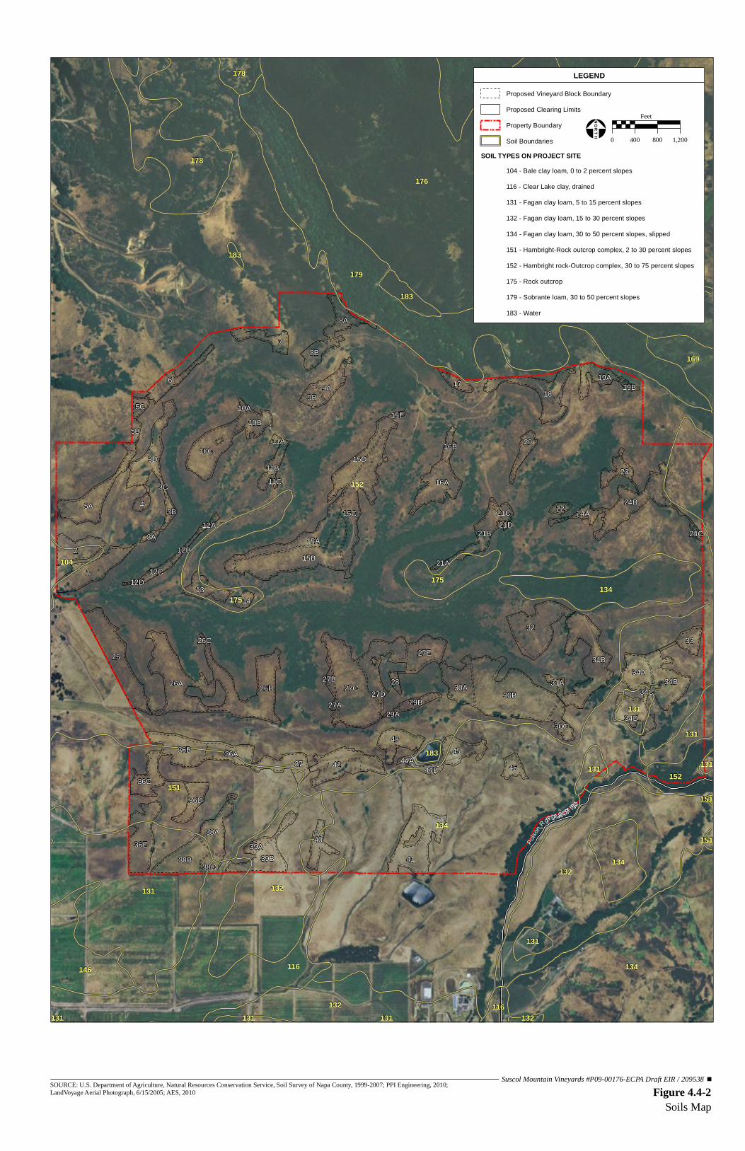
152
134
176 152
179
132
134
151
131
116
132
178
132
134
146
175
134
175
175
152
169
131
151
104
178
131
183
131
131
116
183
131 132
131
183
151
151
131131
POLSON RD
1
30B
41
25
32
27C
15B2
26B26A
31B
5A
18
15C
42
6
3D
24B
10C
7
36E
15A
34B
16A
36B43
38B 39B
4537
30A
27E
13
38A
8A
34A
36A
8B
36C
9A
33
20
10B
46
9B
38C
27D
15D
34D
21B
40
23
19A
36D
4
11B
30C
17
5C
14
24A
29B
3B
5B
28
16B
22
12C
21C
39A
44B
27B
3A12B
31A
27A
12A
10A
44A
3C
19B
15E
24C
11A
12D
34C
29A
21A
26C
21D
11C
Polso
n R
d
Figure 4.4-2Soils Map
SOURCE: U.S. Department of Agriculture, Natural Resources Conservation Service, Soil Survey of Napa County, 1999-2007; PPI Engineering, 2010; LandVoyage Aerial Photograph, 6/15/2005; AES, 2010
Suscol Mountain Vineyards #P09-00176-ECPA Draft EIR / 209538
LEGENDProposed Vineyard Block Boundary
Proposed Clearing Limits
Property Boundary
Soil BoundariesSOIL TYPES ON PROJECT SITE
104 - Bale clay loam, 0 to 2 percent slopes
116 - Clear Lake clay, drained
131 - Fagan clay loam, 5 to 15 percent slopes
132 - Fagan clay loam, 15 to 30 percent slopes
134 - Fagan clay loam, 30 to 50 percent slopes, slipped
151 - Hambright-Rock outcrop complex, 2 to 30 percent slopes
152 - Hambright rock-Outcrop complex, 30 to 75 percent slopes
175 - Rock outcrop
179 - Sobrante loam, 30 to 50 percent slopes
183 - Water
0 400 800 1,200
Feet
!¢Ð
NORTH

4.0 ENVIRONMENTAL SETTING, IMPACTS AND MITIGATION MEASURES Geology and Soils
Analytical Environmental Services 4.4-6 Suscol Mountain Vineyards P09-00176-ECPA March 2012 Draft Environmental Impact Report
4.4.1-3 SEDIMENT EROSION AND YIELD
Sediment Erosion
Sediment erosion is the mechanical breakdown of rock material and the removal of the resultant materials, such as soil and rock particles, by water or wind. The potential for erosion of a particular area is dependent upon a variety of factors including the geology, slope, vegetation cover, hydrology, precipitation, and the intensity of storm events. Shallow soil creep is the slow downward movement of soil and loose rock on slopes. On steep hillside areas the potential for erosion is greater and rilling, rutting, and damaging of gully systems can occur. Along many natural drainage courses on both hillsides and valley areas, stream and river flow can result in bank erosion. In overland flow areas (OFAs) sediment is easily dislodged and transported to receiving waters. Large-scale erosion occurs from mass wasting including shallow and deep-seated landsliding, particularly from high intensity storm events. According to vineyard plot studies in the Napa River Basin, the annual surface erosion from hillside vineyards with limited straw or no-till cover crops ranges from 2.3 to 23 tons per acre (tons/acre) (Napa County RCD, 1997). Watersheds underlain by Sonoma Volcanics, such as Suscol Creek, are considered to have low sediment input rates (Balance Hydrologics, 2010). Notable amounts of sheetwash and rilling may also occur during large-magnitude storms due to the hydrologic effects of wildfires or vegetation removal. Large rainstorms that sweep across the Napa River watershed periodically induce both shallow and deep-seated landsliding. Landsliding is further discussed in Section 4.4.1-4 below. Site reconnaissance performed as part of the hydrologic study of the property by Balance Hydrologics identified local conditions that may contribute to sediment loading. The bed of Suscol Creek itself contained sediment deposits, likely due to cattle grazing land uses, but was not substantially choked with sediment. The lack of substantial sedimentation is likely due to the presence of Sonoma Volcanics bedrock covered by relatively thin soils in the upland areas. Little evidence of rilling or gully erosion of the landscape were observed in the upper Suscol Creek reaches, despite the steep topography. On the southern portion of the property south of Suscol Ridge, far more evidence of past erosion was observed, including moderately to deeply incised channels, especially in Fagan Creek, and slump and debris flow scarps (Balance Hydrologics, 2010). This difference is likely due to the underlying Markley and Domengine sandstones south of Suscol Ridge, which increases the sedimentation potential of overlying soils (Napolitano et al., 2006). The majority of sediment supply to the Suscol Creek watercourses originates from the rill and sheetwash erosion of the steep upland areas. The soils in this area have moderate infiltration rates and moderately high runoff rates. South of Suscol Ridge, erosion in the Fagan and Sheehy Creek watersheds are subject to sediment loading via gullying within drainage swales,

4.0 ENVIRONMENTAL SETTING, IMPACTS AND MITIGATION MEASURES Geology and Soils
Analytical Environmental Services 4.4-7 Suscol Mountain Vineyards P09-00176-ECPA March 2012 Draft Environmental Impact Report
incision and bank erosion in the stream channels, and deposition by landslides. Soils on this side of the project site are similar to those on the upland areas on the other side of the ridge, with moderate infiltration rates and moderately high runoff rates; however, the weak sandstone basement rocks cause this area to be more prone to slumping, erosion, and slope failure.
4.4.1-4 GEOLOGIC STABILITY
Landslides
Napa County prepared Geographic Information System (GIS) maps of landslide deposits and areas of potential landslide hazards for the Napa County Environmental Baseline Data Report (Napa County, 2005). The data was collected from the interpretation of U.S. Geological Survey (USGS) aerial photographs from sources published over several decades. The GIS maps identified that one large landslide deposit and several small areas of potential landslide hazards exist. A site-specific geotechnical investigation was performed by registered geologists of Gilpin Geosciences in June 2010 (Appendix F), which mapped active and dormant landslides as part of a larger slope stability analysis. The project site can generally be characterized by three levels of landslide hazard that increase in level of hazard from north to south: 1) Suscol Creek Valley (Blocks 1-32); 2) South ridgeline and bench of south-facing slopes (Blocks 33, 34, 36, 37, 42-46); and 3) slopes south of bench on south-facing slopes (Blocks 35, 38-41) (Gilpin Geosciences, June 2010). The northern ridgeline’s north facing slopes are comprised of thick volcanic units and do not show susceptibility to landslides. Over the northern two thirds of the project site (which contains Blocks 1 through 32), the investigation revealed little to no slope stability issues that would hinder the development of the project. Specifically in the proposed vineyard areas, low inclinations and strong to very strong andesitic bedrock contribute to stable slope conditions. By contrast, within the southern third of the project site (which contains Blocks 33 through 46) many active and dormant landslides were mapped on the south facing slopes of the southern ridgeline, which is dominated by older block landslides caused by the weak and easily weathered Markley sandstones and Nortonville shales which underlie the volcanics in this area. The southern slope of the project site is further characterized by Mason (1988) as Zone 4, the most susceptible to landsliding. These large block slides do not appear to be active at present; however, the poor drainage, weak rock, and poor soil conditions in this area have created several small slope failures within and around the periphery of these proposed vineyard blocks, which may be masking slow creep of large block slides (Gilpin Geosciences, 2010). These smaller active slides are the result of poor drainage of the crushed and weak bedrock in concert with steep slopes. Recent landslide activity was observed in the southeastern and southwestern corners of the project site and project area, as many shallow slumps and debris

4.0 ENVIRONMENTAL SETTING, IMPACTS AND MITIGATION MEASURES Geology and Soils
Analytical Environmental Services 4.4-8 Suscol Mountain Vineyards P09-00176-ECPA March 2012 Draft Environmental Impact Report
flows were activated by winter storms. As noted above, several areas of slump and/or shallow soil instability were mapped by the geotechnical investigation within the southern third of the project site (containing proposed Blocks 33 through 46), that occur within and adjacent to several of the proposed vineyard blocks. Complex drainage channels, erosion gullies, hummocky topography, and numerous seeps and springs are indicative of landslide deposits covering most of the southern portion of the project site. The report recommends the incorporation of certain design measures to minimize the possibility of slope failure, discussed in Section 4.4.3 Impacts and Mitigation Measures below. Onsite geologic conditions, including the location of landslides, are depicted in Figure 4.4-3. Seismcity
Seismic Potential Numerous faults exist throughout the Bay Area of Northern California where the Suscol Mountain Vineyards site is located. The majority of active faults within the Bay Area are components of the San Andreas Fault zone, a broad north-northwest trending system that extends along coastal California. An active fault is a fault that shows displacement within the last 11,000 years (the Holocene epoch), and therefore, is considered more likely to generate a future earthquake than a fault that has not shown signs of recent activity. A potentially active fault is one that has shown activity in the last 2.5 million years (the Quaternary Period). A fault that the California Geological Survey (CGS) determines to be sufficiently active and well-defined is zoned as an earthquake fault zone according to mandates of the Alquist-Priolo Earthquake Fault Zoning Act of 1972. These earthquake fault zone areas are located along active faults that are susceptible to the hazard of surface fault rupture. When an earthquake occurs, energy waves are radiated outward from the fault. The amplitude and frequency of earthquake ground motions partially depends on the material through which it is moving and distance from the source. The earthquake force is transmitted through hard rock in short, rapid vibrations, while this energy movement becomes a long, high-amplitude motion when moving through soft ground materials, such as valley alluvium. The force an earthquake applies to a structure is expressed in terms of a percentage of gravity (g). For example, an earthquake that produces 0.30 g horizontal ground acceleration will impose a lateral force on a structure equal to 30 percent of its total vertical weight. The intensity of an earthquake is expressed in terms of its effects, as measured by the Modified Mercalli Intensity Scale, and in terms of the quantity of energy released, or magnitude, as measured by the Richter scale. On the Richter scale every one-unit increase indicates an increment of roughly 30 times the energy. Within Napa County a large number of faults have been mapped, but the CGS has designated only a very small number of these faults as active (Figure 4.4-4). The Green Valley Fault is the closest active fault in Napa County to the project site, located approximately 2.6 miles east. The Green Valley Fault is part of the Concord-Green Valley Fault zone, which is the easternmost

BLOCK 1±8.8 AC
BLOCK 3A±0.7 AC
BLOCK 3B±1.1 AC
BLOCK 3C±0.3 AC
BLOCK 4±1.1 AC
BLOCK 3D±7.8 AC
BLOCK 5A±9.4 AC
BLOCK 5C±1.5 AC
BLOCK 6±4.1 AC
BLOCK 7±3.4 AC
BLOCK 8A±3.9 AC
BLOCK 8B±3.5 AC
BLOCK 9A±3.2 AC
BLOCK 9B±2.2 AC
BLOCK 12C±1.4 AC
BLOCK 12D±0.4 AC
BLOCK 13±3.8 AC
BLOCK 14±1.2 AC
BLOCK 15A±8.8 AC
BLOCK 15B±16.8 AC
BLOCK 15C±12.7
BLOCK 15D±6.2 AC
BLOCK 15E±0.4 AC
BLOCK 16A±8 AC
BLOCK 21A±0.3 AC
BLOCK 21B±4.8 AC
BLOCK 21C±1.3 AC
BLOCK 17±1.6 AC
BLOCK 18±8.6 AC
BLOCK 19A±3.8 AC
BLOCK 19B±0.4 AC
BLOCK 33±2.7 AC
BLOCK 34A±5.2 AC
BLOCK 34B±8.3 AC
BLOCK 34D±5.8 AC
BLOCK 35 HAS BEEN REMOVED FROM THE
PROJECT
BLOCK 30A±6.7 AC
BLOCK 29B±1.7 AC
BLOCK 27C±18.8 AC
BLOCK 27E±6.3 AC
BLOCK 27D±8.1 AC
BLOCK 27A±0.7 AC
BLOCK 27B±1 AC
BLOCK 28±1 AC
BLOCK 26A±14.9 AC
BLOCK 25±13.7 AC
BLOCK 36B±7.9 AC
BLOCK 10B±3.9 AC
BLOCK 10C±9.8 AC
BLOCK 11A±0.4 AC
BLOCK 11B±2.7 AC
BLOCK 11C±0.1 AC
BLOCK 12A±0.6 AC
BLOCK 12B±0.8 AC
BLOCK 38A±5.7 AC
BLOCK 38B±7.5 AC BLOCK 38C
±2.1 AC
BLOCK 39A±1.2 AC
BLOCK 39B±7.3 AC
BLOCK 40±3 AC
BLOCK 42±7.7 AC
BLOCK 43±5.1 AC
BLOCK 44B±1.1 AC
BLOCK 45±4.6 AC
BLOCK 46± 2.2 AC
BLOCK 41±12.2 AC
BLOCK 44A±0.5 AC
BLOCK 2±5.9 AC
BLOCK 21D±0.2 AC
BLOCK 24B±10.3 AC
BLOCK 24C±0.4 AC
BLOCK 26B±15.4 AC
BLOCK 30B±23.9 AC
BLOCK 31A±0.8 AC
BLOCK 31B±13.8 AC
BLOCK 32±12.4 AC
BLOCK 37±4.4 AC
OUT
BLOCK 10A±0.5 AC
BLOCK 20±2.6 AC
BLOCK 22±0.9 AC
BLOCK 23±2.6 AC
BLOCK 5B±1.1 AC
BLOCK 16B±1.5 AC
BLOCK 24A±1.8 AC
BLOCK 26C±0.2 AC
BLOCK 29A±0.3 AC
BLOCK 34C±0.3 AC
BLOCK 36A±5.1 AC
BLOCK 36D±3.8 AC
BLOCK 36E±9.3 AC
BLOCK 36C±4.8 AC
36A
1
30B
41
25
32
2
27C
15B
26B26A
18
31B
5A
6
15C
42
7
3D
24B
10C
15A
43
27D
34B
16A
45
38B 39B
37
30A
27E
13
15D
34D
38A
8A
34A
36B
8B
40
21B
9A
33
20
23
10B
19A
4
46
9B
11B
30C
17
5C
38C
14
24A
29B
28
3B22
5B
16B
12C
21C
39A
44B
3A
27B
12B
31A
27A
12A
10A
44A
3C
19B
15E
24C
11A
12D
34C
29A
21A
26C
21D
11C
24C
SITE GEOLOGIC MSUSCOL MOUNTAIN VINEYAR
16
Tst
32
15o
18
Qlso2451
Qa
Landslide, scarp area hachured, arrow in directionof downslope movement, compressional toe withdebris pushing over the original ground surfaceby a dash and semi-circle symbol, number associatedwith mapped deposit described below. Debris slide, 0-5’where unlabled.
Landslide designation
1 - active, 1r - recent2 - dormant3 - ancient
1 - debris slide
3 - slump4 - rotation5 - translation6 - topple
1 0 - 5 ft.2 5 - 10 ft.3 10 - 15 ft.4 15 - 20 ft.5 20+ ft.
1 - certain2 - probable3 - questionable
Certainty
Depth
Type
Activity
Qls
SLOPE STABILITY
2111
36o
26o
45o
20o
20oQa
Tst
Qa
Qf
QfQf
Tst
35o
20o
Tst
Tst
Tst
40o
36o
hard, yellow tuff
TstQa
Qa
Qa
Tst
Tst
Qa
Tsa TsaTsa
Qlso2451
Tsa Qlso2451
Tsa
Qlso2451
Qls1331
SADDLE
Tem
Qlso2451
Qlso2451
Qlso2451
Qlso2451
Qls1531
Qls1331
Qls1r341
Qls1131
Qls1121
Qlso2451
Qlso2551
1958Pond
Qlso2451
Qlso2451
Qlso2451 Qlso
2341
Qls1131
Qls1321
Qls1r331
Pond
TsaQls1131
Series (4-5) of benched activelandslide slumps at toe of deep-seated landslide deposit
?
??
?
QlsoQlso2451
Tank
Tank
White Fine AshFlow Tuff
N76W, 55N
1958 slide
Qls1341 Qls
1331
Tanks
6” PVC24” Culvert
EXPLANATION
Geologic UnitsFill
AlluviumLandslide depositOlder Landslide Deposit
SONOMA VOLCANICSAsh Flow TuffsBasalt - Andesite Lavas
KREYENHAGEN FORMATIONMarkley Sandstone
QfQaQlsQlso
TstTsa
Tem
25
37
2-3
KeyGeologic Contact, queried where unknowndotted where concealedFaultStrike and of dip beddingBreak in topographic slope Soil CreepErosion Gully with depth in feetSlope Direction with magnitude of inclinationSeep/SpringErosion Scarp - LandslideTest Pit location
Cross Section location
Proposed Vineyard Block
8-10’ deep head cut
Pipe
Massive,WeatheredTuff
A'
B'
B
A 'A
1010
710
800
200 Qls
Qls2121
?
Qls1131
Qls1331
Qls1331
Qls1331
Qls1131
Qls1121
?
Qls3333
700
800
900
1300
1400
1200
1100
1000
900
800
800
700
600
500
400
300
200
300
400
500
500
600
700800
900
700
600
500400
300
500
600
700
800
900
1000
1080
12001100
1000
900
1000
1100
1200
1300
1400
1500
800
700
800
900
960
1000
900
800
Qls1r531
2
1
3
48
76 10
9
11
5
2
Suscol Mountain Vineyards #P09-00176-ECPA Draft EIR / 209538Figure 4.4-3
Site Geologic Map
SOURCE: Gilpin Geosciences, 8/5/2010; AES, 2011
SCALE
NORT
H
0 600’ 1200’
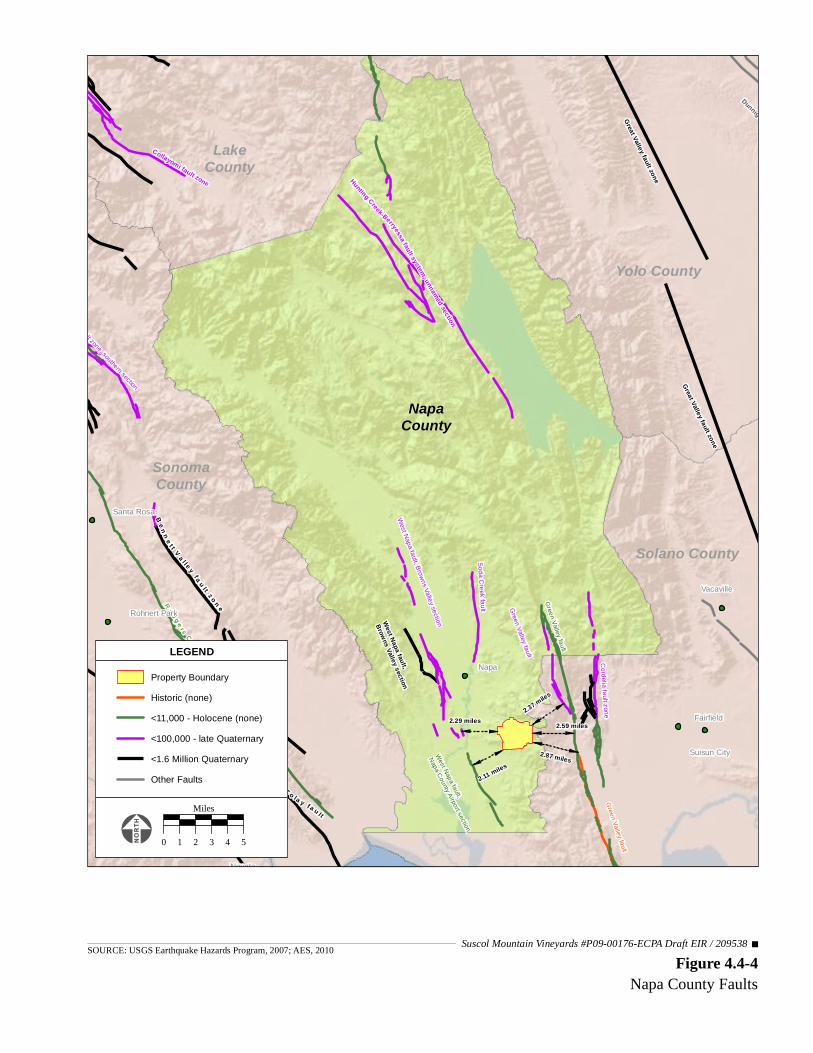
"
"
" "
"
"
""
"
"
Hunting Creek-Berryessa fault system, unnamed section
Collayomi fault zoneGreat Valley fault zone
Dunnigan Hills fault zone
YoloCounty
YoloCounty
Green Valley fault
Green Valley fault
Cordelia fault zone
T o la y f a u l t
B u r d e l l M o u n ta i n f a u l t
V a c a fa u lt zo ne
R o d g e rs C r e e k f a u l t
Ben n e t t V a l l e y fa u l t z o n e
Soda Creek fault
West Napa fault, Browns Valley sectionWest Napa fault,
Napa County Airport section
Tolay fault
West Napa fault,
Browns Valley section
Green Valley fault
Maacama fault zone, southern section
Great Valley fault zone
NapaCounty
LakeCounty
SonomaCounty
Solano County
Yolo County
Great Valley fault zone
2.87 miles
2.37 miles
2.29 miles 2.59 miles
2.11 miles
Napa
Novato
Petaluma
Vacaville
Fairfield
Santa Rosa
Suisun City
Rohnert Park
Property BoundaryHistoric (none)<11,000 - Holocene (none)<100,000 - late Quaternary<1.6 Million QuaternaryOther Faults
LEGEND
0 1 2 3 4 5
Miles
Figure 4.4-4Napa County Faults
SOURCE: USGS Earthquake Hazards Program, 2007; AES, 2010Suscol Mountain Vineyards #P09-00176-ECPA Draft EIR / 209538
4.0 ENVIRONMENTAL SETTING, IMPACTS AND MITIGATION MEASURES Geology and Soils
Analytical Environmental Services 4.4-11 Suscol Mountain Vineyards P09-00176-ECPA March 2012 Draft Environmental Impact Report
active dextral strike-slip fault of the larger San Andreas Fault system. The Green Valley Fault is a Holocene active fault that has produced surface rupture within the last 2,700 years (Bryant and Cluett, 2002) and is capable of producing a magnitude 6.9 earthquake (Gilpin Geosciences, 2010). The Hunting Creek Berryessa Fault located approximately 15 miles north of the project site is the nearest potentially active fault. The West Napa Fault section closest to the project site is the Napa County Airport section located approximately 2.11 miles west of the project site, which is a Holocene active dextral strike slip fault (Bryant, 2000). Portions of the Green Valley, Hunting Creek, and West Napa faults are zoned as fault rupture hazards by the Alquist-Priolo Act (CDMG, 1997), although the project site is not within the Alquist-Priolo zone for either fault. The San Andreas Fault is located approximately 40 miles southwest of the project site. Other substantial faults in the Bay Area include the Rodgers Creek Fault, Hayward Fault, Calaveras Fault, and San Gregorio Fault. These faults also have the potential to result in large magnitude ground shaking events. Numerous earthquakes have occurred in the Napa County region within historic times. Between 1735 and 2005, 97 earthquakes were recorded with a magnitude of 5.0 on the Richter scale or larger within 200 kilometers (or approximately 124 miles) of the center of Napa County (Napa County, 2005). Seven substantial earthquakes have been recorded since 1836 within 61 miles of the center of Napa County, and had median peak bedrock accelerations of 0.04 g to 0.10 g. This includes the 1906 earthquake of magnitude 8.3 with a median peak bedrock acceleration of 0.10 g located 55 miles from the center of Napa County. Other earthquakes have occurred in the vicinity of Napa County along the previously mentioned faults in the Bay Area, including the 1989 earthquake along the Loma Prieta Fault. To estimate the probability of future earthquake events in the Bay Area, USGS considered potential sources of an event on seven different fault systems in the Bay Area. Based on a combined probability of all seven fault systems and background earthquakes, there is a 62 percent chance of a magnitude 6.7 or larger earthquake occurring in the Bay Area by the year 2032. Smaller earthquakes, between magnitudes 6.0 and 6.7, which are capable of causing considerable damage, have about an 80 percent chance of occurring in the Bay Area by 2030 (USGS, 2003). Seismic Hazards Seismic hazards are effects that are caused by surface fault rupture and seismic shaking from a seismic event. Surface fault rupture occurs when a fault breaks through to the ground surface during a seismic event. The CGS determined that in Napa County there are three faults that are active and capable of surface fault rupture: the West Napa Fault, Green Valley Fault, and Hunting Creek Fault (Napa County, 2005). As discussed above, the project site is susceptible to little hazard from surface rupture along an active fault trace.

4.0 ENVIRONMENTAL SETTING, IMPACTS AND MITIGATION MEASURES Geology and Soils
Analytical Environmental Services 4.4-12 Suscol Mountain Vineyards P09-00176-ECPA March 2012 Draft Environmental Impact Report
Seismic shaking can result in structural damage. This risk is high because shaking damage can be caused by any of the active faults in the Bay Area discussed above. The severity of the shaking damage at a particular location depends on a number of factors, including the magnitude of the earthquake, the distance to its epicenter, and the nature and thickness of the deposits at the location. Areas that are subject to the greatest ground shaking damage are anticipated to be within Napa County’s various valleys, because they consist of deep, unconsolidated alluvial deposits underlain by saturated estuarine deposits, which are subject to higher amplitude and longer duration shaking motions (Napa County, 2005). Ground failures, or secondary effects, from ground shaking can extend many miles from the earthquake fault that generated the shaking. Ground failures include landsliding, differential settlement, lateral spreading, and liquefaction. Landsliding triggered by ground shaking occurs in the same types of hilly or mountainous terrains that are susceptible to non-seismically induced sliding events. Ground shaking can reactivate dormant landslides, cause new landslides, and accelerate or aggravate movement on active slides. Differential settlement is the non-uniform densification of loose soils that occurs during strong ground shaking and causes uneven settlement of ground surface. Differential settlement could occur in numerous locations, but most likely the valley areas of Napa County. Lateral spreading is a ground failure in which a subsurface layer of soil liquefies, resulting in the overlying soil mass deforming laterally toward a free face. Limited lateral spreading is extremely unlikely given the project area’s low probability for liquefaction on the slopes of the project site. The potential for seismic ground shaking is mapped by the Association of Bay Area Governments (ABAG) as low in the project vicinity, and therefore, coupled with the thin soils on most of the project site, the potential of seismically-induced landslides is fairly low (ABAG, 2010). Liquefaction is a process in which sandy, saturated soils become liquefied and lose their bearing capacity during seismic ground shaking. As a result, sufficiently liquefied soils can no longer support structures built on or beneath them. Liquefaction potential is dependent on such factors as soil type, depth to groundwater, degree of seismic shaking, and the relative density of the soil. Soils most susceptible to liquefaction are saturated, clean, loose, uniformly graded, fine-grained, and unconsolidated materials that are most commonly associated with alluvial valleys with high groundwater levels. On a countywide basis, the potential for liquefaction-induced ground failures is relatively low, since only about 20 percent of the County is characterized as an alluvial valley. ABAG creates maps of Bay Area counties that show the susceptibility of mapped areas to liquefaction based on the presence of water-saturated sand and silty materials that may be more prone to liquefaction than other soils. The project site susceptibility to liquefaction is considered very low (ABAG, 2010).

4.0 ENVIRONMENTAL SETTING, IMPACTS AND MITIGATION MEASURES Geology and Soils
Analytical Environmental Services 4.4-13 Suscol Mountain Vineyards P09-00176-ECPA March 2012 Draft Environmental Impact Report
4.4.2 REGULATORY FRAMEWORK
4.4.2-1 NAPA COUNTY
The Napa County General Plan (Napa County, 2008) serves as a broad framework for planning within Napa County. State law requires general plans to cover a variety of topics. The General Plan contains goals and policies related to open space conservation, natural resources, water resources and safety that provide guidance for issues related to geology and soils from the proposed project. Open Space Conservation Policies
Policy CON-5: The County shall identify, improve, and conserve Napa County’s rangeland through the following measures:
d) Encouraging livestock management activities to avoid long-term destruction of rangeland productivity and watershed capacity through overgrazing, erosion, or damage to riparian areas.
Policy CON-6: The County shall impose conditions on discretionary projects which limit development in environmentally sensitive areas such as those adjacent to rivers or streamside areas and physically hazardous areas such as floodplains, steep slopes, high fire risk areas and geologically hazardous areas. Water Resources Policies
Policy CON-48: Proposed developments shall implement project-specific sediment and erosion control measures (e.g., erosion control plans and/or stormwater pollution prevention plans) that maintain pre-development sediment erosion conditions or at minimum comply with state water quality pollution control (i.e., Basin Plan) requirements and are protective of the County’s sensitive domestic supply watersheds. Technical reports and/or erosion control plans that recommend site-specific erosion control measures shall meet the requirements of the County Code and provide detailed information regarding site specific geologic, soil, and hydrologic conditions and how the proposed measure will function. Policy CON-49: The County shall develop and implement a water quality monitoring program (or programs) to track the effectiveness of temporary and permanent Best Management Practices (BMPs) to control soil erosion and sedimentation within watershed areas and employ corrective actions for identified water quality issues (in violation of Basin Plans and/or associated TMDLs) identified during monitoring. Policy CON-50: The County will take appropriate steps to protect surface water quality and quantity, including the following:

4.0 ENVIRONMENTAL SETTING, IMPACTS AND MITIGATION MEASURES Geology and Soils
Analytical Environmental Services 4.4-14 Suscol Mountain Vineyards P09-00176-ECPA March 2012 Draft Environmental Impact Report
g) Address potential soil erosion by maintaining sections of the County Code that require all construction-related activities to have protective measures in place or installed by the grading deadlines established in the Conservation Regulations. In addition, the County shall ensure enforceable fines are levied upon code violators and shall require violators to perform all necessary remediation activities.
Safety Goals and Policies
Goal SAF-1: Safety considerations will be part of the County’s education, outreach, planning, and operations in order to reduce loss of life, injuries, damage to property, and economic and social dislocation resulting from fire, flood, geologic, and other hazards. Goal SAF-2: To the extent reasonable, protect residents and businesses in the unincorporated area from hazards created by earthquakes, landslides, and other geologic hazards. Policy SAF-8: Consistent with County ordinances, require a geotechnical study for new projects and modifications of existing projects or structures located in or near known geologic hazard areas, and restrict new development atop or astride identified active seismic faults in order to prevent catastrophic damage caused by movement along the fault. Geologic studies shall identify site design (such as setbacks from active faults and avoidance of onsite soil-geologic conditions that could become unstable or fail during a seismic event) and structural measures to prevent injury, death and catastrophic damage to structures and infrastructure improvements (such as pipelines, roadways and water surface impoundments not subject to regulation by the Division of Safety of Dams of the California Department of Water Resources) from seismic events or failure from other natural circumstances. Policy SAF-9: As part of the review and approval of development and public works projects, planting of vegetation on unstable slopes shall be incorporated into project designs when this technique will protect structures at lower elevations and minimize the potential for erosion or landslides. Native plants should be considered for this purpose, since they can reduce the need for supplemental watering which can promote earth movement. Policy SAF-10: No extensive grading shall be permitted on slopes over 15 percent where landslides or other geologic hazards are present unless the hazard(s) are eliminated or reduced to a safe level.
4.4.2-2 NAPA COUNTY RESOURCE CONSERVATION DISTRICT
The Napa County Resource Conservation District (RCD) published the Napa River Watershed Owner’s Manual in 1996. The manual contains the following objective and recommendations that pertain to the proposed project:

4.0 ENVIRONMENTAL SETTING, IMPACTS AND MITIGATION MEASURES Geology and Soils
Analytical Environmental Services 4.4-15 Suscol Mountain Vineyards P09-00176-ECPA March 2012 Draft Environmental Impact Report
Objective G: Reduce Soil Erosion
Recommendation G2: Reduce erosion resulting from agricultural activities. Agricultural activities in the Napa River watershed include grazing, viticulture, small farms and horticulture. Soil disturbance or vegetation removal as a result of agricultural activities can result in loss of topsoil and subsequent water quality degradation. Good agricultural management can also benefit water quality and wildlife habitat, and can contribute to the overall good health of the watershed. Relevant sub-recommendations include:
• G2.1. Emphasize erosion prevention over sediment retention as a priority in agricultural planning and operations.
• G2.2. Promote the use of permanent vegetative ground cover in vineyards. Support research, demonstrations and technology exchange to refine no-till cover crop technology for vineyards and orchards.
• G2.4. Maintain access roads and farm roads to control storm water runoff in agricultural areas. Utilize assistance from the U.S. Department of Agriculture (USDA) Natural Resource Conservation Service, or other erosion control professionals, for design of storm water runoff control on rural roads.
• G.2.5. Minimize wet weather vehicle traffic through or across agricultural areas, especially on hillsides.
• G.2.6. Provide adequate energy dissipaters for culverts and other drainage pipe outlets. • G.2.7. Establish vegetated buffer strips along waterways.
4.4.3 IMPACTS AND MITIGATION MEASURES
4.4.3-1 SIGNIFICANCE CRITERIA
The proposed project would involve earthmoving activities associated with the development of vineyard areas, erosion control measures, and other features included within the erosion control plan (ECP) on slopes greater than five percent, as outlined in Chapter 3.0 Project Description. For the purposes of this EIR, the proposed project would have a significant impact if it would:
• Result in the accelerated, long-term erosion and loss of topsoil causing substantial depletion of the agricultural resource or an increase in the rate and quantity of sediment accumulated down slope to the extent that it damages roads, vineyard facilities, adjoining vineyards, or deposits excessive sediment in natural waterways, including Suscol, Sheehy and Fagan Creeks (and their tributaries) which are tributary to the Napa River.

4.0 ENVIRONMENTAL SETTING, IMPACTS AND MITIGATION MEASURES Geology and Soils
Analytical Environmental Services 4.4-16 Suscol Mountain Vineyards P09-00176-ECPA March 2012 Draft Environmental Impact Report
• Alter the topographic or geologic site conditions such that an earthquake would cause substantial damage to the proposed vineyard, or a geologic unit or soil would become unstable, thereby resulting in excessive erosion, soil creep, catastrophic slope and ground failure, or loss of cultivatable land area.
4.4.3-2 IMPACTS AND MITIGATION MEASURES
Impact 4.4-1: Development of the proposed project would alter the rate of sediment erosion and yield onsite; however, the project is designed to create a slight decrease in sediment erosion and yield, and a less-than-significant impact to receiving waters would result. The Universal Soil Loss Equation (USLE) provides a technique for numerically evaluating the proposed project’s potential effects on soil loss and erosion. The USLE has been calculated for proposed vineyard blocks under pre- and post-project conditions and is presented in Table 4.4-2. As shown in Table 4.4-2, overall the proposed project is anticipated to result in an approximately 477 ton (30.21 percent) reduction in soil loss relative to existing conditions.
TABLE 4.4-2
PRE- AND POST-PROJECT USLE CALCULATIONS BY VINEYARD BLOCK
Vineyard Block Acreage
Pre-Project Conditions Post-Project Conditions
Soil Loss (tons)
Soil Loss (tons/acre)
Soil Loss (tons)
Soil Loss (tons/acre)
Percent Change in Soil Loss
(tons/acre)
Suscol Creek Watershed1 9.0 10.63 1.18 10.40 1.16 -1.69% 2 5.9 11.73 1.99 11.48 1.95 -2.01%
3A 0.7 1.02 1.46 1.09 1.56 +6.85% 3B 1.1 1.10 1.00 1.07 0.98 -2.00% 3C 0.3 0.12 0.39 0.14 0.46 +17.95% 3D 7.8 15.01 1.92 16.06 2.06 +7.29% 4 1.1 1.15 1.05 0.85 0.78 -25.71%
5A 9.4 1.86 1.86 1.82 1.82 -2.15% 5B 1.1 1.84 1.67 1.97 1.79 +7.19% 5C1 1.5 1.06 0.70 1.13 0.75 +7.14% 61 4.1 9.77 2.38 6.70 1.64 -31.09% 71 3.4 7.68 2.26 5.56 1.63 -27.88%
8A1 3.9 7.36 1.89 7.20 1.85 -2.12% 8B1 3.5 5.58 1.59 6.11 1.75 +10.06% 9A 3.2 8.37 2.62 6.62 2.07 -20.99% 9B 2.2 4.91 2.23 3.88 1.76 -21.08%
10A 0.5 0.79 1.58 0.85 1.69 +6.96% 10B 3.9 8.48 2.17 9.07 2.33 +7.37% 10C 9.8 22.81 2.33 18.04 1.84 -21.03% 11A 0.4 0.44 1.09 0.52 1.29 +18.35% 11B 2.7 6.34 2.35 6.21 2.30 -2.13% 11C 0.1 0.20 1.97 0.21 2.10 +6.60% 12A 0.6 0.62 1.03 0.57 0.95 -7.77% 12B 0.8 0.24 0.29 0.22 0.27 -6.90% 12C 1.4 1.45 1.03 1.33 0.95 -7.77%

4.0 ENVIRONMENTAL SETTING, IMPACTS AND MITIGATION MEASURES Geology and Soils
Analytical Environmental Services 4.4-17 Suscol Mountain Vineyards P09-00176-ECPA March 2012 Draft Environmental Impact Report
Vineyard Block Acreage
Pre-Project Conditions Post-Project Conditions
Soil Loss (tons)
Soil Loss (tons/acre)
Soil Loss (tons)
Soil Loss (tons/acre)
Percent Change in Soil Loss
(tons/acre) 12D 0.4 0.64 1.61 0.59 1.48 -8.07% 13 3.8 10.69 2.81 9.64 2.54 -9.61% 14 1.2 2.99 2.49 2.93 2.44 -2.01%
15A 8.8 21.89 2.49 23.98 2.72 +9.24% 15B 16.8 41.83 2.49 33.86 2.02 -18.88% 15C 12.7 43.71 3.44 31.62 2.49 -27.62% 15D 6.2 14.40 2.32 10.42 1.68 -27.59% 15E 0.4 0.65 1.62 0.47 1.16 -28.40% 16A 8.0 20.79 2.60 20.35 2.54 -2.31% 16B 1.5 3.06 2.04 2.99 1.99 -2.45% 172 1.8 1.72 0.96 1.89 1.05 +9.38% 182 8.7 33.19 3.81 30.53 3.51 -7.87%
19A2 3.8 12.02 3.16 8.69 2.29 -27.53% 19B2 0.4 0.41 1.02 0.40 0.99 -2.94% 20 2.8 10.28 3.67 7.44 2.66 -27.52%
21A 0.3 0.64 2.12 0.62 2.08 -1.89% 21B 1.8 12.27 2.56 12.00 2.50 -2.34% 21C 1.3 4.96 3.82 3.59 2.76 -27.75% 21D 0.2 0.47 2.35 0.46 2.30 -2.13% 22 0.9 1.40 1.56 1.70 1.89 +21.15% 23 2.6 6.05 2.33 7.33 2.82 +21.03%
24A 1.8 5.74 3.19 5.14 2.85 -10.66% 24B 10.3 44.70 4.34 39.99 3.88 -10.60% 24C 0.4 0.35 0.88 0.43 1.07 +21.59% 25 13.7 33.36 2.43 32.65 2.38 -2.06%
26A3 14.9 70.06 4.70 37.04 2.49 -47.02% 26B3 15.4 44.46 2.89 43.51 2.83 -2.08% 26C 0.2 0.73 3.64 0.53 2.63 -27.75% 27A 0.8 1.74 2.18 1.91 2.39 +9.63% 27B 8.7 22.28 2.56 24.41 2.81 +9.77% 27C 19.1 62.79 3.29 50.83 2.66 -19.15% 27D 8.7 27.40 3.15 30.01 3.41 +8.25% 27E 6.0 13.25 2.21 14.51 2.42 +9.50% 28 1.0 2.22 2.22 2.43 2.43 +9.46%
29A 0.3 0.66 2.18 0.72 2.39 +9.63% 29B 1.7 3.48 2.05 3.82 2.24 +9.27% 30A 6.7 19.63 2.93 14.20 2.12 -27.65% 30B4 27.7 110.66 3.99 80.05 2.89 -27.57% 31A 0.8 1.34 1.68 1.31 1.64 -2.38% 31B3 13.7 104.21 7.61 30.58 2.23 -70.70% 32 12.4 170.81 13.78 35.61 2.87 -79.17%
Fagan Creek Watershed
30C 2.7 9.37 3.47 6.78 2.51 -27.67% 33 2.7 25.26 9.35 11.82 4.38 -53.16%
34A 5.3 31.48 4.05 12.62 2.38 -41.23% 34B 8.3 39.61 4.77 32.06 3.86 -19.08% 34C 0.4 1.69 4.22 1.65 4.13 -2.13% 34D 5.8 18.67 3.22 15.12 2.61 -18.94%
Sheehy Creek Watershed
36A 5.1 6.06 1.19 6.64 1.30 +9.24% 36B 7.9 23.29 2.95 11.80 1.49 -49.49% 36C 4.8 3.00 0.63 6.28 1.31 +107.94%

4.0 ENVIRONMENTAL SETTING, IMPACTS AND MITIGATION MEASURES Geology and Soils
Analytical Environmental Services 4.4-18 Suscol Mountain Vineyards P09-00176-ECPA March 2012 Draft Environmental Impact Report
Vineyard Block Acreage
Pre-Project Conditions Post-Project Conditions
Soil Loss (tons)
Soil Loss (tons/acre)
Soil Loss (tons)
Soil Loss (tons/acre)
Percent Change in Soil Loss
(tons/acre) 36D 3.8 7.96 2.09 6.10 1.61 -22.97% 36E 9.3 50.68 5.45 29.67 3.19 -41.47% 37 4.4 1.90 1.90 1.46 1.46 -23.16%
38A 3.20 4.17 1.30 4.08 1.27 -2.31% 38AB 7.7 27.59 3.58 24.88 3.23 -9.78%
38B SW 2.0 4.66 2.33 4.20 2.10 -9.87% 38C 2.3 5.56 2.42 5.44 2.37 -2.07% 39A 1.2 4.99 4.16 4.50 3.75 -9.86% 39B 7.3 57.46 7.87 24.79 3.40 -56.80% 40 3.0 29.47 9.82 18.22 6.07 -38.19%
41 upper 2.0 5.17 2.58 4.32 2.16 -16.28% 41 lower 10.2 44.89 4.40 37.55 3.68 -16.36%
42 7.7 16.32 2.12 14.72 1.91 -9.91% 43 5.1 22.81 4.47 14.78 2.90 -35.12%
44A 0.5 0.41 0.82 0.40 0.80 -2.44% 44B 0.5 0.76 1.53 0.84 1.67 +9.15%
45 west 1.0 3.76 3.76 3.68 3.68 -2.13% 45 east 3.7 10.66 2.88 10.43 2.82 -2.08%
46 2.2 7.30 3.32 7.14 3.25 -2.11%
Suscol Creek
Watershed 327.1 1,114.49 3.41 780.28 2.39 -29.99%
Sheehy Creek
Watershed 94.9 338.87 3.57 241.92 2.55 -28.61%
Fagan Creek
Watershed 25.2 126.08 5.00 80.05 3.18 -36.51%
TOTAL 447.2 1,579.44 3.53 1,102.25 2.46 -30.21%
Notes: 1. Blocks 5C, 6, 7, and 8 or portions thereof occur within the Arroyo Creek drainage, including 0.74 acres within
Block 5C, 2.62 acres within Block 6, 3.20 acres within Block 7, 2.62 acres within Block 8A, and 2.73 acres within Block 8B. For the purposes of this analysis, these blocks have been identified as occurring within the Suscol Creek watershed.
2. Blocks 17, 18, and 19 or portions thereof occur within the Cayetano Creek drainage, including 1.34 acres within Block 17, 2.40 acres within Block 18, 0.31 acres within Block 19A, and 0.06 acres within Block 19B. For the purposes of this analysis, these blocks have been identified as occurring within the Suscol Creek watershed.
3. Portions of Blocks 26A, 26B, and 31B occur within the Sheehy Creek watershed, including 0.44 acres within Block 26A, 0.86 acres within Block 26B, and 4.06 acres within Block 31B. However since the majority of these blocks occur within the Suscol Creek watershed, these blocks have been identified as such.
4. Portions of Block 30B occur in all three watersheds, including 17.44 acres in Suscol Creek, 3.06 acres in Sheehy Creek, and 3.42 acres in Fagan Creek. However, since the majority of Block 30B occurs within the Suscol Creek watershed, this block has been identified as such. Source: Napa County Resource Conservation District, May 2010
It is not expected that land preparation activities associated with vineyard, such as removal of rocks from the soil profile, would substantially affect the USLE modeling results. The USLE model evaluates the environmental conditions and physical forces that lead to the detachment and movement of soil particles. The primary goal of cultivating the soils within the development area during implementation is to prepare the site for planting, including fracturing and mixing

4.0 ENVIRONMENTAL SETTING, IMPACTS AND MITIGATION MEASURES Geology and Soils
Analytical Environmental Services 4.4-19 Suscol Mountain Vineyards P09-00176-ECPA March 2012 Draft Environmental Impact Report
layers of compressed soil and rock to facilitate root growth and improve permeability, rather than to remove all the rock within the development area soils. Soil cultivation may result in a greater number of smaller rocks at the soil surface: smaller rocks that emerge through development would be left within the vineyard, and only the larger rocks that surface would be removed. Since the larger rocks that may be removed from the site are generally underneath the soil surface, the removal of large rocks that emerge during development would not significantly alter the composition of soil. Therefore, the soil type classification utilized in the USLE calculations would remain unchanged (Oster, 2008; and the Stagecoach Vineyards #P06-0042-ECPA Environmental Impact Report, AES 2007, SCH #2006082143 certified October 7, 2008). Also see Section 4.6.1-2 (Hydrology and Water Quality) for additional discussion. An impact from the conversion of grasslands and oak woodlands to vineyard (as well as increased road use) would be considered significant if sediment erosion and yield are substantially increased and sedimentation in receiving waters is excessive. The mainstem Napa River is listed as sediment-impaired according to the Clean Water Act, Section 303 (d), because it does not meet the beneficial uses for which it was designated, including steelhead habitat. Section 303 (d) requires the Regional Water Quality Control Board (RWQCB) to create a Total Maximum Daily Load (TMDL) for sediment in the Napa River watershed. Under California Water Code §13242, the RWQCB is also authorized to develop an implementation program to meet the TMDL. The RWQCB Staff Report for the development of the TMDL specifically cites vineyards as a source of human caused sediment discharge, and states that a total 50 percent reduction in sediment loading to the watershed is necessary in order to meet the TMDL (Napolitano et al., 2009). The TMDL load reductions are based on natural conditions prior to human activities. The Suscol Mountain Vineyards property is already disturbed by grazing, another anthropogenic source of sediment, so in order to meet the TMDL, no net increase in sediment yield offsite should occur from the proposed project. Since the proposed project is larger than 40 acres and involves ground disturbing activity, the RWQCB can require the preparation and implementation of a sediment control plan. The requirements of Napa County’s Conservation Regulations (Chapter 18.108) are specifically listed as an effective measure at reducing sediment delivery. Existing conditions on the project site and in the onsite catchments reflect the effects of natural processes, ongoing land use, and legacy effects of cattle grazing and related past land uses. The conversion of existing habitats on the project site to vineyard would result in the removal of existing brush, shrubs, and trees, as well as soil ripping, earthmoving, and grading activities. Vegetation clearing associated with the proposed project could remove obstacles to sediment transport and expose new soils. Soil ripping and other earthmoving activities could loosen soils onsite and increase susceptibility to erosion, especially in overland flow areas. Additionally, increased traffic on existing unpaved roads during vineyard construction and operation may

4.0 ENVIRONMENTAL SETTING, IMPACTS AND MITIGATION MEASURES Geology and Soils
Analytical Environmental Services 4.4-20 Suscol Mountain Vineyards P09-00176-ECPA March 2012 Draft Environmental Impact Report
accelerate erosion and sedimentation, particularly on primary access roads at unstabilized fords across Suscol Creek, such as the crossing between proposed Blocks 12 and 13. However, the ECP has been designed to minimize increases in erosion. Erosion control measures are outlined in Table 3-3 and include: 1) level spreaders at piped drainage outlets near Blocks 21 and 36C designed to turn concentrated flow into sheet flow, which decreases the velocity of runoff and minimized channelization of drainage pathways, therefore minimizing sediment loading into runoff; 2) Outsloped turnarounds throughout the vineyard prevent the concentration of runoff on vineyard roads, which prevents sedimentation in a similar manner to level spreaders; 3) gravity outlets near Blocks 23, 27, 34B, 34D, 36E, and 41 lined with rip rap to dissipate energy in a runoff stream and prevent gullying in runoff channels, which can lead to erosion and sediment loading (the gravity outlet at Block 34B is designed to act as a natural detention basin, which decreases the velocity of runoff and causes sediment to precipitate into the basin, thereby clarifying runoff and retaining sediment onsite; and 4) straw wattles and rock repositories that slow runoff, which both prevents erosion and precipitates sediment, in addition to filtering runoff of coarse and finer sediments which are trapped in the wattle or rock matrix. Additionally, as discussed in Chapter 3.0 Project Description, the ECP includes the establishment of a permanent no-till cover crop with a plant residue density (i.e., cover) of between 70 and 80 percent in each of the proposed vineyard blocks (see Table 3-3 for specific cover crop densities per vineyard block) that would function as the primary measure in inhibiting vineyard-related particulate sediment (i.e., silt and coarser grain sizes) from being transported to another location through erosion or sedimentation. As detailed in Table 4.4-2 above, implementation of the ECP would result in an approximate 30 percent reduction overall in soil loss as compared to existing conditions. As discussed in Mitigation Measure 4.2-16 (in Chapter 4.2 Biological Resources), the existing creek crossing through Suscol Creek would be equipped with a new bridge two feet above the 100-year flood level prior to use of the crossing for vineyard construction and operation. As proposed with the project, heavy traffic would be excluded from the other crossings, which would remove the potential for sedimentation from increased project-related traffic at ford crossings. The removal of cattle grazing from a large portion of the project site would revitalize existing vegetation in previously grazed areas, thereby providing greater obstacles to sediment transport, and reducing stream bank erosion and habitat degradation through the removal of cattle from stream bed and wetland areas (Appendix D). Since the soils have been compacted on the surface by grazing, soil ripping in proposed vineyard areas would also increase the infiltration rate, decreasing available runoff during initial saturation. Additionally, the removal of livestock grazing from most areas of the project site would result in a reduction in hillside

4.0 ENVIRONMENTAL SETTING, IMPACTS AND MITIGATION MEASURES Geology and Soils
Analytical Environmental Services 4.4-21 Suscol Mountain Vineyards P09-00176-ECPA March 2012 Draft Environmental Impact Report
surface erosion in the areas not proposed for vineyard development. Further, in accordance with Mitigation Measures 4.2-6 and 4.2-7 in Chapter 4.2 Biological Resources, minimum 50-foot setbacks from wetlands, seeps, and springs shall be established, which would prevent livestock from entering and degrading these areas. As discussed in Chapter 4.6 Hydrology and Water Quality, a Long Term Vineyard Road Management Plan (Section 3.4.1-5, and Impacts 4.6-1 and 4.2-17) has been prepared to reduce any potential increases in soil loss, erosion, and sedimentation resulting from the increased use of existing dirt and gravel roads as a result of vineyard development and operation. As discussed above, with incorporation of erosion and runoff control measures proposed in the ECP and as demonstrated through the USLE calculations (Table 4.4-2), the overall load of sediment transported to local waterways with the proposed project is anticipated to decrease and therefore result in no impacts related to sediment erosion and yield. Mitigation Measure 4.4-1: No further mitigation is required. Impact 4.4-2: Development of the proposed project would involve earthmoving and grading activities that would alter the existing topographic and geologic conditions at the project site; however, conditions would not be altered such that an earthquake would result in significant damage to the project site from excessive erosion, soil creep, or catastrophic slope and ground failure. This is considered a less-than-significant impact. The proposed vineyard could be subject to an earthquake event from one of the active faults within the San Andreas Fault zone. Numerous earthquakes with large magnitudes have occurred in the Bay Area over the last few centuries, and the USGS estimates that an earthquake of magnitude 6.0 or greater will likely occur in the Bay Area in the future. However, surface fault rupture would not be anticipated to occur at the project site, since none of the active faults in Napa County that the CGS determined capable of underground surface fault rupture are located within the project site. The proposed project includes the conversion of natural hillslope and alluvial valley areas into vineyard and road re-surfacing as needed. Construction of the proposed project would involve earthmoving activities, soil cultivation, installation and maintenance of drainage and erosion control features, and vineyard plantings. Modifications that would alter the geologic setting of the property would be relatively minor changes associated with earthmoving activities for development of vineyards and associated avenues. Since the proposed project would not include construction of buildings or other facilities that would attract a large number of people, the potential risk of exposing people or structures to hazards from a seismic event would remain low. Up to six water storage tanks may be developed as part of the project. As stated in the Chapter 3.0 Project Description, the proposed water tanks would be seven to 15 feet in diameter, 21 to 33 feet high, and store about

4.0 ENVIRONMENTAL SETTING, IMPACTS AND MITIGATION MEASURES Geology and Soils
Analytical Environmental Services 4.4-22 Suscol Mountain Vineyards P09-00176-ECPA March 2012 Draft Environmental Impact Report
30,000 to 50,000 gallons of water each. The occurrence of seismic shaking sufficient to damage the structural integrity of the water storage tanks is low. Ground failures due to seismically-induced ground shaking can reactivate dormant landslides, cause new landslides, and accelerate or aggravate movement on active slides, as well as result in differential settlement, lateral spreading, and liquefaction. Seismically-induced ground shaking potential is low on the project site; therefore, the potential to reactivate or cause new slides is low (ABAG, 2010). Uneven settlement is not likely to occur in the mountainous regions of the County, including the Suscol Mountain Vineyards property. As discussed in Section 4.4.1-4, based on the soil types and depth to bedrock, the project area’s susceptibility to liquefaction is considered low. Lateral spreading is unlikely to occur because there are no liquefiable slopes on the project site. Therefore, seismically induced ground failure as a result of the project would be considered a less-than-significant impact. Mitigation Measure 4.4-2: No further mitigation is required. Impact 4.4-3: As discussed in Section 4.4.1-4, the development of the proposed project would occur on some areas prone to slope failure. A geotechnical report was completed for the proposed project (Appendix F) and the provisions in the ECP were generally found to be protective of slope stability, prevent over-saturation of weak slopes, reduce runoff, and not direct runoff onto slopes susceptible to landslide failure. However, within the southern portion of the project area (Blocks 33 through 46) there are many mapped active and dormant landslides. The geotechnical report has recommended extra measures for vineyard Blocks 33 through 46 to minimize the slope destabilization during site preparation and design considerations to prevent slope failure. These recommendations include the following:
• Grading shall be reduced to a minimum in order to maintain the current level of stability on the southern slopes of the site, and trees on the steeper slopes of the site should be left in place where possible.
• Rock repositories shall be prepared by grubbing and excavating a keyway at the toe of the proposed storage area. The keyway should extend two feet into firm soil or bedrock at the downslope edge of the keyway. The limits of the rock storage area proposed for Block 42 shall be constrained so that the downslope limit of storage is excavated where the older colluviums was encountered at depth with the test pits.
• Should unstable landslide deposits be encountered and/or localized slope failures occur during construction, the slope shall be restored to a stable configuration using specifications provided by the project’s engineering geologist.
The geotechnical report also suggests drainage improvements that would improve drainage by reducing overland flow and infiltration across the site by directing runoff to another drainage or

4.0 ENVIRONMENTAL SETTING, IMPACTS AND MITIGATION MEASURES Geology and Soils
Analytical Environmental Services 4.4-23 Suscol Mountain Vineyards P09-00176-ECPA March 2012 Draft Environmental Impact Report
to elevations below instabilities; this would reduce the risk of reactivating landslide deposits and would reduce overall sediment release from the site. However, the report does not provide specifications on how or to what level grading should be reduced to maintain slope stability. Additionally, the plan proposes drainage improvements within Blocks 34A and 34B that collects water from above and within a mapped active slide, and discharges it within the same active slide, which is contrary to report recommendations. Considering the unstable nature of the southern portion of the project site and that it is located on a geologic formation that is highly susceptible to the occurrence of landslides, as evident by the numerous active and dormant slides in this area, in conjunction with the increased sedimentation potential associated with landslides and slope failures, development within these geological hazardous areas (i.e., active landslides) is considered a potentially significant impact. Implementation of Mitigation Measure 4.4-3, which would reduce grading to maintain the current level of stability by eliminate proposed vineyard development within active landslides areas and provide them with a 50-foot buffer, would reduce potential slope stability and associated sedimentation impacts to a less-than-significant level. Blocks affected by this measure include, but are not limited to, Blocks 34A, 34B, 36D, 36E, 37, 38A, 38B, 38C, 39A, 39B, and 41. All of these blocks except 36E, 38B, 39A, and 39B would be affected to varying degrees with the implementation of Mitigation Measures 4.2-1 and 4.2-2 (grassland) 4.2-6 and 4.2-7 (wetlands), Mitigation Measures 4.2-11 and 12 (special status species), Mitigation Measure 4.2-4 (oak avoidance), and Mitigation Measure 4.2-8 (wildlife movement). It should be noted that site-specific engineered slope stabilization could be implemented in the future with a subsequent land clearing proposal within active landslide areas to allow for future development. However, development of the additional slope stabilization plan would require additional site analysis, further environmental review and a separate Erosion Control Plan. Avoidance of active landslides and providing them with a 50-foot buffer when site-specific engineered slope stabilization is not included with the project design is consistent with measures incorporated into Goldenberg/Lucky Star Vineyards ECPA (#00233-ECPA, Napa County 2001, certified April 13, 2001: 130 Polson Road APN 057-080-029), which is located approximately one mile to the southeast of the project site and exhibits similar geologic conditions. Mitigation Measure 4.4-3: Prior to approval of #P09-00176-ECPA, the plan shall be modified to include the following specifically for Blocks 33 through 46 to avoid potential slope stability and associated sedimentation impacts:
4.0 ENVIRONMENTAL SETTING, IMPACTS AND MITIGATION MEASURES Geology and Soils
Analytical Environmental Services 4.4-24 Suscol Mountain Vineyards P09-00176-ECPA March 2012 Draft Environmental Impact Report
1. Revise the proposed vineyard layout of #P09-00176-ECPA prior to County approval to avoid and provide a 50-foot buffer from all active landslides mapped by Gilpin Geosciences (August 2010): active landslides shall include those designated as active and recently active (i.e., 1 and 1r) of Figure 3 of said report.
2. The limits of all identified active landslides including the 50-foot buffers shall be field verified by the project’s engineering geologist prior to implementation of earthmoving activities. Prior to any vegetation removal and earthmoving activities associated with #P09-00176-ECPA the limits of all identified active landslides including the 50-foot buffers shall be demarcated (i.e., flagged) in the field and temporary fencing shall be placed at the edge of the 50-foot buffer. The precise locations of said fences shall be inspected and approved by the Planning Division prior to the commencement of any vegetation or earthmoving activities. No disturbance, including grading, placement of fill material, storage of equipment, etc. shall occur within the designated buffer areas for the duration of erosion control plan installation, vineyard installation and ongoing vineyard operation.
3. Rock repositories shall be prepared by grubbing and excavating a keyway at the toe of the proposed storage area. The keyway should extend two feet into firm soil or bedrock at the downslope edge of the keyway. The limits of the rock storage area proposed for Block 42 shall be constrained so that the downslope limit of storage is excavated where the older colluviums was encountered at depth with the test pits.
4. Should unstable landslide deposits be encountered and/or localized slope failures occur during construction, the slope shall be restored to a stable configuration using specifications provided by the project’s engineering geologist. The specifications shall be reviewed and approved by the County prior to commencement of slope re-stabilization.
With the implementation of Mitigation Measure 4.4-3, potential impacts to slope stability and associated erosion and sedimentation as a result of the proposed project would be reduced to a less-than-significant level. Implementation of this measure would also result in consistency with General Plan Conservation Policy CON-6 and Safety Policy SAF-10 in that development, as mitigated, is limited in environmentally sensitive areas (i.e., geologically hazardous areas) and grading on slopes over 15 percent where landslides or other geologic hazards are present has been reduced.

4.0 ENVIRONMENTAL SETTING, IMPACTS AND MITIGATION MEASURES Geology and Soils
Analytical Environmental Services 4.4-25 Suscol Mountain Vineyards P09-00176-ECPA March 2012 Draft Environmental Impact Report
REFERENCES Association of Bay Area Governments (ABAG), 2010. Seismic Hazards Mapping. Interactive
GIS maps. Available online at: http://quake.abag.ca.gov/liquefac/liquefac.html. Balance Hydrologics, 2010. Hydrologic Assessment of Proposed Vineyard Conversion,
Prepared for Suscol Mountain Vineyards, Napa County, California. Bryant, W.A., compiler, 2000. Fault number 36b, West Napa fault, Napa County Airport section,
in Quaternary fault and fold database of the United States: U.S. Geological Survey. Available online at: http://earthquakes.usgs.gov/regional/qfaults. Accessed October 19, 2010.
Bryant, W.A., and Cluett, S.E., compilers, 2002, Fault number 37, Green Valley fault, in
Quaternary fault and fold database of the United States: U.S. Geological Survey. Available online at: http://earthquakes.usgs.gov/regional/qfaults. Accessed October 12, 2010.
California Division of Mines and Geology (CDMG), 1997. Fault Rupture Hazard Zones in
California. Special Publication 42. Gilpin Geosciences, 2010. Engineering Geologic Investigation: Suscol Mountain Vineyards.
Napa-Vallejo Road and Highway 12. Napa, California. August 5, 2010. LSA Associates, Inc., 2010. Biological survey report for the Suscol Mountain Vineyard property.
Napa County, California. Manson, Michael W., 1988. Landslide Hazards of the Cordelia-Vallejo Area,
Solano and Napa Counties, California: California Division of Mines and Geology Landslide Hazard Identification Map No. 13, 6 sheets, scale 1:24,000.
Napa County, 2005. Napa County Baseline Data Report. Napa County Conservation,
Development, and Planning Department. Napa County, 2008. Napa County General Plan. June 3, 2008. Available online at:
http://www.countyofnapa.org/GeneralPlan/. Napa County RCD, 1997. Napa River Watershed Owner’s Manual.

4.0 ENVIRONMENTAL SETTING, IMPACTS AND MITIGATION MEASURES Geology and Soils
Analytical Environmental Services 4.4-26 Suscol Mountain Vineyards P09-00176-ECPA March 2012 Draft Environmental Impact Report
Napolitano, M., S. Potter, and D. Whyte, 2009. Napa River Sediment TMDL and Habitat Enhancement Plan. Report prepared by the California Regional Water Quality Control Board, San Francisco Bay Region, September 2009. 126 p. Available online at: http://www.waterboards.ca.gov/sanfranciscobay/water_issues/programs/TMDLs/napariversedimenttmdl.shtml.
Richard C. Slade and Associates LLC (RCS), 2010. Hydrogeologic Assessment and Report of
Pumping Test for Proposed Suscol Mountain Vineyard Project. Prepared for Silverado Premium Partners Napa, California.
U.S. Department of Agriculture (USDA), 1978. Soil Survey of Napa County, California.
Available online at: http://www.ca.nrcs.usda.gov/mlra02/napa/. August 1978. USGS, 1963. Geology Map, Santa Rosa Sheet 1:250,000 scale. USGS, 2003. Earthquake Probabilities in the San Francisco Bay Region, 2003 to 2032: A
Summary Finding. The Working Group on California Earthquake Probabilities, U.S. Geological Survey.

4.0 ENVIRONMENTAL SETTING, IMPACTS AND MITIGATION MEASURES Hazardous Materials
Analytical Environmental Services 4.5-1 Suscol Mountain Vineyards P09-00176-ECPA March 2012 Draft Environmental Impact Report
4.5 HAZARDOUS MATERIALS
This section describes the current site conditions and operations related to hazardous materials use at the project site. The potential risk from the proposed project to the public and the environment through the transport, use and disposal of hazardous materials are discussed, including applicable federal, state, and local regulations. This section only addresses hazardous materials, not hazards; hazards associated with a school or public airport would not apply to the proposed project, as the project site is located approximately two miles from the nearest school and approximately 2.5 miles from the nearest airport. Portions of parcels within the project site, including APNs 045-360-008, 010, -011 and 057-020-077, -076, are within an Airport Compatibility (AC) Combination District Zone E, and a small portion of 057-020-077 is also within Zone D. This zoning designation limits the density of development to reduce the risk of damage to property or injury to persons; agriculture is a compatible use and does not need a consistency determination from the Airport Land Use Commission. As discussed in the Initial Study, the project does not propose residential use and there would not be full-time employees at the project site on a daily basis, therefore, impacts to people residing or working in the project area would be less than significant. The project site is not located in the vicinity of a private airstrip. The proposed project would also not interfere with an adopted emergency response plan or emergency evacuation plan and would not expose people or structures to a significant risk of loss, injury or death involving wildland fires.
4.5.1 SETTING
4.5.1-1 CURRENT SITE CONDITIONS
Database Searches
Regulatory agency databases were searched in an effort to identify locations of current and historical hazardous materials storage, generation, and release. It should be noted that a site could be listed on a hazardous materials database and be in compliance with local, state and federal laws. The database search did not identify any hazardous sites on the property, but two leaking underground storage tank (LUST) sites are located within one mile of the property (Geo Tracker, 2008). The closest site is Kaiser Napa Data Center (T10000000413) located at 2600 Napa Valley Corporate Drive, approximately 0.5 miles away, across State Route 221. This site was opened December 4, 2008 for verification monitoring. The second LUST site is Napa Pipe Corp (T0605500100) identified as a cleanup site with an open remediation case as of July 1, 2002. The project site is not listed on the LUST database or the State CORTESE list and no hazardous releases have been reported within 1,500 feet of any project parcel (Napa County GIS, 2003). Existing chemical storage exists on a contiguous property that is also

4.0 ENVIRONMENTAL SETTING, IMPACTS AND MITIGATION MEASURES Hazardous Materials
Analytical Environmental Services 4.5-2 Suscol Mountain Vineyards P09-00176-ECPA March 2012 Draft Environmental Impact Report
owned by the Applicant of #P09-00176-ECPA; this storage area would be used for the proposed project and is located over 500 feet from Suscol Creek. Sensitive Receptors
As discussed in Chapter 4.1 Air Quality, there are no residences located on the Suscol Mountain Vineyards property but there are scattered residences and commercial and industrial facilities located within the vicinity of the property. The nearest residence is located approximately 900 feet from the southeast corner of the project site. There are several residences to the west of the site and east of Highway 29 approximately 1,500 feet and a half mile (2,640 feet) from the property boundary. Two major industrial office complexes are located west of the site, including the North Bay Regional Center a half mile to the southwest and the Napa Corporate Center one mile to the west. The Kirkland Ranch vineyard and winery is located just south of the property boundary. Several schools are located in the vicinity of the Suscol Mountain Vineyards property, including: the Phillips Elementary School and the Napa Valley College located approximately two miles northwest of the property, the Mt. George and Silverado Middle Schools located approximately three miles north of the property, and the Carquinez Middle School located approximately eight miles to the west of the property. Napa State Hospital is located approximately 1.5 miles northwest of the project site.
4.5.1-2 CURRENT AND PROPOSED VINEYARD OPERATIONS
As stated in the Project Description (Chapter 3.0), the vineyards would be managed using sustainable agricultural practices. Sustainable farming is defined as being environmentally sound, economically viable, and equitable. The sustainable approach allows latitude in making decisions on controlling weeds, pests and disease; chemical, mechanical or biological means may be used. A list of agricultural chemicals proposed for use is provided in Table 4.5-1 below. In addition to the agricultural chemicals listed in Table 4.5.1, chemical pesticides would also be used as needed throughout the project site (ECPA, 2009); the specific type of chemical pesticide to be used onsite would be determined as it is needed. New aboveground storage tanks (AST) for mixing and loading agricultural chemicals would be located throughout the project site and their locations would be determined once irrigation design of the vineyard blocks is complete and environmental constraints have been addressed.

4.0 ENVIRONMENTAL SETTING, IMPACTS AND MITIGATION MEASURES Hazardous Materials
Analytical Environmental Services 4.5-3 Suscol Mountain Vineyards P09-00176-ECPA March 2012 Draft Environmental Impact Report
TABLE 4.5-1
SUSCOL MOUNTAIN VINEYARDS PROPOSED CHEMICAL USE
Name Storage Application Method
Application Location
Application Amount
(per acre)
Number of Applications
(per year)
Time of Day/Year of Application
Nitrogen (Fertilizer)
Locked container
Drip Vineyard 15 gallons 1 Day Spring/Fall
Phosphorus (Fertilizer)
Locked container
Drip Vineyard 15 gallons 1 Day Spring/Fall
Potassium (Fertilizer)
Locked container
Drip Vineyard 15 gallons 1 Day Spring/Fall
Liquid Sulfur (Fungicide)
Locked container
Tractor / Ground
Vineyard 3 pounds 2 Night Spring
Sulfur Dust (Fungicide)
Locked container
Tractor / Ground
Vineyard 10 pounds 3 Night Spring
Champ (Fungicide)
Locked container
Tractor / Ground
Vineyard 2 pints 2 Day Spring
Rally (Fungicide)
Locked container
Tractor / Ground
Vineyard 4 ounces 1 Day Spring
Pristine (Fungicide)
Locked container
Tractor / Ground
Vineyard 12 ounces 1 Day Spring
Elite (Fungicide)
Locked container
Tractor / Ground
Vineyard 4 ounces 1 Day Summer
Flint (Fungicide)
Locked container
Tractor / Ground
Vineyard 2 ounces 1 Day Summer
Procure (Fungicide)
Locked container
Tractor / Ground
Vineyard 6 ounces 1 Day Summer
Quintec (Fungicide)
Locked container
Tractor / Ground
Vineyard 5 ounces 1 Day Summer
Rely (Herbicide)
Locked container
Strip Spray Tractor / Ground
Under vinerow
2 quarts 1 Night Summer
Roundup (Herbicide)
Locked container
Strip Spray Tractor / Ground
Under vinerow
2 quarts 2 Night Winter/Summer
Chateau (Herbicide)
Locked container
Strip Spray Tractor / Ground
Under vinerow
10 ounces 1 Night Winter
Goal (Herbicide)
Locked container
Strip Spray Tractor / Ground
Under vinerow
1 quart 1 Night Winter
Sources: ECPA, 2009; Balanced Planning, 2010 Integrated Pest Management (IPM) techniques would be used to reduce the use of chemicals on the vineyard as a condition of certification under the Fish Friendly Farming program. IPM techniques include permanent cover crops, beneficial insects, and minimal to no use of chemical pesticides. IPM employs an aggressive visual monitoring regime that will identify the presence of invasive insects prior to infestation. If an infestation occurs chemical pesticides will be used only as a last resort. Proposed fertilizers, herbicides (weed control), and mildewicides may be applied up to six times per year during vineyard operations. Weed control is applied by tractors or ATVs in February, March, June, or July in vineyard rows. Mowing occurs between rows from March to June. Mowing will reduce invasive insect habitat, potentially reducing pesticides that would otherwise be used to control insects. The proposed project would only

4.0 ENVIRONMENTAL SETTING, IMPACTS AND MITIGATION MEASURES Hazardous Materials
Analytical Environmental Services 4.5-4 Suscol Mountain Vineyards P09-00176-ECPA March 2012 Draft Environmental Impact Report
use Environmental Protection Agency (EPA)-certified pesticides and any excess pesticides would be disposed of in compliance with federal, state, and local regulations. Fertilizers would be applied via the drip irrigation system and, as noted in the narrative of #P09-0176-ECPA, the application of herbicides would be would be sprayed along an 18-inch strip beneath the vines, except in proposed Blocks 3A, 3B, 3C, 9A, 9B, 13, 14 and 39B, where no strip spraying would occur. Therefore, herbicides and pesticides would be focused on the vines which would minimize air borne chemicals and substantially reduce the potential for offsite migration. Mildewcides would be sprayed in the early morning hours as opposed to evening hours in order to minimize drift.
4.5.2 REGULATORY FRAMEWORK 4.5.2-1 FEDERAL
The Federal Insecticide, Fungicide, and Rodenticide Act (FIFRA) governs the sale, distribution and use of pesticides in the United States (EPA, 2010a). Pesticides are regulated under FIFRA until they are disposed, at which time they become wastes and are regulated under the Resource Conservation and Recovery Act (RCRA), which ensures responsible management of hazardous and nonhazardous waste (EPA, 2010b). Some, but not all, pesticides are regulated as hazardous waste when disposed. FIFRA was enacted in 1947, and significantly amended in 1972 and 1996, to provide federal control of pesticide distribution, sale, and use. FIFRA requires that each manufacturer register each pesticide and its label with the U.S. EPA before it can be manufactured for commercial use. The Occupational Safety and Health Administration (OSHA) was created to ensure worker safety and health in the United States by working with employers and employees to create better working environments. Section 1919, Subpart H-Hazardous Materials of the Occupational Safety and Health Act of 1970 provides information and guidelines for working with hazardous materials (OSHA, 1970). All employees at the project site would be trained in proper methods of working with hazardous materials. The U.S. Department of Transportation has the authority to regulate all safety aspects of hazardous materials transportation in accordance with the Hazardous Materials Transportation Act of 1975. The Motor Carrier Act of 1980 requires carriers of hazardous materials to demonstrate their ability to pay for damages sustained from an accident involving such materials by means of adequate insurance. The California Highway Patrol regulates transportation of hazardous materials in California. Fertilizers and petroleum fuel that would be used on the project site would be delivered by licensed contracted delivery companies.

4.0 ENVIRONMENTAL SETTING, IMPACTS AND MITIGATION MEASURES Hazardous Materials
Analytical Environmental Services 4.5-5 Suscol Mountain Vineyards P09-00176-ECPA March 2012 Draft Environmental Impact Report
4.5.2-2 STATE
The California Department of Pesticide Regulation (DPR) protects human health and the environment by regulating pesticide sales and use and fostering reduced-risk pest management. Oversight by DPR includes product evaluation and registration, environmental monitoring, residue testing of fresh produce, and local use enforcement through county agricultural commissioners. DPR’s regulations of pesticide use on the project site would be regulated through the policies of the Napa County Agricultural Commissioner. The RCRA and the California Health and Safety Code authorize the California Department of Toxic Substance Control (DTSC) to regulate the handling, storage, transportation, and disposal of hazardous substances. DTSC regulations of hazardous materials use on the project site would be followed through the local Certified Unified Program Agencies (CUPAs) as described below. Senate Bill 1082 required the establishment of a unified hazardous waste and hazardous materials management program. The result was the California Environmental Protection Agency (CalEPA) Unified Program. The Unified Program consolidates, coordinates, and makes consistent the administrative requirements, permits, inspections, and enforcement activities of six environmental and emergency response programs. The state agencies responsible for these programs set the standards for their program, while local governments implement the standards. CalEPA oversees the implementation of the program as a whole (CalEPA, 2006). The Unified Program is implemented at the local level by 85 government agencies certified by the Secretary of CalEPA. These Certified Unified Public Agencies (CUPAs) have typically been established as a function of a local environmental health or fire department. The proposed project will comply with the Unified Program through the Napa County Department of Environmental Management (DEM). To comply with Title 22 of the California Code of Regulations (CCR) (66262.34(f)), hazardous waste containers must be marked with specific information. This regulation applies to the proposed project because waste oil would be stored for the project. A valid Hazardous Materials Transportation License is required by the laws and regulations of the State of California (Vehicle Code Section 32000.5) for the transportation of either:
• Hazardous materials shipments for which the display of placards is required; or • Hazardous materials shipments of more than 500 pounds (being transported for a fee),
which would require placards if shipped in greater amounts in the same manner. All motor carriers and drivers involved in the transportation of hazardous materials must comply with the requirements contained in federal and state regulations, and must apply for and obtain

4.0 ENVIRONMENTAL SETTING, IMPACTS AND MITIGATION MEASURES Hazardous Materials
Analytical Environmental Services 4.5-6 Suscol Mountain Vineyards P09-00176-ECPA March 2012 Draft Environmental Impact Report
a hazardous materials transportation license from the California Highway Patrol (CHP) (CHP, 2000). Fertilizers and petroleum fuel that are delivered onsite by the contracted delivery companies are responsible for complying with state and federal regulations.
4.5.2-3 LOCAL
The Napa County Department of Environmental Management (DEM) is the CUPA for Napa County, including all of its cities (Napa County, 2006). As the CUPA, the DEM administers the following Unified Programs:
• Hazardous Materials Release Response Plans and Inventory (Business Plan) Program; • California Accidental Release Prevention Program (CalARP); • Underground Storage Tank Program; • Hazardous Waste Generator and Hazardous Waste Onsite Treatment Programs; and • AST Program (Spill Prevention, Control and Countermeasure (SPCC) Plans)
Through the enactment of Assembly Bill 2185 in 1985, the Business Plan Program was developed, commonly known as the Hazardous Materials Business Plan (HMBP) or Community Right to Know Program. The purpose of the program is to make available to the public information on what hazardous materials are being handled at businesses in the community, provide information to emergency responders on what hazardous materials are handled at a facility, and provide training to employees in how to handle a release or threatened release of hazardous materials at a facility. There are an estimated 1,250 facilities in Napa County subject to the HMBP program. The DEM began countywide implementation of this program in 1989. The DEM requires businesses that store hazardous materials above the minimum reportable quantities (a total weight of 500 pounds for solids, a total volume of 55 gallons for liquids, and 200 cubic feet for compressed gases) to have a HMBP. The HMBP consists of owner/operator information, chemical inventory, and an emergency response plan and maps. The proposed project is subject to the HMBP, as oil, gasoline and diesel fuel would be stored for the project. The CalARP Program regulates facilities that handle extremely hazardous materials in quantities that are greater than state or federal planning standards. The purpose of the program is to reduce the incidences of releases of extremely hazardous materials and decrease the impact of a release. A Restricted Materials Permit is required for hazardous materials listed on the Regulated Substances List, and if the quantity of hazardous materials stored or handled onsite are greater than the regulated limit. If a permit were required, a Risk Management Plan would need to be submitted. The hazardous materials used on the project site are not listed on the Federal Regulated Substances List; therefore, the proposed project is not subject to the CalARP Program.

4.0 ENVIRONMENTAL SETTING, IMPACTS AND MITIGATION MEASURES Hazardous Materials
Analytical Environmental Services 4.5-7 Suscol Mountain Vineyards P09-00176-ECPA March 2012 Draft Environmental Impact Report
There are just under 500 facilities in Napa County permitted to generate hazardous waste. They range from large quantity generators (greater than 1,000 kilograms of hazardous waste per month), to small quantity generators (less than 1,000 kilograms of hazardous waste per month), to conditionally exempt small quantity generators (less than 100 kilograms of hazardous waste per month). The Napa County Agricultural Commissioner and staff are responsible for the implementation of federal, state and local hazardous materials regulatory programs within Napa County. The Agricultural Commissioner is authorized to enforce the laws administered by the DPR. The Agricultural Commissioner requires a private applicator certificate for restricted materials (pesticides) use. To obtain a private applicator certificate an exam must be taken, which is administered through the Agricultural Commissioner. The private applicator certificate allows purchase and use of California restricted materials and the authority to perform required training of pesticide handlers and field workers. The certificate is valid for a three-year period and may be renewed through continuing education or by re-examination. Restricted materials permits are required for commercial use of certain pesticides and must be renewed annually. Pesticide use reports must be submitted to the Napa County Agricultural Commissioner on the 10th of the month following application. Safety issues associated with transportation of hazardous substances are discussed in the Safety Element of the Napa County General Plan. The following safety and conservation policies are listed in the General Plan (Napa County, 2008):
• Policy SAF-5: The County shall cooperate with other local jurisdictions to develop intra-county evacuation routes to be used in the event of a disaster within Napa County.
• Policy SAF-30: Potential hazards resulting from the release of liquids (wine, water, petroleum products, etc.) from the possible rupture or collapse of aboveground tanks should be considered as part of the review and permitting of these projects.
• Policy SAF-31: All development projects proposed on sites that are suspected or known to be contaminated by hazardous materials and/or are identified in a hazardous material/waste search shall be reviewed, tested, and remediated for potential
• Policy CON-2 (e): Encourage inter-agency and inter-disciplinary cooperation, recognizing the agricultural commissioner’s role as a liaison and the need to monitor and evaluate pesticide and herbicide programs over time and to potentially develop air quality, wildlife habitat, or other programs if needed to prevent environmental degradation.
• Policy CON-2 (f): Minimize pesticide and herbicide use and encourage research and use on integrated pest control methods such as cultural practices, biological control, host resistance, and other factors.
4.0 ENVIRONMENTAL SETTING, IMPACTS AND MITIGATION MEASURES Hazardous Materials
Analytical Environmental Services 4.5-8 Suscol Mountain Vineyards P09-00176-ECPA March 2012 Draft Environmental Impact Report
4.5.3 IMPACTS AND MITIGATION MEASURES
The California Environmental Quality Act (CEQA) Guidelines list a series of threshold criteria to analyze hazards and hazardous materials impacts resulting from a project. This section considers only the criteria that involve use of hazardous materials, which are directly applicable to the project. Several issues discussed above that were determined to have no impact or a less-than-significant impact from the proposed project are not included in this discussion.
4.5.3-1 SIGNIFICANCE CRITERIA
For purposes of this analysis, an impact is considered significant if the proposed project would:
• Create a significant hazard to the public or the environment through routine transport, use or disposal of hazardous materials; or
• Create a significant hazard to the public or the environment through reasonable foreseeable upset and accident conditions involving release of hazardous materials into the environment.
4.5.3-2 IMPACTS AND MITIGATION MEASURES
Impact 4.5-1: The proposed project would include the storage of hazardous materials, including common vineyard-related chemicals (Table 4.5-1). There is potential for incidental AST leakage, rupture and spillage when fueling agricultural equipment, which could result in hazards to the public or environment. If substantial quantities of diesel or unleaded gasoline reach soil or drainage areas, surface and/or groundwater quality may be degraded. This is a potentially significant impact. Mitigation Measure 4.5-1: Prior to the development of the proposed project, the owner of Suscol Mountain Vineyards would prepare a HMBP for all proposed hazardous materials to be used onsite. If storage amount or use of hazardous materials change during project operation, the project owner should update, as necessary, the HMBP. The HMBP should include:
• An inventory of the type and quantity of hazardous materials stored onsite; • A site map; • Risks of using the hazardous materials; • Spill prevention methods; • Emergency response plan; • Employee training; and • Emergency contacts.

4.0 ENVIRONMENTAL SETTING, IMPACTS AND MITIGATION MEASURES Hazardous Materials
Analytical Environmental Services 4.5-9 Suscol Mountain Vineyards P09-00176-ECPA March 2012 Draft Environmental Impact Report
The plan should also include a review of each chemical used onsite and a determination on whether any substitution for the chemicals (less toxic, flammable, more stable, etc.) can be made; changes should be made as appropriate. The hazardous materials inventory, site map, emergency response plan, business owner form, and business activities form must be submitted to the DEM. If there is any change in storage of a hazardous material or 100 percent increase in quantity of a hazardous material, the DEM must be notified within 30 days. An employee training record must be filed onsite and would be inspected by the DEM once every three years. Implementation of the mitigation measure above reduces this potentially significant impact to a less-than-significant level. Impact 4.5-2: The potential release of hazardous materials into the environment during construction of the proposed project through the use of equipment is a potentially significant impact. During construction activities, the use of hazardous materials would include substances such as gasoline, diesel fuel, motor oil, and hydraulic fluid. Fueling and oiling of construction equipment would be performed as needed. The most likely possible hazardous materials releases would involve the dripping of fuels, oil, and grease from construction equipment. The small quantities of fuel, oil, and grease that may drip from properly maintained vehicles would occur in relatively low toxicity and concentration. No long-term effects to the soil or groundwater would occur. Typical construction management practices limit and often eliminate the effect of such accidental releases. An accident involving a service or refueling truck would present the worst-case scenario for the release of a hazardous substance. Depending on the relative hazard of the material, if a spill of significant quantity were to occur, the accidental release could pose a hazard to construction employees, as well as to the environment. Such a release could result in a potentially significant impact. Potentially significant impacts during temporary construction activity can be mitigated to less-than-significant levels through the implementation of standard operating procedures (SOPs) intended to eliminate construction-related pollutants from leaving the construction site. Specific project objectives associated with the implementation of # P09-00176-ECPA related to protecting water quality are identified within the project description. These measures, as well as the SOPs described below, would ensure potential impacts remain less than significant. Mitigation Measure 4.5-2: In addition to the erosion control measures that are outlined in Table 3-3, personnel shall follow written SOPs for filling and servicing construction equipment and vehicles. The SOPs, which are designed to reduce the potential for incidents involving hazardous materials, include:

4.0 ENVIRONMENTAL SETTING, IMPACTS AND MITIGATION MEASURES Hazardous Materials
Analytical Environmental Services 4.5-10 Suscol Mountain Vineyards P09-00176-ECPA March 2012 Draft Environmental Impact Report
• Refueling shall be conducted only with approved pumps, hoses, and nozzles. • Catch-pans shall be placed under equipment to catch potential spills during servicing. • All disconnected hoses shall be placed in containers to collect residual fuel from the
hose. • Vehicle engines shall be shut down during refueling. • No smoking, open flames, or welding shall be allowed in refueling or service areas. • Refueling and all construction work shall be performed outside of the stream buffer
zones to prevent contamination of water in the event of a leak or spill. • Service trucks shall be provided with fire extinguishers and spill containment equipment,
such as absorbents. • A spill containment kit that is recommended by the DEM or local fire department will be
onsite and available to staff if a spill occurs. In the event that contaminated soil and/or groundwater or other hazardous materials are generated or encountered during construction, all work shall be halted in the affected area and the type and extent of the contamination shall be determined. Should a spill contaminate soil, the soil shall be put into containers and disposed of in accordance with federal, state, and local regulations. If the size of the spill and containment is beyond the scope of the contractor, proper authorities shall be notified. The potential release of hazardous materials during construction of the proposed project is reduced to a less-than-significant level with the implementation of the mitigation measures above. Impact 4.5-3: The potential release of hazardous materials into the environment during operation and maintenance of the vineyard is a potentially significant impact. During vineyard operation, the use of hazardous materials would potentially include substances such as gasoline, diesel fuel, motor oil, pesticides, herbicides, mildewcides, and fertilizers. Hazardous materials releases from storage are discussed above in Impact and Mitigation Measure 4.5-1. Hazardous materials impacts and mitigation measures associated with pesticides are discussed below in Impact and Mitigation Measure 4.5-4. Hazardous materials releases from operation and maintenance of the vineyard may occur from dripping of fuels, oil, grease, pesticides, and fertilizers from farm equipment. The small quantities of hazardous materials that may drip from properly maintained equipment would occur in relatively low toxicity and concentration. It is not likely that significant impacts to soil or groundwater would occur. Additionally, as described in Section 4.5.1-1, the nearest sensitive receptor to the project site is a residence located approximately 900 feet south of the property boundary. The 900-foot distance between the property and the nearest residence would act as a filter to reduce the potential for petroleum products, pesticides, or fertilizers to reach sensitive receptors. With

4.0 ENVIRONMENTAL SETTING, IMPACTS AND MITIGATION MEASURES Hazardous Materials
Analytical Environmental Services 4.5-11 Suscol Mountain Vineyards P09-00176-ECPA March 2012 Draft Environmental Impact Report
implementation of best management practices (BMPs), IPM strategies as described in Mitigation Measure 4.5-4, as well as focusing the application of herbicides and pesticides on the vines and spraying mildewcides in the early morning hours as opposed to evening hours in order to minimize drift, it is not likely that significant impacts from agricultural chemical drift would occur as a result of the proposed project. Napa County DEM promotes best management practices to reduce hazardous material contamination of surface and groundwater. The proposed project would be operated in a manner that is consistent with Napa County DEM requirements. As discussed in Chapter 4.2 Biological Resources, stream setbacks are proposed consistent with Napa County stream setback requirements, based on slope. Setbacks of 20 feet would be maintained around drainages that do not meet Napa County’s definition of a stream and 25-foot minimum setbacks would be maintained around all wetlands. No vineyard operation or maintenance activities would occur in the buffer zones. During storm events, the buffer zone would act as a filter to reduce the potential for petroleum products, pesticides, herbicides, mildewcides, or fertilizers to reach waters of the U.S. and drainages onsite. No farm equipment would be cleaned onsite; the Applicant owns a contiguous parcel with existing chemical and equipment storage that would be used for the project. This area is located greater than 500 feet away from Suscol Creek, outside the proposed setbacks and away from any areas that could potentially drain off site or potentially affect surface and groundwater quality. Rinse water containing potentially harmful pollutants would have the potential to significantly impact human health or the environment if not contained properly. Mitigation Measure 4.5-3: In addition to Mitigation Measures 4.5-1, 4.5-2, and 4.5-4, chemical mixing and loading areas should be established outside the proposed setbacks and away from any areas that could potentially drain off site or potentially affect surface and groundwater quality. When farm equipment is cleaned at the existing facility, only rinse water that is free of gasoline residues, pesticides and other chemicals, and waste oils should be allowed to diffuse back into vineyard areas. All other rinse water from farm equipment and rinse water from equipment used to apply chemicals such as pesticides, herbicides and fungicides should be collected and stored in containers that are of sufficient size to contain the water until a hazardous materials transporter can remove the rinse water. No rinse water shall be drained to a septic system or discharged to ground or surface water to prevent the release of hazardous materials into the environment during operation and maintenance of the proposed project. Impacts after mitigation are less than significant. Impact 4.5-4: The proposed project may include the use of pesticides for vineyard maintenance. This is a potentially significant impact.

4.0 ENVIRONMENTAL SETTING, IMPACTS AND MITIGATION MEASURES Hazardous Materials
Analytical Environmental Services 4.5-12 Suscol Mountain Vineyards P09-00176-ECPA March 2012 Draft Environmental Impact Report
The owner would apply for a private applicator certificate and a restricted materials permit from the Napa County Agricultural Commissioner. The owner would comply with the Napa County Agricultural Commissioner’s regulations, such as renewing the private applicator certificate every three years and restricted materials permits annually, reporting pesticides use to the Agricultural Commissioner by the 10th of every month following application. All vineyard employees would be trained annually in the proper use of pesticides. Non-compliance with hazardous materials regulations including improper pesticide use, storage or disposal can be hazardous to human health and the environment. This is a potentially significant impact. Mitigation Measure 4.5-4: Personnel shall follow SOPs when applying pesticides to the vineyard. SOPs for pesticide use include the following:
• Purchase only enough pesticide that would be used per season. • Utilize IPM techniques where feasible, such as for fungicides, the use of a permanent
cover crop, beneficial insects, and minimal to no use of pesticides except when found necessary from monitoring.
• Store all pesticides in their original containers. Do not remove labels on the containers. • Keep pesticides in a well-ventilated locked area. • Maintain pesticide storage areas 100 feet from any drainage area, stream, or
groundwater well. • The best way to dispose of a small amount of pesticide is to use it. If a pesticide must
be disposed of, contact the Napa County Agricultural Commissioner to locate a hazardous waste facility for proper disposal.
• Never pour pesticides down the sink, toilet, or stream. • Utilize proper personal protection equipment when working with pesticides.
The mitigation measures above reduce potential impacts from pesticide use to a less-than-significant level.

4.0 ENVIRONMENTAL SETTING, IMPACTS AND MITIGATION MEASURES Hazardous Materials
Analytical Environmental Services 4.5-13 Suscol Mountain Vineyards P09-00176-ECPA March 2012 Draft Environmental Impact Report
REFERENCES Balanced Planning, 2010. Projected Pesticide Use for Suscol Mountain –ECP. April 26, 2010. CalEPA, 2006. The Unified Program. California Environmental Protection Agency. Available
online at: http://www.calepa.ca.gov/CUPA/. Accessed September 30, 2010. CHP, 2000. How to obtain a Hazardous Materials Transportation License. California Highway
Patrol. May, 2000. Available online at: http://www.chp.ca.gov/publications/pdf/chp361e.pdf. Accessed September 30, 2010.
ECPA, 2009. #P09-00176-ECPA filed with Napa County Conservation, Development and
Planning Commission April 22, 2009. EPA, 2010a. Federal Insecticide, Fungicide, and Rodenticide Act (FIFRA). United States
Environmental Protection Agency. Available online at: http://www.epa.gov/agriculture/lfra.html. Accessed September 30, 2010.
EPA, 2010b. Summary of the Resource Conservation and Recovery Act. United States
Environmental Protection Agency. Available online at: http://www.epa.gov/lawsregs/laws/rcra.html. Accessed September 30, 2010.
Fish Friendly Farming, 2011. California Land Stewardship Institute. Napa County, California.
Available online at: http://www.fishfriendlyfarming.org/. Accessed May 6, 2011. Geo Tracker, 2008. State Water Resources Control Board. Available online at:
http://www.geotracker.swrcb.ca.gov/. Accessed September 30, 2010. Napa County, 2006. Certified Unified Program Agency. Available online at:
http://www.countyofnapa.org/Pages/DepartmentContent.aspx?id=4294967508. Accessed September 30, 2010.
Napa County, 2008. Napa County General Plan. June 2008. Available online at:
http://www.countyofnapa.org/GeneralPlan/. Accessed September 30, 2010. Napa County GIS, 2003. Hazmat Releases Search. Available online at:
http://gis.napa.ca.gov/HazFac/haz_search.asp. Accessed September 30, 2010. OSHA, 1970. Occupational Safety and Health Administration Act of 1970. Available online at:
http://www.osha.gov/pls/oshaweb/owasrch.search_form?p_doc_type=oshact. Accessed September 30, 2010.

4.0 ENVIRONMENTAL SETTING, IMPACTS AND MITIGATION MEASURES Hydrology and Water Quality
Analytical Environmental Services 4.6-1 March 2012
4.6 HYDROLOGY AND WATER QUALITY
4.6.1 SETTING
4.6.1-1 CLIMATE
The Napa Valley region has a Mediterranean climate characterized by warm, dry summers and cold, wet winters. The vast majority of the precipitation occurs in the form of rain, though snow is not uncommon at higher elevations. Approximately 90 percent of annual precipitation falls as rain during the winter and early spring months. Annual precipitation varies significantly from year to year, and deviations can be as high as 200 percent from the 85-year average. In general, precipitation varies significantly throughout Napa County ranging from 22.5 inches per year to 75 inches per year, decreasing from north to south and with lower elevations (Napa County, 2005). The greatest rainfall intensity occurs in the mountain regions along the northern and western edges of Napa County. For 100-year, 24-hour, and six-hour storm events, the maximum amount of precipitation ranges from five to 14 inches (Napa County, 2005). Between 1961 and 1990, the average annual precipitation was between 35 to 40 inches in the western portion of the Napa River watershed, and between 20 to 25 inches in the eastern portion of the Napa River watershed. Average annual precipitation is equal to approximately 38 inches at Calistoga, 35 inches at St. Helena, and 25 inches at the Napa State Hospital over two miles north of the project site (Stillwater Sciences and W. Dietrich, 2002).
4.6.1-2 SURFACE WATERS
The topography of Napa County consists of a series of parallel northwest-trending mountain ridges and intervening valleys of varying sizes. These mountain ridges subdivide the County into three principal watersheds: Napa River watershed, Putah Creek/Lake Berryessa watershed, and Suisun Creek watershed. The project site is located in the southeastern portion of the Napa River watershed. The Napa River watershed extends in a northwesterly direction roughly 45 miles from San Pablo Bay to the hills north of Calistoga, and includes primarily a central valley floor and eastern and western mountains to either side of the valley floor. The watershed is bounded by Mount St. Helena to the north; the Mayacamas Mountains to the west; Howell Mountain, Atlas Peak, and Mt. George to the east; and the Napa-Sonoma Marsh to the south. The Napa River is the largest river in Napa County and drains numerous tributaries of the watershed along a 55-mile stretch from Mount St. Helena to the San Pablo Bay where it empties to the south. The lowest reaches of the Napa River and its tributaries north into the City of Napa are influenced by tides due to the proximity to San Pablo Bay. In general, tributaries to major drainages typically form canyons in their steeper upstream reaches, where they flow over the more resistant bedrock of the mountainous areas. In

4.0 ENVIRONMENTAL SETTING, IMPACTS AND MITIGATION MEASURES Hydrology and Water Quality
Analytical Environmental Services 4.6-2 Suscol Mountain Vineyards P09-00176-ECPA March 2012 Draft Environmental Impact Report
terms of geomorphic form, Napa County streams typically descend from steep headwater reaches onto alluvial fan surfaces and then onto valley floors. Some of the upstream reaches of tributaries are intermittent, while others are perennial. The downstream reaches, especially of the larger streams, are generally perennial. Stream flows generally peak in January or February and are lowest from August through November. Average and maximum stream flows are scaled with drainage areas. There are 28 dams in the Napa River watershed with individual water storage capacities greater than 28 acre-feet (af) (Stillwater Sciences et al., 2002). Seventy-one percent of the total reservoir storage in the watershed is in Conn Creek Reservoir (Lake Hennessey). Other significant dams include Rector Creek, Bell Canyon, and Milliken Creek dams. All of these dams are located on the tributary streams along the eastern side of the watershed, and effectively block every major east side tributary between St. Helena and Napa, except Soda Creek. Project Site Watersheds
The northern two-thirds of the project site encompass the entire upper Suscol Creek watershed, which is a subwatershed of the Napa River watershed. The southern third of the project site south of Suscol Ridge is located in the Sheehy and Fagan Creek watersheds, which are also tributary to the Napa River (Figure 4.6-1). Very small portions of the project site to the north of the northern ridgeline drain north into the Central, Arroyo and Cayetano Creek watersheds of the Napa River. Specifically, 11.94 acres or 0.9 percent of gross vineyard area would be located in the Arroyo Creek watershed (1,306 acres); 6.94 acres or 0.3 percent of gross vineyard area would be located in the Cayetano Creek watershed (2,001 acres) and 2.68 acres or 0.6 percent of gross vineyard area would be located in the Central Creek watershed (430 acres). A small area on the east side of the project site drains east into Solano County and eventually into Suisun Bay. No development would occur within the portion of the site that drains east into Solano County. Due to their limited reach within the project site, development within these watersheds is not expected to affect overall drainage. Also, the project has been designed to reduce runoff; consequently these watersheds (Central, Arroyo and Cayetano Creek) are not discussed further in this section (Appendix G). Project Site Drainage
Suscol Creek transects the property, flowing generally east to west, and flows offsite for about 1.5 miles before emptying into the Napa River just north of the Napa River Marshes.

Fagan Creek
Suscol Creek
Napa
Rive
r
Shee
hy Cr
eek
Tuluc
ay Cr
eek
Fagan Slough
Steamboat Slough
Fagan Creek
Sheehy Creek
Suscol Creek
South Creek
Napa River Marshes - East
Buhman Creek
Cayetano Creek
Arroyo Creek
Central CreekNapa River Marshes - West
No Name Creek
Congress Valley Creek
Horseman's CreekKreuse Creek
Figure 4.6-1Project Site Hydrology
SOURCE:“Cordelia, California” and “Mt. George, California” USGS 7.5-minute topographic quadrangles, T5N, R3W sections 6, 25, 29, 30, 31, 32, and 36, Mount Diablo Base and Meridian; USGS National Hydrologic Dataset,5/2002; AES, 2010
LEGEND
Suscol Mountain Vineyards #P09-00176-ECPA Draft EIR / 209538
Property Boundary
Napa River Watershed, SubwatershedsUSGS Delineated Streams 0 1,000 2,000
Feet

4.0 ENVIRONMENTAL SETTING, IMPACTS AND MITIGATION MEASURES Hydrology and Water Quality
Analytical Environmental Services 4.6-4 Suscol Mountain Vineyards P09-00176-ECPA March 2012 Draft Environmental Impact Report
The Sheehy and Fagan Creek tributaries drain the southern portion of the project site flowing generally southwest, and join the Napa River near Steamboat Slough. Suscol, Sheehy, and Fagan Creeks together make up the majority of the surface drainage system for the project site. Figure 4.6-1 shows the delineation of onsite tributaries into individual drainage areas. There are also numerous seeps and springs on the property totaling approximately two acres (discussed in Chapter 4.2 Biological Resources), most of which contain water or are moist throughout the year. The seeps and springs are considered potential wetland habitat areas, although a formal wetland delineation has not been performed to date; this will be completed prior to construction to establish setbacks (Mitigation Measure 4.2-6). There is also a constructed water storage pond in the southern portion of the project site, which is fed by the springs, and not located in a prominent drainage channel of any of the three major drainages (Appendix D). Much of the surface water resources on the project site are likely fed by a constant groundwater source (Appendix G). Channel Morphology and Stability
Both channeled and unchanneled hydrologic networks occur within the project site. The channeled network consists of hydrologic pathways with permanent stream banks, and is comprised of both perennial and ephemeral waterways. Channel morphology ranges from grass-lined swales to well-defined bed and banks. Many channels do not sustain year-round flows, and many are seasonal and only carry runoff from precipitation events. Only the mainstem of Suscol Creek and the Fagan Creek tributary within the southeast corner of the project site sustain year-round base flows, even in dry years (Appendix G). The stream morphologies of the unchanneled hydrologic network are characterized as zero-order swales. Zero-order swales are unchanneled ephemeral drainage features located in areas that are likely to produce overland flow during wet winters or high-intensity and long-duration precipitation events. The upland channel reaches of Suscol Creek are characterized as high relief, (i.e., confined by the steep terrain), and are hydraulically rough due to the coarse channel bed and abundant riparian vegetation (Appendix G). Channel erosion is naturally inhibited in most locations by near-surface bedrock in the watershed. These channels have not experienced widespread incision, even given ranching activities throughout the watershed. Small-scale localized incision was observed during site visits in October 2008 by Balance Hydrologics staff, but the incisions do not appear to migrate, likely due to the competent bedrock (Appendix G). The stream morphology of Suscol Creek is characterized by relatively high velocity riffles and runs, with numerous still pools, some over 1.5 feet deep. The channel bed ranges from coarse gravel to rock rubble and bedrock, with few instances of undercut banks (Appendix D). Stream channels in the Fagan Creek watershed show evidence of past and ongoing incision

4.0 ENVIRONMENTAL SETTING, IMPACTS AND MITIGATION MEASURES Hydrology and Water Quality
Analytical Environmental Services 4.6-5 Suscol Mountain Vineyards P09-00176-ECPA March 2012 Draft Environmental Impact Report
or downcutting, which may be a result of ranching practices onsite. Cattle trampling has left deep, narrow channels with banks prone to slumping and widening. Continued livestock grazing at the project site would cause further trampling-related disturbance, which would likely promote systemic bank widening along Fagan Creek and impact riparian habitat and water quality (Appendix G). Fagan Creek exhibits similar flow characteristics to Suscol Creek, but is more intermittent, with some instances of stream flow underneath the gravel bed during the dry season (Appendix D). Runoff Potential
The primary landscape features affecting the volume and rate of runoff are soil type, land use, vegetative cover, and slopes. Several different types of soils are located on the project site, as discussed in Chapter 4.4 Geology and Soils. The soil types located in the project area are largely comprised of Hambright complex and Fagan Clay Loams, which are classified as being well-drained to excessively-drained and having medium-to-high potential for surface runoff. Only a small portion (less than 0.2 percent) of the project area is comprised of poorly-drained alluvial Clear Lake Clay and Bale Clay Loam soils. Past land uses, specifically cattle grazing, has resulted in the compaction of the surface layers of these soils, which has lead to a higher runoff rate than would occur in their uncompacted state. Soil infiltration beneath this layer is largely a function of the underlying bedrock, particularly for the shallow soils of the Hambright complex (Appendix G). As stated in Chapter 3.0 Project Description, the proposed project would rip approximately two to six feet in preparation for installation of vineyard. According to Ken Oster, a Natural Resources Conservation Service (NRCS) Soil Scientist, ripping could potentially change the soil classification because it could potentially alter the soil infiltration rate. Ripping a minimum of 36 inches is expected to improve the infiltration rate for much of the ground cover, resulting in an overall decrease in the land curve number for the Hambright soils. Specifically, Mr. Oster calculated the hydrologic soil group for the Hambright soils before and after ripping to 36 inches. He determined that the Hambright soil changes from hydrologic group D to C upon ripping to 36 inches. The methodology and assumptions used for this analysis are contained in Appendix E of Appendix G. The project proposes ripping in the range of two to six feet. Different land uses result in different types and amounts of coverage by vegetation, which influences runoff. Currently, the project site consists primarily of grasslands, oak woodlands, and dirt access roads. Habitats with dense vegetation coverage disperse runoff by intercepting precipitation and providing obstacles to the concentration of runoff. Areas that have been historically and are currently used for livestock grazing characteristically have trampled and degraded vegetation, which reduces obstacles to runoff, and increases the pathways for runoff and runoff concentration areas. Roads and fords across Suscol Creek also provide potential runoff concentration areas due to the lack of interceptors and

4.0 ENVIRONMENTAL SETTING, IMPACTS AND MITIGATION MEASURES Hydrology and Water Quality
Analytical Environmental Services 4.6-6 Suscol Mountain Vineyards P09-00176-ECPA March 2012 Draft Environmental Impact Report
obstacles to runoff. However, little rilling or gullying was observed onsite even where roads traverse steep slopes (Appendix G). Flooding
Napa County is a flood-prone region as a result of the Mediterranean climate with wet winters and dry summers, and a landscape of steep hills and a wide valley floor. Flooding from tidal fluctuations in Napa County can also occur, but is limited to areas in the lowland sloughs of the southern portion of the County. The Federal Emergency Management Agency (FEMA) has mapped flood zones in Napa County for 100- and 500-year flood events. The proposed project is not located within any FEMA designated flood zones. Downstream flooding may cause hazards if flows are impeded by crossings, culverts, or roads, and if structures in urban areas are inundated with flood flows from upstream. Surface Water Quality
Sediment Loading Runoff from the project site is eventually transported to the Napa River, which is currently listed as an impaired water body for nutrients, pathogens, and sediment under Section 303(d) of the Clean Water Act (CWA). The construction of several large dams between 1924 and 1959 on major tributaries in the eastern Napa River watershed and northern headwater areas of Napa River has affected sediment transport processes into the mainstem Napa River by reducing the delivery of the coarse load sediments to the river. Thirty percent of the Napa River watershed drains into dams, such that ponds and reservoirs behind these dams capture a significant fraction of all sediment input to channels (Napolitano et al., 2009). Historically, the Napa River system has typically been described as a gravel-bed river; more recently, the Napa River has become increasingly-dominated by finer sediments. The sources for these finer sediments include a variety of land use, infrastructure, and in-stream erosion sediment sources. Dams that trap sediment in the area have not significantly reduced the degree to which finer sediments are being delivered to the watershed. As a result of this fine sedimentation, habitats for steelhead, Chinook salmon, and Californian freshwater shrimp, which rely on more gravel substrate in the river, have been negatively affected from reduced gravel permeability (Stillwater Sciences and W. Dietrich, 2002). The Regional Water Quality Control Board, San Francisco Bay District (SFRWQCB) has released a technical report that proposes a total maximum daily load (TMDL) for the Napa River that calls for substantial reductions in the amount of fine sediment deposits into the watershed to improve water quality and maintain beneficial uses of the river, including spawning and rearing habitat for salmonid species.

4.0 ENVIRONMENTAL SETTING, IMPACTS AND MITIGATION MEASURES Hydrology and Water Quality
Analytical Environmental Services 4.6-7 Suscol Mountain Vineyards P09-00176-ECPA March 2012 Draft Environmental Impact Report
Temperature Parameters that influence stream temperature include ambient air temperature, humidity, riparian vegetation, topography, surrounding land uses, and flow conditions. Water temperature influences a number of chemical processes within water bodies. Streams in Mediterranean climates, such as in Napa County, experience naturally low summer flows that translate to higher water temperatures, resulting in watersheds that are susceptible to impacts of high water temperatures. Additionally, land development often alters channel geomorphology, which creates conditions that cause water temperatures to rise and habitat to degrade. These activities include the removal of riparian shading, reduced cold-water inputs (i.e., altered groundwater supplies), and increased surface runoff. The Napa River watershed currently provides habitat for cold-water anadromous fish species, including steelhead trout and Chinook salmon. Water temperature is a key constituent for assessing the quality of water within the Napa River watershed. Steelhead and Chinook salmon are highly sensitive to temperature and require cold water throughout the majority of their life stages. Mainstem and tributary temperatures are elevated to a level that can cause stress to salmonids, but not high enough to be acutely lethal. Elevated temperature conditions contribute to reduced habitat conditions for salmonids, particularly when combined with low summer base flows and aggraded channels (raised from sediment). Nutrients Nutrients, specifically nitrogen and phosphorus, are essential for life and play a primary role in ecosystem functions. In addition to naturally present concentrations in the atmosphere and organic matter, nutrients are introduced to waterbodies through human or animal waste disposal or agricultural application of fertilizers. Nutrients are commonly the limiting factor for growth in aquatic systems. Excessive levels of nutrients affect aquatic systems in a wide range of ways, including producing toxic or eutrophic conditions, both of which impair aquatic life. The Napa River is identified as impaired by nutrient loading according to Section 303(d) of the CWA, as discussed in Section 4.6.2 Regulatory Framework below. Wang et al. (2004) identified numerous nutrient load contributors, including point sources such as wastewater treatment plants, and non-point sources such as septic system seepage, agricultural and urban runoff, and atmospheric deposition. No specific numeric nutrient targets for the Napa River watershed have been established by the SFRWQCB. Historical and current livestock grazing activities at the project site are likely introducing increased levels of nutrients through animal waste. Analysis of samples taken by Balance Hydrologics in October 2008 and May 2009 from several springs on the project site and Suscol Creek samples indicated slightly elevated nutrient levels (Appendix G). Additionally, trampling of grasslands and other vegetation by livestock increases the degradation and decomposition of plant matter into nutrient rich plant litter, which is eventually washed into

4.0 ENVIRONMENTAL SETTING, IMPACTS AND MITIGATION MEASURES Hydrology and Water Quality
Analytical Environmental Services 4.6-8 Suscol Mountain Vineyards P09-00176-ECPA March 2012 Draft Environmental Impact Report
the watershed by stormwater runoff, especially if erosion of a trampled stream bank is also occurring (Wang et al., 2004). Pathogens High concentrations of fecal bacteria have been recorded in the Napa River since the 1960s. Consequentially, the SFRWQCB identified the Napa River as impaired by pathogens according to Section 303(d) of the CWA. Sources that contribute to the significant pathogen loads in the watershed include faulty onsite sewage treatment systems (i.e., septic systems), failing sanitary sewer lines, municipal runoff, and livestock grazing. Past monitoring efforts indicate that urban runoff and failing septic systems are the primary pathogen sources during wet weather months, while failing sanitary sewer lines and septic tanks may constitute the primary pathogen sources during the dry season. To address this issue, a TMDL has been developed for the Napa River and its tributaries, which implements density-based targets and zero discharge of untreated or inadequately treated human waste. Onsite waters could potentially have increased levels of pathogens due to historic and current livestock grazing activities onsite, as discussed in the nutrients section above.
4.6.1-3 GROUNDWATER
Regional Groundwater Resources
The California Department of Water Resources has established delineated groundwater basins and subbasins within California. The project site is not located with a delineated regional basin but is approximately 0.75 miles west of the Napa Sonoma Valley regional groundwater basin. The Napa-Sonoma Valley groundwater basin is divided into subbasins including the North Napa Valley Basin (NNVB). The eastern edge of this closest subbasin to the project site is approximately 0.75 miles west of the project site (DWR, 2003) (Figure 4.6-2). The NNVB is the largest and most productive groundwater basin in the County. This aquifer is unconfined and is primarily alluvium consisting of poorly sorted lenticular stream deposits of sand and gravel interspersed with floodplain deposit of silts and clays. These deposits vary in thickness from over 300 feet at the southern end of the valley west of the project site to less than 50 feet near Calistoga. Underlying the alluvium in most locations are the Sonoma Volcanics, which are believed to be up to 2,000 feet thick (Napa County, 2005). Groundwater data from the NNVB shows well yields at a maximum of 3,000 gpm and an average of 223 gpm (DWR, 2003). Given the differing geology and the distance between the NNVB and the project site they are not likely to be hydraulically connected, although flows within Suscol Creek may provide recharge to the NNVB.

C
B
A
Well 1
Lake Marie
Fagan Creek
Suscol Creek
Napa
Rive
r
Shee
hy Cr
eek
Tuluc
ay Cr
eek
Fagan Slough
Steamboat Slough
Figure 4.6-2Water Supply Resources
SOURCE: CA Dept. of Water Resources, 2010; USGS National Hydrologic Dataset, 5/2002; “Cordelia, California” and “Mt. George, California” USGS 7.5-minute topographic quadrangles, T5N, R3W sections 6, 25, 29, 30, 31, 32, and 36, Mount Diablo Base and Meridian; AES, 2010
LEGENDApproximate Offsite Well LocationLocation of Onsite Well No. 1RCS Recommended Well LocationUSGS Blueline StreamsLake/PondReservoirSwampMarshNapa-Sonoma Valley Groundwater BasinProperty Boundary
Suscol Mountain Vineyards #P09-00176-ECPA Draft EIR / 209538
0 1,100 2,200
Feet

4.0 ENVIRONMENTAL SETTING, IMPACTS AND MITIGATION MEASURES Hydrology and Water Quality
Analytical Environmental Services 4.6-10 Suscol Mountain Vineyards P09-00176-ECPA March 2012 Draft Environmental Impact Report
The Milliken-Sarco-Tulocay area (MST) is located to the east of the NNVB and north of the project site. The MST is the second largest groundwater basin in the county (Napa County, 2005). The southernmost tip of the MST area is located approximately one mile northwest of the northwest corner of the project site; thus, the project is not located within in the MST area (see Figure 6-5 in Chapter 6.0 Other CEQA-Required Sections). Geologic materials underlying the MSTB east of the Soda Creek fault consist of tuffaceous sediments, which differ from the hard volcanic rock beneath the project site. These tuffaceous sediments have poor recharge capabilities, and as such the MST has experienced a long-standing decline in groundwater elevations. Due to the differing geology and distance between the project site and the MST, the two areas are not likely hydraulically connected (Appendix H). There are a number of wells used primarily for vineyard irrigation located in the area between Highway 121 and the project site. These wells are east of the NVVB. Based on a review of available geologic maps for the area it is assumed that these wells all produce groundwater from Sonoma Volcanics (Appendix H). Groundwater on the Project Site
Groundwater available to the project site is limited to the fractured volcanic rock aquifers within the extent of Sonoma Volcanics in the region. The Sonoma Volcanics are a diverse group of volcanic rocks of differing lithology and chemistry. Within Napa County, these rocks are well-known to provide groundwater for water wells and represent the principle water bearing geologic formation in the region (RCS, 2010). Sonoma Volcanics generally contain groundwater in fractures and joints, in zones of deep weathering, along remnant flow channels, and between individual flow units that developed amid successive volcanic events. Due to the nature of groundwater occurring in these rocks, the amount of groundwater available to wells in the volcanic materials is highly dependent on well depth and the frequency, openness, lateral continuity and degree of interconnection of the fractures and joints encountered in the rocks at a specific site. Wells tapping the volcanic aquifer yield water at an average rate of 32 gpm (Napa County, 2005). The northern two thirds of the project site are underlain by Sonoma Volcanics as shown on Figure 4.6-3. Based on a review of available geologic maps it is assumed that the wells shown on Figure 4.6-2 west of the project site and east of Highway 121 extract groundwater from Sonoma Volcanics. The Markely Formation and the Nortonville shale are exposed on the southern portion of the project site. These rocks may underlie the Sonoma Volcanics at depth beneath the entire project site. Because of their highly consolidated nature, they do not represent significant water bearing formations capable of supplying the project (Appendix H). Alluvium is found as unconsolidated recent sedimentary deposits located within and along the creek channels.

Suscol Creek
Faga
n Cree
k
Shee
hy Cre
ek
Cayetano CreekMarie Lake
POLSON RD
Figure 4.6-3Existing Geology
SOURCE: Geologic Map and Map Database of Northeastern San Francisco Bay Region, California, 2002; PPI Engineering, 2010; LandVoyage Aerial Photograph, 6/15/2005; AES, 2011
NAPA COUNTY GEOLOGY DATA
Suscol Mountain Vineyards #P09-00176-ECPA Draft EIR / 209538
Property BoundaryUSGS Blueline StreamsNot MappedWaterKu - Undivided sandstone, siltstone, and shale (Late Cretaceous)
Qls - Landslide depositQpf - Alluvial fan deposits (late Pleistocene)Td - Domingene SandstoneTmk - Markley SandstoneTnv - Nortonville Shale Member of Kreyenhagen Formation
Sonoma VolcanicsTsva - Andesite to basalt flowsTsvt - Ash-flow tuffTsvt? - Ash-flow tuff, identification uncertain
0 800 1,600
Feet
!¢ÐNORTH

4.0 ENVIRONMENTAL SETTING, IMPACTS AND MITIGATION MEASURES Hydrology and Water Quality
Analytical Environmental Services 4.6-12 Suscol Mountain Vineyards P09-00176-ECPA March 2012 Draft Environmental Impact Report
Alluvial deposits consist of layers of silt, clay, sand and gravel that contain occasional cobbles, and are the most productive water bearing formation. The onsite alluvial deposits are not considered to be a viable source of groundwater since the alluvium along Suscol Creek is not laterally extensive, and it is likely limited to less than ten feet in vertical thickness (Appendix H). There is one existing well on the project site. The well, identified as Well 1 is located near the western boundary of the project site just north of Suscol Creek (Figure 4.6-2). The well was drilled and constructed in April 2009 to a depth of 660 feet below ground surface (bgs). Based on interpretation of the drill cuttings, the well penetrated various volcanic rocks of the Sonoma Volcanics to a depth of approximately 640 feet bgs. Below 640 feet bgs it was interpreted that the well penetrated shale and clay of the Great Valley Sequence or the Nortonville Shale. Based on these findings the well was cased to a depth of 618 feet bgs. A sanitary seal was installed to a depth of 150 feet bgs. Groundwater Quality
In general, groundwater quality throughout most of the San Francisco hydrologic region is suitable for most urban and agricultural uses with only local impairments. The primary constituents of concern are high total dissolved solids (TDS), nitrate, boron, and organic compounds. Releases of fuel hydrocarbons from leaking underground storage tanks and spills/leaks of organic solvents at industrial sites have caused minor to significant groundwater impacts in the urbanized portions of many basins throughout the region. Methyl tertiary-butyl ether (MTBE) and chlorinated solvent releases to soil and groundwater continue to be problematic. Areas of high TDS (including chloride) concentrations have typically been found in groundwater basins situated close to the San Francisco Bay including the very southern portion of the Napa Valley. Specifically, groundwater with high TDS, iron, and boron levels in other parts of Napa Valley make the water unfit for agricultural uses (DWR, 2003). A sample of groundwater was collected from the onsite well upon completion of the constant rate pumping test on July 9, 2009 (RCS, 2010; Appendix H). Key test results for the sample are shown in Table 4.6-1. The groundwater displayed a sodium bicarbonate character, low boron, relatively high silica, and detected concentrations of iron and manganese, which are all characteristic of groundwater from other wells in the region that are constructed into the volcanic rocks of the Sonoma Volcanics. These constituents are within acceptable ranges and therefore, the groundwater quality is acceptable for vineyard irrigation purposes.

4.0 ENVIRONMENTAL SETTING, IMPACTS AND MITIGATION MEASURES Hydrology and Water Quality
Analytical Environmental Services 4.6-13 Suscol Mountain Vineyards P09-00176-ECPA March 2012 Draft Environmental Impact Report
TABLE 4.6-1 GROUNDWATER SAMPLE CONCENTRATIONS
Constituent Onsite Well1 July 9, 2009
Agricultural Supply Limit2
Total dissolved solids (TDS) 190 mg/L -- Total hardness (TH) 50 mg/L -- Arsenic (As) 0.0041 mg/L 2.0 mg/L Boron (B) not detected 2.0 mg/L Iron (Fe) not detected 20.0 mg/L Manganese (Mn) 0.043 mg/L 10.0 mg/L Adjusted sodium absorption ratio (adj. SAR) 1.2 units 9.0 units
Silica 88 mg/L -- Source: 1RCS, 2010; Appendix H
2SFRWQCB, 2010, 22 CCR Division 4 Chapter 15
Offsite well water quality data available from Richard C. Slade & Associates LLC (RCS) in-house data show a similar bicarbonate character, with similarly low levels of iron and manganese, but with elevated TDS levels (Appendix H). According to the SFRWQCB Basin Plan, groundwater with a beneficial use of agricultural supply shall not contain concentrations of chemical constituents in amounts that adversely affect such beneficial use. At a minimum, groundwater designated for use as agricultural supply shall not contain concentrations in excess of the limits shown in Table 4.6-1. Comparison of the groundwater sample from the agricultural supply groundwater well indicates that the concentrations of all constituents of concern fall within acceptable levels. These limits are taken from the California Code of Regulations drinking water standards commonly known as Title 22 Standards (SFRWQCB, 2010).
4.6.1-4 WATER SUPPLY
The project site is currently used as rangeland, and contains approximately 25 miles of dirt roads and a man-made reservoir located in the south-central portion of the property. The existing water system onsite consists of one water well drilled to determine the feasibility of the proposed Suscol Mountain Vineyard project, and four existing water tanks. The four existing water tanks are located on the southern portion of the project site and each has a capacity of 10,000 gallons. The tanks are filled from a spring and provide domestic supply to a property south of the project site; this spring and any others that might exist on the property would not be used to help provide irrigation-supply to the proposed vineyards. Under the proposed project, a total maximum of 263 af of groundwater per year (438 acres of planted vineyard irrigated at a rate of 0.6 af per acre of vineyard per year) would be used for vineyard irrigation (Appendix H). The Applicant has indicated that sprinkler frost

4.0 ENVIRONMENTAL SETTING, IMPACTS AND MITIGATION MEASURES Hydrology and Water Quality
Analytical Environmental Services 4.6-14 Suscol Mountain Vineyards P09-00176-ECPA March 2012 Draft Environmental Impact Report
protection would not be used for the proposed project and is therefore not included in the water demand total. Surface Water Supply
Surface water is not proposed as a water supply for the project. Although there is an existing pond on the project site, it would not be utilized to provide water for the proposed project. Water stored in the pond is covered under appropriative water right License 13800 (Permit 20762, Application 30247; Appendix I). License 13800 allows for the diversion to storage of 73 af of water between November 1 and May 1 from two Unnamed Streams tributary to Sheehy Creek thence Steamboat Slough thence the Napa River thence San Pablo Bay for stockwatering, recreational, wildlife enhancement, and fire protection uses. Water is allowed for storage in the 24 af capacity onsite pond (Reservoir 1) and Reservoir 2; Reservoir 2 has a capacity of 49 af and is located on the Madison Vineyard Holding LLC property (APN 057-140-010) about a half mile south of Reservoir 1, immediately south of the southern boundary of the project site. Groundwater Supply
There is one existing well (Well 1) on the project site. The well was designed by Richard C. Slade and Associates LLC and drilled in 2009. The well was cased with ten-inch PVC to a depth of 618 feet bgs, and was screened from 258 feet to 298 feet, 318 feet to 518 feet, and 528 feet to 598 feet bgs. The two nearest off-site wells (1.8 and two miles to the northwest) for which groundwater level data are available were constructed within ground surface exposures of alluvial-type sediments on the floor of Napa Valley, however, both are considered to derive their groundwater from the volcanic rocks of the Sonoma Volcanics that underlie that alluvium. Consequently, the hydrographs for these wells are considered to be representative of local groundwater conditions within the Sonoma Volcanics in this portion of the Napa Valley. The hydrographs for these two wells showed steady water levels over time with slight seasonal variations but no long-term decline trend (Appendix H). The offsite wells are not hydraulically connected to the existing onsite well, and were drilled into ash laden materials with poor recharge. By contrast, the rocks beneath the project site are hard volcanic flow rocks with greater transmissivity, which translates to a greater ability of the aquifer to transmit water to the pumping well (Appendix H). Due to the highly fractured nature of the bedrock and subsequent folding of the geology, it can be difficult to correlate the behavior of groundwater over long distances. Groundwater is found within the fractures, fissures, and joints of the rocks; these fracture systems are not homogenous or isotropic (Appendix G). Recharge to the Sonoma Volcanic rocks underlying the project site would be expected to occur as a result of deep percolation of direct rainfall on the surface exposures of these rocks within the local watershed, infiltration of surface water runoff following rainfall on and within the local watershed and potentially

4.0 ENVIRONMENTAL SETTING, IMPACTS AND MITIGATION MEASURES Hydrology and Water Quality
Analytical Environmental Services 4.6-15 Suscol Mountain Vineyards P09-00176-ECPA March 2012 Draft Environmental Impact Report
from percolation of surface water runoff along Suscol Creek (Appendix H). Discharge from the Sonoma Volcanics onsite is expected to occur naturally by subsurface outflow to the west and, to a minor degree, by seep and/or spring discharge. Groundwater discharge also occurs in the vicinity via the pumping of various wells to the west but there has never been any groundwater production on the project site to date other than that during the 2009 testing of Well 1 (Appendix H). It is anticipated that the 438 acres of proposed vineyard would be irrigated at a rate of 0.6 af per acre of vineyard per year, for a total maximum water demand of 263 af per year. A maximum supply of 1,060 gpm would be needed for peak demand periods during the irrigation season which typically runs from mid-May through mid-September, assuming future pumping occurs on a 50 percent operational basis (i.e., 12 hours per day). At this time, three additional wells have been proposed to help meet the annual irrigation demand, since the existing well was pumped at a rate of 258 gpm for the pumping test conducted in June and July of 2009 (Appendix H). All of these wells would not be operated at every moment at maximum capacity – the additional wells would provide operational redundancy, improved system operation and the ability to provide high flow rates for short peak periods. Figure 4.6-2 shows the location of the existing well (identified as Well 1) and the approximate location of the boreholes for additional wells that have been suggested at this time (the locations for at least three additional wells, listed as Wells A, B, and C, are provided on that figure). The wells would be tied into the primary irrigation supply network (Figure 3-13). All primary irrigation lines and pump stations will be located within vineyard blocks or along the vineyard roads and would not result in any additional ground clearing. Existing Well 1 and proposed Wells B and C would be linked with the primary irrigation lines as shown in Figure 3-13. Three booster pumps would be located within the proposed vineyard footprint areas. One creek crossing is proposed to transport water from the wells to vineyard areas south of Suscol Creek (discussed in Impact and Mitigation Measure 4.6-5 below). Pipe sizing for the project does not exceed ten inches in diameter and size is graduated downward as needed. Well A does not need to be linked to the system (Suscol Mountain Vineyards, LLC, 2011). Other additional wells, depending on their final locations, could be linked to the irrigation system, as needed. Existing Well 1 is located in the northwestern quadrant of the project site, adjacent to proposed Block 1 approximately 250 feet northwest of one of the tributary drainages to Suscol Creek and approximately 650 feet north of the main stem of Suscol Creek. The creek was monitored by Balance Hydrologics staff in 2009 during the pumping tests on Well 1 to determine the interaction between groundwater extraction and stream flow. Balance installed stream monitoring stations at six locations along Suscol Creek adjacent to and upstream of the well; this included two primary monitoring stations and four

4.0 ENVIRONMENTAL SETTING, IMPACTS AND MITIGATION MEASURES Hydrology and Water Quality
Analytical Environmental Services 4.6-16 Suscol Mountain Vineyards P09-00176-ECPA March 2012 Draft Environmental Impact Report
supplementary stations (see Figure 1 in Appendix A of Appendix H for the location of the monitoring stations and Well 1). The summer of 2009 followed three wet seasons with below-average rainfall, and therefore the June to July 2009 well development and pumping tests were appropriately timed to observe small fluctuations directly attributable to the pumping of this well. Suscol Creek was closely monitored during the pumping tests, and no changes were observed by Balance in water level, water temperature, or specific conductance corresponding to the pumping tests. It should be noted that the static water level in the well was approximately 60 feet below the elevation of the Suscol Creek bed at the western property line. While this does not preclude a potential connection between stream flow in the creek and the aquifer from which Well 1 draws water, it does suggest that if a connection exists the pathway of groundwater flow may be complex (Appendix A of Appendix H). The recommended locations for at least three additional wells proposed within the project site would be farther from the onsite drainages (than Well 1), and none of these possible future wells would be located near a spring. Current proposed Wells A, B and C would be over 1,000, 600 and 500 feet, respectively, from the nearest tributary and over 4,000, 3,000 and 2,200 feet, respectively, from the main stem of Suscol Creek (Appendix H). The sanitary seal depth in Well 1 is 150 feet and the shallowest perforation interval begins at a depth of 258 feet. Each additional well would be constructed based on in-situ conditions identified during the drill process. Each new well would also be provided with a sanitary seal that would allow it to be used for both irrigation supply and domestic purposes, although the wells are only being proposed for irrigation supply for this project. See Figure 4.6-2 for the locations of existing Well 1 and for proposed locations of the additional Wells A, B and C. A number of offsite water wells exist to the west of the project site. As shown on Figure 4.6-2, there are approximately 15 documented wells west of the site that are within the same type of Sonoma Volcanics that exist beneath the subject property. The locations of these offsite wells range from 150 feet to 5,000 feet from the western property boundary of the project site and 1,370 to 6,200 feet from Well 1. For the two wells immediately west of the project site and north of Suscol Creek, the specific well construction data are proprietary to the owners; however, these wells are reported to be on the order of 400 to 500 feet deep and able to produce groundwater at rates as high as 300 gpm (Appendix H). Recycled Water
The Napa Sanitation District owns and operates the Soscol Water Recycling Facility (WRF) south of the City of Napa approximately one and three-quarter miles west of the project site. Currently, treated wastewater is sent to the Napa River during the wet season (November 1 through April 30) and is provided to a limited number of users within the District’s recycled water distribution system. The reclaimed water distribution network distributes for reuse to local vineyards, industrial parks, golf courses and spray fields south of the project area. The

4.0 ENVIRONMENTAL SETTING, IMPACTS AND MITIGATION MEASURES Hydrology and Water Quality
Analytical Environmental Services 4.6-17 Suscol Mountain Vineyards P09-00176-ECPA March 2012 Draft Environmental Impact Report
recycled water produced at the Soscol WRF is disinfected to tertiary quality, which is the highest quality recognized under the California Department of Health Services, Title 22 requirements.
The District and its engineering consultants have developed a Recycled Water Strategic Plan to explore options to maximize the recycling of wastewater produced at the Soscol WRF to provide the following benefits to the community by addressing the area's water supply and wastewater disposal issues:
• Assurance that the highest quality water is reserved for the highest quality use, public drinking water
• Decreased reliance on dwindling groundwater supplies • Increased availability of recycled water for irrigation in water-short areas • Prevention or postponement of costly water supply projects • Enhancement of the Bay-Delta System by reducing dependence on the North Bay
Aqueduct • Broader rate base for the District with more recycled water users • Reduction of emphasis on the National Pollutant Discharge Elimination System
(NPDES) permit for river discharge and its associated costs and uncertainty
On April 6, 2011, the Napa Sanitation District Board of Directors adopted a Resolution to “Provide Policy for Future Activities Associated with the Recycled Water Program.” As part of the resolution it was noted that the District can currently treat and deliver approximately 1,900 af per year of treated wastewater. With planned Phase 1 improvements, the District will be able to increase the delivery to between 3,700 af and 4,200 af per year. Phase 1 improvements include adding filters for activated sludge and an additional pump station. Phase 1 improvements are a part of the District’s capital improvement plan. Subsequent improvements may increase the delivery volume, but these phases are not currently scheduled or funded. The resolution identifies three tiers of recycled water customers. Tier 1 includes customers with existing service or contracts for service (2,900 af total), Tier 2 are probable customers (750 af total) and Tier 3 are other potential customers (1,800 af total). The Tier 3 potential customers have expressed interest in purchasing recycled water, but have not been provided confirmation of service (“Will Serve” letter). Suscol Mountain is included in the Tier 3 customer group. In order to access this water, the District would have to issue a letter of commitment to provide water and additional pipeline infrastructure would be needed to convey the water to the project site. In July, 2010, a request for recycled water service was submitted to the District, requesting a total of 300 af of water for two vineyard properties. The Silverado Suscol Vineyards, LLC vineyard (±200 vine acres, existing) and the SPP Napa Vineyards, LLC (planned project (±440 planned vine acres). The District has not yet responded to the request for this specific allocation of water. However, it is reasonable to assume that the projected allocation of 150 af per year (Napa

4.0 ENVIRONMENTAL SETTING, IMPACTS AND MITIGATION MEASURES Hydrology and Water Quality
Analytical Environmental Services 4.6-18 Suscol Mountain Vineyards P09-00176-ECPA March 2012 Draft Environmental Impact Report
Sanitation District Resolution No. 11-004, 2011) represents the potential future supply for this area. This allocation would be divided between the two requested projects.
4.6.2 REGULATORY FRAMEWORK
4.6.2-1 FEDERAL
The Federal CWA is the primary federal law that protects the quality of the nation’s surface waters, including lakes, rivers, and coastal wetlands. It operates on the principle that all pollutant discharges into the nation’s waters are unlawful unless specifically authorized by a permit. The CWA authorizes the U.S. Environmental Protection Agency (USEPA) to protect and maintain the quality and integrity of the nation’s waters. Part of the CWA provides for the NPDES, in which discharges into navigational waters are prohibited except in compliance with specified requirements and authorizations.
4.6.2-2 STATE
The Regional Water Quality Control Plan for the San Francisco Bay Basin and the California Enclosed Bays and Estuaries Plan serve to protect the water quality of the state consistent with identified beneficial uses. These plans govern the waste discharge and non-point source control requirements in the state through the regional boards. Section 303(d) of the CWA requires that each state identify water bodies or segments of water bodies that are “impaired” (i.e., not meeting one or more of the water quality standards established by the state). Once a water body or segment is listed, the state is required to establish a TMDL for the pollutant causing the conditions of impairment. The TMDL is the quantity of a pollutant that can be safely assimilated by a water body without violating water quality standards. The intent of the 303(d) list is to identify the water body as requiring future development of a TMDL to maintain water quality and reduce the potential for continued water quality degradation. The SFRWQCB has identified waters that are polluted and need further attention to support their beneficial uses. The 303(d) list includes the Napa River for nutrients, pathogens, and sedimentation/siltation. The SFRWQCB identifies beneficial uses and water quality objectives for surface waters in the region, as well as effluent limitations and discharge prohibitions intended to protect those uses. The existing beneficial uses designated for the Napa River are agricultural, municipal, and domestic supply, cold freshwater habitat, fish migration, navigation, preservation of rare and endangered species, water contact and non-water contact recreation, fish spawning, warm freshwater habitat, and wildlife habitat. Suscol Creek has no designated existing or potential beneficial uses at this time (SFRWQCB, 2007).
4.0 ENVIRONMENTAL SETTING, IMPACTS AND MITIGATION MEASURES Hydrology and Water Quality
Analytical Environmental Services 4.6-19 Suscol Mountain Vineyards P09-00176-ECPA March 2012 Draft Environmental Impact Report
National Pollutant Discharge Elimination System
In California, the Environmental Protection Agency has delegated the implementation of this program to the State Water Resources Control Board (State Water Board) and Regional Water Quality Control Boards. The NPDES program regulates municipal and industrial storm water discharges under the requirements of the CWA. Initially, the NPDES program permits focused on regulating point source pollution. In the early 1970s, an amendment to the CWA directed the NPDES program to address non-point source pollution through a phased approach. The NPDES is federally mandated, but enforced locally. Applicants with construction projects disturbing one or more acres of soil are required to file for coverage under the State Water Board, Order No. 2009-0009-DWQ, NPDES General Permit No. CAS000002 for Discharges of Storm Water Runoff Associated with Construction Activity (General Permit). Construction activities include clearing, excavation, stockpiling, and reconstruction of existing facilities involving removal and replacement. During installation, the Erosion Control Plan (ECP) would cover the stormwater management requirements under the General Permit.
4.6.2-3 LOCAL
Napa County Groundwater Ordinance
Napa County regulates groundwater usage and well development through its County Code, Title 13 Water, Sewers, and Services. Specifically, the General Plan prioritizes “available groundwater for agricultural and rural residential uses…” and seeks to ensure “that discretionary projects will be required to assess and mitigate their potential impacts.” The ordinances are a means to ensure that these Plan objectives are managed effectively. Napa County General Plan
The Napa County General Plan (Napa County, 2008) serves as a broad framework for planning within Napa County. State law requires general plan’s to cover a variety of topics. The General Plan contains goals and policies related to open space conservation, natural resources, water resources, safety, and circulation, that provide guidance for issues related to hydrology and water quality from the proposed project. Open Space Conservation Policies
Policy CON-6: The County shall impose conditions on discretionary projects which limit development in environmentally sensitive areas such as those adjacent to rivers or streamside areas and physically hazardous areas such as floodplains, steep slopes, high fire risk areas and geologically hazardous areas.

4.0 ENVIRONMENTAL SETTING, IMPACTS AND MITIGATION MEASURES Hydrology and Water Quality
Analytical Environmental Services 4.6-20 Suscol Mountain Vineyards P09-00176-ECPA March 2012 Draft Environmental Impact Report
Water Resources Goals and Policies
Goal CON-8: Reduce or eliminate groundwater and surface water contamination from known sources (e.g., underground tanks, chemical spills, landfills, livestock grazing, and other dispersed sources such as septic systems). Goal CON-9: Control urban and rural storm water runoff and related non-point source pollutants, reducing to acceptable levels pollutant discharges from land-based activities throughout the county. Goal CON-10: Conserve, enhance and manage water resources on a sustainable basis to attempt to ensure that sufficient amounts of water will be available for the uses allowed by this General Plan, for the natural environment, and for future generations. Goal CON-11: Prioritize the use of available groundwater for agricultural and rural residential uses rather than for urbanized areas and ensure that land use decisions recognize the long term availability and value of water resources in Napa County. Goal CON-12: Proactively collect information about the status of the county’s surface and groundwater resources to provide for improved forecasting of future supplies and effective management of the resources in each of the County’s watersheds. Goal CON-13: The County shall require that all discretionary residential, commercial, industrial, recreational, agricultural, and water development projects consider and address impacts to wildlife habitat and avoid impacts to fisheries and habitat supporting special-status species to the extent feasible. Where impacts to wildlife and special-status species cannot be avoided, projects shall include effective mitigation measures and management plans including provisions to:
a) Maintain the following essentials for fish and wildlife resources: 1) Sufficient dissolved oxygen in the water. 2) Adequate amounts of proper food. 3) Adequate amounts of feeding, escape, and nesting habitat. 4) Proper temperature through maintenance and enhancement of streamside vegetation, volume of flows, and velocity of water.
b) Ensure that water development projects provide an adequate release flow of water to preserve fish populations.
c) Employ supplemental planting and maintenance of grasses, shrubs and trees of like quality and quantity to provide adequate vegetation cover to enhance water quality, minimize sedimentation and soil transport, and provide adequate shelter and food for wildlife and special-status species and maintain the watersheds, especially stream side areas, in good condition.

4.0 ENVIRONMENTAL SETTING, IMPACTS AND MITIGATION MEASURES Hydrology and Water Quality
Analytical Environmental Services 4.6-21 Suscol Mountain Vineyards P09-00176-ECPA March 2012 Draft Environmental Impact Report
d) Provide protection for habitat supporting special-status species through buffering or other means.
e) Provide replacement habitat of like quantity and quality on- or off-site for special status species to mitigate impacts to special-status species.
f) Enhance existing habitat values, particularly for special-status species, through restoration and replanting of native plant species as part of discretionary permit review and approval.
g) Require temporary or permanent buffers of adequate size (based on the requirements of the subject special-status species) to avoid nest abandonment by birds and raptors associated with construction and site development activities.
h) Demonstrate compliance with applicable provisions and regulations of recovery plans for federally listed species.
Policy CON-42: The County shall work to improve and maintain the vitality and health of its watersheds. Specifically, the County shall:
d) Support environmentally sustainable agricultural techniques and best management practices (BMPs) that protect surface water and groundwater quality and quantity (e.g., cover crop management, integrated pest management, informed surface water withdrawals and groundwater use).
Policy CON-47: The County shall comply with applicable Water Quality Control/Basin Plans as amended through the Total Maximum Daily Load (TMDL) process to improve water quality. In its efforts to comply, the following may be undertaken:
e) Ensuring continued effectiveness of the National Pollution Discharge Elimination System (NPDES) program and storm water pollution prevention.
f) Ensuring continued effectiveness of the County’s Conservation Regulations related to vineyard projects and other earth-disturbing activities.
Policy CON-48: Proposed developments shall implement project-specific sediment and erosion control measures (e.g., erosion control plans and/or stormwater pollution prevention plans) that maintain pre-development sediment erosion conditions or at minimum comply with state water quality pollution control (i.e., Basin Plan) requirements and are protective of the County’s sensitive domestic supply watersheds. Technical reports and/or erosion control plans that recommend site-specific erosion control measures shall meet the requirements of the County Code and provide detailed information regarding site specific geologic, soil, and hydrologic conditions and how the proposed measure will function. Policy CON-50: The County will take appropriate steps to protect surface water quality and quantity, including the following:

4.0 ENVIRONMENTAL SETTING, IMPACTS AND MITIGATION MEASURES Hydrology and Water Quality
Analytical Environmental Services 4.6-22 Suscol Mountain Vineyards P09-00176-ECPA March 2012 Draft Environmental Impact Report
a) Preserve riparian areas through adequate buffering and pursue retention, maintenance, and enhancement of existing native vegetation along all intermittent and perennial streams through existing stream setbacks in the County’s Conservation Regulations.
c) The County shall require discretionary projects to meet performance standards designed to ensure peak runoff in two-, ten-, 50-, and 100-year events following development is not greater than predevelopment conditions.
e) In conformance with National Pollution Discharge Elimination System (NPDES) requirements, prohibit grading and excavation unless it can be demonstrated that such activities will not result in significant soil erosion, silting of lower slopes or waterways, slide damage, flooding problems, or damage to wildlife and fishery habitats.
Policy CON-52: Groundwater is a valuable resource in Napa County. The County encourages responsible use and conservation of groundwater and regulates groundwater resources by way of its groundwater ordinances. Policy CON-53: The County shall ensure that the intensity and timing of new development are consistent with the capacity of water supplies and protect groundwater and other water supplies by requiring all applicants for discretionary projects to demonstrate the availability of an adequate water supply prior to approval. Depending on the site location and the specific circumstances, adequate demonstration of availability may include evidence or calculation of groundwater availability via an appropriate hydrogeologic analysis or may be satisfied by compliance with County Code “fair-share” provisions or applicable State law. In some areas, evidence may be provided through coordination with applicable municipalities and public and private water purveyors to verify water supply sufficiency. Policy CON-55: The County shall consider existing water uses during the review of new water uses associated with discretionary projects, and where hydrogeologic studies have shown that the new water uses will cause significant adverse well interference or substantial reductions in groundwater discharge to surface waters that would alter critical flows to sustain riparian habitat and fisheries or exacerbate conditions of overdraft, the County shall curtail those new or expanded water uses. Policy CON-62: (b) Use wastewater treatment and reuse facilities where feasible to reclaim, reuse, and deliver treated wastewater for irrigation and possible potable use depending on wastewater treatment standards. Safety Goals and Policies Goal SAF-5: To protect residents and businesses from hazards caused by human activities.

4.0 ENVIRONMENTAL SETTING, IMPACTS AND MITIGATION MEASURES Hydrology and Water Quality
Analytical Environmental Services 4.6-23 Suscol Mountain Vineyards P09-00176-ECPA March 2012 Draft Environmental Impact Report
Policy SAF-30: Potential hazards resulting from the release of liquids (wine, water, petroleum products, etc.) from the possible rupture or collapse of aboveground tanks should be considered as part of the review and permitting of these projects. Circulation Goals and Policies
Policy CIR-8: Roadway, culvert, and bridge improvements and repairs shall be designed and constructed to minimize fine-sediment and other pollutant delivery to waterways, to minimize increases in peak flows and flooding on adjacent properties, and where applicable to allow for fish passage and migration, consistent with all applicable codes and regulations. Napa County Code (Chapter 18.108 – Conservation Regulations)
Napa County Code 18.108 includes conservation regulations such as requirements for standard erosion control measures, provisions for intermittent or perennial streams, requirements for use of erosion hazard areas. This section of the code also defines streams and provides stream setbacks for grading and land clearing for agricultural development (see Chapter 4.2 Biological Resources for the discussion of this code section). The project site has slopes greater than five percent; therefore, under Napa County Code Section 18.108.070, the proposed project would require permit approval prior to any grading activities (see Chapter 3.0 Project Description). Napa County Resource Conservation District (RCD)
The RCD published the Napa River Watershed Owner’s Manual in 1996. This manual lists the following objectives and recommendations that pertain to the proposed project:
Objective G: Reduce Soil Erosion Recommendation G2: Reduce erosion resulting from agricultural activities. Agricultural activities in the Napa River watershed include grazing, viticulture, small farms and horticulture. Soil disturbance or vegetation removal as a result of agricultural activities can result in loss of topsoil and subsequent water quality degradation. Good agricultural management can also benefit water quality and wildlife habitat, and can contribute to the overall good health of the watershed. Sub-recommendations include: G2.1. Emphasize erosion prevention over sediment retention as a priority in
agricultural planning and operations. G2.2. Promote the use of permanent vegetative ground cover in vineyards. Support
research, demonstrations and technology exchange to refine cover crop technology for vineyards and orchards.
G2.3. Establish tree cover in unused areas to decrease erosion of topsoil.

4.0 ENVIRONMENTAL SETTING, IMPACTS AND MITIGATION MEASURES Hydrology and Water Quality
Analytical Environmental Services 4.6-24 Suscol Mountain Vineyards P09-00176-ECPA March 2012 Draft Environmental Impact Report
G2.4. Maintain access roads and farm roads to control storm water runoff in agricultural areas. Utilize assistance from the USDA Natural Resource Conservation Service, or other erosion control professionals, for design of storm water runoff control on rural roads.
G2.5. Minimize wet weather vehicle traffic through or across agricultural areas, especially on hillsides.
G2.6. Provide adequate energy dissipaters for culverts and other drainage pipe outlets.
G2.7. Establish vegetated buffer strips along waterways. G2.8. Develop grazing management plans to increase vegetation residue on
rangeland.
4.6.3 IMPACTS AND MITIGATION MEASURES
4.6.3-1 EROSION CONTROL PLAN FEATURES AND SURFACE RUNOFF
One of the basic philosophies of the project design as proposed by the Applicant is to avoid sensitive resources, address onsite constraints and control erosion on the project site rather than capturing soil after it has been displaced. To help meet these goals, the proposed project would maintain the use of pipelines or other artificial measures for the control of runoff, and would emphasize erosion prevention through sustainable farming practices including cover crops and filter strips, as well as avoidance/management of erosion-prone areas. As outlined in Chapter 3.0 Project Description, Table 3-3 the ECP includes several different measures for the prevention of erosion and control of sediment, including: methods for installation of irrigation piping; installation of erosion control features, such as level spreaders/gravity outlets/rock aprons on roads and drainages; rock berms and rock lined swales; rock repositories/outsloped turnarounds; vegetative cover in proposed vineyard blocks (i.e., no-till cover crops); and management of livestock grazing outside the vineyard blocks and stream corridors. The proposed project would aim to preserve the existing courses of runoff and drainage onsite, as well as features that improve the courses of runoff and drainage onsite once the vineyard blocks are in place. Road Improvement and Maintenance
There are 25 miles of existing dirt roads on the project site, which would be maintained and resurfaced with crushed rock produced from vineyard installation, as needed (refer to Section 3.4.1-5). The roadway network is sufficient to access the proposed vineyard blocks and primary access roads would be utilized onsite, as shown in Figure 3-11; no new roads would be required. Turnarounds adjacent to 25 of the vineyard blocks would be outsloped using rock gathered during ripping operations. Outsloping allows runoff to drain in sheetflow towards natural drainages, as opposed to sloping vineyard roads inwards, which creates the need to collect and later disperse the runoff that collects on access roads. Outsloping has

4.0 ENVIRONMENTAL SETTING, IMPACTS AND MITIGATION MEASURES Hydrology and Water Quality
Analytical Environmental Services 4.6-25 Suscol Mountain Vineyards P09-00176-ECPA March 2012 Draft Environmental Impact Report
been shown to be less costly and more effective than insloped roads, and helps ensure runoff does not concentrate on the road surface and erode the road bed (Pacific Watershed Associates, 1994). This is also protective of water quality. There are three existing road fords across Suscol Creek on the project site; two in the open area near the western boundary of the property and one just upstream of the confluence of the two upper-most forks in the creek. The first crossing closest to the western boundary is designated as a Type 1 primary road as described in Chapter 3.0 Project Description, Section 3.4.1-4 and shown on Figure 3-11. Increases in vehicular traffic across fords during construction and subsequent maintenance and operation of the vineyards could result in impacts to water quality and aquatic habitat through increased erosion and sedimentation. In accordance with Mitigation Measure 4.2-17 (Chapter 4.2 Biological Resources), the westernmost creek crossing would require a bridge two feet above the 100-year flood level which would be completed prior to vineyard construction. All construction equipment and other heavy duty vehicles would utilize this bridge to access the vineyard blocks north and south of Suscol Creek via the Type 1 and Type 2 road system as depicted on Figure 3-11. The other two stream Suscol Creek crossings located southeast of proposed Block 14 and north of proposed Block 32, respectively, are designated as Type 3 Roads and would only be used by the irrigation operator during operation of the project and for emergency access and fire suppression (Figure 3-11). Use would be restricted to low-ground pressure ATVs. In addition, there are numerous other stream crossings on the existing access roads, as shown in Figure 3-11, that would be retained for the operation of the vineyard. A description of the crossings and mitigation to protect aquatic habitat in the vicinity of the crossings is discussed in Mitigation Measure 4.2-17. Water Supply/Irrigation Pipelines
Water for irrigation would be provided by one existing well (Well 1) and at least three additional wells (currently listed as Wells A, B, and C on Figure 4.6-2). Irrigation pipelines would be located within existing roadways and proposed vineyards and vineyard avenues. Two creek crossings would be required to transport water from the wells to points south of Suscol Creek; however, water line crossings would not be constructed within the bed or bank of the creek (discussed in Impact and Mitigation Measure 4.6-5 below). Any pipelines located on slopes greater than 15 percent would be backfilled to a depth of six inches using import or native granular fill material to prevent voids from forming below the haunches of the pipe, and backfill would be wheel-rolled or otherwise compacted to reduce settlement. Final grading would be mounded and water-barred to direct runoff away from new trenches. Additional measures for erosion prevention near irrigation pipelines, such as additional compaction and testing requirements or the installation of cutoff collars (see Figure 3-8), would be included in the Irrigation Plans.

4.0 ENVIRONMENTAL SETTING, IMPACTS AND MITIGATION MEASURES Hydrology and Water Quality
Analytical Environmental Services 4.6-26 Suscol Mountain Vineyards P09-00176-ECPA March 2012 Draft Environmental Impact Report
Mechanical Erosion Control
Surface drainage pipelines (Figure 3-8) would collect surface runoff from low points on the project site through drop inlets (Figure 3-10) and transport it to protected outlets (Figure 3-8). The piping would be made of solid corrugated polyethylene pipe, which is both durable and flexible. When installed under all-weather roads, the pipe trench would be backfilled and compacted to 90 percent and re-graded to existing conditions. Concrete cutoff collars (Figure 3-8) and other erosion prevention features would be installed in some areas detailed in the ECP. Pipe level spreaders (Figure 3-9) and rock level spreaders (Figure 3-10) would return concentrated runoff at the end of pipes and natural drainage courses to sheetflow to avoid concentrating runoff that could gain additional velocity and erosion potential. Additionally, temporary erosion control measures such as straw wattles and waterbars (Figure 3-9) would be installed as needed to help decrease surface erosion and promote high infiltration rates and settling of soil sediment particulates. These measures would serve to decrease the velocity of overland flow by increasing surface roughness and adding breaks in slope. Cover Crop
Vegetative erosion control measures would consist primarily of a permanent no-till cover crop strategy. Disturbed areas would be seeded and mulched, and vineyard management personnel would apply fertilizer as necessary prior to October 15 of the year of construction. A temporary no-till cover crop would be established during the first three years of vineyard development. A permanent no-till cover crop would also be established and would be managed each year such that any areas that have less than the proposed vegetative cover would be re-seeded and mulched until adequate coverage is achieved (see Table 3-3 for block specific cover crop densities). The permanent seed mix would be seeded no later than October 15 of the fourth year. The permanent no-till cover crop for most of the vineyard would be maintained with 70 percent to 75 percent cover. Proposed Blocks 32, 33, and 39B would be managed each year for vegetation cover of 80 percent (see Table 3-3). These blocks were identified as requiring a slightly greater vegetation cover to control erosion, based on the results of the Universal Soil Loss Equation (USLE) calculations performed for the ECP. Maintenance of a vegetative cover crop would provide surface roughness to help prevent the concentration of runoff, collect moisture, and help prevent the loosening of soil that would be susceptible to erosion. Habitat Restoration
Existing vegetation consists of annual grasses and forbs mixed with shrubs and trees. Development of the proposed project would result in direct impacts to a portion of the grassland (approximately 530 acres, or 34 percent) and woodland (approximately 30 acres, or six percent) habitats (totaling approximately 560 acres, or 27 percent) of the property. Removal of woody and herbaceous vegetation within the project site would be required to

4.0 ENVIRONMENTAL SETTING, IMPACTS AND MITIGATION MEASURES Hydrology and Water Quality
Analytical Environmental Services 4.6-27 Suscol Mountain Vineyards P09-00176-ECPA March 2012 Draft Environmental Impact Report
implement the proposed project. A total of 1,182 trees would be removed as a result of the project as proposed, including: 272 bay, nine buckeye, eight hollyleaf cherry, two eucalyptus, 887 live oak, and four valley oak. In accordance with Mitigation Measure 4.2-17 (in Chapter 4.2 Biological Resources), riparian and aquatic habitat would be enhanced by implementing a riparian restoration plan. This plan would include measures to repair existing erosion at a bridge crossing over Suscol Creek (also discussed in Mitigation Measure 4.2-17) in combination with the planting of native riparian vegetation. Stream enhancement would include replacement of invasive Himalayan blackberry with red willow and other native riparian species, and realignment of Suscol Creek with its original stream channel. Aquatic habitat would be further enhanced with the implementation of the Resource Management Plan (RMP) developed for the project site (discussed in Chapter 4.2 Biological Resources), which would exclude livestock from access to Suscol Creek and its tributaries. Restoration activities would be conducted during the dry season in order to prevent debris or sediment from being washed into the waterways. Additionally, Best Management Practices (BMPs) to prevent debris and sediment entering waterways would be implemented during restoration activities. Livestock Grazing
As discussed in Chapter 4.2 Biological Resources, managed livestock grazing shall occur within undeveloped grassland areas for fire prevention and weed management, guided by the RMP (Mitigation Measure 4.2-1). When livestock are grazed outside of vineyard areas, temporary fencing would be utilized to prevent livestock access to wetlands, Suscol Creek and its tributaries and Sheehy and Fagan Creeks and their tributaries. Limiting livestock grazing activities would allow for denser vegetation growth compared to existing conditions, which would result in increased surface roughness to help prevent the concentration of runoff, help prevent the loosening of soil that would be susceptible to erosion and favor the maintenance and expansion of native plant species. Preventing livestock from accessing wetlands, Suscol, Sheehy and Fagan Creeks and their tributaries would reduce physical disturbance and nutrient inputs in these areas, providing for healthier stream corridors. Stream Setbacks
Napa County Code Section 18.108.030 defines streams and Section 18.108.25 provides setbacks for agricultural development adjacent to streams. County-designated streams require 35- to 150-foot setbacks depending on slope, measured from the top of the bank. Stream setbacks have been incorporated into the project design. The project proposes minimum 55-foot setbacks from all County-definitional streams. In addition, minimum 275-foot buffers are maintained along Suscol and Fagan Creeks. Twenty-foot minimum setbacks have been proposed for known jurisdictional waters of the U.S. that do not meet the Napa County definition of a stream and 50-foot minimum setbacks are proposed around

4.0 ENVIRONMENTAL SETTING, IMPACTS AND MITIGATION MEASURES Hydrology and Water Quality
Analytical Environmental Services 4.6-28 Suscol Mountain Vineyards P09-00176-ECPA March 2012 Draft Environmental Impact Report
all known wetlands. The Natural Resources Conservation Service (USDA, 2000) and the University of California, Division of Agricultural and Natural Resources (2006) recommend 50-foot wide vegetated buffers for stream and wetland protection because under most conditions it is a generally adequate buffer width to provide enough vegetation to entrap sediments and soils, and filter chemicals adequately by facilitating degradation within buffer soils and vegetation. Additionally, the U.S. Environmental Protection Agency has indicated that buffer strips of three to 50 feet wide were effective in removing nitrogen, and grassland buffer strips of approximately 50 feet effectively removed approximately 50 percent of nitrogen in runoff (USEPA, 2005). The minimum setback distances would also ensure that vegetation is preserved adjacent to drainages and other aquatic resources, so that water quality is minimally impacted.
4.6.3-2 SIGNIFICANCE CRITERIA
For the purpose of this Environmental Impact Report, an impact to hydrology and water quality would be significant if it would result in any one of the following:
• Alter the existing onsite drainage pattern in a manner that would substantially increase the volume and rate of surface runoff such that on or offsite drainages become unstable (either by increased erosion or increased sediment deposition), the capacity of existing or planned stormwater drainage systems is overwhelmed, and/or significant flooding occurs;
• Alter the existing onsite drainage pattern in a manner that would substantially degrade water quality, onsite and within downstream receiving water bodies, by increasing the suspended sediment load and/or contributing other pollutants to the natural waterways;
• Expose people or structures to a significant risk of loss due to flooding; or • Substantially deplete groundwater supplies, or interfere substantially with
groundwater recharge, such that there would be a net deficit in aquifer volume or a lowering of the local groundwater table.
4.6.3-3 IMPACTS AND MITIGATION MEASURES
Impact 4.6-1: Development of the proposed project would alter the existing drainage pattern of the project site; however, a slight decrease in the volume and rate of runoff onsite would occur and a less-than-significant impact on flooding hazards and drainage system capacity would result. The drainage pattern of an area will, in part, determine the rate and volume of runoff. Pattern refers to the characteristics of a landscape that determine the course of runoff in that area, which is determined by the size and extent of vegetation, and topographic and

4.0 ENVIRONMENTAL SETTING, IMPACTS AND MITIGATION MEASURES Hydrology and Water Quality
Analytical Environmental Services 4.6-29 Suscol Mountain Vineyards P09-00176-ECPA March 2012 Draft Environmental Impact Report
geologic features. Development activities involved with the proposed project would alter the existing drainage pattern of the project site. Lands that typically generate greater concentrations of runoff characteristically contain few obstacles, impervious surfaces, and poorly drained soils. The conversion of ranching land uses on the project site to an operational vineyard would result in the removal of existing grasslands and woodlands. Conversion of the land use would also involve soil ripping to a depth of two to six feet and earthmoving activities required for vineyard preparation. Since the project proposes the use of existing roads and the roads would be improved through the proposed Long Term Vineyard Road Management Plan (Chapter 3.0 Project Description), runoff characteristics of existing roads would not change. In some cases, runoff flows and erosion potential associated with existing roads could decrease following the implementation of the Long Term Vineyard Road Management Plan. Installation of the proposed structural erosion control measures, including rock-lined swales and subsurface pipelines would preserve the channel beds and natural pathways of drainage on the project site. Alterations of the existing drainage pattern that result in an increased volume and rate of runoff to onsite drainages could lead to hydrologic impacts to Suscol Creek and its tributaries, as well as the Napa River. An increased volume and rate of runoff could result in bank erosion in unstable channels and increased sediment transport and loading to receiving waters, as well as exceed the capacity of existing stream channels resulting in water channels spilling over and flooding adjacent lands. Hydrology Analysis Methodology
To evaluate the effects of the proposed project on runoff, a quantitative watershed hydrology study was completed by Balance Hydrologics (Appendix G). The study quantifies the volume and rate of surface runoff at the project site based on existing land uses and post-development land uses and evaluates the capacity and stability of onsite channels from the change in runoff under proposed project conditions. The runoff potential of different land uses was determined by assigning land use curve numbers to different land uses. Land use curve numbers indicate the runoff potential of a soil and are based on ground cover and the hydrologic soil group. A curve number is attributed to different land uses to measure the influence of land cover on infiltration and runoff rates. Curve numbers depend on the vegetative type, the amount of cover, and the land use practice. The higher the curve number, the higher the potential for runoff. In order to ensure a conservative analysis of post project conditions, for vineyard blocks a “fair” hydrologic condition was assumed, and was reflected in the curve number used, even though the vineyard is expected to perform at “good” curve numbers based on the vegetative cover and other measures in the ECP. Soils are classified into four groups (A, B, C, and D) according to the infiltration rate and associated runoff potential during rainfall events; classifications range from a high infiltration rate and low runoff potential (Soil Group

4.0 ENVIRONMENTAL SETTING, IMPACTS AND MITIGATION MEASURES Hydrology and Water Quality
Analytical Environmental Services 4.6-30 Suscol Mountain Vineyards P09-00176-ECPA March 2012 Draft Environmental Impact Report
A) to very slow infiltration rate and a high runoff potential (Soil Group D). Amending the soils by ripping to depths by two to six feet and preparing the ground cover for vineyard conversion results in a change from D to C for much of the soil cover on the project site (discussed further in Appendix G). This assumption was included in the hydrologic analysis. Input data for the analysis was separated into sub-watersheds, reaches, and junctions. The runoff area for onsite drainages encompasses seven watersheds (Figure 4.6-1); however, only Suscol Creek, Sheehy Creek, and Fagan Creek watersheds were analyzed because the eastern watershed does not drain any proposed vineyard blocks, and the area drained by the three watersheds along the northern boundary (Central, Arroyo and Cayetano Creeks) is very small (16.5 acres). Suscol Creek watershed was divided into 11 tributary and seven mainstem reaches on the project site, with the last mainstem reach extending into the neighboring property. Sheehy Creek was divided into eight mainstem reaches, and Fagan Creek was divided into five mainstem reaches and four tributary reaches on the project site. In the analysis, the onsite watersheds account for the factors of land use curve numbers, initial loss and lag time. Initial loss accounts for water not available for runoff from factors other than land use, such as evaporation. Lag time accounts for the time it takes to route flows through the watersheds, and was calculated using Manning’s equation roughness values and channel dimension. Reaches represent areas of drainage from one watershed to the next, and account for the factor of additional lag time. Junctions represent areas where water outlets from one watershed and flows into another. For each onsite watershed, the United States Army Corps of Engineers (USACE) Hydrologic Engineering Center - Hydrologic Modeling System (HEC-HMS) model was used to estimate runoff volumes and peak discharges. HEC-HMS simulates the precipitation-runoff process in watersheds. In each watershed representative channels and routing channels were measured for use in determining the time of concentration. Input parameters for the HEC-HMS model were created using a combination of two-foot survey data prepared in ArcView GIS software, and a digital elevation model (DEM) developed using Light Detection and Ranging (LiDAR) data from the National Center of Airborne Laser Mapping. These two DEMs were then combined and delineated in ArcView using the program’s HEC-GeoHMS extension. The modeling only considers direct runoff, and does not take into account indirect runoff that infiltrates into shallow groundwater and then to springs which feed the stream channels. The model was run for precipitation from two-, five-, ten-, 25-, 50-, and 100-year intensity precipitation events. Precipitation data was obtained from the National Oceanic and Atmospheric Administration Precipitation-Frequency Atlas of the Western United States. Because the intensity, duration, and season of grazing outside of deer fencing has not yet been prescribed, this effect was not included in the modeling effort for the hydrologic

4.0 ENVIRONMENTAL SETTING, IMPACTS AND MITIGATION MEASURES Hydrology and Water Quality
Analytical Environmental Services 4.6-31 Suscol Mountain Vineyards P09-00176-ECPA March 2012 Draft Environmental Impact Report
analysis (Appendix G). Therefore, in order to provide a conservative estimate of change of flows, it was assumed for the purposes of hydrologic modeling that all grasslands outside the proposed vineyard blocks would continue to be grazed at current (moderate) intensities. Typically, the removal of cattle results in reductions in peak storm runoff due to increased density of vegetative land cover; however, at this time it is not known to what extent grazing would be reduced outside of the deer fencing, and in an effort to be conservative, the effects of grazing management on peak flows and runoff volume have not been accounted for in the model (Balance Hydrologics, 2010; Appendix G). Results
Data was generated for each of the three primary onsite watersheds and the three outlets, located at the points where Suscol, Sheehy, and Fagan Creeks leave the project site (Figure 4.6-1). The hydrology of each watershed is representative of the size and land uses of that particular watershed. Therefore, collectively these results provide a perspective on surface runoff throughout the project site. The hydrologic model calculated the pre-project runoff rate for a 100-year flow event from 6.9 cubic feet per second (cfs) to 1,980 cfs peak flow from the three primary onsite watersheds and related outlets. After development of the proposed project, the calculated peak flow rate ranged from 6.9 cfs to 1,900 cfs, and showed a decrease in every sub-watershed. Peak flow in the sub-watersheds for the 100-year storm event would decrease between one and 12 percent. Pre-project runoff rate for a two-year flow event ranged from 2.2 cfs to 660 cfs peak flow from the various watersheds on the property. After development of the proposed project, the calculated peak flow rate ranged from 2.2 cfs to 603 cfs. Peak flow in the sub-watersheds for the two-year storm event decreased between four and 20 percent. Development of the proposed project would result in an overall net decrease in the peak discharge runoff for each of the modeled watersheds. A complete tabular representation of each stream node and precipitation event calculated is provided in the Balance Hydrologics report, included as Appendix G. A description of the changes in peak flow rates for the Suscol, Sheehy, and Fagan Creek Watersheds under two-year, five-year, ten-year, 25-year, 50-year, and 100-year storm events is provided in Tables 4.6-2 and 4.6-3 below.

4.0 ENVIRONMENTAL SETTING, IMPACTS AND MITIGATION MEASURES Hydrology and Water Quality
Analytical Environmental Services 4.6-32 Suscol Mountain Vineyards P09-00176-ECPA March 2012 Draft Environmental Impact Report
TABLE 4.6-2 CHANGES IN PEAK FLOW IN SUSCOL, SHEEHY, AND FAGAN CREEK WATERSHEDS
(2-YEAR, 5-YEAR, AND 10-YEAR STORM EVENTS)
Watershed
Peak Flow(2-year storm event)
Peak Flow(5-year storm event)
Peak Flow(10-year storm event)
Existing (cfs)
Post-Project
(cfs) %
Change Existing
(cfs) Post-
Project (cfs)
% Change
Existing (cfs)
Post-Project
(cfs) %
Change
Suscol Creek 6,054.5 5,549.4 -8.34% 9,104.9 8,523.1 -6.39% 10,682.8 10,072.2 -5.72% Sheehy Creek 364.5 325.1 -10.8% 550.9 502.2 -8.84% 647.1 595.0 -8.05% Fagan Creek 1,062.8 1,038.7 -2.27% 1,662.0 1,631.6 -1.83% 1,977.1 1,943.6 -1.69%
TOTAL 7,481.8 6,913.2 -7.60% 11,317.8 10,656.9 -5.84% 13,307.0 12,610.8 -5.23%
Source: Balance Hydrologics, 2010; Appendix G
TABLE 4.6-3 CHANGES IN PEAK FLOW IN SUSCOL, SHEEHY, AND FAGAN CREEK WATERSHEDS
(25-YEAR, 50-YEAR, AND 100-YEAR STORM EVENTS)
Watershed
Peak Flow(25-year storm event)
Peak Flow(50-year storm event)
Peak Flow(100-year storm event)
Existing (cfs)
Post-Project
(cfs) %
Change Existing
(cfs) Post-
Project (cfs)
% Change
Existing (cfs)
Post-Project
(cfs) %
Change
Suscol Creek 13,093.2 12,448.3 -4.93% 14,718.7 14,056.1 -4.50% 18,002.5 17,315.3 -3.82% Sheehy Creek 795.2 737.6 -7.24% 895.3 834.3 -6.81% 1,096.9 1,030.4 -6.06% Fagan Creek 2,461.9 2,424.5 -1.52% 2,791.5 2,752.1 -1.41% 3,461.6 3,417.0 -1.29%
TOTAL 16,350.3 15,610.4 -4.53% 18,405.5 17,642.5 -4.15% 22,561.0 21,762.7 -3.54%
Source: Balance Hydrologics, 2010; Appendix G

4.0 ENVIRONMENTAL SETTING, IMPACTS AND MITIGATION MEASURES Hydrology and Water Quality
Analytical Environmental Services 4.6-33 Suscol Mountain Vineyards P09-00176-ECPA March 2012 Draft Environmental Impact Report
Decrease in peak discharge runoff is attributed to increases in surface roughness from an increase in vegetation cover, and corresponding increase in infiltration of runoff. Increased surface roughness would occur from the reduction of livestock grazing at the project site, and increased infiltration would result from the ripping of soil on the project site. In some cases, ripping changed the drainage class of the soils from a D to a C class, with the land use curves associated with C type soils being lower than that of D type. The management of grazing in areas near the creek beds would allow the riparian forest to recover to a more natural state resulting in an increase in channel vegetation and roughness. This would increase water concentration time, which would delay peak flows and slightly reduce the peak discharge. A decrease in the volume of runoff throughout the project site would correspond to an increase in infiltration of runoff water. It is expected that most of the increased infiltration would be returned to the streams a short time following a precipitation event because bedrock is located close to the soil surface over large areas of the project site. It is also expected that some runoff water would percolate to groundwater, either directly or through streambed percolation. This would occur because of the fractured nature of the Sonoma Volcanics bedrock. The cycling of infiltrated water back to streams through shallow groundwater indicates that estimates provided in Appendix G may overstate the reduction in the volume of runoff. However, the anticipated decrease in direct runoff and corresponding increase in indirect runoff may improve anadromous fish habitat, as it would support higher recession flows and baseflows, allowing for longer duration periods for fish passage Appendix G. Channel Instability and Downstream Flooding
The high channel transport capacity, confined channel geometry, and presence of resilient and shallow bedrock at watercourses within the upland portion of the Suscol Creek watershed all amount to a low potential for channel instability or flooding from increases in runoff. Erosion could occur at swales and stream segments downstream of pipe outlets however, erosion control measures including rock level spreaders are proposed that are designed to attenuate any increases in runoff. Flooding hazards on the project site would not change with implementation of the project and reductions in peak discharge runoff would actually reduce flood risks both on and offsite. Localized flooding issues associated with potential failure of erosion control features would be addressed through implementation of the maintenance program described in the ECPA and compliance the provision of Section 18.108.135 (Oversight and operation) of the Conservation Regulations. The proposed project would result in a low potential for sediment erosion and sediment yield impacts that could alter drainage channels (Impact 4.4-1). However, as proposed by the ECPA, ongoing monitoring and maintenance of drainage and erosion control features would insure proper function of onsite drainage channels and overall erosion and sediment yield

4.0 ENVIRONMENTAL SETTING, IMPACTS AND MITIGATION MEASURES Hydrology and Water Quality
Analytical Environmental Services 4.6-34 Suscol Mountain Vineyards P09-00176-ECPA March 2012 Draft Environmental Impact Report
would be reduced as described above. Increased vegetation in the main drainage feature for Suscol Creek would result from the management of livestock grazing (as discussed above). The proposed project would not affect the capacity of the other onsite drainages. Drainage System Capacity and Flooding
The proposed project includes the construction of subsurface drainage pipelines and rock-lined berms and swales in some locations; these features were included in the hydrologic model of post-project conditions. These features would provide adequate pathways for runoff flows on the project site, as discussed in the review of ECPA features and surface runoff (see Section 4.6.3-1). With implementation of the project, runoff and flooding onsite would be expected to decrease, which would therefore reduce impacts on drainage system capacity. Findings
Development of the proposed project would alter the drainage pattern of the project site, but would not result in an increased rate or volume of runoff. In fact, the proposed project would result in a slight decrease in both the peak discharge and volume of surface runoff at the project site. Therefore, this is considered a less-than-significant impact. One of the primary factors for the decrease in runoff in the hydrology analysis is due to the ripping of soils. By ripping the consolidated bedrock to create the vineyards, the hydrologic soil group will be converted from a “D” to a “C”; the land use curve numbers associated with type C soils is lower than type D soils, and as a result peak flow in the sub-watersheds would decrease. Other factors contributing to the reduction in runoff, or lower curve numbers, are the use of a permanent no-till cover crop within all vineyard blocks as well as the reduction of livestock grazing activities. By reducing cattle grazing onsite, dense vegetation growth within the primary drainage features on the site will occur. These changes will increase the runoff time of concentration within each onsite watershed, as well as increase infiltration rates as a result of ripping soils to a depth of two to six feet. Since the project site is very rocky with bedrock close to the soil surface, it is expected that the majority of increased infiltration of water, resulting from a reduction in the volume of direct runoff, would be returned back to the stream channels shortly after precipitation events. The overall volume of water contributed to streams would be similar for both pre- and post-project conditions; however, peak runoff would be expected to decrease and lag times increased due to the release of water over a longer time period from shallow soils (Balance Hydrologics, 2010; Appendix G). Due to large areas of shallow bedrock forming the Suscol Creek stream channels, and reduced runoff onsite, channel instability would not be adversely affected with implementation of the proposed project. Drainage system features onsite would not result in

4.0 ENVIRONMENTAL SETTING, IMPACTS AND MITIGATION MEASURES Hydrology and Water Quality
Analytical Environmental Services 4.6-35 Suscol Mountain Vineyards P09-00176-ECPA March 2012 Draft Environmental Impact Report
flooding because the rate and volume of runoff would not increase as a result of the proposed project, and because these drainage features were determined to be appropriate for local hydrologic conditions during development of the ECPA. This is considered a less-than-significant impact. Mitigation Measure 4.6-1: No additional mitigation is required. Impact 4.6-2: Development of the proposed project would alter the existing drainage pattern of the project site; however, a slight decrease in the volume and rate of runoff onsite would result in a less-than-significant impact to sedimentation rates and water quality of receiving waters. As discussed in Impact 4.6-1, development of the proposed project would alter the existing drainage pattern on the project site through the removal of existing vegetation, soil ripping and earthmoving activities. Alteration of the existing drainage pattern resulting in an increased volume and rate of runoff to these drainages could result in increased loading of sediment and pollutants to onsite drainages, and subsequently offsite streams and the Napa River. The increased accumulation of sediments in receiving waters could alter channel geometry, and increased fine-grained sediment accumulation could result in increased turbidity and alteration of crucial biological habitat conditions. The increased loading of nutrients, including chemicals applied to vineyard areas, could result in eutrophication and toxic conditions. Increased sediment accumulation and removal of vegetation in riparian habitats has the potential to result in adverse impacts to water temperature. Degradation of water quality could impact chemical and biological conditions and beneficial uses of onsite and receiving waters. Sediment Loading
Since the mainstem Napa River has been listed as sediment-impaired according to the Clean Water Act, Section 303(d), no net increase in sediment yield from the project site is allowed to occur from development of the proposed project. As discussed in Impact 4.4-1 there would be no net increase in sediment erosion or sediment yield offsite from development of the proposed project compared to existing conditions. Total sediment erosion and sediment yield, including gravel, sand, silt, and clay, may decrease slightly from existing conditions under the proposed project. As discussed in Chapter 4.2 Biological Resources, buffers from wetlands, waters of the U.S. and County definitional streams will have minimum 50-foot vegetated buffers. For a more detailed analysis of the project impacts to sediment loading from erosion, refer to Chapter 4.4 Geology and Soils.

4.0 ENVIRONMENTAL SETTING, IMPACTS AND MITIGATION MEASURES Hydrology and Water Quality
Analytical Environmental Services 4.6-36 Suscol Mountain Vineyards P09-00176-ECPA March 2012 Draft Environmental Impact Report
Chemical Loading
Livestock grazing has historically occurred throughout the project site. Waste accumulation associated with livestock grazing has been determined to be a significant source of pathogens (Krottje et al., 2005) and nutrients (Wang et al., 2004) in the Napa River. The proposed project would reduce livestock grazing at the project site, and would preserve a vegetated corridor along Suscol, Sheehy and Fagan Creeks and other onsite drainage features through implementation of proposed setbacks ranging from 20 feet to in excess of 75 feet. However, setbacks from watercourses, wetlands, waters of the U.S. and seeps/springs are increased to a minimum of 50 feet pursuant to mitigation measures required to reduce impacts to biological resources (see Chapter 4.2 Biological Resources). The reduction of livestock grazing activities compared to existing conditions would decrease the amount of potential nutrient loading to receiving waters. Further, livestock access to Suscol, Sheehy and Fagan Creeks and their tributaries would be prevented through the use of fencing, which would avoid waste and nutrient accumulation directly in these waters. This would be considered a beneficial impact. Use of fertilizers can result in runoff laden with excessive plant nutrients, which can lead to eutrophication and algal growth in receiving waters; pesticide use can result in runoff contributing to toxic conditions in receiving waters. Napa County Department of Environmental Management (DEM) promotes best management practices to reduce hazardous material contamination of surface and groundwater. The proposed project would be operated in a manner that is consistent with Napa County DEM requirements. Operation of the vineyard under the proposed project would utilize Integrated Pest Management (IPM) techniques (see Mitigation Measure 4.5-4). Fertilizers proposed for use at the project site include: nitrogen, phosphorus, potassium, micro-nutrients, and compost. Pesticides proposed for potential use at the project site include a variety of herbicides, fungicides, and rodenticides (discussed in Chapter 4.5 Hazardous Materials). Establishment and maintenance of setbacks from onsite drainage features in conjunction with implementation of Mitigation Measures 4.5-1, 4.5-2, 4.5-3, and 4.5-4 in Chapter 4.5 Hazardous Materials would minimize the potential for pesticides to enter receiving waters on the project site. This is considered a less than significant impact. Temperature
Water temperature influences a number of chemical processes within water bodies. The elevation of the water temperature is influenced by ambient air temperature, humidity, riparian vegetation, topography, surrounding land use, and flow conditions. The proposed project would not alter the topography of onsite creeks or remove any vegetation that provides shade. As discussed in Impact 4.6-1, the reduction of livestock grazing at the project site would allow riparian forest areas to recover to a more natural state

4.0 ENVIRONMENTAL SETTING, IMPACTS AND MITIGATION MEASURES Hydrology and Water Quality
Analytical Environmental Services 4.6-37 Suscol Mountain Vineyards P09-00176-ECPA March 2012 Draft Environmental Impact Report
resulting in an increase in drainage channel roughness, especially in the main drainage features in the three watersheds analyzed in the hydrologic study (Appendix G). Increased vegetation in the drainage channel would provide increased shaded areas and surface roughness. Increased surface roughness results in an increased number of obstacles that can trap sediments and ground stability to reduce the loosening of topsoil and erosion into channels. As discussed above, the stream setbacks would be a minimum of 50 feet as proposed and mitigated. All setbacks maintained onsite would also help to preserve natural stream function. As determined from the USLE calculations discussed in Chapter 4.4 Geology and Soils, sediment yield from the proposed vineyard and sediment accumulation in receiving waters would be expected to remain the same or decrease with the proposed project. Potential impacts from sedimentation that can increase water temperature, such as alteration of stream geometry and an increase in darker fine sediment, would not occur. Additionally, resource management measures, as discussed in Chapter 4.2 Biological Resources, would introduce obstacles to sediment entering streams and provide new sources of shade. These effects would preserve and enhance natural stream function. This is considered a less-than-significant impact. Mitigation Measure 4.6-2: No mitigation is required. Impact 4.6-3: The proposed project would not be located in a FEMA flood zone. Development of the proposed project would not exacerbate flooding or expose people or structures to a risk of loss. This is considered a less-than-significant impact.
Development of the proposed project would not be located within a FEMA mapped flood zone for a 100- or 500-year precipitation event. According to the hydrology analysis presented in Impact 4.6-1, no increase in the rate or volume of runoff is anticipated to occur along onsite watercourses under the proposed project conditions (Appendix F). The proposed project would not exacerbate flood flows downstream, impede or redirect flood flows or expose people or structures to flooding hazards. Mitigation Measure 4.6-3: No mitigation is required. Impact 4.6-4: The proposed project would require the use of local groundwater resources for irrigation purposes, which might alter local groundwater levels and local groundwater flow directions. The effects to groundwater levels could cause drawdown in offsite wells, and if this drawdown interference were to be substantial, the existing pump in the impacted well might become less efficient; were this to occur, the existing pump might not be able to maintain its normal operational pumping rate. Increased groundwater pumping from the proposed project could also impact groundwater supplies in the project region. With mitigation, this would be considered a less-than-significant impact.

4.0 ENVIRONMENTAL SETTING, IMPACTS AND MITIGATION MEASURES Hydrology and Water Quality
Analytical Environmental Services 4.6-38 Suscol Mountain Vineyards P09-00176-ECPA March 2012 Draft Environmental Impact Report
The proposed vineyard areas would be irrigated by groundwater from one existing onsite well (Well 1) and at least three additional proposed onsite wells. Borehole locations for the first three additional wells are shown on Figure 4.6-2 (see Wells A, B and C). Use of groundwater for irrigation would increase demand for local groundwater resources. Groundwater demand for the vineyard is estimated to be 263 af per season, based on a vineyard establishment application rate of a maximum of 0.6 af per acre of vineyard per season and 438 acres of vineyard (Appendix G). Based on a discussion with the property owner, frost protection would occur from wind machines and no groundwater would be used for this purpose. It is expected groundwater would be pumped during the irrigation season, typically the 16-week period between June and October. Groundwater would also be stored in three to six water tanks to be located within vineyard blocks. The proposed water tanks would be seven to 15 feet in diameter, 21 to 33 feet high, and store about 30,000 to 50,000 gallons of water each. Pumping from the groundwater well(s) onsite could result in drawdown of local groundwater, and could temporarily lower groundwater levels in offsite wells during the onsite irrigation season. The increased demand for groundwater resources could also temporarily alter local groundwater flow directions during the irrigation season. A depletion of the volume of local groundwater supplies and interference with existing groundwater recharge at the project site could potentially result in a net deficit in aquifer volume. Methodology
To evaluate the effects on groundwater resources from the proposed project, pumping tests were conducted in the existing onsite well: Well 1 (see Appendix H). Results from those tests were used to determine (via the use of a computer program) the theoretical amounts of water level drawdown that might occur in those offsite wells by virtue of various pumping scenarios in the new well(s). To determine the impact of water use on groundwater levels, two pumping tests were performed. The first test was a three-point step-drawdown pumping test. The objectives were to pump Well 1 at three different rates to determine its pumping capacity, to help identify a reasonable pumping rate for the subsequent constant rate test, and to generate data on water level drawdown in Well 1. The second test was a 48-hour constant-rate pumping test. The objectives of this longer term test were to pump this well continuously at a rate near but greater than its future operational rate, in order to stress the groundwater system, and to generate additional data on water level drawdown in Well 1, representative of severe pumping conditions. Due to the amount of area covered by the 438 acres of proposed vineyard, it is known that a single well would not be able to effectively and efficiently supply groundwater to these different areas. Thus, at least three additional groundwater wells would be needed to help meet the irrigation demands of the project at full vineyard development (see, for example, the locations for future Wells A, B, and C on Figure 4.6-2). At this time the extent to which

4.0 ENVIRONMENTAL SETTING, IMPACTS AND MITIGATION MEASURES Hydrology and Water Quality
Analytical Environmental Services 4.6-39 Suscol Mountain Vineyards P09-00176-ECPA March 2012 Draft Environmental Impact Report
each well would be used is not known. Regardless of the location and number of additional wells, the total water demand of 263 af per year for the project would remain the same. Because there were no other onsite wells at the 2009 date of the prior pumping tests of Well 1, no additional onsite wells were available in which to directly monitor the possible drawdown impacts during those prior tests (Appendix H). Aquifer parameters were thus calculated with theoretical models using an aquifer test analysis software, Aquifer Test Solver (AQTESOLV). Aquifer parameters were then used to calculate theoretical drawdown at various pumping rates and various durations of continuous pumping in the future. These calculations provided estimates of water level drawdown that might theoretically be induced in any onsite well and in hydraulically-connected offsite wells. To determine effects on the availability of local groundwater resources, groundwater recharge and storage directly related to the property were estimated and evaluated in the context of the proposed project. Groundwater Level Analysis
Pumping tests were performed by RCS geologists on Well 1 following its construction and development. The basic purposes of these pumping tests were to collect water level and pumping rate data and to enable the geologists to define the pump depth setting and an operational pumping rate for a new permanent pump. In addition, analyses of the test data were also intended to help estimate the possible future impact of pumping this well on the subject property, and on the area surrounding the subject property. As part of the pumping tests, a three-point step drawdown test was performed on June 19, 2009. For this test Well 1 was pumped continuously at average pumping rates of 163 gallons per minute (gpm), 254 gpm and 353 gpm for a duration of three hours at each rate. Based on the results of the step drawdown test, RCS recommended that a constant rate pumping test be performed at a rate of approximately 250 gpm. The purposes of the constant rate pumping test were to help determine the long-term operational pumping rate of this well, and to also help determine important aquifer parameters so that theoretical water level changes in the aquifer system due to pumping could be predicted by a computer program. Following the nine-hour drawdown test, a period of background water level monitoring of 16 days was performed. Review of this background monitoring indicated that approximately two days following the June 19 step drawdown test, water levels stopped increasing (recovering) and began to decrease slowly throughout the remainder of the background monitoring period. A regional water decline of 0.15 feet per day was observed during this background monitoring period, which is typical of the summer months. It is common that water levels in wells typically rise in the winter-spring months of each year due to seasonal rainfall events and decreased pumping, and to then decline in the summer-fall months of each year due to reduced rainfall and increased groundwater production (Appendix H).

4.0 ENVIRONMENTAL SETTING, IMPACTS AND MITIGATION MEASURES Hydrology and Water Quality
Analytical Environmental Services 4.6-40 Suscol Mountain Vineyards P09-00176-ECPA March 2012 Draft Environmental Impact Report
During the background monitoring period, there also appeared to be relatively small and spontaneous decreases in water levels followed by spontaneous increases in water levels. These fluctuations ranged from 0.4 feet to 0.6 feet of change. These changes were slightly larger than the range of the combined error reported for the two water level pressure transducers and appear to be characteristic of the pumping influence of offsite wells in the region. Based on the results of the step drawdown test, RCS recommended that a constant rate pumping test be performed at a rate of approximately 250 gpm. This constant-rate pumping test was then performed on Well 1 on July 6, 2009 at an overall average pumping rate of 258 gpm and for a continuous 72-hour period. Theoretical Drawdown Calculations Theoretical drawdown calculations were made using the PUMPIT software platform. First, the pumping test data were used to determine values of T and S for the aquifer. Such analysis was performed using the AQTESOLVE software package which relies on curve-fitting techniques to determine the parameters. The 0.15 feet per day of regional water level decline defined from the background water level monitoring period was factored out before the curve-fitting technique was applied. Then a simulation of the 72-hour constant rate pumping test was performed using PUMPIT and using the aquifer parameters to calibrate the software. An adjusted transmissivity of 19,000 gallons per day per foot and a storativity of 0.00045 were used to calibrate the model for the 28.1 feet of maximum drawdown that was actually recorded in the well at the end of the constant rate pumping test. Transmissivity is the rate at which groundwater can move through an aquifer and storativity is a measure of the volume of groundwater taken into or released from storage in an aquifer for a given volume of aquifer materials; storativity is dimensionless and has no units. Then, a simulation was performed for the 16 week irrigation season to help determine the effect of this extraction on offsite wells located approximately 1,370 feet, 5,000 feet, 8,760 feet (the Napa Pipe project site), and 10,100 feet (the Syar well) away from Well 1 (Figure 4.6-2). The simulation assumed that Well 1 would be pumped at 258 gpm (the average rate of the constant rate pump test) for 24 hours per day, seven days per week, during the 16 week irrigation season. While Well 1 would not actually be pumped at this rate or for this duration in the future, this simulation provides a conservative estimate of the maximum effect of the total project demand using available data. Typically, a maximum 12-hour to 18-hour per day operational pumping period (i.e., a 50 percent to 75 percent operational basis, respectively) would be recommended for future pumping of Well 1 (and other future onsite wells) (Appendix H). When pumping a well, a region of temporary water level drawdown (known as a cone of depression) is created around the well. Once pumping is ceased, water levels within this cone of depression will begin to recover back to their pre-pumping static water levels. Hence, the purpose of these drawdown calculations was to provide estimates of the possible amount of temporary water level drawdown that might be induced in any existing or

4.0 ENVIRONMENTAL SETTING, IMPACTS AND MITIGATION MEASURES Hydrology and Water Quality
Analytical Environmental Services 4.6-41 Suscol Mountain Vineyards P09-00176-ECPA March 2012 Draft Environmental Impact Report
future wells constructed either on or near the property, as a result of pumping Well 1 at a normal operational rate and for various continuous durations of pumping during the assumed 16-week irrigation season in the future. For each of the five known/assumed well locations (the one onsite well and four offsite wells), the calculated amount of water level drawdown decreased as the radial distance of the monitoring well from Well 1 increased. The maximum calculated drawdown was 28.1 feet in Well 1 (modeled to match actual pumping conditions), and the maximum theoretical drawdown was model-predicted to be ten feet in the nearest offsite well after 16 weeks of continuous pumping of Well 1 at 258 gpm for the entire time period. Following the constant rate pumping test, water levels recovered up to a “high” of 177 feet below the wellhead reference point in Well 1 after approximately four days of recovery; this recovery “high” was 1.7 feet lower than the pre-test water level in this well (RCS, 2010). Suscol Creek was monitored by Balance Hydrologics during the pumping tests, and no changes were observed in water levels, water temperature, or specific conductance corresponding to the pumping tests. It should be noted that the static water level in Well 1 was approximately 60 feet below the elevation of the Suscol Creek bed at the western property line. While this does not preclude a potential connection between stream flow in the creek and the aquifers from which Well 1 draws water, it does suggest that if a connection exists the pathway of groundwater flow may be complex (Appendix H). Groundwater Resources Analysis
As discussed, and illustrated in Figure 4.6-3, groundwater available to the proposed project occurs principally within the fractures and joints within the Sonoma Volcanics rocks which are known to occur beneath the northern two thirds of the site. While groundwater is potentially available to the property from the large spatial extent of Sonoma Volcanics in the region, knowledge of the availability of resources is unknown due to the heterogeneous nature of the geology. Therefore, this analysis of available groundwater resources is limited to the spatial extent of the project site. To estimate the magnitude of the volume of groundwater currently in storage in the saturated zone of the volcanic rocks below the project site, the factors considered include the maximum estimated thickness of Sonoma Volcanics, recent depth to groundwater in the onsite well, the area of exposed rock on the project site, and estimated specific yield of the rocks used in the simulations discussed above. The depth of volcanic rocks (640 feet bgs) minus the static water level (300 feet bgs) in Well 1 resulted in a minimum saturated thickness of volcanic rocks in Well 1 of 340 feet. The area of volcanic rocks exposed at the ground surface solely on the project site was determined to be 1,582 acres. By multiplying the area by the saturated thickness, the saturated volume of fractured volcanic rocks was calculated to be 537,880 af, of which it is assumed only two percent is recoverable (a

4.0 ENVIRONMENTAL SETTING, IMPACTS AND MITIGATION MEASURES Hydrology and Water Quality
Analytical Environmental Services 4.6-42 Suscol Mountain Vineyards P09-00176-ECPA March 2012 Draft Environmental Impact Report
conservative estimate). The resulting magnitude of groundwater currently in storage that could be extracted solely from the fractured volcanic rocks directly beneath the property is approximately 10,757 af (Appendix H). Implementation of the proposed project would result in the demand for approximately 263 af of water based on irrigating 438-acres of vineyard. This water demand represents less than three percent of the estimated extractable groundwater in storage. This demonstrates that sufficient groundwater resources are currently available beneath the project site. Since static water levels are known to change in wells seasonally and from year to year, the amount of water in storage beneath the project site will also change. However, since the project demand represents such a minute fraction of the estimated volume of groundwater currently in storage beneath the property, fluctuations in storage would not substantially affect the availability of water for the project. To estimate the potential amount of average annual recharge to groundwater within the volcanic rocks beneath the project site, the long-term average annual rainfall and the estimated long-term average annual rainfall available to deep percolation were considered. Long-term average annual rainfall near the project site has been approximately 24.6 inches (2.05 feet) per year (Appendix H). The subject property area used in the estimation is 1,582 acres (which is the portion of the project site underlain solely by Sonoma Volcanics); this area would receive approximately 3,243 af per year through precipitation (2.05 feet x 1,582 acres). Based on RCS experience in estimating recharge in different geologic materials, rainfall available for deep percolation to groundwater was estimated at approximately ten percent; thus, the resulting estimate of recharge to groundwater beneath the project site is approximately 324 af per year (Appendix H). Maximum demands of 263 af of water per year from the proposed project represent approximately 81 percent of this average annual recharge over the long-term. This demonstrates that in an average year of rainfall, sufficient recharge is provided to groundwater beneath the project site. Findings
As discussed in Appendix H, groundwater supply from the one existing and approximately three additional onsite wells for the proposed project would not be expected to result in substantial lowering of groundwater levels in offsite wells or decreased availability of groundwater resources. Regardless of the total number of wells that are eventually sited and constructed on the property, the annual demand for groundwater would remain at 263 af per year. The nearest known offsite well from the existing Well 1 is located approximately 1,370 feet to the west. While the theoretical drawdown calculations resulting from 16 weeks of assumed continuous pumping by Well 1 did result in temporary groundwater level drawdown within the cone of depression at offsite wells (ten feet at the nearest well), drawdown decreases as the radius from the pumping well increases and the magnitude of drawdown is not substantial or prolonged beyond natural conditions of recovery. Further, the software used to calculate theoretical drawdown in these offsite wells

4.0 ENVIRONMENTAL SETTING, IMPACTS AND MITIGATION MEASURES Hydrology and Water Quality
Analytical Environmental Services 4.6-43 Suscol Mountain Vineyards P09-00176-ECPA March 2012 Draft Environmental Impact Report
assumes the aquifer is uniform and isotropic, which is not necessarily representative of the fractured/jointed rocks within the Sonoma Volcanics. Typical rock aquifers transmit groundwater through open, interconnected fractures and joints in the rocks, and the transmissivity over long distances may not progress uniformly. Based on prior experience with similar wells, RCS hydrogeologists expect the model-predicted drawdown values to be overestimated. Thus, the cone of depression and effects to drawdown of local groundwater levels would be expected to be less from the proposed project than those predicted by the program software. In addition, the future proposed wells are located further east than Well 1 and would be expected to have even less influence on all known offsite wells to the west because they would be more distant from them than is existing Well 1. It is not anticipated that nearby water levels in offsite wells would be substantially affected by the proposed project. Further, due to the distribution of the one existing and the future proposed wells throughout the project site, no one well would be pumped intensely, such as was done during the pumping test of Well 1. While it is not anticipated that groundwater levels in nearby offsite wells would be substantially affected by the proposed project this impact is considered potentially significant and subject to mitigation as the complex nature of well interactions within a fractured volcanic aquifer system, combined with climatic variations, make it infeasible to predict with absolute certainty the long term impacts associated with ongoing groundwater extractions at the project site. In addition, even though no fluctuations in water levels were detected in the water in Suscol Creek during the pumping test, the complex nature of the Sonoma Volcanics does not preclude the possibility that there could be direct impacts to stream flows from ongoing groundwater pumping on the project site. This impact is also considered potentially significant and subject to mitigation. Based on aquifer parameters determined from the pumping test, as well as local geology and rainfall, groundwater storage beneath the property was determined to be substantial. In addition, maximum water demands from irrigation of the proposed project were determined to constitute approximately 81 percent of annual recharge beneath the property. However, groundwater dynamics of the local area are subject to seasonal and annual fluctuations due to variation in rainfall amounts. In the case of a year with extremely low precipitation, substantial storage would still exist beneath the project site, but recharge could be affected to the extent that water demands from the proposed project could be greater than the recharge volume in that year, resulting in a lowering of local groundwater levels during such a year. This is considered a potentially significant impact. In order to address the potential impacts identified above from groundwater extraction at the project site, the following monitoring program is proposed to ensure that sufficient groundwater is available for each phase of the project and that project operation does not negatively impact offsite wells or onsite stream flows. In addition, use of recycled water to

4.0 ENVIRONMENTAL SETTING, IMPACTS AND MITIGATION MEASURES Hydrology and Water Quality
Analytical Environmental Services 4.6-44 Suscol Mountain Vineyards P09-00176-ECPA March 2012 Draft Environmental Impact Report
meet onsite demand is included as an option in the event that impacts on offsite water wells or stream flows in Suscol Creek occur during the ongoing monitoring of these resources. Mitigation Measure 4.6-4: In order to mitigate potential impacts to adjacent property owners or stream flows in Suscol Creek, the following performance standard has been added as a mitigation measure, and shall be implemented as set forth below. Specifically, this measure is intended to help ensure that any affected property owner will have access to water of similar quality and quantity as existed before new pumping for the project. This intent assumes that each offsite well owner properly maintains and rehabilitates his/her own well and pump on a regular basis in the future. Monitoring Wells To assess potential project impacts from groundwater pumping on neighboring offsite wells in areas west of the project site, two monitoring wells shall be constructed into the Sonoma Volcanics on the project site, and in a manner that is generally similar to the construction of Well 1; these monitoring wells are to be located along the western property boundary and north of Suscol Creek adjacent to these offsite areas. Placement of these wells will be modified, if necessary, to avoid any sensitive resources (Chapters 4.2 Biological Resources and 4.3 Cultural Resources) in consultation with a qualified biologist/archaeologist. Pre-Irrigation Baseline Monitoring The Applicant shall measure the groundwater levels in the two new monitoring wells and in Well 1 on a regular basis using pressure transducers, which can be programmed to automatically record water levels on a basis of approximately one reading every 15 minutes. This monitoring should occur for six months prior to the first irrigation season of the proposed project. Currently, the Applicant is measuring water levels in Well 1 via an automatically-recording pressure transducer. In addition, property owners with existing water wells located west of the project site and east of Highway 29 that extract groundwater from the Sonoma Volcanics (Figure 4.6-2) shall be asked and given the opportunity to participate in groundwater level monitoring contingent upon the owner granting the Applicant a right of access in a form approved by County Counsel. The offsite property owners will be contacted in advance to request their participation in groundwater monitoring with adequate assurances provided by the Applicant to address groundwater-related liability, water supply interruption, or other related concerns regarding participation in the groundwater monitoring. The monitoring of the new onsite monitoring wells and participating offsite wells will include collection of groundwater level data, well location and well construction information, and pump setting depth, as applicable. Groundwater levels in participating offsite wells shall also be obtained with pressure transducers for a six-month period (assuming the Applicant received permission to install the transducer in the well) prior to the first irrigation season of the proposed project to provide additional baseline data. The Applicant shall submit a report

4.0 ENVIRONMENTAL SETTING, IMPACTS AND MITIGATION MEASURES Hydrology and Water Quality
Analytical Environmental Services 4.6-45 Suscol Mountain Vineyards P09-00176-ECPA March 2012 Draft Environmental Impact Report
at the three-month and the six-month period to the County and property owners to the west of the project site and east of Highway 29, as prepared by a hydrogeologist acceptable to the County, with the results of the pre-baseline water level monitoring; each report shall also include rainfall data from a nearby raingage. Criteria for Future Well Pumping Tests The above monitoring shall be completed prior to initiation of irrigation of the initial phase of the project. Subsequent phases of vineyard development would require the construction of additional onsite water-supply wells. Provided that no significant impacts created solely by the pumping effects are determined during the monitoring conducted during irrigation of the initial phase, the development of future wells shall be subject to the pumping test recommendations provided below. Borehole locations for several future wells are shown in Figure 4.6-2. Criteria for the evaluation of construction of all future wells at the project site should focus on the possible water level drawdown impacts on nearby offsite wells that could be caused when pumping the newly-constructed wells in the future. Existing onsite Well 1 is located on the west side of the subject property, and roughly 1,370 feet from the closest known offsite well owned by others. Hence, existing onsite Well 1 could be used as an additional monitoring well in addition to the two proposed monitoring wells described above during the pumping test for each future well constructed at the project site. As many as two offsite wells that have been volunteered to be included in the pre-irrigation baseline monitoring shall also be monitored during the pumping test for subsequent onsite wells. Recommendations Placement of each well for the project shall avoid any sensitive resources (Chapters 4.2 Biological Resources and 4.3 Cultural Resources). After each new well is constructed at the project site, it should be subjected to a maximum 72-hour constant rate pumping test. The pumping rate for each new test will be determined by a qualified, licensed geologist, and will be based on the results of the initial three-point step-drawdown test of each new well. During each 72-hour constant rate pumping test, water levels shall be collected in existing Well 1, the two new onsite monitoring wells, in as many as two offsite wells that have agreed to allow monitoring, and in the new pumping well using automatically recording water level pressure transducers. A manual, electric tape sounding device should also be used on an occasional basis during each test to help corroborate the automatically-recorded transducer data (depending on down-well access, it may not be possible to collect manual readings in any offsite wells). Based on the data that will be collected from both the newly constructed well (the new pumping well), existing onsite Well 1, the two monitoring wells and any participating offsite wells, the following criteria for the evaluation of each new well constructed at the subject property are recommended:
• The final water level in the pumping well at/near the end of the pumping portion of the aquifer test should be relatively stable. That is, the water level decline rate
4.0 ENVIRONMENTAL SETTING, IMPACTS AND MITIGATION MEASURES Hydrology and Water Quality
Analytical Environmental Services 4.6-46 Suscol Mountain Vineyards P09-00176-ECPA March 2012 Draft Environmental Impact Report
should be on the order of one-foot per hour, or less, at the average pumping rate determined from the pumping well using totalizer flow dial readings.
• The amount of water level decline in Well 1 and the other two onsite monitoring wells that can be attributed solely to water level drawdown interference induced by the pumping of the new onsite wells should not exceed a total of ten feet at the end of the 72-hour constant rate pumping test.
Ongoing water level monitoring in all onsite monitoring wells and water wells, and monitoring of pumping rates and pumping volumes in each pumping well are essential to assessing the ongoing status of the aquifer system(s) beneath the property. The property owner has already begun monitoring water levels at the subject property by installing an automatically recording water level pressure transducer into existing onsite Well 1. This monitoring effort will help to identify changes in the aquifer that are occurring at this time, prior to the commencement of onsite pumping. On-Going Monitoring Following the baseline monitoring period, the Applicant shall continue monitoring of both onsite and participating offsite wells with automatically-recording pressure transducers when groundwater pumping is not occurring and also during the groundwater irrigation season. During this ongoing monitoring, the Applicant shall have his consultant submit a report on a semi-annual basis to the County to present findings and conclusions regarding groundwater levels, rainfall and ongoing groundwater extractions. Specifically, the Applicant shall submit a semi-annual report prepared by a qualified hydrogeologist to Napa County and property owners to the west of the project site (volunteer participants) and east of Highway 29 with the results of the monitoring program, including a summary of data collection and necessary recommendations regarding possible project operational modifications and/or physical improvements necessary to meet the stated performance standard, if needed. The groundwater monitoring plan shall include phasing of the project over at least three years with development of three phases (discussed in Chapter 3.0 Project Description) and intervening monitoring periods between phases; this is described in more detail below. Development Phasing In order to monitor potential changes in the groundwater table and its potential impact on adjacent property owners, the proposed vineyard development shall be developed in no less than three phases over three years. Proposed phasing is shown on Figure 3-4 in Chapter 3.0 Project Description. The project area would be irrigated with groundwater pumped from existing Well 1 and future wells as previously described. Boreholes for several future wells are as shown in Figure 4.6-2. The project would be completed in three phases and the initial phase (Phase I) would include no more than 130 net acres of vineyard. The initial phase would be irrigated using existing Well 1, which has been fully tested and evaluated using the well development and monitoring requirements described above. Well

4.0 ENVIRONMENTAL SETTING, IMPACTS AND MITIGATION MEASURES Hydrology and Water Quality
Analytical Environmental Services 4.6-47 Suscol Mountain Vineyards P09-00176-ECPA March 2012 Draft Environmental Impact Report
development for the next phase (Phase II) shall be completed using the well testing and monitoring as described above. A maximum of 195 net acres of vineyard would be developed in Phase II. Proposed wells needed to serve the final phase (Phase III) shall be tested and monitored as described above. The final 113 net acres of vineyard would be developed in Phase III. A hydrogeologist, whose qualifications are acceptable to the County, shall review the water level, rainfall and pumping data monitored and/or collected on a regular basis prior to and during each phase. A map of existing nearby offsite wells is presented in Figure 4.6-2. Additionally, see Figure 1 in Appendix A of Appendix H for the location of recommended well monitoring stations. If there is substantial evidence that groundwater extractions strictly by project wells are causing the production rate of pre-existing nearby offsite wells to drop to a level which would not support existing land uses or planned uses for which permits have been granted at the time of the project approval, the County shall implement one or more, but not limited to, the following mitigation measures to the extent necessary to meet the performance standard:
1. Redistribute onsite pumping operations to reduce pumping stress in the area of impact.
2. Reduce the pumping rate from selected project wells. 3. Consider use of recycled water expected to be available to the project site from the
Suscol Water Recycling Facility in the future to supplement onsite groundwater supplies
4. Repair, service or replace the existing well, at no expense to the affected property owner, such that the affected property owner will have access to water of similar quality and quantity as existed before new pumping began on project.
5. Construct additional onsite wells to reduce potential impacts.
The decision of the hydrogeologist shall be based upon substantial evidence. The Applicant shall complete the required mitigation measures before development of subsequent phases. Stream Monitoring of Suscol Creek Flows in Suscol Creek shall be monitored during the pre-irrigation baseline monitoring period to establish baseline flow conditions. The pre-irrigation baseline data shall be used to evaluate natural, diurnal variability in stream stage and discharge attributed to evapotranspiration and infiltration which are completely dependent on climactic conditions such as annual precipitation and temperature. The baseline data will help establish the correlative relationships between stream stage and discharge, annual precipitation and temperature so that a study design can be formulated to determine whether direct effects to stage and discharge occur during groundwater pumping. After the baseline data are collected and analyzed, an adaptive stream monitoring and management plan shall be implemented to determine whether groundwater pumping effects stream stage and discharge using established significant criterion for northern California coastal steelhead

4.0 ENVIRONMENTAL SETTING, IMPACTS AND MITIGATION MEASURES Hydrology and Water Quality
Analytical Environmental Services 4.6-48 Suscol Mountain Vineyards P09-00176-ECPA March 2012 Draft Environmental Impact Report
streams. The specific and detailed stream monitoring parameters used to determine significance will be developed by a professional hydrologist and/or fisheries biologist whose qualifications are acceptable to Napa County. This established criteria will take into account the minimum stage discharge standards for steelhead trout based on the timing (seasonal irrigation demand) of groundwater pumping relative to steelhead life stage requirements. The significance criteria may be developed using all or a combination of passage, spawning and/or rearing standards based on the timeframe when groundwater pumping demand is highest. If during the operation of the onsite wells it is determined that there is a direct, measurable and significant impact to stream stage and discharge in Suscol Creek, using the established significance criteria for stage reductions in northern California coastal steelhead streams, the Applicant shall implement an adaptive management strategy using one or a combination of the performance standards listed above to eliminate direct impacts to stream stage and discharge in Suscol Creek. Impacts after implementation of monitoring are considered less than significant. Impact 4.6-5: The proposed project would require the construction of pipelines to transport water onsite, the construction of which could create potentially significant impacts to water quality and stream conditions. Additionally, two Suscol Creek crossings would be required to transport water from the wells to points south of Suscol Creek. Water line crossings are not proposed for constructed within the bed or bank of the onsite creeks. Any pipelines located on slopes greater than 15 percent would be backfilled to a depth of six inches using import or native granular fill material to prevent voids from forming below the haunches of the pipe, and backfill would be wheel-rolled or otherwise compacted to reduce settlement. Final grading would be mounded and water-barred to direct runoff away from new trenches. Mitigation Measure 4.6-5: In order to ensure preservation of regional water quality and local stream conditions, the Irrigation Plans for the project shall include following measures:
• Any proposed pipeline crossings over Suscol Creek shall be attached to the main Suscol Creek bridge or constructed at current creek crossings in accordance with Department of Fish and Game design criteria for pipeline crossings (described in Impact and Mitigation Measure 4.2-17).
• Any proposed underground or aboveground pipelines shall span be constructed in such a manner that there is no disturbance the bed and bank of any onsite drainages or streams.

4.0 ENVIRONMENTAL SETTING, IMPACTS AND MITIGATION MEASURES Hydrology and Water Quality
Analytical Environmental Services 4.6-49 Suscol Mountain Vineyards P09-00176-ECPA March 2012 Draft Environmental Impact Report
REFERENCES Balance Hydrologics, 2010. Hydrologic Assessment of Proposed Vineyard Conversion,
Prepared for Suscol Mountain Vineyards, Napa County, California. DWR, 2003. San Francisco Bay Hydrologic Region. California’s Groundwater Update
2003. Bulletin 118. California Department of Water Resources. Krottje, P. and R. Tuden, 2005. Total Maximum Daily Load for Pathogens in the Napa River
Watershed. California Regional Water Quality Control Board San Francisco Bay Region. June. Available online at: http://www.waterboards.ca.gov/sanfranciscobay/water_issues/programs/TMDLs/napariverpathogentmdl.shtml.
Krottje, P. and D. Whyte, 2003. Conceptual Approach for Developing a Nutrient TMDL for
San Francisco Bay Area Water Bodies. Prepared by SFRWQCB Staff. June 18, 2003. Available online at: http://www.waterboards.ca.gov/sanfranciscobay/water_issues/programs/TMDLs/naparivernutrienttmdl.shtml.
Napa County, 2005. Napa County Baseline Data Report. Napa County Conservation,
Development and Planning Department. Napa County, 2008. Napa County General Plan. June 3, 2008. Available online at:
http://www.countyofnapa.org/GeneralPlan/. Napa Sanitation District Resolution No. 11-004, 2011. A Resolution of the Board of
Directors of the Napa Sanitation District to Provide Policy for Future Activities Associated with the Recycled Water Program. April 6, 2011. Available online at: http://www.napasanitationdistrict.com/treatment/recycled.html
Napolitano, M., S. Potter, and D. Whyte, 2009. Napa River Sediment TMDL and Habitat
Enhancement Plan. Report prepared by the California Regional Water Quality Control Board, San Francisco Bay Region, September 2009. 126 p. Available online at: http://www.waterboards.ca.gov/sanfranciscobay/water_issues/programs/TMDLs/napariversedimenttmdl.shtml.
Pacific Watershed Associates, 1994. The Handbook of Forest and Ranch Roads. Prepared
by William E. Weaver, PhD and Danny K Hagans for The Mendocino County

4.0 ENVIRONMENTAL SETTING, IMPACTS AND MITIGATION MEASURES Hydrology and Water Quality
Analytical Environmental Services 4.6-50 Suscol Mountain Vineyards P09-00176-ECPA March 2012 Draft Environmental Impact Report
Resource Conservation District. Arcata, CA. June 1994. Available online at: http://www.krisweb.com/biblio/gen_mcrcd_weaveretal_1994_handbook.pdf.
Richard C. Slade and Associates LLC (RCS), 2010. Hydrogeologic Assessment and Report
of Pumping Test for Proposed Suscol Mountain Vineyard Project. Prepared for Silverado Premium Partners Napa, California.
SFRWQCB, 2010. San Francisco Bay Basin (Region 2) Water Quality Control Plan (Basin
Plan). California Regional Water Quality Control Board San Francisco Bay Region. December 31, 2010. Available online at: http://www.swrcb.ca.gov/rwqcb2/basin_planning.shtml.
Stillwater Sciences and W. Dietrich, 2002. Napa River Basin Limiting Factors Analysis,
Final Technical Report. Available online at: http://www.waterboards.ca.gov/sanfranciscobay/water_issues/programs/TMDLs/napasediment/lfa_executive_summary.pdf.
Suscol Mountain Vineyards, LLC, 2011. Pete Opatz and Beth Painter. Subject: Suscol
Mountain ECP. Letter to: Don Barrella. April 5, 2011. University of California – Division of Agricultural and Natural Resources, 2006. Vegetative
Filter Strips for Nonpoint Source Pollution Control in Agriculture. Publication 8195. U.S. Department of Agriculture (USDA), 2000. Conservation Buffers to Reduce Pesticide
Losses. March, 2000. Natural Resources Conservation Service. U.S. Environmental Protection Agency (USEPA), 2005. Riparian Buffer Width, Vegetative
Cover, and Nitrogen Removal Effectiveness. October 2005. Wang, P., L. Shariq, L. Montague, R. Kwaan, V. Kella, 2004. Developing a Nutrient
Management Plan for the Napa River Watershed. Santa Barbara, CA: Donald Bren School of Environmental Science and Management, University of California, Santa Barbara. Available online at: http://www.bren.ucsb.edu/research/2004Group_Projects/napa/napa_brief.pdf.

4.0 ENVIRONMENTAL SETTING, IMPACTS AND MITIGATION MEASURES Transportation and Traffic
Analytical Environmental Services 4.7-1 Suscol Mountain Vineyards P09-00176-ECPA March 2012 Draft Environmental Impact Report
4.7 TRANSPORTATION AND TRAFFIC
4.7.1 SETTING
4.7.1-1 REGIONAL ROADWAY NETWORK
Interstate 80 (I-80) is an eight-lane freeway located southeast of the project site (Fehr & Peers, 2009). This freeway is the second-longest Interstate Highway in the United States. A short segment of the freeway passes through the southeast corner of Napa County. The I-80 connects Napa County with downtown San Francisco to the southwest and Sacramento to the northeast. The closest I-80 freeway onramp is located less than a mile from the project site off of Jameson Canyon Road. State Route (SR) 29 is a four-lane freeway that travels in a north-south direction from just north of SR 121 West to just north of Trancas Street. SR 29 is considered a Rural Throughway north of Trancas Street and south of SR 121 West. The closest freeway ramp to the project site is located northwest of the project site off of SR 121/Imola Avenue.
4.7.1-2 LOCAL ROADWAY NETWORK
SR 12 is a two-lane Rural Throughway that travels in an east-west direction south of the project site and connects SR 29 in southern Napa County to I-80 to the east (Fehr & Peers, 2009). SR 12 has an undivided two-lane cross section between SR 29 and I-80 that passes mostly through undeveloped rural lands. SR 12 joins with SR 29 at the SR 29/SR 12/Airport Boulevard intersection and continues north. SR 12 connects with SR 221 to the southwest of the project site. SR 29 is primarily a two- to four-lane Rural Throughway that stretches through Napa County in a generally north-south direction (Fehr & Peers, 2009). SR 29 varies in character along the route. SR 29 becomes Sonoma Boulevard south of its intersection in Vallejo with SR 37. SR 29 is a four-land Rural Throughway between Vallejo and SR 121 West. A portion of SR 29 is designated as a freeway north of SR 121 West and south of Trancas Street, and west of the project site. Between Trancas Street and Yountville, SR 29 reverts to a four-lane divided Rural Throughway (Fehr & Peers, 2009). North of Yountville, SR 29 becomes an undivided two-land road. The posted speed limit ranges between 45 and 60 miles per hour (mph). SR 221 (Napa-Vallejo Highway) is a four-lane Rural Throughway that extends in a north-south direction approximately three miles, from SR 29 to the south to SR 121/Imola Avenue to the north. SR 221 becomes Soscol Avenue at Imola Avenue in the City of Napa. Soscol Avenue continues north through Napa. For most of its length, SR 221 is divided by a landscaped

4.0 ENVIRONMENTAL SETTING, IMPACTS AND MITIGATION MEASURES Transportation and Traffic
Analytical Environmental Services 4.7-2 Suscol Mountain Vineyards P09-00176-ECPA March 2012 Draft Environmental Impact Report
median and is designed for relatively high-speed vehicle traffic, with posted speed limits ranging between 40 and 55 mph, wide shoulders, no on-street parking, and no sidewalks (Fehr & Peers, 2009). Primary access to the property and project site is located off of SR 221 (Napa Vallejo Highway) via Anderson Road; emergency access would be off of SR 12 (Jameson Canyon Road) through an existing easement. Anderson Road (which is opposite Napa Valley Corporate Way) is a signalized intersection of SR 221. Anderson Road connects to a private drive, which provides access to the property through contiguous parcels. Soscol Creek Road (located off Highway 29) also connects to a private drive, which provides access to the project site through contiguous parcels; however this access is not anticipated or proposed to provide access to the site. Secondary access to the southern portion of the project site for emergency purposes would be provided by an existing easement off of SR 12. A map of the local roadway network is provided in Figure 4.7-1.
4.7.1-3 EXISTING TRAFFIC CONDITIONS
The function of local roadways is frequently described by their Level of Service (LOS). LOS designations are calculated by traffic engineers using standardized methods as described in the Highway Capacity Manual published by the Federal Highway Administration. As stated in the Napa County General Plan, the County aims to maintain LOS “D” on all roadways (Napa County, 2008). A description of each LOS is provided in Table 4.7-1 below.
TABLE 4.7-1 LEVEL OF SERVICE DESCRIPTIONS
LOS Description A Free-flowing travel with an excellent level of comfort and convenience and freedom to maneuver. B Stable operating conditions, but the presence of other road users causes a noticeable, though slight,
reduction in comfort, convenience, and maneuvering freedom. C Stable operating conditions, but the operation of individual users is substantially affected by the
interaction with others in the traffic stream. D High-density, but stable flow. Users experience severe restrictions in speed and freedom to
maneuver, with poor levels of comfort and convenience. E Operating conditions at or near capacity. Speeds are reduced to a low but relatively uniform value.
Freedom to maneuver is difficult with users experiencing frustration and poor comfort and convenience. Unstable operation is frequent, and minor disturbances in traffic flow can cause breakdown conditions.
F Forced or breakdown conditions. This condition exists wherever the volume of traffic exceeds the capacity of the roadway. Long queues can form behind these bottleneck points with queued traffic traveling in a stop-and-go fashion.
Source: Napa County, 2008 Table 4.7-2 provides 2009 roadway traffic counts collected by the California Department of Transportation (Caltrans) and 2003 LOS designations indicated in the Napa County General Plan Update EIR under peak traffic conditions for roadway segments in the vicinity of the proposed project (Caltrans, 2009; Napa County, 2007); this information represents the

SUSCOL CREEK
STATE HIGHWAY 29
DEVL
IN R
D
KAIS
ER R
D
POLS
ON R
D
N KE
LLY R
D
12
221
AIRPORT RD
AIRPORT BLVD
SOSC OL FERRY RD
KIRKLAND RANCH RD
SOSCOL CREEK RD
S KEL
LY R
D
AIRPARK RD
B OR D EAUX W
AY
GATEWAY RD WT ECH NOLOGY W
AY
SHEHEY CT
ANSELMO CT
CAMINO ORUGA
ENTERPRISE W AYLATOUR CTSYAR
INDU
STRI
AL W
AY
ALEXIS CT
EXECUTIVE CTSTATE HIGHWAY 29
A N D ERSON RD
NAPA VALLEY
CORPORATE WY
1
30B
41
32
27C
2
5A
25
15B
26B26A31B
18
15C
42
6
3D
24B
10C
7
36E
15A
34B
16A
27D
36B 43
38B 39B
4537
30A
27E
15D
13
38A
34D
8A
34A
36A
8B
21B
36C
40
9A
33
2023
10B
19A
36D
46
4
9B
11B
30C
17
38C
5C
14
24A
29B
3B
5B
28
16B
22
12C
21C
39A
44B
27B
3A12B
31A27A
12A
10A
44A
3C
19B15E
24C
11A
12D
34C29A
21A
26C
21D
11C
Figure 4.7-1Roadway Network
SOURCE: PPI Engineering, 2010; LandVoyage Aerial Photograph, 6/15/2005; Napa County, 2008; AES, 2011 Suscol Mountain Vineyards #P09-00176-ECPA Draft EIR / 209538
LEGENDApproximate Easement LocationProposed Vineyard Clearing LimitsProperty BoundaryProposed Vineyard Block Boundary
0 1,200 2,400
Feet

4.0 ENVIRONMENTAL SETTING, IMPACTS AND MITIGATION MEASURES Transportation and Traffic
Analytical Environmental Services 4.7-4 Suscol Mountain Vineyards P09-00176-ECPA March 2012 Draft Environmental Impact Report
most recent data available for both traffic counts and LOS designations for road segments in Napa County.
TABLE 4.7-2 ROADWAY SEGMENTS NEAR THE PROJECT SITE
Roadway Segment Peak Hour Traffic
(cars per hour)
Annual Average Daily Traffic
(cars per day)
LOS 2003
SR 221 Napa Vallejo Hwy NB Highway 29 to Kaiser Rd 2,600 29,500 D
SR 221 Napa Vallejo Hwy SB Highway 29 to Kaiser Rd 2,750 31,000 D
SR - 29 NB SR 221 to Kelly Rd 3,530 45,000 C
SR - 29 SB SR 221 to Kelly Rd 4,800 61,000 C
SR 29 NB Kelly Rd to SR-12 3,600 45,500 C
SR 29 NB Kelly Rd to SR-12 3,650 46,500 C
Jamieson Cyn Rd (SR-12) WBLynch Rd to Kelly Rd 1,900 24,400 F
Jamieson Cyn Rd (SR-12) EB Lynch Rd to Kelly Rd 2,750 33,000 E
Shading indicates an unacceptable LOS according to Napa County standards. Source: Caltrans, 2009; Napa County, 2007
As noted in the Napa County General Plan Update EIR, some peak hour trips in Napa County occur outside of the normal AM and PM peak times, due to the influence of agricultural traffic which peaks during the harvest season, and summer tourism which peaks over the weekend during the summer (Napa County, 2007). Napa County has experienced approximately six percent growth per year in traffic since 1983, but only a 1.3 percent growth per year in population, which indicates that traffic throughout Napa County is heavily influenced by trips made from outside the County (Napa County, 2007). Table 4.7-3 provides a list of 2009 LOS designations under peak traffic conditions for roadway intersections in the vicinity of the proposed project (Fehr & Peers, 2009); this represents the most recent data available for roadway intersections in the vicinity of the proposed project.

4.0 ENVIRONMENTAL SETTING, IMPACTS AND MITIGATION MEASURES Transportation and Traffic
Analytical Environmental Services 4.7-5 Suscol Mountain Vineyards P09-00176-ECPA March 2012 Draft Environmental Impact Report
TABLE 4.7-3 INTERSECTIONS NEAR THE PROJECT SITE
Intersection Traffic Control1
AM Peak Hour PM Peak Hour
Delay (seconds)
LOS Delay (seconds)
LOS
SR 29 Southbound Ramps/Imola Ave AWS >50 (EB)2 F >50 (EB)2 F SR 29 Northbound Ramps/Imola Ave SSS >50 (NB)2 F >50 (NB)2 F Imola Ave (SR 121)/Soscol Ave Signal >80 F >80 F SR 221/Kaiser Rd Signal 15 B 11 B Napa Valley Corp. Way (Anderson Road)/SR 221
Signal 37 D 22 C
SR 12-SR 121/SR 29 Signal 53 D 52 D SR 12-SR 29/SR 221 Signal >80 F >80 F Airport Blvd/SR 29-SR 12 Signal >80 F 66 E
Notes: Shading indicates an unacceptable LOS according to Napa County standards. Signal: Signalized intersection; AWS: All-Way Stop-Controlled intersection; SSS: Side-Street Stop-Controlled intersection 1 Signalized and AWS intersection level of service based on average control delay per vehicle, according to the HCM- Special Report 209 (Transportation Research Board, 2000). Side-street stop-controlled intersection level of service based on worst approach control delay, according to the HCM-Special Report 209 (Transportation Research Board, 2000). 2 (XX) = indicates worst case approach where WB = westbound, EB = eastbound, NB = northbound, and SB = southbound Source: Fehr & Peers, 2009
4.7.2 REGULATORY FRAMEWORK
The Napa County General Plan (2008) seeks to provide safe and efficient movement on well-maintained roads throughout the County, meeting the needs of Napa County residents, businesses, employees, visitors, special needs populations, and the elderly. The following are related goals and policy guidelines: Goal CIR-2: The County’s transportation system shall provide for safe and efficient movement on well-maintained roads throughout the County, meeting the needs of Napa County residents, businesses, employees, visitors, special needs populations, and the elderly. Policy CIR-13: The County seeks to provide a roadway system that maintains current roadway capacities in most locations and is both safe and efficient in terms of providing local access. The following list of improvements has been supported by policy makers within the County and all five incorporated cities/town, and will be implemented over time by the County and other agencies to the extent that improvements continue to enjoy political support and funding becomes available:
Countywide • Install safety improvements on rural roads and highways throughout the county
including but not limited to new signals, roundabouts, bike lanes, shoulder widening, softening sharp curves, etc.

4.0 ENVIRONMENTAL SETTING, IMPACTS AND MITIGATION MEASURES Transportation and Traffic
Analytical Environmental Services 4.7-6 Suscol Mountain Vineyards P09-00176-ECPA March 2012 Draft Environmental Impact Report
Policy CIR-15: The County shall maintain and apply consistent highway access standards regarding new driveways to minimize interference with through traffic while providing adequate local access. The County shall also maintain and apply consistent standards (though not exceeding public road standards) regarding road widths, turn lanes, and other improvements required in association with new development. Application of these standards shall consider the level of improvements on contiguous roads.
Policy CIR-16: The County shall seek to maintain an adequate level of service on roads and at intersections as follows. The desired level of service shall be measured at peak hours on weekdays.
• The County shall seek to maintain an arterial Level of Service D or better on all county roadways, except where maintaining this desired level of service would require the installation of more travel lanes than shown on the Circulation Map.
• The County shall seek to maintain a Level of Service D or better at all signalized intersections, except where the level of service already exceeds this standard (i.e., Level of Service E or F) and where increased intersection capacity is not feasible without substantial additional right-of-way.
• No single level of service standard is appropriate for un-signalized intersections, which shall be evaluated on a case-by-case basis to determine if signal warrants are met.
4.7.3 IMPACTS AND MITIGATION MEASURES
4.7.3-1 SIGNIFICANCE CRITERIA
In order to analyze the potential impacts to the local roadway network as a result of the proposed project, the number of trips generated by the proposed project were compared to existing traffic counts and LOS designations. A formal traffic study was not conducted for the proposed project due to the timing and limited number of trips anticipated to be generated by the project. Traffic impact analysis is not required for projects that generate less than 100 trips. Therefore, the analysis below represents a qualitative comparison between the anticipated increase in traffic as a result of the proposed project and the total amount of traffic in the roadway network. For the purposes of this analysis, the proposed project would have a significant impact if it would:
• Cause an increase in traffic, which is substantial in relation to the existing traffic load and capacity of the street system (i.e., result in a substantial increase in either the number of vehicle trips, the volume-to-capacity ratio on roads, or congestion at intersections);

4.0 ENVIRONMENTAL SETTING, IMPACTS AND MITIGATION MEASURES Transportation and Traffic
Analytical Environmental Services 4.7-7 Suscol Mountain Vineyards P09-00176-ECPA March 2012 Draft Environmental Impact Report
• Exceed, either individually or cumulatively, a level of service standard established by the county congestion management agency for designated roads or highways (LOS D in Napa County);
• Result in a change in air traffic patterns, including either an increase in traffic levels or a change in location that results in substantial safety risks;
• Substantially increase hazards to a design feature (e.g., sharp curves or dangerous intersections) or incompatible uses (e.g., farm equipment);
• Result in inadequate emergency access; • Result in inadequate parking capacity; or • Conflict with adopted policies, plans, or programs supporting alternative
transportation (e.g., bus turnouts, bicycle racks).
4.7.3-2 IMPACTS AND MITIGATION MEASURES
Impact 4.7-1: Construction of the proposed project would temporarily increase traffic volumes on roadways in the area; however, the increase in traffic would not be substantial and a less-than-significant impact would result. The proposed project would generate vehicle and truck trips to and from the project site. Trips would result from construction workers and trucks delivering heavy equipment and materials to the project site. Equipment would stay onsite for the duration of each construction season. Construction activities would be intermittent and short-term in nature. Construction activities would require approximately 30 workers for a period of six months between April 1 and October 15. Heavy equipment would be transported to the project site, creating an estimated 20 truck trips. Based on 2009 traffic counts along SR 221, approximately 2,065 cars travel northbound on SR 221 past Anderson Road during peak hour traffic and approximately 1,616 cars travel southbound on SR 221 past Anderson Road during peak hour traffic. There would be a maximum of 30 worker trips per day with the work day beginning at approximately 7 am and ending at approximately 5pm, Monday through Saturday. It is estimated that up to 20 materials and heavy equipment deliveries in a single day, resulting in an increase of approximately 50 vehicle trips per day during construction (Section 3.4.5). In order to ensure a conservative analysis, the projected increase in traffic as a result of the proposed project was compared against the existing conditions in the project vicinity under both average daily traffic as well as peak hour traffic. As stated under Section 4.7.1-2, primary access to the project site is located off of SR 221. It is not anticipated that worker or delivery trips would occur during peak hours, but instead would be spread out throughout the day. However, it is assumed for the purposes of this analysis that all project-related trips occurred at the same time and during peak hour traffic. In this case, the addition of 50 vehicle trips to SR 221 would not constitute a significant increase in regional traffic (less than two percent for all

4.0 ENVIRONMENTAL SETTING, IMPACTS AND MITIGATION MEASURES Transportation and Traffic
Analytical Environmental Services 4.7-8 Suscol Mountain Vineyards P09-00176-ECPA March 2012 Draft Environmental Impact Report
segments) compared with the peak hour traffic counts observed for roadway segments along SR 221 (Table 4.7-2). When compared with the average daily traffic counts on roadway segments along SR 221, the addition of 50 vehicle trips per day would represent an approximately 0.17 percent increase in total daily traffic, which would not be considered a significant increase in regional traffic. The temporary increase in project-related trips during construction would not result in a substantial increase in traffic volumes on area roadways and the LOS experienced by motorists would not be anticipated to change significantly; therefore, the potential impact to regional traffic as a result of project-related trips during construction would be considered less than significant. Mitigation Measure: No mitigation is required.
Impact 4.7-2: Operation of the proposed project would increase traffic volumes on roadways in the area; however, the increase in traffic would not be substantial and a less-than-significant impact would result. Vineyard operations would be carried out over two seasons. The pruning season would generally begin in December and end in March. The proposed project would require approximately 45 workers during the pruning season. Harvest would generally begin in August and end in October. Approximately 80 workers would be needed at the project site during the harvest season. Thus, the maximum number of one-way workers trips during routine operation would be 160. Including a conservative four grape truck trips per day, the maximum increase in vehicles on SR 221 would be 168 cars. As discussed in Impact 4.7-1, it is not anticipated that worker trips would occur during peak hours, but instead would be spread out throughout the day. However, it is assumed for the purposes of this analysis that all project-related trips occurred at the same time and during peak hour traffic. In this case, the addition of 168 vehicle trips per day would not constitute a significant increase in regional traffic (less than six percent for all segments) compared with the peak hour traffic count observed for SR 221. When compared with the average daily traffic counts on roadway segments along SR 221, the addition of 168 vehicle trips per day would represent an approximately 0.6 percent increase in total daily traffic, which would not be considered a significant increase in regional traffic. The increase in project-related trips to the roadway network would not cause an increase in traffic that would be substantial in relation to the existing traffic load or capacity of the street system, and would not be anticipated to result in deterioration of the LOS in the local roadway network; therefore, the impact to regional traffic as a result of the proposed project would be considered less than significant. Mitigation Measure 4.7-2: No mitigation is required.

4.0 ENVIRONMENTAL SETTING, IMPACTS AND MITIGATION MEASURES Transportation and Traffic
Analytical Environmental Services 4.7-9 Suscol Mountain Vineyards P09-00176-ECPA March 2012 Draft Environmental Impact Report
Impact 4.7-3: Installation of the proposed project, and to a lesser extent subsequent vineyard activities, could increase potential conflicts between vehicles on area roads. However, given the low number of additional vehicles that would be entering and exiting the project site, traffic volumes would not increase substantially as a result of construction and operation of the project (discussed in Impacts 4.7-1 and 4.7-2). The width of the road to and from the project site can accommodate a variety of vehicle types, and the available site distance for drivers of the road is not unduly restricted. Furthermore, because the primary access (Anderson Road) is a signalized intersection, any conflicts with agricultural vehicles associated with development or ongoing operations of the project would be minimized. A less-than-significant impact would result. Mitigation Measure 4.7-3: No mitigation is required. Impact 4.7-4: Development and subsequent operation of the proposed project would increase wear-and-tear of area roads; however, the increase in wear-and-tear would not be substantial and a less-than-significant impact would result. The use of trucks to transport equipment and materials to and from the project site during construction and operation could affect road conditions by increasing the rate of road wear. Roads such as SR-221 were constructed to accommodate a mix of vehicle types, including heavy trucks. Anderson Road is a local road, which is generally not built with the pavement thickness that would withstand substantial or continuous traffic. However, the small amount of trucks on Anderson Road (estimated at eight round trips per day) during harvest season and the 0.6 percent increase in daily vehicle trips along SR 221 are not considered substantial. There would be less-than-significant impact on the wear-and-tear of area roadways. Mitigation Measure 4.7-4: No mitigation is required.

4.0 ENVIRONMENTAL SETTING, IMPACTS AND MITIGATION MEASURES Transportation and Traffic
Analytical Environmental Services 4.7-10 Suscol Mountain Vineyards P09-00176-ECPA March 2012 Draft Environmental Impact Report
REFERENCES
Caltrans, 2009. State Highway Traffic Counts for 2009. Available online at http://www.dot.ca.gov/hq/traffops/saferesr/trafdata/2009all/2009TrafficVolumes.htm. Accessed October 20, 2010.
Fehr & Peers, Transportation Consultants, 2009. Draft Napa Pipe Transportation and Impact
Analysis. September 2009. Available online at: http://www.countyofnapa.org/NapaPipe/. Accessed October 21, 2010.
Napa County, 2008. Napa County General Plan: Circulation Element. June 2008. Available
online at http://www.countyofnapa.org/GeneralPlan/. Accessed October 12, 2010. Napa County, 2007. Draft Environmental Impact Report. Napa County General Plan Update.
February 2007. Available online at: http://www.countyofnapa.org/WorkArea/DownloadAsset.aspx?id=4294972287.

Analytical Environmental Services 5-1 Suscol Mountain Vineyards P09-00176-ECPA March 2012 Draft Environmental Impact Report
CHAPTER 5.0 ALTERNATIVES TO THE PROPOSED PROJECT
5.1 INTRODUCTION
5.1.1 CEQA REQUIREMENTS FOR ALTERNATIVES ANALYSIS
This chapter reviews the range of alternatives considered while drafting this Environmental Impact Report (EIR). The purpose of the analysis of alternatives in an EIR is to describe a range of reasonable alternative projects that could feasibly attain most of the objectives of the proposed project and to evaluate the comparative merits of the alternatives (CEQA, 2006: Section 15126.6(a)). Additionally, the California Environmental Quality Act (CEQA) Guidelines Section 15126.6 (b) requires consideration of alternatives that could reduce to a less-than-significant level or eliminate any significant adverse environmental effects of the proposed project, including alternatives that may be more costly or could otherwise impede the proposed project’s objectives. The range of alternatives evaluated in an EIR is governed by a “rule of reason,” which requires the evaluation of alternatives “necessary to permit a reasoned choice.” Alternatives considered must include those that offer substantial environmental advantages over the proposed project and may be feasibly accomplished in a successful manner considering economic, environmental, social, technological, and legal factors. An EIR does not need to consider every possible alternative, but must consider alternatives that will foster informed decision-making and public participation. As required by CEQA Guidelines Section 15126.6 (e), the No Project Alternative must be evaluated as part of the EIR. The purpose in addressing the No Project Alternative is to allow decision makers the ability to compare the impacts of the proposed project versus no project. According to the CEQA Guidelines, the No Project Alternative shall discuss what would reasonably be expected to occur in the foreseeable future if the project were not approved (CEQA, 2010: Section 15126.6 (e) (2)). In addition to the No Project Alternative, a Reduced Intensity Alternative and a Recycled Water Supply Alternative were reviewed.

5.0 ALTERNATIVES TO THE PROPOSED PROJECT
Analytical Environmental Services 5-2 Suscol Mountain Vineyards P09-00176-ECPA March 2012 Draft Environmental Impact Report
5.1.2 PROJECT OBJECTIVES
Specific project objectives of #P09-00176-ECPA include:
• Develop approximately 438 to 561 acres of vineyard on areas of the property containing the appropriate soil and microclimate;
• Minimize soil erosion through vineyard design that avoids erosion-prone areas and controls erosion within the vineyard rather than capturing soil after it has been displaced; and
• Protect water quality by protecting wetlands and streams to the maximum extent feasible through avoidance and the implementation of various drainage and erosion control features.
Objectives associated with the installation and operation of the proposed vineyard include:
• Provide opportunities for vineyard employment and economic development in Napa County;
• Farm vineyards in a sustainable manner; and
• Make efficient use of water from existing and proposed water resources, using recycled water to supplement water demands if it becomes available in the region and is commercially feasible to do so.
5.1.3 KEY IMPACTS OF THE PROPOSED PROJECT
Key impacts of the proposed project are discussed in Chapter 4.0. Development of the proposed project would result in impacts to air quality, biological resources, cultural resources, geology and soils, hydrology and water quality, transportation and traffic, and hazardous materials. Potentially significant impacts to cultural resources would be limited to the duration of the construction of #P09-00176-ECPA. Potentially significant impacts to air quality, biological resources, hydrology and water quality, transportation and traffic, and hazardous materials would occur during the construction of #P09-00176-ECPA, as well as during the operation and maintenance of the proposed vineyard. Impacts would be reduced to less-than-significant levels with the implementation of the mitigation measures outlined in Chapter 4.0. There are no significant and unavoidable impacts associated with the proposed project.

5.0 ALTERNATIVES TO THE PROPOSED PROJECT
Analytical Environmental Services 5-3 Suscol Mountain Vineyards P09-00176-ECPA March 2012 Draft Environmental Impact Report
5.2 ALTERNATIVES TO THE PROJECT
5.2.1 NO PROJECT ALTERNATIVE
The development of project features associated with #P09-00176-ECPA would not occur under the No Project Alternative. Impacts identified in Chapter 4.0 would be avoided and the existing environmental setting would remain. With the No Project Alternative, the project site would continue to operate as a cattle grazing area, and the approximately 2,123 acres of rangeland on the project site would continue to be grazed and maintained. No changes to the existing agricultural facilities, fencing, well, access roads or open space areas would occur. The vegetation cover proposed for removal through the proposed project would remain with the No Project Alternative, including approximately 530 acres of annual grassland, nine acres of Wild Oat Grassland, 30 acres of woodland, and 0.25 acres of Chamise Chaparral. The 1,182 trees proposed for removal would be retained, which includes 272 bay, nine buckeye, eight hollyleaf cherry, two eucalyptus, 887 live oak, and four valley oak. Under the No Project Alternative, cattle would continue to have unlimited access to the watercourses, thereby affecting native habitat and water quality. Cattle trampling has left deep, narrow channels with banks prone to slumping and widening. Continued livestock access to the watercourses would cause further trampling-related disturbance, which would likely promote systemic bank widening along Suscol and Fagan Creeks and impact riparian habitat and water quality. Native species would continue to be reduced through grazing, and vegetation trampling would lead to a sustained elevated rate of nutrient deposition into watercourses over natural conditions. Degradation of riparian habitat may increase as native vegetation is further subdued, and sediment yield may continue at the present elevated rate over non-grazed conditions, or may increase. No potential impacts identified in Chapter 4.0, whether beneficial or adverse, would occur under the No Project Alternative. The proposed development areas would remain primarily grasslands and oak woodlands and the No Project Alternative would be consistent with Napa County’s Conservation Regulations. However, the No Project Alternative would not achieve the objectives of #P09-00176-ECPA, including the installation and operation of a vineyard.
5.2.2 REDUCED INTENSITY ALTERNATIVE
Under the Reduced Intensity Alternative, less vineyard acreage would be developed than is proposed under #P09-00176-ECPA. The objectives of the Reduced Intensity Alternative are to further reduce impacts beyond the mitigated project as described in Chapter 6.1, Cumulative Impacts and depicted on Figure 6-1.

5.0 ALTERNATIVES TO THE PROPOSED PROJECT
Analytical Environmental Services 5-4 Suscol Mountain Vineyards P09-00176-ECPA March 2012 Draft Environmental Impact Report
The mitigated project would reduce impacts to native grasses on the property (Mitigation Measures 4.2-1 and 4.2-2); reduce impacts to oak woodlands (Mitigation Measure 4.2-4), avoid impacts to wetlands, seeps, and springs (Mitigation Measures 4.2-6 and 4.2-7); maintain wildlife movement corridors throughout the site (Mitigation Measure 4.2-8); avoid and replace streamside daisy (Mitigation Measure 4.2-9), protect California red legged frog habitat and prime upland nesting habitat and overwintering habitat for the western pond turtle (Mitigation Measures 4.2-11 and 4.2-12); protect upland nesting habitat for the grasshopper sparrow (Mitigation 4.2-14); avoid all existing rock walls and other identified cultural resources (Mitigation Measure 4.3-1); and avoid active landslides (Mitigation Measure 4.4-3). Implementation of the mitigation measures identified in the EIR would reduce the gross acreage of the project from 561 acres to approximately 477 acres and would reduce the net acreage from 438 acres to approximately 379 acres. With the Reduced Intensity Alternative, the block configurations of the mitigated project have been evaluated to make adjustments that are intended to achieve the following: adjust block boundaries where the configuration after project mitigation has compromised the practical farming of the area; enhance riparian protection; enhance wildlife movement on the site; and increase stream setbacks. In all, avoiding the areas described above in addition to the areas removed through mitigation would result in a total reduction of approximately 110 gross acres of developed area, from approximately 561 acres to approximately 451 acres and 79 net acres from approximately 438 acres to approximately 359 acres under the Reduced Intensity Alternative. As discussed above, all other mitigation associated with the proposed project for avoidance and/or minimization of impacts to biological resources would apply with the Reduced Intensity Alternative. Modifications to the vineyard blocks under the Reduced Intensity Alternative are depicted in Figure 5-1. Table 5-1 shows the acreages by block under the proposed project, mitigated project and Reduced Intensity Alternative.

Marie LakeCayetano Creek
N o r t h e r n R i d g e
S u s c o l R i d g e
T h e K n o b
1
30B
41
25
32
27C
15B2
26B26A
31B
5A
18
15C
42
6
3D
24B
10C
7
36E
15A
34B
16A
27D
36B43
38B 39B
4537
30A
27E
15D
13
38A
34D
8A
34A
36A
8B
21B
36C
9A
33
20
10B
19A
36D
46
4
9B
38C
5C
40
2311B
30C
17
14
24A
29B
3B
5B
28
16B
22
12C
21C
39A
44B
27B
3A12B
31A
27A
12A
10A
44A
3C
19B
15E
24C
11A
12D
34C
29A
21A
26C
21D
11C
Suscol Creek
Sheehy Creek
Faga
n Cree
k
Kreuse Creek
Polso
n Rd
Figure 5-1Reduced Intensity Alternative
SOURCE: PPI Engineering, 2010; LandVoyage Aerial Photograph, 6/15/2005; Napa County, 2008; AES, 2012 Suscol Mountain Vineyards #P09-00176-ECPA Draft EIR / 209538
LEGENDApproximate Property BoundaryProposed Clearing LimitsProposed Vineyard Block BoundaryUSGS Blueline StreamsVineyard Block Area Removed Due to MitigationClearing Area Removed Due to MitigationVineyard Block Area Removed Due to RIAClearing Area Removed Due to RIAMitigated Deer Fencing
0 600 1,200
Feet

5.0 ALTERNATIVES TO THE PROPOSED PROJECT
Analytical Environmental Services 5-6 Suscol Mountain Vineyards P09-00176-ECPA March 2012 Draft Environmental Impact Report
TABLE 5-1 VINEYARD BLOCK ACREAGE
(PROPOSED PROJECT, MITIGATED PROJECT, AND REDUCED INTENSITY ALTERNATIVE) Proposed Project Mitigated Blocks Reduced Intensity
Alternative
Block Gross Acres
Net Acres
Gross Acres
Net Acres
Gross Acres
Net Acres
1 10.6 8.8 8.2 7.3 8.2 7.3 2 7.3 5.9 4.0 3.3 4.0 3.3 3 13.7 9.9 13.7 9.9 13.7 9.9 4 1.7 1.1 1.7 1.1 1.7 1.1 5 15.5 12.0 15.5 12.0 15.5 12.0 6 5.3 4.1 3.9 3.2 3.9 3.2 7 5.0 3.4 4.1 2.8 4.1 2.8 8 10.2 7.3 10.2 7.3 10.2 7.3 9 7.1 5.3 6.9 5.1 6.9 5.1
10 17.3 14.0 17.3 14.0 17.3 14.0 11 4.6 3.2 4.6 3.2 4.6 3.2 12 4.9 3.2 3.3 2.3 0 0 13 5.1 3.8 4.3 3.3 4.3 3.3 14 1.7 1.2 1.7 1.2 1.7 1.2 15 55.0 44.9 54.6 44.6 54.6 44.6 16 12.1 9.4 12.1 9.4 12.1 9.4 17 2.4 1.6 2.4 1.6 2.4 1.6 18 11.6 8.6 11.6 8.6 11.6 8.6 19 6.2 4.2 5.0 3.5 5.0 3.5 20 3.7 2.6 3.7 2.6 3.7 2.6 21 9.5 6.7 5.0 3.7 5.0 3.7 22 1.4 0.9 1.4 0.9 1.4 0.9 23 4.0 2.6 4.0 2.6 4.0 2.6 24 17.4 12.5 16.6 12.1 16.6 12.1 25 15.7 13.7 15.7 13.7 15.7 13.7 26 38.2 30.5 36.1 29.4 36.1 29.4 27 42.1 35.0 39.6 33.3 39.6 33.3 28 1.3 1.0 0 0 0 0 29 3.2 2.0 2.4 1.8 2.4 1.8 30 38.6 33.3 36.5 31.7 36.5 31.7 31 18.8 14.7 13.8 11.3 11.7 10.2 32 14.7 12.4 14.0 12.0 14.0 12.0 33 3.7 2.7 3.7 2.7 0 0 34 24.4 19.6 8.6 7.4 0 0 36 39.3 30.9 31.0 24.8 31.0 24.8 37 6.7 4.4 4.8 3.4 4.8 3.4 38 18.7 15.3 0 0 0 0

5.0 ALTERNATIVES TO THE PROPOSED PROJECT
Analytical Environmental Services 5-7 Suscol Mountain Vineyards P09-00176-ECPA March 2012 Draft Environmental Impact Report
Proposed Project Mitigated Blocks Reduced Intensity Alternative
Block Gross Acres
Net Acres
Gross Acres
Net Acres
Gross Acres
Net Acres
39 11.3 8.6 10.7 8.3 10.7 8.3 40 4.5 3.0 4.4 3.0 4.4 3.0 41 15.2 12.2 14.0 11.5 14.0 11.5 42 11.8 7.7 11.8 7.7 11.8 7.7 43 6.4 5.1 6.1 5.0 6.1 5.0 44 2.6 1.5 0 0 0 0 45 6.2 4.6 5.5 4.2 0 0 46 3.1 2.2 3.1 2.2 0 0
TOTAL 560.6* 437.6 477.3 378.8 451.0 358.9 *Note: 0.8 acres of proposed avenues connecting blocks was incorporated into the mitigated and Reduced Intensity Alternative acreages. *Acreages and figures provided for the mitigated project and Reduced Intensity Alternative are approximate and are meant for planning purposes only. The resolution of the source elevation data from which the calculations were based is highly generalized, and is limited by 100 square foot and USGS elevation data. Source: PPI Engineering, May 2011; Napa County, 2012; AES, 2012
With the Reduced Intensity Alternative, construction-related dust and particulate matter would be generated, additional vehicles would travel to the project site during project construction and operation compared to current conditions, and odors would be generated similar to the proposed project. These impacts are considered less than significant with the proposed project, and would similarly be anticipated to result in less-than-significant impacts under the Reduced Intensity Alternative, as the vineyard acreage would be decreased. The Reduced Intensity Alternative could result in the potential to affect previously unknown cultural resources, and could result in the discovery and disturbance of unknown human remains, similar to the proposed project. The mitigation measures included in the proposed project would be required for the Reduced Intensity Alternative to minimize potential impacts to cultural resources. Like the proposed project, the Reduced Intensity Alternative would result in a reduction in erosion and sediment yield compared to current conditions; however, the Reduced Intensity Alternative would result in slightly greater sediment yield than what would occur with the proposed project, as sediment yield is greater for grasslands and oak woodlands than for vineyard (based on results of the Hydrologic Assessment; Balance Hydrologics, 2010; Appendix G). The Reduced Intensity Alternative would not result in any changes that would alter the geologic setting to an extent that would initiate or exacerbate the potential for seismic hazards to occur on the property, resulting in a risk of loss of life or property.
5.0 ALTERNATIVES TO THE PROPOSED PROJECT
Analytical Environmental Services 5-8 Suscol Mountain Vineyards P09-00176-ECPA March 2012 Draft Environmental Impact Report
The Reduced Intensity Alternative would require the use, storage and disposal of hazardous materials, similar to the proposed project. The release of hazardous materials into the environment during construction, operation and maintenance of the proposed project are potentially significant impacts. The mitigation measures included in the proposed project would be required for the Reduced Intensity Alternative to minimize potential impacts to hazardous materials to less-than-significant levels. Like the proposed project, the Reduced Intensity Alternative would result in a reduction in the volume and rate of runoff compared to current conditions; however, the Reduced Intensity Alternative would result in a slightly greater volume and rate of runoff than what would occur with the proposed project, as the volume and rate of runoff is slightly greater for grasslands and oak woodlands than for vineyards (based on results of the Hydrologic Assessment; Balance Hydrologics, 2010; Appendix G). Changes to channel stability, the potential for downstream flooding, and impacts to water quality were less than significant with the proposed project, and would similarly be anticipated to be less than significant under the Reduced Intensity Alternative, as the vineyard acreage and associated operational needs would be decreased. Like the proposed project, the Reduced Intensity Project could impact local groundwater resources and the mitigation measure included with the proposed project would be required. The Reduced Intensity Alternative would result in less demand for groundwater resources than the proposed project, as fewer vineyard acres would be developed. This would reduce the potential for impacts to offsite wells and would reduce the potential for impacts to base flows in Suscol Creek. Like the proposed project, the Reduced Intensity Alternative would not result in transportation and traffic impacts.
5.2.3 REDUCED INTENSITY WITH RECYCLED WATER SUPPLY ALTERNATIVE
The project as proposed would be developed in phases, with the Phase I being served by groundwater pumped from existing Well 1. With the Reduced Intensity with Recycled Water Supply Alternative, the groundwater and surface monitoring program would be the same as described in Mitigation Measure 4.6-4; however, the program would be modified such that groundwater would be utilized for Phases I and II and Phase III would make use of recycled water from the Napa Sanitation District’s Soscol Water Recycling Facility (WRF). The project site and an adjacent existing vineyard have been identified as properties that are potentially eligible for up to 150 acre-feet of recycled water. The recycled water produced at the Soscol WRF is disinfected tertiary quality, which is the highest quality recognized under the California Department of Health Services, Title 22 requirements. Phase I of project development would require a maximum of 78 af of groundwater per year which would be well within the capacity of existing Well 1. Phase II of the project would require a maximum of 117 af of groundwater per year. Phase III of the project would require a maximum of 68 af of groundwater per year. With

5.0 ALTERNATIVES TO THE PROPOSED PROJECT
Analytical Environmental Services 5-9 Suscol Mountain Vineyards P09-00176-ECPA March 2012 Draft Environmental Impact Report
implementation of the project mitigation, the water demand would be further reduced due to loss of planned vineyard area. Phase III would not be initiated until recycled water has been secured and infrastructure required to deliver the water to the site has been completed. This alternative assumes that the mitigation and avoidance measures proposed in the Reduced Intensity Alternative would be implemented. Upon acceptance of recycled water, a minimum of 50 percent of the acreage within Phase III would be irrigated with recycled water. Given the likelihood that the volume and schedule of delivery of water may vary from year to year, the 50percent use would be averaged over a three year period. As currently proposed, Phase III includes 113 net acres of vineyard which would require approximately 68 af per annum for irrigation. The project site has been identified as potentially eligible to receive a portion of a projected 150 af annual allocation. Implementation of the Reduced Intensity with Recycled Water Supply Alternative would reduce potential impacts to offsite wells and reduce the potential for impacts to base flows in Suscol Creek. The introduction of additional water into the onsite watersheds could potentially increase baseflows in the streams, increase flows to seeps and springs and improve aquatic habitat on the project site. All other impacts associated with this alternative would be similar to those described for the Reduced Intensity Alternative.
Since actual allocation of recycled water has not been provided to this project from the Napa Sanitation District, this alternative is not considered feasible. Without a reliable allocation of recycled water, the objectives of the project would not be achieved. However, the language in Mitigation Measure 4.6-4 that would encourage use of recycled water would remain and the project objective to use recycled water to supplement water demands if it becomes available in the region and is commercially feasible to do so would also remain.
5.3 FULL DEVELOPMENT ALTERNATIVE
The Erosion Control Plan initially considered the development of over 455 acres of new vineyard within 579 acres of cleared land. Approximately 18 acres of potential development areas were removed from consideration in order to minimize hydrologic impacts associated with the project. Additional avoidance areas were also identified early on in the planning process through the completion of environmental studies conducted on the property and the project was designed to minimize impacts to trees, wetlands, swales, streams and special status habitats, resulting in the design of the proposed project as discussed in Chapter 3.0 Project Description. Development of the Full Development Alternative would have resulted in greater impacts to air quality and biological resources, and potentially greater impacts to cultural resources, geology and soils, and hydrology and water quality compared to the project as proposed and evaluated in this EIR.

5.0 ALTERNATIVES TO THE PROPOSED PROJECT
Analytical Environmental Services 5-10 Suscol Mountain Vineyards P09-00176-ECPA March 2012 Draft Environmental Impact Report
REFERENCES
CEQA, 2010. California Environmental Quality Act (CEQA) Guidelines. Public Resources Code, Sections 21000-21178 (as amended January 1, 2010) and California Code of Regulations, Sections 15000-15387.

Analytical Environmental Services 6-1 Suscol Mountain Vineyards P09-00176-ECPA March 2012 Draft Environmental Impact Report
CHAPTER 6.0 OTHER CEQA-REQUIRED SECTIONS
6.1 CUMULATIVE IMPACTS
This Draft Environmental Impact Report (EIR) provides an analysis of overall cumulative impacts of #P09-00176-ECPA, taken together with other past, present, and probable future projects that produced/would produce related impacts, as required by Section 15130 of the California Environmental Quality Act (CEQA) Guidelines. Figure 6-1 illustrates the approximate boundaries of the proposed vineyard blocks as mitigated in Chapter 4.0, including the wetlands and seeps/springs avoidance mitigation, oak woodland mitigation, wildlife corridors, streamside daisy avoidance, and California red legged, western pond turtle and grasshopper sparrow mitigation discussed in Chapter 4.2 Biological Resources. With the implementation of Mitigation Measures 4.2-4, 4.2-6, 4.2-7, 4.2-8, 4.2-9, 4.2-11, 4.2-12, 4.2-14, 4.3-1, and 4.4-3, the project area would be reduced by approximately 84 gross acres (approximately 59 net/planted acres; Table 5-1). The table presented in Appendix J details the environmental constraints that were identified by block, which resulted in the reduced acreage in the mitigated project. The mitigated proposed project is consistent with the 2008 Napa County General Plan Element Goals and Policies. The CEQA Guidelines define a cumulative impact as two or more individual effects which, when considered together, are considerable, or which compound or increase other environmental impacts. A cumulative impact occurs from a change in the environment, which results from the incremental impact of the project when added to other closely related past, present, and reasonably foreseeable future projects. In other words, the goal of the required analysis is to first create a broad context in which to assess the project’s incremental contribution to anticipated cumulative impacts, viewed on a geographic scale well beyond the project site itself, and then to determine whether the project’s incremental contribution to any significant cumulative impacts from all projects is significant. Consistent with CEQA Guidelines Section 15130, the discussion of cumulative impacts in this Draft EIR focuses on significant and potentially significant cumulative impacts. Section 15130 (b) of the CEQA Guidelines states the following for establishing the cumulative environment:

Marie LakeCayetano Creek
N o r t h e r n R i d g e
S u s c o l R i d g e
T h e K n o b
1
30B
41
25
32
27C
15B2
26B26A
31B
5A
18
15C
42
6
3D
24B
10C
7
36E
15A
34B
16A
36B43
38B 39B
4537
30A
27E
13
38A
34D
8A
34A
36A
8B
36C
9A
33
20
10B
46
9B
38C
27D
15D
21B
40
23
19A
36D
4
11B
30C
17
5C
14
24A
29B
3B
5B
28
16B
22
12C
21C
39A
44B
27B
3A12B
31A
27A
12A
10A
44A
3C
19B
15E
24C
11A
12D
34C
29A
21A
26C
21D
11C
Suscol Creek
Sheehy Creek
Faga
n Cree
k
Kreuse Creek
Figure 6-1Mitigated Project
SOURCE: PPI Engineering, 2010; LandVoyage Aerial Photograph, 6/15/2005; Napa County, 2008; AES, 2011 Suscol Mountain Vineyards #P09-00176-ECPA Draft EIR / 209538
LEGEND
Approximate Property BoundaryProposed Clearing LimitsProposed Vineyard Block BoundaryUSGS Blueline StreamsClearing Area Removed Due to MitigationVineyard Block Area Removed Due to MitigationMitigated Deer Fencing
0 600 1,200
Feet

6.0 OTHER CEQA-REQUIRED SECTIONS
Analytical Environmental Services 6-3 Suscol Mountain Vineyards P09-00176-ECPA March 2012 Draft Environmental Impact Report
The discussion of cumulative impacts shall reflect the severity of the impacts and their likelihood of occurrence, but the discussion need not provide as great detail as is provided for the effects attributable to the project alone. The discussion should be guided by the standards of practicality and reasonableness, and should focus on the cumulative impact to which the identified other projects contribute rather than the attributes of other projects which do not contribute to the cumulative impact. An adequate discussion of significant cumulative impacts should either list past, present, and probable future projects producing related or cumulative impacts, including, if necessary, those projects outside the control of the agency (1A), or provide a summary of projections contained in an adopted general plan or related planning document, or in a prior environmental document which has been adopted or certified, which described or evaluated regional or area wide conditions contributing to the cumulative impact. Any such planning document shall be referenced and made available to the public at a location specified by the Lead Agency (1B).
6.1.1 GEOGRAPHIC SCOPE
The California Environmental Quality Act requires that the cumulative analysis define the geographic scope of the area affected by the cumulative effect and provide a reasonable explanation for geographic limitations. As such, this analysis will rely on a list of Erosion Control Plan (ECP) projects and other projects that have the potential to contribute to cumulative impacts within the Suscol Creek, Sheehy and Fagan Creek watersheds and that occur within a three-mile radius of the project site, with the exception of air quality and hydrology and water quality as discussed below. The drainage areas of the Suscol Creek, Sheehy and Fagan Creek watersheds within this range are approximately 2,075 acres, 2,713 acres, and 4,198 acres, respectively. Given the nature of #P09-00176-ECPA, the potential extent of environmental impacts identified in Chapter 4.0 of this EIR are limited by the topography, drainage, and other physical features of the local area. Local topography and drainage has been delineated as defined by the Suscol Creek, Sheehy and Fagan Creek watersheds within a three-mile radius of the project site, and therefore any potential incremental impact of the proposed project would be in addition to cumulative impacts of other ECPs or other projects within the watersheds.
6.1.2 PROJECT TIMING
To determine the scope of the projects that were considered as part of the cumulative environment, past, present, and reasonably foreseeable future projects must be defined. For the purposes of this analysis, a “past project” is defined as a project that has been approved and has valid permits, or a project that was undertaken in the last 18 years. “Reasonably foreseeable probable future projects” are those projects currently under environmental review by the County or other agency with jurisdiction within the geographical

6.0 OTHER CEQA-REQUIRED SECTIONS
Analytical Environmental Services 6-4 Suscol Mountain Vineyards P09-00176-ECPA March 2012 Draft Environmental Impact Report
limits of Napa County, those projects anticipated as later phases of previously approved projects, and public projects where money has been budgeted or the project has been included as part of an approved improvement plan. Those projects included in the Cumulative Environment section below meet the criteria for past projects, reasonably foreseeable future projects, or are simultaneously occurring with #P09-00176-ECPA (present project). Although the timing of the projects in the cumulative environment is likely to fluctuate due to schedule changes or other unknown factors, this analysis assumes these projects would be implemented concurrently with the installation of #P09-00176-ECPA.
6.1.3 CUMULATIVE ENVIRONMENT
A 1993 aerial photograph that shows the project site in relation to Suscol Creek, Sheehy Creek, and Fagan Creek watersheds is shown in Figure 6-2. In 1993 vineyard development was predominantly located in the southern end of the Sheehy Creek watershed. Since 1993 there has been additional vineyard approved for development totaling approximately 640 acres. The current cumulative environment of ECPs and other projects determined for the analysis is shown in Figure 6-3. The Suscol Creek, Sheehy Creek and Fagan Creek watersheds and the three-mile radius cumulative environments discussed in this chapter are shown in Figure 6-4. A listing of the projects, including the acreage and status of the development, is provided in Table 6-1. Approved projects are those determined by the County to be under permit or developed within the past eighteen years, and pending projects are those that may be developed in the reasonably foreseeable future, including #P09-00176-ECPA. In 1993 (Figure 6-2), the cumulative environment within the Suscol Creek watershed (2,075 acres) consisted of 18 acres of vineyard; the cumulative environment within the Sheehy Creek watershed (2,713 acres) consisted of 87 acres of vineyard; and the cumulative environment within the Fagan Creek watershed (4,198 acres) consisted of 153 acres of vineyard. Since 1993 there has been additional vineyard and other projects approved for development totaling approximately 677 acres. An additional 561 acres of vineyard are pending ECP approval, including #P09-00176-ECPA. Approved and pending vineyard development since 1993 relative to the current analysis is estimated to total approximately 1,238 acres. The total acreage of vineyard development in the three watersheds, including pre-1993 development, approved ECPs, and pending ECPs is approximately 1,496 acres or approximately 16.6 percent of the total area. Given the trend of vineyard development since 1993, the analysis of reasonably foreseeable future projects considers the acreage of development beyond that included in Table 6-1. While it is not possible to quantify precisely the acreage and location of additional vineyard development that would be pursued by property owners in the watersheds over time, it is possible to make a conservative estimate based on previous trends. To estimate the
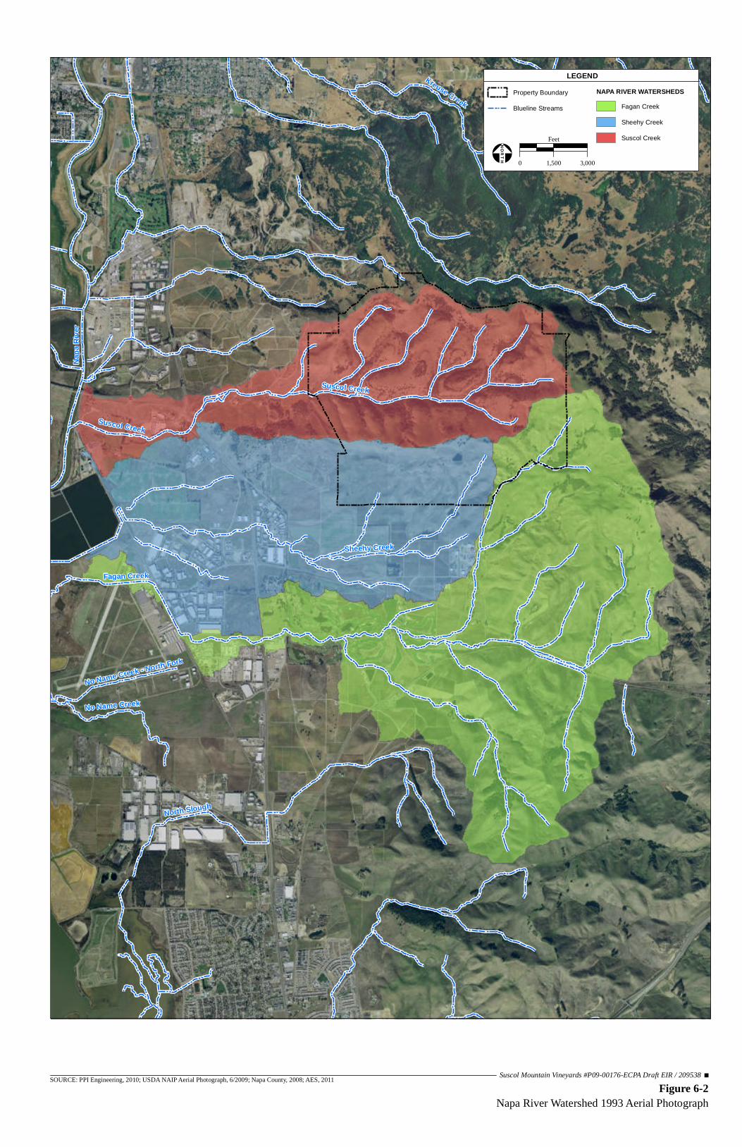
Napa
Rive
r
Fagan Creek
Sheehy Creek
North Slough
Kreuse Creek
Suscol Creek
No Name Creek
Spencer Creek
No Name Creek - North Fork
Suscol Creek
Figure 6-2Napa River Watershed 1993 Aerial Photograph
SOURCE: PPI Engineering, 2010; USDA NAIP Aerial Photograph, 6/2009; Napa County, 2008; AES, 2011 Suscol Mountain Vineyards #P09-00176-ECPA Draft EIR / 209538
Property Boundary
Blueline Streams
NAPA RIVER WATERSHEDSFagan Creek
Sheehy Creek
Suscol Creek
LEGEND
0 1,500 3,000
Feet
!¢Ð
NORTH

§̈¦80
UV221
UV12
UV29
UV12
UV12
UV29
Airport Rd
Airport Blvd
Elliott Dr
Rio Del Mar
American Canyon Rd
Donaldson Way
American Canyon Rd
Laird Justin
Vino Farms Inc
Vino Farms Inc
Vino Farms Inc
Kirkland Lonnie
Nerlove Kenneth
Goldenberg Jacob
Napa Wine Estates
Kirkland Cattle Co
Grgich Hills Cellar
Grgich Hills Cellar
Grgich Hills Cellar
Grgich Hills Cellar
Chalone Partnership
Chalone Partnership
Grgich Hills Cellar
Napa Wine Estates LLC
Napa Wine Estates LLC
Gunn Rodger Greenwood
Gunn Rodger Greenwood
Raymond Vineyard & Cellar
Napa Pipe
Syar Napa Quarry
Figure 6-3Current Cumulative Environment
SOURCE: PPI Engineering, 2010; USDA NAIP Aerial Photograph, 6/2009; Napa County, 2008; AES, 2011 Suscol Mountain Vineyards #P09-00176-ECPA Draft EIR / 209538
Property Boundary
ECP/Other Project Locations
WATERSHEDSFagan Creek
Sheehy Creek
Suscol Creek
LEGEND
0 1,500 3,000
Feet
!¢Ð
NORTH

§̈¦80
§̈¦80
UV221
UV12
UV29
UV121
UV12
UV29
UV29
UV12
UV29
UV121
Figure 6-4Agricultural Soils Within 3-Miles of the Project Site
SOURCE: PPI Engineering, 2010; LandVoyage Aerial Photograph, 6/15/2005; Napa County, 2008; AES, 2010 Suscol Mountain Vineyards #P09-00176-ECPA Draft EIR / 209538
Property Boundary
Napa County ParcelsWATERSHEDS
Fagan Creek
Sheehy CreekSuscol Creek
3-Mile Radius
Napa County Ag DesignationFarmland of statewide importance
Prime farmland if irrigatedFMMP Ag Designation
Prime Farmland
LEGEND
0 2,500 5,000
Feet
!¢Ð
NORTH

6.0 OTHER CEQA-REQUIRED SECTIONS
Analytical Environmental Services 6-8 Suscol Mountain Vineyards P09-00176-ECPA March 2012 Draft Environmental Impact Report
number of reasonably foreseeable vineyard projects that may be developed in the future, the number of approved and pending projects in the cumulative environment over the last 18 years (16 approved and one pending) and their relative sizes (in acres) were used to project an estimation of vineyard development for the next three to five years. Over the past 18 years, approximately 677 acres of vineyard development were submitted for ECP approval, creating an average of 37.6 acres of vineyard development per year.
TABLE 6-1 CUMULATIVE ECP PROJECTS LIST FOR THE SUSCOL CREEK,
SHEEHY CREEK AND FAGAN CREEK WATERSHEDS (1993 - 2011)1
ECPA # Applicant Name Vineyard Development Acres Status
Suscol Creek Watershed
97055 Vino Farms 164.6 Approved September 1997
03081 Suscol Springs South (Now Napa Wine Estates)
15.6 Approved September 2003
P07-00229 Ryan Vineyard 4.9 Approved November 2007
99485 Chalone Wine Group 46 Approved September 2003
Sheehy Creek Watershed
97055 Vino Farms 19.4 Approved September 1997
00210 Napa Wine Estates 2.6 Approved August 2001
94078 Kirkland Ranch 49 Approved November 1994
Fagan Creek Watershed
97107 Nerlove Vineyard 10.8 Approved April 1999
P08-00590 Hill Family Vineyards 33 Approved September 2010
00233 Goldenberg Vineyard 37 Approved April 2001
96623 Grgich Hills Cellar 106.6 Approved June 1997
96017 Raymond Vineyard 67.5 Approved August 1996
97582 Gunn Rodger Greenwood 83.4 Approved August 1998
P10-00224 Laird – Chardonnay Golf Course 22.8 Approved June 2011
P09-00435 Grgich Hills Cellar 13.5 Approved April 2011
P09-00176 Suscol Mountain Vineyards 561 Pending - Subject Application
Total Acres of Pending Development: 561
Total Acres of Approved Development: 676.7
Total Acres of Development1: 1,237.7
1 Totals do not include those areas within the watershed developed that are under five percent slope. Source: Napa County Conservation, Development and Planning Department, 2011
Combined with Napa County policies and other site selection factors that limit the amount of land that can be converted to vineyard, the development of approximately 112.8 to 188 acres over the next three to five years is a conservative estimate. Chapter 18.108 of the
6.0 OTHER CEQA-REQUIRED SECTIONS
Analytical Environmental Services 6-9 Suscol Mountain Vineyards P09-00176-ECPA March 2012 Draft Environmental Impact Report
Napa County Code includes policies that require setbacks of 35 to 150 feet from drainages (depending on slopes), which limits the amount of potential vineyard acreage that could be converted within the watersheds. It has also been the County’s experience with ECP projects that there are generally site-specific issues, such as wetlands, other water features, rare plant species, or cultural resources that further reduce areas that can be developed to other land uses. Additionally, the vineyard acreage projections for the next three to five years do not consider environmental factors that influence vineyard site selection, such as sun exposure, soil type, water availability, slopes greater than 30 percent, or economic factors such as land availability, cost of development or investment returns. In addition to approved and pending vineyard projects, two large-scale development projects are currently under consideration by Napa County in the cumulative environment. They include the Napa Pipe Project and the Syar Napa Quarry Project. The Napa Pipe project site is located at 1025 Kaiser Road, approximately 1.5 miles west of the Suscol Mountain Vineyards property (Figure 6-3). The Napa Pipe Project would be located approximately three miles south of downtown Napa on an existing 154-acre industrial site. The site is located approximately a quarter-mile west of Highway 221 and a quarter-mile north of Highway 29. In the northern portion of the Napa Pipe project site, a maximum of 2,580 housing units of varying dwelling unit sizes, heights, and building types are proposed, and approximately 40,000 square feet of retail and restaurant space would be developed. The southern portion of the Napa Pipe site would be developed with a mix of commercial and industrial uses, including: approximately 50,000 square feet of office space, approximately 140,000 square feet of research and development/warehousing space, and approximately 150 condominium suites with associated uses such as meeting space and spas. Additionally, the Napa Pipe Project would include approximately 50 acres of new public parks, and open space and wetland areas, including a new segment of the Napa River trail. Local groundwater would be relied upon as the primary water source for the Napa Pipe Project. The Syar Napa Quarry project site is located on the east side of State Highway 221 at the intersection with Basalt Road (Figure 6-3). The Syar Quarry is located approximately one mile southeast of downtown Napa and approximately 1.5 miles northwest of the Suscol Mountain Vineyards property. The Syar Napa Quarry is currently the largest mine in Napa County. Mining operations have taken place on the site for over a century. The Syar Napa Quarry Project proposes to continue operation of the existing 472-acre quarry for an additional 35 years, expand existing mining operations by approximately 291 acres, increase the depth of mining, increase production of aggregate and aggregate-related materials from approximately one million tons per year to up to two million tons per year, and amend the existing Reclamation Plan. Currently, approximately 154 people are employed at the Syar Napa Quarry. It is anticipated that an additional quarry work shift (consisting of

6.0 OTHER CEQA-REQUIRED SECTIONS
Analytical Environmental Services 6-10 Suscol Mountain Vineyards P09-00176-ECPA March 2012 Draft Environmental Impact Report
existing employees) or approximately ten to 20 new employees would be necessary to accommodate the proposed production increase. Water for the Syar Napa Quarry would continue to be supplied by two groundwater wells. Additionally, the Syar Napa Quarry would continue to utilize water from existing onsite ponds for dust suppression throughout the site.
6.1.4 CUMULATIVE EFFECTS
This section identifies the potential cumulative effects of installation of #P09-00176-ECPA concurrently with the other vineyard projects identified in Table 6-1, as well as the pending Syar Quarry and Napa Pipe projects.
6.1.4-1 AIR QUALITY
The geographic scope for the cumulative air quality impact analysis is the San Francisco Bay Area Air Basin (SFBAAB), because air quality impacts would affect the entire San Francisco Bay Area region. Cumulative air quality issues in the SFBAAB are addressed through regional air quality control plans developed by the Bay Area Air Quality Management District (BAAQMD). These plans account for projected growth in the Bay Area, as embodied in the adopted General Plans of the various cities and counties that comprise the Bay Area. There is, therefore, no need to identify each and every specific “probable future project” that might contribute emissions within the air basin. Project construction, including installation of #P09-00176-ECPA concurrent with other projects in the air basin would generate emissions of criteria pollutants, including suspended and inhalable particulate matter (PM10) and equipment exhaust emissions. For construction-related impacts, the BAAQMD has developed cumulative significance thresholds of 54 pounds per day for oxides of nitrogen (NOX), reactive organic gases (ROG), and PM2.5
and 82 pounds per day of PM10, and recommends basic construction mitigation for all projects (BAAQMD, 2010), as discussed in Chapter 4.1 Air Quality. Construction emissions from the development of the proposed project would not exceed the BAAQMD threshold (Impact 4.1-2 in Chapter 4.1). The BAAQMD CEQA Guidelines take into account past, present, and future emissions of criteria pollutants; therefore, since the project would not exceed BAAQMD thresholds the cumulative impacts due to construction would also be less than significant. The BAAQMD also provides cumulative operational significance thresholds for NOx, ROG, PM2.5 and PM10 (BAAQMD, 2010). The San Francisco Bay Area Air Basin (SFBAAB) non-attainment status for NOx, ROG, PM2.5 and PM10 is attributed to the region’s development history. Past, present, and future development contribute to the region’s adverse air quality impacts on a cumulative basis. By its very nature, air pollution is largely a cumulative impact; no single project is sufficient in size to, by itself, result in non-attainment of the ambient air quality standards. However, if a project contribution is considerable, then the project’s cumulative impact on regional air quality would be

6.0 OTHER CEQA-REQUIRED SECTIONS
Analytical Environmental Services 6-11 Suscol Mountain Vineyards P09-00176-ECPA March 2012 Draft Environmental Impact Report
considered significant. Cumulative thresholds are the same as project thresholds, which are provided in Chapter 4.1 Air Quality. As shown in Table 4.1-4 in Chapter 4.1, project-related NOx, ROG, PM2.5 and PM10 emissions would not exceed the BAAQMD cumulative operational significance thresholds; as stated in Section 4.1.2-3, the Bay Area is designated as a non-attainment area for O3, PM10, and PM2.5. The potential cumulative contribution to air quality impacts associated with operation of the proposed project would be further reduced through the implementation of Mitigation Measure 4.1-3 discussed in Chapter 4.1. Climate Change
The EIR prepared for the Napa County General Plan Update (February 2007) addressed cumulative global warming effects and concluded that cumulative impacts were significant and unavoidable for the County. The cumulative context included land use and traffic projections (regional and local), approved and known pending plans and projects (city and County plans/projects), vineyard expansion projections, recreation and open space projects, transportation and other infrastructure projects, flood control projects, as well as relevant regional planning and regulatory changes (e.g., TMDL and Basin Plan amendments) through the year 2030. In accordance with CEQA Guidelines, a project can be determined to have a less-than-significant impact by providing either project components or mitigation, which would reduce greenhouse gas (GHG) emissions below a specific threshold provided by a public agency or recommended by experts, provided the decision of the lead agency to adopt such thresholds is supported by substantial evidence. In June 2010, the BAAQMD Board of Directors adopted the BAAQMD CEQA Guidelines. The BAAQMD CEQA Guidelines were updated in June 2011. As explained in Section 4.1.2-4, the Alameda Superior Court ruled that BAAQMD failed to study the impacts of the BAAQMD CEQA Guidelines prior to the adoption of those guidelines. While the status of the BAAQMD CEQA Guidelines remains unclear for projects over which BAAQMD has jurisdiction, the thresholds of significance for GHG emissions in the BAAQMD CEQA Guidelines are supported by substantial evidence.1 Nevertheless, the BAAQMD CEQA Guidelines’ thresholds of significance for vehicle/equipment related emissions remain to be a tool for provide appropriate significance criteria for this project based on the substantial evidence underlying the development of those thresholds (CEQA Guidelines §15064.7(c)). The BAAQMD CEQA Guidelines provide an operational threshold of significance of 1,100 metric tons per year of carbon dioxide equivalent (CO2e) and a methodology for calculating project-level GHG emissions. CO2e is a method by which GHGs other than CO2 are converted to a CO2-like emission value based on a heat-capturing ratio or global warming potential (GWP). CO2 is used as the base and is given a value of one. Methane (CH4) has
1 See BAAQMD report titled California Environmental Quality Act Guidelines Update – Proposed Thresholds of Significance dated December 7, 2009 and available
online at: www.baaqmd.gov/~/media/Files/Planning%20and%20Research/CEQA/Proposed%20Thresholds%20of%20Significance%20Dec%207%2009.ashx.

6.0 OTHER CEQA-REQUIRED SECTIONS
Analytical Environmental Services 6-12 Suscol Mountain Vineyards P09-00176-ECPA March 2012 Draft Environmental Impact Report
the ability to capture 21 times more heat than CO2; therefore, CH4 is given a CO2e value of 21. GHG emissions are multiplied by the CO2e value to achieve one GHG emission value. By providing a common measurement, CO2e provides a means for presenting the relative overall effectiveness of emission reduction measures for various GHGs in reducing project contributions to global climate change. Although the BAAQMD CEQA Guidelines provide clear guidance on how to analyze GHG emissions from biogenic sources (wood, paper, vegetable oils, animal fat, yard waste, and etc.) as described in Chapter 4.1 Air Quality, the BAAQMD CEQA Guidelines state that the biogenic emissions should not be included as part of the quantification of GHG emissions for projects and do not provide a GHG emission threshold for these sources for both operation and construction activities. However, the BAAQMD CEQA Guidelines do recommend that construction-related GHG emissions be quantified using the URBEMIS air quality program and disclosed in the appropriate environmental document. The BAAQMD CEQA Guidelines require that only exhaust from construction equipment be included in the climate change analysis, similar to the analysis for criteria pollutants. Though not required by the BAAQMD CEQA Guidelines, analysis of biogenic sources has been included in the climate change analysis for the construction of the proposed project. Since the certification of the Final General Plan EIR and adoption of the General Plan, the County has undertaken numerous efforts aimed at reducing GHG emissions. The County participated in a multi-jurisdictional effort lead by the Napa County Transportation and Planning Agency (NCTPA) to quantify community-wide emissions for all jurisdictions within the County and to develop a non-binding emission reduction framework (2009) that each jurisdiction can use to guide their decision making and planning. The County has also prepared and adopted an emission reduction plan aimed at reducing emissions from County operations. Napa County has prepared a draft Climate Action Plan (CAP), which is undergoing public review and may soon be adopted by the Napa County Board of Supervisors (discussed further in Section 4.1.2-3). The draft CAP provides that discretionary development projects must reduce or offset emissions by 39 percent. The draft CAP would require new vineyard projects needing an erosion control plan to: a) calculate the GHG emissions associated with their project; b) implement best management practices such as mulching rather than burning debris, using cover crops, etc.; and c) implement one or more other measures to reduce or offset emissions by 39 percent. Measures that could be selected for implementation by project applicants include on- or off-site habitat restoration, on- or off-site reforestation, on- or off-site avoided deforestation, or participation in a program demonstrated to offset project emissions.

6.0 OTHER CEQA-REQUIRED SECTIONS
Analytical Environmental Services 6-13 Suscol Mountain Vineyards P09-00176-ECPA March 2012 Draft Environmental Impact Report
Impact 6-1: Construction of the proposed project would emit GHGs and would have the potential to exacerbate global climate change. Project sources of GHG emissions during construction would include the transport and delivery of construction equipment to the project site; operation of construction equipment, including equipment used for planting and irrigation system installation; worker trips, fuel use, and material transport, loss of sequestration due to removal of oak woodlands, tree removal, tillage of soil, etc. Methodology GHG emissions from construction equipment were estimated using the URBEMIS 9.2.4 air quality model, which is a widely accepted model and is recommended by the BAAQMD CEQA Guidelines. Construction equipment assumptions were developed using default URBEMIS values combined with information presented in Table 3-4. Carbon in biogenic sources is derived from an analysis that incorporated guidance provided in the Forest Project Protocols (Version 2.1) (Forest Protocol) of the Climate Action Reserve (CAR, 2007). The estimated carbon from biogenic sources (1,813.67 MT as discussed in the Findings section below) was multiplied by 3.67 to establish the CO2-e value, 3.67 is the relative proportion of carbon in CO2. The proposed project was analyzed for potential sources of GHG emissions associated with the clearing of forest vegetation and the effects of carbon sequestration associated with oak tree planting. The temporal scale for evaluating the GHG emissions in the analysis was 100 years. Carbon is sequestered by biogenic sources, such as trees during their life cycle. When trees, brush, or grasslands are cleared and soil is tilled for agricultural use there is a loss of carbon sequestration; therefore, increasing the amount of carbon in the atmosphere. When trees are planted there is a potential for future sequestration; however, substantial carbon sequestration does not occur in the first five years after planting. The climate change analysis considered the following sources of emissions and carbon sequestration associated with the project:
• GHG emissions associated with the clearing and conversion of forest land to vineyard in the following carbon pools: o Trees (live and dead) o Down dead wood o Forest understory o Forest floor o Soil carbon
• Conservation of carbon sequestration from the avoidance of woodland conversion and deforestation.

6.0 OTHER CEQA-REQUIRED SECTIONS
Analytical Environmental Services 6-14 Suscol Mountain Vineyards P09-00176-ECPA March 2012 Draft Environmental Impact Report
The sequestration of carbon due to the preservation and management of oak woodlands (avoided conversion) was estimated using a 100 year carbon sequestration time frame for over 40 acres of avoided oak woodland (discussed in Mitigation Measure 4.2-4). Vineyard sequestration of carbon was estimated based on 0.15 tons of carbon /hectare/year and a 100-year sequestration period (Kroodsma, 2006). The project site is currently used for cattle grazing. Cattle are the second largest producer of methane gas (CH4) in the United States. Methane is a GHG with a CO2e of 21. In 2008, methane emissions from California cattle (14,488,000 MT/CO2e) constituted the bulk of total GHG emissions from California cattle (15,536,000 MT/CO2e). Conversion of the project’s grazing land to vineyard, and the resulting removal of cattle from vineyard areas, may reduce the project site’s GHG emissions associated with cattle grazing. The BAAQMD CEQA Guidelines recommend that existing sources of GHG emissions be subtracted from emissions estimated for a new land use. Though a reduction in GHG emissions could occur, the project conservatively is assumed to continue the existing GHG emissions from cattle grazing. Findings Table 6-2 shows the estimated project construction emissions of GHG from construction activities, including mobile and indirect sources, as well as the GHG emissions from biogenic sources. Construction GHG emissions would be reduced with the implementation of the BAAQMD construction emission reduction measures outlined in Mitigation Measure 4.1-2 in Chapter 4.1 Air Quality; however, these reductions are difficult to accurately quantify due to limited scientific research available related to the measures. Therefore, reductions from Mitigation Measure 4.1-2 are not included in this analysis, which results in a more conservative analysis of construction GHG emissions. As shown in Table 6-2, GHG emissions from construction activities, which includes carbon emitted due to tillage, and 1,813.67 MT multiplied by 3.97 (the relative proportion of carbon in CO2) resulting in 6,656 MT of carbon stock from trees removed, for a total 11,013 MT of CO2e construction related emissions. The mitigated project would include the preservation and management of a minimum of 42 acres of oak woodland (refer to Chapter 4.2 Biological Resources, Mitigation Measure 4.2-4). The tree mitigation would consist of avoiding a minimum of 40 acres of oak woodland to provide better health and regeneration for the preserved oak woodlands. This, coupled with planting agricultural grapevines which sequester atmospheric carbon, would reduce global atmospheric GHG. Sequestration of the preserved and maintained oak woodland is conservatively estimated at 6,656 MT of CO2e and the vineyard would sequester 2,370 MT of CO2e for a total of 9,026 MT of CO2e sequestered. Project-related GHG emissions from construction after reduction measures are implemented would result in 1,987 MT of CO2e. However, project construction would occur in three phases, and no two phases would occur in the same year (see Chapter 3.0).

6.0 OTHER CEQA-REQUIRED SECTIONS
Analytical Environmental Services 6-15 Suscol Mountain Vineyards P09-00176-ECPA March 2012 Draft Environmental Impact Report
TABLE 6-2 GREENHOUSE GAS CONSTRUCTION EMISSIONS
Proposed Project
GHGs Emissions Conversion
Factor
GHG Emissions
ST ST/MT MT of CO2e
Construction GHG Emissions
Construction Activities1 CO2 4,788 0.91 4,357
Tree Removal2 CO2 6,656
Total Construction Emissions 11,013
GHG Emission Reduction Measures
Preservation of Oak Woodland Areas (Mitigation Measure 4.2-4)3 6,6563
Vineyard Sequestration4 2,370
Total Construction GHG Emissions 1,987 ST = short tons; MT = metric tons; CO2e = carbon dioxide equivalent 1 Estimated using BAAQMD recommended URBEMIS air quality model and includes land clearing, irrigation system
installation, planting, etc. 2 Assumes 100 percent of removed trees’ carbon is immediately released in to the atmosphere. 3 Conservatively based on over 40 acres of avoided oak woodland (refer to Chapter 4.2 Biological Resources,
Mitigation Measure 4.2-4). 4 Based on 0.15 tons of carbon /hectare/year and 100 years sequestration period (Kroodsma, 2006). Source: URBEMIS, 2007; BAAQMD, 2010
Napa County anticipates that its CAP will demonstrate that the GHG emission reduction target established by California Assembly Bill 32 (AB 32) can be met if vineyard projects reduce or offset one-time emissions associated with vineyard development by approximately 39 percent (Napa County, 2011). The draft plan is currently under public review. At this time, the State of California, BAAQMD and Napa County have not adopted significance thresholds for project level construction GHG emissions. As demonstrated in Table 6-2, the project as proposed would offset GHG construction emissions by approximately 86 percent through avoidance of oak woodland and management of Oak Woodland Avoidance and Management Areas (Mitigation Measure 4.2-4) and sequestration from the proposed vineyard. The project is consistent with Napa County's draft CAP. Additionally, implementation of Mitigation Measure 4.1-2 can be expected to further reduce GHG emissions by reducing the amount of construction vehicle idling and by requiring the use of properly maintained equipment. The removal cattle from grazing land on a portion of the property can be expected to further lower project-related GHG emissions during and after construction of the project if the number of cattle onsite are reduced.

6.0 OTHER CEQA-REQUIRED SECTIONS
Analytical Environmental Services 6-16 Suscol Mountain Vineyards P09-00176-ECPA March 2012 Draft Environmental Impact Report
Mitigation Measure 6-1: No mitigation is required. Impact 6-2: Operation of the proposed project would emit GHGs and would have the potential to exacerbate global climate change. Project operational sources of GHG emissions would include vehicles (produce and material transports and workers) traveling to and from the project site and water transport. Methodology Operational GHG emissions from mobile and area sources were estimated using URBEMIS 9.4.2 air quality model as recommended by the BAAQMD CEQA Guidelines. Indirect GHG emissions from water conveyance were estimated using the BAAQMD CEQA Guidelines and average annual loss of carbon sequestration from vegetation removal was estimated using the Forest Protocol (CAR, 2007). The loss of future carbon sequestration by existing forest vegetation in the vineyard development areas was considered in the analysis. GHG emissions from operation were converted to CO2e and compared to appropriate climate change thresholds. In the absence of a County-approved CAP and in accordance with BAAQMD CEQA Guidelines (refer to Chapter 4.1 Air Quality), the operational threshold for GHG emissions is 1,100 metric tons per year. Findings Under the CEQA Guidelines, a project’s operational emissions must be quantified. Table 6-3 shows the estimated project emissions of GHG from mobile, area, and indirect sources.
TABLE 6-3 GREENHOUSE GAS OPERATIONAL EMISSIONS
Proposed Project
GHGs Emissions Conversion
Factor
GHG Emissions
ST ST/MT MT of CO2e
Operational GHG Emissions
Area CO2 0.25 0.91 0.23
Mobile CO2 377.71 0.91 343.72
Mobile CH4/N2O 3.23 0.91 2.94
Water Conveyance2 CO2e 25.69 Water Conveyance2 CH4/N2O 0.23
Total Operation-Related GHG Emissions 372.81
Average Annual Loss of Carbon Sequestration from Vegetation Removal1 66.56
Total Annual Operational GHG Emissions 439.37 BAAQMD Operational GHG Emissions Threshold 1,100 Significant No
ST = short tons; MT = metric tons; CO2e = carbon dioxide equivalent 1 Forest Protocols, 2007. 2 Based on 263 acre-feet of water use per year (refer to Chapter 4.6 Hydrology and Water Quality). Source: URBEMIS, 2007; BAAQMD, 2010

6.0 OTHER CEQA-REQUIRED SECTIONS
Analytical Environmental Services 6-17 Suscol Mountain Vineyards P09-00176-ECPA March 2012 Draft Environmental Impact Report
The project includes components which would reduce GHG emissions and retain a number of carbon sequestering sources. These reductions in GHG emissions and atmospheric carbon are consistent with AB 32 reduction strategies and the CEQA Guidelines. The following measures would be included as part of the project and would reduce GHG emissions and/or increase atmospheric carbon sequestering:
• Establishing a no-till cover crop • Composting vegetation from vineyard pruning onsite • Minimizing vegetation burning
Agricultural lands depend on water for irrigation, and this water must be provided either from wells, lakes or streams. The movement of water can be energy intensive. In California the movement of water uses 14 percent of the State’s total energy usage. The use of gas or diesel powered pumps to extract water from the ground or move water from lakes or streams increase GHG emissions. It is estimated that the proposed project would install two to three new wells (the future number of wells is dependent upon the final flow from each well, but the total volume of water per annum for irrigation would not change) and would operate one existing well, all of which would use energy to operate. The wells would be onsite and would be located in close proximity to the propose vineyard blocks; therefore, reducing the need to transport water far distances. This would reduce the energy needed to transport water; thus, reducing GHG emissions. Furthermore, several aspects of the project’s proposed design are benefits that would reduce global climate change impacts. The project would minimize the burning of trees and wood removed for vineyard development, construction equipment would be kept onsite during construction (which would minimize truck trips), engine idling would be minimized and equipment would be properly maintained, a cover crop would be established on all disturbed areas, and risk of significant fires on the property would be reduced by maintaining roads for fire access around the property. The above project components, which would reduce GHG emissions, are not readily quantifiable due to the lack of verifiable scientific data, therefore, a conservative approach was taken and GHG emissions reductions from the above project components were not included in the analysis. As shown in Table 6-3, operational GHG emissions would be less than the BAAQMD CEQA threshold of 1,100 MT of CO2e for project-level operation. Additionally, avoided deforestation in the form of oak woodland avoided (as shown in Table 6-2) offsets emissions by 86 percent, which greatly exceeds the draft CAP’s 39 percent reduction

6.0 OTHER CEQA-REQUIRED SECTIONS
Analytical Environmental Services 6-18 Suscol Mountain Vineyards P09-00176-ECPA March 2012 Draft Environmental Impact Report
requirement. Therefore, operation of the proposed project would result in a less-than-significant impact to climate change. Mitigation Measure 6-2: No mitigation is required.
6.1.4-2 BIOLOGICAL RESOURCES
The geographic scope for the cumulative biological resources impact analysis is the area within a three-mile radius of the project site, as shown in Figure 6-4. Impacts to Biological Resources During Construction
As discussed in Chapter 4.2 Biological Resources, several habitat types would be impacted by construction of the proposed project. Chapter 4.2 includes mitigation measures to reduce potential impacts to special status species and habitats during construction to less-than-significant levels. The County would similarly require future projects with potentially significant impacts to wildlife and plant species to comply with federal, state and local regulations and ordinances protecting biological resources through implementation of mitigation measures during construction to reduce impacts to less than significant levels.
Impacts to Biological Resources Due to Vineyard Conversion
Although vineyards only provide limited habitat value for wildlife, local regulations ensure that installation of vineyards does not necessarily represent a total loss of habitat for wildlife. Napa County Conservation Regulations (Napa County Code, Chapter 18.108) require projects to maintain portions of parcels proposed for development as open space, providing habitat for plants, and foraging and nesting opportunities for wildlife. As noted earlier, Napa County Conservation Regulations generally preclude development on slopes greater than 30 percent and require setbacks of 35 to 150 feet from all County-definitional streams (depending on slopes). Habitats on the project site where special status species may occur include California Annual Grasslands Alliance, California Sagebrush Scrub, Chamise Chaparral, Coast Live Oak Woodland, Purple Needlegrass Grassland, Seeps and Springs, Water, White Alder Forest, and Willow Woodland. Purple Needlegrass Grassland is considered sensitive by the California Department of Fish and Game (CDFG) and Napa County. Although the project proposes to remove portions of these habitats, they are still relatively common in the cumulative environment, with the exception of Purple Needlegrass Grassland, for which few data are available (Table 6-4). Specific mitigation and avoidance measures specified in Section 4.2 Biological Resources reduce the cumulative impacts to special status species

6.0 OTHER CEQA-REQUIRED SECTIONS
Analytical Environmental Services 6-19 Suscol Mountain Vineyards P09-00176-ECPA March 2012 Draft Environmental Impact Report
potential habitats to less-than-significant levels. Table 6-4 shows habitats on the project site where special status species may occur in the context of the cumulative environment.
TABLE 6-4 PROPOSED PROJECT HABITAT CONVERSION WITHIN THE CUMULATIVE ENVIRONMENT
Vegetation Alliances 3-Mile Radius Project Site Proposed Blocks
Acreage % in Napa County Acreage % in 3-Mile
Radius Acreage % in 3-Mile Radius
California Annual Grassland 7,061 18.0% 1,558.42 22.1% 530.26 7.5%
California Sagebrush Scrub NA NA 1.72 NA 0 0
Chamise Chaparral 486 1.6% 15.82 3.3% 0.26 0Coast Live Oak Woodland 1,343 10.2% 522.58 38.9% 29.77 2.2%
Seep NA NA 2.12 NA 0.07 NAWater 769 2.7% 2.59 0.3% 0 0White Alder Forest 31 3.2% 4.78 15.4% 0 0Willow Woodland 71 13.1% 0.97 1.4% 0 0
Source: AES, 2010; LSA, 2010; Thorne et al., 2004 The mitigated project would remove an estimated 458 acres of Wild Oats Grassland, as opposed to 530 acres as originally proposed (Table 4.2-4). All grassland areas that qualify as native grassland are considered sensitive habitats; these include Purple Needle Grass and Creeping Rye Grass Grasslands, and they would be protected in perpetuity (see Mitigation Measure 4.2-1) for a total of 100 percent preserved. In addition, a Range Management Plan (RMP) would be developed and implemented according to guidelines listed in Mitigation Measure 4.2-1 to minimize indirect impacts of development on avoided grassland areas. The project proposes the removal of an estimated 29.8 acres of Coast Live Oak Woodland (containing approximately 1,182 oak trees). However, with the mitigated project this acreage would be reduced to approximately 20 acres. Impacts would be reduced to a less-than-significant level by reconfiguring proposed Blocks 1, 7, 9, 19, 21, 24, 26, 27, 29, 30, 31, and 32, and enhancing approximately 12 acres of oak woodland in Oak Woodland Avoidance and Management Areas. Preservation of stream corridors that function, in part, as wildlife movement routes connected to larger habitat areas provide overall connectivity within the landscape and add to the value of these areas as wildlife corridors. As part of the project, deer fencing would surround the vineyard blocks or clusters of vineyard blocks. There would be impacts to animal movement as a consequence of the installation of the deer fencing; however, maintenance of minimum 100-foot corridors between the fenced areas as discussed in Mitigation Measure 4.2-8 would allow for wildlife movement between contiguous habitats

6.0 OTHER CEQA-REQUIRED SECTIONS
Analytical Environmental Services 6-20 Suscol Mountain Vineyards P09-00176-ECPA March 2012 Draft Environmental Impact Report
both on and offsite, including to existing regional corridors. Stream corridors have been preserved throughout the project site and stream setbacks from Napa County definitional streams are a minimum of 55 feet on either side of drainages. As shown on Figure 4.2-6, stream corridors have been preserved throughout the project site. Minimum 50-foot setbacks would be maintained around all wetlands as well. These areas would be preserved in perpetuity. In addition, Mitigation Measure 4.2-12 includes the protection of minimum 100-foot buffers from identified water habitats surrounded by open grassland and agricultural areas onsite to protect prime Western pond turtle nesting habitat and 275 foot buffers along water features that are surrounded by oak woodland to provide ample protection of Western pond turtle overwintering habitats. Open space areas, particularly adjacent to Skyline Wilderness Park to the northeast, would be preserved with the proposed project, thereby benefiting the wildlife that use the Suscol Creek corridor and other corridors along the smaller streams (Fagan and Sheehy Creeks) in this area. Undeveloped areas provide habitat for wildlife, and the large uninterrupted corridor along Suscol Creek minimizes fragmentation of wildlife habitat. Due to the presence and maintenance of these wildlife corridors, the cumulative impact on habitat fragmentation as a result of the proposed project is expected to be less than significant. USFWS designated Critical Habitat for the California red legged frog (CRLF) overlaps with proposed vineyard Blocks 30B, 30C, 31B, 32, 33, 34, 41, and 46 (Figure 4.2-5). The conversion of these areas to vineyard and subsequent vineyard operations could result in significant impacts to this special status resource. As discussed in Impact and Mitigation Measures 4.2-6 and 4.2-7, vineyard development near streams and wetlands (including seeps and spring) would be required to adhere to minimum 50-foot setbacks (see Figure 4.2-2). In addition, proposed Block 34A, a portion of Block 34B, and Blocks 34C and 34D would be removed from the project through the application of Mitigation Measure 4.2-11, thereby reducing the total project area within the Critical Habitat for CRLF. Use of BMPs as proposed by the project, such as cover crop management and integrated pest management (IPM), in addition to the proposed setbacks, would filter agricultural chemicals, sediments, and nutrients to reduce impacts to amphibians to a less-than-significant level (discussed in Impact 4.2-6). Steelhead/rainbow trout are known to occur throughout Suscol Creek, and Suscol Creek is part of U.S. Fish and Wildlife Service designated Critical Habitat for this species. The proposed project would not modify the physical conditions of any streams on the project site and there would not be direct diversions of surface water associated with the proposed project. The proposed project includes the maintenance of stream setbacks, the restriction of earthmoving activities to the dry season consistent with County Code Section 18.108.070(L), and the installation of straw wattles, seeding and mulching of disturbed

6.0 OTHER CEQA-REQUIRED SECTIONS
Analytical Environmental Services 6-21 Suscol Mountain Vineyards P09-00176-ECPA March 2012 Draft Environmental Impact Report
areas, and other erosion control measures and best management practices (BMPs) discussed in Chapter 3.0 Project Description which would reduce the potential for sediment and topsoil to migrate into Suscol Creek. The proposed project would not increase runoff rates or volumes, or degrade water quality (discussed in Chapter 4.6 Hydrology and Water Quality) and would not increase soil erosion or sedimentation (discussed in Chapter 4.4 Geology and Soils). Development of the proposed project would not have a significant impact on California Central Coast ESU Steelhead and its associated critical habitat within Suscol Creek, or other special status aquatic species within Suscol Creek and other onsite creeks, as discussed in Impact and Mitigation Measure 4.2-17. Mitigation Measure 4.6-4 includes a groundwater monitoring plan with a detailed surface water monitoring component that would suitably monitor and record any apparent changes to stage and/or discharge during times of heavy groundwater pumping demand. If significant changes to stage and/or discharge are attributed to groundwater extraction, this measure includes alternative water use approaches to ensure that impacts to steelhead in Suscol Creek are less than significant. The loss of grassland foraging habitat for some bird species is a potential cumulative impact. The project proposes to remove approximately 530 out approximately 1,558 acres of all types of grassland (34.0 percent) on the project site. With proposed mitigation, the total grassland acreage removed would be approximately 458 acres (29.4 percent). Approximately 1, 100 acres of grassland out of the 1,558 present on the project site would be avoided (see Impact and Mitigation Measures 4.2-2, 4.2-11, 4.2-12, 4.2-14, 4.2-16), and the remaining grassland would be enhanced under the RMP (see Mitigation Measure 4.2-1). A majority of the approximately 72 acres of grassland habitat avoided after mitigation is in the eastern half of the project site, where nesting grasshopper sparrows and loggerhead shrikes were recorded. This modification provides greater than 500 acres of unfragmented and contiguous grassland habitat in the eastern and southern portions of the project site. Additional unfragmented grassland habitat located adjacent to grassland onsite would create an even larger expanse of contiguous grassland habitat for foraging birds that likely exceeds 1,000 acres. Information on the foraging ranges of birds that feed in grasslands is limited in applicability by differences in survey methods, study regions, and species behaviors. Nonetheless, Table 6-5 summarizes literature on foraging ranges to determine which species might be affected by grassland conversion to vineyard, and to address whether the remaining unfragmented grasslands on the project site may provide sufficiently large foraging habitat for those species requiring large areas of unfragmented grassland. Several species, (long-eared owl, burrowing owl, purple martin, tri-colored blackbird, sharp-shinned hawk, and ferruginous hawk) were not observed during field surveys of the site and surrounding areas, but are included in the table because they have the potential to occur. Bird activity on a

6.0 OTHER CEQA-REQUIRED SECTIONS
Analytical Environmental Services 6-22 Suscol Mountain Vineyards P09-00176-ECPA March 2012 Draft Environmental Impact Report
given site can fluctuate significantly across years. Of all grassland foraging birds with potential to occur on the project site, white tailed kite, sharp-shinned hawk, and Cooper’s hawk would likely be unaffected by landscape changes to foraging habitat because they can forage in wooded habitat, including vineyards. Of the birds that require large expanses of grassland habitat for foraging, the roughly 500 acres of unfragmented grassland that will remain in the eastern and southern portion of the project site appears to exceed maximum observed foraging ranges for most species. Tri-colored blackbirds are known to fly long distances to forage, but are unlikely to establish a colony onsite because the pond is small and not very thickly vegetated on the edges. Golden eagles will forage across a much larger area than the entire project site, and may be nesting not far from the project site as potential nest sites are not ideal on the project site for this species (LSA, 2010). Sufficient minimum foraging habitat for ferruginous hawk would also be present in the unfragmented grasslands that will remain on the project site, but during periods of low prey abundance, this species would clearly need to forage over a much larger range than the entire project site. It is clear from a review of scientific literature that management practices on the 1,100 acres of grassland avoided can have a significant impact on forage quality for grassland birds. The timing and extent of mowing and grazing would be optimized to encourage native plant and animal diversity on the project site through the Resource Management Plan (Mitigation Measure 4.2-1). In addition, the use of insecticides and rodenticides would be restricted through the use of BMPs and IPMs (discussed in Impact and Mitigation Measure 4.2-6). Improving overall range quality, and maintaining an unfragmented area of over 500 acres of grassland would mitigate the landscape level effects of removing approximately 6.5 percent of the grassland in the cumulative region. The use of Upland Annual Grasslands and Forbs Grasslands (of which there are approximately 2,300 acres in the cumulative region) by birds who forage exclusively in grasslands would further attenuate cumulative impacts.

6.0 OTHER CEQA-REQUIRED SECTIONS
Analytical Environmental Services 6-23 Suscol Mountain Vineyards P09-00176-ECPA March 2012 Draft Environmental Impact Report
TABLE 6-5 SPECIAL STATUS BIRDS, INCLUDING ALL BIRDS OF PREY, WITH POTENTIAL TO FORAGE
IN OPEN GRASSLAND HABITAT ON THE PROJECT SITE
Special Status Birds
Home Range/Territory Prey
Foraging Habitat on
Site Nesting
Habitat on Site Potential Cumulative
Impacts
White-tailed Kite This species was observed flying over site; could potentially nest on the site in the trees along the drainages or in adjacent areas.
Variable with competition or fluctuating prey accessibility. Reported average territory sizes range from 3.9 to 296.5 acres (1.6 to 120 hectares) (Dunk and Cooper, 1994; Waian, 1973; Henry, 1983).
Small mammals (primarily voles), birds, amphibians, and large insects.
Open grasslands, woodlands.
Closed canopy woodlands.
Not significant; this species can forage in vineyards.
Northern Harrier An adult male was observed on the site on May 7 and a female was seen on July 8, 2009, which could indicate local breeding; however, the male individual could also have been a migrant. This species could nest in the open grassland on the site or in adjacent areas. Much of the grassland on the site is relatively sparse or occurs on steep slopes, reducing its suitability as breeding habitat for this hawk.
Varies wildly according to habitat and prey availability, with a range of 420 to 37,066 acres (170 to 15,000 hectares), and a median of 593 acres (240 hectares), reported from eight studies outside of California (Idaho, eastern Washington, Utah, Missouri and New Hampshire) (MacWhirter and Bildstein, 1996).
Small rodents, birds, reptiles, amphibians, and large insects.
Open grasslands.
On the ground in tall herbaceous vegetation.
Conversion of native grassland prairies for monotypic farming has contributed to declines of local populations. In upland areas, mechanized agriculture and early mowing have increased the threat of nest destruction. Overgrazing of pastures and the advent of larger crop fields, fewer fencerows, and widespread use of insecticides and rodenticides have reduced prey availability and thus the amount of appropriate foraging habitat.
Swainson's Hawk Several individuals, including adult and juvenile birds were observed in the southern portion of the site (south of Suscol Ridge) during the 2009 surveys.
Highly variable, from 170.5 to 21,542.6 acres (69 to 8,718 ha); variation in home range size within study areas was often attributable to habitat quality and nest site distribution. In general, nest sites in riparian forest habitat in close proximity to alfalfa
Small mammals, birds, reptiles, and large insects.
Open, dry grasslands.
Nest trees are typically located on the edges between woodland and either grass or shrubland habitats or in isolated trees or clumps of trees in open terrain (Estep, 1989).
Conversion from suitable grassland to vineyards and orchards reduces foraging habitat (Estep, 1989).

6.0 OTHER CEQA-REQUIRED SECTIONS
Analytical Environmental Services 6-24 Suscol Mountain Vineyards P09-00176-ECPA March 2012 Draft Environmental Impact Report
Special Status Birds
Home Range/Territory Prey
Foraging Habitat on
Site Nesting
Habitat on Site Potential Cumulative
Impacts
or recently-harvested row crops corresponded to smaller home ranges (denser prey) (Estep, 1989).
Long-eared Owl This species was not observed on the project site.
Variable, from 83 to 262 acres (34 to 106 hectares) (Craighead and Craighead, 1956); birds do not appear to defend foraging territories beyond immediate nesting area; may be loosely colonial.
Small mammals.
Open grasslands.
Closed canopy woodlands with abandoned corvid and raptor nests.
Conversion from suitable grassland to vineyards reduces foraging habitat.
Burrowing Owl This species was not observed on the project site. It could occur as a transient, but animal burrows are rare on the project site, indicating a lack of prey base and nesting habitat. The apparent absence of ground squirrels may indicate past rodent control management practices.
Highly variable (ranging from less than one acres to over 100 acres per breeding pair) (Thomsen, 1971; Gervais et al. (unpublished 2000 report); estimates are reported based on indirect measures (not radio telemetry); these birds are colonial and difficult to track.
Small mammals and large insects.
Open grasslands.
Underground burrows in deep soil grasslands.
Rodent control, particularly along levees and roadsides can decimate ground squirrel populations and ultimately reduce available nesting and cover habitat for burrowing owls. Artificially enhanced populations of native predators (e.g., gray foxes, coyotes) and introduced predators (e.g., red foxes, cats, dogs) can decimate burrowing owl populations as well. Veinyards are not conducive to foraging for this species.
Loggerhead Shrike The shrubby growth, woodland edge, and hedgerow of horsetail trees along the southwestern edge of the site provide potential breeding habitat for shrikes and the adjacent open grassland provides foraging habitat. Four or five individuals of this predatory songbird were seen on or
Estimated in one study in California as 10.9 acres (4.4 hectares) to 39.5 acres (16 hectares) (Miller, 1931, cited in Yosef, 1996).
Large insects, small birds, amphibians, reptiles, small rodents.
Open, dry grasslands.
Shrubs, woodland edges, and hedgerow of horsetail trees along the southwestern edge of the site.
Conversion from suitable grassland to vineyards reduces foraging habitat (Humple, 2008). Removal of trees and shrubs along field borders and roadsides reduces available nesting habitat. Spraying the common fertilizer, sodium ammonium nitrate, on cattle pastures can reduce foraging territories, reduce survivorship of eggs, nestlings, fledgings and adults (Yosef and Deyrup, 1998). Approximately 530

6.0 OTHER CEQA-REQUIRED SECTIONS
Analytical Environmental Services 6-25 Suscol Mountain Vineyards P09-00176-ECPA March 2012 Draft Environmental Impact Report
Special Status Birds
Home Range/Territory Prey
Foraging Habitat on
Site Nesting
Habitat on Site Potential Cumulative
Impacts
adjacent to the project site during 2009.
acres of potential foraging habitat will be developed; however, more than sufficient open grassland foraging habitat (over 1,000 acres) will be avoided, including large expanses of several hundred acres where this species was observed. Nesting habitat is largely unchanged.
Purple Martin This species was not observed on the project site; the lack of tall coniferous trees may limit the potential for nesting martins on the project site.
Data not available. These swallows can forage over many miles if necessary.
Large insects. Above open grasslands and water.
Cavities in large trees.
Competition for nest sites from European starlings and house sparrows (Garrett and Dunn, 1981; Unitt, 1984; Airola and Grantham, 2003; Airola and Williams, 2008). Martins are unlikely to colonize where starlings are numerous (i.e., lowlands, agricultural valleys, urban areas, etc.) (USFS, 2008; Airola and Williams, 2008). Localized starling and house sparrow control in the vicinity of active nest sites and erection of starling-resistant nest boxes is a potential habitat improvement action (Stephenson and Calcarone, 1999; Airola et al., 2008).
Grasshopper Sparrow Singing males of this species were observed on the property during the 2007 and 2009 field surveys in suitable nesting habitat.
Minimum area requirements are about 74.1 acres (30 hectares) in Illinois (Herkert 1994), and 19.8 to 29.7 acres (eight to 12 hectares) in Nebraska (Helzer and Jelinski, 1999).
Grasshoppers and other insects.
Open, dry grasslands with some patches of bare ground.
Same as foraging habitat, with scattered shrubs.
Grasshopper Sparrows avoid highly fragmented grasslands in California and elsewhere (Vickery, 1996). Breeding habitats may be degraded by poorly managed livestock grazing and by invasive non-native plants. Early season mowing of breeding sites may also destroy nests (Vickery, 1996).

6.0 OTHER CEQA-REQUIRED SECTIONS
Analytical Environmental Services 6-26 Suscol Mountain Vineyards P09-00176-ECPA March 2012 Draft Environmental Impact Report
Special Status Birds
Home Range/Territory Prey
Foraging Habitat on
Site Nesting
Habitat on Site Potential Cumulative
Impacts
Tricolored Blackbird The stands of cattails and bulrush in the pond provide suitable breeding habitat but may be too small; this species was not observed during the field surveys. Flocks may forage in the grazed grasslands during the winter.
Adults feeding young typically forage within 3.1 miles (five kilometers) of the colony, but can range up to eight miles (13 kilometers) from the colony (Beedy and Hamilton, 1999).
Insects, arachnids, grains, and other plant materials.
Open grasslands.
Cattails surrounding pond (too small to support a colony).
Water management by humans often has the effect of increasing predator access to active colonies. Conversion of pasture or grasslands to vineyard reduces foraging habitat.
Sharp-shinned Hawk This species was not observed during surveys of the project site, but may occur, primarily as a migrant and/or winter visitor.
May forage up to 0.75 miles (1,200 meters) from the nest territory to hunt (Platt, 1973).
Small birds. Near openings and brushy areas where prey is abundant and cover is sufficient for the perch and dash foraging style; avoids large grassland areas.
Closed canopy woodlands.
None. There will be no significant change in edge habitat on the project site.
Golden Eagle This species was observed on the property during the October 2, 2008 and March 10, 2009 field surveys.
N. California territories average 48 square miles (124 square kilometers) (Smith and Murphy, 1973). Territories are generally larger in open grassland habitats than in more complex, mountainous terrain (Roberson and Tenney, 1993).
Small mammals, birds, reptiles, carrion, and fish.
Open grasslands, shrublands.
Cliffs, large trees in open areas.
Conversion from suitable grassland to vineyards reduces foraging habitat.
Ferruginous Hawk This species was not observed on the project site during surveys.
Variable and not well researched; from less than 1 mile (1.6 kilometers) to as much as 4 miles (6.4 kilometers).
Small mammals, birds, and large insects.
Open grasslands.
Solitary trees or cliffs.
Conversion from suitable grassland to vineyards reduces foraging habitat; this species only forages in grasslands (Pandolfino et al., 2011, submitted manuscript).

6.0 OTHER CEQA-REQUIRED SECTIONS
Analytical Environmental Services 6-27 Suscol Mountain Vineyards P09-00176-ECPA March 2012 Draft Environmental Impact Report
Special Status Birds
Home Range/Territory Prey
Foraging Habitat on
Site Nesting
Habitat on Site Potential Cumulative
Impacts
Cooper's Hawk This species was observed on the project site March 10, 2009.
Variable and not well researched; ranged from 45 to 1,312 acres (18 to 531 hectares) in Michigan and Wyoming (Craighead and Craighead, 1956).
Small birds, mammals, reptiles and amphibians.
Open woodland and habitat edges as well as dense thickets.
Riparian woodland.
Not significant; this species can forage in vineyards.
Source: AES, 2011, and references summarized herein
6.1.4-3 CULTURAL RESOURCES
The geographic scope for the cultural resources cumulative impact analysis is the Suscol Creek, Sheehy and Fagan Creek watersheds and that occur within a three-mile radius of the project site, because the projects described above that are located within this radius of the project site have the potential to degrade existing cultural resources in the surrounding area. Installation of new vineyard blocks through the development of vineyard projects in the cumulative environment has the potential to impact prehistoric resources, historic resources or unknown archaeological resources. As stated in Chapter 4.3 Cultural Resources, potential impacts to known and unknown cultural resources would be reduced to less-than-significant levels through the implementation of the identified mitigation measures. As such, the proposed project’s potential contribution to cultural resource impacts associated with the installation of the new vineyard blocks would be rendered less than cumulatively significant.
6.1.4-4 GEOLOGY AND SOILS
Cumulative geologic and soils impacts are limited to sedimentation, since seismic impacts are locally specific. Sedimentation impacts from the proposed project would occur to onsite sediment trapping waters and offsite receiving waters of Suscol, Sheehy, and Fagan Creeks. Therefore, a three-mile radius that includes these watersheds defines the geographic scope of cumulative sedimentation impacts. Cumulative impacts to sedimentation could result from past, present, and reasonably foreseeable future ECP projects within these watersheds. Cumulative effects would be considered significant if cumulative sedimentation from past, present, and future projects in the watershed is considerable, or if the incremental impact of the proposed project within the cumulative environment were considerable. There are no properties upstream of the project site in any of the three major watersheds. The proposed project is expected to maintain or decrease the current level of sediment delivered to these watersheds. Like the proposed project, any future development would be required to comply with the Napa River TMDL for sediment, which prevents the increase of

6.0 OTHER CEQA-REQUIRED SECTIONS
Analytical Environmental Services 6-28 Suscol Mountain Vineyards P09-00176-ECPA March 2012 Draft Environmental Impact Report
sedimentation into the Napa River and its tributary watersheds. #P08-00590 EPCA for the Hill Family Vineyards proposes a small vineyard development (31.8 acres) downstream of the project site in the Fagan Creek watershed. The Negative Declaration for the proposed vineyard states that based on soil loss calculations for the project site, sediment loading is expected to decrease from 4.7 to 16.32 tons per acre to 1.35 to 3.81 tons per acre after development of the vineyard, with an average of 75 percent cover crop, outsloped terrace benches, and other erosion prevention measures. #P09-00435-EPCA for the Grgich Hills Cellar proposes a small vineyard development (13.5 acres) in the lower Fagan Creek watershed south of the project site just south of SR-12. An Initial Study/Mitigated Negative Declaration was prepared for the project, which states that the vineyard will be managed using biodynamic farming techniques, and would include significant erosion control measures to minimize the anticipated increase in sedimentation to the Fagan Creek watershed, even though without these measures the soil loss increase is within acceptable tolerances (4.0 tons per acre). Therefore, when taken with these other reasonably foreseeable projects, the proposed project would not have an incremental increase on the sediment loading to the Napa River that would be cumulatively considerable.
6.1.4-5 HAZARDOUS MATERIALS
The geographic scope for the hazardous materials cumulative impact analysis is the Suscol Creek, Sheehy and Fagan Creek watersheds and that occur within a three-mile radius of the project site, as any release of improperly contained hazardous materials into the environment could reach the surface and/or groundwater of these watersheds. The approval of #P09-00176-ECPA would increase the use of hazardous materials within the project site. However, the cumulative increase in use of hazardous materials and their impact on the environment would be negligible through compliance with federal, state, and local regulations and best management practices outlined in Chapter 4.5 . As discussed in the mitigation measures in Chapter 4.5, compliance with the Napa County Department of Environmental Management regulations for hazardous materials storage would reduce the risk of spillage and leaks, and would prepare employees and other emergency response personnel for an incident. Standard operating procedures would reduce the potential for release of hazardous materials into the environment and reduce the potential for hazardous materials to reach onsite streams if an incident occurred during grading, construction, operation and maintenance of the proposed project. Compliance with the Napa County Agricultural Commissioner’s regulations for pesticide use and proper vehicle and equipment rinse areas away from water sources decrease the risk of contamination to humans and the environment. Finally, the proper chemical storage and disposal reduces the potential for contamination of the environment.

6.0 OTHER CEQA-REQUIRED SECTIONS
Analytical Environmental Services 6-29 Suscol Mountain Vineyards P09-00176-ECPA March 2012 Draft Environmental Impact Report
6.1.4-6 HYDROLOGY AND WATER QUALITY
Impacts to Runoff
Impacts to runoff from the proposed project would have the potential to affect the volume and rate of runoff in onsite drainages and the offsite receiving waters of Suscol, Sheehy, and Fagan Creeks. Therefore, a three-mile radius that includes these watersheds define the geographic scope of cumulative runoff impacts. Cumulative impacts to runoff could occur from past, present, and reasonably foreseeable future projects within the watersheds. Cumulative effects would be considered significant if the cumulative rate and volume of runoff from past, present, and future projects in the watershed to receiving waters is considerable, or if the incremental impact of the rate and volume of the runoff from the proposed project to receiving waters within the cumulative environment is considerable. To estimate the rate and volume of runoff from the proposed project, a hydrologic analysis was completed to calculate peak runoff flows and the total volume of runoff for 2-, 5-, 10-, 25-, 50-, and 100-year storm events (Appendix E). Chapter 4.6 Hydrology and Water Quality discusses the potential impacts to the rate and volume of runoff discharged to receiving waters from the proposed project. It was estimated that no increase in peak flows or the volume of runoff would occur from the modeled storm event scenarios. In fact, as a result of the proposed project peak flows and the volume of runoff would decrease for each onsite drainage watershed and the drainage outlets for the project site. The reduction in the peak flows and the volume of runoff for drainages throughout the project site and receiving waters indicates that the proposed project would not have an incremental impact on flooding in the Suscol, Sheehy, and Fagan Creek watersheds. Impacts to peak flows and the volume of runoff from existing neighboring vineyard development completed before the hydrologic analysis are captured in the existing conditions estimates (Appendix E). Therefore, since there is no other reasonably forseeable development in the three watersheds beyond the proposed project itself, no effects on the cumulative environment would result from the implementation of the project. Impacts to Groundwater
The proposed project would be irrigated with groundwater. Groundwater demands for the project as proposed are estimated to be 263 acre-feet (af) per year. Napa County’s allowable allotment of groundwater for parcels located in mountain areas that are not designated as groundwater deficient areas is 0.5 af per acre per year. Accordingly, the project site is allowed by Napa County to utilize 791 af per year (1,582 acres x 0.5 af per year) of groundwater. A groundwater analysis was completed by Richard C. Slade & Associates LLC (2010) to determine impacts of the proposed project on local groundwater levels and groundwater supplies, and is provided as Appendix H. The analysis determined that utilizing existing and proposed onsite groundwater wells to meet irrigation demands would not be expected to result in substantial lowering of groundwater levels in offsite wells

6.0 OTHER CEQA-REQUIRED SECTIONS
Analytical Environmental Services 6-30 Suscol Mountain Vineyards P09-00176-ECPA March 2012 Draft Environmental Impact Report
or decreased availability of groundwater resources; however, due to the complex nature of well interactions within the Sonoma Volcanics, combined with the area’s regional climatic variations, it is infeasible to predict with absolute certainty the long term impacts associated with groundwater extraction on the project site (Impact 4.6-4). In addition, although no fluctuations in water levels were detected in Suscol Creek during the pump testing described in Chapter 4.6, the complex nature of the Sonoma Volcanics does not preclude the possibility that there could be long term impacts to stream flows due to groundwater pumping. These impacts are considered potentially significant and subject to the monitoring program described in Mitigation Measure 4.6-4. To evaluate groundwater demands from the cumulative environment, potential irrigation demands are evaluated for existing vineyards to the west of the project site, the Napa Pipe Project site, and the Syar Quarry (Figure 6-5). As mentioned previously, Napa County policies and site selection factors limit the amount of potential areas that can be converted to vineyard. The determination of wetlands, rare plant species, or cultural resources or the implementation of government enforceable controls like setbacks from water resources can greatly limit a project’s ability for growth. Therefore based on these limitations and conversations with the owners, Richard C. Slade and Associates LLC estimated the irrigation rate of the vineyard directly west of the property of approximately 593 acres of vines could be irrigated with 0.5 af per year for a total demand of 296.5 af/year. Richard C. Slade and Associates LLC obtained estimated groundwater demand for the Napa Pipe Project site of 620 af/year from the Draft Groundwater Report for that project. Demands for the Syar Quarry are considered as well. One of the wells on the Syar property is drilled into a different groundwater formation than the proposed project; however, the other is located near the Napa Pipe Project site and is considered part of the cumulative analysis. Slade and Associates LLC assumed in their estimates that the demand from the Syar Quarry would total 50 af/year. However, they noted that this number may change with the expansion of the Quarry. Therefore, even though only one Syar well contribute to the cumulative environment, the entire value was included as a conservative estimate. Total demand for the cumulative scenario (not including the proposed project) was estimated at 966.5 af/year. Groundwater available to the Suscol Mountain Vineyards watersheds is defined by the coverage of Sonoma Volcanics beneath these areas. Sonoma Volcanics represent the principal water bearing geologic formation in the region, and there is significant groundwater storage in these areas, as described in Chapter 4.6 Hydrology and Water Quality. To estimate recharge for the cumulative environmental defined within these areas, the same methodology was used as in Impact 4.6-4. A cumulative area of 3,360 acres was estimated based on the geology of the surrounding area, and contains only the project site and the vineyards to the west. Accordingly, the long term average annual groundwater recharge for

HWY 29-12
HWY 29-12
HWY 29-12
HWY 29-12
HWY 29-12
HWY 29-12
HWY 29-12
HWY 29-12
HWY 29-12
HWY 29-12
HWY 29-12
HWY 29-12
HWY 29-12
HWY 29-12
HWY 29-12
HWY 29-12
HWY 29-12
HWY 29-12
HWY 29-12
HWY 29-12
HWY 29-12
HWY 29-12
HWY 29-12
HWY 29-12
HWY 29-12
HWY 29-12
HWY 29-12
HWY 29-12
HWY 29-12
HWY 29-12
HWY 29-12
HWY 29-12
HWY 29-12
HWY 29-12
HWY 29-12
HWY 29-12
HWY 29-12
HWY 29-12
HWY 29-12
HWY 29-12
HWY 29-12
HWY 29-12
HWY 29-12
HWY 29-12
HWY 29-12
HWY 29-12
HWY 29-12
HWY 29-12
HWY 29-12
5N/4W-14J35N/4W-14J35N/4W-14J35N/4W-14J35N/4W-14J35N/4W-14J35N/4W-14J35N/4W-14J35N/4W-14J35N/4W-14J35N/4W-14J35N/4W-14J35N/4W-14J35N/4W-14J35N/4W-14J35N/4W-14J35N/4W-14J35N/4W-14J35N/4W-14J35N/4W-14J35N/4W-14J35N/4W-14J35N/4W-14J35N/4W-14J35N/4W-14J35N/4W-14J35N/4W-14J35N/4W-14J35N/4W-14J35N/4W-14J35N/4W-14J35N/4W-14J35N/4W-14J35N/4W-14J35N/4W-14J35N/4W-14J35N/4W-14J35N/4W-14J35N/4W-14J35N/4W-14J35N/4W-14J35N/4W-14J35N/4W-14J35N/4W-14J35N/4W-14J35N/4W-14J35N/4W-14J35N/4W-14J35N/4W-14J3
5N/4W-13H15N/4W-13H15N/4W-13H15N/4W-13H15N/4W-13H15N/4W-13H15N/4W-13H15N/4W-13H15N/4W-13H15N/4W-13H15N/4W-13H15N/4W-13H15N/4W-13H15N/4W-13H15N/4W-13H15N/4W-13H15N/4W-13H15N/4W-13H15N/4W-13H15N/4W-13H15N/4W-13H15N/4W-13H15N/4W-13H15N/4W-13H15N/4W-13H15N/4W-13H15N/4W-13H15N/4W-13H15N/4W-13H15N/4W-13H15N/4W-13H15N/4W-13H15N/4W-13H15N/4W-13H15N/4W-13H15N/4W-13H15N/4W-13H15N/4W-13H15N/4W-13H15N/4W-13H15N/4W-13H15N/4W-13H15N/4W-13H15N/4W-13H15N/4W-13H15N/4W-13H15N/4W-13H15N/4W-13H15N/4W-13H1
Well 1Well 1Well 1Well 1Well 1Well 1Well 1Well 1Well 1Well 1Well 1Well 1Well 1Well 1Well 1Well 1Well 1Well 1Well 1Well 1Well 1Well 1Well 1Well 1Well 1Well 1Well 1Well 1Well 1Well 1Well 1Well 1Well 1Well 1Well 1Well 1Well 1Well 1Well 1Well 1Well 1Well 1Well 1Well 1Well 1Well 1Well 1Well 1Well 1
Suscol Mountain Vineyards #P09-00176-ECPA Draft EIR / 209538Figure 6-5
Cumulative Groundwater Setting
SOURCE: Richard C. Slade & Associates LLC, July 2010; AES, 2011
SCALE
NORT
H
0 2000’ 4000’
RCS Defined Cumulative Impact AreaApproximate MST Area BoundaryApproximate Property BoundaryApproximate Offsite Well LocationLocation of Onsite Well No. 1
LEGEND

6.0 OTHER CEQA-REQUIRED SECTIONS
Analytical Environmental Services 6-32 Suscol Mountain Vineyards P09-00176-ECPA March 2012 Draft Environmental Impact Report
the cumulative environment is 689 af per year (3,360 acres x 24.6 in rainfall per year x 10 percent deep percolation). Including the proposed project (263 af per season), annual groundwater demand within the cumulative environment would be 559.5 af per season, which represents 81 percent of the estimated long-term annual average recharge in the RCS-defined cumulative impact area (Appendix H). The Napa Pipe Project and Syar Quarry sites were included in the cumulative analysis in Appendix F, as they were analyzed as part of the cumulative environment in the Draft Groundwater Report for the Napa Pipe Project site reviewed by RCS. The groundwater supply available as stated in the report is 3,100 af/year, and the cumulative annual demand for the for the properties listed above, including the proposed project, is estimated at 1,299.5 af/year (296.5 af/year for nearby vineyards + 620 af/year for the Napa Pipe Project +50 af/year for Syar Quarry +263 af/year for the proposed project). Based on this data, the cumulative annual demand of 1,229.5 represents about 40 percent estimated annual recharge for the region. This analysis demonstrates that under the worst-case scenario groundwater recharge would be adequate to meet cumulative demand. In addition, it is not expected that cumulative groundwater demands would far exceed current levels including the proposed project, and recharge would be greater than or similar to irrigation demands. As discussed in Impact 4.6-4, significant groundwater storage is found in the Sonoma Volcanics bedrock that lies beneath the Suscol Creek watershed. Therefore, taken together with the conservative assumptions about the amount of recharge to the watershed (from rainfall only), this analysis is considered conservative. Since the groundwater levels would not be substantially impacted from the proposed project which would be assured through implementation of the groundwater monitoring program described in Mitigation Measure 4.6-4 and it is anticipated that adequate groundwater resources would be available to support the cumulative environment, the overall cumulative effect of the past, present, and reasonably foreseeable future projects is not considerable and the incremental impact of the project considered in the context of the cumulative projects would not be significant.
6.1.4-7 TRANSPORTATION AND TRAFFIC
Napa County’s 2008 General Plan EIR projects traffic in Napa County up to 2030 using the 2000 Highway Capacity Manual to estimate future traffic volumes and calculate the resulting level of service (LOS) on those roadway segments. Roadway segments only were considered in the analysis because the study was county-wide. In addition, guidelines for roadway capacities from the Florida Department of Transportation, a professional standard, were used to determine peak hour capacity for county roadways (Napa County, 2007). Table 6-6 shows the roadway segments near the project site and their LOS projected by the

6.0 OTHER CEQA-REQUIRED SECTIONS
Analytical Environmental Services 6-33 Suscol Mountain Vineyards P09-00176-ECPA March 2012 Draft Environmental Impact Report
General Plan EIR by 2030. Some roadway segments are already functioning at an unacceptable LOS. Each segment may function at a different LOS in each direction. Traffic levels throughout the County have grown approximately six percent per year since 1982 (the previous General Plan was adopted in 1983), with enormous growth along State Route (SR) 12 between American Canyon and Solano County. The Napa County population has increased at a rate of 1.3 percent, which means traffic growth has outstripped population growth by five to one. The increase in traffic can be attributed to both population growth and a change in job/housing balance. Napa County also experiences higher weekend traffic flows compared to weekday on some roadways, and that some months experience higher flows than others due to the agricultural land uses which produce harvest-time traffic booms (Napa County, 2007).
TABLE 6-6 ROADWAY SEGMENTS NEAR PROJECT SITE – 2030 CUMULATIVE LOS
Roadway Segment LOS 2003 LOS 2030
SR 221 (Napa Vallejo Hwy) Highway 29 to Kaiser Rd
D F
SR 221 (Napa Vallejo Hwy) Highway 29 to Kaiser Rd
D D
SR - 29 SR 221 to Kelly Rd
C C
SR - 29 SR 221 to Kelly Rd
C B
SR 29 Kelly Rd to SR-12
C F
SR 29 Kelly Rd to SR-12
C F
SR-12 (Jamieson Cyn Rd) Lynch Rd to Kelly Rd
F F
SR-12 (Jamieson Cyn Rd) Lynch Rd to Kelly Rd
E B
Shading indicates an unacceptable LOS. Source: Napa County, 2009
There are other significant projects in the project region. As detailed in Section 6.1.3, the Napa Pipe Project includes development of a maximum of 2,580 housing units and approximately 40,000 square feet of retail and restaurant space would be developed, as well approximately 50,000 square feet of office space, approximately 140,000 square feet of research and development/warehousing space, and approximately 150 condominium suites with associated uses such as meeting space and spas. Additionally, approximately 154 people are currently employed at the Syar Napa Quarry; and it is anticipated that an

6.0 OTHER CEQA-REQUIRED SECTIONS
Analytical Environmental Services 6-34 Suscol Mountain Vineyards P09-00176-ECPA March 2012 Draft Environmental Impact Report
additional quarry work shift (consisting of existing employees) or approximately ten to 20 new employees would be necessary to accommodate the proposed production increase. As discussed in Chapter 4.7 Transportation and Traffic, the proposed project would require approximately 45 workers during the pruning season, and approximately 80 workers during the harvest season. Thus, the maximum number of one-way workers trips during routine operation would be 160. Including a conservative four grape truck trips per day, the maximum increase in vehicles on SR 221 would be 168 cars. As discussed in Impact 4.7-1, it is not anticipated that worker trips would occur during peak hours, but instead would be spread out throughout the day. However, even if all project-related trips occurred at the same time and during peak hour traffic, the addition of 168 vehicle trips per day would not constitute a significant increase in regional traffic (less than six percent for all segments) compared with the peak hour traffic count observed for SR 221. When compared with the average daily traffic counts on roadway segments along SR 221, the addition of 168 vehicle trips per day would represent an approximately 0.6 percent increase in total daily traffic, which would not be considered a significant increase in regional traffic. The increase in project-related trips to the roadway network would not cause an increase in traffic that would be substantial in relation to the existing traffic load or capacity of the street system, and would not be anticipated to result in deterioration of the LOS in the local roadway network.
6.2 GROWTH INDUCMENT
CEQA Guidelines Section 15126.2 (d) require that an EIR evaluate the growth inducing impacts of the proposed project and provide the following guidance for assessing growth inducing impacts:
Discuss the ways in which the proposed project could foster economic or population growth, or the construction of additional housing, either directly or indirectly, in the surrounding environment. Included in this are projects which would remove obstacles to population growth. Increases in population may tax existing community service facilities, requiring construction of new facilities that could cause significant environmental effects. Also discuss the characteristic of some projects which may encourage and facilitate other activities that could significantly affect the environment, either individually or cumulatively. It must not be assumed that growth in any area is necessarily beneficial, detrimental, or of little significance to the environment.
Growth inducement itself is not an environmental effect, but may foreseeably lead to environmental effects. These environmental effects may include increased demand on other community and public services and infrastructure, increased traffic and noise,
6.0 OTHER CEQA-REQUIRED SECTIONS
Analytical Environmental Services 6-35 Suscol Mountain Vineyards P09-00176-ECPA March 2012 Draft Environmental Impact Report
degradation of air or water quality, degradation or loss of plant or animal habitats, or conversion of agricultural and open space land to urban uses. No growth inducement is expected to be generated from installation of #P09-00176-ECPA. As discussed in Chapter 1.0 Introduction, the proposed project would not result in new homes, businesses or roads; would not increase demand for public services, infrastructure, or utility service systems; and would not generate significant additional noise. The project is consistent with Napa County General Plan and zoning agricultural designations for the site. No induced population growth would occur directly or indirectly. While the project would require up to approximately 80 workers during peak operation, workers would be located in the local area.
6.3 SIGNIFICANT, UNAVOIDABLE ENVIRONMENTAL IMPACTS
Any project-related and cumulative impacts that were identified as potentially significant have been reduced to a less-than-significant level by mitigation measures. Therefore, no significant and unavoidable impacts would result from implementation of the proposed project if all recommended mitigation measures are adopted.
6.0 OTHER CEQA-REQUIRED SECTIONS
Analytical Environmental Services 6-36 Suscol Mountain Vineyards P09-00176-ECPA March 2012 Draft Environmental Impact Report
REFERENCES
BAAQMD, 2010. BAAQMD California Environmental Quality Act Air Quality Guidelines. Prepared by the Bay Area Air Quality Management District. Available online at: http://www.baaqmd.gov/Divisions/Planning-and-Research/CEQA-GUIDELINES/Updated-CEQA-Guidelines.aspx. June 2010.
Airola, D.A., and J. Grantham, 2003. Purple martin population status, nesting habitat
characteristics, and management in Sacramento. Western Birds 34: 235-251. Airola, D.A., and B.D.C. Williams, 2008. Purple martin (Progne subis). In: California Bird
Species of Special Concern: A ranked assessment of species, subspecies, and distinct populations of birds of immediate conservation concern in California. W.D. Shuford and T. Gardali (editors). Studies of Western Birds 1. Western Field Ornithologists, Camarillo, CA and California Department of Fish and Game, Sacramento, CA.
Airola, D.A., D. Kopp, and K. Thomas. 2008. Breeding population status, reproductive
success, and mortality of purple martins in Sacramento in 2007. Central Valley Bird Club Bulletin 11: 25-36.
Balance Hydrologics, 2010. Hydrologic Assessment of Proposed Vineyard Conversion,
Prepared for Suscol Mountain Vineyards, Napa County, California. Beedy, EC. and W.J. Hamilton III, 1999. Tricolored Blackbird (Agelaius tricolor). In: The
Birds of North America, No. 423 (A. Poole and F. Gill [eds.]). The Birds of North America, Inc., Philadelphia, PA.
CAR, 2007. Forest Project Protocols. Available online at:
http://www.climateactionreserve.org/how/protocols/adopted/forest/development/. CEQA, 2010. California Environmental Quality Act (CEQA) Guidelines 2010. Public
Resources Code, Sections 21000-21178 (as amended January 1, 2010) and California Code of Regulations, Sections 15000-15387.
Craighead, J.J., and F.C. Craighead, Jr., 1956. Hawks, Owls and Wildlife. Stackpole
Books, Harrisburg, PA. Dunk, J.R., and R.J. Cooper, 1994. Territory-size regulation in black-shouldered kites. Auk
111: 588-595.

6.0 OTHER CEQA-REQUIRED SECTIONS
Analytical Environmental Services 6-37 Suscol Mountain Vineyards P09-00176-ECPA March 2012 Draft Environmental Impact Report
Estep, J.A., 1989. Biology, movements, and habitat relationships of the Swainson's Hawk in the Central Valley of California, 1986-87. California Department of Fish and Game, Nongame Bird and Mammal Section Report.
Garrett, K. and J. Dunn, 1981. Birds of Southern California. Los Angeles, CA: Los Angeles
Audubon Society. Gervais, J.A. D.K. Rosenberg, and L.A. Comrack, 2008. Burrowing Owl (Athene
cunicularia). In: California Bird Species of Special Concern: A ranked assessment of species, subspecies, and distinct populations of birds of immediate conservation concern in California. Shuford, W.D. and Gardali T., (editors). Studies of Western Birds 1. Western Field Ornithologists, Camarillo, California, and California Department of Fish and Game, Sacramento.
Gilpin Geosciences, 2010. Engineering Geologic Investigation: Suscol Mountain Vineyards.
Napa-Vallejo Road and Highway 12. Napa, California. Helzer, C.J., and D.E. Jelinski, 1999. The relative importance of patch area and perimeter-
area ratio to grassland breeding birds. Ecological Applications 9:1448-1458. Henry, M.E., 1983. Home range and territoriality in breeding white-tailed kites. Thesis. San
Diego State University, San Diego, California. Herkert, J.R., 1994. The effects of habitat fragmentation on midwestern grassland bird
communities. Ecological Applications 4: 461-471. Humple, D., 2008. Loggerhead Shrike (Lanius ludovicianus) (mainland populations). In:
California Bird Species of Special Concern: A ranked assessment of species, subspecies, and distinct populations of birds of immediate conservation concern in California. Shuford, W.D., and Gardali, T., (editors). Studies of Western Birds 1. Western Field Ornithologists, Camarillo, California, and California Department of Fish and Game, Sacramento.
IPCC, 2007. Contribution of Working Groups I, II and III to the Fourth Assessment Report of
the Intergovernmental Panel on Climate Change. Core Writing Team, Pachauri, R.K. and Reisinger, A. (Eds.). IPCC, Geneva, Switzerland. pp 104.
Kroodsma, D.A.and C.B. Fields, 2006. Carbon Sequestration in California Agriculture,
1980-2000. Ecological Applications 16(5): 1975-1985.

6.0 OTHER CEQA-REQUIRED SECTIONS
Analytical Environmental Services 6-38 Suscol Mountain Vineyards P09-00176-ECPA March 2012 Draft Environmental Impact Report
Local Government Operations Protocols (LGOP), 2010. LGOP for the quantification and Reporting of Greenhouse Gas Emissions Inventories, Version 1.1. Available online at: http://www.arb.ca.gov/cc/protocols/localgov/pubs/lgo_protocol_v1_1_2010-05-03.pdf. Viewed on October 15, 2010.
MacWhirter, R.B., and K.L. Bildstein, 1996. Northern Harrier (Circus cyaneus). In: The
Birds of North America, No. 210 (A. Poole and F. Gill, editors). The Academy of Natural Sciences, Philadelphia, PA, and The American Ornithologists’ Union, Washington, D.C.
Napa County, 2009. Napa County Code 2009. Available online at:
http://library.municode.com/index.aspx?clientId=16513&stateId=5&stateName=California.
Napa County, 2007. Draft Environmental Impact Report. Napa County General Plan
Update. February 2007. Available online at http://www.napacountygeneralplan.com/library/files/DEIR/5%200%20Cumulative%20Impacts.pdf.
Napa County, 2008. Napa County General Plan. June 2008. Available online at:
http://www.countyofnapa.org/GeneralPlan/. Napa County, 2011. Draft Napa County Climate Action Plan. January 2011. Available
online at: http://www.countyofnapa.org/CAP/. Pandolfino, E.R., M.P Herzog, S.L. Hooper, and Z. Smith, 2011. Winter habitat associations
of diurnal raptors in California’s Central Valley. Western Birds 42:62-84. Platt, J.B., 1973. Habitat and time utilization of a pair of nesting Sharp-shinned Hawks – A
telemetry study. M.S. thesis, Brigham Young Univ. Provo, Utah. Richard C. Slade and Associates LLC (RCS), 2010. Hydrogeologic Assessment and Report
of Pumping Test for Proposed Suscol Mountain Vineyard Project. Prepared for Silverado Premium Partners Napa, California.
Roberson, D, and C. Tenney, 1993. Atlas of the breeding birds of Monterey County,
California. Monterey, CA. Monterey Peninsula Audubon Society. Smith, D.G., and JR. Murphy, 1973. Breeding ecology of raptors in the eastern Great Basin
of Utah. Brigham Young University. Provo Science Bulletin. Biological Series 18.

6.0 OTHER CEQA-REQUIRED SECTIONS
Analytical Environmental Services 6-39 Suscol Mountain Vineyards P09-00176-ECPA March 2012 Draft Environmental Impact Report
Stephenson, J.R., and G.M. Calcarone, 1999. Southern California mountains and foothills assessment: Habitat and species conservation issues. General Technical Report GTR-PSW-172. Albany, CA. Pacific Southwest Research Station, Forest Service. U.S. Department of Agriculture.
Thomsen, L., 1971. Behavior and ecology of Burrowing Owls on the Oakland Municipal
Airport. Condor 73: 177-192. Unitt, P., 1984. The birds of San Diego County. San Diego Society of Natural History. San
Diego, CA. Urban Emissions (URBEMIS), 2007. Air quality emissions modeling program. Available
online at: http://www.urbemis.com/. USDA Forest Service (USFS), 2008. Species Accounts: Animals. Available at:
http://www.fs.fed.us/r5/scfpr/projects/lmp/read.htm. Vickery, P.D., 1996. Grasshopper Sparrow (Ammodramus savannarum). In: The Birds of
North America, No. 239 (A. Poole and F. Gill, editors). The Academy of Natural Sciences, Philadelphia, PA, and The American Ornithologists’ Union, Washington, DC.
Waian, L.B., and R.C. Stendell, 1970. The white-tailed kite in California with observations of
the Santa Barbara population. California Fish and Game 56: 188-198. Yosef, R., 1996. Loggerhead Shrike (Lanius ludovicianus). In: The Birds of North America,
No. 231 (A. Poole and F. Gill, editors). The Academy of Natural Sciences, Philadelphia, and The American Ornithologists’ Union. Washington, D.C.
Yosef, R., and M.A. Deyrup, 1998. Effects of fertilizer-induced reduction of invertebrates on
reproductive success of Loggerhead Shrikes (Lanius ludovicianus). Journal Fuer Ornithologie 139: 307-312.
Analytical Environmental Services 7-1 Suscol Mountain Vineyards P09-00176-ECPA March 2012 Draft Environmental Impact Report
CHAPTER 7.0 REPORT PREPARATION
7.1 LEAD AGENCY
NAPA COUNTY CONSERVATION, DEVELOPMENT AND PLANNING Attn: Brian Bordona 1195 Third Street, Suite 210 Napa, CA 94559
7.2 EIR CONSULTANTS
ANALYTICAL ENVIRONMENTAL SERVICES 1801 7th Street, Suite 100
Sacramento, CA 95811 (916) 447-3479
David Zweig, Project Director Jennifer Aranda, Project Manager Ona Alminas, Associate Biologist Pete Bontadelli, Biological Resources Director Clint Cole, Senior Cultural Resources Specialist Anna Elzeftawy, Technical Specialist Adrienne Edwards, Associate Biologist Erin Evan, Associate Environmental Specialist Dana Hirschberg, Senior Graphic Designer Glenn Mayfield, Graphic Designer Melinda McCrary, Cultural Resources Specialist Erin Quinn, Technical Specialist Ashley Wells, Associate Environmental Specialist

7.0 REPORT PREPARATION
Analytical Environmental Services 7-2 Suscol Mountain Vineyards P09-00176-ECPA March 2012 Draft Environmental Impact Report
CONSULTANTS
Balance Hydrologics, Inc. 800 Bancroft Way, Suite 101 Berkeley, CA 94710-2227 Gilpin Geosciences, Inc. 2038 Redwood Road Napa, CA 94558 LSA Associates, Inc. 157 Park Place Point Richmond, CA 94801 PPI Engineering, Inc. 2931 Solano Avenue Napa, CA 94558 Richard C. Slade and Associates, LLC Consulting Groundwater Geologists 12750 Ventura Boulevard, Suite 202 Studio City, CA 91604
7.3 FEDERAL AGENCIES CONSULTED
United State Fish and Wildlife Service United States Army Corps of Engineers
7.4 STATE AGENCIES CONSULTED
California Department of Fish and Game California Department of Transportation Regional Water Quality Control Board, San Francisco Bay District State Water Resources Control Board, Division of Water Rights
7.5 LOCAL GOVERNMENT AGENCIES CONSULTED
Napa County, Conservation, Development and Planning Department Napa County Resource Conservation District