MountainView - Mountain View County
13
MountainView COUNTY September 1.4,2021. File No.: PL5D20270390 Attention: Adjacent Landowners Dear Sir/Madam: RE: Proposed Subdivision Applicant GUZMANUI! THOMAS C Landowner: GUZMANUII GLADYS LEONE Legah SE 35-31-5-5 and NE 35-31-5-5 To Consolidate (+ / - 79.63 actes) in the NE 35-31-5-5 with +/- 80.00 actes in SE 35-31-5-5 to Become One (1) Parcel of (+/-159.63 acres) And to Consolidate (+ / - 79.71acres) in NE 35-31-5-5 with +/- 80.00 acres in SE 35-31-5-5 To Become One (1) parcel of (+/-159.79 acres) (see attached Subdivision Sketch) You are teceiving this notification letter because there is a proposal subdivision for Boundary Adiustment within the vicinity of your property (see attached map) and you are invited to provide comment. Mountain View County has teceived an application fot Subdivision apptoval on the above noted property. You ^re an adlacent landowner to this property and, as such, we are required to noti$r you of this application. A copy of the application car be viewed and downloaded from our website ^t https://www.mountainviewcountv.com/home-propertv-development/file-circulations. Altematively, at no cost, you can contact the Plannet to tequest a copy of the information to be mailed or emailed to you; or you may view the infotmation at the County OfFrce during ofhce hours. A request for a copy to be mailed will not result in an extension of the deadline date for written comment. If you would like to provide us with comments with respect to this proposal, wdtten submission can be submitted any time pdor to Octobet 1412021. Comments may be sent to the Planner by: Email [email protected]; or In Petson: 1408 Township Road 320 (Bergen Road); or Mail Postal Bag 100, Didsbury AB TOM 0W0 Include your contact information including your mailing address, telephone number, and email address so that v/e may provide you with notice of meetings tegarding this file. Your letter will be provided to the appropriate Apptoving Authority urhen it considets this application and will become pat of the public record for this file. In addition, yout letter will be shared with the landowner andf or the applicant. Written comment will only be used for this redesignation and subdivision file. In the future, if a Development Permit is applied for that tequires a notification, you will receive a notification and the oppoftunity to comment. T 403.335.3311 1..877 .264.97 54 F 403.335.9207 1408-TwpRd320 PostalBaglO0 Didsbury,Ag,canada ToMowo www. mounta i nviewcounty.com Eulldlng Rural Eettor
-
Upload
khangminh22 -
Category
Documents
-
view
0 -
download
0
Transcript of MountainView - Mountain View County

MountainViewCOUNTY
September 1.4,2021. File No.: PL5D20270390
Attention: Adjacent Landowners
Dear Sir/Madam:
RE: Proposed Subdivision
Applicant GUZMANUI! THOMAS CLandowner: GUZMANUII GLADYS LEONELegah SE 35-31-5-5 and NE 35-31-5-5
To Consolidate (+ / - 79.63 actes) in the NE 35-31-5-5 with +/- 80.00 actes in SE 35-31-5-5
to Become One (1) Parcel of (+/-159.63 acres)And to Consolidate (+ / - 79.71acres) in NE 35-31-5-5 with +/- 80.00 acres in SE 35-31-5-5To Become One (1) parcel of (+/-159.79 acres) (see attached Subdivision Sketch)
You are teceiving this notification letter because there is a proposal subdivision for BoundaryAdiustment within the vicinity of your property (see attached map) and you are invited to providecomment.
Mountain View County has teceived an application fot Subdivision apptoval on the above noted property. You
^re an adlacent landowner to this property and, as such, we are required to noti$r you of this application. A
copy of the application car be viewed and downloaded from our website ^thttps://www.mountainviewcountv.com/home-propertv-development/file-circulations. Altematively, at no
cost, you can contact the Plannet to tequest a copy of the information to be mailed or emailed to you; or youmay view the infotmation at the County OfFrce during ofhce hours. A request for a copy to be mailed willnot result in an extension of the deadline date for written comment.
If you would like to provide us with comments with respect to this proposal, wdtten submission can besubmitted any time pdor to Octobet 1412021. Comments may be sent to the Planner by:
Email [email protected]; orIn Petson: 1408 Township Road 320 (Bergen Road); orMail Postal Bag 100, Didsbury AB TOM 0W0
Include your contact information including your mailing address, telephone number, and email address so thatv/e may provide you with notice of meetings tegarding this file. Your letter will be provided to the appropriateApptoving Authority urhen it considets this application and will become pat of the public record for this file.In addition, yout letter will be shared with the landowner andf or the applicant.
Written comment will only be used for this redesignation and subdivision file. In the future, if a DevelopmentPermit is applied for that tequires a notification, you will receive a notification and the oppoftunity to comment.
T 403.335.3311 1..877 .264.97 54 F 403.335.92071408-TwpRd320 PostalBaglO0 Didsbury,Ag,canada ToMowowww. mounta i nviewcounty.com
Eulldlng Rural Eettor

If you tequite any clarification on this fi.Ie, or the collection of personal information for the pu4)oses outlinedbelow, please contact me at 403-335-331,1 ext. 186 or by email at [email protected].
Sincerely,
PlannerPlanning and Development Services
/ls
Enclosure
Please note:Any personal infonnation submitted as a part of this circulation is collected under the authority of Section 33(c)of the Alberta Fteedom of Information and Ptotection of Privacy Act (FOIP) and will be used to review andevaluate this application. By ptoviding the above personal information, the applicant consents to theinformation being made available to the landownet and/ot applicant, the public and ApprovingAuthotity in its entirety undet Section 17(2) of the Alberta Freedom of Information and Protecrion of PrivacyAct.
T 403.335.3311 L.a77.264.9754 F 403.335.92071408 - Twp Rd 320 Postal 8ag 1oO Oidsbury, AB, Canads ToM owowww. mountai nvi€wcounly. com
Bulldlng Ru?sl Bolter

zzuga
7otr5IF
l'lACHELI-wturAM xrNHtllt
A SANORA LEE
6Tr r|RtAA'IMRA?'rt0t}oRo
Aldrrlr RAil.FRANC€SCO
IIIIIIa
a
o
[,ARrS{rZCLAUDEARNOLD
KEAFNEYJOSEPH'NE NN
d>a.dpsz(J>a-t d+uustE
o6
WTST ELKIOTIfARMS LIO
whsT atxl 0NFAR}'SLTD,
ROriNF,n El)WAItl} I& JOANNE MARCAR:T
SC{MAT7 UANVNSMMTI]EODORO& vtTToRin
scakPr
GTFNOA
K& I,IARJORIE€L'Z,A8ETII
JONES. WAYNE I4./
31
IIt
NI$ON GLEIIN
o
Nfr sONROSSeRTC
MURRAY
rO
rvEsts. FtlAtiA BARI]ARA
culJli,rNs.MT RICK JAI' ESd, JANFTIRTIf
NELSON,FOSSTRtC
NELSONAI\NR
ilURRAY
NELSON. 6LEtIN
il00R8 DrAlrAAMh
HEN MfuESWTHE OUEE}I
32-5-Ws
6AE?ttI'OU
a
ldrcHAiL
SIJRROWSRALPHJUilf
WERS
SRAIIAMB OAWN
Qxorn.L1IRTIS K
tAsotcoRuAcK
a
trolvlal.ROgEE'Icr raRL!6
a
S'HtrERI.EONAiD &
LOREfiA JUN:
III
III
a
III
(iJZI^NUKUSiJJ
lsr-s-I
rfour{TANVIFJV COUNTY
bodis";>o<tr ..i
EE
?iliif r
c2t
srr$ftg()N
QiJZ;g
E4F,'eFS
22:
c4291t 4y
=i id<i &
gal Location: NE & SE 35-31-5-5
File No: PLSD20210390 Map Created on: 2021-09-08
MountalnViewCOUNTYI-ocation,
I-and Use, Ownership& Circtrlation
rJegeno
I r*rraa...,
- 1 Proporat| -- Srldiri"ion Eoradlrr
lod Use Zouio3
. ._-_ "{sulual Direcl i.l.,
_ .\qncrd@l i:) f)irEict l"\t?ll
Cowuy Rcsi&orirl Dnuic (R-CR)
il* Couu' Rc:id<urirl ,l) Disuia il.-CRlli *
Rr:,clcntial Fsnrsud Di:nirt iR f
f, Lo.ol Co-.o.nl Dilen (C-LCI
-- Euriqrsr Plu! Dlgicr i!-BP)
J Hsn loclu.uial D;!i6 if-Hlj
f .tgqrgrr tsmfrolPs*3isgDi*(ict i.\EP)
Parls ud Couerr:tiooDisuicr 1?-PQ
! Putr eud Retreatiu Diruic P-PR;
f f*' rad Cooprcbcrrirc Rrc:*dorr Disaicr IF-PCR;
I lnrtintiarol.f,ctrrrdonr.l aotl Culml Di*i6 {S.IEC)
! :trponDisUctrs.rrP;
! Dir.c Coruot
$ Subiectland
1..-; f"anOowners Circulated
@0 500zfr
sfnlc; lzq&)O
llouain ViarConqz
I|oietio6Ta6lrc

W5ort
a IItII
+/- 79.63 +t-79.71
Io€{+
31 W5III
+r-9b.00 +/- 80.0E
IaIa
IIIaIII
To SubdivideApproximately in Half
the NE 35-31-5-5
To SubdivideApproximately in Half
the SE 35-31-5-5
gal Location: NE & SE 35-31-5-5
File No: PI-SD20210390 Created on:2421-09-08
MountainViewCOUNTY
Site Sketch - Subdivision
kgend
To Consolidate *79"63acin NE 35-31-5-5 with*80.00ac in SE 35-31-5-5To Becoure One (l) parcelof *159.63ac
To Consolidate *7 9.7 lacin NE 35-31-5-5 with*80.08ac in SE 35-31-5-5To Become One (1) parcelof*159.79ac
rc}ler€FS<:dc: I:IQ0M
:Vounttitt Viw hunrvj{I,J
- P&J_CSR 5_ t0 T It _lE P_ Ii'.6.
hoiaioa Tnrclzae-Vemar
NO'l H: l:or Esacr Wtlls Clatsificatiou rcricrirg Amibutc'Ihble or Cmract A-ER
050 100@ 400

MountainViewCOUNTY
liite L)imension
I n*r.uc-6.rPbnrt 8!r6ry sita, !c.
O <4 o$q vrirc>
jll o.**qso*.I war"
Pro1,q.dRcdcigmtiorSulr(lerson
Ptpdines. . . <r! otbd rCb6>
SUBST-A
- cRUtE O:r
_a*, FnE5H \fiTER
iUELGAS
-itwpRoDucTsm L1?PtODUCTS
AldicffitrL€Ed
{... }ijutlljl crrs
-
olt. fi"Ell. 6I+aUgN-l
-
sr{LTlr.tfER
-
sLr&:\&MJX!rt G3S
- - - h.*lq{OFN
250tI.ttters
$cte t140UMawt*ia Viw Coutr
i{AJ,_' 9lr_68 s_ trM-AE P_hN thojabaTnm_Menat
NOTE: For Em Wclls Chsifiqtion siwirs Ardbute Table c Cmtac A-ER

MountainViewCOUNTY
REDESIGNATION & SUEDIVISION APPLICATION
1408 Twp. Rd.320 / Postat Bag 100, Didsbury, AB Canada TOM 0W0T 403.335.3311 F 403.335.92A7 TotlFree 1_.877.264.grs4
www. mounta inviewcounty.com
NAME
Phone #;
Fax #:
Phone #:
Fax #:
Emall:
Alternate Phone #
Emall:
PROPERTYDETAls
l' LEGAT DESCRIffiON of the land to be redeslginated (rezoned) andlorsubdtvtded:Atl/garrotrnely'y'i-s/Lr/qsec. 3a' rwp.3/ Range { westof 5 MeridianBeingall/parts of Lot Btock: plan ---Rural Address (if appticable): _a. Area to acres (xl /-T-H fYT l,\crLl_ fr 7^Jb. Rezoned from Land Use District: f! Agricultural
fl Direct Control
flCountry Residentiat fJ Recreational I tndustriat
fl Highway Commercial fl Business Commercial
e,rT5rrNqNumber oj,qew'parcels
6.
Size of new oarcels proposed: ,/L
c. To Land Use District: I Agricultural2
flRecreational
n Country Residenilat fl Residentiat Farmstead
fl lndustriat n Direct Controt
ial I Business park fJAggregate Extraction/processing
o acres / RECEIVEDhectares
i.l i . ': '! '..i:',ti
UNTAIN VIEWCOUNWDIDSBURY
F*o
2. LocATloN of the land to be redesignated (rezoned) andlorsubdlvlded:a. ls the land situated immediatety adjacent to the municipat boundary? flyes
MO
lf yes, the adjoining municipality is:
b. Is the land situated within 1.6 kitometers of the right-of-way of a highway? fl ves ,F toIf yes, the highway number is:
c' Does the proposed parcel contain or is it bounded by a river, stream, lake or other body of water or by a
Dec24, dralnage ditch or canal, or containing a coulee or ravine? f] yes
F *oPage 2 ot 7

lf yes, state its name:
d. ls the proposed parcel within 1.5 km of a sour gas facility? [ Yes F No I Unknown
lf yes, state the facility:
e. ls the proposed parcel within one (1) mile of a Confined Feeding Operation (CFO) or lntensive Livestock
Operation? fJYes F No fl Unknown
3. REASON FOR REDESIGNAilON/SUBDMSION (please give us the reasons for your application and how they supportthe Mun I Development Plan. lf addition alspace is required, please submit n a separate of per):
A
4. PHYSICAL C}IARAGIER|$|ilCS of the lend to be subdlvlded:
Describe the nature of the topography of the land (flat, rolling, stesp, mixed): F T-ATDescribe the nature of the vegetation & water on the land (brush, shrubs, tree stands, woodlots, etc. sloughs,
creeks, etc.):
Describe the kind of soil on the land (sandy, loam, clay, etc.):
5. B(ISTING BUILDINGS & BUSINESSES ON TTIE I-AND TO BE SUBDIVIDED:
Describe any buildings, any structures & any businesses on the land. Arg they to remain or be demolished or
removed?
ElEr^EnrEnr lhrttLE,l lil L-lJ
6. WATERANDSEWERSERVTcES : j":: ' "::''
ls the proposed subdivision to be served by a water distribution system ano'a wast$,voav#H|gsu V$EHS&UNW
flYes fl No
Has proof of waterbeen established? !.Yes , [.Nolf not, describe the manner of providing water and sewage disposal to the proposed subdivision.
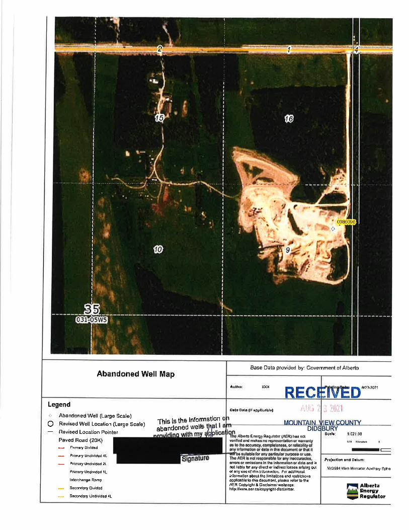
7. ABANDONED OIVGAS WEI Lcr:
ls there an abandoned well on the propertyf
lf yes, please attach information from the AER on the location and name of licensee.
I haw conbctedtheAER toobhln thls lnformatlon and lf regulrcd I haw pnbcted the llcense orAER,Dec24,2O2O Page3ofT
ilt* flNo

AGEM AI'TTIORIZAfl ON & RIG}TT OF ENTNY AAREFME
tNtde, O ln n ft ./ -s a^J* Gu.z*r,, n p rkOwne(s) Name(s) (please print) being the registered owne(s) of :
Alt/paftof the\/(4&-Tasection 35' Township 3 /nange t Westof { rvteriOianLot:- Block:- Plan:
do hereby authorize to act as Applicant on mylour behalf regardingthe redesignationlsubdivision application of the above mentioned lands.
I hereby gfant approval for Mountaln Vlew 0ounU staff to aecess the property for a Slte lnspectlon:W(es flNo
(s)Sign Date
Landowner(s) Signature(s)
Pleae€ completc thc followlng lf landowner ls a reglsterod company:
Date
Name of Authorized Qflicer/Pailner/lndividualhave authority to bind
lnsert Narne of Corporation
$ignature of Authorized 0fficer, Partner or lndividual Title of Authorized Officer, Partner or lndividual
Sigrlatule of Witness Name of Witness (please print)
l,
REGTSTERED OWNER(S) AND/OR PERSN AgflNG ON THE REGTSTERED OWNER'S BEMLF:
hereby certify that: I I am the registered owner(Print full name/s) fi+am authorized to act on behalf
of the registered ownerand that the information given on this frlrm is full and complete and is, to the best of my knowledge, a true statement ofthe facts relating to this application for redesignation approval.
\he personal lnformatlon on thB form ie belng nllected under the authorP of Wlon ?eO) il thc Albcrb Frecdom oftnfvrmatlon and Protedon of PrttacyAct (Fr1lP) for thc purpsa of rwlewlng|and awluailng an appllcatlon for rd*lgtnatlonanflor aubdh,Bion. By provldlng the abow pnmal informattan, the appllmnt corufrnb to the informatlon belng madeatallable to the Wbllc and AppmvlnlAuthortV ln ltr endre{ under 9ectlon 77(2} of the AlfutE Frwdom of lnformadon andnoedon af Prlwcy Ad, Any lnqulrls ralatlw to the sllectlon or use of thls lnfbrmafron may bs dlrectd towarde to:Mounbln Wew bunly FOIP tuordinator 7&8 - Twp Rd 320 P6tdl Sag lO0 Dl&buryAB fOM OWO Ph:403-735-3377
OF
#*:;:J::H:"::J;'H-*,"*"- frv'u n uzc
RE'E*ED-.....:::'i1
AppllcationFee:$-LongRangePlanningFee:$-TOTALFEE:$i:.ijt::."1J.:::'.(NoIElfpurequlreaseletanooaalcul8tlngfe03,plea3econtectPlannlngandDevelopm"n..oo*ueffit$yF.H'?ouNTY
* Note: Be advlsed ihatthere ls a $5OO0.00 Motlmum for Credlt Card Paymente *
Dea 24,2o2O Page 4 ot 7

nn!n
SKETCHThe Site Plan must include all of the following information (if applicable) in order for it to be considered complete:n Localion, dimensions, and boundaries of the entire property and cf the portion of the property to be
redesignated,/su bdivided;n Location and dimensions of existing buildings and structures on the property, including distances from property
lines. ldentifiT buildings that will be demolished or moved;Location and names of proposed and existing roadways, driveways and road approaches;Location of existing wells and septic systems;Location and description of natural site features such as steep slopes, water bodies or courses, woodlots andshelterbelts;Location and clescription of man made site features such as drainage ditches, wells and private sewage disposalsystems, (ravel working, etc.;Location, dimensions and boundaries of proposed lot boundaries and rights-of-way (if applicable).
The below aVtlnclicate name of ROAD lf applicable
R
oA
D
<,L 'cl '/D )ul')-:\ e1 4 I 4^ T.L \
R
0AD
) o !T) / t3 o<) I t2h )lc lii1
-1P I L
I ) tI
( ,Ll p + If I
I Jr\t I t;) .t (t t
{ I r7, ,) ) Llll t 11 r r 74, st] t', 1t t, IJ I lr
I1l
L\? J I \
\: I
t'.rlr t \.'{<t!\ (: [.lr )ftt r lt, a
I \fit r ( I p '),1 07 / 6t ,J
\\I
]I ( I I lL/,,il ftn " tL
^Jr(, t
I
t li, I t,u I\*TI, 80 t ,
I
I.c> g
tI,4 I uT v
F t4, tAI.J
-*7 5 r[! *t4 h.J t) /), \4, \ Z:, tn
lndlcat€ name of ROAD lf applicable RI
- I ]EIVE tl
eD
0
AoTr,€ a Ll ^t.6b Fr /f h N &S
4 &aluAA P,f Aonnc t4 A r) 6/ MC- 6 t l"vtl z pry'o dl :s o f
(t?,,c,m, - /6o / /6 a
To 7O X 3AOl"l frt+t u L N
.!.:1. .r "j -.1:;:: "':" : ;
MouNrg[yfilflfouNrY
3{ e I3s &t
N4 -fNt 2
-f LU 5
Dec24,2O2O
5aPage 5 of 7

The midclle square represents the quarter section your property is located on.t. Please sketch a land use map showing the proposed redesignation/subdivision site and the dwellings, buildings,
roads and water on your property.
lots, waste transfer stations , oilgas facilit1/z mile of the proposed site (example: farm, pasture, confined feedingies, roads, watbrcourses, or any other form of land use surrounding the
2. Please indicate and the land uses within
proposed development site. Brtg
Oeft
Each square repreento a Vc Sectlon.The central square represents the tA Section in which the development is proposed.
REGEIVED'": ' ': ''
MouNTAuluE'vy€ouNrY
\\R(,A$
\$a
Ptlll'lua - \\
0 ({\t'tt \
l
;*,'
B 'tldfnst",tt t'
QotyflL0
dRnoru
Irf
I
\
of,d E
'lntolO
prl#6
(tat.P
6 u9/'l/J psfar4t
\4
e ut
\- PrlA //t'j
*ta A
lrfftc, n to 7b6il,t* frf.
\rAix$.
\."
t\nD
k
Tb'v^tep') A L,hl4 'r"A^Or$
sni}
s3CI
.r. .f L\5 ,'nJl i o)'i
14ht<t uL r*4p
2 Piers ^8o A
/n+roilBE/, -l+ 3tL(tfS @rtJtl.32O,,
gofigt vts't$ ut l+
ia EJt lt oorld
P arron 'tt/// rNfolcfie, ,AOn 6
Dec 24,2O2O Page 6 of 7
t,'!t
Base Datia provided by: Government of Alberta
D823/2021
Scrlo: 9.027.98
--Prolsctlon and orlum:
WGS84 Wob ilorcato. Auxiliary Sph€l
AlbertaEnergyRogulrtor
Abandoned Well Map
Aulhcr xxx
Orlo Ooto (lt !ppllcablolLegend. Abandoned Well (Large Scale)
Q Revisod Well Location (Large Scale)
Revigod Location Pointer
Paved Road (20K)P.imsry OlvidEd
Pr|m0ry Undtvratod.tL
P.tmary Undivtded 2L
P.tmary Undlvided lL
lnterchdnge Romp
S6cmdory Oivldsd
. Socmddry Undlvid€d 1L
Thls ls theabandoned
lnformatlonwells
,qbona En€rgy Rogulslor (AER) hs8 not
mt llsblo lor any dlEct or lndlroct loiso8 a.lshE outot €ny uss ot lhl8 Irdornullon. For addlllonallnlormatlon about iho limttstbns 0nd rostrhlonsoppllcableto lh,s doc{unonl, plooso rolor lo thoAEF Copyrlght & DadsimBrwdbpsgo:hltprrn fl .Borcdcopyr0hl.diBclaimor,
D
lg
t!AS-

Base Dala provided by: Government of Alberta
EW
Scdr:
fi*,,,*,
9,027.98
olatut
Ir-Prolecllon and Dalumi
WGS84 Web M6rc.tor Aullsry SptKr
Abandoned Well Map
RECIAulhd xxx
Abandoned Well (Large Scale) Thls ls lhCRevised Well Localion (Large Scabsandoned welle
Paved Road (20K)Primary Oividsd
Prlmrry Undivtdsd 4L
Prhsry Undividod 2L
PrinaryUndivided tL
lnldcnlng6 R6np
S€condery Dtvidsd
S€condrry UndMdod 4L
olication
lnformatlon onlam
Revised Locelion
Legend
ThE Ab€.16 Enorgy Regulatq (AERI ha8 notvetifod and makos no r€prosontalion or wamntya to lh€ acer6.y, coltplolen$s, or rellsbili9 otsny lnlorulion q dsla in thig dmmsnt or that itrvil bo rultauo loruny psrihular plrprc tr m.lh€ AER b not B8pongbl8 for any tnacqrrmts!,€tlota oroml8SlonS ln lhe inlormgiion or dsta snd iBnot llaue for rny dlrsd or lrdlrscl los8€ ariEing outolany e of lhlB lnlomation. For additlddlinfbrmatim 6boul tho llmitsllofto and reBtdctlmgapplicablo b lhis do6rJosnl, dmro rotorlo lh6AER Copydghl & txsclaimer rebpago:hlF Jiv/ww,a€r.ca/copyrl€htsdiscl6lm r.
Orle Drra {lf spFllcrblol
MOUNTAINDID]
trq Alb.rtr
lI::;r**

ltlountainViewCOUI{TY
PI.ANNING SERVICES
NME ECEM'ION AGREEMENT FOR SUBDMSION APPUCANON
Applicant:
Legal Description:
File Number:
fw{fl-* Js ) .l{il
Section 6 of the Subdivlslan and Devetopment Regutatlon requires Mountain View County to make a decision on acompleted application within 6O days of its receipt, unless at1 agreement is entered into with the applicant to extendthis period.
ln order to permit Mountain View Coun$ to make a decision on your application, we are requesting that you enter intothe Time Extension Agreement as set out below. Without this agreement, we will be unable to deal ilitn your applicationafter the 60 day period has expired.
lf you concur with our request, please complete the agreement set out below.
ln accordance with section 681(1Xb) of the Muntc tpat Government Act,
Gt)/We, Ithereby enter intoan agreement with Mountain View County to extend the time prescribed under Section 6 of the subdivision and
ttevelopment Regulailon to 60 days after the day Council makes a decision on the redesignation application.
U
RECFMED
Mo'*t3l$.udtHrtouNrY
Dec 24,2O2OPageT ot7