Eagle's View of San Juan Mountains; Aerial Photographs with Mountain Descriptions of the most...
191
Eagle’s View of San Juan Mountains Aerial Photographs with Mountain Descriptions of the most attractive places of Colorado’s San Juan Mountains Wojtek Rychlik
-
Upload
independent -
Category
Documents
-
view
0 -
download
0
Transcript of Eagle's View of San Juan Mountains; Aerial Photographs with Mountain Descriptions of the most...

Eagle’s View of San Juan Mountains Aerial Photographs with Mountain Descriptions of the most attractive places of Colorado’s San Juan Mountains
Wojtek Rychlik

Ⓒ 2014 Wojtek Rychlik, Pikes Peak Photo
Published by Mother's House Publishing 6180 Lehman, Suite 104 Colorado Springs CO 80918 719-‐266-‐0437 / 800-‐266-‐0999 [email protected] www.mothershousepublishing.com
ISBN 978-‐1-‐61888-‐085-‐7
All rights reserved. No part of this book may be reproduced without permission in writing from the copyright owner.
Printed by Mother’s House Publishing, Colorado Springs, CO, U.S.A.
Wojtek Rychlik www.PikesPeakPhoto.com
Title page photo: Lizard Head and Sunshine Mountain southwest of Telluride.
Front cover photo: Mount Sneffels and Yankee Boy Basin viewed from west.
Acknowledgement
1. Aerial photography was made possible thanks to the courtesy of Jack Wojdyla, owner and pilot of Cessna 182S airplane.
1
Table of Contents
1. Introduction 2
2. Section NE: The Northeast, La Garita Mountains and Mountains East of Hwy 149 5 San Luis Peak 13
3. Section N: North San Juan Mountains; Northeast of Silverton & West of Lake City 21 Uncompahgre & Wetterhorn Peaks 24 Redcloud & Sunshine Peaks 35 Handies Peak 41
4. Section NW: The Northwest, Mount Sneffels and Lizard Head Wildernesses 59 Mount Sneffels 69 Wilson & El Diente Peaks, Mount Wilson 75
5. Section SW: The Southwest, Mountains West of Animas River and South of Ophir 93
6. Section S: South San Juan Mountains, between Animas and Piedra Rivers 108 Mount Eolus & North Eolus 126 Windom, Sunlight Peaks & Sunlight Spire 137
7. Section SE: The Southeast, Mountains East of Trout Creek and South of Rio Grande 165
9. Panorama of San Juan Mountains 182
10. Index 184

2
Introduction San Juan Mountains is the largest mountain range in Colorado that covers 17,000 square miles. The mountains are very diverse, from
having several hundred acres large flat summits table mountains or mesas, to very steep and rugged Needle Mountains and everything in between. They are also most rugged and inaccessible. The Range extends from the south of Montrose in southwest Colorado to Abiquiu/Chama River, bordering with Jemez Mountains in New Mexico, see the map on the left. It has fourteen 14ers: Uncompahgre Peak 14,309’, Mt. Wilson 14,246’, El Diente Peak 14,159’ (only 259’ prominence), Mt. Sneffels 14,150’, Mt. Eolus 14,083’, Windom Peak 14,082’, Sunlight Peak 14,059’, Handies Peak 14,048’, North Eolus 14,039’ (only 189’ prominence), Redcloud Peak 14,034’, Wilson Peak 14,017’, Wetterhorn Peak 14,015’, San Luis Peak 14,014’, and Sunshine Peak 14,001’. Recent measurements of Sunlight Spire revealed that it is the 15th San Juan non-‐ranked 14er with 14,000’ and 215’ prominence. The hardest to climb 14-‐ers are then Sunlight Spire (class 5.10), followed by Mount Wilson and Sunlight Peak, both class 4, by the Yosemite Decimal System (YDS) ranking. There are three San Juan Centennial 13ers harder to climb: Jagged Mountain 13,824’ (class 5.1), Teakettle Mountain (class 5.3) and Dallas Peak (class 5.3). The most impressive is the number of
13ers – there are 314 peaks that make 43% of the all 13ers in Colorado. For comparison with European Alps, that cover approximately 5 times more area (85k square miles), there are 226 (with prominence of 300’ or more) peaks in San Juan Mountains and only 51 summits in Alps (with prominence of 100m or 328’ or more) over 4 kilometers high (13,123’).
Most of the San Juans is the National Forest area. There are eight wilderness areas, listed below from the largest: 1. Wenimuche (492,418 acres) – Covering South San Juans, roughly from Hwy 550 in the west to Hwy 16 in the east; 2. South San Juan (158,790 acres) – mountains east of Pagosa Springs and Hwy 160; 3. La Garita (128,858 acres) – northeast mountains around San Luis Peak; 4. Uncompahgre (102, 721 acres) – west of Ouray and Hwy 550 and east of Lake City and Hwy 149; 5. Powderhorn (62,050 acres) – east of Hwy 149 and west of La Garita Wilderness, with Calf Creek and Cannibal Plateaus; 6. Lizard Head (41,309 acres) – southwest of Telluride, with Mt. Wilson Range; 7. Cruces Basin (18,000 acres) – in north New Mexico; 8. Mount Sneffels (16,566 acres) – west of Ouray and Hwy 550, and north of Telluride
Colorado San Juan Mountains are divided here into 6 Sections, three north (of Rio Grande) and three south Sections. The Southeast Section is the largest merely because there is the least photographed here; see the map on the next page.

3
Map of San Juan Mountains. The red triangles represent points from which the photographs were taken, and the numbers indicate the corresponding photograph number in each section.
4
Explanation of the mountain names on the photographs.
The main reference material describing the mountains and lakes in this atlas came from the USGS Topographic Maps that were published in the late 1900s, followed by the information taken from Google Earth. Some mountain names were derived from 13ers.com and 14ers.com web sites. Since USGS failed to indicate revised mountain heights in their most recent TOPO maps update (2010-‐2011, based on aerial photographs) I had no choice but to stick with the older, established numbers.
The summits of named mountains are labeled by their names with the height in feet above the sea level marked below. The unnamed peaks with prominence above 300 feet are marked as “UN” (Un-‐Named) with the height printed below it. Mountains with prominence below 300 feet are indicated by their height only. When a peak is labeled by its height followed by its name given in parenthesis, it is a parent peak with a prominence below 300 feet of a higher, named mountain.
The prominence of a mountain is the minimal vertical drop from its summit before it ascends into a higher peak. The generally accepted criterion for inclusion on lists of ranked mountains is the prominence of at least 300 feet. The 300' rule is sometimes referred to as the Colorado rule (www.peaklist.org).

5
Section NE: The Northeast, La Garita Mountains and Mountains East of Hwy 149
There are 14 photos covering the Northeast Section. The photo numbers are labeled light green in this area.
6
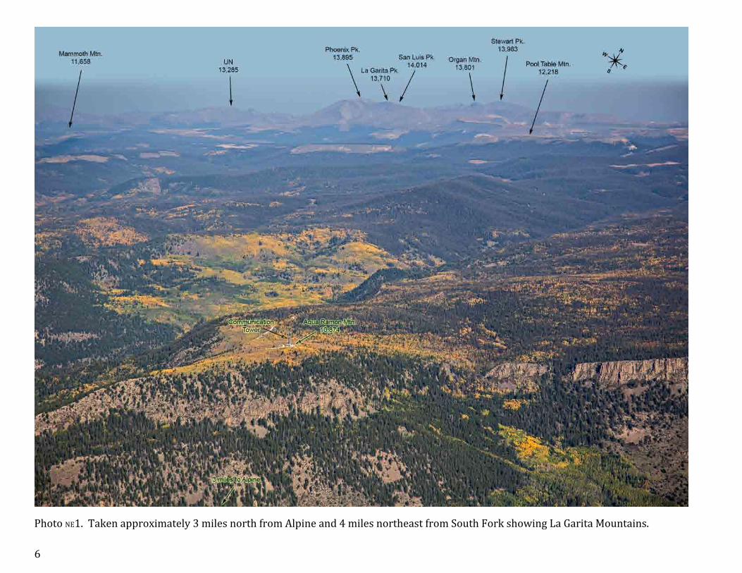
Photo NE1. Taken approximately 3 miles north from Alpine and 4 miles northeast from South Fork showing La Garita Mountains.

7
Photo NE2. The mountains northwest from South Fork. Vicinity of Crede (top left) is presented on the next page.

8
Photo NE3. Mountains around Crede, view to the southeast.

9
Photo NE4. Table and Sheep Mountains east of La Garita Peak. The summits are on the border between forest and alpine tundra.

10
Photo NE5a. A two-‐page panorama showing the La Garita Peak – Phoenix Peak Ridge.

11
Photo NE5b. Part 2 of the panorama. Phoenix Peak (4th highest 13er in San Juan Mountains) is a common name, not recognized by USGS, however, La Garita Peak is, with only 232’ prominence.

12
Photo NE6. Organ Mountain Ridge. The standard trail to San Luis Peak leads through Stewart Creek drainage.
13
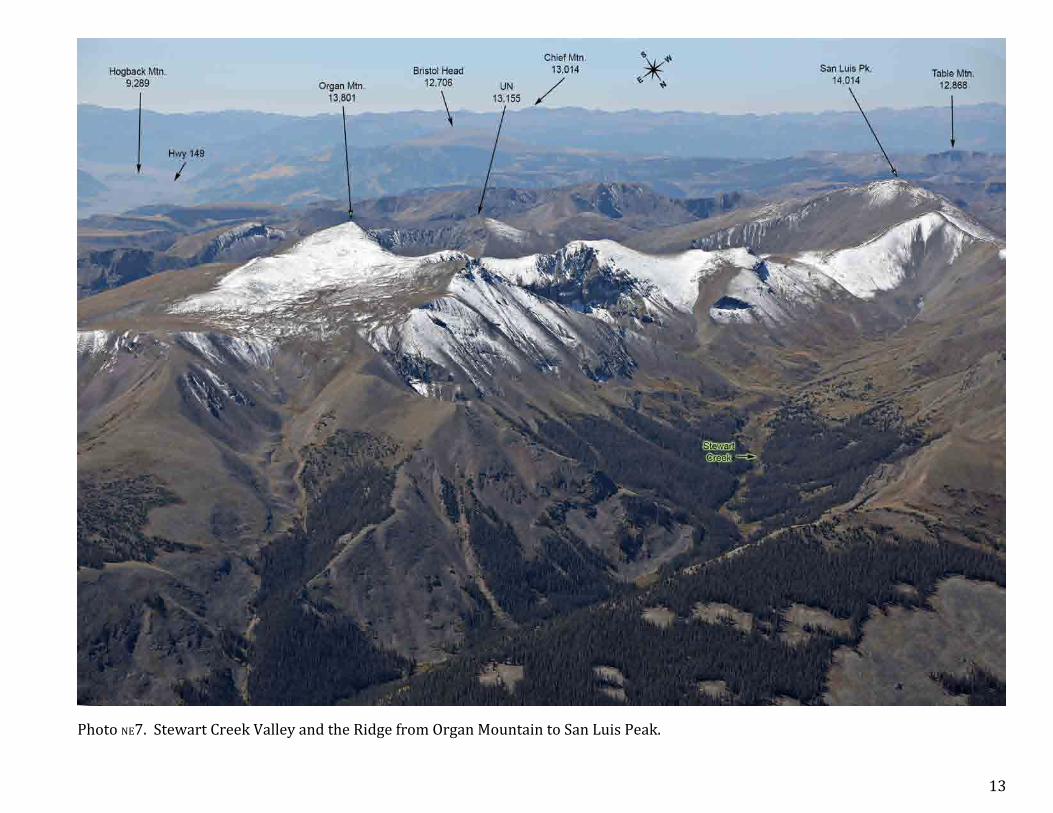
Photo NE7. Stewart Creek Valley and the Ridge from Organ Mountain to San Luis Peak.

14
Photo NE8. Organ Mountain.

15
Photo NE9. San Luis Peak and Organ Mountain viewed from south. Named after Spanish patron saint of the oldest town in Colorado, originally named San Luis de la Culebra (1851).

16
Photo NE10. View from west of San Luis Peak.

17
Photo NE11. View of La Garita Mountains from north. These Oligocene (23-‐34 million years ago) mountains is an extinct super volcano that created the largest eruption known to date. It was 5000 km3, a 5 times larger than Yellowstone super volcano eruptions.
18
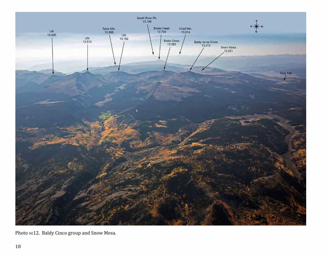
Photo NE12. Baldy Cinco group and Snow Mesa.

19
Photo NE13. Cannibal Plateau and Calf Creek Plateau east of Lake City, in Powderhorn Wilderness, the largest tundra area in the continental United States. Known as a very hard to survive wilderness. In February 1874 Alfred Packer and five other gold prospectors ran out of provisions there and only A.P. survived as he fed on his comrades bodies, apparently after killing them (see history.com). That’s how Cannibal Plateau got its name.

20
Photo NE14. Bristol Head and Santa Maria Lake.

21
Section N: North San Juan Mountains; Northeast of Silverton & West of Lake City
There are 37 photos covering the North Section. The photo numbers are labeled light yellow-‐green in this area.
Peaks in blue circles are the 14ers, and peaks in green circles are the centennial 13ers (above 13,808’).

22
Photo N1. Southeast view from the Red Mountain. Lake San Cristobal is the Colorado’s second largest natural lake.

23
Photo N2. Red Mountain near Lake City.

24
Photo N3. View from northwest of Uncompahgre Peak, the highest mountain in San Juans. Enlargement of the summit is in bottom right.
25
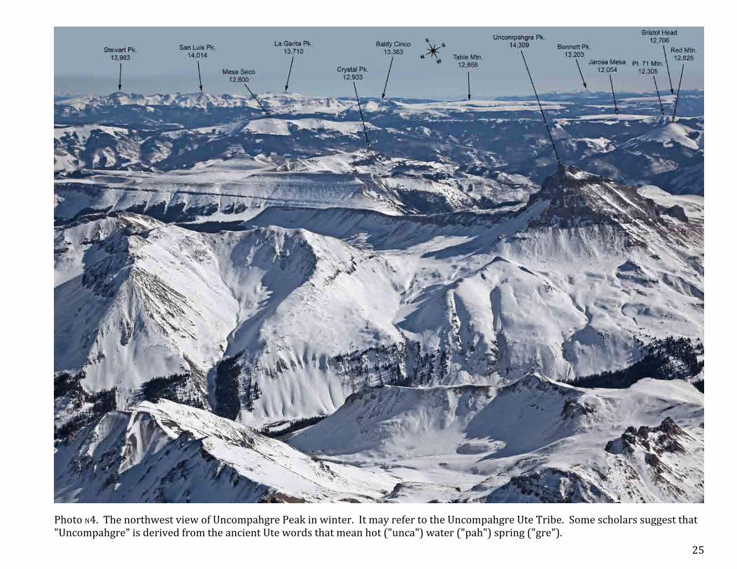
Photo N4. The northwest view of Uncompahgre Peak in winter. It may refer to the Uncompahgre Ute Tribe. Some scholars suggest that "Uncompahgre" is derived from the ancient Ute words that mean hot ("unca") water ("pah") spring ("gre").

26
Photo N5. Uncompahgre Peak view from north.

27
Photo N6. Uncompahgre Peak view from south.

28
Photo N7. Winter view to the east of Wetterhorn and Uncompahgre Peaks. "Wetterhorn" is German for "weather peak"; named here by Lieutenant William Marshall of the Wheeler Survey of 1874, who was inspired by the Swiss mountain of the same name.

29
Photo N8. Summer view to the east of Wetterhorn and Uncompahgre Peaks.

30
Photo N9. Wetterhorn and Matterhorn Peaks view from north.

31
Photo N10. Wetterhorn Peak and its summit.

32
Photo N11. Wetterhorn and Matterhorn Peaks view from south. Turret view from west is in the insert.

33
Photo N12. Turret and Cimarron Ridges, view from south.

34
Photo N13. Courthouse Mountain and Chimney Rock in Cimarron Ridge. The standard route to top of the Chimney Rock is rated 5.6 (second most difficult after Lizard Head Peak). Chimney Rock National Monument is yet another known place of the same name in San Juan Mountains, less than 20 miles west of Pagosa Springs.

35
Photo N14. Sunshine Peak view from northwest. The U.S. Geological Survey named the mountain "Sunshine Peak" in 1904.

36
Photo N15. View to the west of Redcloud and Sunshine Peaks. The “Redcloud” name was given by the chief topographer for the Wheeler U.S. Government Survey, J.C. Spiller, who made its first ascent in 1874. It used to have a more generic name “Red Mountain”.

37
Photo N16. Sunshine, Redcloud and Uncompahgre Peaks.

38
Photo N17. Close up view of Redcloud and Sunshine Peaks.

39
Photo N18. View to the east of Redcloud and Sunshine Peaks. UN 13, 832 and UN 13,811 are the only centennial 13ers without a name. Peakbagger.com calls UN 13,832 (prominence 812’) Redcloud Peak-‐Northeast Peak, and UN 13,811 (prominence 551’) Redcloud Peak-‐ Far Northeast Peak, but these mind-‐numbing names are generally not accepted.

40
Photo N19. View to the south of Redcloud and Sunshine Peaks. Some call UN 13,832 (prominence 812’) Redcloud Peak-‐Northeast Peak.

41
Photo N20. The northeast side of Handies Peak and the surrounding mountains.
42
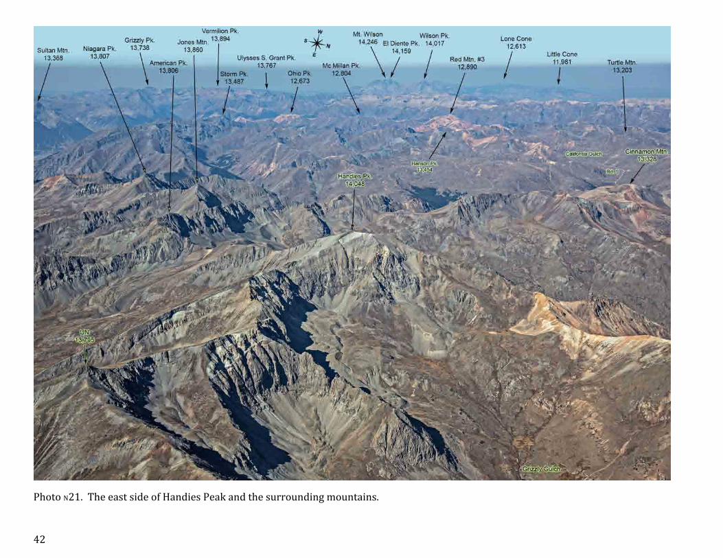
Photo N21. The east side of Handies Peak and the surrounding mountains.

43
Photo N22. Close-‐up view of Handies Peak form south. Historians have suggested that "Handie" may have been an early pioneer or surveyor, who was influential in the area near Lake City.

44
Photo N23. Close-‐up view of Handies Peak form northeast.

45
Photo N24. The north side of Handies Peak and the surrounding mountains.

46
Photo N25. The northwest side of Handies Peak and the surrounding mountains.

47
Photo N26. Whitecross Mountain.

48
Photo N27. Jones Mountain and Niagara Peak and the road from Cinnamon Pass to Silverton.

49
Photo N28. Dome and King Solomon Mountains. Grenadier Range and the Needle Mountains are in the background.

50
Photo N29. View to the south from around Bonita Peak.

51
Photo N30. Kendall Mountain near Silverton.

52
Photo N31. Northern view from above Silverton.

53
Photo N32. Southern view of Silverton and surrounding mountains.

54
Photo N33. View from above Red Mountain to the south.

55
Photo N34. Red Mountain north of Silverton, close to Hwy 550.

56
Photo N35. Grand Turk and mountains north of it. Mountains to the left of the view presented on the Photo 31.

57
Photo N36. Blackwall Mountain and Wildhorse Peak view to the south.

58
Photo N37. View to the west from Unnamed Peak 13,566. Ouray is in the valley behind and below Darley Mountain and Cow Benchmark.

59
Section NW: The Northwest, Mount Sneffels and Lizard Head Wildernesses
There are 29 photos covering the Northwest Section. The photo numbers are labeled in yellow in this area.

60
Photo NW1. View from Ouray to the north.

61
Photo NW2. View from Ouray to the south.

62
Photo NW3a. A four-‐page panorama of Mount Sneffels Wilderness area viewed from north. Part 1 of 4, from Whitehouse to Cirque Mountains.

63
Photo NW3b. Part 2 of 4 of Mount Sneffels Wilderness panorama, from Cirque Mountain (far left) to Dallas Peak.

64
Photo NW3c. Part 3 of 4 of Mount Sneffels Wilderness panorama, from West Dallas Peak to Mears Peak. The Mount Wilson group belongs to Lizard Head Wilderness.

65
Photo NW3d. Part 4 of 4 of Mount Sneffels Wilderness panorama, from S 7 to Hayden Peaks.

66
Photo NW4. A close up northern face view of Mount Ridgeway – Cirque Mountain Ridge.

67
Photo NW5. Potosi Peak.

68
Photo NW6. Yankie Boy Basin and the surrounding mountains.

69
Photo NW7. View from southeast of Mount Sneffels. The summit is in the insert. Although not certain, term “Sneffels” came after Icelandic mountain from a fiction Jules Verne's 1864 novel, "Journey to the Center of the Earth", as mentioned on 14ers.com.

70
Photo NW8. Wintery view from south of Mount Sneffels. Mount Emma and Gilpin Peaks are in the foreground.

71
Photo NW9. View from southeast of Dallas Peak.

72
Photo NW10. Northwest view of Mount Sneffels.

73
Photo NW11. Mount Sneffels and Yankee Boy Basin viewed from west.

74
Photo NW12. Mount Sneffels Wilderness view from south. Telluride Airport is on its foothills.

75
Photo NW13. Mount Wilson and Wilson Peak viewed from northeast. Name “Wilson” is after Allen David Wilson, chief topographer of the U.S. Government's Hayden Survey of 1873-‐75, who made the first ascent on Mount Wilson.

76
Photo NW14. From Wilson Peak to El Diente Peak, viewed from north.
77
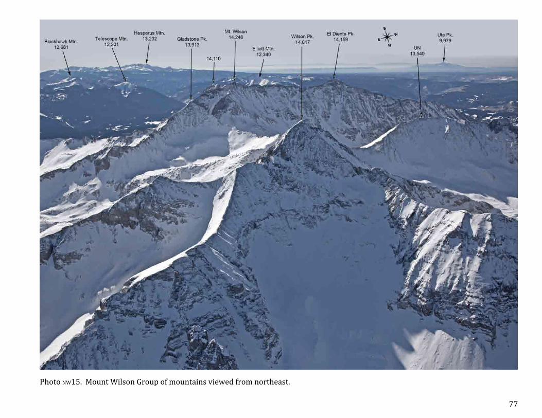
Photo NW15. Mount Wilson Group of mountains viewed from northeast.

78
Photo NW16. El Diente to Mount Wilson Ridge viewed from southwest. El Diente, which is Spanish for the "the tooth," was named by San Juan mountaineer Dwight Garrigues Lavender (1911-‐1934) for its ascent from the south.

79
Photo NW17. View from around Lizard Head Peak towards west.

80
Photo NW18. Lizard Head – Sunshine Mountain Rige.

81
Photo NW19. View from around Gladstone Peak to the east.

82
Photo NW20. Lizard Head Peak. Considered the most difficult 13er to climb in Colorado (class 5.8).

83
Photo NW21. Mountains around Telluride, view to the east.

84
Photo NW22. Trails from Telluride to Imogene Pass and Black Bear Pass.

85
Photo NW23. Blue Lake in winter.

86
Photo NW24. Lookout Peak and the west side of Ophir Pass.

87
Photo NW25. Lookout Peak, Columbine Lake, and the east side of Ophir Pass.

88
Photo NW26. Columbine Lake has a very unusual for the mountain lakes lazur color. There are some others of a deeper blue color, such as Ice Lake, but this one is of the lightest blue in San Juans. Do not mix up this lake with another Columbine Lake in Needle Mountains.

89
Photo NW27a. A two-‐page panorama of the mountains from Lookout Peak to Telluride Peak South, part 1.

90
Photo NW27b. A two-‐page panorama of the mountains from Lookout Peak to Telluride Peak South, part 2.

91
Photo NW28. Continuation of the view presented on the previous photo, from Red Mountain towards northeast. Ouray is only about 5 miles away from Crystal Lake, roughly behind Hayden Mtn. North on this photo, well seen from Abrams Mountain, visible at top right.

92
Photo NW29. View from above Telluride towards west.

93
Section SW: The Southwest, Mountains West of Animas River and South of Ophir
There are 14 photos covering the Southwest Section. The photo numbers are labeled in light green in this area.

94
Photo SW1. Highway 145 leading from Telluride to Rico

95
Photo SW2. Pilot Knob and Vermilion Peak viewed from northwest.

96
Photo SW3. Sheep Mountain near San Miguel Peak.

97
Photo SW4. Mountains near Fuller Lake.

98
Photo SW5. Similar view to that shown on the previous page except it’s made further to the north.

99
Photo SW6. Bear Mountain and Twin Sisters.

100
Photo SW7. Ice Lake Basin viewed from east.

101
Photo SW8. Ice Lake Basin viewed from south.

102
Photo SW9. Various colors of Ice Lake and surrounding lakes. The insert shows Ice Lake panorama made from the ground.
103
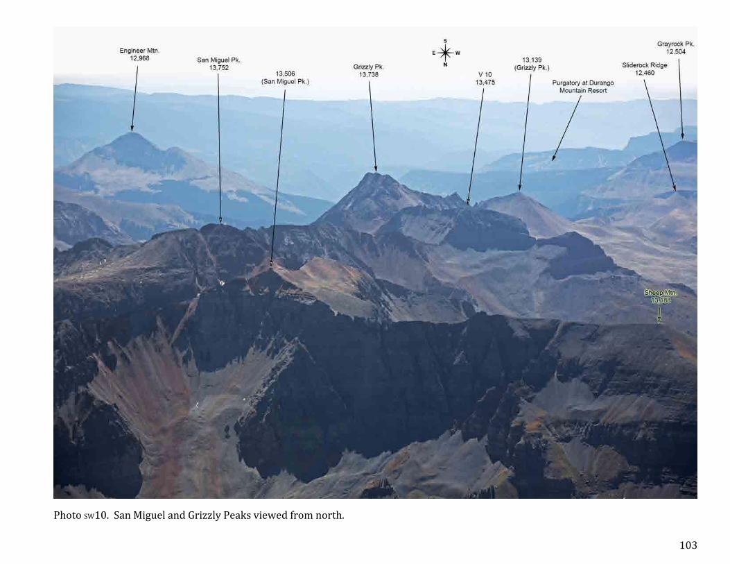
Photo SW10. San Miguel and Grizzly Peaks viewed from north.

104
Photo SW11. Engineer Mountain and La Plata Mountains in the background.

105
Photo SW12. Twilight Peak and Potato Hill viewed from north.

106
Photo SW13. South West Needle Mountains.

107
Photo SW14. West Needle Mountain.

108
Section S: South San Juan Mountains, between Animas and Piedra Rivers
There are 56 photos covering the Southwest Section. The photo numbers are labeled in light blue in this area.

109
Photo S1. Grenadier Range viewed from northwest.

110
Photo S2. Grenadier Range viewed from west. The tallest mountain in the Range is Vestal Peak, 13,864’.

111
Photo S3. This and the following photo is the close-‐up of the western portion Grenadier Range viewed from south. This view covers mountains from Mount Garfield to Electric Peak.

112
Photo S4. The second part of the panorama from Arrow Peak to Trinity Peaks. Jagged Mountain, in the foreground, is one of the most difficult centennial 13ers to climb (class 5.3).

113
Photo S5. Northwest view of Peak Six, Peak Four and The Heisspitz.

114
Photo S6. Northwest view of The Heisspitz and Animas Mountain.

115
Photo S7. Northwest view of Animas Mountain and Pigeon Peak.

116
Photo S8. Pigeon and Turret Peaks viewed from north.

117
Photo S9. Pigeon and Turret Peaks viewed from southeast.

118
Photo S10. Mountains around Ruby Creek drainage.
119
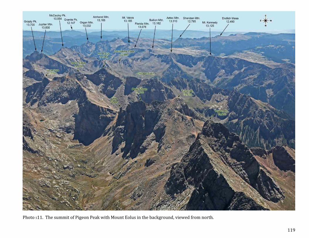
Photo S11. The summit of Pigeon Peak with Mount Eolus in the background, viewed from north.

120
Photo S12. Pigeon – Turret Peaks saddle viewed from south-‐southwest.

121
Photo S13. Pigeon – Turret Peaks saddle viewed from southwest.

122
Photo S14. Summit of the Animas Mountain and the Turret – Pigeon Peaks saddle.

123
Photo S15. Summit of the Animas Mountain with Mount Eolus in the background.

124
Photo S16. The Ridge from North Eolus to Turret Peaks.

125
Photo S17. New York Basin and the surrounding mountains.

126
Photo S18. Mount Eolus viewed from southeast.

127
Photo S19. Mount Eolus viewed from northeast.

128
Photo S20. Mount Eolus viewed from northeast. A close-‐up.

129
Photo S21. Summits of Mt. Eolus and North Eolus. North Eolus is a non-‐ranked 14er with only 189’ prominence. Aeolus was the ruler of the winds, according to Greek mythology.

130
Photo S22. View of Mount Eolus from southwest. West Eolus is an unranked 13er with prominence approximately 280’, and 5th class difficulty climbing.

131
Photo S23. View of Turret Peak through Mount Eolus from southwest.

132
Photo S24. View from south and above Chicago Basin of Mount Eolus mountains group.

133
Photo S25. View of all four 14-‐ers of the Needle Mountains. The 5th 14-‐er is actually Sunlight Spire, as more accurate measurements placed it among unranked 14-‐ers with 14,000’ and 215’ prominence.

134
Photo S26. The Twin Lakes area.

135
Photo S27. Chicago Basin and the surrounding mountains.

136
Photo S28. General view of the eastern part of Needle Mountains.

137
Photo S29. Sunlight Peak to Windom Peak ridge viewed from west. Windom Peak was named after William Windom (1827-‐1891), congressman, senator, and Secretary of the Treasury under President James Garfield by the U.S. Geological Survey when they mapped the Needles Mountains in 1902.

138
Photo S30. Sunlight Peak to Grizzly Peak ridge viewed from northwest. Recent revisions in the altitude of Colorado Mountains, the Sunlight Spire in now recorded as an even 14,000’, and 215’ prominence. This makes it the most difficult to reach 14er summit in the contiguous USA, of class 5.10.

139
Photo S31. Sunlight Peak to Grizzly Peak ridge viewed from north.

140
Photo S32. Sunlight Peak to Grizzly Peak ridge viewed from northwest.

141
Photo S33. Sunlight and Windom Peaks viewed from north.

142
Photo S34. Greylock Mountain to Windom Peak ridge with Sunlight Lake viewed from northeast.

143
Photo S35. Ridge from Jupiter Mountain to Sunlight Peak. Recent measurements of Sunlight Spire indicated that this peak is even 14,000 feet high.

144
Photo S36. This and the next photo shows a closer view of a ridge from Jupiter Mountain to Windom Peak. Jupiter Mountain.

145
Photo S37. Continuation of the view from the previous page. Windom Peak.

146
Photo S38. Needle Mountains viewed from southeast.

147
Photo S39. Mount Valois and Amherst Mountain, view from south.

148
Photo S40. Amherst Mountain and the Needles viewed from southeast.

149
Photo S41. Mount Valois and Emerson Mountain viewed from west.

150
Photo S42. Amherst and Organ Mountain with Vallecito Creek Valley in the background.

151
Photo S43. Mount Oso Group of mountains viewed from northwest.

152
Photo S44. Vallecito Creek Valley viewed from southeast.

153
Photo S45. Irving Peak and Vallecito Creek Valley viewed from south.

154
Photo S46. Mount Oso Group of mountains viewed from south.

155
Photo S47. Emerald Lake and the surrounding mountains viewed from southwest.

156
Photo S48. Graham Peak viewed from southeast.

157
Photo S49. Rio Grande Pyramid and the Window viewed from west.

158
Photo S50. Rio Grande Pyramid viewed from north. Colorado’s 97th highest mountain in the middle of nowhere. Class 2 climb and ten miles hike one way is the shortest and the easiest route, which is still very strenuous.

159
Photo S51. View of Chief Mountain from the vicinity of Rio Grande Reservoir.

160
Photo S52. Graham Peak and Los Pinos River Valley viewed from southwest.

161
Photo S53. Flag Mountain and Mesa Lato viewed from southeast.

162
Photo S54. Bald Mountain and Mesa Lato viewed from southeast.

163
Photo S55. Cimarrona Peak and the nearby mountains.

164
Photo S56. Mountains northwest of Williams Creek Reservoir.

165
Section SE: The Southeast, Mountains East of Trout Creek and South of Rio Garnde
There are 16 photos covering the Southwest Section. The photo numbers are labeled yellow in this area.
166
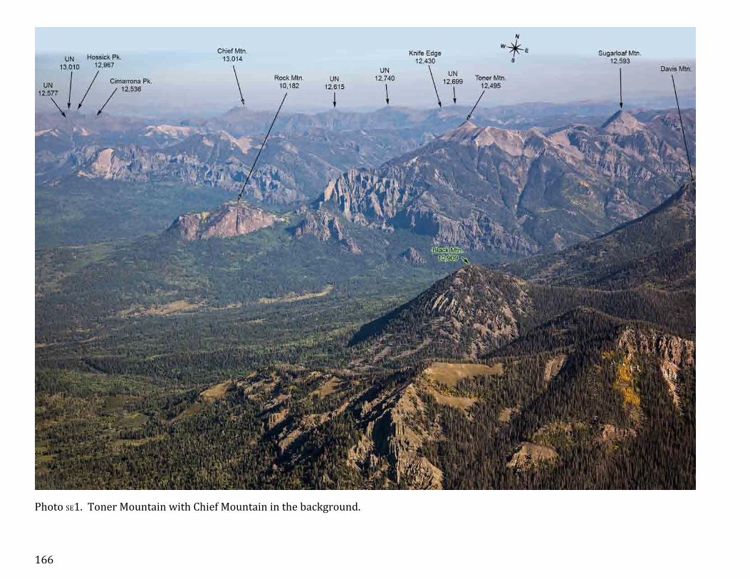
Photo SE1. Toner Mountain with Chief Mountain in the background.

167
Photo SE2. Pagosa Peak is the highest mountain close to Pagosa Springs.

168
Photo SE3. Pagosa Peak and Eagle Mountain viewed from south.

169
Photo SE4. Saddle Mountain viewed from east.

170
Photo SE5. Highway 160 climbs to Wolf Creek Pass on the slopes of Sheep Mountain.

171
Photo SE6. Wolf Creek Pass.

172
Photo SE7. Wolf Creek Ski area.

173
Photo SE8. East side of the Wolf Creek Ski area and San Juans of Southern Colorado.

174
Photo SE9. View from above Highway 160, four miles north of Wolf Creek Pass, towards west.

175
Photo SE10. Mount Hope and the ridge to Table Mountain, that continues north is shown on the insert and the next photo.

176
Photo SE11. Table Mountain and Shaw Lake.

177
Photo SE12. Metroz Lake and Metroz Mountain to the west of it.

178
Photo SE13. Mountains near South Fork.

179
Photo SE14. Beaver Creek Reservoir south of South Fork.

180
Photo SE15. South San Juans panorama made 8 miles west-‐northwest of Del Norte.

181
Photo SE16. Mountains near Del Norte.

182
Panorama of San Juan Mountains
Winter panorama of San Juan Mountains made about 10 miles north of Ouray. Part 1 and 2 of 4.

183
Winter panorama of San Juan Mountains made about 10 miles north of Ouray. Part 3 and 4 of 4. All San Juan 14ers are indicated on this photo.

184
Index
Name Pages 71 Mountain 22, 25, 35, 39 Abajo Peak 92 Abrams Mountain 61, 91, 101, 183u Ajax Peak 83, 84 Alberta Park Reservoir 173 Alberta Peak 172, 173 American Basin 41, 43, 45 American Peak 36, 41, 42, 44, 45 Amherst Mountain 138, 140, 147-‐150 Amphitheater 60, 61, 67, 183u Anchor Mountain 94 Animas Forks Mountain 51, 57 Animas Mountain 114, 115, 118, 120-‐123,
125, 126, 131, 146, 147 Antelope Mountain 20 Antora Peak (Sawatch) 182u Anvil Mountain 54, 56, 85, 86 Aqua Ramon Mountain 6 Arrow 109 Arrow Peak 53, 109, 110, 112, 120 Aztec Mountain 115, 116, 119, 124, 135,
136, 141, 142 Babock Peak 104 Bald Knob 104 Bald Mountain 158, 160, 162 Baldy Alto 12, 14-‐17 Baldy Chato 12 Baldy Cinco 14, 18, 19, 25, 28, 182L Baldy Mountain 157, 163 Baldy no es Cinco 18 Baldy Peak 60 Balsam Lake 110 Banded Peak 180 Barebottom Park 161 Bear Mountain 54, 86, 99 Beattie Peak 81
Beattie Peak 96, 100 Beautiful Mountain 176, 177, 178 Beaver Creek Reservoir 179 Benito Lake 10 Bennett Peak 180, 181 Bent Peak 40 Betty Lake 151 Big Meadows Reservoir 174, 175 Bilk Basin 78-‐80 Black Bear Pass 84, 90 Black Face 81, 87, 96, 100 Black Lake 60 Black Mesa 75, 79, 87, 100 Black Mountain 10,909 166, 167 Black Mountain 11,861 22, 35 Blackhawk 97 Blackhawk Mountain 77, 94 Blackhead Peak 173 Blackwall Mountain 57, 182L Block Tops 63, 70 Blowout, The 60 Blue Lakes (Sneffels) 71, 73 Bonita Peak 52, 73 Bonito Mountain 180 Boot Mountain 9 Bridal Veil Basin 85 Bristol Head 11, 20, 22, 176 Broken Hill 26, 30, 37 Brown Mountain 52, 56, 183u Buffalo Peak 151 Bullion Mountain 119 Burro Mountain 104 Button King Lake 89, 90 C.T. Peak 30 Calf Creek Plateau 19 Campbell Creek Peak 46
Campbell Mountain 8 Campbell Peak 68, 74 Canby Mountain 41, 48, 50 Cannibal Plateau 19, 23 Carson Peak 40, 45 Cascade Mountain 60, 61, 67, 182L Castilleja Lake 147, 149, 150 Castle Lakes 35, 40 Castle Rock 10,441 107 Castle Rock 11,453 33, 60 Castle Rock 9,890 164 Cataract Peak 45 Cattle Mountain East 179 Cherry Cairn 167-‐169, 174, 175 Chicago Basin 125, 127, 128, 132, 133,
135, 136, 141-‐145 Chicago Peak 62, 66, 73, 83 Chief Mountain 157, 159, 160, 163, 164, 166 Chimney Rock 11,781 32-‐34, 182u Chipeta Mountain (Sawatch) 182u Cimarrona Peak 159, 163, 164 Cimmaron Ridge 32, 33, 91, 182u Cinnamon Mountain 36, 42, 43, 51 Cinnamon Pass 36, 43 Cirque Mountain 62, 66, 68, 73, 74, 183u Coal 173 Columbine Lake (Chicago B.) 135, 136, 143, 144, 147 Columbine Lake (Electra) 107 Columbine Lake (Needles) 86-‐89 Columbine Pass 135, 136, 144 Conejos Peak 180 Coney 22, 35, 40 Cooper Lake 58 Cooper Mountain 10, 20, 176, 178 Corbet Peak 62, 183u Cornwall Mountain 180 Cottonwood Peak (Sangres) 182u

185
Courthouse Mountain 32-‐34, 182u Cow Benchmark 58, 67, 91 Coxcomb Peak 28, 33, 37, 182L Crede 8 Crestone Peak (Sangres) 182u Cropsy Mountain 180 Cross Mountain 79, 183L Crown Mountain 48 Crystal Lake (Hwy 550) 91 Crystal Lake (Ophir) 86, 87 Crystal Peak 24, 25, 29 Dallas Peak 63, 68, 71, 74, 183L Darley Mountain 58 Davis Mountain 167 Deer Park 53 Del Norte 181 Del Norte Peak 180 Demijohn Peak 179 Diamond Hill 74, 92 Diorite Peak 104 Dog Mountain 181 Dolly Warden Mountain 57, 58, 182L Dolores Mountain 94 Dolores Peak 65, 75, 79, 183L Dome Mountain 41, 48, 50-‐52, 61 Dunn Peak 75 Dunsinane Mountain 33, 182u Durango 105 Eagle Mountain 168, 169 East Basin 85 East Windom 138, 141 Echo Mountain 136, 138, 147-‐149 Edith Mountain 43, 47 El Diente Peak 64, 75-‐79, 89, 100, 183L El Punto 32 Electra Lake 105-‐107, 127 Electric Peak 109-‐111
Elk Park Station 53 Elliott Mountain 94, 97, 98 Emerald Lake 127, 154, 155 Emerson Mountain 138, 149 Engineer Mountain 12,968 96, 99, 103, 104 Engineer Mountain 13,218 58, 61, 182L Engineer Pass 58 Eureka 48 Every Mountain 26, 37, 182L Expectation Mountain 94 Fets Peak 180 Finger Mesa 22, 40 Fisher Mountain 20, 157, 176-‐178 Flag Mountain 113, 151, 160, 161 Flat Top 60 Flat Top Peak 79, 92 Flattop Mountain 94 Flint 155, 160, 161 Florida Mountain 119, 136 Fortress Peak 182L Fuller Lake 97, 98, 100, 102 Fuller Peak 97, 98, 100 Galena Mountain 41, 48, 50, 51 Gilpin Peak 68, 70, 72-‐74 Glacier Point 115, 119, 123, 126-‐128,
132, 134 Gladstone Peak 64, 75-‐79, 81, 183L Golden Horn 81, 95, 100-‐102 Goodrich Peak 178 Governor Basin 68, 73 Graham Peak 113, 114, 140, 151 156, 160 Grand Turk 53, 54, 56 Granite Peak 113, 114, 140, 151 158, 160, 162 Grassy Mountain 22, 39 Gravel Mountain 57, 182L
Gray Head 78, 90, 92 Gray Needle 112, 118 Grayback Mountain 180 Grayrock Peak 76, 99, 103, 104 Graystone Peak 110, 111, 120 Greenhalgh Mountain 41, 45 Grenadier Range 110 Greylock Mountain 113, 114, 135, 136,
140, 149, 150, 152 Grizzly Peak 13,700 115, 135, 136,
138-‐142, 147 Grizzly Peak 13,738 96-‐98, 103 Groundhog Mountain 79, 100, 183L Guardian, The 110, 136, 137, 152, 153 Gudy Peak 30, 37, 182L Half Peak 45, 46 Hamilton Mesa 92 Handies Peak 36, 41-‐45, 182L Hanson Peak 42, 52 Hastings Mesa 183L Hayden Mountain North 56, 58, 61, 91, 183u Hayden Mountain South 56, 73, 91, 183u Hayden Peak 65, 71, 183L Hazel Lake 136, 143, 144, 147, 149 Heart Mountain 174 Heisshorn 28, 30, 32 Heisspitz, The 110, 111, 113, 114,
121, 126, 146 Hermosa Cliffs 107, 127 Hermosa Peak 76 Hesperus Mountain 94, 99, 104-‐107, 183L Hidden Lake 151 High Mesa 27, 32, 33, 182u Highland Mary Lakes 49, 50, 109 Hogback Mountain 13 Hope Mountain 138, 139, 143, 144, 147 Horsefly Peak 60 Horseshoe Mountain 180, 181

186
Hossick Peak 159, 163, 164, 166 Houghton Mountain 61 Ice Lake 100-‐102 Ice Lake Basin 100-‐102 Imogene Pass 83, 84 Index, The 114, 115, 122, 123, 131 Indian Ridge 109 Ingram Basin 83 Ingram Lake 84 Irving Peak 113, 149-‐153, 156 Island Lake 100-‐102 Jackson Mountain 172 Jagged Mountain 112, 113, 118, 125, 130,
134, 146, 147 Jarosa Mesa 22, 25, 35, 39 Jones Mountain 41, 42, 45, 48, 182L Jupiter Mountain 114, 115, 135, 136,
138-‐144, 146, 147 Kendall Benchmark 51, 53, 120 Kendall Mountain 49-‐51, 53, 54, 85, 86,
120 Kendall Peak 49-‐51, 53, 120 King Solomon Mountain 49 Kismet 63, 70 Knife Edge 159, 166 Knife Point 112-‐114, 118, 134, 146 La Garita Peak 6, 7, 9, 10, 17, 182u La Junta Peak 89, 90 La Plata Mountains 99 Lake City 19, 23 Lake Hope 96 Lake Lenore 60 Lake Mary Alice 151 Lake San Cristobal 22, 23 Lavender Peak 99, 104, 183L Leviathan Peak 113, 118 Lewis Lake 87-‐89 Lewis Mountain 99, 104, 105
Lilie Lake 136, 147, 149 Little Cone 87, 89, 92, 183L Little Emerald Lake 155 Little Finger 116, 117, 119, 124,
126, 131 Little Giant Peak 41, 49 Lizard Head 80-‐82, 100, 183L Lone Cone 79, 87, 89, 92, 183L Long Ridge 20 Long Treck Mountain 180 Lookout Mountain 12,448 180 Lookout Mountain 8,475 181 Lookout Peak 86-‐89, 101 Lost Lake 151 Lower Ice Lake 100, 101 Machin Lake 11 Mammoth Mountain 8, 11 Marble Mountain 180, 181 Matterhorn Peak 28-‐32, 37, 182L Mc Millan Peak 56, 85, 101 McCauley Peak 136, 138-‐140, 147, 156 McClelland Mountain 7, 8, 10 Mears Peak 64, 68, 71, 74, 183L Mesa Lato 155, 160-‐162 Mesa Mountain 12,985 9 Mesa Seco 25, 28 Metroz Lake 177 Metroz Mountain 176-‐178 Middle Mountain 41, 48, 51, 52 Middle Peak 65, 75, 79, 183L Middleton 48, 51, 52 Mineral Basin 90 Mineral Mountain 12, 14, 15 Molas Lake 53, 54 Monitor Peak 114, 115, 118, 121-‐126,
130, 131, 146 Montezuma Peak 173, 180, 181 Monument Hill 104
Mount Emma 68, 70 Mount Eolus 114-‐116, 118, 119, 123-‐
135, 183u Mount Garfield 109-‐111, 120, 146 Mount Hope 170, 171, 174, 175 Mount Kennedy 115, 116, 119, 123, 124,
135, 141, 142 Mount Nebo 137, 149, 150, 153 Mount Oso 113, 149-‐151, 153, 154 Mount Ouray (Sawatch) 182u Mount Rhoda 49, 53, 86 Mount Ridgway 62, 66, 67, 183u Mount Shavano (Sawatch) 182u Mount Silex 110 Mount Sneffels 58, 63, 68-‐74, 183u Mount Soso 151, 153 Mount Valois 119, 138, 147-‐149 Mount Wilson 64, 75-‐79, 87, 89, 100, 183L Mountain Village 83 Mud Lake 85 Needle Ridge 130, 133, 134, 140 New York Basin 125, 127, 130, 132 Niagara Peak 41, 42, 48, 51, 52, 182L Noname Lake 130 Noname Needle 112 North Crown Mountain 48 North Eolus 114-‐116, 118, 119,
123-‐135, 183u North Irving 151, 153 North Mountain 9,980 92 North Mountain 12,754 180 North Pole Peak 183L North Twilight Peak 95, 105, 106 Northwest Pole 45 Ohio Peak 54, 85 Ophir 87 Ophir Pass 86, 87 Organ Mountain 13,032 138, 140, 148-‐150, 156

187
Organ Mountain 13,801 12-‐17 Oscars Peak 87, 89 Ouray 60, 61, 67, 183u Overlook Point 96, 116, 122 Owl Creek Pass 182u Pagosa Peak 167-‐169, 174 Pagosa Springs 172 Palisade Lake 164 Paradise Basin 98 Peak Eighteen 137-‐143 Peak Eleven 111, 118, 123, 130,
132-‐135, 140, 146 Peak Fifteen 115-‐127, 131 Peak Five 112, 113, 130, 134 Peak Four 110, 111, 113, 131 Peak Nine 133 Peak One 110 Peak Seven 109, 110 Peak Six 109, 110, 112, 113,
130, 133, 134 Peak Sixteen 116, 117, 126, 131 Peak Ten 112, 118 Peak Thirteen 114, 115, 118, 121-‐123,
126 Peak Three 109, 110 Peak Twelve 118, 124, 127 Peak Two 109, 110 Peters Peak 151, 154 Phoenix Peak 6, 7, 11, 17, 182u Piedra Peak 170 Pigeon Peak 53, 115-‐117, 119-‐122,
183u Pilot Knob 81, 95, 97, 98, 100, 102,
183u Pintada Mountain 180, 181 Pole Creek Mountain 40, 45, 48 Pool Table Mountain 6, 9 Popes Nose 155, 160, 161 Porphyry Basin 89, 90
Portland 60 Potato Hill 105, 106 Potosi Peak 62, 66, 67, 68, 72, 73,
183u Precipiece Peak 32, 33, 37, 182u Quarter Peak 45, 46 Quartz Ridge North 173 Reconnoiter Peak 62, 183u Red Mountain #1 55, 56, 101 Red Mountain #2 55, 56, 101 Red Mountain #3 36, 42, 55, 56, 84, 91,
101 Red Mountain 12,826 22, 23, 25, 39 Red Mountain East 168, 170, 174, 175 Red Mountain West 170, 174, 175 Redcliff 32, 33, 37, 182L Redcloud Peak 26, 36-‐40, 182L Rico 94 Ridgeway 60 Ridgeway Reservoir 33, 60 Rio Grande Pyramid 155, 157, 158, 160-‐162,
164, 182L Rio Grande Reservoir 159 Rito Alto Peak (Sangres) 182u Rock Lake 151 Rock Mountain 166 Rolling Mountain 96-‐98 Rooster Rock 164 Ruby Lake 117, 127 S 10 65, 183L S 3 64 S 4 64 S 6 64, 74, 183L S 7 65, 74, 183L S 8 65, 183L S 9 65, 183L Saddle Mountain 169, 172, 174 Saint Sophia Ridge 73
San Luis Peak 12-‐17, 182u San Miguel Canyon 183L San Miguel Peak 96-‐98, 100, 103, 183u Sand Mountain 173 Santa Maria Lake 20 Savage Basin 83 Sawtooth Mountain 175, 182u Section Point 94 Seigal Mountain 57 Sentinel Peak 8, 178 Seven Parks Peak 11, 176 Shaw Lake 176 Sheep Mountain 12,085 9 Sheep Mountain 12,369 170, 174 Sheep Mountain 13,070 140, 148, 156 Sheep Mountain 13,085 138 Sheep Mountain 13,168 27, 32, 37, 182u Sheep Mountain 13,188 96-‐98, 100, 103, 183u Sheep Mountain 13,292 41, 45, 48, 50 Sheridan Mountain 115, 119, 156 Silver Lake 49 Silver Mountain 12,500 104-‐107 Silver Mountain 13,470 78, 87, 89 Silver Mountain 13,714 27, 182u Silver Pick Basin 76 Silverton 52-‐54, 86 Simpson Mountain 155, 160, 161 Sister Peak 60, 61, 183u Sliderock Mountain 104 Sliderock Ridge 76, 103 Sloan Lake 44, 45 Snow Mesa 18 Snowdon Peak 53 Snowshoe Mountain 8, 10 Snowstorm Peak 104 Sockrider Peak 94 South Baldy 71, 183L

188
South Canyon 161 South Fork 7, 178 South Lookout Peak 81, 87, 89, 97, 98 South River Peak 167, 168, 170, 174, 175, 177, 178 South Snowdon Peak 106 South Table Mountain 175, 176 Squaretop Mountain 173 Station Eleven 19, 23 Stewart Peak 12, 15, 17, 182u Stony Mountain 66, 68, 73 Stony Pass 50 Storm King Peak 110, 152, 153 Storm Peak 42, 52 Sugarloaf Mountain 166, 175 Sultan Mountain 54, 56, 81, 85, 86, 183u Summit Peak 173, 180, 181 Sundog 37 Sunlight Lake 142, 146 Sunlight Peak 112, 114, 118, 125, 130, 133-‐143, 146-‐148, 183u Sunlight Spire 137-‐139, 143 Sunshine Mountain 12,930 78, 80 Sunshine Mountain 13,321 58 Sunshine Peak 26, 35-‐40, 182L Sunshine Point 92 T 0 64, 68, 74, 183L T 10 56, 83, 85, 90 T 11 62, 85, 89 T 5 73 T 7 56 T 8 56, 91, 183u Table Mountain 11,705 141, 151, 152, 154, 156 Table Mountain 11,900 9, 16 Table Mountain 12,688 171, 176, 177 Table Mountain 12,868 13, 18, 25, 28 Teakettle Mountain 62, 66, 67, 68, 72-‐74,
183u Telescope Mountain 77, 94 Telluride 83, 90 Telluride Peak 56, 83, 84 Telluride Peak South 83, 84, 90 Three Needles 56, 83, 85, 89, 90 Thunder Mountain 136, 138 Tomboy 84 Tomichi Dome 182u Toner Mountain 166, 169, 175 Tower Mountain 41, 50-‐52, 61 Treasure Mountain 172 Trico Peak 56, 73, 83, 84, 90 Trinity Peaks 109, 110, 112, 121, 147 Trout Lake 96 Trout Mountain 178 Turret Peak 115-‐127, 183u Turret Ridge 32, 33, 182u Tuttle Mountain 42, 61, 183u Twiligt Peak 105-‐107 Twin Lakes 126, 127, 133-‐138, 141 Twin Peaks 10,970 60, 67, 183u Twin Peaks 12,461 9 Twin Sisters 95, 99, 134 Twin Thumbs 123, 132, 140 Ulysses S. Grant Peak 81, 97, 98, 101, 102, 183u UN 11,492 163 UN 12, 570 175 UN 12,381 180 UN 12,410 173 UN 12,436 168 UN 12,441 31 UN 12,473 167, 168 UN 12,495 156 UN 12,550 157 UN 12,577 158, 159, 163, 164, 166
UN 12,603 157, 167, 168, 175 UN 12,615 166 UN 12,620 159 UN 12,636 173 UN 12,645 175 UN 12,699 157, 159, 166 UN 12,724 158, 162 UN 12,740 157, 159, 166 UN 12,768 158, 159, 163, 164 UN 12,790 158-‐160, 163, 164 UN 12,848 175 UN 12,882 151, 161 UN 12,986 33 UN 13,010 159, 160, 163, 164, 166 UN 13,017 158, 162, 164 UN 13,020 18 UN 13,041 178 UN 13,123 65, 75, 79 UN 13,140 151, 155 UN 13,145 90 UN 13,155 12, 13, 15 UN 13,158 24 UN 13,159 85-‐87 UN 13,162 18 UN 13,169 137 UN 13,206 32, 33 UN 13,220 154 UN 13,222 A 151 UN 13,222 B 32 UN 13,230 133, 137 UN 13,261 164 UN 13,278 157, 164 UN 13,285 17 UN 13,300 151 UN 13,302 151, 153 UN 13,308 133, 150, 162 UN 13,315 27

189
UN 13,340 32 UN 13,342 150, 162 UN 13,377 28, 30 UN 13,402 9 UN 13,427 43, 57 UN 13,498 65, 75, 76, 79 UN 13,510 18, 19 UN 13,540 A 30, 57 UN 13,540 B (Wilson) 65, 75-‐78 UN 13,566 58 UN 13,580 45 UN 13,681 27 UN 13,688 36, 57 UN 13,708 57 UN 13,722 36 UN 13,795 41, 42, 45, 46 UN 13,832 26, 39, 40, 182L UN 18,811 26, 39, 182L Uncompahgre Peak 24-‐29, 37, 182L Unicorn, The 173 Ute 155, 160, 161 Ute Peak 77 Ute Ridge 137, 150 V 10 97, 103 V 2 97, 101 V 3 81, 101 V 4 81, 100-‐102 V 5 86, 97, 98, 101 V 9 97 Vallecito Basin 138, 147 Vallecito Mountain 113, 118, 130, 137 Vermilion Peak 81, 95, 97, 98, 100, 183u Vestal Peak 53, 109, 110, 112, 120, 121, 134, 183u Wasatch Mountain 89, 90, 101 Waterdog Peak 60 Wenimuche Peak 151, 155, 161
West Baldy 71 West Dallas Peak 64, 74 West Eolus 114, 115, 128, 130, 131 West Needle Mountain 106, 107 Wetterhorn Peak 28-‐32, 37, 182L Whipple Mountain 90 White Dome 109 Whitecross Mountain 36, 41, 46, 47, 57 Whitehead Peak 53 Whitehouse Mountain 60, 62, 67, 183u Wildhorse Peak 57, 58, 67, 182L Williams Creek Reservoir 163, 164 Wilson Peak 64, 75, 76, 89, 183L Windom Peak 114, 125, 133, 135-‐143, 145, 146-‐148, 183u Window Peak 157, 158, 162, 164 Window, The 157, 158 Wof Creek Ski Area 171, 172 Wolcott Mountain 64, 183L Wolf Creek Pass 171 Wood Mountain 36, 51 Yankie Boy Basin 67-‐69, 73 Yellow Mountain North 87, 89 Yellow Mountain South 81